MONITORING THE RESPONSE OF NSW BIVALVES TO CLIMATE CHANGE
85
MONITORING THE RESPONSE OF NSW BIVALVES TO CLIMATE CHANGE Final report by the Australian Museum to the Environmental Trust for Grant 2008/RD/0071 Donald J. Colgan, Peter Middelfart, Rosemary Golding and Francesco Criscione Research Branch, The Australian Museum 6 College Street Sydney 2010
-
Upload
australianmuseum -
Category
Documents
-
view
4 -
download
0
Transcript of MONITORING THE RESPONSE OF NSW BIVALVES TO CLIMATE CHANGE

MONITORING THE RESPONSE OF NSW BIVALVES TO CLIMATE CHANGE
Final report by the Australian Museum to the Environmental Trust for Grant 2008/RD/0071
Donald J. Colgan, Peter Middelfart, Rosemary Golding and Francesco Criscione
Research Branch,
The Australian Museum
6 College Street
Sydney 2010

2 | P a g e
Notice: Material in this report is © Australian Museum, 2009, all rights are reserved.
Date of preparation: 7 December, 2009

3 | P a g e
CONTENTS
Summary ................................................................................................................................................. 5
Acknowledgements ................................................................................................................................. 6
List of Tables ........................................................................................................................................... 7
List of Figures .......................................................................................................................................... 7
Background to and objectives of the project ........................................................................................ 10
Outcomes .............................................................................................................................................. 12
Outputs ................................................................................................................................................. 13
Milestones achieved compared with those planned ........................................................................ 13
Three most important outputs ......................................................................................................... 14
Key performance indicators .............................................................................................................. 14
Number of people who directly contributed to project activities ................................................ 14
Number of innovative technologies or methods developed as a result of the research ............. 14
Number of scientific conferences at which the research was presented ..................................... 14
Number of post‐graduate students involved in the project ......................................................... 15
Number of research publications on the results of the research project .................................... 15
Methodology and analyses ................................................................................................................... 15
Field Methods ................................................................................................................................... 15
Genetic Data ..................................................................................................................................... 16
DNA sequence collection .............................................................................................................. 16
Protein electrophoresis ................................................................................................................. 17
Analytical Methods ....................................................................................................................... 17
Results for B. rostratus .................................................................................................................. 18
Results for Mytilus species ............................................................................................................ 21
Results for Limnoperna species .................................................................................................... 24
Results for Trichomya hirsuta ....................................................................................................... 25
Results for Lasaea species ............................................................................................................. 27

4 | P a g e
Issues, Changes and Opportunities ....................................................................................................... 28
Lessons from the program, long‐term opportunities and how benefits from the program can be spread more widely .......................................................................................................................... 28
Other issues of which the Environmental Trusts should be aware .................................................. 28
Financial report ..................................................................................................................................... 29
Actual income and expenditure of Trust funds compared to approved budget .............................. 29
Estimated value of in‐kind contributions .......................................................................................... 29
References ............................................................................................................................................ 31
Attachments .......................................................................................................................................... 34

5 | P a g e
SUMMARY
Field surveys of selected NSW bivalves were undertaken to establish a baseline for time
series investigation of current and potential threats to these organisms. The survey
concentrated on the mussels Brachidontes rostratus (Dunker, 1857), the species in the
Mytilus complex, Limnoperna species and Trichomya hirsuta (Lamarck, 1819).
The present distribution of B. rostratus has a northern limit near Narooma, which is almost a
degree further South than the limit in the 1960s. We recommend that this species be
monitored routinely to ascertain the effects of environmental change on the distribution of
intertidal animals in southern NSW.
Mytilus species are widely distributed geographically and environmentally in southern NSW.
Genetic studies indicate that in addition to the introduced Mytilus galloprovincialis Lamarck,
1819 and the native species related to this, there is a third Mytilus element that has most
similarity to the form of Mytilus edulis Linnaeus, 1758 found in the Baltic Sea. Clarifying
what components are in their stocks could be of great assistance to mussel aquaculturists. We
recommend that the distribution of these forms in southern NSW be monitored in detail using
genetic investigations.
The phylogeography of Limnoperna is complex and to date it has not been possible to
establish the geographic boundary between the two main lineages, the supposed species
Limnoperna securis (Lamarck, 1819) and Limnoperna pulex (Lamarck, 1819) There is such
high genetic variability, even within the Sydney region, in the specimens of the former group
that it may represent multiple species. We recommend further genetic investigations to
establish which of the genetic forms within L. securis represent invasive lineages.
T. hirsuta appears to be quite common wherever it has been sought in suitable habitats in the
present surveys. Presently, it seems not to have great utility as a key species in monitoring
climatic change.
6 | P a g e
ACKNOWLEDGEMENTS
We are grateful to the NSW Environmental Trust for providing the funding for this project
and to the Australian Museum for additional support. We thank Dr. Melinda Coleman,
Project Officer, Batemans Marine Park for advice about possible collection sites. We thank
Madeleine Bennison (Australian Museum) for assistance with project administration, Tina
Reutelshöfer and Pam da Costa (AM) for collecting some of the DNA sequences reported
here, Alison Miller and Janet Waterhouse of the AM for assistance with the examination of
Museum specimens and Dr Cynthia Riginos of the University of Queensland for advice on
mytilid systematics.
7 | P a g e
LIST OF TABLES
Table 1: Observations on Sites Recorded for this project. .................................................................... 34
Table 2: Brachidontes rostratus specimens held in the Australian Museum collection ....................... 45
Table 3: Mytilus specimens from Australia held in the Australian Museum collection ....................... 48
Table 4: Trichomya hirsuta specimens from New South Wales and Victoria in the Australian Museum Collection .............................................................................................................................................. 54
Table 5: Limnoperna securis specimens from New South Wales held in the collection of the Australian Museum ............................................................................................................................... 61
LIST OF FIGURES
Figure 1: Brachidontes rostratus eroded specimens ............................................................................. 18
Figure 2: Looking Eastward over the Brachidontes rostratus band in the intertidal at Bicheno, Tasmania ............................................................................................................................................... 19
Figure 3: Example maximum parsimony tree showing relationships between sequences from Brachidontes rostratus. ......................................................................................................................... 20
Figure 4: A cluster of Mytilus shells from Snug in Tasmania ............................................................... 21
Figure 5: Example maximum parsimony tree showing relationships between sequences from Mytilus species. .................................................................................................................................................. 23
Figure 6: Specimens of Limnoperna pulex ........................................................................................... 24
Figure 7: Example maximum parsimony tree showing relationships between sequences from Limnoperna species. ............................................................................................................................. 26
Figure 8: Example maximum parsimony tree showing relationships between sequences from Lasaea species. .................................................................................................................................................. 27
Figure 9: ET 1, looking northwards (Photo by D. J. Colgan) ............................................................... 65
Figure 10: ET1, looking eastwards (Photo by D. J. Colgan) ................................................................ 65
Figure 11: Mytilus habitat at ET2 (Photo by D. J. Colgan) ................................................................... 66
Figure 12: Looking southeast at ET2 (Photo by D. J. Colgan) ............................................................. 66
Figure 13: Looking southward from ET2 (Photo by D. J. Colgan) ...................................................... 67
8 | P a g e
Figure 14: ET2, looking southwestward (Photo by D. J. Colgan) ........................................................ 67
Figure 15: ET3, looking eastward (Photo by D. J. Colgan) .................................................................. 68
Figure 16: ET3, looking southward (Photo by D. J. Colgan) ............................................................... 68
Figure 17: ET4, looking westward (Photo by D. J. Colgan) ................................................................. 69
Figure 18: ET6, looking northward (Photo by D. J. Colgan) ................................................................ 69
Figure 19: Brachidontes rostratus habitat at ET7 (Photo by D. J. Colgan) .......................................... 70
Figure 20: Close–up of Brachidontes rostratus habitat at ET7 (Photo by D. J. Colgan) ..................... 70
Figure 21: Looking south from ET7 (Photo by D. J. Colgan) .............................................................. 71
Figure 22: Looking westward from ET7 (Photo by D. J. Colgan) ........................................................ 71
Figure 23: ET8 (Photo by D. J. Colgan) ............................................................................................... 72
Figure 24: ET9, looking southwest (Photo by D. J. Colgan) ................................................................ 72
Figure 25: Brachidontes rostratus habitat at ET10 (Photo by D. J. Colgan) ........................................ 73
Figure 26: ET10, looking south(Photo by D. J. Colgan) ...................................................................... 73
Figure 27: ET11, looking southwest (Photo by D. J. Colgan) .............................................................. 74
Figure 28: ET13 (Photo by D. J. Colgan) ............................................................................................ 74
Figure 29: ET14 (Photo by D. J. Colgan) ............................................................................................. 75
Figure 30: ET15 (Photo by P. Middelfart) ............................................................................................ 75
Figure 31: ET17 (Photo by P. Middelfart) ............................................................................................ 76
Figure 32: ET19 (Photo by P. Middelfart) ............................................................................................ 76
Figure 33: ET20 (Photo by P. Middelfart) ............................................................................................ 77
Figure 34: ET21 (Photo by P. Middelfart) ............................................................................................ 77
Figure 35: ET22 (Photo by P. Middelfart) ............................................................................................ 78
Figure 36: ET23 (Photo by P. Middelfart) ............................................................................................ 78
Figure 37: ET24 (Photo by P. Middelfart) ............................................................................................ 79
Figure 38: ET25 (Photo by P. Middelfart) ............................................................................................ 79
Figure 39: ET26 (Photo by P. Middelfart) ............................................................................................ 80
Figure 40: ET29, looking eastward (Photo by F. Criscione) ................................................................ 80
9 | P a g e
Figure 41: ET29, Trichomya hirsuta habitat (Photo by D. J. Colgan) .................................................. 81
Figure 42: ET30, Limnoperna securis habitat (Photo by D. J. Colgan) ................................................ 81
Figure 43: Looking south towards ET30 (Photo by D. J. Colgan) ....................................................... 82
Figure 44: ET31, looking towards South Head, Port Jackson (Photo by D. J. Colgan) ....................... 82
Figure 45: ET31, Trichomya hirsuta habitat (Photo by F. Criscione) .................................................. 83
Figure 46: ET38, Trichomya hirsuta habitat (Photo by F. Criscione) .................................................. 83
Figure 47: ET38 (Photo by F. Criscione) .............................................................................................. 84
Figure 48: ET39, Mytilus embedded in oysters (Photo by F. Criscione) .............................................. 84
Figure 49: ET39, Mytilus embedded in oysters (Photo by F. Criscione) .............................................. 85
Figure 50: ET41, Mytilus and oysters (Photo by F. Criscione) ............................................................. 85

10 | P a g e
BACKGROUND TO AND OBJECTIVES OF THE PROJECT
This project was proposed to integrate available historical data on selected littoral and estuarine NSW
bivalves with systematic sampling of their present distribution to evaluate how such species are faring
in response to contemporary environmental challenges. The surveys were intended to establish a
baseline for a time series to investigate current and potential threats to these organisms, particularly
from climate change and the effects of aquaculture and competition from invasive species.
The project is part of a larger investigation concentrating on bivalves and gastropods entitled
“Defining evolutionary stability in marine ecosytems” which has the aim of understanding
how humans, as a major current cause of that change, might modify our impact on the
environment so that we cause as little disruption as possible to natural evolutionary processes.
The program is attempting to answer questions such as:
1. What population structure currently exists in southeastern Australian marine Mollusca
and is this related to identifiable physical barriers?
2. What are the patterns of population recruitment and gene flow along the coastline?
3. How has marine population structure changed over historical time?
4. How are marine invasions impacting on local molluscan population genetics?
The survey concentrated on mytilid species, particularly B. rostratus, the NSW populations
of Mytilus species (currently generally referred to the European mussel M. galloprovincialis),
T. hirsuta and species in the genus Limnoperna. These were selected because potential
threats to or by each of these species have been identified and because data are available for
each of them in museum collection databases and the published scientific literature that give
an insight into the species' historic status.
One possible threat to the cold-adapted species B. rostratus is that its range will be pushed
south with increasing sea temperatures or changes in current patterns. According to
Australian Museum collection data the species has reached as far north as Sussex Inlet in the
1940s to 1960s but has not been collected in that region recently. The species was apparently
quite abundant on the NSW South Coast in the 1950s being present in “large clusters in
favourable places from Tuross Heads (lat. 36" 10' S.) southwards” (Bennettand Pope, 1953;
supported by Dakin, 1952)..

11 | P a g e
Estuarine or harbour populations of T. hirsuta may be at risk from competition from the
oysters Crassostrea gigas (Thunberg, 1793) and Saccostrea commercialis (Iredale and
Roughley, 1933). For instance, despite the dedication of the locality as an aquatic reserve, a
population of the mussel at Fly Point in Port Stephens that was thriving in 1990 has
apparently been greatly reduced in size although not totally eliminated by competition from
oysters for settlement sites (Don Colgan, personal observation, 2008).
The edible mussel found in Aboriginal middens was apparently a native form of the genus
Mytilus. This may be referable to an Australian mussel from King Georges Sound W.A. that
was given the name Mytilus planulatus by Lamarck in 1819. In the 1990s protein
electrophoretic studies (McDoonald et al., 1991) suggested this form to be similar to the
European M. galloprovincialis and it is commonly now referred to this species. More recent
studies (Hilbish et al. 2000) have shown that there is a native lineage in the southern parts of
Australia that is distinct to M. galloprovincialis. The most recent publication (Gérard et al.
2008) suggests that M. galloprovincialis is actually more closely related to the other
widespread European species M. edulis than it is to the Australian forms. However, there are
some data (albeit not as categorical as DNA sequencing) suggesting that at least part of the
Western Australian population of Mytilus is derived from European invasives (Borsa et al.,
2007). What the size of this component might be and the extent to which it has spread to
other parts of Australia is unknown.
L. securis1 is an invasive estuarine mussel that has spread very widely around the world from
an origin in Australia, New Zealand or nearby in the Indo-Pacific (Garci et al., 2008; Pascual
et al., 2009). L. pulex is a related species generally living in the rocky intertidal in Australia
and New Zealand that reached as far north as Mallacoota in Victoria in 1951 (according to
the Museum of Victoria online database2) and Cape Hicks in 19963. It was recorded as
present at Mallacoota by Bennett and Pope (1953). This species is not recorded from NSW in
the Australian Museum databases. 1 This and other species previously referred to the genus Xenostrobus were transferred to Limonperna by Beu (2004).
2 http://collections.museumvictoria.com.au/object.php?irn=625050&QueryPage=%2Femuintranet%2Fsearch.php
3 http://collections.museumvictoria.com.au/object.php?irn=616688&QueryPage=%2Femuintranet%2Fsearch.php

12 | P a g e
In this project we also attempted to investigate the possible environmental change effects at
the genetic level. Latitudinal differences in the frequency of variant hemoglobin alleles in
Anadara trapezia (Deshayes, 1840) along the coasts of NSW were identified by O'Gower and
Nicol (1968). We proposed to investigate potential changes in the pattern of these differences
using protein electrophoresis of samples of haemolymph since southerly displacement of a
cline (possibly but not necessarily by global warming) has already been demonstrated in a
terrestrial insect (Umina et al., 2005).
OUTCOMES
The field survey succeeded in finding populations of B. rostratus in southern NSW although
the absence of this species from localities where it has been recorded in the past suggests that
it is possible that the distribution of the species is being forced towards the south. The results
suggest that the populations around Narooma, particularly Cuttagee Point, should be
intensively monitored to confirm this.
L. securis and L. pulex are genetically distinct but multiple species may be present in the
former. At least some of the lineages in this taxon are likely to be invasive in the Sydney
region. The geographic boundaries between Limonperna taxa are unclear. Specimens of L.
securis have been found only in non-marine environments. These are often brackish water.
The species’ records in Australian Museum databases suggests that it occurs in suitable
environments along the entire southern coast. L. pulex has been found in both marine and
non-marine habitats. L. securis is limited to NSW waters but in southeastern Australia L.
pulex is apparently restricted to Victoria and Tasmania. Monitoring of the rocky intertidal and
estuaries in the extreme south of NSW would enable confirmation of any continuing presence
of the species and assessment of any southerly range extensions experienced by L. securis in
response to rising air and sea temperatures.
T. hirsuta appears to be surviving in appreciable numbers wherever it has been looked for in
suitable habitats in central and southern NSW. In this area, it does not appear to be suitable as
an indicator of climate change on the broad scale.
There are multiple genetic lineages found in New South Wales populations of what has been
referred to as the European mussel M. galloprovincialis. Judging by international experience,
these are not likely to be morphologically distinguishable. In NSW Mytilus speices, there

13 | P a g e
appear to be remnants of a related native form (which may or not be referable to the named
species M. planulatus), contributions from the European M. galloprovincialis and
unexpectedly, a notable proportion of individuals that can be referred to the European species
M. edulis that is most closely related to the Baltic Sea mussels referred to the species
‘trossulus’4. It is not known if there might have been a native element referable to M, edulis.
The latest evidence is that the local and introduced forms of M. galloprovincialis interbreed
rarely (Mather et al., 2009) but where this occurs in southern NSW between these, or either
of them and the M. edulis/’trossulus’ element, there may be effects on mytilid aquaculture.
Stock performance in aquaculture may also be affected by the species composition and
knowing this may be beneficial to growers.
Preliminary DNA sequencing suggests high differentiation between specimens of Lasaea
Brown 1827 from western Victoria and NSW. The specimen from Mallacoota belongs the
same lineage as the individuals from NSW but there are large genetic distances to samples of
the two other Victorian populations located west of Wilsons Promontory. Larger values have
been found in some taxa for populations east and west of the Promontory (Nerita: Waters et
al, 2005; Plaxiphora: Ayre et al., 2009) but it appears that such distances likely indicate
species level differentiation and this is probably also the case for Lasaea.
OUTPUTS
Milestones achieved compared with those planned
The principal milestone of this project was to identify sites for future monitoring of the
condition of NSW bivalves. Such sites were identified for B. rostratus. These would also be
suitable for monitoring the dispersal and distribution of the various forms of Mytilus along
the state’s southern coast. More work is required to identify the boundary zone between L.
securis and L. pulex if the latter species is indeed present in NSW. To date, we have not
replicated the investigation of the haemoglobin cline in A. trapezia that was discovered in
1968, principally as our efforts were directed at sampling that would not necessitate animal
sacrifice. The electrophoretic procedures themselves were repeatable but haemoglobin could
be demonstrated in only a minority of specimens. We will continue work on this area and
make a supplementary report when it is completed. 4 M. trossulus Gould 1851 was described from California so the identity of the Baltic from with this species is doubtful.

14 | P a g e
Three most important outputs
1. Identification of sites for monitoring the distribution of B. rostratus and the dispersal of the
various forms of Mytilus in southern NSW.
2. Discovery of the M. edulis/’trossulus’ component of the Mytilus populations of NSW.
3. Establishing the very high genetic variability of Limnoperna species.
Key performance indicators
Number of people who directly contributed to project activities
Personnel directly contributing to project activities were: Dr Don Colgan (project leader), Dr
Peter Middelfart, Dr Rosemary Golding and Dr Francesco Criscione who performed field
observations and collections, collection verification and/or DNA sequence compilation,
Alison Miller who facilitated access to the AM Malacology collection (including databases)
and Tina Reutelshöfer and Pam da Costa who collected some DNA sequences.
Number of innovative technologies or methods developed as a result of the research
The principal technological innovation was the discovery of the effect of the tissue and
nucleic acid preservative RNAlater on Mytilus shell. Storage in this solution for 18 months
caused the shell to dissolve. Eventually the calcium carbonate in the solution re-crystallised.
This strongly suggests that this preservative not be used for room temperature storage of
Mollusca. The finding does however offer the potential for the extraction of DNA from dried
shells from which the animal has been lost.
Number of scientific conferences at which the research was presented
The first scientific communication of the work was an oral presentation at the triennial
meeting of the Malacological Society of Australasia in Brisbane during the 25th to 27th of
November, 2009. The research will subsequently be presented at other conferences, including
the triennial meeting of the World Congress of Malacology, in Phuket, Thailand in July,
2010.

15 | P a g e
Number of post-graduate students involved in the project
No post-graduate students were directly involved in the project. Two young postdoctoral
researchers (less than two years post-Ph.D.) were employed on the project. For each of these,
this was their first major project utilising bivalves.
Number of research publications on the results of the research project
None to date. One full-length paper detailing the results of the project from the
phylogeographic and historical perspective will be submitted before March 2010. A note on
the presence of M. edulis/’trossulus’ in Australia will also be published.
METHODOLOGY AND ANALYSES
Field Methods
We surveyed the coast of NSW from Sydney south to the border with Victoria. Observations
were conducted at low to mid-tides for a minimum of one person hour per site. There was
some concentration on the Jervis Bay to Narooma region to allow assessment at the historical
boundaries boundaries of B. rostratus. It is especially important to obtain accurate
information about this limit as it is here that the effects of climatic and environmental
changes are likely to be first detectable. Other relevant sites from earlier collections for this
project, principally from Tasmania or Victoria were also included.
Sites visited during the surveys for this project were located by GPS reading or by finding the
relevant location on Google Earth. The locations of previously collected sites were taken
from Museum records. Digital photographs were taken to show the view from each site for
this project so that the sample points can be identified for use in longer term monitoring at the
scale of a few tens of metres. Photographs were also taken of the habitats where the
specimens were observed.
We attempted to sample haemolymph from live specimens. However, the available needle
(19 gauge) proved to be too broad, and repeated stabs at posterior foot/heart region were
necessary to collect any haemolymph at all. Consequently the specimens were sacrificed by
opening the valves and sucking up blood after seawater had been drained off. Samples of 200
microlitres form each specimen were collected and mixed in plastic tubes with 50 microlitres

16 | P a g e
of sodium citrate anticoagulant (citric acid 0.48 g, sodium citrate 1.32 g, glucose 1.47 g, H20
to 100 ml). There was a very noticeable variation between specimens in the coloration of the
sample, with smaller specimens generally providing lighter samples. The samples were
placed in a refrigerator, and the shells were retained as frozen material.
Where collected, molluscs were hand picked and taken to the lab where they were sacrificed
by drowning in freshwater before freezing at -80oC. Some bivalves that had been collected
prior to this project but were included for comparison had been stored in 70 or 95% ethanol.
Genetic Data
DNA sequence collection
DNA was extracted from a few milligrams of mantle tissue (or all of the animal in the case of
Lasaea) using a standard protocol for the QIAGEN DNAeasy Tissue and Blood extraction
kit. Tissue that had been stored in ethanol was allowed to dry in ambient air for one to two
hours before homogenisation. After preparation, DNA was eluted in 100 to 150 μL of water.
DNA quality was checked on an agarose gel stained with Gel RedTM (Biotium, Hayward,
California) on which the DNA was detected by UV-fluorescence.
Mytilus samples provided by Spring Bay Seafoods of Triabunna in Tasmania were stored at
room temperature in RNAlater TM (Ambion, Austin, Texas) for two years. After 18 months it
was observed that the shells, but not the bodies had dissolved. Successful attempts were made
to extract DNA from the tissue and the re-crystallised calcium carbonate in the samples.
Standard polymerase chain reaction protocols for the amplification of cytochrome c oxidase
subunit I were employed (Colgan and Da Costa, 2009) using the universal primers of Folmer
et al. (1994). The PCR products were purified for DNA sequencing by Exo-SAP-IT TM (USB,
Cleveland, Ohio) treatment for the collection of DNA sequence data. The purified products
were sent to Macrogen Inc. in Seoul, Korea for sequence determination using the same
primers as were used in the amplification. Sequences were determined in both directions.
BioEdit (Hall, 1999) was used to manipu DNA sequence files in NEXUS or FASTA format
are available from the first author on request. Sites collected for this project are indicated by
the ET site number, followed by the specimen number within that site. Labels for previous
collections have three or four elements. The first is the specimen number within a site. This is

17 | P a g e
followed by the site number (in numerical order within a year) and the third is the two digit
specification of the year. The numbers after the year indicate that this is an individual
removed from a specimen lot and individually treated (in the numerical order specified).
Protein electrophoresis
The general procedures for protein electrophoresis were as follows. Some modifications were
made between different runs in attempts to improve protein solubilisation and staining
procedures. Haemolymph samples were centrifuged at 1000 rpm for one minute in an
Eppendorff centrifuge to pellet the cells. The supernatant plasma was transferred to another
tube and the cellular pellet resuspnded in 0.1 ml of water. This was then frozen and thawed
for three cycles after which electrophoresis was conducted on CellogelTM (Chemetron, Milan)
cellulose acetate gels. The electrophoresis buffer was 0.1M tris-EDTA-Borate (pH 8.9; 12.1
gm tris, 0.92 gm boric acid and 1.2 gm Na2EDTA in a final volume of 1 L). Electrophoresis
was run for 1 to 2 hours at 200V at 4OC. The gels were fixed and stained for general protein
by immersion for 10-20 minutes in 0.5% Coomassie Blue in 5:5:1 Methanol: Water: Acetic
acid and subsequently destained in successive washes of 5:5:1 Methanol: Water: Acetic acid.
Analytical Methods
DNA sequences were edited in Sequencher, and aligned in ClustalX (Thompson et al., 1997)
using default parameters. Conversions between various DNA sequence formats were made
using FORCON (Raes and van den Peer, 1999). BioEdit (Hall, 1999) was used for sequence
inspection. Maximum parsimony analysis was conducted using PAUP (Swofford, 2003),
generally using the default settings. Genetic distances were calculated with Mega 4.0
(Tamura et al., 2007). Details of the analyses are available on request from the first author.
The results are presented in the form of phylograms rather than consensus trees so that the
relative length of branches (and consequently, the genetic distance between specimens) can
be illustrated. Consensus trees and bootstrap support values are available from the first
author. In considering the DNA results, the unusual pattern of mitochondrial inheritance in
mytilids should be considered. In this family, males of many species possess two classes of
mtDNA that can be quite different in DNA sequence, one (the M type) is transmitted from
male parents to their sons and the second (F type) is transmitted through the female parents to
both sons and daughters. Males do not transmit their mother’s F type mtDNA. (Hoeh et al.,
1997).

18 | P a g e
Results for B. rostratus
The distribution limits by decade for B. rostratus are: Prior to 1950: 35o 21’ at Ulladulla;
1950s: 35o 11’ at Sussex Inlet; 1960s: 35o 23’ at Burrill Lake; 1980s: 36o 13’ at Narooma;
2000s: 36o 30’ Cuttagee Point.
Detailed investigation will be required to determine the true status of a specimen referred to
B. rostratus in the Australian Museum database that was taken from deeper waters (>60 m)
off Sydney This specimen is represented by only one valve that does not have typical
appearbnace of the species, being more brilliant and whiter internally and having noticeably
more residual ribbing in eroded areas near the umbo.
Genetic results for B. rostratus show two quite similar lineages that are each found
throughout the species’ range, including southern NSW. These are probably the M (Male)
and F (Female) type lineages of the species. The results indicate that there is no major
phylogeographic distinction between the regions where the species is found.
Figure 1: Brachidontes rostratus eroded specimens
These specimens are about 3 cm in length

19 | P a g e
Figure 2: Looking Eastward over the Brachidontes rostratus band in the intertidal at Bicheno, Tasmania

20 | P a g e
Figure 3: Example maximum parsimony tree showing relationships between sequences from Brachidontes rostratus.
Samples from East of Wilsons Promontory are indicated by green bars (light grey in monotone reproduction) to the right of the specimen name and samples from the west are indicated by red bars (dark grey in monotone). The scale bar indicates the number of nucleotide changes inferred to have occurred along the branches.
1 change
32 14 06 T1
ET10 3
01 16 06 T2
ET9 5
ET9 3
12 18 06 T1
ET9 4
6L 14 06 T2
01 16 06 T4
13 18 07 T1
3L 14 06 T1
ET9 2
ET7 2
ET10 2
01 16 06 T1
01 16 06 T3
01 13 06 T1
12 13 06 T2
ET10 1
12 18 06 T2
02 14 06 T1
ET7 7
08 14 06 T2

21 | P a g e
Results for Mytilus species
Mytilus shells are illustrated in Figure 4. Specimens of this genus were very widely
distributed in the Sydney region and along the south coast of New South Wales. The
distribution of Mytilus species was not surveyed North of Sydney region. This may be worth
investigating. The oldest and most northern sample of the genus was collected from Port
Stephens in 1888 but this is one of only seven records in the collection of specimens taken
north of Port Jackson. The native elements of this genus may also experience a range
reduction towards the south in coming decades.
Figure 4: A cluster of Mytilus shells from Snug in Tasmania
22 | P a g e
The specimens held in the Australian Museum collections in the attachments are not listed
with species names as the genetic results below suggest that at least three species are
included, given that previous genetic results have demonstrated two species in the “M.
galloprovincialis” group (Borsa et al., 2007; Gérard et al., 2009). The third group is most
readily seen in the M lineage clade containing the M. edulis and M. ‘trossulus’ GenBank
accessions and the three ET site mussels. These three are very distinct in COI sequence to
any mussels previously found in Australia. The distinction between M. edulis and M.
‘trossulus’ is difficult to characterise. They are members of what may be termed a species
flock and hybridise to at least some extent. The mtDNA in the latter species in the Baltic Sea
has been recently derived from the former (Cynthia Riginos, pers. comm.) Consequently,
although the mtDNA might suggest that the specimens derive from the Baltic, there is no way
to determine how much of the nuclear genetic material currently in southern NSW
populations is derived from this area without intensive genetic investigation.

23 | P a g e
Figure 5: Example maximum parsimony tree showing relationships between sequences from Mytilus species.
The male and female mitochondrial DNA lineages are indicated. GenBank data are indentified by the species name given for the accession. The species identified as M. ‘trossulus’ is from the Baltic Sea. Locations are given for GenBank specimens from Australian waters. The scale bar indicates the number of nucleotide changes inferred to have occurred along the branches.

24 | P a g e
Results for Limnoperna species
L. securis is widely distributed in NSW and has been found as far south as Lakes Entrance in
recent Australian Museum collections (specimen 17_2P_08). L. pulex has been reported in
the literature as far north as Mallacoota and in recent Australian Museum collections has been
found at Cape Conran (specimen 12_2P_08). All NSW Limnoperna specimens have been
listed as securis in the Museum database and specimens from estuaries at the extreme south
of the state are L. secures in shell form.
Figure 6: Specimens of Limnoperna pulex
These are approximately 1.5 cm long.

25 | P a g e
The Australian form of L. pulex differs greatly for COI from the GenBank sequence for the
supposedly conspecific mussel from New Zealand. More investigation is required before the
mussels in the two countries can be regarded as the same species. Within L. securis, there are
three very divergent lineages (A, B and C). These may comprise male and female mtDNA
lineages within the one species but this would not explain the divergence of the third form.
BLAST searches in GenBank find the clades labelled B and C to have the highest similarity
to the invasive forms in the Iberian Peninsula.
The samples from Falmouth estuary in Tasmania (population 20_07) clearly belong to the L.
pulex lineage, demonstrating that Wilson’s (1967) observation that this species is restricted to
the rocky intertidal no longer holds true.
One individual from Webster Street, Deepwater Creek sample (06_02_06) that has the L.
pulex mt DNA form. Further work will be performed to check whether this is a repeatable
result or is due to PCR contamination needs more thorough investigation.
Results for Trichomya hirsuta
T. hirsuta appears to be surviving in appreciable numbers wherever it has been looked for in
suitable habitats. Competition from oysters may be locally important in sheltered waters. It
appears, however, that T. hirsuta can compete successfully in some microhabitats such as
under crevices or small rock ledges, particularly where the oysters do not form dense beds
and where there is a significant degree of sedimentation present.

26 | P a g e
Figure 7: Example maximum parsimony tree showing relationships between sequences from Limnoperna species.
The scale bar indicates the number of nucleotide changes inferred to have occurred along the branches. The sequences for L. atratus and L. ‘pulex’ from New Zealand are GenBank accessions. Specimens from estuarine environments are indicated by vertical bars to the right of their names.

27 | P a g e
Results for Lasaea species
Relationships between sequences from Lasaea species are very common in the Australian
Museum databases and are not listed separately here as only preliminary surveys have been
made of the genetic variation in the genus. This is illustrated above to show the high levels of
divergence between the NSW/eastern Victorian samples and the western Victorian samples.
Figure 8: Example maximum parsimony tree showing relationships between sequences from Lasaea species.

28 | P a g e
ISSUES, CHANGES AND OPPORTUNITIES
Lessons from the program, long-term opportunities and how benefits from the program
can be spread more widely
The surveys have suggested that there can be a significant change in the distribution of a
common intertidal invertebrate within a period of a few decades. There is an opportunity to
correlate this with possible climatic effects by continued monitoring of the southern NSW
populations of B. rostratus and making a similar study of the current distribution of the
species in South Australia where it has been reported (Cotton, 1959) to reach similar
northerly latitudes to those it once attained on the east coast. Intensive genetic investigations
using microsatellites might reveal that there is some regional structure in the species but this
would have lower priority than continued survey work.
Mussel aquaculturalists on the NSW South Coast should be informed of the likely occurrence
of three species in their stocks. Little selective breeding is presently carried out in this area
but informal line selection could benefit from knowing of the occurrence of multiple species.
Aquaculturalists would likely develop a reasonable understanding of morphological
separation of the species with experience.
The Australian Museum will continue work on Limnoperna to confirm the conchological
assessment of the specific status of the available estuarine specimens from northeastern
Victoria.
Other issues of which the Environmental Trusts should be aware
Living A. trapezia were not detectable in Gunnamatta Bay, one of the most important sites in
the O'Gower and Nicol study of clinal variation (1968). There is a possibility that this
apparent absence is caused by historical sand dredging operations in Gunnamatta Bay (W.
Ponder, pers. comm.) and/or previous fishery of the clams. Presently none of these operations
are acting on the population and as clams are still present in Port Hacking a re-colonisation is
a possibility provided the habitat is still suitable.
A large number of dead naticid shells were noticed during the observations of Cuttagee Lake. This is
currently a closed lagoon and the deaths may be a repeated phenomenon in such environments,

29 | P a g e
possibly leading to local extinction, with later recruitment of new populations when the lagoon is
again open to the ocean.
FINANCIAL REPORT
Actual income and expenditure of Trust funds compared to approved budget
See the final financial report on the next page. The principal variation in the expenditure of
Trust funds was the reduction in transport and fieldwork accommodation costs that resulted
form the unexpected availability for employment of the bivalve expert Dr Peter Middelfart
when he returned from Canada. Dr Middelfart is resident in the area that was most intensively
surveyed. Consequently his transport costs to the field sites were greatly reduced and it was
not necessary to pay for his accommodation during this work.
Estimated value of in-kind contributions
See the final financial report on the next page. There was a significant increase over budget in
the commitment of support from the Australian Museum. This was principally provided by
the time of Dr Colgan and the costs of infrastructure access to the Museum’s laboratories for
the collection of the DNA sequence data included in this report. This commitment was made
as the Museum saw the opportunity to add significant value to this project by using current
technology to investigate population structure in the region. This was partly prompted by the
recent confirmation that there are two species in the M. galloprovincialis group in Australia.

30 | P a g e

31 | P a g e
REFERENCES
Ayre, D. J., Minchinton, T. E., and Perrin, C. 2009. Does life history predict past and current
connectivity for rocky intertidal invertebrates across a marine biogeographic barrier?
Mol. Ecol. 18, 1887–1903
Bennett, I., and Pope, E. C. 1953.. Intertidal zonation of the exposed rocky shores of Victoria,
together with a rearrangement of the biogeographical provinces of temperate
Australian shores. Aust. J. Mar. Freshwater Res. 4, 105-159.
Beu, A. G. 2004. Marine Mollusca of oxygen isotope stages of the last 2 million years in
New Zealand. Part 1: revised generic positions and recognition of warm-water and
cool-water migrants. J. Roy. Soc. New Zealand 34, 111–265.
Borsa, P., Daguin, C., and Bierne. N. 2007. Genomic reticulation indicates mixed ancestry in
Southern-Hemisphere Mytilus spp. mussels. Biol. J. Linn. Soc. 92, 747–754.
Colgan, D. J., and P. da Costa. 2009. DNA haplotypes cross species and biogeographic
boundaries in estuarine hydrobiid snails of the genus Tatea. Mar. Freshwater Res 60,
861-872..
Cotton, B. C. 1959. South Australian Mollusca. I. Archaeogastropoda. Government Printer,
Adelaide.
Dakin, W. J. 1952. Australian Seashores. Angus and Roberston, Sydney reprint 1976.
Folmer, O., Black, M., Hoeh, W., Lutz, R., and Vrijenhoek, R. 1994. DNA primers for
amplification of mitochondrial cytochrome c oxidase subunit I from diverse metazoan
invertebrates. Mol. Mar. Biol. Biotech. 3, 294-299.
Garci, M. E., Trigo, J. E., Pascual, S., González, A. F., Rocha, F., and Guerra, A. 2007.
Xenostrobus securis (Lamarck, 1819) (Mollusca: Bivalvia): first report of an
introduced species in Galician waters. Aquaculture International 15, 19-24.
Gérard, K., Bierne, N., Borsa, P., Chenuil, A., and Féral, J.-P. 2008. Pleistocene separation of
mitochondrial lineages of Mytilus spp. mussels from northern and southern
hemispheres and strong genetic differentiation among southern populations. Mol.
Phylogenet. Evol. 49, 84–91.
Hall, T. A. 1999. BioEdit: a user-friendly biological sequence alignment editor and analysis
program for Windows 95/98/NT. Nucl. Acids Symp. Series 41, 95-98.

32 | P a g e
Hilbish, T. J., Mullinax, A., Dolven, S. I., Meyer, A. , Koehn, R. K., and Rawson, P. D. 2000.
Origin of the antitropical distribution pattern in marine mussels (Mytilus spp.): routes
Hoeh, W. R., Stewart, D.T., Saavedra, C., Sutherland, B. W., and Zouros, E. 1997.
Phylogenetic evidence for role-reversals of gender-associated mitochondrial DNA in
Mytilus (Bivalvia: Mytilidae). Mol. Bid. Evol. 14, 959-967.
Mather, A., Shields, J., and Riginos, C.. 2009. Cryptic invasion of Mytilus galloprovincialis
in Australia: sympatry and possible hybridization with a native Mytilus spp. Molluscs
2009 : Program and Abstracts of the triennial meeting of the Malacological Society of
Australasia, Brisbane 2009.
McDonald, J.H., Seed, R., and Koehn, R. K.. 1991. Allozymes and morphometric characters
of three species of Mytilus in the northern and southern hemispheres. Mar. Biol. 111,
323–333.
O'Gower, A. K., and Nicol, P. I. 1968. A latitudinal cline of haemoglobins in a bivalve
mollusc. Heredity 23, 485- 491.
Pascual, S., Villalba, A., Abollo, E., Garci, M., González, A. F., Nombela. M., Posada, D.,
and Guerra. A. 2009. The mussel Xenostrobus securis: a well-established alien
invader in the Ria de Vigo (Spain, NE Atlantic). Biological Invasions Online First at:
http://www.springerlink.com/content/pnv5x86041756h4u/
Raes, J., and Van de Peer,Y. 1999. ForCon : a software tool for the conversion of sequence
alignments. EMBnet.news 6(1). Distributed free at:
http://vulcan.rug.ac.be/~jerae/ForCon/index.html
Swofford, D. L. 2003. PAUP: Phylogenetic Analysis Using Parsimony. Version 4. 0.
Laboratory of Molecular Systematics: Smithsonian Institution, Washington.
Tamura K, Dudley J, Nei, M., and Kumar, S. 2007. MEGA4: Molecular Evolutionary
Genetics Analysis (MEGA) software version 4. 0. Mol. Biol. Evol. 24, 1596-1599.
Thompson, J. D., Gibson, T. J., Plewniak, F., Jeanmougin, F., and Higgins, D. G. 1997. The
CLUSTAL X windows interface: flexible strategies for multiple sequence alignment
aided by quality analysis tools. Nucl. Acids Res. 25, 4876-4882.
Umina, P. A. Weeks, A. R. Kearney, M. R. McKechnie, S. W. Hoffmann, A. A (2005). A
rapid shift in a classic clinal pattern in Drosophila reflecting climate change. Science
308, 691-693.

33 | P a g e
Waters, J. M., King, T. M,, O’Loughlin, P. M., and Spencer, H. G. 2005. Phylogeographical
disjunction in abundant high-dispersal littoral gastropods. Mol. Ecol. 14, 2789–2802.
Wilson, B. R. 1967. A new generic name fpr three recent and one fossil species of Mytilidae
(Mollusca: Bivalvia) in southern Australasia, with redescriptions of the species. Proc.
Mal. Soc. Lond. 37, 279-295.

ATTACHMENTS
Table 1: Observations on Sites Recorded for this project.
Localities with ET prefixes were observed directly for this report. Other relevant localities previously observed and collected by Don Colgan are listed at the end of the table. Latitudes and longitudes taken by GPS are listed with decimal minutes. Other latitudes were taken from Google Earth. Abbreviations for observers are: DC: Don Colgan; FC: Francesco Criscione; PM: Peter Middelfart; RG: Rosemary Golding; and TR: Tina Reutelshöfer. Abbreviations for directions are: E: East; N: North; S: South; W: West; ENE; east northeast, etc.
Site Date Site Name Habitat type Notes Latitude Longitude Observers
ET1 18 August 2009 Bittangabee Bay, Rock block formation facing 50° ENE on the ocean side of the bay.
Searched extensively for mytilids, found Mytilus in crevices above cunjevoi belt. Two specimens found, one collected. Lasaea numerous in coralline algae.
37° 12.922’ S 150° 01.164’ E PM
DC
ET2 18 August 2009 Green Cape Southern side of Light House
SSW facing high energy rock formation with extensive growth of large brown algae (species unknown).
Searched extensively for mytilids, found Mytilus in clumps in the lower intertidal zone on several rocks. Trichomya hirsuta also observed. Lasaea numerous in coralline algae.
37° 15.758’ S 150° 03.051’ E. PM
DC
ET3 18 August 2009 Green Cape mid southern side.
SSE facing platform exposed to high wave energy.
Searched extensively for mytilids, found Mytilus present between barnacles. Did not specifically search for Trichomya.
37° 15.315’ S 150° 00.785’ E PM
DC
ET4 18 August 2009 Nullica Mouth, South of Eden
Estuarine mud flats Collected Bedeva, Mimula, Batillaria near oyster covered rocks and wooden logs.
37° 05.531’ S 149° 52.123’ E. PM
DC

35 | P a g e
Limnoperna not observed.
ET5 18 August 2009 Nullica Mouth, South of Eden.
Under grasses and succulent plant at high tide level, behind mangrove trees.
Collected ellobiids and Littoraria. 37° 05.532’ S 149° 51.985’ E. PM
DC
ET6 18 August 2009 Curalo Lake, North of Eden
SE end of lake Searched for Anadara to wading depth. Not found. Found venerids, mactrids, tellinid, laternulid, nassarids. All collected.
37° 03.271’ S 145° 54.735’ E PM
DC
ET7 19 August 2009 Haycock Headland.
South facing jagged rocks with high splash zone and sandy bottom at only 1-2m depth in front of rocks.
Searched extensively for mytilids, found Brachidontes in clusters in cracks in the high intertidal. Mytilus was also present. Collected Brachidontes and Mytilus. Did not specifically search for Trichomya
36° 57.025’ S 149° 56.461’ E PM
DC
ET8 19 August 2009 Tura Head. ESE facing, steeply sloping, very exposed platform.
Searched extensively and found and collected mytilids of questionable species. Did not specifically search for Trichomya.
36° 51.341’ S 149° 56.992’ E PM
DC
ET9 19 August 2009 Tura Head at South base of headland.
In cracks in the high intertidal.
Searched extensively for mytilids. Found and collected Brachidontes. Did not specifically search for Trichomya.
36° 51.354’ S 149° 56.719’ E PM
DC
ET10 19 August 2009 Cuttagee Point Small rocky sand stone head land facing ESE 120°. One metre water
Searched extensively and found Brachidontes in the high intertidal. Did not specifically search for
36° 29.255’ S 150° 03.372’ E PM
DC

36 | P a g e
depth in front of rocks. Trichomya.
ET11 19 August 2009 Cuttagee lake. Estuary at western side of road bridge presently closed by a sand bar.
Collected nassarids, venerids, small ?laternulids and naticids.
36°29.267’ S 150° 03.069’ E PM
DC
ET12 20 August 2009 Tuross Heads, One Tree Point,
South facing rocks with shallow 1-3 m sandy to rocky bottom at base.
Searched extensively for mytilids, No Brachidontes found, but a few very small Mytilus sp. Did not specifically search for Trichomya.
36° 03.805’ S 150° 08.485’ E. PM
DC
ET13 20 August 2009 Burrawarra Point on mid south side.
South facing rocky platform with many bays, base of rocks in 1-5m sand to rubble, to big boulders.
Searched extensively for mytilids. Did not find any. Did not specifically search for Trichomya.
35° 49.779’ S 150° 13.146’ E PM
DC
ET14 20 August 2009 Ulladulla headland south western side of light house.
Extensive table-like rock platform with 1-2 metre vertical rocks in the intertidal zone.
Searched extensively for mytilids although none found. Did not specifically search for Trichomya.
35° 22.025’ S 150° 29.296’ E PM
DC
ET15 21 October 2009 Bendalong Headland
ESE facing rocky point on the north side of small secluded bay. Steep rocks and wash over areas, with numerous cobbles on the south side.
Searched extensively and found numerous Trichomya, mostly under rocks but also in pools. Byssus with numerous Lasaea embedded. No other mytilids found. No animals collected.
35° 22.397’ S 150° 26.191’ E PM
ET16 22 October 2009 Burrill Lake. Eastern side of
Searched extensively for Anadara without success.
35° 23.372’ S 150° 26.830’ E. PM

37 | P a g e
bridge.
ET17 22 October 2009 Burrill Lake, at Kings Point
At the base of small public park.
Extensive population of Anadara found. 60 specimens collected, haemolymph sampled form 50. Remaining specimens discarded, as some contained invasive species of algae (Caulerpa taxifolia).
35° 22.397’ S 150° 26.191’ E PM
ET18 23 October 2009 Currarong, at the wreck of the ship Merimbula.
Exposed sandstone rocks with ENE (60°) exposure.
Searched the whole headland for Brachidontes without success. Trichomya and Lasaea present.
35° 00.217’ S 150° 49.784’ E PM
ET19 23 October 2009 Crookhaven Headland
ESE (110°) facing, exposed rock platform with extensive ‘washover’ areas. Very few steep rock faces.
Searched extensively in zone appropriate for Brachidontes and Mytilus without success. Found Trichomya under rocks in pools on rock platform, not in the usual places. Lasaea also noted. Very dense beds of Trichomya close to boat ramp near the head land facing the Crookhaven/Shoalhaven River.
34° 54.220’ S 150° 46.138’ E. PM
ET20 27 October 2009 Maloneys Bay, Bass Point, Shell Harbour.
Very exposed rock face facing SSW (210°) with steep drops and wash-over areas. Although tide was low, a dangerous swell prevented observation below the lower barnacle zone.
Searched extensively in barnacle zone. Found Mytilus in crevises but no Brachidontes. Not safe to proceed to lower intertidal zone to look for Trichomya. Found Trichomya and Lasaea closer to Maloneys Beach in pools.
34° 36.154’ S 150° 53.231’ E. PM

38 | P a g e
ET21 27 October 2009 Shellharbour village, in the old harbour.
Large rocks and seawalls facing NE (40°).
Looked for any mytilids, particularly Limnoperna. Found only Trichomya. Lasaea also observed.
34° 34.666’ S 150° 52.287 PM
ET22 27 October 2009 Lake Illawarra entrance near bridge in Windang.
Between bridge and small wooden pier. W to SW facing.
Searched the high intertidal between oysters for mytilids. Found population of Mytilus sp. and a sparse population of Limnoperna. Some specimens on wooden pylons near sandy surface, some among the oysters and pebbles in the muddy sediment. Kept 3 specimens of Limnoperna and a pair of shells and one specimen of Mytilus sp.
34° 32.090’ S 150° 52.165’ E PM
ET23 27 October 2009 Port Kembla harbour, near southern breakwater. NSW Maritime centre and Water Police.
A boat ramp and wooden pier. Searched among the oysters on rocks and on the N facing boat ramp between metal non – skid grid.
Large population of Mytilus in the boat ramp grid. No other mytilid recorded. No Trichomya and no Lasaea.
34° 28.461’ S 150° 54.754’ E PM
ET24 28 October 2009 Gunnamatta Bay, Darook Park, next to NSW Fisheries.
SSW (220°) facing shallow bay with sand, sea grass and other short algae and angiosperms.
Searched the shallows (to about 60 cm) at low tide extensively for Anadara. Many old Anadara shells but no live specimens.
34° 04.293’ S 151° 08.848’ E PM
ET25 28 October 2009 Gunnamatta Bay, in front of park
Algae, and seagrass and other angiosperms present. Sediment
Searched extensively along the steep part of the shore, near moored boats. Search to about 60cm depth at low tide. No
34° 03.630’ S 150° 08.925’ E PM

39 | P a g e
sandy Anadara observed, either alive or dead.
ET26 28 October 2009 Gunnamatta Bay Marina.
Very muddy bay with some algae overgrown sea grass. Searched entire bay to wading height,
No evidence of Anadara. 34° 03.299’ S 151° 8.906’ E PM
ET27 20 October 2009 Mona Vale Head Exposed rock platform with algal covering
No mytilids observed. Oysters absent. 33° 40' 32" S 151° 19' 09" E DC
RG
FC
ET28 20 October 2009 Narrabeen Lake Soft mud with reeds No mytilids observed in a short inspection.
33° 43' 05" S 151° 17' 16" E DC
RG
FC
ET29 20 October 2009 Long Reef Point Rocks partially buried in sand, with diverse algae and sponges coating undersurfaces.
Numerous specimens of Trichomya hirsuta, living singly or in clusters of up to 4 on the undersurface or side of rocks, sometimes completely buried under the sand. Oysters absent.
33° 44' 17" S 151° 18' 40" E DC
RG
FC
ET30 20 October 2009 Dee Why Lagoon Artificial retaining wall made of large sandstone blocks near lagoon mouth
Dense beds of Limnoperna securis living on lower surfaces (subtidal) of artificial wall, very close to coastward mouth of lagoon. Oysters also present on higher surfaces of rock wall.
33° 44' 47" S 151° 18' 07" E DC
RG
FC
ET31 20 October 2009 Fairlight Intertidal rock platform with algal covering
Numerous specimens of Trichomya hirsuta, living on underside of partially buried rocks and in crevices of exposed rocks. Oysters also present
33° 48' 02" S 151° 16' 26" E DC
RG

40 | P a g e
but not forming dense beds. FC
ET32 28 October 2009 The Spit Rocky foreshore in front of an artificial seawall
Mytilus uncommon in a dense oyster bed. Trichomya hirsuta common on upper surface of boulders in the low intertidal zone, covered in algal mat.
33° 48' 29" S 151° 14' 55" E RG
FC
ET33 28 October 2009 Edwards Beach, Balmoral
Tidal pool with algal covering
Dense beds of Trichomya hirsuta covering floor of tidal pool, partially buried in sand. Mytilus common in oyster beds.
33° 41' 13" S 151° 15' 05" E RG
FC
ET34 28 October 2009 Roseville Bridge, Middle Harbour
Artificial seawall Limnoperna securis rare, overgrown by abundant oysters.
33° 46' 22" S 151° 12' 17" E RG
FC
ET35 28 October 2009 Berry Island Rocky intertidal platform Mytilus common in oyster beds. Trichomya hirsuta abundant attached to rocks in low tide zone.
33° 50' 23" S 151° 11' 22" E RG
FC
ET36 28 October 2009 Boronia Park Muddy rock platform and mangroves
A few Limnoperna near oysters. 33° 49' 36" S 151° 08' 37" E RG
FC
ET37 29 October 2009 Bare Island, La Perouse
Exposed rock platform Rare Mytilus individuals amongst oysters and algae.
33° 59' 16" S 151° 13' 50" E RG
FC
ET38 29 October 2009 Taren Point, Georges River (north)
Muddy boulders behind a seagrass bed
Dense beds of Trichomya hirsuta on partially submerged boulders and rare Limnoperna securis amongst oysters.
34° 00' 22" S 151° 07' 43" E RG
FC
ET39 29 October 2009 Taren Point. Georges River (south)
Muddy boulders behind a seagrass bed
Dense beds of Trichomya hirsuta on partially submerged boulders and rare Mytilus amongst oysters.
34° 00' 36" S 151° 07' 36" E RG
FC

41 | P a g e
ET40 29 October 2009 Cooks River Sparse mangroves with mud in front of a seawall
Dense beds of Limnoperna securis living underneath boulders in front of seawall.
33° 55' 43" S 151° 09' 33" E RG
FC
ET41 29 October 2009 Wooli Creek Overgrown creek, mostly freshwater
No mytilids observed. Oysters absent. 33° 55' 47" S 151° 08' 18" E RG
FC
Additional sites
12_07 2 April 2007 Snug, The Esplanade
Rock outcrops at the headland
General collection. Mytilus present 43 07 21 147 16 12 DC
15_07 2 April 2007 Midway Point, Sheltered rocks at the western end of the eastern causeway
Narrow platform, Lasaea in Mytilus byssal threads.
42 48 11 147 32 20 DC
Triabunna Samples provided by Spring Bay Seafoods
16_07 2 April 2007 Avalon, Near Swansea, Tasmania
Small groups of rocks in the central section of bays, surrounded by beach.
Collected Brachidontes rostratus. No Limnoperna observed.
42 09 00 148 05 DC

42 | P a g e
18_07 3 April 2007 Bicheno Exposed platform, Somewhat sheltered by the headland to the South. Collected Brachidontes rostratus No Limnoperna observed
41 52 18 148 17 54 DC
20_07 3 April 2007 Falmouth Mud flats in a shallow estuary
Limnoperna present. Typical estuarine fauna (Amphibolidae, Ellobiidae)
41 30 00 148 16 DC
23_07 4 April 2007 Georgetown Rocky headland somewhat sheltered within the Tamar estuary, but marine environment
Limnoperna present. No Brachidontes. Typical marine fauna (Nerita, Onchidella)
41 06 33 146 48 39 DC
22_07 3 April 2007 Bridport Rocky headland at west end of bay.
Limnoperna present even on outlying rocks in the beach sand. No Brachidontes.
40 58 54 147 23 08 DC
13_06 9 June 2006 Skenes' Creek Bay, west of creek entrance to ocean
SE facing, rock platform, exposed
Brachidontes and Limnoperna abundant.
38 43 38 143 42 36 DC

43 | P a g e
14_06 9 June 2006 Kennett River, rocks immediately east of river entrance
SE facing, rock platform, exposed
Brachidontes and Limnoperna abundant.
38 39 56 143 51 53 DC
16_06 12 June 2006 San Remo SW facing rock platform Sheltered by Phillip Island. 38 31 49 145 22 15 DC
1P_08 29 February 2008 Lakes Entrance, E. side of small bridge leading to East Gippsland Sailing Club
Estuarine mud flats. Some snails and Limnoperna on concrete pipes, anthropogenically placed rocks.
37 52 58 147 58 21 DC
2P_08 29 February 2008 Cape Conran, North Cape
Rocky headland B. rostratus collected near N end of platform and also from isolated rocks 200m N of platform
37 47 46 149 17 04 DC
18_06 13 June 2006 Bastion Point Mallacoota
Rocky headland B. rostratus collected on N end of platform
37 42 22 149 45 55 DC
44 | P a g e
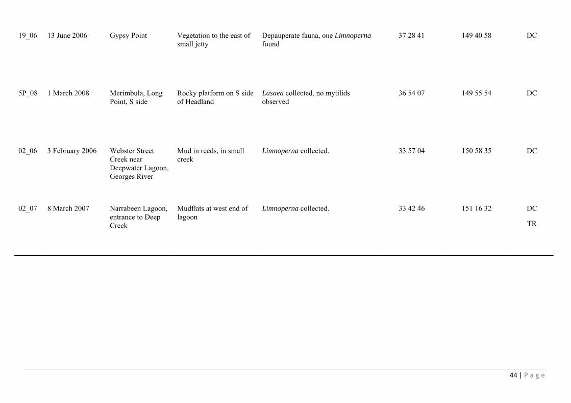
19_06 13 June 2006 Gypsy Point Vegetation to the east of small jetty
Depauperate fauna, one Limnoperna found
37 28 41 149 40 58 DC
5P_08 1 March 2008 Merimbula, Long Point, S side
Rocky platform on S side of Headland
Lasaea collected, no mytilids observed
36 54 07 149 55 54 DC
02_06 3 February 2006 Webster Street Creek near Deepwater Lagoon, Georges River
Mud in reeds, in small creek
Limnoperna collected. 33 57 04 150 58 35 DC
02_07 8 March 2007 Narrabeen Lagoon, entrance to Deep Creek
Mudflats at west end of lagoon
Limnoperna collected. 33 42 46 151 16 32 DC
TR
45 | P a g e
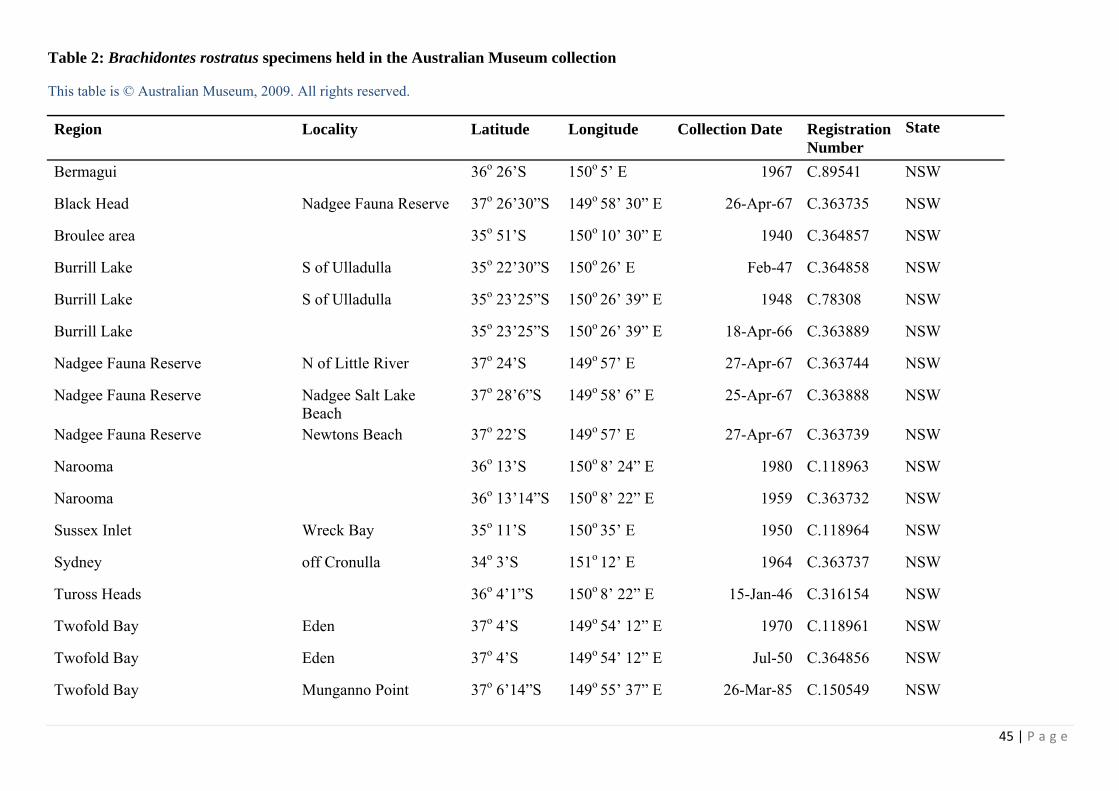
Table 2: Brachidontes rostratus specimens held in the Australian Museum collection
This table is © Australian Museum, 2009. All rights reserved.
Region Locality Latitude Longitude Collection Date Registration Number
State
Bermagui 36o 26’S 150o 5’ E 1967 C.89541 NSW
Black Head Nadgee Fauna Reserve 37o 26’30”S 149o 58’ 30” E 26-Apr-67 C.363735 NSW
Broulee area 35o 51’S 150o 10’ 30” E 1940 C.364857 NSW
Burrill Lake S of Ulladulla 35o 22’30”S 150o 26’ E Feb-47 C.364858 NSW
Burrill Lake S of Ulladulla 35o 23’25”S 150o 26’ 39” E 1948 C.78308 NSW
Burrill Lake 35o 23’25”S 150o 26’ 39” E 18-Apr-66 C.363889 NSW
Nadgee Fauna Reserve N of Little River 37o 24’S 149o 57’ E 27-Apr-67 C.363744 NSW
Nadgee Fauna Reserve Nadgee Salt Lake Beach
37o 28’6”S 149o 58’ 6” E 25-Apr-67 C.363888 NSW
Nadgee Fauna Reserve Newtons Beach 37o 22’S 149o 57’ E 27-Apr-67 C.363739 NSW
Narooma 36o 13’S 150o 8’ 24” E 1980 C.118963 NSW
Narooma 36o 13’14”S 150o 8’ 22” E 1959 C.363732 NSW
Sussex Inlet Wreck Bay 35o 11’S 150o 35’ E 1950 C.118964 NSW
Sydney off Cronulla 34o 3’S 151o 12’ E 1964 C.363737 NSW
Tuross Heads 36o 4’1”S 150o 8’ 22” E 15-Jan-46 C.316154 NSW
Twofold Bay Eden 37o 4’S 149o 54’ 12” E 1970 C.118961 NSW
Twofold Bay Eden 37o 4’S 149o 54’ 12” E Jul-50 C.364856 NSW
Twofold Bay Munganno Point 37o 6’14”S 149o 55’ 37” E 26-Mar-85 C.150549 NSW

46 | P a g e
Twofold Bay 37o 5’S 149o 54’ E 1950 C.118960 NSW
Twofold Bay 37o 5’7”S 149o 55’ 21” E 11-Aug-00 C.363734 NSW
Ulladulla 35o 21’30”S 150o 28’ 30” E 1939 C.118965 NSW
Middleton 35o 31’S 138o 42’ E Jan-71 C.458620 South Australia
Bass Strait Marrawah Green Point 41o 10’49”S 144o 52’ 47” E 29-Jan-55 C.118962 Tas
Bridport 41o S 147o 23’ E 1970 C.118952 Tas
Cape Sorell Macquarie Harbour mouth
42o 12’S 145o 10’ E 3-Feb-55 C.118951 Tas
Derwent Estuary Taroona 42o 57’S 147o 20’ E 1970 C.118950 Tas
Derwent Estuary Taroona 42o 57’S 147o 20’ E 1970 C.63645 Tas
Frederick Henry Bay 42o 55’S 147o 35’ E 1902 C.10922 Tas
Great Oyster Bay Swansea 42o 8’S 148o 4’ E 20-Mar-73 C.109231 Tas
Sandy Cape NW coast 41o 25’S 144o 45’ E 15-Jan-54 C.118953 Tas
Simpsons Bay D'Entrecasteaux Channel
South Bruny Is 43o 17’S 147o 18’ E 1929 C.54131 Tas
Sloop Reef N of St. Helens 41o 12’48”S 148o 17’ 18” E 7-Feb-55 C.118955 Tas
Between Anglesey & Lorne 38o 28’S 144o 6’ E Sep-63 C.403942 Vic
Mallacoota Shipwreck River mouth, 6ml S of Mallacoota
37o 37’S 149o 39’ E 16-Feb-73 C.403948 Vic
Mallacoota 37o 34’S 149o 56’ E Aug-55 C.403941 Vic
Mallacoota 37o 34’S 149o 56’ E 1918 C.50291 Vic
Ninety Mile Beach near Lakes Entrance 37o 53’S 147o 59’ E 24-Jan-50 C.209916 Vic

47 | P a g e
Western Port Bay Flinders 38o 29’S 145o 1’ E 1970 C.458619 Vic

48 | P a g e
Table 3: Mytilus specimens from Australia held in the Australian Museum collection
Specimens are listed in Regions that include connected water bodies.
This table is © Australian Museum, 2009. All rights reserved.
Region Locality Latitude Longitude Collection Date
Registration Number
Bendalong N of Lake Conjola 35 o 15’ S 150 o 32’ E 17 Mar 1976 C.366572 Botany Bay Georges River, Captain Cook
Bridge 34o 45” S 151o 7’ 30” E 20 Oct 1998 C.399148
Botany Bay Bare Is 33o 59’ 42” S 151o 13’ 48” E 26 Oct 1998 C.399149 Botany Bay Botany Heads 34o S 151o 14’ E 1901 C.8871 Botany Bay Brotherson Dock 33o 58’ 12” S 151o 13’ 24” E 20 Oct 1998 C.399126 Botany Bay Brotherson Dock 33o 58’ 12” S 151o 13’ E 22 Oct 1998 C.399135 Botany Bay Brotherson Dock 33o 58’ 12” S 151o 12’ 48” E 19 Oct 1998 C.399151 Botany Bay Brotherson Dock 33o 58’ 12” S 151o 13’ 24” E 20 Oct 1998 C.399152 Botany Bay Bulk Liquids Berth 33o 58’ 23” S 151o 13’ 48” E 19 Oct 1998 C.399136 Botany Bay Cooks River mouth 33o 57’ S 151o 10’ E 23 Oct 1998 C.399130 Botany Bay Cooks River mouth 33o 57’ S 151o 10’ E 23 Oct 1998 C.399146 Botany Bay Cooks River mouth 33o 57’ S 151o 10’ E 23 Oct 1998 C.399147 Botany Bay Dolls Point 33o 59’ 36” S 151o 8’ 54” E 23 Oct 1998 C.399129 Botany Bay Dolls Point 33o 59’ 36” S 151o 8’ 48” E 23 Oct 1998 C.399137 Botany Bay Dolls Point 33o 59’ 36” S 151o 8’ 48” E 23 Oct 1998 C.399138 Botany Bay E of Botany Bay 34o 6’ S 151o 28’ E 4 May 1960 C.124185 Botany Bay Kurnell 3434” S 151o 12’ 22” E Aug 1945 C.364841 Botany Bay Kurnell Pier 34 o 30” S 151o 12’ 45” E 21 Oct 1998 C.399134 Botany Bay Kurnell Pier 34o 12” S 151o 12’ 30” E 21 Oct 1998 C.399142

49 | P a g e
Botany Bay Kyeemagh to Bay St 33o 57’ 17” S 151o 9’ 45” E 26 May 1975 C.331606 Botany Bay Monterey to Ramsgate. 33o 58’ 31” S 151o 8’ 56” E 26 May 1975 C.331607 Botany Bay Third Airport Runway 33o 57’ 47” S 151o 11’ 24” E 19 Oct 1998 C.399133 Botany Bay 33o 57’ S 151o 12’ E 1950 C.364835 Broken Bay Ettalong Beach 33 o 30’ 56” S 151o 20’ 19” E 13 Aug 1971 C.331610 Broken Bay Patonga Beach 33 o 33’ 11” S 151o 16’ 10” E 1980 C.331611 Broulee area 35o 51’ S 150o 10’ 30” E 1940 C.364840 Crookhaven Heads 34o 54’ S 150o 46’ E 1981 C.364837 Depot Beach NE of Point Upright, SW side
Grasshopper Island 35 o 38’ 1” S 150o 19’ 51” E 9 Feb 2003 C.447061
Jervis Bay Callala Point 35 o 30” S 150o 43’ 21” E 18 Oct 1978 C.129705 Lake Tuross 36 o 3’ S 150o 7’ E 12 Mar 1953 C.331604 Macquarie Island Middle Beach o 543 o 1’ 18” S 158o 56’ 4” E 12 Nov 1976 C.460939 Mallacoota 37 o 34’ S o 149o 56’ E 1918 C.118906 Mallacoota 37 o 34’ S o 149o 56’ E Aug 1955 C.393067 Mallacoota 37 o 34’ S o 149o 56’ E 1918 C.50314 Mallacoota 37 o 34’ S o 149o 56’ E 1918 C.50448 Maroubra Beach Sydney 33o 57’ S 15115’ 18” E 15 Mar 1970 C.366577 Nadgee Fauna Reserve
N of Little River 37o 24’ S o 149o 57’ E 27 Apr 1967 C.331605
Nadgee River estuary 37 26' 23" S o 149o 57’ 30” E
o 8o Jano 1970 C.101628
Nadgee Salt Lake Beach
Nadgee Fauna Reserve 37o 28’ 6” S o 149o 58’ 6” E 25 Apr 1967 C.331603
Narooma 36o 13’ 14” S 150o 8’ 22” E 1974 C.97316 Nords Wharf Lake Macquarie 33o 8’ 2” S 15136’ 7” E 14 Sep 1953 C.331612 Port Hacking 34o 4’ S 151o 6’ E Feb 1962 C.97878 Port Jackson Middle Harbour, Balmoral Beach 33o 49’ 42” S 15115’ 1” E 1984 C.364838

50 | P a g e
Port Jackson Middle Harbour, Balmoral, Edwards Beach
33o 49’ 23” S 15115’ E 13 Jan 1998 C.461322
Port Jackson Middle Harbour, The Spit 33o 48’ 17” S 151o 14’ 24” E 19 May 1951 C.207345 Port Jackson Parramatta River, Cockatoo Island 33o 51’ S 151o 10’ 5” E 22 May 1952 C.364832 Port Jackson Parramatta River, Iron Cove at
Callan Park 33o 52’ 2” S 151o 9’ 26” E 8 Feb 1997 C.331617
Port Jackson Balls Head Bay north 33o 50’ 34” S 151o 11’ 31” E 24 Apr 2001 C.463061 Port Jackson Balls Head Bay north 33o 50’ 34” S 151o 11’ 31” E 24 Apr 2001 C.463064 Port Jackson Balls Head Bay south 33o 50’ 48” S 151o 11’ 34” E 14 May 2001 C.463239 Port Jackson Balmain, White Horse Point 33o 51’ 15” S 151o 10’ 11” E 26 Oct 1996 C.315715 Port Jackson Berrys Bay north 33o 50’ 31” S 151o 11’ 55” E 21 May 2001 C.463040 Port Jackson Blackwattle Bay 33o 52’ 30” S 151o 11’ 14” E 18 Apr 2001 C.463027 Port Jackson Blackwattle Bay 33o 52’ 30” S 151o 11’ 14” E 18 Apr 2001 C.463033 Port Jackson Blackwattle Bay 33o 52’ 30” S 151o 11’ 14” E 17 Apr 2001 C.463060 Port Jackson Blackwattle Bay 33o 52’ 30” S 151o 11’ 14” E 18 Apr 2001 C.463116 Port Jackson Bottle & Glass Rocks 33o 50’ 56” S 151o 16’ 7” E 5 May 2000 C.380718 Port Jackson Bradleys Head 33o 51’ 17” S 151o 14’ 41” E 1957 C.364839 Port Jackson Chowder Bay 33o 50’ 28” S 151 o 15’ 19” E 6 Jun 2001 C.463028 Port Jackson Chowder Bay 33o 50’ 28” S 151 o 15’ 19” E 6 Jun 2001 C.463051 Port Jackson Clarke Island south 33o 51’ 54” S 151o 14’ 25” E 6 Jun 2001 C.463032 Port Jackson Darling Harbour north 33o 51’ 17” S 151o 12’ 6” E 21 May 2001 C.463052 Port Jackson Darling Harbour south 33o 51’ 17” S 151o 12’ 7” E 14 May 2001 C.463026 Port Jackson Darling Harbour south 33o 51’ 17” S 151o 12’ 7” E 14 May 2001 C.463030 Port Jackson Garden Island east 33o 51’ 45” S 151o 13’ 47” E 21 May 2001 C.463034 Port Jackson Garden Island east 33o 51’ 45” S 151o 13’ 47” E 21 May 2001 C.463038 Port Jackson Garden Island east 33o 51’ 45” S 151o 13’ 47” E 21 May 2001 C.463044 Port Jackson Garden Island west 33o 51’ 48” S 151o 13’ 44” E 21 May 2001 C.463045

51 | P a g e
Port Jackson Garden Island west 33o 51’ 48” S 151o 13’ 44” E 21 May 2001 C.463062 Port Jackson Glebe Island east 33o 51’ 58” S 151o 11’ 10” E 18 Apr 2001 C.463036 Port Jackson Glebe Island east 33o 51’ 58” S 151o 11’ 10” E 18 Apr 2001 C.463048 Port Jackson Glebe Island east 33o 51’ 58” S 151o 11’ 10” E 18 Apr 2001 C.463053 Port Jackson Glebe Island west 33o 52’ 4” S 151o 10’ 44” E 17 Apr 2001 C.463039 Port Jackson Glebe Island west 33o 52’ 4” S 151o 10’ 44” E 17 Apr 2001 C.463055 Port Jackson Gore Cove north 33o 50’ 25” S 151o 11’ 7” E 24 Apr 2001 C.463035 Port Jackson Gore Cove north 33o 50’ 25” S 151o 11’ 7” E 24 Apr 2001 C.463037 Port Jackson Gore Cove north 33o 50’ 25” S 151o 11’ 7” E 24 Apr 2001 C.463054 Port Jackson Gore Cove south 33o 50’ 25” S 151o 11’ 8” E 24 Apr 2001 C.463050 Port Jackson Gore Cove south 33o 50’ 25” S 151o 11’ 8” E 24 Apr 2001 C.463115 Port Jackson Middle Harbour, The Spit 33o 48’ 17” S 151o 14’ 41” E 15 Feb 1958 C.331614 Port Jackson Middle Harbour. The Spit 33o 48’ 17” S 151o 14’ 24” E 1923 C.49171 Port Jackson Middle Harbour. The Spit 33o 48’ 17” S 151o 14’ 41” E 15 Feb 1958 C.97892 Port Jackson Middle Harbour, Chinamans
Beach 33o 48’ 58” S 151o 14’ 52” E 1967 C.331609
Port Jackson Middle Harbour, Clontarf 33o 48’ 30” S 151 o 15’ 5” E 6 Apr 1972 C.331608 Port Jackson Middle Harbour, Balmoral Beach 33o 49’ 45” S 151 o 15’ 1” E 3 Jul 1965 C.118909 Port Jackson Milsons Point, North Sydney Pool 33o 51’ 6” S 151o 12’ 35” E Mar 2001 C.394181 Port Jackson North Harbour 33o 48’ 30” S 151o 16’ 30” E 1956 C.89956 Port Jackson Parramatta Wharf 33o 49’ S 151o E 1928 C.54607 Port Jackson Port Jackson 33o 51’ 17” S 151o 14’ 48” E 1979 C.118908 Port Jackson Port Jackson 33o 51’ 17” S 151o 14’ 48” E 1912 C.81318 Port Jackson Shark Island 33o 51’ 36” S 15115’ 24” E 1966 C.80123 Port Jackson Sydney Cove 33o 51’ 33” S 151o 12’ 31” E 24 Apr 2001 C.463042 Port Jackson Sydney Cove 33o 51’ 33” S 151o 12’ 31” E 24 Apr 2001 C.463063 Port Jackson White Bay east 33o 51’ 40” S 151o 11’ 24” E 18 Apr 2001 C.463041

52 | P a g e
Port Jackson White Bay east 33o 51’ 40” S 151o 11’ 24” E 18 Apr 2001 C.463046 Port Jackson White Bay east 33o 51’ 40” S 151o 11’ 24” E 18 Apr 2001 C.463047 Port Jackson White Bay west 33o 51’ 40” S 151o 11’ 25” E 22 May 2001 C.463029 Port Jackson White Bay west 33o 51’ 40” S 151o 11’ 25” E 18 Apr 2001 C.463031 Port Jackson White Bay west 33o 51’ 40” S 151o 11’ 25” E 18 Apr 2001 C.463043 Port Jackson White Bay west 33o 51’ 40” S 151o 11’ 25” E 18 Apr 2001 C.463049 Port Jackson White Bay west 33o 51’ 40” S 151o 11’ 25” E 18 Apr 2001 C.463065 Port Jackson ,White Bay Power House 33o 51’ 53” S 151o 11’ E 17 Jun 1919 C.118907 Port Stephens Nelson Bay 32o 43’ 17” S 152o 8’ 41” E 1888 C.47453 Port Stephens 32o 42’ S 152o 5’ E 1980 C.331613 Terrigal 25 mls off 33o 27’ S 15135’ E 1969 C.71409 Tuross River 36o 4’ 30” S 150o 8’ 9” E 1967 C.363900 Twofold Bay Boydtown Beach 37o 6’ 17” S 149o 52’ 30” E 1966 C.331616 Twofold Bay Boydtown Beach 37o 6’ 17” S 149o 52’ 30” E Mar 1940 C.364833 Twofold Bay Curalo Lake 37 o 3’ 15” S 149o 54’ 27” E 20 Jan 1910 C.31053 Twofold Bay Fisheries Beach 37o 6’ 49” S 149o 55’ 43” E 26 Jun 1985 C.363777 Twofold Bay Fisheries Beach 37o 6’ 49” S 149o 55’ 43” E 19 Dec 1985 C.363785 Twofold Bay Fisheries Beach 37o 6’ 47” S 149o 55’ 36” E 18 Sep 1985 C.363791 Twofold Bay Fisheries Beach 37o 6’ 49” S 149o 55’ 43” E 26 Mar 1985 C.363793 Twofold Bay Fisheries Creek 37o 6’ 57” S 149o 55’ 46” E 12 Dec 1984 C.150566 Twofold Bay Fisheries Creek 37o 6’ 57” S 149o 55’ 46” E 18 Sep 1985 C.363789 Twofold Bay Munganno Point 37o 6’ 14” S 149o 55’ 37” E 10 Oct 1984 C.363780 Twofold Bay Munganno Point 37o 6’ 11” S 149o 55’ 33” E 19 Dec 1985 C.363781 Twofold Bay Munganno Point 37o 6’ 12” S 149o 55’ 29” E 19 Dec 1985 C.363790 Twofold Bay Munganno Point 37o 6’ 14” S 149o 55’ 37” E 19 Dec 1985 C.363796 Twofold Bay Munganno Point 37o 6’ 12” S 149o 55’ 29” E 27 Jun 1985 C.363799 Twofold Bay Munganno Point 37o 6’ 14” S 149o 55’ 37” E 27 Jun 1985 C.363802

53 | P a g e
Twofold Bay Munganno Point 37o 6’ 12” S 149o 55’ 29” E 19 Dec 1985 C.363803 Twofold Bay Munganno Point 37o 6’ 12” S 149o 55’ 29” E 26 Mar 1985 C.363804 Twofold Bay Munganno Point 37o 6’ 14” S 149o 55’ 37” E 10 Oct 1984 C.363807 Twofold Bay Munganno Point 37o 6’ 12” S 149o 55’ 29” E 19 Dec 1985 C.363808 Twofold Bay Munganno Point 37o 6’ 12” S 149o 55’ 29” E 19 Dec 1985 C.363811 Twofold Bay Munganno Point 37o 6’ 14” S 149o 55’ 37” E 19 Dec 1985 C.363812 Twofold Bay Munganno Point 37o 6’ 14” S 149o 55’ 37” E 26 Mar 1985 C.363816 Twofold Bay Murrumbulga Pt 37o 4’ 45” S 149o 53’ 4” E 9 Oct 1984 C.363778 Twofold Bay Murrumbulga Pt 37o 4’ 45” S 149o 53’ 4” E 25 Jun 1985 C.363788 Twofold Bay Murrumbulga Pt 37o 4’ 45” S 149o 53’ 4” E 18 Dec 1985 C.363814 Twofold Bay Nullica Beach 37o 6’ S 149o 52’ 30” E Feb 1978 C.364834 Twofold Bay Nullica River 37o 5’ 37” S 149o 52’ 8” E 12 Jul 1984 C.148549 Twofold Bay Nullica River Estuary 37o 5’ 37” S 149o 52’ 8” E 26 Jun 1985 C.363779 Twofold Bay Nullica River Estuary 37o 5’ 37” S 149o 52’ 8” E 27 Mar 1985 C.363797 Twofold Bay Nullica River Estuary 37o 5’ 37” S 149o 52’ 8” E 3 Dec 1985 C.363801 Twofold Bay Nullica River Estuary 37o 5’ 37” S 149o 52’ 8” E 19 Sep 1984 C.363809 Twofold Bay Nullica River Estuary 37o 5’ 37” S 149o 52’ 8” E 13 Dec 1984 C.363810 Twofold Bay Quarantine Bay 37o 4’ 42” S 149o 52’ 36” E 12 Jul 1984 C.148548 Twofold Bay Red Point 37o 6’ 5” S 149o 57’ 6” E 13 Jul 1984 C.363805 Twofold Bay 37o 5’ 7” S 149o 55’ 21” E 11 Aug 1900 C.7674 Ulladulla 35o 21’ 30” S 150o 28’ 30” E 1967 C.89544 Wonboyn Lake S side at piers near boat ramp 37 o 15’ 2” S 149o 55’ 4” E 6 Mar 2001 C.395917 Wonboyn River W side of mouth at "back' of beach 37 o 15’ 6” S 149o 57’ 27” E 6 Mar 2001 C.205723 Wonboyn River W side of mouth at "back' of beach 37 o 15’ 6” S 149o 57’ 27” E 6 Mar 2001 C.395915

54 | P a g e
Table 4: Trichomya hirsuta specimens from New South Wales and Victoria in the Australian Museum Collection
Mallacoota is the only Victorian locality represented.
This table is © Australian Museum, 2009, All rights reserved.
Region Locality Latitude Longitude Collection Date
Registration Number
Ballina 28° 52' 6” S 153° 33' 36” E 1930 C.403947 Batemans Bay Wimbie Beach 35° 44' S 150° 12' 30” E 6 Jan 1970 C.315772 Batemans Bay Wimbie Beach 35° 47' S 150° 14' E 6 Jan 1970 C.315735 Bellambi Reef N of Wollongong 34° 22' 15” S 150° 55' 46” E 14 Nov 1971 C.315773 Bendalong N of Lake Conjola 35° 15' S 150° 32' E 17 Mar 1976 C.315656 Bendalong N of Lake Conjola 35° 15' S 150° 32' E 17 Mar 1976 C.366648 Bittangabee N of Green Cape 37° 13' S 150° 1' E 13 Feb 1973 C.315771 Bittangabee N of Green Cape 37° 13' S 150° 1' E 13 Feb 1973 C.366649 Bombo Beach 34° 39' 18” S 150° 51' 17” E 10 Feb 2001 C.392130 Botany Bay Bare Is 33° 59' 42” S 151° 13' 48” E 26 Oct 1998 C.399112 Botany Bay Bay St, Brighton 33° 57' 44” S 151° 9' 16” E 26 May 1975 C.315658 Botany Bay Brotherson Dock 33° 58' 12” S 151° 13' E 22 Oct 1998 C.398703 Botany Bay Brotherson Dock 33° 58' 12” S 151° 13' E 22 Oct 1998 C.398709 Botany Bay Bulk Liquids Berth 33° 58' 23” S 151° 13' 48” E 19 Oct 1998 C.398708 Botany Bay Cape Banks 34° 6” S 151° 14' 48” E Feb 1961 C.403944 Botany Bay Cooks River mouth 33° 57' S 151° 10' E 23 Oct 1998 C.398735 Botany Bay Cooks River mouth 33° 57' S 151° 10' E 23 Oct 1998 C.399114 Botany Bay Dolls Point 33° 59' 36” S 151° 8' 54” E 23 Oct 1998 C.399113 Botany Bay Frenchmans Beach 33° 59' 17” S 151° 13' 48” E 1975 C.364877 Botany Bay Cooks River to Kyeemagh Baths 33° 56' 57” S 151° 9' 55” E 26 May 1975 C.315657 Botany Bay Georges River 33° 59' 47” S 151° 8' 44” E 26 May 1975 C.315660 Botany Bay Georges River, Captain Cook Bridge 34° 45” S 151° 7' 30” E 20 Oct 1998 C.398707 Botany Bay Georges River, Captain Cook Bridge 34° 45” S 151° 7' 30” E 20 Oct 1998 C.398717 Botany Bay Georges River, Captain Cook Bridge 34° 45” S 151° 7' 30” E 20 Oct 1998 C.398737 Botany Bay Kurnell 34° 34” S 151° 12' 22” E 29 Nov 1929 C.366651
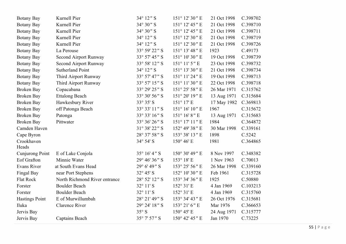
55 | P a g e
Botany Bay Kurnell Pier 34° 12” S 151° 12' 30” E 21 Oct 1998 C.398702 Botany Bay Kurnell Pier 34° 30” S 151° 12' 45” E 21 Oct 1998 C.398710 Botany Bay Kurnell Pier 34° 30” S 151° 12' 45” E 21 Oct 1998 C.398711 Botany Bay Kurnell Pier 34° 12” S 151° 12' 30” E 21 Oct 1998 C.398719 Botany Bay Kurnell Pier 34° 12” S 151° 12' 30” E 21 Oct 1998 C.398726 Botany Bay La Perouse 33° 59' 22” S 151° 13' 48” E 1923 C.49173 Botany Bay Second Airport Runway 33° 57' 45” S 151° 10' 30” E 19 Oct 1998 C.398739 Botany Bay Second Airport Runway 33° 58' 12” S 151° 11' 5” E 23 Oct 1998 C.398732 Botany Bay Sutherland Point 34° 12” S 151° 13' 30” E 21 Oct 1998 C.398734 Botany Bay Third Airport Runway 33° 57' 47” S 151° 11' 24” E 19 Oct 1998 C.398713 Botany Bay Third Airport Runway 33° 57' 15” S 151° 11' 30” E 22 Oct 1998 C.398718 Broken Bay Copacabana 33° 29' 25” S 151° 25' 58” E 26 Mar 1971 C.315762 Broken Bay Ettalong Beach 33° 30' 56” S 151° 20' 19” E 13 Aug 1971 C.315684 Broken Bay Hawkesbury River 33° 35' S 151° 17' E 17 May 1982 C.369813 Broken Bay off Patonga Beach 33° 33' 11” S 151° 16' 10” E 1967 C.315672 Broken Bay Patonga 33° 33' 16” S 151° 16' 8” E 13 Aug 1971 C.315683 Broken Bay Pittwater 33° 36' 26” S 151° 17' 11” E 1984 C.364872 Camden Haven 31° 38' 22” S 152° 49' 38” E 30 Mar 1998 C.339161 Cape Byron 28° 37' 58” S 153° 38' 13” E 1898 C.5242 Crookhaven Heads
34° 54' S 150° 46' E 1981 C.364865
Cunjurong Point E of Lake Conjola 35° 16' 4” S 150° 30' 49” E 8 Nov 1997 C.348382 Eof Grafton Minnie Water 29° 46' 36” S 153° 18' E 1 Nov 1963 C.70013 Evans River at South Evans Head 29° 6' 49” S 153° 25' 56” E 26 Mar 1998 C.339160 Fingal Bay near Port Stephens 32° 45' S 152° 10' 30” E Feb 1961 C.315728 Flat Rock North Richmond River entrance 28° 52' 12” S 153° 34' 36” E 1925 C.50880 Forster Boulder Beach 32° 11' S 152° 31' E 4 Jan 1969 C.103213 Forster Boulder Beach 32° 11' S 152° 31' E 4 Jan 1969 C.315760 Hastings Point E of Murwillumbah 28° 21' 49” S 153° 34' 43” E 26 Oct 1976 C.315681 Iluka Clarence River 29° 24' 18” S 153° 21' 6” E Mar 1976 C.366653 Jervis Bay 35° S 150° 45' E 24 Aug 1971 C.315777 Jervis Bay Captains Beach 35° 7' 57” S 150° 42' 45” E Jan 1970 C.73225

56 | P a g e
Jervis Bay Green Island, S of Hare Bay 35° 33” S 150° 44' 58” E Aug 1989 C.315830 Jervis Bay Green Patch 35° 8' 26” S 150° 43' 1” E 27 Feb 1976 C.315778 Jervis Bay Green Patch 35° 8' 26” S 150° 43' 1” E 28 Feb 1976 C.315747 Jervis Bay Green Point 35° 58” S 150° 44' 58” E 18 Jun 1991 C.315732 Jervis Bay Green Point 35° 58” S 150° 44' 58” E 26 Sep 1990 C.315823 Jervis Bay Green Point 35° 58” S 150° 44' 58” E 27 Feb 1990 C.315822 Jervis Bay Green Point 35° 58” S 150° 44' 58” E Feb 1991 C.315825 Jervis Bay Hole in The Wall 35° 7' 42” S 150° 44' 47” E 18 Jun 1991 C.315733 Jervis Bay Hole in The Wall 35° 7' 42” S 150° 44' 47” E 20 Feb 1989 C.315730 Jervis Bay Hole in The Wall 35° 7' 42” S 150° 44' 47” E 21 Feb 1991 C.315811 Jervis Bay Hole In The Wall 35° 8' 3” S 150° 44' 43” E 24 Feb 1990 C.315793 Jervis Bay Hole in The Wall 35° 7' 42” S 150° 44' 47” E 26 Sep 1990 C.315810 Jervis Bay Hole in The Wall 35° 7' 42” S 150° 44' 47” E 27 Feb 1990 C.315814 Jervis Bay Hole in The Wall 35° 7' 42” S 150° 44' 47” E Aug 1989 C.315807 Jervis Bay Hole in The Wall 35° 7' 42” S 150° 44' 47” E Jun 1989 C.315790 Jervis Bay Hole in The Wall 35° 7' 42” S 150° 44' 47” E May 1990 C.315809 Jervis Bay Hole in The Wall 35° 7' 42” S 150° 44' 47” E Nov 1989 C.315808 Jervis Bay Hole In The Wall 35° 8' 3” S 150° 44' 43” E Sep 1990 C.315812 Jervis Bay Honeymoon Bay 35° 3' 30” S 150° 46' 28” E 17 Jan 1969 C.315653 Jervis Bay Montagu Roadstead 35° 2' 1” S 150° 45' 55” E 17 Aug 1989 C.315817 Jervis Bay Montagu Roadstead 35° 2' 1” S 150° 45' 55” E 18 Jun 1991 C.315731 Jervis Bay Montagu Roadstead 35° 2' 1” S 150° 45' 55” E 19 Feb 1991 C.315791 Jervis Bay Montagu Roadstead 35° 2' 1” S 150° 45' 55” E 26 Sep 1990 C.315818 Jervis Bay Montagu Roadstead 35° 2' 1” S 150° 45' 55” E 6 Jun 1990 C.315815 Jervis Bay Montagu Roadstead 35° 2' 1” S 150° 45' 55” E Jun 1989 C.315816 Jervis Bay Murrays Beach 35° 7' 36” S 150° 45' 27” E 23 Jan 1973 C.315767 Jervis Bay off Green Point, N end 35° 58” S 150° 45' E 16 Aug 1984 C.364875 Jervis Bay Plantation Point 35° 4' 26” S 150° 41' 42” E Jul 1970 C.77210 Jervis Bay Plantation Point, N side 35° 3' 4” S 150° 41' 22” E 27 Feb 1990 C.315828 Jervis Bay Summer Cloud Bay 35° 10' 24” S 150° 41' 16” E 26 Nov 1971 C.315655 Jervis Bay West of Murrays Beach 35° 7' 36” S 150° 45' 27” E 13 Aug 1984 C.364870 Jervis Bay West of Murrays Beach 35° 7' 36” S 150° 45' 27” E 22 Aug 1984 C.364869

57 | P a g e
Lake Conjola Berringer Lake 35° 15' 18” S 150° 29' 58” E 8 Nov 1997 C.348381 Lake Conjola Berringer Lake 35° 15' 18” S 150° 29' 58” E 8 Nov 1997 C.348500 Lake Macquarie 33° 4' S 151° 36' E 18 Sep 1953 C.315675 Lake Macquarie 33° 4' 20” S 151° 36' 22” E 18 Sep 1953 C.315677 Lake Macquarie 33° 4' S 151° 36' E 26 Jan 1956 C.84258 Lake Macquarie Croudace Bay 33° 16” S 151° 37' 49” E 4 May 1955 C.85132 Lake Macquarie opposite Rocky Point 33° 4' 28” S 151° 32' 49” E 6 Sep 1955 C.315679 Lake Macquarie Pelican Is 33° 3' 54” S 151° 37' 53” E 27 Sep 1955 C.315674 Lake Macquarie Valentine 33° 38” S 151° 37' 58” E 13 Jul 1953 C.70580 Lake Macquarie Valentine 33° 38” S 151° 37' 58” E 13 Jul 1953 C.70587 Lake Macquarie Vales Point 33° 8' 39” S 151° 32' 15” E Sep 1965 C.315685 Lake Macquarie Wangi Wangi Bay 33° 4' 1” S 151° 34' 57” E 17 Jul 1953 C.70586 Largs near Maitland 32° 42' S 151° 36' E 19 Jul 1976 C.461273 Largs near Maitland 32° 42' S 151° 36' E 19 Jul 1976 C.461284 Lennox Head 28° 48' S 153° 36' E 27 Mar 1972 C.315769 Mallacoota 37° 34' S 149° 56' E 1918 C.392922 Mallacoota 37° 34' S 149° 56' E 1918 C.50292 Mallacoota 37° 34' S 149° 46' E 2 Jan 1973 C.392923 Mallacoota 37° 34' S 149° 56' E Aug 1955 C.392921 Mallacoota Bastion Point 37° 34' S 149° 46' E 20 Feb 1973 C.392924 Merimbula 36° 53' 26” S 149° 55' 9” E 12 Feb 1963 C.315650 Merimbula Lake Merimbula, middle of channel
leading from lake to bridge. 36° 54' 12” S 149° 54' E 24 Jul 1975 C.123979
Merimbula Merimbula Jetty 36° 53' 30” S 149° 54' 30” E 7 Jan 1970 C.315776 Merimbula Merimbula Harbour 36° 53' 36” S 149° 55' 20” E 7 Jan 1970 C.91602 Minnamurra River
lower reaches between Princes Hwy & rail bridges
34° 37' 17” S 150° 50' 47” E 26 Jul 1997 C.348380
Newcastle 32° 56' S 151° 46' E 28 May 1960 C.315726 Newcastle Merewether Beach 32° 57' S 151° 45' 23” E 1972 C.96980 Nords Wharf Lake Macquarie 33° 8' 2” S 151° 36' 7” E 14 Sep 1953 C.85131 O'Hara Head. 35° 34' S 150° 23' E 16 Mar 1976 C.366652 Port Hacking Ship Rock 34° 4' 25” S 151° 7' 35” E 5 May 1976 C.315763
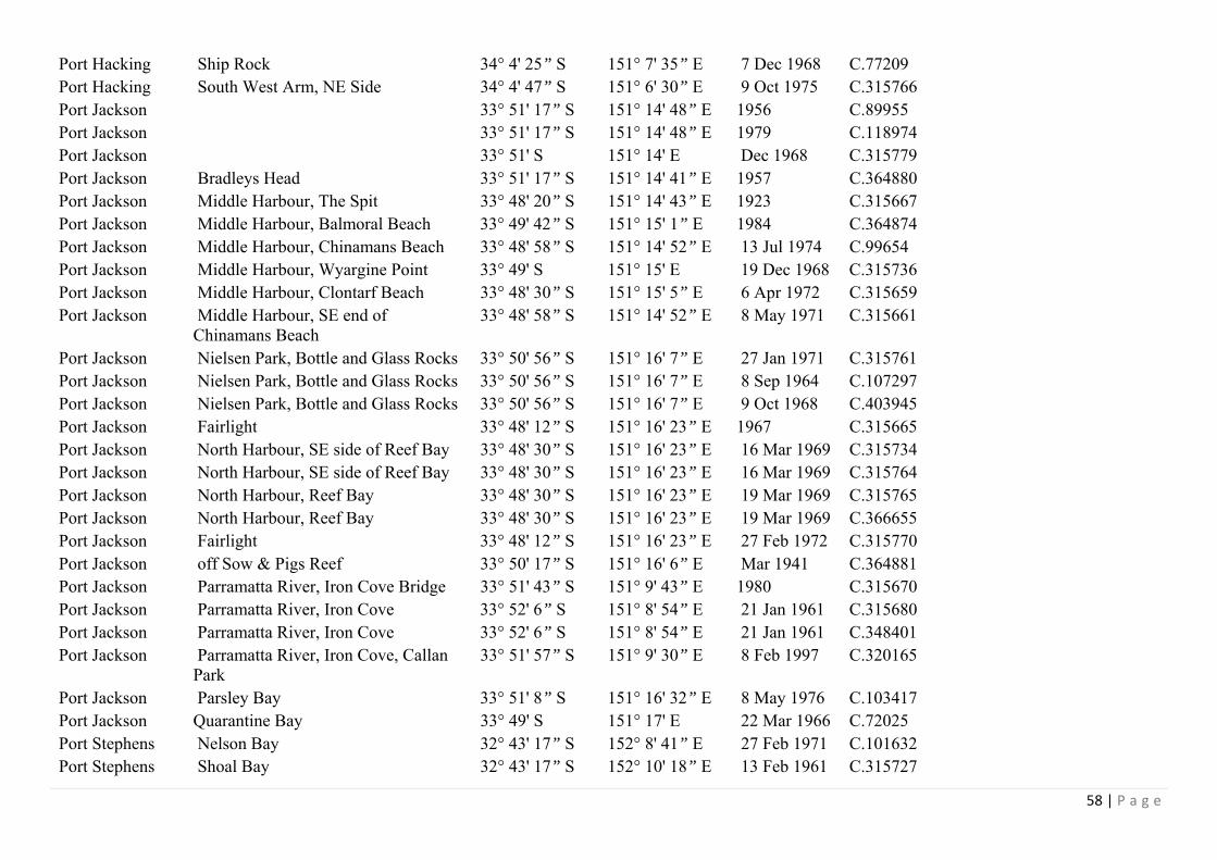
58 | P a g e
Port Hacking Ship Rock 34° 4' 25” S 151° 7' 35” E 7 Dec 1968 C.77209 Port Hacking South West Arm, NE Side 34° 4' 47” S 151° 6' 30” E 9 Oct 1975 C.315766 Port Jackson 33° 51' 17” S 151° 14' 48” E 1956 C.89955 Port Jackson 33° 51' 17” S 151° 14' 48” E 1979 C.118974 Port Jackson 33° 51' S 151° 14' E Dec 1968 C.315779 Port Jackson Bradleys Head 33° 51' 17” S 151° 14' 41” E 1957 C.364880 Port Jackson Middle Harbour, The Spit 33° 48' 20” S 151° 14' 43” E 1923 C.315667 Port Jackson Middle Harbour, Balmoral Beach 33° 49' 42” S 151° 15' 1” E 1984 C.364874 Port Jackson Middle Harbour, Chinamans Beach 33° 48' 58” S 151° 14' 52” E 13 Jul 1974 C.99654 Port Jackson Middle Harbour, Wyargine Point 33° 49' S 151° 15' E 19 Dec 1968 C.315736 Port Jackson Middle Harbour, Clontarf Beach 33° 48' 30” S 151° 15' 5” E 6 Apr 1972 C.315659 Port Jackson Middle Harbour, SE end of
Chinamans Beach 33° 48' 58” S 151° 14' 52” E 8 May 1971 C.315661
Port Jackson Nielsen Park, Bottle and Glass Rocks 33° 50' 56” S 151° 16' 7” E 27 Jan 1971 C.315761 Port Jackson Nielsen Park, Bottle and Glass Rocks 33° 50' 56” S 151° 16' 7” E 8 Sep 1964 C.107297 Port Jackson Nielsen Park, Bottle and Glass Rocks 33° 50' 56” S 151° 16' 7” E 9 Oct 1968 C.403945 Port Jackson Fairlight 33° 48' 12” S 151° 16' 23” E 1967 C.315665 Port Jackson North Harbour, SE side of Reef Bay 33° 48' 30” S 151° 16' 23” E 16 Mar 1969 C.315734 Port Jackson North Harbour, SE side of Reef Bay 33° 48' 30” S 151° 16' 23” E 16 Mar 1969 C.315764 Port Jackson North Harbour, Reef Bay 33° 48' 30” S 151° 16' 23” E 19 Mar 1969 C.315765 Port Jackson North Harbour, Reef Bay 33° 48' 30” S 151° 16' 23” E 19 Mar 1969 C.366655 Port Jackson Fairlight 33° 48' 12” S 151° 16' 23” E 27 Feb 1972 C.315770 Port Jackson off Sow & Pigs Reef 33° 50' 17” S 151° 16' 6” E Mar 1941 C.364881 Port Jackson Parramatta River, Iron Cove Bridge 33° 51' 43” S 151° 9' 43” E 1980 C.315670 Port Jackson Parramatta River, Iron Cove 33° 52' 6” S 151° 8' 54” E 21 Jan 1961 C.315680 Port Jackson Parramatta River, Iron Cove 33° 52' 6” S 151° 8' 54” E 21 Jan 1961 C.348401 Port Jackson Parramatta River, Iron Cove, Callan
Park 33° 51' 57” S 151° 9' 30” E 8 Feb 1997 C.320165
Port Jackson Parsley Bay 33° 51' 8” S 151° 16' 32” E 8 May 1976 C.103417 Port Jackson Quarantine Bay 33° 49' S 151° 17' E 22 Mar 1966 C.72025 Port Stephens Nelson Bay 32° 43' 17” S 152° 8' 41” E 27 Feb 1971 C.101632 Port Stephens Shoal Bay 32° 43' 17” S 152° 10' 18” E 13 Feb 1961 C.315727

59 | P a g e
Seal Rocks 35km S of Forster 32° 26' 21” S 152° 32' 15” E 7 Jul 1939 C.70747 Shellharbour Bass Point 34° 36' S 150° 53' 30” E 5 Jul 1971 C.315737 Shellharbour Beach
34° 35' 47” S 150° 52' 47” E 18 Nov 2000 C.387088
Shelly Beach S of Yamba 29° 31' 30” S 153° 21' E 1974 C.364876 Smiths Lake Bar 32° 24' S 152° 31' E 15 Mar 1998 C.348383 Sydney 0.5km E of Long Bay 33° 58' 42” S 151° 16' E 5 Dec 1973 C.315668 Sydney 2km SE of Long Bay 33° 58' 25” S 151° 16' 19” E 20 Jul 1972 C.366656 Sydney 3km E of Long Bay 33° 58' 12” S 151° 16' 46” E 1973 C.315669 Sydney Collaroy, Long Reef 33° 44' 36” S 151° 18' 36” E 1957 C.364879 Sydney Collaroy, Long Reef 33° 44' 36” S 151° 18' 36” E 6 Aug 1983 C.139437 Sydney Collaroy Beach 33° 44' S 151° 18' E Jul 1948 C.364885 Sydney Coogee Beach 33° 55' 19” S 151° 15' 24” E 18 Feb 1997 C.349299 Sydney off Cronulla 34° 4' S 151° 14' E Dec 1963 C.366660 Sydney off North Head 33° 50' S 151° 18' E 26 Feb 1974 C.315774 Sydney off North Head 33° 50' S 151° 18' E 3 Oct 1972 C.315775 Sydney S end of Manly Beach 33° 48' S 151° 17' E 30 Jun 1971 C.348396 Tuross Heads 36° 4' 1” S 150° 8' 22” E 15 Jan 1946 C.315742 Twofold Bay 37° 5' 7” S 149° 55' 21” E 1919 C.49900 Twofold Bay 37° 5' 7” S 149° 55' 21” E 11 Aug 1900 C.7675 Twofold Bay Eden 37° 4' S 149° 54' 12” E 1966 C.364882 Twofold Bay Eden, Snug Cove 37° 4' 30” S 149° 54' 30” E 24 Jan 1946 C.403943 Twofold Bay Munganno Point 37° 6' 12” S 149° 55' 29” E 10 Oct 1984 C.315782 Twofold Bay Munganno Point 37° 6' 14” S 149° 55' 37” E 10 Oct 1984 C.315788 Twofold Bay Munganno Point 37° 6' 12” S 149° 55' 29” E 12 Dec 1984 C.148538 Twofold Bay Munganno Point 37° 6' 14” S 149° 55' 37” E 26 Mar 1985 C.315787 Twofold Bay Munganno Point 37° 6' 12” S 149° 55' 29” E 27 Jun 1985 C.315786 Twofold Bay Murrumbulga Point 37° 4' 45” S 149° 53' 4” E 11 Dec 1984 C.148539 Twofold Bay Murrumbulga Point 37° 4' 45” S 149° 53' 4” E 25 Jun 1985 C.315784 Twofold Bay Murrumbulga Point 37° 4' 45” S 149° 53' 4” E 27 Mar 1985 C.315780 Twofold Bay Murrumbulga Point 37° 4' 45” S 149° 53' 4” E 9 Oct 1984 C.148540 Twofold Bay Nullica River Estuary 37° 5' 37” S 149° 52' 8” E 26 Jun 1985 C.315789

60 | P a g e
Twofold Bay Nullica River Estuary 37° 5' 37” S 149° 52' 8” E 3 Dec 1985 C.315729 Ulladulla 35° 21' 30” S 150° 28' 30” E C.315671 Ulladulla Kioloa Beach 35° 33' 17” S 150° 22' 53” E 14 Feb 1978 C.364883 Urunga mangroves on S side of town just
beyond footbridge 30° 29' 55” S 153° 1' 10” E 9 Jul 1997 C.351264
Wallagoot Lagoon
near closed estuary 36° 47' 23” S 149° 56' 47” E 6 Mar 2001 C.453824
Wapengo Lagoon
NE edge beside road 36° 35' 38” S 150° 1' 2” E 8 Mar 2001 C.407035
Wapengo Lagoon
S side near Bithry Inlet 36° 37' 42” S 150° 59” E 8 Mar 2001 C.453892
Wollongong 34° 26' S 150° 54' 30” E 1950 C.315664 Woolgoolga Beach
S end 30° 6' 17” S 153° 12' E 19 Aug 2003 C.432537
Wreck Bay Cemetery Point 35° 10' 24” S 150° 40' 53” E 27 Feb 1976 C.315748
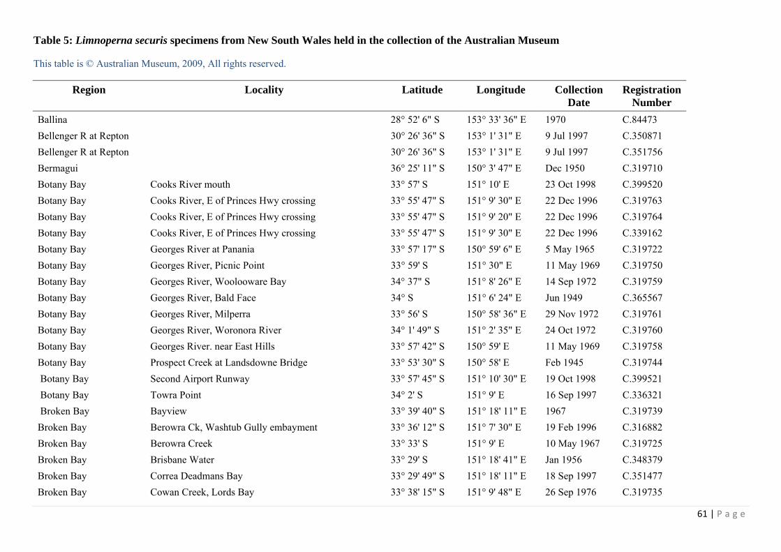
61 | P a g e
Table 5: Limnoperna securis specimens from New South Wales held in the collection of the Australian Museum
This table is © Australian Museum, 2009, All rights reserved.
Region Locality Latitude Longitude Collection Date
Registration Number
Ballina 28° 52' 6" S 153° 33' 36" E 1970 C.84473 Bellenger R at Repton 30° 26' 36" S 153° 1' 31" E 9 Jul 1997 C.350871 Bellenger R at Repton 30° 26' 36" S 153° 1' 31" E 9 Jul 1997 C.351756 Bermagui 36° 25' 11" S 150° 3' 47" E Dec 1950 C.319710 Botany Bay Cooks River mouth 33° 57' S 151° 10' E 23 Oct 1998 C.399520 Botany Bay Cooks River, E of Princes Hwy crossing 33° 55' 47" S 151° 9' 30" E 22 Dec 1996 C.319763 Botany Bay Cooks River, E of Princes Hwy crossing 33° 55' 47" S 151° 9' 20" E 22 Dec 1996 C.319764 Botany Bay Cooks River, E of Princes Hwy crossing 33° 55' 47" S 151° 9' 30" E 22 Dec 1996 C.339162 Botany Bay Georges River at Panania 33° 57' 17" S 150° 59' 6" E 5 May 1965 C.319722 Botany Bay Georges River, Picnic Point 33° 59' S 151° 30" E 11 May 1969 C.319750 Botany Bay Georges River, Woolooware Bay 34° 37" S 151° 8' 26" E 14 Sep 1972 C.319759 Botany Bay Georges River, Bald Face 34° S 151° 6' 24" E Jun 1949 C.365567 Botany Bay Georges River, Milperra 33° 56' S 150° 58' 36" E 29 Nov 1972 C.319761 Botany Bay Georges River, Woronora River 34° 1' 49" S 151° 2' 35" E 24 Oct 1972 C.319760 Botany Bay Georges River. near East Hills 33° 57' 42" S 150° 59' E 11 May 1969 C.319758 Botany Bay Prospect Creek at Landsdowne Bridge 33° 53' 30" S 150° 58' E Feb 1945 C.319744 Botany Bay Second Airport Runway 33° 57' 45" S 151° 10' 30" E 19 Oct 1998 C.399521 Botany Bay Towra Point 34° 2' S 151° 9' E 16 Sep 1997 C.336321 Broken Bay Bayview 33° 39' 40" S 151° 18' 11" E 1967 C.319739 Broken Bay Berowra Ck, Washtub Gully embayment 33° 36' 12" S 151° 7' 30" E 19 Feb 1996 C.316882 Broken Bay Berowra Creek 33° 33' S 151° 9' E 10 May 1967 C.319725 Broken Bay Brisbane Water 33° 29' S 151° 18' 41" E Jan 1956 C.348379 Broken Bay Correa Deadmans Bay 33° 29' 49" S 151° 18' 11" E 18 Sep 1997 C.351477 Broken Bay Cowan Creek, Lords Bay 33° 38' 15" S 151° 9' 48" E 26 Sep 1976 C.319735

62 | P a g e
Broken Bay Crosslands Creek 33° 36' S 151° 7' 5" E 30 Dec 1995 C.316887 Broken Bay Crosslands Creek 33° 36' S 151° 7' 5" E 30 Dec 1995 C.316893 Broken Bay Crosslands Creek 33° 36' S 151° 7' 5" E 19 Feb 1996 C.316895 Broken Bay Franks Gully embayment, E side of Berowra Creek, 33° 36' S 151° 7' 24" E 19 Feb 1996 C.316883 Broken Bay Franks Gully embayment, E side of Berowra Creek, 33° 36' S 151° 7' 24" E 13 Dec 1995 C.316894 Broken Bay Franks Gully embayment, E side of Berowra Creek, 33° 36' S 151° 7' 24" E 13 Dec 1995 C.316896 Broken Bay Hawkesbury River 33° 23' S 151° E 1979 C.119003 Broken Bay Hawkesbury River 33° 23' S 151° E 1902 C.12320 Broken Bay Hawkesbury River, 0.75ml SE of Wisemans Ferry 33° 24' S 151° E 13 Jun 1972 C.319755 Broken Bay Hawkesbury River, Cockle Creek 33° 39' 52" S 151° 9' 19" E 13 Oct 1997 C.344720 Broken Bay Hawkesbury River, Cockle Creek 33° 39' 52" S 151° 9' 19" E 13 Oct 1997 C.351476 Broken Bay Hawkesbury River, Cowan Creek 33° 35' 47" S 151° 15' 24" E 1967 C.319737 Broken Bay Hawkesbury River, Marramarra Creek 33° 31' S 151° 8' E 10 May 1967 C.319726 Broken Bay Patonga Beach 33° 33' 11" S 151° 16' 10" E 1966 C.80166 Broken Bay Washtub Gully embayment 33° 36' 12" S 151° 7' 30" E 31 Dec 1995 C.316884 Catherine Hill Bay S of Newcastle 33° 9' 18" S 151° 37' 42" E 1901 C.12706 Clarence River 0.8km S of Maclean 29° 28' S 153° 12' E 18 Oct 1972 C.319752 Conjola Lake Berringer Lake 35° 15' 18" S 150° 29' 58" E 8 Nov 1997 C.348917 Conjola Lake Berringer Lake 35° 15' 18" S 150° 29' 58" E 8 Nov 1997 C.349351 Corunna Lake along short track of W side of Princes Hwy 36° 16' 18" S 150° 7' 36" E 10 Mar 2001 C.397283 Cuttagee Lake N edge 36° 28' 41" S 150° 2' 26" E 9 Mar 2001 C.397282 Jervis Bay Cararma Creek Inlet 34° 59' 28" S 150° 46' 52" E 22 Jun 1991 C.336548 Jervis Bay Cararma Creek Inlet 34° 59' 41" S 150° 47' E 22 Jun 1991 C.336549 Jervis Bay Cararma Creek Inlet 34° 59' 39" S 150° 46' 58" E 3 Jun 1989 C.350912 Jervis Bay Cararma Creek Inlet 34° 59' 31" S 150° 46' 55" E 2 Jun 1989 C.350914 Jervis Bay Huskisson 35° 2' 30" S 150° 40' E 1956 C.319700 Lake Cathie S of Port Macquarie 31° 32' 49" S 152° 51' E 30 Mar 1998 C.339166 Lake Cathie S of Port Macquarie 31° 32' 49" S 152° 51' E 30 Mar 1998 C.339168 Lake Illawarra 34° 32' S 150° 50' E 18 Dec 1938 C.319720
63 | P a g e
Lake Macquarie creek between Lake Eraring and Muddy Lake Dora Ck 33° 5' S 151° 31' E 23 Oct 1956 C.319762 Lake Munmorah near power station 33° 13' S 151° 33' E 1967 C.319728 Lake Pambula Merimbula. 36° 58' 17" S 149° 54' E 18 Mar 1976 C.319738 Little Lake 36° 20' 16" S 150° 6' 7" E 10 Mar 2001 C.453825 Manning River at Taree 31° 55' 6" S 152° 27' 40" E 24 Mar 1998 C.339164 Manning River Scotts Creek 31° 55' 17" S 152° 35' 43" E 24 Mar 1998 C.339163 Nadgee Fauna Reserve Black Head 37° 26' 30" S 149° 58' 30" E 26 Apr 1967 C.319707 Nadgee River estuary 37° 26' 23" S 149° 57' 30" E 8 Jan 1970 C.101638 Narooma 36° 13' 14" S 150° 8' 22" E 1967 C.319745 Narooma 36° 13' 14" S 150° 8' 22" E Nov 1942 C.64009 Port Jackson 33° 51' 17" S 151° 14' 48" E 1979 C.119001 Port Jackson Lane Cove River 33° 49' S 151° 10' E 1979 C.119002 Port Jackson Lane Cove River 33° 47' S 151° 8' 30" E 1950 C.319733 Port Jackson Lane Cove River, at Boronia Park 33° 49' 47" S 151° 8' 41" E 31 May 1963 C.319747 Port Jackson Lane Cove River, Blue Gum Creek Mouth 33° 47' 42" S 151° 9' 24" E 31 May 1963 C.319748 Port Jackson Middle Harbour, Roseville Chase 33° 46' 25" S 151° 12' 11" E 16 Oct 1997 C.351195 Port Jackson Parramatta 33° 49' S 151° 1' E 22 May 1949 C.34121 Port Jackson Parramatta River 33° 49' 25" S 151° 5' 3" E 16 Mar 1972 C.319749 Port Jackson Parramatta River 33° 51' 57" S 151° 9' 30" E 8 Feb 1997 C.320168 Port Jackson Parramatta River 33° 51' 57" S 151° 9' 30" E 25 Apr 1998 C.350808 Port Jackson Parramatta River 33° 50' 30" S 151° 6' E 1888 C.47466 Port Jackson Parramatta River 33° 50' 30" S 151° 6' E 1888 C.47468 Port Jackson Parramatta River, Rodd Point 33° 52' 6" S 151° 8' 54" E 21 Jan 1961 C.319741 Port Jackson Parramatta Wharf 33° 49' S 151° E 1928 C.54606 Port Jackson Port Jackson 33° 51' S 151° 12' 35" E 8 Jul 1962 C.319756 Port Jackson Port Jackson 33° 51' 17" S 151° 14' 48" E 1967 C.89543 Port Macquarie Shelly Beach 31° 27' 18" S 152° 55' 53" E 18 Oct 1913 C.319730 Port Macquarie Shelly Beach 31° 27' 18" S 152° 55' 53" E 18 Oct 1913 C.37072 Port Stephens 32° 42' S 152° 5' E 1900 C.12319

64 | P a g e
Reed Park Ck nr Wollongong 34° 29' 36" S 150° 47' 12" E 31 May 1993 C.404164 S of Kingscliff Cudgen Creek 28° 16' 53" S 153° 34' 23" E 27 Mar 1998 C.339165 Shoalhaven 34° 51' 17" S 150° 44' 23" E 1888 C.47467 Smiths Lake N side 32° 22' 37" S 152° 28' 56" E 6 Sep 1969 C.319753 Smiths Lake NW corner 32° 22' 48" S 152° 27' 48" E 6 Sep 1969 C.319751 Smiths Lake S of Forster 32° 23' S 152° 29' E 18 Jan 1971 C.319757 Sussex Inlet S of Jervis Bay 35° 11' S 150° 35' E 1950 C.64006 Sydney Collaroy, Lonf Reef 33° 44' 36" S 151° 18' 36" E 1950 C.54555 Sydney Curl Curl Harbord Lagoon 33° 46' 6" S 151° 17' 30" E 30 Mar 1989 C.337863 Sydney Curl Curl Lagoon 33° 47' S 151° 18' E 14 Jan 1998 C.352358 Sydney Dee Why Lagoon 33° 45' S 151° 17' 41" E 1950 C.319732 Sydney Dee Why Lagoon 33° 45' S 151° 17' 41" E 23 May 1979 C.319754 Sydney Dee Why Lagoon 33° 45' S 151° 17' 41" E 16 Apr 1939 C.70171 Sydney Dee Why Lagoon, W side 33° 44' 46" S 151° 17' 22" E 23 Oct 1994 C.321288 Sydney Narrabeen Lake Lagoon 33° 42' 53" S 151° 16' 48" E 1967 C.319743 Sydney Queenscliff 33° 47' 6" S 151° 17' E 1956 C.319697 Sydney Queenscliff 33° 47' 6" S 151° 17' E 19 Dec 1954 C.365568 Tuross Lake 36° 3' S 150° 6' E 13 Mar 1953 C.319709 W of Wallabi Point Saltwater, Khappinghat Creek 32° 37" S 152° 33' 52" E 24 Mar 1998 C.339167 W of Wallabi Point Saltwater, Khappinghat Creek 32° 37" S 152° 33' 52" E Mar 1998 C.339169 W of Wallabi Point Saltwater, Khappinghat Creek 32° 37" S 152° 33' 52" E 24 Mar 1998 C.349413 Wallaga Lake 3.7km from Morunna Point bridge. 200m NE Snake Is. 36° 21' 21" S 150° 2' 9" E 23 Oct 1974 C.319742 Wallaga Lake N of Bermagui 36° 21' 41" S 150° 3' E 1979 C.119000 Wallagoot Lake 36° 47' 6" S 149° 56' 17" E 27 Feb 1983 C.319740 Wamberal Lagoon middle region 33° 25' 23" S 151° 27' 6" E 31 Mar 1974 C.349426 Wang Wauk River approx 40km S of Taree on Pacific Highway 32° 9' 30" S 152° 19' 11" E 4 Mar 1959 C.64014 Wapengo Lagoon NE edge beside road 36° 35' 38" S 150° 1' 2" E 8 Mar 2001 C.407034 Woolgoolga 30° 6' 42" S 153° 12' 18" E 1967 C.319746

Figure 9: ET 1 looking northwards (Photo by D. J. Colgan)
Figure 10: ET1, looking eastwards (Photo by D. J. Colgan)

66 | P a g e
Figure 11: Mytilus habitat at ET2 (Photo by D. J. Colgan)
Figure 12: Looking southeast at ET2 (Photo by D. J. Colgan)

67 | P a g e
Figure 13: Looking southward from ET2 (Photo by D. J. Colgan)
Figure 14: ET2, looking southwestward (Photo by D. J. Colgan)

68 | P a g e
Figure 15: ET3, looking eastward (Photo by D. J. Colgan)
Figure 16: ET3, looking southward (Photo by D. J. Colgan)

69 | P a g e
Figure 17: ET4, looking westward (Photo by D. J. Colgan)
Figure 18: ET6, looking northward (Photo by D. J. Colgan)
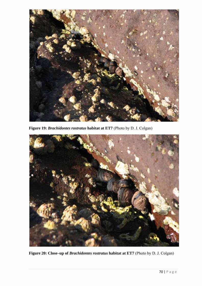
70 | P a g e
Figure 19: Brachidontes rostratus habitat at ET7 (Photo by D. J. Colgan)
Figure 20: Close–up of Brachidontes rostratus habitat at ET7 (Photo by D. J. Colgan)
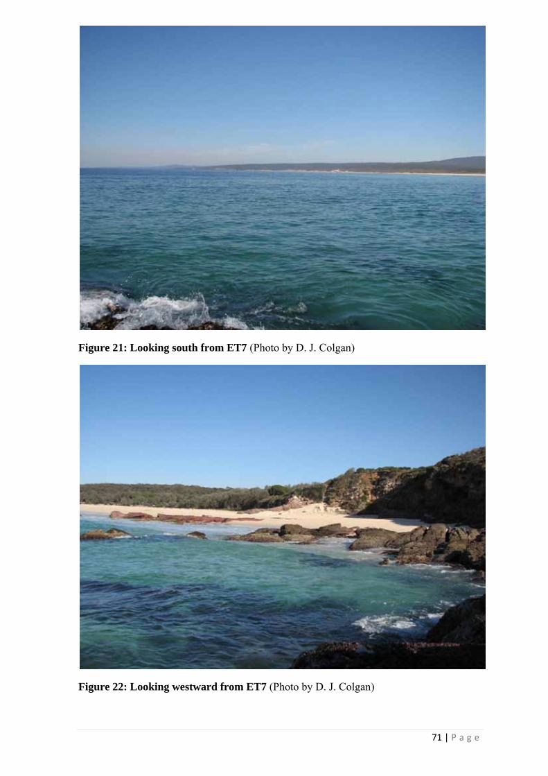
71 | P a g e
Figure 21: Looking south from ET7 (Photo by D. J. Colgan)
Figure 22: Looking westward from ET7 (Photo by D. J. Colgan)

72 | P a g e
Figure 23: ET8 (Photo by D. J. Colgan)
Figure 24: ET9, looking southwest (Photo by D. J. Colgan)

73 | P a g e
Figure 25: Brachidontes rostratus habitat at ET10 (Photo by D. J. Colgan)
Figure 26: ET10, looking south(Photo by D. J. Colgan)

74 | P a g e
Figure 27: ET11, looking southwest (Photo by D. J. Colgan)
Figure 28: ET13 (Photo by D. J. Colgan)

75 | P a g e
Figure 29: ET14 (Photo by D. J. Colgan)
Figure 30: ET15 (Photo by P. Middelfart)

76 | P a g e
Figure 31: ET17 (Photo by P. Middelfart)
Figure 32: ET19 (Photo by P. Middelfart)

77 | P a g e
Figure 33: ET20 (Photo by P. Middelfart)
Figure 34: ET21 (Photo by P. Middelfart)

78 | P a g e
Figure 35: ET22 (Photo by P. Middelfart)
Figure 36: ET23 (Photo by P. Middelfart)

79 | P a g e
Figure 37: ET24 (Photo by P. Middelfart)
Figure 38: ET25 (Photo by P. Middelfart)

80 | P a g e
Figure 39: ET26 (Photo by P. Middelfart)
Figure 40: ET29 looking eastward (Photo by F. Criscione)

81 | P a g e
Figure 41: ET29 Trichomya hirsuta habitat (Photo by D. J. Colgan)
Figure 42: ET30 Limnoperna securis habitat (Photo by D. J. Colgan)

82 | P a g e
Figure 43: Looking south towards ET30 (Photo by D. J. Colgan)
Figure 44: ET31 Looking towards South Head, Port Jackson (Photo by D. J. Colgan)

83 | P a g e
Figure 45: ET31 Trichomya hirsuta habitat (Photo by F. Criscione)
Figure 46: ET38 Trichomya hirsuta habitat (Photo by F. Criscione)

84 | P a g e
Figure 47: ET38 (Photo by F. Criscione)
Figure 48: ET39, Mytilus embedded in oysters (Photo by F. Criscione)
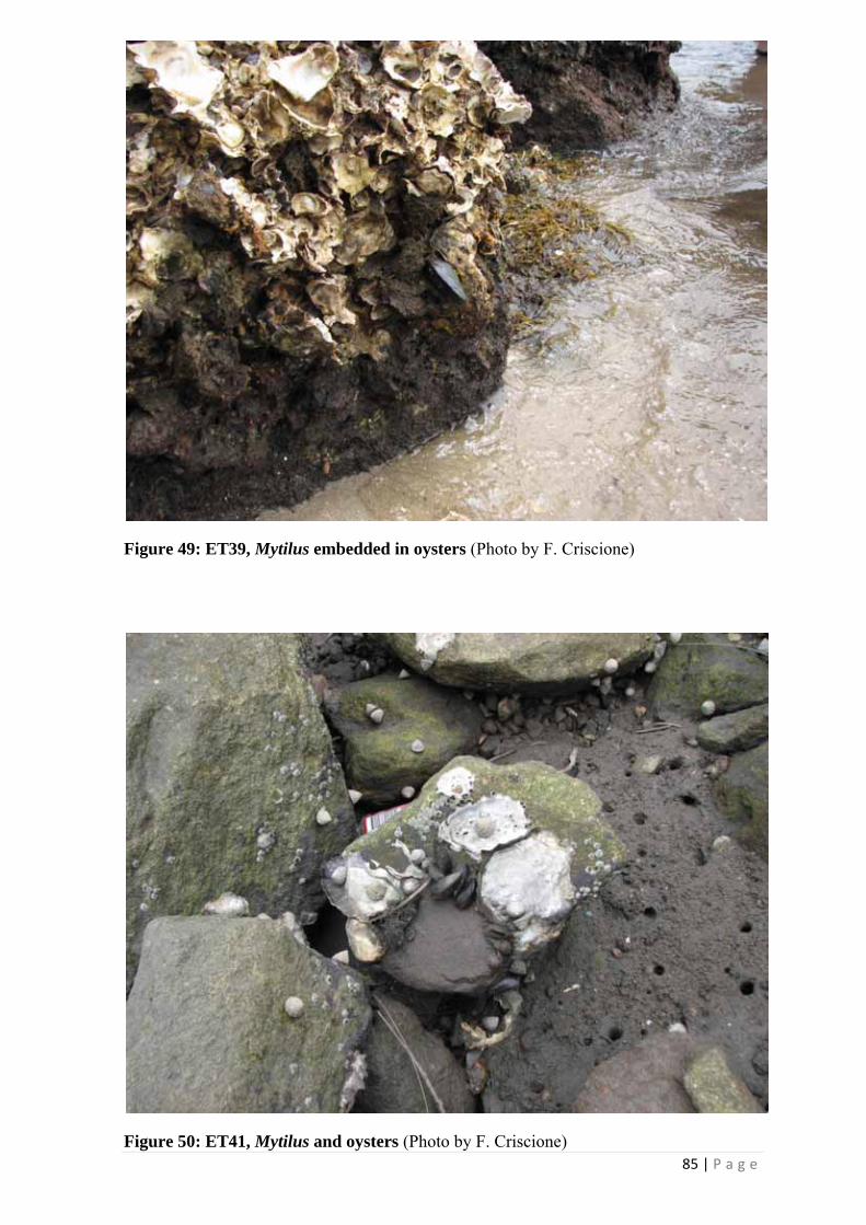
85 | P a g e
Figure 49: ET39, Mytilus embedded in oysters (Photo by F. Criscione)
Figure 50: ET41, Mytilus and oysters (Photo by F. Criscione)