Module 1 Lesson 2 – Conducting Action Research - BLM
105
Module 1 Lesson 2 – Conducting Action Research EXERCISE 1 - Review APD and COAs Instructions: • This is an individual exercise. • Imagine you are conducting action research for an upcoming environmental/surface inspection. You are now at the step in the action research process where you are reviewing the APD and COAs. You acquire the APD and COAs from the well file in your office (see attached APD and COAs). • Review the attached APD and COAs. • Take notes of any items of interest that might be relevant to an upcoming environmental/surface inspection. Take notes for the five different inspection activities: o Surface Construction o Surface Drilling o Interim Reclamation o Surface Production o Surface Abandonment Example: Review the APD and COAs and imagine you are preparing for a surface construction inspection. Take notes on the appropriate note pad (attached) for that upcoming surface construction inspection activity. Repeat this same process for the other four inspection activities (i.e., SD, IR, SP, and SA). Take notes on the appropriate note pads for the other inspection activities as if you were preparing for those inspection activities. You can use your own note pad. Hint: You would not note special COAs for final reclamation for the ES-SC inspection, but you would for the ES-SA inspection. • At the next webinar, students will be asked a series of questions related to this exercise. Attachments: 1. ES-SC Note Pad (1 page) a. Student can use the first (top) section of the Note Pad to type notes to complete the exercise and reference during the exercise review. b. Student can use the second (bottom) section of the Note Pad to type notes during the exercise review/instructor feedback and reference in the future. 2. ES-SD Note Pad (1 page) 3. ES-IR Note Pad (1 page) 4. ES-SP Note Pad (1 page) 5. ES-SA Note Pad (1 page) 6. Entire APD and COAs (99 pages)
-
Upload
khangminh22 -
Category
Documents
-
view
0 -
download
0
Transcript of Module 1 Lesson 2 – Conducting Action Research - BLM

Module 1 Lesson 2 – Conducting Action Research
EXERCISE 1 - Review APD and COAs
Instructions:
• This is an individual exercise.
• Imagine you are conducting action research for an upcoming environmental/surface
inspection. You are now at the step in the action research process where you are
reviewing the APD and COAs. You acquire the APD and COAs from the well file in
your office (see attached APD and COAs).
• Review the attached APD and COAs.
• Take notes of any items of interest that might be relevant to an upcoming
environmental/surface inspection. Take notes for the five different inspection activities:
o Surface Construction
o Surface Drilling
o Interim Reclamation
o Surface Production
o Surface Abandonment
Example: Review the APD and COAs and imagine you are preparing for a surface
construction inspection. Take notes on the appropriate note pad (attached) for that
upcoming surface construction inspection activity. Repeat this same process for the other
four inspection activities (i.e., SD, IR, SP, and SA). Take notes on the appropriate note
pads for the other inspection activities as if you were preparing for those inspection
activities. You can use your own note pad. Hint: You would not note special COAs for
final reclamation for the ES-SC inspection, but you would for the ES-SA inspection.
• At the next webinar, students will be asked a series of questions related to this exercise.
Attachments:
1. ES-SC Note Pad (1 page)
a. Student can use the first (top) section of the Note Pad to type notes to complete
the exercise and reference during the exercise review.
b. Student can use the second (bottom) section of the Note Pad to type notes during
the exercise review/instructor feedback and reference in the future.
2. ES-SD Note Pad (1 page)
3. ES-IR Note Pad (1 page)
4. ES-SP Note Pad (1 page)
5. ES-SA Note Pad (1 page)
6. Entire APD and COAs (99 pages)

Module 1 – Lesson 2: “Conducting Action Research” Exercise 1 – Review APD and COAs
Exercise Aid: NOTE PAD for ES-SC Inspection
Notes for Exercise (Filled in for Exercise)
Exercise Feedback – Optional Notes (Filled in during instructor feedback)

Module 1 – Lesson 2: “Conducting Action Research” Exercise 1 – Review APD and COAs
Exercise Aid: NOTE PAD for ES-SD Inspection
Notes for Exercise (Filled in for Exercise)
Exercise Feedback – Optional Notes (Filled in during instructor feedback)
Module 1 – Lesson 2: “Conducting Action Research” Exercise 1 – Review APD and COAs
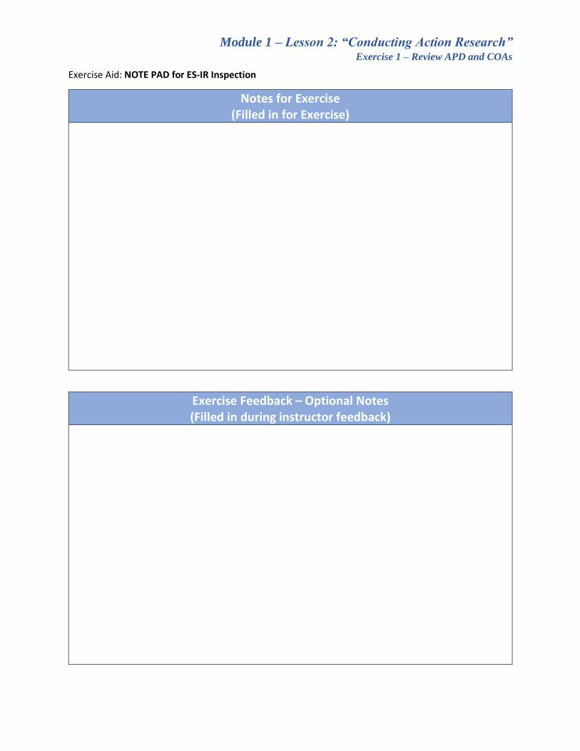
Exercise Aid: NOTE PAD for ES-IR Inspection
Notes for Exercise (Filled in for Exercise)
Exercise Feedback – Optional Notes (Filled in during instructor feedback)

Module 1 – Lesson 2: “Conducting Action Research” Exercise 1 – Review APD and COAs
Exercise Aid: NOTE PAD for ES-SP Inspection
Notes for Exercise (Filled in for Exercise)
Exercise Feedback – Optional Notes (Filled in during instructor feedback)

Module 1 – Lesson 2: “Conducting Action Research” Exercise 1 – Review APD and COAs
Exercise Aid: NOTE PAD for ES-SA Inspection
Notes for Exercise (Filled in for Exercise)
Exercise Feedback – Optional Notes (Filled in during instructor feedback)

CONFIDENTI
AL
Form 3160 -3 (March 2012)
3a. Address
UNITED STATES DEPARTMENT THE INTERIOR BUREAU OF LAND MANAGEMENT
APPLICATION FOR PERMIT TO DRILL OR REENTER
3b. Phone No. (include area code)
la. Type of work:
Distance from proposed* location to nearest property or lease line, ft. (Also to nearest drig. unit line, if any)
No. of acres in lease
lb. Type of Well: Oil Well Gas Well Single Zone Multiple Zone
21. Elevations (Show whether DF, KDB, RT, GL, etc.)
2. Name of Operator
2.2. Approximate date work will start*
2. A Drilling Plan. 3. A Surface Use Plan (if the location is on National Forest System Lands, the
must be filed with the appropriate Forest Service Office).
4. Location of Well (Report location clearly and in accordance with any State requirements.*)
At surface At proposed prod. zone
Item 20 above).
reguired by the
14. Distance in miles and direction from nearest town or post office*
18. Distance from proposed location* to nearest well, drilling, completed,applied for, on this lease, ft.
Depth
FORM APPROVED
5. Lease Serial No.
6. If Indian, Allotee or Tribe Name
7. If Unit or CA Agreement, Name and No.
Name and Well No.
9. Well No.
10. Field and Pool, or Exploratory
11. Sec., T. R. M. or Blk. and Survey or Area
13. State County or Parish
Spacing Unit dedicated to this well
Bond No. on file
Estimated duration
24. AttachmentsThe following, completed in accordance with the requirements of Onshore Oil and Gas Order No.1, must be attached to this form:
1. Well plat certified by a registered surveyor. 4. Bond to cover the operations unless covered by an existing bond on file (see
Signature Name (Printed/Typed) Date
Title
Approved by (Signature) Date
Title
the applicant holds legal or equitable title to those rights in the subject lease which would entitle the applicant to
Title 18 U.S.C. Section 1001 and Title 43 U.S.C. Section 1212, make it a crime for any person knowingly and willfully to make to any department or agency States any false, fictitious or fraudulent statements or representations as to any matter within its jurisdiction.
OF
OMB No. 1004-0137 Expires October 31, 2014
DRILL
Other
15. 16. 17.
19. Proposed 20. BLM/BIA
2.3.
SUPO5. 6. Such other site specific information and/or plans as may be required by the
Operator certification
25.
Name (Printed/Typed)
of the United
Office
(Continued on page 2) *(Instructions on page 2)
API
8. Lease
12.
BLM.
REENTER
Application approval does not warrant or certify that conduct operations thereon.Conditions of approval, if any, are attached.
Approval Date: 04/03/2018
CONFIDENTI
AL
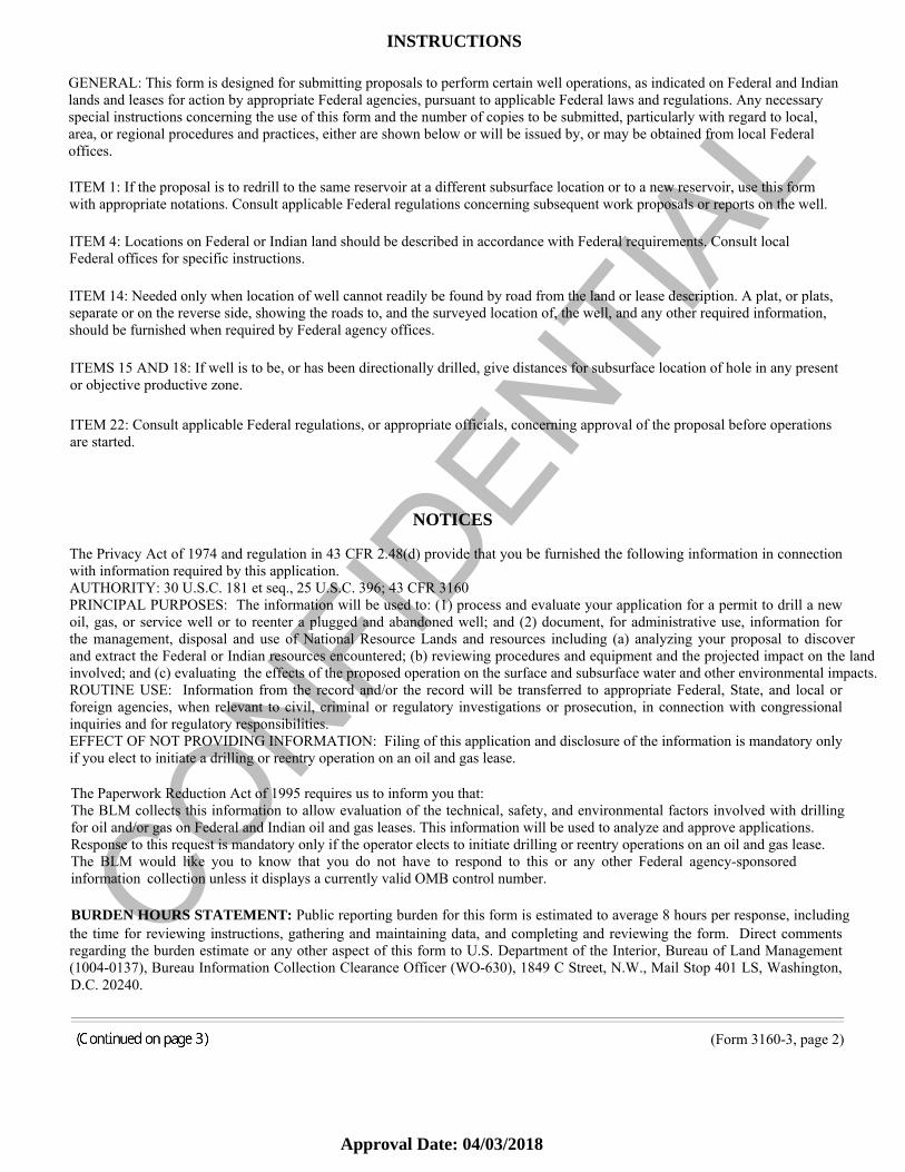
INSTRUCTIONS
GENERAL: This form is designed for submitting proposals to perform certain well operations, as indicated on Federal and Indian lands and leases for action by appropriate Federal agencies, pursuant to applicable Federal laws and regulations. Any necessary special instructions concerning the use of this form and the number of copies to be submitted, particularly with regard to local, area, or regional procedures and practices, either are shown below or will be issued by, or may be obtained from local Federal offices.
ITEM 1: If the proposal is to redrill to the same reservoir at a different subsurface location or to a new reservoir, use this form with appropriate notations. Consult applicable Federal regulations concerning subsequent work proposals or reports on the well.
ITEM 4: Locations on Federal or Indian land should be described in accordance with Federal requirements. Consult local Federal offices for specific instructions.
ITEM 14: Needed only when location of well cannot readily be found by road from the land or lease description. A plat, or plats, separate or on the reverse side, showing the roads to, and the surveyed location of, the well, and any other required information, should be furnished when required by Federal agency offices.
ITEMS 15 AND 18: If well is to be, or has been directionally drilled, give distances for subsurface location of hole in any present or objective productive zone.
ITEM 22: Consult applicable Federal regulations, or appropriate officials, concerning approval of the proposal before operations are started.
NOTICES
The Privacy Act of 1974 and regulation in 43 CFR 2.48(d) provide that you be furnished the following information in connection with information required by this application. AUTHORITY: 30 U.S.C. 181 et seq., 25 U.S.C. 396; 43 CFR 3160 PRINCIPAL PURPOSES: The information will be used to: (1) process and evaluate your application for a permit to drill a new oil, gas, or service well or to reenter a plugged and abandoned well; and (2) document, for administrative use, information for the management, disposal and use of National Resource Lands and resources including (a) analyzing your proposal to discover and extract the Federal or Indian resources encountered; (b) reviewing procedures and equipment and the projected impact on the land involved; and (c) evaluating the effects of the proposed operation on the surface and subsurface water and other environmental impacts. ROUTINE USE: Information from the record and/or the record will be transferred to appropriate Federal, State, and local or foreign agencies, when relevant to civil, criminal or regulatory investigations or prosecution, in connection with congressional inquiries and for regulatory responsibilities. EFFECT OF NOT PROVIDING INFORMATION: Filing of this application and disclosure of the information is mandatory only if you elect to initiate a drilling or reentry operation on an oil and gas lease.
The Paperwork Reduction Act of 1995 requires us to inform you that: The BLM collects this information to allow evaluation of the technical, safety, and environmental factors involved with drilling for oil and/or gas on Federal and Indian oil and gas leases. This information will be used to analyze and approve applications. Response to this request is mandatory only if the operator elects to initiate drilling or reentry operations on an oil and gas lease. The BLM would like you to know that you do not have to respond to this or any other Federal agency-sponsored information collection unless it displays a currently valid OMB control number.
BURDEN HOURS STATEMENT: Public reporting burden for this form is estimated to average 8 hours per response, including the time for reviewing instructions, gathering and maintaining data, and completing and reviewing the form. Direct comments regarding the burden estimate or any other aspect of this form to U.S. Department of the Interior, Bureau of Land Management (1004-0137), Bureau Information Collection Clearance Officer (WO-630), 1849 C Street, N.W., Mail Stop 401 LS, Washington, D.C. 20240.
______________________________________________________________________________________________________________________________________________________________________________ ______________________________________________________________________________________________________________________________________________________________________________
(Form 3160-3, page 2)
Approval Date: 04/03/2018

CONFIDENTI
ALAdditional Operator RemarksOther description
Oil and/or Gas
Location of Well
(Form 3160-3, page 3)
1. SHL: SESE / 239 FSL / 205 FEL / TWSP: 14N / RANGE: 11W / SECTION: 31 / LAT: 35.6390492 / LONG: -98.4025265 ( TVD: 0 feet, MD: 0 feet )
PPP: SESE / 165 FSL / 379 FEL / TWSP: 14N / RANGE: 11W / SECTION: 31 / LAT: 35.6388475 / LONG: -98.4031128 ( TVD: 13254 feet, MD: 13292 feet )
PPP: SENE / 2641 FSL / 379 FEL / TWSP: 14N / RANGE: 11W / SECTION: 31 / LAT: 35.6390492 / LONG: -98.4025265 ( TVD: 0 feet, MD: 0 feet )
BHL: NENE / 50 FNL / 380 FEL / TWSP: 14N / RANGE: 11W / SECTION: 30 / LAT: 35.6672269 / LONG: -98.4031131 ( TVD: 13421 feet, MD: 23671 feet )
BLM Point of ContactName: Carolyn Russell
Title: AFM RESOURCES
Phone: 4055797170
Email: [email protected]
Approval Date: 04/03/2018

CONFIDENTI
AL
(Form 3160-3, page 4)
Review and Appeal Rights A person contesting a decision shall request a State Director review. This request must be filed within 20 working days of receipt of the
Notice with the appropriate State Director (see 43 CFR 3165.3). The State Director review decision may be appealed to the Interior
Board of Land Appeals, 801 North Quincy Street, Suite 300, Arlington, VA 22203 (see 43 CFR 3165.4). Contact the above listed
Bureau of Land Management office for further information.
Approval Date: 04/03/2018

Page 1 of 6
ENGINEERINGGeneral CONDITIONS OF APPROVAL
Operator: Devon Energy Production Company LPWell Name: MAD DOG 31_30-14N-11W 1HX Lease No: 14-20-205-16391SME: Private Surface Owner
Location: SHL: 239’ FSL & 205’ FEL, (SESE ) , Sec. 31, T. 14 N., R. 11 W., I.M., Blaine County, OKBHL: 50’ FNL & 380’ FEL, (NENW ), Sec. 30, T. 14 N., R. 11 W., I.M., Blaine County, OK
A copy of the CONDITIONS OF APPROVAL must be furnished to your field representative.
1. Verbal notification shall be given to the assigned BLM Natural Resource Specialist at least 72HOURS PRIOR TO PAD CONSTRUCTION .
2. The Operator shall provide the BLM Inspection and Enforcement department a verbalnotification with the following information 72 hours prior to spud.
BLM lease number Well Name API number Operator Name Drilling contractor’s name Rig Number Date and Time which the well will be spud.
3. Verbal notification shall be given to the BLM Inspection and Enforcement department at least72 hours before well operations begin on the following:
Well Spud (including setting conductor casing) Pressure Testing BOPE, Casing, and Formation Integrity Testing Setting and Cementing all Casing Strings Open Hole Logging Operations Drilling Over Lease Expiration for Lease Extension
4. Approval of this APD does not warrant or certify that the applicant holds legal or equitabletitle to those rights in the subject lease that would entitle the applicant to conduct operations thereon. Inaddition, approval of this APD does not imply that the operator has legal access to the drilling location.When crossing private surface 43 CFR 3814 regulations must be complied with and when crossingpublic surface off-lease the operator must have approved rights-of-way.
5. This APD is valid for two years from the date of approval or until the oil and gas leaseexpires/terminates, whichever occurs first. If drilling of this permitted well is to result in anextension of the lease term, diligent operations (actual drilling) must be in progress before and continuethrough the lease expiration date and must continue diligently until well completion, advance leaserentals must have been paid, and a letter stating drilling operations were in progress must be submittedto this office no later than five days past the lease expiration date. If the APD terminates, any surface
BLM- Oklahoma Field Office- Conditions of Approval: Devon Energy-MAD DOG 31_30-14N-11W 1HX Approval Date: 04/03/2018

Page 2 of 6disturbance created under the application must be reclaimed according to an approved plan.
6. All applicable local, state and/or federal laws, regulations, and/or statutes must be compliedwith.
7. A complete copy of the approved APD must be at the drill site during the construction of theroads and drill pad, the drilling of the well, and the completion of the well.
BLM Contact Information :
Natural Resource Specialist: (NRS)
Mr. Ty Swirin(405) 579-7175 office(405) 230-6569 cell [email protected]
Inspection & Enforcement: On Call (405) 245-5048 cell
Petroleum Engineer: Mr. Teungku Kruëng (405) 579-7141 office [email protected]
Oklahoma Field Office (OKFO): (405) 579-7100201 Stephenson Parkway, Suite 1200Norman, OK 73072www.blm.gov/nm
DRILLING PLAN CONDITIONS OF APPROVAL
I. ADMINISTRATIVE REQUIREMENTS
1. Contact the BLM Petroleum Engineers listed in the above table if there are any concernsregarding these Drilling Plan Conditions of Approval prior to SPUD Notification during normal businesshours.
2. After Spud Notification and matters of urgent concern that occur outside of normal businesshours shall be directed to Inspection and Enforcement first. The Field Inspector may direct the call to aBLM Engineer if necessary.
3. Notices to BLM Inspection and Enforcement staff, and discussion with BLM Engineersshall be recorded in your daily progress (drilling) report. The name of the BLM staff, the timewhen they were notified, and the nature of the discussion shall be documented, including anypertinent outcome of the discussion. Unless instructed otherwise, daily drilling reports shall besubmitted at the end of drilling operations in the form of a drilling summary; however, dailyreports may be requested at any time and shall be available on demand.
4. Required Testing, Logging, and Coring procedures noted below:
Mud Logging/Gamma Ray/MWD. Open hole logs (GR/SP/DIL/LDT/CNL/ML) from TD (horizontal well – vertical portionof hole) to the top of the upper most potential hydrocarbon intervals.
2
Approval Date: 04/03/2018

Page 3 of 6 Open hole logs (GR/SP/DIL) from the top of the upper most hydrocarbon interval to thebase of the surface casing and (GR) log from base of surface casing to surface. Cased hole CBL on production casing.
When logs are run, digital log data must be submitted to this office. Paper logs will not beaccepted . Log data should be in LAS format (Log ASCII Standard [Canadian Well Log SocietyVersion 1.2, or greater]).
5. A copy of the daily drilling and completion morning reports along with a copy of all theopen and cased hole logs shall be submitted to the BLM office 30 days from completion. Thecompletion data reported to the BLM should include the final bottom hole location, treatingpressure, pumped volumes, post frac analysis, flow back oil and water volumes and tracerinformation if available.
6. Changes to the approved APD casing program need prior approval if the itemssubstituted are of lesser grade or different casing size or are Non-API. The Operator canexchange the components of the proposal with that of superior strength (i.e. changing from J-55to N-80, or from 36# to 40#). Changes to the approved cement program need prior approval ifthe altered cement plan has less volume or strength or if the changes are substantial (i.e.Multistage tool, ECP, etc.). The initial wellhead installed on the well will remain on the wellwith spools used as needed.
7. Casing String Cement Compressive Strength: After cementing but beforecommencing any tests, the casing string shall stand cemented until the cement has reached acompressive strength of at least 500 psi at the shoe, and cement has been in place at least 8hours. During this WOC time, no tests shall be initiated until cement has been in place at least 8hours; also no drill pipe shall be run in the hole. WOC time shall be recorded in the driller’s log.Provide compressive strengths including hours to reach required 500 pounds compressivestrength prior to cementing each casing string. Have well specific cement details onsite prior topumping the cement for each casing string.
8. If applicable, plans for disposal of water produced beyond the drilling and completionsphase of this well shall be submitted via Sundry Notice of Intent, Form 3160-5, and must beapproved by the Authorized Officer prior to disposal. Please refer to Onshore Oil and GasOrder #7 A. for appropriate disposal methods and approval requirements. ‘Unless prohibited bythe Authorized Officer, produced water from newly completed wells may be temporarilydisposed of into pits for a period of up to 90 days, if the use of the pit was approved as part of anapplication for permit to drill.
9. If applicable, requests for measurement of produced oil or gas at any location other thanon the lease, or within the boundary of a valid Federal or Indian agreement, shall be submittedvia Sundry Notice of Intent, Form 3160-5, and must be approved by the Authorized Officerprior to use of any alternative method.
II. Pressure Control
1. All blowout preventer (BOP) and related equipment (BOPE) shall comply with well control requirements as described in Onshore Oil and Gas Order No. 2 and API 53.
BLM- Oklahoma Field Office- Conditions of Approval: Devon Energy-MAD DOG 31_30-14N-11W 1HX Approval Date: 04/03/2018

Page 4 of 6
If the operator plans on using a multi-bowl wellhead assembly in the APD2. Operator has proposed a multi-bowl wellhead assembly. This assembly will only be tested
when installed on the surface casing. Minimum working pressure of the blowout preventer (BOP) and related equipment (BOPE) required for drilling below the surface casing shoe shall be10,000 (2M) psi.
a. Wellhead shall be installed by manufacturer’s representatives. Submit documentationwith subsequent Sundry Notice.
b. If the welding is performed by a third party, the manufacturer’s representative shall monitor the temperature to verify that it does not exceed the maximum temperature ofthe seal.
c. Manufacturer representative shall install the test plug for the initial BOP test.d. All seal test on the multi-bowel wellhead shall be tested for a minimum period of
15 minutes and chart recorded. This information shall be submitted with the BOP/BOPE test information.
e. If the cement does not circulate and one inch operations would have been possible with a standard wellhead, the well head shall be cut off, cementing operations performed and another wellhead installed.
f. Whenever any seal subject to test pressure is broken, all the tests in OOGO2.III.A.2.i.must be followed.
3. Variance approved to use flex line from BOP to choke manifold. If you choose to use a flexible hose as opposed to a non-flexible connection between the stack and the choke manifold, the hose must be successfully tested along with the stack over each hole section at the same test pressure of the approved RAM size (RAM test pressure). Check condition of flexible line from BOP to choke manifold and replace if exterior is damaged or if line fails test. The flexible hose can be exchanged with a hose of equal size and equal or greater pressure rating. The manufactures’ specification and hydrostatic pressure test certification matching the hose in service information must be available on request to our inspection and enforcement personnel.
If the operator is not using a multi-bowl well head assembly, Items 4 and 5 apply.4. Minimum working pressure of the blowout preventer (BOP) and related equipment (BOPE)
required for drilling below the surface casing shoe shall be 5,000 (5M) psi. 5. Minimum working pressure of the blowout preventer (BOP) and related equipment (BOPE)
required for drilling below the 9-5/8” intermediate casing shoe shall be 10,000 (10M) psi.
5M/10M system requires an HCR valve, remote kill line and annular to match. The remote kill line is to be installed prior to testing the system and tested to stack pressure.
6. The BLM office shall be notified as stated in General Conditions of Approval above in advance for a representative to witness the BOP tests. All testing shall comply as described in Onshore Oil and Gas Order No. 2 and API 53
4
Approval Date: 04/03/2018

Page 5 of 6a. For all casing strings utilizing slips, these are to be set as soon as the crew and rig are
ready and any fallback cement remediation has been done. The casing cut-off and BOP installation can be initiated four hours after installing the slips, which will be approximately six hours after bumping the plug. For those casing strings not using slips, the minimum wait time before cut-off is eight hours after bumping the plug. BOP/BOPE testing can begin after cut-off or once cement reaches 500 psi compressive strength (including lead when specified), whichever is greater. However, if the float does not hold, cut-off cannot be initiated until cement reaches 500 psi compressive strength.
a. The tests shall be done by an independent service company utilizing a test plug, not a cup or J-packer.
b. The test shall be run on a 5000 psi chart for a 2-3M BOP/BOP, on a 10000 psi chart for a 5M BOP/BOPE and on a 15000 psi chart for a 10M BOP/BOPE. If a linear chart is used,it shall be a one hour chart. A circular chart shall have a maximum 2 hour clock. If a twelve hour or twenty-four hour chart is used, tester shall make a notation that it is run with a two hour clock.
c. The results of the test shall be reported to the appropriate BLM office.
d. All tests are required to be recorded on a calibrated test chart. A copy of the BOP/BOPE test chart and a copy of independent service company test will be submitted to the appropriate BLM office.
e. The BOP/BOPE test shall include a low pressure test from 250 to 300 psi. The test will be held for a minimum of 10 minutes if test is done with a test plug and 30 minutes without a test plug. This test shall be performed prior to the test at full stack pressure.
III. PRESSURE TESTING ON CASING – AFTER CEMENTING
In accordance with Onshore Oil and Gas Order No. 2, “all casing strings below the conductor shall be pressure tested to 0.22 psi/ft of casing string length, or 1,500 psig, whichever is greater, not to exceed 70% of the minimum internal yield.” Variance granted to use 0.22 psi/ft offset exterior gradient for the 70% of the minimum yield pressure calculations.
IV. FORMATION TESTING REQUIREMENTS – AFTER DRILLING OUT BELOW SHOE
On all exploratory wells and on that portion of any well approved for a 5M psi BOPE system or greater, a pressure integrity test of the formation (FIT), at each casing shoe (before drilling no more than 20 ft below the casing shoe) shall be performed. Formation at the shoe shall be tested toa minimum of the mud weight equivalent anticipated to control the formation pressure to the next casing depth or at total depth (TD) of the well, or to the maximum mud weight listed in the APD tothe next setting depth, whichever is greater.
V. OTHER VARIANCES TO BLM ORDERS AND REGULATIONS and COA Requirements
o Due to inconsistency in the APD request,
BLM- Oklahoma Field Office- Conditions of Approval: Devon Energy-MAD DOG 31_30-14N-11W 1HX Approval Date: 04/03/2018

Page 6 of 6
BLM assumes the following statement is correct:
Instead of:
o Variance request on submitting logs from nearby wells is denied. Please submit a sundry request onceAPD is approved.
o Variance approved with use of a 5M annular on a 10M BOP system per IM-NM2017-008.The 5M Annular Preventer on a required 10M BOP stack will be tested to 100 % of rated working pressure including a 10 minute low pressure test. Pressure shall be maintained at least 10 minutes.
The Operator assumes all responsibility for maintaining well control accredited industry standard Certification of appropriate supervisory drilling rig personnel.
Enforcement actions include but are not limited to immediate replacement of personnel lacking certifications, drilling operations being delayed or installment of a 10M annular.
Initials & (Date)
United States Department of the InteriorBUREAU OF LAND MANAGEMENTOklahoma Field Office201 Stephenson Parkway, Suite 1200Norman, Oklahoma 73072www.blm.gov/nm
6
Approval Date: 04/03/2018
Page 1 of10
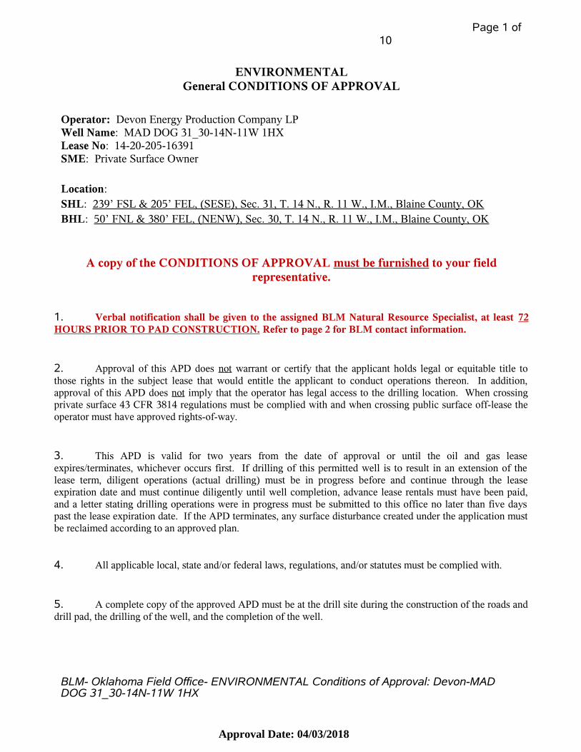
ENVIRONMENTALGeneral CONDITIONS OF APPROVAL
Operator: Devon Energy Production Company LPWell Name: MAD DOG 31_30-14N-11W 1HX Lease No: 14-20-205-16391SME: Private Surface Owner
Location: SHL: 239’ FSL & 205’ FEL, (SESE ) , Sec. 31, T. 14 N., R. 11 W., I.M., Blaine County, OKBHL: 50’ FNL & 380’ FEL, (NENW ), Sec. 30, T. 14 N., R. 11 W., I.M., Blaine County, OK
A copy of the CONDITIONS OF APPROVAL must be furnished to your fieldrepresentative.
1. Verbal notification shall be given to the assigned BLM Natural Resource Specialist, at least 72HOURS PRIOR TO PAD CONSTRUCTION. Refer to page 2 for BLM contact information.
2. Approval of this APD does not warrant or certify that the applicant holds legal or equitable title tothose rights in the subject lease that would entitle the applicant to conduct operations thereon. In addition,approval of this APD does not imply that the operator has legal access to the drilling location. When crossingprivate surface 43 CFR 3814 regulations must be complied with and when crossing public surface off-lease theoperator must have approved rights-of-way.
3. This APD is valid for two years from the date of approval or until the oil and gas leaseexpires/terminates, whichever occurs first. If drilling of this permitted well is to result in an extension of thelease term, diligent operations (actual drilling) must be in progress before and continue through the leaseexpiration date and must continue diligently until well completion, advance lease rentals must have been paid,and a letter stating drilling operations were in progress must be submitted to this office no later than five dayspast the lease expiration date. If the APD terminates, any surface disturbance created under the application mustbe reclaimed according to an approved plan.
4. All applicable local, state and/or federal laws, regulations, and/or statutes must be complied with.
5. A complete copy of the approved APD must be at the drill site during the construction of the roads anddrill pad, the drilling of the well, and the completion of the well.
BLM- Oklahoma Field Office- ENVIRONMENTAL Conditions of Approval: Devon-MAD DOG 31_30-14N-11W 1HX
Approval Date: 04/03/2018

Page 2 of10
BLM Contact Information:
Natural Resource Specialist (NRS):
Mr. Ty Swirin (405) 579-7175 office [email protected]
Archeologist: Mr. Jamie Palmer (405) 579-7173 office [email protected]
Wildlife: Mr. George Thomas(405) 579- 7176 office(918) 344-7874 cell
Oklahoma Field Office (OKFO) (405) 579-7100201 Stephenson Parkway, Suite 1200Norman, OK 73072www.blm.gov/nm
BLM- Oklahoma Field Office- ENVIRONMENTAL Conditions of Approval: Devon-MAD DOG 31_30-14N-11W 1HX
Approval Date: 04/03/2018
Page 3 of10
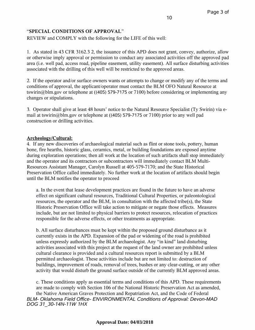
“SPECIAL CONDITIONS OF APPROVAL” REVIEW and COMPLY with the following for the LIFE of this well:
1. As stated in 43 CFR 3162.3 2, the issuance of this APD does not grant, convey, authorize, allowor otherwise imply approval or permission to conduct any associated activities off the approved padarea (i.e. well pad, access road, pipeline easement, utility easement). All surface disturbing activitiesassociated with the drilling of this well will be restricted to the approved areas. 2. If the operator and/or surface owners wants or attempts to change or modify any of the terms and conditions of approval, the applicant/operator must contact the BLM OFO Natural Resource at [email protected] or telephone at ((405) 579-7175 or 7100) before considering or implementing any changes or stipulations.
3. Operator shall give at least 48 hours’ notice to the Natural Resource Specialist (Ty Swirin) via e-mail at [email protected] or telephone at ((405) 579-7175 or 7100) prior to any well pad construction or drilling activities.
Archeology/Cultural:4. If any new discoveries of archaeological material such as flint or stone tools, pottery, human bone, fire hearths, historic glass, ceramics, metal, or building foundations are exposed anytime during exploration operations; then all work at the location of such artifacts shall stop immediately and the operator and its contractors or subcontractors will immediately contact BLM Multi-Resources Assistant Manager, Carolyn Russell at 405-579-7170; and the State Historical Preservation Office called immediately. No further work at the location of artifacts should begin until the BLM notifies the operator to proceed
a. In the event that lease development practices are found in the future to have an adverse effect on significant cultural resources, Traditional Cultural Properties, or paleontological resources, the operator and the BLM, in consultation with the affected tribe(s), the State Historic Preservation Office will take action to mitigate or negate those effects. Measures include, but are not limited to physical barriers to protect resources, relocation of practices responsible for the adverse effects, or other treatments as appropriate.
b. All surface disturbances must be kept within the proposed ground disturbance as it currently exists in the APD. Expansion of the pad or widening of the road is prohibited unless expressly authorized by the BLM archaeologist. Any “in kind” land disturbing activities associated with this project at the request of the land owner are prohibited unless cultural clearance is provided and a cultural resources report is submitted by a BLM permitted archaeologist. These activities include but are not limited to: destruction of buildings, improvement of roads, removal of trees, bushes or any clear-cutting, or any other activity that would disturb the ground surface outside of the currently BLM approved areas.
c. These conditions apply as essential terms and conditions of this APD. These requirementsare made to comply with Section 106 of the National Historic Preservation Act as amended,the Native American Graves Protection and Repatriation Act, and the Code of Federal
BLM- Oklahoma Field Office- ENVIRONMENTAL Conditions of Approval: Devon-MAD DOG 31_30-14N-11W 1HX
Approval Date: 04/03/2018

Page 4 of10
Regulations 36 CFR Part 800. Having gone through the permitting process successfully, Devon Energy Production Company LP is fully aware that any future project that causes ground disturbance prior to a permit being issued by the BLM, will be a violation of NHPA and will be considered Knowing and Willful and may result in a denial of permit and will beforced to remedy any violation regardless of cost.
d. If human remains are discovered the procedures of the Oklahoma Burial Desecration Law(Oklahoma Statute Chapter 47, Section 1168.0 - 1168.6), Texas Health & Safety Code (Section 711.010 Unknown or Abandoned Cemetery), or Kansas Unmarked Burial Sites Statute and Regulations (K. S. A 75-2741) shall apply.
e. This authorization does not permit any surface disturbance on any other Federal or StateSurface management agency or private land owners. The operator or their agent isresponsible for obtaining permits, permissions, or Rights-of-ways from other surfacemanagement agencies prior to any ground disturbance and ensuring that cultural resourcessurveys are approved by those agencies.
Surface Disturbance:5. No construction or routine maintenance activities will be performed during periods when the soilis too wet to adequately support construction equipment. If such equipment creates ruts in excess of6 inches deep, the soil shall be deemed too wet.
6. If soil is removed, at least the top 6 inches of soil material, or whatever salvageable, will bestripped and stockpiled (separate from the spoils pile) on an unutilized construction zone of the wellpad. The stockpiled soil material will be spread on the portions of the well pad, which are to bereclaimed (including the cut and fill slopes and all portions of the well pad outside of the productionfacility) prior to reseeding. Spreading will not be done when the ground or topsoil is frozen or wet.
7. At a minimum, effectively install silt fencing (screening) and/or weed-free hay/straw bales priorto beginning any clearing/construction activities. Silt fencing will be installed (and maintained)adjacent to the entire area to be leveled and cleared (around all construction sites; pad, access road,and pipeline) so as to minimize the movement of materials from the BLM approved areas of surfacedisturbance to adjacent lands or drainages. Placement should be along all sides of the pad except forthose areas needed for vehicular access. The bales need to be installed, maintained, and replaced insuch a manner as to provide effective control of any surface runoff and/or erosion that may occur. Adouble row of hay bales will be used where necessary. These measures will be effectivelymaintained until the well is in active/production stage or has been plugged and abandoned, andsuccessful stabilization, reclamation and restoration is achieved. These erosion control measures areonly needed for the duration of construction, drilling/completion, production (only if ground has notbeen stabilized), and reclamation as needed to prevent soil movement.
8. The access road and pad may be surfaced with rock aggregate per operator and surface owner’sagreement. Surfacing or additional surfacing will be required in the event there is resource orexcessive road damage.
BLM- Oklahoma Field Office- ENVIRONMENTAL Conditions of Approval: Devon-MAD DOG 31_30-14N-11W 1HX
Approval Date: 04/03/2018

Page 5 of10
Production:9. All production related facilities/equipment will be painted, and all painted surfaces will bemaintained to ensure its integrity, according to API, BLM, and surface owner specifications.
10. A fluid impermeable secondary containment dike/berm will be constructed/placed around anytank battery and facilities according to 40 CFR 112.7. No sumps, pumps, drains, lines or othermeans will be used to remove/discharge water collected within the secondary containment except toremove for on-site storage/off-site disposal via approved storage tanks and/or transport systems. Thedike/berm and the entire containment area will be graveled. A step or walkway will be placed overthe dike/berm to gain access to the tank battery.
11. Dike & berm the tank battery that will receive fluids from this well. The dike/berm will beimpervious and designed according to requirements of 40 CFR 112. The EPA has a booklet (July1992) available titled “Information on SPCC Plans – 40 CFR 112.” Page 20 of this bookletdescribes, in detail, how tank battery dikes (berms) are to be constructed.
12. If the well is successful, all production equipment, facilities and tanks including well-head andabove-ground piping/equipment shall be properly enclosed to exclude livestock if present.
13. If a compressor or pump-jack shall be used at any point over the life of the well, noise mitigationmay be required at the discretion of the landowner. If noise mitigation is required, a 48.6 dB[A] Leqnoise level will be enforced 100 feet from a dwelling/home in a direct line between the noise sourceand the dwelling/home.
14. During production operations the location and access road will be policed and kept free from alldebris and garbage.
Reclamation:15. After plugging operations are complete, and prior to reclamation, all contaminated soil, cables, drums, thread protectors, trash/debris, and unnecessary materials/equipment or imported gravel, etc.,shall be removed and hauled to an authorized permitted disposal facility.
16. The entire area will be returned to its original contour or as directed by the surface owner. Stockpiled topsoil will be returned to all disturbed areas or, if needed, clean soil or topsoil would be added. All disturbed areas should be ripped to a depth of 12-24 inches and disked prior to topsoil placement and seeding.
17. Establish vegetation on all areas of the location to be reclaimed. This phase of the reclamation process should be accomplished by using seed or sod. Current policy recommends that these areas be restored with native vegetation in regards to both species and structure (grass, shrubs or trees). In those areas where trees or shrubs are planted, grass should be planted in conjunction to provide stabilization until trees are mature. This recommended reclamation is contingent upon the wishes of the surface owner and/or the surface management agency. Seeding will be repeated if a satisfactory
BLM- Oklahoma Field Office- ENVIRONMENTAL Conditions of Approval: Devon-MAD DOG 31_30-14N-11W 1HX
Approval Date: 04/03/2018

Page 6 of10
stand is not obtained as determined by the Authorized Officer upon evaluation after the second growing season.
18. Use only certified weed-free seed. It is recommended to use the appropriate seed mixture, according to NRCS site guidelines, for the site unless the surface owner or surface managing agencyprefers a different seed mix. Under no circumstances should the seed mixture contain any species listed by the State of Oklahoma as noxious or invasive.
19. All areas of the surface disturbance (i.e. well pad, access road, pipeline, etc.) that are not needed or used in the production or operation of the well shall be reclaimed, immediately as described in theapproved APD.
20. After the well is no longer in production, complete reclamation of the site will begin as soon as possible, but in no case longer than sixty (60) days from final plugging of the well and completed within thirty (30) days, weather permitting, unless approved otherwise by the BLM and surface owner.
21. The final fill slope prior to re-seeding will not be steeper than a 3:1 Ratio. To obtain this ratio, pits and slopes will be back-sloped into the pad upon completion of drilling. Construction slopes canbe much steeper during drilling, but will be re-contoured to the above ratio during reclamation. Production equipment (including any facilities associated with pipeline construction) will be placed on location as not to interfere with reclaiming the cut and fill slopes to their proper ratio. If equipment is found to interfere with the proper reclamation of the slope, the company will be required to move the equipment so proper re-contouring can occur.
22. Operator must provide proof or certification of water permit for use in project well(s). If the source of water used on the project well(s) changes to a different source from what was analyzed in the original surface use plan; then the proposed new water source is to be submitted to BLM on Sundry Form 3160-5.
BLM- Oklahoma Field Office- ENVIRONMENTAL Conditions of Approval: Devon-MAD DOG 31_30-14N-11W 1HX
Approval Date: 04/03/2018
Page 7 of10
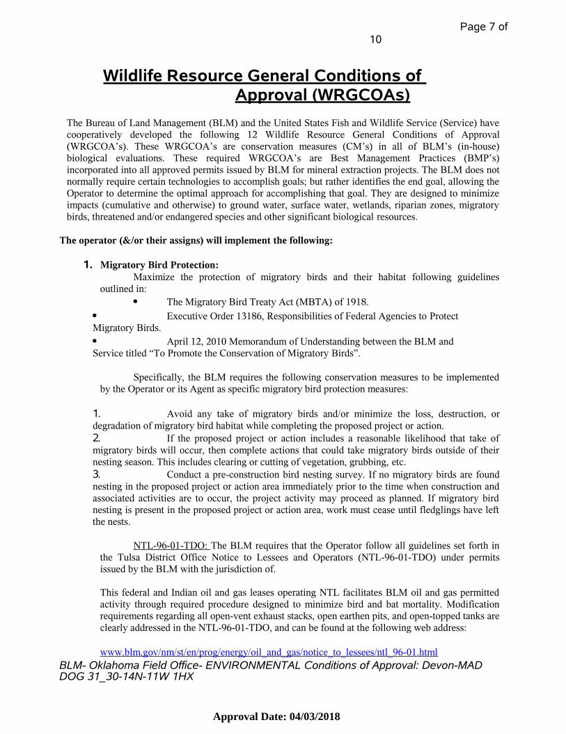
Wildlife Resource General Conditions of Approval (WRGCOAs)
The Bureau of Land Management (BLM) and the United States Fish and Wildlife Service (Service) havecooperatively developed the following 12 Wildlife Resource General Conditions of Approval(WRGCOA’s). These WRGCOA’s are conservation measures (CM’s) in all of BLM’s (in-house)biological evaluations. These required WRGCOA’s are Best Management Practices (BMP’s)incorporated into all approved permits issued by BLM for mineral extraction projects. The BLM does notnormally require certain technologies to accomplish goals; but rather identifies the end goal, allowing theOperator to determine the optimal approach for accomplishing that goal. They are designed to minimizeimpacts (cumulative and otherwise) to ground water, surface water, wetlands, riparian zones, migratorybirds, threatened and/or endangered species and other significant biological resources.
The operator (&/or their assigns) will implement the following:
1. Migratory Bird Protection:Maximize the protection of migratory birds and their habitat following guidelines
outlined in: The Migratory Bird Treaty Act (MBTA) of 1918.
Executive Order 13186, Responsibilities of Federal Agencies to Protect Migratory Birds. April 12, 2010 Memorandum of Understanding between the BLM and Service titled “To Promote the Conservation of Migratory Birds”.
Specifically, the BLM requires the following conservation measures to be implementedby the Operator or its Agent as specific migratory bird protection measures:
1. Avoid any take of migratory birds and/or minimize the loss, destruction, ordegradation of migratory bird habitat while completing the proposed project or action.2. If the proposed project or action includes a reasonable likelihood that take ofmigratory birds will occur, then complete actions that could take migratory birds outside of theirnesting season. This includes clearing or cutting of vegetation, grubbing, etc.3. Conduct a pre-construction bird nesting survey. If no migratory birds are foundnesting in the proposed project or action area immediately prior to the time when construction andassociated activities are to occur, the project activity may proceed as planned. If migratory birdnesting is present in the proposed project or action area, work must cease until fledglings have leftthe nests.
NTL-96-01-TDO: The BLM requires that the Operator follow all guidelines set forth inthe Tulsa District Office Notice to Lessees and Operators (NTL-96-01-TDO) under permitsissued by the BLM with the jurisdiction of.
This federal and Indian oil and gas leases operating NTL facilitates BLM oil and gas permittedactivity through required procedure designed to minimize bird and bat mortality. Modificationrequirements regarding all open-vent exhaust stacks, open earthen pits, and open-topped tanks areclearly addressed in the NTL-96-01-TDO, and can be found at the following web address:
www.blm.gov/nm/st/en/prog/energy/oil_and_gas/notice_to_lessees/ntl_96-01.htmlBLM- Oklahoma Field Office- ENVIRONMENTAL Conditions of Approval: Devon-MAD DOG 31_30-14N-11W 1HX
Approval Date: 04/03/2018
Page 8 of10
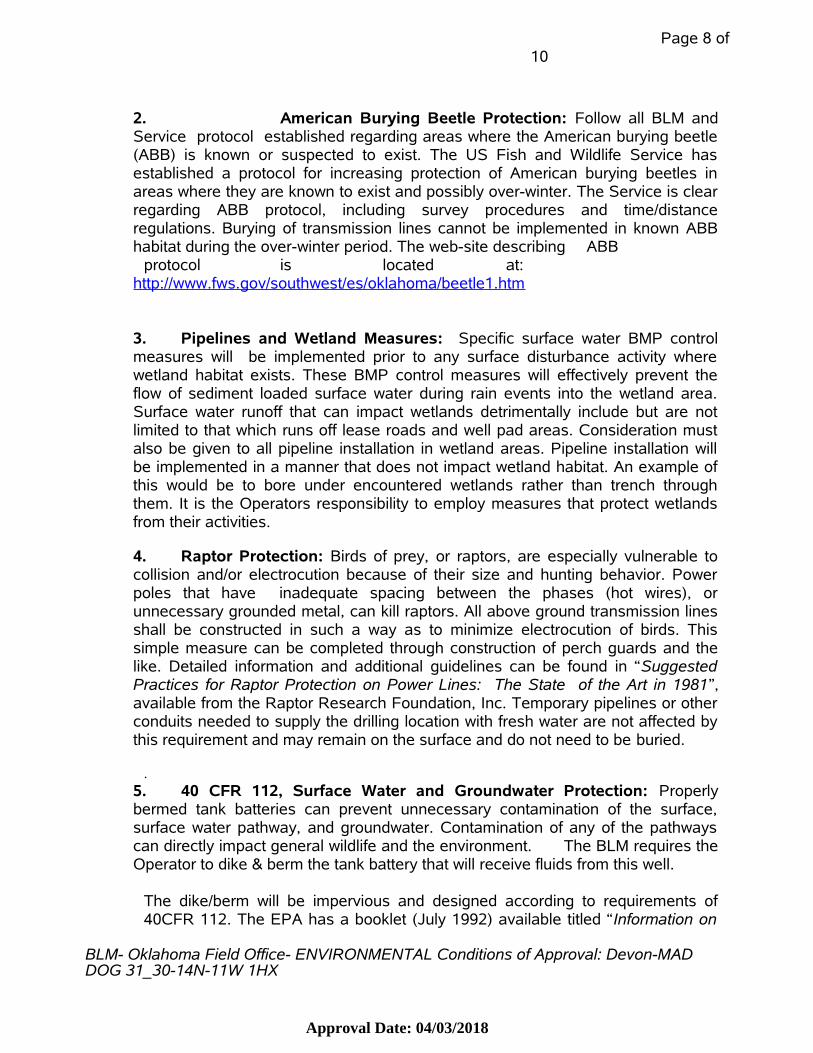
2. American Burying Beetle Protection: Follow all BLM andService protocol established regarding areas where the American burying beetle(ABB) is known or suspected to exist. The US Fish and Wildlife Service hasestablished a protocol for increasing protection of American burying beetles inareas where they are known to exist and possibly over-winter. The Service is clearregarding ABB protocol, including survey procedures and time/distanceregulations. Burying of transmission lines cannot be implemented in known ABBhabitat during the over-winter period. The web-site describing ABB
protocol is located at:http://www.fws.gov/southwest/es/oklahoma/beetle1.htm
3. Pipelines and Wetland Measures: Specific surface water BMP controlmeasures will be implemented prior to any surface disturbance activity wherewetland habitat exists. These BMP control measures will effectively prevent theflow of sediment loaded surface water during rain events into the wetland area.Surface water runoff that can impact wetlands detrimentally include but are notlimited to that which runs off lease roads and well pad areas. Consideration mustalso be given to all pipeline installation in wetland areas. Pipeline installation willbe implemented in a manner that does not impact wetland habitat. An example ofthis would be to bore under encountered wetlands rather than trench throughthem. It is the Operators responsibility to employ measures that protect wetlandsfrom their activities.
4. Raptor Protection: Birds of prey, or raptors, are especially vulnerable tocollision and/or electrocution because of their size and hunting behavior. Powerpoles that have inadequate spacing between the phases (hot wires), orunnecessary grounded metal, can kill raptors. All above ground transmission linesshall be constructed in such a way as to minimize electrocution of birds. Thissimple measure can be completed through construction of perch guards and thelike. Detailed information and additional guidelines can be found in “SuggestedPractices for Raptor Protection on Power Lines: The State of the Art in 1981”,available from the Raptor Research Foundation, Inc. Temporary pipelines or otherconduits needed to supply the drilling location with fresh water are not affected bythis requirement and may remain on the surface and do not need to be buried.
.5. 40 CFR 112, Surface Water and Groundwater Protection: Properlybermed tank batteries can prevent unnecessary contamination of the surface,surface water pathway, and groundwater. Contamination of any of the pathwayscan directly impact general wildlife and the environment. The BLM requires theOperator to dike & berm the tank battery that will receive fluids from this well.
The dike/berm will be impervious and designed according to requirements of40CFR 112. The EPA has a booklet (July 1992) available titled “Information on
BLM- Oklahoma Field Office- ENVIRONMENTAL Conditions of Approval: Devon-MAD DOG 31_30-14N-11W 1HX
Approval Date: 04/03/2018

Page 9 of10
SPCC Plans – 40 CFR 112”. Page 20 of this booklet describes, in detail, howtank battery dikes (berms) are to be constructed.
6. Vegetative Establishment: The BLM requires the establishment ofvegetation on all areas of the location to be reclaimed. This phase of thereclamation process should be accomplished by using seed or sod. Current policyrecommends that these areas be restored with native vegetation in regards to bothspecies and structure (grass, shrubs or trees). In those areas where trees orshrubs are planted, grass should be planted in conjunction to provide stabilizationuntil trees are mature. This recommended reclamation is contingent upon thewishes of the surface owner and/or the surface management agency.
7. Erosion Control: The BLM requires that erosion control measures prior tobeginning any construction activities be effectively employed. These erosioncontrol measures will be installed (and maintained) outside of the entire area to beleveled and cleared (around all construction sites; pad, access road and pipeline)so as to effectively minimize the movement of materials from the BLM permit siteto adjacent lands or drainages. These measures will be effectively maintained untilthe well is producing or has been declared a dry hole and plugged. These erosioncontrol measures are required for the duration of the construction, drilling andcompletion phases of this project and not for the life of the well.
8. Impervious Liners: Drilling operation fluids can contaminate theenvironment. The BLM requires that the Operator install an impervious liner underthe drilling rig structure. Usually this will be the drilling rig substructure, operatingequipment (diesel engines) and storage tanks (diesel fuel, lubricants, antifreeze,etc.); not the entire pad. This liner should extend into sumps and the cellar andinto and along the ditches to prevent any fluids associated with the drilling processfrom coming into contact with earthen material. This liner will be washed off intolined ditches, lined sumps or into the lined cellar and then pumped to the linedsumps prior to being removed from the location. Metal catch pans may be used onisolated engines and/or storage tanks where the impervious liner may not bepractical. The catch pans, if used, will need to be kept pumped and/or drained (notallowed to overflow). The contents of the metal catch pans may go to the linedsumps, lined cellar or pumped into tanks/trucks for disposal purposes.
9. Sumps: To further insure and minimize possible contamination of theenvironment, the BLM requires that all sumps be lined with impervious material(steel or concrete preferable) on all sides, and bottom. These sumps will, at alltimes, be below the level of the ditches so that the fluids in the ditches can flowinto the sump without coming into contact with native soil or other earthen layer.These sumps must be emptied before overflowing. These sumps will also becovered so as to prevent accidental entry by migratory birds.
BLM- Oklahoma Field Office- ENVIRONMENTAL Conditions of Approval: Devon-MAD DOG 31_30-14N-11W 1HX
Approval Date: 04/03/2018

Page 10 of 10
10. Rat and Mouse Hole: Additional contaminant control is required bymaking the rat hole and mouse hole impervious. This can be accomplished byinstalling cylinders (conductors, culverts or tin-horns) with concrete bottoms.The cylinders shall be installed in such a manner so as to prevent fluids fromthe pad surface from running into the cylinders, or entering between thecylinders and the earthen wall of the rat and/or mouse hole. The top of thecylinder should be above the pad surface. One option is to pour cement aroundthe outside of the cylinders between the cylinders and the earthen hole. Thecement could also be shaped/formed at an incline or raised (like a collar) abovethe ground level. Modifications to this approach shall first be cleared bysubmitting in writing the alternative method to a BLM staff biologist andengineer for review.
11. Drilling Cellar: The drilling cellar (concrete, metal, etc) must also belined so as to make it as impervious as possible to prevent liquids dischargedfrom the drill hole, or drained from the pad surface, from percolating into thesoil. If needed, a pump will be installed to transfer fluids in the cellar to one ofthe lined sumps. The cellar will not be allowed to overflow.
12. Removal of Impervious Liners: Improper removal of impervious linerscan defeat the purpose of the liner. Exercise caution and care when removingany of the impervious liners (geo-membrane, concrete, steel, etc.). The liquidsand solids which have collected on/in the impervious liners will not be allowedto come into contact with the pad surface, parent soil or any other earthenlayers during the cleanup of the site. The liners will be properly cleaned prior toremoval or removed in such a manner so as not to allow liquids/solids toescape. Preferably the liner will be washed off into lined ditches, lined sumps orinto the lined cellar and then pumped to the lined sumps prior to beingremoved.
10
Approval Date: 04/03/2018

BLM>New Mexico>Energy & Minerals>Oil and Gas>Notice to Lessees>NTL 96-1
Print Page
NTL 96-01
Notice to Lessees and Operators (NTL) of Federal and Indian Oil and Gas Leases Operating Under Permits Issued by the
Bureau of Land Management within the Jurisdiction of the
Tulsa District Office (i.e., Kansas, Oklahoma and Texas)
(NTL 96-01 TDO)
Modification of Oil and Gas Facilities to Minimize Bird and Bat Mortality
I. BACKGROUND:
The subject of bird and bat mortalities associated with oil and gas facilities has
become a concern not only nationwide but worldwide and has prompted many oil and
gas companies to modify existing and new production facilities to minimize accidental
deaths of birds, bats, and other wildlife.
Open-vent exhaust stacks are used as perches by many species of birds, especially
during migration. Death may result from carbon monoxide poisoning, incineration, or
becoming trapped in the units.
Open pits and tanks on production sites periodically contain salt water, oil or oil by-
products. These pits and tanks present a hazard to birds because they appear to be
fresh water. Birds, particularly waterfowl and shorebirds, are lured into the pits or
tanks thinking they are places to feed, drink, or rest. This results in a loss of
hundreds of thousands of birds nationwide.
The potential hazard to birds and bats from open-vent exhaust stacks and open pits
and tanks warrants mitigative action by the Bureau of Land Management (BLM).
The Migratory Bird Treaty Act of 1918, as amended, authorizes the Secretary of Interior to adopt such measures necessary to protect and preserve migratory raptor
and other avian species. Additionally, the BLM is responsible for implementing
protective management goals identified in the Nongame Migratory Bird Habitat
Conservation Strategy Plan. The Federal Land Policy and Management Act (FLPMA) declares that the policy of the United States is to manage the public lands in a
manner that will protect the quality of scientific, ecological, and environmental
values.
II. PURPOSE:
To minimize the likelihood of accidental death of birds and bats on oil and gas
facilities under the jurisdiction of the BLM.
III. AUTHORITY:
Under the authority of Title 43 Code of Federal Regulations (CFR) Part 3161.2, Part 3162.5-1 and Part 3164.2,. lessees/operators on Federal and Indian oil and gas
leases can be required to modify production equipment when needed to protect
natural resources and environmental quality.
IV. REQUIREMENTS:
A. All open-vent exhaust stacks on production vessels designed to heat the product
using an open flame (as opposed to electrically heated) shall be constructed, modified
and/or otherwise equipped and maintained to prevent birds and bats from entering
and to discourage perching and nesting. Such production vessels include, but may not be limited to, heater-treaters, separators, dehydrators, and in-line units. This
requirement does not apply to compression type equipment.
B. All open earthen pits will be effectively netted or otherwise covered, and
maintained, until such time as the pits are filled and/or reclaimed. Minimizing the likelihood of accidental deaths of migratory birds is the goal. This netting or cover
shall be installed no later than forty-five (45) days after the setting of the production
casing string or completion of plugging as a dry hole. All pits, if not netted or
covered, will be adequately equipped during the 45 day interim period with other bird deterrent devices. Such devices to be used during the interim period may include, but
not be limited to, streamers, pinwheels and/or noise devices. Variances may be
requested. The 45 day interim period for completion of covering or netting pits in no
way limits the operator's responsibility should migratory birds be found dead in the
pits within the interim period or during the actual drilling phase.
C. All open topped (non-earthen) tanks will be effectively netted or otherwise covered
and maintained so as to minimize the likelihood of accidental deaths of migratory
birds. This netting or cover shall be installed no later than four (4) days after the setting of the production casing string or completion of plugging as a dry hole. All
tanks installed for production purposes will be immediately netted or covered. All
tanks shall remain netted or covered until such time as they are removed from the
location. The granting of a four (4) day interim period for completion of covering or netting tanks associated with the drilling process in no way limits the operator's
responsibility should migratory birds be found dead in the tanks within the interim
period or during the actual drilling phase.
V. TIME FRAMES:
1. All open-vent exhaust stacks, open pits, and tanks existing as of the effective date
of this NTL will be modified as required under Section IV, Requirements, A., B. and C.
within a twelve (12) month period from the same effective date of this NTL.
2. All new oil and gas operations commenced after the time frames presented above (No. V.1.) will immediately incorporate requirement Numbers IV.A., IV.B. and IV.C.
(above) as applicable.
VI. COMPLIANCE:
SLIM compliance inspections will include examinations for the use and effectiveness of these measures. Should these measures prove to be ineffective the BLM shall seek
alternate measures to minimize the likelihood of accidental deaths of birds and bats
Failure to implement the requirements listed in this NTL will be considered failure to
comply with a written order and a "Notice of Incidents of Noncompliance" may be
issued.

APPROVED: Date: 8-15-96 Jim Sims Tulsa District Manager

Application for Permit to Drill
U.S. Department of the InteriorBureau of Land Management
APD Package Report
Operator:
Date Printed:
Well Status: Well Name:
Well Number:
APD ID:APD Received Date:
APD Package Report Contents - Form 3160-3 - Operator Certification Report - Application Report - Application Attachments -- Well Plat: 1 file(s) - Drilling Plan Report - Drilling Plan Attachments -- Blowout Prevention Choke Diagram Attachment: 1 file(s) -- Blowout Prevention BOP Diagram Attachment: 1 file(s) -- Casing Design Assumptions and Worksheet(s): 4 file(s) -- Proposed horizontal/directional/multi-lateral plan submission: 1 file(s) -- Other Facets: 5 file(s) - SUPO Report - SUPO Attachments -- New Road Map: 1 file(s) -- New road access plan attachment: 1 file(s) -- Attach Well map: 1 file(s) -- Production Facilities map: 1 file(s) -- Water source and transportation map: 1 file(s) -- Well Site Layout Diagram: 1 file(s) -- Other SUPO Attachment: 3 file(s) - PWD Report - PWD Attachments -- None - Bond Report - Bond Attachments -- None
ilmocdthpv27
Typewritten Text
ilmocdthpv27
Typewritten Text
ilmocdthpv27
Typewritten Text
mplyler
Rectangle

12/08/2017Operator Certification Data Report
Operator Certification
I hereby certify that I, or someone under my direct supervision, have inspected the drill site and access route proposedherein; that I am familiar with the conditions which currently exist; that I have full knowledge of state and Federal lawsapplicable to this operation; that the statements made in this APD package are, to the best of my knowledge, true andcorrect; and that the work associated with the operations proposed herein will be performed in conformity with this APDpackage and the terms and conditions under which it is approved. I also certify that I, or the company I represent, amresponsible for the operations conducted under this application. These statements are subject to the provisions of 18 U.S.C.1001 for the filing of false statements.
City: Oklahoma City
Phone: (405)228-8595
Signed on: 10/12/2017
Email address: [email protected]
Title: Regulatory Compliance Professional
Street Address: 333 West Sheridan Avenue
State: OK Zip: 73102
NAME: Chelsey Green
Email address:
Phone:
City: State: Zip:
Street Address:
Representative Name:
Field Representative

Application Data Report12/08/2017
Well Number: 1HXWell Name: MAD DOG 31_30-14N-11W
Submission Date: 11/21/2017APD ID: 10400022718
Well Work Type: Drill
Operator Name: DEVON ENERGY PRODUCTION COMPANY LP
Well Type: OTHER
Highlighted datareflects the mostrecent changes
Show Final Text
APD ID: Tie to previous NOS? Submission Date: 11/21/2017
BLM Office: OKLAHOMA User: Chelsey Green Title: Regulatory ComplianceProfessional
Federal/Indian APD: IND
Surface access agreement in place? N Allotted? YES Reservation: CHEYENNE & ARAPAHO
Agreement in place? NO
Agreement number:
Agreement name:
Federal or Indian agreement:
Keep application confidential? YES
Permitting Agent? NO APD Operator: DEVON ENERGY PRODUCTION COMPANY LP
Operator Info
Operator Organization Name: DEVON ENERGY PRODUCTION COMPANY LP
Operator Internet Address: [email protected]
Operator Phone: (405)552-6571
Operator PO Box:Zip: 73102
Operator Address: 333 West Sheridan Avenue
State: OKOperator City: Oklahoma City
Section 1 - General
10400022718 10400021348
Operator letter of designation:
Is the first lease penetrated for production Federal or Indian? IND
Lease number: 14-20-205-16391 Lease Acres: 160
Well in Master Development Plan? NO Mater Development Plan name:
Well in Master SUPO? NO Master SUPO name:
Section 2 - Well Information
Well in Master Drilling Plan? NO
Well API Number:
Pool Name:Field/Pool or Exploratory? Field and Pool
Well Number: 1HXWell Name: MAD DOG 31_30-14N-11W
Master Drilling Plan name:
Field Name: MISSISSIPPIAN
Is the proposed well in an area containing other mineral resources? USEABLE WATER,NATURAL GAS,OIL
Page 1 of 3

Well Number: 1HXWell Name: MAD DOG 31_30-14N-11W
Operator Name: DEVON ENERGY PRODUCTION COMPANY LP
Survey Type: RECTANGULAR
Describe Survey Type:
Datum: NAD83 Vertical Datum: NAVD88
Survey number:
Section 3 - Well Location Table
Latit
ude
Long
itude
Cou
nty
Sta
te
Mer
idia
n
Leas
e T
ype
Leas
e N
umbe
r
Ele
vatio
n
MD
TV
D
NS
-Foo
t
NS
Indi
cato
r
EW
-Foo
t
EW
Indi
cato
r
Tw
sp
Ran
ge
Sec
tion
Aliq
uot/L
ot/T
ract
SHL
#1
239 FSL 205 FEL 14N 11W 31
SESE
35.6390492
-98.4025265
BLAINE
OKLAHOMA
INDIAN
F FEE 1655
0 0Leg
Aliquot
KOP
#1
50 FSL 379 FEL 14N 11W 31
SESE
35.6385322
-98.4031128
BLAINE
OKLAHOMA
INDIAN
F FEE -11288
12953
12943Leg
Aliquot
PPP
#1
2641
FSL 379 FEL 14N 11W 31
SENE
35.6390492
-98.4025265
BLAINE
OKLAHOMA
INDIAN
I 14-20-205-16391
1655
0 0Leg
Aliquot
Reservoir well spacing assigned acres Measurement: 1280 Acres
Well Class: HORIZONTAL
Distance to town:
Type of Well Pad: SINGLE WELL Multiple Well Pad Name:
Describe sub-type:
Describe other minerals:
Well Type: OTHER
Duration: 30 DAYS
Well sub-Type: APPRAISAL
Describe Well Type: Oil and/or Gas
Distance to lease line: 205 FT
Use Existing Well Pad? NO
Distance to nearest well: 652 FT
Is the proposed well in a Helium production area? N
Well plat:
Well work start Date: 04/15/2018
Number of Legs: 1
New surface disturbance?
Number:
Well Work Type: Drill
2017_8_31_MAD_DOG_31_30_14N_11W_1HX_20170831141930.pdf
Page 2 of 3

Well Number: 1HXWell Name: MAD DOG 31_30-14N-11W
Operator Name: DEVON ENERGY PRODUCTION COMPANY LP
Latit
ude
Long
itude
Cou
nty
Sta
te
Mer
idia
n
Leas
e T
ype
Leas
e N
umbe
r
Ele
vatio
n
MD
TV
D
NS
-Foo
t
NS
Indi
cato
r
EW
-Foo
t
EW
Indi
cato
r
Tw
sp
Ran
ge
Sec
tion
Aliq
uot/L
ot/T
ract
PPP
#1
165 FSL 379 FEL 14N 11W 31
SESE
35.6388475
-98.4031128
BLAINE
OKLAHOMA
INDIAN
F FEE -11599
13292
13254Leg
Aliquot
EXIT
#1
165 FNL 380 FEL 14N 11W 30
NENE
35.666912
-98.403113
BLAINE
OKLAHOMA
INDIAN
F FEE -11766
23557
13421Leg
Aliquot
BHL
#1
50 FNL 380 FEL 14N 11W 30
NENE
35.6672269
-98.4031131
BLAINE
OKLAHOMA
INDIAN
F FEE -11766
23671
13421Leg
Aliquot
Page 3 of 3

N00
° 15'
E 10
216'
GRI
D B
RNG
NA
D83
N00° 06'E 115'GRID BRNG NAD83
S67° 26'W 190'GRID BRNG NAD83
X=1843889Y=240577
X=1875489Y=240553
3/8" IP CA973
X=1849129Y=237909X=1880728Y=237884PK NAIL
X=1849093Y=232633X=1880692Y=232608RR SPIKE
X=1846469Y=232653X=1878069Y=2326283/8" IP CA1293
X=1843871Y=232672
X=1875471Y=232648
3/8" IP CA1293
X=1849111Y=235271X=1880710Y=2352463/8" IP CA1293
X=1849133Y=240543X=1880733Y=2405193/8" CA1293
X=1849138Y=243179X=1880737Y=2431553/8" IP
X=1846511Y=243195
X=1878110Y=243171
3/8" CA1293
X=1843901Y=243212
X=1875501Y=243188
3/8" IP
X=1843878Y=237942
X=1875478Y=23791860D NAIL
X=1843875Y=235307
X=1875474Y=235283
3/8" IP CA1293
X=1846487Y=237924
X=1878086Y=237900
MAG NAIL CA1293
DEVON ENERGY PRODUCTION COMPANY, L.P.OPERATOR:_________________________________________________LEASE NAME:___________________________WELL NO. ___________________________GOOD DRILL SITE:_________________________________COUNTY, STATE:________
MAD DOG 31_30-14N-11W TOPOGRAPHY & VEGETATION:_________________________________________________________________________________________________
LOCATION FELL IN THE CORNER OFA FIELD
ACCESSIBILITY TO LOCATION:__________________________________ FROM SOUTH LINE
REVISION DATE:
SCALE: 1" = SHEET NO.:DRAWN BY:PLOT DATE: OF
0
GRAPHIC SCALE IN FEET
2000 20001000
2000'
Crafton Tullwww.craftontull.com
405.787.6276 fYukon, OK 73099
300 Pointe Parkway Blvd
SURVEYINGR
405.787.6270 t
DRAWING:1 2SQ08-31-2017
MAD DOG 31_30-14N-11W 1HXPART OF THE SE/4 OF SECTION 31, 14N, 11W
WELL LOCATION EXHIBITBLAINE COUNTY, OKLAHOMA
G:\16601798_MADDOG\ENERGY\DWG_CLIPS\WELL_PLAT\BIA-DEVON-WELL.DWG 8/31/2017 6:47:25 AM SQ7278
DISTANCE & DIRECTION FROM HWY JCT OR TOWN: ____________________________________________________________________________________________________________________________________________________________________________________________________________________________________________________
YESBLAINE OK
1HX
GROUND ELEVATION: ______________________SURFACE HOLE FOOTAGE:__________________SECTION:___ TOWNSHIP:_____ RANGE:______BOTTOM HOLE:_________________
14N
1655.85 GR. AT STAKE
31 11W30-14N-11W,I.M.
239' FSL - 205' FEL
GRI
D N
ORT
H (N
AD
83)
OKL
AHO
MA
- N
ORT
H ZO
NE
N
BASI
S O
F BE
ARI
NG
:
CERTIFICATE OF AUTHORIZATION:CA 973 (PE/LS) EXPIRES 6/30/2018
PLEASE NOTE THAT THIS LOCATION WAS STAKED ON THE GROUND UNDER THE SUPERVISION OF ALICENSED PROFESSIONAL LAND SURVEYOR, BUT ACCURACY OF THIS EXHIBIT IS NOT GUARANTEED.PLEASE CONTACT CRAFTON TULL PROMPTLY IF ANY INCONSISTENCY IS DETERMINED, GPS DATA ISOBSERVED FROM RTK-GPS.NOTE:X AND Y DATA SHOWN HEREON FOR SECTION CORNERS MAY NOT HAVE BEEN SURVEYED ONTHE GROUND, AND FURTHER, DOES NOT REPRESENT A TRUE BOUNDARY SURVEY.
CERTIFICATION:THIS IS TO CERTIFY THAT THIS WELL LOCATION EXHIBIT WASCOMPILED AND PREPARED UNDER MY SUPERVISION.
DENVER WINCHESTER PLS 1952
16601798-WELL
GPS DATUM: ____________LAT: ________________LONG: _____________
STATE PLANE COORDINATES:ZONE: ___________________X: ________________Y: ________________
NAD27
OK-NORTH NAD27
35.63900073-98.40218207
1880488.9232849.3
GPS DATUM: ____________LAT: ________________LONG: _____________
NAD8335.63904922
-98.40252650
SURFACE HOLE DATA
BOTTOM HOLE DATA
GPS DATUM: ____________LAT: ________________LONG: _____________
STATE PLANE COORDINATES:ZONE: ___________________X: ________________Y: ________________
NAD27
OK-NORTH NAD27
35.66717909-98.40276782
243106.91880357.4
GPS DATUM: ____________LAT: ________________LONG: _____________
35.66722687-98.40311306
STATE PLANE COORDINATES:ZONE: ___________________X: ________________Y: ________________
OK-NORTH NAD831848889.4232873.6
STATE PLANE COORDINATES:ZONE: ___________________X: ________________Y: ________________
OK-NORTH NAD831848757.7243131.2
BOTTOM HOLE INFORMATIONPROVIDED BY OPERATOR LISTED.
30
1880313.1232776.3
35.63879808-98.40277237
1880357.1242991.9
35.66686315-98.40276693
1848757.5243016.2
35.66691095-98.40311216
1848713.7232800.5
35.63884658-98.40311681
GPS DATUM: ____________LAT: ________________LONG: _____________
STATE PLANE COORDINATES:ZONE: ___________________X: ________________Y: ________________
GPS DATUM: ____________LAT: ________________LONG: _____________
FIRST PERFORATION DATA
STATE PLANE COORDINATES:ZONE: ___________________X: ________________Y: ________________
NAD27
OK-NORTH NAD27
NAD83
OK-NORTH NAD83
GPS DATUM: ____________LAT: ________________LONG: _____________
STATE PLANE COORDINATES:ZONE: ___________________X: ________________Y: ________________
GPS DATUM: ____________LAT: ________________LONG: _____________
LAST PERFORATION DATA
STATE PLANE COORDINATES:ZONE: ___________________X: ________________Y: ________________
NAD27
OK-NORTH NAD27
NAD83
OK-NORTH NAD83NAD83
DISTANCE TO NEAREST WELL:_____________________________________________________________
SURFACE HOLE:239' FSL - 205' FEL
BOTTOM HOLE:50' FNL - 380' FEL
FIRST PERF. POINT165' FSL - 380' FEL
LAST PERF. POINT165' FNL - 380' FEL
7085'MUSE 1-31H API#3501123285
FROM THE TOWN OF GEARY HEAD NORTH ON US-281 O.5MI± TO E950RD,HEAD WEST 4.8MI± TO INTER. OF E950RD & N2580RD, PAD SITE IS ON THE NWCORNER.
5.0MI± W OF GEARY
BASIS OF ELEVATION:TOPO ELEVATION = 1653.19'AT E/4, SECTION 31, 14N-11WTOPO ELEVATION = 1653.59'AT SE COR, SECTION 31, 14N-11WTOPO ELEVATION = 1643.45'AT S/4, SECTION 31, 14N-11W
31
N00
° 15'
E 10
216'
GRI
D B
RNG
NA
D83
N00° 06'E 115'GRID BRNG NAD83
S67° 26'W 190'GRID BRNG NAD83
X=1843889Y=240577
X=1875489Y=240553
3/8" IP CA973
X=1849129Y=237909X=1880728Y=237884PK NAIL
X=1849093Y=232633X=1880692Y=232608RR SPIKE
X=1846469Y=232653X=1878069Y=2326283/8" IP CA1293
X=1843871Y=232672
X=1875471Y=232648
3/8" IP CA1293
X=1849111Y=235271X=1880710Y=2352463/8" IP CA1293
X=1849133Y=240543X=1880733Y=2405193/8" CA1293
X=1849138Y=243179X=1880737Y=2431553/8" IP
X=1846511Y=243195
X=1878110Y=243171
3/8" CA1293
X=1843901Y=243212
X=1875501Y=243188
3/8" IP
X=1843878Y=237942
X=1875478Y=23791860D NAIL
X=1843875Y=235307
X=1875474Y=235283
3/8" IP CA1293
X=1846487Y=237924
X=1878086Y=237900
MAG NAIL CA1293
REVISION DATE:
SCALE: 1" = SHEET NO.:DRAWN BY:PLOT DATE: OF
0
GRAPHIC SCALE IN FEET
2000 20001000
2000'
Crafton Tullwww.craftontull.com
405.787.6276 fYukon, OK 73099
300 Pointe Parkway Blvd
SURVEYINGR
405.787.6270 t
DRAWING:2SQ08-31-2017
MAD DOG 31_30-14N-11W 1HXPART OF THE SE/4 OF SECTION 31, 14N, 11W
WELL LOCATION EXHIBITBLAINE COUNTY, OKLAHOMA
G:\16601798_MADDOG\ENERGY\DWG_CLIPS\WELL_PLAT\BIA-DEVON-WELL.DWG 8/31/2017 6:47:26 AM SQ7278
2
CERTIFICATE OF AUTHORIZATION:CA 973 (PE/LS) EXPIRES 6/30/2018
CERTIFICATION:THIS IS TO CERTIFY THAT THIS WELL LOCATION EXHIBIT WASCOMPILED AND PREPARED UNDER MY SUPERVISION.
DENVER WINCHESTER PLS 1952
16601798-AERIAL
DEVON ENERGY PRODUCTION COMPANY, L.P.OPERATOR:_________________________________________________LEASE NAME:___________________________WELL NO. ___________________________GOOD DRILL SITE:_________________________________COUNTY, STATE:________
MAD DOG 31_30-14N-11W TOPOGRAPHY & VEGETATION:_________________________________________________________________________________________________
LOCATION FELL IN THE CORNER OFA FIELD
ACCESSIBILITY TO LOCATION:__________________________________ FROM SOUTH LINE
DISTANCE & DIRECTION FROM HWY JCT OR TOWN: ____________________________________________________________________________________________________________________________________________________________________________________________________________________________________________________
YESBLAINE OK
1HX
GROUND ELEVATION: ______________________SURFACE HOLE FOOTAGE:__________________SECTION:___ TOWNSHIP:_____ RANGE:______BOTTOM HOLE:_________________
14N
1655.85 GR. AT STAKE
31 11W30-14N-11W,I.M.
239' FSL - 205' FEL
GRI
D N
ORT
H (N
AD
83)
OKL
AHO
MA
- N
ORT
H ZO
NE
N
BASI
S O
F BE
ARI
NG
:
PLEASE NOTE THAT THIS LOCATION WAS STAKED ON THE GROUND UNDER THE SUPERVISION OF ALICENSED PROFESSIONAL LAND SURVEYOR, BUT ACCURACY OF THIS EXHIBIT IS NOT GUARANTEED.PLEASE CONTACT CRAFTON TULL PROMPTLY IF ANY INCONSISTENCY IS DETERMINED, GPS DATA ISOBSERVED FROM RTK-GPS.NOTE:X AND Y DATA SHOWN HEREON FOR SECTION CORNERS MAY NOT HAVE BEEN SURVEYED ONTHE GROUND, AND FURTHER, DOES NOT REPRESENT A TRUE BOUNDARY SURVEY.
DISTANCE TO NEAREST WELL:_____________________________________________________________
GPS DATUM: ____________LAT: ________________LONG: _____________
STATE PLANE COORDINATES:ZONE: ___________________X: ________________Y: ________________
NAD27
OK-NORTH NAD27
35.63900073-98.40218207
1880488.9232849.3
GPS DATUM: ____________LAT: ________________LONG: _____________
NAD8335.63904922
-98.40252650
SURFACE HOLE DATA
BOTTOM HOLE DATA
GPS DATUM: ____________LAT: ________________LONG: _____________
STATE PLANE COORDINATES:ZONE: ___________________X: ________________Y: ________________
NAD27
OK-NORTH NAD27
35.66717909-98.40276782
243106.91880357.4
GPS DATUM: ____________LAT: ________________LONG: _____________
35.66722687-98.40311306
STATE PLANE COORDINATES:ZONE: ___________________X: ________________Y: ________________
OK-NORTH NAD831848889.4232873.6
STATE PLANE COORDINATES:ZONE: ___________________X: ________________Y: ________________
OK-NORTH NAD831848757.7243131.2
BOTTOM HOLE INFORMATIONPROVIDED BY OPERATOR LISTED.
1880313.1232776.3
35.63879808-98.40277237
1880357.1242991.9
35.66686315-98.40276693
1848757.5243016.2
35.66691095-98.40311216
1848713.7232800.5
35.63884658-98.40311681
GPS DATUM: ____________LAT: ________________LONG: _____________
STATE PLANE COORDINATES:ZONE: ___________________X: ________________Y: ________________
GPS DATUM: ____________LAT: ________________LONG: _____________
FIRST PERFORATION DATA
STATE PLANE COORDINATES:ZONE: ___________________X: ________________Y: ________________
NAD27
OK-NORTH NAD27
NAD83
OK-NORTH NAD83
GPS DATUM: ____________LAT: ________________LONG: _____________
STATE PLANE COORDINATES:ZONE: ___________________X: ________________Y: ________________
GPS DATUM: ____________LAT: ________________LONG: _____________
LAST PERFORATION DATA
STATE PLANE COORDINATES:ZONE: ___________________X: ________________Y: ________________
OK-NORTH NAD27
OK-NORTH NAD83NAD83
BASIS OF ELEVATION:TOPO ELEVATION = 1653.19'AT E/4, SECTION 31, 14N-11WTOPO ELEVATION = 1653.59'AT SE COR, SECTION 31, 14N-11WTOPO ELEVATION = 1643.45'AT S/4, SECTION 31, 14N-11W
31
SURFACE HOLE:239' FSL - 205' FEL
BOTTOM HOLE:50' FNL - 380' FEL
FIRST PERF. POINT165' FSL - 380' FEL
LAST PERF. POINT165' FNL - 380' FEL
7085'MUSE 1-31H API#3501123285
FROM THE TOWN OF GEARY HEAD NORTH ON US-281 O.5MI± TO E950RD,HEAD WEST 4.8MI± TO INTER. OF E950RD & N2580RD, PAD SITE IS ON THE NWCORNER.
5.0MI± W OF GEARY
30

ACCESSIBILITY TO LOCATION:__________________________________ FROM SOUTH LINE
LOCATION FELL IN THE CORNER OFA FIELD
TOPOGRAPHIC & VEGETATION:________________________________________________________________________________________________
DEVON ENERGYPRODUCTION COMPANY, L.P.OPERATOR:_____________________________
LEASE NAME:___________________________WELL NO. ___________________________GOOD DRILL SITE._________________________________COUNTY, STATE:_______
MAD DOG 31_30-14N-11W
YES
OK
1HX
GROUND ELEVATION: ___________________________SURFACE HOLE FOOTAGE:______________________SECTION:__________ TOWNSHIP:__________ RANGE:_________BOTTOM HOLE: FOOTAGE:______________________SECTION:__________ TOWNSHIP:__________ RANGE:_________
50' FNL - 380' FEL14N
1655.85 GR. AT STAKE
31 11W
30 14N 11W
239' FSL - 205' FEL
BLAINE
GRI
D N
ORT
H (N
AD
83)
OKL
AHO
MA
- N
ORT
H ZO
NE
N
BASI
S O
F BE
ARI
NG
:
THE PURPOSE OF THIS MAP IS TO VERIFY THE LOCATION AND ELEVATION AS STAKED ONTHE GROUND AND TO SHOW THE SURROUNDING TOPOGRAPHIC FEATURES. THEFOOTAGE SHOWN HEREON IS ONLY AS SCALED ONTO A USGS TOPOGRAPHIC MAP.PLEASE NOTE THAT THIS LOCATION WAS CAREFULLY STAKE ON THE GROUND UNDER THESUPERVISION OF A LICENSED PROFESSIONAL LAND SURVEYOR, BUT THE ACCURACY OFTHIS SURVEY IS NOT GUARANTEED.PLEASE PROMPTLY CONTACT CRAFTON TULL IF AN INCONSISTENCY IS DETERMINED.
CONTOUR INTERVAL:__________________________10'
CERTIFICATE OF AUTHORIZATION:CA 973 (PE/LS) EXPIRES 6/30/2018
16601798-QUAD
REVISION DATE:
SCALE: 1" = SHEET NO.:DRAWN BY:PLOT DATE: OF
0
GRAPHIC SCALE IN FEET
2000 20001000
2000'
Crafton Tullwww.craftontull.com
405.787.6276 fYukon, OK 73099
300 Pointe Parkway Blvd
SURVEYINGR
405.787.6270 t
DRAWING:
CERTIFICATE OF AUTHORIZATION:CA 973 (PE/LS) EXPIRES 6/30/2018
1 1SQ08-31-2017
MAD DOG 31_30-14N-11W 1HXPART OF THE SE/4
SECTION 31, 14N, 11W, I.M.TOPOGRAPHIC VICINITY MAPBLAINE COUNTY, OKLAHOMA
G:\16601798_MADDOG\ENERGY\DWG_CLIPS\WELL_PLAT\BIA-DEVON-WELL.DWG 8/31/2017 6:47:29 AM SQ7278
BOTTOM HOLE
LAST PERFORATION POINT
FIRST PERFORATION POINT
DISTANCE & DIRECTION FROM HWY JCT OR TOWN: ____________________________________________________________________________________________________________________________________________________________________________________________________________________________________________________
DISTANCE TO NEAREST WELL:_____________________________________________________________
7085'MUSE 1-31H API#3501123285
FROM THE TOWN OF GEARY HEAD NORTH ON US-281 O.5MI± TO E950RD,HEAD WEST 4.8MI± TO INTER. OF E950RD & N2580RD, PAD SITE IS ON THE NWCORNER.
5.0MI± W OF GEARY
MAD DOG 31_30-14N-11W 1HX

DEVON ENERGYPRODUCTION COMPANY, L.P.OPERATOR:_____________________________
LEASE NAME:___________________________WELL NO. ___________________________GOOD DRILL SITE._________________________________COUNTY, STATE:_______
MAD DOG 31_30-14N-11W
YES
OK
1HX
GROUND ELEVATION: ___________________________SURFACE HOLE FOOTAGE:______________________SECTION:__________ TOWNSHIP:__________ RANGE:_________BOTTOM HOLE FOOTAGE:______________________SECTION:__________ TOWNSHIP:__________ RANGE:_________
50' FNL - 380' FEL14N
1655.85 GR. AT STAKE
31 11W
30 14N 11W
239' FSL - 205' FEL
BLAINE
GRI
D N
ORT
H (N
AD
83)
OKL
AHO
MA
- N
ORT
H ZO
NE
N
BASI
S O
F BE
ARI
NG
:
CERTIFICATE OF AUTHORIZATION:CA 973 (PE/LS) EXPIRES 6/30/2018
16601798-HWY
REVISION DATE:
SHEET NO.:DRAWN BY:PLOT DATE: OF
0
SCALE: 1/2" = 1 MILE
GRAPHIC SCALE IN MILES
2 1 2
Crafton Tullwww.craftontull.com
405.787.6276 fYukon, OK 73099
300 Pointe Parkway Blvd
SURVEYINGR
405.787.6270 t
DRAWING:
CERTIFICATE OF AUTHORIZATION:CA 973 (PE/LS) EXPIRES 6/30/2018
1 1SQ08-31-2017
MAD DOG 31_30-14N-11W 1HXPART OF THE SE/4
SECTION 31, 14N, 11W, I.M.COUNTY HIGHWAY VICINITY MAP
BLAINE COUNTY, OKLAHOMA
G:\16601798_MADDOG\ENERGY\DWG_CLIPS\WELL_PLAT\BIA-DEVON-WELL.DWG 8/31/2017 6:47:30 AM SQ7278
DISTANCE & DIRECTION FROM HWY JCT OR TOWN: ____________________________________________________________________________________________________________________________________________________________________________________________________________________________________________________
DISTANCE TO NEAREST WELL:_____________________________________________________________
7085'MUSE 1-31H API#3501123285 FROM THE TOWN OF GEARY HEAD NORTH ON US-281 O.5MI± TO E950RD,
HEAD WEST 4.8MI± TO INTER. OF E950RD & N2580RD, PAD SITE IS ON THE NWCORNER.
5.0MI± W OF GEARY

GRI
D N
ORT
H (N
AD
83)
OKL
AHO
MA
- N
ORT
H ZO
NE
N
BASI
S O
F BE
ARI
NG
REVISION DATE:
SCALE: 1" = SHEET NO.:DRAWN BY:PLOT DATE: OF
100'
0100 100
GRAPHIC SCALE IN FEET
50
Crafton Tullwww.craftontull.com
405.787.6276 fYukon, OK 73099
300 Pointe Parkway Blvd
SURVEYINGR
405.787.6270 t
DRAWING:1 1DW08-31-2017
MAD DOG 31_30-14N-11W 1HXEXISTING CONTOURSPART OF THE SE/4 OF SECTION 31, 14N, 11W
BLAINE COUNTY, OKLAHOMA
G:\16601798_MADDOG\ENERGY\DWG_CLIPS\WELL_PLAT\BIA-DEVON-PAD-PROFILE.DWG 8/31/2017 6:47:37 AM DW2795
DEVON ENERGY PRODUCTION COMPANY, L.P.OPERATOR:______________________________________________LEASE NAME:___________________________WELL NO. ___________________________GOOD DRILL SITE._________________________________COUNTY, STATE:_______
MAD DOG 31_30-14N-11W
YESBLAINE OK
1HX
GROUND ELEVATION: ___________________________SURFACE HOLE FOOTAGE:______________________SECTION:__________ TOWNSHIP:__________ RANGE:_________14N
1655.85 GR. AT STAKE
31 11W239' FSL - 205' FEL
16601798-PD-EX
CERTIFICATE OF AUTHORIZATION:CA 973 (PE/LS) EXPIRES 6/30/2018
DEVON ENERGYPRODUCTION COMPANY, L.P.MAD DOG 31_30-14N-11W 1HX239' FSL - 205' FELNATURAL GROUND: 1655.85DESIGN ELEVATION:1654.75
· THIS PROPOSED PLAT DOES NOT REPRESENT A TRUE BOUNDARY SURVEY· THE FOOTAGES AND TIES SHOWN HEREON ARE FROM LINES OF OCCUPATION AND
MAY NOT BE FROM ACTUAL PROPERTY CORNERS.· OWNERSHIP SHOWN HEREON IS PROVIDED BY AND/OR VERIFIED WITH CLIENT.· INFORMATION SHOWN HEREON IS FOR CONSTRUCTION PURPOSES ONLY
NOTES:
TOPSOIL STOCKPILE (25' TO 50')
140'20
0'185'
180'
PROPOSED PAD2.83 ACRES
NS-
258
REED, WILLIAM J REVOCABLE TRUSTSE/4, SEC. 31, 14N 11W I.M.
DEVON ENERGYPRODUCTION COMPANY, L.P.MAD DOG 31_30-14N-11W 1HX239' FSL - 205' FELNATURAL GROUND: 1655.85
PROPOSED LEASE ROADSEE DRAWING16601798-LR
SE CORNER OF PADLIES 65' W & 59' N OF
SE CORNER SECTION 31
PIPELINE RISER20' x20' from
SW pad corner(By others)
90'
OVERHEAD ELECTRIC LINE
PROPOSED 120' X 20" STEEL PIPE EW-95E950RD
N25
80RD
EXISTING BARBED WIRE FENCE
EXISTING BARBED WIRE FENCE

ELEV=1654.30
ELEV=1655.13
ELEV=1655.68
ELEV=1656.29
ELEV=1653.26
ELEV=1653.40
ELEV=1653.68
ELEV=1654.61
ELEV=1657.23
ELEV=1656.69
ELEV=1656.08
ELEV=1655.52
ELEV=1655.16
ELEV=1655.21
ELEV=1655.51
ELEV=1656.12
ELEV=1655.87
1652
1653
1654
1655
1656
1657
1652
1653
1654
1655
1656
1657
1654
1655
1656
1657
1658
1654
1655
1656
1657
1658
GRI
D N
ORT
H (N
AD
83)
OKL
AHO
MA
- N
ORT
H ZO
NE
N
BASI
S O
F BE
ARI
NG
REVISION DATE:
SCALE: 1" = SHEET NO.:DRAWN BY:PLOT DATE: OF
100'
0100 100
GRAPHIC SCALE IN FEET
50
Crafton Tullwww.craftontull.com
405.787.6276 fYukon, OK 73099
300 Pointe Parkway Blvd
SURVEYINGR
405.787.6270 t
DRAWING:1 1DW08-31-2017
MAD DOG 31_30-14N-11W 1HXPROPOSED PAD CROSS-SECTION
PART OF THE SE/4 OF SECTION 31, 14N, 11W
BLAINE COUNTY, OKLAHOMA
G:\16601798_MADDOG\ENERGY\DWG_CLIPS\WELL_PLAT\BIA-DEVON-PAD-PROFILE.DWG 8/31/2017 6:47:38 AM DW2795
EAST / WEST PROFILE VIEWSCALE: 1"=100' HZSCALE: 1"=4' VT
NO
RTH
/ SO
UTH
PRO
FILE
VIE
WSC
ALE
: 1"=
100'
HZ
SCA
LE: 1
"=15
' V
T
DEVON ENERGY PRODUCTION COMPANY, L.P.OPERATOR:______________________________________________LEASE NAME:___________________________WELL NO. ___________________________GOOD DRILL SITE._________________________________COUNTY, STATE:_______
MAD DOG 31_30-14N-11W
YESBLAINE OK
1HXGROUND ELEVATION: ___________________________SURFACE HOLE FOOTAGE:______________________SECTION:__________ TOWNSHIP:__________ RANGE:_________14N
1655.85 GR. AT STAKE
31 11W239' FSL - 205' FEL
16601798-PD-XS
CERTIFICATE OF AUTHORIZATION:CA 973 (PE/LS) EXPIRES 6/30/2018
· THIS PROPOSED PLAT DOES NOT REPRESENT A TRUE BOUNDARY SURVEY· THE FOOTAGES AND TIES SHOWN HEREON ARE FROM LINES OF OCCUPATION AND
MAY NOT BE FROM ACTUAL PROPERTY CORNERS.· OWNERSHIP SHOWN HEREON IS PROVIDED BY AND/OR VERIFIED WITH CLIENT.· INFORMATION SHOWN HEREON IS FOR CONSTRUCTION PURPOSES ONLY
NOTES:
REED, WILLIAM J REVOCABLE TRUSTSE/4, SEC. 31, 14N 11W I.M.
TOPSOIL STOCKPILE (25' TO 50')
140'20
0'185'
180'
PROPOSED PAD2.83 ACRES
DEVON ENERGYPRODUCTION COMPANY, L.P.MAD DOG 31_30-14N-11W 1HX239' FSL - 205' FELNATURAL GROUND: 1655.85
PROPOSED LEASE ROADSEE DRAWING16601798-LR
PIPELINE RISER20' x20' from
SW pad corner(By others)
90'
OVERHEAD ELECTRIC LINE
PROPOSED 120' X 20" STEEL PIPE
NS-
258
SE CORNER OF PADLIES 65' W & 59' N OF
SE CORNER SECTION 31
EW-95 E950RD
N25
80RD
EXISTING BARBED WIRE FENCE
EXISTING BARBED WIRE FENCE

REVISION DATE:
SCALE: 1" = SHEET NO.:DRAWN BY:PLOT DATE: OF
100'
0100 100
GRAPHIC SCALE IN FEET
50
Crafton Tullwww.craftontull.com
405.787.6276 fYukon, OK 73099
300 Pointe Parkway Blvd
SURVEYINGR
405.787.6270 t
DRAWING:1 1DW08-31-2017
MAD DOG 31_30-14N-11W 1HXFINAL CONTOURS
PART OF THE SE/4 OF SECTION 31, 14N, 11W
BLAINE COUNTY, OKLAHOMA
G:\16601798_MADDOG\ENERGY\DWG_CLIPS\WELL_PLAT\BIA-DEVON-PAD-PROFILE.DWG 8/31/2017 6:47:40 AM DW2795
· THIS PROPOSED PLAT DOES NOT REPRESENT A TRUE BOUNDARY SURVEY· THE FOOTAGES AND TIES SHOWN HEREON ARE FROM LINES OF OCCUPATION AND
MAY NOT BE FROM ACTUAL PROPERTY CORNERS.· OWNERSHIP SHOWN HEREON IS PROVIDED BY AND/OR VERIFIED WITH CLIENT.· INFORMATION SHOWN HEREON IS FOR CONSTRUCTION PURPOSES ONLY
NOTES:
DEVON ENERGY PRODUCTION COMPANY, L.P.OPERATOR:______________________________________________LEASE NAME:___________________________WELL NO. ___________________________GOOD DRILL SITE._________________________________COUNTY, STATE:_______
MAD DOG 31_30-14N-11W
YESBLAINE OK
1HX
GROUND ELEVATION: ___________________________SURFACE HOLE FOOTAGE:______________________SECTION:__________ TOWNSHIP:__________ RANGE:_________14N
1655.85 GR. AT STAKE
31 11W239' FSL - 205' FEL
16601798-PD-PR
CERTIFICATE OF AUTHORIZATION:CA 973 (PE/LS) EXPIRES 6/30/2018
DEVON ENERGYPRODUCTION COMPANY, L.P.MAD DOG 31_30-14N-11W 1HX239' FSL - 205' FELNATURAL GROUND: 1655.85DESIGN ELEVATION:1654.75
GRI
D N
ORT
H (N
AD
83)
OKL
AHO
MA
- N
ORT
H ZO
NE
N
BASI
S O
F BE
ARI
NG
REED, WILLIAM J REVOCABLE TRUSTSE/4, SEC. 31, 14N 11W I.M.
140'
200'
185'
180'
DEVON ENERGYPRODUCTION COMPANY, L.P.MAD DOG 31_30-14N-11W 1HX239' FSL - 205' FELNATURAL GROUND: 1655.85
PROPOSED LEASE ROADSEE DRAWING16601798-LR
PIPELINE RISER20' x20' from
SW pad corner(By others)
90'
OVERHEAD ELECTRIC LINE
PROPOSED 120' X 20" STEEL PIPE
NS-
258
SE CORNER OF PADLIES 65' W & 59' N OF
SE CORNER SECTION 31
EW-95
PROPOSED PAD2.83 ACRES
E950RD
N25
80RD
EXISTING BARBED WIRE FENCE
EXISTING BARBED WIRE FENCE
FINISHED PAD ELEV:CUT RATIO: 3:1FILL RATIO: 4:1CUT VOLUME: 2,267 C.Y.FILL VOLUME: 2,267 C.Y.SHORT TERM PAD DISTURBANCE:2.97 AC± OR 129,544 SQ FT±LONG TERM PAD DISTURBANCE:2.68 AC± OR 116,877 SQ FT±SHORT TERM LEASE ROAD DISTURBANCE:0.11 AC± OR 4,575 SQ FT±LONG TERM LEASE ROAD DISTURBANCE:0.11 AC± OR 4,575 SQ FT±SHORT TERM TOTAL DISTURBANCE:3.08 AC± OR 134,119 SQ FT±LONG TERM TOTAL DISTURBANCE:2.79 AC± OR 121,452 SQ FT±
DEVON ENERGYPRODUCTION COMPANY, L.P.
DESIGN INFORMATION1654.75

X
XXXX
GRI
D N
ORT
H (N
AD
83)
OKL
AHO
MA
- N
ORT
H ZO
NE
N
BASI
S O
F BE
ARI
NG
:
REVISION DATE:
SCALE: 1" = SHEET NO.:DRAWN BY:PLOT DATE: OF
0
GRAPHIC SCALE IN FEET
Crafton Tullwww.craftontull.com
405.787.6276 fYukon, OK 73099
300 Pointe Parkway Blvd
SURVEYINGR
405.787.6270 t
DRAWING:
60 6030
60'1 108-31-2017
MAD DOG 31_30-14N-11W 1HXLEASE ROAD EXHIBIT
PART OF THE SE/4 OF SECTION 31, 14N, 11W
BLAINE COUNTY, OKLAHOMA
G:\16601798_MADDOG\ENERGY\DWG_CLIPS\WELL_PLAT\BIA-DEVON-LEASE.DWG 8/31/2017 6:47:45 AM SQ7278
Centerline Description of a Proposed Lease Road situate within a portion of the Southeast Quarter (SE/4) of Section Thirty-One (31), Township Fourteen North (T14N),Range Eleven West (R11W) of the Indian Meridian (I.M.) in Blaine County, Oklahoma, being more particularly described as follows:
BEGINNING at a point, said point being N 88° 30' 35" W 299.91 feet from the Southeast corner of said SE/4; thenceN 00° 26' 15" E a distance of 53.86 feet to and ENDING at a point 90 feet East of the Southwest corner of a proposed pad, said point beingN 78° 21' 45" W 305.69 feet from the Southeast corner of said SE/4.The Basis of Bearing for this description is Grid North, NAD 83(2011), Oklahoma North Zone.This description was prepared on August 25, 2017 BY Denver Winchester, LPLS 1952.
Being 120 feet wide tapering to 50 feet wide at 0+53.86Total Length = 53.86 L.F. OR 3.26 RODS
DEVON ENERGYPRODUCTION COMPANY, L.P.OPERATOR:__________________________
LEASE NAME:___________________________WELL NO. ________________________________________COUNTY, STATE:_______
MAD DOG 31_30-14N-11W
OK1HX
BLAINE
SQ16601798-LR
· THE LAST SITE VISIT WAS PERFORMED ON 8/23/17.· OWNERSHIP SHOWN HEREON IS PROVIDED BY AND/OR VERIFIED WITH CLIENT.
NOTES:
CERTIFICATION:I, DENVER WINCHESTER, OKLAHOMA LICENSED PROFESSIONAL LAND SURVEYOR NO. 1952,DO HEREBY CERTIFY THAT THIS PLAT OF SURVEY MEETS THE OKLAHOMA MINIMUM STANDARDSFOR THE PRACTICE OF LAND SURVEYING AS ADOPTED BY THE OKLAHOMA STATE BOARD OFREGISTRATION FOR PROFESSIONAL ENGINEERS AND LAND SURVEYORS
DENVER WINCHESTER PLS 1952
LEASE RD FOOTAGE:_____________________________SECTION:__________ TOWNSHIP:__________ RANGE:_________31 14N 11W
53.86 L.F. OR 3.26 RODS
"MAD DOG 31_30-14N-11W 1HX"
CERTIFICATE OF AUTHORIZATION:CA 973 (PE/LS) EXPIRES 6/30/2018
LEA
SE R
OA
D D
ETA
IL
EDG
E LE
ASE
RO
AD
CL
LEA
SE R
OA
D
EDG
E LE
ASE
RO
AD
VAR.
VAR.
PROPOSED PADSEE DRAWING16601798-PAD
DEVON ENERGYPRODUCTION COMPANY, L.P.MAD DOG 31_30-14N-11W 1HX239' FSL - 205' FELNATURAL GROUND: 1655.85
REED, WILLIAM J REVOCABLE TRUSTSE/4, SEC. 31, 14N 11W I.M.TOTAL LENGTH = 53.86 L.F. OR 3.26 RODS
EW-95 E950RD
PROPOSED 120' X 20" STEEL PIPE

XX
X
XXXX
1653
1654
1655
1656
1657
1658
1659
1653
1654
1655
1656
1657
1658
1659
0+10
0+20
0+30
0+40
0+50
0+54
GRI
D N
ORT
H (N
AD
83)
OKL
AHO
MA
- N
ORT
H ZO
NE
N
BASI
S O
F BE
ARI
NG
:
SCALE: 1" =
REVISION DATE:
SHEET NO.:DRAWN BY:PLOT DATE: OF
0
GRAPHIC SCALE IN FEET
Crafton Tullwww.craftontull.com
405.787.6276 fYukon, OK 73099
300 Pointe Parkway Blvd
SURVEYINGR
405.787.6270 t
60 30 60
60' DRAWING:1 1SQ08-31-2017
MAD DOG 31_30-14N-11W 1HXPROPOSED LEASE ROAD PLAN AND PROFILE
PART OF THE SE/4 OF SECTION 31, 14N, 11W
BLAINE COUNTY, OKLAHOMA
G:\16601798_MADDOG\ENERGY\DWG_CLIPS\WELL_PLAT\BIA-DEVON-LEASE.DWG 8/31/2017 6:47:45 AM SQ7278
· THIS PROPOSED EXHIBIT DOES NOT REPRESENT A TRUE BOUNDARY SURVEY· THE FOOTAGES AND TIES SHOWN HEREON ARE FROM LINES OF OCCUPATION AND
MAY NOT BE FROM ACTUAL PROPERTY CORNERS.· OWNERSHIP SHOWN HEREON IS PROVIDED BY AND/OR VERIFIED WITH CLIENT.· THIS PLAN AND PROFILE EXHIBIT IS FOR INFORMATIONAL PURPOSES ONLY AND DOES
NOT REPRESENT ANY DESIGN WORK· ANY UTILITY INFORMATION SHOWN HEREON IS AN APPROXIMATION AND SHOULD BE
VERIFIED BY THE CONTRACTOR.
NOTES:
SCALE: 1"=10' HZSCALE: 1"=6' VT
DEVON ENERGY PRODUCTION COMPANY, L.P.OPERATOR:______________________________________________LEASE NAME:___________________________WELL NO. ________________________________________COUNTY, STATE:_______
MAD DOG 31_30-14N-11W
OK
1HX
LEASE ROAD FOOTAGE:____________________________SECTION:__________ TOWNSHIP:__________ RANGE:_________CROSS SLOPE:________________
31 14N 11W53.86 L.F. OR 3.26 RODS
BLAINE
SCALE: 1"=60' HZ
16601798-LR-P&P
DEVON ENERGYPRODUCTION COMPANY, L.P.MAD DOG 31_30-14N-11W 1HX239' FSL - 205' FELNATURAL GROUND: 1655.85DESIGN ELEVATION:1654.75
NATURAL GROUND
EDGEEX. ROAD
EDGEPROPOSED PAD
PROFILE VIEW
PLAN VIEW
LEA
SE R
OA
D D
ETA
IL
EDG
E LE
ASE
RO
AD
CL
LEA
SE R
OA
D
EDG
E LE
ASE
RO
AD
VAR.
VAR.
CERTIFICATE OF AUTHORIZATION:CA 973 (PE/LS) EXPIRES 6/30/2018
PROPOSED PADSEE DRAWING16601798-PAD
CONSTRUCT STEEL PIPEBEGIN TAPER 120' WIDE0+00.00 |EL. 1656.37'|
0+10.85 |EL. 1655.15'|0+53.86 |EL. 1654.75'| END TAPER TO 50' E.O.L.
EW-95
REED, WILLIAM J REVOCABLE TRUSTSE/4, SEC. 31, 14N 11W I.M.TOTAL LENGTH = 53.86 L.F. OR 3.26 RODS
NS-
258
E950RD
N25
80RD
PROPOSED 120' X 20" STEEL PIPE
EXISTING BARB WIRE FENCE
EXISTING BARBED WIRE FENCE
-3.01%
2% MINIMUM

GRI
D N
ORT
H (N
AD
83)
OKL
AHO
MA
- N
ORT
H ZO
NE
N
BASI
S O
F BE
ARI
NG
REVISION DATE:
SCALE: 1" = SHEET NO.:DRAWN BY:PLOT DATE: OF
100'
0100 100
GRAPHIC SCALE IN FEET
50
Crafton Tullwww.craftontull.com
405.787.6276 fYukon, OK 73099
300 Pointe Parkway Blvd
SURVEYINGR
405.787.6270 t
DRAWING:1 1SQ08-31-2017
MAD DOG 31_30-14N-11W 1HXRECLAMATION EXHIBITPART OF THE SE/4 OF SECTION 31, 14N, 11W
BLAINE COUNTY, OKLAHOMA
G:\16601798_MADDOG\ENERGY\DWG_CLIPS\WELL_PLAT\BIA-DEVON-PAD-REC.DWG 8/31/2017 6:47:52 AM DW2795
· THIS PROPOSED PLAT DOES NOT REPRESENT A TRUE BOUNDARY SURVEY· THE FOOTAGES AND TIES SHOWN HEREON ARE FROM LINES OF OCCUPATION AND
MAY NOT BE FROM ACTUAL PROPERTY CORNERS.· OWNERSHIP SHOWN HEREON IS PROVIDED BY AND/OR VERIFIED WITH CLIENT.· INFORMATION SHOWN HEREON IS FOR CONSTRUCTION PURPOSES ONLY
NOTES:
DEVON ENERGY PRODUCTION COMPANY, L.P.OPERATOR:______________________________________________LEASE NAME:__________________________WELL NO. ___________________________GOOD DRILL SITE._________________________________COUNTY, STATE:_______
MAD DOG 31_30-14N-11W
YESBLAINE OK
1HX
GROUND ELEVATION: ___________________________SURFACE HOLE FOOTAGE:______________________SECTION:__________ TOWNSHIP:__________ RANGE:_________14N
1655.85 GR. AT STAKE
31 11W239' FSL - 205' FEL
16601798-PD-PRRC
CERTIFICATE OF AUTHORIZATION:CA 973 (PE/LS) EXPIRES 6/30/2018
RED
UCE
THIS
SID
E O
F PA
D.
TAPE
R SL
OPE
S TO
ORI
G. T
OE
RED
ISTR
IBUT
E TO
PSO
IL &
SEE
D
LEVEL PAD AREA AFTER RECLAMATION2.57 ACRESNOTE: PERMANENT FENCE TO BECONSTRUCTED ON ROCKED PORTION
DEVON ENERGYPRODUCTION COMPANY, L.P.MAD DOG 31_30-14N-11W 1HX239' FSL - 205' FELNATURAL GROUND: 1655.85DESIGN ELEVATION:1654.75
110'
200'
185'
180'
30'
NS-
258
PROPOSED LEASE ROADSEE DRAWING16601798-LR
PROPOSED 120' X 20" STEEL PIPE EW-95E950RD
N25
80RD
SE CORNER OF PADLIES 95' W & 59' N OF
SE CORNER SECTION 31
PIPELINE RISER20' x20' from
SW pad corner(By others)
90'
FINISHED PAD ELEV:CUT RATIO: 3:1FILL RATIO: 4:1CUT VOLUME: 2,267 C.Y.FILL VOLUME: 2,267 C.Y.SHORT TERM PAD DISTURBANCE:2.97 AC± OR 129,544 SQ FT±LONG TERM PAD DISTURBANCE:2.68 AC± OR 116,877 SQ FT±SHORT TERM LEASE ROAD DISTURBANCE:0.11 AC± OR 4,575 SQ FT±LONG TERM LEASE ROAD DISTURBANCE:0.11 AC± OR 4,575 SQ FT±SHORT TERM TOTAL DISTURBANCE:3.08 AC± OR 134,119 SQ FT±LONG TERM TOTAL DISTURBANCE:2.79 AC± OR 121,452 SQ FT±
DEVON ENERGYPRODUCTION COMPANY, L.P.
DESIGN INFORMATION1654.75
REED, WILLIAM J REVOCABLE TRUSTSE/4, SEC. 31, 14N 11W I.M.
DEVON ENERGYPRODUCTION COMPANY, L.P.MAD DOG 31_30-14N-11W 1HX239' FSL - 205' FELNATURAL GROUND: 1655.85DESIGN ELEVATION:1654.75

12/08/2017Drilling Plan Data Report
Well Number: 1HXWell Name: MAD DOG 31_30-14N-11W
Submission Date: 11/21/2017APD ID: 10400022718
Well Work Type: Drill
Operator Name: DEVON ENERGY PRODUCTION COMPANY LP
Well Type: OTHER
Highlighted datareflects the mostrecent changes
Show Final Text
Section 2 - Blowout Prevention
Pressure Rating (PSI): 10M
Equipment: Ten thousand (10M) psi working pressure Blind Rams and a five thousand (5M) psi Annular Preventer will beinstalled on all casing. Two (2) chokes, (1) hydraulic and (1) manual, will be used. Floor Safety Valves that are full open andsized to fit Drill Pipe and Collars will be available on the rig floor in the open position when the Top Drive is not in use.Requesting Variance? YES
Rating Depth: 13921
Variance request: Operator requests a 0.22 psi/ft offset gradient be used as the production hole will not be evacuated duringdrilling operations. A variance to the requirement of a rigid steel line connecting to the choke manifold is requested.Testing Procedure: A third party testing company will conduct pressure tests and record prior to drilling out below 13-3/8"and 9-5/8" casing. The BOP, Choke, Choke Manifold, Top Drive Valves and Floor Safety Valves will be tested to 3500 psi
Section 1 - Geologic Formations
FormationID Formation Name Elevation
True VerticalDepth
MeasuredDepth Lithologies Mineral Resources
ProducingFormation
1 PERMIAN 1656 0 0 USEABLE WATER No
2 BROWN DOLOMITE -2329 3985 3992 NONE No
3 BASE HEEBNER SHALE -5684 7340 7350 NONE No
4 TONKAWA -6464 8120 8130 NATURAL GAS,OIL No
5 COTTAGE GROVE -6959 8615 8625 NATURAL GAS,OIL No
6 HOGSHOOTER -7404 9060 9070 NATURAL GAS,OIL No
7 CHECKERBOARD -7729 9385 9395 NATURAL GAS,OIL No
8 OSWEGO -8589 10245 10255 NATURAL GAS,OIL No
9 CHEROKEE -8624 10280 10290 NATURAL GAS,OIL No
10 MORROW -9579 11235 11245 NATURAL GAS,OIL No
11 CHESTER -10264 11920 11930 NATURAL GAS,OIL No
12 MISSISSIPPIAN -11354 13010 13020 NATURAL GAS,OIL Yes
Page 1 of 7

Well Number: 1HXWell Name: MAD DOG 31_30-14N-11W
Operator Name: DEVON ENERGY PRODUCTION COMPANY LP
prior to drilling below the 13-3/8" surface casing shoe and to 100% of full working pressure (10,000 psi) prior to drilling belowthe 9-5/8" intermediate casing shoe. The Annular Preventer will be tested to 3500 psi prior to drilling below the 13-3/8"surface casing shoe and to 100% of working pressure (5000 psi) prior to drilling below the 9-5/8" intermediate casing shoe.The rotating head is not used for pressure control and will not be tested for such. In addition, the BOP equipment will betested every 21 dayes and after any repairs to the equipment as well as drilling out below any casing string. Pipe rams, blindrams and annular preventer will be activated on each trip and weekly BOP drills will be held with each crew.
Choke_and_BOPE_stack_20171120085526.pdf
Choke Diagram Attachment:
Choke_and_BOPE_stack_20171120085534.pdf
BOP Diagram Attachment:
Cas
ing
ID
Str
ing
Typ
e
Hol
e S
ize
Csg
Siz
e
Con
ditio
n
Sta
ndar
d
Tap
ered
Str
ing
Top
Set
MD
Bot
tom
Set
MD
Top
Set
TV
D
Bot
tom
Set
TV
D
Bot
tom
Set
MS
L
Top
Set
MS
L
Cal
cula
ted
casi
ngle
ngth
MD
Gra
de
Wei
ght
Join
t Typ
e
Col
laps
e S
F
Bur
st S
F
Join
t SF
Typ
e
Bod
y S
F T
ype
Bod
y S
F
Join
t SF
1 0NSURFACE 17.5 13.375 NEW API 1500 0 1500 1500 J-55 54.5 OTHER -BTC
2.749
BUOY 4.695
BUOY 4.695
3.684
2 8115NINTERMEDIATE
12.25
9.625 NEW API 11031 8115 11031 2916 OTHER
40 OTHER -BTC
1.4 BUOY 2.339
BUOY 2.646
1.648
3 0NPRODUCTION
8.75 5.5 NEW API 13703 0 13421 13703 OTHER
23 OTHER -VAMTOP-HT
0.709
BUOY 2.028
BUOY 2.356
1.187
4 13703NPRODUCTION
8.75 5.5 NEW API 23671 13421 13421 9968 OTHER
23 OTHER -DWC/C IS+
0.709
BUOY 2.028
BUOY 2.356
1.187
Casing Attachments
Section 3 - Casing
Page 2 of 7
Well Number: 1HXWell Name: MAD DOG 31_30-14N-11W
Operator Name: DEVON ENERGY PRODUCTION COMPANY LP
Casing Attachments
Inspection Document:
Spec Document:
Tapered String Spec:
String Type:SURFACE
Casing Design Assumptions and Worksheet(s):
Surface_Casing_Assumptions_20170118_20171120092249.docx
Casing ID: 1
Inspection Document:
Spec Document:
Tapered String Spec:
String Type:INTERMEDIATE
Casing Design Assumptions and Worksheet(s):
Intermediate_Casing_Assumptions_20170118_20171120092303.docx
Casing ID: 2
Inspection Document:
Spec Document:
Tapered String Spec:
String Type:PRODUCTION
Casing Design Assumptions and Worksheet(s):
Production_Casing_Assumptions_20170118_20171120092325.docx
Casing ID: 3
Page 3 of 7

Well Number: 1HXWell Name: MAD DOG 31_30-14N-11W
Operator Name: DEVON ENERGY PRODUCTION COMPANY LP
Casing Attachments
Inspection Document:
Spec Document:
Tapered String Spec:
String Type:PRODUCTION
Casing Design Assumptions and Worksheet(s):
Production_Casing_Assumptions_20170118_20171120092339.docx
Casing ID: 4
Section 4 - Cement
Str
ing
Typ
e
Lead
/Tai
l
Sta
ge T
ool
Dep
th
Top
MD
Bot
tom
MD
Qua
ntity
(sx)
Yie
ld
Den
sity
Cu
Ft
Exc
ess%
Cem
ent t
ype
Add
itive
s
SURFACE Lead A4330 1200 2.79 11.5 8.80 lbm/sk Enhancer923, CMT, 4 %Bentonite, 0.1250lbm/sk Poly-E-Flake, 2% Calcium Chloride,Pellet and 11.03 Gal/skfresh water
148
SURFACE Tail A2321200 1500 1.3 14.8 37.60 lbm/sk Enhancer923, CMT, 2 % CalciumChloride, Pellet 0.1250lbm/sk Poly-E-Flakeand 5.91 Gal/sk freshwater
37
INTERMEDIATE Lead A2278115 10531
4.16 10.5 31.02 lbm/sk Enhancer923, CMT, 28.22 lbm/skPozmix A, 0.20 %WellLife 1094 - 15 lbbag, 8 % Bentonite, 8 %Cal-Seal 60, 0.25 %WG-17, 25.96 Gal/skfresh water
135
INTERMEDIATE Tail A15110531
11031
1.3 13.5 0.25 % HR-800, 0.05 %WG-17, 0.40 %Halad(R)-9, 5.76 Gal/skfresh water
27.9
Page 4 of 7

Well Number: 1HXWell Name: MAD DOG 31_30-14N-11W
Operator Name: DEVON ENERGY PRODUCTION COMPANY LP
Str
ing
Typ
e
Lead
/Tai
l
Sta
ge T
ool
Dep
th
Top
MD
Bot
tom
MD
Qua
ntity
(sx)
Yie
ld
Den
sity
Cu
Ft
Exc
ess%
Cem
ent t
ype
Add
itive
s
PRODUCTION Lead HalliburtonNeoCEM
12489041 13703
1.18 16 Halliburton NeoCEMproprietary blend +0.2% BWOC Welllife1094, 0.125 lbs/sk POL-E-FLAKE
210
PRODUCTION Lead HalliburtonNeoCEM
266713703
23671
1.18 16 Halliburton NeoCEMproprietary blend +0.2% BWOC Welllife1094, 0.125 lbs/sk POL-E-FLAKE
448
Mud System Type: Closed
Describe what will be on location to control well or mitigate other conditions: Mud weight increases at shoe depths arefor pressure control. Mud weight increases in the curve and lateral sections of the hole are for hole stability, not pressurecontrol. Mud weight assumptions for casing load designs exceed anticipated maximum mud weight for balanced drilling in allhole sections. Ten thousand (10M) psi working pressure Blind Rams and Pipe Rams and a five thousand (5M) psi AnnularPreventer will be installed on all casing. The proposed well will not require a flare pit. Expected mud weights will be 0.1 to 1.0ppg greater than the formation pressure. Sufficient quantities of mud material and additives will be maintained on site tomaintain mud properties, control lost circulation and assure well control (including a minimum of 1000 sacks of barite). Themud volume on location will exceed 500 bbls with the rig’s active system.
Section 5 - Circulating Medium
Will an air or gas system be Used? NO
Description of the equipment for the circulating system in accordance with Onshore Order #2:
Describe the mud monitoring system utilized: Visual monitoring, Totco and PVT will be utilized to detect volume changesindicating loss or gain of circulating fluid volume.
Diagram of the equipment for the circulating system in accordance with Onshore Order #2:
Circulating Medium Table
Top
Dep
th
Bot
tom
Dep
th
Mud
Typ
e
Min
Wei
ght (
lbs/
gal)
Max
Wei
ght (
lbs/
gal)
Den
sity
(lb
s/cu
ft)
Gel
Str
engt
h (lb
s/10
0 sq
ft)
PH
Vis
cosi
ty (
CP
)
Sal
inity
(pp
m)
Filt
ratio
n (c
c)
Add
ition
al C
hara
cter
istic
s
Page 5 of 7

Well Number: 1HXWell Name: MAD DOG 31_30-14N-11W
Operator Name: DEVON ENERGY PRODUCTION COMPANY LPT
op D
epth
Bot
tom
Dep
th
Mud
Typ
e
Min
Wei
ght (
lbs/
gal)
Max
Wei
ght (
lbs/
gal)
Den
sity
(lb
s/cu
ft)
Gel
Str
engt
h (lb
s/10
0 sq
ft)
PH
Vis
cosi
ty (
CP
)
Sal
inity
(pp
m)
Filt
ratio
n (c
c)
Add
ition
al C
hara
cter
istic
s
0 1500 8.33 9.5SPUD MUD
0 11031
8.33 9.5WATER-BASEDMUD
13421
13421
13.3 15OIL-BASEDMUD
0 13421
13.3 15OIL-BASEDMUD
List of production tests including testing procedures, equipment and safety measures:
No planned testing
List of open and cased hole logs run in the well:
MWD,MUDLOG
Coring operation description for the well:
No coring operations or wireline logging operations are planned. Logging operations will consist solely of gamma ray MWDlogging from KOP, and mudlog/lithology logs.
Section 6 - Test, Logging, Coring
Anticipated Bottom Hole Pressure: 10468 Anticipated Surface Pressure: 10468
Anticipated abnormal pressures, temperatures, or potential geologic hazards? NO
Section 7 - Pressure
Anticipated Bottom Hole Temperature(F): 225
Describe:
Contingency Plans geoharzards description:
Hydrogen Sulfide drilling operations plan required? NO
Contingency Plans geohazards attachment:
Hydrogen sulfide drilling operations plan:
Page 6 of 7
Well Number: 1HXWell Name: MAD DOG 31_30-14N-11W
Operator Name: DEVON ENERGY PRODUCTION COMPANY LP
Other proposed operations facets description:
Section 8 - Other Information
Other proposed operations facets attachment:
Proposed horizontal/directional/multi-lateral plan submission:
5.50_20__P110EC_DWC_C_IS_PLUS_20171121130832.PDF
5.50_23lb_P110EC_VAM_TOP_HT_20171121130832.pdf
9.625_40__P110EC_BTC_V_M_4230_Collapse_20171121130833.pdf
13.375_54.50__J55_ERW_BTC_20171121130833.PDF
Mad_Dog_11_09_17_AFMSS_APD_20171121131621.pdf
Other Variance attachment:
Devon_Mad_Dog_31_30_14N_11W_1HX__Permit_Plan_2__20171121131954.xlsx
Page 7 of 7

13 5/8” 5M BOPE & Closed Loop Equipment Schematic
hydraulic
5K
10K
10K10K
manual
10K psi working pressure

13 5/8” 5M BOPE & Closed Loop Equipment Schematic
hydraulic
5K
10K
10K10K
manual
10K psi working pressure

Casing Assumptions and Load Cases
Surface
All casing design assumptions were ran in Stress Check to determine safety factor whichmeet or exceed both Devon Energy and BLM minimum requirements. All casing strings will be filled while running in hole in order to not exceed collapse rating of the pipe. Operator used 0.22psi/ft gradient to calculate burst and collapse safety factors in order to assume a worst case scenario.
Surface Casing Burst DesignLoad Case External Pressure Internal PressurePressure Test Water (8.33ppg) Max mud weight of next hole-
section plus Test psiDrill Ahead Water (8.33ppg) Max mud weight of next hole
sectionDisplace to Gas Water (8.33ppg) Dry gas from next casing
point
Surface Casing Collapse DesignLoad Case External Pressure Internal PressureFull Evacuation Water gradient in cement,
mud above TOCNone
Cementing Wet cement weight Water (8.33ppg)
Surface Casing Tension DesignLoad Case AssumptionsOverpull 100kipsRuning in hole 3 ft/sService Loads N/A

Casing Assumptions and Load Cases
Intermediate
All casing design assumptions were ran in Stress Check to determine safety factor whichmeet or exceed both Devon Energy and BLM minimum requirements. All casing strings will be filled while running in hole in order to not exceed collapse rating of the pipe. Operator used 0.22psi/ft gradient to calculate burst and collapse safety factors in order to assume a worst case scenario.
Intermediate Casing Burst DesignLoad Case External Pressure Internal PressurePressure Test Water (8.33ppg) Max mud weight of next hole-
section plus Test psiDrill Ahead Water (8.33ppg) Max mud weight of next hole
sectionFracture @ Shoe Water (8.33ppg) Dry gas
Intermediate Casing Collapse DesignLoad Case External Pressure Internal PressureFull Evacuation Water gradient in cement,
mud above TOCNone
Cementing Wet cement weight Water (8.33ppg)
Intermediate Casing Tension DesignLoad Case AssumptionsOverpull 100kipsRuning in hole 2 ft/sService Loads N/A

Casing Assumptions and Load Cases
Production
All casing design assumptions were ran in Stress Check to determine safety factor whichmeet or exceed both Devon Energy and BLM minimum requirements. All casing strings will be filled while running in hole in order to not exceed collapse rating of the pipe. Operator used 0.22psi/ft gradient to calculate burst and collapse safety factors in order to assume a worst case scenario.
Production Casing Burst DesignLoad Case External Pressure Internal PressurePressure Test Water (8.33ppg) Fluid in hole (water or
produced water) + test psiTubing Leak Water (8.33ppg) Packer @ KOP, leak below
surface 8.6 ppg packer fluidStimulation Water (8.33ppg) Max frac pressure with
heaviest frac fluid
Production Casing Collapse DesignLoad Case External Pressure Internal PressureFull Evacuation Water gradient in cement,
mud above TOC.None
Cementing Wet cement weight Water (8.33ppg)
Production Casing Tension DesignLoad Case AssumptionsOverpull 100kipsRuning in hole 2 ft/sService Loads N/A

Customer: Devon Energy CorporationCreation Date:1/1/1990Project: Blaine County Oklahoma (NAD83) OK NorthField: Blaine County Oklahoma (NAD83) OK NorthNorth Ref: GridStructure: Mad Dog 31_30-14N-11WJob Number: EPSG Proj Co-ord System Name:North American Datum 1983 US State Plane 1983 Oklahoma Northern ZoneLatitude: 35.639049 Longitude: -98.40253Wellhead: Mad Dog 31_30-14N-11W 1HXGround Level: 1655.85 Kelly Bushing Elev:1680.85Profile: Permit Plan 2Print Date: 11/8/2017 Vertical Section AZI:359.26 BHL TVD: 13421
MD Incl. Azim. Sub-Sea TVD Local N CoordLocal E CoordGlobal N CoordGlobal E Coord(ft) Deg. Deg. (ft) (ft) (ft) (ft) (ft) (ft)
0 0 0 -1680.85 0 0 0 232873.6 1848889.4100 0 0 -1580.85 100 0 0 232873.6 1848889.4200 0 0 -1480.85 200 0 0 232873.6 1848889.4300 0 0 -1380.85 300 0 0 232873.6 1848889.4400 0 0 -1280.85 400 0 0 232873.6 1848889.4500 0 0 -1180.85 500 0 0 232873.6 1848889.4600 0 0 -1080.85 600 0 0 232873.6 1848889.4700 0 0 -980.85 700 0 0 232873.6 1848889.4800 0 0 -880.85 800 0 0 232873.6 1848889.4900 0 0 -780.85 900 0 0 232873.6 1848889.4
1000 0 0 -680.85 1000 0 0 232873.6 1848889.41100 0 0 -580.85 1100 0 0 232873.6 1848889.41200 0 0 -480.85 1200 0 0 232873.6 1848889.41300 0 0 -380.85 1300 0 0 232873.6 1848889.41400 0 0 -280.85 1400 0 0 232873.6 1848889.41500 0 0 -180.85 1500 0 0 232873.6 1848889.41600 0 0 -80.85 1600 0 0 232873.6 1848889.41700 1.5 223.024 19.139 1699.989 -0.957 -0.893 232872.64 18488891800 3 223.024 119.059 1799.909 -3.827 -3.572 232869.77 18488861900 4.5 223.024 218.842 1899.692 -8.608 -8.034 232865 1848881
1919.91 4.799 223.024 238.686 1919.536 -9.788 -9.135 232863.81 18488802000 4.799 223.024 318.495 1999.345 -14.686 -13.706 232858.91 18488762100 4.799 223.024 418.145 2098.995 -20.802 -19.414 232852.8 18488702200 4.799 223.024 517.794 2198.644 -26.918 -25.122 232846.68 18488642300 4.799 223.024 617.444 2298.294 -33.033 -30.83 232840.57 18488592400 4.799 223.024 717.093 2397.943 -39.149 -36.537 232834.45 18488532500 4.799 223.024 816.743 2497.593 -45.265 -42.245 232828.34 18488472600 4.799 223.024 916.392 2597.242 -51.381 -47.953 232822.22 18488412700 4.799 223.024 1016.042 2696.892 -57.496 -53.66 232816.1 18488362800 4.799 223.024 1115.691 2796.541 -63.612 -59.368 232810 18488302900 4.799 223.024 1215.341 2896.191 -69.728 -65.076 232803.87 18488242963 4.799 223.024 1278.12 2958.97 -73.581 -68.672 232800 18488213000 4.799 223.024 1314.99 2995.84 -75.844 -70.784 232797.76 18488193100 4.799 223.024 1414.64 3095.49 -81.959 -76.491 232791.64 18488133200 4.799 223.024 1514.289 3195.139 -88.075 -82.199 232785.53 18488073300 4.799 223.024 1613.939 3294.789 -94.191 -87.907 232779.41 18488013400 4.799 223.024 1713.588 3394.438 -100.306 -93.614 232773.29 18487963500 4.799 223.024 1813.238 3494.088 -106.422 -99.322 232767.18 18487903600 4.799 223.024 1912.887 3593.737 -112.538 -105.03 232761.06 18487843700 4.799 223.024 2012.537 3693.387 -118.654 -110.738 232754.95 18487793800 4.799 223.024 2112.186 3793.036 -124.769 -116.445 232748.83 18487733900 4.799 223.024 2211.836 3892.686 -130.885 -122.153 232742.72 1848767
3992.639 4.799 223.024 2304.15 3985 -136.551 -127.441 232737 18487624000 4.799 223.024 2311.485 3992.335 -137.001 -127.861 232736.6 18487624100 4.799 223.024 2411.135 4091.985 -143.117 -133.568 232730.48 1848756

4200 4.799 223.024 2510.784 4191.634 -149.232 -139.276 232724.37 18487504300 4.799 223.024 2610.434 4291.284 -155.348 -144.984 232718.25 18487444400 4.799 223.024 2710.083 4390.933 -161.464 -150.691 232712.14 18487394500 4.799 223.024 2809.733 4490.583 -167.58 -156.399 232706.02 18487334600 4.799 223.024 2909.382 4590.232 -173.695 -162.107 232699.91 1848727
4641.22 4.799 223.024 2950.457 4631.307 -176.216 -164.46 232697.38 18487254700 4.034 223.024 3009.062 4689.912 -179.525 -167.548 232694.08 18487224800 2.734 223.024 3108.886 4789.736 -183.841 -171.576 232689.76 18487184900 1.434 223.024 3208.818 4889.668 -186.5 -174.058 232687.1 18487155000 0.134 223.024 3308.806 4989.656 -187.501 -174.992 232686.1 1848714
5010.34 0 0 3319.146 4999.996 -187.51 -175 232686.09 1848714.45100 0 0 3408.806 5089.656 -187.51 -175 232686.09 1848714.45200 0 0 3508.806 5189.656 -187.51 -175 232686.09 1848714.45300 0 0 3608.806 5289.656 -187.51 -175 232686.09 1848714.45400 0 0 3708.806 5389.656 -187.51 -175 232686.09 1848714.45500 0 0 3808.806 5489.656 -187.51 -175 232686.09 1848714.45600 0 0 3908.806 5589.656 -187.51 -175 232686.09 1848714.45700 0 0 4008.806 5689.656 -187.51 -175 232686.09 1848714.45800 0 0 4108.806 5789.656 -187.51 -175 232686.09 1848714.45900 0 0 4208.806 5889.656 -187.51 -175 232686.09 1848714.46000 0 0 4308.806 5989.656 -187.51 -175 232686.09 1848714.46100 0 0 4408.806 6089.656 -187.51 -175 232686.09 1848714.46200 0 0 4508.806 6189.656 -187.51 -175 232686.09 1848714.46300 0 0 4608.806 6289.656 -187.51 -175 232686.09 1848714.46400 0 0 4708.806 6389.656 -187.51 -175 232686.09 1848714.46500 0 0 4808.806 6489.656 -187.51 -175 232686.09 1848714.46600 0 0 4908.806 6589.656 -187.51 -175 232686.09 1848714.46700 0 0 5008.806 6689.656 -187.51 -175 232686.09 1848714.46800 0 0 5108.806 6789.656 -187.51 -175 232686.09 1848714.46900 0 0 5208.806 6889.656 -187.51 -175 232686.09 1848714.47000 0 0 5308.806 6989.656 -187.51 -175 232686.09 1848714.47100 0 0 5408.806 7089.656 -187.51 -175 232686.09 1848714.47200 0 0 5508.806 7189.656 -187.51 -175 232686.09 1848714.47300 0 0 5608.806 7289.656 -187.51 -175 232686.09 1848714.4
7350.344 0 0 5659.15 7340 -187.51 -175 232686.09 1848714.47400 0 0 5708.806 7389.656 -187.51 -175 232686.09 1848714.47500 0 0 5808.806 7489.656 -187.51 -175 232686.09 1848714.47600 0 0 5908.806 7589.656 -187.51 -175 232686.09 1848714.47700 0 0 6008.806 7689.656 -187.51 -175 232686.09 1848714.47800 0 0 6108.806 7789.656 -187.51 -175 232686.09 1848714.47900 0 0 6208.806 7889.656 -187.51 -175 232686.09 1848714.48000 0 0 6308.806 7989.656 -187.51 -175 232686.09 1848714.48100 0 0 6408.806 8089.656 -187.51 -175 232686.09 1848714.4
8130.344 0 0 6439.15 8120 -187.51 -175 232686.09 1848714.48200 0 0 6508.806 8189.656 -187.51 -175 232686.09 1848714.48300 0 0 6608.806 8289.656 -187.51 -175 232686.09 1848714.48400 0 0 6708.806 8389.656 -187.51 -175 232686.09 1848714.48500 0 0 6808.806 8489.656 -187.51 -175 232686.09 1848714.48600 0 0 6908.806 8589.656 -187.51 -175 232686.09 1848714.4
8625.344 0 0 6934.15 8615 -187.51 -175 232686.09 1848714.48700 0 0 7008.806 8689.656 -187.51 -175 232686.09 1848714.48800 0 0 7108.806 8789.656 -187.51 -175 232686.09 1848714.48900 0 0 7208.806 8889.656 -187.51 -175 232686.09 1848714.49000 0 0 7308.806 8989.656 -187.51 -175 232686.09 1848714.4
9070.344 0 0 7379.15 9060 -187.51 -175 232686.09 1848714.49100 0 0 7408.806 9089.656 -187.51 -175 232686.09 1848714.4

9200 0 0 7508.806 9189.656 -187.51 -175 232686.09 1848714.49300 0 0 7608.806 9289.656 -187.51 -175 232686.09 1848714.4
9395.344 0 0 7704.15 9385 -187.51 -175 232686.09 1848714.49400 0 0 7708.806 9389.656 -187.51 -175 232686.09 1848714.49500 0 0 7808.806 9489.656 -187.51 -175 232686.09 1848714.49600 0 0 7908.806 9589.656 -187.51 -175 232686.09 1848714.49700 0 0 8008.806 9689.656 -187.51 -175 232686.09 1848714.49800 0 0 8108.806 9789.656 -187.51 -175 232686.09 1848714.49900 0 0 8208.806 9889.656 -187.51 -175 232686.09 1848714.4
10000 0 0 8308.806 9989.656 -187.51 -175 232686.09 1848714.410100 0 0 8408.806 10089.656 -187.51 -175 232686.09 1848714.410200 0 0 8508.806 10189.656 -187.51 -175 232686.09 1848714.4
10255.344 0 0 8564.15 10245 -187.51 -175 232686.09 1848714.410290.344 0 0 8599.15 10280 -187.51 -175 232686.09 1848714.4
10300 0 0 8608.806 10289.656 -187.51 -175 232686.09 1848714.410400 0 0 8708.806 10389.656 -187.51 -175 232686.09 1848714.410500 0 0 8808.806 10489.656 -187.51 -175 232686.09 1848714.410600 0 0 8908.806 10589.656 -187.51 -175 232686.09 1848714.410700 0 0 9008.806 10689.656 -187.51 -175 232686.09 1848714.410800 0 0 9108.806 10789.656 -187.51 -175 232686.09 1848714.410900 0 0 9208.806 10889.656 -187.51 -175 232686.09 1848714.411000 0 0 9308.806 10989.656 -187.51 -175 232686.09 1848714.411100 0 0 9408.806 11089.656 -187.51 -175 232686.09 1848714.411200 0 0 9508.806 11189.656 -187.51 -175 232686.09 1848714.4
11245.344 0 0 9554.15 11235 -187.51 -175 232686.09 1848714.411300 0 0 9608.806 11289.656 -187.51 -175 232686.09 1848714.411400 0 0 9708.806 11389.656 -187.51 -175 232686.09 1848714.411500 0 0 9808.806 11489.656 -187.51 -175 232686.09 1848714.411600 0 0 9908.806 11589.656 -187.51 -175 232686.09 1848714.411700 0 0 10008.806 11689.656 -187.51 -175 232686.09 1848714.411800 0 0 10108.806 11789.656 -187.51 -175 232686.09 1848714.411900 0 0 10208.806 11889.656 -187.51 -175 232686.09 1848714.4
11930.344 0 0 10239.15 11920 -187.51 -175 232686.09 1848714.412000 0 0 10308.806 11989.656 -187.51 -175 232686.09 1848714.412100 0 0 10408.806 12089.656 -187.51 -175 232686.09 1848714.412200 0 0 10508.806 12189.656 -187.51 -175 232686.09 1848714.412300 0 0 10608.806 12289.656 -187.51 -175 232686.09 1848714.412400 0 0 10708.806 12389.656 -187.51 -175 232686.09 1848714.412500 0 0 10808.806 12489.656 -187.51 -175 232686.09 1848714.412600 0 0 10908.806 12589.656 -187.51 -175 232686.09 1848714.412700 0 0 11008.806 12689.656 -187.51 -175 232686.09 1848714.412800 0 0 11108.806 12789.656 -187.51 -175 232686.09 1848714.412900 0 0 11208.806 12889.656 -187.51 -175 232686.09 1848714.4
12953.88 0 0 11262.686 12943.536 -187.51 -175 232686.09 1848714.413000 5.534 0.238 11308.734 12989.584 -185.285 -174.991 232688.32 1848714
13020.56 8.001 0.238 11329.15 13010 -182.862 -174.981 232690.74 184871413021 8.054 0.238 11329.585 13010.435 -182.801 -174.98 232690.8 184871413100 17.534 0.238 11406.536 13087.386 -165.327 -174.908 232708.27 184871413200 29.534 0.238 11498.051 13178.901 -125.471 -174.743 232748.13 184871513292 40.574 0.238 11573.247 13254.097 -72.713 -174.524 232800.89 184871513300 41.534 0.238 11579.279 13260.129 -67.459 -174.502 232806.14 184871513400 53.534 0.238 11646.672 13327.522 6.174 -174.197 232879.77 184871513500 65.534 0.238 11697.282 13378.132 92.208 -173.84 232965.81 184871613600 77.534 0.238 11728.898 13409.748 186.885 -173.448 233060.49 184871613700 89.534 0.238 11740.139 13420.989 286.067 -173.037 233159.67 1848716
13703.88 90 0.238 11740.155 13421.005 289.947 -173.021 233163.55 1848716

13800 90 0.238 11740.155 13421.005 386.066 -172.622 233259.67 184871713900 90 0.238 11740.155 13421.005 486.065 -172.208 233359.67 184871714000 90 0.238 11740.155 13421.005 586.064 -171.793 233459.66 184871814100 90 0.238 11740.155 13421.005 686.063 -171.379 233559.66 184871814200 90 0.238 11740.155 13421.005 786.063 -170.964 233659.66 184871814300 90 0.238 11740.155 13421.005 886.062 -170.55 233759.66 184871914400 90 0.238 11740.155 13421.005 986.061 -170.135 233859.66 184871914500 90 0.238 11740.155 13421.005 1086.06 -169.72 233959.66 184872014600 90 0.238 11740.155 13421.005 1186.059 -169.306 234059.66 184872014700 90 0.238 11740.155 13421.005 1286.058 -168.891 234159.66 184872114800 90 0.238 11740.155 13421.005 1386.057 -168.477 234259.66 184872114900 90 0.238 11740.155 13421.005 1486.057 -168.062 234359.66 184872115000 90 0.238 11740.155 13421.005 1586.056 -167.648 234459.66 184872215100 90 0.238 11740.155 13421.005 1686.055 -167.233 234559.66 184872215200 90 0.238 11740.155 13421.005 1786.054 -166.819 234659.65 184872315300 90 0.238 11740.155 13421.005 1886.053 -166.404 234759.65 184872315400 90 0.238 11740.155 13421.005 1986.052 -165.99 234859.65 184872315500 90 0.238 11740.155 13421.005 2086.051 -165.575 234959.65 184872415600 90 0.238 11740.155 13421.005 2186.051 -165.16 235059.65 184872415700 90 0.238 11740.155 13421.005 2286.05 -164.746 235159.65 184872515800 90 0.238 11740.155 13421.005 2386.049 -164.331 235259.65 184872515900 90 0.238 11740.155 13421.005 2486.048 -163.917 235359.65 184872516000 90 0.238 11740.155 13421.005 2586.047 -163.502 235459.65 184872616100 90 0.238 11740.155 13421.005 2686.046 -163.088 235559.65 184872616200 90 0.238 11740.155 13421.005 2786.045 -162.673 235659.65 184872716300 90 0.238 11740.155 13421.005 2886.045 -162.259 235759.65 184872716400 90 0.238 11740.155 13421.005 2986.044 -161.844 235859.64 184872816500 90 0.238 11740.155 13421.005 3086.043 -161.43 235959.64 184872816600 90 0.238 11740.155 13421.005 3186.042 -161.015 236059.64 184872816700 90 0.238 11740.155 13421.005 3286.041 -160.6 236159.64 1848728.816800 90 0.238 11740.155 13421.005 3386.04 -160.186 236259.64 184872916900 90 0.238 11740.155 13421.005 3486.039 -159.771 236359.64 184873017000 90 0.238 11740.155 13421.005 3586.039 -159.357 236459.64 184873017100 90 0.238 11740.155 13421.005 3686.038 -158.942 236559.64 184873017200 90 0.238 11740.155 13421.005 3786.037 -158.528 236659.64 184873117300 90 0.238 11740.155 13421.005 3886.036 -158.113 236759.64 184873117400 90 0.238 11740.155 13421.005 3986.035 -157.699 236859.64 184873217500 90 0.238 11740.155 13421.005 4086.034 -157.284 236959.63 184873217600 90 0.238 11740.155 13421.005 4186.033 -156.87 237059.63 184873317700 90 0.238 11740.155 13421.005 4286.032 -156.455 237159.63 184873317800 90 0.238 11740.155 13421.005 4386.032 -156.04 237259.63 184873317900 90 0.238 11740.155 13421.005 4486.031 -155.626 237359.63 184873418000 90 0.238 11740.155 13421.005 4586.03 -155.211 237459.63 184873418100 90 0.238 11740.155 13421.005 4686.029 -154.797 237559.63 184873518200 90 0.238 11740.155 13421.005 4786.028 -154.382 237659.63 184873518300 90 0.238 11740.155 13421.005 4886.027 -153.968 237759.63 184873518400 90 0.238 11740.155 13421.005 4986.026 -153.553 237859.63 184873618452 90 0.238 11740.155 13421.005 5038.026 -153.338 237911.63 184873618500 90 0.238 11740.155 13421.005 5086.026 -153.139 237959.63 184873618600 90 0.238 11740.155 13421.005 5186.025 -152.724 238059.63 184873718700 90 0.238 11740.155 13421.005 5286.024 -152.31 238159.62 184873718800 90 0.238 11740.155 13421.005 5386.023 -151.895 238259.62 184873818900 90 0.238 11740.155 13421.005 5486.022 -151.48 238359.62 184873819000 90 0.238 11740.155 13421.005 5586.021 -151.066 238459.62 184873819100 90 0.238 11740.155 13421.005 5686.02 -150.651 238559.62 184873919200 90 0.238 11740.155 13421.005 5786.02 -150.237 238659.62 1848739

19300 90 0.238 11740.155 13421.005 5886.019 -149.822 238759.62 184874019400 90 0.238 11740.155 13421.005 5986.018 -149.408 238859.62 184874019500 90 0.238 11740.155 13421.005 6086.017 -148.993 238959.62 184874019600 90 0.238 11740.155 13421.005 6186.016 -148.579 239059.62 184874119700 90 0.238 11740.155 13421.005 6286.015 -148.164 239159.62 184874119800 90 0.238 11740.155 13421.005 6386.014 -147.75 239259.61 184874219900 90 0.238 11740.155 13421.005 6486.014 -147.335 239359.61 184874220000 90 0.238 11740.155 13421.005 6586.013 -146.92 239459.61 184874220100 90 0.238 11740.155 13421.005 6686.012 -146.506 239559.61 184874320200 90 0.238 11740.155 13421.005 6786.011 -146.091 239659.61 184874320300 90 0.238 11740.155 13421.005 6886.01 -145.677 239759.61 184874420400 90 0.238 11740.155 13421.005 6986.009 -145.262 239859.61 184874420500 90 0.238 11740.155 13421.005 7086.008 -144.848 239959.61 184874520600 90 0.238 11740.155 13421.005 7186.008 -144.433 240059.61 184874520700 90 0.238 11740.155 13421.005 7286.007 -144.019 240159.61 184874520800 90 0.238 11740.155 13421.005 7386.006 -143.604 240259.61 184874620900 90 0.238 11740.155 13421.005 7486.005 -143.19 240359.61 184874621000 90 0.238 11740.155 13421.005 7586.004 -142.775 240459.6 184874721100 90 0.238 11740.155 13421.005 7686.003 -142.361 240559.6 184874721200 90 0.238 11740.155 13421.005 7786.002 -141.946 240659.6 184874721300 90 0.238 11740.155 13421.005 7886.002 -141.531 240759.6 184874821400 90 0.238 11740.155 13421.005 7986.001 -141.117 240859.6 184874821500 90 0.238 11740.155 13421.005 8086 -140.702 240959.6 184874921600 90 0.238 11740.155 13421.005 8185.999 -140.288 241059.6 184874921700 90 0.238 11740.155 13421.005 8285.998 -139.873 241159.6 184875021800 90 0.238 11740.155 13421.005 8385.997 -139.459 241259.6 184875021900 90 0.238 11740.155 13421.005 8485.996 -139.044 241359.6 184875022000 90 0.238 11740.155 13421.005 8585.996 -138.63 241459.6 184875122100 90 0.238 11740.155 13421.005 8685.995 -138.215 241559.6 184875122200 90 0.238 11740.155 13421.005 8785.994 -137.801 241659.59 184875222300 90 0.238 11740.155 13421.005 8885.993 -137.386 241759.59 184875222400 90 0.238 11740.155 13421.005 8985.992 -136.971 241859.59 184875222500 90 0.238 11740.155 13421.005 9085.991 -136.557 241959.59 184875322600 90 0.238 11740.155 13421.005 9185.99 -136.142 242059.59 184875322700 90 0.238 11740.155 13421.005 9285.99 -135.728 242159.59 184875422800 90 0.238 11740.155 13421.005 9385.989 -135.313 242259.59 184875422900 90 0.238 11740.155 13421.005 9485.988 -134.899 242359.59 184875523000 90 0.238 11740.155 13421.005 9585.987 -134.484 242459.59 184875523100 90 0.238 11740.155 13421.005 9685.986 -134.07 242559.59 184875523200 90 0.238 11740.155 13421.005 9785.985 -133.655 242659.59 184875623300 90 0.238 11740.155 13421.005 9885.984 -133.241 242759.58 184875623400 90 0.238 11740.155 13421.005 9985.984 -132.826 242859.58 184875723500 90 0.238 11740.155 13421.005 10085.983 -132.411 242959.58 184875723557 90 0.238 11740.155 13421.005 10142.982 -132.175 243016.58 184875723600 90 0.238 11740.155 13421.005 10185.982 -131.997 243059.58 184875723671 90 0.238 11740.155 13421.005 10256.981 -131.703 243130.58 1848758
23671.619 90 0.238 11740.155 13421.005 10257.6 -131.7 243131.2 1848757.7
Latitude Longitude Dogleg Vertical SectionBuild Turn CommentDD:MM:SS.0000DD:MM:SS.0000(°/100ft) (ft) (°/100ft) (°/100ft) -------------
35.639049 -98.40253 0 0 0 0 35.639049 -98.40253 0 0 0 0 35.639049 -98.40253 0 0 0 0 35.639049 -98.40253 0 0 0 0 35.639049 -98.40253 0 0 0 0 35.639049 -98.40253 0 0 0 0 35.639049 -98.40253 0 0 0 0 35.639049 -98.40253 0 0 0 0 35.639049 -98.40253 0 0 0 0 35.639049 -98.40253 0 0 0 0 35.639049 -98.40253 0 0 0 0 35.639049 -98.40253 0 0 0 0 35.639049 -98.40253 0 0 0 0 35.639049 -98.40253 0 0 0 0 35.639049 -98.40253 0 0 0 0 35.639049 -98.40253 0 0 0 0 35.639049 -98.40253 0 0 0 0 Begin Nudge35.639047 -98.40253 1.5 -0.95 1.5 0 35.639039 -98.40254 1.5 -3.78 1.5 0 35.639026 -98.40255 1.5 -8.5 1.5 0 35.639022 -98.40256 1.5 -9.67 1.5 0 EOB; EOT35.639009 -98.40257 0 -14.51 0 0 35.638992 -98.40259 0 -20.55 0 0 35.638975 -98.40261 0 -26.59 0 0 35.638958 -98.40263 0 -32.63 0 0 35.638941 -98.40265 0 -38.68 0 0 35.638924 -98.40267 0 -44.72 0 0 35.638908 -98.40269 0 -50.76 0 0 35.638891 -98.40271 0 -56.8 0 0 35.638874 -98.40273 0 -62.84 0 0 35.638857 -98.40274 0 -68.89 0 0 35.638846 -98.40276 0 -72.69 0 0 Cross South Perf. Line @ 2963' MD 165' FSL 273'' FEL Sec. 31
35.63884 -98.40276 0 -74.93 0 0 35.638823 -98.40278 0 -80.97 0 0 35.638806 -98.4028 0 -87.01 0 0
35.63879 -98.40282 0 -93.05 0 0 35.638773 -98.40284 0 -99.1 0 0 35.638756 -98.40286 0 -105.14 0 0 35.638739 -98.40288 0 -111.18 0 0 35.638722 -98.4029 0 -117.22 0 0 35.638705 -98.40292 0 -123.26 0 0 35.638688 -98.40294 0 -129.31 0 0 35.638673 -98.40295 0 -134.9 0 0 BROWN DOLOMITE35.638671 -98.40295 0 -135.35 0 0 35.638655 -98.40297 0 -141.39 0 0

35.638638 -98.40299 0 -147.43 0 0 35.638621 -98.40301 0 -153.47 0 0 35.638604 -98.40303 0 -159.52 0 0 35.638587 -98.40305 0 -165.56 0 0
35.63857 -98.40307 0 -171.6 0 0 35.638563 -98.40308 0 -174.09 0 0 EOH35.638554 -98.40309 1.3 -177.36 -1.3 0 35.638542 -98.4031 1.3 -181.62 -1.3 0 35.638535 -98.40311 1.3 -184.25 -1.3 0 35.638532 -98.40311 1.3 -185.24 -1.3 0 35.638532 -98.40311 1.301 -185.25 -1.3 1324.724 Drop to Vertical35.638532 -98.40311 0 -185.25 0 0 35.638532 -98.40311 0 -185.25 0 0 35.638532 -98.40311 0 -185.25 0 0 35.638532 -98.40311 0 -185.25 0 0 35.638532 -98.40311 0 -185.25 0 0 35.638532 -98.40311 0 -185.25 0 0 35.638532 -98.40311 0 -185.25 0 0 35.638532 -98.40311 0 -185.25 0 0 35.638532 -98.40311 0 -185.25 0 0 35.638532 -98.40311 0 -185.25 0 0 35.638532 -98.40311 0 -185.25 0 0 35.638532 -98.40311 0 -185.25 0 0 35.638532 -98.40311 0 -185.25 0 0 35.638532 -98.40311 0 -185.25 0 0 35.638532 -98.40311 0 -185.25 0 0 35.638532 -98.40311 0 -185.25 0 0 35.638532 -98.40311 0 -185.25 0 0 35.638532 -98.40311 0 -185.25 0 0 35.638532 -98.40311 0 -185.25 0 0 35.638532 -98.40311 0 -185.25 0 0 35.638532 -98.40311 0 -185.25 0 0 35.638532 -98.40311 0 -185.25 0 0 35.638532 -98.40311 0 -185.25 0 0 35.638532 -98.40311 0 -185.25 0 0 BASE HEEBNER SHALE35.638532 -98.40311 0 -185.25 0 0 35.638532 -98.40311 0 -185.25 0 0 35.638532 -98.40311 0 -185.25 0 0 35.638532 -98.40311 0 -185.25 0 0 35.638532 -98.40311 0 -185.25 0 0 35.638532 -98.40311 0 -185.25 0 0 35.638532 -98.40311 0 -185.25 0 0 35.638532 -98.40311 0 -185.25 0 0 35.638532 -98.40311 0 -185.25 0 0 TONKAWA35.638532 -98.40311 0 -185.25 0 0 35.638532 -98.40311 0 -185.25 0 0 35.638532 -98.40311 0 -185.25 0 0 35.638532 -98.40311 0 -185.25 0 0 35.638532 -98.40311 0 -185.25 0 0 35.638532 -98.40311 0 -185.25 0 0 COTTAGE GROVE35.638532 -98.40311 0 -185.25 0 0 35.638532 -98.40311 0 -185.25 0 0 35.638532 -98.40311 0 -185.25 0 0 35.638532 -98.40311 0 -185.25 0 0 35.638532 -98.40311 0 -185.25 0 0 HOGSHOOTER35.638532 -98.40311 0 -185.25 0 0

35.638532 -98.40311 0 -185.25 0 0 35.638532 -98.40311 0 -185.25 0 0 35.638532 -98.40311 0 -185.25 0 0 CHECKERBOARD35.638532 -98.40311 0 -185.25 0 0 35.638532 -98.40311 0 -185.25 0 0 35.638532 -98.40311 0 -185.25 0 0 35.638532 -98.40311 0 -185.25 0 0 35.638532 -98.40311 0 -185.25 0 0 35.638532 -98.40311 0 -185.25 0 0 35.638532 -98.40311 0 -185.25 0 0 35.638532 -98.40311 0 -185.25 0 0 35.638532 -98.40311 0 -185.25 0 0 35.638532 -98.40311 0 -185.25 0 0 OSWEGO35.638532 -98.40311 0 -185.25 0 0 CHEROKEE35.638532 -98.40311 0 -185.25 0 0 35.638532 -98.40311 0 -185.25 0 0 35.638532 -98.40311 0 -185.25 0 0 35.638532 -98.40311 0 -185.25 0 0 35.638532 -98.40311 0 -185.25 0 0 35.638532 -98.40311 0 -185.25 0 0 35.638532 -98.40311 0 -185.25 0 0 35.638532 -98.40311 0 -185.25 0 0 35.638532 -98.40311 0 -185.25 0 0 35.638532 -98.40311 0 -185.25 0 0 35.638532 -98.40311 0 -185.25 0 0 MORROW35.638532 -98.40311 0 -185.25 0 0 35.638532 -98.40311 0 -185.25 0 0 35.638532 -98.40311 0 -185.25 0 0 35.638532 -98.40311 0 -185.25 0 0 35.638532 -98.40311 0 -185.25 0 0 35.638532 -98.40311 0 -185.25 0 0 35.638532 -98.40311 0 -185.25 0 0 35.638532 -98.40311 0 -185.25 0 0 CHESTER35.638532 -98.40311 0 -185.25 0 0 35.638532 -98.40311 0 -185.25 0 0 35.638532 -98.40311 0 -185.25 0 0 35.638532 -98.40311 0 -185.25 0 0 35.638532 -98.40311 0 -185.25 0 0 35.638532 -98.40311 0 -185.25 0 0 35.638532 -98.40311 0 -185.25 0 0 35.638532 -98.40311 0 -185.25 0 0 35.638532 -98.40311 0 -185.25 0 0 35.638532 -98.40311 0 -185.25 0 0 35.638532 -98.40311 0 -185.25 0 0 KOP @ 12953' MD 50' FSL 379' FEL Sec. 3135.638538 -98.40311 11.999 -183.02 11.999 0 35.638545 -98.40311 12 -180.6 12 0 MISSISSIPPIAN35.638545 -98.40311 12 -180.54 12 0 Mississippian POE @ 13021' MD / 13010' TVD 55' FSL 379' FEL Sec. 3135.638593 -98.40311 12 -163.07 12 0 35.638703 -98.40311 12 -123.22 12 0 35.638848 -98.40311 12 -70.47 12 0 Cross South Perf. Line @ 13292' MD 165' FSL 379' FEL Sec. 3135.638862 -98.40311 12 -65.21 12 0 35.639064 -98.40311 12 8.41 12 0 35.639301 -98.40311 12 94.43 12 0 35.639561 -98.40311 12 189.1 12 0 35.639833 -98.40311 12 288.26 12 0 35.639844 -98.40311 12 292.14 12 0 LP @ 13703' MD / 13421' TVD

35.640108 -98.40311 0 388.25 0 0 35.640383 -98.40311 0 488.24 0 0 35.640657 -98.40311 0 588.22 0 0 35.640932 -98.40311 0 688.21 0 0 35.641207 -98.40311 0 788.19 0 0 35.641481 -98.40311 0 888.18 0 0 35.641756 -98.40311 0 988.16 0 0 35.642031 -98.40311 0 1088.15 0 0 35.642306 -98.40311 0 1188.13 0 0
35.64258 -98.40311 0 1288.12 0 0 35.642855 -98.40311 0 1388.11 0 0
35.64313 -98.40311 0 1488.09 0 0 35.643404 -98.40311 0 1588.08 0 0 35.643679 -98.40311 0 1688.06 0 0 35.643954 -98.40311 0 1788.05 0 0 35.644229 -98.40311 0 1888.03 0 0 35.644503 -98.40311 0 1988.02 0 0 35.644778 -98.40311 0 2088.01 0 0 35.645053 -98.40311 0 2187.99 0 0 35.645328 -98.40311 0 2287.98 0 0 35.645602 -98.40311 0 2387.96 0 0 35.645877 -98.40311 0 2487.95 0 0 35.646152 -98.40311 0 2587.93 0 0 35.646426 -98.40311 0 2687.92 0 0 35.646701 -98.40311 0 2787.9 0 0 35.646976 -98.40311 0 2887.89 0 0 35.647251 -98.40311 0 2987.88 0 0 35.647525 -98.40311 0 3087.86 0 0
35.6478 -98.40311 0 3187.85 0 0 35.648075 -98.40311 0 3287.83 0 0 35.648349 -98.40311 0 3387.82 0 0 35.648624 -98.40311 0 3487.8 0 0 35.648899 -98.40311 0 3587.79 0 0 35.649174 -98.40311 0 3687.77 0 0 35.649448 -98.40311 0 3787.76 0 0 35.649723 -98.40311 0 3887.75 0 0 35.649998 -98.40311 0 3987.73 0 0 35.650272 -98.40311 0 4087.72 0 0 35.650547 -98.40311 0 4187.7 0 0 35.650822 -98.40311 0 4287.69 0 0 35.651097 -98.40311 0 4387.67 0 0 35.651371 -98.40311 0 4487.66 0 0 35.651646 -98.40311 0 4587.64 0 0 35.651921 -98.40311 0 4687.63 0 0 35.652195 -98.40311 0 4787.62 0 0
35.65247 -98.40311 0 4887.6 0 0 35.652745 -98.40311 0 4987.59 0 0 35.652888 -98.40311 0 5039.58 0 0 Cross Sect. 30 @ 18452' MD 0' FNL 393' FEL Sec. 30
35.65302 -98.40311 0 5087.57 0 0 35.653294 -98.40311 0 5187.56 0 0 35.653569 -98.40311 0 5287.54 0 0 35.653844 -98.40311 0 5387.53 0 0 35.654118 -98.40311 0 5487.51 0 0 35.654393 -98.40311 0 5587.5 0 0 35.654668 -98.40311 0 5687.49 0 0 35.654943 -98.40311 0 5787.47 0 0

35.655217 -98.40311 0 5887.46 0 0 35.655492 -98.40311 0 5987.44 0 0 35.655767 -98.40311 0 6087.43 0 0 35.656041 -98.40311 0 6187.41 0 0 35.656316 -98.40311 0 6287.4 0 0 35.656591 -98.40311 0 6387.38 0 0 35.656866 -98.40311 0 6487.37 0 0
35.65714 -98.40311 0 6587.36 0 0 35.657415 -98.40311 0 6687.34 0 0
35.65769 -98.40311 0 6787.33 0 0 35.657964 -98.40311 0 6887.31 0 0 35.658239 -98.40311 0 6987.3 0 0 35.658514 -98.40311 0 7087.28 0 0 35.658789 -98.40311 0 7187.27 0 0 35.659063 -98.40311 0 7287.26 0 0 35.659338 -98.40311 0 7387.24 0 0 35.659613 -98.40311 0 7487.23 0 0 35.659887 -98.40311 0 7587.21 0 0 35.660162 -98.40311 0 7687.2 0 0 35.660437 -98.40311 0 7787.18 0 0 35.660712 -98.40311 0 7887.17 0 0 35.660986 -98.40311 0 7987.15 0 0 35.661261 -98.40311 0 8087.14 0 0 35.661536 -98.40311 0 8187.13 0 0
35.66181 -98.40311 0 8287.11 0 0 35.662085 -98.40311 0 8387.1 0 0
35.66236 -98.40311 0 8487.08 0 0 35.662635 -98.40311 0 8587.07 0 0 35.662909 -98.40311 0 8687.05 0 0 35.663184 -98.40311 0 8787.04 0 0 35.663459 -98.40311 0 8887.02 0 0 35.663734 -98.40311 0 8987.01 0 0 35.664008 -98.40311 0 9087 0 0 35.664283 -98.40311 0 9186.98 0 0 35.664558 -98.40311 0 9286.97 0 0 35.664832 -98.40311 0 9386.95 0 0 35.665107 -98.40311 0 9486.94 0 0 35.665382 -98.40311 0 9586.92 0 0 35.665657 -98.40311 0 9686.91 0 0 35.665931 -98.40311 0 9786.89 0 0 35.666206 -98.40311 0 9886.88 0 0 35.666481 -98.40311 0 9986.87 0 0 35.666755 -98.40311 0 10086.85 0 0 35.666912 -98.40311 0 10143.84 0 0 Cross North Perf. Line @ 23557' MD 165' FNL 380' FEL Sec. 30
35.66703 -98.40311 0 10186.84 0 0 35.667225 -98.40311 0 10257.83 0 0 PBHL @ 23671' MD 50' FNL 380' FEL Sec. 3035.667227 -98.40311 0 10258.45 0 0

VAM TOP HT Coupling Length
10.748 Make-Up Loss
4.382 Box Critical Area
0.415 Wall
SWAGEDDESIGN
Pin Connection PipeCritical Connection O.D. Pipe O.D.Area I.D. 6.156 I.D. 5.500
4.607 4.670
O.D. WEIGHT WALL GRADE DRIFT5.500 23.00 0.415 P110EC 4.545
PIPE BODY PROPERTIES CONNECTION PROPERTIES
Material Grade P110EC CONNECTION OD 6.156 inMin. Yield Strength 125 ksi CONNECTION ID 4.607 inMin. Tensile Strength 135 ksi MAKE UP LOSS 4.382 in
COUPLING LENGTH 10.748 in
Outside Diameter 5.500 in BOX CRITICAL AREA 6.757 sq.in.Inside Diameter 4.670 in %PB Section Area 101.9%NOMINAL AREA 6.630 sq.in.
PIN CRITICAL AREA 6.630 sq.in. %PB Section Area 100.0%
YIELD STRENGTH 829 kips YIELD STRENGTH 829 kipsULTIMATE STRENGTH 895 kips PARTING LOAD 895 kipsMIN INTERNAL YIELD 16,510 psi MIN INTERNAL YIELD 16,510 psi*HIGH COLLAPSE 16,220 psi *HIGH COLLAPSE 16,220 psi*Ratings based on VMS specifications WK COMPRESSION 663 kips
MAX PURE BENDING 30 deg/100
Questions? Contact Tech Services (281) 821-5510 TORQUE DATA ft-lb Ref. Drawing: SI-PD 100526 Rev.B min opt max Date: 1-Jun-12 12,450 13,750 15,050Time: 2:45 PM Max. Liner Torque: 20,000ft-lbs
Generated by:
Venkata Muthyala

Minimum Yield Strength: 125.0 ksi
Maximum Yield Strength: 140 ksi
Minimum Tensile Strength: 135 ksi
Nominal ID: 8.835 inch
Wall: 0.395 inch
Nominal Area: 11.454 inch2
API Drift: 8.679 inch
Alternate Drift: 8.750 inch
Pipe Body Yield Strength: 1,432 kips
Collapse Resistance: 4,230 psi
Internal Yield Pressure (API Historical ): 8,980 psi
Lamé open: 8,950 psi
Lamé capped: 9,970 psi
Lamé ductile rupture: 9,700 psi
STC Internal Pressure: 8,980 psi
STC Joint Strength: 861 kips
LC Internal Pressure: 8,980 psi
LC Joint Strength: 988 kips
BC Internal Pressure: 8,980 psi
BC Joint Strength: 1,266 kips
minimum: 7,410 optimum: 9,880 maximum: 12,350
Geometry
Performance
T&C LB/FTO.D. GRADE
40.00
LC Torque (ft-lbs)
Lamé - Internal Yield Pressure
7/5
/2011 1
2:4
0
PE LB/FT
38.97
Grade - Material Properties
Pipe Body Data (PE)
API Connection Data
P110 EC9.625
OCTG Casing Data Sheet
This data sheet is for informational purposes only. While every effort has been made to ensure the accuracy of all data and that the information contained herein is correct, this material is presented as a reference guide only. V & M Tubes assumes no responsibility for the results obtained through the use of this material.
API grades with enhanced performance are supplied with API couplings produced from standard API grades.


Prepared By: Stephen LakeDRILLING ENGINEER- ANADARKO BASIN
direct 405-552-5317 | mobile 405-318-0577
email [email protected]
Devon Energy CORPORATION
333 West Sheridan Avenue
Oklahoma City, OK 73102-5015
U.S.A.
Mad Dog 31_31-14N-11W 1HX
SECTION 31_30, T14N, R11W
BLAINE COUNTY, OKLAHOMA
Anadarko Basin
Drilling Plan

FormationDepth
(TVD)
Depth
(MD)
Surface Surface
PERMIAN 0 0
BROWN DOLOMITE 3985 3985
BASE HEEBNER SHALE 7340 7340
TONKAWA 8120 8120
COTTAGE GROVE 8615 8615
HOGSHOOTER 9060 9060
CHECKERBOARD 9385 9385
OSWEGO 10245 10245
CHEROKEE 10280 10280
MORROW 11235 11235
CHESTER 11920 11920
MISSISSIPPIAN 13010 13020
Lateral TD 13421 23671
SubstanceDepth
(TVD)
Fresh Water 0' to 130'
Base of Treatable
Water130'
Hydrocarbons8615' TVD
to TD
Oklahoma Corporation Commission requires surface casing to be set between 50' and 250' below base of
treatable water, operator obtained approval to set the surface casing at a depth of 1500' with 13.375" casing.
Planned productive interval will be cased and cemented with 5.5" casing, cement will cover all pay zones.
Target Formation and Total Depth:
The total depth of the proposed well is 23671' MD/13421' TVD located in the MISSISSIPPIAN target interval.
Estimated Depths of Anticipated Fresh Water, Oil, Gas, or other Important Minerals
Plan for Protection
Drilling Program
Estimated Tops of Important Markers

A variance to the requirement of a rigid steel line connecting to the choke manifold is requested.
Testing ProcedureA third party testing company will conduct pressure tests and record prior to drilling out below 13.375" and
9.625" casing. The BOP, Choke, Choke Manifold, Top Drive Valves and Floor Safety Valves will be tested to 5000
psi prior to drilling below the 13.375" surface casing shoe and to 5000 psi prior to drilling below the 9.625"
intermediate casing shoe. The Annular Preventer will be tested to 3500 psi prior to drilling below the 13.375"
surface casing shoe and to 3,500 psi prior to drilling below the 9.625" intermediate casing shoe. The rotating
head is not used for pressure control and will not be tested for such. In addition, the BOP equipment will be
tested every 21 days and after any repairs to the equipment as well as drilling out below any casing string. Pipe
rams, blind rams and annular preventer will be activated on each trip and weekly BOP drills will be held with
each crew.
Pressure Control Equipment
EquipmentTen thousand (10M) psi working pressure Blind Rams and Pipe Rams and a five thousand (5M) psi Annular
Preventer will be installed on all casing. Three (3) chokes, (2) hydraulic and (1) manual, will be used. Floor Safety
Valves that are full open and sized to fit Drill Pipe and Collars will be available on the rig floor in the open
position when the Top Drive is not in use.
Variance Request

0' - 1,500’ MD 17.5 13.375 12.615 J55 54.5 BTC New
8,115' - 11,031’ MD 12.25 9.625 8.835 P-110EC 40 BTC New
0' - 13,703’ MD 8.75 5.5 4.778 P-110EC 23 VAMTOP-HT New
13,703' - 23,671’ MD 8.75 5.5 4.778 P-110EC 23 DWC/C IS+ New
13.375 in J55 54.5 BTC 1130 2730 853242
9.625 in P-110EC 40 BTC 4230 8980 1432000
5.5 in P-110EC 23 VAMTOP-HT 16220 16510 829000
5.5 in P-110EC 23 DWC/C IS+ 16220 16510 829000
13.375 in J55 54.5 BTC 2730 3.684
9.625 in P-110EC 40 BTC 8980 1.648
5.5 in P-110EC 23 VAMTOP-HT 16510 1.187
5.5 in P-110EC 23 DWC/C IS+ 16510 1.187
13.375 in J55 54.5 BTC 1130 2.749
9.625 in P-110EC 40 BTC 4230 1.400
5.5 in P-110EC 23 VAMTOP-HT 16220 1.516
5.5 in P-110EC 23 DWC/C IS+ 16220 1.516
13.375 in J55 54.5 BTC 853242 4.695
9.625 in P-110EC 40 BTC 1432000 2.646
5.5 in P-110EC 23 VAMTOP-HT 829000 2.356
5.5 in P-110EC 23 DWC/C IS+ 829000 2.356
Tension SF
Tension Design:
Casing Size Grade Weight ThreadTension
(Kips)
Burst SF
Collapse Design:
Casing Size Grade Weight ThreadCollapse
(psi)Collapse SF
Burst Design:
Casing Size Grade Weight Thread Burst (psi)
Thread Condition
Casing Size Grade Weight ThreadCollapse
(psi)Burst (psi) Tension (Kips)
Proposed Casing Program
Depth Hole (in) Casing Size Casing ID Grade Weight

Burst:
Collapse:
Tension:
Load cases evaluated include:
The casing is subjected to the maximum internal burst pressure when the casing
is pressure tested prior to the frac job to 12,000 psi with 8.3 ppg fresh water
inside the casing. The TOC behind the production casing will be 9041 ft. The
minimum SF is 1.0.
The casing is subjected to the maximum external (collapse) pressure during full
evacuation of the casing with maximum mud weight (15 ppg) behind the casing
from surface to TOC (9041') and cement slurry density (16 ppg) from TOC to
casing shoe TVD. The minimum SF is 1.1.
The maximum tensile load subjected to the casing results from the cooling effect
of injecting fluid down the casing during the frac job. The minimum SF is 1.4.
All casing strings below the conductor shall be pressure tested to 0.22 psi/ft. of casing string length or 1500 psi,
whichever is greater, but not to exceed 70% minimum internal yield.
Assumptions:
Maximum Bottom Hole Temperature (BHT) = 225°F
Maximum Bottom Hole Pressure (BHP) = 10468 psi (15 ppg MW)
All casing design assumptions were ran in Stress Check to determine safety factor which
meet or exceed both Devon Energy and BLM minimum requirements. All casing strings will
be filled while running in hole in order to not exceed collapse rating of the pipe.
Well will be in an overbalanced state while drilling with sufficient mud weight to provide
hole stability. Similar wells drilled with like pressure gradients in the target formation have
shown desirable well bore stability with given mud weights. Operator used 0.22 psi/ft
gradient to calculate burst and collapse safety factors in order to assume a worst case
scenario.

Proposed Cement Program
Surface Casing:
Lead:
Tail:
Intermediate Casing:
Lead:
Tail:
Production Casing:
Tail: 3915 sks standard cement @16ppg, 1.18 ft3/sks
Estimated additives used:
Halliburton NeoCEM proprietary blend + 0.2% BWOC Welllife 1094, 0.125 lbs/sk POL-E-
FLAKE
0.20 % WellLife 1094 - 15 lb bag, 0.25 % HR-800, 0.05 % WG-17, 0.40 % Halad(R)-9, 5.76
Gal/sk fresh water
Cement top for the production cement will be brought up to ~9,041’ TVD/MD, 2,000’ above intermediate casing
which covers all hydrocarbon bearing formations with cement. Estimated volume (gauge hole + 25%).
Cement top will be 8,115’ TVD/MD. Estimated volume (gauge hole + 25%).
227 sks standard cement @10.5ppg, 4.16 ft3/sks
Estimated additives used:
31.02 lbm/sk Enhancer 923, CMT, 28.22 lbm/sk Pozmix A, 0.20 % WellLife 1094 - 15 lb bag,
8 % Bentonite, 8 % Cal-Seal 60, 0.25 % WG-17, 25.96 Gal/sk fresh water
151 sks standard cement @13.5ppg, 1.3 ft3/sks
Estimated additives used:
433 sks standard cement @11.5ppg, 2.79 ft3/sks
Estimated additives used:
8.80 lbm/sk Enhancer 923, CMT, 4 % Bentonite, 0.1250 lbm/sk Poly-E-Flake, 2 % Calcium
Chloride, Pellet and 11.03 Gal/sk fresh water
232 sks standard cement @14.8ppg, 1.3 ft3/sks
Estimated additives used:37.60 lbm/sk Enhancer 923, CMT, 2 % Calcium Chloride, Pellet 0.1250 lbm/sk Poly-E-Flake
and 5.91 Gal/sk fresh water
Cement will be circulated to surface, estimated volume (gauge hole + 45%).

0 ft to 1500 ft FW 8.3-9.5 32-40 8.0-8.5 NC 0-25 0-20
1500 ft to 11031 ft FW/GEL 8.3-9.5 45-50 8.5-10.5 NC 5-15 0-4
11031 ft to 23671 ft OBM 13.3-15 60-65 9.0-9.5 8-10 8-16 15-18
NC = no control
In instances when circulation is lost, LCM will be used in order to attempt to regain full returns.
Mud System Requirements
Mud weight increases at shoe depths are for pressure control. Mud weight increases in the curve and lateral
sections of the hole are for hole stability, not pressure control. Mud weight assumptions for casing load designs
exceed anticipated maximum mud weight for balanced drilling in all hole sections.
The Mud System will run as a self-contained mud system utilizing electronic PVT sensors for monitoring pit levels
with the drilling fluids, mud, and cuttings being transported to an OCC approved site for disposal or soil farmed
with the appropriate approval. The location is constructed with the use of cemented soil that is an impervious
surface under the drilling rig structures, substructures, operating equipment, storage tanks, sumps, cellars and
ditches associated with this location. Above ground steel storage tanks are used instead of a reserve pit for
storage and disposal of water, drill mud, and cuttings during operations. All drill cuttings and liquid mud will be
hauled to an approved Oklahoma Corporation Commission site for disposal or soil farming upon receiving
appropriate approval.
Depth Type Wt. (ppg) VIS pH Water Loss PV YP
The Novi formation will be identified by mud loggers based on cuttings samples.
All waiting on cement times shall be adequate to achieve a minimum of 500 psi compressive strength at the
casing shoe prior to drilling out.
Other freshwater zones and zones with valuable deposits of minerals will be protected by casing and cement in
the wellbore.
Proposed Mud Program

Drill 12.25" hole to 11031' TVD; run 9.625" casing, cement per cement program and test.
Drill 8.75" hole to 23671' MD, run 5.5" production casing, cement per program and test.
Overview of Completions
Test casing to 12,000 psi.
Frac through 5.5" casing with a maximum 12,000 STP, using a maximum fluid density of 11
ppg and TOC behind the 5.5" as per the cement program.
Abnormal Pressures or Hazards
No abnormal pressures and/or temperatures are anticipated. No hydrogen sulfide is expected. Offset wells
have shown that losses are expected in known loss zones in the Cottage Grove and Checkerboard formations.
Immediate offset wells show no Red Fork channeling. Wellbore is West of the Morrow truncation line
suggesting that the Morrow sands are likely present as a pressurized gas producing formation.
Supplementary Information
The proposed well will not require a flare pit. Expected mud weights in the MISSISSIPPIAN Shale Horizontal will
be 0.5 to 1.0 ppg greater than formation pressure (i.e. overbalanced drilling.)
Overview of Drilling Procedure
Drill 17.5" hole to 1500' TVD; run 13.375" casing to 1500' and cement to surface; mount
BOPE stack, set isolation plug and test BOPE and casing independedntly to regulatory
requirements.
Cores: None anticipated
DST’s: None anticipated
Logs: Caliper log, Gamma Ray Log, Measurement while drilling, Mud Log/Geologic Lithology Log
Expected BHP
Anticipated bottom-hole pressure ranges from 9282 psi to 10468 psi (13.3-15.0 ppge)
Evaluation Program
Directional Surveys: Surveys will be taken at intervals no greater than 200 ft when the dogleg severity is less
than 5°/100 ft and no greater than 100 ft when the dogleg severity is greater than or equal to 5°/100 ft.
Samples: 30’ samples KOP to TD. Dry cut to Devon geologist

12/08/2017SUPO Data Report
Well Number: 1HXWell Name: MAD DOG 31_30-14N-11W
Submission Date: 11/21/2017APD ID: 10400022718
Well Work Type: Drill
Operator Name: DEVON ENERGY PRODUCTION COMPANY LP
Well Type: OTHER
Highlighted datareflects the mostrecent changes
Show Final Text
Will new roads be needed? YES
New road type: RESOURCE
Length: 53.86 Width (ft.): 120Feet
Section 2 - New or Reconstructed Access Roads
New Road Map:
MAD_DOG_31_30_14N_11W_1HX_lease_road_20171012142157.pdf
Max grade (%): 3Max slope (%): 2
New road travel width: 50
Army Corp of Engineers (ACOE) permit required? NO
New road access erosion control: Silt Fence, and re-direct water from the north east around the north side of locationheading west.New road access plan or profile prepared? YES
ACOE Permit Number(s):
MAD_DOG_31_30_14N_11W_1HX_road_profile_20171012142059.pdf
New road access plan attachment:
Access road engineering design? NO
Access road engineering design attachment:
Access topsoil source: ONSITE
Access surfacing type: GRAVEL
Section 1 - Existing Roads
Will existing roads be used? NO
Page 1 of 10

Well Number: 1HXWell Name: MAD DOG 31_30-14N-11W
Operator Name: DEVON ENERGY PRODUCTION COMPANY LP
Access surfacing type description:
Number of access turnouts: Access turnout map:
Access onsite topsoil source depth: 12
Access other construction information:
Offsite topsoil source description:
Access miscellaneous information:
Onsite topsoil removal process: 12" of topsoil is pushed to the side of location and stock piled.
Drainage Control comments: 1 each 120' x 20" steel pipe
Road Drainage Control Structures (DCS) description: 1 each 120' x 20" steel pipe
Road Drainage Control Structures (DCS) attachment:
New road drainage crossing: CULVERT
Drainage Control
Additional Attachment(s):
Access Additional Attachments
Existing Wells Map? YES
Section 3 - Location of Existing Wells
Attach Well map:
Existing Wells description:
MAD_DOG_31_30_14N_11W_1HX__1_mi_radius_20171012142438.pdf
Section 4 - Location of Existing and/or Proposed Production Facilities
Production Facilities description:
Submit or defer a Proposed Production Facilities plan? SUBMIT
Mad_Dog_31_30_14N_11W_1HX_Facility_Layout_Rev1_20171012142526.pdf
Production Facilities map:
Section 5 - Location and Types of Water Supply
Water Source Table
Page 2 of 10

Well Number: 1HXWell Name: MAD DOG 31_30-14N-11W
Operator Name: DEVON ENERGY PRODUCTION COMPANY LP
Water source use type: INTERMEDIATE/PRODUCTION CASING,SURFACE CASING
Water source type: RECYCLED
Describe type:
Source latitude: Source longitude:
Source datum:
Water source permit type: WATER WELL
Source transportation land ownership: PRIVATE
Water source volume (barrels): 23275.102 Source volume (acre-feet): 3
Source volume (gal): 977554.3
Source land ownership: PRIVATE
Water source transport method: PIPELINE
New water well? NO
Water source comments:
Water source and transportation map:
Mad_Dog_Water_Map_20171018125450.pdf
Well target aquifer:
New Water Well Info
Est thickness of aquifer:
Aquifer comments:
Est. depth to top of aquifer(ft):
Well latitude: Well Longitude: Well datum:
Aquifer documentation:
Well casing outside diameter (in.):
Well casing type:
Well casing inside diameter (in.):
New water well casing?
Well depth (ft):
Used casing source:
Water well additional information:
Casing top depth (ft.):Casing length (ft.):
Grout material: Grout depth:
Drilling method: Drill material:
Well Production type: Completion Method:
State appropriation permit:
Additional information attachment:
Page 3 of 10

Well Number: 1HXWell Name: MAD DOG 31_30-14N-11W
Operator Name: DEVON ENERGY PRODUCTION COMPANY LP
Construction Materials description: CKD Ashgrove Cement 1801 N Santa Fe Ave Chanute, KS 66720 Cap Rock HoskinsTrucking 256282 E CR 72 Hitchcock, OK 73744
Section 6 - Construction Materials
Construction Materials source location attachment:
Section 7 - Methods for Handling Waste
Waste type: DRILLING
Waste content description: drilled cuttings and liquid mud
Amount of waste: 2000 barrels
Waste disposal frequency : One Time Only
Safe containmant attachment:
Safe containment description: above ground closed system containment
Disposal location description: All cuttings and liquid mud are captured in above ground closed system containment thenhauled to an approved Oklahoma Corporation Commission site for disposal or soil farming upon receiving appropriateapproval.
Disposal location ownership: PRIVATE
Disposal type description: soil farming
Waste disposal type: OTHER
Waste type: FLOWBACK
Waste content description: Completion water from frac, and produced formation water.
Amount of waste: 85000 barrels
Waste disposal frequency : Daily
Safe containmant attachment:
Safe containment description: onsite tank battery
Disposal location description: Williamson 1-2 SWD, Bomoff 1 SWD, Canna 1-13 SWD, Safari 1 SWD
Disposal location ownership: PRIVATE
Disposal type description:
Waste disposal type: OFF-LEASE INJECTION
Waste type: COMPLETIONS/STIMULATION
Waste content description: Recirculated fresh water, with small amount of formation frac water.
Amount of waste: 5000 barrels
Waste disposal frequency : One Time Only
Safe containmant attachment:
Safe containment description: 500 bbl frac tanks with a lined containment area.
Disposal location ownership: PRIVATEWaste disposal type: OFF-LEASE INJECTION
Page 4 of 10

Well Number: 1HXWell Name: MAD DOG 31_30-14N-11W
Operator Name: DEVON ENERGY PRODUCTION COMPANY LP
Disposal location description: Williamson 1-2 SWD, Bomoff 1 SWD, Canna 1-13 SWD, Safari 1 SWD
Disposal type description:
Waste type: PRODUCED WATER
Waste content description: Produced formation water, small amounts of frac water.
Amount of waste: 105000 barrels
Waste disposal frequency : Daily
Safe containmant attachment:
Safe containment description: onsite tank battery
Disposal location description: Williamson 1-2 SWD, Bomoff 1 SWD, Canna 1-13 SWD, Safari 1 SWD
Disposal location ownership: PRIVATE
Disposal type description:
Waste disposal type: OFF-LEASE INJECTION
Cuttings Area
Cuttings Area being used? NO
Are you storing cuttings on location? YES
Description of cuttings location cuttings stored in an above ground storage tank, closed loop system.
Cuttings area length (ft.) Cuttings area width (ft.)
Cuttings area depth (ft.) Cuttings area volume (cu. yd.)
Is at least 50% of the cuttings area in cut?
WCuttings area liner
Cuttings area liner specifications and installation description
Reserve Pit
Reserve Pit being used? NO
Temporary disposal of produced water into reserve pit?
Reserve pit length (ft.) Reserve pit width (ft.)
Reserve pit depth (ft.) Reserve pit volume (cu. yd.)
Is at least 50% of the reserve pit in cut?
Reserve pit liner
Reserve pit liner specifications and installation description
Page 5 of 10

Well Number: 1HXWell Name: MAD DOG 31_30-14N-11W
Operator Name: DEVON ENERGY PRODUCTION COMPANY LP
Section 8 - Ancillary Facilities
Are you requesting any Ancillary Facilities?: NO
Ancillary Facilities attachment:
Comments:
Section 9 - Well Site Layout
Well Site Layout Diagram:
MAD_DOG_31_30_14N_11W_1HX_final_contours_20171012143812.pdf
Comments:
Section 10 - Plans for Surface Reclamation
Type of disturbance: New Surface Disturbance
Drainage/Erosion control construction: All areas disturbed shall be reclaimed as early and as nearly as practicable to theiroriginal condition or their final land use and shall be maintained to control dust and minimize erosion to the extent practicable.Drainage/Erosion control reclamation: Topsoils and subsoils shall be replaced to their original relative positions andcontoured so as to achieve erosion control, long-term stability and preservation of surface water flow patterns. The disturbedarea then shall be reseeded in the first favorable growing season.
Recontouring attachment:
Multiple Well Pad Name:
Multiple Well Pad Number:
Other short term disturbance (acres): 0
Wellpad short term disturbance (acres): 2.97
Total long term disturbance: 2.79
Pipeline long term disturbance (acres): 0
Wellpad long term disturbance (acres): 2.68
Pipeline short term disturbance (acres): 0
Access road long term disturbance (acres): 0.11
Total short term disturbance: 3.08
Access road short term disturbance (acres): 0.11
Other long term disturbance (acres): 0
Existing Vegetation at the well pad: Grasses and mesquite.
Topsoil redistribution: Topsoils shall be replaced to their original relative positions and contoured so as to achieve erosioncontrol, long-term stability and preservation of surface water flow patterns.
Existing Vegetation at the well pad attachment:
Soil treatment: Topsoils shall be replaced to their original relative positions and contoured so as to achieve erosion control,long-term stability and preservation of surface water flow patterns.
Reconstruction method: Operator will use Best Management Practices"BMP" to mechanically recontour to obtain thedesired outcome.
Existing Vegetation Community at the road: Grasses and mesquite.
Page 6 of 10

Well Number: 1HXWell Name: MAD DOG 31_30-14N-11W
Operator Name: DEVON ENERGY PRODUCTION COMPANY LP
Existing Vegetation Community at the pipeline: Grasses and mesquite.
Existing Vegetation Community at the pipeline attachment:
Existing Vegetation Community at the road attachment:
Existing Vegetation Community at other disturbances attachment:
Existing Vegetation Community at other disturbances: Grasses and mesquite.
Non native seed used? NO
Non native seed description:
Seedling transplant description:
Will seedlings be transplanted for this project? NO
Seedling transplant description attachment:
Seed harvest description:
Will seed be harvested for use in site reclamation? NO
Seed harvest description attachment:
Seed type:
Seed name:
Source address:
Seed source:
Source name:
Source phone:
Seed cultivar:
Seed use location:
Proposed seeding season:PLS pounds per acre:
Seed Management
Seed Table
Seed Type Pounds/Acre
Total pounds/Acre:Seed Summary
Seed reclamation attachment:
Operator Contact/Responsible Official Contact Info
First Name: Last Name:
Page 7 of 10

Well Number: 1HXWell Name: MAD DOG 31_30-14N-11W
Operator Name: DEVON ENERGY PRODUCTION COMPANY LP
Email:
Seedbed prep:
Phone:
Seed BMP:
Existing invasive species treatment description:
Existing invasive species? NO
Seed method:
Weed treatment plan description: Maintain weeds on an as need basis.
Existing invasive species treatment attachment:
Monitoring plan description: Monitor as needed.
Weed treatment plan attachment:
Monitoring plan attachment:
Success standards: Reclamation will be determined successful when the desirable vegetation across the disturbed areareaches 70% of the backgrown cover. (This is standard for every well)Pit closure description: No pits, closed loop system
Pit closure attachment:
Section 11 - Surface Ownership
Disturbance type: WELL PAD
Describe:
Surface Owner: PRIVATE OWNERSHIP
Other surface owner description:
BIA Local Office:
COE Local Office:
BOR Local Office:
DOD Local Office:
NPS Local Office:
State Local Office:
USFWS Local Office:
USFS Forest/Grassland: USFS Ranger District:
Military Local Office:
Other Local Office:
USFS Region:
Page 8 of 10

Well Number: 1HXWell Name: MAD DOG 31_30-14N-11W
Operator Name: DEVON ENERGY PRODUCTION COMPANY LP
Fee Owner: William J. Reed Revocable Trust Fee Owner Address: PO Box 1
Email:Phone: (405)488-7001
Surface use plan certification:
Surface access agreement or bond:
Surface Access Agreement Need description:
BLM Surface Access Bond number:
Surface Access Bond BLM or Forest Service:
USFS Surface access bond number:
Surface use plan certification document:
Section 12 - Other Information
Right of Way needed? NO Use APD as ROW?
ROW Type(s):
ROW Applications
Previous Onsite information: Onsite conducted on 09/26/2017, MAD DOG 31_30-14N-11W 1HX, NOS #: 10400021348
Use a previously conducted onsite? YES
SUPO Additional Information:
Other SUPO Attachment
Soil_Cementing_Attachment_20171121134739.pdf
2017_8_31_MAD_DOG_31_30_14N_11W_1HX_lease_plat_20171121135939.pdf
WMP_20171121140416.docx
Page 9 of 10

X
XXXX
N
REVISION DATE:
SCALE: 1" = SHEET NO.:DRAWN BY:PLOT DATE: OF
0
GRAPHIC SCALE IN FEET
Crafton Tullwww.craftontull.com
405.787.6276 fYukon, OK 73099
300 Pointe Parkway Blvd
SURVEYINGR
405.787.6270 t
DRAWING:
60 6030
60'1 108-31-2017
MAD DOG 31_30-14N-11W 1HXLEASE ROAD EXHIBIT
PART OF THE SE/4 OF SECTION 31, 14N, 11W
BLAINE COUNTY, OKLAHOMA
Centerline Description of a Proposed Lease Road situate within a portion of the Southeast Quarter (SE/4) of Section Thirty-One (31), Township Fourteen North (T14N),Range Eleven West (R11W) of the Indian Meridian (I.M.) in Blaine County, Oklahoma, being more particularly described as follows:
BEGINNING at a point, said point being N 88° 30' 35" W 299.91 feet from the Southeast corner of said SE/4; thenceN 00° 26' 15" E a distance of 53.86 feet to and ENDING at a point 90 feet East of the Southwest corner of a proposed pad, said point beingN 78° 21' 45" W 305.69 feet from the Southeast corner of said SE/4.The Basis of Bearing for this description is Grid North, NAD 83(2011), Oklahoma North Zone.This description was prepared on August 25, 2017 BY Denver Winchester, LPLS 1952.
Being 120 feet wide tapering to 50 feet wide at 0+53.86Total Length = 53.86 L.F. OR 3.26 RODS
DEVON ENERGYPRODUCTION COMPANY, L.P.OPERATOR:__________________________
LEASE NAME:___________________________WELL NO. ________________________________________COUNTY, STATE:_______
MAD DOG 31_30-14N-11W
OK1HX
BLAINE
SQ16601798-LR
THE LAST SITE VISIT WAS PERFORMED ON 8/23/17.OWNERSHIP SHOWN HEREON IS PROVIDED BY AND/OR VERIFIED WITH CLIENT
NOTES:
CERTIFICATION:I, DENVER WINCHESTER, OKLAHOMA LICENSED PROFESSIONAL LAND SURVEYOR NO. 1952,DO HEREBY CERTIFY THAT THIS PLAT OF SURVEY MEETS THE OKLAHOMA MINIMUM STANDARDSFOR THE PRACTICE OF LAND SURVEYING AS ADOPTED BY THE OKLAHOMA STATE BOARD OFREGISTRATION FOR PROFESSIONAL ENGINEERS AND LAND SURVEYORS
DENVER WINCHESTER PLS 1952
LEASE RD FOOTAGE:_____________________________SECTION:__________ TOWNSHIP:__________ RANGE:_________31 14N 11W
53.86 L.F. OR 3.26 RODS
"MAD DOG 31_30-14N-11W 1HX"
CERTIFICATE OF AUTHORIZATION:CA 973 (PE/LS) EXPIRES 6/30/2018
LEA
SE R
OA
D D
ETA
IL
EDG
E LE
ASE
RO
AD
CL
LEA
SE R
OA
D
EDG
E LE
ASE
RO
AD
VAR.
VAR.
PROPOSED PADSEE DRAWING16601798-PAD
DEVON ENERGYPRODUCTION COMPANY, L.P.MAD DOG 31_30-14N-11W 1HX239' FSL - 205' FELNATURAL GROUND: 1655.85
REED, WILLIAM J REVOCABLE TRUSTSE/4, SEC. 31, 14N 11W I.M.TOTAL LENGTH = 53.86 L.F. OR 3.26 RODS
EW-95 E950RD
PROPOSED 120' X 20" STEEL PIPE
DENEDENDEDEEEDENDENDDEDDDEDEDD VERVEE WINCHESTER PLS 1952
Date: 2017.08.31 06:49:40-05'00'

X XX
XX
XX
1653
1654
1655
1656
1657
1658
1659
1653
1654
1655
1656
1657
1658
1659
0+10
0+20
0+30
0+40
0+50
0+54
N
SCA
LE:
1" =
REV
ISIO
N D
ATE
:
SHEE
T N
O.:
DRA
WN
BY:
PLO
T D
ATE
:O
F
0
GRA
PHIC
SC
ALE
IN F
EET
Cra
fton
Tull
ww
w.c
rafto
ntul
l.com
405.
787.
6276
fYu
kon,
OK
7309
930
0 Po
inte
Par
kway
Blv
d
SURV
EYIN
GR
405.
787.
6270
t
6030
60
60'
DRA
WIN
G:
11
SQ08
-31-
2017
MA
D D
OG
31_
30-1
4N-1
1W 1
HXPR
OPO
SED
LEA
SE R
OA
D P
LAN
AN
D P
ROFI
LEPA
RT O
F TH
E SE
/4 O
F SE
CTIO
N 3
1, 1
4N, 1
1WBL
AIN
E C
OUN
TY, O
KLA
HOM
A
THIS
PRO
POSE
D E
XHIB
IT D
OES
NO
T RE
PRES
ENT
A T
RUE
BOUN
DA
RY S
URV
EYTH
E FO
OTA
GES
AN
D T
IES
SHO
WN
HER
EON
ARE
FRO
M L
INES
OF
OC
CUP
ATIO
N A
ND
MA
Y N
OT
BE F
ROM
AC
TUA
L PR
OPE
RTY
CO
RNER
S.O
WN
ERSH
IP S
HOW
N H
EREO
N IS
PRO
VID
ED B
Y A
ND
/OR
VER
IFIE
D W
ITH C
LIEN
T.TH
IS P
LAN
AN
D P
ROFI
LE E
XHIB
IT IS
FO
R IN
FORM
ATIO
NA
L PU
RPO
SES
ON
LY A
ND
DO
ESN
OT
REPR
ESEN
T A
NY
DES
IGN
WO
RKA
NY
UTIL
ITY IN
FORM
ATIO
N S
HOW
N H
EREO
N IS
AN
APP
ROXI
MA
TION
AN
D S
HOUL
D B
EV
ERIF
IED
BY
THE
CO
NTR
AC
TOR.
NO
TES:
SCA
LE: 1
"=10
' HZ
SCA
LE: 1
"=6'
VT
DEV
ON
EN
ERG
Y PR
OD
UCTIO
N C
OM
PAN
Y, L
.P.
OPE
RATO
R:__
____
____
____
____
____
____
____
____
____
____
____
LEA
SE N
AM
E:__
____
____
____
____
____
____
_W
ELL
NO
. ___
____
____
____
____
____
____
____
____
____
_CO
UNTY
, S
TATE
:___
____
MA
D D
OG
31_
30-1
4N-1
1W
OK
1HX
LEA
SE R
OA
D FO
OTA
GE:
____
____
____
____
____
____
____
SEC
TION
:___
____
___
TOW
NSH
IP:_
____
____
_ RA
NG
E:__
____
___
CRO
SS S
LOPE
:___
____
____
____
_31
14N
11W
53.8
6 L.
F. O
R 3.
26 R
OD
SBL
AIN
E
SCA
LE: 1
"=60
' HZ
1660
1798
-LR-
P&P
DEV
ON
EN
ERG
YPR
OD
UCTIO
N C
OM
PAN
Y, L
.P.
MA
D D
OG
31_
30-1
4N-1
1W 1
HX23
9' F
SL -
205'
FEL
NA
TURA
L G
ROUN
D: 1
655.
85D
ESIG
N E
LEV
ATIO
N:1
654.
75
NA
TURA
L G
ROUN
D
EDG
EEX
. RO
AD
EDG
EPR
OPO
SED
PA
D
PRO
FILE
VIE
W
PLA
N V
IEW
LEASE ROAD DETAIL
EDGE LEASE ROAD
CL LEASE ROAD
EDGE LEASE ROAD
VA
R.
VA
R.
CER
TIFIC
ATE
OF
AUT
HORI
ZATIO
N:
CA
973
(PE/
LS) E
XPIR
ES 6
/30/
2018
PRO
POSE
D P
AD
SEE
DRA
WIN
G16
6017
98-P
AD
CO
NST
RUC
T ST
EEL
PIPE
BEG
IN T
APE
R 12
0' W
IDE
0+00
.00
|EL.
165
6.37
'|0+
10.8
5|E
L. 1
655.
15'|
0+53
.86
|EL.
165
4.75
'|EN
D T
APE
R TO
50'
E.O
.L.
EW-9
5
REED
, WIL
LIA
M J
REV
OC
ABL
E TR
UST
SE/4
, SEC
. 31,
14N
11W
I.M
.TO
TAL
LEN
GTH
= 5
3.86
L.F
. OR
3.26
RO
DS
NS-258
E950
RD
N2580RD
PRO
POSE
D 1
20' X
20"
STE
EL P
IPE
EXIS
TING
BA
RB W
IRE
FEN
CE
EXIS
TING
BA
RBED
WIR
E FE
NC
E
-3.0
1%
2% M
INIM
UM
1
19 20 2124
25 282930
31 32 3336
456
1 Mile Buffer
BRETZLAFF 29-135011228720000
MUSE 1-3035011231110000
BURNS 1-135011216060000 STEGALL 1
35011214440000
DEEN 135011207970000
FLORA GOURLEY 1-3035011208960000
BOMHOFF 135011219620000
BOMHOFF 1-3635011215590000
M3
JONES 1-2135011220440000
YOUNG 23-19 /14-11/ 135011202720000
GRAMLIC35011201
STRATMAN 135011303480000
PETTICREW 135011204620000
LEFT HAND WOMAN 1-8H35011232690000
SEYLER 1-9H35011232820000
MAIB 1-5H35011232840000
COBLE 1-7H35011232600000
MUSE 1-31H35011232850000
HOLMAN 1-24H_P35011232970000
PETTICREW 1-20H35011233000000
BASE 1-33H35011233010000
HOLMAN 1-24H35011232970100
HOLMAN 1-19H35011233100000
BOMHOFF TRUST 1-32H35011233130000
GARRETT 1-36H35011233280000
HELM 1-25H35011233430000
OTTER 1-12H35011232710000
LONDON GRAYSE 1-6H_OH35011233590000
NEELY 1-21H35011233570000
LONDON GRAYSE 1-6H_ST135011233590100
BETTY JO 1-29H35011233740000
MAX 1-18H35011234700000
BOMHOFF 1 SWD35011219620001
GARY 1-28H3501123476000
MAD DOG 31_30-14N-11W 1HX35011AABWW0000
DEVON ENERGY PRODUCTION CO
MAD DOG 31_30-14N-11W 1HX
BLAINE COUNTY, OK
October 3, 2017 9:54 AM
PETRA 10/3/2017 9:54:11 AM

������
���
������
��� �
�
������������������������������������� �
���� �
��!��
�����
��
�� ��
�������
����
�����
�����������
������
"��# ������
$���
�����
�����
���%���&�
"�'�����
�����
�����
�����
�����
�����
�����
����������
�����
� ���
!"���
����
#�$
(!$�)�*'��&&��
��+�"��&& ��
���
���
������
���
%+��,�
���
����
���
����
���
� � �����&��� ��
)�*'��&&��
����
%�&�%�'(
�����
���� �

~~~~7~20~7
35°38'20.5"N 98°
24'0
9.7"
W - Google Maps
Goi:ale Mans
35°3
8'20
.5"N
98°
24'0
9.7"
W
htt ps://www.google. com
/map
sJpl
acer35%f.2° /tiB038'20.5%?2N+gg%C2`/x6024'09.7%[email protected], -98.4093692,1225mldata=~3m 1 ! t e3!4m6!3m5! 1 sOx87ae7f49452ddc1 d:OxF583bfdc2a6f~7ee!7e2! ..
. 1 i
1
Measure distance
~ ~ (~ ~ ~
1 ~ - r _''
~ ~v
Tot
al dis
tanc
e: 1.45 mi (2.33 km)

REVISION DATE:
SCALE: 1" = SHEET NO.:DRAWN BY:PLOT DATE: OF
100'
0100 100
GRAPHIC SCALE IN FEET
50
Crafton Tullwww.craftontull.com
405.787.6276 fYukon, OK 73099
300 Pointe Parkway Blvd
SURVEYINGR
405.787.6270 t
DRAWING:1 1DW08-31-2017
MAD DOG 31_30-14N-11W 1HXFINAL CONTOURS
PART OF THE SE/4 OF SECTION 31, 14N, 11W
BLAINE COUNTY, OKLAHOMA
THIS PROPOSED PLAT DOES NOT REPRESENT A TRUE BOUNDARY SURVEYTHE FOOTAGES AND TIES SHOWN HEREON ARE FROM LINES OF OCCUPATION ANDMAY NOT BE FROM ACTUAL PROPERTY CORNERS.OWNERSHIP SHOWN HEREON IS PROVIDED BY AND/OR VERIFIED WITH CLIENT.INFORMATION SHOWN HEREON IS FOR CONSTRUCTION PURPOSES ONLY
NOTES:
DEVON ENERGY PRODUCTION COMPANY, L.P.OPERATOR:______________________________________________LEASE NAME:___________________________WELL NO. ___________________________GOOD DRILL SITE._________________________________COUNTY, STATE:_______
MAD DOG 31_30-14N-11W
YESBLAINE OK
1HX
GROUND ELEVATION: ___________________________SURFACE HOLE FOOTAGE:______________________SECTION:__________ TOWNSHIP:__________ RANGE:_________14N
1655.85 GR. AT STAKE
31 11W239' FSL - 205' FEL
16601798-PD-PR
CERTIFICATE OF AUTHORIZATION:CA 973 (PE/LS) EXPIRES 6/30/2018
DEVON ENERGYPRODUCTION COMPANY, L.P.MAD DOG 31_30-14N-11W 1HX239' FSL - 205' FELNATURAL GROUND: 1655.85DESIGN ELEVATION:1654.75
N
REED, WILLIAM J REVOCABLE TRUSTSE/4, SEC. 31, 14N 11W I.M.
DEVON ENERGYPRODUCTION COMPANY, L.P.MAD DOG 31_30-14N-11W 1HX239' FSL - 205' FELNATURAL GROUND: 1655.85
PROPOSED LEASE ROADSEE DRAWING16601798-LR
PIPELINE RISER20' x20' from
SW pad corner(By others)
90'
OVERHEAD ELECTRIC LINE
PROPOSED 120' X 20" STEEL PIPE
NS-
258
SE CORNER OF PADLIES 65' W & 59' N OF
SE CORNER SECTION 31
EW-95
PROPOSED PAD2.83 ACRES
E950RD
N25
80RD
EXISTING BARBED WIRE FENCE
EXISTING BARBED WIRE FENCE
FINISHED PAD ELEV:CUT RATIO: 3:1FILL RATIO: 4:1CUT VOLUME: 2,267 C.Y.FILL VOLUME: 2,267 C.Y.SHORT TERM PAD DISTURBANCE:2.97 AC± OR 129,544 SQ FT±LONG TERM PAD DISTURBANCE:2.68 AC± OR 116,877 SQ FT±SHORT TERM LEASE ROAD DISTURBANCE:0.11 AC± OR 4,575 SQ FT±LONG TERM LEASE ROAD DISTURBANCE:0.11 AC± OR 4,575 SQ FT±SHORT TERM TOTAL DISTURBANCE:3.08 AC± OR 134,119 SQ FT±LONG TERM TOTAL DISTURBANCE:2.79 AC± OR 121,452 SQ FT±
DEVON ENERGYPRODUCTION COMPANY, L.P.
DESIGN INFORMATION1654.75
Date: 2017.08.31 06:49:50-05'00'

Devon energy emplaces an impervious liner through subgrade stabilization by incorporating chemical additives into the subgrade to increase the strength of the subgrade soils and to provide structural value for the pavement structure. This consists of first compacting one or more layers of a mixture of soil, chemical additives and water to achieve a stable subgrade. Chemical additives used to stabilize or modify are defined as cementitious additives, namely Portland cement, fly ash, lime additives and cement kiln dust. The chemical composition of the additives are tested against standards ASTM C150/C150M-16 for chemical and physical properties.

N00
° 15'
E 10
216'
GRI
D B
RNG
NA
D83
N00° 06'E 115'GRID BRNG NAD83
S67° 26'W 190'GRID BRNG NAD83
X=1843889Y=240577
X=1875489Y=240553
3/8" IP CA973
DEVON ENERGY PRODUCTION COMPANY, L.P.OPERATOR:_________________________________________________LEASE NAME:___________________________WELL NO. ___________________________GOOD DRILL SITE:_________________________________COUNTY, STATE:________
MAD DOG 31_30-14N-11W TOPOGRAPHY & VEGETATION:_________________________________________________________________________________________________
LOCATION FELL IN THE CORNER OFA FIELD
ACCESSIBILITY TO LOCATION:__________________________________ FROM SOUTH LINE
REVISION DATE:
SCALE: 1" = SHEET NO.:DRAWN BY:PLOT DATE: OF
0
GRAPHIC SCALE IN FEET
2000 20001000
2000'
Crafton Tullwww.craftontull.com
405.787.6276 fYukon, OK 73099
300 Pointe Parkway Blvd
SURVEYINGR
405.787.6270 t
DRAWING:1 2SQ08-31-2017
MAD DOG 31_30-14N-11W 1HXPART OF THE SE/4 OF SECTION 31, 14N, 11W
WELL LOCATION EXHIBITBLAINE COUNTY, OKLAHOMA
DISTANCE & DIRECTION FROM HWY JCT OR TOWN: ____________________________________________________________________________________________________________________________________________________________________________________________________________________________________________________
YESBLAINE OK
1HX
GROUND ELEVATION: ______________________SURFACE HOLE FOOTAGE:__________________SECTION:___ TOWNSHIP:_____ RANGE:______BOTTOM HOLE:_________________
14N
1655.85 GR. AT STAKE
31 11W30-14N-11W,I.M.
239' FSL - 205' FEL
N
CERTIFICATE OF AUTHORIZATION:CA 973 (PE/LS) EXPIRES 6/30/2018
PLEASE NOTE THAT THIS LOCATION WAS STAKED ON THE GROUND UNDER THE SUPERVISION OF ALICENSED PROFESSIONAL LAND SURVEYOR, BUT ACCURACY OF THIS EXHIBIT IS NOT GUARANTEED.PLEASE CONTACT CRAFTON TULL PROMPTLY IF ANY INCONSISTENCY IS DETERMINED, GPS DATA ISOBSERVED FROM RTK-GPS.NOTE:X AND Y DATA SHOWN HEREON FOR SECTION CORNERS MAY NOT HAVE BEEN SURVEYED ONTHE GROUND, AND FURTHER, DOES NOT REPRESENT A TRUE BOUNDARY SURVEY.
CERTIFICATION:THIS IS TO CERTIFY THAT THIS WELL LOCATION EXHIBIT WASCOMPILED AND PREPARED UNDER MY SUPERVISION.
DENVER WINCHESTER PLS 1952
16601798-WELL
GPS DATUM: ____________LAT: ________________LONG: _____________
STATE PLANE COORDINATES:ZONE: ___________________X: ________________Y: ________________
NAD27
OK-NORTH NAD27
35.63900073-98.40218207
1880488.9232849.3
GPS DATUM: ____________LAT: ________________LONG: _____________
NAD8335.63904922
-98.40252650
SURFACE HOLE DATA
BOTTOM HOLE DATA
GPS DATUM: ____________LAT: ________________LONG: _____________
STATE PLANE COORDINATES:ZONE: ___________________X: ________________Y: ________________
NAD27
OK-NORTH NAD27
35.66717909-98.40276782
243106.91880357.4
GPS DATUM: ____________LAT: ________________LONG: _____________
35.66722687-98.40311306
STATE PLANE COORDINATES:ZONE: ___________________X: ________________Y: ________________
OK-NORTH NAD831848889.4232873.6
STATE PLANE COORDINATES:ZONE: ___________________X: ________________Y: ________________
OK-NORTH NAD831848757.7243131.2
BOTTOM HOLE INFORMATIONPROVIDED BY OPERATOR LISTED.
30
1880313.1232776.3
35.63879808-98.40277237
1880357.1242991.9
35.66686315-98.40276693
1848757.5243016.2
35.66691095-98.40311216
1848713.7232800.5
35.63884658-98.40311681
GPS DATUM: ____________LAT: ________________LONG: _____________
STATE PLANE COORDINATES:ZONE: ___________________X: ________________Y: ________________
GPS DATUM: ____________LAT: ________________LONG: _____________
FIRST PERFORATION DATA
STATE PLANE COORDINATES:ZONE: ___________________X: ________________Y: ________________
NAD27
OK-NORTH NAD27
NAD83
OK-NORTH NAD83
GPS DATUM: ____________LAT: ________________LONG: _____________
STATE PLANE COORDINATES:ZONE: ___________________X: ________________Y: ________________
GPS DATUM: ____________LAT: ________________LONG: _____________
LAST PERFORATION DATA
STATE PLANE COORDINATES:ZONE: ___________________X: ________________Y: ________________
NAD27
OK-NORTH NAD27
NAD83
OK-NORTH NAD83NAD83
DISTANCE TO NEAREST WELL:_____________________________________________________________
SURFACE HOLE:239' FSL - 205' FEL
BOTTOM HOLE:50' FNL - 380' FEL
FIRST PERF. POINT165' FSL - 380' FEL
LAST PERF. POINT165' FNL - 380' FEL
7085'MUSE 1-31H API#3501123285
FROM THE TOWN OF GEARY HEAD NORTH ON US-281 O.5MI± TO E950RD,HEAD WEST 4.8MI± TO INTER. OF E950RD & N2580RD, PAD SITE IS ON THE NWCORNER.
5.0MI± W OF GEARY
BASIS OF ELEVATION:TOPO ELEVATION = 1653.19'AT E/4, SECTION 31, 14N-11WTOPO ELEVATION = 1653.59'AT SE COR, SECTION 31, 14N-11WTOPO ELEVATION = 1643.45'AT S/4, SECTION 31, 14N-11W
31
DENDENDENENDENENDEDENDENEDEDENDENDENEND NDDD VERVERVERVERVERVERERERVERVERVERVEREEVERVERVEVERVERRVERVEERVVVEEVVVV RR WIIWIWWWIIWWIWWWWIWWW NCNCHNNNCHNCCNCHNCCNNNNNNN ESTESTESTESTESTSTSTSSTTSSSTEEESSTEEEEEEEEEE TSSSSTEREEEEEREEEEEEE PLS 1952
Date: 2017.08.31 06:50:11-05'00'
greenc9
Rectangle
greenc9
Sticky Note
Unmarked set by greenc9
greenc9
Text Box
14-20-205-16391

WASTE MINIMIZATION PLAN
Operator Name: Devon Energy Production Company, L.P.
Operator Address: 333 West Sheridan Ave.Oklahoma City, OK 73102
Lease Serial No. 14-20-205-16391
If Indian, Allottee or Tribe Name: Cheyenne & Arapaho
If Unit or CA Agreement Name and No.:
Well Name and Well No.:Mad Dog 31_30-14N-11W 1HX
APD ID No.:10400022718

1. ANTICIPATED COMPLETION DATE AND DATE OF FIRST PRODUCTION OF PROPOSED WELL
Completion dates and dates of first production can be highly uncertain and variableduring the well planning and development process, especially during the time periodbetween the point of time an APD is submitted to the commencement of completionsoperations. Factors that may influence completion date and date of first production, butwhich are uncertain at this time, include drilling schedules, completions schedules,surface use restrictions, weather and environmental conditions, and economicconsiderations. Accordingly, the information provided here is only a rough estimation.
The estimated completion date of the proposed well is within 90 days after the datestated in Field 22 (approximate date work will start) of the APD associated with thisplan.
The estimated date of first production of the proposed well is within 60 days after thedate of commencement of completions operations.
2. EXPECTED OIL AND GAS PRODUCTION RATES OF THE PROPOSED WELL
OPERATOR CONSIDERS THE FOLLOWING INFORMATION CONFIDENTIAL BUSINESS INFORMATION. OPERATOR RESPECTFULLY REQUESTS THAT BLM APPLY ALL AVAILABLE SAFEGUARDS TO PROTECT DISCLOSURE OF SUCH INFORMATION, INCLUDING REFRAINING FROM POSTING OR OTHERWISE MAKING THIS INFORMATION PUBLICLY AVAILABLE.
The expected oil production rate of the proposed well is 650 – 1270 bopd.1
The expected gas production rate of the proposed well is 3300 – 7700 mcfd.2
3. EXPECTED DURATION OF THE PROPOSED WELL
OPERATOR CONSIDERS THE FOLLOWING INFORMATION CONFIDENTIAL BUSINESS INFORMATION. OPERATOR RESPECTFULLY REQUESTS THAT BLM APPLY ALL AVAILABLE SAFEGUARDS TO PROTECT DISCLOSURE OF SUCH INFORMATION, INCLUDING REFRAINING FROM POSTING OR OTHERWISE MAKING THIS INFORMATION PUBLICLY AVAILABLE.
The expected duration of the proposed well is 30 – 50 years.3
1 OPERATOR RESPECTFULLY OBJECTS TO PROVIDING ITS CONFIDENTIAL, PROPRIETARY INTERNAL DATA AND PROJECTIONS FOR THIS WELL BECAUSE SUCH PUBLIC DISCLOSURE WOULD PROVIDE A COMPETITIVE ADVANTAGE TO OUR PEERS, COMPROMISE OPERATOR’S DETERMINATION OF ENTERPRISE VALUE, AND AS A CONSEQUENCE, BE A GRAVE DISSERVICE TO OUR SHAREHOLDERS.
2 Please refer to previous footnote.
3 Please refer to previous footnote.

4. EXPECTED PRODUCTION DECLINE CURVE OF OIL AND GAS FROM THE PROPOSED WELL
OPERATOR CONSIDERS THE FOLLOWING INFORMATION CONFIDENTIALBUSINESS INFORMATION. OPERATOR RESPECTFULLY REQUESTS THAT BLMAPPLY ALL AVAILABLE SAFEGUARDS TO PROTECT DISCLOSURE OF SUCHINFORMATION, INCLUDING REFRAINING FROM POSTING OR OTHERWISEMAKING THIS INFORMATION PUBLICLY AVAILABLE.
The requested estimate is objectionable4 and irrelevant to pipeline capacity attime of initial connection. Nonetheless, please see attached for a genericestimation of the information requested.
5. EXPECTED BTU VALUE FOR GAS PRODUCTION FROM THE PROPOSED WELL
OPERATOR CONSIDERS THE FOLLOWING INFORMATION CONFIDENTIAL BUSINESS INFORMATION. OPERATOR RESPECTFULLY REQUESTS THAT BLM APPLY ALL AVAILABLE SAFEGUARDS TO PROTECT DISCLOSURE OF SUCH INFORMATION, INCLUDING REFRAINING FROM POSTING OR OTHERWISE MAKING THIS INFORMATION PUBLICLY AVAILABLE.
The expected BTU value for gas production from the proposed well is 1100-1300BTUs.5
6. INFORMATION PROVIDED TO MISTREAM PROCESSING COMPANIES
Operator certifies that it has provided (or will as soon as practicable) one or moremidstream processing companies with Operator’s production plans, including theanticipated completion dates and gas production rates of the well(s) proposed herein.
7. IDENTIFICATION OF GAS PIPELINE AND INFORMATION ON THE PIPELINE
Operator has identified a gas pipeline to which the operator plans to connect, with sufficient capacity to accommodate the anticipated production of the proposed well.
A. Pipeline identity: Enlink Midstream
B. Maximum Current Daily Capacity of the Pipeline: N/A
C. Current Throughput of the Pipeline: N/A
4 Please refer to previous footnote.
5 Please refer to previous footnote.
3

D. Anticipated Daily Capacity of the Pipeline at the Anticipated Date of First GasSales from the Proposed Well: N/A
E. Anticipated Throughput of the Pipeline at the Anticipated Date of First Gas Salesfrom the Proposed Well: N/A
F. Description of Plans Known to Operator for Expansion of Pipeline Capacity forthe Area that Includes the Proposed Well: N/A
8. INFORMATION REQUESTED WHEN OPERATOR CANNOT IDENTIFY A GAS PIPELINE WITH SUFFICIENT CAPACITY
A. Volumes Currently Being Flared or Vented:
Operator has identified a gas pipeline to which the operator plans to connect, with sufficient capacity to accommodate the anticipated production of the proposed well. Therefore, this information is not necessary.
B. Gas Pipeline System Map:
Operator has identified a gas pipeline to which the operator plans to connect, with sufficient capacity to accommodate the anticipated production of the proposed well. Therefore, this information is not necessary.
C. Evaluation of Opportunities for On-Site Capture Approaches:
Operator has identified a gas pipeline to which the operator plans to connect, with sufficient capacity to accommodate the anticipated production of the proposed well. Therefore, this information is not necessary.

PRODUCTION DECLINE CURVE ATTACHMENT
OPERATOR CONSIDERS THE FOLLOWING INFORMATION CONFIDENTIALBUSINESS INFORMATION. OPERATOR RESPECTFULLY REQUESTS THAT BLMAPPLY ALL AVAILABLE SAFEGUARDS TO PROTECT DISCLOSURE OF SUCHINFORMATION, INCLUDING REFRAINING FROM POSTING OR OTHERWISEMAKING THIS INFORMATION PUBLICLY AVAILABLE.
5

12/08/2017PWD Data Report
Would you like to address long-term produced water disposal? NO
Section 1 - General
Section 2 - Lined Pits
Would you like to utilize Lined Pit PWD options? NO
Produced Water Disposal (PWD) Location:
PWD surface owner: PWD disturbance (acres):
Lined pit PWD on or off channel:
Lined pit PWD discharge volume (bbl/day):
Lined pit specifications:
Pit liner description:
Pit liner manufacturers information:
Precipitated solids disposal permit:
Precipitated solids disposal:
Decribe precipitated solids disposal:
Lined pit precipitated solids disposal schedule attachment:
Lined pit precipitated solids disposal schedule:
Lined pit reclamation description:
Lined pit reclamation attachment:
Leak detection system description:
Leak detection system attachment:
Lined pit Monitor attachment:
Lined pit: do you have a reclamation bond for the pit?
Lined pit Monitor description:
Lined pit bond amount:
Is the reclamation bond a rider under the BLM bond?
Lined pit bond number:
Additional bond information attachment:

Section 3 - Unlined Pits
Would you like to utilize Unlined Pit PWD options? NO
Produced Water Disposal (PWD) Location:
PWD surface owner: PWD disturbance (acres):
Unlined pit PWD on or off channel:
Unlined pit PWD discharge volume (bbl/day):
Unlined pit specifications:
Unlined pit precipitated solids disposal schedule:
Unlined pit precipitated solids disposal schedule attachment:
Precipitated solids disposal:
Precipitated solids disposal permit:
Decribe precipitated solids disposal:
Unlined pit Monitor attachment:
Unlined pit Monitor description:
Unlined pit reclamation description:
Unlined pit reclamation attachment:
Do you propose to put the produced water to beneficial use?
Does the produced water have an annual average Total Dissolved Solids (TDS) concentration equal to or less thanthat of the existing water to be protected?
Estimated depth of the shallowest aquifer (feet):
Geologic and hydrologic evidence:
Beneficial use user confirmation:
TDS lab results:
Unlined Produced Water Pit Estimated percolation:
Unlined pit: do you have a reclamation bond for the pit?
State authorization:
Is the reclamation bond a rider under the BLM bond?
Unlined pit bond number:
Unlined pit bond amount:
Additional bond information attachment:
Section 4 - Injection
Would you like to utilize Injection PWD options? NO
Produced Water Disposal (PWD) Location:
PWD surface owner: PWD disturbance (acres):
Injection PWD discharge volume (bbl/day):
Injection well mineral owner:

Assigned injection well API number?
Injection well type:
Injection well name:
Injection well API number:
Injection well number:
Mineral protection attachment:
UIC Permit attachment:
Injection well new surface disturbance (acres):
Underground Injection Control (UIC) Permit?
Minerals protection information:
Section 5 - Surface Discharge
Would you like to utilize Surface Discharge PWD options? NO
Produced Water Disposal (PWD) Location:
PWD surface owner: PWD disturbance (acres):
Surface discharge PWD discharge volume (bbl/day):
Surface Discharge NPDES Permit?
Surface Discharge site facilities information:
Surface Discharge NPDES Permit attachment:
Surface discharge site facilities map:
Section 6 - Other
Would you like to utilize Other PWD options? NO
Produced Water Disposal (PWD) Location:
PWD surface owner: PWD disturbance (acres):
Other PWD discharge volume (bbl/day):
Other PWD type description:
Have other regulatory requirements been met?
Other PWD type attachment:
Other regulatory requirements attachment:

12/08/2017Bond Info Data Report
Bond Information
Federal/Indian APD: IND
BLM Bond number:
BIA Bond number: 30S100753026-22
Is the reclamation bond a rider under the BLM bond?
Is the reclamation bond BLM or Forest Service?
Do you have a reclamation bond? NO
BLM reclamation bond number:
Forest Service reclamation bond number:
Reclamation bond rider amount:
Forest Service reclamation bond attachment:
Reclamation bond amount:
Additional reclamation bond information attachment:
Reclamation bond number: