MODUL #2 -HUJAN HIDROLOGI DASAR GEL 1301 – 4 SKS
38
MODUL #2 - HUJAN HIDROLOGI DASAR GEL 1301 – 4 SKS JURUSAN GEOGRAFI LINGKUNGAN FAKULTAS GEOGRAFI UNIVERSITAS GADJAH MADA SEMESTER GENAP 2008
Transcript of MODUL #2 -HUJAN HIDROLOGI DASAR GEL 1301 – 4 SKS

MODUL #2 - HUJANHIDROLOGI DASAR
GEL 1301 – 4 SKS
JURUSAN GEOGRAFI LINGKUNGANFAKULTAS GEOGRAFI
UNIVERSITAS GADJAH MADASEMESTER GENAP 2008

Unsur-Unsur MeteorologiPresipitasi (Tipe-tipe, keragaman, pengukuran dan perhitungan)Kelembaban UdaraTemperaturAngin & Radiasi
Oleh:Darmakusuma Darmanto

The Hydrologic Cycle
Infiltration = Groundwater System
Runoff = Surface Water SystemRunoff = Precipitation - Evapotranspiration

Pustaka
Pettersen, S., 1958, Introduction to Meteorology, McGraw-Hill Book Company Inc, New York.
Bayong Tjasjono, 1995, Klimatologi Umum, ITB Press, Bandung.Prawirowardoyo, S., 1996, Meteorologi, ITB Press, Bndung.
Alber Miller, Jack C. Thompson, Richard E. Peterson, Donal R. Haragan., 1983, Elements of Meteorology, Fourth Edition, Charles E Merril Publishing
Company, Columbus.Lakitan, B., 1997, Dasar-Dasar Klimatologi, PT Raja Grafindo Persada,
Jakarta.Linacre, E., 1992, Climate Data and Resources : A Refference and Guide,
Routledge, London.Russel D.T., and Perry, A., 1997, Applied Climatology : Principles and
Practise, London.

Proses-proses apa yang terjadiPada gambar siklus hidrologi di bawah ini ?


PRECIPITATION
In Meteorology, the deposition of moisture from the atmosphere on to the earth’s surface (Dictionary of Geography, 1992, Oxford University Press)Precipitation includes all forms of water particles or hydrometeors that fall to the ground (Albert Miller et.al, 1983, Elements of Meteorology)Precipitation refers to all liquid and frozen forms of water (rain, snow, hail, dew, fog), but in general, only rain and snow make significant contribution to precipitation totals (Roger G.Barry, 1992, Atmosphere Weather and Climate)

RAIN FORMATION NEEDS:
1. Enough atmospheric moisture
2. Formation of clouds
3. Creation of rain to uplift the air formation

The air moves upward because:
Orographic lifting
Convergence lifting
Convective lifting
Frontal lifting

OROGRAFIS
Level of condensation

High pressure
Low pressure High pressure
Convergence
Condensation level

Early morning
Mid-day Late afternoon
ConvectiveTropopause

RAINFALL TYPE (GENETIC)
Convective: intensity is small to high, short period, thunderstorm and localiesConvergence: intensity depends on the type of convergence, relatively long periodOrographic: high in mountainous areasFrontal: long period, heavy rain, tornadoes with windstorms

Klasifikasi Bentuk
Presipitasi Vertikal:HujanHujan GerimisSaljuHujan batu esSleet (campuran hujandan salju
Presipitasi HorizontalEsKabutEmbunKondensasi pada esdan dalam tanah

Keragaman Presipitasi
1. Garis Lintang2. Ketinggian tempat3. Jarak dari sumber-sumber air4. Posisi di dalam dan ukuran massa tanah
benua atau daratan5. Hubungannya dengan deretan gunung6. Suhu nisbi tanah dan samudera yang
berbatasan


CIRI HUJAN YANG PENTING DALAM HIDROLOGI
Intensitas:
jumlah hujan yg jatuh pada waktu tertentu (mm/menit, mm/jam)
Lama hujan:
periode jatuhnya hujan (menit, jam, hari)
Frekuensi:
mengacu pada harapan tebal hujan tertentu akan jatuhpada saat tertentu
Luas wilayah:
luas wilayah, dimana hujannya dianggap sama

Minimum density of rainfall networks
1,500 – 10,000 km2Arid and polar zones
25 km2Small mountainousislands with irregularrainfall
250 – 2,000 km2100 – 250 km2Mountainous regions asabove
900 – 3,000 km2600 – 900 km2Flat areas of temperate, Mediterranean andtropical zones
Tolerance under difficulties
(area for 1 station)
Normal tolerance(area for 1 station)
Type of region


05
1015
2025
3035
40
1 3 5 7 9 11 13 15 17 19 21 23 25 27 29 31
Tanggal
Cur
ah h
ujan
(mm
)


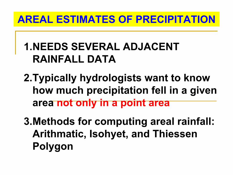
AREAL ESTIMATES OF PRECIPITATION
1.NEEDS SEVERAL ADJACENT RAINFALL DATA
2.Typically hydrologists want to know how much precipitation fell in a given area not only in a point area
3.Methods for computing areal rainfall: Arithmatic, Isohyet, and ThiessenPolygon

Penambahan data Presipitasi
Metoda nisbah-normal:PA = 1/3 [(NA/NB)PB + (NA/NC)PC + (NA/ND)PD]
Metoda rata-rata Aritmatik:PA = 1/3 ( PB + PC + PD )

THIESSEN POLYGON METHOD

ISOHYETAL METHOD

How well do adjacent gauges measure the same rainfall event?
ANOTHER METHOD
•Graph spatial correlation vs distance
Height (meter) Percentage of rain coverage area0 100
0.4 93 – 971.5 84 - 96
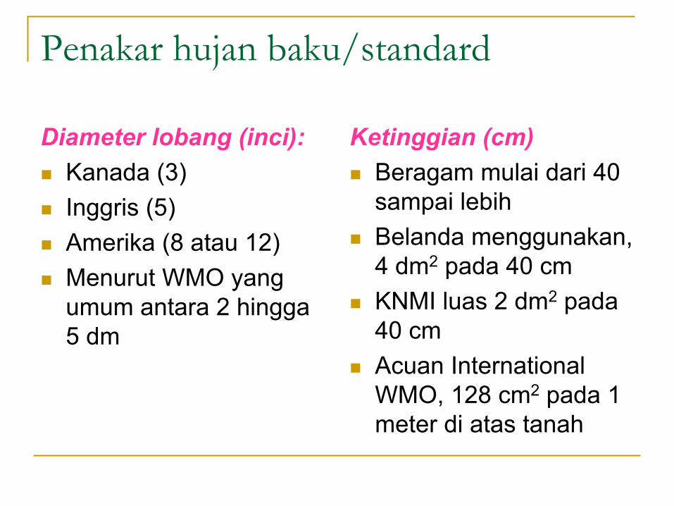
Penakar hujan baku/standard
Diameter lobang (inci):Kanada (3)Inggris (5)Amerika (8 atau 12)Menurut WMO yang umum antara 2 hingga5 dm
Ketinggian (cm)Beragam mulai dari 40 sampai lebihBelanda menggunakan, 4 dm2 pada 40 cmKNMI luas 2 dm2 pada40 cmAcuan International WMO, 128 cm2 pada 1 meter di atas tanah

Wind speed and direction
Rain-gauge


Global winds
Wind is the movement of air from
regions of highpressure
to
regions of lowpressure

Tugas I (Perorangan)Baca Skripsi/Tesis/Desertasi/Majalah/Jurnal yang ada data curah hujannya di Wilayah/DAS, hitungrata-rata curah hujan di wilayah/DAS tersebutTulis sumber,lokasi daerahnya, stasiun-stasiun-nya yang ada dalam perhitunganGunakan metode “Isohyet / Thiessen Polygon”, bagaimana langkah perhitungannya dan berikanhasil rata-rata curah hujan bulanan untuk periodetahunannyaApa komentar anda terhadap potensi hujanbulanan pertahunnya di DAS tersebutJawaban tugas I diserahkan tanggal paling lambat12 Maret 2008.