Mobile audio assistance in bus transportation for the blind
8
Proc. 7 th ICDVRAT with ArtAbilitation, Maia, Portugal, 2008 ©2008 ICDVRAT/University of Reading, UK; ISBN 07 049 15 00 6 279 Mobile audio assistance in bus transportation for the blind J H Sánchez and C A Oyarzún Department of Computer Science, University of Chile, Blanco Encalada 2120, Santiago, CHILE [email protected], [email protected] ABSTRACT People with visual disabilities have serious difficulties when mobilizing through the city on the public transportation system. We introduce AudioTransantiago, a handheld application that allows users to plan trips and provide contextual information during the journey through the use of synthesized voices. The usability and cognitive evaluation of AudioTransantiago was performed using a prototype evaluation in order to identify and solve usability issues, ending up with an intuitive and simple interface. Finally, a cognitive impact evaluation administered during bus trips taken with the assistance of AudioTransantiago demonstrated that the software provides more autonomy and effectiveness for users’ trips, improving their orientation and mobility. 1. INTRODUCTION It is widely recognized that visually handicapped people have difficulties moving around independently (Petrie et al., 1997; Engelbrektsson, 2004; Gill, 2005). Orienting oneself and moving around quickly, efficiently and independently within a space is a difficult task that depends on a series of highly complex cognitive processes, including perception, codification, learning and memorization of spatial information (Espinosa et al., 1998). In particular, people with visual disabilities have problems traveling independently by way of public transportation (Baudoin et al., 2005; Engelbrektsson, 2004; Gill, 2005; Sánchez and Maureira, 2007; Sánchez and Sáenz, 2006), starting with the difficult access to the information necessary to plan their trips (Petrie et al., 1997; Engelbrektsson, 2004; Sánchez and Maureira, 2007; Sánchez and Sáenz, 2006, Koruda et al., 2002). In addition, the scarcity of contextual information about the trip makes their orientation difficult and makes it impossible for them to identify their position on the route with certainty and to make safe decisions when presented with some kind of difficulty (Kulyukin et al., 2004; Vogel, 2003). There are different trip planning systems for both pedestrians and those who use public transport (Gill, 2005; Sánchez and Maureira, 2007; Sánchez and Sáenz, 2006). As such, several authors suggest that through the use of software applications that provide contextual information about the different environments involved in the trip, the users are capable of constructing a mental model of spatial distribution that is adjusted to reality (Sánchez and Maureira, 2007). Moore (2002) presents a support system for blind user mobility in real spaces called Drishti. This system includes the use of wireless technology, voice recognition and synthesizer, geographical and global positioning systems and internet connection. Drishti provides contextual information and seeks to optimize the possible routes that blind users could take. This software application is thought of as a supplementary system to other support systems for orientation and mobility, such as guide dogs and white canes. The diminished or lack of the visual channel as a source of information for users with visual impairments is compensated for with information obtained from other senses (Lahav and Mioduser, 2004). In particular, blind users use their sense of hearing as a main source of information and knowledge for learning purposes (Sánchez and Sáenz, 2006). It is for this reason that the majority of the aids for non-sighted people use auditory interfaces (Massof, 2003), with either a synthesized voice or non-verbal sounds. The positive effects that can be obtained from the use of such technologies include a considerable improvement in the users’ quality of life, a reduction of stress, anxiety and uncertainty caused by taking trips, as well as a higher degree of independence (Marston and Golledge, 2000). At the beginning of the year 2007 in Santiago de Chile a new system of urban transportation was implemented called Transantiago (The Economist, 2007). This system emerged out of the almost unmanageable and chaotic situation in transportation that had been operating in Santiago up until the end of
-
Upload
independent -
Category
Documents
-
view
1 -
download
0
Transcript of Mobile audio assistance in bus transportation for the blind

Proc. 7th ICDVRAT with ArtAbilitation, Maia, Portugal, 2008 ©2008 ICDVRAT/University of Reading, UK; ISBN 07 049 15 00 6
279
Mobile audio assistance in bus transportation for the blind
J H Sánchez and C A Oyarzún
Department of Computer Science, University of Chile, Blanco Encalada 2120, Santiago, CHILE
[email protected], [email protected]
ABSTRACT People with visual disabilities have serious difficulties when mobilizing through the city on the public transportation system. We introduce AudioTransantiago, a handheld application that allows users to plan trips and provide contextual information during the journey through the use of synthesized voices. The usability and cognitive evaluation of AudioTransantiago was performed using a prototype evaluation in order to identify and solve usability issues, ending up with an intuitive and simple interface. Finally, a cognitive impact evaluation administered during bus trips taken with the assistance of AudioTransantiago demonstrated that the software provides more autonomy and effectiveness for users’ trips, improving their orientation and mobility.
1. INTRODUCTION It is widely recognized that visually handicapped people have difficulties moving around independently (Petrie et al., 1997; Engelbrektsson, 2004; Gill, 2005). Orienting oneself and moving around quickly, efficiently and independently within a space is a difficult task that depends on a series of highly complex cognitive processes, including perception, codification, learning and memorization of spatial information (Espinosa et al., 1998). In particular, people with visual disabilities have problems traveling independently by way of public transportation (Baudoin et al., 2005; Engelbrektsson, 2004; Gill, 2005; Sánchez and Maureira, 2007; Sánchez and Sáenz, 2006), starting with the difficult access to the information necessary to plan their trips (Petrie et al., 1997; Engelbrektsson, 2004; Sánchez and Maureira, 2007; Sánchez and Sáenz, 2006, Koruda et al., 2002). In addition, the scarcity of contextual information about the trip makes their orientation difficult and makes it impossible for them to identify their position on the route with certainty and to make safe decisions when presented with some kind of difficulty (Kulyukin et al., 2004; Vogel, 2003).
There are different trip planning systems for both pedestrians and those who use public transport (Gill, 2005; Sánchez and Maureira, 2007; Sánchez and Sáenz, 2006). As such, several authors suggest that through the use of software applications that provide contextual information about the different environments involved in the trip, the users are capable of constructing a mental model of spatial distribution that is adjusted to reality (Sánchez and Maureira, 2007). Moore (2002) presents a support system for blind user mobility in real spaces called Drishti. This system includes the use of wireless technology, voice recognition and synthesizer, geographical and global positioning systems and internet connection. Drishti provides contextual information and seeks to optimize the possible routes that blind users could take. This software application is thought of as a supplementary system to other support systems for orientation and mobility, such as guide dogs and white canes.
The diminished or lack of the visual channel as a source of information for users with visual impairments is compensated for with information obtained from other senses (Lahav and Mioduser, 2004). In particular, blind users use their sense of hearing as a main source of information and knowledge for learning purposes (Sánchez and Sáenz, 2006). It is for this reason that the majority of the aids for non-sighted people use auditory interfaces (Massof, 2003), with either a synthesized voice or non-verbal sounds. The positive effects that can be obtained from the use of such technologies include a considerable improvement in the users’ quality of life, a reduction of stress, anxiety and uncertainty caused by taking trips, as well as a higher degree of independence (Marston and Golledge, 2000).
At the beginning of the year 2007 in Santiago de Chile a new system of urban transportation was implemented called Transantiago (The Economist, 2007). This system emerged out of the almost unmanageable and chaotic situation in transportation that had been operating in Santiago up until the end of

Proc. 7th ICDVRAT with ArtAbilitation, Maia, Portugal, 2008 ©2008 ICDVRAT/University of Reading, UK; ISBN 07 049 15 00 6
280
2006. The city’s population had clearly expressed its discontent with the transportation system. In an acceptance survey for public systems taken in 2002, public transportation was graded with an average of 11.2 points on a scale of 1 to 100 (Cruz, 2002). Under the new Transantiago system, the city was divided into different zones (service units) that have different local bus routes (services) and that are connected by longer, more extensive services called Troncales (main bus routes). With the implementation of this system, it has been possible to model the services: each route has a series of stops assigned to it at which the different buses stop to pick up passengers (in addition to the stops at red lights). Transantiago does not offer a solution for people with visual disabilities to be able to utilize the bus transport system on a day-to-day basis. Faced with this situation, we propose AudioTransantiago, which emerges as an alternative for providing contextual information at each Transantiago bus stop through the use of a pocketPC, which allows a user with visual disabilities to plan his/her journey before taking it, taking into account the streets and important landmarks near each bus stop that he/she will utilize during the trip. It also allows the user to access this information during the trip and, in case of a detour or the suspension of a particular service, it offers the user alternative services to be able to complete the trip.
This study introduces AudioTransantiago, a handheld application that allows users to plan trips and which provides contextual information during the journey through the use of synthesized voices, as well as the usability and cognitive evaluations employed to tailor this application to the characteristics and needs of blind users and to determine the cognitive impact of AudioTransantiago on the user’s orientation and mobility.
2. SOFTWARE AudioTransantiago stores the contextual information on each stop of the Transantiago routes, from which the user chooses in order to plan his/her trips in advance. In addition, this software navigates the stops of a previously planned trip in order to strengthen orientation and facilitate the blind user’s journey.
2.1 Logic Design
The software application is designed for pocketPC with Windows Mobile 2005 and .NET Compact Framework 1.0, using the programming language C#. The system also uses a Text-to-Speech engine (TTS) from the Acapela Group.
Figure 1. Architecture of AudioTransantiago
AudioTransantiago is designed modularly in order to facilitate the development and re-use of its components. In Figure 1 there are 3 identified layers of which the software is composed. The first consists of a superior layer (GUI or Graphical User Interface) that manages the interaction between the user and the interface. The second layer consists of the data administration (Service Manager) and the audio components (Audio Interface). The third layer is that which supports the management of the data and its representation (XML Manager, Data Structure, TTS, MotorWay and XML DB).
AudioTransantiago stores the contextual information for every bus stop on the Transantiago routes, which the user can select beforehand in order to plan his/her trips. In addition, it navigates the stops of a previously planned trip in order to strengthen the user’s orientation and facilitate his/her journey. The data employed by AudioTransantiago is stored in an XML document, which includes the city’s service units, the services or routes and their stops. In turn, the software incorporates additional information on the nearby streets around them, as well as significant landmarks near to the bus stops.
2.2 Interaction with the User
The design of the interface considers the results discovered in previous studies with blind users and audio-based interfaces. The most important aspects taken into consideration are the circular menus, the color

Proc. 7th ICDVRAT with ArtAbilitation, Maia, Portugal, 2008 ©2008 ICDVRAT/University of Reading, UK; ISBN 07 049 15 00 6
281
contrasts and the use of sound mixed with a synthesized voice and non-verbal audio (Sánchez and Maureira, 2007; Sánchez, 2007).
AudioTransantiago presents a Text-To-Speech, audio-based interface through which it conveys information to the user, complemented by non-verbal sounds that help to identify the navigational flow within the application menus. This is improved upon with a minimalist graphic interface, which includes only the name of the selection that is being used and the option that has been selected, utilizing a strong color contrast (yellow letters over a blue background) that can be useful for those users with residual vision who can only distinguish shapes when displayed with highly contrasting colors (see Figure 2A).
(A) (B) (C)
Figure 2. (A) AudioTransantiago Interfaces (B) Navigational Flow of the AudioTransantiago menu (C) Denomination of the buttons on a pocketPC
2.3 Navigation
Navigation through the software application’s different functions is done through circular menus (Sánchez and Maureira, 2007), and through the use of the buttons below on the pocketPC (see Figure 2C). The advantage of these menus is that they facilitate the searches within the lists, which have a large number of different elements. The navigational flow through the software’s menu structure is described in Figure 2B. The software application’s two operational functions can be accessed through this structure (planning a trip and making a trip), as well as their respective submenus, which are explained in the next section.
A diagram with the denominations of the various buttons on the pocketPC can be observed in Figure 2C. In table 1, all the functions of the pocketPC buttons utilized by the software are specified.
Table 1. Functions of the buttons used in AudioTransantiago.
Button Function 1 Indicates the current section in which the user is located 2 Repeats the last instruction given to the user 3 Indicates the current option 4 Indicates the additional contextual information on the stops when these are being reviewed to plan a trip, or during an actual
trip Up Navigates the current options in the opposite order. While in the actual trip mode, this button provides alternative services to
the service that is being used Down Navigates the current options. In the actual trip mode, this button advances to the following stop Left Returns to the previous menu
Right Stops the reproduction of the current text Center Accepts the current option
2.4 Functions
AudioTransantiago has two main functions: planning a trip and making a trip. The first consists of planning a trip using a Transantiago bus, on what could be a frequent route or not. On the other hand, making a trip corresponds to carrying out a previously planned trip with the software application.
2.4.1 Trip Planning. In order to plan a trip the user must perform the following steps: 1. Select a service unit (area of the city where he/she will travel), 2. Choose the service or route that he/she wants to use, 3. Pick the direction in which he/she will travel, 4. Define a starting point at a specific stop, and 5. Define a destination stop. In following these steps, the user is able to create a trip that is stored in the pocketPC and which can be consulted by selecting the “Trip Execute” option.
2.4.2 Trip Execute. This option allows the user to make a previously planned trip. For the correct use of the information encapsulated in the previously planned trip, a navigation in advance model was proposed, in which the user can advance manually to the following stop before arriving. As such, he/she can consult the

Proc. 7th ICDVRAT with ArtAbilitation, Maia, Portugal, 2008 ©2008 ICDVRAT/University of Reading, UK; ISBN 07 049 15 00 6
282
contextual information about the stop (streets and nearby points of interest), and get an impression about the stop’s surroundings before getting there. In addition, the software application provides information about alternative routes to the one the user is using, and just in case there is some emergency or problem during the trip, it offers services that pass through the stop where the trip was suspended or detoured, and which directs the user to the destination stop defined in the originally planned trip.
3. EVALUATION 3.1 Usability Evaluation
3.1.1 Participants. The sample for the evaluation of the AudioTransantiago prototype was made up of 6 legally blind participants, between the ages of 27 and 50 years old, all residents of Santiago de Chile. Case 1 was 32 years old, male and totally blind (chronic uveitis), case 2 was 33 years old, male and totally blind (retinitis pigmentosa), case 3 was 34, male and with residual vision (miotic maculopathy), case 4 was 50, male and with residual vision (deform maculopathy), case 5 was 35, male and with residual vision (optic atrophy), and case 6 was 28 years old and totally blind (bilateral atrophy of the optic nerve). They participated in several activities, 3 of them had residual vision and all were men. Two special education teachers also participated, which are specialists in visual disabilities, and one engineer who is an expert in usability evaluation.
3.1.2 Instruments. The usability evaluation was done by means of a Software Usability Questionnaire (Sánchez, 2003), adapted for adult users in the context of this study. This questionnaire includes 18 closed questions about the specific aspects of the software’s interface, together with 5 more general, open-ended questions relating to trust in the system, the way of using the system and the perceived sensation of utilizing these devices as a way of helping the users to travel on a bus system. The results obtained can be grouped into four categories: (1) Satisfaction, (2) Control and Use, (3) Sound, and (4) Image.
3.1.3 Procedure. The usability evaluation was completed in two 60-minute sessions at a University of Chile laboratory. In each one of the sessions, the users interacted with the software for 25-30 minutes in order to evaluate the effectiveness of the interaction with the buttons on the pocketPC, the utility of the circular menus and the clarity of the sound support.
Each session involved the following steps: (1) Introduction to the software. The functions of the software application and its use through the pocketPC buttons are explained to the participant. (2) Interaction with the software. The users try out the functions of AudioTransantiago and the use of its buttons. At this point they also plan a trip as their final task. This trip is defined arbitrarily in order to be used in the evaluation of the cognitive impact. (3) Documentation. The session is documented in detail through the use of photographs, and (4) Evaluation. The Software Usability Questionnaire is applied. Based on the recommendations suggested by the participants, the software was modified, redesigning it in order to improve its usability.
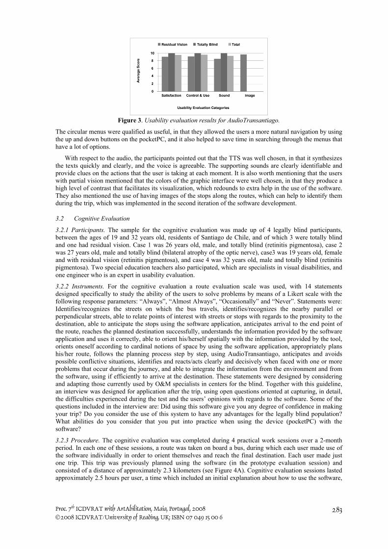
3.1.4 Results. Quantitative results were obtained and these are summarized in Figure 3. The closed questions were evaluated on a point system with values between 1 and 10, 10 being the highest. On average, the values obtained for all the items were quite satisfactory, obtaining an average of over 9 points for all of them. The points assigned by the totally blind users were 10 for all the questions, while those users with residual vision gave out slightly lower points (average 9.02).
The “Satisfaction” category obtained an average score of 9.53 points. The statements that obtained the highest scores in this category, for both totally blind users and those with partial vision, are, “I would recommend this software to other people” (10 points in both cases) and “I like this software” (10 points and 9.3 points respectively). In the “Control and Use” category, an average score of 9.57 points was obtained, and those statements that received the highest scores, indifferent to the kind of user, were “The software is motivating” and “The software adapts to my pace”. From this last statement we can gather that the user makes all of his/her consultations whenever he/she finds it convenient. The sounds obtained an average score of 9.28 points, in which the statement, “The sounds of the software are clearly identified” received a score of 9.33 points for users with partial vision and 10 points for the totally blind users.
For those users with partial vision, the graphic interface used in the software complements the sounds and helps to transmit information to them. This interface was evaluated with an average score of 9.67 points.
From the open questions, significant qualitative information was obtained. Among this information, we point out the fact that the participants did not have any major difficulties with using the buttons on the devices: it only took a couple of minutes of use for them to memorize the functions of each one of the buttons.
Proc. 7th ICDVRAT with ArtAbilitation, Maia, Portugal, 2008 ©2008 ICDVRAT/University of Reading, UK; ISBN 07 049 15 00 6
283
Figure 3. Usability evaluation results for AudioTransantiago.
The circular menus were qualified as useful, in that they allowed the users a more natural navigation by using the up and down buttons on the pocketPC, and it also helped to save time in searching through the menus that have a lot of options.
With respect to the audio, the participants pointed out that the TTS was well chosen, in that it synthesizes the texts quickly and clearly, and the voice is agreeable. The supporting sounds are clearly identifiable and provide clues on the actions that the user is taking at each moment. It is also worth mentioning that the users with partial vision mentioned that the colors of the graphic interface were well chosen, in that they produce a high level of contrast that facilitates its visualization, which redounds to extra help in the use of the software. They also mentioned the use of having images of the stops along the routes, which can help to identify them during the trip, which was implemented in the second iteration of the software development.
3.2 Cognitive Evaluation
3.2.1 Participants. The sample for the cognitive evaluation was made up of 4 legally blind participants, between the ages of 19 and 32 years old, residents of Santiago de Chile, and of which 3 were totally blind and one had residual vision. Case 1 was 26 years old, male, and totally blind (retinitis pigmentosa), case 2 was 27 years old, male and totally blind (bilateral atrophy of the optic nerve), case3 was 19 years old, female and with residual vision (retinitis pigmentosa), and case 4 was 32 years old, male and totally blind (retinitis pigmentosa). Two special education teachers also participated, which are specialists in visual disabilities, and one engineer who is an expert in usability evaluation.
3.2.2 Instruments. For the cognitive evaluation a route evaluation scale was used, with 14 statements designed specifically to study the ability of the users to solve problems by means of a Likert scale with the following response parameters: “Always”, “Almost Always”, “Occasionally” and “Never”. Statements were: Identifies/recognizes the streets on which the bus travels, identifies/recognizes the nearby parallel or perpendicular streets, able to relate points of interest with streets or stops with regards to the proximity to the destination, able to anticipate the stops using the software application, anticipates arrival to the end point of the route, reaches the planned destination successfully, understands the information provided by the software application and uses it correctly, able to orient his/herself spatially with the information provided by the tool, orients oneself according to cardinal notions of space by using the software application, appropriately plans his/her route, follows the planning process step by step, using AudioTransantiago, anticipates and avoids possible conflictive situations, identifies and reacts/acts clearly and decisively when faced with one or more problems that occur during the journey, and able to integrate the information from the environment and from the software, using if efficiently to arrive at the destination. These statements were designed by considering and adapting those currently used by O&M specialists in centers for the blind. Together with this guideline, an interview was designed for application after the trip, using open questions oriented at capturing, in detail, the difficulties experienced during the test and the users’ opinions with regards to the software. Some of the questions included in the interview are: Did using this software give you any degree of confidence in making your trip? Do you consider the use of this system to have any advantages for the legally blind population? What abilities do you consider that you put into practice when using the device (pocketPC) with the software?
3.2.3 Procedure. The cognitive evaluation was completed during 4 practical work sessions over a 2-month period. In each one of these sessions, a route was taken on board a bus, during which each user made use of the software individually in order to orient themselves and reach the final destination. Each user made just one trip. This trip was previously planned using the software (in the prototype evaluation session) and consisted of a distance of approximately 2.3 kilometers (see Figure 4A). Cognitive evaluation sessions lasted approximately 2.5 hours per user, a time which included an initial explanation about how to use the software,

Proc. 7th ICDVRAT with ArtAbilitation, Maia, Portugal, 2008 ©2008 ICDVRAT/University of Reading, UK; ISBN 07 049 15 00 6
284
the functions of different buttons and the way to use it during the trip, the bus ride itself, and the application of the instruments.
(A) (B) Figure 4. (A) Map of the route taken (B) Cognitive evaluation in a microbus, using AudioTransantiago
The user was accompanied by two special education teachers, which are specialists in visual disabilities, and one project engineer, who gave out indications before beginning the journey and during the trip, always and only when the user asked for some help that was beyond the information provided by the software. During the trip, the facilitators evaluated different aspects of the user’s performance by using the previously described evaluation guideline. After the trip, the user was interviewed on his/her experience (see Figure 4B).
3.2.4 Results. When the level of the users’ problem solving skills as a result of having used AudioTransantiago was measured, relevant results were achieved, reaching 90% achievement in resolving orientation and mobility tasks. On average, the users obtained 39 out of a total of 42 points on the evaluation scale. The users were able, only on certain occasions, to relate significant landmarks to their respective streets and/or bus stops. This is due to the fact that, for each landmark, the software gives 4 horizontal streets and 4 vertical streets to the point, this being too much information to be able to remember. The users recommend using only 2 streets respectively. In addition, they were able to relate the distance from their final destination to the different landmarks. All together, the user is able to achieve a certain degree of autonomy in identifying places, planning certain routes and being able to get to their destination, which is the key objective of every bus ride.
The posterior interview provided valuable information: of the 4 users, only one had previously taken the route used, and had done so only partially. In addition, they indicated that the software was a real help in facilitating their location, in that the contextual information on each stop allowed them to identify approximately the area in which they were traveling, without necessarily knowing that area. With regards to a comparison between making the trip with or without the software, one of the users stated, “The software indicates surrounding streets, something that one generally doesn’t know or remember. That makes a notable difference, especially if you don’t know the route; also, depending on the person, one can anticipate when to get off.”
As far as the advantages that the users appreciate in the software, they commented: “The information about the landmarks that it (AudioTransantiago) has is key, they are very orienting, it gives you a pretty practical map of the route to be followed.”, “…it gives us information on what is all around us that we don’t know.”, “It makes you more independent of other people, because if I do everything right and concentrate on the route, I can get to my destination without any problems…”.
With regards to the degree of confidence that the software provided for making the trip, the users all agreed that the software provided them with a certain degree of security, and that they felt oriented within the span of the trip, but that they had some difficulties due to the attention that the software requires. One of them mentioned, “The information that it provided me was good and precise, and let me know where I was. The stops can get all mixed up with each other, but it is just a matter of knowing where you are and paying attention to the distances and blocks between them. It’s easy to use. It requires 100% concentration, which makes it hard to talk to people on the way.”
When they were asked, “Do you consider the use of this system to have any advantages for the legally blind population?” one of the users responded, “Yes, knowing the surroundings of the stop, the main streets that surround it such as those that are parallel or perpendicular to the north and south is useful, because it allows you to anticipate everything. If you plan the trip well, you can have mental clarity in as much as the journey and the time to get off.”
According to interviewees, when they were asked about which abilities they considered having used when using the pocketPC with AudioTransantiago, they mentioned: attention, analysis, distinguishing (between stops), calculating or estimating distances, auditory memory, concentration, orientation and spatial location.

Proc. 7th ICDVRAT with ArtAbilitation, Maia, Portugal, 2008 ©2008 ICDVRAT/University of Reading, UK; ISBN 07 049 15 00 6
285
Among the potential difficulties that the users estimate could affect the use of the software is the possibility that the bus drivers not stop at all the stops along the route, or that they make stops at places besides the normal stops, which would confuse the users and negatively alter their planning. One user said, “I don’t know, it’s just that they don’t respect the stops…” In addition, some participants need certain commodities in order to use the software easily, and others fear that the devices will not fulfill their roles perfectly and fail during the trip. One user commented, “What if the battery runs out during the trip? It’s necessary, as far as possible, to be sitting down, because holding oneself up with a cane is complicated, for which reason it could sometimes be difficult to concentrate.”
With respect to the question, “What kind of solutions do you imagine when faced with these difficulties?” the users said that getting information from other passengers on the bus or from the driver could help to relocate themselves on the route. One of the users mentioned, “Concentration is necessary at all times, especially because you are the one working the machine. The idea is not to put all the responsibility in the device, rather to complement it with ones own strategies.”
Finally, the blind participants that used AudioTransantiago are used to orienting themselves according to the cardinal directions, unlike the majority of blind people who orient themselves better through standard directions (left, right, straight, back). For this reason, the participants mentioned the need to have information about streets and surrounding places by their cardinal directions, because the way in which the information is currently presented in the software, it is necessary for them to have a certain dominion over the place in which they are located; using the cardinal directions, however, would be much easier.
4. CONCLUSIONS The objective of this study was to determine if the fact of having contextual spatial information on the stops that make up a bus ride makes the use of urban transportation possible in an autonomous and efficient manner, improving the mobility and orientation of the user. In order to achieve this objective the software AudioTransantiago was designed, developed and evaluated with blind users, allowing users with visual impairments to orient themselves and move about on the trips made using the public transport system of buses in Santiago de Chile.
With the evaluation of the AudioTransantiago prototype, we were able to determine that the use of a pocketPC was appropriate for the end goals of this study, in that the participants learned to use the device without any major difficulties, demonstrating a high level of skill in the use of the buttons on the pocketPC. Also, the use of the audio system, both the synthesized voice and the non-verbal sounds, was well accepted by the users in which the natural sound of the TTS and the clarity of the sounds in general were highlighted.
All the users performed well on their trips and in the ways in which they dealt with them. In dealing well with the trips, they were able to achieve a higher degree of autonomy and improve the decision-making skills necessary to move about in the city. This was facilitated to a great degree through the use of the problem-solving methodology, which the users proved to dominate adequately.
The users were able to establish relationships between the stops on the trip and their respective nearby points of interest. This allowed them a certain degree of independence in planning trips, identifying places and being able to get to a destination, which was the main objective of the entire trip.
For the users of AudioTransantiago it is a powerful tool, due to the information on the environment that it provides to a legally blind user, and thanks to which they can anticipate things in advance and achieve an effective journey. At the same time, AudioTransantiago allows them to be aware of the environment that they are passing through, the trajectory that they are on and where they have to get off the bus, being able, as such, to make decisions about their route. All in all, the users were able to move around a lot more autonomously. As such, they improved their orientation and mobility skills on the bus transportation system through problem solving and the completion of proposed tasks.
As in all projects in which assumptions are made to be able to model situations, AudioTransantiago is dependent on the appropriate behavior of the bus drivers. If the drivers make stops at places that are not official stops, or if they skip one or more stops, they produce inconsistencies between the model and reality, and therefore the users of the software could become easily disoriented.
Some aspects to take into account in order to improve the program are to increase the amount of contextual information incorporated into the software (due to the time available the software was tested using only a reduced amount of information), make the planning of trips that involve the use of more than one route possible, and to incorporate the Metro network into the system.

Proc. 7th ICDVRAT with ArtAbilitation, Maia, Portugal, 2008 ©2008 ICDVRAT/University of Reading, UK; ISBN 07 049 15 00 6
286
Finally, it is necessary to make tests with more complex routes, and in more complex scenarios. A detailed analysis of the use and effect of this tool would allow us to clarify that a simple method without great technological requirements is able to support blind users’ autonomy when moving about from one place to another in the city.
Acknowledgements: This report was funded by the Chilean National Fund of Science and Technology, Fondecyt, Project 1060797 and PBCT-CONICYT, Project CIE-05.
5. REFERENCES G Baudoin, O Venard, G Uzan, A Rousseau, Y Benabou, A Paumier and J Cesbron (2005), How can blinds
get information in Public Transports using PDA? The RAMPE Auditive Man Machine Interface, Proc. 8th, AAATE, Lille, pp. 304-316.
C Cruz (2002), Transporte urbano para un Nuevo Santiago, Ministerio de Obras Públicas, Transporte y Telecomunicaciones, Santiago de Chile.
P Engelbrektsson, M Karlsson, B Gallagher, H Hunter, H Petrie and A O’Neill (2004), Developing a navigation aid for the frail and visually impaired. Universal Access in the Information Society, 3, 3, pp. 194-201.
M Espinosa, S Ungar, E Ochaita, M Blades and C Spencer (1998), Comparing methods for introducing blind and visually impaired people to unfamiliar urban environments, Journal of Environmental Psychology, 18, pp. 277-287.
J Gill (2005), An Orientation and navigation System for Blind Pedestrians. The MoBIC Project at the University of Magdeburg (2005). http://isgwww.cs.uni-magdeburg.de/projects/mobic/mobiruk.html.
T Koruda, H Sasaki, T Tateishi, K Maeda, Y Yasumuro, Y Manabe and K Chihara (2002), Walking aids based on wearable/ubiquitous computing – aiming at pedestrian’s intelligent transport systems. Proc. of the IV ICDVRAT, Veszprém, Hungary, pp 117-122.
V Kulyukin, C Gharpure, J Nicholson, and S Pavithran (2004), RFID in robot-assisted indoor navigation for the visually impaired, Proc. of International conference on Intelligent robot and systems, pp. 1979-1984.
O Lahav and D Mioduser (2004), Blind Persons’ Acquisition of Spatial Cognitive Mapping and Orientation Skills Supported by Virtual Environment. Proc. of the 5th ICDVRAT, Oxford, UK, pp. 131-138.
J R Marston and R G Golledge (2000), Towards an Accessible City, Removing Functional Barriers to Independent travel for Blind and Vision Impaired, A Case for Auditory Signs. Final Report, University of California Berkeley, University of California Transportation Center, Grant # UCTC 65V430.
R Massof (2003), Auditory Assistive Devices for the Blind, Proceedings of the 2003 International Conference on Auditory Display, Boston, MA, USA, pp. 271-275.
S Moore (2002) Drishti: An Integrated Navigation System for the Visually Impaired and Disabled, A Thesis Presented to the Graduate School of the University of Florida in Partial Fulfillment of the Requirements for the Degree of Master of Science, University of Florida, pp. 1-54.
H Petrie, V Johnson, T Strothotte, A Raab, R Michel, L Reichert and A Schalt (1997), MoBIC: An Aid to Increase the Independent Mobility of Blind Travellers. British Journal of Visual Impairment, 15, 2, pp. 63-66.
J Sánchez (2003), End-user and facilitator questionnaire for software usability, Usability Evaluation Test, University of Chile.
J Sánchez (2007), Blind Children Centered Technology. Human Technology Journal. (in press) J Sánchez and E Maureira (2007), Subway Mobility Assistance Tools for Blind Users. Lecture Notes in
Computer Science, LNCS 4397 (C Stephanidis & M Pieper, Eds.), pp. 386-404, Springer-Verlag Berlin. J Sánchez and M Sáenz (2006), Audio-Based Mobilization and Orientation of Users with Visual Disabilities
through Subway Networks. International Journal on Disability and Human Development, IJDHD, 5(3), pp. 235-242.
The Economist Web Version (2007), Transport in Chile. From the Economist print edition, February 15th http://www.economist.com/world/la/displaystory.cfm?story_id=8706618
S Vogel (2003), A PDA-Based Navigation System for the Blind. M.S. Integrative Paper (Retrieved April 6, 2006) from http://www.cs.unc.edu/ (no longer available online).