MOBILE APPLICATION FOR PUBLIC TRANSPORTATION By ...
107
MOBILE APPLICATION FOR PUBLIC TRANSPORTATION By Chan Man Ling A REPORT SUBMITTED TO Universiti Tunku Abdul Rahman in partial fulfilment of the requirements for the degree of BACHELOR OF COMPUTER SCIENCE (HONS) Faculty of Information and Communication Technology (Perak Campus) JAN 2017
-
Upload
khangminh22 -
Category
Documents
-
view
1 -
download
0
Transcript of MOBILE APPLICATION FOR PUBLIC TRANSPORTATION By ...
MOBILE APPLICATION FOR PUBLIC TRANSPORTATION
By
Chan Man Ling
A REPORT
SUBMITTED TO
Universiti Tunku Abdul Rahman
in partial fulfilment of the requirements
for the degree of
BACHELOR OF COMPUTER SCIENCE (HONS)
Faculty of Information and Communication Technology
(Perak Campus)
JAN 2017
UNIVERSITI TUNKU ABDUL RAHMAN
REPORT STATUS DECLARATION FORM
Title: __________________________________________________________
__________________________________________________________
__________________________________________________________
Academic Session: _____________
I __________________________________________________________
(CAPITAL LETTER)
declare that I allow this Final Year Project Report to be kept in
Universiti Tunku Abdul Rahman Library subject to the regulations as follows:
1. The dissertation is a property of the Library.
2. The Library is allowed to make copies of this dissertation for academic purposes.
Verified by,
_________________________ _________________________
(Author’s signature) (Supervisor’s signature)
Address:
__________________________
__________________________ _________________________
__________________________ Supervisor’s name
Date: _____________________ Date: ____________________
ii Bachelor of Computer Science (HONS)
Faculty of Information Technology and Communication Technology (Perak Campus), UTAR.
DECLARATION OF ORIGINALITY
I declare that this report entitled “Mobile Application for Public Transportation” is my
own work except as cited in the references. The report has not been accepted for any
degree and is not being submitted concurrently in candidature for any degree or other
award.
Signature : _________________________
Name : ______Chan Man Ling______
Date : ________17/4/2017_________
UNIVERSITI TUNKU ABDUL RAHMAN
FACULTY OF _______________________
Date: __________________
SUBMISSION OF FINAL YEAR PROJECT /DISSERTATION/THESIS
It is hereby certified that ______Student Name___________________________ (ID
No: __Student ID ) has completed this final year project/ dissertation/ thesis*
entitled “____________title____ _” under the supervision of
_________________________________ (Supervisor) from the Department of
_________________________, Faculty of ___________________________ , and
____________________ (Co-Supervisor)* from the Department of
________________________, Faculty of __________________________.
I understand that University will upload softcopy of my final year project / dissertation/
thesis* in pdf format into UTAR Institutional Repository, which may be made
accessible to UTAR community and public.
Yours truly,
____________________
(Student Name)
*Delete whichever not applicable
Bachelor of Computer Science (HONS) ii
Faculty of Information and Communication Technology (Perak Campus), UTAR.
ACKNOWLEDGEMENT
I would like to express my deepest gratitude to Mr. Tan Teik Boon who had given me the
chance to work on Mobile Application for Public Transport. I’m very thankful to had Mr.
Tan as my supervisor, as he had been giving me advices and guidance throughout Final
Year Project 1 and 2.
Lastly, a million thanks to my friends and family for their encouragement and
support throughout the whole Final Year Project. I couldn’t have handled the stress and
pressure if it wasn’t for the support of my friends and family.
Bachelor of Computer Science (HONS) iii
Faculty of Information and Communication Technology (Perak Campus), UTAR.
ABSTRACT
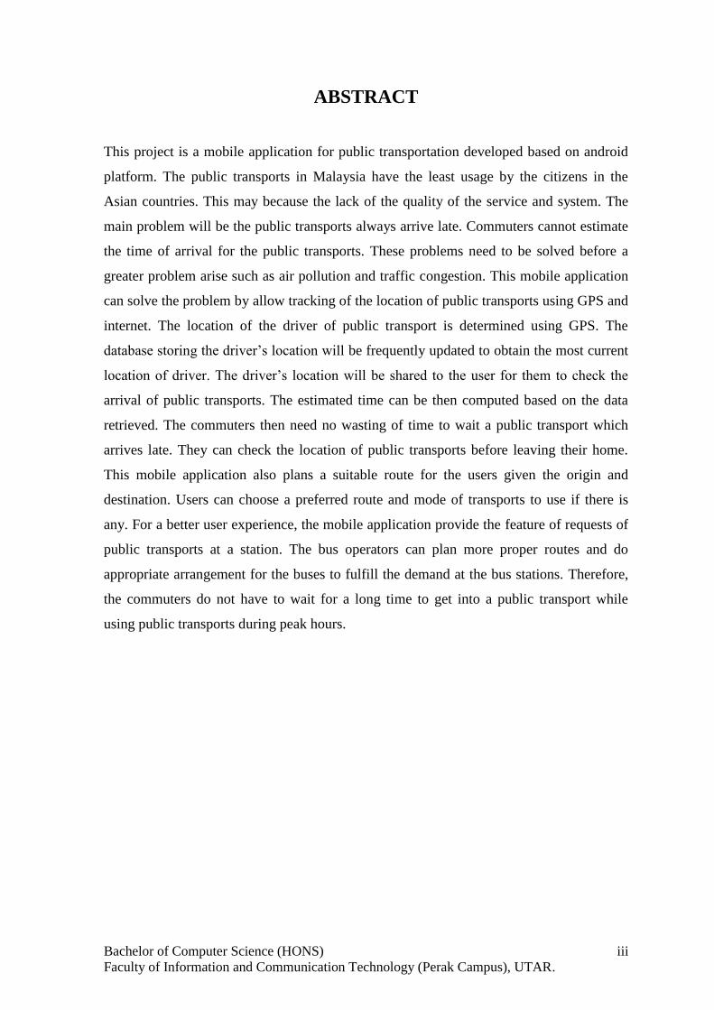
This project is a mobile application for public transportation developed based on android
platform. The public transports in Malaysia have the least usage by the citizens in the
Asian countries. This may because the lack of the quality of the service and system. The
main problem will be the public transports always arrive late. Commuters cannot estimate
the time of arrival for the public transports. These problems need to be solved before a
greater problem arise such as air pollution and traffic congestion. This mobile application
can solve the problem by allow tracking of the location of public transports using GPS and
internet. The location of the driver of public transport is determined using GPS. The
database storing the driver’s location will be frequently updated to obtain the most current
location of driver. The driver’s location will be shared to the user for them to check the
arrival of public transports. The estimated time can be then computed based on the data
retrieved. The commuters then need no wasting of time to wait a public transport which
arrives late. They can check the location of public transports before leaving their home.
This mobile application also plans a suitable route for the users given the origin and
destination. Users can choose a preferred route and mode of transports to use if there is
any. For a better user experience, the mobile application provide the feature of requests of
public transports at a station. The bus operators can plan more proper routes and do
appropriate arrangement for the buses to fulfill the demand at the bus stations. Therefore,
the commuters do not have to wait for a long time to get into a public transport while
using public transports during peak hours.
v
Bachelor of Computer Science (HONS)
Faculty of Information Technology and Communication Technology (Perak Campus), UTAR.
TABLE OF CONTENTS
TITLE i
DECLARATION OF ORIGINALITY ii
ACKNOWLEDGEMENTS iii
ABSTRACT iv
TABLE OF CONTENTS v
LIST OF FIGURES vii
LIST OF TABLES ix
LIST OF ABBREVIATIONS xi
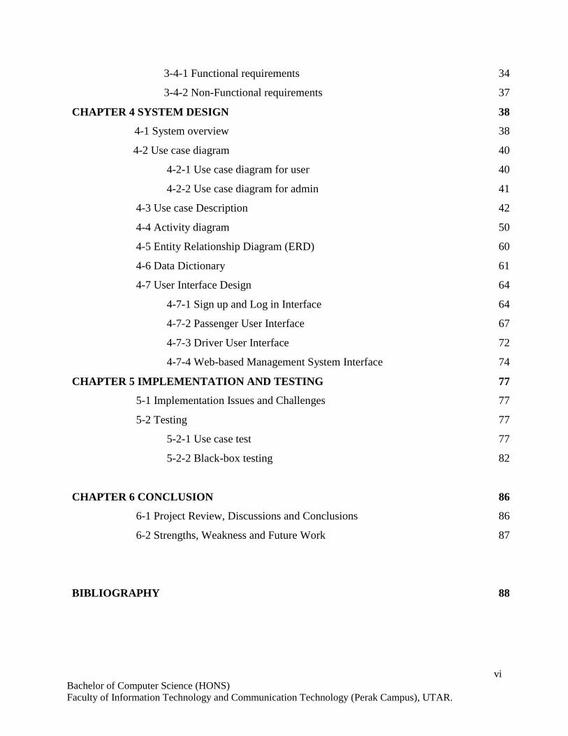
CHAPTER 1 INTRODUCTION 1
1-1 Problem Statement 1
1-2 Motivation 2
1-3 Project Scopes 3
1-4 Project Objectives 4
1-5 Impact, significance and contribution 5
1-6 Background 6
CHAPTER 2 LITERATURE REVIEW 7
2-1 Location Based Detection Techniques 7
2-2 Technique to Obtain Social Information from Individual Mobile Devices 12
2-3 Type of Multimedia That Are Suitable for Mobile Sharing 15
2-4 Google Maps APIs 19
2-5 Similar Mobile Applications 21
CHAPTER 3 PROPOSED METHOD/APPROACH 28
3-1 Methodology 28
3-2 Project Timeline 30
3-3 Tools used 32
3-4 Requirements 34
vi
Bachelor of Computer Science (HONS)
Faculty of Information Technology and Communication Technology (Perak Campus), UTAR.
3-4-1 Functional requirements 34
3-4-2 Non-Functional requirements 37
CHAPTER 4 SYSTEM DESIGN 38
4-1 System overview 38
4-2 Use case diagram 40
4-2-1 Use case diagram for user 40
4-2-2 Use case diagram for admin 41
4-3 Use case Description 42
4-4 Activity diagram 50
4-5 Entity Relationship Diagram (ERD) 60
4-6 Data Dictionary 61
4-7 User Interface Design 64
4-7-1 Sign up and Log in Interface 64
4-7-2 Passenger User Interface 67
4-7-3 Driver User Interface 72
4-7-4 Web-based Management System Interface 74
CHAPTER 5 IMPLEMENTATION AND TESTING 77
5-1 Implementation Issues and Challenges 77
5-2 Testing 77
5-2-1 Use case test 77
5-2-2 Black-box testing 82
CHAPTER 6 CONCLUSION 86
6-1 Project Review, Discussions and Conclusions 86
6-2 Strengths, Weakness and Future Work 87
BIBLIOGRAPHY 88
vii
Bachelor of Computer Science (HONS)
Faculty of Information Technology and Communication Technology (Perak Campus), UTAR.
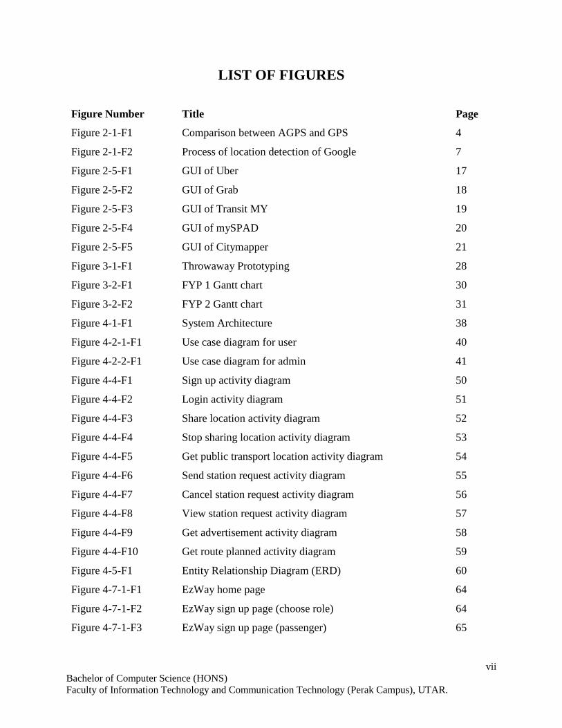
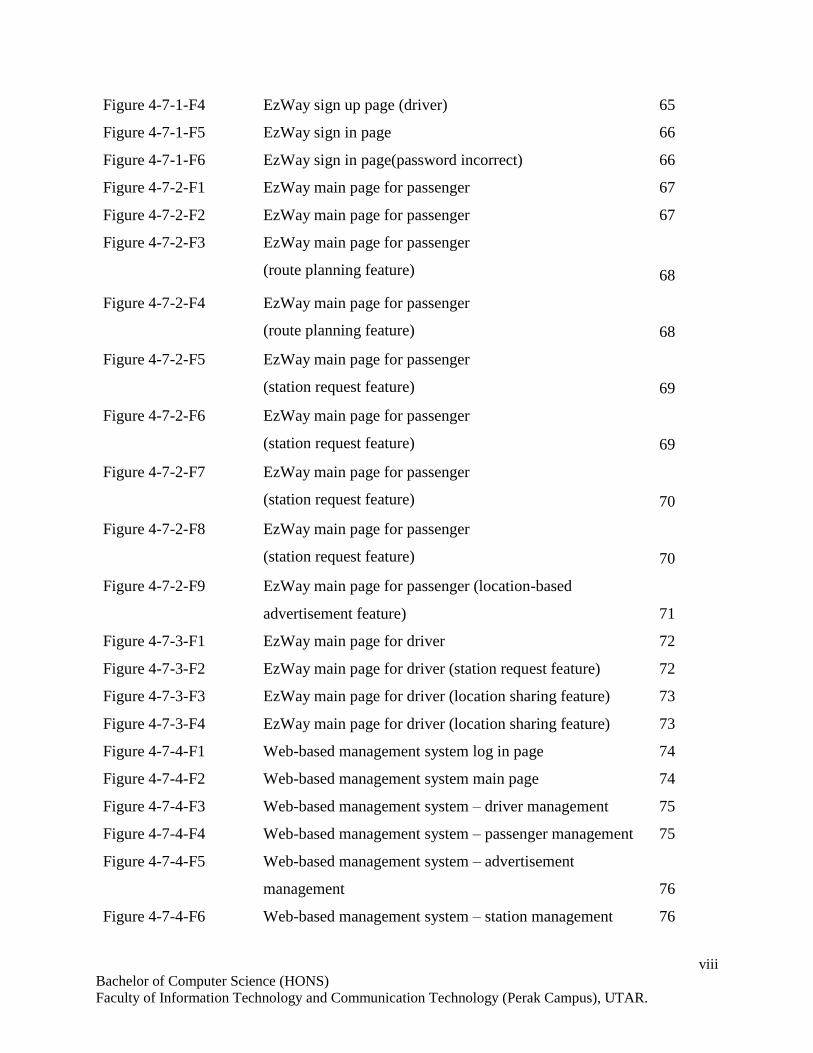
LIST OF FIGURES
Figure Number Title Page
Figure 2-1-F1 Comparison between AGPS and GPS 4
Figure 2-1-F2 Process of location detection of Google 7
Figure 2-5-F1 GUI of Uber 17
Figure 2-5-F2 GUI of Grab 18
Figure 2-5-F3 GUI of Transit MY 19
Figure 2-5-F4 GUI of mySPAD 20
Figure 2-5-F5 GUI of Citymapper 21
Figure 3-1-F1 Throwaway Prototyping 28
Figure 3-2-F1 FYP 1 Gantt chart 30
Figure 3-2-F2 FYP 2 Gantt chart 31
Figure 4-1-F1 System Architecture 38
Figure 4-2-1-F1 Use case diagram for user 40
Figure 4-2-2-F1 Use case diagram for admin 41
Figure 4-4-F1 Sign up activity diagram 50
Figure 4-4-F2 Login activity diagram 51
Figure 4-4-F3 Share location activity diagram 52
Figure 4-4-F4 Stop sharing location activity diagram 53
Figure 4-4-F5 Get public transport location activity diagram 54
Figure 4-4-F6 Send station request activity diagram 55
Figure 4-4-F7 Cancel station request activity diagram 56
Figure 4-4-F8 View station request activity diagram 57
Figure 4-4-F9 Get advertisement activity diagram 58
Figure 4-4-F10 Get route planned activity diagram 59
Figure 4-5-F1 Entity Relationship Diagram (ERD) 60
Figure 4-7-1-F1 EzWay home page 64
Figure 4-7-1-F2 EzWay sign up page (choose role) 64
Figure 4-7-1-F3 EzWay sign up page (passenger) 65
viii
Bachelor of Computer Science (HONS)
Faculty of Information Technology and Communication Technology (Perak Campus), UTAR.
Figure 4-7-1-F4 EzWay sign up page (driver) 65
Figure 4-7-1-F5 EzWay sign in page 66
Figure 4-7-1-F6 EzWay sign in page(password incorrect) 66
Figure 4-7-2-F1 EzWay main page for passenger 67
Figure 4-7-2-F2 EzWay main page for passenger 67
Figure 4-7-2-F3 EzWay main page for passenger
(route planning feature) 68
Figure 4-7-2-F4 EzWay main page for passenger
(route planning feature) 68
Figure 4-7-2-F5 EzWay main page for passenger
(station request feature) 69
Figure 4-7-2-F6 EzWay main page for passenger
(station request feature) 69
Figure 4-7-2-F7 EzWay main page for passenger
(station request feature) 70
Figure 4-7-2-F8 EzWay main page for passenger
(station request feature) 70
Figure 4-7-2-F9 EzWay main page for passenger (location-based
advertisement feature) 71
Figure 4-7-3-F1 EzWay main page for driver 72
Figure 4-7-3-F2 EzWay main page for driver (station request feature) 72
Figure 4-7-3-F3 EzWay main page for driver (location sharing feature) 73
Figure 4-7-3-F4 EzWay main page for driver (location sharing feature) 73
Figure 4-7-4-F1 Web-based management system log in page 74
Figure 4-7-4-F2 Web-based management system main page 74
Figure 4-7-4-F3 Web-based management system – driver management 75
Figure 4-7-4-F4 Web-based management system – passenger management 75
Figure 4-7-4-F5 Web-based management system – advertisement
management 76
Figure 4-7-4-F6 Web-based management system – station management 76
ix
Bachelor of Computer Science (HONS)
Faculty of Information Technology and Communication Technology (Perak Campus), UTAR.
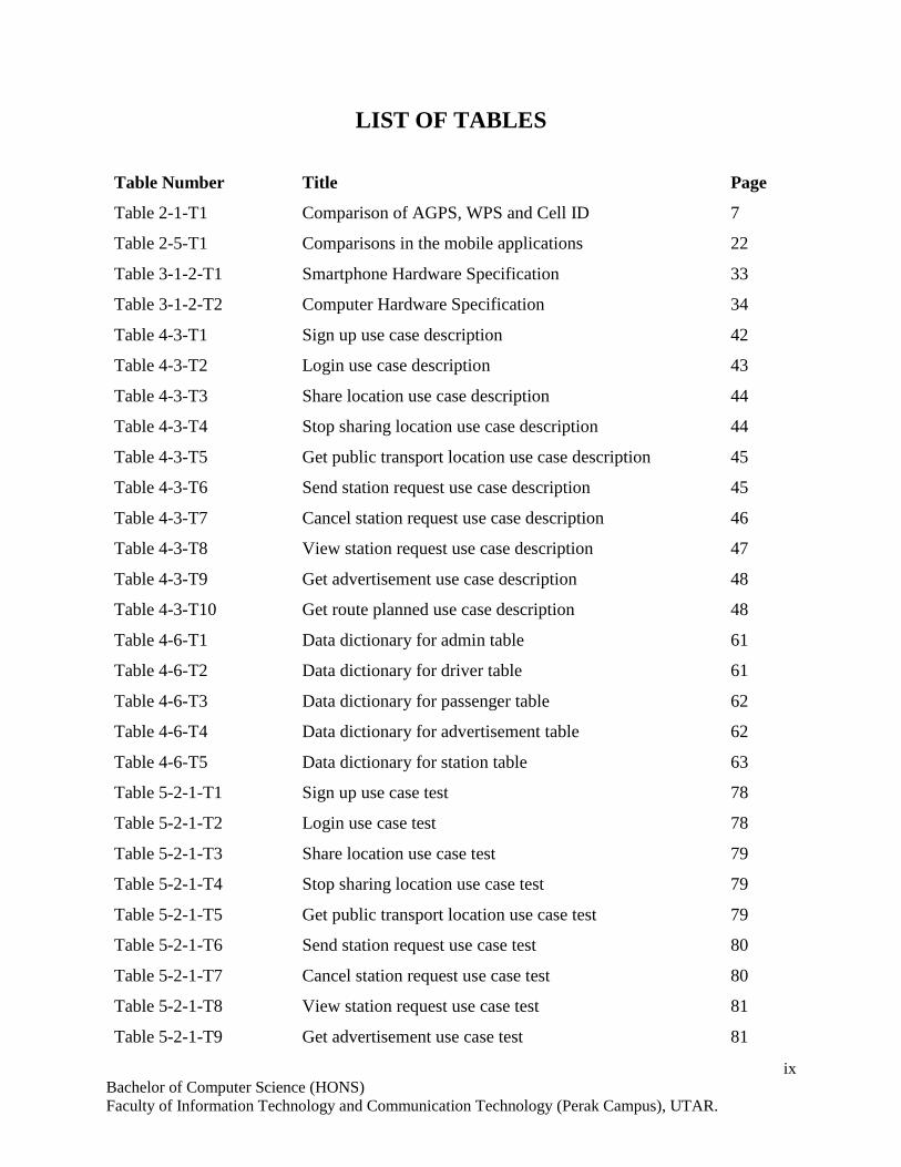
LIST OF TABLES
Table Number Title Page
Table 2-1-T1 Comparison of AGPS, WPS and Cell ID 7
Table 2-5-T1 Comparisons in the mobile applications 22
Table 3-1-2-T1 Smartphone Hardware Specification 33
Table 3-1-2-T2 Computer Hardware Specification 34
Table 4-3-T1 Sign up use case description 42
Table 4-3-T2 Login use case description 43
Table 4-3-T3 Share location use case description 44
Table 4-3-T4 Stop sharing location use case description 44
Table 4-3-T5 Get public transport location use case description 45
Table 4-3-T6 Send station request use case description 45
Table 4-3-T7 Cancel station request use case description 46
Table 4-3-T8 View station request use case description 47
Table 4-3-T9 Get advertisement use case description 48
Table 4-3-T10 Get route planned use case description 48
Table 4-6-T1 Data dictionary for admin table 61
Table 4-6-T2 Data dictionary for driver table 61
Table 4-6-T3 Data dictionary for passenger table 62
Table 4-6-T4 Data dictionary for advertisement table 62
Table 4-6-T5 Data dictionary for station table 63
Table 5-2-1-T1 Sign up use case test 78
Table 5-2-1-T2 Login use case test 78
Table 5-2-1-T3 Share location use case test 79
Table 5-2-1-T4 Stop sharing location use case test 79
Table 5-2-1-T5 Get public transport location use case test 79
Table 5-2-1-T6 Send station request use case test 80
Table 5-2-1-T7 Cancel station request use case test 80
Table 5-2-1-T8 View station request use case test 81
Table 5-2-1-T9 Get advertisement use case test 81
x
Bachelor of Computer Science (HONS)
Faculty of Information Technology and Communication Technology (Perak Campus), UTAR.
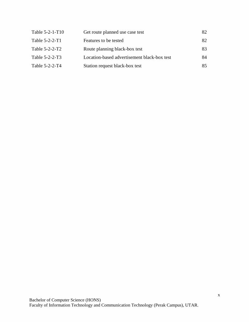
Table 5-2-1-T10 Get route planned use case test 82
Table 5-2-2-T1 Features to be tested 82
Table 5-2-2-T2 Route planning black-box test 83
Table 5-2-2-T3 Location-based advertisement black-box test 84
Table 5-2-2-T4 Station request black-box test 85
xi
Bachelor of Computer Science (HONS)
Faculty of Information Technology and Communication Technology (Perak Campus), UTAR.
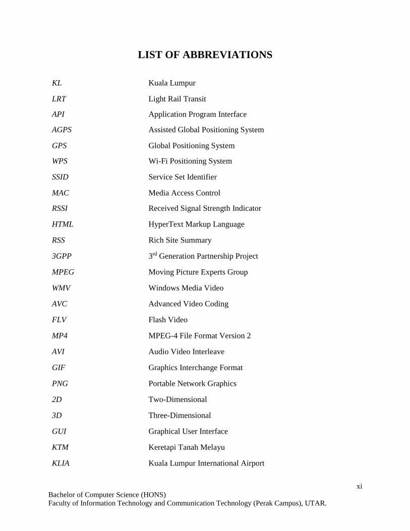
LIST OF ABBREVIATIONS
KL Kuala Lumpur
LRT Light Rail Transit
API Application Program Interface
AGPS Assisted Global Positioning System
GPS Global Positioning System
WPS Wi-Fi Positioning System
SSID Service Set Identifier
MAC Media Access Control
RSSI Received Signal Strength Indicator
HTML HyperText Markup Language
RSS Rich Site Summary
3GPP 3rd Generation Partnership Project
MPEG Moving Picture Experts Group
WMV Windows Media Video
AVC Advanced Video Coding
FLV Flash Video
MP4 MPEG-4 File Format Version 2
AVI Audio Video Interleave
GIF Graphics Interchange Format
PNG Portable Network Graphics
2D Two-Dimensional
3D Three-Dimensional
GUI Graphical User Interface
KTM Keretapi Tanah Melayu
KLIA Kuala Lumpur International Airport
xii
Bachelor of Computer Science (HONS)
Faculty of Information Technology and Communication Technology (Perak Campus), UTAR.
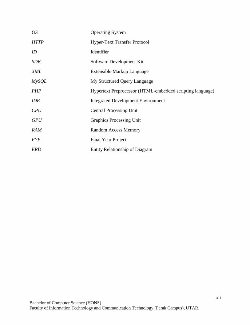
OS Operating System
HTTP Hyper-Text Transfer Protocol
ID Identifier
SDK Software Development Kit
XML Extensible Markup Language
MySQL My Structured Query Language
PHP Hypertext Preprocessor (HTML-embedded scripting language)
IDE Integrated Development Environment
CPU Central Processing Unit
GPU Graphics Processing Unit
RAM Random Access Memory
FYP Final Year Project
ERD Entity Relationship of Diagram
1
Bachelor of Computer Science (HONS)
Faculty of Information and Communication Technology (Perak Campus), UTAR.
CHAPTER 1 INTRODUCTION
1-1 Problem Statement
In present age, problems raised by public transportation have often been an issue in
Malaysia. The rapid growth of economy and urbanizations in Malaysia result in a by-
product which is a high income society in an urban area. This leads to the high demand in
travel among the metropolitans. However, the public transport facilities are lack of
planning and design, the concerns of pedestrians, bicycle users and bus users are also less
considered. The public transportation facilities lack of service quality although it is modern
(Almselati, Rahmat & Jaafar 2011). When the economy develops quickly but the public
transportation system is poor, people choose to travel by private vehicle. Among most of
the Asian countries, Malaysia has the lowest rate of public transport usage by their citizens.
People prefer to travel in their own private cars because of the degree of freedom,
accessibility, comfortability and negative perception for public transport (Almselati,
Rahmat & Jaafar 2011). The flourish of private transport eventually leads to various
problems arise such as air pollution and hazards in Malaysia and traffic congestion in the
urban area. In a nutshell, the public transportation system in Malaysia is indeed a necessary
to be improved in order to solve the problems stated above.
In the concrete jungle such as KL and Penang, people choose to travel by private
vehicle or taxi instead of public transport such as bus or LRT due to the time constraint.
Even there are schedules for public transport, the public transport always arrive late.
When the people choose to travel by public transport, their waiting is just like gambling,
they would not know when the bus will be arrived. Given a scenario that a worker wanted
to go to work by bus, he had been waiting at the bus station for half an hour as the bus are
not arrived on time. When he was running out of time, he decided to hire a taxi.
Unfortunately, the bus has arrived after he had make a phone call to the taxi company. This
is a problem needed to be solved in order to avoid wasting time of passengers or driver of
buses.
The bus stations in Malaysia usually do not provide any proper route
information of buses. Unlike the government operators such as RapidKL and KL monorail,
the normal bus operators only provide basic route information on the bus itself which
means that unless you see the bus passes by, you will never know what the route for the

2
Bachelor of Computer Science (HONS)
Faculty of Information and Communication Technology (Perak Campus), UTAR.
CHAPTER 1 INTRODUCTION
particular bus is. The route information can only be obtained from local people or the bus
itself. This scenario leads to the problem that foreign tourists are inconvenient to use the
public transport. Without the route information, people find the difficulty to plan the route
for their journey.
The main issue of using public transport in Malaysia is the crowded condition,
especially in the peak hours. The common situation is the commuters from different types
of groups, including students and workers are waiting the same bus or public transport in
a station during peak hours. Even when the public transport is arrived, some commuters
may not manage to get into the public transport as the spaces and seats are limited. The
amount of demand is often greater than the availability of public transports. Therefore,
some commuters may need to waste their time to wait for the next-coming public transports.
Nowadays, advertisement on public transport becomes a popular choice among the
large-size enterprises. The main problem of advertisement on public transport is
flexibility. Adverts are often placed as basic rectangular motifs on the side or front of a
bus. These may be applied directly to the bus. Additionally, adverts may be printed on
placards known as boards, which are slotted into special guide fittings attached to the side
of the bus (Rsrikanth 2015). Therefore, limited adverts can placed on the bus and altering
of the adverts on bus is infeasible. Moreover, some advertisement such as cigarettes and
alcohol are unsuitable to be placed on a bus due to some moral issues.
Thus, the deliverable of this project will be a mobile application for public
transportation to improve the public transport service with the purpose of enhancing the
commuter experience.
1-2 Motivation
There exist some mobile application for public transportation in Malaysia such as Transit
MY and MYSPAD. However, these applications just include the features such as estimated
time and fares, route information and schedule of LRT or rails in KL. These information
are less vital as they can be easily obtained from the rail stations or the web sites.
3
Bachelor of Computer Science (HONS)
Faculty of Information and Communication Technology (Perak Campus), UTAR.
CHAPTER 1 INTRODUCTION
The mobile application delivered in this project will improve the existing application and
includes some new features like tracking the public transport, do the route planning and
sending request for the transport at a bus station.
1-3 Project Scopes
The end product of this project is a mobile application for public transportation which could
improve the convenience of using public transport. This project is developed based on the
android platform. GPS and internet is needed for the device in order to track the user
location. The mobile application targets the public transports in KL region. The users of
this application are categorized into two groups which are passengers and drivers in where
the passengers can use the features like route planning, tracking the public transport and
requesting for transport while the drivers can share the location for the system to broadcast
it to the passengers and view the request at the bus stations. The system should be able to:
i) Allow users to sign up as driver or passenger.
ii) Allow users to log in as driver or passenger.
iii) Allow drivers to share their location.
iv) Update the location of drivers in database and broadcast it to passengers.
v) Determine the speed of drivers.
vi) Allow drivers to view the status of the bus stations. (Number of requests)
vii) Calculate the estimated time for arrival, travelling and reaching destination.
viii) Track the user location using GPS.
ix) Allow passengers to set starting and destination points.
x) Provide route planning for passengers.
xi) Allow passengers to request for the transport when they are at a bus station.
xii) Publish the location-based advertisements.
4
Bachelor of Computer Science (HONS)
Faculty of Information and Communication Technology (Perak Campus), UTAR.
CHAPTER 1 INTRODUCTION
1-4 Project Objectives
In order to solve the problems stated before, the mobile application developed in this
project will be capable of tracking the location of public transport. The system provide a
suitable route planning for the users and an estimated time is calculated. The number of
requests of each bus station are tracked and broadcasted to the driver users. To attract the
interest of users, suitable and location-based advertisements are provided to the users.
To track the location of public transport, the location of a public transport is
determined and broadcasted to the users who are the passengers. The passengers can view
the current location of the public transports.
The routes are planned for a user based on the origin place and destination
provided. The information of each step of the planned route are provided to the users. The
estimated arrival time, travelling time and the time for reaching the destination are
calculated. Each stop point is shown to guide users step-by-step to reach the desired
destination.
The system allows the user as a role of passenger to check-in and send requests
from a bus station when he/she is nearby the bus station. The number of requests are
updated to the server. The drivers are then able to view the number of requests of the bus
stations.
For the advertisements on public transports, no more rectangular board painted with
the advertisements is placed on the public transport. The advertisements can be mobility
which is published on the mobile application. Suitable advertisements have to be chosen
for each user to avoid the displeasure of the user. Besides, location-based advertisements
is an innovative way to provide commuters relevant ads that they desire at that very time.
5
Bachelor of Computer Science (HONS)
Faculty of Information and Communication Technology (Perak Campus), UTAR.
CHAPTER 1 INTRODUCTION
1-5 Impact, significance and contribution
With this mobile application, it will improve the user experience of the public transport.
Passenger can use the public transport in a more convenient way with the aid of this mobile
application. For instance, a student does not need to wake up earlier and wait at the bus
stop for a long time to avoid missing of the bus. He/she can get the location of the bus and
the estimated time for it arrives from the application, then leaves home in appropriate time.
The application provides good functions such as route planning for various public
transportation and sharing of transportation information to users. This promotes the usage
of the public transport by gaining the confidence of people in using public transport in
Malaysia. Besides, the application can solve the problem of the crowded situation on using
the public transport in peak hours. The bus operators can check the number of requests of
each station before sending the buses to the stations. The arrangement of sending more
buses to a bus station could be done if there is a large number of requests at the particular
bus station.
The application contains information for various types of public transports with
commuter advertising. The transit companies earn more revenues and the advertiser
benefits from innovative commuter advertising. Everyone get benefits!
6
Bachelor of Computer Science (HONS)
Faculty of Information and Communication Technology (Perak Campus), UTAR.
CHAPTER 1 INTRODUCTION
1-6 Background
Public transport is a shared transport service that can be used by general public. Public
transport provides the lowest rate of travelling fares for public and at the same time greatly
reduce the environmental pollution by increasing the energy efficiency. However, public
transport in Malaysia is less used by the citizen due to the lack of quality of service and
system. The end product of this project will be a mobile application for public
transportation with the purpose of promoting the usage of public transport.
This project will target the user in KL. KL has the most various type of public
transports in Malaysia including KTM Komuter, KLIA Ekspress, KLIA Transit, LRT,
monorail and RapidKL. The mobile application will guide the foreigner or tourist to use
the public transport in KL in a more convenient way. The application provide the basic
information of public transports in KL such as schedule and fares.
In order to improve the user experience, the mobile application includes features
such as tracking the public transports. This tracking feature requires GPS in the mobile
device. GPS is a system that uses satellite to get user location. At least three satellites are
needed to pinpoint the location through trilateration process. The location of driver of
public transport is tracked using GPS and is shared to the passengers. The location of
drivers will be updated periodically so that the passengers can obtain the actual current
location of public transport from the application. This process will only be possible when
the application is allow to access to the internet. The internet is needed for the application
to access and retrieve data from the database of the server. The estimated time will also be
calculated based on the speed of drivers and the distance.
The mobile application allows users to choose their starting and destination points
in order to do route planning for them. Users are able to send requests for bus when they
are at a bus station. The number of requests at each bus stations are tracked and be shown
to driver users.
7
Bachelor of Computer Science (HONS)
Faculty of Information and Communication Technology (Perak Campus), UTAR.
CHAPTER 2 LITERATURE REVIEW
In this project, some techniques are needed to be performed to fulfill the objectives and
complete the development of project. Some literature reviews had been done after doing
the studies and researches on current technology. These reviews include location based
techniques, techniques to obtain social information from individual mobile devices, types
of multimedia that are suitable for mobile sharing, Google Map APIs and similar mobile
applications.
2-1 Location based Detection Techniques
2-1-1 Introduction
In the mobile application of this project, the users’ locations would need to be obtained in
order to provide a location-based advertisement to them. Other than that, the real-time
location of passenger and public transportation would need to be tracked to inform the user
of the current location. There are several techniques available in order to track a user’s
current location such as using AGPS, Wi-Fi or Cell ID.
AGPS and Wi-Fi can obtain a more accurate result than Cell ID but the power
consumption is high. This is because AGPS can only track a person’s location while mobile
network resource is available and the AGPS location fixes are performed periodically. In
addition, AGPS is not available for indoor positioning. Wi-Fi can localize a person at
indoor but Wi-Fi coverage is often spotty (Wang, Wong & Kong 2012). Cell ID is power-
saving and also available both at indoor and outdoor but the drawback is the location
tracked is less accurate because the cell tower can cover a radius of hundreds meters to
kilometers.
In this review, the three popular location based detection techniques will be studied
and compared.
8
Bachelor of Computer Science (HONS)
Faculty of Information and Communication Technology (Perak Campus), UTAR.
CHAPTER 2 LITERATURE REVIEW
2-1 Location Based Detection Techniques
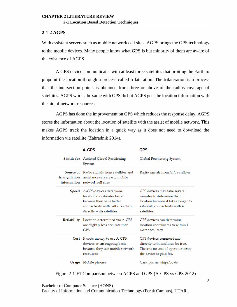
2-1-2 AGPS
With assistant servers such as mobile network cell sites, AGPS brings the GPS technology
to the mobile devices. Many people know what GPS is but minority of them are aware of
the existence of AGPS.
A GPS device communicates with at least three satellites that orbiting the Earth to
pinpoint the location through a process called trilateration. The trilateration is a process
that the intersection points is obtained from three or above of the radius coverage of
satellites. AGPS works the same with GPS do but AGPS gets the location information with
the aid of network resources.
AGPS has done the improvement on GPS which reduces the response delay. AGPS
stores the information about the location of satellite with the assist of mobile network. This
makes AGPS track the location in a quick way as it does not need to download the
information via satellite (Zahradnik 2014).
Figure 2-1-F1 Comparison between AGPS and GPS (A-GPS vs GPS 2012)
9
Bachelor of Computer Science (HONS)
Faculty of Information and Communication Technology (Perak Campus), UTAR.
CHAPTER 2 LITERATURE REVIEW
2-1 Location Based Detection Techniques
The GPS satellites orbiting the Earth send the location information to the Earth
through radio waves continuously (A-GPS vs GPS 2012). Then the distance of a particular
location is calculate based on how long it took for the message to reach. There are at least
three satellites are needed to be above of a GPS receiver in order to track the exact location.
The location is determined through a process called trilateration which is a process that the
intersection point between overlapping satellites is taken. This computing needs to takes
some time for a GPS device to track the location. Some environmental factors such as
blockages of some buildings or the weather could affect the response time.
The cell sites tower or an AGPS server continuously updates their location
information by sending and receiving the message to the GPS satellites. The orbital
information is downloaded from satellites and stored in the server database. The time
performance for tracking locations is greatly improve for an AGPS device because the
information only needs to be downloaded from AGPS server instead of the satellites.
2-1-3 Wi-Fi Positioning System
The Wi-Fi positioning system (WPS) uses the intensity of signal strengths of wireless
access points or modems to localize a person. The main objective of introducing WPS to
this world is to solve the unavailable using of GPS at indoor. The indoor positioning using
WPS took the advantage of the 21st century rapid growth of wireless access point and
modem in urban area. The poor performances of GPS in indoor building and the popularity
of using Wi-Fi had encouraged companies to design the Wi-Fi based indoor positioning.
The location of Wi-Fi hotspot is tracked by the SSID and the MAC address of the
particular device. When a mobile devices starts the WPS service, the RSSI which is the
signal strength of Wi-Fi hotspots is determined. The estimated location of the mobile
device is then calculated using multilateration technique.
Fingerprinting method is now a popular technique of WPS. This method is also
RSSI-based but the RSSI information is store as a ‘fingerprint’ in the wireless access points.
During the learning phase, the known position of a mobile device is categorised
10
Bachelor of Computer Science (HONS)
Faculty of Information and Communication Technology (Perak Campus), UTAR.
CHAPTER 2 LITERATURE REVIEW
2-1 Location Based Detection Techniques
by the RSSI from different Wi-Fi hotspot and stored into the database. For the positioning
phase, the position is compared to the fingerprint information to find the closest match and
an estimated position is computed (Navaro, Peuker & Quan n.d.).
The WPS did a good performance in indoor but the main drawback of using Wi-Fi
positioning is the accuracy of tracked position is relatively low when compared to GPS.
2-1-4 Cell ID
Cell ID is a unique number used to identify a cell tower which a mobile device is connected
to. The cell ID is used to detect the location from the closest tower. By knowing the location
of the tower, an estimated position of a mobile device can be manipulated.
The time taken for localizing a mobile device using cell id is the least compared to
AGPS and Wi-Fi because the location information is stored previously in the cell tower.
However, the accuracy is very low due to the large coverage of a cell tower. As a result,
the difference between the actual position and the estimated position can be up to 1 or 2
kilometers. The accuracy can be improved by increasing the number of cell tower in an
area.
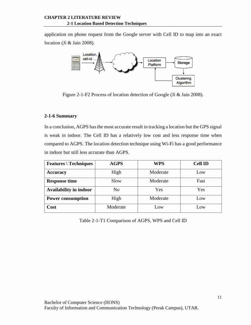
2-1-5 Google location detection technique
Google uses a hybrid way to track the mobile devices including using GPS and Cell ID.
The new feature in Google Map called My Location can pinpoint the location of the phone
even the phone has no GPS service (Ji & Jain 2008).
A mobile phone connects to a cell tower to make a call and use the internet. If a
phone has GPS service, it sends the Cell ID of cell tower with the GPS location to the
Google server even when the phone does not request GPS service. Many of this kind of
data is collected and formed a huge database of location information by clustering
algorithm. Then when a mobile phone users want to track the location of themselves, the
11
Bachelor of Computer Science (HONS)
Faculty of Information and Communication Technology (Perak Campus), UTAR.
CHAPTER 2 LITERATURE REVIEW
2-1 Location Based Detection Techniques
application on phone request from the Google server with Cell ID to map into an exact
location (Ji & Jain 2008).
Figure 2-1-F2 Process of location detection of Google (Ji & Jain 2008).
2-1-6 Summary
In a conclusion, AGPS has the most accurate result in tracking a location but the GPS signal
is weak in indoor. The Cell ID has a relatively low cost and less response time when
compared to AGPS. The location detection technique using Wi-Fi has a good performance
in indoor but still less accurate than AGPS.
Features \ Techniques AGPS WPS Cell ID
Accuracy High Moderate Low
Response time Slow Moderate Fast
Availability in indoor No Yes Yes
Power consumption High Moderate Low
Cost Moderate Low Low
Table 2-1-T1 Comparison of AGPS, WPS and Cell ID
12
Bachelor of Computer Science (HONS)
Faculty of Information and Communication Technology (Perak Campus), UTAR.
CHAPTER 2 LITERATURE REVIEW
2-2 Technique to Obtain Social Information from Individual Mobile Devices
2-2 Technique to Obtain Social Information from Individual Mobile Devices
2-2-1 Introduction
Mobile advertising have been highly effective throughout the past few years, however
recently its effectiveness have been decreasing. But most of the time mobile advertising
might potentially irritate or offend people. So, advertisers should focus on providing
mobile device user relevant advertisement which they are interested on and also be
respectful to the user at the same time (How do I Make n.d.).
In this project, the mobile application should provide a suitable advertisement to
users by obtaining their information firstly. In this case, Google Advertisement has done a
good example to provide a suitable advertisement to Google users. How can Google do
this? The studies below will explain the way of Google gain social information from the
users’ devices in order to choose a suitable advertisement for users.
Before studying the Google’s way of advertisement, let’s see where mobile
advertisements appear.
Browsers of smartphones or tablets
The first one is text ads, followed by image ads, the third is application promotion ads and
lastly is HTML 5 ads which is built with Google Web Designer (About Mobile Ads n.d.).
Application of smartphones or tablets
Same as the advertisement which appears on browsers of smartphones or tablets but minus
the HTML 5 ads which is built with Google Web Designer, it includes some extra types of
advertisement which is image app promotion ads, video app promotion ads and lastly
which is TrueView for app promotion ads (About Mobile Ads n.d.).
Devices which can only make calls
This only have one type of advertisement which is call-only ads (About Mobile Ads n.d.).
13
Bachelor of Computer Science (HONS)
Faculty of Information and Communication Technology (Perak Campus), UTAR.
CHAPTER 2 LITERATURE REVIEW
2-2 Technique to Obtain Social Information from Individual Mobile Devices
2-2-2 Google’s information-gathering channels
Google’s mission is stated that “to organize the world’s information and make it universally
accessible and useful”. However, Google may have gathered even more information than
we thought (How Google Collects data 2010).
The first channel would be searches which includes web, images, news, and blogs.
With a market share of 70%, Google keeps track of all searches, with the personalization
of searching on Google, this kind of information is going to grow detailed and user specific
(How Google Collects data 2010). The next channel is clicks on search results, which
means Google also keeps an eye on what search result we click on. Up next is web crawling
which is done by Googlebot (Google’s web crawler) it helps to index web pages.
Other than those mentioned above, Google’s Website analytics which is named
Google Analytics supports a lots of advanced features while it remains free, that’s why it
is the most popular website analytics. Moreover, ad serving also plays a big role for
Google’s information mining and their financial success right now. It tells Google which
advertisement people are clicking on and which key terms are the advertisers bidding on.
Next, Gmail which is considered as one of the three email giants others are Hotmail
from Microsoft and Yahoo. All email contents are examined and analyzed. At a security
point of view, Google’s email, Web security and archiving service (Postini), receive many
data about spam, malware and email security movement from all Gmail users. Moreover,
Google has made a deal with social media giants which is Twitter, to have the privilege of
direct access to all tweets. Examples such as docs, spreadsheets and calendar, which all of
them are Google’s office suite is also a great place for information mining for Google.
Google Finance provides not only finance data, it also collects what user search for
and use on Google Finance. Google’s video site, YouTube, which is also known as the
world’s largest video sharing and streaming platform, also provides Google of user’s
viewing habits. To help perfect their natural language analysis and translation, Google uses
Google Translate. Up next, a not so popular Google service (Google books) may help
Google to figure out what user are reading. RSS feeds that user subscribe to and
14
Bachelor of Computer Science (HONS)
Faculty of Information and Communication Technology (Perak Campus), UTAR.
CHAPTER 2 LITERATURE REVIEW
2-2 Technique to Obtain Social Information from Individual Mobile Devices
which blog post does user reads? Google collect those information with Google reader.
Feedburner is a service Google provides to allow blogs to publicize their RSS feeds, and
Google will track all the Feedburner Link. Google’s location services include Google Maps
and Google Earth are also collecting information about which parts of the world are user
interested in (How Google Collects data 2010).
15
Bachelor of Computer Science (HONS)
Faculty of Information and Communication Technology (Perak Campus), UTAR.
CHAPTER 2 LITERATURE REVIEW
2-3 Type of Multimedia That Are Suitable for Mobile Sharing
2-3 Type of Multimedia That Are Suitable for Mobile Sharing
In this modern era of smartphones, videos sharing have been everywhere, no matter it is a
short-clip from YouTube or a sample of work to your boss or producer.
In a recent Pyramid research, and it is inform by that report that mobile video usage
is predicted to rise at annual compound growth rate of 28% through the next 5 years. People
nowadays are watching TV programs, news, videos from a video sharing sites on their
smartphone anywhere and at any time as everyone nowadays carry smart phones
everywhere.
In order to develop mobile application of this project, suitable types of multimedia
for mobile sharing is a necessary to be studied and reviewed.
2-3-1 Video Formats Compression Methods
The first compression method for video is the primary video format for mobile video
which is 3GPP (3rd Generation Partnership Project). All cell phones will save videos in this
kind of format. But it is often assign separately from other MPEG-4 formats, although in
reality 3GPP is a variation of MPEG-4.
Motion Picture Experts Group which is also known as MPEG-4. It is separated into
parts for example, part 2 comprises of Windows Media Video (.wmv), DivX, Xvid, 3ivx
QuickTime 6 and Nero Digital. Whereas part 10 includes H.264 or AVC standard and also
QuickTime 7. MPEG-4 video is playable in all mobile video devices.
Next, there is an enhanced version of Flash which is meant for mobile devices.
Flash Lite is used by most video sharing sites, and H.264 standard and FLV is both
supported by it.
Main benefit of 3GPP format is that its size is small. This is advantageous for users
that often save and watch videos on their mobile devices. Uploading and downloading a
video in this format only take seconds to minutes (depends on sizes of the
16
Bachelor of Computer Science (HONS)
Faculty of Information and Communication Technology (Perak Campus), UTAR.
CHAPTER 2 LITERATURE REVIEW
2-3 Type of Multimedia That Are Suitable for Mobile Sharing
file) so it is suitable for sharing. The down side of this format is that it is highly compressed
so that the quality and resolution might be degraded from the original file or when
compared to other format (Apowersoft 2015).
The first benefits of Flash Lite is its browser penetration, as most user’s computer
have Flash player installed than other video format. Next is its consistency and
compatibility, Flash files works the same on all platforms, and for consistency you can rest
assure that after you’ve implemented a Flash video, the video will perform the same way
for all users. Lastly is its advanced features, Flash provides unique features when it comes
to interactive content even QuickTime fell behind in this comparison. However,
disadvantages do exist in this format, is that this format is less matured for example, Flash
video have undergoes 2 major changes throughout version 5 and 8 (The Pros and Cons
n.d.).
In conclusion, all of the file format compression methods above are suitable for
video sharing between mobile devices. It depends on what the user will use it for.
2-3-2 Types of Video Formats
Firstly, there is a .mp4 file format. Video sharing giants such as YouTube and Vimeo prefer
it as it is good in quality and small in size. But there’s one disadvantage that Windows
devices cannot play this kind of file format without codecs like VLC Media Player.
.wmv file format is used to stream and download contents through the World Wide
Web. It is small in size but not so good in quality. Same as to the .mp4 file format, .wmv
is not playable on Windows machine without any codecs.
The next one is .mov file format. Apple Quick Time Movie uses this file format. It
is great in quality but large in size and it does not play without a codecs on Windows
devices also.
17
Bachelor of Computer Science (HONS)
Faculty of Information and Communication Technology (Perak Campus), UTAR.
CHAPTER 2 LITERATURE REVIEW
2-3 Type of Multimedia That Are Suitable for Mobile Sharing
Flash video format is the most common video sharing format out there, almost
everyone have Adobe Flash player installed on their computer. Even social media giants
such as YouTube, Yahoo and MySpace are using this file format. It is relatively small in
size but needs some aids to increase its quality. Also, codecs is needed on a Windows
devices.
Last but not least, .avi file have a good quality and its size varies from small to
large. But downside is it is not playable on Mac without a codecs, it is playable for
Windows since they developed this file format. It is slowly replacing .mp4 file format as it
compresses videos more effectively (Downs 2012).
2-3-4 Best Image Format for Sharing
JPEG format image has a minimal of 24 bits of memory delegated to each pixel which can
integrate 16.8 million colours. However, the quality of the image is worsen each time it is
transferred as the file is compressed by selectively discarding its data. It is mainly used for
the photographs. JPEG is good for images which needed to be small in sizes but it performs
poor on logos.
The next image format is GIF, which is also known as Graphics Interchange Format.
It is one of the file formats used to display indexed-colour graphics and images in HTML
documents on the web. It only displays a total of 256 colours. GIF is beneficial for animated
image, clip art and flat graphics. It is good when only minimal colour is needed. Logos
with only blocks of color is beneficial from this format.
In addition, there is another image format which is PNG file format which stands
for Portable Network Graphics. It includes a full range of colour depths, support for
sophisticated image transparency, better interlacing and automatic corrections for display
monitor gamma. PNG images can also hold a short text description of the image’s content.
It is lossless and it retains the colour and quality. It is beneficial for logos and line art and
when transparency is a factor. However, there are some compatibility issues on this format
which is this format is not supported in all platforms.
18
Bachelor of Computer Science (HONS)
Faculty of Information and Communication Technology (Perak Campus), UTAR.
CHAPTER 2 LITERATURE REVIEW
2-3 Type of Multimedia That Are Suitable for Mobile Sharing
To decide which file format is the best, first we need to determine which format is
more appropriate for our main purpose. If we are sharing an animation, GIF is the format
to go with, if we want to share a photograph which can retain detail and colour, we should
use a JPEG. Last but not least if we’re sharing a picture of a logo we should use PNG file
format.
19
Bachelor of Computer Science (HONS)
Faculty of Information and Communication Technology (Perak Campus), UTAR.
CHAPTER 2 LITERATURE REVIEW
2-4 Google Maps APIs
2-4 Google Maps APIs
2-4-1 Introduction
Google Maps is originally designed for desktop used. This is a web mapping service
developed by Google. There are two views in Google Maps which are normal 2D map
view and earth view captured by the satellites. Some features such as imagery, 3D street
view and route suggested for walking, cycling, driving and public transportation are also
offered in the service.
Google introduced a mobile application for Google Maps in 2005 (Gilliam 2016).
This brought the convenience for the users of mobile devices that they can track their
location using Google Maps and also get a route to a destination from Google Maps
application on mobile devices.
Google Maps API had been launched in the same year Google introduced the
mobile application of Google Maps. Google Maps API allows developers to plugin Google
Maps into their websites (Gilliam 2016). Developers can customize maps and information
on maps using Google Maps API.
In this project, the mobile application will be using Google Map API to perform
many features such as track the public transportation in real-time and plan a route for the
users.
2-4-2 Google Maps Android API
Google Maps Android API is an API that allows android developers to use the google maps
service in their application on an android platform. The developers can integrate the Google
Maps in their android application and customize it. The functions in Google Maps Android
API included adding a marker on the map, moving the map to a particular location, getting
the user location and drawing polylines on the maps.
20
Bachelor of Computer Science (HONS)
Faculty of Information and Communication Technology (Perak Campus), UTAR.
CHAPTER 2 LITERATURE REVIEW
2-4 Google Maps APIs
2-4-3 Google Maps Direction API
Google Maps Android API is a service that calculates directions between locations using
an HTTP request. With the Google Maps Android API, the developers can:
i) Search the directions from one place to another with various modes of
transports including driving, cycling, walking or transit.
ii) Return multi-parts directions using a series of waypoints.
iii) Specify origins, destination and waypoints as text strings or as
latitude/longitude coordinates or as place IDs.
The developers are able to compute the direction data within google map using this API.
(Developer’s Guide, 2016).
2-4-4 Term of Service for API
Google Maps API is free of charge and accessible for commercial use provided that the
application developed using this service is not charge for access and is accessible for public.
However, Google reverses the right to set the transaction limits and usage policies and
publish the advertisements in the future.
21
Bachelor of Computer Science (HONS)
Faculty of Information and Communication Technology (Perak Campus), UTAR.
CHAPTER 2 LITERATURE REVIEW
2-5 Similar Mobile Applications
2-5 Similar Mobile Applications
In this review, several mobile applications are studied and compared to find their strength
and weakness.
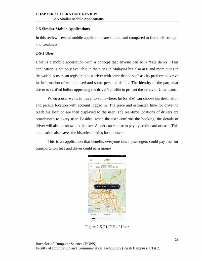
2-5-1 Uber
Uber is a mobile application with a concept that anyone can be a ‘taxi driver’. This
application is not only available in the cities in Malaysia but also 400 and more cities in
the world. A user can register to be a driver with some details such as city preferred to drive
in, information of vehicle used and some personal details. The identity of the particular
driver is verified before approving the driver’s profile to protect the safety of Uber users.
When a user wants to travel to somewhere, he (or she) can choose his destination
and pickup location with account logged in. The price and estimated time for driver to
reach his location are then displayed to the user. The real-time locations of drivers are
broadcasted to every user. Besides, when the user confirms the booking, the details of
driver will also be shown to the user. A user can choose to pay by credit card or cash. This
application also saves the histories of trips for the users.
This is an application that benefits everyone since passengers could pay less for
transportation fees and driver could earn money.
Figure 2-5-F1 GUI of Uber

22
Bachelor of Computer Science (HONS)
Faculty of Information and Communication Technology (Perak Campus), UTAR.
CHAPTER 2 LITERATURE REVIEW
2-5 SIMILAR MOBILE APPLICATIONS
2-5-2 Grab (My Taxi)
Grab is a mobile application for user to book a taxi which the original name of the
application is called My Taxi. This application is available in the South-East Asian
countries such as Singapore, Malaysia, Philippines, Indonesia, Thailand and Vietnam.
Similar to Uber, Grab users can choose their origin location and destination, the estimated
time and price will be provided.
In addition, Grab users can choose their preferred type of taxi based on the price
and comfortability. The extra feature that Grab has is users can make pre-bookings on a
selected date and they can check their schedule of bookings. The main difference between
these two mobile applications is Grab’s driver is a real taxi with license. Users might feel
more secure to take on a taxi compared to a stranger.
Figure 2-5-F2 GUI of Grab
23
Bachelor of Computer Science (HONS)
Faculty of Information and Communication Technology (Perak Campus), UTAR.
CHAPTER 2 LITERATURE REVIEW
2-5 SIMILAR MOBILE APPLICATIONS
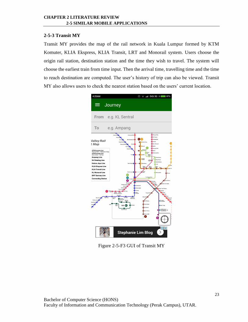
2-5-3 Transit MY
Transit MY provides the map of the rail network in Kuala Lumpur formed by KTM
Komuter, KLIA Ekspress, KLIA Transit, LRT and Monorail system. Users choose the
origin rail station, destination station and the time they wish to travel. The system will
choose the earliest train from time input. Then the arrival time, travelling time and the time
to reach destination are computed. The user’s history of trip can also be viewed. Transit
MY also allows users to check the nearest station based on the users’ current location.
Figure 2-5-F3 GUI of Transit MY
24
Bachelor of Computer Science (HONS)
Faculty of Information and Communication Technology (Perak Campus), UTAR.
CHAPTER 2 LITERATURE REVIEW
2-5 SIMILAR MOBILE APPLICATIONS
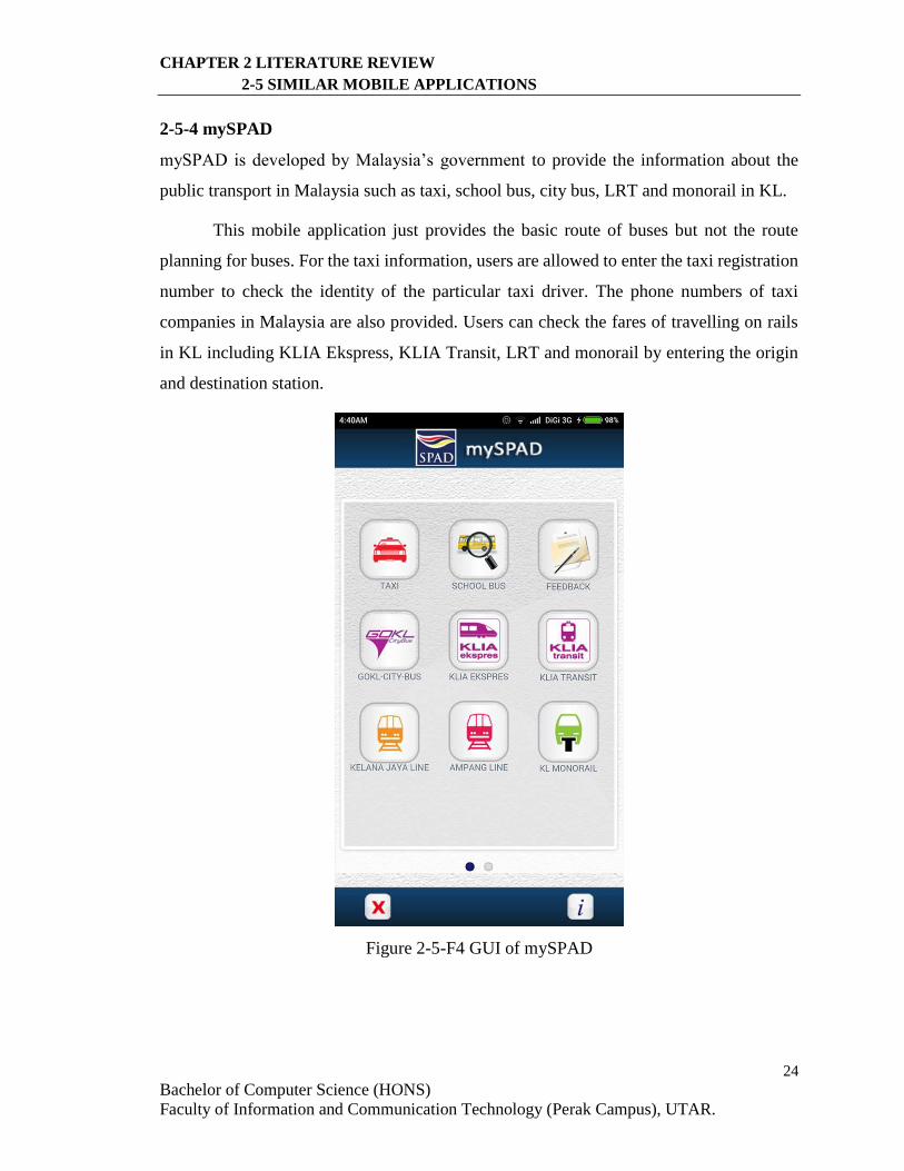
2-5-4 mySPAD
mySPAD is developed by Malaysia’s government to provide the information about the
public transport in Malaysia such as taxi, school bus, city bus, LRT and monorail in KL.
This mobile application just provides the basic route of buses but not the route
planning for buses. For the taxi information, users are allowed to enter the taxi registration
number to check the identity of the particular taxi driver. The phone numbers of taxi
companies in Malaysia are also provided. Users can check the fares of travelling on rails
in KL including KLIA Ekspress, KLIA Transit, LRT and monorail by entering the origin
and destination station.
Figure 2-5-F4 GUI of mySPAD
25
Bachelor of Computer Science (HONS)
Faculty of Information and Communication Technology (Perak Campus), UTAR.
CHAPTER 2 LITERATURE REVIEW
2-5 SIMILAR MOBILE APPLICATIONS
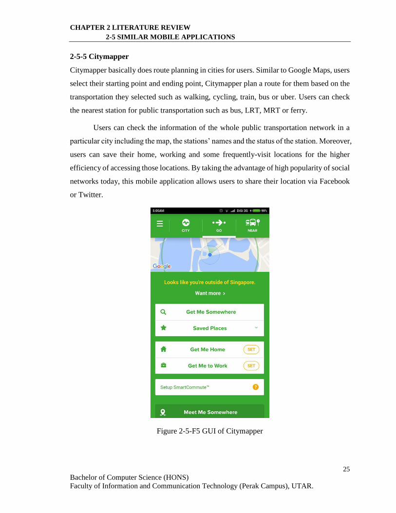
2-5-5 Citymapper
Citymapper basically does route planning in cities for users. Similar to Google Maps, users
select their starting point and ending point, Citymapper plan a route for them based on the
transportation they selected such as walking, cycling, train, bus or uber. Users can check
the nearest station for public transportation such as bus, LRT, MRT or ferry.
Users can check the information of the whole public transportation network in a
particular city including the map, the stations’ names and the status of the station. Moreover,
users can save their home, working and some frequently-visit locations for the higher
efficiency of accessing those locations. By taking the advantage of high popularity of social
networks today, this mobile application allows users to share their location via Facebook
or Twitter.
Figure 2-5-F5 GUI of Citymapper
26
Bachelor of Computer Science (HONS)
Faculty of Information and Communication Technology (Perak Campus), UTAR.
CHAPTER 2 LITERATURE REVIEW
2-5 SIMILAR MOBILE APPLICATIONS
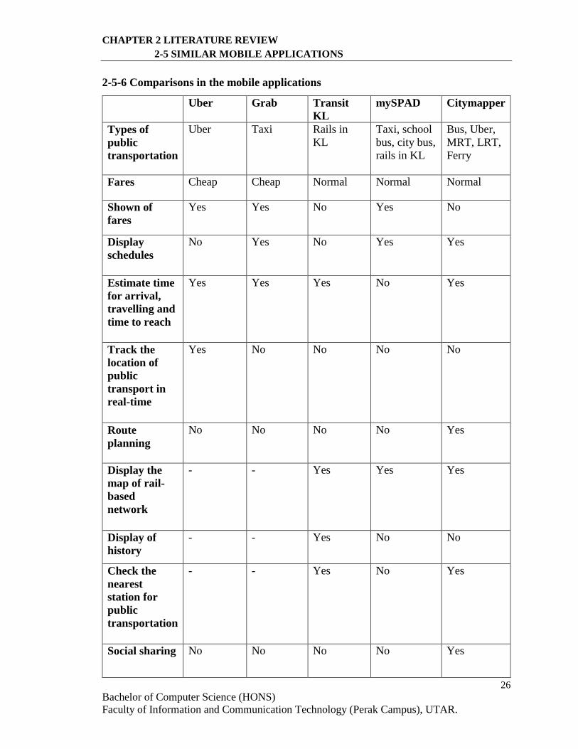
2-5-6 Comparisons in the mobile applications
Uber Grab Transit
KL
mySPAD Citymapper
Types of
public
transportation
Uber Taxi Rails in
KL
Taxi, school
bus, city bus,
rails in KL
Bus, Uber,
MRT, LRT,
Ferry
Fares Cheap Cheap Normal Normal Normal
Shown of
fares
Yes Yes No Yes No
Display
schedules
No Yes No Yes Yes
Estimate time
for arrival,
travelling and
time to reach
Yes Yes Yes No Yes
Track the
location of
public
transport in
real-time
Yes No No No No
Route
planning
No No No No Yes
Display the
map of rail-
based
network
- - Yes Yes Yes
Display of
history
- - Yes No No
Check the
nearest
station for
public
transportation
- - Yes No Yes
Social sharing No No No No Yes
27
Bachelor of Computer Science (HONS)
Faculty of Information and Communication Technology (Perak Campus), UTAR.
CHAPTER 2 LITERATURE REVIEW
2-5 SIMILAR MOBILE APPLICATIONS
Strength - New
concept
that
everyone
could be a
driver and
earn money
- Normally
lower fares
than taxi
- The
location of
driver is
tracked in
real-time
- More
secure for
passenger
- Pre-
bookings
are allowed
- There are
always
promotions
- Display
the actual
rail-based
network
map
- Provide
estimated
time
- Display
nearest rail
station
Sufficient
information
about public
transportation
in Malaysia
Many
features are
included
such as
social
sharing
Weakness Less
credibility
of the
driver
- Still more
cost than
Uber
- Less
driver
No route
planning
and check
of fares
No useful
features such
as route
planning and
estimate time
Not
available in
Malaysia
Table 2-5-T1 Comparisons in the mobile applications
28
Bachelor of Computer Science (HONS)
Faculty of Information and Communication Technology (Perak Campus), UTAR.
CHAPTER 3 PROPOSED METHOD/APPROACH
3-1 Methodology
3-1 Methodology
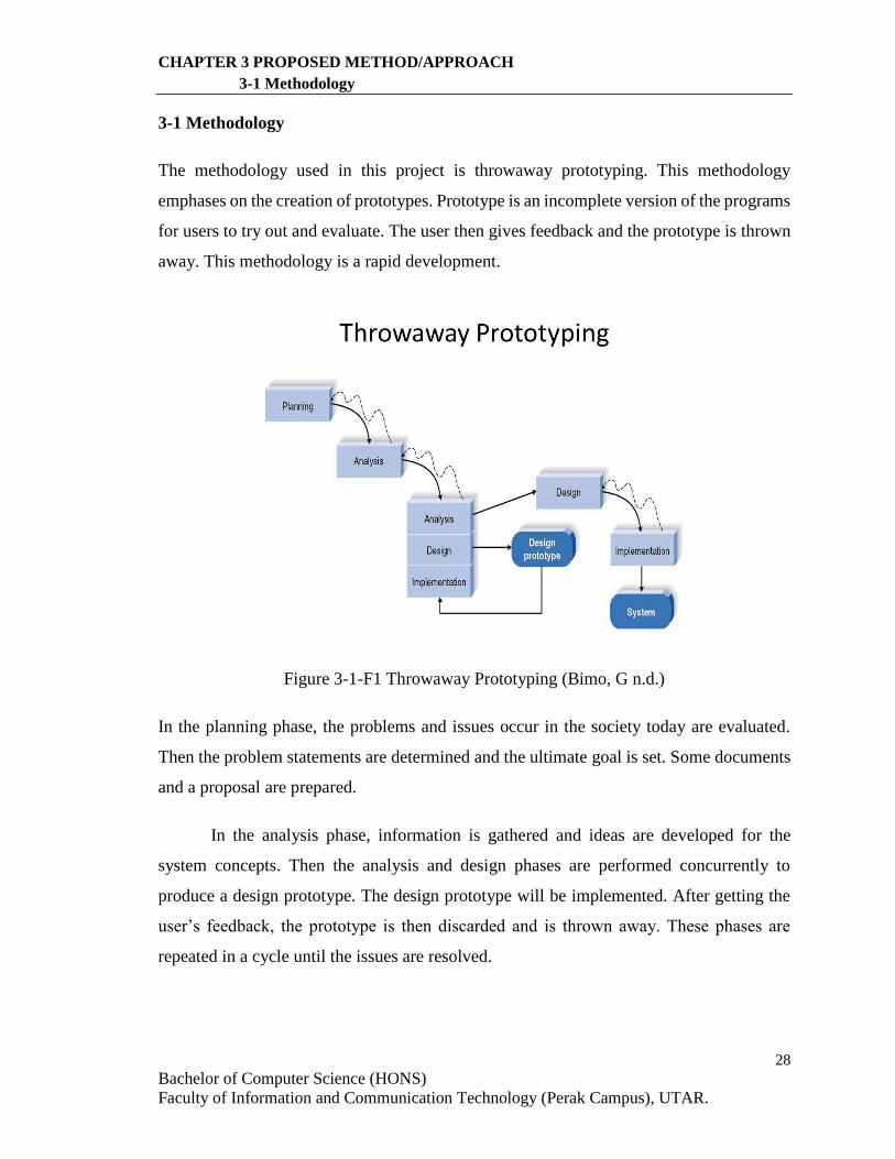
The methodology used in this project is throwaway prototyping. This methodology
emphases on the creation of prototypes. Prototype is an incomplete version of the programs
for users to try out and evaluate. The user then gives feedback and the prototype is thrown
away. This methodology is a rapid development.
Figure 3-1-F1 Throwaway Prototyping (Bimo, G n.d.)
In the planning phase, the problems and issues occur in the society today are evaluated.
Then the problem statements are determined and the ultimate goal is set. Some documents
and a proposal are prepared.
In the analysis phase, information is gathered and ideas are developed for the
system concepts. Then the analysis and design phases are performed concurrently to
produce a design prototype. The design prototype will be implemented. After getting the
user’s feedback, the prototype is then discarded and is thrown away. These phases are
repeated in a cycle until the issues are resolved.
29
Bachelor of Computer Science (HONS)
Faculty of Information and Communication Technology (Perak Campus), UTAR.
CHAPTER 3 PROPOSED METHOD/APPROACH
3-1 Methodology
Next, the project moves to the next phase which is design phase. The final
requirements are determined. The solutions on the problems with some techniques used is
designed. The design model is implemented and coded during implementation phase.
Finally, the system is set up in a real environment.
There are various pros and cons for this methodology:
The Advantages of Throwaway Prototyping
- Quickly provide a system to user
- Increase the user involvement in the project
- Quickly refine real requirement
The Disadvantages of Throwaway Prototyping
- Fast-paced system releases challenge attempts to conduct careful, methodical
analysis
- User may confuse of prototypes and real system.
However, the advantages still overweigh the disadvantages.
30
Bachelor of Computer Science (HONS)
Faculty of Information and Communication Technology (Perak Campus), UTAR.
CHAPTER 3 PROPOSED METHOD/APPROACH
3-2 Project Timeline
3-2 Project Timeline
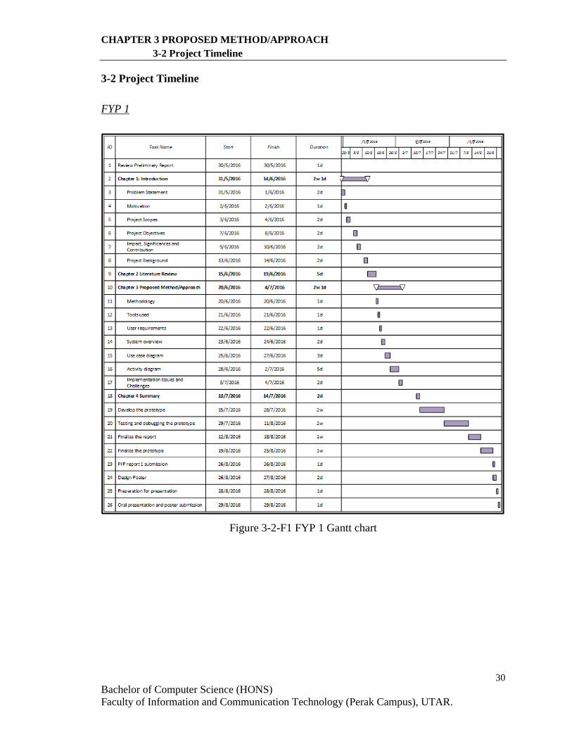
FYP 1
Figure 3-2-F1 FYP 1 Gantt chart
31
Bachelor of Computer Science (HONS)
Faculty of Information and Communication Technology (Perak Campus), UTAR.
CHAPTER 3 PROPOSED METHOD/APPROACH
3-2 Project Timeline
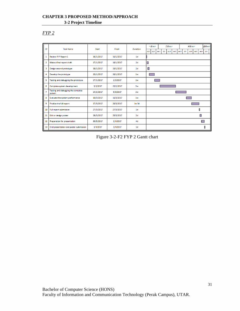
FYP 2
Figure 3-2-F2 FYP 2 Gantt chart
32
Bachelor of Computer Science (HONS)
Faculty of Information and Communication Technology (Perak Campus), UTAR.
CHAPTER 3 PROPOSED METHOD/APPROACH
3-3 Tools Used
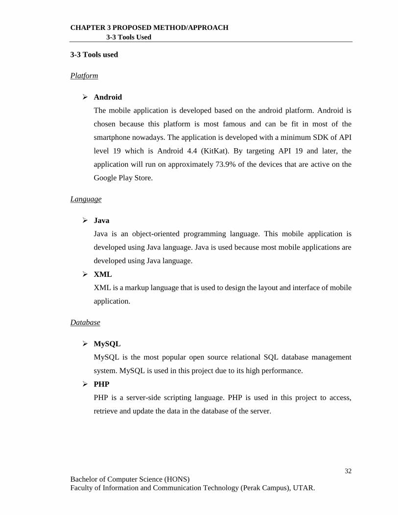
3-3 Tools used
Platform
Android
The mobile application is developed based on the android platform. Android is
chosen because this platform is most famous and can be fit in most of the
smartphone nowadays. The application is developed with a minimum SDK of API
level 19 which is Android 4.4 (KitKat). By targeting API 19 and later, the
application will run on approximately 73.9% of the devices that are active on the
Google Play Store.
Language
Java
Java is an object-oriented programming language. This mobile application is
developed using Java language. Java is used because most mobile applications are
developed using Java language.
XML
XML is a markup language that is used to design the layout and interface of mobile
application.
Database
MySQL
MySQL is the most popular open source relational SQL database management
system. MySQL is used in this project due to its high performance.
PHP
PHP is a server-side scripting language. PHP is used in this project to access,
retrieve and update the data in the database of the server.
33
Bachelor of Computer Science (HONS)
Faculty of Information and Communication Technology (Perak Campus), UTAR.
CHAPTER 3 PROPOSED METHOD/APPROACH
3-3 Tools Used
Web Hosting
Hostinger
Hostinger is a website that provides free service of hosting a web with the support
of PHP and MySQL. This website is used in this project to host the database in the
internet.
Software
Android Studio
Android Studio is an IDE for android application development.
Google Maps Android API
Google Maps Android API is used in order to add a google map to the mobile
application. The API also provides other map functions.
Google Maps Direction API
Google Maps Direction API is used to get direction data of given origin and
destination.
Hardware
Smartphone with Android OS
This device is used for installation and testing of the mobile application.
Operating System Android 6.0.1 (Marshmallow)
CPU 4x ARM Cortex-A15, 1x ARM Cortex-A9, 1800MHz,
Cores: 5
GPU GeForce, 672 MHz, Cores: 72
RAM 2GB, 933MHz
Storage 16GB, 64GB
Display 5in, IPS, 1080 x 1920 pixels, 24 bit
Wi-Fi a, b, g, n, Wi-Fi Hotspot, Wi-Fi Direct
Positioning GPS, A-GPS, GLONASS
Table 3-3-T1 Smartphone Hardware Specification
34
Bachelor of Computer Science (HONS)
Faculty of Information and Communication Technology (Perak Campus), UTAR.
CHAPTER 3 PROPOSED METHOD/APPROACH
3-3 Tools Used
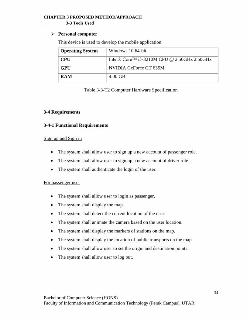
Personal computer
This device is used to develop the mobile application.
Operating System Windows 10 64-bit
CPU Intel® Core™ i5-3210M CPU @ 2.50GHz 2.50GHz
GPU NVIDIA GeForce GT 635M
RAM 4.00 GB
Table 3-3-T2 Computer Hardware Specification
3-4 Requirements
3-4-1 Functional Requirements
Sign up and Sign in
The system shall allow user to sign up a new account of passenger role.
The system shall allow user to sign up a new account of driver role.
The system shall authenticate the login of the user.
For passenger user
The system shall allow user to login as passenger.
The system shall display the map.
The system shall detect the current location of the user.
The system shall animate the camera based on the user location.
The system shall display the markers of stations on the map.
The system shall display the location of public transports on the map.
The system shall allow user to set the origin and destination points.
The system shall allow user to log out.
35
Bachelor of Computer Science (HONS)
Faculty of Information and Communication Technology (Perak Campus), UTAR.
CHAPTER 3 PROPOSED METHOD/APPROACH
3-4 Requirements
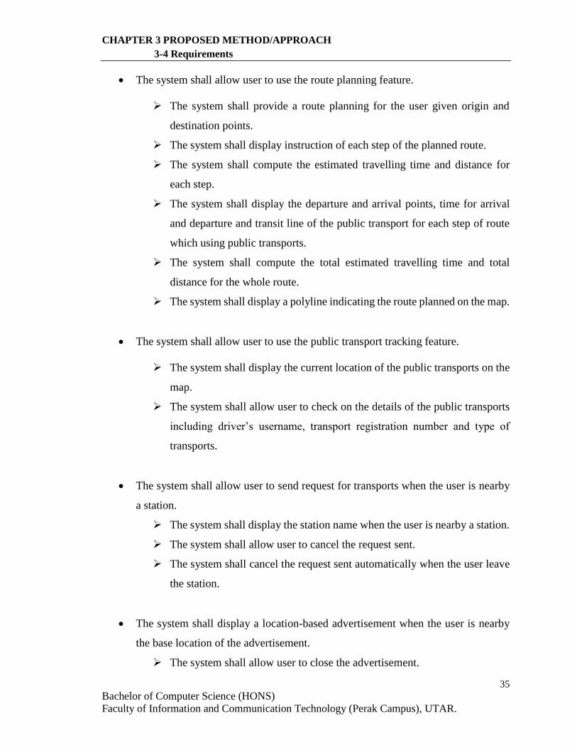
The system shall allow user to use the route planning feature.
The system shall provide a route planning for the user given origin and
destination points.
The system shall display instruction of each step of the planned route.
The system shall compute the estimated travelling time and distance for
each step.
The system shall display the departure and arrival points, time for arrival
and departure and transit line of the public transport for each step of route
which using public transports.
The system shall compute the total estimated travelling time and total
distance for the whole route.
The system shall display a polyline indicating the route planned on the map.
The system shall allow user to use the public transport tracking feature.
The system shall display the current location of the public transports on the
map.
The system shall allow user to check on the details of the public transports
including driver’s username, transport registration number and type of
transports.
The system shall allow user to send request for transports when the user is nearby
a station.
The system shall display the station name when the user is nearby a station.
The system shall allow user to cancel the request sent.
The system shall cancel the request sent automatically when the user leave
the station.
The system shall display a location-based advertisement when the user is nearby
the base location of the advertisement.
The system shall allow user to close the advertisement.
36
Bachelor of Computer Science (HONS)
Faculty of Information and Communication Technology (Perak Campus), UTAR.
CHAPTER 3 PROPOSED METHOD/APPROACH
3-4 Requirements
For driver user
The system shall allow user to login as driver.
The system shall display the map.
The system shall detect the current location of the user.
The system shall animate the camera based on the user location.
The system shall display the speed of the driver.
The system shall display the markers of stations on the map.
The system shall allow user to log out.
The system shall allow user to share the current user location.
The system shall display message indicating the sharing is started.
The system shall update database based on the current user location.
The system shall allow user to stop sharing the current user location.
The system shall display message indicating the sharing is stopped.
The system shall allow user to view the number of requests at a bus station.
The system shall display the details of station name and number of requests
at the station when the user is nearby a station.
The system shall display a message indicating the number of requests when
the user is nearby a station.
Admin Management System
The system shall allow user to login as admin.
The system shall authenticate the login of the user.
The system shall allow user to perform driver management.
The system shall allow user to view driver records.
The system shall allow user to add a driver record.
The system shall allow user to edit a driver record.
The system shall allow user to remove a driver record.
37
Bachelor of Computer Science (HONS)
Faculty of Information and Communication Technology (Perak Campus), UTAR.
CHAPTER 3 PROPOSED METHOD/APPROACH
3-4 Requirements
The system shall allow user to perform passenger management.
The system shall allow user to view passenger records.
The system shall allow user to add a passenger record.
The system shall allow user to edit a passenger record.
The system shall allow user to remove a passenger record.
The system shall allow user to perform advertisement management.
The system shall allow user to view advertisement records.
The system shall allow user to add an advertisement record.
The system shall allow user to edit an advertisement record.
The system shall allow user to remove an advertisement record.
The system shall allow user to perform fare management.
The system shall allow user to view fare records.
The system shall allow user to add a fare record.
The system shall allow user to edit a fare record.
The system shall allow user to remove a fare record.
The system shall allow user to logout.
3-4-2 Non-Functional Requirements
Environmental requirements
The system shall be able to work on an android platform.
The system shall be able to work when there is internet connection for the device.
The system shall be able to work when GPS permission is allowed.
Performance requirements
The system shall be able to response in less than 10 seconds.
The system shall be able to display error message for invalid user input.
The system shall be able to display error message when there is internet problem
or problem of server.
38
Bachelor of Computer Science (HONS)
Faculty of Information and Communication Technology (Perak Campus), UTAR.
CHAPTER 4 SYSTEM DESIGN
4-1 System Overview
4-1 System Overview
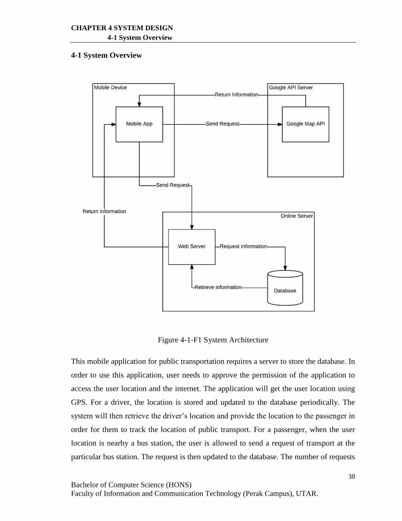
Figure 4-1-F1 System Architecture
This mobile application for public transportation requires a server to store the database. In
order to use this application, user needs to approve the permission of the application to
access the user location and the internet. The application will get the user location using
GPS. For a driver, the location is stored and updated to the database periodically. The
system will then retrieve the driver’s location and provide the location to the passenger in
order for them to track the location of public transport. For a passenger, when the user
location is nearby a bus station, the user is allowed to send a request of transport at the
particular bus station. The request is then updated to the database. The number of requests
39
Bachelor of Computer Science (HONS)
Faculty of Information and Communication Technology (Perak Campus), UTAR.
CHAPTER 4 SYSTEM DESIGN
4-1 System Overview
of each bus station would be retrieved from the database and be shown to the drivers. Some
functions such as route planning are done by using the Google Maps API. The application
will send the request to the Google API server by providing some information such as user
location and destination location. The Google API server will then return the information
such as steps of route planned, estimated time and distance. Therefore, the information can
be provided to the user.
40
Bachelor of Computer Science (HONS)
Faculty of Information and Communication Technology (Perak Campus), UTAR.
CHAPTER 4 SYSTEM DESIGN
4-2 Use case diagram
4-2 Use case diagram
4-2-1 Use case diagram for user
Passenger
Driver
Login
Share location
Get public transport location
Update database
<<include>>
Get route planned
Compute estimated time
<<include>>
Get travel distance
Send request at station
<<include>>
View station request
Sign up
Get Advertisement
Get each step
Get departure and arrival point
Get transit line
<<include>>
<<include>><<include>>
<<include>>
Stop sharing location
<<include>>
Cancel station request
<<include>>
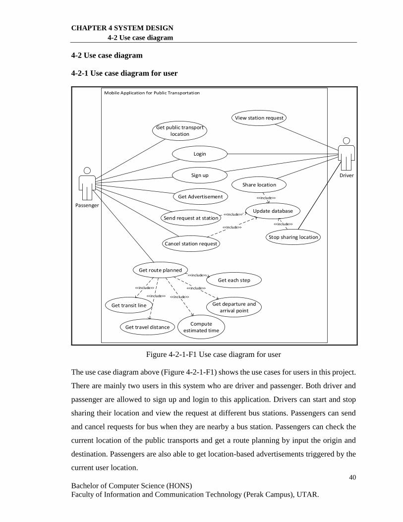
Figure 4-2-1-F1 Use case diagram for user
The use case diagram above (Figure 4-2-1-F1) shows the use cases for users in this project.
There are mainly two users in this system who are driver and passenger. Both driver and
passenger are allowed to sign up and login to this application. Drivers can start and stop
sharing their location and view the request at different bus stations. Passengers can send
and cancel requests for bus when they are nearby a bus station. Passengers can check the
current location of the public transports and get a route planning by input the origin and
destination. Passengers are also able to get location-based advertisements triggered by the
current user location.
41
Bachelor of Computer Science (HONS)
Faculty of Information and Communication Technology (Perak Campus), UTAR.
CHAPTER 4 SYSTEM DESIGN
4-2 Use case diagram
4-2-2 Use case diagram for admin
Admin
Update database
<<include>>
View driver records
<<include>>
<<include>>
<<include>>
Add driver
Edit driver
Remove driver
<<include>>
View passenger records
<<include>>
<<include>>
Add passenger
Edit passenger
Remove passenger
<<include>>
View station records
<<include>>
<<include>>
Add station
Edit station
Remove station
<<include>>
View advertisement records
<<include>>
<<include>>
Add station
Edit station
Remove station
<<include>>
<<include>>
Update database
<<include>>
<<include>>
<<include>>
Update database
<<include>>
<<include>>
<<include>>
Update database
<<include>>
<<include>>
<<include>>
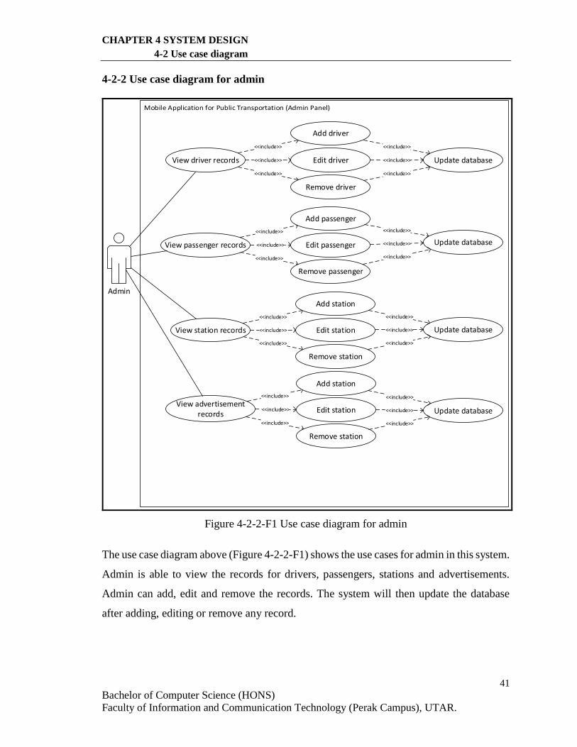
Figure 4-2-2-F1 Use case diagram for admin
The use case diagram above (Figure 4-2-2-F1) shows the use cases for admin in this system.
Admin is able to view the records for drivers, passengers, stations and advertisements.
Admin can add, edit and remove the records. The system will then update the database
after adding, editing or remove any record.
42
Bachelor of Computer Science (HONS)
Faculty of Information and Communication Technology (Perak Campus), UTAR.
CHAPTER 4 SYSTEM DESIGN
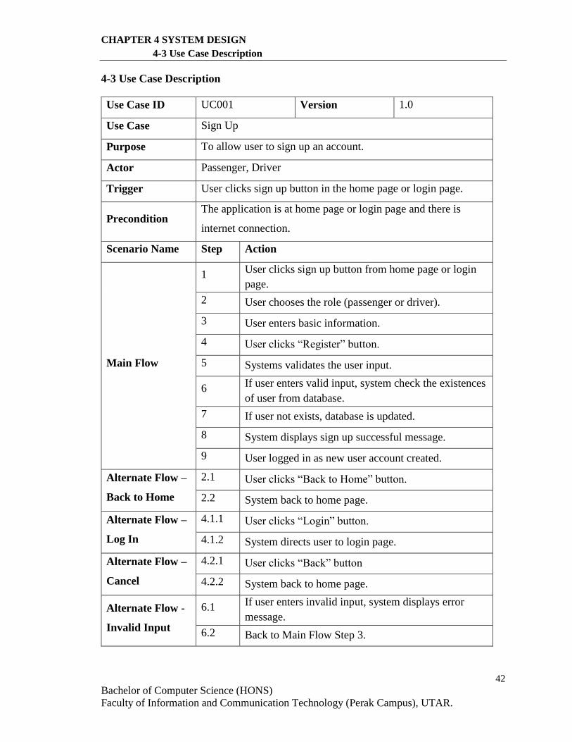
4-3 Use Case Description
4-3 Use Case Description
Use Case ID UC001 Version 1.0
Use Case Sign Up
Purpose To allow user to sign up an account.
Actor Passenger, Driver
Trigger User clicks sign up button in the home page or login page.
Precondition The application is at home page or login page and there is
internet connection.
Scenario Name Step Action
Main Flow
1 User clicks sign up button from home page or login
page.
2 User chooses the role (passenger or driver).
3 User enters basic information.
4 User clicks “Register” button.
5 Systems validates the user input.
6 If user enters valid input, system check the existences
of user from database.
7 If user not exists, database is updated.
8 System displays sign up successful message.
9 User logged in as new user account created.
Alternate Flow –
Back to Home
2.1 User clicks “Back to Home” button.
2.2 System back to home page.
Alternate Flow –
Log In
4.1.1 User clicks “Login” button.
4.1.2 System directs user to login page.
Alternate Flow –
Cancel
4.2.1 User clicks “Back” button
4.2.2 System back to home page.
Alternate Flow -
Invalid Input
6.1 If user enters invalid input, system displays error
message.
6.2 Back to Main Flow Step 3.
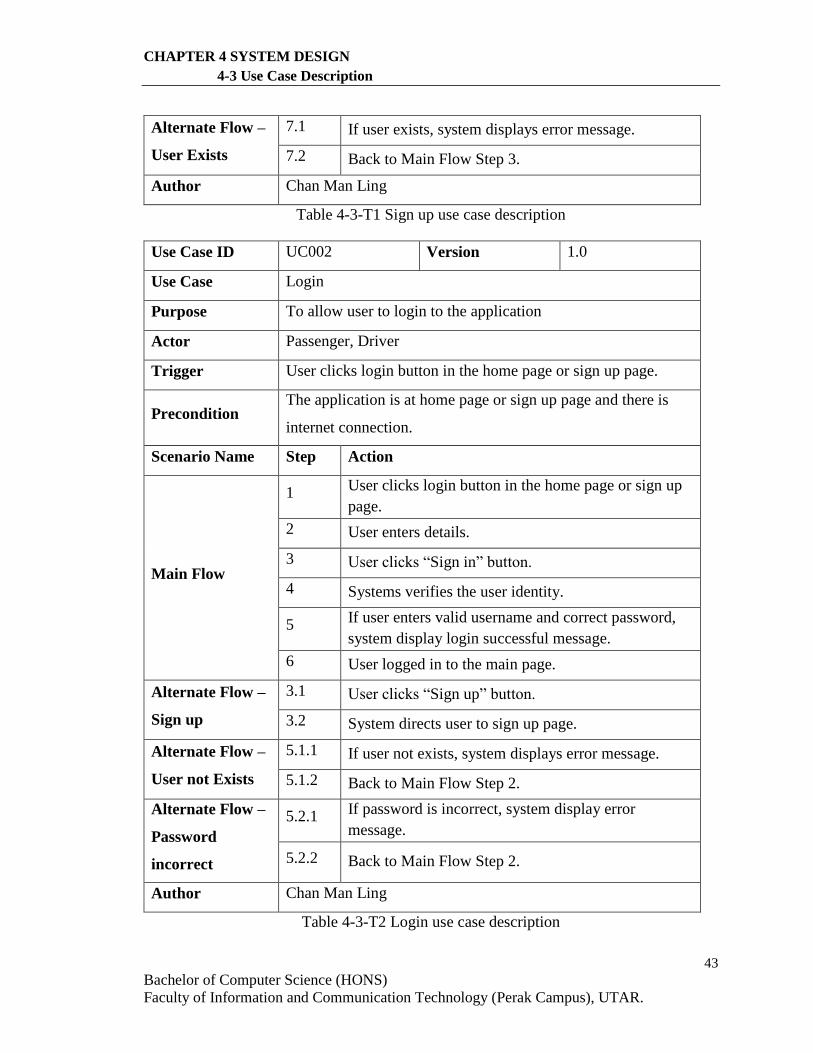
43
Bachelor of Computer Science (HONS)
Faculty of Information and Communication Technology (Perak Campus), UTAR.
CHAPTER 4 SYSTEM DESIGN
4-3 Use Case Description
Alternate Flow –
User Exists
7.1 If user exists, system displays error message.
7.2 Back to Main Flow Step 3.
Author Chan Man Ling
Table 4-3-T1 Sign up use case description
Use Case ID UC002 Version 1.0
Use Case Login
Purpose To allow user to login to the application
Actor Passenger, Driver
Trigger User clicks login button in the home page or sign up page.
Precondition The application is at home page or sign up page and there is
internet connection.
Scenario Name Step Action
Main Flow
1 User clicks login button in the home page or sign up
page.
2 User enters details.
3 User clicks “Sign in” button.
4 Systems verifies the user identity.
5 If user enters valid username and correct password,
system display login successful message.
6 User logged in to the main page.
Alternate Flow –
Sign up
3.1 User clicks “Sign up” button.
3.2 System directs user to sign up page.
Alternate Flow –
User not Exists
5.1.1 If user not exists, system displays error message.
5.1.2 Back to Main Flow Step 2.
Alternate Flow –
Password
incorrect
5.2.1 If password is incorrect, system display error
message.
5.2.2 Back to Main Flow Step 2.
Author Chan Man Ling
Table 4-3-T2 Login use case description
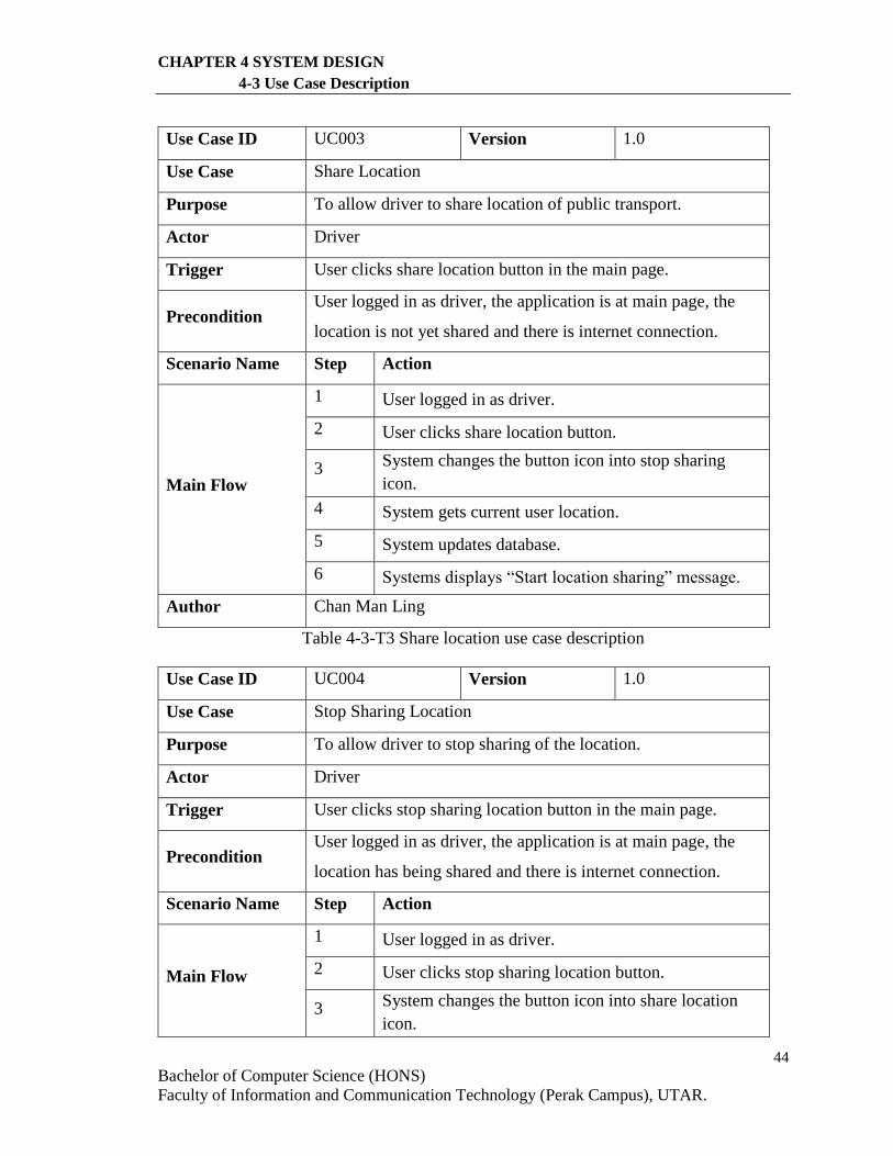
44
Bachelor of Computer Science (HONS)
Faculty of Information and Communication Technology (Perak Campus), UTAR.
CHAPTER 4 SYSTEM DESIGN
4-3 Use Case Description
Use Case ID UC003 Version 1.0
Use Case Share Location
Purpose To allow driver to share location of public transport.
Actor Driver
Trigger User clicks share location button in the main page.
Precondition User logged in as driver, the application is at main page, the
location is not yet shared and there is internet connection.
Scenario Name Step Action
Main Flow
1 User logged in as driver.
2 User clicks share location button.
3 System changes the button icon into stop sharing
icon.
4 System gets current user location.
5 System updates database.
6 Systems displays “Start location sharing” message.
Author Chan Man Ling
Table 4-3-T3 Share location use case description
Use Case ID UC004 Version 1.0
Use Case Stop Sharing Location
Purpose To allow driver to stop sharing of the location.
Actor Driver
Trigger User clicks stop sharing location button in the main page.
Precondition User logged in as driver, the application is at main page, the
location has being shared and there is internet connection.
Scenario Name Step Action
Main Flow
1 User logged in as driver.
2 User clicks stop sharing location button.
3 System changes the button icon into share location
icon.
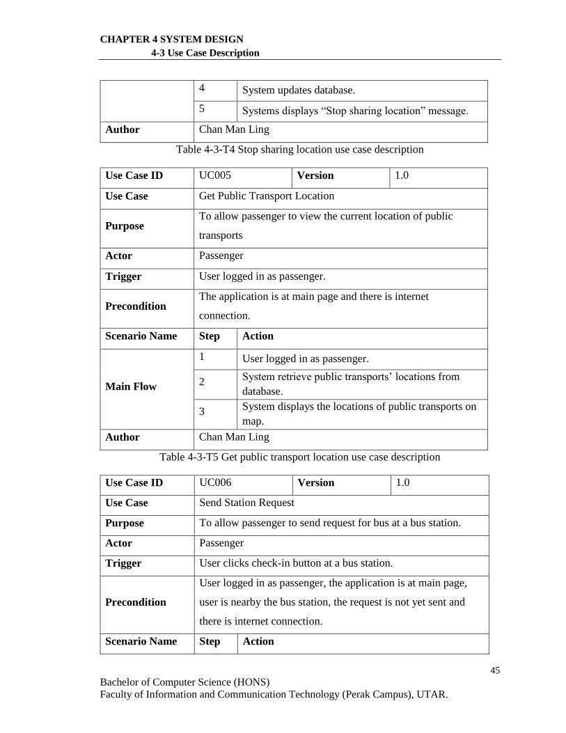
45
Bachelor of Computer Science (HONS)
Faculty of Information and Communication Technology (Perak Campus), UTAR.
CHAPTER 4 SYSTEM DESIGN
4-3 Use Case Description
4 System updates database.
5 Systems displays “Stop sharing location” message.
Author Chan Man Ling
Table 4-3-T4 Stop sharing location use case description
Use Case ID UC005 Version 1.0
Use Case Get Public Transport Location
Purpose To allow passenger to view the current location of public
transports
Actor Passenger
Trigger User logged in as passenger.
Precondition The application is at main page and there is internet
connection.
Scenario Name Step Action
Main Flow
1 User logged in as passenger.
2 System retrieve public transports’ locations from
database.
3 System displays the locations of public transports on
map.
Author Chan Man Ling
Table 4-3-T5 Get public transport location use case description
Use Case ID UC006 Version 1.0
Use Case Send Station Request
Purpose To allow passenger to send request for bus at a bus station.
Actor Passenger
Trigger User clicks check-in button at a bus station.
Precondition
User logged in as passenger, the application is at main page,
user is nearby the bus station, the request is not yet sent and
there is internet connection.
Scenario Name Step Action
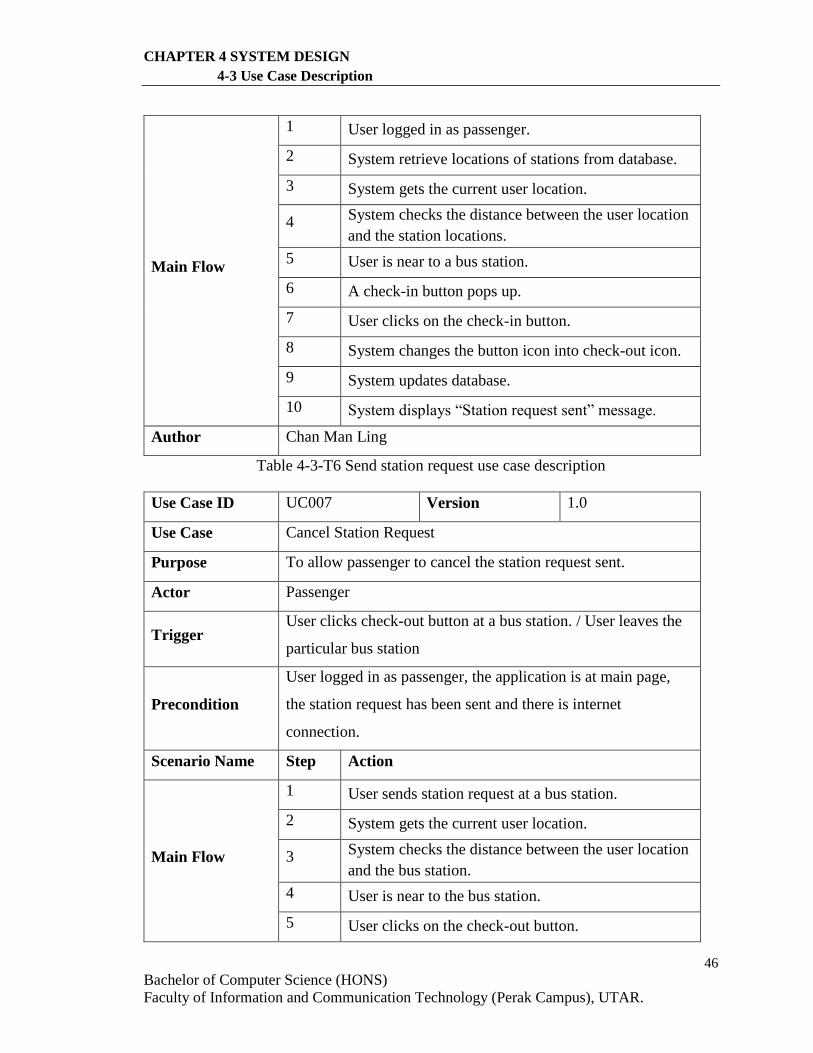
46
Bachelor of Computer Science (HONS)
Faculty of Information and Communication Technology (Perak Campus), UTAR.
CHAPTER 4 SYSTEM DESIGN
4-3 Use Case Description
Main Flow
1 User logged in as passenger.
2 System retrieve locations of stations from database.
3 System gets the current user location.
4 System checks the distance between the user location
and the station locations.
5 User is near to a bus station.
6 A check-in button pops up.
7 User clicks on the check-in button.
8 System changes the button icon into check-out icon.
9 System updates database.
10 System displays “Station request sent” message.
Author Chan Man Ling
Table 4-3-T6 Send station request use case description
Use Case ID UC007 Version 1.0
Use Case Cancel Station Request
Purpose To allow passenger to cancel the station request sent.
Actor Passenger
Trigger User clicks check-out button at a bus station. / User leaves the
particular bus station
Precondition
User logged in as passenger, the application is at main page,
the station request has been sent and there is internet
connection.
Scenario Name Step Action
Main Flow
1 User sends station request at a bus station.
2 System gets the current user location.
3 System checks the distance between the user location
and the bus station.
4 User is near to the bus station.
5 User clicks on the check-out button.
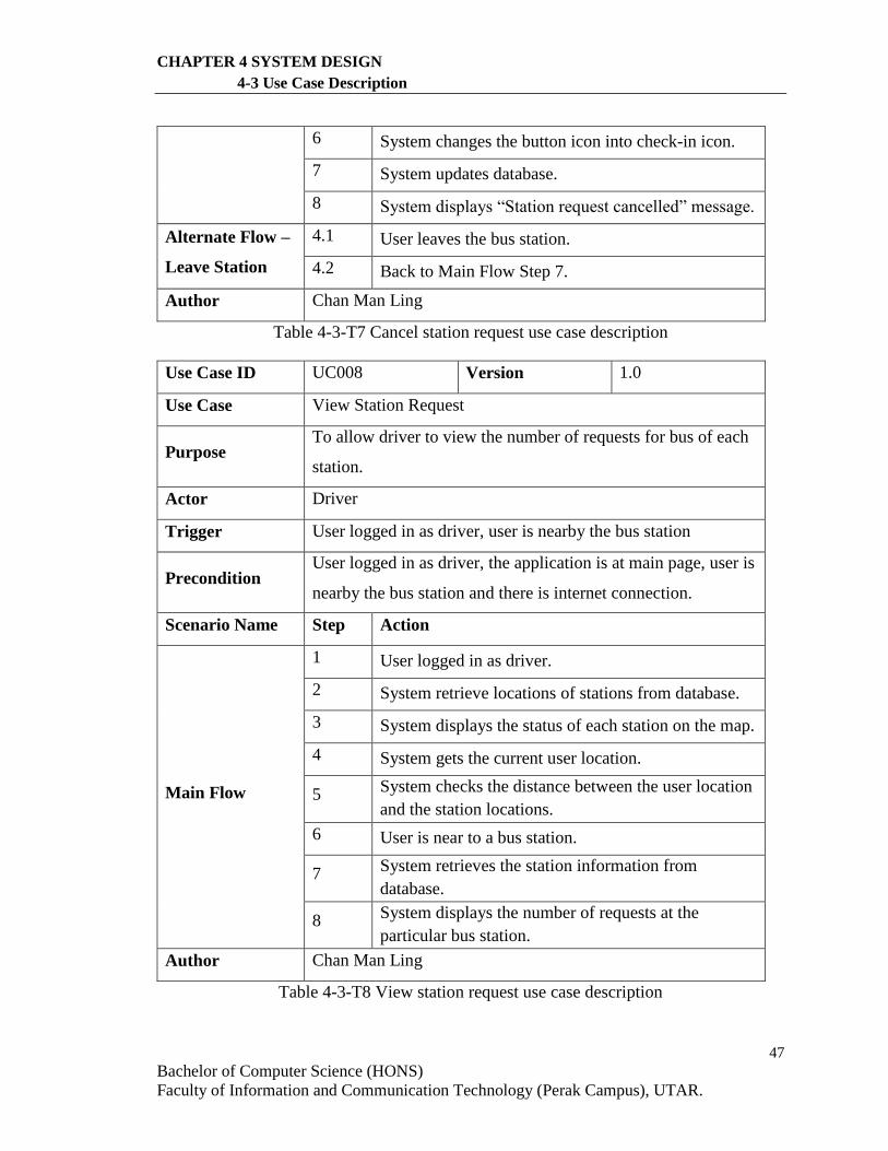
47
Bachelor of Computer Science (HONS)
Faculty of Information and Communication Technology (Perak Campus), UTAR.
CHAPTER 4 SYSTEM DESIGN
4-3 Use Case Description
6 System changes the button icon into check-in icon.
7 System updates database.
8 System displays “Station request cancelled” message.
Alternate Flow –
Leave Station
4.1 User leaves the bus station.
4.2 Back to Main Flow Step 7.
Author Chan Man Ling
Table 4-3-T7 Cancel station request use case description
Use Case ID UC008 Version 1.0
Use Case View Station Request
Purpose To allow driver to view the number of requests for bus of each
station.
Actor Driver
Trigger User logged in as driver, user is nearby the bus station
Precondition User logged in as driver, the application is at main page, user is
nearby the bus station and there is internet connection.
Scenario Name Step Action
Main Flow
1 User logged in as driver.
2 System retrieve locations of stations from database.
3 System displays the status of each station on the map.
4 System gets the current user location.
5 System checks the distance between the user location
and the station locations.
6 User is near to a bus station.
7 System retrieves the station information from
database.
8 System displays the number of requests at the
particular bus station.
Author Chan Man Ling
Table 4-3-T8 View station request use case description
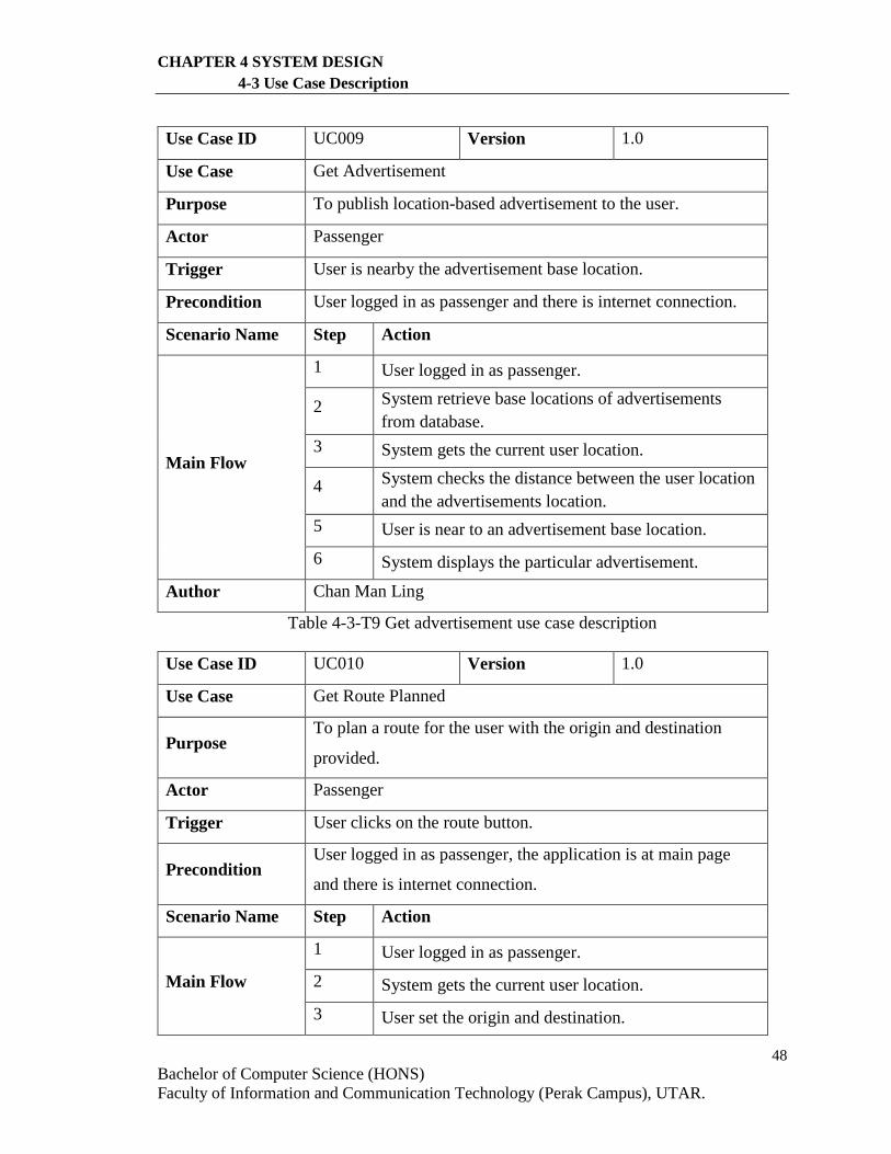
48
Bachelor of Computer Science (HONS)
Faculty of Information and Communication Technology (Perak Campus), UTAR.
CHAPTER 4 SYSTEM DESIGN
4-3 Use Case Description
Use Case ID UC009 Version 1.0
Use Case Get Advertisement
Purpose To publish location-based advertisement to the user.
Actor Passenger
Trigger User is nearby the advertisement base location.
Precondition User logged in as passenger and there is internet connection.
Scenario Name Step Action
Main Flow
1 User logged in as passenger.
2 System retrieve base locations of advertisements
from database.
3 System gets the current user location.
4 System checks the distance between the user location
and the advertisements location.
5 User is near to an advertisement base location.
6 System displays the particular advertisement.
Author Chan Man Ling
Table 4-3-T9 Get advertisement use case description
Use Case ID UC010 Version 1.0
Use Case Get Route Planned
Purpose To plan a route for the user with the origin and destination
provided.
Actor Passenger
Trigger User clicks on the route button.
Precondition User logged in as passenger, the application is at main page
and there is internet connection.
Scenario Name Step Action
Main Flow
1 User logged in as passenger.
2 System gets the current user location.
3 User set the origin and destination.
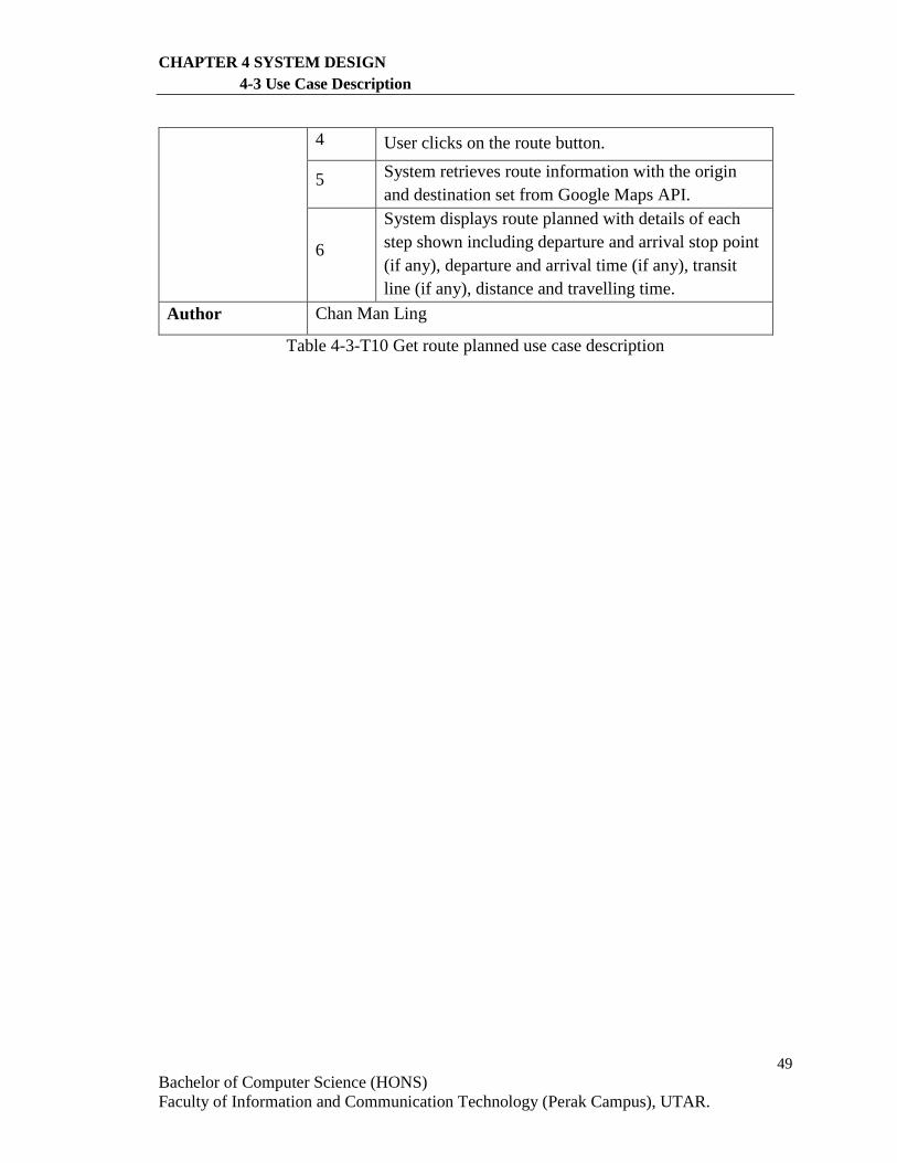
49
Bachelor of Computer Science (HONS)
Faculty of Information and Communication Technology (Perak Campus), UTAR.
CHAPTER 4 SYSTEM DESIGN
4-3 Use Case Description
4 User clicks on the route button.
5 System retrieves route information with the origin
and destination set from Google Maps API.
6
System displays route planned with details of each
step shown including departure and arrival stop point
(if any), departure and arrival time (if any), transit
line (if any), distance and travelling time.
Author Chan Man Ling
Table 4-3-T10 Get route planned use case description
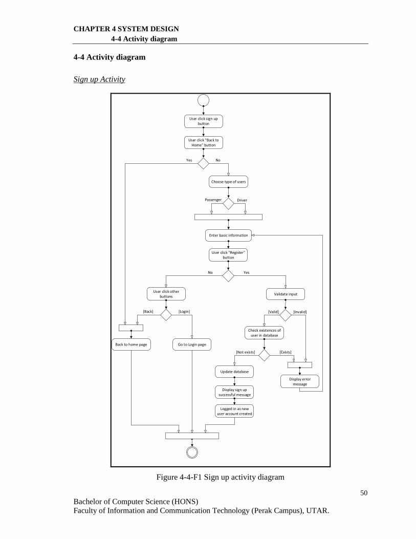
50
Bachelor of Computer Science (HONS)
Faculty of Information and Communication Technology (Perak Campus), UTAR.
CHAPTER 4 SYSTEM DESIGN
4-4 Activity diagram
4-4 Activity diagram
Sign up Activity
Choose type of users
Passenger Driver
User click sign up button
User click "Back to Home" button
Yes No
User click "Register" button
YesNo
Enter basic information
Validate inputUser click other
buttons
[Login][Back]
Back to home page Go to Login page
[Invalid][Valid]
Display error message
Check existences of user in database
[Not exists] [Exists]
Update database
Display sign up successful message
Logged in as new user account created
Figure 4-4-F1 Sign up activity diagram
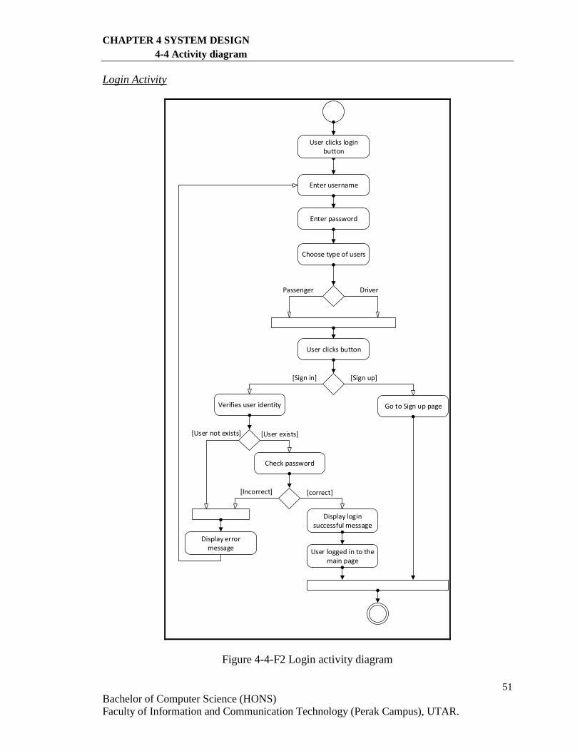
51
Bachelor of Computer Science (HONS)
Faculty of Information and Communication Technology (Perak Campus), UTAR.
CHAPTER 4 SYSTEM DESIGN
4-4 Activity diagram
Login Activity
Enter username
Enter password
Choose type of users
Passenger Driver
Verifies user identity
User logged in to the main page
User clicks login button
User clicks button
[Sign in] [Sign up]
Go to Sign up page
[User not exists] [User exists]
Check password
[Incorrect] [correct]
Display error message
Display login successful message
Figure 4-4-F2 Login activity diagram
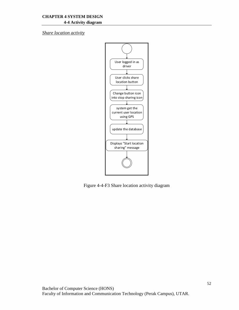
52
Bachelor of Computer Science (HONS)
Faculty of Information and Communication Technology (Perak Campus), UTAR.
CHAPTER 4 SYSTEM DESIGN
4-4 Activity diagram
Share location activity
User clicks share location button
system get the current user location
using GPS
update the database
Displays "Start location sharing" message
User logged in as driver
Change button icon into stop sharing icon
Figure 4-4-F3 Share location activity diagram
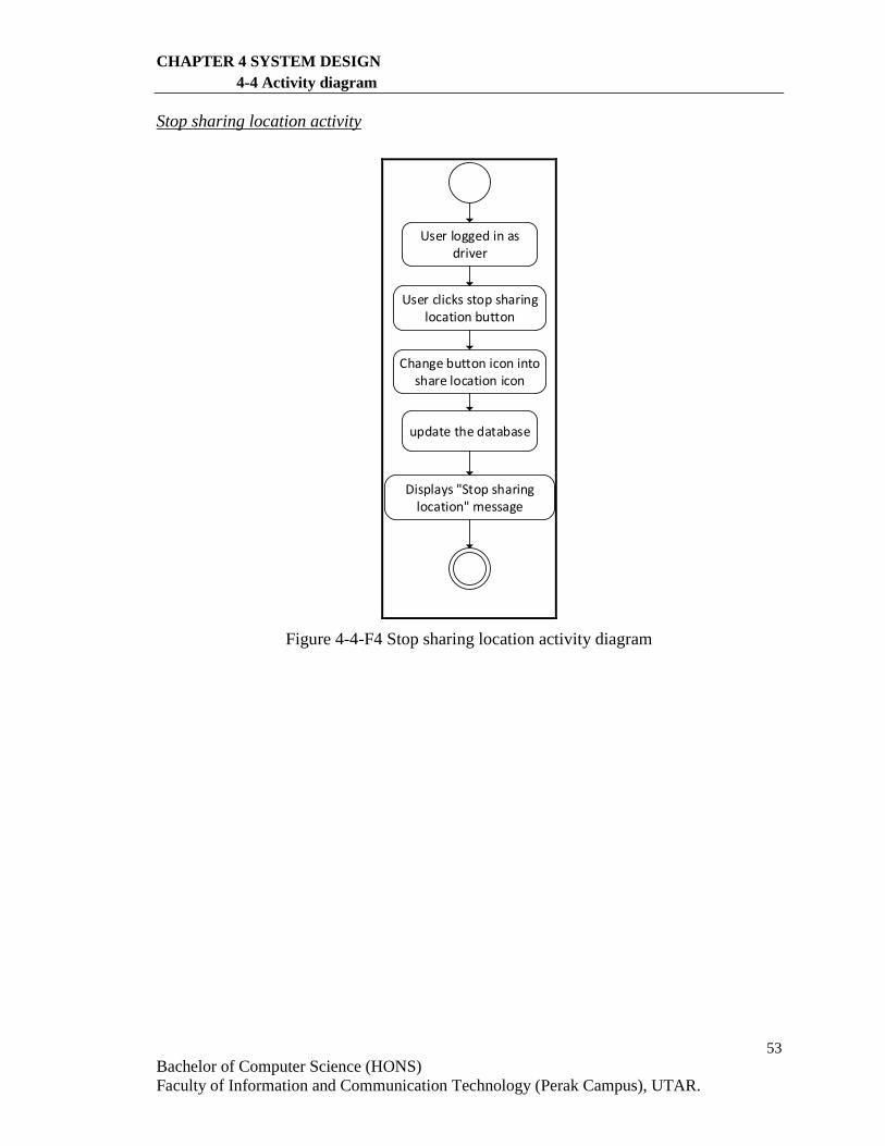
53
Bachelor of Computer Science (HONS)
Faculty of Information and Communication Technology (Perak Campus), UTAR.
CHAPTER 4 SYSTEM DESIGN
4-4 Activity diagram
Stop sharing location activity
User clicks stop sharing location button
update the database
Displays "Stop sharing location" message
User logged in as driver
Change button icon into share location icon
Figure 4-4-F4 Stop sharing location activity diagram
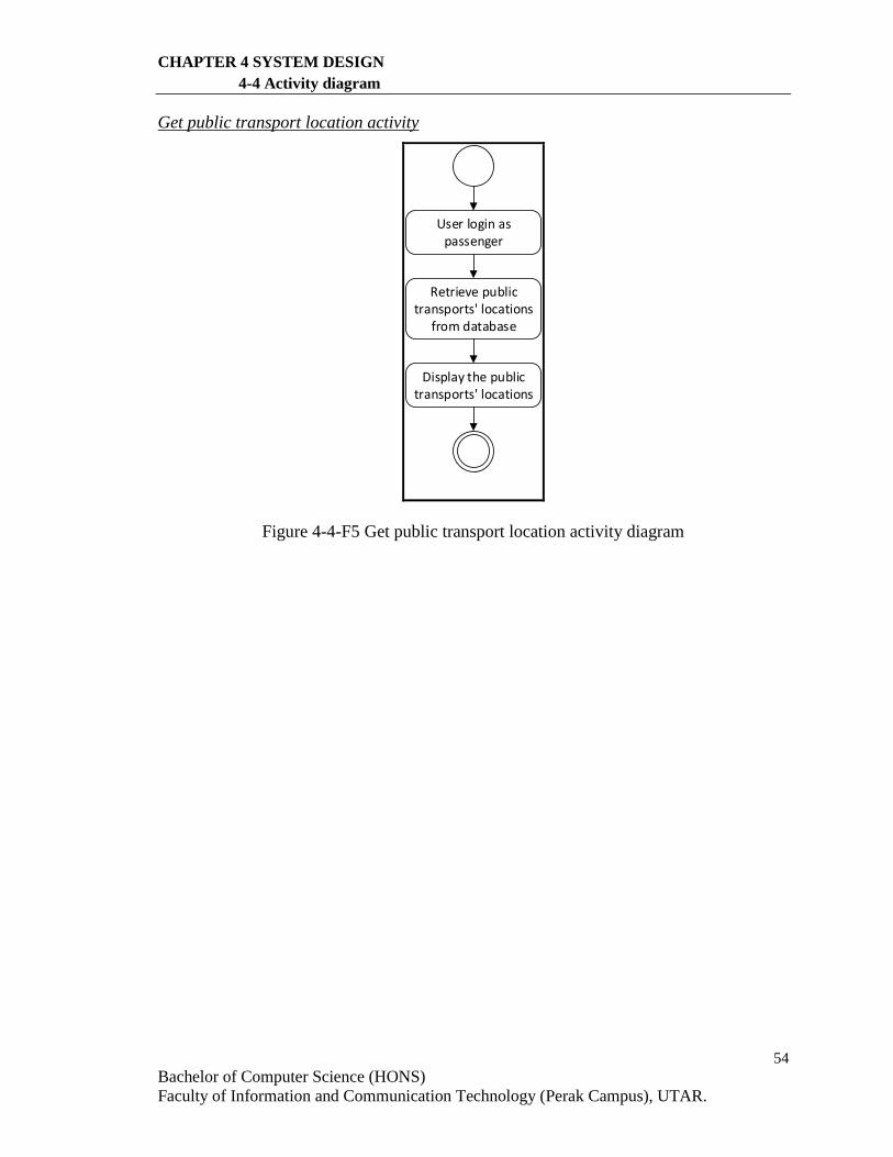
54
Bachelor of Computer Science (HONS)
Faculty of Information and Communication Technology (Perak Campus), UTAR.
CHAPTER 4 SYSTEM DESIGN
4-4 Activity diagram
Get public transport location activity
User login as passenger
Retrieve public transports' locations
from database
Display the public transports' locations
Figure 4-4-F5 Get public transport location activity diagram
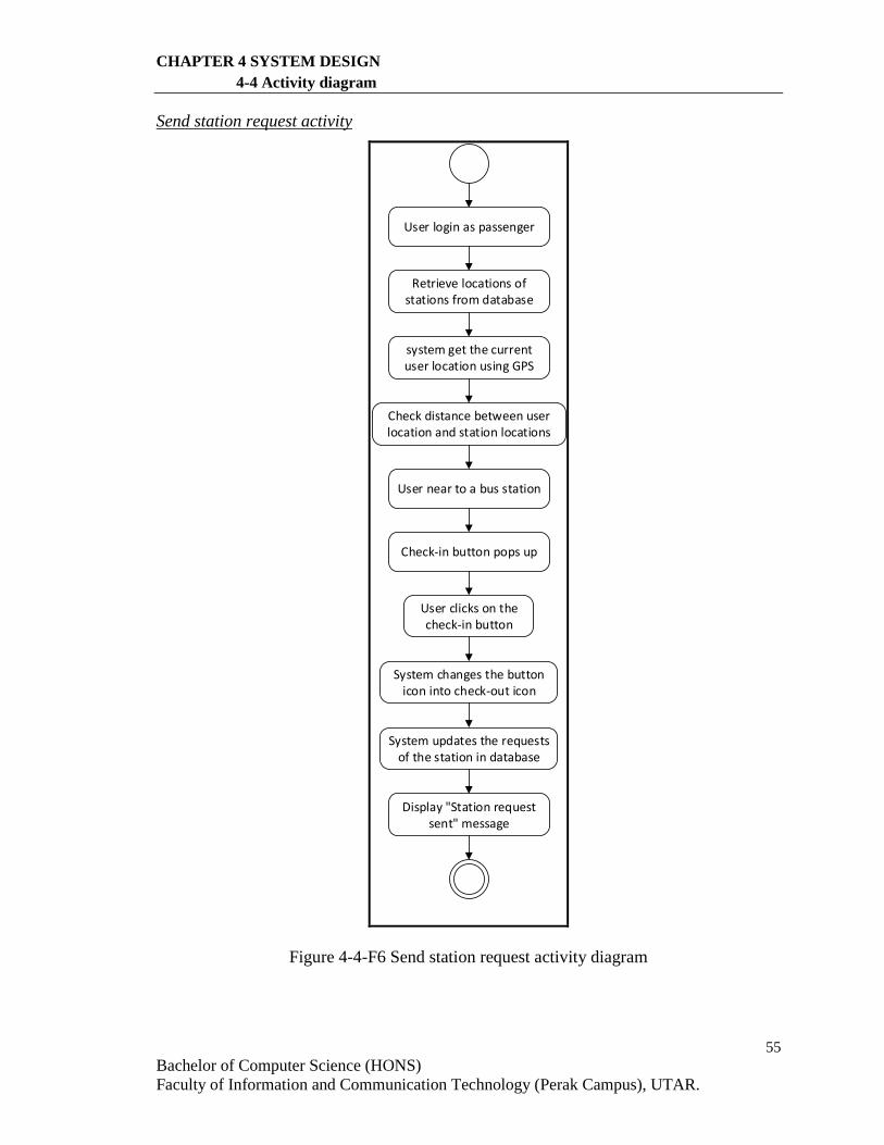
55
Bachelor of Computer Science (HONS)
Faculty of Information and Communication Technology (Perak Campus), UTAR.
CHAPTER 4 SYSTEM DESIGN
4-4 Activity diagram
Send station request activity
User login as passenger
Retrieve locations of stations from database
Display "Station request sent" message
system get the current user location using GPS
Check distance between user location and station locations
User near to a bus station
Check-in button pops up
User clicks on the check-in button
System changes the button icon into check-out icon
System updates the requests of the station in database
Figure 4-4-F6 Send station request activity diagram
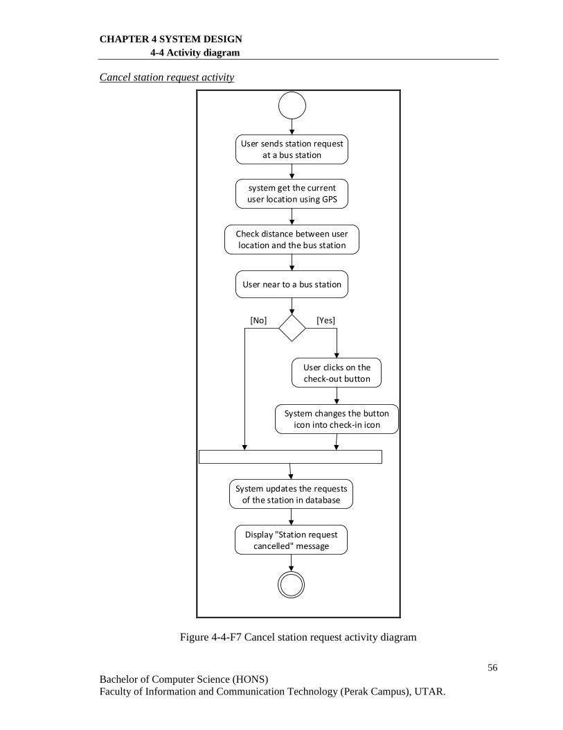
56
Bachelor of Computer Science (HONS)
Faculty of Information and Communication Technology (Perak Campus), UTAR.
CHAPTER 4 SYSTEM DESIGN
4-4 Activity diagram
Cancel station request activity
User sends station request at a bus station
Display "Station request cancelled" message
system get the current user location using GPS
Check distance between user location and the bus station
User near to a bus station
User clicks on the check-out button
System changes the button icon into check-in icon
System updates the requests of the station in database
[Yes][No]
Figure 4-4-F7 Cancel station request activity diagram
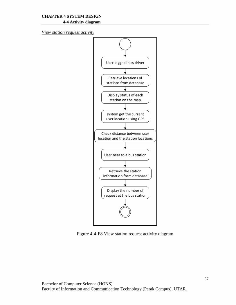
57
Bachelor of Computer Science (HONS)
Faculty of Information and Communication Technology (Perak Campus), UTAR.
CHAPTER 4 SYSTEM DESIGN
4-4 Activity diagram
View station request activity
User logged in as driver
Display the number of request at the bus station
system get the current user location using GPS
Check distance between user location and the station locations
User near to a bus station
Retrieve the station information from database
Retrieve locations of stations from database
Display status of each station on the map
Figure 4-4-F8 View station request activity diagram
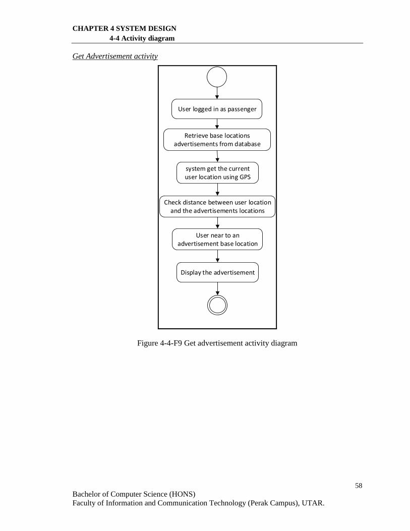
58
Bachelor of Computer Science (HONS)
Faculty of Information and Communication Technology (Perak Campus), UTAR.
CHAPTER 4 SYSTEM DESIGN
4-4 Activity diagram
Get Advertisement activity
User logged in as passenger
Display the advertisement
system get the current user location using GPS
Check distance between user location and the advertisements locations
User near to an advertisement base location
Retrieve base locations advertisements from database
Figure 4-4-F9 Get advertisement activity diagram
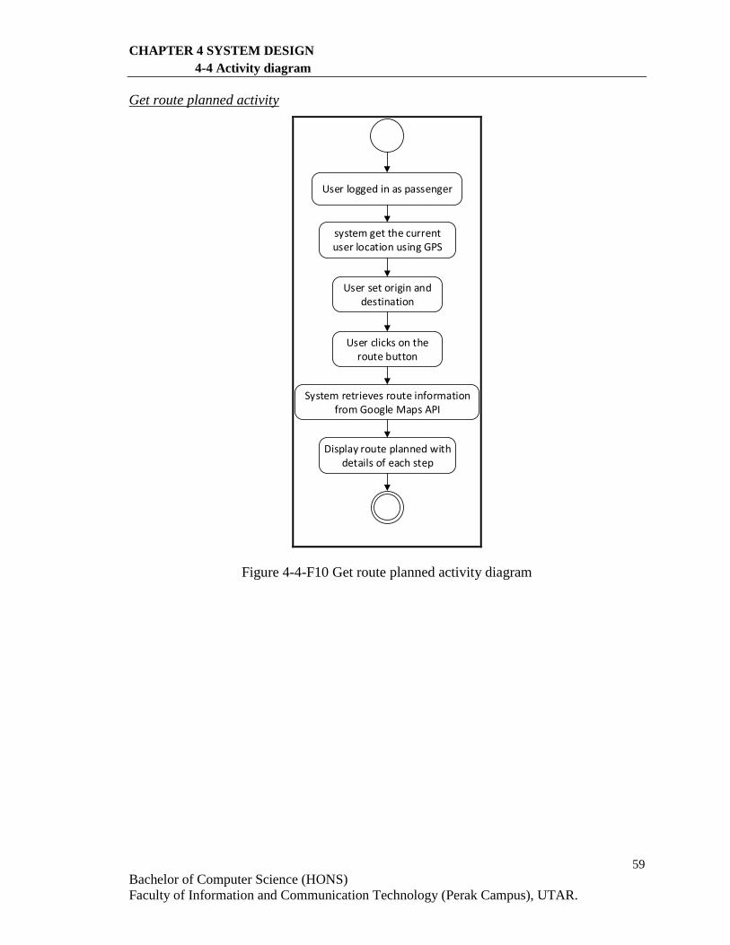
59
Bachelor of Computer Science (HONS)
Faculty of Information and Communication Technology (Perak Campus), UTAR.
CHAPTER 4 SYSTEM DESIGN
4-4 Activity diagram
Get route planned activity
User logged in as passenger
Display route planned with details of each step
system get the current user location using GPS
User set origin and destination
User clicks on the route button
System retrieves route information from Google Maps API
Figure 4-4-F10 Get route planned activity diagram
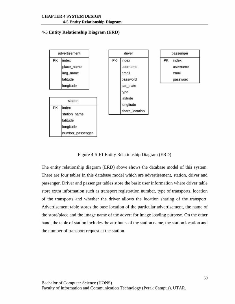
60
Bachelor of Computer Science (HONS)
Faculty of Information and Communication Technology (Perak Campus), UTAR.
CHAPTER 4 SYSTEM DESIGN
4-5 Entity Relationship Diagram
4-5 Entity Relationship Diagram (ERD)
Figure 4-5-F1 Entity Relationship Diagram (ERD)
The entity relationship diagram (ERD) above shows the database model of this system.
There are four tables in this database model which are advertisement, station, driver and
passenger. Driver and passenger tables store the basic user information where driver table
store extra information such as transport registration number, type of transports, location
of the transports and whether the driver allows the location sharing of the transport.
Advertisement table stores the base location of the particular advertisement, the name of
the store/place and the image name of the advert for image loading purpose. On the other
hand, the table of station includes the attributes of the station name, the station location and
the number of transport request at the station.
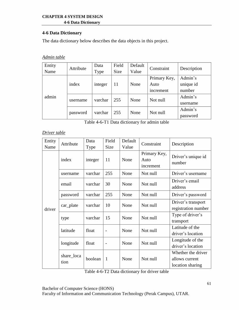
61
Bachelor of Computer Science (HONS)
Faculty of Information and Communication Technology (Perak Campus), UTAR.
CHAPTER 4 SYSTEM DESIGN
4-6 Data Dictionary
4-6 Data Dictionary
The data dictionary below describes the data objects in this project.
Admin table
Entity
Name Attribute
Data
Type
Field
Size
Default
Value Constraint Description
admin
index integer 11 None
Primary Key,
Auto
increment
Admin’s
unique id
number
username varchar 255 None Not null Admin’s
username
password varchar 255 None Not null Admin’s
password
Table 4-6-T1 Data dictionary for admin table
Driver table
Entity
Name Attribute
Data
Type
Field
Size
Default
Value Constraint Description
driver
index integer 11 None
Primary Key,
Auto
increment
Driver’s unique id
number
username varchar 255 None Not null Driver’s username
email varchar 30 None Not null Driver’s email
address
password varchar 255 None Not null Driver’s password
car_plate varchar 10 None Not null Driver’s transport
registration number
type varchar 15 None Not null Type of driver’s
transport
latitude float - None Not null Latitude of the
driver’s location
longitude float - None Not null Longitude of the
driver’s location
share_loca
tion boolean 1 None Not null
Whether the driver
allows current
location sharing
Table 4-6-T2 Data dictionary for driver table
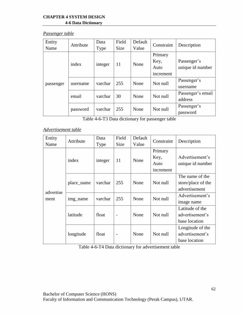
62
Bachelor of Computer Science (HONS)
Faculty of Information and Communication Technology (Perak Campus), UTAR.
CHAPTER 4 SYSTEM DESIGN
4-6 Data Dictionary
Passenger table
Entity
Name Attribute
Data
Type
Field
Size
Default
Value Constraint Description
passenger
index integer 11 None
Primary
Key,
Auto
increment
Passenger’s
unique id number
username varchar 255 None Not null Passenger’s
username
email varchar 30 None Not null Passenger’s email
address
password varchar 255 None Not null Passenger’s
password
Table 4-6-T3 Data dictionary for passenger table
Advertisement table
Entity
Name Attribute
Data
Type
Field
Size
Default
Value Constraint Description
advertise
ment
index integer 11 None
Primary
Key,
Auto
increment
Advertisement’s
unique id number
place_name varchar 255 None Not null
The name of the
store/place of the
advertisement
img_name varchar 255 None Not null Advertisement’s
image name
latitude float - None Not null
Latitude of the
advertisement’s
base location
longitude float - None Not null
Longitude of the
advertisement’s
base location
Table 4-6-T4 Data dictionary for advertisement table
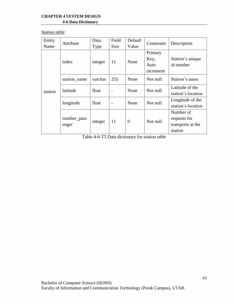
63
Bachelor of Computer Science (HONS)
Faculty of Information and Communication Technology (Perak Campus), UTAR.
CHAPTER 4 SYSTEM DESIGN
4-6 Data Dictionary
Station table
Entity
Name Attribute
Data
Type
Field
Size
Default
Value Constraint Description
station
index integer 11 None
Primary
Key,
Auto
increment
Station’s unique
id number
station_name varchar 255 None Not null Station’s name
latitude float - None Not null Latitude of the
station’s location
longitude float - None Not null Longitude of the
station’s location
number_pass
enger integer 11 0 Not null
Number of
requests for
transports at the
station
Table 4-6-T5 Data dictionary for station table
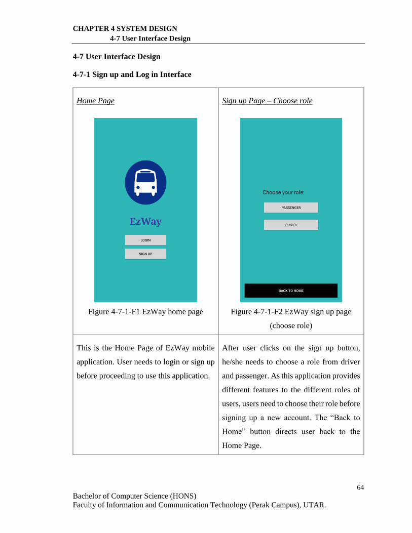
64
Bachelor of Computer Science (HONS)
Faculty of Information and Communication Technology (Perak Campus), UTAR.
CHAPTER 4 SYSTEM DESIGN
4-7 User Interface Design
4-7 User Interface Design
4-7-1 Sign up and Log in Interface
Home Page
Figure 4-7-1-F1 EzWay home page
Sign up Page – Choose role
Figure 4-7-1-F2 EzWay sign up page
(choose role)
This is the Home Page of EzWay mobile
application. User needs to login or sign up
before proceeding to use this application.
After user clicks on the sign up button,
he/she needs to choose a role from driver
and passenger. As this application provides
different features to the different roles of
users, users need to choose their role before
signing up a new account. The “Back to
Home” button directs user back to the
Home Page.
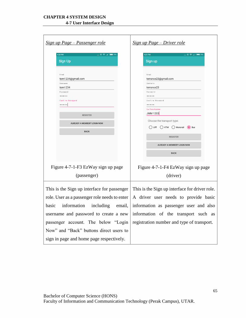
65
Bachelor of Computer Science (HONS)
Faculty of Information and Communication Technology (Perak Campus), UTAR.
CHAPTER 4 SYSTEM DESIGN
4-7 User Interface Design
Sign up Page – Passenger role
Figure 4-7-1-F3 EzWay sign up page
(passenger)
Sign up Page – Driver role
Figure 4-7-1-F4 EzWay sign up page
(driver)
This is the Sign up interface for passenger
role. User as a passenger role needs to enter
basic information including email,
username and password to create a new
passenger account. The below “Login
Now” and “Back” buttons direct users to
sign in page and home page respectively.
This is the Sign up interface for driver role.
A driver user needs to provide basic
information as passenger user and also
information of the transport such as
registration number and type of transport.
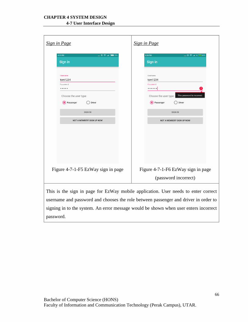
66
Bachelor of Computer Science (HONS)
Faculty of Information and Communication Technology (Perak Campus), UTAR.
CHAPTER 4 SYSTEM DESIGN
4-7 User Interface Design
Sign in Page
Figure 4-7-1-F5 EzWay sign in page
Sign in Page
Figure 4-7-1-F6 EzWay sign in page
(password incorrect)
This is the sign in page for EzWay mobile application. User needs to enter correct
username and password and chooses the role between passenger and driver in order to
signing in to the system. An error message would be shown when user enters incorrect
password.

67
Bachelor of Computer Science (HONS)
Faculty of Information and Communication Technology (Perak Campus), UTAR.
CHAPTER 4 SYSTEM DESIGN
4-7 User Interface Design
4-7-2 Passenger User Interface
Main Page (Passenger)
Figure 4-7-2-F1 EzWay main page for
passenger
Main Page (Passenger)
Figure 4-7-2-F2 EzWay main page for
passenger
This is the page shown when user signs in as a passenger. The application will show the
current user location and bus stations on the map. The text boxes above allow user enters
the origin and destination addresses in order to do the route planning. There are also
origin and destination markers on the map that allow users to drag on and set the origin
and destination location. Besides, there are markers shown on the maps indicates the
location of the particular public transport. The details such as the driver’s username,
registration number of the transport and the type of transport will be displayed.
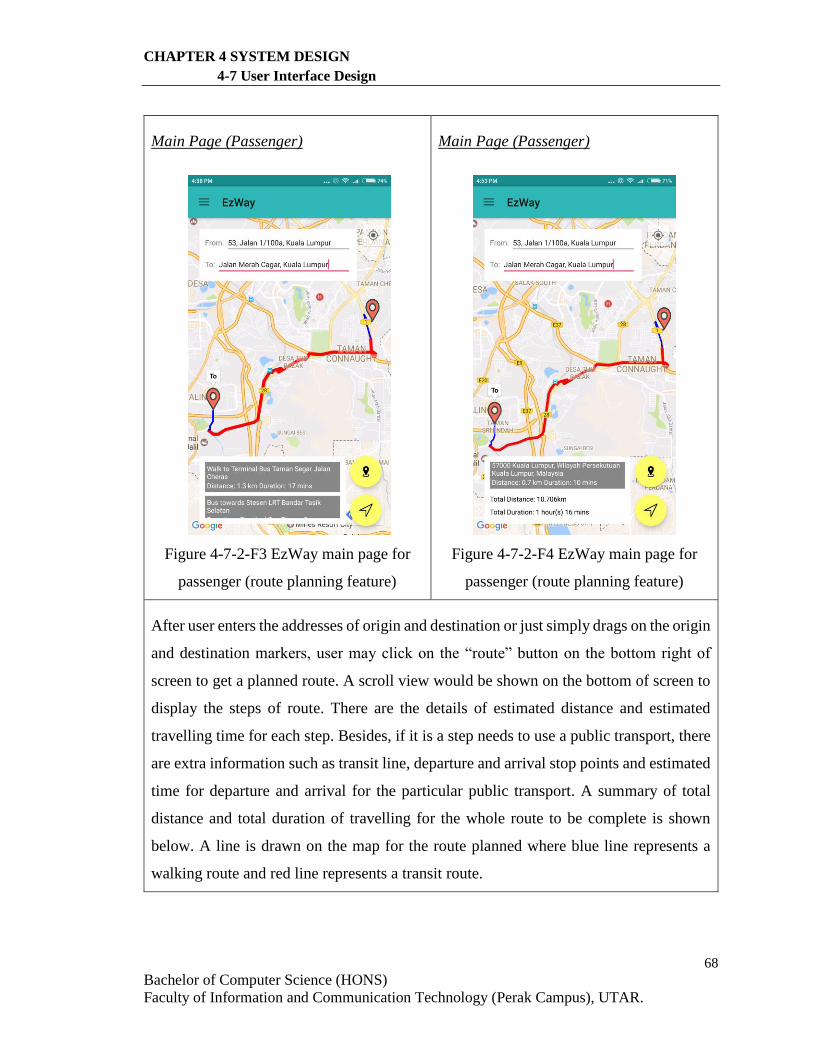
68
Bachelor of Computer Science (HONS)
Faculty of Information and Communication Technology (Perak Campus), UTAR.
CHAPTER 4 SYSTEM DESIGN
4-7 User Interface Design
Main Page (Passenger)
Figure 4-7-2-F3 EzWay main page for
passenger (route planning feature)
Main Page (Passenger)
Figure 4-7-2-F4 EzWay main page for
passenger (route planning feature)
After user enters the addresses of origin and destination or just simply drags on the origin
and destination markers, user may click on the “route” button on the bottom right of
screen to get a planned route. A scroll view would be shown on the bottom of screen to
display the steps of route. There are the details of estimated distance and estimated
travelling time for each step. Besides, if it is a step needs to use a public transport, there
are extra information such as transit line, departure and arrival stop points and estimated
time for departure and arrival for the particular public transport. A summary of total
distance and total duration of travelling for the whole route to be complete is shown
below. A line is drawn on the map for the route planned where blue line represents a
walking route and red line represents a transit route.
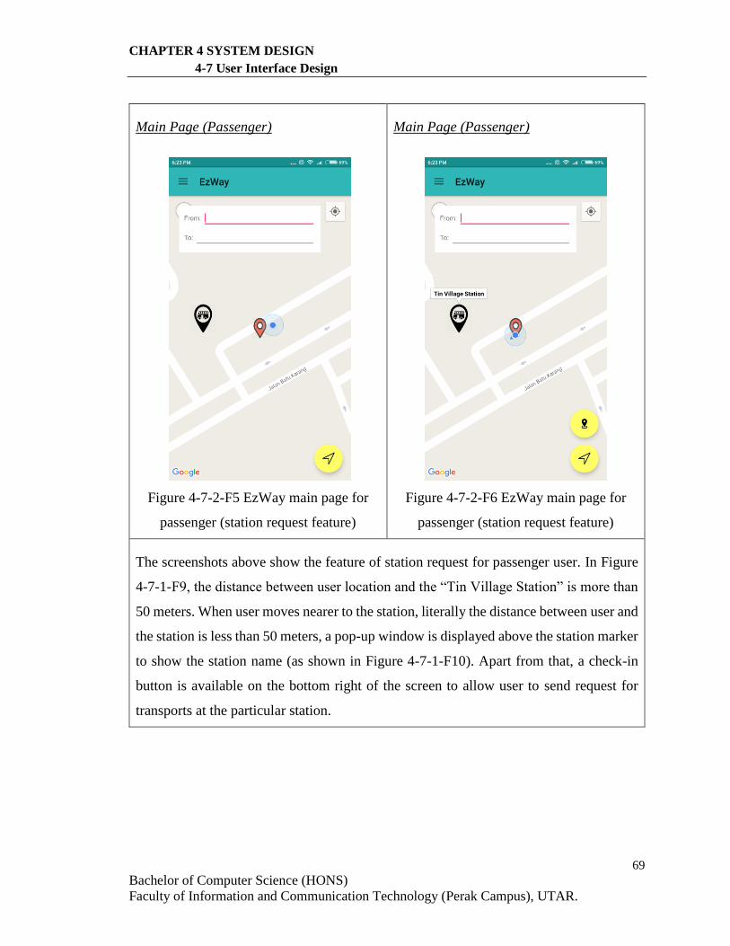
69
Bachelor of Computer Science (HONS)
Faculty of Information and Communication Technology (Perak Campus), UTAR.
CHAPTER 4 SYSTEM DESIGN
4-7 User Interface Design
Main Page (Passenger)
Figure 4-7-2-F5 EzWay main page for
passenger (station request feature)
Main Page (Passenger)
Figure 4-7-2-F6 EzWay main page for
passenger (station request feature)
The screenshots above show the feature of station request for passenger user. In Figure
4-7-1-F9, the distance between user location and the “Tin Village Station” is more than
50 meters. When user moves nearer to the station, literally the distance between user and
the station is less than 50 meters, a pop-up window is displayed above the station marker
to show the station name (as shown in Figure 4-7-1-F10). Apart from that, a check-in
button is available on the bottom right of the screen to allow user to send request for
transports at the particular station.
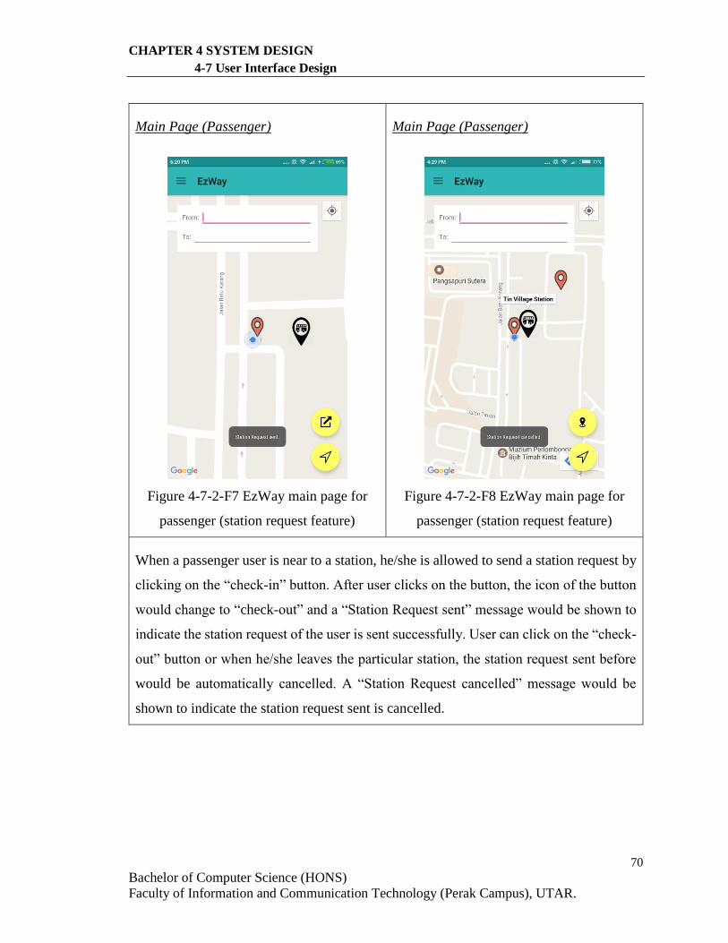
70
Bachelor of Computer Science (HONS)
Faculty of Information and Communication Technology (Perak Campus), UTAR.
CHAPTER 4 SYSTEM DESIGN
4-7 User Interface Design
Main Page (Passenger)
Figure 4-7-2-F7 EzWay main page for
passenger (station request feature)
Main Page (Passenger)
Figure 4-7-2-F8 EzWay main page for
passenger (station request feature)
When a passenger user is near to a station, he/she is allowed to send a station request by
clicking on the “check-in” button. After user clicks on the button, the icon of the button
would change to “check-out” and a “Station Request sent” message would be shown to
indicate the station request of the user is sent successfully. User can click on the “check-
out” button or when he/she leaves the particular station, the station request sent before
would be automatically cancelled. A “Station Request cancelled” message would be
shown to indicate the station request sent is cancelled.
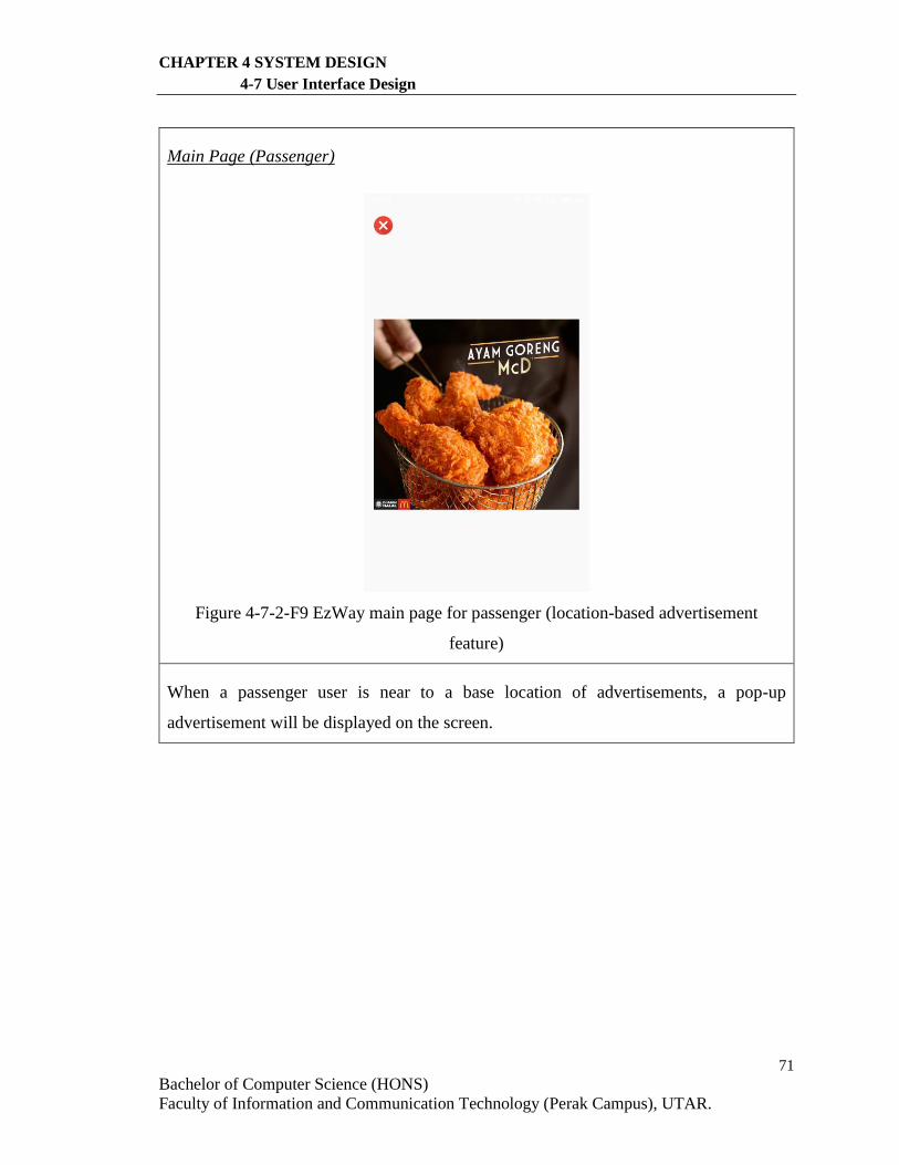
71
Bachelor of Computer Science (HONS)
Faculty of Information and Communication Technology (Perak Campus), UTAR.
CHAPTER 4 SYSTEM DESIGN
4-7 User Interface Design
Main Page (Passenger)
Figure 4-7-2-F9 EzWay main page for passenger (location-based advertisement
feature)
When a passenger user is near to a base location of advertisements, a pop-up
advertisement will be displayed on the screen.
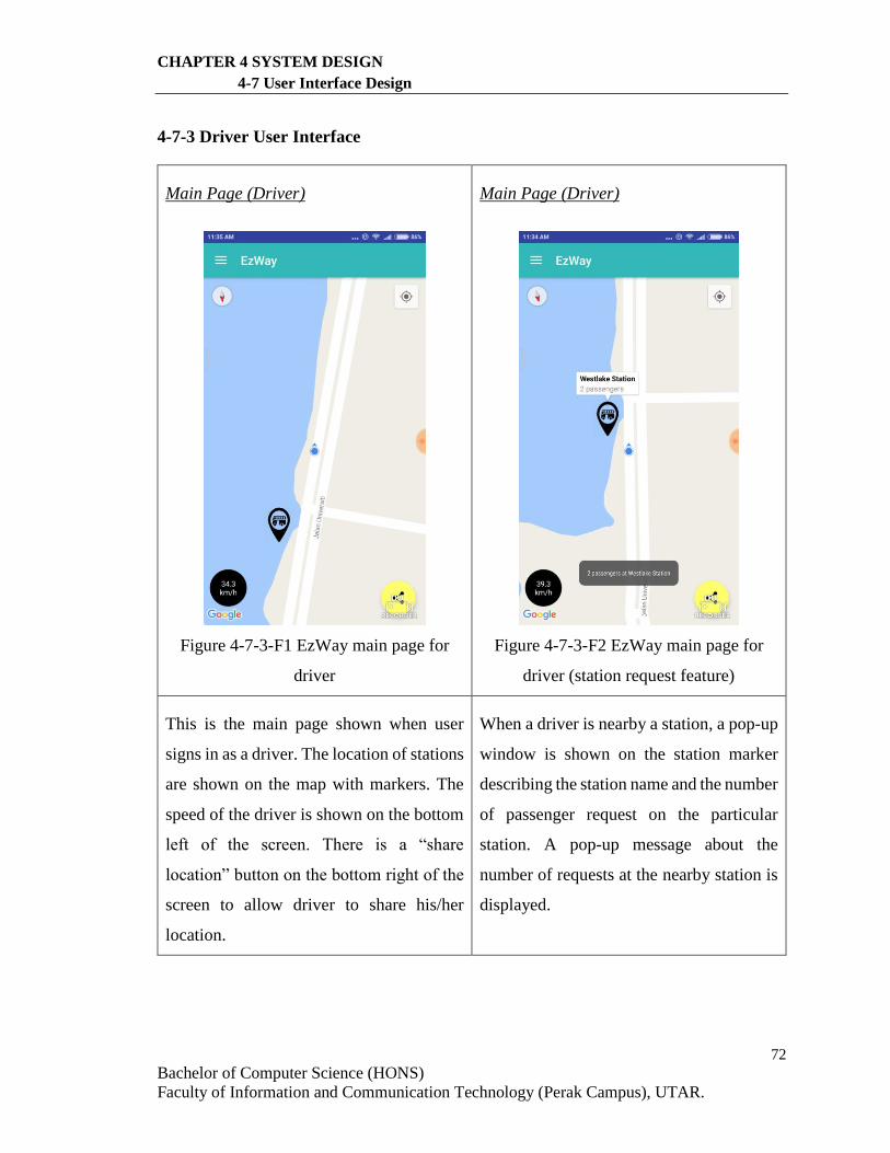
72
Bachelor of Computer Science (HONS)
Faculty of Information and Communication Technology (Perak Campus), UTAR.
CHAPTER 4 SYSTEM DESIGN
4-7 User Interface Design
4-7-3 Driver User Interface
Main Page (Driver)
Figure 4-7-3-F1 EzWay main page for
driver
Main Page (Driver)
Figure 4-7-3-F2 EzWay main page for
driver (station request feature)
This is the main page shown when user
signs in as a driver. The location of stations
are shown on the map with markers. The
speed of the driver is shown on the bottom
left of the screen. There is a “share
location” button on the bottom right of the
screen to allow driver to share his/her
location.
When a driver is nearby a station, a pop-up
window is shown on the station marker
describing the station name and the number
of passenger request on the particular
station. A pop-up message about the
number of requests at the nearby station is
displayed.
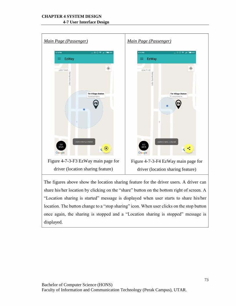
73
Bachelor of Computer Science (HONS)
Faculty of Information and Communication Technology (Perak Campus), UTAR.
CHAPTER 4 SYSTEM DESIGN
4-7 User Interface Design
Main Page (Passenger)
Figure 4-7-3-F3 EzWay main page for
driver (location sharing feature)
Main Page (Passenger)
Figure 4-7-3-F4 EzWay main page for
driver (location sharing feature)
The figures above show the location sharing feature for the driver users. A driver can
share his/her location by clicking on the “share” button on the bottom right of screen. A
“Location sharing is started” message is displayed when user starts to share his/her
location. The button change to a “stop sharing” icon. When user clicks on the stop button
once again, the sharing is stopped and a “Location sharing is stopped” message is
displayed.
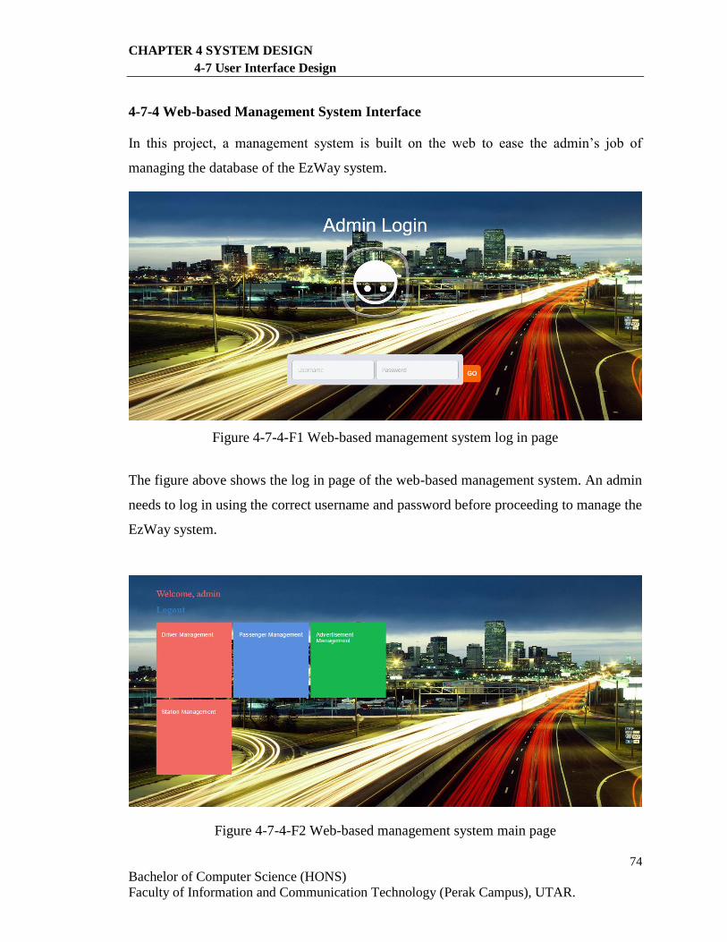
74
Bachelor of Computer Science (HONS)
Faculty of Information and Communication Technology (Perak Campus), UTAR.
CHAPTER 4 SYSTEM DESIGN
4-7 User Interface Design
4-7-4 Web-based Management System Interface
In this project, a management system is built on the web to ease the admin’s job of
managing the database of the EzWay system.
Figure 4-7-4-F1 Web-based management system log in page
The figure above shows the log in page of the web-based management system. An admin
needs to log in using the correct username and password before proceeding to manage the
EzWay system.
Figure 4-7-4-F2 Web-based management system main page
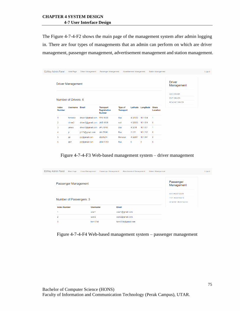
75
Bachelor of Computer Science (HONS)
Faculty of Information and Communication Technology (Perak Campus), UTAR.
CHAPTER 4 SYSTEM DESIGN
4-7 User Interface Design
The Figure 4-7-4-F2 shows the main page of the management system after admin logging
in. There are four types of managements that an admin can perform on which are driver
management, passenger management, advertisement management and station management.
Figure 4-7-4-F3 Web-based management system – driver management
Figure 4-7-4-F4 Web-based management system – passenger management
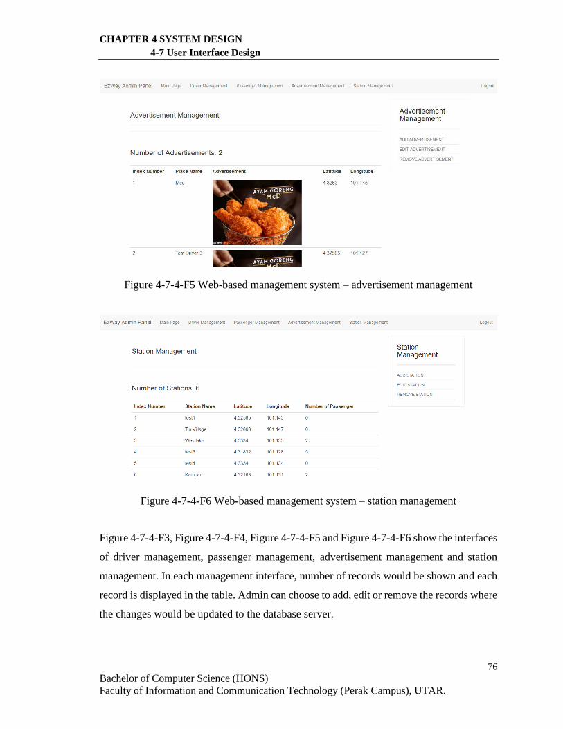
76
Bachelor of Computer Science (HONS)
Faculty of Information and Communication Technology (Perak Campus), UTAR.
CHAPTER 4 SYSTEM DESIGN
4-7 User Interface Design
Figure 4-7-4-F5 Web-based management system – advertisement management
Figure 4-7-4-F6 Web-based management system – station management
Figure 4-7-4-F3, Figure 4-7-4-F4, Figure 4-7-4-F5 and Figure 4-7-4-F6 show the interfaces
of driver management, passenger management, advertisement management and station
management. In each management interface, number of records would be shown and each
record is displayed in the table. Admin can choose to add, edit or remove the records where
the changes would be updated to the database server.
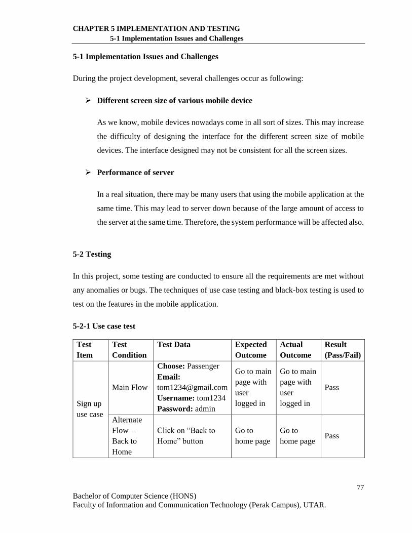
77
Bachelor of Computer Science (HONS)
Faculty of Information and Communication Technology (Perak Campus), UTAR.
CHAPTER 5 IMPLEMENTATION AND TESTING
5-1 Implementation Issues and Challenges
5-1 Implementation Issues and Challenges
During the project development, several challenges occur as following:
Different screen size of various mobile device
As we know, mobile devices nowadays come in all sort of sizes. This may increase
the difficulty of designing the interface for the different screen size of mobile
devices. The interface designed may not be consistent for all the screen sizes.
Performance of server
In a real situation, there may be many users that using the mobile application at the
same time. This may lead to server down because of the large amount of access to
the server at the same time. Therefore, the system performance will be affected also.
5-2 Testing
In this project, some testing are conducted to ensure all the requirements are met without
any anomalies or bugs. The techniques of use case testing and black-box testing is used to
test on the features in the mobile application.
5-2-1 Use case test
Test
Item
Test
Condition
Test Data Expected
Outcome
Actual
Outcome
Result
(Pass/Fail)
Sign up
use case
Main Flow
Choose: Passenger
Email:
Username: tom1234
Password: admin
Go to main
page with
user
logged in
Go to main
page with
user
logged in
Pass
Alternate
Flow –
Back to
Home
Click on “Back to
Home” button
Go to
home page
Go to
home page Pass
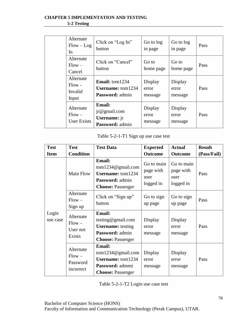
78
Bachelor of Computer Science (HONS)
Faculty of Information and Communication Technology (Perak Campus), UTAR.
CHAPTER 5 IMPLEMENTATION AND TESTING
5-2 Testing
Alternate
Flow – Log
In
Click on “Log In”
button
Go to log
in page
Go to log
in page Pass
Alternate
Flow –
Cancel
Click on “Cancel”
button
Go to
home page
Go to
home page Pass
Alternate
Flow -
Invalid
Input
Email: tom1234
Username: tom1234
Password: admin
Display
error
message
Display
error
message
Pass
Alternate
Flow –
User Exists
Email:
Username: jr
Password: admin
Display
error
message
Display
error
message
Pass
Table 5-2-1-T1 Sign up use case test
Test
Item
Test
Condition
Test Data Expected
Outcome
Actual
Outcome
Result
(Pass/Fail)
Login
use case
Main Flow
Email:
Username: tom1234
Password: admin
Choose: Passenger
Go to main
page with
user
logged in
Go to main
page with
user
logged in
Pass
Alternate
Flow –
Sign up
Click on “Sign up”
button
Go to sign
up page
Go to sign
up page Pass
Alternate
Flow –
User not
Exists
Email:
Username: testing
Password: admin
Choose: Passenger
Display
error
message
Display
error
message
Pass
Alternate
Flow –
Password
incorrect
Email:
Username: tom1234
Password: admmi
Choose: Passenger
Display
error
message
Display
error
message
Pass
Table 5-2-1-T2 Login use case test
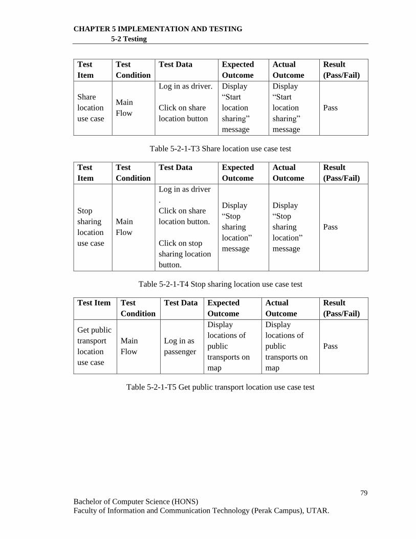
79
Bachelor of Computer Science (HONS)
Faculty of Information and Communication Technology (Perak Campus), UTAR.
CHAPTER 5 IMPLEMENTATION AND TESTING
5-2 Testing
Test
Item
Test
Condition
Test Data Expected
Outcome
Actual
Outcome
Result
(Pass/Fail)
Share
location
use case
Main
Flow
Log in as driver.
Click on share
location button
Display
“Start
location
sharing”
message
Display
“Start
location
sharing”
message
Pass
Table 5-2-1-T3 Share location use case test
Test
Item
Test
Condition
Test Data Expected
Outcome
Actual
Outcome
Result
(Pass/Fail)
Stop
sharing
location
use case
Main
Flow
Log in as driver
.
Click on share
location button.
Click on stop
sharing location
button.
Display
“Stop
sharing
location”
message
Display
“Stop
sharing
location”
message
Pass
Table 5-2-1-T4 Stop sharing location use case test
Test Item Test
Condition
Test Data Expected
Outcome
Actual
Outcome
Result
(Pass/Fail)
Get public
transport
location
use case
Main
Flow
Log in as
passenger
Display
locations of
public
transports on
map
Display
locations of
public
transports on
map
Pass
Table 5-2-1-T5 Get public transport location use case test
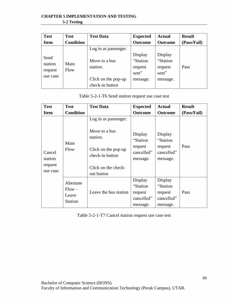
80
Bachelor of Computer Science (HONS)
Faculty of Information and Communication Technology (Perak Campus), UTAR.
CHAPTER 5 IMPLEMENTATION AND TESTING
5-2 Testing
Test
Item
Test
Condition
Test Data Expected
Outcome
Actual
Outcome
Result
(Pass/Fail)
Send
station
request
use case
Main
Flow
Log in as passenger.
Move to a bus
station.
Click on the pop-up
check-in button
Display
“Station
request
sent”
message.
Display
“Station
request
sent”
message.
Pass
Table 5-2-1-T6 Send station request use case test
Test
Item
Test
Condition
Test Data Expected
Outcome
Actual
Outcome
Result
(Pass/Fail)
Cancel
station
request
use case
Main
Flow
Log in as passenger.
Move to a bus
station.
Click on the pop-up
check-in button
Click on the check-
out button
Display
“Station
request
cancelled”
message.
Display
“Station
request
cancelled”
message.
Pass
Alternate
Flow –
Leave
Station
Leave the bus station
Display
“Station
request
cancelled”
message.
Display
“Station
request
cancelled”
message.
Pass
Table 5-2-1-T7 Cancel station request use case test
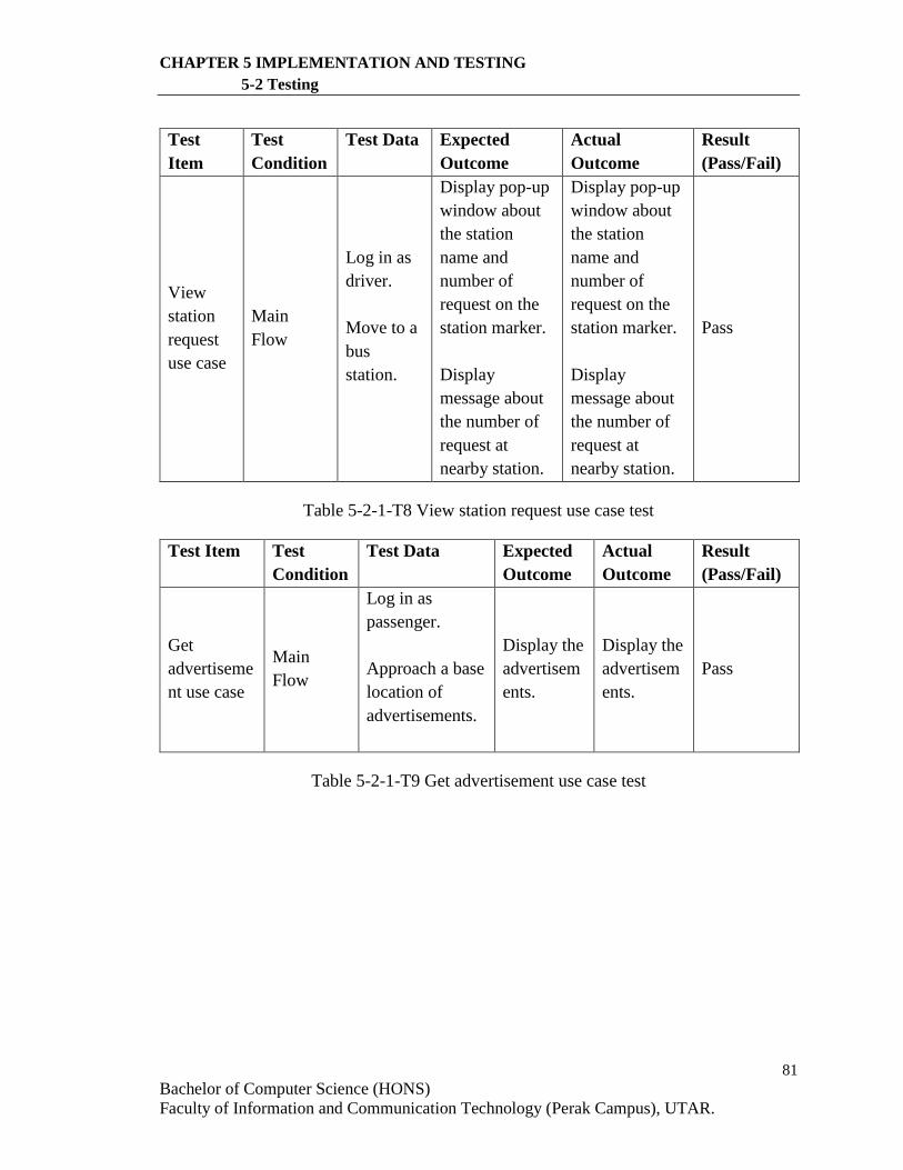
81
Bachelor of Computer Science (HONS)
Faculty of Information and Communication Technology (Perak Campus), UTAR.
CHAPTER 5 IMPLEMENTATION AND TESTING
5-2 Testing
Test
Item
Test
Condition
Test Data Expected
Outcome
Actual
Outcome
Result
(Pass/Fail)
View
station
request
use case
Main
Flow
Log in as
driver.
Move to a
bus
station.
Display pop-up
window about
the station
name and
number of
request on the
station marker.
Display
message about
the number of
request at
nearby station.
Display pop-up
window about
the station
name and
number of
request on the
station marker.
Display
message about
the number of
request at
nearby station.
Pass
Table 5-2-1-T8 View station request use case test
Test Item Test
Condition
Test Data Expected
Outcome
Actual
Outcome
Result
(Pass/Fail)
Get
advertiseme
nt use case
Main
Flow
Log in as
passenger.
Approach a base
location of
advertisements.
Display the
advertisem
ents.
Display the
advertisem
ents.
Pass
Table 5-2-1-T9 Get advertisement use case test
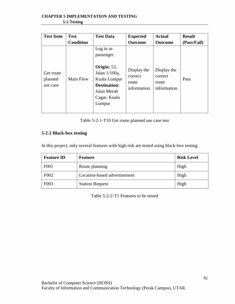
82
Bachelor of Computer Science (HONS)
Faculty of Information and Communication Technology (Perak Campus), UTAR.
CHAPTER 5 IMPLEMENTATION AND TESTING
5-2 Testing
Test Item Test
Condition
Test Data Expected
Outcome
Actual
Outcome
Result
(Pass/Fail)
Get route
planned
use case
Main Flow
Log in as
passenger.
Origin: 53,
Jalan 1/100a,
Kuala Lumpur
Destination:
Jalan Merah
Cagar, Kuala
Lumpur
Display the
correct
route
information.
Display the
correct
route
information.
Pass
Table 5-2-1-T10 Get route planned use case test
5-2-2 Black-box testing
In this project, only several features with high risk are tested using black-box testing.
Feature ID Feature Risk Level
F001 Route planning High
F002 Location-based advertisement High
F003 Station Request High
Table 5-2-2-T1 Features to be tested
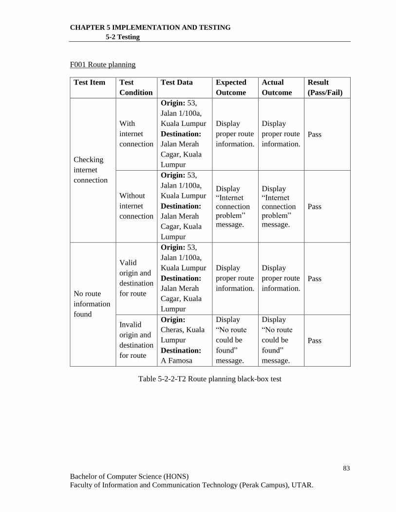
83
Bachelor of Computer Science (HONS)
Faculty of Information and Communication Technology (Perak Campus), UTAR.
CHAPTER 5 IMPLEMENTATION AND TESTING
5-2 Testing
F001 Route planning
Test Item Test
Condition
Test Data Expected
Outcome
Actual
Outcome
Result
(Pass/Fail)
Checking
internet
connection
With
internet
connection
Origin: 53,
Jalan 1/100a,
Kuala Lumpur
Destination:
Jalan Merah
Cagar, Kuala
Lumpur
Display
proper route
information.
Display
proper route
information.
Pass
Without
internet
connection
Origin: 53,
Jalan 1/100a,
Kuala Lumpur
Destination:
Jalan Merah
Cagar, Kuala
Lumpur
Display
“Internet
connection
problem”
message.
Display
“Internet
connection
problem”
message.
Pass
No route
information
found
Valid
origin and
destination
for route
Origin: 53,
Jalan 1/100a,
Kuala Lumpur
Destination:
Jalan Merah
Cagar, Kuala
Lumpur
Display
proper route
information.
Display
proper route
information.
Pass
Invalid
origin and
destination
for route
Origin:
Cheras, Kuala
Lumpur
Destination:
A Famosa
Display
“No route
could be
found”
message.
Display
“No route
could be
found”
message.
Pass
Table 5-2-2-T2 Route planning black-box test
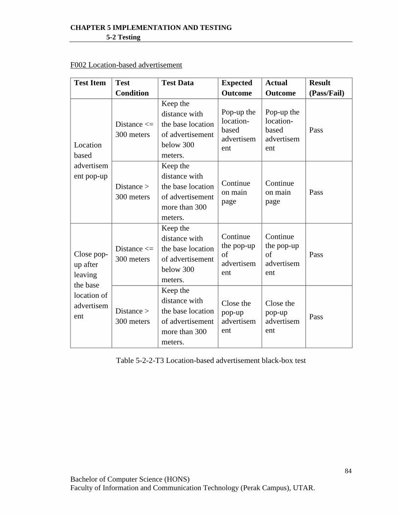
84
Bachelor of Computer Science (HONS)
Faculty of Information and Communication Technology (Perak Campus), UTAR.
CHAPTER 5 IMPLEMENTATION AND TESTING
5-2 Testing
F002 Location-based advertisement
Test Item Test
Condition
Test Data Expected
Outcome
Actual
Outcome
Result
(Pass/Fail)
Location
based
advertisem
ent pop-up
Distance <=
300 meters
Keep the
distance with
the base location
of advertisement
below 300
meters.
Pop-up the
location-
based
advertisem
ent
Pop-up the
location-
based
advertisem
ent
Pass
Distance >
300 meters
Keep the
distance with
the base location
of advertisement
more than 300
meters.
Continue
on main
page
Continue
on main
page
Pass
Close pop-
up after
leaving
the base
location of
advertisem
ent
Distance <=
300 meters
Keep the
distance with
the base location
of advertisement
below 300
meters.
Continue
the pop-up
of
advertisem
ent
Continue
the pop-up
of
advertisem
ent
Pass
Distance >
300 meters
Keep the
distance with
the base location
of advertisement
more than 300
meters.
Close the
pop-up
advertisem
ent
Close the
pop-up
advertisem
ent
Pass
Table 5-2-2-T3 Location-based advertisement black-box test
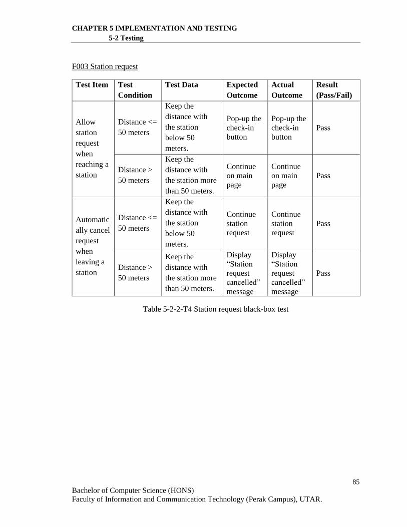
85
Bachelor of Computer Science (HONS)
Faculty of Information and Communication Technology (Perak Campus), UTAR.
CHAPTER 5 IMPLEMENTATION AND TESTING
5-2 Testing
F003 Station request
Test Item Test
Condition
Test Data Expected
Outcome
Actual
Outcome
Result
(Pass/Fail)
Allow
station
request
when
reaching a
station
Distance <=
50 meters
Keep the
distance with
the station
below 50
meters.
Pop-up the
check-in
button
Pop-up the
check-in
button
Pass
Distance >
50 meters
Keep the
distance with
the station more
than 50 meters.
Continue
on main
page
Continue
on main
page
Pass
Automatic
ally cancel
request
when
leaving a
station
Distance <=
50 meters
Keep the
distance with
the station
below 50
meters.
Continue
station
request
Continue
station
request
Pass
Distance >
50 meters
Keep the
distance with
the station more
than 50 meters.
Display
“Station
request
cancelled”
message
Display
“Station
request
cancelled”
message
Pass
Table 5-2-2-T4 Station request black-box test
86
Bachelor of Computer Science (HONS)
Faculty of Information and Communication Technology (Perak Campus), UTAR.
CHAPTER 6 CONCLUSION
6-1 Project Review, Discussions and Conclusions
6-1 Project Review, Discussions and Conclusions
Mobile social networking allows individuals to share interests, opinions or information
among the network using mobile devices such as mobile phones or tablets. As technology
advances, the users of mobile devices increase sharply in the past few years. As a result,
demand of mobile social networking grows over years. This project is a mobile application
project to develop a mobile application for public transportation.
The biggest problem of public transports nowadays is the public transport always
arrives late. Commuters cannot tell the actual arrival time of the public transport. This may
waste a lot of time. Although there exits some mobile application for public transportation
in Malaysia, no one includes the features of tracking the location of public transports. This
feature is important for solving the problem stated above.
The objectives of this project is to track the location of public transports, at the
same time estimate the travelling time and time for departure and arrival of public
transports. On the other hand, this mobile application is able to do the route planning for
the users based on the origin and destination provided. Location-based advertisement will
also be included in the application. The user of this mobile application could request for
public transports at a station when he/she is nearby the station.
In a nutshell, the main focus of this project is to develop a mobile application of
public transportation that could improve the user experience of public transports and
enhance the current system. This proposed project is believed to be a great benefit of the
society.
87
Bachelor of Computer Science (HONS)
Faculty of Information and Communication Technology (Perak Campus), UTAR.
CHAPTER 6 CONCLUSION
6-2 Strengths, Weakness and Future Work
6-2 Strengths, Weakness and Future Work
EzWay is a mobile application that provides several useful features such as public transport
tracking, route planning, request for public transports at a station and provide location-
based advertisement. The strength of this application is the combination of these features
into one application that brings convenience to the KL citizens for using public transports
in KL.
Users can now track the bus before going out from their house which could save a
lot of time for waiting the bus to arrive the bus station. The route planning feature can guide
users especially tourists in KL to use the public transports in order to reach the destination
in a more convenient way. Location-based advertisement feature provides suitable and
relevant ads to the users which may benefit both the users and the advertisers. The station
request feature is the uniqueness of EzWay mobile application to allow the commuters to
use the public transport with a better user experience. This feature solves the crowded
condition of using public transports during peak hours. While waiting a bus at a bus station,
user may send a request for bus. By knowing the demand of public transports users at a bus
station, the bus operators may plan more proper routes for the buses or sending more buses
to the bus station which has a higher demand.
However, there are still some weakness in this mobile application. The system takes
a longer time to response to the database due to the server problem. This may result in the
application would delay a few seconds to response to the users. Besides, the user interface
is not designed properly. The route information displayed to the users is hard to be read
and the learnability is low.
For the future enhancement, Google Firebase would be used for hosting and storing
database. Google Firebase provides a real-time database which can store and sync app data
in real-time. It delivers the web content faster and ease the backend coding which may
improve the performance of this mobile application. Other than that, the user interface
should be designed as more user-friendly where tab layout should be used for displaying
the route information. Lastly, this application should include a tutorial for the first-time
users to guide them on the functions in this application.
88
Bachelor of Computer Science (HONS)
Faculty of Information and Communication Technology (Perak Campus), UTAR.
BIBLIOGRAPHY
A-GPS vs GPS – Difference and Comparison | Diffen, 2012. Available from:
< http://www.diffen.com/difference/A-GPS_vs_GPS>.
About mobile ads – AdWords Help, n.d. Available from:
<https://support.google.com/adwords/answer/2472719?hl=en&ref_topic=312177
0>.
Almselati, ASI, Rahmat RIOK & Jaafar O 2011, An Overview of Urban Transport in
Malaysia. Available from:
<http://www.medwelljournals.com/fulltext/?doi=sscience.2011.24.33>.
Apowersoft 2015, General Knowledge of 3GP Format. Available from:
< http://www.apowersoft.com/what-is-3gp-format.html>. [27 October 2015].
Bimo G n.d., Metodologi Pengembangan Sistem Informasi. Metodologi Metodologi
adalah kesatuan metode-metode, prosedur-prosedur, konsep-konsep pekerjaan,
aturan-aturan. - ppt download. Available from:
< http://slideplayer.info/slide/3785750/>.
Developer’s Guide | Google Maps Direction API | Google Developers, 2016.
Available from:
< https://developers.google.com/maps/documentation/directions/intro>.
[16 August 2016].
Downs, J 2012, What Format or File Type of Video Should I Use for the Web? – 12 Stars
Media. Available from:
< http://12starsmedia.com/blog/what-format-or-file-type-of-video-should-i-use-
for-the-web>. [16 April 2012].
FAQ | Google Maps APIs | Google Maps Developers, 2016. Available from:
<https://developers.google.com/maps/faq?csw=1#google-maps-api-services>.
[18 February 2016]
Gilliam (eds.) 2016, Google Maps – Wikipedia, the free encyclopedia, Myczko.
Available from: <https://en.wikipedia.org/wiki/Google_Maps>. [6 April 2016].
How Do I Make the Most Advertising on Mobile Devices? n.d. Available from:
< http://www.millwardbrown.com/Insights/Knowledge-Point/Mobile_Devices/>.
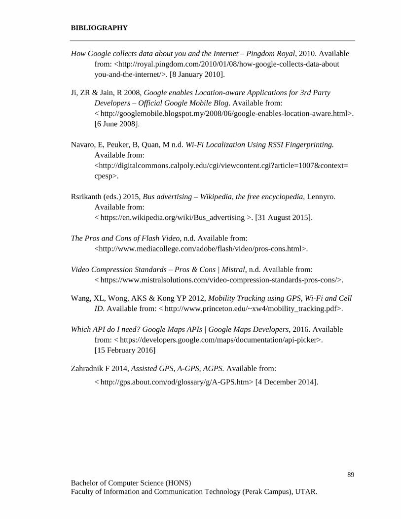
89
Bachelor of Computer Science (HONS)
Faculty of Information and Communication Technology (Perak Campus), UTAR.
BIBLIOGRAPHY
How Google collects data about you and the Internet – Pingdom Royal, 2010. Available
from: <http://royal.pingdom.com/2010/01/08/how-google-collects-data-about
you-and-the-internet/>. [8 January 2010].
Ji, ZR & Jain, R 2008, Google enables Location-aware Applications for 3rd Party
Developers – Official Google Mobile Blog. Available from:
< http://googlemobile.blogspot.my/2008/06/google-enables-location-aware.html>.
[6 June 2008].
Navaro, E, Peuker, B, Quan, M n.d. Wi-Fi Localization Using RSSI Fingerprinting.
Available from:
<http://digitalcommons.calpoly.edu/cgi/viewcontent.cgi?article=1007&context=
cpesp>.
Rsrikanth (eds.) 2015, Bus advertising – Wikipedia, the free encyclopedia, Lennyro.
Available from:
< https://en.wikipedia.org/wiki/Bus_advertising >. [31 August 2015].
The Pros and Cons of Flash Video, n.d. Available from:
<http://www.mediacollege.com/adobe/flash/video/pros-cons.html>.
Video Compression Standards – Pros & Cons | Mistral, n.d. Available from:
< https://www.mistralsolutions.com/video-compression-standards-pros-cons/>.
Wang, XL, Wong, AKS & Kong YP 2012, Mobility Tracking using GPS, Wi-Fi and Cell
ID. Available from: < http://www.princeton.edu/~xw4/mobility_tracking.pdf>.
Which API do I need? Google Maps APIs | Google Maps Developers, 2016. Available
from: < https://developers.google.com/maps/documentation/api-picker>.
[15 February 2016]
Zahradnik F 2014, Assisted GPS, A-GPS, AGPS. Available from:
< http://gps.about.com/od/glossary/g/A-GPS.htm> [4 December 2014].
Universiti Tunku Abdul Rahman
Form Title : Supervisor’s Comments on Originality Report Generated by Turnitin
for Submission of Final Year Project Report (for Undergraduate Programmes)
Form Number: FM-IAD-005 Rev No.: 0 Effective Date: 01/10/2013 Page No.: 1of 1
FACULTY OF INFORMATION AND COMMUNICATION TECHNOLOGY
Full Name(s) of Candidate(s)
CHAN MAN LING
ID Number(s) 13ACB03796
Programme / Course BACHELOR OF COMPUTER SCIENCE (HONS)
Title of Final Year Project MOBILE APPLICATION FOR PUBLIC TRANSPORTATION
Similarity Supervisor’s Comments
(Compulsory if parameters of originality exceeds the limits approved by UTAR)
Overall similarity index: %
Similarity by source Internet Sources: % Publications: % Student Papers: %
Number of individual sources listed of more than 3% similarity:
Parameters of originality required and limits approved by UTAR are as follows: (i) Overall similarity index is 20% and below, and (ii) Matching of individual sources listed must be less than 3% each, and (iii) Matching texts in continuous block must not exceed 8 words
Note: Parameters (i) – (ii) shall exclude quotes, bibliography and text matches which are less than 8 words.
Note Supervisor/Candidate(s) is/are required to provide softcopy of full set of the originality report to
Faculty/Institute
Based on the above results, I hereby declare that I am satisfied with the originality of the Final
Year Project Report submitted by my student(s) as named above.
Signature of Supervisor Signature of Co-Supervisor
Name: Name:
Date: Date:
Bachelor of Computer Science (HONS)
Faculty of Information and Communication Technology (Perak Campus), UTAR.
Plagiarism Check Result

RESULTSINTRODUCTION
OBJECTIVES
CONCLUSIONS
Mobile Application for Public TransportationBy Chan Man LingEzWay
SYSTEM OVERVIEW
This project is a mobile application for public transportation developed based on android platform. The main problem of the public transport in Malaysia is the public transports always arrive late and the route information for public transport is not provided appropriately. Besides, the demand is often greater than the availability of public transports in peak hours. EzWay mobile application is expected to provide some features such as tracking the public transports, route planning, requests of transportation at a station and providing location-based advertisement.
This mobile application for public transportation requires a server to store the database. The application will get the user location using GPS. For a driver, the location is stored and updated to the database periodically. The system will then retrieve the driver’s location and provide the location to the passenger in order for them to track the location of public transport. The number of requests at a station will also be updated to the database when user sends a request from the application. The requests are then retrieved from the database and provided to the drivers. Some functions such as route planning are done by using the Google Maps API. The application will send the request to the Google API server by providing some information such as user location and destination location. The Google API server will then return the information and the information is provided to the user.
This mobile application guides the users to use the public transports in KL in a more convenient way with some features like tracking the public transports, route planning, time estimation and request for public transport at a station. This proposed project is believed to improve the user experience of public transports and enhance the current system.
Bachelor of Computer Science (Hons)Universiti Tunku Abdul Rahman (UTAR - FICT)
Public transport tracking
Route planning Request for transports at a station
Location-based advertisement
View of requests at a nearby station
Location sharing of public transports
• To track the location of public transport
• Estimate travelling time and time for arrival and departure of public transports
• Plan a route for a given origin and destination
• Provide location-based advertisements
• Allow sending and viewing of requests for public transport at a station
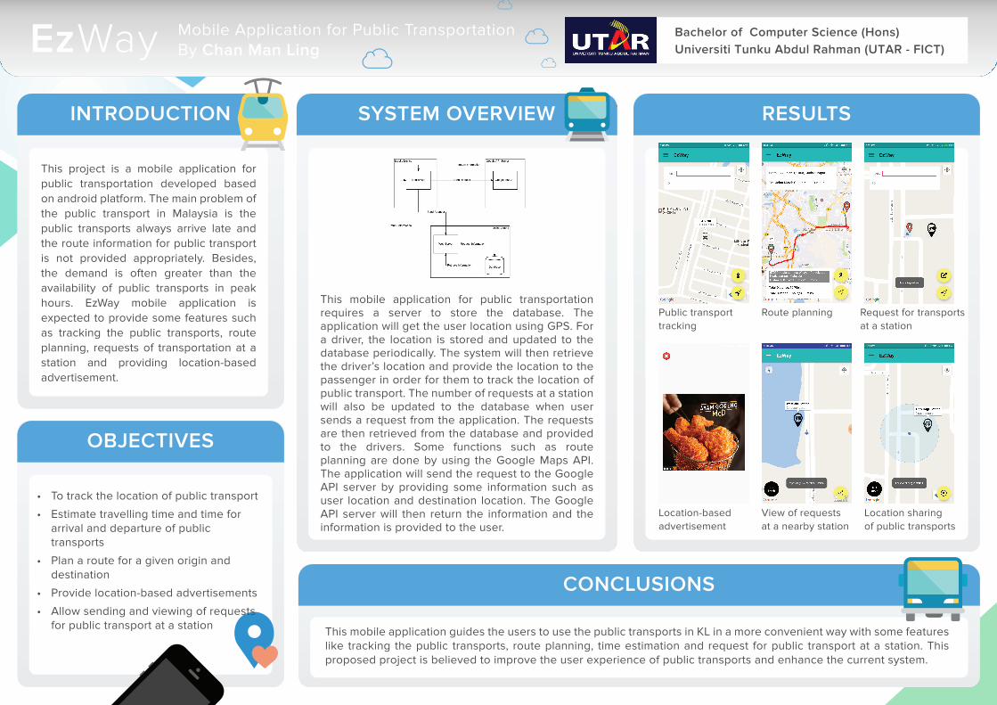