MINISTER OF MINES POR THE - Gov.bc.ca
307
ANNUAL REPORT OP THE MINISTER OF MINES POR THE YEAR ENDING 31st DECEMBER, i .I l906, ! MINING OPERATlOljI FORCOLD,COAL, ETC., PROVINCE IN TRE L-’ / OF BRITISH COLUMBIA. .
-
Upload
khangminh22 -
Category
Documents
-
view
0 -
download
0
Transcript of MINISTER OF MINES POR THE - Gov.bc.ca
ANNUAL REPORT
OP THE
MINISTER OF MINES POR THE
YEAR ENDING 31st DECEMBER, i .I
l906, !
MINING OPERATlOljI FOR COLD,COAL, ETC.,
PROVINCE
IN TRE
L-’ /
OF BRITISH COLUMBIA. .

7 ED. 7 REPORT OF TAE MINISTER OF MINES. H3 i
REPORT
MINISTER OF MINES,
1906.
I
The Annual Report of the Provincial Minsralogiat upon the Mining Industries of the Province for the pear 1906 is herewith respectfully submitted.
RICHARD MCBRIDE, Lb%lzieter of Mine&

7 ED. ‘i REPORT OF TBE MINISTER OF MINES. H5
REPORT OF BUREAU OF MINES. -BY-
WILLIAM FLEET ROBERTSON, PROVINCIAL MINERALOGIST,
-:o:-
To the Hon. Riohard McBride, Minister of Minee.
Sm-I have the honour to submit herewith my Annual Repat on the Mining Industry of the Province for the year ending December 31st, 1906.
The statistics1 tables give the total mineral output of the Province to date, and show in considerable detail the actuel mineral production of the past year, a~ based on smelter or mill r&urns ; also, a summary of the production of each of the last four yeem, thus illustrating by comparison the progress made in productive mining during this period.
To facilitate comparison with information previously givoo, I hare retained, &B closely as wae possible, the general form already established for such tables and for the Report.
I hwe the honour to be, Sir,
Your obedient 8enw&

7 ED. 7 REPORT OF THE MIXISTER OF MINES. H7
MINERAL PRODUCTION OF BRITISH COLUMBIA. -:o:-
METHOD OF COMPUTING PRODUCTION.
In assembling the output for the lode mines in the following tablea, the established custom af this Bureau has been edhered to, via.: The output of a mine for the year is considered that amount of ore for which the smelter or mill returns have been received during the year. This system doea not give the exact amount mined during the yes’hut r&her the anounts credited to the mine on the company’s books duriug such year.
For ore shipped in December the smelter returns we not likely to be received until February in the new year, OP later, and have, oonaequentlg, to be carried over to the credit of guch new year. Thii plan, however, will be found very approximate for each year, and ultimatsly correct, a8 ore not credited to ens gear is included in t,he next.
In the Lode Mines tables, the amount of the shipments htls been obtained from c&i&d returns received from the various mines, BR provided for in the “Inspection of Metalliferous Mines Act, 1897.” In calculating the values of the products, the average prioe for the year in the New York Metal Market has been used 8s B basis. For silver 95 per cent., and for lead ‘90 per cent., of such market price has been taken. Treatment and other charges have not been deducted.
TABLE I.-TWAL Pmxn~ono~ POR ~LC YEARS UP TD ~WD Iwc~unxwc 1906.
Cold lacer. Cold. ode .._.._. ._:. ,._.. ._.._.. ..,... .__, ,,.,__,, ,P
@33,,21,103 41,01&W,
Silver _. _. _. _. _. _, Lead .._...
25,586,008 _..... ._.... .._. . ._.. . . 1,,1325,,39
cop p”
r . . . . . . . . . . . . . . . . . ..,... Coa
35,546,6,8 andCake ,,...__,_,...._.. _,.._.,,., _.,,._, .._... .._.,. 79,334,X,8
Building atone, bricks, etc. 5,543.700 Other met& _........_..._..................... ,... _... ,... 270,009
-.-- Total. .$!!3,643,722
TABLE II.-PRODUOTIO~ lroa BLOB YEAR BBOX 1890 TO 1906 (INCLUSIY.).
1852 ta 1889 (inolusive). .................................... 1390 ..........................................................
$729$,;;
1891..... .................................................... 3:5z1:102 1882.~ ....................................................... 1803 ........................................................... i%E 1894 ......................................................... 1895 ...........................................................
‘$$7l;
1800 .......................................................... 7:Mu:Q5!3 1.507. ..................... ................................. 10,455,!28&l 1898 ...................................................... 10,m,sm 1899 ......................................................... x2,393,131 1~ ........................................................ 15,344,751 1w)1......~ .................................................. M,086,780 1oo2 .......................................................... 17,486,550 ,903 .......................................................... 1,,405,054 1904 ....................................................... 1008.
18,0,7,350 ........................................................ 22,401,325
1906.. ........................................................ 24.980,546
TOtSI . . . . . . . . . . . . . . . . . . . . . . . $!273,643,7Z2


7. ED. 7 MINI~BAL PBIXWXION. H9
Table IV. gives a statement in de&i1 of the amour+ and value .of the d&rent mineral
producta for the gears 1904, 1906 and 1906. As it has been impossible es yet to collect
accurate statistics regarding building stone, lime, bricks, tiles, eta, these are &imat&.
TABLE IV.
Aarouxc anr~ VALUE OP Mui~enr. P~ODDOTS FOR 1904, 1905 *%D 1906.
md$r:::::. “Y?::~::~ ” BilWS. n Led Pounds 0c.p r Ox .._. .__..... Tok 2,kiXi. %%&
4,678,037 37,692,251 5,876,2’ 42,98%488 4,1.52,936 1,61,,308
yf$
cake I, I ye; 1384,313
‘680’wJo “7!:7”” 1,358,@35 199,221 ,906:135
other nmterimls.. , 800,ooo I,fmooo -- --- --_ $18,977,359 ww%.~ 8 24,980,546
TABLE V.
43minece I ...... o*sauR msmrm ............... Em KOOTEx*Y m**tum ........ WEaTKcQrnENAY manuor .......
$inn~vtk Division. I .....................
g,oesn I ........... Trail Creek I ......... 0th.w parts. .................
LIl.ulc~ msnlrcf .............
_.,.,,., I:::::::::. . . . . 1lFm8 10(1,273 460,633 532,664
1,%36,868 970,544 “Jg,tgJ 3,67%3=%
146,860
., ................................ 3 ...............................
!8 171.. I I
.......................................... .......... ..........
Yam lmmm ................ .........
I I
......... 1. ........ Omyms, Orend Forks &Green-
1
wawd Divisions.. ........... 4.110366 6,356,4 UOl 8,698,470/ ._. . ..I is3 2,624 _._._ ..., ..__..._...’
Yde I, 77,416 126,661 73,617 _, _, _. . COMT DWIT.I~ (Nanaimo, Albr-
rd. Ohyquot, Quataino, Vio- toria)....................... . . . . . . . . . . . . . . 4,7U3,679 4mJa53 6333,146
--. - -- -- $18,977,369 $3%461,325 &?4,@89,646

HI0 REPORT OF THB: MINISTEE, OF MINES. 1907
PLACER QOLD.
Table VI. contains the yearly prcducti& ci placer gold to date, .w determined by the returns; Bent in by the banks and express companies, of geld transmitted by them to the mints, and from returns sent in by the Qcld Commiwicners and Mining Recordem. To these yearly smounta one-third was added up to the year 1878, fmm then to 1895 and from 1898 to 1906, cr&Xth, which proportions are ccnsidered to repwent, approximately, the amcunt of gold sold of which there is no record. This pItwar gold contains from 10 to 26 per cent. silver, but the silver value has not baen separated from the totals, aa it would be insignificant.
TABLE VI.-YIELD OP P~acsa GOLD P&R Ysau TO DATE.
8’ 705,000 . 1,616,OTO
2.228.543
ma... 1869... 1860... 1861.. 2;666;118
1894. 1896,
1862. 2,656,903 1896 1863.. 3,913,663 1897: 1864... 3,736,850 1898, 1865... 3,491,206 1899. 1866... 2,662,106
1,344;900
1867... : 2,480,868 1900. 1,278,724 1901,
1868... 3,372,972 970,100
1902. 1869... 1,774,978
1,073,140 1903.
1870... . 1,336,956 1,060,420
1904. l871... .~ 1,799,440
1,115,300 1906.
1872... 1,610,972 969,300
1906. 1873...
: ::,“:x:E
948;400
1874...
1876....$ 2,474,004 1876.... 1,786,648 1877... 1,608,182 1878.... 1,275,204 1879.... 1,290,058 1680.... 1,013,827 1881.... 1,046,737 1@82.... 954,086 1883.... 794,252 1884.... 736,165 1885.... 713,738 1886.... 903,661 1887.... 693.709 1888.... 616;731 1889.... 588,923 x390.... 490,436 1891.... 429,811
1892. 1893.
. .$ 399,526
. . 366,131 406,616
I 481,683 . . 644,026 . 613,620
643.346 .
.
. .
Total . . . . . . . . . . . . $68,721,103
TABLE VII.-P~cnncno~ or Lens MIXES.*
,j os.
GOLD. &WE& LEAD. CCPPW TOTAL
VdUEZ. OS. V&he. POUlld8. V&W. Pounda. Value. VALUE3,
---- ge ..~ I 6 8
9,216 . r 23,818 . . . . . . . . . . . . . . . . . ::
95,547 104,
c,*kx ̂ ‘3 . . . . . . . . . . . . . . . . . . r Nii. . NC!. . . . ^ ̂ -4 . . . . . . . . . . . ...,.....
4,
17.331 75,ooo 47,873 73.948
a% ss:im
1,608,708 2,300,290 2m4,746 q41.328 1,521,472 gp;
1:897:328
x5,uD 78,898
169,376
E2.E 3,3&l, 1,077,681
878,870 2,691,337 “al&E
639:744 1,421,874 2,3!30,022 2.687,678

7ED. 7 MINERAL PRODWTION. H 11
TABLE VSII.--COAL AND COKE PRODDCTIOA PER Ysas TO Dam.
COAL, YE*ss. TONS (2,243 5s). VALUkL
1836.66 ................... 166,319 ................. 1866
.$ 666,288 ....................... 25,115 ..................
1867 100,460
...................... 31,239 .................. 1868
124,966 ...................... 44,005 .. ;. .............
1869 176,020
....................... 35,802 .................. 1870 ...................... 29,843
143,208 ..................
1871-2-3. 119,372
.................. 148,549.. ................ 1874
493,836 ...................... 81,547 ..................
1875............: 244,641
......... 110,146 .................. 1876
330,436 ......................
1877. 139,192. ................. 417,676
.................... 154.052, ................. 1878 ............. ........ 170,846
462,166 ................. 612.638
1879. ..................... 241,301.. ............... 1880 ...................... 267,595 ................... 1881.. .................... 228,357 .................. 1882 ...... _. .............. 282,139.. ................ 1883 ...................... 213,299.. ................ 1884 ...................... 394,070 .................. 1886 ..................... 265,596 .................. 1886 ...................... 326,636 .................. 1887 ....................... 413,360 .................. 1888 ...................... 489.301.. ................ 1889 ...................... 579,830 .................. 1890 ..................... 678,140 .................. 1831.. .................... 1.029,097 .................. 1892..; .................. ................. 1893
826,336 ...................... 978,294 ..................
1894 ...................... 1,012,953 .................. 1895 ...................... 939,654 .................. 1896 ...................... 896,222 .................. 1897 ...................... 882.854 .................. 1898.. .................... 1899
1,135,865 .................. ...................... 1,306,324 .................
1900.. .................... 1,439,595 ................. 1901. .................... 1902
1,460,331.. ................ ...................... 1,397,394 ..................
1903 ...................... 1,168.194 .................. 1904 ..................... 1,263,628 .................. 1905 ............ .;. ....... 1,384,312 .................. 1906 ...................... 1,517,303 ..................
Total ............... .24,144,633 mm. $72,815,423
COKE.
723;903 802,786 685,071 846,417 639,897
1,182,210 796,788 979,908
1,240,080 1,467,903 1,739,490 2,034,420 3,087,291 2,479,006 2,934,882 3,038,8&l . 2,818,962 2,688,666 2,648,662 3,407,695 3,918,972 4,318,785 4,380,993 4.192.182 3;504;682 3,760,884 4,152,936 4,561,909
1896-7 ............ ....... 1898 (eatimated). .......... 1839 ...................... 1900 ............... ...... 1901...................... 1902 ...................... 1903 ...................... 1904. ..................... 1905 ...................... 1906 ......................
19,396 .................. 35,000 .................. 34,251.. ................ 86,149 .................
127,081.. ................ 128,015 .................. 165,643 ................. 238.428 .................. 271;785 .................. 199,227 ..................
$ 96,980 175,000 171,266 425,745 635.405 640;075 827,715
1.192,140 1,358,925
996,136
Total.. . . ,. . . . . 1,303,875 tons. $6,519,376

H 12 REPORT OF T3iE &fINISTER OP MINES. 1907
. -izqi
, TABLE IX.--PROD~~~~ UJ DETAIL cm mm
...... ....... ...... 15,120 ...... 1sma m,rLa ...... 11,180 ...... B,Bm ...... 1,wo
...... ...... XL% ...... ...... 1:44c&
...... ...... E

PEODUIXION OF MFZTALLIFEBOUS MINES.
,I j :::::: :::::: I::.. ,,_,._._._....,_..,. ;;:::; . . .
.,::::::::/::::::::::::I_:::::::::::
. . . . . . . . . . . . . _ : I_ : : :~ , &:&. I.~.~::::::.1:::::::::.:~~:::::::::::::::I::~::~::::::l:::::::.:::: ,_
........... ........... ............ , ............
51.,,........ ij:c.:: -::I::.::; :::::: I :::::; ::::::/.::.::::..:.I::::::::::::

Bald
Bald . . '&t?88,0?1
8n.u ................ 4184817
c+pper.. ............. *0,~8ao
rmd . . . . . . . . . . f8,77s,tiEa
iwkql ............... cl,- co&, ..... ...........
lO,?ar,O?S coke.. ................ 1 1
I Total . . . . . .
-- sa,l,4,41s

7 ED. 7 PNOQRE~~ OF MININO. H 16
PROGRESS OF MINTING.
-0-
The value of the mineral products of the Province grows steadiIy greater, each year showing 8 material increase over the preceding year.
The pmduetion for the year 1906 WBB $24,980,640, which is 11.2% greater than that of 1906, 31.6% greeter than in 1904, end 42.8% greater than in 1903.
An analysis of the returns shows, however, that the increase this year is dne chiefly to the Boundary end Cosat Districts, with a slight increase in the Casaiar Diet&%.
East Hoc&nay snd Caribou Districts shout held their own this year, while Lilloc& and West Kootenay show e conaiderahle decrease. In this latter district, however, Ainsworth more than doukded its output. Rossland and Nelson nearly held their own, hut Siocan end the rest of the district show B marked decresse.
The tonnage of ore mined in the Province, exclusive of coal, wa8 this past year 1,963,872 ‘om, mm 261,193 t.an~ or lb%, graater then in 1905.
The nun&&of mines from which shipments were made in 1906 was 154; and of these. only ‘77 shipped OYBF 100 tons eeoh, during the yaar-pnrctioally no change from the preced- ing year.
Some 41 mines shipped in excea of ~100 tons each during the year, of which 14 were in the Boundary District, eight in Nelson Xining Divisiozi, six in Trail Mining Division snd five on the Cast.
Thp following table shows the number of metullifenxs mines which shipped ore during the past year, together bith the location of these minea and the number of men employed both above end below gnmd :-
caawrs: Skeeas . .
NUT Emm, : Fort Stede . . . .,. Windermere .
WEST KrnrnAY : *insworth.. . gieidgnn:.....................
. . . . . . . . . . . . . . . Trail . . Other Divisiona .
Lulmm............ YAIE :
Bomdsry ~_ Ashcroft-Ksmlmp Bfmilkameen-Vernon . .
CoAcrr . . .
TotsI. . L
1,18!2,617 3*83i
218,848 -- 1,383.872
28
: 8
134 3,718

H 18 REPORT OF THE kf1NlSTfSt OF MINES. 1907
In explanation Of the table, it should be said that in its ,preparstion, a mine employing 12 men for four months is credited in the table with four men for 12 months, 80 that the total given is leas than the actual nnmber of ~individuals who worked in mines during the year.
The “labaw employad to the ton of ore mined” forms some criterion of the total cc& of mining in B camp, since the oost of labour is in B more or less constant proportion to such total cat. In this respect it is interesting to note in the vari?ns distric@ the number of tons of ore mined to each man employed. An snslysia of the above table shows, approximately, that, taking the Province as a whole, there were 528 tons of ore mined for each man employed about the mines. In this respect, however, the districts vary VT materially, eince in the &can District the figures show 44 tons mined to the mti in the year, in the Nelson District 138 tons, in Trail Creek (Roasland) District 373 tons, end id the Botmdary 1,064 tons.
Such ganereliaslion, of oour~e, does not apply exactly to any one mine, hut only to the district, and in the firat two districts me@oned the mines vary Rio character 80 greatly, 801~8 having highgrsde shipping ores, and others low-grade concentrating ores, that care maat be taken not to carry these avange figures too far.
TABLE SEOWIN~ NON-SHIPPINO MINES MD NUYBBB OP MEN EWPUJYED, 1906.
‘o*e, Qlsenn’d, 0anyc.m) 1
~~~~~~*UANDTiwJTIAxE.. ............ Nlauali
1; I ................................
7 x4 Do
msn,81mmcity). ............ 9.3 56 3i fi m*by (Ft. Bteele dc windemlm~ 5 10
K .......................... ::
i . : Ormns ............................... 2 0 l
-- --~ ~~ Tote.1. ......................... 96 145 l‘m 285
STATISTICAL TABLES.
FLeferring to the preceding St&&al Tsbles of the mineral prcduction of the Province, the following is s s&mnary of their contents :-
TABOO I. shows the total grws value of each mineral pwduct that has been mined in the Province ap to the end of 1906. Vrom this it will be wan that coal mining baa pnxiwed more then any separate class of mining--e total of $79,334,798-followed next in importance by placer gold at $668,721.103, and third by lode gold at $41,016,697.
The metal gold, derived from both pl.oep &and lode mining, smoonts to $109,736,800, the greatest amount derived from any one metal or mineral, the next most important bei~gcoppw, of I) total gross valoe of $35,646,678, followed by eilver et $26,686,008, andlead et $17,625,739.
TABLE II. shows r.ha vrdqea of the total production of the mines of the Province for ewh year from 1890 to 1906, during which period the output ha.8 inoreaaed nearly ten-fold, and haa nov ranched a production for the pat y&r Valued et $24,980,546, or more thim double what
it ww in 1899.
Tanw III. presents in graphical farm the facts shown by figurea in the te& and demon&r&es to the eye the rapid growth of lode mining in the Prwince nod also the flucka- tions to which it has bean auhject.

7 F/o. 7 PaWBpsS OF ?vitN&NQo. H 17
It will be seen’ that &hoqgh qal min&q haebqn a oonetantly i~~cree&g iwlustrgeluring this whole period of 20 years, lode mining~did not begin practie+lly uptil 1894, einee when ,it hes risen with rem&able rspidity, t,hough not without interruption, until now it has nearly
reached the $17,lXJO,OOO line, snd the t$al production hasnearly reached the $26,000,000 line.
TABLE IV. gives the amounts, in the cuetomsry units of meaeure, and the valuea, of the v&us metals or minerals which go to make up the grand total of the mineral prodnotipp of the Province, and alao, for pnrpcsea of oomperison, similar data for the two preceding years.
The table ehowg that there hss been B decrease in the production of placer gold of come $20,900, and at the &me time a decrease in the output of lode gold of $302,463, thus leaving for this metsl & balance of $323,363 84 & decrease.
The mnount. of silver produced this past year was 2,990,262 ouncee, having a grow value of @1,897,320, B de-xeaae from the preceding year of $74,498, due chiefly to the decreased prc- duction of the Slocan district.
The table Shows an c&pot ef ~leud in 1906 aniounting to 52,408,217 EM., valued at . @2,667,57#, which, although a decrease from the production of the preceding yearof 4,1’72,486 Bs. of lead, is etill gre&er than that uf any other year since 1900, but owing to the greatly increased market value of the metal, and in spite of the materially decreased amount produced, the vslue of the product this year shows an increase over the preceding year of $268,556.
Tams V. shows the proportions of the total mineral productions made in each of the various Diatriets into which the Province is divided.
It will be noted that thin year again the ‘Boundary District has the honour of first place on the lia, followed in order of output by the Coast District and East Koutenay, with West Kootenay, for many years our greatest producer, se only fourth on the lint.
The Coast and East Kwtensy Districts, however, owe e considerable percent&ge of their outputs to the coal mines situ&ad within their limits, whereas in the other districts the pro- duction is entirely from lode mining.
TABLE VI. givea the statistical record of the placer mines of the Province from 18fj8 to 1906, and shows a total prwluction of $68,721,103. The output for 1906 was 8948,400-e decrease of about 2% ae compared with the prev@ns year, and due to a dry eeaeon with B shortage of water for hydraulic mining.
TABLE VII. relates entirely to the lode mines of the Province, and shows the amounta and values of the va+ue met& produced each year einoe l&37-the~heginning’of such mining in the Province. The gross value of the product of thw~minee to date ia $119,774,022. The prodnotion in 1906 w&e $17,484,102, an increase over the preceding year of $2,303,938, or about 15.2%.
TARLE VIII. oontsius the etatiatica of production of the coal mines of the Province. The total amount of coal mined to theend of 1906 is 24,144,633 tone (2,24Olbs.), worth $72,815,423. Of this there wea produced in 1906 come 1,517,303 tone, valued at $4,551,909, a larger amount than ~has been p&wed in any pear previous.
In these figures of coal production is not included ihe coal used in meking coke, as such owl is accounted for in figures of output of coke.
The amount of coal need in 1906 in making coke was 381,773 tone, from which wae pro- duced come 199,227 tone of coke, worth $996,135, & decrease of -eotie 72,@58 tone from the preceding year in coke produced. These figure5 are to a certain extent misleading, however, se in 1905 come 3,694 tone of coke were put into stock, whereas in 1906 all the coke that wae made vim sold, together with 13,009 tons taken ~from stick, making the coke sales this year 210,897 ton*.

Tl+ production of coke this year would have been mtich greater than it is but for the very nrgcnt demand .for coel and the general scarcity of labonr, which taxed the oompu~ie$ rcmn~e~ @ keep up a sufficient supply of axaL A strike at the Crow’s Nest Collieries in the fall r&o grestlp dir&&bed the output.
%fom detailed atatieties, en to’ the coal product&m of the Province and of the separate diaticta are given elsewhere in this Report.
TABLS IX. gives the details of pra-lndion of the minee of the Province (excepting coal mines) for the yearn 1903, 1904, 1906 and 1906, and the districts in which such produotions were made, showihg the tonnage of ore mined in each d&i&, with its metallic oor$eots, and market value.
The total kumgc of ore mined in the F’rovince during the past year wae 1,963,872 tons, having a gmm value of $19,432,602.
Tbe following table shows the percentagee~of auoh tonnage and valuea derived frum the w&ma districta of the Province :- ,
Boundary District, 60.2 % Of tammge and 44.2 % of values. Tmil Creek Mining Division, 14.2 II 16.3 ,i Fort Steels ,I 9.2 I, lU.J 01 Sloan District, .8 ,, 2.7 ,I aosst II 11.1 II 6.6 II Miscellaneous and other diatcicta 4.6 N 16.2 I,
-ioo.o -- 100.0
TABLE X. comparea graphically the output of mineral products in British Columbia with that of similar produots in all the other Provinces of the Dsminion, and shows that in 1906 British Columbia produced of the metals and coal an amount over 767. of that of all the other Cmmdiari Provinces combined.
UOAL.
During the years 1906 the eotnsl production of coal in British Columbia has 88 yet been confined to the two +ell-ktiown districts, the colicrice in vicinity of the Crow’s Neat Paas snd the cdlieriea on Vmx~uver Island.
In the former of these districts the Crow’s Nest Peas Coal Co. baa been operating &lie&s at Miohel, Coal Creek and, for the first portion of the year, at Carbonado, but latterly this last colEery has been closed down.
The’collieries on Vancouver Island have been operated by two companies, the Western Fuel Co. at Nanaimo, and the Weilington Colliery Co. at Ledysmith and Cornox.
The gross output of the coal mines of the Province for the year was 1,899,076 tons (2,240&a.), which, with 17,230 tons taken from stock, makes B total consumption of 1,916,306 tone. Of this total amount, 1,361,728 tons were sold as coal, of which 681,899 tans were for consumption in Canada and 679,829 tons were exported, while 381,773 tone were used in m&king coke and 172,806 tone were used under the oompanias’ boilers, etc., or sold looally.
The amount of coke made was 199,227 tons (2,240 fhs.), which, together with 11,670 tons taken from stock, made the e&e for the year 210,897 tons.

7FaT PnooEEeE OF Mmrao. H 19
The following table indicate the mark& in which the coal and coke output of the
COAL
&Id for consumption in Cansde.. _. .(Tons-2,240 mS I *xpo~ttoUnitedStates............... I, export to other oountries~ 3,
COKE.
8old for coaanmption in Canads. I m export to United States.. I n exportto other countries. ._ *
-
__
)
,~ -
coast. Cm& Nest
Pam. A.--
531,106 x0,793 4g?;g mm
----- !m.o72 381,656
14,547 X34,646 3,304 5%400
,.. . . . . . . . . . . . . . . .
22,551 168,046
T&J.
681,399 664,046
16,733 -- .
1,361,728
‘;$;g
2m397
The Vancouver Island Collieries mined in 1906 son18 1,178,627 tons of coal, which, aith 17,230 tons taken from stock, makes the total amount of coal disposed of 1,196,857 tons,
distributed 88 follows:,-
Sold ILL coal in C~nads . . . . . . . . 531,106 tons II United St&es.. . . . 433,183 ~2 I, other couotnes . . . . . . 16,783 (4
-- Total sold ascoal~. . . . . . . . . . . . . . . . . Used under companies’ boilers, etc.. . . . . . . Used in making coke.. . . . . . . ,
980,072 138,057
77,728 -_ 1,195,857
The total coal sales of the Coast collieries show en inorease of 1721042 tons, or about 21.3 % OYBP the prweding yew. The amonnt of coel exported to the United States is very little greater than it was l& year, but amounts to about 46.8 % of the total.salea. The chief market for this coal is still San Frsooisoo, although Alaska, with its inoreaqing requirementa for mining and smeiting, hsa become an important factor in the export trade, and promises to become greater. The consumption of coal in that portion of British Columbia served by the Coast collieriaa shows & marked increase, being 150,774 tons, or 39.6 % greater thnn during the preceding year.
The production of coke on the Coast is confined to one company, the Wellington Colliery Co., which made in 1906 only 9,842 tons, but took from its stock piles some 13,009 tons, m&king the coke s&s 22$51 tons, of which amount 14,547 t&s were sold locally and 8,304 tins were exported chiefly to Alaskan points. The local consumption of coke shows an increaak of 9,137 toes, or 169 %, due to the active operations of the Vancouver Island copper smelters. The incrense in the amount of coke exported is equally marked, being 4,004 tons, or 93 %, and is due to the constantly increasing copper smelting operations car&d on in Alaska.
While these increases are very considera+ they we not nearly aa great P.S they would have been but for the shortage of labour at the various collieries, which were, therefore, quite unable to satisfv the demand for fuel. A fuel famine seemed to be imminent, and, a+ a matter of fat, in the spring of 1907 coke had to bs and WEE imparted, a oargo of some 3,000 tons having been received by the Crofton smelter from Australia.
The selling price of coal hss also advanced very much, 80 much 80 that local coal dealers are charging $7.75 for 2,000 lbs. of ooal delivered for domestic USB.

B??fJ REPORT 0~ THE &%II@~TEB ,OF MINES. ,I?07
Oz+on’e NEg PAa!J coLI+a&q.
In the Rocky mountain coal field, the collieries in British Columbia are all operated by the Crow’s Nest Pass Co&l Company, although ovw the boundsry in the Pmvinoe of Alberta there are t&mKor four other companies operating. The Crow’s Nest Paan Coal Company operated collieries at Michel, Goal Creek, and at Cerbanado (Morriasey) ; the latter, however, was,ahut down on April 1st and has not since resumed operatipns. This company m@d during the yeear 720,449 tow (2,240) of coal, the disposition of which is shown in thefollowing table :-
Bald LL~ coal in Cmmds.. . z . . . . . . . . 160,793 tons. II United St.&a, . . . . 230,863 II
-- 381,6@ USed by oompenj io making coke . . 304,a@
II under companies’ boilera, eta. . . 34,748
720,449 tons.
The amount of coke producad from the cw$noted +bope was 189,386 tons, of which 1,339 wea carried over the year &8 stock and 188,046 ton8 sold, ‘mmo 134,646 tons for con- sumption in Cunnsda-ill in British C!&mbia--while 53,400 tom weti export& to the Unitad States. The coal sales of the Cm& Nest Company t,his year are less than during the procar- ing year by 13,285 tons, or 3.3 %. Thn coke aale also &or a dew& of 70,336 tons, or 27.2 %. These decreases am acmunted for by the facts that in the fall a labour atrike closed the mines for six weeka or two.months, mud later the onosually heavy snow fall blocked the railwayys to such an extent that they were unable to move the ~0~1.
QOLD.
The production of placer gold during the year 1906 ~188 about $948.400, Placer Gold. which is rtbout 2.2 % less than that of 1906. This fellingo5, though slight,
is general and represents tlwlwened work of the individual miner, whose 8ucceasors, the large companies, have not aa yet got into satisfactory operstion.
The Atlin District produced very nearly aa much gold &B it did the previous year, chiefly the work of oompsmtively smatl companies, although in this district individual &oars am still at work, but the ground suited for this olsw of mining is gradually diminishing.
The two large dredge inst&ad in this district have been praoticzxlly abandoned, BB the ground upon which th%y were working w&8 found unsuitable fir dredging operations.
A large &am shovel plant has &en installed on shallow ground, and ,froni present indications promises to be B ~large producer. The small shovel, the first installed in the district, has not been a commercial succem, owing to the quite inndeqasce arrangements for handling and washing the dirt lifted.
In the De&e lake section of Cassisr, despite the di5culties of tranaportatio~ one hydrsulic~oompauy recovered between $20,000 and ,$26,000 in gold, and a~second company will probably lx in operation in 1907. He?, howewr, the individual miner hss almost disappeared.
In the Cmibw District, the Caribou Mining Division shows B marked increase over the pmceding year, about 18.6 %, chiefly fmm small hydraulic enterprises, but the Quesn~l Division shows a decrease of about 30 %, due to the fact that the largest producing company did little mining, being taken up with large operationa for incrasing its water supply.
The~Fort SE& District continuea to produce a little gold from the old creeks, but the quantity is yearly diminishiug.

7 En. 7 PROGRESS OF MINING.
The’ b&S on the Thompson &od Fraser rivers have b&n very disappointing, ahd the dredges installed thereon have not been aucce~ful.
kh e value of the gold produced fm!.n lode mining in the Province in c+dd from IL& 1906 Wsa $4,630,639, of which about 96 % w&s recovered from the smelting
Mining. bf copper-baring ores. There em practically no stamps in operation since the Ymir mine tensed to operate, excepting one at Hedley.
SILVER.
The t&el wnoont of silver produced in the Pmvinoe during the year wth~ 2,X+0,262 ounces, valued at $1,897,320, a deoreaee of about 449,155 outwee sod in the value of the
product of $74,498.
About 77 % of the silver is found in aasooiation with lead, in argentifemus g&na; the remainder being found in conjunction with copper ores.
The Fort Steele Miuing Divi&n produced 1,049,636 ounces, about the e&me aa in 1905, but the Slooan shows B deerease in output of 474,335 ounces, or 45 %.
LEAD.
There ~~18 produced in the Province in 1906 some 62,406,21? pounds of lead, valued at $2,667,578. Although this ie a decrease of 4,172,466 fbs. from the preceding yew, the value, owing to the higher market prices, show’s an increase of $263,536, sod is the highest amouot eve+ reoei%d for the lead product of the Province, except in 1900.
,With lead, ae with ita asa&isted metgl silver, the greater part of the prodnotion comee ftim Fort Steele Divieion, while the production of the Sloan in 1906 is only 65.1 % of that Of 1905, or 28 % of the production of 1904.
The following table showa the output of the various districts, and the percentage such bear to the tots.1 output for the year :-
Fort Steele Xiniw Divieion .44,487,&l Ita = 34.88 % Ainsworth I) ._,.. .,.. . . . . . . 3,173,363 0 6.05 Slooan ,t . . . . . . . . . 21975,674 II 5.66 Nol5Xo II i 1,034,553 ,, 1.96 All other N .~...~. ., 737,166 I, 1.45
--- -- 52,408,217 t, 100.00
For the whole of the year 1906 the mtiket price of lead hss been above &I2 10% in London; consequently the Dominion Government lead bounty has, during this period, been proportionately reduced.
COPPER.
The copper ontprrt in 1905 WBB the largest the Province bad ever mad@, but the prodtitition of 1906 exoeeds it by some 6,296,237 Be., an increaSe of 12.32 %, while the value of the total product thie year is $2,412,343 in excess of the prweding year, an increase of 41%.
The pmdnction of &op$er in 1906 lntls 42,990,488&a., hnvinga grow value of .@,233,566. This inrreaae is chiefly attribatsbl~ ta the Bouadarp District, although there is tin inct&@e in tiie Coast District, but Ro&u?d show B -dac?eese. Cf th& tot& output, the Boundary Dietriot pmduces 73 %, the Coast District 12 %, and Roseland 10 2.
---

H 22 REPORT OF TEE &fINISTER OF &NES. 1907
The following table showa the production of the varioaa districta for the yeam 1904, 1905 end 1906 :-
1w. 1906. 1806. Bomldary Rossland
@hict~....22,066,407ibs. 27,670$44Bs. 32,226,782fbs. w 74.90 % II . 7,119,876 II
CO& 6,300,294~ I, 4,760,110 ,, 11.40
II . . . 6,960,693 II ;&-y&opa ,I
9,437,236 I, . 328,360 II
5,431,2&J t, 12.45 680,808 II 354,377 78 .75
e II . . . . 220,600 ,I .45 Various Districta. . . .
92,663 18 14,372 II
216,034 ,t 10,606 II 10,916 I, .05
--- -_ --_ __ 36,?10,128 ;I 37,692,261 I, 42,99&488 VT 100.00
The *ventge “says cd the copper mea of the vs+xIs’ osmps based upon the copper
recovered, WBre as follows :-
Boundary, 1.4 % hopper; Co&, 1.21x, and Rowland, 0.85 % copper.
--
OTHER MNERALS.
There has been no iron ore mined in the Pmvinoe during this paat
_ iron ore. y-e, for the 1‘888013~ that there is no market for it on the Pacific Coast There haa been considerable prospecting work done in ,wnnection with the
known inn deposits on the Coast, and sohemen h&w been in consideration for the erection of. blsst furnaces, either in Britisb Columbia or on Pug& Sound.
The production of zinc m-e this pBSt year w&8 very small, only some Zinc Ore. 664 tow, and the industry has been ~practically at B atand still. In 1905,
concentrating or “enriching” plants were emoted for the production of conbentretes that would away about 50 % zinc, for which there was a market in the United States, into whioh country they were admitted free of duty 8~ “crude mineral ” ; but in 1906 B decision of the United States Customs Department ruled that them concentrates wem not “crude mineral,” and, consequently, were subject to duty, which duty was w high Se to be prohibitive, the result being & suspension of zinc mining in British Columbia. This decision has, however, been appealed from, end on February 7th, 1907, the United States General
‘. Appraisers reversed the decision, deciding that these concentretas were “ made mmersl ” and, consequently, free from duty. The full text of this decision will ,be found in the Report on the Sloan District submitted herewith.
The Commimion, headed by W. R. Ingalle, of New York, and Philip Argall, of Denver, appointed by the Dominion Government to investigate the zinc remurces of British Columbia, hss published ite report, whioh goes in,h.the snbjeot most thoroughly. Copies of this ,mport can be obtained fGom the Minas Branch of the Department of the Interior, Ottawa
Tbe following is a brief summary of 8ome of the mom important points brought out in the
report :- Prmsarw POEalBLB Zmo OUTPVT.
The two mines working ate essentially lead mine+ although containing East Kootenay. considerable tine-one cd them has more developed zinc ore than any other
miw in British Columbia-but the eharwtar of the ore is such that zinc extraction is elm& hopeless (p. 47 of Report.).
Assuming Blue Ml. 01‘8 to carry 15 %, zino mined eta masse, then, if Ainmvorth M. D. mined and concentrated at r&a of $00 tons of am a day, it might produce
39 tons a day of 50 % cencsntrates. All the other mines in the Division might’prodoce 16 tons B iJay of 60 % con&tr&s (p. 166).
------ .- .-,__

7ED.7 PROGREB OF MIWINQ. H 23
Ingslls s&l 16,000 tans per snnum of conoPntrnte.9 (45 to 60 tons B SlOCan. day) would be a liberal estimste for Slocan, and thin could only be pmduwd
es a by-product f?om lead mining (pp. 41.47).
“The zinc deposits of the Coast are’still of unknown megnitode; they coast. are, in feet, nothing but prospeota ” (p. 56).
POWXULITIE~ bun COST OP ZINC SWLTINO IA B. C.
The ore must be taken to the coal, aa the consumption of coal is 2 tons to 1 of ore ; hence the only placea adaptal for zinc smelting in British Columbia are Crow’s Nest or Coast (pp. 61 and 62). Ore or concentrates mast contain over 40 % metallic zinc. “It is difficult to see how
zinc smelting coul$ be profitably carried on in British Columhie with coal at Crow’s Nest Pass Coal Co.+, price “-$2 B ton (p. 52).
“The prospect for zinc smelting on the Coat, at lea& by the standard method, is too remote
to merit detailed consideration st the present time” (p. 56).
The estimated cost of smelting in British Columbia, given by Ingallq for the runoing expensea of a perfectly equipped and economically,run modern zinc smelter-with no allowance for interest on investment, or legitimate profit-with coal at $1.60 B ton, and skilled labour at $3 a day of 10 hours, ia $15 a ton (p. 54.)
(If we substitute in this estimate the lowest pricea at present available, viz.:-Coal at $2 to $2.25 a ton, and skilled l&our at $3.25 to $3.50 for eight hours, it will make the estimated eosta of operation about $18.75 a ton of 50 % concentrates.) Ingalls further estimates the coat
of marketing the spelter produced from 1 ton of zinc concentrated at 86.50, ‘which makes hia total estimate $23.50 a ton of concentrates (or, if corm&d 88 above noted, $26.76 B ton).
The Repart further estimate the cost of shipping the wna concentrates to Europe for
&atment would be $26.03 a ton, from which it would appear that zinc smelting is not st present feasible in British Columbia.
E~sna~c SHBLTIWG OF ZINC OR&~.
The following are the conclusions arrived et by the Commimion ae to electric smelting of zinc ores in British Columbia (pp.132-133) :-
(1.) L‘Electrio smelting will never displace ordinary (fire) smelting, if it is neccasary to generste the power from cal.”
(2:) ‘I Electric smelting may be, in the future, economically conducted at placea where .very cheap hydro&&ric power is available.” (By cheap he means leea than $16 per h. p. per annum. Nelson and Treil ati now paying $45 per h. p. Ses p. 67.)
(3.) “Aside from the question of power, up to the present time, certsin peuliar and serious metallurgical difficulties in electric smelting have not been satisfsctorily overcome.”
‘I It is unlikely that electric smelting of zinc orea fan ever be profitably carried on in the zinc-producing districts of the l&at snd West, Kootenays ” (p. 133).
Platinum co&mea to be found in small quantities in vsrioue parts of Platinum. the Province, but aa yet no systematic attempt has been made to save it.
An already noted in previous reports, it is found in alluvial waehinga in the Similkameen District, on the Quesnel river in Cariboo, on Thibart creek in Csssiar, and also in the Yukon. The latest find w&8 at Lillooet, from which district there was received a few oxmcee of the crude platinum sand, saved by 8 prospector in washing for gold, for which the Provincial Mineralogist wea able to obtain some $25 8x1 ounce net csah.

B 24 - REPORT OF TBE MINISTER OF MINE(I. 1903
The qu&W+g of stone for bail&~ ~porpaees has aa yet’ only on the Build% st0~~ Uoast taken tbe~ form of 811 industry, an in that district only has the we of
stone for building become at all general. IQ e previous report descriptions were givsn of the more iroportant querrias~tbet bad been opened up on the Co&, to which there is not much to add now, except to note that the general output of the quart& has nearly doubled in the Inet couple of years.
The msnufaoture of red building brick ia constantly increasing with Brick. the market. A spwisl report on t&industry end the clay deposits or the
. Coast will be found elsewhere in this report. The greater consumption of brick, and consequently the greater production, is on the c(oast, N&P Vsncquver and Victoria, although acattared throughout the Interior are small yarda supplying local d~msnds, suitable clay being found in abundanoe.
The manufwture of fire brick formerly csrried on at Comox has, 88 far Fire Brick. BB is known, ceased, although about 3,600 tona of fire clay were mined from
the cwl mines in the vioinity. A deposit of fire clay of apparently very fsir qwlity is being develuped near Vancoover, snd a brick-making plant erared, the product h which haa not, however, been on the market for a sufficient time to assure it,s reputation.
The menufactura of earthenware, aocb ea sewer and drain pipes, chimney oaps, flower po&?, Qo., has heen oarried on near Victoria by the BX. Pottery Company, the output having a value of somewhere shout $80,000, while other firms have also been making drain tilea and pipes.
Tbe prodaction of lime ia naturally rtssoeiated more or lear closely with Lime. constructions of brick or stone, aside from $8 usa in internal plastering,
and, consequently, the greatest prcduct,ion has been on the Coast, the most extensively operated lime-kilns being situated st Victoria and oh Tersda Island, st both of which points B lime of almost theoretical purity is made, although the kilns are rather primitive and the economies of production have only begun to be iritrodaced.
Although other enterprise% am in conten~plstion, the only concern at Cement present manufacturing cement in British Columbia; to any extent, ia the
Vancouver Portlsnd Cement Campsny; with work, a8 Ted Inlet, some 14 milea from Victoria, a description of wbaae plant, BB it then existed, spa~~glsati in the Report af 1904, since which time the capacity of tbe plant has been about doubled and the demand for the cement will probably necessitate further enlargemnn~ in the II- future. The veloe of the output in 1906 approached B quarter of B million dollar%
Tbati’bss been no serious attempt mnde to develop cho euppo%d oil Oil and OIlshales. fields ins tbB Flatbead vallei, owing pmbablg to the cafiioting and qoe~-
tioned validity of titlee to the vario~8 claima; hut this matter has now heen practically settled, and it ia expected the coming sea.wn will ee active opemtiotls tandiw to prove tbe field. Nothing further baa been beard of the &hales found in the vicinity of Harper’s Cmnp, Caribex, and no aeriooa attempt haa been made to prospect for oil in the i&en Charr@te &ads, where seepe~ea were reported as found.

T En. 7 PROQRESR OF hlININQ. \H ,25
DEVELOPMENTS OF THE YEAR.
There have been few developments or occu~rcnccs during the paat year that wqoipe specisl notice. Mining ia becoming morq e settled bueinesa, by the elimination, to e large extent, of visionary schemes.
In pincer mining D departure hae been &m&s in Atlin, from the methods Placer Miriing. formerly in vogw, in the installation of the first properly equipped steam
shovel, with apparently aatisfactwy reanlts. In Oeriboo, the long-preached nxiom that the quantity of water availsbIle for hydraulicking is the mcaaurc of the output, has had the c&t of starting extensive plans and works for rendering availiabie considerably more water, the c&t of which will not be noticeable on the production for 8 couple of yeara.
Dredging in Atlin hsa proved a failure, owing to the character of the growl rather than the scarcity of gold. Dredging on the Fraser river end ita tributaries has not proved succeasfu1, for various re&con*.
Individnal placer mining is decreasing to such an extent aa to be now rcle+&cly unimportent.
The inoreaae in the production of the metalliferous mines~ of the ~ctcwcrous Province this year is entirely due to the increase in the market price of
Mines. met&, together with the &feat this has had in stimulsting the output of copper ore in the Boendary aad Cosnt Districts. The chief product
of the East Kootcnay District is silver-lead ore, of which practically all is obt&cd from two or three mines in the Fort Steele Mining Division. Here, although the amount of lead pro. dueed this year is about 3,761,347 lbs, less than in 1905, this year’s production is over donbl+ t&&of 1904. Despite the decreased production, the market price h&a been co m&h higher 88 to make the value of this year’s diminished product greater than wac that of lest yaw.
The 88mc ie true of the silver product. The quantity of arc bwadled this year hw inonvrsed by about 10,000 tons.
Fort Steele Mining Division this year prodaced about 66 % of the total lead out+ of the Province. The North Star Co. has again begun to ship B considerable qoantity of ore from awrtber of its prop+rti.s
In the Windermete Mining Division wmc six mines shipped during the year, but did not average 60 tons adl.
In the Nelson Mining Division the tonnage of ore mined was about the same aa in tile previous year, but, ow;ng to the closing of the Ymir mine, the production of gold decrc+cd, while the capper output more than doubled. Scvcrtd of the smaller prxapcrtias in the Division
have been energetically and aucoessfully oper&xl.
In the Sloolm District ~omc 52 mines shipped ore-&out the fame ca in the previous year-but of the&c only 16 produced over 100 tons each during the year. During the paat year tbc metcSlic content of the ore is only about half whet it wa8 in 1905, or one-qmwtcr of what it was in 1904.
This great &crease is partly sttributsble to the fact that this year there has been no market for zinc arc, which is a by-product in the mining of gslena Neither the Dominign
Government bounty nor the high price of the metals wans to be able to stimulate the lead indnetry in this district.
In the Rossland Camp there is a decrease in the tonnage of ore mined of 16 %, with B somewhat greater decrease in gold and copper contenta.

H .% REWBT OF THE MINISTEB OF MINBS. 1907
In the Boundary District, despite B abort+ of coal and coke for shout two months, them has b&n an increase of some 22 % in the tonnage of ore mined. The v&m of the gold pmdnct haa increased abut 19 % ; of silver, abent 18 % ; and of copper, of 44 %. The value of the copper proddot in this diatriot in 76 % that of the whole Province.
In the Coast District, on Texads Island, the dfa&Ze Bay miqe hss maintained regular shipments, whfle the Ccppev Queen and Pan dlda properties have sgsin begun to ship, &bough in small quantities. The iron mines have not been opemted.
IO the New Weattiinstar Diatriot the Bri&mnio mine has been in oper&ion, but on veount of tmnblea with the aerial tramwaay, and difficulties encountered in the concentration of the or!& has not been es suocwful ae it was hoped it would be. Them were mined$ how- ever, during the year about 90,000 tons of ore, of which same 36,0&l tons were shippxl direct td the smelter and &at 66,000 tons were concentrated, producing nearly 10,000 tons of eonoenttib8. The metallic contents ~of the ore mined wore, appmxim~&ely, 2,800 0unc.a of gold, 4,600 ounces of silver, and 2,600,OOO Es. of copper. The smelter openrted by this company, situated st Crofton, haa bean in operation during the year on Britavmia ore, supple men&d hy orea from Alssks and from the Portland Canal.
The Portland Canal District has ‘et least partly ful5lled ita ‘promise of last yew, and daring the latter psrt of this year hss been ahipping to the smelter at Hadley, Alaska, from one mine, about 100 tons of copper ore a day.
” In the Omineca Mining Division, on the headwaters of the Telkws and 2ymoet.z rivers, B .nuinber of pmspacta are being developed which have gwd surface &wings, chiefly copper ox-a. These will,~however, be too remote from transportation to ba avsilsble until after tbe Grand Trunk Paoi5c~milway is built.
On Venconver Island, the 2’ysa mineshipped some 24,000 tons~of ore, containing 1,800,000 Bs. of ccipper, in addition to the gold end silver vsluea. The developm&t of the lower levels of the mine has been continued regularly, but h& 80 far failed to disclose any important ore bodies.
A shipment of almost IW tons of copper ore w&8 made from the So&w& Ctoos mine, +the Alberni osnal.
Active development aa again begun on the copper proper&a et,&dney inlet on the West Coast of the Island.
7En. 7 BUREN OF MINES H 97
BUREAU OF MINES.
Wora OF THE YEAR
The work of the Bureau of Mines increasea, of n&xwsity, year by year, and this graving activity is due to the following oaueea :-The extension of the mining are& cf the Province, with the proportional izicrease in the number of mines; the increasing desire of the outside public for the free information which the Bureau supplies with regard tc the varicua mining districta and camps; and the appreciation by the prospector cf the fact that be may obtain, gratis, a determination of acy rock or mineral which he msy send to the Bureau.
The routine work of the office, and the preparstioo and publication of the Repart for the gear just ended, followed by the examination in the field of 88 many of the mines and mining districts ea the ~eascn would permit, together with the work of the Laboratory and instruction of students, fully occupied the staff for the year. The et& of the Burac ccneiete of the Prcvincial Miner&gist, the Provincial Assayer, and a junior assistant in the Labcratcry, wi:h a clerk as temporary as&&t during the publication of the Report.
After tbe poblioat,icn of the Annual Report for the previous year and Provincial the finishing of office work, the ~rcvincial Mineralogist, early in June,
Mineralogist. made s trip tc the vicinity of Cowichan lake, visiting there such mix& claims BB had bed ecy me.terial amount of work performed an them, snd
making e report on the earce. A report was r&c made 88 tc the necessity for end the beat mote to be followed for a trail into certain claims situated cm the Nanaimo river. The field- work to be undertaken during the ecmmer months by the Bureau wan then planned out and preparations for the main summer trip of the Provincial Mineralogist made.
On July 12th’ the Provincial Mineralcgiet, acting under instructions of the Hon. the Minister of Mines, started on B trip to the valley of the Pcaoe river, east cf~ the Rocky mountains and west of ,the 120th m&disc, the Provincial boundary between the 64” and 60 north latitude. The reports cf rich finds of gold, and also of owl, in this district, combined Orith its agricultural possibilities, cm all of which the Qovecnment had no authentic inform& tion, and the fact that this wae a proposed route of the G.T.P. Bailwsy ecrcea the Province which seemed mcst likely to be followed, rendered an early report cm this district very desirsble.
The recta chosen wae to go up the Skeena river from E&q&n to Haelton; thence by peek-train to Be.bine lake, portaging tc Stuart lake, and thenoe tc Fort St. James, at the outlet of this lake. Frcm here pack-horses wets taken to Fort. McLwd, cm the Pack river, one of the tribotariea of the Peace river, a distance of 85 miles. At ,McLecd Lake past osnca vere obtained, with which, and later the we of a bateau, the btibctaries of ncd the main Peace river were followed to Peace River Gras&g, some 430 miles down stream, during which run three or four side trips were ma& into the adjacent country by paok-train or on feet.
Fmm Peaoe River Crcsaing a waggcn road wa8 followed for 100 milee to Lesser Slave I&e, which diecharges through Isaser Slew river into the Athsbwoa river ; end theac water- wasye were descended in a oarme, a distance of 200 milee, tc Athabewa Landing, from which plsce to Edmonton the trip of 100 miles w&rl made in a, waggcn. From Edmonton to Victoria the trip wea made by the Canadian Paeifie Railway.

REPORT oi THE MINISTER OF MINI.
The total distance travslled on this trip was B little over 3.000 miles, of which 910 miles was by steamer, 840 milea by railroad, 700 b.y canoe, 470 on honieback or on foot, rind 200 by freight waggon. The total time occupied, ilr&ding 811 stop add delays, WWJ 88 days. From Hazelton to Edmonton, with included side trips, occupied 76 days, during which time camp we8 moved 56 times.
In November the Provincial Miner&&at made B trip to Texada I.&and, accompanying aa c&er of the United St&a Geologienl Survey.~
‘In May, and again in December, Examinations for Asaayem~ were held in the Governmen$ Laboratory, Victoyis, by the Board of.Examiners appointed under the Act, on which Board the Provincial Mideralogist ind Provincial Ayyer sat.
In December two bulletins-one on the West Coast of Vaocouv~r Tslaod and the other on the Portland Canal district-were pmpared,.etid publiahod in January.
The remainder of the time TVBB spent in the preparation for publication of the notes taken iq the field, the collection and preparstmn of at&is&x and the routine work of the office, ahich’included; in connection with the vsrious inquiries for information and the collection of statistics, the sendmg out of, approximately, 1,500 letters, with, approximately, the came number received.
In addition to the work in the assay b5&, which is noted in a separate Provincial report herewith, the Provincial Aseager made B trip up the west coast of ASSClfW. Vancouver Island aid snother to the district st the head of Portland
&n&l, with a short run into the Ke&mo river, on Giwdner canal, visiting the mineral claims under development in t&z& se&ices, the repoets of which trips are mntained iit tba b&y of #da ?eport. He also undertook EXI investigation of the eley deposits of the tit that sr@ rioti h&g commercially worked, and altbodgb th& investigation is not ye6 c&$&d, ati aeeoant of some of the deposits visited till be found;uuder the heading of the ?&i&zig Divisi&P in which they are situnati.
The photograph& from which cuts uceo&panying this report were mndk, were &Imost 011 developed in the Laboratory.
Attention is drawn to the v&y skillful tinner in which the Provineixl Assayer h&a ir,sde olle photagmph out of, in som& en&s, 88 many aa six separate negativee (4 x6 Kodak); nhioh have been so anoce&.fuliy joined that in meet cawa it ia quite impos&bie to detect the fact that the photograph in not.from ori8 negsti% As gwd r&&s hsve DBVB~ been attained by Soy professional photographer in the Province.
ASSAY OFFICE
The followizig: ia a sommsry cd the w&k of the .&a~++ O&E ~e’~the &&au for the year 1906, 88 mp&ti by the Provin&l Assayer, Mr..&rbert Ce~rniohae% <-
Dnring the ye& 1906 tb~ere were made by the at& in the Government Assay O&e 1,005 &saays or qoantittiiive determinations, which is e decrease from the n&nheer tied& during t&e previoue year. Of the, a number we% for the Bur&au of Mines; br for the Department, for which n6 fees were r&eived. The fees 001le~ted by the office w&e 8% fOllowP:-
F&frotie.sssys...... . . . . . . . . . . . . . . . . . . . . $ 393 00 11 melting and assaying gold dust and bullion. 249 00
, .. 11 essayers fxiL&m,nat10”8., . 467 00
Tot&l etib receipts _. . . $1,109 00 &&minations and tixsd&atibtis msde f@ other %vernh%erit
~rimeoti for which no feeS *ere c&&&l . . . ;_ $ 400 00
Value of weying done . . . $1,609 00

The value of gold melted dying the year was $SS,l@O, in 117 lot+, aa against $99,631, in 142 lots in 1905.
In addition to the above quantitative work, a large number of qwli- Free tative determbiations, or tests, were made ip connection with the identifica
Determinations. tion snd classification of rooks or minerals sent to the Bureau for a report. Of these no count wa.a kept, nor were feea charged therefor, as it is the
established co&cm of the Bureau to examine and test qualitatively without charge samples of mineral cant in from any part of the Province, and to give a report on the awoe. This hea been done for the purpose of eocoursg&g the search for new or ram minemls’and ores, and to. assist prospector8 and others in the diaoovering of new ,mining districts, by enabling them to have determined, free of cost, the nature end probable value of any rock they may find. In making them free determinatioos, the Bureau asks that the locality from which the sample aras obtained he given by the sender, 80 that the distribution of mioeml over the Province may be put ou record.
In addition to the ordinary work of the oftice, e large number of water analyea were made for New Westminster city and Phcenix.
A considerable number of samples of black sand were wsayed and platinuru wae found in
the samples from Omineca and Casaiar Districts.
An examination in being made of the clay and clay industry of the Province, and when
the work is further advsncad B complete mprt will be made.
--
EXAMINATIONS FOR ASSAYERS,
REPORT OF IX. CAR~ICEAEI., S~BBTARY OF BOARD OP Exnr~wma.
I have the honour, as Secretary, to submit the Annual Report of the Board of Examiners for Certificates ~of Competency and Licence to Practice Assaying in British Columbia, aa established under the ‘LBureao of Mince Act Amendment Act., 1899.”
The Act requires that st least two examinations shall be held each year, end such have duly taken place.
Both’ these examinations were held in the Government Laboratory at Victoria, each occupying 8 week ; the tirst examination began on April 23rd, and the second on December
3rd, 1906.
At the first exa@nation the Baud consisted of the Pmvincial Minemlogist, the Provin- oial Assayer and Mr. Thomas Kiddie, and at this examination five cendidatas came up for examination, of which number four passed the required examination, only one failing. At the December examination, the Board consisted of the Pro&+1 Mineralogist, Provincial Assayer and Mr. D. E. Whitaker, a B. C. L. Assayer, at which twelve candidates stood for examination
sod seven successfully passed.
The question of holding the fall examination at Nelson wen thought of, providing a so5cient number of candidates from the Upper Country entered for the examination. Adver- tisements were inserted in the Koaenay papers, giving notice of such inteetion and celling for entries, but no su5eie,lt number applied to justify the considerable additional expense entailed by holding ao exsminntion away fmm Victoria.
In addition to the twelve candidates mentioned above, who successfully passed the exam- ioations, the Board n:rommended during the year the gmn$ng of two certificates hy exemption, under sub--section (2) of section 2 of the Act. In accordance with these recommendations, all these fourteen certificates have been duly iamd by the Honourable the Mini&r of Mines.
Hi 30 REPORT OF THE &fbmISTEB OF &NE% 1907
....... ,-~~~c:.~~; :::,:: ,:::;:arnodffaFk~ M&,rm~ck. Ala” F. ....... .Ruth, Nevada.
Barb, A. C. .............. .Greenamod, B:C. MacDonald, gale .. C ...... .Vmcouver. B&, Sm’L Erwin ......... .Boondar Falls, B. 0.
ilk McFarlsne, James A ........ K-lo.
Rqmerd, Pierre ............ Monte C ‘sto, Wash. Nicbdls, Fran, ‘hwsy. Bishon. Walter. ........... .&and Forks. O’SnUivan, John .......... Vanwuver.
,t. A. .......... .-land. B,i&&“, James. ......... Trail. c!.mqW, Win ........... .New~ Denver. Csrmiohael, Norman ....... .Clifto”, Arlzo@.
........... .Ross&ud. hy, AtheIstan .......... .D?.wso”. Dedolph, Ed .............. .Merysville, B C. Dookri,,, W&s R ........ .Chemai”ue. Fsq,hsw, J. B. ........... .Venoouver. Fi”&“d, Joh” J ........... Sad”“: ,&w,mnor, F. E .Nelson. ~snna
B W. II.. .......... .Rossla”d.
Hert, E ............... .Grand Forka Haarkine, Fsncis. .... .*. .... Silvertan. Hmk, A. Hury ........... .Greenwwd. Hurter, C. S ............... John, D ................. Haileybwy, Ont Kiddie, Gee. R. .......... .Viotmis. Bitto, Ge&rey B. ........ .Ladysmith. hg, J. a ................ Ley,Ri&srdN.. ..................... Nelson. Marsh, Richard Spokane, Wash. MmM, H. Jukea ........ .Brita”“i a. Benah, Marsball, William S ....... .Le.dyemith. Miles, Arthur D. ...........
Pmker,B& ~~~~.~~~.~.~ Pamnow, w. L Perkins, Walter G.. .Basin, Mootans. Robertson, T. R.. Ranbsuer, A. B... _. ,_ Butte, Mootpua. Schmeder, Curt. A.. .Hazelton. Segsvotih, Walter.. .H”ughton, Mich. Sharp, Bert N.. Sim, Chsrles Job” .E”&“d.
+S”yder, Blanchsnl M .Gree”wood. Steven, Wm. Gordon. Stirmel, B. A.. .Baundary Falls. Sm,dbarg, Gustave. .Prinoeof Walea Island. T&y, Robert E .Sipokane, Wsah. i Thomas, Percival W Pr. of Wales Is.~A,+. Tretheww, John H.. . . . Kokanea, B. 0.
B.C.
T,,r,,er, If. A _. ._ _. ._. Vance, John F. C. B. .Vanmnver. Van Ag”ev, Frank.. .Siberia. Wales, Roland T Watson, Willian J Ladysmith. W&h, J. Cnthbert. _, .A,aska. Wells, Ben T.. .Vsncouver. West, Gee. G _. Whittaker, &lb& E. .Victoris. Widdowao”, I”.. Walter .Ne,son. Williams, W. A .Gra”d Forks. William, Eliot H ,_ .Nelso”. Wimbwly, 6. II.. _. .G-d Forks.
Archer. All*” . Brow& D. J _. _. .Rossla”d. Bryent, Cecil M .Vsno”“ver. Blsvlook. Selwv” 0;. .Ne,so”.
Clot&, George A,. .Rosslsnd. Cole. Arthur A. .Oobdt, tit. I%< L He& .Phae”& Conlthard, R. W .Fer”ie. Cowam, Fc4eriak.. Dixon. Howard A . . .Toronto, Onbrb. Galb&tb. M. T _, _. Oilman, Ellis P. , .Vanamwer. Qreen. J. T. RamI.. .Bkdrmore. Cuesa’ &or e A.. .Trail Gwi,,;,o J. % . Xi”&,, Ontaria Heal, Jib” II.. _..._._:
Ibye, Al&s”der .Vancm&i. by, Dougle.8, . .Silv&n. Tawia. Fran&B Merril, Charles P. :. Musgmve, William N. .Victc& B. C.
Mussen, Eore.ce W .Siheria. &Arthur, Reginald E. _. Mctellsn, Job” .Pwt Simpson.
p, Gordon 0 ____.._ .,J. A .._...._ . . . Trail. MoVicnr, John Maclennm, R. W. .Rczsla,d. Noble. David T .Tmil. Ontbett. Christogh~. .Kamiwp. pc-L--L. n, a.
IYIUTIW‘~, 7.. I . Y. ~.
..aid, J. A _... ,._... ,..... Greenwoad. Scott. Owdd Nomw.n . f3m,non,s2.. ; .TFntt I ake. B. 0. m*rpe. :.o.J?... Mrdlsnd, Ohtsio. . . . . . . . Sloan, David. .Thfee Forks, B.‘C. Stevena, F. G .Mexioo. Sullies”. Miahae, H .Trail. Sutherland, T. Frwe Swinney, Idie Tbomwn. H. Nr
r A.33.~ illis AMcon&, MO”taW.
We&o”, ‘A. A.. .0,&s. W&Son, HelWJ. Workmsn, Ch. W . . Wright, Richard ~. . .Rossland. Wynns, Imelly” c . Priacetoa
7 ED. 7 Bv~eao OF MINES. H 31
EXAMINATIONS FOR COAL MINE OFFICIALS.
During~the yew1904, under the “Coal Mines Regulation Act Further Amendm@, Act, 1904,” the reg&tions regarding the qualilicntions and examinations of officials emptoyed ip cccl mines have been completely revised and at t,be same time made mu& more stringeat and thorough.
The “cosl Mines Regulation Act,‘! 86 now amended, provides that all the ,officers of B coal mining company having cmy direct charge of work underground, shall hold Government Certificates of Competency, which are to be obtained only after passing sn examination before a duly qualified Board, appointed for the purpose of holding such examinations, and known v the Managers’ Board. The certificates granted on the recommendation of arch Board,~and the requirements for -me, a-8 88 follows:-
Snob 8 certi6cata must be held by every manager or “chief officer having the co&o1 and daily supervision of any coal mine” in British Columbia The statutory requirements for this
certificate, in addition to such examination and qualifications 8s may be imposed by t&Board of Examiners are, that the candidate for examination ahall be at least 25 years of age, a &!ritish subject, and have had at least five years’ experience in or about the pra&ical working d 13 caal mine.
‘Such certificate must be held by any person “who has the daily charge of the ondergroond workings of a coal mine under the control and daily supervision of the manager, and next in charge under such manager.”
Aside from the requirementa of the Board of Examiners, a candidate for such c&i&ate most have had “at least five years’ experience in or about the practical working of a coal mine.”
THIRD CLA88 CBRTIFICIA~E.
This certificate muat be held by every shiftboss, 6rebe.w. or ahotlighter in a coal mine in British Columbia, and betides the examination by the Board, calls for three years’ praebi& exprieence.
Experience in a coal mine &aide the Province may be accepted by the Board. Any certificate is considered to include that of any lower class.
In addition to the examinations and certiflcatea already specified 88 coming under the Mwmgera’ Board, the Act further provides that every coal miner shell ‘be the holder of e c&i&ate of competency 88 such. By “miner” ia meant “a per8011 employed undergrolihd in any coal mme t.~ cut, sheer, break or lcaen coal from the &id, whether by band or machinery.”

it3 82 RE~IRT OF %&swat 00~ &IN=. -~ rsJ@
.‘~&nmications fcr .a ~miner’s~ certi6eata am held aaeh month at aoh c&icry hy LL Board of Examiners, known es the Miners’ Bosrd, and ccwisting of an official appointed by the cwccrc, cc examiner electad by the miners of that colliery, and en examiner appointed by the Qcvern- merit,
Examinations for ,&at, encad s$ third clesaea wcm held aimultar~ccwly rt Fwnic, Nan&m and Cutcberlccd, Ootober 23rd, 24th and 26th, 1906.
BOARD OF EXAMINERB FQR COAL~.~MINE OFFICIALS.
Fmm, sBcono *ml TEIED CLASS CERTIaIoATm.
Rtlpwt of .rib&5ly of Bornd, ‘%-a%& H. Shqkd.
I’bcgto sub&t the annual mpcrt, acveringthe transscticns of the above +td, appointed under the *‘ Cccl Mines Regulsticn Aor”
The p&cd intervening between the holding of the last excminstion~end tb& previccs one was longer than usual, and the number of s~plicants was in ccnseqcenw greater. The Boa;lit posscsswnc definite means of ascertaining when these cxaminaticns shotild be held, in order tc edible intending zmidfdatae~ to present thwcselvea for eiamiusticn~sPithout~unceaesssry delay, and the Bcacd hss hitherto bsen governed in this matter by the response tc the prcvicas eatinsticn.
‘While it ‘is the desire of the Bawd to hold examicaticcs sufficiently often to fcily meet the reqcirementa cf the ‘*coal Mines Regulation Act,” it should be stated that the necaacrq srrangementa and preparations iwqui* ta hold such exsminstions simultaneously over so large an area, ezqbmcing as it does, 00~1 mining centma 800 miles apart, ncoeasitates wcrk of corn8 ma&&&, and the fixing of dates for ~hclding these examinationa should, and does, receive the &r&i occaideraticn of the Board.
In ordei’tbat intending candid&s nmy have ample time in which to prepare for examin- ation, the B&xl now publiBhhe8 notices of examinations intended tc be held fully three months previous to the data Bet for such exeminaticn. The last examination was held simultaneously at Nanaimo, Fernie acd Cumberland, cc October 23rd, 24th and 25th.
The examiners wx-z as follows :-
Nccaimo-Messrs. Charles ~&em, Elijah Priest and F. H. Shepherd.
Ferni+Messrs. Jchu John and R. 0. Drinnan.
Cumbcrland-Messrs. A. Dick, John Mstthews and Tully Boyce.
The following cendidatss having earned the nwss%wy percentages, 7~81‘8 recommended to receive tirst, second 011 third class certificstea zacccrdingly :-
&v.st Class-Thos. H. Williaqq Thos. Fracoe snd John K. Millsr.
Second Class-Bcmsrd Caofield, John Newton, Jaqs Dorbyahire, Edwrc-d Budge, ~illism Lockhart, Thcmaa M. MoQuchie, John Qilleapie, David McKiinnel, Joseph D. Thomas end John C. Brown.
T&d CZa.w-D. B. Dcqglas, Williac@&ifiekl, f&me1 K. M?ttishwv, Willimc Stcck- we& QBorge Mcerrifield, James Bf. Stew&, Rd~ard Dsviio, &orgc Moore, Will@? Lsanesetw, Sac& Richards, Williq Wetccn llnd Job White.
~crdicg the n&x cf the examinations, the Board reg&c that it w~&8 unable to,pro- qcte scitsbIe,+ppwatus in time ~to subcqit the “sight teat” eug@uti in previous report, but &.n&edgan with thanks the wlusble information raeeived upon ~the subject from James

-
7ED.7 BUREAU OF MINES. H 33
&h&rth, Faq., The Camels, Old Colain, England, who deaoribee, with drawinga, a very e5cient apparatus for testing mine o5cials in the detection of small pacentaga of gas by w&y lamps. Also from J. T. Beard, Esq., Principal of the Scranton School of Mines (Coal Xin. Div.), for. valuable suggestions upon’ the ~&me subject, accompanied by his valuable pamphlet npon the “Detection of small percentagtw of Qas by the Safety Lsmp.” Also suggestiona kindly sent by E. (filpin, Esq., Inspector of Dines, Works and Mines Department,
Halifax, N. S.
The Board will ondeavonr, at its next examination, to install the neoassary &pparatusand
submit to each candidate this very important and necwawy teat.
The by-laws of the Board prohibit the use of texebwka and of written or printed formulse at the examinationa, and th& question has been brought to the attention of the Board by a pertinent circular letter issued by J. T. Beard, Esq., and addrewd to State Eqamining Boa& for Mine Foremen, Firebases and Engineers, B copy of which was forwarded by the author to this Board.
The question hss from time to time received tho consideration of t&e Board, and it is probable that~ the m&tar will be taken up at the next general meeting of the Board. Giving BB en example a long, complicated numerical calculation, Mr. Pew.3 comments &B follows :-
‘< If this question came up in the office, or was worked out by the candidate at ho&, be would naturally refer to his handbooks snd find the formula that he required to make the calculation, and in a few minutes he would arrive at the correct answer.
“No one expects a practical man to remember rulee, formulae, etc., that are required in such numerical calculations, and, except when .a candidate is preparing for these examinations, he does not attempt to memorise such formulae, becease he knows where he can find them when required.
“I think yon will agree with me that the purposes of any examination should be: first, to show the candid&e’s practical knowledge and acquaintance with mine-work of every descrip tion, and the laws, conditions and r&@ementn in any way affecting the work; and, second,
to show his capability for making neeewry c&uletions.
CIA man may understand how to solve the hardest theoretic+l qu&ions;and yet, without practical experience, he would be incapable of holding any position of respodaibility in mining operations.”
Mr. Beard has given this question much consideration, and in this connection I may say that the recent efforts of the Board have been to render the British Columbia examinetions more practical, and to eliminate the ultra-acedemio feature, tending towards furnishing coal mine officials of greater practical experience, and thus making for greater safety to life and
PrcwhY. PrcwhY. The Board of Appointment of Examiners consists of : Messrs. Andrew Bryden, Lady- The Board of Appointment of Examiners consists of : Messrs. Andrew Bryden, Lady-
smith, Chairman ; Tully Boyce, Nan&m, Vice-Chairman; T. R. Stock&t, George Williama smith, Chairman ; Tully Boyce, Nan&m, Vice-Chairman; T. R. Stock&t, George Williama and A. Dick, Nanaimo ; R. 0. Drinnan and John John, Feraie ; F. H. Shepherd, Nanaimo, and A. Dick, Nanaimo ; R. 0. Drinnan and John John, Feraie ; F. H. Shepherd, Nanaimo, Secretary. Secretary. The office of the Board is in the Provincial Court House building, at Nansimo. The office of the Board is in the Provincial Court House building, at Nansimo.

Et 34 REPORT OF TEE MINISTER OF MINES. 1907
The following ia the registerad list of thaw to whom Certificatsa of Competoooy have been iaaued by the Men&gem Board, the Secretary of which Board is Francis H. Shepherd, Nenaimo :-
FIRST CL.US CERTIPICATEX-SERVICE CERT~PI~ATES 18s~~~ UNDER SE~ION 39, “COAL Mm.8 Rmxma~rozi ACT, 1877.”
,John Bryden, Victoria, *John Dick ‘Jsmea Gill&pie. Edward C. Prior.
Archibald Dick, Government Inspector of Mines. James Duosmuir, Victoria.
Thomas A. Buckley. James Cairns, Comox, Farmw.
Fmm Cuss CBRTI~ICATE~ OF C~DIPETRHCY Iesue~ UNDER “COAL MINE. s RE~JLATION ANT, 1897.”
Shepherd,, Frwis H . . . . . ..~........................................... hlsrch Gibson, Rachard .._. ..,,_....,....,.__.___.._,._.,..,...,.,__..,......,.,
bth, ,,
*MeGrep, Vpillbmn 6th,
~. _, _. _. _. _. _. __ _. ,, Honohm,Wdlimn . ...__......_,,__..,_. .._.... _. __.._..__.~._..._..,..,, Mav
5th lat.
*Muir,ArchihaId. _.__...... ,...,,....._..._....._.___... ,,- Little,Franc.isD.. .__......._..__.,....,........ .._.............._..._.._. ,,
ist;
Mwtell, Joehua let,
. ,, ‘8rott,Robsrt.................... .,_..__..__, ._..__,,,...__.,,,,..,...,... ,,
,st, I&,
Chandler, William........................ .,.................,,,.....,.,..,. Deoember ast, Priest,Elijsh................................................... I !21st, McGrwor, James............................................................ Janusrv 18th. Randle, Joseph., : .............................................. ........ ,,
‘Dickinson,Uriok Evan 18th;
..................................................... I, Matthews,John.
8th, ......................................................... ,,
‘Jones, John Bunyan Louis 8th,
.... ............................................... I Norton, Riohwd Henry
gth, ....... i ............... ... ..........................
Brydsn, Aodrew, August 2&h,
........... ........................................ ...... RuaseU,Thomas
Deoember 3l%h, .............................. ........................ .....
Sharp, Alexander. .: April 2Ot,h,
............ ............ ............................... October ‘~“dsay,_~illiam Alfred
27th, .................................................... M&h 4”.
nemey, John Wall.WillismR ........................................................................................................................... Ed;y
4th,
MOrgso, [email protected]. : ......................................................... I Wilsan,~vid .............................................................. ,, Smith,FrankB ............................................................... I Ek
‘Jadeson, P.&art ........................................................... ,, Bradahaw,GeorgeB...................................~
30th; ..................... June
Simpron.WiUism G X&h,
....................................................... ,, 12th. *Fisher,Robert...............:...... ..__..._.,...,..,._,.__,_..._~. lNavemher 6th: Hargresves,Jsmes ........................................................ Drinnsn.RobertG
February &th, ........................................................... n 6th.
Bmwitt, Benjamin ..................................................... .... Stack&t, Thomas, Jr.
August ................. ............. : ....................... I
Peerson.Robert ............................................................ ,, Cunliffe, John ............................................................. ,,
‘Lamb, RobertB iz
............................................................ ,, &ma, Daniel ................... ............................................ ,, 23 MoEvoy, Jaw ............................................................ oct&3* Wi1son.A.R
17th: .............................................................. ,,
Simister, Charles 17th,
.... ....................................................... ,, ca4le, Andrew
17th, ................................... ........................ )I
Budge, Thomas 17th,
........................ ................................... n Milk, Thomas.,
17th, ................................... ,,
Faulds.Alerander ........................................................... ,, Richards, James A
y$,
.................... ..................................... ,, McLean, Donald
17th: .............................................................
Wilkinson.Geo...................................~ January 2,st,
.......................... ” Wright, H.B
!21st, ................................................................ ,,
Coulthsrd, R w mlt,
.................................... ......................... ” P.oaf,J. Rioherdson
!21st, .... ........................ ............................ ,,
John,John BLsti,
.................................................................... ,, Xar.1ley.H. L
21st, ................................................................ I 21st,
‘D@d
1881 I
l&39 I
&3 1888.
I 1889 I I I ”
1891
l&l9
l&Xl n I I
hs I
GOI I I, ” I ” ”
lb ” ,I
I
I
”
I,
lies
I,
”
”
I
I
I

Fmce, Tim. . . . . . . . . November l%,d, ,808 Fraser, Norman . bbmh WI, 19% Grahim, Charlee. . . . . . r., . . Nwmber 14th, n
Btrach~,Robert............... ..,.,,,.__,..._.__.,.:_,. Jamb BhSw, Alex . . _. _. November 14th, ,, Willhams, Thea. H. . . _. _, _. . . ,, 22nd, 1806
SECOND CLAW CewIP!oATz 08 sNavIoa.
NAKE. Data. cm. No.
Corkhill, Thorma . . . MilEJj$ll. .
. . . . . . . . . . . . . . . . . . ___,, Mwch ;g,‘” g:, . . . . . . . . . . . . . . . . . . . . . . . . . . . . . . . . . . . . . . I
. . . . . . . . . . . . . ..~.........._........__._._. ..,,......... n 4th: :, Mik J. K..............................................,........;, I MdXiment, John . . . . I Martin, David.. . . . . . . _. _. _. I B 1% Hat, John.. _. . _. _. _. n
” 3 I
Walker, David B 13
. . . . . . . . . . . . . . . . . . . . . . . . .,,. ” 4th: n B 14 Short, Riohard . , . . . . . . . _. _. x B16 PoweB,william Baden..........~.......................... ..,...... I ,:it :
% Sha Jamaa _.___................,.... . . . . . . . . ..._........,....,.. ,, P
18th: )I Bry en. Alamder.. . . . . . . . . . . . . . . . . . . . n 4th, I) B 13
Smom CLAM CEETIBIOATB(I OP C!ONIP~ENOY Isensn UNDER “ COAL MINI RBQUL~ON Am FONDER AIIBNDY~T Am, 1904.”
NABIS%
Bth’1303 B%
cJ.mxd, Bemad . . . . .,. Derbyshire, James . . _. _. _, _. _, t. __ Dunmuir, John . . . . . . . . . . . . . . . . . . .
. . . . . . Jezkm,,Thos.R..................... . . . . . . . . . . . . .._.._.._._....... Maroh Jones, Wm.................................................,....,... Ju,y Lockhart, wuiiam................................................... ootaber 22 ,806 E
I
MaGmkie, Thomlur Pd.. . . . . . . . . . . . . . . . . . ” 03rd: ,, B 35 Mcginnel, Devid . . . ,, t&d, ” B37 Ndlist, David . . . . . . . . . . . . . . . . . . . . . . . . . . . . . . . . . . . . . . . .._.._ Mmh 4tb, 1905 B 8 Newton,John.......................... . . . .._..._..._..i__......._.. October Mrd, KM3 B31 RBid,Tbomas . . . . . . . . . . . . . . ..s........... . ..~...................~ July 23th 1W5 B23 Rigby, dohn. , ,_ . 8omfo7iUe, Alex .___... t... _,___.._., ._.. I..... . . .._. ,._., .._., b&h %” , ,, 2 Shaw,Alex....................... . . .._..._.._......._...._....... July Thomss,JoeephD................. . . . . . . . . . . . . . . . . . . . . . . . . . . . . . . . . . . oatober $2 ii03 E Webber, John Frank. . . . . . . . . . . . . . . . . . . . . . . . . March 4th: If!@+5 B 3 WyBie,Jotm B...,..........................................
Jn’y 2gth9 * %z W&on. AdamG . . . .._..._ .,._., .__.,_ . . . . . .._. ..___ ,_.., November 14th. I

H. 36 REPORT OF TEE MINISTER OF MINES. 1907
TRIRD CLAW CBRTIPICATE~ Issum UNDER ‘I COAL BIINES RFAIJLATION Am Pvimmm AHEND~~ENT ACT, 1904.”
Name. I Dste. car. No.
Bi$r John ...................................................... March Mb, BR g*,Edward ...................................................... July zclbh, Chmford, David. ................................................. Marah 4th, ~Mke.Joseoh ..................................................... I 46h, Catch&l, c?harle* ..... ........... ................................. July 29th, Cumdngham, G. F Devlin,Edwsrd
........................................................................................................ ~neveer hlti&
Donev.John ...................................................... March 4th: ~s~,,O.B~....................................................... October 2&d, F*eem*n. H. b ., _. _. i.. _, _. _. November 14th, Rodson,R.H....................................... March 4th, Hntchison, Ben _:_ Jemson,J. W ..__...__._._...__...........
November li4 _, ._, March
Jones.W.T. .................................................... ” 4th, laneaster. Wilham ..... ,: .................................... ....... Oatober 23rd, Liddle, Jdhn ...... Mattishaw, Ssmd K
_. .........................
..................................................................... %bw
29th, 23ld
Merrideld, George ......... i .................................... ” 03rd,
Merrifield, William ................................................ I, krd: Moore, George. ................................................... ‘! 2&d, Mw n,Joho
r - ............... ........................................
Mm s,James...................................................: ... MaAl ioe, John
P .......... ...........................................
Md0I.e h, Willimn ................................................ Mdhekie. Thomas ................................................. JUIY Z%h, Pee- ,,James .................. M&ah Plm ,fismuel.............................................. f ..............................................
November ,Ftk
Riohards, Samuel .................................................. ootobflr 23rd: Rigby,John ...................................................... J”,Y 29th, SmtM.,n. Thus. A. ................................................ March 4% Skith, J&q& ....................................................... I’ 4th, Stewmt, James Ed ........................... ......................... October Stockwell. William ................. .............................. n
$j, r I
Taylor, Chswles M ........................... ........................ March 4th, Thomson, Duncan ................. ..... ............................ I &h, Themes, Joseph ..................................................... I 4th, Thomas, Job,, B .............................................. ........ Wstaon,AdnmG.
November ‘i&S
W&son, William .................................................................. ~~~~;;;~~~~~;~~~~~ ff¶$,
P&d: Weeks, John ......................... h&h Ith, White, John.
.............................. .............................
Wintls, Thomas A .............. ....................... .................................... m&her 2323
Km5 I I n I I
~605
:i%
” I I , /
,,
:iE 1808 I I)
lioci I, ”
I
”
”
ii;06 k396
n
&I3
l&5

7 ED. 7 Bumm OF MINES. H 37
COAL MINE OFPICIALS.
Third class certificates issued under “Coal Minea Regulation Act Further Amendment Act, 1904,” sec. 38, 8.-s. 2, in exohsnge for eertificetes issued under the “ &al Mines Ragu- l&ion Act Amendment Sot, 1901.”

H38 REPORT OK THE MINISTER OF MINES. 1907
CARIBOO DISTRICT. --
CARIBOO AND QUESNEL MINING DIVISIONS.
I have the honour to submit herewith my report on mining operations in Cariba District during the year 1906.
I am unable to ennoun~~ any increase in the gold output of the mines, but, at the @ame time, the actual conditions gix the greatest encouragement that the district is on the we of P. prosperous term that has not been equalled for years, from the fact that more applications for mining leases have ,baen granted than in any previous year, while there hes also been an increase in the revenue. The work done during the past yeer has given evidence of such e substantial oharacter that it is safe to predict grently increased activity in the near future. Several of the small properties, hitherto held and worked by individual miners, have been purchased by strong companies snd formed into large enterprises, neoaesitating the con- strwtioq of extensive ditches, flumeq reaervoira and other works of a substantial nsture. This changing of the methods of working, cog&her with the very dry season, hss had e deterrent effect upon the output of our hydraulio operations, the method by which three- fourths of the gold of the district ia produced, and has curtailed this year’s output of gold, but, when the extensive preliminery works already well under way are completed, there- will undoubtedly be .s large increase in the gold yield of the district.
In order to obtain aa reliable information aa possible, I addressed notes to the foremen and managers of the various mines, requesting B report on the seanon’s operations at the minea under their supervision, and from the information thus obtained the following report is largely taken.
QUESNEL MINING DIVISION.*
Of this portion I regret my inability to speak with any degree of certainty, not having received reporte from’the varioos managers, but the report of the Mining Recorder of the Division will be found appended hereto.
The Lute claim, on Little Snowshoe week, W&B purchased last Spring by Messrs. &aham and Minis&, to whom I am indebted for the following report :-
‘6 The present season we operated the’ mine with B crew of wsen men, but ha&only two months’ water. Unfortunately, just aa the water had about given out, B large slide came down from the bank and buried the bedrook we had &ripped, in consequence of which we vere unable to clean up. We were unpreprrred for the freshet that occurred in the fall’and did not UBB the water. We drifted toward the hill rim for 50 feet, and found the pay of ,great.er width than was expeoted. We look forward with confidence t,o a good wason next year.” --
*See den Report of Mining Reoorder, page 44.

7 ED. 7 Ca~mm DISTRICT. H 39
TEE OARIROO MINING DIVISION.
In the Csriboc, or what is locally known aa the Barkerville Mining Division of Caribca District, the result of the eawcn’~ operations hew been fairly gccd, but Bhows a slight decreeae from that of the previous year.
WILLIAMS CBEEK mn TRIBUTARIES.
The &&echo Ore claim on Stout’s gulch, formerly owned by W. C. Fry and purchased this yeaear by John Hopp, who, having leased the Caribca Geld Fields ditch and installed B larger hydraulic plant, moved appmximately eight times aa much n$erial 88 ww previcualy done by the former owner& The output of the mine, so far as I oan learn, haa been very satisfactory and the future prospects are promising.
The liw.& Roee hydraulic claim, on Williams Creek, alao owned hy Mr. J. Hopp, cn ivhich very little has been done for a number of yearn, haa been pot into good working order and active cperstions will ocmnienoa in the early spring.
LCWEEE CR.tzK.
The prcperty on this creek formerly owned by the Uaribcc Consolidated, Limited, and on which very little hes been done for the paat three 01‘ four yearn, WBB also purch@ by Mr. John Hcpp, who in the fall employed quite & force of men rep&i&g ditohes, enlarging the sluice flume and meking general rapairs in and around the property 80 aa to be in readiness for next seascn’e work, when, I am informed, it will be operated to its full capacity.
Lxvmnma Oassrr MD TRIBUTARIES.
I am indebted to the manager of the Cariha Ucnsclidated Company, Limited, Mr. M. Railey, for the following brief but comprehensive report on the Lra B’on’ontaine mine :-
6 Work hae prcgreaaed staadily, with a force of men numbering on an average 48 per diem for the whole year. The total length of the various tunnels, drives, crewcuts, etc., that have been driven to date, in developing and prcspecting the channel, is 6,340 feet. A total of 95.2 feet of opraises has been made, in addition to the main shaft, which is of B depth of 175 feet. Since the firat of January, 1906, a tote1 of 6,828 cubic y&s of gravel hss been mined and washed, which yielded 1,451.6 cunces of gold ; the gravel having, therefore, an sversge value cf $3.91, se against last year’s avexrerage of $2.22 per cubic yard. The total amount of gold recovered tc date in cur La B%%laine mine in 2,036 cunoes, having an approximate valne of $37,460. Our drainage drivea em being continued up stream aa rapidly 88 mible, in order to blcok cat and drain the gravel sc that it can be worked to advantage,later on.
“Above the OZd Elm of England workings. opposite the mouth of Anderson creek, gravel containing very much higher values has been struck, acame of this gravel &waging $30.40 per cubic yard, making the outlcck for the future very bright.”
I am indebted tc Mr. 9. Keast, Superintendent of the Lightning Creek Gold Orwe and Drainage Co., Ltd., for the following repcrt :-
(6 Our previous report inoluded mention of prospect drilling operations closing the -on of 1905. This determined the depth and location of the old channel of Lightning creek, at the present location of cw works, to our estisfaotion. A year ago ~8 began the preliminary wcrk and placed orders for the equipment of cur shaft; since then we h&w sunk & double ccmpartment shaft, 84 x 124 feet, about 200 feet deep, end et this writing the crass-oat, 8 x 12 feet, is in about 90 feet and, we believe, very close to gravel. We have equipped the phmt with a 40 h. p. engine, 10 h. p. dynamo engine, 12 h. p. ocmpressc~, two 40 h. p. boilers, 25 h. p. hoist, saw-mill, two l%inch Ccrnish pumps, driven by a water-wheel 8 feet breast and

H4Q REPORT OF TBE MINI~ER OF MINES. 1907
20 feet diameter, B Keystone drilling apparatus to locate the depth, values and position of the old channel, a considerable amount of special machinery, including a power-lathe, large pipe cutter and threader, boring machine, and B complete outfit of tools to suit oar work. We also have one large and one small stam pump, with special arrangements for firs pr&xtion. The property is also well provided with buildings for v~rsious purposes. The main shaft-house is 62 x 90 feet. The old shaft house is equipped with an S-inch pomp end water-wheel, and besides this WR have two &inch fast-speed pumps for general USB. Estimates on B 600 h. p. electric plant, to be driven by turbines (water power), have been obtniped from various com- psniea, it being our intention to run all the works by electric power, the station to be located below tht, old Big Bononsa dam, which we have cut sway preperstory to the erection of a much larger dam on the ~mne site. All our operations along the creek will be connectid by a marrow gauge electric rsilway.
“The installation of this plant, which wo estimate will cost $60,000, will greatly reduce operating expensea and enable w to operate on a much larger scale. Since the last active work began, in May, 1905, the company has expended for labour, equipment sod working expenses, generally, an average of $5,000 monthly. At presant there are about 30 men directly connected with the work, which number will be increased a.8 soon ea WB got working roan in the drifts, if efficient labour can be secured.
“During the pact winter our holdings, including the Sig Bonanza and other claims not inoluded in the previooa Consolidation Act, were reconsolidated by 8x1 Act of the Provinoial Assembly.
“The supplies and equipment for drilling operations and for special work during the ensuing awwm have been ordered. These will eggregste fully 25 tone of material, excluding the proposed electric plant. A second shaft will be started in the spring, and after drilling the Big Bonanza a 300.foot shaft will be started thereon. The steam equipment for the No. 2 shaft is now on the ground.
“The drilling opemtiona at our present location showed 9 feet of old or pre-glacial channel gravel, very firm and apparently rich, underlying all the other gravel and sand. The formation ia about 8s follows: 40 feet sand and gravel, 40 feet blue clay, 30 feet dry and wet alum, 45 fs.& sand and gravel, 10 feet old hard gravel ; altogether, 166 feet.
‘4 The B-inch drill hole which pRnetr&d the old channel at this depth gave values of $7.16, reoovored hy the and pump. This would figure over $1,000 to tho sot, if these valuea wore similar owr the bedrock at this location.
-1 During the past mummer seven holes were drilled about half a mile sbovo our present shaft, and the last one, WB feel certain, would have low&d the old channel, but th&t at 146 f-t the diire pipe parted, and not having enough for a nsw &ring, WB closed that work until spring. At this depth, however, WB recovered about $2.50 with the sand pump. The gravel at this point was quite thick, and from the uppr indications of value the bedrock was expected to show a larger value than the location below.”
Of the Fountain Creek Consolidated Mining Co., of Fountain creek, an enterprise started last year to proapect the deep ground of this creek, Mr. A. McPherson, the foreman, writes me :-
61 The Fountain Creek Consolidated Mining Co. was first orgsnised in July, 1905, to pmp& on Fountain creek. After four months’ work the venture was found too expensive for the company. The first bedrock was found at 45 feet, from which mme 50 feet of drift \VBB run, but the bedrock found in cho channel had 80 heavy B grade snd WBB washed so smooth that very little value was obtainad, but the quality of gold WSB so encouraging that the oom

7 ED. 7 CARIBOO DISTRICT. H 41
pay concluded to go half a mile further down stream and sink B second shaft. This wan
done, but 8 depth of only 42 feet wea obtained when a flow of water was struck; after three days’ work bailing with B bucket snd windlaw the shaft had to be abandoned and work was sospended for two months and the company was reorgeniaed. The reorganised company, on
November 20th, 1905, eta&d to work to find the ohannel by sinking a large shaft, building an overshot water-wheel to drive pumps and a large shaft-house, all of which we annpleted. The shaft was sunk 62 feet and B drift started in rock to find the channel. This drift ti now
out from the shaft 55 feet, but, a8 the rook encountered is very hard, the pregrea made is slow. Up to the present time the oompany have expended $10,000.”
31r. Bertram Mellon, manager of the Slough Creek, Limited, kindly furnishes me with
the following particulars of the oompsny’a operations :-
“ Our operationa for the current year consist of drifting in bedrock and tapping thegravel
at various points at intervals during the year, but only as much work of this nature has been done as w.w neoeaaary to maintain a flow of water from the gravel st a speed sufficient to keep both pumps running at from 70 to 80 per cent. of their capacity. The greater part of the year has been occupied with purely construction work. A water lodgmont (having B capacity of about 60,000 Imperial gallons), has been driven below the level of the main tunnel for a dietanoe of 140 feet. A drift is now being run from the m&in tunnel to connect with the pump chamber and provide a necessary exit. ‘The old drain tunnel, commencing home 2,000 feet down the
valley snd connecting with the gravel shaft, has been opened up and repaired throughout. This drift is now being continued up stream, for, the purpose of taking off the surface water and 80 reducing the possibility of this water finding its way to the bedrock gravels. Pumpieg,
at the rata? of from seven to eight million gallons a week, hes gone on steadily throughout the year. It is now quite clear that the unwatering of this mine is a much greater undertaking than was anticipated, and in order to increase the outflow and as&at the pumps it is proposed to elevate water with bailing tanks. Two additional boilers and a pair of 16” x 36” dire& acting winding engines will be installed. The work &ending this increase of plant, new bciier house, an extension of shaft-house and a new head frame, eta., is now going forward. From 20 to 30 men hsve been employezl and about 60 Chinese are at work cutting fuel, under contract.”
The Willow River Mining Company, Limited, has at last succeeded in reaching the deep channel of Willow river, and, I am credibly informed, when compelled to shut down on account of the fatal illness of the priucipal owner, WRB working on gold sticient to pay, with the ground improving with every foot advanced across the channel.
MOSQUITO CREBIC.
The KYilZiams and Alabama hydraulic claims, owned by Flynn Brothers, owing to the light snowfall of last winter, had & short season; notwithstanding this fact, tbeae claims still continue to be among the moat productive of the dietrict.
EIGET-MII,E LAKE.
Mr. T. 0. Burgess, Assistnut Manager of the Thistle Gold Company, Limited, says :- “Notwithstanding the fact that it ~88 neowary to do considerable dead work before obtaining any returns from the mine, the season just past has proved a very successful one.
This is due in great part to the unusual rainfall in tbe latter part of the wason, there being, after the first day of September, 26 days (24 ~hours each) of water for hydraulic operations. Fran the commencement of the se&son to June.30th, there were 52 full days of water. In order to gain depth, B cut for B sluice flume two feet in width w&8 brought up from the lake

H 42 REPORT OF THE MINISTER OF MINES. j 1907
throogh the east side of the diggings. As the old sluice flume ww on the west side, this aleo afforded better dumping facilities, that part of the lake into which ths old sluice dumped having been f&d up with tailings. With the exception ~of occasional bedrock, the out xv*&h in hardpan, all of which it was necessary to blast before the ‘pipes’ would take hold. This cut, 800 feet in length, ha&a minimum depth of 8 feet, a maximum depth of 30 feet and an approximate \width of 8 ~feet. Total length of new sluice flume laid, 1,200 feet. Grade of sluice, 4 in&as to the la-foot box.
“While the alive was in program, the top mat&al at the working face, which, in the fall of 1905, wa.a prepared for washing by R ,bank blast, WBS worked off through the old sluioe flame. The bottom or pay gravel was left until the fall run, when it w&5 taken up sod washed through the nsw sluice. At the *ame time a small pit W&S also taken out on the wast side of the diggings. Another bank blast will he put off this fall; length of main drive 60 fest ; length of T, 60 feet; charge, 3,000 pounds of black blasting powder.
“Fifteen men were employed in the early part of the sowon.
“ The prospeots for next aeaaon are bright, the gmund is good, and all vork will be live work.”
aRouss Cmmrc.
Regarding the Wsmxrly mine, Mr. p. Csrey, the foreman, says :-
“With a light snowfall during the winter, it w&8 the general opinion that. the water supply WBB going to be short, which proved well founded. After a short run with the best of the freshet, ,I decided to store tke remaining flow in the reservoir, and thus keep the mine going steadily with the usus number of hands. The result of the clean-up WP.S so satisfactory that the Board of Directors w&s able to declare 8 dividend of $5 per share, an increase of $1 a share over any previous year. Then the neceaity of having to divert water from the main pipe line for the economical and convenient working of the west branch pit, B new giant, water gates and other apparatus had to be provided for. A con&w% haa now been let for the supply- ing sod delivering of this materiltl at the mine, ti’be in readiness for next spring’s operations. In wnclnding this report, I might add that, from present appertrances, the large body of pay gravel in the facart of both pita of the mine will be a steady and increasing dividend-producer for years to oome.”
CHINA gR.BH.
I am favoured with the following report from Mr. B. A. Las&e, manager of the China Creek Hydraulic Co.:-
“An early spring made it possible to commenoo hydmulioking the last week of April, ton daya earlier than in usual. The total ‘yardage’ washed during the ~eaeon wv8~ 150,000 cubic yards, of which 60,000 yards wea piped off during the fall run and not cleaned up. The equipment on this property now haa an sverage dtiily~ wsahing capacity of 2.000 cubic yards a day of 24 hours. The gold valuea here continued uniform, and the large amount of workable ground in this company’s holdings makes the future of this mine satisfactory to the ownem.”
Noaam aul0H. There is s no-m hydraulic mine of much promise on Nugget Q&h, whioh has been equipped
this season, and of which the manager, Mr. B. A. Las&, says :-
“This property has been equipped during the post season with a complete hydraulic plant, capable of handling 1,500 cubic yards B day of 24 hours. The w&tar supply is secured from Victoria creek, where e.n earth-filled crib dam WBS oonstructed for storage and rsservoir’pnr- pea, which will enable the property to be worked a part of the time during the dry 888~~008

7 ED. 7 CARIBOO DISTRICT. H 43
The water wee turned into the pipe for B few days in the latter part of O&&r, and the pit opened up enough to enable this mine to start hydraolicking with the first water avsileble in the spring of 1907. Co&x&ion work on the property completed this seeeon consists of 2&
miles of ditch, with B carrying capacity of 1,200 miner’s inches; sn earth-filled crib dam 260 feet long, 14 feet high and 34 feet wide on the bottom ; pipa-line, i,250 feet long ; eluiosflume, 200 feet long; camp buildings and three miles of new waggon road up Antler creek. This
property is situated on what is apparently a pm-glacial channel coming in from the hesd of Cunningham &reek, with every sppeerence of having been the principal source of the gold found on Antler creek during the early 60’s, and the owners feel assured of profitable returns from this property,in the future, 812 the workable ground is extensive and well suited for ohesp and economic working.”
ANTLER Cmsa.
The Russian Creek Hydrsulio Mine, on Lower Antler creek, is a new hydraulic mine of
much promise, which is et the present time being opened up, and of which the superintendent writes me e.¶ follows :-
“The Ruaiala Creek mine is situated at the junction of Russian and Antler creeks, having B bench over s mile in length, and ranging from 500 to 1,000 feet in width. Gold wae firat
discovered late in the eeaeon of 1905 by a shaft sunk to a depth of 36 feet,. titer, seven shafts
were sunk, cross-cutting the bench, ranging from 20 to 30 feet in depth, all showing high gold values, which increaeied with depth, although it ~88 impossible to reach bedrock in any one of the shafts on accaunt of water. During the present emeon two men have been employed ground&icing a cut, which cross-cute the bench, in order to determine the average value of a cubic yard. There was, approximstely, 900 yards of gravel moved, producing 12% ounces of gold, which wae an average of about 25 cent8 a cubic yard. The face of the present cut is
about 38 feet high, with the bedrock pitching into the hill ; therefore, it is impossible to deter- mine the depth df the ‘deep ground’ at present. The company intends to in&l1 a hydraulic plant for next eeason, and at present there are four men et work digging a ditch about 8. mile long, which is 3 feet in the bottom by 5 feet on top, for the purpose of bringing water from Russian creek on to the grounds.”
CuNNINQHAar CREEK.
The Beer Hydraulic Company, Limited, on Cunningham creek, which own8 the second
lsrgeat hydraulic mine in Caribcxz District, has completed a large dam on Cunningham pee for storage purposes, which will enable the management to work the mine continuously during the 8eason ; also sir or seven hundred feet of a large rock cut through the rim-rook to tap the bottom gravels of the channel ~88 practically completed in the letter part of the seaon, thereby putting the claim in good shape for next year’s work.
QUARTZ.
Mr. C. J. Seymour Baker writes me regarding his operations BB follows :-
“A considemble amount of work hue been done on Proeerpine mountain, three miles from Barker”&, and several new reefs opened up, but they all appear to be low grade on the anrfaoe. The Pore& shaft wae bailed out and the fault examined. From its appesrance, the reef ia thought to be olcme by.
*‘Assays were made of galena found and in saver81 places on the mountain the galena went 70 ounces of silver to the ton, and in one c&88 ae high ee 180 ounces, but the quantity is so amall and the distribution eo irregular that the ore cannot be made to pay ea a silver-lead ore. In no other place in the district hae galena carrying such high values of gilver been
found.

H 44 REPORT OF TWE MINISTER OF ?&NES. 1907
“Some q”artz veins on Sugar creek, Island mountain and near Stanley were ,exemi”ed, but the highest value found w&s about $16 in gold to the ton, and the g&“a ore 25 o”“ca of silver to the to”.
“The deposit on Hardscrabble creek containing wheelite was via&d. The acheelite appears to be distributed very irreg&rly in the country rock, which has qusrtz in lumps and lenses running through it. The quartz often appears to the eye to be much richer in scheelite
or in tungatic oxide than the country rack, we” where it is actually much poorer, as it is very di5c”lt to judge of the value of the ore by its i~ppearance.
“It is very doubtful if the scheelite carries any gold or silver, although that “ear the surface of the bedrock does, but this i8 believed to be derived from the auriferous alluvial aboVe it.”
OFFICE STATISTICS-CARIBOO DISTRICT.
Free minera’.certi&ates issued, cornpony. . 9 II I! ,# indwldual. ,343 I, ,I t, spec1sl. 0
Records and transfers of recorded claims (plsoer) 43 Leaves of absence.. _..................__....: .,.,,_. 30 Water records issued. . 44 Placer mining leases issued. . ,164
,I 0 cancelled .: .; . 20
Rwmua Receipts.
%ree miners’ certificates. . . $ 2,343 00 Mining receipts general . 46,160 95 Water grants and rentals.. . . 2,609 00 Leaves of absence.. . . . 82 50 Land sales ,. . . ._.... ._, ,. . . . . i6,493 22 Other land revenue.. .~, 474 00 Mineral tax . : . 1,783 30 Revenue tax. . . . . . 2,667 00 Real property tax . . . . . . . 2,594 65 Personal property tax. 2,644 63 Wild land tax _‘. . 174 04 I”oome tax.. . 3.30 59 Licenoes, spirits. . 1,587 50 Licences, trade. _‘. . 605 00 J. P. Court fines.. . . 318 70 Miscellaneous receipts. . . ~. . . 154 17
-- ‘Total.. _. . . . . _. _. $80,072 15
QUESNEL MINING DIVISION.*
REPORT BY W. STBPH.NSON, MINING RECORDER.
In submitting the annual report, with tlie estimated yield of gold obtained for the mining season of 1906 from the Quesnel Mining Division of Cariboo Distriot. it might be inferred from the small amount of gold obtained for the 8ea8o” that thie section of the district was becoming unproductire, or, aa miners would say, worked out. Such is not by any means the ewe. The first and real came of the very apparent shortage of gold obtained is the scarcity of water for the working of hydraulic and other surface mining. As is well know”, the winter of 1905.6 the snowfall was very light i” this division. The *ame conditions have held for the 1-t four --
*See also report of.Qold:Commissio”er, page 38.

7 ED. 7 CAmBOO DISTRICT. H 45
winters. Consequently, each succeeding year, for the last four yesm, the water in the lakes, .swamps and ‘,other natural reservoirs has been diminishing, and many of these natural reaer- voirs have become axhsuated by evsporation ; a number of the gulohes and small streams which were fed from these souroa have become sltoogsther dry, while some of the lakes have fallen below the level of the ditch-heads through which the ditches formerly drew their water supply. Through the mining section of this division B large number of the small mining Claims were unable to work for lack of water, and the sane was the case with thti large hydraulic mines, the water supply being so limited that they did not attempt to operate during the .w~on. For this reason we have no returns whatever from our chief producers. Owing to the demand, at good wages, for l&our, it may be said that de&tory mining on the river bars and creaks was abandoned during the season, the men doing better by working for the wages to be obtained from the companies and contractors on the preliminary work in constructing roads, digging ditches and other works which is being pushed as fast as available labour will permit end the met&& can be procured. Judging from the work already done and the work contracted for, it would seem that mining men and cnpitalista have confidence in the future of this section of Cariboo District.
NOTE BY PROVINCIAL M~~leen~oors~.-Mr. J. B. Hobson hsa kindly provided the Pro- vincial Mineralogist with a copy of hia report, 88 manager of the Cmiba Gold Mining Co., to the Qsneral Manager of the Guggenheim Exploration Co., of New York, from which the following extracts are made -
“I hand you herewith my sonual report, which reviews briefly the work carried on d the company’s minee during the progress of the season commencing 1st March and ending 20th November, 1906. Owing to the impossibility of securing the number of labourera and
mechanics required for excavation snd aonatruation work, the ~eaaon’s work turned out a m&t disappointing one, for the reason that only B small portion of the work on Spanish lake cans1 w&s performed. The increased rate of wages demanded and paid added materially to the cost of the work performed. The failure of’ the contractors to complete the lower or Bullion section of the Spanish lake system, which cuts away the old Polley’a lake ditch for & distance of one and seventy-three one-hundredths miles, made it impossible to utiliee the water stored in Morehead, Polley’a lake and Boot Jack lake reservoirs, for uining purpoeaa, in the hydraulic excavation.
“WATER SUPPLY.
“The quantity of watt available for use during the season of 1906, wa9 : From Mw&ead lake, 37,000 minor’s inchas; from Poll&a lake, 31,600 miner’s inches; from Boot Jwk lake, 6,100 miner’s inches; total, 74,700 miner’s inches, which ia barely suffiioient to operate the mine thirty days with 2,500 miner’s inches of water.
1‘1t was intended to use this water to take up the high-grade bottom grav&l in Pit No. 1, but the failure of the contraotom to complete the Ixxver or Bullion section of the Spanish lake d&oh, which cut out the loiver end of the South Fork ditch, made it impossible to deliver
the water from Polley’s lake snd Boot Jack lake reservoirs for “88 at the mine.
1‘ It ia expected that the contractors ‘will complete the Bullion section on or before 1st July, 1907, when mining operations can be commenced in Pit No. 1, and continued to such time aS the water supply is exhausted.
1‘ The snowfall on the watershed tributary to Boot Jack, Polley’s and Morehead lakes is greater lhsn it haa been for several year8 past, so that the outlook for the ensuing season’s water supply is quite favourable.

H 46 REPORT OF TKE &NISTEB OF MINES. 1906
“The water in Spanish lake reservoir stood 83 inches above the bottom of discharge gates on November 2Oth, and 100 inches on the 27th December-a rise cf 17 inches in 37 d-v
“ CONDITION OF THB MILE.
“ The mine, having been equipped with B gravity tram, an hydraulic elevator plent, and B Loveridge derrick, may be ccnsidered in good condition for the economical removal of the high-grade bottom gravel, which hae been unccvered for 8 distance of 1,300 feet.
“ The disintegration of a large quantity of the top deposits by the bank blast8 plaeea the high bank of Pit No. 1 in good condition for eooimmical end profitable removal.
“ The sluice tunnel should be completed and ready for use early in the sca.scn of 1908.
“SPANI8H LAKE WATaR SUPPLY SYmwar.
“The dam built acrcsa the cutlet of Spzmti~lake ia 298 feet long on or&, 31 feet high; width cc top, 12 feet; inner or water slope, $ to 1; cuter, & to 1.
“The dam ia ccnstructi of barked spruce logs, in cribs of 9 feet oentrcs, all securely fastened with imn drif&bclta, and rock-filled. The inner slope is sheeted with donble a-inch plank and battens ; said sheeting is well bedded in concrete and covered with earth carried up tithe discharge g&t&.
“ The water ia discharged through three cast-iron, brass-faced gates, 40 inches in diameten which are fastened to three.42.inch riveted sheet-steel conduits, each 24 feet long, which term- inate in the cutlet flume at heed of ditch.
6’ The structure is completed, with the exception of a small amount of work to complete and m&e safe the waste weir, and a few Or&a to 6ll with reek at extreme top of structure.
“ By reference to the Engineer’s report, it will be noted that 8cmc work has been done all along the line of ditch, excepting on the Quesnel section. About one mile only is completed on the Bullion aecticn. The whole of the work perform6d by the contractors will not exceed nine per cent. of the exesvrtticn. The contractors, however, appear confident that they will, with the aid of the steam Bhovels now on the ground, be able to complete the work by the mid+ of November, 1907.
” Eetimatsd Cost of compZ&ng llre Spa&h La& ,W&r Supply System.
” Summq of Estimates :-
Expended during 88880~1 1906, aa per Accountant’s books, aa follows :- Spanish Lake Dam . . . . . . . . . . . . . . . . . $14282 64
Ditoh- PeyGcnts to ccntractcrs . . . . . . . . . . . . . . . Telephone construction . . . . . . . . . .
$31,;;; ‘6;
Other payments, covering supervision, engineering, surveying. cemp equipment, lumber, materisl, etc. 13,164 31
-- 46,043 74
Boads to Spanish lake.. . . Bridge, Quesnel lake crossing . . . . . . .
Total expenditure for 8ea.scc . . . . 97,312 72
---

7 ED. 7 CARIBOO k'TRWF, H’ 41
1st Spwiah Creek Division.. . , . . . . . ., $112,100 00 2nd Divisiou . . . . . . . . . . . . 77,600 00 Quesnel River section . . . . . . . . . . . . . . 109,600 00 Bullion section, to complete.. . . 9,500 00 Pipelines-
Poquetta line . . . . . . . . . . . 12,614 25 South Fork Quesnel Crossing, iaoludiog briqge 61,016 25 Right of way, &wing . . . . . . . . . . . . . . 6,400 00
Total eetimete to complete . . . . . . .’ 388,630 50
To which must be added the 10 % retained on con- treetars’ estimate during 1906, which is still un- paid . . . . . . . . 3,299 60
$489,242 82 “~
I have no returns of gold f&n the Horsefly eection, as there has been no mining nor even prospecting done on the wr~tira ‘of the Eorsetly river during the sewon, but lately 5 mining leases have ,been located upon the upper HorseBy, which may oause development of the ground.
The hydraulic mines on the south fork of the Quesnel river not having been operated during the season, there are no returna from them. On the north fork a few individual white miners have been taking out fair wages durin,g the year.
Upon the main Quesnel river, from the Forks down, very little mining baa been done this 8esson, hut quite 8 number of mining leases, both dredging and bench, have been located.
Keithley, Snowshoe and other creeks in this vicinity are holding out well, but owing to’ the limited supply of water, returns for 1906 fall short of sverage yesre.
In the matter of lode mining there ia little to be ssid; there have been a few mineral lo&ions recorded, but very little development work done.
Although the &mount of gold obtained for the year is small, yet the number of new looa- tions and the heavy expenditure on preliminary work done in the op’ening up of thw locations give promise or gocd returns in the near Future.

HM REPORT OF TEE MINIE~EB OF MINES. 1907~
CASSIAR DISTRICT.
-o-
ATLIN MINING DIVISION.
REPORT OP .J. A. Fwmn, GOLD Coaazaas~o~~~
I have the honour to submit my annual report on mining opetations in the Atlin Mining Division of Caasiar District for the year ending 318t December, 1906.
This division now includes what wore formerly the Chilkat, Bennett and Teslin Mining Divisions, vd covem the north-weat portion of the Province from the height of lend between the T&n and Stikine rivers on the south and east to the Yukon and Alaskan boundaria on the north and west. There wwa about w many men engaged in mining during the aunm~r wt8on (1906) 88 last year, viz., about 460, and though the in$ividusl operators WBF~ fewer, the * rasulta, generally speaking, www a8 good a8 in previous years. There is, .sppsr&tly, a falling off in production end amount of royalty obtained, a.8 compared with 1905, but this ia mom than socounted for by the decreased output from Boulder creek alone, which is explained else. where. If the output of that creek ia deducted from each 8eason’x returns there will be an increase shown for the remainder of this district of about 1,000 ounces in favour of 1906.
The scarcity of water was again &D embarrassment, and will doubtless continue to be so until reservoirs are established on the various creeks sod 8ourcea of ~npply.
The drifting operations of la& winter were, on the whole, very aatiafactory, but I regret to say that there BIV fewer men operating in that way this winter than for several yeara ; there being not more than 100 &B against 190 la& winter and 260 the winter before, and so on. This is due to several cmmea, the principal being that the sections along the oreoks where
. the beat results have been obtained in the past have been pretty well worked out, and, while the “ pay ” ia not by any meana exhausted, the operators realise the necessity for better plant and facilities for operation, the installation of which w&d involve an expenditure whioh they, individually, are unable to undertake. Consequently the properties are being gradually acquired by oompanie9, who are not dieposed to proeecuta winter operations to any oxtent. There is no renaon for supposing that portions of Spruce and other creeks which remain praoti- ally untouched will not prove just aa rich aa the parts already tested when systematically operated.
Drifting operations 81‘8 being carried on this winter on Spruce, Pine, Qold Run, Boulder and Gold Bottom weeks.
MOKBE CREEK.
Only four individual miners operated on this creek during the seaon. Of the companiap, the McKee Consolidated Hydraulic, Limited, under the management of Mr. William II. Davis, apent the 88a8on between the 1st of May and 17th of August prospecting for an older and deeper channel, supposed to exist to the south of, and parallel with, the present channel. The banks are high, &out 110 feet, and the material very hard, yet, with an average of ten men, they moved about 100,000 cubic yards of material and uncovered about 2,000 square yards of b&ock, without, however, securing’su5cient gold to cover expenees. The mine cl& down on the 17th of August on account of acaroity of water, but not until they had uncovered what they consider very promising indications of the exiatance of the channel sought, farther south than they were able to reaoh this yar.

7 En. 7 CASSIAR DiwrrwT. H 48
Now BY PROVINCIAL MI~E~AI.Q~IST.-The following notes on the season’s work have been received from Mr. F. T. Hamahsw, president and manager of the company, since the, report w&8 written :-
“The entire year’s work w&8 put in hydraulicking into the bench at right angles with the creek. This is believed to be the break from the old channel on the hill, and it is our intention to follow up this break about 500 feet farther; this should let us into this supposed old channel. The deep ground runs into the hill and there is heavy gold found on this right limit; in fact, we have taken out, during all ow deve!opment work, about $6,000. From this break the amount that we recovered this year w&9 163 ounces, and aa Ginaca. (who had the use of our hydraulic during the se&son of 1905) recovered practically nothing from that portion of the present creek bed above this break, we ares more thoroughly convinced that the original run of gold is on a higher level and that this break is the feeder at this point. It will prob- ably require one 8eason to finish this development work and it is quite probable thet Q drill will be used next spring to prove the existence of this channel.”
The Amalg:amated McKee Creek Mining Company, ~Limiti, under the management of
Mr. 5. H. Plumbe, operated farther down stream. The banks being high (140 feet), the material hard and cemented, with large boulders, so powder drifts were rud in and dynamite used to shake it up. Water under pressure was applied on May 12th, and for about ten weeka two six-inch monitors were used. Water began to fail during the first week in August, and on the 22nd September the mine closed down for lack of enough to operate hydraulically. They
were also hampered by the ‘I tailings ” and debris from the ypper company’s operations, which necessitated the construction of a debris dam i~eross the creek. Other necessary dead-work done during the season was the building of about 1,200 feat of flume. Notwithstanding these
difficulties and the shortage of water, with an average force of 18 men, they uncovered nearly 8,000 square yard8 of bedrock, yielding upwards of $4 per square yard, and netting them a handsome profit on the season’s operations. This company intends installing 8 steam shovel plant for next 8ea50n1s operations.
NOTE BY PROVINCIAL M~ERALOQIST.-Mr. F. T. Hamshaw, president and mensger of
this company also, has, since this report w&8 written, forwarded to the Gold Commissioner the following notes on the season’s work of this company :-
“ During our operations on McKee creek for the year 1906, by the Amalgamated McKee Creek Mining Company, Limited, we have taken out $32,000. We found the values increas-
ing BB we went farther into the bench. For the past three years that portion which lies nom& the right rim has bean by far the richest, and the past two years have proved that the bedrock averages about $12 per square yard. while in the middle of the creek it ran a8 low as $3.00. We had a fairly gcad season of water but our low pressure pipe line wa8 not
suficient to handle the heavy wash that we encountered on bedrock. During the past two yearn we have been prospecting by means of tunnels to ascertain the widths of our pay streak and so far only one rim has been encountered ; hut we we now convinced that we have an immense body of grarel that will average about 50 cents per square foot of bedrock.
“The Christopher flume will be completed next summer. This will give n8 110 feet more pressure head and we will we this pipe line for removing the top material down to within twelve feet of bedrock.
“It is the intention of the Company to put a heavy steam shovel plant on this property next year that will be worked with the hydraulics. There is two years’ -work on the left limit of the creek that has no over-burden to remove before beginning work on the lower arat which will be worked by the hydraulic. The stripping of our top material occupies hut little
H 50 %WORT OF THE MINISTER 0~ MINES. 1907
time, for we osn usually ,mmove enough of the upper &r&a in three aaeks to keep ua ocoupi&
the rest of the sawn on the lower wash. 80 that having abundance of water for twenty dsys ah year, ORB expect to remove su5ciont top mstarial to keep our shovel running steadily.
“The ataut shovel plant will have B permanent washing station on the top of the hog-back, just b&w the osmp, and the Christopher flume will ba ext,ended 4,400 feet beyond the point that ia graded to the waebing at&ion. Alf boulders will be bydraulicked before passing over the grisly. The steam shovel to be installed -kill have s fivecubic yard dipper. ~0 that all boulders, up to five feet in diameter, can be handled. This will do ‘sway with a great deal of blasting.
“ One of the heavy expenses connected with the hydraulic is the cost of maintenance of B long line of sluice8 and block riffles. This we hope to obviate by having B good dump and steel riffles, with a reasonably short sluitie, not to exceed 600 feet. It ia our ultimate intention to put B double-track railroad to Atlin lake, but it ia deemed more advisable to make a swcea~ of this plant before attempting to put in the large one.”
P1ae .CBEEK.
Not more than 30 individual miners operated on Pine and Gold creeks this season, but those who did seemed well satisfied with results.
Of the companies, the Pine Creek Power Company, Limited, wea the moat successful, the North Columbia Gold Mining Company coming second. These +panies am under’ the man- sgement of Mr. J. M. Ru5ner, president and genersl msnager of b&b companies, and qrn to have had the mc& successful sewm in their history, t,beir aggregate output exceeding $70,000.
1, regret to say that the mansgar has again failed to supply me with the customary details of cost and methods of operation, but from my own observation, I may ssy that they appeared to pursue the method in vogue last year, viz. : running in powder drifts, &king up the mat,&al with dynsmita end then washing it down. They have employed B force of about 25 men between the two companies. Water w&8 turned on esrly in May and used until abazt the 12th of November. They are still encountering the sane “yellow deposit” referred to in previous reports, the deposit being astonishingly uniform snd satiafsetorily auriferous and shows no signs of exhaustion. These companies enjoyed B much b&tar water supply during the latter part of the warm, the result of the conservation of the w~tern of Surprise lake by a dam they built at the bead of Pine creek, the outlet of said fiurpriaa lake. Had this dam,
whereby B large quantity of water which ran to waste during the winter would have been conserved. been completed in the fall of 1906, aa st 6rst intended, B much earlier start could base been made, and no doubt would have resulted in B materially increased outpot. I under-
stand it is .&he intention of these companies to incresse the ~iee and capacity of their ditches, flames and conduits, accommodtrting & very mwb larger quantity of w&x than is at present possible.
On the Swhdyke &mqz of leaees, which ia also under Mr. Ruffier’s menagemezit, nothing worth mentioning has been done this year.
The Atlin Consolidated Mining Company, promoted and organized, I believe, by Guggen- heim Sonq of New York, who have acquired the properties and leaees formerly’owned and controlled by the Atlin and Willow Creek Gold Mining Company, together with other leases and claims on “Tar-flats,” i. e., on the north side of Pine creek, running practically from Discovery up to L’Gold Ran,” baa installed thereon a 70&n Buoyrus steam shovel with a I$-yard dipper, capable of handling six cubic yards per minute, or about 3,000 cubic ymds
7 ED. 7 CASSIAR DISTRICT. H 51
e day of 24 houre. (NOT%.-A very f u 11 end complete report of this plant sod the methods and results of operation map be found in the “Atlin Claim ” newspaper of September 29th, 1906.)
This plant, under the auperintendenee of Mr. Thos. D. Harris, commenced operating about the 15th of August and was operated until the 25th of October, in which time they moved a considerable quantity of gravel and cleaned up over $25,000, which must have been very satisfactory to the parties concerned. This manager &o failed td eupply me with any details of work done, quantity of gravel moved, cost of operation, eic., so that I cannot give fuller details. They operated ‘night and day and employed come 36 men.
No work wae done by the Rritish American Dredging Company, Limited, this year, beyond operating their electric power plant at Pine creek falls, from which they supplied power to the steam shovel on “Tar-flats,” and $0 the B. C. Dredging Company’s dredge at Blue Canyon while it was operated.
Very little work W&R done on “Gold Run ” after the winter dumps were sluiced, because
the high pressure at which the North Columbia Gold Mining Company’s ditch was run caused more water than usual to escape into the individual workings, which are all under ground,
rendering them di&ult and dangerous of operation.
Prom 90 to 100 men were engaged on Pine creek and Gold Run during the se&eon.
SPRUCB CRRBK.
On this creek between 210 and 220 men were emp!oyed during a portion of the season, including the company employees, and, while not RS many were engaged in individual operations as in some former years, it ie still first as regards the number 80 engaged and amount of out- put, which lstter sggregsted about $77,000 8s reported, and would be considerably more if fully reported. The operators not being 80 010&y located aa in former se&one, there w.s much lees
trouble in the apportionment of water and dump; 80 that, while troubles of this nature had not c&rely disappeared, the difference vae marked and appreciated.
Some of the beet results obtained by individual operators on this creek were from resluioing ‘8 tailings ” which had already been washed once and lmd lain for a time exposed to the action of the element.8, and from which more gold was actually recovered than by the first sluicing.
About 70 men are drifting on the creek this winter.
Of the companies operating on this creek, the Spruce Creek Power Company, Limited, under the management of Mr. W. C!. Hall, with an average force of 16 men, spent about $20,000 ia prospecting work and in removing and changing plant, flumes, pipe-linea, etc., preparatory to next eeason’e operations. Again I much regret having to report that this company failed to recover an amount equivalent to its outlay, but I believe the gravel exposed at the clase of this season’s work is the most promising that has yet been encountered, and it really looks 88 if the “pay-streak,” which is known to exist ou the property, is in sight. This company was also hampered for went of water, but not to the came extent 88 in former years.
The Northern Mines, Limited, under the superintendence of Mr. Henry B. Warren, P. L. S., operated with the atertm above1 for a portion of tho se&son, but although w&king phenomenally rich ground, the results cennot be regarded as sstisfactory. A force of about 20 men was employed and about $15,000 was reooverod before operations were suspended owing to financial difficulties. These difficulties were, perhaps, due to cau8ee over which the local menrtgement had little or no control. The property is in the hands of & receiver.
The British Columbia. Dredgiing Company, Limited, from the operation of whose dredge at Blue Canyon great things were expected, commenced in goal 8eraon but only operated for a

H 52 REPORT OP TEE MINISTER OF MINES. 1907
few weeks and clw+i down, reluctantly +dmitting this dredge also to be B failure. The dredge
worked well and handled the material sati&&xily, but for some rewon appeared unable ta ssve the gold. The failur&‘of thia dredge was a g&at disappointment to many others besides its owners, for had it proved successful the problem of how to succesafully,mine the large areas of suriferous ground which exist in this distri,ct would have been solved.
The Columbia Hydra$ic Company did not attempt to operate thiB season, a.~ its property was in the hands of its creditors. Its affiirs sre being adjusted, and I expect the plant will be in operation next 8eason.’
A number of leasehold properties, such 88 the Ksneingkna, Crowpl Group, Nom, Joker,
Gla&tonc, C&w, Peterborrmgh, Gorgon end Lit& S~uocoa Group were worked, but little more then what would represent development raeswmmt ‘was done on any of them.
Options of purchase on behalf of Guggenheim Sons (80 it is represented) were obtained last fall on most of the property dn this creek. 80 that, possibly, entirely dit%rent methods of operation msy be in vogue there in the near future There is little doubt that the installation of B properly equipped plant, with B su@cient supply of water to work with, will be amply rewarded, for there is unquestionably much gold still recoverable even from the swxalled worked out portions of the creek.
Bino~ CREEK.
About 16 men were engaged in mining on this creek during the summer, and three or four are on it this winter. Messrs. Pesrae & Co. having obtained B lease or “lay” on the proper- tiea formerly owned by the Atlin Lake Company, but now held by the Dominion Trust Com- pany, commenced operations early in &lay, overhauling the plant, etc., and were ready for the spring freshet which began on the 18th of May and lasted nine days. After that date the water fell rapidly, and for most of the 8e.saon they had very little for piping purposea. They, however, moved &out 16,000 cubic yards of gravel, recovering therefrom 8ome $5,000; Individual operators further upstream hd a fairly suecesaful wxwm.
Boumsa Cm&H.
On this creek about 20 individual miners operated during the summer, making 40 altogether, inolnding the company’s employees. Results were very satisfactory in most cases. There are 13 men drifting on the creek this winter.
The Sock% MiniAre de la Colombie Britsnnique, under the msnlcgement of T. Oh&&i, Esq., M. E., assisted by Monsieur E. Janne de LaMare, with an average of 16 men (maximum 20), operated from the !st of Msy to the 20th of October, running day end night shifts. The
company uncovered about 1,600 square yards of bedrock, winning therefrom about $23,500, and, although the expenses for the ~~agcm aggregated &out $19,000, the management felt much more hopeful than for 8ome 8enaon8 past, owing to the discovery that the I‘ pay-streak )’ ran under the benches on the west side and was richer than most of the ground they had hitherto been working. Some of the ground worked this season ran $16 to the square yard of bedrock and averaged $14.50 to the square yard for the season’s work. This, with the fact that the increased grade of the creek (working up stream) provides such an elevation 8s will enable the company with .u comparetively short flume line to wcure much better dump and operating facilities, makea it very hopeful for the coming season’s sucoeea. Contracts have been let for the driving of two tunnels of 200 feet each under the above-mentioned benches
this winter, for the pwpoea of determining the width 01‘ extent of the pay-streak in that direction.
On the Non-Union leasa & sm@ll force of men with a small hydraulic plat did very gwd work, reaultiog,in meterid pro§t to themselves.

7 ED. 7 Cass~an DISTRICT. H 53
The decreesed outpot from Boulder creek is easily accounted for, being in no way attri- butable to any lack of gold in tba gravel, but simply to the fact that not 80 much work was done this year. For tbia at least two re&sou~ may be stated. One is, that the oomparetively large amount of gold reported by the Saci& Mini& de la Colombie Britannique, aa shown by 1905 report, WBB meetly produced by Nessrs. Black & Grant, who, with a steam hoisting and pumping plant, operated B “lag ” on the company’s ground. Neither this nor any similar
plant PTBS in operation there in 1906, and, therefore, no corresponding output. This alone would account for the difference in output during the two seaaoos. Another reason is that
the perpetual injunotion obtained in 1903 by the So&W Mini&e de la Colombie Britmmique againat certain miners on this creek, practically restraining them from ground-sluicing, has bad such a deterrent effect that this year (1906: only half 88 many individual mioere operated as in 1905.
Although the gold ia apparently distributed through the gravel to & greater depth than on most of the other creeks, drifting operations are not satisfactory to the owners, for while a fair vsge ia usually obtained, they know they are not securing all the gold, ‘the ame area of bedrock or cl&m usually yielding quite 88 much more when afterwards operated by ordinary sluicing methods. Rather than invite vexatious and cost,ly litigation, the individual and other holders situated on the upper portion of the creek have been holding off in the hope of xome improved plan of operation, or of the whole creek being acquired by some company capable of controlling and operating it altogether.
RUBY CRE.K.
Very little work was done on this creek during the season, a8 a considerable outlay of capital is necessary to open it up properly and install the ncoa~sary plant for ita profitable working, end which capital the OIVLIW~ have not yet aucoeeded in securing.
Wrm3m Cnsslt.
About 12 minera were working on t,bis creek during the summer, and, &s udual, some of them were very well satisfied, while others vere not. I am very much pleened to ba able to state that Messrs. Gierke & Co., who for five seasons have operated on the English Countiea Hydraulic Syndicate’s leases (Li~oZlbshie and Sw-rey) and adjacent ground, with $different and dieappointing returns, have at lest “struck it rich” and have every chance of being amply repaid for their pluck. ;luch perseverz~~ce deeerves every commendation, and, in fact, would usually be similarly rewarded in this district.
oTmB CREEK.
00 this nneek we have another evidence of plucky p+rawerance and faith in the gmund which, I am glad to say, promises to be well rewarded. I refer to the operations of Messrs. Camicbael & Co., who own the Otto Ore& Consolid&d Croup of hydraulic l~.ws, sitsated on upper Otter creek, acquired and for a time held by the “Otter Hydraulic Company, Limited,” and reconveyed last year to Messrs. Carmichael and partners, the original owners. These operators commenced in April to move the plant, pipe lines, etc., and did a large amount of dead work, including the laying and riffling of 240 feet (lineel) of sluice flume, 2 ft. by 3 ft. and laying a long length of supply pipe. They commenced piping on May ZZnd, and between then and the 10th of October, when their sluices froze up, with an everage force of 5 men and & wry limited supply of water, they washed down 26,000 cubic yards of barren dirt and over 10,000 cubic yards of “pay gravel” from which they obtsined, approximately, $4,000 worth of gold. They have left their plant and pits in excellent shape for an early start and ~UCCBBB- ful operation next se&pon. The banks on which they operated average about 18 feet in height,

H 54 REPORT OF TEE MINIBTEH OF MINES. 1907
with from 8 to 12 feet of pay gravel, yielding from $2.34 to $3.16 per equnre yard of bedrock and over 50 cants per cubic yzwd. Thitl property is now owned hy,a small ‘1 close ” corpora- tion which baa several leases of apparently good ground, end c plant is installed aonsisting of about one mile (5,240 feet) of supply flume, 20 inches by 30 inches, 2,600 feet of steel pipe line+ 600 feet of sluice flume, two No. 3 Giants, the ususl supply of mining tools, blacksmith ahop end outfit, and very comfortable dwelling house, cabins nod barn. I believe it is intended to establish B eyetern of reservoir8 next eeaaon, for which the physical conditions we said to ba favourable, so that very good results may be expected fmm future operations.
Another group of leases on lower Otter is held under bond by Messrs. Maluin, Jamieeon & Co., who did considerable prospecting on them I& setasori, with, I believe, very encouraging results, and I undec&nd all preliminary srrangementa have been made for the installation of an hydraulic plant next year.
VoLoaNIc CRSEK.
On this creek four men worked all season without reaching bedrock, having n heavy intlow of water and many other difficulties to contend with. I am pleased to say, however, th& they have met with such encouragement as makes them determined to continue next eeaon until bedrock is reached. This is still another’case of that perseverance which deserves sueces8, and which in this case also, I trust, will be amply rewarded.
WILIlON CREEK,
This is XL tributary to C’Donnel river and hitherto has not sttraoted auflioient attention
to be worthy of mention. It is one of the many weeks which, in 1898 and 1899, were staked from end to end and abandoned. Suhwqoently a portion of it vaa located in hydraulic leasee, but no development work wea done and the leases were cancelled. The creek WBB then open for two yesre, but last winter a new discovery CVBS made, and quite a number (90 or more) of cleims located on it. Conaidernhle prospecting wee done during the summer, but owing to the scarcity of l+bour and the lack of capital, no persiatent work was done except on Discovery claim, on one or two claims on either side of it, and on two or three others. On Dkwmy &im I have reason to believe that the oper~tora recdised from $25 to $30 B day each, and this winter come comfortable oabins are being erected and other preparations made for mom per- sistent and systematic work next season.
O’Domier. RIVER.
On this river only one crew of four men did any work this year. They were operating on the Gold Hal Group of leases owned by Robert McKee. They put out B dump lest winter
which. wee believed to be valuable. They were, unfortunately, quite unprepared for the
frwh& when it came in the spring and loet most of their dump. They then sluiced until some time in September with very gratifying results, winning, it ia aid, about en ounce 8 day per men. Work was suspended because the flow of water was too great for the pumps which were in use, and steps had to be taken to procure more efficient appliauoea It lwks now, however, as if either .s ateam shovel or s dredge will be installed on the property, definite action to that end havihg been taken.
GOLD Bonow Cas~xa.
Thie is a creek situntad beyond the south end of Atlin lake, tributary to then Sloko river,
a d&r&t in which no other plwer properties ere held, but a groop of leases has been located upon the creak, and active prospecting commenced in Novemba by an American company which has B bond on the property.

CASSIAR DISTRICT.
A crew of four cr fire men have been prospecting on Oold Bottom creek since then, but from recent reports I fear the usual difficulty w&h water ia embarrassing them, and they will
’ very likely close down until they can in&al proper and e5cient pumping apparatus. I may say that all the physical conditions are very favourable, viz., high gravel banks, good dump, plenty of waetar and timber, and it only remains to be demonstrated that they have the gold in paying quantities to prove that they possess a very valuable property. I may say further, that if this property proves to be worth working it will lead tc extensive location in that part
of the district, which so far has received very little attention.
LINCOLN CREEK.
This creek is B tributary of Teslin lake and attrectad home attention last year. there having been a number of placer claims located. Some desultory prospecting was done and some three or four men spent most of the SB&RO~ on the creek, but did not accomplish anything worth mentioning.
CoNsolATIoN CEEEK.
The eana may be aid of Ccnsolatio” creek, another tributary of T&n lake situated quite near Linooln creek, and on which two or three men have spent two seasons prospecting, but without finding bedrock, the ground being deep snd somewhat difficult to work.
The s”cces8 of the steam shovel on Pine creek will doubtless direct more attention to that style of plant snd method of operation, 8s being the best yet suggested and adapted to the peculiar nature of the material found in this dirt&t, there being but one serious objection to it that I can see, vim., the cost of the fuel, which will soon be scarce and very costly. It is expensive now and will become more 80 as the t+nber is consumed. If electric power an be successfully applied insteed of steam, that objection will be overcome, for water-power ia plen- tiful throughout the district.
MINERAL C~arxs.
The active development carried on by Ccl. Conrad and.his associates cn .the Yukon side of Windy arm, Tagish lake, gave a peat impetus to prospecting and.& large number of mineral lccstionr were recorded around Tutshi lake, and in fsct all through the district. The surface showings on quite a number seam to indicate the existence of valuable deposita therein. Yufficient development has not bean done anywhere to justify definite pronunciation aa to
VslUeS. On most of the properties about Atlin only sufficient work has been done to keep them in gcnd standing; severs1 Crown grants have, however, been applied for.
The quartz deposits in and about “ Rainy Kollow,” on the Klehini river, in the north-west owner of the district, have attracted considerable attention during the past season, and the indications are that B copper camp will be ostablisbed there in the near future. A number of claims (upward of 100) have been locat~ed on aparently very extensive deposits or ledges of what is said to be aelf-fluxing copper ore, which also carries good values in gold. The limited amount of development 80 far done has tended to justify and increase the high expectations induced by the surface indications. There have also been discovered in the a”*e vicinity
ledges of g&me, molybdenum and other metals.
The above-mentioned claims a-e situated between 50 and 60 miles from tide water at H&es, Alaska, and &cut 10 miles beyond the International Boundary at Plwant camp. A large number of the claims 8~ held under bond by certain British and American capitalists, who profess to be about to vigcurcuslg prcsscute development.
There is another gmup of claims located from two to five miles from the International Boundary, and therefore nearer tide water, on which very little development work hss been done.

H 56 REPOBT OF TEE ?dINISTER OF MINES 1907
..~..,~ ,. ~,~ ,. ,,,. .~.
Altogether, there is pod jOstiti0Stion for the belief thet the wbhde north-w& portion :
of the district, fmm the International end Yukon boandaries through t.& Bennett, Tut&i end Atlin will be the scene of active mineral development and operation at no very diatentdate.
0m1ce ST&~~~~+-ATLIN Mnano DIVISION.
No. of reaorda iwwd, 126, representing. . . . . . . . . . . : L . 127 claims. 3, re-records issued, 383, repraenting.. . . . . . . . . 464 r> grouping permits (
abandonments 61 e! lacer) iesued.. . . . . . . . 29
II ,9, representing... . . . . 15 !I leaves of absence granted, 131, representing.. . . _. . . 307 VP hvdraulic leases awllied for,. . . . . . . . . . 18 . . 11 !t II issued. ............................... 51 II II ,, cancelled .............................. 23 !! applications for mining leanes de&wed void ......... ...... 73 (1 II I, II declined ..... . ............. 1 I, I, (I II withdrawn ................ 2 ,, bills of sale recorded (placer). .......................... 209 II 11 II 103 II !I !!
‘;; jhy$w~~. mmera ................ ............................... 74
1: mineral records issued (Atlin, 188; Bennett, 117; Klahini, 69), 374 oert&crttesof work issued(Atlin,G; Bennett, 29; Klehini,55), 171
,D notieee filed under Mineral Act (Atlin, 16 ; Bennett, 16; Klahini, 2), ..................................... 33
II permita to move stakea issued (recorded). ............... 16 11~ free miner’s eertifiwtea issued (individual) ............... 845 I, I, II II ,I (individual special). ........ 12 I, I f t, !t I, (companies) ............... 12 II I, 8, I, I, (oompaniea special) ......... 1 II water records appbed for .............................. 23 I, I, I, issued .................................. 2 ,I II 1, abandoned ............................... nil 8, !I ,I canceiled ................................ nid II 96 #I in force ................................. 68 tt bedrock flume granta issued ............................ nil II II ,1 0 lapsed .......................... _. nil ,I !, I, t, in force .......................... 1 ,I !, drain licenses igsUed ........................... nil ,I II 3, I, cancelled ......................... nil II ,, !I in force ........................ ! f in&tigations held by Gold Commissioner under part ix of
1
‘1 Placer Mining Act ” ......................... nwnerow
Rmemm Collected, i906. Free miner’s oertifioata, individual .................... :. $ 3,896 26
II cnmpaoies Mf6ing Leipta, lease rentals. ...............................................
1,350 00 17,510 00
,I II lease deposita. ......................... 300 00 I, II water remrds snd rentals. ............... 1,006 50 I: II bedrock flumes and draina .............. 200 00 ,, t, other WWMIB .......................... 5;873 50
Ieves of absence .................................... 767 50 Mineral tax or royalty on mines and miner&. ............ 4,073 54 Lmdeslee.. ......................................... 295 00 Other land revenue. .................................. 649 01 llbxes, m&y ........................
!I peraonalty .................... $m; ;;
,1 wild Lnds .................... ’ 6 ‘30 II income ...................... 134 00


~,ED. 7 CA- DIWIUOT, H 67
Tares, revenue _. . . . . . . . 8 849 00 $6,300 86 Licenoes, trade . . . . . 145 00
rt liquor . . 1,98a 00 2,127 00 Mqistmtea and Small Debts Court.. . . . . , . ,. . . 966 86 Other 8CU~.XB.. . . . . . . . . . . . . . . . . ‘ . . . . . . . . . 349 21
$43,666 21 - T ,-
*e Cqek.~. ......................
r Creek ...................... .“.si’ ... . ........ . iver ......................
m Creek ..................... 181
) 7EZ 293 56 40 ‘Lb
17 75 -- $1,139 65
coarpawm.
I $171,610 54 (2,933 99
Individusl Mimm . . . c!ompalli*s . * .
STIKINE AND LIARD JdlNINO DIVISIONS.
REPORT OP Janaes P,RTER, COLD CC~~MI~~ICNER
2 have the hcncur to submit my sixteenth ~nausl report on the miuing operations in the Stikine and Lid,Mding Divisions cf Csssiar Die&riot, for the year ending 31s~ December, 1906.
I regret to say tbst I am net able to report any very marked improvement in the 8888011’8 operations over that of other years, yet the result may safely be said tc be encooraging for the future. The amcnnt of prospecting in new &Ids during the season has been smell, but the results at least showed B revival of mining activity.
During ihe summer e p&y, guided by an Indian, went cut from MoDeme creek in a S. E direction for R di&+noe cf, apprcuimawly, 80 miles to the watersbed of Black crfirnagain river, where the Indian knew of a large bcdy of qnsrtz. The result of the expedition was that

H 58 REPORT or TEE MINISTER OF ?&IN=. 1907
mme claims were staked and recorded, snd it is mid that assays of. the rock obtained went from $31 to $111 to the ton, in gala, silver and copper. These results wem obtained from crude methods, and it was thought that by more mienti5c assays better renulta would be obtained. For this purpose some of the ore ~88 taken to Chicago, and it WBS promised that I should be advised’sa to the result of the assay made there. I regret to cay that I have not heard any more about it. However, I feel that there will be more or less attention paid to the locality mentioned during the coming sewon. The couotry in question is approximately 250 miles from this place by the route at present travelled, of which 100 miles can be msde by water in the open season.
A party of three prospectors, looking for placer diggings, wenb &cross from the head of Deaae lake to the headwaters of the we& branch of Black or Turnagain river, which can be reached some 35 mile8 from the lake. Tbase men, 80 far aa I know, found nothing rich enough to work, but it is said that they obtained encouraging prospects in several places, and I under- stand it ia their intention to return to the place next eummer better equipped for a season’s work.
Some prospecting for quarts wea done on the lbwer part of the Iskut river, where some fair-looking ore ~8s found in place. Several locatiOns were made, but it seama that when the rock wa8 assayed it w&s found to be worthless, or at least not of sutficient value to encourage further exper$ture.
STIKINE MINING DIVISION.
FIRST NORTH FORK OF C~s~nw.wsa Rrvsa.
This stream is large and may be said to be unmanageable fmm any ordinary mining point of view, 88 it contains a large volume of turbulent weter the whole year round, and the greeter portion of it is said to be confined between nrwrow walls of rock. Ahut four miles, however, of the lower part of the stream is not 80 closed in. This occurs just before it joins the main Clearwater river, and here wide tlata cud bsnr have been made by the wash from &we. The mouth of this stream is d&tit, &pproximately, 40 miles fmm Telegraph Creek by water. Gold was discovered on the creek a few gears ago, snd on the 31st of October, 1904, the partnership of Mews. Conover, Wilson and Jackson recorded a creek lease, where the stream leaves the canyon to %ow over the stretch mentioned. So far the company haa confined ita operations to working B high bar at the upper end of the claim, and *be work has been carried on in the old ordinary sluice-box method, without the we of any modern applimicas. The results obtained from this manner of operating have been fair, and I think should prove that some very good deposit8 of gold may be found. So far no attempt has been made to sound the present channel.
On the opponita side of the Stikine river from the mouth of Clearwetex river are located the Au+&, Mow&&z Goat No. 1 end ~ouorcn6rrivz Go& No. B mineral claims, which are owned by Mr. Lewis Kirk. These are said ta be good. ledgea of copper oro. Nothing more than the neoeassry mount of aases~ment work has been done on these claims.’
LIARD MINING DIVISION.
Dsass Cnesrr.
One creek lease st the mouth of this well-known creek we8 recorded during the mancm, and two hydra&c leases have changed hands. No extensive operations have yet commenoed on the creek, and what little gold is being taken out is from desultory mining.
fl ED. 7 CMSIAR DISTRICX H 59
TalBBBT CREEK.
This stream haa been and is yet e good producer of gold, end on it me the large holdings, comprising ten hydrsulic leases, of the Berry Creek Mining Company, Ltd., now under the management of Mr. D. R. Irvine, of Victoria, B.C. This energetic oompany can truly be con- sidered es being the present etey of the diattiot. The oompny has been confrunted d&rig the several years of its existence with the numeron~ obstacles and drawbacks met with by undertakings of the kind, more especially when operating in B locality like this where the seasons .ure 80 short and transportation facilities un&rtaio and expensive. The campany has now installed, at an euormou8 expense, large monitors, pipe lines, miles of ditohes and %umes, and the whole plant and everything in connection with it is-ready to operate on 8 larger scale
than ever. The resolt of the past seaaon’8 wsshing did not quite meet the expectations of
those interested, yet it has eatabliahed the important fact of the presence of gold in paying quantities.
There are a few Chinsmen working on the creak who manage to make B living.
NOTE BY PROVINCIAL MI~PRAWGI~T.- Through the courtesy of Mr. D. R. Irvine, the msnag~r of the Berry Creek Company, the following extra& from his official, report to his directora are given :-
“During the winter of 1905.06 the foremen left in charge of the mine got out ri%is
blooks and wood, while a contractor moved some 30,000 feet of lumber required for flumes, etc., from the company’s saw-mill on Dease lake up to the mine.
“ In February, 1906, the hydraulic piper went in over the ice from Wrengel, reaching the
mine about the middle of 3larch. “ By the first week in May the foreman, with the four men then on the ground, bad %&bed
repairing the %ume, clearing sluice-boxes and cuts from ice and rooka, tightening up pip&w+ etc., and had everything ready ta begin operations. On May 9th water vex turned on the mine, sunning one shift a day, with ori% piper end four men.
“The other men reached the mine from ‘outside’ on May 22od, but owing to break- down of stesmer on the Stikine river, the menag8r, Mr. Irvine, did not reach the mine until
June 17th. “The first piping of the 8-n rae done in removing’the gravel ridge betyeen No&l
and 2 pits. which occupied until June lst, when No. I pit wea abandoned and the No. 1
monitor moved into No. 2 pit. The ridge moved was m,ostly top soil and gravel, the ‘pay-
&e&’ having been mined in early placer days, and, aa ~88 expected, did not oarry much gold. “The total number of days, of 24 hours eeoh, run of water during the -on of 1906
was divided among the pits as follow : No. 2 pit, 50 days; No. 3 pit, 21 days 19 hours; No. 4 pit, 17 days; No., 5 pit, 20 days 5 hours; total, 109 days. The total amount of gold recovered wea $21,760, or an average of, $200 for each day’s run. ,
“In No. 2 pit there were three ‘clean-upa’ in the run of 60 days, in which time $17,000 was cleaned up;itn aversge of $335 B day, despite the fact that 16 days of this time were spent in removing top gravels and the ridge between pits Nos. 1 and 2, and in removing a big cove
of top clay that had come down the previous fall. The 35 days’ washing of middle and lower gravels yielded $475 B day’s washing.
“ By middle and lower gravels ia meant here the lower 70 feet of the bank-the bottom gravel and cement average 6 feet in thickness. No aoourate estimate wea made of yardage mov& hut the manager makea the following approximate estimate of the v&es to the cubic yard of the vstiou strata :-
“ Bottom gravel and cement, 6 feet thick. . . .25~ cents to cubic yncd. Lower II 70 II . . . ...14 II I, Upper II . 8 I! I!

-
H 60 REPORT OF TFIE &VlsTER OF MINES. 19or
“ In places the bbti.am gravel run8 moth richer, 88 high 8$ saveral dollars to cubic yard. No. 2 pit snd the results obtained therefrom is seid to give the fairest idea of the deposit. ‘The height of the bank in this pit is 210 feet, and the face is 400 feet from the cuter edge of the new channel. The hank is all gravel, with no boulder clay on top.
r‘ No. 5 pit w&8 piped 20 days, of which half the time and water was used in removing a valueless elide of boulder cley which had ccxue down ; the bottom gravel or cement was barely touched; yet for the whole 20 days’ run the average yield wee $105 a day. This pit has only been worked in fcr 140 feet, and haa at present a face of 60 feet in height, which will, how- ever, rapidly increase, aa the hillside is steep, and 88 yet only the outer edge of t,he old channel has heen touched.
“The ground occupied by pits Nos. 3 and 4 has had, siuoe the mine opened up, & auaoeseion ~of slides from the bank above, aa the gravels of the old channel 81‘8 covered with B capping of boulder clay.
+‘ In No. 3 pit there were tart runs, the first of 12 days. yielding $1,300, or $108 & day. The second run of ten days yielded $400, or $41 per day. In No. 4 pit & run of 17 days recovered $750, or $43 B day.
“ These comparatively low results we accounted for hy the fact that, while the lighter m&t&al from the slides of the last three yeara had been already remwad, there remained this. year an accumulation of large bouldera which ‘impeded operations. Mont of this msas of boulders had been removed hefore the close of the ~eawm.
“ The work laid out snd started in 1905 to bring in additional water from twc tributaries of Deaee creek W”BS completed in August of this year. While Berry creek supplies an abundance of water to run the monitors to their full capacity of 1,000 miner’s inohea until the end of July, after that the supply from this ~curce wa8 insufficient to run full, hut, after the additicns to the wster supply had been completed on the 18th August and the Deaee creek water turn+ in, there w&s plenty of water for the remainder of the wason and B surplos running over the dam, despite the fact that it w&c an unusually dry fall. The condition of the mine at theend Of the wsxm, with the pits well cleaned up and B sufficient wster supply assured, gives a better p+csp+ct of 8 profitable seaeon’s work next year than it has ever done before.”
This creek is snother substantial reminder of the early mining in the district, for it also yielded B godly supply of the yellow metal. There are thirteen creek and hydraulic leases cm the creek and tributaries, but BB yet nothing mcrc than development work has been done on any of them, excepting that of Mr. John P. Allen, loosted at the mouth of Snow creek, which is said to be producing a fair return. considering that it is worked without machinery of any kind.
The Seattle Prospecting & Development Company, of which Mr. John Ley is mensger, controle several leases on the creek, and the company has attempted to instal machinery there for two suoceanive eeascns, but owing to unavoidable breakdowns on each occasion, very little headway haa been made.
Quite e number of quartz. claims have been recorded on the crwk sod in ita near vicinity, some of which are anid to he very promising properties. Nothing more than actual awae- ment work hsa been done on any of them. Several of theee claims 81‘8 controlled by Mr. John W. Haskins, of Victoria.

It ia on this creek that the Rosella Hydra& Mining & Developmedt Co., Ltd., of Vie: toria, B.C., haa four creek and five hydraulic leases. The operations of this company, under the management of Mr. J. W. Haskins, has been cosfined to preliminary work &boot the ground and getting the hydraolic plant t+ the olaima. This property ia the most Emote of any taken hold of in the distriot, hence the expense of inetalment has been heavy, and it hu also been necessarily slow. I understand that everything can now soon be put in shape to reimbume the projectors.
I think it is quite unnecessary for me to mention here that in this part of the Province there is B very great deal of unexplored country and many mountainous tracts that have never even been seen by the ever inquisitive prospector.
OFEICE S~~~rs~rns-S~~a~rvn ABD LI.UW Mr~nw Dw~sma.
Revenue collected from general mining receipta. . I $!&904 94 I, other wm-ces . 2.. . . 2,266 68
Total revenue. . . ~... . . . . . . . . . . . . . . . ..,$5,161 58
%
SKEENA MINING DIVISION.
The Gold Commissioner of this division, Mr. John Flewin, has this year failed to make axny report ae to the condition of the mining industry in his division. This is much to be regretted, as mining haa been more th&n usually active there this past sewn, and many psrticolara BB to the work done on the individual claims cannot, therefore, be given.
PORTLAND CANAL DISTRICT.
Portland canal is the most northerly inlet on the coast of British C!&ni!&, and forma the boundary betweeu that province and Alaska. This International boundary, the pwition
uf which was definitely decided upon 6ome few years ag4 has now, in this povtion of it st least, been laid out on the ground, and ite position clearly marked, by monuments or by B cutting through the fore&a where such occur. The settlement of this boundsry hsa relieved olsim owners of much uncertainty as to which country their claims lie in, and should stimu- l&a development on both aides of the line. The canal, or fiord, communicates with the epen nea at Dixon entrance, and front that point run8 nearly due north a distance of 55 miles to its head. It poeaesses few and indifferent anchorsgea, siuce the shores on either side are pm- cipitous mountains with, in places, peaks which rise rdmost perpendicularly to heights of 6,000 feat About 35 miles from the head of the osnsl, on the east side, ie Maple bay {marked %iaple point on the chart), a small bay affording good shelter but with rather deep anchorage The
two rivers, the E%ar and the Salmon, at the head of Portland canal, are separated by a high bare ridge of mountain that forms the Internatioual boundary line, trending off to the west. On the east aide of the valley of Bear river a mountain range extenda in an east and weat direotio~, the highest peak of the range, mount Disraeli, being a snow-clad pinnacle 7,000 feet high. The valley of the river ie about B mile wide, composed of gravel sod sand dotted with cottanwwd and alder trees. It extends easterly in B atraight line, with a gradual rise, for ten miles, until an elevation of 400 feet is attained. From this point the river and creeks rise

H 62 REPORT OF TBE MINISTER OF MINES. 1907
more rapidly, becoming mountain tare&. With very little work B good waggon road could be made up the valley for ten miles or more. A bridge over the river, near it6 mouth, is needed, aa, without it, it is nearly impossible to crovx the river at high water, and all means of communication are cut 05.
Communication up Portland canal is maintained by the Union Steamship Company every tan days from Vancouver, and every week by 8 small stsamer from Port Simpson. There is B very comfortable hotel at Stewarc, St the head of the canal. Attention was Erst drawn to Portland oennl when, on the 4th of May, 1898, a party of 64 persons from Seattle
landed at the head to look for placer diggings at the 8oorce of the Nasa iiver. Some 21 of the party went OYB~ the divide from Bear river sod down the Nass river and struck “oolours,” but no pay placers. Some of the men still believe that if the “grub” had held out they would have found diggings worth staying with. Two or three of the party wintered on the Canal sod staked in the spring of 1899 what is now the Rooscvell cldm, on Bitter creek, while Stewart’s claim, on American creek, w)&~ staked in 1902, and the principal claims on Qlacier creek in 1905 and 1906.
The country round Qlaoier creek is the only part which 80 far has bean visited and reported on. The locations there have been made on well-@Ined veins in a schist country rock, carrying v~loelues in silver, gold and lead, with a little copper. Farther up Bear river the country rock is said to change, becoming more granitoid, the change beinp noted on the lllosher Lode &&I, two sod B half miles shove Ql&er creek. There is still ample 6eld 101 ~forthar prospecting, and the district ia well worthy of attention.
On the west side of the Crtnal the country rock is granite, which continuea from the mouth to its head and forma the range referred to &between the Sdmon and Bear rivers.
On the east side B similar granite extends from the mouth nearly to Maple bay, where the country rock’changes to a schist* intersected by dykes, which formation continues to a point ahut seven miles up Bear river valley, where granitoid rocks again appear.
MAPLE BAY Cams.
The properties at Maple bay are being worked by the Brown Alaska Company, with head office in Seattle and a smelter at Hndley, Alaska. The general superintendent et Maple bay is Mr. Arthur A. Wakefield.
The group consists of fourteen cllaims, including fractions, and lies to Outsiders Group. the northeast of Maple bay. A quarti vein has been traced through #even
claims running diagonally up the hillside St an angle of 30 to 40’degrees. The principal work haa been done at the junction of the Regina and Copper King claims. At an elevation of 1,100 feet, and 6,000 back from the bay, a main tunnel has been run in 300 feet on a well-defined quartz vein, which follows the strike sod dip of the schistoae country rock, the dip being about 60 degrees to the east. The rein, while clearly defined, swells and contracts in places, varying from five to fourteen feet wide, and is well mineral&ad witb capper pyrites, fairly well disseminated, the maea averaging 3% in copper.
.

t-FAD.7 CAWAR DISTFWT. H 69
r
,.._.__... ...“.
-=+-TV \*’
T .

li 64~ REPORT 0~ TEHB MINZSTEZE OF MINFS. 1907
A second tunnel, called the “Intermediate,” has been run in an elevation of 76 feet above the first, and ie in on the vein 100 feet.
Twenty feet still higher up a third, or “Upper” tunnel, has been run on the veiq 40 feet. No &aping has been done, but the different levels have been connected preparatory to stoping, when the ore will be taken out by the lower or main tunnel
On the surface, shove the upper tunnel, the vein has been stripped and show up strongly, crossing over 8 shoulder of the mountain. Two or three small d&base dykea were crossout in the tunnele, and also show up on the surface; these dykea Croat the vein from well to wall, hut do not run into the country rock.
On a level with the upper tunnel, but some 550 feet to the north, in 8 ~msll gulch, B was-cut has been driven through ‘tie schist country rock, cutting the vein at 150 feet in. At this point the vein w&e found to be about three feet wide and not aa’heavily mineralised ea in the main workinga. From the inner end of this crosscut tunnel a drift has been run to thenorth, on the vein, for 150 feet, while a drift to the south, towards the main workings, has been run for 220 fe&. In this south drift, at 140 feet from the tunnel, the vein haa been replaced hy a diabaee dyke, but towards the inner end of the drift the vein comes in again with zx width if eight feet, throughout which width it is well minsralised with copper pyrites.
The vein has been tread for e considerable .disbnce, both above and below the main work- ings, and giv& promise of carrying a large body of good ore.
Just below the main tunnel ia the upper terminal of an aerial tramway which runs 6,000 feet to the ore bunkers at Maple bay, where there me good loading facilities. A 6-drill Rand compressor haa been inatalled st the beach and s pipe line run to the mine.
A sample of the ore taken es it was being mined gave, upon assay, copper, 3.4 %; silver, 0.4 oz. per ton; and gold, 0.05 oz. per ton.
The Blue BeZl Growp, conaigting &eight claim@, ie aitusti to the Blue ~~11 c+oup. eouthesst of Maple bay, the principal work having been done on the Bhus
Bell. Some 4,600 feet back from the bay and at an altitude of 1,600 feet .
a tunnel has been run in 50 feet on a quartz vein from 18 inches to 5 feet wide, aarrying copper pyritea. Some 160 feet below this tunnel a oroas-xt is being run to strike the vein, that is now in 185 feet and is expectad to cut the vein at 200 feet. A sample taken of the ore ae it could be sorted for Bhipment gave, upon assay :-Copper, 11.3 %; silver, b.2 oz., and gold, 0.02 oz. per ton.
The Ea& Group of l&e claims ia eituated above and to t.he northeast
Eagle Group. of Outaidwe Group. On the Eagle claim surface work has exposed a quartz vein 7 to 12 feet wide. It has been traced for 1,500 feet, end is
well mineralised with copper pyrites. It ia intended to develop this vein hy a tunnel and to
ship the ore hy tramway to the bunkers at Maple bay, 3,000 feet below and horizontrdly,3,000 feet distant.
BEAR RIVER Cnar~.
These claims are owned by John Gritfin and Jos. McGrath. They we ~~~~~ seven and reached hy following up the main Bear river trail, 24 miles from the hotel,
Little Joe. where a trail strikes up the south-east slope of Glacier creek, and rising
rapidly until the clrdms are reached at an altitude of 2,460 feet and about la miles from the Bear river trail. A short distance above the mine cabin a small creek haa exposed a quartz vein; this has been developed on’ the Little Joe by a short tunnel 20 feet long and a series of shota and open cuts extending through both that claim and the LucQ S,+ww. The development, while not extensive, shows a welldefined quartz vein averaging


‘I ED. 7 thJSE.IAR DI~RI~. H 65
about 6 feet wide, striking N.W. and S.E. and dipping about 20’ southerly into tb$ bill. The banging-wall is schist* and the fo&wall porphyr@ic dgke.t The vein shows marked
brecciation; the quartz enclosing and cementing large and amsll pieces of the schist country rock. Tbe vein ia wall mineralised throughout, the mineralisation, however, varying in plaow, the prevailing ore being galena with occasional native silver, while itt certain points in the vein lead carbneb replaces the g&ma. A stmak of &id, fiobgrained pyrites, from 2 to 14 inches wide, occura with great persistace through the lead. This carries about 0.25 oz. of gold per ton. An essay of a fair sample of the ore gave :- Gold, 0.1 oz. ; silver, 32 oz. per ton ; copper, trace; laxI, 27.5 % ; zinc, 6.3 %. The owners state that sverege ore asaa)-s :-Qold, $4 ; silver, 25 to 30 oz. per ton; lead, 4 to 6 2. The win shows great permanence, having bean ale+ traced throagb the L&q Seven and Little Joe, while extensions have been located at either end of these oleims. Another small vein has been located on the claim, but no work has yet been done on it.
Tbia claim, owned by Be&on and Did&de, adjoins the Luc& Seven
Gipsy Mineral and Lit& Joe, farther down the hill, but W= not visited, 88 the al& ww Claim. reported partly filled with water. The owners state that they have sunk B
shaft 40 feet on a quartz vein from 2 to 5 feet wide, in schist, mineralised with galens and pyrites, the values running $30 to $40 in gold, 20 oz. per ton in silver, snd
20 % lead. The ownem intend to sink farther in the spring.
This olailn is located at the heedwatere of the south fork of Glacier cook and ~~~~~~~~ creek, three miles from Bear river. An open cut into the hillside has out
0lahl. a minerelised cone in the whist, in which stringers of quartz run into and impregnate the country rock. This may be & continuation of the Little Joe
vein, or it may be B parallel vein, though it ie not 80 strong nor we.11 defined, and is not 80 well minaralised. The width of the mineralization is uncertain, but may be taken aa about a feet.
The Jzlmbo miners1 claim, owned by Sem Gurley and R. B. Dodge,
Jumbo. is rdtuated at the headwuters of the south fork of Glacier creek, st en elevation of ~2,190 feet, and is distant &baut 39 miles from Bear river. On
the faoe of an overhanging bluff 100 feet high is a minerslised zone in the whist, which here
has e atrike east and west, with B dip of 22 ’ into the hill. This wme ia a quartz impregnation of the schist, there being quite 88 much schist aa quartz. The entire maea is, however, ma-a or leas minerelied with lead carbonate and galens, and 81~0 carries iron pyrites, Little develop
*The fullowing are reports by Dr. J. A. D reemr, of Montreal, of microscopic eraminstions of these rooks. Gsmple No. 4,202 re reeenta the general oou~try rook in vioinity of Glwier Oreek--lca.lIy known 8s ‘~sohist”--in which maet o P the ora bdiea mew. Samples Nos. 4,811 and 4,201 may be taken e.a ?epre- .Benti the gened dyke system of thie vicinity :-
“ No. +W2.-&9&, Ghaciw Oreeh,~ Pa&d Can&.-This is a fine gmined, iron gray rocL hwin B distinct sohmtose atrnoture, It is w&s along the ‘oint planes. The microsoo io s&ion shows fme pars. lel k line8 of minute gmins of me.gnetite 10 a very De
fiY aoular base of & dul gray oolour. Them are also P
present a few larger grains of pyrite and of feldspar. t teems to be B very fine-gmined sediment, par&p altered by proximity to mme igneous intrusion. It might be called a fenvginous srg+Uite.”
+“No. 4,881.-Fb&~dl sft&e tic& Seven &im, Bear Riwr Camp, Pmtland &&-This specimen is s fine-grnimd, dark green mk showing ocoasionel small &m&8 of a lighta* shade. Under the micreaco this is found to be a much altered rock, consisting of a ground, m&s~ of turbid secondary materi& probab y $ kaolin, in whioh the outlines of feldspar plmnocrysts can be dmoerned. l’be feldspar M tm much deem- pased to &nit of the enact species bung determined. Is a much altered parphyritic mck, probsb~y a porphyrite.”
“No. 4,201.-D+, Rltier Creek, Bar River, Povtland CawZ-A dark gra rook with oocrrsional lighter shades. It oontains numerous small wy&& of hornblende, wbioh appear % lack to the naked eye. In the slide it shows B distinct porphyritic et~ctnre. The phenaoryst~ consist of hornblurde e.ad fel&p ; the former rang= from straw colour to bronze. The feldspar phenocrysts, where suitably cut, give symmet- riea1 extinction on the albite lsmellae of 8 to 10 degrees, indicating t&t it has the aamposit,ion of oligoclase. The ground maw is B finely cry&%&e aggregate of qusrte and feldapsr. The rook is B hornblende porphyrite.”

H 66 REPORT OP TEE MIINI~TER OF MINES. 1907
merit haa been done beyond a few shots pnt into the vein, and it is impossible st this stage to 889 the average values in the ore-body, w it is muoh decomposed, and it is p&+$& that the gref~&r part of the VS~U~S have baen leeched out ; but, judging from the results obtain& on other claims, there is every r&won to expect that it msy prove B valuable ore-body. A s&o&d sample of the ore taken for assay gave :--Lead, 69.2 %; zinc, 1.6 %; gold, 0.03 oz., snd silver, 47.2 oz. to the ton.
The Evening Sun mineral claim, owned by Rush llod Bsggs, is reached Evening SW. by & zig-zag trail up the north side of the middle fork of Glacier creek, and
400 feet higher than the cabin, which is about three miles from Bear river and 1,950 feet above sea level. A vein outcrops on the hillside, in schist country rock, on which a tunnel has been driven 36 feet. The vein dips vertically, strikes N. and S., and is from 3 to 4 feet wide, with well-defined walls. The vein-matter is largely calcite, fairly well minerslised with galena and a little iron pyrites. A sample of the ore gave, upon assay :- Gold, 0.04 oz. per ton ; silver, 62.2 oz. per ton ; lead, 27.3 % ; with a considerable quantity of antimony.
The Sileer King mineral claim, owned hy A. Nelson, ia directly above Silver King Claim. Rush and Baggs’ cabin, the highest workings being at about 500 feet
greater elevation. Several open outs have been made which show a quartz impregnation of the schist dipping vertically, and outcropping up and down the hill. This cssriea aon blend with a little pyrites and galens. A selected sample of the mineral gave, upon assay :-Gold, 0.02 oz. ; silver, 43 oz. per ton ; zinc, 19 %.
Lake P&w Nos. I and 8 mineral claims are owned by Messrs. Bebeau fake View group. and McKay. To reach these claims the main trail up the south side of
Glacier creek is followed for l+ miles, then B&au and McKay’8 trail turns off to the left and follow8 up a small creek a distmxe of about three-quartera of a mile. The trail rises rapidly at first, but towards the top f&tans out considerably. At an altitude of 2,200 feet above Rear river B quartz vein outcrops in & small creek. This has been prospected by trgnches and open cuts for B distance of 200 feet. These outs and trenches have been sunk to the vein through two feet of pa&y mould and two feet of broken schist. The work has not been sufficient to determine with certainty the nature of the country rock or how the vein OBCUCS, hut it appears to be a quartz vein in achint, cutting diagonally &crom the oountry rock, tend having an averegge width of about 4 feet. The lead is well mineraliaed, and carries a considerable quantity of high grade ore in banded formation, the minerslisation being fins grsined galam and pyrites. An aasay of the best ore gave the following result :-Gold, 0.08 oz. per ton ; silver, 44.00 oz. per MO ; lead, 16 % ; zinc, 13.6 %.
The Mother Lode mineral claim, owned by Jas. McKay, is on a ‘smsll
Mother Lode creek flowing into Bear river from the east, five and a half miles from the Claim. north of Bear river. At a quarter of a mile up the side of the bill from
Bear river, and 300 feet &ve it, is a quartz impregnation in & granitoid rook* with a strong qusrtz vein some eight inches wide and B number of stringers parallel ---

CA~SIAR DISTRICT.
+ to it, in all about four feet wide. This shows considerable mitieralisation, with iron pyritea
and B little jemesonite in plscee. The vein outcropa ~orws the hill N. IO’ W:, and dips 60’ to the east. Aaays of ore gave : gold, 0.06 oz. per ton ; SilVel’, 4.2 be. per ton.
l% AnwGcan C&l (rruup, owned by G. Stewart, iB situated on Ameri- American Girl C&P creek, home 16 or 20 miles from ,salt water, following up Rear river.
Group. This claim was not visited owing to high water in Ameriosn creek making the crossing dangerous. According to general report, there is on thege
claims B very considerrshle showing of galena or jamesonite, carrying, in places, high values in silver.
In addition to the claims already mentioned, there me, in the district, a large number of claims which it w&8 impossible, under the oircumst.ances, to visit, on the most of which com- paratively little development work has been done. The ownera of B number of these o&ma supplied the writer with samples of ore from their respective claims, which samples were aeaayed at t,he Government Laboratory, Victoria, and the results are given 88 followa, in order to indicate further the class of ore BO far encountered in the district, without assuming respon- sibility except for the ways :-
The Bla& Bnight mineral claim ia situated on the east side of Port. flack Knight. land canal, comparatively near the water. The sample received appeared
to he nearly solid g&me and eincblende, with little gangne m&&r, and contsind: lead, 43.0 % ; zinc, 28.0 %; silver, 16.4 oz. to the ten.
The S&XV Bmu claim, owned by 0. Starke and M. K. Rodgers, is situ-
Silver Sow. ated about three miles up Glacier creek from its junction with Besr river, and et an altitude of over 3000 feet. The sample assayed consisted of
mixed sulphidea of lead, antimony and zinc, containing: lead, 17.1 % ; zinc, 8.0 %; antimony, abut 20 % ; silver, 8.2 oz. to ton ; gold 0.04 oz. to ton.
The Roo.wvaZ~ M. 0. is on Bitter creek, a tributary of Rear river, about ~~~~~~~~~ M. c. 14 miles from Portland c.anal, and is owned by F. Raineg, of Stewert, B. C.
The sample received aseayed : lead, 24.7 % ; copper, 1.5 % ; silver, 20.0 oz. to tan ; gold, 0.02 oz. to ton.
The Fnqklin No. 1 mineral claim, also owned by F. Rainey, is located Franklin ~0. I. on the west side of Rear river. ,The samples received assayed: copper,
6.2 % ; nickel, none; silver, 2.2 oz., and gold, 0.02 oz. to ton.
K~arano RIVER.
The Kern&no r&r flows into Gardner canal on the north-t side, 30 miles from the mouth of the canal. It is & stream of considerable size and is navigable for canoes a distance of 20 miles, hut ie so swift flowing as to require “poling” or “lining” all the way. At the mouth of the river there is a good ha&our, with anchorage.in not too deep water. The mountains, which rise abruptly to 8 height of 4,000 or 5,000 feet, 888111 to be entirely granitic and show very marked glaciation to B height of 2,000 feet or more. At eight miles from the mouth of the river, Pintledsnne creek flows in from the north. From this creek there is a good trail, with an easy grade, to T&s lake, which in tarn flows into O&a lake. The height of the pass is said to be 4,000 feet and the distance from Gardner canal to T&s lake, 20
miles. Thia pass seems to afford a~1 easy route to the Ootsa lake country. --- (Coalbued fmna pretipge.) This consists of 8 Bnely orystalline ground m&88, evidently of quartz and feldspar, whioh contains pheno- myths of feldspar. The feldspar is found to hsva a composition of oligoclase, or some variety DB&F the acid end of the plagioeLase series. A few speaks of pyrite are also present. The rock is B quartti porphgrite.”
(This rock ooows some distance above the diother Lode olsim, nt an elevation of shout 4,ooO feet, and

H 68 REPORT OP TBE MIPI‘ISTEB OF MINES. 1907
The Pilulcdanm Glroup of mineral claims wea atnked in the spring of Pintledanne 1906 by Messrs. Dekin & Pooklington, of Victoria. The claimsare reached
Group. from the north side of Gardner canal by following up the Kemano river to the mouth of Pintledanne creek, a tributary flowing in from the north.
There is an old Indian trail following up this creek and over the summit to T&o lake, in the Interior. This follo& the north bank of the creek up for B distance of about Z.$ miles, when it croasas the creek to the south side and rapidly ascends the won&n, reaching, at an altitude of a little over 2,000 feet, the claims in question.
Pintledacne creek rnns through high granitio mountains, which rise on either side to an altitude of 4,000 feet. On the mountain on the left side of the creek, two miles from its junction with the Kemano river, is a large sod welldefined quartz vein. This is easily seen where the vein crosses the gulches which run down the mountain side. The vein has an approximate width of 100 feet and oroesee diagondly in a north-westerly direction over the range, a distance of several thousilod feet. On this vein the Pi&&nne Grovp of claims has been staked. The vein was examined where it crossed the two gulches at an altitude of !Z,OOO feet above the Kemano river, and at R distance from it of about two milea The vein is well and strongly defined, with a frozen contact with granite on the lower side and diabase oo the upper side. The diabsae dyke ia of & later date than either t,he vein OF the granite. The vein-m&a is rather sparsely mineralized with copper pyrites, bornite and molybdenite unevenly disseminated through the mass, and it is doubtful, with tho present showing on the property, whether it would pay to work. The ore, however, appears to be well suited for con- centration, there is ample water power to operate a mill and the transportation problem could l
also be e&y solved. Careful prospecting might disclose pay chutes in the vein which would materially help the property.
UNUK RIVER.
The following description of the Unuk river district is takeo from the’ Summary Report for 1906 of the Canadian Geological Survey, the Director of which iotroduces it aa follows L
While investigating the geology of Southern Alaska, under instructions from Professor
Alfred H. Brooks, geologist in charge, Dr. Frederick E. Wright, of the United States Geological Survey, explored the Unuk river, which flows into Behm canal, oppoeite Prince of Wales island. Dr. Wright’s work having been principally within British Columbia, the United Shtes Survey has generously placed his rasulta st our disposal, as if he had done this work for our department, and they ore published 88 o short report in the present volume.
TAE UNUK RIVER MINING REGION OF Bsr~rsa Co~umnra.
Fred. Eugm Wkghc.
The occurrence of valuable ore deposits sod placer gold near the heedwaters of Unuk river, British Columbia, haa been known in a vague way for many years. and during the p&Bt two seasooe definite steps have been taken to develop its resources eyntemetically. Interest has been shown hy prospectors and miners, not alone in this locality, hut also in the entire mineral belt situ&xl along the oaatern flank of the Coast Range granite and not far distant from the International Boundary line. Discoveries of ore bodies, which appear t+ warrant careful investi- gation, have been made at several poiute in this zone recently, notably near the head of Portland

7 ED. 7 CASSIAR DISTRICT. H 69
canal, nlso up Unuk sod Stikine rivers, and farther north neer Csciboo Crossing (Windy Arm). From B geologic and economic standpoint, these regions we prscti&ly unknown, and, with the exception of brief notea by Dawson (a) sod Brooks (b), have not been described in detail.
In September, 1906, the writer made e hasty reconnsissance trip to one of the looalitiea by way of Behm cans1 for the purpose of examining its prospects and collecting data of geologic interest. He is much indebted to Mr. J. W. Daily, manager of the Unuk River Company, for many courtesies extended, which sided greatly in furthering the invwtigation. During the past year the International Boundary line has been permanently established by tbe Commission, and the uncertainty which has heretofore existed &B to ita exwt position thus removed.
GEOORAPEY.
Unuk or ~‘Junuc ” = “ w” in the language of the Tlingit Indians) river is one of
the four large trsnsmontane streams which rise in British Columbia either beyoad or well within the Coast Range, and crossing the International Boundary line, enter tide wuster on the Alaskan coast. Unuk river is about 64 miles in length, and with ita tributaries drains the Pacific side of the Coast Range divide between Stikine river on the north end Portland canal on the south. At ita mouth the river has formed a wide delta deposit which is gradually filling Burroughs bay, .% deep water indentation adjoining Rehm canal, about 60 miles north-east of Ketchiksn, Revillagigedo island, South-eastern Alaska. The river is swift and too shallow to
permit river transportion on B large scale, and is furthermore obstructed by three canyons vhieb can be passed only during periods of low water and then by canoea or small boats alone.
At its source a narrow divide leads over to a branch of Iskut river, along which prospectors oan paas and enter the rolling plateau lands of British Columbia. This natural entrance from the coast into British Columbia has long bean known, and would have been used many years ago had the natural obstacles at the start on Unuk riper been less formidable. Within the past. three years, however, these conditions have been improved by the construction of B waggon rod from the mouth of Unuk river to a prospect 42 miles inland. The road is at present 25 miles in length, sod when completed will furnish easy BCO~SS into the min&al belt, and thus increase its value materially.
The fiord-like valley hf Unuk river is bounded by steep glaoiatad mountains 4,000 to 10,000 feet high, frequently rising sheer from its valley floor. It han been shown by Messrs. Spencer and Brooks (c) of the U. S. Geological Survey, that the large rivers which traverse the Co& Rsnge are probably antecedent in character and have preserved their original drainage courses during the mountain uplift.
In glaciial times the ice streams followed these earn8 lines, scouring them thoroughly and even making deep incisions into the country rock itself, so that at present the land forms are those of an intensely glaciated region., The usual features of glacir&ion-U-shaped velleys, hanging Valleys, glacial terraces, rounded mountain tops, glmial erratica, flutings and grooves- abound and show by their freshness that only a small amount of erosion has been accomplished since the glacial epoch. On several of the mountain slopes the work of ice erosion is still being continued by smell ice streams, the last remnants of the huge ice sheets which formerly covered this entire area, to a depth of over 6,000 feet _-
(a.) Dswson, G. M., The Yukon Diet&t, N. W. T., Geol. Nat. Hi&. Survey, clnsde, nev/ 8eriea, Vol. III., Pt. I., 1887.1888 B.
(b.) Brmks, A. H. Preliminary Report on the Ketohikan Mining District. Prof. P&Per No. 1, U. 8. Ged. Survey, 1901.
(c.) Spencer, A. C., Pacific Mountain System in British Columbis and Ala&s : Bull. Cool. 600. ~mer., vol. 14, p. 117-w‘2.
BE& A. H., &+.&&an Mining District, Prof. Papers, No. 1. U. S. Geol. Survey.

H 70 REPORT OF mm MINISTER OF MINES. 1907
Along the banks of Unuk river timber of good quality oce”rs in occasional patches, end consista chiefly of spruce, hemlock, cedar, cottonwood, with some b&am fir trcee “ea its head. Trees of epmce and hemlock, fciur to six feet in diameter, we not uncommon, and are reported by lumbermen to be of fair quality. The quantity and supply of timber are sufficient to supply mining purposes for many years. The underbrush is dense, and together with the wet climate and the malevolent Devil’s club (Echinopanaz how&z), adds to the difficulties to be over- come by the prospector. ,
GEOLOOU. e
The geologic section exposed by the deep Unuk river out affords a” unusual opportunity for the study of the Coast Range from many different view points. In & broe$ way its co”- aideration may be resolved into a study of tho intrusive Coast Range granite and the adjoining belta of altered sedimentary rocks on the east and west.
The Coast Range granite belt, which is traversed by Unuk river, is a small part of sn immense granite batholite (a) nearly 1,000 miles in length and 30 to 60 milea in width which extends from Fraser river in British Clolumbia in a north-westerly direction, parallel to the co&, to the White river basin in the Yukon district. The Coast Range granite is one of the master features of the geology of this entire coastal strip end deserves careful study, not only by the geologist, but also by the prospector, since the :“ajor portion of the ore bodies which have been discovered probably have a genetic relation to the intrusive granite (6). From evi- dence obtained at other points it has bee” shown that the intrusion of the Coast Raoge granite took place between Upper Jurassic and Middle Cmtaoeous times.
Petrographically the field term, granite, applies to only a small part of the intrusive rock types. The prevalent type is less siliceous and ronges~from grsnodiorite to diorite and gabbro in composition with hornblende and biotite ae ooloured constituents and titanite as a frequent aceeseory 00mpo”e”t. As a general rule~hornhlende appears to be more abundant new the coast, while biotite predominates “ear the inland border of the batholite. Near the coast the granite is also more noticeably gneiswid in aspect and contains abundant inch&one of the in- truded schists “ear its contact. These inclusions become more and more oosrsely cryetalline ae the contact recedes, until finally they resemble basic or acid differestiation products and are gradually lost sight of. Tt is B charscteriatic feature that while splitic and particularly pegmatitic dikea are extremely abundant “ear the weetern contact of the granite and form an intricata network in the adjoining schist weas, they are rare and pntctically absent in the central parts of the massif. On its eastern flanks acid dikes occur frequently but c.re fer lese abundant than on the co:oastzd side. The absence of minette and similar b&c differentiation dike.products is noteworthy and may be due to the fact that the acid dikes are pegmatic rather than aplitic in chersctar and therefore are not, strictly speaking, differentiation products.
The importance of t,he pegmetitcs becomes apparent when their mode of formation from solutions emanating from the intrusive mass is considered. They represent only a small part of the work accomplished by the pneumatolytic solutions of the granite, and are B silent but
convincing witness of the great volume of pneumatolytic solutions which accompanied the hstholitic intrusion. The intimate annexion of ore bodies in south-eater” Alaska with the intmsive messes has bee” proved directly in several instances and is inferred in a number of
the remaining deposita.
Considered as a whole, the Coast Range granite has not prc+ced the ordinary type of contact metamorphism in the roaks which it intrudes. 0” sppmaching its weetern contact
(a.) See Golo ‘c Mdap.cf the Dominion of Csnads, Western sheet No. 183. (L) Spencer, &f
Edition of 1901. C , the magnetic origin of vein forming waters in Sasth-eatam Alaska. Trios. A.I.
M.E., Vol. XXXVI., pp. 971.978. Bmks, A. H., Ketohikm Mining District. Prof. T3.pr No. 1, U.S. Cd Suruey, 1901.

7 ED. 7 CASSIAR ,hSTRICT. H 71
-
from the coastal side, 88 exposed along the shores of Rehm canal, B change in the inwided sedimentary rocks is noted from &&a and argillites to phyllites and mica schista and, still nearer, often to gneisa. The many types of contact hornfela are rare and spatted schists do not form an integral port of the complex. The strata are intensely faded, and were ondoubt- edly deeply buried at the time of ‘the granite invasion. In that position, deep seated metam- orphic forces were active, and had undoubtedly heat+ and altered the rocks to such an extent that the granite intrusion did not disturb their equilibrium greatly; its chief e&t w&s rather to accentuate the process of crystallizetion already in force and to increase their power then to replace them by othem This coastal strip, whose contact with the granite can at present be traced only with dilllculty, offers, therefore, an excellent example of the metamorphic cbenges produced by granite at B deep seat-4 level.
It is sign&ant that in the Ketchikan district no ore bodice of consequence have been found in this cone of deep seated metamorphism, phile rock8 farther sway from the granite and at the same time nearer the surface during its invasion, frequently show traces of contaot metamorphism (spotted schists and t,he like) and contain valuable metullifemus deposits. The folded ch:hsraoter and lock of uniform etruoture of the strata new the granite contact may also account, in part, for the absence of commercial ore deposits, since they offer no decided lines along which concentration could take place aa in the isoclinal schists of the Juneau district.
Eant of the inland border of the granite the character of the invaded rocks is noticeably different. Tbe slstea and sandstones are less altered and typical schists snd gneiases are rare. Folding, and particulnrly faulting, are common and characteristic of the entire complex. The granite contact line is sharp, and frequently traverses the bedding planes of the inveded strata. Although its general trend is parallel to the Coast Range, the actual line in the Unuk river exposures undulates locally and crosscuts the strata at variable angles. The intruded rocks are often indurated and heavily mineraliwd with sulphides near the contact, and show their, evidence of metamorphism by the intrusive mam.
On comparing the metamorphic effects of the intrusive granite along its western and -tern flanks decided differences are thus apparent. On the coastal side, near the oontact, the metsmorphism @of +r;~&&&&e, gneiases and schists predominate, and are cut by innulnerablk~pegmstit dikes ramifying from the granite. Mineralisetion by sulphides is not pronounced. Fsrther to the west, and at some distance from the contact, evidencea of contact metamorphism increase, BP also the degree of mineralization ; valuable ore bodies have been diecovered within this latter zone.
,,:~ ,.: ~~ ~: ._.-,,, ,.*l~~.x,~~--iii~l_l~ .,., i
Although in such a large bRlt the phenomena of contact metamorphism we not 80 pro- nounced and concentrated &B in the contact aureole of a smell intrunive bass, they am more extensive and, on a large scale, equally ae varied. It has been frequently observed that in a smell contact aureole different oontaot minerals we fousd at different distances fmm the

H 72 REPORT OF THE MINISTER OF MINES. 1907
intrusive maea rind that under similar condition8 an evident relation exists between a given contact miner81 and its distance from the invading rooks; and in a general way this law has been found to hold true for this eastern contact zone of mineralized sedimentary rooks.
The age of sedime&ry complex enat of thn granite has not yet been determined aocu- rat+ because of insufficient fossil evidence. It is probable, however, from the work of Dew- 8on on Stikine and Skeena rivers that they were deposited chiefly during the Pelieozoie Era.
Occasional h&a of included sedimentary rocks were observed within the granite belt and found to he in B highly metamorphosed condition. They vary from argillitea to mics, horn- blende and oalc schists of various types, and occur in long bands, often intensely folded, and trending usually parallel to the coome of the range. As a general rule they appear more frequently no&r the mountain tops than in the valley. During the past 8umrn~ two pros- pect~rs located a claim, the Cbeechscho, about B mile below the Internationsl Boundary line on B vein two feet wide in such an included echist band, striking east and west and dipping 60” north. The vein car&s pyrite, chdcopyrite, and pyrrhotite and is reported to give low &sssy values in gold. The schist hand is cut by numerous offshoots from the intrusive hatbo- lite and deserves mention, since it contains the only vein on which work has heen accomplished within the Alaskan portion of the Unuk river section.
Of intorest are comparatively recent lava flow8 which are extruded near the granite con- tact, and, following Canyon creek and Blue river valleye to Unuk river, spread over its valley floor and forced itn watera over to the Booth wall, where they now pass&y way of the three narrow canyons indicated on the map. The volcanic ash from these eruption8 can still be seen as black patobes on the glaciers of the mountain peaks 8 to 10 miles d&tint. A few miles from the mouth of Blue river, the lava has dammed the valley to such an extent that a long lake has baen formed and serves &B 6 natural settling tank into which the turbid glacial stream flows, and from which it issues practicrrlly free from &iment.
The foregoing considerations tend to show that the belt of sedimentary rocks east of the Coast Range granite is B favourable one for prospecting, and deserve8 thorough ioveatigation. As the inland horder of granite lies entirely on the Canadian side of the Internrational Boundary line, the Coast Range mineral belt is in British Columbia, and lo&ions must ha made in accordsnce with it.8 laws.
MIXERAL DEPOSITS.
The occnrrenco of placer gold near the h&waters of Unuk river and its tributaries has been known for many yam. In the earlier sighties prospectors diacovered gold-bearing gravels up Sulphide creek and spent several seasons profitably extracting the gold by means of rockers end other primitive methods. The difficulties of transportation, however, were 80 great that they ultimately abandoned their claims. In the succeeding years occasional prospectora visited the region, relooated the placer deposits, and also discovered well mineralised veins carrying go& vslues in silver, gold and lead. A primitive trail was built along the north bank of the river, and ~CCBBB to the region thus facilitated. The present waggon road follows spproxi- mi~tely the blazes of this old trail.
The most promising claims which have been staked am situated on Sulpbide creek, and hove been acquired by the company interested in construction of the waggon read. Other locations have been made near the head of &uth Fork, also near Boulder creek and Canyon creek.
SULPHIDE CREEK.
Recent discoveries have been made on this creek nom- its mouth, and consist of two veins which have been developed by several shdrt drifts snd open cuts. One of the veins outcrops elong & narrow gulch and haa been trsoed about one thousand feet up the gulch. It strikes

‘,,i. ‘,,i. ,i ,i
*;, ,,. *;, ,,.

7 ED. ~7 CASSIAR DISTRKZ H 73
uswlIy N. 26’ W., dips w-60” N. E. and v&e% in width fmm 2 to 8 inches ThQ en minerals SI+) chiefly tetrahedrit+ (gray copper) pyrite, sph&.rit.& galena and native silver ; near the surface they are usually &wed end enveloped in * soft ferruginous matrix of weathering products. The native silver is a product of the auperiioiel alteration of gray copper. About 100 tons of ore we reported to have been taken from this vein and to have given high aasay returne, particularly in silver. The country mck consists of &wed limestone and breccia with 8ome quartzite and slate, out by intruaives of several types. The second vein outcrops B short distance south of the first vein, and ia exposed along the face of a steep cliff where it is easily recognised by its brown oxidiead car&g. At the am&e it appesrs to be 20 to 30 feet wide and is heavily mineralized in spots with pyrite, fine galena (steel galeoa) and ooca- &ions1 sphelerite and chalcopyrite. Native gold ia said to have been observed in the oxidised portions of this vein which has been prospected by s short tunnel 26 feat long at 1,400 feet elevation above sea-level. The vein shows distinct banding and strikes N 5’ W. with dip 60 to 85’ E. A fine-gmined basic dyke is expawd along the we& side of the tunnel. On both these veins the development work which has been accomplished is not sufficient to permit definite statements in regard to their future. The indications, however, appear sufficiently favoumble to warrant the tent which the company plans to give the property in the nom future.
At the junction of Sulphide creek and Unuk rive the river gmvels contain sane free gold, and fine colours can be man in evefy pan of mate&l tested. The gold is &kg and con- siderably worn. No thorough sampling has yet been done and depth to bedrock is unknown.
As the river valley, however, is wide’and has passed through & long period of glacial erosion, it is probable that bedrock is at some distance from the surface. Looal irregularities were observed in the bedrock floor near the placer gravels end similar variations may 81.~0 be expected at the clsims. It appears that these placers might be exploited by dredging, but large boulder6 are likely to be encountered.
Sow.& Fork-Near the hwdwrrters of South Fork, below Sulphide creek, a seoond group of claims hss been located 16 miles above its junotipn with the Unuk river, on veins within the sedimentary belt east of the Co& Bange, granite. These claims were not visited by the
writer. Well defined deposits are reported and plans for future development we contemplated.
Boulder Cr.&.-Below South Fork on the wne side of Unuk river prospects have been located on similar veins near Boulder creek, a glacial stream, about 10 miles in length and k&g near the Coast Range contact.
North Fork.-The territory drained by North Fork and by Glacier creek, two glacier-fed streams reported to be about 15 to 18 milw long respectively, haa not been prospected system- etically. The ore-bodies which have been discover+ am similar to others in this bel:, and are frequently rich in galena, with good values in silver. The 8une statement applies to the region near the headwaters of Unuk river.
Car~~mz Cr&-In the vicinity of Canyon creek several ore&dies bsve been discovered, and are significant because of their close pmdmity tu the granite contact along which Canyon creek has cat its course. The principal proapecta near Canyon creek are the Black Bear claim and the Daily Boy group. The first is located on a win 2 feat wide, ootampping-along the
e&age of a diorite porphyrite dike, snd cont&inins anriferoua pyrite and pyrrhotita. The Daily Boy group is located in a gulch adjacent to Canyon creek, on veins occurring in altered black slates, srgillites snd quartzitea. The entire assem’blsge of strata is folded and faulted con- siderably, and is ohomcteriaed by intense indumtion and mineralisstion by eulphidea, especially pyrite. On weathering they oftan bewme covered with s deep brown crust of fermginoua campounds, not unlike brown paint in appearance. The oomplex is cut by lsmpmphyric dikes
of var&ble width and loose contaot selvages. The veins which have been discovered in this gulch contain, b&ides pyrite, pyrrhotite snd occasionally galesa and aphalerite. No develcp- merit work of note haa been done on either of these prcapeetn.
The geolc~c cross-section exposed by the Unuk river valley, across part of the Coast Range, consists of two parta : on the west, a wide belt of Mesozoic grenitic m&8888, formed during the amne general period and grouped into one great unit, the Coast Range bathclite, which on the east intrudes partially metamorphosed, and probably Palreozoic sedimentary rooks in which ore deposits have been discovered. A discussion of the type of metamorphism of this rock-ccmplex leads to the inference that its metamorphic changes were largely due to the contact action of the intrusive grwdte; that the impregnation of these rocks by metallic aulphides was essentially concomitant with their contact metamorphism ; that at the time of
the graniti: invasion this sedimentary belt w&s nearer the surface than the invaded strata on the coastal side of the bathclite; and that the different physical conditions resulting from differencea in relative position to an intrusive are important factora in determining, not only the type and intensity of metamorphism, but alao the kind and degree of eulphide mineraliw
ticn.
From these &msideraticna it is inferred that the sedimentary belt to the east of the Coast Range grwite in the Unuk river section merits investigation and msy reward careful pra- petting for, ore-bodies. The dificultiea of transportation vhioh have been encountered here- tofore will be mat&ally decreased by the completion of, the waggcn road to Sulphide creek. Prospectors will then be able to devote B large part of their energy to the seerch for and development of metallifercus veins in the region.
QUEEN CHARLOTTE ISLANDS.
Dr. R. W. Ells, of the Dominion Geological Survey, spent the greater part of the 8eaacn of 1905 in exsmining Graham island, the most northerly of the Queen Charlotte group.
‘<In the work of explcratioti particular attention was given tc the coal areas of the Interior, which were discovered 20 yews ago and where several large and valuable seams are disclosed.”
The full text of Dr. Ella’repcrt is given in Pert B of Vol. XVI., Annual Report, Geolc~. cal E(urvey. In the first part of hia report Dr. Ells gives a very full description of the island, which is too extended for reproduction here, in place of which is given Dr. Ells’ summary of his trip, BS contained in the Summary Repart of Geological Survey for 1905, followed by his description of the geology of the island taken from his full report.
GRAHAM 1er.a~~ (OF THB Qus~x &na~.ox~x GROUP, B. C.)
By Dr. R. W. E&J.
The greater part of the 8eaacn of 1905 was devoted to an examination of the coal deposits snd other possible mineral reacurce8 of C&ham island, the largest and meat northerly of the Queen Charlotte grcup of British Columbia. The party left Ottawa on May 10th. and after a week apent in a further examination of the Quilchena and other coal areas in the Niccla valley, which had been examined in detail the previous year, reached Vencouver on May 21%. Here, after hiring men and securing outfi% and supplies, we sailed by the P&zceae Beatrice on the 26th, end reached Skidegete, via. Port Simpson, on the evening of May 31st.


7~ ED. 7 CASSIAR DIWRICT.
It WBB here found neoesssry fo pack ow supplies and outfit inland to the coal lo&ions, and for this purpose a number of Indian packers wers secured for several days. The first three weeks were spent in examining the coal outcrops at Camps Robertson and Wilson. The
former of these is situated about eight miles north-west of Skidegste harbour, the trail taking off inland at the mouth of the Ronna river, which is about four miles west of Skidegate post office (oil works), the Indian village being rather more than two miles farther east. Camp Wilson ia situated about eight miles north of Camp Robertson. The trails were bad in plaoea, the country being very rough and hilly. Several large seams were found ; the shafts and tun- nels, made 8ome ‘years ago, were pumped out, and the area was carefully studied in order to arrive, if possible, at some definite oonclusion aa regards the actual structure of the district. The details of this work will be published in the rrgular report 0% the resources of the island, now being prepared.
It was found impossible to force a way aeros the centre of the island from these camps to the head of Masset inlet and we were, therefore, after finishing our investigations on these coal seams, obliged to return to Skidegete. Here, after 8ome delay, B fishing boat w&8 secured, and though no one could be found who knerv the western coast, and though the chart of this part of the island was practically worthless ~8 regards details, we started from the village by way of Skidegate channel westward. This channel Bffords a passage for boats &t high water only, and after reaching the western entrance we examined the we& and north ooasts as far as Mssset on the north end of the island, studying on the way the socalled oil-bearing rooks south of Frederick ialend, and the lignite depovim of Virago sound and Mass& inlet, and the coast about five miles east of the entrance.
The shores of the large lake-like expansions near the centre of the island were examined, and here our party divided, my a&tant and one man with s light canoe anoending the Yakoon river to the lake at the head (Yakoun lake), a very difficult trip owing to the low oondition of the water and also to the fact that, for much of the distance, the river wp9 obstructed hy heavy log-jams. It was found impracticable to take the csnoe all the w&y to the lake, and the party, therefore, forced its way through the jungle along the stream until it struck a trail leeding wxoss to Camp Robertson, whence they made their way out to Skidegate.
After coming hack with the boat to Mass& village the examination of the north and east coast was continued, but owing to a very heavy and prolonged gale we were detained for ten days at Tow hill, through the impossibility of rounding the dangerous north-e&t corner of the islend known BR Rose point. The black gold-bearing sands of the east coast were examined, and they were found to extend south from Cape Fife nearly VJ Lawn hill, or to within about fourteen miles of Skidegate. This place was reached on August 2nd and the boat for Vancouver w&a taken on the 8th, that city,being reeohed on the 13th. As there is only one boat a month to the island this was the only possible oourse to pursue, the stormy sewon setting in before we left the island.
General Geology.
The formations found on Graham island may be considered under four heads :-
1. Post Tertiary; including sands, gravels, and clays, the latter often holding ma&e shells and pieces of lignite.
II. Tertiary; comprising shales, sandstone and conglomerate, with beds of lignite, fossil- iferous.
III. Cretaceoua; shales, sandstone and conglomerate, with thin limestones, and with large deposits of bituminous coal which sometimes passes into anthracite; also fossiliferous. ,,
IV. Igneoue rocks, comprising Pre-Cretaceous and later Tertiary.
H 76 REPORT OF THE MINISTEB OF MINES. 1907
POST-T&RTIARY.
The gened aspect of the sands, clays and grevela has been well described in the Report by Dr. G. N. Dawson, 1878-79, and lists of fossils collected from them at dij%rent pointa have hem given. It will be necessary, therefore, merely to give, brietly, the leading features r&ting to the formation.
Along the east and north eon&~ the surface deposits of clays end asnda~ere best exposed. !Che south and west coasts are rocky snd generally rough, with high hills rising almost from the 888 shore and the P&-Tertiary deposits, if ever deposited, have been largely removed.
Along tbe east and north shores, which are low, rock outcrops 81‘8 rarely seen east of the entrance to Mass& inlet. Along this part of the coast, sends end grsrela abound, and &ra frequently underlaid by B h&d, tough, bluish-grey clay, which at a distance resembles a hard, grey andstone and from the lower part of which collections of marine shells were made by Dr. G. M. Dswson in 1878, and were determined by Dr. J. F. Whiteaves.
These beds of clay and sand are exposed at 8 number of places, not only along the .shore line but in the interior. Their distribution has been wids-spread. Among pla+ where their relations can be well studied may be mentioned the following :-
The shore north of Lawn point; Cape Ball and for severs1 miles no+b ; the entrance ti Maeset inlet, opposite the village; the east ahore of the inlet at W&in river, eleven milea above the village; at Echinua point, about two miles west of the mouth of Yakoun river on the south side of Mdssset inlet expansion ; the Msmin river (a small atream flowing into the inner Mass& expansion known 8s Tsuskatli) ; on the north ahore at Mary point, just outside the narrows of Virago sound ; the shore inside, opposite the old Kung Indian village; and at Lignite brwk on the east side of Neden harbaur.
At all these plsces the oharectem of the deposits em practicslly the wne. A section
made of the occurrence at Mwy point gives in descending order :-
Sandy lnyers, upper shei bed. . 3 feet. Sands with pebbles having the aspect of a well solidified conglomerate. 5 feet. Stiff grey okay, with p&as, of lignite and ~thick deposits of shells,
manyofwhichsreoflargesize ._......................... 3feet. Beach with lignite pieces.
Among the species of shells found in those deposita, those colleotsd tit Wstun river, in Maxset inlet, may be given as fairly roprasenting those found elsewhere. They include Eenzathyriepsittacea,, Lim. hfodiolcwia Nigm, Gmy. Saxicava v-wgom, Lamarck. Pumotu- rdla g&a&z, Gould. Balamue 1
A very common ahell st most of theaa places is the large variety of the clam, atill found in great quantities and used for food, known 88 S&z&&m-w Nuttili, acme specimens of, which measure wven inches by five.
An interesting feature in these clays is the frequent ocou~rence of lignite. The quantity a observed is usually small, and from the decay of the banks it is often picked up along the
shore, leading to the supposition on the part of some people that its presence in such places may indicate the occurrence of beda of this mate&l in workable quantities. In no ti where seen is this indicc&d by the conditions oft deposit. The largest pieces found were on the bank of a small creek on the south side of Mamet inlet, oppo&e the Indien village, where the lignite occurs in pieces up to four or Bve feet long and with B thickness of several inches. It is of very inferior qnality and unsuitable for fuel. The ocoorrence at Lignite brook, in &den ha&our, is similar, but the amount of observe&lignite ia much leas, the pieces being merely fragments picked up on the beach. At neither of thw places am any sedimentary recks other than 018~ exposed

7 ED. 7 CAWAE ~IsTaIOT. H ‘I7
The country east of Maaset inlet is usually low, or broken with cccaaional ridges of no great elevation. It is largely driftcovered, and rock outcrops are praotically unknown. Evea the streams, which are short, BPR cut in sand and gravel, so for aa they have been exsmined. On the north shore, frcm Mamet to Rose point, there is nothipg but sand, gravel and boulders with the exception of the rock outcrops at Tow hill, and at two places between this point and the entrance to the inlet. The sands are often blown into great ridges which have invaded the edge of the forest growth that skirts the shore. Along tho portion between the mouth of Hiellen river, at Tow hill, and Rose point, the upper psrt of the beauh is composed of great quantities of rcnn&xl pebbles, mostly of ignecus mcka, while the cuter portion of the point wzudsts of great masses of blown sand or dunes. The88 dunes continue 8cuth from Rose point on the east side for several miles, and, with the exception of the clay outcrops already noted near Lawn hill and Cape Ball, the sandy ohctraoter predominates. Between these two places there ~8 great quantities of boulders which extend seaward for 8cme distance and have tc be guarded against in boat navigation at low water. At the high-water harbcur of Cape Fife, where a shelter for boats is formed by a projecting gravel bar, which extends northward parallel to the cc& for several hundred yards, the banks are strati&d sand and gravel which averlie clays ccnt8ining layers of pebble8 and, in placrs, shell beds, to 8 height of ten feet above high-water mark. A small l&k8 close to the shore et this place is partly surrounded by a stratum of peat which overlies the send and gravel.
Thin portion of the coast has assumed scme importance in recent years owing to the presence of geld-bearing black sands that extend southward from the vicinity of Cape J?ifa They w8re traced in this direction nearly to Lawn hill. During the past 88ascn (1906) B number of mining claims were taken up along the shore near the former ple.08, and it i8 prw posed to erect 8 washing plant for the extraction of the gold. The original scwce of the metal is unknown, but the present accumulation of the black sud ruby sands is evidently due to the destruction of the sand banks along the shore and not from any rocks in place. The tbickneaa of the sands, so far .w oould be ascertained, did not appear to be great.
Rose point, which termic&tes seaward in Rase spit, is one of the mcst dangercos places, aa regards navigation, on the whole island. The sand dunes on the former extend northward +cr sane miles and form a long 8nxa of shallows upon which, in any but a south wind, tremendous 888,s cccw. There are occasions1 gapa in the sand of the spit, tbmugh which boats can pass at certain stages of the tide in calm westher, but at other times beats and canoes rarely make the attempt and much delay is often experienced before a safe passage can be effected. During cur trip around ,this point we were delayed for ten days in the high-water barbcnr at Tow bill owing tc the impossibility of launching & heat in the surf that broke all along the shore, and many lives have been lost in the attempt tc round the spit, or through being caught in heavy weather on this part of the coast.
Indications of ice mcvement were observed at only one place around the island. On the ahcra twc miles west of Skidegate post 05oe &rise wer8 seen having a direction of N. 40” E. -or in the line of Skidegate channel, the result probably of loosl ice movement from the high bill8 to the west.
TEET1M.Y.
The Tertiary rocks of Graham ieland are divisible into two parts, viz.: the sedimentary,, comprising sandstones, ahala and conglomerates, with cweaicnal beds of lignite; and the igneous, which form a large pert of the western coast north of Ram811 sound, and are exposed at intervals along the north shore, west of Mdasset inlet. The rocks of the second division will be discussed under the head of Igneous.

H 78 REPORT ox TH& MINWTER OF I&II-W. 1907
Tbe general distribution of tka Tertiary sedimenta must be, to some extant, inferred. 90 great is the mantle of drift, and RO extensive the forest growth, tbst rock outcropa are rarely wxm. From the evidence obtainable it would appear that the part of the island east of a line drawn from B point B short distance east of the Indian village of Skidegate, wmss country to near the village of &azet, in underlaid by these reeks, outcrops of wbicb axe seen at Cbinnk- undl brook, between Skidegate snd Lawn bill on the south, and at Skonon point, about four or five miles east of MaRset entrance. These recks m-e also men on the north rihom of Tow bill, underlying the trap rooks which form that headland, and on the shore of Yakan point, two miles west. On the east coast no rock exposuw are aem, with the exception of those in the brook just mentioned and the igneous mas8 of Lawn hill ; but, from the fact that pieces of lignite, which m&y be torn by storms fmm beds which lie out to sea, nre frequently seen along this shore, it is possible that a portion of the wide presage between this island and the group of islands lying along the British Columbia coast is underlaid by the Teitiary sandstones sod oonb?.
The ehamcter of the sandstones belonging to this formation can ha well 888x1 at the points on the north shore east of Mass& Thus, at Yakan point, two miles west of Tow bill, the rocks are generally co&me gmyiab quartzose grits, having & calcsrwus cement and holding mattered pebbles. They show much false bedding and irregularity of deposition, 80 that the exaot dip of the formation at this point cannot be accurately determined.
Thin beds of shale also occur, both grey and blackish, cm the whole similar to tbwre seen et Skonun point on the west, except that no lignite is seen here ; as a whole, however,, the rocks are quite distinct from those of the Cretrtowns aa exposed along the Skidegata shore and about the Henna river. The sandstones are often perforated by holes, apparently the work of rock borers.
The outcrops ate Skonun point, about Rre miles east of the entrance to Mass& inlet, are mostly of a grey grit with bands of shale and conglomerate. Certain banda contain fossil shells in abundance, and plant stems occur in the shales, The mcka are seen in two ledges situ&ad about a fourth of a mile apart and lweted on the bea& at ahut half-tide. At the more westerly the dip is N. 78” E. < If?, but in the more easterly this dip awings round to N. 40”~ W. < 26’. The sandstone here carriea a bed of lignite of fairly good quality at the surface, though aa the outcrop is seen only at low wstar but little can be said aa to ite actual value, Andy no analysis baa been made. The thickness of the lignite varies at different points, but at one place is at least four feet. The bed dips northward, snd if the formation is regular should not+ reappear inland; but from the statement of the Req. Charles Harrison, of Mesa&, that lignite occor~ in the 5at country south of the beach at this place, it is possible that other deposits exist or that the bed wan on the beach is repeated by B fsult, of which nothing definite can now be asserted owing to the &mace of rock expasurea.
The matter could be tasted at small expense by band boring, aa the place ia easy of access from Mr:Harrimn’s farm, and the whole oountry in this direction is low.
The four-foot bed continues along the shore for several hundred yards with a cows8 of N. 65’ E., the average dip of this portion being N. 25’ W. -z 30’. At the most easterly point of the outcrop the dip changes, through gradual curving of the strata, to N. 50’ W. < 15’-20”.
Under the maas of Tow bill, which stands at the west side of the mouth of Hiellen river,
there is at low water 6 good outcrop of ebales, the position below the maea of igneous rock which forms the hill being well men. These shales me brown and grey and me directly capped by the tedded trap, the soffkoe of the shales appearing aa if denuded before the trap over5ow. They am Bornewhet altered along the contact, the reddish tint being changed to grey with .s hardening of the contact leyers. Ten feet west of the direct cspping of the trap the shales
.--,--

7ED.7 ‘2assr.m DISTBICK H 79
beoome almost black and contain B thin band of gmyish sandstone and B conglomerate made up of pebbles of volcanic rock in .s gritty paste, interbedded with which there is B thin ah& of black diabase.
Inland, these rcoka have not been mocgniaed, except by Dr. Dawson a~ P point on the Manin river, near the extreme head of the Inlet and B short distance west of the Yakoun river. Here, a thin deposit of finegrained argillaceous shale cooum, resting on bas&ic rocka
and holding thin layer8 of lignite of no economic importance. The shale hss a tufaoecus character and holds obscure impressions of plants, among which a coniferous tvig was reccg- n&d. It w&s impossible for the writer tc visit this place, but from their ohirmcter, aa described by Dr. Dawaon, these rake somewhat resemble the lowest beda men on the Coldwater river in the Niccla valley, which am also of Tertiary age. Similar lignitic ccourrtmce~ were rep&d, though not seen, in the ama south of Yakoun lake, but thw, also, can be of no economic importance.
The rocks of Cbinukundl brcok, north of Skidegate zillege, a described by Dr. D&won am “hard, thin-bedded amn&oecu~ ola,yys, grey in oclour, and frequently with tedding planes ocvered with shining micaoeous particles. Them are also hard, ocmm, sandy beds and olayey gmvele, holding well-munded pebbles, associated with ergillsoeous lignite, end including trunk6
and branches of trees which are converted into cc&blaok lignite though, still retaining their wwdy texture. The- beds cn the whole appear to be nearly or quite horimntal.” The dewrip- ticn of these beds aomawhst &mbles that of the Pent-Tertiary depotits already deaoribed at d&rent points along the cw.st.
With the exception of the ledgea sesn on the cc& east of Maaset the Tertiary rocks showed but small Bigns of organic remains.
THE CRETACECU~ CB COAJAEABIHG Rwxs.
The Cret.acecus rooks of the island comprise a considerable thickness of shale, sandstone and ocnglcmerate with thin limestone bands, the measurement of which, in the faulted ccndi- ticn of much of the strata snd the absence of gccd secticnq it is difficult to c&&t& The C&,aceous rooks hare an exposed breadth along the north shore of Skidegate harhour of &cut ten miles, namely, from the point west of Skidegate pest office, or what ia known aa the “oil works,” to the old Cowgitz anthracite mine.
Northward, they extend along the eastern flank of the mouxitain range, composed of pre- existing igneous rocks, probably to the mouth of Mawet inlet, where the village of Meeset is situated; but since the greater portion of this area is covered with timber and soil, and exposures are elm& entirely absent, the exact line of demarcation cannot be definitely deter- mined beyond the fact that they do not appear to occur west of Mass& inlet, with the exoep- t&m cf a small outlier near the south end of North island, at the extmme north-w& owner of Graham island. The most northerly outcrops of this formation 8een in the interior of the i&nd vex certain exposures of sandstone on the Yakoun river, about midway between the lake at the head and the upper end of the Inlet; and of eandstone and conglomerate at the mouth of the Nadu river, which enters the Inlet about twelve miles from the village of Ma&et. Similar exposures are &a seen in the channel east of the large island about one mile south of the Nadu. These outcrops help to fix the western limit of the formation, since the rocks bordering the Inlet on the west are apparently all of igneous origin.
The rooks of the Skidegate shore were described in 1872 by Mr. James Rioha;rdson, when he visited the Cowgitz mine on behalf of the Geclcgical Survey, and later (1878), by Dr. G. M. Dewson. Large collections of fossils were made by both pmtiea, and were supplemented

H. EiO REPOBT OF TBE &~IN~~~~oF MINES. *SO7
(i&395-97) by Dr. 0. F. Newaombe. These ecdl&tions ~81‘~ exmnined by Dr. J. F. Wbiiemw, and the resnlta of his work were published in eaveml bolletineon “Mee.ozoie fossils * fnxn 1876 to 1900.
At Skid6gsta village there is s large ama of igneous rock, comprising diebase, felsite, agglomerate, etc., whiob hare been described by ~Dr. a. HI. Dswaon M older than the C&MS GIII* The rocks extend fmrn the point north-east of the Indian village as far west BLI the point beyond the ojl-works et the po.+offiice, a distance &long the shore of &out three
milw. These am probably the oldest rocks on tba islad, unless we except certain sm.&areas of sandstones, shale and limestone, which occur on several islands in Skidegate barbour, and also near the we& entrance of Skidegete chsonel. These may be of Triassic sge.
The structure of the sandstone, shale a& ,conglomerata, which .we the rocks of the Cretaoe- has formation &long the mast west of the oil-works point, is quite simplo. These rocks lie in the form of two synclines, separated near the mouth of the Hoona river hy a low anticline, which extends from the shore north-west imp the valley of that stream. Tbe lower beds, which rest OIL the igaeoos tiks~on the east side of this basin, are somewhat caste wadston&, with inter-
~&r&i&d beds of shale, generally greyisb, hut sometimes blackish-grey. The sandy beds e&sin s&ted pebbles of igneous rocka, sometimes of large sim, mostly of LI fioegrained
diabsse. The dip of the sediments for several miles is about S. 30” W. <20’-30’. Ribbed &Us {&xwanus) mw found in aouie Op the beds, and the lista of fossils collected at diil’erent ti& will be found in Mesozoio Fossils, vol. I., pt. IV., 19M), pp. 305.7, by Dr. J. F. Whiteapes. Owing to the general strike of the beds in the eastern pert of the shore section &n-t dir&ii eeroea the heacb, and the ~oequol weathering of the shalea and herd beds, this part of the shore is mmewhat rough ; but goings west the sandy beds gradually decrease, and shales, with occasional bands of ocbreoizs dolomite, come in and extend beyond the mouth of the Hbnne river. Tbe dip of these beds, for e mile or more west of Maple island, ia weat, or w&a a few degrees to tbe north or south, at angles of five to ten degreea. Appmwbing the small point a quarter of a mile east of the Honoa, the dip gradually incliner to the north and at one place is N. IO’ E. < 7’, #howing the presence of a low anticline. In thie stretch severe1 dikes of fine-grained disbaae cut the strata in e. direction of N. 50’.75’ E. Tbeaedikes are from two to three feet thick and sometimes stand up aa wells along the beach.
Approaching the mouth of the Honns, which enters the barbour inside Lena island, the $p of the sbsles, Gbicb, on the small p&t east, is to the north at an angle of 30 degrees, gmdually swings muql to south-west ~30”.40”. A fourth of & mile west of the mouth of the river, near the ummxmcement of the Narrows separating Lena island from Qrabam island, a heavy mw of conglomerate comas in and forms high bille to the north and a rough shore for 8ome hundred yards westward. This rock also appara on the west side of Lena island. It separates the lower series of Bhalea, just described, from what has been called the “upper shale and sandstone series ” by Richardson and Dawson. It oonforms in dip with the under- lying shales and is an iQegra1 part of the s&a In the lower part it contains beds of grey grit, which, by the addition of pebbles, soon p&88= into oongloinerate proper.
The pebblea in this mck am of all aizez, and comprise granite, diabase, sandstone and shale. The conglomerate extends along the shore. past the Narmws for helf~a mile, and then pawee up into the upper seriag The rocks of this upper sari~s closely resemble portions of the lower series, and continue westwwd along the shore to witbin half a mile of Slate Chuck creek. The. intervening upper s&&a, about midway of this distance, sbow a aynclinal &-u&are. They are osuelly grvyiab, but in places beoome reddish-brown, and are mm&mea thin end papery. The dip near the intermediate conglomerate ia abut 8. 20” W. lo”-30’.
1


7 ED.7 CASSIAR DISIRICT. H 81
Just weat of B deep bay &out one mile from the edge of the conglomerate belt the shales, which hsve been dipping uniformly to the south-west, show local foldings, and we probably near the centre of the synclinsl just mentioned. A abort distance farther on, the dip changes to the east and continues thus to within .s short distance of the Slate Chuck, where the con- glomaratea of the Honna ares, again appear. As elsewhere, the slatas are cut across by dikes of baa&. and traces of fossils are wxen at severe.1 placea The conglomerate8 east of Slate Chuck contain well-rounded pebbles of igneous rocks and fragment8 of &ate, and are evidently the equivalenta of the large maa of these rooks seen at the Narrows, forming here the under Portion of the shale synclinal. Mixed hands of slate and conglomerate with intrusive dikas extend thence along the shore to a point several hundred yards west of the creek, where they are much faulted. At the mouth of B small creek half a mile west of Slate Chuck week the black and grey ahales are sometimes much crushed. They become a+oci.&ed with heavy nmases of the grey, coarse conglomerate that forumthe shore southward to the end of the tram way in Anchor cove, which leads up to the Anthracite mine. This part of the shore is very
rough. The rocks are much broken with,ocoaaional dipa both to the ewt sud weat, and dikes of dark green diabase cut both shale and eohglomerate. Between this part of the shore and Cowgitz mine, a distance of three-fourths of a wile west in a straight line, the black end grey shales again appear and are cut by dikes. The 00x1 is in close proximity to the underlying igneous rocks, which extend thence westward to the west side of the island. The rocks at the mine containing the coal we much broken up and crushed, and the original lignite of the formation has been converted to the variety of anthracite them ~found. This ia due to heat induoed by pressure of the shales and stlndstones against the Pre-Cretaoeous igneous rock mass at the baok. In fact, 80 great has been the crushing strain at this place that much of the coal, when mined, iu found in the form of powder, and is quite useless for economic purposes, while, as in other outcrops on the island, the coal and black shale are 80 closely mixed that their separation is almost impossible.
Mining has been carried on at this place at intervals for many years. The original oom pany, apparently formed in Victoria in 1865, w&8 the Queen Charlz&te Coal Mining Co. A aomewhat full description of the~earlier work done at the mine is given in Mr. Richardson’s repwt(lS72) and Dr. Dswson’a report (1373-9). The last attempt to mine this deposit seems to have been made about fifteen yeare ago. None of these efforts haa ever been attended with much success. The workings have long since been abandoned, and the tunnels having fallen in, any exploration of them at the present time would be very dangerous. In view of this fact, and because no information other than already in our possession seemed obtainable, no detailed examination of this mine WBB made during our visit. The approaches along the old tram-road from the wharf to the mine are already thickly grown over with bushes and will require considerable clearing before the place can be sccerrsible.
Along the valley of Slate Chuck creek a bend of sandstone with areas of blwk slate, more mivlsive than the ordinary slatas of the shore section, cornea in and extends north-west- ward. As dseoribed by Mr. Richardson (Rep. Prog. 1872-73, p. 61), “the shale occurs in Ientioular patchas of two to three feet in the thickest part and from eight to twenty feet long which are inter&ratified with .a light-grey, not very hard sandstone. In the patch= oocw an abundance of flattened &ems and leaves, sometimes infiltrated with B greenish mineral and many thin irregular patches of anthracite sometimes & tenth df an inch thick.”
This is the rock from which the Indians (Haidas) of Skidegate carve ,small totems and other interesting ornaments. A quarry has been opened in the slate by a Victoria company, and tha material is shipped in the rough to that place and there manufactured. The place ~~88 visited hy my assistant, Mr. S. C. Ells, B. A., last mummer and the following description, taken from his notes, may be given :-

H 82 REPORT OF THE MINISW OF MINES. 1907
“ Slate Chock creek is, during the summer months, B smell but rapid stream, and in high water rarely exceeds thirty feet in width. From the temperature and colour of the wstor, as also from the comparative shortness of the stream and the rapidity of its desoent, the chid source of the water supply is evidently the melting mow that caps the high ridges on both sides
of the valley.
“This valley ia one of the many short indentations which pen&rata the mountsine of the west and south-west coasts of the island. The extreme length of the valley appears to be three and a half to four miles, and the width varies fran a helf to threequarters of a mile; on the east snd west sides the mountains rise to elevations of 1,500 to 3,500 feet above sea-lSV.31.
I‘ For about half a mile above tidewater the bed of the crock consists for the most part of drift, derived partly from sedimentary, but largely from igneous rocks. In this part of the stream are a few minor outcrops of black shale, not the soft and workable variety but a more brittle rock, From this on, the rise ia more rapid, with occasional falls of five to twenty feet over ledges of alate, with agglomerate and other igneous rocks.
<‘About two miles from the mouth of the creek, and at an elevation of 175 feet, the slate, in a soft and easily worked condition, is obtained, sometimes directly underlaid by the igneous rocks, while occasionally this, or B eimilar slate, occupies the bed of the stream. The slate is
obtained, usually, in maw%, varying in weight from a few hundred pounds to several tons. The surface of these blocks is ir. many CBR~~ slickensided and at times tin alteration to a chloritic condition is seen. It is probable that this broken chitracter extends downward through the main body of the slate, though in the creek bottom the slate ledges are in places quite undisturbed. Generally there is R band of agglomerate between the slates and the under- lying diabaae rock.”
This rock was snalyzed by Dr. Harrington from ssmplea brought by Mr. Richardson, in 1872, and found to be a hydrated silica of alumina and iron, with a large percentage of car- bonaceous matter, the composition being :-
Silica . ;. . . 44.78 Alumina . .,. . ._ _. . . 36.94
,Peroxide of iron 1. . ., 8.46 Lime . . . traces Magnesia . . . . wster . . . . +:15 Carbonaceous matter : . . . . 3.18
-- 100.51
A similar carbonaceous shale or rock is reported by Richardson &B occurring in Wilkes’ tunnel, at the Cowgitz mine. The shales and associated rocka just described aa occurring in the Skidegate shore section are continuous northward along the palley of the Honns river, probably aa far north at least 8~ the head of Masset inlet. They also occupy the area east of the Yakoun lake and river. West of the Cowgita coal mine they are not seen except as a small basin-shaped area along the shores of Long Arm, which extends north from Skidegate channel 89 a somewhat deep inlet west of the ridge on which the Cowgitz mine is situated.
These rocks rest against the igneous rooks of the west hdf of the island which rise in a great series of hills to elevations of over 4,000 feet above the sea. They continue up the west shore to &out the middle of the island, when the hills gradually die down and the rest of the area to North island is comparatively low or broken by scattered elevations. A similar series of hills rises east of Slate Chuck creek, and include the Slate Chuck mountains, the Nipple, Mount Genevieve, etc., with elevations up to 3,600 feet. This area of igneous rocks terminates

7 ED. 7 CASBIAIt D~mwcr. H 83
northwsrd in Mount Etheline, 2,640 feet high, situated aereral miles south-east of Yakoun lake, from the summit of which, eon B clear day, an extensive view which includes B large portion of the northern half of tbe island, can be obtained.
Tbis high range of mountains northward from Skidegete effeotuelly bounds the coal forma- tion on the west. The older or F’re-Cretaceoua portion underlies tbe aedimenta&a, but the newer and more basic, often basaltic, portiona which form e grest part cf the north half of the island we& of Mass& inlet, are, a8 already indicated, probably later Tertiary, which bsve invaded the stratified rocks as well aa the older igneous, and have in ple~ea spreed over B wide
area, though in the southern part they are confined largely to dykes and outcrops of limited extent. These tertiary v&s&s, west of the Maaset inlet, occupy a comparatively level country, broken bere and them by high ridges, as in the area south of Naden barbour.
In the bad of the Henna, for several miles from the mouth, ledges of sandetone and shale are exposed at intervals, aa also along the rough t&l that follows this stream for several miles and then turns off to Camp Robertson, which ia about eight miles from the shore. From this camp two other traila branch off, one leading west to Yekoun lake, three miles distant, the other to Camp Wilson, about nine miles north-west.
On the Rcbartson trail, after leaving the Henna velley at a distance of about four miles, the bills rise steeply, and the trail orcs~e~ the eastern flank over a maas of conglomerates, which is prcbably B pert of the ridge seen on the ahore west of Honns, camp. In several of the small atrssms that cross the trail between this and Camp Robertson, grey sandstone and shale, ususlly~ dipping at B low angle, are exposed, the angle of dip rarely exceeding ten degrees.
00 the trail from this camp to Yakoun lake, similar rocks are seen on several streams which flew northward, and a ridge of amygdaloidal trap crc8ises the trail a sborc distance before the lake is reached. Near the point where t,he trail strikes the shore are outcrops of B map88
yellowish grit, which extend along the shore for several hundred yards. It holds scattered pebbles of quartz, bluish-grey felsite, etc., and while bedding planes are somewhat obscure has ti apparent dip of esdt < 8’. These grits seem to represent the lowest beds of the coal for- mation at this place and to rest against the igneous rooks that rise steeply from the western ahcre of the lake. In character they resemble tbe coarse, yellowishgrey sandstones of the Nsneimo coal basin.
Going south along the east shore of the lake from the end of the trail, these grey grits are expaxd for a fourth of a mile. They here overlie bard, bluish-grey, igneous-looking rocks that are probably & spur from the hill range to the south, where similar rocks are seen on Mount Ethelice. South of this there are small outcrops of black shale containing a little shaly coal, with outcrops of a hard, finegrained, green diabaae, wbioh am part of the underlying series. Still farther south, and near the southeast angle of the lake, there is a small basin of ccaly shale in which cocuw B small deposit of impure anthracite. This was prospeoted mme years age by a small shaft sunk tc a depth of about six feet at e. point 100 feet fmm the lake shore. The rooks passed through were a mixture of crushed black shale and irregular stringers of imp&e anthracite coal, which dcas not appear to be of economic value. Farther we&, between the shore of the lake and Rennell sound, along which B trail, through what is called the Rennell sound pass, was partially cleared txme years age, small patches of fosailiferoue Cretaceous shales occur, resting cn the igneous rocks. Fcasils from these deposita show them to belong tc
the upper part of this formation.
Yak&a lake has an elevation, by aneroid, of 210 feet above sea-level. The country tc the north, through which the Yskoun river flows to Maaset inlet, ii ion, but is bounded by bigb bills a short distance west of the lake and stream. Occasionel ledges of sandstone out

H 84 REPORT OF TEIE MINISTER OF MINES. 1907
crop along the river, and et B point about midway between the lake and the inlet the volcanic8 approaoh in a large spur from the main mass. The oontaot of the sedimentary rooks with the igneous is, therefore, not far distant from the west bank of the stream.
On the inland bays or lakes at the head of Meet inlet, the igneous rooks ma everywhere exposed, either in ledges or in masses along the beach, and no trace of sedimentary rwks is seen in this direction south of the junction of the Nsdu river. The valley of the river itself is densely wooded and almost impenetrable to one on foot. The only indication of sedimentary rocks in the area west of the river is a small outcrop of Tertiary shales with traces of l&&e, recorded by Dr. Dawson as occurring on Msmin river, a tributary of Tsuskatli lake, and already referred to.
In the area between the Skidegate shore and the Yakoun lake, coal has been found in at least three places, besides the unimportant ocou~enees mentioned above. A considerable extent of country has been blocked out into townships and lots by the Government of British Columbia, 80 that these outcrops may be definitely lcw&ed. Of thase co&l areas, the most northerly is that known as Camp Wilson, on Lot 36, Township IX.; the second large deposit is on Lot, 20, Township V., named Camp Robertson, after the discoverer of the coal field, and the outcrop of anthracite on a small creek on Lot 17, Township V. ; the outcrop of the last being on the strike of the Robertson seam, though the connection cannot be traced a,cross the intervening country.
The area in which these several outcrops are located is rugged and hilly. It is oovered with a heavy forest growth and is intersected by several small streams, that flow northward into the east branch of the Yakoun river. The surface is di5oult to traverse owing to its generally rough character and to the impediments from fallen timber and dense scrub. The small streams ire frequently almost impsssable, owing to boulders and drift timber, and great care is requisite to prevent serious accidents in traversing these.
The sitndstone and shale which, with occasional outcrops of igneous, are the only rocks seen in this pert of the island, are similar in many respeotn to those seen along the Henna shore. Fossils, generally poorly preserved, are seen in some of the beds, and indicate the general horizon of the formation a Upper Cretsceous. The conglomerate on the trail to Camp Robertson probably represents the northern extension of the similar rocks seen on the shore near the mouth of the Henna, where there is an apparent anticline which should carry these rocks north-west on their strike, or in the direction of the conglomerate outcrops on the trail near the six-mile camp.
The only means of access to the mining camps at Robertson and Wilson, is by means of the trail up the Henna. This keeps close to the r,iver for about four miles, to what is called the “Four-mile” camp, which is just nt the crossing of the west branch. The rise in this distance is 220 feet, so that the fall in this part of the stream is quite rapid. Thence the trail rises quickly and parses along the east flank of a rugged and hilly country, till, in two miles, at the six-mile camp, the elevation is 900 feet, the rocks at this place being conglomerates associated with black shales and grey sandstone. From the ‘iSix-mile” camp the trail winds erouMf the eastern flank of the hills at elevations varying from 830 to 960 feet, to a small brook that crosses the trail about one mile south-east of Camp Robertson, at zm elevation of 900 feet. This stream, named Fall creek, flows over a series of grey sadstones with bands of shale lying newly flat; but in the next third of & mile the trail resches the summit of a ridge at an elevation of 1,150 feet, about three-fourths of B mile oest of the coal outcrops at Robertaon osmp. Thence it descends rather rapidly to 950 feet, which is the height of Camp Robertson above s& level. The distance from the shore by this trail is not far from eight miles; and he path is, in places, in very b&condition.

Camp Wilson tin be reached by trail from Camp Robertson, e distance of about nine milea, or by following up the valley of the Honne from the “Four-mile” camp direct. Taking the route from Camp Robertson, the trail fimt pssses over t.be Robertson ridge to the north, and then descends somewhat rapidly for 600 feet in a mile and & half to the valley of the east branch of the Ynkoun. It then pagses across 8 oompsretively low erea, till it meeta the main trail from the mouth of the Honns direot to Camp Wilson, and then rises abruptly to top of B ridge 960 feet high, or a little above the level of the other camp. This is a short dietgnce south of the half-way amp, and thence the trail deeeends in four miles to Camp Wileon, the height of which above sea level, by aneroid, ia 180 feet. On the ridge, midway, bard, felsitic snd disbase rocks of the older series outcrop along the trail, and were seen, also, on some of the small streams which cross to the north between the half-way camp and the coal outcrops. Parts of this trail, also, we diffioult to traverse.
God e~pceurea of shale and sandstone with, occasionally, conglomerate, are seen on a, number of these small brooks that rise to the south-west of the Robertson trail. In places, these are out by dikes and mame of volcanic rook, and are, as B consequence, much disturbed. but where these source8 of disturbance we absent the co&formation rocks lie nearly flat or dip et angles of five to fifteen degrees.
The third outcrop, marked on the plan aa Camp Anthracite, ie on a small brook half 8 mile south-east of Fall creek by trail. Beds of the ordinary grey shale and sendstone are seen at ~tbe croeaiag, snd on the stream, &ut 250 yards above tbe tmil, there are bther exposures of similar rock in which the coal seam is located. Work was done on this ovtcmp come years ago, principa,llg by a tunnel driven into the east bank to a distance of about forty feet. The shale and coal, where opened up, were much broken, the latter, generally-from the samples seen-of impure quality, and the economic value of the deposit is small. The atrike of the rocka at the outcrop is about N. 80” W., the dip north-east, at a high angle, but ea tbe opening is on the east side of B steep gully it is probable that the surface rocks are somewhat displaced by the overlying mass of the hill. The overhanging we.11 appears to be a rotten shaly sand- stone.
The rocks along thia stre+%n, which we have named Anthracite creek, were examined for come distance &above this outcrop. At about 100 yards the shale and sandstone change the strike to N. 60” W., xvitb in east dip. Several small parting8 or streaks of coaly matter were observed ; the rocks we nearly vertical and the &ale is much crushed. A few yards farther up, large ledges of bluish-grey sandstone, similar to the rock on Fall creek, are exposed in a small fall of 15 to 20 feet, and dip S. lo” E. < V-7’. It is probable that the coal of the mine on this brook is not far from the underlying igneous rock and, as in the cn~e of the Cowgita mine, hss been crushed by pressure and altered by beat induced by rock movements.
Going south-west on this brook toward Mount Etbeline similar flat-lying ssndatone and shale we exposed for several hundred yards. Crossing in the s&me direction to the upper part of Fall brook they sre agein seen in broad flat ledges. The elevation of this outcrop is 1,OOQ
feet, or 150 feet above Camp Robertson. From the upper part of this brook, still on the &me oourse, another &-era is crossed, which flows past the eastern sides of Mount Etbeline and enters the east branch of Yakoun river a short distance from the lake. In this also the out- crops, similar to those on Fall creek, are apparently quite regular, but approsobing the mountain which is of the older igneous rook, the mec+8ures become somewhat disturbed. To the north of Mount Etheline considerable are&s of peaty land wxw, with small pools and scrubby timber.
From this place an eacent of the mountain was made on the east flank. It is composed for the mast part of very bard, rubbly, greyiab weathering felsite, somewhat tlinty and occasion.

H 86 REPORT OF THE MINISTER OF MINES. 1907
ally with e banded structure. It ie B part of the underlying Pre-Cretioua series of the island, or what has been styled by Dr. Dawson the “ Vancouver series.” The elevation of this mountain is 2,540 feet abore 88% level, by aneroid.
From Camp Robertson to Yakoun lake ie about three miles, the descent in this distance being 640 feet, 80 that the elevation of the lake should be 210 feet. The geological features of this lske basin have already been stated. On the trail several creeks we crossed where ledges of the usual grey sandstone outcrop, the dip in the larger creek midway being N. 20’ E. < lo”- 12”. The rocks in this are& are not steeply inclined.
Returning to Fall creek, one mile south-east of Camp Robertson, the sandstone and shale in broad, nearly flat, ledgea extend down the atream for some hundred yards, end in places show the presence of shells and plant stems. At about 300 yards below the trail crostling there is a fall of 45 feet over well-bedded sandstone, with & dip of 9. 65’ W. < 8”, interbedded with grey shale. This is the usual character of the coal-measure sandstone throughout the district.
A good se&on of the rocks near the camp is afforded on B small branch of the east Yakoun stream which flows past the camp. The openings here on the main seam consist of serernl shafts and tunnela which will presently be described, and the containing rocks are greyish sandstone ana shale, both grey and black. Abut ten chains east of the camp, a large bank of crushed black ooaly shale ia exposed, succeeded d&n stream by sandstone and shale, also somewhat disturbed, but with a general dip of S. 30”-40” E. Two brooks join the atreem
from the south near this point, both of which flow to the west of the high ridge which lies to the south-east of the osmp. These both show outcrops of the ordinary grey sandstons.
The rocks along the lower part of this stream exe very much broken up. Intrusions of igneous rocks are frequently eon, and several sherp anticlinals occur. Thus, a short distinoe below the forks of the creeks just mentioned, the shales have a dip of S. lo’ W., which in ten chains further down changes to S. 30’ W. < 60”, declining in B few yards to < 40” in the same direction. There is an anticline in this part of the stream, &possibly a roll in the measures. Ten chains lower down the dip is reversed to N. 40’ E.-z 85”, showing R sharp anticline and probable fault.
From this, down stream to the forks of Fall creek. coarse and fine sandstone with greyish shales are exposed at frequent intervals. All we highly inclined at angles SO”-go”, with much broken and faulted strata and occesionsl mame~ and dikes of newer volcanica. These tilted strata extend up Fall creek for ssverel hundred yards, the falls being about half a mile above the forks of the stream. From this fork down to the fork of Anthracite creek, the prevailing reck is the ordinary grey sandstone, showing plant stems oocaionally. These rocks are much
broken up and angles of dip are high. At the forks of Anthracite creek bluish shales oocur, and in a diatsnee of f i f ty yards the dip of these is only eight degrees to the north-east. The shale contains numerous black, rounded concretions, having¢ral point of iron pyrite. The dips are irregular, and hard, broken, altered sandstones and shale extend for 100 yards to black and krey shale, with & S. W. dip 40”.
Thence down the stream for some distance outcrops are lacking, the banks being low. The descent from the mine to this place, B distance of about one mile and a half, is nearly 400 feet. The bed of the stream ia in plmes choked with drift trees and bouldera of green oon- glom&te, rendering walking both difficult and dangerous. Where the rocks are exposed they are ususlly much disturbed.
Just below B smsll brook fmm the left bank. which rises a short distance north of Camp R.ob+rtaon, heavy beds of bard, green conglomerate outcrop, with well banded, grey sandstone,
7 ED. 7 C&BIAR DISTRICT. H 87
dipping S. W. < Bo’, the dip changing in 60 garde to 8. 60” W. < 36”, and a fourth of a mile farther to N. < So”, the area being evidently &&cd by faults. A hundred yards below thie the dip is north-e&, the sh&a are sandy and very oahreoue, and continue for some yards with the e&me dip and at an angle of 26 degrees. One hundred end fi f ty ysrde down the stream fhe angle increasea to 75 degrees, and the rooks are again much ~broken up, end at the last exposure on this stream the dip is N. 60” E.< 50’. Below thin to the lake the banks are usnally low and show no rock exposures, with the exception of B small ledge about half a mile .xcst of the forks of the Yakoun river. The descent to the valley of this stream where the trail $o Camp Wilson crosses is about 600 feet below Camp Robertson, the distance by trail being one mile and a half.
The broken oharecter of many of the rocks along this part of the stream, which probably affects the best section across the coal-measures in the vicinity of thin camp, together with the exposures of igneous rocks in aeaocistion, shows that the ground in the vicinity moat be greatly disturbed. This disturbance is also men at the outcrop of the Robertson 8eams near the camp, where the coal appear8 to ba cut off sharply on the south-west by a fault, and is tilted on edge along the contact for some yarda. The mme tilted and crushed character in the coal bed ie
seen in the tunnel at the eastern limit of the coal outorop.
Between Camps Robertaon and Wilson but few rooks show on the trail. On the crest of the ridge north of the former an outcrop of grey sandstone is men, but with this exception oothing wee obeerved till the top of the next ridge between the east branch of the Y&on and Camp Wilson wee reached. Here, in the bed of B small oreek, igneous rocks, apparently of the underlying e&es, are expoeed, and seem to indicate that & division exists between the eeame af the two camps. On a creek that croesea the trail B short distance north of the half-way camp on Lot 18, Township VI., however, gc+ exposures of send&me and shale appear. ‘These streems were traversed for a distance of two milee or more east of the trail, till the banks of the stream became low, and for e mile west of the trail. This stream was named Three. mile creek. Weat of the trail on thin oreek frequent exposurea of sandstone, shale and con- glomerate occur, easooiated with green diabaee snd hard, red-brown felsitic mck. The dipa vary from north to N. 70’ W. < lo’-30”. The igneous rooks am well exposed for about half a mile, but above this, on the stream, the sandstonea are wore regular and have a dip of N. 20” E.< lo”.
From the notea of survey of that portion en& of the trail the racks are, for the most part, sandstone with fine conglomerates ; an occasional dike of volcanic rook outs these, but is rarely seen. The dips are usually low, ranging from 10 to 20 degrees. For the fir& mile these am e few degrees weat of north, but lower on the stream the prevailing dip is north-easterly.
About twenty-four chains east of the trail sandstone, with bands of fine conglomerate, contain particles of coal up to an inch in size, but no outcrops of coal veins were seen in the distance traversed. The formation in this direction appears to be fairly uniform, end local disturbances are mre.
The principal coal outcrops in this exe& are 8eeo on Wilson creek, about three-fourth8 of a mile east of it9 forks with the Yakoun river. The earn of coal is here exposed along the creek bottom for 8 distance of seven chains. It is cut off by a fault along the south-west portion of the outcrop, es in the oaee of the Roberteon se&m, the lower part of the seam being tilted on edge.
East of the outcrop survey WBB made of this creek for over one’mile. The rooks are asnd- stones with some shales, but no trace of volcanic rocks in place wan observed. The dips were usually low, but low undulations were e&en, though on the whole the strats were nowhere greatly disturbed. It is possible, however, that where outorops ore concealed such distorbanoes

H 88 REPORT OF TIIE MINISTEH OF &fIINES. 1907
may occur. ,Tbe country along the creek is not so rugged *s in the vicinity of Camp Robertson, but * high ridge, apperently of mudstone, rises to the north-east of the coal outcrop on tbia creek,~*nd extends south-east from ne*r the Yakoun river for nearly three miles.
To the north-west of the outcrop, on * snmll tributary of the Yakoun, there *re other out- crops of shale end eandstone in which much higher dips *re found ; snd while they conform t@ the general strike of the coal se&m in this direction, they m*y also indicate the general run oft the fault which ia there observed. At one point ne*r the river * hand of black coaly shale w*s observed, with * thickness of 12 to 18 inobes, but the large warn of Camp Wilson w&s not seen in this direction. The conditions for its extension to the south-east *ppear to be more fwour- able tbsn in the case of the Robertson seem, while the quslity of the coal is much superior. The thickness of this *e&m, 88 measured in the tunnel driven in from the creek, is 173 feet, with * perting of six inches to one foot of sandstone, the upper bench showing 12 ft. 4 in. olear coal. The dip of the coal in the lower part of t,he outcrop, or south end of the tunnel, is N.~ 40’ E< 78”. This is ne*r the line of the fault. The dip *t the edge of the feult is N.E. < 85m, but at the inner end of the tunnel has become much less, in this w&y resembling the outcrop cd the Robertson seam.
It is impossible from surfnce indications to determine the exact value of this cml seam. It has been opened at one place only, on the north side of Wilson creek, by a tunnel and sm*ll ebdt. The seam itself is of large dimensions and the quality of the cm1 is excellent. It can, be traced in * course S. 43’ E. from the opnniog for *boot *even chains to another small tunnel, beyond which it hss not been lwated. The underlying cock is * grey sandstone, and the overwall appears to be precticelly the ssme; but in the creek on which the opening is made,. sod * short distance below, there is * heavy outcrop of dark grey shale. In the creek *Isa, forty feet *hove the upper tunnel, is * bed of rather co*lge oonglomerste of a brown-grey colour, resembling the conglomerate seen on the creek three milea to the south. In obsracter the coal of tbia deem does not resemble that of Cemp Robertson, and should be atratigrsphically higher in the formation. It is *n excellent g&s coal with *low percentage of aab, in both these- respecta contrasting strongly with that from the Robertson warn. (See anelyses.)
The me*sures seen on the creek, both to the aat and west, *re compenttively undisturbed,, dipping usually at low angles, but with low undulstions. On the creek, just by the maim opening, *fault-the one disclosed in the tunnel on the seam-is seen in the sandstone. The extent of this is not known, but it may be small, since there is no change in the character oft rock on either side.
The work done on this Wilson seem consists of * am*11 drift run in from the bank of the creek directly on the cmp of the coal to * distance of 47 feet, in * direction N. lo” E., the dip of the cm1 bed being N. E. < 75’.50”. Midway of the distance * shaft, 14 ft. deep, has been
sunk on the coal, and from the foot of the ahrtft * drift w*8 msde towards the creek, snd at 14 ft. struok the fault already mentioned as bounding the co*1 on the south. A side drift w&s. also run &cross the seam westward for only * few feet, so that but litt,le work has been done on the *rea.
As for the coal itself, the contact with the foot-w*11 of sandstone is, *s alresdy indicated,, by * fault and *t *u *II@ of 85 degrees. The sesm itself meaan~~es from the bottom upw*rds.~
feet. inch. Co*1 of good quelity 4 Grey sandstone parting. . . 0 6 Coal of fine quslity with parting of 2 inches sandstone. 12 6 Srtndstone roof . .
The thin pertiog *a seen in the orossdrifc dies out in the direction of the creek.


7 ED. 7 CASSIAR DISTWFT. H 89
The analysis of this coal, aa made by Dr. J. T. Donald, of Montreal, ia :-
Moisture . . . . . . . . . , 2.47 Aah..................................................... 2.92 Vol. Comb.. . . . . . . _. . . 35.25 Fixed Carbon............................................. 69.36 Coke firm and coherent.
Two chains west of this opening, on the strike of the 88&m, a small drift was run into the bank in search of the coal, but failed to find it. It is probable that in this distance it has been displaced by the fault.
The coal at Camp Robertson presents somewhat different features as contra&d with that just described. It has been opened along the creek for a total distance, measured from the first shaft at the west end to the end of the tunnel on the east, of 296 feet on a course 127 degrees. In this distance four small shafts have been sunk and two drifts.
In shaft No. 1, which is nearest the camp, there is & large body of coal and shale, the width of which, at surfaoe, is from 20 to 24 feet. The lower edge of the coal is vertical, resting against & grey sandstone by a fault plane. Of this entire thickness of coal and shale
the portion opened up by the ahaft is about as follows :- Fed,
Coal at bottom . . 4 Sandstone parting 1 Coal . . . 2 Coal, with small partinga of shale mixed, . . . . . . . . . . 2
This probably represents the lower portion of two 8eams which appear to exist in this area. the exact relations of which are not easy to determine at one point merely. To ascertain BS clearly aa possible the actual conditions of the coals at this place, as to which 8ome dis- crepancy of opinion exists in the several reports on the property by mining engineers, a careful examination w&5 ma&.
A measured line wa.s ran from No. 1 shaft to the entravx of the tunnel on a coorae of 127’ for 295 feet. Another shaft, to the south of the camp about 175 feet west of shaft No. 1, found no coal, probably being to the south of the line of fault, which o&n be traced from the first abaft into the tunnel on a course 8. 65’ E.
The tunnel st the east end of the outcrop w&s driven on & course of 76” for 82 feet, or at an oblique angle to the run of the coal, and later, was continued on a coome of 5’for about 60 feet. In the latter coome, at 10 feet, the lower seam WP.B struck, the angle of dip at bottom being 75 degrees, indicating a fault ; the dip speedily declined and in B distance of 14 feet was only 37 degrees, the coal sod shales being much crushed. The thickness of this seam of coal
and shale is about 12 feet 6 inches, of which the amount of coal will total about 6 feet. ‘A large part of the warn near the outcrop ia badly broken up, the coal and shale being crushed together. In general chsracter this lower seam corresponds quite closely with the lower portion of the eeam disclosed in shaft No. 1.
The Recond, or upper seem, as seen in the tunnel, is separated from the lower by about eight feet of shale. The dip of 37 degrees in the upper part of the lower seam decreases to 16” at the bottom of the upper seam, the mee.sure8 flattening out rapidly. The inner end of the tunnel could not b=e reached owing to water, but the seam as measured gave :-
Feet Inches Coal . . . 1 3 Shale parting.. . . . . Coal . . . I.. . . 5 :,
The last is, in plaoes, mixed with shale, owing, apparently, to local crushing.

H90 REPOI~T cm THE MINISTEI~ OF MINES. 1907
It would appear, therefore, the&the two seams eeen in the tunnel, when traced w&vard to shaft No. 1, approach each other, end the shale parting becomes much leas. This feature ie eeen in 8 emall shaft and t.unnel, No. 3, nearly midway. Hem the dip of the coal et the entrance of the slope is N. 15” E. <37’, agreeing with that of the top of the lower ~esm St the tunnel, with B bunch of coal next the foot-wall, but this part of the eeam w&8 not proved at a lower depth. Then come bleak and brown shslea to the back of the tunnel, a distance of about 16 feet, when the tunnel turns to the right and continues for 15 feat more. This is in coal, the thickness of which could not be aeoerttined, but 30 inohee could be eeen. The dip appeara to incline to the east, and decreases in angle, so that it appeare the principal B’IDBPB tion hem, in No. 3, ia above the lower 8earn eeen in the tunnel, and pehetmtaa the upper 8eam without p8ening through it. It thus tenda to confirm the identity of the two aearns at this camp.
In view of the fact that a oonaiderable cum of money haa been spent st this plac6, it is to be regrettad that its expenditure has not been carried out on a more scientific baeis, since far more intelligible resulta, 88 regards the structure of this part of the field, should have been obtained. The difficulty in bringing in supplies and machinery from the coast, with the appliancaa available, was, however, grest, and the actual location of the outcrops, at B time when the whole place was densely fore&d, was almost en impossibility. A couple of bore- holes, well placed, would have been more economical, in the circumstancea, and would have
given more actual information 88 to the extension and condition of the coal ~eame that have already been lc.&ed.
It will be 8een from the above remarks that B large area.of ooel exists at both Campa Rob&eon and Wilson. The extension of the eeams et either place can only be ssoerteined by borings, but it seems probable that the Robertson ee&ms form a basin separate from the Wileon area and bounded on the east by the high ridge between the two camps. This would i&i&e a strong pmbsbility of finding 8eame in the valley of the eeet branch of the Yakoun. East of the outcrop of the Wileon eeam, the regularity of the meesume, in so far ae they could be men, indicates conditions f~vourable to the occurrence of 00~1, but, in the absence of exposures, such probability can only be aeeumed.
The extension of the Robertson eeame in the valley of the Henna ia alao quite probable. The sandstone and ahale, where seen in that &pea, between the mou~th of the Honne and the creeks which flow west into the Yakoun, are comparatively undisturbed though the lack of expoeores here also in&ferns with the determioatinn of this problem. Along the north shore of Skidepute h&our, eat of the Cowgitz mine, there is &,iso ao extended ama of the shales, etc., of the coal formation, and while ootcmps of coal itself are not disclosed at the surface, it eeems possible that the anthracite of the Cm&z mine should ba found in a less altered con- dition at 8ome point between this place and the igneous rooks we& of Skidegate. This also is a matter to be determined by judicious boring operations.
The question of shipping facilities is also a very important one as regards the future development of this coal field. There are only three placea where these can be found, vir, fir&, at Skidegate on the south; second, by way of Maaset inlet on the north, and third, from Rennell sound on the west coast.
In the present practically nnsurveyed condition of these termini, but little o&n be said aa to choice of mute, but in any ease a railway will have to be built in order to reach e seaboard.
The conditions for the ooo~rrenoe of lignite in economic quantities from the Tertiiy
rooks of the eaetam portion of the island are not very fevourable. Them me no shipping ports arailable on the east side, while the prasenoe of the lignite itself has only bean 88cer.

7 ED. 7 CASSIAR DIETRI. H 91
tained on the north shore, east of Mass&, below high water mark. The statement is, however, made by Rev. 0. Harrison to the effect that the lignite exists in the flat country adjacent to the south, bat no information as to quantity or quality csn be &certained. In fact, to de&- mine actual conditions in this respect, a systematic series of borings will have to ba msde under proper direction at well selected spots.
The analysis of the coal from the Robertson seam shows it to differ in a marked degree from that of Camp Wilson. From a specimen examined by Dr. J. T. Donald, of Montreal, the following result W&B obtained :-
CAHP ROBERTsox, Imme SEAar, 1906. Moisture . . . . , . . . . . . . 1.33 Vol. corn. . . . . . . , . I . . . . . . 36.23 Fixed carbon . . . . . . . . . . . . . . . . . . 48.89 Ash _..... . . . . . . _. . . . . . . . . . . . . . . . . . . . . . . . . 20.85
100.00
An analysis of the coala from the seams at Camps Robertson, Wilson and Anthracite, from samples furnished Dr. G. M. Dawson by the first explorer of the area, Mr. W. A. Robert- son, gave the following results :-
W&t% Vol. Cornbunt. Fired Oerbon. Ash. Camp Robertson. , 0.80 23.21 51.39 24.54 Camp W&on . . 1.06 43.48 46.01 9.46 Camp Anthracite . 1.52 8.69 80.07 9.72
An analysis of the co& from these two camps from specimens obtained during the past mrnme~ haa been made by Mr. M. F. Connor, in the laboratory of the Geological Surrey, and is aa follows :-
cemp Rd%zLwn. csmp Wilma Moisture . . . . . . . . 1.20 1.91 V&tile matter . . . . . . 29.13 36.24 Fixed carbon . . . . 47.52 59.39 Ash . . . . . 22.15 3.46
-- 100.00 100.00
No. 1 yields a firm coke and yellow&h-gray ash. No. 2 yields a more friable coke snd~ash of a light red tint.
F..bnmy c%d, 1906. Ed. F. COXXOB
An analysis by Dr. Hawington of the anthracite from the Cowgitz mine, from specimens colle&d by Dr. Richardson, gave :-
Water. . . . . . . . . . 1.60 Vol. comb.. . . . . . . . . . . 5.02 Fixed carbon . . . . . . . . , . . . . . . , . . . 83.09 Sulphur . . . . . . . . . . . . . . . . . . . . . . . . . . . . . . . . . . . . . . . . . . . . . . . . . 1.53 Ash . . . . . . . . . . . . . . . .._.................................. 8.76
100.00 A eeoond sample from the wxalled 3-f& aearn gave :-
Water. . . . . . . . . . . . . . . . . . . . . . . . . . . . . . . . 1.89 Vol. comb.. . . . . . . . . . . . . . 4.77 Fixed carbon . . . _. . . . . . . . . . . . . . . . . . . . . . . . . . 85.76 Sulphur . . . . . . . . . . . . . . . . . . . . . . . . . . . . . . . . . . . . . . . . . . . . ..___ 0.89 Aah . . . . . . . . . . . . . . . . . . . . . . . . . . . . 6.69
100.00

H 92 REPORT OF WE MIRISTER OF MINES. 1907
A sample from Camp Anthracite inland gave :- Water, .................................................. 1.63 Vol. comb ................................................ 8.69 Fixed carbon ............................................. 80.07 Ash. ................................................... 9.72
100.00
As for the probable ooour~~oe of coal in the Oretaceous wea outside of the territory possessed by the Victoria syndicate, which controls sane 30,000 acres to the east of Yakoun lake, it can only be said that there is no apparent re88011 why seams of coal which may be the extension w&ward of those already known to exist on the property of that cotnpany, may not exist. Owing, however, to the difficulty of obtaining outo~pa over the greater portion of the district, such exploration to determine the presence of coals in workable qusntity can only .be economically carried on by means of boring, in which cue the cable drill will posaeea some features superior to the diamond drill, owing to the comparative cheapness with which it can be operated in such a wilderness country.
The only place where the Cretaceooa rocks were seea outside of the principal area which extends t~oro~s the eastern centre of the island was an isolated patch on the 8outhaast oolper of North island. Here shales and sandstones with conglomer&ee, precisely eimilar to the sediments seen along the north side of Skidegete channel, in the vicinity of the Honns river, are exposed slang the shore for nearly a mile. ‘Ihey dip generally 8. 60” E. < 30”.40”, with a roll midway to where the dip is changed for 100 yarda to N. 60’ E. At the northern end Of the beein the shales pass beneath a mass of comw greyish conglomerate which exactly reseoiblas that at the Narmws west of Honna, and which there marks the base of the upper series of shales and sandstone of Richardson. These conglomerates contain pebbles of granite, hard fine-grained diabase, hard altered slate, quartz, etc., with inter-stratified beds of co&me grits. These beds extend south-eastward to the eastern entrance of the main channel between the two islands, but hero they are badly mixed up with the later Tertiary eruptive rocks. In this area their diarribution hae been defined by Dr. Dewson (Rep. 1878-79). No trace of coala wa.a seen in this area, which is very limited, and apparently of no economic importance.
Iolr~ous ROCKS.
The~rocks of the west coast, and, in fact, of the greatest portion weat of e line drawn from the mouth of the Honns to Mass&, are included under the head of Igoeoue. These are divisible into two chases, viz., those of Pre-Clretaceoua and those of the later Tertiary. The former are the extansion of the coast rocks of Vancouver Island and the greater part of the southern islands of the Queen Charlotte group, named by Dawson the “ Vancouver serias.” They comprise large area8 of green, generally fine-grained, diebase, felsitic rooks, sometimes porphyritic, agglomerates, etc., with which in places we limestones which contain trace8 of fossils, though generally of but little value for determination of horizons. These igneous rocka are the oldest known on this part of the coast. They oertainly underlie the Cretaceous rocks which have just been described, and may therefore be regarded aa older than that series. They we penetrated by dikes sod aomet,imes hy large maesea of granita, 88 well &9 by blackish green diabsae rock, which is more recent than the Cretaceous shales.
In these rock@, which come ax088 fmm Moresby island, traces of copper were observed at several points. The mineral wealth of the se&e, however, appears to be small, snd nothing of importewe we8 gean in any part of the island. Thee rocks occopy the southern portion of the western half of the island to the vicinity of Hippa island, when the country becomea gradually lower and the rocks of the second series appear in increasing volume.

7 ED. 7 Cassrm DISTRICT. H 93
The sewnd group of igneous rocka is for the mast part of the age of the later Tertiary. They not only out the Cretaceous shale and sandstone, but in placea rest upon the Tertiary eedimentsry shalea, aa at Tow hill end several other points. They are genemlly basic. often basaltio, dark green somewhat rough trap rocks, in plsoes showing an apparent bedded structure, but roughly divided into four-square blocks. In places, 88 at Tow hill, the lower portion of the mass, which hsa a height of 275 feet, is bedded in sheets or layers of one foot to eighteen inches thick, while the upper part is of the columnar variety to the top of the .XpX”F¶.
The columnar form is well seen at a number of placea along the northern half of the weat eoaet, and at some paints on the southern see-board, &B along the western entrance of Skidegate channel. In the islands of Msaaet inlet, volcsnio conglomerates are met with, frequently interbedded with colurunar trap flax., end at one island near the lower end of the inlet expansion the rocks contain mraes of obsidian. The northern portion of this inlet expsnsion, from the entmnce past the Big island to the head beyond the Ain river, ahowe frequent exposnres of the latter diabase, which outs across the Prel?retaceous igneous rocks and forms large rnwe~. In plaoee these bedded newer v&a&e strongly resemble et a distance roughly bedded sandstones, but their crystalline character ie eaeily recognieed on closer inspection. No minerala of economic importance were seen in the rocks of this newer series.
On the west shore of the island, between Frederick island and Tiahn point, & distance of about ten miles along the coast, these rocks are well exposed, and form & very large portion of the shore. An interesting occurrence in this locality is the presence of thickened petroleum, now in the form of s viscous tar, which iills cavities in the blackish diabeae, and which, when the rock is broken, can be drawn out into strings. There are no indications of sedimentary rocks anywhere in the area. About ten miles in lengt,h of this part of the ooast was taken up as B mining district during the past summer (1905), the object being 8 search for petroleum. The preliminary investigations were not attended with any great meawe of success.
THE TELKWA MINING DISTRICT.
BY W. W. LEACH.
(‘From Sumlnary Report &ological Spc~oey, 1906.)
In eccordanoe with your instructions, I left Vancouver on May 26, travelling to the Skeene river by we.9 of Ashcroft and Queanel, this mute having been chosen in preference to that via the coast snd river on account of the reported aosrcity of men and horses in the Bulkley valley.
THE BULKLEY VALLEY.
It is only within the put few years that much attentiw hss been ptid to prospecting in this region, at least in regard to qpartz snd coal, aa the whole of this country has previously been run over by prospwtors in search of placer gold. In recent years, however, many claima have been staked at various pointa in or adjacent to this valley ; the most important localities being the Babine range, the headwsten of the Zymoetz or Copper river, and on the Telkwa river and ita tributaries. It was oonaidered advisable to contine operations for this won to the but-named district.
-

H 94 REPORT OF THE MINISTEE~ OF MINES. 1907
The Telkwa river joins the Bolkley at a point about sixty miles above &r&on (at the mouth of the Bulkley), where the new town of Aldermere is situated. The only meane of communication with the onteide world at present is by pack trail either to Quesnel, 300 miles to the sooth, or to Ha&on and thence down the Skeens to Esaingtan by river steamer ; aa, however, the Skeena is navigable only et certain stag% this route cannot alneys be depended on
At the junction of the Bulkley and the Telkwa rivers, the former occupies B wide valley, the river itself being confined to a narrow secondary vslley out through gravel terraces to a depth of from 100 to 160 feet. The Telkwa valley is also terraced for e distance of about 20 &lee, when the bottom of the valley rises above the level of the terraces.
About 30 or 40 milea west of the Bulkley lies the main Co& rSnge, en exceedingly
rugged and alpine chain of mountains, flanked on the eastern ;slopes by e series of volcanic ridgea in which the Telkwa takes ita rise. These ridges give the general impression of a dessioated plat+eu with a general and gentle ‘slope towards the south and west, showing pre- cipitous facea towards the north and east. The topography generally is very irregular, the various streama, aa B rule, heading in companrtively low passes and following erratic eouraea to the main valleys, !eaving in many -8 i&&d we&s of &&topped mountains
The Coast range itself presenta an mu~enally unbroken front, stretching in a rontinuons mray of sharp and jagged peaks ae far a8 the eye can eee in a north-westerly and south- easterly direction. Numerous and large glaciers are constantly in view along the eastern
slopea of the range.
GXoL.ooY.
The rocks of the Telkws valley may be roughly subdivided into four main divisions con- sisting, in sscendiqg order of :-let. The crystalline rocks of the Coast range. 2nd. A great thickness of volcanics. 3rd. The co&bearing beds; and, 4th. A series of eruptives more recent than any of the &we mentioned.
Of the first little can be said; they constitute the back-bone of the Coast range and where seen consist of gneisses, schists, granites, etc., but were in no c&&e closely examined.
Younger than these, and overlying the greater part of the Telkwa wstershod, is a grest~ serias of volcanic rocks consisting chietly of tuffs, agglomerates, sndesites and other flow rocks. These rocks are more or leas regularly bedded and vary greatly in appearance in d&rent parts of the field. No attempt was made to ascertain their thickness, but it ia probably not lesa than 5,000 feet. These rocks probably belong to what Dr. Dawson has named the ‘ Porphyrite group’ (Report of Progress, 1676-77, p. 90, and Report of Progreee, 1679.80, p. 101 B.) of the Creetaoeous, but, a8 no fossils were found this season, no evidence of their age beyond their lithological resemblance to those described by Dr. Dawson is forthcoming. Generally speaking, it may be raid that red colours predominate towards the top of the series, the beds consisting of reddish andesites, bracciw &nd tuffi, in many cases amygdaloiditl with ihclusions of calcite and eeolitees. C&en is the characteristic colour of the base of the series, the beds being corn- posed largely of fine-grained greenish feldapathic rocks, often amygdaloidal and containing mwb calcite and epidota.
These beds are important, inssmuch aa the majority of the mineral claims which have been staked in the district are loaatad in them.
Immedistaly overlying these rocks and possibly nncnnformahle to them, although both have been subsequently folded and faulted to such an extent that their immediate rslstionsbip to one another is somewhat doubtful, owurs B series of rocks mmposed chiefly of clay sh&e and containing e number of important coal seams. The lower member ‘of these beda consists

7 ED. 7 CASSIAR DISTRIQR H 96
of a coarse, looselycemented conglomerate mainly composed of pebbles of the underlying volcenics, in places shading into B close grit and not mom than 60 feet in thickneae iu any
place seen, but on account of ita characteristic appearawe and permanency throughout the field it affords B very valuable reference horizon when pmspsoting for coal. This is followid
by eon18 thin clay shales, with a few Bott, thin, orumly beds of lightcoloured andstone soooaeded by more clay shales and coal, the shales being often oarbonawous and containing msny beds carrying nunwow yellow-weathering clay ironstone nobulea. These are the youngeat sedimentary rocks represented in the district and, r&though not of great thickness (in no case seen showing more than 300 feet in all), they am of considerable importance on account of the coal contained therein.
All of the &eve rooks are cut by a series of eruptives oonsiating of ooarmly crystalline porphyritio rocks which have thrown out dikes in all directions and have crumpled and dia located the volcanic flows and coal-hearing strata along their contact to a very great e*t,enL Their importance is great 88 they have apparently afford& a.‘ohannel for the ascent of the mineral-bearing solutions, as it ia along their contact with the volcanica that practically r.11 the mineral olaims have been staked. Their iniluenoe on the coal has been very great, 8s it haa been found that, aa the main eruptive areas are spproached, with the resulting increased distarbance of the strata, the coal becomes much mom snthraoitio in character. The coal seam8 themselves have been cut by nnmerons dikes, in many wes accompanied by faulting ; a fact which will m&wiaUy affect future mining operations.
COAL.
The problem of delimiting the coal sreaa in thia district is one of extreme difficulty. The
exceeding soft nature of tho coal-bearing rooks, and their consequent failure to r&at erosion, has resulted in their removal everywhere from the higher ridgea, only a few isolated patches remaining in the vslleys. The total thickness of the coal formation being small, probably not in excess of 300 feat, and the foldmg and faulting being considerable, it is probable that even in the lower valleys the volcanic rocks occupy & large extent of the urea, the cwl rocks hawing been removed by denudation ; this is proved to e certain extent by the volcanic outcroppinga in various pl~oea in the vslleys of Go& creek, Mud creek and the Telkwa river, uauelly brought up by the action of faulting but in several instances cropping alow the axis of B denuded ant&line.
The only natural exposures are to be found in the creek bottoms in a few places where the 8tream8 have out thmugh the heavy covering of drift of the wide-terraced valleys. Away
from the creeks no expoaores need be looked for until the higher ridges are reached, and them am, in all c&sea, cornpa& of volcanic rocks, the contact being invariably masked by a drift covering. It will, therefore, require very olose prospecting before the extent of the coal are&8 is proved.
There am, at present, four companies holding 00~1 locations in this neighbourhoed, all of which have done mme prospecting in B desultory nsture
The Caasiar Coal Company, whose property lies in part on Goat creek, a large tribntsv of the Telkwa from the south-west, have stripped several seams about six miles up that stream. The following section, in descending order, was measured hy the writer, in 1903 :-
Feet Inches clay shale . . , . . . . . . . . . . . . . . . . . . . . . . . . Top seti-
Coal, with a few small clay partings. . . . . 12 Clean oosl. . . . . . . . . . . . . . . . . 7 ;
Clay. . . . . . . . . . . . . . . . . . . . . . . . . . . . . . . . . 2 0 Gmy, sandy shale, and oovered, about.. . . . . . . . . . . . . . . 30 0
.

H 96 REPORT OF THE MI~~I~TEE OP MINES. ,I907
Middle ‘scam- Feet. Imhas.
Coal.. . . . . . . . :.. . I.. . . Clay shale . . . . i F Coal, with a few irregaiar cley partings.. . . 14 Shale, with imnstone ncdules . . 3 i Coal . . . . . . . . . . . 2
Grey, clay ahale, ‘with nodular ironstone bands, about. 50 : Bottom w3*m-
Carbonaceous shale end coal.. . . . . 2 0 cod............................................ 1 Shale.. . . . I.. . . . . 0 i Coal, with small, irregular, clay partings.. . . . 9 0 Cla‘y shale.. . . . . . . . . . .
Armlyaes of the above cc& gave the following results :- Mciature. Vol. C!WL, Fixed A&.
Met. 05rbon. 1. Lower7feetoftcpseam 1.92 % 30.45 % 61.30 % 6.33 % 2. Lower 7 feet. middle bench, middle
BeanI . . I 4.70 30.40 60.60 4.10 3. Middle bench (14 ft., 5 in) middle
Be&* 6.60 29.00 56.90 7.50
No. 3 analysis ia by the Britieb Columbia Provincial Assayer (Sea Report of Minister of Mines, B. C., 1905). No. 1 gave LI dense and ncn+xpansive coke, while Noa. 2 and 3 wcrc ncnocking. No. 3, the only one of these tented for sulphur, showed 0.52 per cent.
This coal should make &n excellent fuel, &B it is fairly hard and well able to stand ocn- aiderable handling without much 108s in slack; it is, however, apparently not suited for the manufacturr, of coke.
The strata h?re dip irregularly at low angles snd show several small faults.
A short distant above these openings, in a high cut bank, what arc probably the eamc beds BPB seen, but, in this caq it &ppesra that the two upper warns have been burnt, leaving in their place thin beds of ssh and slaggy material, and oclourin~ the neighb+uring shales B brick red. A fourth scam overlies the other cutcrcps at the top of the cut bank ; it shows about two feet of coal, but no regular roof was seen, the present overlying material being the gravel wash of the terrace. It does not seem probable that the burning extends over any largrge wea here, ~9 there is no further sign of it higher up the creek, although & couple of milas down Qoat creek a similar cccwrenc~ ~18.8 noted.
These exposures give what ia probably the best s&c; of t,he coal measures in the district, &cut 200 feet of strata being uncovered between the creek bed and the tap of the terrace, but it is by no mean8 complete.
Several other small coal exposures were 8~x1 on the property of this company farther down Goat creek, but no other work of any extent has been done.
To the north and west of this prcpwty a number of locationa we held by the Kitimat Development Syndicate. No work has been done beyond memly surface stripping at verioue plscea. On Mud creek, a branch of Gcat oraek from the south-we&, near its mouth, and on the Telkw& river e few miles above the mouth of Goat creek, the coal hss been expcaed by the action of the streams ; several good seams arc uncovered, of a nature very similar tc those of the Cassiar Company, but in all c8sca are subje& to faulting 88 elsewhere in the field.
The cosl lands of the Traxaccntinental Development Syndics& arc situated cm Goat ~Gcat creek above those of the Caasiar Coal Company. During the past sen.scn twcpraspeoting tunnels have been driven and a shaft sunk with the intention of proving the number, size and
I


f ED. 7 cAf?SIAR DISl’RICT. H 91
.: :-‘.
the lower six feet slid the nw four feet thick. The roof of the aix&ot ‘seam is n&sing, a fault hwing out through the seam here, but it is probable that thh in tBe same bed that h& been shown in a lutmal exposure ‘8 short distance down t,he weak, where about ten feet of ed is h eight.
No. 2 tunnel onta the streta at a rliihtly higher horizon than No. 1, and it is poanible that other wani~ e&t between the end 6f No. 1 end the entrance to No. 2.
Near the entry to No. 1 tunnel B d&t ha bean sunk to L depth of twenty-three feet to prcepect the strata at B lower horizon then could be reached by the tundels, bnt no ooal bad been found.
The coal meaanrea at this point being nearer to the later eruptive 8~88 are more highly flexed than those farther down Goat creek, evidences of faulting .a~ abundant, and the basin has narrowed down to a great extent. Although in all probability the w.me mans are represented here as those mentionad before on the Cassiar Company’s land the character of the coal is entirely d&rent, a.d the following analyses ahoa :-
Moistme.
% -- -~-- 1. Swm 2 ft. 4 in. 200 feet down creek ~from No. 1
tunnel (non-coking) . . 0.30 9. Six foot seam of No 2 tunnel (non-ooking) 0.90
No. 1 analysis by the British Columbia Provincisl Assayer (See Report of Minister of Mines, B. C. 1906).
This coal is firm and bright and may be olaased 88 & semi-anthracite, and should make a moat excellent fuel of its class.
As has already been men~oned, on the oeacer approach to the newer eruptive areaa the older rooks, including the coal ‘beds, have been highly disturbed, and the rendtent heat and pressure have had a marked effect on the coal, altering it from a bitwninous to a semi-8ntbra. cite ; it must be expected, however, that more difficulties will be met with in mining, due to the probable greater frequency of faulting and increased intensity of the folding.
Similar conditions, prob+blyif anything intapsiEed, prevail &t the property of the Telkwa Mining. Milling and Dev+pment Company, situated on Coal creek, B small stream running into Gold&ream, one of the headwaters of the Morica river, and not far fran the head of the south fork of the Telkwa river; here B number of aam~ of good‘coal have been opened up. The disconnected nature of the work done, with the disturbed condition of the strata, renders it almost impossible to be 8ure of the relative positions of the 8eams and whether sever4 of the openings are on the earn18 or different semxw. It is fairly c&sin, however, that four different workable 8esm8 bwe been uncovered; in descending order these have the following respective thickness :-Four feet two inches, four sod on&half feet, four feet, and seven feet tbre+ inchas. No anslywa hcve, an yet, been obtained from this coal, but in general sppaar- tinoe it basrs a strong rwsoblauce to that frum the Transmntinental Syndioate’s property; if anything, arp more anthracitio in nature..
J

H 98 REPORT OF TEE MINISTEE OF MINES. 1907
Where these 8881118 have been uncovered the aren of coal-baring rooks is very ~~amw, probably not mope than e few hundred feet in width. It ~ppeam to lie on the line of, and on the downthrow side of, a g& fault, and represents a small remnant of a once great coal field now mostly removed by erosion ; it is probable, however, that to the south-east in the main valley of Uoldstresm, a much wider belt of coal land will be found to exist.
With regard to this field 88 a whole, it may be aaid that wheraver the coal form&ion haa been exposed faults were seen, not, 8s B rule, of any great &a, but in such numbem MJ to be B matter of serious importance to future mining operations. The coal has ~1~0 been cnt by ~lmn~rous dikes and nearly.everywhere is aomewhet severely tlexed. These facts, taken in connection with the uncertain extent of the several areas, seem to render it imperative that systematic and careful prospecting should be undertaken, well in advance of regular mining. &me method of boring could possibly be otiliaed to d&arm& the position and the nature of the strata underlying the great gravel deposita of the terraces; until something of this sort is dons it will be impassible to define the limits of the several coal areas. It is possible that in cwtain csaes mining could be successfully carried on by stripping the overlaying gravel and shales from the coal, where not of too great depth, a method that baa been somewhat exteq- sively utiliaed in the anthracite fields of Pennsylvenia.
MINERAL ~CLIIPB.
Hunter basin, situated st the head of Cabin or Fonr-miles creek, e tributary of Goat creek, vaa the first locality visited. The conntry rook here conaiats of bedded v&a& rocks, red and greenish andasites, agglomerates, etc., tilted at comparatively low angles, but ocoasionally showing locally more swem crqmpling, often accompanied by faulting. Across the ridge to the south, at the bead of Glacier and Webster creeks, an intrusive 81‘~~ of ooaraely-xystalline granitic rocks is found which seam8 to have had an important relationship to the mineralia tion of the district, as it is along the borders of this wea that many claims have been staked, notably in Hunter basin, Hankin basin, Dominion basin (at the head of Uoldatresm), and various locations on the heads of Sunrise and Glacier creeks. The eruptive mass is itself in places impregnated with iron pyrites, which has resulted in the weatberinq of the rocka to B bright rusty yellow, giving a characteristic o&wing M the mountains.
In FIunter basin the veins we, aa a rule, small, and sppsar either in narrow irregular fissures or aa replacementa along line8 of crushing. The King and Raimbow claims are good examples of the former. On the King & shaft bad been sunk, said to be fifty feet in depth, but full of water when sea. The vein, at this point, is about two and onshalf feet wide and is in places well minwal&d with lxx&e sod ohalcopyrits, the ore occurring in irregular lenses or pockets; it ia reported to carry good values in silver and copper.
On the Rainbow ore of a di&rent class is found, consisting chiefly of higbly micaceous spxxular iron with some iron pyrite+ bornita, ohalcopyrite and copper carbonates. There appear to be tvo or more small irregular veins, more or less parallel. Where the moat work had been done oo one vein it varied from one to ten inches in width, practically all mineral.
On the Wmmco claim the ore 8eeme to ocom along B crushed r&one from four and a half to five feet in width, the conntry rock having been deoomposed and replaced in part by minerals consisting of copper carbonstea, copper glence, chalcopyrite and bornite.
Numerous other olsima of B eimiler nature &I‘B to be found in this nsighbonrhood, but very little work bss as yet been done in proving them.
Dominion basin at the head of Qoldstream ie near the oppwita border of the Ulaoier Creek granite area. The country rack here is composed of gray end greenish solcanies not 80 much disturbed BB at Hunter b&n, but with generslly mgnlar light dips to the south-w&.

TED.7 CAfMAB I)ISTlUCT. H 99
Theee rooks are cut by a fmegmined, bmwnieh-aoloured dike, about forty-five feet ,in width, which oan be plainly &e-en on b&b aidea of the valley whioh it cmasee +&I$: gt right wgles. It is along the edges af this ~dike that various mineral claims have been staked, the Dominion and the Black Ja& being then meet important. It would appear that tbie dike has ago&d e
channel for the aecent of the minecrl-bearing solutions w&h bava pea&rated ~latemlly along the bedding planes of the volcanioa, where most readily e&tacked, dewmpoaing snd mplsoing the country, rock in part with sewpdary minerals and ore.
It me108 reasonable to ~uppoee, therefore, that the ore bodiaa. will be found to occur in a succession of eteps, where the more readily~decompcwd etrsta of the volcanice a? met with, and will meet their maximum thickness in the immediste neigbbourbw$of the dike, gmdu&y diaappeering at inoreaeed distances from it. The ore consists chiefly. of micaeeous ~peoulsr iron, chaloopyrite, copper glance and copper carbonates, with B gangue of altered Funtry rock,
quartz, calcite end epidote.
Another and larger ,wea of intrusive rooka CBCDUI‘B near the heed of &llon creek, an important tributary to the south fork of the Tdkwa from the west, extending rm1‘08e the divide to the hedwatere of the Morice and main branch of the Telkwa. This rock has sent out numerous dikes in all directions intq the surrounding v&e&x, and has also caught up and included in it many patches of the latter. Near the contact of these two‘formstions and along the dikes from the former, a large number of mineral locations have been made, including the Duchess, the Anna.Eva and the Evening grcqm on Howaon creek, the S& gm,,p on Starr creak and numero”e other claima.
The Duchas group, owned by the Telkwa Knee, Limited, is situated on the north side
of Howson creek, near its head. This property hes beeti opened up by B short tunnel about twelve feet long, all in ore. The ground about here is rather heavily drift-covered and, ee yet, but little work baa been done, so that it is very di5oult to gain en ides of the nature of the deposit. It appears probable, however, that the ore OCCUIB in a large dike from the neighbour- ing eruptive rocks at or new its contact with the wlcanic country rock, the ~olcanios
themselves, near the dike, being largely decomposed and in places mineralieed and with muoh epidote developed. The extent of the ore body is not yet shown, but at the entrance to the
tunnel it is at leaet twelve feet wide and can be traced longitudinally for several hundred feet, the whole mace being more or less highly minemlised with pyrites, chalcopyrita and hematite, weathering to a well-defined iron-cap on the surface. The gsngue consists largely of the decomposed and highly alt.ered dike rook, with many amall quartz stringers parallel to the dike walls.
A short distance down the creek, on the e&me side, the Evening group is situated, the property of the Telkws Mining, Milling and Development Company. This appesre to be of B very similar nature to the Dmhm, but the hilleide here being leas heavily drift-covered and the ore can be trawl more rapidly. The mineral apparently is contained in 8 dike from twenty-
five to thirty feet in width, cutting, at a narrow angle, the bedded volcanice, which are hare tilted at high angles and in placea much altered ; the whole width is more or less miner&ed with irregularly distributed lenses and bands of higher grade ore, w in the Ducheaa, consisting of chaloopyrita, pyrite and hematite, with considerable quartz and remnants of the original dike mck. Thia deposit has been opened up by cuts at irregular intervale for a diatance of
about 1,500 feet, in all of which ore ia shown.
On the ridge on the oppoeite side of Howeon creek, and ooneidemblp farther away fmm the eruptive rocks, P number of claims have been staked, including the Anm-Eta group. the
Irota Horse gmnp, the War Ea.&, GmwiUe, Str&maa, Hmnesfake, Wdta and many othera.
I
I
I
/
I
I ! /
I
I
/
I
I
I
I
I

H 100 REPORT OF THE MINISTER OF MINES. 1807
All of these ehow a somewhat &Gbtr condition of atfairs to that noted et the DuckLes and .hdtg ; the mineral occurring in dikes, in steaks parallel to, emi generally richer nea the wslls, hnd usually is Basociated with quarts, asrpatine, calcite, epidote~ and other secondary minerals. In places the volcanic country rock i8 likewise decomposed and mineral&d alongaide of the dikea. None of these claims appear to be 80 heavily miner.&& aa are those acrom the creek.
dcroa3 the ridge, at the head and to the west of Howson and Sc.&m creeks, in Starr basin, a number of claims are located. The ore here is usually found st the oontaot of the eruptive and volcanic rocks. This canta& is very irregular in outline aa the v&a&s have been muoh shattered, and many patches of varying size have bean caught up in the intrusive rocks; these small seas are usually highly altered and often somewhat mineralised.
At the SW-r group, the ore seems to be developed along two parallel crosbed zoonea in the volcanica near the contact, about two snd three feet in width, respectively. The mineral, which is irregularly distributed, consists of pyrite, chalccpyrite and copper c.~bonstes, is~ a gangue of quartz, calcite and altered country rock.
Although time ~88 not available to visit the headwaters of the Zymoetz (Copper) river or the Babine mountains, when, msny claims have been located, it may be of inter& to note here that many gas3 looking specimens of galena. ore, said to be from these localities, were seen by the writer.
A &at p& of this district hsa bean over-run by forest firas, but suf3ioient timber remaim~ in many of the valleys ta furnish mine props, dx., BB well BB supplying the Ical lumber mar- ket, for many yearn. The principal treea l~ra j&pine, spruce end balsam.
Enough information WEE obtained for the campilstion of B map covering the greater part of the Telkwa basin and immediate neighbourhood. Trisngnlation (using British Colnmhis, government township surveys aa e base), pamramio sketches and travemes of tho main traila and streams WBB the method adopted.

ma 7 ESSINOTON TO EDMONTON, H 101
ESSINGTON TO EDMONTON.
-c-
Via Skeena River, Babine and Stuart Lakes and Peace River.
RBWRT BY Wm. FLEW Ro~swmon, PB~VIUCIAL M~ti~aniab~mT.
Under instruotiona from .the, Ffoo. the Minister of Mines, the Provintil bfi~eralo~st, during the eummer of 1906, made & trip to, and 8~ examination of, that portion of British Columbia lying east of the Rocky mountaina, but ,ti the west of the 120th Meridian of west longitude, and known 88 the Peace River Valley District of Britieh Co1nrobi.s As this par-
tion of the Province is at present most remote from transportation facilities of any sort, the time o&pied in mbihg it f&m Victoria WBB greater than was required 8o make the eramin- ation of the district.
A route wea selected embracing B stretch of British Columbia of which little authentic
‘information wae available and about whiob auoh was desired.
This report most necewxily partake largely of B description of the country along the roota travelled or Bdjscent thereto, but, since the line of travel WPS ‘%rossiog the form&one,” both physical and geologicsl, the features notad will, in all probability, be found to extend a certain dirtaxe north and south of the section traversed.
The route taken on this trip was parallel to, but B little farther north than, that tiarelld over in 1905 across the Northern Interior Plateau, and the deectiption of the major physical featurea contained in the Report of 1906 are applicable to this more ,+wtherly’route.
The party consisted of the Provincial Mineralogist, with &. Harold Nation ae an assistant, and, for part of the tine only, B cook.
A general description of the route taken ie aa follows :--From Victoria and Vanoonver to Remington, at the mouth of bbe Skeene river, by Canalian Pacific Railway Ca’s steams, a distance of 645 miles. From Essington up the Skeena river to Haaelton by Eludeon Bay Co.‘a steamer, B distance of 180 miles. From Haselton to Babine 1a;ke by pack-train, 70 milea. From Babine, up Babine lake by oenoe, across a portage of 12 milea to Stuart lake by waggon
road, and, sgein by canoe, down Stuart lake to Fort St. Jams, at the outlet, B total distance of 160 miles. From Fort St. James to McLeod lake by pack-train, a distance of 86 mike.
McLeod lake is on the beadwaters of tbe Peace river, and here camea were taken to the head of the canyon of the Peace, B distance of 182 miles, where the canoes bad to be aban- doned and a portage of 14 miles made around the canyon to Hudson Hope, the party paoking all ite supplies and camp outfit aoross the portage.
From Hodson Hope to Fort St. John, on the Peace river, is a dietonce of 60 miles by the river, which it \VBS expected would have to be made on & raft, but, being so fortunate as to encounter rm Indian with horses, B side trip we8 made to Moberly lake and the Pine river district to the south, arriving at Fort St. John overland, after a trip by pack-train of some 90 miles.
From Fort St. John another trip by peck-train w&6 made to the aoutb, to the Pouoe Coupe prairie, returning to Fort St. John after travelling by pack-train come 185 miles.

H 102 REPORT OF TEE MINISTER OF MINES. 19ot
A abort tip was alw made from this point to the north, on foot, 88 no horses could be obtained on the north side of the river.
At Fort St. John a bateau ~88 obtained from the Hudson %y Company, and the party, here reduced to two, ftoated down stream to Peace River Croaaing, st the junction of the Smoky with the Peace river, a distance of 130 miles, crossing the Pm&&l Boundary ina Alberta some 46 miles below Fort St. John.
From Pease River Crossing the party went by e freight waggo~ to the upper end of Lesser Slave lake, B distance of iO0 miles, trswlling from that point in a Pete&m’ canoe,
kindly loaned by the Royal North-West Mounted Police, down Lesser Slave lake snd river and the Athabrska river to Athabasirs Landing, a distance estimated at 200 miles, from which point to Edmonton is 100 miles by a gocd waggon road.
At Edmonton railway facilities were again obtainable and the party proceeded by the Canadisn Pacific Railway to Victoria.
The distance travelled wan estimated at, approximately, 3,120 miles, divided .w followa:- By steamer, 910 milas; by pack-train or on foot, 470 miles; by canoe or b&sax, 700 milea; hy waggon, 200 miles; and by railway, 840 miles. These distances end the modes of travel- ling are set forth in tabular form in the following table :-’
TABLE OF lhsm.mxa Tanvmm, S,,M,E OF 1906.
FBOY P&k-
TO Bteamer. Railway tE$~nc& wsggoil canoe. T&31.
~--- ---
Victoria Vsncouver Vmcanv~r . Essington
35 . . . . . . . . . . . . . . . . . . . . . . . . . . . . . . .
Es&,&m. 530 . . . . . . . . . . . . . . . . . . . . . . . . . . . . . . . . .
IIsz&.m 180 . . . . . . . . . . . . . . . . . . . . . . . . . . . Hazelton . . . . Babine Post . _.
On Babine lake.. ._ _, . . . 70 . ..‘ios’. . . . . . .
Portagge . . . . 12 ,......, . . . . . . . stuirt l&e . . . 33
Fort St. Jsmea . . MaLGd lake.. . . . a5 . Pack river [email protected] ri0*r 1
20 . . . . . . . . . . . . . . . . . . . . . . . 72 . .
Head of Peac9 Oat FIou.su . . . . . . . 93 Cud House Hudson Hope . . . . . . . . Hudson Hope St. John via Mob+ lske
. . . . .
St. John , . . t.. Pouoe Coup4 and return.. . . E . .
‘E North of r,ver m . ._. _. . . . . . . . . . . . . . . . . . . . . . .
Pesce River Cmssing . . . . . . . . . . . . . . . .
II 180 . . . . Peaoe River Crossing. . boy Slave lake. .
. . . . . . . . . . . . . . . . . . . 100 . .
II n ” riser .,...... . . . . . .
I PO0 .
On Athsbasks I Athabaaks Landing. Edmonton , 100 . Ehontm . celgery.. 125 . . . ..,. . . . . . . . . Calgary vancouver 045 . . . . . . V*ncower Viotoris 33 . . . . . . . ,....... . . . . . . . . . . ..__i
------ ------
I tm 010 470 2m , 700 , 3,120
The time occupied between transportation points, viz., Hazelton and Edmonton, wan 77 days, including Sundays, in which time 58 camps, OP movea, were made. The route taken, while seemingly longer than necessary to reach and return from the district inspected, proved that “ the longest way amund is sometimes the shortest w&y home,” aa it was almost entirely down stream on the waterways, in which direction 40 milss B day could be covered with little labour or expense ; whereaa, going up stream, only about 10 miles 8, day could have been made, and three or four Indians would have been required to ” track ” the canoes up stream.

7 ED. 7 ESSINOTON TO EDMONTON. H,loa
Summary.
A detailed description of the oounlzy passed through is given later on in this report, in diary form, but the following is B summsry of the e&me :-
. MlNBsnL Pctw1BlUTIsa
The Babibine ‘gage of mountains, over which the trail frcm Hamltin to Babine lez&, rises 40 heighta of 7,000 feet in the peaks, and its rock formation conaistu of schists, quart&es, shalaq eta, out by numerous pcrphyritic dike& ‘This range ia practically the length of Babine fake, forming ita southern shore and watershed; dying out bcth to the eat and nest of the lake. The range haa only begun to be prcepdoted, atid ita potentialities we ae yet uodemcn- strand ; but, at the same time, there have been~a number of claims stskad there, 88 yet quite undeveloped, which prcduce at least samples of coppbr,’ silver and gold ores that indicate possibilities and lead to the hope of great@ thing8 in the future.
On the north side of Babine lake the camtry is 80 covered with recent super6cisl deposita, of C&cial age, that fen expaemw of solid formation cccur to tempt the investigation of the prospector, particularly sa the adjacent formations to the south have not, as yet bean pmven.
To the south of Stuart lake there ia a rage of rccky hills which does not ettaih @ the dignity of being called .a mount& range, in.whioh there are expcsures of a$id formsticu, chiefly eedimentsries of P&o&c age, mere or leas disturbed, hut which, as far aa o,culd be ,ohserve$ have not bean cut hy the igneous dikes which elsewhere sppeer in ecme way to have been, if not the cause of, at least formed at the time when the miner&&ion tack place, and which dikes form, to the prcapector, the visible sign of a possible ruiueralimtion.
On the north side of Stuart lake, until within B fen miles of ita eastern end, the country is covered with glacial deposits, and, from i miners1 view-point, ie unpromising, +ud from this district VB have no record of even placer gold indications ever having been d&w&d.
Within a few mil? of the eastern end of the lake 9 great knob of t,he tinderlying lim- atone protrudes, from which there are probably exposures of the ame rock extending to the north-w&, hut this point WBB not investigat$.’ The borders of this limestone area may prove worthy of investigation by the ,prcspecto~, but the apparent &ewe of any serious igneous action is here also against the ohmwas of its proving B profitable field. Such igneous action may be found ta have cccurred farther to the north and have y yet eacapecl notice, since the lake providea such e.* easy line of traval BB to have left the adjsceat country practically antravelled, mve by the local Indians.
The line of the dil from ,Fcrt St. James to MoLecd lake is uninteresting in a mineral mxme, aa it ia covered deep in gravel, clay, etc., and the few exposurea of rock seen wem mostly anpromising aedimentaries.
The course down the Pack and ParSuf~ rivera was through si+w country and Lay at the baa of the western foot-hills of thB Rockies, k range which, .w we know it in the more ecuth- erly part of the Prcvince, where the geological formation and oondi&xas are vev similar, has not, a.~ yet, proved productive of mineral wealth, althcugh a few piwpeots have been located ~tberein.
The P&e river, formed by tbe coufluence of the Parsnip and Finlay riveA, derives fmm the latter tributary, wash from the north-west, from the vicinity of Manson creek, a district in which placer gold has been alreedy found in various localities and in ooneiderable quanti- *tiea Consequently, es might be expected, the bed cf the Peace river shows black sand end ~udicaticus cf placer gold throughout it9 explored length, acme of the bara giving $1 cclcurs”

H 104 REPORT IX THE MINISTEB cm MINEEI. 1907
quite su5oient to offer inducementa to prcapeot for dredging or stam-shovel gmnnd, bnt, 80 far as is known, at no plam have the bars contained a su5cient proportion of gold to be pr&ably worked by whet baa been called “individual ” methods.
Unlike most of the streams in the southern pert of the ,Prcvince on which dredging hsa so far been attempted, the bars on the Peace river are found to be free from boulders of any material &a, e fact which should greatly fsvcur dredging operations and render possible the working of a depoliit of B grade which might not be profitable where such conditions did not. exi& These remarks apply not only to the bed of the present river, but also, to e cert& extent, tc the banks of the river, which were at one time the bars in the greater valley of the ancient river into which the present river has out. It WBB in banks of tbie description, sane miles b&w Fort St. John, that small quantities of gold were fcnnd in 1906, which led ta the staking of numerous claims end the rather sensational newspaper articles about them attributed to me&em of the Dominion Government Peace River Exploration party.
COAL
Sc far as is known, there have been no indications of cc&l found in theawticn of country peaed through between Hazelton and the head of the Peace river, although them is B pm& bility that lignite, at least,, may be found under mme of the glacial drift to the north of Bebine and Stuart lakes. It seems unlikely that the western slope and foot-hills of the Rockies will be found to be coal-bearing, as, at this latitude, the coal measures appear to be aImcat exclusively on the eastern slops of these mountaina.
On passing down the Pence river thmugh the main range the foot-bills am reached, where rocks of the coal-bearing formation are men and continue to below the Canyon, mme 75 miles to the east, in which extensive region it ia pcesible that, in the future, cosl may be developed at many point.3
Up to the present time the whole district to the east of the mount&a has been under Gcv&nment Reserve, so that no coal or other land might be staked or recorded there, which
fact has prevented the district from being prcspected or settled. A few prcspectors, either ins ignomeo cr in disregard of the reserve, lcaatad and staked coal lands in the vicinity of the Canyon, but aa 8 record of these claims wea refused by the Provincial Government, the prcs- pctora and those interented are extremely reticent aa to their finds, hoping to restake aa men aa the reserve is opened, snd it is felt that it is but right that the location of their discoveries
be not made public.
The coal found appearn to be B bituminous ccal of very fair quality, in beds of wcrksble
thickness.
Some distance east of the Canyon &nd south of the Peace river, cn Cod cwk, B tributary cf the South Pine, and on the headwaters of Muddy river and other streams of that vicinity, ccal hss beea reported as found; the latest mention of such being by Mr. J. A. Macdonnell, in the report cf his explorations of the district for the Dominion Government, in which he mentions finding a gccd bituminous ccnl.
ohs writer, who followed his trail through the district for a considerable distance, found
lignite, but was unable to gee any bituminous coal, which, it is sxpeoted, would be found ‘CD bo confined to the district more clcsely bordering on the main mountain range. It is thought that, BS seen aa reilway transportation through the district becomes an established fact, IL nmber cf workable deposits of coal will be developed, but under the present conditions any such deposit would be without value.

--

7 ED. ‘I EWINQTON TO EDMONTON. H 106
Tmem
Of timber, enoh as is e&led timber on the Go&, there ia none in the district trawlled through. Such timber ae there is, is spmce, hemlock, b&am and jerk pine, the beat of it ranging from 12 to 24 inches in diameter, and not tall for that diameter, with numerous knots, etc. Timber line in the Intecio;. et this latitude, may be placed at, approximately, 4,000 feet &ova sea level, although B few scrub trees and bushes range higher. Timber which would be even locally merchantable for lumber is ecaroe, the repeated foreat fires having pwtty thoroughly cleared out the grater portion of it, leaving only B few isolated patebee of the older treae, while the subsequent growth has not ae yet renabed e siee to make it of value for this purpaee. Of these patches, probably the beat is to the south of Babine lake, towanls its eoath-eastem end, where them is e very fair body of spruce timber. There ie e very limited eree of fir on Stuart lake, near the portage, snd B few isolated @ohas of epmce at intervels along the south shore of the lake. There is an wee of very fair spruce to the east of McLwd lake, but aloog the Parsnip river there is no timber fit for lumber, with tbe exeep- tion of isolated spruce trees end large cottonwoods, which msy be ntiliid and now serve for making the dugout canoes used in the district. These latter treea gmar very plentifully and sometimes very large on the river bottoms of the streama of the northern watershed.
To the eat of the mountains, on the upper benebes, them is little or no timber, 88 a rule, the whole country having been burned over. There em, however, on the trail to the Pouce CoupB, a e&p18 of small areae which emaped the general wntlagration and are exwrespondingly the more valuable.
A few tamsrack i&w&r Bne&omz) treee were eeen eeet of the mountaina. but that such do not grow west of the mountains here may be inferred by the feat that the Indians from Stuart lake had never seen and did not know the tree.
A~UOULTURAL Laarps.
In the district peasod through there are, to the west of the Rookies, no large blocks of land suitable for agriculture or wen grazing, although there me a number of atrips of &h lend, come of them of considerable &me.
On the south shore of Bebine lake, near ita outlet, them is a small area of goad land, but the remainder of this south shore did oat appear promising, good laqd only being found amund the mouths of the few creeks. On the north shore of the lake there is ,e qurultity of very goal land. There is a strip of this lend extending almost c+inuouely from the outlet up the lake for some 40 miles, and extending from the shore et least a mile baok. The greater part of this wee ia open, free from trees, clear, and supports a magniEcent crop of wild hay, which in July wee being mowed by the Indians for winter horse and cattle feed, the stock in eummer finding good grazing on the higher land, further beck from the lake. This wee one of the finest strips of land seen on the trip. The soil is a clayey loam ; the elope fmm the lakg is gradual, with a southern exposure, and would sopport grain of all e&a, &B well ae vegetablea.
The district is at preeent remote from transportation, but the lake is eminently suited for wwigation, with B low valley opening from its couth-eastern end towards Fraser lake, through which e mad could be easily built, apd it meme probable that connection will thus be made with the main line of the Grand Trunk Pacific Railway, 8oon after that road is built.
In this valley just mentioned bhere is goad rtgricultural land pxtending up the velley for miles, but not exceeding in width ooe or two miles.
To the south of both Babine nod Stoart lekea the hills rise from the water’s’edge, and, except in a few inatanuxa around the mouths of creeks, there is no land suitable for agriculture. At the eset end of Stuart lake there is e considerable area of fine land to the south-east, wbioh wee fully described in the Report of 1905.

II ,106 REPORT OF TBE MINIWEB OF MINES. 1907
The trail from Stuart lake to McLeal lake passes along the height of lend separating three drainage areas, and the grester part of the land in this section consists of gravel benches, barely supporting a Bcenty growth of jack pine. There are, however, a few patches of land in bottoms
which is very fair, and a few gd bay meadows, hut these are too i.wlated to be of any general importnmx These conditions prevail 611 the way down the ‘F’ack and Parsnip rivers to the Peace river.
In passing down the Peace river, the mountains occupy the land for scme distance, fcl. lowed by the foc&hilla aa far 88 the Canyon, and it dces not teem to offer any inducement to the agricu&uri&. Possibly, when the country is more developed, a few valleys in the foot- hills, of very li&ed area, may eventually prove of um
From the Canyon east to the boundary of the Province e ccnaiderable proportion of this grast area, es far as the soil, etc., is concerned, ia quits suitable for oultivaticn, being rclling prairie bench land, snme 800 to 1,000 feet higher than the Peace river, and requiring bttle or no clearing, such trw growth aa there ia being small poplar and willow. The stream ccmrea are cut down into this bench land to such en extant 88 to preclude all possibility of irrigation
for ~the greater part of the distriot, but from observation in B dry eawm and from information picked up, it would 888111 that the 8ummer rainfall and dews are quite sufficient for ordinary orcpe, while the streams and numerous small lakewprovide all the water needed for atcck.
Of this large area of land, which will 801118 day be &lined for farming, the choicest parts seen were at the Pcuce Coup6 pr+ie and around the ends of Mob++ lake, the former about
. 40 milts long by 25 milea wade, B solid block of fine rclling prairie, clear of trees and covered with grass suitable for hay, well watered and with splendid eoil, the analysis of which ia given in the detailed ,mport; This is probably the largeat eclid blwk of farming land in British Cclumbia Detailed descriptiona of the land along the route are given elsewhere in tbia Report.
In the whole of the district passed tbmugh there we no settlers or settlements, except the is&t& posts of the Htideon Bay Cc., which we primarily fur-trading posta. Cultivation of
the soil being a question of inolinaticn of the Factor, there have been few attempts at cultiva- tic& from which to draw definite conclusiona .w to the agriculture1 possibilities of the region. At Babine Post the ordinary mot crops end .wmmer vegetables are grcwn without difficulty, although cco&xmlly wmner frosts trouble the potatoes. Hay and other wild grasses grow 80 prulificallg that it is considered there would be no difficulty experienced with barley, rye, cats, wheat, etc. The swumem are report@ to be wormer than at Stuart lake, with a greater e.ummer rainfall snd heavier snowfall, together with a winter season averaging two weeks lcuger than at Stuart ,lake, and probably a lower winter temperature. At Stuart lake, as noted in last year’s Report, all the garden vegetsbles and root crops have been grown amce~s- fully, as have the small fruits, such 88 raspberries, curmnts, strawberries, etc., both at the Hudson Bay Co.‘8 post and at tho H. 0. Mission, a mile farther up the lake, at which latter point barley, rye and cats vere seen growing and almust ripe, with fine full heads.
Owing tc the difticulty in getting young treea into the district, no attempt haa been made to grow fruits, such .w apples, plume, etc., but it is not expected that them will be any di&ulty in gmwing these fruit trees. The olimsta compares very favourably with that of the Ptivince of Quebec, with which the writer is familiar, where fruit is grown equal in flavcur tc any produced in the Dominion.
At McIacd lake a~mmer vegetables and root cmpa here, for many yeara, been grown with succew by the Hudson Bay Factor, although the soil around the Past ia very peer and requires erti6cial irrigation. The orcp of wild hay hem, where the soil vea suitable,’ was gccd, end the berry crcp plentiful and of good quality.

7 ED. 7 ESSINQTON TO EDMONTON. H 107
There is no permanent habitation on the Peace river between the Rocky mountains end Fort St. John, but east of the mountains the vegetation was found to he luxuriant, and seemed to indicate a favoumble climate. The wild berries were 88 good LLB anywhere in the Provine, although not as plentiful. The size of the “ applea ” on the wild rose bushes WBB particularly noted, 88 being larger than seen anywhere else in Rritiah Columbia.
At Fort St, John the Hudson Bay Co.% Factor grows vegetables, etc., but hss never attempted anything further. In 1906 the potato crop st the Post w&a very poor, owing to the unusual dryness of the sexan.
South of Fort St. John, in tho Pouce Coupe district, no oultivation ha% been attempted, but the growth of wild grassas and the general conditiona seam to compare favourahly with portions of Alberta seen later, and which successfully supported a fine crop of grain.
Around Dunvegan, on the Peace river, in Alberta, vegetables and grain of the usual sorts are grown on the lower benches, but it is reported that attempts to cultivate the higher bench lands, 8ome 600 to 600 feet higher than the river, ham not been succasful.
At Peace River Crossing, at the junction of the Smoky with the Peace river, the umml garden vegetable8 were 88811 growing in the latter part of September, while melon8 were reported to have been grown nearby, although these were not seen, but the,writer ate ripe tomatoes, grown outside by Mrs. Anderson, whose husband, Sergeant Anderson, ia in charge of the R. N. W. Mounted Polioe bermcka.
This point is more northerly than any part of the Peace river in British Columbia, and
the climate ia colder, yet at Vermilion, mme 300 miles still farther to the north and down the Peace ,river, grain is reported to be grown to an extant to justify the existence of the three tloar mills in operation there.
CLIXATE.
It might be well to quota from Pmfeaaor Mc+oun, Botanist of the Geological Survey, who visited this district in 1372 and 1375. Speaking of the district in the vicinity of Stuart lake,
he 88~8 :-
‘<There can be no doubt but that when the forest ia cleared, by whatever c&use, the soil will become drier, and the climt& will be considerably ameliorated. Owiqg to the latitude, the sun’s rays fall obliquely on the for&, and 88 a natural result there is little evaporation, Aa Germany w&s to the Remans, 80 is much of our North-West to u8---s land of marsh and swamp and rigorous winter. Germany has been alesred of her forest and is now one of the finest and mast progressive of European countries. May not the clearing of our north- western forests produce a similar result in the distant future of British America.”
In the garden of the Hudson Bay Company’s post at McLeod lake, he found in June, 1675, “among other vegetables, cabbage, cauliflower, turnips, peas and potatoes -the latter sir inches high-growing luxuriantly and not at all injured by frost, although it had been very severe one night shortly before our arrival.”
He writes of the vicinity of Hudson Hope :-“I have been extremely surprised St the rankness of the vegetation around hare, &hough there is very little ram at this mason end there haa been little all spring. Wild peas and vetches grow to sn amazing height in the poplar woods, and form almost impenetrable thickets in many places. Vetches, rosea, willow herb (fireweed) and grasses of the genera, poo, triticuti (bunch grass) and brmnua Ii11 the
woods and cover the burnt ground, and surprise Canadians by their rankness and almost tropical luxuriance. . . .
“Growth is extremely rapid, owing partly to the length of day and cloudless skies, suppI& mentad by heavy dews, and possibly also to the great range of temperature during ths twenty: four hours, from 46” at sunrise to 80’ Fahrenheit at noon.

H 108 REPORT OF THE MINISTER OF BdINES. 1907
“At St. John (on the Peace river) a few minutes’ cbservaticn tended, tc &on that this point was much warmer than Hudson Hops, that the soil waxa richer and that thn vegetation was in 8 far, more advanced atata. Raspben% snd service berries were fully ripe a”d in great abundanoe. Potatoes, cat8, ha&y, and many varieties of vegetables were in a very flourishing state in ‘ Nigger De& ’ garden. The cats stood fully five feet higli, and the barley had made nearly equal growth.
“I started up the hill in rear of the Fort. We found the level of the vuntcy above the river valley to be about 700 feet. . . .
“ Clumps of willows and poplars, of vsricua ages, were interspersed with the meet aston- ishing grcwth of berbacecus plants I ever nitnead.
“Willow herb (&weed), cow parsnip, geunz, trilicwm (bunch grass), pa, and B number
of other tall-growing ape&s, covered the whole regicq with B thick mass of vegetation that iweraged from three to 5ve feet .
“The ad must be exoeedingly rioh to support such IL growth year after year. “My observations all tend to show that, omitting the slopea on the left bank, the flora of
6hia region is almost identical with that of Ontario. “It would be folly to attempt to depict the appearance of the country, BP it was 80 much
beyond what I ever saw before that I dare hardly make “8~ of truthful words to portray it ‘1 The country passed ever in your own (Selwyn’s) excursion, ten miles to the north-west,
you report to bear a vegetation eimilsrly luxuriant, mere 80 than &cut Edmonton, or any- *here in the Saskatchewan Country. Rainy river and the Lesser Slave lake marshes are the only regions known to me that we in any w&y oompwable to it.
“The latter, however, is swamp, while thie ia a plateau, nearly level, and in parts over 700 feet above the river.”
Dr. 0. M. Dawson, in the Ueclcgioal Survey report of 1879, writes of this district 88 follow8 :-
CLIMATE MD ACRICULTUBE.
“With regard to the climate of the Peace river ccuntry, we are without such accurate infcrmsticn aa might lx cbtgioed frcm B careful metecmlcgical n+xwd, embracing even B single year, and its character c&n, at present, be ascertained merely from notes and cbaervs- tions of e general cheraotw, and the appearance of the natural vegeteticn.
“It may be stated st cnce that the ascertained facts leave no doubt on the subject of the sufficient length and warmth of the swoon to ripen wheat, oatn and barley, with all the ordio- ary rcct crops and vegetables, the only point which may admit of question being to what extant the cccorrenee of early frosts may interfere with growth. This remark is intended to apply to the whole district previously d&n&d, inclnding both the river valleys and the
WImBBlNa STOCK.
“ Horses almost invariably winter cut well, without requiring to be fed. Hay should be provided for cattle, to ensure perfect safety, for a period of three or four months, though in scme scwcns it is necesssry to feed the &male for a few weeks only. The Indians of the Cree settlement on Sturgeon lake, prwiouely referred to, winter their homea without any difficulty around the borders of a neighbowing lake, the shores of which are p&rtly cpen. From
Hudson Hope the horses are sent southward to Mcberly lake to winter, and, according to Mr. Selwyn, do well there. Laser Slave lake, with its wonderful natural meadows, has long been known a8 an excellent place for wintering stock, and is refer& to aa ‘such by Sir. J. Richsrdaon.”
--

7 ED. 7 ESSINGTON TO EDMONTON. H 109
Details of the Trip.
July lath.-The Provincial Mine.ralog&t left Viotoria uia the Canadian Paci6c Railway (lo.‘8 steamer “Princess Beatrice ” for Port Rssington, at the mouth of the SkeeruL river. The
Canadian Pacific Railway Co. and the Union Steamship Co. meintain regular lines of atearners from Victoria Fnd Vancow& to Port Easington, which service in sopplemented by occasional beats run by independent owners, 80 that, &ring the nunmer monthe, page may be obtained about twice B week. The single, fim&class fare, including meala and berth, was, in 1906, $17.
July l&h.-T& steamer was d&&cd in Vancouver, only leaving that port on the mom-
fng of the 14tb st 2 AX., and arrived at Port EBeington at 6 P.M. on the lSth, a ND of 40 hours, including stops et w.ay ports.
July l&b.-Leaving Port E&&on at 9 LX., the party proceeded up the Skeens river
by the Hudson Bay Co.% aterwner “i%unt Roy&” The estuary of the Sheme river at Port Rssingon is from five to six milea wide, sod continuea inland, gmduzdly narrowing, until it meats the river nome 20 miles np. The river, from this point up to the Canyon, altbougb flowing with B ourrent of three or four miles an hour, wanders about among gravel barn awl i&tads, most of which we submerged at extreme high wets.
On one side or other of the rirer, for the moat of the way, is to be found bench land,
averaging from a quarter to half a mile wide, extending from the river to th& base of the steep granite mounte.bs of the Co.& range, the level of these bench lsndn being only a few feet above high water in the river. This bench or bottom land continues to the Canyon, some 80 milea
above Essington, and ia covered with’ a heavy growth of cottonwood and spruce timber. The soil, though light, is excellent, end when cleared is admirably suited to the growth of amall fmita sod vegetables, ,ks has been fully demonstrated by the two or three settlers who have already cleared small patches and are growing such produce.
The river is navigable by steamers at all &ages of the water 88 far ap aa the Canyon; above this it is impassable et extremea of high or low water. The trip from Esaington to Hazelton oocnpied the better part of three d&ye, thp steamer tying up let night, the first night at the mouth of the Lakelse river, at the head of abich the Dominion Govomment Salmon hatchery is situated, and the second night at the mouth of Lome areek. The Canyon ww
pd at noon on the second day.
At Lome creek are situated the workings of the Dry Hill Hydraulic mines, st a distance of about a mile from the river and at an &v&ion about 300 feet higher. The ground here is
being sluiced for gold in what is supposed to have been the old bed of Lome creek, which had long ago been filled in by a slide from the mountain, the stream being thereby dive&d to its present channel. The ground undoubtedly contains gold in considerable quantities, but ita recovery is rendered difficult by an exceedingly irregular bedrock and the presence of a great number of boulders, which require to be broken up before they can be removed by the stream of water at present available through tbe existing pipe-line and plant. Although, 80 far, the
proposition has not been B paying one, the management has hope of ultimate suocess,‘owing to the marked improvement shown in the character and grade of the bedrock and the narrow- ing up of the channel.
July l&h.-Arrived at Hazelton about 5 P.N., some five days after leaving Vancouver. The town of Ha&on and its vicinity were fully described in the Report for 1905.
July lOth.-The day w.w spent in outfitting with provisions, etc., and packing them for transport over the trail. It W&B considered ad&able to obtain provisions here for the whole trip, with the exception of flour and sugar, with which &plea the interior Posts of the Hudson Bay Co. we always well supplied. Arrangementa had teen msde in advance with
y.

H 110 REPORT op THE I(IINISTER OF HINES. 1907
thin Company for supplies, homes, can088 and Indians st the various points weat of the mount&s along the route, and in every instance preparation wea found to have been made and the arrangements were carried out to the letter.
July 20th.-The pertp wae ready fa start at 9 &Y., & pack-train having been held iq Mineas by the Hudson Bay Co., but the old story of Ii last horse9 delayed the Indian packer until 2.30 P.M. A distance of nine milee was, hqwever, covered that afternoon by 6.30 P.II., when Camp I. was m&de, on the west side of the Suskwa river.
The Hazelton-Babine trail, on leaving Hazelton, follows up the bench, on the north aide $ the Bulkley river to the junction of the valley of tho Suskwa rive<, which l&er valley it follows up to the head of the middle fork of the river and to the divide on the Babine range of mountains, between the drainage areas of the Bulkley river and Babine lake. The pass through which the trail oroeaee the summit is a level, marshy “drew,” some 16 miles long, having en elevation of about 4,000 feet above sea level, or about 3,200 feet higher than the Skeena river at Hazeltan, and is flanked on either side by the’ high peaks and ranges of the Babine mountains, whioh attain an altitude of from 5,000 to 7,000 feet. The valley of the Bulkley waa described in l&at year’s report and, consequently, need not be eg&in mentioned.~
The valley of the Suskws, up to the fir& fork, the 16-mile bridge, from Hazelton, is narmw, with little or no b&tan land, but the hillsides, particularly on the we&em side of the valley, after the first sudden rise from the river, are gently sloping, with excellent loamy soil, free from stones and &Fording 6ne sunnner grazing. The country we8 formerly covered with L growth of large apruee trees, hut these have been burned off long ego, the present tree growth consisting of &all spruce end fir, with poplar tree$ and willow bushes. There are no a&as of merchantable timber in the Sunskwa valley.
July 2&t.-About 20 miles of trail wea covered, end Camp II. w&8 made some 21 miles from the mouth of the Suskwa, on the easy, sloping, west bank of the middle fork, opposite the junction of the East fork, at an altitude of 2,500 feet. This East fork is ohly two or three miles long and rises in e circular basin, with &n altitude of about 1,800 feet, surrounded by hills and containing an ares of very good grazing land, possibly fit for cultivation.
July 22nd (Sunday).-Travel thia day we8 over the level elevated vslley forming the summit of the pass and having an altitude of 3,800 feet. Only 12 miles WBB travelled “day, 88 the Indians object to travellingfar on Sunday, and Camp III. was made in the pass, where very fair feed for the horses W&B found around the small ponds and through the brul&
July 23rd.-The trail continued along the level valley until within about six or eight, miles of the outlet of Babine lake, when it begins to descend, dropping in that distance from an altitude of 3,800 feet to one of 2,250 feet, the level of Babine lake. AAS indicated by this sudden drop in the trail, the Babine mountains rise abruptly from the western side of Babine lake et its northern end, leaving little or no land sufficiently level for cultivation pn this side of the lake, except at its very outlet, where there is a flat of 8ome thousands of acres, where B small creek flows into the lake.
Bsbine ia ementially an Indian village only, and is situated at the outlet of the lake, this location having been eelected by the Indiana owing to the facilities offered for catching salmon aa they run up the Bsbine river from the Skeene, the salmon catoh of tbeee Indians having for generations formed tbeir chief staple of food and commodity of barter with the Indians
from the north and interior. Them is P good and well kept-up pile bridge acrcas Babine river at the outlet fmm the
lake, aorc+a which the trail lends to the village and Indian reserve, situated on the northeast side of the lake at the outlet. The village conaistn of some 30 log houses snd outhouses, with a very well constructed K. C. Church, e branch from the mission at Stuart lake.
---~----_- -_-,-_- --m

7 ED. 7 ESSIXQT~N rro EDXONTON. H 111
Adjoining the Indian remrve on the southeast is the Hudson Bay Co.% Post, a well equipped poet in charge of Mr. Ware, and consisting of a store, wamhonae, Agent’s maiden&, etc., together with a number of log cabins, belonging to the Compwy, which are occupied m summer by pasing travellers and in winter by miners from the Omineoa Dietrict, who come this much nearer to civilization and the eouroe of supplies, finding it cheaper to come to then winter supplies than to have them brought into the camps st Manarm areek.
All supplies for the Omineoa oountry paes through Bsbine, the pack-trail contiquing from here easterly to Takle lake, which is crowxl by ferry. All supplies for the Ktuert lake, McIaod lake and Fort Grahame districts arrive at Babine from Hu&on by pack-train, and are there forwarded in sailing 8cow up Babine lake to the portage at its m&eastern end, acmea which they are taken by horses and vaggons to Stuart lake, then by another nailing BOOV down this lake to Fort St. James, at its.eeetern end, where they a-e distributed.
Babine river, from the lake to ita junction with the Skeana, ia some 50 miles long, but in that distance drops mnm 1,200 feet by 8 succession of rapida without any distinct falls, and is reported to be in canyon for a oonsiderable portion of its length. That the river ia not preo-
ticably navigable, even for cenceq ia indicated by the foot that it has not been used either by the Indians or the Hudson Bay Co. as & route for bringing in supplies from He.mltan, it having been found more economical and safer to transport all the freight for the whole of t.he northern interior by pack-train over the trail already described, a distance of 70 miles, at a ooat of 24 centa a pound or $60 B ton--at least, that W&B the current contract rate charged, even by the regular pack-trains, in 1906.
Arriving at Fort Bsbine at 12.30 P. H. on the 23rd, the pack-train which had transported the party from Hazelton wm dismissed and sent back, when Camp IV. was made in one of the Hudson Bay Co.‘8 cabins. Two Indians with a large cottonwood dugout canoe were hired t6 tmspd the party of three right through to Fort St. James, on Stuart lake, atid 811 srrenge- m&s were made for an early start on the following morning.
July 24th.-In the morning the camx mu loaded with the baggage and provision8 for the trip, and at 8 A. M. a atart was made up Babine lake. Babine lake, while ,not surveyed, is estimated to be about 105 miles long, with an average width of not over 3 miles, a long, narropr, flooded valley running N. W. and 9. E. The water ia clear, clean and deep; the shores am gravel or sand, with very little rock or clay. The lake abounds in fish, chiefly tmut of various aorta. A troll kept out behind the canoe, without sny attempt at fishing, supplied more trout than the party could we, fish running from 4 to 6 ma., of varieties known to the Indians aa Mwi and 6&, both very fine iish, and the mow common wwiety, the ordinary lake tmut ; all being gsmey fish and giving good sport. In the spring excellent f ly fishing for trout is to be
had in the lake, around the mouths of the various tree+ flowing into the lake, but in late &mner the fish wn only be caught by trolling deep.
The lake also abounds in white fish, probably the most delicious table fish found in the waters of British Columbia, even superior to the celebrated white 6nh of Lake Winnipeg. Them, however, offer no attraction to the Bportsman, aa they do not take the fly and seldom even .a baited hook in summer, but are caught by the Indians in nets in summer and through the ice in winter.
In the 8e&mn (first salmon arrived at St. Jamen while we were there, July 24th) ealmon abound in the lake and am oawght in large numbars in neta, while sturgeon of large tire are Imp&ml to have been caught.
Game ia not very plentiful in the vicinity of the Lske, except ducks and geese, daring the spring and awannn flights ; the lake, however, being almost free from sheltered bays, reeds or greasy banks, they do not remain long. There em growa in the woods, though not mtiy.

H 112 REPORT OF THE MINISTEIIL”OF Mrma IQ07
Der,although not often found in the distriot et prw’ent, are gradually working-in from thesouth Them are goat in the Babine mountains. Of the fur-bearing adim&, ‘matten are reported to be the moat plentiful, while B few beaver am found in the smaller trlbtitatp lakes. Lynx and fox are reasonably abundant, while black and grimly bear ti reported 88 plentiful in the higher mountains to the south.
This first day, after mwiug and paddling sorue 33 miles, Camp V. was made on e. small island about 2 miles north of the ri Old Fort,” the old Fort Babine of the Hudson Ray Co.
Speaking generally, the country pawed during the day was, on the south side of the lake, well wooded with medium-sized spruce, much of which would make lumber, but not first class. The ground, rising gradually and u.wally rather rapidly to the Babine range of mountains, does not afford any quantity of lnnd deemed fit for cultivation.
Cln the north-east side of the lake there are no high mountains or hills, the land not exceeding a height of 600 to 300 feet above the lake. The hills’ere rolling and rounded and have evidently been burned oIT olean many yews ago, the present tree growth being .wpen, poplar and willow in patchss, leaving many weas, of large extant, of fine gross land. At inter- vals along this north shore were 8.wu Indian ranches--so called through courtesy-with very fair log housea and paaihly a stable or Bhed each, with perhaps an &cm of ground under culti- vation, and that of the most primitive description; hut such 88 it was, it proved moat conclusively that all the root crops and small fruits can be r&w3 hem without di5culty. These Indiana have numbers of horses and some tiue cattle, for which they have no trouble in cutting sufficient wild hay of the tineat quality. This hay they cut wherever mems to them most convenient ; them they stack it up and in winter take it on sleds, drawn by horsea on the frozen lake, to their ranches.
Of these lands on this north shore p888ed during the day, probably 16 miles of the shore line, and as far back as could be seen, namely, to the hill tops, is the finest of agricultural land, gently sloping to the lake, with a southern expormm, exceIIe.nt soil and al&y cleared, or so lightly wooded aa to be wry easily cleared.
These ame conditions prevailed the next day, for another 15 miles, making in all an area
of fine agricultural land well worthy of the serious attention of the Government and suitable for immediate settlement.
The climate, of court, could only ix learned of from report and such indications 88 offered, but it would appear that the winter is about five months, the snow is deep, the winter tempersture cold, 30” below zero being common, but steady end the air dry. The summer temperature is high, the air fairly dry and with a good summer r&fall. Cattle end horses winter without shelter, but require to be fed, owing tm the depth of snow.
July 25th.-The party WBB under w&y by 7:45 A. x. and in B short time passed the “Old Fort,” the important Indian village of Nstalkuz, larger than Babine, situated at the wuth- eastern end of a paint or peninsula between two arrn~ of the lake and in the centre of the best of the agricultural lend. The village consi& of a number of log houses and a few barns, with a new R. Cl. ohurch and wh.& remains of the old Hudson Bay Post, now abandoned. A con- siderable portion of thin peninsula is Indian reserve, but there remainsmuch land still open to settlement.
Camp was made for the night (Camp VI.) on the south side of the lake, about 2% miles S. E. of the “Old Fort,” at the mouth of a creek entering in from the south, which flowa in B
well marked valley, said hy the Indians to conneat with a series of beaver lakea, and which valley connects, over a low p” through the Babine mountains, with another valley entering tie Bulkley valley new Morioetown.


7ED.7 &SlNQTON TO )?,DMONTON. H 113’
July 2&h.-The camp was broken up and the canoe onder way again by 7 A. a. ,A nmth&ly wind having sprung up doring the night, the Hudson Bay Co.% mow, under 41, overtook ua and passed the csmp about five o’clock in the morning, although it had atart. troti Babine a day later than did the cbnoe. By noon earn8 16 milea had been paddledi bat altar lunch, B favouring wind springing up, a sail 7~88 hoisted and the canoe went ahead with greator spead, end with very muoh lese l&our, then with oars and paddles. All went we11 until after rounding the point where the lake takea a band to the es& when the femur- ing breeze became B gale, goon stirring up such R heavy sea that safety l&y only in run&g with full 4 tight b&ore it, ainoe with s heavily laden dugout it was impossible to take B cross ne%., The wind was direly astern and, by its assistsnce, 8ome 35 milea were made in the afterman, giving the Indians the fastest sail and the worst scam they bad evec had. The Portage, at the head of the lake, was reached’& 6 P. Y., where Camp VII. was made near the H. B. CCL’S warelfouse.
The north ahore of the lake, towards ita upper end, becomes rocky, ~griculturnl lend being entirely absent ; the tree growth consists of small poplars and birch, of no value. /
The rock formation seem318 to be the 88018 volo4c series seen tbo previous year in the country so& of the Bulkley valley, cm&&g of toffa, baaslte, etc., and, BB br LUI could be learned, not having bean found to contain mineral of value.
The south-western shore of the main lake, and the southern shore of the lake, after it takes ths bend to the east, a@pear to be well wooded with spruce timber bf fair size, maoh of it 5t for lnmber.
July 27th.-The portage between Bsbine and Stuart lakes ia 12 mike long, fmm boat- landing to boa&landing, but in portaging o~ncea they are put into B creek on the Stuart lake aide of the divide, some, two miles up from that lake. Aoroas this portage the Hudson Bay
‘Campany bs4 built, and maintains, a good waggon road, with warehouses at either end. The Company keep8 two men here all mummer, with two paim of horses and waggons to tmnsfer freight across In passing ov.?r the divide the waggon road I&E about 300 feet shove Babine lake end about $50 feet above Stuart lake. At the head of the lake a mmll &ream, the Beaver river, enters from the south, flowing in 8 Bat, open valley at least a mile wide, extending a far south ae the eye could reach, and seid to continue thmugh to the went atid of Fraser lake. This valley contains nome very good land, is lightly timbered in part+ and is admirably suited for immediate cultivation. The land on the portage between the lakes, for a width of five or six mile+ is excellent, although B small portion on the aommit is rather stony; ea a rough eatimate, about twc&drds of it is good agricultural land.
The Stuart lake end of the portage ia at the mouth of B small sluggish river which flows in fmm the north-west, having its head in e amall lake. This stre&, called by the Indians Yiko river, is crc~ed by the waggon road come two milas fmm Stuart leke, and at this crossing c~n~yl being portaged are launched, while freight ia taken right through to the hose lending cm the lake. From the beet-landing et the month of the Yiko river to Fort St. James, at the outlet of the lake, is about 33 miles, which may be taken 88 the length of the lake, although there ia a thrower arm of tbe lake, extending to the north-neat fmm the Pike, some 10 or 12 miles. The width of the lake proper is from five to air miles. On the north side of the lake, about 10 milea from the western end of the lake pmper. the Tat&6 river flows in from the north-west, out of Trembleur (more properly Tremblay) lake or Gross lake, which receives its water through ~Middle river from Takla lake. T&la lake is in turn,fed by Drift~ocd river, B stream heading up very near to Bear lake, one of the 8oupce8 of the Skeene river, where the Hudson Bay Company’s Fort Connelly ia situ&d. An Indian portage trail leada from the north-west arm of Stuart lake to Trembleur lake. It ~88 by the

H 114 REPORT OP TBE MINISTER cm MINES. 1907
Tatch6 river, and these connecting waterways, that the Hudson %y Campany formerly transported supplies to Fort Connelly, hut, of late years, it has been supplied directly from Bahine, acmsa country, hy pack-train. This water route is, however, still much used by Indians, and is the best mute for proepectors coming from the Interior and bound for the headwetera of the Skeena.
On the south shore of the lake, the hills, rising from the water’s edge, are not very steep ‘nor very high, and seemed to be mostly gravel or rock, not affording any land fit for sgrioulture; except for B few isolated patches, these hills we not covered with timber of commercial size, the whole country having been swept by tire st come remote date. To the north of the lake the hills are relling and covered with B second growth of spruce and poplar trees, gradually turning into e rolling plateau, having an altitude of about 2,600 feet and dotted with small lakes, ai%rding numerous small hay meadow an+ patches of agriculturzd land.
With the ansistance of the Hudson Bay Company’s teems, the cadoe and baggage were portaged acroee to Stuart lske and a start made down Stuart lrrke, B distence of some ten miles being covered before Cemp VIII. wee made, on the couth shore.
July Z&h.--Early in the morning the party wee under w&y again, proceeding e&ward along Stuart lake and arriving at the outlet, the Hudson Bay Company’s Fort St. James, at about 5 P.M., just two weeks from the time of leaving Vancouver. This is considered very good time for B party travelling with bsggage, hut the 8ame distance has been covered by a Hudson Bay Company’s official, travelling light, in four days’ leas time.
The waters.of Bahine lake empty into the Skeena river, flowing into the Pacific Ocean at Port Essington, while Stuart lake is on another watershed, its waters tlowing by the Stuart and Nechako rivers into the Fraser river at Fort Qeorge. From this latter point, during the Omineca mining excitement, e steamboat wea run up the connecting waterwnye to the lake, but did not find su5cient business to justify its maintenance ; it was consequently allowed to KO to pieces.
July 29th and 30th were spent in the Hudson Bay Company’s Fort St. James, encamped inside the enclosure (Camp VIII.), the time being spent in getting the Indians to gather up a pack-train to convey the party through to MoLeed lake. Fort St. James and surroundings
were.fully described in last year’s Report. In the Frxtor’s garden were seen the usual garden root crops, including potatoes, while the small fruits had also done fairly well. The Roman Catholic Mission, a mile from the fort, is in charge of Father @ala, and here R fine crop of Russian barley wee seen, about ready to he out. The Indians, many of them, have small patahes under grain and vegetables, but do not seem to bother much with cultivation, once the crop is planted.
July Slst.-After come little trouble, & rather motley pack-train ~8s gathered together
and a start made at 2 P. Y., from Fort St. James, following e well-defined and broad trail leading to the northeast, a distance of 10 miles being covered before Camp IX. wae made on the edge of one of the numeroue hay meadows, which ocour in the beds of old swamps, long
since dry.
August l&--A summer frost came on during the night, leaving B coating of ice over
the water buokets in the morning. The party we8 in motion by 8 A. Y., and by 2 P. P. had travelled some 17 miles, when Gmp X. was made on the shore of B small lake, the w&era of which drained into the Salmon river; B tributary of the Fraeer, which enters it ebave Fort &orge. The height of land between the Stuart lake drainage area and thlat of the Salmon river ~88 oroesed during the day, and ~88 found to have an altitude of almost 2,600 feet.
August Znd.-Only about 10 miles were travelled this day, when at 2 ~.w. Camp XI. was pitched onI8 smell beaver meadow, the last water of the Salmon ri+er drtimge WOSSHI on the

7 ED. 7 EWNOTON 10 EDMONTON, H 116
trail. Travel for the last two days bed been along the compsr&vely level plateau, which forms the headwetera of the Salmon river, and hss en altitude of. about 2,600 feet. There BFB e number of hay meadows oemrring in ;depreasione, in which a certain amount of good soil has been .woumulated, hut these are emall in extent, the general character of the country consisting of ridges, compaed of sand, gravel and clay, having the eppearence of moraines but without any marked direction of drift. The whole district bee been fireswept and, where- ever completely cleared, them is gwd pasture land, but, upon the whole, it cannot he said to be capable of cultivation. Black pine (P&we wig?@) grows over large eras, indicating barren, gravelly soil.
August 3rd.-Travel was continued over B generally flat country, with ridgea and tarraw of sand and gravel. The trail formerly creased Carp Blake st the Narrows, bat, as now travelled, rons along the hillside to the north of the lake. Carp lake h&s an altitude of 2,750 feet and ftowa into Long lake, which, in turn, empties through Long Lake river into McLeod lake, and thence by the Pack, Parsnip and Peace rivers into the Mackenzie river, which flows into the Arotic ocean.
August 4th.-Starting from Camp XIII., at the outlet of Long lake, the trail, after fording the river near the outlet, follows the general coume of Long Lake river, but+ en the river here makes B curve to the north and we&, the trail tien a more direct course to the north-east, crossing the river &g&in, however, at ita outlet into MoLead lake md near the Hudson Bay Co.% post.
Long Lake river, near the outlet of the lake, where the trail croees~ “d v&em the water is sluggish, wee found to be a stream about 100 feet acrow and about two or three feet deep. A few hundred yards farther down, however, the river becomes rapid and, within the distance of half .u mile, drops by B eucceaaion of rapids sod falls through a vertical height of about 200 feet, below which point the river continues to flow rapidly in & trough-like valley. Of these falls Prof. Maooun, Botanist of the Qeological Survey, wrote in 1875, ae follows :-
“We were well repaid for our trouble, the river deeeending at three great leaps about 120 feet. They formed B lovely and never-t&x+forgotten piotnre j the rushing water flashing in the sunlight, the sombre spruce, mixed with the light and graceful foliage of the aspens ; the grey lichen&wered rocks e&d the blue sky tid the glorious sunshine c&rib&xl to make np e pi&we not often seen in any coon&y, snd that owe seen oen never he embed from the momoly.”
The trail oontinuee. over the grave1 benchar to the sottth-esat of the river valley, and some 300 feet higher, but gradually descends over e series of similar terraeea until it cranes the river again near M&cd lake. About 3:30 RN. the H. B. Co.‘8 post, in charge of Mr. Ham- met, was reached and Camp XIV. wea pitched inside the Company’s enclosure, secutig~ thereby a partial immunity from those pests of the country, half-famished Indian dogs.
The Indian pack-train waa here diech&ged and sent back to Stuert lake.
The diatancs by t&l from Stuart lake to MeLead lake is estimated at about 65 milea. The country passed over is, generally speaking, a rolling plstesu, with an altitude varying from 2,600 to 3,000 feet, and made up of gravel and send ridges and +aees, rsthec than hills, the sorf~ce being gently undulating. The soil consists of gravel, s&nd &nd clay, almost completely masking the solid rook formation. The few rock expoeurw seen, near Carrier lake and on Long Lake river near the falls, were basalt, while in low-lying ground near Carp lake, granite, sppamntly in place, wan found, probably the same classed by Dr. Dewaon es of probable Laurentian age. An &Lad lake wee approached, small and rather indistinct expasures of s&i& were noted, apparently coming in from the east.

H 116 REPORT CIP TEE MINISTER OF MINES. 1907
The firat 15 or 20 miles of the trail, after leaving Stuart lake, is on the Stuart lake and Nectiako river watershed; next to this in the watershed of the Salmon river, which extends nearly to Carp leke, which latter is an Arctic watershed. The two summits thus paased over are scarcely discernible. the plateau being a level lake country and the eoome of the various streams which flow to such diverse destinations.
August 5th, being Sunday, w&e spent in the usual occupations of that day in camp, wash. ing and patching up clothes which were already in need of it.
There seemed to be some question aa to how well supplied the Hudson Bay posts on the Peace river might prove to be; they were eo distant, the time required to reach them eo uncertain, sod the facilities for subsequent transport were 80 doubtful, that it wae considered advisable to replenish the camp supplies at McLeod lake and to procure enough of the essen-
tials of camp fare-flour, beans, bacon and sugar-to last throughout the whole trip, ae this post had a plentiful supply.
When all supplies and camp dunnsge were “sized up,” it was apparent that these, with e party of three Bud two local Indian guides or canownen, could not be orowded into one oarme and leave free-board sufficient to be safe in the rough and swift water to lx encountered; therefore, in addition to the canoe hired from the Hudson Bay Oo., and in which the Indians were to return, B second 3%foot cottonwood dug-out w&s bought, and the party and supplies divided between them.
McLwd lake discharges to the north through the Pack river, which in turn empties into the Parsnip river. Thie lake, which is about 17 milea long by 14 miles wide, lies in e. north- weat and south-ea&ly direction, parallel with the Rocky mountains and along the western slope of whst might be called a second range of low foothills, separated from the main range by &he valley of the Parsnip. The altitude of McLeod lake is about the wm~e es that of Stunrt lake, my from 2,250 to 2,300 feet, and the latitude of its outlet, according to Dr. Dswson, is 55” 0’ 2” north.
Around the lake there is e IULITOW margin of flat land, composed of sand and gravel, covered only euperfioially with moold and gilt, which, while productive of B fine crop of grass, stc., is not deep enough to stand cultivation. On the west side of the lake, beck of the flat bottom-land, the hills rise gradually to the plateau level, the whole being densely wooded with poplar, cottonwood, small spruce and b&am. On the east side of the lake the hills rice BODE- what more rapidly, to a height of about 600 feet above the lake, and are wowled with spruce af fair size; this side of the lake seemingly having escaped the general contlagmtion which .denuded the plateau to the weat.
The geological formation of this section is, anp&cially, the sand, grovel and &ye of the Boulder clay period, which so completely mask and cover the underlying solid rock formation w, to leave very few expoeures visible, and these are entirely of sedimentary origin, limestones, sandstone+ mica, schista, etc., pmbably B part of the main Rocky mountain formation. This formation seeme to continue to the northward, down the valleya of the Pack and Parsnip rivers to the Peace.
August Gth.-The necessary supplies for the long trip of 260 miles to Fort St. John, the next :eupply point. heving been obtained, these and the camp dunnage were divided between the two c&no84 and, at 11 AX., t,he party, consisting of the writer, Mr. Harold Nation BS assistant, lend a cook, with two Indian canoemen, Charles Murdock and P&rick Ketloo, one in each .emoa, started down the Pack river. These Indians had been brought from Stuart lake, B practice &vays followed by the Hudson Bay Co., aa the MoLecd lake Indians am B branch .of the Beaver tribe, & tribe of nomadic~ Indians having no fixed abode or permanent settle-


7 ED. 7 ESSINWON M EDB~ONTON; H II7
men& but living aumtir and winter in tepee+ following the game wound and, consequently, not to be relied opcm to do any work, and in this instant it was found that their village WP.E oompletely deserted, ewe for B couple of old men and women,
The Pack river is a rapid stream from 40 to 60 yards ecrcw, its bed composed of large boulders aud its channel frequently split by islanda, in which w&division the water heames, in late summer, very shallow even for cawed. The difficult& mentioned, combined log-jems and “weepers’‘-trees that bad grown oo the bank snd, being undermined by the current, had fallen iota the river with their mote still attached to the &am-rendered c&nosing anything but safe. The Indians, however, proved to be expert cen~emen nnd tbe trip w&8 made with- out mishap.
About seven milea down, the river widens into a lake, came three miles long and one and P. half milea acro88, locally known as Trout lake. The Peck river, from here to its junction with the Parsnip, is nearly parallel with the letter river, between the two being B strip of low-lying country only a couple of miles &cm* From the east aide of Tmut Ieke, about midway between its ends, there is a portage trail acrcw this strip, about three-quarters of a mile long, to the Parsnip river. This trail is used by the Indians in preference wfollow- ing one river down for 12 miles to the jtinction and poling 12 mile@ up the other. Cms0ir.g the Parsnip river, this trail continuea eastward through the Pine River paw to Fort St. John, snd over it the Indians claim they reach that point in 10 days’ travel.
From Trout lake to the junction of the Peck and Persnip rivers is s distance of about 12 miles, the first portion of which ie (L succession of rapids; in the last the river is deeper and flows more quietly between hanks heavily wooded, chiefly with cottonwood trees (PO&W M~mifwa). On the eve&g of the 6th, Camp XV. wee mada on the esat bank of Paok river, shout three miles above the junction of tbe Parsnip.
Trout of all sorts abound in the clear waters of the Pack river, the casting of B fly over the pools and eddies, aa the canoe passed by, providing more fish than could lx disposed of by the camp.
August 7th.-At the junction of the Pack and Persnip, both rivers are placid sad smooth, running between banks of gravel from 8 to 10 feet high, heck of which are flats covered with very large oottonwood trees, and here the Indians of the district make moat of their large canoes. Tbe waters of the Pack are yellowish, showing their swamp or@, while those of tbe Parsnip are gmen, produoed from melting B~O’R and ice on the main wmge of the Rooky moun- Gas, along the base of which the river flows. At this 8eaeon of the year the Pack river osrried about half DA much water as did the Parsnip.
Camp XVI. was made 00 the west bank of the Peranip, about 15 miles below the junction .of the Pack. The Parsnip river is BO named from the cow-parsnip (BarocEewa lanalum), which grows profusely on tbe banks.
August 8th.-An early start wea made and the cmme8 once more heeded down stream, greater speed being gained from the current. her: flowing about 3 miles an hour, than from the paddles, aa the day we+x very warm. At 11 d.ti. the mouth of the Nation river w&e reached and B halt of a couple of hours we8 made, when KJIU~ very good fishing was bad, chiefly trout and char. Here we% caught, for the ii*& time, e number of Arctic trout (ThymalZw sigaa$er), B beautifully marked fish fro,m 10 to 14 inches long, with most brilliant scales and B dorsal fm sticking np es high 88 the baly is deep.
The’distance from the mouth of the Pack to the month of the Nation river we8 estimated st &out 30 miles. The Nation river, at thin aeaeon of the year in about half-w&x, was from 160 to 200 feet ecroea and aboot 2 feet deep, with swift running water. The river rises some 60 miles to the south-wat in B lake country lying between Stuart lake and the Omineoe district.

H 118 REPORT OF THE MINISTER OF MINES. 1907
Looking up the valley of the Nation them ,mnld be seen, at a distenw of come 20 to 26 miles, a range of mountains, the peaks of which bad an eatimatad altitude of 6,000 feet. From the P&snip river to the foot-b& of th&reoge the country rises by~a snccewion of gravel and clay bench-, the highest of wbioh is ~lome 500 feet above the river.
On the east of the Parsnip the bills tiae more abruptly and BTO densely mvered with fair- sized spruce up M 2 feet in diameter, B oonaiderable area of which, however, has ,&n burned over, tbe’burned wea bearing aspens (Populus tramuZoi&a). That, side of the ~ivar presents L series of out-banks, sometimes 200 feet high’, compowd of clay and send, with beds of caloareous sandstone oft a very soft and ea.+ di&!integmted cbaeacter.
Below the junction of the Nation the Parsnip river is very tortuous j ita bed bewmee much wider, with numerous sloughs and haok channels, at high water forming islanda densely wooded with poplar and. on the older islands, with spruce. After travelling down stream about 30 miles, Camp XVII. was made on the east bank of the river, some 15 miles below the mouth of the Nation.
August Stb.-At 8 d. II. the oanoea were *gain under way. The river widens, and again aboels and small rapids were enwuntered. The river by Lbie time bad approached very near to the base of the Rocky mountains, being not mow than two or three miles awag from Mount Selwyn, P. high pa& wbiob stands as B sentinel st the gateway by which the Peace river flows through the mountain range.
At about 3 P. II. the junction of the Finley and Pawnip rivers was reached, the former flowing south-east and the latter north-neat, while the combined watera, under the name of the Peace river, flow east through the mountains. Within half IL mile from this junction, its origin, the Peaoe river entera upon the Finlay rapids. At the bead of the ‘rapid8 B landing was made on the south shore, to reoonnoitre, ~8 only one of the party, one of the Indiana, bad ever bean on the river before, and it w&8 17 years since be bad been there. These rapids are not more than half B mile long, but the current ia vary swift, with large curling wavea in the oentre of the channel, while towards the aides, the numerous large boulders, almost submerged, render that part of the obannel very treacherous. While the rapids could easily be run in a Peterhero’ or other ligbt canoe, or in a large bateau, they were too rough to be attempted in beevily laden dugouts.
After unloading the better of the two O(L~OBB, the Indians attempted to run the rapids light, and succeeded in doing so, although the canoe bung for B minute on a submerged rook in the middle of the rapids, almost upsetting,‘bnt finally o~me off, and the eddy,& the foot of tbe rapids was reached in safety, but with a distinot realization that B very serious calamity and the luss of two or three men bad been averted, more by good luck than anything else.
After the experience with the first canoe, it ~88 deemed best to lower the other down with a rope, after having removed meet of the load. Tb$ dunnsge and supplies were carried over the portage, about a quarter of a mile, and by 5 P. Y. B start w&s again made and the river descended for two milea further, when Camp XVIII. was pitched on the south bank of the Peace.
August 10th.~An early start wa made from camp, but, after proceeding B few mile+ the appearance of P black bear on a green “slide,” running down to the water, cawed some delay until the animal was brought down and plaoed in the canoe.
At neon, after trsvelling some 10 miles, a halt “SE made at the mouth of Selwyn creek, and it WBB decided to investigate Mt. Selwyn more particularly; aaordii$y, Camp XIX. wan pitched on the south bank of the river, just b&w the mouth of Selwyn creek.
Selwyn creek flows in from the south, just to the erst of Mt. Selwyn, circling wound ita eastern base, while at the western base the Parsnip river flows, and on the north the Peaoe

7 ED. 7 ESSINQTO~- TO EDMONTON. H 119
river, the moon+& rising to 8 height of 7,600 feat, P. landmark showing the gateway through the Rocky mountain range by which the we&we from the pat Interior plsteau of British Columbia break through and find their way, down ‘the McKenzie, to the Arctic wan.
Immediately after loach, the writer, accompanied by Mr. Nation and’ one of We men, taking a blanket each and “grub u foi B day, started up the valley of Selwyn week, to approach the mountains from the south, aa its northern face is too eteep to permit of its being climbed. The mountain range, of which Mount Selwyn ia tbe northern cplminating peak, is paralleled on the west by the Parsnip river, while on the eest the valley of Selwyn creek runs for come 15 miles along the base of the range, graduslly rising to the height of the general hill level, its elopes rising rapidly, but not precipitously, to the renges on either side, and we covered, to en altitude of about 4,000 feat, with B very fair-sired growth of spruce. After proceeding up the main creek about two miles, a branch coming in from the we& W&B followed up for come three miles, rising rapidly to timber line.
In the &.sence of soy trail or clearing, progrws throvgh the unbroken underbrush and network of fallen loge WBB both slow and ardubus, particularly se, during the afternoon, B cold rein began to fall and every bush, when touched, ehowered down its accumulated v&r, wetting one to the skin eaoh time and reducing the temperature of the body nearly to the freezing paint. At about 7 P.Y. timber line w&8 reached, sod the night w&s spent in the rain, under such scant shelter as w&8 aftorded by the overhanging branches of a spruce tree.
August llth.-The climb up the mountain wee continued and the summit of the peak was eventually reached by Mr. Nation, the writer ‘I playing out ” before reechipg the highest summit. Mr. Nation secured from this summit wne very oomprehensive photographs, some of which accompany this report.
The rock formation exposed at the highest altitudes cdnsiste of finegrained quart&e hnd micaceous whist, dipping to the south-east. The slope of the mountain 00 the south-east side follows the inclinat.ion of the strata, but on the north-west face of the mountkin it is almost vertical, a break right across the formation. This physical feature seems to be common to most of the mountains of the vicinity, and suggests that a series of step-faults accompsnied the upheaval of the raoge. The mount+ on ‘the north aide of the Peace river show quite different outlines, being more rounded. The high, dome-shaped mountain opposite to Mount Selwyn slopes uniformly, though steeply, in all directions, ita upper portions apparing to be an impure limestone, in which a large cave has been weathered out, which is distinctly visible from the river.
August 12th (Sunday).-It rained heavily all day, but cleared up towards evening. No move wos made this day, the camp remaining at the foot of, Mount Selwyn.
August l%h.-Fine day. An early start ~88 made, end after about four hours’ travel down s&am, with a three-mile-an-hour current and come peddling, the Parlepaa rapida were reached. The rapids we about 1,000 feet long, and we occasioned by a nearly horizontal bed of sandstone outcropping .wroes the bed of the river, over yhicb, for the grater width, the
,, weter flows in a thin sheet, forming a fall of about four feet. Towards the left bank (north aide) the ssndetone has been broken away, and towards this side of the river most of the water flows, forming, for B width of about,100 feet, short, but very rough, rapid& Along the sbolre the loaded cr.0088 were lowered down by ropee, the Indians remaining aboard to pole off the rocks. The rapids might be run with a light canoe or bateau without any trouble, but the left side of the river must be taken in doing so. The approach to the rapids, ooming dow stream, is somewhat treacherous, ae the channel from above sppesre perfectly smooth to the right side of the river and the rapids, true to their name-“ Rapidequi-n*parle-pee,” “ Rapid that does not speak “-give no warning of their proximity.

‘E 120 REPORT OF TEE &~nrswa OP MINF.S. 1907
The Parle;pes rapids mark the eastern,limitc of the Rocky mountain range, in which the peaks rise from 4,000 to 4,600 feet &we the river, while to the east, as far c.8 the ‘1 Portage of the Mountain of Rock@,” the hille we mom rounded and only fmm 1,000 to 2,000 feet &we the river. At this point the rwks of the coal-bearing formation begin to show up strongly, continuing to the eastward.
B&W the Parle-pw repids the Peace river is very tortg~os, floWiQg with cn &no& hnbroken surf&cc st the rste of fmm three to four miles en hour. Its width remains about
600 feet, but the valley between the hills widens to two or three miles, the interval b&g corn- posed of gravel, sand and clay beoohea, with valleya of some length and width b&w- the side-hills. These benches and valleys are, on the north side of the river, nearly destitute of trees end cavered with e epeciea of bunch-grass, affording poaible feed for horsea, etc., but the couth side of the river premnte an almoat unbroken forest of small spruce.
August 14th.-After about five hours’ travel down str+m, the party arrived at the “Portage of the Mountain of Rocks,” which cuts over & shoulder of a rocky hill (4,000 feet altitude) formed et the bend of the river. The river hem enters into canyon for wmc 30 miles, in which it is not navigabla, flowing, in a series of rapids sod falls, between perp&ndicnlar snd often overhanging walla of sandstone, the wrtical drop in the Canyon being about 275 feet. The distance across the portage, estimated by pacing, is about 14 miles from the upper end of
the portage to Hudson Hope. Not wishing to ‘Ltaokle” t.he portage thin day, Camp XXI. wra made at its upper end, end the canoes were lifted out and cached in the brush on top of the bank.
In the afternoon the mouth of the Uanyon wa8 examined; where the ,river, contracting to a width of not over 150 feet, rushed between cliffs of coanre-grained sandstone from 100 to 200 feet high, in which occur occaeiond bands of dark shale. On the south side of the Canyon wxneprospecting for coal was done in the ~ummcr of 1905 by an engineer from Eastern Canada, appnrently with sr&isfactory results, 88 he staked out home. 20 square miles as coal lends and applied for lioence to prospect them, but such licence was refused, aa the whole of that section of British Columbia, east of the Rocky mountains. was under reserve.
August 15th and lGth.-It w&8 hoped that homes would he found to pack the supplies and dunnage over the portage, but such were not obtainable, and, consequently, the party had to do it. During the first two days packs were taken 10 n&s, where e tent was set up by a small trickling stream, the only water found on the trail, a return being made to the upper ehd of the portage each night.
August l’lth.-With the lest of the packs the party went right through, 14 miles, to Hudson Hope, wham Camp XXII. wca made in B temporarily abandoned cabin belonging to Revillon FrBras.
August 18th and 19th.-The suppliescached on the portage were packed down to Hudson Hope: The Hudson Bay Co.% post, which had existed for many yews on the couth bank of the Peace river, ww a few years ago moved directly acmea the river to the end of the Portage trail, where it now stands, tww crude log houses, having for company tvo equally crude cabins belonging to the opposition firm of Revillon F&es. These stores are both ‘L outposts ” fmm the regular p&a at Fort St. John, come 60 milea further down the river, and have been established for trading with the Indians during the late fall and winter months, which is the seaon xvhen these Indians, of the Beaver tribe, am in the vicinity. The Beavers are a nomadic tribe, having no fixed plsoe of residence nor permanent babitatious, and owning neither horses nor osttle, LLB they live entirely by hunting. Their “village” wea passed on the
.Portage trail; it 7s~ completely deserted, and consisted merely of a nuniber of “tepee” framea eitusted on the high bench near c spring of water.

-r
i

7 ED. 7 EBSINQTON TO EDXONTON. H 121
Hudson Eopa may be taken aa marking the eastern boundary of the foothi+, BS to ths east the country spreads out into high-level bench prairie land, having a general height above see level of from 2,200 to 2,400 feet, into which the Peace river has cnt to e depth of about 800 to 1,000 feet, while the smaller water-ways have cut to a correspondingly lass degree.
Almost everywhere the surface, for R depth varying fmm one to four or five feet, is com- posed of a fine, dark, loamy soil, resting on a bluish clay, underneath which, a8 seen in the cutbanks along the rivers, lie clay shales with beds of semi-coherent sandstone, all belonging to the Cretaceous period. Interbedded with these measurea there are, probably, occasional beds of lignite, and possibly of true cosl. The “ float ” from these seams WBB found in vsrious omeks, but the beds in place could not be found, 8 matter not to he wondered at, &B every cut- bank 8eem~ to have a fresh mudslide each spring.
The Peace river, below Hudson Hope, has a width of from a quarter to half a mile, and, although flowing st the average velocity of from five to six miles an hour, contains no rapids, as its bed is composed of gravel and small, round, water-worn stones, producing innumerable bars and shoals, with numerous islands, almost every one of which bears evidence of having been originally R gravel bar, on which, at the upper end, B log jam had formed, producing a breakwater behind which the sand and silt bad collected, forming a foothold for the vegetz+ tion of foreat trees which now,grow so luxuriantly.
In the beck chsnnels sod eddies sand end silt b&a have oollected, and these, psrticularly ~,e%rer the Canyon, show c&um of fine gold. Attempts have been made to wash these bare with cradlea and sluices, but, while home qusntity of gold has been recovered, the ban, are not rich enough to pay for this class of mining. The mnults obtained, however, indicate the possibility of their being succeesfully worked by dredging, the oharacter of the river bed, its freedom from all boulders, etc., being particularly suited for such operations, although, at the pregent time, tbe difficulties of ,transporting heavy machinery into so remote a district seem
almost insurmountable.
At highest water the river is too swift, and at low water tw shallow, for steamboat nsvi- gation, but, for a period during midsummer, the Hudson Bay Company operatea a large and well equipped stern-wheel steamer from Vermilion to Peace River Crossing, at the junction of the Smoky river, B distance of some 300 miles, with each pear occasional trips to Fort St. John. In 1906 the steamer ran one trip to Hudson Hope, a distance of 250 miles above the Croruing, thus providing transportation over a distance of 550 miles of river; B length of river navigation which can best be sppreciated by stating that it is approximately 50 % greater than that provided by the St Lawrence river, from the “Great Lakes ” to Qnebeo, on tide weter. According to the Geological Survey, the fall in the river between Hudson Hope and Vermilion is 572 feet or abat one foot to the mile.
On the plateau level, on the north side of the Peace river, there is a waggon road erteod- ing from Peace River Crossing to Fort St. John, built by tbe Dominion Government during the deys of the Klondike rush, when that most iniquitous attempt we.6 made to bomn the “ Edmonton Route” to the Yukon, the cauw of nmny deaths and hardships innumerable. In extension of this road, which is not much more then & track over the prairie and requiring no construction, the Dominion Government has, during the pest two wwsons, been engaged, through the Royal North-West Mounted Police, in marking out a trail through to theYukon, and has succeeded so far in getting a little further than Fort Grahams, in British Columbia, at which point a detachment haa been obliged to winter this year. This trail leaves the Peace river at Fort St. John and bearing north-west, strikea the Half-way riser about half- way up. This river, and R tributary, were followed up for some distance when, crossiog the plateau, the trail strikes the headwaters of Otter Tail creek, which, in turn, is followed up to

H 122 REPORT OF TEIE MINISTE& OF MINES. 1907
the Lawier p888, through the Rocky mount&s into the valley of the Finlay~and to Fort Orshame. For the mmt part, the route taken hns been along an old Indian trail between them two points, which has bean rt-eut and cleared out. It is understood thst, during the coming mummer, this trail is to he continued to Fort Connelly, on Rear lake, snd eventually through to the Yukon Telegraph trail, at or about the “4th Cehin ” above Hazelton.
August ZOth.--R&sing the improbability of obtaining paok-homes at Hudson Hope, it was the intention to build B raft and to float down the Peace river to Fort St. John-some 60 miles-at which latter point it was hoped that horses could be obtained with which to make a t,rip into the country south of the Peace, and between it and Pine River, which would have meant a retracing of steps to a certain extent. At this juncture, however, the dificulty ~a.8 otherwise solved by an unexpected stroke of good luck, aa a Cree Indian from Lesser Slave lake, who was hunting in the country to the south, c&me into Hudson Hope for auppliee and readily agreed to p&de transport&ion for the party thmugh the district desired and to deliver the ‘I outfit ” at Fort St. John. This Indian was Bent for horses, of which he had some 20 or more, at Moberly lake, with instructions to turn up next day. The two Indiana who had mme OII with the party from Fort St. James were paid off, given supplies for the return trip, and sent back up the Peace to their home, where they arrived in due course.
August 2lst.-The Cme Indian, Ch’arlie Calleh+m, turned up with his horses about 4 P.M., and the heavier portions of the dunnage were moved nor098 the river in the two small ca110as of which the place boasted.
August 22nd.-An early at& was made, the remainder of the camp outfit moved aomss, the packs made up, and hy 9:30 the pack-train started for Moberly la& some 20 miles distant in B southerly direction. The trail follows np a small creek for some distance, the wa@rs of which, aa well a8 the banks, were saturated with inn rust, apparently seeping out of thebanka of clay. Following up this creek for three or four miles, the level of the general plstsau was reached, from 800 to 1,000 feet above the Peace river. This plateau is generally rolling, covered with luxuriant gram, although in many places overgrown with willows and poplar bushes, while along the route of the trail there is a series of small lakes or ponds. The soil is excellent, the snowfall is reported to be light, but the winds strong in winter, although fm quest “chinooks” blow through the Pine River pass. This section, and the mountains to the we&ward, are very favourite hunting places for the Indians and half-breeds of Alberta, and here they turn their horses lcmse to winter without shelter or any,pruvi8ion for feeding them, further than nature provides, and they say that in the spring they find them in good con- dition Accompanying this Report is a photograph of one of the many open prairies passed on the way.
About 6 P. Y. the western end of Moberly lake was reached, sod after travelling about five miles down the north side of the lake, a temporary Indian camping place, formerly a trading post, w&s reached at about 7 P. Y., where Camp XXIII. WBB pitched for the night.
August 23rd.-Moberly lake ia about 16 milea long, in a general east and west direction, by about two miles wide ; it receives from the west a &earn which rises~ towsrds the head- waters of the Pine river, in the Rocky mountains, snd empties to the northeast by Moberly river into the Peace river, wme five miles above Fort St. John. The lake lies at the base of the footbills of the main range, and on the we&em edge of the plateau area, which, here begina to be hilly rather than rolling.
To the west of the lake, up the vslley of the inflowing stream, there is a oomdderablo area of fine farming land, protected from the northern winds but open to the warm “chinooks”

7 ED. 7 EESINGTON TO EDMONTON. H 123
from the Pine River pass. An old Yukon miner named White, or Le Blanc, hes already “ squatted ” on B rancho here and haa made 8 start, with a fair band of horsee ; cattle will not do. aa the wolves are too numerous.
To the north of the lake ihe country consists of rolling hills, grass-covered. with occasional bunches of scrub timber, and, while probably not suited for cultivation in this latitude, affords good grazing, and as it is wind-swept in winter, is aid to be ‘usually free from mow, enabling horses to get at the dried grass when they most need it. Towards the north end ,of the lake, at the outlet, there is, on the north side, an area of several thousand acres of fine level grass prairie, devoid of trees, and with excellent soil. This good land ia reported to extend for mm38 distance down the Mob&y river, towards Fort St. John, although, 88 the Peace river is approached, the valley becomes very narrow. To the south of Moberly lake, w far aa the eye could me, the country appears to be more hilly, and is covered with a thick forest of small spruce.
The trail followed paesea along the north side of Moberly Lake, crossing the river just below the outlet and continuing due east, up B draw, rapidly climbing a range of bills (elevation, 3,160) thet runs northea.sterly end separates the valley of Moberly river from that,of the Pine. After crossing the range of bills, the trail drops rapidly into the general valley of the Pine river, in which it would appear the river has had various channels, the prosent channel being the most easterly, while the other channels are indicated by almost continuous lines of lakes, lying in clearly-marked valleys, all trending towards the h&waters of the present river. These old channels are wme 300 feet lower than the general platesu level, which latter has a height above 8es level of from 2,200 to 2,400 feet. The soil of the plateau is a fine rich loam, underlain by clay. The surface ia undulating, but much out by water-courses, which beoome gradually deeper as they appmab the larger streams.
The whole district bears evidence of having been covered with B dense growth of spruce or similar timber, nhich has, at some oomparatively recent period, been burned off and has been replaced by a scrub growth of poplar from 15 to 30 feet high, through which the trail is very indistinctly marked.
Them are numerow game trails and 1ndia.n hunting tmils runnini in all directions that are very confusing to B stranger in the country, while the almost continuous growth of poplam shuts out any view of hills, etc., precluding the we of such landmarks io trareiling, 80 that it ia not advisable for anyone to travel without B guide thoroughly familiar with the d&riot.
After trsvelling mme 25 miles, Camp XXIV. was pitched on one of the numerous open prairiea along one of the older Pine river channels.
August 24th.-During the night there was B heavy rainstorm, but by morning every- thing was dry again. In this distriet’it appears that most of the rain fells at night, followed by bright days.
The trail, in a few miles, cane to the edge of the valley of the Pine river, but kept along the plateau some little distance back to avoid the numerour coulees, or gulches, making out from the main valley. It is not practicable to follow down in the river valley, since, while them is eonsidereble bottom land, it ia fimt on one side of the river and then on the other, the river wandering from a cutbank on one side to one on the other, effectively cutting off all travel along either bank. The seaam was reported to be exceptionally dry, but still the vegetation on the plateau did not appear to have suffered from drought, as sufficient moisture is obtained from~ heavy dews at night. The afternoon was spent following down the valley of the Pine river, along the plateau, where the cheractetitics already described continued, the valley becoming deeper aa it neared the Peace river.

H 1B4 REPORT OF THE MIRISTEB OF MINES. ID07
Crest di&tdty wae expwienoed on the plateau in finding sufficient water to drink, such water aa wa8 obtained b&g surface v~tar in shallow, half-dry streams ; washing was out of the question. On the evening of the 24th Camp XXVI. was made about 12 miles fmm Paoe river, beside B small water-hole that the Indians had found. ‘~
August 25th.-The Pine river here taken a bend to the east, entering the Peace river come five miles Below Fort St. John, while the trail keeps to the north &croae the plateau direct for the fort. The plateau maintaina ita level until within about half B mile of the river, when the w&y of erosion of the Peace is reaohed and the ground drops off at au angle of 30 to the river bottom, some 800 feet lower. Fran the edgo of the plateau mat magnificent views we had up and down the river, showing its sinuoaitiea for miles, ita verioua islands snd back channels, and giving a comprehensive idea of its general character and of the surrounding country, such as never could he obtained from the rivervnlley. Photographs of soroe of them views ae&mpany this Report.
In the afternwn of the 25th Camp XXVII. was pitched on the south side of the river, directly opposite Fort St. John. Here the trails fmm the south oonverge on a large flat, some tin ta fifteen feet higher than the w&x in the river, and three or four miles long by about half B mile wide, much of which ia open prairie and the remainder covered with small poplar and aspen; the soil is gmd and the whole flat capable of being put under cultivation at once. On this flat, Mr. John A. Macdonnell, the commissioner appointed by the Dominion Qovernment to make the selection of the 3,500,OOO &ores in the valley of Peace river that it is entitled to receive from the Provincial Government, hes built two large log buildings and done some fencing; here he stayed for two sewous with a lwge party investigating the distriot, and ‘it is supposed he has now made the selection, although the boundaries of euch
have not, &B yet, been made publio. The altitude of the water in the river at this point is given by the Geological Survey PB
1,462 feet above the BBB level, while the writer’s observations made it 1,450 feet. Fort St. John is on the north honk of the river, on .a small area of compamtively level
land at the foot of the ‘steep banks which rise some 800 feet higher to the @neral plateau level. There has been located here for over 60 yearn a Hudson Bay Company post, and of late years some free traders alto astabliblished a trading post, which has, within the last two years, been taken over by Revillon F&es BB ohe of their chain of posts. During the winter of 1905-6 cho Royal North-W& Mounted Police maintained here 8 detmhment that had been employed in the cutting out of the trail to the Yukon, already mentioned.
August 26th.-Sunday w&s apent in camp, washing end repairing clothas. It was de- sired to take B trip to t,hat section of the district to the southeast of the Pine river, but west of the Provincial Boundary, known as the Pouce Coup& prairie, for which horses would be required, and it wa8 found thst none could be obtained at Fort St. John. Herwagsin there was an unexpected pieoe of good fortune, since Tmmblsy, a French-Canadian who had served es guide to the McDonnell pwty, and bought all the horses, supplies, etc., of that party when it left about B mont,h befor&, had settled in the Pow+ Co@ and was at St. John on a strip, with all hi% horeas, to take B load of supplies back to the Pouoe Coup& and was returning on the 28th. AGngementa were speedily made with him to trenaport and guide the party through the district, and the Indian, who had provided transport from Hudson Hope, wae psid off and returned to his c&p on Moberly lake. In the afternoon the writer cnwsed over to
Fort St. John and arranged with the Hudson Bay Company for storsge of all but neoeesary baggage, etc., the Company’s agent, Mr. Beeton, kindly putting the “guest cabin” et his disposal.
August 27th.-Camp ‘RB(I not moved. The day was spent in the vicinity photogmphing and washing up, and in the afternoon all 8pam baggage pll~~ uooved wxosn the river to St. John.


7 ED. 7 ESBINOTON ‘TO EDIJONTOW. H 1%
Augqst %.-It hal bwn’ plsnned ta make &n earlp start today, but a heavy rain, which fell during the night, rendered the steep dlay outbanks &o slippery that horsea cculd not olimb
them, 80 e delay of e day was necosaery. During the afternoon the camp wan left ungowded for B couple of hours, during which time the “sleigh dogs” from the neighboring cabin had ‘t rustled” all the burn, bread, etc., in fact, everything edible not in tins, although theea suppliw were hung up on e pde tripod ncme Bix feet above the ground. Fcrtun&teJy, the&a Qf supplies had not been left and the commisssriat could, therefore, be replenished.
Them sleigh dogs ma the cwse of the Northern country ;’ they are mongrela cf the worst description, naually Indian bred, and invariably thievrPl ; in one instance they stole mest cut .cf a pet boiling on the fire. More experienced trsveliers in the district go provided with B strongly bound wooden “kitchen-box,” with B good padlcck.
August [email protected] early start v.=as made for the Pcoce Coup6 prairie. Tremhlay’n psck- train was heavily laden and w&a new to the work, so that travellii wes slow, only averaging about IKmilea B day.
Tho trail fellows the river down for B couple of milss along the Meodcnndl flat, when it mcuntg to an intermediate bench about 300 feet shove the river, along which it continuea for scme three miles to a cutbnnk on the Pine river, et a point &cut five miles frcm its mouth. This intermediate bench aflbrds excellent grazing, and is a beautiful prairie devoid of trees, but the soil, wbioh lies on top of gravel, is 60 thin that it is not 6t for cultivation, ditl’eriog in this reapeot fmm bctb the upper and lower benches.
The Pine river, where the trail OMK)SBR it, is about 200 yarda wide, swift floaridg, and at this ~aecn of the year the water come8 well up to the hors& belly when fording, but not high amugh to wet a pack. The river, 88 far above and below the ford &B could be seen from the hill on either side, is “in cc&e,” having steep cuthenks of clay and gravel and with no .svailable bottom land.
After crossing the river, the trail mcuats tc the pletenn level along a hog-back ridge and ccntinues ever the plateau to the Pc~oe Cati@ prairie, hut with nomerctis drops into the valleys of intersecting &ream beds, for the most part dry at this 8888011.
The country passed over during the day on the uppw plateau WBB & repetition of the Pine tiver country on the Mcherly lake trail, rolling prairie and small, rounded hills, covered .&idly with small poplar of a stunted growth. The soil is exodlent, tine rich loam on e day subscil, suppcrtihg 8 most luxuriant grcwth of pea-vine and wild grass. Them are B few ~moskegs, but their area ia proportionately emall end they am easily avoided.
After travelling mme 16 miles, Camp XXVIII. w&4 made on the plateau beside a dry crsek bed. The only wster obtainable was frcm B smell hole dug in the gravel of the creek bed, cut of which a couple of buckets of muddy water wwe b&d with e cup. Them was no &her water supply to bc had on the trail for 15 miles, which fact &me regulated the length af the d+y’s drive with the horaw
August 2Otb.-Travelled all day over aimilsr plateau, mostly covered with poplar, but with ccoasicnal small pstobes of spruce forest-fair sized trees-which seemed to have escaped
. the general burning over to which the se&ion had bean aubJected. After travdling 15 miles, during which two or three miles of the trail had to be cut cut to let pack-hems through, Camp XXIX. was pitched at Chippewa amp, on the edge of a spruce forest end alcngsidwa running stream.
August 3lat.-Travelled 14 miles today and made Camp XXX. at 3 P. P., on the banks af Cutbank river, which st this wwcn is B anw.11 brook, but in the spring D deep swift river, some 100 to 150 feet wxus8, with’ banke which rise in terraces to a height of 600 feet above

H 126 REPORT OB TH& MINISTER OF MINES. 1907
$h& river ; that ia to say, bho river has cut to this depth into the; platean. Cutbank river flows into the Pew river about 36 miles MOW Fort St. John.
Doting the day Cord creek, a small, dry creek, VW orowd, in the bed of which ~8118 man a number of pieces of lignite w+l. The coal beds themselves could nob be found, tid worn pmbohly some distance up the creek. Sandstone was found in the various creek cute, appar- ently lying nearly horizontally, and bsing very soft and partly cemented together.
8eptanber lat.-Started at 9 r*. Y. After tmvelling 14 miles-part of the distance over a desoleta platesot much of which hsd been recently burned over’. the rest of the way through I) tangle of older bushes, which 80 encombemd the trail that the horses bad 60 fairly push their way through-the weatom ed@ of the Ponce Coupd prairie was reached, end an the grass had been la&y burned off by forest fires, it w&8 found necessary to camp on the edge of the praizio, whew some fead for how remained. Camp XXX. was pitched on the edge of SW. katoon creek in e clomp of willows, in o&r to obtain shelter from the wind which swaps so incessantly .w~oss the open prairies from the Pine river paas. The distance from Fort St. John to this edge of the prairie is about 68 miles, but, BB nearly 88 could be reckoned, not ovw 15 or 20 fmm the Peace river, trsvolling due north OWP e country which is easy to travel until the steep banks of the Pesoa river am reached.
Soptambor and.-Moved aomen the south-ea&zn edge of the prairie, where Camp XxX11. wsa pitohed on the edge of Dswson creek, where it flows into e larger stream, known locally as Bear river, end called D’Echafaud creek by Dr. G. M. Dawson, hot mom recently named Pouce Coop6 river by the Geographic Board.
September Brd.-Leaving the camp and pack-train at Dewson creek, B trip wes ‘made with saddle-horses &long the south-weatom edge of the prairie and 8omo photographs ~818 t&en.
aptember 4th.-Sending the pack-train hack to the camping place st Saekatoon creek, the writer, with Mr. Nation and Tmmbley, made .s tour of the prairie to the north-east, returning to Camp XXXIII., at Saakatoon creek, iu the evening.
The Pouoe Coupe prairie, on which the three preceding daya wem s&t, is an saxtension into British Colombia of the prairie lsnda of Alberta, and is B great, open, rolling prairie, &me 25 miles wide by 40 miles long. This prairie land lies immediately weat of the Pro- vimid boundary line, and its northern edge would be about 10 milea moth of the Peace river. It ia banded on the east by the Pouoe Coupe river (D’Eohafaud) end on the west by Mud river. The general elevation of the land irr about 2,400 feet above the sea level; The prsirie ia olmoet free fmm brush and is covered with a luxuriant gmwth of wild hey ; it is well retold, being dotted with small lakes and hy nom~~oos small atreams, which am so new their soowe that they have not cut very deep into the prairie. The soil is axeellent, a dark lopm vwying in depth from 3 to 16 feet, underlsin hy clay. A sample of the soil wee taken nesr Saskstin cmek, the analysis of which, by the Provinoial Government Assayer, is as followa :-
Moisture.. .I.. . . . . . . . . . . . . . . . . . . . . . . . . . . . . . . . 2.80% ~~ Lw by ignition.. . . . . . . . . . . . . . . . . . . . . . . . . . . 8.20 ,, Insoluble. . . .,. . . . . .~. . . . . . . . . . 77.61 II Oxideof iron . . . . . . . . . . . . . . . . . . . . . . . . . . . .._. 3.60 ,% : AImnina.. . . . . . . . . . . . . . . . . . , . , . . . . , , . . . . . 5.70 ,, Lime. . . . . . . . . . . . . . . :. . , . . . . . . . . . . 0.60 II Potash . . . . . . . . . . . . . . . . . . . . . . . . . . . . . . . . . . 0.81 ,I Phosphoric +cid . . . . . . . . . . . . . . . . . . . . . . 0.20 8, Nitrogen. . . . . . . . . . . . . . . . . . . . . . . . . . . , . . . . . : . . . . 0.44 I, Alkali... . . ..,....... . . . . . . ‘... . . . . . . . . . . . . . . . .:.. None.
!
-- I -

7 ED. 7 EWINGKIN TO EDMONTON. H 127
Where the aample wan taken, the bank, having hem dndennined hy the cwk, some 30 feet below, had broken away, leaving B fresh face, and the sample representa an average of the soil for B depth of some 30 inches over B considernhle length.
This district tskas ita name from e celebrated Indian Chief, Pouoe Co+, “out thumb,” whose hunting ground it WBB, and has long been EZ favourite hunting place for the Indians from the plains, end here they wintered their horses, while they spent the winter hunting and trapping in the mountains to the we&. The snow-fall is said to be light and the wind keepa the side-hills bare, giving winter grazing. The trees and hushes rertainly pmsent a saruhby ~ppearsnce, indicating B .wwre winter, but plant life, such as grasses, etc., which have e summer’s growth, bear strong evidence of the fertility of the soil and the warmth of mmmer.
September 6th, 6th and 7th were spent in retracing ataps to Fort St. John, arriving them about 6 P. IY. on the latter day.
September Bth.-It rained all day, 80 camp remained in the Dominion Government house, on the south benk of the river.
September Sth.-Th$ party moved ra~w~ the riser to the Hudson Bay Co.% post, where the agent put B log cabin, containing a cwk stove, st its dispuu%l.
So many bear and the signa of other game had been aem on the Ponce Coup4 trip, that the half-breed cook’s hunting fever was raised to such a pitch that he wan render& nseleas~for
hi8 work, so, aa he &pmaaed the desire to spend some time in the district. he was hem dia. charged and paid off. I%um this point on, the party consisted of the writer and Mr. Harold Netion.
September IOth.-It was hoped that it would he possible to get homes and a guide to vieit the country north of the Peace river, but the only horees in the place belonged to Indians from the north, who have a great objection to their section being visited hy B white man, and, under the chief’s instructions, they refused to either him their horses or to act ea guides. Consequently, all that could be done was to go as far on foot aa possible ; so, in company with, end under the guidance of Father Hess, B R. U. missionary at the post, on September 11th the writer and Mr. Nation net out on fwt and walked home 10 miles back on the upper bench, 800 feet higher than the river, and to the top of a small mcky hill, from which the country for miles around could he seen. From what little could be seen end from descriptions obtained from other, who bad travelled over it, it would appear that for some miles north of the Peace river the country is very similar to that described aa seen south of the river. The soil is similar, the analysis of a sample taken from the plateau four miles north of Fort St. Jphn, made by the Provincial Government Assayer, being a8 follows :-
Moisture . , . . . . . . . . . . . . . . . 2.90% Loss by ignition . . . . . 9.60 31 Insoluble, . . . . . . . . . . . . . 7;:;; ;: Oxide of won . . . . . . . . . . . . ._ . . . . . . . . . . Alumina.... . . . . . . . . . . . . . . . . . . . . . . . . . . . . . . . . . . . . . . . . . . . . 4.00 tv Lime . . . . . . . . . . . . . . _. . ., . . . . . . 0.80 u Potash _. . . . . . . . . . . . . . . . . . . . . . . . . . . . . . . 0.73 ,I Phosphoric acid . . . . . . . . . . . . . . . . . . 0.25 I, Nitrogen . . . . . . . . . . . . . . . . . . . . . . . . . . . . . . 0.30 1, Alkali . . . . . . . . . . . . . . . . . . . . . . . . . . . . . . . . . . . . . . . . . . . . . . . . . . NO%%
About 20 miles north of the Peace river, mnskega are reported a8 beginning, becoming mom and mom frequent BB one pmcaedds north, 80 that B distance of 30 miles from the river noald probably cover all the land suited for agricolture. The olimate north of the Peace in reported ae being much colder than it, is south of the river, end chinooks are not 80 numerow,
owing to the fast that them is no low gap in the mountains by:which the wwmer tindamight enter.

lx 1as REPORT OP TAte ?~~NI&%R'OF'?~ILINES. 1907
September lath.-There was found at St. John a bateau built by the R. N. W. Monnted Polioe, and lett by them~in charge of the Hudson Bay Co. This the writer was sdlowed txj
uee, on condition that he deliver it to the Police 05cer~ at Pesoa River Crossing. All the
setims Of the bat,eW had to be caulked, which took a whole day, while Mr. Nation wss engaged in hewing a pair of oars out of B couple of dry trees.
September lSth.-In the afternoon all the baggage wa8 abawd the bateau and the trip <own the Peace river began. The b-t was 80 big and awkward and the oars so crude, that the current wea trusted to almost entirely ; but WJ this rune at an a&rage speed of some five miles en hour, very~good headway X&,8 made. Mr. Beston, agent of the Hudson Bsy Co. at Fort St. John, started at the seme time in B small canoe, with his two boys and an Indian, but after accompanying the bateau for two days he went ahead, and was only overtaken at Dun- vegan, where he had stopped.
In the spring there had been some rather sensational accounts in the Coast newspapers, which were credited to Mr. Macdonnell, of the Dominion Government Exploration party, 88 to some wonderfully rich locations, made by him and his friends, on the bank8 of the Peace river, some 17 milea below Fort St. John, which were reported &s being very rieh in gold. Mr. Eaton, who acts aa Deputy Mining Recorder for this part of the Province of British Columbia, went with the Provincial Mineralogist to those locations and showed where the prcapaoting had been done. The locations had been made on the north bank of the river, where the rivgr had cut into the bank and exposed B face, in platen, 50 feet high, showing the strata ta consist of alternating beds of dark, earthy shales, of Cretaoeoua age, often containing nodular clay iron-stones and oalcareous sand-stones, which latter were found to be frequently impregnated with iron suiphides. These beds are seen in the river banks for many miles,
having B alight dip to the east and forming the underlying beds of the prairie district. In common with moat of the similar formations of the region, these deposits will, when crushed, octionally give o&ura of gold. which may or may not beve bean derived fmm the present strean. Samples were taken of, what appeared to be, the most highly mineralised portions of the beds carrying the iron pyrites, and the highest assay obtained WBB about $2 in gold to the ton. No derelopment work had been dons on the propertias since they ware staked, and a9 the “Record Year” had juat about expired, it is reasonable to suppose that the claims had been abandoned.
The first locations are psported to have been made by a prospector named Mulligan, who bed. been employed 88 cook for Mr. Msodonnell’s. p&y. Mulligan was met hy the writer at
Fort St. John, snd said that he had disposed of his holdings to Mr. Meodonnell.
The circumstances serves to bring attention to the fact that much of the country contains gold, if only in relatively small qusntitiea, and this may be the source of the gold already mentioned BB having been found on~bars, etc., in the Peace river.
The first afternoon the bateau travelled down stream ~me 15 miles, when scamp XXXVIII. was made, on an island nearly opposite the mouth of Mud river, which flows in from the south.
Septambar 14.-In the morning, ~drifting down the river \KBB again begun, and when the moutdx of the North Pine river was paneed it wan seen that the river flowed in & co&e, with steep banks and with no bottom land. At lo:30 A. BI. the month of Cutbank river wsapsaed.
At about 1 P. Y. the boundary line between British Coiumbis aad Alberta, some 45 miles below Fort St. John. VW reached, and Mr. Ekx.ton, of the Hudson Bay Co., shot a mm 88 it wan swimming eoroea the river. Camp XxX1X. was made here for the night, Mr. &&on, after leaving half of the rn- meat, continuing in his canoe to Dunvegan.
. -


7 En. 7 ESSINGTON TO EDYIONTON. H’l29
September 15th, 16th and 17th wexa spent drifting down the river, with some little assistance fmm the oars. At noun on the 17th Duovegan, 8 Hudson Bay Co. paat, situated on the north bank of the river, 8ome 110 miles below Fort St. John, wan reached. Dunvegan was formerly the headquarters of the Company for this_ district, hut it is now relatively unimportant, carting merely an & tnrding post for the Indian settlemeot of Spirit Rirer, which ia (L few miles aouch of the river at this point, and ia connected with Dunvegan hy 8 waggon road. This post also servo the Indians fmm the country to the north and a few half-breeds settled in the vicinity.
After h stop of two houm at Dunvegan, where the Company’s agent, Mr. 9. J. H. B&son, wss aem, the trip downstream WBB resumed, but the day being wet and cold, Camp XLII. was made early in the afternoon, on the north bank.of the river, about 15 miles b&v+ the fort..
September 18th and 19th.-After flosting down the river for two days more, Peace River Crossing, at the mouth of the Smoky river, was reached early in the afternoon of the 19th. Here the boat ws8 turned over to Sergeant Anderson, of the R. N. W. Mounted Police, and Camp XLIV. was made at the police barracka.
From Peace River Crossing there is B reed,--so called by courtesy,-to Lesser Slave Lake, a Hudson Bay post and R. N. W. M. Police headquarters for the district, which liea about 100 miles to the south-east. Over this read all the supplies for the Peace River district em tex&, mostly in winter, but at thii waxsou of the year, owing to heavy rains and clayey soil, the freight teams had stopped snd no horses were obtainable at the Cmsaiog. Here again there w&s luck, for, although no teams had been through for ten dsya, on the evening of the 19th e special freight waggon, with four horses and B saddle-horse, arrived at the Crossing from Lesser Slave lake and w&8 to go back again next day, so arrangements were made with the freighter to return with him.
September Both.--Left Peace River Crossing for Lesser Slave lake past with Marshall Robinson, the half-breed packer. The journey .of 100 miles occupied four days, and the Hudson Bay Company’s post, at Laxer Slave lake, was ‘&ached on the evening of Sunday, September 23rd, and Camp XLVIII. was made OII the Company’8 grounds.
September 24tb.-Tbe writer called upon Major Constantine, the Mounted Police Officer Commending this district, and here again there was good fortune, for, through the courtesy of the 05cer Commanding, he wes loaned B large Peterborn canoe in which to make the journey of 200 lpiles by water M Athabaaka Landing. Another fortunate ciroulnstance was the meeting at the barracks with Mr. John Fielder, the Alberta Qovernment Inspector of Roads, who wished to make the s&me trip. A land prospector from the United States, also wishing to go down the river, was found, which made up the requisite craw of four for the canoe.
Sieptember 25th was spent at Lesser Slave Lake, where the Indian dogs again cleaned the camp out of bacon, although it was in a box in a well-pegged-down tent.
September 26th.-Mr. Nation and the writsr started from the post 011 Buffalo lake, an extension of Laser Slave lake, at 10 da.., but the water in the connecting chrinnel ww solow that the canoe, drawing only six inches of water, stuck fast in the mud, and, after wading ashore, Indians were obtained, with few clothes on to get wet or muddy, who had to practi- cally awry the canoe ows the shads to deep water in the lake. The rest of the party was pioked up, end by about 4 P.YI. B start w&8 again made, to succeed that night in only getting around the point into the main lake, where Camp XLIX. was made on the beach, at one of the fev pointa on the lake where the water wan deep enough near shore to permit even B canoe to land.

H 130 REPORT OF TEE MINISTER OF MINRS. 1907
September 27th.-For e nnmber of deye e heavy wind from the east had been blowing, which would have aerioualy retarded, if not prevented, pamage down Lesser Slave lake, but this morning, by further good fortune, the wind changed end blew down the lake, and with the aid of a 8ail, about 60 miles WBB made before night, having in the afternoon e rather melting time running before a dangerous gale and maneging by gocd luck to alip into the mouth of Aano areek, one of the few available ehelteti m the west &ore, The lake being
very shallow, a heavy eea rises quickly under a gale. Here Camp L wp48 made and the te&s were set up in a clump of bushes just before a heavy rain-storm set in.
Laser Slave leke ia -8 70 miles long by about 10 wide. Down the centre there is B ohanne perhaps a mile wide, with comparatively deep water, but the re& of the l&e is 80 shoal, with bare of sand running out, fmm shore for miles, the& even a oance does not find water enough to flooet, and, except at three or four small places on the entire lake, cannot be brought witbio half a mile from shore. At the mouth of Asno oreek the current from the creek, instead of forming a delta. keeps B channel, some 20 feet wide by about a foot deep, washed clear through the bar. This channel w&8 found more by good luck than anything else, aa none of the party knew the lake, the only guide to it being the cheracter of the waves breaking in it, end another half-hour on the lake would certainly have eeen the canoe swamped.
September 2&h.-With 8 light but favouring wind, and after grounding woe or twice on sboals two or three miles from shore, the outlet of the lake was reached about 2 P. M,, getting there just in timq &s the winds blew up the lake in the afternoon.
After lunch a start wan made down the Laser Slave river, a quiet, meandering &ream 100 feet wide, flowing st the rateof about one and LL half miles an hour, between perpendicular banks, from six to eight feet high, through an area of level prsirie country covered with beautiful grass and hay three feet high, with patches of willow bushes here and there. The course of the river is 80 tortuous that in one place aan artificial channel, cut through the bank for 200 feet or so, cute off B bend in the river channel for three miles. The steep graskcovered banks, with their willow trees, End the smwth, placidly-5owing water, gave the stream more the appearance of en Old Country canal rather th&n & northern river in its primitive state. At about 6 P. Y. Camp LI. w&e made, ~KIIIX 15 miles down the river.
September ZSth.-The river, from the lake to its junction with the Atbabaake, was esti- mated at about 50 miles &s it Bows, although a straight line from its source to the mouth is not over two-thirds that distance. The first 30 milea is 8s already described, but for the next 20 miles the river is B succession of rapids, consisting of water flowing rapidly over shoals, oom- posed of rounded atones and 80 shallow that it WBS with di6iculty that B chum.4 could be picked out deep enough to float the ceaoe. By night the river bad been descended to a point mme 10 miles below the beginning of the rapids, where a stern-wheel steamer wea found tied up to the bank for the wintar, it having been found impossible to get it any farther up stream, owing to the very low stage of the water. This steamer had been built at Athsbaakn Landing in 1906 by Capt. Barber, for we on Lesser Slave lake. This night Camp LII. ‘~a8 made aboard the boat, and ell greatly appreciated the finding of a ready-made covering under which to unroll blank& and s table and chairs at which to eat meals.
September SOtb.-The worst half of the suwesaion of rapida’waa still to be run, and ona of the men left in charge of the steambrat, who knew the lower rapida, ea be explained, $1 hy dmgging the stesmer over them,” volunteered to accompany the party to the junction of the Athabaska river. When within two rapids fran the Athaba$a the first n&hap naa met with, aq in attempting to round (L aurvein B rapid, the can~ewas carried sidewaysagainst a boulder, whioh stove II hole in the frail cr.&, the boards of which we- not mire than e quarter of 8~ inch thick and of baaswocd. Fortunately, however, the shore was reached before the canti
.-

7 ED. 7 ESSINGTON TO EDXONTON. H 131
sank, and, taking the cargo out, a board wea rivetted on the inside, over the break, pitch put over the patch, and B piece of tin, obtained by unsoldering a condensed milk tin, tacked over all. Materials for such patching had been carried all the aerzaoq and only during the Isat two days of the long boat journey had they been found necessary.
The Athabasks river was entered about 4 P.I., and aftar proceeding down stream for some 15 miles, Camp LIII. W&B made &about 6 P. YI., cm the north shore of the river.
Oot+& I.%-The Athabaska river is a stream varying in width from 300 ysrds to half e mile, deep enough for steamboat nsvigation, et least aa far as the mouth of the Lesser Slave river, and flowing with an average current of about six miles an hour.
In the morning B steamer 7~88 met taking a lest load of supplies up to the mouth of Laser Slave river, from which point goods are taken up the Lesser Slave river and lake in “ York boats,” to be forwarded on to the Peace river dietrict.
L&e in the afternoon, while running through 8 particularly wide and &ft stretch of river, the canoe bumped & submerged rook, breaking three holes thvugh, fortunstely right under s dunnage bag, which partly blocked up the holes. The shore W&B reached before the ean~e swamped, but only just in time. An’hour snfliced to put a board patch on the inside of the csnoe and a piece of ce.nv~(1 laid pn in pitch on the outside, when B start w&8 again made sod Athabaska Landing reached about two hours after dark.
October and.-Mr. Fielder, Mr. Nation and the writer left by waggon for Edmonton, B di&ance of 100 miles, arriving there at 7 P. H. on the 4th.
October 5th W&B spent in Edmonton.
October G&-Left Edmouton in the morning, arriving at Calgary in the afternoon.
October 7th.LLeft Calgary at 7 .&. a., arriving in Victoria on evening of 8th.

H 132 REPORT OF TEE MINISTEB OF MINES. 1907
SOUTH-EAST KOOTENAY DISTRICT.
-:o:-
FORT STEELE MINING DIVISION.
SIR,-I hsve the honour to submit e report on the progress of mining in the Fort St&e Mining Division for the year 1906.
The following table shows appmximately the number of mineral claims held during each year since 1699 :-
The aaseasment work done on mineral claims shows a alight incroaae, but the number of
new lcationa is smaller than in the previoue year.
The shipping mines have bean the St. &‘ugew Ummp at Moyie and the SuZZivon and Nwllr Star ffrowpe at Kimberley. The North Star Unwp hsa shipped only 2,900 tons of ore, but has been energetically pushing development work throughout the year. Work has been continued on the S&ntin&r, a neighbouring claim to the Nwth Star, with good results, and this claim will undoubtedly be added to the list of shipping minea in this Division within the next twelve months.
The syndicate which seared rights during the year 1905 to prospact under the waters of arOyie lake, between the St. Ewpae and Aurwa Troupe, has been boring on the eastern shore and in the lake, and expects to reach the vein shortly.
Development work on e large scale would be justified on meny properties with the present means of transportation, but capital seems to be waiting for cheaper trsm8port.
The silver-lead ore from this Mining Division has this gear contributed largely to the total mineral production of the Province.
PLACER MINING.
The usual output from Wild Horse creek by Cbinamen has been made. An hydraulic plant has been completed by B company of white men, who washed for eix weeks during the early part of the fall.
One hydraulic company has been operating with e large st& of men on Perry creek during the whole nunmer. The steam ahovel installed on this creek has not operated this ptl~.


7 ED. 7 SOUTH-EAST KOOTEN~Y DISTIWX. H l&3
The company operating on Bull river resumed work late in the fall, but I have no detaila of the work done.
COAL ‘Girl COHE.
The Crow’s Nest Pass Coal Company continuoa shipping coal and manufacturing coke in large quantities. In consequence of the mines being closed for some months by a strike, it hss not been able to supply the constantly increasing demand. Ths Provincial Idineralogist will report more fully on their operations that I can. The installation of improved maohinery during the year will reault in increasing the daily output.
The Imperial Coal and Coke Company, having uncovered coal on the different groupa of coal licencee held by them on Fording riwr, have applied for and obtained 1ea.w over 89 lots, covering 63,851 acres of land. The preliminary survey of B railway route to these properties hss bean oom+ed.
The Elk Valley Coal Company, hpldidg 44 licenoes and leases on the upper Elk river, has discovered coal on severe1 of its claims, and ia continuing the exploration of the others.
Cal haa also been discovered and leases have been granted on 41 lots lying immediately north of Lot 4,588, on the upper Elk river, and leases have been granted covering 26,240
&cm%
Coal licances oovering 13,440 acres on the north fork of Michel creek are in force.
A syndicate holds 16 coal leases, covering 10,240 mrea, at the northern end of Lot 4,593.
I have not in my office aup record of the number of coal licences and leases in force in the other parts of Lot 4,593.
‘! ,A
Mineral claims recorded . . . . . . . . 160 Placer claima recorded or re-recorded, . . . . . . .‘.. 4 Partnership placer claims recorded or rerecorded . . . . . . . 2 Certificates of work . . . . . . . 235 Payments in lieu of assessment work.. . . . . : . . . . 0 Certificates of improvement recorded, . . . . . . 30 Conveyances or other documents of title rewxded.. . . . . . . 42 Partnership agreements. . . . . . . . . . . . . . 2 Gold Commi.&oner’s permita recorded . . . . , . . 8 Documents fyled.. . . . . . . . . It3 Affidavits . . . . . . . . . . . . 289 Recorda of water grants and permits.. . .1. . . 2 Mining leases issued.. . . . . . . . 3 Mining leases in force . . . . . . 29 FIW miners’ certificatea issued, (ordinary). .‘. . . . . . 361
,~wng~ant8,~, ,,,,. [;,, ~~~~~~iplhoalj:::::::::::::::: i . . . . . . . . . . . . . . 22
Records of abandonment.. . . . . . . .,. . . . . . . . 2
BWtWWt%
Free miners’ certificates.. . . . . . . . . . . . . . . . . . . $2,224 25 Mining receipts . . . . . . . . . . . . . . . . . . . . . . . . . . . . . . . . . . . . . 2,990 75
i

NORTH-EAST KOOTENAY DISTRICT. -:o:----.-
DOLDEN MINING DI’VISII~N.
I have the~honour to submit my annual mining report for the District of North-J&t Kootenay for the year ~1906. Mining ia practioally at a standstill aa regards the shipment of ore, and will probabty remain 80 until there me better transportation facilities in the valley. A large peroentqe of tbe ore must be treated on the ground.
This well-known props&y, whioh is situated close to the C. P. Railway Monarch. track near Field, ia likely to have another trial. Bunk-houses have been
commented and B win, cable to convey the ore down to the tmck is on the ground. A 16-e of the (foldeu Smelter has been scoured, where the installation of new machinery in oontasmplated for then treatment of this particular ore, which has hitherto always b&n don&at- a Lana Whet&i this proposed tlew treatmeat ia mxcessful or not remains to be Sean
Work on 8 small scale hea been prosecu~ted continuously on thie group shining deputy. of claima, which is the property of the Labourers’ Co-operative Oo., and the
only one at present worked by them. on* tmiel400 feet and one 200 feet.
The development work consist8 of
Work wan discontinued on the Qiolrt during the summer, bat will be resumed again shortly.
All other work in this Division consisted praoticslly of ssseasment work only.
OFFIOE S~ATI~I~~--Q~LD~~ ~[ININO DIVISION.
Free miners certificatea.. . . . . :. . . . . . . . . . . . . . . . . 101 Company certifioates . . . . ~. . . , 4 sr$?&l~;gyteL... . ::. . . . . . . . .,“. . . . . . . . ..~. 1
Pl,,,l~,re-reoordeci:..::::~:.:::::.:::::::::::::::::::::: 44
Certiiica~ of work . . . . . . . . . . . . . . . . . . . . 2; conveysnms . . : . . . . . . . . . . . . . . . : . . . . . 7 Powera of stteraey . ;. . . . . . . . . . . . . . . . . . . . . . . . . . . . . . . . . . . 6 Agreements.. . . . :. . . . . . . . . . . . . . . . . . . . . 2 Crowngranted mineral claims . . . . . . . . . . . . . . . . , 92
RC3VtXW¶.
Free miners’ cartiilcates . . . . . . . . . . . : . . . . . . . . $ 896 50 Mining receipts general . . . . . . . . . . . . . . Rentofrater~reoo~da....~... . . . . ;...;...., . . . . . . . . . . . . . . .
710 10 11 00
Royalty . . . . . . . . . . . . . . . . . . . . . . . . . . :1...;.. . . . . . . a00 29 Acreage tax . . . . . . . . . . . . . . . . . . . . . 590 00 TaxmIce . ._. . . . . . . . . . . . . . . . . . . 15 00
82,424 69

7 ED. 7 NORTH-EAST KOOTENAY DISTRICT. H 136
WINDERMERE MINING DIVISION.
REPORT ow E. J. Scovi~, MINING RECO~DEF..
I have the honcmr to submit herewith my report on the Windermere Mining Division for 1906.
Railway communic&m, which is not f&r off, construction being actually under wey, will change conditions tremendously, although, aa & matter of fact, the different properties can ship at B profit under the present inadequate transport&m conditions.
The following pr&rti~ made shipmente before the alose of navigation on the Columbii :- Tmmsah, Net& & Black Diamond, B. C. and Tilbwy, Ptamigan snd Pm-ad&, which, with the exception of the two letter, were worked by local owner-s and one lessee. The Tecumeeh, Pam&se and Ptavmigalz will continue work throughout the winter.
Lead Queen Croup, on B. D. S. creek, & tributary of No. 3 creek, continues to improve with development work, which, &s heretofore, is being done on the sole re~oumea of the three wig&l locators. It is expected that thie prop&y will become one of the large &ippera in . East Eootenay. The owner8 will continue work throughout the winter.
A new strike w.w made this sewm, on the 17th of September, on B tributary of the north fork of Toby creek, and is known &s the Cornstock Growp. The p&y&reak averages &bout 3 feet in width, and is acid to away $86.39 to the ton in silver and lead. The owner.8 have installed B winter camp and are taking out several carloads of om for shipment in the spring. This property is considered one of the most promising loerttions made in East Kwtenay. It is nnderatood that davalopment work on an es&&w wale will be commenced in the spring.
Nothing more thsn the usual &s88s.%n~nt work has been done on the majority of the properties, in anticipation of the advent of nwv capital.
As most of the properties have been previously deeoribed by me, I deem it unneceaeery to repeat this yew.
OFFICE ST~TI~~~-WIN~E~~~~RE MININQ Dw~sros.
Free miners’ certificates. . . . 95 Transfers, etc., . . 10 Ae.exiamenta . . . . . . . . , . . . . . . 86 Locetions . . . . . . . . . . . 36 Csrtificates of improvements. . 2 Water mconis. . i. . . 28
Revenue, $2,212.75.

H 136 REPORT OF TEE MIINISTER OF Mxm. 1907
NdRTH-WEST KOOTEN:AY DISTRICT.
-:o:-
I have the honoor to submit herewith my snnusl report, on the progrew of mining within the Revelstoke, Illecillewset,,* Ledeau snd Trout Lake Mining Divisions, fsr the year ending December s1sq 1906.
The year now clwed haa an exceptionally light record in mining. In the Rev&take Division, the Prince Mining Co. worked a few men in the early part of the eason, but in the, remainder of the division nothing beyond assessment work wan recorded.
In the Lrdeau Ditiion the Era mine has kept its star& going steadily, et the same time carrying on much development work in anticipation of increasing its stampa and mill- power at m early date. The Elwwd Tinworkers Cold and Silver Mining Company haa about completed its large outlay for machinery, which is Dewing its fin& installation, and ia expected ta be put into operation hy June 1st. The R~UWGX mines have carried on much developm& work, with complete .&&faction to it.8 shareholders, while the bfammoth Mining Syndioata, during the year. surmounted many serious obatecles and is now ready to ship ore. In this division some exwptionslly fine disooveries have been made during ‘the sea80n, which mnet, sooner or later, &mot attention and invwtment.
In the %rout Lake Mining Division, the SiZvw Coup still stands at the head of the shippers; the &ucky Bqq closed down after e few weeks’ shipping, but the company ia making 6nancial anei,gemanta for work on e much larger scale than heretofore. The B&wze, Bad S%ot, Broad- via0 and many other properties are giving promise of future prosperity, and while fewer properties have changed hands during the ~eamtl, confidence is firmer and the outlook brighter than it has been for some yearn past.
The FLavelatoke end IvlcCulloch Creek Hydraulic Mining Co.‘8 grand, ~lamr Mining. nuder the management Of Mr. J. D. Sihbald, p~~mti to ~XI~II Out well, and
now that the old workings have been cleared sway and virgin ground struck. s recmd can ho looked for. French creek had B ravivsl of interest during the olcw of the sswon. Smith creek ia on the eve of a busy year. The new company, under the msnage merit of Mr. F. H. GuSey, baa installed an uptadata ferry. crowing the Columbii river at the mouth of Smith creek, erected B naw-mill, oonstructed some seven miles of trail, and has
ordered the n ~cessary machinery for e fimt-olaae hydraulic plant.
*ILDCILL~WA~ Mmma DNLS~OX-R~ *n Order in Council, e pmvd on April 4th lgo1, t&in cf6mt on May I&, 1907, the Ik&llemet Micio Division wae stdish cl 3 and the territory formerly molud within its boundaries was divided between the rdeeu and Revelstoke Mining Divisiona.
;. .:. That portion of
it lying on the drtinage urea of the Inooma lax or Fwh river has been aided to the Lardsan Mining Dimion, and the ntmsinder to the Revelstoke mmg Ihvzmon.


7 ED. 7 NOBTH-WEYT KOOTENAY DIBTRICT. H 137,
REVELSTOKE DIVISION.
I have the honour to submit my annual report of mining operations in the Revelstoke Mining Division for the year ending December 31st, 1906.
During the p&t year but little development work hss been done on the minea in this division, other than the nectary annuel Basessment work, except by the Prince Mining and Develo@ment Company, Limited, of Revelstoke, B.C., at the headwsters of Downie creak, who h.we,kept a force of men or, all waaon. A large amount of work baa bean done on these properties, there being upwards of 3,000 feet of tunnelling and shafts. The ore-bearing body ia proved to a depth of 400 feet, and haa been found to be from 2 to 10 feet in thickness. A tramway route to the river has been surveyed, which is less than air miles in length and is pronounced perfectly feasible. The company owns 20 mineral claims and fractiona, 18 of which are Crown-granted. The properties are situated 30 miles up the Columbia river from Revelstoke, where the head 050~ of the company is located.
On the Rev&oke Group of eight mineral claims, loc&d by Neil McEachern and othem in 1905, 10 miles south of Rev&take, on the west side of the Columbia river, the surface abowing consists of a ledge of freemilling quartz about 200 feet wide. Mr. McEachern has run 150 feet of tunnel, besides open cute and cross-cutting on the ledge at different points. Somn specimens show gold to the naked eye.
Free miners’ certificatea issued . . 169 Companies’ tt II ._....................../........ 6 Mineral claim8 recorded . . . . 42 Certificates of work issued . . 89 Money paid io lieu of eatwment work.. . . . . 3 Placer leases issued . . . . ‘. . . . 3 Billa of sale recorded. . . 40 Powers of attorney recorded. . . . . . . . . . . . 4
TROUT LAKE MINING DIVISION.
REPORT OP F. C. CAMPBELL, MIHINQ RECOBDE~:
I have the honour to submit herewith my report of the progress of the mining industry in the Trout Lake Division for the year 1906 :-
There has been no marked activity in mining in this Division during the year, and, with a few exceptions, owners of properties have contented themselves with the annual assessments. The most notable event, perhaps, haa been the acquisition by the Ohio Mines Development Co., Ltd., of the Broad&w and other proper&n situated on Great Northern mountain. These &ima, which are within way reach of transportation, are credited with large bodies of medium grade ore; and, should the expect&one of the owners be raalised, would be B grest boon to
the Division. The Poplar creek camp, which w&8 said to contain many good gold proper&+ end of which much was expected, remains still practically undev&pad.
On the S&w Cup only development work, under oontrsct, was proceeded with from the 1st Jsouary to the 21st of March, at which latter data the mine we8 closed temporarily, owing to possible danger from snow-slides. Operations were resumed, by company work, the latter part of April, since which time the mine has been working eteadily. The chief aim of the

I
H 138 REPORT OF T&E MINISTER OF Mw~a 1907
management throughout the year has been development ; this has been confined to the gmuud lying to each side of the raise connecting the lower level with the old workinga above. Three levels have been run between these points, and the ore showings throughout are very e&e- fectory. Two thoueahd and eixty-five feet of drifte and cmskouts, and 95 feet of raises, were run, making B total of 2,160 feet. No new machinery wee installed, but e. pipe-line hes been laid, thus permitting of the driving of the compreenor by water-power during the summer months. An avera@ of about 35 men wae employed during the year. Seven hundred tons of first grade ore, galena with grey oopper carrying a high pe~qentage of silver, were shipped. It in the policy of the msnsgement to maintain ore ehipmenta averaging about 100 tons a month. This property ia owned by the Fergueon Mines, Ltd., and is eitueti on the south fork of Lsrdesu creek, about ‘I miles from Ferguon.
Qroundsluicing has been carried on to a ooneiderable extent on the Y&Z Group, which lies immediately below the S&W Cup property, exposing a lead from 4 to 5 feet wide end carrying about 4 inches of galena. This is on th8 strike of the SiEeer Cup vein and is believed to be & continuation of that vein.
The Reward Qold and Silver Mining Co., Ltd., is driving 8 long tunnel near Six-Mile, on the south fork of La&au creek, to cut at greet depth the porphyry dike in which’tha Silver Cup and Net& L. mines lie, and ran 600 feet during the year, tbns making the tunnel 1,060 feat long.
On the Whdm, situ&d about one and B haif milea we& of the Silver Cup, & omescdt tunnel has been driven 140 feet cutting 8 qoertE vein &out 8 feet wide, which carries good gold valuea
Considerable work, of B praspeoting nature, bee been done on the Star Group, situated near the la&mentioned .property.
The Bvmduiqw, situllted on &eat Northern mountain, wea operated from Jennary to
April by e local nyndioste, with a force of about 14 men. During this period 230 tons of ore waa mined and shipped, end oonsiderable development work done. On the 1st of September the property y&s acquired by the Ohio Mines Development Co., Ltd., which has since that date driven 470 feet of drifts, croe&cute and raises. The work eo far undertaken by this compmy hea been purely development. The lee& where ant, is said to contain 26 feat of milling ore. Sixteen men have been employed during this period. The BEua BcU, St. E&w and True P&sure, adjoining properties, are under bond to the same company.
Coneiderable development work wae done on the Lzlc@ Boy. which ia situated on Trout creek and owned by the Chestnut Hill Mining Co., Ltd., 7 men being employed for about 3 months during the summer. Thirty tons of ON wee abipped fmm thin pmperty.
On the C&m& and He&, situated on Rapid creek, s number of open cute wem made and the vein stripped for a coosidersble distance. Thie property poeseasee an eroel!ent surfaoa showing and car&e goad gold values.
OFFICE S~a~~s~~cs--Taon~ LAKE Mmmo D~szsron.
Free miners’ oertifioates issued to individuals. . . . . , . . . 192 I, I f oolnpan1a . . 7 3, individuals (special) . .
Wneral claims recordei , . . . . . . . . . 12; Certiflcatee of work issued. . . .~. . . . . . . . . . . . . . . . . 449 Caahpe$inlieuofasaeaameetwork . . . . . . . . . . . . . ..I . . . . . . 1 Certificates of improvements recorded. . . . . . . 3 Billa of sale, agreements, etc., recorded.. . . . . . 96 aold Commissioner’s permissions recorded . . . . . . . , . . . . . . . . . 3

c
7 ED. 7 NORTR-WEST KOOTENAY Dxssrarcr. H ‘130
LARDEAU MINING DIVISION.
I have the honour to submit herewith a short report of the progress made by the La&au
Mining Division during the yew 1906 :-
There has been little change in the mining situation here since the &port of last year. The location of mineral claima has slightly inoresaed, whilet the aesassment work recorded has slightly declined. This, however, indicatea that loostions without merit am allowed. to lapse. The same companies actively engaged in mining during last year are one and all showing their faith in the district by pushing development and by enlarging their mining plant and adding machinery which will incrwe their output.
The msnagem& of this valusble property has passed from the original Beatrice. owners into the hands of heavy shareholdera, whose intention it is to prove,
and that aa quickly .w possible, that the Eeat&oe is B rich silver-lead property. Ore has been encountered in the intermediete tunnel, which was being dtiven for lest year. Now attention ia being directed to strike the ore-body in the lower tunnel.
This mine is Camborne’s mainstlty in free gold. The oompany hae Eva. slowly, but surely, demonstrated that it hes free gold in paying qua&tie+
and has raised the property to the self-supporting (and hopes during the coming year to the dividend-paying) stage. This company, in the peat, hss been supplying its IO-stamp mill with something like 1,000 tons 8 month, by handdrilling, but before this maohen the press, th&Rand oompreesor, which is now being inatslled, will be supplying air to seven or eight air drills. With the addition of 10 other stamps, it will not be difficult to treat practically double the above tonnage, with the wme monthly expenditure.
This company rem&d operations in the spring, end has by eyatamatio Gold Finch. development proved that freemilling ore atill exists on ita pmparty.
Reoonstruotion of the serial tram, which wan burnt out ttm years ago, in looked for tbia spring, and the atampmill will then be again startad.
The Rdward Baillie Syndicate, operating this pmperty, in working Mammoth. under gnnit die&vantage, developing it during winter by wing the
proceeds of the very rich ore which is extmcted fmm the surface in the mmmer. In the event of the lead being struok in the present workinga ore can be taken out the year ‘round.
This property is still lying idle. The confidence displayed by then ahare- Oyster Criterion. holders at the outset has never been shaken by lack of meqt in their
holdinga at cambaY%
This company baa installed a saw-mill, a&al tram and compresm~ and Silver Dollar. has B $tampmill, with ecus+ and Chilian mill, an rowe to the property.
Owing to the mountainous trail to the mill, come five miles above Ca,mborne, and the nature of the n+whinery to be taken up for installation, them will, of necessity, be s p&cd of heavy expenditure. The management by this time should know the value of their ore, aleo the available quantity, snd should be in a position to inform the shareholders, should they require the information, the net proceeds from the or&I say net advisedly. willing ten
only extract B percentage of the ore, end at present any valuea remaining in concentrates could not be reckoned on to yield full values, on account of cost of transportation of 8ame to the
smelter.

l
This property adjoins the Qilwr Dollar. Considerable work hss been done Del Ray. on this during the past year, but the ownera being away, nothing authentic
an be stated. The ocntractoni, however, report gwd b&as of ore every- where, and the values are supposed to bs eminently satisfactory.
One locatiion made during the paat year is worthy of note, viz., the Bsnzeire. A specimen from this property is on exhibit.+ appanmtly B piece of white quartz weighing about 100 fb9, and cawed with visible gold. This location adjoins the Nelsolz Grout, a free-milling gold pqwsiticn, and being directly in line with the Eva and U&a’ Finch properties, it would tend to show the continuity of the gold belt through this section.
OFFICE STATISTICS-Lmman MININO D~vrston.
Locations recorded. . . . . . Certificatea of work recorded Bills of eale. . ‘. Free mmera certificates . . ,
,I II ccmpany Ueertificates of improvement. . . . . .._..........._ . . . . . . . . . .
.


7 ED. ‘7 @LK!AN Drmucm H ‘141
SLOCAN DI~STRICT.
AINSWORTH, SLOCAN AND SLOCAN CITY MINING DIpISIONS.
I have the honour to submit my’report for the Slocan District for the pesr 1906.
During the year there has not been very much aotivity in mining, but, on the whole, an amount of progress has been made which jpetifiea the confidence that prevail8 throughout the district. The number of mines working under lease has increased, and the results obtained have been, in nearly every oaae, reported ae &iefaotory to the operators. The imposition of a,duty on zinc orea going into the United States caused B falling off in the shipments of ores of this cherwter, but it is hoped that this duty will be removed in the new future and that the lerger zinc producers will be able to resume operstions.
Nom BY P~ovmora~ Mmm~~oarm.-Sinc.e this Report wea written the duty on zinc ores imported into the United Statea haa been remold and they now enter free. The following ie the decision of’ the “U. 8. Qenerol Appreisera,” as published in the official “Treasury Decisions” iaened to U. 8. Customs and other ofticials, dated February Tth, 1907 :-
“(Trassury Decisions, 27,891-General Appraieere, 6,540.)
“The term ‘c&amine’ in paragraph 514, Tati Act of 1897, includes both the carbonate and the silicate of zinc; hence such ora of zinc we free of duty under the provision for calamine in said paragraph ; ‘ blende,’ or aulphide of eino, not being e L metallic sebetanee,’ BB thst term is employed in psragraph 183, is free of duty under parsgreph 614 118 a crude mineral, the oircumstamce that tbe large piecea of ore have been broken into smaller ones and the rock and dirt removed for economy and convenience in transportation not beinq sufficient to exclude *he merchandise from clsssificstion under the provisions in paragraph 614 for ‘miner&, crude, or not advanced in value or condition by refining or grinding, or by other prweas of manufao ture,’ subject, however, to the qualification\that when lead is found in these Orea duty shall be taken on the amount of lead contained therein, aa described in paragraph 181” (14 centa per pound).
The most notable discovery in the district we8 that of B large body of stib&e in the Alps and B&a-aa claims, on the north fork of +pentor creek. The ore shows in B well- defined ledge, four feat in width, running 66 % antimony. The ownem of the property, The Golden Crown Gold and Silver Mining Company, Louis Hind, MB., manager, owing to the lateness of the ~BBMII and the elevation of the mines, viz., 7,700 f-t, were unable to do more than development work during the fsll, but sufficient progreen wan made to show that the ore- body is a very extensive one. A car load of ore is now, sacked on the dump and a large quantity of ore is blocked out ready for mining. The management hea arranged for the con- struction of an aerial tramway 4,000 feet in length, and for the building of eubstslltird qusrters for a large force of mea, that oper~tioziemay be cwried on continuously. The ore is to be sent to Scotland for treatment, and shipments will be made aa soon aa the tramway is
installed.

H 142 REPORT OF ~TEE MOISTER OF MINES. 1907
AINSWORTH MINING DIVISION.
In this Division the most marked pmgresa has been made iti the Ainsworth Camp. An
important eale we8 made during the year of the &m mine to Montana parties, for the con- sideration of $100,000. The Krao w&8 one of the oldest claims in the camp and had been
practically idle for years. The discovery of native silver in this claim, and the above- mentioned sale, hes renewed confidence in the permanency and value of the properties in the camp, and a number of abandoned or idle claims am being opened up. The following is a
short statement of what hss been accompli&d at Ainsworth during the year :-
On the Tariff six men were employed and 350 feet of cmas-cut tunnels were driven to tap the vein b&w the old workings. No ore was ahipped.
On the A&on 200 feet of tunnel on the ledge was drives from the main tunnel of the Highland Mining Company. Four men were employed. No ore wa8 shipped.
The BZa& Diamond and Little DonaZd were under lease to two men. The drork co&&d
in staping ore from the old workings. Fifty tons of ore were shipped.
The Jfasslro was under bond to Messnr Qiegerich and King. Six men were employed. A shaft wa8 sunk 30 feet, 100 feet of tunnel vaa driven, and considerable su&cs atripping wa8 done. No ore shipped.
Number One mine wa.s under lease to two men. One hundred feet of drifting on the ledge w.as done and 90 tons of ore were shipped.
The Uniledemployed 12 men; put up gallows frame, hoisting plant, and built shaft- house, cook and bunk-housar j drifted several hundred feet on the ledge and made 160 feet of upraises; shipped about 200 tons of ore to the Pilot Bay concentrator.
In the early part of the year the Krao employed sin men, mostly in surface&ripping and &ping out ore. The property w&s sold in October and the new management installed a hoisting snd’pnmping plant and erected shaft-, cook- and bunk-houses for the aocommcdstion of an increased force. About 1,200 tons of high-grade silver ore were shipped. W. E. Zwicky, of Kaslo, is msnager.
The S&wze Trirakeet employed 14 nien during the mummer. +wral hundred feet of
raises and tunnels W&B driven and 60 feet of shaft sunk. About 400 tons of ore were shipped. G. H. Bamhart is manager.
The Highland (Kootenay, B. C.,) Mining Company’s properties have been under bond to Barns and Wilson, who employed eight men in development, upraising and drifting. No ore aae shipped.
On the Blue Bell, on the east shore of Kc&may lake, about 50 men were employed in the early part of the yew and 11,000 tons of ore were shipped to the Pilot Bay concentrator. In August the management changed and the shipments of ore ceased. The work of develop-
ment was, however, continued at the mine and 12 men were steadily employed and B number of othera were engaged in clearing the right-of-way for a flume from Tam O’Shanter creek. The present compsny intends emoting B 200.ton concentrator at the mine. Ten thousand tons
of ore are now stored in the mine ready for treatment, and it is conservatively estimated that 1,ooO,OOO tons we ready to be mined and taken down as man aa the proposed conoentrator is ready for operation. 8. 8. Fowler, Nelson, is the manager.
WoooenRY CREEK.
On this creek the Baltimore worked an average of two men continuously during the year
and did 600 feet of development. No ore was ahipped.
The Pontiac Group worked four men since October, in development. No ore shipped.

7ED.7 %L”TAN D~snucr. H 14s
The Jessis BZud&d worked an av&age of two men continuously during the year. At the present time aix men me employed, three at the mine and three rawhiding ore. Twenty- four tons of ore were shipped, which netted the owner $5,830. Several car-loads are now at
the mine awaiting shipment. Tbe owner, Eric Johnson, intends working the mine eteadily with an increased force. Three hundred feet of tunnel WBB driven and 50 feet of shaft sunk during the year.
The King Solomon Mines Company baa worked B small force of men steadily on its v&w properties during the year, but has shipped no ore.
A small amount of development work has been done on the Scranton, Da&Z, Ontario and C&e claims, and all the claims on the week have been represented.
HAarIL CREEH,
The. Argenta Mines Company has put in a l&drill Allis-Chalm?ra oompreasor plant, which is operated by water power, and built 2,600 feet of tlume. It has employed an average of 15 men during the year end baa accomplished 1,600 feat of development. The manage- ment intenda to put in a plant for the treatment of tbe large bodies of ore near the mine.
On the Mdatyhlan Group, of claims the owners have constructed B trail and built cabins, preparatory to continuous work.
On the south side of Hamil creek, J. C. Hanson hea opened up a fine lead of copper ore carrying good values in free gold. The vein is supposed to be a continuation of the Argente Mines property.
The Lavina-Butte Group still rem&s olased down.
On the Duncan river and its tributnries very little dev&pment betides the necasssry anneal work was performed, but all the important claims have been represented. To the lack of transportation facilities is attributed the delay in opening up this part of the district, although it ia believed to be the &he& part of the Ainsworth Division.
Soum FORK OF Kns~o CREEK.
The flint mine hsa employed three men continuonsly in development during the year, and has about 40 tans of ore ready for shipment, which will asesy 100 ounces silver and 70 % lead.
The Biamar~ hss worked three men steadily, bsa done 160 feet of development and shipped 120 tons of ore.
The Zndez worked three men steadily from February to the end of the yew, and has done 460 feet of development work in driving tunnels. Drifted on the vein 95 feet, exposing for nearly the whole distance a fine body of ore, which will .wnay 100 0x8. silver to the ton and over 70 % lead. The management intends to prosecute development work With an increased force during the ensuing yew.
The Cork mine worked an sversge of 35 men from the beginning of the year to the end of October, when the mill was shut down on account of ehortage of water. About 700 tons of silver.lead concentratea were shipped. The management intends to lgsnme operations early in the year.
The dibtLtexmm mine consists of a group of five claima and is owned by H. Ciegericb, of Kaelo. An average of 12 men has bean employed on the property since early spring in developing the mine and repairing tba aerial tramway. There are large bodies of concentrating mm exposed in the mine carrying lead, silver and zinc. A hundred tana of clean galen8 ore

H I‘M REPORT OF TEE MINISTER OF MINE& 1907
wem taken out in development, but have not been shipped. The tramway connwt8 the mine with EG concentrator which haa B capacity of about 70 tons IL day. The concentrator ia owned jointly by Mr. Qiegerich and the Province Mines, and is to be operated jointly by them.
The Pmwince Group, owned by the Province Mines, employed about 40 men during the hammer, fell and winter in mconstrocting the ~Vontezwna concentrator and adapting it to the saving of zinc concentrates, &B well 8.3 lead and silver. A sew-mill has been built, flumes, bridges and roads~oonstruoted, tramway are&d, and everything in connection with the mill has been pat in first class shape, malring it an up-to-date concentrator. Large bodies of lead, silver and zinc ores am blocked out in the Province, and these, in connection with the e&m- sive bodies of the same class of ore exposed in the Jfontesunaa mine, of which the Province Company ia a half owner, BIB considered to be sufficient to keep the mill working at its full capscity for at least three years.
On the B. A? A. two men wmw employed nearly all ~umrnw in development. One hund- red feet of tunnel was driven and considerable drifting on the vein. No cm was shipped.
One hundred feet of tunnel was drivan on the Nmne Group, hy the ownera, Messrs. Nor- quist and Rugge, and all the other claims on the various branches of the south fork of Ka~lo river WBI‘B fully representad.
Development on the Jackam minas has been steadily progressing with a crew of five men, and the work has further operad up the already large bodies of zinc and lead ore. No ship merits were made from the property during the pest year.
Kowmlrn~ ORE &WAX& LIMITED, SAWLEa *ND SEPAEAT~~ PUW’ 11~ KULO, B. C.
This plant has done much .to solve the problem of the proper treatment of low-grade orea snd the bringing of such to a merketahle value. The company has four Dings electromagnetic seperators installed in its works, and these machines and the entire plant w4em favourably reported on by the Zinc Commission appointed by the Dominion Government to inquire into the zinc resources of Britieh Columbia. The principal separation work has been on Ruth snd Jaokmn zinc orea, and msterisl from which sn sverage 37 % zinc ww extracted yields in the new process 61%. This plant will be in B position to t.reat the zinc 01‘88 coming from the entire south fork of Ksslo river, and arrangements to that end have been practically completed.
Messrs. Fowler, Ret&lack end Koch steadily worked at their lease on the Vhitewatrr sad Whitwatsr Dap claims, and employed altogether about 30 men in development and in taking out and marketing ore. Seven hundred tons of or8 were shipped during the year, netting the lease-holders very substantial returna~ The work will be steadily prosecuted the coming year.
Two men have been working continuously on the &%np9w8 at Bear lake, and the 8&r Qlmoe v,orked a small foroe the greater part of the year.
OFFICE STATISTIC~--AIN~WORTH MINING Dnwmx
Free ZEnera Certificates, personal. . 241 ,I oompmies . .
New’&ims recorded . . . . : : : 1. . 141 4
Transfers recorded . . 66 Certificates of work issued . . . 411 Paymenta in lieu of work.. . . . . . 4 Water records ieaued . . . . . 74 Preemptions issued . . . . . . . 75 Certificates of improvements. . . 90 Certificates of purchase ; . 183

I #l’“-,-
,, ,

‘I ED. 7 %JCAN DISTRICT. H 145
SLCCAN MININQ DIVISION.
I have the honour to submit herewith my annual mining report and office statistics for the Sloean Mining Division for the year ending December 31st, 1906 :-
The Payne mine h&s been worked under the lea&p; sg&m for the last year, with very guod resulta, Mr. Walker Smith being in charge.
The &co ia in oh;rge of Mr. John Steel, and has been worked with B small force during the year and a considerable amcut of high grade ore. has been shipped.
The 1zoode~g~ adjoina the &co, and hea also beenworked with B small force with gwd results.
The SZccan Star hawdone very little during the year, litigation with the Star Mining and Milling Co. aver the apex rights beipg the oawe.. It ia expected, however, that the case will be settled before spring, and then the mine will open up again with increased force. 0. V. White is the manager.
The Rope has been working a few men doing development work. The property haa hundreds of tona of ore blocked cut, and will likely start shipping early in the spring.
Mr. Lewis Pratt hsa a number of men employed on the Lost Chance, and I arc informed that early in the spring the number will be doubled, ea the mine has a gmd showing and a great tommga of cm in sight.
The &met, owned and operated by 0. IX Hughea, has been worked e&dily during the year, with good results.
The Idaho, situated at Alamo siding, has been worked vety sucowfully with B small foroa during the year. Mr. R. Robert.s ia manager.
The Rambler, situated in McOuigsn basin, has had e great deal of development work done during the 1-t year, end it is said that there is quite a large tonnage of cm blocked out.. Mr. W. E. Zwioky is manager.
The Amarieae Boy, also managed by Mr. &icky, hss shipped B considerable amount of lead and zinc cm during the past year.
The A&&or and Bcmm minea 81-e situated near New Denver, and have had 6 great deal of development work done and ore blocked out. It is the intention of the management to work these properties on B large scale the ocming year. Mr. Maurice G&burger ia manager.
The Standard is located near Silverton, and is owned 8nd worked by Mr. George Aylard, of New Denver. Mr. Aylard has just completed two large build&s on the pmperty, and proposes to work on a large scale in the coming yew. He has ten oar8 of ore now ready to
ship.
The Batch&r has within the last week changed hands. A strong ocmpany hw,bken it over and intends to mine it extensively next year.
The Rmitt, situated near Silver&m, is owned and operated by Mr. M. Davys, of Nelson, and was one of the biggest shippers of the Sloean during the year. Mr. Davys has had about 30 men constantly employed during the yaw, and the more work that is done the better the mine shows up. Mr. Davy8 has also been working the Pa~~~cacuer mine, which he hss lately transferred to & strong co*pl?.ny. This oompeny is making arrangementa to build B
concentrating plant near the mine, and will work a large fame of men the coming ye-sear.
There are, besidea the propwti~s mentioned hem, several other properties which have been worked on B smaller scale, with gccd results.
-

H 146 REPOBT OF THE -hfINIsT%3R OF MINES. 1907
Oamx STAT~~-SLO~A~ MININO Dm~smn.
Free miners’ certificatea isaued. . . . . . . : . . . . . _ . , . . . . . . . . . 263 Companies’ I, Iq . . . . .:. . . . . . _ . . . . . . . . 9~’ Mining rw8ipt.s ~~record8d.........:l..::::::::::::::::::::::::::::::::: 63
223
Aimessments recorded . . . . . . . . . . . . . . . . . . . 237 Trmsfera and agreements recorded . . . . . . . . . . . . . . . . . . . . . . . 41 Certificeten of improvements issued . . . . . . . . . . . . . . . . . . . . . . . 21
SLOCAN -CITY MININQ DIVISION.
Remm OF H. R. JOBAND, M~~K~RB(~oEDEB.
I have the honow to submit my report for the Slocan City Mining Division for the year ending December Slst, 1906.
Tbe ore shipments from this Division during 1906 show a decrease from those of the previoiw ye&r, due chiefly to leek of development work during the depression of the metal market. Some 1,700 tone only~has been forwarded to the smelters. Nearly all this, however, was of an exceptionally high grade.
SPalNam GEE&H.’ +
An &drill air compressor wan installed at the O~awa mine last summer, enabling deeper devel&pment of the mine, the motive power being supplied by Springer creek, 2,600 feet below the mine.. At B point 1,000 feet in from the portal of No. 5 Tunnel e wiw is now being sunk on the,vein, where a station has been cut and B hoist installed. This wince has reached a depth of 90 feet, at which point B naw level is being opened tip with drifta both weyq the new level being known as No. 6. Five hundred tone of ore were shipped from thin mine during 1906, the proceeds of which were eu5cient to pay all expensee for that year. Some 30 men are now being employed. The present w&a will be continued to B depth of 300 feet, that being the capacity of the prsseat hoist.
The BrZin@n mine hss been a steady shipper, with 700 tons to its credit for the year. The force hes bean increased under the management of Mr. W. F. DuBois and development work pnxeeded with.
The &can Prima shipped over 300 tons of ore at the beginning of the year, hut is now tempomrily closed down.
The owners of the My& @rap are now sacking ore, prqxwatory to shipping a car-losd.
the Kimbe& was sold during the year to New York people and home development work WM done, resulting in 8 small shipment of ore.
me Ta-m, Omphic, h%w@on, Mefrw, and Z’&M were b worked this year in .m small way, and some ore WBB shipped from all theea prupetiiea.
Twmvrc-MILE CBEBK.
the Hmy lllcdium W(LB also Bold this year to New York partie% who did some develop merit work end made a amall shipment. The group, cwmie.ting of 5ve claim!+ is now being CKWl-grsd3d.
A good &ike wsa made on the Illid+& which ia non under lease and in being developed.
Aboot $1,000 ~~18 spent in further developing the .Uq/ o+oup daring the year, and tbe propertiw comprising 881118 are now being ClUWn-gWIItsd.
7 ED. 7 SLCXXN DISTRICT. H 147
TEA-MILE CBE.H.
A contract h&s been let on the Necpawa for further development, and a oar-load of ore was shipped in September.
The moat encouraging strike in this Division WRBB msde during the past year on the Wcstmont and B&k Cloprd 0(7oup, which has been worked by Mr. F. Griffith for the last eleven years. About 12 inches of clean ore is now showing in the face of the drift,, with an amay due of about 300 ounce in silver to the ton.
LEmon CREEK.
No work WBB done on this creek during the last year, outside of the regular assessment work.
O~FICUL ETATIS~C~-SLOCAN CITY MINING DIVISION.
Free miners’ certificates issued, ordinary. . . . . . 146 1, II special . . . . . . . . . 1 II company . . . . . . . . .~. , . . 6
Certi6cataa of work rec&ed . . .,. . . . . . . . . . . . . . 269 New locations reoorded . . . . . . . . . . . . . 71 Conveyanoea recorded : . , . ~,. . . . . . . , , 79 &rtificatea of improvements recorded. . . . . . . . . . . . . . . . 13 Cash paid in lieu of work . . . . . . . . . . . . . . . . . . . . . . $1,600

H 148 REPORT OF TIils ?dINEITES OF ?dINE+% 1907
NELSON DISTRICT.
---o- NEIBON MINING DIVISION:
REPORT OF ROBERT A. RE~WICK, &nn Ccniv~wo~sa
The moat noticable feature of the mining development ih the Nelson Mining Division during the yeear 1906 was the succeaa met with in the opening up of the gold ledges io the
Sheep Creek District. In every venture in the section sucaeea has crowned the efforta of the oper~twv, and, although little beyond preliminary work was undertaken, the ensuing year will see 8 number of new shipping mines added to the lint. The Queen mine was operated throu& out the yesr with B crew varying in number from 21, to 40, and at the Reo&na$ E&e, Mot/w Lode, Ore Hi& Ekedd, Deblin Group and the Matthews property development wp8 carried on with most estisfsotory results ; with the &eption of the EwteraZd; the values are chiefly in gold. The ledges, while not very large, carry high valnea in gold and am credited with having everpindication of permanence. In the aggregate, considerable sbipmeste have been made from the properties mentioned during the year. The Qzcean is the only property equipped with a mill, but from the other mines sorted crude ore gave good profit mwgins.
Another very gratifying feature ww the discovery of what appeara to be en immense deposit of copper on the north.aide of the Kootensy river, near Reasley siding, on the Canadian Pacific Railway, from which the owners expect a large copper output. ‘There is every likelihood that the discoveries in these two sections will prove of sufficient importance to attrr& attention.
The Hall Mining and Smelting Company, which for years has been the most active corn- pay opanrting in the district, w&9 forced to show e small loss as the result of the year’s work. This was the more dieappointing in view of the increase in the volume of the company’s business, snd the further circumstance that for the two preceding yeam,. with lesser business, the company wae enabled to show small profi&.
At the Mw and Jewainia property, for which very high hopes were held oat through the treatment of e lare body of low-grade Bold ore by the Hendryx process of c&ding, there was practically nothing doing. The inau5cient capacity of the cyaniding plant having been demonstrated, milling operationa were discontinued and underground exploratory work was undertaken on a limited scale, the ‘progress within the year being insu5oient to determine reSUlts.
At the Pair the year’8 operations were berren of financial results. The company’s mill was in operation for s considerable portion of the last six months, but the mill feed was of low-grade end the year closed with another reconstruction on the carda.
The operations of thin company for the fisoial year ending June 3Oth, ~a.11 Mining and 1906, while more extensive than those of the previous year, resulted in a
Smelting Co. small loss. Mining operations showed a profit of $1,162 16s 8d, but against this there WBB a smelting loss of &I,030 68 10~2, and when carried through
the general wxounb of the compsny the net result was a loss of $28 118 Sd. Work WB~ carried on in the company’s Silver Ximg property under a partnership arrangement with M. 9. Davys. The announced programme of unwataring the mine to work the lower levels XVR&~ not carried out, and operations were restricted to the upper workings. During the financial y&r there was an extraction of 1,187 tons of ore, which averaged 251 ounces silver and 4.3 % copper.


7 ED. 7 NEON DISTFIIIX. H 149
For the yasr ending November 30th, 1906, the ship&& qgmgated 1,920 tons, the smelter returna on which were $40,000. This marked the termination of the partnership arrangement with Mr. Davps and.direction of the work st the mine v&p assumed by the company. It is now contemplated to work the property through the Dandy mine levels, m arrangement having been arrived at with the ownem of the Daluly mine to this end. Thin will have the effect of draining soroe of the Silver Rilag workings at present under water, and +ll admit of working them without the neceeaity for pumping. A small cmv is at work advancing the Dandy level .hto the .9&w .%aq ground.
In the smelting branch of the company’s busineae the most notable wbievement was the installation of the Huntington-Heberlein proown for the deaulphuriastion of galens ores, but difficulty in getting orders filled for machinery end the prevailing marcity of l&our 80 delayed the completion of the worh that the benefits from the impmrements do not figure to any appreciable extent in the company’s emelting~operatioos for the f&.nl year. The on tonnage purchased by the smelter was drawn~fmm 127 mines, and ~RBB made up .w follows :-.&ma, 8,060 ; B. C. z%andad 6,422 ; Silzw King, 1,544 ; lead and dry oro~, 24,872 ; making in dl 39,898 tontl. The No. 1 blest fomwx van in opemtion 29 day@, and No. 2 furnace 346 days, equivalent on their kapaeity to 85 %. The tonnsge smelted was 37,767 tons, made up ea follows: roaated and converted, 8,279 tons; raw golena, 8,794; dry ore, 7,702; B. C. Staltdard, 4,682; end Emma, 8,410. Fmm this was pmduoed 7.63O~tons of lead bullion, carrying 116,600 onncas silver and 8,163 ooocea gold, the total ralue being $1,215,943.
The La. Plats Mines, Limited, oparating the gmup of this tame on b. PIN- Mines. Kokanee week, completed the erection of a lOO-ton cor~centretor during the
year and oommenced milling operations in July. The shipments fmm the mine amounted to some 2,000 tons, half of which was omde ore and the balanos concentrates. The sorted erode ore averaged 60,ti 70 ouocen silver and 10 to 20 % load. The product of the mill is a concentrate milled from sweo to tan into one, sod raogea in values from 30 to 60 ounces silver and from 10 to 20 % lead. Much diillculty was met with in providing for the concentration of the La Plakz ore to effit good mcoveries, but even 88 it is, them is P consider- able loss carried off in tbe slimes. A mew of 60 men was engaged throughout the pear, of whom 46 were underground and the others on the surface. The principal development wea in advancing the No. 5 and No. 4 levels and potting a conneotion in between them. The bulk of the ore shipped carvie from the No. 5 workings. Tbe company contemplate. installing e. lOdrill compressor during the coming year, and alSo to put in e section of a tramway to out out part of the haul from the mill to the Kootenay lake lending.
The most sensational ,weot of the year was the discovery of a large queen Victoria body of copper ore oo the QUUCS~ l’i~tok~ property, situate aboot half B
Group. mile from Ben&y siding. Development :wea curried on throughout the year by J. P. swedberg, and by Deoember the iahowiog ‘was sofficietitly
good to warrant the bonding of the property by James Cronin, Bmce White, N. J. Cawnough and B. B. Mighton. The considerrition named in the bond is $lOO,OOO, and a substantial pityment no&x the enme was made in cash. There ia e. large outomp of mineral on the property, the ore carrying copper, a little silver, gold end nickel. The prewnt ownera of the property estimate they have 200,000 tom of on in sight. It is said the ore was passed over for the reason that where exposed on the surface, the ore-body, while copper-stained, carried no values, but when broken into the values were disclosed. A crew of 20 mm are at work on the pr”p”rt9; i tramway ie being erected and a railway spur constructed. By February the ownem ~o&xoplata having so output of from 30 to 40 tons a day, end within six months to run this up to 200 tons. An analysis of the ore showed 60 % tilica, 5 to 7 % copper, 15 %

;H 150 REPORT OF THE MINISTER OF MINES. 1907
ironandl2%lime. Assnyn give an indicated value of 4 to 6 % coppw, with one au&a of silver and 20 centa in gold ,to each per cant. of copper. For the present the property will be worked by the “ glory hole ” sy&em. The ownem expect twplace the ora on the railway care for $1.60 per ton, and to have a.freight and treatment rata of $4. With favonr.&e develop- ment, it is contemplated the output of the mine will be smelted on the ground, e company being formed to ereot and operate I) smelter.
The company operating this prope?ty has bed a very sueceafnl finan- second Relief cial year. The mill wee kept in operation thtiughout the year, with .ti
Mine. average monthly feed 08 600 tone. The ebipmeata from’the mine were 531 tone, including three care of crude, ore. The smelter returns feom this
were $14,980, the copcentretea having e value in gold rsnging fmm $26 to $40 in gold and small silver velnea. In additim, to the v.aluea in the concentrates, them welg saved on the plates 2,343.E ouncea of gold, having a value of $43,100. An addition made,to the mine plant consists of a small steam compressor capable of driving three drille, for we 88 an auxiliary during the low stag&s of water. A crew of 30 men VBB employed throngbout the year. The ore reservea at the close of the year were said to be sstiafactory.
This property was operated throughout the year by the Hall Mining “““ter v. and and Smelting Co., uhder lease from the B. C. Standard Mining CO. from
Double Standard. December 21at 1905, to January 31st, 1907, the ahipnienta aggregated 6,099 tons, the smelter retnrhs on whioh were $16,846. A new tunnel ia being
driven in, with the expe+tion of striking the ore within 400 feet. Caeiderable change has been met with in the clmrsctar of the ore. The ye&a operationa were not protlhble to the owning company.
Work on this wopert~ wee carried on throughout the year by,the
Eureka Mine. Eureka Copper M&e, $&d. The shaft wea a&d down- for 66 feet from the lGO.foot level, snd 270 feet of drifting carried cm along the 160
and ZOO-foot levels, and 8 connection made between the two levels to provide a wand exit. During the year 940 tine of copper ore vere shipped, the values beiqj in copper and gold. The, smelter returns on this ore .were $14, to the ton. 4 force of 18 men wea employed throoghont the year.
Thin property wee worked continuously, throughotit the year. Ship ~~~~~~~~ MI”*. merits aggregating 1,312 tous were made to the Hall Minea smelter; the
smelter returns (net) open which were $53,315.30. The.averageeasey value per ton wea $40.64. During the year, 1,306 feet of development wea performed, die&e. ing e new chute of are, but no continuous body. In the opinion of the management a very considerable expenditure will be necewxy in ortier to develop the mine at B lower level, and nniea .further m-e chute% we exposed the mine will won be worked out. The H&inga (British Columbia) Explo&ion Syndicate, Ltd., operating the Arlington, secured a lease upon the &lmdian King and commenoed development, but no ore wea shipped.
Omme f4mnmcs, NELSON MIN~(I DNIBION.
hse minbra’ certificates, ordioery . . :. . . . . . . . . . . . . 697 0, ,I compsny............. . . . . . . . . . . . . . . . . 14
ID special . . . . . . . . . . . . . . Certiktea of work _. . . . . . . . . .
3,
Money in lieu of work. . . . . . . . . . . . . . 52;
JIaaitions, mineral . . . . ~. . . . . . . . . . . . . .~. . . . . placer...... . . . . . . . . . . . . . . . . . . . . . . . . . . . . . . . . . . . . .
PlaeG lease8 . . . . . . . . . . . . . . . . . . . . . . . . . . . . . . . . . . . . . . . . . . . . . . :.
2::
3 .Trrnafera . . . . . . . . . . . . . . . . . . . . . . . . . . . . . . . . . . 143 Crown-granted mineral olaime.. . . . . . . . . . . . . . . . . . . 847

7 ED. 7 NZS,SON Dwntwr. H 151
ARROW LAKE MININO DIVISION.
I have the bononr ta sub&it my annus report on the Arrow L& Mining Division for the year ending December 31st, 1906 :-
Tbe Pmvincisl Government expended $9,000 upon S$ milea of waggon-road from the Arrow lake towards the Big Ledge, the work done conaiating of bridging and blasting out rock; there are still I$ miles to be Anisbed. The property in rap&ad to contain D large deposit of zinc ora
This group is situated on Big Ledge, Pingston creek, and comprises ~.,n.wch c+,,u,,. the dionaroh, Empress, Dalewager, Anna S., hiaple Leaf, Ovr~ario, Forast
Chiaf and Wh& Heatntr mineral claims. The width of the vein is 316 feet. ,On the Monarch there is sn open cnxax:nt, all in zinc ore, &esaying 30 % zinc, and there is another band of zinc ore 24 feet wide. In Anna 9. gulch and D&sager gulch tlmresre exposures of 40 feet each of zinc ore. On the &~n,pess, on the, west nide of &preas gulch, the vein ia exposed for 550 feet, showing 40 feet in width of zioo ore, and four feet of oorvaeo- ttiting galens. The xinc ,ore amaya 41 % sine. The ownera of the diona& Grollp have oonstruotsd this season six miles of waggon road from Arrow lake towarda the mine, and have Fpended home $4,ooO on the works.
Free miners’ certiEeates. ................................ .:, 41 Mining claims reeoxied ....................................... 7 Certi&ates of work .......................................... 45 Canveyl3ncnoes, etc., morded ...................................... Certificatea of improvementa, ................................ :

lx 162 REPORT OF TEE MINISTER OF MINES. 1907
ROSSIaAND DISTRICT. -:o:-
TRAIL CREEK MINING DIVISION.
I have the,honour to submit my report of mining opemtions in the Trail Creek Mining Division during the year 1906 :-
Mining in thin Division during the paat year wan confined to a large extent to the old pqefties on Red moentaiu, L1 few other propwtiea hs?ing bean OpBreted for. short pwicds only du&g ths yew.
The shipmenta of ore 8ra somewhat leas than thaw of the previous year, thin Gng aecoonted for by the shutting down of the wal minea in East Ktitenay, which cawed the cloning of the 8meltars, and, consequently, the ourtailing of the ore shipments, the oatput b&g approximately 280,000 Toni, of. an approximate green value of &3,278,269.
Included in the ebov~mentioned output was come 12,000 tons’ of low grade 01‘8 which wan treated by the 06ncentretirs of the Le Roi No. 2, Limited, and the White Bear Consoli- dated Gold Mines, Limited, producing 746 tons ot cancentrataa of a fsirly good value.
The average nor&r of men employed during the yeas wss8 730, which number should be largely increased during the coming year, as conditions point ta a much l&w outpnt of ore, provided the nupply of fuel ia forthqoming to enable the smelters to treat snch increase of tmnage.
These properties are owned and have been operated during the *hole LB Roi Ed flak year by the Le Roi Mining Co., Ltd., during *hioh time 127,161 tona
Bear. of ore wore shipped, such ore having been atoped from the di&rent leveln of the LB Roi to a depth of 1,350 feet, ‘Lad from the differat levele
in the Blaok Bear, an adjoining property.
Development work is being carried on as rapidly 88 possible, the Company being sided very materially by the work done by diamond drilling. Such development during the year mnsi&d of sinking the main shaft 90 feet ; tunnelling. 7,636 feet ; raising, 111 feat; win&g, 193 feet, together with 3,076 feet of dihmond drilling j the average number of men employed during the year W&B 247.
These properties having been amalgamated, are now being operated centre gmr and by the Consolidated Mining and Smelting Company of Canads, Limited,
war Eagle. which also operates the large smelting and mfining works at Trail, together with different other properties throughout the East and West Kootenay
Distcic~. During the yew 114,853 tons of ore were shipped, this tonnage being taken from the di5rent levels of the mines as far down .w the 12th. Development work during the yew con&ted of sinking the main shaft 228 feet; raising, 1,842 feet ; cross-cutting and drifting, 12,384 feet, and diamond drilling, 9,964 feet. The facea of the tunnels on the 4th, 7th and 8th levels we now in the Idaho claim, B property recently purchkeed by thin company, and lying immediately east of and adjoining the Cdllrre Star claim. Another property, the Enwrise, lying immediately east of the Idaho, has also bean purchased by this company, giving it a property fully one mile in length. The company made large ndditions to its plmit during the year, at a cost of $96,348. The average number of men employed WLLB 360.


The Jo& and dnnie atime, together with P number of othera lying to Le Roi No. z the II&~ and W& of and &j&ix the Iss 3oi mine, are owned and
operated by the La Rui Nc. 2, Limited, wcrk b&g carried on principally in the J&o and An.&, from which prcp&& d&ng the year, 21,024 tons cf cm were abipped, in addition to which 10,436 tons cf low-grade cm wera treat& at the ccncentntc? of the ocm~y on the pmmisen, prcdn&g 666 tons of concentratea The development wcrk during the year c~nsiated of driving, 1,388 feet ;~ raising, 145 feet, and 4,732 feet cf diamond drilling, tbe svemge number of men employed being 97. Additions to the plant during the pear cost $3,200.
The +wn&, situated &cot cue mile north cf the L&oi mine, is &mlbc. owned by the Jumbo Ccld Mining Cornpay, of Spokane, and, during the
year, WF+JI opted until the 10th day of Mdsrch,~st which time it wan clceed and remained 80 for two months, when it waa again operated until the firat day of August ; then it was closed and remained en ;during the rent of tbe year. Tke shipmenta during the time the prcperty wea in operation ccnsisted cf 3,393 tons, and 18 men were employed.
The White Bern, owned and operated by the White Bear Conmlidsted White Bear. Go@ Mines, Limited, is situated weat cf and adjoining the Black Bear
mine, the prcperty of the Is Roi Mining Co., Limited, end rearmed cper- asions on or &cut the 5rat day of March, 1906, Bf+ being cl@ during the pravicus eight months. During the remainder of the year the property wa8 steadily cpemted, the shipments of ore oonsistiog of 545 tons, in addition to which scme 1,200 tons cf low-grade ore were treated at the ocmpsny’s concentrator on the premises, prcdxming 89 tona of ccncentratea The development during the p&cd in which the prcpekty wan in cpersticn consisted of aink- ing 277 feet; driving, 949 feet; raising, 77 feat, and diamond drilling, 906 feet ; 26 men being employed. The depth cf the main shaft at the end cf the year was 1,068 feet, and the total underground workings ocnsi&ing of 6.000 feet of driving and 600 feet of upraising. Develcp- merit work at the present time ia being carried on, on tbe 7th, 8th and 10th levels, with very ellccuraging reanlta.
The Crown P&d in owned by the Ccnsolidstad Idining and Smelting drown Point. Company, of CSU~~S, Limited, and WLIQ C~W&J~ for a few weeks during
the months cf May and June,~during, whioh time nine men were employed, taking cut 367 tons of ore, which wan shipped to the ~mpmny’s smelter at Trail for 5nxing
P”posea. The 0. K. is situ&d abcu& two miles south cf Roe&and and WBB
0. K. worked under a lease for sxne time during the early spring, during which time 66 tana of cm weti milled on the premises, but 88 the ore wan not of
m&iently higb grade to justify the expense of operating, the part& having the leaee were obliged to throw it up. Tbia mine haa been worked under lease hy several parties in thg last three or fcor yeara, and although it ia ccnsidered to be a v&able property, none of the lessees hsve bean able to make e SUCCBSS of it, the general opinion being thet ncne of them have been able, financi~ly, to carry on the much needed development vcrk.
The Felvsl, situated on Sophie mcnntain, scme six and cne&df milea Velvet. south-west from Rosslend, ~188 operated during e few weeks in the montha
of May and June, during which time 249 feet of drifting wes done by the 26 men employed.
. The &$, situated to the north of and partially within the limits
Mabel. of the City of Wand, in controlled by parties in Lima, Ohio, and was cper- ated 01, a small scale during II portion of the year, three or four ‘men being
employed, and a oar-load, consisting of 26 tons, shipped.

H 154 REPORT OF TBE MINISTER OF MINES. 1907
The ZnIalEd &I@~ mine, situated on Qrenville mountain, e distance of inland ~@r~. 26 milea north-west from Bcealand, and reached by the Norway mountain
waggon road, which p-8 within R few hundred yards of the workings* wan recently purchased hy the Inland Empire Mining and Milling Compsny, Limited, Foreign, of Wall& Walls, Washington. Development work during the past year consisted of sinking a shaft 6 by 6 feet, 180 feet deep; four or five men were employed under the menagement of Mr. 9. F. Griswold, and, as the shaft has attained a depth at which it is 8 disadvantage to hoist by hand power, it is the intention of the new company to in&al machinery of sufficient power to carry on the development work more advantsgeoualy, and the result of the work already done would 8-m to justify the necessary expenditure of installing such 8 plant.
The Berlin lying to the west of and adjoining the Z&r& Empi+-e, ia
Berlin. owned by S. F. Oriswold, who, during the year had a shaft, 6 by 8 feet, sunk to a depth of 45 feet, giving a promising showing.
In addition to the foregoing, very little work wss done, other than the necessary seses% mea work, which keeps falling off from year to year, 88 shown by the wxompanying office statistics.
OFFIOE STATISTIOS, TRAIL CREBH MIXING D~nsroa.
Mineral claima recorded . , . . . . . . 26 Certifioirtea of work 1. , . . , 64 Certifiestea of improvement . . . . . . . . 2 Bills of sale, etc., recorded . . . . . , . . . . 11 Free minera’ certificates, companies . . . . . . . . 9
!I II personal. . . . . , . . . . 206 II ,I special . . . . . . . . . . . . . . . 7
3 ED. 7 BOUNDARY 1)ISTBICT. H, 156
BOUNDARY DISTRICT.
-o- GREENWOOD MINING DIVIBION.
Rym OF W. G. Mcfdtix, Go~n~Covarws~o~a~.
I have, the honpnr to eubmit my annual report on mining ‘operations in the Greenwwd Mining Division during she year 1906.
The minee of the Boundary District made sn output in 1906 of 1,158,991 tons of ore. The stay of their operatioas~duriwg the year, as told .by the Phmtir “Pioneer,“ ie one of
steady progress id every direction. Not only have the large pr&wers~ been doing e gradually inoreesing business in mining and smelting, but the smeller and higher grade mines have been showing up well end have bean I) MUMB of sat&f&ion and profit to ~their owners.. More men are employ& tc-dsy in the Bormdary minea sqd smeltem, and more by the railwaeye in handling the mineral products. than ever before in the history Of this grow- ing and pmgreanive section;
One feature of importance in ewxing aapit&ta that Boundary mioea can be made profitable, is the fact that tbe Granby C&solidated D%. 8. dc P. Co., Ltd., has this year paid .a 19 % dividend, the fourth 3 % dividend foa 1906 beings p+ble to the shareholders on 31st Deceniber,’ 1906. Aa then Grsnby Compasy in the largest Concern of its kind in the Provinoa its record has been more closely watohed, perhaps, than that of any other mining company @i British Columbia. Its undoubted ~uoceas, evidenced by the fact that, with.the above stated payment of $405,090, the oompany will bsve peid P. tatal of $1,753,000 thus far in dividends, places the question of pm&able mining in the Boundary beyond B doubt.
One wult is that the two other large companies operating in the Bodnday-the British Columbia Copper Co. and the Dominion Copper Co.-are inoressing their operations to a con- sider&e extent, thus being but P step or two behind the Gmnby Corwlidati in pnwing that the Boundary’s low~gradeores can be mined and smelted at B pro&-especially with the present high price obtainable for oopper.
In six and & b&f years the mines of the Boundary have sent to district smelters approxi- mat& 4,609,04S tona of ore. Tbia is from 1900, in the middle of which year ore shipments vere oommenoed, to the end of 1906. In 1900 but 97,000 tons were shipped, while i,168,991 tons of ore were dug oot of Boundary mines in 1906 aud sent to the three reduction works, or eleven times &B much 8s in 1900: To show+he yearly progress and increase of output, the following table is given :-
1900. . . . . . . . . . . . . . . . . . . , . . . . . . . . 96,600 tom. 1901............................................. 390,800 ,I 1902 . . . . . . . _. . . . . . . . . . . 608,876 I, 1903 . . . . . . . . . . . . . . . . . . . . . 690,419 et 1904 . . . . . . . . . . . . . . . . . . . . . . . . . . . . . . . . . . . . . . . .._ 829;808 II 1905 . . . . . . . . . . 933,548 ,I 1906 . . . . . . . . . . . . . . . . . 1,158,991 ,I
-- Glwd total.. . *. _. I. . . . . . . . . I I.. . . . . . 4,609,042 ,,I
Of the above total, the Granby minea have sent out nearly thraeqosrtem, or more than ~@O+MC tone, this ore all coming from Phasnis amp. The British Columbia Uopper Co.%
ti,,

,B 156 REPORT OF TEE MINXWEE OF MINES. 1907
dlothw Lode mines have pmduoed about 830,000 tons; smn8 380,000 tons by mines now con- trolled by the Dominion Copper Co., and the remaining 450,000 tons by the B, C., &w&w, and nwnwou8 small shippers.
The recovery of oopper per tan from om of the Round&y~ mines ia known to be low ; .un estimate of 25 to 30 &a. psr ton ia considered conservative. The fine copper production of the Boundary mines for the Arat year of ore shipping was but 5,700,OOO lba. The mcovtzy for 1906 will amount to about 32,OGQOMl Ea. ~Altogether, the mines of the Boundary in seven yeara have contributed, approximately, 136,OOC$OOO fbs. of wpper. In addition to this, there 81% gold end silvei v&es to he taken into account .w well. The values of the orea thun treated would amount to mom than $34000,000. Nearly all the large producing mines have been making additions to their machinery plants this last year, in preparation for still larger outputs in the near future.
At this company’s minea work has been progressing steadily on what &anhy con. M. ie known as the Viotoria shaft and headworks. Thin will be the permanent S. & P. Co., Ltd. working &aft of these great mines, and the company is spending something
like $100,000 in fitting-up the shaft and the accompanying headworks with the requisite machinery. ~The shaft ia now down 400 feet and hea been timbered. The hois& ing engine ia of 260 h. p.; it will be driven hy an electric motor of the mm8 pow”. There will also be a third b&nmoth crusher at this shaft, a duplicate of the two other% non in operation at the Oranby mines, maximum capacity, 150 tona an hour. Both the Canadian .Pacific Rail- way Co. snd Great Northern Railway Co. are arranging to ranch this shaft, and both will be fed froth the extensive orebioa erected st thin point. The Granby mines sre in e fortunsta position. If one of the openings should, for any reason, be pla+d out of we, the ,regular output of ore could be easily maintained from ,either of two or threa c&here, with the choice of two railways to haul the ore to the smelter.
For the pa& year the Britiab Columbia Copper &.‘a mines have been British Columbia working towards 8 large increaw in output when the amelter should ha
copper 00. snlsrged. The &t/w Lo& mine has been extensively developed at depth, and with the force of 200 men there now, it can, if required, maintain ship
menh up to 1,000 tons daily. This oompsny’s Evnma mine, in Summit camp, is one of its beat properties, aside from the Mother Z& and it has been develoved satisfactorily this 1-t yes’; more snd better copper ore having been found there. At both the M&er Lode and the &wm mines the company is substituting electricity for steam poww, at B great swing in coat of operation. During the year, the B. C. Copper Co. bought outright the Or0 De~ro and the B. C. mines, both situated in Summit cmnp, and these acquisitions are known ta be adven- tageous to the company. The B. C. mine has shipped more than 100,000 tons of OFB in past years, some of the beat ~rgr sent out of Boundary mines, while the Ore Demq adjoining the Emma, hae large deposits of ore that can he ohaply mined and shipped. The main fouram- partment shaft at the Mother Lode mine is down 475 feet, with long drifts at the 60, ZOO, 300 and 400.foot levels. Diamond drilling has proved the existence of ore at lowsr levels, and preparations am being made for taking it out.
During 1906 the smelting works of the B. C. Copper Co., et Oreenvwxl, have been entirely rwmdelled and rebuilt along modern lines. The two old furnaces, which had been in um for about five yesrs, WWB tom out and repl.ced by one of the,finest and most .complete npt&& smelting plants in the Dominion of Cam&. This work is completed, the new plant, with three large furnaces, now having a daily c&p&city of mom than three times that of the two o]d furnaces. Custom ore is weighed on aelf-registering a&es, and bins, ta the capacity of 2,000 tans, am provided ~to receive it. From these the ape pasea through B ssmpling mill of 600 tins

7ED. 7 BOUNDABY DIQBIGT. H 15V
daily cape&y, wbemce a ccnveym belt delivers it again into railmad cm dump oars, tb&e delivering the cm into the smelter bina The latter have a capaoity of 12,000 to1~8 of om and 2,000 tons cf coke. The new blest furnaces were manufactured by the Power k Mining Machinery Cc. They have a hearth area of 46 inches by 240 inches each, and B daily capacity for treating from 600 to 700 tons each, the furnace charging being done with side-dumping oars, b&&d in trains from the cm and coke bins by trolley lcccmctivea. The mclt.?n slag is hauled away from the furws in cars of 25 tons capacity, each being prcvided with &II electrio motor for tilting the car, the @em being operated by trolley locomotives. In the
paver-house are three Root ?ctery blowers, eaob delivering 300 cubic feet of air a revolution, driven by 300 b. p. motors, and furniabing air for the blast furnaces; a N&berg, blowing engine, having 8 “pacity of 5,000 cubic feat a minute, operated by 8 300 b. p. variable speed motor, to furnish air for the converting plant ; B high pressure sir ocmpresscr, to furnish
air for pneumatic tools, raising furnace charging doors, etc.; a hydraulic wcumulatcr, for tilting the converters, and two motor generators of 100 and 75 kw. capacity, to furnish direct current for trsvelling crane and trolley locomotives. The entire machinery is being operated by electrical energy, which is furnished by the British Columbia Construction and Distributing, Cc., frcm the power station at Bonningtcn falls, on the Kcctenay river, 75 miles distant.
In the converter building, adjoining the blast furnace building, is B modern two-at&d converter plant, to which the copper matte ia tnk!ken ,+ten from the furnaces by B 40.ton travelling crane and blown into blister ospper, 96 % fine. In addition, the company converts the ccpper matte from the smelter of the Dominion Copper Cc., at Boundary Falls, by contract.
Tba water supply acmes from Copper creek, acrusa which a dam has been thrown about a mile &we the sm+ing works, giving a reservoir at such elevation that ample pressure for fire ,and other purpwea ia obtained. A complete fire system has been installed, with self-draining hydrants at intervals throughout the works, giving adequate prcteoticn. The water fmm the blast furnace jack& delivers into .a cooling pond, whence a centrifugal pump delivers hit tc storage tanks of 160,000 gallons oapaoity, to be refed to the furnace jacketa aa required. The
,bl& furnace and converter buildings are constructed entirely of &eel. The plant ia pmvided ~witb folly equipped machine and blacksmith-shops and storage warehouses.
The tonnage of ore treated at the British Columbia Copper Cc.% smelter, including cutom ores, by yaws, is aa follows, the figures for 1906, cf oourew, being reduced on account of the works being out of commission for wveral months during tbe enlarging operations :-
1901 . . . . . . . . . .:. . . . . . . . . . ,... ;. . . . ..I . . . . . . 117,611 tons. 1902 . . . . . . . . . . . . . . . . . . . . . . . . . . . . . . . . . . . . . . . . . . . 148,600 ,I 1903 . . . . . . . . . . . . . . . . . . . . . . . . . . . . . 162,913 II 1904 . . . . . . . . . . . . ..,. . . . . . . . . . . . . . . . . . . . . . . . . . . . . . 210,484 I, 1905 . _. . . . . . . . . . . . . . . . . . . . . . 210,830 I, 1906 . . . . . . . . . . . . . . . . ..I . . ..I . . . . . . . . . . . . . . 121,031 II
Total.. . . , . . . . . . _. . . . . 971,469 II
This company has prosecuted active and sytematio development during O)ominion copper the past year, and baa, in that time, mined and smelted more than 200.000
Company. tons of ore from its mines, most of this supply being drawn from Phoenix camp. The BrooWylz mine has L shaft scme 425 feet in depth. On the
150.foot level there is 250 feet of drifting ; on the 260.foot level, 3,000 feet of drifting, and ,on the 360.foot level acme 500 feet of work. Besides this, there is over 600 feet in raises, making about one and one-half miles of workings on this one property. Connection at the
250-f& level was made with the shaft cm the Zdahd, an adjoining prcperty. Adjoining the &‘rooUyn on the east ia the Stemwinder n&e, whioh has a shaft about 400 feet in depth, with

.H 158 REPOBT OP THE MINISTER OF MINES. 1907
drifts at different levels, end B total of 1,300 lineal feet of work done. Shipments have been, made which were coqsidered satisfactory. 00 the Idaho, mentioned above, B main shaft has
been sunk and a long tunnel, driven IL* far ae the Qmnby Co.% property, revealed B large body of ore, which will be easily available for shipment when the preeeot proposed enlargement of this company’s smelter at Boundary Falls is completed. New ore-bins have been erected, and the Oreat Northern Railway hen connection with these by a spur.
In Deadwood camp shipment6 have been regularly made fmm this company’s properties, the Stcnsel Grcap, about 50,000 tons being mined. These properties adjoin the British
Colombia Copper Co.% group, and their ore is of eimilsr fluxing quality. An electric instal- lation will facilitate operations here. About 25 men find steady employment.
The Dominion Copper Co. owns and operatee other properties not in thir Division, the Rawhi& dthslatan, and Momtain Rose.
The smelting works of this company, located et Boundary Falls, were re-opened, under the present management, in December, 1905. The two furnaces now in use have a rated qwcity of smelting about 300 tons of ore a day, but in a&ml practice they do better than this.
The amount of ore treated at this smelter, under the various menagements, for the la& four years, is 88 follows :-
1903 . . . . ;. . . , . . .._. . _. . . _. 132,670 tons. 1904 . . . . . . . . . . . . . . 30,930 II 1905.. .‘. . . . . . . . . . . . 84,059 I, 1906.................... . . . . . . . . . . . . . .._......_.. 218,811 0
-- Total... . . . . . . . . 466,370 ,I
While the copper mines of the Boundary have been exceeding all
Providence. previous records for output, etc., the high-grade silver and gold minea near Greenwood have also been making substantial progreaa. Chief among
them is the Providence, near Greenwoo& It paid e dividend of about $16,000 lost September. Six other dividends, amounting in all to $22,000, were paid previous to October, 1904, making a total of $38,000 80 far distributed. It shipped a total of 1,140 tons of first and second grade ore during the year.
Second on the shipping list ia the Skylark ruing, with 629 tans. A
Skylark. new shaft has been sank to a depth of 200 feet, end is now being used 8s the main entrance to the mine, tbe~connection with the old shaft furnishing
good ventilation. On the ISO-foot level them are drifts totelling 600 feet in length, some 55 feet being out to the south thie year. This drift is in ore, the ledge averaging @out six inchee. Most of the ore shipped this year came from this level, the stopes running direct to
the surface. About 46 feat of cmsa-cota have also been made on thie level for prospecting pnrposes. On the !OO-foot level the vein WBB reached about 30 feet from the shaft. From this point drifts have been run 90 feet to the north and 30 feet to the moth. This level has opened up B very nice body of ore, which looke mhst promising. Considerable aurfaoe
improvements hsve aleo been made thin eeaeon, including e new shaft-house, orebin, bleck- mith shop and boarding-house.
At the Strothmore mine operations are at present confined t,o sinking
Strathmore. the mein shaft, which hoe attained a depth of about 130 feet. On the 60-foot level much drifting has been done to the north in very fine ore, and
etopes opened up. A considerable quantity of ore has been broken down in the @to&w% The eh& is in good ore, the ledge averaging from six to eight inches. A 74 h. p. electric hoist has now been installed. A total of i40 tons of ore haa been shipped this year.

7 ED. 7 BOUNDARY DISTBICF. H 159
Fourth on the list, fmm & ahipping standpoint, ia the Xlh mine, Elkhorn. fmm which 45 tona of first-class ore has been shipped. On thin property
the cromcut et the 300.foot level ia in 125 fnet. On the Crescent the shaft,& now 210 feet in depth. It is practically
ClW3C.ent. vertical, ia timbered to the b&corn, and is one of the beat equipped amoog the high-grade mines in the District. Valaes have greatly inoreaaed with
depth, the latest assays being $148.22 for firat-clsss, $111.70 for the general averwe, and $22 for the second grade.
A great deal of work ha8 been done at the Prince Hway during the Prince deny. year. Early in 1906 .a 20 h. p. electrio hoist w&8 installed, end since then
development has been rushed. The shaft is at pmsent down 185 feet, the lead at the bottom being about nine inches wider and becoming stronger. A trial shipment of one car of ore me& early in the year gave eatisfsctory resulta.
This property, adjoining the Crexnt on the south, is being op~r&.ed crescent Fraction. hy the Chicago-B. C. Mining Co. A shaft has been sunk to .s depth of 106
feet, end about 90 feet of drifts run N. E. and 8. W. Both shaft and drift% are in ore, the ore in the drift to the north being 24 inches in width. A stopa has been stsrted in tbe south drift and over & carload of ore broken down.
At the Bay mine operations were resumed 8 few months ago. A raise
say. has been made from the loo-foot level M the surface. It is well timbered, snd is used 88 the main entrance to the mine. A 20 h.p. electric hoist
‘has now been installed and a subst&ntisl gallows-frame built over the new shaft. A few months &go work w~&s resumed on the biac&, the extension to
Mavis. the muth of the Bay, by Linklater b Eckert, who hsve B lease of the property. A drift has been run 16 feet to the north from n point 36 feet
down in the ehsft. The ledge av&ges about 24 inohea in width, though at one point B width of 6 feat WBB enoountered. f&me 20 tom of ore have been taken from this drift, end has been ebipped. Average aassys run up to $100, veluea being principally in gold.
In the E. P. U. mine &tunnel is being driven from d point on Twin creak, and B total length of about 200 feet dug to tap the ore which showed 80 well ori the surface.
Early in the summer of 1906 work wa8 sbrted on the S&zr~~eotc~ olaim
Staweo”t. whibh lies to the east of the H.&a mine. A 50.foot ah& h&s been sunk on the main quartz vein, which is about 10 inches in width, end mveml
open cuts made on B parsllel vein 50 feet to tbe east. The &aft has been equipped with B gallows frame and horse whim.
Coneidersble work wm dono on tae Pveatm mine early in the year, when B 6 h.p. electric hoist wm installed. The ledge in the shaft is about 6 inches wide and values are good. A car of ore w&s shipped.
At the Dynamo mine work is in progress on r+ long tunnel which is being driven to tap the lead at depth.
Other properties cm which work has been done during 1906 are : the &pit&P&a, Gold Bug, Odd F&oh, Eureka, Frenwnt, Meadow Lark, Avmcmda, Jecosl, etc. A toeal of 2,110 tons of ore has been shipped from the high-grade ndnea thin yen=, representing B value of about $175,000.
Wlrs~ FORK cm Kmn, RIVEB.
Borne 15 cars of ore have been shipped from the So& Umup of claims, near Beaverdell, on the west fork of Kettle river, netting the owners, the Vmmuver and Boundary Creek M. & D. Co., about $46,000. The veins 8ra small but very rich, end the vsluaa am &i&y in gold

H 160 REPORT OF TBE M~arxma OF MINES. 1907
an&silver. Development work w&a kept up during the gfeater part of the year on thaae claims, and the company has now about 600 tons of eacond-clasn ore in its bina, averaging about $25 a ton, which it hopea to ship at an early date, when the Midway and Vernon Rail- way &all have been built up the river v&y. On the fincon and Bounty Fmetionol mineral claims, south+& of the Sally, e. large ,amount of work has also been done, and one crrloadof ore was shipped, with aatiefaotorj reaulta. 00 the Rambti, Carmi, and other claims in this district, more work hes berm done again this year then last, hut the progress of this locality is being r&x&xl through laok of transportation facilities.
0x+x% 8~~ns~1os-Gs~ssaoo~ Mmrso DIYI~ION.
Free miners’ certificate issued . . . . . . . . I.. . . 562 Location records . . . . . . . . . 227 Certificates of work recorded . . . . 492 Bills of sale recorded . . . . . . . . . . . . . . . . . 167 Certi6catea of improvements recorded . , . . . 65 Placer claima recorded.. . . . . . . . . . . . 4, Wster grants issued.. . . . . . . . . . 1
GRAND FORKS MINING DIVISION.
REPORT OF R. 8. Aramo~n, GOLD COM~I~SIOX~R.
The Granby Coneolidated Mining, Smelting and Power Co,, with its ~ranby C. M. s. smelter located et Grand Forks and its mines st Phcenix, about 15 miles
& P. co. from Grand Forks, is the lnrgast mining snd smelting corporation in British Columbia, and from the faot that it is handling the low-grade copper
ore8 of the Boundary District, ita progress has been followed with inter& and oars That thin company paid over one million and B half dollars in dividends during the past year tends to show that mining and smelting with it ia on a sound basis, and proves, concluai~ely, the low grade orea of this District can be mined and treated at considerable profit. At the minea
the company is continually developing and keeping ahead of the demand, and at the smelter there is an unceasing extension of plant, and en ever-growing demand for the raw met&ala. Over 300 men have had continual employment at these works during the year, and a larger number at the mines at Phasnix.
WElLINOToN CAMP.
Properties in this camp have been changing bands in considerable numbers daring the past meson, and have mostly adverted into the hands of the large corporations working in the Boundary District. Tbs Granby Consolidated Mining, Smelting and Power Co., Ltd., has absorbed the Cold Dvy, Czllkw, Black Baar F+vz&n, Afoonaroh Fraction, Bank of England, Bank of Ea&md Fmction, .?-oboggan, Ironclad F ractiolz, and several more, and is pushing dev?lopment work on most of them. The advances made on the Gold Drop have been mo& sucwasful in every direction, and an average number of 35 men have baen employed on the mine, and 2,‘197 feet of development work, basidea 1,613 feet of diamond drilling, have been done on the property; an average daily output of 200 tons of or8 is being obtained, and the mine has shipped 43,933 tons to the end of the year.
On the Cu&w, B property near the Gold Drop, but lying lower on the mountain, a large tonrage has been exposed. .Poasibly, in the future, the Gold Drop will be worked by B tunnel,, through the Curlew. Two railroads tap this camp, the C. P. R. and the V. V. & E.


7 ED. 7 BOUFDA~Y DISTRICT. H 161
The Consolidated M. &. S. Co. of Cenade has started to operate in this camp, lmving taken e lease of the Snoavshoe from the Snowshoe Gold and Copper Mines, Ltd. Profeaor Brock, of the Canadian Geological Survey, reports that about 100,ooO tons of ore can be profitably mided. In consideration of the lease, an overdraft of the Snowshoe Company for $78,000 has bee n gum-anteed by the Consolidated M. & 8. Co. of Canada. ‘The proceeds from ore shipments will be applied on this overdraft until it is paid. When the Company shut down last October, on account of the strike in the East Ko&msy coal mines, it had 90 men on its pay-roll and had shipped 8,426 tone of ore. It is now shipping about 260 tons & week.
The Dominion Copper Co,, whose smelter is located at Boundary Fails, on Boundary creek, is interested in this camp, but more 80 in the tadjoining camp of Greonwocd, in the Gremnvoad Mining Division. The Rawhide ia ite pridoipal mine in Wellington Camp, end it is largely to this property tbst the company looks for the increesed tonnage to supply its lately enlarged smelting works. Three shafts are being worked on this mine; there are also two tunnels of &bout 600 feet in length, the lower of which is asid to be 400 feet below thesurface and right in the ore body. The largest elope is 170 by 70 feet, and ahows ore on 611 aides, without any indications of limit. The Rawhida is shipping over 700 toqs 8 week, and hss shipped 26,032 tons during the ywr 1906. This company bea lately startad on the At&&zn mine, in the axme camp. This claim has not been worked since 1904, but, previous to that, had been worked for several years, and owr 12,000 tons of ore had been ship+ from it. The BtAalstan ore in said to be fairly high grade.
Surrounding the difterent properties owned by the elmve-mentioned compsnies, am many
* more mineral claims, with juet as good showings on them aa on those &-eady acquired by these large corporations, that in time will, in all probability, also be &orbed by them.
On July creek the St. Lowrewa U?w&p of olair& consisting of the St. ~aurrence, &&e&w,
and ?‘. 8. and adjoining the Wolf& kwp, have shown up well with the last esseasment work done. The values are copper, gold snd silver in chalcopyrite, ranging from $3 to $32.
The Wolfard Group, obnsiating of the Rate No. 1, WoIfard and Kale No. ?Z, is the next group of claims, of which the Kate No. l and the Wolf&d 8r8 Crown-granted, sod on which exploitation haa been oar&d on both by diamond drill and the regular prooeae of tunnel-and- shaft, and, 88 the result 88e.m~ to have been of & satisfactory nature, it is to be hoped that this groop will soon join the list of shippers.
On ‘Hardy or Eagle mount&, the Home&&~ &oup of three claims, the Homed&, Con- n&ion and C7wcent, has responded well to this year’s regular work, and the values in ~oppor, gold and silver vary from $4 to $18.
The Go&n Bre, owned by J. Holm and J. Davis, has B tunnel 25 feet long 8nd B con- siderable quantity of surface work done on it; the values range from $1 to $16.
The Cen&a Eagle, Copper Butte, E&-on and %xbel E. me all owned by John Holm. He haa a 60-foot tunnel on the Centre En&, and B 20.foot shaft on the Copper Butce, aa well aa surface and other work done on the four claims. The OR werage.+about $48, taking all values.
The Amwkn EagZa, Sfwnti Garb and Lit& Babe we all Crown-granted claima; the former of these is owned by Mr. Helm, sod the letter two by Mr. H. McGuire. These claims have very fine showings for the work done on them, and the values run fairly high in copper. Each claim has e shaft on it, of 35, 80 and 86 feat, respectively.
The Betts ‘snd Hesperus Mining Co. hs4 not pushed ita work on the Bet& and Hespew claims since the middle of last summer, but up to that time bad put in some 800 feat of tunneling and had d&led over 3,000 feet with the diamond drill, besides putting in soms machinery, building how% and doing considerable surface work. The company is evidently waiting for transportation facilities.

H 162 REPORT OF TliE MINISTER “F’MINEB. 1907
Tbe Quee?l has two shafts down nome 40 feet each, a tunnel of over 100 feet in length, and aurfaoe work of importance done. The showing on this claim is excellent. It is owned by P. Byrne.
The Eagle miner&l claim, from which Eagle mountain has taken ite name, is an old Cnxvn- granted claim owned by Frank Richter. It is the oldest claim in this vicinity, but has not bad much exploration work put on it yet.
The Rabbit Paw and Last Ghana are owned by R. W. Yuiil; the latter haa a 70.foot tunnel, a shaft 30 feet deep and much surfwe work done on it.
The Humphry, owned by Alex. Omon, has only surface work at present, but this work has exposed IP grand showing of oopper ore.
The Homestake is owned by Mr. A. L. Rogers. It has a 65-foot shaft and an amount of surface work.
The Mqkba is being developed by a tunnel, which is now in 150 feet from the entrance. This is the only galena proposition on Eagle mountain. It is owned by Pete Santure.
The Gladstone,.a proposition containing mostly iron, is aleo being developed by B tunnel, the wne being now in 100 feet.
suxxrT CAXP.
The British Columbia Copper Co., whose smelter plant is situated at Greenwood, together with the Hall Mining and Smelting Co., Ltd., with its smelter at Nelson, B. C., has much interest in this osmp. The B. C. Copper Co.‘s properties oonsist of a threefourths interest in the Emma, Jzwnbo, Miinlade Mowa, snd a full intereat in the 0~0 Denoro and B. C. mineral claims. At the present time t.he Emma mine appears to be the one on which they are depending mostly for ore from this camp, although they m-e preparing the Ore Demwo, by installing an electrical pleat for shipping ore, and have started to ship from the B.C.
The Emma has been equipped with a new electrical plant, oqosisting of e. 200 home-power, 2,200 volt Westinghouse motor, a,n 8 x 10 Lidgerwwd hoist, and a compound, belt-driven Rand sir oomprassor with Co&a valve gear; capacity, 1,400 feet of air B minute. No. 1 tunnel, which tapped the ore-body a short distance from the shaft, has been driven 387 feet in ore from that point. The ore wee extracted from this tunnel from the full width of the lead, except for s distance of about 50 feet; the width of the vein averagea from 20 to 36 feet and eon&s of magnetite carrying gold, silver and copper, and valued at about $5 per ton. About 8,000 tons of ore have been broken in the stopes, ready to be taken through the tunnel and
shipped. The shaft has been sunk lower and is now ahut 272 feet deep. It is intended to start No. 2 tunnel from B point about 250 feet down. The ground under No. 1 tunnel has been prospected with a diamond drill, with good results.
The ore shipments during the year were 2,079 toru to the B. C. Copper Co., Ltd., 1,025 tons to the Oranby Consolidated Mining, Smelting and Power Co., and 8,060 tons to the Hall Mining end Smelting Co., Ltd. The value of the ore W&B $53,229, or $4.77 per ton.
This mine woe formerly oyned and worked by the Denoro Mines,
Or0 Denoro. Limited, but waa sold by them a few months ago to the B. C. Copper Co., the consider&ion being 15,000 shams of the B. 0. Copper Co.‘a stock,
which works out to the shareholders of the forrqer company at about one B. C. Copper Co.% share for 100 Denoro Mines sharea When working under the former order of things the mine shipped its wee to both the Trail and Boundary Falls smelters, and altogether shipped home 42,000 tons. The mine is not shipping at the present time, as an elect&al plant is being installed, but 89 soon as this work is finished and the power forthooming, the mine will be in full swing again.

7ED. 7 BOUNDARY DIST~ICV. H 163
This mine wtw formerly owned and worked by the B. C. Chertered Co. 8. C. Mind. . Some of the beet copper ore ever t&en out of any mine in the ,Boondary
district W&B taken ant; of the 3. 0. in Summit Camp. Over 102,000 tons were taken out and shipped by the B. C. Charte+ Uompeny, some of which went to the Trail amelter, but mostly to the Granby at Grand Forks. This property W&B acquired by the B&i& Columbia Copper Clompany during the past summer.
The Dominion Copper Compsny owns .% three-fourths .and the Hall Mountain nose. Mining and Smelting Company B one-fourth interest in this propeny ; the
former company has finished driving a tunnel, cutting the vein 50 feet below s tunnel driven by the lstter company at & previons date. The ore in the lower tunnel was found to be identical with that in the upper one, and the vein shout 16 feet wide. The ~oountain Hose shipped 3,555 tons of ore during 1906, and at the preeent time is shipping 35 tons B week, about & third of the ore was ehipped to the Dominion Copper Co.% smelter st Boundary Falls.
Assessment work was done on the Jo& Group, in Summit Osmp, and on the Banner Group, which consists of the Royal Banvwr, &v&w, norenoe Fraction and Willis mineral claims. The valuea are in gold, silver and copper, and on the former group range from $6 to $7, and on the latter from $4 to $32.
Assessment work wa8 done on the Al&z and Omega and many others in Pw Creek Cemp. Nothing more than the ordinary assessmeut work has been done on any claims. The Stvm&rm~, Hbnming B&d end Humrniny Bird Fraction have been idle all the year.
NORTH FORK of KE~LE RIPER.
In Brown’s Camp, on the north fork of Kettle river, oonsideerable work wee done on the Patlajndw by the Gmnby Consolidated Co., and 8ome ore WBS shipped by waggon to the Granby smelter, but the work was closed down on account of the values not proving high enough to stand thin mode of handling.
The Volcanic Group, eonaiating of Volcano, S&&hock rind Fmtantim, has been at a standstill during the year, hut much work one w&y end another has been done on meny of the claims in this camp. The Kettle Valley Railway, now under construction, passea right through the camp, and it is expected that when this road ia in running order quite o few of these properties will become shippws.
The G&den Eagle sod the Earthqmks G+oup have remdned inactive during the past season. At the prwmt time there ia home talk of the Little B6&uz being agein financed and plooe&on B working basis.
FRANKLIN Cnw.
Franklin osmp, including McKinley and Gloucester camps, ii situated on the east fork of the north fork of Kettle river, about 45 or 50 miles from Grand Forks. This camp hss attracted the attention, during the ~onuner months, of mining men corn&g into this psrt of the country, and from the reporte will prove productive in the near future.
The McKinley is the premier mine, 88 far an exploitation goes, in the McKinley. c&top ; it hlLs some bnndreds of feet of tunnelliog, extsnsive so&w work
in the shape of oleting the top dirt off the claim end leaving the ore exposed, t&den msnyopen cute snd teat qusrriee. A great pert of the summer the McKinley Mines, Limited, the present owners of the claim, had two diamond drills testing and sampling the ore depaeite in every direction. The exploibition on the dioRi&y has gone so far that the company has been forced into en ineotive stete, until such time ae it ia ehle to get meohine~ over the roads to equip the mine.

H164 FQWORT OF TEE MIKISTER OF MINES. 1907
The Bawaer is another developed mineral olsim lying across B deep Banner. ravine or go-e from the McKinley claim, and on the opposite range or
spur of mountains. The claim is under bond at the preseht time. It has been developed principally by tunnel and the ordinary system of surface work, up to last fall, when it W&B thoroughly prospected with B diamond drill, This claim will be emong the first shippers in this ccmp. It w&s formerly owned by Mr. Frank McFarlane, who still has an interest.
The Gloucester Group, consisting of the G&we&w, Ophir, G. H. and aoucester soup. G. H. Fraction, ie situate on Gloucester creek, a feeder of the east fork of
the north fork of gettIe river, and at the present time is being developed by the Dominion Copper Co., Ltd., which holds a bond on it, on which the firat payment haa been made. Work has been done on all the claims in the group, but more especially on the Glozcce.&r, which has several hundred feet of tunnelling, a~ considerable amount of surface prospecting work, and several hundred feet of shaft work.
The Maple Leaf mineral claim, situate on the same spur of the moun-
Maple Leaf. tain aa the Banner, on the northern slope, is owned by the Fee Bras. and Mr. Young, of Vancouver. The ore is chaloopyrite and the surface show-
ings m-e rich. The claim is under bond to the Dominion Copper Co. Much stripping and open cut work was done on the claim during the summer, uncovering some fine bodies of ore; the work contemplated for next spring will, it is hoped, prove the ore to depth.
This claim has a showing ranging from 700 to 1,400~feet wide, and
Evening Star. running in values from 49 cents to $14.25 in gold, silver snd copper. The work done on this claim is not very extensive at present ; it con&a of 160
feet of open cuts and a shaft 10 feet deep.
This group of claims comprises the Whita Bear, Lucky Jack, Big Cub, White ~ear~roup. Black Reav and Little Cub Fndon. The work for the group has ~11 been
done on the White Bear and Lu.oky Jmk. This work has uncovered B large body of white iron carrying gold and copper and running from one to ten dollars. There are several chutes of high grade chalcopyrite running through the lead.
The Copper Group is comprised of the Ccpper, Riveraide, White Tail cbpper ~~~~~~ and White Tail Fraction, and is situate am-o+8 the east fork of the north
fork of Kettle river from the Franklin Townsite. Joe Oelinas, Dane Mor- r&on and Alex. Omon are the ownem. The work on the Copzer is & shaft, 12 feet deep by 7 feet square, on the lead. There ie an open cut 100 feet long, all in ore, averaging 6 feet wide and from 2 to 6 feet deep; a second shaft, 12 x 7 x 7 feet, all in ore, and other prospect- ing work, &idea a cabin and blackamitb’s~sbop. On the Riverside, White Tail and Wkita 2% Fraotion considerable prospecting work baa been done, demonstrating the existence of extensive ore-bodies on each.
The E&m, in the axme locality, and owned by G. Carraher, has been prospected hy open cuts and surface work, and shows the same ore-bodies as t,he Comer mineral claim.
The following table mtry he of interest, 88 showing the ore smelted by the Granby Con- aolidsted Ca’s Smelter, at Grand Forks, since it first blew in its furnaces :-
1900 . . ” . . . . . . . . . . . . . 62,367 tons. 1901, . . . . . . . . . . . . . . . . . . . . . . . 250,828 II 1902 _._ .._ . . . . . . . . . . . . . . . . . . . . . . . ..I. . . 312,340 II 1903............................................... 401,921 II 1904 . . . . . . . .._..........,...... 696,252 1, 1905 . . . . . . . . . . . . . . . . , I.. . . 667,968 I* 1906 _. . . . . . . . . . . . . . . 640,000 ,I


BOUNDARY ~)I~~RICT. H 165
The production for the fiscal yesr ending June 3Oth, 1906 :-
Copper . 19,939,004 pounds ; sverege price, 8 0 17.78 Silver. . 316,947 OUOW; II 0 64.66 Gold. . 60,020 0 ,, 20 00
- Total value _. . . . $5,751,058 69
The net cost B pound of the copper w&8 8.35 cents.
O~ICE STATISTICS-Gmwn Foaxs Mmnio Dw~sm~.
Loo&ions recorded .......................................... Uertificates of work issued .................................... Transfers, etc., recorded ...................................... Permission to re-locate given .................................. Filing notice8 of work, eta ................ ................... Certiiicates of improvement recorded ............................ Free miners’ oertific&es issued .................................
!! !I 0 ape&l ...........................
305 396 . 121
1 43 23
348 3
OSOYOOS MINING DIVISION.
REPOST OF Jns. R. BROWN, A~nrra GOLD COMMIM3NER, FAIRVIEW, B. C.
I have the honour to submit herewith my annual report of the mining operations in the Osoyoon Mining Division for the year 1906.
CAMP FAIRVIEW.
Very little mining work has been done this year outside of aesesamente, Stemwinder. excepting on the S&w&da. The company operating this mine has,
during the past year, undergone reconstruction, and ia now known aa the
Stemwinder Gold and Coal Mining Company, Ltd. A new tlume, over a mile long, has been constructed from Reed creek M the head of the pippBline, which doubles the w&r supply available for power and treatment purposes, and will, for e portion of the year, enable steam costs to be entirely dispensed with. A large belt-driven, cross-compound, Rand &compressor has been installed in the mill adjoining the Corliss engine, by which it can be driven; the compressor may also be driven by the water wheel. A au,pply of the new Murphy drills has been obtained, from which great things are expected. The shaft is being sunk to the 600 ft. level~fmm the bottom of the present 300 ft. incline shaft, all new work being perpendicular, and a r&e is to be made from the present 300 ft. level, which will come out at the back of the mill snd give an admirable site for new headworks, dump and crusher, and facilitate the delivery of ore to the mill. The ore has been found under the break which caused t&nporary suspension 801118 time ago, and unless unlooked for difliculties arise, by cross-cutting this ore- bcdy each 100 feet during the sinking operation, there will become available B large amount of pay ore that will demonstrate the value of this property.
On Kruger mountain but little work haa bean done either on the Dividend or Gold Dust Gmq of claims.
Caa~ HEDLEP.
On the Ni& Plate and other properties of the Yale Mining Co. leas development has been done than in sny other yo&~ since the property was first bonded in 1898 ; but it was a rwrd yesr for extraction, snd this was done with B view to obtaining the maximum v&e of which the existing plant and ore in sight wm capable. Fortunately, the amount of develop

H 166 REPORT OF TEE MINIBTER OF MINES. 1907
ment done before the present manager took charge wrza eu5ciently extensive to par&t of this couree of “picking the byes out,” without any serious impairment of the value of the property The development was confined to exploration work with the diamond drill, of which 3,600 feet was done on vstioue claims of the Nickel Plale Group.
The tonnage of ore mined and milled during the year W&B 35,000 tons, principally from the Niokel Plate and Sumnyside claims. No addition of any importance WBB made to the plant during the year, but B few necessary changes were effected. The postponement of extension of the works or improvement of the plant may be credited to the failure of the Railway Company to complete construction within the time a&. The Company has already paid large su+ms of money for hsulctgs of plant from Pentioton, and when it was promiaed railWey connection in the early sutumn of 1906, it was perhaps justified in waiting for it before bringing in additional plant. The concentratea have been hauled by waggon to Penticton, a cheaper rate of haulage being bbtained by giving the freighter a load of concentrates for back loading.
On the Hunwniltg Bird Gmup of claims, owned by J. J. Marks and others, there was done, in addition to considerable prospecting, 2,000 feet of diamond drilling, from which astisfactory results were obtained.
The Golden Zolze Grwp, owned also by J. J. Marke et al., and consisting of the Golden Zow, S&w Be& B. C. and I&h Boy, we.8 improved to the extent of about $1,000 worth of work. Former shafts and tunnels were extended and & new find made which gives excellent way valuea. The total development done to date is much more extensive thsn that done on the average claima held by private parties.
The Flore?acs Gwwp, in 20-Mile canyon, ia owned by Thos. B;sdshaw, who spent about $1,600 in development work during the year. The amount already expended on these claims, the FLwetace, FZownce lrractiona2 and Zemrzlst E”lactionaZ, amounts to over $8,000, principally in tunnelling. The ore is arsenical pyrites carrying satisfactory gold v&es.
On the Gwelzwood Group, owned by Mr. Duncsn Woods, three men worked the greater part of the summer on development work.
The Kingston Group, consisting of the Kingston, dfetropolikzn, War Horse and Grand View, is owned by the Kingston Gold and (lopper Mining Co. Development work haa been
carried on steadily most of the year, the force employed being from four to seven men. Much
more good copper was exposed during the yew, end additional buildings for the mine crew were provided.
The Jwnbo Group, situated on Sixteen-Mile creek, had & great deal of development work done. A shaft was sunk, under the direction of G. M. Gilbert, to a depth of 100 feet, and alao a considerable amount of cmascutting done.
The Oregon Group, consisting of the Oregon, Winchester, St. Bawwrd, and Swqqe, is situ&d on the north bank of 16.Mile creek. About 30 feet of tunnelling W&B done during the year, resulting in an excellent copper showing.
The following is a report sent in by R. W. Northey, who has been in the Keremaos valley for the last seven or eight years, and h&had every chance of visiting the various mines and el&ims :-
“The Billy Goat and Sh&nrock a-e owned by James Riordan and the Riordan Mountain Olalla Copper Mining and Smelting Company. The workadone includea a
Camp. 47-f& open cut lb feet deep, a 15-f& shaft, B lo-foot shaft, B 50-f& tunnel and a deep cot into the aide of the ore-body, Iewing a vertical face of 25 feet.
: ‘I.; - .-’

‘7 ED. 7 ahTNDARY DISTRICT. H 167
“Afterthought, Resort and Resort No. 1, claims on the western and north-western slopes of the mountain are owned by Jas. Riordan Same class of ore a8 on Billy Gcat. Discovery was made last year of s ledge of chdcopyrite in contaot with a granular lime dike, being covered by only three feet of red oxidized soil. Work done-two large open cuts on the Afier- thought, B 40.foot cut on the Remet (the discovery) and a IO-foot shaft on Resort No. 1.
“The Hmestaksand Asdover claims on the southern half of themountain, and joining the BiZly.Goot, Shamrock and Gramd View, are owned by Ft. W. Northey and J. H. Hayes, of Olalla. Riordnn mountain is a small double mountain, the Billy Goat, Shamrock and After- thought occupying the northern promontory and the Homeetake and Andover the southern. The ore is precisely the errme as on the Billy Goat, with pretty much the same values. Work on the HomestaFe includes a lo-foot tunnel all in ore, with 20 feet of mck cutting at the entrance. There ie a good-sized ore dump on a crib-work flat built at the tunnel entrance, 50 feet above the proposed waggon road to the Billy Goat.
“Grand&w and Portland, situatad on the western and south-western slopes of the mountain, and adjoining the Billy Goat and Homestake, we owned by John and Colin McKinnon, of Hedley. Work is done in open cuts, some of them exposing the ore-body at a depth of 15 or 20 feet. The ore is similar to that on the Billy Goat sod Homerrtake.
“ Three full-sized claims, Rio Cvalzde, Lormz Doone and Shav$~~oter, ~oehey Mountain we on the northern slope of Green mountain, and within half a mile of
Camp. Keremeos creek and the Penticton-Nicktl Plste waggon road. A huge ledge of pyrrhotite and mispickel outcrops through all three claims, and
this outcrop of brilliant red (the effects of oxidisation) can be seen miles away. This ore-body rune N. E. and S. W., and on the centre claim, the Rio Graade, two 20.foot tunnels, about 200 feet apart, have been mu into the capping about 50 feet below the apex. Previous to starting No. 2 tunnel, all the red oxidised stuff was &ripped off clean down to bedrock for B length of 50 feet, from the apex to the tunnel level, and for a width of 8 feet, while the depth varied from a few inohes~at the spax to 8 feet st t,he tunnel entrance; thus the tunnel wa8 started in solid ore and no timbering ww required. Work w&s stopped at the first heavy fall of mow, late in October. There are about 200 tons of ore on the dumps. From the outcrop the ledge appears to be not leas than 50 feet in width. The ownem RIB R. W. Northey and J. H. Hayee, of Olalls.
<‘Two claima, Cinnabar and Cinnabar No. 2, situated on the southern slope of Northey mountain and on the opposite side of B narrow valley from the Rio Grande group, cover about 100 acres of mineral ground. On the Cinnabar an immense bluff of almost solid pyrrhotite and arsenical iron is a distinguishing feature from the waggon road, which passes about half a mile south. The owners, Louis Goodchop, of the Khyber Pass ranch, and R. B. Venner, of Camp MoKinney, did considerable development work during the summer, chiefly e long wow out tunnel low down the slope. Both groups in this camp can obtain water-power from Keremeos creek.
“ Beaconsfield is a large group comprising 600 awee on Red mountain. led Mountain. The work includes no less then five long tunnels, half a dozen ehsfts, and
a great number of open cuts. The tunnel on the Beaconafield, in 175 feet, showed up some small veins of copper ore ; from a 4%foot tunnel on the G&w&eve the rock went $5 in gold ; in a 65.foot tunnel on the Kwemeos B lode w&8 intersected, but the grade was low ; and from & glory hole on the Pm&c about 200 tons of low-grade ore was taken out. There are thousands of tone of this low-grade pyrrhotite all over the property that can be
mined cheaply, on the glory hole plan. The Gibraltar shaft is down 55 feet. The work done in 1906 included a 60.foot tunnel on the Standard, where another 40 feet should intersect a

H 168 REPORT OF TIIE MINISTER OF MINES. 1907
good-looking ledge which outcrops on the ridge, a 24-fwt shaft on the &m&or&; 8 20-foot shaft on the Lady Bertha, and a glory hole on the Standard, where about a ton of high-grade arqnioal iron was taken out. Seven men were worked during the seaon of 1906, from June till the end of October. The company (Keremeos-Pontiac Mines) has erected a combined boarding and bunk-house, B storehouse, powder house, stable and three blacksmith shops.
‘( &Nulty’s Group consists of eight claims, situ&ted on the northeastern slope of Red mountain. Nearly all the work has been done on the Gem, where there is an immense outcrop of pyrrhotite, or magnetic iron pyrites, averaging nearly 200 feet in width. Last year’s work
opened up home garnstite carrying yellow copper. The workings include a loo-foot tunnel with a crossaxt of SO feet and several large open cuts into the l&e, the strike of which is N. E. sod 8. W., with e trifling dip to the 8. E. The owners, James McNulty and Thomas Roderick, of Phoenix, erected a substantial cabin, and put in nearly all the summer of 1906 developing their property.
“The Black, Alfred and Green Mmmtain me three Crown-granted preen Mountain claims owned by Black Bras. and others. Work done includes three long
Camp. tunnels and B number of open cuts.
“The Tiger mineral claim is owned by James Blsck, of Olalla. Quartz veins, five feet wide, carrying free gold snd native copper. Work done, three large open outa and aeversl smaller one&
‘<The Divided Group consists of seven claims, owned by the Olalla
Dividend Copper M. and 8. Co. hrge bodies of magnetic iron and pyrites. V&OS Mountain. we ohie6y in gold, but garnetite with yellow copper ocoum in some of the
workings. Work done includes several long tunnele, ahefts sod upen cuts. Uabina and blacksmith shops have been erected. This group has been Crown-granted.
“The Scotia Group of five claims, on the northern slope, are owned hy J. A. McDonald and XX. Wheodon, of Olalla There is e 36.foot tunnel on the Scotia and a big open cut 100 feet higher up the hill, both workings showing up same very fine ore, which, an usual, is in contact with a granular lime dike. The strike is N. E. and S. W., with B alight dip to S. E. The oie is chiefly garnet&, impregnated with yellow copper m&interspersed with pyrrhotite and some miapickel. About 500 feet east of this ledge there is B parallel one of about the same width, 15 feet, same class of ore and ame strike and dip. This has been opened hy three large outs across and into the ore-body. -.
“The Kzple Leaf end Lad Chance are situated on the western slope and owned by W. J. (farbutt and partners. A body of ore, chiefly pyrrhotite, is noticeable for a long distance by its bright red oxidization. Work done, cross-cut tunnels and open cuts.
“The Nellie is owned by James Black, of Olslla. Ore-body, pyrrhotite. Work done, three open outs, 45 feet, 28 feet and 25 feet long.
“The Apex Group of eight clallns, tituatod on a spur running north-
Independence east from Independence mountain, owned hy W. D. McMillan, of Olalla, Mountain. and in which W. J. For&r, of Hedley, has an interest. In the late
summer of 1905 the B. C. Copper Co., of Clreenwood, started work under a bond, but a great deal of development work had been done by McMillan before the company
made the deal. The company built large dining and hunk-houses, stables, powder house, two blacksmith chops, shaft-house, end erected e, horse whim eapeble of hoisting from a depth of over 200 feet. Work was first started on the Nighthawk, where McMillsn had opened a ledge of pyrrhotite and arsenical iron. A cross-cut tunnel WBB run in through this mass of ore, which by actual mecanrement WBB found to be 32 feet wide, with 8 strike N. E. and


7Eo.7 BOUNDARY D~snucr. H 160
8. W. and a dip S. E. The v&ma were not deemed so5cient by-the ~mpaay to warrant ocmtinonnce of the work, and oper.&ma were eccordingly concentreted on the h farther went. On this claim 8 shaft was sunk &se to the point where the spur OF ridge runs out from the L&D m&bin. Here, under a granular lime capping, HeMiRan had obtained valuea in both gold and copper, the gold being carried in white arsenical iron end the copper in the lime or calcite. The valoea continued all the way down the shaft, and st the IOO-foot level B drift WBS em south-west on the ledge for over 60 feet, still in ore, hut very variable in valuea At this juncture the B. C. Copper Co., who had paid the first instellment of the purchase money, asked for an extension of time, and, being refused, the company stopped work in May, 1906, since when the Apex hm been closed down.
“The R&g Artkzcl adjoins the Apesr on the south-we&, and bss the Apac lead running throizgh its entire length. The work done in 1906 consisted of a cma-cut tunnel to intera& the lead at B depth of 150 feat. The first 20 feet of this tunnel ia in loose rocks and water- worn gravel, aece&&ing timbering for that distance. Some arsenical iron wan taken out from &II open cut about 60 feet shove the tunnel entrance. About 300 feet south of the tunnel, and lower down the hill, e big open cut discloses B body of pyrrhotita and iron pyrites. The own& of the King Arthw we R. W. Northey and J. H. Hayes, of Olnlla.
“The Hoiona&‘a Daughter adjoina the Kk?zg Adhw on the south-west. The work done during 1906 consisted of stripping and &face or@%-cutting, exposing B great deal of miner& ised ledge matter. This claim is owned in Fair&w.
“The Cov&&g Growp coimprisaa sir claims. Work done includes several long open cuts, chiefly on the M&arch, where the lead, which is ibait 10 feet wide; is opened up bg half B dozen deep cuts for 8 distance of 500 feet. The ore is pyrrhotite and of the usual grade. On another claim in this group free gold has been fpund. Cookling & Cornell are the owners.
‘: The W&te Grouse &joins the Nmm& on the south. Considerable work done and ore of pay grade. Claim w&s surveyed in 1906 end Crown grant applied for. Owned by J. Dal rymple, Fairview.
‘1 The Dominion and Pins Apple adjoin &&i&s Growp on the south-weat, and 818 owned by Alex. Ford, of Fish lake. Work done consists of B 3%foot open cut acrom the lead and B 1%.foot shaft. The OI)B is pyrrhotite, with garnetita carrying yellow copper.
61 On the I’eviot, owned by Kenneth M&this+ of Pbcenix, several vein of arsenical iron
have been opened on, giving values in gold. On the Amam, the same owner, the ore ia ohiefly
pyrrhotite, but of a rather better grade than usual. Wwk done in 1906 incltided six large openings into the ore-my from the summit of the ridge to the bottom, over 500 feet.
(1 The Slar of Ho& Gro-q, situated at the junction of 16.Mile end Ceder creek% consists
of four claims, owned by Frank Richter, of Keremeos, and L M. Lyon and 3. A. McDougall, of Ok&x. Tbe ore is galena and arsenical iron. The work consists of .s 40-f& shaft, tunnels and surface cuts.
4‘ The Mount .%~a Group consists of threa claims, situatad on Mount Zion, on the east side of lower Keremeos valley and about three miles northeast of Olslla. There are two prallel leada on this property, both run&g N E. and SW. and about 1,M)O feet apart, the lower one being only *bout 300 feet above Kerameas creek and the Pentiota-Princetan wsggos rosd. The work on the lower lead includes eight open outs on the outcrop for 600 feet, a c--cut tunnel in 105 feet, a drift 65 feet and e wince down 12 feet. In 1906 the work ~88 concentrated en the upper lead, where considerable stripping was done and a shaft started in the ore&&y, which is about 10 feet wide; Both leads are similsr in aira and class of ora, which ie chiefly gsrnetite carrying yellow copper and magnetic iron. Owned by the
Mount Zion Mines.

H 170 REPORT OB THE MINISTER OF MINES. 1907
“The Mount Seuern Group of four claims is situated on the east side Olalla Camp. of the valley about two miles northeast of Olslle. On the Now& Sezwlr
the ore is pyrrhotitc and garnetite, but no high values have yet been met with. Owners-Hayes, Northey and Peterkin, of Olalls.
“Six cl&x form the Go&n Rule Group on tl~e RBILM mountain 89 Moz~nt Sewn c709cp. Work done chiefly on the Golden Hule. Owned by W. C. McDougall, of Princeton.
“The O&&z Giant is on the west slope of Bullion mountain, and is owned by W. C. McDougall. Work done in 1906 consisted of a tunnel run in on ore-body, which is nesrly st the foot of the slope. Size of ledge not yet known.
“The Bulliolz is the most developed property in lower Keremeos valley, the workings including the longest tunnel in the Similkameen, in ever 700 feet ; No. 2 tunnel, in 200 feet ; No. 3 tunnel, in 176 feet, and acme smaller ones, besides cpen workings on various parts of the mountain. The Bullion. and 18 or 20 other ollaims in the group have been surveyed and Crown-granted. The property, which is owned by the Olalla. Copper M. & S. Cc., has been closed down during the present winter. The ore carries values in gold, copper and silver.
“The Sear&light Gwup connists of four claims, owned by Jaw. Riordan and the Ok& Copper M3. & S. Co. ; recently surveyed aud Crown-granted. Born&e is the chief ore of thie group.
“The Elkhwn Group of four &aims, owned by J. M. Sharp and the Olalla Copper M. k S. Co. is also surveyed and Crown-granted.
“Situated on the tcp of the range, on the east side of the valley, south of Olalla, the
Opulence has considerable development work done on it and is owned by the Olalla. M. & S. Cc. There is a 50.foot shaft, with two drift tunnels of 35 feet and 15 feet, respectively.
“The Black Diamond, situated at the feet of Opulence mountain, is owned by Messrs. Buohan, Lyon & Eisler, of Olslla. The shaft ia down 60 feet. Work done in 1906 wss a 2Ofoct tunnel, which is being run in to the bottom of the shaft. On the adjoining claim, St. Kewrne, three smell veins of qusrtg carrying silver, gold and some copper sulphide, were opened by outs snd shafts.
“ The Elaloradc Group carries cm very similar to that on the Dolphin. Work done in 1906 inoludes a 30.foot shaft snd a 25-f& out aorcss the lead, The sane class of ore is found on the Shanwock, but with better v&as in gold and ocpper. Work done includes txvc tunnels, one 35 feet and the ,cther 30 feet.
“The Dolphin Gwup is situated half a mile south of Oh&; owner, Mr. Pitmsn. Seven men have been at work since November 12th, 1906. The work done includes four tunnels of 160 feet, 60 feet, 39 feet and 26 feet, with seven open outs and pits aggregating 120 feet.
“The Ma@& Grollp of two clsjms lies just east of Keremeos. The work done includes two shafta snd a number of open outs. In 1906 a new out disclosed acme fine-looking ore, although not perticulsrly valuable.
“The Copper Ring Group is situated on the crest of the foothills on the west side of the valley, at Olalla, and about 1,000 feet &we the weggcn road. Work done includee two connels, cne 30.foot shaft and severe1 large cpan cuts. Copper is in evidence everywhere, es well BS bleck magnetic iron. Size of ore-body net known. Owned by John Buchan, of Olalla. Adjoining the Copper K&q on the east ia the Prince of w&S owned by J~chn Kearns, of F&view. Work done, all in open’cuts. Ore, copper sulphidea.
c‘Adjoining the Copper King on the south me the ~omeclrest end Strand, owned by C. A. Eialer, of Olslle. Ore similar to that on Copper Ring. Work done, all open cute of various depths.

7 En. 7 BOUNDARY D-ox H 171
“ Two claims, Rmdaide and Cream of the Camp, 8re closa to the waggon road and Olalla creek. Recently surveyed and Crown-granted. Ore chiefly pyrrhotite, carrying v&es in copper, gold and silver. Owned by L. W. Shetford, M.P.P., and others.
“The Cornstock and OZaUa, situated on the we& fork of Olalla creek and owned by Bromley k Lyon, of Olslla, have s large body of ore. Work done, IO-foot &.ft and long open cut.
“ Situated on the we& side of the valley, about 700 feet above the wsggon road, ia the Smo$+ The ore on this claim is red hematite, carrying valuea in gold. The vein ia 76 feet wide, strikes N.E. and S.W., snd has no dip. This claim is owned by John Knowles, of Ol@&.”
Owrm S~anmrcs-Oso~ws MININQ DIVISION.
Individual free miners’ certificates.. . . . . . . . . . . . 287 Compsny (( !. . . . . . . . . . . . . . 4 Records of locations.. . . . . . . . . . . . . . . . . 140 CertiJ,!cates of work isaued . . . . . . . . . . . . . . , . . . . . . . . . . 316 l&m& of trsnsfers, etc.. . . . . . . . . . . . . . . . . I c 60 Certificates of improvementr issued . . . . . . . . . . 36

H 172 REPORT OF TBE MINIVTER OF MINES. 1907
VERNON DISTRICT.
-:o:-
VERNON MINING DIVISION.
I beg to submit the following report on the mining industry in this Division during the past yesr :-
There has not been much activity in mining ,matters in this Division during the past year. The most important work was done on the Brilklr Empim and Royal Standard claims, near Okanegau Landing. On these claims a 5& mill ran for 120 days, snd gold W&R recovered on the plates. Manager, D. R. Young. The mill shut down in Norembar last, and has not since resumed op&tions. Want of c&I&al is still seriously interfering with the proper developmr.nt of these claims.
Some work w&8 done last June by Thomas Kelly on the Last Chance mineral claim, a nrther promising silver-lead proposition situated on the north bank of Trout creek, about 8 miles up from its mouth. It has two pay streaks 10 and 12 inches wide, respectively, and some picked specimens ran as high aa 100 oz. of silver to the ton and 50 % lend. Thia claim is owned by Thos. Kelly, F. L. A&r and R. H. Aguf: There ia one tunnel driven in about 120 feet, st a dip of about 46”.
Take it all round, hut year w&s decidedly an off year.
The following mining statistics were furnished me by H. F. Wilmot, Mining Recorder :-
Records.. . . . _. _. . .:. . 33 Free miners’ certificates. . 124 Company’s IV . . . . . . . . . . . . . . . . . . . . . . . . . . . . . . . . . Transfers . . . . . . . : Certificates of work . . 25
lmprowments . . . . . . . Clai& Crown-granted.. . . . . . . . :

7 En. 7 YALE DISTRICT. H 173
YALE DISTRICT.
-:o:-
I hevs the honour to enclose the mining reports for the Kernloops, Aahcroft, Yale, Similkameen and Nicola Mining Djvisions, embracing mining opeixtiona in those Divisions during the year 1906 :-
PLACER Mnnnro.
It will be observed that the yield of plaoer gold in the first four Divisions, which formerly s&wxl good returns, has been of so little value aa to be unworthy of mention. This ia e metter of deep rsgret, BB it apparently msrks the termination of sn industry which, in past seers, contributed B remunerative occupation to e hardy claks of men, whose history is closely asmcisti with the wly dsye of the Provinca
Mr. Dodd, the Mining Recorder at Yale, in hia report for the year 1905, ststi the yield in the Yale Divtion to be only $2,000. That of the Ashcroft Division also ahowed ii remsrksble decrease in the usual output, whilst B similu amount to that of the Yale Division WWBB credited to the Similksmeen District.
Since the abandonment of the Fraser river by the whitss, placer mining has been steadily prowouted hy Indiana and Chinese, priooipally the latter. The ame bars, end otherlocaliti~ favourahle for the deposit of float gold, sre mined with results vqing every year, caused by the spring flocds carrying sway bars situated st B considerable diatgnce higher up % river, and depositing the gold they contained st points lower down, where it remained until the following spring.
The new dredge, constructed a,t Y& Isat fall by B New Zealand compm~y, was operated several weeks, in chqe of s DI‘BW of experienced men, but I hew not been able to obtain the particulars of the rermlta. It is the intention to remove it to Hill’s Bar next sewson, where the amount of 8ucce.w obtained will determine the future of the lower Fraser river in ragard to dredging operations.
MINERAL CLulae.
To &et the exhaustion of the placer mines, the miner&l claims of the districts &re &&acting attention. The approtxehing construction of the V. V. and E. RBilway through the Similkamean country will open up & promising miners1 section, which, in consequence of lack of railway communication; has remained compsratively undeveloped.
Ths development of the Nicola ooal mines will not fail to stimul&e mining inter&a by a supply of cheap coke necessary for smelting.
In the Highland valley, in the Aehcroft Mining Division, on the Transvaal Group snd &her locations, work has been diligently performed on the mineral deposits they contsin, with results that prove their velusble char&w.
KAMLOOPS MINING DIVISION.
My remarks aoncwning the minerel loo&ions in this Division will be short, w t,hey only eafer to those on which the most development work hae been a~compliched. There BPB many others on which mere saeeaament work hse bean performed, this being insu5cient to give eny idea of their permanenci%

H 174 REPORT OF THE MINISTER OF MINES. 1907
The Iron A&ask, Capt. J. Argall, manager, hss been worked during the
Iron Mask. past year with a force of from 60 to 80 men, until the beginning of last October, when the number ~88 reduced pending arrangements being made
to increase the returns, by utilising the large bodies of low-grade ore, which will yield profit- able results with the introduction of a mow economical mode of transportation and treatment. To efFeot this object, negotiations are in coume of progress for the erection of & large smelter near the Canadian Pacific Railwsp line, where 8 suitable site has heen obtained for the pmpopo~e. The ore will be transported by an aerial or gravity tramway. These improvements will admit of operations being prosecuted on a larger scale.
The quantity of ore shipped to the smelters in Kootenay, since my last reports, I under- stand, is 3,720 tons.
The WIaeaZ Tawzw is situated in the Jocko lake section. It was Wheal Tamar. steadily worked last 8ummer with B small number of mea, in oherge of 0.
9. Batohelor. A “common sense” whim was installed and housed in with a substantial frame building. Cross-cutting w&8 performed at the bottom of the 50.foot shaft. Forty feet of the vein was intersected and produced ore of the sitme class and value a& the outcropping on the surface, which contains ore 60 feat wide, that ca.n be worked to advantage, and 200 feet of low-grade ore that may be found profitable under more favoureble conditions in regard to treatment. The vein hits been crow+cut in different places for a considerable
distance. This group consists of three claims, viz., Eueniy Star, Goldeva Star
Evening Star and Bill Nye. It is situated about six miles south-west of Kamloops, Group. immediately Boutb of the Iron Xasask mine. The vein runs northeast and
south-west, and has been proved by open cross-cuts to extend the whole length of the three claims. The ledge is from 40 to 100 feet in width on the surface. The principal work has been dons on the .&w&g Slar. A tunnel was run from a small lake to
intersect the vein ; at about 35 feet from the enfr&nce a lode of high-grade ore w&8 encountered, 6 feet wide. A shaft, 4 x 9 feet in the clear, with two eompartment,s, well ’ timbered all the way down, baa been sunk a depth of 90 feet. At a depth of 40 feet a body of clean ore 4 feet wide was cut through, dipping to the northeast, and at 56 feet had dipped out of the shaft. A drift w&s started at this point 20 feet long, in ore of the same grade, which yields $35 a ton, in all values. About 1s car-loads are now on the dump, which will pay to send to the smelter. Another chute of similar grade, 6 feet wide, exists at the bott,om of the shaft. Between the two high-grade veins is a large body of low-grade ore which, with a smelter in the vicinity, would yield profitable returns in combination with the richer ore.
Considerable work was performed on the Da&ah last summer, which
Truth Group. is one of the principal properties of the Truth Group. The work consisted principally of wide open cuts running with the trend of the vein matter in
magnetio ore and oarrying small values in gold, oopper and silver. In one of the cuta a good
showing of copper was exposed, which will be further developed next season. All of the ore mined was sold to the Iron Mdaak Co. for fluxing purposes. The Tmth Group ia one of the mineral properties on Coal Hill and contains some of the best ore deposits.
Mr. Ashhy, the former manager of the Pal Hook, informs me that instructions have been received from England to iesume work On that mine, which has lain idle for several years.
The Cot&m Bell mines are sitoatad on arace mountain, about ten miles Gonon melt Mines. in B straight line north-east of Seymour Landing, at the head of Seymour
arm. The following work has bean performed on the claima mentioned :- &,tto,-,,d, an open cut and aheft 20 feet deep; Joe, shaft 10 feet j Boy% shaft 12 feet;

7 ED. 7 YALE DISTBICT. H 175
Ha&am, shaft 10 feet; Victoria, open cut, shaft 20 feat, and lode stripped for a caneidenhle distance ; Jessie, vem stripped j W&k&m, croee-cnte ; Sk, orca-o~~ta j Z~erniyord, woea- totting or, vein; Black P&ce, two large open outa; T&w, open cot 30 feet long; NcZad, shaft 12 feet; Horse&w, shaft 10 feat. The o&xdiea chow an increase in value w depth ie obtained. I am informed that two new reins were discovered last eummer. They exist in different formations, and a-e dieaimilar in the oharaoter of the vein matter. One of them, 70 feet wide, contains chalcopyrite. The other vein, 10 feet wide, is composed of galens, grey copper and ohsicopyrite.. Mr. F. Daniels, the manager of the Cotton Be& @wp, reports having found a vein of molybdenum of B very promising oheracter, which has returned come high assays in that metal and 10 ora. in silver. The gravel in Cotton creek contains both gold and platinum, but not in sufficient quantity to p&y to work.
The amount granted by the &wernmest for the oonatruction of B trail haa been a great assistance to prospectors.
COAL.
A 10~~1 company of Kamloops buaineea men, which acquired 2,600 acrea of coal lands bordering the railway track and extending up the mountain side, commenced drilling operations last fell at e point about six miles west of Kemlcope, designated by the late Dr. Dewson 88 being in line with the strike of the coal belt, and offering advantages for the prosecution of the necessary work. A Calyx drill, which cute a core two inchas in diameter, was pnmhhased from the Canadian Rand Drill Co., of Sherbrooke, Quebec, and installed last fall, and has performed efficient work with e. much smaller expenditure than if done by means of a Diamond drill. The depth attained is 376 feet, represented by 200 feet of rock. geologi- tally termed as belonging to the Trsnquille bed, 100 feet of conglomerate, and 26 feet of ehele. The cold weather suspended operations during the winter, but preparstiona are non in comae of progress to resume drilling. It is not expected that the coal eesm will be encountered before reaching a depth of 500 feet.
Claims recorded . . . . . . . . . . . . . . . . . . . . . 136 Certificates of work.. . . . . . . . . . . . . . . . . 143
. Billsof sale . . . . . . . . . . . . . . . ,.....__..............._ . . . . 48 Mining leaw issued. . . . . . . . . . . . . . . . 11 CertiGcatea of improvement . . . . , . . . . . . . . . . . . 20
RCJVWM65. Free miners’ certificates.. . . . . . . . :. . . . . . . . . ~ . . . . . . $1,907 76 Mining receipta, general . , . . . . . . . . . . . . 1,886 55 Tax, Crown-grenkd minerel claims . . . . . . . . . . . . . . . 253 60
$4,046 80
I take pleasure in forwarding P communia&ion from C. B. Drnmmond, giving inform& tion relative to the mineral claims on Coal hill, in come of which he in inter&ad :-
“ These being B proepeotor’a ideae, can be 80 considered.
“The CycZ.n~ Gwwp has been surveyed tbii year. Thie property lies south end eaet of Petereon creek, and is, ae far as the or&odies have been traced, cm their southa& strike.
“The Zmma &m&a has bed come WO to WOO spent on it this yar. The shaft has been carried down to the BO-foot level, and replacement of iron by oopper is- non rapidly taking place in the bottom of the shaft. Some very nioe ore fmm the came ah& is on the dump, whilst come 600 feet farther west on the strike there ie B cut 70 feet in length, in which o

H 176 REPORT cm THE Mmwma OF MINES. 1907
spot has been squared out for a ah& and has good yellow copper for & surface showing. The heavy drift on the north end of the 70.foot cut has made it inadvisable to strip farther. At present there is no sign of a north boundary. The south boundary is probably a wall, end, if so, the only one at present disclosed ip the camp. There are many other surfsce cuts.
‘I The Gold&m the Grass Roots claim has been surveyed and application for 8 Crown grant therefor wea made this paat gear, and in being surveyed has practically displaced some fractional claims.
“The Monte Cwlo has 8 good showing of ore, sufficient to warrant further expenditure if capital was forthcoming.
“The Wheal Tamw has had considerable work done on it this .w~8on, snd there is now
exposed a Ytvy large body of l$ to a % ore; higher grade ore is also in evidence. This is one of the more developed prospeots, and will well repay investigation.
“The Blizzard E”raction har also had some work done this year. It adjoins the Wheal
Tawwr, snd it would appear to be the more reasonable v&y to open the latter through the Blizzard Fraclion ground by quarrying and glory-holing than by shaft.
“The &a and adjacent claims have had assessment work performed. There are some good showings and large bodies of ore here, but work has not yet defined any boundaries of mineral-bearing rock, though exposures over B large scattered &re& all show ore, some fairly
high-grade copper.
“The Number Severz needs work in the shape of a shaft. This claim probably contains a large body of magnetite and copper, which is not likely to be exposed as long a8 only the
wsessment work is done from year to year. Being overlaid by drift, and not much bed-rock in sight, the owners have not gained sny great depth, though there are several cuts and holes of, my, 10 to 15 feet in depth ; these l&tar 81‘8 more or less filled in with dirt.
“ Not much work has been done in the neighbourhood of the Sugar Loaf this season. ‘<The Chie+n Group haa produced some good copper, and, &B the ore is not pock&y
anywhere else in the camp, there would be reraaon to suppose that work will disclose ore-bodies.
‘1 It is hoped that the coming year will see work resumed on the Pot Hook Gmxp. There ia a considerable body of higher grade copper thereon.
‘1 On the Road&w there is some nice born& ore to be obtained. This is also a hard
clsim to prospect, owing to the amount of glacial drift overlying the formation, making the preliminary surface stripping very discouraging, but lying BS it does between the Z’rulh Group and Xwntaia, is worth looking into for B large body.
‘1 The ~Wozmtain claim is a large mass of low-grade ore, probably between 1 % mud 14 %
COpp*.
1’ Application for B Crown grant has also been made on the Iron Cap.
“A group of claims has been incorporated BS the Nowna Group. These form B good
property and ought to be more extensively developed, though the present c&we of this not being done may be lack of capital.
“The old Dominion Copper Co. now owns e group formerly known as the 0. K.
61 The Orphm Boy has some good gold values and yellow copper on the dump.
‘1 The He& Gwzq needs more money for deeper development. A tunnel run on this
property would drain the lead, but is too large en undertaking for the present ow~em. The shsft ia full of water and water hae always been .S disagreeable factor in working in this shaft,
but, at the same time is probably responsible for the ore-body hare, which i8 a continuation of the Pytncm zone.

I
---_

“ The Espemnza hss had some yellow oopper found on it this year. This is the first 80 far diecovered. Ae this ie B sinking proposition, development will be n~easarily slow.
“ The lV+.& Secundus is a new location in part covering old ground. Some yellow copper
has alao been shown up here. Development will be proceeded with in the spring.
“The Kimberley Co. has applied fcr 8 Crown grant of its properties here, and e claim or two, the C0ppe.r King, etc., et Cherry creek, The ocmpany has done ecme work st Uharry creek.
“ The Risimg Sun Group has had a smell glory-hole, with B faoe 60 feet in depth by 40 feet
in width, put,int.o it. A orcskcut will now be run aorcea the lead at this depth. Scme nioe ore h+a been taken cut of it, but squeezing, through movement, has cpmpressed all the mineral cut of it for wxce distanoe through the cut by which the glory-hole ia reached. The rock appeared to be in place, however, just when work w&s kncoked off for the 8-n and the ore was coming in. Water level has bean reached.
$‘The Hawthorn haa been Crowngranted. A large iron oap exists here, but through inau&ient depth work hsa not yet reaoh.$ the ore.
a Assessment work hsa been done annually on the Diep&ehsr for ecme years, all by our- face crowcuts, but if sunk on this prcpaty ought ti make another of the large lcwgr& bcdiea.”
ASHOROF’@ :&NING DIJ&ON. .,.,... ~.~
REPORT -08 H. P. Carusw, MIXIXG Rscorwa. ..,
I have the hcncur to submit my aen& ~mining &&t for the Ashcrcft Mining Division for the year1906. ., ~.,~~ ,.,,
There has bee? pmoticslly no change for the last couple of yearn. The office stat&ice
show B smsll decrease all round, although the. reports coetinue favcurabl&, and the owners of mineral claims are in nearly all oae&keeping.up their aaaesaments. There has, however, been very little legitimata mining done. ,Nc~ placer mining hw been engaged in to apeak of, the Fraser River G&d &edging Cc. having ceased all operations for the present.
OFFICE S~~~~s~~os-Asac~cpr MIXIN@ D~vw~os.
Free miners’ certificatea . . . . . . . . . ,. . . , . 80 Certificates of work . . . . . . . . . , . . . 42 Locations recorded.. . . . . . . :. . . . . . . . 41 Plaoera ,, . . . ..I . . . . . . . . t... . . . ,.. 3 Conveyancea, etc. . :. .~. . . . . . . . .~. . . . . 7
YALE MINING DIVISION.
REPCRV 0% WILLIAM DODD, MININQ. RECORDER
I have the hcliour to submit her&vi& my snnual report and office stat&tics for the year ending Deoember 31st, 1906.
There is practically nothing new of importance tc report regarding the Mining District
P~nosa MINI~Q.
: The Ptiific North-West Cc., On Siwash creek, oantinuea the extension of ita epen cut. and laying sluice-boxes, with the view of striking b&rook.
.

H 178 REPORT OF TEE MINISTER OF MINES. 1907
The Yale Syndicate, composed of New Zeslsnd capitalists, has completed its dredging plant, and is ready to make B practical test of the Frsser river bed at Hill’e bar, BB soon BB weather per+.
MINERAL Crams.
The Mount Baker and Yale Mining Co., on Sixvash creek, baa done the usual assessment work.
The Marvel Gold Mining Co. has five mineral locations, snd has extended its tunnel into the mountain, meeting with encouraging prospeots. Theso pmpertiea give assay valuea in gold fmm four different ledges. A six-stamp Merrill mill haa been installed on this pmperty.
The Bonannz location, new Hope, it, owned by Wardle & Co., who extended the tunnel during tho past weam.
In the vicinity of Hope considerable activity has been evidenced hy a number of locations recorded in Coquihalls and Skagit valleys ; also on Ladner creek. In the event of construction of the V., V. and E Railway, & large amount of prospecting may be expected in the country bordering on the line of construction.
OFFICE STAT~IO~-YALE MININQ Dw~srox
Mineral and placer records . . . . . . . . . . 23 Free miners’ certificates.. . . . . . . . . . . . . . . . . 63
11 0 eompanlea.. . . . . . . . . . . . . . . . 4 C!ertiilc&3s of work . . . . . . . . , 39 A5davita (26), notices (6), and permits (3) . . . . . . . . . . . . . . . . . 34 Conveymcea, agreements . . . . . . . . . . . 23 Powera of attorney. . . . . . . . . . . . . . . . . . . . 3 Leases in force . . . . . . . . . . . . . . 29
Rl9XWZ?. Free minera’ certificates ................................. .$ 442 50 Mining receipts ......................................... Miscellaneous receipts. ...................................
1,::; ti
$2,966 55
NICOLA MINING DIVISION.
REPORT OF Gwxvx MVRRAY, MININQ RBCOBDER.
I have the honour to submit the following report upon mining operations in the Nioole Division during the year 1906 :-
ASPEN Gsove Caa~.
The large& number of mineral locations ia in the Aspen Grove Camp, of which several groups have been Crown-granted. About nine years have elapsed since prospecting work began in this section, and up to date, but few claims have changed hands. Efforts are now confined chiefly to keeping up assessment work and Crown-granting.
The GoZde+z Sovereign Uroup, which makes a strong showing of native copper, XVRBB bonded last March. Development work was engaged in and a shaft was sunk to the depth of 100 feet.
The Copper S~an&wd group of claims, owned by Price Ellison, M. L. A., et al., contains copper ore with apprecirrble velues in gold end silver. Work was done on the Bighorn and adjoining claims, enhancing the value of the property.

7 ED. 7 YALE DIEITRICT. H 179
On the group of claims owned by Dad Allen, aeaewment work has resulted in exposing copper glance, chaloopyrita and bornite. Lwationa held by Roberts and Budd, on which prospecting hss been done, afford excellent showings. Some goad exposures are .to be found on the Tom Cat Group, where several strong showings of native copper are in sight.
Bates Bras. and Armstrong, who wem among the firat prospeotors in the camp, have severs1 groops of properties, on came of which considerable development avork has been done.
Disclosures on the Wayside Group, owned by Larsen and Murray, indicate a wide ledge with copper showings.
TEWMILE Cnar~.
The camp at IO-Mile creek hes attracted attention on sccoont of the ore exposed by aaseasment work on some of the proper&a. Work done in this csmp during the last two years has resulted in very favourabla disclosures, both BB to permanence of veins snd values of ore-bodies. An open cut on the property of the Broomhead Syndicate exposed the lead, which is 15 feet wide v?ith two well-defined pay ohutes of high-grade copper ore, with small gold and silver values. In & former tunnel e station wae cut and w&e sunk 16 feet on the larger pay chute, which is several feet wide.
Work on the fhobcy claim, owned by the eame company, has disclosed a vein of ore of excellent indications.
On the Coronado mineral claim 8 lead about 12 feet wide, which seem8 well minerslieed, has been discovered.
A large body of medium grade copper ore is in evidence 09 the group of claims owned hy Mr. Sissett and others.
Vacations held by J. W. ,oOllis and asaociatea were favoorably mentioned’in previous reports, and anbsequent work strengthens the conviction. H. Stumblea & Co. have e large ore&+ in sight, containing copper pyrites, which give excellent assay values.
The extension of the railway into Nicola brings the IO-Mile Camp within 12 miles of ebipping facilities, with a down-grade to the station.
MILL Cnmma.
On Mill creek, about three miles north of NiGola, Thomas Hunter has B groop of several claims, gold and copper hearing. The ledge matter ia white quartz and the formation granite. Frank Lsmbert has five claims, on which several years’ assessment work has been done. Assay values from bath properties .we go%l.
COAL PRO(IP.mINO.
Doting the 14, three years a considerable amount of prospecting with Diamond drills has been done. The Diamond Vale Coal & Iron Co. haa been operating extensively with the drill on its coal areas in the Quilchena basin, and recently on its Coldwater property. The diaclcawea on Quilohens were aatisfsotary, but too remote from a railway for a present shipment. T&s company wowed a large ares of the best coal lands in the Nicols and &ldw&er basin, through which the C. P. R. branch line peaas. After several drill tests, which resulted favourably, the oompsny selected a colliery site, end things are now in preps’- &ion for the opening up of these properties. All the work is done subatsntially and with a viev to permanency. Everything is now ready for shaft-sinking, and, aa the depth of the first 888m is oomparatively small, the oompany hopes to have an output of coal at an arly date.
The Nicols Valley Coal & Coke Co. (locally known a8 the Garesch&Green), aleo lo&& 0” the Coldwater, has 8 large coal aearn to start on, an outcrop on the hilleide of e good quality of ooal, which can be worked by tunnelliog. Under the efficient management of A.

H 180 REPORT OF TBE MINISTER OF MINES. 1907
Faulds, M.E., this property is being prepwed for coal shipment. The local demend has been fully supplied ; also the Canadian Pacific Railway engines on the Nicola. branch get their coal from the tunnel output. A c&r is now being loaded for shipment to Vancouver. Counting the different seams known to exist on this property, there is fully 18 feet thiekneaa of coal acceesible by tunnel. The work 80 far has been chiefly exploratory snd preparatory; but .w won 88 proper shipping facilities are afforded the company expecta to have WI output equal to the demand.
OFFICE Smmmcs-NIcom MININQ Dw~sron.
Claims recorded .,. _,_ . . . 96 Certifioates of work . . . . . . . 119 Free miners’ certificatea. . . _. . . . . . 101
SIMILIKAMEEN MININO DIVISION.
REPORT OP HDQH HUNTER, MINING RECOBDER.
I have the honour tn forward the annual mining report for the Similkameen Mining Division for the year 1906 :-
A few Chinese were engaged in placer mining above the mouth of Bear creek.
On Copper mountain the majority of the claims are Crown-granted, and on the remainder ~wsment work has been done.
The ownera of the St. George, St. H&z and St. Launwnce mineral claime, cm Bear creek, who, with the 8ssiatanoe of the Government, built a waggon road some 12 miles long, have started to develop their property by mesas of a shaft. At the 3 ZO-foot level a body of high- grade ore was struck, which continues with depth.
At the head of this creek a group of olsima, known as the Zw&xm&w, has been bonded to a New York Syndicate, which has & force of men running a tunnel to prospect the ground.
I have nothing of importaxe to report concerning other portions of the district, oWnem s&dying themselves with doing merely su5cient work to hold their claims.
Osarm STATISTICS-QIMIILUMBEN MININQ Div~sionr.
Free mined certificates. . . . . . . . . . . 223 special . . . . . . .
Lax&m recorda. 1’. . . . . . . . i.. . . . . 30; Oertiiicates of work . .‘. . . . . . , . . . . 443 Conveya~ces...;............................................ 109 Certificates of improvements. . . . . . . . . . . . . . . . . 38
Revenue. ’
Free mrnera c&&x&a . . . , $1,464 YO &Ii&g receipts general . . . . . . . . . . . . . . . 2,934 15 Acreage tax, mineral claima. . . . . . . . . . . . . . . . . . 771 00
-- $5,170 05

7 ED. 7 LILLOO~ DISTRICT. OH’ 181
LILLOOET DISTRICT. -:o:-
LILLOOET MINING DIVISION.
REPORT OF C. Paa, GOLD Coara~ssms~~.
I have the bonour to submit my annual report on the prograss of mining ,in Lillwt Mining Ditiion during the year 1906 :-
No changes of importance have taken plea since last year.
The Low@ mineral &aim, st Cadwsflader creek, was worked aa usual with an arm&a, which crushed 215 tons of ore, yielding $6,441.82, which was a good result from such a primi- tive mode of treating the ore.
The purchase of the W&p&& mineral claim at Bridge river by Mr. Osmond Fergusson, ia worthy of note. The surface indications are gocd, but it baa not yet been proved on depth.
Tbe Anderson Lake Mining and Milling Company’s mineral cleims at Anderson lake are bonded to Mr. J. Burley Smith, of Montreal, who informed me that be bad undertaken to form a company in London, England, with a large capital to opar~te the wne.
Messrs. Babb, Fergutin, Walker and Swwanson have done considerable development work on their placer leases at Alexander creek. They employed an average of 15 men and took in a large hydraulic plant over a trail for the greater part of the way. They intend working two monitors, having & good water supply, and the ditch, which is 1s miles in length, is nearly completed. They dammed the outlet of No-fish lake, for the purpose of storing water. The lake is about two miles long by one-half mile wide.
The Jesperson leases at Caycosb creek were not worked to the same extent es last year. High water, ate various timeq prevented the re-building of the dam, 80 only four man went employed in prospecting and derelopment work.
The yield oft ptacer’gold ascertained ~mounta’ti ofilj $14,000, which is $10,000 leas than last year, owini +biefly to then cessation of the dredge by ~i,quidstion, and the departure of
nearly all itinerant Ghisase mipers to Bullion, where they obtained employment st high wages.
OFFICE STA~~TIC~--LILL~OET Mmma DIVIB~X
Mineral cl&u recorded . . . . . _. 41 Placer claims re-recorded. . :. : : . . . . . . 5 Certificatas of work recorded : . 89 Chweyances recorded I. . 49 Mining leases in force . . . . . 25 Dredging leases in force.. . . . . . . . 6 Free miners’ c&ii&tea issued . , . . . . . . 82
Rcyanw. Free miners’ certiiicates . . . . . . .~. . . .$ 888 00 Mining receipta g&end . ;. . . . 2,361 16 Mineral tax . . . . . . . . . 108 83 Tax on Crown-granted mineral claims . . . . . . . . . 398 60
$3,766 48
H 182 REPORT OF THE MINISTER OF MINES. 1907
CLINTON MINING DIVISION.
I have the honour to submit herewith my annusl report on mining in the Clinton Mining Division of Lillooet District for the year ending December 31st, 1906 :-
Mining in all its branches, I regret, has been practically at 8 standstill, and no improve- ment in value over that ~of 1905. The total yield of gold, so far 8s I have ascertained, is under $1,000.
A certain amount of prospecting has been done on the mineral claims (copper) on the Bonaparte river.
On B few of the recorded claims suliioient work has been done to hold them for another
The holders of the dredging leases on the Fraser river, in this division, have seen their way clear to install a Keystone drill to test the value of the gravels in the bed of the river, B method which I have advocated for years. It is an expensive w.y of prospecting, but in the end far better than building an expensive dredge and launching it on what may be a worthless
part of the river. The work done by an imperfect dredge on Horsebeef bar, below Lillooet, has convinced me of the far-seeing ideaa of the late Dr. Dawson. In a conversation with him several years ago, he said : ‘( thist the mineral valuea in the Fraser river were enormous, but they were at depth, and science and mechanical skill would, some time in the future, find ways snd means to reach them.” The Keystone drill w&8 installed late in the season, and only some three or four bowholes put down a distance of 50 to 60 feet each, when extreme cold weather set in and all work stopped until next April, at the earliest, when prospecting will be renewed and continued with vigour until the lessees feel justified in setting about the construction of B modern dredge powerful enough to deal with the gruvels in that very turbulent river.
Placer mining has been confined to a few itinerant Chinese and Indians.
Mineral claims recorded . . . 9 Placer claims rerecorded.. . . . 1 Certificates of work.. . . . 9 Mining leases in force . . . Bar leases in force . . . . . z Dredging leasas in foxe . . . . 12 Conveyances recorded 14
Revenue Collected. Free miners’ certificates. . . . . $ 84 50 Mining mceiptq general . . , ,. 5,270 50
$6,355 00

7 ED. 7 WEST COAST OF VAI%OUVER ISLAND. H 183
VANCOUVER ISLAND AND COAST.
-:o:-
WEST COAST OF VANCOUVER ISLAND.
This section w&s visited by the Provincia Assayer in 1899, who then gave B general description of the district. It is now attempted in this report to give some sccount of the more important developments tbst have taken place since tbet time. The greater number of the claims have been m-visited. but some have not, in which latter c&88 the information given h&S baen obtained from various sources, and 80 carefully checked that it is believed to be reliable.
Qu~mmo SOUND.
The Provincial Assayer visited and reported on the properties in the vicinity of Quatsino in 1903, since which time the only propwty upon which any important development work has
been done is the .J%w Gmv, situated a few miles back from the north
June Group. shore of the south-east erm of Quatsino sound. As ~88 then noted, there was on this property B marked mineral&d zone, occurring &~&ridge, shown
up for B length of 300 feet. This showing had then been pm~pected by B series of open cute snd gwe promise of the probable finding of an ore-body. Lmt year the owners determined to do wme development work on the property, to demonstrate at a depth the promise given by the surfsee showing, and stwted B long crosscut tunnel. Thin work has been done under the charge of Mr. Harold &ant, of Victirie, from whom the following account of work done has been obtained :-
“Development work has been actively carried on for the last twelve months. This has consisted principally in running B tunnel under the large, open cut where we shows on the surface. This tunnel has been driven through very hard ground for 410 feet. The formation out by the tunnel is well minerelised along & contact between limestone and granite, much cut up by felsitic intrusives. In & 20.foot crowcut, to the north, ore carrying 2 par cent. capper was struck, and B considerable quantity can be hand-sorted to & shipping grade.”
The Y&a mine, which WBB being worked in 1903, and w&s then fully
Yreka. reported on, ha9 since thet date lain idle and no further development hea tikeken plme, 80 that nothing fur&her can be added to the report then made.
The hemstite iron ore deposit, noted in 1903 Report 88 situated on the Hematite west arm of Quateino sound, has been further prospected by small open tron Ore. cuts and test pite, with results that appear satisfactory to the owners. It
ia understood that the property has been under bond to & syndicate which contemplates, the making of iron at Irondale, Washington, but, &8 far &s ten be learned, no ore has been mined or shipped from the property.
On some of the other cl&us within the district tributary to the Sound some little work has been done, but it hae been in each case limited to the amount of assessment necessary to hold the property.
Kyuquot sound snd Esperanzs inlet we to the south of Quilteino sound, on the west coast of the Island. These inlets were proepecti to B certain extent 801118 three or four year8 sgo, but no ore showing warranting further pmspeoting ~88 found.

H 184 REPORT OF THE MINISTER OF MINES. 1907
NCCTKA SOUND.
No&k& sound, which lies to the south of end adjacent to Esperanza inlet, WBB visited this year by the Provincial Assayer.
An attempt is being made on the shore of Deserted creek--an arm of warble quarry. No&k& sound-to develop’s marble quarry, which is particularly in&e&
ing, as previous attempts on other parts of the Coast to develop deposits of marble have shown the deposits developed to be so fissured by the proximity of igneous rocks, developed locally, &9 to be of no value commercially.
Deserted creek is an arm 8011138 2& miles long by about half a mile wide, running in B north-westerly direction, and has a depth of 40 fathoms of water at its mouth, gradually shoaling off to 14 fathoms at its head. From the water’s edge the mountains rise abruptly & e height of over 1,000 feet, leaving little or no land anywhere along the shore.
At the mouth of the creek or inlet the country rock is sgenitic granite, that about a mile up the inlet gives place to a highly crystalline limestone or marble, which hae been traversed in plaoes by diabase dykes, varying in width from a few inob+s to one that measured 45 feet acro88. These dykes 8eem to be more silicious on the western side of the inlet than on the eastern aide.* On the east aide of the inlet thia limestone formation extends for I& miles to the head of the inlet, rising to a height of several hundred~feet and showing out strongly in great massive bluffs.
This entire mass of limeatone has beeu rendered highly crystalline, probably by the~great quantity of igneous rocks which surround and traverse it. While the entire mass has become crystalline, the cryatalKaation varies greatly in character, and it would appear, from close examination, that along the contacts of the limestones with the dykes the crystallisation is fine-grained, while farther away from the influence of the dykes the crystalline form is much coarser-in 8ome places, very co&me. The original bedding of the limestone has been so completely obliterated by the metamorphism to which it has been subjected that no definite idea could be formed aa to the strike of the beds, although this appeared to be N.E. and S.W., with &II equally indefinite dip seemingly to the east.
The deposit on the esst side of the inlet has been taken up by J. Hastie et al., while that on the west side is held by J. Mortimer.
There is on either side of the inlet undoubtedly sn exteneive deposit of crystalline marble, of great purity snd good quality, but aa to whether this deposit will produce a com- mercial product--that is, solid, flawless slabs of commercial size-it ie as yet impossible to se,y definitely, since no work has been done to open up quarries, and only a few ahota have been blown out of the surface exposures to test them.
While, undoubtedly, in a number of places, the deposit has been considerably shaken and fissured, yet there are indications leading to the belief that there are several spots which have not been 80 affected, and where quarries may probnhly be opened up and blooka of even large size obtained, free from flaws or shakes.
The colour of the marble on the east side is somewhat variable, but it is generally a blue- gray, becoming darker towards the northern end of inlet.
*The following is the report of Dr. J. *. Dresser, of Montre.1, on & micraseopio eramin&ion af this dgke rock, taken from western side of the inlet t-
“No. 4,004.--Dyke Rock, Deserted Cove.-This is B yellowish green rook of fine, even tsxtm-e. In the thin section is found @ consist sesentiallg of feldqw, au ita, quartz and horneblende, with accessory amounts of home iron ore snd shreds of leuooa~ne. The fe dspar is pkqiwlsse, well crg&Gzad ; au&, f which in amount is nearly qua to feldspar, is of the k&r orystslliza&on than many pwt.s of that mineral 1 at least several interstitial s~ces are filled with uartz ; horn&lade wours in rather smsll brown crystala, somewhat chlortiaized. The rook is 8 quartz d,s .za 8..”


7~ ED. 7 WEST COAST OP VANCOUVER I&AND. II ~185
On the we+ aide of the inlet, while the extent of the deposit is not quite 80 great BP on the east, the texture is finer and the eolour is good, varying from & pure white togray, while at several spota it presents B mottled face--white with gray streaks--from which it would 8eem from surf&w indications a,8 if blocks of considerable size might bs ~bteined.
If the properties prow upon subsequent development to be workable, an the present exposuree indicate, they are sdmirsbly situ&d ae regards transportation, being right on the shores of & deep navigable inlet, well sheltered fmm storms or rough water.
The Stwmont, Glengarry and Terns form & group of claima owned by Stormont. Messrs. Stockhsm, Orant & Dswley, of Victoria and CltLyoquot, situ&xl et
Glengarry and the upper end of Head bay, nn Brm of Nootka sound, and diabnt half & TeXaS. inile from the water. At en altitude of 360 feet &ove the sea home BUP-
face stripping hes uncovered B body of magnetic iron ore, that &ppesrs to be of considerable size. The beat exposure is & bluff over 40 feet high and unoovered for a width of 100 feet, in which exposed &es the magnetite seems to be solid and unmixed with rock matter. At this point the om has been partly atripped for a further distance of 200 or 300 feet, while it is mid to have been traced through the three claims. The minersliaation appears to occur along the contact of & felsitic, igneous rock with zx limestone, but sufficient work has not been done to render any wry definite ideas being formed of the dip or strike of the embody or of its general chamcter. An anslysis of an average sample gave the following result : Iron, 66.42 % ; aulphur, 0.26 %. The property is most favourably situ&xi for cheap mining, and B railway two miles long, with easy grade, would convey the ore to s sheltered bay with navigable water.
HEBQUIAT HILRBOOR.
Heaqoiat harbour is the next inlet to the south of Nootks. sound, and was visited by the Provinoiel Assayer in 1902, since which time no new developments have been made, further thsn wseRament work performed on the &vu~n Jug Gmup, owned by Norris & Smith, of Alberni, and situated on the east Bide of Heequist lake. The ore is reported ta be zino blende, carrying 20 to 26 oz. of silver to the ton.
smim INLET.
Sidney inlet is about 10 miles south-east from Hesquiat ha&our, and about 12 miles north of the Indian vill.sge of Ahousat. This camp W&B visited in 1899 by the writer, but since that time co&derable development has taken place on both the Indian Chief and Prinm Grolcpn of claims, and home ore has been shipped.
Neither of theso claims were being actudly operated, and there W&II 110 one on the ground to serve 8s & guide, nor could ogle be obtained. However, sn attempt W&B made to find the various Forkings by following up the old trails; hut EB trails in this part of the country become rapidly obecumd by the rank underbrush and mass, the attempt ww not very s&is- factory, and only three of the numerous openings could be found. This is to be re@etted, WI fmm reliable authority it is known tbat 8 number of new exposures of ore have been uncovered, which the owner8 consider very promising.
This group, consisting of nine claims--Fir&y, Lest%, Erutw, Indian Chief. Mep&bphZea, Scot& Victor Fraot., V&v-, Dew&p Fraot., and Tim&
canurn-is owned by Hon. Edgar Deydney, of Victoria. The property extends from the shore of Sidney inlet back for some 6,ooO feet, in which distance the &lLs rise to a height of over 2,000 feet. The mine camp hsa WI elevation of 1,200 feet; the prin- oipal workings are farther up the mountain, and we reached by short trails from the msin trail from the beach, which is one mile long, over which some 100 tous of ore have been

H 186 REPORT OF THE MINISTER OP HINES. 1907
brought down to the beach by pack train and ebipped to the Cmftcn smelter, yielding returns of 17 % Cu. The camp buildinga consist of a cabin and ateble on the beach and a good bunk-house up the hill.
The Prince &cup, ccnaisting of eight claims, the P&a Nos. 2 to 8, Prince Group. is situated to the north of and adjacent to the Indian Chief group. The
occurrence and the we 81‘8 very similar. This is B group of olsims which was obtained and developed for a Scotch syndicate by Dr. T. R. Manhall, now of London, but since his departure from the Province, in 1904, the claims have remsined idle,
The Prince and Irzdian Chief Group use the ame trail from the beach for 8 dietgnce cf 2,200 f&, when the trail forks, the righMand branch going to the Zw&am Chief and the left. hand one tc the Prism Group, this latter gxacp being situated come 7,000 feet from the landing wharf.
AECU8.4T.
Ahousat is an Indian village situated on a sheltered bay, Matilda creek, making in on the east side of Flares island, and is a regular port of call for the cc&in@; et&mere. There ie B store here owned by W. Dawley, of Clay~quot, where the mc~ ordinitry supplies can be obtained.
The Ormond ia a claim owned by G. Beck and Cardhouse, of Ahcusat, Ormond. and situated about a mile back from the west shore of Matilda creek or
arm. At an altitude of ectne 960 feet a few blasts have been fired, break- ing a few feet into an expceure of magnetite iron ore, showing here for a width of three 01‘ four feet,, snd occurring in epidote and diabase.
A little farther to the west and at about the e&me altitude there is to be eeec, in a zone of mcvement in the diabase country rock, B mineralisation by ocpper pyrites and pyrrhctite, on which s short tunnel had been driven in for some eight feet. The minerslisation in thia tunnel WBB very illdefined and indistinct ; consequently, B second tunnel wee started mme 30 feet lower down the hill, tc prospect the showing at that greater depth. This tunnel is now in 64 feet, and has been driven on a well-deiined slip wall in the d&base oountry mck. This slip forma the left side of the tunnel, and on that side no mineralization ~88 seen, but the right-hand wall is irregularly minerelieed with iron pyrites ‘and coppar pyrites, which in certain spots I‘B~ w high ae 6 01‘ 7 % copper. Some 75 feet vertically end 150 horiwntally back from the second tunnel several shots have been put in on a rook exposure showing mineralisa- tion with pyrrhctite and copper pyrites.
A little tc the south of and et 400 feet lower elevation than the Onnond there cccum in s basic eruptive rock a miner&&d wne running in a north and south direction, and cc this ecne several claims have been located. Beginning at the northern end of this zone, the following claims were seen :-
The Pete and ZVCVL Kilig, adjoining claims, have been purchwxl by faete and lrcn Capt. John Irving tLnd Wm. Wilson, of Victoria. At an altitude of 675
King. feet and hslf r~ mile west from the shore of Matilda creek LX am, several open cuts have bsen made, the longest being 27 feet. These cute show the
zone in the diabase to.be strongly mineralised with pyrrhotite, with a little copper pyrites. A few feet to the south of this cut a few ahota have exposed the rook, which here appears to contain & greater percentage of ccpper pyrites.
To the south of and adjoining the previously mentioned claims are the copper King ice. Copper King Nos. 1, ~2 end $ mineral claims. owned by Messrs. A. Watson
1; 2 and 3. and Sullivan. Towards its southern end the mineralieed zcce already referred to occupies a ridge, and into this a tunnel has been driver+ which
for the whole 30 feet of its length is in solid pyrrhotite. To the east and on the other side of


H 188 REPORT OF THE MINIYTER OF MINES. 1907
the ridge the rock is soft end very much crushed, and in this very little mineralisstion could be : seen. One or two inclines have been run into the hillside, and these are said to oarry ore, but
as they were full of water, such statement could not be confirmed by personal observation.
The Ormond No. % mineral &im has been loceted by Beck and Gsrd- Ormond ho. I. house on the east shore of Matilda. creek, and has heen prospected by
sevehd open cuts and 8 few shots on surface. In one of these sxpoaures, on a oontaxt between diorite and d&base, there w&s seen from 3 to 4 feet of aolid magnetite, while from amae of the other showings & small quantity of very fair copper ore has ban taken put, but no extensive mineralization has been proved by the work 80 far done.
CLAYOQUOT SOUND.
Clayoquot sound is the first important inlet to the south of Sidney inlet, and it has many branches, &&ding a splendid landlocked waterway. This district was visited by the Prc- vi&al Assayer in 1899, when a number of claima were reported on in full. Since then many of the claims have lain dormant, and on B few only has even the requisite assessment work
hen done. The Good Hope olaim, owned by the Helga Mining Co., of Seat&
Good Hope. Washington, showed in 1899 swell-defined quartz vein from 4 to 7 feat wide; since then the owners started 8 tunnel 126 feet below the outcrop,
to cross-cut the vein at depth. In and from this tunnel some 800 feet of drifting and cross-
cutting has been done, without, it ia regrettable to say, locating any body of psy ore. Still undiscouraged, the ownerz are preparing to do at least a small amount of further work, which, it is hoped, will meet with better reward, since such energetic development is rare on the west
coeat. The &Zla~a claim ia situ&d on the shore of Dissappointment inlet.
Kikqaa. An attempt WBB made to find this claim, which was, however, not success- ful, as the trails were not traceable, being 80 grown over with underbrush.
It we.~ learned later that only the annusl assessment work had bean done on the property for some years. The following notes 81‘8 from the report of an engineer who visited the prop&r :
<<The moot important development work haa been done at an altitude of some 600 feet,
where a tunnel hss been driven for 150 feet in ore. The vein-matter consists of quartz with iron pyrites and copper pyrites, carrying gold and silver, and is about 3 feet wide.”
The American Wonder claim, situated on Tranquil creek and owned American Wonder. hy General Aston, of Tacoma, was visited in 1899, when a good body of
oopper ore w&8 exposed. Since then the claim hss been Crown-granted and allowed to remain idle, no further work having been done, so that the conditions remain as they were when last visited.
The Betty Green claim is situated on Deer creek and is owned by
Hetty Green. Ward and Thompson, of Alberni. Considerable work has been done on the property, end in 1905 some 216 tons of very good copper ore were
’ shipped out over a waggon mad which we.s built with the asaiatance of the Provincial Govern-
ment. BARKLEY SOUND.
Barkley sound is the most important inlet on the weet coast of Vancouver island, with many armq extending for 35 miles in a north-east direction into the island, about two-thirds of the distance across, and at the head of the moat important arm, Alberni canal, is the town of Alberni. There are a large number of claims situated in the district tributary to the various arme of this sound, and of which a number were visited this 8ummer.
,

7 En. 7 WEST Cons~ OP VANKJUVER ISLAND. H 189
.
The Red Rover claim, owned by Mews. Jay, Or&m and Poole, is Red Rover. situ&ad about 2g miles to the north from the shores of Toquat herboar,
with which it is connected by trail, and at an &v&ion of 375 feet above tide water. A small creek flowing through the property has exposed P quartz veih fmm 28 to 3 feet wide, with B strike N. 30’ W. and * dip of 66” to wt at this point. Below this expoaum, 80me 20 feet, en open cut 30 feet long w&8 run, from which wne quarte was t&en out, carrying $5 in gold per ton. From the expaaure in the open cut it w&8 seen that the vein ~88 i&tee then indicated by the outcrop, conseque@,ly, 6 tunnel was started at the end of the cut and under the vein aa exposed. This tunnel gradually turns to the right, 80 e,~ to orcwcut the ooume of the vein, but in the tunnel the vein does not appear to be clearly defined. The vein
is in e diabase country rock, with fairly tight wells, although in the open out the hanging wall is well defined. The vein-matter is somewhat brecciated in structure, containing enclosed fragments oi the country rock. The owner8 claim to have obtained very good gold valuee from the vein and that the well rock also c&r& values, but such va,lulues were not appsrent in the samples taken by the writer for &BB&~.
This claim ia situated on Pridwux island, on &hart channel, Fk&ley Enterprise. sound, and is owned by J. Crewford Anderson. On the southeast side of
the island & quartz outcrop on the bewh has been unoovered by LUL open out and some eurfaoe work ; 8 shaft hes also bean sunk on the lead to & depth of 40 feet. This l+r was, however, full of water when vtited. The lead is 22 feet wide on the surface between well defined slickewdded walls; strike, N. 75’ E. The~&&natt&is b&&ted and shows considerable movement. The miner&&ion on the surface and of the dump eon&& of B little copper and iron +lphidas, with slight indications of cinneber. The owner of the property claims to have obtained high values in gold and en appreciable percentwge of mw.+ry from the vein, but the samples taken snd assayed by the writer only gwe a trace of gold and no mercur$ The ore on the dump did not show high vsluas, but aa it is much decomposed it is possible the values mey have been lost. The vein *ppppaars to ~ceur on &lime diehase contaot, zmd is seen on Nettle island, farther to the 9. E., and it is reperted to have been trsoed on to other islands for one and s half miles.
On the east aide of Effingham inlet, about 5 milea up, the? is & high Building Stone. bluff of reddish brown nxk, having a close, fin*grained texture and show-
ing no cleavage or bedding plans.* Aa~ociated with this rock mass are intrusions of & greenish eruptive, having & more or less amygdaloidal structure. The deposit has been taken up aa e quarry by Mr. J. C. Anderson, of Sechsrt, and it is possible the rock msy bwe some v&e aa B building stone.
This group consists of the Black Bear, Eureka, United, Southem Cross, Sari- amup. diidday, Brilish Paci& and also & leased strip of the Indian Reserve
fronting on the Sari& River. The property ia owned by Wm. Wilson end Capt. J. Irving, of Victoria. The claims are reaobed by following up the Sarita river from Barkley Sound about one mile from deep water, whew an outcrop of ore is seen in the river. Some 10 feet above the river B tunnel has been driven under an outcrop of ore ahpwing on the bluff above. This tunnel has been run in B nearly straight line 8. 17’ E. for 180 feet. At 117 feet in two drifts hew been run at newly right angles, the one to the right for 54 feat, and thet to the left for 40 feet. Some yews ago & winze w&9 sunk at 47 feet in on the ttmnel
l The following ia the report of Dr. J. A. Dresser, of MootreaI, an B miorosoopic exe.miuation of this. rock :-
“No. 4,WX.-Andereon’a Red Rock, B@gkam I&, B. U.LThia raok consists of m&r qurta,.wbioh a-e cemented together by fine s~,gregste of grnnulsr matetil, lvhioh ia hlmast who tits. The rook is II jwpilite or impure jasper.
h’.,

H190 REPORT OF THE MINISTER OF KINES. 1907 .
c
to a depth of 50 feet, and a drift run back towards the river of 50 feet. This winze and drift. are now full of water. Them haa been a considerable amount of surface stripping done on different parts of the claim.
The entire surfsce ia heavily timbered and covered with underbrush, but, from a general
examination of the property, them would seem to be contact of & f&tic rock with limestone, and along this rontact later disbasa dykea* have intruded, carrying with them B little miner- alization, consisting principally of pyrrhotite with B little chslcopyrite and arsenical iron. The miner&&ion is not evenly distributed through the dyke matter, some parts carrying copper end others none. At present no bcdy has teen developed large enough to pay the cost of extrsction.
The tunnel cross-cuts a diabase dyke 40 feet wide, while the drift to the left, where the work is now being done, starts on the dvke, but at 40 feet turns, cutting through the dyke and at the face is about 2 feet in the f&tic country rock, the strike of the dyke at this point being N. 6’ E. with a dip of 66” to the north. A systemstic tracing of these dykea on the snrface would much facilitate the working of the oldma and would awe 8 considerable amount of work underground.
The assay valuee from ssmples taken were a8 follows :-
COLD. SILVEF& COPPEP..
Straight pyrrhotite 0.16 02x&9; ton. 1.12 oz. per ton. None. ore fmm o”tcrop. .,. cl.2 I 6.2%
The Cascade mine is situated on the north shore of Uchucklesst harbour. ~awade Mine. Near the head of the h-bow the mountains on this side rise abruptly t? s
height of 3,000 feet. The general country rock is limestone traversed by disbase dykes. At an elevation of 275 feet above sea level some surface work has been done
and an incline sunk on a, diabaae dyke, which is impregnated with bunches of iron and copper pyritea. Some 25 feet lower down, a tunnel has been LIUII into the mountain side, on the dyke, for 54 feet in 8 general N. 30’ E. direction, but turning & little more to the north towards its inner end. At 20 feet in, the tunnel ran through a chute of ore, B few feet wide, which ia cut off by a slip-wall in the dyke. The mineralisation is iron and copper pyrites. Selected samples gave the following ass&y :-Gold, 0.06 oz. per ton ; silver, 0.12 oz. per ton; copper, 6.5 %. That there has been much movement is proved by the “alicken-aided ” slip-w& which
am seen. The evidence would point to the miner&w&m having taken place during a second period of movement. The end of the tunnel is in the diabasa dyke matter, but a little mineral
ia seen on a slipwsll near the floor. A considerable amount of ore has been shipped from thia mine, t&m principally fmm the open cut above and from the drift to the left of the tunnel. A gravity tramway has been erected to convey the ore to 8~ level, where it WM shipped.
This group ia situ&d on the north side of Uchuokleaet harbour, near Southern cross the mouth, and consists of five claims, the Southern Croat, Ballarat, ~&le
Group. Dipper Fraction, Coa&vnca Fraction and Nwth Star. The work has all been done on the Southena Cram. The mountain rises at an angle of
about 45” and at an elevation of about 160 feet, on 8 contact of limestone with an intrusive
*The following ia the report by DC. J. A. her, of Montrwl, on a microscopic examination of this ,,,inmti dyke matter :-
“No. 4,007.-This is B dark green or, greyish gma rock ; consists of lath-shaped cry&& of plagio&se feldq+.r mrm ed about myat& md the megnlar m89s~s of pymxene. Smaller mtemtices amongst these miner& are lied with quartz. Grains of magnetite 81-e enclosed in the various other minerals. The f struoture of the rack is that known &B ophitio, and the rock is therefore e. qua& di&we.”
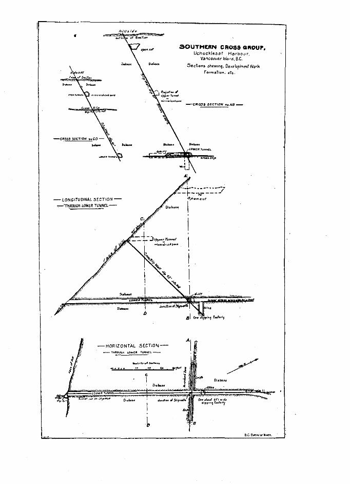

H192 “‘~ REPORT OF TBE MXNISTER OF MIKES. 1907
rook, .% well marked slip-wall ia .seen, having a strike N. 30” E. into the hill, with a dip of 60 towards the southaxst.’ This earn8 intrusive rock also appam in the two after-mentioned claima, the Ham John and Monitor. Towards the south this slip-wall is out off, nearly at right angles, by another slip having 8 strike of S. 55” E. and a dip of 46” into the hill. The north-easterly slipwall, first mentioned, haa been followed along by CL tunnol 40 foot long, all in a body of low-grade ore, occurring in a minerali& zone in the diabaae, following along the slip-wall.+
About 100 feet lower down the hill and slightly to the mat, a tunnel has been driven to reach the point where the north-esaterly slip and the cross slip, before referred to, intersect. This tunnel is now in 300 feet. and for 200 feet run8 through diabase, at which distance it cuts the crows slip-wall, here found to have the same strike and dip as noted on the upper level. The north-east&y slipwall was&o struck, with an unchanged dip and strike, showing a well-developed ore body on the right hand-side, moms 6 feet in thickness. This is men in a short crosscut of 46 feet which runa into the limestone to the right. The tunnel has been continued along the slip-wall for 60 feet, with the ore on the right side, when the tunnel swings slightly to the right, and is being run for tho limestone contact, which should goon be reached. Where the om showed strongest a wince wa8 being sunk from the tunnel and was down 20 feet, good om having been taken out as the winze w&8 being sunk. The wince is now getting out of ore, as the body dips sway from it on the main slipwdi. When FL greater depth is maohed omsscuta will be run to the om chute.
The CTOBB slip-wall before notad has been followed from the main tunnel by ZL drift running to the left, which ia now in a distance of 45 f&. This is fairly well mineralised and may develop a good body of ore. This cross slip ia traceable oo the surface and has been proved by an open cot to the left, in which direction the crosscut is now being driven.
At 175 feet above the msin shaft an open cut has been run for 75 feat along B mineml- isod zone in diabase on a limestone contact. In the open cut this zone shows for 17 feet, and ia minaraliaed with iron pyrites sod a little copper pyrites.
There has been no &ping done in this mine, and any ore taken out hssbeen in the ooum of development. The management is pushing the development with three shifts and ia making B strong endeavour to block out a good body of ore. The mine is equipped with two bunkers aQd ore chutes on the two working levels, and them is & good wharf oo deep water for ship -t. The bunkers were partially tilled with B very good grade of om, the values being principally in copper pyrites. A small shipment W&B made this year.
A sample taken of the best-looking om in the bin gave, upon assay :-Gold, trace; silver, 0.56 oz. to ton; copper, 16 %.
l The following is the report of Dr. J. A. Dresser, of Montreal, on a microscopic examination of tti rmk :-
“No. 4,013.-A 6ne.textured gray rook, showing a few grains of some yellow sulphide. A few rusty p.t&.s &o appear in the hand specimen. Thqv are evidently dua to the oxiditian of an iron-baa& mioersl. The rock consists eaaentially of felds ar, which is primipally orthoo,.w.e and much ohkrize
f %
hornblende, with a considerable development o epldota. The rook is essantiallg similar to the last (No. 4,007), but contains little, if any, quartz. It ia a syenite porphpy.”
+Tbe foILowing is the report by Dr. J. A. Dresser, of Montr& on B miorosoopia ersmination of two samplea taken from this minsralised zone :-
icNo. O.--The JwuIe~Cross Ore.--The rook of this or+, whioh is an sltered parphyrite, is penetnrted by nwrow BB&~S of ore which maintain a generslly parsUe, direction. In the microsoo io aeotion these lines are found to be small fractures in the rock, into which the ore has been infiltrated B P ter the rwk has been ddi,id and frsotured., In one CUB a lar e feldspsr has been broken ao,.xs and ora hap been subse- ,potXy *posited in the cre~lc~ thus formed. 4 he ore has thus been the ,&tat part of the rock to form, while If It were due to magnet,ic segregation, it would have been one of the ssrliest constituenti to solidify.
‘I No. 4,0,8.--Oa~~ Mot&alfr~, the Sov&erra Cvoas ?&a-This oonsiste of radiating tufts of horn- blende, c+ly satino,ita sod masses of home light-a&u+ z&it% which is often partially deoom ~&gm,m, does not BBB~ to throw “7 sstufaotory hght on the relstrons of the or8 to the B,X osmg P

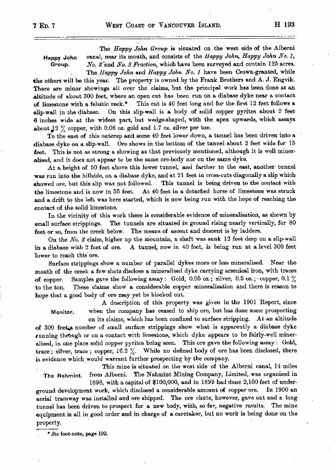
7 ED. 7 WEST COAST OF VANCOUVER ISLAND. H 193
The Espy John Group is situ&xl on the west side of the Alborni
Happy John canal, nee~l its mouth, end consists of the Happy John, Happy John No. 1, Group. No. Z‘snd No. $ Fmction, which have been surveyed end contain 125 &or&s.
The Happy John and Happy Johw No. 1 have boon Crown-granted, while fho others will be this yore. The property is owned by the Frank Brothers and A. J. Engvik. There am minor showings all ovw the claims, but the principal work has boon done at en altitude of shout 300 foot, where sn open out hss been run on s. disbaso dyke ness & contact of limestone with 8 felsitic rook.’ This cot is 40 feet long and for the first 12 feet follows B alip-wall in the diabsse. On this slipnall is B body of solid copper pyrites about 2 foot 6 inches wide at the widest p&, but wedge-shaped, with the apex upwards, which assays z,hootJ2 % copper, with 0.06 oz. gold and 1.7 oz. silver per ton.
To the east of t,his outcrop and some 40 foot lower down, a tunuel has been driven into a d&base dyke on a slipwall. Ore shows in the bottom of the tunnel &+ut 2 feet wide for 15 foot. This is not ins strong & showing ss that previously mentioned, although it is wall minor- &sod, and it does not appear to lx the sruno ore-body nor on the smno dyke.
At & height of 50 feet above this lower tunnel, and farther to the mat, snother tunnel wss run into the hillside, on & disbase dyke, and at 21 foot in cross-cuts diagonally 8 slip which showed ow, but this slip w&s not followed. This tunnel is being driven to the contact with the limostone and is now in 55 foot. At 40 foot in & detached horse of limestone w&s struck snd & drift tq tbe loft w&s here stltrtod, which is now being pun with the hope of reaching the contact of the solid limestone.
In the vicinity of this work there is considerable evidence of minemlisation, as shown by small surface strippings. The tunnels BI‘~ situated in ground rising nearly vertically, for 80 feet OP so, from the crook below. The mesns of ssoent and descent is by ladders.
On the No. $ claim, higher up the mbuntain, & shaft w&s sunk 12 feet deep on & slip-wall in & diabase with 2 foot of cm. A tunnel, now in 40 feet, is being run st & level 300 feet lower to reach this OPB.
Surface strippings show & number of p&rallel dykes mono or less mineralised. Near the mouth of the creek B few shots disclose & minomlised dyke carrying arsenical iron, with tmoos of copper. Samples gave the following assay : Gold, 0.05 oz.; silver, 0.5 oz.; -copper, 0.1 % to the ton. These olsims show & oonsidersble copper minemlisetion and there is mason to hope that & good body of ore msy yet be blocked out.
A description of this property was given in the 1901 Report, since
Monitor. when the company has ceased to ship ore, but has done some prospecting on its claims, which has been confined to surface stripping. At an altitude
of 300 fee& numbs of small surface strippings show what is apparently B diabase dyke running thtiugh 01‘ on B contact with limestone, which dyke appears to be fairly-well miner- &sod, in one place solid copper pyrites being soon. This ore gsve the following ssssy : Gold, trsce; silver, trace ; copper, 16.2 %, While no defined body of om has boon disclosed, there is evidence which would wwrant further prospecting by the company.
This mine is situated on the west aide of the Alberni canal, 14 miles The Nshmint. from Alborni. The Nahmint Mining Company, Limited, w&8 organised in
1898, with s capital of $100,000, and in 1899 hsd done 2,100 feet of under- ground development work, which disclosed & considerable &mount oX copper ore. In 1900 an aerial tramway ws,s install&l snd ore shipped. The ore chute, however, gave out and s long tunnel hss boon drivan to prospect for & now body, with, so far, negative results. The mine squipment is all in good order and in charge of B caretaker, but no work is being done’on the prop&y. --
* 8% foot-note, page 192.

H 194 REPORT OF TEE MINISTER OF MINES. 1907
Gladys.
This cl&n is situated on the @aat side of the Alberni conal, neer the mouth. The work on it has been done at an altitude of 400 feet and several hundred feet back from salt water, where a few &ota have been put in on
a home of limestone appearing in the disbaae dyke, minar&wl with copper and iron pyrites, with B little arsenical iron. A shaft haa been sunk on the dgke, 25 feet lower, from which a considerable amount of ore has bean shipped. This shaft W&R full of water when visited, and the ore at present remaining on the dump is only second-class, the dump having been hand- picked and the first-class or8 shipped. According to B miner who had worked in the mine, there WBB still goal or- in the bottom of the shaft, but financial di&ulties necessitated the temporary closing down of the property. The assay of 8om8 selected samples taken give the following results : Gold, 0.2 oz. per ton; silver, 2.32 oz.; copper, 16.43 %.
This group, consisting of the Edith, Bhck Bear end &u&a, o&-d by Edith Group. E. A. Waterhouse, of Alberni, is situated on the eat eide of the Alberni
canal, a short distance from the mouth, and ia reached by a trail froth the beach &ut a mile long, although the distance to salt water would be less in a direct line. The workings are st an altitude of 475 feet,, where a tunnel has been run in a 9. 66” E. direc- tion for 30 feet. This tunnel started to follow in 8 limediabae con&t, but TR&R diverted, continuing entirely in diabase, following a strong slip-well along which no ore was visible, although some ore men oo the dump w&s presumably taken out of this tunnel. A few hundred yards to the east a number of open cuts have baen made and shots blasted in diabase, which show more or less mineralisation with copper pyrites, iron pyrites and pyrrhotite, the lstter, however, predominating, ,while in one of the open cuts solid pyrrhotita W&B noted.
Great Central Lake.
Considerable bodies of ore having been reported to exist at the head of Great Cent& lake, Alberni District, it w&s decided to mltke a preliminary examination of that region; which w&s dona towards the end of August, 1906. Great Central lake can now be reached with ease from the town of Alberni, B distance of twelve miles, by waggon road, the elevetion of the lake being 200 feet above the so&. This inland shoot of water preaenta the same physic& features 8s do the inlets which indent the west coast of Vancouver Island, the mountains rising ‘abruptly from the water, with here and there a valley extending back for 8 considerable distance, the mo& important valley being that extending to Ash lake on the northeast.
The general length of the lake is east and west, and it is about twenty-five miles long by B mile or so wide. At its western end two creeks flow in, heading from mountains still farther to the weat. A trail from thk lake follows the most northerly of these creeks on & gradual ascent for a distance of ten miles until it ends in B basin, shut in by high mountains, the basin having here an elevation of 1,500 feet above the Great Centrd lake, or 1,700 feet above the 88~ To the south a precipitous bluff rises 2,075 feet high, from which pours & considerable stream of water that barely touches the rocks ;ntil it reeches the bottom, breaking into 8 mw8 of spray in its descent. The asoent of the bluff requires stout muscles and the sid of the small bnshas which cling 80 tenaciously to the clefts in the rook. On the top there is a small rocky plateau or basin enclosing .a lake about half a mile long hy a quarter wide, the elevation of the lake being 3,360 feet above the ~a. This mountain lake, situated in the heart of Vancouver Island, with snowclad mount&s rising 2,000 feet &ove it and the blue crevassed giaoier of t,he 1‘ Nine Peaks ” showing up to the south in the morning sun. forms & beautiful scene.
This group consists of 88von claims, viz.: Big Znbriw Nos. 1 to 7, and
Big Interior w.w located by Drinkwater and Nicholls, of Aluberni. The claims are Group. reached from the bead of the small lake referred to by following up a
smsll second basin, slighL1y to the north of the main basin, about a quarter


H196 REPORT OF THE ?&NISTER OF MINES. 1907
of 8 mile. The head of this second haein is hemmed in’on three aidss by pm&pit& cliffs a thousand feet high, on which rests a anow cap, terminating in peaks which are 2,000 feet above the lake below. Practically, this entire face, come 4,000 feet wide by 1,000 feet high, shows the strong red colour due to iron stain, while at the base there are thou&nds of tons of the same rock which have been mined by the action of the elements. A closer examination shows
‘this cliff to be B granitoid rock,* miner&ed with copper pyrites, pyrrhotite and pyrite in varying proportions, 801118 zones showing strong mineralisation, while in others it is more sparwe. To the weat the rock asames B brecciated structure and has been cemented together by a filling of cslcite, with a considerable impregnation of copper carbonates and into this zone .m tunnel has been driven a distance of 31 feet. The ascent of the bluff is somewhat dangerous, owing to the rather precarious foothold and the &ewe of wgetation, the top being reached at an elevation of 1,376 feet shove the small lake. From the top of the bluff a
snowslide w&8 followed until a further elevation of 500 feet w&s reached, at which point the ore is uncovered and shows the strongly minemlised granitic mws which is seen to penetrate a nearly horizontal strata of limestone, alternate bands of which continue to the top of the mountain BOO feet still higher. This sharp ridge, with an altitude of 5,700 feet, may be con- aidered e-e the beakbone of Vanwxxver island, shedding the water to the south down the Alberni canal, to the north-east down Buttle lake and the Campbell river, and to the west by Bear river into Olayoquot sound.
Sumann.-The mineralized zone, showing in the fFe of the cliff to the north of the basin and forming the great mua8 of low grade mineral on the property, is so large, 80 insccesaible, and the mineralisation so scattered, that it would be impossible to obtain anything approxi- mating an sueraga general smnple of the ~xpoaure without the expenditure of e.n amount of time and moneynot justifiable under the circumstances. However, et the foot of the cliff, and aa illustrated in the accompanying sketch, there is a talus extending the whole length or width of the miner&sad zone, made up of material broken sway from the whole face of the zone in question. While this talus msy to B certain extent have been affected by weathering, it still may be considered a very approximate sample of the inaccessible cliff. Samples were taken from this talus, from which it is judged that approximately the central portion of the min- emlised zone will assay from 4 to 1 % co pp er, with from la to 2 oz. silver per ton, and a trace of gold. These values extend over a width of about 1,500 feet,, while to the right the min- er&&ion gradually fades off into the country rock.
To the left of the miner&w3 zone is what has been called, for purposes of designation, the ‘I brecciated zone,” and which is merely a continuation, to the left, of the mineralised zone which haa here been subjected to CL oruBhing due to movement, and in which the interstices between the fragmenta of the rock ham been filled with secondary miner&, chiefly calcite, with some carbonate of copper, forming a secondary enrichment. This secondary enrichment haa taken place, as would be expected, along defined channela, producing streaks of higher

-

7 ED. 7 WEST COAST OF VAN~JUV~ IsL.~ND. H 197
grade minorclisaticn often forming ocmmeroial ore. Here, .sgain, no goneral sampling w&B pcsrdble; although e tunnel hss boon driven for ncrno 31 foot into the blnff, it was found impossible to examine the face of the cliff for 10 foot on either side of the tonne1 month.
The minerslieaticn just described, and which forms the grest bulk of visible minemlisa- ticn on the property, ia sdmittcdly very much di!Twxl through the rock, and is consequently 80 low gmde &B to be of vnlue only if found to be amenable to 801118 form of concentration, and of ,which there seems tc be & fair probability.
On the top of the mountain, in the knob shown to the left of the oontrs in the sketch herewith, is an oxon in which the mineralisaticn 8oom8 tc bo more concentrated, producing, in pieces, cro of B grade tc stand trmisportation and treatment charges. This higher grade ore appenrrl to coonr slcng the lines of contgot of alternating bands of granitic reek snd limestone. The oxtont of the latter deposit it w&8 found impossible tc determine, LM the ore was found to be coverod in most plaoes by B heavy capping of gcssan, and in mmiy places seemingly per- manent snow mid ice ccvored up the formation. While the future of the prcporty ia far frcm being proven, the very groat extent of the minoralisation, with occasional concentrations, oertainly renders the proposition worthy of most careful investigation and prospecting.
These claims BIB situated on the smrdl lake in the Big Interior Basin, ~olla and Glacier. and ore owned by Drinkwater and Eogvik. On the ol&ime is B small quartz
vein from 2 to 3 foot wide, minernliaed chiefly with arsenioel iron. Assays of the straight cro gave the following result :-Gold, 5.12 oz. per ton ; silver, 6.2 oz. per ton ; copper, 1.0 %. The vein hss not yet boon worked to any extent, but nn sttcmpt is being made to extract the vslues by roasting the ore rind grinding in cn nrnstra, which has beon eroctcd and ia being mn by B small water-wheel ‘ocnatructed on the ground. The sraatca had just been completed at the time of my vi.&.
Formation of Ore Bodies on West Cdast.
An exsminstion of the ditl’orent properties on the west ooest of Venocnver Island, especially those on which extensive developinent work has boon done, would point to tba following theory &s to the mode of ore deposition :-
The properties, with the exoopticn of those in Quntsino sonnd, and Crest Central lake, present nearly identical conditions. The mineralisstion ooonr~? in or close to diabase dykea. Sometimes there ie snfficient quartz in the lisatwo to make .s qnsrtz vein, but mcro often there is an entire absonbe of quertz, the vein-mattor being the crushed material of the dyke. There appear to have boon two periods of mcvomont, the first in which the dykas were formed, when no miner&&ion took place ; the second period in which those dyked wore shattered and twisted, when probably secondary dykos of B eilnilar composition tc the first series were injected into the fissures ‘found by the movement. A oaroful exmcinnticn of these dop&te would load one to the ccnolwicn that mineralisaticn tcck plcoe at this time, not 88 & sooondsry enrichment, but 88 e direct deposit by or&oaring solutions fmm b&w. The solid mineral is won to ponetrato what wwo originally o&ties, and to follow slcng old slipwalls, inside of which, w (L rule, no mineral whatever ia wn, 88 would bo the CBBB if segregation had occurrod. The deposits &m often of brwoietcd structure, the 01‘8 enclosing fragments of tho origins1 dyke-rook end only wcasicnally is it aeon forming & part of the dgke, end then it would be accounted for as forming part of the seocnd upheaval when the later dykes wore fcrmod. Minediaaticn ie found along frcetnrod cones in these disbase dykon, snd whohere these frsctnres contained cavities for the entrance of mineral-bearing scluticns wo new have ore-bodies, but where the ground is tight or shows only slight movement, little or no cm is found.

H 198 REPORT OF TRE MINISTER OF NINES. 1907
Ch&opy& forms the principal mineral of value, while pyrrhotite is a common mineral, oconrring both massive and mixed with pyrite snd chalcopyrite, but carrying little or no v&lue in itself. Arsenopyrite occf1rs in many of the prop&& and, 88 a rule, carriea gold values.
While no geological map or extensipe examination of this region has been made, the general country rock outside of the mineralised zones appears to be syenite. occurring often .w mountains of great size and connected with a series of felspathio dgkea which penetrate the older rocks.
ALBERNl DISTRICT.
ALBERNI MINING DIVISION.
I have the bonour to submit my annual rep& OD the progress of mining in the Alberni Mining Division during the year ending December 31st, 1906 :-
Excepting B few properties, there hss’bean little done beyond what wa8 absolutely necaassry for aaaeasment work. The exceptions we :-
The Sig Z&a&r, where active operations have been oarried on all mummer and fall. This ia & very promising property, and results so far have been very eatisfwtory.
On the Phmnix Group work has been carried on all mummer, snd is still continued.
Mr. Bailey has worked the Three W’s until quite lately, when weather conditions prevented the continusnce of operations.
The Sarita and COF Island Gr’oup were actively worked for some time during summer, and further development of these properties is expected.
With these exceptions there hss been little done, and the industry in the Division may be pronounced dull.
Free &in& certi6cates. . . . . . . . . . . . ~. ~. . . ~. . . . . . 58 Mined claims recorded. . . . . . 32 Certificstea of work recorded 69 ‘rransfers recorded. . . . , : 24 Certificstea of improvements. . . 13 Crown-gritnted mineral claims on roll ~. . . 143
R.%WU&
Free miners’ oertifiorttes.. . i . , . . . . 9% 442 50 Mining receipts . 349 75 Acreage tax Crown-granted claims . . . 1,049 50
-- $1,841 75

7 ED. 7 &BERN1 DISTRICT. H 199
CLAYOQUOT MININQ DIVISION.
I have the honour to submit my annual report of the mining operation8 in the Clsycquot Xi&g Division for the pear ending December 31st, 1906 :-
The year has seen very little activity in mining operations in this Division ; in fact, it has been quieter than any other year since the Recorder’s O&x we,8 opened here in 1898. The only property worked ta any extent was the Good Hope Group of claims. The owners, the Holga Gold and Copper Co., of Seat&, bad from four to six men at work most of the
par tnnnelling, but they have DOW olased down until spring, when they expect to aink on the
PropehY. Ownera of other claima have c&fined themselvae to doing the annual amount of aaseas-
rnent work, and quite B few have had their cleima surveyed, with the object of having them Crowngrsnted. From present hearsay. B number of the properties will be working early in 1907, noticeably the I&n Chief Group, at Sidney inlet ; the Good Ilops Group, at Trout river ; the Ornwnd Qrwp, et Ahousat ; the Bwwn Jug Group, et Heaquoit ; the Ku&~ end Goldelz Gatc claims, at Disappointment inlet, and the Rase dfavaria Group, at Kennedy lake.
OFFICE hW,T8TIC8-CLAYOQUOT Mlsmo Dwmnxi.
Free miners’ certificates issued . . . 25 Mineral claims recorded . . . . 13 Certificatee of work reco+d . . . 61 Bills of sale, bonds, eta, recorded . . . . . . . . . . 4
R@WWW. Free miners’ certific&ea . . . . . . , . , . . . . 8122 00 Mining receipts, general, . . . . . . . . . . . . . . 234 76
$356 75
QUATSINO MINING DIVISION.
REPORT OF 0. A. SHERBERG, Mrxrrro RECORDER.
I have the honour to submit my ~nnrrel report of the mining operations in the Quatnino Mining Division for the ye+i ending December 31et, 1906.
Inrc~aao~. RIVER.
The BZw, Bivd Group consi& of two claims, the X&o and the BZue Bird, owned by Ames&. P. Cramer and 0. ,Strendwold. An additional seven feet has been driven in the tunnel .on the Blue Bivd claim, and the surface stripping abows or8 to & considerable extent. The pr‘opepty hes recently been sold on option to A. F. Gwin, of Victoria.
The Ingem& St& and Olga are owned by B. 0. Erickson and Wm. Hanson. The work
done this pear consists of eight feet of tunneling, open cuts and stripping, with very satisfactory reSUlta.
mother p~~pwties on Ingemol aiver are the Elk, owned by Frank Pstteraon ; the Hemlock, awned by J. L. Leeaon, and the &‘w&a, owned hy Edw. Frigon; all of which have had the annual assessment work done on them during the~swon.

H 200 REPORT 0%’ TEE MINISTER OF &fINES. 1907
TEE SOUTE-Emr ABM.
NO work has been done on the Yrska mine doting the year. Mr. H. Carmichael, Prc-
vincial Assayer, in his report on Qoatsino Sound, fully described the property in the Annual Report of the Minister of Mines for 1903. NO work worth mention has been performed since that time.
The Edtim, adjoining the Superior claim of the Y&-a mine to the east, and formerly owned by the Edison Mining Co.. was sold to B. J. Murphy end J. D. Murphy in June, 1905, and Crown-granted during the year.
The CT.ima.z, owned by Evenson, Sownson, Lokken, Bergh and She&erg, adjoins the Y&a mine to the north, and lies higher up the mountain. This property has been proqwted during the 6eaaon and showa B wellnefined lead running the full length of the claim. The lead is about four feet wide, carrying copper, gold and home silver.
The Uncle Saq owned by H. S. Butler, is a continuation of the Climua lead to the west. The lead has been exposed for some distance by open outs and stripping.
The King Edward, owned by Sherberg end Nordstrom, is situated to the east of the Y&a mine, and adjoining the Cornslock claim. This property xv&? formerly known &s the Blue Grouse. The ore is copper pyrites, carrying small values in gold and silver.
The Payetreak Group, situated on T&a river, consists of three claims, the Paystreak, the Royal and the Red Rock. This is a promising property, having & well-defined lead, which has. been exposed by open cuts, shafts and stripping for more then 2,000 feet. The owners are P. Cramer and Fred Pollock.
The Annex ia an extension of the Paystreak lead, and bolonga to the ~&me ownem.
The Quatsino K&g, the’ Rubicond, the Hill Side nnd EmI. Side are owned by Chris. Nordstrom and Ct. Sorenson. The work done during the 8won consists of open cuts, and the old tunnel on Qzratsino King ooncinued 10 feet.
On the Lwliae, owned by Ed. Eaenson and B. C. Lokken, assessment work has been carried on from year to year.
The June Group, under the management of G. F&old Grant, has been worked in a mnslb way for the best part of the season, and is showing up well under development. The tunn& which was started in July. 1905, is in about 430 feet, and two cross-cuts have been made, 28 and 30 feet. Two ore-bodies have been struck in the tunnel ; one that is 50 feet in the main tunnel, and B cross-out of 30 feet ~88 made, r.11 in ore, besides some smaller showings. Assays of ore from the tunnel givehigher values than from the surface. A test shipment of 146 sacks, taken from the open quarry on the Jwvz cl&n, &as made in February to the Crofton wnelter, but the v&es are not known here. Work was closed down temporsrily in September, snd I am informed that it is the intention of the menegement to start work again in the early part of 1907, by installing an electric plant with sufficient power to operate four or five drills. , Power for mining operations can easily be obtained from Link creek, which flows through the Amazon claim of the Jum Group.
The Pee&ss,~owned by Julian Se.& and situated to the east of the June Group, also shows up well. Assessment work this year consisted of 8 5.foot shaft on t.he lead and some surface stripping.
The Mew&q Glm, situated to the west of the Jme &oup and owned by Sberberg and Bergh, is another promising property.
Ros&md, owned by H. A. Thorn, has bean thoroughly prospected this year and shows several small deposits of galens and yellow copper. Development consista of 4 feet tunnel, 4 open cuts and stripping. Certificates of work recorded for three years.


7~Eb. 7 Burma DISTBICT. H 201
.&raerva Factiwz, owqed by D. A. MaDonell, lies betwexm the Olga and Iron Knob claims of the Jwne Group. This property ma surveyed two years ago, and, having a&cient work done on it, B Crown grant will be applied for.
Other claims in the vicinity of the June cfrowp are the Zsnore and Piotoria Fraction, owned by A. F. Macaulay ; the Alpho and Prime Bwpert, owned by Sherberg end McDonoll ; the Inde~ndcnce, owned by H. A. Thorn, and the Dun&s, owned by D. A McDonell.
The Andrew, owned by Frank Psttsrson, haa recently been sold to B Seattle syndicate and work is already started. Only s few days’ actual mining has ban done since the camp was established. A few sacks of copper splphide ore were shipped by last steamer for B Bmelter teat.
WSST Ana.
The iron property situated on the north aide of West arm comprise8 36 claims and is owned by J. A. Mwre and Wm. Pigott, of Seattle, Wash. A considerable amount of work ha4 lxeu done on the different claims during the year consisting of numerous open cuta, pits and shrsllow shafts. The two large& cuts are 425 feet long, 4+ feet wide, 7 feet deep; and 200 feet long, 2 feet wide and 4 feet deep, all in ore. Some of the ahnfta am nunk 14 feet deep. The results from this year’s work are most sstisfaotory and large bodies of hematite have been opened up.
A new discovery of iron WBB made hy Chris. Jacobsen snd James W. Jackson snd 4 claims, the Iron. Meadow, the Iron Meads No. 1, 2, &ml 3 were located. This property is situated about 10 miles farther up the arm than that above mentioned and quite a distance back from salt water.
The Nel sad Slclla No. 1, owned by Jsmes A. Mwm and Rsy 6. Price, are other promia ing properties vhioh were located last mmuner, and from the work done showings &1+ very
satisfactory. The ore is bornite.
OFFICE S~n~wmoa-Qun~smo MINING DIYISION.
Free Miners’ C&i&&s issued . . . . 30 Mineral claims recorded., . : . . . . . 26 Certificates of work recorded . . . . 46 Certificates of improvements recorded . . . 1 Bills of sale, etc., recorded.. . . . .~ . 10
Ileuemue.
Free Miners’ Certificates . .$144 26 Mining receipts, genanrl. , . . . . . 220 00
$364 26

H 202 REPORT OF THE MIKISTER OB MINES. 1907
NANAIMO DISTRICT.
NANAIMO MININQ DIVISION.
&a,-I have the honour to submit herewith my snnuel report on the mining operations in the Nsnaimo Mining Division for the year ending the 31st of December, 1906.
The mineral re~curces of this Division are being steadily developed, end the results gonerally have been highly satisfactory, many important discoveries having been made during the past year. There were 496 mineral claims in good standing on the 31st of December, 1906, and more mineral claims were recorded than in the year 1905.
The returns for the year’s work from the Tyee smelter at Ladysmith, although not as large &s the year 1905, made a good showing for the number of days that the smelter VI&S in blast. Tons of ore smelted at Tyee smelter for 1906 : 99,110; value, $477,300. With the exception of 4,744 tins, the above WBB all from British Columbia cast mines.
Tsxmn ISLARD.
The Marble Bay Grozl?, of claims, belonging to the Tacoma Steel Co., under the manage- ment of A. Cirant, mined and smelted during the year 1906, 10,560 too8 dry weight. The development work done on the property ccnaists of deepening the shaft 100 feet, 250 feet of drifting and 110 feet of wince sinking ; the total depth of the shaft ia now 760 feet below the surface, or 718 feet below the 8ea level. A nexv shaft-house, 40 feet by 40 feet, and 90 feet high, haa been erected, in which has been installed a new lo-foot diameter sheave for the hoisting cable to run over.
They have added to the plant one ” H ” Sullivan diamond drill, capable of boring a hole 2,ooO feet deep. The average number of white men employed in and about the mine for the year WBS 50, and 15 Chinese. The copper and gold values show B steady increase with depth.
The Cornell Operating Cc., working the Comzell mine, under the management of J. A. Johnson, mined end shipped 1,000 tons of ore since the 1st of July, 1906. The development work consists of 100 feet of drifting and an uprise of 45 feet, and a lot of timbering toconform with the order of the Inapcotor of Mines. They are contemplating installing a new air
compressor, new hoist and cage, and & new boiler.
Mr. W. Thw. Newman, who has charge of the exploitation of the Commodme Gnx~p of claims cn Texada island, har, kindly furnished me with the following pwticulars of the development work done on Commodae mine during the year 1906 :-A plant, ccnaisting of a 40-home-power, wood-burning, locomotive-type boiler, built by the Jenckes Machine Cc. ; a 16. hcrwpcwer double cylinder hoisting engine, by same maker; e Cameron sinking pump; B duplex Morris Station pump; with full complement of blacksmith chop and essential machine tools, was installed, and haa been constantly worked throughout the year. A bunk-house and
cook-house to accommodate about 40 men, with boiler- and engine-house (the former containing bath-room and drying room), w&8 also built, and & substantial gallows frame, and tramway8 t.herefmm. complete the surface plant.

7 ED. 7 NANAIHO DISTRICT. H 208
With the ebove outfit 180 feet of sinking has been do& during the year. The mein shaft
is a two-compartment incline, 5 feet by 8 feet, in the clear. From the bottom of main ah& 8 level has been run north and south for 725 feet, and 128 feet of cross-cutting has been accomplished. On an svemge 12 men have been employed during the yew, in two shifta, under Bruce Kirk as foreman. The Commodore mine has t.hrae veins capeble of being
operated from the came set of openings. The main or contact vein ia to be the first explored and tested, sod is situate directly in the main contact crossing Texada Island between several miles of limestone on the southeastern side, and about the 8&me extent of eruptives on the north-western side. These operations have demonstrated the vein to be a true fiwwe, aa three dikes have b+en encountered coming in from the lime wall aide, and the vein has gone straight on without being faulted, even the strong cl&y parting on this wall being unbroken. The only effect of these dikes has bsen increased mineralisation on the vein iu their proximity. The shaft was sunk beiween two large exposures a distance of 1,140 feet *part,, the drift being pushed either w&y- To the north the valuea on the surface are in silver, lead, zinc and copper, in the order named, while the exposures on the south consist of gold and coppw. To the
south, at a depth of 180 feet, the ore carries a very satisfactory mnount of gold, and the gangue is mainly qusrcz. When driven 1,500 feet thii level is expwted to intercept both the lateral veins which run out into the limestone a known distance of over 2,000 feet in the Commodore ground.
The Loyal Lease Co., working the Lo& Orooy, of claims, has not shipped any ore during the year 1906, but has installed B 50-h.p. boiler, and employed 10 men. The development work for the year oonaisti in sinking the shaft 100 feet deeper; the shaft is now 300 feet deep, with 700 feet of drifts.
The Pug& Sound Iron Co. has not been working the iron mines during the year 1906 ; but proposes starting up again in the near future.
The flow& Queen is getting ready to ship ol‘~ q-sin, after having bean shut down for the paa year.
There are many other pmpertiea on Texada island on which the ownem have done development work enough during the year to keep the claims in good standing.
VALOSS IsLaND.
The Capper Cliff Mining Co., operating the Cqper CZ$ Group of claims, situate at Copper cliff, Valdes island, under the management of Wti. Simison,’ has just begun ta opan up what promises to be a very valuable property, and shipped 120 tons to the Tyee Smelter late in the fall of 1906. It has drifted into the mountain 46 feet, close to the 889 beech Only three men were working, but it is the intention to provide accommodation for 20 next year; The ledge ia well defined and of unknown width, but on the foot+&1 there is said to be 11 feet of ohaloopyrite of shipping grade. A bunker to hold 160 tons hss been built.
The Islands Copper Co., owning the TTZG~ Blue @romp of claims on Vsldea and Gowllsod islanda, at Gowlland herbour, has done considerable development work, sinking 60 feet, and has opened up e large body of copper ore in the diorite several feet in thickness. The percentage of copper shown by the smelter returns on a trial shipment of 22 tons of ore to the Tyec smelter was 2.84 and 6.2 qn low and high-grade orea, respectively. A small trial shipment to the Tacoma smelter gave 4.30 per cent. in copper ; gold, & oz. ; silver, l& oz. The cost of
rsnsportation to the Tyee smelter, together with the smelter charges, will not be more than $3.50 a ton ; this would leave B handsome prolit on even the low-grade ore, and if the ore- body holds good with depth, this property should be the making of’s mine. There we other properties on Valdea island that have made goad ahowings for the amount of work that has been done on them .
.

..,~.. H 204 REPORT OX THE MINISTER OF MINES. 1907
Considerable work has been done during the .p&8t year on Phillipe and Frederick arms, Thurlow and Cracroft islands. Most. of the peninsula between Hardy bay and Besvei harbour, at Fort Rupert, has been located, and same fine showings of copper ore have been found them.
Du~isrum DISTRICT.
The Nanaimo Jubilee Mining Co. has not done much development work on its two groups of mineral claims, situate some distenoe up the south fork of the Nsnaimo river.
Ommn Dwcnm.
Considerable work has been done on many claims in this district during the pest pear, resulting in very favourable showings.
OFFICE Swmmcs FOB 1906-Naxanao MINING DIVISION. .
Free miners’ certificates issued (individual) . 194 II ,I (companies) .,, 6
Mined claims recorded . . . . . . , . . , . . . . 132 Certificates of work recorded . . 126 Paid in lieu of work.. . . 2 Certifioates of improvamtints rooor’ded. 5 Crown grants applied for and issued . . :. . . 5 Bills~ of sale recorded 52 Permission8 given to re-locate.. 10 Rental mining lease.. . . 1
The revenue collected from the above free miners’ certificates and mining receipts gener- ally, for the year eoding the 31st of December, 1906, was $2,653.35, being a little less than for the year 1905.
THE NANA~IMO-COMOX CO&FIELD.
FROM REPORT OF DR. H. S. POOLE, OF GE~LOOI~~L~SURVEY.
Ie accordnnce with instruot.ions, I left Ottawa on May 10th. On reaching Victoria, the courteous oflicials of the local Government freely placed at my disposal such information as they possessed respecting the coal fields of Vancouver Island. Through the kindness of Mr. W. F. Robertson, the Provincial Mineralogist, I made the acquaintance of many who had been and home whc, were now, conneet+d with the coal industry ,of the island. Mr. E B. McKay: the Surveyor-General, kindly supplied me with copies of all available maps of his department.
These, however, seldom showed, even approximately, the country roads, so the services of Mr. Thomss Budge were called in. With a cyclometer on his bicycle, wd a prismatic~compass, he trwerwd the roads and ways in the neighbourhood of the mines and thn district between Ladysmith and the entrance to Nanoose bay.
Mr. A. Dick, who has $pint the best part of his life among the mines of this country, sided me by the exercise of hin retentive memory, and was 88 painstaking to keep me histori- cally correct a8 he is zealous to require compliance with the law in hia office of Inspector of
Mines.
Records of several bore-holes in both the Nanaimo and C&ox fielda were obtained through the kindnaes of Mr. T. Stock&t, &nerd Manager of the Western Fuel Co:, and Mr. F. D. Little, General Manager of the Wellington Colliery Co., who alao were good enough to furnish copies of maps.
. Information was sought for data obtained in the course of prospecting and working the coal fields since they were reported on by I&r. J. Richardson in 1876-7.

7 ED. 7 NANAIHO DISTRICT. H 205
Inquiry indicsti that in the northern section of the islend nothing further had been disclosed of the structure about Fort &pert, Coal harbour, MoNeill’s harbour, etc., than’what wa8 described by Dr. 0. M. Daweon, in his &port of Northern Vancouver, Part B, 18%.
Mr. W. Hogan, who was a good deal with Mr. Richardson in the seventies, advises that pmspecting on the coal measures at Oillies bay, Texada island, disclosed that the outcrop of coal *eon there ~8s only B patch, apparently on B fault.
Opposite Cmfton, on Osborne hay, explorations were made on Salt Spring island, between the public wharf and Veauvius bay. Two bore-holes were put down in 1901, where somu coal
and black &de cropped vertically on the shore, one near the public wharf to B depth of 400 feet, computed by the drill man 1,500 feet over the coal. This is in line with the theoretical continuation southward of the horizon of the coal beds st Nanaimo, but the bore-hole record w&9 not obtained, and general report makes the prospect unsuccessful and the ground faulted. At Koksilsh, in the Cowichan motion, an exposure of black shale, reported to be coaly, induced the sinking of a trial pit by Mr. WC&. The lwality w&s not visited nor the stat& merit confirmed that limestones in the neighbourhced, which is south of Duncsna, are full of fossils.
Explorations outside the field of immediate examination, on, a more extensive scale, were those at Tuuobo island in 1893, when people of Victoria sank a shaft st No. 1 bore-hole, some 60 feet on the eastern aide, opposite its mid-length. Next they bored on the western side, c.low to the w&x, from s base blasted out of the mck, so I am informed by Mr. A. Dick. The bore reached s depth of 300 feet, having passed through bituminous shale and coal at 280 feet, the coal being so friable that a birge quantity was pumped up in the bore. The channel +x&de is reported to be 40 feet deep, and it v&8 thought it gaw woess to the born-hole. Contrary to his advice, says Mr. Dick, a &aft w&s sunk on the site of the bore-hole and this at 200 feet met so heavy & flow of water that it w&8 abandoned, and then the 60.foot shaft was put down and stopped for raant of funds. The surface on the island here slopes with the
athe at 16’ to the eastwerd.
Besides the help obtained from Qovernment rind colliery officials, information was had of private individuals, 80 much at least as they felt at liberty to make known; but I found myself unexpectedly barred from mme records of exploration by the view that the secrecy ,insisted on while borings are in progress ww still binding, although necessity for reticence and private interests had long ceased. In the absence of official data, and with press notices of the closing down of collieries, an impression of late was produced away from Vancouver Island that the wxkable coals are of less extent than Ottawa and the East had been led to suppose. how, there are some people who have a vague idea that s coal mine is like a spring of water, vith a’flow to last at least their day, and they do not realise what “worked out” really means. What has happened is this : Wellington, which for many yeara xvas a busy centre of trade, has ceased to have an output of coal, the openings there have been abandoned, and in their stead mines at Extension have been developed, and Ladysmith has increased its population. At the asme time, it is true the coal operator in Vanwuver island has had many disappoint- ments, many unexpected difficulties to meet that are specialties of t.his coal field, in compariwn, say, with the structure of the coal-bearing deposits of the opposite side of the continent.
In Cape Breton the beds carry a fairly uniform thickness for miles. Cosl, sandstone, shale and firs-olay, each oocur and re-occur in their due order of deposit, while in Vencouver Island the records of e&ions taken only 1,000 feet apart read so differently that it is hard to . determine which am the beds continuous in both, which have been suppressed, and which have heen unduly developed within that short distance.

H 206 REPORT OF TEE MINISTER OF MINES. 1907
Under guidance of Mr. John Matthews, manager at Cumberland, in the Canox coal field, the reported occurrence of anthracite coal w&s examined, together with sxposnrea of coal altered and coked by igneous dikes on Brown river, some four miles from No. 7 slopes, which are being opened by the aide of the Puntledge or Caurtenay river, two miles below Comox lake. At sn exposure on e small watercourse half-way between the two place & lava flow has converted some cod into & dense silvery coke. The exposure was limited, but so far ae it permitted inspection the alteration extended but 8 short distance from the dike. From this point to Brown river the flow of andesite has made B hill 1,000 feet above the se& and capping the coal measures. Whst its s&t may be on the underlying coal seams can only be conjectured ; but neither hare nor at No. 7 slopes could the coal mined be classed 8s in any degree anthracitic. The exposure at Brown river is above where Richardson took hia No. 1 section, published in the Survey Report for 1672-3, page 36 ; and it is opposite where the river takes ite plunge in casoades through a narrow gorge of the older diabase against the outcropping sediment&es. Mr. Matthews wrote an article on this locality in the L‘ Mining Record” of Victoria, Novem- ber, 1901.
Another unusual, close association of o-1 rind igneous rocks occwa also in the same district, but in this case under reversed and ordinary conditions, the coal being the newer of the two. Right in the,heart of the town of Cumbetiand, in the workings of No. 6 shaft, bosses of dir&se project up through the pavement of the lowest yearn at several places ; there is nb dislocation, the coal merely thins ovw them, but the contact is very close ; in one c&se not an inoh of what may have been mud intervenes between the weathered surface of the igneous protrusion and the coal. The bosses appear to have belonged to a spur from the hills; among it9 depressions limt were deposited the grog shales and sandstones, these overlapping its sides apparently failed
to complete the levnlling up of the surface and 80 left these knobs of rock still exposed when the time came for the deposition of the coal seam. In a comparison of the conditions attending the workable seems of coal in the two great divisions of the coal field, the Nanaimo and Canox, this proximity of the workeble coals to the unconformable rocks beneath in the latter division is in marked contrast with those in the’former, where depths of 1,000 feet, or even more, of
sediments, with thin coals and massive blue shales prevail.
Another important feature of differentiation between the two divisions is the association at Nansimo of the working coala with thick beds of conglomerate, and their practically tot& absence in the worked portion of the Comox Division.
AB to the area of the coal-bearing series, it map, in general terms, be said to extend down the whole east Coast of the i&rid, but the am& in which it is probable coal in workable thick- ness exists ia very much less, while the wea that may be regarded &B proved is comparatively s~+Il. The difficulties in the way of exploration are numerous; vegetation is rank, the surface is largely disguised under thick layers of wash gravels, and there are no induoemeuts to the public to prospect over the major portion of the more immediately promising ground, as these laads 81‘8 held by the present coal operators, who have no occasion to explore much ahead of their reqoiremeuts. Still, if it lx desired that a conjecture be hazarded of the quantity of coal exceeding B thickness of two feet, and within a vertical depth of 4,000 feet, an estimate of 600 million tons, though based on most incomplete data, would seem conservative, and yet at the sam8 time sufficiently large to allay apprehensions of any immediate shortage in the output.
The fossils collected in connection with the above geological work have been submitted to Dr. Whiteeves, palleontologist to the Survey, for determination.

NAIJAIXO DISTRICT.
VICTORIA DISTRICT.
VICTORIA MINING DIVISION.
I have the honour to submit herewith the annual report on mining in this division during
1906.
Through t&courtesy of Mr. Clermont Livingston, I am enabled to supply some psrticulsm of work done by the Vancouver Island Mining and Development Company, Limited, and the Tyee Copper Company, Limited.
Vnlrconv~~ IBLAND Mmma *?wa D~VELOPV.NP Co., LIYIT.D.
The work done by this compsny has been concentrated on Xoksilah mountain, about five miles from Cowichau, a station on the E. & N. Railway. From the BZuebell five oarlcds ofzore have been shipped, ranging from 6 % tom 8 % wpper ; severs1 prospect shafts have been snnk, which have proved the existence of good copper to a depth of 60 feet b&v the outcrop. This work w&8 suspended at the end of November, as weather conditions were an obstacle to the extensive surface work that w&8 being undertaken. This work will be continued in the coming spring. Although it ia tea early yet to ape&k definitely, conditions qqxar to be very fwoursble for the development of marketable ore.
TEE TYEB COPPER COMPANY, Lnwr~n
While the Tyee mine has been reported on for the last few years, still B few remarks on the past year’s work will prove interesting. Z’yee ore to the amount of 23,823 tons was smelted at the company’s smelting works st Ladysmith. This produced 2,116,617 pounds of oopper, 3,776 ounces of gold, and 77,085 ounce8 of silver, the cash returns, after deducting refining and freight charges, being $306,600. The Tyee main shaft has attained B depth of 1,250 feet, and the came low-grade ore body has been met with that had been previously intersected at the 1,000.foot and 1,150.foot levels. A winze hea just been commenced at the 1,150-f& level, and this will he sunk from 200 to 300 feet, which will prospect the mine to a depth of
aboub 1,500 feet from the actuaJ surface of the ground. At ths 8ame time, heavy prospecting work in the form of drifts and cross-cuts will be done in the lower levels, to follow up and explore the ore that has been exposed. Concentration testa are also being made, in order to find out the best method of ntilisin&- the large tonnage of low-grade materis1 which ban been
developad in the mine.
In addition to the work at the Tyee mine, a shaft has been sunk to a depth of 500 feet on the neighbowing altim, octlled the I.B.L., which is also the property of the Tgee Company. Several thousand feet of work has been done on this ground cm a form&m very similar to the T3ee, and the indications we distinctly favoursble for pay ore.
The diamond drills are slso workinq contiouooaly on the property. One of these is a “ B ” drill made by the Sullivan Machinery Company, and has 8 capacity of 3,000 feet.
RIOEA~D THI Tama
The Qee smelter has secured the contract for the ore from the Ric?uwd tlca Third. There is now .eome 400 tons on the dumps ready to be shipped, and regular shipments will continne.

H 208 REPORT OF TEE MINISTER OF MINES. 1907
The necassnry annual ~mecmmmt work haa been performed on a number of claims, but w reports of any import have come to my knowledge.’
OFFICE S~a~rs~~cs--V~o~oa~a XINING DIVISION.
Free miners’ certificates.. . . . . 450.. ,490 I, special. . . . . . . . . .
&fin&g oloims recorded . . . . . . . . . . . . . s.... 7
83.... 81 Ce*i6clltes of work recorded.. , , . . . . . . . . . . , , , 219.. .163 Certi6oatss of improvement recorded. . . . . . . . 58. 10 Co,,,,,,,,, recorded . . . . . . . . . . . . ,
)I . . . . . . . . . . . . . . . . . . . . . . . . . . . . . . . . . 7;;; : 30
. 2 Lay-avers !I . . . . . . . . . . . . . . . . . . . . . . 1
Revmue. 1906
Free miners’ certificate. . . . . . ._ . . . . $4,166 02 $5:% 45 Minidg receipts, general . . _. 2320 30.. 1,684 90
$6,486 32.. .$6,800 35
NEW WESTMINSTER MINING DIVISION.
REPOUT BY J. M~~AONY, Muwici RBCORDBR.
I have the honour to submit the following report of mining operation8 in the New
Westminster Mining Division for the year 1906 :-
The claims recorded during the year were distributed as follows :- Howe sound and vicinity ...................................... 41 Britannia and vicinity,, ...................................... 57 Bowen island ............................................... 21 Cambier island .............................................. 2
24 Salmon 8rm and vicinitv ..................................... Burr& inlet and vicinity ................................... 4 Cap&no, Lynn and Seymour creeks .......................... 33 Pitt lake ................................................... 35 Stave lake. .................................................. 2 Lillooet river ............................................... 9 Wharnock and vicinity. ...................................... 12 Harrison lake and vicinity ...... ............................ 3 Chilliwack and vlcunty ........................................... Jervis inlet ................................................. 2: Nelson island .............................................. 6 Welcome pass ........................................... :. .. 25-Mile creek ............................................... 3” PwpoiSe bay. ............................................... 2
The number of claima recorded shows a considerable inorellse over the year before, and shows that them is greater activity in prospecting than there has been for the two preceding yem+s Some god prospects have been found between Salmon arm and Howe sound. and it is
the intention of the holdera of the mineral claims recorded in that locality to do considerable development work during the year 1907. There has been & great deal of prospecting in Howe sound and vicinity, and also throughout the whole Mining Division, and there ia every proqact that the year 1907 will show an increase ever the preceding gears.


7 ED. 7 VICTOSIA DISTRICT. H 209
From the office statistics it will be 8een that there has been a considerable increase over the year 1905.
OFFICE STATISTICS-NEW WE~T~IN~TBB Mninm DIVI[IION. 1905. 190’6.
Free miners’ oertificates issued. . . 736.. .I,158 Quartz claims recorded . . . 107. . 283 Certificates of work recorded . 191,. 157 Certificatas of improvement recorded.. . . 13,. 1.5 Conveyances recorded.. . . . . . . . . . . . . . . . . . . . . . . . 46..., .94
&WW?. 1905. 1906.
Free miners’ certificates, . . . $4,606.65.. .$6,484.86 Mining receipts, general. . ~. 1,810.40. 2,507.70
-- $6,417.05 $?3,992.55
CLAY DEPOSITS OF ANVIL ISLAND.
Anvil island ia situated up Howe Bound, 23 miles from Vencouver City; the island ie a grsnitic peak rising to a height of 2,700 feet, and is three miles long by two miles wide. At the southern extremity of the island them is an extensive deposit of glacial clay. This is now
being worked by the Columbia Clay Co., Ltd., under the management of J. A. Brownsword. The clav bank has an area of 8ome 90 BCL‘BB and a thickness of about 100 feet. clay it ia very uniform in texture, being practically free f&m stones.
For B glacial
A floor has been I‘un into the bank, slightly above the level of the mixer and brick machine, 60 that the clay is shovelled into small oars and run by gravity a short distance to the hopper; the brick machine ia of the “soft mod” type. The bricks are burned in a continuous kiln, the draught being maintained by a fan and exhausted through a dryer, in which the bricks are dried before being burnt. The kiln in only a few feet from the water, the brick being loaded direct from the kiln hy small cars on to scows, which are towed to market. The plant has a cappacit.y of 30,000 per day.
The following is an analysis of the Anvil island clay, made by the Provincial Government Asssy Office :-
Loss by ignition.. . . . Silica
3.0 % 56.6 ,,
Alumina., . _. _. _. . 26.7 ,, Oxide of iron 7.5 ,, Lime. . .._ ._. _. .._ . 4.0 ,, Megnasia. . . . . . . . Tram, Fusion point. . . . . 2,000 Fahr.
COWICHAN LAKE AND VICINITY.
In the early part of the mummer the Provincial Mineralogist, having been request” to visit the mineral claims being developed in the vicinity of Cowiohan lake, in the Victoria Mining Division, reported 88 follows :-
In compliance with the memorandum mentioned, I beg to report that I left Victoris on May 2&h, and visited the claims in question.

H 210 REPORT OF THE MINISTER OP MINES. 1907
Casmnlm SLOPE.
The claims on the Chemsinus nlope BL‘B aituuLed on s small creek which flows into the south fork of the Chemainus river, and about two miles from its junction. The claims may be reached by B trail up the Chemainus river, and alno by 8 tmil from Cowichan I&e, which starts from a point a little to the east of the mouth of Cottonwood creek. The former route would, eventually, be that over which any ore from this~ section would be taken out, and by which any important trail or waggon road would ba built ; but, for the preliminary develop merit of properties snd for prospecting purposes, the trail from Cowichsn l&ke is the one beat suited, 88, at present, supplies can be transported by waggon and boat ti a point nearer tha claims than by the Chemninus tail. I followed the Chemainus trail down some three miles below the junction of the creek mentioned, and found that it ran through finely timbered land, large treea with no undergrowth and little or no fallen timber, with B solid, stony and gravelly soil, unfit for agriculture, but perfect for a trail, over which B pack-train could be
driven without any previous preparation ; in fact, a line of blazes is the only trail work neces- aary. I am informed that these conditions prevail all down the Chemainus valley.
Cowichan lake is about 20 miles from Duncan station, on the Eaquimalt and Naneimo Railway, with which it ia connected by a very fair waggon-road to the east end of the lake. A regular daily stage and a couple of independent stages are run over this mad, making the distance in B little ova three hours ; there are no heavy grades on the mad.
The elevation of Cowichen lake is about 550 feet shave the sea level ; from the east end
of the lake to the mouth of Cottonwwxl creek, by water, is estimated at almost nine miles. The water of the lake is everywhere deep enough for any ~t~&rner, and a landing can be made on the beach at any point. A company logging on the lake has a small tug capable of towing mows or rafts, and, consequently, if 80 desired, any supplies or horses could be landed at the mouth of Cottonwwd creek.
The present Cottonwood trail to the summit follows the main creek up to “DO&” cabin, at the junction of the east fork, which fork it then follows up to the summit. The summit is &out nine miles from the lake, and at an elevation 2,000 feet higher, mm8 2,600 feet above se8 level.
The claims located by Sherk, Jones and others &IE- nearly a mile north of the summit, and at &ut 300 feet lower elevation, about 2,300 feet atwe se8 level. I w&s given to nnder- stand that locations have been made two or three miles farther down the’creek, and at an altitude of about 1,700 feet. No work has been done on these and I WBB personally unable to locate them. The Cottonwood Cmek trail is through magnificently timbered land, with no underbrush or fallen timber, and not & single standing tree hes had to be cut to make the present trail, thefew small ones that were cut serving merely to blaze the trail. The country traversed is almost entirely covered to a considerable depth by “wash,” consisting of slide rock, voloanio in origin, embedded in clay produced from the disintegration of such rooks. $fore or less clearlydefined benches follow the course of present &reams. The trail in question hss &ma laid out with very poor judgment: it follows the first bench aa far 89 the junction of the east fork, when it drops co the creek level, or follows the steep hillside bordering thereon, thereby neoessitating an amount of aide-hill cutting, and crossing in and out of
ravinea, with many “reverse grades,” all of which might have been avoidad by keeping to and following up ths first bench, above the ravines and .side-hills, with no greater distance to travel to the summit.
The owntry is smooth, with solid footing, no mud holes, end open to e degree scarcely comprehensible to one scoustomed to the Kwtcnay Districts, and is such that no Eootenay

7En.7 VICTORIA DISTRICT. H 211
prospector would dream of uking for a trail through, for a peck-horse could go any&ere. The difficulty in this section is that there is practically no ‘1 horse feed ” on the hills, and, for the small amount of work going on, it does not pay to bring in hay and grain with hors-.
MINEKAL PossmLrTIEs.
On the Cottonwood creek slope there are few rock exposures and such few a8 ,vere see,, on the higher levels are much altered and shattered igneous rocks, in which I wuld not 888 sny indication of mineral nor hear of any having been discovered.
On the Chemainus slope, in the cutting made by the creek, were seen sedimentary rocks, shales, silicious limestones, etc., in contact with the igneous rocks mentioned. Near such contact are the miner&l locations referred to, which, from the fact that most of the mineral locations of value on the Island are similarly located, gives these claims greater possibilities then the present meagre development has proved, and renders the locality well worth prospecting.
It was expected that some of the prospectors would be on the properties, but such was not the case, the snow having scarcely left the ground ; consequently, having followed the blazed trail to the Sherk cabin, the various claims had to be found by tracing, from there, foot trails which had been made by the men when doing the work.
The Cascade is known a8 one of the Sherk claims, but the location post Cascade. bears the nsme of George Lawrence, tbe date of location being 21st August,
1902. This claim is located about a mile from the summit, lend on the Chemctinus slope, on a small creek flowing eastward into the south fork of the Chemainus riwr, and at an altitude of about 2,300 feet. The work has been done in the creek cutting just below a small falls, where the solid formation is exposed in the steep bank. Here there is exposed an igneous dike of considerable, although undetermined, width, which exhibits a number of parallel vertical fissures from one to two feet &part. Along these fi&res has been
deposited quartz, with home ehalcopyrite and bornite, together with a certain amount of magnetic iron oxide, which has been again enriched by a secondary deposit of calcite carrying copper sulphides. The width of these individual stringers is from 2 inches to 4 inches, and they are, apparently, disconcected. The extent of the deposit, &B at present exposed, ia com- mercially unimportant. The amount of development work done at this point consists of an open
cut about 10 feet wide, and 6 feet into the solid formation, with a height of face of about the same. In the open cut a pit has been sunk, of what depth it is impossible to say, since it has been ne&rly filled in again by the creek and rock from the face. A few yards farther down the creek a little surface blasting has been done, exposing a small amount of copper mineral. The workings did not disclose any defined strike or dip to the deposit. A sample taken of what might be considered the ore from the claim gave copper, 5.6 % ; silver, 0.2 oz. to t,he ton, and gold a trace. A short di&nce to the south of the creek some surface stripping and smsll cuts were seen, apperently on the sanm claim, which did not, however, promise ~8 well a8 the
creek exposures.
Still farther to the south, and towards the summit, were found the stakes of the Empire mineral claim, located by Jac. Sherk. on the 26th August, 1902, but no development work could be found. Mr. Sherk, however, who was seen later, says 8ome work has been done here.
The stakes of the Horlzet miners1 claim, located by F. H. I&win and Walter Jones, 27th September, 1905, and also the atakes of the Wmp, were found, but no development work or exposure of mineralised rock could be found.
Mr. Jones, of Crofton, subsequently met with on Cowichan lake, says he has a property, the Garnet mineral claim, lying to the south of the Ca&de, and farther up the hill, upon

H 212 REPORT OF THE MINIBTER OF MINES. 1907
which he claims to have run R tunnel driven on B considerable deposit of copper aulphidee, which he says is “ a direct extension of the &made lead and aseaysys e little over two per cent. copper (wet), with low gold and silver contents.” These workings I OIQB unable to Bnd, or any trace of a trail leading thereto.
While I do not consider that the mineral so far exposed, in the workiogrr I B&W, has any commercial value, still, the rook formation is undoubtedly mineral-bearing, and the conditions are favourable for the existence of ore-bodies, and I think it would be advisable to encourage prospecting in the vicinity. I would, therefore, recommend that an expenditure be made on
the trail from Cowiohan lake, sufficient to render the trail fit for we with pack-horses.
I would draw attention to the fact that all the land in this district is well within the Esquimalt & Nsnimo Ry. Cl land grant,” to which Company the “base metals ” (copper and iron) are supposed to belong, and the claims only show nominal values in the precious metals (which belong to the Crown), and that, in my opinion, any permanent trail, or road, should be up the Chernainua valley, the claims lying within a couple of miles of timber limits already sold on that river.
On the morning of May 3lst a oanoe wr&8 taken from the mouth of Cottonwood creek to the mouth of Sutton creek, .s small creek flowing from the west into the Little Cowichan lake
--i. e., that portion of Cowichan lake eat of the narrows-at its western Sunnyside and extremity. Starting at Vex&r’s cabin, a trail was followed up the north
Here-it-is. slope of the Sutton creek valley, which, gradually climbing the hills separating Sutton creek from the main lake, for a distance for about one
aod a half miles, reached the cabin of the Sunnyside and Her&-ia mineral cldms, at an
elevation of about 400 feet above the lake. These claims are owned by Messrs. Douglas, Shelton and Prevost. Considerable work has been done on the claims, but it consists chiefly of small open cots sod strippings and is 80 scattered 8s to give no definite idea of the deposit. The most extensive development work is No. 1 Tunnel, elevation 550 feet above the lake, which has been driven in about 35 feet, N. 24” E., gaining thereby a depth at the face of only about 35 feet fruln the surface. The rock formation is a very much altered and shattered igneous rook, with a high percentage of iron, and containing nomemw red garnets along the fissures. Near the portal, the tunnel passed through a somewhat ill-defined body of copper pyrites, pyrrhotite and arsenical pyrites, which seemed to be deposited along and hear a black,
“slickensided” fissure cutting the tunnel. The inner portion of the tunnel was devoid of mineralisation, having seemingly cot through the ore deposits in the first 10 feet. This tunnel atarts on the Sunnyaide ground, but in 8 few feet is into Here-it-is ground. An approximate
wople taken of the sorted ore gave, upon assay : Copper, 9 % (wet) ; silver, 0.3 oz. ; gold, trace. A special sample taken of the pyrrhotite and the arsenical-pyrites assayed : Copper, 5.6 % ; si!ver, 0.2 oz.; gold, trace.
Some 40 feet vertical above the tunnel there is 8x1 iron capping containing copper and ~iron sulphidas, with iron oxides, on which a little stripping had been done. Scattered over an area several hundred feet wide, there are a number of these exposures of mineral, but on none of them hss sufficient work been done to ahow whether the mineral, which shows on the sor- face so abundantly, is 8 “au&x flow ” or whether it continues with depth. One of the ore exposures occurs near an outorop of lime, which lies above the workings, but, 88 far m could be seen, not lying on suah contaot for any distance. Above the outcrops mentioned was ~e=zn
a quartz vein of very irregular width, carrying a amsll amount of copper solphide. The owners report B similsr, though stronger, quartz vein some 250 feet vertical higher op the hill, also carrying 801118 copper.
-

7 ED. 7 VICTOEIA DISTRICT. H 213
Peters”“.
The P&mm claim is situated on the east side of e. small creek, dry in summer, which flows into the extreme western end of Cowichan lake, and is at an elevation of about 300 feet above the lake and half a mile from the
mouth of the creek. To reach it from the end of the lake, the old Nitinat waggon road, now almost overgrown, ia followed up for about a quarter of & mile, when the trail strikas off to the right, up the hillside. In the face of an overhanging cliff a n&rrow seem in the country rock shows a small percentage of copper ore, but not any great quantity. From this showing a tunnel ha.8 been driven in to the north-east for a distance of 16 feet, along & fissure in the rock ; the cost of the work done ~88 estimated at about $JOO. The shattered character of the
rook in the roof of the tunnel and the overhanging cliff renders the workings absolutely dangerous for men to work in ; but B prospect of this class does not come under the operation of the “ Metalliferous Mines Inspection Act.” The property is owned by Mr. Peterson, of Duncan. No ore could be seen in the tunnel workings, nor in the vicinity, except in the wmn already mentioned. The country rock is & highly-altered shale, much shattered and cut by fine-grained igneous dikes. A nsmple taken from a small pile of ore at the tunnel mouth assayed 1% copper, with trace8 of gold and silver.
Page;Claims. From the shore of Cowichan lake, about l& miles east of the mouth of
Nixon creek, a trail, four miles long, leads up over the summit of the hills to the south of the lake, on to the slope drained by the Gordon river. Here
a large amount of work haa been done on & group of claims by & Mr. Paget, an Englishman not now in this country, and whose local representative is not known. Iarge log buildings, consisting of an office and store-house, hunk-house, cook-house, blacksmith shop, etc., were built, but, aa the property has not been worked for mme yesti. these have nearly gone to ruin. The principal workings are at an altitude of 2,650 ft.; and consiet of an upper tunnel driven N. 70’ E. into the hillside for about 60 feet, with, near its inner end, a cross-cut to the left of 5 feet and another to the right of 10 feet. At some 50 feet lower elevation another tunnel, nearly in line with the upper tunnel, had been driven in for, it is reported, 60 feet, but, as it was flooded with watar dammed back by fallen material, this could not be verified; this lower tunnel mems to have been in gravel for the greater part of its length, and no ore was visible. The upper tunnel is on a well-defined quartz vein about 6 ft. wide, the mineralisation consisting of arsenopyrite, pyrite zinc blade, and a little galene. Very fair gold values we reported to have been obtained in the working of the property, but these values must be “spotty,” as samples taken of the most pmmising looking arsenopyrite on the dump yielded negative results. The quantity of g&ma is insignificant.
Them ere & number of other claims in the vicinity of the lake, or a few miles back, notably “ Dot’s ” claims up the Robertson river, but the exact location of these was not known and no guide to them could be found, 80 they were not visited.

H 214 REPORT OF TBE MINIBTER OF MINES. 1907
INSPECTION OF METALLIFEROUS MINES.
-:o:-
I have the honour to eubmit my annual report for the year 1906, with respect to the condition of the metalliferous mines in my district.
NELSON DEWRIOT.
In this district there hss not been an increase in the number of mines shipping ore, but there hae been B marked increased activity in the development of the existing mines snd in prospecting of new ground. In my visits of inspection I have slw~ys found that the require- ments of the “ Metalliferans Mines Inspection Act” were being carefully observed. ;
SLOCAN D~snucr.
The general outlook in this district seems to be less depressed than it has been ; although fewer large properties are working, there is an increased number of mines working under the lease ~y&m. I have invariably found the underground workings safe, thetimbering properly done, and in the handling of explosives all precautions are observed.
LASDEAU DISTRIWE
In this diatriot there has been this past year no increase in the number of mines shipping ore, but some of those operatitig have enlarged their planta and increased their outputs, while much prospecting is under way. I have in wary instance found the bunk-houses, powder magazines, men-weye and ladder-ways to be in compliance with the Act.
There are no new ahipping minea in this d&-i&, but those in operation have worked oontinuoosly, snd I have found them to be worked and equipped in compliance with the Act.
KAMLOOPB DEZTRICP.
There in no incresae in number of shipping minea in this district ; those working are being operated in compliance with the Act.
In this district the number of mines being operated is constantly increasing, and the various mines mw each year making lsrger outputs and keeping up development work. Upon inspection, I have found tbii yeesr, aa formerly, that great owe wea being exercised in com- plying with the requirements of the Act, and every disposition shown to carry out its spirit w
well as letter. AIN~WO~TE DISTRICT.
There hhe bnen grestlg increased activity in mining in this district, both in shipping end developing, and with all the enlargements of plant I have found every precaution which would tend to eafety being observed.

INSPECTION OF METULIFEROUS MINES.
Ross~n~n DISTRICT.
Much progress has be& made in this district during the past year, in the enlargement both of the mines and surface plant.8 ; the larger properties sinking to still greater depths. I, have invariably found, upon inspection, a desire to comply with every requirement of the Act.
Appended is a list of accidents which have occurred in or about minea within my Inspection District during the past year.
I have the honour, aa Inspector of Metallifemus Mines for the East Kc&anay District, to submit my annual report for the ye+ 1906.
The following mines, situated within my district, have been worked during the @aat gear !-
The St. Eugew, at Moyie, the Sullivan, the North Star and the S’t~tindsl; near Kimberley. I have visited thee mines at every opportunity and have always found them in very good condition ; the ventilation ip good and every precaution is used for the safety of the men employed.
The St. Eugene mine ia situated st Moyia, on the line of the Canadian St. Eugene. Pacific Railway, and is owned and operated by the Consolidated Mining
and Smelting Co., of Canada. I last visited the property on Ootober 1st end 2nd. Extensive work has been carried on during the past year, with sstisfaotory results. Then, is an abundance of fresh sir in the mines, supplied by natural ventilation and by compressed air. The timbering was in first class order.
The SuZZitxzn mine is situated about 24 miles north of Kimberley, and
Sullivan. when I visited it on November 2nd I found everything in first &as order, the mine well timbered and the ventiletion good. The bunkera and
tramway have not been changed in any way during the year.
The North S&w mine is near Kimberley, and was last inspected by me
North star. on October 4th. Considerable work had been done during the yea’; mainly of a prospecting nature. The mine ia well ventilated by natural ventilation
and compressed air, end tho timberiug is good.
The St~mwinde~ mine ia located l+ miles to the west of Kimberley, Stemwinder. and was last inspected by me on October 5th. This property has only
recently been opened up and as yet very little work has been done, other than prospecting, which, however, givas indications of an extensive body of low-grade lead ore.
I have tho honour, &B Inspector of Metalliferous mines for the Vancouver Island and Coast District, to submit my zmnual report for the year 1906 :-
During the paat year I inspected the following working mines :-B&m& mioas, New Westminster Mining District ; Marble Bay, Cornell and Loyal mines, on Texada island, in the Nenmimo Mining District.

H 216 REPORT OF THE MINLWEB OF T&INKS. 1907
The Bdmmiaminea, C. M. Dull, &mm1 Madanagsrmd Superintendent, Britannia. are located on Britannic, mountain. at an altitude of 3,500 feet, and we
connected with the beach on Howe sound by en aerial tramway 34 miles long, at which point are located the concentrating and power plants. The entire plant is operated by water power, obtained from a stream on the mountain aide, including the concen- trator with 70 tables, eta., mill, machine shop, and electric lighting plant. The mine plsnt, consisting of rook crusher, air oompreaaors and electric lighting plant, is also operated by wnater power.
There are at the mine four operating tunnels, two at the Jaw and two at the S&J&I At the Jaw the No. 1 tunnel is higher than the top of the pockets at the upper terminal of the aerial tramway, and the ore from here ia lowered down B (‘back balance ” incline. No. 2 tunnel ia praeticrdly on 8 level with the top of the pock&, to which the ore is trammed direct, and a similar arrangement is in use from No. 2 tunnel pf the B&f
I found everything about the mines in good condition, the timbering in good condition and well placed, and the “ Metnlliferous Mines Ins$ction Act ” was being complied with in every way.
The Marble Bay mine, on Tends island, owned ~by the Tacoma Steel
Marble Bay. Co., is under the management of Mr. A. Grant. The bottom of the shaft is now down 700 feet from the surface, and as the collar of the shaft is
only 52 feet above sea level, the bottom ia 6.G3 feet lower than sea level. I inspected all parts of the mine now bein,q worked, and found everything in very gocd condition, the timbering quell done, and the vsntilstion gcad. There were 30 men employed underground and 27 on the surface. At the time of my visit & new shaft-house and hoisting plant were under oon- &u&on. The shaft-house is 40 feet square at the bottoq, and 90 feet high, and will contain ore chutes, sorting tables, etc.
The Cornell mine is being worked under lease by the Cornell Operating
CWdl. Co., W. 0. Tonkin, Superintendent. This mine has been idle for home yeara, end hsa been recently lessed by the present company, and work is
being energetically pushed 88 far down BS the 160-f& level, to which depth the workings had been unwatered ; but srrangementa are being made to take out the remainder of the waster. The mine is quipped with B 25.h.p. hoisting engine and e 34-h.p. boiler. Seven men were
employed. The Loyal mine ia situated to the north of Van Ands, on the east side
Loyal. of Texada island, and is under lease to and being worked~ by the Loyal Lease, Limited, (lo., under the management of Mr. C. Jacobs. On September
llth, 1906, the date of my visit, there were two miners at work timbering the bottom portion of the shaft, then down some 300 feet, and they were making a good job of it ; but I found some of the upper portion of the shaft in need of repair, and I not&d Mr. Jacoba that it would have to be attended to, which he promised to do.
I append a~ list of accidenta occurring during the past year at metalliferous mine8 within
my district.
- -

7En.7 WWECTION OF METALLIFEROT Mr~es. H 217
LIST OF ACCIDENTS IN METALLIFEROUS MINES. 1906.
I 1 I
I2 Centre Star, Rwslmd.
13 Brooklyn, Fhenix
14 C!entre Star, Bmslmd
I6 Brooklyn, Pbaenin..
16 Sunnyside, Hedlay
I, I II
18 Americm Boy, Sandon.
19 Stmnvinder, Phalnix.
20 Britmmin
21 Contre Star, Rossland.
22 St. Eugene, Moyk
2.3 I r
24 Cmtre Star, Rosa,md
2.5 Stm!more, Gmnwoc
-
--
:
Ja
d
I. FE
M
M
,. J1
d
Date. Neme. Oeoupation. Ihtaus.
-----
I, 23 Arthur Dswson Shiftboss M$wr~I bone injured bysmal, piece
:b. 7 II. Vi&&e Trammer Wee bruiserl while picking lwse ore, by powder ~rp,osion.
,, I, James Anson, Timberman.. Foot broken by log rolling on it in ’ lumber ym.3.
I 15E.H.Roas ..,. Muoker Preparing for set md mk fell on his head.
I, 18 Jas. Pizz&te Miner g Freeing muck in chute by bl&ing; rook feU on him.
8,r. 1 A. Nichelsen. n Eyes blown out ; picking into missed hole, powder eq,loded.
n I3 A. A. Brett.. I Ssnle phce, 88me N?a”lt.
pril 18 D. Kennedy Motor brake- Finger broken at chute by rock. man.
I, 23 J.W.Carsoaden Miner Fom;,dmd in atop ; head crushed by
I 28 Chris. Curry Ore mrter Killed by falling down shaft.
I 28 John Adgers Miner A&2sk, broken while barring do-
.&Y 8IeuhDoran . I Killed by expbxim of & o&88 of dym- mite.
I, 8 Jos. Dumsis n Same a&dent, s&me result.
I 9 T. Md:ui@m., Mmager. Killed by fall of mk in drift.
,, I5,Mike Cantfield Csrmm.. Injured by falling into shaft.
I, 22 Herbert Verco Miner Foot slightly injured by fall of rook.
me 1 W. A. Brow. Machineman Leg broken by rook he picked do-.
I, 7 C. Anderson Miner _. Killed b explosion of powder; hsd wriedrsaok of powder to face, alone.
n I, Corn. Lsopoldo Mucker . Killed by contact with electric wire.
* 13 0. A. Petterson Miner Killed by fall of wok in drift.
‘3
H 218 REPORT.,?F THE MIBISTER OF MINES, 1907
LIST OF ACCIDENTS IN METALLIFEROUS MINES, 1908.-Catinued.
Tyea
31 St. Eugene, Mqie.
32 I I .
33 LeRoi, Raealand....,,
34 St, Eugene, I&+. .
34 n ” . . .
36.. ” . . .
39 ” I .,
40 I) I .,
4, St. Eugene..
42 Queen, salmo
43 Victoria, Phlenix
44 centre StM, rQ.csdand
46 St. Eugene, bfoyisx
46 lye*.... . . . . . . .
4, Broadview, Trout Lak.
43 Old Imnaidae
40 Providence, Grsenwood
50 Old IrcmSidaa, Phoenix.
5, Brooklyn, I
52 pmvidenoe, amnwd
53 St. Eugene, Moyia.
.-
J1
h
.A
Date. N&UlS. Occupstioo. D%tails.
--- --
me 14 Jss. Adams Miner Killed by f&of rock bsdrift. ~,.
* 18LH.Baid . . . . I _I. ..FingerinjuwdbytiU.
* IO Fred. titer _. ,, L-zgs injured by fell of rook at drill.
I 24 Wm. Nsavie Skiptender.. Killed by falling from the skip.
n 28 Petrick clung. Midiner Se$rk&y injured hJ fall of rock in
Robt. Inchas.. Csrpentar.. Killed by falling off shaft-house. I t Jno. Chestnut. Miner Feel1 into chute; beck btised

7 ED. 7 k%X’eCTION OF hfETALLIPEROU8 MINEX. H 219
LIST OF ACCIDENTS IN METALLIFEROUS MINES, 191X-Concluded.
No. Mine. Date. Name. Owqstim. Det@&.
54 St. Eugene, Moyie. Nov. 26 Go. Smith. Top-oesmm.. Pushed car into shaft md went down, being killed.
56 I, I, I 9 J. Coventry.. I Leg broken, eye injured; drilled into unexploded powder.
57 Knob Hill, Phoenix I, 18 Sam Jones Shoveler.. Leg injured; died of blmd p&o&g.
58 Providence, Greenwood. I 18 Wm. Tatter&l Miner Finger broken by machine drill.
69 Centre star April I8 Fred Girmrd. Timberman.. Legslightly bruised bypiece of timber.
60 ,Sunnyside, Hedley May S Jno. Anderson. Tr-er.. Sliihtly shaken by explosion of gea
TAWLAT~D LIST OP ACCIDE~ IN METALLIPEROUB MINES, ,1906.
-- __------------
A Rbsting ................................................
B Defective powder .......................................
0 Drilling into old holea oont,aining powder ...................
D Powder in muck ............ .............................
E Shafts and cages, aocidents oonneeted with ..................
F Falling down shafts or winzes ............................
0 Felling down obutes .......................................
H Mine cara. ..............................................
I Rook falling in atopes, levels, ete ...........................
J Rook falling down chutes or openinglr .....................
H Timbering .............................................
L Misaellmmus, undergrauud ...............................
M Surface ................................................
Totals ............................
Accidents for ewb 100,ooO tons ore mined.. 0.86
Fstd.
3
0
0
II
1
2
0
2
4
cl
0
cl
5 --
17
erioua.
0
0
4
2
1
0
1
3
6
0
1
1
2 --
21
1.06
6.38
‘1
ilight.
0
0
0
5
0
1
0
0
4
1
2
4
5 --
22
-
1.12
5.61 1
!WlW.
3
0
4
1
2
3
1
5
14
1
3
5
12 --
60
3.96
15.33

H 220 REFUBT OR ‘ME MIN~TEEI OF hfINE8. 1907
COAL MINING IN BRITISH COLUMBIA.
-:o:-
Although worksble coal seams have been proven in several places a&&red OVBLI the Province, the only coal-fields actually producing coal are the Vsnoouver Island coal-field, on the wt coast of Vanoouver Island, and the Crow’s Nest Pass coal-field, situated in the extreme south-eastern portion of the Pmvinoe, on the western elope of the main range of the Rocky mountains. In the former field two companies are operating, the Wellington Colliery Co., Ltd., at Extension and Comox, snd the Western Fuel Co. at Nan&no ;~ in the Crow’s Nest field the three collieries opened 81‘8 all operated by the Crow’s Nest Pass Coal co., Ltd.
The collieries of British Columbin have felt the wave of general prosperity which has
swept over the country, and find themselves in such a position that they have more orders for coal and coke than they oan fill, It seems probable that this condition will exist for some
time to come. The mines are all sufficiently developed and equipped for a larger tonnage then is at present produced, and to such cause the present stringency of coal supply oltn not be att.ributed, but rather, it is clsimed, to the axcity of labour, both skilled and unskilled,
to mine the coal and operate the mines on a more extensive scale.
The gross amount of coal mined in the Province during the year 1906 was 1.899,076 tona (2,240 lb%), an increase over the preceding year of 73,244 tons. Some 381,773 tons of this coal ~88 manufactured into coke, of which there WBS produced 199,227 tam
The distribution of this output of coal and coke is shown in the following table :-
COAL AND COKE PRODUCED, EXPORTED, ETC., BY PRO+INCE, 1906
SALVS AND OmmT *CR YEAR COAL. COKE.
(Tons of 2,240 fbs.) Tons. cwt. Tons. CWL Tons. cwt. Tons. owt.
---- --- --- ----_
Sold for consumption in Canada 681,889 . ” exporttoU.S...............
1m.193 .,.. ..__ 679,029 61,704 . . .
I, ?, tootheroountries ._.._ .._..._,._ ,.,. ,.._ ._.. .,:...._.. -- ---
Total sales.. 1,361,728 210,897 . .
Ud in mskinfi,Coke .,. Used wider co my Imlera, etc..
331,773 . . . . .~...~ . . . . . . 170,416 .._ .._..,.._. ,,.. ,..,._.... ._..
--_ - Total for colliery we., . . . . . . . . . 552,189 . . . . Retiled lwdly . 2,389 . .
--
LItOCbonhandfirstdgsar _.___.,._. 1,916,3oa
30,4.58 ._., 13,228 . . . . . # hat of year.. 13,226 . . :. 1.558 . . . . . . . . . . . . . .
__-- Difpemme t&en from stmk during yw 17,230 . 11,870 . . . .
--- --_ Catput af collieries for gear 1,3D9,076 199,227

7 ED. 7 COAL MINING. H 221
E~~~~i~~,“~“~,~,l.~~t~~~~ : : : : : : : : 1 ?;; 63 154 . . .
‘k42 :::::::::: :::::::: ::::..:::: 1,396
Miners’ helpers. 442 L&wren
E . 471 1,131~
Mechanics and skilled l&our 270 589 . . Bogs . . . . . . . . . 13‘2 ,......... 60 . . 182 .
.Jspanese 73 *ii 7;: Chinese . . es1
Indians and Hindus . 25 30 55 -__ _-- - --- --
Totals. .,.....,., ,_..._.._. 3,415 ._...._ 1,380 ..__.. ._,. 4,805
The spring of 1907 witnessed the unprecedented ocourrenoe of a Vancouver Island smelter importing coke from Australia, and an Alaskan smelter temporarily shut down for lack of British Columbia. coke. The collieries of the Crow’s Nest Pass-bath in British Columbia and &CIY)SII the Provincial boundary, in Alberta-have had & grater demand for coal and coke
than they could supply, which is partly due to shortage of labour, combined with a labouf dispute in the fall, and partly M a nhortage of cars to move the coal. the railways being also handicapped later hy heavy snowfalls.
While not yet producing coal in the commercial sense, certain propwties in the Nicola valley am being opened up systematically since the completion of the railway from Spencea Bridge, on the Canadian Pacific Railway, to the coal field at N&la, and st least one of these
properties will be shipping coal during the year 1907.
The Nicola Valley Coal & Coke Co., under the management of Alex. Faulds, formerly with the Wellington Colliery Co., has opened up a coal aearn on its pmperty, and has a prospecting slope now down 1,000 feet, ret an angle of about 25”, on & 8eam of coal 6 to 8 feet thick. A tunnel ia being driven to strike the seam at the level of the bott,om of this slope ;
this tunnel will be used aa the working tunnel through which the coal will be brought out, and at the mouth of which the tipple will be placed. Developmeut has 80 far progressed that the property should be shipping in 1907.
The following are analyses of coal and coke from the Nicola valley :-
T -~
Ah.
58.7 5.0 64.1 8.2 84.0 13.8
-
Coking Properties.
Fair. Fair.
The Diamond Vale Coal & Iron Co,, of Nioola, haa made extensive teats of its coal areas with a diamond drill and has selected B site for its colliery plant. A shrift has been started
through the overlying surfaoe deposits and is down some 60 feet, but trouble is experienced with water and good progress is not being made.

H 222 REPORT OF TEE ?&INEWER OF MINES. 1907
The lignitic-coal deposits in the vicinity of Princeton have remained with little or no further development done on them; muoh development could scwoely be expected until B rail- way is actually constructed to the camp.
Prospecting for coal continues in the vicinity of Kamloops, but no proparty has been opened up 88 yet.
No fresh developments worthy of note have ocaurred in the Flethead district of East Kootenay.
Same further prospecting work hw been done up Elk river, hut no active development of the known seam8 bss taken place.
The Pacific Coal Co., at Hcsmer, between Fern& and Miohel, on the Canadian Pacific Railway, hss hegun active operations, and at the end of the year had two tunnela driven in on the ooal for a distance of 1,000 feet each ; the larger of these tunnels is S&x 22 feat in the clear and the smaller S&x 13 feet. It is proposed to take the coal from these tunnels to the tipple by an incline 4,000 feet long. This property alao should become a pmducer during the coming yxbr.
The Crow’s Nest Psss Coal Co., on the 1st of April, 1906, abandoned work, at least temporarily, at its Carbon.& collieries.
Dr. R. W. Ells’ report on the coal rneasure~ of Queen Charlotte islands will be found on pagea 74 et q. of this report; and B report by W. W. Loch, also of the Gological Survey, on the coal of the Telkwa valley is reproduced on pagea 96 et ag. of this Report.
Same notes on the coal formation of the Peace river valley, by the Pmvincial Mineral- ogist, will be found on pages 101 e18ep.
00 Vancouver Island by fw the greater ares of the possible coal-producing measures is included in the grant of land made to the Esquimalt & Nanaimo Railway, and the coal that may be therein is now owned by the Dunsmuir inter&e, and aa they have sufficient coal land
being worked and explored to last for some years, no active stepa need ba taken by them to further prospect at present. Certain area8 of land, however, in the Railway Belt., had been alienated from the Crown before the railway grant wa8 made, end these carry with them the ooal rights. On an ama of this description bawholes have been ennk in the Cedar district, near Nanaimo, with fair prospects of BUCCCSS; and similar work is about to be begun near comox.
Some prospecting has been done on the coal seams in the vicinity of Fort &pert on the porthat mast of the island, but no definite maulta have been announced.
Active development of the coal measures on Tumbo haa again been started, after many yearn of inactivity.
VANCOUVER ISLAND COLLIERIES.
The green out.pnt of coal from the Vancouver Island collieries for the year 1906 w&s 1,178,627 tons (of 2,240 lbs.) of coal actually mined, in addition to which 17,230 tona were taken from stock, making together an aotual consumption of 1,195,867 tons. Of this gross consumption 980,072 tons were sold ae coal, 138,057 tons were consumed by the producing wmpsniea, and 77,728 tona wwa manufectumd into coke, of which them W&B produced in 1906 some 9,842 tona (2,240 &a), end there wea taken from stock piles some 13,009 tons, making the tatal coke sales for the year 22,861 tam
The following table gives an aggregate summsry of the output of the Vancouver Island collieries for the year 1906, and shows the diapaition made of such product.

7 ED. 7 COAL MINING. H 223
In the subsequent pages of this Report the detailed returns of the individual mines are given, except from the mines of the Western Fuel Co., which Company has refused the per- mission, without which such details may not be published.
Sold far consumption in Canada. ,, slrporttoUnitedStates................. I n other Countries .~
Totddes .._ i .._.
Used in makin 7
Coke , II under Co liery boilers.
Total for Colliery ~98
Stock on band first of year ._,........ n hat of yesr. . . . . . .
D&mm @ken from stock during year
output of Collieriies for year 1905
Lz
I COAL. COKE.
-
Tons. ( Tom. 1 Tons. TOW.
:......I 17.230 I--
. . . . . . . Il.li8.op7/ .,...,...... i
22,361
13,M)9 --
9,642
80 rvisiooand clerioal assistmnoe wEt4f.
62 . UmrB 346 ..~.... . ...“.‘.. 8E
MhWd hdpelV . 2; :::.:.::::
34, Labaurers...................... 66 625 Meechanios and skilled hbaur 21 . 164 . 135 Boys........ 108 44 . . . 152
Japanese 73 . . . . . 13 ..C..‘~ 30 Chinese . 28, 433 Iadidians and Hindus 25 30 7E
.~ .---____ Totals.. , 2,213 344 ,, .., 3,060
-
-
*wags Daily
wage.

H 224 REPORT OF THE MINISTER OF MINES. 1907
INSPECTION OF COAL MINES, 1906.
VANCOUVER ISLAND AXD COAST INSPECTION DISTRICT.
REPORT OF ARCH. DICK, INSPECTOR.
The wdlieries operating during the year were :-
Naxa~aro : Western Fuel Company-No. 1 shaft, Protection Island shaft, No. 4 Ncrth- 5eld mine.
EHTBN~ION: Wellington Colliery Company-Nos. 1, 2 and 3 mines, all worked from what is know a.s the No. 1 tunnel.
CUMBB~LAND : Nos. 4 and 7 slopes and NCR. 5 and 6 shafts.
Western Fuel Company.
The Western Fuel Company 11s~ been working the following mince during the year, nnder the direction of Mr. Thomas R. Stock&t BB general manager and Mr. Thomas Graham .w superintendent.
No. 1 SAAPT, ESPLANADE, Nax.uaro.
Thomas Mills, Manager.
I have examined thie mine each month during the year, making monthly reports of the condition in which I found it.
No. 1 shaft and Protection island mine may properly bo regarded as oae mine, a6 they are oonneotod undorgrouncl and under one system of ventilation. The workmen employed in the Prctaoticn island section of the mine go up and down that shaft, but all the coal mined there is conveyed tc rind hoisted through No. 1 shaft.
The mcst productive district in the upper 8oam of this mine ia known aa No. 1 north level, and here work is chiefly confined to the extraction of pillws from what &ro known 88 Lamb’s, Kileen and No. 2 inclinoa. From this upper 8o&c1 there ia a rcok tunnel, driven nearly all the X+&J through hsrd conglomerate, to the lower soam, w)ich is 8crco 60 foot verti- ~8117 deeper. In this lower seam the coal varies in thicknees from 30 to 40 inches, all of it being of excellent quality and wry hard, which is worked on the “ long-wall ” system, to which it is well adapted.
The coal from the districts mentioned ia loaded into mine oam, which 81% oclleotmd at the dillbrent sidings and taken to the bottom of No. 1 shaft by electric motors; two such mctor~, are kept busy, it being no unusual thing to BBB a train of 70 loaded mine cam.
No. 1 slope branches off No. 1 north level, to the east, about 70 yards frcm the shaft bottom, and is down 6,513 feet. No. 7 east level branches off from this slope at a paint 5,055 fest from its head, and has been driven therefrom 4,960 foot, being at a depth of 1,200 feet vorticall~ k&w the mud 5ats of the Nanaimo river. The seam here looks particularly well,

7 ED. 7 COAL MIYINC. H 225
the caal being bard and of good quality. About 1,000 yards down No. 1 slope, the diagonal slope branches off. In my previous reports, No. 7 level and the diagonal slope were mentioned a8 not then being worked ; now this portion of No. 1 mine is producing largely and teems likely to do 80 for home time.
PROTECTION ISLAND MINE.
Tboa. Xills, Manager; Cbas. Graham, Overman.
This mine is now a continuation of No. 1 mine. The coal from the No. 3 north level is brought along the level by eloetric motors to No. 1 slope, up which it is taken by an “endless rope” system of haulage. The operations in the upper seam at this part of the mine are oon- fined to the extraction of pillars; the coal produced is very fine and hard.
From No. 3 level, where it joins Protection Slope, a rock tunnel has been driven to the lower seam, already mentioned in No. 1 mine, and it is here found to be from 30 to 40 inches thick, this pro&q its existence End thickness under Nan&m barbour, Protection and New- castle islands, and its probable extension for a considerable distance under the Straits of Georgia. As a, rule, the coal in this lower 8emn is very bard and of first-olass quality. There me now
very extensive workings in this lower ramn on either aide of the slope, and a large number of men are here employed.
The ventilation of these mines is good, there being an average of 90,000 cubic feet of air a minute travelling along the return airways from the slope and No. 1 north level to the No. 1 mine’fan, and this does not include the air that goes out at the Newcastle shaft. On the morning ehift there is .a general average of 176 men and 26 mules employed. In making my exeminations of this mine I have always carried e. Wolf safety lamp, and it has been very
soldo!,, that I have been able to find even a trace of gas. In the districts in which the extrac- tion of pillars is in progress, the Wolf safety lamp only is used, and it is found to be very satisfaotory, giving a good light and having a magnetic look which csn only be opened by B powerful magnet.
No. 4 NORTHFIELD MINE (NANAIMO COLLIEEY).
George Wilkinson, Manager.
Reference was made to this mine in a previous report as likely to become a productive mine ; it has been working continuously this past year, with the exception of B period from May 25th to October lst, when, owing to a dullness in the coal trade, due to the earthquake in San Franoiaoo temporarily shutting off that market, to which most of this Company’s coal is shipped. Conditions became normal again in October, when work ~P.S resumed, and now the mine is producing 600 tona of coal a day, and double this quantity could be marketed if
available.
The haulage outlet of this mine was formerly 8 slope, but this baa now been converted into a travelling road for men and animals, while the coal is brought along a parallel slope by endless rope haulage to the bottom of 8 shaft, 60 feet deep, through which it is hoisted. This bmdaglage slope has not been extended any during the past year, but the rope haulage has been extended another 400 yards along it and is now down 1,400 yards. The levels to the right and left a-e the 8ane as mentioned in my report of last year, somewhat extended. All the workings here are on the “long-wall” system and are well timbered end in good condition. The slope, as well as a great part of the travelling roads, is well lighted by 16.candle power electric lights, placed at intervals of 30 feet, with extra lights at siding-a and entrances $0 levels. This is the same seam as mentioned in No. 1 and Protection mines a8 the lower se&m ; the coal is bard and bright and continues very regular, being little troubled by faults, which all goes to show the regularity and large extent of this seam.

H 226 REF-ORT OF THE MINISTER OF HINES. / 1907
I have always found the ventilation gwd and sofficient, there being some 40,000 cubic feet of sir 8 minute circulating in the sirways of the mine, in which e total of 125 men and 10 mulea are at work. I have examined the mine frequently during the past year with a safety lamp, b& have been unable to detect any gas, nor has the presence of such been noted in,tbe firamn’a report book.
Wellington Colliery Company, Limited.
Head 05ce-Victoria, B. C.
Capital, $2,OOO,OOG.
OjkW8. Ad&m.
Hon. James Dunsmuir, President, Viotmia, B. C. F. D. Little, Vice-President, 2, H. M. Hills, Secretary, If J. A. Lindsay, Treasurer, 11 I?. D. Little, General Superintendent, ,I
The Wellington Colliery Company, Limited, has bean operating the following mines during the year 1906, under the general management of F. D. Little, M.E. :-
The Extension Colliery, in Cranberry District (Extension) ; Andrew Bryden, Mlmager.
The Union Colliery, in Cornox District ; John Matthews, Manager,
The amount and disposition of the combined output of this company’s collieries is fully- shown in the following table :-
S&l for cmsnmption in Canada ...... 400,300 .................. * expd to United Ststes ...... 221,cm ..................
‘$55 ::::
,I n to other countries ..... 15,673 ....................... . ........ -_- ---
Total Sales. ........................... 345,072 .................. B&51
Used in makinfipke .: I, under Co my Boders .........................
:7& :: : :
__-- - Tote.1 for Colliery Use .................. 175,651 ....
-- .... 8!21,rn3
StocksonhsndSmtofyesr ........... z2,6%3 .................. 13,z!B I ,&St of yeer ........... 3,050 .................. 318
__-- -- - Di&mnce b&en from Stock during year .............. 10,776 .................. 13,0&l
--- -- Output of Colliery for Year. .............. 802,040 - .............. 3,043
-
0
-
.-
By prcdu&. Fire Clay (tons), .3,433.75
- wt.
-
- -

COAL ‘&tININO.
Su r&ion and clerical assistance WfL-Miners.
..................................................... 26 20 ....... ..............
bfinem’ helpers .............................. z .............. Labourera ................................... 52 Mechanics and skilled labourers ................ 21 1: Boys ....................................... i2 29
Japanese ............................................ Chinese .............................................. Hindus............................................~ ..
~- ~_ Total ................................... &?a368 510
I.
-
EXTENSION OOLLIER~Y.
Andrew Bryden, Manager.
No. 1 OR TUNNEL MINE.
William Jones, Overman.
The developing drivages in this mine have, during the paat year, been confined to the slope and to the dip of the east level off this slope. There has also been wme work done west of the slope. The face of the slope and the e+& level have been advanced into new ground, of which there is a large extent and which is showing up very well, and improving as the work goes on. The motor road mentioned in my last. report w&8 completed home months &go, and by it the coal is now being brought out.
This mine w&s originally worked by the I‘ pillar and stall ” system, by which not more rhsn one-third of the cosl in the seam was extracted, the remainder being left &s pillars ; besides which, in some cases, 3 feet. of coal was left in the stalls for a roof. Now, however, in the rise or bigher levels of the tunnel. thase pillars, as well 8s the coal left for a roof in the stalls, are being extracted, 80 none of the coal may be lost. A sufficient number of pillars are being left around the shaft to amply protect it.
There are four openings from the mine workings to the surface, by two of which the men and mules travel to and from their work, leaving the motor. road with its exposed electric wires free from travel except by the haulage motor. The fourth opening is the fan shaft, which is in close proximity to the pillar workings.
I have visited the mine frequently during the past year, and have always found it in fine
order and well timbered, while the manager has been prompt to attend to any little safeguard I might suggest.

H 228 REPORT OF THE MINISTER OF MINES. 1907
No. 2 MINE.
Alex. Shaw, Overm&n.
This mine is now being worked from two slopes driven to the dip from No. 4 level, an extension of No. 1 or the Big Tunnel mine. The slope to the weet is known &B No. 2 slope, and that to the eat aa the New or East slope; both are developing new ground. The East slope has gone down into and .wrw B basin, and is now working up a rim ; the No. 2 slope has not yet reached the bottom of the basin, the ooel still pitching ahead of it. The coal st the face of both workinge is very good, and, from prospecting done, it would appear that there is a very extensive coal-field ahead of the present workinga.
I have es&mined this mine frequently during the past year with B Wolf e&&y lamp, and very seldom have I ever been able to detect even a trace of gas ; the ventilation is sufficient, being slmut 66,900 cubic feet of air B minute for 68 men and 11 mules.
No. 3 MINE (EXTENSION.)
Jas. Shari,, Overman.
This ia now the most extensive mine of the Wellington Colliery Co.; the winning drivsges are now confined to the levels off the No. 3 slope. The go. 4 West level is the motor road over which all the coal is taken out to the No. 1 or Big Tunnel. The workings a-e all on the pillsr tend stall system, but the extraction of pillars has now been begun There are four openings from these mine workinge to the surface, three of which we used a8 air intakes and a8 travel- ling and timber roads.
The three leatmentioned mines might almost be considered one mine, as they are all connected underground at different places, and all the co&l goes out the s&me tunnel, but there are large barriers left between each, 80 that, in case of a fire, one section may be flooded without interfering with the others.
The general supervision of these niines is entrusted to Mr. Andrew Bryden, with an ovwmm at each mine.
The following are the official returns of the Extension Colliery for the year ending 31st December, 1906 :-
I /
-__-- Total S&s.. 345,189
Used in m&r,~ Coke .,. I, under Co bery Balera, 8~. 51,870
--- Total for Colliery UPA . . . . . . . 51,870
-.- 397,059
Stock on hand first of year. 2,980 ._,. ..__...... . . n I& of year 511
OutputofCollieryforyear.~.......... / . . . . / 394,690 / . . . 1
By products-Em Clay (tom), 2,124.
-
Cl wt. Tons.
---
-
wt.
-
-

7 ED. 7 COAL MINING.
NDMBER OP HANDS EBPLOYBD, DAILY WAGES PAID, &o.
H 229
@xvi&m and &rid aasistenoe 3 .......................... --Miners ................. 362 $3.00ta$4.50 ... .” ................
Miners’ helpers ........... 229 &5oota$3,w .... .............. Lhmrera ................. ... .j ... ..........
a.” @x5 to $2.75
Mechsnios& skilled lfhur. @L%l to $2.76 $2.50 to s4.00 Bogs .................... 44 $1.OQtO&.OO
4; $1.L5to$*‘Z.00
Japanese ..................................................... $1.35. ..... Chinese. ................ .........
I........ ........... 113 $l.%to51.50
__---
,.......,. 3.lHtCJ4.50 2.50t03.00 2.35 to 2.75 2.50to4.00 1.00to2.w
l::kLso
Totals. ._. .._.. _._ ( 647 I.. / 177 I...... . / 824 I...
Name of Seams or Pita-Wellington.
Description of ~esms, tunnels, levels, shafts, &c., and number of same-No. 1 Mine, with airways and levels ; No. 2 Mine, with airways snd 1eveLs ; No. 3 Mine, with airways and levels.
Description and length of tramway, plant, &c-l0 miles railways and sidings; 6 locomotives; 196 gondola coal cars, capacity 25 tons ; 150 coal CBIX, capacity 3 tons; 4 stationery engines ; electrio power house, with 2 generators ; electric tramway, with 4 locomotives; wharves and bunkers at Ladysmith, Oyster hsrbour.
The Minister of Mines is hereby authorieed to publish these returw
Jamss DUN~XUIR.
UNION COLLIERY.
John Matthews, Manager.
No. 4 MINE.
David Nell&, Overman.
No. 1 Slope.
This slope and the Diagonal slope have not been advanced any during the, gear, hut Nos. 11, 14 and 16, West levels, levels off these slopes, have been worked steadily during the year and have been advanced long distances. In the No. 11 level the coal has beencontinuously gocd, but in Nos. 14 and 15 there has been much trouble with faulty ground.
To the dip on north aide of No. 15 level, the coal is very good, clean and hard, varying in thickneae from six to eight feet. The coal from Nos. 9 and 10 levels is lowered by self-acting
inclines to No. 11 West level, along which it is hauled by mules to the slope.
The ventilstion throughout the mine is good, the amount of air travelling in the return airway from No. 11, west level, was 33,500 cubic feet ra minute, for 102 men and 16 mulea In addition to this, there is an air division from the slope to Noa. 14 and 16, west levels, in

H 230 REPORT OF THE MINISTER OF MINES. 1907
which there ia travelling 13,220 cubic feet of sir for 32 men and 6 mules. I WBB unable to
detect gas in either of these return airways, and gas haa only been reported in the mine on four -ions during the past year.
No. 9 Slope.
This slope branches off No. 1 slope to the right, a short distance after going under cover, and is, at the face, the deepest workings of No. 4 mine. Same yam ago the bottom portion of this elope was on fire, which necessitated its being tlwded, and this water is not yet entirely removed. The water caused some bad OFSVBS of roof, which have seriously interfered with getting the mine in working order again. The slope itnelf has been cleared out down to the 13th level, but the levels have yet to be cleared out and put in order. On the east aide of the slope, levels Nos. 6, 9, 10, 11 and 12, and on the west side, levels Nos. 10 and 11, BPB now being worked, the extraction of pillars being in progress.
The ventilation in the mine is good ; there am two air intakes, the slope and the travelling road, in the former of which I found 27,000 cubic feet of air B minute circulating, snd in the latter 10,500, B total of 37,500 cubic feet for 63 men and 10 mules. Very little gsa is now met with in this mine.
No. 6 SHAFT.
John Kesley, Overman.
In the Lower warn, the only work being carried on is B little pmspeoting in one place. The Upper seam is about 240 fe& from the surface and 350 feet from the bottom of the Bhaft. The se8111 is about 6 feet thick, with e very hard, strong rock roof; the coal is wry herd and of good quality, but is very much mixed with rock. The ventilation is very good ; sonw 20,000 feet of air circulating for 16 men and 5 mules.
At present this mine hes only one shaft or surface connection, although work is being pushed to make another with No. 6 shaft ; consequently, under the ‘I Coal Minas Regulation Act,” not more than 19 men may be employed at any one time underground until such con- nection is made, although there ~L‘B places in the mine for three times that number.
The shaft landing is so particularly well protected that it mans impossible for any accident to occur from men, etc., inadvertently falling down it from the level; there ia a strong iron gata at the entrance to the workings, ostches on the tram track, as well as the usual large bar, which must be hoisted when a car ia put on or taken off the cage.
No. 6 SHAFF, UPPER SBAM.
This shaft is on the sane seam aa is No. 5, but is about B mile farther south; the workinga are all on the “pillar and stall ” system. The coal is wry hard end has to be blasted ;
this was formerly done without undercutting, but now the mining msohinee 8~ in operation. The undercutting is made in the middle of the seam ; the top coal is blat& down and the bottom 00~1 up, which gives nearly all lump coal, with B much smaller consumption of powder, and the cost of mining has been materilally reduced.
The ventilation is very good, there being 26,250 cubic feet of air & minute for 19 men sod 6 m&a. There has seldom been any gas found in the mine, except along an Cc upthrow ” fault, which gave B little trouble for a few days.
The numba of men employed in thie mine ia also matrictad, owing to there being but one connection with the surfsoe ; this restriction will be remowd in B short time, when No. 6 and No. 6 81‘8 mnneoted. The 8arne precautions are used at this shaft as in No. 5 mine and 8 proper “ by-road ” is provided around the shaft, which dca not need to be crawed.

7 ED. 7 COAL MINING. H 231
No. 7 MINE (SJ.OPE).
David Walker, Overman.
This mine is about fpur miles in a north-westerly direction from No. 5 shaft, and about two miles from No. 4. A standard gauge track from the Company’s railway extends to the mine, where extensive sidings and labouraaving appliancea are provided for handling a large output of coal. The mine has been opelred by B slope, which ia now down 1,000 yards on a gentle incline. This corsl ia very good and hard and is greatly in demand ass “Cumbe~land anthracite.” Some trouble has been experienced in the past by faults, but these are believed to have been passed and a more regular field entered upon.
During the past year several bore-holes have been put down from the surface, a consider- .able dietsnce in advance of the workings, all of which gave evidence of the continued quantity and quality of the coal.
The ventilation in the mine is good; I have never been able to detect gas with a safety lamp, although I have tried it on several different ooeaaiona. The amount of air circulating via about 19,300 cubic feet, for 31 men and 5 mules.
In anticipation of future enlargements of the mine, B 30 x 11 ft. exhaust fan hae been eected some 100 ft. from the upcast shaft, with which it is connected by a paaage-way of 130 aq. feet, sectional area. The fan has been in place for some time, but has not yet been run for lack of boiler power.
The “ picking table ” at the tipple has been greatly enlarged, thus providing better facilities for the removal of rock or other impurities from the coal.
The following are the o5cihl returns of the ynion Colliery for the year ending 31st December, 1906 :-
COAL AND COKE PRODUCED, EXPORTED, ETO.
finma AND “nw”T FOB YEA?.. COAL. COKE.
(Tons of 2,240 Ita.) Tons. cwt. Tom cwt. TOZVI. cwt. TO%% cwt.
_------ --
Sold for consumption in Canada.. 226,948 14,547 ” export to United States. 67,962 3,304 ,.., I I other Couutriea 15,673 . .., .,.,
Total sales. 299,883 ~. ,.. 22,851~
Used in makin Coke Y.
77.728 n under Co hery boilers, etc. 47,953
--- Total for Colliery UBB 114,781
---- 424,664
‘8took on hand first of pear.. 19,653 13,223 I last of year 3,!247 219
DiEerence taken from stack during year __--
16,406 13,009 L- -
Output of Colliery for year. 405,258 . -__-
9,842
By prduots . .Fire Cley (tons), 1,340.

Supervision and Clerical AsPiatanw ....... Whites-M’ “ml% .........................
Mined Hdp.3~ ................ Laburers ..................... l&&xmies and Skilled Labour., Boys ..........................
.J*psneae ............................... cldnese. ............................... Hindus ............................ .,.,
34 167 63
;: 49
32 52 I
Name of Seams or Pits :-No. 4 Slope, No. 5 Shaft, No. 6 Shaft, No. 7 Slope.
Description of sewas, tunnels, levels, ehafta, etc., and number of sun18 :-No. 4 Slope, witb airways and levels ; No. 5 Shaft, with airways and levels ; No. 6 Shaft, with airways and levela ; No. 7 Slope, with airways and levels.
Description and length of tramway, plant, etc. :- 20 milea of railway, 4’ SK gauge ; four loco- motives, 150 coal cam, one second-hand psssenger coach, five stationery engines, five atesm pumps, five electric pumps, one dynamo, one steam sew-mill, one coal washer, 200 ooke ovens, two wherves and one pile driver.
The Minister of Mines is hereby authorised to publish these Returns. J.uss Duwaru~~.
PROSPECTIVE COAL MINES.
I have received o&&l notice from Mr. F. H. Lantz, managing director of the Niccla Valley Coal and Coke Cc., Ltd., informing me that hia company had started mining operations on its property near Catlee, in the Nicols valley, known as the ‘1 Middlesborc Collieries,” and
had employed, in December, three men above ground and six under ground. It is pmhable that within the coming year we may thus have another producing camp.
In the vicinity of Neneimo there are two new independent coal properties being prospected, viz. :-
In the Cedar District a company has secured an option on a conaidereble portion of the coal area in that district, and has begun diamond drilling operations to prove the existence of al, and if so to determine its thickness and quality.
Another company is carrying on eimilar operations at Englishmen’s river, near the NanaimwAlberni stage road, in a new coal-field, with prospects of suooe8s.
EAST KOOTENAY INSPECTION DISTRICT.
REPORT oz+ Taoans Mormnzi, I~a~soroa.
I have the honcur, as Inspector of Coal Mines for the East Kootenay District, to submit. my ~nnusl report for the year 1906. The only company actuslly produoing coal in this district, as yet, is the Crew’s Nest Pass Ccal Co., Ltd., but this ocmpsny is operating three separate and distinct oollieriea.

7 ED. 7 COllL MINING. H 233
Crow’s Nest Pass Coal Co., Ltd.
0flCer8. Addwse.
Hon. Gea. A. Cox, President, Toronto, Ont. Robert J&ray, Vice-President, II G. G. 9. Lindsey, Secretary and M.wmging Director, II E. R. Wood, Treasurer, R. G. Drinnan, General Superintendent, Femie~ B. 0.
Capital of the Company, $3,500,000.
The above company is nwu operating the following extensive collieries on the western slope of the Rocky mountains in the East Kootenay Diatridt, viz. :-
Coal Creek Collieries, situated on Coal creek, about Bve miles from the town of Fernie, on B branch railway to the mines.
Michel Collieries, situated on both sides of Michel creek, on the line of the 0. P. Railway, being 23 miles in a northeasterly direction from Femie.
Carbonado Collieries, situated on Morrissey creek and connected by s branch railway with the C. P. Rsilwsy and the Great Northern Railway e.t Morrissey. The colliery ia about 14 miles from Fernie by rail, in s southeasterly direction. This colliery worked only the first three months of the yew.
The total output of the Company’s collieries for the pwt year was 720,449 tons. of this 304,045 tons were used in the manufacture of coke, yielding 189,385 one, of which 1,339 tons were added to stock, 134,646 tone vere sold for consumption in Canada, and 53,400 tons were exported to the United States.
The coal exported to the United States amounted to 230,863 tons, while 150,793 tons were sold for consumption in Canada.
The amount and disposition of this combined output is more fully shown in the following table :-
RETURNS FROX Cmxv’s NEST PASS Conr, CO~~PAWY’S COLLIERIES.
8AI.m AND OmPmPOP. YEAR. COAL. COKE.
(Tons of 2,249 as.) Tons. aat. Tons. owt. Tons. cwt. Tom cwt. __ - -~-~-
&Ad for mnaumption in Canada. 160,793 ,., wEi6 I export to United States.. 239,883 . 53,400 ,I I! to other countries. ,,..,....
---- T&d s&lea.. 381,656 188,946 -
Used in makin coke. 7.
304,945 ,, under ool wy boilers 32,359
Rete.il coal.. 2,389 . . __--
TohI for oolliery “88. 338,793
Stockeonh~ndtirstof year .___....._ .,,, ..~.... n hat of year ,,,. . . . . . . . . . . 1,339
--- --- Difference added to Stools during year. ..,, .,........ ..,. ,......... 1,339 -
---- - output “f Colliery for year., 720,449 139,335 -

B 234 REPORT OF TEE MINISTER OF MINES. 1907
Su Niaion and cle~iosl asai&me WEe8-Miners ..... ........................................ :::::: SE .... .!“. .... 52
Mined helps ............................... 101 .............. 101 Lsbourers ................................... 191 415 Km Mechmios and skilled labor. .................. 298 106 Boy.8 ...................................... 24 6 30
--- --__ -- Total ................................ 1,199 546 1,745
MICHEL COLLIERY.
This colliery is situated about 24 miles north-s& of Fern%, on the Crow’s Nest branch of the Can&n Pacific Railway. Mines Nos. 3, 4, 6 and 6 are on the south-we& side, and Nos. 8 and 9 on the north-east side of Miohel creek, the railway running up the valley between the two groups of mines.
No. 3 MILE.
John John, Overman.
This mine is worked from B level started off a main tunnel 1,000 feet in. The level hea been run to the west for a diatanoe of 1,400 feet, from which stalls have been turned off to the rise. The mine is worked on the piller-and-stall system, with the subsequent extraction of the pillara. The seam averages about 6 feet thick of good, hard coal ; the ooel is so herd aa to neceaBitste blasting, which ia done st night, when the miners exe out of the mine ; only Negm powder is used, and the shots ewe fired by a battery.
On my last inspection, on December 3rd, I found the mine clear of gas, well timbared, old workings fenced off, msn-holes at propar.distancos and free from obstruction. I found 22,000 cubic feet of air B minute circulating in the mine, in which them were employed 40 men
sad 3 horses.
The general and special rules, B plan of the mine and B barometer am placed at the mouth of the tunnel for the guidance of the men.
No. 4 MINE.
John John, Overman.
This mine is off the wane tunnel aa is No. 3 mine, commencing 600 feet fmm its mouth. The eaat aide only hsa been worked since the “strike” in September last, the water not being y& out of the west side. The mine is worked on the pillar-and&all system, with the extraction of pillars.

7 ED. ‘r COAL NININC. H 235
On my last inepection, December 4th, I found the mine clear of gas, well timbered, snd everything in good order. No blasting is done in this mine at present; 35,000 cubic feet ‘of air a minute is supplied to 14 men and 2 horses. The same fan ventilates both Nos. 3 and 4 mines; the total sir at tbe fan shaft was 140,000 cubic feet; the air t&ken from the west side was 16,000 cubic feet; leakage from doors, curtains and the old workings were 63,000 cubic feet a minute. -4 oopy of the general and special rules, a plan of the mine end a barometer e.re posted at the entrance of the tunnel, for the guidance of the men.
No. 5 MINE.
The level of this mine oommenoes 260 feet from the mouth of the ~&me main tunnel 88 do Nos. 3 and 4 mine% but has not been worked since the strike, the water not being yet out of the mine, but will bo started as soon as possible.
On my last inspection, in August, I found everything in good order snd the mine free from gas, with 30,000 cubic feet of air a minute oirculsting for the u.se of 40 men and 3 horses.
No. 6 MIN&.
This mine has also been idle for the last few months. My last inspection was made on July 2Oth, when I found everything in good order and the mine well ventilated hy 22,5.00 oubic feet of air & minute, for the use of 34 men and 3 horses; safety lamps only are used. The mine ia, worked on pillar-and-stall system with extraction of pillars.
No. 8 MINE.
This level is in about 14 miles and is still being driven ahead. The seam is from 4 to 20 feet thick, and is worked on the piller-and-stall eyatem with extraction of pillars; the coal makes an excellent coke.
On my last inspection, on December 5th and 6th, I found a little gas above the timbera in Nos. 35 and 36 stalls, in the east level, and 2~ little in No. 5 incline, but bratticing was put in and the gas cleared out ; the remainder of the mine was clear of gas end well ventilated, 801138 12,600 cubic feet of air a minute circulating for 50 men and 6 horses in the main east level district, while in the main incline district 22,040 cubic feet w&s in circulation for 24 men and 1 horse, 38,600 cubic feet in the No. 2 incline district for 50 men and 5 horses, and 12,960
cubic feet in the wast side of No. 3 incline district for 16 men and 1 horse. The total air at
the fan shaft was 94,500 cubic feet; the fan, 6 feet by 14 feet diameter, making 170 revolu- tions s minute and producing 2 inches on the water gauge. The old workings receive 9,400 cubic feet of air a minute to keep them ventilated.
The general and special rules, B plan of the mine and 8 harometer are posted at the mouth of the tunnel for the guidance of the men employed.
No. 9. MINE.
The tunnel to this mine we.8 driven from the main east level in No. 8 mine, through the strata, to No. 9 se&m. No work has been done here since last April. On my last inspection, April 21st, I found everything in good order and the ventilation good, with 12,000 cubic feet of air in circulation for 5 men and 1 horse.

H 236 REPORT OF THE MINISTER OF MINES. 1907
The following we the oi%oial returns of the Michel Colliery for the year ending December 31st, 1906 :-
sum AND OwmUT POE YEAR. c0.a.. COKE.
(Tons of 2,240 i-h.) TOZL% cvd. Tons. cwt. TOIIS. cwt. Tons. cwt. __- __-___ -__-
Sold for consumption in Camde 106,347 . . 69,395 n exportt0U.s . . . . . . . . . 3,176 36,810 . . I " tootherco"ntriea..... . . . . . . ,... .,........ . . . . _..,
--- --- Total Sales. 108,623 ..I. 96,214
~Usedinmakiny,Coke .:___..._,...... 142% :::: n nuder Co berg Balers, &c
--- Total for Colliery Use.. ,...,,..., ,... 164,974 Retail coal.. , ,
Stocks on kmd first of year.. . . . . . ,,.. I, hat of gear, . . . . . . I.
--- Di&moce taken fmm &oak during yeear . . . ..,....,.. ..,.
__-- --- Output of Colliery for Yew. . 273,497 . , 00,214
Su miiaion and Clerical Aeaistence W&s-Miners
................ 14 .......... ....... 150
II-
0 ........... .........................
Mind helpers. ............ 101 ............................. Lalm”mrs ................. 78 .......... 172 .......... Meohanics and ekihd labour. 65 .......... 47 ........... Boys ..................... 2 .............................
Japanese cllrnesa
........................................................ .........................................................
Indians ....................................................... --.-- ---
TOtdS .................. 400 ......... 228 ........... -- -_-
628
Name of 8emn8 or pits-Nos. 3, 4, 6 snd 8 working; No. 6 not working.
The Minister of Mines is hereby authorised to publish these returns.

7 ED. 7 GOAL MININa. H 237
COAL CREEK COLLIERY.
Andrew Colville, Manager.
This colliery ia situated on Coal creek. about five miles in an easterly direction from the town of Fe&e, on the Crow’s Nest Pass branch of the Canadian Pacific Railway, from which town the coal company has a standard gauge railway running up to the colliery. In this colliery the following mines are being operated :-On the north side of Coal creek, mines Nos. 1, 4, 5 and 9, and on the south side of the creek, No. 2 mine.
No. 1 MINE.
David Martin, Overman.
This mine has not been worked sinoe September. On my last inspection, on August 9th, I found .m little gas in No. 3 stall, off No. 2 north level, over the timbers ; the remainder of the mine wa8 clear of gas and the ventilation good, with 27,600 cubic feet of air passing B minute for the use of 65 men and 7 horses.
No. 2 MINE.
John McClimont, Overman.
The main tunnel has been driven for I& miles in good coal ; the cod is mined on the pillar-and-stall system, with removal of pillars. No blasting is done in the mine. On my last inspection, on December 13th and 14th, I found the mine in good order, with ventilartion and timbering first-class. The old workings &re all fenced off; there is & travelling mad for the men &eparate from the h&age road ; and man-holes are provided within proper distances.
In No. 2 district of the mine, 38,200 cubic feet of air is provided for the uee of 84 men end 8 horses. In No. 3 district 66,500 cubic feet of air is travelling for 87 men and 10 horses. The total air circulating in the fan shaft ia 160,000 cubic feet, leaving 55,200 cubic feet of air for leakage through doors, stoppings, etc., which serves to ventilate the old wnrkings. The fan is 8 feet by 16 feet in diameter, and makes 100 revolutions a minute, producing a vacuum of 13 inches on the water gauge. In the No. 3 return-air-course the percentage of gas was
one-quarter of one per cent., taken with a Pi&r gas-testing lamp.
No. 4 MINE.
John Hunt, Overman.
This mine has not been worked since the strike, last September. On my last inspection, September 13th, I found the mine in good order, well ventilst=ed and well timbered, with 29,400 cubic feet of air circulating for 11 men and 1 horse. Very little work has been done in this mine, and it is in only a short distance, but safety lamps only are used.
No. 5 MINE.
John Hunt, Overman.
The seam in this mine varies fmm 4 to 12 feet in thickness, and it is worked on the pillar- and-stall system. On my last inspection, on December Ilth, I found a little gas above the timbers in No. 4 stall, hut it wae soon removed, while the remainder of the mine w&e free from gas and well timbered. The level is in 2,600 feet, and all the workings are to the rise. A travelling rosd is provided for the men, separate from the haulage road.
The main level district received 29,120 cubic feet of air a minute, for 60 men and ,6 horsea, while in the incline district 10,000 cubic feet of sir is provided for 28 men and 3 horses. In the fan shaft a total volume of 46,000 cubic feet of air w&e passing each minute, which
indicetes a leakage of 8,800 cubic feet through doors and old workings. No powder is used in this mine, and safety lamps are exclusively employed.

H 238 REPORT OF TEE MINISTER OF MINES. 1907
No. 9 Mmm.
David Martin, Overman.
The coal ~esm in this mine vwies from 4 feet to 8 feet in thickness, and is worked on the “long-wall” system. 0p my la& inspection, December I%th, I found everything in goal order, the mine well ventilated, well timbered and cogged throughout. In the slope district I found 27,600 cubic feet of air for 70 men and 8 homes, which air is conveyed to the No. 1 mine fan through a rock drift. The size of this fan is 4 feet. 8 inches by 14 feet diameter, end it makes 70 revolutions a minute. In the incline district 40,000 cubic feet of air wss circulating for 70 men and 9 horses ; the fan producing thie is 8 feet by 16 feet in diameter, and it makes 40 revolutions B minute. The total air thus circulating was 76,600 cubic feet, leaving 8,100 cubic feet for leakage through doors, stoppings and the old workings.
(Tom of 2,240 ib.) 1 Tona. /cwt./ Tons. cwt. TOU!. cwt. Tons. CWL
Sold for oonwmption in Canada ...... 43,115 ............. 0 e.xportt0u.a.. ............. 211,736 ............. ” I, tootilero3untries.. .........................
-- Total aales .................. ..............
I I
254,851
Uaad in m&in ii
Coke ................ 149,753 ............. Used onder co my boiiers, etc ........ 22,169 ............
-_ - Tot01 for oolliery we..
/:.:::::::./::::~..!??Y .
Retailed locally .,.. _-
--- DitTereooe d&i to stmk during year I I -- ontpnt of colliery for year.. 426,793
-.. -- - --- _
. . . 76.2551 .,,. 16,581 . . . . .
. . . . . 91,632 . . . .
. ..~.... ,,.. . ..,....... ,...
. ,... ...,...., ,... 1,339 . . . . . ..,.
1,338 - -~-
93,171
Mdeohmics end skilled labour .............. .......... Boy.9 ......................... 22 ......... I3 ..........
Jayese ................................................................... cbm~. .................................................................. IndisnasodHindua .........................................................
-- ------ TOti. .................... 799 .......... 318 ..........
. . ...& ::::::::::
302 23 .
. . . . . . . . . . . . . . . . . .
. . . . . . . . . . . . . . . . . .
. . . . . . . . . . . . . . .
- - -
1,117 ..........

7 ED. 7 COAL MININGI. H 239
Name of Seams or Pita--No& 2, 6 and 9 Mines working all year. Nos. 1 and 4 Mines working only part of year.
Description of seams, tunnela, levels, shafts, Am., and number of same-No. 6 Mine being developed. Tunnels just started at end of year.
Description and length of tramway, plant, &c.-Same as 1-t year. Tramway to No. 6 Mine in coume of construction.
The Mini&r of Mines is hereby author&d to publish these returns.
ROBERT 0. DBINNAN,
CAR.BONADO COLLIERY.
This colliery ia situated about four miles east of Morriasey, a station on the Canadian Pacific Railway, and also on .a branch of the Oreat Northern Railway, from which ,town the coal company has built a standard gauge railway to the colliery. The colliery W&B shut down at the end of March, 1906, since when it has not been worked, and up to which time my reports have been sent to the Department.
The following are the oficial returns from this colliery for the three months of this year that it was in operation :-
CO.4L
TO”8.
Sold for consumption in Canada ................. 2,331 ” export to United States .................. 15,951 n ” other Countries ..........................
-- Total sales. ....................................
Unfdinmakin~~oke .: ...............................................
..... under Co lmry balers
i;iii.
Total for cdlkry OlyI ............................
Stmk on hand first of year ............................. * last of yeer ................................
~-
-
-.
-
TOILS.
-- 18,282
1,877 --
-- 20,159
, , . ,
. ,
. -
7
-
COK..
.........
.........
--
..........
TOW.
Colliery olosed on April lst, 1906. No mines working since that date.
The Minister of Minee is hereby authorized to publish these returna
ROBEET G. DFUN~AN, General Swparktendent.

H 240 REPORT OF TEE MINISTER OF MINES. 1907
ACCIDENTS IN BRITISH COLUMBIA COLLIERfES DURING 1806.
--- --_-. -------- - ............................ ~~~“~“i~:~:11111:)~11;1::::,::: ::::::::::: ~-Ill I ...... .........
1;: :: ..i :: :: 14 6
fl::ilY:/.Y ‘i ::i 1: ‘i ::I Y “$ 1::
slight ,_ ,, ,, ,,,,,,,,.,
...................................... .... .... Fcdhof Casl ..................................................
Fatal ............................................. 3 .. .. 1 aerions.. ..................................... 2 .. r
1 /I I
Slight ....................................... 1 ...
lb&of Rock ........................................ ., .. I II I .. .. Fatal ....................................... 1 .... 2 serions ........................................ 2 .... : Slight ......................................... 7 ...
Minecars.. ............................................. .. .. Fatal .....................................
iaua: ..................................... I .i :: :: :
I II I
Slight ..................................... . .... 10 .......
Shot or powder Fetal ................................................. I 11 I
............................................... .I1
setious ....................................... 1 .. Slight ..............................................
3 I I/ 1
22 1 3 7
1 2 8 ,
j::,,:: 1:; ;I ‘1: :; ;; ;I’;jg ;i, ;;
2
.l..II.. 1: ,,I/:‘: :I 1: 1:: “i ::I t:I
. . 3 2
1 ,.... 2 ‘i :~: ::: ., 1
6
Ropes, Hoisting or Hsukqp ............................... Fatal ............................................... s:erious esght ................................................................................. .? ‘i 1: :,
PastorTimber ................................................. Fatal .................................................. sBriO”S .................................................. slight ........................................... 1 ..
Misoellaneous-Undergrouod .............................. Fatal .............................................. s0riO"S ...................................... 1
..I..11
Slight. .......................................... 2 .... 1 ..
MdisoelLsneoue3odace ................................. .... F&al ........................................... seriO”S ................................................... Rigat ............................................... ......
--. Tots, ................................. 2 112
I/ I / I/ I
SUMbfARS-TABLE SHEWING hXXDENTS OCCURRING IN B. C. COLLIEBJES IN TEN YBARS-1397 TO 1906.
Gas explosions
Ba,[email protected]_,.,.... 1 3 2 6 3 4 ,. 7
22421431 :
1 4 3
I
2
2 I 22 I 2411
14 3 19
n rock.. 2 7 2 11 1 5 3 3 5 412
Mine oars,, ,_, ..,.. 3 4 7 1 9 3 1
391R. ”
3 9 4 !
,,mules 1..1..2.. .
On aurfaoe--iaoel-(/..I..I..I..II..I 21..) 71

H 242 REPORT OF TEE MASTER OP MINES. 1907
DETAILED STATEMENT OF ACCIDENTS IN B. C. COLLIERIES DURINQ 1906.
-:o:-
VANCOUVER ISLAND COLLIERIES.
4 Namimo
5 Nswmimo .,.
6 Union
8 union .
9 Nmsimo
-_
..I
,.
I
. .
r, 10 Wm. Kipling Miner Piece of raok fell from the side of his stall. strikin him on the headand killing him. The ate 1 WBB well timbered. “1
* 31 Chow Yaw.. Miner’s helper. Eelping Wm. Kilpattick ; pullin down a piem of coal, it fell *~“p”ct.$ on to his leg, breaking it ebova the 8,” le.
,b. 1 Cba. Swe.nmn ,, Miner .._. . . . . Takin down piece of rook, wbioh, when it fe r; 1, rolled over and struck him on the leg 8nd foot, bruieing foot.
,, He 7~88 undermining vha B ieee of ooel i/Richud Co% Sr.lMinar .:. .I bruising oheat, fell on him breaking tbrse rx .g
B and badly
n 8 Hemle VsnmhoE Brusher He w&8 rmmxiog B prop, prepwing to set
* 13 Alex. Strang . Miner . A ahot did not bring down al, theooa, that was e-ted Bnd Whilst working at the rows left, B
P ietre of oca, fell on him,
braking his eg.
W Hy.

7 ED. 7 Coar. MININO. H 243
ACCIDENTS IN V. I. COLLIEB~ D”R~R~ 1906.-Cont&mexZ.
NO. colliery.
13 Union.. .
14 Nandmo
15 Nsmhno
16 Union..
17 iG”si*o
I* Union
19 l$h3nsion.
26 Extension..
21 Nansimo
22 Nmdmo
23 Nmaimo
24 Union
26 union......
28 Naminimo
27 Naneimo
!a? Union.
30 Nanaimo
b. 2% Fang Yoo” Jun.. Miner He was mining under a piece of tap coal, which fell and killed him inatsntlv. The
I?. !27 L. McDonald.. Surveyor Caught between loaded cm snd prep a;od badly bruised about thighs.
I) 28 Walter Calverly Mule driver. Coupling c&m at bottom of shaft, when mule atsrted and two of his fingers were oanght and bruised in coupling.
“$1 7 Wm. Potter. .._. Miner . . . . . He had fired a shot, and on returning to me the work it had done a rock fell a” hia leg, breaking it.
I 14 Wm. Forest. Machine helper IIe was sompi”g mining dirt from machine when *piece of 00.~1 fell from oleavage crushing his fc&.
hy 11 Chin Cat _. ,,_. Miner .., _. Small piece of top-rock fell on his head, killing him; place WS.B well timbered.
I, 15 David Wright.. Mule driver.. Ay.;~;,“pht between two mine cam and
I 18 Jno. Nunnerv.. Miner Fired a shot in middle be”&, loosenina
Piece of rock bruised hand, while loading mi”e c&p,
I 26 Jas. Langdon Mule driver.. Riding on a 0e.r tmin ooming out of mine, O&L~ ran into mm empties on siding, jamming him and braking two ribs.
I, 28 AK Wwdle.. Mule driver.. Bruised jaw from kiok by & mule.
tne 1 Albert Brambery Timberman Fsll of rook, while timbering, caused one broken rib snd bruises.
I 8 Oeo. Reid. Miner standing near his place, apiece of rook fell and bruised his side; ribs alao broken.
I, 11 Jno. Drake Mule driver. Piece of rook fell an him, bruising bia back.
n 20 Henry Cooper. Winoh driver Winch be worked usually bmught out two ours. Three were on this tri and he, not knowing this, caught ho1 % of second CBS on &siding, the third ce.r f&mmin,g ;&t~ganmt P. prop and bnusmg b,a
,, 26 Pay _, _. Miner ,
( (
A spark from his leap, while charging a
j d,o,;%ie sndhands. shot, I ,ted some lwsepowder ; burned

H 244 REPORT OF THE ?&INISTER OF MINES. 1907
52 Nmaimo
33 Nansjmo
35 Extension.
36 Nmaimo .
33 Union......
40 Namimo
42 Neaaimo _..
43 Namimo
44 union......
45 Natimo
46 Union
- -- 1 Jl
. . A
Sf
01
D@.$.% Name. Ooouption. Details. ---- ---- ---
I , 17 T. R&as. Miner Cettiug awJ down, it fcEIL and bruised his leg.
” 6 Ceo. Waring.. Rope rider.. Cwght between roof and CB~, and bruised 1 1 about ribs.

7 ED. 7 COAL MINING. H 245
AOCIDBNT~ IN V. I. COLLIERIES DDRINR 1906,-Concluded.
No. Colliery.
---
i
47 Rxtensian
48 NmCno
D&?.
0”
I,
I,
I
I
I,
I
‘80,
I
I
I
I
n
NWlX3. I I
ooeuption. Details.
Llbst Me&son _, Miner _. _. He was standing on the roadside of his place, when srg car. jumped t,be track and pinne breaking it.
hmlegagamat the wall,
Yicholas &se- rick
Mule driver. Stepped off moving car &nd w&s nm down, small bone in leg being broken.
I’& ,...,. .,_, Labonrer .,., While working at B pile of timber, be d and fell over pitheed Bmke
injured by a fe.B of top ooal and shortly after arriving at hospital.
r8,s. Sharp.. O”erman While giving +mctioos ” 8 miner, he Fs;i!ed c+ httle gss, wbxh burned bia
1. Stone., Driver.. Engaged in switching a car, he was caught b two other cars and bruised &onbout the dighs.
rfike Creak.. B~sber _. He was puttin a o&p on * fuse when the c&p evplod 2 blowing off the first joint from a finger’snd thumb.

H 246 REPORT OF TEE &~INJSTER OP MINES. 1907
- ~_
. J,
2 CdGrsek.. F
3 CoalCreek.. . .
4 Cd Creek..
5 Coal Creek. h!
6 Miehel I, 37J.Cmft . . . . . . . Back-hand. _, Killed in No. 8 Mine; be WBB breaking cd in the chute when the roof caved in and buried him.
7 Coal Creek,. * pril 13/F. Stamp /Miner / While pm qing for a set of tin&r, mf mok fe$on him, Leg brok,,
8 Cad Creek,.
9 Cd Creek..
J1
.~
me 6 H. Snow.. . . Dumpmm Fell on track when am can dumpmotor. Am had to %a
ht in gear of e.mput&d.
I 8 H. Julien.. .._. Miner . He w.u entaring s plsoe worked b two other men, when B piece of rock 9 ell on him, crushing him 80 that be died shortly after arrival at hoepital.
uly 9 Jno. Burda. Miner Was driving, when he fell off ear, which ran on to him. Abdomen brnised and wrist sprained.
10 Coal Creek . J,
11 CmdCteek..
ug. 4 Jan. Bargo ._.... Miner ._.. . Was mining, when a msss of mal fell from the face, kiIliog him.
A
DI
12 Michd
13 Cd Creek..
14 Coal Creek..
16 Cal Creek..
16 0x1 Creek..
17 CoslCmk..
CROW’S NEST COLLIERIES.
Date. Name. Ckcnption. Dfbils.
B”. 6 J. Tomashy. . Miner . . Ribe fractured on both sides end shoulder- b$nl; llpn. csugllt between cam and
eb. 23 Micbel Stint.. Miner Leg broken by rock fslling from the face.
I 94 C. Web&r.. Miner I.et+x@n by e. moving car be sttempted
I, 28 L. Leoski. Driver . . Collar-bone bmken. He W&B riding on trip. when his borne knmked out some thimer, which, with mm reek, fell on
[ar. 3 F. Rutherford.. Dumpman Whilst looking to see if e.pmn feeder wm all right, his hand b&g on the rsil, B o&r w&8 uncoupled and ran over his band.
I 14 Wm. Palmer. Miner . Stepped between cam and leg wea bruised ; small bone broke,,.
” 5 Jno. E. Smith. Miner . . . . . . . . Horse fell on rail; bow of shaft atruck Smith on leg md broke it betw+v, ankle and knee.

7 ED. 7 COAL MINING. H 247
No. Colliery. Date. N.UW. Oooupation. Detaila.
__-~---~~-i--~ -__ --
I3 Cm.1 Creek.. Dee. 6 Mike Augen ._. Top hand While dismmtling an old tipple, he wa8 struok with 8 pieoe of acsntling and injured sbout head.
20 CoslCraek.... I, 29 X. Meg&...... Miner........ Workin fall o B
in stall of No. 9 Mine ; killed by rook,
21 Miohel _. I 24 Rioh’d. Eoolestm Motmbey Run over by motor in No. 8 Mine and killed.

H 248 REPORT OF THE MINIWER OF MINES. 1907
METALLIFEROUS MINES SHIPPING IN 1906.
-:o:-
--

-

pa’yp,::::::: :::: PhreOiX ................ Dominion lapper OCL, It.3 ...... PhtnOii ............ copper, silver, go,& II ............... II
Mountain Base II
summit mmp ...... 3, ............ II 1, ,,
...... Pmvaie .......... ,, . . ...... ............ Phmn~X I, ............
*tenwi”der ................ ,, I, ..... I, ............ O&P, gdid. &L. ........
8una8t ,, ................ ,, .I ...... II ............ II ,I ,,
.............. <I DoldDm*. WellngbnOmp..
................... o,.‘b,o,“,sr.s.‘~P.od.;i;id ::
........... II I, ,, ......... ............ ,, ,, ,,
pcic;;j;y ,:::::::: IlIT ,:::::: ::::::::: /Yplehl~tningoo ::::::.:::::::::: I”“‘” :::::: :::::: 1”“. -
LILMOET lm?INO DWImxi.
l Lams.. ./cmll&* oroek.. Ihid A”*le,.. :.. /LilhM lOOld

7 ED. 7 CROWN GRANT& H 251
LIST OF CROWN-GRANTED MINERAL CLAIMS.
-:o:-
CROWN GRANTS ISSUED IN 1906.

meale Rugby Fractional.. II .I. Imlid Emes “pr%&ze: :
II Alex. YoKinleJ.. Rutland FraL*iona,
Gs”Olvqv II *,er. MeRinlep, w,oe.
!?X%k:.::::::::: Cnllow.s”
II oacar”.wtiiteandJo, *I Alexander xcmnlsp, 1 “_,l^.._..
7 ED. 7 CROWN GRANTS. H 253
,wer Utal _. st. Louis. TOIn Edward
Vanro”“er “By, Wiley..
se. ....................................... Bh .......... ............................
ye I
mrm h %
.., stGd Jlini”gOa,Imdee.“, B.C.,N.P.V ...,.,
I..:: ..,....-. ~ :.....,.. _.

H 254 REPORT OF TEE MINISTEB OF MINES. 1907
Rex ................... Rubs pnajcmal.. ...... preere, .............. Sunday ................
Oh”dP t.larguerite, ..... Powell ................. Pride ................... Red Eagle ............. RO,‘ti F2.nL.s ........... Seamhlight. stae Pmtional.. ...................
stpro*Hop.. ......... stemaet ........ .I .... Tower FnctiOnsl .......
Mangle Prsetiord Two Brothem ................ victorin ..... ..........

7 ED. 7 CROWN GRANTS. H 255
. . . . . I I I I . . . . . . . . . . . . . . . . . . . . . . . . . . . . . . .
. . . . . I I I I . . . . . . . . . . . . . . . . . . . . . . . . . . . . . . . . . .
. . . . . I I 7, . . , . . . . ._, . . . . . . . . . . . . . . . . . . . . . . . . . . . . . . . . . . .
.......... .._. JOsBph;i-ri~htltandilh~ii;n’li:i);~~~:::::.:::::::‘:: JOsBph;i-ri~htltandilh~ii;n’li:i);~~~:::::.:::::::‘:: ml” Old&n. mwnrd A. 0. stvri.3 and oll*r,es E. O,i”U .... ml” Old&n. mwnrd A. 0. stvri.3 and oll*r,es E. O,i”U *hornas c!hsrle? Revelg an.3 George ldoltimer Al!inm *hornas Oki&? Revelg an.3 George ldoltimer Al!iMl, ....
: : : : : gy&$jyEfi : : : : : m&e&ye “mgllt ..... .... .......................... H Parh4”son, Igttcm w. sbethd and stephen
blangott .......................................... ..... AlbItE. HOwse ..................................... ..... &my I,. U&l.3”~aM ................................ ..... Oardine lfq Barclay ................................. .... John William Broomhead ..............................
..... wwge J. Novak and James “osbing .................... .... William Smith .........................................
..... Yiohael mee ............... .......................... ..... Caorge J. Novak and James HoPking .................. ..... ReubenM. Wmdrunrd ............................ ........
c&o e J. Novak and James Hosking Oh% .I winney., ...... ....... ........................................
..... Gieorge J. NW& B”d hmes m&ing ...... ............
..... .vh”Oh perton oh” .J. k”)anReld ............................
............................... ... ...........
..... Rose Olagperto” ........... .:. .........................
.......... UeOrge J. Novak, JamesHosk?“$:. George J. Novak ana James HOS l”B
........................................
""lEe.¶ ........................... Edison ................. “&“, Commodore ,,,,.,,,, 8 .’ .“““” $
me h xi nrulph~:Belie jdlido;t’Y;rpby : 1 :I :: 1: :: : 1: : B"e.nnO ........ w. homasNewma” .............. ..... ......... Escort ................. ,r ........ ................ leadBa”L
w. Tbs. Newm.“, Janlea x’ Webster. ............ ,I ......... JameaR. webater.. ..................................
%iy2??.:::::::. :: ......... w. Thomae Newmm an.3 James P.. welmter ........... ......... II .............
BelO er ................ TlctOria .......... William VBDBtrlne and Jlm&arct If, ?ddmse ............

7 ED. 7 GOLD COMMISSIONERS AND MINING RECORDERS. H 257
GOLD COMMISSIONERS AND MINING RECORDERS.
MiniTizF$s and / Looation of 05W. Gold Commissioner. Mining Recorder. Sub-Reoorder.
Atlin _. J. A. Frsser _. _, _. Herbert ! Atlin Mining Divi
Sub-office ,l’+egra, hen F. Co&y.
igh 4. Butler.
Cassiar District- Liard Mining Division .. Telegraph Creek .. Jsa. Porter ....... Jss. Porter ....... Stikine I ....... Skeens ,, Part Sim son _:: u & JohiFlewin ......
Sub-office M-set, JohA’Flewin’ : : : : : : H. C. Flewin.
C. I. .. .................................... n ......... Skidagate,
C. Harrison. II ....................................... W. H. Dem
* ......... J&V&Y, ater.
I ....................................... A.Eugene If napp. <f ......... Kitirwt .......... .................................... Jas. L. Steele. n ......... Prinoe Rupert., ..................................... W. H. Viokera. I ......... Essinqton ............................................ Johu Collins. I ......... Bear River (Port-
land CanaL) ................................. ...... I ......... Unuk River
John Conway. ..... ..... .............................
Hartley Bay Burt E. Daily.
I ........ ........... .............................. Bella Coola Mining Div. Victoria
Ed. MoCoskrie. ......... R. A. Renwiok .... R. A. Renwiek ....
Sub-o5eice ......... Bella Coola ..... ................................... Chris. Cm&on.
Omineca District ...... Viotoria ......... R. A. Renwick ..................... Omits s. Mining Diviei’n Fort Grahame. ...................................... Wm. Fm.
Sub-office ......... Fort St. James ... .................. .................. Alox. C. Murray. ” Fort St. John ........................... .................. F. W. Be&on. I, ......... Maneon Creek, ... ......... .......................... E!zF&E”e.n& n ......... Aldermere ................ : ....... R. Berryman. ..... I ......... Lorne Creek.. .... .................................... F. E. Holt. I ........ Skeens* Canyan. .................................... J. H. Patterson. I ......... Hazdton ............................................ Jas. Kirby.
Cariboo District ,: .::. Barkervine ...... Gee. J. Walker ........ ............ g”r&i&, Mmng Dlvmon I ...................... R. C. 5. Randall ..
n QuesnelForks .................... W. Stephenson ..... Sub-office ......... Queanel.......... .................................. DavidE.Anderson.
Lillooet District- . . . . . . . . . Clinton Mining Divbion Olinton., _. F. Sows,. _. _, F. Sows _, _.
Lillooet n
Kamloops District Barnloops.. G. C. TunsteSl . . ..~.......... Kemloops Mining Div. I _.__.. E. T. W. Pesrse.,
Sub-office Nicola.. . Ashomft Mining Div., Ashcroft.. _,
. Gee. Murray. . . . . . .
Similkameen _. _. _. Princeton., _, H. P. Christie.. H. C. Rayson.
Sub-office. Hedley _. _. _, Hugh Hunter
Nieols Mining Division Nicola F. M. Gilleepie.
Ysle Gee. Mumy..
I Yale ._. ._ ._. _. Wm. Dodd .._._ ._
Vernon District. _. _. Vernon.. _. L. Norris _. _, Vernon Mining Division I, . . . . . H. F. Wilmot _,
Boundary District- Greenwood Mining Div. Greenwood..
Sub-o5oe.. Vernon.. _. W. 0. MoMynn Gem Cunningham.,
_. _. _. H. F. Wilmot. I Camp McKinney.. 8. Nicholson. I Beaverdell. .,,..,_..,,,_.._.. .._.____..._,.__ F. F. K&hum.
Grand Forks Min. Div., Grand Forks 9. R. Almond S. R. Almond osogws II F&view. _. _, J. R. Brown _. Howard A. Turner.
Sub-o5ee : : Olslle.. John Mcoonsld. I Hedley . . . . . . . . . . . . . . . . . . F. M. Gillespie.

H 258 REPORT OF THE B~INISTER OF MINES. 1907
GOLD COMMISSIONERS AND MINING RECORDERS.-&,&,&d.
Golden District . ._.. Golden . . .__. J. E. Gri5th .._. . . . . .,..._., Golden Mining Division r, . . . . . . . . . . . F. IL Bacon O&n Camemn. Windermere I Wilmer . . . . . . . . . . . . .._. E. J. Soo~il.....,
Fort Steele District Cmnbrcok _. J. F. Armstrong.. . _, . _. ,. Fort Steele Mining Div. n . . . .
Sob-office.. . Ste&, _. _. _. , __ _, _. Jaseph Welsh. n . . . . . . Femie .,. . . . . . . . . . . J. IX MoMdutlio. n Moyie . . . . . . . . . . . . . . . .
Marym4le Fred. J. Smyth.
” . ,. ,............ . . . . . . .._
Slocan District.. . Eatdo _. E. E. Chipman . _. _, . Aimworth Mining Div. I . . . . . . . . . . . . . . . . . . . . . . R. J. Stanson . Wm. John Green.
Sub+5.oe......... Eowser.......... .._ _,...,__,,., . . . . ._._._ W.Sim*on. I . . . . . . Poplar Creek.. . . . . . . . . . . . . . . . . . . . . . . .
Tmut Lake J. Simpson.
n . Sloean Mining Division. New Denosr
F. C. Campbell. . . . . . . . . .
Sub-office.. . Sandon., Angus M&n68
_. _. _, W. J. Parha,,. Slocan City Mining Div. Sloosn Oity ..~....._..._ H. R. Jorand.. .
Nelson District ........ N&on .......... Harry Wright .................... Nelson Mining Division n ........................... C.D.Blackwocd ..
Sub.o5oe ......... Ymir.. ......................... ................... P. J. Glwer. n ........ Crsston .............................................. P. Wilson.
Arrow Leke Min. Div. .......................... w. 5wtt ......... Sub.officioe
Nskusp., ......... Vsmon., ............................................ H. F. Wilmot.
Revelstoke District ..... Revelstoke ....... Fred Fraser. ........................ Revelstoke Mining Div. n ......................... W. E. MoLauahlin. Edwwd Edwards. Lardesu q Camborne .......................... B. E. Drew,, ..... Trout Lake I, Tmttt Lake.. ....................
Sub-office Poplar Cmok F. 0. Csmpbsll....
......... ........................................ J. Simpson.
Roroland District ...... Rosslmd ........ ............ ........... Trail @wk Mining Div.
John Kirkup ,, .......................... J.E.Hc.,son ......
Nanaimo District ...... Nanaimo ........ Mar&al Bray ....................... Nanaimo Mining Div .. ,I ..........................
Sub-office Ladyamith Marah* Bray .....
......... ....... .................................... J. Stewart. I ......... [email protected]
2 ................... ...................... w. Woounoott.
II ......... Van An a.. ....................................... Ceo.MoK. McLwd
Alberni District ........ Albsmi .......... A. L Smith. ....................... Alberni Mining Ditiion I ............................ A. L. Smith. .....
ohycquot ........................ Yreks.
W. T. Dswley .... ........................... 0. A. She&q ....
Victoria District ....... Vi&aria ......... H. A. &wick.. .................... Victoria Mining Division n ......... ................. .... New Westminster I, New Westminster. C. C. Fisher
c. v. cuppage ..... John Mehony .....
S,,bo+Iioe ......... "moauver ....... ..................................... R. J. Skinner. I ......... Harrison Iake ....................................... I .......... Chilliwhllok
L. A. Agsesiz, .......................................... J. P&y.

.
7 ED. 7 TABLE OF CONTENTS. H 259
TABLE OF CONTENTS.
SOBJSCT. SnsmTTEn BY
I MinernlPmduotion .................................
&distical Teblea Provincial Mineralogist ........ t .....
................................ II II .............. Pmaess of Minine durin Year
k ....................... I I, ..............
the e&r ....................... n I .............. L-k of Yesr ...................... I I ..............
Assay mce Report ............................ I Asssyer .................. Ereminstion of Aeswers ........................ n n ..................
I
-
7
List of Licensed i ......................... n ,I ........... ..... Examinstion of Con, Mane IX&+ ............... I Minerdogist .......... ... List of Licensed I ................ I I ..............
Cariboo District- Reprt on. ................. Gold Commissioner ................. Quesnel Mining Division, I ................. I, ................. Cariboo 0 I ................. I ................. Qnemel n * .................. Mining Recorder ...................
Caasisr District : Atlin District-Report on. ...................... Gold Commissioner ..... ............ Teslin, Lisrd e.nd Stikine Mining Divisions ......... I ..................
....................... Provinoisl Mineralogist .............. Division-Report on. .............. Gold Commiseioner ..................
................ ProvincialAsaa er z
......... ......... U”” ............... Dr. F. E. Wrig t, U. S. Cdl. Survey. Queen ma ................ Dr. R. W. Ells, Canadian I .. Telh :wa Mining District, I ............... w. w. Leach, I n ..
dmonto”, n ................ Provinoid Mineralogist ..... ........ Distriot :
oten~pi&yReporh on, : Gold Commissioner ................
Essington to P South-East Kooten&y
Fort Steele Minn North-E& Ko
Golden Mi nmg Ins~on-Report on. ....... Gold Commissioner 1:::: MiningRecprc$r..
............. .... Windermere
North-West Kootena~ Eistriot n ........... ..................
..................... Gold Lomnussmner .................. Revelstoke Mining Division-Report on. ........... Mining Recorder .................... Trout Lake I I, ........... I ................... Lardeau I I .......... Y ....................
Slogan District+eprt 9”: ... ........................ Gold Commissioner .................. ;;L&myth Mmmng D,won-Report on ........... * ..................
n I ............ Mining Recorder ................... SIOCS” citv I II ............ I ....................
Nelson District-: Nelson Mining Division-Report on ................ Gold Commxxemer .................... Arrow Lake I I ................ Mining Recorder ....................
Roseland E&riot : Trail Creek Mining Division-Report on. ........... Gold Commissioner ..................
Boundary District : Greenwood Mining Division-Repart on ............ Gold Commissioner .................. Grand Forks n I/ ........... ,I ................. 0s0y00s I, I! ............ Acting Gold Commissioner ...........
Vernon Distriot ..................................... Gold Commissioner .................. Yale District ............. : ........................... n .................
$;~;,;ft Mining D~v~smn-Report on ............. Mining Recorder .................... I * .............. I ....................
Sinailksmeen I * .............. I! .................... Lillooet District :
Lillooet Mining Division-Report on. ..... ........ Gold Commissioner ................. C,inton II n .............. n ..................
,‘anoonver Island and Coast-Report on ................ Provincial Asayer .................. Alhmi District :
Alberni Mining Division-Report on. ..... ........ Gold Commiseionef .................. Clayoq”ot I n .............. Mining Recorder ..... .............. Qustsino x I, .............. I ....................
Nanaimo Distriot : Nan&m Mining Division-Report on .............. Gold Commissioner ........ ......... Nanaimo-Comor ooa,fie,d ... ..................... Dr. If. S. Poole, of Geological Survey.

H 260 REPORT OR TEE MINISTER OF MINES. 1907
TABLE OF CONTENTS.-Cm&&d.
Victoris District : Vietmia Mining Division.. . ., New Westminster ,,
Mining Reoorder .,. .__. .,._. ._ ,_. ._. I .._...........
Clav deoosits of anvil Island . . Provincial Assay. .: .,. . . . Co&h& Lake and vioinity--Report on ................ Provincisl mrmalogmt .............. Inspotion of MeUliferoua Mines--Report of .......... James McGregor, Impeator ..........
I I, I ........... Thc.3. Mar an, n .......... n ” I ........... Archibald %I ‘ck, r, ..........
List of Aoaidenta in Metalliferous Mines ............... ProvinciaJ Minem&gi*t ............ ..............
i ::::::::.::::: Inspection of Cod Mines :
Vmaouver I$md md Coast Inspmtiou District,. ... Archibald Dick, Inspector. ........... ........
?%%%?%%%.4~mbi~ Collieries 1906 tion District--Report. Thomse Morgan, I ...........
...... Pruvindal Mmsrslogi8t Sum,,&-Table of I
.............. I I r, ..............
Detailed Statsment of A&d&q Vancouver Island .. Archibald Dick, Inspector. ......... I I Cmw’s Nest Coll’s. Thaw Morgan, o ............
Shipping Mines ........... ......................... Provinoisl Minerslo@ ............. Drawn-granted Minsral Clsims ..................... I I .............. Gold Commissioners and Mining Recorders ........... I, I .............. Table of contents. .................................. I I, .............. Index .............................................. I, * .............. Liet of Illustrations ............................... ,, I .............. Library Catalogue slips. .............................. I n ..............
INDEX. H 261
INDEX. -:o:.-
A. Nom-Minersl c,a*nm in iwica
Aooidents : In Metaliifemus Mines Character of. In Co&l Minea-Tabulated . ,240, At Ihds Nest Collieries,, detailed...., At Vanoouver Island Collmies, I
Admtww Qrovp . . ..__....._.........~.... ARerthowht A$$,lt& land :
smqton to Edmonton., ,105, 106 Babine-Stuart lake portage 113 Fort St. John _. _. la7
122 126
Hudson Hope ............................ Ponce Coup4 prairie. ......................
dgrioultural possibilities : l3ssington to Peace liver., .................
*llousat ........................ ..185.186. Ainsworth Minim Division. .................. A,joz - ... .................................... Ala~ma .................................... AltUlO ...................................... AlaskaBoundsrs ............................
Orefmm .... . .................. . ......... Alberta, exteneion of prairie into B. 0 ......... ALnenNl D,sTar~ ..........................
Report of Cold Oommissioner ............. Mining Division, report of Mining Reoorder.
Albemi canal ......................... ..188. A2bia .... .................................
106 199 142 176
12 48
1; 198 198 198 193 142
Aldermere ................................ 94 Alexmder week. .......................... 181 AVred ...................................... 168 Alpha ............ ......................... 201 Alpha and Omega ............................ 163 Alps ..................................... 141 AIturaa ................................... 141 Amalgamated McKee Creek Mining Co ......... 48 Anwsex ........ ....................... 169 Amazon .................................... 200 American Boy ...... ......... .......... ... 145 Americancreek .............................. 62 Amwican Eagle ............................. 161 Amy&m Cirrl Qrmp. ........... ........... 67 Amenean Wonder ............................ 188 Anaconda .................................. 159 Andersonoreek..............~ .............. 39 Anderson lake-Lillooet ..................... 181
Athabaska. river.. _. .: 131 AthablLska Landing. 131 Athelrtan.. _. ,158, 161 Atlin rind Willow Creek Cold Mining Co. 50 Atlin Consolidated Mining Co.. 50 Atlin “Claim” newspaper; reference to. _. 51 *mm MIXlNR DIMSIOI( :
Report of Cold Commissioner. 48 Cold recovered in. 57 Mineral claim iu 55
Atlin (town, 55 *t,in lake., ........................... .50, 54 Atlin Lake Mining Co ........................ 52 AllpA .................................... 58 Awwa ..................................... 132
B.
Eabiine : Lake ............................... 101, 114 Mountains ............................ .93, 100 River ..................................... 111 Village and H. B. P ................. ...... 110 Salmonat ................ . .............. 111 A~rio”lt”ml land ........................ 112 Climate .............. .................... 112 Indim reaeme ............................. 110
I, n N&alkuz .................... 112 Old Fort .. .............................. 112
Anderson Lake Mining and Milling Co.. 181 Andover 161 Andrew 201 Anne.Eva ................................... 99 Anna S ..................................... 151 $nnps ...................................... 200 Ann b. ...................................... 153 Atdlercreek.. .............................. 43 Antimony ................................... 141 Anvil island, clay deposits on ................. 209 ApexOroup ................................................................ 168 ApexR,ghts. 145 Antic tmut ............................... 117 Ar enta Mines Co
7 ................... . 143
A, ingtm ................................... 146 Arldngtm (Erie) ............................. 150 AF.ROW LAxlc Mmmo DIVISION :
Report of Mining Recorder. ............... 151 Asnonom MINIPG Dwrsrolr :
Report of Mining Recorder. ................ 177 Ash lske ................................. 194 Aspen trees ................................. 118 *spe”Cro”eckhp ......................... 178 Asnooreek ................................. 130 Assa,y Office :
Workdonein. ........................... 28 Bt&ffof ................................... 28
__“_ “. ” List of Certifhted .30, 31 Examinations for,. . .28, 29
BadShot ................................... 138 Bc dlarat ................................... 190 BI rLhwe .................................. 142 BWLR ofEnaland ............................. 160
,, ,, Fraction ..................... 160 Bonn er&oup ............................. 162 Bonnw .................................... 164 Barkerville ................................. 43 Barkley Round. ........................... 188 Base metala, E. & N. Ry. Belt ................ 212 Batehe~,......................,........... 145

H 262 INDEX.
Bay ............................... ...... B.C.(Bonndswy) ....... i ................. B. C....................................,62, B. C. and TGZbwy ........................... B.D.S. creek ............................... B.N A .................................. Be;L&y ..................................... Beaeonaqzeld ............................... gl ;gek (Similkameen) ;
Bear. ..118, Bear Hydraulic Co., Ltd. Bear lake ._,.._.,__,.. . . . . . . . . . ...113. 122, Bear river, Porland Canal .6,, 62, Bear river, Pow” Coup& prairie : Bear river camp ...,.,..,.. Beatrice . ,136. Beaverdell : Besver river. . . . .._.......
)m....................... _..... B&on, Mr., H. B. Co. agent at Fort. St. John. Bennett M. D.. now included in Atlin M. D.. Bedin .............. ...................... Bwlreire .................................... Berry creek ,,, :. . .
~~~~~~~~i~~~~~d::::::::::::::::: Betts ................ .: ..................... BiqBonum.. .............................. Big ‘kb. .................................. Bq Interaor ........................... ,194, Big Horn .............. .................. Bi!,L~dp ......................... ...... Bill Aye .................................... Billy Coat .................................. Birch creek ................. Biamard .................................. Bitter creek ............. ................... BZaek. .._.. ._,_ BZarh Bear .53, 152, 164, 189, Black Bear J’metion.. Black Cloud croup.. ,,. Black Diamond Black Prince
,135, 142,
BZack Jack
Blue blue Bell c?” BZve B&-d G
““In ............... Wd A’rac. ......... ........ Bell .......................... ..,38, 142,
................................. koup ............................
Blueri~er................................. Bluff:.... .._......._.......... Bomd of Easminers for 00~1 Mine Officials
m&cl 159 156 166
:ii
:z 167 189 196 127 43
144
1: 64
138 159 113 204 124
,z 149
5”: 16, 16,
1: 198 178 1.5, 174 166 .52
143
,i;
:% 147 170 176
E
3 2Q7
64 199 200
27: 32
m&w Bonan?n ................................... Ebnaprteliver
178 ............................. 182
Bo”“i”gt.2” falls ..................... htjsck lake
16, .............................. 45
Bosen.. ....... . .......................... 146 Boundary “reek ............................ 16, Boundary Fr&. .................... ..... 16, Boundary between B. C. and Alberta .......... 126 BUDNDAEY DISTRIOT :
Report of Gold Commissioner ............... 166 Ih’elopments ............................. 26 ore to smelters ..... ...................... 1.55 Copper, per ton of ore ...................... 156
Boulder oresk 52 Individual mi
......................... ..48. “emon.. ........ .52.53. 72. 73
&unty hzethd .............. .................. 160
pp ....... .(. ... . ........................... 174 md ........................ 209
n, eaumsted. ..................... .9, 24 Bridge river. B&m
.................. ,8, mm .............
- ................
.... ..26. 216
co., Ltd.. ......... ii, ........................... ,f
Britirh Empire British Columbia. Construction & Distributing Co. British Cplumbia. Copper Co ,166, 162, British Columbia Dredgin ~Sri~~$, @!um,bFa z+y
19 :a; 166
52.::. ............. ..............
;5
1111rl (i"L?L?nota StalLdad. .......... ,149, 150 ................................ 136
mkZ,$m ................................... 157 Bmomneaa > lyndiotlte ....................... 179 Bnxvn.Alask aC” ............................ 62 BIWW” .river...: ............................. 206 Brown% c ‘amp.. ............................ 163 Brown Jug G ...................... &in.
‘“lq ,185, 199 ............................... ..~ .. 194
ItW ..................................... 18.5 -.>lnke ................................ ,29
tted .......... 9, 24 PO” .......................... 1.33
y”alW ............................... 93
md ............... 28 ulna1 ........................... 28
boo ...................... 45
!Zion n,Omycm ,,_.,,.._....__..._ 179
179 . _ _. ‘:ofvear: Bureau of nunes, work
Provincial bfin”r*l”g Prorinoial Aas St&
gist -.. .................. 27 iayer ........................
1...................................... Burroughs bay ............................. 69 Burton ..................................... 16, Bnttle lake ................................. 1%
c.
Cabin, or &Mile creek ...................... 98 .......................... 120 CabZe
ccmyon, Peso” river ....................................... 143 0.P.R ...................................... 160
Cdwslhder creek ........................... ,6, Nicolsbrsnoh ............................ 179 Oslsmine (zinc) duty on ..................... 141 Crow’s Nest branch ....................... 233 clczder .................................... 52 CapeBsll......~ ............................ 76 Calvmpt and Xecb ............ 136 Csm bellriver..
K .............................. 196
Cape Fife Capital-Prize ......... ::::::::::.:::::::::::. 13:
cm” me .................................. 139 &rbonad”. ................................ 222 Camp Fairview ................. ........... 166 Carbonado collieries. ...... ............. Cmp He&y
,233, 239 ................................ 166 Cn~rs”” DISTRICT., ......................... 38
cmp Robertson ............................. Camp Wilson
;; &rib”” end Quesnel Mining Divisions 38 ......... ..................... Report of Uold Oommineioner ............... 39
Canadian King ................ ............. 150 Canyon creek
Csribo” Co”s”lid&d, Ltd ................... 39 ................................ 72 Cmibw Gold Fields ......................... 39
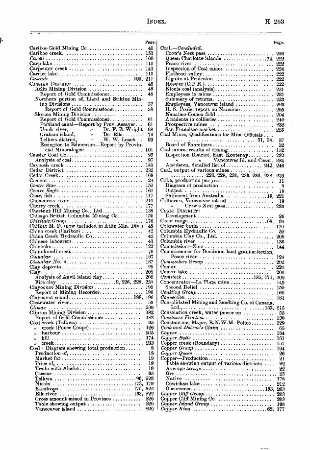
INDEX. H 265
Caribm Gold Mining Co.. 46 Caribw creek.. _, 151 Carmi............. .,.,..,,,,.,.,,,..,...,. 160 Carplake .__... ..__ .__. ._..., _,..,.,, ..,.. 115 Carpenter creek...... __. .__...____..__.. 141 Carrierlake.~........................,...... ,105 Caxcade ,~. ,... .., 190. 21, cnssr*a IhmFxT .......................... 48
Atlin Mining Division ..................... 48 Reporb of Gold Commissioner. ...... .... 48
Northern portion of, L&d and Stikine Min- inq Division* ........................... 57
Report of Gold Commissioner. .......... 58 Skeena Mining Division ......... ........
Report, of Gold Commissioner ............. 61 Portland cans,-Report by Pro”. Asae er. .. 61 Unuk river, I, Graham island, I
Dr. F. E. &ight 68 Dr. Ella ........ 71
Telkw.rr district, I W. W. Leach 9.3 Essington to Edmonton--Report by Provin-
cial Mineralogist ..................... 101 Casaiar Coal co .............................. 95
Analgais of ood. ............ .............. 97 C~tywsh creek ............................. 181 Cedar District. .............................. 232 CedarCreek ................................ 109 Cement........: ............................ 24
Cherryweek ............................. Ii: Chestnut Hill Mining co., Ltd ............. 138 Chicago-British Columbia Mining Co .......... 1% Chieftain ovmp ........................... Ii6 Cbilkat M. D. (uow included in Atlin Min. Div.) 48 China creek ICsribooJ ...................... 42 China Creek Hydraulic Co .................. 42 Chinese lsbourers. ....................... 41 Chinooks ................................. I‘22 Cbinukundl weak ....... ................... 58 Cinnabar ................... .............. 167 Cirmhar ATO. 8.. .......................... 167 Clay deposits ................................ 28 Clay.-. ................................ 909
Analysis of Anvil ials;nd cls+ .............. 239 Fire clay .................... .9, 226, 228, 231
Claycquot Mining Division ................... I99 Report of Mining Reoorder ................ 1%
CIayvquutsound.........................188, 1% Clcarwster river ............................. 58 Climaz !m Clinton Mining Division 182
Renort of Gold Commissioner 182 I (
Coal hreek (Telkws). ......................... 95 I week (Ponce Coup4 ................... 126 ,, hsrbaur ............................... 205 ,, hill ................................... 174 II creek .................................. 233
Cod Diagram shewing tote.1 pduotion ....... 8 Produotionof,............~. .............. I8 Mwkketfor ................................ 19 Priceof ................................. 19 TradewitbAl.ska. ........................ 19 Cassiar ................................... 95 Telkwa ............................... .96, 222 Niooh ......................................................... Kamkwps
.:~ . ,
g
Elkriver ................................. 222 Gross amount mind io Pmviuos ............ 210 Table showing ontput ........... .......... ml Vancouver island ......................... !Z20
Lh8l.--Goncztlded. Crow’s Nest pass _, Queen Charlotte isbands .74, Peace river. Inspection of CosJ mines. Flatheadvall~y............................ Lignites*tPrinceton . . . .._..._.......... Hosmer(C.PR.) _,_... Nioola we.1 Ianalysis). Employees in mines Summary of r&urns. Employees, Vancouver island ;, H. s. PC&, report on Nanaim. _. Nanaimo-Comox field Accidents in collieries _. _. Prospeotive mintx . . . .._.._.....___.., SanFranciacomarket.........,.......~...
2oal Mines, Qualifioations for Mine GfGcisls ,._., 31,
Board of Examiners.. _. _. Sd mine.3, resulbs of oloaing..
Impeotion District, East Kootenay I ,, Vancouver Id. and Cast,
Accidenta, detailed list of.. ,242, &al, mtput of various mines
Zoke, prcduction~$e?? .??. ??. ?! D&ram of pro uctmn output . Shipment from Australia .1R,
Zdlieries, Vanoou\w islead Crow’6 Nest pass.
““AST DIaTE~cr : De”ah”ment ’̂ - .,oastrauge................ ..~..... . ...68.
2oldwe.ter basin Clolumbia Hydraulio Co. Columbia Clay Co., Ltd. Columbia river _. _. %mmisaion-Zino Zommissioncr for Dominion lead erant selection.
Peiloeriver .... ........ ..T ............ . Commodore Ump .............. ............ Comox .................................... Comox lake .............................. rlmmtoek ........................... :onoentrator- Lc. Pldta mine
,135, 1 ii, ................
Second Belief ............................. coonkzi,~g Group . . . . . . . . . oonneetimt _. .‘. _. Consolidated Mining and Smslting Co.~of Canada,
Ltd.,,......... .._..__..... . . . . ..I63. Consolatmn creek, water power on oonztance l+czclimL Chnsbmtine, Major, R.N.W.M. Polio*, Cook and u&m’s Claim ooppe~........,.......... .._..._. copp Bllae . . . . . . . Capper creek (Boundary) coppcv a-@up Ccppe~QQueen ..,........,..... Co
$ per-Produotion . . . . . . . . .._. able showing output of various districts..
$wlLgeassays . . . . . . . . . . . . .._.._. “Lx............. .._............._....,... N&w ................................ CowicbanIa,ke...: ......................... Oceurrenoe ..........................
Copper Cliff orcap ..193.
........................... Copper Cliff Mining Co. ...................... owv Idand (houp ......................... Copper King ............................ .62,

H 264 INDEX.
pw Ooppr King amp (OSO~COS). ................ 170
M. (Ahousat) ................. 188 coppar Standard Gro?J@ ...................... 178 oo,J r mountain ........................... 180 oar r ........................................ 143 Oonm~ .................................... 179 omneu.. ....... . ....................... m2, ‘216
come”T mtlng co .................... ,202, 216
CoumBetamup ........................... ~175 CommBeZt .................................. 174 0ottazwDd ................................. 174 Cottonwood creek .......................... 210 Cotta, ersek ................................ 175 Courtesy river. ............................. 206 ~~t~~ .................................... 23‘2 Could ..................................... 179 Cow&e ad mine ........................... 79 Cowichm lake, Prov. Mineralogist’s trip to, .27, 209 .... Mineral posslbd,tses &out. ................ 210
I 3. Daeotah .................................... 174 Daily Bq amp. ........................... 73 Dandy 148
I ......................................
Daniel ...................................... 143 Damon, Dr., mpat on Queen Chedotte lslsnds
referred to ............................. ‘19 Dswson week (Ponce Con@) .................. 126 Deadwood oe.mp ............................ 158 Deasecreek ............................ ~5B, 60 Deaselake .................................. 68 D’Echafcwd oreek (Ponoe Cu”&) .............. 126 Deeroreek ................................. 198 Dde2enger .................................... 15, Della ...................................... 197 Delict ..................................... 14, Denoro Mines, Limited ....................... 113‘2 lkserted creek. .............................. 184 Determinstions.free .......................... 29 Determimtion of Fossils ..................... 206 Developments of the year ..................... 25
Placermining.. .......................... 25 Metalliferous mines ........................ 25
Devlinarolcp ................................ 148 Dewdrop Fmtional.. ....................... 185 Diamond Yale Coal & Iron Co. ........... ,179, 92, Disappointment inlet .................... .,t%, 199 Diwwy (Pine creek,. ................ .... 50
PILE&
Cowrcbnn ...... ................. .......... 205 Crsymoft islEnd ............................. ‘%4 CreonoftheomP.. owsceat ........ :.
........................ 171 .....................
Crescent IhSibn ,159, 161
........................... 159 Crofton .................................... 205
SmeltareA.. ............................ 26 Cross ,orTrahleur) lake .................... 113 Crown Gwp .............................. 62 crown Point.. ............................... 153 Crows Nest Pam Coal Co .........
Details of eooidenta at .,5, 19, 133, !z%
...................... ~46 Cumberland ............................... 206 ‘< Cnmberland anthracite ” .................... 231
~~~~~~~~~.:~.~.:~.~.:~.::~.~.:~.-.~.:~.:.::~.~~~~, 1% curlew ...................................... 160 Cyaaiding, Hendryx prooess .................. 148 Cyclone GrolJ@ .............................. 175
D&cowry (Wilson creek) 64 DMpucher ~. ~. 17, Dinp, electro-magnetic seps.stors. 144 Diwk?nd~.........-........................ 165 Dividend Oroup. , :. 168 Dividend mountain 168 Dixon entrsnoe _. 9, Do 8, Indian sleigh _, Do&++, ,,.._.._ _, ,..._. ::::::::::::‘:::::: :: Dmnmton............................... .QQ, 164 Dominionbssin .............................. 98 Dominion Government Raserw. Pwe river 120 Dominion Copper Co ..................... Dominion Tmt Co
,155, 16, .......................... 52
Downieereek ................................ 137 lhdnes. Frsser river. Drift;uo& river
...................... 182 . 113
Drummond, C. B., contribution from _. ,75 Drv Hill Hvdraulio Mines
I . . 109
Dwhem .................................... 99 Dunoan station ..................... ,160, 20.5, 210 Dunoanriver ............................... 14.3 vendee ................................... 20, Dunvegan,X.B.P.. ........................ 129 Duty on Cdsmine and zinc blende ............ 141 Dynamo ..................................... 15 9.
Eagle ...................................... 162 ElhhGroup.. ............................ 170 agle arOtip. ............................. 64 Elk river ................................... 133 Eagle (Hardy) mountain ................. 161, 162 E,kValley Coal Co .......................... 133 aarihqde arOup .................... .... 163 Elwaod Tin-workers G. B 6. M. Co ............ 136 &z&Side ................................... 200 ,%&e&d ................................... 148 Bdiwn .................................... 203 ~nme..............................149,156, 16‘2 Edison Mining Co ................. .......... 200 Empire ................. i. .................. 211 Edidith .................................... 194 Bmprena.. .............................. 144, 151 ~d~ur ..................................... 164 ......... 53 Edward Baillie Syudicate. .................. 139
English Counties Hydrsulio syndics t. Englishman’s river ... ....................... 232
Efiingham inlet .............. ............ 189 Ev,‘erprisc ................................... 189 Eight-mile lake ............................. 4, 8. P. u .................................. 159 Eldor& Grorq ..................... ..... 170 Essington to Edmonton, trip from. ........... 10, Electric instaUntion5 : Tsble of distances .......................... 102
B. c. Copper co,, ....................... 157 Cd ...................................... 104 Deadwwdc&mp .... ......... ............ 158 Cranby mines 156
Tim% .................................. h15 .............................
Ehdrio power ............................. 216 Agricultural ,m$r~ ; ; ........................ ;O$
n Pine creek. ................. 5, Min;ra, ,,,~~~~;$y8. :.
................................. 103 B7Zk ........................................ 199 Climate .................................. 107 Elkhorn .................................... 159 Winteringstock ........................... 108

Essingtan to Edmonton.-thchded. Details of trip $Xj
&zmmm ................................... Espersnza inlet .............................. :G EweEa ........................ ,150, 159, 189, 189 Eureka Copper Mines, Ltd. ................. 150 BM ................................ 136, 139, 140
F.
Fw&tanti*e .................................. 16.3 Aernie ...................................... 233 Firebrick .................................. 24 FireclPq.. ffi~~U” ...................................................
.9,226,2% 231 ........... 186 .”
Finlay rlvpida and river. ...................... 118 Ferguson...,. ........................... 1.18 Fer’” ,Mmes, Ltd ............... For mg rl”er ................ ........................
;;;
Railway up ............................... 133 i%“oresc .................................... 43 Iro,,t Chief ................................. 151 ForeslRave ................................. 39 FG-mR1 Qvem ............................... 203 Fort Connelly .......................... 113, 1% Font SESELE MINING D~vrs~oli :
Silver-lead reduction in ................. 25 cm, and co e, 7s I, .................. lY3 Plaoer mining ............................. 132
Fort St. James-. 113 Time to rasch fmm Vmmuver 114 R. c. Mission @.t.. 114
G
Galens ore, desulphurisation of, by Heberlein process ................................ 149
G*sme, hew. .......................... 118, 127 Gardner csnal ......... i .................... 67 GaresehB-Green Cod co .................... 17Y Ca7mt .......................... ......... 211 Gem .................................... 168 0. N ..................................... 164 “iLwL1 .................................... 134 *i**llar ................................... 167 Ci1,iesb.y ................................. ‘205
~Gapay ....................... ............... 65 Olacirr ................................... 197 Gladatone ............................. 52, 162 Gladyn....................~ ................. 194 Olenyorry .................................. 186 G,oncester camp ........................... 163 Gloueealer ................................. 164 Glouoevteroreek.............~ .............. 164 Gold, free .................................. 139
DredgesT Thompson river ............ .21, 25 llgdraulloe .............................. 20 p,aoers .................................. 26 prodnction of ............................ 20 placers, Yale M. D ...................... 177 Peaoe river ................................ 128 tnhle of production ....................... 10 lode mining ........... ................. 21 stamp mills .............................. 21
Cold Commissioners, list “f .................. 257 Gold Buttom creek ....................... .54, 55 Gdd Hqg ......................... ..... 139 Gold Drop .............. ................ 160 Gdd nuat Grozlp ............................ 165 Gold Finch ... ...... Go~afkm the Gmar I?0018 .........................
.139, 140, ;g ...... ...
cold Hill crollp ............................. 54 GoldRuncreek ............................ 48
Ew&Q Group. ................. ..... .... 99 EwGzg star ........................ ... ,164, 174 Blwing sun, 66 Eaominations for Coal Mines 06cie.h 1906 31 Extension. ................. ......... ..206. 2-a EntenaionColliery ........................... 227
Fort St. James-Conclud.ed. crops at 114 Frostnear .__..........__,,.,...,___.__._. 114
Fort%. John .___.._.....: ,,,.._._....... 120, 19.4 F&Lt ,..._..,..._..,,,...._.....,,, 143 Florence Gmq 166 nwene~ Fraction ,163, 166 Flares island ................................ 186 Fort Rune*. ............. ............... 204 Fossils &terminations of, in Nmeimo Fount&n Creek Cons. MS. Co .......................
206 40
Fountain week ....................... ...... 40 Fmnklin oazm .... ......................... 163 - Frariklin No. I ............................. 67 Fraukli? (townsite) ........... ............ 184 Fraser river (placers) ......................... 173 Fraser River Cold lhdging 00 ............... 177 Frederick island ........................ 75
: Bnn ............................. 204 i+mmont ........... ........................ 159 Frenchoreek ............................... 136
GoZdRun. .................................. 60 iG”ldatream creek ,Telkwa, GOLDEN Mmmo J~VISION
.................... 97 ................... 134
Colden, smelter *t ...... .................. 134 GoldmAze ........................... ..... 161 ColdenOare ................................. 199 Golden Crown G. $ S, Mining Co ........... 141 Golden Eagle .............. .... ........... 163 Golden Rule GrmJM .......... ................ 170 Gddrn Star ..... . ........................... Golden Soveredy~~ Oroup .....................
;;;
“olden zone GrotLp. .......................... 166 Coat meek (Telkws) ....................... 95
section oi ccQ.1 mfasure8 an ................. 95 Owdenough ................................ 145 GoodHom ................................. 188 c7md H&e Gra*. ........................ 199 Gordoll river ................................ 213 Gorgun .................................... 52 C0va,“d ishd ....................... .... 203
n lmrbour ........................ 203 Rraoemountain ............................. 174 Brahamishnd(Q.C.1.) ....................
Geolom “f ............................... ;i
Coelon ................................. 88 Anslyais of 0oP.l. ..... ................ .R9, 91
rook......~ ...... ............. 82 Map of ..................................
Grmby Con. M., S. bc P. Co., Ltd ... ,156, 16% GILAND FORK* MINImi DnTxxi:
Report of Cold Commissioner ............... GrandForks.. .............................
Production in M. D ...................... Crrsnd Trunk Pacific Pailway ............. .26, Grind "kw ............................. “ILLPhC .................................... Gr,mviue .................................. G*eat Centn.1 l&e ............ ......... ,194,

%D. we. Great Northern Railway : Qneenwood Qmwp . . 166
Spur to Phoenix . . 158 arsenwood . . 158 Branch to Fernie 233 Glacier ortek _. .@2, 65
Great Northern mountain 137 ,r (Unuk river). . 73 Grentille mountain 154 jr Gro!m creek
(Telkws) 98 . . . . . . . . . . . . . .,.... 41 62
areaMmtiai?l . . . . . . . . . . . . . . . . . . . . 168 Guggenheim Exploration Co . . .45, 50, uwllevicve................................... 16,
Green Mountain osmp. . . 168
H.
Ihines (Ah rsks) ............................ Hell Mini _ ,“a and Smeltina Co .. : .............. Hamilcreek................................. Hmmet, Mr., a. B. co. agent et Forth Ham
rlcLeod cplo~..................................
Iin................................ Hank,” has Happy Johlz Hamq, John &oup Hapmr Hedlum Hardscre.bble creek . HardyBoyr ~ . . . . . . ..,.. Herdy or Eagle mountain _. Harriwn Hastings (B. 0.) Exploation Syndicate, Ltd.. LTa~~othonze......................... . . .._.. H~~0lto~.................................... Hwelton-Babine trail
Reference to ,905 Report. Hecla............ ..,. . . . . . . . . .
Height of I&d : Stuart lske and S4mon river.. Salmoo river and Arctic water-shed
Hden.......................~............... Helga Gold and Capper Co.. . He@ Mining Co. Hemlock Hendryr process of Cyaniding , Here-it-& Hesperus...... ___........_._..,...,_..,,... Hesquoit . .
I.
I&l&? ................................ ..145. 157 Illecillewsat Al. D .......................... 136 1llu;rtrations :.
preprstion 04. ............................ 28 Zap, Alberni Mining Division. .............. 187 Sketch of Big Interior. .................... 195 801ukrn cn%s chaup .................... 131 Index to ...............................
Imperial Cod & Coke Co ..................... I,‘33 Ind4pendenee ....................... ..180, 201 Independencemauntsin.. .................... 168 Index.. .................................. 26, Index. ................................ 143 In*ersol .... .....................i ........ 136 I” ersolriver
% ................................ 189
In imos ..................................... 116 Be~Tertribe ............................. 120 doga .................................... 125
Indian chief amllp .... . ................. .m, 389 Inland~~~~~ ............................... 154 Inland Empire Mining & Milling Co ......... 154
Henquiat lake _. _, . _, _, Ewquiat. tmrbour. . . . . . . . . .._.... Hew (keen :. ~e~tt ...................................... Hie1le.n riv BP ................................ Highland (Kwtensy, B.C.1 Mining Co. ........ Hi
k blsnd .........................
Hi l’s bar valley .........
Hillside .................... ..173.
............. ............. Hcbaon .................................... Honestake Qroup ............ Honecrext
.%I, 161, 162, ...................................
Henna river ................................ Hope ................................. .145, Hornet ................................ : Homefly seotion ............................ Homaflv river .............................. Hmverhoe ................................... Iforsebeef bar .............................
.................................... md ...... .................... :reek
,208, ..............................
dson Houe ............................ ..............................
wdmd .............. asin ................................
e‘eberlein pmesa ................ rd ............................
&wp ........................ z&m. ........ ............
185 185 188 145
77 ,** 173 178 ml 161 167 I70 75
178 211
47 47
376 18;? 222 209
39 120
Ins ction of metallifemus mines I% mines
214 ............. ............................... B4
Internstionsl Boundary es~blished by oommiss’n 00 Zviah Boy ................................. 166 rmccap ................................... 176 Zronclad Fmetim ............................ 180 Iron Duke.. ... ............................ 16, Iron ....................................... 22
Hematite ore. ............................ 183 Zrm Horse ............................... 99 Zmz King .................................. 186 ZrolonRno6 .................................. 20, zwn bflwk ................................. 174 Iron Mask Mining Co ........................ 174 Iron Meadow ............................... 20, zrondleadowNoa.1,~arLdS.~ ............... 20, Isknt river ...................... .......... 68 Island mountain ............................. 44 Islands Copper Co .......................... 203 I.X.L. .................................... 207
J. Jaction ..................................... 144 JessieHZrre~~ ............................... 143 Jo* ....................................... 216 Jewel .................................... 159 Jespersonlsases ............................. ,8, Jook, lake ........... ..................... J&S
174 ............... ....... .............. 175 Joe ....................................... 174

Paps. r%ge. J&r ...................................... 59 Jumbo.., ....................... 05, 153, 102, 164 Jo& &nip ............................ 153, 163 Jumb0G.M. co ............................. 153 July creek ................................. 161 Jww Oroup ........................ ,183, 200, 201
Kdhpa (Kibp) ..................... ,188, Kamlmps Mining.Di\iision. ................... Kaslo meek, south fork. ...................... KateNo. .................................. KateNo.d .................................. Keithley creek ............................. Kemsn~ river
I, Provincial Asssv& trin to ” _ Kennedy I&e ..... ........................ Kenilt?orth ................................ Kenaingon ................................. Xeremeos-Pontiac mines .................... Korameoe ................................... Krremeosvalley ............................. Kotchikan (Alaska) ......................... Kettle river, north fork .....................
n east fork, north fork ............ I west fork .......................
Kett,le Vslley railway .......... ............ Kimherleg Co ...............................
L&our, soaroity of, ..................... .19, n pertonoforemined.. ................
Lahourers’ 00.operative Co ................... Lac Long river. See Long lake. LaclyDertha ................................ Ledysmith ............................ .202, La Jhtaine. ................................ Lake View c?rG7Lp .......................... Lakelse river, Government hstohery on I,* Plata Mm*, Ltd ...... ......... .................. Lexdeau Mining Division .....................
Report of Mining Recorder ................. Lmdeau meek, south fork ................. Last manee .................. 145, 162, 163, Law% Rnncp. ................. ............
.......................... .........................
Lam hill .................................. LeoA &seen ..... Lead,produotlo* Of ....................................................
I Table of output of various distriots ..... I London price of ...................... ,, Bo”ntyon . . . . . . .._......._...........
Leads...................................... Leemilford ................................. Lemon creek .............................. Lenaislsnd ................................ Lenore. ..................................... Le Roi ..................................... &e Rpi~NO. 2, Ltd ........................... Led&. . .._.____.__..._.._._...__~......_.. Lemer Slave Lake ~settlement), C.M.S. Mission,
H.B. Post, R. C. Mission, Revillon Fr&res. Lesser Slave river..
I I lake................,...........
...... ,132, 146, nmy .................. ..-. ................. Kin&J ‘4rchm ............................ Kim Solomon Mines Co. .....................
16’ 47 Kmgatcm ................................. 67 Kingston Gold and Copper Mining Co. ......... 28 Kitimat Development Syndioate. ..............
199 Klehini river .............................. 108 Kokaneeereek ...............................
2 Koksilah ........................... ,205, ceCo .............................
Kootena$ Belle. % \ Kooten&yriver ............................................................
n lake....................~ .......... 3 ( K”M ........................................
Krumrmountan, ............................ Kun; Indian village ......................... Kyuquot sound ............................
L. 149
16 134
168 %Y 1:: 149 139 139 138 152 li.5 122 143
73 135
21
2
2:: 175 147
2: 1.52 152 185
129
::
M.
Mabel. ,.....,... __,,...._,, . ..._.__...,,_ 163 drahe28 .................................... 161 Macdonnell, Mr. John A ...................... !E MczealW ............. .................... 14“ Mngdda a*ozL~ .............................. 170 M&L&a ..................................... 162
Lisrd aud Stikine, unexplored country in ....... 61, Lightning creek ........................... 39 Lightning Creek Gold Gravel and Draimge Co 39 Lignite--at Princatm ........................ 222 Lignite creek ................................ 76 LiIm.........~ ........................ 9, 24 Linooln creek ............................. 55 Lineolarhire ................................ 53 Lii,le *the ................................. 161 Lillk Bertha ................................ 163 Little Cdl Fmelion. .......................... 164 Littie Dipper Fnetim ....................... 190 Little Dmald ............................... 142 LittleJo .................................. 64 Lit& Snowshoe creek. ....................... 38 Ltttle &mm croup ......................... 52 LrLLooET DrslmIcT ......................... 181
Liliooet Mining Division, Report of Gold Cam- missioner ............................... 181
Lode mines, Diagram showing production of .... 8 Long lake ................................... 115 Long lake river. ............. .............. 115
I I n fsllsin ........................ 115 Lorne (Lillooet) .............................. 181 Lorne creek ................................ 109 Lor,LaUoone ................................ 167 Louire ..................................... 100 Lowheeoreek ............................... 39 ~~~.........................................215 Loyal Lease Ltd., co. ..... ............. .203, 216 “,o&d7amup
................................................................... “3
L&y Boy ............... ............. ,136, 138 Ldy Jack .............. La& seven. ................................................
1g
Mslvin, Jamieson ‘% co ....................... 54 hbmin rirer ................................ 70 Mo,mmoth ................................... 139 Mmmoth Mining Syndicate .................. 136 &,hbay .................................. 61 M@e &y oamp ............................ 62
H 268 INDEX.
Dr. Dresser’s Fe tionofmk mmMapleBaycsmp ,......,. p”
* an miorosoopic examina-
Maple island.. . ..t...... diaple Lwf . ,151, 164, Mstildaomek ,.,_.,_..._,...__.,_,.....,,._. Marble ..................................... Marble Bay..............................28. Marble ,Bay Ormq .................... i ..... MarvelG. Id. Co ........................... Mary point ................................. Maas& inlet ................................. Mczuhetoa ................................... Mauia ..................................... May & Jennie ................................ arayG~~~ ................................. McDame creek ......................... .57, McGuigm basin ........................... McKeemeek .............................. McKee Conaolidsted Eydraulio, Ltd. .......... BicKidey ................................. McKinley oa?p. ............................. MoKinle~ ?tfmes, Ltd ........................ M&wg iwz Group. .......................... McLml.. ................................. McLmdleke ................................
Land bordering on ......................... McNeill’sharbcmr ............................ McNdty Grovp ............................. ~~~azr.Lark ............................. Metalliferoue minea, impeotion of .............
shipping, list of .......................... Meteor. ..................................... .mropolitaa .............................. Mephi&ophelee ............................... Miohel creek, coal on .................... 133, Miobel aollieries ............................. today ..................................... Middle river ................................ “ Middlesboro Collieries ” (Nioola\ ............ Al Midway & Vernon~ Rnih Mill ore& ,--’ 4UeMcck.................................
‘inas, ldo, production of. See Lode Mines.
Kdnight. .............................. VB~ ...................
i micole4 ...........................
Nde,, harbour Nsdu river. ................................ Nahmint Mining Co. ...... .. ..... .. ‘.:‘:“” Nmarm D~TRIOT, Report of Gold Commmsmner Nanaimo Jubilee Mining Co ............... Nmaimo river. ............................ Nansimo hasbour .................... ....... Nmooae bay Nermws..: .............................. Nass river .................................. Nation river ................................ NeqJwJJa ...................................
Nettie L .................................. Nettie Jr. .................................. Nettle iAnd ................................ Newcastle i&nd. ........................... NewDenver. ............................
-se- Mineral prducts, value of .................... 16 M&erw i+Yactiml ............................ 201
Mining Reoorders, list of ..................... 967 Msmie Lvmwe .............................. 132
Missions : R. C., st Beb: R. C. at N&a
ine .......................... 110 Ikuz .......................... 112
td. (r‘., ~tmmrtieke.. ........ i.. ........ 114. C. M. S.,atLwmSlwelake.. ............. I99
Mob+ lake .............................. 122 Mother Lode .................... MoUie Gibson (me Laplata mines)
.m, 00, 143, ,f% ............. 149
‘NOnarch ............................. dionareh’ai)a~~ter
..134. 169 .......................... 16%
Mm!nrrh FnwtiJn ........................... 160 Monareh~mup.........~.............~ ...... 15, dfOonilrn .................... .145, 163 192, 193 MO& Carlo. .............................. ,i 6. Montezluna .............................. 143 Mdooss (Gem4 ............................... 128 Momh e.4 lake ............................. 45 Morice river. .............................. 97 Momiasey week. ............................ 211 Morni7lng Cky ........... .................. 290 Mosquitocreek .......................... 41 Mountain ................................. 176 diovntain Gcm No. I.. ....................... 58,
I NO.8 ......................... 5.8 Mountain Rose ................ ....... ,158, 163 Mount &key B. Yale Mining Co. ............. 118 Mount Dismeli ............................ 61 Mouounted Police, R. N. W., st Ft. St. John W.4 Mount Etheline ........................... 83 MountGenevieva ........................... 82 MmLntSevenG9nup. ...................... 170 Mt. Selwyn .............................. 118, Mount Zion ................................ 169 Mount Zion Mines ........................... 169 Jiount Zion Gmup .......................... 169 Moyfe ................................ ..132, 215 Moyie lake ............................. 132 diucho Dlo .................................. 39 Mod creek ................................. 96 Mud river .......................... .. ..126, 128 Muskeg.................................,2.5, I27 My-UP Gvoup ............................. 146 My&, ............................... 169
Nmv W~TTSIN~TF.~ DIBTRI~. _. _. New Westminster Mining Division, Report from
Mining Recorder _. _. N~ckelP2atc.......~.......... .._.........
). ,179, 221. Nioola (tom Nioole. Minim Divi ,SiO” _, ,73,
Valley Coal Q Coke Co.. ,179. 221. Nicola - Night, hawk Nipple mountain. ., Nii;;t;wggon road), lake, mver
N”.tiS, eB ................................
hlake.........~ ...................... No* Gmp ............................... Non- union .... ............................ Nootkasound ............................ Nom. ................................... Norm G+-oap .............................. North fork, Unuk rivex ...................... North island North Columbia Gold Mining C+ _. Noma-E.4e.T KOoTE**Y *IsTRIm, Report of
Gold Commissioner

INDEX. H 269
pnpe. me. Northey Mountain Cauip ..................... 167 Norway mountain ............................ 1.54 Northern Mines, Ltd .... .................... 61 No. 7 ....................................... 176 Northfield Mine.. ........................... 225 Xo. One ................................... 112 North Pine river .......... .......... .... 193 No. 3week .,_._.,_,.,,_, .................. 138 h%rorlh ,%.a, ...................... ...... .132, 216 No
P etguloh. ........... ................... 49
Nor;hJ~ta&yny. ...... .................. 9.5 N IsXecundw ............................. 17, OWENAY Dwnucw, Rap& by
Gold Commissioner ..................... 138
0. CyDonnel river .............................. 64 office St&istica :
A&worth Mioing Division ................. 144 Alb.ami I) ................. IS8
Vernon I, Victoris r Windermen, I Ysle I
Oil end Oilshaleles : I,, FL&head vsl,ey.. . 24 Cnrib........ . . . . . . . . . . . . . . . . . . . . . . 94
Oil and Oil&ales.-Cm&&d. Queen Charlotte Islanda., ..................
OilWorke(Q.C.1.)~. ........................ OlaUa ..................................... oiau a camp ................................. OlallsCop
ge rM.andS.Co ...........
Olsue cl-00 188, 188,
................................. Oldlu #iant ...... .......................... Old Elmen of England ........................ Olga.. ............................. i .... Ohio Mines Development Oo., Ltd.
199, ............
0. K.. ..................................... Okanagsn Landing. ..... ~._ ................. OxrsEca MmzrNo DImsroN :
DevelopmenL ............................. Ontario ..................... ........... Ophir
,143, ....................... ..............
OptdencL ............... .................... Opulence mountain. ......................... Oremm &up .............................. OreHill.. .............................. Ore mined in Pmvinoe, tonnage of ............. ore; westc.wt,v.1. .................... or0 Denmo Ormond..
........................... ..156. ........................... ....
0 hm 5mkp 188,
........... OS msba O&o, dm:,,, D~vrsrolr:“““““~““.”
................................
Report of Aoting Gold Commissioner. ....... Ollawa ..................................... Otter&ak .... ..: ......................... Ott.9 chk Conucl~~cd QrmI‘o., ..............
~~~~K~~~~.~:~.~~.:::::::::::::::::::. ouloak.. ...................... ..c ......... Outeider Grrmp .............................. Oyeter oriterion ............ ................
Pacificchdco .............................. Paoific North-West Co ....................... Pack river .................................. PawAise ............ ...................... Parle-paw rapids ............. ;. ............. Pars& river ........................... ,118,
cow-parwip plant ......................... Rosa Creek camp ............................ ParhJnder ..... ... i ... .; .................. Payne....................;..........; ...... Payrweak &x,p. ............... ........... PeaceRiver.. ......................... ..m,
steam navigation .......................... canyonon ................................. distriot;....;;...........; ................ o,ime.tenorthof ..........................
Pesoe River Crossing (settlement). ... , ........
Perryoreek .i . . . .._........ i _.......... . . Pete .......................................
Pelerboro~h ................................
P. sss P&+-son ................................... 213 177 Petersworeek .i ............................ 176 I,8 Phillips arm ............. .;. ................. 204 133 Phomiz Orotrl, ............................ 198 119 Phcenix ..................................... 160 117 PilotBey Concentrator.. ..................... 1.92 117 PineAp&e...........; ...................... 169 163 Pine(black) ................................. 116 163 Pinecreek.. ...... . ................. 48,50. 85
Ei? Elecrrio power plant on .................... 8, Fellsin; ................................ 81
118 6!, 121
Pine,Cre=ak Power Co., Ltd.. Pi,rer,vsr...; ...... .... ........................ .......... 199
E valley of .................................. 123 trails of.. ................................. 12.3
197 Pine River paw ....................... ..,,7. 132 129 ............................ 151 XXI
Pingston oraek Pintledanne oreek ......................... .67, 88
164 Pilldetinne oroup ... i i ................... I37 139 Placergold ................................. !25 186 Platinum
20, ................................... 2.3
52 production at Yllooet ....................... 23

H 2’70 IXDEX.
Pleassntczwnp ............................... Polleykke .................................. pItnt
0 iiEd ...............................
up .............................. Poplar creek camp .......................... Portage :
Babine lake to St-t lake ..... ............ Mountain of Rooks portage ................. PeSCeri”ercS”VO” .........................
Portland Porthndosnal..................... ._...._._
Repof;ts of microsoopic exsmination of rooks 08. om . . . .
Report by Provincial Asasyer ~. .28, International boundary in Communication with Geology of ............................. Ore from .................................. Development ............................. Sketch map of .............................
Port Essington ... . ........................ PortSimpo” ................................ Pc4Hook .................................. Pottery :
B. c. Pottery Co .......................... 24 Pouae Coup6 prairie ................. .107, 124, 126 Prral~ ..................................... 158
Quarta mining, Caribm District:. . 43 Qmmmo Mmrm DIVISION :
Repurt of Mining Recorder . . 199 Qwtsino sound.. . . ,197, 200, 183 &uatsino King.. ._ _. _. 2M) Quilehem basin . _. . . 178 Queen Chsrlotte Islands-Report by Dr. EUs.. 74 Queen Charlotte Cod Minim Co.. 81 -. Queen Charlotte Islands, fossils of. i6
I Queen Charlotte Islands.--Cacludcd.
Oil seepages. . ieen.........~........ . . . . . . . . . . . . . . ..bt&
ictoria -mEw DISTF.Icr :
Mining Recorder mmissioner
Lodemining in............................ Quesnelriver..............................
Rab it Pat0 ............................... , 162 Rainhe.. ................................ OS Rain Hollow
8 ............................... 05
Ram Lr ................................ 145, 160 Repid creek ................................ X38 Rnrohide .............................. ,138, 10, Rem ....................................... Red mountain ......................... ..152, 167 Red Rd. ................................. 204 Red Rover ................................. IS0 Reuina ...................................... 62
Prideawrisland.............................~ 139 Prince Qrolqp.. 106 PrinceHenry ..__,_.._,..,,..,_.,..,.__._... ,858 &Gme Mining Co.. . . 136 Ptince of wales.. . . . . . . ..~..... 170. Prince Rtqert . . . 20, Prodwho”, mineral :
analysis of retwa 16 diagram showhg total.. . 8
Pr”mpi”e mounte.in 43 Protection island . 225 Pm&&o” Islaad Mine.. . 226 Providence 1.58 Province Group. 144 Province Mines, LM _. _. _, 144 Provinoial Mineralogist :
Work of Year 27 Visit to Cowicha” lake. 27 Peace river Bip. 27
Di8ta”c.e table.. _. _. _. _. 102 Diary . . . . . . . . . . .._....__.. 10,
Te~aisland.................... _.,...., 23 Pta7mi~on........................ 135 PugetSoundIro” Co. _..._.._,,,.,,...,.,___ 203 Puotledge river _. 206 Py&bm 176
Q.
R.
R&e11 sound.. , , . 77 Report of Dr. Dresser, on micmsoopic examina-
tion of rooks of Big Interior ~. 196 Reserve, Dominion Govecp4ent 120
awt . lOi NO.J....................... . . . ,oi
-l-&es .: . ,120, 124 DImBIC~ : Kord~=.................. ,a,
;olIe.... ..~.. 137
:SilverMg.Ca ................. 1 rd tire w&d. ..... ................. .20, 207 wnde ................................. 10,
vm”tsi” .......................... 167 ,ioh mountain amp .. _, ............. .... 186
? ............................ 11, !y& ... - .......... ...................... 104
I. Bi*in* sun (hau, Ri R.N.W.M. Police-
Pem River Crating . . . . . . . . . . . . . . . 1 23
R.N.W.M. Police.--Concluded. LeSSW F&We L&e. .........................
Road-Penticton-Nickel plate ................ Roads-
Bear 0-k (Similkamee”). .................. Peace River Crossing, south .................
I? I to St John. ........... Arrow Lake to Big Ledge., ................ Nanaima, Alberni ..........................
Rc+dview .................................. Roadside .................................. Robertson river. ............................. Rooaetirlt ................ ............... Rosepoint
.62, .................................
Rose spit ................ ............ , .. Resella week. ............................. Rosslle Hyd. Mg. & Dev. Co., Ltd.. .......... Roee Ma,w Group ........................... RO&WLd .................................... Roselsnd ................................... Rossland camp .............................. Ross~~m Drswax :
Report of Gold Commissioner .............. RO!+ .......... ........................... Royal Banner ............................... Royal Standard ............................. R&iemd .................................... Ruby omek ..................... ............ RwnianCweE.. ............................. Xtih .................................. ....
-

INDEX. H 271
S.
Sd&l~ ................................ f3dmon arm .................. , , ............. Salmonriver .......................... ..61. Salt Bpriog islend .......................... SaIlJUan. ................................... 851-h ...................................... sarilaorovp ............................... ibrit9 liver ........................ , ........ Saekstoon creek ..................... ..... saznge ........................ ............. Senllonoreek ............................... seheeute ................................... Scoti ckwp ............................... scotlet ..................................... smmtin .................................... 143 shwchli ............................ 170 Seattle 5
nt Qroup mnpecting and Development Co. ...... W
sechartehsnnel.............................. 189 Secoad Relief ............................... 150 Gelwvn. Mount ; ........................... 118
,,- creek .............................. ll3 s%ymo”r **In. .............................. 174
Ianding 8hkvek
...................................................... .... 114 ,166, 170
sri0rpahooler ............................ : ..... 167 Sheep creek ................................ 148 Shickdmk ................................... 163 Shining Batvty ............................... 134 Shipping mines in 1906, list of., .............. 248 Shmy ....................................... 175 Sidney inlet ......................... .!26, 185, ml silver. .................................... 203 8ilvcrBeU .................................. 106 S&w Bow ................................ 67 silw clap.. ...................... .136, 137, 138 8ilverDc?&w ................................ 138 8&e Qlmce .............................. 144 8ilwKing...............................68, 143 Silver-lead ore, praduotion of ................ 25 Silver, production of .......................... 21 SilWtOn. ............................. ..145. 16, Smm5Hanr~ MmmO DIvrs1on ............... 130 Siwseh week ................................ 177 Six-mile ................................... 1.38 16.mile creek ........................... ,166, 169 S3mENb MIRINO DnlsIoN :
Skeens river ............................... 109 Rqxirtfrom ............................... 61
Skidege.te .................................. 54 Skonun point. ............................... 7.9 Shark ..................................... 156 Sl& ........ ............................. 81 Ststeebuck creek ............................ 80
Qoarr- on ........ ......... smw &N MniING Dmsrox :
.............. 81
ReportofMiningRecorder.. .............. . . 1443 SLOCAN Drs~nroz :
R.ep~ort of Gold Commissioner ............... 111 Develo merits
Smm & ............................ 25
WMR Drvvrsro~ ; Report of Mining F.e@order ................. 146
sloean Prince., ............................. 146 8beanStar .................................. 145 Slokoriver ................................. 54 sh&c&yk, Lt.3 ........................... 42
cmfton ................ .............. .u36, 200 ALAa ................................. 221
~B. 0. Copper Co. (Greenwood). ......... ,158, 182 G-by ................................... 164
SXELTZSCR-C He.11 Mines.. , . TaowIle.... ,..........._......,.......... Tyee.. ................................... Im rtin
SrniGY f coke.. ..........................
oree ................................. S7IlB&l...................................... Smoky river ................... ............. Sbwdoe ........................... Snowshoecreek
..L%, .............................
Snowshoe Gold and Cow-z Mines, Ltd. ........ .- Snow creek. _. .~ .:. . _.
Fort Steele Mininn Divieion ............... Report of Gold Commissioner Mikal claims held in, . .
southenz CICSS . . .!B. 13% , South- Groan mine2 Plsna of South fork (Unnk river) ..
...................................
Spanish lake .............................. n I ditch ..........................
Spences Bridge ............................. Spi Spdnne T&k springe Spruce (tin21 sprnoe OI Spruce Creek Yower Co.. Stetistioal Tables I., II., III., IV., V.! VI.,
VII., VIII., IX., X. and XI, explenatmn of. h!?ee also Mineral Product,ion.l .1I3. 17.
SW-r Qronp ............................. .w), Stem basin ................................ starveout ..... ............................. StsnleV ................................... Slanderd .............................. ..i .. StarMiningendMillingCo ................... 8tarofHepQrorvp ........................ 8tondard ...................................
,mr
Bwnard ................................. Stameraervice,Ca&ofB.C ...............
Ila ................................. . .... No.>. ...............................
St.Zhm..... . . . . . .._._.. .,__..... .___ stenwinder.. . . . ..m. 157, 16.5, Stemwinder Gold & Casl MS. Co., Ltd.. Stephe St. h%&
stnclen ................................... Stikine and Lisrd Mining Divisions, Gold Corn-
missioner’s rqmt of. .................... Stikine Mining Division, quarts in ........... Stikine river ............................. .48,
copperoreon.. .......................... Stibnite ..................................... S1.Keverne ................................. 8t.Immnce Qmtlp .......................... St. Lawrence, ....................... ........ S1. Lawwa tSimilkameenl.. ................ StmwlGdch ........... ~: .................. 8tcwmw ...................................
r

H 272 INDEX.
psss straits of aenrgis ............................ !a5 Bl~~COna.. ............................... 64 ShztAwe ............. .................... 168 Blrand .................................... 170 B/ra~ ................................... 163 Stuart lake .... ......................
co”“try~~ut ,101, 113
............. ............... 114
sg ” arcreek ................................. 44 suga7 Laf ................................ 176 Sdldmn ............................. Sulphide creek
..132. 215 .............................. 72
T.
Tacoma Steel Co.. ,202, 216 Te ish lake _. _, _.
k 5I
Ta lalake....~........................ .,_, 113 Tammac ................................... 146 pm. ~Shanter creek ......................... 141 1.a.~~ ...................................... 141
,“Tar-Flets”. ............................... 60 I Tartw.................... 1,~ Tetoheriver................................. Il.3 Tecumeh : . 136 Telkws river ~.......... . . . . . . ...26. 93 Telkwe Mines, Ltd.. . . . . . . 99 Telkwa Mtinn. Wlline Et Develcoment Cc., ~. 97 Telkwa ,
T Repcn
1k.............................. 68 Ten-l)“i” cami .. .;. .......... i .............. 179
tree (Nmoh) .............. - ...... 179 I crrek ............................ 147
Tedin lake .................... ............. 55 n river. ................................ 48
Teslin M.D.,includedinAtlinM.D. ......... 48 Tetariver ................................... 200 Tetiol ....... ............................. 169 TEX~DA Imo.w ...................
Provincial Mineralcgist’a trip to. 24,!26,202, 215
............ 28 Terns ...................................... ,86 Thibert week ........................ ... 69 Thistle Gold Cc., Ltd ......................... 41 Three Pa .......... ....................... 188 Thurlcw inland .............................. 204 Tiger ...................... ; ................ 168 Tilaa, cotput estimated ....................... 9 Tinnicamm ................................. 18.5 Tobcwm ................................... 160 Tcby creek, north fork ...................... 13.5 Ted inlet, cement works at .............. .... 24 TOM Cat CWp.. 179 Totems of slate.. _. 8,
I
Y. a. . . . . . .._......_..................._... 161 Valdes island.. 203 van Anda,. ,.. ,. ,, ..2,, 216 vancm4w. 14.5
Vancouver Portland Cement Co.. 24 Vancouver (t Bcundsry Creak M. & D. Cc, 159 Vancouver Island, develvpment 26 Vancouver Island and Cw,st _. 183 Vmconver Inland Mg. & I)ev. Co. 207
Pe.!m.
Summit Camp ......................... Bunnyeide
.156, 162 ..............................
Sunrise creek ,165, 212
................................ 9% SUMst f3rcy (Boundary) ..................... 158 Sunact ....... . .............................. 145 Wnahine .................................. 15, Superior .................................... !a0 Surprise lake ............................... 50 SUP?%Y ..................................... 53 Suttoncreek ................................ 212
Tcqu Towhill......
1x h&rccu* . . . . . . . . . . . . . . . . . . . . . . . . . . . . . . .._..._.._..._._..
Eky Mining Division
Fort St. John to Pouoe Co@. . StwrtlaketoMoL.xdlake ._.,,......... ,. g$k&~Ph&RiW& %X2:. : : : : : ; : : : : : : :
Hudson Hope to Mcberley lake . . . To Yukon, via Ft. Grahame. I” Pine river ve.lley . . . . . . . .
Tranquil week.. . . Trsnquille bed (geology). Tm~maol Cvtmp Trmsccntinental Development Syndicate.. Tremblay (guide) _. _, _. Tremhleur (Tremblay) lake, or Cross lake ~rcutri~or................................. I Trzle Blue Group. : Truth-?mq............................ 174, T ~eI(**(*~~L ........................ ........ TBC”T LAKB MININ< f DInsIoN :
Report cf !&dug I Leoorder ................. PIa .oe* rmnmg .... ................ ....
gycut fishing ................................ routlake ..................................
TI routcreek ........................... 13% Ttiune ............................... Tsukatli lake.
..136. ..............................
Tut&lake. ................................ Tumbc island .............................. Tungstic oxide .............................. Turnagain river. ........................ Twelve-mile week
.57, ...........................
Twenty-mile canyon., ...................... Twin creek., ................................ hovel ................................... ryee copper co
26, ...........................
ryee Smelter ................................
Uchucklesat ha&cur.. . uncle sanz ~. United . ...142.
v.
VANconv~ ISLAND : Prcv. Assayer’s trip ta west coast 28
I’clvet.. 153 VERNON Dmwsrx :
Mining Division, Report of Gold Commissioner 172 Vesuvius bay.. . 205 “*lcr.................. . . . . . . . 185 V*tor Fmctim.. 185
VICTORIA DISOWN, Report of Mining Reocrder 2M

INDEX. H 273
Pa?p. Victoria
Pap. . . . . . . . . . . ..__. . . . . . .
Victaia Fmecdm 156, 175 vo&ano............................,...., 163
.,. 201 V. V. & E. Ry.. : .160, 173, 178
Voleanie amp 163
Viragosound................................ 75 Volc;tnio creek.. 34
W.
W@Z& Whmco . . . . . . . . . . . . . ww &age ..~................ War E.q,le (Howson creek, ~, warHor8e ~.. ..~..... .,.....,..
9 ....................................... ‘atihmn
ii ............... ................
‘ate-power, C!msolation meek ....... .55, 167, wetlmrfver ............................... wm+y ................................... Way&e Qlvzup ......................... ,159, Webster creek .......... ................... WdlingtOL................................. weui”gto” cmnp.. .150, Wellington CoUiery Co., ,204, ZSQ, ?24, well<~@m West mn, Quataino sound.. West co& of Vmoonver Island :
Report of Pmvinoial Asw.yer West=3*n Fuel co.. _,... 18,!2@4,220, Wealnont Wheal Tama”‘. ,174, White Bear.
White Bear Conmlfdated Oold Mines, Ltd.. . white crouse...................... . .
Yskan poi nt............. . . . . . . Yskonnl&e,river. ..~ . . . . . Yu9 Dmmrm :
Bmdwps, Ashcroft, Yale, Bimilknmeen and Nicols. Mining Divisions ,.
Ysle Mining I)itiaion I, I 00.
While Heaker ............................ 15, White Tail ................... .............. 164 White Tail Fradion. ......................... l&L Whitevxter .................. 144 Whiteweler Deep ............................ 144 Wild Horse creek. &oer on ................. 132 _ Wildiams ..,.... . ...,,_, .._.. 4, ~~‘!jcms creek 39 Willis ...................... . .............. 16.3 Willow river ............................... 41 Willow River Mining Co., .................. 41 W&ml cm&. ....................... ....... 54 Wimheste,. ................................ 166
Windy am ............................. 69 W1NDsRMEP.E MININo DIvrsIoN :
55,
Remrtof MininnReoorder ................. 1% Development of.. 26 Railway oommunioation in.. 135
Wirnlow ..,..........,,........ 1.38 w~~~damup.............................. ,Ol w&es ... .I ............................... 123 Wmdbury creek. ......... : .................. 142 Wrengel ................................... 59 Wright week ............................... 53
Zee.wl Frculima . .,. . . . . . . . :. 164 Zino:.....(.................. . . . . . . . . 203
Zino blende _. , _. _. _. 141 Calamine (duty cm). . __ _, _. 141 Dominion Gav t Zinc Commission, report .22, 144 Production Z2
ko river .............................. .. Ynair ...................................... Yorkboats.....~ ............................
173 Ymka ................................ ..183. 177 Y~ill Qnndp ................................. 165 Yukon Rmndwy ...........................
Z.
zirm.-0m1wlrd. Enriohing pla&s. , n Smelting.. . 23 Occurrence in Kaslo District. 144
Zymoetz river.. ~. .B3, 93, ml

ILLlJSTRAycIONS. H 275
LIST OF ILLUSTRATIONS.
------:o:-
FortSt.John,II. B.Co.‘s~tonPeaceRiver,B. C ._.. .__....._ Frontiapiew. Alberm Mmug Dmsmn, map of .Fscing p. 186 Bsbine Vilkwe md Iake--Liking south ,.................. 96 Babine Lake, B. C., on--looking north. ..............................................
Bear River, Portland Canal District, sketch map of ...... ................ ........... Bear River, Port,land Cam, Distriot, B. C ........................................... Bear River Valley, Portland Canal Distriot, B. 0. ...................................... Big Interior Mine, sketoh of bmin at .............................................. Big Interior Mine, Vancouver Island, basin at .......................................... Blsok &ok md Burns Hydraulic Mine, Cariboo, B. C., in 1863 (from old photo. loaned by
Ho,,.D.M. Eberts) ........... ..i ........................................... “Caribm” Cameron Dlsim, Willima Creek, ,863 (from old photo. lotmed by Edge Bloom-
field, Em., ............................................................... ‘N&-No. I-L‘Ce~ibm” (J. A.) Cameron (with gold pm).
I 2-A. D. MoImea. I Sdames [email protected]. ,, PJames T. Steele. I S-Robert Stqeneon. I Blames Cummings (behind No. 4). I 7 and S-Brothers of J. A. Cameron (on either side of No. 1).
Della Lake, Vencmver Islmd. .......................................................
DellaandGlaoierCIsims ...........................................................
I n arrastra O” ................................................
Dunvegan, IX B. Co. post, Peace River, Alberta-looking down stream ................. Fort MoLd, H. B. Co. post, i&Led Lake, B. C ...................................
Fort St. John--view fmm platam level, laoking south .................................
n -Gosernment Reserve opposite (with oamp). ............................
Gmhsm Idand (Queen Charlotte Group), sketoh geologioal map of .................... Crest Central Lake, Vanoouver Island ...............................................
Guggenheim’ Steam Shovel, Pine Creek, A+& B. C ..................................
Hudson Rope, II. B. Co. post on Pease River, B. C., from the east .............. ........ Hudson Hop snd Moberly Lake, country between., ....................................
km&ion of the Pack and Parsnip Rivers, 8. O., lwking es& ............................
Remsno River, B. C., laoking up. ...................................................
Km,, River, Gardner Cm& B. C. ......... :. .......................................
Le.c hng,River, falls on, near Fort McLed, B. C .................................
Lesser Slave Lake, Epimooal Church Mission at ............... Y. ......................
Lesser Shve River, Alberta, York boat on ...........................................
n I patching cmw ...........................................
Maple Bay snd “ Gxhsiders” Mine Tramway, Portland Canal ............... ........... r
Moher,y Lake, B. O., from the east. ......... ....................................
Mt. Selwyn, on Peace River, B. C., looking south-east ......... .....................
Parsnip River, B. C., looking north down stream from mouth of Nation River., ........... Pesoe River, B. C., camp on, 06 foot of Mt. Selwyn, looking north-cast ...................
n ~lformationon .................................................. I, FinlsyRapids O” ..................................................
I . from Mt. Selwyn, 4,ooO feat dxwe river, looking nortb-e+v4
I Moontains opposite Mt. Selwyn ..................................
n looking up from Mountain-of Rooks Portage ........................
Y Mcmntain.of.Rooks Canyon (36 miles long). ........................
I Psrle Pas Rapids ................................................
n lwking east down stream from Hudson Hop .......................
I,
I,
I
I,
I,
I
,I
I,
x
I,
I
n
I
I
n
n
,,
n
n
I
I
n
I
I
I,
n
I
0
I
I
I
I,
I
n
I
II
n
I,

.
H 276 ILLUYTRATIONS.
144 II 164
Peeaoe River, B. C., packing over Mountain-of-Rocks Portage ..........................
I oppmte Fort St. John, from south side .............. I, at120th Meridian .................................................
PineCrrekPowerCo.‘sMine,Atlin,B.C.. ............................ .............. Pintledanne Pass, head of Kemano River ...................... .................
Pouoe coup4 Prairie, country uelV ................ ............... ........... ...
Steam Shovel, Great Northern Mine, Spruce Creek, Atlin, B. C .......................... South Pine River, B. C., 15 miles frarn mouth, looking south-west .......................
I I, ford, four miles from mouth .............................. Southern Cross Group, sections of ................................................... Southern Cross Mine, upper tunnels ...................................................
I n lonertunnel ................................................... Stuart Lake, B. C., sunset on ................... .....................................
I R. C. Mission at ............. .......................... ......... Table showing in detail Miners1 Pmdu$on from 1858 to 1WB ...........................
Table showing Mineral Pmduotion from 1886 to 1906 ...................................
--

LIBRARY CATALOa-GE SLIPS.
Annual Report of the Minister of Minea for the year ending r 31st December, 1906, being an account of mining operations
for gold, coal, etc., in the Province. William Fleet Robertson, Provincial Mineralogist. 277 p., plstms, maps, 1906.
Victoria, Government Printing 05on, 1907.
Robertson, William Fleet. (~rwincial Mineralogist.)
Annual Report of the Mini&r of Mines of British Columbia for the pear ending 31st December, 1906, being an account of mining operations for gold, coal, etc., in the Province. (British Columbia. Bureau of Mines.) 277 p., plates, m&ps, 1906.
Victoria, Government Printing 05oe, 1907.
Annual Report of the Minister of Minea of British Columbia
for the year ending 31st December, 1906, being an account of mining operations for gold, coal, etc., in the Province. William Fleet I&obertaon, Provincial Ninerslogiat. (Britieb Columbia, Bureau of Mines.) 217 p., plstea, meps, 1906.
Victoria, Government Printing C5ce, 1907.