Mineral and geochemical characterization of a leptic aluandic soil and a thapto aluandic-ferralsol...
10
Mineral and geochemical characterization of a leptic aluandic soil and a thapto aluandic-ferralsol developed on trachytes in Mount Bambouto (Cameroon volcanic line) P. Tematio a, ⁎, E. Fritsch b , M.E. Hodson c , Y. Lucas d , D. Bitom e , P. Bilong e a University of Dschang, Faculty of Sciences, Campus C., BP.67, Dschang, Cameroon b Institut de Minéralogie et de Physique des Milieux Condensés (IMPMC), UMR 7590, CNRS, Universités Paris VI, VII et IPGP, Campus Boucicaut,140 rue Lourmel, 75015 Paris, France c University of Reading, P.O. Box 217, Reading, Bershire, UK d Université du Sud Toulon Var, Laboratoire PROTEE, BP.20132 – 83957, La Garde Cedex, France e Université de Yaoundé I, Faculté des Sciences, BP.812, Yaoundé, Cameroon abstract article info Article history: Received 11 November 2008 Received in revised form 22 May 2009 Accepted 27 May 2009 Available online 24 July 2009 Keywords: Soil mineralogy Soil geochemistry Hydrolysis Volcanic soils Andosolization Ferrallitization Cameroon volcanic line Mineral and geochemical investigations were carried out on soil samples and fresh rock (trachytes) from two selected soil profiles (TM profile on leptic aluandic soils and TL profile on thapto aluandic-ferralsols) from Mount Bambouto to better understand geochemical processes and mineral paragenesis involved in the development of soils in this environment. In TM profile, the hydrated halloysites and goethite occur in the weathered saprolite boulders of BC horizon while dehydrated halloysite, gibbsite and goethite dominate the soils matrices of BC and A horizons. In TL profile, the dehydrated halloysites and goethite are the most abundant secondary minerals in the weathered saprolites of C and BC horizons while gibbsite, hematite and kaolinite occur in the soil matrices of BC, B and A horizons. The highest gibbsite content is in the platy nodules of B horizon. In both soil profiles, organo-metal complexes (most likely of Al and Fe) are present in the surface A horizon. Geochemically, between the fresh rock and the weathered saprolites in both soils, SiO 2 , K 2 O, CaO, Na 2 O and MgO contents decrease strongly while Fe 2 O 3 and Al 2 O 3 tend to accumulate. The molar ratio of SiO 2 /Al 2 O 3 (Ki) and the sum of Ca, Mg, K and Na ions (TRB) also decreases abruptly between fresh rocks and the weathered saprolites, but increases significantly at the soil surface. The TM profile shows intense Al enrichment whereas the TL profile highlights enrichment in both Al and Fe as the weathering progresses upwards. Both soil profiles are enriched in Ni, Cu, Ba and Co and depleted in U, Th, Ta, Hf, Y, Sr, Pb, Zr and Zn relative to fresh rock. They also show a relatively low fractionation of the rare earth elements (REE: La, Nd, Sm, Eu, Tb, Yb and Lu), except for Ce which tends to be enriched in soils compared to CI chondrite. All these results give evidence of intense hydrolysis at soil deep in Mount Bambouto resulting in the formation of halloysite which progressively transforms into gibbsite and/or dehydrated halloysite. At the soil surface, the prominent pedogenetic process refers to andosolization with formation of organo-metal complexes. In TL profile, the presence of kaolinite in soil matrices BC and B horizons is consistent with ferralitization at soil deep. In conclusion, soil forming processes in Mount Bambouto are strongly influenced by local climate: (i) in the upper mountain (N 2000 m), the fresh, misty and humid climate favors andosolization; whereas (ii) in the middle lands (1700–2000 m) with a relatively dry climate, both andosolization at the soil surface and ferralitization at soil deep act together. © 2009 Elsevier B.V. All rights reserved. 1. Introduction Andosols occur in volcanic regions all over the world and cover about 1% of the earth's surface (Leamy, 1984) under a variety of environmental conditions (Jahn, 1991; Saigusa et al., 1991; Shoji et al., 1993; Zhao et al., 1993; Nizeyimana et al., 1997; Adjadeh and Inoue, 1999; Aran et al., 2001; Campos Cascaredo et al., 2001; Quantin, 2004). In tropical regions, they are widespread and represent circa 50% of the total andosols worldwide, they occur predominantly around the Pacific Rim and the Africa Rift Valley. In Cameroon, they occupy a small area along the Cameroon volcanic line where they are commonly surrounded by ferralsols (Sieffermann, 1973). Mount Bambouto is located in the central part of the Cameroon volcanic line. Previous studies have focused upon the agricultural suitability and management of these soils (Boukong et al., 2001). Very few were done about soil genesis, since the majority of the studied soil pits did not reach fresh rocks (Doubé, 1989; Van Ranst et al., 1993). Recent research related to soil typology and their spatial distribution Geoderma 152 (2009) 314–323 ⁎ Corresponding author. E-mail address: [email protected] (P. Tematio). 0016-7061/$ – see front matter © 2009 Elsevier B.V. All rights reserved. doi:10.1016/j.geoderma.2009.05.029 Contents lists available at ScienceDirect Geoderma journal homepage: www.elsevier.com/locate/geoderma
Transcript of Mineral and geochemical characterization of a leptic aluandic soil and a thapto aluandic-ferralsol...

Geoderma 152 (2009) 314–323
Contents lists available at ScienceDirect
Geoderma
j ourna l homepage: www.e lsev ie r.com/ locate /geoderma
Mineral and geochemical characterization of a leptic aluandic soil and athapto aluandic-ferralsol developed on trachytes in Mount Bambouto(Cameroon volcanic line)
P. Tematio a,⁎, E. Fritsch b, M.E. Hodson c, Y. Lucas d, D. Bitom e, P. Bilong e
a University of Dschang, Faculty of Sciences, Campus C., BP.67, Dschang, Cameroonb Institut de Minéralogie et de Physique des Milieux Condensés (IMPMC), UMR 7590, CNRS, Universités Paris VI, VII et IPGP, Campus Boucicaut, 140 rue Lourmel, 75015 Paris, Francec University of Reading, P.O. Box 217, Reading, Bershire, UKd Université du Sud Toulon Var, Laboratoire PROTEE, BP.20132 – 83957, La Garde Cedex, Francee Université de Yaoundé I, Faculté des Sciences, BP.812, Yaoundé, Cameroon
⁎ Corresponding author.E-mail address: [email protected] (P. Tematio).
0016-7061/$ – see front matter © 2009 Elsevier B.V. Adoi:10.1016/j.geoderma.2009.05.029
a b s t r a c t
a r t i c l e i n f oArticle history:Received 11 November 2008Received in revised form 22 May 2009Accepted 27 May 2009Available online 24 July 2009
Keywords:Soil mineralogySoil geochemistryHydrolysisVolcanic soilsAndosolizationFerrallitizationCameroon volcanic line
Mineral and geochemical investigations were carried out on soil samples and fresh rock (trachytes) from twoselected soil profiles (TM profile on leptic aluandic soils and TL profile on thapto aluandic-ferralsols) fromMount Bambouto to better understand geochemical processes and mineral paragenesis involved in thedevelopment of soils in this environment. In TM profile, the hydrated halloysites and goethite occur in theweathered saprolite boulders of BC horizon while dehydrated halloysite, gibbsite and goethite dominate thesoils matrices of BC and A horizons. In TL profile, the dehydrated halloysites and goethite are the mostabundant secondary minerals in the weathered saprolites of C and BC horizons while gibbsite, hematite andkaolinite occur in the soil matrices of BC, B and A horizons. The highest gibbsite content is in the platynodules of B horizon. In both soil profiles, organo-metal complexes (most likely of Al and Fe) are present inthe surface A horizon. Geochemically, between the fresh rock and the weathered saprolites in both soils, SiO2,K2O, CaO, Na2O and MgO contents decrease strongly while Fe2O3 and Al2O3 tend to accumulate. The molarratio of SiO2/Al2O3 (Ki) and the sum of Ca, Mg, K and Na ions (TRB) also decreases abruptly between freshrocks and the weathered saprolites, but increases significantly at the soil surface. The TM profile showsintense Al enrichment whereas the TL profile highlights enrichment in both Al and Fe as the weatheringprogresses upwards. Both soil profiles are enriched in Ni, Cu, Ba and Co and depleted in U, Th, Ta, Hf, Y, Sr, Pb,Zr and Zn relative to fresh rock. They also show a relatively low fractionation of the rare earth elements (REE:La, Nd, Sm, Eu, Tb, Yb and Lu), except for Ce which tends to be enriched in soils compared to CI chondrite. Allthese results give evidence of intense hydrolysis at soil deep in Mount Bambouto resulting in the formation ofhalloysite which progressively transforms into gibbsite and/or dehydrated halloysite. At the soil surface, theprominent pedogenetic process refers to andosolization with formation of organo-metal complexes. In TLprofile, the presence of kaolinite in soil matrices BC and B horizons is consistent with ferralitization at soildeep. In conclusion, soil forming processes in Mount Bambouto are strongly influenced by local climate: (i) inthe upper mountain (N2000 m), the fresh, misty and humid climate favors andosolization; whereas (ii) inthe middle lands (1700–2000 m) with a relatively dry climate, both andosolization at the soil surface andferralitization at soil deep act together.
© 2009 Elsevier B.V. All rights reserved.
1. Introduction
Andosols occur in volcanic regions all over the world and coverabout 1% of the earth's surface (Leamy, 1984) under a variety ofenvironmental conditions (Jahn, 1991; Saigusa et al., 1991; Shoji et al.,1993; Zhao et al., 1993; Nizeyimana et al., 1997; Adjadeh and Inoue,1999; Aran et al., 2001; Campos Cascaredo et al., 2001; Quantin,
ll rights reserved.
2004). In tropical regions, they are widespread and represent circa50% of the total andosols worldwide, they occur predominantlyaround the Pacific Rim and the Africa Rift Valley. In Cameroon, theyoccupy a small area along the Cameroon volcanic line where they arecommonly surrounded by ferralsols (Sieffermann, 1973). MountBambouto is located in the central part of the Cameroon volcanicline. Previous studies have focused upon the agricultural suitabilityand management of these soils (Boukong et al., 2001). Very few weredone about soil genesis, since the majority of the studied soil pits didnot reach fresh rocks (Doubé, 1989; Van Ranst et al., 1993). Recentresearch related to soil typology and their spatial distribution

315P. Tematio et al. / Geoderma 152 (2009) 314–323
(Mpakam, 2000; Leumbe Leumbe, 2001; Tsozué, 2001; Tematio et al.,2004) underlined the presence of leptic aluandic soils above 2000 mhigh (upper mountain), thapto aluandic-ferralsols between 1700 and2000 m high (middle lands) and ferralsols between 1400 and 1600 mhigh (lowlands). However, the mineral and geochemical transforma-tions related to their formation and evolution still need to be wellunderstood. The present work aims to investigate chemically andmineralogically a leptic aluandic soil profile and a thapto aluandic-ferralsol profile developed on trachytes in Mount Bambouto in orderto better understand the geochemical processes and mineralparagenesis leading to the formation and evolution of (i) soils withandic properties and (ii) soils with both andic and ferrallitic properties inthis particular environment of tropical volcanic mountain.
2. Regional setting
Mount Bambouto is a volcanic mountain in the Cameroon volcanicline (CVL) that crosses the western part of the Cameroon territory(small insert in Fig. 1). The geology comprises both basic (alkali basalt,basanite, mugearite and hawaïte) and highly differentiated acid(trachyte, phonolite, rhyolite, ignimbrite, tuff and ashes) rocks(Marzoli et al., 1999; Marzoli et al., 2000; Nono et al., 2004). These
Fig. 1. Soil distribution in Mount Ba
cover a Neoproterozoic granito-gneiss and a Late Proterozoic granitoidbasement (Kwékam, 2005).
A recent soils survey in Mount Bambouto (Tematio et al., 2004)established the zonal distribution of the major soil groups (Fig. 1).Above 2000 m the aluandic soils are found. These have A and BChorizons when developed on crests and steep slopes (80%) and welldeveloped A, B and BC horizons when developed on foot-slopes.Between 1700 and 2000m asl the aluandic-ferralsols with A, B, BC andC horizons are developed on gently slopes and crests. The ferralsolsare found in the gently undulated lowlands (1400–1600 m asl) andare developed on either volcanic deposits or granito-gneiss basement.The lithosols also occur on the granito-gneiss basement, while thegleysols are found at the bottom of the valleys.
3. Methods
For this study, two soil profiles were sampled, one from the lepticaluandic soils (TMprofile) and the other one from the thapto aluandic-ferralsols (TL profile). Fig. 2 stretches the vertical organization of thetwo investigated soil profiles.
The shallow weathered TM profile from Mt Méléta is a 1 m thickA/BC soil profile located on a gently sloping crest (1–2%) at 2740 m
mbouto (Tematio et al., 2004).

Fig. 2. The studied soil profiles and their sampling sites. (a). TM profile: MC3, MC2, MC1: saprolite materials of BC horizon; MC3′, MC2′, MC1′: soil matrices of BC horizon; MA12, MA11:soils matrices of A horizon. (b). TL profile: LC3, LC2, LC1: saprolite materials of C and BC horizons; LC1′: soil matrix of BC horizon; LB12, LB11: soil matrices of B horizon; LBnd: gibbsiticnodules of B horizon; LA12, LA11: soil matrices of A horizon.
316 P. Tematio et al. / Geoderma 152 (2009) 314–323
high. An afro-alpine grass and randomly dispersed trachyte boulderscover the soil surface. The surfaceAhorizon corresponds to a thick (up to60 cm) and dark greyish to dark brown (10YR3/2-10YR3/3) loamy soilwith fine to coarse crumbly structure. Its transition to the underlyingbrighter coloured BC horizon is gradual. This subsurface BC horizoncomprises the boulders of light yellowish brown (2.5Y6/4) weatheredtrachytes embedded in a dark to yellowish brown (10YR4/4-10YR5/6)clay loam and fine granular soil matrix. The deep weathered TL soilprofile from Loung corresponds to a 10 m thick A/B/BC/C soil profilelocated on a sloping crest (1–2%) at 1820mhigh. It belongs to a fruit treeplantation and does not display the rock boulders at the soil surface. Thehumus rich surface A horizon still shows the same morphologicalcharacteristics, but relatively thin (below 35 cm thick) compared to TMprofile. Its transition to the underlying brighter and redder coloured Bhorizon is gradual. This yellowish red (5YR4-5/6) B horizon has morethan 400 cm thick; is homogenous, clayey with fine to coarse blockystructure; contains platy reddish yellow (5YR6/6) nodules moreabundant at the bottom of B horizon (15%). It grades progressivelydownwards to BC horizon which comprises pink (7.5YR7/4) to lightbrownish grey (2.5Y6/2) sandy loam saprolite boulders embedded in areddish yellow (7.5YR6/5) clay loam soil matrix. The saprolite bouldersbecome bigger with depth and demarcate an almost continuous Chorizon at about 8.5 m.
Soil samples and fresh rocks were collected at different depths, air-dried and crushed into a fine powder prior to analyses.
Mineralogy was determined by X-ray diffraction on total soilpowder using a Pananalytical X'pert Pro diffractometer during1 h22mn with Co-Kα radiation (40 kV, 40 mA), λ. 1.54×10⁻¹⁰ m, instep scan mode, between 2θ=5 and 90° with 2θ step of 0.03° andcounting time of 5 s per step. The Fourier-transform Infra-Redspectroscopy (FTIR) was carried out in transmission mode using aNicolet Magna 560 IR Spectrometer. Spectra were recorded in therange 250–4000 cm−1 range with 2 cm−1 resolution. The diffusereflectance spectroscopywas carried out used a Cary 5G (US–VIS–NIR)spectrophotometer with 100 mm-diameter integrating sphere coatedwith Halon (Labsphere, Inc., USA). Spectra were recorded in the range200–2500 nmwith 1 nm increments and reflectance, R, was measuredrelative to aHalon standard. Fe oxyhydroxideswere identified after themethods of Malengreau et al. (1996), Kosmas et al. (1984) andScheinost et al. (1998). Elemental analysis of thefinely ground sampleswas done by X-ray fluorescence spectrometry using a philips XRFSPW1404 spectrometer. The analysed elements were Si, Al, Fe, Mg, Ca,Na, K, Ti, Ba, Cd, Co, Cr, Cu, Hf, Mo, Ni, Pb, Rb, Sr, Sb, Sc, Ta, Th, U, V, Y, Zn,Zr, La, Ce, Nd, Sm, Eu, Tb, and Lu. Mass contents are reported as oxides(%) and traces elements (ppm). Oxalate, dithionite-citrate-bicarbonate(DCB) and Na pyrophosphate extractable Si, Al and Fe from soilsamples (identified by the subscripts “o”, “d” and “p” respectively)were determined following the method of Dahlgren (1994) andanalysed by a plasma emission JY24 ICP spectrometer. 13C-NMRspectroscopy was performed on organic substances extracted by

317P. Tematio et al. / Geoderma 152 (2009) 314–323
0.1 M NaOH and 0.4 M NaF using a BRUKER DRX 500NMR (11.7 T)spectrometer.
4. Results
4.1. Soils mineralogy
Trachytes in Mount Bambouto have a microlitic to porphyritictexture and are predominantly K-feldspar (sanidine) and plagioclase(anorthite) with minor pyroxene (diopside, hypersthene), olivine(forsterite), opaque minerals (ilmenite and magnetite) and apatite(Nkouathio, 2007).
13C-NMR data from the A horizons indicate a high proportion ofaromatic (32.3–35.0%), O-alkyl (29.5–33.8%) and carboxyl (21.2–22.3%) groups. The FTIR spectra for the A horizons display weak peaksat 2927 cm−1 and 2855 cm−1 assigned to alkyls (Oades, 1995) andintense peaks around 1626 cm−1, 1458 cm−1 and 1400 cm−1 relatedto carboxylates (COO−) and aromatic functions (CfC groups) (Zechet al., 1990). The prominent and sharp vibration at 1626 cm−1 and thelack of a distinct shoulder on the 1725 cm−1 carboxylate peaksuggests organo-metal complexes (Aran et al., 2001). In TM profile,
Table 1Chemical element contents in the studied soil profiles.
(a) TM soil profile
Fresh rock BC horizon A horiz
TMR MC3 MC2 MC1 MC3′ MC2′ MC1′ MA12
SiO2 % oxydes 58.0 45.5 14.1 25.7 22.3 21.2 22.5 21.6Al2O3 18.4 25.8 49.2 38.7 39.9 37.1 35.9 20.4Fe2O3 5.6 5.8 4.3 6.3 10.0 10.3 9.7 7.1TiO2 0.4 0.5 0.4 0.6 1.0 1.1 1.0 1.0CaO 2.1 0.4 0.0 0.0 0.0 0.0 0.0 0.3MgO 0.4 0.1 0.0 0.0 0.1 0.0 0.1 0.3K2O 5.2 2.3 0.1 0.0 0.2 0.1 0.2 0.5Na2O 6.6 2.9 0.1 0.0 0.1 0.0 0.2 0.9LOI 2.0 14.6 24.5 30.2 28.5 27.1 28.7 46.4Ki 3.2 1.8 0.3 0.7 0.6 0.6 0.6 1.1TRB mg/kg 418 167 5 3 14 4 16 65Ni mg/L 1 27 30 40 50 53 48 31Cu 3.7 5 9 7 11 8 10 14Ba 300.6 1340 357 522 673 429 554 323U 8.6 5.4 6.3 5.1 2.2 2.8 2 3.1Th 37.1 28.9 35.5 28 15.6 11.1 18.4 18.9Ta 16.4 12 15 11 7 5 9 7Hf 23.4 13.5 16.2 13 8 6.2 8.9 8.4Y 41.6 31 2 2 6 3 5 14Co 2.5 26 8 18 5 11 10 10Sr 227.9 132 11 17 27 26 27 46Pb 26.6 26 9 20 39 28 44 27Zr 1122 499 352 524 784 979 748 389Zn 178.5 109 61 92 94 141 90 53La 115.1 32.3 28.3 28.4 78.3 7.7 10.2 32Ce 180 242 82 186 121 40 99 148Nd 49 12 0 8 38 0 5 23Sm 7.6 2 1.1 1.8 6.2 0.3 0.4 4.7Eu 0.9 0.6 0.5 0.6 1.4 0 0.3 1.4Tb 1.0 0 0 0 0.6 0 0 0Yb 5.4 1.4 0.7 1.2 2.8 0.4 0.6 2Lu 0.9 0.2 0.1 0.2 0.4 0.1 0.1 0.3Ald mg/g – 6.1 3.7 5.3 9.9 7.9 15.0 41.2Alo – 5.9 1.8 2.8 2.6 2.6 7.7 29.0Alp – 1.0 0.7 1.3 0.9 1.0 8.0 30.2Fed – 10.5 13.6 19.7 37.0 35.7 38.8 35.0Feo – 2.0 0.0 0.0 0.7 0.7 6.9 18.5Fep – 0.0 0.0 0.0 0.0 0.0 5.0 13.2Sio – 2.1 0.0 0.0 0.0 0.0 0.2 3.4Alp/Alo – 0.2 0.3 0.4 0.4 0.5 1.0 1.0(Alo–Alp)/Sio – 2.3 ns ns ns ns 0.0 0.0Feo/Fed – 0.2 0.0 0.0 0.0 0.0 0.2 0.5
(a) Aluandic soil profile (TM profile): TMR: fresh rock (trachyte); MC3, MC2, MC1: saprolite mmatrices of A horizon. (b) Ferralsolic aluandic soil profile (TL profile): TLR: fresh rock (trachytLB12, LB11: soil matrices of B horizon; LBnd: gibbsitic nodules of B horizon; LA12, LA11: soil m
the Alp/Alo ratios are very close to 1 while those of (Alo–Alp)/Sio equalto 0 at the soil surface (Table 1), suggesting the absence of allophanicminerals in this surface A horizon (Dahlgren, 1994). Inversely, in TLprofile, the high values of (Alo–Alp)/Sio (2.5 to 5) in the weatheredsaprolites of C and BC horizons and the soils matrix of A horizon maybe indicative of extraction of important amount of Al allocated togibbsite during extraction procedure. The Feo/Fed ratios vary from0.53 to 0.67 in the A horizons and are close to 0 deeper in the horizonsindicating the presence of traces of iron bearing short-range orderedminerals, most likely ferrihydrite in the deep soils.
The TM profile contains predominantly hydrated and dehydratedhalloysites, gibbsite, and low amount of goethite and traces ofhematite. In X-ray diffraction patterns (Fig. 3a), the peaks around10.0 Å are related to hydrated halloysite and those around 7.20 Å todehydrated halloysite. Intermediate peaks around 8 Å in the XRD tracefor the BC horizon are attributed to partly dehydrated halloysites.Important changes in the intensities and shape of these peaks occurfrom the bottom to the top of the soil. The peaks associated with 10 Å-halloysite occur in the patterns from the weakly weathered saproliteboulders at the bottom of the soil profile. Upward through the profilein strongly weathered saprolite boulders and the soil matrix of BC
(b) TL soil profile
on Fresh rock C horizon BC horizon B horizon A horizon
MA11 TLR LC3 LC2 LC1 LC1′ LB12 LBnd LB11 LA12 LA11
20.6 62.5 60.7 37.3 31.8 26.2 21.8 6.0 16.7 25.8 20.517.7 16.5 17.8 32.1 31.1 36.8 37.1 57.4 37.4 24.5 29.46.7 5.6 5.5 10.5 13.1 13.9 15.4 5.0 16.1 9.9 13.00.9 0.7 0.9 1.6 1.3 2.2 2.4 0.6 2.6 1.8 2.20.3 0.5 0.3 0.0 0.1 0.1 0.6 0.0 0.0 0.4 0.40.4 0.4 0.4 0.0 0.0 0.1 0.1 0.0 0.1 0.5 0.40.6 6.3 5.3 0.0 0.1 0.1 0.1 0.0 0.2 0.5 0.20.9 6.3 6.3 0.0 0.0 0.0 0.1 0.1 0.1 0.4 0.149.8 0.5 2.9 16.7 20.9 19.3 21.5 30.6 25.5 34.1 32.01.2 3.8 3.4 1.2 1.0 0.7 0.6 0.1 0.4 1.1 0.774 373 345 4 7 8 33 3 12 66 4130 1 7 120 92 50 51 11 38 38 3924 1 5 10 7 13 19 8 20 20 189227 46 70 285 140 71 92 17 70 153 1153.2 5.7 3.8 8.1 8 16.4 8.6 7.9 7.8 5.5 6.317 23.4 16.7 48.5 44.9 36.5 43.2 17.3 40.3 26.4 32.26 15.9 10 30 23 21 18 12 16 14 147.4 26.3 15.7 46.1 36.3 33.4 29.9 17.5 27.5 20 22.512 80.8 133 73 123 69 64 44 43 55 3811 2.0 1 16 7 10 9 3 7 11 942 13.6 11 7 4 30 53 3 30 58 5423 17.7 17 52 37 55 52 12 43 30 32273 1238 1319 2546 1972 2023 1677 952 1487 1790 100654 485 202 163 172 65 38 26 6 52 3431.5 180 259 38 77 78 91 19 48 106 51133 350 164 59 488 152 529 42 383 285 30322 132 200 35 52 54 58 16 30 68 364.5 22 31 8 10 12 12 4 8 13 71.3 2.6 4.9 2.2 2.6 2.8 2.8 1.2 2 3 20 2.7 2.3 1.5 1.6 2.2 1.7 0.8 1.7 1.4 01.8 7.7 8.6 12.9 10 19.4 8.4 7 6.8 6.6 5.50.2 1.1 1.3 1.8 1.5 2.8 1.2 1.0 1.0 1.0 0.844.3 – 1.3 7.7 9.4 7.1 8.1 5.9 13.8 31.1 32.530.9 – 0.5 1.4 8.9 1.1 1.6 4.0 3.7 19.7 20.532.1 – 0.3 0.4 0.5 0.3 0.4 0.9 1.0 11.9 11.931.0 – 6.7 45.1 39.4 65.6 76.2 24.3 79.3 48.7 47.918.4 – 0.0 0.1 1.1 1.2 2.0 0.0 1.7 8.0 9.513.6 – 0.0 0.0 0.0 0.0 0.0 0.0 0.0 3.3 2.84.0 – 0.0 0.2 2.0 0.0 0.0 0.0 0.0 3.0 3.51.0 – 0.6 0.3 0.1 0.3 0.3 0.2 0.3 0.6 0.60.0 – ns 5 4.2 ns ns ns ns 2.6 2.50.6 – 0.0 0.0 0.0 0.0 0.0 0.0 0.0 0.2 0.2
aterials of BC horizon; MC3′, MC2′, MC1′: soil matrices of BC horizon; MA12, MA11: soilse); LC3, LC2, LC1: saprolitematerials of C and BC horizons; LC1′: soil matrix of BC horizon;atrices of A horizon.

Fig. 3. X-ray diffraction diagrams of the total soil powder from the studied soil profiles. Ha10A: hydrated halloysite; Ha7A: dehydrated halloysite; Gi: gibbsite; Qz: quartz; Go:goethite; K: kaolinite; Sa: sanidine; An: anorthite; Ap: apatite; Di: diopside; Fo: forsterite.
318 P. Tematio et al. / Geoderma 152 (2009) 314–323
horizon, they become prominent but are overlapped at higher anglesby a shoulder attributed to 7 Å-halloysite. In XRD patterns for Ahorizon samples only peaks of 7 Å-halloysite are observed. FTIRspectroscopy confirms the presence of halloysites (Fig. 4a). At highfrequencies, the two OH-stretching bands at 3696 and 3621 cm−1 arecharacteristic of halloysites. Although kaolinite has similar peaks, italso displays two internal bands at 3669 and 3650 cm−1 which areabsent in halloysite. Moreover, kaolinite also presents a characteristicAl2OH-bending vibration at low frequencies (940 cm−1) which isabsent in halloysite. Accordingly, both X-ray diffraction and FTIRspectroscopy exclude the presence of kaolinite in the TM profile.Gibbsite is identified by major peaks around 4.85 Å in XRD traces andpeaks at 3621, 3526, 3460–3444, 3393 and 3379 cm−1 in FTIR spectrathat correspond to OH-stretching bands. Gibbsite concentrations aregreatest in the deeply weathered saprolite boulders and soil matrix ofBC horizon. Concentrations drop in A horizon as indicated by areduction in peak intensity. X-ray diffraction (major peak around4.18 Å) and the diffuse reflectance spectroscopy (Fig. 5a) confirm thatthe dominant secondary iron mineral in these soils is goethite whichhas its highest concentration in BC horizon.
The TL profile contains a wider diversity of minerals: dehydratedhalloysite, kaolinite, gibbsite, goethite and hematite. The X-raydiffraction patterns (Fig. 3b) and FTIR spectra (Fig. 4b) indicate that7 Å-halloysite is the only form of halloysite present. The matrix of theBC horizon contains small concentrations of kaolinite. This can berecognized in the X-ray diffraction patterns (Fig. 3b) by the slight shiftof the 7 Å peaks from around 7.23 Å (7 Å-halloysite) to around 7.15 Å
(kaolinite). In the FTIR spectra, the two internal bands at highfrequencies (3669 and 3650 cm−1) (Fig. 4b) and the peak or shoulderat 940 cm−1 (not shown) which are specific for kaolinite becomedetectable in the matrix of the BC, B and A horizons. Gibbsite is barelydetectable in the weathered saprolite. It becomes highly concentratedin the matrix of the BC and B horizons as platy nodules (Tematio et al.,2004; Tematio, 2005) but concentrations drop off significantly in the Ahorizon. Goethite and hematite are the main iron oxides identified.Their proportions increase upward to reach a maximum in the matrixof the B horizon, and drop significantly in the A horizon (Fig. 5b).However the hematite/(hematite+goethite) ratios remain almostthe same as in the B horizon.
4.2. Soils geochemistry
Concentrations of the measured elements are given in Table 1.Overall, soil samples have less SiO2 (6.0 to 37.3%), K2O (0.0 to 2.3%)
and Na2O (0.0 to 2.9%) and more Al2O3 (17.7 to 57.4%) and TiO2 (0.4 to2.6%) than fresh rocks. In TM profile, SiO2 concentrations decreasecontinuously upwards whereas in TL profile the lowest SiO2
concentrations are in the platy gibbsitic nodules from B horizon(SiO2: 6.0%) (Tematio et al., 2004; Tematio, 2005). The highestconcentrations of Al2O3 are in the weathered saprolite boulders of theTM profile BC horizon (Al2O3: 38.7–49.2%) and the platy gibbsiticnodules of the TL profile B horizon (Al2O3: 57.4%). The highest Fe2O3
concentrations are in the matrix of the TM profile BC horizon (Fe2O3:10.3%) and the matrix of the TL profile B horizon (Fe2O3: 15.4–16.1%),
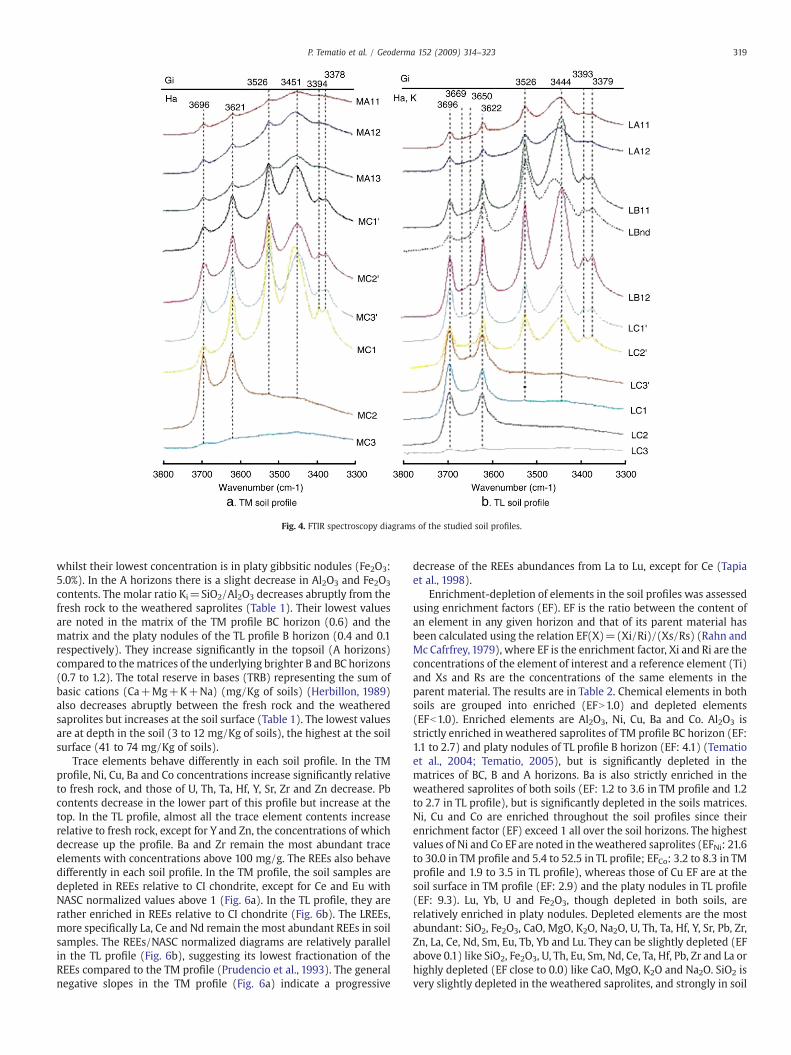
Fig. 4. FTIR spectroscopy diagrams of the studied soil profiles.
319P. Tematio et al. / Geoderma 152 (2009) 314–323
whilst their lowest concentration is in platy gibbsitic nodules (Fe2O3:5.0%). In the A horizons there is a slight decrease in Al2O3 and Fe2O3
contents. The molar ratio Ki=SiO2/Al2O3 decreases abruptly from thefresh rock to the weathered saprolites (Table 1). Their lowest valuesare noted in the matrix of the TM profile BC horizon (0.6) and thematrix and the platy nodules of the TL profile B horizon (0.4 and 0.1respectively). They increase significantly in the topsoil (A horizons)compared to thematrices of the underlying brighter B and BC horizons(0.7 to 1.2). The total reserve in bases (TRB) representing the sum ofbasic cations (Ca+Mg+K+Na) (mg/Kg of soils) (Herbillon, 1989)also decreases abruptly between the fresh rock and the weatheredsaprolites but increases at the soil surface (Table 1). The lowest valuesare at depth in the soil (3 to 12 mg/Kg of soils), the highest at the soilsurface (41 to 74 mg/Kg of soils).
Trace elements behave differently in each soil profile. In the TMprofile, Ni, Cu, Ba and Co concentrations increase significantly relativeto fresh rock, and those of U, Th, Ta, Hf, Y, Sr, Zr and Zn decrease. Pbcontents decrease in the lower part of this profile but increase at thetop. In the TL profile, almost all the trace element contents increaserelative to fresh rock, except for Y and Zn, the concentrations of whichdecrease up the profile. Ba and Zr remain the most abundant traceelements with concentrations above 100 mg/g. The REEs also behavedifferently in each soil profile. In the TM profile, the soil samples aredepleted in REEs relative to CI chondrite, except for Ce and Eu withNASC normalized values above 1 (Fig. 6a). In the TL profile, they arerather enriched in REEs relative to CI chondrite (Fig. 6b). The LREEs,more specifically La, Ce and Nd remain the most abundant REEs in soilsamples. The REEs/NASC normalized diagrams are relatively parallelin the TL profile (Fig. 6b), suggesting its lowest fractionation of theREEs compared to the TM profile (Prudencio et al., 1993). The generalnegative slopes in the TM profile (Fig. 6a) indicate a progressive
decrease of the REEs abundances from La to Lu, except for Ce (Tapiaet al., 1998).
Enrichment-depletion of elements in the soil profiles was assessedusing enrichment factors (EF). EF is the ratio between the content ofan element in any given horizon and that of its parent material hasbeen calculated using the relation EF(X)=(Xi/Ri)/(Xs/Rs) (Rahn andMc Cafrfrey, 1979), where EF is the enrichment factor, Xi and Ri are theconcentrations of the element of interest and a reference element (Ti)and Xs and Rs are the concentrations of the same elements in theparent material. The results are in Table 2. Chemical elements in bothsoils are grouped into enriched (EFN1.0) and depleted elements(EFb1.0). Enriched elements are Al2O3, Ni, Cu, Ba and Co. Al2O3 isstrictly enriched in weathered saprolites of TM profile BC horizon (EF:1.1 to 2.7) and platy nodules of TL profile B horizon (EF: 4.1) (Tematioet al., 2004; Tematio, 2005), but is significantly depleted in thematrices of BC, B and A horizons. Ba is also strictly enriched in theweathered saprolites of both soils (EF: 1.2 to 3.6 in TM profile and 1.2to 2.7 in TL profile), but is significantly depleted in the soils matrices.Ni, Cu and Co are enriched throughout the soil profiles since theirenrichment factor (EF) exceed 1 all over the soil horizons. The highestvalues of Ni and Co EF are noted in theweathered saprolites (EFNi: 21.6to 30.0 in TM profile and 5.4 to 52.5 in TL profile; EFCo: 3.2 to 8.3 in TMprofile and 1.9 to 3.5 in TL profile), whereas those of Cu EF are at thesoil surface in TM profile (EF: 2.9) and the platy nodules in TL profile(EF: 9.3). Lu, Yb, U and Fe2O3, though depleted in both soils, arerelatively enriched in platy nodules. Depleted elements are the mostabundant: SiO2, Fe2O3, CaO, MgO, K2O, Na2O, U, Th, Ta, Hf, Y, Sr, Pb, Zr,Zn, La, Ce, Nd, Sm, Eu, Tb, Yb and Lu. They can be slightly depleted (EFabove 0.1) like SiO2, Fe2O3, U, Th, Eu, Sm, Nd, Ce, Ta, Hf, Pb, Zr and La orhighly depleted (EF close to 0.0) like CaO, MgO, K2O and Na2O. SiO2 isvery slightly depleted in the weathered saprolites, and strongly in soil

Fig. 5. Diffuse reflectance spectroscopy diagrams of the studied soil profiles.
320 P. Tematio et al. / Geoderma 152 (2009) 314–323
matrices and the platy nodules. Sr, Y, Tb, Yb and Lu are slightlydepleted in TL profile and strongly in TM profile. Inversely, Zn isslightly depleted in TM profile, but strongly depleted in TL profile.
5. Discussion
5.1. Mineral transformations
Trachyte weathering in both soils is associated with the appearanceof halloysite and goethite. The process of their formation can be relatedto deep and intense hydrolysis of primary minerals during whichreleased Al combines with the remaining Si to form halloysite (Certiniet al., 2006) whereas Fe crystallizes into goethite (Nieuwenhuyse et al.,
2000). The highmoisture regimes at soil depth highlight the importanceof this permanently humid environment to the greater tendencytowards the formation of halloysite and goethite instead of kaoliniteand hematite respectively (Churchman, 2000). Their formation is alsofavored by the microlitic texture of the trachyte which contributed toincreasing the contact between primary minerals and the percolatingsolution (Aristizabal et al., 2005). The hydrated state of the halloysites(10 Å-halloysite) in the TM profile weathered saprolites may be relatedto the permanently water-saturated weathering milieu (Bates, 1962)attributed to the high annual rainfall (more than 2500 mm) at thesummit of this mountain.
Between the weathered saprolites and the soil matrices, themineral transformations behave differently in each soil profile. In the

Fig. 6. NASC normalized REE diagrams of the studied soil profiles.
321P. Tematio et al. / Geoderma 152 (2009) 314–323
TM profile, the hydrated halloysites (10 Å-halloysite) transformprogressively into an intermediate state at 8.7 Å in the matrix of theBC horizon (Costanzo and Giese, 1985) and the dehydrated halloysites(7 Å-halloysites) in the matrix of the A horizon during dehydrationwith decreasing in relative humidity at the soil surface (Hughes,1966)since surface soils are subject to desiccation during the dry seasons
Table 2Enrichment factors (EF) for major, traces and RE elements in: (a) Aluandic soil profile; (b)
(a) TM soil profile
Fresh rock BC horizon A horizon
TMR MC3 MC2 MC1 MC3′ MC2′ MC1′ MA12 MA11
SiO2 1.0 0.6 0.2 0.3 0.2 0.1 0.2 0.1 0.2Al2O3 1.0 1.1 2.7 1.4 0.9 0.7 0.8 0.4 0.4Fe2O3 1.0 0.8 0.8 0.8 0.7 0.7 0.7 0.5 0.5CaO 1.0 0.2 0.0 0.0 0.0 0.0 0.0 0.1 0.1MgO 1.0 0.2 0.0 0.0 0.1 0.0 0.1 0.3 0.4K2O 1.0 0.4 0.0 0.0 0.0 0.0 0.0 0.0 0.1Na2O 1.0 0.4 0.0 0.0 0.0 0.0 0.0 0.1 0.1Ni 1.0 21.6 30.0 26.7 20.0 19.3 19.2 12.4 13.3Cu 1.0 1.1 2.4 1.3 1.2 0.8 1.1 1.5 2.9Ba 1.0 3.6 1.2 1.2 0.9 0.5 0.7 0.4 0.3U 1.0 0.5 0.7 0.4 0.1 0.1 0.1 0.1 0.2Th 1.0 0.6 1.0 0.5 0.2 0.1 0.2 0.2 0.2Ta 1.0 0.6 0.9 0.4 0.2 0.1 0.2 0.2 0.2Hf 1.0 0.5 0.7 0.4 0.1 0.1 0.2 0.1 0.1Y 1.0 0.6 0.0 0.0 0.1 0.0 0.0 0.1 0.1Co 1.0 8.3 3.2 4.8 0.8 1.6 1.6 1.6 2.0Sr 1.0 0.5 0.0 0.0 0.0 0.0 0.0 0.1 0.1Pb 1.0 0.8 0.3 0.5 0.6 0.4 0.7 0.4 0.4Zr 1.0 0.4 0.3 0.3 0.3 0.3 0.3 0.1 0.1Zn 1.0 0.5 0.3 0.3 0.2 0.3 0.2 0.1 0.1La 1.0 0.2 0.2 0.2 0.3 0.0 0.0 0.1 0.1Ce 1.0 1.1 0.5 0.7 0.3 0.1 0.2 0.3 0.3Nd 1.0 0.2 0.0 0.1 0.3 0.0 0.0 0.2 0.2Sm 1.0 0.2 0.1 0.2 0.3 0.0 0.0 0.2 0.3Eu 1.0 0.5 0.6 0.4 0.6 0.0 0.1 0.6 0.6Tb 1.0 0.0 0.0 0.0 0.2 0.0 0.0 0.0 0.0Yb 1.0 0.2 0.1 0.1 0.2 0.0 0.0 0.1 0.1Lu 1.0 0.2 0.1 0.1 0.2 0.0 0.0 0.1 0.1
(Takahashi et al., 1993). They can also transform directly into gibbsiteduring complete desilication favored by intense leaching due to awater-saturated environment at soil depths (Certini et al., 2006). Inthe TL profile, the dehydrated halloysites transform into kaoliniteduring complete dehydration (Churchman, 2000) favored by thesignificant drop of the relative humidity at the soil surface (Bilong,
Ferralsolic aluandic soil profile.
(b) TL soil profile
Fresh rock C horizon BC horizon B horizon A horizon
TLR LC3 LC2 LC1 LC1′ LB12 LBnd LB11 LA12
1.0 0.8 0.3 0.3 0.1 0.1 0.1 0.1 0.21.0 0.8 0.9 1.0 0.7 0.7 4.1 0.6 0.61.0 0.8 0.8 1.3 0.8 0.8 1.0 0.8 0.71.0 0.5 0.0 0.1 0.1 0.4 0.0 0.0 0.31.0 0.8 0.0 0.0 0.1 0.1 0.0 0.1 0.51.0 0.7 0.0 0.0 0.0 0.0 0.0 0.0 0.01.0 0.8 0.0 0.0 0.0 0.0 0.0 0.0 0.01.0 5.4 52.5 49.5 15.9 14.9 12.8 10.2 14.81.0 3.9 4.4 3.8 4.1 5.5 9.3 5.4 7.81.0 1.2 2.7 1.6 0.5 0.6 0.4 0.4 1.31.0 0.5 0.6 0.8 0.9 0.4 1.6 0.4 0.41.0 0.6 0.9 1.0 0.5 0.5 0.9 0.5 0.41.0 0.5 0.8 0.8 0.4 0.3 0.9 0.3 0.31.0 0.5 0.8 0.7 0.4 0.3 0.8 0.3 0.31.0 1.3 0.4 0.8 0.3 0.2 0.6 0.1 0.31.0 0.4 3.5 1.9 1.6 1.3 1.8 0.9 2.11.0 0.6 0.2 0.2 0.7 1.1 0.3 0.6 1.71.0 0.7 1.3 1.1 1.0 0.9 0.8 0.7 0.71.0 0.8 0.9 0.9 0.5 0.4 0.9 0.3 0.61.0 0.3 0.1 0.2 0.0 0.0 0.1 0.0 0.01.0 1.1 0.1 0.2 0.1 0.1 0.1 0.1 0.21.0 0.4 0.1 0.8 0.1 0.4 0.1 0.3 0.31.0 1.2 0.1 0.2 0.1 0.1 0.1 0.1 0.21.0 1.1 0.2 0.2 0.2 0.2 0.2 0.1 0.21.0 1.5 0.4 0.5 0.3 0.3 0.5 0.2 0.41.0 0.7 0.2 0.3 0.3 0.2 0.3 0.2 0.21.0 0.9 0.7 0.7 0.8 0.3 1.1 0.2 0.31.0 0.9 0.7 0.7 0.8 0.3 1.1 0.2 0.4
322 P. Tematio et al. / Geoderma 152 (2009) 314–323
1988). The dehydrated halloysite can also transform directly intogibbsite during complete desilication. The presence of hematite can belinked to a preferential dissolution of goethite in the uppermosthorizon due to high microbial activity (Lucas et al., 1993) and thevertical transfer of Fe with crystallization of hematite (Aristizabalet al., 2005). The high content of gibbsite in the platy nodules of the TLprofile B horizon (Tematio et al., 2004; Tematio, 2005) can beexplained by a partial dissolution of kaolinite at the soil surfacefavored by high microbial activity (Lucas et al., 1993) and a downwardtransfer of free Al fixed at the surface of colloids or bonded to organicacids, and their precipitation as gibbsite in the underlying horizons.
In both soils, important accumulation of organo-metal complexeshas been noted in the A horizons. The process of their formation maybe linked to partial dissolution of some secondary minerals (kaolinite,halloysite and iron oxides) due to high microbial activity at the soilsurface (Lucas et al., 1993) and the liberation of metal elements whichcan bond to the highly polycondensed organic acids with highchelating capacity present in A horizons (Aran et al., 2001).
Both soils differ considering their mineral transformationssequences reported as follow: 10 Å-halloysite+goethite→7 Å-halloy-site+goethite+gibbsite in the TM profile; 7 Å-halloysite+goethite→kaolinite+gibbsite+hematite+goethite in the TL profile. The TMprofile can thus be considered as halloysite-rich soil and the TL profile ashalloysite-kaolinite and iron oxide rich soils. Accordingly, the TL profilerepresents an intermediate situation between the aluandic soils (TMprofile) observed at the summit of Mount Bambouto and the ferralsolspresent at lowlands.
5.2. Geochemical transformations
Geochemically, the trachyte weathering in both soils is character-ized by the complete removal of alkaline and alkaline-earth elements,the conspicuous depletion of Si and the relative accumulation of Feand Al contributing in the formation of both halloysite and goethite.The lowest values of the TRB in the weathered saprolites may beindicative of this approximately complete weathering of primaryminerals (Herbillon, 1989).
In the TM profile, the general trend up through the profilecorresponds to intense Al enrichment and both Al and Fe enrichmentin the TL profile. Thus, inMount Bambouto,with increasing temperatureand decreasing altitude, Fe mobility reduces severely and contributestogether with Al to the development of aluandic-ferralsols while at thesummit of the mountain with very low temperature, Al act alone togenerate soils with andic properties (Adjadeh and Inoue, 1999).
The increase of Ki at the soil surface suggests a relatively lowamount of Al compared to the underlying horizon and may be relatedto intense biological activity which favors partial dissolution ofalumino-silicate secondary minerals and downwards transfer of freeAl fixed at the surface of colloids or bonded by organic acids in a highlyleachingmediumwhich have probably contributed to the formation ofthe platy nodules in the TL profile B horizon (Tematio, 2005; Tematioet al., 2004). The relatively high values of TRB at the soil surface can beexplained by: (1) input of fertilizer by farmers, (2) alkaline-rich dustdeposited by the Harmattan winds, (3) recycling of nutrients byvegetation or (4) the incomplete weathering of K-feldspar orplagioclase related to rock fragments present at the soil surface.
The b1 EF values for Zr indicate that, relative to Ti, Zr was mobile inthese soils. Zr is traditionally viewed as an immobile element (e.g.Hodson, 2002) but other studies of soils subject to intense weatheringhave reported the mobility of Zr, most likely due to complexationwithorganic molecules (e.g. Oliva et al., 1999, Viers et al., 2000). Howevermobility of Ti has also been reported in tropical soils, e.g. Cornu et al.(1999) and therefore the EF factors reported should be viewed asrecording mobility relative to Ti rather than as an absolute measure ofmobility/immobility.
6. Conclusion
Trachyte underlying the twoprofiles has beenweathered resulting inalmost complete leaching of alkali and alkaline-earth elements andpartial leaching of silica. Aluminum has combined with the remainingsilica to formhalloysitewhereas iron crystallized into goethite. In the TMprofile, the hydrated halloysites (10 Å-halloysites) undergo incompletedehydration to form dehydrated halloysites (7 Å-halloysites). In the TLprofile, the dehydrated halloysites form kaolinites during completedehydrationwhile the goethites undergo dissolution and crystallizationinto hematite. A part of gibbsite originates from complete desilication ofhalloysites at soil depth in a highly leached medium. At the soil surface,the partial dissolution of the secondaryminerals favors the liberation ofAl and Fe which can bond to organic acids to form organo-metalcomplexes, or undergo downward transfers to precipitate as gibbsiteand hematite respectively, contributing to the formation of the platynodules in the TL profile. They represent halloysite-rich soils for the TMprofile andhalloysite-kaolinite and ironoxide rich soils for theTLprofile.
Acknowledgments
This work was financially supported by the AUF (Agence universi-taire de la francophonie) and the IRD-BESCD post-doctoral scholarshipsfor first author. Generous logistical and in kind support for lab analysishas been provided by the PROTEE lab of the University of Toulon(France) and the IMPMC lab of the University of Paris VI (France).
References
Adjadeh, T.A., Inoue, K., 1999. Andisols of Kitakami Mountain range, Northeastern Japan:their characterization and classification. Soil Science and Plant Nutrition 45 (1),115–130.
Aran, D., Gury, M., Jeanroy, E., 2001. Organo-metallic complexes in Andosols: acomparative study with a Cambisol and Podzol. Geoderma 99, 65–79.
Aristizabal, E., Roser, B., Yokota, S., 2005. Tropical chemical weathering of hillslopedeposits and bedrock source in the Aburra Valley, northern Colombian Andes.Engineering Geology 81, 389–406.
Bates, T.F., 1962. Halloysite and gibbsite formation in Hawaï. Clays and Clay Minerals 9,315–328.
Bilong, P., 1988. Genèse et développement des sols ferrallitiques sur syénites alcalinespotassiques enmilieu forestier du Centre-Sud Cameroun. Comparaison avec les solsferrallitiques développés sur roches basiques. Thès. D'Etat, Univ. Yaoundé, 367p.
Boukong, A., Fonteh, M.F., Tankou, C.M., 2001. Aptitude de terre et risque d'érosion enculture irriguée de pois-mange-tout (pisum sativum) sur un andosol des HautsPlateaux de l'Ouest-Cameroun. Tropicultura 19 (2), 79–84.
Campos Cascaredo, A., Oleschko, K., Cruz Huerta, L., Etchevers, B.J.D., Hidalgo, M.C.,2001. Estimation of allophane and its relationship with other chemical parametersin Mountain Andisols of the volcano Cofre de Perote. Terra 19 (2), 105–116.
Certini, G., Wilson, M.J., Hillier, S.J., Fraser, A.R., Delbos, E., 2006. Mineral weathering intrachydacitic-derived soils and saprolites involving formation of embryonichalloysite and gibbsite at Mt Amiata, Central Italy. Geoderma 133 (3–4), 173–190.
Churchman, G.J., 2000. The alteration and formation of soil minerals by weathering.Handbook of Soil Science (M.E. Sumner, edition. CRC Press, Boca Raton, Florida,pp. F3–F76.
Cornu, S., Lucas, Y., Lebon, E., Ambrosi, J.P., Luizao, F., Rouiller, J., Bonnay, M., Neal, C.,1999. Evidence of titanium mobility in soil profiles, Manaus, central Amazonia.Geoderma 91, 281–295.
Costanzo, P.M., Giese, R.F., 1985. Dehydration of synthetic hydrated kaolinite: a modelfor the dehydration of halloysite (10A). Clays and Clay Minerals 33, 415–423.
Dahlgren, R.A., 1994. Quantification of allophane and imogolite. In: Amonette, J.E.,Zelazny, L.W. (Eds.), Quantitative methods in soil mineralogy. Soil Sciences Societyof America, Madison, W.I., pp. 430–451.
Doubé, M., 1989. Pedogenesis, classification and charge properties of the Bambouto soilsequence (West-Cameroon). Thèse State University of Ghent, Belgium, 184p.
Herbillon, J.A., 1989. Chemical estimation of weatherable minerals present in thediagnostic horizons of low activity clay soils. 8th. Int. Soil Classif. Workshop 1986(Brazil), pp. 39–48.
Hodson, M.E., 2002. Experimental evidence for mobility of Zr and other trace elementsin soils. Geochimica et Cosmochimica Acta 66, 819–828.
Hughes, I.R., 1966. Mineral changes of halloysite on drying. New Zealand Journal ofScience 9, 103–113.
Jahn, R.,1991. Intensity and velocity of soil forming process in volcanic soils in the semiaridclimate in Lanzarote (Spain). Mitteilungen der Deutschen BodenkundlichenGesellschaft 66 (I), 51–58.
Kosmas, C.S., Curi, N., Bryant, R.B., Franzmeier, D.P., 1984. Characterization of iron oxideminerals by second derivative visible spectroscopy. Soil Science Society of AmericaJournal 48, 401–405.

323P. Tematio et al. / Geoderma 152 (2009) 314–323
Kwékam, M., 2005. Genèse et évolution des granitoïdes calco-alcalins au cours de latectonique Panafricaine: le cas des massifs syn à tardi-tectoniques de l'Ouest-Cameroun (Régions de Dschang et de Kekem). Thèse Doctorat d'Etat, Université deYaoundé I, 194P.
Leamy, M.L., 1984. Andisols of the world. Congresco Internacional de Suelos Volcanicos,Communicationes: Universida de La Laguna Secretariado de Publicaciones, serieinformes, vol. 13, pp. 368–387.
Leumbe Leumbe, O., 2001. Typologie, cartographie et fertilité actuelle des sols de la zonemoyenne et basse du versant sud des monts Bambouto. Mém. Maîtr. Sc. Terre, Univ.Dschang. 108 pp.
Lucas, Y., Luizao, F.J., Chauvel, A., Rouillet, J., Nahon, D., 1993. The relation betweenbiological activity of the rainforest and the mineral composition of soils. Sciences260, 521–523.
Malengreau, N., Beddidi, A., Muller, J.P., Herbillon, A.J., 1996. Spectroscopic control ofiron oxide dissolution in two ferrallitic soils. European Journal of Soil Science 47,13–20.
Marzoli, A., Renne, P.R., Piccirillo, E.M., Castorina, E., Bellieni, G., Melli, A.J., Nyobé, J.B.,Nni, J., 1999. Silicic magmas from the continental Cameroon Volcanic Line (Oku,Bambouto and Ngaoundere): 40Ar/39Ar dates, petrology, Sr-Nd-O isotopes and theirpetrogenetic significance. Contributions to Mineralogy and Petrology 135, 133–150.
Marzoli, A., Piccirillo, E.M., Renne, P.R., Bellieni, G., Iacumin, M., Nyobe, J.B., Tongwa, A.T.,2000. The Cameroon Volcanic Line Revisited: Petrogenesis of Continental BasalticMagma from Lithospheric and Asthenospheric Mantle Sources. Oxford UniversityPress, pp. 87–109.
Mpakam, H.G., 2000. typologie et cartographie des sols de la zone d'altitude du versantsud des monts Bambouto. Mém. Maîtr. Sc., Univ. Dschang. 101 pp.
Nieuwenhuyse, A., Verburg, P.S.J., Jongmans, A.G., 2000. Mineralogy of soil chronose-quence on andesitic lava in humid tropical Costa Rica. In: Geoderma, vol. 98. Elsevier,pp. 61–82.
Nizeyimana, E., Bicki, T.J., Agbu, P.A., 1997. An assessment of colloidal constituents andclay mineralogy of soils derived from volcanic materials along a toposequence inRwanda. Soil Science 162 (5), 361–371.
Nkouathio, D.G., 2007. Evolution tectono-magmatique et volcanologique de la ligne duCameroun: comparaison d'un volcanisme de graben (plaine de Tombel) et d'unvolcanismedehorst (monts Bambouto). ThèseDoctorat d'Etat, Université deYaoundé I.231p.
Nono, A., Njonfang, E., Kagou Dongmo, A., Nkouathio, D., Tchoua, F.M., 2004. Pyroclaticdeposits of the Bambouto volcano (Cameroon Line, Central Africa): evidence of astrombolian initial phase. Journal of African Earth Sciences (JAES) 39, 409–4142004.
Oades, J.M., 1995. Recent advances in organo-mineral interactions: implications forcarbon cycling and soil structure. In: Huang, P.M., Berthelin, J., Bollag, J.M., McGill,W.B., Page, A.L. (Eds.), Environmental Impact of Soil Component Interactions. LewisPublishers, Baca Raton, FL, pp. 119–134.
Oliva, P., Viers, J., Dupré, B., Fortuné, J.P.,Marint, F., Braun, J.J., Nahon,D., Robain,H.,1999. Theeffect of organic matter on chemical weathering. Study of a small tropical watershed:Msimi-Zoétélé site, Cameroon. Geochimica et Cosmochimica Acta 63, 4013–4035.
Prudencio, M.I., Braga, M.A.S., Gouveia, M.A., 1993. REE mobilization, fractionation andprecipitation during weathering of basalts. Chemical Geology 107, 251–254.
Quantin, P., 2004. Volcanic Soils of France. In: Catena, vol. 56. Elsevier, pp. 95–109.Rahn, K.A., Mc Cafrfrey, R.J., 1979. Compositional differences between Arctic aerosol and
snow. Nature 280, 479–480.Saigusa, M., Shoji, S., Otowa, M., 1991. Clay mineralogy of Andisols showing a
hydrosequence and its relationships to their physical and chemical properties.Pedologist 35, 21–33.
Scheinost, A.C., Chavernas, A., Barron, V., Torrent, J., 1998. Use and limitations of second-derivative diffuse reflectance spectroscopy in the visible to near infrared range toidentify and quantify Fe oxideminerals in soils. Clay and ClayMinerals 46/8, 528–536.
Shoji, S., Nanzyo, M., Dahlgren, R.A., 1993. Volcanic Ash Soils. In: Dev. Soil Sci., vol. 21.Elsevier, Amsterdam, The Netherlands.
Sieffermann, G., 1973. Les sols de quelques régions volcaniques du Cameroun. Variationspédologiques du milieu équatorial au milieu tropical. Thès. Doct. Sc. Strasbourget Mém. ORSTOM, n° 66, 183 pp.
Takahashi, T., Dahlgren, R.A., Van Susterva, P.,1993. Clay mineralogy and chemistry of soilsformed in volcanic materials in the xeric moisture regime of northern California.Geoderma 59, 131–150.
Tapia, J., Tosiani, T., Loubet, M., 1998. Rare earth elements (REE) behaviour during gabbroweathering in a tropical rain forest of Southern Venezuela. Mineralogical Magazine62A (3), 1493–1494, 1998.
Tematio, P., 2005. Etude cartographique et pétrographique des sols à caractèresferrallitiques et andosoliques dans les monts Bambouto (Ouest Cameroun): influencede la nature lithologique et des facteurs du milieu sur la nature et la distribution dessols en regions de montagne tropicale humide. Doc.d'Etat, Univ. Yaoundé I. 251 pp.
Tematio, P., Kengni, L., Bitom, D., Hodson, M., Fopoussi, J.C., Leumbe, O., Mpakam, H.G.,Tsozué, D., 2004. Soils and their distribution on Bambouto volcanic mountain, WestCameroon highland, Central Africa. Journal of African Earth Sciences (JAES) 39,447–457, 2004.
Tsozué, D., 2001. Typologie et cartographie des sols du versant est des monts Bambouto.Mém. Maîtr. Sc. Terre, Univ. Dschang. 88 pp.
Van Ranst, E., De Coninck, F., Debaveye, J., 1993. Implication of charge properties andchemical management of volcanic ash soils inWest Cameroon. In: Elgala, A.M., Parr,J.F., Hornick, S.B., Taha, T.A., Simpson, M.E. (Eds.), Proceedings of the Second AfricanSoil Science Society Conference on Soil and Water Management for SustainableProductivity. Egyptian Soil Science Society, Cairo, pp. 255–264.
Viers, J., Dupre, B., Braun, J.J., Deberdt, S., Angeletti, B., Ngoupayou, J.N., Michard, A., 2000.Major and trace element abundances, and strontium isotopes in theNyongbasin rivers(Cameroon): constraints on chemical weathering processes and elements transportmechanisms in humid tropical environments. Chemical Geology 169, 211–241.
Zech, W., Hempfling, R., Hanmaier, L., Schulten, H.R., Haider, K., 1990. Humification insubalpine rendzinas: chemical analyses, IR and 13NMR spectroscopy and pyrolysis-field ionization mass spectrometry. Geoderma 47, 123–138.
Zhao, L.P., Xueming, X.M., Inoue, K., 1993. Morphological, chemical, and humuscharacteristics of volcanic ash soils in Changbaishan and Wudalianchi, NortheastChina. Soil Science and Plant Nutrition 39 (2), 339–350.