Microthermometric and O‐ and H‐isotope characteristics of the mineralizing fluid in the Akgüney...
13
Microthermometric and O- and H-isotope characteristics of the mineralizing fluid in the Akgu ¨ney copper–lead–zinc deposit, NE Turkey Esra U ¨ nal a , Ahmet Go ¨ kce b * and Chris Harris c a Bozok University, Department of Geology, Yozgat, Turkey; b Cumhuriyet University, Department of Geology, Sivas, Turkey; c Department of Geological Sciences, University of Cape Town, Rondebosch 7701, South Africa (Accepted 8 December 2008 ) The Akgu ¨ ney copper–lead–zinc deposit (Ordu Province) is actively mined in the eastern Black Sea Region of Turkey. This deposit consists of ore-bearing veins emplaced along fault zones and hosted by slightly altered Upper Cretaceous andesites. Seven ore veins, D-1 to D-7, have been identified. These veins strike N 70–80uW with a dip of 50–60uNE, except for D7 which strikes E–W with a dip of 25uS. The ore-bearing quartz vein outcrops are slightly limonitized and hematitized. Two different ore associations are distinguished within the D-1 and D-2 veins. The first contains only pyrite, whereas the second consists of coarse-grained sulphides such as chalcopyrite, galena, sphalerite, tetrahedrite, and secondary limonite veinlets in addition to pyrite. Quartz and calcite are the gangue minerals. The mineral paragenesis has been identified as: pyriteRgalenaRchalcopyrite (I)RsphaleriteRchalcopyrite (II)R(tetrahedrite ?)RquartzRcalcite. Fluid inclusion data indicate that the ore-forming fluids contained significant concentrations of divalent cations in addition to NaCl. The salinity of the fluids lies in the range 14–24% (ave.519.0) NaCl equivalent; liquid homogenization temperatures range from 276 to 349uC (ave.5307uC) and decrease to 211uC through the later stages of mineralization. Oxygen and hydrogen isotope data are consistent with the mineralizing fluid being of meteoric origin, with modification of the oxygen isotope composition by exchange with the volcanic host rocks. However, low dD values suggest a magmatic water component in some samples. The combination of fluid inclusion and stable isotope data suggest that the Akgu ¨ ney Cu–Pb–Zn vein-type deposits were formed by the leaching of metals and sulphur from the surrounding volcano-sedimentary rocks by deep-circulating meteoric water. Keywords: Akgu ¨ ney; copper–lead–zinc deposit; Eastern Black Sea region; fluid inclusion; stable isotope Introduction The Akgu ¨ney copper–lead–zinc deposit is located near to Akgu ¨ney Village in the Kabadu ¨ z District of Ordu Province within the Eastern Pontide region of Turkey (Figure 1). The Eastern Pontide region consists of volcano-sedimentary units of Jurassic to Quaternary age, which developed on a pre-Mesozoic basement and were intruded by *Corresponding author. Email: [email protected] International Geology Review Vol. 51, No. 5, May 2009, 375–387 ISSN 00200-6814 print/ISSN 1938-2839 online # 2009 Taylor & Francis DOI: 10.1080/00206810802674287 http://www.informaworld.com
-
Upload
independent -
Category
Documents
-
view
0 -
download
0
Transcript of Microthermometric and O‐ and H‐isotope characteristics of the mineralizing fluid in the Akgüney...
Microthermometric and O- and H-isotope characteristics of themineralizing fluid in the Akguney copper–lead–zinc deposit, NE Turkey
Esra Unala, Ahmet Gokceb* and Chris Harrisc
aBozok University, Department of Geology, Yozgat, Turkey; bCumhuriyet University,
Department of Geology, Sivas, Turkey; cDepartment of Geological Sciences, University of
Cape Town, Rondebosch 7701, South Africa
(Accepted 8 December 2008 )
The Akguney copper–lead–zinc deposit (Ordu Province) is actively mined in the
eastern Black Sea Region of Turkey. This deposit consists of ore-bearing veins
emplaced along fault zones and hosted by slightly altered Upper Cretaceous
andesites. Seven ore veins, D-1 to D-7, have been identified. These veins strike N
70–80uW with a dip of 50–60uNE, except for D7 which strikes E–W with a dip of
25uS. The ore-bearing quartz vein outcrops are slightly limonitized and
hematitized. Two different ore associations are distinguished within the D-1
and D-2 veins. The first contains only pyrite, whereas the second consists of
coarse-grained sulphides such as chalcopyrite, galena, sphalerite, tetrahedrite,
and secondary limonite veinlets in addition to pyrite. Quartz and calcite are the
gangue minerals. The mineral paragenesis has been identified as:
pyriteRgalenaRchalcopyrite (I)RsphaleriteRchalcopyrite (II)R(tetrahedrite
?)RquartzRcalcite. Fluid inclusion data indicate that the ore-forming fluids
contained significant concentrations of divalent cations in addition to NaCl. The
salinity of the fluids lies in the range 14–24% (ave.519.0) NaCl equivalent; liquid
homogenization temperatures range from 276 to 349uC (ave.5307uC) and
decrease to 211uC through the later stages of mineralization. Oxygen and
hydrogen isotope data are consistent with the mineralizing fluid being of
meteoric origin, with modification of the oxygen isotope composition by
exchange with the volcanic host rocks. However, low dD values suggest a
magmatic water component in some samples. The combination of fluid inclusion
and stable isotope data suggest that the Akguney Cu–Pb–Zn vein-type deposits
were formed by the leaching of metals and sulphur from the surrounding
volcano-sedimentary rocks by deep-circulating meteoric water.
Keywords: Akguney; copper–lead–zinc deposit; Eastern Black Sea region; fluid
inclusion; stable isotope
Introduction
The Akguney copper–lead–zinc deposit is located near to Akguney Village in the
Kabaduz District of Ordu Province within the Eastern Pontide region of Turkey
(Figure 1).
The Eastern Pontide region consists of volcano-sedimentary units of Jurassic to
Quaternary age, which developed on a pre-Mesozoic basement and were intruded by
*Corresponding author. Email: [email protected]
International Geology Review
Vol. 51, No. 5, May 2009, 375–387
ISSN 00200-6814 print/ISSN 1938-2839 online# 2009 Taylor & FrancisDOI: 10.1080/00206810802674287http://www.informaworld.com
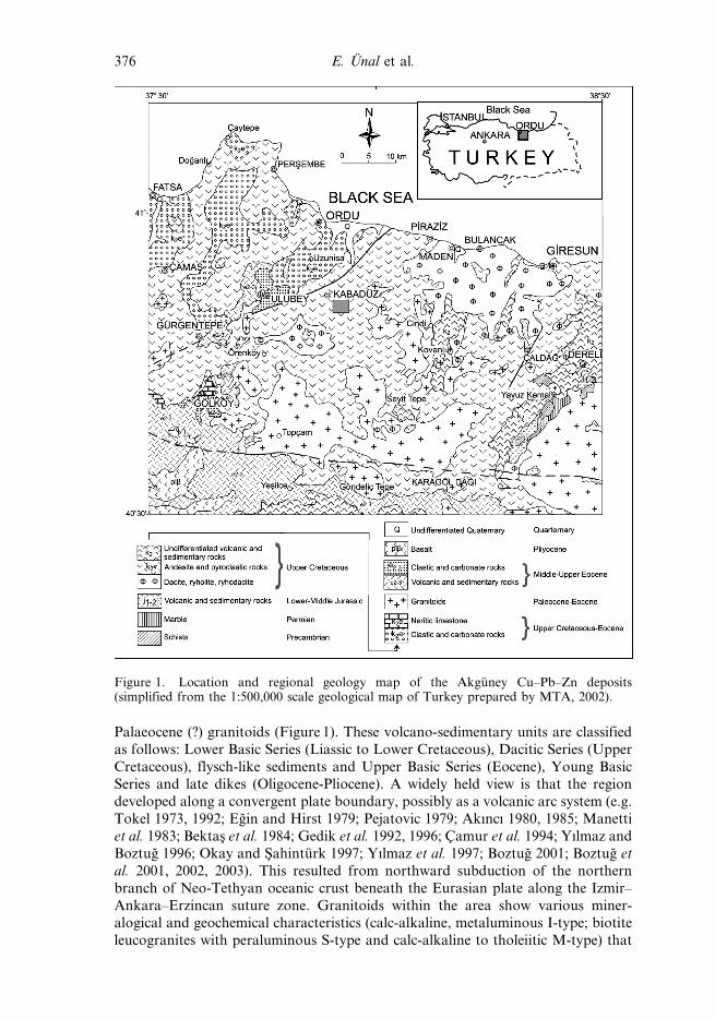
Palaeocene (?) granitoids (Figure 1). These volcano-sedimentary units are classified
as follows: Lower Basic Series (Liassic to Lower Cretaceous), Dacitic Series (Upper
Cretaceous), flysch-like sediments and Upper Basic Series (Eocene), Young BasicSeries and late dikes (Oligocene-Pliocene). A widely held view is that the region
developed along a convergent plate boundary, possibly as a volcanic arc system (e.g.
Tokel 1973, 1992; Egin and Hirst 1979; Pejatovic 1979; Akıncı 1980, 1985; Manetti
et al. 1983; Bektas et al. 1984; Gedik et al. 1992, 1996; Camur et al. 1994; Yılmaz and
Boztug 1996; Okay and Sahinturk 1997; Yılmaz et al. 1997; Boztug 2001; Boztug et
al. 2001, 2002, 2003). This resulted from northward subduction of the northern
branch of Neo-Tethyan oceanic crust beneath the Eurasian plate along the Izmir–
Ankara–Erzincan suture zone. Granitoids within the area show various miner-alogical and geochemical characteristics (calc-alkaline, metaluminous I-type; biotite
leucogranites with peraluminous S-type and calc-alkaline to tholeiitic M-type) that
Figure 1. Location and regional geology map of the Akguney Cu–Pb–Zn deposits(simplified from the 1:500,000 scale geological map of Turkey prepared by MTA, 2002).
376 E. Unal et al.
indicate emplacement within various geotectonic environments (arc-related, syn-
collisional and post-collisional extension-related) over a period of time from Early/
Late Cretaceous to Eocene (Boztug et al. 2004, 2006; Arslan and Aslan 2006).
The region contains over 400 massive, vein and skarn-type hydrothermal sulphide
deposits and mineral prospects. In addition, Cu–Mo mineralizations occur in the
porphyry granitic rocks, and Mn occurrences are also known in the volcanic rocks.
The dacitic series host Kuroko-type massive sulfide deposits and most of the vein
type Cu–Pb–Zn deposits occur in this region.
The Akguney copper–lead–zinc deposit is a typical example of the volcanic-hosted
vein type deposits that occur widely within the Eastern Pontide region of Turkey.
The earliest reported study of the Akguney Cu–Pb–Zn deposits was carried out byKose (1987), who interpreted these deposits as ore veins formed along fault zones
developed in a NW–SE direction within andesitic and basaltic volcanic rocks. Kose
found that the ore veins contain pyrite, chalcopyrite, sphalerite, galena, tetrahedrite,
quartz and barite occurring in three different phases of mineralization. This was
produced by hydrothermal fluids possibly related to a deep seated granitoid
intrusion.
Steinmann and Emerson (2001) concluded that two different types of veins are
present in the area; the northern one is rich in zinc, whereas the southern one is rich
in copper.
More recently, Unal (2006) and Unal and Gokce (2007) carried out detailed
geological investigations, including ore petrography and fluid inclusion studies, and
their conclusions are summarized below. This paper aims to determine the
characteristics and origin of the mineralizing fluids. We report new oxygen isotope
data from veins, and hydrogen isotope data of the fluid inclusion water presumed to
represent the mineralizing fluid. The chemical composition of the fluids has been
constrained from the microthermometric characteristics of these fluid inclusions.
Geological background
Andesitic rocks crop out around the Akguney Cu–Pb–Zn deposits (Figure 2). These
volcanic rocks consist of agglomerates and interbeds of massive lavas. Agglomerates
contain tuffaceous matrix and show well developed bedding. Massive lavas are
slightly brecciated. In addition, they have dark grey and black colours in unaltered
deeper levels, whereas they are highly altered under surficial conditions and have
off-white, yellowish and greenish pale colours representing argilization, limonitiza-
tion and chloritization at the surface. The volcanic rocks of the area were mapped as
Cretaceous on the 1/500,000 scale regional geology map of Turkey. Akıncı (1985)
investigated these volcanic rocks in the Upper Cretaceous Dacitic Series, which was
mentioned in the introduction section, and Terlemez and Yılmaz (1980) named them
as the Upper Cretaceous Mesudiye Formation.
Microscopic investigation of selected samples shows that they contain plagioclase,quartz, biotite, muscovite and hornblende and plot within the andesite field on the
diagram of Streckeisen (1976, 1979). Hypo-hyaline porphyritic texture is widespread
and pilotaxitic and amigdaloidal textures are seen in some of the samples.
Sericitization, argilization and silicification of plagioclases, chloritization of biotites
and hornblendes are widespread. Some of the samples show brecciation, with calcite
and quartz infillings developed between the brecciated rock fragments.
Strikes and dips of cracks and fractures are randomly dispersed on rose diagrams
with minor concentrations of trend between 70 and 115u (N70E and N65W),
International Geology Review 377

indicating that these tectonic features developed under a tensional regime in a N–S
direction. In addition, some lineaments and ring-like structures were identified on
the Landsat images (174/32 ETM) of the investigated area, and these features were
suspected to represent a dome-like structure related to a buried granitoid intrusion
(Unal 2006), but the lack of the radial lineaments does not support this idea. Field
control of these features showed that the outer ring corresponds with the contact
between the massive volcanics of the inner zone and tuffaceous volcanoclastics ofthe outer zones.
Ore geology
Cu–Pb–Zn mineralizations within the Akguney area are developed as ore veinsoccurring along the fault zones developed in the Upper Cretaceous andesitic
volcanic rocks. The veins crop out as slightly limonitized, yellowish-brownish quartz
veins. The known ore veins are numbered as D-1 to D-7. These ore veins, strike at
N70–80uW with a dip of 50–60uNE, except for D-7, which strikes E–W with a dip of
25uS (Figure 2).
The D-2 and D-3 veins are the only ones which were being mined during the
field investigations undertaken for this study. Mining operations start with cross-
cutting adits until reaching the veins, then continue as wings in the direction ofthe ore veins at different levels (Upper Umut Adit, at 902 m elevation; Lower
Umut Adit, at 886 m elevation; Efe Adit, at 839 m elevation; Guclu Adit, at 766 m
Figure 2. Geological map and cross-section of the Akguney area.
378 E. Unal et al.
elevation). Both of the veins are cut and replaced by the younger faults in a NW–
SE direction.
Two different types of mineralization were identified in D-2 and D-3 veins. The first
type of mineralization is characterised by fine-grained pyrite, whereas the second one is
characterized by a coarse-grained texture and a variety of ore minerals including
chalcopyrite, sphalerite, galena, tetrahedrite and limonite as well as pyrite. The second
type mineralization cuts the first one and they are classified as early and late stage (the
first and second phase) mineralizations. Only the second type of occurence was mined
and the second type was left as pillars. In addition, the upper parts of the veins are rich in
galena and sphalerite, whereas the lower parts are rich in chalcopyrite and pyrite.
Quartz and calcite are the gangue minerals and are seen to be formed later than the ore
minerals. The mineral paragenesis is determined as: pyriteRgalenaRchalcopyrite
(I)RsphaleriteRchalcopyrite (II) ¡ tetrahedriteRquartzRcalcite.
Fluid inclusion studies
Sampling and methodology
Fluid-inclusion studies were carried out on quartz crystals closely associated with
the sulphide minerals. Samples were collected from the D2 and D3 ore veins at the
766 m level; samples OC-4 and OC-5 were taken from the D2 vein, the others from
the D-3 vein.
Fluid inclusions were observed using a petrographic microscope, and the
following parameters were determined by microthermometry: first melting
temperature (TFM), last ice melting temperature (TICE), and temperature of
homogenization into liquid (TH).
These microthermometric measurements were performed using a LINKAM
THMS-600 and TMS-92 freezing–heating stage and a long focal length LW 640
objective. Liquid nitrogen was used for freezing. The heating rate was controlled
manually with the help of a TMS-92 system in the range of 0.1–5.0uC/min. The stage
was calibrated using heptane (Tm5290.61uC) and potassium nitrate (Tm5335.0uC)
at the beginning of daily studies. Repeated measurements showed that the
reproducibility of the temperature determinations was better than ¡0.5uC for all
three types of determinations.
Morphology and inclusion types
Fluid inclusions are developed as either irregularly dispersed primary inclusions
within the crystals or linearly dispersed secondary inclusions along the small cracks.
Primary inclusions are more abundant than the secondary ones. Both types of
inclusions are two phase (liquid + vapour) inclusions with mostly ellipsoidal and
pear shaped morphologies.
The size of the inclusions is very small (5–15 mm for primary inclusions, generally
smaller than 2.5 mm and rarely larger than 5 mm for secondary inclusions). The
volume of the gas phase is generally in the range of 5–10 % and rarely reaches 20%.
Microthermometric measurements
First melting temperature (TFM) values are dispersed in the range from 253.5 to
250.5uC (average: 252.0uC, n590) for primary and secondary inclusions. These
temperature values are significantly lower than for the NaCl–H2O system and very
International Geology Review 379

close to the eutectic temperature of ‘H2O–NaCl–CaCl2’, ‘H2O–MgCl2–CaCl2’, and
‘H2O–KCl–CaCl2’ (255.0, 252.2 and 250.5uC, respectively; Shepherd et al. 1985),
and suggest that the mineralizing hydrothermal fluid contains the salts of bivalent
ions such as CaCl2, MgCl2, besides the NaCl and possibly KCl.
The last ice melting temperature (TmICE) values range from 223.0 to 210.0uC(average: 215.0uC, n567) in primary inclusions, whereas they range from 223.0 to
211.0uC (average: 216.0uC, n525) in secondary inclusions (Figure 3). The average
salinity values, calculated using the equations of Bodnar (1993), for primary and
secondary inclusions, are 18.6% (24.3–13.9%) and 19.4% (24.3–15.00%) NaCl
equivalent, respectively. Although the salinity values cover a wide range, the
similarity of the values in primary and secondary inclusions indicates that the
salinity of the mineralizing fluids was similar during the various stages of
mineralization.
The pressure uncorrected homogenization temperature (TH) values range from
276 to 349uC (average: 307uC, n598) in primary inclusions, whereas they form two
different populations in secondary inclusions, in the ranges of 265.0–309.0uC(average: 290.0uC, n538) and 211.0–233.0uC (average: 221.0uC, n518) (Figure 4).
These TH values indicate that the ore veins were formed in hypothermal and
Figure 3. Statistical distribution diagrams of the highest temperature of ice melting (TICE)values in primary (A) and secondary (B) fluid inclusions.
380 E. Unal et al.

mesothermal conditions, and the temperature of the hydrothermal fluids decreased
through the later episodes of mineralization.
Plotting the primary and secondary inclusions on the salinity versus homogeniza-
tion temperature diagram shows a large area of dispersion (Figure 5). Although,
Figure 4. Statistical distribution diagrams of the homogenization temperature (TH) valuesin primary (A) and secondary (B) fluid inclusions.
Figure 5. Distribution of fluid inclusions on the salinity–homogenization temperaturediagram (only inclusions for which both TICE and TH values were recorded).
International Geology Review 381

there is no significant separation between the points of primary and secondary
inclusions, it may be said that the secondary inclusions are scattered within the low
temperature parts of the diagram.
Oxygen- and hydrogen-isotope studies
Analytical methods
Representative samples were chosen on the basis of fluid-inclusion results, and
quartz separates were prepared by hand-picking under a stereo-microscope.
All stable isotope measurements were made at the University of Cape Town (UCT).
Oxygen isotope ratios of quartz were determined using conventional extraction
methods after reaction with ClF3. The O2 was converted to CO2 using a hot platinized
carbon rod, and isotope ratios were measured using a Finnigan MAT Delta XP mass
spectrometer. The data are reported in the familiar d notation where d5(Rsample/
Rstandard 2 1)61000 and R518O/16O. The quartz standard NBS28 was run twice with
each batch of eight samples and the average difference between 18 pairs of NBS-28
standards run during the course of this work was 0.13%. This represents the typical
precision of the analyses. Data were normalized to a value of NBS28 of 9.64%, but the
difference between normalized and unnormalized data is ,0.5%. Further details of the
methods employed for extraction of oxygen from silicates at UCT are given by
Vennemann and Smith (1990) and Harris et al. (2000). Hydrogen-isotope analyses were
carried out on inclusion fluids extracted from the quartz separates by thermal
decrepitation at 1000uC. Extracted water vapour was converted to hydrogen gas, and
the dD of each sample was determined. Approximately 2 g clean chips of vein quartz
were loaded into a 9 mm (ID) oven dried (800uC) quartz glass tube and attached to the
vacuum line. The loaded sample was degassed at about 200uC using a hot air gun until
no further rise in the pressure was noticed. The samples were then gently flamed causing
the fluid inclusions to decrepitate. The H2O and CO2 liberated from the sample were
collected in a liquid nitrogen trap. The CO2 was separated from the H2O and CO2 mix
using an alcohol trap. The H-isotope composition of the H2O was determined using the
closed tube Zn reduction method of Vennemann and O’Neil (1993). An internal water
standard (CTMP, dD529%) was used to calibrate the data to the SMOW scale and a
second water standard DML (dD52300%) was used to correct for scale compression
(e.g. Coplen 1993).
Results
The d18O values for quartz, the calculated d18O values for inclusion water in
equilibrium with quartz, and dD values for inclusion water are all given in Table 1.
The d18O values of water in equilibrium with quartz were calculated using the
quartz–water fractionation equation of Sharp and Kirschner (1994) and the average
homogenization temperature values of primary inclusions for each sample.
The calculated d18O values of the fluid vary in a narrow range from + 1.1 to
+ 4.0%. The dD values for the inclusion water range from 294 to 238% (average:
257¡37%).
Discussion
The estimated compositions of the mineralizing fluids plot between the global
meteoric water line and the magmatic water box on the dD versus d18O diagram
382 E. Unal et al.

(Figure 6). The O-isotope composition of the fluid was calculated using the
homogenization temperature. The trapping temperature of the fluids is not known
precisely because the mineralization depth is unknown. The estimated d18O values of
the mineralizing fluids are, therefore, systematically lower than the real values.
The palaeolatitude of the Pontide region during the time of mineralization
(Tertiary) was around 30u based on the palaeomagnetic data of Orbay and Bayburdi
(1979) and Baydemir (1990). This result suggests that the region was further south
than at present, and the 18O and D values of ambient meteoric water is, therefore,
Table 1. Hydrogen and oxygen isotope compositions of the fluid inclusions.
Sampleno.
d18O valuesof quartz
Average homogenizationtemperature values
measured for primaryinclusions (uC) 103lna*
Calculated d18Ovalues of the
inclusion fluid inequilibrium with
quartz
dD values ofthe inclusion
fluid
OC-04 10.0 309 6.6 3.4 294OC-05 10.6 296 7.0 3.6 262OC-07 10.1 310 6.5 3.6 245OC-11 8.8 289 7.3 1.5 252OC-12 7.8 304 6.7 1.1 240OC-13 8.5 313 6.4 2.1 249OC-14 9.0 316 6.3 2.7 238OC-17 9.2 319 6.2 3.0 263OC-21 8.6 311 6.5 2.1 251OC-24 11.2 292 7.2 4.0 271
Note: *103lna values were calculated from the results of quartz using the TH values measuredin fluid inclusions and fractionation factors of Sharp and Kirschner (1994).
Figure 6. dD versus d18O plot (Sheppard, 1986) for the mineralizing fluid that formed theAkguney deposits. The d18O fluid data were calculated from quartz values using fluidhomogenization temperatures.
International Geology Review 383

estimated to be 24 and 222%, respectively, based on the global map of Clark and
Fritz (1997, p. 66–67). This point is plotted in Figure 6.
It is suggested on the basis of Figure 6 that either there was involvement of both
meteoric and magmatic water within the mineralizing hydrothermal fluid, or that
significant modification of the O-isotope composition of meteoric water occurred.
The first possibility may be explained by the mixing of the meteoric and magmatic
waters during the mineralization processes. Although, there is no evidence of
contemperaneous magmatic activity close to the mineralization area, hydrothermal
fluids derived from an unexposed plutonic intrusion may be involved in the
mineralization processes. The second view is more in accordance with the data from
similar deposits within the Pontide region. The data for the vein type Kursunlu and
Inler Yaylası deposits, which are located in close proximity to the Akguney deposits
and hosted by the same Upper Cretaceous and Eocene volcano-sedimentary units,
and those for VHMS type Cakmakkaya and Damarkoy deposits, which occur in the
same volcano-sedimentary unit in eastern Black Sea region, are similar those of
Akguney deposits (Gokce et al. 1993; Gokce and Spiro 2002; Gokce and Bozkaya
2003). These authors concluded that meteoric water was dominant in the
mineralizing fluid and that its oxygen isotopic composition was profoundly changed
as a result of interaction with volcano-sedimentary rocks.
The dispersion of data points shows a vertical trend because of the large width of
the range of dD values. Campbell and Larson (1998) indicate that this is a typical
feature of most deposits of this type. The calculated d18O values of fluid based on
quartz values probably represent more closely the depositing fluid, whereas the dD
measured from extracted fluids is a mixture of both primary and secondary fluid
inclusions. The contribution of the secondary inclusions to the bulk extracted fluid
will change the dD values of the fluid if the dD value of the secondary inclusions is
significantly different. It is possible that the vertical lineation of the points is an
artifact of the higher uncertainty in dD, specifically those resulting from the
incorporation of both primary and secondary fluid inclusions within the extracted
bulk.
Summary and conclusions
The Akguney copper–lead–zinc deposit consists of ore-bearing veins emplaced along
fault zones and is hosted by slightly altered, Upper Cretaceous andesites. The ore-
bearing quartz veins show two different ore associations. The first one consists of
pyrite, whereas the second one consists of coarse-grained sulfide minerals such as
chalcopyrite, galena, sphalerite, tetrahedrite, and secondary limonite veinlets in
addition to pyrite.
Fluid inclusion data indicate that the ore forming fluids contain significant
quantities of divalent cations (CaCl2 and/or MgCl2), along with NaCl and possibly
KCl. The salinity of the fluids was in the range of 14–24% (average519%) NaCl
equivalent. The homogenization to liquid temperatures are in the range 276–349uC(average: 307uC) and decrease down to 211uC for the later stages of mineralization.
Oxygen- and hydrogen-isotope data suggest that the fluids from which the quartz
veins formed contain a significant proportion of meteoric water. The generally low
D values suggest magmatic water involvement in some samples. The metals and
sulphur in the deposit were most likely derived from the surrounding volcano-
sedimentary rocks and transported by the mixture of deeply circulated meteoric
water and possible magmatic water.
384 E. Unal et al.

Acknowledgements
The Research Foundation Council of Cumhuriyet University partly supported thisstudy (Project No. M-297). We thank the Zamantı Mining Company for kind
accomodation during the field investigation, Dr Omer Bozkaya, Dr K. Sevki Kavak,
Dr Ahmet Efe, and Dr Gulcan Bozkaya (Cumhuriyet University) for useful help
during laboratory investigations. Thanks are due to Fayrooza Rawoot for helping
with the oxygen and isotope analyses.
ReferencesAkıncı, T.O., 1980, The mineralogy and crystallization processes of the Bulancak sulphide
veins: MTA Bulletin, v. 93–94, p. 55–65.
———, 1985, The Eastern Pontide volcano-sedimentary belt and associated massive sulphide
deposits, in Dixon, J.E., and Robertson, A.H.F., eds., The geological evolution of the
Eastern Mediterranean, Special Publication of the Geological Society No. 17: Oxford,
Blackwell Scientific Publications, 848 p.
Arslan, M., and Aslan, Z., 2006, Mineralogy, petrography and whole-rock geochemistry of
the Tertiary granitic intrusions in the Eastern Pontides, Turkey: Journal of Asian Earth
Sciences, v. 27, no. 2, p. 177–193.
Baydemir, N., 1990, Palaeomagnetism of the Eocene volcanic rocks in the eastern Black Sea
Region: Journal of Earth Sciences, v. 6, p. 167–176.
Bektas, O., Pelin, S., and Korkmaz, S., 1984, Mantle uprising and polygenetic ophiolites in
the Eastern Pontide (Turkey) back arc basin, in Proceeding, Ketin Symposium: Ankara,
Geological Society of Turkey, p. 175–188.
Boztug, D., 2001, Petrology of granitoid and their country rocks exposed in the northern and
southern blocks of the NAFZ in the area between Susehri (Sivas) and Golkoy (Ordu):
TUBI.TAK Project Report No. 195Y001-YDABCAG-9, 98 p (In Turkish).
Boztug, D., Ercin, A.I.., Goc, D., Er, M., I
.skenderoglu, A., Kurucelik, M.K., and Komur, I
..,
2001, Petrogenesis of the composite Kackar batholith along a north-south geotraverse
between Ardesen (Rize) and I.spir (Erzurum) towns, eastern Black Sea region, Turkey:
Fourth International Turkish Geology Symposium (ITGS IV), Adana, Turkey,
Abstracts, p. 210.
Boztug, D., Wagner, G.A., Ercin, A.I.., Goc, D., Yegingil, Z., I
.skenderoglu, A., Kurucelik, M.K.,
Komur, I.., and Gungor, Y., 2002, Sphene and zircon fission-track geochronology
unravelling subduction- and collisionrelated magma surges in the composite Kackar
Batholith, eastern Black Sea region, Turkey: First International Symposium of the Faculty
of Mines (I.TU) on Earth Sciences and Engineering, Istanbul, Turkey, Abstracts, p. 121.
Boztug, D., Kuscu, I.., Ercin, A.I., Avcı, N., and Sahin, S.Y., 2003, Mineral deposits
associated with the pre-, syn- and post-collisional granitoids of the neo-Tethyan
convergence system between the Eurasian and Anatolian plates in NE and Central
Turkey, in Eliopoulos, D., ed., Mineral exploration and sustainable development:
Rotterdam, Millpress, p. 1141–1144.
Boztug, D., Jonckheere, R., Wagner, G.A., and Yegingil, Z., 2004, Slow Senonian and fast
Palaeocene – early Eocene uplift of the granitoids in the Central Eastern Pontides,
Turkey: apatite fission-track results: Tectonophysics, v. 382, no. 3–4, p. 213–228.
Boztug, D., Ercin, A.I.., Kurucelik, M.K., Goc, D., Komur, I
.., and I
.skenderoglu, A., 2006,
Geochemical characteristics of the composite Kackar batholith generated in a Neo-
Tethyan convergence system, Eastern Pontides, Turkey: Journal of Asian Earth
Sciences, v. 27, no. 3, p. 1–17.
Bodnar, R.J., 1993, Revised equation and table for determining the freezing point depression
of H2O-NaCl solution: Geochemica et Cosmochimica Acta, v. 57, p. 683–884.
Campbell, A.R., and Larson, P.B., 1998, Introduction to stable isotope applications in
hydrothermal systems, in Richards, J.P., and Larson, P.B., eds., Techniques in
hydrothermal ore deposits geology: Reviews in Economic Geology, v. 10, p. 173–193.
International Geology Review 385
Clark, I.D., and Fritz, P., 1997, Environmental isotopes in hydrogeology: New York, Lewis
Publishers, 328 p.
Coplen, T.B., 1993, Normalisation of oxygen and hydrogen isotope data: Chemical Geology,
v. 72, p. 293–297.
Camur, M.Z., Guven, I..H., and Er, M., 1994, Geochemistry of Eastem Pontide volcanics,
Turkey: an example of multiple volcanic cycles in arc evolution: International
Volcanological Congress (IAVCEI), Ankara, Turkey, abstracts, Theme 2:
Subduction-Related Magmas.
Egin, D., and Hirst, D.M., 1979, Tectonic and magmatic evolution of volcanic rocks from the
northern Harsit river area, NE Turkey, in Proceedings, Geocome 1 (1st Geological
Congress on the Middle East): Ankara, MTA, p. 56–93.
Gedik, A., Ercan, T., Korkmaz, S., and Karatas, S., 1992, Petrology of the magmatic rocks
around Rize-Fındıklı-Camlıhemsin (Eastern Black Sea) and their distribution at the
Eastern Pontids: Geological Bulletin of Turkey, v. 35, no. 1, p. 15–38 (in Turkish with
English abstract).
Gedik, I.., Kırmacı, M.Z., Capkınoglu, S., Ozer, E., and Eren, M., 1996, The geological
development of the Eastern Pontides, in Proceeding, 30th Anniversary Symposium:
Trabzon, KTU, p. 654–677 (in Turkish).
Gokce, A., and Bozkaya, G., 2003, Fluid-inclusion and stable-isotope characteristics of the
Inler Yaylasi Lead–Zinc Deposits, Northern Turkey: International Geology Review,
v. 45, p. 1044–1054.
Gokce, A., and Spiro, B., 2002, Fluid-related characteristics of the Cakmakkaya and
Damarkoy copper deposits, northeast Turkey: International Geology Review, v. 44,
p. 744–754.
Gokce, A., Spiro, B., and Miller, M.F., 1993, Stable-isotope (O, H, and C) geochemistry and
origin of the mineralizing fluid in the Kursunlu (Koyulhisar–Sivas) vein-type Pb–Zn–Cu
deposits: Geological Bulletin of Turkey, v. 36, p. 73–79 (in Turkish).
Harris, C., Smith, S., and le Roex, A.P., 2000, Oxygen isotope composition of phenocrysts
from Tristan da Cunha and Gough Island lavas: variation with fractional crystallization
and evidence for assimilation: Contributions to Mineralogy and Petrology, v. 138,
p. 164–175.
Kose, M., 1987, Geological investigation of the Pb–Zn–Cu veins Akguney–Kabaduz (Ordu)
area [M.Sc. thesis]: Trabzon, KTU, 74 p.
Manetti, P.Y., Peccerillo, A., Poli, C., and Corsini, F., 1983, Petrochemical constraints on
models of cretaceous-eocene tectonic evolution of the eastern pontide chain (Turkey):
Cretaceous Research, v. 4, p. 159–172.
Okay, A., and Sahinturk, O., 1997, Geology of the Eastern Pontides, in Robinson, A.G., ed.,
Regional and petroleum geology of the Black Sea and surrounding region: AAPG
Memoir, v. 68, p. 291–311.
Orbay, N., and Bayburdi, A., 1979, Palaeomagnetism of dykes and tuffs from Mesudiye
region and rotation of Turkey: Geophysical Journal of the Royal Astronomical Society,
v. 59, p. 437–444.
Pejatovic, S., 1979, Metallogeny of the Pontid-type massive sulfide deposits: Ankara, MTA,
no. 177, 100 p.
Sharp, Z.D., and Kirschner, D.L., 1994, Quartz-calcite oxygen isotope thermometry: a
calibration based on natural isotopic variations: Geochemica et Cosmochimica Acta,
v. 58, p. 4491–4501.
Shepherd, T.J., Rankin, A.H., and Alderton, D.H.M., 1985, A practical guide to fluid
inclusion studies: London, Blackie, 235 p.
Sheppard, S.M.F., 1986, Characterization and isotopic variations in natural waters: Review
of Mineralogy, v. 16, p. 165–181.
Steinmann, M., and Emerson, C., 2001, Technical reports on the geology, reserves and
drilling program of the North Turkey Project: Zamanti, Zamanti Mining Company,
15 p (unpublished).
386 E. Unal et al.
Streckeisen, A., 1976, To each plutonic rocks its proper name: Earth Science Reviews, v. 12,
p. 1–33.
———, 1979, Classification and nomenclature of volcanic rocks, Lamprophyres,
Carbonatites and Melilitic rocks (Recommendations and suggestions of the I.U.G.S.
Subrommission of Igneous Rocks): Geology, v. 7, p. 331–335.
Terlemez, I.., and Yılmaz, A., 1980, Stratigraphy of the area between Unye-Ordu-Koyulhisar-
Resadiye: Bulletin of the Geological Society of Turkey, v. 23, p. 179–191.
Tokel, S., 1973, Evalution of the eastern Pontides during Mesozoic and Tertiary, and possible
relation to the North Anatolian seismic zone: Symposium of Earth Sciences: 50th,
Abstract, p. 1–4 (in Turkish).
———, 1992, Magmatic and geochemical evolution of the Pontide segment of the northern
Tethys subduction system, in Erler, A., Ercan, T., Bingol, E., and Orcen, S., eds.,
Geology of the Black Sea Region: Ankara, General Directorate of Mineral Research
and Exploration and Chamber of Geological Engineers, p. 163–170.
Unal, E., 2006, Geology of Akguney (Kabaduz-Ordu) cupper–lead–zinc deposits [M.Sc.
thesis]: Sivas, Cumhuriyet University, 70 p.
Unal, E., and Gokce, A., 2007, Geology and fluid inclusion characteristics of the Akguney
(Kabaduz-Ordu) copper–lead–zinc deposits: Geological Bulletin of Turkey, v. 50, no. 3,
p. 158–175.
Vennemann, T.W., and O’Neil, J.R., 1993, A simple and inexpensive method of hydrogen
isotope and water analyses of minerals and rocks based on a zinc reagent: Chemical
Geology (Isotope Geoscience), v. 103, p. 227–234.
Vennemann, T.W., and Smith, S.M.F., 1990, The rate and temperature of reaction of ClF3
with silicate minerals, and their relevance to oxygen isotope analysis: Chemical Geology
(Isotope Geoscience), v. 86, p. 83–88.
Yılmaz, S., and Boztug, D., 1996, Space and time relations of three plutonic phases in the
Eastern Pontides (Turkey): International Geology Review, v. 38, p. 935–956.
Yılmaz, Y., Tuysuz, O., Yigitbas, E., Genc, S.C., and Sengor, A.M.C., 1997, Geology and
tectonic evolution of the Pontides, in Robinson, A.G., ed., Regional and petroleum
geology of the Black Sea and surrounding region: AAPG Memoir, v. 68, p. 183–226.
International Geology Review 387