Mellor: Living on the Edge. A Regional Study of an Iron Age and Romano-British Upland Settlement
129
Mellor: Living on the Edge A Regional Study of an Iron Age and Romano-British Upland Settlement Edited by Michael Nevell and Norman Redhead Manchester Archaeological Monographs Volume 1
Transcript of Mellor: Living on the Edge. A Regional Study of an Iron Age and Romano-British Upland Settlement

Mellor: Living on the Edge A Regional Study of an Iron Age and Romano-British
Upland Settlement
Edited by Michael Nevell and Norman Redhead
Manchester Archaeological Monographs Volume 1
Mellor: Living on the Edge
A Regional Study of an Iron Age and Romano-British Upland Settlement
Edited by Michael Nevell and Norman Redhead
Manchester Archaeological Monographs Volume 1 (2005)
The University of Manchester Archaeological Unit The Greater Manchester Archaeological Unit
and the Mellor Archaeological Trust
2 Manchester Archaeological Monographs Volume 1 (2005)
Mellor: Living on the Edge
Copyright Individual Authors
First published 2005
All rights reserved. No part of this publication may be reproduced, in any form or by any means, without
permission from the authors
Typeset by UMAU and printed by Q3 Digital Loughborough, Leicestershire
Published by The University of Manchester Field Archaeology Centre
( incorporating the University of Manchester Archaeological Unit and the Greater Manchester Archaeological Unit)
and the Mellor Archaeological Trust
ISBN 0-9527813-6-0

3
Mellor: Living on the Edge
Manchester Archaeological Monographs Volume 1 (2005)
Dedicated to the memory of Sarah Whitehead a mature student of archaeology at the University of Manchester
and a volunteer on the Mellor site, who tragically died, together with her eight-year old daughter,
in a road accident in June 2005.

4 Manchester Archaeological Monographs Volume 1 (2005)
Mellor: Living on the Edge

5
Mellor: Living on the Edge
Manchester Archaeological Monographs Volume 1 (2005)
Contents Foreword Councillor Mark Hunter 7 Preface: Living on the Edge 9 Robina McNeil Chapter 1 Introduction: Archaeology at Mellor 1998 to 2004 11 John & Ann Hearle Chapter 2 The Mellor Excavations 1998 to 2004 17 Peter Noble & Adam Thompson Chapter 3 Mellor: A Review of the Later Prehistoric Ceramics 35 Christopher Cumberpatch, Alison Walster, Rob Ixer, & Elaine Morris Chapter 4 Mellor: The Romano-British Pottery 1998-2003 43 Ruth Leary Chapter 5 Mellor: its Local and Wider Archaeological Significance 49 Norman Redhead Chapter 6 Late Prehistoric Lowland Settlement in North West England 65 Ron Cowell Chapter 7 Romano-British Rural Settlement in the Dee-Mersey Region. Some Themes 77 Rob Philpott Chapter 8 Iron Age and Roman Settlement in the Peak District 87 Bill Bevan Chapter 9 Overcoming Splendid Isolation. Trans-Pennine Trade in the Roman Period and the Role of Mellor in Re-Uniting a Divided Landscape 99 Peter Connelly Chapter 10 Towards an Understanding of the Rural Economy and Society of the Iron Age and Romano-British Landscape of the Mersey Basin and Southern Pennines 107 Michael Nevell & John Roberts Bibliography 119 Index 125
6 Manchester Archaeological Monographs Volume 1 (2005)
Mellor: Living on the Edge
List of Authors
Bill Bevan Peak District National Park
Peter Connelly
University of Manchester Archaeological Unit
Dr Ron Cowell National Museums Liverpool
Dr Christopher Cumberpatch
Freelance Archaeologist
Anne Hearle Mellor Archaeological Trust
Prof John Hearle
Mellor Archaeological Trust
Dr Rob Ixer University of Leicester
Ruth Leary
Independent Pottery Specialist
Dr Elaine Morris University of Southampton
Robina McNeil
County Archaeologist, Greater Manchester Archaeological Unit
Dr Michael Nevell Director, University of Manchester Archaeological Unit
Peter Noble
University of Manchester Archaeological Unit
Dr Rob Phipott National Museums Liverpool
Norman Redhead
Assistant County Archaeologist, Greater Manchester Archaeological Unit
John Roberts University of Manchester Archaeological Unit
Adam Thompson
University of Manchester Archaeological Unit
Alison Walster Aardvark Conservation

7
Mellor: Living on the Edge
Manchester Archaeological Monographs Volume 1 (2005)
It has been a pleasure to see the archaeological investigations around Mellor Old Vicarage grow from a small scale student dig into a fully fledged communi-ty excavation. Such has been the importance of the finds that the Mellor Ar-chaeological Trust was able to attract a number of the region’s leading archaeol-ogists to speak at the Study Day in April 2003, which has inspired this publica-tion. The Council is delighted to have supported the Mellor project, whose success comes as a result of the enthusiasm and hard work of all those who have taken part. We would like to thank the Heritage Lottery Fund through their ‘Local Heritage Initiative’ and ‘Your Heritage’ programmes for providing grant aid and making the project possible. The staff at the University of Manchester Archaeo-logical Unit and members of the Mellor Archaeological Trust are to be congrat-ulated for their enterprise and expertise. Stockport Council is committed to protecting the historic environment and engaging its communities in the process of understanding, cherishing, and man-aging their local heritage. These aims and ambitions have recently been set out in the Council’s ‘Conservation Strategy’ document. The Mellor project provides an excellent ‘role model’ for the way in which a local community can galvanise its considerable human resources to work with funding bodies, the local author-ity, and experts to provide a dynamic and exciting local heritage project. I have been astonished, along with thousands of other visitors to the site, at the story of Prehistoric and Roman settlement that has emerged from the exca-vations, in an area where there was little or no previous knowledge of these pe-riods. The Council welcomes this publication which will be of great local inter-est and national academic importance.
Councillor Mark Hunter Leader of Stockport Metropolitan Borough Council July 2005
Foreword

8 Manchester Archaeological Monographs Volume 1 (2005)
Mellor: Living on the Edge
9
Mellor: Living on the Edge
Manchester Archaeological Monographs Volume 1 (2005)
M ellor is an exceptional archaeological phenomenom. The site itself, essentially an
Iron Age settlement, was only discovered some ten years ago. Its investigation has been the result of an extrordinary partnership between an enthusiastic local trust and the University of Manchester. Excavations have revealed exciting discoveries, often in almost surreal situations, such as a deep defensive ditch hidden beneath an almost flat surburban lawn. Its greatest distinction, however, is the importance of the site and its associated archaeology to broader conceptual understanding of the development of societies and the methodological study of such developments. The settlement at Mellor belongs to a ‘proto historical’ period, the later British Iron Age, one where we have glimpses of a society afforded by references in classical texts but where we rely upon archaeology for the greater part of our understanding and any increase in that understanding. Such societies were a particular interest of the late Professor Barri Jones who characterised the difficulty of working in this area in his preface to the 1999 monograph Living on the Edge of Empire: Models, Methodology and Marginality. Late Prehistoric and Romano-British Rural Settlement in North-West England as follows: ‘The central problem of proto-historical archaeology lies in establishing convincing interpretive links between partial written sources, material culture and its associated society. Nowhere, perhaps, is this interpretive problem more complex, thanks to the one-sided historical sources, than at the interface between conquerors and conquered, the interface between conquest, cultural continuity and social change’. It is the strength of the extrordinary site at Mellor that its complex, multi-phased, settlement enabled the present volume to be conceived as a successor to that 1999 work. However, the present volume, unlike its predecessor, is based entirely upon one location.
Preface
Living on the Edge
Robina McNeil
It brings together papers delivered to a study day
held in the spring of 2003. It is also the first volume in the new Manchester Archaeological Monographs series. As such it has been conceived as a successor to the Manchester Archaeological Bulletin, a regional journal of archaeological work from the University of Manchester which ran for ten volumes under the guidance of the late Professor Barri Jones from 1987 to 1995. This new series will publish original excavation material, survey data and conference proceedings undertaken by archaeologists from the University of Manchester on subjects of all periods. However, it will also seek to publish work that has a distinctive archaeological, theoretical, and metho-dological outlook with a bias towards the late prehistoric/Romano-British landscape and towards the archaeology of the industrial transition. Thus, future volumes in preparation include an overview of the excavations on Roman Manchester since 2000 and the proceedings of a major conference on the archaeology of the Lancashire textile industry held in Blackburn in 2004.
The 2003 Study Day, in focusing upon Mellor, provided an opportunity to present the results of continuing Iron Age and Romano-British studies. It followed in the enquiring tradition of Barri Jones who always sought to ask questions as a means of seeking explanations. Excavations are one of the key mechanisms employed by archaeologists in order to pose questions and the determination of where and how to excavate is therefore of critical importance. In 1999 Barri Jones asserted that `there is no replacement, in my opinion, for systematic sample excavation, and our job in the next decade is to
decide how we can best apply such a policy’ (Jones 1999, 95). In identifying Mellor and then co-operating with the University of Manchester, the members of the Mellor Archaeological Trust enabled

10 Manchester Archaeological Monographs Volume 1 (2005)
Mellor: Living on the Edge
application of such a policy. As a result, the work at this site provides an excellent example of local dedication and enthusiasm allied to academic enquiry. It is an approach which is providing results that are substantially altering our view of the late prehistoric and Romano-British landscape of the
upland fringes of the eastern Mersey Basin and western Peak District. Robina McNeil Greater Manchester County Archaeologist July 2005
11
Mellor: Living on the Edge
Manchester Archaeological Monographs Volume 1 (2005)
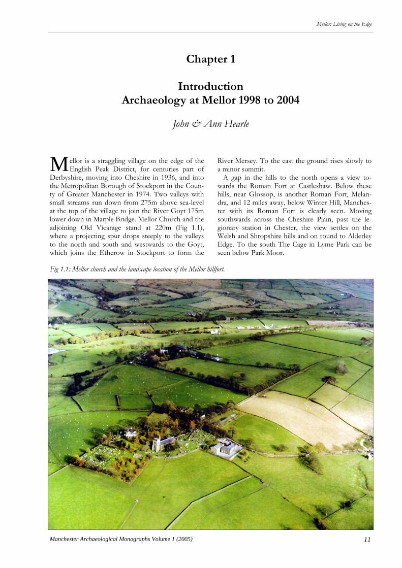
M ellor is a straggling village on the edge of the English Peak District, for centuries part of
Derbyshire, moving into Cheshire in 1936, and into the Metropolitan Borough of Stockport in the Coun-ty of Greater Manchester in 1974. Two valleys with small streams run down from 275m above sea-level at the top of the village to join the River Goyt 175m lower down in Marple Bridge. Mellor Church and the adjoining Old Vicarage stand at 220m (Fig 1.1), where a projecting spur drops steeply to the valleys to the north and south and westwards to the Goyt, which joins the Etherow in Stockport to form the
Chapter 1
Introduction
Archaeology at Mellor 1998 to 2004
John & Ann Hearle
River Mersey. To the east the ground rises slowly to a minor summit. A gap in the hills to the north opens a view to-wards the Roman Fort at Castleshaw. Below these hills, near Glossop, is another Roman Fort, Melan-dra, and 12 miles away, below Winter Hill, Manches-ter with its Roman Fort is clearly seen. Moving southwards across the Cheshire Plain, past the le-gionary station in Chester, the view settles on the Welsh and Shropshire hills and on round to Alderley Edge. To the south The Cage in Lyme Park can be seen below Park Moor.
Fig 1.1: Mellor church and the landscape location of the Mellor hillfort.
12 Manchester Archaeological Monographs Volume 1 (2005)
Mellor: Living on the Edge
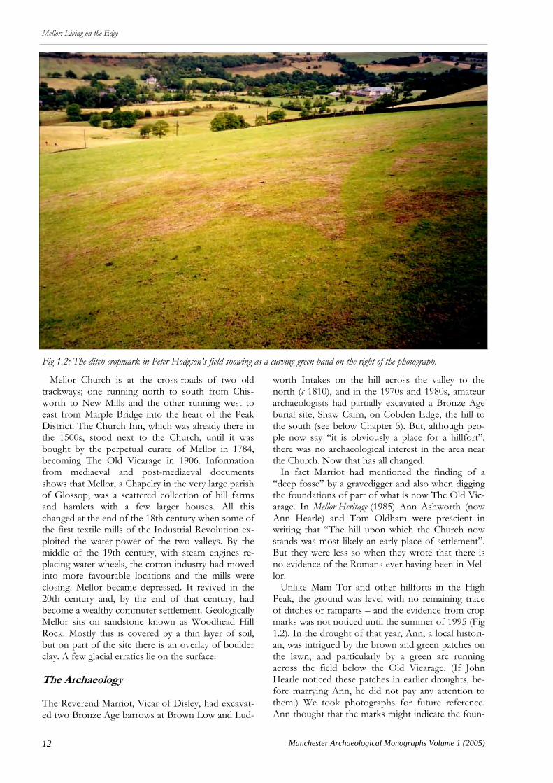
Mellor Church is at the cross-roads of two old trackways; one running north to south from Chis-worth to New Mills and the other running west to east from Marple Bridge into the heart of the Peak District. The Church Inn, which was already there in the 1500s, stood next to the Church, until it was bought by the perpetual curate of Mellor in 1784, becoming The Old Vicarage in 1906. Information from mediaeval and post-mediaeval documents shows that Mellor, a Chapelry in the very large parish of Glossop, was a scattered collection of hill farms and hamlets with a few larger houses. All this changed at the end of the 18th century when some of the first textile mills of the Industrial Revolution ex-ploited the water-power of the two valleys. By the middle of the 19th century, with steam engines re-placing water wheels, the cotton industry had moved into more favourable locations and the mills were closing. Mellor became depressed. It revived in the 20th century and, by the end of that century, had become a wealthy commuter settlement. Geologically Mellor sits on sandstone known as Woodhead Hill Rock. Mostly this is covered by a thin layer of soil, but on part of the site there is an overlay of boulder clay. A few glacial erratics lie on the surface. The Archaeology The Reverend Marriot, Vicar of Disley, had excavat-ed two Bronze Age barrows at Brown Low and Lud-
worth Intakes on the hill across the valley to the north (c 1810), and in the 1970s and 1980s, amateur archaeologists had partially excavated a Bronze Age burial site, Shaw Cairn, on Cobden Edge, the hill to the south (see below Chapter 5). But, although peo-ple now say “it is obviously a place for a hillfort”, there was no archaeological interest in the area near the Church. Now that has all changed. In fact Marriot had mentioned the finding of a “deep fosse” by a gravedigger and also when digging the foundations of part of what is now The Old Vic-arage. In Mellor Heritage (1985) Ann Ashworth (now Ann Hearle) and Tom Oldham were prescient in writing that “The hill upon which the Church now stands was most likely an early place of settlement”. But they were less so when they wrote that there is no evidence of the Romans ever having been in Mel-lor. Unlike Mam Tor and other hillforts in the High Peak, the ground was level with no remaining trace of ditches or ramparts – and the evidence from crop marks was not noticed until the summer of 1995 (Fig 1.2). In the drought of that year, Ann, a local histori-an, was intrigued by the brown and green patches on the lawn, and particularly by a green arc running across the field below the Old Vicarage. (If John Hearle noticed these patches in earlier droughts, be-fore marrying Ann, he did not pay any attention to them.) We took photographs for future reference. Ann thought that the marks might indicate the foun-
Fig 1.2: The ditch cropmark in Peter Hodgson’s field showing as a curving green band on the right of the photograph.

13
Mellor: Living on the Edge
Manchester Archaeological Monographs Volume 1 (2005)
dations of medieval dwellings, and John thought that the green line was a path with buildings on either side. How wrong we were! When Dr Peter Ar-rowsmith from the University of Manchester Archae-ology Unit (UMAU) saw the photographs and walked round the site in late 1997, he said “This is old; I know it’s old”. In the spring of 1998, Graham Eyre-Morgan, at that time in charge of field archaeology at UMAU, arranged for three students to carry out a resistivity survey, which confirmed the green line in the field and showed anomalies in the Old Vicarage garden. They returned in the summer and started digging. Three post-holes in the rock of the first trench; some unexplained disturbance in the second trench; and then, in the third trench, they found an edge cut in the rock. This trench was near the vegetable garden on the western end of the site. As they continued to dig, pottery and other artefacts were found; to every-one’s surprise they were Roman. Deeper down was Iron Age pottery. Part of an Iron Age ditch had been uncovered. In the following years the whole of this section of the ditch was opened and proved to be 4m wide and 2.1m deep. Also in 1998 a section of a nar-rower ditch, which was not so deep, was opened on the green line in the field, to be followed in later years by many other sections. Full-scale archaeology
has continued for six to eight weeks each year since 1999, as the next Chapter describes. Stuart Holden directed the work for UMAU in 2000 and 2001 and John Roberts took over in 2002. What is remarkable is the way the story has changed over the years. At first we thought that there was one oval ditch, but, despite searching in the Church car park and elsewhere, we could not find the eastern boundary. Then in 2002 one edge of a ditch was found at the eastern end of the garden. It was fully excavated in 2003, revealing another wide and deep section of ditch, which matched the one at the western end. Also in 2003 the narrower ditch in the field was found to cross a trackway, about 100m to the north of the deep ditch, and to go on through another field, continuing much further to the east than the ditch in the garden. In 2004 the narrow ditch was found two fields away on the south side. Clearly there was a small outer ditch, narrow enough to jump across, surrounding a strong defensive inner ditch. The “half” of the outer enclosure that has been traced covers four hectares (10 acres), but we still do not know how much further it extends to the east. Meanwhile, an 11m diameter gully showed the presence of a roundhouse in the middle of the inner enclosure, and in 2004 there was evidence of other roundhouses between the two ditches (Fig 1.3).
Fig 1.3: Volunteers excavating a roundhouse between the two ditches at Mellor in 2004.

14 Manchester Archaeological Monographs Volume 1 (2005)
Mellor: Living on the Edge
Many Mesolithic flints indicated earlier use of the site. The finds continued to thrill us; in 2000 a piece of Iron Age pot that fitted to a piece found in 1999; in 2001, the Iron Age “Mellor Pot”; in 2002, the Ne-olithic chisel; in 2003, the Roman brooches; in 2004, the Bronze Age flint dagger. These are just the high-lights of what are described in the following pages. A Community Project In the debate about the roles of local societies, the civic community, and professional archaeology or-ganisations (see Andrew Selkirk’s comments on ‘What is public archaeology?’ in Current Archaeology, May/June 2005), Mellor is a half-way house. It is not run by an archaeological society looking for some-where to dig, it is not just a commercial opportunity for an archaeological unit, nor an academic project of University research. It is site-driven. It started be-cause the owners of the site wanted to know more about its history and has spread to interest from the whole local community. But we are not archaeolo-gists. That is why we turned to UMAU for profes-sional support. Not only has this taught us a lot about archaeology, but it ensures that the work is carried out to the highest standards. Policy is decided by the Trust and all the support-ing activities are carried out by Trustees and Friends. The programme of excavation, the geophysics, and the decisions on post-excavation follow-up result from a discussion between a planning group of Trus-tees and the professional archaeologists from UMAU. Norman Redhead, with his two hats as a Trustee and as Assistant County Archaeologist for Greater Manchester, plays an important part in these discussions. Almost all the actual excavation work is done by volunteers. John Roberts runs from trench to trench as if he was on Time Team, while the other two archaeologists from UMAU, Peter Noble and Adam Thompson, concentrate on particular areas. One amateur archaeologist, Donald Reid, Trustee and archivist, joins in the supervision. He has consid-erable practical experience of archaeological investi-gations in Scotland, so that he is able to supervise excavations of particular trenches, either during the main season or with small groups at other times. In a season, about 60 volunteers help in the dig, with about 20 present on any one day. Some are 17-year old students doing archaeology A-levels at local Sixth Form Colleges; many are University students living locally; several have studied archaeology as mature students; and the 70-year olds are just inter-ested in a new activity. Their skills in practical archae-ology grow as they return year after year. Once the hard work of removing the top-soil is over, they know how to carefully trowel away in sensitive re-gions and uncover the secrets of the past. A local artist has become an expert in using a grid to record
and draw the complex pattern of gullies and post-holes. Two “Anns” have tapped the expertise of Chris Cumberpatch and become knowledgeable on the medieval and post-medieval pottery, which has been found in the upper levels; it was neglected in earlier years, but tells us about the later history of Mellor. A dozen or so of the volunteers have ac-quired the understanding of the site to conduct guid-ed tours during the Open Days (Fig 1.4). The community gets involved in other ways. A lo-cal resident who deals in construction equipment loans us free of charge the heavy machinery to open up the trenches and for back-filling, which means that the volunteers can get straight to the serious work. Signage has been donated by another local firm. An enthusiastic group provides refreshments at the Parish Centre for the Open Days and incidentally contributes to Church finances. Others sit at the gate or direct the car parking. Our Open Days have be-come a traditional part of the village year. Another notable collaboration was with Ridge-Danyers College (now Cheadle and Marple Sixth Form College). In 2002 the A-level archaeology class, led by Bob Dinn, took part in a European Communi-ty Culture Programme, the Mnesonyme Project. With partners located in Italy, the Czech Republic, Bulgaria, and Lithuania, the general aim was to pro-mote the local cultural heritage in various ways. The task for Ridge-Danyers was to build a half-size repli-ca Iron Age roundhouse typical of the first millenni-um BC. With advice from skilled craftsmen, they built the roundhouse in the triangular field on the Old Vicarage site, where roundhouses had stood over two thousand years ago (Fig 1.3). With planning permission for a “temporary construction in the green belt”, it remains an interest to walkers on the nearby footpath and to visitors at the Open Days. At the end of their project Ridge-Danyers hosted a meeting for their European counterparts on the Mel-lor site. Where it is appropriate, we recommend the Mellor pattern for community archeology. It is centred on a
Fig 1.4: Visitors to the Mellor Open Day in September 2003.

15
Mellor: Living on the Edge
Manchester Archaeological Monographs Volume 1 (2005)
group with an interest in the locality, brings in pro-fessional advice, but spreads out to a large number of volunteers and generates interest and support in the whole community. Mellor was part of the inspiration behind the ‘Dig Manchester’ project, promoted by Manchetser City Councillor Paul Murphy at Moston Hall and now Northenden Mill. The detailed practice depends on the site. In the difficult archaeology of Mellor, with post-holes and gullies only detected by rather small changes in colour, skill is needed by those trowelling. About seven volunteers to one su-pervising archaeologist is the norm. It is different in Moston, where the remains of the Hall included walls and paved areas, which can be happily uncovered by groups of schoolchildren. What is common to both sites is the immense local interest. Reaching Out to Stockport and Beyond At first it was just the two landowners; ourselves and the farmer, Peter Hodgson, who owned the field and fortunately was a keen metal detectorist with a great interest in history. Gradually the news spread through the community. One local resident contrib-uted £1000. In 1999 our first hurriedly organised Open Day attracted several hundred visitors; in 2004, 1300 came over two days. Talks by Graham Eyre-Morgan in 2000 produced record audiences for annu-al meetings of the Mellor Society and the Marple Civ-ic Society. Since then Ann Hearle, Donald Reid, and John Roberts have given scores of talks to local soci-eties. School parties visit the site, including one from a deprived area of central Manchester. In 2001 an information case was erected on the Hearse House across the road from the Church car park; and in 2004 a path, starting between the Church gate and the Old Vicarage gate, was made to a public view-point for the deep Iron Age ditch. Booklets about the excavations are printed and updated each year. In 2002, we were so impressed by the way in which John Roberts explained the compli-
cated archeology of a large open area in the middle of the garden that we thought it should be recorded while the trench was still open. By a wonderful piece of serendipity, Chris Mann, who was helping with the Open Day car parking, turned out to be an experi-enced TV producer, who had started his own compa-ny, Mannmade Productions. The video, Ancient Mel-lor Revealed, which he made for a fraction of the full-cost, brought 125 local people to its premiere in the Mellor Parish Centre. This video was runner-up in its section of the 2004 British Archaeology Awards. For 2003-5, we are recording the progress of the dig on video, to supplement the professional filming by Chris for a new video. Our rough editing of the ama-teur video shots provides enjoyment at the annual update evenings of the Friends of the Trust, which fill the Arkwright Hall in the Parish Centre. For the Trust, we were careful to involve the com-munity. In addition to the four residents nearest to the Church, the Trustees consist of representatives of Stockport MBC (a Councillor and an Officer), the Mellor Society, the Parochial Church Council, and the Marple Local History Society, plus three co-opted members with special skills. These organiza-tions have been supportive of our grant applications and in many other ways. A fortunate coincidence was the conversion of the old Mellor School just below the Church into a Parish Centre. In 2000, we were able to fit in displays and refreshments among the building works. Since then, we have the use of the excellent new facilities. The diggers make it their “home” during the excavations and, at the Open Days, we have two rooms for displays, two rooms for media presentations and the large hall for the famous Mellor cakes and other refreshments. In another piece of serendipity, the excavations at Mellor have coincided with Stockport’s development of the Stockport Story Museum, adjacent to the re-stored medieval Staircase House in the town centre, which is due to open in 2006. Because it is built over, few prehistoric and Roman remains have been found in Stockport. Displays of the finds at Mellor, on the outer edge of the borough, and an account of life there up to 10,000 years ago will be the centrepiece of the early part of Stockport’s story. The Museum Service will also be the repository for the Mellor ar-chive and the collection of properly stored and con-served artefacts. In various ways, we also reach out beyond the local community. Coach parties come from historical and archaeological societies as far away as Lancaster, Merseyside, Flint, and Huddersfield. The North-Western Branch of the Council for British Archae-logy held their spring meeting in 2004 in the Mellor Parish Centre. The Mellor hillfort was described in an article in Current Archaeology - the only time in which Mellor has appeared as one of only four loca-tions marked on a map of the British Isles! In 2004
Fig 1.5: Discussing the pottery evidence at the Mellor Study Day in 2003.

16 Manchester Archaeological Monographs Volume 1 (2005)
Mellor: Living on the Edge
we were honoured to be finalists in the Pitt-Rivers Community Award in the British Archaeology Awards, which took news of Mellor across the water to the ceremony in Belfast. Even further away, Ann, accompanying John on a professional trip to Japan, was asked to give a talk about ancient Mellor. By the end of the 2002 season the importance of the Mellor site and its significance for the regional archaeology had been appreciated. A Study Day, “Iron Age and Roman Mellor in the regional set-ting”, was held on Friday, April 11, 2003 and attend-ed by 125 people (Fig 1.5). The venue was the newly renovated Mellor Parish Centre. The Mayor of Stock-port, Councillor David Brailsford, chaired the morn-ing session, which covered the findings at Mellor, and the Director of UMAU, Dr Michael Nevell, chaired the afternoon session on the regional con-text. Those presentations, updated to include the work of 2003 and 2004, form the basis for this book.
The Funding The 1998 excavation was privately funded. When we continued with the 1999 excavation, we did not know how we would pay UMAU for the services of the archaeologists. Fortunately, a visit from the Di-rector of Community Services of Stockport MBC led to a grant of £6000, which has continued annually to pay for one supervising archaeologist. In 1999, we formed the Mellor Archaeological Trust, registered with the Charity Commission in 2000, and, next year, the Friends of the Trust. The basic income of the Trust comes from Open Days, sales of booklets, membership of Friends of the Trust, donations, gift aid receipts, and bank interest. We were able to add a second supervising archeologist in 2001. For 2001-2, we received a Local Heritage Initiative Award of £25,000 from the Heritage Lottery Fund, adminis-tered by the Countryside Agency. Until they were relaxed in 2002, the rules said that this grant could not be used for excavation, but it did cover publica-tions, evaluation of finds and other ancillary activi-ties. For 2003-2005, the excavations are supported by a “Your Heritage” grant of £50,000 from the Herit-age Lottery Fund. With the grant from Stockport and £5000 annually from Trust funds, this has ena-bled us to employ three archaeologists from UMAU, who are needed to train and supervise the large num-ber of volunteers, as well as covering all the expenses of conservation, evaluation, reporting, and bringing the story of the dig to the public. The achievements at Mellor owe much to the staff of the Countryside Agency in Penrith and the Man-chester office of the Heritage Lottery Fund, as well as the professional support of UMAU and the Great-er Manchester Archaeology Unit.
Speculation Perhaps we as non-archaeologists, who now have the pleasure of living on the site, can speculate on what happened thousands of years ago. Some time after the ice melted around 12,000 years ago, each season would see the Mellor hilltop visited by hunter-gatherers, who would camp here, make their flint tools, and collect their food supplies. Then farming started in Neolithic times and there may have been a small Bronze Age settlement here, perhaps continu-ing into the Iron Age. Meanwhile the great hillforts in Derbyshire, notably Mam Tor at 517m, were founded. Around 500 BC, the weather turned colder and maybe an Iron Age tribe, a branch of the Brigantes, who had been living on Mam Tor or one of the other Derbyshire hillforts, decided to move lower down to a spur of land where they could grow crops and tend their animals. Lower still, the woods and streams provided other benefits. They built a ditch to enclose their “farm”, and built roundhouses to live in. The spur was on the edge of Brigantian territory and, in more troubled times, they dug a great inner defensive ditch, which was backed by a rampart. This was both a symbol of status and a for-midable obstacle to enemies, who had climbed up from the valley below. Or possibly, the defensive ditch was built first and the outer enclosure later; or both were planned at the same time. So this Iron Age community lived in what would come to be known as Mellor. They would begin to hear about the great Roman Empire and the invasion of southern Britan-nia, until finally the legions came north in 70-80 AD. What happened then? Did the Romans choose to establish a signal station alongside the British settle-ment? Did a Roman officer from one of the local forts build a “country cottage” here? Or did the tribal lead-er co-operate and, although still living in a round-house, did he acquire the expensive pottery and jew-ellery of a Romanised Briton? After Rome aban-doned Britain, what was the impact of Norse, Anglo-Saxon, and Danish invaders on the Britons in Mel-lor? Did Chad, who became Bishop of Lichfield in 669, establish a Church on this ancient site in the middle of his vast diocese? This is a “dark age”, and we know nothing about life in Mellor, until the time of Norman rule of the Forest of the Peak, the build-ing of Mellor Hall in the 13th Century and a stone church in the 14th or 15th Centuries. Much remains to be excavated on the present site, but then there are the neighbouring valleys and hilltops. Archaeologists will have opportunities for studies for many years to come, uncovering the story of Mellor through all the ages of prehistory and his-tory up to the Industrial Revolution at the end of the 18th century and beyond.

17
Mellor: Living on the Edge
Manchester Archaeological Monographs Volume 1 (2005)
Chapter 2
The Mellor Excavations 1998 to 2004
Peter Noble & Adam Thompson
nity excavations conducted to date upon the Mellor hilltop. Though emphasis will be placed on the Iron Age and Roman periods, it should be borne in mind that evidence of human activity on the site has been
Fig 1.1: The location of Mellor. Reproduced by permission of Ordnance Survey on behalf of HMSO. © Crown copyright 2005. All rights reserved. Ordnance Survey Licence number 10022765.
R ecent excavations upon the hilltop of Mellor have identified substantial remains relating to an
Iron Age enclosed settlement. This chapter is intend-ed as an overview and interpretation of the commu-
18 Manchester Archaeological Monographs Volume 1 (2005)
Mellor: Living on the Edge
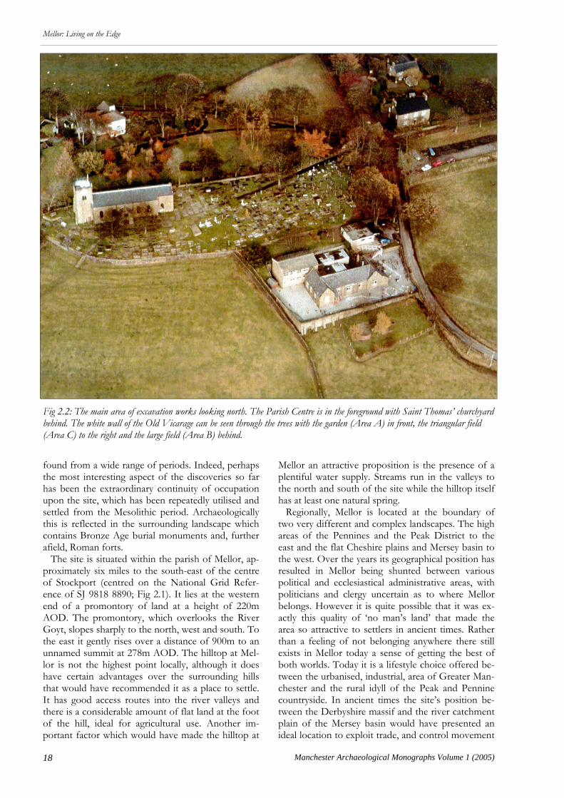
found from a wide range of periods. Indeed, perhaps the most interesting aspect of the discoveries so far has been the extraordinary continuity of occupation upon the site, which has been repeatedly utilised and settled from the Mesolithic period. Archaeologically this is reflected in the surrounding landscape which contains Bronze Age burial monuments and, further afield, Roman forts. The site is situated within the parish of Mellor, ap-proximately six miles to the south-east of the centre of Stockport (centred on the National Grid Refer-ence of SJ 9818 8890; Fig 2.1). It lies at the western end of a promontory of land at a height of 220m AOD. The promontory, which overlooks the River Goyt, slopes sharply to the north, west and south. To the east it gently rises over a distance of 900m to an unnamed summit at 278m AOD. The hilltop at Mel-lor is not the highest point locally, although it does have certain advantages over the surrounding hills that would have recommended it as a place to settle. It has good access routes into the river valleys and there is a considerable amount of flat land at the foot of the hill, ideal for agricultural use. Another im-portant factor which would have made the hilltop at
Mellor an attractive proposition is the presence of a plentiful water supply. Streams run in the valleys to the north and south of the site while the hilltop itself has at least one natural spring. Regionally, Mellor is located at the boundary of two very different and complex landscapes. The high areas of the Pennines and the Peak District to the east and the flat Cheshire plains and Mersey basin to the west. Over the years its geographical position has resulted in Mellor being shunted between various political and ecclesiastical administrative areas, with politicians and clergy uncertain as to where Mellor belongs. However it is quite possible that it was ex-actly this quality of ‘no man’s land’ that made the area so attractive to settlers in ancient times. Rather than a feeling of not belonging anywhere there still exists in Mellor today a sense of getting the best of both worlds. Today it is a lifestyle choice offered be-tween the urbanised, industrial, area of Greater Man-chester and the rural idyll of the Peak and Pennine countryside. In ancient times the site’s position be-tween the Derbyshire massif and the river catchment plain of the Mersey basin would have presented an ideal location to exploit trade, and control movement
Fig 2.2: The main area of excavation works looking north. The Parish Centre is in the foreground with Saint Thomas’ churchyard behind. The white wall of the Old Vicarage can be seen through the trees with the garden (Area A) in front, the triangular field (Area C) to the right and the large field (Area B) behind.
19
Mellor: Living on the Edge
Manchester Archaeological Monographs Volume 1 (2005)
between the two geographical zones. Geologically the site is located upon a solid deposit of sandstone known locally as Woodhead Hill Rock, the lowest sandstone development in the Westphali-an A succession, laid during the late Carboniferous Period. Excavation has revealed the possibility of a glacial channel running down the northern side of the hill. Trenches along this line have revealed that the archaeological features are cut into boulder clay which appears to have filled the channel. One of the consequences of this changing geology is that the character of the archaeological survival is very differ-ent depending on within which of the two geological deposits a trench is excavated. Within the band of boulder clay the archaeological features are for the most part well defined and clearly visible whereas all
but the largest of features cut into the plated sand-stone bedrock tend to be more irregular in both shape and depth. Just as the topography of the site has influenced the settlement so too has the geology. The sandstone bedrock occurs in plates of varying thicknesses which can be prised apart as large flat fragments. Excava-tion has shown that this material was used extensive-ly as packing in post holes and linear features. The amount of this material produced by the excavation of the two ditches would have been huge. It would have provided the Iron Age and Roman inhabitants of the site with a plentiful supply of stone ideally suited not just for post hole packing but for laying paths and building low walls. Surviving topsoil and subsoil horizons across the
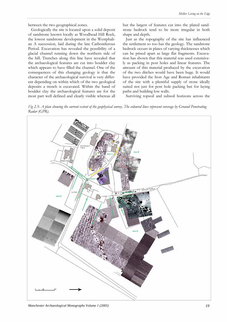
Fig 2.3: A plan showing the current extent of the geophysical survey. The coloured lines represent coverage by Ground Penetrating Radar (GPR).

20 Manchester Archaeological Monographs Volume 1 (2005)
Mellor: Living on the Edge
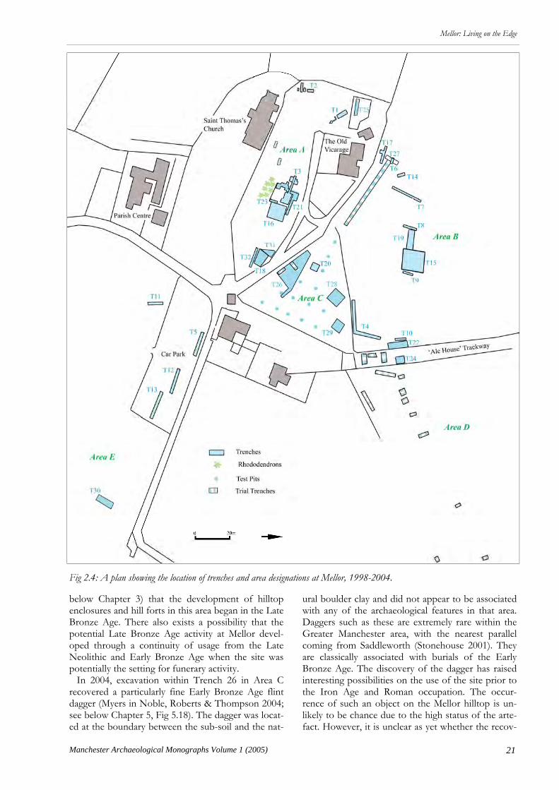
site are shallow. As a result it is suspected that the presence of positive archaeological features may have been truncated through the continuous occupation and agricultural use of the immediate area during the last two millennia. One of the reasons that the site has remained unknown is the complete lack of sug-gestive banks or mounds within the immediate land-scape. As has been described in the introduction the pres-ence of significant archaeological deposits upon the Mellor hilltop was unknown prior to 1998. In the six years following the discovery of the site a programme of evaluation involving excavation and geophysical survey has examined five areas surrounding the Old Vicarage at Mellor (Fig 2.2). Geophysical Survey Given the potential size of the site, geophysical sur-vey has formed a crucial part of the evaluation pro-gramme (Fig 2.3). The main aims of the survey work have been to try and determine the extent of the ditch system associated with the Iron Age settlement and to guide the location of evaluation trenches. In this role it has proved invaluable. The extensive geo-physical survey has been carried out using a variety of methods. Resistivity has proved particularly success-ful in identifying the location and path of the outer enclosure ditch in Area B. This is largely due to size of the feature and the high differential in resistance between the earth filled ditch and the bedrock geolo-gy. Within the area of boulder clay the difference between the natural geology and the fill of the ar-chaeological features is less pronounced. This makes the results less conclusive and more difficult to inter-pret. Magnetometry has been used extensively and also proved successful in identifying large features. In addition it has also been able to locate features cut into the boulder clay, where the fills contain a high percentage of burnt material. Particular examples include the charcoal rich fills of the gullies found within Trench 16 in Area A (see below). For areas where magnetometry and resistivity were unable to be deployed, such as the road, drive and paved areas, Ground Penetrating Radar (GPR) has been used. One set of particularly interesting results from the GPR system has provided a strong indication that the north arm of the inner enclosure ditch runs be-neath the drive of the Old Vicarage. Excavation Strategy By the conclusion of the 2004 season the extent of intrusive archaeological investigation consisted of 32 trenches, 14 trial trenches, and 17 test pits. The exca-vation has concentrated on the west end of the hilltop around the Old Vicarage. Even so they repre-
sent only a small fraction of the land available for archaeological inspection on this part of the hilltop. Because of the potential scale of the site the current programme of archaeological work should be viewed as an evaluation phase. The main aims of the excava-tion are to try to shed light on the age, extent, and nature of the Iron Age and Roman settlements at Mellor. In part the concentration of work in this area of the hilltop has been determined by the availability of land and the willingness of the owners to allow archaeological excavation on their land. The focus also reflects a planned strategy of archaeological in-vestigation which aims to build on the results of pre-vious years’ work whilst expanding the area of poten-tial study through an extensive geophysical survey of the hilltop. Three principal areas of the hilltop (A, B, C) have been investigated through systematic archae-ological excavation, with further limited evaluation conducted in areas (D and E) to try to establish the line of the outer enclosure ditch (Fig 2.4). Pre-Iron Age Activity The earliest evidence of occupation upon the hilltop dates from the Early Mesolithic period, c 8000-10000 years ago, when the location appears to have been the setting of a knap site or seasonal camp. A sub-stantial assemblage of nearly 200 lithic artefacts from both the Early and Late Mesolithic periods have been uncovered during excavations conducted within Area A. These were principally recovered from a discrete area within Trenches 3 and 21, close to the highest point of the hilltop, and appear to denote a focus of activity (Fig 2.4). The high proportion of bladed piec-es in the assemblage suggests that it may have been the site of a work area used by hunter gatherers to carry out maintenance. Mesolithic flints have also been recovered from the nearby site of Shaw Cairn (Mellor 2000) and together these finds would suggest repeated usage of the high ground overlooking the River Goyt valley. Finds from the Bronze Age have been sporadic and as yet no definitive Bronze Age occupation has been discovered. However, there exists a very real possibility that the Iron Age occupation upon the hilltop had its origins in the Late Bronze Age and that the first steps towards the development and en-closure of the area began at this time. A radiocarbon date of 1750-900 cal BC (Beta 202316, 2 sigmas) re-covered from a small pit within Trench 26 in Area C (below), would suggest that the site was being used during the mid- to late Bronze Age. This situation would seem to conform to the prev-alent development of sites of this type in the region. Although there exist numerous differences in both their character and nature, it would appear (based on the nearest comparable sites of Mam Tor, Fin Cop, Wincobank, Great Low, Bunbury, and Ball Cross; see
21
Mellor: Living on the Edge
Manchester Archaeological Monographs Volume 1 (2005)
below Chapter 3) that the development of hilltop enclosures and hill forts in this area began in the Late Bronze Age. There also exists a possibility that the potential Late Bronze Age activity at Mellor devel-oped through a continuity of usage from the Late Neolithic and Early Bronze Age when the site was potentially the setting for funerary activity. In 2004, excavation within Trench 26 in Area C recovered a particularly fine Early Bronze Age flint dagger (Myers in Noble, Roberts & Thompson 2004; see below Chapter 5, Fig 5.18). The dagger was locat-ed at the boundary between the sub-soil and the nat-
ural boulder clay and did not appear to be associated with any of the archaeological features in that area. Daggers such as these are extremely rare within the Greater Manchester area, with the nearest parallel coming from Saddleworth (Stonehouse 2001). They are classically associated with burials of the Early Bronze Age. The discovery of the dagger has raised interesting possibilities on the use of the site prior to the Iron Age and Roman occupation. The occur-rence of such an object on the Mellor hilltop is un-likely to be chance due to the high status of the arte-fact. However, it is unclear as yet whether the recov-
Fig 2.4: A plan showing the location of trenches and area designations at Mellor, 1998-2004.
22 Manchester Archaeological Monographs Volume 1 (2005)
Mellor: Living on the Edge
ery of the dagger represents the use of the site as a location for Early Bronze Age burials or whether the seemingly random nature of its deposition represents activity not normally associated with such an artefact. A precedent for this last possibility may be found in the similarities with a polished Late Neolithic flint chisel uncovered within Trench 16 in Area A during the 2002 season of excavations. This artefact was also discovered lying upon the natural boulder clay and was similarly unassociated with surrounding fea-tures. It is possible therefore, that both objects were moved here after initially residing elsewhere, or more likely that they have been disturbed from their initial deposition and re-deposited through later intrusive activities. If, as seems likely, these objects have been dis-turbed from their original contexts, then it is possible that they represent grave goods associated with Late Neolithic or Early Bronze Age funerary practices upon the Mellor hilltop. This theory is further strengthened by the absence of any comparably dated material from the site which would suggest that these undamaged artefacts were deposited here for a ritual or burial purpose rather than belonging to a residual and more widespread habitation area (Myers in No-ble, Roberts & Thompson 2004). The area surround-ing the Mellor hilltop is dominated by hills overlook-ing the Etherow and Goyt river valleys, many of which have surviving funerary monuments of the Bronze Age. The nearby burial sites at Shaw Cairn, Marple Ridge, Werneth Low, Brown Low, and Lud-worth Intakes, all indicate that visually impressive hilltops were utilized for ritual purposes during this period. The equally impressive hilltop of Mellor would clearly fit within this established practice and could have been used as the site for a barrow. The later enclosure and occupation of a hilltop containing
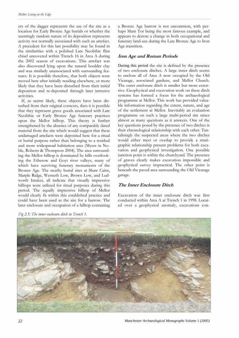
a Bronze Age barrow is not uncommon, with per-haps Mam Tor being the most famous example, and appears to denote a change in both occupational and funerary land-use during the Late Bronze Age to Iron Age transition. Iron Age and Roman Periods During this period the site is defined by the presence of two enclosure ditches. A large inner ditch seems to enclose all of Area A now occupied by the Old Vicarage, associated gardens, and Mellor Church. The outer enclosure ditch is smaller but more exten-sive. Geophysical and excavation work on these ditch systems has formed a focus for the archaeological programme at Mellor. This work has provided valua-ble information regarding the extent, nature, and age of the settlement at Mellor. Inevitably an evaluation programme on such a large multi-period site raises almost as many questions as it answers. One of the key questions posed by the presence of two ditches is their chronological relationship with each other. Tan-talisingly the suspected areas where the two ditches would either meet or overlap to provide a strati-graphic relationship present problems for both exca-vation and geophysical investigation. One possible junction point is within the churchyard. The presence of graves clearly makes excavation impossible and geophysical survey impractical. The other point is beneath the paved area surrounding the Old Vicarage garage. The Inner Enclosure Ditch Excavation of the inner enclosure ditch was first conducted within Area A at Trench 1 in 1998. Locat-ed over a geophysical anomaly, excavations con-
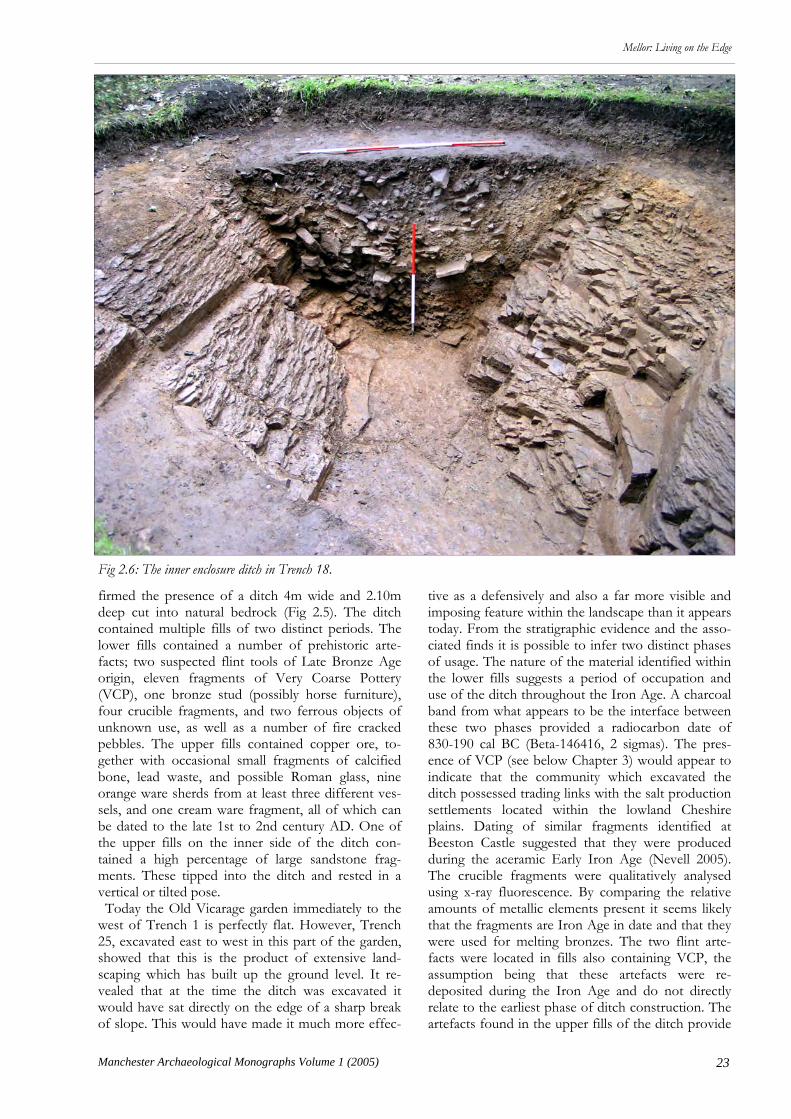
Fig 2.5: The inner enclosure ditch in Trench 1.
23
Mellor: Living on the Edge
Manchester Archaeological Monographs Volume 1 (2005)
firmed the presence of a ditch 4m wide and 2.10m deep cut into natural bedrock (Fig 2.5). The ditch contained multiple fills of two distinct periods. The lower fills contained a number of prehistoric arte-facts; two suspected flint tools of Late Bronze Age origin, eleven fragments of Very Coarse Pottery (VCP), one bronze stud (possibly horse furniture), four crucible fragments, and two ferrous objects of unknown use, as well as a number of fire cracked pebbles. The upper fills contained copper ore, to-gether with occasional small fragments of calcified bone, lead waste, and possible Roman glass, nine orange ware sherds from at least three different ves-sels, and one cream ware fragment, all of which can be dated to the late 1st to 2nd century AD. One of the upper fills on the inner side of the ditch con-tained a high percentage of large sandstone frag-ments. These tipped into the ditch and rested in a vertical or tilted pose. Today the Old Vicarage garden immediately to the west of Trench 1 is perfectly flat. However, Trench 25, excavated east to west in this part of the garden, showed that this is the product of extensive land-scaping which has built up the ground level. It re-vealed that at the time the ditch was excavated it would have sat directly on the edge of a sharp break of slope. This would have made it much more effec-
tive as a defensively and also a far more visible and imposing feature within the landscape than it appears today. From the stratigraphic evidence and the asso-ciated finds it is possible to infer two distinct phases of usage. The nature of the material identified within the lower fills suggests a period of occupation and use of the ditch throughout the Iron Age. A charcoal band from what appears to be the interface between these two phases provided a radiocarbon date of 830-190 cal BC (Beta-146416, 2 sigmas). The pres-ence of VCP (see below Chapter 3) would appear to indicate that the community which excavated the ditch possessed trading links with the salt production settlements located within the lowland Cheshire plains. Dating of similar fragments identified at Beeston Castle suggested that they were produced during the aceramic Early Iron Age (Nevell 2005). The crucible fragments were qualitatively analysed using x-ray fluorescence. By comparing the relative amounts of metallic elements present it seems likely that the fragments are Iron Age in date and that they were used for melting bronzes. The two flint arte-facts were located in fills also containing VCP, the assumption being that these artefacts were re-deposited during the Iron Age and do not directly relate to the earliest phase of ditch construction. The artefacts found in the upper fills of the ditch provide
Fig 2.6: The inner enclosure ditch in Trench 18.

24 Manchester Archaeological Monographs Volume 1 (2005)
Mellor: Living on the Edge
evidence for occupation of the site during the Ro-man Period. The mixed nature of the artefactual ma-terial in these upper fills and the presence of a variety of differing vessels, glass, and burnt bone suggest that the final function of the ditch was as a rubbish dump. The large amounts of stone within the upper layers may represent remains of a collapsed or slight-ed structure associated with the ditch. Trench 2 was positioned to establish the extent of the inner enclosure ditch as it enters the churchyard of St Thomas’s Church. The trench identified the inner edge of the ditch and also a linear feature, inter-preted as a palisade slot running inside and parallel to the edge of the ditch. The feature was distinctive in that it contained a number of large sandstone frag-ments which appeared to have been deliberately set on edge against the sides of the cut. Only the upper fills of the ditch were excavated due to the proximity of a garden wall, which stands directly above the cen-tre of the ditch. These excavated fills closely resem-bled the upper contexts in Trench 1. They produced one Roman pottery sherd, fragments of burnt bone and charcoal, along with one piece of copper ore. The presence of copper ore in the upper layers of the ditch in both Trench 1 and Trench 2 suggests that metalworking took place on the site during the Ro-man Period. Neither geophysical survey nor excava-tion have yet produced any indication of a focal point for either Iron Age or Roman metal working on the site. In Trench 2 the palisade slot was located 3.25m to the east of the inner edge of the ditch. In an attempt to locate the palisade slot near Trench 1, a 0.30m wide slot was extended back towards the south-west of Trench 1 towards the Old Vicarage. This slot con-tained no evidence of the feature found in Trench 2. However, it did reveal the presence of a large circular pit cut into the bedrock. Within the pit were the re-mains of a 0.4m wide post-pipe. Two interpretations seem possible; the pit may have been backfilled and a post hole then cut into it, or that it is the cut for a large post relating to a structure. The size of the post-pipe would suggest that this would have been a substantial structure perhaps associated with a gate-way. Trench 18 was located over a geophysical anomaly at the eastern end of area A. It revealed a rock cut ditch, 4m wide and 1.90m deep very similar to that found in Trench 1 (Fig 2.6). Trench 18 also revealed a long length of the palisade slot first identified in Trench 2. As in Trench 2 it ran alongside the ditch and was characterised by two lines of vertical angular stones. As yet no dating material has been recovered from this feature although the fact that it clearly runs parallel with the ditch strongly suggests that they are part of the same enclosure system (Fig 2.7). The depositional sequence of the fills in Trench 18 can also be split into two distinct phases. The lower
fills contained two flint flakes and one sherd of high-ly abraded Iron Age pottery, whereas the artefacts recovered from the upper fills included 221 frag-ments of Roman pottery, from multiple vessels da-ting from the 1st to 4th centuries AD. Fragments of five bronze Roman brooches, an assortment of Ro-man nails, and 40 fragments of briquetage were also recovered from these fills. Comparisons between Trenches 1 and 18 show a remarkably similar pattern of deposition and finds. The flint flakes are probably a product of re-deposition and are similar in nature to the flakes identified c 30m west redeposited within the roundhouse gully located in Trench 21. The Ro-man pottery identified (see below Chapter 3) dates from the 1st century AD to the late 4th century AD. Sherds of pottery of widely different dates were found within the same fills. This indicates that they have been deposited within the ditch during a phase of backfilling and abandonment, similar to that shown in Trench 1. The pottery fragments represent over 30 different vessels. Their sources include Dor-set, Mancetter-Hartshill, the Severn Valley, Cheshire Plains, Derbyshire, and Lincolnshire. They include fabric types such as Black Burnished Ware, Cheshire Plains Ware, Grey Ware, Cream Ware, Samian and Oxidised Wares. The variety and assorted nature of the pottery frag-ments identified would seem to suggest a substantial, high status, and lengthy occupation of this part of the hilltop during the Roman Period. This sort of settle-ment should have left a considerable impression amongst the surviving archaeology. Although the trenches excavated close to Trench 18 have pro-duced some evidence of Roman activity it is not on anything like the scale that one might expect from the finds assemblage. The dating evidence from the upper fills in Trench 18 shows that, although perhaps partially in-filled, the ditch was open up until the 4th century AD, and though the partial infilling of the ditch might have negated its use for defensive pur-poses it could still have functioned as an enclosure ditch. The size of the site means that it is quite possi-
Fig 2.7: The palisade slot and ditch in Trench 18.

25
Mellor: Living on the Edge
Manchester Archaeological Monographs Volume 1 (2005)
ble that the location of the occupation in the Roman period lies within this enclosure, undetected by geo-physical survey in the parts of Area A not yet investi-gated by excavation. Perhaps less likely is the possi-bility that the ditch had completely fallen out of use by the Roman period and thus ceased to be a rele-vant feature in the landscape and was only used as a rubbish dump. This would mean that the evidence for Roman settlement is just as likely to lie to the east of the ditch in Trench 18, below what is now the churchyard and car park, to the west of the ditch and thus inside the Iron Age enclosure. Within the upper fills of Trench 18 a distinctive layer composed pre-dominantly of stones was uncovered. In terms of the Iron Age settlement these stones appear to have orig-inated from the external side of the ditch, possibly relating to the demolition of a nearby bank or struc-ture. There is no clear evidence from the excavated ditch sections of a hiatus which may indicate the deliberate slighting of the defences or destruction of buildings, nor is there any suggestion of a prolonged period of silting which might represent a period of abandon-ment. Although some evidence has come from trenches elsewhere on the site one of the most im-portant questions that future work on this ditch will seek to shed light on is whether or not there was a break in the occupation of the site within the Iron Age or between the Iron Age and Roman Periods. Trenches 1, 2, and 18 appear to be situated over the same ditch and the same associated palisade slot. The presence of flint artefacts, Iron Age pottery, and crucible fragments and the absence of Roman arte-facts within the lower fills would suggest that the ditch and palisade date to the Iron Age. Some care should be taken with this interpretation. The excava-tion of such a ditch in the Roman Period through a site which had been occupied and used during the Mesolithic and Iron Age would almost certainly dis-turb archaeological features and artefacts relating to those periods which might then through natural ero-sion and weathering silt into the ditch. However, it does seem likely that the excavated sections in these trenches represent parts of a large Iron Age ditch enclosing a relatively small area. The depth of the ditch, the presence of a palisade and the size of the area it encloses suggests that, in part at least, its func-tion was defensive. By combining the excavation and GPR results with clues presented by features in the modern landscape it is possible to propose a likely course for this ditch. This would run through Trenches 1 and 2 into the churchyard. It would seem likely that its route then follows the line of the present churchyard wall as it runs south and then east. A line of sunken grave-stones running north to south at the eastern end of the churchyard may well indicate the line of the east-ern arm of the ditch as it runs into Trench 18. The
absence of the ditch in Trench 26, in Area C, and the indications from GPR suggests that after leaving Trench 18 the ditch swings sharply west following the line of the present driveway before running be-neath the Old Vicarage to rejoin Trench 1. The Outer Enclosure Ditch Within Area B geophysical survey and excavation have securely established the line of the outer enclo-sure ditch over a distance of 120m. It follows the contours of a break in the slope which runs south-west to north-east across the field. In the majority of the trenches excavated in this area the ditch was cut into natural bedrock. Typically within these trenches the ditch is a flat based, near vertical, cut measuring on average 1.50m wide and 1.40m deep. Excavating a ditch through bedrock is a daunting task. However, the nature of the geology at Mellor means that once a shaft has been excavated down to the required depth it is then relatively easy to excavate straight ahead by levering out the bedrock following the geological joints between the bedding planes exposed in the section. The thickness of the plates of sandstone increases with depth. It would seem that the ditch has been excavated to a functional level at which the thickness of the plate made deeper excavation im-
Fig 2.8: The outer ditch in Trench 15.
26 Manchester Archaeological Monographs Volume 1 (2005)
Mellor: Living on the Edge
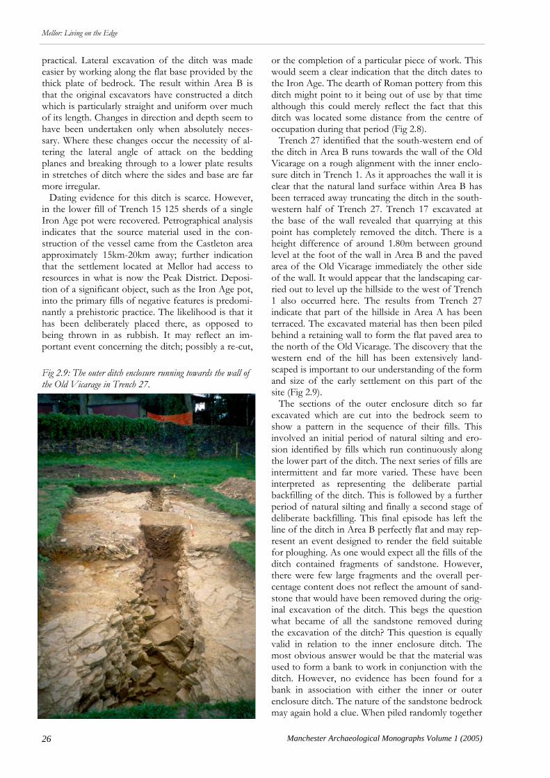
practical. Lateral excavation of the ditch was made easier by working along the flat base provided by the thick plate of bedrock. The result within Area B is that the original excavators have constructed a ditch which is particularly straight and uniform over much of its length. Changes in direction and depth seem to have been undertaken only when absolutely neces-sary. Where these changes occur the necessity of al-tering the lateral angle of attack on the bedding planes and breaking through to a lower plate results in stretches of ditch where the sides and base are far more irregular. Dating evidence for this ditch is scarce. However, in the lower fill of Trench 15 125 sherds of a single Iron Age pot were recovered. Petrographical analysis indicates that the source material used in the con-struction of the vessel came from the Castleton area approximately 15km-20km away; further indication that the settlement located at Mellor had access to resources in what is now the Peak District. Deposi-tion of a significant object, such as the Iron Age pot, into the primary fills of negative features is predomi-nantly a prehistoric practice. The likelihood is that it has been deliberately placed there, as opposed to being thrown in as rubbish. It may reflect an im-portant event concerning the ditch; possibly a re-cut,
or the completion of a particular piece of work. This would seem a clear indication that the ditch dates to the Iron Age. The dearth of Roman pottery from this ditch might point to it being out of use by that time although this could merely reflect the fact that this ditch was located some distance from the centre of occupation during that period (Fig 2.8). Trench 27 identified that the south-western end of the ditch in Area B runs towards the wall of the Old Vicarage on a rough alignment with the inner enclo-sure ditch in Trench 1. As it approaches the wall it is clear that the natural land surface within Area B has been terraced away truncating the ditch in the south-western half of Trench 27. Trench 17 excavated at the base of the wall revealed that quarrying at this point has completely removed the ditch. There is a height difference of around 1.80m between ground level at the foot of the wall in Area B and the paved area of the Old Vicarage immediately the other side of the wall. It would appear that the landscaping car-ried out to level up the hillside to the west of Trench 1 also occurred here. The results from Trench 27 indicate that part of the hillside in Area A has been terraced. The excavated material has then been piled behind a retaining wall to form the flat paved area to the north of the Old Vicarage. The discovery that the western end of the hill has been extensively land-scaped is important to our understanding of the form and size of the early settlement on this part of the site (Fig 2.9). The sections of the outer enclosure ditch so far excavated which are cut into the bedrock seem to show a pattern in the sequence of their fills. This involved an initial period of natural silting and ero-sion identified by fills which run continuously along the lower part of the ditch. The next series of fills are intermittent and far more varied. These have been interpreted as representing the deliberate partial backfilling of the ditch. This is followed by a further period of natural silting and finally a second stage of deliberate backfilling. This final episode has left the line of the ditch in Area B perfectly flat and may rep-resent an event designed to render the field suitable for ploughing. As one would expect all the fills of the ditch contained fragments of sandstone. However, there were few large fragments and the overall per-centage content does not reflect the amount of sand-stone that would have been removed during the orig-inal excavation of the ditch. This begs the question what became of all the sandstone removed during the excavation of the ditch? This question is equally valid in relation to the inner enclosure ditch. The most obvious answer would be that the material was used to form a bank to work in conjunction with the ditch. However, no evidence has been found for a bank in association with either the inner or outer enclosure ditch. The nature of the sandstone bedrock may again hold a clue. When piled randomly together
Fig 2.9: The outer ditch enclosure running towards the wall of the Old Vicarage in Trench 27.
27
Mellor: Living on the Edge
Manchester Archaeological Monographs Volume 1 (2005)
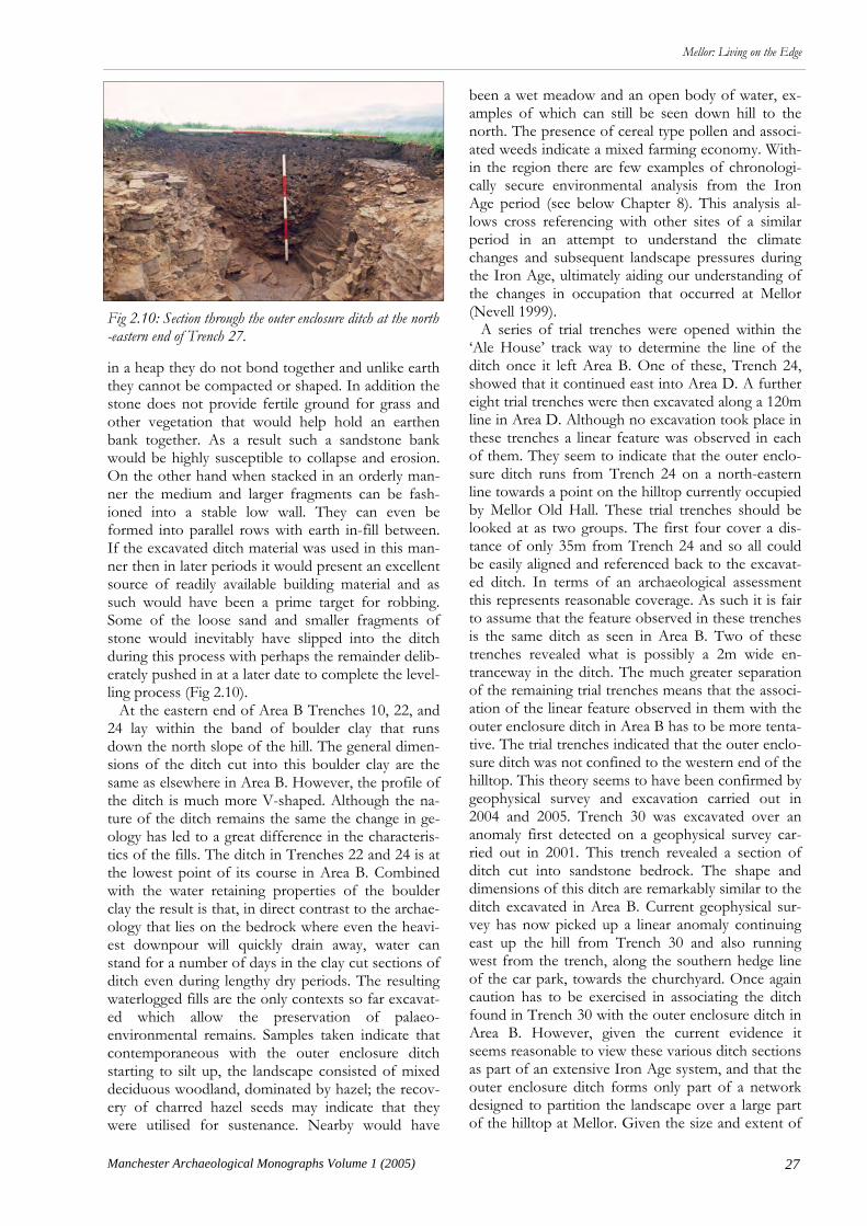
in a heap they do not bond together and unlike earth they cannot be compacted or shaped. In addition the stone does not provide fertile ground for grass and other vegetation that would help hold an earthen bank together. As a result such a sandstone bank would be highly susceptible to collapse and erosion. On the other hand when stacked in an orderly man-ner the medium and larger fragments can be fash-ioned into a stable low wall. They can even be formed into parallel rows with earth in-fill between. If the excavated ditch material was used in this man-ner then in later periods it would present an excellent source of readily available building material and as such would have been a prime target for robbing. Some of the loose sand and smaller fragments of stone would inevitably have slipped into the ditch during this process with perhaps the remainder delib-erately pushed in at a later date to complete the level-ling process (Fig 2.10). At the eastern end of Area B Trenches 10, 22, and 24 lay within the band of boulder clay that runs down the north slope of the hill. The general dimen-sions of the ditch cut into this boulder clay are the same as elsewhere in Area B. However, the profile of the ditch is much more V-shaped. Although the na-ture of the ditch remains the same the change in ge-ology has led to a great difference in the characteris-tics of the fills. The ditch in Trenches 22 and 24 is at the lowest point of its course in Area B. Combined with the water retaining properties of the boulder clay the result is that, in direct contrast to the archae-ology that lies on the bedrock where even the heavi-est downpour will quickly drain away, water can stand for a number of days in the clay cut sections of ditch even during lengthy dry periods. The resulting waterlogged fills are the only contexts so far excavat-ed which allow the preservation of palaeo-environmental remains. Samples taken indicate that contemporaneous with the outer enclosure ditch starting to silt up, the landscape consisted of mixed deciduous woodland, dominated by hazel; the recov-ery of charred hazel seeds may indicate that they were utilised for sustenance. Nearby would have
been a wet meadow and an open body of water, ex-amples of which can still be seen down hill to the north. The presence of cereal type pollen and associ-ated weeds indicate a mixed farming economy. With-in the region there are few examples of chronologi-cally secure environmental analysis from the Iron Age period (see below Chapter 8). This analysis al-lows cross referencing with other sites of a similar period in an attempt to understand the climate changes and subsequent landscape pressures during the Iron Age, ultimately aiding our understanding of the changes in occupation that occurred at Mellor (Nevell 1999). A series of trial trenches were opened within the ‘Ale House’ track way to determine the line of the ditch once it left Area B. One of these, Trench 24, showed that it continued east into Area D. A further eight trial trenches were then excavated along a 120m line in Area D. Although no excavation took place in these trenches a linear feature was observed in each of them. They seem to indicate that the outer enclo-sure ditch runs from Trench 24 on a north-eastern line towards a point on the hilltop currently occupied by Mellor Old Hall. These trial trenches should be looked at as two groups. The first four cover a dis-tance of only 35m from Trench 24 and so all could be easily aligned and referenced back to the excavat-ed ditch. In terms of an archaeological assessment this represents reasonable coverage. As such it is fair to assume that the feature observed in these trenches is the same ditch as seen in Area B. Two of these trenches revealed what is possibly a 2m wide en-tranceway in the ditch. The much greater separation of the remaining trial trenches means that the associ-ation of the linear feature observed in them with the outer enclosure ditch in Area B has to be more tenta-tive. The trial trenches indicated that the outer enclo-sure ditch was not confined to the western end of the hilltop. This theory seems to have been confirmed by geophysical survey and excavation carried out in 2004 and 2005. Trench 30 was excavated over an anomaly first detected on a geophysical survey car-ried out in 2001. This trench revealed a section of ditch cut into sandstone bedrock. The shape and dimensions of this ditch are remarkably similar to the ditch excavated in Area B. Current geophysical sur-vey has now picked up a linear anomaly continuing east up the hill from Trench 30 and also running west from the trench, along the southern hedge line of the car park, towards the churchyard. Once again caution has to be exercised in associating the ditch found in Trench 30 with the outer enclosure ditch in Area B. However, given the current evidence it seems reasonable to view these various ditch sections as part of an extensive Iron Age system, and that the outer enclosure ditch forms only part of a network designed to partition the landscape over a large part of the hilltop at Mellor. Given the size and extent of
Fig 2.10: Section through the outer enclosure ditch at the north-eastern end of Trench 27.

28 Manchester Archaeological Monographs Volume 1 (2005)
Mellor: Living on the Edge
the outer ditch any defensive function it fulfilled would have been very basic. It would have provided some protection to livestock and crops from preda-tors and would have allowed animals to graze and be corralled within certain areas. It would also have act-ed as a psychological boundary within the landscape providing a clear property boundary indicating that this land was part of a settlement. It is probable that a lot more of this ditch system waits to be discov-ered. It now appears that a much larger portion of the hilltop would have been looked upon as part of the ‘managed’ area of the settlement than we had at first anticipated. This has clear ramifications for any assessment of population levels, scale of agriculture, and the presence of industrial processes on the hilltop. In wider terms it will effect how we assess the social, political, and economic role of Mellor within the region’s Iron Age community. The relationship between the two ditches is an im-portant question that remains to be answered. It is possible that they were excavated at the same time during the Iron Age and served to demarcate differ-ent zones of use within the settlement. Another pos-sibility is that initially there was no perceived need for a defensive ditch but that later social and political changes led the Iron Age inhabitants of Mellor to excavate the inner ditch and associated palisade. Of course the reverse might be true and there was from
the beginning a need for a defendable area. Perhaps the inner ditch was excavated around specific build-ings and structures to afford a place of retreat for the inhabitants in time of danger. In more peaceful times the inner ditch would have continued to function; however it may no longer have been felt necessary to confine certain key buildings within the limits of the inner enclosure ditch. Iron Age Occupation Trenches 3, 16, 21, and 23 within Area A revealed several re-cuts of a drainage gully c 0.4m wide and 0.3m deep associated with a roundhouse that meas-ured c 11m in diameter (Fig 2.12 & 2.14). No evi-dence for an entranceway for the house was uncov-ered in the excavated areas and it seems probable due to this that the roundhouse had its entranceway to the unexcavated south. This gully produced a radio-carbon date of 520-380 cal BC (Beta-173892, 2 sig-mas) and was cut by a curvilinear stone-lined gully (Fig 2.14) which produced two possible results. The earliest is between 410 cal BC and 360 cal BC and the later is between 280 cal BC and cal 240 BC (Beta-17893, 2 sigmas). This later gully was characterised by a very regular vertical stone packing along both its edges (a common feature of the postholes discovered at the site) that might have served to brace wooden
Fig 2.11 Trowel cleaning in Trench 16. A number of pits and post holes appear in the foreground with the stone-lined gully visible on the left.

29
Mellor: Living on the Edge
Manchester Archaeological Monographs Volume 1 (2005)
posts, fences or hurdles. Indeed it might be that, giv-en the availability of large amounts of flat sandstone, the easiest way of holding a fence or line of hurdles in place was not to dig individual post holes or drive in stakes (difficult on the boulder clay, impossible on the bedrock) but rather to dig a continuous gully, set the fence in it and then pack stone around it to hold it in place. The stone lined gully was only partly ex-posed within the excavations to date and it is unclear as yet whether this gully was associated with a differ-ent design of house structure or whether it served as an enclosure for some form of stock control (Fig 2.11). This latter possibility would seem to apply to a thin linear gully that ran east-west through Trenches 3 and 16 which also cut the roundhouse gullies. This feature was square in profile and partly filled with fire-cracked stone and contained numerous postholes within its exposed length. No dating evidence was recovered from the fills of this feature and its pur-pose is at present unknown, though it appears to symbolise a different form of occupation in the area and may be associated with the division of the site into enclosures as defined by the stone lined gully discussed above (Fig 2.13). A total of nine crucible fragments representing at least three separate moulds have been recovered dur-ing excavations within Area A. These have been pro-visionally dated to the Iron Age and appear to denote
that bronze was being cast on the site. Artefacts such as these are rare in Iron Age contexts and have tradi-tionally been seen to indicate a site of high status. Settlement within Area C was repeated and long-standing. A total of 19 curvilinear gullies were dis-covered during excavation within Trench 26, repre-senting the drainage gullies for at least four separate phases of roundhouse. Many of the gullies lay only partially within the confines of the trench and ex-tended outside the area of excavation, therefore de-finitive conclusions as to their nature and character
Fig 2.12: Pre-excavation photograph of the western half of Trench 16 showing the dark fills of the curving roundhouse gullies.
Fig 2.13: The fruits of four years labour. When the plans of Trenches 21 and 23 excavated in 2003 were combined with Trench 16 (2003) and Trench 3 (1999 & 2000) they provided a complete plan showing several phases of roundhouse gullies, well almost! While John and Ann Hearle have been unstinting in their commitment to the archaeological excavation of their garden, a line had to be drawn at the magnificent rhododendron bush that now grows above the southern edge of the roundhouse.

30 Manchester Archaeological Monographs Volume 1 (2005)
Mellor: Living on the Edge
must remain limited. The four houses’ drainage gul-lies ranged in size from 10m-12m in diameter, with the majority of their entrances positioned to the north-west. A charcoal sample from one of the latest in the series of gullies produced a date of 190 cal BC-10 cal AD (Beta-202315, 2 sigmas), placing it firmly within the Late Iron Age (Fig 2.15). In common with those gullies discovered within Trenches 16 and 21 in Area A, the majority of these features had been in-filled with a dark grey clay silt, which regularly contained a high percentage of sand-stone and charcoal. It would appear from the similar-ity in their matrix that these gullies underwent a simi-lar repeated process of rapid abandonment or infil-ling. This process involved the deposition of charred remains of very small fragments of burnt and cal-cined bone (possibly from a hearth or other cooking site) within the redundant gully. It is possible that the two radiocarbon dates recov-ered from roundhouse gullies in Trenches 16 and 26 show that Area A was settled prior to Area C, and that this latter area represents an expansion into pre-viously unsettled land enclosed by the smaller ditch but outside the larger ditch. However, this interpreta-tion should be viewed with caution until more roundhouse gullies are sample excavated and radio-carbon dated. It is equally probable that the two radi-
ocarbon dates represent continuity of occupation upon the hilltop as a whole, rather than specific are-as. The site would have had many sub-divisions of varying shape and size for different agricultural, in-dustrial, and domestic use, and these divisions changed as differing requirements and opportunities arose. The evidence from Area A would suggest that the site underwent numerous changes in usage, from an area set aside for domestic or industrial use, as indicated by the roundhouse and crucible fragments, to partly enclosed and divided areas of stock control. The differing dates of the samples probably reflect a changing pattern of settlement rather than a break in occupation. Further evidence for this changing pattern exists within Area C. Here two of the potential roundhouse gullies do not appear to conform to the others, both in terms of design and size. Unlike the majority of roundhouse gullies, they had been principally in-filled with washed-in natural clay rather than with occupa-tional debris or during a rapid levelling of the site. These gullies are also unusual in other respects, as they shared both the deepest and squarest profiles of all the gullies so far excavated, varying from 0.35m deep to 0.65m deep. This is in contrast to the majori-ty of examples excavated within Areas A and C which showed that depth was not an issue when it came to excavating a drainage gully for a roundhouse and that it was enough to ensure that there was a sufficient gradient for the gullies to work efficiently. Although the length of their course proved difficult to follow, due to the density of intercutting features as well as their being not fully exposed within the excavation area, the plan and size of these two fea-tures along with their unusual in-fill suggest that they were not designed as roundhouse drainage gullies. Due to their stratigraphic relationship to other fea-tures it is possible that these gullies represent a simi-lar break in roundhouse occupation as seen in Area A, and suggest that this area was utilised for differing functions over time, with an earlier phase of round-house occupation being replaced by enclosures (perhaps to pen animals?), before reverting once more to a site for roundhouses. In terms of size and shape there seemed to be two distinct groups of postholes within both Area A and C. Many of the postholes were stone packed and contained flat sided small to medium sized sand-stones, which had been set on-edge around the sides of the posthole. It is likely that these represent pack-ing wedged into the hole, around the post, to provide support. This may suggest that the function of these posts required a solidity of support that was not needed for posts without stone packing. In the ab-sence of dating evidence this might provide a way of phasing the numerous postholes and provide an indi-cation of the structures they are associated with. It also appears that there is a general difference in size
Fig 2.14: Section showing re-cuts within one of the roundhouse gullies.

31
Mellor: Living on the Edge
Manchester Archaeological Monographs Volume 1 (2005)
between the postholes with packing and those with-out. The former were typically sub-circular or sub-oval in plan, measuring 0.45m x 0.4m with near verti-cal sides, a u-shaped or flat base and a depth of 0.2m. Those postholes without stone packing tended to be circular and smaller in plan, averaging 0.3m x 0.3m with v-shaped profiles and an average depth of 0.3m. No complete ground plan of postholes were seen
in either Area A or C which corresponded to the shape of the drainage gullies. There does appear to be a general southeast-northwest arrangement in the postholes’ orientation in the eastern half of Trench 26, which mirrors that of the roundhouse gullies and this does suggest that some at least are associated with roundhouses. There are however, several poten-tial problems with this interpretation. Only two of
Fig 2.15: A view of the eastern end of Trench 26 showing the series of curving gullies.
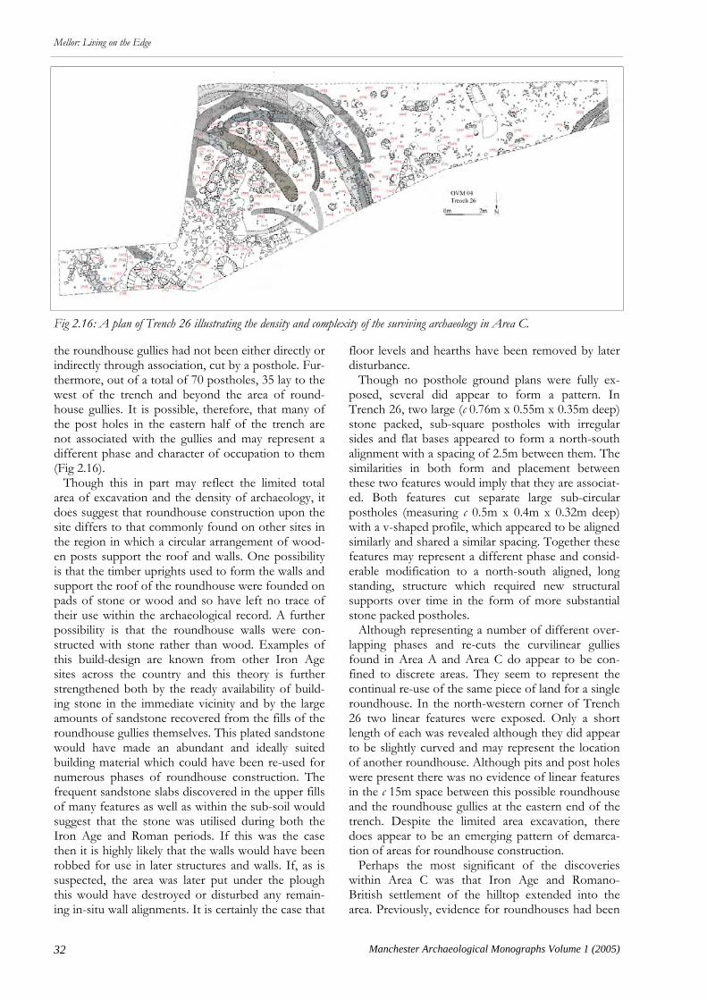
32 Manchester Archaeological Monographs Volume 1 (2005)
Mellor: Living on the Edge
the roundhouse gullies had not been either directly or indirectly through association, cut by a posthole. Fur-thermore, out of a total of 70 postholes, 35 lay to the west of the trench and beyond the area of round-house gullies. It is possible, therefore, that many of the post holes in the eastern half of the trench are not associated with the gullies and may represent a different phase and character of occupation to them (Fig 2.16). Though this in part may reflect the limited total area of excavation and the density of archaeology, it does suggest that roundhouse construction upon the site differs to that commonly found on other sites in the region in which a circular arrangement of wood-en posts support the roof and walls. One possibility is that the timber uprights used to form the walls and support the roof of the roundhouse were founded on pads of stone or wood and so have left no trace of their use within the archaeological record. A further possibility is that the roundhouse walls were con-structed with stone rather than wood. Examples of this build-design are known from other Iron Age sites across the country and this theory is further strengthened both by the ready availability of build-ing stone in the immediate vicinity and by the large amounts of sandstone recovered from the fills of the roundhouse gullies themselves. This plated sandstone would have made an abundant and ideally suited building material which could have been re-used for numerous phases of roundhouse construction. The frequent sandstone slabs discovered in the upper fills of many features as well as within the sub-soil would suggest that the stone was utilised during both the Iron Age and Roman periods. If this was the case then it is highly likely that the walls would have been robbed for use in later structures and walls. If, as is suspected, the area was later put under the plough this would have destroyed or disturbed any remain-ing in-situ wall alignments. It is certainly the case that
floor levels and hearths have been removed by later disturbance. Though no posthole ground plans were fully ex-posed, several did appear to form a pattern. In Trench 26, two large (c 0.76m x 0.55m x 0.35m deep) stone packed, sub-square postholes with irregular sides and flat bases appeared to form a north-south alignment with a spacing of 2.5m between them. The similarities in both form and placement between these two features would imply that they are associat-ed. Both features cut separate large sub-circular postholes (measuring c 0.5m x 0.4m x 0.32m deep) with a v-shaped profile, which appeared to be aligned similarly and shared a similar spacing. Together these features may represent a different phase and consid-erable modification to a north-south aligned, long standing, structure which required new structural supports over time in the form of more substantial stone packed postholes. Although representing a number of different over-lapping phases and re-cuts the curvilinear gullies found in Area A and Area C do appear to be con-fined to discrete areas. They seem to represent the continual re-use of the same piece of land for a single roundhouse. In the north-western corner of Trench 26 two linear features were exposed. Only a short length of each was revealed although they did appear to be slightly curved and may represent the location of another roundhouse. Although pits and post holes were present there was no evidence of linear features in the c 15m space between this possible roundhouse and the roundhouse gullies at the eastern end of the trench. Despite the limited area excavation, there does appear to be an emerging pattern of demarca-tion of areas for roundhouse construction. Perhaps the most significant of the discoveries within Area C was that Iron Age and Romano-British settlement of the hilltop extended into the area. Previously, evidence for roundhouses had been
Fig 2.16: A plan of Trench 26 illustrating the density and complexity of the surviving archaeology in Area C.
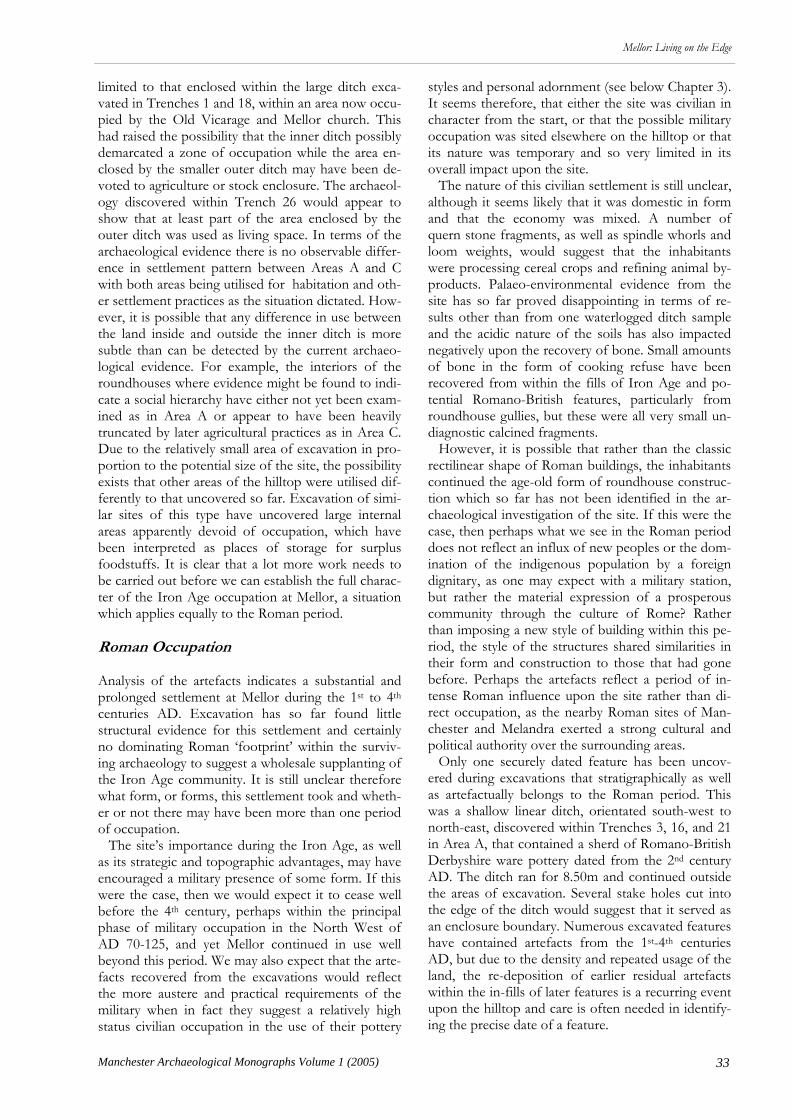
33
Mellor: Living on the Edge
Manchester Archaeological Monographs Volume 1 (2005)
limited to that enclosed within the large ditch exca-vated in Trenches 1 and 18, within an area now occu-pied by the Old Vicarage and Mellor church. This had raised the possibility that the inner ditch possibly demarcated a zone of occupation while the area en-closed by the smaller outer ditch may have been de-voted to agriculture or stock enclosure. The archaeol-ogy discovered within Trench 26 would appear to show that at least part of the area enclosed by the outer ditch was used as living space. In terms of the archaeological evidence there is no observable differ-ence in settlement pattern between Areas A and C with both areas being utilised for habitation and oth-er settlement practices as the situation dictated. How-ever, it is possible that any difference in use between the land inside and outside the inner ditch is more subtle than can be detected by the current archaeo-logical evidence. For example, the interiors of the roundhouses where evidence might be found to indi-cate a social hierarchy have either not yet been exam-ined as in Area A or appear to have been heavily truncated by later agricultural practices as in Area C. Due to the relatively small area of excavation in pro-portion to the potential size of the site, the possibility exists that other areas of the hilltop were utilised dif-ferently to that uncovered so far. Excavation of simi-lar sites of this type have uncovered large internal areas apparently devoid of occupation, which have been interpreted as places of storage for surplus foodstuffs. It is clear that a lot more work needs to be carried out before we can establish the full charac-ter of the Iron Age occupation at Mellor, a situation which applies equally to the Roman period. Roman Occupation Analysis of the artefacts indicates a substantial and prolonged settlement at Mellor during the 1st to 4th centuries AD. Excavation has so far found little structural evidence for this settlement and certainly no dominating Roman ‘footprint’ within the surviv-ing archaeology to suggest a wholesale supplanting of the Iron Age community. It is still unclear therefore what form, or forms, this settlement took and wheth-er or not there may have been more than one period of occupation. The site’s importance during the Iron Age, as well as its strategic and topographic advantages, may have encouraged a military presence of some form. If this were the case, then we would expect it to cease well before the 4th century, perhaps within the principal phase of military occupation in the North West of AD 70-125, and yet Mellor continued in use well beyond this period. We may also expect that the arte-facts recovered from the excavations would reflect the more austere and practical requirements of the military when in fact they suggest a relatively high status civilian occupation in the use of their pottery
styles and personal adornment (see below Chapter 3). It seems therefore, that either the site was civilian in character from the start, or that the possible military occupation was sited elsewhere on the hilltop or that its nature was temporary and so very limited in its overall impact upon the site. The nature of this civilian settlement is still unclear, although it seems likely that it was domestic in form and that the economy was mixed. A number of quern stone fragments, as well as spindle whorls and loom weights, would suggest that the inhabitants were processing cereal crops and refining animal by-products. Palaeo-environmental evidence from the site has so far proved disappointing in terms of re-sults other than from one waterlogged ditch sample and the acidic nature of the soils has also impacted negatively upon the recovery of bone. Small amounts of bone in the form of cooking refuse have been recovered from within the fills of Iron Age and po-tential Romano-British features, particularly from roundhouse gullies, but these were all very small un-diagnostic calcined fragments. However, it is possible that rather than the classic rectilinear shape of Roman buildings, the inhabitants continued the age-old form of roundhouse construc-tion which so far has not been identified in the ar-chaeological investigation of the site. If this were the case, then perhaps what we see in the Roman period does not reflect an influx of new peoples or the dom-ination of the indigenous population by a foreign dignitary, as one may expect with a military station, but rather the material expression of a prosperous community through the culture of Rome? Rather than imposing a new style of building within this pe-riod, the style of the structures shared similarities in their form and construction to those that had gone before. Perhaps the artefacts reflect a period of in-tense Roman influence upon the site rather than di-rect occupation, as the nearby Roman sites of Man-chester and Melandra exerted a strong cultural and political authority over the surrounding areas. Only one securely dated feature has been uncov-ered during excavations that stratigraphically as well as artefactually belongs to the Roman period. This was a shallow linear ditch, orientated south-west to north-east, discovered within Trenches 3, 16, and 21 in Area A, that contained a sherd of Romano-British Derbyshire ware pottery dated from the 2nd century AD. The ditch ran for 8.50m and continued outside the areas of excavation. Several stake holes cut into the edge of the ditch would suggest that it served as an enclosure boundary. Numerous excavated features have contained artefacts from the 1st-4th centuries AD, but due to the density and repeated usage of the land, the re-deposition of earlier residual artefacts within the in-fills of later features is a recurring event upon the hilltop and care is often needed in identify-ing the precise date of a feature.

34 Manchester Archaeological Monographs Volume 1 (2005)
Mellor: Living on the Edge
An example of this was encountered during the 2004 season, with the discovery of 16 pits within the eastern extent of Trench 26. These features formed an irregular linear arrangement orientated southeast-northwest 1-3m wide and 8.2m long that continued to the north of the trench. The pits were all sub-circular or sub-oval in plan, averaging 0.8m x 1m, and most had a relatively shallow depth of 0.2m. Two sections were placed across this arrangement in order to gain an understanding of these complicated relationships. Both of these revealed a rather haphaz-ard and seemingly unrelated sequence of inter-cutting pits, with very similar mid-dark grey silty clay fills containing frequent charcoal flecks and regular small and fragmented burnt bone. Two of these pits pro-duced sherds of 2nd and 3rd century AD pottery, whilst a radiocarbon sample taken from a small pit within the main group produced a date of 1750-900 BC. Two of the pits were substantially deeper at 0.5m and both had been partly in-filled with re-deposited clay which overlay a light grey silty clay basal fill. It is interesting to note that both these pits were uncut by other features and together may de-note a different phase of activity. The Late Bronze Age radiocarbon date is intriguing and potentially highly significant. Although there is a
possibility that it is erroneous and represents a re-deposition of residual charcoal within a later feature, it would appear more likely that the result demons-rates that the pits are unrelated and represent numer-ous phases of activity. The close proximity of this pit to the find spot of the Early Bronze Age flint dagger raises the possibility that they are both related to fu-nerary activity. This series of pits which appear to represent a re-peated use of this swathe of ground over a period of 2000 years and the increasing likelihood of significant activity on the hilltop during the Bronze Age clearly demonstrate the complexity and scale of the site at Mellor (Fig 2.16). Individually, each of the trenches excavated over the past seven years have provided insights into specific aspects of the settlement. Cu-mulatively, the information from these trenches is now beginning to fit together allowing us to offer interpretations about the size, date, and nature of the prehistoric and Roman settlement on the hilltop. However, the clearest lesson from the work done so far is a humbling one. It shows that we only have a few pieces of what is a very large jigsaw puzzle and that there is a great deal more work that needs to be done and undoubtedly many new discoveries to be made if we are to understand the site fully.

35
Mellor: Living on the Edge
Manchester Archaeological Monographs Volume 1 (2005)
T his review is intended to draw together infor-mation presented in hitherto unpublished re-
ports on the later prehistoric pottery from Mellor (Cumberpatch 2000, 2002; Cumberpatch, Ixer, Leary, Morris, & Walster 2003). It is also intended to pre-sent some suggestions as to the context within which the deposition of this pottery should be seen and the ways in which it might be interpreted. The article presents the data pertaining to the later prehistoric pottery together with that which relates to the salt containers from Mellor, and makes brief mention of the crucible fragments from the site, some of which await analysis. The work has been undertaken by a group of individuals and the individual sections are credited as appropriate. Later Prehistoric Pottery From Mellor by Christopher Cumberpatch A total of 240 sherds of later prehistoric pottery have been recovered from Mellor weighing 1675 grams (see Cumberpatch, Ixer, Leary, Morris, & Walster 2003). The number of sherds far exceeds the likely number of vessels, with the 123 sherds from the sin-gle vessel from Trench 15, context 21, accounting for a significant proportion of the total number of sherds. As will be discussed below, this pattern is a common one throughout the region. Six distinct fab-ric types (some of them sub-divided) were recognised amongst the assemblage and are defined and de-scribed in the following section. To date, petrograph-ical analysis has been carried out only on the semi-complete vessel from Trench 15, Context 21 (Fabric 5), but it is hoped that further work of this type will be undertaken in the future. The descriptions of the fabrics follow the terminology set out by the Prehis-toric Ceramics Research Group (1997). Mellor Type Series Fabric 1 A soft, fine, sandy textured fabric containing moder-ately dense inclusions (c 15%). The range of inclu-sions appears to be wide with fine rounded quartz
Chapter 3
Mellor: A Review of the Later Prehistoric Ceramics
Christopher Cumberpatch, Alison Walster, Rob Ixer, & Elaine Morris
grains (0.2mm - 0.4mm), occasional larger grains (up to 0.8mm) and rare, very large (1.00mm - 3.00mm), hard, dark, angular, possibly igneous rock inclusions. The vessels were fired to an orange-brown colour through-out. The illustrated examples (Fig 3.1, Nos 1 & 2) have a slightly rough finish with no sign of any burnishing or smoothing, although a hard object, perhaps a piece of smooth wood or bone appears to have been used to smooth the top of the rim. In general Fabric 1 type has a distinctive soapy texture and a denser, more homoge-nous appearance, but the same range of inclusions (quartz and black rock fragments). Fabric 1A This resembles Fabric 1 but is somewhat sandier in texture and appears to lack the non-crystalline rock fragments. In addition there is some evidence of the presence of grass stalks, but this could be accidental and does not seem to be a regular feature of the fabric. Fabric 1B This fabric (formerly Fabric 5 type) is a soft sandy tex-tured fabric with sparse fine quartz and occasional an-gular rock fragments distinguished from other Fabric 1 types by being reduced to dark grey throughout and with some sooting or a black deposit on the internal surface. Fabric 2 A hard, dense, robust fabric containing a sparse to moderate density of inclusions (c 7% - c 15%) notably rounded and occasionally sub-rounded quartz grains (0.2 - 0.4mm) in a black, reduced matrix. The illustrat-ed example (Fig 3.2) has a roughly smoothed finish with a simple rounded rim. Fabric 3 A moderately hard, dense, black reduced fabric with sparse to moderate (c 7% - c 15%) fine rounded quartz inclusions (0.1mm - 0.2mm). This is probably a variant of fabric 2, although more examples are needed before this can be confirmed. The illustrated example (Fig 3.1, No. 3) is finely finished with a possible burnished sur-face.

36 Manchester Archaeological Monographs Volume 1 (2005)
Mellor: Living on the Edge
Fabric 3A This is a particularly distinctive fine black fabric ap-parently lacking the fine quartz grains typical of Fab-ric 3. It appears to be extremely friable and crumbly, the majority of sherds being broken into many small irregular lumps. Only two or three pieces have recog-nisable surfaces. Fabric 4 A very distinctive fabric with a coarse texture which contains common (c 20%) large, angular, non-crystalline inclusions up to 6mm long in a soft, bright orange oxidised matrix. The rock types represented include sandstone and chert. Surviving surfaces are rare on sherds in this fabric which somewhat resem-bles briquetage.
Fabric 5 This was first defined in the report on the material from the 1999/2000 season as a moderately hard, muddy textured fabric containing moderate (c 7% - c 15%) quantities of angular, non-crystalline rock frag-ments with traces of grass stems in the fired body. The surface was smoothed with some surface crack-ing. The fabric appeared to have a tendency to split and flake, although the fracture was not laminated in the conventional sense. This is the same fabric as was used for the semi-complete vessel found during the 2001 season and reconstructed (Fig 3.3). The results of the petrographic analysis of the fabric by Dr R Ixer are presented below. Fabric 6 A hard, brick-red to orange fabric containing sparse
Fig 3.1: No 1: Rim 1028/3008 (Fabric 1) 2001 report; No 2: Rim; OVM99, Tr. 1, 1013 (Fabric 1); No 3: Rim OVM00 TIII(6), 3054, SFN89 (Fabric 3).

37
Mellor: Living on the Edge
Manchester Archaeological Monographs Volume 1 (2005)
to moderate (c 7% - c 10%) angular to sub-angular lumps of rock, generally between 0.1 - 0.2mm but occasionally up to 1mm in size. Some examples are little more than lumps of fired clay and resemble small fragments of brick or tile as much as they do pottery. They appear to be harder than the briquetage from the site. Vessel forms The rarity of large sherds makes it difficult to be cer-tain about the shape of the majority of the pots. With the exception of the substantially complete ves-sel from Trench 15 Context 021 (Fig 3.3) and the three joining sherds from Contexts 1028/3008 (Fig 3.1, No.1), other diagnostic sherds are limited to small fragments of rim indicative of little more than jar-like forms, the majority with simple rounded rims. On this somewhat insecure basis four rim forms have been defined and these are described below. Rim type 1 A low, flat topped, beaded rim on a globular body with a small everted lip which distinguishes the form from the commoner straight rounded rims (Fig 3.1, No.1; Contexts 1028/3008). Rim type 2 A simple, un-elaborated, rounded rim with a slightly flattened top. Parallels can be found for this rim shape (Elsdon 1996, A6; 8), but the extent to which they are significant is unclear, given the simple and plain nature of the rim (Fig 3.1, No 2; Trench 1, con-text 1013). Rim type 3 A round, beaded rim with a pronounced external bulge. Possible parallels include Pickburn Leys in South Yorkshire (Sydes 1993, Fig 41) although the fabric of the two vessels is markedly different (Fig 3.1, No.3; Trench III (6), 3054, SFN 89). Rim type 4 A simple rounded rim, probably generally similar to
that of the semi-complete vessel from Context 21 (Fig 3.4; Trench 3, 3011). Conservation report on the vessel from OVM01, Trench 15, Context 021 by Alison Walster Visual examination/condition The vessel consisted of approximately 125 sherds, which appeared to be in fairly stable condition alt-hough several had laminating surfaces. The fabric was light-dark brown/black in colour to its outer surface and patchy dark red/brown over most of its interior. The broken edges revealed a dark core and fairly dense temper. Fingermarks were visible around the rim of the vessel, giving a ‘dimpled’ appearance where it had been squeezed or pinched and these may be partly decorative. The vessel was hand-built and the walls were uneven in thickness. The outer surface had been smoothed, a process which gave a roughly burnished appearance to the finished vessel. X-Radiographic examination The vessel sherds were x-rayed (at 100kvp for 1-1.5 mins) to see if this would aid the process of recon-struction. Unfortunately, this was not the case but the x-rays revealed that the vessel was tempered with an array of inclusions varying widely in density and size. Some of the inclusions appeared to be very sim-ilar to a grog-tempered experimental briquette x-radiographed at the same time and may, therefore be grog. The white inclusions on the x-ray indicate that the vessel was tempered with a very dense, almost metallic material, which was initially thought to be slag tempering. Although the metallic nature of this material was confirmed by running a magnet over the surface of the smaller sherds, subsequent petrograph-ic analysis (see Ixer, below) showed that the material was not slag. Overall, the temper appears to be poor-ly mixed and fairly random. Conservation The sherds were carefully cleaned with a soft brush to remove any loose soil, prior to being stuck with HMG Paraloid B72 adhesive (methyl methacrylate copolymer in a solvent base). It was decided not to consolidate, since most of the fragments appeared to be strong. Where the surface was spalling away on some sherds, it was repaired using the above adhe-sive. Although much of the vessel is missing, particu-larly around the rim and central body area, it was possible to reconstruct a basic profile suitable for display.
Fig 3.2: Tr. 3, 3011 (Fabric 2).
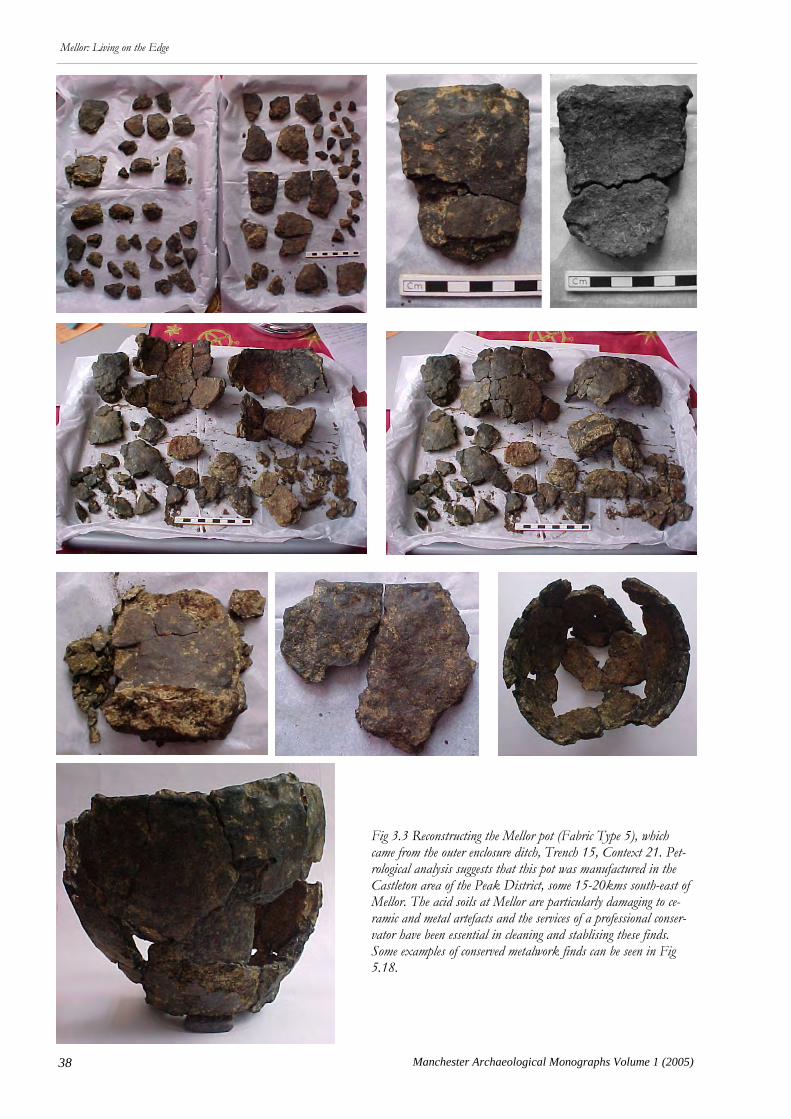
38 Manchester Archaeological Monographs Volume 1 (2005)
Mellor: Living on the Edge
Fig 3.3 Reconstructing the Mellor pot (Fabric Type 5), which came from the outer enclosure ditch, Trench 15, Context 21. Pet-rological analysis suggests that this pot was manufactured in the Castleton area of the Peak District, some 15-20kms south-east of Mellor. The acid soils at Mellor are particularly damaging to ce-ramic and metal artefacts and the services of a professional conser-vator have been essential in cleaning and stablising these finds. Some examples of conserved metalwork finds can be seen in Fig 5.18.
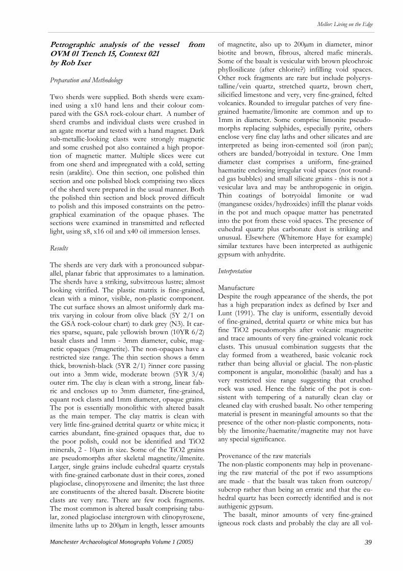
39
Mellor: Living on the Edge
Manchester Archaeological Monographs Volume 1 (2005)
Petrographic analysis of the vessel from OVM 01 Trench 15, Context 021 by Rob Ixer Preparation and Methodology Two sherds were supplied. Both sherds were exam-ined using a x10 hand lens and their colour com-pared with the GSA rock-colour chart. A number of sherd crumbs and individual clasts were crushed in an agate mortar and tested with a hand magnet. Dark sub-metallic-looking clasts were strongly magnetic and some crushed pot also contained a high propor-tion of magnetic matter. Multiple slices were cut from one sherd and impregnated with a cold, setting resin (araldite). One thin section, one polished thin section and one polished block comprising two slices of the sherd were prepared in the usual manner. Both the polished thin section and block proved difficult to polish and this imposed constraints on the petro-graphical examination of the opaque phases. The sections were examined in transmitted and reflected light, using x8, x16 oil and x40 oil immersion lenses. Results The sherds are very dark with a pronounced subpar-allel, planar fabric that approximates to a lamination. The sherds have a striking, subvitreous lustre; almost looking vitrified. The plastic matrix is fine-grained, clean with a minor, visible, non-plastic component. The cut surface shows an almost uniformly dark ma-trix varying in colour from olive black (5Y 2/1 on the GSA rock-colour chart) to dark grey (N3). It car-ries sparse, square, pale yellowish brown (10YR 6/2) basalt clasts and 1mm - 3mm diameter, cubic, mag-netic opaques (?magnetite). The non-opaques have a restricted size range. The thin section shows a 6mm thick, brownish-black (5YR 2/1) ?inner core passing out into a 3mm wide, moderate brown (5YR 3/4) outer rim. The clay is clean with a strong, linear fab-ric and encloses up to 3mm diameter, fine-grained, equant rock clasts and 1mm diameter, opaque grains. The pot is essentially monolithic with altered basalt as the main temper. The clay matrix is clean with very little fine-grained detrital quartz or white mica; it carries abundant, fine-grained opaques that, due to the poor polish, could not be identified and TiO2 minerals, 2 - 10µm in size. Some of the TiO2 grains are pseudomorphs after skeletal magnetite/ilmenite. Larger, single grains include euhedral quartz crystals with fine-grained carbonate dust in their cores, zoned plagioclase, clinopyroxene and ilmenite; the last three are constituents of the altered basalt. Discrete biotite clasts are very rare. There are few rock fragments. The most common is altered basalt comprising tabu-lar, zoned plagioclase intergrown with clinopyroxene, ilmenite laths up to 200µm in length, lesser amounts
of magnetite, also up to 200µm in diameter, minor biotite and brown, fibrous, altered mafic minerals. Some of the basalt is vesicular with brown pleochroic phyllosilicate (after chlorite?) infilling void spaces. Other rock fragments are rare but include polycrys-talline/vein quartz, stretched quartz, brown chert, silicified limestone and very, very fine-grained, felted volcanics. Rounded to irregular patches of very fine-grained haematite/limonite are common and up to 1mm in diameter. Some comprise limonite pseudo-morphs replacing sulphides, especially pyrite, others enclose very fine clay laths and other silicates and are interpreted as being iron-cemented soil (iron pan); others are banded/botryoidal in texture. One 1mm diameter clast comprises a uniform, fine-grained haematite enclosing irregular void spaces (not round-ed gas bubbles) and small silicate grains - this is not a vesicular lava and may be anthropogenic in origin. Thin coatings of botryoidal limonite or wad (manganese oxides/hydroxides) infill the planar voids in the pot and much opaque matter has penetrated into the pot from these void spaces. The presence of euhedral quartz plus carbonate dust is striking and unusual. Elsewhere (Whitemore Haye for example) similar textures have been interpreted as authigenic gypsum with anhydrite. Interpretation Manufacture Despite the rough appearance of the sherds, the pot has a high preparation index as defined by Ixer and Lunt (1991). The clay is uniform, essentially devoid of fine-grained, detrital quartz or white mica but has fine TiO2 pseudomorphs after volcanic magnetite and trace amounts of very fine-grained volcanic rock clasts. This unusual combination suggests that the clay formed from a weathered, basic volcanic rock rather than being alluvial or glacial. The non-plastic component is angular, monolithic (basalt) and has a very restricted size range suggesting that crushed rock was used. Hence the fabric of the pot is con-sistent with tempering of a naturally clean clay or cleaned clay with crushed basalt. No other tempering material is present in meaningful amounts so that the presence of the other non-plastic components, nota-bly the limonite/haematite/magnetite may not have any special significance. Provenance of the raw materials The non-plastic components may help in provenanc-ing the raw material of the pot if two assumptions are made - that the basalt was taken from outcrop/subcrop rather than being an erratic and that the eu-hedral quartz has been correctly identified and is not authigenic gypsum. The basalt, minor amounts of very fine-grained igneous rock clasts and probably the clay are all vol-

40 Manchester Archaeological Monographs Volume 1 (2005)
Mellor: Living on the Edge
canic in origin. It is possible that all come from the same locality namely from a site with weathered clay overlying cropping out basaltic lava. The quartz crys-tals with carbonate dust in their cores are typical of silicified limestone and a small clast of silicified lime-stone occurs in one of the thin sections. No lime-stone or fossil clasts were recognised. Both basaltic lava and silicified limestones are widely found (together) in the Carboniferous Limestone of Derby-shire. The nearest localities to Mellor where both lavas and silicified limestone are juxtaposed are 15 - 20km away in the Castleton-Bradwell-Peak Forest-Hucklow Edge area. Petrographical comparisons Comparisons between the Mellor sherd and Fabric C from Dalton Parlours (a crushed sandstone tempered pot with Whin Sill quartz dolerite and fayalite-magnetite slag) (Buckland et al 1990, 132 in Wrath-mell and Nicholson 1990) can be made. Both have a fine-grained, basic igneous rock temper but the Mel-lor pot lacks both the sandstone and iron-making slag components of fabric C and that, in turn, lacks the millimetre diameter magnetite clasts that are pre-sent in the Mellor material. Igneous tempered Iron Age pottery is widespread in the British Midlands. The Mellor pot has discrete magnetite grains and rounded limonite/haematite ?clasts and much limo-nite/wad staining along its fabric. Discrete magnetite and oxidised magnetite, up to 5mm in diameter, have been recognised from Iron Age pottery at White-moor Haye Quarry, Staffordshire as have rounded limonite-rich areas. At least some of these rounded areas and the limonite concentrations lying along the fabric of the pot (together with the presence of authi-genic gypsum) have been ascribed to post-burial groundwater effects (Ixer 2002, 94-96 in Coates 2002). This explanation may also be true for the Mel-lor material. Industrial Ceramics from Mellor by Chris Cumberpatch This section of the report covers the crucible frag-ments, briquetage, and fired clay from Mellor. The
details of the individual sherds and fragments are summarised in Tables 3.1 and 3.2. Table 3.3 lists fragments of fired clay of undetermined origin and function. To date nine sherds from crucibles have been re-covered from excavations at Mellor. Five of these have been subject to a preliminary examination by Dr D Dungworth (CFA) and a preliminary report has been included in the interim site report for 2000 - 2001 (Dungworth 2001). Two fragments, including a rim sherd were subsequently identified amongst the Roman pottery. Two pieces of vitreous slag were also identified, one of which was examined by Dr Dung-worth. Further work is required on both the slag and cru-cible fragments before a comprehensive report can be published. Cheshire Salt Containers from Mellor by Elaine Morris A total of 21 sherds (63 grams) of briquetage, salt-drying and transporting containers from Cheshire, were identified in the ceramic assemblage. This par-ticular type of briquetage, originally named Stony VCP or a stone-rich Very Coarse Pottery (Gelling & Stanford 1965), is quite distinctive due to the oxi-dised firing condition resulting in an orange-coloured clay matrix and the presence of large angular frag-ments of igneous and sedimentary rock in the fabric (Morris 1985).
Nature of the assemblage Sherds of Cheshire salt containers were recovered from ten contexts in four different trenches at Mellor (Table 3). The fragmentary nature of the material is demonstrated by the very small mean sherd weight of the assemblage as a whole at 3gms, which also shows the quality of the excavation recovery techniques on site - these are very, very tiny fragments in many cas-es. Only body sherds and flakes of briquetage con-tainers were recovered.
Year Trench Context SFN Type Number Weight ENV Notes MC98 U/S ?Slag 1 2 1 Small fragment of slag; bagged with glass
OVM00 T1 1028 95 Crucible 1 11 1 Dungworth 2001 OVM00 T1 1031 101 Crucible 1 2 1 Dungworth 2001 OVM01 T1 1028 Slag 1 Not recorded 1 Not stored with pottery; Dungworth 2001
OVM02 T1 163 Crucible 1 Not recorded 1 Crucible fragment (IA) with Roman pottery (Leary 2003)
OVM02 T1 164 Crucible 1 Not recorded 1 Crucible rim (IA) included with Roman pottery (Leary 2003)
OVM99 T1 1008 Crucible 1 4 1 Dungworth 2001
OVM99 T1 1013 Mould/crucible 2 21 2 Dungworth 2001
Total (No.) 9
Table 3.1: Crucible fragments and slag from Mellor.
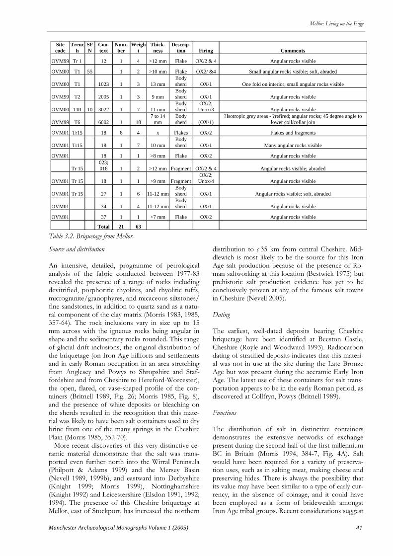
41
Mellor: Living on the Edge
Manchester Archaeological Monographs Volume 1 (2005)
Source and distribution An intensive, detailed, programme of petrological analysis of the fabric conducted between 1977-83 revealed the presence of a range of rocks including devitrified, porphoritic rhyolites, and rhyolitic tuffs, microgranite/granophyres, and micaceous siltstones/fine sandstones, in addition to quartz sand as a natu-ral component of the clay matrix (Morris 1983, 1985, 357-64). The rock inclusions vary in size up to 15 mm across with the igneous rocks being angular in shape and the sedimentary rocks rounded. This range of glacial drift inclusions, the original distribution of the briquetage (on Iron Age hillforts and settlements and in early Roman occupation in an area stretching from Anglesey and Powys to Shropshire and Staf-fordshire and from Cheshire to Hereford-Worcester), the open, flared, or vase-shaped profile of the con-tainers (Britnell 1989, Fig. 26; Morris 1985, Fig. 8), and the presence of white deposits or bleaching on the sherds resulted in the recognition that this mate-rial was likely to have been salt containers used to dry brine from one of the many springs in the Cheshire Plain (Morris 1985, 352-70). More recent discoveries of this very distinctive ce-ramic material demonstrate that the salt was trans-ported even further north into the Wirral Peninsula (Philpott & Adams 1999) and the Mersey Basin (Nevell 1989, 1999b), and eastward into Derbyshire (Knight 1999; Morris 1999), Nottinghamshire (Knight 1992) and Leicestershire (Elsdon 1991, 1992; 1994). The presence of this Cheshire briquetage at Mellor, east of Stockport, has increased the northern
distribution to c 35 km from central Cheshire. Mid-dlewich is most likely to be the source for this Iron Age salt production because of the presence of Ro-man saltworking at this location (Bestwick 1975) but prehistoric salt production evidence has yet to be conclusively proven at any of the famous salt towns in Cheshire (Nevell 2005). Dating The earliest, well-dated deposits bearing Cheshire briquetage have been identified at Beeston Castle, Cheshire (Royle and Woodward 1993). Radiocarbon dating of stratified deposits indicates that this materi-al was not in use at the site during the Late Bronze Age but was present during the aceramic Early Iron Age. The latest use of these containers for salt trans-portation appears to be in the early Roman period, as discovered at Collfryn, Powys (Britnell 1989). Functions The distribution of salt in distinctive containers demonstrates the extensive networks of exchange present during the second half of the first millennium BC in Britain (Morris 1994, 384-7, Fig. 4A). Salt would have been required for a variety of preserva-tion uses, such as in salting meat, making cheese and preserving hides. There is always the possibility that its value may have been similar to a type of early cur-rency, in the absence of coinage, and it could have been employed as a form of bridewealth amongst Iron Age tribal groups. Recent considerations suggest
Site code
Trench
SFN
Con-text
Num-ber
Weight
Thick-ness
Descrip-tion Firing Comments
OVM99 Tr 1 12 1 4 >12 mm Flake OX/2 & 4 Angular rocks visible
OVM00 T1 55 1 2 >10 mm Flake OX2/ &4 Small angular rocks visible; soft, abraded
OVM00 T1 1023 1 3 13 mm Body sherd OX/1 One fold on interior; small angular rocks visible
OVM99 T2 2005 1 3 9 mm Body sherd OX/1 Angular rocks visible
OVM00 TIII 10 3022 1 7 11 mm Body sherd
OX/2; Unox/3 Angular rocks visible
OVM99 T6 6002 1 18 7 to 14
mm Body sherd (OX/1)
?Isotropic grey areas - ?refired; angular rocks; 45 degree angle to lower coil/collar join
OVM01 Tr15 18 8 4 x Flakes OX/2 Flakes and fragments
OVM01 Tr15 18 1 7 10 mm Body sherd OX/1 Many angular rocks visible
OVM01 18 1 1 >8 mm Flake OX/2 Angular rocks visible
Tr 15 023; 018 1 2 >12 mm Fragment OX/2 & 4 Angular rocks visible; abraded
OVM01 Tr 15 18 1 1 >9 mm Fragment OX/2; Unox/4 Angular rocks visible
OVM01 Tr 15 27 1 6 11-12 mm Body sherd OX/1 Angular rocks visible; soft, abraded
OVM01 34 1 4 11-12 mm Body sherd OX/1 Angular rocks visible
OVM01 37 1 1 >7 mm Flake OX/2 Angular rocks visible
Total 21 63
Table 3.2. Briquetage from Mellor.

42 Manchester Archaeological Monographs Volume 1 (2005)
Mellor: Living on the Edge
that the making of salt from brine may have resulted in a magical aura for both the production of this strange white crystalline substance which emerged from bitter water when heated and for the saltmakers who may have been seen as early alchemists. Fired clay by Chris Cumberpatch A small number of unidentified fragments of ceramic material have been classified as fired or burnt clay. These are listed in Table 3.3. Their origin and nature remains uncertain, but they could represent frag-ments of hearths or ovens. Discussion by Chris Cumberpatch It would be premature to draw any far reaching con-clusions from later prehistoric pottery recovered from Mellor to date, but it seems that while pottery was a rare item, it was being manufactured in small amounts in the region in the middle to late Iron Age and was also imported, in equally small amounts, from areas further south and east. The petrographic analysis of the vessel from Trench 15, context 21, suggested a relatively local source for this particular vessel (and others sharing the same fabric) and a fu-ture direction for research might include the exten-sion of the programme of analysis to include exam-ples of the other fabric groups which, on the basis of visual examination, appear to have a somewhat dif-ferent composition. In terms of technology, the Mellor pottery is en-tirely hand made, probably using a slab-building ra-ther than coiling technique. None of the vessels re-covered to date was decorated and finishing was lim-ited to smoothing and pinching, the latter notably on the rim of the substantially complete pot from Trench 15, context 21. Other vessels from the site have simple flat topped everted rims (Fig 3.1, Nos 1 & 2) finished by hand, probably with the aid of a piece of polished wood or bone to produce the char-acteristic flat-topped rims. The functions of the vessels are unknown. Given the small size of the assemblage and the scarcity of pottery in the region generally, it seems unlikely that everyday cooking and eating depended upon the use of pottery, suggesting either that cooking techniques were based upon roasting and baking or that organic containers were used, perhaps in conjunction with
hot stones and pot boilers. This having been said, signs of burning (in the form of blackening and ap-parently burnt deposits) were visible on some of the sherds, notably on the rim of the vessel from 1028 and associated contexts. A possible avenue for future research might be the investigation of organic resi-dues surviving within the body of the vessels which could cast light on the uses to which the vessels were put. Analysis of organic remains and animal bone may also be informative in determining the methods of food preparation used on the site. It is, at present, difficult to set the material from Mellor into any regional or local context as Iron Age pottery is extremely rare within a region which ex-tends from South and West Yorkshire, across the Pennines and into Cheshire and the Mersey Basin (Bevan 2000b, Matthews 1997, 1999b, Sumpter 1990). This scarcity of material effectively precludes the kinds of typological comparison which is stand-ard for other regions. Extensive excavations on later prehistoric crop mark sites in South and West York-shire have demonstrated that, while the communities were making significant investments of time and la-bour in land division, material culture is rare or non-existent (Chadwick 1997, 1999, 2004, Robbins 1998). Excavations at the early to middle Iron Age site at Sutton Common (which predates the major phase of land division) have produced an equally small quanti-ty of pottery; two sherds from excavations undertak-en by the South Yorkshire Archaeology Service (Cumberpatch 1997) and only seven from the much more extensive excavations undertaken by Exeter and Hull Universities on behalf of English Heritage (Cumberpatch 2004). Small quantities of pottery have been recovered from other later prehistoric sites in South Yorkshire, notably Sykehouse (Cumberpatch, Leary & Willis 2003), Red House Farm, Adwick-le-Street (Cumberpatch, in prep.), South Elmsall (Cumberpatch nd), Edenthorpe (Cumberpatch & Chadwick 1995), Pickburn Leys (Sydes 1993) and others. The fabric of these vessels differs significantly from those found at Mellor. In West Yorkshire a number of sites have pro-duced later prehistoric pottery including the later prehistoric and Romano-British site at Dalton Par-lours (Buckland, Runnacles, & Sumpter 1990; Sump-ter 1990), Ledston (Runnacles & Buckland 1998), Wattle Syke (Buckland nd.), Moss Carr (Evans 2002) and Bulcliffe (Evans nd.). Small quantities of pottery were recovered from a number of sites on the line of the A1 - M1 link road between Leeds, Tadcaster and
Year Trench Context Type Number Weight ENV Notes
OVM00 II 3004 Fired clay 3 8 3 Three irregular lumps of possible fired or burnt clay
OVM00 III 3018 Fired clay 6 38 6 Six irregular lumps of fired or burnt clay MC98 TC 106 ?Burnt clay 1 50 1 One rounded lump of dried/burnt clay/daub
Total 10 96 10
Table 3.3. Fired and burnt clay from Mellor.
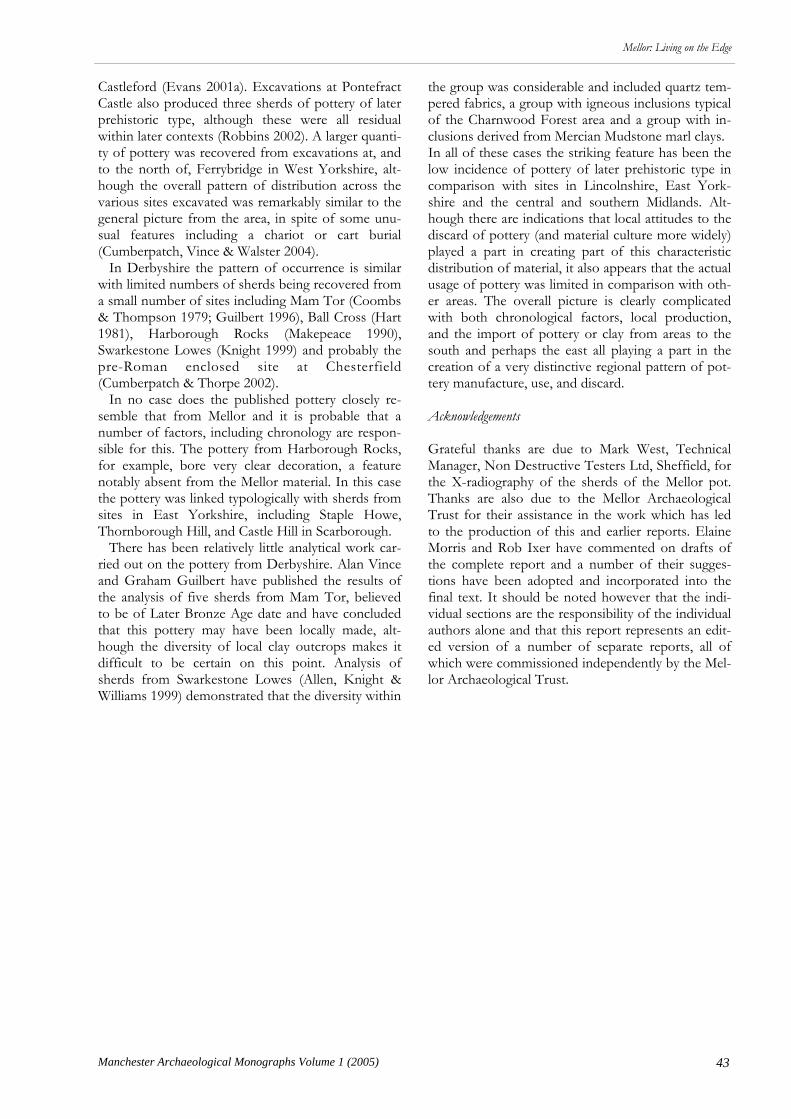
43
Mellor: Living on the Edge
Manchester Archaeological Monographs Volume 1 (2005)
Castleford (Evans 2001a). Excavations at Pontefract Castle also produced three sherds of pottery of later prehistoric type, although these were all residual within later contexts (Robbins 2002). A larger quanti-ty of pottery was recovered from excavations at, and to the north of, Ferrybridge in West Yorkshire, alt-hough the overall pattern of distribution across the various sites excavated was remarkably similar to the general picture from the area, in spite of some unu-sual features including a chariot or cart burial (Cumberpatch, Vince & Walster 2004). In Derbyshire the pattern of occurrence is similar with limited numbers of sherds being recovered from a small number of sites including Mam Tor (Coombs & Thompson 1979; Guilbert 1996), Ball Cross (Hart 1981), Harborough Rocks (Makepeace 1990), Swarkestone Lowes (Knight 1999) and probably the pre-Roman enclosed site at Chesterfield (Cumberpatch & Thorpe 2002). In no case does the published pottery closely re-semble that from Mellor and it is probable that a number of factors, including chronology are respon-sible for this. The pottery from Harborough Rocks, for example, bore very clear decoration, a feature notably absent from the Mellor material. In this case the pottery was linked typologically with sherds from sites in East Yorkshire, including Staple Howe, Thornborough Hill, and Castle Hill in Scarborough. There has been relatively little analytical work car-ried out on the pottery from Derbyshire. Alan Vince and Graham Guilbert have published the results of the analysis of five sherds from Mam Tor, believed to be of Later Bronze Age date and have concluded that this pottery may have been locally made, alt-hough the diversity of local clay outcrops makes it difficult to be certain on this point. Analysis of sherds from Swarkestone Lowes (Allen, Knight & Williams 1999) demonstrated that the diversity within
the group was considerable and included quartz tem-pered fabrics, a group with igneous inclusions typical of the Charnwood Forest area and a group with in-clusions derived from Mercian Mudstone marl clays. In all of these cases the striking feature has been the low incidence of pottery of later prehistoric type in comparison with sites in Lincolnshire, East York-shire and the central and southern Midlands. Alt-hough there are indications that local attitudes to the discard of pottery (and material culture more widely) played a part in creating part of this characteristic distribution of material, it also appears that the actual usage of pottery was limited in comparison with oth-er areas. The overall picture is clearly complicated with both chronological factors, local production, and the import of pottery or clay from areas to the south and perhaps the east all playing a part in the creation of a very distinctive regional pattern of pot-tery manufacture, use, and discard. Acknowledgements Grateful thanks are due to Mark West, Technical Manager, Non Destructive Testers Ltd, Sheffield, for the X-radiography of the sherds of the Mellor pot. Thanks are also due to the Mellor Archaeological Trust for their assistance in the work which has led to the production of this and earlier reports. Elaine Morris and Rob Ixer have commented on drafts of the complete report and a number of their sugges-tions have been adopted and incorporated into the final text. It should be noted however that the indi-vidual sections are the responsibility of the individual authors alone and that this report represents an edit-ed version of a number of separate reports, all of which were commissioned independently by the Mel-lor Archaeological Trust.

44 Manchester Archaeological Monographs Volume 1 (2005)
Mellor: Living on the Edge.
R esearch into the Romano-British pottery of the Cheshire and Lancashire plains has concentrat-
ed overwhelmingly upon the large assemblages from the forts and large settlements such as those at Wil-derspool. The “story” of the pottery from rural/native settlements has, at best, been dealt with in a summary paragraph and, at worst, been ignored. Although the significance of small numbers of arte-facts, scattered thinly over the region, has been rec-ognised in recent years in the Iron Age (Matthews 2002), the small somewhat scruffy assemblages of pottery from Roman sites have attracted less atten-tion. It is difficult to interpret assemblages number-ing a mere handful of sherds and it can seem scarcely worth cataloguing and quantifying such material. In addition, many of the key military assemblages in the region such as those from Melandra, Manchester, Wilderspool, and Northwich (Webster 1971 & 1974; Hartley & Webster 1973; Jones 1972) were published long before the present habit of quantifying Roman pottery by fabric, form, and vessel category was in vogue, although Webster compared quantities of ves-sel types in the stream and mansion deposits at Melandra and both vessel types and fabrics from the 1966-9 and 1976 excavations at Wilderspool (Webster 1992). There is, therefore, little with which to compare our detailed quantification, should one be compiled. The significance of these small groups consequent-ly lies untapped and dormant. However, studies in other area of Britain have illustrated the wealth of information that can be gleaned from relatively small groups, particularly if a number of sites can be con-sidered together. In west and south Yorkshire, Evans has been able to study military, urban, and rural sites and characterise them by the vessel types present - rural sites having more jars and military/urban sites having more tablewares (Evans 2001b). Going (1992) first noticed the peaks and troughs in the supply of pottery in Roman Britain when studying a small group of some 200-250 vessels from a native farm-stead near Snowdonia some 10km from Segontium (Going 1992, 94) at Cefn Graeanog, Wales. The Ro-man pottery supply was apparently intermittent but
Chapter 4
Mellor: The Romano-British Pottery
1998-2003
Ruth Leary
the site showed no signs of abandonment and the paleobotanical evidence provided a full and complete history suggesting continuous occupation from the mid-1st century AD until as late as the end of the 4th century AD. Going found that the intermittent ap-pearance of pottery on what seemed to be a continu-ously occupied site coincided with peaks and troughs in pottery supply on pottery-rich site elsewhere in Britain. Further study found this pattern on other sites in Wales and in the north of England (Evans 2001a, 175). Those few sherds on that “marginal” site have changed our understanding of the signifi-cance of Roman pottery found on all sites and per-mitted Going to propose a dating “calibration” table which has improved the dating of coarse pottery in Roman Britain. The excavations at Mellor have recovered 488 sherds of Romano-British pottery. Compared with other published rural groups from the region, this is a relatively large and diverse assemblage (Table 1, chart 3). The average sherd weight from these rural sites is low and compares with Evans’ average for “highland” sites in Wales, and Cumbria, where he found sherds tended to be highly fragmented and abraded, rather than his average of c 20g for rural sites in sites in south and west Yorkshire (Evans 2001a table 16). This may reflect differences in rub-bish disposal in the two areas with the “highland” zone material being noticeably more broken and abraded due to trampling. In Yorkshire there is some evidence for a more rigorous approach to disposal resulting in larger sherds being deposited in earth-cut features and thus escaping further breakage. The excavations at Mellor produced a wide range of wares (Fig 4.1) coming from distant sources in-cluding Dorset, Mancetter-Hartshill, the Severn Val-ley kilns to the south, including charcoal-tempered Severn Valley ware (Evans 2001b), the Cheshire Plains kilns, Derbyshire kilns around Belper, Lincoln-shire kilns and mortaria, from Mancetter-Hartshill and Wilderspool. A cordoned cream ware sherd from bowl may be a parchment ware vessel from the Nene Valley kilns. Most of the pottery came from the large ditch (context 304/5). A small number of fine oxi-
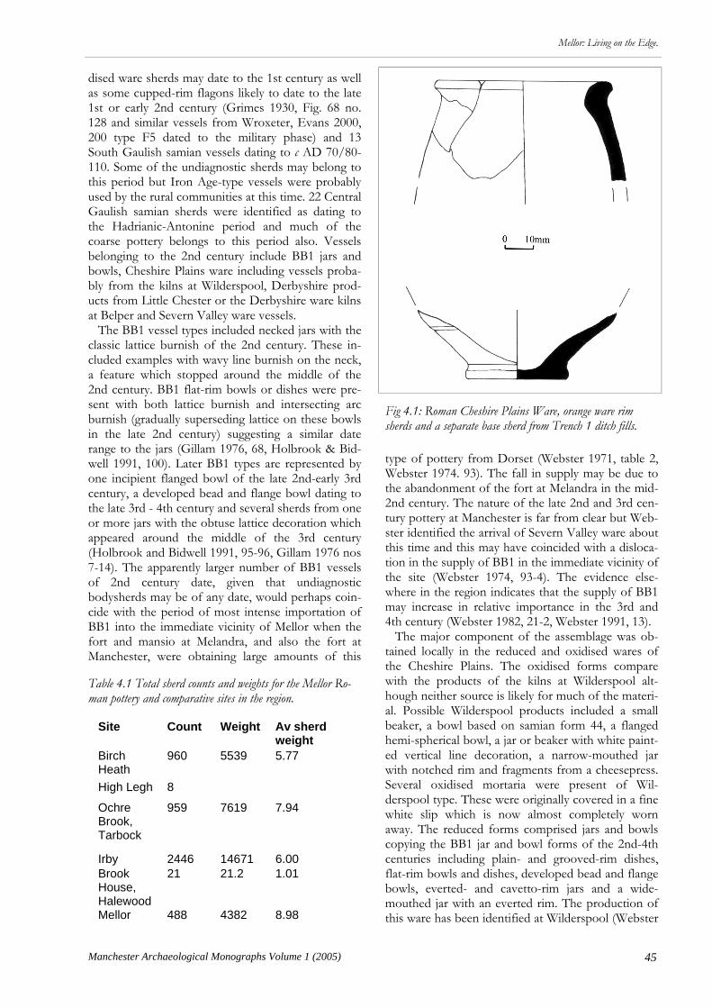
45
Mellor: Living on the Edge.
Manchester Archaeological Monographs Volume 1 (2005)
dised ware sherds may date to the 1st century as well as some cupped-rim flagons likely to date to the late 1st or early 2nd century (Grimes 1930, Fig. 68 no. 128 and similar vessels from Wroxeter, Evans 2000, 200 type F5 dated to the military phase) and 13 South Gaulish samian vessels dating to c AD 70/80-110. Some of the undiagnostic sherds may belong to this period but Iron Age-type vessels were probably used by the rural communities at this time. 22 Central Gaulish samian sherds were identified as dating to the Hadrianic-Antonine period and much of the coarse pottery belongs to this period also. Vessels belonging to the 2nd century include BB1 jars and bowls, Cheshire Plains ware including vessels proba-bly from the kilns at Wilderspool, Derbyshire prod-ucts from Little Chester or the Derbyshire ware kilns at Belper and Severn Valley ware vessels. The BB1 vessel types included necked jars with the classic lattice burnish of the 2nd century. These in-cluded examples with wavy line burnish on the neck, a feature which stopped around the middle of the 2nd century. BB1 flat-rim bowls or dishes were pre-sent with both lattice burnish and intersecting arc burnish (gradually superseding lattice on these bowls in the late 2nd century) suggesting a similar date range to the jars (Gillam 1976, 68, Holbrook & Bid-well 1991, 100). Later BB1 types are represented by one incipient flanged bowl of the late 2nd-early 3rd century, a developed bead and flange bowl dating to the late 3rd - 4th century and several sherds from one or more jars with the obtuse lattice decoration which appeared around the middle of the 3rd century (Holbrook and Bidwell 1991, 95-96, Gillam 1976 nos 7-14). The apparently larger number of BB1 vessels of 2nd century date, given that undiagnostic bodysherds may be of any date, would perhaps coin-cide with the period of most intense importation of BB1 into the immediate vicinity of Mellor when the fort and mansio at Melandra, and also the fort at Manchester, were obtaining large amounts of this
type of pottery from Dorset (Webster 1971, table 2, Webster 1974. 93). The fall in supply may be due to the abandonment of the fort at Melandra in the mid-2nd century. The nature of the late 2nd and 3rd cen-tury pottery at Manchester is far from clear but Web-ster identified the arrival of Severn Valley ware about this time and this may have coincided with a disloca-tion in the supply of BB1 in the immediate vicinity of the site (Webster 1974, 93-4). The evidence else-where in the region indicates that the supply of BB1 may increase in relative importance in the 3rd and 4th century (Webster 1982, 21-2, Webster 1991, 13). The major component of the assemblage was ob-tained locally in the reduced and oxidised wares of the Cheshire Plains. The oxidised forms compare with the products of the kilns at Wilderspool alt-hough neither source is likely for much of the materi-al. Possible Wilderspool products included a small beaker, a bowl based on samian form 44, a flanged hemi-spherical bowl, a jar or beaker with white paint-ed vertical line decoration, a narrow-mouthed jar with notched rim and fragments from a cheesepress. Several oxidised mortaria were present of Wil-derspool type. These were originally covered in a fine white slip which is now almost completely worn away. The reduced forms comprised jars and bowls copying the BB1 jar and bowl forms of the 2nd-4th centuries including plain- and grooved-rim dishes, flat-rim bowls and dishes, developed bead and flange bowls, everted- and cavetto-rim jars and a wide-mouthed jar with an everted rim. The production of this ware has been identified at Wilderspool (Webster
Site Count Weight Av sherd weight
Birch Heath
960 5539 5.77
High Legh 8
Ochre Brook, Tarbock
959 7619 7.94
Irby 2446 14671 6.00 Brook House, Halewood
21 21.2 1.01
Mellor 488 4382 8.98
Fig 4.1: Roman Cheshire Plains Ware, orange ware rim sherds and a separate base sherd from Trench 1 ditch fills.
Table 4.1 Total sherd counts and weights for the Mellor Ro-man pottery and comparative sites in the region.
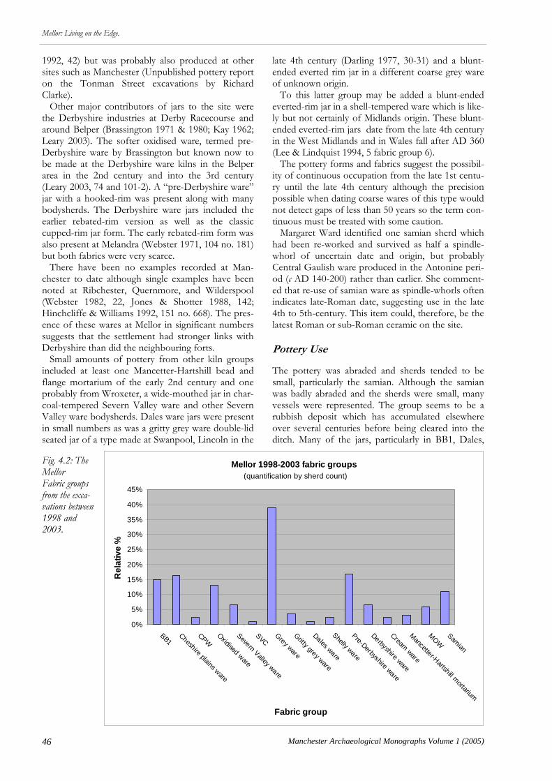
46 Manchester Archaeological Monographs Volume 1 (2005)
Mellor: Living on the Edge.
1992, 42) but was probably also produced at other sites such as Manchester (Unpublished pottery report on the Tonman Street excavations by Richard Clarke). Other major contributors of jars to the site were the Derbyshire industries at Derby Racecourse and around Belper (Brassington 1971 & 1980; Kay 1962; Leary 2003). The softer oxidised ware, termed pre-Derbyshire ware by Brassington but known now to be made at the Derbyshire ware kilns in the Belper area in the 2nd century and into the 3rd century (Leary 2003, 74 and 101-2). A “pre-Derbyshire ware” jar with a hooked-rim was present along with many bodysherds. The Derbyshire ware jars included the earlier rebated-rim version as well as the classic cupped-rim jar form. The early rebated-rim form was also present at Melandra (Webster 1971, 104 no. 181) but both fabrics were very scarce. There have been no examples recorded at Man-chester to date although single examples have been noted at Ribchester, Quernmore, and Wilderspool (Webster 1982, 22, Jones & Shotter 1988, 142; Hinchcliffe & Williams 1992, 151 no. 668). The pres-ence of these wares at Mellor in significant numbers suggests that the settlement had stronger links with Derbyshire than did the neighbouring forts. Small amounts of pottery from other kiln groups included at least one Mancetter-Hartshill bead and flange mortarium of the early 2nd century and one probably from Wroxeter, a wide-mouthed jar in char-coal-tempered Severn Valley ware and other Severn Valley ware bodysherds. Dales ware jars were present in small numbers as was a gritty grey ware double-lid seated jar of a type made at Swanpool, Lincoln in the
late 4th century (Darling 1977, 30-31) and a blunt-ended everted rim jar in a different coarse grey ware of unknown origin. To this latter group may be added a blunt-ended everted-rim jar in a shell-tempered ware which is like-ly but not certainly of Midlands origin. These blunt-ended everted-rim jars date from the late 4th century in the West Midlands and in Wales fall after AD 360 (Lee & Lindquist 1994, 5 fabric group 6). The pottery forms and fabrics suggest the possibil-ity of continuous occupation from the late 1st centu-ry until the late 4th century although the precision possible when dating coarse wares of this type would not detect gaps of less than 50 years so the term con-tinuous must be treated with some caution. Margaret Ward identified one samian sherd which had been re-worked and survived as half a spindle-whorl of uncertain date and origin, but probably Central Gaulish ware produced in the Antonine peri-od (c AD 140-200) rather than earlier. She comment-ed that re-use of samian ware as spindle-whorls often indicates late-Roman date, suggesting use in the late 4th to 5th-century. This item could, therefore, be the latest Roman or sub-Roman ceramic on the site. Pottery Use The pottery was abraded and sherds tended to be small, particularly the samian. Although the samian was badly abraded and the sherds were small, many vessels were represented. The group seems to be a rubbish deposit which has accumulated elsewhere over several centuries before being cleared into the ditch. Many of the jars, particularly in BB1, Dales,
Mellor 1998-2003 fabric groups (quantification by sherd count)
0%
5%
10%
15%
20%
25%
30%
35%
40%
45%
BB1 Cheshire plains ware
CPWOxidised ware
Severn Valley ware
SVCGrey ware
Gritty grey ware
Dales ware
Shelly ware
Pre-Derbyshire ware
Derbyshire ware
Cream ware
Mancetter-Hartshill m
ortarium
MOW
Samian
Fabric group
Re
lati
ve
%
Fig. 4.2: The Mellor Fabric groups from the exca-vations between 1998 and 2003.

47
Mellor: Living on the Edge.
Manchester Archaeological Monographs Volume 1 (2005)
and gritty grey ware retained signs of use in the form of burnt deposits still adhering around the rim and upper bodies, perhaps where food had boiled over and burnt on. Rivet holes in grey ware vessels indicate that pot-tery supply was not always regular and curation was necessary. This is common in Wales but not South Yorkshire where it has been suggested that pottery supply met demand (Evans 2001a, 173).
Site Status The vessel types indicate a high status site (Fig 4.3). Evans has done extensive work on this subject and the Mellor assemblage compares with urban and villa sites rather than rural sites on the basis of its jar:bowl ratio. This conclusion is supported by the range of traded wares present (Fig 4.2). Unfortunately there are few sites published in the North West for which fabric and form quantifications are available but comparison with Ochre Brook, a site with a military connection, confirms a relatively high status (Fig 4.3). The fabric profile of the site was compared with other sites with available data (Fig 4.4). This con-firmed the impression that Mellor was obtaining a wide range of fabrics and taking advantage of its po-sition on the edge of several ceramic zones. Com-pared with the other sites in the North West, it used rather less BB1 and rather more grey ware, similar to Derbyshire sites. The proportion of Cheshire Plains wares was much lower and the site obtained coarse wares from Derbyshire, a fabric rare on sites further west. The relative quantity of samian is remarkable at Mellor and apparently surpasses any of the other sites. An initial impression of these sherds suggested that although they were highly abraded and fragmen-
Relative quantities of vessel types (using rim % values)
5%
23%
2%
13%41%
9%
4% 3%
B
B/ D
C
D
J
MOR
NNJ
WMJ
Fig 4.3: Vessel type quantities based upon rim % values.
0
10
20
30
40
50
60
70
80
AM
O
BB
CC
GR
OX
M
OX
W
Cheshire P
lains
SA
M
WH
M
WH
W
WS
Wilderspool
SV
NV
N. G
aul/Germ
any/S. S
pain
Mid +
S E
ngland
Dales w
are
E Y
orks
Other shelly
DB
Y/pre-D
BY
Ochre Brook
Irby
Birch Heath
Wilderspool 1966-9
Wilderspool 1976
Mellor
Fig 4.4:Fabric profiles of comparative sites.

48 Manchester Archaeological Monographs Volume 1 (2005)
Mellor: Living on the Edge.
tary, they did represent a relatively large number of vessels, possibly as many as 34 vessels. Mellor was able to obtain and afford the best of tablewares, per-haps from the fort at Melandra. Other fine wares at the site, such as the early flagons, might also belong to this period. There are few fine wares in the third and fourth centuries but this may be due to the ab-sence if a ready source of such wares. No Nene val-ley colour-coated ware was identified although a cream ware bowl may be an example of Nene Valley parchment ware. At this time, however, the site was still able to acquire coarse wares from as far away as Yorkshire or Lincolnshire and Dorset. The Nature of the Site’s Relationship with the Roman Occupiers Although some aspects of the site assemblage sug-gests links with the presence of a military installation and/or civil settlement nearby, this is not a constant factor throughout the occupation of the site. In the late 1st and early 2nd century the presence South Gaulish samian on the site certainly indicates contact with the Roman trading network albeit selective in character. Later in the 2nd century, probably in the Antonine period, the site receives a much larger quantity of Roman wares and the make-up of the assemblage is closely related to what one might find in the relevant phases at Melandra and Manchester. Mellor does not obtain apparently the same range of wares, lacking amphora and imported fine wares and acquiring small numbers of flagons, but the propor-tions of the main fabrics - BB1, Cheshire Plains oxi-dised, reduced and white-slipped wares, and Severn Valley wares - were similar to that found generally in the forts and civilian settlements in the Cheshire Plain. A marked difference lies in the acquisition of Derbyshire ware. This may reflect the continuation of tribal or trading connections demonstrated by the Iron Age pottery from the site (the clay of which may also come from Derbyshire; see above Chapter 3). The contrast with the forts suggests that the connec-tion was socially significant rather than purely com-mercial although a predilection for Pennine beer can-not be totally ruled out. The latest types from the site come from Lincoln-shire and the Midlands suggesting a dramatic change both in suppliers and in kiln sources. Pottery supply in the later 4th century on military sites in the North West relied heavily on Crambeck and Huntcliff wares from East Yorkshire and possibly some late BB1 wares (Webster 1974, nos 194 and 219-221; Webster 1991, 14). Loughlin noted a negative distribution of Dales ware at Manchester and Chester (1977, Appen-
dix 2). The Mellor jars from Lincolnshire and the Midlands are in stark contrast to this pattern and, perhaps, reflect the east-west connection reflected in the Derbyshire ware group as well as the decline in activity observable in the 4th century. However, it is perhaps significant in this connection that the late group from Roystone Grange, Derbyshire, included Huntcliff ware as well as Dales wares jars and a shelly everted-rim jar similar to the blunt-ended examples from Mellor (Leary unpublished report). The other published quantified rural assemblages did not ex-tend as late as the material from Mellor so we cannot be certain how typical this small late group of fabrics and forms is of the settlement type in this region. Mellor thus appears to maintain a relationship with the producers of Romanised pottery which fluctuates through time. It interacted with the fortunes of the nearest forts and civil settlements but perhaps main-tained other networks rooted in the pre-Roman so-cial structure. The nature of all these ceramic ex-changes, whether with military or civilian traders and potteries, may have had great social significance and very little economic gain (Nevell 1999b, 62). It may represent very particular adoptions of specific vessel types such as mortaria (Philpott & Adams 1999, 72). At Mellor the assemblage indicates tablewares were adopted to some extent during the 2nd century but may have fallen out of use in the 4th century and been replaced either by organic vessels or by commu-nal rather than individual eating arrangements using larger pots with food eaten straight from the cooking jar. Further work at Mellor will hopefully bring more sherds to light and clarify these tentative interpreta-tions of this small but diverse and significant group of Romano-British pottery.
Relative quantities of vessel types(using rim % values)
0
10
20
30
40
50
Amph
ora
Beake
r
Bowl/d
ish
Flagon
Jar
Mor
taria Cup
Mellor
Ochre Brook
Fig 4.4: Mellor Roman Vessel type quantities compared with Ochre Brook.
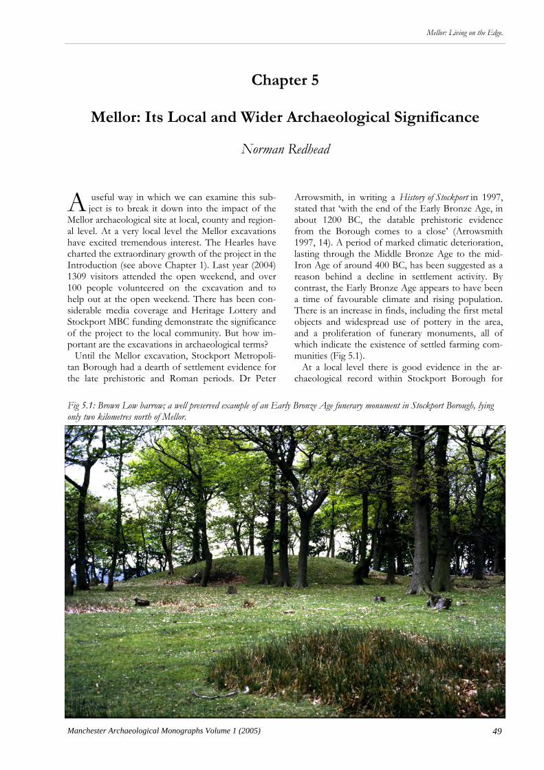
49
Mellor: Living on the Edge.
Manchester Archaeological Monographs Volume 1 (2005)
A useful way in which we can examine this sub-ject is to break it down into the impact of the
Mellor archaeological site at local, county and region-al level. At a very local level the Mellor excavations have excited tremendous interest. The Hearles have charted the extraordinary growth of the project in the Introduction (see above Chapter 1). Last year (2004) 1309 visitors attended the open weekend, and over 100 people volunteered on the excavation and to help out at the open weekend. There has been con-siderable media coverage and Heritage Lottery and Stockport MBC funding demonstrate the significance of the project to the local community. But how im-portant are the excavations in archaeological terms? Until the Mellor excavation, Stockport Metropoli-tan Borough had a dearth of settlement evidence for the late prehistoric and Roman periods. Dr Peter
Chapter 5
Mellor: Its Local and Wider Archaeological Significance
Norman Redhead
Arrowsmith, in writing a History of Stockport in 1997, stated that ‘with the end of the Early Bronze Age, in about 1200 BC, the datable prehistoric evidence from the Borough comes to a close’ (Arrowsmith 1997, 14). A period of marked climatic deterioration, lasting through the Middle Bronze Age to the mid-Iron Age of around 400 BC, has been suggested as a reason behind a decline in settlement activity. By contrast, the Early Bronze Age appears to have been a time of favourable climate and rising population. There is an increase in finds, including the first metal objects and widespread use of pottery in the area, and a proliferation of funerary monuments, all of which indicate the existence of settled farming com-munities (Fig 5.1). At a local level there is good evidence in the ar-chaeological record within Stockport Borough for
Fig 5.1: Brown Low barrow; a well preserved example of an Early Bronze Age funerary monument in Stockport Borough, lying only two kilometres north of Mellor.

50 Manchester Archaeological Monographs Volume 1 (2005)
Mellor: Living on the Edge.
Early Bronze Age activity. This comes mainly in the form of funerary monuments, several of which are located close to the Mellor site. The Brown Low bur-ial mound, which lies in a wood below the crest of Ludworth Intakes on the opposite side of the valley from Mellor, comprises a mound 25m in diameter and two metres high. It was excavated in 1809 by Rev. Marriott who found fragments of bone and evi-dence for a funeral fire. He recorded similar finds from another burial mound only 400m away on the summit at Ludworth Intakes, during its ransacking by locals (Marriott 1810, 376-9; Fig 5.3). He commented on a ‘very ancient urn’ being discovered in 1808 dur-ing the construction of Marple All Saints Church (another ridge-top site) (Marriott 1810, 253). Excava-tions at Shaw Cairn on Cobden Edge, only 2 kilome-tres to the south of Mellor, revealed a stone-built funerary cairn of Late Neolithic to Early Bronze Age date, enclosed by a stone kerb 15m in diameter and containing 12 to 15 cremations. Associated finds in-
cluded an almost complete Early Bronze Age food vessel (Mellor 2000, Fig 5.2). The presence of these funerary sites clearly indicates a settled farming com-munity in the Mellor area at this time; yet no settle-ment sites have yet been identified through excava-tion. The most important evidence for Early Bronze Age settlement in the area has come from Manches-ter Airport’s 2nd runway where archaeologists have recorded a long-lived occupation site on a sand and gravel terrace overlooking a ford across the River Bollin (Fig 5.4). Remains included a series of circular and rectangular buildings beside a sunken track way which was associated with a midden deposit. Finds such as domestic pottery, stone implements including flint tools and quern stones, and the presence of ce-real grains, indicate a farming community (Garner 2001, 41-56). Whilst the Mellor excavations have yielded no evidence for Bronze Age settlement, it is likely that there was some activity during this period, and the exquisitely worked Early Bronze Age flint knife that was discovered in the 2004 season suggests at least the possibility of a funerary site. It is quite reasonable to expect that future archaeological inves-tigations will locate a Bronze Age settlement, either on another part of Mellor hilltop or on the valley sides. But it is for the Iron Age and Romano-British peri-ods that the Mellor excavation has made such a great impact for the archaeology of Stockport. Formerly the only possible settlements within the borough for these periods were those inferred from clusters of finds. Principally, these are Bramhall Green by the Lady Brook (spindle whorls and a quern stone) and Cheadle (Roman coins and road alignment) and Stockport (Roman coins, pottery, and a road align-ment). The ‘Castle Hill’ place name was also felt to indicate ancient settlement, these being located at Stockport and Bredbury (Arrowsmith 1997, 18-20). Just outside the borough, at Hangingbank, Werneth Low, a small-scale excavation of a possible double ditched enclosure in 1991 yielded a single sherd of Romano-British pottery from ditch backfill, suggest-ing a defended farmstead site (Nevell 1992, 19-22). But within Stockport Borough there were no proper-ly excavated sites and a very limited number of finds. Several seasons of methodical excavations at Mel-lor have allowed us to begin to understand the char-acter, phasing, and extent of the settlement. As de-scribed in Chapter 2, we know that in the middle Iron Age the site was enclosed by a large inner defen-sive ditch and a smaller outer enclosure ditch. The inner ditch encompassed the core of the settlement, covering an area of around 1ha, and situated on the lower part of the ridge where it commanded fine views across the Mersey Basin. The construction of the inner ditch does not follow the common practice of using the upcast to form a rampart. There is as yet no physical evidence for a rampart at Mellor, and the
Fig 5.2: Top: Excavation plan of Shaw Cairn. Above: The Late Neolithic/Early Bronze Age food vessel from Shaw Cairn.
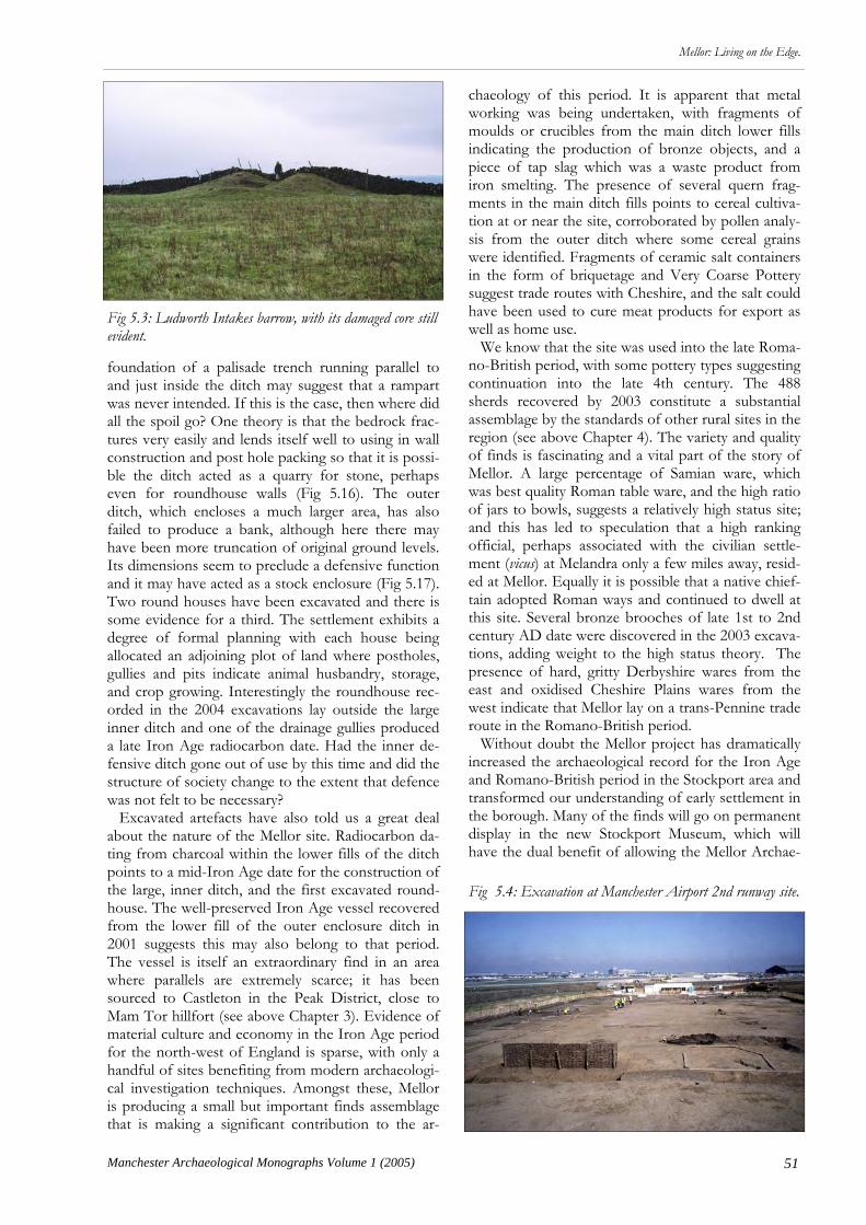
51
Mellor: Living on the Edge.
Manchester Archaeological Monographs Volume 1 (2005)
foundation of a palisade trench running parallel to and just inside the ditch may suggest that a rampart was never intended. If this is the case, then where did all the spoil go? One theory is that the bedrock frac-tures very easily and lends itself well to using in wall construction and post hole packing so that it is possi-ble the ditch acted as a quarry for stone, perhaps even for roundhouse walls (Fig 5.16). The outer ditch, which encloses a much larger area, has also failed to produce a bank, although here there may have been more truncation of original ground levels. Its dimensions seem to preclude a defensive function and it may have acted as a stock enclosure (Fig 5.17). Two round houses have been excavated and there is some evidence for a third. The settlement exhibits a degree of formal planning with each house being allocated an adjoining plot of land where postholes, gullies and pits indicate animal husbandry, storage, and crop growing. Interestingly the roundhouse rec-orded in the 2004 excavations lay outside the large inner ditch and one of the drainage gullies produced a late Iron Age radiocarbon date. Had the inner de-fensive ditch gone out of use by this time and did the structure of society change to the extent that defence was not felt to be necessary? Excavated artefacts have also told us a great deal about the nature of the Mellor site. Radiocarbon da-ting from charcoal within the lower fills of the ditch points to a mid-Iron Age date for the construction of the large, inner ditch, and the first excavated round-house. The well-preserved Iron Age vessel recovered from the lower fill of the outer enclosure ditch in 2001 suggests this may also belong to that period. The vessel is itself an extraordinary find in an area where parallels are extremely scarce; it has been sourced to Castleton in the Peak District, close to Mam Tor hillfort (see above Chapter 3). Evidence of material culture and economy in the Iron Age period for the north-west of England is sparse, with only a handful of sites benefiting from modern archaeologi-cal investigation techniques. Amongst these, Mellor is producing a small but important finds assemblage that is making a significant contribution to the ar-
chaeology of this period. It is apparent that metal working was being undertaken, with fragments of moulds or crucibles from the main ditch lower fills indicating the production of bronze objects, and a piece of tap slag which was a waste product from iron smelting. The presence of several quern frag-ments in the main ditch fills points to cereal cultiva-tion at or near the site, corroborated by pollen analy-sis from the outer ditch where some cereal grains were identified. Fragments of ceramic salt containers in the form of briquetage and Very Coarse Pottery suggest trade routes with Cheshire, and the salt could have been used to cure meat products for export as well as home use. We know that the site was used into the late Roma-no-British period, with some pottery types suggesting continuation into the late 4th century. The 488 sherds recovered by 2003 constitute a substantial assemblage by the standards of other rural sites in the region (see above Chapter 4). The variety and quality of finds is fascinating and a vital part of the story of Mellor. A large percentage of Samian ware, which was best quality Roman table ware, and the high ratio of jars to bowls, suggests a relatively high status site; and this has led to speculation that a high ranking official, perhaps associated with the civilian settle-ment (vicus) at Melandra only a few miles away, resid-ed at Mellor. Equally it is possible that a native chief-tain adopted Roman ways and continued to dwell at this site. Several bronze brooches of late 1st to 2nd century AD date were discovered in the 2003 excava-tions, adding weight to the high status theory. The presence of hard, gritty Derbyshire wares from the east and oxidised Cheshire Plains wares from the west indicate that Mellor lay on a trans-Pennine trade route in the Romano-British period. Without doubt the Mellor project has dramatically increased the archaeological record for the Iron Age and Romano-British period in the Stockport area and transformed our understanding of early settlement in the borough. Many of the finds will go on permanent display in the new Stockport Museum, which will have the dual benefit of allowing the Mellor Archae-
Fig 5.3: Ludworth Intakes barrow, with its damaged core still evident.
Fig 5.4: Excavation at Manchester Airport 2nd runway site.

52 Manchester Archaeological Monographs Volume 1 (2005)
Mellor: Living on the Edge.
ological Trust to disseminate its exciting discoveries to an even wider audience, within the borough and beyond, whilst furnishing Stockport Museum with a range of finds undreamt of several years ago. Each year, the project has been lucky enough to chance upon a ‘spectacular’ find, be it the nearly complete Iron Age vessel, the Neolithic flint chisel, the group of bronze brooches, or the early Bronze Age flint dagger; the collective significance of these finds, both academically and as a visual treasure to the people of Mellor and Stockport, is considerable (Fig 5.18). But how does Mellor fit into the wider picture, firstly of the county area defined as Greater Man-chester and secondly within the wider region? Until recent years archaeologists had very little un-derstanding of the nature and location of late prehis-toric settlement in Greater Manchester and the wider region at the time of the Roman invasion. Evidence has been difficult to find for several reasons; sparse population, disturbance from extensive industrialisa-tion and urban growth, and a materially poor econo-my that was animal-product based, from which bones and other organic remains generally have not survived in the acidic soils. Pottery has been found in only small quantities, some of it so coarse that it is hard to recognize during archaeological excavations. Similarly, there has been a lack of metal artefact finds and visible earthwork monuments. However, over the last two decades several research excavations have begun to establish settlement types for the re-gion. The 2003 excavations confirmed that there had been a large, inner ditch clearly dug on a massive and defensive scale; did this prove that Mellor could in-deed be classified as a hillfort rather than just a hilltop enclosure? The true dimensions of this inner defended area, which includes the roundhouse, are not yet precisely known. There is a distance of 100m between the ditch excavated by the driveway en-trance in the eastern part of the Hearle’s garden to the original ditch excavated in 1998 in the western garden. South to north is more problematic, although in the early 18th century Marriot recorded an ancient
fosse (ditch), revealed when a vault was being dug near to the southern edge of the graveyard, and re-cent geophysics and excavation evidence suggests a northern return of the ditch to be under or just to the east of the driveway, giving a distance of c 80m. This would make a hillfort size of 0.8ha. However, if the outer ditch is taken into account, and if it really does encompass the whole hilltop as recent investiga-tions suggest, then the enclosure at Mellor would be of the order of a massive 23ha. Forde-Johnson (1965) made a study of Iron Age hillfort earthworks in which he distinguished true hillforts as being above c 2.5ha in area; they acted as central places in which resided a local chieftain, with lesser sites being farmsteads. In the Mersey Basin there are only a handful of sites which fit into this category, these being Kelsborrow (3.3ha), Eddisbury (3.5ha), and Beeston (4ha) (Fig 5.6). Of course, Mam Tor which lies in Derbyshire south of Mellor is very much in this class of monument, at 5ha in size. These sites are characterised by visible banks and ditches. Mellor differs from them in that there is as yet no evidence for a bank, with the excavated evidence suggesting a palisade on the inner side of the ditch. The big hill-fort sites, including Mam Tor and Beeston, but also Almondbury near Huddersfield, and Castercliffe and Portfield in the Ribble Valley, are all abandoned by the last quarter of the 1st millennium BC, and in some cases by around 500 BC. It is interesting to note that Mellor’s dating evidence points towards a construction date of 500-400 BC, with site occupa-tion continuing into the late Iron Age.
Fig 5.5: Castlesteads aerial view.
Fig 5.6: The Iron Age settlements of North West England .(after Nevell 2001, 71).

53
Mellor: Living on the Edge.
Manchester Archaeological Monographs Volume 1 (2005)
Fig 5.7: Great Woolden Hall from the air showing the double-ditched cropmark beside the River Glazebrook, Reproduced courtesy of Dr Nick Higham, University of Manchester..
Fig 5.8: Plan of the Phase II (65-15 BC) buildings at Great Woolden Hall.
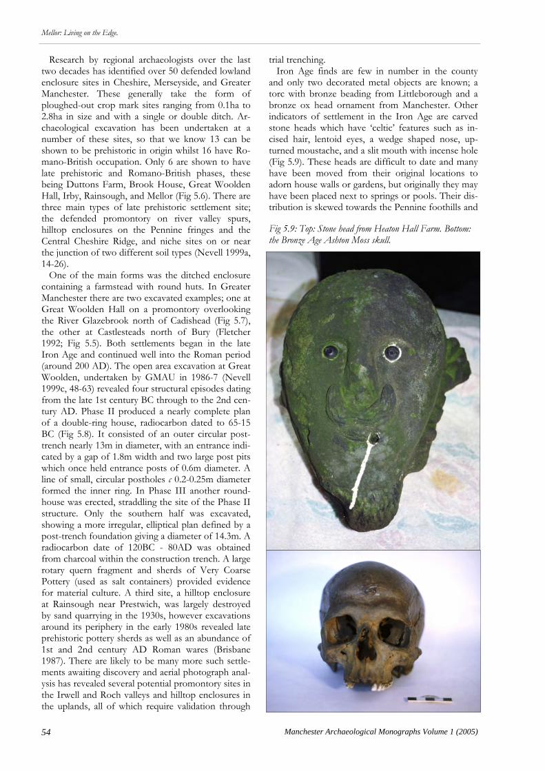
54 Manchester Archaeological Monographs Volume 1 (2005)
Mellor: Living on the Edge.
Research by regional archaeologists over the last two decades has identified over 50 defended lowland enclosure sites in Cheshire, Merseyside, and Greater Manchester. These generally take the form of ploughed-out crop mark sites ranging from 0.1ha to 2.8ha in size and with a single or double ditch. Ar-chaeological excavation has been undertaken at a number of these sites, so that we know 13 can be shown to be prehistoric in origin whilst 16 have Ro-mano-British occupation. Only 6 are shown to have late prehistoric and Romano-British phases, these being Duttons Farm, Brook House, Great Woolden Hall, Irby, Rainsough, and Mellor (Fig 5.6). There are three main types of late prehistoric settlement site; the defended promontory on river valley spurs, hilltop enclosures on the Pennine fringes and the Central Cheshire Ridge, and niche sites on or near the junction of two different soil types (Nevell 1999a, 14-26). One of the main forms was the ditched enclosure containing a farmstead with round huts. In Greater Manchester there are two excavated examples; one at Great Woolden Hall on a promontory overlooking the River Glazebrook north of Cadishead (Fig 5.7), the other at Castlesteads north of Bury (Fletcher 1992; Fig 5.5). Both settlements began in the late Iron Age and continued well into the Roman period (around 200 AD). The open area excavation at Great Woolden, undertaken by GMAU in 1986-7 (Nevell 1999c, 48-63) revealed four structural episodes dating from the late 1st century BC through to the 2nd cen-tury AD. Phase II produced a nearly complete plan of a double-ring house, radiocarbon dated to 65-15 BC (Fig 5.8). It consisted of an outer circular post-trench nearly 13m in diameter, with an entrance indi-cated by a gap of 1.8m width and two large post pits which once held entrance posts of 0.6m diameter. A line of small, circular postholes c 0.2-0.25m diameter formed the inner ring. In Phase III another round-house was erected, straddling the site of the Phase II structure. Only the southern half was excavated, showing a more irregular, elliptical plan defined by a post-trench foundation giving a diameter of 14.3m. A radiocarbon date of 120BC - 80AD was obtained from charcoal within the construction trench. A large rotary quern fragment and sherds of Very Coarse Pottery (used as salt containers) provided evidence for material culture. A third site, a hilltop enclosure at Rainsough near Prestwich, was largely destroyed by sand quarrying in the 1930s, however excavations around its periphery in the early 1980s revealed late prehistoric pottery sherds as well as an abundance of 1st and 2nd century AD Roman wares (Brisbane 1987). There are likely to be many more such settle-ments awaiting discovery and aerial photograph anal-ysis has revealed several potential promontory sites in the Irwell and Roch valleys and hilltop enclosures in the uplands, all of which require validation through
trial trenching. Iron Age finds are few in number in the county and only two decorated metal objects are known; a torc with bronze beading from Littleborough and a bronze ox head ornament from Manchester. Other indicators of settlement in the Iron Age are carved stone heads which have ‘celtic’ features such as in-cised hair, lentoid eyes, a wedge shaped nose, up-turned moustache, and a slit mouth with incense hole (Fig 5.9). These heads are difficult to date and many have been moved from their original locations to adorn house walls or gardens, but originally they may have been placed next to springs or pools. Their dis-tribution is skewed towards the Pennine foothills and
Fig 5.9: Top: Stone head from Heaton Hall Farm. Bottom: the Bronze Age Ashton Moss skull.
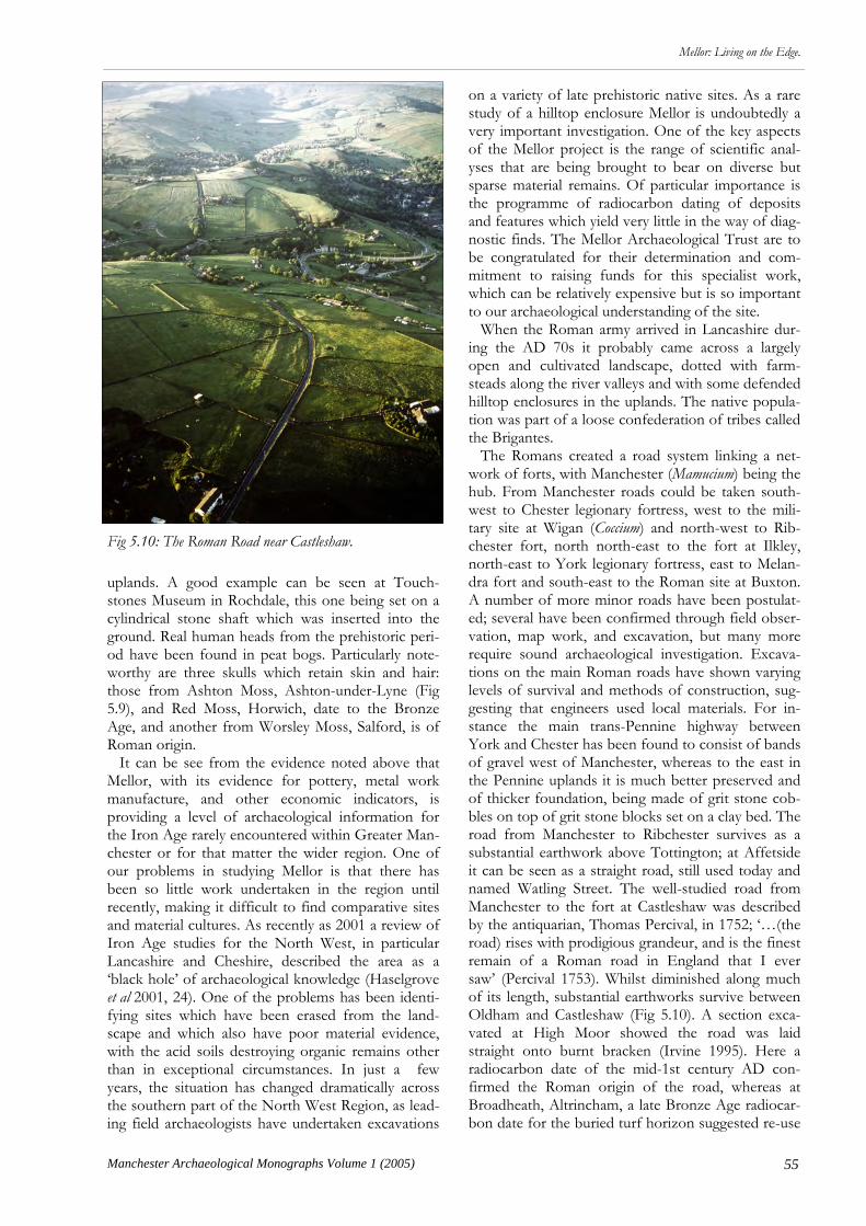
55
Mellor: Living on the Edge.
Manchester Archaeological Monographs Volume 1 (2005)
uplands. A good example can be seen at Touch-stones Museum in Rochdale, this one being set on a cylindrical stone shaft which was inserted into the ground. Real human heads from the prehistoric peri-od have been found in peat bogs. Particularly note-worthy are three skulls which retain skin and hair: those from Ashton Moss, Ashton-under-Lyne (Fig 5.9), and Red Moss, Horwich, date to the Bronze Age, and another from Worsley Moss, Salford, is of Roman origin. It can be see from the evidence noted above that Mellor, with its evidence for pottery, metal work manufacture, and other economic indicators, is providing a level of archaeological information for the Iron Age rarely encountered within Greater Man-chester or for that matter the wider region. One of our problems in studying Mellor is that there has been so little work undertaken in the region until recently, making it difficult to find comparative sites and material cultures. As recently as 2001 a review of Iron Age studies for the North West, in particular Lancashire and Cheshire, described the area as a ‘black hole’ of archaeological knowledge (Haselgrove et al 2001, 24). One of the problems has been identi-fying sites which have been erased from the land-scape and which also have poor material evidence, with the acid soils destroying organic remains other than in exceptional circumstances. In just a few years, the situation has changed dramatically across the southern part of the North West Region, as lead-ing field archaeologists have undertaken excavations
on a variety of late prehistoric native sites. As a rare study of a hilltop enclosure Mellor is undoubtedly a very important investigation. One of the key aspects of the Mellor project is the range of scientific anal-yses that are being brought to bear on diverse but sparse material remains. Of particular importance is the programme of radiocarbon dating of deposits and features which yield very little in the way of diag-nostic finds. The Mellor Archaeological Trust are to be congratulated for their determination and com-mitment to raising funds for this specialist work, which can be relatively expensive but is so important to our archaeological understanding of the site. When the Roman army arrived in Lancashire dur-ing the AD 70s it probably came across a largely open and cultivated landscape, dotted with farm-steads along the river valleys and with some defended hilltop enclosures in the uplands. The native popula-tion was part of a loose confederation of tribes called the Brigantes. The Romans created a road system linking a net-work of forts, with Manchester (Mamucium) being the hub. From Manchester roads could be taken south-west to Chester legionary fortress, west to the mili-tary site at Wigan (Coccium) and north-west to Rib-chester fort, north north-east to the fort at Ilkley, north-east to York legionary fortress, east to Melan-dra fort and south-east to the Roman site at Buxton. A number of more minor roads have been postulat-ed; several have been confirmed through field obser-vation, map work, and excavation, but many more require sound archaeological investigation. Excava-tions on the main Roman roads have shown varying levels of survival and methods of construction, sug-gesting that engineers used local materials. For in-stance the main trans-Pennine highway between York and Chester has been found to consist of bands of gravel west of Manchester, whereas to the east in the Pennine uplands it is much better preserved and of thicker foundation, being made of grit stone cob-bles on top of grit stone blocks set on a clay bed. The road from Manchester to Ribchester survives as a substantial earthwork above Tottington; at Affetside it can be seen as a straight road, still used today and named Watling Street. The well-studied road from Manchester to the fort at Castleshaw was described by the antiquarian, Thomas Percival, in 1752; ‘…(the road) rises with prodigious grandeur, and is the finest remain of a Roman road in England that I ever saw’ (Percival 1753). Whilst diminished along much of its length, substantial earthworks survive between Oldham and Castleshaw (Fig 5.10). A section exca-vated at High Moor showed the road was laid straight onto burnt bracken (Irvine 1995). Here a radiocarbon date of the mid-1st century AD con-firmed the Roman origin of the road, whereas at Broadheath, Altrincham, a late Bronze Age radiocar-bon date for the buried turf horizon suggested re-use
Fig 5.10: The Roman Road near Castleshaw.
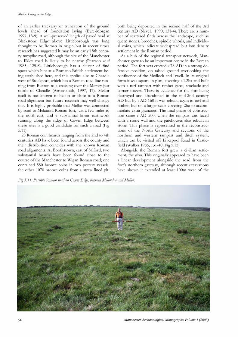
56 Manchester Archaeological Monographs Volume 1 (2005)
Mellor: Living on the Edge.
of an earlier trackway or truncation of the ground levels ahead of foundation laying (Eyre-Morgan 1997, 18-9). A well-preserved length of paved road at Blackstone Edge above Littleborough was long thought to be Roman in origin but in recent times research has suggested it may be an early 18th centu-ry turnpike road, although the site of the Manchester to Ilkley road is likely to be nearby (Pearson et al 1985, 125-8). Littleborough has a cluster of find spots which hint at a Romano-British settlement be-ing established here, and this applies also to Cheadle west of Stockport, which has a Roman road line run-ning from Buxton to a crossing over the Mersey just north of Cheadle (Arrowsmith, 1997, 17). Mellor itself is not known to be on or close to a Roman road alignment but future research may well change this. It is highly probable that Mellor was connected by road to Melandra Roman fort, just a few miles to the north-east, and a substantial linear earthwork running along the ridge of Cowm Edge between these sites is a good candidate for such a road (Fig 5.11). 23 Roman coin hoards ranging from the 2nd to 4th centuries AD have been found across the county and their distribution coincides with the known Roman road alignments. At Boothstown, east of Salford, two substantial hoards have been found close to the course of the Manchester to Wigan Roman road; one contained 550 bronze coins in two pottery vessels, the other 1070 bronze coins from a straw lined pit,
both being deposited in the second half of the 3rd century AD (Nevell 1990, 131-4). There are a num-ber of scattered finds across the landscape, such as quern stones, brooches, spindle whorls, and individu-al coins, which indicate widespread but low density settlement in the Roman period. As a hub of the regional transport network, Man-chester grew to be an important centre in the Roman period. The fort was erected c 78 AD in a strong de-fensive position, on raised ground overlooking the confluence of the Medlock and Irwell. In its original form it was square in plan, covering c 1.2ha and built with a turf rampart with timber gates, stockade and corner towers. There is evidence for the fort being destroyed and abandoned in the mid-2nd century AD but by c AD 160 it was rebuilt, again in turf and timber, but on a larger scale covering 2ha to accom-modate extra granaries. The final phase of construc-tion came c AD 200, when the rampart was faced with a stone wall and the gatehouses also rebuilt in stone. This phase is represented in the reconstruc-tions of the North Gateway and sections of the northern and western rampart and ditch system, which can be visited off Liverpool Road in Castle-field (Walker 1986, 131-40; Fig 5.12). Alongside the Roman fort grew a civilian settle-ment, the vicus. This originally appeared to have been a linear development alongside the road from the fort’s northern gateway, although recent excavations have shown it extended at least 100m west of the
Fig 5.11: Possible Roman road on Cowm Edge, between Melandra and Mellor.

57
Mellor: Living on the Edge.
Manchester Archaeological Monographs Volume 1 (2005)
road (Connelly 2002). The cemetery and religious complex were on the east and south-east side. Exca-vations through the 1970s found extensive evidence for successive building phases beginning in the late 1st century AD and continuing into the early 3rd century AD (Jones and Grealey 1974 and Jones & Reynolds 1978). The evidence consisted mainly of post-holes and beam slots indicating timber con-struction, but in a few cases dwarf stone walls were found, and these supported timber-framing. The buildings were typically rectangular, some having recognisable internal divisions, others being a single room. Variations included the addition of a veranda, a type comprising a shed open along one side, and a U-shaped complex around a central yard. The recon-structed stone footings of three of these buildings, including a hostelry fronting the Roman road, can be seen opposite the White Lion pub on Liverpool Road. Through the 2nd century AD the Roman fort and vicus had periods of large-scale industrial produc-tion, mainly related to iron working. A large number of hearths have been found, either within buildings or in the open to the rear, and many of these were used to forge weapons, tools or other equipment. There is also evidence for iron smelting in the form of bloomeries and a large number of ‘industrial’ pits
have been found that are of uncertain function. It is thought that these intensive periods of activity were to support military campaigns further north into Scotland. Whilst the coin finds and evidence for re-cutting of the fort ditches shows that the fort continued in use throughout the 3rd and 4th centuries, the vicus de-clined considerably during this period. In the early 3rd century industrial activity gave way to domestic buildings and by the 4th century the vicus was all but abandoned. A particularly important find was made in 1978 during Prof Jones’ excavations at Tonman Street. A broken amphora from a late 2nd century AD rubbish pit was found to have graffiti which when decoded represented early Christian beliefs, at a time when the religion was still oppressed through-out the Roman Empire (Jones & Reynolds 1978, 15-16). Any further archaeological evidence corroborat-ing or shedding further light on this discovery would be of international significance. Also from this area came the only Roman pottery kiln in Greater Man-chester, this one producing basic cooking wares (grey wares). Castlefield has experienced intense develop-ment pressure over the last few years which has led to several large scale developer-funded archaeological excavations taking place in the eastern half of the
Fig 5.12: Reconstruction of the North Gateway of the Manchester Roman fort after restoration by Manchester City Council in Spring 2005.

58 Manchester Archaeological Monographs Volume 1 (2005)
Mellor: Living on the Edge.
Fig 5.13: UMAU’s Barton Street excavations of 2004 in the Manchester vicus, on the site of a possible temple.
Fig 5.14: A Roman building with clay floor and wall trench at the Beetham Tower site on Deansgate, Manchester, ex-cavated in 2004 by Pre-Construct Archaeology.

59
Mellor: Living on the Edge.
Manchester Archaeological Monographs Volume 1 (2005)
vicus. This has shed more light on the character and extent of the civilian settlement, with Roman wood-en buildings being found on both sides of Deansgate, as well as a substantial stone founded building, possi-bly a mansio, a temple and further, discrete areas of industrial activity (Figs 5.13 & 5.14). Projected devel-opment work will affect the last remains of the fort allowing a final chance to understand its layout and changing role. Castleshaw, near Delph in Saddleworth, is the sec-ond known Roman fort site in Greater Manchester. It lies a days march (16 miles) from Manchester east along the York road, and beyond Castleshaw is Slack only a further eight miles on. Castleshaw was part of the process of parceling-up the Pennines to control the passes and routeways; it had a short life because it was expendable being so close to Slack. Excavated at various times through the 20th century, this site comprised a turf and timber fort of 1.2ha for an in-fantry cohort established by Agricola in 78 AD. There were two phases of timber buildings within the fort before it was abandoned in the mid-AD 90s. In c AD 105 the Romans returned to Castleshaw and erected a smaller fortlet on the earlier fort site. This fortlet, again of turf and timber, also had two phases of building before it was abandoned in the mid-AD 120s (Fig 5.15). Most fortlets in Britain were used to house garrisons and therefore contained barrack blocks. However, excavations by GMAU in 1984-9 showed that the Castleshaw fortlet’s layout was unu-sual (Walker 1989). Despite its large size, of 1950m2, it had only one barrack block, the rest of the interior being taken up by a commander’s house, workshop, overlarge granary (big enough for a fort), stables/latrines, bread oven and a courtyard building (headquarters or mansio). It has been postulated that Castleshaw served either as a ‘base’ fortlet, holding the nerve centre of a cohort with most of the troops out-stationed in smaller garrison fortlets and signal stations, or a ‘commissary fortlet used for supply and administration. Research excavation by GMAU in 1995-6 demonstrated that there was a settlement just outside the south gate (Redhead 1999, 74-81). This was abandoned with the fortlet in c AD 125. Pollen analysis has shown that in the early 2nd century AD, Castleshaw valley had managed herb-rich grasslands for grazing, but as soon as the site was abandoned native wild grasses, shrubs, and trees quickly invaded again indicating that there was no continuation of settlement in the valley (Brayshay 1999, 82-9). In summary, Castleshaw had four phases of buildings within a 50 year lifespan. This short length of occu-pation and the establishment of a small vicus, makes Castleshaw a site with excellent research potential. The bath-house, cemetery, and field systems will sur-vive at Castleshaw but have not yet been found. It is worth noting that both the Castleshaw and Manches-ter Roman forts provided tentative archaeological
evidence for a pre-Agricolan foundation, perhaps by one of the previous governors Frontinus or Cerialis, and this is a subject worthy of further study as it could change our understanding of the origins of Roman occupation in the North West. Excavations by GMAU in 1982-4 at the Wiend, Wigan, failed to find evidence for a fort but did con-firm that Wigan was a Roman military site (Jones and Rice 1985, 25-34). In the late 1st century AD or early 2nd century AD, open ended warehouse buildings were in use (similar types have been found at Cor-bridge and Walton-le-Dale), these were then disman-tled and the area given over in the first half of the 2nd century to industrial activity in the form of hearths and pits indicative of iron working and smelt-ing. Wigan supports the idea of the North West be-ing used in the first half of the second century as a supply and manufacturing area to support military campaigns into Scotland. Recently completed excava-tions by Oxford Archaeology North ahead of a new shopping centre development off Millgate have re-vealed significant new evidence for the nature of Ro-man Wigan, with truncated remains of a possible fort ditch and a large stone built bath complex being rec-orded (Fig 5.19). Melandra Roman fort and vicus at Glossop, Der-byshire (Fig 5.20), lies just beyond the border of Greater Manchester on a bluff overlooking the river Etherow. The fort only survived until the 140s AD, as did its associated civilian settlement. It is likely that related settlement activity existed on the opposite bank. Several potential features, including tracks and a farm site, have been plotted from aerial photo-graphs (Nevell 1992, 66). At Pyms Parlour, a rock shelter in a gorge of the Etherow, coins and a bronze plaque may represent a hoard never collected or a temporary settlement (Nevell 1992, 74-5). New Roman sites are continually coming to light. A very recent example is Moss Brow, Warburton, where metal detector finds, geophysical survey and evaluation trenching by UMAU and the South Traf-ford Archaeology Group have located the badly trun-cated remains of a fortlet overlooking the River Bol-
Fig 5.15: The Castleshaw Roman fort and fortlet from the air.
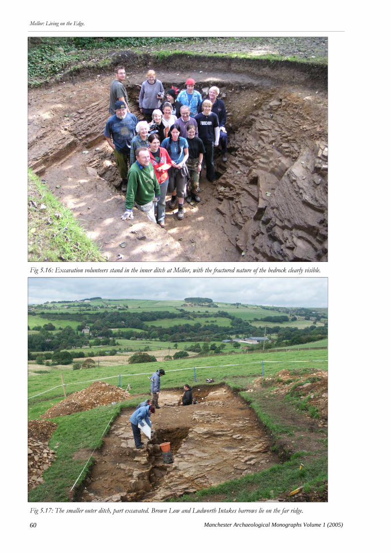
60 Manchester Archaeological Monographs Volume 1 (2005)
Mellor: Living on the Edge.
Fig 5.16: Excavation volunteers stand in the inner ditch at Mellor, with the fractured nature of the bedrock clearly visible.
Fig 5.17: The smaller outer ditch, part excavated. Brown Low and Ludworth Intakes barrows lie on the far ridge.
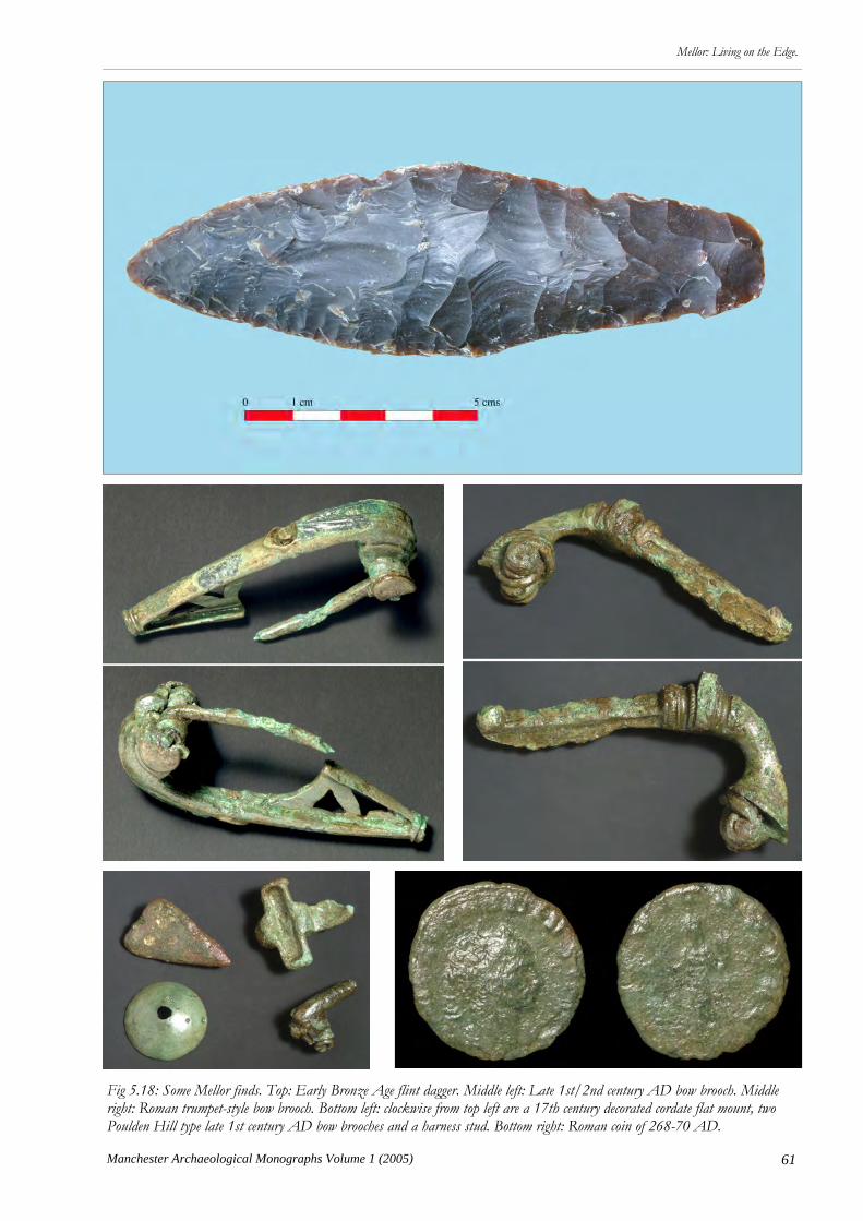
61
Mellor: Living on the Edge.
Manchester Archaeological Monographs Volume 1 (2005)
Fig 5.18: Some Mellor finds. Top: Early Bronze Age flint dagger. Middle left: Late 1st/2nd century AD bow brooch. Middle right: Roman trumpet-style bow brooch. Bottom left: clockwise from top left are a 17th century decorated cordate flat mount, two Poulden Hill type late 1st century AD bow brooches and a harness stud. Bottom right: Roman coin of 268-70 AD.

62 Manchester Archaeological Monographs Volume 1 (2005)
Mellor: Living on the Edge.
lin. Generally, Romanisation in the Greater Manches-ter area appears to have been a transient affair and its impact on native structure and economy was relative-ly slight. A rural economy, based mainly on animal products, probably continued from the Iron Age. Excavations show that farmsteads continued in use well into the Roman period and there are no villas to suggest a higher level of economy and estate manage-ment. To judge by the evidence from Wigan and Manchester, the area was the focus of heavy industri-alization in the first half of the 2nd century AD. Based on current evidence, the one large civilian set-tlement, at Manchester, flourished for a century then withered. To date, Mellor is the only rural settlement site in Greater Manchester to produce late Roman pottery, from the 3rd and 4th centuries AD. Is this because its role was connected with the Peak District area of the southern Pennines rather than the Mersey Basin? Future Research Directions Despite several seasons of excavation, Mellor is still being evaluated, with only a very small fraction of the site having been examined. Each year our under-standing of the site is transformed by new findings –
as illustrated so well in the 2003 season when the existence of a massive inner defensive ditch was con-firmed and the line of the outer ditch was found to be running north-east up towards Mellor Hall to en-compass, apparently, the whole hilltop, rather than as was previously thought to run south past the New Vicarage. Defining the alignment of the two enclo-sure ditches is clearly an archaeological priority and it is hoped further light on these features will be shed in the 2005 season. We do not yet know the location of the gateway into the settlement nor the nature of its defences. Another key area for site investigation is the character and sequence of occupation. How many roundhouses were there and were they con-fined within the inner ditch enclosure? Were there other building types such as four-post structures for storage? Did the shape and type of house change through time. Can we shed more light on the phasing and character of features revealed as a plethora of pits, post-holes, and gullies revealed in the 2002 and 2004 open area excavations? Although there are a few Romano-British features, such as gullies, we do not yet have any evidence of buildings from that pe-riod. Have most of the Roman levels been truncated by later activity, and could the large quantity of Ro-man finds deposited in the upper fills of the inner ditch be the result of site clearance in the late or post
Fig 5.19: Recording the Roman hypocaust from the recent excavation at Millgate, Wigan, by Oxford Archaeology North.
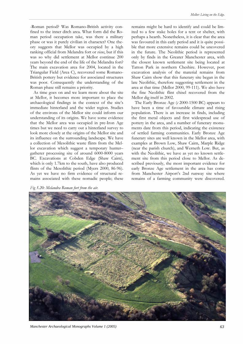
63
Mellor: Living on the Edge.
Manchester Archaeological Monographs Volume 1 (2005)
-Roman period? Was Romano-British activity con-fined to the inner ditch area. What form did the Ro-man period occupation take, was there a military phase or was it purely civilian in character? One the-ory suggests that Mellor was occupied by a high ranking official from Melandra fort or vicus, but if this was so why did settlement at Mellor continue 200 years beyond the end of the life of the Melandra fort? The main excavation area for 2004, located in the Triangular Field (Area C), recovered some Romano-British pottery but evidence for associated structures was poor. Consequently the understanding of the Roman phase still remains a priority. As time goes on and we learn more about the site at Mellor, it becomes more important to place the archaeological findings in the context of the site’s immediate hinterland and the wider region. Studies of the environs of the Mellor site could inform our understanding of its origins. We have some evidence that the Mellor area was occupied in pre-Iron Age times but we need to carry out a hinterland survey to look more closely at the origins of the Mellor site and its influence on the surrounding landscape. We have a collection of Mesolithic waste flints from the Mel-lor excavation which suggest a temporary hunter–gatherer processing site of around 6000-8000 years BC. Excavations at Cobden Edge (Shaw Cairn), which is only 1.7km to the south, have also produced flints of the Mesolithic period (Myers 2000, 86-96). As yet we have no firm evidence of structural re-mains associated with these nomadic people; these
remains might be hard to identify and could be lim-ited to a few stake holes for a tent or shelter, with perhaps a hearth. Nonetheless, it is clear that the area was favoured in this early period and it is quite possi-ble that more extensive remains could be uncovered in the future. The Neolithic period is represented only by finds in the Greater Manchester area, with the closest known settlement site being located at Tatton Park in northern Cheshire. However, post excavation analysis of the material remains from Shaw Cairn show that this funerary site began in the late Neolithic, therefore suggesting settlement in the area at that time (Mellor 2000, 99-111). We also have the fine Neolithic flint chisel recovered from the Mellor dig itself in 2002. The Early Bronze Age (c 2000-1500 BC) appears to have been a time of favourable climate and rising population. There is an increase in finds, including the first metal objects and first widespread use of pottery in the area, and a number of funerary monu-ments date from this period, indicating the existence of settled farming communities. Early Bronze Age funerary sites are well known in the Mellor area, with examples at Brown Low, Shaw Cairn, Marple Ridge (near the parish church), and Werneth Low. But, as with the Neolithic, we have as yet no known settle-ment site from this period close to Mellor. As de-scribed previously, the most important evidence for early Bronze Age settlement in the area has come from Manchester Airport’s 2nd runway site where remains of a farming community were discovered.
Fig 5.20: Melandra Roman fort from the air.

64 Manchester Archaeological Monographs Volume 1 (2005)
Mellor: Living on the Edge.
Mam Tor hillfort also has a substantial community established in the Bronze Age (Coombs & Thomp-son 1979, 7-50). It is very likely that a farm site or larger settlement will exist either on the hilltop at Mellor or close by. There is evidence for climatic deterioration in the Middle Bronze Age, from around 1300 BC to the mid-Iron Age of c 500 BC. This cor-responds with a marked decrease in the number of find spots and funerary sites. Pollen core analysis shows expanding peat bog during this period and it is likely that marginal farmland became unworkable and the population declined. We do not know if settle-ment continued in the Mellor area during this period of poorer climate. Research priorities for the future should include a close examination of the whole Mellor hilltop, through geophysical survey and trial trenching, estab-lishing not only the full parameters of the Iron Age ditch system but looking for earlier occupation evi-dence as well. A wider hinterland survey should also be undertaken which will use aerial photographic analysis, historical research (including antiquarian reports and observations), field walking and further investigation of key sites such as Shaw Cairn, to build an understanding of the settlement of the Mellor area through time and its affect on the surrounding land-scape. Previous specialist reports on the pottery from the Mellor excavations have stressed how significant the assemblage is in a region which has so little Iron Age ceramics. Thin section analysis has linked some of the pottery to the Castleton area, where Mam Tor is situated. The possibility of cultural affinities with the Mam Tor site needs to be researched further. Indeed, this research should include re-analysis of the Mam Tor finds assemblage, as that site was excavat-ed a long time ago (in the 1960s) and should be re-examined in the light of subsequent discoveries and
improved knowledge. One of Mellor’s continuing successes is the way it communicates results both to the public and the aca-demic community. Mellor Archaeological Trust host-ed a very successful Study Day in April 2003, which aimed to put Mellor in its archaeological context. Archaeologists presented the results of recent investi-gations on Iron Age and Romano-British settlement sites across the region, which included Cheshire, Merseyside, Greater Manchester, the Peak District, and Derbyshire. The Study Day showed that Mellor sits at a key location both in topographic terms, lying as it does on the edge of two distinctive environ-ments (the Pennines and the Mersey Basin), and in terms of east to west trade links. The Study Day presentations published in this monograph continue the process of communicating the archaeological significance of the Mellor investigations to both the general public and practicing archaeologists. The Sto-ry of Stockport, the Borough’s new museum which will open in 2006, will also have some important arte-facts from the Mellor dig together with computer models of the site. This will enable the exciting ar-chaeological discoveries to be disseminated to a wid-er range of people. This year sees the last of the three year programme of excavations funded by Your Her-itage (with support from Stockport MBC). Discus-sion is underway as to whether this will be a good time to publish the results of the excavations at Mel-lor, and what format such a publication should take. This will allow a line to be drawn under the initial, exploratory excavations at the site, and enable a new scheme of research led investigation to be undertak-en.

65
Mellor: Living on the Edge.
Manchester Archaeological Monographs Volume 1 (2005)
A number of large surviving earthwork enclo-sures along the summit of the Cheshire ridge;
the ‘hillforts’, have traditionally dominated discussion of the late prehistoric period in the North West be-cause of the paucity of other sites and evidence. For many years the late prehistoric farmstead enclosure at Great Woolden Hall, near Urmston, Manchester (Nevell 1989, 1999a), was the main excavated evi-dence for lowland settlement of this period. In a re-cent research agenda paper Lancashire and Cheshire were recorded as a ‘black hole’ for Iron Age research (Haselgrove et al 2001, 24). Recently, however, exca-vations on sites of this period have increased the in-formation available, even though appreciation of them may not have spread yet beyond the region. Two sites investigated by National Museums Liver-pool (NML) form the core of this contribution; at Halewood, Merseyside (Cowell 2000) and at Lathom, West Lancashire (Cowell 2003). Although recognis-ing that the database is still small, tentative attempts are then made at interpretation of the social and eco-nomic factors behind the emerging settlement pat-tern in the region. Brook House Farm, Halewood, Merseyside This site was initially discovered through aerial pho-tography in 1990. It showed as two ditches, c 35m apart, inscribing half of an enclosure that had been cut through by the A562 road between Liverpool and Widnes (Fig 6.1). Although road construction has left the exact measurements of the enclosed area difficult to identify, an approximate estimate is c 1ha for the internal enclosure and c 1.8ha in total. It lies on a broad ridge, at a height of c 10m AOD, overlooking the valley of the Ditton Brook, c 2km from its con-fluence with the Mersey. Brook House Farm was excavated by a team from NML Field Archaeology Unit in 1993, as part of res-cue excavations in advance of the construction of the A5300 road linking the M57/M62 junction south of Whiston to the A562 (Cowell 2000). Because of con-straints dictated by the road scheme the excavation trench was only c 8-10 m wide and 100 m long (Fig 6.2). Therefore, as only a small part of the enclosure
Chapter 6
Late Prehistoric Lowland Settlement in North West England
Ron Cowell
was investigated, extrapolation of the results from the excavated area to an interpretation of the site as a whole should be made with caution. However, allowing for this, the excavations did provide some evidence that may be of value in ad-vancing understanding of the nature of the late pre-historic period in this region. Four radiocarbon dates were acquired from the internal ditch and interior settlement features adjacent to the former bank (Fig. 3). These all date to the mid to late Iron Age. A small twig of Quercus (oak) from the primary silting of the inner ditch produced a date of 400-180 cal BC (2260±50 BP; Beta-117711) and a small branch of Corylus (hazel) gave a date of 390 to 10 cal BC (2150±60 BP; Beta-117716) while a date of 360-40 cal BC (2140±40 BP; Beta-117712) came from inde-terminate charcoal associated with a small curvilinear structure just inside the enclosure. Sometime in the late Iron Age or early Roman period, macro-botanic and insect evidence in a heavily organic layer one metre thick, post dating c 170 BC, suggests this sec-tion of ditch fell into disuse (see below). The most significant find from the base of the
Fig 6.1: The location of the double-ditched enclosure at Brook House Farm, Halewood.
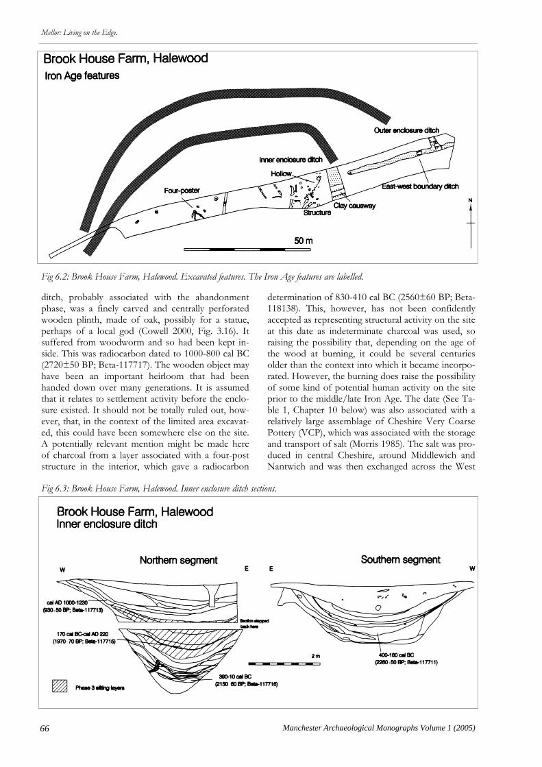
66 Manchester Archaeological Monographs Volume 1 (2005)
Mellor: Living on the Edge.
ditch, probably associated with the abandonment phase, was a finely carved and centrally perforated wooden plinth, made of oak, possibly for a statue, perhaps of a local god (Cowell 2000, Fig. 3.16). It suffered from woodworm and so had been kept in-side. This was radiocarbon dated to 1000-800 cal BC (2720±50 BP; Beta-117717). The wooden object may have been an important heirloom that had been handed down over many generations. It is assumed that it relates to settlement activity before the enclo-sure existed. It should not be totally ruled out, how-ever, that, in the context of the limited area excavat-ed, this could have been somewhere else on the site. A potentially relevant mention might be made here of charcoal from a layer associated with a four-post structure in the interior, which gave a radiocarbon
determination of 830-410 cal BC (2560±60 BP; Beta-118138). This, however, has not been confidently accepted as representing structural activity on the site at this date as indeterminate charcoal was used, so raising the possibility that, depending on the age of the wood at burning, it could be several centuries older than the context into which it became incorpo-rated. However, the burning does raise the possibility of some kind of potential human activity on the site prior to the middle/late Iron Age. The date (See Ta-ble 1, Chapter 10 below) was also associated with a relatively large assemblage of Cheshire Very Coarse Pottery (VCP), which was associated with the storage and transport of salt (Morris 1985). The salt was pro-duced in central Cheshire, around Middlewich and Nantwich and was then exchanged across the West
Fig 6.2: Brook House Farm, Halewood. Excavated features. The Iron Age features are labelled.
Fig 6.3: Brook House Farm, Halewood. Inner enclosure ditch sections.
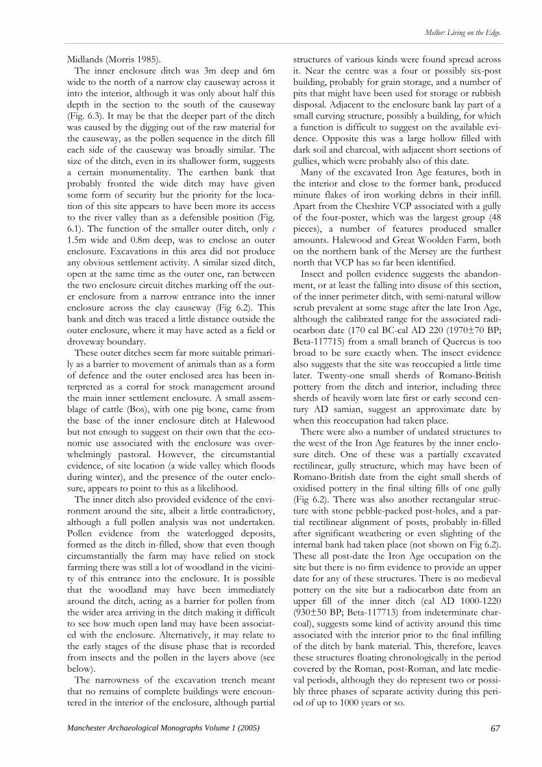
67
Mellor: Living on the Edge.
Manchester Archaeological Monographs Volume 1 (2005)
Midlands (Morris 1985). The inner enclosure ditch was 3m deep and 6m wide to the north of a narrow clay causeway across it into the interior, although it was only about half this depth in the section to the south of the causeway (Fig. 6.3). It may be that the deeper part of the ditch was caused by the digging out of the raw material for the causeway, as the pollen sequence in the ditch fill each side of the causeway was broadly similar. The size of the ditch, even in its shallower form, suggests a certain monumentality. The earthen bank that probably fronted the wide ditch may have given some form of security but the priority for the loca-tion of this site appears to have been more its access to the river valley than as a defensible position (Fig. 6.1). The function of the smaller outer ditch, only c 1.5m wide and 0.8m deep, was to enclose an outer enclosure. Excavations in this area did not produce any obvious settlement activity. A similar sized ditch, open at the same time as the outer one, ran between the two enclosure circuit ditches marking off the out-er enclosure from a narrow entrance into the inner enclosure across the clay causeway (Fig 6.2). This bank and ditch was traced a little distance outside the outer enclosure, where it may have acted as a field or droveway boundary. These outer ditches seem far more suitable primari-ly as a barrier to movement of animals than as a form of defence and the outer enclosed area has been in-terpreted as a corral for stock management around the main inner settlement enclosure. A small assem-blage of cattle (Bos), with one pig bone, came from the base of the inner enclosure ditch at Halewood but not enough to suggest on their own that the eco-nomic use associated with the enclosure was over-whelmingly pastoral. However, the circumstantial evidence, of site location (a wide valley which floods during winter), and the presence of the outer enclo-sure, appears to point to this as a likelihood. The inner ditch also provided evidence of the envi-ronment around the site, albeit a little contradictory, although a full pollen analysis was not undertaken. Pollen evidence from the waterlogged deposits, formed as the ditch in-filled, show that even though circumstantially the farm may have relied on stock farming there was still a lot of woodland in the vicini-ty of this entrance into the enclosure. It is possible that the woodland may have been immediately around the ditch, acting as a barrier for pollen from the wider area arriving in the ditch making it difficult to see how much open land may have been associat-ed with the enclosure. Alternatively, it may relate to the early stages of the disuse phase that is recorded from insects and the pollen in the layers above (see below). The narrowness of the excavation trench meant that no remains of complete buildings were encoun-tered in the interior of the enclosure, although partial
structures of various kinds were found spread across it. Near the centre was a four or possibly six-post building, probably for grain storage, and a number of pits that might have been used for storage or rubbish disposal. Adjacent to the enclosure bank lay part of a small curving structure, possibly a building, for which a function is difficult to suggest on the available evi-dence. Opposite this was a large hollow filled with dark soil and charcoal, with adjacent short sections of gullies, which were probably also of this date. Many of the excavated Iron Age features, both in the interior and close to the former bank, produced minute flakes of iron working debris in their infill. Apart from the Cheshire VCP associated with a gully of the four-poster, which was the largest group (48 pieces), a number of features produced smaller amounts. Halewood and Great Woolden Farm, both on the northern bank of the Mersey are the furthest north that VCP has so far been identified. Insect and pollen evidence suggests the abandon-ment, or at least the falling into disuse of this section, of the inner perimeter ditch, with semi-natural willow scrub prevalent at some stage after the late Iron Age, although the calibrated range for the associated radi-ocarbon date (170 cal BC-cal AD 220 (1970±70 BP; Beta-117715) from a small branch of Quercus is too broad to be sure exactly when. The insect evidence also suggests that the site was reoccupied a little time later. Twenty-one small sherds of Romano-British pottery from the ditch and interior, including three sherds of heavily worn late first or early second cen-tury AD samian, suggest an approximate date by when this reoccupation had taken place. There were also a number of undated structures to the west of the Iron Age features by the inner enclo-sure ditch. One of these was a partially excavated rectilinear, gully structure, which may have been of Romano-British date from the eight small sherds of oxidised pottery in the final silting fills of one gully (Fig 6.2). There was also another rectangular struc-ture with stone pebble-packed post-holes, and a par-tial rectilinear alignment of posts, probably in-filled after significant weathering or even slighting of the internal bank had taken place (not shown on Fig 6.2). These all post-date the Iron Age occupation on the site but there is no firm evidence to provide an upper date for any of these structures. There is no medieval pottery on the site but a radiocarbon date from an upper fill of the inner ditch (cal AD 1000-1220 (930±50 BP; Beta-117713) from indeterminate char-coal), suggests some kind of activity around this time associated with the interior prior to the final infilling of the ditch by bank material. This, therefore, leaves these structures floating chronologically in the period covered by the Roman, post-Roman, and late medie-val periods, although they do represent two or possi-bly three phases of separate activity during this peri-od of up to 1000 years or so.

68 Manchester Archaeological Monographs Volume 1 (2005)
Mellor: Living on the Edge.
Duttons Farm, Lathom, West Lancashire The other recently excavated site in the region ap-pears to be of a different type to that outlined above. This site, at Duttons Farm, Lathom lies in an area of farmland that today is grade 1 arable. It occupies a small patch of c 20ha of well-drained late glacial Shirdley Hill Sand, which probably included a now dry spring close to a pond, at a height of c 17m AOD (Fig. 6.4). It is surrounded on three sides by heavier clayland and to the north-east lies a former mossland. The site was first recognised when a gas pipeline was constructed in 1998. Excavations have taken place since 1999 by NML Field Archaeology Unit, largely as a series of training excavations for students from Liverpool University and local people (Cowell 2003). The main trench contains up to four adjacent roundhouses (Fig 6.5). The largest house, 10.5m in diameter, has a double entrance on an east-west axis and a large central stone packed post-hole, out of which the post had been subsequently extracted and then the cavity packed with clay. The outer gully has produced two radiocarbon dates of 195 to 5 cal BC
(2090±40 BP; Beta-153894) and 170 cal BC to cal AD 410 (1890±120 BP; Beta-153893). The only Iron Age pottery (Ann Woodward pers. comm.) from the site consists of two rim sherds from the terminal of the gully marking the eastern entrance, which tends to support the 1st or 2nd cen-tury BC date for the structure. The roundhouse was constructed over an earlier, dismantled four post-structure, inferring an earlier origin to the settlement. A late prehistoric beehive quernstone, made from central Pennine Millstone Grit, probably from near Sheffield, came from the original gas pipe-line close to where the excavations subsequently located the main house (Brooks 1999). To the west of the house lies a four post structure and a number of pits which respect the entrance way to the house, which may suggest that they are con-temporary. Adjacent to the house on the south are a series of undated shallow ditches, which may be part of small plots or paddocks, which stratigraphically predate a Romano-British trackway (Fig 6.5). The second, undated, house lying to immediately to the west of the pits is only fragmentary but does not
Fig 6.4: Duttons Farm, Lathom. Location of excavated trenches.

69
Mellor: Living on the Edge.
Manchester Archaeological Monographs Volume 1 (2005)
appear to have been as substantial as the others. The outer wall may have been constructed of stakes, which are aligned on short sections of gully at the eastern entrance, without evidence for an outer encir-cling gully. It appears to have been rebuilt or sub-stantially repaired on two occasions from the disposi-tion of internal post-holes. This building is probably earlier than both a circular house of c 8m diameter to the west, and fragments of a possible earlier house, which the latter essentially replaced almost on the same spot. The earlier of these two may also have seen a phase of rebuilding. These houses had been substantially destroyed by two intersecting post-medieval field boundaries but neither appeared to have an entrance on the eastern side. The final house in this sequence was abandoned in the late 1st or 2nd century AD, with several sherds of local oxidised ware pottery found in the burnt fill of the outer gully. An area of c 0.5ha has been excavated in total on the site but there is no trace yet of an enclosure ditch around the Iron Age settlement, as at Brook House Farm. There is a 50m length of ditch, 1.3m wide and 0.4m deep running east-west less than ten metres to the south of the roundhouses (Fig. 6.5). There are indications that a wooden palisade or large fence may have accompanied, or perhaps more likely preceded, the digging of this ditch. However, neither the dating nor function of these two features is clear yet, other than that the ditch stratigraphically pre-dates a Ro-mano-British trackway. The smaller ditches of the potential plots are bounded by this larger ditch on the north, and 20m to the west a further short length of a shallow north-south aligned ditch joining it from the south, suggests the larger ditch may mark a land
division rather than an enclosure ditch. Animal bones do not survive in the acid sand sub-soil of the site and relatively extensive sampling of the house-gullies, pits, and ditches has not produced evidence of burnt grain, so it is difficult to identify where the balance lay between arable and pasture on the farm. However, in the absence of direct palaeo-environmental evidence, the four-posters, quern, and the location and topography of the site gives the po-tential arable component a visibility that is not as evident at the Brook House Farm site. A 35m stretch of two essentially parallel linear pit alignments, 25m apart, which head towards the for-mer spring, is also a feature of the area to the south of the Iron Age farm (Fig 6.6). The Lathom feature is undated and this is the first of its type in the region but national analogy suggests that such features very often originate in the earlier part of the late prehis-toric period, where they mark divisions of land and route-ways, and sometimes may have had symbolic roles (Thomas 2003). Often they stand at the head of a sequence of development that leads to settlements and field boundaries as land was divided up during the late Bronze and Iron Ages (Powlesland 1986). It is difficult to interpret the status of the people farming this site, as it does not appear to have been expressed through material culture. Only one pottery vessel is represented on the site, and it is not clear if this has been made locally as it falls within the tradi-tion found throughout the West Midlands (Ann Woodward pers comm.) Salt-containing briquetage, such as VCP, has not been found on the settlement, unlike at Brook House Farm. As mentioned above, the Iron Age roundhouse settlement continued into the 1st or 2nd century AD
Fig 6.5: Duttons Farm, Lathom. Iron Age settlement and enclosure features.

70 Manchester Archaeological Monographs Volume 1 (2005)
Mellor: Living on the Edge.
before probably being abandoned, when the area became part of a Romano-British field system (Fig 6.6). This consists of several trackways in trenches IV and IX and less well-dated, but potentially Romano-British, fragments of gullies and pits in trench XI, which currently do not appear to be settlement fea-tures. An assemblage of 98 sherds of Romano-British pottery including Black-burnished ware, Oxfordshire ware, samian and local sandy oxidised wares, proba-bly from Wilderspool, along with tile, possible struc-tural stone, and a late 1st-early 2nd century AD hoard of silver coins has come mainly from the trackways. The building associated with this agricul-tural landscape has not yet been found, although sev-eral concentrations of surface Romano-British pot-tery elsewhere in the field could be related to the lo-cation of settlement activity during this time. The Late Prehistoric Context The section below distinguishes the pattern of Iron Age settlement from that of the Romano-British pe-riod, or indeed what can often only be described as late prehistoric/Romano-British, in an attempt to facilitate in the long term the study of each period in its own right, the better to identify the impact on the prehistoric landscape of new political, social, and economic realities associated with imperial conquest. A comprehensive regional study of the Iron Age has been presented elsewhere, incorporating a full range of evidence, including artefacts, earthwork, and cropmark sites. This is used as the basis for a theoret-ical study of Iron Age social organisation. It is em-phasised that this does not make any claims for the ‘truth’ of the data but should be used as a basis for
further fieldwork to test the interpretations (Matthews 2002, 30). This study is largely Cheshire based and so this section takes the opportunity to integrate the more northerly evidence. It looks only at sites of the Iron Age and only sites that can, through excavation, be securely placed in the period and emphasises a few of those areas where under-standing of the regional data needs improving if the existing social models are to be confidently accepted. The area between the Ribble and the Mersey (and even as far north as the Lune) has few excavated sites of the late prehistoric period, with only six settle-ments, including the two outlined above, confirmed by excavation as being of this date (Fig 6.7). Of the others, Great Woolden Hall lies about 25km to the east of the Brook House Farm, Halewood, settle-ment, to which it is similar in form (Nevell 1999a; see below Chapter 10). It lies in a similar location, at an altitude of c 16m AOD, with an enclosure of c 1.1ha on a promontory created by a meander in the Glazebrook, a minor tributary of the Mersey. It, likewise, has a double cir-cuit of ditches, although here they are only c 5-7m apart, compared to the 18-45m of Halewood (Fig 6.8). Additionally, they are only about half as wide and half to a third as deep as the inner ditch at Hale-wood. Two roundhouses were excavated and the site produced several types of pottery, one form of which may be late prehistoric and several early Romano-British types, with radiocarbon dates spanning the period from the end of the Iron Age into the early Roman period. As at Brook House Farm, Halewood, late prehistoric Cheshire VCP was also found in some quantity. The site of Portfield, Whalley, Lancashire has seen
Fig 6.6: Duttons Farm, Lathom. Prehistoric and Romano-British excavated features.

71
Mellor: Living on the Edge.
Manchester Archaeological Monographs Volume 1 (2005)
a number of small-scale archaeological investigations over a number of years, often in response to epi-sodes of pipe-laying across the site (Beswick & Coombs 1986). A late Bronze Age metalwork hoard, found during one pipe-laying episode, may suggest a date for its origins, although it cannot be directly as-sociated with any structural component of the site (Longworth 1967). The site consists of an enclosure of 1.4ha lying on a hill at 110m AOD overlooking the Calder valley, a tributary of the Ribble, on the western fringes of the Pennines (Fig 6.8). A large earthen rampart, c 6m wide, with outer ditch and counterscarp bank, now destroyed, existed only on the northern, fairly gentle, slope of the hill. The east-ern side, which is overlooked by higher, sloping land, has largely been lost to post-medieval settlement fea-tures, while the western side is marked by a sheer, natural drop and the second steepest slope, on the south, has a slight earthen bank part way down the slope. The rampart sequence is imperfectly understood but tentatively is suggested as developing from a stone rampart, possibly with some form of timber strengthening, to the main stone-faced earthen dump rampart, without ditch, to the addition of the outer ditch and counterscarp bank, although the several unrecorded disturbances to the site have made this difficult to prove. There is also another site in a western Pennine fringe location, at Castlesteads, Bury (Fig 6.8), shown to have been of Iron Age date. It lies at 114m AOD and covers slightly over 1ha of a promontory over-looking the river Irwell that is cut off by a ditch c 10 m wide and c 2m deep located through geophysical survey and auguring on its eastern side (Fletcher 1986). Pottery, associated with a radiocarbon date of 260-120 cal BC (Beta-58077) subsequently came from the site (Nevell 1999a, 60). The site of Castercliff, near Nelson, Lancashire, c 15km to the east of Portfield, is in a rather different upland topographical location, lying on the western edge of a hill at c 270m AOD in the Pennines. Its form is also somewhat different with an inner en-closed area of c 0.8ha lying within two concentric earthen ramparts, c 6m apart, and traces of a possible third incomplete rampart outside on the east. This gives a total area of c 2.2ha (Fig 6.8). The inner ram-part consisted of a stone bank with timber revetment that had been burnt. The outer rampart, which fol-lowed the same line but was unfinished, had an ac-companying ditch 1.3m deep and 7m wide, with wooden palisade 3m outside the ditch. Inside the ditch the clay bank was box-frame timber-revetted. Two radiocarbon dates, one from each rampart, pro-duced statistically identical determinations of 810-480 cal BC (89% certainty) (no Lab.references). This site is similar in construction to a type of double-palisaded enclosure found in northern England and
Scotland, rather than to Portfield (Coombs 1982). There are a number of other sites which are includ-ed within discussions of the regional Iron Age, but for which the evidence is less firm (Matthews 2002; Nevell 1999b). These include Rainsough, between Manchester and Bolton, where eight sherds of pot-tery from one vessel, that may be either late prehis-toric or early Romano-British in date, were found with a relatively large Romano-British pottery assem-blage, which probably came from a destroyed earth-work in the vicinity (Nevell 1994a). Another western Pennine fringe site at Werneth Low, consisting of a double ditched enclosure of c 2ha., lying at c 240 m AOD, may eventually prove to be of this date, but currently it is not independently dated (Nevell 1992). South of the Mersey there are several groups of sites for which an Iron Age context is confirmed by excavation (excluding Mellor). These may be broken down into three basic small groups. The first consists of two sites; Irby on the Wirral (Philpott & Adams 1999; forthcoming) and Bruen Stapleford, Cheshire (Fairburn 2003a), which may be open settlements, although interpretation should be tempered by the fact that less than 0.3ha was excavated at Irby and c 0.5ha at Stapleford. At Irby, there are traces of occu-pation based on scattered post-holes and two incom-plete sections of curving post-hole alignments, one of which is associated with a radiocarbon date of 410-200 cal BC (OxA-8485-6). A 3rd century steatite spindle-whorl also comes from the site, along with an assemblage of VCP, largely as residual material in Romano-British contexts. At Stapleford, a site on a low plateau at 41m AOD consists of six mainly cir-cular structures, with a late Bronze Age phase with three radiocarbon dates centring on the 9th or 10th centuries cal BC and a further phase with five radio-carbon dates falling between 400-170 cal BC and 120 cal BC-60 AD. Most of the structures were associat-ed with VCP. Other sites, sometimes included with this group, such as Tatton Park, Cheshire, provide less firm evi-dence for the Iron Age. Here a pit associated with a radiocarbon date of 800-120 cal BC (2340+-120 bp; HAR-5147) provides some environmental evidence of surrounding wood pasture several hundred metres away from the structural evidence of the main settle-ment, which largely consisted of a two rectangular buildings and a large palisade enclosure. However, although one building is associated with dates of 380 cal BC-AD 230 (HAR-4496) and 180 cal BC-AD 370 (HAR-5111) the excavator places the structure in the Roman or post Roman periods, on the basis of other dates associated with accompanying structural fea-tures and the fact that oak, potentially much older than the date when burnt, was used as a sample for the dates in question (Higham & Cane 1999, 45, 52-3). The other two groups of site consist of earthwork
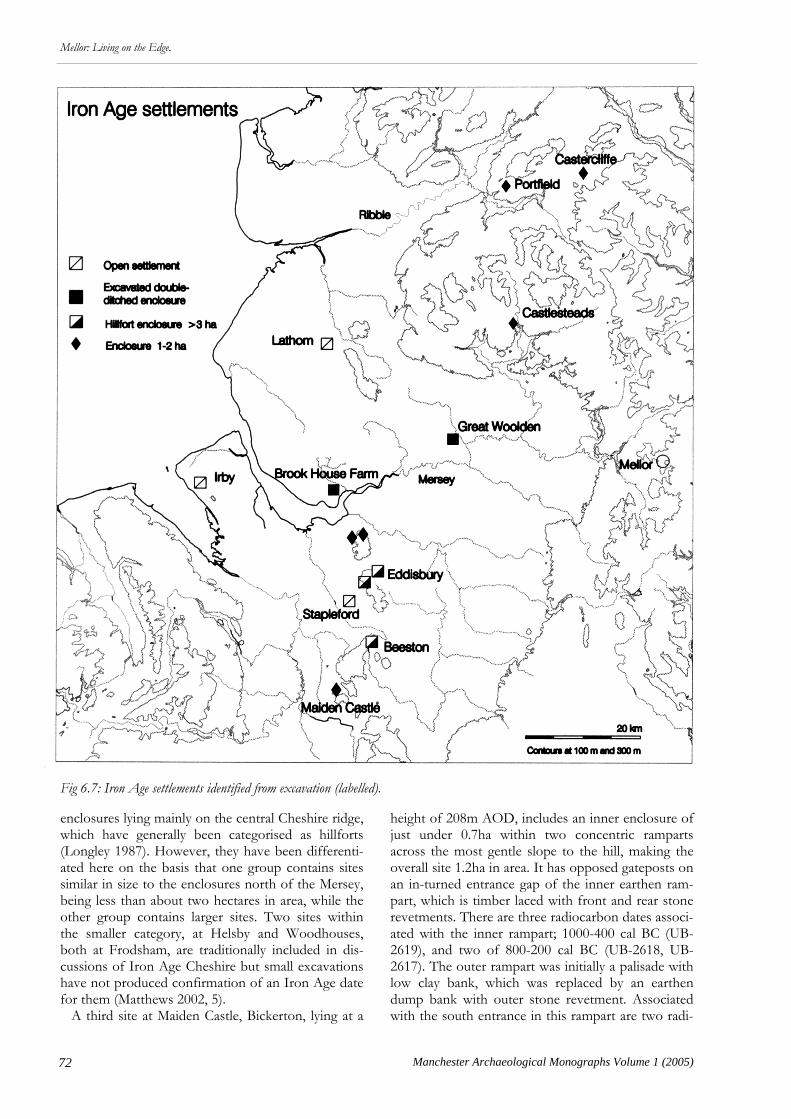
72 Manchester Archaeological Monographs Volume 1 (2005)
Mellor: Living on the Edge.
enclosures lying mainly on the central Cheshire ridge, which have generally been categorised as hillforts (Longley 1987). However, they have been differenti-ated here on the basis that one group contains sites similar in size to the enclosures north of the Mersey, being less than about two hectares in area, while the other group contains larger sites. Two sites within the smaller category, at Helsby and Woodhouses, both at Frodsham, are traditionally included in dis-cussions of Iron Age Cheshire but small excavations have not produced confirmation of an Iron Age date for them (Matthews 2002, 5). A third site at Maiden Castle, Bickerton, lying at a
height of 208m AOD, includes an inner enclosure of just under 0.7ha within two concentric ramparts across the most gentle slope to the hill, making the overall site 1.2ha in area. It has opposed gateposts on an in-turned entrance gap of the inner earthen ram-part, which is timber laced with front and rear stone revetments. There are three radiocarbon dates associ-ated with the inner rampart; 1000-400 cal BC (UB-2619), and two of 800-200 cal BC (UB-2618, UB-2617). The outer rampart was initially a palisade with low clay bank, which was replaced by an earthen dump bank with outer stone revetment. Associated with the south entrance in this rampart are two radi-
Fig 6.7: Iron Age settlements identified from excavation (labelled).

73
Mellor: Living on the Edge.
Manchester Archaeological Monographs Volume 1 (2005)
ocarbon dates of 770-400 cal BC (UB-2615) and 380-10 cal BC (UB-2614) (Forde-Johnston 1965; Mat-thews 2002, 38-39). The third group consists of three enclosures, dis-tinguished by their scale, being larger than three hec-tares, which might suggest they represent chronologi-cal, functional, or social differences from the previ-ous group (see below). Beeston Castle may be the largest, although the Iron Age ramparts have not been traced all the way around the hill, which stands out from the Cheshire Plain to a height of 160m AOD. The area enclosed may have been up to four hectares (Ellis 1993). The origins of the hillfort lie in the late Bronze Age, with a phase of rampart altera-tion and entrance modification in the early Iron Age and a phase of massive construction, consisting of a timber-framed stone-revetted rampart probably sur-mounted with a timber palisade. There are two blocks of radiocarbon dates associated with this phase, one with calibrated parameters lying between the 5th to 8th centuries BC and the other lying be-tween the 3rd and 4th centuries BC (Ellis 1993, 85; see below Table 10.1). To the north lies Eddisbury, at a height of 152m AOD. This site has two phases of rampart, which eventually enclosed c 3.5ha in area, with the earlier phase being c 2.8ha (Varley 1950). It has a double circuit of bank and ditches, with very steep west and north sides, while the other two sides are relatively steep. Features associated with the ram-parts and entrance are paralleled widely in dated sites in the Welsh Marches and north Wales and strongly argue for an Iron Age date for this site. There is also a sherd of an early form of pottery from the site (Matthews 2002, 13). Another site traditionally regarded as Iron Age, at Kelsborrow Castle, Kelsall, occupies a promontory, which is cut off by a single arc of bank and ditch, enclosing an area of 3.3ha, but no positive Iron Age evidence has come from it. It is worth noting here, perhaps, those sites cur-rently included in existing theoretical models but for which further work is still needed before they can be used as such confidently (Matthews 2002; Nevell 1999a;b). These include a number of enclosures of various types. One group is represented by the low-land curvilinear enclosures, recognised largely through aerial photography. The excavated site at Legh Oaks near High Legh, Cheshire, is used as the type-site for this group but it has no independent evidence that associates it with the late prehistoric period, only the Romano-British period (Nevell 2002). Additionally, a number of unexcavated earth-work enclosures, around one hectare in area, lying between 20m and 75m AOD, including Oakmere, Bradley, Peckforton, and Burton Point are even more specifically suggested as being early Iron Age (Matthews 2002, 33). None, however, have inde-pendent evidence to warrant this yet.
It has been suggested that the large Cheshire hill-forts fell into disuse by the mid Iron Age to be re-placed by the smaller curvilinear enclosures of the late Iron Age (Matthews 2002, 8, 33; Nevell 1999b, 23). However, as outlined above, perhaps caution should be exercised in uncritically regarding this as orthodoxy, as it based on such a small body of rele-vant evidence. None of the smaller enclosures can be shown to belong to the middle or late Iron Age peri-od (sites in this category north of the Mersey are treated separately below), with only Stapleford, which has no evidence to show that it was enclosed, dated to this period; the larger hillforts, Beeston apart, have seen only limited excavation, and sites in general are often associated with radiocarbon dates with very broad probability ranges for individual determina-tions, such as at Maiden Castle at Bickerton. There-fore, the theory that these hillforts (with their limited history of investigation) all have such straightforward histories as is suggested in the standard interpretation of early origin and early demise, needs testing further. Discussion The evidence on which to base firm conclusions about the Iron Age in the North West can thus be seen to be slight, serving to limit the confidence with which interpretations can be made. However, Mat-thews’ (2002) account of the social organisation of the region provides an interpretive framework for the period. Some areas of the evidence on which this was based that need to be tested further have been high-lighted above, while the following section offers some thoughts on these theoretical frameworks from a slightly more northern perspective. Models for the Iron Age are often discussed in terms of settlement and social hierarchies. In other parts of the country differences in status between sites are interpreted from the type and density of structures they contain, the overall layout and scale of storage facilities on site, the agricultural role a site might have played in relation to its hinterland, and the importance to it of imported and craft specialisa-tion goods (Hill 1996). In the North West, however, little of this kind of evidence exists because of the lack of excavation of the interiors of enclosed settlements, the lack of as-sociated environmental evidence, and the sparse ma-terial culture of the Iron Age. However, on the basis of the presence of Cheshire VCP, along with a num-ber of coins from Meols and two exotic drinking vessels from Cheshire, Matthews (2002, 27) argues for an archaeologically visible strand of prestige ex-change. This, he suggests, was likely to be controlled by a socially pre-eminent class in the North West, although without resulting in a strongly hierarchical settlement pattern. In regional settlement terms, the

74 Manchester Archaeological Monographs Volume 1 (2005)
Mellor: Living on the Edge.
main grounds for distinguishing potential social dif-ferences are restricted to the size of the enclosed area and possibly the nature of its boundaries. Rank size analysis, a geographical statistical method, can be used to reconstruct social patterns employing these kind of criteria, but a reliably representative data base of sites is needed (Ferrell 1997). This is not the case in this region and so interpretation has to be subjec-tive, and accordingly, less reliable. Cheshire lies at the northern end of Cunliffe’s (1995) ‘hillfort zone’, represented by the class of large, defended hill enclosure, which he interprets as elite centres for the redistribution of craft and agri-cultural goods. Others argue against a universal ex-planation for their function and, in Wessex for exam-ple, they have been seen as communal places for ei-ther permanent or occasional settlement in an essen-tially non-hierarchical society (Hill 1996). In Cheshire the large enclosures over 3ha in area, located in positions for which defence might be thought to have been an important consideration and exhibiting features such as special entrances and guardrooms ie. Beeston Castle and Eddisbury, are the ones that seem most relevant to this debate. The most extensively excavated hillfort in the county, at
Beeston Castle, belongs to a horizon marked in north Wales, the Welsh borders, and Derbyshire by late Bronze Age defended hill-top settlements that con-tinued as Iron Age hillforts (Musson 1991). It has been suggested that their origins may have lain in increasing territorality and competitive pressure on land, leading to social instability and the need for communal defence. Matthews (2002), whose argument is essentially derived from Cheshire, does note an alternative, but in his opinion less preferred, theory of social organi-sation based on a more egalitarian society with a shal-low hierarchical structure. This is a view promoted by Nevell (Nevell 1999a, 2004) who sees the North West as made up of a series of small independent family groups, based upon the distribution of the smaller enclosures under c 2ha. The Mersey probably marks the boundary between tribes recorded in the early Roman period as Brigantes to the north and to the south, in modern Cheshire, the Cornovii. Whether this had implica-tions for the nature of society in each area in the Iron Age is difficult to say, but coincidently or not, the area to the north of the Mersey appears to have a more restricted range of settlement types. The major
Fig 8: Enclosure types from the Iron Age.
75
Mellor: Living on the Edge.
Manchester Archaeological Monographs Volume 1 (2005)
difference is that the large hillforts do not occur here, suggesting the possibility that the areas north and south of the Mersey had different social systems dur-ing the Iron Age. There are sporadic instances of large hillforts around the margins of the northern region, such as on the southern edge of the Lake District at Warton Crag (Forde-Johnston 1965), alt-hough not independently dated to the Iron Age, and in the central Pennines at Aldmondbury, near Hud-dersfield (Varley 1976). These sites may have fulfilled a similar role to some of the large Cheshire examples but, if relevant, are so marginal to southern Lancashire that any influence they had would be expected to have been minimal, at the least. The smaller enclosures appear as the major site-type north of the Mersey, although open sites will always be underrepresented in the record because of the difficulties of recognition. The potential relation-ship between open and enclosed is touched on in a little more detail below. There is a tendency when interpreting late prehistoric settlements in the region to define them on topographic location, as if this might define function or status. However, if topo-graphic setting is ignored, the few enclosed sites so far investigated north of the Mersey have more simi-larities than differences. The size of sites such as Portfield, Brook House Farm, and Great Woolden is fairly similar, at less than 2ha in area, and perhaps the slightly smaller Castlesteads could also be included in this list (Fig 6.7). They all have significant enclosure ditches but their location suggests a defensive func-tion was less important than other factors. At Portfield the site is overlooked by higher ground, while the other sites lie in river valleys. This suggests their monumentality may have been geared at least as much to social factors as to defence. All three sites are also well placed to exploit good graz-ing land, either in valley or upland fringe locations, although this need not have been exclusively so, as Brook House Farm, for example, had evidence for a four or six poster building on site, which may have been a granary type structure. The form of the low-land sites, with their narrower outer enclosures also suggests livestock may have been an important fea-ture of their economy, although in neither case is the outer enclosure proven to have been in existence contemporary with the inner enclosure. However, livestock may have been one form of acquiring social status in the Iron Age (Matthews 2002, 25). The two double ditched enclosures adjacent to the Mersey have each produced Cheshire VCP, which is found in some quantity at the large hillfort at Beeston and forms an important part of Matthews’ (2002) prestige exchange model. Thus function, form, and economy may all have acted together to enforce a social statement. Alt-hough the evidence is circumstantial and needs test-
ing further, one reading of it could see these sites as representing a level of social hierarchy associated with the economic and social use of livestock, which has little to do with geography or topography but which reflects the abundance of good grazing land. This type of scattered, enclosed, settlement pattern might be interpreted as representing a series of strong, self-sufficient, independent family groups within a context of competition between social peers (Ferrell 1997). This element may be present south of the Mersey also but there is little settlement evidence for it yet, but assuming better chronological controls can be developed, the relationship to the large hillforts po-tentially presents an extra level of social complexity. And at the risk of falling into the trap that is being cautioned against, more speculatively, an extra level of complexity may be reflected in the second group of Cheshire enclosures, the smaller hillforts such as Helsby or Woodhouses (which are not yet proven to be Iron Age), that are paralleled in form and size north of the Mersey, but appear to be located in more impressive, and potentially more defensible, locations than the latter. Beyond potential differences in the levels of social complexity, a further difference between the two areas may also be vaguely discernible. Under the cur-rent interpretation, if the hillforts did go out of use during the middle Iron Age, regardless of whether they were elite residences or communal centres or a combination of the two, it would suggest that poten-tially significant social changes were taking place in Cheshire at around this time. However, north of the Mersey the smaller enclo-sures were a feature of the social landscape possibly in the late Bronze Age (Portfield), the early Iron Age (Castercliffe), the middle/late Iron Age (Brook House Farm, Castlesteads) and the late Iron Age (Great Woolden). It might be questioned that social organisation and resulting settlement forms stayed the same over the best part of a millennium, but the small sample available so far does suggest the possi-bility of a greater degree of social stability in southern Lancashire than is argued for in the southern part of the region. At the moment, therefore, north of the Mersey the smaller enclosures seem to represent the main level of settlement type, which might be taken to represent a broad socio-economic grouping of independent social peers involved in some degree of status dis-play. The Lathom site, however, appears different from these sites, although the scale of excavation is still not large enough to be absolutely certain that the excavations have not so far taken place within a still to be located enclosure. But, given the balance of probability at the moment, the settlement appears to be an open site, which may have had an appreciable
76 Manchester Archaeological Monographs Volume 1 (2005)
Mellor: Living on the Edge.
association with arable farming, although the envi-ronmental evidence is typically circumstantial; limited to a quernstone, two four-posters, and the current richness of the area for arable farming. It should also be noted that a relatively extensive programme of environmental sampling did not produce any evi-dence of cereal use on the site. The most similar site to Lathom in the region, at Stapleford, while producing some evidence for cere-als, shows that grassland was important around the mid- to late Iron Age settlement (Fairburn 2003a, 35-6), although the site lies on poorer land than at Lath-om. Salt-containing briquetage, such as Cheshire VCP, has not been found yet at Lathom. This sug-gests that either it did not lie within the sphere of Cheshire VCP distribution, which may not have ex-tended much further than the northern bank of the Mersey, or else, if VCP is linked with sites of a high order, then Lathom may not have enjoyed such sta-tus. A possible analogy, although on a far bigger scale and several centuries earlier in date, may be the Yorkshire site of Heslerton (Powlesland 1986). Here, an open settlement with a similar structure and on a similar geology is suggested as being a lower-order
farming site. This is largely on the basis of the range of imported goods found on two impressively sited, banked and ditched enclosures on the ridge over-looking the plain in which Heslerton lies, which are interpreted as being the higher order sites (Bevan 1997). Lathom is overlooked by the Parbold and Beacon Fell hill range, which lies about six kilometres to the east, reaching heights of over 100m AOD, but no earthwork sites have been identified here yet. In fact the only potentially higher order sites in the adjacent lowlands are, on this argument, those river valley sites such as Brook House Farm and Great Woolden, over 25kms away. It may be worth thinking of the possibility that this kind of hierarchical social rela-tionship may have existed on a larger regional scale in southern Lancashire, although a legitimate objection could be made that this may just as easily be a factor of the difficulties of site recognition producing wide-ly scattered evidence. However, it does serve to pose the question as to whether there is a group of poten-tially higher order, small, enclosure sites in the region and whether they are distributed evenly within the landscape or are a particular feature of certain areas, represented perhaps by good grazing land.

77
Mellor: Living on the Edge.
Manchester Archaeological Monographs Volume 1 (2005)
Chapter 7
Romano-British Rural Settlement in the Dee-Mersey Region
Some Themes
Rob Philpott
es on rural sites and those of urban or military settle-ment is stark and surface indications of rural sites may be confined to very dispersed pottery scatters consisting often of no more than a handful of sherds, and more subtle indicators such as concentrations of undiagnostic fired clay may be of as much use as pot-tery per se. Other artefacts such as coins or brooches are relatively scarce although on occasions low-level concentrations of metal finds have proved a valuable tool in site location. Even when the settlement nucle-us is known, the pottery scatters revealed in ploughed fields can be very thin. A substantial Ro-mano-British site at Court Farm, Halewood, was lo-cated through fieldwalking when the crop was high, and only narrow tramlines visible; three certain Ro-man sherds and a thin scatter of possible Roman pottery led to two phases of excavation over six months and the discovery of an apparently unen-closed Romano-British settlement. Subsequent searches through existing aerial photographs revealed no trace of the site. At Southworth (Fig 7.4) a large field containing an enclosure observed as a cropmark was fieldwalked, producing a scatter of 14 sherds of pottery outside the enclosure but nothing from the interior. The enclosure ditches and features subse-quently produced 2nd century Romano-British pot-tery in an evaluation. An important consequence is that the absence of Romano-British pottery from the surface of a field by itself cannot necessarily be taken to indicate that there is no site. The identification of pottery scatters is not helped in the region by their poor survival in the ground. The soft fabrics do not survive well in slightly acidic soils, while frost damage destroys the surface and renders them vulnerable to abrasion and obliteration in ploughsoil. Furthermore it is not always easy to distinguish Romano-British pottery from post-medieval unglazed wares. Collection strategies need therefore to take account of the nature of the materi-al. It means collecting every sherd and then assessing under good conditions where the fabrics can be ex-amined closely to see whether Romano-British mate-rial is present.
S ince the 1980s archaeologists have made an in-creasing effort to research the Romano-British
rural settlement of the lowland North West in an attempt to redress the overwhelming balance of at-tention in the region on military sites. Little work had previously been done in the area so the questions that were being posed were basic; where did people live in the Romano-British countryside, in what kind of settlements and what form did their houses take, what sort of activities took place in the countryside, what was the basis of rural economy, and when did their settlements originate. A number of researchers from several institutions in the region began to take an active interest in the subject and over 20 years have transformed our understanding of the rural population of the region. One such institution was National Museums Liverpool (formerly National Museums and Galleries on Merseyside) and the sites mentioned below are largely those investigated by the NML Field Archaeology Unit since the mid-1980s in the Dee-Mersey Basin. This article will touch on a few of the main developments and themes emerging from the last two decades’ work. The initial problem in researching the Romano-British countryside was fundamental, the great diffi-culty in finding rural sites in the region. A range of field techniques has been brought to bear on the problem of identifying and characterising Romano-British rural settlement in the region. Fieldwalking In many other areas of England scatters of tile and masonry found in fieldwalking can frequently be used as indicators of substantial Romano-British ru-ral buildings. However, in the lowland North West rural sites often prove virtually undetectable by field-walking. Substantial masonry buildings are confined largely to military and urban sites and are rare in the countryside, there being just one certain villa record-ed from Cheshire, at Eaton-by-Tarporley. Supposed-ly ubiquitous Roman pottery is not a prolific find in the region. The contrast between artefact assemblag-

78 Manchester Archaeological Monographs Volume 1 (2005)
Mellor: Living on the Edge
Chance Finds Some sites are coming to light through the steady accumulation of chance or metal-detector finds. In this regard, the Portable Antiquities Scheme is prov-ing of great value, particularly as the quality of infor-mation on findspots continues to improve so that developing patterns of findspots can be identified over time. The lowland North West is poor in finds by comparison with many areas of England. The fig-ure for Roman finds reported to the scheme from Merseyside and Cheshire between September 1997 and May 2004 show the great majority have been recorded from Cheshire (75%), which produced 476 of 639 Roman finds in the North West while only 19 finds (3%) were recorded from Merseyside, albeit a much smaller and more built up area. These should be compared with 3663 Roman finds from Hamp-shire alone, or 1111 from the West Midlands, in the period 2000-03 (PAS 2003, 66, Table 5). Even within the region, stark differences can be observed. There is for instance a sharp disparity in the volume of finds between Merseyside and Cheshire, with rela-tively few metal finds such as brooches and coins or other items from north of the Mersey. Whether this is a genuine reflection of a difference in the level of material culture either side of the tribal boundary between the Cornovii to the south and the Brigantes (or perhaps the tribal group of the Setantii) to the north or depends in part on the modern pattern of
metal-detecting and reporting is uncertain. Despite the relatively low volume of Roman finds, the Porta-ble Antiquities Scheme performs an invaluable ser-vice in creating a systematic record of finds from the region and in capturing information which because of its scarcity is of higher value for this materially impoverished area. Aerial Reconnaissance A programme of aerial reconnaissance in the region has been undertaken since 1987 by Dr Jill Collens and the writer, supported by English Heritage, Na-tional Museums Liverpool and Cheshire County Council. This has made some inroads into what had appeared to be a virtually blank landscape in terms of late prehistoric and Romano-British settlement. Alt-hough flight paths are inevitably constrained by fac-tors such as restricted air space, urban development, soil and drift geology and crop regimes, it has been the most successful technique so far in terms of the overall number of sites discovered. Many sites have been recognised from the air as enclosures, the buried ditches surrounding settle-ments showing up as cropmarks. Over 60 have now been recorded from the lowland North West. How-ever, by themselves the enclosures tell us little about their date or function, even though we may reasona-bly assume most are late prehistoric Iron Age or Ro-mano-British in date. Although aerial reconnaissance has produced most sites in total, relatively few of the sites which have actually been excavated in the region have been re-covered by aerial photography. A surprising number of Romano-British sites have turned up during exca-vation for other periods. At least eight sites which were examined for the presence of archaeological deposits of other periods (all but two later than Ro-mano-British), have Romano-British pottery or fea-tures or both. For example of nine sites in the Tar-bock/Halewood area, which covers 24km2, only four were discovered through aerial reconnaissance. The lessons for the researcher into late prehistoric and Romano-British settlement in the region is that no one approach by itself is sufficient. It is the use of a combination of archaeological techniques, allied with improvements in our understanding of the sub-tle indicators of settlement characteristics of this re-gion, which has brought to light a substantial increase not only in the number of known sites but also in our understanding of their character and landscape context. An integrated approach is required to pull together information from several different sources. In addition, place and field names, metal detector finds and studies of soils and topography are able to contribute towards an understanding of the way the landscape was settled and used during the late prehis-toric and Roman periods.
Fig 1: The lowland North West showing forts, set-tlements, and excavated sites mentioned in the text.
79
Mellor: Living on the Edge.
Manchester Archaeological Monographs Volume 1 (2005)
Enclosures Although the Iron Age in the region has been dis-cussed elsewhere in this volume by Ron Cowell (see above Chapter 6), in effect the settlement pattern is indivisible from that of the Roman period and some brief comments are essential. Settlement in the Iron Age has proved even more elusive than that of the Roman period. Apart from the obvious hillfort sites of the Central Cheshire ridge, few sites are known. In the absence of significant quantities of pottery, coins or other metalwork which might be revealed through field walking or metal-detecting, settlement sites are hard to locate. Most known Iron Age sites take the form of enclosed settlements, surrounded by a single or double bank and ditch. The means by which these have been located is instructive for future develop-ment control measures, although serendipity has also played a significant role. Of six excavated sites, at Great Woolden Hall, Brook House Farm in Hale-wood, Brook House in Bruen Stapleford, Mellor, Irby, and Lathom, two were located in monitoring pipeline developments, one during excavation of a Romano-British site found in a housing develop-ment, two through aerial photography, and the last, Mellor, by the application of the principles of aerial photography by the somewhat more economical means of observation from an upstairs window! A few trends are beginning to appear. One feature of at least two certain Iron Age sites is the use of curvilinear double-ditched enclosures, which occur at Brook House Farm in Halewood and Great Woolden Hall. Although inevitably speculative, the presence of undated sites of broadly similar form, two in the Dee Valley and another in the Weaver, may indicate a similar date in the Iron Age. These sites share the characteristic of widely spaced ditches enclosing be-tween them a substantial area. At Brook House Farm ditches were apparently used to subdivide this curv-ing strip of ground. It is tempting to see these as ani-mal corrals, divided up to protect and control live-stock for sorting and breeding. Six sites of this kind have been located so far in the lowland North West. Deep ditches and massive banks not only require a considerable investment of time and labour to con-struct but also represent a conspicuous and visually impressive homestead. Whatever their defensive function, such earthworks reinforced the status and power of the occupant in the eyes of the visitor, while the emphasis on animals is consistent with the forms of wealth in many tribal societies. However, it should be stressed that we have no confirmation of the chronology yet at most sites. The location of some sites by meres in the case of probable prehistoric enclosures at Oakmere and Peckforton in Cheshire places an emphasis not so much on ‘defence’ but on access to water, whether this is for practical purposes such as watering live-
stock, or food resources such as fish and wildfowl, or for the simple reason that water is essential to life. It has been suggested that these sites are Iron Age in date (Longley 1987) but neither of the two men-tioned has been investigated so the dating is specula-tive. Other enclosure sites lie in river valleys, or close to streams, including examples in the Wirral and Sef-ton districts of Merseyside, and the same access to water for farms with a pastoral element may deter-mine the site location. For the Roman period there are some similarities with what have tentatively been identified as Iron Age enclosures. As with the Iron Age many people in the Romano-British countryside lived in discrete set-tlements usually enclosed by a ditch and bank. The ditched enclosure is almost certainly in this lowland zone the habitation element of an integrated settle-ment such as those we can see preserved in the up-land zones by their marginal location (e.g. Roystone Grange, Derbyshire). They take a variety of forms and at present it is uncertain how consistently these differences correlate to their function or date. Single-ditched curvilinear sites are consistently found with Romano-British pottery or other finds in Merseyside but one has produced Iron Age pottery in fieldwalk-ing. The small rectangular or square enclosures have in some cases produced Romano-British finds and in two cases may have had relatively short-lived occupa-tions in the 2nd-3rd century AD. These may be a secondary stage of colonisation in the landscape, fill-ing in the gaps between sites already in use. Early indications of an emerging settlement pattern suggest a widespread population thinly but extensive-ly scattered. That the true density of settlement may be masked to some extent is suggested by the discov-ery at Court Farm, Halewood, of an unenclosed Ro-mano-British settlement. Not only is the settlement pattern more varied than we yet recognise but also that some sites will lack the cropmark signature of enclosure ditches, rendering them invisible from the air. Whether rural settlements become more numerous in the Roman period, as appears to be the case, they certainly see an increase in visibility over the Iron Age as the spread of Roman material culture has an impact on the economy of the farmsteads, introduc-ing coins, metal items and pottery, albeit in relatively modest quantities. The areas where these settlements are appearing from aerial reconnaissance reflects in part the presence of drift geology and soils conducive to cropmark formation and also the routes taken by aerial photographers; much is obviously lost to the urban development. However, one main achieve-ment has been to demonstrate a strong settlement pattern in the Mersey valley and the valleys of its trib-utaries, the Newton Brook, Sankey, Glaze Brook and Ditton. For instance there are nine sites located in the Tarbock/Halewood and the Dee and Weaver

80 Manchester Archaeological Monographs Volume 1 (2005)
Mellor: Living on the Edge
valleys have also produced a number of new sites. This demonstrates not only that they were located on lighter soils that tend to produce cropmarks, so they become archaeologically visible, but perhaps also that these areas were relatively well settled on account of the topography. It is interesting to note that pairs of enclosures occur at several locations and the close proximity may represent neighbouring sites, perhaps indicating the division of land units through partible heritance, or successive sites due to a shift in the set-tlement nucleus through time. The interpretation of such pairs must await detailed investigation. Enclosed or unenclosed, the settlements were al-most certainly associated with arable fields, pasture some of which may have been enclosed, by wood-land managed for timber, by meadow land, and by resources such as heath, woodland, or marshland, each of which had its economic value but were less tightly managed than the labour-intensive arable. At present we cannot yet see much in the way of field systems as the landscape does not seem to have been visibly partitioned across extensive swathes of land in the manner familiar in south or east Yorkshire or Nottinghamshire (Riley 1980). However occasional hints of field ditches are re-covered as at sites in the Dee Valley or beside Brook House Farm, Halewood, where a probable Romano-British ditch runs towards the Iron Age enclosure. Hints of probable ancient field systems have been traced in the vicinity of other discrete enclosures in the Dee valley, in mid-Cheshire and in the Mersey valley. Ploughmarks sealed under Romano-British structures at Court Farm, Halewood, suggest the en-croachment of settlement over former arable land. During the Roman period the lowland North West experienced a significant increase in population through an influx of soldiers at the occupying garri-sons, perhaps accompanied by deliberate colonisa-tion by Britons or settlers from further afield. This without doubt resulted in some clearance and expan-sion to areas previously unfarmed. In Roman Britain more widely the picture of Romano-British settle-ment in the south and east of England or the Mid-lands suggests a far greater density of settlement than was realised even thirty years ago, with sites every few hundred metres in some favoured areas. This region will perhaps never match that density but in certain intensively studied areas, such as west Wirral, the Tarbock-Halewood area, and the Winwick area, sites are appearing at about 2km intervals. These are in areas which do not necessarily have the best quali-ty land but which have received intensive study from archaeologists and where soils are fairly productive for aerial photography. The broader picture from aerial reconnaissance lacks definition and detail. The chronology is poorly understood and there is a danger of hypotheses or speculation hardening into ‘fact’ through constant
repetition. Sites revealed as cropmarks without fur-ther investigation lack dating evidence or control, and by themselves provide no evidence of chronolo-gy, function or structures. For this we need to turn to excavation on individual settlements, and here the quality of the information available increases dramati-cally, but then so does the cost and the effort of ex-tracting the information. Individual sites The value of excavation is that it can yield a detailed picture of the development, sequence of occupation and activities at individual settlements. Sites excavat-ed in the last few years have shed considerable light on the problems of understanding the rural scene. Nonetheless the data-set of excavated rural sites re-mains small and the wide variation between sites makes it difficult to map out consistent trends. Three sites are considered briefly to illustrate the variety of site types and settlement histories. On ex-cavation, several Romano-British sites in the lowland North West have revealed an Iron Age phase of oc-cupation. It is rarely possible, however, to obtain the closely dated sequence of structures or deposits which can demonstrate unequivocally continuous occupation from Iron Age to Romano-British. Given the notorious problems of radiocarbon dating for much of the Iron Age, and the lack of diagnostic, durable, or datable artefacts on Iron Age sites, it is rarely possible to anchor sequences or deposits to precise dates. The identification of a sequence of roundhouses rebuilt on the same site at Lathom is a rare exception, with radiocarbon dates and pottery suggesting a late Iron Age date in the earliest house and a sherd of Romano-British pottery in the latest, which argues cogently for a sequence of houses span-ning the late Iron Age-Roman transition (see above Chapter 6). The significance of the pattern elsewhere - whether it be continuous occupation or re-occupation after an interval - is less clear. On the one hand it could be argued they represent occupation of ancestral farms by lineal descendants over centuries but on the other hand it is possible, where there appears to be a break in occupation, that they represent land or estates tak-en over by incomers at the instigation of the Roman administration. As the general impression in the Dee-Mersey re-gion is of a landscape operating at below capacity, with little pressure on land as a resource, the suspi-cion is that they are more likely to indicate long-term stability of land ownership within kinship groups. The analogy of medieval settlement is instructive here; many landowners in the region in the 18th cen-tury could trace their holdings back to estates occu-pied by their ancestors centuries earlier in the medie-val period.

81
Mellor: Living on the Edge.
Manchester Archaeological Monographs Volume 1 (2005)
Irby, Wirral The site at Mill Hill Road, Irby was long-lived, with a mid-Bronze Age phase of occupation or activity, fol-
lowed by an Iron Age phase evident from radiocar-bon dates and finds (Philpott & Adams in prep.). The finds comprised a steatite spindle whorl, found in the wall of a medieval structure, and dated on sty-
Fig 7.2: The gully of a Romano-British roundhouse under excavation at Irby, Wirral.

82 Manchester Archaeological Monographs Volume 1 (2005)
Mellor: Living on the Edge
listic grounds to the 3rd century BC, nearly 500 sherds of Cheshire stony VCP, and a La Tène iron brooch from a post-hole fill which produced two identical radiocarbon dates of 410-200 cal BC (Philpott & Adams forthcoming). Despite this, the duration of the Iron Age occupation is uncertain and the structures of this period are difficult to define amid a mass of intercutting post-holes. The sheer quantity of features renders spatial pat-terning very difficult to apply, and the phasing is ren-dered problematic by the difficulty of recognising the level from which the post-holes were cut. Most be-came obvious only when the packing stones which were used to stabilise the post were exposed (Fig 7.2). At Irby the development of the site during the Ro-man period is much clearer, with an initial palisaded enclosure being replaced by a ditched subrectangular enclosure. This was then expanded by the addition of a further ditched enclosure. Circular buildings occur in the earlier part of the Romano-British sequence within the appended enclosure, one certainly no earli-er than the early 2nd century AD in date. A succes-sion was noted of at least two clearly identifiable structures each about 11m in diameter replaced on the same spot, probably with others which cannot now be defined due to the mass of intercutting post-holes within a confined area of the site. The second clearly defined building of the sequence was in fact polygonal in plan, probably constructed with post-holes and straight panels set in a gully. Finds are few but the first roundhouse probably dates to the 2nd or 3rd century AD, while the second perhaps as late as the 4th century AD, though the stratigraphy is not as clear-cut as one would like. Such circular buildings were typical of the Iron Age elsewhere in Britain, but here in the North West, as in other less developed areas of Britain, they contin-ued in use through much of the Roman period. The final two Romano-British phases saw the in-troduction of rectangular buildings, one constructed with gullies, and may have survived into the 4th cen-tury AD and beyond. Curvilinear buildings previously considered to be Roman in date (Philpott & Adams 1999) have now been assigned to the Norse period on stratigraphic and typological grounds. Definable occupation in the Romano-British peri-od begins with South Gaulish samian pottery of the late 1st century AD, followed by a wider range of 2nd century AD wares, including Cheshire Plains orange and grey ware, samian and other introduced wares from Britain and the continent. The finds indi-cate occupation continued to the late 4th century AD and probably beyond. Although the presence of traded wares indicates participation in the market economy from the late 1st century AD, coins are few and do not make an ap-pearance until the AD 270s.
Court Farm, Halewood The settlement at Court Farm, Halewood differs from most others in the region by virtue of the fact it has no enclosing ditch but from its open, extensive, character and number of buildings rather resembles a hamlet or small village (Fig 7.3). Apart from a single possible sherd of VCP there is no evidence of pre-ceding Iron Age occupation. Indeed the presence of VCP may indicate that this form of salt container continued to be used into the early Roman period rather than suggesting an Iron Age date for the site. The pottery and other finds suggest that occupation lasted from the 2nd century AD to at least the mid 4th century AD. A total of about 20 buildings were identified. They include rectangular post-built structures and four-post structures of a type often interpreted as grana-ries. However, most common on the site is an unusu-al form of subrectangular or curvilinear building plan with opposed entrances in the centre of the long sides, measuring from 12-15m long and dated to the 2nd-3rd century AD. The same plan can be seen in a building (2956) at Lousher’s Lane, Warrington, exca-vated in 1976, and dated to the late 2nd/early 3rd century AD. The structure is oval in plan measuring 17m x 8.5m with possible porch for central entrance. Burnt clay in the post-pits suggested it was a work-shop, and there is evidence of bronze-working close by (Hinchliffe & Williams 1992). A further example, at Brunt Boggart in Tarbock, was less well defined and was not dated but appeared to have the same form (Cowell & Philpott 2000, 122-4, Fig. 5.7). In the early phase at Court Farm a ditch was en-countered, possibly for an agricultural enclosure since all the structures lay outside the feature. Ploughmarks, also from an early, although undated, phase suggest the expansion of settlement over for-mer arable land. A series of pits include one with a well-defined shelf near the base identified as a water cistern, while others may have served as clay winning pits for daub. Industrial activities After an initial phase of military settlement dominat-ed by the legionary fortress at Chester and accompa-nied by other forts at Whitchurch, Middlewich, Northwich, and Manchester, the lowland North West developed into an industrial zone, probably supplying the northern frontier with manufactured goods and perhaps agricultural produce. A series of nucleated settlements, founded late in the 1st century AD, sometimes at fort sites, were heavily involved in in-dustrial production. Such settlements included Man-chester, Middlewich, Nantwich, Northwich, Wigan, and Wilderspool. They produced a range of manufac-tured items such as pottery, metalwork, or glass, as

83
Mellor: Living on the Edge.
Manchester Archaeological Monographs Volume 1 (2005)
well as salt-making in the brine-rich areas of Cheshire (Nevell 2004). Against this background of an indus-trial zone supplying the military in the frontier zone of the north, it comes as little surprise that the rural settlements of the region also began to see small-scale industrial activities, transferring the skills of the artisans of the ‘small towns’ to a rural context. Thus at Irby, Court Farm, and other fieldwalked sites in Wirral, crucibles or metalworking waste demonstrate the working of copper alloy, although few of the products survive on the sites. Similarly, iron smithing is attested at Halewood and Irby, the latter site pro-ducing a range of tools such as awls, a saw and nails, as well as hearth-lining fragments for high tempera-ture heating of iron to smith, and the slag from forg-ing and hammerscale from the same process. During the Roman period the sources of raw mate-rials were known and exploited within rural contexts. Coal from outcrops at Cronton was found at nearby Halewood, while the small outcrops at Neston in South Wirral provided fuel for ironworking at Irby. Local sandstone appears to have been quarried for quern manufacture at Irby, although a millstone grit quern at Halewood suggests trading the objects over distances of perhaps ten kilometres or so.
Rural activities also included spinning and weaving, while one site in Wirral across the Dee estuary from the lead-producing area of Flintshire appears to have engaged in the manufacture of spindle whorls and other lead items. Rural industry: Ochre Brook, Tarbock One unexpected aspect of industrial activity in the countryside was the discovery at Ochre Brook in Tarbock of evidence for roof-tile manufacture for a military client. The site appeared at first as a rectan-gular ditched enclosure containing a single Roman timber building. In the ditches, occupation deposits and in the silted bed of the adjacent stream were nu-merous fragments of Roman tile, including wasters and amorphous fired clay. Seven tegulae bore stamps, with two different inscriptions. Five bore a rare 20th legionary tile-stamp dated to the third consulship of Verus (ie AD 167) of which only two examples were previously known. The inscription is Tegula(ria) A(uli) Vidu(ci fecit), Vero III Co(n)sule Leg(ioni) XX, ‘the tilery of Aulus Viducus made this for the Twentieth Le-gion in the third consulship of Verus’ (Swan & Phil-pott 2000). The wording of the stamp, which very
Fig 7.3: Plan of all Romano-British and later features at Court Farm, Halewood.

84 Manchester Archaeological Monographs Volume 1 (2005)
Mellor: Living on the Edge
unusually gives the name of the individual and a date, should be taken as referring to the civilian firm of the Viduci, who were engaged in contract work manufac-turing tile on behalf of the legion. It has been sug-gested elsewhere that the Viducus named on the stamp is a member of a family which is recorded elsewhere as having been involved in the ceramics trade (Swan & Philpott 2000). The presence of a sty-lus as well as the tile stamps themselves demonstrates a degree of literacy amongst the workforce or own-ers. Significantly, the date coincides with the period immediately after the return of the XX legion to Chester from the Antonine Wall, when the unused barracks might be expected to require re-roofing. Significantly there are only roofing tiles and no flue tiles or bricks. The Ochre Brook site demonstrated that the relationship between natives and Romans in the countryside was complex and can throw up unex-pected connections. Agriculture and Crops Some indication of crop regimes has begun to accu-mulate for the rural sites in the region. Environmen-tal analysis of the Romano-British phases at Irby in-dicates the presence of cereal grains in a number of samples. Grains of barley, spelt, bread wheat, oats and possibly rye were all recorded, along with chaff from barley, oats and spelt. Weed seeds, heather and burnt peat were also noted along with seeds of
Prunus, oak charcoal and a hazelnut shell. The heather may have been used on the site as either bedding or thatching material. At Court Farm, Halewood, palaeo-environmental remains include one certain grain of emmer, but oth-erwise spelt or emmer wheat were noted. There is no certain barley though wild oats and rye were present. Pits and ditch fills at the site at Ochre Brook, Tar-bock contained hulled barley and spelt/bread wheat, as well as modest quantities of rush seeds, suggesting flooring material. There were also considerable quan-tities of grass taxa, possibly indicative of hay or of weeds within cereal crops (Huntley 2000). Animal bones are far less well preserved on the acidic soils of the region but cattle, pig, domestic chicken and sheep/goat are all attested, suggesting most farms practised a mixed farming regime. Economy The relatively low level of rural pottery use has been noted in the context of site location. However, with-in the region there is considerable variation. Within the Mersey-Dee Basin pottery assemblages are rela-tively large by comparison with those from rural sites in Cumbria or North Wales, and there seems little doubt that the presence of the legionary fortress and a group of industrial centres in Cheshire both made pottery available through the market place and also stimulated demand for its use. The fluctuation of
Fig 7.4: A Romano-British enclosure at Southworth evaluated in 1993.

85
Mellor: Living on the Edge.
Manchester Archaeological Monographs Volume 1 (2005)
fortunes of the nearby market or industrial centres will also have had an impact on the farms of their hinterland. In the Mersey basin the industrial settle-ment at Wilderspool flourished from the late 1st to early 3rd century AD after which there was a marked decline in activity into the 4th century AD, probably due to changes in demand from the northern military zone. The decline may have had an impact on the availability of manufactured items in the hinterland farms as the volume of material in circulation and of trade in the market must have been dramatically re-duced. The hinterland sites may not disappear but they tend not to produce the highly visible material in plentiful supply later than the 2nd century AD. Irby remains an exception to the decline in pottery use in the 4th century AD, maintaining its pottery supply into the later 4th century AD with calcite-gritted ware from east of the Pennines in the York-shire area. Irby was able to participate in a military and civilian supply network that included the long-lived Iron Age and Roman port at Meols, as well as the fortress at Chester. Proximity to Meols must ac-count for Irby’s high proportion of black-burnished ware, shipped along the west coast trade route from Dorset and occurring on site from the early 2nd to mid-4th century AD, though the presence of small quantities of traded wares from Oxfordshire and the Midlands indicates access to markets supplied over-land. Coins are not common in rural sites of the North West by contrast with areas of southern and eastern England where a single rural sites will produce sever-al dozen coins. In western Britain, in common with Wales and the North, coins are much less commonly used. Neither the Cornovii of Cheshire and Shrop-shire nor the Brigantes north of the Mersey minted coins and few Iron Age coins have been recovered from the region. The Portable Antiquities Scheme up to 2005 records only six Iron Age coins for the whole of Cheshire, while a similar number was rec-orded at Meols in the 19th century, but here includ-ing three Carthaginian staters of the late 3rd century BC. In the absence of a tradition, or habit, of coin use, traditional exchange mechanisms, barter, will have persisted. There appears to be a sharp contrast between the towns or military sites and rural sites in coin use and in the latter coins do not appear to have been lost in any quantity. At Irby, for example, the six coins date to the late 3rd and 4th centuries AD, when low value coins begin to circulate in large quantities. However, the presence of a number of hoards, such as the late 2nd century AD hoard of 80 coins at Tarbock and over 100 silver coins from Ottershead Farm near Lathom, suggests that the rural population did have the ability to accumulate wealth in monetary form. There is a suspicion that the low level of coin finds on rural sites is not a straightforward reflection of the
volume of coins in the possession of the rural popu-lation, but depends on the way in which the coins were used (or not) on rural sites. Coin loss is most common where the volume of transactions is high, as in markets or towns. It is a distinct possibility that most of the coins lost by the rural population (and therefore of coins available to be found by archaeol-ogists and others) actually took place in urban or market contexts. The End of the Story The end of Roman Britain is conventionally dated to the collapse of the Roman administration in AD 410. Whether this event caused any significant disruption to the rural economy is difficult to say but it seems inherently unlikely that all the rural sites of the region were immediately abandoned. Indeed it is likely that the farmsteads which had a largely subsistence-based economy, with little dependence upon the market economy, would be best placed to withstand the ad-ministrative hiatus. There is high potential for at least some of these sites to remain in use after the ‘end’ of the Roman period. What does decline dramatically in the immediate post-Roman period is the visibility of the settlements and their inhabitants. In a re-emergence of the prob-lem of site location for the Iron Age, early medieval sites are also very hard to identify. Both societies used little in the way of durable material culture, manufacturing neither pottery nor coins, and experi-enced a drastic decline in the use of manufactured goods such as brooches or other metal artefacts Despite the difficulties of identifying such sites, two excavated Romano-British sites in the region have produced potential deposits of post-Roman date. At Irby a structural gully probably from a rec-tangular building contained a mid-4th century AD coin but produced two radiocarbon dates which ex-tended as late as the 5th or 6th centuries AD (Philpott & Adams forthcoming). Furthermore, a Saxo-Norman spike lamp found in a different build-ing foundation gully demonstrated a 10th-12th centu-ry AD date for another structure on the site. At Court Farm, radiocarbon dating of wooden stakes in a pit which cut through the one Romano-British structure indicates re-occupation of the settlement site in the Anglo-Saxon period. The suspected pres-ence of post-Roman deposits was reinforced in one case and confirmed in the other by the use of radio-carbon determinations for stratigraphically late fea-tures. Radiocarbon dating is essential on the upper levels of apparent Romano-British settlements to identify such occupation phases, since the swamping effect of Roman pottery on sites, persisting as residu-al material through later levels, will frequently yield highly misleading dates for the later settlement. There is a growing pattern of Roman finds occur-
86 Manchester Archaeological Monographs Volume 1 (2005)
Mellor: Living on the Edge
ring on sites excavated for medieval remains, while the converse is also true - there is a consistent corre-lation between Romano-British sites occurring adja-cent to medieval ones. There thus appears to be some strong general continuity in settlement location within the landscape, perhaps related to the presence of good arable land, maintained over many centuries, with settlements drifting through time around a core of arable land. Conclusions Romano-British settlement in the Mersey-Dee Basin appears to have been extensive. In certain areas which have been subject to intense scrutiny, or where the soils are conducive to cropmark development, the density of settlements comes as something of a surprise as does the use in the Romano-British peri-od of soils and topography which looks unpromising. The aerial photographic work has produced a sub-stantial number of sites but the chronological control will remain poor until followed up by field investiga-tion and the need to guard against turning specula-
tion on the date and development of enclosures into hard fact is noted. Excavation yields high quality in-formation but will always be an expensive and time-consuming activity. Until the data-set increases how-ever the complex variety of individual site histories and range of activities and social connections will remain hidden. One interesting question is the con-sistent relationship of Romano-British sites with me-dieval settlements. Given that post-Roman sites are nearly impossible to locate at present, this not only offers a potential route for locating sites of that date, but also hints at much longer term continuity of land-use on small estates. Concerted research is required to refine our knowledge and to build up a much more detailed picture of Romano-British settlement across the whole region. Refining techniques for site identification and long-term research programmes have made inroads into what had been an almost intractable problem of rural settlement. This brief review touches on themes which two decades ago would have been matters of pure speculation.
87
Mellor: Living on the Edge.
Manchester Archaeological Monographs Volume 1 (2005)
T he Iron Age and Roman periods in the Peak District form two contrasts. A major difference
in evidence between the two appearing to mimic the old stereotype of the civilised latter dominating the barbarian former. The more substantial edifice of the Roman evidence overshadows the data-poor Iron Age almost into invisibility. Does this truly reflect an original disparity in settle-ment and land use? Or does it relate more to durabil-ity of material culture and existing preconceptions of the periods based on archaeological work in southern England? At a time when archaeologists working in ‘Britain beyond Wessex’ are re-writing established historical models (Bevan 1999a; Harding & Johnston 2000; Harding 2004), it is timely that such an im-portant site as Mellor is being investigated. As well as discovering much about prehistoric and Roman life at Mellor itself, the site is providing a focus for the discussion of other recent discoveries and ideas from the surrounding region. Mellor sits on a watershed. The Mersey Basin stretches out far below to the west, while the hills of the Peak District climb to the east. In the Peak District, the Roman period is thought to be relatively well understood because of a range of visible archaeology. This can be placed in a historical framework provided by general models for the Ro-man conquest and administration of Britannia. Forts, roads, settlements and burials are accompanied by chronologically precise sequences of pottery, metal-work and other finds. Taken together, they enable a more close-grained history, with definite chronologi-cal horizons, to be written for some aspects of the 400 years or so of Roman occupation. What we know about forts stand out from the others because of the levels of fieldwork conducted at them, the perceived importance of the military having attracted archaeologists for decades. Forts also tend to be rich in terms of material culture, making it easier to devel-op chronological narratives that can often be precise to the decade. More recently, rural settlements have also attracted attention and we are now beginning to interpret their nature, though we still have a long way to go before we fully understand the relationships
Chapter 8
Iron Age and Roman Settlement in the Peak District
Bill Bevan
between their inhabitants and the Roman military/civilian administration. Preceding this imperial indulgence is a blank period of approximately 1000 years with, seemingly, only a small amount of evidence to its name. A prehistoric dark age lacking in much dateable material culture, settlements or funerary sites; the nature of land-use and society in the Peak District during the Iron Age is very difficult to interpret. The ‘blank generation’ of the Iron Age covers a period from the later Bronze Age dates for Mam Tor and settlements on the East-ern Moors until the appearance of workshop-produced pottery in the 2nd century AD. A number of hilltop enclosures, such as Castle Naze and Fin Cop, are the major actors to step into the limelight. This contrast in archaeological evidence has led to an academic framework for the Peak District cover-ing the 1st millennia BC and AD which is based around Richard Hodges’ belief that archaeological visibility and invisibility is the result of economically driven phases of colonisation and abandonment (Hodges 1991; Hodges & Wildgoose 1981). He ar-gues that an absence of the familiar range of south-ern English Iron Age artefacts and settlement fea-tures results from climatically-driven abandonment of the region around 1000 BC, with people moving to the sunny shores of the Trent Valley or the balmy Sherwood Sandstones to the east. This turns the re-gion into a backwater for a few hundred years, where few other than summer transhumants and their flocks from the surrounding lowlands braved the place. Rare occurrences of Iron Age material (La Tène style metalwork, burials and quernstones) were taken to demonstrate that actual Iron Age settlement in the region was sparse. As a result, the Peak District has become a region where the Iron Age barely exists in narratives of Brit-ish prehistory (Bradley 1984; Cunliffe 1991, 1995; Hill 1995). The model sees people returning to live permanently in the Peak District only in the 2nd cen-tury AD on the back of economic opportunities pro-vided by Roman lead mining. According to this mod-el, Romano-British settlers effectively inherited an empty landscape.

88 Manchester Archaeological Monographs Volume 1 (2005)
Mellor: Living on the Edge.
Peak District Vegetation History Before reviewing the archaeological knowledge for the Iron Age and Roman periods, it is worth looking at the environmental evidence for the time span. There has been a small amount of radiocarbon dated
environmental work undertaken on the Eastern Moors by Hicks and Long, and in the High Peak by Tallis (Hicks 1971, 1972; Long et al 1998; Tallis & Switsur 1973) (Fig 8.1). The results of Hicks and Long are broadly similar. Across all of Hicks’s sam-ple sites, she identified a decrease in woodland begin-
Fig 8.1: Locations of Iron Age sites and find spots in the Peak District. From Bevan 2000b.

89
Mellor: Living on the Edge.
Manchester Archaeological Monographs Volume 1 (2005)
ning in the Iron Age that was maintained throughout the Roman period (Hicks 1971, 1972). Arable ap-pears during the second half of the millennium, peak-ing sometime between 200 BC and AD 670. During the later Iron Age/early Roman period, cereal pollen increased from less than 1% to more than 2% of sample size and walnut pollen, a Roman introduc-tion, makes an appearance. At Stoke Flat mire, arable activity was present within a wooded environment before the middle of the first millennium BC, then continued in a more open environment until a wide-spread tree loss in the 3rd to 4th centuries AD (Long et al 1998). After this time, cereal pollen declined as open grassland and moor species came to dominate. At Featherbed Moss, near the Snake Pass, a sustained period of extensive woodland clearance began during the second half of the 1st millennium BC and contin-ued until the post-Roman period (Tallis & Switsur 1973, 852). These pollen samples are useful but not entirely satisfactory. All the studies provide a broad back-ground of vegetation changes for the areas surround-ing the sample sites. They can neither be taken to represent the whole of the Peak District, nor are they finely dated sequences related to specific archaeologi-cal sites. What the existing studies do achieve is to point out that human activity continued throughout the Iron Age and Roman period without suggesting any wholesale abandonment. They also provide a basis from which to build future environmental re-search. So Where’s the Iron Age in the Peak Dis-trict? If the pollen samples indicate the presence of people clearing and farming the land, then where is the ar-chaeological evidence for them? There are a small number of Iron Age artefacts and sites recorded for the region, including bee-hive querns, La Tène style decorated objects, crouched inhumations, a single coin of Icenian origin, enclosures, and ‘Celtic fields’ (Hart 1981). Approximately 15 beehive querns have been dis-covered, mainly in the east of the Peak District, in-cluding Hunsbury and Humsberg types. Some have been found in so-called marginal areas such as Edale and the Upper Derwent, surely places that would have been devoid of people if Hodges’ model holds. There is also a major quern-production site at Wharncliffe, South Yorkshire, which appears to have been worked from the middle or later Iron Age to the Roman period (Fig 8.1). Potential Iron Age burials comprise only four crouched inhumations. However, only two of these, found at Winster, can be dated with any confidence. Excavated by Thomas Bateman in 1856, they were accompanied by grave goods which included a 3rd to
2nd century BC barrel jar, an iron ploughshare bar, Hunsbury-type beehive querns and a bone or antler D-shaped strap link (Beswick & Wright 1991). Taken collectively, the grave goods date the Winster burials to between the 2nd century BC and 1st century AD. La Tène style decoration also appears on a bronze ring-headed pin and a bone-weaving comb from a cave at Harborough Rocks, Derbyshire (Fig 8.1). Approximately 13 sub-rectangular and sub-circular enclosures have been potentially dated to the Iron Age by morphological comparison with enclosures in Wessex and palisaded enclosures in Northumberland (Hart 1981). However, none have been definitely dated and they could potentially range in date from the Bronze Age to the early medieval period. Field systems described as ‘Celtic’ fields, defined as small rectilinear fields enclosed by lynchets or banks, sur-vive at a number of locations (Hart 1981). The best known is at Chee Tor, Derbyshire, and is associated with a settlement dated to the Roman pe-riod by finds of 2nd to 4th century AD pottery (Makepeace 1998; Monet-Lane 1987; Wildgoose 1988). None of the field systems have been directly dated and thus could originate from later prehistory through to the Roman period. Association with set-tlements may suggest that the ‘Celtic’ fields of the southern Pennines are a Romano-British phenome-non. Finally there are the region’s hillforts, perhaps the most well known being Mam Tor. Eight to 13 hill-forts are listed in the Peak District, the variation in numbers depending on the confidence attributed to their interpretation (Barnatt & Smith 1997; Hart 1981). They are a group of sites displaying great vari-ety; the small rampart enclosure at Ball Cross, the promontory earthworks of Castle Naze, the enclosed rock outcrop of Carl Wark, and the hilltop contour earthworks of Mam Tor, Fin Cop, Wincobank, Great Low, and Bunbury. All have been attributed Iron Age dates solely because they appear to be hillforts by comparison with the hillforts of Wessex. To date, only Mam Tor and Ball Cross have been dated, and only later Bronze Age/early Iron Age artefacts have been identified at both (Coombs & Thompson 1979; Hart 1981, 1985). So even the hillforts do not give us a confident Iron Age presence. So far, our overview of Iron Age evidence has re-turned quite a limited picture, hence the previous interpretations of an abandoned region. However, two very recent radiocarbon dates, one from either side of the region, have dramatically highlighted Iron Age settlement and land-use. One is from a pit align-ment on Gardom’s Edge, associated with typical Eastern Moors later prehistoric field systems. Deter-minations for the ground surface immediately below upcast banks and for the bottom peat fill in one of the pits, have both come to 350 cal BC - 10 cal AD (2105±43 BP; Rylatt & Bevan in press). The other is

90 Manchester Archaeological Monographs Volume 1 (2005)
Mellor: Living on the Edge.
from Mellor where a charcoal-rich layer located ap-proximately mid-way up the ditch fill, and associated
with Iron Age pottery, has been dated to 830-190 cal BC (2430±140 BP Beta-146416, 2 sigmas; see above
Fig 8.2: Locations of Roman forts, roads, vici, towns and Romano-British rural settlements in the Peak District.

91
Mellor: Living on the Edge.
Manchester Archaeological Monographs Volume 1 (2005)
Chapter 2). Re-writing the Iron Age History? Returning to the environmental evidence of both Hicks and Long, their work demonstrates the pres-ence of agriculture on the present-day moors and nearby valleys continuing from the 2nd millennium BC into the 1st. The environmental evidence for in-creasing cereal production throughout the 1st millen-nium BC indicates the more intensive production of cereals as a major element of agricultural production, a phenomenon seen elsewhere in England at this time (Cunliffe 1991; Haselgrove 1999). I have argued elsewhere that this opens up the possibility that the field systems and settlements usually dated to the Bronze Age also have Iron Age histories (Bevan 1999b, 2000b). The considerable variability in form and spatial differentiation of Eastern Moor field sys-tems may represent a complex and lengthy history during the Bronze and Iron Ages. On Gardom’s Edge, many of the field systems comprise small, ir-regular enclosures suitable for horticulture and pas-ture, defined by stone banks and irregular clearance cairns (Barnatt et al 2002). Within the northern area of field systems one notable zone comprises much larger fields laid out on more regular lines with clear-ance cairns aligned in rows. They partly overlie and appear to have replaced a group of small, irregular fields typical of much of the rest of the shelf (Barnatt et al 2002). It is possible that a relative increase in cereal culti-vation during the 1st millennium BC contributed to soil degradation through the over-intensive working of relatively fragile soils, though in a more open envi-ronment it is also likely that pollen is travelling fur-ther and may originate from nearby valley slopes. The spread of moorland peat is visible in cores from the 4th and 3rd centuries BC. Higher ground and water-collecting hollows would be the most suscepti-ble and the places where the earliest blanket peat formed first. Different areas of the moors would be-come unsustainable for arable and intensive pasture at different times dependent on local topography and altitude. That areas still farmed today are free of peat, suggests that continuous manuring maintains pasture quality even on fragile soils at altitudes below 350m AOD (Barnatt 2000). This creates a much more complex picture of changing land potential and counters the interpretation that climatic changes caused wholesale abandonment of the moors at one period. The radiocarbon dates, coupled with the environ-mental evidence for clearance and cultivation on the Eastern Moors in the 1st millennium BC, indicate that people were occupying the region during the Iron Age despite the paucity of identified settlements and material. In the case of pottery, the area may have been largely aceramic or, alternatively, pottery
fabrics given a later Bronze Age date by comparison with the decorated sherds to John Barrett’s work on ceramic forms in Wessex (Barrett 1980) may have a longer history of use in the Peak District. As well as the potential longer histories to the Eastern Moors settlements traditionally dated as Bronze Age, those surviving as earthworks on the limestone plateau may have earlier origins than the conventional Roman date (Bevan 1999b). Apart from notable exceptions, both groups of settlements have only been investigat-ed with narrowly defined research excavations based on the acceptance of existing dating. These have em-ployed small trenches placed over earthworks which, for the limestone plateau sites, have simply con-firmed the Roman date of the visible phases. Stratig-raphy, sometimes indistinct on the thin soils of the region, and horizontal spatial patterning of features such as post-holes where artefacts are absent are im-possible to explore fully under such conditions. This has prevented the exploration of long histories. We still have to find more places where people were liv-ing in the Iron Age (Bevan 2000b). Such a place may be Chee Tor, were geophysical survey identified sub-surface features on different alignments to earthwork boundaries, despite the thin soils of the promontory limiting opportunities for geophysical prospection (Aitchison 2000; Allen 1998). In many respects the paucity of Iron Age evidence is similar in most of those regions surrounding the Peaks. In all, recent work has challenged or begun to overturn the misconception that lack of data equals lack of settlement (Deegan 1996; Knight in press; Matthews 1999b Nevell 1999b). Recent work has identified that settlement associated with extensive land boundaries in regions neighbouring the Peak District originated during the Iron Age rather than being of Roman origin (Chadwick 1999; Myers 2002). The apparent well-organised nature of the fields has led some to suggest they were planned and resulted from a growing population (Riley 1980). It would therefore be tempting to see such a population expansion as being the result of folk movement from the Peak. However, more recent re-interpretation of the brick-work field systems on the Sherwood Sand-stone shows that there is a great deal of variety in field morphology and topographical associations, with different field systems being orientated on riv-ers, areas of seasonal flooding, ridges and slopes (Chadwick 1999). There is no evidence for a popula-tion expansion during the Roman period, but for the continued reworking of existing settlement patterns over the 1st millennia BC and AD. We can already see glimpses that challenge Hodges’s model and demonstrate the need to devel-op further research based on the regional and local evidence, which enable an understanding of Iron Age life in the southern Pennines rather than its consign-

92 Manchester Archaeological Monographs Volume 1 (2005)
Mellor: Living on the Edge.
ment to an historical aside. Priorities for work in-clude the analysis of soils and pollen, coupled with detailed and open-minded investigation of field sys-tems/settlements and the re-evaluation of artefacts. The arrival of the Roman army in the region proba-bly occurred in the AD 50s when they moved north up either side of the southern Pennines, building forts at Derby and Chesterfield in Derbyshire, Ros-sington Bridge and Templeborough in South York-shire, and Trent Vale, Staffordshire (Breeze & Dob-son 1985). At the time, these formed the northern frontier of the Roman Empire in Britain, with the Peak District encircled by the forts as the army sought to control access routes to the north along the flatter land (Breeze & Dobson 1985). Roughly 30 years later, sometime after Agricola’s push further north to conquer northern Britain, forts were built in the Peak District itself (Branigan 1991; Hanson 1987). Presumably a period of reconnaissance and contact with the local population occurred during this period and the Roman authorities decided on the best methods for incorporating the southern Pen-nines into the province. The infrastructure of Roman rule comprised long-distance roads and probably a town at Buxton, as well as the forts (Fig 8.2). To date, no other civilian urban settlements have been identified in the region, though towns may have de-veloped at Manchester and Derby (Salway 1980).
Forts and Vici Forts were built at Navio, near Brough-on-Noe at the junction of Bradwell Dale and the Hope Valley, and at Ardotalia (Melandra) near Glossop between the late AD 70s and early AD 80s (Bartlett 1959, 1960; Bru-ton 1907; Dearne 1993; Jones & Thompson 1965; Jones et al 1966; Jones & Wild 1968, 1970; Petch 1949; Webster 1971). This was contemporary with the fort at Rocester, Staffordshire, and the rebuilding, on a new site, of the fort at Derby (Breeze and Dob-son 1985). It has been suggested that there was also forts at Buxton, Carsington and Longdendale (Hart 1981), however, archaeological survey and excavation at a number of locations in Buxton has yet to identify any evidence for a military presence there (Myers 2002). The early histories of Navio and Ardotalia are simi-lar and typical of auxiliary forts which housed a co-hort of approximately 500 men (Breeze & Dobson 1985). They originally covered 1.2ha defended by earthen banks and timber palisades, and were posi-tioned on promontories overlooking rivers. Both were abandoned in the early to mid-2nd century AD. Navio was re-occupied and rebuilt on a slightly re-duced area and different orientation c 158 AD, and remained in use until the 4th century AD. The later fort’s defences were much more visually impressive
Fig 8.3: Navio Roman fort near Brough-on-Noe, Hope Valley. PDNPA collection. Key: grey: extent of excavated vicus build-ings; black: roads; light grey: unexcavated early vicus.
93
Mellor: Living on the Edge.
Manchester Archaeological Monographs Volume 1 (2005)
than in the earlier phase. A stone wall was enclosed within up to three wide ditches. Why were forts built at Navio and Ardotalia? The general explanation is as part of the ‘general garrison-ing’ of the Peak District or Brigantia (Branigan 1991; Dearne 1993). Forts were located in relation to Ro-man political geography and perceived threats of the time, incorporating ideas about defence, access to resources, the control of surrounding populations, symbolic impact on communities, and to provide a network of bases for moving supplies and goods (Millett 1990). The monumental size of the forts and the scale of their earthworks not only acted as de-fences, but would have also signified the power of Roman rule to surrounding communities. The acqui-sition of trees and stone to construct the fort would have had a direct impact on nearby communities who would have lost material elements of the land-scape they perceived as holding rights over. The forts were, therefore, one of the ways that households would have perceived and interacted with Roman authority. Navio may have also been built to enable control over people travelling along important local and long-distance communication routes following valleys (Dearne 1993). The fort is within Hope valley, ap-proximately 30km to the west of Templeborough and 23km from Ardotalia, while the latter is 22km from Manchester. These are all distances you would expect to be easily reachable within a day, and the Romans appear to have used the Hope and Wood-lands valleys to build roads that connected the forts to the east and west via Navio. A road was also built south of Navio along Bradwell Dale, a natural route onto the limestone plateau from the Hope Valley, that gave immediate access to lead veins on Bradwell and Tideswell moors before running to Buxton, 14km to the south-west. The proximity to the north-ern part of the lead ore field on the limestone plateau has been put forward as another reason for locating the fort here (Branigan 1991). Both Navio and Ardotalia were built close to the southern banks of rivers, the Noe and Etherow re-spectively, which afforded water supplies and en-hanced defence from any attacks from the north. The forts were built at approximately the same time as many of the forts built during or soon after Agric-ola’s campaign against the Brigantes, and may be seen as part of the defences to secure southern Brit-ain from the latter. It is also notable that the forts at Templeborough and Rossington Bridge were also positioned immediately to the south of rivers, and could be taken together to suggest that the Romans perceived the biggest threat to come from the north, and that this line formed the Roman boundary be-tween the Corieltauvi and the Brigantes. Civilian settlements, known as vici, quickly devel-oped adjacent to each fort (Branigan 1991; Dearne
1991; Webster 1971, illustration 4.4). The irregular layouts of vici in the southern Pennines suggest ad hoc developments rather than planned and laid out to a standard form as forts were. They comprise wooden buildings laid out in strip landholdings fac-ing end on to roads, and they had dual functions as workshops or shops as well as residencies. Some flimsy, open-sided buildings appear to have been specialised workshops and shops separate from do-mestic buildings. How vicani made their livelihoods is a matter of speculation with a list of occupations reg-ularly including smiths, traders, carpenters, leather workers, priests, soothsayers, prostitutes, innkeepers, shopkeepers, farmers and soldiers’ families (Salway 1980). While soldiers were not allowed to marry while in service until the 3rd century AD, unofficial relationships were permitted, and families may have formed the largest part of the population because they were not allowed to live in forts. Vici popula-tions were cosmopolitan, and so were places where indigenous people from local areas would mix with people from other parts of the Empire. Cemeteries are often found and positioned along roads beyond the settlement, and vici may have acted as markets for local rural settlements. Forts were the local expressions of Roman rule as physical entities and source of immediate human au-thority. They would be the main locales at which so-cial contact between Roman and ‘native’ occurred. Soldiers and civilians based at the fort would have carried out administrative tasks for the Empire, trav-elling to the surrounding areas to collect taxes or im-pose the rule of law. The concentration of large numbers of non-agriculturally productive people in one place would require supplies of local produce, such as grain and meat. If, as has been suggested, vici acted as markets, interaction at this site may have been two-way, with the potential for local farmers to buy, or exchange, material culture, obtain services and hear news. Roads A network of well-engineered roads linked the forts and new towns to enable the Imperial rule (Rush 1998). The directions and alignments of Roman roads were laid out by surveyors who were a profes-sional class employed by the military and private indi-viduals. Built to a specific engineering plan, a foundation trench was in-filled to form an embankment (agger) upon which the surface was laid, with drainage ditch-es running either side. The width of this road was not consistent, but varied in relation to what the topogra-phy allowed, the volume of traffic and the im-portance attached to the road’s presence through the landscape. They enabled soldiers, officials, goods and information to be transported quickly over long dis-

94 Manchester Archaeological Monographs Volume 1 (2005)
Mellor: Living on the Edge.
tances between important locations such as towns and forts, and formed another important symbol of Roman control over a province. The recorded Roman road system in and around the Peak District is a combination of well-attested routes identified through fieldwork, surveyed earth-works or cropmarks and small-scale excavated sec-tions, with hypothetical routes drawn across large stretches of landscape as straight lines between known Roman centres (Myers 2002; Wroe 1982; Fig 8.2). This can make interpreting the layout of roads dif-ficult because the well-recorded roads have to be identified from the speculative. In cases where exca-vations around forts have identified short sections of roads nearby, their destinations are expected to be the nearest fort that lies in that direction, sometimes lying many miles beyond the end of the excavated road itself. There is also the problem that the limited extent of excavations across proposed Roman roads have not found any dating evidence in secure contexts. When-ever engineered and metalled routes have been found, a Roman date has been assumed. This over-looks the potential for medieval or post-medieval works on packhorse routes that have since been abandoned due to the imposition of the turnpike road system during the 18th and 19th centuries. Packhorse routes were often paved across boggy ground and many examples survive across the re-gion’s moorlands (Dodd & Dodd 1980; Hey 1980). The destinations of these routes have been extrap-olated across the landscape to the nearest known Roman fort or town (Dearne 1993; Margary 1957; Wroe 1982). Securely identified lines include Batham Gate which runs from Navio to Buxton via Bradwell and the Buxton to Ardotalia road. Buxton is thought to be at the centre of a network of roads connecting the town with Trent Vale, Staffordshire, Carsington and Manchester, as well as Ardotalia and Navio. A complex of roads can be seen leaving the gates of Navio to run to the south-west, to the south via Bradwell Dale, south-east parallel to the River Noe, east directly towards the Noe and north-east (Dearne 1993). The longest known stretch is the south-east bearing line which is identified for approximately 450m (Fig 8.3). As far as the others go, there are no known archae-ological visible remains beyond the immediate envi-rons of Navio. Speculative destinations include Ardo-talia, via the Woodlands Valley, Templeborough, Chesterfield and Carsington. Excavations along the proposed Templebrough and Ardotalia routes have been inconclusive, identify-ing sections of stone metalling containing only small numbers of finds which all date to the post-medieval period (Preston 1969; Richardson 1969; Wroe 1999, 2000).
Rural Settlement in the Peak District The Peak District landscape during the Roman peri-od is one characterised by rural settlement. A total of 82 settlements and field systems survive in the Peak District that definitely or probably are Romano-British in date (Bevan 2000a, 2005; Hart 1981; Make-peace 1998; Wildgoose [n.d.], Fig 8.2). They vary in nature and can be characterised into three different types depending on the arrangement of buildings and yards (Bevan 2000a; Fig 8.4). 11 comprise a nucleated group of buildings enclosed within small sub-rectangular yards or paddocks, for example Chee Tor, Blackwell, The Burrs, Chelmorton, and The Warren, Outseats. These are often associated with adjacent fields. There are 22 settlements dispersed as individual or loosely grouped buildings, often amongst fields, such as Beechenhill, Ilam, and Deep Dale Head, Taddington. Most are open settlements, often with attached small, subrectangular yards, while five are enclosed within a sub-circular boundary earthwork. Mellor is one of this latter group. Another six settlements appear to be isolated without any evi-dence for associated fields. Most comprise the site of a single or small number of buildings with one or two attached sub-circular or sub-rectangular enclo-sures. Buildings are visible at 70% of the settlements, and comprise rectangular, ovoid and round floor-plans in approximately equal numbers. These often occur in combinations of two or more building types at any one settlement. The varying nature of settle-ment and field layout is typical of Romano-British settlements throughout England and Wales, though there are few of the enclosed ditched settlements common in the Midlands, northern England and northern Wales (Dark & Dark 1998; Hingley 1989). Settlements tend to be concentrated in the south-ern half of the Peak District and the majority are lo-cated on the limestone plateau (Fig 8.2). There are high settlement densities along Dovedale, south of Hartington, and around Wyedale between Tideswell and Sheldon, where numerous sites are found within 1km of each other. Where they survive is significant-ly related to historical land-use, with 50% lying on land which was open common and wastes before enclosure from the 17th century onwards. On a more local level most individual sites occupy rocky out-crops and steep daleside slopes. These are uncultivat-ed islands surrounded by medieval and later cultiva-tion. The surviving sites will represent only a fraction of the total of original Romano-British settlements, with the majority having been hidden under historic peri-od settlement and fields. Villages and open fields originating in the early medieval period have covered or destroyed earlier features across large swathes of the limestone plateau, where most Romano-British settlements survive. Whilst earthworks are likely to

95
Mellor: Living on the Edge.
Manchester Archaeological Monographs Volume 1 (2005)
have been destroyed by medieval ploughing, those fields have long since been under permanent pasture so reducing opportunities for fieldwalking. This is highlighted by S. Carrington’s 1860s excavation of an extensive rural settlement, then surviving as low earthworks adjacent to the open field at Wetton, Staffordshire (Carrington 1861). Evidence for the presence of further settlements in valley bottom sites has been located by fieldwalking where current land management has enabled the dis-covery of artefact scatters. In the Upper Derwent, the reservoir edges have been walked during low wa-ter levels and as a result, at least six new settlements have been discovered from combinations of pottery, querns, spindle whorls and glassware (Bevan 2004). Similarly, Romano-British pottery has been found near Bubnell, lower down the Derwent Valley. Both of these areas have been farmed in the medieval and post-medieval periods so are largely devoid of earlier earthworks. Clearly, there is the potential for settle-ment detection by fieldwalking but it is severely lim-ited by the dominance of the region by permanent pasture. Returning to the settlement earthworks, they have been dated as Romano-British on evidence identified at a small number of settlements. Very few settle-ments have been excavated, the best investigated ones prior to the current work at Mellor being Carsington, Chee Tor, Roystone Grange, and Staden.
In addition, finds have been made from fieldwalking or small evaluation trenches at Hay Top, Rainster Rocks, Pearson’s Farm, Carrs Wood and Owslow Barn. Predominant amongst finds is Derbyshire ware, a type of pottery produced on a large scale in distinctive tall kilns at Holbrook, Hazelwood and Derby between the 2nd and later 4th centuries AD (Leary 2003; Tyers 1996). Derbyshire ware is found in large quantities throughout Derbyshire, with a scatter in the northern frontier zone and occasional specimens from Wales. It is an extremely hard, gritty, sand-tempered fabric with a pimply, rough, surface, which comes in various colours of buff, brick-red and purple. Vessels are wheel-thrown and typical forms are jars with deep ‘bell-mouthed’ rims or rolled rims, bowls and dishes (Gillam 1968). At most of these sites, finds fall within a date-range between the 2nd and 4th centuries AD. The major exceptions have been Iron Age pottery at Staden and 1st century AD material from Carsington (Dearne et al 1995; Makepeace 1995). At Carsington, fieldwalking produced 1st to 4th century AD finds covering an area of approximately 2ha, within which a group of three buildings was ex-cavated and dated to the late 1st and 2nd centuries AD (Dearne at al 1995). Domestic ceramic vessels, a mid-2nd century AD coin, glass, bronze pieces, iron nails and tools, galena, lead waste, lead slag and lead spindle whorls were found. Dearne interpreted Carsington as the site of Lutudarum, a name in the 7th century AD Ravenna Cosmography that appears stamped on lead pigs. Lutudarum has been put for-ward as a regional centre involved in administrating the lead industry (Hart 1981). The nature of Lutudarum has been long debated by archaeologists, and Lutudarum’s association with Carsington was based on Dearne’s interpretation of the site as an extensive, quasi-urban centre, its association with coins, silver and lead, the presence of at least one long-distance road and a nearby villa (Dearne et al 1995). The villa comprised a small L-shaped stone building incorporating a cobbled floor, window glass, tesserae, a stone slab and tegula roof, hypocaust and a bath house (Ling & Courtney, 1981; Ling et al 1990). There was activity on-site during the mid-2nd to 4th centuries AD, with occupation of the building dating to the late 3rd to 4th centuries AD. Finds comprised a range of domestic artefacts, including cooking and storage vessels, glassware, fine tablewares, spindle whorls, iron knives, as well as a lead phallus. This site is similar to smaller villas in the south and west of the province, including the recently excavated villa at Little Hay Grange Farm, Ockbrook, Derbyshire (Palfreyman 2001). However, it is unique in the Peak District. Dearne describes Roman settlements in the Peak as being either non-nucleated rural sites like Roystone or Staden, or vici such as at Chesterfield and Navio (Dearne et al 1995). However, the Carsing-
Fig 8.4: Typical layouts of Romano-British rural settlements in the Peak District, including examples of enclosed, nucleated, and dispersed settlements.

96 Manchester Archaeological Monographs Volume 1 (2005)
Mellor: Living on the Edge.
Fig 8.5: Rectilinear fields defined by lynchets and banks at Chee Tor, Blackwell.
ton site comprises only three identified buildings, and they are approximately 1km from the villa. This small-scale grouping of buildings is not any different to sites such as Chee Tor or The Burrs, and the distri-bution density is identical to areas such as Dovedale and Wyedale. Carsington appears typical of rural set-tlements elsewhere in the region, so there is currently no archaeological evidence to stamp it with the name of Lutudarum. Aquae Arnemetiae Buxton has been identified as Aquae Arnemetiae in the Ravenna Cosmography, a spa town centered on nat-ural hot and cold springs, and possibly the Peak Dis-trict’s only non-military urban settlement (Hart 1981. Fig 8.2). A series of discoveries in the 17th and 18th centuries in the area around St Anne’s Well supports this interpretation (Myers 2002). Building remains, incorporating lead-lined baths and red plaster, were found, overlooked by a structure thought to be a classical temple. In the 1970s, a brick structure was exposed along with a deposit of 232 Roman coins, three bronze bracelets and a wire clasp, dating from the 1st to the end of the 4th century AD. A number of long-distance roads focus on Buxton, suggesting it was an important location; however, the nature and extent of civilian settlement and the presence of a fort is still unknown.
Fields The majority of Romano-British fields comprise sub-rectilinear fields defined by banks, walls and lynchets, or as regular complexes of strip lynchets and terraces (Fig 8.5). Where irregular and sub-circular fields are present, they are usually associated with sub-rectilinear field systems. Sizes of surviving fields vary enormously from approximately 100 to 24,000m2. They are typi-cal of fields created within a framework of small-scale mixed-farming regimes likely to produce sur-pluses to exchange or sell in markets. Large boundary lynchets at some fields on sloping ground, such as those at Chee Tor, Thorpe Pastures, and Wetton, indicate that some arable cultivation was intensive enough to cause substantial downslope earth move-ment. Caves and Burials There appears to be a strong relationship between known Romano-British settlements and caves (Makepeace 1998). Whether this is a significant distri-bution pattern is unclear given the survival of known settlements on historically marginal locations such as valley edges where caves also tend to form (Myers 2002). However, caves were certainly used during the period as evidenced by the presence of Roman-

97
Mellor: Living on the Edge.
Manchester Archaeological Monographs Volume 1 (2005)
period material in 29 caves in the Peak District (Branigan & Dearne 1992; Chamberlain 1999, illus-tration 4.6). Most common are coarsewares, including Derby-shire ware, and there are also finds of finewares, fibu-lae, coins, non-ferrous tools, toilet instruments, iron weapons, tools, lead weights, worked bone, whet-stones and human burials. The size, composition and context of Roman assemblages vary from cave to cave. While only two potsherds have been found in Dowel Cave, south of Buxton, over 800 artefacts comprising pottery, coins, fibulae and pennanular brooches, jewellery/toilet items, tools, lead weights, metallurgical debris and the skeletal remains of at least six individuals have been excavated in Poole’s Cavern, near Buxton, dating from c 80 to 225 AD (Bramwell et al 1983). While the excavator interpreted this and other mixed cave assemblages as represent-ing religious sites, Branigan and Dearne favour do-mestic and workshop uses. Some fissure caves, including Poole’s Cavern, Thors Fissure, Thirst House, Carsington Pasture and Fox Hole were used for burial (Chamberlain 1999; Myers 2002). There is also widespread evidence for the insertion of offerings, frequently in the form of coins or sherds of pottery, within chambered tombs and later prehistoric barrows of the Peak District (Edmonds & Seaborne 2001; Jones 1997). Evidence for Romano-British funerary practices is rare in the region. Outside of the caves, inhumations have been discovered at Chee Tor, Ashover, Rows-ley, Conksbury Bridge and Calver Low, and crema-tions at Brough, Ashleyhay, Aldwark, Eyam, Chel-morton, Hartington, Navio, and Ardotalia. Coins, pot-tery and brooches are the commonest grave goods. The tendency for caves to be cold and humid, with poor removal of fire smoke makes them unlikely set-tlement and craft-production places except for short-term activity. Use of caves is not restricted to the Roman period, with deposits dating from throughout prehistory (Edmonds & Seaborne 2001). Their marginal loca-tions in the landscape, positions as links between the world and underworld, may have made them attrac-tive to different generations whether as places for burial, ceremonies or transmutation of raw materials into cultural objects. The relationship to settlements suggests that this activity was undertaken at a local level, by communi-ties from small, neighbouring settlements. Natural features, such as springs, and small shrines are recog-nised as the locations for ceremonial and religious practices in the Roman period, especially in the north and west, and are often accompanied by large quanti-ties of objects (Dark & Dark 1997; Henig 1984).
From Iron Age to Roman – a case of coloni-sation or expansion? So what does the evidence say about the Peak Dis-trict from the Iron Age to the Roman period? The finds of 2nd century AD material at settlements have been interpreted as resettlement of the region in the that period (Hodges 1991). Hodges sees this as a planned exercise by a Roman administration based at Lutudarum which offered land within a region-wide government estate at low rent to settlers from areas to the south. The aim was to open up lead mining and farming to increase production of vital resources and boost tax revenues. Branigan proposes a differ-ent model, where the Roman administration encour-aged, but did not organise, settlement into the region. Many settlers came from the vici that were deserted at the abandonment of forts during the Hadrianic peri-od, followed by a further influx of immigrants during the 3rd century AD (Branigan 1991). The practice of settling veterans in the provinces is well-attested in Britannia, and a diploma was found in 1760 at Stan-nington, Sheffield, which records the discharge of a soldier after 25 years service (Buckland 1986). This diploma may have been associated with a settlement on land granted to a retired soldier. It is impossible to know how common an occurrence this was in the region, and it would be easy to over state the signifi-cance of one find for interpreting impetuses behind the regional settlement pattern. The evidence of colonisation into an empty land-scape is not clear cut. Since 1991, the excavations at Staden and Mellor have revealed settlements originat-ing in the Iron Age and continuing into the Romano-British period (Holden 2001; Makepeace 1995). A similar range of Iron Age to Romano-British material has been identified from more limited investigations at Horsborough, the Warren and Taddington Bot-tom. At each site, it is common for the quantities of Romano-British artefacts to increase considerably compared to Iron Age material. This is a scenario not confined to the Peak District, but one that is played out throughout much of northern Britain with the exception of a few regions such as east Yorkshire (Bevan 1997). Are we to believe that such a wide geographic area had a small population prior to the coming of the Romans? Or is it more likely that pot-tery vessels were not in wide use and circulation until the Roman administrators established pottery kilns, making vessels first for official use that were later adopted by wider sections of society? Until the production of Derbyshire ware, pots were manufactured at centres of Roman domination and activity, and it appears they were being used by those households and individuals involved in or more en-gaged with Roman administration. Pottery then ‘disperses’ to other rural settlements later when the

98 Manchester Archaeological Monographs Volume 1 (2005)
Mellor: Living on the Edge.
local Derbyshire ware potteries were founded, either for its own use or in transporting goods, and was probably used in addition to other, organic and met-al, materials. Some local pottery may have appeared at rural settlements as a by-product of or active en-gagement between native populations and Romans, or by individuals from local communities who were connected to Roman authority through the social positions they held. Pottery therefore appears during the Roman period in places where it had previously been limited or absent as a result of changing social relations rather than as an indicator of colonisation or simple, unidirectional Romanization. Pottery ves-sels, and the goods they contained, were then incor-porated into everyday routines and local social rela-tions of households and communities, contexts that may have been socially removed from interaction with Roman world. The relatively small scale nature and earthwork focus of most investigations implies that what we know about rural settlement in the Peak District is limited. Roystone Grange, and to a lesser extent oth-er settlements surviving as earthworks, such as Chee Tor, have become the ‘market leaders’ for defining the character of Romano-British settlement in the region. However, do these earthwork settlements represent anything like a complete picture of south-ern Pennine settlement during the period? When set-tlements are investigated more fully, as at Mellor and Staden, it seems that the answer is no. Standing earthworks may represent only the later phases of occupation rather than the whole settlement history and earlier phases could lie below. Such a possibility is highlighted by the Chee Tor geophysical survey (Aitchison 2000; Allen 1998). Another important factor in understanding the history of Romano-British settlement is the present distribution of surviving earthworks in relation to medieval/post-medieval unimproved open commons and wastes, rocky outcrops and steep slopes. When the pattern of surviving Romano-British earthworks
is matched to historic land-use, we see that they oc-cupy locations marginal to historical cultivation. The areas under most intensive land-use from the medie-val period onwards are the same as the potential pre-historic settlement zones identified by Barnatt (2000). These zones would be the most likely locations for Romano-British settlement originating in later prehis-tory. Many of the surviving settlements with evidence for 2nd to 4th century AD occupation may have been founded late in a sequence of land occupation where they filled in gaps around pre-existing settle-ments on better land. However, this argument is still based on the belief that the appearance of Derby-shire ware in the 2nd century AD indicates new set-tlement rather than the widespread adoption of ce-ramic vessels by existing households who had not previously used pottery in significant numbers. Taking the archaeological, vegetation and radio-carbon evidence together, I believe that the Peak District during Iron Age and Roman periods was settled by a relatively stable population practising mixed agriculture with perhaps some settlement ex-pansion during the 2nd to 4th centuries AD. What is significant, is the way that communities interacted with the new political power of the Romans and the increase in circulation of durable material culture. Settlement has become archaeologically more readily detectable to us, almost 2000 years after the Roman invasion, through the adoption of pottery by an ex-isting Iron Age population that has largely remained invisible in the archaeological record. The work at Mellor points the way forward for the types of dis-coveries we may make. Mellor’s watershed position may be more than geographical, it may be one of knowledge. There is much we can learn from the ancient site under the Old Vicarage that will change our perceptions and influence research objectives of the whole of the region. The old contrast between the archaeological knowledge of the Iron Age and Roman periods is being challenged, but the future is far from grey.

99
Mellor: Living on the Edge.
Manchester Archaeological Monographs Volume 1 (2005)
M ellor has come to hold a very fortunate posi-tion in the present studies of regional archae-
ology in northern-central England. Fortunate not only because the excavations have brought to light an important lost site to further the understanding of Iron Age and Romano-British archaeology in this region but because it has blurred the edges and bridged the gap between archaeologists separated by the Pennines which has hindered the progress of this area of archaeology. This paper is not directly about Mellor but it is about how Mellor holds an intriguing position within the Romano-British landscape and how by breaking modern barriers that picture can be shown to be increasingly complex. Fragmentary Evidence It is understandable that, to a large extent, the study
Chapter 9
Overcoming Splendid Isolation
Trans-Pennine Trade in the Roman Period and the Role of Mellor in Re-Uniting
A Divided Landscape
Peter Connelly
of Romano-British archaeology in the northern-central part of England has had an indelible stamp placed upon it by the current perceptions associated with modern geographical boundaries, terminology, and the mass movement along, and through, the ma-jor corridors of the industrialised landscape of late 20th and early 21st century central Britain. To the present generation of archaeologists, as well as the up-coming generation, this fragmentation of the landscape can be strongly linked to Britain’s post-World War 2 mass transport infrastructure policies and the present municipal, county, and regional boundaries which leave strong psycho-geographical imprints on all our lives. However, to be aware of the problem is to address the problem. Thus, the inherent factors that have led to, and influenced, the fragmentation of intra-regional archaeological interpretations need to be
Fig 9.1: Trans-Pennine map showing the juxtaposition of rivers and the Roman road network with the modern major transport networks. Also shown are a few of the inter-related Roman period production centres. Based upon the Ordnance Survey Historical Map and Guide to Roman Britain.
100 Manchester Archaeological Monographs Volume 1 (2005)
Mellor: Living on the Edge.
highlighted. Subsequently, to provide a better under-standing of what may be a highly interactive Roma-no-British landscape, the broader reaching scope of various archaeological excavations, the English Herit-age led regional research frameworks, and archaeo-logical projects such as the Mellor excavations, have to be addressed so that misconceptions of landscape fragmentation can be overcome. In turn it is hoped that this broader approach can begin to place Romano-British Mellor in its wider context in conjunction with Romano-British north Staffordshire, Cheshire, Merseyside, Lancashire, Greater Manchester, Derbyshire, South Yorkshire and Nottinghamshire. Obstacle 1: The Modern Transport System The first major psychological obstacle to a better integrated archaeological understanding follows the present major transport routes through the modern landscape. It is clearly obvious that the large majority of population movement, supply chain, and commu-nication can be boiled down to three major corridors; the trunk routes of the M6, M62, and the M1/A1. These road corridors are further bolstered by the major inter-city rail network routes of the West Coast Mainline, the East Coast Mainline, and the Trans-Pennine line. Mapping these corridors, and what can be seen from them, it is clear that certain large parts of the landscape become almost invisible to the mod-ern traveller and supplier of goods using these routes, which can hinder a holistic approach to archaeologi-cal understanding (Fig 9.1). Furthermore, the Merseyside area, without nodal points of integration in the modern mass transport system, in comparison to Warrington and Manches-ter, has become partially isolated from intra-regional archaeological interpretations. This is undoubtedly because both the M62 and the Trans-Pennine rail line terminate in Merseyside and only those people, and suppliers of goods, making a concerted effort to go there will end up there, thus perpetuating the mis-conception that the area is both a modern and ar-chaeological backwater. Ignoring tourism, it is apparent how minor is the role of the major waterways throughout this region in interacting with the major transport routes, supply routes, and modern conurbations. This has also hin-dered the psychological way within which site to site connections, movements of people and communica-tion, and the supply of goods have been evaluated and interpreted in the archaeological record. Obstacle 2: Modern Boundaries The effects of the county and municipal boundary changes that have taken place since 1974 as part of re-organisation of local government have undoubted-
ly affected the approaches to broader landscape ar-chaeological interpretation and therefore caused a fragmentation of the archaeological record. In the Mersey basin alone this fragmentation can be seen in the creation of Merseyside and Greater Manchester from segments of pre-1974 Lancashire and Cheshire, as well as the creation of the municipal borough of Chester separate from Cheshire and later the creation of five separate local government ar-chaeological bodies encompassing county/city ar-chaeologists, assistant county archaeologists, devel-opment control archaeologists, and Sites and Monu-ments now Historic Environment Record officers. In turn, fledgling rescue archaeological units and archaeological trusts in the post-1974 re-organised authorities became tied to the county or municipal body within which they were based without much re-course to the various neighbouring archaeological units. As archaeological units and trusts evolved, ap-peared, and disappeared prior to the introduction of Planning Policy Guideline (PPG) 16 in 1990 and its sister PPG 15 in 1994 the domain covered by these bodies became more entrenched. The subsequent acceleration in commercial archae-ological activities post-1990 witnessed further frag-mentation of archaeological information. The intro-duction of PPG 15 and 16 archaeological activities brought with it free market forces, tendering situa-tions for archaeological work, mistrust, and because of the mistrust a precious hoarding of archaeological information. Where the majority of units and trusts had once been authority neighbours they had now become direct competitors and, as further new com-mercial archaeological units joined the free market for archaeological work, communication between competitors started to perish. Thus, considering the large amount of archaeological work that has gone on since 1990, what should have been a torrent of archaeological information and discourse became almost a drought. Breaking Free Of The Obstacles However, the modern geographical constructs and dearth of communication which has seen an im-portant part of the British archaeological record be-come fragmented and isolated is being put to the sword by a number of archaeological projects and a concerted effort to understand wider landscape ar-chaeology. The Regional Research Frameworks processes that have been driven by English Heritage over the last few years have been a welcome move towards a far more integrated understanding of archaeology at a regional level. The research framework for the North West (incorporating Cumbria, Lancashire, Mersey-side, Greater Manchester, and Cheshire) is on its way to integration and the East Midlands (incorporating

101
Mellor: Living on the Edge.
Manchester Archaeological Monographs Volume 1 (2005)
Derbyshire and Nottinghamshire amongst others) is even further advanced. These research frameworks have become talking shops for the archaeological fraternity of each region, allowing people to come together under one banner and thus engendering an exchange of ideas and information which can be used as a resource by all. However, one minor prob-lem still arises and that is on an inter-regional level where there still exists a virtual boundary, as there is no East Midlands representation on the North West framework panel and vice versa, which leaves places
that are so obviously linked in terms of landscape, such as Mellor, north-west Derbyshire, the Peak Park and the eastern extents of Greater Manchester and Cheshire, with no immediate recourse for integration. Additional to the research frameworks there has been an increasing drive by local government archae-ologists in a number of the authorities for a more inclusive and holistic approach to the sharing of ar-chaeological information (Fig 9.2), coupled with a concerted effort to compel archaeological units to talk to one another. This continuing policy, or phi-
Fig 9.2: Publications from the University of Manchester Field Archaeology Centre which take a thematic and sub- or macro-regional approach to the archaeological database of northern-central England and which have been published with the help of other archaeological organisations: “Living on the Edge of Empire: Models, Methodology & Marginality” published in 1999; “Brine in Britannia. Recent Archaeological Work on the Roman Salt Industry in Cheshire” published in 2005; and “A History and Archaeology of Tameside. Volume 1: Tameside before 1066” published in 1992.

102 Manchester Archaeological Monographs Volume 1 (2005)
Mellor: Living on the Edge.
losophy, has started to erode some of the mistrust that was built during the 1990’s. And of course there are archaeological projects such as Mellor which have provided the perfect op-portunity to bring together archaeologists from both sides of the Pennines to share archaeological theories and information. One only needs to look at the list of contributors in this volume to see that there is repre-sentation from Liverpool, Manchester, Mellor, the Peak Park, Sheffield, and Nottingham. Thus, the group of contributors to this volume echoes the importance of a site such as Mellor to points of contact in antiquity that lie to both the west and the east. Therefore, it is the attempted holistic approach of integrating west to east that will bring, at least, some possible cross-fertilisation of ideas in the study of the trans-Pennine Roman period, outlined below, that makes Mellor a perfect example of a pro-ject important to the study of the past as well as a recourse for the present study of archaeologists themselves. Inter-Connected Goods Moving Through The Romano-British Landscape It can be an easy temptation for archaeologists to focus upon site specific questions and research whilst in the process of excavating a site or, and especially, in the Roman period, to focus on the military infra-structure of Roman Britain with its mosaic of roads linking forts, fortlets, signal stations, fabrica and so on. However, beyond the immediate and conspicu-ous Roman military remains there is a rich tapestry of networks that can be tentatively stitched together. It is within these complex systems that the work of any archaeological body can add important parcels of information and it is within this network that the recent work of UMAU, and associated research, can be added. Fortuitously the work of UMAU on sites dating to the Roman period spans Cheshire, Lancashire, Greater Manchester, Derbyshire, and Nottingham-shire. The wealth of information gleaned from the wide variety of sites and the even greater wealth of information introduced to the archaeologist via pub-lications enriches both the individual and collective knowledge. Pottery The most immediate element that makes up the ma-jority of an assemblage from any Roman period site is pottery. The overwhelming amount of pottery, as a percentage of the assemblage, on some Roman mili-tary and Romano-British sites can be daunting and the impression that the pottery assemblage can give is of burgeoning material wealth associated with a more robust nation-wide infrastructure where certain
easily identifiable pottery types can swamp initial im-pressions. However, there have been glimpses of other patterns of pottery trade that tied disparate areas together. The best example of cross-Pennine trade, for the purposes of this article, is Derbyshire Ware, even though there are a number of tentative links through-out the region, such as Trent Valley ware pottery recovered from excavations in Chesterfield (Connelly 2000), the overlap of Cheshire Plains wares and wares produced in Derbyshire at Mellor (Roberts & Redhead 2003), and the comparative assemblage pro-portions of oxidised and reduced wares in the pottery assemblages across the Pennines. Derbyshire Ware is a ware ingeniously described as “petrified gooseflesh” (Gillam 1950) in fabric which ranges in colour from grey/purplish grey through to brown/pale buff and usually with a hard consistency although acidic soils can make the sherds soft. Der-byshire Ware is produced in southern Derbyshire, covers a date range from the early Antonine period, c 140 AD, through to the middle of the 4th century AD (Leary forthcoming), and has an intense distribution pattern focused within the confines of Derbyshire with an associated wider and less intense distribution pattern spreading into Nottinghamshire, south York-shire, Cheshire, Lancashire, Greater Manchester, and the northern frontier military sites, amongst others. Of the archaeological sites in North West England from which Derbyshire ware was retrieved, a single sherd was recovered from excavations in Nantwich (Connelly & Power 2005), an unspecified amount from Middlewich and Warrington (both Leary pers comm), Quernmore (Leary forthcoming) and 18% of the Roman coarseware pottery assemblage from Mel-lor (Roberts & Redhead 2003). Further UMAU and UMAU-related excavations have, unsurprisingly, re-covered evidence for Derbyshire Ware at Chester-field (Connelly 2000) and Kniveton; both within the main distribution network, and from excavations at the Ferry Lane Farm site within Besthorpe quarry in northern Nottinghamshire. However, though the pottery distribution is helpful in tracing distribution links through the landscape, it is the once-thought archaeologically invisible evi-dence that may be of greater importance. This be-comes clearer once the morphology of the most common types of Derbyshire Ware are studied. The construction and height of the Derbyshire Ware kilns allowed for the firing of pottery vessels in high tem-perature kilns, possibly reaching temperatures of up to 1100°C, producing hard, almost vitrified, vessels as opposed to the common earthenwares, produced in kilns reaching temperatures up to 700-800°C. This high firing process allows for the production of water tight vessels unlike unglazed earthen wares which are porous by nature. Coupled with this production qual-ity, the most common types of Derbyshire Ware are

103
Mellor: Living on the Edge.
Manchester Archaeological Monographs Volume 1 (2005)
Fig 9.3: The large brine storage pit [1207] during deconstruction, Kingsley Fields, Welsh Row, Nantwich, 2002 excavation.
the cupped and hooked rim medium-necked jars (Leary forthcoming) which are obviously designed to take lids, making the jars ideal sealable containers. It
is more than likely that the lids themselves were made of wood, an easily sealable medium, which would swell when wet thus giving an even tighter fit
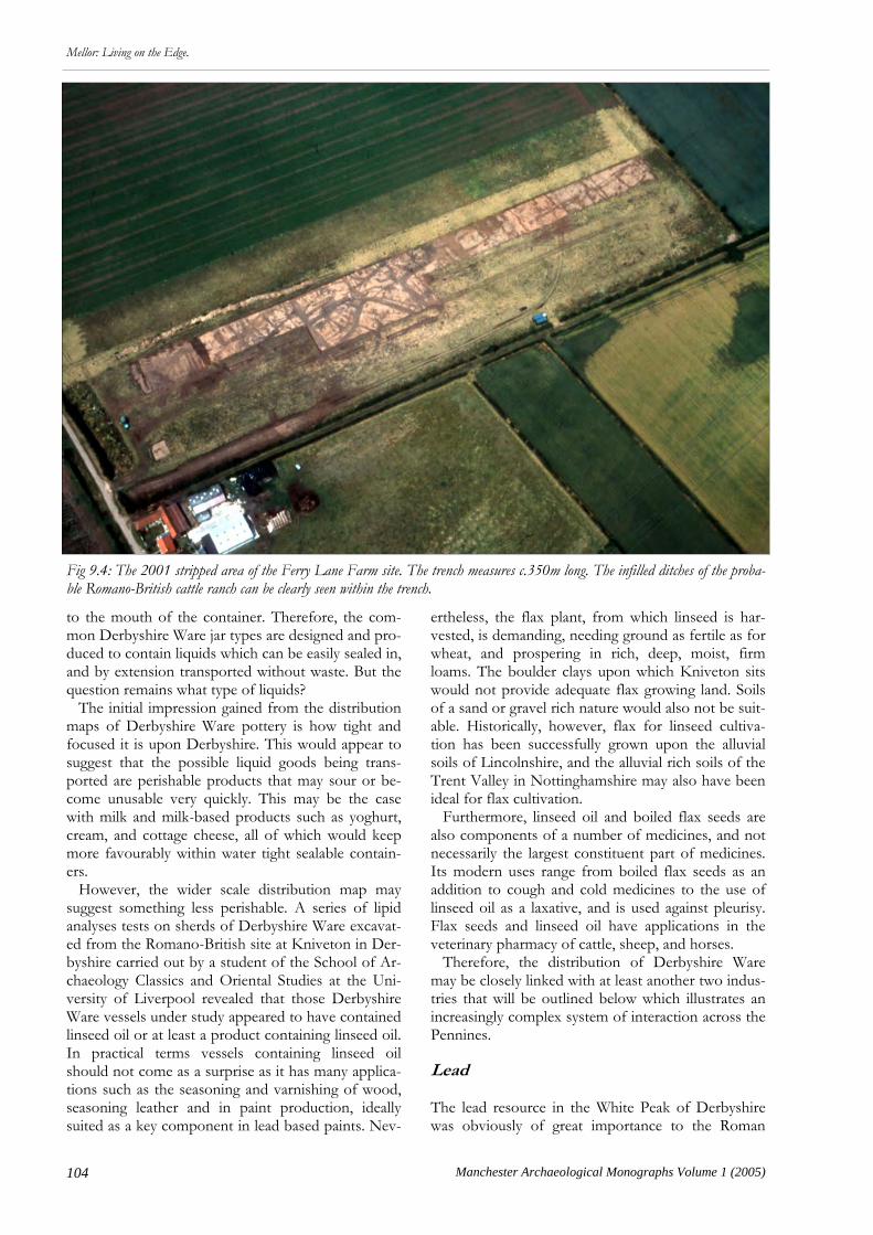
104 Manchester Archaeological Monographs Volume 1 (2005)
Mellor: Living on the Edge.
to the mouth of the container. Therefore, the com-mon Derbyshire Ware jar types are designed and pro-duced to contain liquids which can be easily sealed in, and by extension transported without waste. But the question remains what type of liquids? The initial impression gained from the distribution maps of Derbyshire Ware pottery is how tight and focused it is upon Derbyshire. This would appear to suggest that the possible liquid goods being trans-ported are perishable products that may sour or be-come unusable very quickly. This may be the case with milk and milk-based products such as yoghurt, cream, and cottage cheese, all of which would keep more favourably within water tight sealable contain-ers. However, the wider scale distribution map may suggest something less perishable. A series of lipid analyses tests on sherds of Derbyshire Ware excavat-ed from the Romano-British site at Kniveton in Der-byshire carried out by a student of the School of Ar-chaeology Classics and Oriental Studies at the Uni-versity of Liverpool revealed that those Derbyshire Ware vessels under study appeared to have contained linseed oil or at least a product containing linseed oil. In practical terms vessels containing linseed oil should not come as a surprise as it has many applica-tions such as the seasoning and varnishing of wood, seasoning leather and in paint production, ideally suited as a key component in lead based paints. Nev-
ertheless, the flax plant, from which linseed is har-vested, is demanding, needing ground as fertile as for wheat, and prospering in rich, deep, moist, firm loams. The boulder clays upon which Kniveton sits would not provide adequate flax growing land. Soils of a sand or gravel rich nature would also not be suit-able. Historically, however, flax for linseed cultiva-tion has been successfully grown upon the alluvial soils of Lincolnshire, and the alluvial rich soils of the Trent Valley in Nottinghamshire may also have been ideal for flax cultivation. Furthermore, linseed oil and boiled flax seeds are also components of a number of medicines, and not necessarily the largest constituent part of medicines. Its modern uses range from boiled flax seeds as an addition to cough and cold medicines to the use of linseed oil as a laxative, and is used against pleurisy. Flax seeds and linseed oil have applications in the veterinary pharmacy of cattle, sheep, and horses. Therefore, the distribution of Derbyshire Ware may be closely linked with at least another two indus-tries that will be outlined below which illustrates an increasingly complex system of interaction across the Pennines. Lead
The lead resource in the White Peak of Derbyshire was obviously of great importance to the Roman
Fig 9.4: The 2001 stripped area of the Ferry Lane Farm site. The trench measures c.350m long. The infilled ditches of the proba-ble Romano-British cattle ranch can be clearly seen within the trench.

105
Mellor: Living on the Edge.
Manchester Archaeological Monographs Volume 1 (2005)
military regime due to lead’s malleability and use in various industries. The mining, roasting, and smelting of lead played an important part in the settlement patterns of specific areas of the White Peak and the subsequent trade of lead and lead products would unite these production areas to consumption centres. One of these production areas, straddling the southern tip of the White Peak and the northern ex-tents of the Derbyshire Dales, includes the lead min-ing site at Rainster Rocks, the site at Closes Farm in Kniveton, and the sites of Carsington A and B which now lie under Carsington Water. These three sites lie roughly three miles from one another and are un-doubtedly linked by the lead trade: Rainster Rocks with the mining of the raw lead (galena); Kniveton probably with the processing of lead as both raw lead, and roasted lead, both of which have been exca-vated from Roman deposits here; and Carsington as a possible administrative centre. Together these sites may form the often debated position of Lutudarum, a lead production centre linked with this area of Derbyshire, rather than any single site and the trade of lead products ties together some of the various other industries presented in this chapter and ultimately would incorporate Mellor into the web of trades. Interestingly, fragments of galena and roasted lead have also been recovered from Mel-lor. In a marriage with other Roman industries lead was essential in the production of salt in the form of lead pans used for the evaporation of brine on hearths to produce salt. This reliance of the Roman salt industry on the supply of lead for the production of the evaporation pans inexorably links the salt pro-duction sites of Northwich, Middlewich, and Nant-wich in Cheshire with the Peak District of Derby-shire where a symbiotic relationship is essential (Fig 9.3). Additionally, as already highlighted above, linseed oil is an essential component in the production of lead-based paints, a Roman period commodity, and those few Derbyshire Ware vessels from the Closes Farm site at Kniveton that were used to store linseed oil may imply there was some form of production of lead-based paints at sites such as this. This raises a connection which could link the mining and produc-tion of lead with the distribution of Derbyshire Ware thus tying together Romano-British sites on both sides of the Pennines.
Salt
The site specifics of salt production in Cheshire will not be covered in this monograph as these have been detailed in a recent volume (Nevell & Fielding 2005) which does this topic far better justice. However, the trade in salt undoubtedly connected many trans-Pennine sites due to its importance in the Roman trade network and in the essential role it plays in diet.
Fragments of Cheshire briquatage, salt containers, have been recovered from Iron Age contexts at Mel-lor which implies that Mellor was within the range of the Cheshire salt supply during the Iron Age, some-thing which would have been easily achievable during the Roman period. Due to the intricacies of the Ro-man road infrastructure and the proximity of sites such as the one at Kingsley Fields in Nantwich to a river, in this case the Weaver, it is easy to imagine how salt was transported from the Cheshire Plains across the Pennines. Yet, the importance of salt in trans-Pennine communications and landscape adap-tation may not be as readily obvious and it may have played an equally important role in a more subtle way as a secondary but essential product.
Cattle, Beef, and Leather The relatively huge increase in beef consumption as part of the Romano-British diet brought on by the invading Roman military and continental tastes would have had a profound effect on the use of the agricultural landscape. Excavations at the Ferry Lane Farm site within Besthorpe Quarry to the west of Collingham in northern Nottinghamshire has so far revealed evidence for a nucleated farmstead which appears to have been entirely removed from the landscape by the early 2nd century AD and replaced by, for all intents and purposes, a large scale evolving cattle ranch (Fig 9.4). The faunal remains recovered from 3rd and 4th century features have revealed that by that time the site was heavily involved with cattle livestock. The siting of this cattle ‘ranch’ within the landscape, its nodal points of connection, the size of the site and the finds assemblage imply that the Ferry Lane Farm site in the Roman period is neither a mar-ket place nor an abattoir but a large, cattle dominated farmstead involved with the processing of cattle prior to the delivery to market. However, a site such as this may have been heavily integrated with other production centres that span the Pennines. In the first instance cattle feed would have been a prime concern and although the Trent Valley provides a lush environment for cattle grazing other sources of fodder would have to be taken into consideration. One such example could have been the by-product of linseed oil production which is the crushed pulp remains, often referred to in modern farming as oil-cake, which has been and is largely used in modern farming as a fattening food for cattle. Secondly, the relationship between the cattle rearing centres and the salt production centres can not be overstated. The demand for salt to preserve beef would have undoubtedly played a large role in the relationship between the production groups. Addi-tionally, the role of salt in the leather production trade would also mean that both industries would
106 Manchester Archaeological Monographs Volume 1 (2005)
Mellor: Living on the Edge.
have been closely linked. Salt can be used during the initial stages of leather production, when salt is thrown over hides to facilitate hair removal, or it can be used in the leather finishing process, in a brine solution, to harden off the leather. Thus, even though sites along the Trent Valley may have been supplied with salt from the coast of Lincolnshire in the late 1st and early 2nd centuries AD it is highly probable that this area was receiving Cheshire salt by the late 2nd and 3rd centuries AD bringing with it fur-ther trans-Pennine trade and communication. Conclusion Overcoming the modern problems of local and re-gional boundaries and healing the breaks in the lines of communication in the archaeological fraternity that have fractured the study of trans-Pennine trade
and communication during the Roman period reveals a surprising amount of information. By taking that information and realising that each strand does not sit in splendid isolation a rich tapestry of inter-dependent sites and industries, be they small or large scale, can begin to be woven. By bringing together archaeologists from both sides of the Pennines the excavations at Mellor has afforded the opportunity to increase the collective knowledge of archaeologists working in the surrounding regions. Therefore, Iron Age and Roman Mellor starts to take on a new im-portance in the landscape. An importance due to its position in the landscape, which would allow Roman Mellor in particular to take advantage of the goods, and lines of communication, flowing through the landscape east to west and west to east, uniting the Pennines with the surrounding landscapes.
107
Mellor: Living on the Edge.
Manchester Archaeological Monographs Volume 1 (2005)
M arginal archaeological areas have tended to attract either intensive study by archaeologists
or have been ignored. Such zones classically fall into two categories; geographically discrete areas where the impact of climatic changes have a marked impact on societies throughout most periods; and zones with societies who were themselves liminal (on the border of several different landscape or cultural zones), or marginal to the prevailing political or economic sys-tem. The landscape and region around Mellor en-compasses a historically marginal area which has seen both geographical and social marginality in many periods (Pollard 1997); hence the title of this volume and its predecessor Living on the Edge of Empire (Nevell 1999a). In that earlier volume it was noted how little the Iron Age had been studied in the southern part of North West England, the Mersey Basin. This is a region to the south of the River Ribble and north-west of the headwaters of the River Trent, defined by the catchment of the Rivers Dee and Mersey. It was also noted how intensive scholarly research had been be-fore the 1990s on the Roman military presence. In a research agenda published as recently as 2001 Lanca-shire and Cheshire, were recorded as a ‘black hole’ for Iron Age research (Haselgrove et al 2001, 24) and the Peak District was regarded as not much better . Whilst this was the case for Lancashire before 1996 (Haselgrove 1996, 61-2) the situation was already changing significantly in the Mersey Basin by the time Living on the Edge of Empire was published in 1999 (Nevell 1999a) and can now be seen to be inaccurate for large swathes of the North West south of the Cumbrian massif. Since 1999 there have been several thematic papers on Iron Age and Romano-British settlement and society, presenting new and previously unpublished material (Matthews 1999b & 2002; Nevell 1999, 2001, & 2004) as well as the publication of several significant excavations of rural sites (Cowell
Chapter 10
Towards an Understanding of the
Rural Economy and Society of the Iron Age and Romano-British Landscape of the Mersey Basin and
Southern Pennines
Michael Nevell & John Roberts
& Philpott 2000; Fairburn 2003a & b; Nevell 2002). As Cowell and Philpott have outlined (see above Chapters 6 & 7) two distinct views have emerged regarding the social structure of the Iron Age and Romano-British communities of this area (Matthews 2002; Nevell 2004) which have important implications for the way in which we can interpret the Iron Age/Roman transition. Why then do negative opinions persist regarding specifically the Iron Age study of the region, in contrast to the Roman archaeological data-base? Is this due to a lack of published material, a lack of research initiatives or, as argued forcefully by Peter Connelly in the previous chapter, an attachment to politico-geographical boundaries that can distort the existing evidence and focus of current research? The research at Mellor since 1998 has demonstrated the high archaeological potential of the North West as regards Iron Age and Romano-British studies. The papers in this volume highlight the lively debate that is evolving over a variety of issues that straddle these two important periods in the region’s development. In 1999 two themes were apparent. First, that the climate and physical geography of the region may have made the area marginal for early settlement. Secondly, that this in turn may have led to the archaeological remains of the late prehistoric and Romano-British era in the North West being sparse and the material culture of poor quality (Nevell 1999b, 14). Thanks in large part to Mellor and a few other key sites we can now focus the debate as it was in 1999 more precisely by looking critically at three related topics; the role of the envi-ronment in shaping society in this area; how the lim-ited Iron Age material culture might reflect social status and hierarchy within this liminal (or border) society; and finally the degree to which the late Iron Age communities of the region accepted or were forced to accept Romanisation. The rest of this paper will attempt to discuss these three issues and Mellor’s important role in this evolving debate.

108 Manchester Archaeological Monographs Volume 1 (2005)
Mellor: Living on the Edge.
Climate Change and Settlement The theoretical background for the influence of cli-matic marginality upon settlement during the 1st mil-lennium BC and early 1st millennium AD within
North West England has been discussed at length elsewhere and need not detain us other than to note that this model remains to-date unchallenged (Nevell 1992, 1999a, 2001). Using the climatic models pio-neered by Parry it is it possible to argue that within the
Fig 10.1: Iron Age and Romano-British sites in North West England (after Nevell 2001). Key: = Iron Age settlement; = Iron Age and Roman farmstead; = Roman town; = Roman fort and vicus; = tile manufactory; — Roman road.

109
Mellor: Living on the Edge.
Manchester Archaeological Monographs Volume 1 (2005)
Mersey Basin, and elsewhere west of the Pennines, climatic instability, and in particular fluctuations in annual mean summer temperatures, had a direct im-pact on the early communities of the area by affecting the altitudinal limit on cereal cultivation and thus permanent settlement (Parry 1975), particularly during the 1st millennium BC, but less so during the early centuries of the 1st millennium AD. The suggestion is that there was a zone of agricultural marginality for cereal growing in the Mersey Basin and around the western and south-western foothills of the Pennines between c 110m AOD and c 250m AOD which fluc-tuated according to climatic changes throughout the 1st millennium BC, but that conditions during the Roman period were more favourable in this zone. Although this model remains crude in its details it suggests that in the 110m to 250m zone cereal grow-ing would have been unreliable, whilst any permanent settlement above 250m AOD would have been for pastoral farming even in the Roman period (Fig 10.1). Due to the often unfavourable conditions for the survival of palaeo-environmental deposits from exca-vated contexts across much of the region (see above Chapters 2, 5, 6, 7 & 8) this model remains to be fully tested, although the small amount of data available since 1999 has strengthened the argument for a direct link between climate change and the organisation of communities within the Mersey Basin. The Environmental Evidence for Late Prehistoric Settlement The palaeo-environmental deposits from the Mersey Basin and southern Pennines for the 1st millennium BC preserve evidence for anthropogenic changes to the vegetation in the form of woodland clearance episodes and the occurrence of cereal pollen. This evidence allowed one of the authors to suggest as long ago as 1999 a reconstruction of the broad impact of changing settlement trends on the landscape of the area (Nevell 1999b). This has yet to be superseded by more detailed analysis, although the absence of any re-appraisal is almost certainly due to a lack of suitable palaeo-environmental deposits for investigation since that date (Nevell 2004). This evidence, which is still largely reliant on natural deposits from lowland mosses and upland blanket peats, suggests that for the lowland areas below 110m AOD a brief period of forest regeneration in the early to mid-1st Millennium BC was followed by a second phase of woodland clearance within the Mersey Basin during the late 1st millennium BC. This was charac-terised by a period of highly intensive agricultural activity, involving major deforestation, high levels of weed pollen and, for the first time, the introduction of cereals (and possibly hemp/hops) in high quantity. A similar pattern of clearance can be seen in the neigh-bouring Peak District (see above Chapter 8). This period of intense land use has been dated at Lindow
Moss in eastern Cheshire (SJ 8200 8050), to the period after 430-250 cal BC (340 ± 90 BC; BM 2401). Sam-ples from Simmonswood Moss on Merseyside show a similar pattern of clearance dated to after the period 790-257 cal BC (2380 ± 80 BC; Birm-1221; Cowell & Innes 1994), and the same pattern is apparent in Chat Moss and Holcroft Moss in western Greater Man-chester and northern Cheshire (Nevell 1999b; Birks 1964 & 1965; Hall et al 1995; Leah et al 1997). The survival of micro and macro-fossil evidence within archaeological deposits that might flesh-out these broad trends remains a regional problem. For instance, at Duttons Farm, on the lowlands north of Ormskirk, despite extensive sampling of the features no significant palaeo-environmental deposits were recovered. However, artefacts and structures suggest that grain did form a part of the local economy alt-hough whether imported or grown locally is as yet unknown (see above Chapter 6). A similar range of evidence for mixed-farming was found at Great Woolden Hall in 1987-8, but once more was not sup-ported by any surviving palaeo-environmental mate-rial (Nevell 1999c). However, the most significant sites recently exca-vated in terms of the palaeo-environmental evidence for the Iron Age economy and landscape are Bruen Stapleford, in central Cheshire, and Brook House Farm, in Halewood. At Bruen Stapleford a sampling programme across the site produced a few burnt ani-mal bones (cattle, sheep/goat, and pig), and a small amount of evidence for cereals in the form of the macro-fossil remains of bread wheat, emmer/spelt, and hulled barley. The cereal evidence was associated with radiocarbon dates which spanned the late Bronze Age to late Iron Age (Fairburn 2003a, 35-7). However, all of this evidence was associated with relatively large amounts of grass pollen and wetland species which when taken with the nature of the cereal grains sug-gested to the excavators that this may represent mainly hay making, and furthermore that the economy of the site may have been predominantly pastoral in charac-ter (Fairburn 2003a, 38-9). At Brook House, Halewood, the inner ditch pro-duced palaeo-environmental evidence suggesting something similar. The settlement seems to have been established in a glade within woodland (although an alternative interpretation might relate the woody spe-cies to the beginning of an abandonment phase; Cowell & Philpott 2000). Most intriguing was the presence of animal bones including cattle and pig, and an absence of any artefacts or features relating to grain production, which suggested to the excavators a site dominated by pastoral farming. Both Bruen Stapleford and Brook House are low lying sites in areas capable of producing cereal crops (at 41m AOD and 10m AOD respectively). They are also close to water and a variety of landscape types. Therefore, the evidence for a preference for pastoral
110 Manchester Archaeological Monographs Volume 1 (2005)
Mellor: Living on the Edge.
farming seems to reflect a conscious choice of these two communities, but whether this is down to local niche conditions or whether this might reflect a wider preference for stock rearing in other parts of the re-gion is unclear at the moment. Evidence for the significance of pastoral farming in the uplands of the region during the later 1st millen-nium BC is forthcoming from the small number of natural upland palaeo-environmental deposits that have been studied in the south-western Pennines and Peak District. These show sustained forest clearance from the mid-1st millennium BC in the Rossendale area, and around the middle reaches of the Tame and Etherow valleys where this activity has been radiocar-bon dated by samples from a small basin mire in Godley to 810-415 cal BC (Beta-111472). However, elsewhere in the southern Pennines this clearance activity is dated to the late 1st millennium BC (Nevell 1999b). Cereal pollen occurs only rarely in these de-posits suggesting that stock rearing may have been dominant in this zone. Frustratingly, Mellor has yet to produce much pal-aeo-environmental material of any period, although an undated deposit from the bottom of the outer ditch seems to suggest a landscape around the site of de-ciduous woodland dominated by hazel. The presence of cereal pollen suggests a mixed farming economy at the time these deposits were laid down (see above Chapter 2). Mellor’s potential, however, remains high as the only upland site currently being researched, and at 220m AOD it lies right on the edge of the marginal zone for cereal cultivation in both the Iron Age and Roman periods. The overwhelming impression of the admittedly very limited excavated Iron Age palaeo-environmental deposits in the region is of a mixed-farming regime but with an emphasis on stock rearing (perhaps cattle). It will be interesting to see if this pattern is confirmed by future research and whether the dominance of pastoral farming at the lowland sites of Brook House and Bruen Stapleford, which is the best supporting evidence for the wider palaeo-environmental trends during this period, is repeated elsewhere. The Environmental Evidence for Roman Settlement There is a similar lack of excavated palaeo-environmental deposits for the Romano-British peri-od so that the broad trends visible in the natural de-posits of the region as outlined in 1999 have remained unchallenged (Nevell 1999b). The pollen diagrams from natural deposits in the Mersey Basin all record major and sustained woodland clearance over many centuries at the end of the 1st millennium BC and during the first centuries of the 1st millennium AD. These clearances appear to be broadly chronologically coincident across the Basin, and form the third sig-nificant period of palaeo-environmental disturbance
after 795-595 cal BC. The end of this third phase of clearance activity is marked by a second radio-carbon date from the years 326-526 cal AD (Godwin & Willis 1960, 62-72). Five pollen diagrams from natural deposits indicate a major and sustained upsurge in agricultural activity, associated with significant amounts of cereal pollen and widespread tree clearance, in the centuries imme-diately before 326-526 cal AD (Nevell 1999a; Cowell & Innes 1994; Hall et al 1995). This evidence is sup-ported by two palaeo-liminological studies showing increased soil erosion in this period in Cheshire at Peckforton Mere, near the central Cheshire Ridge, and at Rostherne Mere in northern Cheshire where this episode began sometime between 366 BC and AD 60 (Leah et al 1997; Schoenwetter 1982). This third phase of woodland clearance would seem to start at the end of the Iron Age and continue into the Roman period and was characterised by an upsurge in the presence of cereal pollen and the extent of woodland clearance. Again a similar pattern of landscape exploitation can be seen in the Peak District (see above Chapter 8). A number of excavated Romano-British lowland sites in the Mersy Basin have produced both macro and micro palaeo-environmental evidence in general support of this trend. Irby has produced a variety of cereal grains (barley, spelt, bread wheat, oats, and possibly rye), Court Farm, Halewood has produced emmer and spelt wheat, whilst Ochre Brook, Tarbock, has produced barley and spelt/bread wheat (Cowell & Philpott 2000). In general animal bones survive less well but cattle, sheep/goat, chicken, and pig are rep-resented on a variety of lowland sites including Great Woolden and Irby. Of potential greater significance for future research is the evidence from Birch Heath, Tarporley. This has also produced animal bones for cattle, pig, and sheep/goat. However, it has also pro-duced evidence for cereals, but not cereal processing, on the site, as well as high counts of a variety of grass pollen suggesting to the excavators that pastoral farming may have been more important on this site than cereal production (Fairburn 2003b, 89-96). Thus, direct link between the rise in cereal pollen and woodland clearance during this period in the wider regional samples may not just indicate a rise in crop growing. Only the excavation of further sites with suitable deposits will clarify the local farming econo-mies of lowland Roman North West England. As with the 1st millennium BC, upland farming in the Roman period remains largely unexplored alt-hough the upland pollen diagrams from the fringes of the Mersey Basin also indicate an upsurge in activity during this period, but of a different nature. The pol-len diagrams from Deep Clough, at 340m AOD and Rishworth Moor at 410m AOD, both indicate the continuance of the substantial woodland clearance seen towards the end of the 1st millennium BC, and the dominance of grass pollens indicative of an open
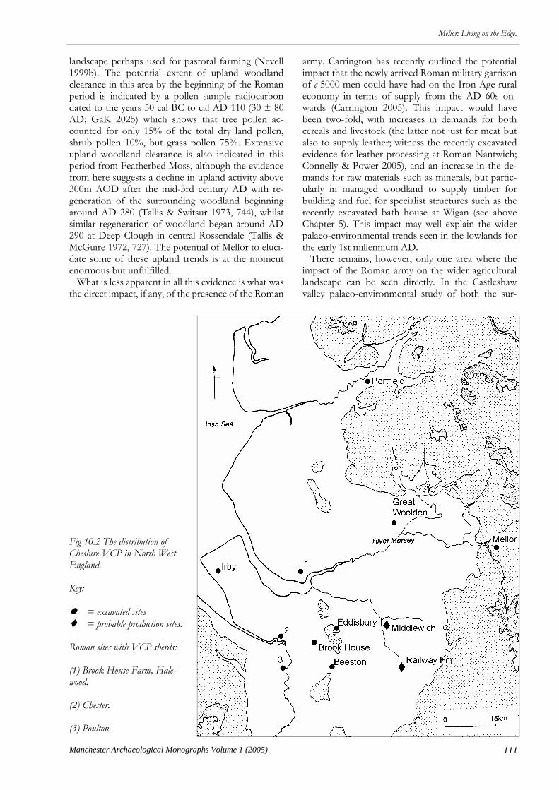
111
Mellor: Living on the Edge.
Manchester Archaeological Monographs Volume 1 (2005)
landscape perhaps used for pastoral farming (Nevell 1999b). The potential extent of upland woodland clearance in this area by the beginning of the Roman period is indicated by a pollen sample radiocarbon dated to the years 50 cal BC to cal AD 110 (30 ± 80 AD; GaK 2025) which shows that tree pollen ac-counted for only 15% of the total dry land pollen, shrub pollen 10%, but grass pollen 75%. Extensive upland woodland clearance is also indicated in this period from Featherbed Moss, although the evidence from here suggests a decline in upland activity above 300m AOD after the mid-3rd century AD with re-generation of the surrounding woodland beginning around AD 280 (Tallis & Switsur 1973, 744), whilst similar regeneration of woodland began around AD 290 at Deep Clough in central Rossendale (Tallis & McGuire 1972, 727). The potential of Mellor to eluci-date some of these upland trends is at the moment enormous but unfulfilled. What is less apparent in all this evidence is what was the direct impact, if any, of the presence of the Roman
army. Carrington has recently outlined the potential impact that the newly arrived Roman military garrison of c 5000 men could have had on the Iron Age rural economy in terms of supply from the AD 60s on-wards (Carrington 2005). This impact would have been two-fold, with increases in demands for both cereals and livestock (the latter not just for meat but also to supply leather; witness the recently excavated evidence for leather processing at Roman Nantwich; Connelly & Power 2005), and an increase in the de-mands for raw materials such as minerals, but partic-ularly in managed woodland to supply timber for building and fuel for specialist structures such as the recently excavated bath house at Wigan (see above Chapter 5). This impact may well explain the wider palaeo-environmental trends seen in the lowlands for the early 1st millennium AD. There remains, however, only one area where the impact of the Roman army on the wider agricultural landscape can be seen directly. In the Castleshaw valley palaeo-environmental study of both the sur-
Fig 10.2 The distribution of Cheshire VCP in North West England. Key: = excavated sites = probable production sites. Roman sites with VCP sherds: (1) Brook House Farm, Hale-wood. (2) Chester. (3) Poulton.

112 Manchester Archaeological Monographs Volume 1 (2005)
Mellor: Living on the Edge.
rounding blanket peats and features from the Roman vicus show the direct impact of the Roman army in improving the upland grazing grounds of the valley (Brayshay 1999). Not only is this direct relationship startling, but the immediate decline in the quality of this grazing land after the Castleshaw forts closed reminds us that the impact of the Roman army on the landscape and economy of the North West could be short lived and highly localised. Thus, there is a small but growing body of excavated palaeo-environmental evidence that supports the theory of a gradual intensification of agriculture dur-ing the late 1st millennium BC and early 1st millenni-um AD, with a shift from an Iron Age mixed farming regime with an emphasis on stock rearing, to a Ro-mano-British mixed farming regime with the empha-sis on cereal growing. Social Status and Exchange in the Iron Age The second theme which has developed since 1999 is how the growing, but limited range, of Iron Age ma-terial culture (a handful of excavated sites, a scattering of domestic-style artefacts, and the occurrence of a very small number of ‘exotic’ items) might reflect social status and hierarchy within this liminal society. What has emerged since 1999 are several theories as to the social organisation of the Iron Age communi-ties of the area which boils down to a debate between complex or simple social systems and whether these had significant extra-regional links (Matthews 1994, 1996, 1999a & b, 2002; Nevell 1994b, 1999b & 2004). Both Cowell and Philpott have touched upon these theories above in Chapters 6 and 7. Cowell’s analytical approach to these ideas has taken the argument a step
further with his suggestion that there may be a social difference between the organisation of the communi-ties north and south of the River Mersey, whilst ac-knowledging that the narrow archaeological database makes any conclusions provisional. There is, however, one particular type of evidence which needs highlighting because of both its pres-ence at Mellor and its potentially significant role in elucidating the social organisation of these Iron Age communities; namely the manufacture, control, and distribution of Cheshire VCP and the Cheshire salt trade. Much has been written about this particular ceram-ic fabric in terms of what it may or may not mean for the Iron Age in North West England (Cowell above Chapter 6; Matthews 1996 & 2002; Morris 1985). Since the identification of Cheshire VCP as a bri-quetage fabric in the early 1980s, with a distribution in Herefordshire, Worcestershire, Shropshire, Staf-fordshire, and North Wales (Morris 1985, Fig 8), the fabric has been found on sites across much of North West England in Cheshire, Greater Manchester (including Mellor), Lancashire, and Merseyside (Nevell 2005). Recently small quantities have been identified on two settlements in Derbyshire, at Swarkestone Lowes and Aston-on-Trent (Knight 1999; Morris 1999), at Gamston in Nottinghamshire (Knight 1992), and at Enderby and Normanton-le-Heath in Leicestershire (Elsdon 1991, 1992 & 1994). The most significant groups of Cheshire VCP in the North West (Fig 10.2) are associated with radio-carbon dated samples from Beeston Castle, Brook House Farm (Halewood), Bruen Stapleford, Great Woolden Hall Farm, Irby, and Mellor (see Table 10.1). Other sites have produced just a few sherds
Table 10.1: Cheshire VCP from Radiocarbon Dated Contexts Site Radiocarbon Date Source (to two sigmas) Beeston Castle 791-410 cal BC (HAR-8102) Ellis 1993 Brook House Farm, Halewood 830-410 cal BC (Beta-118138) Cowell 2000 Brook House Farm, Halewood 360-40 cal BC (Beta-117712) Cowell 2000 Bruen Stapleford 1000-800 cal BC (AA-49265 GU-9974) Fairburn et al 2002 Bruen Stapleford 1020-800 cal BC (AA-49268 GU-9977) Fairburn et al 2002 Great Woolden Hall I 40 cal BC-cal AD 80 (GrN 16849) Nevell 1999 Great Woolden Hall II 200 cal BC-cal AD 350 (GrN 16850) Nevell 1999 Mellor 830-190 cal BC (Beta 146416) Redhead & Roberts 2003 Wrekin Hillfort I 440-240 cal BC (Birm-530) Stanford 1984 Wrekin Hillfort II 700-340 cal BC (Birm-531) Stanford 1984 Wrekin Hillfort III 460-320 cal BC (HAR-4452) Stanford 1984 Wrekin Hillfort IV 500-330 cal BC (HAR-4454) Stanford 1984
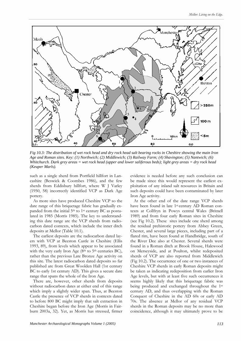
113
Mellor: Living on the Edge.
Manchester Archaeological Monographs Volume 1 (2005)
such as a single sherd from Portfield hillfort in Lan-cashire (Beswick & Coombes 1986), and the few sherds from Eddisbury hillfort, where W J Varley (1950, 58) incorrectly identified VCP as Dark Age pottery. As more sites have produced Cheshire VCP so the date range of this briquetage fabric has gradually ex-panded from the initial 5th to 1st century BC as postu-lated in 1985 (Morris 1985). The key to understand-ing this date range are the VCP sherds from radio-carbon dated contexts, which include the inner ditch deposits at Mellor (Table 10.1). The earliest deposits are the radiocarbon dated lay-ers with VCP at Beeston Castle in Cheshire (Ellis 1993, 89), from levels which appear to be associated with the very early Iron Age (8th to 5th centuries BC), rather than the previous Late Bronze Age activity on this site. The latest radiocarbon dated deposits so far published are from Great Woolden Hall (1st century BC to early 1st century AD). This gives a secure date range that spans the whole of the Iron Age. There are, however, other sherds from deposits without radiocarbon dates at either end of this range which imply a slightly wider span. Thus, at Beeston Castle the presence of VCP sherds in contexts dated to before 800 BC might imply that salt extraction in Cheshire began before the Iron Age (Morris in Fair-burn 2003a, 32). Yet, as Morris has stressed, firmer
evidence is needed before any such conclusion can be made since this would represent the earliest ex-ploitation of any inland salt resources in Britain and such deposits could have been contaminated by later Iron Age activity. At the other end of the date range VCP sherds have been found in late 1st century AD Roman con-texts at Collfryn in Powys central Wales (Britnell 1989) and from four early Roman sites in Cheshire (see Fig 10.2). These sites include one sherd among the residual prehistoric pottery from Abbey Green, Chester, and several large pieces, including part of a flared rim, have been found at Handbridge, south of the River Dee also at Chester. Several sherds were found in a Roman ditch at Brook House, Halewood on Merseyside, and at Poulton, whilst redeposited sherds of VCP are also reported from Middlewich (Fig 10.2). The occurrence of one or two instances of Cheshire VCP sherds in early Roman deposits might be taken as indicating redeposition from earlier Iron Age levels, but with at least five such occurrences it seems highly likely that this briquetage fabric was being produced and exchanged throughout the 1st century AD, and thus overlapping with the Roman Conquest of Cheshire in the AD 60s or early AD 70s. The absence at Mellor of any residual VCP sherds in the Roman deposits may be no more than coincidence, although it may ultimately prove to be
Fig 10.3: The distribution of wet rock head and dry rock head salt bearing rocks in Cheshire showing the main Iron Age and Roman sites. Key: (1) Northwich; (2) Middlewich; (3) Railway Farm; (4) Shavington; (5) Nantwich; (6) Whitchurch. Dark grey areas = wet rock head (upper and lower saliferous beds); light grey areas = dry rock head (Keuper Marls).

114 Manchester Archaeological Monographs Volume 1 (2005)
Mellor: Living on the Edge.
an indicator that the site was unoccupied at this date. This extensive industry and exchange network was probably focused on ‘wet rock head’, that is permea-ble rock with brine springs, in the valleys of central Cheshire; the lower Dane Valley, the upper Weaver Valley, the Wheelock Valley, and the Wych Brook Valley (Nevell 2005; Fig 10.3). It is in this area that the first excavated Iron Age salt making site has found. This was discovered at Railway Farm, Moston, near Crewe in the Wheelock Valley in 1992 as part of an archaeological watching brief during the digging of a gas pipeline trench (Brooks 1992, 3, 14; Price 1994, 4). Two brine hearths were partially exca-vated within the line of the pipeline. The first pit was 2.5m wide and 0.95m deep. It contained pieces of fired clay and a small quantity of briquetage of the type normally associated with Roman salt working, including parts of flat plates and a fire bar although there was no pottery from this feature. The second pit, which was smaller and lay roughly 70m west of pit 1, was also interpreted as a brine hearth. This was 0.55m wide and 0.33m deep and only contained sherds of Cheshire VCP. Furthermore, a recent re-examination of the Middlewich excavation archive from the 1960s revealed the presence of several VCP sherds, whilst recent excavations on the eastern out-skirts of Middlewich have uncovered a brine evapo-rating hearth incorporating pieces of briquetage but no VCP, which was subsequently truncated by a Ro-man period ditch (Dodds 2005). This could repre-sent, however, a very early Roman feature. In the past it was been assumed that Roman salt production was focused at Middlewich (Nevell 2004 & 2005), but if the Roman period had multiple pro-duction sites it seems likely that Iron Age salt pro-
duction would have been equally dispersed across this ‘wet head rock’ landscape. Whether this was on a few large sites, as at Droitwich, or many small ones, akin to the way coastal salt was produced, remains to be seen. This has significant implications for the or-ganisation of both the industry and Iron Age elites in the Mersey Basin. If production was dispersed across the river valleys of central Cheshire this might argue against the tight control of production by a narrow elite since one might expect production to be fo-cussed on only one or two sites. On the other hand control could have been exerted at the distribution stage of salt production. The distribution of finds of Cheshire VCP on sites such as Mellor may also reflect contemporary social and economic practices not only in the Mersey Basin and southern Pennines, but also across northern Wales and the northern Midlands. For instance, despite several seasons’ work at Dut-tons Farm in central Lancashire no Cheshire VCP has been found, although Iron Age pottery sherds have been recovered from the site (see above Chapter 6). This could have a number of implications. It may mean no more than the distribution range did not extend this far north, but against that argument is the presence of VCP at the Portfield hillfort in the middle reaches of the Ribble valley a few kilometres to the east. Alternatively, the absence of VCP on a small open settlement may reflect contemporary hierarchies in late Iron Age North West England. Almost all other sites that have produced Cheshire VCP in the region have been enclosed settlements, as at Mellor. (Too little of the site at Brook House Farm, Bruen Staple-ford in Cheshire, was excavated to determine whether it was an enclosed or open settlement although aerial photography suggests it might have been). Cowell has thus suggested (see above Chapter 6) that VCP may indicate that enclosed sites such as Mellor were of higher status than the open settlements. What is needed to test this hierarchical theory is the large-scale excavation of an open settlement in the Dane or Weaver Valleys, the heartland of Iron Age salt pro-duction. There is another way in which Cheshire VCP may reflect contemporary social structures and that is in determining whether it was traded as a commodity or as a form of social exchange. Thus, in Worcester-shire, the Droitwich salt industry provided a focus for ceramic exchange (Hurst 1997, 132) and it is like-ly that the exchange included other types of goods. This was probably also the case in Cheshire and the few ‘exotic’ items found during the Iron Age in the region, such as pre-Roman coins and pottery and Iron Age coins, are evidence for external contacts (Matthews 1996, 21; 2002). In 1985 Elaine Morris suggested that the occur-rence of Cheshire VCP could be split into two chronological distribution patterns (Morris 1985). In
Fig 10.4: The distribution of mid- to late Iron Age VCP in Wales, north Midlands and North West England after Mor-ris 1985 with additions.
115
Mellor: Living on the Edge.
Manchester Archaeological Monographs Volume 1 (2005)
the early phase, covering the Early Iron Age, Cheshire VCP is the only type of briquetage found in the area north of the River Severn whereas sites in the middle reaches of the Severn valley contained a roughly equal mixture of Cheshire VCP and Droitwich salt containers. Further south, Droitwich salt containers were the only forms of briquetage to be found. Morris suggested that this is what would be expected from an overland or riverine distribution reflecting a very simple form of exchange. This was reflected in the proportion of Cheshire VCP to the rest of the Iron Age pottery assemblage, where there was a direct correlation between the ratio of VCP to other Iron Age pottery; the further from the manu-facturing source in central Cheshire the smaller the assemblage size (Morris 1994). It may be significant that this earliest distribution belonged to the period in which the hillforts were in use. The later distribution pattern - covering the Middle and Late Iron Age (Fig 10.4) - shows that Cheshire salt was exchanged throughout north Wales, the north Midlands, and the Marches. In particular, sites in Gloucestershire, Herefordshire, and Worcester-shire that had only Droitwich salt containers in the early Iron Age now had some Cheshire VCP, alt-hough it was never the dominant form. Matthews noted that the extreme south-western distribution of Cheshire briquetage is separated from the northern distribution zone by an area in northern Worcester-shire where only Droitwich material is found. He has suggested (2002) that this indicates a more complex distribution mechanism than in the earlier period, presumably with a redistribution centre somewhere on the lower Severn, and the existence of maritime exchange routes which were controlled by a locally based elite probably channelled through the Iron Age port at Meols on the northern Wirral coast . Morris has argued that not only does the distribu-tion of Cheshire VCP and the Droitwich briquetage containers demonstrate an extensive network of ex-change during the second half of the first millennium BC across North Wales, North West England and the northern Midlands (Morris 1994, 384-7), but that its value may have been more symbolic. It is possible that it was used as a type of early currency or that it was employed as a form of bridewealth amongst dif-ferent tribal groupings. It is even possible that the early salt makers were viewed as having mystical powers, being able to transform water into a white crystal. How these attitudes might be reflected in the archaeological database is unclear at the moment. The debate over the role and status of VCP indi-cates that just because a region has the potential to be environmentally marginal does not mean that the societies within that area were themselves marginal. Thus, a low level of archaeologically visible material culture, as occurs in the 1st millennium BC in the Mersey Basin and Peak District, does not equate with
an impoverished society. The distribution of Chesh-ire VCP at sites such as Mellor, and the potential so-cial forces it reflects, is one factor that argues against such an assumption. As both Keith Matthews and Bill Bevan (see above Chapter 8) have suggested the local elites in the southern part of North West Eng-land and the Peak District may have expressed wealth, power, and status in ways that are at the mo-ment largely unrecoverable archaeologically; perhaps in the form of livestock for instance. Elaine Morris has shown that an analysis of the distribution and context of Cheshire VCP could be one way of throw-ing light on this problem. Another is the continuing research at Mellor which has a vital role to play in establishing the social status and organisation of these Iron Age communities. Romanisation in the North West The third and final theme is that of the degree to which the native communities of the region were Romanised. The settlement pattern of the Romano-British peri-od is far more complicated than the shallow hierarchy of the late prehistoric era. However, the dominant form of settlement type in the Mersey Basin and southern Pennines during the Roman era remained the defended enclosure. By the end of the 1990s in the Mersey Basin 19 ditched enclosures of less than 2ha in area, interpreted as farmsteads, had been positively identified as Romano-British through excavation, of which eight had late prehistoric origins. These 19 enclosures had a single ditch usually enclosing a rec-tangular compound which contained one or more buildings. This contrasts with the evidence for rural settlement from the Peak District where at least 82 sites have been identified from this period, ranging from open farmsteads to large nucleated village style settlements (see above Chapter 8). Few palaeo-environmental remains have been exca-vated on the sites from the Mersy Basin so it is still not possible to say with certainty what their economic base was, although mixed farming is indicated at Court Farm, Irby, and Great Woolden. There is a particular lack of such remains from upland sites in the Mersey Basin, so as yet there is no evidence to support the other palaeo-environmental material which suggests an expansion of cereal agriculture in the 100m to 250m AOD zone (see above), although Mellor, which lies a c 220m AOD, will start to fill this gap. Even though the number of confirmed Romano-British rural farmsteads in the Mersey Basin, and the extent of the excavation within these sites, remains low the archaeological evidence hints at an expansion in settlement sites, and thus population, in the first two centuries of the Roman occupation, with seven sites appearing to have only Roman activity. So far
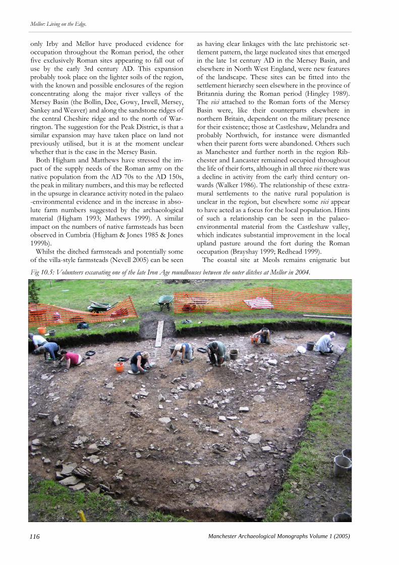
116 Manchester Archaeological Monographs Volume 1 (2005)
Mellor: Living on the Edge.
only Irby and Mellor have produced evidence for occupation throughout the Roman period, the other five exclusively Roman sites appearing to fall out of use by the early 3rd century AD. This expansion probably took place on the lighter soils of the region, with the known and possible enclosures of the region concentrating along the major river valleys of the Mersey Basin (the Bollin, Dee, Gowy, Irwell, Mersey, Sankey and Weaver) and along the sandstone ridges of the central Cheshire ridge and to the north of War-rington. The suggestion for the Peak District, is that a similar expansion may have taken place on land not previously utilised, but it is at the moment unclear whether that is the case in the Mersey Basin. Both Higham and Matthews have stressed the im-pact of the supply needs of the Roman army on the native population from the AD 70s to the AD 150s, the peak in military numbers, and this may be reflected in the upsurge in clearance activity noted in the palaeo-environmental evidence and in the increase in abso-lute farm numbers suggested by the archaeological material (Higham 1993; Mathews 1999). A similar impact on the numbers of native farmsteads has been observed in Cumbria (Higham & Jones 1985 & Jones 1999b). Whilst the ditched farmsteads and potentially some of the villa-style farmsteads (Nevell 2005) can be seen
as having clear linkages with the late prehistoric set-tlement pattern, the large nucleated sites that emerged in the late 1st century AD in the Mersey Basin, and elsewhere in North West England, were new features of the landscape. These sites can be fitted into the settlement hierarchy seen elsewhere in the province of Britannia during the Roman period (Hingley 1989). The vici attached to the Roman forts of the Mersey Basin were, like their counterparts elsewhere in northern Britain, dependent on the military presence for their existence; those at Castleshaw, Melandra and probably Northwich, for instance were dismantled when their parent forts were abandoned. Others such as Manchester and further north in the region Rib-chester and Lancaster remained occupied throughout the life of their forts, although in all three vici there was a decline in activity from the early third century on-wards (Walker 1986). The relationship of these extra-mural settlements to the native rural population is unclear in the region, but elsewhere some vici appear to have acted as a focus for the local population. Hints of such a relationship can be seen in the palaeo-environmental material from the Castleshaw valley, which indicates substantial improvement in the local upland pasture around the fort during the Roman occupation (Brayshay 1999; Redhead 1999). The coastal site at Meols remains enigmatic but
Fig 10.5: Volunteers excavating one of the late Iron Age roundhouses between the outer ditches at Mellor in 2004.
117
Mellor: Living on the Edge.
Manchester Archaeological Monographs Volume 1 (2005)
Matthews has argued persuasively that the site should be viewed not just as an ordinary agricultural settle-ment or even as a small port but as one of the series of late prehistoric and Romano-British emporia, or trad-ing sites, known from the English Channel and the Irish Sea, with strong trading links with the Iron Age tribes of Brittany and later the western Mediterranean (Matthews 1994, 16-8). Meols potentially had a unique role in the region as a facilitator of international trade throughout both periods and is one of only a handful of sites in North West England where fifth and sixth century settlement activity can be identified. Of the larger nucleated Roman settlements at Chester, Heronbridge, Middlewich, Tilston and Wil-derspool, only Chester and Middlewich started as vici; the Roman fort at Middlewich appears to have been abandoned by the end of the 1st century AD (Rogers 1995 & 1996; Shotter 2000), although the settlement there rapidly expanded to become at c 30ha probably the second largest in the region after Chester, which itself covered an area of over 50 ha. The other sites appear to have developed as ribbon developments either at crossroads or river crossings and all appear to have been occupied into the fourth century AD. These sites have been well studied, in comparison with the native-style farmsteads of the Mersey Basin, and fit within the wider settlement pattern of the province; most of these settlement can be character-ised as local Romanised market and industrial settle-ments (Hingley 1989). The exception is the largest settlement in the region, Chester, with its close asso-ciation with the legionary fortress. This settlement almost certainly had a wider regional administrative function, although it is unclear whether it reached colonia status in the late Roman period (Higham 1993; Mason 1987). Nevertheless, this idea has received slight additional support in recent years with the re-interpretation of two 4th century AD inscriptions on lead brine pans from Nantwich which may now refer to a bishop, presumably resident at Chester (Mathews 1999; Petch 1987). Despite the greatly expanded site types visible in the Roman period there remain gaps in the settlement hierarchy which suggest that the underlying late pre-historic settlement pattern, and by implication the native social structure, was not substantially altered by the Roman presence. Thus, research in the region has yet to produce evidence for Romanised civilian set-tlements between the farmstead and local centre level; that is settlements that covered c 3ha to c 6ha and which have been interpreted elsewhere in the province as large hamlets or villages (Hingley 1989). Nor have any potential villa sites yet been located beyond a radius of c 25km from Chester, strongly suggesting that the influence of this type of farming was limited to the hinterland of the fortress. The auxiliary forts and their vici to the east and north of Chester may have occupied this apparent gap in the native settlement
hierarchy as they could have done in Cumbria and Northumberland, where the needs of the local Roman garrisons probably stimulated growth in the local rural economy which survives archaeologically as an in-crease in the number of farmstead sites in the Roman period. The limited nature of the impact of the Roman conquest and Romanisation in the Mersey Basin and Peak District can be seen in several of ways. Firstly, in the limited nature of the rural settlement types which at least in the Mersey Basin suggests a continuance of the underlying shallow Iron Age settlement hierarchy. Secondly, in the adoption of a limited range of Ro-man material culture, primarily pottery but also met-alwork in the form of brooches. This can occur in some abundance, as at Mellor, but the nature of the pottery styles and fabrics seem to be closely tied to the military presence and supply network (see above Chapter 4). It may be significant that it is not until the 3rd and 4th centuries that pottery supplies from Yorkshire appear on two sites (Irby and Mellor), at a time when the garrison in the region has been reduced to a minimum. The farmstead established around AD 400 at Tatton in northern Cheshire failed to produce any late Roman pottery (Higham & Cane 1999) and may indicate that the supplies into the region had dwindled significantly or even stopped by this date. Thirdly, in the failure of these communities to adopt Romanised forms of building. The roundhouse ap-pears to have been the standard domestic building in this region during the Iron Age and continued as such for much of the Roman period at sites such as Hale-wood, Irby, and Great Woolden. Curvilinear buildings even appear in urban sites such as Wilderspool (Hinchliffe & Williams 1992) and Middlewich (Garner 2005, 18). The rural site at Tatton suggests that recti-linear buildings were in use on rural sites by the end of the Roman period, although this site failed to produce any Roman tile or brick suggesting that such struc-tures were not using these classic Roman building materials. It is unclear whether the Mellor round-houses (Fig 10.5) so far excavated run into the Roman period, but further excavation here will change this picture. Conclusion A common link between the three themes outlined in this paper (the role of the environment in shaping society; social status and hierarchy; and Romanisation) is the lack of durable cultural remains (pottery and structures) on the rural sites of the later prehistoric and Roman period in the Mersey Basin and Peak District. This can now be seen to be a real phenome-non that runs from the Iron Age through the Romano-British period and into the sub-Roman and early medieval periods (Higham 2000; Nevell 1999c, 59-61; Philpott & Adams 1999, 70-1). However, an absence

118 Manchester Archaeological Monographs Volume 1 (2005)
Mellor: Living on the Edge.
of cultural artefacts does not mean an absence of culture. As Mellor has once again demonstrated these were not isolated impoverished communities even before the adoption of Roman material culture made the site more visible archaeologically. Yet our models of cultural usage and exchange in the late prehistoric and Romano-British periods have, until recently, been based upon the concept of eco-nomic need and cultural imperialism during the Ro-man occupation (Higham 1993; Petch 1987; Thomp-son 1965). Keith Matthews has demonstrated how ethno-graphical parallels can be used to show how many small-scale pre-industrial societies used material culture as a means of constructing and reinforcing individuality rather than as an expression of economic need (Matthews 2002). Thus, if we look at the issue of the apparent ‘paucity’ (or should that be lack of visi-bility) of portable finds such as pottery in the Iron Age from Great Woolden Hall, Irby, and Mellor we find that anthropological models suggest two main types of exchange mechanism; subsistence exchange, often referred to as socially disembedded trade, which was concerned with everyday needs; and ceremonial or gift exchange, often termed socially embedded trade, which was concerned primarily with strengthening social ties through gift-partnership, exchange cycles, tribute, and diplomatic exchanges. In other words exchange was often for reasons other than profit, and this may be expressed in the composition of a finds assemblage. Such an explanation can and has been used to account for the lack of material culture from
the Iron Age in the Peak District (see above Chapter 8). In order to study communities such as those which occupied Mellor we need to understand that they may have displayed their wealth, power, and social status in ways which are now difficult to recover archaeologi-cally. Thus, the presence of a few VCP sherds at Mel-lor (and by extrapolation salt which could have been used in both the preservation of meat and in the preparation of leatherwork), coupled with the large outer enclosure, and the site’s geographical position in the uplands of the region, may in fact hint at a display of wealth and social status based upon the manage-ment of large amounts of livestock, probably cattle, in the Iron Age and Roman periods. The lesson of the multi-disciplinary research at Mellor for the study of rural settlement in North West England and the southern Pennines is that we should be seeking mod-els that address the issues raised by the regional evi-dence and that we should be looking at inter-regional comparisons. The papers in this volume have shown how Mellor is one of the key sites in the evolving research agenda for the Iron Age and Romano-British periods in North West England and the northern Midlands. The data presented here will be of enormous value to scholars for decades to come, and whilst our models and theories about these two linked periods will con-tinue to evolve, Mellor’s central role in this research can only increase as it is recognised as a type-site for upland settlement in the region.

119
Mellor, Living on the Edge
Manchester Archaeological Monographs Volume 1 (2005)
Adams M H & Philpott R A, forthcoming, A Romano-British and later site at Court Farm, Halewood, Merseyside. National Museumas Liverpool, Liverpool.
Aitchison K, 2000, Chee Tor, Blackwell, Derbyshire Geophysical Sur-vey. Unpublished report for the Peak District National Park Authority, Archaeology Service.
Allen T, 1998, Report on Geophysical Survey of Part of the Settlement on Chee ToR Unpublished report for the Peak District National Park Authority, Archaeology Service.
Allen C, Knight D & Williams D, 1999, ‘Vessel fabrics’, in L Elliott & D Knight, ‘An Early Mesolithic Site and First Millen-nium BC Settlement and Pit Alignments at Swarkestone Lowes’, Derbyshire Derbyshire Archaeological Journal 119, 79-153.
Arrowsmith P, 1997, Stockport - A History. Stockport. Stockport MBC
ASUD, 2003, Mellor, near Stockport, Greater Manchester Plant macrofossil assessment. ASUD Report 1059. Archaeological Ser-vices University of Durhawm, Durham.
Barnatt J, 2000, ‘To each their own, later prehistoric farming communities and their monuments in the Peak’, Derbyshire Archaeological Journal 120, 1-86.
Barnatt J & Smith K, 1997, Peak District. English Heritage. B T Batsford Ltd, London.
Barnatt J, Bevan B & Edmonds M, 2002, ‘Gardom’s Edge, a landscape through time’, Antiquity 76, 50-56.
Barrett J, 1980, ‘The pottery of the later Bronze Age in Lowland England’, Proceedings of the Prehistoric Society 46, 297-319.
Bartlett J, 1959, ‘Interim note on excavations at Brough’, Journal of Roman Studies 49, 108.
Bartlett J, 1960, ‘Interim note on excavations at Brough’, Journal of Roman Studies 50, 216.
Beale D & Grimsditch B, 2004, Mellor, Iron Age Hillfort. Un-published Report.
Beswick P & Coombs D G, 1986, ‘Excavations at Portfield Hill-fort, 1960, 1970 and 1972’, in Manby T G & Turnbull P, (eds), Archaeology in the Pennines, Studies in Honour of Arthur Raistrick, BAR Brit Ser 158, Oxford, 137-79.
Beswick P & Wright M E, 1991, ‘Iron Age burials from Winster’, in Hodges R & Smith K, (eds), Recent Developments in the Archae-ology of the Peak District. Sheffield, J R Collis Publications, 45-56.
Bestwick J D, 1975, ‘Romano-British salting at Middlewich (Salinae)’, in K de Brisay & K A Evans, (eds), Salt, The Study of an Ancient Industry. Colchester.
Bevan B, 1997, ‘Bounding the Landscape, place and identity during the Yorkshire Wolds Iron Age’, in Gwilt A & Haselgrove C, (eds), Reconstructing Iron Age Societies, New ap-proaches to the British Iron Age. Oxbow Monograph 71, Oxford, 181-91.
Bevan B, (ed), 1999a, Northern Exposure, interpretative devolution and the Iron Ages of Britain. Leicester, Leicester Archaeological Mon-ographs.
Bevan, B. 1999b Northern Exposure: interpretative devolution and the Iron Ages of Britain. In Bevan, B. (ed) Northern Expo-sure: interpretative devolution and the Iron Ages of Britain, 1-19. Leicester: Leicester Archaeological Monographs.
Bevan B, 2000a, The Peak District Romano-British Rural Settlement Survey. Unpublished research report for Derbyshire Archaeo-logical Advisory Committee.
Bevan B, 2000b, ‘Peak Practice, what ever happened to the Iron Age in the southern Pennines?’, in Harding J & Johnson R,
(eds), Northern Pasts; interpretations of the later prehistory of northern England and southern Scotland. Oxford, Archaeopress, BAR Brit-ish Series 302, 141-56.
Bevan B, 2004, The Upper Derwent, 10,000 years in a Peak District valley. Stroud, Tempus.
Bevan B, 2005, ‘Peaks Romana, Peak District Romano-British upland settlement survey, 1998-2000’, Derbyshire Archaeological Journal 125.
Birks H J B, 1964, ‘Chat Moss, Lancashire’, Memoirs and Proceed-ings of the Manchester Literary and Philosophical Society 106: 1-24.
Birks H J B, 1965, ‘Pollen analytical investigations at Holcroft Moss, Lancs, and Lindow Moss, Cheshire’, Journal of Ecology 53: 299-314.
Bradley R, 1984, The social foundations of prehistoric Britain: themes and variations in the archaeology of power. Longman, London.
Bramwell D, Dalton K, Drinkwater J F, Lorimer K L & Mackreth D F, 1983, ‘Excavations at Poole’s Cavern, Buxton, an interim report’, Derbyshire Archaeological Journal 103, 47-74.
Branigan K, 1991, ‘Civilian development in a military zone, The Peak AD 43-400’, in Hodges R & Smith K, (eds), Recent Devel-opments in the Archaeology of the Peak District. Sheffield, University of Sheffield, Sheffield Archaeological Monographs 2, 57-68.
Branigan K & Dearne M J, 1992, Romano-British Cavemen, cave use in Roman Britain. Oxford, Oxbow Monograph 19.
Brassington M, 1971, ‘A Trajanic kiln complex near Little Ches-ter, Derby, 1968’, Antiquaries Journal Vol. 51, 36-69.
Brassington M, 1980, ‘Derby Racecourse kiln excavations 1972-3’, Antiquaries Journal Vol 60, 8-47.
Brassington M & Webster W A, 1988, ‘The Lumb Brook Pottery Kilns, Hazelwood, an Interim Report’, Derbyshire Archaeological Journal 108, 21-33.
Brayshay B, 1999, ‘Some Palaeoenvironmental Evidence for Marginality in the Upper Mersey Basin’, in Nevell M, (ed), 1999a, 82-89.
Breeze D J & Dobson D, 1985, ‘Roman military deployment in north England’, Britannia 16, 1-19.
Brisbane C, 1987, ‘A Roman Dig at Prestwich’, British Archaeologi-cal Monthly 1, 10-4.
Britnell W J, 1989, ‘The Collfryn enclosure, Llansantffraid Deuddwr, Powys, Excavations 1980-1982’, Proceedings of the Prehistoric Society 55; 89-134.
Brooks I P, 1992, Warburton to Audley Gas Pipeline. Archaeological Report. Engineering Archaeological Services Ltd (Unpublished report for client).
Brooks I P, 1999, Treales to Burscough gas pipeline, Watching Brief. Unpublished Report, Engineering Archaeological Services, Blaenau Ffestiniog.
Bruton F A, 1907, ‘Excavations at Melandra in 1905’, Derbyshire Archaeological Journal 29, 22-63.
Bryant S, 1986, ‘Phase 5 Area B’, in Walker J, (ed), Roman Man-chester, A Frontier Settlement. The Archaeology of Greater Man-chester, Volume 4, 54-6.
Buckland P C, 1986, Roman South Yorkshire, a source book. Shef-field.
Buckland P C, nd, Wattle Syke Iron Age pottery. Archive report supplied by Archaeological Services (WYAS).
Buckland P, Runnacles R B & Sumpter A B, 1990, ‘The petrogra-phy of the Iron Age pottery’, in Wrathmell S & Nicholson A, (eds), Dalton Parlours, Iron Age settlement and Roman Villa. York-shire Archaeology 3. West Yorkshire Archaeology Service.
Sources

120 Manchester Archaeological Monographs Volume 1 (2005)
Mellor, Living on the Edge Carrington P, 2005, ‘New light on Roman Cheshire’, Past Uncov-
ered: Four-monthly Newsletter of Chester Archaeology, June 2005, 3. Carrington S, 1861, ‘Upon a Romano-British settlement, near
Wetton, Staffordshire’, in Bateman T, Ten Years’ Diggings in Celtic and Saxon Grave-hills. Hartington, Moorland. Reprinted 1978.
Chadwick, A M, 1997, Towards a Social Archaeology of Later Prehis-toric and Romano-British Field Systems in South Yorkshire, West Yorkshire and Nottinghamshire. Assemblage 2. www.shef.ac.uk/assem/2/.
Chadwick A, 1999, ‘Digging ditches, but missing riches? Ways into the Iron Age and Romano-British cropmark landscapes of the north midlands’, in Bevan, B (ed) 1999, 149-72.
Chadwick A M, 2004, ‘Heavier burdens for willing shoulders?’ Writing different histories, humanities and social practices for the Romano-British countryside’, in Croxford B, Eckhardt H, Meade J & Weekes J, (eds.), T.R.A.C. 2003 Proceedings of the Thirteenth Annual Theoretical Roman Archaeology Symposium, Leices-ter 2003. Oxbow Books, 90-110.
Chamberlain A T, 1999, ‘Carsington Pasture Cave, Brassington, Derbyshire, a Prehistoric Burial Site’, Capra 1, http,//www.shef.ac.uk/~capra/1/carsing.html.
Coates G, 2002, A Prehistoric and Romano-British Landscape, excava-tions at Whitemore Haye Quarry, Staffordshire. 1997-1999. BAR British Series 340.
Connelly P, 2000, Excavation at Vicar Lane, Chesterfield, 1998. Un-published UMAU client report.
Connelly P, 2002, 73/83 Liverpool Road, Manchester - an archaeologi-cal excavation within the Roman Vicus. Unpublished excavation report. The University of Manchester Archaeological Unit.
Connelly P & Power D, 2005, ‘Salt Making in Roman Nantwich. Recent Discoveries at Kingsley Fields, Welsh Row’, in Nevell M & Fielding A, (eds), 2005, 31-40.
Coombs D & Thompson H, 1979, ‘Excavation of the hillfort of Mam Tor, Derbyshire 1965-69’, Derbyshire Archaeological Journal 99, 7-51.
Coombs D G, 1982, ‘Excavations at the Hill Fort of Castercliff, Nelson, Lancashire 1970-71’, Transactions Lancashire & Cheshire Antiquarian Society 81, 111-130.
Cowell R W, 2000, ‘Brook House Farm, Halewood’, in R W Cowell & R A Philpott, (eds), 2000, 27-66.
Cowell R W, 2002, Romano-British and Late Prehistoric Excavations at Duttons Farm, Lathom, West Lancashire, 2nd interim report, 1999-2001. unpublished research report, Liverpool Museum.
Cowell, R W, 2003, Prehistoric and Romano-British Excavations at Duttons Farm, Lathom, West Lancashire, Third interim report, 1999-2002. Unpublished research report, National Museums Liver-pool.
Cowell R W & Philpott R A, 2000, Prehistoric, Romano-British and Medieval Settlement in Lowland North West England, Archaeological excavations along the A5300 road corridor in Merseyside, National Museums and Galleries on Merseyside, Liverpool.
Cumberpatch C G, 1997, ‘Pottery’, in Parker Pearson M & Sydes R E, ‘The Iron Age enclosures and prehistoric landscape of Sutton Common, South Yorkshire’, Proceedings of the Prehistoric Society 63; 237.
Cumberpatch C G, 2000, Later prehistoric pottery from Mellor (OVM99 and OVM00). Unpublished archive report for the Mellor Archaeological Trust.
Cumberpatch C G, 2002, Later prehistoric pottery from Mellor (OVM01). Unpublished archive report for the Mellor Archae-ological Trust.
Cumberpatch C G, 2004, Pottery from excavations at Sutton Common, Askern, South Yorkshire. Unpublished archive report for English Heritage / University of Exeter.
Cumberpatch C G, nd, Prehistoric, Roman and later pottery from Don-caster Road, South Elmshall. Unpublished archive report for Ar-chaeological Services (WYAS).
Cumberpatch C G, forthcoming, Later prehistoric pottery from
Redhouse Farm, Adwick-le-Street, South Yorkshire. Report in prepa-ration for Northamptonshire Archaeology.
Cumberpatch C G & Chadwick A M, 1995, ‘Further work on the Iron Age and Romano-British landscape at Edenthorpe’, in-Cumberpatch C G, McNeil J & Whiteley S P, (eds), Archaeology in South Yorkshire 1994 – 1995. South Yorkshire Archaeology Service.
Cumberpatch C G, Ixer R, Leary R, Morris E & Walster, A, 2003, Pottery from excavations at Mellor, Stockport, A review. Un-published archive report for the Mellor Archaeological Trust.
Cumberpatch C G, Leary R & Willis S, 2003, Medieval, Roman and prehistoric pottery from excavations at Sykehouse, West Yorkshire. Un-published archive report for Archaeological Services (WYAS).
Cumberpatch C G & Thorpe R., 2002, The archaeology of Chester-field. Unpublished archive report for English Heritage.
Cumberpatch C G, Vince A & Walster A, 2004, Later prehistoric pottery from excavations on the line of the A1(M). Unpublished ar-chive report for Oxford Archaeology (North).
Cunliffe B, 1991, Iron Age Communities in Britain. Routledge, Lon-don. Third Edition.
Cunliffe B W, 1995, Iron Age Britain. English Heritage, Batsford, London.
Dark K & Dark P, 1998, The Landscape of Roman Britain. Sutton Publishing Ltd, Gloucestershire.
Darling M J, 1977, A group of Late Roman Pottery from Lincoln. Lin-coln Archaeological Trust. The Archaeology of Lincoln, Vol. XVI-2.
Dearne M J, 1991, The military vici of the south Pennines, retro-spect and prospect’, in Hodges R & Smith K, (eds), Recent Developments in the Archaeology of the Peak District. Sheffield, Uni-versity of Sheffield, Sheffield Archaeological Monographs 2, 69-84.
Dearne M J, 1993, Navio, the fort and vicus at Brough-on-Noe, Derby-shire. Oxford, Tempus Reparatum. British Archaeological Re-ports, British Series 234.
Dearne M J, Anderson S & Branigan K, 1995, ‘Excavations at Brough Field, Carsington, 1980’, Derbyshire Archaeological Journal 115, 37-75.
Deegan A, 1996, ‘North Nottinghamshire field systems – a land-scape overview’, Aerial Archaeology Research Group 12, 18-24.
Dodd A E & Dodd E M, 1980, Peakland Roads and Trackways. Ashbourne, Moorland. Second edition.
Dodds L, 2005, ‘Salt Making in Roman Middlewich: Part 2. Dis-covery and Rediscovery. Excavations along King Street, 2001-2’, in Nevell M & Fielding A, 2005, 25-30.
Dool J & Wheeler H, 1985, ‘Roman Derby, Excavations 1968-1983’, Derbyshire Archaeological Journal 105.
Dungworth D, 2001, ‘Report on X-Ray fluorescence analysis’, in Holden S, 2001.
Edmonds M & Seaborne T, 2001, Prehistory In The Peak. Stroud, Tempus.
Ellis P, 1989, ‘Roman Chesterfield, excavations by T. Courtney 1974-78’, Derbyshire Archaeological Journal 109, 51-130.
Ellis P, (ed), 1993, Beeston Castle, Cheshire - Excavations by Laurence Keen and Peter Hough, 1968-85. English Heritage Archaeological Report no. 23, London.
Elsdon S, 1991, ‘The pottery’, in Sharman J & Clay P, ‘Leicester Lane, Enderby, Leicestershire’, Transactions of the Leicestershire Archaeological and Society 65; 1-12.
Elsdon S, 1992, ‘The Iron Age pottery’, in, Clay P, ‘An Iron Age farmstead at Grove Farm, Enderby, Leicestershire’, Transactions of the Leicestershire Archaeological and Society 66, 1-82.
Elsdon S, 1994, ‘The Iron Age pottery’, in Thorpe R & Sharman J with Clay P, ‘An Iron Age and Romano-British Enclosure System at Normanton-le-Heath’, Leicestershire Transactions of the Leicestershire Archaeological and Historical Society 68, 35-45.
Elsdon S, 1996, Iron Age pottery in the East Midlands. Department of Archaeology, University of Nottingham.
Evans J, 1993, ‘Pottery function and finewares in the Roman

121
Mellor, Living on the Edge
Manchester Archaeological Monographs Volume 1 (2005)
north’, Journal of Roman Pottery Studies 6, 95-119. Evans J, 2000, ‘Form series’, in Ellis P, 2000, The Roman Baths and
Macellum at Wroxeter, Excavations by Graham Webster 1955-85. English Heritage Archaeological Report 9. London, 195-245.
Evans J, 2001a, ‘Iron Age, Roman and Early Anglo-Saxon Pot-tery’, in Roberts I, Burgess A & Berg D, (eds), A New Link to the Past. The Archaeological Landscape of the M1-A1 Link Road. Yorkshire Archaeology 7. West Yorkshire Archaeological ser-vices.
Evans J, 2001b, ‘Material approaches to the identification of different Romano-British site types’, in James S and Millett M Britons and Romans, advancing an archaeological agenda, CBA Re-search Report 125, 26-35.
Evans J, 2002, ‘Iron Age and Roman pottery’, in Roberts I & Richardson J, (eds), Iron Age and Romano-British settlement enclo-sures at Moss Carr, Methley, West Yorkshire. Archaeological Ser-vices (WYAS) publications 2.
Evans J, nd, Bulcliffe 1994-5 pottery. Unpublished archive report supplied by Archaeological Services (WYAS).
Evans J, Jones L & Ellis P, 2000, Severn Valley ware Production at Newland Hopfields. BAR British Series 313. Oxford.
Eyre-Morgan G, 1997, ‘Excavations on the Roman Road at Broadheath’, in Nevell M, The Archaeology of Trafford. A Study of the Origins of Community in North West England before 1900. Traf-ford MBC with UMAU, 18-19.
Eyre-Morgan G, 1998, Mellor 1998. Excavation Report. Un-published research report, UMAU.
Eyre-Morgan G, 1999, Mellor 1999. Excavation Report. Un-published research report, UMAU.
Fairburn N, 2003a, ‘Brook House Farm, Bruen Stapleford. Exca-vation of a First Millennium BC Settlement’, Journal Chester Archaeological Society, new series 77 (for 2002), 9-57.
Fairbairn N, 2003b, ‘Birch Heath, Tarporley. Exacavation of a Rural Romano-British Settlement’, Journal Chester Archaeological Society, new series 77 (for 2002), 59-114.
Ferrell G, 1997, ‘Space and Society in the Iron Age of north-east England’, in Gwilt A & Haselgrove C,(eds), Reconstructing Iron Age Societies, New approaches to the British Iron Age. Oxbow Mono-graph 71, Oxford, 228-238.
Fletcher M, 1986, ‘A Fortified Site at Castle Steads, Walmersley, Bury’, Greater Manchester Archaeological Journal 2, 31-40.
Fletcher M, 1992, Castlesteads, Bury - Evaluation Report. Un-published report. North West Archaeological Surveys.
Forde-Johnston J, 1965, ‘The Iron Age Hillforts of Lancashire and Cheshire’, Transactions of the Lancashire & Cheshire Antiquari-an Society 72, 9-46.
Garner D, 2001, ‘The Bronze Age of Manchester Airport, Run-way 2’, in Bruck J (ed), Bronze Age Landscapes and Transfor-mation. Oxbow Books.
Garner D, 2005, ‘Salt Making in Roman Middlewich: Part 1. Discoveries Before 2000’, in Nevell M & Fielding A, 2005, 15-24.
Gelling P S & Stanford S C, 1965, ‘Iron Age Pottery or Dark Age Ovens?’, Transactions of the Birmingham Archaeological Society 57, 77-91.
Geoquest Associates, 2002, Geophysical Survey of the three areas at Mellor, Stockport, 2002. Unpublished Report.
Gillam J P, 1950, ‘Dating Second-century Pottery in Northern Britain’, Transactions of the Dumfriesshire & Galloway Natural His-tory & Antiquarian Society 28, 190-8.
Gillam J P, 1968, Types of Roman Coarse Pottery Vessels in Northern Britain. Newcastle-upon-Tyne, Oriel. Second edition.
Gillam J P, 1976, ‘Coarse fumed ware in northern Britain and be-yond’, Glasgow Archaeological Journal 4, 57-89.
Godwin H & Willis E H, 1960, ‘Cambridge University natural radio-carbon measurements. II’, American Journal of Science, Radiocarbon Supplement 2, 1960: 62-72.
Going C J, 1992, ‘Economic “Long Waves” in the Roman Peri-od? A Reconnaissance of the Romano-British Ceramic Evi-
dence’, Oxford Journal Archaelogy 11(1), 93-117. Gregory R A, 2001, Geophysical investigation at the Old Vicarage,
Mellor. Unpublished research report. Grimes W F, 1930, ‘Holt, Denbighshire, the works-depot of the
Twentieth Legion at Castle Lyons’, Y Cymmrodor 41, 1-235. Guilbert G, 1996, ‘Petrology of some prehistoric pottery from
Mam Tor’, Derbyshire Archaeological Journal 116, 49-59. Hall D, Wells C & Huckerby E, 1995, The Wetlands of Greater
Manchester. North West Wetlands Survey 2, Lancaster Imprints 3.
Hamer A, 2002, A study of the use and origins of Derbyshire Ware pottery with a case study of the Romano-British site of Kniveton. Un-published BSc Archaeology dissertation. School of Archaeolo-gy, Classics and Oriental Studies, University of Liverpool.
Hanson W, 1987, Agricola and the Conquest of the North. New Jer-sey, Barnes & Noble.
Harding J & Johnson R, (eds), 2000, Northern Pasts, interpretations of the later prehistory of northern England and southern Scotland. Ox-ford, Archaeopress. BAR British Series 302.
Harding D W, 2004, The Iron Age in Northern Britain, Celts and Romans, natives and Invaders. London, Routledge.
Hart C, 1981, The North Derbyshire Archaeological Survey to AD 1500. The North Derbyshire Archaeological Trust.
Hartley K F & Webster P V, 1973, ‘The Romano-British kilns near Wilderspool’, Archaeological Journal 130, 77-104.
Haselgrove C, 1999, ‘Iron Age Societies in Central Britain, retro-spect and prospect’, in Bevan B, (ed), 1999, 253-278.
Haselgrove C, Armit I, Champion T, Creighton J, Gwilt A, Hill J D, Hunter F & Woodward A, 2001, Understanding the British Iron Age, Agenda for Action. A Report for the Iron Age research Semi-nar and the Council of the Prehistoric Society English Heritage/Historic Scotland.
Hawkes C F C & Hull M R, 1947, Camulodunum First Report on the Excavations at Colchester, 1930-1939. Oxford. Report of the Research Committee of the Society of Antiquaries 14.
Henig M, 1984, Religion in Roman Britain. London, Batsford. Hey D, 1980, Packmen, Carriers and Packhorse Roads. Leicester,
Leicester University Press. Hicks S, 1971, ‘Pollen-analytical evidence for the effect of prehis-
toric agriculture on the vegetation of North Derbyshire’, New Phytologist 70, 647-667.
Hicks S, 1972, ‘The impact of man on the East Moor of Derby-shire’, Archaeological Journal 129, 1-21.
Higham N J, 1993, The Origins of Cheshire. Manchester: Manches-ter University Press.
Higham N J, 2000, ‘The Tatton Park Project, Part 2. The medie-val Estates, Settlements and Halls’, Journal of the Chester Archaeo-logical Society 75 (for 1998-99), 61-133.
Higham N J & Jones G D B, 1985, The Carvetii. Gloucester: Alan Sutton.
Higham N J & Cane T, 1999, ‘’The Tatton Park project, part 1: prehistoric to sub-Roman settlement and land use’, Journal of the Chester Archaeological Society new series 74 (for 1996-7), 1-61.
Hill J D, 1995a, Ritual and rubbish in the Iron Age of Wessex. BAR British Series 242.
Hill J D, 1995, ‘The Pre-Roman Iron Age in Britain and Ireland (c 800 B C to A D 100), an overview’, Journal of World Prehisto-ry 9(1), 47-98.
Hill J D, 1996, ‘Hill-forts and the Iron Age of Wessex’, in Cham-pion T C & Collis J R, (eds), The Iron Age in Britain and Ireland, Recent Trends. University Sheffield, 95-116.
Hinchliffe J & Williams J H, 1992, Roman Warrington. Excavations at Wilderspool 1966-9 and 1976. Brigantia Monograph No. 2, University of Manchester.
Hingley R, 1989, Rural Settlement in Roman Britain. London, Seaby. Hodges R, 1991, Wall-to-Wall History The Story of Roystone Grange.
Duckworth & Co Ltd, London. Hodges R & Wildgoose M, 1981, ‘Roman or native in the White
Peak, the Roystone Grange project and its regional implica-

122 Manchester Archaeological Monographs Volume 1 (2005)
Mellor, Living on the Edge tions’, Derbyshire Archaeological Journal 101, 42-57.
Holbrook N & Bidwell P T, 1991, Roman Finds from Exeter. Exeter Archaeological Reports vol. 4. Exeter City Council and The Uni-versity of Exeter.
Holden S, 2001, Excavations of the hillfort at Mellor, Stockport, interim report 2000 and 2001 season. Unpublished report for University of Manchester Archaeology Unit and the Mellor Trust.
Huntley J P, 2000, ‘Macro-botanic Assessment’ in Cowell R W & Philpott R, 2000, 104-7.
Hurst J D, ed, 1997, A multi-period salt production site at Droitwich. Excavations at Upwich. CBA Research Report 107.
Irvine J, 1995, Roman Road, High Moor, Saddleworth – Iter II and Colluviation: a test study. Unpublished report. University of Man-chester Archaeological Unit.
Ixer R, 2002, ‘Appendix 2 Petrographic Description’, in Coates G, A Prehistoric and Romano-British Landscape, excavations at White-more Haye Quarry, Staffordshire 1997-1999. BAR British Series XXXX, 94-97.
Ixer R A & S Lunt, 1991, ‘Petrography of certain Pre-Spanish pottery of Peru’, in Middleton A & Freestone I, (eds), Recent Developments in Ceramic Petrology. British Museum Occasional Papers 81, 137-164.
Jackson D, 1999, ‘Variation in the Size Distribution of Hillforts in the Welsh Marches and its Implications for Social Organisa-tion’, in Bevan B (ed), 1999, 197-216.
Jones G C & Price J, 1985, ‘Excavations at the Wiend, Wigan 1982-4’, in The Greater Manchester Archaeological Journal 1, 25-34.
Jones G D B, 1972, ‘Excavations at Northwich (Condate)’, Ar-chaeological Journal 128, 31-78.
Jones G D B, 1999, ‘Conclusion: Marginality, Their Fault or Ours? A Warning from the Cumbrian Evidence. Living on the Edge of Empire: Models, Methodology and Marginality. Late-Prehistoric and Romano-British Rural Settlement in North-West England’, in Nevell M, (ed), 1999a, 90-6.
Jones G D B & Grealey S, 1974, Roman Manchester. Altrin-cham. Manchester Excavation Committee.
Jones G D B & Reynolds, P 1978, The Deansgate Excavations 1987 - an interim report. Greater Manchester Council, Greater Man-chester Archaeological Group, Manchester Museum & Dept of Archaeology, University of Manchester.
Jones G D B & Shotter D C A, 1988, Roman Lancaster, some exca-vation reports and some observations, Brigantia Monograph series 1 Manchester.
Jones G D B & Thompson F H, 1965, ‘Brough-on-Noe (Navio)’, Derbyshire Archaeological Journal 85, 125-126.
Jones G D B, Thompson F H & Wild J P, 1966, ‘Manchester University excavations at Brough-on-Noe (Navio) 1966’, Der-byshire Archaeological Journal 86, 99-101.
Jones G D B & Wild J P, 1968, ‘Excavations at Brough-on-Noe (Navio) 1968’, Derbyshire Archaeological Journal 88, 89-96.
Jones G D B & Wild J P, 1970, ‘Manchester University excava-tions at Brough-on-Noe (Navio) 1969’, Derbyshire Archaeological Journal 89, 113-130.
Jones H E, 1997, The Region of Derbyshire and North Staffordshire from AD350 to AD700, an analysis of Romano-British and Anglian barrow use in the White Peak. Unpublished PhD thesis, University of Nottingham.
Jones L C, 2000, ‘Romano-British Coarse Pottery’, in Cowell R W & Philpott R A, 2000, 85-91.
Jones S, 1997, The Archaeology of Ethnicity. London, Routledge. Irvine J, 1995, Roman Road, High Moor, Saddleworth - Iter II and
Colluviation, a test study. Unpublished report. University of Man-chester Archaeological Unit.
Kay S O, 1962, ‘The Romano-British pottery kilns at Hazelwood and Holbrook, Derbyshire’, Derbyshire Archaeological Journal 82, 21-42.
Knight D, 1992, ‘Excavations of an Iron Age settlement at Gam-ston’, Nottinghamshire Transactions of the Thoroton Society of Notting-hamshire 96, 16-90.
Knight D, 1999, ‘Iron Age Briquetage and Miscellaneous Fired Clay’, Derbyshire Archaeological Journal 119, 79-153.
Knight D, in press, ‘From open to enclosed, Iron Age landscapes of the Trent Valley’, in Haselgrove C, (ed), The Early Iron Age in Britain. Oxford, Oxbow.
Knight D & Howard A J, 2004, Trent Valley Landscapes. Heritage Marketing and Publications Limited, King’s Lynn.
Leah M, Wells C E, Appleby C & Huckerby E, 1997, The Wet-lands of Cheshire. Lancaster University Archaeology Unit, Lan-caster: Lancaster Imprints 5.
Leary R, 2000, Mellor Romano-British pottery. Unpublished archive report for the Mellor Archaeological Trust.
Leary R, 2003, Mellor Romano-British pottery 2002; a catalogue. Un-published archive report for the Mellor Archaeological Trust.
Leary R S, 2003, ‘The Romano-British pottery from the kilns at Lumb Brook, Hazelwood, Derbyshire’, Derbyshire Archaeological Journal 123, 71-110.
Leary R S, forthcoming, A Reconsideration of the date and distribution of Derbyshire ware.
Lee F & Lindquist G, 1994, ‘Romano-British coarse pottery’, in Cracknell S & Mahany C, Roman Alcester, southern extramural area 1964-1966 Excavations. Part 2, Finds and Discussion. CBA Re-search Report 97, 3-12.
Ling R & Courtney T, 1981, ‘Excavations at Carsington, 1979-80’, Derbyshire Archaeological Journal 101, 58-87.
Ling R, Hunt C O, Manning W H, Wild F & Wild J P, 1990, ‘Excavations at Carsington, 1983-84’, Derbyshire Archaeological Journal 90, 30-55.
Long D J, Chambers F & Barnatt J, 1998, ‘The Palaeoenviron-ment and the Vegetation History of a Later Prehistoric Field System at Stoke Flat on the Gritstone Uplands of the Peak District’, Journal of Archaeological Science 25, 505-519.
Longley D M T, 1987, ‘Prehistory’, in Harris B & Thacker A, (eds), Victoria History of the Counties of England. A History of the County of Chester Volume I. The University of London Institutue for Historical Research and the Oxford University Press, Lon-don, 36-114.
Longworth I H, 1967, ‘A Bronze Age Hoard from Portfield Farm, Whalley, Lancashire’, British Museum Quarterly 32, 1-2 & 8-14.
Loughlin N, 1977, ‘Dales Ware, a contribution to the study of Roman coarse pottery’, in Peacock D P S, 1977, Pottery and Early Commerce, Characterization and Trade in Roman and Later Ceramics. London,85-146.
Makepeace G, 1990, ‘An early Iron Age site at Harborough Rocks, Brassington’, Derbyshire Archaeological Journal 110, 24-29.
Makepeace G, 1995, ‘The Romano-British settlement at Staden near Buxton, the 1987-88 and 1989-90 excavations, and final report’, Derbyshire Archaeological Journal 115, 107-135.
Makepeace G A, 1998, ‘Romano-British settlements in the Peak District and north-east Staffordshire’, Derbyshire Archaeological Journal 118, 95-138.
Margary I D, 1957, Roman Roads in Britain. London, Phoenix House. Second Edition.
Marsh G D, 1981, ‘London’s Samian supply and its relationship to the Gallic Samian industry’, in Anderson A C & Anderson A S, (eds), 1981, Roman Pottery research in Britain and North-West Europe. 1981 BAR International Series vol 123, 173-238.
Marriot Rev W, 1810, The Antiquities of Lyme and its Vicinity. Matthews K, 1994, ‘Archaeology without artefacts, The Iron Age
and Sub-Roman Periods in Cheshire’, in Carrington P, (ed), From Flints to Flower Pots. Current Research in the Dee-Mersey region. Papers from a seminar held at Chester, February 1994. Chester City Council Archaeological Service Occasional Paper No 2, 76-81.
Matthews K, 1996, ‘Iron Age sea-borne trade in Liverpool Bay’, in Carrington P, (ed), 1996, Where Deva Spreads her Wizard Stream. Trade and the Port of Chester. Papers from a Seminar held at Chester, November 1995. Chester City Council Archaeological Service Occasional Paper No 3, 12-23.

123
Mellor, Living on the Edge
Manchester Archaeological Monographs Volume 1 (2005)
Matthews K, 1997, ‘Immaterial culture; Invisible peasants and consumer subcultures in north-west Britannia’, in, K Mead-ows, C Lemke & J Heron, (eds), TRAC96, Proceedings of the sixth annual Theoretical Roman Archaeology Conference. Oxbow Books.
Matthews K, 1999a, ‘Rural Settlement in Roman Cheshire: A Theoretical View’ in Nevell M, (ed), 1999a, 27-34.
Matthews K, 1999b, ‘The Iron Age of North-west England and Irish Sea Trade’, in Bevan, B (ed), 1999, 173-96.
Mathews K, 2002, ‘The Iron Age of North-West England. A socio-economic model’, Journal of the Chester Archaeological society new series 76 for 2000-01, 1-22.
Mellor V, 2000, Shaw Cairn, Mellor Moor, Report on the Excavations 1976-1988. Unpublished research report. GMAU.
Millett M, 1990, The Romanization of Britain. Cambridge University Press.
Monet-Lane, H, 1987, Chee Tor Enclosure and Excavations. Buxton. Buxton Archaeological and Natural History Society.
Morris E L, 1983, Salt and Ceramic Exchange in Western Britain During the First Millennium BC. Unpublished doctoral thesis, University of Southampton.
Morris E L, 1985, ‘Prehistoric Salt Distributions, Two Case Stud-ies from Western Britain’, Bulletin of the Board of Celtic Studies 32, 336-379.
Morris E L, 1994, ‘Production and Distribution of Pottery and Salt in Iron Age Britain, a Review’, Proceedings of the Prehistoric Society 60, 371-393.
Morris E L, 1999, ‘Other ceramic materials’, in Hughes G, (ed), ‘The Excavation of an Iron Age Cropmarked Site at Foxcovert Farm, Aston-on-Trent 1994’, Derbyshire Archaeological Journal 119, 176-88.
Morris M, 1983, Medieval Manchester. A Regional Study. The Ar-chaeology of Greater Manchester Volume 1. Greater Man-chester Archaeological Unit.
Musson C R, 1991, The Breidden Hillfort, A later prehistoric settlement in the Welsh Marches CBA Research Report No 76, London.
Myers A, 2000, ‘The Lithics’, in Mellor 2000. Myers A, 2002, ‘An Archaeological Resource Assessment of
Roman Derbyshire’, in The East Midlands Archaeological Research Framework Pro j e c t . h t tp ,//www. le .ac .uk/ar/east -midlands_research_framework.htm
Nevell M, 1989, ‘Great Woolden Hall, excavations on a late pre-historic/Romano-British native site’, Greater Manchester Archaeo-logical Journal 3 (for 1987-88), 27-34.
Nevell M, 1990, ‘The Boothsbank Coin Hoard’, Seaby Coin & Medal Bulletin No 851, 131-4.
Nevell M, 1992, Tameside Before 1066. Metropolitan Borough Council and GMAU.
Nevell M, 1994a, ‘Rainsough, A Romano-British Site in the Ir-well Valley’, Archaeology North West 7 (vol. 2, part 1), 11-15.
Nevell M, 1994b, ‘Late Prehistoric Pottery Types from the Mer-sey Basin’, in Carrington P, (ed), From Flints to Flower Pots. Current Research in the Dee-Mersey region. Papers from a seminar held at Chester, February 1994. Chester City Council Archaeological Service Occasional Paper No 2, 33-41.
Nevell M, 1999a, Living on the Edge of Empire, Models, Methodology and Marginality. Late-Prehistoric and Romano-British Rural Settlement in North West England. Archaeology North West vol 3 (no 13, for 1998), Manchester.
Nevell M, 1999b ‘Iron Age and Romano-British Rural Settlement in North West England, theory, marginality and settlement’, in Nevell M, (ed), 1999a, 14-26.
Nevell M, 1999c, ‘Great Woolden Hall Farm. A Model for the Material Culture of Iron Age and Romano-British Rural Settle-ment in North West England?’, in Nevell M, (ed), 1999, 48-63.
Nevell M, 2001, ‘The edge of empire: late prehistoric and Roma-no-British settlement in north west England. A study in mar-ginality’, in Higham N J, (ed), Archaeology of the Roman Empire. A tribute to the life and works of Professor Barri Jones. Oxford. Archae-opress (BAR International Series 940), 59-69.
Nevell M, 2002, ‘Legh Oaks Farm, High Legh, The value of Sample Excavation on Two Sites of the Late Prehistoric and Roman Periods’, Journal Chester Archaeological Society 77 for 2001, 115-129.
Nevell M, 2004, ‘The Late Prehistoric and Romano-British Set-tlement of the Mersey Basin. A Study in Marginality’, Journal of the Chester Archaeological Society new series 78 for 2003, 1-21.
Nevell M, 2005, ‘Salt Making in Cheshire: The Iron Age Back-ground’, in Nevell M & Fielding A, 2005, 9-14.
Nevell M & Fielding A, 2005, Brine in Britannia. Recent Archaeologi-cal Work on the Roman Salt Industry in Cheshire. Archaeology North West Volume 7. CBA North West, The Lion Salt Works Trust and The University of Manchester Archaeological Unit.
Noble P, Roberts J, & Thompson A, 2003, Excavation Report for the 2003 season at Mellor, Stockport. Unpublished.
Noble P, Roberts J, Thompson A, 2004, Excavation Report for the 2004 season at Mellor, Stockport. Unpublished.
Palfreyman A, 2001, ‘Report on the excavation of a Romano-British aisled building at Little Hay Grange Farm, Ockbrook, Derbyshire 1994-97’, Derbyshire Archaeological Journal 121, 70-161.
Parry M L, 1975, Climatic Change, Agriculture and Settlement. Chat-ham: Dawson Archon Books.
Pearson B, Price J, Tanner V & Walker J, 1985, ’The Rochdale Borough Survey’, The Greater Manchester Archaeological Journal Volume 1, 102-32.
Percival T, 1753, ‘Observations on the Roman colonies and sta-tions in Cheshire and Lancashire’, Philosophical Transactions of the Royal Society of London 47, 216-26.
Petch J A, 1949, ‘The date of Melandra Castle’, Derbyshire Ar-chaeological Journal 22, 1-40.
Petch D, 1987, ‘The Roman Period’, in The Victoria History of the County of Chester, vol 1. Harris B E, (ed), London:University of London Institute of Historical Research, 115-236.
Philpott R A & Adams M H, 1999, ‘Excavations at an Iron Age and Romano-British Settlement at Irby, Wirral, 1987-96, An Interim Statement’, in Nevell M (ed), 1999a, 64-73.
Philpott R A & Adams M H, forthcoming, Irby, Wirral, Excava-tions on a Late Prehistoric, Romano-British and Medieval Site, 1987-96. National Museums Liverpool monograph, Liverpool.
Pollard, S., 1997. Marginal Europe. The Contribution of Marginal Lands Since the Middle Ages. Oxford: Clarendon Press.
Portable Antiquities Scheme, 2003, Portable Antiquities Scheme, Annual Report 2001/02-2002/03. Resource, London.
Powlesland D, 1986, ‘Excavations at Heslerton, North Yorkshire 1978-82’, Archaeological Journal 143, 53-173.
Prehistoric Ceramics Research Group, 1997, The study of later prehistoric pottery. Guidelines for analysis and publication. Occasional paper No. 2, revised 1997.
Preston F L, 1969, ‘The Roman road through Hallamshire to Brough-on-Noe’, Transactions of the Hunter Archaeological Society 9(4), 235-244.
Price J, 1994, ‘The Discovery of an Early Salt-working Site near Crewe.’ in Cheshire Past 3, 4.
Redhead N, 1999, ‘Edge of Empire, Extra-Mural Settlement in a Marginal Context. Roman Castleshaw’, in Nevell M (ed), 1999a, 74-81.
Richardson G G S, 1969, ‘Excavations on early roads east from Brough-on-Noe’, Transactions of the Hunter Archaeological Society 9(4), 245-251.
Riley D N, 1980, Early Landscapes from the Air, Studies of Crop Marks in South Yorkshire and North Nottinghamshire. Department of Prehistory and Archaeology, University of Sheffield.
Roberts J, 2002, Excavation Report for the 2002 season at Mellor, Stockport. Unpublished research report, UMAU.
Roberts J, 2003 Excavations at Mellor an Interim Report. Un-published research report, UMAU.
Roberts J & Redhead N, 2003, ‘Mellor - A new Iron Age hillfort’,

124 Manchester Archaeological Monographs Volume 1 (2005)
Mellor, Living on the Edge Current Archaeology 189, 400-5.
Robbins G, 1998, ‘Cropmark landscapes and domestic space’, Assemblage 3, http://www.shef.ac.uk/assem/3/.
Robbins G, 2002, ‘The prehistoric pottery’, in Roberts I (ed), Pontefract Castle Yorkshire Archaeology 8. West Yorkshire Archae-ology Service.
Rogers I, 1995, ‘Gifford Archaeological Service: Recent Work in the North West 1993-4’, Archaeology North West 9 (Vol 2, Part III): 70-1.
Rogers I, 1996, ‘The Conquest of Brigantia and the development of the Roman Road System in the North-West’, Britannia XXVII, 365-8.
Royle C & Woodward A, 1993, ‘The prehistoric pottery’, in Ellis P, (ed), 1993, 63-78.
Runnacles R B & Buckland P C, 1998, Ledston Iron Age pottery. Unpublished archive report for Archaeological services (WYAS).
Rush P, 1998, ‘Roman roads; phenomenological perspectives on roads in the landscape’, in Forcey C, Hawthorne J & Witcher R, (eds), 1998, TRAC 97. Proceedings of the Seventh Annual Theo-retical Roman Archaeology Conference, Nottingham 1997. Oxford, Oxbow, 60-70.
Rylatt J & Bevan B, forthcoming, ‘Realigning the world; pit align-ments and their landscape context’, in Haselgrove C, forth-coming, Later Iron Age Britain. Oxford, Oxbow.
Salway P, 1980, ‘The Vici. Urbanisation in the north’, in Branigan K, (ed), Rome and the Brigantes. Sheffield, J R Collis, 8-17.
Schoenwetter J, 1982, ‘Environmental archaeology of the Peck-forton Hills’, Cheshire Archaeological Bulletin 8, 10-2.
Shotter D C A, 2000, ‘Middlewich. The Evidence of Roman Coin Loss’, Journal of the Chester Archaeological Society 75 (for 1998-99), 51-60.
Swan V & Philpott R, 2000, ‘Legio XX VV and Tile Production at Tarbock, Merseyside’, Britannia 31, 55-67.
Stonehouse W P M, 2001, The Prehistory of Saddleworth and Adjacent Areas. Edited by D Chadderton. Saddleworth Archaeological Society.
Sumpter A B, 1990, ‘Iron Age Pottery’, in Wrathmell S & A Nicholson (eds), Dalton Parlours, Iron Age settlement and Roman Villa. Yorkshire Archaeology 3. West Yorkshire Archaeology Service.
Sydes R E, 1993, ‘Excavations at Pickburn Leys, Adwick-le-Street, Doncaster’, in Archaeology in South Yorkshire 1992 - 1993. South Yorkshire Archaeology Service.
Tallis J H & McGuire J, 1972, ‘Central Rossendale: the evolution of an upland vegetation’, Journal of Ecology 60: 721-37.
Tallis J H & Switsur V R, 1973, ‘Studies on Pennine peats VI; a radiocarbon-dated pollen diagram from Featherbed Moss, Derbyshire’, Journal of Ecology 61, 743-751.
Thomas J, 2003, ‘Prehistoric pit alignments and their significance in the archaeological landscape’, in Humphrey J, (ed), Re-
searching the Iron Age. Leicester Archaeology Monographs vol-ume 11, University of Leicester, 79-86.
Thompson F H, 1965, Roman Cheshire. Chester, Cheshire Com-munity Council.
Tyers P, 1996, Roman Pottery in Britain. London, Routledge. Varley W J, 1950, ‘Excavations of the Castle ditch, Eddisbury,
1935-38’, Transactions of the Historic Society of Lancashire & Chesh-ire 102, 1-68.
Varley W J, 1976, ‘A Summary of the Excavations at Castle Hill, Almondbury, 1939-72’, in Harding D W, (ed), 1976, Hillforts, Later Prehistoric Earthworks in Britain and Ireland. Academic Press, London, 119-292.
Walker J S F, (ed), 1986, Roman Manchester - A Frontier Settlement. The Archaeology of Greater Manchester Volume 3, Greater Manchester Archaeological Unit.
Walker J S F, (ed), 1989. Castleshaw - The Archaeology of a Roman Fortlet. The Archaeology of Greater Manchester Volume 4, Greater Manchester Archaeological Unit.
Webster P V, 1971, ‘Melandra Castle Roman fort; excavations in the civil settlement 1966-69’, Derbyshire Archaeological Journal 91, 58-118.
Webster P V, 1974, ‘The Coarse Pottery’, in Jones G D B & Grealey S, 1974, 89-119.
Webster P V, 1977, ‘Severn Valley Ware, a preliminary study’, Transactions Bristol and Gloucestershire Archaeological Society 94, 18-46.
Webster P V, 1982, ‘Romano-British Coarse Pottery in North-West England - an Introduction’, Lancashire Archaeological Jour-nal 2, 13-31.
Webster P V, 1991, ‘Pottery supply to the Roman north-west’, Journal of Roman Pottery Studies 4, 11-18.
Webster P V, 1992, ‘The Coarse Pottery’, in Hinchcliffe J & Williams J H, 1992, 42-78 and 124-150.
Wrathmell S & Nicholson A, (eds), 1990, Dalton Parlours, Iron Age settlement and Roman Villa. Yorkshire Archaeology 3. West Yorkshire Archaeology Service.
Wildgoose M, 1988, Chee Tor; a Romano-British settlement near Bux-ton, Derbyshire. Unpublished research report for the Peak Park Joint Planning Board.
Wildgoose M, [nd], Romano-British Settlement and the Lead Miner/Farmers of Central Derbyshire (White Peak). Unpublished manu-script.
World Wide Web, Botanical.com accessed 2005 http//botanical.com/botanical/mgmh/f/flax - -23.html.
Wroe P, 1982, ‘Roman roads of the Peak District’, Derbyshire Archaeological Journal 102, 49-73.
Wroe P, 1999, A Roman Road Between Buxton and Melandra Castle, Glossop. Unpublished research report.
Wroe P, 2000, A Roman Road Between the Roman Fort, Navio at Brough-on-Noe and Melandra Castle, Glossop. Unpublished re-search report.
125
Mellor, Living on the Edge
Manchester Archaeological Monographs Volume 1 (2005)
A1-M1 Link Road 42 Abbey Green 113 Affetside Roman road 55 Aldwark 97 Almondbury 52, 75
Aquae Arnemetiae (see Buxton)
Ardotalia (see Melandra) Ashleyhay 97 Ashover 97 Ashton Moss Skull 54-5 Aston-on-Trent 112
Ball Cross 20-1, 43, 89 Barton Street, Manchester 58 Batham Gate 94 Beechenhill 94 Beeston Castle 23, 41, 52, 73-5, 111-13 Belper 44-6 Besthorpe (see Ferry Lane Farm) Birch Heath 45, 47, 110 Black Burnished Ware (& BB1) 24, 45, 47-8 Blackstone Edge Roman road 56 Blackwell 94 Boothstown 56 Bradley 73 Bradwell Dale 93-4 Bramhall Green 50 Bredbury 50 Brigantes 15, 79 85, 93 Briquetage 40-2, 69, 76, 112-15 Broadheath Roman road, Altrincham 56
Brook House Farm, Halewood 45, 54, 65-7, 69-70, 74-6, 79- 80, 109-13, 117 Brook House, Bruen Stapleford 71, 76, 79, 92-3, 109-14 Brough 97
Brough-on-Noe (Navio) 92-3, 96-7
Brown Low barrow 12, 22, 49, 60,63 Brunt Boggart 82 Bulcliffe 42 Bunbury 20, 89 Burton Point 73
Buxton (Aquae Arnemetiae) 55-6, 92-4, 96
Calver Low 97 Carl Wark 89 Carsington 92, 94-6, 105 Carsington Pasture 97 Carrs Wood 95 Castercliffe 52, 71, 74 Castle Hill, Scarborough 43 Castle Naze 87, 89
Castleshaw 11, 40, 55, 59, 112, 116
Castlesteads 52, 54, 71, 74-5 Castleton 26, 51, 64
Cefn Graeanog (Segontium) 44 Cerialis 59 Chat Moss 109 Cheadle 50, 56
Chee Tor 89, 91, 94-5, 96-8 Chelmorton (see The Burrs) Cheshire Plains Ware 24, 44-5, 47-8, 51 Cheshire Very Coarse Pottery (see VCP) Chester 11, 48, 55, 82, 85, 110, 117 Chesterfield 43, 92, 94, 96, 102 Closes Farm, Kniveton 105 Cobden Edge (see Shaw Cairn)
Coccium (see Wigan) Collfryn 41, 113 Conksbury Bridge 97 Corbridge 59 Corieltauvi 93 Cornovii 74, 79, 85
Court Farm, Halewood 80, 82, 83-5, 110, 115 Cowm Edge 56 Cranbeck Ware 48
Dales Ware 46, 48 Dalton Parlours 42 Deansgate, Manchester 58-9 Deep Clough 111 Deep Dale Head 94, 95 Derby Racecourse 46 Derby Roman fort 92 Derbyshire pottery 24, 33, 44, 51 Derbyshire Ware 45-6, 48, 95, 97, 102, 104-5 Dig Manchester 15 Dorset pottery 24, 44, 85 Dowel Cave 97 Droitwich 114-15
Duttons Farm, Lathom 54, 68, 69-70, 76, 79, 81, 109, 114
Eastern Moors 88, 91 Eaton-by-Tarporley 77
Eddisbury 52, 73, 74, 113 Edenthorpe 42 Enderby 112 Eyam 97
Featherbed Moss 89, 111 Ferrybridge 43 Ferry Lane Farm, Besthorpe 102, 104-5 Fin Cop 20, 87, 89 Flax 104 Fox Hole 97 Frontinus 59
Gamston 112 Gardom’s Edge 89, 91 Godley 110 Goyt River valley 20 Great Law 20, 89
Great Woolden Hall 53-4, 65, 67, 70, 74-6, 79, 109, 110-13, 115, 117-8 Handbridge 113 Harborough Rocks 43, 89 Hartington 97 Hay Top 95
Index
Entries in bold indicate pages on which figures and their captions occur

126 Manchester Archaeological Monographs Volume 1 (2005)
Mellor, Living on the Edge Heaton Hall Farm stone head 54 Helsby 72 Heronbridge 117 Heslerton 76 High Legh 45, 93 High Moor Roman road 55 Holbrook 95 Holcroft Moss 109 Horsborough 97 Huntcliff Ware 48
Ilkley 55-6, 84-5
Irby 45, 47, 54, 71, 79, 80, 81-2, 110, 113, 115-8
Kelsborrow 52, 73
Kingsley Fields, Nantwich 103, 105 Kniveton 102, 104
Lancaster 116 Lathom (see Duttons Farm) Lead 105 Ledston 42 Lincolnshire pottery 24, 44, 48 Lindow Moss 109 Little Chester 45 Little Hay Grange Farm 95 Longdendale 92 Lousher’s Lane, Warrington 82 Ludutarum 95-7, 105
Ludworth Intakes barrow 12, 22, 50, 51, 60
Maiden Castle, Bickerton 72 Mam Tor 12, 15, 20, 22, 43, 51-2, 64, 87, 89 Mancetter-Hartshill pottery 24, 44, 46
Manchester Airport 2nd Runway 50, 51, 64
Manchester Roman fort and vicus 11, 33, 44-6, 48, 55-6, 57, 59, 62, 83, 92-3, 117 Manchester to Castleshaw Roman road 55 Manchester to Ilkley Roman road 56 Manchester to Wigan Roman road 56 Marple Ridge (All Saints Parish Church) 22, 50, 63 Marriot, Rev. 12, 50, 63
Melandra (Ardotalia) 11, 33, 44-8, 51, 55-6, 59, 63, 92-3, 97, 116 Mellor Ancient Mellor Revealed video 15 Archaeological Trust 15 British Archaeology Awards 15 Bronze Age flint dagger 14, 21, 52, 61 Bronze harness stud 22, 61 Community project 14-5 Crucible fragments 23, 29-30, 40, 51 Excavation strategy 20, 21 Friends of 15
Geophysical survey 19-20, 52
Iron Age ditches 12, 13, 22-7, 28, 60
Iron Age pottery 14, 26, 35, 36-8, 39-40, 41-2, 52, 115
Iron Age roundhouse reconstruction 13, 14 Neolithic chisel 14, 22, 52, 63 Pitt Rivers Community Award 15 Pre-Iron Age activity 20-22 Radiocarbon dates 20, 23, 28, 30, 51
Romano-British pottery 44, 45-8, 51 Roman brooches 14, 24, 51-2, 61
Roundhouses 13, 28, 29-32, 33, 116
Mellor Old Vicarage 11-13, 15, 18, 20, 22-3, 25-6, 33
Mellor Parish Church (St. Thomas) 11-12, 18, 33 Meols 73, 85, 115, 117 Mesolithic flints 14, 20, 63 Middlewich 66, 82-3, 102, 105, 113-14, 117 Millgate, Wigan 59, 62 Mnesonyme project 14 Moss Brow 59 Moss Carr 42
Nantwich 66, 83, 102, 105, 111, 113 National Museums Liverpool 65, 68, 77
Navio (see Brough-on-Noe) Nene Valley Ware 44, 48 Normanton-le-Heath 112 Northwich 44, 83, 105, 113, 116
Oakmere 73, 80 Ochre Brook 45, 47, 83-4, 110 Oldfield Hill 95 Ottershead Farm, Lathom 85 Owslow Barn 95
Palaeo-environmental remain 27, 33, 51, 59, 64-7, 69, 84, 89, 105, 109-112 Pearson’s Farm 95 Peckforton 73, 80, 110 Petrographic analysis 39-40 Pickburn Leys 42 Pontefract Castle 43 Poole’s Cavern 97 Portable Antiquities Scheme 78, 85
Portfield 52, 71, 74-5, 113 Poulton 110, 113 Pyms Parlour 59
Quernmore 46, 102
Radiocarbon dating 20, 23, 28, 30, 51, 54-5, 65, 71-3, 81-2, 85, 89, 90, 108, 110-13 Railway Farm 113-14 Rainsough 54, 71 Rainster Rocks 95, 105 Red House Farm 42 Red Moss skull 55 Ribchester 46, 55, 116 Rishworth Moor 111 Rocester 92 Rossington Bridge 92-3 Rostherne Mere 111 Roundhouses 13, 28-32, 68-70, 81-2 Rowsley 97 Roystone Grange 48, 95-6, 98
Saddleworth flint dagger 21 Salt making and use 41-2, 105-6, 112-15 Samian 24, 45-6, 48, 51, 67, 70, 82 Severn Valley pottery 24, 44-6, 48 Shavington 113
Shaw Cairn 12, 22, 50, 63-4 Simmonswood 109 South Trafford Archaeology Group 59, 62 Southworth 77, 84 Stockport 11, 50 Stockport MBC 15, 49
127
Mellor, Living on the Edge
Manchester Archaeological Monographs Volume 1 (2005)
Stoke Flat mire 89 Story of Stockport Museum 15, 51-2, 64 Staden 95-8 Stannington 97 Staple Howe Sutton Common 42 Swanpole 46 Swarkestone Lowes 43, 112
Tarbock 45, 85 Taddington Bottom 97 Tatton Park 71, 117 Templeborough 92-4 The Burrs, Chelmorton 94, 95-7 The Warren, Outseats 94, 97 Thirst House 97 Thornborough Hill 43 Thorpe Pastures 96 Thors Fissure 97 Tilston 117 Tonman Street, Manchester 46, 57 Touchstones Museum, Rochdale 55 Trent Vale 92
V VCP (Very Coarse Pottery) 23, 40-2, 51, 54, 66-7, 70-1, 73, 75-6 82, 112-115 Viduci 84
Walton-le-Dale 59 Walton Syke 42 Warton Crag 75 Werneth Low 22, 50, 63, 71 West Midlands 46, 48, 67, 69 Wetton 95-6 Wharncliffe 89 Whitchurch 82, 113 Wiend (The), Wigan 59
Wigan (Coccium) 55, 62, 83, 111 Wilderspool, Warrington 44-7, 70, 83, 85, 102, 117 Wincobank 20, 89 Winster 89 Woodhead Hill Rock 12, 19 Woodhouses 72 Worsley Moss skull 55 Wrekin Hillfort 111 Wroxeter 45-6
York 55
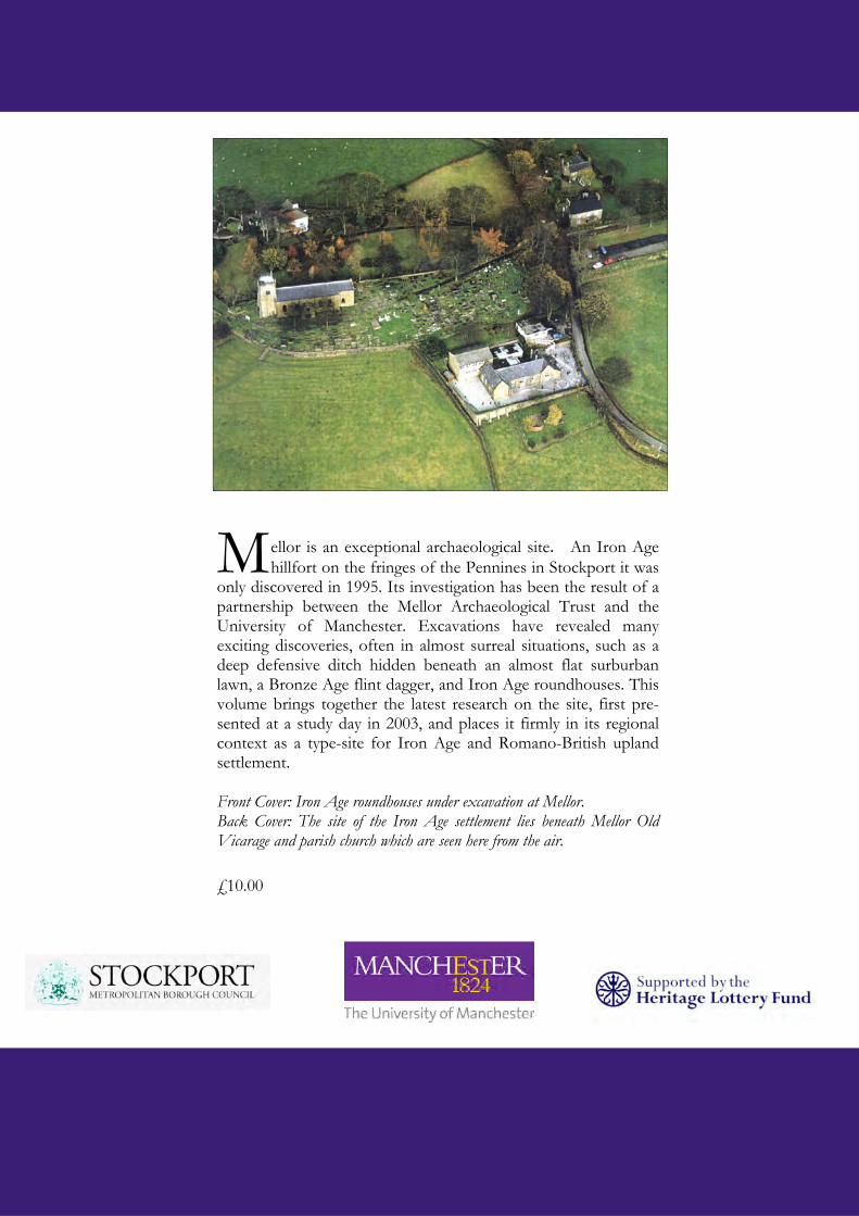
M ellor is an exceptional archaeological site. An Iron Age hillfort on the fringes of the Pennines in Stockport it was
only discovered in 1995. Its investigation has been the result of a partnership between the Mellor Archaeological Trust and the University of Manchester. Excavations have revealed many exciting discoveries, often in almost surreal situations, such as a deep defensive ditch hidden beneath an almost flat surburban lawn, a Bronze Age flint dagger, and Iron Age roundhouses. This volume brings together the latest research on the site, first pre-sented at a study day in 2003, and places it firmly in its regional context as a type-site for Iron Age and Romano-British upland settlement. Front Cover: Iron Age roundhouses under excavation at Mellor. Back Cover: The site of the Iron Age settlement lies beneath Mellor Old Vicarage and parish church which are seen here from the air.
£10.00