MDNR RAP for White Lake AOC - October 1987
258
Michigan Department of Natural Resources Remedial Action Plan for WEITE LAKE \ . Area of Concern October 27, 1987 Michigan Department of Natural Resources Surface Water Quality Division Great Lakes and Environmental Assessment Section P.O. Box 30028 Lansing, Michigan 48909
-
Upload
khangminh22 -
Category
Documents
-
view
1 -
download
0
Transcript of MDNR RAP for White Lake AOC - October 1987

Michigan Department of Natural Resources
Remedial Action Plan
for
WEITE LAKE \ .
Area of Concern
October 27, 1987
Michigan Department of Natural Resources Surface Water Quality Division
Great Lakes and Environmental Assessment Section P.O. Box 30028
Lansing, Michigan 48909

ACKNOWLEDGEMENT
The initial draft of the White Lake Remedgal Action Plan was completed through the technical assistance of Science Application International Corporation under EPA Contract No. 68-04-5041, Work Assignment GL86-07, SAIC Project No. 2-813-03-202-07. Assistance in reviewing, selecting, extracting, organizing available information and shaping it into a readable initial draft is acknowledged and appreciated. Special recogni- tion goes to Ms. Cindy Hughes and assocaiates.
Thanks is also given to those individuals that have provided technical assistance and information during the preparation of this remedial action plan. Special thanks goes to Irnie Jousma and Roger Przybysz - Grand Rapids District staff and Jim Heinzman - Geological Survey Division who took the time to become involved in this project.
Special thanks goes to Connie Pennell, Supervisor, MDNR Word Processing, and her staff; Julie Rann and Teresa Kent for their patience, understand- ing and conscientious efforts in the preparation of this,RAP.
John Wuycheck RAP Coordinator

TABLE OF CONTENTS
Page
LIST OF FIGURES
LIST OF TABLES
1 . 0 EXECUTIVE SUMMARY
INTRODUCTION
2 . 1 BACKGROUND 2 . 2 PURPOSE AND OBJECTIVES 2 . 3 INTENDED USE
3 . 0 ENVIRONMENTAL SETTING
3.1 LOCATION
3 . 1 . 1 IJCIState Area of Concern
3 . 2 NATURAL FEATURES
3 . 2 . 1 Drainage Basin 3 . 2 . 2 Topography 3 . 2 . 3 Hydrology 3 . 2 . 4 Soil Types, Runoff, Erosion 3 . 2 . 5 Limn01 ogy 3 . 2 . 6 Climate and Air Quality
3 . 3 LAND COVER AND USES
3 . 3 . 1 Land Cover 3 . 3 . 2 Land Use 3 . 3 . 3 Sewer Semice Systems
3 . 4 WATER USES (WHITE LAKE AOC)
3 . 4 . 1 Water Supply 3 . 4 . 2 Commercial Fishing 3 . 4 . 3 Sport Fishery 3 . 4 . 4 Wildlife Babitat 3 . 4 . 5 Contact and Noncontact Recreation 3 . 4 . 6 Navigation 3 . 4 . 7 Waste Disposd
3 . 5 WATER QUALITY STANDARDS, GUIDELINES, OBJECTIVES, AND APPLICABLE BENEFICIAL USES
4 . 0 DEFINITION AND EVALUATION OF THE PROBLEM

4.1 IMPAIRED USE ASSESSMENT
4.2 MAJOR AOC COMPONENT EVALUATIONS
4.2.1 Water ~ u a l ity 4.2.1.1 Tributaries to White Lake 4.2.1.2 White Lake
4.2.1.2.1 Nutrients 4.2.1.2.2 Toxic Substances
4.2.2 White Lake Sediment Quality 4.2.3 White Lake AOC Biota
4.2.3.1 Benthic Community 4.2.3.2 Fish Community
5.0 SOURCES OF POLLUTION
5.1 PRIMARY SOURCES OF MAJOR POLLUTANTS
5.1.1 Urban Stormwater Runoff/Combined Sewer Overf 1 ows
5.1.2 Surf ace Water Discharges
5.2 SECONDARY SOURCES OF MAJOR POLLUTANTS
5.2.1 Groundwater Contamination 5.2.1.1 Groundwater Contamination by
Industries 5.2.1.2 Local ized Groundwater Contamination
by Industries 5.2.2 Sediment Contamination
5.3 SUHMARY
6.0 POLLUTANT TRANSPORT MECEANISMS AND LOADINGS
6.1 CONTINUOUS POINT SOURCES
6.2 INTERWITTENT POINT SOURCES
6.2.1 Urban Stormwater Discharges
6.3 NONPOINT SOURCES
6.3.1 Atmospheric Deposition 6.3.2 Groundwater Discharges
6.4 IN-PLACE POLLUTANTS
6.5 SDMEiARY
7.0 HISTORICAL RECORD OF REMEDIAL ACTIONS

7.1.1 Muskegon County Wastevater Hanagemcnc System (WMS) No. 2
7.1.2 Superfund Sites 7.1.3 Proposed Superfund Sites 7.1.4 Non-Superfund Sites
7.2 ACTIONS CURRENTLY IN PROGRESS
7.2.1 Muskegon County W S No. 2
8.0 DEFINITION OF SPECIFIC GOALS, OBJECTIVES, AND MILESTONES FOR RESTORATION OF MPAIREO USES
8.1 USES TO BE RESTORED, ~INTAINEO, OR DISCONTTNUm
8.2 GOALS FOR BIOTA AND BABITAT RESTORATION
8.3 WATER USE AND QUALITY OBJECTIVES
9.0 PROGRAMS AND PARTICIPANTS
9.1 REGULATORY AND ADMINISTRATIVE PROGRAMS
9.1.1 Status of Water Quality Standards, Guide1 ines and Ob j actives
9.1.2 Compllanca Status of Point Source Controls 9.1.3 Superfund and State Hazardous Site Cleanup 9.1.4 Nonpoint Source Control Efforts 9.1.5 Hazardous Waste Management 9.1.6 Urban Stormvater Pollution Control Efforts 9.1.7 COE Projects/Other Agency Actions
9.2 PUBLIC rn0LVMENT
9.3 -CY A-S 9.3.1 Great Lakes Water Quality Agreement of 1978
10.1 RECO-ED PLANS AND STUDIES
10.1.1 Contambated Groundvater 10.1.2 Urban Stormwater Runoff 1 0 . 3 Contaminated Sediments 10.1.4 Nutrf ent Enrf chment 10.1.5 Fish Contaminants

APPENDICES
3.1 METEOROLOGICAL DATA FOR 1985
4.1 WKITE LAKE BASIN WATER SAMPLING DATA
4.2 WHITE LAKE SEDMENT ANALYSIS DATA
4.3 WHITE LAKE B m O S DATA
4.4 WRITE LAKE FISE SAMPLING DATA
7.1 PRIORITY LISTS FOR EVALUATION AND INTERIM RESPONSES AT SITES OF ENVIRONMENTAL CONTAMINATION PROPOSED
9.0 RPiEDLAL ACTION PLAN PARTICIPANTS
' 9.1 SURVEY FORH FOR KDNR NONPOINT SOURCE ASSESSHENT

LIST OF FIGURES
3-1 LOCATION OF WHITE LAKE IN MUSKEGON COUNTY, MICHIGAN
3-2 WHITE RIVER DRAINAGE BASIN
3-3 AVERAGE ANNUAL now OF THE WHITE RIVER AT WHITEHALL
3-4 MEAN MONTHLY FLOW OF THE WHITE RIVER AT WHITEBALL
3-5 MAJOR SOIL ASSOCIATIONS IN MUSKEGON COUNTY
3-6 LOWER, MIDDLE, AM) UPPER BASINS OF WHITE LAKE
3-7 MUSKEGON COUNTP CLIMATOLOGICAL DATA
4-1 WHITE LAKE SAMPLING STATIONS
4-2 LOCATION OF SEDPiENT SAMPLES COLLECTED IN WHITE LAKE
4-3 WHITE LAKE SEDIMENT MONITORING STATIONS
4-4 MDNR-1975 SEDIMENT PCB RESULTS
5-1 LOCATIONS OF HISTORICAL AND POTENTIAL POLLUTION SOURCES
5-2 PLUME MONITORING WEUS, HOOKER CHEMICAL COMPANY
5-3 PLUME PURGEWELL HOOKER CHPiICAL COMPANY
5-4 CONTAMINATION GROUNDWATER PLUME ASSOCIATED WITH HOWMET CORPORATION
5-5 CONTAMINATED GROUNDWATER PLUME ASSOCIATED WITH KOCH (MUSKEGON) CHEMICAL COMPANY
5-6 GROUNDWATER MONITORING WELL LOCATIONS AT MUSKEGON COUNTY WMS NO. 2
6-1 ANNUAL AVERAGE PHOSPHORUS LOADING RATE TO WHITE TAKE
6-2 AVERAGE AVERAGE PHOSPHORUS CONCENTRATION IN WHITE LAKE
7-1 LOCATION OF TKE WMS NO. 2
7-2 GENERAL LAYOUT OF THE WMS NO. 2
9-1 ORGANIZATIONAL CHART OF MICHIGAN DEPARTMENT OF NATURAL RESOURCES

LIST OF TABLES
WHITE RIVER BASIN WATERSHED MANAGEMENT UNITS (REGION 14 ONLY)
now RATES OF STREAMS PER WATERS= MANAGMENT UNIT IN TEE WHITE RIVER BASIN
ESTIMATES OF LAND COVER PER WATERSHED MANAGPIEFIT UNIT
ESTIMATES OF LAND USE PER WATERSHED MANAG- UNIT
RESTRICTED USE PESTICIDES IN MUSKEGON COUNTY IN 1986
WHITE RIVER BASIN STORM SEWER NETWORK
ANGLER DAYS - WHITE LAKE - 1972 TEROUGII 1982 SURFACE WATER DISCHARGERS
HISTORICAL IMPAIRED USES OF WHITE LAKE AND CURRENT STATUS
IMPAIRED USES OF TRIBUTARIES TO WHITE LAKE
RULE 57(2) GUIDELINE LEVELS IN SURFACE WATER SAMPLES
SUMMARY OF "LOW BOILER" DATA FOR WATER SAMPLES FROM WHITE LAKE
NONAFFECT SEDIMENT CLASSIFICATION CRITERIA
SUMMARY OF G R O ~ A T E R CONTAMINATION DATA IN TIIE AOC
POLYCHLORINATED BIPHENYLS IN WHITE LAKE
SUMMARY OF WHITE LAKE SAMPLING DATA - SEDMENTS MDPH AND USDA FISH CONSUMPTION ADVISORY ACTION LEVELS
4-10 CONTAMINANTS FOUND IN WHITE LAKE OUTLET FISH DURING LAKE MICHIGAN TRIBUTARY STUDY, 1980-1983
1 INDUSTRIES WITHIN STORM DRAIN BASINS
5-2 CURRENT AND DISCONTINUED SURFACE WATER DISCHARGERS
5-3 MUNICIPAL, INDUSTRIAL AND CONTAMINATED GROUNDWATER SITES in AOC
5-4 CURRENT SURFACE WATER DISCHARGERS

SUMHARY OF MONITOR RESULTS FOR HOOKER CHEMICAL COMPANY'S CONTAMINATED GROUNDWATER PLUME MONITORING WELL DATA
MEAN ANALYTICAL RESULTS FOR PURGEWELL WATER SAMPLES COLLECTED IN 1986 FROM HOOKDER CHEMICAL COMPANY
ANALYTICAL RESULTS FOR MUSKEGON CHEMICAL COMPANY CONTAMINATED GROUNDWATER SEEPAGE TO MILL POND CREEK
CHLORIDE AND NUTRIENT LEVELS DETECTED IN GROUNDWATER AT THE WMS SITE, 1981
TRACE ORGANIC CONCENTRATIONS DETECTED IN MONITORING AND OBSERVATION WELLS AT THE WMS SITE
ESIMATED WHITE RIVER BASIN STORMWATER LOADINGS
WHITE RIVER TOTAL PHOSPHORUS LOADINGS TO WHITE LAKE
WMS NO. 2 PUMPING STATION SUMMARY
COST FOR SITE CONSTRUCTION AT WMS NO. 2
10-1 PROPOSED REMEDIAL ACTIONS - WHITE LAKE AREA OF CONCERN

PROLOGUE - WHITE LAKE REMEDIAL ACTION PLAN
In 1985, the Water Ouality Board (WB) of the International Joint ComTlission ( I J C ) identified 42 Areas of Concern ( A m ) for which Remedial Action Plans (RAPS) should be developed. In their report on Great Lakes Water Wlity, the WQB further identified specific impaired beneficial water uses and water quality problem in each AOC that the RAPS were to address. The identified problems were suspected of contributing to the degradation of one of the Great Lakes. The intent of each RAP is to outline the course of action that will result in the restoration of designated uses and resolution of water quality problems that impact the Great Lakes. Once it is confirmed that those uses identified in the 1985 WQB report are restored, the AOC should be removed from the AOC list.
In 1986, The Michigan Department of Natlxal Resources (MDNR) began work on RAPS to address identified impaired uses in each of Michigan's fourteen A m . During the data collection, fact finding and analysis phases of RAP development8 problems other than those reported in the 1985 WQB Report were identified. The newly identified problems are listed in this RAP regardless of their status as RAP issues in order to
i document known environmental issues in the AOC. Inclusion of all documented problems in the RAP is sound from an ecosystem management perspective. Furthermore, it indicates to the public what the problems are and how they may be addressed.
An attempt was made to clearly distinguish between those water quality problems and impaired uses identified as truly RAP issues and those problems that ace of local and/or regional (Lake Michigan wide) concern. RAP issues included those identified in the 1985 WQB Report as causing or contributing to an impact or loading to the Great Lakes.
The RAP issue identified in the 1985 WQB Report used to designate White Lake as an AOC was the venting of contaminated groundwater to White Lake frw the defunct Occidental (Hooker) Chemical Company site. Current well monitoring data8 purgewell system operation and groundwater treatment indicate that 100% of the contaminated groundwater plume is being captured and treated. The final effluent quality meets limits designed to protect environmental and public health concerns. Studies to-date indicate no apparent impacts to designated uses of Lake Michigan due to conditions in White Lake.
Various issues of local importance discussed in the White Lake RAP include other contaminated groundwater sites, urban stormwater runoff, nutrient enrichment and contaminated sediments. These issues are being addressed through state, federal, county and/or local programs as indicated in this RAP. They are not expected to be resolved through the RAP process.
In addition to the identification of local issues, PCB and chlordane concentrations were found to be elevated in carp collected from White Lake. There is inadquate information to determine if this is a regional or site specific phenomenon. Therefore, carp were scheduled to be collected from Lake Michigan and analyzed in 1988-89 to define PCB and chlordane levels. Results may indicate that PCB and chlordane levels found in White Lake carp reflect a regional problem versus a site specific problem (RAP issue). Further, White River sediments will be collected in 1988 and be analyzed for PCBs, chlordane and other pesticides to determine if they are a potential source of environmental contaminants. PCB and chlordane loadings to the region, as part of an air toxics monitoring program, needs to be determined in order to assess this potential source of environmental contaminants to the region as well as the White Lake area.
MDNR staff appreciated the Water Quality Board's Programs Cornnittee review of the 1987 White Lake RAP that was submitted in October 1987. MDNR's responses to the reviewer(s1 comnents are included in Appendix 10.0. Staff are hopeful that our responses address the AOC issues of concern. A major effort was made to clarify, better define and separate AOC issues from localized and/or potentially regional problems.

MDNR UPDATE 21 September 88
Muskegon Lake Remedial Action Plan:
The following paragraph will be added to page 10 under Section 3.2.3 entitled Hydcology of the Muskegon Lake Remedial Action Plan:
Sorrell (1988) concluded that the Muskegon River flows into Lake Michigan under normal conditions. His conclusion was derived by comparing the average annual rate of rise of Lake Michigan of 0.2 &day of 0.08 inchedday over a 5 month period (equivalent to 0.42 m3/s or 15 cfs) with the lowest recorded discharge of the Muskegon River of 1.47 m3/s or 52 cfs (Newaygo U.S.G.S. gage located 30 miles upstream from the lake). The inflow volume from the Muskegon River to Muskegon Lake is, therefore, greater than inflow volume into Muskegon Lake caused by the normal rise of Lake Michigan. Although the level of Muskegon Lake fluctuates in response to the normal cycle of Lake Michigan, it always receives a sufficient amount of inflow volume from the Muskegon River watershed to show a net inflow into Lake Michigan.
Reference :
Sorrell, R. 1988. Effect of Lake Michigan on Muskegon and White Lakes. A 15 September 88 memo to Jack Wuycheck (Surface Water Quality Division) from Rick Sorrell (MDNR Land and Water Management Division hydrologist).

1.0 EXECUTIVE SUMMARY
White Lake is a 1,040 hectare (2,571 acre) lake located in Muskegon County along the east shoreline of Lake Michigan in the vicinity of the communities of Montague and Whitehall. The White Lake AOC includes White Lake proper and a 0.4 km (0.25 mi) wide zone around the lake. White Lake is an excellent walleye, perch, largemouth bass and northern pike fishery and sustains other popular recreational activities such as boating and ,
swimming.
The major environmental problem identified in the 1985 WQB report was the discharge of contaminated groundwater to White Lake from the Occidental (Hooker) Chemical Company property. Groundwater contaminants of concern that enter White Lake include chloroform, trichloroethylene, carbon tetrachloride and tetrachloroethylene. Major soil contaminants at the site, located about 1.2 km (0.75 mi) north of White Lake, are hexachlorobutadiene (C-46 or HCBD), hexachlorocyclopentadiene (C-56 or HCP), hexachlorobenzene (C-66 or HCB) and octachlorocyclopentene (C-58 or O C P ) . These latter contaminants are not entering White Lake from the contaminated plume.
A 1979 Consent Judgment between the Hooker Chemical Company and the State of Michigan reauired the company to completely halt the flow of contami- nated groundwater to White Lake. The Consent Judgment required the installation of purge wells to purge groundwater from the contaminated aquifer and provide treatment of the groundwater to remove contaminants of concern. The company has installed a series of purge wells and a carbon absorption treatment system. The treated purge well water is discharged to White Lake pursuant to an NPDES permit.
After installation of the purge well system, Michigan Department of Natural Resources (MDNR) has, on an on-going basis, evaluated the effec- tiveness of the purge well system and determined that the purge well system is not completely halting the flow of contaminated groundwater to White Lake. In May 1985 the State filed a Motion to Compel with the Ingham County Circuit Court to enforce the provisions of the 1979 Consent Judgment and to compel the chemical company to improve its groundwater purge well and treatment system so that the flow of contaminated ground- water to White Lake is co~lpletely halted. In December, 1985, the Circuit Court affirmed the State's position that the Consent Judgment requires Hooker to completely halt the flow. Since that time, Hooker Chemical Company has made incremental increases in the groundwater purge rates, but the company still is not purging at a rate sufficient to halt the flov of contaminated groundwater to White Lake. Hooker increased the total pumping rate of a nine well system, during the summer of 1987, to 2580 liters/minute (685 gpm). This pumping rate appears to be effective in capturing greater than 952 of the plume entering White Lake. One major factor that influences plume capture is lake level. Pumping rates must be sufficient to maintain the level of the plume below the level of the lake. Increased pumping rates have reduced contaminant loadings to White Lake based on White Lake sampling data. Further improvements must be made before the company vill be in compliance with the Consent Judg- ment on this issue. The State is continuing its efforts to obtain camp1 iance.
1

In order t o evaluate the poten t ia l f o r bioconcentration of HCBD, HCB, OCP L and mirex e f f luen t concentrat ions, normally l e s s than the level of de tec t ion , Occidental (Hooker) Chemical was required t o conduct a contam- inant uptake study which involved exposing f i s h t o the t rea ted e f f l u e n t . Study r e s u l t s shoved the absence of de tec tab le l e v e l s (detect ion l eve l of 10 ppb) of hexachl orobutadiene , octachl orocycl opentene , hexachl orobenzene and mirex i n whole rainbow t rou t a f t e r 28 days exposure t o 100% carbon f i l t e r t r e a t e d e f f l u e n t discharged from Outfal l 001.
The 1984 f i s h contaminant monitioring da t a f o r White Lake indicated t h a t carp populations contain an average concentrat ion of 3.7 ppm PCBs which exceeds 2.0 ppm wet weight ac t ion l eve l used by the Michigan Department of Publ ic Health (MDPH) and U.S. Food and Drug Administration (U.S. FDA) . These same carp a l s o contained elevated concentrat ions of chlordane t h a t exceeded the MDPH's and U.S.FDA a c t i o n leve l of 0.3 ppm. Heavy metals and o the r organic contaminant l e v e l s were found t o be l e s s than estab- l i shed l e v e l s of concern. PCB sources t o the carp population is sus- pected t o be lake sediments and/or atmospheric loadings t o Lake nichigan arid t he White Lake watershed. Suspected chlordane sources may be ag r i - c u l t u r a l and/or atmospheric. White Lake 1986 sediment sample ana lys i s ind ica ted chlordane l e v e l s were l e s s than l e v e l s of de tec t ion (67 t o 430 ppb). White Lake sediment samples a r e cur ren t ly being reanalyzed f o r PCBs t o determine i f they a r e a s i g n i f i c a n t po ten t ia l source t o the l ake ' s ca rp population.
White Lake sediment survey da ta f o r December 1986 indica ted the l i t t o r a l zones on the north, west and south s i d e s of the lake a r e primarily sand. Sand t y p i c a l l y contains low contaminant l e v e l s and, during the survey,
L was, t he re fo re , not sampled except i n the v i c i n i t y of Occidental (Hooker) Chemical Company's contaminated groundwater plume. Sediments nor theas t of t he lake near the i n l e t were found t o be pr imari ly organic influenced by runoff from upstream muck land.
A major sediment contaminant commonly found throughout the lake i n the s u b l i t t o r a l areas , during the 1986 survey, was chromium. A maximum chromium concentrat ion of 4,300 ppm w a s co l lec ted i n the v i c i n i t y of the now defunct o u t f a l l of Whitehall Leather Company. P r i o r t o 1976, t he company discharged process water t o White Lake. Lake sediment chromium concentrat ions i n the v i c i n i t y of t he discharge, reportedly contained more than 20,000 ppm In 1970. The benth ic community i n the v i c i n i t y was degraded by the company discharge bu t is improving. Although e leva ted , the observed sediment chromium concentrat ions do not appear t o be causing any impalred use of White Lake o r Lake Michigan, nor w a s there any ind ica t ion of excessive uptake of chromium by f i sh .
Since t h e mid-1970's i n d u s t r i a l and municipal wastewater from Whitehall and nontague have been t rea ted at the Whitehall-Montague wastewater land app l i ca t ion f a c i l i t y located about 3.2 lan (2 mi) upstream of White Lake. Implementation of an approved i n d u s t r i a l pretreatment p lan t has f u r t h e r reduced the discharge of process wastes t o the treatment f a c i l i t y . Underdrainage from several laad app l i ca t ion s i t e s a r e present ly dis- charged t o S i lve r Creek, a designated coldwater stream, and thence t o the White River and White Lake. The f a c i l i t y is being upgraded and the ou fa l l d iver ted t o t he White River j u s t downstream of the S i lve r Creek confluence.
2

Runoff from agricultural areas and nonpoint source loadings in the watershed are suspected of contributing 95-97% of the nutrient loadings to the lake. Phosphorus is the limiting nutrient for White Lake and an inlake phosphorus concentration goal less than 30 ppb phosphorus is reconmended for White Lake by the MDNR in order to maintain acceptable water quality. December 1986 and May 1987 lake sampling indicated average phosphorus concentrations of 15 and 25 ppb , respectively. Additional survey data characterizing seasonal lake conditions is recom- mended to determine if remedial actions are needed to reduce nonpoint source nutrient loadings to the lake.
A public meeting was held on June 17, 1986, to provide the general public, local units of government, industrial representatives and envi- romnental groups an overview of the Remedial Action Plan development process, findings to date and an opportunity to provide comments and recommendations concerning the White Lake AOC.
A second public meeting was held on October 19, 1987, folloving the completion and release of a draft of the remedial action plan in order to afford an opportunity for comments and suggestions for the final report.
Based on available data, the following conclusions and recommendations are made:
White Lake AOC has no known adverse effects on Lake Michigan.
The only documented impaired use in White Lake is a fish consumption advisory for carp because of elevated PCBs and chlordane.
The reduction of the discharge of contaminated groundvater from Occidental (Hooker) Chemical Company to White Lake is occuring because of increased purgewell capture of the plume. Pumping rates need to be increased in order to completely halt the flow of contarn- inated groundwater to White Lake under varying lake levels.
Evaluate nonpoint nutrient loadings and contaminants (pesticides) to determine seasonal loadings and the need for developing a nonpoint source nutrient loading minimization plan.
Air toxics monitoring in the region is recommended to determine atmospheric loadings of PCBs and chlordane to the White Lake area.
Carp from Lake Michigan should be collected and analyzed for PCBs and chlordane to help determine if PCBs and chlordane in White Lake carp are a specific or regional phenomenon.
A summary of impaired uses, causes, sources, and remedial actions is provided in Table 10-1.

2.0 INTRODUCTION
2.1 BACKGROUND
The International Joint Commission (IJC), the Great Lakes National Program Office (GLNPO), and the State of.Uichigan have designated White Lake as an Area of Concern (AOC). The White Lake AOC is located on the east shore of Lake Michigan and is connected to the lake by a federally. maintained navigational channel. For purposes of this Remedial Action Plan (RAP) , the White Lake AOC includes White Lake and a 0.4 km (0.25 mi) zone around the lake. This remedial investigation was developed as an evaluation of water quality, sediment quality and impaired designated uses in the White Lake AOC.
One impaired use is evident in the Area of Concern. A fish advisory was issued in 1986 that advised for "Restricted Consumption'' of carp due to the presence of PCBs (average 3.7 ppm) that exceeded the MDPH and U.S. FDA action level of 2 ppm. Chlordane concentrations (average 0.6 ppm and range of 0.13 to 1.24 ppm), in these same carp, exceeded the 0.3 ppm action level used by the MDPH and U.S.FDA.
Other documented environmental issues are contamination of bottom sedi- ments, groundwater and surface water. Contaminant sources have been identified as historical surface water discharges, contaminated groundwa- ter and nonpoint sources. Groundwater contamination has been detected in at least 10 locations in the vicinity of the the AOC. The major site is Occidental (Booker) Chemical Company whose contaminated plume discharges to White Lake.
There is some indication of lake sediment quality improvements since the 1973-74 due to wastewater diversion to the Muskegon County WMS No. 2 land application site. However, contaminated groundwater seepage, excessive nutrient loadings and degraded benthic comnunities, although improving, still represent measureable problems for Uhite Lake that need evaluation. NPDES permitted point source dischargers no longer appear be contributing to current pollution concerns in the lake.
Great Lakes Water Quality Management
The Great Lakes Water Quality Board (GLUQB) is responsible for reporting water quality research activities and the environmental quality of the Great Lakes to the IJC. The GLWQB has adopted a system of categories to track and measure the progress of the 42 identified Areas of Concern in terms of envirollmantal health. The categories identify the status of the information base, programs which are underway to fill the information gaps, and the status of remedial efforts. According to the GLWQB (l985), resolution occurs when evidence can be presented verifying that the full complement of uses has been restored. The site can then be removed from the Area of Concern list. The folloving categories form the described sequence :

Expl anat ion Category
1 Causative factors are unknovn and there is no investigative program to identify causes.
Causative factors are unknown and an investiga- tive.program is underway to identify causes.
Causative factors known, but Remedial Action Plan not developed and remedial measures not fully implemented.
Causative factors known and Remedial Action Plan developed, but remedial measures not fully imp1 emented.
Causative factors known, Remedial Action Plan developed, and all remedial measures identified in the Plan have been implemented.
Confirmation that uses have been restored and deletion as an Area of Concern.
2.2 PURPOSE AND OBJECTIVES
The purpose of the Remedial Action Plan process is to provide a coordi- nated (i.e., Great Lakes watershed) approach to environmental management that will ultimately lead to the successful rehabilitation of the Great
I, Lakes and, in this instance, the White Lake Area of Concern. This approach requires an integration of available data on the environmental conditions, socioeconomic influences and pol itical /institutional frame- works. The plan's purpose is to focus the data gathering and data synthesis tovards the resolution of the immediate problems which impair the AOC's designated uses. Recommendations towards resolving the identi- fied problems will be based on the current available data and within the framework of current institutional programs.
2.3 INTENDED USE
This RAP is intended as a technical management document that provides a review of available data, defines impaired uses, data needs, prioritizes necessary investigations and necessary remedial options to provide a platform for future analyses and decision-making. The RAP also repre- sents a detailed review and synthesis of available data and/or infonna- tion relevant to the problems in the Area of Concern. Every attempt has been made to identify the major documents pertaining to the critical environmental issues affecting this AOC. Remedial action planning is an iterative process, however, and suggestions and additions are welcomed in as much as they contribute to RAP issues and final goals.

3.0 ENVIRONMENTAL SmING
The S t a t e of Michigan and the In te rna t iona l Jo in t Commission (IJC) have i d e n t i f i e d White Lake and t h e surrounding 0.4 km (0.25 m i ) zone a s the White Lake Area of Concern (AOC). Environmental c h a r a c t e r i s t i c s , land and water uses and water q u a l i t y s tandards a r e presented i n t h i s s ec t ion t o provide background information f o r e f f ec t ive evaluation of the ex i s t - ing s i t u a t i o n i n the AOC.
3.1 LOCATION
The White Lake AOC, located i n Muskegon County i n the west cen t ra l por t ion of Michigan, is on the eas t e rn shore l ine of Lake Michigan (Figure 3-1). The AOC is p a r t of the White River Drainage Basin. Headwaters f o r the e n t i r e drainage system o r ig ina t e i n Newaygo County and flow westward, eventual ly dra in ing i n t o Lake Michigan.
3.1.1 IJC/State Area of Concern
The Area of Concern f o r t h i s Remedial Action Plan (RAP) has been desig- nated a s White Lake and the surrounding 0.4 km (0.25 m i ) zone.
3.2 NATURAL FEATURES
3.2.1 Drainage Basin
The White Lake AOC l i e s wi th in the White River Drainage Basin (Figure 3-2). The bas in d ra ins port ions of Newaygo, Oceana and Muskegon Counties covering a t o t a l drainage a rea of 131,831 hec tare (509 mi2)
(U.S. EPA, 1975). The drainage a rea cons i s t s of the White River 124,579 hec t a re (481 m i 2 ) and minor t r i b u t a r i e s and lamediate drainage of 6,216 hec t a re (24 mi2). The West Michigan Shoreline Regional Development Counnlssion (WMSRDC) f u r t h e r divided the port ion of the White River Basin t h a t l i e s i n Region 14 (Oceana and Muskegon Counties) i n t o four Watershed Management Units W s ) a s p a r t of t h e i r regional development and plan- ning program (WMSRDC 19780). Total drainage a rea f o r the four WMUs is 64,232 hec tare (248 mi2), o r 51 percent of the t o t a l basin drainage a rea (WMSRDC 1978a). The individual WMUs and t h e i r drainage a reas a r e provid- ed i n Table 3-1.
Of the four WMUs, North Branch is the l a r g e s t , occupying approximately 17 percent of the t o t a l basin drainage area. The nor th branch of t he White River o r ig ina t e s i n Oceana County a t McLaren Lake. The South Branch WMU, t he main branch of the White River, o r ig ina t e s i n Newaygo County and covers approximately 11 percent of the t o t a l drainage basin. White River drops 123 m (400 f t ) i n e l eva t ion from its headwaters i n nor th cen t r a l Newaygo County t o its terminat ion i n White Lake, 173 km (453 mi) away. White River WMU is the smal les t of the four , covering only 6 percent of t he a rea , and joining the North Branch and South Branch WMUs t o White Lake WMU. The second l a r g e s t i n s i z e , White Lake WHU covers approximate- l y 17 percent of the drainage a rea .
6


I I I 1
I
Figure 3-2 White River / White Lake drainage basin. Michigan.

Table 3-1. White River Basin Watershed Management Units (Region 14 Only)
Watershed Management Unit
Percent of Hectare (mi 9 Total Basin
North Branch
South Branch
White River
White Lake
Source: Modified from WMSRDC 1978a.
Major tributaries within the White Lake AOC and White River WMUs are Mill Pond Creek, Coon Creek, Silver Creek, Carlton Creek, and Buttermilk Creek.
The portions of the White River Basin within Muskegon County are empha- sized throughout this RAP because this portion of the basin possesses the
L greatest potential for affecting the AOC.
3.2.2 Topography
The majority of Muskegon County is characterized by level to gently sloping topography. Large sand dunes stretch across the Lake Michigan shoreline gradually decreasing in size towards the east that flattens into a wide plain. Stream channels and lake basins are located through- out the plain. Elevations in the county range from 170 m (580 ft) above sea level at Lake Michigan to 246 m (800 ft) at the lakeshore dunes (Metcalf 6 Eddy 1982).
3.2.3 Hydrology
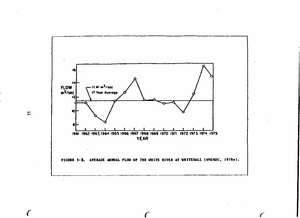
U.S.EPA (1975) reported mean flows for the White River and immediate drainage area of the lake basin of 14 ms/s (495 fts/s) and 0.8 m3/s (27.2 fts/s). Average flow rates for White River and tributaries located in the White River Basin are provided in Table 3-2 (UXSRDC, 1978a). Recent flov measurements at the Fruitvale Road USGS gaging station, located near Whitehall, measured a 28-year average flow rate of 12.4 ms/s (439 ft3/s) (U. S. G. S., 1985). Typical variations in yearly flow rates reported by WMSRDC (1978a).for the period 1961 to 1975 are presented in Figure 3-3. Typical seasonal differences in flow rates are illustrated in Figure 3-4. Annual and seasonal variations in flow rates are moderated by groundwater which provides approximately 79 percent of the White River flow (WMSIUX
9 i

1978a). The White River represents 95% of the drainage area of White Lake and provides at least 95% of the basin discharges to the lake (U.S. EPA, 1975).
Table 3-2 Flov Rates of Streams ier Watershed Management Unit in White River Basin
Watershed Management Unit
Associated S t r eams
Average Flow Rate
m3/s (ft3/s)
North Branch
South Branch
White River
White Lake
Cobmoosa Knutson Nevman Robinson
Brayton Cushman Skeel s
Carl eton Carl ton Cl eve1 and Mud Sand Silver White River
Birch Buttermilk Coon Mill Pond Pierson S travberry Wildcat
0.31 10.8 0.25 8.9 not provided
0.10 3.7 1 .09 38.4 0.67 23.6 not provided 0.54 29.1 0.51 18.0 12.8 454.6
Source: Modified from WHSRDC 1978a. (17-year period of record).
U.S.G.S. - Water Resources DataIWater Year 1985 White River at Whitehall (Fruitvale Road Gage) - 28 year period of record. Average: 12.4 mS/s (439 ftS/s)
Extremes : ninimum - 4.6 mS/s (163.ftS/s) Maximum - 152.9 mS/s (5,400 ftS/s)
YEAR
FIGURE 3-3. AVERAGE ANNUAL PLOU OF THE WHITE RIVER AT WHITEHALL (WHSRDC, 1978.1-


3.2.4 Soil Types, Runoff, Erosion
A variety of soil types cover the Muskegon County area. Figure 3-5 illustrates the eight major soil associations in Pfuskegon County. Soil types range from well-drained sandy soils to poorly drained mucks (Melcalf 6 Eddy 1982). Six of the soil associations are found in the White Lake area and include the following:
Rubicon-Croswell-Deer Park ' Carl is1 e-Tawas O Montcalm-Nester-Belding-kawkawl in
Au Gres-Roscomanon-Granby O Nester-Ubly-Sims O Belding-A1 1 endal e-Rubicon (Metcal f h Eddy 1982) .
The Rubicon-Croswell-Deer Park association consists of almost level to steep, well to moderately well drained sandy soils located on outwash plains and uplands (Metcalf & Eddy 1982). The Carlisle-Tawas associa- tion consists of almost level to depressiond, poorly drained peats and mucks. The Montcalm-Nester-Belding-Kawkawlin association consists of sloping to rolling, poorly drained and well drained sandy and loamy soils located on lake plains, outwash plains, and glaciated uplands. The Au Gres-Roscommon-Granby association consists of almost level to depressional, poorly drained sandy soils located on outwash plains, uplands, and lake plains. The Nester-Ubly-Sims association consists of sloping to hilly, well to moderately well drained and poorly drained loamy soils located on lake plains and uplands. The Belding-Allendale- Rubicon association consists of almost level to slightly sloping, poorly to well drained loamy and sandy soils located on lake plains.
Soils dong the river are highly erosive as evidenced by steep, eroded banks and gullies created near the river and its tributaries. Surface runoff from the watershed contributes to sediment loads because of erosive soils located in the inmediate vicinity of the White River (Mund, 1987).
Specific data concerning runoff and erosion potential for soils are not yet available (Pfund, 1987). Generally, soils that are highly permeable are more resistant to erosion and runoff than poorly drained soils. Additiorul information on runoff and erosion potential are presented under Section 3.3, Land Cover and Land Uses.
White Lake, a drowned river mouth, has a surface area of 1,040 hectare (2,571 acres) with mean and maximum depths of 6.9 m (22.5 t) and 21.5 m 5 (70+ ft), respectively. The lake has a volume of 7.1 :lo m (57,940 acre-ft) and a mean hydraulic retention time of 56 days (U.S. EPA, 1975).

LEGEND
FICUILE: 3-5. W O R SOIL ASSOCUTIONS IN MUSKEGON COUNTY (WBDC, (no date ) b ) .
White Lake contains three basins: 1) the upper t h i rd of the lake; 2) west of Dowies Point; and 3) west of Long Point (Figure 3-6). White Lake is approximately 8 lan (5 mi) long, 261 t o 1923 m (850 t o 6,250 f t ) wide, and is surrounded by 34.6 km (21.5 mi) of shorel ine. The lake has a mean hydraul ic r e t en t ion time of 56 days (U.S. EPA, 1975).
White Lake remains c l a s s i f i e d a s eutrophic even a f t e r the 1973 d ivers ion of municipal and indus t r i a l discharges. Nonpoint source nu t r i en t loadings from the watershed is the most important f a c t o r i n maintaining the eutrophic s t a t e of White Lake. In te rna l loadings from lake sedi- ments and t h e i r resuspension may a l s o serve a s a s i g n i f i c a n t source of phosphorus, espec ia l ly , i n the shallow eas t end of the lake where depths average 2.5 t o 3.0 m (8 t o 10 f t ) . The lake has extensive shallows t h a t support p r o l i f i c growths of macrophyte growths (Limno-Tech, 1981). The lake is d imic t ic and eutrophic and experiences periods of summer hypolimnetic anoxia.
3.2.6 Climate and Air Qua l i t y
Climate i n the AOC f luc tua t e s depending upon wind d i rec t ion . Winds blowing from the west produce a quasimarine cl imate, while winds blowing from the e a s t o r south produce a cont inental climate. Proximity of Lake Michigan c rea t e s mild winters and cool summers, with annual average d a i l y maximum and minimum temperatures of 13.8'C (56.g°F) and 4.Z°C (39.5'F), respect ively. Annual p rec ip i t a t i on averages 79.7 cm o r 31.4 inches (Metcalf 6 Eddy 1982). Figure 3-7 provides a summary of climato- log ica l da ta f o r 1985. Meteorological data f o r Muskegon County, includ- ing information on monthly p rec ip i t a t i on r a t e s temperature and cloud cover, appear i n Appendi .- 3.1.
The Kichigan Department of Natural Resources (MDNR) monitors a i r q u a l i t y f o r a l l po l lu t an t s under the National Ambient A i r Qual i ty Standards (NAAQS), except hydrocarbons. Under t h i s program, l e v e l s of s u l f u r dioxide, carbon monoxide, and lead have been found t o be l e s s than es tab l i shed standards.
Monitoring f o r a i r po l lu t an t s i n Muskegon County is conducted by the Muskegon County Health Department ' s A i r Qua1 i t y Section and by I ocal i ndus t r i e s . No v io l a t ions of the primary o r secondary p a r t i c u l a t e l e v e l s were recorded f o r years 1980, 1981, 1983, 1985 and 1986. One v i o l a t i o n of the secondary standard was recorded i n 1982 and 1984. No v i o l a t i o n s of the s u l f u r dioxide o r lead standard have been recorded in. over 8 years. The l a s t v io l a t ion of the carbon monoxide s tandards w a s recorded in 1978.
Muskegon County has recorded v i o l a t i o n s of the ozone s tandards i n the pas t 8 years . However, the po l lu t an t s which lead t o the formation of ozone a r e believed t o be generated from outside of Muskegon County (MDNR, 1985e, Annual A i r Quality Report).


Dai ly Data x131L
- - I0 - - - 28
* I
- Z i d
" 111
- 14 4 - i a - d
- -I0 - - i 4
- - 111 - -22 , D
I 1 1 1 1 + - 28
I ~ ~ ~ I o ~ ~ I ~ ~ ~ I ~ ~ ~ I ~ ~ ~ ~ o ~ ~ I ~ ~ ~ I ~ ~ ~ I ~ ~ ~ I ~ ~ M I O L D ~ I O ~ ~
JAY FEB MAR xPR MAY Jt'S JUL xCG SEP OCT SOL' DEC ,
I . I * * I 81. 4 \ I t Vi . ; A )ilj! , ; v , / .'+: J, , 2 , ' ' . .,.L ' 8 . - * - , ,....a - * + . l a * a41-, ' I re . .- .. .*. . . I , ' ,\ ' .. ;;," f * . ,
4.. 4 .'.. ' A ; . @ ' , . , . . n 1 4 - , '1 ' I / i i . 1,. . . . . 1'
it;! 4 I an; ' . I , t I - I I 4.: . , . ' , . I . . 8 , .
1 0 2 0 s 10IOa 10aO30 102030101010 102030101010 1OaO10 l O ~ 3 0 I O 2 0 3 0 102030102030
t 1 C W 3- 7. MJSKZCON COUNTY CLlXATOLOCICAL DATA ( N U , 1985).

L 3.3 LANDCOVER AND USES
The WMSRDC has completed an extensive investigation of land cover and land uses in Muskegon County. Information presented in this section has been recovered from "Sourcebook for Water Quality Planning Part I11 Estimates of Land Cover and Use" (WMSRDC (no date)b).
3.3.1 Land Cover
The extent of runoff and erosion occurring in an area is generally dependent upon the type of land cover present. Land cover classes include :
O Water O Grassy vegetation O Bare earth O Impermeable surfaces (paved areas) O Wooded
Percentage and acreage of each type of land cover are provided for each Watershed Management Unit in the White River Basin (Table 3 - 3 ) . . Extent and type of land cover in the area was estimated through the use of aerial photography. Due to seasonal changes, values presented here are only general estimates. Difficulty in the identification of water bodies or bare earth h e r e some vegetation was present may have caused under representation of these two categories.
Table 3-3. Estimates of Land Cover per Watershed Management Unit
North South White White Type of Land Branch Branch River Lake Cover Units WHU WMU WMU WMU
Water X Acres
Bare X Acres
Grassy X Acres
Wooded X Acres
Impermeabl e X Acres
Source: Modified from WMSRDC (no datelb
18
Predominant types of land cover vary between Watershed Management Units, L but wooded and grassy areas are generally the most common. Impermeable surfaces are the least common land cover type in each WHU.
Areas predominantly covered vith vegetation or sandy soils with high infiltration rates experience lower degrees of runoff and erosion than areas of clay-rich soils or Impermeable materials. Generally, areas with relatively high percentages of impermeable surface cover have a greater potential for contamination resulting from urban runoff.
Perhaps the single most important characteristic governing the water regime and drainage patterns in Muskegon County, more than anything else except precipitation, is the high soil infiltration rate due to sandy soils. The high infiltration rate of the Muskegon County soils, for the most part, exceeds the rainfall intensities for all but the severest of storm events (Muskegon County, 1974). This quality increases the potential for increased groundwater contamination due to man's activities.
3.3.2 Land Use
Types of land use provide information for the potential for contamina- tion. The West Michigan Shoreline Regional Development Commission (1978) divided land use into nine categories ranging from areas with land uses that possess the greatest potential for pollutant production to those with the least:
Wastedisposal Extractive O Industrial a Institutional
Residential 0 Open space and recreation a Agricultural a Commercial a Transportation
Table 3-4 lists the extent of land use types per Watershed Management Unit in the White Lake Basin. Percentages and actual acreages of land use types were determined using aerial photographs. Due to the subjec- tive nature of the method utilized for classification of land areas into the nine categories, the amount of land presented per category are generally estimates of land uses in the White River Drainage Basin. In areas where questions arose concerning the identification of the land use type, the areas were classified as the land use category containing the greater potential for pollutant production. Specific types of land use are described in the following paragraphs.
Waste disposal land uses refer to areas containing dumps, landfills, sewage treatment facilities, incineration facilities, sludge or indus- trial disposal sites and waste injection well sites.
Industrial land uses refer to areas containing factories, manufacturing plants, power generating plants, or any operations that process raw materials into purchase products.

Table 3-4. Estimates of Land Use per Wate~shed Management Unit
North South White White Type of Land Branch Branch River Lake Cover Units WMU WMU WMT WMU
Waste Disposal
Indus t r i a l
Resident ial
Agricul t u r a l
Transportation
Extract ive
I n s t i t u t i o n a l
Recreational
Commercial
% Acres
X Acres
X Acres
X Acres
X Acres
X Acres
X Acres
X Acres
X Acres
Source: Modified from WMSRDC (no date)b
Resident ial uses include a reas containing not only p r iva t e homes but a l s o ho te l s , motels, apartments, pr isons o r any type of housing u n i t . The major po l lu t an t t h a t would r e s u l t from t h i s category of land use is sewage. These sources have been eliminated by the cons t ruc t ion of c o l l e c t i o n sewers, a s p a r t of the Muskegon County WMS No.2 f a c i l i t y .
Agricul tural uses . re la te t o a r eas used f o r l ivestock and crop produc- t ion . Cropland, orchards, barnyards, and equipment s torage yards a r e examples of a reas covered by t h i s category. There a r e approximately 4168 hectare (10,300 acres) of cropland i n the White Lake bas in i n Ifuskegon County (Mund, 1987) . The cash crops raised a r e corn, wheat, green beans, asparagus and a l f a l f a . A few l ivestock opera t ions a r e a l s o present . There a r e muck operat ions along the White River wi th ce l e ry the primary crop. The amounts of s o i l erosion and ac tua l sediment y i e l d from these croplands a r e not present ly quant if ied. Contamination
20

r e su l t i ng from a g r i c u l t u r a l use would be, i n the form of f e r t i l i z e r s , pes t i c ides , herb ic ides and animal wastes.
Estimates of r e s t r i c t e d use pes t i c ides used i n Muskegon County i n 1986 a r e I i s t e d on Table 3-5.
Table 3-5. Res t r i c t ed Use Pes t ic ides used i n Muskegon County i n 1986 (Cteagh, 1987).
Pes t i c ides
Azinphos methyl Carbarnate Parathion Chlorinated hydrocarbons Me thomyl Paraquat/Diquat Pyrethroids Organo-Phosphate Chlorinated Benzene Compounds
Transportat ion uses r e f e r t o any areas used f o r movement from one place t o another. These a reas include roads, sidewalks, r a i l r o a d s , telephone l i n e s , parking l o t s , and pipel ines . Areas used f o r t r anspor t a t ion of veh ic l e s cover t he majori ty of t h i s category. Contamination r e s u l t i n g from t r anspor t a t ion uses pr imari ly includes f u e l , heavy metals , grease, road salt , and o the r debr i s commonly r e s u l t i n g from veh ic l e use.
Ext rac t ive uses r e f e r t o mining, coppmercial hunt ing o r f i s h i n g , petrole- um, and any comerc i a1 processes t h a t involve permanent removal of na tu ra l resources. Trash, sediment production, o r o i l well leakage a re examples of contaminants t h a t may r e s u l t f o r e x t r a c t i v e uses.
C m e r c i a l uses r e f e r t o a reas where products o r serrrices a r e bought or sold. Contaminants r e su l t i ng from t h i s use category a r e genera l ly runoff i n nature.
I n s t i t u t i o n a l uses r e f e r t o a reas maintaining opera t ions such a s educa- t i ona l i n s t i t u t i o n s , churches, o r government o f f i c e s . Contamination r e s u l t i n g from t h i s use category may be r e s i d e n t i a l (LC., sewage) o r commercial i n nature.
Open space and r ec rea t ion uses r e f e r t o outdoor a c t i v i t i e s only. Open space and r ec rea t ion uses include a l l bodies of water , f o r e s t land, camps, parks, golf courses, and any o the r a r e a s designed f o r outdoor use i n add i t i on t o "unused" land. Three S t a t e parks e x i s t i n Muskegon County, one loca ted d i r e c t l y adjacent t o the Area of Concern. Contami-
2 1 L

nation results from three main sources: litter, effluents and erosional sediments, and natural sediments and nutrients.
Open space and recreation areas cover the largest percentage of land use in each of the four Watershed Management Units in the White River Drainage Basin. Agricultural land uses encompass the second highest percentage in each WMU. Industrial, waste disposal, commercial, extrac- tive, and institutional uses are low in each WMU. Among the WMU's, the White River WMU has the highest waste disposal use of the four WMUs.
3.3.3 Sewer Service Systems
The cities of Whitehall and Montague are the only areas that maintain a sewer service system in the White Lake AOC (Metcalf d Eddy 1982).
The sewage collection system discharges to the Whitehall/Montague Waste Management System located east of Whitehall. This lagoon storage, treatment and land application system presently discharges underdrainage to Silver Creek, a designated trout stream.
Combined stormwater overflows have occurred at two pump stations, one located upstream of Business Route 31 and the other in the vicinity of Spring Street and Slocum Street. Both stations, located along the south shoreline of White Lake are scheduled to be upgraded vith emergency electrical generators to maintain pumping capability during power outages.
Storm sewer systems service the cities of Whitehall and Montague. Drainage area, number of outfalls, and receiving waters are provided for each collection system in Table 3-6. Total drainage area covered by these systems is 200 hectare (495 acres) (WMSRDC 1978a). These sewers direct stormwater runoff into the White River and White Lake.
Table 3-6. White River Basin Storm Sewer Network
Political Number of Area Drained Receiving Jurisdiction Outfalls Hectare (Acres) Waters
City of Montague 4
City of Whitehall 19
6 1 (151) Buttermilk Creek Coon Creek
139 (344) White Lake Bush Creek
Source: Modified from WMSRM: 1978a.
Information concerning the effects of stormwater on the water quality of the White River Basin was not available. Because stormwater runoff can
22

contain biochemical oxygen demanding (BOD) substances, suspended s o l i d s , chemical oxygen demanding (COD) substances, t o t a l n i t rogen and t o t a l phosphorus, i ts a d d i t i o n t o sur face waters can d e t e r i o r a t e water qual i - ty . WMSRDC 1978a estimated po l lu t an t loadings from stormwaters t o White lake a r e provided i n Sect ion 6.2. VSMRDC indicated t h a t stormwater runoff has not been a documented problem a f f ec t ing White Lake water qua1 i t y . 3.4 WATER USES (WHITE LAKE AOC)
3.4.1. Water Supply
White Lake i s not used a s a dr inking water supply.
Drinking water supp l i e s i n the White Lake AOC a r e provided primari ly by . municpal wel l s and a l imi t ed number of p r iva t e water wel l s . Montague and Whitehall now opera te t h ree and f i v e Michigan Department of Public Health (MDPH) c e r t i f i e d water supply wel l s , respec t ive ly .
Montague's uncontaminated municipal water w d l s a r e 49 t o 55 m (160 t o 180 f t ) deep. One is loca ted i n the v i c i n i t y of Church S t r e e t and Water S t r e e t and the o t h e r two a r e loca ted , e a s t of t o m , of f Lasley S t r e e t i n the v i c i n i t y of t h e White River.
3.4.2 Commercial Fishing
There is no commercial f i s h i n g i n White Lake.
In 1986, t h ree commercial f i s h i n g l i censes were authorized by the MDNR t o f i s h the waters of Lake Michigan i n the v i c i n i t y of White Lake. They a r e authorized t o f i s h from t h e Port of Muskegon. By law, these l i cens - ees may only f i s h the waters of Lake Michigan wi th in a 80.4 km (50 mi) radius of t h e i r docks i n Muskegon Lake. In f a c t , these l i censees f i s h i n c lose proximity t o Muskegon Lake and do not use the f u l l rad ius granted by t h e i r l i censes .
Two of these e n t e r p r i s e s a r e mult ispecies operations. Spec i f i ca l ly , they harvest wh i t e f i sh with largemesh t r a p n e t s i n waters 27.7 m (90 f t ) o r l e s s ; and they harves t chubs with small mesh n e t s in waters deeper than 73.8 m (240 f t ) . The t h i r d operat ion is exclusively a chub f i shery .
These f i s h e r i e s a r e highly regulated by the S t a t e t o reduce both con- f l i c t s with s p o r t s ang le r s and nontarget f i s h mor ta l i ty . There is no ind ica t ion that the commercial f i s h i n g use is impacted.
3.4.3. Sport Fishery
Fishing is one of the primary t o u r i s t a t t r a c t i o n s i n t he White River and White Lake bas in . F ish spec ies common t o the White Lake AOC include white bass, smallmouth bass , largemouth bass, crappie, carp, perch, walleye, nor thern pike, b l u e g i l l s , s teelhaad and salmon. Smith (1986 personal communication) described White Lake t o be second, only t o
23

Muskegon Lake, in popularity and value as a fishery in western Michigan. The lake supports a tremendous sports fishery.
Jamsen (1986 personal communication) reported that estimated annual angler days for White Lake increased from 23,OO to 60,000 between 1972 and 1982 (Table 3-7).
Table 3-7. Estimated annual angler days for all fishing by licensed anglers on White Lake. Muskegon County, Michigan
Year Angler Days 1
23,000 42,000
unavailable 43,000 4O,OOO 54,000 32,000 49 , 000 31,000 28,000 60,000 8 ~+Q-JsLM = I ~ , O , C O C i
l~~timates based on mail survey of 13% of licensed anglers in Michigan, Margin of error unknown.
Kolar (1986) reported that White Lake supports anadromous (upstream migration to spawn) runs of chinook salmon which is listed, by the U.S. Fish and Wildlife Service, as a National Species of Special Emphasis. Listed species are those for which the U.S. Fish and Wild1 ife Service has legal responsibility and a high interest based on biological, social and economic criterfa.
3.4.4 Wildlife Habitat
Kolar (1986) reported that White Lake provides important breeding, migratory and wintering habitats for numerous waterfowl species. Species breeding in the White Lake area include mallards, black ducks and wood ducks. Overwintering species include, mallards, black ducks and ringnecked ducks. In addition, the lake provides migratory habitat to pintails, redheads, canvasbacks, Canada geese, tundra swans and snow geese. Waterfowl data for White Lake has been summarized by Grettenberger (1985).

3.4.5 Contact and Noncontact Recreation 'cy
Approximately 53 percent of the land i n the White Lake Basin is reserved f o r recrea t iona l uses (WMSRDC 1978a). Several parks e x i s t i n the White Lake Basin t h a t provide f a c i l i t i e s f o r noncontact recrea t iona l a c t i v i - t i e s , including camping, picnicking and spo r t s . The major park f a c i l i - t y , upstream from the AOC, is the Manistee National Forest. The western margin of the park is located t o the nor theas t of the White Lake AOC and p a r t i a l l y s i t u a t e d i n Montague Township. Contact recrea t ion uses of the '
park include swimming and boating.
Sylvan Beach and Medbery Park and the nearshore areas of Lake Michigan a r e used extensively f o r contact reac t ion purposes ( i . e . swimming and boating).
White Lake has no defined svimming beach a rea but does have three publ ic access s i t e s and parks t h a t allow boat access.
Information provided by the IQNR' s Recreational Faci l i t i e s Division ind ica t e s t h a t Muskegon County has over 12,000 reg is te red wa te rc ra f t , both pleasure and commercial, a s of December 31, 1986. Sixty percent a r e represented by tho8e c r a f t 3.7 t o 4.9 m (12 t o 16 f t ) i n length , 221 by those 4.9 t o 6.2 m (16 t o 20 f t ) i n length and 13% by those c r a f t g r e a t e r than 6.2 m (20 f t ) i n length.
Six marinas provide f o r boat s torage, docking and/or launching f a c i l i - t i e s . The cha r t e r boat indus t ry a l s o uses White Lake t o access Lake Michigan f o r spo r t s f i sh ing . These marinas provide docking f a c i l i t i e s
I,
f o r about 100, 142, 32 and 15 c r a f t of lengths l e s s than 6 m (20 f t ) , 6 t o 9 m (20 t o 30 f t ) , 9 t o 12 m (30 t o 40 f t ) and g rea t e r than 12 m (40 f t ) , respec t iveIy . These f a c i l i t i e s a l s o provide an addi t ional 288 m (936 f t ) of broadside mooring. Based on recent marina expansion and development permit reques ts , required under Act 346 (Inland Lakes and Streams Pro tec t ion Act) , t he re w i l l be an increase i n ava i l ab l e f a c i l i- t i e s i n White Lake i n the near future. This development is an indica- t i o n t h a t boat access t o White Lake and Lake Michigan is very important f o r boat ing pleasure, f i s h i n g and other recrea t iona l uses of White Lake and Lake Michigan.
3.4.6 Navigation
T r i b u t a r i e s t o White Lake a r e protected f o r navigation a s per Michigan's Water Q u a l i t y Standards.
I n recent years , dredging of the White Lake harbor and navigat ion channel has been performed approximately every o ther year , depending on need based on U.S. Army Corps of Engineer inspect ions. Maintenance dredging of t h i s a r ea use t o be necessary f o r deep d r a f t ves se l s t h a t provided cargo t o t he Occidental (Eooker) Chemical Company f a c i l i t y p r i o r t o its c losure in 1982. The navigational channel is present ly maintained f o r recrea t iona l watercraf t .
The Federal pro jec t c o n s i s t s of a navigational channel t h a t begins a t the e a s t shore of Lake Michigan and extends t o the ves t shore of White Lake f o r a t o t a l l ength of 600 m (1950 i t ) . The maximum channel width
25

is 61 m (200 ft) with a desired maintenance project depth of 5 m (16 ft). Sediments in the channel consist primarily of sand. Sediment quantities dredged since 1971 annually averaged 42,048 m (55,000 yd) from the White Lake (Grazioli, 1987).
It was determined in 1976, that some shoreline erosion at the White Harbor site was occurring due to the presence of the Federal navigation structures and that beach nourishment of the Lake Michigan shoreline, in the vicinity of the channel, was desired. Accordingly, shore erosion mitigation plans vere formulated to provide about 29,230 m (38,000 yd) of sand annually (if required) at affected shore1 ine locations.
The U.S. Army Corps of Engineers performed dive inspections at the beach nourishment sites in 1977. They found the bottom areas to be sandy and suitable for deposition of clean dredged material.
The most recent (1979) sediment testing and benthic data for White Lake Harbor indicated the sediments are suitable for openwater disposal and/or beach nourishment. The sediment sampling frequency for the White Lake Harbor has been extended to once every 20 years.
3.4.7 Waste Disposal
There are four NPDES-permitted dischargers in the vicinity of the White Lake AOC (Table 3-8). The Muskegon County WMS No. 2 facility discharges underdrainage from a land application wastewater treatment site to Silver Creek, a designated coldwater stream tributary to the White River. The WMS treatment facility is located about 4.4 km (2.75 mi) east of White Lake. Section 5.1.2 provides additional characteristics of these surface water dischargers included in the White Lake AOC review.
3.5 WATER QUALITY STANDARDS, GUIDELINES, OBJECTIVES ANXI APPLICABLE DESIGNATED USES
waters. qua1 ity
0
0
0
0
0
0
The State of Michigan designed the Intra-State Water Quality Standards for the State of Michigan in 1972 (WKSRDC, 1977). The standards, most recently revised in 1986, provides water quality guidelines and criteria for the Great Lakes and all other surface waters in Michigan. The State of Michigan established six different designated uses for surface
The following designated uses establish the degree of water standards required:
Total Body Contact Recreation Fish, other aquatic life, wildlife Agricultural water supply Industrial water supply Public Water supply at the point of intake Navigation

Table 3-8. Surface Water Dischargers to AOC
Industry NPDES Permit Receiving Number Water Discharge
E.I. duPont MI0000884 Lake Michigan - treated process deNemours 6 Co. White Lake waste - intake filter
backwash
Occidental Chemical MI000263 1 White Lake - treated purge (formerly: Hooker well water, vault Chemical and Plastics drainage, stomatel Company) runoff and equipmen1
wash water
Muskegon County MI0029173 White River - trrated sanitary Wastewater Management via Silver and industrial System No. 2 Creek wastewater
Howmet Corp. Misco MI0002623 White Lake - NCCW Division (Whitehall ) Plant No. 1
Source: MDNR Files
In cases vhere the same body of water has more than one use, the more stringent use dictates vhich water quality standard applies.
Once the State has designated the specific uses of a water body, eleven criteria are used to assess water quality:
Suspended Sol ids Dissolved oxygen Aciditylalkdinity (pH) Taste and ode? producing substances Toxic substances Radioactive substances Plant Nutrients Fecal col if o m Dissolved oxygen Temperature Residues
In 1977, the West Michigan Shoreline Regional Development Commission (WMSRDC) determined that White Lake failed to meet the 1983 "fishable and svimnable" goal, set forth by Public Law 92-500 (The Federal Water Pollution Control; Act of 1972). White Lake was predicted to fail this goal for an estimated 20 years (WMSRDC 1977). This was attributed to
2 7
fish contamination, nutrient enrichment, a degraded benthic community, contaminated sediments, raw sewage discharges and fish tainting (WMSRDC, 1977).
Specific issues and concerns about the quality of White Lake, raised by WMSRM) (1978a), in order of decreasing significance, were as follows:
a Fish contamination Eutrophication
a Benthic cornunity degradation O Contaminated lake ,sediments a Raw sewage discharge a Fish tainting
WMSRDC also recommended further investigation of groundwater contamina- tion in the AOC.
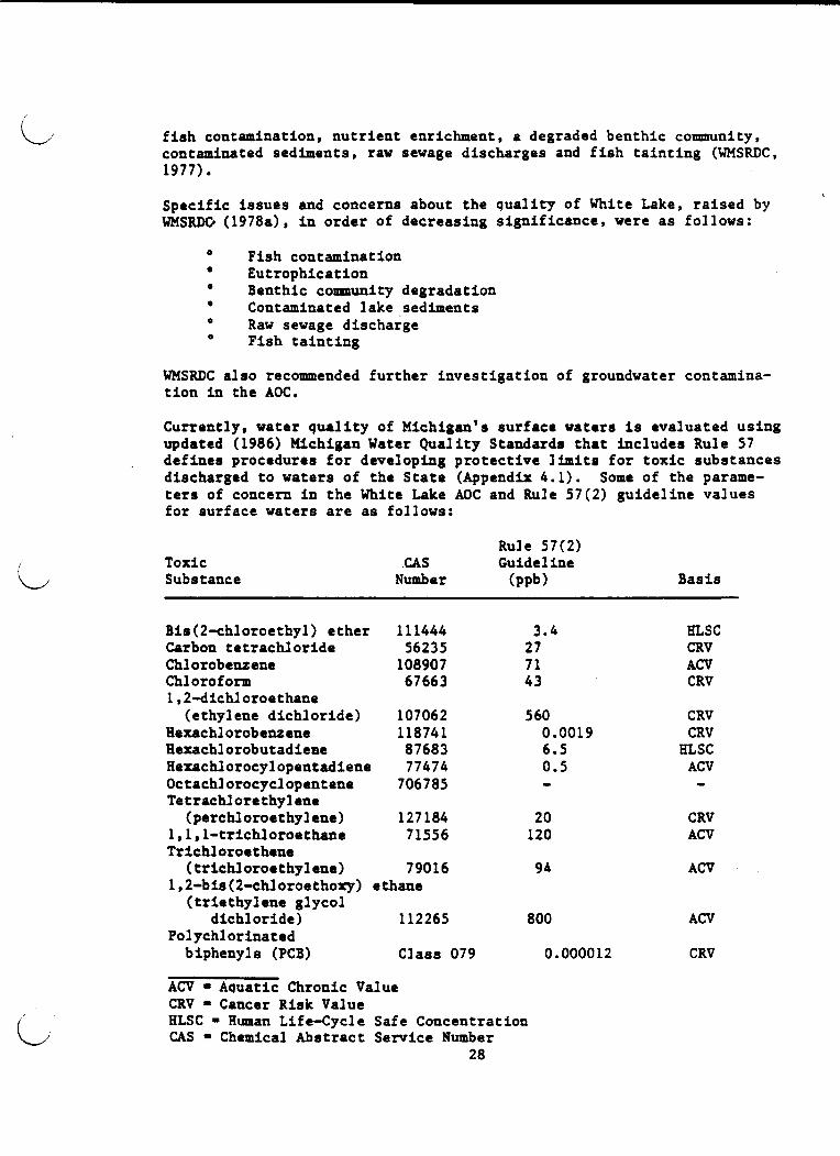
Currently, water quality of Michigan's surface waters is evaluated using updated (1986) Michigan Water Quality Standards that includes Rule 57 defines procedures for developing protective limits for toxic substances discharged to waters of the State (Appendix 4.1). Some of the parame- ters of concern in the White Lake AOC and Rule 57(2) guideline values for surface waters are as follows:
Toxic Substance
Rule 57(2) CAS Guide1 ine
Number (PP~) Basis
Bis (2-chloroethyl) ether 111444 Carbon tetrachloride 56235 Chl orobenzene 108907 Chl orof o m 67663 1,2dichl oroethane
(ethylene dichloride) 107062 Hexachlorobenzene 118741 Hexachl orobutadieae 87683 Hexachlorocylopentadiene 77474 Octachlorocyclopentene 706785 Tetrachlorethyl ene
(perchloroethylene) 127184 l,l,l-trichloroethane 71556 Trichl oroethene
( trichl oroethyl ene) 79016 1,2dis (2-chl oroethory) ethane
(triethylene glycol dichloride) 112265
Polychlorinated biphenyls (PCB) Class 079
ACV = Aquatic Chronic Value CRV = Cancer Risk Value HLSC = Human Life-Cycle Safe Concentration CAS = Chemical Abstract Service Number
28
HLSC CRV ACV CRV
CRV CRV
BLSC ACV - CRV ACV
ACV
ACV
CRV

Sediment quality is an important cooiponent to evaluate because contami- nants in the aquatic environment often accumulate to higher concentra- tions in the sediments than in the overlying water column. The major concern is that contaminated sediments may, in turn, act as a source of contaminants to biota associated with the sediments and overlying water. Numerical sediment criteria, based on the relationship of contaminant concentrations to biological effects, have not been developed because of inadeauate scientific understanding of the complex ways the many possi- ble combinations of inorganic and organic constituents in sediment interact to influence the biogeochemical behavior, and thus effects, of sediment contaminants (U.S.EPA, 1987).
In the absence of effects-based sediment criteria, a variety of ap- proaches have been developed to evaluate potential environmental effects of contaminated sediments that include physical characteristics, biolog- ical oxygen demand and other sanitary engineering measurements and elutriate test results comparison with water quality criteria. Bioas- says and bioaccumulation tests are being developed and have only recent- ly been used to directly evaluate the potential environmental effects of contaminated sediments. However, acceptable testing methods and proce- dures have yet to be developed. The development of effect-based crite- ria continues (Ehorn, July 1987). Some affect conclusions are discussed as part of the Benthic Conununity Section 4.2.3.1 based on organism associations with contaminated sediments.
Table 4-5 of Section 4 provides four sediment evaluation criteria: the U.S.EPA Dredge Spoils criteria (used to determine if sediments are suitable for open water disposal as part of harbor maintenance pro- jects), Lake Michigan background concentrations of selected contami- nants, Michigan lakes and streams background values reported by Hesse and Evans (1972) and dredge spoils criteria used by the Ontario Ministry of the Environment. Sample results were compared with these values to determine relative level of contamination and do not represent effect-based criteria, as discussed above.
It is the collective opinion and experience of MDNR staff that, with the exception of mercury and possibly selenium, common heavy metals do not bioaccumulate in fish tissues at levels much greater than Statewide background concentrations.
The Michigan Department of Public Health WPH), U.S. F ~ o d and Drug Administration (FDA) and International Joint Commission (I JC) guide1 ines used for evaluating levels of certain toxic substances in edible por- tions of fish and the need for fish consumption advisorits.are as follows:

Parameter IJC ( P P )
Aldrin/Dieldrin DDT Lindane Endr i n Heptachloroepoxide Chlordane Kepone Mercury Mire : PCB Toxaphene PBB Dioxin Unspecified organic
compounds
0.3 0.3 0.3 0.3 1 0.1 2 5 0.3
25-50 ppt
0.5 l e s s than detect ion
0.1
l e s s than detect ion
Health consumption advisories are annually updated and published i n the Michigan Fishing Guide provided with the purchase of a Michigan f i sh ing 1 icense .
4.0 IMPAIRED USE ASSESSMENT
The intent of this section is to define impaired uses of the White Lake AOC based on environmental monitoring data. Data reviewed included water quality (nutrients, inorganic and organic contaminants), benthic (bottom dwelling organisms) community assessments and environmental contaminant monitoring data for sediments and fish. Groundwater contam- ination potentially affecting the AOC was also discusse F3 4.1 IMPAIRMENT EVALUATIONS
White Lake reportedly experienced increased degradation during the 1950s to the mid-1970s due to increased industrial and municipal discharges directly to and upstream of White Lake. Surveys conducted since 1952 indicated that White Lake experienced conditions causing the occurrence of nuisance algal blooms, tainted fish flesh, loss of white bass fish- ery, reduction of walleye, perch and northern pike populations, fish contamination.' sediment contamination, nutrient enrichment, dissolved oxygen depletion and degradation of the benthic community. These conditions resulted in a variety of lake quality concerns (Table 4-1) that were used to justify placing White Lake on the IJC1s Areas of Concern list. Table 4-2 provides a listing of the historical impacts to tributaries within the White Lake AOC provided by WMSRDC (1978).
Diversion of point sources to the Muskegon County Wastewater Management System (WMS) No. 2 in 1973-1974 and the elimination of several septic tank and runoff source discharges resulted in reduced loadings of environmental contaminants and improvement in the environmental quality of White Lake. Even though same pollution sources were eliminated by 1974, some contaminant sources remained in the area, Hooker Chemical Coppay's discharge and contaminated industrial groundwater discharges. After 1974, some of these contaminant sources continued to affect the quality and resources of White Lake and its tributaries.
In 1977, the West Michigan Shoreline Regional Development Commission (YnSRDC) determined that White Lake failed to meet the 1983 "fishable and swimmable" goal, set forth by Public Law 92-500 (The Federal Water Pollution Control; Act of 1972). White Lake was predicted to fail this goal for an estimated 20 years (WMSRDC 1977). This was attributed to fish contamination, nutrient enrichment, a degraded benthic community, contaminated sedimcntr, raw sewage discharges and fish tainting (WMSRDC, 1977).
Specific issues and concerns about the quality of White Lake, raised by WPLSBDC (1978a1, in order of decreasing significance, were as follows:
' Fish contamination ' Eutrophication ' Benthic community degradation * Contaminated 1 ake sediments ' Raw sewage discharge
Fish tainting 3 1
Table 4-1. Hietorical Impaired Uses of White Lake and Current Status
Impaired Uses Causes Sources Current Status
Contaminated fish
Fieh tainting
i
Loes of fieh production
k:
Elirfnation of benthic substrate
Degradation of benthic populat ions
Recreational activities restricted, aesthetics impaired
Polluted bottom sedimente
Polluted bottom eediment e
Loes of benthos
Substrate covered with hair and hides, high concentratione of heavy retale
Dissolved oxygen depletion, high levels of P and N, contaminated sediments
High phoephorus a1 gal bl o m s
Hooker Chemical and Plastics Carp Corporation, Hornet Corpora- PCBs and tion - Misco Division, chlordane Whitehall Leather Company
Hooker Chemical and Plaetics No longer Corporation, Howmet Corpora- tion - Mieco Division, Whitehall Leather Company
Sediments contaminated with Improving heavy metals, chlorides, organics
Whitehall Leather Company
Point and nonpoint eourcee of P and N, metals, and organic compounde
Point and nonpoint sources of P and N
Source: WMSRDC 1978a.
Improving
Improving, needs to be checked
Improved

Table 4-2. Hietorical Impaired Uses of Tributaries to White Lake Prior to WMSRDC. 1977
Impaired Usee Causes Sources Status
Buttermilk Creek
Recreational activities reetricted, aeethetlcs impaired
Exceee of phosphorus, nitrogen, fecal col i- form bacteria, suspended solids, oxygen demanding eubetances, of Is and greases
White River
I5 Exceede establiehed phoephoruelnitrogen standards
Carlton Creek
Recreational activitiee reetricted, aeethetics impaired
Mil I pond Creek
Recreational activities res tric ted
Excese of phosphorus, nitrogen, fecal coli- form bacteria, oxygen demanding subs tances
Potential excess of phosphorus, nitrogen, fecal coliform bacteria, suspended eolids, oxygen demanding substances, organic contaminants
Raw domeetic sewage discharge Corrected
Septic contamination from unsewered areas
Septic contamination from unsewered areas
Corrected
Corrected
Septic contaminat ion from Corrected unsewered areas, contaminated except groundwater contaminated
groundwater
WMSRDC also recommended further investigation of groundwater contamina- tion in the AOC.
4.2 MAJOR WHITE LAKE AOC COMPONENT EVALUATIONS
4.2.1 Water Qua1 ity
4.2.1.1 Tributaries to White Lake
Since the majority of Montague and Whitehall were sewered, in 1973, septic tank discharges to the tributaries of White Lake have been eliminated. Mill Pond Creek remains a problem site because it receives contaminated groundwater from both the Koch (Muskegon) Chemical Company site and Howmet Corporation's Plant No. 4 and possibly No. 5 sites.
Several volatile organic contaminants were detected in groundwater seeps to Mill Pond Creek and in Mill Pond Creek proper. MDNR biological surveys (Section 5.2.1.1.) of 1981 and 1983 indicated the absence of any obvious impacts to the Mill Pond Creek macroinvertebrate community downstream of the Muskegon Chemical Company contaminated seeps.
Fish were collected in June, 1983 from the Mill Pond (located downstream of Zellar Road) for fish contaminant monitoring purposes (Beck, 1983~) . Four species of fish were analyzed as composite samples of three to five whole fish. Triethyl ene glycol dichloride and bis (2-chloroethyl) ether were less than a level of detection of 0.2 ppm. Analysis for other purgeable organic compounds was not don't for lack of approved analytical methods. None of the substances vere expected to bioaccu~nrlate.
L
Analytical results reported by Beck (1983) and Przybysz (1986) for Mill Pond Creek water samples collected just upstream of White Lake or Mill Pond indicated contaminant concentrations were less than Rule 57 (2) guideline levels used to protect aquatic organisms (Appendix 4.1) . The Michigan Public Health Department advised, because of the presence of known carcinogens, against m i n g and wading in the unnamed pond upstream from White Lake Drive where chemical levels are elevated because of close proximity to the contaminated groundwater seeps (Boehm, 27 July 83 letter to Whitehall residents).
The presence of fish in the Mill Pond and macroinvertebrates just dovn8tre.n of White Lake D i m e indicated the absence of acute toxic concentrations of the subject organic compounds. Therefore, there is little likelihood that there is any perceptible impact to uses of White Lake or Lake Michigan from these contaminated groundwater sources.
4.2.1.2 White Lake
4.2.1.2.1 Nutrients
White Lake is a dimictic system that thermally stratifies and undergoes spring and fall turnover or mixing. Nutrient (phosphorus and nitrogen) concentrations were historically elevated and characteristic of a eutrophic system (Limno-Tech, 1981; Grant, 1972 and Robinson, 1967). As a result, this lake sustained nuisance blooms of blue-green and green L

algae. Ketelle and Uttermark (1971) listed White Lake among the "Prob- lem Lakes of United States" based on existing nutrient enriched conditions. Oxygen depletion does occur in the deeper basins but Limno-Tech (1981) indicated the duration decreased slightly after the diversion of waste- water to the Muskegon County WMS No. 2.
U.S.EPA (1975) reported results for a 1972 nutrient budget survey of White Lake that indicated that the lake was extremely eutrophic. Results showed White Lake to be nitrogen limited from June to September and phosphorus limited by November. During this study chlorophyll a ranged from 1.2 tp 18.9 ppb with the highest levels occurring in June and September and the lowest in November. Inlake phosphorus concentra- tions ranged from 25 to 44 ppb.
Limno-Tech (1981), subsequent to a nutrient budget study of White Lake from 1972 through 1980, concluded that White Lake became a phosphorus limited system by 1980. Based on a comparison of 1980 nutrient budget survey results with earlier survey data, Limo-Tech estimated that
. nutrient loadings and overall White Lake water quality showed very little improvement after municipal and industrial process wastewater was diverted to the Muskegon County WMS No. 2 facility in 1973-74. They indicated that total phosphorus loading concentrations and resultant inlake concentrations remained steady despite the elimination of most point source loadings to the lake. Phosphorus loading estimates are discussed further in Section 6.
An inlake phosphorus goal of 30 ppb (during spring and fall turnover periods) is recommended by the MDNR in order to provide good recreation- al water quality by reducing nuisance algal blooms that commonly occur at greater concentrations. Inlake phosphotus concentrations during lake turnover conditions of May 1987 averaged 24 ppb (range 19 to 36 ppb) at the 21.5 m (70 f t) deep middle basin (Appendix 4-1). This is in contrast to an inlake concentration of 58 ppb measured May 1980 in the same vicinity. The most recent data does indicate that water quality of White Lake has improved. (Additional lake survey data was collected October 1987 to evaluate nutrient conditions but results were unavail- able prior to the completion of the RAP).
Lfmno-Tech did note some improvement, since the 1973-74 diversion. The duration of reduced dissolved oxygen concentrations, in the deep basins during summer stratification, has slightly decreased during periods of stratification and that algal mass and chlorophyll a concentrations have also shovn a slight decrease.
4.2.1.2 Toxic Substances
In addition to nutrient budget evaluations, other water quality studies were performed to detexmine contaminant levels in White Lake.
Concern about contaminant loadings from Hooker lead to a lake survey, by the Company consul tants (Williams and Works, June 1977) , in the vicinity of the Hooker Chemical company's discharge (Dowies Point). Survey results showed the presence of several toxic compounds in 45 lake

profile samples: chloroform (less than 1.0 to 4.9 ppb), carbon tetra- chloride (less than 1.0 to 54.8 ppb), trichloroethylene (less than 1.0 to 6.4 ppb) . tetrachloroethylene (1.7 to 60.5 ppb) . Approximately half of 21 samples analyzed contained detectable concentrations of hexachlorobutadiene or HCBD (0 .O5 to 1.0 ppb) , hexachlorocycl opentadiene or HCP (0.1 to 1.1 ppb), octachlorocyclopentiene or OCP (0.1 to 0.4 ppb) and hexachlorobenzene or HCB (0.8 to 0.8 ppb). Some samples contained carbon tetrachloride, tetrachloroethylene, hexachlorocyclopentadiene and hexachlorobenzene concentrations that exceeded current Rule 57(2) guide1 ines for toxic substances listed in Table 4-3.
Table 4-3 Rule 57 (2) Guideline Levels in Surface Waters
CAS Guide1 ine Parameter Number (PP~) Basis
Bis (2-chloroethyl) ether Carbon tetrachloride Chl orobenzme Chl orof o m 1,2-dichloroethane
(ethylene dichloride) Hexachl orobenzene Hexachl orbutadiene Hexachl orocyl opentadiene Oc tach1 orocycl opentene Tetrachl oroethyl ene
(perchl oroethyl ene) l,l,l-trichloroethane Trichloroethene
(trichloroethylene) 1,2-bis(2-~Uoroethoxy) ethane
(triethylene glycol dichloride)
Polychlorinated biphenyl s (PCB)
11226s
Class 079
ACV = Aquatic Chronic Value CRV - Cancer Risk Avlue BLSC = Human Life-Cycle Safe Concentration CAS Chemical Abstract Service Number
5 60 0.0019 6.5 0.5
no value
EILSC CRV Am CRV
CRV CRV HLSC Am
CRV ACV
ACV
ACV
CRV
By February 1977 the Company shut down the "Fine Chemical Production Facility" since it was unable to meet effluent limits in a 1976 Final Order prepared by the MDNR. Thus, the discharge of some of the above chlorinated hydrocarbons previously found in their effluent was discon- tinued. Hwever, January and February 1978 sampling by the Company's indicated their effluent contained HCBD ( 0.1 to 0.1 ppb), HCP (1.8 to 2.8 ppb), HCB ( 0.3 ppb) and tetrachloroethylene (35 to 66 ppb) (Hooker Chemlcal Co. letter to MDNR, 8 March 78). Tetrachloroethylene

concentrations in intake water, during the same period, ranged from 51 to 106 ppb. An'other source, other than the Company's discharge to White Lake, was suspected. Additional sampling results for the Company ' s White Lake water intake (located nearshore, east of Dowies Point), in 1978, indicated the presence of 85 to 115 ppb tetrachloroethylene (Hogarth, 1978).
MDNR studies were performed in 1978 and 1979 on White Lake during periods of ice cover to determine the influence of the contaminated groundwater plume and point source discharge during stable lake condi- tions. Evans (1978) found thermal and chemical stratification of White Lake water due to elevated concentrations of chlorides. Chloride concentrations increased with depth in the deep basins, reaching 210 to 310 ppm (10 to 20 times greater surface concentrations of 15 to 20 ppm). Carbon tetrachloride (20 to 40 ppb) and dichloroethylene (40 to 80 ppb) were present in the deep water samples from the upper, middle and lover basins as well as in the immediate vicinity of Booker's water intake.
Evanr' (1979) study indicated that chlorides ranged from 9.7 to 320 ppm at the White Lake inlet and deep upper basin, located east of the Hooker outfall, respectively. Carbon tetrachloride (2.0 to 16 ppb) and tri- chloroethylene (2.0 to 4.0 ppb) were detected near the Hooker Chemical Company's intake. The highest concentrations of carbon tetrachloride (140 ppb) was found near the bottom of the lower basin. Tetrachloroeth- ylene (28 ppb) and chloroform (9.0 ppb) were highest in in the basin east of Dowies Point and in the upper basin, respectively. Evans' 1979 survey results indicated that inlake concentrations of HCBD, HCP, OCP and BCB were less than a level of detection of 1.0 ppb
Recent MDNR surveys of White Lake in the vicinity of the Hooker Chemical Company plume (1981, 1982, 1984, 1985, 1986 and 1987) indicated a downward trend in lake concentrations of "low boiler" compounds (chloro- form, carbon tetrachloride, trichloroethylene and tetrachloroethylene) off Dowies Point (Table 4-4 , Figure 4.1). This reduction has resulted from the increased pumping rate in the purge well system that was increased from 135 gpm in 1987 to 560 gpm in February 1987. The pumping rate was increased to 685 gpm in August 1987 and recent evaluations indicate almost 100% capture of the plume. Evaluation of recent data is ongoing and a determination of final pumping rates necessary to maintain 100% plume capture will be defined in a meeting between Company.
Since 1979, inlake concentrations of HCBD, HCP, OCP and BCB have re- mained near or less than the levels of detection of 0.05, 1.0, 1.0 and 0.2 ppb. Two of fifteen lake water samples, collected in February 1986, contained 0.21 and 0.85 ppb HCBD that are less than the Rule 57(2) guideline value of 6.5 ppb.
The West Michigan Shoreline Regional Development Commission (WMSRDC) began a project in 1979 entitled "The Muskegon County Surface Water Toxics Study." During this project, the WMSRDC analyzed water samples, taken from White River and White Lake, for inorganic contaminants and a limited number of organic contaminants. Priority pollutants detected in these samples included arsenic, copper, lead and zinc (Appendi: 4.1).

Table 4-4 Summary of "Low Boiler" data for water samples from White Lake monitoring stations off Hooker Chemical Company's contaminated groundwater plume. 1981 - 1987. Values as ppb. (Source: Hooker Chemical Co. via Grand Rapid8 District staff)
Sampl ing Site 1/20/81 2/18/82 1/24/84 3/13/84 ' 2/6/85 2/25/86 2/12/87 .---uI----------- --- --------------- 1 58 105 42 4 3 3 2 , 2 17 63 4 9 5 K . 1 82 3 3 . 27 85 80 14 11 K 1 2 4 63 K 1 1 1 K 1 3 1 2 5 1 K 1 K 1 K 1 K 1 2 7 7 6 K 1 K 1 K 1 K 1 9 8 6 7 K l 66 16 2 48 5 K 1 8 6 8 K 1 K 1 K 1 1 K 1 K 1 9 1 1 K 1 K 1 1 K 1 K 1 10 1 20 2 1 7 11 6 * 11 K 1 28 12 45 49 2 * 12 * * * 1 . 2 K 1 * 13 * * a 5 3 1 K 1 * - -- -0 -0 - -0 --- Average 21 3 4 20 10 11 13 3
GPM 135 190 3 0 5 ~ 305 345 490b 560 Collected
* - locations not sampled. K - values less than the detection level indicated. a - Purgevell system down for maintainonce b - Wells PH and PI down
"Lower Boiler" values represent sum concentrations of chloroform, tricblloroethylene, carbon tetrachloride, tetrachloroethylene.

F i gur

WMSRDC staff collected water samples from the backwater area adjacent to the Montague Dump, located on the north side of the White River upstream
L of White Lake. These samples were found to contain 50 and 130 ppb of lead and zinc which exceed or approximate the Rule 57 Aquatic Chronic Values (ACV) of 5.7 and 138 ppb, respectively, assuming a water hardness of 150 ppm as CaCO , typical of White Lake. The observed hardness near the dump site was $30 ppm in this backwater area. Increased water hardness reduces the toxic effects of lead and zinc as is reflected by the increase in the Aquatic Chronic Values of 29 and 338 ppb based on a
'
water hardness of 430 ppm.
4.2.2 White Lake Sediment Quality
Several sediment sampling surveys were conducted in White Lake to document environmental contaminant levels. These surveys included: MDNR - 1972, 1975, 1980, and 1986; WMSRDC (1982) surveys during the period 1979 to 1982; U.S.EPA (ca. 1978-79) and U.S. Army Corps of Engineers' Federal White Lake Harbor maintenance sampling data for November 1979 (Appendix 4.2) . Table 4-5 provides four nonaffect sediment classification guidelines the U.S.EPA Dredge Spoils criteria (used to determine if sediments are suitable tor open water disposal as part of harbor maintenance pro- jects), Lake Michigan background concentrations of selected contami- nants, Michigan lakes and streams background values reported by Hesse and Evans (1972) and dredge spoils criteria used by the Ontario Ministry of the Environment. Sample results were compared with these values to determine relative level of contamination and do not represent
L effect-based criteria, as discussed above.
Results of the 1972, 1980 and/or the 1986 MD#B surveys, for samples collected at similar locatioru (Figure 4-2), were compared (Table 4-61. Whitr Lake sediment concentrations of mercury, arsenic, cadmium, copper, nickel and oil/grease decreased to levels at or below U.S.EPA dredge spoils criteria, by 1980. Chromium, lead and zinc concentrations exhibited a downward trend since 1972, but continue to exceed the above contamination evaluation criteria in samples from Tannery Bay, off Whitehall Leather Company; the 12 m (40 ft) deep basin off Hooker Company property, east of Dowies Point and/or in the other deeper lake barins, including the lower (west) basin.
The 1986 data (Appendix 4.2) for fifteen stations, in White Lake, included the analysis of twenty-five organic cumpounds. All the organic compounds, including PCBs, were lesr than their respective levels of detection which ranged from 68 to 3500 ppb. Oils and grease ranged from Iesa than 20 to 27 ppm.
Although none of the sediment samples collacted contained more than 10 ppm PCBs (U.S.EPA dredge spoils criteria), Michigan DNR staff are concerned about sediment concentrations greater than 1.0 ppm. PCB
Table 4-5 Nonaffect sediment classification criteria. (Concentrations as ppm)
Hesse Lake Michigan 1 Evans
Parameter U.S. EPA M.O.E. Present Past (1972)
Arsenic Barium Cadmium Chromium Copper Cyanide
Iron Lead Manganese Mercury Nickal Se 1 enium Zinc
Polychlorinated biphenyl (PCB)
Volatile Solids 80000 Chemical 0 ygen Demand 80000 Total Rjeldhal Nitrogen 2000
Oil and Grease 2000
Phosphorus 650 1000 650
f = precolonial or natural average concentrations
Sources: Great Lakes Water Quality Board. 1982. Guidelines and Register
for Evaluation of Great Lakes Dredging Projects. Report of the Dredging Subcomittee. Windsor, Ontario. 365 pp.
U.S. EPA Dredge Spoils Criteria. 1987.
TABLE 4-6 Whlte Lake Sediment D,ata; 1972, 1980, and 1986.

Figure 4-2 Location of similar sediment sampling stations i n White Lake i n 1972, 1980 and/or 1986. Muskegon County, M I . Sources: Evans, ca. 1981 and MONR survey data - December 1986.

concentrations of 1.0 ppm can possibly serve as sources to aquatic biota. Analytical results for sediment samples collected by the MDNR in June 1975 from four deep basins (Table 4-7, Figure 4-3) indicated the presence of 2.3 ppm of Arochlor 1254 in sediments in the 15 m (50 ft) upper (east) basin (Evans, ca. 1981). Arochlor 1254 was less than the detection level of 0.1 ppm in sediments from the other three basins. Concentrations of Arochlors 1242 and 1260 were less than their respec- tive detection levels of 0.1 and 0.05 ppm at all four locations. The 1986 sediment survey samples are being reanalyzed for PCBs using a method with a detection limit less than 1.0 ppm. PCBs and chlordane are of concern since they are the only two contaminants that exceeded MDPB and U.S.E'DA action levels in White Lake carp (see 4.2.3.2, below).
Table 4-7 Analytical results for polychlorinated biphenyls in White Lake sediment samples collected 30 June 75. Muskegon County, MI. Values on a dry weight basis.
Arochl or Arochl or Arochl or 1242 1254 1260
Station (PW) ( P F ~ ( P P ~
W L - 1 K 100 K 100 K 50 W L - 3 K 100 2300 K 50 W L - 4 K 100 K 100 K 50 W L - 6 K 100 K 100 K 50
Source: KDNR file
Phases I through IV of the WMSRDC (1982) study involved the analysis of 12 and 5 sedimcnt samples from White Lake and tributries (White River, unnamed tributary receiving Howmet Corporation discharge and Pierson Creek), respectively. These data indicated lake wide chromi~ms lead and zinc concentrations ranged from 10 to 5600 ppm, 15 to 160 ppm and 48 to 140 ppm, respectively. The highest contaminant levels were associated with Tannery Bay and/or the deeper lake basins, including the west bas in.
Further, WMSRDC (1982) inte~ively sampled (18 samples) White Lake sediments in the northeast third of the. lake during the fifth and final phase of their Muskegon County lakes. Analytical resul ts indicated that chromium, lead and zinc concentrations ranged from less than 1.3 to 3900 ppm, less than 2.5 to 240 ppm and 3.0 to 160 ppm, respectively (Appendix 4.2). Specific locations for the eighteen sampling stations were not reported making it difficult to conclude anything about the distribution of these contaminants in relation to suspected point sources.
WMSRDC survey results also indicated that sediments in an unnamed tributary to White Lake, receiving Howmt Corporation's discharge, contained elevated levels of chromium (280 ppm) , lead (460 ppm) , zinc (120 ppm), nickel (720 ppm), copper (380 ppm) and oil/grease (2200 ppm). Newel1 (1970) observed, during a MDNR point source survey, that Hovmet
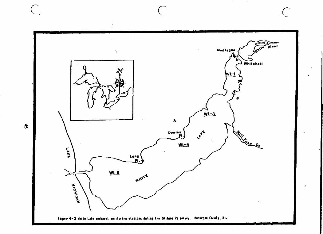
f i g u r r l - 3 Yhi le Lake sedi rer l aonilorinp stal ions during l b r 30 June 75 survey. tiuskegon Cwnty, H I .

Corporation discharge flows through a landfill area used by the Whitehall Tannery. He also noted that the Howmet Corporation, at the time, did not use a chrome plating process.
WMSRDC (1982) determined that White Lake sediments contained elevated levels of inorganic contaminants (primarily chromium, lead and zinc that exceeded dredge spoils criteria). They concluded that "...the Commis- sion shall recommend no lake reclamation efforts beyond support for the MDNR regarding the site clean-up and groundwater pollution containment of both the E.I. duPont deNemours Company and Hooker Chemical and Plastics Corporation. While the pollution of the sediments undoubtedly degrades aquatic habitat, White Lake is apparently able to support a substantial fishery. The ubiquitous distribution of toxic inorganic substances throughout White Lake's bottom sediments makes removal or isolation difficult ."
4 WMSRDC (1982) also reported, during Phase I (in 1 79) of their intensive study, a PCB concentration of 25.56 ppm (as Aroc J or 1254) in sediments from the upper basin. WRDC (1982) also found sedlment PCB concen- trations, greater than 1.0 ppm, along the shoreline of White Lake ' at concentrations ranging from 3.5 ppm of 1242 (Yest of Long Point) and 3.1 ppm and 2.0 ppm Arochlor 1248 to the west and east of Dowies Point, the latter two, in the vicinity of Hooker Chemical Compa- ny's discharge.
Concern about organic contaminants in Hooker's discharge (see Section 5.1) raised concern about contamination of lake sediments and biota. Swanson (1976) reported analytical results for nine lake sediment samples (six from the vicinity of Hooker Chemical Company's discharge) collected from White Lake on May 26, 1976. These data indicated that hexachlorocyclopentadian. (HCP), hexachlorobenzene (HCB) and hexachl orobutadiene (HCBD) , previous1 y ( 1976) detected in Hooker' s discharge, were less than detection levels of 500, 1000 and 100 ppb, respectively. In addition, U.S.EPA (ca. 1978-79) collected and analyzed White Lake sediments collected in the vicinity of Booker's discharge (White Lake sediments near discharge and 200 m or 650 ft from dis- charge). None of eighteen chlorinated organic compounds, including the above, ware detected in the White Lake sedlment samples using analytical method8 rith detection limits that ranged from 10 to 100 ppb.
Five redlment samples were collected (November 1986) and analyzed for PCB6 and total chromium by representatives for the Crossvind Marina. Their development project, located west of Sophia Street on the east rhoreline at Whitehall, required dredging the nearshore area and sedi- ment analysis war required. Analysis of the five sediment samples Indicated lesr than 5.0 ppb total PCBs and total chrumium concentrations that ranged from 0.97 to 3.8 ppm. Total solids ranged from 72.0 to 81.39 percent indicating a high percentage of sand present in the project area (MDNR File No. 86-9-132).
The U.S. Army Corps of Engineers collected sedinents in 1979 as part of their White Lake navigational channel maintenance program. Six samples were collected from Lake Michigan and the navigational channel. Parame- ters analyzed fncluded arsenic, cyanide, 10 heavy metals, PCBs and 6 i d

pesticides (Appendix 4.2). The analytical results indicated the sedi- ments were suitable for open water disposal as well as for beach nour- ishment of the Lake Michigan shoreline in the vicinity of the harbor. PCB, mirex, HCB and HCP concentrations in all six samples were less than 10.0, 4.0, 4.0 and 6.0 ppb, respectively.
The sediment quality of nearshore Lake Michigan near the White Lake outlet and navigational channel was summarized using data from ~enaga's study (1976) . Average contaminant concentrations and ranges detected in sediments are summarized in Table 4-8. Based on comparisons with U.S.EPA dredge spoil criteria and background levels provided in Table 4-5, none of the contaminants detected in sediments in the Lake Michigan nearshore area indicated elevated levels.
Table 4-8. Summary of Lake Michigan Sampling Data Near White Lake Outlet - Sediments (ppm)
Sediment Levels Number of Indicating
Contaminant Samples Average Range Contamination
Cu Hg Cd Cr Zn Ni Pb Fe Mn TKN TP COD TOC Oil -Eexane Extractabl es DDT
Sources: Kenaga 1976, U.S./Canadian Great Lakes Water Quality Agreement of 1978.
NC = No criteria available * = Moderate criteria were not available, levels indicated are heavy levels

4.2.3 White Lake AOC Biota
4.2.3.1 Benthic Community
A number of studies were conducted to assess the condition of the benthic community of White Lake. Evans (ca. 1981) summarized these studies in his report entitled "Mona, White, and Muskegon Lakes in Muskegon County, Michigan, the 1950s to the 1980s." No benthic studies ,
have been done since 1980.
Significant degradation of the White Lake benthic community occurred after 1954 primarily because of the discharge of toxic substances and oxygen depletion in the deeper basins associated with increased eutro- phication from elevated nutrient loadings from the now defunct Whitehall Wastewater Treatment Plant, located just upstream from the inlet to White Lake and White Lake watershed.
Appendix 4.3 illustrates saarpling results for the White Lake benthic community for 1972, 1975, and 1980 (Evans, ca. 1981). Studies conducted in 1952 and 1954 by Surber (1952 and 1954) revealed relatively normal benthic conditions. Surber concluded that biological conditions had not been altered since the 1952 survey.
After 1954, the percentage of oligochaetes, a pollutant-tolerant spe- cies, increased while the percentage of pollutant-sensitive mollusks decreased. Between 1972 and 1975, a series of sampling events found few or no molluscs at any of the stations sampled. These results show an extensive decrease from 1952 and 1954 here mollusc densities were approximately 327 and 382 organisms/m2, respectively. The 01 igochaete population recorded at water depths greater than 6 meters (20 ft) increared from approximately 45 percent in 1952 to 90 percent in 1957. Figure 4-4 summarizes the average percent of oligochates reported from MDNR sunrays (1952 to 1980) and Meier (1979) during 1973-74. The percent oligochaetes in 1980 are just slightly higher than observed in 195244, implying improved conditions.
Evans (ca. 1981) concluded that "White Lake benthos in 1980 indicated substantial lake quality improvements as as result of improved waste- water treatment by the Booker Chemical Company. Densities and percent composition of aquatic oligochaetes and midges were similar to those found one year after Booker Chemical Company began discharging to White Lake in 1953. Fingexnail clams have begun to recolonize the lake bottom after an absence of at least eight years . . ." Densities by 1980 were 14 to 72/m2 among 40 stations, whereas, lakewide densities averaged 327/m2 in 1952 among 16 samples. Lakewide mollusc densities averaged 382/m2 In 1954 with 607/m2 near the river mouth stations. Evans

WHITE LAKE MUSKEGON COUNTY, h4ICHIGAN

Table 4-9 MDPH and U.S. FDA fish consumption advisory action levels and IJC obf ectives for environmental contaminants in fish. Concentrations as ppm unless othetwise indicated.
Parameter FDA MDPH I JC
Al drin1Dieldrin DDT Lindane Endrin Heptochl oroepoxide Chl ordane Kepone Mercury Mirex PCB Toxaphene PBB Dioxin Unspecified organic
compounds
0.3 5
0.3 0.3 0.3 0.3 1 0.1 2 5 0.3
25-50 ppt
U.S. FDA = U.S. Food and Drug Administration MDPH = Michigan Department of Public Health IJC + International Joint Commission
0.5 less than detection 0.1
less than detection
Several fish contaminant monitoring survey results were conducted by the MDNR (1971, 1976, 1977, 1978, 1979, 1980 and 1984); WMSRDC (1982); and U.S.EPA studies DeVaul t (l984), Camanzo (1985) and DeVaul t (1986). The level of study, indicated by the number of studies, was prompted, primarily, because of concern about the environmental contaminant loadings to the lake by industrial dischargers and contaminated ground- water plumes.
Swanson (1976) reported that MDNR fish contaminant monitoring results for 1972 indicated detectable concentrations of the toxic substance hexachlorobenzene (HCB). This prompted increased effluent monitoring requirements for Booker C h d c a l Company.
Fish contaminant monitoring results for fillet samples collected on May 26, 1976 showed ECP, HCB and HCBD were less than detection levels of 2.0, 20 and 1 ppb in pumpkinseeds, brown bullheads and a northern pike (70 cm / 27.5 Inches length) from near the M e t . However, suckers from the vicinity of Booker's discharge and the vest end of the lake con- tained 18 and 17 ppb of HCP, 66 and 90 ppb of HCB and 2 and 3 ppb HCBD, respectively. Pumpkinseed and northern pike from the same two locations contained less than 10 ppb of ECP and 1.0 ppb or less of HCBD. HCBD was less than 20 ppb in pumpkinseed, brown bullhead and northern pike collected from the vicinity of the Hooker discharge. The same species, collected from near the outlet, contained 21, 50 and 44 ppb of HCB, respectively.

Contaminant monitoring da t a f o r White Lake f i s h co l lec ted on July 23, 1976 indicated HCP was l e s s than a de tec t ion l eve l of 2.0 ppb i n carp and dogfish f i l l e t s . HCB concentrat ions of 48 t o 110 ppb were detected i n carp and dogfish from near the White Lake i n l e t and 100 t o 60 ppb in individual carp and dogfish f i l l e t 8 co l lec ted of f Eooker's discharge, respec t ive ly (Swanson, 1976 memorandum).
Analysis of white suckers, northern pike, b l u e g i l l and/or bullhead from . t he White Lake i n l e t , v i c i n i t y of Hooker's discharge and west of Long Point on 23 August 77 indicated t h a t HCBD, HCP, OPC and HCB were l e s s than de tec t ion l e v e l s of 10, 20, 50 and 50 ppb, respect ively. The adipose t i s s u e (61.5% l i p i d s ) of a t u r t l e co l lec ted near the lake i n l e t , however, contained 720 ppb of HCB. A U.S.FDA guide l ine f o r HCB of 300 ppb i n f a t of c a t t l e , goats , horses , sheep and swine w a s es tab l i shed i n 1972 a f t e r contaminated c a t t l e were reported i n Louisiana. No guide- 1 i n e s a r e ava i l ab l e f o r f i s h t i s s u e consumption advisories .
Humphrey, a t al. (1980) reviewed White Lake f i s h contaminant monitoring r e s u l t s f o r White Lake of 1976, 1977, 1978 and 1979 and concluded the f o l l w i n g : .
"It is the judgment of the Michigan Department of Public Health t h a t the confirmed quan t i t a t i ve da ta generated to-date (espec ia l ly i n the l a s t 6 months) do not warrant the need f o r a ban on catching and ea t ing f i s h (indigenous) t o White Lake o r f i s h migrating through the lake while spawning."
E~mphtey, e t a l . made several recommendations regarding which f i s h t o consume, proper preparat ion and r e s t r i c t e d c o n s w t i o n of anadromous f i s h migrating upstream from Lake Michigan (Appendl :4-4).
The most recent f i a h contaminant monitoring sunwys of White Lake were in 1980 and 1984 (Forney, 1980 and Rossio, 1985). The 1980 survey involved 25 f i s h that included 7 northern pike, 2 suckers, 2 largemouth bass , 3 smallmouth bass , 4 ye l lov perch and 7 carp. Tissue concentra- t i o n s f o r HCB, HCP, mirex and polybrominated biphenyls (PBB) were l e s s than 0.02 ppm, DDT plus DDE were . less than 1.0 ppm and PCBs were l e s s than 1.0 ppm i n moat rpeciea except carp which averaged 1.4 ppm (MDPH lab. r e s u l t a ) t o 1.8 ppm (MDNR lab. r e su l t a ) m n g s ix carp co l lec ted o f f Dowies Point and from the lover basin a r ea ca l l ed , Indian Bay (Appendix 4.4)
The 1984 crurvey Involved the a n d y s i 8 of f i l l e t s from 34 f i s h t h a t included 10 northern pike, 11 ruckera, 4 walleye and 8 carp (Appendix 4.4). Mercury u r a l y s i r indicated four northern p ike contained 0.2 t o 0.6 ppm r i t h an average of 0.4 ppm t h a t did no t exceed the MDPE ac t ion l e v e l of 0.5 ppm f o r mercury. PCB (as Arochlor 1254) i n carp, exceeded the MDPH and FDA 2.0 ppm ac t ion l e v e l , averaging 3.7 ppm with a maximtm of 9.0 ppm. Total chlordane (expressed a s t he sum of alpha-chlordane, ganma-chlordane, cis-nomchlor and ox--chlordane) exceeded the MDPH and FDA ac t ion l eve l of 0.3 ppm among the e igh t carp analyzed. Total chlordane averaged 0.6 ppm and ranged from 0.13 t o 1.24 ppm.

The Michigan Department of Public Health issued an advisory i n 1986 f o r the consumption of carp due t o elevated PCB leve ls . The advisory reconmends the following:
O No more than 1 meal per week (or 12 kglyr o r 26 l b s l y r ) of carp should be eaten
0 Nursing mothers, pregnant women, women an t i c ipa t ing bearing ch i ldren , and chi ldren younger than 15 years of age should not e a t carp
Before ea t ing , f i s h should be skinned, trimmed, and f i l l e t e d t o remove f a t t y portions and cooked by baking, barbecuing, o r b r o i l i n g on a rack t o reduce contaminant level (advisory)
I n a USEPA study e n t i t l e d "Contaminants i n Lake Michigan Nearshore Fish," f i s h were co l l ec t ed from a s e r i e s of t r i b u t a r i e s and harbors of Lake Michigan between 1980 and 1983. Table 4-10 presents r e s u l t s of f i s h samples co l l ec t ed from the White Lake ou t l e t . The White Lake o u t l e t w a s reported t o be one of th ree s i t e s with the h ighes t concen- t r a t i o n s of DDT found during the study (Lahvis e t a l . no da te) . DDT l e v e l s i n White Lake f i s h were, however, l e s s than 5.0 ppm, the MDPH and FDA's ac t ion leve l .
Table 4-10. Contaminants Found i n White Lake Outlet Fish During Lake Michigan Tr ibutary Study, 1980-1983. Based on whole f i s h .
Parameter ~ o n c e n t r a i i o n s (ppm) Carp Bowfin
0 ych l ordane Heptachlorepoxide Beta BHC Cisnozachl o r Transnonachl o r Alpha BHC Cischl ordane Transchl ordane Al d r i n Heptachl o r Methorychl o r Endrln Die ldr in
Source : Lahvis e t a1 . no date.
'NA - Not Applicable.

Lake Michigan - A f i s h advisory r e s t r i c t i n g consumption has been issued f o r lake t r o u t (20-23"), coho salmon (over 26"), chinook salmon (21-32") and brown t r o u t (up t o 23") because of e levated polychlorinated biphen- y l s (PCB's). Recommended consumption should be r e s t r i c t e d t o no more than one meal per week, and women and ch i ldren a r e advised not t o e a t these f i s h a t a l l . The f i s h consumption advisory f u r t h e r advises a l l c i t i z e n s not t o consume lake t rout (over 23"), chinook salmon (over 32") , brown t r o u t (over 23"), carp o r ca t f i sh . These adv i so r i e s apply ,
t o a l l of Lake ~ i c h i g a n ' s waters.
4.3 SUMMARY
Use impairments i n the White Lake AOC a r e r e s t r i c t e d consumption of carp due t o elevated PCBs (average 3.7 ppm, maximum of 9.0 ppm). Carp were found, i n 1984, t o contain chlordane concentrat ions g r e a t e r than the 0.3 ppm a c t i o n l eve l . The same consumption advisory app l i e s .
Water q u a l i t y appears t o be improving due t o reduced n u t r i e n t loadings observed s i n c e 1973. Major point source d ischargers t o White Lake were el iminated i n 1973 and 1974 with diversion t o t h e Muskegon County WMS No. 2. Annual average phosphorus loadings t o White Lake, from t h e watershed, remain elevated, but have decl iaed by about 40 t o SO percent s ince 1973. Late f a l l 1986 and May 1987 in lake phosphorus average concent ra t ions of 15 and 25 ppb were l e s s than a des i r ed goal of 30 ppb.
The q u a l i t y of b i o t a , sediment and water condi t ions were seve re ly degraded i n 1950s through the 1970s do t o substances discharged by Hooker Chemical Company. Since t h a t t i m e , improvements i n sediment q u a l i t y and assoc ia ted benthic community have been noted. S p e c i f i c a l l y , t h e r e has been a dec l ine i n heavy metals and o i l s l g r e a s e s and t h e 1980 benth ic co~mmtnity survey indica tes mollusc d e n s i t i e s a r e increas ing . The causa t ive discharge has been eliminated because of t he more r e s t r i c - t i v e NPDES requirements and ul t imately the c losure of t he f a c i l i t y i n 1982.

5.0 SOURCES OF POLLUTION
Sources of most pollutants to White Lake have been identified. Histori- cally, the major pollutant sources included: municipal and industrial point sources, combined sewer overflows, watershed runoff, contaminated groundwater and contaminated in-place sediments.
5.1 PRIMARY SOURCES OF POLLUTANTS
Primary sources of pollutants are defined, herein, in the White Lake AOC as current or historical contributors of contaminants. Primary pollu- tant sources to the AOC, identified in the area prior to the 1973 - 1974 wastewater diversion to the Muskegon County WMS No.2, were surface water discharges and possibly contaminated groundwater. Those contaminated discharges resulted in reduced water quality, a reduced lake benthic community and long-term contamination of lake sediments.
Agricultural practices were not considered to be a significant source of pollutants in the White River Drainage Basin (WMSRDC 1978a). However, agricultural activity within 1.5 km (2.0 m i ) upstream need further investigation with regard to seasonal loadings of nutrients and pesti- cides. Presently, the primary source of nutrient loadings to White Lake is the White River watershed which is discussed in Section 6.3.
5.1.1 Urban Stormwater Runoff /Combined Sewer Overflows
Urban runoff in the AOC has been referred to as a potential nonpoint source of pollution. Stormsewer systems service the cities of Whitehall and Montague. WMSRDC (1978a) reported the following number of sewer outfalls in the AOC and tributaries:
WhiteRiver-2outfalls White Lake - 14 outfalls
O Bush Creek - 5 outfalls Buttermilk Creek - 3 outfalls
0 Coon Creek - 1 outfall Section 6.2 provides additional information on specific pollutants and estimated loadings.
Tabla 5-1 summarizes industries located within storm drain basins in the White Lake area. The impact of these industries on stormwater quality has not been determined; however, these facilities are potential pollu- tant sources because of materials used in manufacturing processes.
5.1.2 Surf ace Water Dischargers
Four facilities currently have NPDES permits allowing them to discharge treated wastewater or noncontact cooling water to the White Lake AOC. Two facilities discharge directly to White Lake, one to White River, one to White River via Silver Creek, and one to Lake Michigan and White Lake. Two facilities that previously discharged to the AOC (Whitehall

Leather and Whitehall WWTP) discontinued operations or diverted flow to the Muskegon County WHS No. 2 in 1974. Facilities that discharged directly to White Lake or its tributaries in the past are described in addition to the current dischargers because significant contaminant problem were created by their discharge (Table 5.2).
Table 5-1. Industries Within Storm Drain Basins
Watershed Product Management
Company Name Manufactured Storm Drain Basin Unit (WMU) Comments
Ahlstedt Electric Buttermilk Creek White Lake Widgit Corp. Vehicles
Old Century Weathervanes, White River Marsh White River Some type of Forge, Inc. house signs to White River drain
White Lake Iron foundry, Buttermilk Creek White Lake Sand floors in Castings Corp . high a1 1 oys foundry (cool ing
water discharge?)
Whitehall Metal Weathervanes, Buttermilk Creek White Lake Studies, Inc. nameplates
Source: WMSRDC 1979
Table 5.2 Current and discontinued point source dischargers.
Current Dischargers:
' Huskegon County Wastewater Management System (WMS) 12 (White River via Silver Creek)
' Eoumet Corporation - Misco Division (White Lake) ' Occidental Chemical (formerly,Hooker Chemical and Plastics
Company) (White Lake)
' E.I. W o n t de Nemours and Company, Inc. (Lake Michigan and White Lake)
Discontinued Dischargers:
' Whitehall UUTP (serviced Whitehall and Montague) eliminated in 1973
' Whitehall Leather Company (diverted flow to WMS in 1974)

Table 5.3 charge29 ,
Howmet Corporation - (process wastewater diverted to W S in 1974) #
provides a listing of current permitted surface water dis- contaminated groundwater sites, current municipal and indus-
trial disposal sites and former municipal and industrial- disposal sites. Locations of these facilities are illustrated in Figure 5-1 and identi- fied in Table 5.3.
Table 5.3 Municipal, Industrial and Contaminated Groundwater Sites in the AOC. (See Figure 5-1 for locations)
Surface Water Point Source Discharners
1. E.I. duPont deNemours and Company (Discharge to White Lake and Lake Michigan)
2. Occidental (Booker) Chemical and PI astics Company
3. Bowmet Corporation Plant 11 - Misco Divison 4. Muskegon County Wastewater Management System 82
(Whitehal I-Montague WMS)
Contaminanted Groundwater Sites
E.I. duPont deNemours and Company
Occidental (Booker) Chemical and Plastics Company
Hornet Corporation Plants 11 and 13
Muskegon County Wastewater Management Site #2
Houmet Corporation Plants Y4 and 15.
Tech-Cast , Inc . Koch (Muskegon) Chemical Company
White. Lake Landfill
Shell Cast, Inc.
Active Municipal or Industrial Disposal Sites
1. E.I. duPont deNemours and Company
9. White Lake Landfill
Former Municipal or Industrial Disposal Sites
1. E.I. duPont deNemours and Company

2 . Occidental (Hooker) Chemical and Plastics Company #
11. City of Montague Dump
12. Montague Tovaship Dump
14. Whitehall Leather Company
Source: MDNR Piles
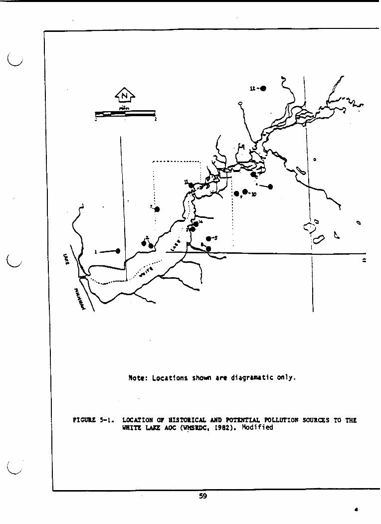
Note: Locatfons shown an d i a g r a m t i c only.
PICUPE 3-1. LOCAZION at ~rsrorrcu, AND pcmmu~ mtturroa souRas TO m~ mrre UI(E M)c: (U~SRDC, 1982). Modified

Table 5-4 provides NPDES permit numbers and receiving waters for surface water dischargers.
Table 5-4. Current Surface Water Dischargers
Industry
Watershed NPDES Permit Receiving Management Number Water Unit
Occidental Chemical MI 0002631 White Lake White Lake (formerly Hooker Chemical and Plastics Company
Muskegon County MI 0029173 White River White River Wasf ewat er Management via Silver System (WM) 12 Creek
Howmet Corporation - MI 0002623 White Lake White Lake Misco Division (Whitehall) Plant #l
E.I. duPont deNemours MI 0000884 Lake Michigan Coastal Zone and Company, Inc. White Lake White Lake L
Source: MDNR Files
E.I. duPont deNemours and Company
€.I. duPont ddemours and Company is located on the northwest shore of White Lake in close proximity to Pierson Creek. The company, which began operations in 1955, produces f lurocarbons (Freons) and ha1 ogenated carbon chemicals used in refrigerants and in Teflon. The Company has a NPDES permit to discharge treated process wastewater directly to Lake Michigan and intake backwash to White Lake. The company is permitted to dincharge up to 0.41 ms/s (9.4 MGD) of treated process wastewater, lime pile interceptor we1 1 water, purged and treated organic feedstock Interceptor wellwater and noncontact cooling water through their outfall to Lake Hichigan. Parameters limited in the NPDES' permit include:
' Chemical oxygen demand (COD) ' Fluoride ' Total residual chlorine (TRC) ' Antimony ' Sulfates ' Carbon tetrachlori de ' Chlorides ' Chloroform ' Trichlorof luoromethanc (F-11) ' Me thy1 ene chl or1 de ' Trichlorotrif luoroethane (F-113) ' Tetrachloroethyl ene
W E ) ' Total suspended sol ids ' Chloroform

' Biochemical oxygen demand (BOD) ' 1 ,l,l-trichloroethane Total phosphorus ' Trichloroethylene
(TCE)
The Company is also authorized to discharge up to 7.6 m3/d (2,000 gpd) of intake filter backwash to White Lake. No parameters were listed in the NPDES permit for discharge to White Lake but effluent must be visually monitored prior to discharge to determine any unusual charac- teristics that must be reported.
E.I. duPont deNemours and Company exceeded permit requirements for pH levels in July 1976 and January 1977 (recorded as minor excursions), August 1976 (recorded as a violation), and October 1976 (noncompli- ance). PCB (as Arochlor 1254) was detected (0.67 ppb) in a 1976 MDNR survey of E.I. duPontts effluent. PCB (1254) is listed on the "Critical Materials Register" for the State of Michigan (WMSRDC 1978a). MDNR point source survey reports (1986, 1983 and 1980) indicate the Company has met their final effluent limitations provided in their NPDES permit.
Howmet Corporation - Misco Division The Howmet Corporation is currently permitted to discharge up to 1,715 m3/d (0.453 MGD) of noncontact cooling water to White Lake via an unnamed drain (NPDES permit). Temperature, flow and outfall observa- tions are required.
Xn 1968, Howmet Corporation effluent was added to White River water to determine whether a change in algal production rates would occur. Samples containing the effluent produced up to seven times the amount of algae as those samples containing odly White River water (Robinson 1968). This indicated nutrient enriched effluent.
Prior to 1975, oils and suspended materials were noted in the.discharge. PCB (1254) was detected in the discharge at 2.5 ppb in 1975. By 1976, less than 1 ppb was found; no PCBs vere observed in 1977. PCBs in the White Lake upper basin are suspected to have come from Howmet's histori- cal discharge (Evans, ca. 1981)
In 1974, process wastewater and sewage from the Company were diverted to the Muskegon County WMS No. 2 facility.
Evans (ca. 1981) also reported that toxicity testing of the Company's final effluent in 1976, using fathead minnows, indicated 100% survival after exposure to 100 percent effluent for 72 hours.
Muskegon County WMS No. 2
The Muskegon County WMS No. 2 is currently permitted to discharge underdrainage from their land application site to Silver Creek, a tributary of the White River. The WMS NPDES permit includes limitations for the following parameters:

Carbonaceous biochemical oxygen demand Nitrate Emmonia nitrogen Nickel Total suspended sol ids O Zinc PB ' Chromium Fecal col if o m bacteria Copper Total phosphorus Chloride Bis(2-chloroethyl) ether Bis (2-chloroethoxy) ethane (triethylene glycol dichloride)
The WMS is required by conditions set forth in the NPDES permit to conduct daily monitoring of flow and quality data of equalization basin effluent, primary clarifier effluent, and irrigation water. Monitoring of daily flow is required for raw sewage and daily depth readings taken from storage lagoons are also required. In addition, irrigation water and aerated lagoon effluent must be monitored five times monthly and quarterly measurements for organic chemicals must be taken from irriga- tion water and outfall effluent. The WMS ir required to report this information monthly to the Surface Water Quality Division of the Michi- gan Water Resources Commission.
In addition to the requirements listed above, the NPDES permit also stipulates that a groundwater monitoring program must be performed. Kecks Consultants have just completed a site assessment report that is to be reviewed by MDNR. WMS No. 2's contribution to groundwater contam- ination is discussed in Section 5.2.1.1.
Some information was available on the effectiveness of the systirm. Equalization basins, the clarifier, and aerated lagoons reduce BOD and suspended solids in the influent by 90 percent and 82 percent, respec- tively (Uetcalf 6 Eddy 1982). Samples ~011e~ted from onsite purge wells in 1980 produced the following pollutant concentrations:
BOD5 - 5.6 ppm ' Suspended solids - 1 ppm ' Total phosphorus - 0.10 ppm NEI3-1.12ppm (Metcalf &Eddy 1982).
Some complaints concerning odors emanating from the WMS have been reported.
Whitehd 1 Leather Companz
Prior to diversion to the WMS in 1974, the Company discharged animal hide, hrfr and elevated heavy metals, primarily chromium used in the hide tanning process. The discharge of these materials was evidenced by benthic surveys (Evans, ca. 1981). Deposits of these materials degraded benthic communities of macroinvertebrates in "Tannery Bay".
The effluent from the company may also have created conditions favoring increased algal production in White Lake. A study conducted in 1968 reported that effluent from the Whitehal I Leather Company resulted in three times the algal growth that was reported in raw White River water (Robinson 1968).

During the 19609, the waste disposal problems became a concern f o r t he company. Waste disposal remained a problem a t Whitehall Leather u n t i l d ivers ion of i ts discharge t o the WMS No. 2 i n 1974 (Evans, ca. 1981).
Occidental - (Booker) Chemical and P l a s t i c s Company
Hooker Chemical and P l a s t i c s Company opera t ions were terminated i n June 1982 when cont ro l of the 356 hectare (880 ac re ) s i t e was assumed by Occidental Chemical (WMSRDC 1982). The s i t e is refer red t o a s Hooker . Chemical and P l a s t i c s Company regarding contamination tha t may have a f f ec t ed the White Lake AOC and Occidental Chemical during d iscuss ion of cur ren t NPDES discharge l imi t a t ions .
Occidental Chemical is cu r ren t ly authorized t o discharge up t o 1.0 MGD of t r e a t e d groundwater purge water, t r ea t ed v a u l t leachate water, t r ea t ed equipment wash water and t r ea t ed stormwater t o White Lake. NPDES e f f l u e n t maximum l i m i t s , f o r organic compounds of concern, a r e a s follows: carbon t e t r ach lo r ide (1 ppb) , chloroform (1 ppb) , t r i ch lo ro - e thylene ( 1 pbbY, te trachloroethyl ene ( 1 ppb) , hexachlorobenzene (0.2 ppb) , hexachlorobutadiene (0 .O5 ppb) , hexachlorocyclopentadiene ( 1 ppb) , octachlorocyclopentene (1 ppb) and mirex (1 pbb).
The NPDES permit limits, f o r the organic compounds associated wi th t h e i r discharge, a r e treatment technology based va lues required i n the Consent Judgment. These l i m i t s , developed p r i o r t o Rule 57(2) Guidelines t o p ro t ec t human and aquat ic l i f e , a r e more r e s t r i c t i v e than Rule 57(2) der ived numbers f o r pro tec t ing human and/or aquat ic l i f e (Table 4.3) wi th the exception of hexachlorobenzene.
' Chloroform, carbon t e t r ach lo r ide and te t rachloroe thyl ene maximum concen- t r a t i o n s (3 , 6 and 4 ppb) i n the Company's discharge t o White Lake have occas iona l ly exceeded NPDES permit d a i l y maximum ef f luent limits (1 ppb) no more than 3 times i n 1986 - 1987. Improved treatment requirements a r e being implemented by the Company t o achieve permit e f f luen t l i m i t requirements. Average e f f luen t concentrat ions were l e s s than o r approx- imate t o permit limits f o r a l l nine compounds indicat ing t h a t e f f l u e n t 1 h i t s a r e not f requent ly exceeded.
The cu r ren t NPDES permit required t h a t a f i s h biouptake study be con- ducted us ing t r ea t ed f i n a l e f f luen t discharged t o White Lake. The permit required that the f i s h be analyzed f o r the following chemicals: hexachlorobenzene, hexachlorobutadiene, octachlorocyclopentcnc and mirex. Resul ts of the study, a s described i n Michigan Water Resources Commission's (MWRC) i n t e r o f f i c e co.mmunications i n 1987, repor t t h a t no de t ec t ab le l e v e l s of these chemicals were found i n f i s h samples follow- ing exposure t o 100 percent t r ea t ed e f f l u e n t f o r 28 days.
Hooker Chemical and P l a s t i c s Company appears t o have had the g r e a t e s t e f f e c t among the sur face water dischargers on environmental condi t ions i n White Lake. The company, located on t h e north s ide of White Lake, began opera t ions in the ea r ly 1950s and discharged in to the middle bas in of White Lake from Dowies Point. Hooker Chemical manufactured ch lo r ine , sodium hydroxide and hydrochloric acid. P r i o r t o February 1977, the f a c i l i t y a1 s o produced hexachl orocyclopentadiene (C-56) , a compound used

by o ther manufacturers t o produce pes t i c ides and f i r e re ta rdants . Chloroform, carbon t e t r ach lo r ide , t r ich loroe thylene (TCE), te t rachloro- e thylene (PCE) , octachl orocycl opentcnc (C-58) , hexachlorobenzene (C-66) , hexachlorobutadiene (C-46) and mirex were a l s o produced a s by-products of the C-56 manufacture.
Twelve surveys of the wastewater discharge were completed between 1965 and 1980. Discharge volumes ranged from 7.92 t o 16.65 MGD; pH ranged from 7.1 t o 11.4; sulphates ranged from 2,600 t o 8,100 kg/day; ch lor ides ranged from 5,600 t o 100,000 kg/day; and phosphorus ranged from 2 t o 50 kglday (Evans, ca. 1981) . In 1970, the MDNR completed a bioassay t o determine the t o x i c i t y of Hooker's e f f luen t t o fathead minnows. None of the minnows were a b l e t o survive g rea t e r than 2.1 percent e f f luen t . When exposed t o 100 percent of the e f f l u e n t , a bullhead could not survive f o r 15 minutes. The e f f l u e n t was found t o contain elevated chlorine l e v e l s (60 mg/l) and high pH l eve l s . The study concluded t h a t the e f f l u e n t would c r e a t e a tox ic environment i n White Lake (Eva-, ca. 1981). The cur ren t Rule 57(2) water qua l i t y based l i m i t f o r t o t a l res idua l ch lor ine is 0.036 ppm a s a d a i l y maximum e f f luen t limit.
During 1976 and ea r ly 1977, the Company exceeded permit l imi t a t ions f o r hexachlorobenzene, s u l f a t e s and pH l e v e l r and d id not r epo r t pH l e v e l s f o r November 1976. PCBs and phtha la tes were de tec ted in t h e i r e f f l u e n t in 1973. Subsequent MDNR sample ana lys is of the company's e f f l u e n t ind ica ted HCB concentrations of 0.84 t o 2.0 ppb. In June 1976, the
L MDNR c i t e d Hooker Chemical f o r discharging the tox icants asbestos , hexachl orocycl opmtadiene (C-56) , hexachl orobenzene (C-66) and hexachlorobutadiene (C-46) generated by its "fine" chemical plant . Additional e f f luen t sampling (25-27 J u l y 76) revealed that Hooker's discharge contained 56 t o 170 ppb hexachlorocylopentadiene (BCP) and 2.1 ppb hexachl orobutadiene (HCBD) . The primary damoge a t t r i b u t e d t o Hooker Chemical and P l a s t i c s sur face water discharge was the degradation of approximately 405 hec tare (1,000 acres) of sediments and associated benthic community. Damages t o t he benthos were used t o est imate f i r h production l o s s e s (Truchan 1976). Loss est imates t o the f i she ry , due t o Hooker's discharge were based on the impact t o benthos t h a t would a f f e c t a l o s s in f i r h production. No information war ava i lab le on f i r h spec i e r l o s t , bu t approxirnotely one- ha l f of the f i s h l o s t v e r e considered game f i s h (Evans and Borgeson 1977). Game f i s h a r e Important t o t he loca l economy because f i sh ing is a major t o u r i s t a t t r a c t i o n in the White Lake AOC. Booker payed a $135,000 f i n e f o r damages t o the f i shery .
I n February 1977, Hooker closed down the f i n e chemicals p lan t which served ae a primary source of tox ic substances and closed the f a c i l i t y i n 1982.
5.2 SECONDARY SOURCES OF POLLUTANTS
Groundwater contarnination by industry and contaminated in-place sed i - ments a r e two o ther sources of contaminants t o the AOC.

5.2.1 Groundwater Contamination
Sandy soils constitute the major soil type surrounding the White Lake AOC. These soils have high porosity which permits liquids to readily percolate into the ground and facilitate the movement of surface contam- inants into the groundwater. Contaminated groundwater has been docu- mented in numerous areas in Muskegon County and within the White Lake AOC . The potential for the groundwater to affect the White Lake has been documented for Occidental (Hooker), E.I. duPont deNemours and Company, and Howmet Corporation and Koch (Muskegon) chemical Company. This section also discusses groundwater contamination from other industries and 1 andf ill s . 5.2.1.1 Groundwater Contamination by Industries
Seven companies whose operations have resulted in groundwater contami- nation in the vicinity of the Area of Concern have been placed on the Michigan Act 307 Priorities Lists. (MDNR, 1986d) Hooker and E. I. DuPont sites have been proposed for inclusion on the National Priority List (NPL) . Industries with documented groundwater contamination problems include the following:
' Occidental (Hooker) Chemical and Plastics Company ' E.I. duPontdeNemoursandCompany ' Howmet Corporation - Misco Division ' Koch (Muskegon) Chemlcal Company ' CMI- Dearborn (Techdart, Inc. ) ' Muskegon County WMS Bo. 2 ' White Lake Landfill and Shell Cast site
The individual industries are discussed in the following paragraphs:
Occidental (Hooker) Chemical and Plastics Corporation
This chlo-alkali industry manufactured chlorine, sodium hydroxide, hydrochloric acid and, until 1977, manufactured huachlorocyclopentadiene (HCP or C-56), a toxic substance used by other manufactures for the manufacture of pesticides and flame retardants. By-products formed during the C-56 production process included the folloving chlorinated hydrocarbons: chloroform, carbon tetrachloride, trichloroethyl ene (TCE) , tetrachloroethylene or perchloroethylene (PCE) , octachlorocyclopentene (OCP or C-58) , hexachlorobenzene (HCB or C-66) , hexachlorobutadiene (C-46) and mirex.
MDNR point source surveys between 1965 and 1980 indicated that the . quality of their effluent had changed because of different production
processes that involved chlorinated hydrocarbons. Elevated chlorine concentrations (60 ppm) were detected in 1971 during a MDNR fish bio- assay of the effluent. Such chlorine concentrations would certainly account for the observed mortdity (Wuerthele, 1970). The current acute toxicity value for chlorine is 36 ppb. DeKraker (1976) reported the effluent was very toxic to fathead minnows. Again, chlorine vas
suspected because of an effluent chlorine concentration of 8,700 ppb . No mortality was obsented during two static bioassays in 1980 (Bohn-Svanson, 1980).
In 1971 toxic, suspected toxic and potentially bioaccumulative organic compounds were being detected in Hooker's discharge (Swanson, 1976). Swanson (19761, in a review involving Booker, concluded that asbestifom materials, hexachlorcyclopentadiene, hexachlorobenzene and hexachlorobutadiene were constituents of the company's discharge.
Improper production waste disposal.practices by the Company resulted in extensive soil and groundwater contamination on site (MDNR 1986d). The Booker site has been proposed for inclusion on the NPL. Contaminants, improper disposal practices and areas contaminated included the following:
' C-56 and by-products were stored in 55-gallon drums, dumped in earthen pits and and covered with flyash., Groundwater contam- ination caused by leachate from the d m was determined at several 1 ocatiom .
' Chlorinated hydrocarbons contaminated the fine chemical production plant where C-56 was manufactured.
a Contamination of soils and groundwater underlying sludge and solid waste disposal areas and the fine chemical production plant from leachate.
' Chlorinated hydrocarbons contaminated a concrete eaualization basin. Wastewater from the fine c h d c d production plant containing asbestos and organic compounds were treated in the basin prior to discharge to White Lake.
a Numerous lagoon areas containing brine sludges and equaliza- tion basin sludges resul tad in groundwater contamination.
During 1977, the Company produced approximately 46,179 kg (101,826 lb) of a variety of heavy sludge materials frum chemical manufacturing processes (WMSRDC 1978). Approved Industrial Removal Company of Grand Rapids removed and dispored of these wastes vhich had been stored in tank trailers. An estimated 19,809 kg (43,680 Ib) of wet solid wastes were also produced in 1977, but stored onsite.
A contambated groundwater plume, originating from the Booker Chemical Company plant site, was determined by the rid-1970'8 to be discharging into White Lokc at Dovies Point in the vicinity of the Company's water intake. Both the point source discharge and ground water discharge were found to contain organic contaminants that listed on Michigan's Critical Materials Register.
Subsequent sampling programs, conducted at the site, indicated severe contamination of the underlying aquifer with chlorinated hydrocarbons. The groundwater contamination affected a number of residential wells south-southeast of the Campany's site near White Lake. The contaminated

groundwater plume (Figure 4-1) migrated and discharged to White Lake, located ap~roximately 1.2 km (0.75 mi) to the south. The contaminated plume has entered the lake along a 708 m (2300 ft) wide "leachate face" located just northeast of Dowies Point (WMSRDC, 1978). The plume discharge to White Lake is discussed in 4.2.1.2.
The State of Michigan entered into litigation against Hooker Chemical in February 1979 in order to reduce the source of environmental contamina- tion on the plant site and completely halt the contaminated groundwater . plume discharging to White Lake. The Ingham County Court entered a Consent Judgment which included the following determination:
"The Court determines, from a review of the matters before the Court, that the terms and conditions herein are reasonable, ade- quately resolve the environmental issues raised in this action, constitute a full restorative program or eliminating any threat to the lands and waters of this State, properly protect the interests of the people of the State of Michigan, and are hereby adopted by this Court"
The Consent Judgment provided the following statement of jurisdiction:
"ENFORCEMENT. This Court specifically retains jurisdiction over both the subject matter hereof and the parties hereto to enforce this Judgment until December 31, 2030, and thereafter until juris- diction in this cause is terminated by Order of this Court ."
Additional information involving the terms of the suit are provided in Section 7.1.3.
By 1982, most of the contaminated soils and onsite waste were excavated, and confined to a clay lined and capped vault, located on site. The MDNR also instructed the Company to excavate and'dispose of additional contaminated soils located in a 1263 m2 (13,600 ft2) area north of the defunct C-56 production plant site referred to as "No-Man's Land (Courchaine, 23 November 81). Johnson and Anderson, Inc. (1982) estimated the amount .of contaminated soils to be removed to range from 7548 to 27,924 m3 (9,873 to 36,525 yds) . This issue remains unresolved (Przybysz, 1986).
Eeinzman (1979), MDNR geologist, estimated chlorinated hydrocarbon compound loadings of 367 kg/day (810 Ib/day) to White Lake, based on an aquifer volume of 1.8 billion gallons and an average hydrocarbon concentration of 75,111 ppb. A groundwater purgewell and treatment system was installed in June 1979 to capture and treat the contaminated plume (MDNR, 1980). The purgewell system presently collects and treats liquids from the contaminated groundwater plume, storage vault leachate and stormwater runoff originating from the contaminated Company site.
The company purge wells are currently pumping at a rate of 685 gpm in an attempt to capture the contaminated plume (Heinzman, 1987 personal communication). Heinzman's 1987 estimated loadings from the plume is about 18 to 27 kg/day (40 to 60 lb/day) based on about 100% plume capture with the existing purgewell system and pumping rate of 2589 literslmin (685 gpm). Verification testing is ongoing and company and MDNR staff are reviewing future requirements to achieve and maintain 1002 capture of the plume.
6 7

,The company is also studying the effects of ite Lake's water level on the plume capturing efficiency of the pur 0 system. Lower water levels increase the gradient of the conta natd plume, increasing the potential for bypassing the purge well coll 5 n system and discharging to White Lake. The Consent Judgment requires drawdow on the contaminat groundwater to be maintained 6 cm (0.2 ft) below White Lake water leve to maintain a positive flow of lake water into the purgewell system loca c. ed along the lake shore. Northwesterly winds can cause the water level to rise and fall 15 to 30 cm (0.5 to 1.0 ft.) during a day, thereby, affecting plume discharge rates.
The contaminated groundwatF p ume discharge to White Lake remains as an existing source for contaqinat loadings o White Lake.
w h LJ
Table 5.5 represents monitoring results,pater samples collected from plume definition wells in 1986 as well as purge well monitoring wells (Figure 5.2). Among the plume definition wells, well S had the highest concentrations of chloroform (65 ppb) , carbon tetrachl&ide (1,713 ppb) , trichloroethyl ene (68 ppb) , tetrachloroethylene (7,590 ppb) and HCB (0.09 ppb). The highest contaminant concentratione among the purge well system monitoring wells were in Wells PA, WW-31 and WW-33. Concentrations of HCP, OCP and BCBD were less than levels of detection (I, 1 and 0.2 ppb, respectively among 19 wells. Eight purge wells intercept the contaminated groundvater plume headed towards the lake (Figure 5-3). Month1 y monitoring data (Table 5-6) of the purge we1 1 s in 1986 indicated, among the eight vells, average concentration ranges of toxics were as follows: chloroform (less than 1 to 774 ppb), carbon tetrachloride (less than 1 to 9,169 ppb), trichloroethylene (less than 1
It to 245 ppb), tetrachloroethylene (8 to 20,212 ppb) and HCB (less than 0.05 to 0.2 ppb). BCP, OCP and HCBD were undetected (less than 1, 1 and 0.2 ppb , respective1 y.

Table 5-5 Suomary of 1986 quarterly monitor results for Hooker Chemical Company's contaminated groundwater plume monitoring well data. Mean values as ppb. Data for April, July, September and December 1986.
Plume Definition Welle
CHCl CC1, C HCl -3--3
C,C1, HCB - HCP - OCP - HCBD - KO. 05 K0.05 KO. 05 0.05 0.09 0.09
KO. 05 K0.05 0.06 0.05
K0.05 KO .05 KO. 05
KO. 2 K0.2 - KO. 2 K0.2 KO. 2 KO. 2 k0.2 K0.2 K0.2 KO. 2 KO. 2 K0.2 K0.2
HCBD - K0.2 KO. 2 K0.2 K0.2 KO. 2 KO. 2
Purgewell System Monitoring Wells
C HCl -P----3
HCB - HCP - OCP - K0.05 KO. 05 K0.05 K0.05 KO. 05 K0.05
K r values less than detect level indicated CHCl,, - chloroform, CC14 - carbon tetrachloride, C HCl - trichloroethylene, C Cl = tetrachloroethylene,
2 3 2 4 HCB = hexachlorobenzene, HCP = hexachlorocyclopentadiene, OCP = octachlorocyclopentene and HCBD = hexachlorobutadiene.
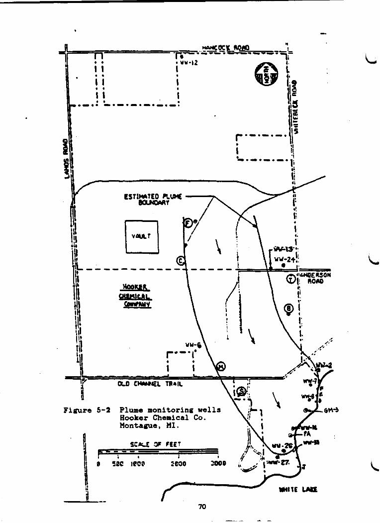
*
----------
Figure 5-2 Plume monitoring wells Hooker Chemical Co. Montaque, MI.


Table 5-6 Mean an4lytical reeults for purge well yater samplee collected in 1986 from the Hooker Chemical Company purge welle located between the contaminated plume and White Lake, Muskegon County, HI.
Parameter Purgewell
PE PD . PC ' PB PI PH PC PF
Chl orof orr Carbon Tetrachloride Trichloroethylene Tetrachloroethylene
(Perch1 oroethylene) Hexachlorobenzene Hexachlorocyclopentadiene Octachlorocyclopentene Hexachl orobutadiene
330 3,535
2 0 4,726
0.08 K 1 K 1 KO. 2
774 8,228
245 15,793
0 . 2 K 1 K 1 KO. 2
150 9,169 204
20,212
Q. 1 1 K 1 K 1 KO. 2
35 157 56
5,988
KO. 05 K 1 K 1 KO. 2
11 60 3 6
1,574
0.06 K 1 K 1 KO. 2
KO.05 KO.05 K 1 K 1 K 1 K 1 KO. 2 KO. 2
4) (3
K = leee than level at detection indicated Data baaed on eamplee collected monthly for ten monthe except welle PH and PI which represent a nine month period.

E.I. duPont deNemours and Company
E.I. duPont deNemours and Company, located in White River Township, began operations in 1955. Various solid waste disposal methods were employed by the company and include the following:
A lime pile covering 12.2 hectare (30 acres) and containing up to one million cubic yards of solids that contain traces of ammonia, arsenic, copper and thiocyanate. The lime pile is not considered a hazardous waste and efforts are to comer- cially use the material for acid neutralizers and agriculture lime. The Company proposes to remove the pile over the next ten years (Przybysz, 1987 personal communication) .
O A bury pit and northeast dumpsite containing steel drums (used for neoprene tar and latex disposal), copper chloride salts, potassium and ammonium latex, potassium hydroxide, and general ref use
* Frequent small spills at the former bulk storage area releas- ing TCE, PCE, carbon tetrachloride, and methyl chloroform (MDNR 1986d).
In 1961, contamination of several residential wells was determined. E.I. duPont deNemours completed several hydrogeologic investigations and installed two groundwater purgewell systems to retard migration of the contaminant plume from the plant site. E.I. duPont deNemours has been proposed by U.S.EPA for inclusion on the XPL because of the lime pile and associated groundwater contamination.
Howmet Corporation - Plants 14 and #5 The Howmet Corporation Plants No. 4 and 5 manufacture turbine engine components. Groundwater contamination has been confirmed at this site. Groundwater samples collected March 1984 from observation wells con- tained tetrachloroethylene, (1.4 ppb) , trichloroethane (6.8 ppb) and 14 ppm total chromium. (MDNR 1986d). The contaminated groundwater vents to Mill Pond Creek, a White Lake tributary (Figure 5-4).
Przybysz (1986), MDNR Grand Rapids District staff, stated trichloroeth- ane contamination appears unique to Eowmet Plant No. 4's plume, whereas, triethylene glycol dichloride and bis (2-chloroethyl) ether are unique to hskegon Chemical Company's plume. Seeps from the Muskegon Chemical plume appear to discharge to Mill Pond Creek upstream of White Lake Drive, vhereas the Hornet Plant No. 4 plume vents to the creek just upstream of Zellar Road. Zellar Road is located about 0.5 km (0.75 mi) upstream from White Lake. The two plumes vent at separate locations about 300 m (1000 ft) apart. Based on current well monitoring data, the two plumes appear to be running parallel to each other but do not appear to overlap or intersect.
Hill Pond Creek water samples, collected April 1984 in the vicinity of the Zellar Road and Eowmet Plant No. 4 plume seeps, contained

rcHI
ul
t &
J .
w=
.
Figu
m m
Ire 6-4 Contaminated groundwater plume associated with Hownet Corporation Plant a 4. Whitehall, Huskegon County, HI.
tetrachloroethylene (1.4 ppb) and trichloroethane (5.2 ppb). These concentrations do not exceed their respective Rule 57(2) guideline levels of 20 and 120 ppb, respectively. The Company is currently monitoring and making efforts at source determination and plume def ini- tion. Leaking underground chemical storage tanks and a defunct seepage lagoon are suspected sources.
Howmet Plant No. 5, located northeast of Plant No. 4, is a suspected source of contaminated groundwater influencing the Howmet plume to Mill . Pond Creek. Groundwater plume definition studies are planned by the Company for fall 1987.
Koch (Muskegon) Chemical Company
The Muskegon Chemical Plant, located south of Whitehall in the vicinity of Howmet Plant No. 4 and No. 59 manufactures a variety of industrial organic compounds. The plume extends from the Company property to the southeast underneath White Lake Drive to Mill Pond Creek (Figure 5-51.
,M)NR (1986d) groundwater monitoring vell data for samples coll ected (north of White Lake Drive) on August 1984 indicated the presence of 1,2-dichloroethane (9800 ppb) , bis (2-chloroethyl) ether (5000 ppb) , triethylene glycol dichloride (2200 ppb), trichloroethylene (80 ppb), tetrachloroethylene (360 ppb) and chlorobenzene (360 ppb) . The contami- nated groundwater plume boundaries are well defined and have not been intercepted by any residential wells.
Prior to 1984, Beck (1982, 1983a and 1983b) reported that groundwater seeps to Mill Pond Creek upstream of White Lake Drive contained elevated concentrations of triethylene glycol dichloride, 1,2dichloroethane and bis (2-chloroethyl) ether on three occasions (Table 5-7). Current Rule 57(2) guideline levels of 800, 560 and 3.0 ppb, respectively, would have been exceeded. Analytical results for water samples collected June 1983 from Mill Pond Creek, just upstream of White Lake, indicated concentra- tions greater than Rule 57(2) guidelines at concentrations of 39, 1 and 2 ppb , respectively) . Qualitative biological assessment surveys of Mill Pond Creek (1981 and 1983) indicated no apparent impacts to macroinvertebrate communities downstream of White Lake Drive, located inmediately downstream of the unnamed pond that receives contaminated groundwater. seepage and upstream of Hill Pond Creek (MDNR flles).
Fish were collected in June 1983 from the Mill Pond (located downstream of Zellar Road) for fish contaminant monitoring purposes (Beck, 1983~). Four species of fish were analyzed as composite samples of three to five whole fish. Triethylene glycol dichloride and bis (2-chloroethyl) ether were less than a level of detection of 0.2 ppm. Analysis for other purgeable organic compounds vas not done for lack of approved analytical methods. None of the substances were expected to bioaccumulate.

Figure 5-5 Contaminated groundwater plume associated with Koch (Pluskegon) Chemical Company. Sourca: HDNR Grand Rapids District.

Table 5-7. Analytical results for Muskegon Chemical Company contaminat- ed groundwater seepage to Mill Pond Creek. Whitehall, Michigan.
December June August Rule 57(2) Parameter 1982 1983 1983 Guidelines Basis
Triethyl ene glycol 17 1 0 t o 16 2.3to19 0.8 ACV dichloride (ppm) i b l d 1,2dichloroethane 7.5 1.3 to 3.3 0.46 to 0.7 56 CRV 0- (ethyl ene (dichl oride) (ppm) a 00% C R ~ ~ , 5579
Bis(2-chloroethyl) 0.9 0.3 to 1.3 0.052 to 0.5 ,&€M3+ W E E ether (ppd %?a
ACV = Aquatic Chronic Value CRV = Cancer Risk Value HLSC = Human Life-Cycle Safe Concentration
Source: MDNR Surveys
The presence of fish in the Mill Pond and macroinvertebrates just domstream of White Lake Drive indicated the absence of acute toxic concentrations of the subject organic compounds. Therefore, there is little likelihood that there is any perceptible impact to uses of White Lake or Lake Michigan from these contaminated groundwater sources.
hskegon Chemical Company installed a groundwater purgewell and treat- ment system in 1985. The purgewell, to date, has failed to capture the entire contaminated plume but has retarded the discharge to Mill Pond Creek. MDNR Grand Rapids District staff indicate that captured contami- nated groundwater is treated via carbon filtration to remove the organic contaminants. Treated wastewater is then discharged to the Muskegon County WMS No. 2. MDNR staff indicated the Company was in compliance, during 1986, vith requirements set forth in a 1985 Consent Agreement between the HDNR and Company.
Tech-Cast, Inc.
Tech-Cast, Inc., (the facility is presently owned by CMI-Dearborn) is located on the west side of Montague. This site has confirmed levels of trichloroethylene of up to 478 ppb in their supply and monitoring wells. Additional contaminants detected include l,l,l-trichloroethane (100 ppb) , benzene (6 ppb), ethylbenzene (42 ppb) , toluene (42 ppb) , xylene (56 ppb) and 1,l-dichloroethane (2 ppb). A solitary spill incident at the facility is the suspected source of contamination.
The MDNR believes the contaminant plume is migrating, but no information is available on rates or direction of movement (MDNR 1986d). Tech-Cast, Inc. terminated its operations on December 28, 1984.

The drinking water supply at CXI-Dearborn (Tech Cast) was replaced with municipal water.
Muskegon County Wastewater Management System No. 2
The Muskegon County WMS No. 2, located eaat of Whitehall, uses land application methods for wastewater treatment. Treatment practices at the site have resulted in the migration of two contaminant plumes from ,
the site. Uncollected irrigation water has produced a northwesterly directed plume and storage lagoon leakage has produced a northeasterly directed plume. The northwesterly directed plume is intercepted by White River, located approximately 154 to 308 m (500 to 1,000 ft) from the corner of the site, while the northeasterly directed plume is intercepted by Silver Creek (Metcalf & Eddy 1982). Some contamination was confirmed in residential wells to the west of the site. MDNR information (December 1984) indicated that effluent permit limitations for ammonia had been exceeded. Corrective actions are being pursued by the MDNR. A report from Keck Consultants detailing site conditions is due this fall (1987).
Groundwater at the WMS site has been found to contain elevated levels of nutrients. Table 5-8 summarizes chlorides and nutrients detected in wells at the site in 1981 (Figure 5-6). Chloride concentrations of 1 to 2 ppm are considered back ground concentrations for the site, indicating that higher levels are from the influence of wastewater. High chloride concentrations of up to 450 ppm were detected onsite predominantly to the northeast. Although no information was available concerning back- ground nutrient levels, areas that were strongly influenced by waste-
L water, as indicated by elevated chloride concentrations, were also tended to show elevated levels of nutrients (Metcalf & Eddy 1982).
Table 5-8. Chloride and Nutrient Levels Detected in Groundwater at the WMS Site, 1981

Table 5-8 (continued)
Whll Depth Chloride NH3-N N03-N Total P No. (Ft .) (mgll) (mgll) (mgll) (mgll)
Source: Metcalf & Eddy 1982.
Elevated levels of organics,have also been found at the site. Table 5-9 summarizes priority pollutants and additional organic compounds detected in observation and monitoring wells onsite in 1981 and 1982. Organics detected in groundwater at the WMS site were found to be at levels of concern. Additional sampling of wastewater, completed later in 1982, indicated levels of'bis(2-chloroethyl) ether at 16 and 11 ppm a decrease from the earlier samplings (Metcalf & Eddy 1982).
A report on the Muskegon County UMS No. 2 facility is due in the fall of 1987.
Table 5-9. Trace Organic Concentrations Detected in Monitoring and Observatton Wells at the WMS Site (ppm)
August 1981
C~mpound A-1 A-2 A-3 B-2 B-3 C-1 C-2 C-3
Priority pollutants
Bis (ethylhexyl )phthalate Vinyl chloride Chl orof o m 1,2-Dichl oroethane Tetrachloroethane Bis (2-chloroethyl) ether Chloromethane Toluene

Table 5-9 (continued) August 1981
Compound A-1 A-2 A-3 B-2 B-3 C-1 C-2 C-3
Addi t ional organic compounds
Bis(2-chloroethoxy)cthane 0.078 -- -- Tetraethylene glycol 0.14 0.016 -- d ichl oride
Pentaethylene glycol 0.050 0.027 -- dichl oride
Bexae thy1 ene glycol 0.28 0.10 -- dichloride
Tetrahydrofuran 0.19 0.041 0.015 Methy 1 an11 ins n -- -- N ,N-dimethylanil ine -- -- -- A3kyl iubet phenol (2) -- -- -- Bis (2-chl oroethoxy) ethanol - -- -- 4 chlorobenzoic acid -- -- --
February 1982
Compound
Priority pollutants
1,2-Dichl oroe thane l,l,l-Trichloroethane Trichl oroethyl ene Tetrachloroethylene Bis (2-chloroethy1)ether To1 uene Bis (ethylhexy1)phthalate Trans-1,2-Dichloroethylene 1,l-Dichloroetbne Chl orobenzme
Additional organic compounds
1,4-Dioxane Methy 1 anif ine Bia (2-chloroethoxy) ethane N,N-Dimethyl anil ine Tetraethylene glycol
dichl oride Hexae thy 1 ene glycol
dichloride Pentaethyl ene glycol
dichf oride
Source: netcalf & Eddy 1982. Note: -- indicates not detected 80

LEGEND - MULTI-WILL OaatnvATloN POINT . 8lROLt WELL
0 wnoa war p3'01 MAXIMUM -N CONCINTIIATION 8L?TlMILI I 1 a. 1 - )REDOMlNAtf DIRECTION OF 0 600 .lo00 9600
Figure 5-6 Groundwater monitoring well locations at the Muskegon County W No. 2. Muskegon Couty, HI. (Source: netcalf and Eddy, 1982)

5.2.1.2 Localized Groundwater Contamination by Industries
The proxinity of White Lake and numerous municipal and private wells to industrial and even residentual sites suggests the potential for contam- ination by these facilities. Additional sites have been identified, as per Act 307, as having contaminated groundwater that does not appear to be venting to surface waters of the AOC. They are as follows:
Residential Well - White Lake Drive - Whitehall Montague Municipal Well - Coon Creek Well Whitehall Municipal Wells No. 3 and No. 4 San Juan Subdivision White Lake Landfill Blue Lake Township Dump (Closed) Old City of Montague Dump (Closed) Montague Township DMlp Montague Salt Storage Site Mite River Tovnship Dump Whitehall Salt Storage Site Montague City Garage
Whitehall Municipal Wells No. 3 and No. 4:
Whitehall municipal wells No. 3 and No. 4, two observation wells and six residential vells were determined to be contaminated with volatile organic cumpounds in 1983. The two Whitehall municipal we1 1s were placed on the NPL. Wash King Laundromat facility (Soap Opera), located in town, appears to be the source of organic solvents and cleaners detected in the Whitehall municipal 13. Potential sources of contami- nation of Well No. 4 appear to be from the vicinity of Bowmet Corpora- tion Plant No. 4 and Muskegon Chemical Company. These vells are sampled quarterly in order to monitor contaml~nt levels.
Whitehall Leather Company:
Whitehall Leather Company is a leather taming and finishing industry located in Whitehall along the south shore of White Lake. Between 1940 and 1974, the Company used a settling lagoon system for treating tanning process wastewater. Chromium was a major pollutant associated with the process waste. The lagoon discharged directly to White Lake at "Tannery Bay".
The lagoons have been dredged and the solids deposited in the vicinity of the factory within 154 m (500 ft.) of White Lake. The lagoons and sludge piles have been capped with a clay cover. These sludges can seme a8 source of cont&miuants to White Lake and possibly to ground- water. There is some concern that private and municipal wells, located within one mile of the site, could be affected by groundvater contami- nation if cones of depression were created by overpumping at these wells (MDNR, 1986d). Przybysz (1987 personal communication) indicated that monitoring well data, from around the lagoons, indicates no migration of contaminants.

White Lake Landfill and Shell Cast, Inc.:
These facilities are located east of the White Lake Landfill and are responsible for the contamination of some residential wells located just west of the White Lake Landfill/Shell Cast area (Przybysz, 1987 personal communication). The landfill reportedly received spent solvent vaste from heavy industry and is suspected to contain buried crushed barrels from a chemical manufacturer. Leachate seeps have been observed on the north perimeter despite the installation of a clay liner (MDNR 1986d). '
Monitoring of water wells in the vicinity of the landfill site indicated the Shell Cast's water supply well contained 58 ppb tetrachloroethylene, 5 ppb trichloroethylene and 2 ppb cis-1,2-dichloroethylene. Since the well was located upgradient of the landfill site it was suspected that the company had inadvertently contaminated its own well. Shell Cast and White Lake Landfill have agreed to investigate this matter further (Przybysz, 1987 personal communication).
Montague Municipal Well .- Coon Creek Well Site:
The Montague City garage ia thought to be the source of trichloroethyl- ene that contaminated the Montague municipal well (Coon Creek well). The well is to be used for emergencies only and is sampled quarterly (MDNR, 1986d).
Residential Well - White Lake Drive, Whitehall: This well was contaminated with low levels of benzene. A suspected source of benzene contamination, at this site, is residential use and improper disposal.
San Juan Subdivision Residential Wells:
The Saa Juan subdivision, located approximately 4.8 km (3.0 mi) south- west of Montague along the north shore of White Lake, is considered a potential source of groundwater contamination. Data indicate that a resident in the subdivision used to degrease car engines in his back- yard, possibly resulting in groundwater contamination. This information is unconfirmed (MDNR 1986d). Quarterly monitoring results indicate concentrations of the degreaser are less than levels of detection (1 pbb) Koehler, NDPH, personal communication.
Montague Municipal Well - Coon Creek Well: Montague City Garage is considered the source of trichloroethylene that contaminated Montague Coon Creek municipal water well. This well is shut down except for emergency use only.
The remaining dumps, landfills and salt storage sites listed above are all potential sources for groundwater contamination due to the materials stored or disposed there.

5.2.2 Sediment Contamination
As a result of previous surface water discharges (Section 5.1.2), the bottom sediments of White Lake received a number of contaminants. These in-place sediments can act as a pollutant source for biota and water in the AOC. Howmet Corporation and Hooker Chemical Company discharged PCBs in the early 1970's that caused sediment contamination.
Evans and Borgeson (1977) concluded that the major impact to the White '
Lake benthic community was due to Hooker Chemical Company's surface water discharge betveen 1952 and 1975. Improvement and recovery in the lake's benthic coauuunity was documented in 1980 (Evans, ca. 1981)', subsequent to more restrictive discharge permit effluent limits.
5.3 SUMMARY
Several sources of pollutants to the AOC are identified. In-place lake sediments and contaminated groundvoter are potential sources of contaminants to the AOC.
Industrial and municipal sites in the White Lake AOC, that have con- firmed groundwater contamination that has vented to surface waters in the AOC are: Occidental (Booker) Chemical Company, E.I. duPont deNemours and Company, Hornet Corporation Plants 4 and 5, Koch (Muskegon) Chemical Company and Muskegon County WMS No. 2. CMI-Dearborn (Tech-Cast Inc. ) , White Lake Landfill/Shell Cast, Wash King Laundromat have contaminated municipal or residential wells in either Whitehall or Montague.
Three municipal we1 1 s and six residential we1 1 s were identified by the County and State Health Departments as having been contaminated.
Volatile organic solvents (degreasers) and/or other high1 y mobile organic compounds constituted the major contaminants detected at all sites. Most of the organic compounds involved are miscible vith water and readily migrate through the porous sandy soils located at a31 the site..
Historical surface water discharges (chemlcal production plants, heavy industries, tannery and municipal w8stewater treatment plant) increased environmental contoninants (heavy metal and organic- compounds) in White Lake water and sediments causing severe degradation to White Lake quality. Sedbents of White Lake were contaadnated vith heavy metals making it unsuitable to support a healthy benthic coamnunity PCB contam- inated s e d b m t s resulting from industrial discharges in the 1970s are declining but appear to be a source of PCBs being bioaccumulated in the White Lake carp population at levels that exceed KDPE's action level of 2.0 p p .
Four facilities currently discharge to surface vaters in the AOC and do not have an adverse impact on the environmental quality of White Lake AOC. The development of enviroumenta11y sound NPDES permit limits and requirements, groundwater purgevellltreatment s y s t w , municipal pre- treatment requirements, proper use of approved waste management and disposal procedures and other remedial actions developed in the 1970's and 1980's have resulted in improved lake quality.

Urban runoff may serve as a source of localized nutrient enrichment and suspended sol ids loadings to the lake, but i s considered a very minor source. The White River watershed serves as the major source of nutri- ents and suspended sol ids to White Lake.
b 6.0 POLLUTANT TRANSPORT MECHANISMS AND LOADINGS
Pollutants may be transported and released to the environment from several sources: air, surface water, groundwater, soils and sediments. Atmospheric deposition may occur when contaminants are discharged into the air, volatilized, subsequently contacted by rainwater and/or ad- sorbed particulate matter and deposited on land and surface waters within river and lake basins. Surface waters transport contaminants from wastewater discharges or surface runoff from industrial, municipal and agricultural sites to other surface waters. Contaminated groundwa- ter, resulting from contaminated soils can migrate and vent to surface waters. Contaminated soils can pollute the aquatic environment by contaminating runoff to surface waters. In-place contaminated sediments can release contaminants to the water column, and organisms may acquire contaminants directly from the sediments and pore water.
Continuous, intermittent, nonpoint and in-place pollutant sources are discussed in this 'chapter in tenns of pollutant transport mechanisms and loadings, where possible.
6.1 CONTINUOUS POINT SOURCES
Continuous point sources refer to those facilities that discharge contaminants, at levels of concern, directly to the Area of Concern. These types of potential pollutant sources include municipal wastewater treatment systems and industrial dischargers.
The foll'owing industries have NPDES permits and limits that permit their discharge to White Lake AOC: E.I. duPont deNemours, Howmet Corporation and Occidental (Hooker) Chemical. E.I. duPont deNemours and Company also discharges treated process wastewater to Lake Michigan. The Muskegon County WMS No. 2 discharges to White River via Silver Creek.
Required treatment and permit limits have reduced or eliminated contami- nant loadings to levels that protect the water quality and biota in the AOC . 6.2 INTERMITTENT POINT SOURCES
Intermittent point sources are those sources that periodically dis- charge, rather than continuously discharge, to the AOC. These sources include, sanitary sewer overflows (SSOe) and bypasses, urban stormwater discharges andlor industrial dischargers that do not discharge continuous1 y.
6.2.1 Urban Storwater Discharges
Limited information is available on the effect of stormwater loadings on the White Lake AOC. Table 6-1 provides estimated stormwater loadings for five types of pollutants in the White Lake Watershed Management Units (WMUs) .

Table 6-1. Estimated White River Basin Storwater Loadings L
Pollutant
Suspended Solids
BOD5
COD
Total N
Total P
Stormwater loadings presented above are only estimates provided in order to show that large volumes of nonpoint source pollutants potentially enter the White Lake AOC yearly. These data indicate that nonpoint sources may be significant eources of solids loadings to the AOC, but limited data prohibit the estbation of percentages resulting from these
L sources.
6.3 NONPOINT SOURCES
Nonpoint sources are diffuse sources of nutrients and toxic substances vithin a watershed. Nonpoint pollutant sources include rural and suburban runoff , urban/industrial site runoff , polluted groundwater discharges and atmospheric deposition.
WMSRIX (19770) reported that, in 1975, nonpoint sources to White River contributed 98 percent of the total phosphorus loading to White Lake and 99.1 percent of the disrolved inorganic nitrogen. This was after the point source dirchargerr were diverted to the Muskegon County WMS No. 2 facility . A comparison of estimated annual total phosphorus loading rates (Table 6-2), for example, aa pounds/cfs river flow (Figure 6-l), and annual average instream phosphorus concentrations (Figure 6-2) indicates reduced loadings of phosphorus between 1973 to 1980 (MDNR STORET Station 610178). The phosphorus loading estimates were based on an average of monthly phosphorus concentrations (single grab) and annual average river flovs, the latter from U.S.G.S. gage Number 04122200 located at Fruitval e Road, Muskegon County (Tab1 e 4-3) . The water qua1 ity monitor- ing station was located upstream from White take on north bound U.S. Route 31 within a mile dovastream of the Wuskegon County WMS No. 2 outfall to Silver Creek. i d

Table 6-2 White River total phosphorus loadings to White Lake. Muskegon County, Michigan.
Annual Annual Average Average Annual Average Fl ow Conc . Loading Loading Rate
Year (cf s) (PP~) (lblyr) (kglyr) (Iblcf s)
Sources: MDNR and Limo-Tech
Estimated phosphorus loadings from the Muskegon County WMS No. 2 to the White River in 1983 and 1987 ranged from 82 to 109 kglyr (180 to 240 Iblyr). These estimates were based on facility monitoring reports. Haximum outfall phosphorus concentrations, for the two years, were 0.1 to 0.03 ppm and daily discharge rates averaged 0.026 and 0.068 mS/s (0.6 and 2.6 MGD), respectively. Total phosphorus loadings from the WMS facility presently represent less than 1% of total loadings to White Lake as was also reported by Limno-Tech (1981). Elimination of this discharge would not significantly change phosphorus in-lake concentra- tions. Limno-Tech estimated that a 50% reduction of phosphorus loadings vas necessary to eliminate eutrophic conditions in mite Lake. This percent reduction would require control of basinvide contributions from diffuse and natural sources.
6.3.1 Atmospheric Deposition
Atmospheric deposition of PCBs to the White Lake AOC watershed and Lake Michigan may contribute to the available PCBs and chlordane being bioaccumulated by White Lake carp. Strachan and Eisenreich (1987) estimated PCB annual loadings to Lake Michigan of 685 kglyr (1,507 Iblyr). Seventy-three percent (500 kg or 1,100 lbs) of the loadings are attributed to atmospheric inputs. There is insufficient air toxics monitoring data for chlordane to determine if it is a significant source to Lake Michigan and drowned river mouth lakes (Bidelman, 1987 personal communication).

WHITE RIVER PHOSPHORUS LOADING RATE

WHITE RIVER AtJI4UAL. AVERAGE PHOSPHORUS CONCENTRATION
.-- -----

6.3.2 Groundwater Discharges
Once contaminants have entered a groundwater system they may be trans- ported to and released into surface waters. Groundwater movement may be vertical or horizontal and may occur in one or more directions. Ground- water movement in the White Lake AOC is generally directed toward surface waters. Once the contamination has been detected, removal typically requires an expenditure of time (sometimes years) often at great expense. Often, the extent of contamination may be difficult to def ine . Groundwater composes 79 percent of the White River water (WMSRDC 1978a) upstream of White Lake. Contaminants of the White River Basin soils and groundwater would ultimately be discharged to the White River and White Lake.
The majority of the contaminants that have been determined, to date, at most of the sites that could affect the White Lake AOC are highly mobile organic compounds that readily volatil it.. These compounds are short lived in the aquatic environment and do not readily bioaccumulate.
6.4 IN-PLACE POLLUTANTS (CONTAMINATED SEDIMENTS)
Pollutants originating from point or nonpoint sources can accumulate in the bottom sediments of aquatic systems creating a potential contaminant source for the surface water body. Under reducing conditions (low pH, low dissolved oxygen) pollutants can enter the water column at the L sediment/vater interface.
Historical point and nonpoint sources are primarily responsible for the elevated organics and metals detected in White Lake sediments. There are no active municipal or indurtrial dischargers that are currently known to be contributing to the skdiment pollutant load. Contaminated groundwater and urban runoff may be current but minor pollutant sources that do not affect the AOC or Lake Michigan.
6.5 SUMMARY
Historical mass loadings of pollutants to the White Lake AOC were not calculated. Nonpoint sources of contamination, primarily urban runoff and contamhated groundwater are the current potential sources for pollutant loadings to the AOC. Because groundwater makes up approxi- mately 79 percent of the White River flow, it provides an excellent vehicle for contaminant transport to White Lake. In-place bottom s e d h m t s are improving in quality, but still contain elevated chromium, , lead and zinc at concentrations that may continue to degrade the lake's benthic community. Inorganic contaminants do not exceed levels of concern in tissues of White Lake fish.

7.0 HISTORICAL RECORD OF RPiEDLAL ACTIONS ,
The Michigan Environmental Response Act (P .A. 307) created a me thodology fonthe ranking of contaminant sites using a risk assessment model. An interagency technical committee drafted the risk assessment model in 1983, creating a method entitled the Michigan Site Assessment System (MSAS). Present and potential risks to public health, safety, welfare and the environment from a site are assessed by the MSAS. The MSAS was used to rank a number of sites in the White Lake AOC. Appendix 7.1 identifies sites that have been scored and screened by the MSAS. Scored sites are ranked on a scale of 1 to 2000 and only include sites identi- fied prior to September 19, 1986. Sites screened by the MSAS have been ranked on a scale of 1 to 15, relevant to the site's risks. Sites that have been screened greater than or equal to 9 are also scored (MDM 1986~).
Injection wells, sewer system installation, attempts to control deicing and dust control procedures have been implemented to improve water quality conditions in Muskegon County. Cleanup operations have been conducted at various industries, some of which are listed on the Nation- al Priority List (NPL). In addition, remedial actions have been com- pleted at specific spill sites.
The various remedial measures taken in the vicinity of the Area of Concern (AOC) are described in the following sections. Detailed de- scriptions of wastes disposed at these sites and disposal methods used are provided in Section 5.2.1.
7.1 COMPLETED ACTIONS
7.1.1 Muskegon County Wastewater Management System (WMS) No. 2
Prior to the installation of the Muskegon County Wastewater Management System (WMS) No. 2, severe pollution problems were evident in White Lake due to individual disposal methods used by industries and the now defunct Whitehall/Montague wastewater treatment plant. Disposal methods used involved the direct discharge of insufficiently treated industrial and municpal wastewater to White Lake (Metcalf 6 Eddy 1982a) . The Muskegon County WMS No. 2 began operations in 1973. Figure 7-1 illustrates the Iocation of the system in relation to the AOC. The system was developed under a program with the United States Environmen- tal Protection Agency (USEPA) as a research and development project.
The Department of Public Works applied to U.S.EPA for additional funding through the Michigan Department of Natural Resources (MDNR) for the preparation of a facilities plan. The facilities plan contains an evaluation of the current operation of the WMS No. 2, determination of future requirements and alternative actions and determination of the best alternative based on cost and environmental requirements. An amendment to this plan was completed in 1985 (Metcalf 6 Eddy 1985a).
The Muskegon County WMS No. 2, located in Whitehall Township, treats wastewater by land application methods. The wastewater is pretreated

and applied to irrigated agricultural land where it ds allowed to percolate through the soil. After percolation, collectioa and discharge of wastewater is provided by the system. The system was designed to treat 1.36 MGD (Metcalf & Eddy 19820).
A collection system, consisting of two pumping stations and forcemains, and a treatment and disposal network are maintained by the facility. The facility conducts preapplication treatment, storage, irrigation, groundwater collection and discharge operations. Figure 7-2 illustrates features of the treatment facility. Table 7-1 provides a sumPary of the features at each pumping station.
Table 7-1. WMS No. 2 Pumping Station Summary
Ratio of Firm
Average Capacity No. of Standby Alarm Capacity (MGD)' Flow to Avg . Desiq
Station Pumps Power Telemetry Installed Firm (Ma) Firm Ratio
Source: Modified from Metcalf & Eddy 1982.
'~ec-ended firm pump capacity for sire of station.
Uncollected irrigation water and storage lagoon leakage have resulted in the migration of two individual groundwater plumes from the WMS No. 2 contaminated with ammonia, bis(2-chloroethy1)ether and/or 2- chloroethoxyethane contamination was evident in residential wells on Silver Creek Road located to the west. Owners of the residences in the affected vicinity were provided carbon filters for their water system to remove the organic contaminants. Available information W N R , December 2, 1984) indicated the case was in litigation due to violation of permit requirements by the WMS. A treatment system evaluation report has recently been prepared for Muskegon County by Keck Consultants. Copies have not been provided to appropriate MDNR staff for review.
A residential well,.located southwest of the WMS, in the vicinity of Holton/Whitehall Road, was found to be contaminated with tetrachlorotth- ylene (perchloroethylene). The well has been replaced vith Act 307 funding (Koehler, 1987 personal communication). The source of the contamination remains unknown.
Specific problems identified by Metcalf and Eddy at the Muskegon County WMS No. 2 included:


O Groundwater Control - Facility well can only recover approxi- mately 17 percent of the irrigation flow; the remainder migrates with groundwater from the site.
Storage Lagoon Seepage - Wastewater seeps from lagoons, contaminating the groundwater. There is no control for this problem.
O Nutrient Loading - The agricultural system has very high phosphorus and nitrogen loadings; report recommends addition of chemicals to increase precipitation of phosphorus.
O Sludge Accumulation - No system exists for removal and pro- cessing of sludge in basins.
Preapplication Treatment - The storage lagoon maintains a high organic load, producing odors in the lagoon and irrigation distribution system (Metcalf & Eddy 1982a).
After evaluation of the current concerns at the Muskegon County WMS No. 2 and consideration of future requirements of the system, the following changes were recommended:
O Control groundwater degradation O Control storage lagoon seepage O Increase storage capacity to 1.7 MGD O Improve the sludge handling process (Hetcalf & Eddy 1982a). .
A consent agreement vas entered between the State of Michigan and Muskegon County for cleanup of the contaminated groundwater plume at the WMS No. 2 site. Requirements of the agreement include:
Installation of two interceptor wells by January 31, 1985. Wells would intercept the groundwater plume migrating north- east f tom the storage lagoon and collect groundwater contami- nated from the irrigation fields.
O Sealing of the storage lagoon by October 1987 (Metcalf 6 Eddy 1985a) .
The plan presented by Metcalf & Eddy (1985a) for Improvement of the WMS No. 2 includes the following objectives:
O Restriction of the contamination of the northeasterly migrat- ing groundwater plume by sealing the storage lagoon
O Modification of aeration lagoon system to sludge system, "providing" winter nitrification
O Improve process for handling sludge
O Improve equalization basin

O Expand rapid infiltrationsystemtoenlargecapacity to 1.7 HGD and to treat an estimated 1.1 MCD of contaminated ground- water collected from the northeast interceptor wells
7.1.2 Superfund Sites
One site located in the White Lake AOC is included on the NPL. The Whitehall municipal wells 63 and 64 are 34 and 43 m (110 and 140 ft) deep, respectively, and were determined to be contaminated in 1983. Well monitoring data (1984 to 1987) indicates that neither of these two wells contain contaminants at levels of concern and the MDPH has re- stored their use for emergency use only. Restricted water withdrawals from Well t 3 were implemented to minimize the drawing in of known contaminants, from the surrounding aquifers. U.S. EPA and the MDPH continue to monitor these wells as part of a superfund program.
7.1.3 Proposed Superfund Sites
Two other sites in the AOC have been proposed for inclhsion on the NPL and are detailed below.
Occidental (Hooker) Chemical and Plastics Company
From the 1950's to 1970's Hooker Chemical and Plastics Corporation used improper disposal methods which resulted in the contamination of soils, groundwater and residential water wells with chlorinated hydrocarbons (Weaver, 1987).
The presence of some environmental problems at this site became became apparent to the State of Michigan in the mid 1970's. In 1976 and 1977, the M)NR required the Company to conduct a hydrogeological study to determine the rate and direction of groundwater flow and the extent of contamination and to conduct a soil sampling program to determine the source(s) of the groundwater contamination. These studies indicated that soils and the groundwater at the Company's site was severely contaminated vith chlorinated hydrocarborn. During an inspection of the Company site in 1978, the MDNR became aware of several toxic waste disposal areas on the Hooker Chendcal Company's property. In October 1978, the Company submitted a solid waste disposal plan to the MDNR. The MDNR concluded that the plan was inadequate and that contaminated solid wastes should be excavated and placed in a secure clay lined vault located on site.
The State filed suit against the Company on February 21. 1979 in order to reduce the contamhation at the site. The suit was settled with the entry of a Consent Judgment on October 30, 1979. The judgment required the Company to do the following: complete a hydrogeological investiga- tion to define the full extent of the groundwater contamination; install and properly operate a groundwater purged treatment system to completely halt the flow of contaminated groundwater to White Lake and remove and '
treat (remove contaminants) the contaminated groundwater; excavate the solid wastes from the disposal areas at the site and place them into a clay lined vault located on the Ccmpany's property; and provide an alternate water supply to local residents with contaminated wells.

The Company installed and operated a groundwater purge and treatment system since 1979. During this period, the Company failed to demon- strate the effectiveness of the system to completely halt the flow of contaminated groundwater to White Lake. The MDNR directed the Company to Improve the system to increase capture of the contaminated groundwa- ter. The Company responded by making incremental increases in the pumping rate of the purge well system but these increases were insuffi- cient to halt the flow of contaminated groundwater to White Lake.
From 1980 to 1982, the Company constructed a clay lined containment vault on their property. They then excavated most of the accumulated production process wastes and contaminated solids stored on the property and placed it into the vault. Contaminated soils from an area referred to as "No-Man's Land" were not removed during the excavation period. The MDNR ordered the Company to excavate and place these wastes in the vault. The Company refused.
In Hay 1985, the State brought an action in circuit court to compel the Company to upgrade the groundwater purge well/treatment system to completely halt the flow of contaminated groundwater into White Lake and to excavate and properly contain the contaminated soils located in "No- Man's Land". As a result of that action, the Company has increased the size of the purge well system and increased thC purge well pumping rates. Additional rates are in progress in order capture and treat the contaminated groundwater plume. Approximately 85 to 90% of the plume is being captured and treated (Heinman, 1987 personal communication). The Company is also evaluating the impact of lake level fluctuations (15 to 30 cm or 0.5 to 1.0 ft change in a single day due to prevailing NW winds) on the pumping efficiencies necessary to capture the contaminated plume. The MDNR continues to evaluate the effectiveness of the system to assure compliance with the Consent Judgment.
Court proceedings to compel the Company to remove contaminated materials from "No Man's Land" are pending. A separate federal enforcement action to clean-up the contaminated soils, under the authority of the Resource Conservation and Recovery Act (RCRA), is currently being considered by U.S.EPA.
Estimated damages also were sought from Hooker Chemical and Plastics for deterioration of the fishery of White Lake. Evans and Borgeson (1977) estimated fish loss worth $353,656. A settlement for $135,000 was subsequently made.
Occidental (Hooker) Chemical and Plastics Company shutdown production operations and "mothballedw the site in 1982.
E.I. W o n t de Nemours
The Company operates a chemical (primarily refrigerants) manufacturing plant west of Montague and Occidental (Hooker) Chemical Campany site. As a result of the Company's activities, groundwater in the vicinity of their feed stock unloading area has been contaminated with chlorinated solvents ; specifically carbon tetrachloride, tetrachloroethene , 1,l.l-trichloroethane, chloroform and trichloroethylene. In addition,

waste lime sludge from the manufacture of acetylene (1955 to 1972) contaminated the groundwater with dissolved minerals, aamonia, and thiocyanate compounds. A waste lime pile of 0.76 ms (1.0 million yds) waa estimated. The Company has implemented a groundwater remedial action plan which consists of two purgewell systems to intercept the flow of contaminated groundwater and treat, then discharge the final effluent to Lake Michigan under the provisions of a NPDES Permit (MI 0000884) . The two purgewell systems are identified as the "Lime Pile Interceptor" and the "Organic Feed Stock Unloading Area". The Lime Pile interceptor well is located south of the lime pile and has been in operation for over 20 years. The purge rate of this well is 12 l/s (190 gpm) based on May 1983 aquifer pump test results. The Organic Peed Stock interceptor well is located south of the unloading area and has been in operation since 1982. Two purge wells comprise this system, each pumping at 10.5 l/r (166 gpm) for a total of 21 l/s (332 /~p.) based on February 1982 aquifer pump test results.
The State of Michigan and the Compa ntered into a Consent Agreement on Hay 6, 1986. The Company now ha4 ah NR approved groundwater moni- toring plan which specifically requf 5 e frequencies and types of moni- toring activities. One Consent Agreement stipulation was that "The Company shall continue to operate the purge well and treatment system(s) until the levels of contamination being monitored in the groundwater achieve background levels, determined from upgradient wells, for six ( 6 ) consecutive purge well samples."
7.1.4 Michigan Enviromental Response Act (307) Sites (Nan-Superfund Sites)
Nine sites exist within the White Lake AOC. These sites include:
hakegon County WHS No. 2 Residential Well - White Lake Drive, Whitehall Koch (Muskegon) Chemical Company - Whitehall CMI Dearborn (Tech Cast) Area - Montague Whitehall Leather - Whitehall Howmet Corporation Plant No. 4 - Whitehall San Jwn SubdivLion - Montague White Lake Landfill - Whitehall.
The Muskegon County UMS No. 2 is discussed in Section 7.1.1. Remedial measures completed at the other eight sites are discussed below.(M)NR 1986d).
Residential Well White Lake Drive, Whitehall
A residential well off White Lake Drive in Whitehall found that their well was contaminated with 1 to 3 ppb benzene based on analytical results for samples collected November 1985 and January 1986. Neighbor- ing wells have not contained any detectable level of benzene. The source of contamination in this individual well remains unknown.
The resident was provided bottled water under Act 307 funding. Recent monitoring of the well indicates that benzene concentrations are less than the detection level of 1.0 ppb. Additional sampling is planned for August 1987 and if found to contain less than 1.0 ppb may be useable for domestic purposes.
Montague Municipal Well - Coon Creek Well Organic contaminants from the city garage were suspected to have caused contamination in the Montague Coon Creek Well. The well is sampled quarterly and is used only in the event of an emergency. Latest avail- able data (June 1986) do not provide any information on additional remedhl action.
Koch Wskegon) Chemical Company
This company produces specialty chemicals that requires the use of numerous chemical compounds. Poor chemical containment and handling practices during 1977-1979 period resulted in the loss of an undeter- mined amount of organic chemicals to the plant site soils and underlying grouadvater. Contamination of the groundwater was discovered in 1979 and a subsequent hydrogeological survey define local groundwater was discovered in 1979. A subsequent hydrogeological survey defined the area of the plume and indicated that the contaminated groundwater plume extended about 770 m (2500 ft) down gradient from the facility in a southvesterly direction toward Mill Pond Creek.
The resulting contaminated groundwater plume was contaminated with elevated levels of bis (2-chloroethyl) ether, triethylene glycol dichlo- ride, 1,2-dichloroethane, trichloroethylene, tetrachloroethylene and chlorobenzene. The contaminated plume has migrated to Mill Pond Creek upstreum of the White Lake Drive and vented to the surface at numerous seeps along the margin of Mill Pond Creek and unnamed impoundment of the creek. Muskegon Chemical installed a ground water purgewell system to capture and treat the contaminated groundwater and reduce the amount of contaminants venting to the surface waters. Captured groundwater is treated with a carbon filtration system, then discharged to the Muskegon County WWS No. 2 system.
Abatement techniques and actions were agreed upon an part of a Consent Agreement entered into by the State of Michigan and Muskegon Chemical Company on March 6, 1981.
Q4I Dearborn (Tech Cast) Area Montague
Tech Cast, Inc., determined contamination of their monitor and supply wells in 1982 and 1983. The well contained 478 ppb trichloroethane, 100 ppb l,l,l-trichloroethane, 6 ppb benzene and 42 ppb ethylbenzene. Although the source(s) remains undetermined, a "one-time spill" is thought to have caused the groundwater contamination. Cleanup measures were not implemented, but Tech Cast, Inc., switched its drinking water source to the municipal system. By November 199 1984, the trichloroeth- ane concentrations had declined to 120 ppb. The company continued to use its contaminated well for cooling water. On December 28, 1984, Tech

Cmtp 1nc.B terminated its operations and was replaced by CMI-Dearborn which uses the site as a warehouse,
A private facility (Davignon Mill Point Products) located in the vicini- ty of the Tech Cast facility was also supplied municipal water supply due to detectable concentrations of the above organic compounds.
Whitehall Leather Company
Previous disposal practices used at Whitehall Leather potentially affect the AOC. In the 19408, the company's process wastewater and solids were discharged to a lagoon system which discharged directly to White Lake.
Remedial measures completed at the site included the diversion of process wastes to the Whitehall-Montague WMS in 1974 and dredging of the lagoon sludges. The lagoons and rerulting sludge piles were covered with a clay cap. Test results for monitoring wells crurrounding the capped lagoon site indicate contaminants are not migrating off site. (Przybysz, 1987 personal communication),
* Howmet Corporation Plant No. 4
Previous leakage of underground storage tanks and a seepage lagoon are thought to have resulted in contamination of surface water and groundwa- ter at the Howmet Corporation Plant No. 4. Losses from Plant No. 5 are also being investigated as a possible source of groundwater contamina- tion. Contamination of Mill Pond Creek from contominoted groundwater seeps was determined in samples collected in March and April 1984. A plume assessment is in progress by the Company to determine the extent of contaminated plum. and if a purgewell/treatment system will be necessary to rehabilitate the area (Przybysz , 1987 personal communica- tion). A definition study hur been initiated by the .company to study groundwater contamination at Plant #5.
San Juan Subdivision
In 1979, four residential wells located in the San Juan Subdivision and adjacent to the northwest shoreline of White Lake were found to be contaminated vith 11 to 38 ppb of l,l,l-trichloroethane. Koehler (1987 personal conmunication) reported that recent well smpling results for samples collected by the Muskegon County Health Department staff hdi- cote that contaminant levels are continuing to decline but remain greater than 1.0 ppb (detection level) in one or two of the wells. Additional testing continues.
White Lake Landfill/Shell Cast
Although undetermined, the White Lake Landfill is thought to be a potentlal source for contamination of the Whitehall municipal well system. A supply well for Shell Cast, Inc., located in the vicinity of the landfill, was determined to be contamhated as well. A Consent Agreement between the U.S. EPA and White Lake Landfill and Shell Cast Company has been entered to address the problem of groundwater contami- nation in some of the private wells west of the landfill site. The

compani,es have funded the provision of municipal water supply systems to these private homes. Monitoring of cluster wells around the landfill has been recently completed and analytical results are anticipated for late fall 1987.
7.2 ACTIONS CURRENTLY IN PROGRESS
7.2.1 Muskegon County WMS No. 2
Although general performance of the facility has been effective, several limitations of the system exist. As summarized by Metcalf & Eddy's "Wastewater Management System Facilities Plan Update Summary Report, I t
the major concerns are described as follows:
O Limits of capacity O System's ability for optimum performance O System's ability to comply vith environmental requirements
The facility currently is being upgraded to address the above issues as wells as those raised in Section 7.1.1. Improvements include putting an 80 mil. thick liner in the storage lagoon, rapid infiltration beds and an additional purgewell to intercept contaminated groundwater in the northwest plume. The facility ' s outfall is being diverted away from Silver Creek directly to the White River. Improvement costs, listed by specific area of im- provement, are identified in Table 7-2.
Table 7-2. Cost Estimates for Site Consttuction at WMS No. 2
Construction Area Estimated Cost
Equalization basin
Aeration basin 140,000
Rapid infiltration system 700,000
Settling tanka 600,000
Storage lagoon 1,600, 000
Sludge beds 300,000
TOTAL $3,490,000
Source: Modified from Metcalf & Eddy 1985a.

8.0 DEFINITION OF SPECIFIC GOALS, OBJECTIVES 'AND MILESTONES FOR RESTORATION OF IMPAIRED USES
8.1 USES TO BE RESTORED, MAINTAINED, OR DISCONTINUED
The Michigan Water Resources Commission has designated water uses for which all waters of the State are to be protected, based on Part 4 of the General Rules of the Water Resources Commission, which covers water . quality standards. These rules were most recently amended in November 1986. All Michigan waters, including the Area of Concern, are to be protected for the following uses:
Agriculture Navigation Industrial water supply Public water supply at the point of water intake Warwater fish Other indigenous aquatic life and wildlife Partial body contact a11 year Total body contact recreation from May 1 to October 31.
Aa discussed in previous chapters of this plan, the waters in the source Area of Concern have occasionally failed to support some of these uses, based on the minimum standards set forth in Part 4 of the Michigan Water Resources Commission General Rules. Based on current Michigan regula- tions, a11 of these uses should continue to be supported by any remedial actions undertaken pursuant to this RAP. The White Lake AOC exhibits L impaired uses of carp for consumption because of elevated PCB concen- trations (average of 3.7 ppm) . 8.2 GOALS FOR BIOTA AND HABITAT RESTORATION
Based on Michigan water quality standards, the Area of Concern should be restored to the point where it can support a healthy and diverse fish- ery. PCB and chlordane concentrations in carp populations should be reduced to less than 2.0 ppm and 0.3 ppm. The sources of these two contominants should be determined.
8.3 WATER USE AND QUALITY OBJECTIVES
The ultimate goal of this Remedial Action Plan, as envisioned by the International Joint Conmission Water Quality Board, is to provide direction to remedial activities almed at protecting water quality and restoring impaired designated uses of White Lake. This is to be accom- plished by minimizing negative effects on the lake due to the influence of pollutants from the White River Basin. Water urre and quality objec- tives for the Area of Concern may be very generally stated as the elimination or substantial reduction of detrimental effects on White Lake from the White River Basin.

8 . 4 SUMMARY
All tributaries to the White River and White Lake are protected for coldwater fish. White Lake is protected for warmwater fish species as a minimum.
A health advisory was issued by the Michigan Department of Public Health recommending restricted consumption (no more than one meal a week) of carp from White Lake due to elevated levels (3.7 ppm average) of PCBs that exceed an action level of 2.0 ppm. These same carp contain an average of 0.6 ppm of chlordane which exceeds the W P H and FDA action level of 0.3 ppm.
Habitat restoration goals for the White Lake AOC, in general, are for the restoration of a warm water fishery. Water quality objectives are to optimize lake water quality conditions.

9.0 PROGRAMS AND PARTICIPANTS
This section describes regulatory and administrative programs relevant to pollution problems in the Area of Concern (AOC). Procedures for dissemination of information to the public and public participation in environmental issues also are discussed. Political implementability of the relevant programs is presented.
9.1 REGULATORY AND ADMINISTRATIVE PROGRAMS
Recommendations provided by this Remedial Action Plan (RAP) are made under existing programs for water quality management in the State of Michigan.
9.1.1 Status of Water Quality Standards, Guidelines and Objectives
Water quality standards for all surface waters of the State of Michigan have been adopted pursuant to a mandate from the Michigan Water Resourc- es Commission and the Federal Water Quality Act of 1987. Michigan's Water Resources Commission General Rules state that the purpose of Michigan's water quality standards is "...to protect the public health and welfare, enhance and maintain the quality of water, to protect the State's natural resources, and serve the purposes of P.L. 92-500 (the Federal Water Pollution Control and Clean Water Acts) as amended, Act No. 245 of the Public Acts of 1929 (the Michigan Water Resources Commis- sion Act), as amended, being 323.1 et seq. of the Michigan Compiled Laws, and the Great Lakes water quality agreement enacted November 22, 1978." (Michigan Department of Natural Resources, Water Resources Commission General Rules, November,.1986, Part 4).
The Water Resources Commission was created under Michigan Act 245 of 1929. Its powers and responsibilities were expanded in 1972 (based on Michigan Acts 3, 129, and 293) to bring it into compliance with the Federal Water Pollution Control Act. The administrative firnctions of the Commission are achieved through the Michigan Department of Natural Resources (MDM). Figure 9.1 illustrates the organizational chart of the MDNR. The Commission is charged with protecting and consellring water resources of the State of Michigan, controlling pollution of any waters of the State and the Great Lakes, and controlling alteration of watercourses and flood plains of all rivers and streams in the State. The Commission also was empowered to make rules, require registration of manufacturing products, materials, and waste products where certain wastes are discharged to State waters to cover investigation, monitor- ing, and surveillance necessary to prevent and abate water pollution.
Current use designations for the White Lake AOC are listed in Chapter 3 of this plan. Michigan's water quality standards were most recentlv updated in November 1986 to include more stringent minimum standards relative to plant nutrients, designated uses and microorganisms, dis- solved oxygen and antidegradation. The new rules also designate certain waters as "protected waters" under State authority, to implement strong antidegradation goals. Protected waters now include all Michigan waters of the Great Lakes and trout streams in the southern portion of the Lower Peninsula.

MICHIGAN DEPARTMENT OF NATURAL RESOURCES I O O Y E y I Organization Chart
E L 0 EXECUTIVE I
ECOHOUY: DEVELOPMENT
I
FO(ICI1 MANAGEMENT D(VIMO(I
I I
REAL ESIATE DIVISION
0FFEE.Of ENVUY))(MENfAL A f FAIR8
8AFETV AND HEALTH I LAW) AN0 WAIEA YANAOEYfNI DIVISION I
~ Y ' S ~ S AHI POLLUTION CONTROL
COUU1SSKW( MACSINAC ISLAND I I A I E
PARK COMMISSION
WAVER RESOWICES COMMISSION
AWfflISlRA1IVE HEARINGS m WATERWAYS COMUISSION
Thbre are mlu, 8ov.cal boator. c001(IJIIna a n d c a u K I l r ..I.bU.h.d by I.* t o p d o t r n ac lw l lmr r h l d t o DqIatrnant program8
RECREAIION

Technical work for the proposal of water use designations and water quality standards is carried out by the Surface Water Quality Division of MDNR.
9.1.2 Compliance Status of Point Source Controls
The Water Resources Commission was empowered to require pennits regulat- ing the discharge or storage of any substance that could affect water quality and also to impose restrictions that would ensure compliance with State standards, applicable Federal laws and regulations. The Commission is authorized as the State agency to cooperate and negotiate with other governments and agencies in matters concerning State water resources and to provide penalties for violations of the Water Resources Commission Act.
Michigan's Water Resources Commission obtained Federal approval to administer the National Pollutant Discharge Elimination System (NPDES) program for Michigan dischargers in October 1973. The permit program for municipal and industrial dischargers is operated by the Surface Water Quality Division of HDNR.
Appendix 5.0 provides the State's current NPDES permit development procedure. For additional information, please'refer to reference MDNR (1987a) available from Surface Water Quality Division, Michigan Depart- ment of Natural Resources, P.O. Box 30028, Lansing, Michigan 48909.
Because NPDES permits in Michigan are issued under the authority of the Water Resources Commission Act in addition to the Federal Water Quality Act, permit violations are considered violations of the State Act and may be subject to civil or criminal penalties. Dischargers are notified of alleged violations by written notices of determination setting forth specific permit provisions that the Commission asserts, through MDNR, have been violated.
NPDES permittees are obliged to comply with the terms and conditions of their discharge permits, which normally are reissued at 5-year inter- vals. Permits specify final effluent limits for applicable parameters (and interim limits, where applicable), monitoring requirements, test procedures, reporting and records retention requirements and compliance schedules for completing system upgrading or studies necessary to ensure that dischargers are able to meet effluent limits and avoid causing violations of water quality criteria and standards. Permits also may specify the penalties for noncompliance, indications of the need to
, modify permits, spill containment facility requirements, operator certification requirements and noncompliance notification procedures. Procedures for spill notiffcation and bypass notification are included in current permits. Permits also contain industrial pretreatment program requirements.
Michigan's Water Resources Act requires permitted dischargers to submit reports in compliance with requirements in thir NPDES permits; to file annual reports with the State, describing the nature of the enterprise discharging wastewater, quantities of materials used in or incidental to manufacturing processes, quantities of any by-products and waste

products on the Michigan register of critical materials and volume of wastewater discharged to State waters or any sewer system, including cooling waters.
Section 5.1 shows dischargers holding current NPDES permits allowing them to discharge wastewater and/or storm water into the AOC and signif- icant tributaries. Currently, these dischargers are in compliance with their permits except Hooker Chemical Company which has experienced minor excursions. The company has upgraded its treatment system in order to eliminate permit noncompliance occurrences.
9.1.3 Superfund and State Hazardous Site Cleanup
Michigan's Environmental Response Act (MERA, Public Act 307) and Federal Superfund authority, based on the Comprehensive Environmental Response, Compensation and Liability Act (CERCLA), provide for identifying, assessing risks and evaluating priorities for cleaning up environmental contomination at rpecific sites. KER4 and CERCLA both provide means for publicly financing remedial actions at sites where hazardour substances have polluted the environment and prioritize sites to determine which are most in need of limited public funds. However, E R A provides Michigan with the ability to take action at sites not eligible for remedies through the Superfund program or at sites that do not rank high enough to receive Federal Superfund money. Michigan's priority ranking system does rank sites according to present conditions, while the Federal system ranks sites according to the time they were at their worst (Michigan DNR, Michigan Site of Environmental Contamination Priority Lists, Act 307, February 1986 for Fiscal Year 1987). The programs are administered through PIDNR Environmental Protection Bureau's Environmental Response Division.
9.1.4 Nonpoint Source Control Efforts
Michigan's Rural Nonpoint Source Pollution Subcommittee of the Gover- nor's Cabinet Council on Environmental Protection recently recommended a Strategy for the Reduction of Rural Nonpoint Source Pollution in Michi- gan (Rural Nonpoint Source Pollution Subconmrittee, A Strategy for the Reduction of Rural Nonpoint Source Pollution in Uchigan: A Report to
' the Governor's Cabinet Council on Environmental Protection 1985).
In addition, the Surface Water Quality Division of MlNR developed a strategy (MDNR, 1985.) for determination of nonpoint source contamina- tion in the State. The atrategy is intended to identify the following:
Location, typeanddegree of use impairment
O Identification of the nonpoint contamlaant sources.
In order to complete the nonpolnt assessment, the Surface Water Quality Division issued a survey form (see Appendix 9.1). The survey form was submitted to the WDNR divisions of Fisheries, Land Resource Programs and Surface Water Quality for completion by their field personnel. The results of the assessment survey is included in the nonpoint source pollution control strategy.

9.1.5 Hazardous Waste Mamagemeat
Hazardous waste control regulations in Michigan are designed to protect surface waters, groundwater and soils from toxic contamination. Hazard- ous waste control programs are administered by MDNR based on State mandates from the Water Resources Commission Act and the Hazardous Waste Management Act (Michigan Public Act 64 of 1979) as well as the Federal Resource Conservation and Recovery Act (RCRA), and the Hazardous and Solid Waste Amendments (HSWA) of 1984.
Michigan also has groundwater rules that prohibit discharges of sub- stances to groundwater that may cause degradation to groundwater quality or to groundwater in usable aquifers (i.e., aquifers yielding sufficient quantities and qualities to be usable for water supply purposes) (SEMCOG, River Basin Management Strategy Framework for the Clinton River Basin 1981).
The State of Michigan, through MDNR, licenses and supervises hazardous waste management in the Muskegon Lake area. All Michigan counties have been required to develop solid waste plans for State approval. The MDNR has produced an extensive series of ru.les, under the Hazardous Waste Management Act, concerning the management of hazardous waste.
A number of hazardous waste management facilities exist in the White River Basin potentially affecting the AOC. These facilities include landfills, dumps, storage lagoons and seepage ponds. Appendix 7.1 includes a detailed list of these facilities and their locations.
9.1.6 Urban Stormwater Pollution Control Efforts
The State of Michigan has no comprehensive mandate to regulate directly stormwater runoff and pollutants carried by runoff unless it can be defined.as a point source discharge. Hovever, several State programs have overlapping mandates to address various aspects of pollution carried to surface vaters by urban stormwater. These include programs to manage flood hazards, water quality, soil erosion and sedimentation and wet lands . Urban stormwater runoff is a potential source of contaminants and nutrients to the White Lake AOC. The WHSRDC recotmnended a program to monitor storm sewer contaminant contributions. .(local responsibility)
9.1.7 COE Projects/Other Agency Actions
The U.S. Army Corps of Engineers are to inspect the White Lake Harbor area and navigational channel in 1987 as part of their dredge mainte- nance and beach nourishment program. Sediment contaminant and benthic analysis is scheduled on a twenty year cycle.
9.2 PUBLIC INVOLVEMENT
A public meeting was held at the Whitehall City Hall on July 17, 1986 to inform attendees of the White Lake Remedial Action Plan.(RAP) develop- ment process. This first meeting, one of two planned, was intended to

p provide attendees an overview of initial investigation findings and stress the importance of citizen involvement in the RAP development procesr. Citizen concerns, questions and recommedations were solicited at the meeting. A list of agency representatives and interested citi- zens (that attended the'first meeting) that have been involved in the RAP development process, to-date, is provided in Appendix 9.
A second public meeting was held in October 1987 at the Whitehall City Hall in order to provide attendees an opportunity to comment on the draft RAP. Camments and recommendations during the meeting and those received after the meeting were taken into consideration during the development of this RAP. This report was submitted to the International Joint Commission and U.S. Environmental Protection Agency, the Cities of Montague and Whitehall and Muskegon County to further inform and provide guidance in improving and maintaining a high level of environmental quality in the White Lake AOC.
9.3.1 Great Lakes Water Quality Agreement of 1978
This agreement established water quality planning and regulatory stan- dards for the Great Lakes to be followed by the United States and Canada, the two signatories of the agreement. The International Joint Commission is the principal organization charged with carrying out the provisions of the Agreement through Federal agencies in the U.S. and Canada, and the authority of State and Provincial regulations. Designa- tion of Areas of Concern and drafting of Remedial Action Plans are results of this international treaty.
Pollution control and environmental management programs relating to remedial actions in the AOC are discussed in this chapter. Key regula- tory and administrative responsibilities include setting water quality standards monitoring compliance of point source dischargers and hazard- ous waste control. Other programs involve monitoring the status of hazardous 'voste cleanup, urban stormrater and nonpoint source pollution control efforts and Corpr of Engineers projects. Public involvement was discussed. A list of BAP development particpants, including citizens, agency representaives d company rrpresentatives is provided in Appen- di. 9.0.

10.0 REMEDIAL ACTION 'STEPS
Recommendations for remediation in the White Lake AOC involve completion of specific diagnostic studies and integration of these studies with specifically designed remedial measures. Remedial actions recommended by this RAP include the continuation of current programs in addition to the implementation of new activities. Ongoing investigative studies are recommended throughout remediation to determine the efficiency of the measures taken.
Table 10-1 summarizes impaired uses, causes, sources and remedial actions in the White Lake AOC. The following sections define required studies, specific remedial measures and recommendations for future prevention of contaminant problems in the White Lake AOC.
10.1 RECOMMENDED PLANS AND STUDIES
10.1.1 Contaminated Groundwater
Remedial measures have been implemented at known sites with documented groundwater contamination problems that influence surface waters in the AOC. Additional sites have been identified as being potential sources for groundwater contamination in localized areas.
Recommendat ion
Regulatory actions under Superfund should continue. At sites where groundwater contamination is known to exist but no remediation is underway, definition of size, rate of movement and direction of ground- water plume movement should be made. Sites that have been recognized as potential sources of groundwater contamination should be investigated. Direction and rates of groundwater movements and contaminant concentra- tions should be defined.
10.1.2 Urban Stormwater Runoff
The impact of urban stormwater runoff on the White Lake AOC has not been determined. No current data. are available providing pollutant loadings to the lake.
M)NR staff work with Montague, Whitehall and County staff to document specific sites of need to concern that may be impacted by stormwater. Biological site assessments and sediment contaminant evaluations need to be made at specific sites of concern to evaluate conditions. If obvious Impacts are apparent, then the types and volumes of pollutants occurring in the White River Basin stormwaters should be determined and controlled.

Table 10-1. Propoeed Remedial Actione - White Lake Area of Concern
-- --- - --
Potential Uee Impairment . Cau ee e Sourcee
- -- -- -- -
Remedial Actione
White Lake
Fieh coneumption advieory - carp
6
Degraded benthic community, pollutant-tolerant species dominant
Loee in fieh production
Millpond Creek
Body Contact
Recreational activitiee
PCB8 in contaminated Hietorical surface water eediment e diechargee
Low DO due to elevated Hietorical point eourcee, levels of nitrogen/ etormwater, in-place phosphorus, contaminated pollutante, contaminated eedimente (exceeeive groundwater eeepage levele of heavy metale)
Reduced benthos from Contaminante in eedimente contaminated reeulting from Hooker eedimente Chemical diecharge
Contaminated groundwater Huekegon Chemical and eeepe to stream Hornet Corporation
Organic contaminante Contaminated groundwater plume migrating from Muekegon Chemical eite
Air toxice monitoring for PCB8 and chlordane to determine loadinge
Improving. Evaluation of etormwater pollutant loa to aeeeee localized impact a. trient loadings need to be eed. Control/treatment of etormwatei if problem
Eliminated fiecharge
Purgewell Treatment Syetem
Cleanup of plume

10.1.3 Contaminated Sediments
White Lake sediments are contaminated with heavy metals and some organic compounds. Sediment quality has improved since diversion of the major point source dischargers to the Muskegon County WMS No. 2. Poor sediment quality and the Hooker Chemical Company discharge created degraded benthic conditions in the lake where pollutant-tolerant species used to dominant. Loss of fish production has been linked to benthic community degradation due to Hooker Chemicals' discharge, prior to 1982. The impact of in-place contaminants on water quality and fish toxicity appears to be nonexistent or minimal. Fish contaminant monitoring of resident White Lake fish indicates the presence of PCBs and chlordane in carp populations that exceeds MDPH, U.S. FDA action levels of 2.0 ppm and 0.3 ppm, respectively. Suspected sources of elevated PCBs and chlordane in White Lake carp are sediments and/or atmospheric deposition.
Recommendation
Sediment contaminant and be'nthic community trend monitoring of White Lake should be conducted to evaluate habitat quality.
10.1.4 Nutrient Enrichment
Nonpoint source loadings from the White River watershed comprise the major source of nutrients to White Lake. Agricultural activities immedi- ately upstream of White Lake may serve as a source of nutrients and solids that affects water quality in the east end of White Lake. Season- al dewatering of the agricultural muck land may represent a significant source of nutrient loadings to White Lake.
Recommendat ion
Nutrient loadings from the White River and agricultural areas should be evaluated to further define the trophic state of White Lake and determine if further remedial actions are necessary.
10.1.5 Fish Contaminants
White Lake carp populations contain PCBs and chlordane concentrations that exceed MDPH and U.S. FDA action levels of 1.0 and 0.3 ppm, respectively.
Recommendation
O Lake Michigan carp should be collected, at a point away from the drowned river mouths, and analyzed for PCBs and chlordane. This
on would assist in determining if contamination of White either a site specific or a regional phenomenon.
' Air toxics monitoring for PCBs and chlordane is recommended to determine atmospheric loadings. GLNPO and the ~ N R Michigan Air Quality Division should coordinate and implement monitoring programs in, at least, the Muskegon County region.

11.0 BIBLIOGRAPHY
Amendola, Gary. October 1984. Re: Michigan Dioxin Studies Fish and Avian Sampling Program. Letter to Mr. Linn Duling, Toxic Chemical Evaluation Section MDNR.
Beck, M. July 21, 1983 memorandum. Results of Fish Analysis - Mill Pond vicinity of Muskegon Chemical Company. MDNR report.
Bidleman, T., University of South Carolina. Specialist on Air Toxics Monitoring of Organochlorine Pesticides and PCBs.
Boehm, W. Whitehall City Manager. July 27, 1983. Letter to Whitehall Residents about toxics in Mill Pond Creek from Muskegon Chemical Company.
Bohn-Swanson, J. 1980. Report of Tvo Toxicity Screening Tests conducted with Effluent from Hooker Chemical Company, Montague, Michigan. MDNR staff report.
Courchaine, R. 1987. Certified letter to Nichter informing Hooker to cleanup contaminated soils in "No-Man's Land" site.
DeKracker, D. 1976. In-Lab Static-Bioassay Conducted on the Process Wastewater Discharge at Outfall 610094 (001) by Hooker Chemical Company, Muskegon County, Montague, Michigan. March 16-19, 1976.
Ehorn, July 1987. Letters - Technology Exchange Document Entitled "Regulatory Applications of Sediment Criteria".
Environmental Research Group. 1982. Toxics Survey Technical Report. AM Arbor, MI.
Environmental Research Group. 1982a. Sample Collection and Analysis Report - Final-Third Source Identification Survey Phase V. Ann Arbor, MI.
Environmental Research Group. 1980. Sample Collection and Analysis Report - Draft - First Source Identification Survey. Ann Arbor, MI.
Environmental Research Group. 1980a. Sample Analysis Report - Revised Draft-First Problem Definition Survey, Ann Arbor, MI.
Evans, Elwin D. (No date). Mona, White, and Muskegon Lakes in Muskegon County, MI (The 1950s to 1980s). MDNR Draft Report.
Evans, E. 1983. Unionized Ammonia in Silver Creek Pond near Whitehall, Michigan, July 11, 1983. MDNR Staff Report.
Evans, Elwin D. 1978. Water Chemistry of White Lake, Muskegon County, Michigan, March 1, 1978. MDNR Staff Report.

Evans, Elwin and David Borgeson. 1977. MDNR Interoffice Comrmunication to Jim Truchan. Re: Revised Fish Loss Estimates in White Lake. May
L 16, 1977.
Evans, Elwin. 1973. MDNR Interoffice Communication to Karl Zollner. Re: Heavy Metals, Oils and Nutrients in Sediments of Mona, White, and Muskegon Lakes, Muskegon County. August 10, 1973.
Final Report of Michigan Bureau of Water Management's Investigation of the Sediments and Benthic Communities of Mona, White, and Muskegon Lake, Muskegon County, Michigan, 1972.
Forney, Jim. 1980. Fish Contaminant Survey at White Lake Muskegon County, July 1-2, 1980. MDNR Interoffice Communication to Dennis Swanson.
Grant, J. 1972. Primary Production of White Lake. M.S. Thesis. Michigan Technological University. Houghton, Michigan. 76 pp.
Harvey, C. 1962. Staff Report - Fish Mortality - White Lake. July 20, 1962.
Hesse, J. February 5, 1973 memorandum to G. Guenther. MDNR Files.
Hesse, J. and E. Evans. 1972. Heavy Metals in Surface Waters, Sediments and Fish in Michigan. MDNR Report, Lansing, Michigan. 58 pp.
Humphrey, Harold E.B., David Wade, Daniel Williams, and Arthur Bloomer. L
1980. White Lake Fish Contamination. MDNR Division of Environmental Epidrmiology. Position Paper.
IJC. 1982. Great Lakes Water Quality Board. Guidelines and Register for Evaluation of Great Lakes Dredging Project. Report of Dredging Subconmittee, Windsor, Ontario. 365 pp.
Johnson and Anderson, Inc. November 82. Hooker Chemical Company Project Record Memorandum Concerning "No-Man's Land".
Kenaga, David. 1984. A Benthic Macroinvertebrate Survey of the White River at White Cloud in the Vicinity of an Old (Abandoned) WWTP, Nevaygo County, MI. September 16, 1983. MDNR Staff Report, January 1984.
Kenaga, David Ear Willla S. Creal, and Robert E. Basch. 1983. Limnology of Michigan's Nearshore Waters of Lake Michigan in 1976. Water Quality Division, PIDNR Project Number ROO5146-01.
Key to TSD 's in Michigan.
Lahvis, Garet P., David S. DeVault, and J. Milton Clark. Contaminants in Lake Michigan Nearshore Fish. USEPA Draft Report.

Meiers P. 1979. Summary of Benthic Macroinvertebrates, Phytoplankton and Zooplankton Data and Analysis Gathered from Muskegon County Lakes 1972-1975. University of Michigan.
MDNR. 1987a. Michigan Guidebook for Surface Water Dischargers - The NPDES Permit Program. Lansing , MI. l8p.
MDNR. 1986. E. I. duPont deNemours and Company. Point Source Survey, June 16-17, 1986.
MDNR. 1986. Michigan Fishing Guide. Fisheries Division.
MDNR. 1986a. Interoffice Communication Re: Strategy for Developing Remedial Action Plans for Areas of Concern in Michigan's Great Lakes Waters. September 6, 1986.
MDNR. 1986b. Part 4 Rules--Water Quality Standards. October 14, 1986.
MDNR. 1986c. Michigan Sites of Enviromnental Contamination Proposed Priority Lists Act 307.
MDNR. 1986d. White Lake Area Michigan Sites of Environmental Contami- nation Priorities List Act 307, May 1986.
MDNR. 1986e. Water Quality and Pollution Control in Michigan. 1986 Report. Ed. by Greg W. Goudy.
MDNR. 1985. Hazardous Waste Management Rules (Rev. September 6, 1985) MDNR Eazardous Waste Division.
MDNR. 1985a. Nonpoint Assessment for Small Watersheds. Staff Report. Surface Water Quality Division - Water Quality Surveillance Section.
MDNR. 1985b. Department of Natural Resources Water Resources Codssion General Rules. January 18, 1985.
MDNR. 1985c. White Lake Sample Data. Environmental Laboratory Inorgan- ic Unit. March 28, 1985.
MDNR. 1985d. White Lake Sample Data. Environmental Laboratory Inorgan- ic Unit.
MDNR. 1983. E. I. duPont deNemours and Company. Point Source Survey, April 25-26, 1983.
MDNR. 1980. E. I. duPont deNemours and Company. Point Source Survey, February 26-27, 1980.
MDNR. 1979. Hazardous Waste Management Act. State of Michigan.
MDNR. 1979a. Hazardous Waste Management Act. Act 64 of 1979, as amended.
D MDNR. 1979b. Water Sampling White Lake, Muskegon County, March 6, 1979. L Water Quality Division - Staff Report.
.MDNR Interoffice Conanunication. 1976. From Elwin Evans. Re: Muskegon and Mona Lake Tributary Sediments and Water Quality. December 13, 1976.
MDNR Interoffice Communication. 1973. From Elwin Evans. Re: Heavy Metals, Oils, and Nutrients in Sediments of Mona, White, and Muskegon Lakes, Muskegon County. August 10, 1973.
MDNR. 1972. Tests Conducted with E.I. duPont de Nemours and'company, Inc. Effluent, Montague, Michigan, June and July 1972.
MDNR. 1970. A Continuous-Flow Bioassay of the E.I. duPont de Nemours and Company, Inc. Effluent, August 17-20, 1970.
MDN'R. 1970a. A Continuous-Flow Bioassay of The Hooker Chemical Company Effluent , Montague, Michigan, August 10-1 1, 1970.
Metcalf & Eddy, Inc. 1985. Wastewater Management System Amendment to Facilities Plan Update.
Metcalf & Eddy. 1985a. Personal Communication to Mr. David Krusik, Municipal Facilities, Administrative Section, Cormnunity Assistance Division, MDNR. December 16, 1985. Re: Treatment Works Grant C262771-01 Step 1 Whitehall-Montague Facilities Planning. I,
Metcalf & Eddy, Inc. 1983. Report to the County of hskegon Michigan on 1982 Field Studies at Wastewater Managament System.
Metcalf & Eddy, Inc. 1982. Wastewater Management System Facilities Plan Update. Draft Final Report.
Metcalf & Eddy, Inc. 19820. Wastewater Management System Facilities Plan Update - Sunnnary Report.
Muskegon County. 1974. Storm Drainage Management Investigation. Wright-McLaugh1i.n Engineers. Denver, Colorado.
MWRC, BWM, WDNR. 1976. Fish Taint Studies Mona Lake, Muskegon Lake, White Lake, Pare Marquette Lake, Mpniskee Lake,, and Betsie Lake - Staff Report.
MURC, BWM. (No date.) Final Report of Michigan Bureau of Water Manage- ment's Investigation of the Sediments and Benthic Communities of Mom, White and Muskegon Lakes, Muskegon County, Michigan, 1972.
MURC. NPDES Permit for E.I. duPont de Nemours & Company. Permit No. MI 0000884. Issued August 25, 1986.
MURC. NPDES Permit for Occidental Chemical Corporation. Permit No. MI 0002631. Issued January 17, 1985.
L

MWRC, NPDES Permit for Whitehall-Montague Wastewater Treatment System. Permit Number MI 0029173. Issued January 4, 1985.
MWRC. NPDES Permit for Howmet Turbine Components Corporation. Permit No. 0002623. Issued July 28, 1980.
MWRC. 1967. White Lake Nutrient Survey, Muskegon County. MDNR.
Newell, T. 1970. Industrial Wastewater Survey Report - Howmet Corpora- tion, Misco Division, City of Whitehall, Muskegon County, Michigan. November 3 - 4 , 1970. M)NR Staff Report.
NOAA. 1985. Local Climatological Data. Annual Sunmary with Comparative Data. Muskegon, Michigan.
Office of The Great Lakes Public Meeting Summary. June 17, 1986.
Part One - Geology w d Hydrology of Michigan.
Part Two - Groundwater Contamination Problems in Michigan. Passero, Richard N., Straw, Thomas W., and SMC Martin Inc. 1985.
Hydrology for Underground Injection Control in Michigan and Hydro- geologic Atlas of Michigan. A Training Session for the USEPA.
Przybysz, R. October 23, 1986 memorandum to Liz Hinton concerning remaining controversial groundwater related issues in Grand Rapids District.
Public Water Supply Intakes in Michigan.
Robinson, J. 1968. Algal Growth Potential of the White River and Selected Wastewater Discharges. June 19, 1968.
Robinson, R. 1967. White Lake Nutrient Survey. Muskegon County, Michigan. MDNR Water Resources Commission.
Rogers, R. 1974. Report of Wastewater Survey Conducted at Hooker Chemical Corporation, Montague, Michigan. October 15-17, 1973. MDNR Point Source Survey.
Rossio, Jim. 1985. Personal Communication to Fish Contaminant Advisory Coamittee. Re: White Lake Fish Collection at Montague. MDNR. July 16, 1985.
Soil Conservation Service. 1968. Soil Suroey Muskegon County Michigan. USDA .
Strachen, W. and S. Eisenreich. 1987. Mass Balancing of Toxic Chemicals in the Great Lakes. Burlington Workshop Report October. 1986 Report to IJC.
Surber, Eugene W., Chester Harvey, and Gerald Calhoun. May 26, 27, 1954 Biological Survey of White Lake, Huskegon County.
Surber, Eugene W. Results of Bottom and Plankton Sampling in White Lake, August 19, 1952.
Swanson, D. July 23, 1976 memorandum: - Fish Samples - HCP, HCB Analysis to R. Courchaine concerning White Lake, Mona Lake and Muskegon Lake.
Swanson, D. July 15, 1976. Discharges from Booker Chemical Company. MDNR Staff Report.
The Michigan Water Resources Commission Act.
Truchan, James. 1976. MDNR Interoffice Communication. Re: Meeting to Determine Damage to White Lake from Hooker Chemical Company. November 18, 1976.
United States/Canadian Great Lakes Water Quality Agreement of 1978.
U.S. EPA, 1987. Regulatory Applications of Sediment C,riteria. Office of Water Regulations of Standards.
Weaver, D. 1968. Memo. MDNR Fisheries Division concerning White Lake Fishery in 1950-60's.
WKSRDC. 1982, Revised 1983. The Muskegon County Surface Water Toxics Study Executive Summary.
WMSRDC. 1982. The Muskegon County Surface Water Toxics Study Control Measure Opt ions.
W R D C . 1982a. The Muskegon County Surface Water Toxics Study Toxic Suroey General Summa-.
WMSRDC. 198 1. Work Order 14 for the Phtskegon County Surf ace Water Toxics Study. Program Phase IV. (Revised March 17, 1981).
WMSRDC. 1979. Inventory of Induatrlal Dischargers to Storm Drains- Preliminary Staff Report.
WMSRDC. 1978. The Water Pollution Potential of On-Land Industrial Waste Disposal S p s t w .
WMSRDC. 1978a. Areawide Water Q d i t y Management Plan - Region 14 -Part One - River Basin Studies.
WMSRDC. 1978b. Areawide 208 Water Quality Management Plan - Region 14 - Part Two - Recommended Control Ueurures.
WMSRDC. 1977. Future Lake and Stream Quality 1977 to 1998.
WKSRDC. 19770. Technical Supplement to "Future Lake Stream ~uality'' 1977 to 1998.
WMSRDC. (No date). Sourcebook for Water Quality Planning, Part 1 Areas, Places 6 Boundaries Region 14. L

WMSRDC. (No date)a. Sourcebook for Water Quality Planning, Part I1 Estimates of Population 6 Housing.
WMSRDC. (No date)b. Sourcebook for Water Quality Planning, Part I11 Estimates of Land Cover and Use.
WMSRDC. (No date)c. Sourcebook for Water Quality Planning, Part IV Estimates of Wasteloads 6 Flow.
WMSRDC. (No date)d. Sourcebook for Water Quality Planning, Part V Summary of Public Participation.
WMSRDC. (No datele. Sourcebook for Water Quality Planning, Part VI Appendix A Sewerless Methods of Household Waste Disposal.
WMSRDC. (No datelf. Sourcebook for Water Quality Planning, Part VI Appendix B Point Source Inventory.
WMSRDC. (No dete)g..- Sourcebook for Water Quality Planning, Part VI Appendix C Assessment of Groundwater Quality.
Wujek, Daniel E. and Meredith L. Welling. 1980. Phytoplankton and Water Chemistry from Three Water Intakes in Michigan's Nearshore Waters of Lake Michigan, February 1978 to January 1979.
Wuerthele, M.. 1970. A Continuous Flow Bioassay of the Hooker Chemical Effluent. Auggrst 10-11, 1970. MDNR Staff Report.
Wuycheck, John. 1986. MDNR Interoffice Communication to Dave Kenaga. Re: Comments, Reconmended Monitoring and RAP. Issues to be Pre- sented to Kent Fuller - USEPA. September 11, 1986.
Wuycheck, John. 1983. A Biological Assessment of Unnamed Tributary Receiviag the Whitehall-Montague Wastewater Treatment Spray Irriga- tion Facility Discharge, Muskegon County, Michigan. August 16, 1983.

APPENDIX 3.1 HZTEOROLWICAL DATA FOR 1985 (NOM, 1985)
. - LOCAL CLIMATOLOGICAL D A T A : -\:
1985 ANNUAL S U M M A R Y WITH C O M P A R A T I V E D A T A i 5 M U S K E G O N ,
MICHIGAN
Da i ly Data 4
- 1 ' 1 1 4
I f
1
I I
10 20 30 10 2020 10 20 30 10 20 30 10 20 30 10 20 30 10 20 3Q 10 20 30 10 20 30 10 20 30 10 20 30 I0 20 YO
.JAN FEB MAR APR LIxY .JLY .ILL . K G SEP OCT YO\.' DEC

SIETEOROLOGICAL DATA FOR 1983

1 : , . I i a e r ' 2. * J C 3 a1
- r a u b D C C * 1 8 0 -
U ,- I... n a n .: .?
C .
Y *I
. . 6 .I,
.U
-0 I ID
.n
.Y r e
h, - .U D .
I. 8 - I*.
,. . I, . . - A. ,, , n
. ,.. . h.
1. I . <.
. I .
...
. I ,
* - . - a . U , .
* I a , 4 I
A . .'\. ... I."
..I I.
h. ...a ..... ......
.... . I . , ..M' *
.I., . 4 .
D U . I I ,n.n P
* ,.,..* .)I ...* .1..,,.*.
. . L.. ,
,I..,* . .,, 6.6,'
.,,.,.
,..,.,, . . 1'. . . 1.a..
t l .I, . t*. ... U
..I. . .
....... . .
.,I 4, .
.. I,..., .I., 1.
. . a
........ I , ..I,
. . . . .
.......
.I., . 8
....
I . . I ,
0 0 0 . I 1 1 0
~. .
&.A. h,nr rn*,e *n.n .......
h. -. f i r 9 no '.>a YO . . . .
6, . A l l . u.0 h.h. U'> .. - ...
A, O W 0 . 0
La. .',
L P C .r 0- . .
9 4 L A *
% f # " l t Z i
Q # n o O n C L N W l .no,,, *..,A. I -

. . . . ha; a c m e . euonhrll m n
O n 4 -IUIJ+ L 4 . 4 ~ ~ .(D I . A U


HPPENDIX 4 . 1 WHITE LHKE BASIN WkTEK 3AFlPLLFJG Dk l k

For Sediments and Fish, inorganic parameters as dry weights; organic parameters as wet weights.
PARAMETERS
TABLE 6
Analyt ical Results f o r Water and Fish Samples f r o m White Lake
1. Fie ld Measurements . . d i ssol ved oxygen
(page 1 of 10)
81 uegi 11 Bul l head Water Composite Composite
ERG 39928 ERG 40074 ERG 40073 ( W 1 ) (mg/kq) (mq/kg)
I hydrogen ion concentration (pH) 7 . 8 . HA N A
I temperature t °C )
i speci f ic conductance (umho/un)
2. Nutrients
t o ta l phosphorus t
d i st01 ved orthophosphate as P
t o t a l lUa1 dahl n l trogen
n i t r a t e & n i t r i t e nitrogen
4 m n i a nitrogen
3. Indicators
methyl m e blue act1 ve substances
n i t r i l o t r i a c e t f c acid ,
NA = not appl icablr .

TABLE 6 @ white Lake
Page 2 L
For Sediments and Fish, inorganic parameters as dry weights; organic parameters as wet weights. Bl uegi 11 Bull head
Water Composite Composite ERG 39928 ERG 40074 ERG 40073
PARAMETERS (mg/l _l (mg/kg) (mg/kg)
4. General
chmica l oxygen demand
t o t a l hardness 170 N A N A
f i t terable resf due
non-f i 1 terable residue
t o t a l organic carbon < 1 N A HA
o i l i3 grease (as % i n sediments) N A N A N A
5. Metals
antimony
a n e n i c
k y l l i u a l
c a d i um
chranium
copper
1 tad
mercury
nicke l
$81 en i un
s i l v e r
tha l 1 i un
zinc <.WS 20 20
NA = not applicable.

TABLE 6 White Lake Page 3 For Sediments and Fish, inorganic parameters as dry weights; organic parameters as wet weights.
PARAMETERS
6. Other Ions
chlorides
sulfates
7. Organfcs: P r i o r i t y Pol lutants
acenaphthtne
acmle in
acryloni tri 1 e
benzene
benzidine
carbon tetrachlor ide ( te t rach i oromthane)
chl ombenzene
1,2,4-tri chl orobenzene
hexachl ombenzene
1,2-dichlorocthane
1 ,I ,l-tr ichlomethane
hexachl oroethane
1 ,l di chl oroethane
1.1.2-trichloroethane
1 ,I ,2,2-tetrachl oroethane
chl omethane
NA = not applicable.
81 uegi 1 1 Bul l head Uater Composite Compos i t e
ERG 39928 ERG 40074 ERG 40073
TABLE 6 uhi t e Lake Page 4 For Sediments and Fish, inorganic parameters as dry weights; organic parameters as wet weights. B l uegi 17 Bul l head
Water Compos i te Comuos i t e ERG 39928 ERG 40074 ERG 40073
PARAMETERS ( ~ / l ) h / k d ( W k d
7. Orqanics: P r i o r i t y Pollutants lcontinued)
b i s (2-chloroethyl )ether
2-chloroethyl v iny l ether (mi xed)
2-chl oronaphthal ene
chloroform (trichloromethane)
l,4-di chl orobenzene
2,441nethyl phenol
2.4-dl n i t rot01 uene
TABLE 6 White Lake
t
P a g e 5 For Sediments and Fish, inorganic parameters as dry weights; organic parameters as wet weights. 81 uegi 11 Bull head
Water Composite Composite ERG 39928 ERG 40074 ERG 40073
PARAMETERS (mg/l) ( m / k q ) (mg/kg)
7. Organics: P r i o r f t y Pol lutants 1 con t i nued)
2.6-dini t ro t01 uene
1.2-di phenyl hydrazi ne
ethyl benzene
f l uoranthene
4-chl orophenyl pheny
4-bromphenyl phenyl
b i s(2-chloroi sopropy
1 ether
ether
1 )ether
methyl ene ch1 o r i de ( d i ch1 oromthane)
methyl chloride (chloromcthane)
methyl bromide ( bromonethant )
bromofonn ( t r i bromomcthane)
t r i c h l orofl uonrnathane
dichlorodi f1 uoromcthane
ch1 omd i branomethane
hexachl orobutadi ene
hexachlorocycl opentadiene
TABLE 6 white Lake Page 6 For Sediments and Fish, inorganic parameters as dry weights; organic parameters as wet weights. 81 uegi 1 l Bu l l head
Water Composite Composite ERG 39928 ERG 40074 ERG 40073
PARAMETERS (mg/l) (mg/h) (mg/ kq)
7. Orqanics: P t i o r i t y Pol? utants tcontinued)
i sophotone
naphtha1 ene
n i trobenzene
2-ni trophenol
4-ni trophenol
2.4-dini trophenol
4.6-di n i tro-o-cresol
N-ni trosodimthyl mine
N-ni trosodi phenyl m ine
N-ni trosodi -n-progyl m ine
pentachl omphenol
phenol
b i s(2-ethyl hexyl )phthalate
butyl bentyl phthal ate
di-n-butyl phthalate
dl -n-octyl phthal ate
diethyl phthal ate
dimethyl phthalate
1.2-benzan thracme (benzo(a)anthracene)
ban t o ( a ) pymne ( 3.4-ben topynne)
TABLE 6 White Lake Page 7 For Sediments and Fish, inorganic parameters as dry wei hts; organic parameters as wet weights. $1 uepi 11 Sul 1 head
Water Composite Composite ERG 39928 ERG 40074 ERG 40073
PARAMETERS b / l ) ( m q / k q ) ( m q / k q )
7. Organics: P r i o r i t y Pol 1 utants 1 continued)
3,4-benzofl uoranthene (benzo( b) f 1 uoranthene)
11.1 2-benzofl uoranthene (benzo( k ) fl uoranthene)
chrysene
acenaphthyl ene
an thracene
1,12-benzoperyl ene (benzo(g,h,f )perylene)
fl uorene
phenanthrrne
1.2.5.6-di benzanthracene (dibenzo(a ,h)anthracana)
indeno(l,2,3-c,d)pyrcnc
PYmne
te t rach l oroethyl ene
to1 uene
tri chl oroethyl ene
v iny l chlor ide (ch l omethylene)
a1 d r i n
die1 d r i n

TABLE 6 White Lake Page 8 F O ~ Sediments and Fish, inorganic parameters as dry weights; organic parameters as wet weights.
- - 81 uegi 11 Bull head
Water Composite Comoosi t e ERG 39928 ERG 40074 ERG' 40073 jmg/1) (mq/kq) &/kq)
Orqanics: P t i o r i t v Po1 1 utants 1 con t i nued)
chlordane (technical mixture and metabol i tss)
4.4'-DOT
4.4'-ODE (p,p'-DOT)
4.4'400 (p,p'-TDE)
a1 pha-endosul fan
beta-endosul fan
endosul fan sul fate
endri n
endrin a1 dehyde
haptachlor
heptachl o r epoxide
a1 pha-BHC
. beta-BHC
gama-BHC (1 i ndane)
del ta-8%
atrazine
kepone

TABLE 6 uhit'e Lake Page 9 For Sediments and Fish, inorganic parameters as dry wet hts; organic parameters as wet weights. 11 uegi 11 Bull head
Water Composite Comoosite ERG 39928 ERG 40074 E3G 40073
PARAMETERS (mq/kg) !mq/,kg)
Organics: P r i o r i t y Pol 1 utants lcontinued)
mf r e x
PCB 1242 (Arochlor 1242)
PC8 1254 (Arochlor 1254)
PC8 1221 (Arochl o r -1 221 )
PC8 1232 (Arochlor 1232)
PCB 1248 (Arochlor 1248)
PCB 1260 (Arochlor 1260)
PCB 1016 (Amchlor 1016)
toxaphene
Orqanics : General
bentothi azol e
xy 1 ene
pentachl oroethane
methylene-bi s-2- chloroani 1 ine
t r i a r y l phosphate ester
unknown unknown unknown
c.01 c .01 c. 01
c.01 c.01 c.01
c. 01 *I .4 c. 53
<. 01 unknown unknown

TABLE 6 uhite Lake
P Page 10 L
For Sediments and Fish, inorganic parameters as dry weights; organic parameters as wet weights. 81 uegi 11 Bull head
, Water Composite Composite ERG 39928 ERG 40074 ERG 40073
PARAMETERS (mq/l) (mq/kg) (mg/kq)
8. Omanics: General lcontinued)
chl oroan i 1 i ne g.01 el .4 c .53
dichlorobenzophenone e.01 el .4 e.53
N ,N-dimethyl ani 1 ine e. 01 el .4 <. 53
chlorinated d i benzofurans e.01 . e1.4 e. 53
chlorinated d i benzodioxins e.01 el .4 c.53
pentachl oroni trobentcna e.01 el .4 c.53
polybrominated biphenyls e.002 e.02 e.02

STATE OF MICHIGAN b
JAMES J. BUNCHARD. Govomor
DEPARTMENT OF NATURAL RESOURCES S T M W S MASON &lLMwC
* o eon ma uwlm u umn
January 27, 1987
TO: All Interested Parties
FROM: Paul D. Zugger, Chief Surface Water Quality Division
SUBJECT: Rule 57(2) Guideline Levels
The Rule 57(2) Guidelines state that the most recent calculations of vater quality-based levels of toxic substances developed pursuant to the Guidelines shall be compiled on an annual basis and be available for distribution by February 1 of each pear. The follawfng list is in ful- fillment of that requirement, and is complete as of January 27, 1987. The values are subject to change as nev data or information becomes available.
Rule 57(2 ) Guideline Levels are utilized in making water quality-based permit recommendations to the Water Resources Cormaission concerning toxic substances in the surface water after a point source discharge is mixed vith the receiving stream volume svecificd in R323.1082. These levels do not represent acceptable ambient levels in all waters of the state, nor do tbev represent or reflect necessarp treatment-based con- siderations.
This list is informational only and is not a mechanism to establish water quality-based permit limits. It is advisory in nature and not meant to be binding on anpone.
Water quality-based permit limitations for toxic chanicals are develooed pursuant to existing procedures by staff in the Great Lakes and Enviromental Assessment Section using the R323.1057!2) Guidelines and appropriate .
scientific data.
Ouestions concerning this list should be directed to Linn Duling, of the Great Lakes and Environmental Assessment Section at 5171335-4188.

I Rule 57 (2) Level CHWICAL N M CAS NUMBER! Non-Drinking Water
I Value (ug/l) Basis . . ~ . ~ ~ ~ - ~ ~ - ~ - - - - o - - - o - - - o - ~ ~ ~ - - - - ~ ~ ~ ~ . ~ - ~ ~ o ~ ~ - ~ - - - ~ ~ . ~ ~ ~ ~ ~ . ~ ~ ~ ~ - - . ~ ~ o o ~ ~ ~ ~ ~ ~ ~ ~ -------o---o--------.----o..--.-----~~---.----.-.-.-.-.--..------------.-~-~~-
Arsenic Class 011 1 150 ACV Cadmi urn Class 013 1 Qerp(0.83(@ln(H))-4.84) ACV Chromium Claus 015 1 hxp(O.83(Bln(H))+0.131) ACV COP?- Class 017 1 hxp(0.94(0ln(H))-1.3) ACV Cyanide Class 018 1 5 ACV Lead Class 019 1 hxp(1.53(@ln(E))-5.92) ACV Nickel Class 022 1 hxp(O.92(Oln(E))+0.12) ACV Selenium Class 023 1 13 ACV Silver Class 024 1 0.15 ACV Zinc Class 027 1 hxp(0.85(Qln(B))+0.67) ACV PCB* Class 079 : 0.000012 CRV DDT * 50293 : 0.00013 CRV Carbon tetrachloride # 56235 : 27 CRV Phenol, 4-chloro-3-methyl 59507 1 4.4 ACV Aniline * 62533 1 0.4 ACV Acetone 67641 1 500 TLSC Chloroform * 67663 : 43 CRV (,,, Eexachloroethane # 67721 1 13 CRV Benzene # 71432 1 51 TLSC Ethane, l,l,l-trichloro 71556 1 120 ACV kthylene chloride # 75092 1 430 ACV Ethylene oxide # 75218 1 56 CRV Ethylene, 1,l-dichloro # 75354 : 3 CRV Hexachlorocyclopentadiene 77474 1 0.5 ACV Propane, 1,2-dichloro 78875 : 160 TLSC Trichloroethylene # 79016 : 94 ACV Pentachlorophenol 87865 1 Wrp(l.OOSl*pE-3.6617)/4.6 ACV 2,4,6-Trichlorophenol # 88062 1 1.5 CRV Dinoreb 88857 1 Osxp(1.5837*pH-8.8767)/55.5 ACV Naphthalene 91203 1 29 ACV Benzidine, 3.3-dichloro * 91941 : 0.04 CRV* Benzidine * 92875 : 0.0051 CRV* Silvex 93721 1 3 HLSC Benzene, 1,2-dichloro 95501 : 7 ACV Phenol, 2-chloro 95578 1 10 ACV Ethylbenzene 100414 : 62 ACV Styrene 8 100425 1 19 CRV Benzene, l,4-dichloro 106467 1 43 ACV Phenol, 4-chloro 106489 t 9.3 ACV Ethane, 1,2-dibromo # 106934 1 1.2 CRV* Acrolein 107028 1 3 ACV Ethane, 1.2-dichloro # 107062 1 560 CRV Acryloni trile 1, 107131 1 Toluene 108883 1 2*2 100 CRPt ACV Chlorobentene 108907 1 71 ACV Phenol 108952 1 230 HLSC Bis(2-chloroathoxy) methane lll9tk : 4.6 TLSC
140

I Rule 57(2) Level CHEMICAL NAME CAS w0neE$ Won-Drinking Water
I Value (ug/l) Basi: ----------------------------------------------.-------------.----------.----- ............................................................................. Hexachlorobenzene % 118741 ! 0.0019 CRV* Benzene, 1,2,4-trichloro 120821 1 22 HLSC Phenol, 2,I-dichloro 120832 1 eexp(O.3589+pH+3.395)/13.95 ACV l,4-dioxane % 123911 1 360 ACV Tetrachloroethylene $ 127184 1 20 CRV Ethylene, t-1,2-dichloro 156605 f 90 TLSC* Benzene, 1,3-dichloro 541731 1 20 HLSC Xylene 1330207 1 40 ACV Dl-N-propyl formaaide 6282004 1 63 TLSC Mercury, methyl 7439976 1 0.0006 HLSC Ammonia (Coldwater) 7664417 1 20 ACV Ammonia (Warmwater) 7664417 1 50 ACV Chlori ne 7782505 1 6 ACV Chromium, hexavalent 18540299 1 6 ACV
NOTES :
L t8 - This chemical is regulated as a carcinogen. The Rule 57(2) Level is not necessarily based on its 1 in 100,000 cancer risk value.
* - Professional judgement was used - minimum data not available. ACV- Aquatic Chronic Value TLSC- Terrestrial Life-cycle Safe Concentration HLSC- Human Life-cycle Safe Concentration CRV- Cancer Risk Value CAS = Chemical Abstract Service Number
0.83(ln H)-4.84 Exponential equations: e.q., hrp(0.83(01n(H))-4.84) = e
here H = 'Hardness (mg/l) l.OOSl(pH)-3.66
e hrp(l.O05l*pH-3.6617)/4.6 =
4.6 where pH is in Standard Units

Table 4- Analytical results for White Lake water aaaplea collected 6 Hay 87 1
from the Middle Basin. Huskegon County, Huskeqorr (Storet Station 810230)
ti value less than Ihe l c l ~ l l o r l evr l indicrlrd. f I rate rmunl L t a l d . r 8 Drprrsenls r deplh c ~ o r l l e d s r q l r lrm the nwfrce 18 r u 8 l - @lb y r a l l o 28 the k c h i Bisc r e r l i y .
APPENDIX 4 . 2 WHITE LAKE SEDIMENT ANALYSIS DATA (ERG, 1 9 8 2 a and ERG, 1980a)

A M M V I I C M nfsu 1 8 P t U 6 E v R E P M I DATE 0 9 - 1 3 - 8 2
O I L NU) CREA6E PEICENI n o t e w n E 1 lnc I O l A L CAD((IU( IOIM c t m w I U r (
I 101AA COPPER ~ I I J I M . LEA0 *RCOl)V ,,,L:IcNEL
I I
l O I U CVAWIOE

O I L MI0 OREASE PmCEWI )*)I@IUIIE
101/073189 101/07S190 #Ob/07310l J0&/0 /3892 10-1. 0 W I D U(1 10-2. 0 OaIO 10-3. 0 OAIO 1 0 4. 0 CUIU I CAW(i I U I l I d L A M I U t I I L I AWL l U ) I l l L I AWL I Q L O I M N I I 6 E O l W M I I lXDIHENI IGt'OlCYN8 m E r m r a . WITS I I ~ ~ I Q . UIIO IAEWLIO. u14b 16 IICIIA IS. HI IS . ~ m I I I ~ I * I r I I I r I * I I I - r I r ~ I r - r o o ~ . - o ~ . . r . ~ o . o ~ . . . ~ . . ~ ......-.-o . . r - .
I 480 r)/W#l 3 1 0 r m / W m I U O m a / * *

For Sediments and Fish, inorganic parameters as dry weights; organic parameters as wet weights.
TABLE 8
Analyt ical Results for Sediment Samples Central , West and East Basins
White Lake
(page 1 of 10)
PARAMETERS
Fie ld Measurements
d i ssol ved oxygen
hydrogen ion concentration (pH)
temperature (OC) @
sped f i c conductance
Nutrients
t o ta l phosphorus
d i ssol ved phosphorus
t o ta l nitrogen
n i t r a t e & n i t r i t e nitrogen
amnonia nitrogen
Ind i c a t o n
methyl ene b l ue act1 ve substances
n i tri l o t r i a c e t i c acid
NA = not appl icable.
C W E Sediment Sediment Sediment ERG 39936 ERG 39938 ERG 39937
(mg/kg) (mg/kg) (mg/kq)

TABLE 8 White Lake Page 2 For Sediments and Fish, inorganic parameters as dry weights; organic parameters as wet weights.
PARAMETERS
4. General
chemical oxygen demand
Sedi mtnt Sediment Sediment ERG 39936 ERG 39938 ERG 39937
(mg/kg) (mq/kg) (mq/kg)
t o t a l hardness N A N A N A
f i 1 terable residue
non-fi 1 terable residue
NA N A
N A . N A
t o t a l organic carbon N A NA N A
o i l a grease (as % i n sediments) .026 .017 .012
5. Metals
a n t i mony
arsenic
beryl 1 ium .75 .76 .75
copper 22 27 2 3
lead 98 160 92
nickel
sel eni un
s i 1 ver
z inc lzb 140 130 - -
NA - not applicable.

TABLE 8 ~ h i t e Lake Page 3 For Sediments and Fish, inorganic Parameters as dry weights; organic parameters as wet weights.
PARAMETERS
Other Ions
chlorides
sulfates
Organics: Priority Pollutants
acenaphthene
acrolein
acryloni t r i l e
benzene
carbon tetrachloride (tetrachl ommethane)
chl orobenzene
hexachl orobenzene
1.2-di chl omethane
1.1.1 -trichl omethane
hexachl oroethane
1 ,l -dichloroethane
1.1.2-trichlomethane
1.1.2.2-tetrachl oroethane
chl omethane
NA = not applicable.
C W E Sediment Sediment Sediment ERG 39936 ERG 39938 ERG 39937
(mg/kq) (mq/kg) (mq/kc)

Page 4 For Sediments and Fish, inorganic parameters as dry weights; organic parameters as wet weights.
PARAMETERS
C U E Sediment Sediment Sediment ERG 39936 ERG 39938 ERG 39937 ~ 0 0
7. Orqanics: P r io r i t y Pollutants 1 conti nued)
b i ~(chlorornethyl )ether
bis (2-chloroethyl )ether
2-chlomethyl vinyl ether (mi xed )
2-chlomnaphthal ant
2.4.6-trichlompheno1
p-chlo~+~-c~%sol
ch lorofon ( t r i c h l orunethane)
2-chl orophenol
1,2dichlomkntene'
1.3dichlombentene
1.4-dichlor6bentene
3.3-dichlombentidine
1 ,l dichlomethylene
1,2-trans4 chlomethylene
2 . 4 4 chl orophenol
1.2-di chl ompropane
1.3-trans-di chlompropene
2,4-dimethyl phenol
2.4dini trot01 uene

TA8LE 8 White Lake Page 5
I For Sediments and Fish, inorganic parameters as dry weights; organic parameters as wet weights. C 'rl E
Sediment Sediment Sediment
I ERG 39936 ERG 39938 ERG 39937 PARAMETERS (mg/kg) (mg/kq2_ (mg/kql
Organics: P r io r i t y Pol 1 utants (conti nu&)
2.6-dini t rot01 uene
1.2-di phenyl hydrazinc
ethyl benzene
fl uoranthene
4-chlorophenyl phenyl ether
4-bromophenyl phenyl ether
methyl ane chloride (dichlommethane)
methyl chl o r i de (chl ommethane)
methyl bromide ( btomomcthane)
bromofon ( t r i bromomthane)
tri chl orof1 uoromethane
d i Ch1 orodi fl uo- tha~
chl orodi bromomcthane
hexachl ombutadi ene
hexachl omcycl opentadi ene

TABLE 8 White Lakc Page 6 for Sediments and Fish, inorganic parameters as dry weights; organic parameters as wet weights.
C W E Sediment Sediment Sediment ERG 39936 ERG 39938 ERG 39937
PARAMETERS 0 h!uhl (mg/tg)~
7. Organics: P r i o r i t y Pollutants lcontinued)
i sophorone
naphtha1 ene
n i trobenzene
2-ni truphenol
4-ni trophenol
2.4dini trophenol
4.6-dini t r o d - c n s o l
N-nf trosodimethylamine
N-ni trosodi phenyl am4 ne
N-ni t r o w d i -a-propyl m i n e
pentachl orophenol
phenol
b i s(2-ethyl hexyl )phthalate
butyl k n z y l phthalate
di-n-butyl phthalate
dl-n-octyl phthal ate
diethyl phthalate
dimethyl phthalate
1.2-benzan thracene ( benzo ( a ) an thracene)
TABLE 8 , White Lake Page 7 FOF Sediments and Fish, inorganic parameters as dry weights; organic parameters as wet weights.
C W E Sediment Sediment Sediment
I ERG 39936 ERG 39938 ERG 39937 PARAMETERS (m/kq) (mq/kqL (rna/kqL
7. Organics: P r i o r i t y Pol lutants lcontinued)
3,4-benzofl uoranthene (benzo(b) fl uoranthene)
1 1 ,I 2-benzofl uoranthene (benzo(k) fl uoranthene)
chrysene
acenaphthyl ene
anthracene
, 1 ,12-benzoperyl ene (benzo(g,h,i )perylene)
fl uorene
phenanthrene
1.2.5.6-di benzanthracene ( d l benzo (a, h )anthracene)
indeno(l,2,3-c,d)pyranc
P Y m e
tetrachl oroethyl ene
t o 1 uene
t r f chl omethyl ene
v iny l ch1 or4 de (chl oroethyl ene)
a ld r fn
df e l d r i n
' TABLE 8 uh i te Lake Page 8 For Sdiments and Fish, inorganic patanWer~ as dry weights; organic parameters as wet weights. .
C W E Sediment Sediment Sediment ERG 39936 ERG 39938 ERG 39937
PARAMnERS (mg/kd (mq/kq) (rnq/kqL
7. Orqanics: P r i o r i t y Pol lutants 1 con ti nued 1
chlordane (technical mixture and mtabol i t a r )
4,4' -DOT
4, 4-DOE ( p, p-DOT)
4.4'400 (p,p'-TDE)
a1 pha-endosul fan
betaandosul fan
endosul fan su1 fa te
endri n
endrin a1 dehyde
heptachl o r
heptachl o r epoxi da
a 1 p ha-BHC
beta-BHC
gam-BHC ( 1 i ndane )
del ta-BHC
at raz i ne
kepone

TABLE 8 White Lake Page 9 For Sediments and Fish, inorganic parameters as dry weights; organic parameters as wet weights.
C W E Sediment Sediment Sediment ERG 39936 ERG 39938 ERG 39937
PARAMETERS (mq/kq) (mg/kg) (mq/kq)
Organics: P r i o r i t y Pollutants Tconti nued )
m i rex
PC8 1242 (Arochlor 1242)
PC8 1254 (Arochlor 1254)
PCB. 1221 (~rochlo; 1221 )
PC8 1232 (Arochlor 1232)
PC8 1248 (Arochlor 1248)
PC8 1260 (Arochlor 1260)
PC8 1016 (Arochlor 1016)
toxaphene
- p d l o x i n (TCDO)
1.3-ci s-dichl oropropcnc
1.1.2.2-tetrachl oroethene
Oroani cs : General
benzothi azol e .
xy 1 ene
pentachloroethane
mthylene-bi s-2- chloroani l i ne
t r i a r y l phosphate ester
unknown unknown
c -01 < -01
c.01 c.01
4 <S
unknown unknown
unknown
c.01
c.01
(5
.O1
5
c5
unknown

TABLE 8 m i t e Lake Page 10 for Sediments and Fish, inorganic parameters as dry weights; organic parameterr as wet weights.
C W E Sediment Sediment Sediment ERG 39936 ERG 39938 ERG 39937
PARAMETERS (mlkg) (mg/kg) (mg/kq)
8. Organics: General 1 cont i nued)
chi oman i 1 i ne
d l chl orobenzophenone
N,~-dIdthylani1 ine
chlorinated d i benzofurans
chlorinated d i benzodioxi,ns
pentachl oroni trobenzene
styrene
N-ethyl ani I i ne
polybraninated biphenyls

Figure I - While Lake sel iwnt sarplinq stations on 9 Decerbn 01. Nuskeqta Cwntv, Ill.
sarplin) statlocls
sand
nav i ( r t iw l ipht t w c r

trblr 1 - Anrlytitrl rnults far hervr rrtrls in Witr Lr1.e sdiwrt sqln cdlwtd 9 kcnher #A. lluskqw County, Ill. VrIun m r t l right brsls.
Slrtlm 1 Statir 2 l t r t l v 2A Strtioa 3 I lrt im 34 Strtim 4 Strtiw 5 Prrrrctw (Srylr I) Iraple 2) (Lylr I) ( S a q l r 21 -------------------------------------------------------------------------------------------------------------------------------------------------------__ Crlriua ehrarlw C s r w Ir m Ikrtrrv l i t t r l l r r l linc
I lotrl k~lh 111 IS.)
t r rwtw Strtim b Strtim 1 Strtlv 1A Station 8 Strtim 9
(8rqlr I) ( S a q l r 2) Strtim I6 Stdir 11 Strtia 12
Values i n )rrertheses rrr fro8 r repeat rnrlysls of the swple.
II = Value less than the Ictrctier leve l id i t r td.

I r b l e 2 - Ilnalytical results fw organic corporndr i n b i t e Lrkm r d i r e n t r r y l e r col lecte l 9 Dnerbw 86. Iluskegoa Cwatr, HI. Values on a lrv ueiqht basis.
P u u r t r
B B f B 8 8
Station I Station 2 Str t ian 211 Station 3 S t r t i r r M S t r t i m 4 Station 5 Station 6 tSraple I) (Salple 2) ISaaple 1) (Srrple 2)
Oil and Grease Irqlbg)

In accordance with Section 404 of the Qean Water Act of 1977, the Natiorral a v i r o a ~ . n u l Policy Act of 1969 (NEPA), and Section 122 of the 1970 Biver and 8arbor kt, the Detroi t D i s t r i c t , Corps of Engineers, h s asserred the enviroanwntal i w c t r of the following project: Revision8 of Plan f o r Mftig.tion of Shore 0.p.g. Attributed t o the Federal Navigation S t r u c = r a a t White W e b r b o r , Michigan.
It hu krrr detemin.d that ahotel lnr erosion a u r Vhite M e Earbor is caused par r ly by the harbor b ruh f t t e r s , vhich i n t e m p t n o d Lftto'ral rand ~0-at. Th. 6-1 bu authorizatiorr under Section 111 of the Biver a d
.Harbor Act (Public Law 90-483) t o engage in profacis f o r the p r e n n t i o n o r d t i m t i o n of shon damages caaaed by I e d e r r l &gation works.
Zh. od- p k n f o r mitigation d e d f o r tlm esublirbmmnt of b u c h n o u r i s h n t s i t e s nut White Lalw Harbor. Sand dredged from the h r b o r entraace was t o ham be- tha source f o r b u c h nourishment. Ihr conaidered p k n ~ 8 8 t o d i s c m . t h e dmdged und offshore of a d a c t e d b u d a d a l z m e n t r i t u f o r m b a q u m t tmnaport t o eroded s h o r a l i ~ ruches W thr ac t ion of l o q 8 h o r e m n t s . Th i r p k n ir dlrcuased in &tail Fn the F i a d ~ v i r ~ u l Scatemant en t i t l ed , Wtigstlm of Shore m g e I t t r i b a t e d t o tha t e d e n l Navigation Struczuma a t Vhite Lake h r b o r , Uchigan,' baud i n hb- 1976.
P t n ravisioor am bala coorl&rad include th. rue of a hydfiol lc d m i n g r7rt.r i n addition t o possible a m of h q m a f o r t r rorpor t fng mnd t o noru i r l s rn t r i tes . It is p r o p 0 4 t o dredm ouad from within the h r b o r chrrmrl u ..U u a t th. h r b r entmnc8. The dredged rand d d be t r u u p o r t e d d i n c t l y t o et6d.d s h o r W areas W A f l . r i b l e pipeline. TmcUag sad o b u i r u d f r a upland sources f o r rue i n buch nourishment a c t i v i t i e s is a l so a rl.bI.8 . I t e m w i v e under conaident ion.
h . m i r o a m n u f t.ri.r of th. proporad revision8 indica tes tht they do not c o l u t i t u t e major Federal utiopr r i g n i f i u n t l y affect* the q d t y of the htma arltdmwnt. Thardore, an aviror~wrrtal Impact Sut-t (EIS) -11 aoc k prmpud.
Aa d m u n n u l u ~ s a u n t r q m r r d a p r l 2 ) d r u v Sectiorr 404 B r l t u t i o n , which dircrua the n u o l u a n EIS i. not t e q u t n d , at. attached. -one
infomation tb8t could l u d t o nverril of t he dec i r ioa not t o pr.p.t. an r h d d rmapoud r i t b i n 30 days of th. da te of this Pinding of Ha S i g l u i c m t tnpact.

M W N M E N T A L ASSESSHUJI-406 EVALUATION
Revistom of PI- for klltig8tioo of Shore Daamge Atttfbufrd to the Fedar.1 Navig8tFon Structurrr at Uhitr taka Harbor, Michigan

Prepared by: U.S. ARHX MGIYEEX DISTXCT
Det ro i t , Hichigan
ADDRZSS: U.S. k n y Engineer District, D e t r o i t C o q s of Engineers P.O. Box 1027 Det ro i t , MLdiQan k8231 Telephone (313) 226 6752
The D e c o i t D i s t r i c t of the Corps of k g 4 a e e r s Fs cousfder?Lng the p l a n t o u t i l i z e dredged s ad from vLthFn the White Lake Earbor channel and harbor m u t h f o r baa& o o u r ! ~ ~ n t . Sand would be dredged f r m these a r e a s and hydraulfcally t ranspor ted t o eroded shore l ine r e a c i e s w t r h and south of t h e h a d o r entzanca -da r f l e r i S l e p ipel ine . Shr l lov d r a f t b o q e s could a l s o be w e d t o t r w p o r t drudged sand t o designated nourbbmant s i t e s b e t v e t o t h e s b r a l i n a and t!ae 8 f o o t depth contour of t k a ?tl&igan. The o r i g i n a l p l a n f o r be.& nuurWment descr!!d ia t h e PLnrl Eaviromnrrotsl S t a t a r u n t f o r t h e W t e Lake XarSor n i t fga t io r r P ro jec t ~ L v e d t h e we of sand dredged fzom the b r rbor m u & d p . T!m d r e d g i i vaa o r L g b a l l p t o b. a c c m l i s h a d by a h w p a r dredga. A t present , t h e u s e of a hopper dredga in the m i t e kk. a r b o r a r e a k o o t conaidered f s a r i b l e due t o sha l lov water depths. The cfunnal a r e a is being nvFntiktad only t o r depth of 12 f e e t , p r f m r r t l p t o provfde f o r r ec rea t - b u d boat4- wag. of the harbor. This Enoiro-tal Assessment has bean praparhd t o address c!anges in the met!~od f o r accumpLishiag baa& w u r f i h e n t .

TABLE.: OF COUTEYTS
'Pfm - PAGZ - Abstract . . . . . . . . . 1
. . . . . Puqoae of rod Need 3
for the Proposed &=ion
U t e m r t f i e s IacLudi3g . . . . . 4
. the Prupoaed &=ion
. . . . The U t e c t e d M o ~ n t S
Preli&aary Section 404 Evaluation . . 10

If. PURPOSE OF .UD XEm MR TEIE PFCOPOSiD ACTION
2.01 It has been d e t e n h e d t h a t soma s h o t e l h e e ros ion Fn the v-LcFniq of Vtrita Lake a r b o r fs due t o the u d s t e n c e of the Federal 0 a v i . g a t i o ~ s t r u c t u r e s , which i n t e r r u p t l i t z o r a l sand movement. The C a q s has author'ization t o engage in pro jec t s designed t o nourish these eroded areas .
The plan recnmmcnded fa "Secrion 111 Detailed Pro jec t Renort on Snore Damage a t Khize Lake Barbor, Uch igan " (Februaq 1976) and in its actompany- inq F a 1 Emtronmental Statement provides f o r mi t fgat ing shore l fae eros ion by es tab l i sh ing shore l ine nourLshFng a reas *.ici:? w u l d r e s t o r e the beaches by
. l i t t o r a l curr=nrs, me source of nour.Lshhg abater421s vould be the l l t t o r a l m a t e r i a l dredged only a t t h e harbor entrance. It uas or?!inally proposed t o n a a s p o r t the mpter4ial t o t h e nourishing a reas by s h a l l o v d r a f t , s p l i t - h u l l b a a e s .
2.02 Desc+- tio on O f 3 e Ptooosed Action. me prwosed rev i s ion h v o l 7 e s the use of sand ckat d d be h y d r a u l k a l l p dredged from vLthFn the b i i t e Lake a r b o r &anxiel aa we11 as a t t h e harbor entrance, Dredged sand would: be cm- veyad by f l e s i b l e p ipa l ine d i r e c t l y onto and near eroded shorel ine areas . 30-1 rmp a l s o b. u t i l i z e d f o r the t ranspor t of sand . to t h e designated beac! ~ u r ? ? b n t sites b r r a e n the shore l ine and t h e 8 foot depth cootour of Lake ISicbigan. Figuta 1 (page 3-1) iden t4f ies d r e d g 4 a l o c a t i m s , and Figure 2 (?age 3-2) +Aent i f fes *Ae are- f o r b e a h nouz4~hmrnt.
2.03 'Ihe hydraul ic pun?* r y s t m , kawu as a "sand eductor" sys tea , has t h e c a p a b f l l v of trarupor, ing sand f o r a d i s t ance or' approxisata lp 2,000 f e e t , h 2,000 foo t lengzh of p i ? e l i n e w u l d be posit ioned across t h e channel breakvaters , and wad m l d b. dis&ar@ a l o q t!! shora l f se n o d and south of the harbor e n e a n c a , Tvo booster ;nrmps would be u t i l i z e d t o s r t end the hydraulfc pumping
l o u t e d orr shorn aad/or k th. n u r n h o r e ares,
2,OO A land sour= f o t o b u k r i z g saad f o r bud wurisbot b a l s o betag considered, if ac tap tab le borrov areas can be l o u t e d . An Emlruumental bssesraunt uu prepared axad c i rcu la tad Ln Hay of 1979 t o address t h e acts of ruing s a d fram a land wurce . The upland sourea m n t e u vould probably be obta ised f = m regional sond quarr ies , and it ~ u l d be c lean sand, sisirar ia s i z e aad czmposftion t o the m t e t i a l nov c o a s t i + u t i g the beaches t o be a o u d s had.
2.05 A s e d i m ~ n t densf- gauge rruy be used is cmjunc-ion v i t h t h e hydrau l ic puaxping system. The dens i ty gaugu containa a source of Lon- 'ng r a d i o a c t i v i t y (Cos-U'I) t o detenctne t h e s p e e i f f c g rav i ty of sediment s lu r ry . Any radf o- actin sourc8, even t. IZIConsequentiad, f requent ly r a i s e s c o a c r r v t o t h e public; therafora , t h e use of C.s-U7 i s o t q e b discussed FEI t h e fol ioor~3g paragraph..
2.06 The s d l m e n t densf ty gauge u t i l i z e s i o o i t i n g r a d i a t i o n f o r its operation. A C a s i w 1 3 7 r a d i a t i o n sourea of SO0 n i l l i c u r i n s (4 emfts, through t h e d e u y procnsr, a c o l U a a t d be- of photoar. The a t t e n u r t i o a of t h e bemu b a musurn of s e n t de r r s iq . The operattou of the dens i ty gauge w i l l taka placa on board t h e hydraul ic dredging sptsn during pumping of sandy sedIPLILtS.


Nm: The dFscYrge of dredged sand w i l l occur a t en8 s i t e s indicated b8m8aa ch. Ordinary Hian Vater Xark and the 8 fooc depth eontour of Lake Mchisrn.

2.07 A stream of sediment pa l ses by t!~e 14. c m e of r a d i a t i o n ftw the Cs-137 source bean p a n a t an i n t e n s i t y l e v e l of about 1.5 Boentgen/hour. t i i l e p o t e n t i a l l y hazardous in an occupational h e a l t h sense t o t i s s u e placed h the be= path. t h h rad ia r fon h u a neg l ig iS le e f f e c t on the sed i scn t ; Ft will aeft!!er induce r a d i a t i o n nor chenicol changes. Such c!anps requ i re kupftqrcnt by neutrous, a d thFs device u t i l i z e s a gamma radFat ioa sourc+.
2.08 AuthorFratiaa. Sect ion 111 of t h e E v e r and Harbor kt of 1968 autSor4ses t h e Secretary of the &zy, act* through t h e Chief of Engineers, t o Lsvest igate , study, m d coor t r r r t t p r o j e c t s f o r t h e p r w e n t f m o r m i t i g a t i o n of snore damages a t t r 4 2 u t d t o Federal Havfgation .Voriu.
3.01 Elmen a l t e n r t f v a s o l u t i o ~ t o sit4-? shore damage and t h e e respec t ive a f f e c t s =re d b c a s s e d in t h e Final Eatrironmantal Statement f o r tke t i i t e Lab Harbor !ttt44atim Project . Therafota, a d i s c - u s i o n of these a l t e n a t i v e s d l not be repeated 13 t h h b d r o ~ p p . n t a l rlssessment. The f o l l m d a g paraqrauhs p r 4 s r 4 S y d d m s r d ta r%at ive sources of sand f o r use in beach uour49hrmot and ~ ~ e b n i c a l me&o& of t r a n s p o c i a g s a d t o ergded areas .
3.02 The or44i=rl plan f o r baa& aourhhment rrcumqesded t h a t s a d o b t a b e d fzum m d M f 3 t m a a c e dredging of t h e k i f t e L ; z h Karbor m u t k be u t i l k e d . A split*l b o t t a barge wuld r e c e i n dredged sand frm a hopper dredge. The =tar!& d d be discbmed frao t h e bar38 in shrllav, n u r s h o r e vcrtar r e and it vaa a a t i c f p a t e d t h z 10- shot. currents would aid ia rabu i ld ixq t h e o f f sbora a r e a aad help t o r d u c a beach aros Fm. A t present, t h e we of a. hopper dredge in the m i t e L;rk. Harbor a r e s L not c ~ i d e r d feasible, due t o L s&llw t a t e r d e p t h .
3 .O3 The Ptmosed &time In order t o a r m n t tha w n t i t i e s of sand f o r be.& n&%sbnt, t5e Corps L ptupoaiaq t o use s a d dredged fzon r t t h b t h e 'mi ta Uk8 Harbor W d . 'Phe p l a a t o rue a hydrau l ic -stun f o r sand ttans- pot k i d d i t i o n t o pc i O i 3 h of b a ~ e s i~ ~ o v proposed.
3.00 Al te rza t ives . The a l t e r r m t i v e of tr?ack21g sand frw upland sources is be* c m s b i e r d an a a b l e a l t e r n a t i v e . 'Jhen t h f s a l t e r n a t i v e w suggested in !fay of 1979 and subreqtuss ly addrassed in a a Emf:?-ntal k s e m e n t , c o u c e r y were rafmd t h a t th. nearby R O H ~ Creek Sand Dune w u l d be used u a sourca of s a d by Corps' c o o n a c t o r s . FollarFng a si te i r u p e c t i o n of t h e dune a rea by C a q a persotme1 and th. r a c s i p t of l e t t e r s trao c f t i r a n s in t b e W t a klu Harbor a r u , a dete.firFnrtioo u s made to .prohibi t the u e of t h e Flmr C x e k Dun. a r a a u a source f o r be& nour9kmeat matar ia l . The p r o h i b i t f on PU made became of t h e e&rotmentally s e n s i t i v e anntrm of the dune. Use of t h e land source a l t emr+ive Ls depcnderrt up- loeat fng acc8ptabl.e b o r r w a r m s a d t h ecoaooics favolved. . 3.05 Vaeoru mes of dredging equipment could be a ~ p l o p c i t o ac=anpl i sh b e a d wurLhnraot a c t i v i t i e s . A t o the r h a r 5 o n along t h e Lalu W i g a n shore- l b e , hopper dredge has bees used t o dredg. sand fron v l t h f a h a t b a n . The hopper dredg. hu depooitad srad of Fshot., n u r t h e 18 f o o t depth contour, and &as the und hu bees h y d r a u l i c a l l y prrpped oruhora in a n u s u b j e c t t o erosion. Uhfle t h e use of a hopper dredge Ls c u i r a n t l y wt f e r r i b l e in t h e W h i t . Lalu Earbar c tunru l dua t o sh i l low - tar dapthr , o t h e r r r p l a c a n n t e q u i p e n t could be umd. For -18, a clamahell dredge could dredge th. harbor channel and L

hatSot mouth. Barges f i l l e d w i t h sand by a clamshell dredge could be t o ~ d to a t e m fronting eroded beaches for offshore discharge. If barges a r e employed t o deposit sand within the 8 foo t depth contour, l i t t o r a l cur ren ts w u l d be su f f i c i en t t o provide beach aourishrp.at. It Is possible tha t other combfnations of dredging equip-nt may be ut i l ized.
4.01 White Lake ELrbor Descriotioa. T & i s harbor i s l o u t e d on the c u t shore of kk. UchfgPn 120 miles northeasterly from Chicqo, f l l f n o l 8ad 45 a i l a s southerly from t td iag toa , Uchigan. Existing project was authorized by R&H kts of March 2, 1867, March 3, 1873, July 5 , 1880, July 13, 1892 and March 2, 1907. Thir prwides f o r the abaudoeppent of the old o u t l e t and the c r e a t i a a of a new chaaael 16 f e e t &ep, 200 fee t vide and 1,950 fee t long from Lake Michigan t o Vbite Lab bemmen para l le l p ie rs and revements b r i n g lengths of 1,717 f r e t d 1,953 f e e t on the oorth a d south s idu respectively. The p i e r s and ruveumnts a r e b d l t of s t o m f i l l e d tfnber c r ib s and p i l i ng a l l of which a re upped with 8 coocretr superstnrcture.
4.02 General. 'Ilhe c o u t l l n e fa the v t c io i t y of m i t e lab R8rbor is general ly o r i e n t d northerly. b e p t for localized f i l l e t s a t the harbor, the beaches have a a u i m u m Yidth of about 60 feet . In o\murour locations sand dunes are d i r ec t l y u p o a d to mva action. The dunes rise 8 t o 80 f e a t above the lrkr surface. Sand bars are p r a i n e n t aloag the shord in . .
4.03 'Ih. c o u t l i ~ a t White tirlu Rarbor la uad by a v a r h t y of birds , f i rh and other d s . The birdm iacluda shorebirds, dopu , cr-, bwlrs and owls. t iah lncluda a l e r l l e , t rout , #&mu, prch and carp. Rabbits, foxes, sqpfmls, nccoorrr, her and skunk lahabi t the our Incerior.
4-04 brpst c a m m n i t i u ia the ~ h i t e M aru are ~ h i t e h a ~ l - a n d m u t a p e , .hlch hd 1970 populatioar of .bout 3,000 a d 2,400 r u p e c t i n l y . The major k r d t y t r l . ~ r e l a t e to c h a t - u ld m e t a l l u m . Ship~.nts of uustic rod. from th. c h d plant make up the bulk of c-rcial t r d f f c a t t he harbor. The harbor i s popular d t h r e c r u t i o a r r l boaters.
4.05 The Pl-r Crrek Dunes arr l o a ~ t d along h k 8 Xichfgan near the &askegou CountyOcuna Counv bOu0d .q lhe . The Dunes occur in C l a y tanks Tonuhip , O c r u ~ . County (T 13TE.Rl8W Sectioar 33 and 34) a d ln Uhitr River Towuship, ~ k e g o a ccnulzy (T 1Zu-um - S.ctioPr 3 8nd 4).
4.06 Detail.. Details of the project uu =re fully addressed ia cke PFnir - Euviroammuf S u t a m n t f o r the t R i t e Lake Rarbo? IU t iga tbu Project. 1hir rut.lprrrt a u l d be r e f e d t o fo r d d i t i o a r l descriptioa.

5.01 Th. amtro-otal e f fec ts of the proposd beach nourishment a c t i v i t i e s involving the dredging and dischaqe of rand a r e described la the follovLng paragraphs. The dr8dgFoq a r e u vould be the White Lake Rarbor mouth and &manel. Dlsehrrge of sand w u l d occur betmen the shore l lae (Ordinary 8igh Uater a r k ) and the 8 foot depth coutout of Lab Hichigaa a t d e r l g a a t d beach uaurisimant s i t e s (See figure 2, page 3-1). The d i schaqed material would coor i s t of sand o b u i n d from the drag* actloar and/or tht o b t 8 l a d from m upland =urea. Section 122 of the River aud Rarbor kt of 1970 (PL 91-611) presesta poaaible a r e u of *act that should ba cooribred in r a l a t i oo t o t he propored project. There a r u bc lude , but m not l imited to:
Noise hp10-t *blrplrc-nt of People *R.#ionrl Grwth &sthetic Vdu- *8wLa.rr/'hdurtri.1 A c t i d t y
*Coruniv Cohesion *Dirp&cmnt of tuau *0..irable C-ty Gr-h !Ummde h r d u r c e s
Tax B8V80o.s %tUd ~ s O U ~ C ~ S prop.^ Valuir Air Pol lu t ioa
*Public t a c i r i t i e s Water Pol lur ioo *Ptrblic s8rPices * & m u aot expected t o be e f f e c t d by th. prapoad wrk-
5-02 T h p t b . ~ adverse ef f a c t of the dredging and direha=* opmr8tim8 f o r k8Ch WUrlrhrPrnt d d b8 8 traspOt8- inct- fp -?b%diV (-to? c lodbes . ) . 3 m benthic 0tg.a- la a localized rur8 could be subject t o r o t h e r t u g . lbuvar, bentkic o q . n i s w do wt w W l y c o l o o l e the u u r s h o r e 8ru due t o th vrrn . u h d chrutrr of the s h o n l i s e ia th. fihite trlu hrbor M t 7 .
S 0 3 Ro b u a f u l emir-tal e f f ec t s a r e a a t i c $ p a t d &a t he op.rst%oa of tha d e r r r i ~ paga in coojunctbn wfth the h H r a u l i c d r d - sp ta . Zhe 1-81 of CrU7 absorbed by the drrdgiag ctnr uader s a f e w r w cuudit%oua d d b. cuusiderably Lass tbur oeu millir .dlhour. 'Lhe I l u c l u r U e g u h t o ~ Caadrs ion requires r q u l a r d o a q e waitorin$ a d regular ly rcbeduled miate- ourca practices.
S O Recru t ioo . t r t e u s l o w of f l d 1 e pip . frn t he harbor mmth md chamad area t o tha o o u ~ h n t s i t u c d be t m o r a ~ hhdr8nc.r f o r r.cn8tioorl d t . The p ip . w u l d be marked with i n t e r r u t i d ot+rrq. - colored, 30 lJ1m pootooa f l m t r . h d d i t u a t o carp- D e p a m a t o f
C.rutrl B . w u t s , as o f f i c i a l %tic. t o X u t m d ' w u l d be publicired f o r tha krformt ioo of c m r c h l .od p l u m a t . craft LO day8 pz io t t o the p r o g o d work.
3.09 t i rho r i e r . Beach ~ u r l r C l w n t rtiriv could pnrunt 8 problem to t i r h e e u ~ r r thr project -4 if 0 ~ 8 t r t f O - .t. cOeDd~ta a- th. s g . u a i ~ g o r migratory m ~ q p . . kt i~$t i . r d d k c~tcllP.td vith the Wch4.n
of hntt.1 Re-8s t o avoid irrterfmncr. a t h f i s h rp8vah4 o r rqi.-.
5.06 Il.~ch.tiu. There uould be minor w u u t s of -is;. a d a ir pol lu t ioo from the operat iao of the h@raulfc pump* systam. The hf l rau l ic p w a

operate a t noise leve ls s-ar to tha t ~ e a e r a t e d by a d iese l truck engine. Langths of pipeline placed oarhore a d aear the shoreline may cause temporary Ln~OUV*Itiea~es for recreational w e r s of the Lake Xichigan ~ h o r e l l n e near White Lake Earbor.
5.07 'The beach a o u r i s b n t operation w u l d have the beneficial ef f ee t of rebuilding the forebeach thereby providing erosion protection and helping t o s t a b i l i z e property values.
5 . 0 Water Quality. The dredged A t e r i d proposed f o r w e i n beach aourish- meat a c t i v i t i e s has been tested to detemiacr its s u i t r b f l i t y tor beach a o u r i ~ h a t . I b i s t e a t data is Included Fn the Appendk of t h i s Eoviromaental bsersfaent. AaalysL oL the data lndicatas that the material Ls uncontaminated and tha t ao s l g n i f l c m t fapacts on water qual i ty vould r e s u l t from use of the mrrterirl. Like-a, no s ignif icant adverse impacts oa v r t e r qua l i ty w u l d occur i f s8ad from upland sources Ls u t i l i zed , since only clean sand vould be selected.
5.09 3 e proposed ac t1vi t f . s are coaaisteae wfth ' the S t a t e of nichQan Coastal Matugetaeat Program. The C o u t a l !haagemeat Propam provides f b r Corps harbor main tenmu operations a d Sectioa 11 1 shorel ine mit igat ion projects.
6.01 A public w t i c e en t i t l ed , "Eeach Nourbhmnt m i t e Lake Qtbor, Michigan" w u b a u d oa 16 April 1979. Bafore the implem8atrtion of the proposed actions described in t h t s Emtiroumental Ibsessamnt, a orv publfc ao t i ce w f l l be lssued and c l r c u h t e d with the Assasslpmt.
6-02 The a a a l y r b p r r r e a t d la t h b Envitamental b s e s s a u o t h u shown tha t w -jot adversa impacts MOId resu l t f roa the coaridered p&u revblorrr o r po8sfble d t e r ~ . t i v e s discussed. These beach aoarishamnt a c t i v i t i e s fnoolve the placrorat of dredged and/or f i l l a t e - krto the water sp t r ca of the United States. Theratore, they a re subject t o aa evaluat ioa uader Section 804 of the Clean Water Act of 1977. fn accotdmce with Department of Regulat- Laor (TR-200-2-2), a p r e l h l a a r y e ~ 8 l u a t l o u of Section 606 f ac to r s haa been included in tha .ippendlr of thia M r o u m e u t r l bssem~.a t . The prouosd beach nourishment operatloru described in t h l s Eaviromentr l Assesamant have been found to be fn compliance with the guidelines of Section 406.
6.03 I w i l l r.Pi.9 a l l c m n t s received kr respouse t b ':he public ao t ice , the p r e l h b a r y Sect- 406 tvr luat iao, .nd the EnvLtormuotal A-eraamat beform f i n r l l y detrrmlaiag whether o r aot major adverse impacts w u l d r e s u l t f r a the proposed beach aolrrbhPvot operations. &pone htvfog i a f o m a t i o a dthb the c o a t u t of thfr M t o r m w a t a l baes-t should respond withfa 30 days of the date of this L s e s a e n t .

John ColW
Romeo Pinto

APPENDIX

~ l r o o a u a t a 1 &aesament, H l tQa t lon of Shore D q e Attributed t o the Federal &vi(lation S t ruc tures a t Wbitr Lake Harbor, Uchigur; Revision of Plan t o krcorporate k n d Source 19ourfshiag H. t r r f r l rn . U.S. Englaeer District, Detroi t , !Uchlg.n. t h y 1979.
"'E'Lnrl Enviroummtal Statement, WtigatFoa of Shore Damage Attributed t o the Federal NavQatfao Stnrctur8a a t Vhlte Lake Harbor, Uchlgur". U.S. Amy Eagiaeer District, Detroi t , MAehlgaa. Feburary 1976.
%ctioo I l l Omtailed Projec t w o r t oa Shore D8uga a t Uhlte Lake TI.rbor, Hichig.nn. U.S. Engineer Dutrict, Detroit , Ulchlgan. Pebnurp 1976.
Sectiao M1 of tha C l u n Water Act of 1977 requi r r r that 6rp. projec ts imrolviag the p lacemat of dredgd o r f i l l a u t e r L l i n t o u t o r a of the Uufted S t a t u be d w t d undar T i t l e 40 Code of Federal h@atioh., Soctioo 230, .o hvir-utal Ptotac t ioa Agan9 regu&t%ou. b rtordaac8 vith 40 CFB 230 guidalinea. th. f o l 1 ~ puaaraphs describe th. r m i s o t m m t d a f f e c t s o f proporred beach ooutirhmm~t a c t i v i t i e s at White Wu ZLtbor, Wictrigan.
d. Effects oo Shal l f i sh , There m u l d k w d f e c t r on she l l f lah , s inca *re a r e no coo~lrcial a h a l l f i r h kdr In th. .rue
e. = f e a r oa ?ishem ~011rc.s. Buch MlPLhrat a c t i t i t i ~ could p r u a n t 8 p r o b l r t o f l b r k . Ln tb ptojact a r m lf o p . r a t W u a caaducted

h. Effects on Aesthetics. There would be -or rrffects on aesthetfcr, such u notre aud a%r pollutant maisslotu frm tha operation of equipmnt. B.estrbllshment of eroded beaches along the shore l ine k conalderad a ha- e f i c b l e f f ec t m aesthet ics .
i. Effects on Commercial Fishing. There w u l d be ao masur rb l e e f fec ts on colllll~rreial fish* or r result of the mad eductor operation. Any displace= meat of f i s h a w e d by the turbidity raised by the dredging and placement operation Fs expected to be very locallzed and of shore duration.
J . Effects on End8nqar.d o r Thrutened . Spe+les. The proposed action vould not *act on ury endangered o i th rea tmcd spacF.. or critical habitat .
k. Effects on Benthos. Some benthic organisma a t the project s i t e could be subject to smther iag frcm sedimentation and beach fUlbg. Benthic ofllsaisms a r e not abundant in the project are8 d m t o the u8ve-wa8hed ciaracter of tha shoreline. Adverse e f f ec t s m benthoa, therefore, a r e considered to be p b o r .
m. t f f e c t s oa B i s t o r i u l Placer. No e f f u t a on q h i s t o r i u l o r a r 3 u c l o l q i c r l aftas m mrfcipated.


I e e u l t e o t phyelcel end c h r i c e l enalyeee performad a t each @ampling e l t o uh l l a i n the f i e l d a t Uhite b k e , Micblgen on.Novrder 13, 1979.
S i t e Pa remoter 1 2 3 4 5 6
Core Depth
Air Temprreture (OC)
Water Terp.raturo (OC)
t Dle ro lvd oxygen (mg/1)
Iaccbl d l r c (I)
Dodox poten t ia l
Surfece grab
3
6
11.4
8.25
1.98
1.83
&
Surf ace grab
5 6
12.0
8.20
3.66
2.13 &
Surf ace grab
7
6
12.0
8.10
6.10
2.44 h
Surface grab
5 6
11.5
8.25
5.18
1 .83
Bur f ace grab
3
6
11.2
8.15
4.27
1.83 L
Surf ace grab
2
6 .
11.2
8.15
6.10
1.83 L
8.dlmntr
co lo r Light brown Llght brown Light brown Light brown Light brown Light brown
Odor None Won. None None None None
Texture , Send Sand Sand Sand Sand Sand .. h e t o r not operat ing

Irrultr o t thr bonthjc ucrolnvrrtobrrtr onrlyrrr tor rorplrr colloctrd by tonar arab trom m i t e Irko, Michiaan on Wovwbt 13, 1979.
Dipt or. ChyptocWwn~ rp. O i c 4 0 ~ p ~ 0). C U o r c o r r ) rp. RobacUa rp. PoLypcdUw rp. Ctadotalrydiwuru rp. Ualdontif lablr Chironomidao'
t o t a l number/m2
Total tax8
'head capaulo damaged or rpecimen too imature for ident i f icat ion beyond family l eve l **three grab. par a i t e were taken

Beeul t a ol w t o r c b e ~ ~ i a l a w l y e e a ( e x l u d i n ~ chlorinated corpounda) performed on earplea col lec ted from Uhite lake, Michigan on N o v d e r 13, 1979.
Specif ic Diamolvad t o t a l Sumpendod Chemical b n l a - Total Kjeldahl Conduc tanco &l id8 Solid8 Ory@an Demand Nic ro~en N l t roeen
f i i to (umhoa) h / l ) (me/l) (mg/l) (ma/l) (me/ 1 )
Total Total To ta l Cyanido O i l a d G r u a a Phoephorue Dieaolved Phaaphorue Phenol a
S i t e ( .r/ 1 ) 1 ) mg/l / 1
Total Ar rmic Ta t a l Cadmium t o t a l Chromium Total Copper Totql I ron Total Mercury l i t a 1) Cm&) 1 \ (rl1/1) (me/ 1)
3 b 4 0 .034 0.025 <0.001 0.008 0.085 <0.0002
5 b 6 0.016 0.020 0.002 40.001 0.122 <0.0002
Total b ~ ~ g a n e e e Total Nickal Tota l Lead Total Zinc Tot. 1 Organic i:nrbnli S i t e (w&) (mg/l) (me/&) (rndl) b g / 1)

S i t . Parameter 1 2 3 6 0 5 6 6

8 o ~ u l t . of mdiment chomical analyam porlorrod on umpl.0 c o l l o c t d from Uhito b k o , Michigan on N o v d e r 13, 1979.
t
1 t o t a l Volatile t o t a l Organic C h e ~ ~ i . 1 lo1 id. So1 Id. Carbon Oxygen Dwnd O i l and Oroaao Total Cyanide
I Sit. (2) (2 Dry Solid.) (me/ - 3 (X Dry 8011da) ( re / l )
t o t a l Araonic total. Iron t o t a l Cadmium Total Copper Total Chromlum Total Nickel Sit. (mr/ke) k & a ) (m&) (me/ku) (m&) ( rg/k_g)

a b l e S (cootbud) T o u l Xau~anese Togal L u d TO& Z i n c To ul Hercurp
Si:r (IPP/~I) ( o d k d (mt/kd (mdko)
.kr P-8 Total Phosphorus Sitr D w i s y ( d Y
4.073 Site 2.000 0.830 0 . 2 s 0 .075 (BY Cllculat4an)

I h a u l t e of o lu t r i a t a ua tar chemical analyraa (excluding chlorinated conpoundr) par fomed on ramplar collectad from Uhito Lab, Nichi8an on Wovmbor 13, 1979.
I
Dirrolved t o t a l jaldahl k n l a - Solid. O i l and Grraro Total Cyanlda # i t rigan Witrogen Total Araanlc
Sit. b a / l ) (mall) ( 4 1 ) ( m u / l ) (me/l) (me/l)
Total Iron t o t a l Cadmium Total Copper t o t a l Chromium Total Nickal Total bnganaa. S i t e (mm/l) (me/l) (mell) (me/l) (mall) (mfi/l)

Tabla 7 (contlnued)
total b a d Total b r c u r y t o t a l Zinc Sit. (dl) (rill) (mall 1
3 0;003 (0.0002 so ,010
4 0.014 0.001) <0.010
5 0.014 0.0444 <O.OlO
6 *6.001 0.0012 *0.010
t o t a l OraanM Carbon (w/U
be2
3.9 ,
5 -6
6.0
bmul ta of tbo ana1yaoa of d u t r l a t e water aample8 t o r . c h 1 o r i ~ t . d colpound8. W t a r umplaa wet. c o l l o c t d from a i t a tcko, Hlchl@an on November 13, 1979.
sat. t a r m o t o r 3 4 . 5 6

Sedlwnte (m@/ka) Total PCB'. Li adam Heptachlor Aldrlr/D1aIdrln Heptrchlot opoxlda Wathoxychlor D O T
. Ilutrlat. (ua/l) HCB n1r.x C- 56
HCB Hl rex c-56 .
Ch1orlnat.d Hl)drocarbona and PhenoCa !a Sadlwnta, Zlutrlat., a d Yater

APPENDIX 4 . 3 WHITE LAKE BENTHOS DATA (Evans, no date)

Pisces Larva t


1952 1954 August Hay
1957 1967 1972 1972 1913 1973 1314 1975 1380 August July June August t h y October (k lobet June JIIIW
f lgure 9. Estimated nurnhers o-f 01 igochaetes and tuhe dwell in9 chironomids per square meter i n Uhi t e Lake, Muskec~on County, Hichigan, 1952 to 1980 s t depths e q u ~ l to or less than s i x rr:!ters and a t depths greater than six meters.


APPENDIX 4.4 WHITE LAKE FISH SAMPLING DATA (Forney, 1980 and Rossio, 1985)

nicht& oaorcrawnt o t Public ~ u l t t ~ Oivlrlon of h v i ~ t a i Lgidemiology
Cosi t ton Paper J-Y lgSO
Prepared by:
Harold E. 8. Humphrey, Ph.0. b v i d Uade, Pk.0.
' Oaniel W i l lim, M.0. Arthur Oloomrr, M.S.

P
Wlticu 1-tku, which conneccs d i roc t l y w i t h Lakc n ich igan through a chdnnc l . liilh
I long been a m ~ u l a r area for catching s-rt f i s h indggenous to the lake i tsel l
a S # I l as migratory species which enter from Loke Michigan.
Certain chemical contaminants have been detected i n both Lake Hichigan and
Uhito Lake fish. Polychlorinated biphenyls (PCB), d ie ld r in . DOT and DOE are
typ i - l l y found. Hawaver. th. levels o f these chrmicals i n Uhi ce Loke rish arc
t yp ica l l y be!- those found i n corresponding s p u i r s i n Lake Michigan and f a l l
we1 l w i t h i n currant and prooosed FDA guide1 in. tolerances for conrrrrcir l sale.
r Thus whi l e PC3, d ie ldr in. OOT and DOE are found i n U h i t e Lake f ish , the quanti t i e s
t yp ica l l y present are not Suf f ic ient t o bo o f concern from a pub l ic heal th stand-
pointJ
Fish endogenous to m i t e Lake i t s e l f suc9 as northorn p i b , sm&llrputh bass, \ L
white suckor, bowfin, shad, b u l l h u d , b l uog i l l . pumpkinseed a d porch have been 6
8aUmin.d from time CO ti- i n ordor t o dotemino whocher o r not c k r ~ i u l manu-
facturing operat ions an the $heras o f tha Irk. h v o uusod c o n t u i ~ t i o n o f t h i s
and an unit8nc.i r i d compound wore found a t low I ev r l s i n several species o f f ish.
These resu l ts w r e not consis:mtly confirnud by a second laboratory. The low
I ev r l s o f ihese canpounds w r e not do tuced i n f ish col l u t e d and tested by the
Oe~artaunt o f Natural Resourcrs i n 1977 and 1978.
I n 1979 tho Michigan State Un iw rs i cy Pesticides Research Center announced
that they had decuted HC8 and m i r o r i n three seacier o f Uhi t8 Lake f i s h which
had bean co1l.ct.d fma a suspu t area o f tho l a b i n October o f 197%. The *
' . Michigan ~epartamn; of Pub1 i c H u l t h Environmmtal E~ idmt io lo9y Laboratory,
using a vary s8nsit ive analyt ical arthadology which had been dovologod in con-
junct ion w i th the tPA, tested f i v e o f tho s9.cfmns done a t Michigan State L

University. Alchough Ctle presence or' HCO and mirox uerc conf irnud, the Michigan
Daportmenc o r Public Haalch d id noc rgruu wich che quancicicv roportud, irrsruaci
f ind ing Chea t o ba much Lower. Uich the uxcrtpcfon of o m pika spucimon w l ~ i c t r Itad
2 ppm, llCU wau found a t krvolv balw 0.5 und mircx w a s found ac 1uwb nu grc:rcrr
C i l j n 0 .OU ppm.
Subseqwncly, mother co l lec t ion of U fish ( 3 northern pika, 1 bass, 1 shod,
2 white suc lu r s , 2 bowf ins and 3 perch) wen obcrined from v a r l o w polacs f a b%ite
Lake La hugwc o t 1979 and subm%cted co cba l aboracor las at che .Yichigan Qepart=nt
of Public Health, Departaurt of Hacural Rasourcer, Food rrrd Drug AdPliaist:acion,
th. previously m a t i m e d c o a c ~ t r PCB, DDT, D9E md dial*. Tasciag r epor t s \
have been roceived from the mPET, DNR. AND FDA Irboracorfes and che revulcs appear
t o be ia t u ~ n r b l y good agmnunc. W r u u u fouad la 9 of che 12 f i s h a t l e v e l s
mo, airex v u found a t only 0.002 o r 0.003 p p levelr) . u u found ' i n 4 of
the Lt f f s h a t Levels raag3ry from 0.002 t o 0.011 ppa. Thw, che presence of
t!!ese and ocher chemiu l coacamimacs have been c o a i i r m d in a va r i e ty oC f i s h . -.. I . . .. endoganouu t o Uhice trlu buc b quurc l t f e s ia che p a t u per b i l l i o n range. f c
should be uoced chat 2SZ of c&e fish car ted sixowed no &cec0Ale mirex and 66%
urcs although l c s use u a f i r e recatdrat la plrrtica h u a l s o been dascrtbed. . 'The acuce urd chronic c o x t c l d u of chfr cheaicrf la raicnrl test systems have
t be- reported by i nu9b.r of hvart$~tors . ih atrrce to ldc tcy of d t e x ir
very low, howve t , chtoafc d 9 i r r i r t r a c i a a hu r e s d t e d la the &velopclwnC of
u c a r a c c s i n rats aud c w t ~ O I ? I Y ~ % O Q u wU u otb.f lupatocoXfc e f f e c t s la

* mica. These e f fec t s were only found at do- levels chat grea t ly exceed chr con-
c rn r rac iow of mirer found la uhice take f i sh .
the Food and Orus Adminirtracion acifon k v e l fo r mlrex la regard co corn-
merct.1 sale of rish 1s 0.1 ppm. This vrlua ls from 3 to 5 ctmes higher chan chu
uoncuncrorion CounJ Ln clw 3 Chh .cuacofaiay che lrighvsc luvols o f clru drumical
w a s dr.sucical1y downseracod by an e p i d e d c oC toxfc porphyris in Turkey barroan
- U S 5 m d 1999 u che nsult of u t f a g H 5 c t . a c r d vherc sea&. The u t c i a o g 8 n i -
c i t y of HC3 h u been damanrcracad i n s8verif animal specfar howaver Churc a r c no
epidendologkal studlas U a k i n g RCJ co caacar fa pun. Again, u f o r mir8x, the
co&c e t f a c u of IlCB uara a l f found ac dora t v a b a& p r u c e t chrn tho- i n L I
Ukim Lake fisb.
An upper Lirdc f o r human toarwtiao of 0.6 ug ECB/kg/&y u u proposed by
Food and Agticxltura.2 OqaaiuciorrlWorld 8aalth OeganfucLoe. k s u a i n g che a w r a g o
huaua conruaptSoa oC ffrh. t o bo U l b / f r sad ehrc the average adul t body wefghc
1s 70 kg, irr iadfvidual w u l d d y 0 .OOt7 ug/kg/day from erc iag fish
conC.fnin8 ch8 highest 1-1 of m' fourrd b the most reerne f i s h colleeefon.
f.mn elm so called "Cbh eator" rurrouadin8 tho kiu who eac .a average of 30
Lbs o t f i sh per year w u l d caruuw oaly qp074 t&kl/day. iheu v a l w s would

and 70 cimes higher than the average of che HC3 concsncracaans. Therefore, :J
eac ur aloounc of m i c a Lake f i s h aquivalanc to che 0.3 ppm ac:fon Lwei . an
individual voqLd hjva c o incruasv his o r her f i s h conr;rmpcton 70 fold.
Undcrscanding tha humon aijinificancc of concamiaancs i n kihicc Ltka fish
rcquircu cunsidurscion of aovc.tal Caccots. P i n t , wa m u s t OCCO?C C ~ Q cunccpc
chat modem a n a l y t i c a l rrmchods have alloued the dacec:ion of ariniscole amounzs
of chemicals. Tlra presence oC c h e a i u h i n che anvftonarvac incLucifnf f i sh i s
. to soam extenc uaavo idab~r beuwa i s ref laces the ptoductian + ~ d vide U C % Z ~ -
cioo of Jmniulr tn our socfacy. Obviowly so- s p i l l a y e h c o clm unvirommsrc
f s ia8viCabLc aad t h i s can now be sues with modem son r i c ive kucrununcs. ZAG
fdeacLffcacioa of man-ad8 ch8miu l r ia f i s h r e p t u e a c s oaly oae of a var'28C: \
oC routcur of uxpasurw foe wdarn aan. The home, oCffce, aucomooile and u n a n
atxasphere represane ocher pocencir l sourcar of exposure.
in immr tmce when onr cou8id.n c h relatively smaU (by w r l d r c r ad r td r ) w u n c
of f i s h which Wriunr e a t (abouc ll pounds per y u r p e r c a p i t a ) . A 1974 s:,&y
by the Michigan Departmmc of Publ lc Et..lch o f patrons e a c b g sport-caugi.ic f a h ,
shoved char lposc f i s h e m u in U&Lw ace oaly 26-3 pounds p e t year with 255
source of exporure t o such cfr.ni&.
Third, m y o f che chearical c o n c ~ c s ( inc ludiag HCO, PCU, DDT .ad Pirax) . 'are orrociaud via the fat of the firtr. Appropri.ca prepatatLon .rut cooking
p roceduru which n d u a the ~ u a t 05 fat w i l l s i g a i f i u r r c l y d f e c c che raouac
of such c h e a f u l r presenc i n &a ~ r r l which huvrrr eac. This f a c t u u de-crated i .-- Ln ~ h e a f o t . ~ . n c i a r u d 1974 study when che PCB l8velr of raw fish ware shovn t o be

r ic ;aif iconrly rvduccJ vhrn cooked. Tlrus propar f w d prcparacim ptocudurca sari
k i t u f ish - pomsibly t o nondocaccablu quantf cLes.
PFnaLiy, i c ml~ould bc nocud clroc a l l f iah ore noc clw s a w . The ;tnolyc ical
cuscs cu dotv un Whit8 I A a f i s h hove shown t h e noc a11 the fish a r c c u n c ~ d n o ~ v r l
nor a t . a11 species equal ly concjroinaced. Thur, when onc cacchas and e a t s r f f r h
from cbe Lake, churr ir a d i s t i n c t possibilfcy chat i t may not be concamiaaced
w i t 5 LIC3 or mirvx oc a l l . . Furci~ur , L C should be conridcrcd chat Lorgo pruJjcur
ffrh (pf lu, b u s , lake crouc and ra1PPoru) w i l l tend t o conta la wrr of m y given
u n v i r o ~ c a l concaminrurc because uC fa.Jing lrabicv and fac concurrc;. ULJur,
b.aer f i sh a r e g m e r a l l y found t o ba morr coacrnfrucrd c h m saalhr f i sh of
ti14 s a m ~ S P Y C ~ S or chon f t r h of ocher spacfes. Zhw che nocure of the caccfr
w i l l - f l u n u the degree of pocencial human exposure co given chemical eon-
found h wmm f L h from Whit8 tL. a c t r l a t i v e l y low leve ls . The hf*esc con-
camiaaut coaceacratfon r 8 ~ o r t r d co d a t e has beus 8 s r o ~ i a c e d with a l a rge p n d a c o r
arcen, elm frmqwacy oe eac iag such fir&, th. mehod of c leaning and cookfntj
used,' .ad cha t o t a l &at&. of CLh from elm Wu over cime.
Whit8 Laka o r f i rh r i g r a c b g Chrough the rJu u h f l r spawnins. Uhila the preSenc8
of c h e d c a l c o a c ~ c s b food a r e a ~ c c e r of concern, chef? e x i r t r n c r a lone L does aoc rurcesaarfly t r p n s e n c healcb h r r u t d . The concrpc of food qur l i cy
196

-6-
a d procecctarr racosniz*s che dose-rcrponsrt p r i n c i t h aC toxiciolo~y rna cllc
fact char c e t c l i n concaminanc l e v a 9 can bu C0ler;lccd i n Load vic:tuuc jcSup;lru-
iring chr r a i ecg of the public.
Thetafore cha ? U c h i p t Ue?art=iasc of Public 8aaLch a u k s e t a foLLouins
rocommafiatiow with respuct co Uh i ca U c . ' S u i d e n c a and gues t s may us. che u a c a n f o r suimuing and
H.sidurcs m y cat& rad eat antloganout Z-K species such aa bluellfST, bullhead, rudcer, bovfin, shad, puqicLiseed, b u s aad plke. . .
I e u u r e ptodrcor spec i e s of Larder sit*, sue!! as p i k u aad b u s , hove a g r a r c e t p o s s i b i l f t y o f concaminancs, roviduncs are advfrcd aoc co use chase fish u a m j o r fsod s o u r u i n he dlec.
Kigracory predator spec ies found l n trL. kUciigan such u Laku crouc, s c u c U r ~ , coho and ocher s a b ~ slwuLd not bu c o r u u ~ r d nc im annuaL nvaraso taco greator than ant* marl p e t veok (1/2 lb.) m d & l l d r m , vornvn uho upuc: co bvar ch f ld r rn , .ad p r e v c or nursinq waurr snourd rvoLd erc:ng these f i sh .
Tour t r e r vauc ton fng .nd s p o r t fishtng f o r &e v a u t t o n cab& bavo l i t t l e t o bo concorrud about but a m advised to hmd item #b &ova and co c a k u l r c r conzumpc%on (Cot t he predscor r p u i u sham la 93 and #b above) durtrrg the v a u c f o n pe*od on 8 b w f r whA& w u l d aoc exceed a c o e d o f 26 pounds.
The &partmure o f NacuraL b s o u r c r s fr cequesced co carry ouc m aumal ffrh crsc iag prosram la o t d a t co lronfcor c5emical concaminants such u XCB m d d r r x ia whLce Laka f i s h m d provide t he r u u l t s of sucb t u s u t o tho Weh1g.a Dogamcmeac o f Publ ic b a l t h t o r tho purpose o f updating t h i s rdvirory.

C e l l . c t d : July I, 2. I9UJ by U Imtr Ic i 9. Yluhmlem UIvlmlna Aaalymla: WII - l h r l r o r u n t a l Sorvlcem D I v l r l u , Lic*uratory
)o - b v l r - r t a l ~ I J e m l o I o g y Dluls8ur laboratory
a. I0 ---- (0. I0 ---- a. I. ---- a. I. --..-
<.. Y ---- go. I@ ---- 40.10 ---- eo. Y ---- e.. lo ----
go. lo) 0.012
1.2 0.140
(0. loo 0.020
0.51 0.220 G a a
Yal lau Perch
Val lw Porch
Carp
Carp
F.adhorr Swkor

b r g e r w t h 14.5 MU 0.20 e0.10 0 . e0.10 ---- 0.01 eo.050 ---- ---- < n . o ~ o < o . o ~ o co.010 1.0. wm 0.10 ---- 0 . 2 ---- <O.ouI(W)) 0.010 0.002 0.001 ~ 0 . 0 0 1 o u ~ ~ 0 . 0 0 1 ~ ~ 0 ) ' <O.Onl(Wn) <O.lWb1(SIl)
l u 1 1 ~ r . c h 1 s . 4 OII 0.81 40.10 0 . 2 ~ 0 . 1 0 ---- 0.09 < o . o w ---- ---- dn.010 ~ n m o <0.01u b.8 N I ~ 2.1 ---- 0.m ---- <O.OOI~YD) 0.052 0.001 0.001 o.010 n m r < o . o o ~ in)) ~ O . I W ) I ~ N I I ~
Carp 21.9 D M 4 0 .10 2 W.O. ---- 0.46 <O.OM ---- ---- .U.OIO c0.010 <O.Olfi BWH 4.8 ---- 2 . ---- 0.01) 0.42 0.015 0.025 0.006 iL.OO2 <0.001(WO) cO.OOl(N))
Carp 22.7 DWI 3.0 0.10 1.5 W.U. ---- 0.2% '0.USO ---- - - -- 0.021 <0.010 *O.OIn NIW 1 .1 ---- 1.2 ---- O.UO3 0 . 0.002 0 .01 ) 0 .018 0.012 <0.001(W)) c0.tNJI(Mb)
Carp 2 OWI 0 <@.I0 0 .35 cO.10 ---- 0.05 c0.050 ---- ---- 40.010 <0.010 w.1)10 WPM 7 . 1 ' ---- 2.10 ---- < 0 . 0 0 I ( N ~ ) 0.660 O.OM 0.011 0.014 0.022 <0.001()(U) <O.tYlI(Mb)

Porch
81001- t W t b u n P i b R 81001- 2 I b r t l i a n Pike R 84001- 3 b t h n n rib I 84441- 4 W t h r r n rib R 84001-3 W u n R k e 1)
84001-21 b r t h r n Pike R 84001-22 C u p F M061-23 k p 81001-24 Cup F m 1 - a C u p F 9W!-16 Cup R MOO!-27 Cup R 94001-28 cup R 64001-2? Car0 N 84001-50 Worthan Pike MOO!-51 Northern Pike I L R l - S 2 Nwt f tnn R b F 84001-51 Worthan Pike F 84001-U Ylllcyo F 64001-55 Redhorw htka F 84061-36 Redhwse k ta 81001-S7 Rdhorse futa 9001-3 Redhorse Sac& M I - S 9 Rdhorse k ta 81001-44 Malleye 84001-43 Malltye WOO!-(6 YIl leye 84001-47 Sar l lmuth Bas F W l - ( 8 Redhorse *tr F 0401-49 Redhoru %La B)OOl-fO R M h w u hra 34001-51 R8dhorse *w 84061-SZ Redhorse kkr 94001-53 Redhww khr
F i n d i c a t n skia-a f i l l e t Fs i n d i c a t n skin-off filirt E i n d i c a t n qq w l e m l y M i n d i c a t n d o l e fish 0 i n d i c a t n other -1, type
k i d L.:
t Fat 'I Fat IReplicrte) Corwclts -- 0-- ----
0.30 0. U 0. a 0.20 0.4s 0. a
2 0 . n 11.4 1 b . a s. 10
1 4 . 3 6.3 S. W 3 . 3 1 . 3 1.41 1.20 0.43 2.06 1. )O
0.70 11.2s 1.a
L C o l l u t i m Date: 07124If
k i n d i c r t n undrtuted at t L ( r tu t io r lml 4- t ind ica tn rubtuce ws fd at this Iml, did i s kla (rtutia liut a indicates substme us wt fmnd a t tlw l m t w t i f i r b l e Iml i n d i c r t d Ih i n d i e r t a tbr ctul lml wy h hi* duo to )rrsibIe l a r u w u y ' 1 i n d i c a t n tbr actual Ire1 u v be l w d u e ta m s l h i e hioh rr- - w v -- A - --

Lj k indicates undetected at the detection level nimn t indicates substance ws found at this level, lhicb is bela detectiar l i u t r idicrtn urbrtmc8 ws not found at the lomt quantifiable 1wd indicated lh indicatn the actual level uy be hiqbu due ta porsrble lm ruovuy 11 indicatn the actual lwei uv be lnrr due to possible hi@ ruovay

O.O71O
0.0110
0.2100
1 0.0130
3. oooo
!.0000
1. so00
1.9000
9. roo l . 3 M
0. SMO
0.4200
0. s4Qo
3 :nd :o tn m ntiutrd vrlw: value YY not be ucurrtr. 1( ~ i d i c r t n &?L?det~?d r t the dr tu t lm l m l shun. 9 indtcrtn the actual :m! NV br h q h u 9ue to possible la rKnrrv. ?L :ndicrtn L?e r c tu l Itrd uv br !ow dw to oassible high r a m r y . LP quality clntrol irdicrtn that the aruis im of tbr rna l t MI hrvr beer! mtside
pru:sr# control lrtrtr. W Inercrtn ?orsable i n t a f amte u v have rffa?rd the r c tuvv of the lahratorv rnul t ,
md tbe actor1 !me! u v haw bm h iqha . P1 iadicrtn possible rntnfano ray have rffatad thr utvaq o( !L l ua r twy r ~ l t ,
u d ?hr actual level wv hm bren lour. PS tndrcatn possrble r r t a f r m c r uv have r f ? u t d t h r c c u v l oi thr Irkrataq rnult. T iadicrtn rvbrtrnce MS t o a d at 9th Iwrl, uhicb i s klo detKtia Iml. U i d i c r t n sabstucr wr not found at thr l m t quntiWb1e 1-1 iadicrtd.
204
1 indlcater ra n t l u t r d d o e : v r l w wr not be rccwrte. K i n d i c a t n ~ n d f i K t r d at the deta!:m I w ~ WWI. LH l n d r c a t n the actual l e v 4 u v b r hrqhn dw to ~ ~ ~ s l b h !or recovrrr. U t n d r o t n the a c t u l l r v e l w y be l o w du t o rors ib ie hlqh r u o v a v . LP qual i ty control i n d i c a t n M r t the p r a l s l w of th r n u l t w v .lave b n n mts ide
p r u l c l o n control l i u t s . Zn l n C i c r t n possiblr r n t u f r m c e wr have r f f u t r d thr rccuracv of the lrboratorr rcru i t ,
and the actual l e w l wv hare b n a h1)hw. PI r n d i c r t n posslblr i n t u f f f m c r fin hrvr r f f u t e d the c c v a c y af the l l b a r t l r y rmi:.
rad !he r c t w l leve l uv b m b m lam. PS l n d i c r t n possible :a ta incnc@ r r v have a f f u t r d the t ccvacr of tbe l r b o r r t l r y resdt .
: n d i c r t n substance r r s fauna rt thts !mi, rhrcb 1s baa d e t u t l m level. Y l n d i c r t n substmce u s not found at the lowest o luat r f i rb le lml ~ J i c r t r l .

bl l~t ta Dater 07124111
J i n d i c a t n an n t iw tn v r l u t v r l 8 u wr mt be w rva te . K r n d r c r t n undetectrd at !be Ietectron l n a l Jor. Ln rndlcatrs the u t v a i lm! my k hl- dw t o ~ s l b l e la ruovuy. U i n d i c r t n t h utur l !ml w y be lw due !I possible hi(h r ~ w .
q d r t v control i a l i c a t ~ that tb# p u z s i o n o f tbr rnuit uy bare Om olltside p r u ~ s ~ o r c m t t a l l i u t s .
PI4 t n d i c r t n p m n b l e i n t r + u m e u v Law a f f u t d the UCMU~ of the laboratory rmui:, md the actual 1-1 nay haw h m hi-.
PL i n d i c a t n possible i n t n f w w o url have affrctd the u c u r u y of tbr laboratory r u l t , m l the actual 1-1 wy hm Lnr lour.
rS i n d i c a t n j a r i b l a i r t r f a m c e u v hawe affutd Ue w c u r c y 3 tb, l r k a t w y read!.

J :nd icatn m e s t i u t s d vrlw; value u v not be rccrrrt,. K l n d i c r t r s undetutrd at tbr de tu t ian !eve1 Morn. L.Y tnd:crtes the rc tu r l l w t ! uv be b:qha du t o oors~b le loa r r m a v . LL l l d i c r t n the actual levt! r r v be lom due !a p m s ~ b l e h q b r u w a y . I.? l u r l i t v f m t r a l t n d i c r t n that tbe pruis:on 3 the r n u l t r r v have am outside
ru:s1on c a t t o 1 l i u t s . indlcrtes )ossiblr i n t r ~ u m o say have r f i u t e d the rccurrcv of the i r b o r r t w v rrrui!, m d the rtturl level rrv brvr b m htpha.
@? ; n d i c r t n possible :ntn!rcnce w y h m rf!utr( the rccurrcv of the l d a r t o r v result , md the i c t u c l l w e i r r v 9rw been lour.
PS i n d x r t n parslblr i n t r f r m n c e u y have r f fcc ted the c c u r u y o( the l r b a a t o r y result . ? l n d i c r t n w b s t m o u s !mad rt t h i s lev r l , rb ich i s b e l n dr t rc t ror !evel. Y r n d l c r t n suhstrnce u s wt fornd rt the lamt q u m t l f i r b l e 1-1 rndicrtrd.

wool- 2
wool- 4
3 !d ica tn u n t i w t l l value: value u v not be rtcrate. K i a a c r t a u d e t ~ t l l at the d r t ~ t i a !nd shun. U !adicrtn tbe rctual level u y k h q h r due to porstble i w rumuy. LL :d:cata t h actual level w y br l a w due to porst~le kiqh ruonr(. L? g u l i t v control rndiutn that the j r r c i d a of the r n r l t w v have been outside
prais im cmtrol l i u t r . PM traicatn possible intnfumce u v have rfhctrd the wmwy of the laboratory rnult ,
i~ tk utor l lml u v have Em h iqhn . K r d i c a t n possible i n t n 4 a m o u y have rf4utmd the r n w v of thr lrborrtwy result,
rw the rtul I m l u v have b e a ~ loww. 6 ~nd ic r tn possible intufamcr wy haw rffatrd the c c u r w y of the lrkrrtary result. T iw ic r tn sdstance us 4 d at this l m l , dich i s b d w M u t i m l m l . M t d i c r t n rrbstrnce ur not fwd at the 1' qumtif ia lr l m l idicatrl.
208

j ~ n d i s t n an cr?:utd value: value t r y not k ururate. < i n d l c a t n u d e t u t r b c t the QetKtlOII l e v r l *on. d i n d l o t n the rc? lu l level u y be hiqhrr due to mmsrble l o r recover . L l n d l c a t n the actual level u v be i& due to possible hipe recovery. LP q u r l i t r control i n d i c a t n Mat the p r c l s i o r of the rndt uv hrre b m outside
precision c m t r o l lirt ts. PW i n d i c a t n w r a b l e i n t r ! a m c e uy have a f f a t d the rccorrcv ol the laboratory r u t ,
m d t h r actual 1-1 u y haw b n n h i q h r . PL i n d i c a t n porsible i n t a f e m c e u y lave a f i u t e d the u t w u v of tb l r b w a t g r a t ,
u d the utul level my have bm io-. PS i a d l c a t n porslble ~ n t n f n m r e u v bare a f f u t d the r c t w w v @f the laboratory r n u l t . i i n d i c a t n suhstnce mas !md ct t h i s level, lk rch I# br!m d e t c t i a n lrrd. .
i) . i a d i c a t n substrnce uu not Cound at the lwt p r m t i i i l l e lml indicrtrd.

I r t rboOyt m i t e lake Loertimr l b r t a q u
J i n d i c r t n ra e s t i n t d vrlwt rrlu u v aot h r m a b . K indlcatrr ~ l e t ~ t d rt tb, d n l r t r m lml shn. U in t r c r t r r the actual lwr l uv k hipha Iw to )auibLe lor recovery. 'il m d i s r t n the u t u r l 1-1 u? be l o r (w to pasable biqh ruovary. LP W i t v control r a l i c a t n that tbe prrida 3 tho rmlt u v b r w ka mtside
p ru i s i on control liu ts. Pn ud ic r te r possible i a t r f r r m o wy have affutnd t L wmuy of the laboratory result,
rad the rrtwl lml ur hm hm h i g h . P. : n l i r a t n p w s ~ b l e i r t a f r a a NV hm affected t k w ~ c y of b e l rbaratav result,
md the actual 1ml u v hm hrr, lorrr. PS i nd ic r tm possible i n t r f r m o wy b a n r f4cc td t k utvrrv of the labratory rmdt. 1 i n 4 i c r t n substwo w s ford at tb is lml, abich i s hln W ~ t i a !ml. M i d i c r t a substam mu wt f a at t k I t ( l r t i f i a l e I d i r l icrtad.
210 '

J ~ndrcatrs m nt lnt rd vrlue: vrlur n v not br ctwrtr. K :ndrcrtn ~ I I d e t ~ t d at tbr drtKtlO8 Iwrl Jlom. L! rndlcrtn 9 r actual lwrl u y be h i q h r d u to possible l a r rmav. ?L radlcatn t b rctcul lwd uv k l ow due to ponrblr hi* rumery. LP qori:ty clrtrol rdicatn that tlm pfrisrm 3 the r r r l t wv have been outside
pr~:s:w cmtrol liar ts. Dn rnilcatn oorsible i r t n f r w r n v have r f iu td tbr r turxr of !Re 1rLoratq rnrl t ,
md the actuai 1-1 wy haw bean hipnu. Pl, rndicatn )assibir ~n t r fumcr my have r f fu?d thr UMKV of th 1S01rtorv rnuit,
me the actor1 l n r l wy have bm l o w . PS lndrcrtn oas~blr ~ntafneno uv hm rffuted tbr cturrcr of the lrborrtav rnult. T rndrcrtn rubstam as found rt tbis lnwl, dtxh is k l m d e t ~ t l m 1-1. M rndlcrtn utbstucr u s not found rt the lomt oautrfldlr !ml iadicrtd.


Ptocadura No. L
7 i r s t draft p e d t " mean8 ch. p a a t draft sane out for pra-public w e i c a r d a u u d e r SCIQ C-3.

co1p.ats should be put ia writ ing; hauever, inforp .1 d l c u s s i o a a chat oighe w m d i t a che process i r e encouraged. Hoce: DistrLcc C-8UCS On corrpliaace p rob i rm O t s i t e unaccrpcabtltc:: be foU& by i divis ion recoPIPeadacioa co che Uater Resources Comirs ion co deny the perr ic .
*U response tb.s a r e ia u1rod.r days. 1
3. A m a y Lire of ipplLuCioa8 receiv.d ir sene by the PermLts Section seeretar%al r u f f t o the emfromuoul f a f o r c m e n t Dirtrim (-1. LPI f o r v a r b c-u to the Pests Secttoo -Chi8 20 &ys oa m y d0tcaEmat . e t f o o r / p t o b i m C h t should hold up permit i c t t o a . Wee: Thia u? be follmmd by i d ivf r ioo racolP.nd.cion to d m Uacrr Xeroorcar C d s i m t o deny Qe p e a t .
a. The r p p l k a t f o a fr rclaorledgrd u admi&seracively cumpleca and the appl icant ir i a f o r m d clue i t hu been u r i g a e d to Ch. 8ppropNe. p e n t c uaAt f o r p rocus iaq . t b appl icant L. L rl.o info& k c dtuing the ptocesriag of thm p e a t a d d i t % d i s fomac ioa olr? be requastad ff it i a d m m d neces8ar7 t o corp le te o r commct dmfLeimnciu fa tha P i p p l i u e f o a . This l e t t e r starcs the pa-t f s t u r w e "clock."
b. Ih. ~ p l l c a e i o r r ir decarmiad to be kcorpfmer rrrd the q p l i c r 9 t ir M o d of ehe d e f i c i r a c i r s aad ir requested t o p-e the necessary fa fomat ioa by &em crrt.trr.
e. If. kr st- 1 abo*m. Lh. .PQUUC',O(L r'.mde be f a d i r t r l ~ ptoces8.d duo t o -c pto@ram p&u p t i o r i t i e r , 8 cursory r a v i u L. do- t o d8emrrfDe if r trff iefeac b t o p c t o n is p r 0 v U . d f o r it t o be coorfriarad .rr app l i ca t ion f o r rea.v.1. If so . a "delayad procerriag" l e e t a r ir r a n t to che r p p l i c a a t M o w h k of vhea th. perrr;ie ir axpeetad to be procarsed'. A c o w of the l e e t a r . aloag vtch che i p p l f u c i o r r ir a l s o ran t t o C h dL-ct 0 f f k 8 .

3. c0qli.t.d WBLk arm tonratdad to eh8 ' appropriacr Unit Suparrfror who u r i - the f a c U v co one of h i s s t a f f m8nrb.r~ for pr-t

4. Thr Prmicr Srct%ou IP.k.s arrdrd chagrr co th8 prmit rod pubLic wcicr/face shrrc vichfa 10 days. Zlirrrforr, draft p 8 t a i C for public wcicr fr cumplrcr 75 days aftrr the "cloek" su-.
1. Tho draft prmft L placrd oa public aocicr. vith .a public -c period of 30 days. (Sea ?rocdurr 0U - k b f f c Noticing o f Paraiu)
1 . T& P r n i u Srctioa rrrolvu coacarar trirrd doting chr public wc%ca prrtod a d rrrpoada to c-nu rrc8iv.d.
a. Bued on c m t r receivmd duriag fh. public aotice period, the draft pernit MY requit8 rxt.ruive revlsioa. h soma cases rrpublic noticing ir aeedrd.
b. A public hurfrU my be rquirad, agaia depending on c-at8 . rmceivd d m fhe public notice period.
8. If =A o b j u u to tha proporad permft and a c m t o r i l . caaaot be rauhd vith DNR r u f f . permit irrurncr 8ay be dehyed for up to 180 darn. & u t r m c u e s , =A hu the ruthorlv cb issue its M p . r a i t D I l l objectioa.

A. W U c .
I 8.vl.u
hrr l t 8
Blat r l c t

APPENDIX 7 . 1 PRIORITY LISTS FOR EVALUATION AND INTERIM RESPONSES AT SITES OF ENVIRONMENTAL CONTAMINATION PROPOSED
(MDNR, 19866)

Site Elao, !Xi h t y a n d lrwrtian v, d Sauroe of h i n t of Resarrce Resource
Score b t e S c a d T ~ P Cartaination Rel- bllutant Affected PbtmtiaLly Affected
W t e Ldre LP !ihellcast Area 61-121ClN-27W W t U
E.I. lluRont deNaPurs 61-12N-W-W W t e Uiw
UJCrVMl Richlomethane Crouuhater W c i p l Uell Dichloroethyh Residential Uell Rerchlomethylene
Surface Mchloroethane SurfaceWater U e t M discharge Richloroethylone Cmnheter Residential Uel l
u a
Landfill a
Barrel Lardfill
lkhmn
Uaste pile 4 F = Barrel
Tetradrloroethene (karxhater Surface Water Ethyl aemerre Benzene, Tolrrene
h p r o c i r t C;mrdw ter Surface Uater rarufacmw Soil Sedirent
Vet lard Flora

r Site m, s oanty nd Irroth*, and Sollme of mint of ReParrce Rearrce !bm hte Smed -P ktaiiratim lkhse bUutant ~€fected htentlally ~ [ e c t d
- - - - - - -- --
I Source: ma, 1 s I %lm n site nima qmsmts site identi€icatim anly d tbes not massarily indicate a mqxmible party.

Carn Site Elare, SAS Cantyawl IaaCicnQde, ad Sauce of hint of Resarrce Itesmrce
Screm kt. Scraensd ~MP f3ntarinaticn Relmsa Whmt Affected Pbtentially Affected - WtehU lather ' 107-85 6l-XB-lN-280C
City of I N t U
1 Iha o site rrae rppresents site iidertificaticn d y d does rot rreoessarily Miate a mqmsible party.

APPENDIX 9 .O
A LISTING OF AGENCY CONTACTS AND CITIZENS INVOLVED IN THE DEVELOPMENT OF THE
WHITE LAKE AREAS OF CONCERN RPfEDIAL ACTION PLAN (AS OF OCTOBER 1987)

WRITE LAKE REMEIIIAL ACTION PLAN
Sta te Government Contacts
Michigan Dept. of Natural Resources
Karl Eosford Wild l i fe Division 6th Floor, Mason Bldg., Box 30028 Lansing, Michigan 48909 517-373-3911
Jack Bai l s F isher ies Divis ion 6 th Floor, Mason Bldg., Box 30028 Lansing; Michigan 48909 517-373-3375
Tom Doyle F i she r i e s Divis ion 6 th Floor, Mason Bldg., Box 30028 Lansing, Michigan 48909 517-373-6702
John Trimberger F i she r i e s Divis ion Grand Rapids D i s t r i c t Office 350 Ottawa NW Grand Rapids, Michigan 49503 616-456-5071
Dave Smith F i she r i e s Divis ion Grand Rapids D i s t r i c t Off ice 350 Ottawa NW Grand Rapids, Michigan 49503 616-456-507 1
Terry Ringler Grand Rapids Area Office 3319 P la in f i e ld Ave., NE Grand Rapids, Michigan 49505 616-456-23'61
Rick Taszreak Environmental Response Division Box 30028 Lansing, Michigan 48909 517-373-8248

Roger Przvbysz Environmental Response Division Grand Rapids District 350 Ottawa NW Grand Rapids, Michigan 49503 616-456-5071
Ron Waybrant/Dale DeKraker Warte Management Division Grand Rapids District Office 350 Ottawa NW Grand Rapids, Michigan 49503 616-456-5071
Irnie Jousma Surface Water Quality Division
. Grand Rapids District 350 Ottawa NW Grand Rapids, Michigan 49503 616-456-5071
Denise Gruben Environmental Response Division Box 30028 Lansing, Michigan 49503 517-373-4807
Linn Duling Surface Water Quality Division Box 30028 Lansing, Michigan 48909 517-335-4188
Elwin Evans Surface Water Quality Division Box 30028 Lanring, Michigan 48909 S 17-3354 182
Diana Klemana Surface Water Quality Division Box 30028 tanring, Michigan 48909 517-373-2758
Dave Kenaga Surface Water Quality Division Box 30028 Lansing, Michigan 48909 517-335-4314
Karen Gottlieb Office of the Great Lakes Box 30028 Lansing, Michigan 48909 C 1 7 77-3 ? C O O
--
225

Thomas Martin Office of the Great Lakes Box 30028 Lansing, Michigan 48909 51 7-373-3588
Les Nichols Recreational Facilities Division Box 30028 Lansing, Michigan 48909 517-335-3588
Dan Morgan Land and Water Management Division Box 30028 Lansing, Michigan 48909 517-335-3183
Jack Butterfield Parks Division Box 30028 Lansing, Michigan 48909 517-373-1270
Marlene Liestico Geological Survey Division Grand Rapids District 350 Ottawa NW Grand Rapids, Michigan 49503 616-456-5071
Mike Cote Geological Survey Division Box 355 Plainwell, Michigan 49080 616-685-6851
Larry Kames Department of Transportation Marine Transportation Planning Unit State Transportation Building, Box 30050 Lansing, Michigan 48909 5 17-373-9058
James R. Bernard Great Lakes & Water Resources Planning Commission
Box 30028 Lansing, Michigan 48909 517-373-0014
Henry H. Webster Forest Management Division Box 30028 Lansing, Michigan 48909 517-373-6346

JoAnn Merrick Environmental Enforcement Box 30028 Lansing, Michigan 48909 51 7-373-3503
J i l l Koebbe M r Qual i ty Division Grand Rapids Dis t r i c t 350 Ottawa, N.W. Grand Rapids, Michigan 49503 616-456-5071
Jim Heinzman Geological Survey Division Secondary Complex P.O. Box 30028 Lansing, Michigan 48909 5 17-322-1300
Michigan Dept. of Public Health
Barold Humphreys 3500 N. Logan P.O. Box 30035 Lansing, Michigan 48909 517-335-8350
John Eesse 3500 N. Logan P.O. Box 30035 Lansing, Michigan 48909 517-335-8350
David Tlmm 3500 N. Logan P.O. Box 30035 Lansing, Michigan 48909 517-335-9186
Jan Koehler 3500 N. Logan P.O. Box 30035 Lansing, Michigan 48909
NON-STATE GOVERNMENT CONTACTS
Muskegon County
Ted Baran Enviroumental Health Sanitar ian 1611 E. Oak Avenue Uuskegon, Michigan 49443 616-724-6244 227
8
Mike Vander Hauvel Muskegon County Health Dept. 1611 E. Oak Avenue Muskegon, Michigan 49443 616-724-6208
Dick Maher County Planner 990 Terrace Street Muskegon, Michigan 49443 616-724-6446
Dave Fisher Muskegon County Dept. of Public Works 990 Terrace Street Muskegon, Michigan 49443 616-724-6411
Frank Bednarek Muskegon County Bldg. 990 Terrace St. Muskegon, Michigan 49443 616-724-6211
Muskegon County Library 635 Ottawa Muskegon, Michgian 49443
City of Montague
Mr. John Eilers Superintendent City of Montague 4525 Dowling St. Montague, Michigan 49437
Mayor B. Wayne Gillan 4848 Whitney Street Montague, Michigan 49437
City of Whitehall
Mayor Else M. Anderson City of Whitehall 405 East Colby Whitehall, Michigan 49461-1101
Mr. David Boehm City Manager City of Whitehall 405 E. Colby Whitehall, Michigan 49461-1101

Township Supervisors
Mr. David Johnson Supervisor Township of Whitehall 2904 Benston Rd. Whitehall Michigan 49461
Mr. Roger L. Simon Supe~isor Township of Montague 8915 Whitbeck Rd. Montague, Michigan 49437
Mr. Robert C. Wachernagel Supemisor Fruitville Rd. Montague* Michigan 49437
U.S. Department of Agriculture
Greg Mund Soil Conservation Service 940 Van Eyck Street Muskegoas Michigan 49442 616-788-3492
U.S. Environmental Protection A~ency - Region V Pranus Pranckevicius Great Lakes National Progrlmr Office 230 S. Dearborn St. Chicago, Illinois 60604 312-353-3612
Tom Glatzel Water Division WQA TUB 8 USEPA 230 S. Dearborn Chicago, Illinois 60604
U.S. Army Corps of Engineers
Carol Deboise Detroit District Army Corps of Engineers Box 1027 Detroit* Michigan 48231 6 16-788-349 2
Pam Bedore Detroit District Atmy Corps of Engineers Box 1027 Detroit, Michigan 48231

Mark Graz io l i Det ro i t D i s t r i c t Army Corps of Engineers Box 1027 Det ro i t , Michigan 48231
U.S. Fish 6 Wildl ife Services
Bob Pac i f i c East Lansing Field Office 1405 S. Harrison Rd. East Lansing* Michigan 48823 517-337-6650
Margaret Kolar, Acting Field Supervisor East Lansing Fie ld Office 1405 S. Harrison Road East Lansing, Michigan 48823 5 17-337-6650
Tim Kubiak East Lansing Field Office 1405 S. Harrison Road East Lansing, Michigan 48823 517-337-6650
Dave Best East Lansing Field Office 1405 S. Harrison Rd. East Lansing, Michigan 48823 517-337-6650
U. S. Coast Guard
Muskegon Lake 616-759-8581
In t e rna t iona l Jo in t Commission
John Hart ig Regional Off ice Winsor, Ontario, Canada 313-226-2170
Great Lakes Fishery Commission
Carol F e t t e r o l f , Exec. Sec. 1451 Green Road Ann Arbor, Michigan 48105 . 313-763-3515

Dave Jude Great Lakes Research Division University of Michigan 2200 Bonisteel Boulevard Ann Arbor, Michigan 48109 313-763-3515
Muskegon Conservation Club
Laurie Wassennan 3061 Idlewind Road Muskegon, Michigan 49441 6 16-759-0546
Charles Rowdebush 160 Lakeshore Blvd. Muskegon, Michigan 49441 616-737-2287
Michigan United Conservation Club
Carol Favero Resource Specialist P.O. Box 30235 Lansing, Michigan 48909
Mr. Steve Houseal National Wildlife Federation 802 Monroe Ann Arbor, Michigan 48104 313-769-335 1
Muskegon Sport Fishing Association
C. C. Billinghurst 909 Tortermbe Lane N. Muskegon, Michiggan 49445 616-744-1210
Muskegon Steelhead & Salmon Fgshing Association
Stanley Peterson 1076 Francis Ave. Muskegon, Michigan 49442 616-773-8258
W. Michigan Dive Center
Mark Bansen 2367 W. Sherman Blvd. Muskegon, Michigan 49441 616-755-3771

N. Branch Boat 6 Canoe Livery
Larry De Con 400 Causeway N. Muskegon, Michigan 49445 616-744-1119
Tom Eamilton 8770 Indian Bay Rd. Montague, Michigan 49437 616-893-2175
John Koches W. Michigan Shoreline Regional
Development Codssion 137 Muskegon Mall Muskegon, Michigan 49440-1192 616-722-7878
Cameron Davis Lake Michigan Federal 8 South Michigan Avenue, Suite 2010 Chicago, Illinois 60603 313-263-5550
Cindy Elughes Science Application International Corporation 8400 Westpartk Drive HcLean, Virginia 22102 713-821-471 1
Shari Schaftlein West Michigan Environmental Action Council 1432 Wealthy, S.E. Grand Rapids, Michigan 49506 616-45 1-305 1
Dick Olsen City of Grand Rapids Chief Air Pollution Grand Rapids, Michigan 49506 616-456-3148
Carla Bates League of Women Voters 435 Mitzi St. Muskegon, Michigan 49445 616-459-1504
Toby Dolinka Center for Environmental Study 143 B o s M c k , KE Grand Rapids, Michigan 49503 616-456-4848

t Brad Miller Senator Riegle's Office 716 Federal Bldg. 110 Michigan Avenue, N.W. Grand Rapids, Michigan 49503 616-456-2592
Joe Landis, V.P. of Region 8 Michigan Lakes and Streams 1642 Walnut Heights Drive East Lansing, Michigan 48823 517-882-7399
Michigan House 96
M.L. Mickey Knight (R-Muskegon) 1450 Leaky St. Muskegon, Michigan 49442 517-373-2646
Michigan Senate 33
Phil Arthurhultz (R-Whitehall) 6044 Murray Rd. Whitehall, Michigan 49461 517-373-1635
U.S. Congress 9
Guy Vander Jagt 2409 Rayburn Bldg. Washington, DC 20515
Jim Gibson and/or Karen Delaney Rep. Guy Vander Jagt's Office 950 W. Morton Ave. Muskegon, Michigan 49441 616-733-3131
Companies
E.I. duPont delemours and Company Plant Manager Lamos and Wilkes Road P.O. Box A Montague, Michigan 49437
Hovmet Turbine Components Plant Manager C 6 C Divirion 555 Benston Road Whitehall, Michigan 49461

Mr. William Dodson Howmet Turbine Components Whitehall Castings Division Mfsco Drive Whitehall, Michigan 49461
Mr. Dave Martineze Occidental Chemical Corp. P.O. Box 295 Old Channel Trail Montague, Michigan 49437
Mr. Norbert Woellhaf, Plant Manager Whitehall Leather Company 900 S. Lake Street Whitehall, Michigan 49461
Individuals and Environmental Groups
Don Winne 11262 Oak Ave. Three Rivers, Michigan 49093 616-244-5336
Ken Sherburn Muskegon Nature Club 1287 Peterson Rd. Muskegon, Michigan 49445 616-744-9886
Mr. Greg Means Editor White Lake Beacon 116 S. Division Whitehall, Michigan 49461
Mr... Dave Sheehan W O W C H A N N E L - 8 120 College, S.E. P.O. Box B Grand Rapids, Michigan 49501 616-456-8888
John Lansing W W P f T W - 3 280 Ann Street N.W. Grand Rapids, Michigan 49504 616-388-3333
Rob Sanford m T V - 3 280 Ann Street, N.W. Grand Rapids, Michigan 49504 616-784-4200

Mr. Jack Eogan WZZM TV - 13 645 3-Mile Road, N.W. Grand Rapids, Michigan 49510 6 16-784-4200
Mr. Ken Kolbe WZZM TV - 13 645 3-Mile Road, N.W. Grand Rapids, Michigan 49501 616-784-4200
Mr. Bill Betts WZZM 111 - 13 645 3-Mile Road, N.W. Grand Rapids, Michigan 49501 616-784-4200
Mr. Dave Lorenz WAVX - FM - 98.3 - TEE WAVE 1826 Ruddiman Ave. North Muskegon, Michigan 49445 616-744-2423
Mr. Tim Walters WKBZ RADIO 592 Pontaluna Road Muskegon, Michigan 49444 616-798-2141
Mr. Tim Breed WGaN P.O. Box 330 Grand Haven, Michigan 49417 616-842-8110 Mr. Bill Shoup WABM - FMIWKTR - AM 6083 Martin. Road Muskegon, Michigan 49445 616-798-21 15
Ms. Ann Vandemyde WMUS FPIIAM TEE MUSIC STATION 517 West Giles Road Muskegon, Michigan 49445 616-744-1671
Ms. Pam Roberts WQWQ STERIOIWTRU SUNNY FM 873 Sumnit Avenue Muskegon, Michigan 49444 616-798-2245

Ms. Connie Tripp t
WCXT - FM 11 Diane Avenue Muskegon, Michigan 49442 616-728-5333
Mr. Bob Bums Muskegon Chronicle Main Office 981-3 Muskegon, Michigan 49443 616-722-3161
Mr. John Steveson Muskegon Chronicle Main Office 981-3 Muskegon, Michigan 49443 616-722-3161
Mr. Dave Kolb Muskegon Chronicle Main Office 981-3 Muskegon, Michigan 49443 616-722-3161
The Honorable Carl Levin Senate Office Bldg. Washington, DC 20515
Mr. Lee Kernen Chief of Great Lakes Boundary Water 6 Great Lakes - DNR P.O. Box 7921 Madison, Wisconsin 53707 608-266-2277
Dr. Dan Brazo - DNR U.S. Naval Armory Michigan City, Indiana 46360 219-879-8391
Dr. William Eger, Director Intertribal Fisheries 6 Assessment Program
206 Greanough St. Sault Ste. Marie, Michigan 49783 906-632-6896
Mr. Richard Hess Program Manager Illinois Dept . of Consem. 100 W. Randolph, Suite 4-300 Chicago, Illinois 60601 312-917-2070

M r . Michael G. Walsh Muskegon Chronicle 981 Third S t . , Box 59 Muskegon, Michigan 49443 616-722-3161
M r . John R. Campbell Muskegon Court House County Commission 990 Terrace Muskegon, Michigan 49440 616-773-9131
M r . Mark S. H i l l 7829 Cook St . Montague, Michigan 49437
M r . Greg Boughton P.O. Box 62 Whitehall , Michigan 49461
M r . Ken Mahoney 8029 Old Channel T r a i l Montague, Michigan 49437
S. Hain 4214 W. White Lake D r . Whitehall , Michigan 49461
M r . Ernie Stacy 7885 Whitehall Rd. Whitehall , Michigan 49461
M r . Clarence Bighway 7504 Carefree D r . Whitehall , Michigan 49461
M s . Evelyn E. White 4383 South Shore D r . Whitehall , Michigan 49461
M r . Clark White 4383 South Shore Drive Whitehall , Michigan 49461
M r . K.J. Linton 2653 F r u i t v a l e Rd. Montague, Michigan 49437
M r . Tim Westman R t . t 2 Muskegon, Michigan 49446

Mr. Charles (Carl) Dentai 215 S. Division Whitehall, Michigan 49461
Mr. Clark Rager 9049 Cook St . Montague, Michigan 49437
B. Wayne Gi l lan D.D. 4848 Whitney Montague, Michigan 49437
Ms. Jean E. Ol in isk i 304 S. Division 12 Whitehall , Michigan 49461
A.D. Engs t rm M.D. 219 Country Rd. Whitehall , Michigan 49461
B. Wiseley 4908 Bluff Rd. Whitehall , Michigan 4946 1
J. Cousino McFall Drive Montague, Michigan 49437
R.E. P ik in Box 6 9 Whitehall , Michigan 49461
M r . Fred Loy 4752 Bluff Road Whitehall , Michigan 49461
M s . Rose Flynn 5505 Post Rd. Montague, Michigan 49437
M r . Paul Lukanu 5546 Channel V i e w D r . Whitehall , Michigan 49461
M r . Roger Holmstrom 7752 Old Channel T r a i l Montague, Michigan 49437
M r . Mike Bronsink 5912 Southshore Whitehall , Michigan 49461
Mr. Tim Crawford 1869 Forest Park Muskegon, Michigan 49441

Frances Nesbit 216 E. Alice Whitehall, Michigan 49461
Mr. Tim Martin 7255 Blueberrp Ridge Dr. Montague, Michigan 49437
Mr. Stan Buxton 114 E. main Whitehall, Michigan 49461
Mr. Bob Witte Route # 1 Uontague, Michigan 49437
Mr. Rick Hain 5858 Ducklane Rd. Whitehall, Michigan 49461
Us. Susan Lloyd 6907 Old Channel Trail Montague, Michigan 49437
Mr. John Breuker Jr. 8042 Old Channel Trail Montague, Michigan 49437
Mr. Bruce Krueger 4851 Dowling Uoatague, Michigan 49437
Mr. Joe Landis 1642 Walnut Heights Drive East Lansing, Michigan 48823
Ms. Ruth J. Galbreath 520 E. Banson Whitehall, Uichigan 49461
Mr. Nimen G. Ullman Box 52 524 E. Colby Whitehall, Michigan 49461
Hr. Joseph Vihtelic 5900 Lamas Rd. Whitehall, Michigan 49461
Ur. Thomas E. Hamilton 2785 Weesirs Road Montague, Michigan 49437

Gail 6 Gary Bohling 420 Spring Valley Lane Whitehall, Michigan 49461
Ms. Mary McGee 6158 Murray Rd. Whitehall, Michigan 49461
Ms. Maxine Cobb 5542 Channel Viev Dr. Whitehall, Michigan 49461
Mr. and Mrs. Arland Newkirk 5530 Channel Viev Drive Whitehall, Michigan 49461
Omel Hopkins 5490 Channel View Drive Whitehall, Michigan 49461
R. Bums 2445 Hadden Muskegon, Michigan 49441
R. Stotm 208 S. Lake Street Whitehall, Michigan 49461
R.C. Potter 5440 S. Shore Drive Whitehall, Michigan 49461
H.L. Porter 5424 S. Shore Whitehall, Michigan 49461
HA. Santeford 8039 Old Channel Trail Montague, Michigan 49437
R. Pitylof 603 Gibbs Whitehall, Michigan 49461
Ms. Lynn L. Glaser 6900 Hill Street Whitehall, Michigan 49461
J. Weesies 101 32 Walsharp Montague, Michigan 49437

Mr. Jim O'Brien 400 Hill Pond Rd. Whitehall, Michigan 49461
Ms. Edna K. Blomdahl 115 W. Slocum Whitehall, Michigan 49461
Mr. Greg Means 212 N. Baldwin Whitehall, Michigan 49461
Mr. Robert C. Wackernagel Fruitvale Road Montague, Michigan 49437
Mr. Frank J. Oliniski 5000 S. Shore Whitehall, Michigan 49461
Ms. Shari Schaftlein West Michigan Environmental
Action Council 1432 Wealthy SE Grand Rapids, Michigan 49506
Mr. Steve Britton 681 Lake Forest Ln Apt - 12 Muskegon, Michigan 49441
A. Winton Dahlstrm 116 E. Spring Whitehall, Michigan 49461
Mr. Roger L. Simon 5800 Hancock Montague, Michigan 49437
Me. Edna It. Blomdahl 115 W. Slocum Whitehall, Uichigan 49461
Thomas E. W l t o n 2785 Weerier Road Montaguc, Michigan 49437
Mr. Keith Griffin 9200 Dicey Montague, Michigan 49437
Mr. Richard Parmer 5340 Anderson Montague, Michigan 49437

Mr. & Mrs. Karl Schmitt P.O. Box 384 Whitehall, Michigan 49461
Mr. & Mrs. Adolph P. Bushnick 119 Sunset Drive Whitehall, Michigan 49461
Lloyd & Peggy Salacina 1654 Gardner Ave. Newaygo, Michigan 49337
Mr. Charles O'Connell 220 S. Livingston Whitehall, Michigan 49461
Ms. Sally Churchill 2101.Wood Street P.O. Box 30235 Lansing, Michigan 48909
Mr. Ken Cabala 316 Lewis Street Whitehall, Michigan 49461
Ms. Shelley Gleason 1242 W. Michillinda Muskegon, Michigan 49445
Clarence Capek 5501 S. Shore Drive Whitehall, Michigan 49461
Mr. Greg Boughton 5572 S. Shore Drive Whitehall, Michigan 49461
Mr. Mark Hill 7829 Cook Street Montague, Michigan 49437
Mr. Paul A. Carlson 4894 Hancock Montague, Michigan 49437
Mr. John Dyer P.O. Box 304 Montague, Michigan 4943700272
Ms. Sue Herman 1837 Wyngarden Lane East Lansing, Michigan 48823

Ms. Renee Peichtenbiner West Michigan Em' tl Action Council 1432 Wealthy SE Grand Rapids, Michigan 49506 616-051-3051
Ms. Arlene Esch Muskegon Health Dept . 1611 Oak Ave. Muskegon, Michigan 49442-2499 616-724-6311
Mr. Andrew DMsch 14932 Old Millpond Road Big Rapids, Michigan 49307
Mr. Ray A. Capek 2565 Michillinda Whitehall, Michigan 49461
Ms. Eloise Baxter 4731 S. Shore Drive Whitehall, Michigan 49461
Mr. Mike Skinner 712 S. Livinsston Street Whitehall, Michigan 49461
Mr. Darren Otto 306 Peach Street Whitehall, Michigan 49461
Mr. Eric Pentland 7520 Easy Street Whitehall, Michigan 49461
Mr. Mark Huber ' 932 S. Livingston Street Whf t ehall , Michigan 4946 1
Mr. David Peabody 6002 S. Shore Drive Whitehall, Michigan 49461
Mr. Mike Davson 9232 Broolcvood Circle Montague, Michigan 49437
Ms. Charlotte Runnells 214 Woodside, N.E. Grand Rapidr, Michigan 49503
Mr. and Mrs. Chester Tchozewski 8712 Grant Street Montague, Michigan 49437
243

Mr. Andrew P. Bonczyk n
Route # l P.O. Box 318 New Era, Michigan
Mr. Roy Wheeler Muskegon County Emergency Service Muskegon County Building Muskegon, Michigan 49442
Mr. and Mrs. John Forester 410 E. Foster Ludington, Michigan 49431
Mr. James Luttrull 8679 Meade Street Montague, Michigan 49437
Mr. Charles Peabody 6002 S. Shore Drive Whitehall, Michigan 49461
Mr. Eugene A. Roder 6008 S. Shore Drive Whitehall, Michigan 4946 1
Mr. Bryon Anderson 7278 Pauline Montague, Michigan 49437
Mr. Joseph Ferguson 603 E. Lewis Street Whitehall, Michigan 49461
Ms. Shelley Gleason 6654 Blank Street Whitehall, Michigan 49461
Mr. Jeffrey Bartholomy WW Engineering and Science P.O. Box 146 Montague, Michigan 49437
Mr. Clarence Capek '5501 S. Shore Drive Whitehall, Michigan 49461
Mr. Paul Tomandl 17588-B Parkwood Drive Spring Lake, Michigan 49456