Marine transgression and the creation of Yorke Peninsula ...
30
This is a repository copy of Marine transgression and the creation of Yorke Peninsula/Guuranda, South Australia. White Rose Research Online URL for this paper: https://eprints.whiterose.ac.uk/145862/ Version: Accepted Version Article: Roberts, Amy, Mollenmans, Adrian, Rigney, Lester-Irabinna et al. (1 more author) (2019) Marine transgression and the creation of Yorke Peninsula/Guuranda, South Australia. Journal of Island and Coastal Archaeology. ISSN 1556-4894 [email protected] https://eprints.whiterose.ac.uk/ Reuse Items deposited in White Rose Research Online are protected by copyright, with all rights reserved unless indicated otherwise. They may be downloaded and/or printed for private study, or other acts as permitted by national copyright laws. The publisher or other rights holders may allow further reproduction and re-use of the full text version. This is indicated by the licence information on the White Rose Research Online record for the item. Takedown If you consider content in White Rose Research Online to be in breach of UK law, please notify us by emailing [email protected] including the URL of the record and the reason for the withdrawal request.
-
Upload
khangminh22 -
Category
Documents
-
view
1 -
download
0
Transcript of Marine transgression and the creation of Yorke Peninsula ...
This is a repository copy of Marine transgression and the creation of Yorke Peninsula/Guuranda, South Australia.
White Rose Research Online URL for this paper:https://eprints.whiterose.ac.uk/145862/
Version: Accepted Version
Article:
Roberts, Amy, Mollenmans, Adrian, Rigney, Lester-Irabinna et al. (1 more author) (2019) Marine transgression and the creation of Yorke Peninsula/Guuranda, South Australia. Journal of Island and Coastal Archaeology. ISSN 1556-4894
[email protected]://eprints.whiterose.ac.uk/
Reuse
Items deposited in White Rose Research Online are protected by copyright, with all rights reserved unless indicated otherwise. They may be downloaded and/or printed for private study, or other acts as permitted by national copyright laws. The publisher or other rights holders may allow further reproduction and re-use of the full text version. This is indicated by the licence information on the White Rose Research Online record for the item.
Takedown
If you consider content in White Rose Research Online to be in breach of UK law, please notify us by emailing [email protected] including the URL of the record and the reason for the withdrawal request.
1
‘Sitting on the seashore between Cape Spencer and Port Lincoln’: Marine transgression and
the creation of Yorke Peninsula/Guuranda, South Australia
Amy L. Roberts1, Adrian Mollenmans1, Lester-Irabinna Rigney2,3 and Geoff Bailey 1,4
1College of Humanities, Arts and Social Sciences, Flinders University, Adelaide, South Australia,
Australia 2Narungga Nation, South Australia, Australia 3School of Education, University of South Australia, Adelaide, South Australia, Australia 4 Department of Archaeology, University of York, King’s Manor, York, YO1 7EP, UK
Abstract
This paper provides new palaeogeographical reconstructions of the Spencer Gulf and Yorke
Peninsula/Guuranda region of South Australia for the period circa 20,000–6,000 cal. BP. The rich
complexity of traditional Aboriginal (Narungga) sea-level narratives are also explored. These
narratives, which form a highly significant system of knowledge, are considered together by the
Narungga and non-Narungga authors of the paper to generate a new dialogue about Aboriginal
traditions and scientific data. The dialogue between the Narungga knowledge systems and
palaeogeographic mapping reveal a strong concordance for events/time slices inclusive of the onset
of marine transgression, the creation of northern Spencer Gulf and the formation of some islands—whilst also establishing that there are deeper complexities inherent within Narungga narratives that
demonstrate layers of meaning that at multiple scales. The palaeogeographic reconstructions are also
considered in relation to the known archaeology and geomorphology of the region as well as new
observations arising from this research. Targets for future underwater (and terrestrial) investigation
relating to the periods of marine transgression are also outlined.
Introduction
At the Last Glacial Maximum (LGM), circa 20 ka, sea level was approximately 125 m lower than the
present, exposing extensive tracts of territory around the world’s coastlines. After 20 ka, progressive
and sustained sea-level rise to reach the present level at about 8 ka drowned an estimated 2.12 million
km2 of land in Australia alone, amounting to 21.6% of the continental land mass (excluding New
Guinea), and at least 20 million km2 of land at the world scale (Bailey et al. 2017:1; Williams et al.
2018). Until quite recently, this huge worldwide gap in the late Pleistocene and early Holocene
archaeological records was treated as an archaeological black hole inaccessible to any serious or
systematic investigation. Further, the nature of the territory, resources and archaeological evidence
lost beneath the waves, and the likely social, economic and demographic impact of sea-level rise and
its potentially destructive impact on the pre-inundation archaeological record, were largely ignored
or discounted.
Over the past decade attitudes about the research potential of these drowned landscapes have
changed due to a range of factors including: 1) explicit recognition that these submerged coastal
regions likely represented attractive resource zones for human settlement and dispersal; 2) a growing
realisation that the proliferation of coastal archaeological sites and marine resources after 8 ka may
reflect nothing more than increased visibility after stabilization of sea levels rather than novel
adaptations; 3) the accumulation of more detailed information about the pattern of sea-level rise and
better bathymetric maps to model changes in palaeoshorelines; 4) new technologies for underwater
exploration and reconstruction of submerged landscapes; and 5) improved predictive modelling of
underwater targets for the location and preservation of archaeological sites (Gaffney et al. 2006, 2007;
Bailey et al. 2007, 2017; Bailey and Flemming 2008; Benjamin et al. 2011, 2017, 2018; Evans et al.
2014; Harff et al. 2016; Flemming et al. 2017; Williams et al. 2018). These factors combined have
2
contributed to the prospect of recovering new information and have stimulated a new international
and Australian research agenda.
In Australia, interest in these issues is sharpened by two factors. The first is the fact that, according to
current evidence, earliest human entry into the continent took place by sea crossing at a time when
sea levels were already low (though not yet at their maximum regression), and that first land fall and
earliest settlements must have been located on now-drowned palaeocoastlines. The importance of
coastal regions as primary pathways of dispersal is further reinforced by recent phylogeographic
reconstructions, based on mitochondrial genomic data, which suggest that initial dispersal was rapid
and proceeded separately along the eastern and western coasts of the continent before coalescing in
southern Australia (Tobler et al. 2017).
The second factor is the widespread existence of traditional Aboriginal narratives that appear to refer
to events associated with sea-level rise and to geographical features that existed in the pre-inundation
landscape. Nunn and Reid (2016) recently collated traditional stories from 21 regions around the
Australian coastline and inferred from their consistency, their ubiquity and the details contained
within them that they represent long-lived oral traditions referring to events that took place between
13,000 and 7,000 years ago (see also Nunn 2018). Other authors (e.g., Henige 2009), however, have
doubted whether oral traditions can persist over such a time depth or have questioned their accuracy
and the appropriateness of using them as empirical evidence to corroborate scientific knowledge.
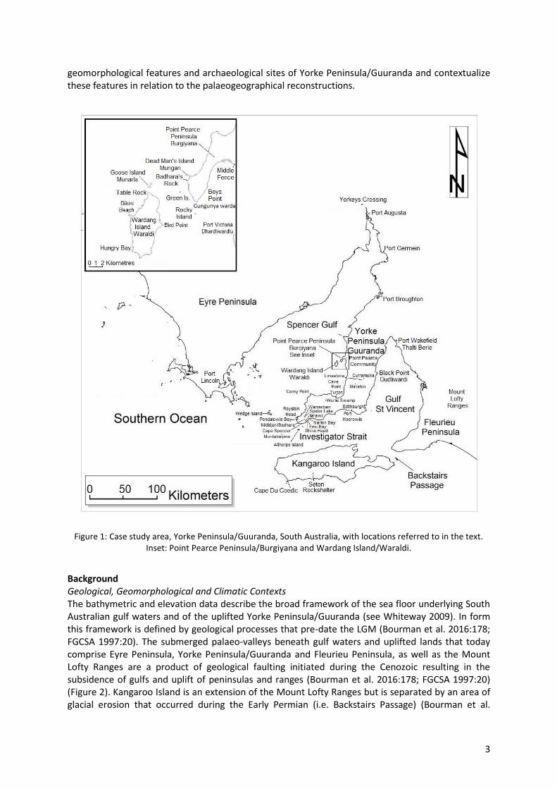
In this paper we focus on the Spencer Gulf and Yorke Peninsula/Guuranda1 region of South Australia
(Figure 1) as a means to explore the issues outlined above. This area serves as an ideal location to
investigate post-LGM marine transgression in a southern Australian context as the region was formerly
land locked. Today no point on Yorke Peninsula/Guuranda is more than 25 km from the sea. Beyond
its specific geographical context, exploring the sea-level rise story in this region is important for two
key reasons. Firstly, it is an important junction in the passage of early Australian colonization and
dispersal, lying at the intersection of the eastern and western phylogeographically-defined pathways
of dispersal as noted by Tobler et al. (2017). Secondly, the region has a wealth of ethnographic
information regarding traditional sea-level narratives. Two versions of a single narrative were
considered by Nunn and Reid (2016), but there are additional versions and other stories that have
remained unexplored in this context. Moreover, these additional narratives refer to the origins of
features at different scales, ranging from the macro-scale of Spencer Gulf, to the meso-scale of
individual formations such as specific islands, to the local scale of individual rocks in the intertidal
zone. This richness of detail provides an opportunity to examine, in collaboration with Narungga
people (the Aboriginal traditional owners of the region), the significance of these stories as a body of
knowledge in its own right and to commence a dialogue about these narratives in light of
palaeogeographical reconstructions derived from sea-level data. This collaborative approach is
consistent with the work of Arbon and Rigney (2014) who argued that Aboriginal knowledge, land
management, connection to country and proven adaptation to extreme climate variability are
important for Australia to adapt to future climate change (Nursey-Bray et al. 2013).
Our aims in this paper are, therefore, threefold: (1) to map the changing configuration of the coastline
and its offshore islands at successive periods (from circa 20,000–6,000 cal. BP), using models of sea-
level change combined with geological and bathymetric data; (2) to explore the traditional Narungga
sea-level narratives in collaboration with community members; and (3) to describe the principal
1 The Narungga Nation requires researchers to use traditional place names in conjunction with European
toponyms in research outputs. Here we primarily follow the place names and orthography as set out in NAPA
(2006) and acknowledge that some terms are used with their requisite qualifications and/or that alternative
names/terms may also exist. Some additional toponyms were sourced from Gillen (c. 1894–1898:843).
3
geomorphological features and archaeological sites of Yorke Peninsula/Guuranda and contextualize
these features in relation to the palaeogeographical reconstructions.
Figure 1: Case study area, Yorke Peninsula/Guuranda, South Australia, with locations referred to in the text.
Inset: Point Pearce Peninsula/Burgiyana and Wardang Island/Waraldi.
Background
Geological, Geomorphological and Climatic Contexts
The bathymetric and elevation data describe the broad framework of the sea floor underlying South
Australian gulf waters and of the uplifted Yorke Peninsula/Guuranda (see Whiteway 2009). In form
this framework is defined by geological processes that pre-date the LGM (Bourman et al. 2016:178;
FGCSA 1997:20). The submerged palaeo-valleys beneath gulf waters and uplifted lands that today
comprise Eyre Peninsula, Yorke Peninsula/Guuranda and Fleurieu Peninsula, as well as the Mount
Lofty Ranges are a product of geological faulting initiated during the Cenozoic resulting in the
subsidence of gulfs and uplift of peninsulas and ranges (Bourman et al. 2016:178; FGCSA 1997:20)
(Figure 2). Kangaroo Island is an extension of the Mount Lofty Ranges but is separated by an area of
glacial erosion that occurred during the Early Permian (i.e. Backstairs Passage) (Bourman et al.
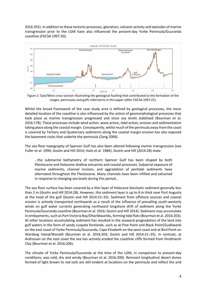
4
2016:355). In addition to these tectonic processes, glaciation, volcanic activity and episodes of marine
transgression prior to the LGM have also influenced the present-day Yorke Peninsula/Guuranda
coastline (FGCSA 1997:20).
Figure 2: East/West cross-section illustrating the geological faulting that contributed to the formation of the
ranges, peninsulas and gulfs referred to in this paper (after FGCSA 1997:21).
Whilst the broad framework of the case study area is defined by geological processes, the more
detailed location of the coastline is also influenced by the action of geomorphological processes that
took place as marine transgression progressed and since sea levels stabilised (Bourman et al.
2016:178). These processes include wind action, wave action, tidal action, erosion and sedimentation
taking place along the coastal margin. Consequently, whilst much of the peninsula away from the coast
is covered by Tertiary and Quaternary sediments along the coastal margin erosion has also exposed
the basement rocks that underlie the peninsula (Zang 2006).
The sea floor topography of Spencer Gulf has also been altered following marine transgression (see
Fuller et al. 1994; Gostin and Hill 2014; Hails et al. 1984). Gostin and Hill (2014:28) state:
…the submarine bathymetry of northern Spencer Gulf has been shaped by both
Pleistocene and Holocene shallow estuarine and coastal processes. Subaerial exposure of
marine sediments, channel incision, and aggradation of peritidal sediments have
alternated throughout the Pleistocene. Many channels have been infilled and exhumed
in response to changing sea levels during this period…
The sea floor surface has been covered by a thin layer of Holocene bioclastic sediment generally less
than 2 m (Gostin and Hill 2014:28). However, this sediment layer is up to 8 m thick near Port Augusta
at the head of the gulf (Gostin and Hill 2014:21–35). Sediment from offshore sources and coastal
erosion is actively transported northwards as a result of the influence of prevailing south-westerly
winds on gulf water currents generating northward longshore drift of sediment along the Yorke
Peninsula/Guuranda coastline (Bourman et al. 2016; Gostin and Hill 2014). Sediment may accumulate
in embayments, such as Port Victoria Bay/Dharldiwarldu, forming tidal flats (Bourman et al. 2016:203).
At other locations accumulating sediment has resulted in the seaward progradation of the land into
gulf waters in the form of sandy cuspate forelands, such as at Pine Point and Black Point/Gudliwardi
on the east coast of Yorke Peninsula/Guuranda, Cape Elizabeth on the west coast and at Bird Point on
Wardang Island/Waraldi (Bourman et al. 2016:203; Gostin and Hill 2014:21–35). In contrast, at
Ardrossan on the east coast the sea has actively eroded the coastline cliffs formed from Hindmarsh
Clay (Bourman et al. 2016:206).
The climate of Yorke Peninsula/Guuranda at the time of the LGM, in comparison to present-day
conditions, was cold, dry and windy (Bourman et al. 2016:200). Remnant longitudinal desert dunes
formed of light brown to red soils are still evident at locations on the peninsula and reflect the arid
5
conditions from this time (FGCSA 1997:36). These dunes trend northwest-southeast across the
peninsula and continue across the formerly exposed gulf floors (Bourman et al. 2016:220). The climate
at the time these dunes were formed was similar to the arid zone climate conditions that occur north
of Port Augusta today (e.g. Hughes et al. 2017; Williams et al. 2013). The ‘[a]bsence of fluvial gravels and sands between Holocene and Pleistocene marine strata’ in northern Spencer Gulf also suggest
that semi-arid to arid zone climate conditions have generally persisted in this region of the gulf from
the time of the last interglacial (Gostin and Hill 2014; Gostin et al. 1988). Palaeoclimatic evidence from
Kangaroo Island indicates that cold and dry conditions continued until approximately 7,000 BP
(Lampert 1981:15–22—see also Draper 1991:13). In the following 2,200 years the island’s climate was wetter than today. After 4,800 BP, conditions became increasingly drier again until about 2,000 BP
when climate conditions became like the present (Lampert 1981:15).
Today Yorke Peninsula/Guuranda has an average yearly minimum temperature of 10⁰C with an
average maximum yearly temperature of 23⁰C (Zang 2006:9). Average rainfall is < 500 mm per annum
with 70% of the rainfall occurring between May and October (Zang 2006:9). In terms of flora and
fauna, Yorke Peninsula/Guuranda shares many species with similar biogeographic zones on the
neighbouring peninsulas and Kangaroo Island (Corbett 1973). These are important considerations as
they may help model the biogeographic zones that existed in now submerged landscapes underlying
gulf waters.
Archaeological Context
Whilst Tobler’s (2017) phylogeographic reconstructions indicate a migration pattern resulting in the
settlement of southern Australia by 49–45 ka, and despite the fact that it is buttressed by Pleistocene
dates from adjacent regions in the north and south2, a cultural chronology that fits within this
timeframe for Yorke Peninsula/Guuranda is lacking. The following age estimates have been reported
(but not published):
1. A radiocarbon date from charcoal lodged in the rib cage of a buried individual (at a depth of
approximately 19 cm) at Edithburgh = 567±62 years BP (R18099/1, NZA2801) (pers. comm.
Vivienne Wood 2018);
2. A radiocarbon date from charcoal from a hearth (at a depth of 1.65 m) at Port Moorowie =
910±50 years BP (CS166) (pers. comm. Vivienne Wood 2018); and
3. Dates from a number of sites and burials (with no geographic details supplied) ranging from
circa 8,000 to 200 BP via the South Australian Museum bioarchaeology project (see SAM 2013).
Although little work has been undertaken to investigate temporal issues on Yorke Peninsula/Guuranda
a number of archaeological surveys have been conducted. Wood and Westell (1998) and Wood et al.
(2003) conducted two of the most comprehensive surveys. They located sites (predominantly coastal)
on both the mainland and Wardang Island/Waraldi. The ratio of coastal sites to inland sites may, at
least in part, reflect survey strategies as the majority of inland Yorke Peninsula/Guuranda is privately
owned farmland and has not been assessed. Faunal remains on the sites were primarily shellfish.
The sites surveyed on Wardang Island/Waraldi all had evidence for coastal resource use with the
dominant faunal remains at all locations also being shellfish. In addition to shellfish, penguin bone
(Eudyptula minor) was recorded at seven sites. Whilst the chronology of the sites discussed above has
not been determined, the shell and penguin remains indicate that these particular site assemblages
date from the period of, or after, separation from the mainland.
2 For example, Warratyi in the Flinders Ranges region north of Port Augusta at 49 ka (Hamm et al. 2016) and at
Seton Rockshelter, on Kangaroo Island, with a probable oldest date at 21 ka (Hope et al. 1977; Lampert 1981;
McDowell et al. 2015).
6
Ethnohistorical Contexts
Narungga people developed specialised skills and knowledge to take advantage of the resources
available in their sea country—they had (and continue to have) knowledge about the variety of marine
species in their territory, their behaviour and habitats and in turn used (and use) a range of fishing
methods to best exploit resources from the range of distinctive coastal environments. Aspects of the
economy, social organisation, language and beliefs of the Narungga people were documented by a
number of observers, many of whom recorded important cultural beliefs about marine species (e.g.
Black 1920; Gillen c. 1894–1898; Griffiths 1988; Johnson c. 1898–1900; Kühn and Fowler in Curr
1886:143–147; Mountford 1936, 1952; Mountford and Roberts 1969:18; Smith 1930:341–342; Sutton
1887; Tindale 1936).
Ethnographically the Narungga coastal/marine economy included shellfishing, fishing with spears,
nets and traps and use of nearshore islands (Fowler in Curr 1886:143; Griffiths 1988; Hill and Hill 1975;
Mollenmans 2014; Mountford 1936, 1952; Roberts et al. 2016; Tindale 1936; Wood and Westell 1998;
Wood et al. 2003). Wardang Island/Waraldi is intimately associated with the Narungga community
both pre and post European contact (Figure 3) (Fowler et al. 2014; Graham and Graham 1987; Roberts
et al. 2013). As Roberts et al. (2013) and Fowler et al. (2014) have noted, Wardang Island/Waraldi and
other islands near the former Point Pearce/Burgiyana Mission were/are important places for the
community to gather food such as eggs, penguins, bandicoots and fish (Black 1920:88; Fowler et al.
2014:15; Roberts et al. 2013). For example, prior to the advent of European style vessels after contact,
Narungga people swam to Wardang Island/Waraldi which is also attested to by the pre-contact
archaeological sites recorded on the island as noted above (Black 1920:88; Cockburn 1984:235; Fowler
2015:306; Graham and Graham 1987:53; Hill and Hill 1975:38; Roberts et al. 2013:81–82; Wood and
Westell 1998:18–19). The skills required for island crossings and expertise employed to access the
range of sea country resources is also bound up in Narungga transitions to adulthood (Klynton
Wanganeen pers. comm. 17 October 2018). However, the timing of the commencement of such
crossings post sea-level rise and/or whether sites exist that predate inundation is currently unknown.
Indeed, the region currently lacks detailed research that can plot both this trajectory as well as the
developments that led to the Narungga economy as described in ethnohistorical sources.
7
Figure 3: View to Green Island in the foreground with (from left to right) Wardang Island/Waraldi, Goose
Island/Murnarla and Little Goose Island in the background. Taken from the southwestern Point Pearce
Peninsula/Burgiyana (facing west). Photograph by Adrian Mollenmans 1/12/2016.
In relation to the prior consideration of traditional Narungga sea-level narratives the research
conducted by Nunn and Reid (2016) remains the primary work on this topic (also referred to again in
Nunn 2018). They concluded that the ‘Aboriginal stories about coastal drowning…in most cases are likely to recall the effects of postglacial sea-level rise more than 7000 years ago’ (Nunn and Reid 2016:42). A focus of their paper was to ‘date’ the origins of these stories by correlating them with the timing for the regional passage of marine transgression as it engulfed the lands of the Aboriginal
communities where these ‘Dreamtime’ traditions are held (Nunn and Reid 2016:11). Their analysis,
conducted at an Australia-wide level, was necessarily coarse-grained in relation to the ethnographic
research and detail that was provided for each of their 21 case studies. For the Spencer Gulf and Yorke
Peninsula/Guuranda region they rely on the following two sources: Smith (1930) and Roberts and
Mountford (1969) (Nunn and Reid 2016:16). Nunn and Reid (2016:16) do not reflect on natural
features referred to in the narratives in great depth but instead postulate at a general level that the
stories may originate either from the time when the sea level was circa 50 m lower than today (at a
locale at the ‘lip of Spencer Gulf’) or further north ‘where the palaeo-valley narrows markedly’ and when the ‘sea level would have been a minimum of 22 m below present’. In this paper we re-examine
these sources in greater detail, as well as range of other references, and in the process consider
Narungga sea-level narratives at different scales.
Materials and Methods
Palaeogeographic Mapping
Bathymetric and topographic data (digital elevation models) were sourced from the 2009 Bathymetric
Grid of Australia published by Geoscience Australia (Whiteway 2009). This dataset is an updated
version of a project undertaken by Geoscience Australia and the National Oceans Office in 2005 to
produce a 9 arc second (0.0025° or ~250 m at the equator) bathymetric grid for Australian waters
(Whiteway 2009:1). These data, as published in ESRI grid format, were modelled using ARCMAP 10.4.1.
The bathymetric and topographic information sources were used to form a baseline (present day) 3D
model of the case study area. The 3D model, in conjunction with data for sea-level rise, provided the
opportunity to map marine transgression in this region. Sea-level rise data were sourced from local
8
and wider studies (primarily Lewis et al. [2013], but also Belperio et al. [2002], Lambeck and Chappell
[2001] and Lambeck and Nakada [1990]).
GPS data were downloaded using DNRGPS software. DNRGPS software was also used to convert the
GPS data to ARCGIS format. Maps included in this article, unless otherwise stated, were generated in
ARCGIS/ARCMAP version 10.4.1. Distance and area measurements were measured using the ARCMAP
version 10.4.1 measurement tool.
Ethnohistorical Research
Some scholars (e.g. Nunn and Reid 2016:11—see also Campbell 1967) have been willing to consider
that traditional Aboriginal sea-level narratives proffer ‘empirical corroboration’ for the scientific ‘story’ of sea-level rise following the LGM, whilst others have argued that the ‘historicity of oral tradition’ (particularly related to deep time) should be treated with great scepticism (see Henige
2009). Thus, any researchers considering the relationship of oral traditions with past events and other
forms of evidence must grapple with both the appropriateness of such a task and concomitantly the
likelihood of the transgenerational transmission of information over vast time. In relation to the
former point, for example, Damm (2005:78) argued that Western science should not be used to simply
give credence to oral traditions as they are ‘historical narratives in their own right and do not need legitimisation from other forms of knowledge’. In this paper we have been careful to avoid this
position by: 1) considering the complexity of traditions relating to coastal formation in Narungga
traditions rather than only pointing to narratives that appear to ‘confirm’ scientific sea-level data; and
2) seeking an ethnocritical archaeology (after Zimmerman 1997) by exploring the past together as
Narungga and non-Narungga academics, and in collaboration with the broader Narungga community,
thereby aiming for a ‘dialogical model’ where ‘cultural differences are explored and where interpretations are negotiated’ (Zimmermann 1997:55). We also see our work as an important
contribution to the global efforts of those Indigenous scholars (e.g. Alexander et al. 2011:478) who
seek to find ‘pathways for the meaningful exchange of information’ between Aboriginal systems of
knowledge and scientific interpretations.
Archaeological Survey and Geomorphological Observations
In order to ground-truth prior archaeological and geomorphological observations, as well as to
contribute new data, surveys were undertaken in the Point Pearce/Burgiyana region in 2016 and 2017.
This region was selected due to its proximity to the nearshore islands discussed in this paper.
Archaeological site recording included undertaking transect surveys, defining site boundaries and
recording surface artefactual and faunal material. Location positions were recorded using Garmin
GPSmap 62. A range of environments (targeted via an analysis of historical aerial photography and
contemporary satellite imagery) were surveyed in order to note relevant geomorphological features.
These included: salt marsh swamps, coastal dunes, beaches, rocky reefs, tidal flats, a small island and
inland areas.
Results
Palaeogeographic Mapping
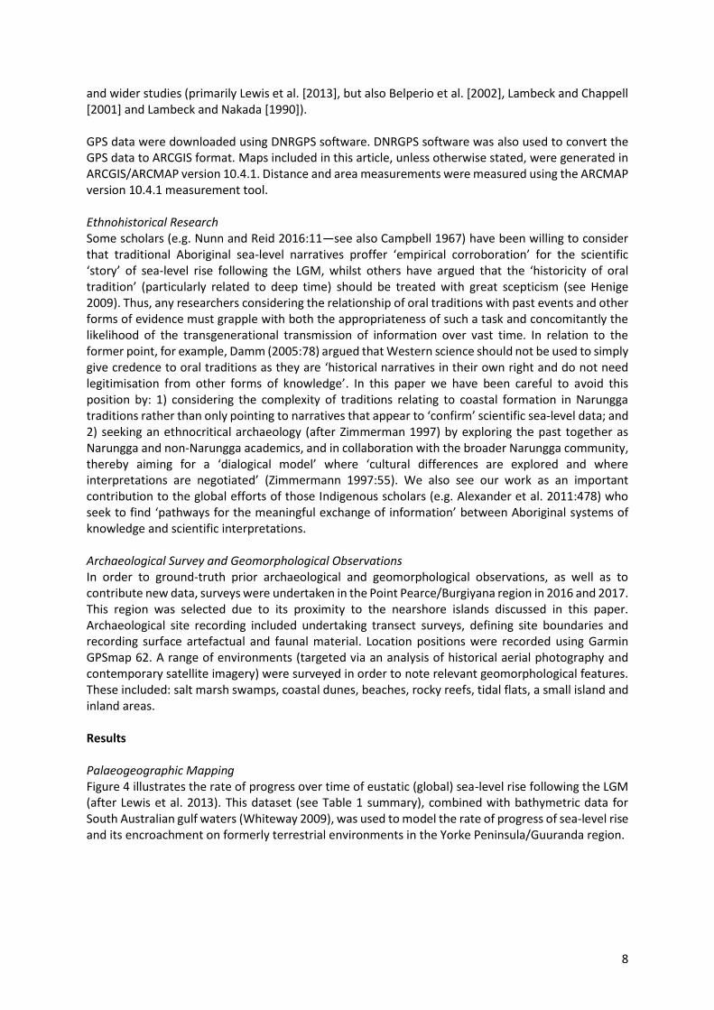
Figure 4 illustrates the rate of progress over time of eustatic (global) sea-level rise following the LGM
(after Lewis et al. 2013). This dataset (see Table 1 summary), combined with bathymetric data for
South Australian gulf waters (Whiteway 2009), was used to model the rate of progress of sea-level rise
and its encroachment on formerly terrestrial environments in the Yorke Peninsula/Guuranda region.
9
Figure 4: Sea-level rise following the LGM. Adapted from Lewis et al.’s (2013:124) synthesis of data for post-
glacial sea-level changes around the Australian margin. Data are from localities in the Northern Territory,
Queensland, New South Wales, South Australia and Western Australia. Individual chart points represent
median values. Dates reported in the review by Lewis et al. (2013) are calibrated dates and adjusted for the
recommended regional reservoir effect (∆R) for each site (see Lewis et al. 2013:118). Data point in red is from
Belperio et al. (2002) and represents the post-LGM sea-level highstand value recorded for Port Lincoln,
Spencer Gulf, South Australia.
-140
-120
-100
-80
-60
-40
-20
0
20
05000100001500020000
Me
tre
s B
elo
w P
rese
nt
Years Before Present
Sea-level rise following the LGM.
After Lewis et al.’s (2013) synthesis of data for post-glacial sea-
level changes around the Australian margin.
10
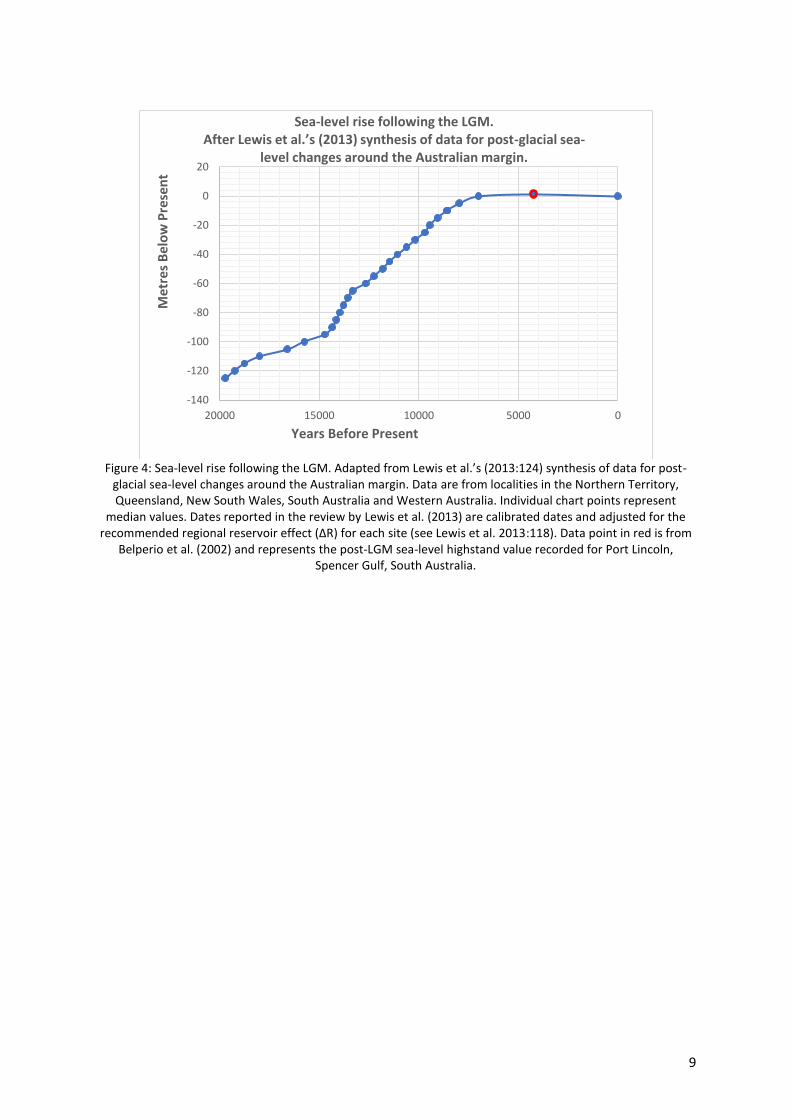
Table 1: Sea-level rise following the LGM (5 m increments). Adapted from Lewis et al.’s (2013:124) review of
post-glacial sea-level changes around the Australian margin, Belperio et al. (2002) for Spencer Gulf and Bone
(1985) for Wardang Island/Waraldi.
Former Sea Levels
(Metres Below Present)
Former Sea Levels
(Minimum years cal. BP)
Former Sea Levels
(Maximum Years cal. BP)
Highstand at Port Augusta
+3.14 6380 6505
Highstand at Port Lincoln
+1.39 4105 4334
Highstand at Wardang
Island/Waraldi
+1.00 Undated Undated
0 6,288 7,712
-5 7,436 8,506
-10 8,002 9,149
-15 8,596 9,513
-20 9,222 9,672
-25 9,498 9,890
-30 9,948 10,413
-35 10,298 10,938
-40 10,674 11,473
-45 10,865 12,073
-50 11,183 12,432
-55 11,724 12,785
-60 12,272 13,071
-65 12,928 13,711
-70 13,152 13,969
-75 13,365 14,204
-80 13,544 14,416
-85 13,678 14,617
-90 13,834 14,875
-95 13,935 15,535
-100 14,237 17,257
-105 15,121 18,107
-110 17,067 18,957
-115 18,040 19,494
-120 18,521 19,964
-125 19,729 19,729
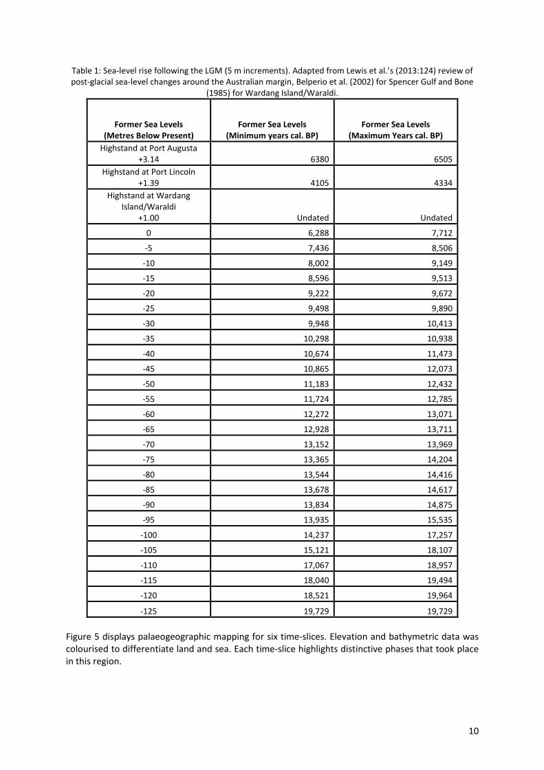
Figure 5 displays palaeogeographic mapping for six time-slices. Elevation and bathymetric data was
colourised to differentiate land and sea. Each time-slice highlights distinctive phases that took place
in this region.
11
A. Sea levels during the LGM
(Circa 19,729 cal. years BP/Sea Level -125 metres)
B. Onset of marine transgression in Spencer Gulf
(12,432–11,183 cal. years BP/Sea level -50 metres)
C. Isolation of Kangaroo Island
(10,413–9,948 cal. years BP/Sea level -30 metres)
D. Creation of Northern Spencer Gulf
(9,890–9,498 cal. years BP/Sea level-25 metres)
E. Creation of Wardang Island/Waraldi
(9,149–8,002 cal. years BP/Sea level-10 metres) F. Present Day Shoreline
(7,712–6,288 cal. years BP/Sea level 0 metres)
12
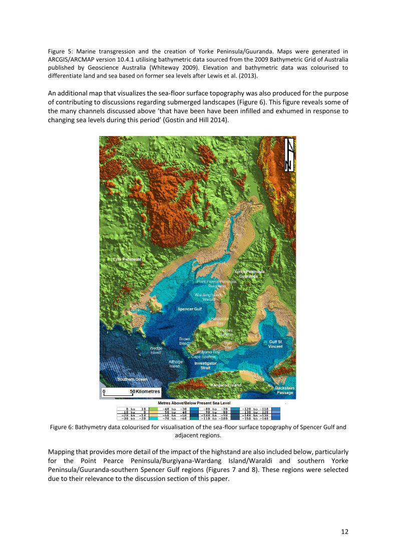
Figure 5: Marine transgression and the creation of Yorke Peninsula/Guuranda. Maps were generated in
ARCGIS/ARCMAP version 10.4.1 utilising bathymetric data sourced from the 2009 Bathymetric Grid of Australia
published by Geoscience Australia (Whiteway 2009). Elevation and bathymetric data was colourised to
differentiate land and sea based on former sea levels after Lewis et al. (2013).
An additional map that visualizes the sea-floor surface topography was also produced for the purpose
of contributing to discussions regarding submerged landscapes (Figure 6). This figure reveals some of
the many channels discussed above ‘that have been have been infilled and exhumed in response to
changing sea levels during this period’ (Gostin and Hill 2014).
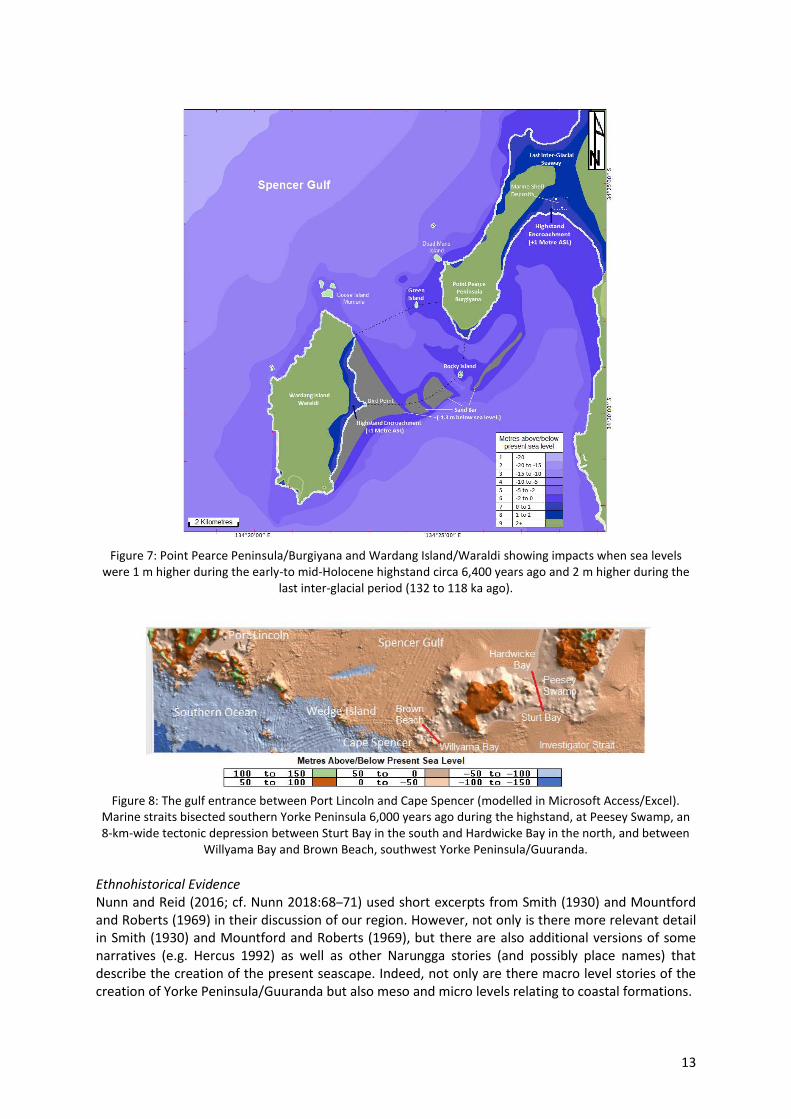
Figure 6: Bathymetry data colourised for visualisation of the sea-floor surface topography of Spencer Gulf and
adjacent regions.
Mapping that provides more detail of the impact of the highstand are also included below, particularly
for the Point Pearce Peninsula/Burgiyana-Wardang Island/Waraldi and southern Yorke
Peninsula/Guuranda-southern Spencer Gulf regions (Figures 7 and 8). These regions were selected
due to their relevance to the discussion section of this paper.
13
Figure 7: Point Pearce Peninsula/Burgiyana and Wardang Island/Waraldi showing impacts when sea levels
were 1 m higher during the early-to mid-Holocene highstand circa 6,400 years ago and 2 m higher during the
last inter-glacial period (132 to 118 ka ago).
Figure 8: The gulf entrance between Port Lincoln and Cape Spencer (modelled in Microsoft Access/Excel).
Marine straits bisected southern Yorke Peninsula 6,000 years ago during the highstand, at Peesey Swamp, an
8-km-wide tectonic depression between Sturt Bay in the south and Hardwicke Bay in the north, and between
Willyama Bay and Brown Beach, southwest Yorke Peninsula/Guuranda.
Ethnohistorical Evidence
Nunn and Reid (2016; cf. Nunn 2018:68–71) used short excerpts from Smith (1930) and Mountford
and Roberts (1969) in their discussion of our region. However, not only is there more relevant detail
in Smith (1930) and Mountford and Roberts (1969), but there are also additional versions of some
narratives (e.g. Hercus 1992) as well as other Narungga stories (and possibly place names) that
describe the creation of the present seascape. Indeed, not only are there macro level stories of the
creation of Yorke Peninsula/Guuranda but also meso and micro levels relating to coastal formations.
14
At the macro level we have details about the creation of Spencer Gulf recorded in Smith (1930:168-
172). Below we include a much fuller version than reproduced in Nunn and Reid (2016):
The people of the Narrangga tribe…had a story that has been handed down through the ages…It is a tale of a strange and wonderful being who lived when there was no Spencer’s Gulf, but only marshy country reaching into the interior of Australia. It was a bone of this
being that was the means of bringing the Gulf into existence. At the lagoons and marshes
there lived various families [of animals]…One day the kangaroo, the emu, and the willy-
wagtail were sitting on the seashore between Cape Spencer and Port Lincoln3. The emu
wandered away from his companions, and found a leg-bone of a huge kangaroo…He
carried it back to where they had slept the night before…In the morning they discussed matters. The willy-wagtail spoke first. “Oh!” he said “I had such a bad dream! I dreamed I
stood upon an island that was round in shape, and without a mountain or hill upon it. The
sea was all round me. Suddenly a great wave rose up, and came rolling and tumbling
toward the island. I was scared. I ran this way and that way, but the waves were now all
tumbling over the island. I threw up my arms in despair. I do not know what kept the sea
from passing over and flooding the island and drowning me…”. “Oh!” said the emu, “I dreamed that where the lagoons are now was a dry, dusty, and parched country.
Desolation was everywhere. Animals, birds, and reptiles were lying dead all round…”. The
emu led the kangaroo and the willy-wagtail to the spot, and they dug and dug until they
found the other bones. The bones were lying pointing in a straight line toward Port
Augusta. The kangaroo took up the bone that the emu had discovered and probed the
ground with it. He did not know that the bone was a magic one. But as soon as he used it
the earth opened itself. The kangaroo started to walk toward Port Augusta, and as he
advanced he probed the ground with his magic bone. The sea broke through, and came
tumbling and rolling along in the track cut by the kangaroo-bone. It flowed into the
lagoons and marshes, which completely disappeared…
(Smith 1930:168-172)
Similarly, Mountford and Roberts (1969:18) recorded:
In those days, the kangaroo was a man who grieved over the unnecessary fighting. Thinking
over the situation he finally decided that if an opening could be made in the southern
isthmus, which in those days blocked the sea from entering the valley, the conflict
[between birds and other animals] would be ended by the flooding of the lagoons. Now the
kangaroo-man possessed the thigh bone of a mythical ancestor…So he pointed the bone at the isthmus, which slowly split open. The sea poured through the opening, flooding the
entire valley, so that the birds and animals were forced to live together in peace.
Unfortunately, the Aboriginal sources for the above narratives are unknown. However, Luise Hercus
recorded a version of this story (centred at Pt Germein) from Gilbert Bramfield (a Nukunu man from
the neighbouring Aboriginal group to the north), about how ‘one old man made this kangaroo bone’ and how he carved out Spencer Gulf: ‘The bloke went this way with his kangaroo bone he broke it at
Port Augusta there, and then he was digging with a really short stumpy one and made all these lakes
all the way through (the salty lakes up from Yorkey’s Crossing)’ (see Hercus 1992:16).
At the meso level there are Narungga traditions about the creation of islands, such as Wardang
Island/Waraldi and other islands near the Point Pearce/Burgiyana community. In one Narungga
tradition it was the creation ancestor Badhara who threw a rock from Middle Fence to Boy’s Point/Gunganya warda. When the rock landed, it split the land and lots of bits flew and made Wardang
3 A location now in the middle of Spencer Gulf.
15
Island/Waraldi Island, Green Island, Goose Island/Murnarla and Dead Man’s Island/Mungari (Graham
and Graham 1987:53). A similar tradition was recorded by Edwardes (1934:51):
The early Aborigines had an interesting legend explaining the genesis of Wardang and the
Wauraltee group of islands. They told of a mighty tribal god named Nugna [Ngarna]. This
god was in the form of a man of gigantic stature and prodigious strength. On one occasion
when his people had invoked his wrath Nugna took up his huge club and dealt the earth a
terrific blow. The force of the blow caused several fragments of land to fly into the gulf, to
form the Wauraltee [Waraldi] Islands; while the great depression caused by it was invaded
by the sea to form Port Victoria Bay and Point Pearce.
In the above quote the ancestral being’s name is changed in comparison to the Graham and Graham
(1987) account, but the manner in which the islands were created remains similar—in fact it must be
noted that there are numerous other versions of this creation narrative (e.g., Aboriginal Studies
Curriculum Committee n.d.; Gillen c. 1894–1898; Ostapchuk 1969:74; Smith 1930:341–342; Sutton
1887:18; Tauondi College n.d.; Tindale 1933; Tindale 1936:58–59). However, of interest in the
Edwardes (1934) recording is the reference to an invasion of the sea. In comparison to these accounts
Sutton (1887:18), who was a superintendent of the Point Pearce Aboriginal Mission Station, separately
recorded that a spider was said to have made the islands.
At the micro level we have the creation of specific rocks and other features in the intertidal zone, such
as Badhara’s Rock—with the latter falling within the Badhara/Ngarna narrative, and in at least one
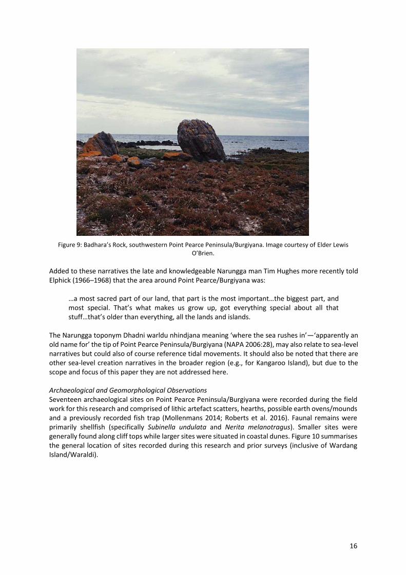
version (Tauondi College n.d.) the rock is the embodiment of Badhara’s club head (or waddy) which he threw at Ngarna (Figure 9):
The waddy misses Ngarna and hits the ground with a tremendous crash, breaking in two.
Today the club head is the large rock known as Budderer’s [Badhara’s] Rock, lying at
Moongurie [Mungari] on the western side of Bookooyana [Burgiyana]…We see blood from the wounds in the sand nearby.
Badhara was said to be buried on Goose Island/Murnarla after he drowned whilst diving for his spear
and the site of his grave is said to be marked with a great heap of rocks (Gillen c. 1894–1898:843).
16
Figure 9: Badhara’s Rock, southwestern Point Pearce Peninsula/Burgiyana. Image courtesy of Elder Lewis
O’Brien.
Added to these narratives the late and knowledgeable Narungga man Tim Hughes more recently told
Elphick (1966–1968) that the area around Point Pearce/Burgiyana was:
…a most sacred part of our land, that part is the most important…the biggest part, and
most special. That’s what makes us grow up, got everything special about all that stuff…that’s older than everything, all the lands and islands.
The Narungga toponym Dhadni warldu nhindjana meaning ‘where the sea rushes in’—‘apparently an old name for’ the tip of Point Pearce Peninsula/Burgiyana (NAPA 2006:28), may also relate to sea-level
narratives but could also of course reference tidal movements. It should also be noted that there are
other sea-level creation narratives in the broader region (e.g., for Kangaroo Island), but due to the
scope and focus of this paper they are not addressed here.
Archaeological and Geomorphological Observations
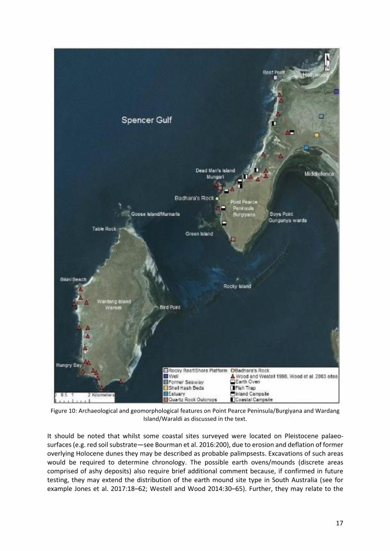
Seventeen archaeological sites on Point Pearce Peninsula/Burgiyana were recorded during the field
work for this research and comprised of lithic artefact scatters, hearths, possible earth ovens/mounds
and a previously recorded fish trap (Mollenmans 2014; Roberts et al. 2016). Faunal remains were
primarily shellfish (specifically Subinella undulata and Nerita melanotragus). Smaller sites were
generally found along cliff tops while larger sites were situated in coastal dunes. Figure 10 summarises
the general location of sites recorded during this research and prior surveys (inclusive of Wardang
Island/Waraldi).
17
Figure 10: Archaeological and geomorphological features on Point Pearce Peninsula/Burgiyana and Wardang
Island/Waraldi as discussed in the text.
It should be noted that whilst some coastal sites surveyed were located on Pleistocene palaeo-
surfaces (e.g. red soil substrate—see Bourman et al. 2016:200), due to erosion and deflation of former
overlying Holocene dunes they may be described as probable palimpsests. Excavations of such areas
would be required to determine chronology. The possible earth ovens/mounds (discrete areas
comprised of ashy deposits) also require brief additional comment because, if confirmed in future
testing, they may extend the distribution of the earth mound site type in South Australia (see for
example Jones et al. 2017:18–62; Westell and Wood 2014:30–65). Further, they may relate to the
18
coastal economy as earth ovens were reportedly used in food and fibre processing (such as net
production) (Hill and Hill 1975:43; Tindale 1936:57).
Geomorphological processes have resulted in the formation of intertidal sand and mud flats, sea grass
meadows as well as rock outcrops and reefs. The terrestrial environment on Point Pearce
Peninsula/Burgiyana includes swamp land/salt marsh covering the neck of land adjacent to the
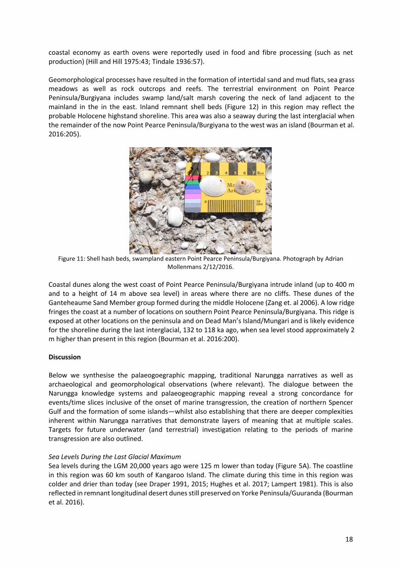
mainland in the in the east. Inland remnant shell beds (Figure 12) in this region may reflect the
probable Holocene highstand shoreline. This area was also a seaway during the last interglacial when
the remainder of the now Point Pearce Peninsula/Burgiyana to the west was an island (Bourman et al.
2016:205).
Figure 11: Shell hash beds, swampland eastern Point Pearce Peninsula/Burgiyana. Photograph by Adrian
Mollenmans 2/12/2016.
Coastal dunes along the west coast of Point Pearce Peninsula/Burgiyana intrude inland (up to 400 m
and to a height of 14 m above sea level) in areas where there are no cliffs. These dunes of the
Ganteheaume Sand Member group formed during the middle Holocene (Zang et. al 2006). A low ridge
fringes the coast at a number of locations on southern Point Pearce Peninsula/Burgiyana. This ridge is
exposed at other locations on the peninsula and on Dead Man’s Island/Mungari and is likely evidence
for the shoreline during the last interglacial, 132 to 118 ka ago, when sea level stood approximately 2
m higher than present in this region (Bourman et al. 2016:200).
Discussion
Below we synthesise the palaeogoegraphic mapping, traditional Narungga narratives as well as
archaeological and geomorphological observations (where relevant). The dialogue between the
Narungga knowledge systems and palaeogeographic mapping reveal a strong concordance for
events/time slices inclusive of the onset of marine transgression, the creation of northern Spencer
Gulf and the formation of some islands—whilst also establishing that there are deeper complexities
inherent within Narungga narratives that demonstrate layers of meaning that at multiple scales.
Targets for future underwater (and terrestrial) investigation relating to the periods of marine
transgression are also outlined.
Sea Levels During the Last Glacial Maximum
Sea levels during the LGM 20,000 years ago were 125 m lower than today (Figure 5A). The coastline
in this region was 60 km south of Kangaroo Island. The climate during this time in this region was
colder and drier than today (see Draper 1991, 2015; Hughes et al. 2017; Lampert 1981). This is also
reflected in remnant longitudinal desert dunes still preserved on Yorke Peninsula/Guuranda (Bourman
et al. 2016).
19
Arid conditions, during a time when sea levels were lower, are also referenced in Narungga narratives
via the ancestral emu’s vision of a dry and parched country, where lagoons once existed in what is
now Spencer Gulf (Smith 1930:171), and the conflict over water in Mountford and Roberts’ (1969:18) account. However, dry conditions during times of lower sea level could also reference later drought
conditions, such as El Niño events during the early Holocene (Carrè et al. 2005; Nunn 2018:70).
The central drainage areas in the middle of the gulf, as illustrated in Figure 6, were likely areas water
may have pooled in this period. Thus, should there be Pleistocene archaeological sites in this region
for the LGM period one would expect these to exist at the margins of such drainage areas. Although,
as noted in previous sections the sediment layer today increases to up to 8 m thick as one approaches
the head of the gulf (Gostin and Hill 2014:21–35). Further, it should be noted that according to Gostin
and Hill (2014:28) channels have been subject to infilling and exhumation as a result of sea-level
changes over time. The shoreline during this period would also be a target for underwater
archaeological prospection.
Onset of Marine Transgression in Spencer Gulf and Gulf St Vincent
Present day Spencer Gulf began to form when sea levels were approximately 50 m lower than today
at around 12,432–11,183 cal. years BP (Figure 5B). The 50 m bathymetry line roughly aligns with the
mouth of Spencer Gulf. Contemporary Eyre Peninsula and Yorke Peninsula/Guuranda began to form
at this time. Port Lincoln (on Eyre Peninsula) and Cape Spencer/Murdabalpina (on Yorke
Peninsula/Guuranda) sit at the entrance to the gulf near this line.
As previously noted these locations are referenced in Narungga traditions (e.g., ‘the seashore between
Cape Spencer and Port Lincoln’ [Smith 1930:168–172]). Whilst Nunn and Reid (2016:16) do not
specifically reflect on this seashore as a defined space in their article, they do postulate that the stories
may originate either from this time (and locale) or further north ‘where the palaeo-valley narrows
markedly’ and when the ‘sea level would have been a minimum of 22 m below present’. Nunn’s
(2018:71) discussion focuses on the 50 m bathymetry line.
As Figures 5B and 6 illustrate there are a number of areas where water may have pooled in what is
now Spencer Gulf during this period including the depression in the southern gulf area north of Wedge
Island. As can be observed there was likely an isthmus between it and the sea, as the depression is at
sea level. This region, as well as the channel areas, would be likely places to target in a search for
archaeological sites. Further the isthmus and coastline to its east and west would be targets for
underwater archaeological prospection. Wedge and North Islands, discussed further below, are all
that substantively remains above sea level of this former isthmus and as such should be considered as
a high priority for archaeological surveys in future research.
Present day Gulf St Vincent began to form when sea levels were 40 m lower than today approximately
11,473–10,674 cal. years BP. Fleurieu Peninsula and Yorke Peninsula/Guuranda began to be separated
by marine transgression at this time.
Creation of Islands in Investigator Strait and Southern Spencer Gulf
Kangaroo Island became isolated when sea levels were 30 m below present levels 10,413–9,948 cal.
years BP when Backstairs Passage fully divides it from the mainland (Figure 5C) (see also Draper
2015:233; Lampert 1981:15–18). Draper (1991, 2015) undertook research at Cape du Couedic
rockshelter, in the southwest of Kangaroo Island. Draper’s (1991:x) results indicated that the Cape du
Couedic rockshelter was used by ‘Aboriginal people occasionally between approximately 7,500 and
6,800 yrs BP [during which time the rockshelter overlooked the Southern Ocean] who hunted sea lion
and kangaroo, small game, and collected shellfish and other foods in the vicinity’.
20
In addition to Kangaroo Island, a number of other islands are found in waters adjacent to Yorke
Peninsula/Guuranda. The most southerly islands in the case study area are Althorpe Islands, Seal
Island, Haystack Island and Chinamans Hat in Investigator Strait and are adjacent to southwest Yorke
Peninsula/Guuranda. Wedge and North Islands (see section above) are situated at the mouth of
Spencer Gulf midway between Yorke Peninsula/Guuranda and Eyre Peninsula to the west. South
Island, Middle Island and Royston Island are a small group of nearshore islands in Spencer Gulf off the
coast of southwest Yorke Peninsula/Guuranda adjacent to Pondalowie Bay.
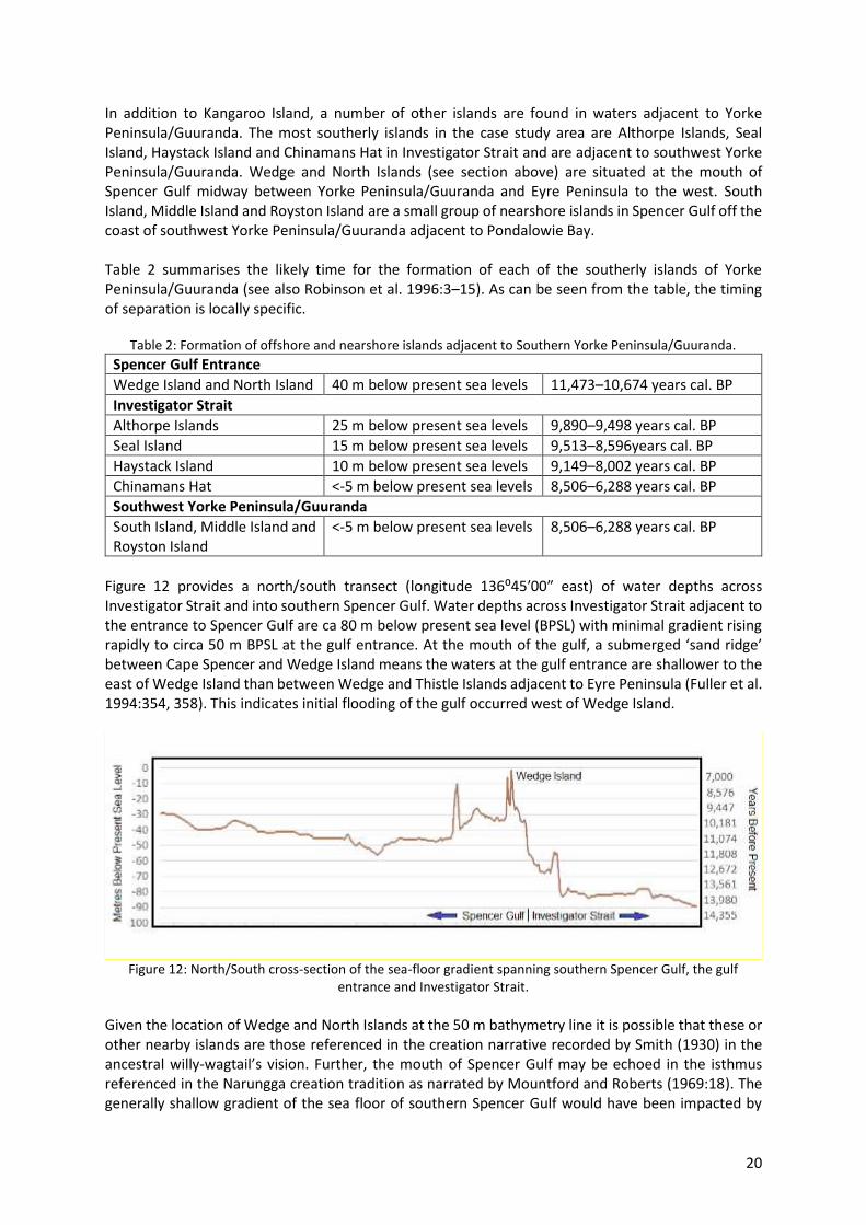
Table 2 summarises the likely time for the formation of each of the southerly islands of Yorke
Peninsula/Guuranda (see also Robinson et al. 1996:3–15). As can be seen from the table, the timing
of separation is locally specific.
Table 2: Formation of offshore and nearshore islands adjacent to Southern Yorke Peninsula/Guuranda.
Spencer Gulf Entrance
Wedge Island and North Island 40 m below present sea levels 11,473–10,674 years cal. BP
Investigator Strait
Althorpe Islands 25 m below present sea levels 9,890–9,498 years cal. BP
Seal Island 15 m below present sea levels 9,513–8,596years cal. BP
Haystack Island 10 m below present sea levels 9,149–8,002 years cal. BP
Chinamans Hat <-5 m below present sea levels 8,506–6,288 years cal. BP
Southwest Yorke Peninsula/Guuranda
South Island, Middle Island and
Royston Island
<-5 m below present sea levels 8,506–6,288 years cal. BP
Figure 12 provides a north/south transect (longitude 136⁰45′00″ east) of water depths across
Investigator Strait and into southern Spencer Gulf. Water depths across Investigator Strait adjacent to
the entrance to Spencer Gulf are ca 80 m below present sea level (BPSL) with minimal gradient rising
rapidly to circa 50 m BPSL at the gulf entrance. At the mouth of the gulf, a submerged ‘sand ridge’ between Cape Spencer and Wedge Island means the waters at the gulf entrance are shallower to the
east of Wedge Island than between Wedge and Thistle Islands adjacent to Eyre Peninsula (Fuller et al.
1994:354, 358). This indicates initial flooding of the gulf occurred west of Wedge Island.
Figure 12: North/South cross-section of the sea-floor gradient spanning southern Spencer Gulf, the gulf
entrance and Investigator Strait.
Given the location of Wedge and North Islands at the 50 m bathymetry line it is possible that these or
other nearby islands are those referenced in the creation narrative recorded by Smith (1930) in the
ancestral willy-wagtail’s vision. Further, the mouth of Spencer Gulf may be echoed in the isthmus
referenced in the Narungga creation tradition as narrated by Mountford and Roberts (1969:18). The
generally shallow gradient of the sea floor of southern Spencer Gulf would have been impacted by
21
rapid inundation once sea-level rise exceeded the present day 50 m bathymetry line. In terms of
targets for underwater archaeological prospection for this period the channel areas in northern
Spencer Gulf remain relevant. The former coastlines for the period should also be considered an
applicable target. In addition, as noted above Wedge and North Islands should be considered as a high
priority for archaeological surveys in future research.
Creation of Northern Spencer Gulf
Eyre Peninsula and Yorke Peninsula/Guuranda become almost fully separated when water depths
reached 20 to 25 m lower than today 9,890–9,222 cal. years BP (Figure 5D). Transient islands formed
in sections of the gulf at this time but were subsequently inundated by the time of sea-level
stabilisation. The gulf narrows northward of the 25 m bathymetry lines and the sea-floor topography
becomes more complex. A narrow submarine ‘channel’ extends northward from the general 25 m bathymetry line. This channel is reminiscent of the Nukunu tradition relating to the creation of
northern Spencer Gulf from Pt Germein to Port Augusta being carved by an ancestral being using the
bone of a kangaroo (Hercus 2002:16; see also Smith 1930:172). The former coastlines and channels
are relevant targets for archaeological investigation for this period.
The Creation of Wardang Island/Waraldi
Islands of central and northern Spencer Gulf include Wardang Island/Waraldi, Goose Island/Murnarla,
Rocky Island, Green Island, Dead Man’s Island/Mungari and Shag Island. Wardang Island/Waraldi and
its adjacent islands were connected to the mainland until at least 9,149–8,002 cal. years BP when sea
levels were 10 m lower than today. The separation of Wardang Island/Waraldi from the mainlaind
occurs when sea levels are 5 m below present and the land link is breached (circa 8,506–7,436 cal.
years BP).
There are two primary Narungga traditions that refer to the creation of Wardang Island/Waraldi,
Green Island, Goose Island/Murnarla and Dead Man’s Island/Mungari (e.g. Edwardes 1934:51;
Graham and Graham 1987:53; Tauondi College n.d.)—the Badhara/Ngarna narrative (within which
there are multiple versions) and the ancestral spider narrative. Inundation or ‘an invasion of the sea’ is implicated in the creation of Port Victoria Bay (on the east side of Wardang Island/Waraldi) in at
least one version of the Badhara/Ngarna narrative (see Edwardes 1934:51), however this is not the
case for all versions/traditions. The latter observation requires us to acknowledge both the complexity
inherent in Narungga traditions as well as in the dialogues between Aboriginal systems of knowledge
and scientific interpretations. As other researchers have argued, such varying accounts in Aboriginal
traditions do not require synthesis, nor is it appropriate to seek ‘authentic’ or ‘pristine’ versions (see Bell 1998:95). Rather, our work has instead created space for a collaborative, meaningful and
respectful exchange about different ways of ‘knowing the past’ which may involve an appreciation of
the confluences between different systems of knowledge but also an acknowledgement of
differences, silences and dynamism (Zimmerman 2006:47; see also Alexander et al. 2011:478). Indeed,
as Bell (1998:102) reminds us, traditional narratives ‘speak to different periods’ (and occur at different
scales) as well as providing ways of conceptualizing the world. Further, just as science is not static nor
should be the ways in which Narungga people choose to negotiate meaning.
As shown in Figure 10, and described in the text, the known sites on Wardang Island/Waraldi are
predominantly reflective of coastal subsistence. However, as archaeological research on the island has
been limited (and restricted to surveys) whether evidence exists for settlement in the region prior to
its separation from the mainland is still an open question. Further, the lack of dating of the coastal
sites does not allow for inferences concerning the timing of any potential marine expansion in the
Holocene—a recurring theme in Australian archaeological research (e.g. Barker 2004; Cherry et al.
2010; Draper 2015; MacArthur and Wilson 1967; McNiven 2003; O’Connor 1992; Rick et al. 2013; Rosendahl et al. 2015; Rowland et al. 2015; Sim and Wallis 2008). Indeed, the question remains: how
22
far into the past can the island crossings referred to in the ethnographic period be projected into the
past? Thus, more archaeological investigation of Wardang island is required—including additional
survey and excavation.
The Present-day Shoreline
Sea levels reach their present height approximately 7,712–6,288cal. years BP (Figure 5F). With the
stabilisation of sea levels, the impact of erosion driven by wave action in coastal regions exposes
outcrops of the underlying basement rocks which concomitantly provide access to important sources
of lithic material for tool making (Bourman et al. 2016:178). Narungga features important in creation
stories such as Badhara’s Rock likely appear at this time (although later to be inundated and then re-
appear—see below). Badhara’s Rock sits right on the margin of the tidal zone where the basement
rocks (Wallaroo Group/Renowden Metabasalt Member dating from the Late Palaeoproterozoic ~1750
Ma) have been exposed as a result of erosion of the overlying sediments (that exist as remnants away
from the coastal margin). Similarly, Dead Man’s Island/Mungari to the north remained anchored to
the coast during this period by a pavement of basement rocks situated within the contemporary inter-
tidal zone and only becomes separated by sea from the mainland at high tide.
As shown in Figure 10, and described in previous sections, the majority of known archaeological
evidence on Yorke Peninsula/Guuranda likely relates to the present day shoreline, although this fact
may relate to survey coverage. This archaeology reflects the coastal economy trajectory of the
Narungga people described at contact (e.g. shell remains, possible earth ovens/mounds associated
with net production and fish traps in the present intertidal zone), although as noted the details and
chronology of this trajectory are currently unknown.
Impact of the Highstand
Table 1, and Figures 6, 7 and 8 detail and illustrate the known data for the highstand in the Yorke
Peninsula/Guuranda region. The timing for the highstand in this region was circa 6400 years BP
‘followed by regionally variable regression and emergence of the land’ ranging from circa +3.14 m at
Port Augusta, northern Spencer Gulf circa 6,505–6,380 years cal. BP and +1.39 m at Port Lincoln,
southern Spencer Gulf circa 4,334–4,105 years cal. BP with subsequent relative fall in sea level to
current heights as a result of hydro-isostasy (Belperio et al. 2002:153; Lewis et al. 2013:129).
Figure 7 in particular highlights the more detailed bathymetry of the waters adjacent to the Point
Pearce Peninsula/Burgiyana region as well as the extent of the inland encroachment of the sea in the
area. Rocky shore platforms (i.e. Reef Point) and tidal flats (i.e. the ‘Creek’) adjacent to the shore are
a product of geomorphological processes as a result of marine transgression.
Evidence of higher sea levels on Wardang Island/Waraldi includes shore platforms, beach ridges and
coastal sediments (Bourman et al. 2016:230). The last interglacial shoreline (132 to 118 ka ago) at 2 m
Australian Height Datum (AHD) is reflected in ‘beach ridges on the east coast and a fossiliferous limestone overlying truncated aeolianite on the north coast’ (Bourman et al. 2016:230). In addition, a
probable Holocene shoreline 1 m above present sea level (APSL) is marked by shell hash beds in the
eastern salt marsh (Bourman et al. 2016)—a feature also evidenced on mainland Point Pearce
Peninsula/Burgiyana as demonstrated by field work conducted in this research. This existence of a
highstand is consistent with evidence found elsewhere in Gulf waters that sea levels were up to 3 m
higher earlier in the Holocene circa 6,400 years BP in northern gulf waters (see Table 1) relative to
present sea levels (see Belperio et al. 2002; Lambeck and Nakada 1990; Lewis et al. 2013:129).
Marine straits also bisected southern Yorke Peninsula 6,000 years ago during the highstand, at Peesey
Swamp, an 8-km-wide tectonic depression between Sturt Bay in the south and Hardwicke Bay in the
north, and between Willyama Bay and Brown Beach, southwest Yorke Peninsula/Guuranda (Bourman
23
et al. 2016:203–204; Von der Borch 1997; Zang 2006) (Figure 8). The intrusion of the sea at these two
locations isolated these sections of the peninsula from the rest of the mainland to form two islands.
Today, a series of salt lakes/swamps cross the peninsula at both these locations, where the terrain is
generally 0.5m to >1 metre above mean sea level (Morris 1993:1). Coastal dunes developed during
the Holocene at Hardwick Bay and Sturt Bay now bar sea access to the Peesey Swamp (Morris
1993:69). Prior to this, sedimentary evidence suggests the existence of a lagoonal sub-environment
during times of inundation (Morris 1993:6). Detailed archaeological research (inclusive of temporal
investigations) is required to understand the effect of this highstand (i.e. did Narungga ancestors
abandon bisected/isolated areas during this period).
Conclusions
Yorke Peninsula/Guuranda provides an ideal location to consider the effects of post-LGM marine
transgression in a southern Australian context, as the region was formerly land locked and subject to
semi-arid to arid zone climate conditions. The passage of marine transgression following the LGM took
place over more than 13,000 years and encroached up to 450 km inland from the pre-inundation
coastline in this region.
Bathymetric modelling has revealed a number of distinct marine transgression phases that occurred
in relation to the region including the creation of southern Spencer Gulf, the separation from Kangaroo
Island, the creation of northern Spencer Gulf and the formation of islands as well as the Holocene
highstand. The palaeogeographic mapping enables us to predict the timing of the northward migration
of the coastline and the formation of islands in this region of southern Australian. As the marine
transgression model reveals, however, the timing of each island separation is different, with offshore
islands in the south being the first to become isolated compared with islands further north in Spencer
Gulf. Thus, each island serves as a unique time capsule marking the passage of marine transgression
through time in this region. The palaeogeographic modelling also provides us with insights as to areas
that may provide targets for submerged landscapes through a consideration of past terrestrial water
bodies.
The highstand would have had many local coastal impacts through the inundation of low-lying areas
(potentially also damaging/eroding any archaeological material in such areas), however the most
marked impact was the isolation (temporary separation) of southern Yorke Peninsula/Guuranda from
the mainland, which would have had significant consequences for any people who may have been in
this region. This separation was initiated circa 6,500 years ago and continued for hundreds of years
until ‘lateral sediment accretion sealed marine passes into the resulting lagoon system soon after sea
level stabilized’ (Von der Borch et al. 1977:693–708—see also Bourman et al. 2016:203–204). A
comprehensive archaeological investigation of this southern region is required to determine how
Narungga ancestors responded to this significant change.
As noted at the beginning of this paper, Yorke Peninsula/Guuranda currently lacks a fully published
cultural chronology (with the few reported dates ranging from circa 8,000 BP to the late Holocene)—although recently published DNA modelling by Tobler et al. (2017) has suggested that the settlement
of southern Australia was achieved by 49–45 ka. A new dating regime was beyond the scope of this
research, however archaeological sites surveyed previously and during this research primarily fringe
the present-day coastal zone suggesting they likely date from the mid-late Holocene when sea levels
achieved their current levels following the highstand. Whilst faunal remains at sites were
predominantly shellfish (in particular S. undulata and N. melanotragus), the presence of fish traps and
possible earth oven/mounds (perhaps used for net manufacture) indicate that fish were also
harvested. Fish traps and netting, in particular, provide for the possibility of more intensive harvesting
of marine resources in the region.
24
Geomorphological processes that have shaped the present-day coastline through on-going erosion
and/or the accumulation of sediments have also influenced the preservation of archaeological sites.
Coastal dunes may intrude inland by wind action and overlie evidence for landscapes that predate
inundation by sea-level rise. Wave action, water run-off and storm action have caused the exposure
and erosion of sites situated within the coastal zone. Some coastal assemblages, where palaeo-
surfaces that pre-date sea-level rise are exposed, also contain cultural material (lithics). These
assemblages may, however, be palimpsests as a result of the deflation of the coastal dunes at these
sites. More testing in such locations is required to determine whether the archaeology dates from the
time when the coastal dunes were being formed or from an earlier period associated with the
underlying land surface. Inland sites have been impacted by clearing as a result of farming following
European intrusion into Narungga land since colonial times which have likely, at least in part, obscured
the past Indigenous heritage of the region.
Importantly this paper is the first to assess a fuller range of Narungga (and related) creation narratives
about sea-level rise by considering traditional stories about inundation, the formation of islands and
coastal development from macro, meso and micro scales. The dialogue between the Narungga
knowledge systems and palaeogeographic mapping reveals a strong concordance for the events/time-
slices relating to the onset of marine transgression, the creation of northern Spencer Gulf and the
formation of some islands, but it must also be acknowledged that there are deeper complexities
inherent within Narungga narratives that demonstrate layers of meaning that exist at multiple scales.
Indeed, whilst the correlation between Narungga sea-level rise narratives and palaeogeographic
mapping is undeniably compelling, we must also note that there are also traditional stories and
different versions of narratives that are silent about the impacts of inundation. Thus, our work both
complements the Nunn and Reid (2016) analysis and conclusions but also extends the scales at which
Narungga sea-level narratives and palaeogeographic mapping may be considered—whilst at the same
time treating Narungga traditions as ‘historical narratives in their own right’ that ‘do not need legitimisation from other forms of knowledge’ (Damm 2005:78). This paper, therefore, reflects a new
dialogue between Narungga and non-Narungga people about the intersection of Aboriginal systems
of knowledge and current scientific interpretations.
Acknowledgements
Dedicated to the late Lindsay (Tintoe) Sansbury, a senior Narungga man who contributed significantly
to cultural heritage research and protection. Thanks are due to the following people who have assisted
with and supported this project:
• Klynton Wanganeen: Current CEO of the Narungga Aboriginal Corporation Regional
Authority.
• Tauto Sansbury: Former CEO of the Narungga Aboriginal Corporation Regional Authority.
• John Buckskin: Chairperson of Point Pearce Aboriginal Corporation.
• Numerous Narungga and Point Pearce community members who participated in field work:
Selena Angie, Eddie Newchurch, Lynette Newchurch, Carlo Sansbury, Lindsay (Tintoe)
Sansbury, Chrissy Stockley, Michael Walker, Thomas Wanganeen and Edgar Wanganeen.
• Flinders University Archaeology Technical Officers Chantal Wright and John Naumann for
assistance organising field trips. We also acknowledge Robert Jones for his contribution to field work.
• Elder Lewis O’Brien for providing assistance during our research and for supplying the image of Badhara’s Rock.
• Vivienne Wood and Craig Westell for their permission to incorporate aspects of their
research as well as their invaluable comments on the drafting of this paper.
25
We also thank two anonymous reviews and the editor for their useful comments and guidance. This
research was approved by the Flinders University Social and Behavioural Ethics Committee (approval
number 7150).
References
Aboriginal Studies Curriculum Committee. N.D. The Story of Buthera’s Rock: A Story of The Narungga People of Yorke Peninsula.
Alexander, C., N. Bynum, E. Johnson, U. King, T. Mustonen, P. Neofotis, N. Oettlé, C. Rosenzweig, C.,
Sakakibara, V. Shadrin, M. Vicarelli, J. Waterhouse and B. Weeks. 2011. Linking Indigenous and
scientific knowledge of climate change. Bioscience 61(6):477–484.
Arbon, V. and L-I. Rigney. 2014. Indigenous at the heart: Indigenous research in a climate change
project. AlterNative: An International Journal of Indigenous Peoples 10(5):478–492
Bailey G. N., and N. C. Flemming. 2008. Archaeology of the continental shelf: marine resources,
submerged landscapes and underwater archaeology. Quaternary Science Reviews 27:2153–65.
Bailey, G. N., N. Flemming, G. C. P. King, K. Lambeck, G. Momber, L. Moran, A. Al-Sharekh and C. Vita-
Finzi. 2007. Coastlines, submerged landscapes and human evolution: The Red Sea Basin and the
Farasan Islands. Journal of Island and Coastal Archaeology 2(2):127–60.
Bailey G. N., J. Harff and D. Sakellariou. (eds) 2017. Under the Sea: Archaeology and Palaeolandscapes
of the Continental Shelf. Cham: Springer.
Barker, B. C. 2004. The Sea-People: Late-Holocene Maritime Specialisation in the Whitsunday Islands,
Central Queensland (Terra Australis 20). Canberra: ANU E Press.
Bell, D. 1998. Ngarrindjeri Wurruwarrin: A World that Is, Was and Will Be. North Melbourne: Spinifex
Press.
Belperio, A. P., N. Harvey and R. P. Bourman. 2002. Spatial and temporal variability in the Holocene
palaeo-sea-level record around the South Australian coastline. Sedimentary Geology 150:153–169.
Benjamin, J., C. Bonsall, C. Pickard and A. Fischer (eds) 2011. Submerged Prehistory. Oxbow: Oxford.
Benjamin, J., M. O’Leary, I. Ward, J. Hacker, S. Ulm, P. Veth, M. Holst, J. McDonald, P. J. Ross and G.
Bailey. 2018. Underwater archaeology and submerged landscapes in Western Australia.
Antiquity 92(363), E10. doi:10.15184/aqy.2018.103
Benjamin, J., A. Rovere, A. Fontana, S. Furlani, M. Vacchi, R. H. Inglis, E. Galili, F. Antonioli, D. Sivan, S.
Miko, N. Mourtzas, I. Felia, M. Meredith-Williams, B. Goodman-Tchernov, E. Kolaiti, M. Anzidei
and R. Gehrels. 2017. Late Quaternary sea-level changes and early human societies in the
central and eastern Mediterranean Basin: An interdisciplinary review. Quaternary International
449:29–57.
Black, J. M. 1920. Vocabularies of four South Australian languages—Adelaide, Narrunga, Kukata and
Narrinyeri—with special reference to their speech sounds. Transactions Royal Society of South
Australia 44:76–93.
Bone, Y. 1985. Wardang Island. Bulletin of the Field Geology Club of South Australia. 14:3–9.
Bourman, R. P., C.V. Murray-Wallace and N. Harvey. 2016. Coastal Landscapes of South Australia.
Adelaide: University of Adelaide Press.
Campbell, A. 1967. Aboriginal traditions and the prehistory of Australia. Mankind 6(10):476–481.
Carrè, M., I. Bentaleb, M. Fontugne and D. Lavallee 2005 Strong El Niño events during the early
Holocene: stable isotope evidence from Peruvian sea shells. The Holocene 15(1):42–47.
Corbett, D (ed.) 1973. Yorke Peninsula: A Natural History. Adelaide: Department of Adelaide
Education, the University of Adelaide.
Curr, E. M. 1886. The Australian Race. Melbourne: Government Printer.
Damm, C. 2005. Archaeology, ethno‐history and oral traditions: Approaches to the Indigenous past, Norwegian Archaeological Review 38(2):73–87.
26
Draper, N. 2015. Islands of the dead? Prehistoric occupation of Kangaroo Island and other southern
offshore islands and watercraft use by Aboriginal Australians. Quaternary International 385:29–242.
Draper, N. 1991. Cape du Couedic Rockshelter and the Aboriginal Archaeology of Kangaroo Island,
South Australia. Unpublished PhD Thesis, Department of Anthropology, University of New
Mexico.
Edwardes, A. D. 1934. Lonely islanders happy in isolation. Chronicle 3 May 1934, p51.
Elphick, G. 1966–1968. Tapes and transcripts of interviews with EM Fisher between 1996–8. Narungga
Aboriginal Progress Association (NAPA) Archives, Moonta.
Field Geology Club of South Australia (FGCSA). 1997. A Field Guide to the Geology of Yorke Peninsula
(Second Edition). Adelaide: Gillingham Printers.
Flemming N. C., J. Harff, D. Moura, A. Burgess and G. N. Bailey. (eds) 2017. Submerged Landscapes of
the European Continental Shelf: Quaternary Paleoenvironments. Chichester: John Wiley & Sons.
Fowler, M. 2015. ‘Now, are you going to believe this or not?’ Addressing Neglected Narratives through the Maritime Cultural Landscape of Point Pearce Aboriginal Mission/Burgiyana, South Australia.
Unpublished PhD Thesis, Department of Archaeology, Flinders University of South Australia.
Fowler, M., A. L. Roberts, J. McKinnon, C. O’Loughlin and F. Graham. 2014. ‘They camped here always’: ‘Archaeologies of attachment’ in a seascape context at Wardang Island/Waraldi (Waraldi/Wara-
dharldhi) and Point Pearce Peninsula (Burgiyana), South Australia. Australasian Historical
Archaeology 32:14–22.
Fuller, M. K., Y. Bone, V. A. Gostin and C.C. Von Der Borch. 1994. Holocene cool-water carbonate and
terrigenous sediments of southern Spencer Gulf, South Australia. Australian Journal of Earth
Science 41:353–363.
Gaffney, V., S. Fitch and D. Smith. (eds) 2009. Europe’s Lost World: The Rediscovery of Doggerland.
CBA Research Report 160. Council for British Archaeology, York
Gaffney, V., K. Thomson and S. Fitch. (eds) 2007. Mapping Doggerland: The Mesolithic Landscapes of
the Southern North Sea. Archaeopress, Oxford
Gillen, F. J. c. 1894–1898. Notes on Habits and Customs of [Australian] Natives. The University of
Adelaide, Barr Smith Special Collections.
Gostin, V. A. and S. M. Hill. 2014. Spencer Gulf: geological setting and evolution. In Natural History of
Spencer Gulf (S. A. Shepherd, S. M. Madigan, B. M. Gillanders, S. Murray-Jones and D. J.
Wiltshire, eds.):21–35. Adelaide: Royal Society of South Australia Incorporated.
Gostin, V. A., A. P. Belperio and J. H. Cann. 1988. The Holocene non-tropical coastal and shelf
carbonate province of southern Australia. Sedimentary Geology 60:51–70.
Graham, D. M. and C. W. Graham. 1987. As We’ve Known It: 1911 to the Present. Underdale: Aboriginal
Studies and Teacher Education Centre.
Griffiths, T. (ed.) 1988 The Life and Adventures of Edward Snell. North Ryde, New South Wales: Angus
and Robertson Publishers.
Hails, J. R., A. P. Belperio, V. A. Gostin and G. E. Sargent. 1984. The sub-marine Quaternary stratigraphy
of northern Spencer Gulf, South Australia. Marine Geology 61: 345–372.
Hamm, G., P. Mitchell, L. J. Arnold, G. J. Prideaux, D. Questiaux, N. A. Spooner, V. A. Levchenko, E. C.
Foley, T. H. Worthy, B. Stephenson and V. Coulthard. 2016. Cultural innovation and megafauna
interaction in the early settlement of arid Australia. Nature 539:280–283.
Harff, J., G. Bailey and F. Lüth. (eds) 2016. Geology and Archaeology: Submerged Landscapes of the
Continental Shelf. London: Geological Society, Special Publications 411.
Henige, D. 2009. Impossible to disprove yet impossible to believe: The unforgiving epistemology of
deep-time oral tradition. History in Africa 36:127–234.
Hercus, L. 1992. A Nukunu Dictionary. Canberra: AIATSIS.
Hill, D. L. and S. J. Hill. 1975. Notes on the Narangga Tribe of Yorke Peninsula. Adelaide: Lutheran
Publishing House.
27
Hope J. H., R. J. Lampert, E. Edmondson, M. J. Smith and G. F. van Tets. 1977. Late Pleistocene faunal
remains from Seton rock shelter, Kangaroo Island, South Australia. Journal of Biogeography
4:363–385.
Hughes, P. J., M. E. Sullivan and P. Hiscock. 2017. Palaeoclimate and human occupation in
southeastern arid Australia. Quaternary Science Reviews 163:72–83.
Johnson, J. H. c. 1898–1900. Vocabulary of Southern Yorke Peninsula Natives. State Library of South
Australia Special Collections.
Jones, R., M. Morrison, A. Roberts and River Murray and Mallee Aboriginal Corporation. 2017. An
analysis of Indigenous earth mounds on the Calperum floodplain, Riverland, South Australia.
The Journal of the Anthropological Society of South Australia 41:18–62.
Kühn, W. and W. Fowler. 1886. Yorke’s Peninsula, South Australia. In The Australian Race: Its Origin,
Languages, Customs, Place of Landing in Australia, and the Routes by which it Spread Itself over
that Continent (Vol. 2) (E. M. Curr, ed.):143–145. Melbourne: Government Printer.
Lambeck, K. and J. Chappell. 2001. Sea level through the last glacial cycle. Science 292:679–686.
Lambeck, K. and M. Nakada. 1990. Late Pleistocene and Holocene sea-level change along the
Australian coast. Palaeogeography, Palaeoclimatology, Palaeoecology (Global and Planetary
Change Section) 89:143–176.
Lampert, R. J. 1981. The Great Kartan Mystery. In: Terra Australis, vol. 5. Canberra: Australian National
University Press.
Lewis, S. E., C. R. Sloss, C. V. Murray-Wallace, C. D. Woodroffe and S. G. Smithers. 2013. Post-glacial
sea-level changes around the Australian margin: a review. Quaternary Science Reviews 74:115–138.
MacArthur, R. and E. Wilson. 1967. The Theory of Island Biogeography. Princeton: Princeton University
Press.
McDowell, M., G. J. Prideaux, K. Walshe, F. Bertuch and G. Jacobsen. 2015. Re-evaluating the Late
Quaternary fossil mammal assemblage of Seton Rockshelter, Kangaroo Island, South Australia,
including the evidence for late-surviving megafauna. Journal of Quaternary Science, 30(4):355–364.
McNiven, I. 2003. Saltwater people: Spiritscapes, maritime rituals and the archaeology of Australian
Indigenous seascapes. World Archaeology 35(3):329–349.
Mollenmans, A. 2014. An Analysis of Narungga Fish Traps on Yorke Peninsula, South Australia.
Unpublished Honours Thesis, Department of Archaeology. Flinders University of South
Australia.
Morris, M. 1993. Palaeo-Reconstruction of Depositionial Environments: Peesey Swamp, Yorke
Peninsula. Unpublished Honours Thesis, Flinders University of South Australia.
Mountford, C. P. 1936. Customs and tribal lore: The last of the Yorke Peninsula Aborigines. The
Chronicle 16 July 1936, p.50.
Mountford, C. P. 1952. The story of our peninsula Aborigines. Pioneer 29 February 1952, p.8.
Mountford, C. P. and A. Roberts. 1969. The Dawn of Time: Australian Aboriginal Myths in Paintings.
Adelaide: Rigby.
Narungga Aboriginal Progress Association (NAPA). 2006. Nharangga Warra: Narungga Dictionary.
Maitland, South Australia: Narungga Aboriginal Progress Association.
Nunn, P. D. 2018 The Edge of Memory: Ancient Stories, Oral Tradition and the Post-Glacial World.
London: Bloomsbury Sigma.
Nunn, P. D. and N. J. Reid. 2016. Aboriginal memories of inundation of the Australian coast dating from
more than 7000 years ago. Australian Geographer 47(1):11–47.
Nursey-Bray, M., D. Fergie, V. Arbon, L-I. Rigney, R. Palmer, J. Tibby, N. Harvey and L. Hackworth. 2013.
Community based adaptation to climate change: The Arabana, South Australia, National Climate
Change Adaptation Research Facility, Gold Coast.
O’Connor, S. 1992. The timing and nature of prehistoric island use in northern Australia. Archaeology
in Oceania 27:49–60.
28
Ostapchuk, V. 1969. A Study in Culture Change: The Aborigines of Yorke Peninsula and of Point Pearce
Reserve. Unpublished Honours thesis, University of Adelaide.
Rick, T., J. M. Erlandson, N. P. Jew and L. A. Reeder-Myers. 2013. Archaeological survey,
paleogeography, and the search for Late Pleistocene paleocoastal peoples of Santa Rosa Island,
California. Journal of Field Archaeology 38(4):324–331.
Roberts, A. L., A. Mollenmans, Q. Agius, F. Graham, J. Newchurch, L. Rigney, F. Sansbury, L. Sansbury,
P. Turner, G. Wanganeen and K. Wanganeen. 2016. “They planned their calendar…they set up ready for what they wanted to feed the tribe”: A first-stage analysis of Narungga fish traps on
Yorke Peninsula, South Australia. The Journal of Island and Coastal Archaeology 11(1):1–25.
Roberts, A. L., J. McKinnon, C. O’Loughlin, K. Wanganeen, L. Rigney and M. Fowler. 2013. Combining Indigenous and maritime archaeological approaches: experiences and insights from the
‘(Re)locating Narungga Project’, Yorke Peninsula, South Australia. Journal of Maritime
Archaeology 8(1):77–99.
Robinson, A. C., P. Canty, T. Mooney and P. Rudduck. 1996. South Australia’s Offshore Islands.
Canberra: Australian Heritage Commissio.
Rosendahl, D., S. Ulm, C. Sloss, L. Steinberger, F. Petchey, G. Jacobsen, E. Stock and R. Robins. 2015.
Mid-Holocene Aboriginal occupation of offshore islands in northern Australia? A reassessment
of Wurdukanhan, Mornington Island, southern Gulf of Carpentaria, Australia. Quaternary
International 4:1–9.
Rowland, M. J., S. Wright and R. Baker. 2015. The timing and use of offshore islands in the Great Barrier
Reef Marine Province, Queensland. Quaternary International 385 (2015 154–165.
Sim, R. and L. A. Wallis. 2008. Northern Australian offshore island use during the Holocene: the
archaeology of Vanderlin Island, Sir Edward Pellew Group, Gulf of Carpentaria. Australian
Archaeology 67:95–106.
Smith, W. R. 1930. Myths and Legends of the Australian Aboriginals. London: Harrap.
South Australian Museum (SAM). 2013 Aboriginals in Excellent Health Prior to Contact. Retrieved 5
June 2018 from http://www.samuseum.sa.gov.au/media/unlocked/aboriginals-in-excellent-
health-prior-to-contact
Sutton, T. M. 1887. The Adjahdurah Tribe of Aborigines on Yorke's Peninsula. Proceedings of the Royal
Geographic Society of Australasia: South Australian Branch 11:17–19.
Tauondi College. n.d. Tauondi College Display. Adelaide: Tauondi College.
Tindale, N. B. 1933. Place names draft for texts. South Australian Museum, AA 338/10/2.
Tindale, N. 1936. Notes on the Natives of Southern portion of Yorke Peninsula. Transactions of the
Proceedings of the Royal Society of South Australia 60:55–70.
Tobler, R., A. Rohrlach, J. Soubrier, P. Bover, B. Llamas, J. Tuke, N. Bean, A. Abdullah-Highfold, S. Agius,
A. O’Donoghue, I. O’Loughlin, P. Sutton, F. Zilio, K. Walshe. A. N. Williams, C. S. M. Turney, M. Williams, S. M. Richards, R. Mitchell, E. Kowal, J. R. Stephen, L. Williams, W. Haak and A. Cooper.
2017. Aboriginal mitogenomes reveal 50,000 years of regionalism in Australia. Nature 544:180–184.
Von der Borch, C. C., B. Bolton and J. K. Warren. 1977. Environmental setting and microstructure of
sub-fossil lithified stromatolites associated with evaporates: Marion Lake, SA. Sedimentology
24:693‑708.
Westell, C. and V. Wood 2014. An introduction to earthen mound sites in South Australia. Journal of
the Anthropological Society of South Australia 38:30–65.
Whiteway, T. G. 2009. Australian Bathymetry and Topography Grid, June 2009. Geoscience Australia
Record 2009/21.
Williams, A. N., S. Ulm, A. R. Cook, M. C. Langley and M. Collard. 2013. Human refugia in Australia
during the Last Glacial Maximum and Terminal Pleistocene: a geospatial analysis of the 25–12
ka Australian archaeological record. Journal of Archaeological Science 40:4612–4625.
29
Williams A. N., S. Ulm, T. Sapienza, S. Lewis and C. S. M. Turney. 2018. Sea-level change and
demography during the last glacial termination and early Holocene across the Australian
continent. Quaternary Science Reviews 182:144–154
Wood, V. and C. Westell. 1998. Aboriginal Archaeological Site Survey of Yorke Peninsula, South
Australian. Unpublished report prepared for the Australian Heritage Commission, Canberra.
Wood, V., C. Westell and A. L. Roberts. 2003. Results of an Indigenous Archaeological Survey of Yorke
Peninsula, South Australia. Unpublished report for Narungga Nation Aboriginal Corporation and
Native Title Unit, Aboriginal Legal Rights Movement, Adelaide.
Zang, W., W. M. Cowley and M. Fairclough (Edited by J. F. Drexel). 2006. 1:250,000 Geological Series—Explanatory Notes. Maitland Special, South Australia. Sheet SI53-12 International Index.
Adelaide: Primary Industries and Resources, SA Geological Survey Branch.
Zimmerman, L. J. 1997. Remythologizing the relationship between Indians and archaeologists. In
Native Americans and Archaeologists. Stepping Stones to Common Ground (N. Swidler, K.E.
Dongoske, R. Anyon, and A. S. Downer, eds.):44–56. Walnut Creek: Altamira Press.
Zimmerman, L. J. 2006. Consulting stakeholders. In Archaeology in Practice: A Student Guide to
Archaeological Analysis (J. Balme and A. Paterson, eds.):39-58. Massachusetts: Blackwell
Publishing, pp. 39–58.