March 16, 2021 Agenda.pdf - Cass County
465
AGENDA APPOINTMENTS SUBJECT TO CHANGE PLEASE CALL ADMINISTRATOR’S OFFICE TO CONFIRM (218) 547-7204 CASS COUNTY BOARD OF COMMISSIONERS AGENDA TUESDAY, MARCH 16, 2021 Land Department Meeting Room - 218 Washburn Avenue East, Backus, MN 56435 1. 9:00 AM. Call to Order b. Pledge of Allegiance. c. Approval of agenda for discussion. (Any requests to be heard not on the proposed agenda are considered for inclusion at this time.) 2. 9:05 AM. Josh Stevenson - County Administrator a. Consent Agenda b. Report Back from Deep Portage Area With Limitations and Timber Management Committee of the Board 3. 9:10 AM. Michelle Tautges and Charitie Herbst - Sourcewell a. Family Child Care Update 4. 9:25 AM. Michele Piprude - Health Human and Veterans Services a. 2020 Annual Report b. 2020 Screening Team Report 5. 9:45 AM. Sandra Norikane - Chief Financial Officer a. 2020 Final Budget Amendments 6. 9:55 AM. Tom Burch - Sheriff a. Annual Report 7. 10:15 AM. John Ringle - ESD Director a. Establish Public Hearing for 2nd reading of Environmental Definitions and Land Use Ordinance b. Approve Contract to Update the Cass County Comprehensive Plan c. Community Collection Events for Household Hazardous Waste 8. 10:35 AM. Confirm Upcoming Meeting Schedule a. Commissioner's Board Meeting on Tuesday, April 6, 2021, beginning at 9:00 a.m., Land Department b. Commissioner's Board Meeting on Tuesday, April 20, 2021, beginning at 9:00 a.m., Land Department c. Leech Lake Band of Ojibwe State of the Band Address on Friday, March 26, 2021, beginning at 10:00 a.m., Virtual Meeting 9. 10:40 AM. Adjourn
-
Upload
khangminh22 -
Category
Documents
-
view
0 -
download
0
Transcript of March 16, 2021 Agenda.pdf - Cass County

AGENDA APPOINTMENTS SUBJECT TO CHANGE
PLEASE CALL ADMINISTRATOR’S OFFICE TO CONFIRM (218) 547-7204
CASS COUNTY BOARD OF COMMISSIONERS AGENDA TUESDAY, MARCH 16, 2021
Land Department Meeting Room - 218 Washburn Avenue East, Backus, MN 56435
1. 9:00 AM. Call to Order
b. Pledge of Allegiance.
c. Approval of agenda for discussion. (Any requests to be heard not on the proposed agenda are considered for inclusion at this time.)
2. 9:05 AM. Josh Stevenson - County Administrator
a. Consent Agenda
b. Report Back from Deep Portage Area With Limitations and Timber Management Committee of the Board
3. 9:10 AM. Michelle Tautges and Charitie Herbst - Sourcewell
a. Family Child Care Update
4. 9:25 AM. Michele Piprude - Health Human and Veterans Services
a. 2020 Annual Report
b. 2020 Screening Team Report
5. 9:45 AM. Sandra Norikane - Chief Financial Officer
a. 2020 Final Budget Amendments
6. 9:55 AM. Tom Burch - Sheriff
a. Annual Report
7. 10:15 AM. John Ringle - ESD Director
a. Establish Public Hearing for 2nd reading of Environmental Definitions and Land Use Ordinance
b. Approve Contract to Update the Cass County Comprehensive Plan
c. Community Collection Events for Household Hazardous Waste
8. 10:35 AM. Confirm Upcoming Meeting Schedule
a. Commissioner's Board Meeting on Tuesday, April 6, 2021, beginning at 9:00 a.m., Land Department
b. Commissioner's Board Meeting on Tuesday, April 20, 2021, beginning at 9:00 a.m., Land Department
c. Leech Lake Band of Ojibwe State of the Band Address on Friday, March 26, 2021, beginning at 10:00 a.m., Virtual Meeting
9. 10:40 AM. Adjourn

Items on the Consent Agenda are reviewed in total by the County Board and may be approved through one motion. Any item of the Consent Agenda may be removed by any Commissioner for separate consideration.
2A.
CASS COUNTY BOARD OF COMMISSIONERS CONSENT AGENDA
March 16, 2021
a. Approve Minutes – Regular Meeting March 2, 2021
b. Approve Auditor Warrants and HHVS Warrants
c. Approve HHVS Personnel Items
d. Approve Probation Department Personnel Item
e. Approve Licenses - Tobacco, 3.2 Beer, Liquor, Gambling, Etc.
f. Approve Capital Fund Activity
g. Approve Abatements
h. Approve Contract for Services with Mark Beard 2021
i. Approve Inspection Contract Renewal for New SSTS Installations
j. Approve Emergency Management Performance Grant
k. Approve Cass Lake-Bena ISD 115 Special Election Press Release
l. Approve Grant with MN Department of Health for COVID-19 Case Investigations & Contact Tracing (CICT)
m. Approve Human Trafficking Investigators Task Force Joint Powers Agreement
n. Approve Purchase of Service Agreement with Daniel Marquardsen Therapy, LLC.
o. Approve Minnesota Residential Group Home Agreement with Nexus Family Healing
p. Approve Amendment to Road Use Agreement with Enbridge
q. Approve Amendment No. 2 to CSAH 27 Road Use Agreement with Enbridge
r. Adopt Resolution Approving MnDot Detour Agreement No.1045955
s. Adopt Resolution Approving MnDot Detour Agreement No.1045954
t. Award Demolition Contract
u. Award Tree Planting Contract
v. Receive and File February 2021 Interest Report
w. Receive and File Letter of Perfect Performance for 2020 Financial Reporting to MN DHS
x. Receive and File Recorder's Office Summary of Fees Collected and Electronic Recording Report
y. Receive and File Timber Auction Results

CASS COUNTY ITEM: Report Back from Deep Portage Area
With Limitations and Timber Management Committee of the Board
REQUEST FOR BOARD ACTION
Requested Board Date: March 16, 2021
Originating Department: Administration
Presenter: Josh Stevenson
Requested Time:
For Discussion:
Regular Agenda Item
Insert Summary of item
MOTION: Receive and File
Supporting Documentation: 03052021 DP AWL and Timber Mngt Committee Meeting Notes
Distribution List: Josh Stevenson Completed 03/11/2021 7:44 AM Board of Commissioners Pending 03/16/2021 9:00 AM
2.b
Packet Pg. 3

Meeting Notes Our mission is to deliver quality public services to the citizens in an effective, professional and efficient manner.
PO Box 3000, 303 Minnesota Avenue, Walker, MN 56484-3000 Phone: 218-547-7204 Facsimile: 218-547-7455 TDD: 218-547-1424 E-Mail: [email protected] Web site: www.co.cass.mn.us Of: Deep Portage Area With Limitations and Timber Management Committee of the Board Commissioner Jeff Peterson Commissioner Bob Kangas Others: Joshua Stevenson, Administrator - Kirk Titus, Land Commissioner Deep Portage Representatives Dale Yerger, Neal Tacheny, Lindsay Bjorkland,
Lynne Harrington, Bruce Stiener, and Jack Fitzgerald, Homeowners from Deep Portage Drive – Steve Dellwo and Doug Wardell, Eric Lindquist, Land Department, Betsy Woodford, Administrator’s Office.
Date: Friday, March 5, 2021 Time: 9:00 AM Place: Land Department Meeting Room, Backus MN and by ZOOM
1. Deep Portage Area with Limitations – The Committee reviewed updated website maps showing the trails, gates, signs, and access roads. They discussed the proposed motorized access route changes and current enforcement challenges. It was reported that Deep Portage has always been known as a place to go hunt quietly. It was also reported that the center has been used as a place for youth to learn how to deer hunt safely and that should be preserved. It was noted that Deep Portage is in competition with other learning centers as there are other options out there. It was also noted that the participation rates for student residents, when all the visits were counted, were about 10,000 per year prior to the COVID-19 pandemic. It was reported that in 2011 the Department of Justice required public land managers to accommodate individuals with mobility limitations in non-motorized areas. It was also reported that the Land Department currently issues waivers to individuals with mobility limitations and that the documentation required holds applicants accountable when interacting with law enforcement. The Committee agreed that no changes to the motorized access routes or gates are needed but better information on how to obtain a mobility waiver is needed. It was further noted that if a mobility waiver is issued gates may need to be opened to accommodate access. The Committee asked staff to update the Deep Portage Area With Limitations description with information on how to obtain a mobility waiver for committee review. No recommendations were made to the County Board at this time.
2. Timber Management – The Committee reviewed the timber management plan for the next
six to ten years in comparison the existing trails, gates, signs, and access roads. It was noted that the cuts that are over 10 acres are causing programming conflicts east of the center where most trails are located. It was also noted that cuts adjacent to the trails
2.b.a
Packet Pg. 4
Att
ach
men
t: 0
3052
021
DP
AW
L a
nd
Tim
ber
Mn
gt
Co
mm
itte
e M
eeti
ng
No
tes
(53
23 :
Rep
ort
Bac
k fr
om
Dee
p P
ort
age
Are
a W
ith
Lim
itat
ion
s an
d

should be done to mitigate visual impacts. It was reported that an annual meeting between Land Department and Deep Portage staff needs to take place. It was also reported that this meeting will provide an opportunity to review upcoming timber sales, current timber sales, and to address the unintentional consequences of past timber sales on trails and programming. It was noted that a special management plan for Deep Portage should be developed to honor the experimental forest management philosophy of the reserve. It was also noted that there is a potential for the loss of schools, visitors, income, and donations to Deep Portage if the social impacts of timber management are not taken into consideration. It was reported that Deep Portage has generated approximately 20 Million dollars in revenue over the past 20 years. The committee asked staff bring back specific Forest Management plan considerations in Deep Portage for committee review. No recommendations were made to the County Board at this time.
3. The committee adjourned at 10:48am.
2.b.a
Packet Pg. 5
Att
ach
men
t: 0
3052
021
DP
AW
L a
nd
Tim
ber
Mn
gt
Co
mm
itte
e M
eeti
ng
No
tes
(53
23 :
Rep
ort
Bac
k fr
om
Dee
p P
ort
age
Are
a W
ith
Lim
itat
ion
s an
d

CASS COUNTY ITEM: Cass County Family Child Care
Update REQUEST FOR BOARD ACTION
Requested Board Date: March 16, 2021
Originating Department: Health, Human and Veteran Services
Presenter: Kim Minton
Requested Time: Michelle Tautges & Charitie Herbst - Sourcewell
For Discussion: 10 Min
Regular Agenda Item
Michelle Tautges & Charitie Herbst - Sourcewell
MOTION: Receive & file - Update from Sourcewell on Cass County’s Family Child Care licensing.
Supporting Documentation: 2021 Cass County Family Child Care Licensing Service Update
Distribution List: Kim Minton Completed 03/09/2021 4:22 PM Betsy Woodford Completed 03/10/2021 10:04 AM Josh Stevenson Completed 03/10/2021 2:57 PM Board of Commissioners Pending 03/16/2021 9:00 AM
3.a
Packet Pg. 6

Cass County Family Child Care Update
March 2021
3.a.a
Packet Pg. 7
Att
ach
men
t: 2
021
Cas
s C
ou
nty
Fam
ily C
hild
Car
e L
icen
sin
g S
ervi
ce U
pd
ate
(53
09 :
Cas
s

Regional licensing specialist role
2
Responsible for working with partnering counties (Becker, Cass, Crow Wing, Douglas, Morrison, Todd, Stevens and Wadena) and overseeing the licensing of family child care licensed programs
Ensuring compliance with all federal and state regulations related to family child care licensing
Advocate for the children, adults and providers we license
Build relationships and be the proper channel of communication between the providers, counties, and DHS
3.a.a
Packet Pg. 8
Att
ach
men
t: 2
021
Cas
s C
ou
nty
Fam
ily C
hild
Car
e L
icen
sin
g S
ervi
ce U
pd
ate
(53
09 :
Cas
s

Licensing update
3.a.a
Packet Pg. 9
Att
ach
men
t: 2
021
Cas
s C
ou
nty
Fam
ily C
hild
Car
e L
icen
sin
g S
ervi
ce U
pd
ate
(53
09 :
Cas
s

Cass County family child care programs
4
Active licensed family child care programs
New licensed programs
Closures
3.a.a
Packet Pg. 10
Att
ach
men
t: 2
021
Cas
s C
ou
nty
Fam
ily C
hild
Car
e L
icen
sin
g S
ervi
ce U
pd
ate
(53
09 :
Cas
s

Recruit and retain
5
Orientation Mentorship for new programs Appreciation Resources Provider of the year video
3.a.a
Packet Pg. 11
Att
ach
men
t: 2
021
Cas
s C
ou
nty
Fam
ily C
hild
Car
e L
icen
sin
g S
ervi
ce U
pd
ate
(53
09 :
Cas
s

Survey feedback
62020 regional family child care survey results
My Licensing Specialist has been very helpful when questions arise and responds very quickly. She helps make the licensing side of business run smoothly and in a positive manner. She’s also very friendly. I don’t have any complaints.
Been very helpful
We had had positive experiences. Our licensor has been very helpful.
Our licensor has been amazing, great to work with and extremely helpful
Our licensor has been wonderful to work with
It’s way more organized than in the past.
Our licensor has always been very helpful in answering question, directing me to other resources, and helping me navigate and stay up to date on changing licensing issues.
Very organized and easy to get help when needed
3.a.a
Packet Pg. 12
Att
ach
men
t: 2
021
Cas
s C
ou
nty
Fam
ily C
hild
Car
e L
icen
sin
g S
ervi
ce U
pd
ate
(53
09 :
Cas
s

Collaboration and partnership with the county
7
Monthly director meetings Bi-annual meetings with county supervisorMonthly database updates Legally non-licensed monitoring inspections Rule 13 audits Licensing actions Variance requests
3.a.a
Packet Pg. 13
Att
ach
men
t: 2
021
Cas
s C
ou
nty
Fam
ily C
hild
Car
e L
icen
sin
g S
ervi
ce U
pd
ate
(53
09 :
Cas
s

Successes
8
Expanded our family child care licensing services to 8 counties
Expanded our adult foster care licensing services to 6 counties
3.a.a
Packet Pg. 14
Att
ach
men
t: 2
021
Cas
s C
ou
nty
Fam
ily C
hild
Car
e L
icen
sin
g S
ervi
ce U
pd
ate
(53
09 :
Cas
s

sourcewell-mn.gov
3.a.a
Packet Pg. 15
Att
ach
men
t: 2
021
Cas
s C
ou
nty
Fam
ily C
hild
Car
e L
icen
sin
g S
ervi
ce U
pd
ate
(53
09 :
Cas
s

CASS COUNTY ITEM: HHVS 2020 Annual Report
REQUEST FOR BOARD ACTION
Requested Board Date: March 16, 2021
Originating Department: Health, Human and Veteran Services
Presenter: Michele Piprude
Requested Time: Michele Piprude & Jeff Woodford
For Discussion: 15 Min
Regular Agenda Item
Michele Piprude & Jeff Woodford presenting.
MOTION: Receive & file – Presentation of Cass County HHVS’ 2020 Annual Report.
Supporting Documentation: Regular Agenda - 2020 Annual Report Final
Distribution List: Kim Minton Completed 03/09/2021 4:23 PM Betsy Woodford Completed 03/10/2021 10:32 AM Josh Stevenson Completed 03/10/2021 3:18 PM Board of Commissioners Pending 03/16/2021 9:00 AM
4.a
Packet Pg. 16

Cass County Health, Human & Veterans Services
2020 Annual Report
4.a.a
Packet Pg. 17
Att
ach
men
t: R
egu
lar
Ag
end
a -
2020
An
nu
al R
epo
rt F
inal
(53
15 :
HH
VS
202
0 A
nn
ual
Rep
ort
)

Advisory Committee & Board Members
Cass County Health, Human & Veterans Services2020 Advisory Committee
Serving Health, Human & Veterans Services on behalf of the Cass County Board of Commissioners
Chair:Joan Kumpula Citizen Representative District 3
Co- Chair:John Warren Veterans Representative
Open Citizen Representative District 1Sherry Fitch Citizen Representative District 2Judy Berg Citizen Representative District 4Peggy Schluter Citizen Representative District 5Steven Fisker Medical ConsultantScott Bruns CommissionerOpen Leech LakeKathy Wagner Representing Low IncomeOpen School AdministratorLeslie Bouchonville Family CentersMargie Richardson Mentally Ill, Developmentally Disabled & ElderlyOpen Children & FamiliesDawn Peterson Emergency ServicesSteve Frawley Rural MN Concentrated Employment ProgramJudy Kadlec-Fuller Registered NurseLee Turney Veterans RepresentativeBernadette Miller Senior Transportation
Cass County CommissionersNeal Gaalswyk Commissioner District #1
Bob Kangas Commissioner District #2
Jeff Peterson Commissioner District #3
Scott Bruns Commissioner District #4
Dick Downham Commissioner District #51
4.a.a
Packet Pg. 18
Att
ach
men
t: R
egu
lar
Ag
end
a -
2020
An
nu
al R
epo
rt F
inal
(53
15 :
HH
VS
202
0 A
nn
ual
Rep
ort
)

Directors Statement
The 2020 Annual report as presented by Health, Human & Veterans Services reflects a year that tested our strength and commitment while facing undeniable challenges. While we could not change the “winds” we continuously adjusted our sails and persevered by remaining steadfast and focused on the needs of the population we serve. Led by our Public Health Division who came to the forefront and rallied our Divisions, we were able to assure our county remained informed and exercised safety and wellness in our daily lives.
Technology became even more of a necessity utilizing Webex, TEAMS, and Zoom which replaced many of our face-to-face contacts and meetings formerly held in person.
Our report indicates some programs experienced a decline while others had a significant up-tick related to the impact of COVID-19. Funding for our services was enhanced by the use of federal and state grants, allocations, waivers, and modifications. These dollars and state changes were geared towards quality enhancement and public safety due to the many limitations amidst the changes brought forth by the pandemic.
In 2020 our staff successfully brought forth new pathways, increased our collaboration and resilience while using our many years of collective experience and ability to serve our children and families, the elderly, Veterans, and individuals in need.
Each year, I remain grateful for the guidance and leadership provided to us by our County Board of Commissioners, Advisory Committee, and County Administrator.
Respectfully submitted,Michele Piprude, DirectorCass County Health, Human & Veterans Services
“ The purpose of life is to contribute in some way to making things better” - Robert F. Kennedy
2
4.a.a
Packet Pg. 19
Att
ach
men
t: R
egu
lar
Ag
end
a -
2020
An
nu
al R
epo
rt F
inal
(53
15 :
HH
VS
202
0 A
nn
ual
Rep
ort
)

HHVS Highlights
Face Shields & Mask AccessoriesCass County was able to partner with Sourcewell to make Personal Protective Equipment for Cass County residents and businesses to include headbands to attach to face shields and face mask ear savers. Sourcewell provided Cass County HHVS and our Information Technology department each with 3D printers in early Spring of 2020 when this project started. Each department worked on printing the headbands and ear savers daily; each printing took about two hours to complete. Cass County ended this project late Fall of 2020.
3 Dimensional (3D) Printer Top - Ear SaverBottom - Face Shield Headband
Limited Access to County Buildings- Due to the COVID-19 Pandemic, Cass County HHVS has had limited access to our building since mid-March of 2020. The pandemic brought new challenges and opportunities as we learned to serve our clients differently than we had in the past. Communications began happening primarily through email and virtual meetings. With many of our staff starting to work from home, we could use this time to implement electronic filing systems for our Child Support and Social Services Departments. With Office Support’s help, we implemented new procedures to get this fully functional going into 2021. Office Support worked to make applications for all public assistance programs readily available outside of our building during and after hours. Cass County HHVS has adapted well to the changing times to ensure clients are still receiving the services they need. 3
4.a.a
Packet Pg. 20
Att
ach
men
t: R
egu
lar
Ag
end
a -
2020
An
nu
al R
epo
rt F
inal
(53
15 :
HH
VS
202
0 A
nn
ual
Rep
ort
)

HHVS Revenues &Expenditures
2020 HHVS Revenue
2020 HHVS Expenditures
Expenditures by Category
42%50%
8%
PUBLIC ASSISTANCE PERSONNEL SERVICES(SALARIES ETC)
SUPPLIES & MISCEXPENDITURES
9.78%
18.24%
32.77%
39.21%
FEES & OTHERREVENUEINTERGOVERNMENTALREVENUE-STATEINTERGOVERNMENTALREVENUE-FEDERALPROPERTY TAXES &PENALTIES
4
4.a.a
Packet Pg. 21
Att
ach
men
t: R
egu
lar
Ag
end
a -
2020
An
nu
al R
epo
rt F
inal
(53
15 :
HH
VS
202
0 A
nn
ual
Rep
ort
)

Veteran’s Services
2014 2015 2016 2017 2018 2019 2020
The Cass County Veterans Service Office provided services to Cass County Veterans who were impacted financially by the COVID-19 pandemic. The Minnesota Department of Veterans Affairs accepted applications from Minnesota Veterans who the COVID-19 Pandemic had financially impacted. Eligible applicants must be a Veteran defined by statute or the surviving spouse and a Minnesota resident who was negatively affected financially by COVID-19. There are three one-time grants available, Disaster Relief of $1,000; Special Needs Grant of up to $3,000, paid directly to the vendor on behalf of the veteran; and a Distance Learning Support Grant of $3,000. Cass County Veterans Service Officers helped distribute the following funds:
$27,000 for Disaster Relief$9,000 Distance Learning Support$4,4774.86 COVID Special Needs
Claims Processed- Claims processed through the Cass County Veteran’s Service Office showed increasing annual trends with a sharp decline in 2020 due to added COVID-19 concerns and obstacles.
18-34 yrs.2%
35-54 yrs.16%
55-64 yrs.18%
65-74 yrs.36%
75 yrs +28%
Cass County Veteran Population by Age Range(18 Years +)
12%Of the County’s Population are
veterans
Veterans Population & Percent of change from 2015 to 2020 -
2,916 = 11.9% decrease 2020 Cass County Veterans
331,383 = 10.1% decrease 2020 MN Veterans
19,541,961 = 9.4% decrease 2020 U.S. Veterans
5
4.a.a
Packet Pg. 22
Att
ach
men
t: R
egu
lar
Ag
end
a -
2020
An
nu
al R
epo
rt F
inal
(53
15 :
HH
VS
202
0 A
nn
ual
Rep
ort
)

Veteran’s Services
Expanding eligibility for the PCAFC (to pre -1975 Veterans)
Offering legal and financial services for designatedPrimary Family Caregivers of eligible Veterans in 2021
Making other changes affecting program eligibility and VA’s evaluation of PCAFC applications.
VA Caregiver Support - The U.S. Department of Veterans Affairs (VA) Program of Comprehensive Assistance for Family Caregivers (PCAFC) offers enhanced clinical support for caregivers of eligible Veterans who are seriously injured. Those who qualify are Veterans who incurred or aggravated a serious injury (including a serious illness) in the line of duty in the active military, naval, or air service on or after September 11, 2001, or on or before May 7, 1975.
Changes to this program include:
The State Solider Assistance Program (SSAP)SSAP provides aid in the form of Shelter Payments, Utilities, Dental, Optical, and Personal Needs Grants to Veterans and their Dependents; this year, the SSAP helped out with COVID-19 related issues as well..
Cass County received a total of $52,050.01 in SSAP funds. • $17, 275.17 was used for
Optical, Dental, Special Needsand Subsistence;
• $34, 774.84 went toward COVID-19related assistance.
New Agent Orange Presumptive ConditionsVeterans Affairs presumes that specific disabilities were caused by military service. This is because of the unique circumstances of a particular group of Veterans Military Service. If a presumed condition is diagnosed in a Veteran in a certain group, they can be awarded disability compensation. Veterans who may have been exposed to Agent Orange include Veterans who served in different locations, including Vietnam, the Korean Demilitarized Zone, on Thai Air Force Bases, at other locations, and who flew on or worked on C-123 Aircraft. The National Defense Authorization Act for Fiscal Year 2021 added three more conditions to the Agent Orange Presumptive-conditions list where Veterans who were exposed to Agent Orange may qualify for benefits: • Bladder Cancer• Hypothyroidism• Parkinsonism or Parkinson like symptoms
6
4.a.a
Packet Pg. 23
Att
ach
men
t: R
egu
lar
Ag
end
a -
2020
An
nu
al R
epo
rt F
inal
(53
15 :
HH
VS
202
0 A
nn
ual
Rep
ort
)

Income Maintenance
Minnesota Supplemental Aid (MSA)Small extra monthly cash payment that helps adults who are
eligible for federal Supplemental Security Income (SSI)Total Persons Served - 499Total Dollars - $47,381.55
Average Cost Per Person - $94.95State Funded
Housing SupportA monthly payment to help pay room & board costs for
people who live in authorized settings and are 65 or older; disabled and 18 or older, or have blindness.
Total Persons Served - 1591Total Dollars - $561,012.47
Average Cost Per Person - $352.62State Funded Supplemental Nutrition Assistance Program
A Federal program that helps residents with low income buy food.
Total Persons Served - 26,059Total Dollars - $5,737,662.05
Average Cost Per Person - $220.18State & Federal Funded
General Assistance (GA)Monthly cash payment for adults who are unable to work who have little to no income, will return to work soon, are waiting to get help from other state or federal programs.
Total Persons Served - 1551Total Dollars - $249,673.04
Average Cost Per Person - $160.97State Funded
Minnesota Family Investment Program (MFIP)Monthly cash assistance for families with low incomes and
pregnant women. Total Persons Served - 9427Total Dollars - $3,985,600.77
Average Cost Per Person - $422.78State & Federal Funded
Divisionary Work Program (DWP)Short-term work program that provides employment services and basic living costs to eligible families.
Total Persons Served - 236Total Dollars - $25,497.90
Average Cost Per Person - $108.04State & Federal Funded
Child CareMakes quality child care affordable for families
with low income.Total Children Served - 112Total Dollars - $345,481.61
Average Cost Per Person - $3,084.66Federal & State Funded
Medical Assistance (MA)MA pays for qualifying applicants current and future
medical bills. Total Persons Served - 102,868Total Dollars - $ 110,468,506.44
Average number of people served per month - 8572State & Federal Funded
Emergency General Assistance (EGA)Helps in a crisis, including not having food, shelter, or utilities.
EGA is limited to once a year and only while funds are available. Total Children Served - 1Total Dollars - $331.80
Average Cost Per Person - $331.80State Funded
Emergency Assistance (EA)Helps in a crisis, including not having food, shelter, or utilities. EA is limited to once a year and only while funds are available.
Total Children Served - 18Total Dollars - $5,412.77
Average Cost Per Person - $300.71State Funded
55%
60%
State Threshold Range
Cass County Perfomance
SNAP Applications processed within
24 Hours
75%
90% 91%
State Threshold
Cass County
Cass County
SNAP & Cash Processed within 30 days
7
4.a.a
Packet Pg. 24
Att
ach
men
t: R
egu
lar
Ag
end
a -
2020
An
nu
al R
epo
rt F
inal
(53
15 :
HH
VS
202
0 A
nn
ual
Rep
ort
)

75%
90% 91%
Child Support
21.30%
49.70%
20%
Currently
Previously
Never
Percentage of people in Cass County receiving Child Support who have never, previously, or currently receive other public assistance benefits.
Total Collections in Fiscal Year 2020 $2,678,935.00
Collection Sources
$1,481,477.00
$246,911.00
$435,030.00
$73,093.00
$144,376.00
$296,632.00
Income Withholding
Re-employment Insurance
Federal Taxes
State Taxes
Other States
Other Sources(cash/checks)
Performance Measures for 2020Cass County State Performance Goal
Paternity 99.42% 90.00%Establishment 85.48% 80.00%Collections on Current 69.61% 80.00%Collections on Arrears 70.47% 80.00%
Cass County distributed $2,660,159.11
in Child Supportin 2020
Total amount Collected in 2020 $2,677,519.00
8
4.a.a
Packet Pg. 25
Att
ach
men
t: R
egu
lar
Ag
end
a -
2020
An
nu
al R
epo
rt F
inal
(53
15 :
HH
VS
202
0 A
nn
ual
Rep
ort
)

Public Health - Children, Youth & Families
Cass County WIC Participants redeemed $348,547.75In food benefits during the reporting period of October 2019-September 2020
WIC is a nutrition and breastfeeding program that helps young families eat well and be healthy. The Cass County WIC program continued to operate during the response to COVID-19. Most services were offered over the telephone, with WIC benefits being added to participant’s e-WIC care remotely. The average participation rate for 2020 was 475 Participants, including pregnant, postpartum, and breastfeeding women, infants, and children ages one to five years old.
Nurse Family Partnership (NFP) to Maternal Early Childhood Sustained Home-Visiting (MECSH)
Our Maternal Infant Early Childhood Home Visiting (MIECHV) grant team and NFP county partners deter-mined, with the assistance from the Minnesota Department of Health, to move from the Nurse Family Partnership (NFP) evidenced-based home visiting program to another evidenced based nurse home visiting program as of November 1, 2020. This is a voluntary program supported by MIECHV Grants. The main focus is first-time moms; however, moms who have had several children and who are pregnant or within eight weeks of delivery can be served, allowing for increased eligibility for the program.
MIECHV Grant Award of $81,646.00 forOctober 1, 2019 - September 30, 2020
$120,257.00 was received in StateFunding to support Child and Teen Checkups Outreach Efforts to children in Cass County ages 0-21 who are eligible for Medicaid services.
COLLABORATIVE DRIVE THRU FLU CLINIC EVENT
Cass County Public Health was invited to collaborate with the Cass Lake Indian Hospital (IHS) and Leech Lake Public Health to provide a community drive-thru flu clinic at the Cedar Lakes Casino Parking Lot to Tribal and Non-IHS eligible members. This was a first-time agreement that proved to be a great partnership in which over 350 individuals were vaccinated in one day.
9
4.a.a
Packet Pg. 26
Att
ach
men
t: R
egu
lar
Ag
end
a -
2020
An
nu
al R
epo
rt F
inal
(53
15 :
HH
VS
202
0 A
nn
ual
Rep
ort
)

Public Health - Home Health, Long Term Care, Prevention
Home Health2020 has brought unique challenges to Home Care Services. With 10,000 Americans turning 65 every day, the need for health care will continue to rise, and costs will continue to skyrocket. This is where hospice comes in. As the preferred choice for most patients, it also offers the greatest cost savings. For example, Medicare pays nearly $2,000 per day for a typical hospital stay and $450 per day for a typical nursing home stay, while home care costs less than $100 per day and helps many seniors remain independent at home. Home Health conducted 950 Skilled Nurse Visits, 541 Home Health Aide Visits, and 78 Physical Therapy Visits for a total of 1,569 Home Visits.
MNChoices AssessmentsMNChoice Assessment is a single, comprehensive, web-based
application that integrates assessment and support planning for all people who seek access to MN Long Term services and support.
Public Health Emergency Preparedness This year’s focus has been primarily on COVID-19 response. Public Health Emergency Preparedness (PHEP) was initially funded at $31,102.00 but, with the pandemic, PHEP received an additional $75,000.00 in grant dollars for response activities
Response Activities Included:
• Working with Long Term Care facilities in procurement ofPersonal Protective Equipment (PPE)
• Testing at Long Term Care sites• Responding to Business Complaints
• Consultation with Jail Health• Procurement of PPE for Agency Staff
• COVID - 19 Vaccine Planning• Establishing Isolation and Quarantine Sites
• Case Investigation & Contact Tracing• School Liaison Work under Emergency PreparednessAlong with many other activities that will continue into 2021
Statewide Health Improvement Program (SHIP)In the 2019-2020 grant year, Cass County was able to distribute almost $30,000 of SHIP allocated funds to the community in the form of mini-grants and contracts. In addition, SHIP was able to coordinate many Health and Nutrition projects with numerous Cass County Community Partners. Some included working with area food shelves to provide coolers, freezers, and other supplies, helping coordinate the free community meals program in Pine River Backus serving over 30,000 meals, and securing a COVID transportation Grant of $63,000.00, which was used to purchase a Cargo Van for food transportation through the Pine River Backus Family Center. SHIP coordinated many other activities throughout the county in 2020 as well.
COVID-19 VACCINE ARRIVES:Cass County Public Health received its first allotment of the Moderna Vaccine and began vaccinating Public Health Staff and Emergency Medical Services Front-line workers on December 28, 2020. Public Health will work to vaccinate all Phase 1 Groups.
461
492
516
2018 2019 2020
10
4.a.a
Packet Pg. 27
Att
ach
men
t: R
egu
lar
Ag
end
a -
2020
An
nu
al R
epo
rt F
inal
(53
15 :
HH
VS
202
0 A
nn
ual
Rep
ort
)

Social Services - Adult & Children’s Mental Health, Chemical Dependency
DetoxCass County Spent $128,661.03
Adult Mental Health Intakes
Children’s Mental Health:
52 Children’s Mental HealthIntakes were processed.
57 cases remain open and are receiving
Children’s Mental Health Case Management.
100 of these Adult Mental Health Intakes included individuals being screened at the Cass County Jail exhibiting Mental Health symptoms.
61 of these intakes were individuals that Cass County pursued commitments on.
COVID- 19 Emergency Response Funds - On April 15, 2020, Cass County was awarded $50,000 for the use of COVID-19 Emergency Response funds. The funds are used to provide shelter space, purchasing vouchers for the cost of a motel or hotel rooms or funding other housing options, providing housing that promotes health and safety, or isolating homeless individuals exposed to or experiencing symptoms of COVID-19. These funds are available 60 days after the expiration of Executive Order 20-01 (COVID-19 Peacetime Emergency) or until funds are exhausted.
30% 31%27% 28% 28% 26%
15% 15%
8.70%14%
3.20%
43%46% 45% 44%
49% 47% 46% 46%50% 50%
47%
2020 2015
Comprehensive Re-Entry Program2020 Overall Recidivism for Cass County
Compared to 2015
Children were adopted to forever families in 2020 11
369
140
2020 2019
This program aims to connect inmates with programming or resources that would be beneficial to improve their well-being during incarcerations and have services and a plan to avoid re-entry to jail.11
4.a.a
Packet Pg. 28
Att
ach
men
t: R
egu
lar
Ag
end
a -
2020
An
nu
al R
epo
rt F
inal
(53
15 :
HH
VS
202
0 A
nn
ual
Rep
ort
)

Social Services - Adult Protection, Developmental Disabilities & Licensing
Adult Maltreatment Reports Trends
Foster Care Placement options for Children:Children thrive in stable, nurturing environments. Removing children from the people they love and environments they are familiar with can be traumatizing. When children must leave their homes, placement in foster care with relatives is considered first. Across all children in oster care, there were 16,397 days spent in family foster care settings since the beginning of the year in Cass County. Of those days, 9,097 days were spent in relative foster care, relative pre-adoptive homes, or kinship care. The performance for Cass is 55.5% and the state performance standard for this measure is 35.7% or greater.
COVID-19 Housing Assistance Program GrantIn mid-October 2020, Cass County HHVS was invited to help with the Federal Government’s COVID-19 Housing Assistance Program Grant. This grant started in July of 2020 to help individuals and families with funding to keep them from falling behind in rent, mortgage payments, utilities, and insurance associated with housing costs. The goal was to prevent people from falling behind on payments that could lead to homelessness, assist landlords, mortgage, and utility companies in making them whole again after missing out on payments due to COVID-19 related circumstances. Cass County reports serving 59 households utilizing over $91,000.00 in Federal Grant funding from November 1, 2020, through the end of December 2020. .
Self Negelct
Caregiver Neglect
Emotional Abuse
Physical Abuse
Sexual Abuse
Financial Exploitation (non-fiduciary)
Financial Exploitation (fiduciary)
129
57
39
16
10
26
20 50
43
Familial Perpetrator Non-Familial Perpetrator
12
4.a.a
Packet Pg. 29
Att
ach
men
t: R
egu
lar
Ag
end
a -
2020
An
nu
al R
epo
rt F
inal
(53
15 :
HH
VS
202
0 A
nn
ual
Rep
ort
)

Social Services - Child Protection
746
208
480
224
Child Protective Services
Child Welfare
2020 2019
Child Protection Intake Allegations
Opioid Epidemic Response:All Minnesota Counties received funding from the Child All Minnesota Counties received funding from the Child Protection Opioid Epidemic Response account, which is set up with the State of Minnesota and paid for by fees associated with pharmaceutical companies operated in Minnesota. Cass County’s allocation is $33,679.00, to be used by December 31, 2021. This funding will be used to supplement services to families currently involved with Child Protection, with a primary removal reason being parental drug abuse.
7%1%
6%
18%
68%
Mental Injury Threatened Injury Sexual Abuse Physical Abuse Neglect
Number of Intakesfor Child Protective Services and Child
Welfare Services
Child Foster Care Reimbursements Increase 35.2% Reimbursements totaled $194,134.00 in 2019 and $262,483.00 in 2020 The increase is contributed to staff training, awareness, diligence, and teamwork.
13
4.a.a
Packet Pg. 30
Att
ach
men
t: R
egu
lar
Ag
end
a -
2020
An
nu
al R
epo
rt F
inal
(53
15 :
HH
VS
202
0 A
nn
ual
Rep
ort
)

Walker Office400 Michigan Ave West
PO Box 519Walker, MN 56484
Phone- 218-547-1340Fax- 218-547-1448
Cass County Health, Human & Veterans Services www.co.cass.mn.us
Backus Office2018 Washburn Ave East
PO Box 51Backus, MN 56435
Phone - 218-947-7530Fax- 218-947-7525
4.a.a
Packet Pg. 31
Att
ach
men
t: R
egu
lar
Ag
end
a -
2020
An
nu
al R
epo
rt F
inal
(53
15 :
HH
VS
202
0 A
nn
ual
Rep
ort
)

CASS COUNTY ITEM: 2020 Screening Team Report
REQUEST FOR BOARD ACTION
Requested Board Date: March 16, 2021
Originating Department: Health, Human and Veteran Services
Presenter: Michele Piprude
Requested Time: Michele Piprude & Jim Schneider
For Discussion: 10 Min
Regular Agenda Item
Michele Piprude & Jim Schneider presenting together.
MOTION: Receive & file – Presentation of Cass County’s 2020 Screening Team Report.
Supporting Documentation: 2020 Annual Report Screening Team
Distribution List: Kim Minton Completed 03/09/2021 4:20 PM Betsy Woodford Completed 03/10/2021 8:59 AM Josh Stevenson Completed 03/10/2021 2:12 PM Board of Commissioners Pending 03/16/2021 9:00 AM
4.b
Packet Pg. 32

Cass County Screening Team Annual Report 2020
Cass County Board of Commissioners
Cass County Mission“ The mission of Cass County is to deliver quality public
services to the citizens in an effective, professional, and efficient manner”
4.b.a
Packet Pg. 33
Att
ach
men
t: 2
020
An
nu
al R
epo
rt S
cree
nin
g T
eam
(53
08 :
202
0 S
cree
nin
g T
eam
Rep
ort
)

Mission and PurposeEnsure all understand the mission and purpose of the screening process:
• Assure reasonable efforts or, in the case of American Indian children active efforts, to prevent out-of-home placement.
• Determine appropriate levels of care, based on child and community safety, when placements are necessary.
• Conduct periodic reviews of the continuing necessity and appropriateness of placement and progress toward alleviating the cause necessitating the placement.
• Assure reasonable/active efforts to achieve reunification or alternative permanency options when reunification is not an appropriate goal.
• Provide a venue for systematically identifying needs for development of community-based services.• To provide placement trend data to the Cass County Board of Commissioners and District Court.
Membership Team 2020
Chair - Michele PiprudeCounty Board Member - Jeff Peterson
Cass County Sheriff or designeeCounty Attorney or designee
Social Services Team Leader(s)Probation Director or designee
Leech Lake Band AppointeeMental Health Professional
Guardian Ad Litem designeeHealth, Human & Veterans Services Director or designee
Note: Chairperson is appointed by the Cass County Board of Commissioners
4.b.a
Packet Pg. 34
Att
ach
men
t: 2
020
An
nu
al R
epo
rt S
cree
nin
g T
eam
(53
08 :
202
0 S
cree
nin
g T
eam
Rep
ort
)

2020 Numbers
County Cost Dollar amount $ 2,239,713.75
Out of Home Placement Costs
1
49
7
39
4
52
ProbationCCHHVS
Screens by Agency
2018 Total 50
2019 Total 46
2020 Total 56
$ 123,466.03 Child Shelter
$ 859,201.07 Treatment Foster Care\Child Family
Foster Care
$ 376,860.66 Childrens' Group and Residential
Treatment:
$ 340,805.58 Correctional
Facility
$ 79,545.49 Supervised
Independent Living
$ 459,834.92 Detention\Respite
4.b.a
Packet Pg. 35
Att
ach
men
t: 2
020
An
nu
al R
epo
rt S
cree
nin
g T
eam
(53
08 :
202
0 S
cree
nin
g T
eam
Rep
ort
)
2020 Numbers
Juveniles/children who were screened in 2020 went into an out-of-home placement for over 30 days. 56
11 Juveniles/Children were discharged from their placement and have not returned to placement.
20
7
19
4
16
12 13
5
27
14 14
1
Relative Fostercare Nonrelative Fostercare
Residential Care Residential Group Home
Out of Home Placements
2018 2019 2020
23
13
37
15 4
20
11 11
0 1 004 4
6
12
0
2018 2019 2020
Screened cases primary issuesNeglect Behavior
Mental Health Alleged Sexual Abuse
Alcohol/Drug Abuse - Caregiver Abuse
4.b.a
Packet Pg. 36
Att
ach
men
t: 2
020
An
nu
al R
epo
rt S
cree
nin
g T
eam
(53
08 :
202
0 S
cree
nin
g T
eam
Rep
ort
)

Demographics
20
9
46
3037
10
2018 2019 2020
Age
16 and Older 15 and Younger29
27
29
17
24
26
Male
Female
Gender
2018
2019
2020
33
22
1
21
24
1
29
16
1
White
NativeAmerican
Black
Ethnicity
2018
2019
2020
4.b.a
Packet Pg. 37
Att
ach
men
t: 2
020
An
nu
al R
epo
rt S
cree
nin
g T
eam
(53
08 :
202
0 S
cree
nin
g T
eam
Rep
ort
)

CASS COUNTY ITEM: 2020 Final Budget Amendments
REQUEST FOR BOARD ACTION
Requested Board Date: March 16, 2021
Originating Department: Administration
Presenter: Sandra Norikane
Requested Time:
For Discussion: 10 Min
Regular Agenda Item
Insert Summary of item
MOTION: Motion to approve final 2020 budget amendments as presented.
Supporting Documentation: 2020 BUDGET AMEND 12.31
Distribution List: Sandra Norikane Completed 03/08/2021 1:49 PM Betsy Woodford Completed 03/10/2021 8:54 AM Josh Stevenson Completed 03/10/2021 2:07 PM Board of Commissioners Pending 03/16/2021 9:00 AM
5.a
Packet Pg. 38

These budget amendments are reflective of additional expenditures approved during regular commissioner meetings for whichfunds were not initially appropriated within the County's original 2020 budget. Or, they may relate to increased fundingstreams, or expenditures in excess of anticipated amounts, which allow the County to perform public service.
Original AmendedBudget Budget Change
General FundCommissioners01-001-000-0000-6281 Misc. Services - EDC/CMIF/MHB 91,500 107,000 15,500 To account for commissioner approved additional appropriations to Deep Portage ($13k) for R&M and HRA ($2.5k) for housing studySources: Unassigned fund balance
Auditor-Treasurer01-040-041-0000-5464 Federal COVID19 Grant - (25,000) (25,000) 01-040-041-0000-5544 Miscellaneous Fees - (5,000) (5,000) 01-040-041-0000-6103 Salaries/Wages- Temporary - 30,000 30,000 To account for Secretary of State COVID19 grant for elections and reimbursement from Seachange used for increased staff expensesSources: Increased revenues County Recorder01-100-000-0000-6609 Recorder's Compliance Fund 94,000 109,000 15,000 To account for additional expenses related to software maintenance chargesSources: Recorder's restricted fund balance for technology compliance
Unemployment Compensation01-172-000-0000-6173 Unemployment Compensation 5,000 6,000 1,000 To account for unemployment claim incurred by the CountySources: unassigned fund balance
Sheriff/ Boat & Water/ Jail/ Dept Corrections01-001-460-0000-6820 Federal COVID 3,692,442 3,442,442 (250,000) 01-200-000-0000-5478 Federal FEMA Grant - (30,000) (30,000) 01-200-000-0000-6102 Salaries/Wages -Permanent 2,469,507 2,794,507 325,000 01-200-000-0000-6105 Salaries/Wages - Overtime 250,000 350,000 100,000 01-228-000-0000-6102 Salaries/Wages -Permanent 193,228 143,228 (50,000) 01-250-000-0000-6102 Salaries/Wages -Permanent 945,816 870,816 (75,000) 01-250-000-0000-6105 Salaries/Wages -OT 100,000 80,000 (20,000) To account for additional staffing in response to COVID, supported by grant revenue, and the reallocation of staffing within the Sheriff'sdepartmentSources: increased revenues, reallocation of current budget
Longville Ambulance01-282-000-0000-6604 Capital Outlay Construction - 40,000 40,000 To account for construction costs of new facilitySources: assigned fund balance for the Longville Ambulance
Environmental Services - Solid Waste 01-801-405-0000-5051 Special Assessment Funds (1,800,000) (1,925,000) (125,000) 01-801-405-0000-5544 Fees for Services - Hauler Tip (700,000) (1,250,000) (550,000) 01-801-405-0000-5550 Fees - Recycled Materials Refund (10,000) (100,000) (90,000) 01-801-405-0000-5553 Fees - Pine River Transfer - (175,000) (175,000) 01-801-405-0000-6294 Hauling Contracted Services - 450,000 450,000 01-801-405-0000-6418 Recy/Tran Operation 10,000 500,000 490,000 01-801-405-0000-6603 Capital Outlay - FF&E - 135,000 135,000 To account for increased revenues and costs under transfer station operating contractSources: increased revenues, fund balance for capital outlay ($135k)
Fourth Quarter request for Budget Amendments
5.a.a
Packet Pg. 39
Att
ach
men
t: 2
020
BU
DG
ET
AM
EN
D 1
2.31
(53
03 :
202
0 F
inal
Bu
dg
et A
men
dm
ents
)

Road and Bridge03-313-000-0000-6615 Capital Outlay - LOST 1,482,000 2,225,000 743,000 03-317-000-0000-5355 State Grants - (60,000) (60,000) 03-317-000-0000-6604 Capital Outlay - Construction - 60,000 60,000 To account for LOST projects funded in part by previous collections accumulating in fund balance and State grants received for special projectsSources: restricted LOST Tax fund balance, and increased revenues
03-001-000-0000-5217 State Aid Town Road - (602,000.00) (602,000) 03-313-000-0000-6297 Road Maintenance Services 150,000.00 752,000.00 602,000 To account for the 2020 Township Apportionment for financial reporting purposesSources: State Aid Revenues
NET REQUESTED INCREASE IN EXPENDITURES 2,611,500$
Sources:General Fund - Increased Revenues 1,000,000 General Fund - Unassigned Fund Balance 16,500 General Fund - Assigned Fund Balance 175,000 General - Restricted Fund Balance 15,000 Road and Bridge - Increased Revenues 662,000 Road and Bridge - LOST Tax Restricted Fund Balance 743,000
2,611,500$
Fourth Quarter request for Budget Amendments (Cont'd)
5.a.a
Packet Pg. 40
Att
ach
men
t: 2
020
BU
DG
ET
AM
EN
D 1
2.31
(53
03 :
202
0 F
inal
Bu
dg
et A
men
dm
ents
)

CASS COUNTY ITEM: Annual Report
REQUEST FOR BOARD ACTION
Requested Board Date: March 16, 2021
Originating Department: Sheriff's Office
Presenter: Tom Burch
Requested Time:
For Discussion:
Regular Agenda Item
Lieutenant Brad Rittgers #107 Cass County Sheriff's Office 300 Minnesota Ave Walker, MN 56484 218-547-1424 (Dispatch) 1-800-450-2677 (Toll-Free)
MOTION: Receive & file – 2020 Annual Report for the Cass County Sheriff’s Office.
Supporting Documentation: 2020 Annual Report
Distribution List: Tom Burch Completed 03/09/2021 3:16 PM Tom Burch Completed 03/09/2021 3:16 PM Betsy Woodford Completed 03/10/2021 9:10 AM Josh Stevenson Completed 03/10/2021 2:21 PM Board of Commissioners Pending 03/16/2021 9:00 AM
6.a
Packet Pg. 41

Cass County Sheriff’s Office 2020 Annual Report Page 0
CASS COUNTY SHERIFF’S OFFICE
2020 ANNUAL REPORT
SHERIFF TOM BURCH
6.a.a
Packet Pg. 42
Att
ach
men
t: 2
020
An
nu
al R
epo
rt (
5318
: A
nn
ual
Rep
ort
)

Cass County Sheriff’s Office 2020 Annual Report Page 1
CODE OF ETHICS PAGE 2
MISSION STATEMENT PAGE 3
MESSAGE FROM SHERIFF BURCH PAGE 4
HISTORY & DATA DEMOGRAPHICS PAGE 5
COVID-19 EFFECTS & OBSERVATIONS PAGE 6
STAFFING SUMMARY PAGE 7
BUDGET PAGE 8
COMMUNICATIONS DIVISION/ICR DATA PAGE 9
911 DATA/CALL VOLUME PAGE 10
GUN PERMITS/WARRANTS PAGE 11
COMPLAINTS RECEIVED BY TOWNSHIP PAGE 12
COMPLAINTS RECEIVED BY CITY PAGE 13
ICR DATA BY TOWNSHIP/CITY PAGE 14
TYPE OF CALL VOLUME TOTALS PAGE 15,16
BCA CRIME REPORTING SUMMARY PAGE 17
PATROL/RESPONSE TIME/TRAINING PAGE 18
SERIOUS CRIME/SUBMITTALS/CRASHES/DUI PAGE 19
POR/TAKE IT TO BOX/CONTRACT SERVICES/WELFARE FRAUD PAGE 20
INVESTIGATIONS/RAMSEY COUNTY MEDICAL EXAMINER PAGE 21
CIVIL PROCESS PAGE 22
RECREATIONAL DIVISON PAGE 23
DETENTION CENTER PAGE 24
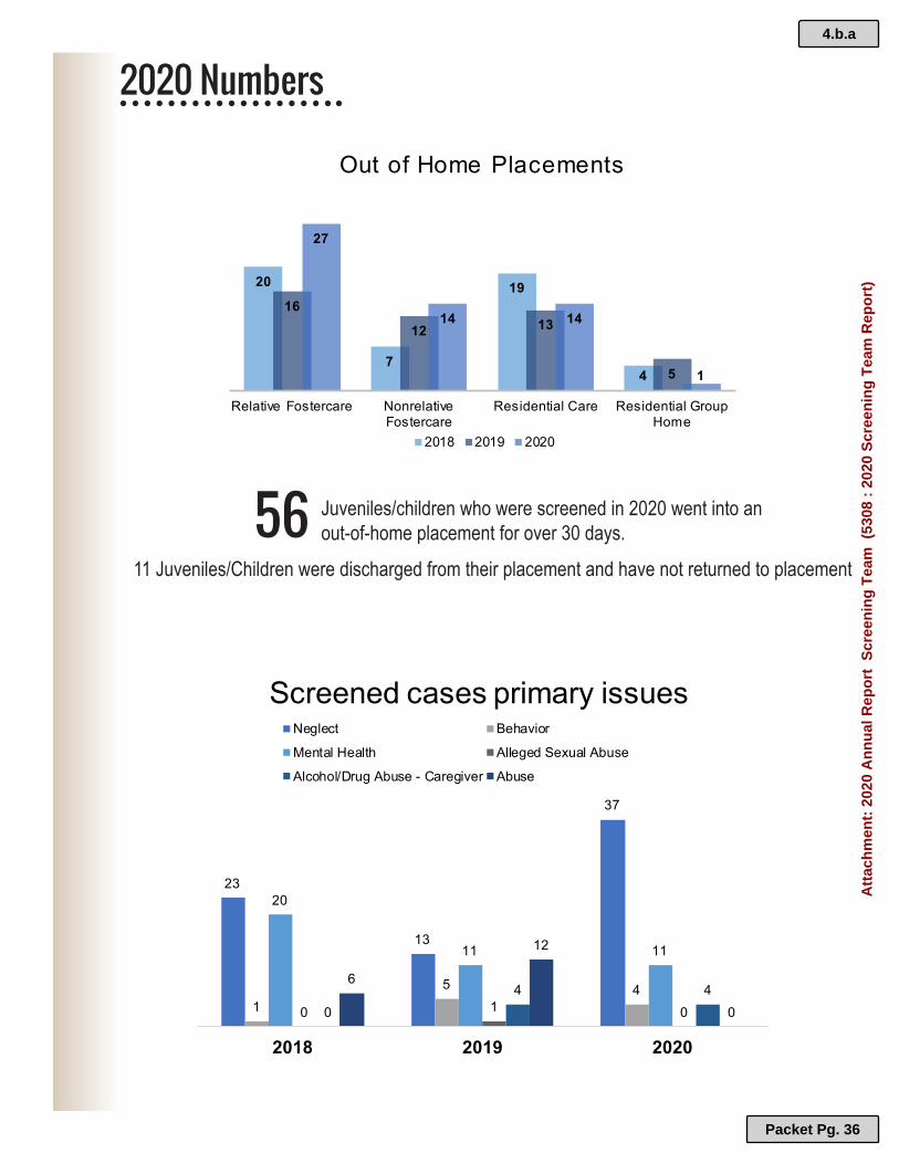
SENTENCE TO SERVICE PAGE 25
EMERGENCY MANAGEMENT PAGE 26
CHAPLAINCY/TRIAD PAGE 27
CASS COUNTY SHERIFF’S OFFICE 2020 ANNUAL REPORT – TABLE OF CONTENTS
MOUNTED POSSE/ATV SEARCH AND RESCUE PAGE 28
6.a.a
Packet Pg. 43
Att
ach
men
t: 2
020
An
nu
al R
epo
rt (
5318
: A
nn
ual
Rep
ort
)

Cass County Sheriff’s Office 2020 Annual Report Page 2
The Mission of the Cass County Sheriff’s Office is to Protect the Life, Limb, and Property of the citizens of Cass County and the State of Minnesota without regard to Religion, Color, Sex or Nationality.
CASS COUNTY SHERIFF’S OFFICE MISSION STATEMENT
6.a.a
Packet Pg. 44
Att
ach
men
t: 2
020
An
nu
al R
epo
rt (
5318
: A
nn
ual
Rep
ort
)

Cass County Sheriff’s Office 2020 Annual Report Page 3
AS A LAW ENFORCEMENT OFFICER, by virtue of the authority conferred upon me by the State of Minnesota and the local governments by which I am employed, I accept it as my
responsibility and fundamental duty to devote my abilities, energies and efforts to the preservation of law and order; to the safe guarding of lives and property, the protection of
the innocent against deception, the weak against oppression or intimidation and the peaceful against violence.
IN THE FACE OF DANGER, scorn or ridicule, I will remain courageous and calm, I will respect the constitutional rights of all individuals, regardless of color, race or creed. I will
practice self-restraint and understanding in dealing with human frailties, and I will never lose sight of the fact that, as an officer of the law, I am not the master of the people - but the
servant of the law-abiding.
IN THOUGHT AND DEED, both in my personal and official life, I will strive to set a good example to all by obeying the laws of the land and the regulations of my Office. Confidential information divulged to me in my official capacity will be kept ever secret, unless revelation
is necessary in the proper performance of my duties.
EVER MINDFUL of the fact that it is better to prevent the commission of an act of crime than to apprehend the wrongdoer after the act has been committed, I will constantly strive to
communicate to the general public ways and means in which crime may be prevented.
WITHOUT FEAR OR FAVOR, malice or ill will. I will enforce the law courteously, impartially and effectively. Without compromise, I will pursue the perpetrators of criminal acts
relentlessly, never employing unnecessary force in making apprehensions and bringing law violators to justice.
I REGARD THE BADGE OF MY CHOSEN PROFESSION as a symbol of public faith and I
accept it as a public trust.
I DEDICATE MYSELF to be true to the trust, and I will keep the faith, by upholding the ideals set forth in this code of ethics.
Unanimously adopted by the Minnesota Sheriff's Association in Conference, at Duluth, Minnesota,
December 4, 1973.
CASS COUNTY SHERIFF’S OFFICE CODE OF ETHICS
6.a.a
Packet Pg. 45
Att
ach
men
t: 2
020
An
nu
al R
epo
rt (
5318
: A
nn
ual
Rep
ort
)

Cass County Sheriff’s Office 2020 Annual Report Page 4
It is my honor to submit to you the following report on the activities, programs and accomplishments of the Cass County Sheriff’s Office for the calendar year 2020. The Annual Report of the Cass County Sheriff’s Office is produced each year to inform our community about the work of the many divisions and initiatives within the Sheriff’s Office. As your Sheriff, I am committed to providing effective and efficient Public Safety and Law Enforcement services to the residents and visitors of Cass County.
The year of 2020 was one of the most difficult years in my Law Enforcement career. From a global pandemic, civil and political unrest and ever so quickly changing times, law
enforcement was challenged in ways that we never have been all throughout this year. We, like everyone else, had to learn and understand new terminology and how to police while practicing social distancing and mask wearing while keeping the populations that we serve and ourselves safe. For most of 2020, we responded in “Emergency Mode” and learned new ways of communicating and handling non-emergency situations and requests. While much of county business can be done online, phone or mail now when visiting the courthouse, you will now be screened and assisted by Deputies assigned to courthouse security and safety.
The ongoing successful work of the Sheriff’s Office is possible because of its dedicated staff and our partnerships with our communities, many volunteer groups and initiatives throughout the county. We are proud of our relationships with the Cass County Board of Commissioners, Citizen Budget Committee and Cass County Administrator’s Office, as well as other County Departments, municipalities and townships throughout Cass County. While the pandemic certainly changed the way we are forced to do business, we are fully committed to keeping our communities safe and are actively working at that every day. We are always thankful for our community support and working relationships and they are especially appreciated during times like these. We are proud to have built this relationship with those we serve and are thankful for the cooperation that we have with you. If we can be of assistance to you, please don’t hesitate to contact us. As always, please contact me with questions you may have about the operation of the Cass County Sheriff’s Office. Questions regarding this report may be addressed to me at the Cass County Sheriff’s Office, 303 Minnesota Ave W, Walker, MN 56484, by phone: (218) 547-1424 or Email [email protected]. You can visit our website at www.casssheriff.com or Friend Us On Facebook for instant updates and news releases.
Tom Burch Cass County Sheriff
CASS COUNTY SHERIFF’S OFFICE MESSAGE FROM SHERIFF BURCH
6.a.a
Packet Pg. 46
Att
ach
men
t: 2
020
An
nu
al R
epo
rt (
5318
: A
nn
ual
Rep
ort
)

Cass County Sheriff’s Office 2020 Annual Report Page 5
CASS COUNTY HISTORY & STATISTICAL DATA
When Cass County was created by legislative act on May 1, 1851; it became one of ten counties that existed in the Minnesota Territory. It remained as a created county and had no county officers until
March 4, 1872 when it was first organized as a county, with its boundaries reduced as slices had been cut off when the following counties were established: Wright, Steams, Meeker, Todd, Morrison, Pope,
Douglas, Ottertail, Wadena, Aitkin, Crow Wing, and Becker. Our county seat was located in West Brainerd, complete with a building that was used as a courthouse.
Cass County remained a part of Crow Wing County until the re-organization in 1897. Cass County was
fully organized on May 6, 1897 and Governor Clough had appointed P.H. McGarry of Walker, G.H. French of Cohasset, O.T. Wilson of Ellis, James F. Middleton of Backus, and T.J. Nary of Walker as the
county's first commissioners. These commissioners then met that same day and also on the 7th to appoint the officers of the county. The county board established the county seat at Walker on May 7th, and purchased a new brick building in Block 14, original plat of Walker. That building presently
houses Reed's Gifts. On May 8th, the chairman of the commissioners appointed a committee to proceed to Brainerd and secure all books pertinent to our county. Construction on our present
courthouse began in 1902-03 and the building was dedicated on April 5, 1907.
Cass County has 50 organized townships today, the first of which was Byron Township in 1898 and the last was Ottertail Peninsula in 1987. Cass County also has 14 unorganized townships and 15
incorporated cities.
FOUNDED: SEPT 1, 1851
POPULATION 28,567 (2010 CENSUS)
SQUARE MILES: 2,414.21 (84% LAND / 16% WATER)
50 ORGANIZED TOWNSHIPS
14 UNORGANIZED TOWNSHIP AREAS
15 INCORPORATED CITIES
CHIPPEWA NATIONAL FOREST
LEECH LAKE INDIAN RESERVATION
CASS COUNTY SHERIFF’S OFFICE DEMOGRAPHIC/VITAL DATA
6.a.a
Packet Pg. 47
Att
ach
men
t: 2
020
An
nu
al R
epo
rt (
5318
: A
nn
ual
Rep
ort
)

Cass County Sheriff’s Office 2020 Annual Report Page 6
In 2020, we handled 19,492 Initial Complainant Reports (ICRs). This is down 2,957 ICRs from the previous year and we dug deeper to find out why. While most months we were basically equal to last year in ICR numbers, the months of March, April and May were significantly less. This decrease in activity was in direct correlation to the Governors Stay at Home orders issued during these months and the start of the pandemic. Each of these months, we received a third less calls for service than a “normal” year. Some of this decrease can be attributed our response in Emergency Mode and attempting to limit contact for non-emergency calls and services. Even though we saw a significant increase of “seasonal”
traffic and occupancy earlier in the year during March, April and May, we did not have an increase in Calls for Service initially. Calls for service trended normally during summer months, our busiest time.
Trending normally, we processed 6,241 911 calls from cellular phones in August of 2020 and
190 from land lines. Overall, we receive 97% of our 911 calls from cellular phones. On
average, Saturday was our busiest day for 911 calls and Monday was the least calls
received daily. From 3:00 PM-10:00 PM were our peak calling time, peaking at 5:00 PM
daily. Week days are often now just as busy as weekends.
Some statistics were significantly more in 2020, including gun permit processing. In 2019,
we processed 953 Permit to Carry Applications. In 2020, we processed 1495 applications.
Another statistic that we are working to understand and get more data on is the amount of
Traffic Crashes with Injuries reported and investigated in 2020. In 2020, we responded to 71
crash reports with injuries, with 51 in 2019. This is consistent with what the Minnesota State
Patrol is seeing, as well as increased speeds and speeding citations on highways.
Statewide boat registrations increased by 5,433 from 2019 to 820,051 boats registered in
2020. Statewide ATV registrations increased by 14,214 registrations from 2019 to 323,956
boats registered. In 2020 DNR data also shows 4,644 ATV registrations for Cass County and
6,747 ATV registrations indicating Cass County as “County Most Used”
MN DNR watercraft and ATV resignation data is consistent with what we are seeing county
wide. Our watercraft traffic and recreation has increased drastically not only on large
recreation lakes, but smaller lakes as well. This has created complaints and new issues
including wake issues. ATV traffic is observed year round in all areas of the county and
with the increased traffic are increased complaints. Sales of recreational vehicles were
very popular this year and we have definitely observed the increase on our trails, roadways
and public property, creating a variety of new issues and need for additional education and
enforcement. These increases are observed throughout the entire year and no long only on
busy or holiday weekends. As residents and tourists are staying at home and social
distancing, they are taking advantage of the many recreational opportunities that our
County and area offers.
Assigned Deputy personnel to Campus Security and Safety to screening station.
CASS COUNTY SHERIFF’S OFFICE COVID-19 EFFECTS & 2020 OBSERVATIONS
6.a.a
Packet Pg. 48
Att
ach
men
t: 2
020
An
nu
al R
epo
rt (
5318
: A
nn
ual
Rep
ort
)

Cass County Sheriff’s Office 2020 Annual Report Page 7
ADMINISTRATION SHERIFF: TOM BURCH CHIEF DEPUTY: SCOTT THOMPSON
SUPPORT STAFF/CIVIL ADMINISTRATIVE ASSISTANT: PAULINE FAHEY
PATROL LIEUTENANT BRYAN WELK
LIEUTENANT BRAD RITTGERS SERGEANT JASON BROGLE
SERGEANT ERIC ALGER 4 INVESTIGATORS
21 PATROL DEPUTIES 3 RECREATIONAL DEPUTIES
1 CIVIL PROCESS DEPUTY 1 WELFARE FRAUD DEPUTY
DETENTION CENTER LIEUTENANT CHRIS THOMPSON
SERGEANT ERIC LUETH 12 CORRECTION OFFICERS
1 TRANSPORT OFFICER 1 STS CREW LEADER
4 BAILIFFS/COURTHOUSE SECURITY
DISPATCH CHIEF DISPATCHER: SHANNA CONNER 10 DISPATCHERS
EMERGENCY MANAGEMENT DIRECTOR: CHAD EMERY
RECORDS RECORDS COORDINATOR: CHARLENE ERICKSON
4 SUPPORT STAFF
CASS COUNTY SHERIFF’S OFFICE STAFFING SUMMARY
6.a.a
Packet Pg. 49
Att
ach
men
t: 2
020
An
nu
al R
epo
rt (
5318
: A
nn
ual
Rep
ort
)

Cass County Sheriff’s Office 2020 Annual Report Page 8
$0
$1,000,000
$2,000,000
$3,000,000
$4,000,000
$5,000,000
$6,000,000
Patrol & Investigation
Jail & Sentence toService Program
Dispatch & 911
Recreation Education &Enforcement
Emergency Response &Medical Examiner
Administration &Records
0%
20%
40%
60%
80%
100%Administration &Records
Emergency Response &Medical Examiner
Recreation Education &Enforcement
Dispatch & 911
Jail & Sentence toService Program
Patrol & Investigation
CASS COUNTY SHERIFF’S OFFICE BUDGET/SPENDING
6.a.a
Packet Pg. 50
Att
ach
men
t: 2
020
An
nu
al R
epo
rt (
5318
: A
nn
ual
Rep
ort
)

Cass County Sheriff’s Office 2020 Annual Report Page 9
The Cass County Communications Center handles all public safety dispatching for law enforcement (except for the Leech Lake Department of Public Safety Tribal Police) including Police Departments, Fire Departments, Medical Ambulances and First Responders. This is the hub of communications within Cass County. The Communications Center consists of one Chief Dispatcher and 10 full-time dispatchers. There are two trained dispatchers on staff at all times, with occasionally a third during peak times and major events. The Communications Center, along with the sheriff’s deputies, work closely with other departments, including Minnesota State Patrol, the Leech Lake Tribal police, as well as 5 other police departments within the county. We also dispatch for all 10 fire departments within the county. The job of a dispatcher is dynamic and always changing. The demands of the dispatch center have changed a great deal in recent years and added technology has enabled the dispatch center to handle more public safety functions. ICRS are Initial Complaint Reports and document every call for service the center receives that requires some action be taken or a response received.
ICRS BY YEAR
1995 1996 1997 1998 1999 2000 2001 2002 2003 2004 16344 15649 15762 13931 14354 13978 13686 14501 14557 15993 2005 2006 2007 2008 2009 2010 2011 2012 2013 2014
17910 21207 18664 17463 16565 16951 17451 18812 19830 19407 2015 2016 2017 2018 2019 2020
21390 22038 22472 20859 22449 19492
CASS COUNTY SHERIFF’S OFFICE COMMUNICATIONS DIVISION/911
6.a.a
Packet Pg. 51
Att
ach
men
t: 2
020
An
nu
al R
epo
rt (
5318
: A
nn
ual
Rep
ort
)

Cass County Sheriff’s Office 2020 Annual Report Page 10
CASS COUNTY SHERIFF’S OFFICE ICR / 911 CALL VOLUME DATA
0 1000 2000 3000 4000 5000 6000 7000 8000
JANUARYFEBRUARY
MARCHAPRILMAYJUNEJULY
AUGUSTSEPTEMBER
OCTOBERNOVEMBERDECEMBER
911 CALLS RECEIVED BY MONTH
LANDLINE
WIRELESSS
6.a.a
Packet Pg. 52
Att
ach
men
t: 2
020
An
nu
al R
epo
rt (
5318
: A
nn
ual
Rep
ort
)

Cass County Sheriff’s Office 2020 Annual Report Page 11
NEW & RENEWAL GUN PERMITS
YEAR 2015 2016 2017 2018 2019 2020 Permit to Purchase 372 407 348 318 343 550
Permit to Carry 428 722 431 395 357 945
WARRANTS – NEW/CHANGED ENTERIES
Record Type ACTIVE CLEARED Felony 428
Gross Misdemeanor 47 Misdemeanor 466
TOTAL 1131 867
VOLUNTEER HOURS
TRIAD 124 Chaplaincy 75.75
Posse 39 Lakes Area Dive Team 669.1
ATV Search/Rescue 0 - COVID-19 PAUSE
LAKE ASSOCIATION VOLUNTEERS RALALA 0 - COVID-19 PAUSE
Pleasant Lake 0 - COVID-19 PAUSE Woman Lake 0 - COVID-19 PAUSE
Gull Lake (GALA) 0 - COVID-19 PAUSE
Most of our volunteer programs, outreach and partnerships were cancelled in 2020 due to the COVID pandemic with the intent to help keep our partners safe. Some services were still able to continue through these programs. We are looking forward to getting these programs and
initiatives started again sometime in 2021.
The Cass County Sheriff’s Office is supported by several volunteer functions and we are fortunate to have these countywide partnerships to assist us in the delivery of public safety
and law enforcement services!
GUN PERMITS/WARRANTS VOLUNTEER HOURS
6.a.a
Packet Pg. 53
Att
ach
men
t: 2
020
An
nu
al R
epo
rt (
5318
: A
nn
ual
Rep
ort
)

Cass County Sheriff’s Office 2020 Annual Report Page 12
Ansel S 20 Moose Lake S 40
Barclay S 168 Ottertail Peninsula N 21
Becker S 112 Pike Bay N 1826
Beulah C 13 Pine Lake C 116
Birch Lake C 203 Pine River S 409
Blind Lake S 35 Ponto Lake S 243
Boy Lake C 186 Poplar S 58
Boy River C 32 Powers S 471
Bull Moose S 64 Remer C 94
Bungo S 109 Rogers C 40
Byron S 44 Salem C 21
Crooked Lake C 209 Shingobee C 1033
Deerfield S 27 Slater C 96
Fairview S 208 Smokey Hollow C 7
Gould C 157 Sylvan S 802
Hiram C 144 Thunder Lake C 120
Home Brook S 118 Torrey C 44
Inguadona C 83 Trelipe C 51
Kego C 254 Turtle Lake C 723
Leech Lake N 242 Wabedo C 123
Lima C 41 Wahnena C 23
Loon Lake S 101 Walden S 144
Maple S 108 Wilkinson N 306
May S 211 Wilson S 190
McKinley S 94 Woodrow C 209
Meadow Brook S 70 District 4/5 (Unorg) 278
CASS COUNTY SHERIFF’S OFFICE CALLS FOR SERVICE RECEIVED BY TOWNSHIP
6.a.a
Packet Pg. 54
Att
ach
men
t: 2
020
An
nu
al R
epo
rt (
5318
: A
nn
ual
Rep
ort
)

Cass County Sheriff’s Office 2020 Annual Report Page 13
City of Backus S 296
City of Bena N 132
City of Boy River C 16
City of Cass Lake N 1632
Chickamaw Beach N 50
East Gull Lake S 307
City of Federal Dam C 75
City of Hackensack C 268
City of Lakeshore S 1084
City of Longville C 154
City of Pillager S 509
City of Pine River S 1398
City of Remer C 317
City of Walker C 1035
LAKES
Cass Lake N 5
Gull Lake S 55
Leech Lake C 52
Pike Bay Lake N 5
Ten Mile Lake C 8
Winnie Lake N 4
Woman Lake C 7
CASS COUNTY SHERIFF’S OFFICE CALLS FOR SERVICE RECEIVED BY CITY
6.a.a
Packet Pg. 55
Att
ach
men
t: 2
020
An
nu
al R
epo
rt (
5318
: A
nn
ual
Rep
ort
)

Cass County Sheriff’s Office 2020 Annual Report Page 14
296
132
16
1632
50
307
75
268
1084
154
509
1398
317
1035
City of Backus
City of Bena
City of Boy River
City of Cass Lake
Chickamaw Beach
East Gull Lake
City of Federal Dam
City of Hackensack
City of Lakeshore
City of Longville
City of Pillager
City of Pine River
City of Remer
City of Walker
0 200 400 600 800 1000 1200 1400 1600 1800
CALL FOR SERVICE BY CITY 2020
Series1
CASS COUNTY SHERIFF’S OFFICE ICR/PERCENTAGE OF TOTAL BY TOWNSHIP/CITY
6.a.a
Packet Pg. 56
Att
ach
men
t: 2
020
An
nu
al R
epo
rt (
5318
: A
nn
ual
Rep
ort
)

Cass County Sheriff’s Office 2020 Annual Report Page 15
911 : Hang up 91 DUI : Atv 0 ADMIN : History/DL Photo Request 2 DUI : Boat/Jetski 0 Airplane : Accident No Injury 1 DUI : Child Endangerment 0 Airplane : Missing/Overdue /Fatal 1/1 DUI : Driving Under the Influence 93 Alarm : Business 424 DWN : Drowning 1 Alarm : CO2 Detector 13 EP : Extra Patrol 73 Alarm : Fire 67 Escort : Funeral 12 Alarm : Medical 96 Escort : Other 10 Alarm : Residence 507 ES : Escape 1 Animal : Barking Dog 12 EXP : Explosives 3 Animal : Bite 37 FGT : Fight 82 Animal : Dangerous 22 FGY : Forgery 4 Animal : Injured 86 Fire : Boat 1 Animal : Lost/Found 34 Fire : Business 11 Animal : Neglect/Abuse 22 Fire : Chimney 4 Animal : Other 93 Fire : Controlled Burn 13 Animal : Potentially Dangerous 13 Fire : Garage 6 AOA : Assist other Agency-EMS 50 Fire : Grass/Forest 91 AOA : Fire Department 7 Fire : Hazmat/Fuel/Gas Leak 40 AOA : Law Enforcement 454 Fire : Home 76 AOA : Other 218 Fire : Illegal Fire 4 AOA :Probation 25 Fire : Motor Vehicle 37 AOA : Social Services 36 Fire : Other 70 Assault : Assault 135 FN : False Name to Officer 21 Assault : Domestic 110 FO : Flee an Officer 18 ATL : Attempt to Locate 292 Found : Person 4 ATV : Accident no Injury 4 Found : Property 111 ATV : Accident with Injuries / Fatal 28 / 1 Fraud : Other 169 ATV : Citation/Warning 21 Fraud : Welfare 198 ATV : Complaint 67 Furnish To Minor : Liquor 1 ATV : Other 38 FWK : Fireworks 26 AV : Abandoned Vehicle 143 GDL : Garbage Dumping/Littering 62 Boat : Accident Fatal 0 GDO : Gas Drive Off 142 Boat : Accident no Injury 11 General Information : TTY 9 Boat : Accident with Injuries 2 General Information : General 500 Boat : Complaint 29 Hit & Run : Accident no Injury 33 Boat : Other 52 Hit & Run : Accident with Injuries 2 BT : Bomb Threat 0 HRS : Harassment 90 BURG : Attempted 24 IT : Identity Theft 12 BURG : Burglary 208 Jetski : Complaint 11 B & W : Other 54 Juvenile : Curfew 7 B & W : Rafts 12 Juvenile : Incorrigible 100 CAF : Crime Against Family-Abuse 71 Juvenile : Mental Illness 1 CAF : Crime Against Family-End 105 Juvenile : Possession of Alcohol 2 CAF : Crime Against Family-Neglect 141 Juvenile : Possession of Tobacco 1 CC : Contempt of Court 0 Juvenile : Runaway 75 CCD : Child Custody Dispute 77 Juvenile : Truant 6 CSC : Criminal Sexual Conduct 5 KDNP : Kidnapping 1 DD : Domestic Dispute 289 Lost : Person 7 Death : Accidental 3 Lost : Property 34 Death : Natural 33 MA : Motorist Assist 91 Death : Other 35 MC : Minor Consume 20 Death : Suicide 2 MDR : Murder 1 Dirtbike : Accident with Injuries 2 MED : EMS Transport Only 254 Dirtbike : Complaint 3 MED : Lift Assist 161 DOC : Disorderly Conduct 124 MED : Medical 3316
DP : Disturbing the Peace 55 MED : Officer Transport 2
Drugs : Other 63 MIP : Mentally Ill Person 65
Drugs : Possesion 48 Motorcycle : Accident Fatal 0
Drunk : Person 97 Motorcycle : Accident no Injuries 2
Drunk : Taken to Detox 1 Motorcycle : Accident with Injuries 6
CASS COUNTY SHERIFF’S OFFICE CALL TYPE TOTALS
6.a.a
Packet Pg. 57
Att
ach
men
t: 2
020
An
nu
al R
epo
rt (
5318
: A
nn
ual
Rep
ort
)

Cass County Sheriff’s Office 2020 Annual Report Page 16
MP : Missing Person 51 Theft : By Check 12 MV : Abandon Vehicle 0 Theft : Gun 14 MV : Accident Fatal 6 Theft : Mail 32 MV : Accident no Injury 193 Theft : Motorcycle 2 MV : Accident with Injuries 622 Theft : Other 474 MV : Deer Accident no Injury 157 Theft : Vehicle 97 MV : Deer Accident with Injuries 4 THTS : Threats 155 MV : In Ditch 123 TPR : Terminal Patient Registration 16 MV : Pedestrian Accident Fatal 0 Traffic : Allow Illegal Operation of Motor Vehicle 1 MV : Pedestrian Accident no Injury 0 Traffic : Allow Unlicensed Party to Operate Vehicle 0 MV : Pedestrian Accident with Injuries 1 Traffic : Careless Driving 18 MV : Repo 11 Traffic : Child Restraint Violation 0 MV : Through Ice 4 Traffic : Driving after Cancellation 1 NC : Noise Complaint 69 Traffic : Driving after Cancellation-IPS 4 Notification : Death 10 Traffic : Driving after Revocation 19 Notification : Offender 1 Traffic : Driving after Suspension 6 Notification : Victim 11 Traffic : Equipment Violation 2 OB : Open Bottle 1 Traffic : Erratic Driving 133 OBST : Obstruct Legal Process 1 Traffic : Expired License Tabs 7 OBST : Obstruct with Force 1 Traffic : Fail to Display Lights 2 Offender : Compliance Check 779 Traffic : Fail to Yield to Emergency Vehicle 1 Offender : Registration Violation 2 Traffic : Improper Lane Change 0 Officer : Injured 0 Traffic : Inattentive Driving 2 Order : Court 1 Traffic : Incident 92 Order : Execute Search Warrant 4 Traffic : Instruction Permit Violation 0 Order : Violation of Court Order 4 Traffic : Minor Consume-Driver 2 Order : Violation of DANCO Order 9 Traffic : No Insurance 2 Order : Violation of Harassment Order 47 Traffic : No Minnesota DL 2 Order : Violation of Protection Order 50 Traffic : No Proof Insurance 2 PA : Public Assist 281 Traffic : Over Centerline 1 Parking : Block Loading Zone 0 Traffic : Overweight Trucks 3 Parking : Complaints 42 Traffic : Passing on Wrong Side 5 Parking : Handicapped Parking Violation 1 Traffic : Reckless Driving 8 Parking : No Parking Zone Violation 3 Traffic : Revoked License Plates 0 Party : Beer 2 Traffic : School Bus Stop Arm Violation 9 Party : Juvenile 7 Traffic : Seat Belt Violation 4 Party : Loud 1 Traffic : Speed 132 PC : Property Check 73 Traffic : Stop Sign Violation 4 PD : Property Damage 290 Traffic : Texting while Driving 23 PLD : Property/Land Dispute 102 Traffic : Traffic Stop 916 Possession : Paraphernalia 1 Traffic : Unreasonable Acceleration 5 Possession : Small Amount 3 Traffic : Unsafe Pass 10 Possession : Stolen Property 3 Traffic : Warning 557 PV : Probation/Parole Violation 18 Train : Accident no Injury 0 RBB : Robbery 2 Train : Other 7 REM : Removal 298 TRSP : Trespassing 146 Road : Road Conditions/Hazards 90 TV : Towed Vehicle 5 Road : Roadway Information 10 TW : Tampering with Witness 0 SL : Shoplifting 49 UTL : Utilities 11 Snowmobile : Accident with Injuries 1 VA : Vulnerable Adult 77 Snowmobile : Complaint 25 WA : Warrant Arrest 77 Snowmobile : Other 9 WC : Welfare Check 528 Snowmobile : Through Ice 0 Weapon : Drive by Shooting 0 Snowmobile: Fatality 0 Weapon : Fire 70 Squad : Accident no Injury 13 Weapon : Possession 6 Suicide : Attempted 8 Weather : Alert 2 Suicide : Threat 79 Weather : Flooding 0 Suspicious : Activity 488 Wellness : Court Check 0 Suspicious : Person 229 ZV: Zoning Violation 1 Suspicious : Vehicle 266 Theft : ATV 10 Theft : Boat 8
CASS COUNTY SHERIFF’S OFFICE CALL TYPE TOTALS
6.a.a
Packet Pg. 58
Att
ach
men
t: 2
020
An
nu
al R
epo
rt (
5318
: A
nn
ual
Rep
ort
)

Cass County Sheriff’s Office 2020 Annual Report Page 17
CASS COUNTY SHERIFF’S OFFICE BCA CRIME REPORTING SYSTEM SUMMARY
6.a.a
Packet Pg. 59
Att
ach
men
t: 2
020
An
nu
al R
epo
rt (
5318
: A
nn
ual
Rep
ort
)

Cass County Sheriff’s Office 2020 Annual Report Page 18
The Cass County Sheriff’s Office Patrol Division is comprised of 37 full-time patrol staff, including 3 Sergeants. The Patrol Division responds to calls for service 24 hours a day on incidents such as medicals, alarms, vehicle crashes, motorist assists, domestic disputes, traffic complaints, as well as property offenses and fraud. The Division is also responsible for protecting the citizens and visitors of Cass County, as well as their property, through proactive patrol and traffic enforcement to prevent and deter crime. The Patrol Division practices the philosophy of community policing, inviting the community to partner with Law Enforcement to identify problems, develop responses and evaluate the results of
those responses. The Sheriff’s Office promotes this practice through the patrol of three geographically assigned areas of the County known as North, Central and South. The division also provides specialized services such as K-9, the Emergency Response Unit, Honor Guard and numerous instructorships in multiple areas of training and specializations.
2020 RESPONSE TIMES TO EMERGENCIES
Countywide Average Response Time: 5.94 Minutes Countywide Average On Scene Time: 30.14 Minutes
Utilizing our AVL (Automatic Vehicle Locator), the concept of drawn patrol lines in response areas disappear and the closest squad, including Deputies, Supervisors and Investigators is
sent to the call for service. Our average on scene times show that we spend a large amount of time on scene with investigations and follow-ups, meeting with victims, collecting evidence,
investigating suspects and conducting follow-up.
K9 PROGRAM
CASS COUNTY SHERIFF’S OFFICE PATROL DIVISON/K9
2020 marked K9 Ranger’s first full year on the road with Deputy Buckhouse and the Cass County Sheriff’s Office. K9 Ranger was called upon 18 times for the CCSO and to assist other agencies. K9 Ranger conducted narcotics searches, article searches, tracked suspects, and building searches. The team was re-certified with the NPCA in November 2020.
2020 marked K9 Ryker’s first complete year on the road with Deputy Huston, working the past 19 months. K9 Ryker was called upon 29 times for the Cass County Sheriff’s Office and surrounding agencies for assistance. K9 Ryker conducted narcotic searches, article searches, tracked suspects and assisted in locating missing or lost persons. K9 RANGER K9 RYKER
6.a.a
Packet Pg. 60
Att
ach
men
t: 2
020
An
nu
al R
epo
rt (
5318
: A
nn
ual
Rep
ort
)

Cass County Sheriff’s Office 2020 Annual Report Page 19
Year Assault Burglary Homicide CVO Kidnap CSC Total 2010 6 265 1 0 0 10 282 2011 9 263 2 6 1 44 325 2012 16 217 3 1 1 87 325 2013 20 238 0 5 0 50 313 2014 21 207 0 2 1 55 286 2015 20 168 1 10 1 53 253 2016 25 118 2 3 2 37 187 2017 27 135 1 7 1 45 216 2018 29 115 3 4 2 45 198 2019 26 210 1 1 1 20 259 2020 29 148 0 2 0 10 189
Assaults: Serious 1st 2nd & 3rd Degree | Burglaries: All | Homicide: All Criminal Vehicular Operation: 1st & 2nd Degree | Kidnapping: All
Criminal Sexual Conduct: 1st, 2nd & 3rd Degree
NEW CASE FILE SUBMITTALS TO COUNTY ATTORNEY
Submitted: 1041 Convicted: 225 Dismissed: 58 Declined: 146
TRAFFIC CRASHES / DUI ARRESTS
CRASH TYPE 2020 TOTAL MOTOR VEHICLE – NO INJURY 209
MOTOR VEHICLE VS DEER – NO INJURY 157 MOTOR VEHICLE – INJURY 71
MOTOR VEHICLE VS DEER – INJURY 3 MOTOR VEHICLE – FATALITY 6
DUI ARRESTS / ALL CRASHES BY MONTH
CASS COUNTY SHERIFF’S OFFICE SERIOUS CRIMES / CASE FILES / CRASHS/ DWI STATS
61 Impaired Drivers were arrested in 2020, 14 being
drug related impaired drivers. Average Blood Alcohol Level
being .18 (two times the legal limit to drive a motor vehicle)
Highest BAC was .30
6.a.a
Packet Pg. 61
Att
ach
men
t: 2
020
An
nu
al R
epo
rt (
5318
: A
nn
ual
Rep
ort
)

Cass County Sheriff’s Office 2020 Annual Report Page 20
PREDATORY OFFENDER REGISTRATION
Deputies completed 786 documented random compliance checks on Level 1, 2 and 3 registered predatory offenders, totaling between 125-135 countywide, ensuring that offender’s
information and location is up-to date and known to law enforcement agencies. 20 non-complaint offender packets were submitted to the County Attorney’s Office for review of
charges, resulting in 2 convictions from 2019 with the balance pending.
TAKE IT TO THE BOX – MEDICATION DISPOSAL
The Cass County Sheriff’s Office collected 709.87 pounds of unwanted prescription
medication in 2020. A permanent mounted drop box is located in the lobby of the Law Enforcement Center in the Courthouse in Walker, the Lake Shore City Hall, the Cass
Lake City Hall & the Pine River City Hall. The portable drop off box is present at our Community Outreach Days, as well as other countywide events.
CONTRACT SERVICES – CITY OF CASS LAKE, BACKUS & LONGVILLE
The Cass County Sheriff’s Office contracts with the City of Cass Lake for Law Enforcement services. There are three full time Deputies assigned to the City of Cass Lake contract. The Cass
County Sheriff’s Office works closely with City Administration and we are proud of this successful partnership. We also contract to provide law enforcement services to the City of
Backus, and provided 1406.25 hours of documented patrol to the Backus community in 2020. We also provided 822 hours to the City of Longville and 751.25 hours at the Pillager Schools.
WELFARE FRAUD INVESTIGATION/PREVENTION
A total of 216 cases were completed in 2020, with an average completion time of 10 days. There were 20 cases
that resulted in a disqualification, with at least 1 for a period of at least one year from the program(s) violated. This
includes programs such as TANF Cash, Food Support, Federal Medical, State Medical, Child Care, MN Sure and other
programs such as general assistance. Total savings that the fraud program prevented from being fraudulently obtained was $59,750.00 The total
overpayments found was $118,322.00. The agency will recoup this money from ongoing benefits or send to collections for repayment or as restitution. 5 Cases were referred for
prosecution.
CASS COUNTY SHERIFF’S OFFICE POR /MEDICATION DISPOSAL/CONTRACT SERVICES/WELFARE
6.a.a
Packet Pg. 62
Att
ach
men
t: 2
020
An
nu
al R
epo
rt (
5318
: A
nn
ual
Rep
ort
)

Cass County Sheriff’s Office 2020 Annual Report Page 21
DEATH INVESTIGATIONS – RIVER VALLEY FORENSIC SERVICES
Cass County contracts with Dr. Kelly Mills of the River Valley Forensic Services (formally Ramsey County Medical Examiner’s Office) for county medical examiner services. Deputies are trained in basic
field corner operations and investigate and report all deaths to Dr. Mills’s Office. A total of 123 deaths were reported and investigated by the Cass County Sheriff’s Office in 2020. An additional 119
terminally ill registration deaths were reported and 195 cremation requests were approved.
Complete Autopsy With Toxicology 39 External Examination With Toxicology 6 Death Certificate Signed W/Out Exam 20
Total Cases Accepted by RCMEO 65 Cases Reported by Manner of Death:
Natural Deaths 90 Accidents 27 Suicides 3
Homicides 2 Undetermined 1
Pending 0
Cass County had an expected increase in the number of cases signed by the medical examiner during a year with a pandemic with a marked increase in the number of natural deaths
requiring an examination. There was also an increase in the number of accidental deaths in overdoses and motor vehicle accidents.
CASS COUNTY SHERIFF’S OFFICE INVESTIGATIONS
The Cass County Sheriff’s Office Investigations Division is comprised of four full time Investigators, two of which are assigned to general investigations and two assigned specifically to drug investigations. The Investigations Division assists Patrol Deputies in providing additional resources and follow-up, including interview and interrogation, processing evidence, transporting evidence to the crime lab, etc. The Investigations Division works closely with other County Departments, including Heath, Human and Veteran services, by meeting daily to review intake reports to determine whether criminal charges should be pursued. The Investigations Division is also active in investigating ongoing cases, such as missing person’s investigations and other cases that have gone cold. The Division is often assisted by the Minnesota Bureau of Criminal Apprehension in these types of investigations. The Sheriff’s Office also became an associate member of the Paul Bunyan Drug Task Force, which allows our Investigators to share information and resources to further assist in drug related investigations. The Division also handled a large amount of burglaries and financial related crimes in 2020, including frauds. The Division was also active in providing numerous presentations and trainings to Cass County residents, volunteers and employees.
6.a.a
Packet Pg. 63
Att
ach
men
t: 2
020
An
nu
al R
epo
rt (
5318
: A
nn
ual
Rep
ort
)

Cass County Sheriff’s Office 2020 Annual Report Page 22
TOTAL CIVIL PAPERS SERVED:
Orders For Protection (OFP) 126 Harassment Restraining Order (HRO) 124 Domestic Assault No Contact Order 29
Subpoenas 241 Summons 14
Child Support 40 Summons & Complaint 207
Summons & Petition 73 Notice of Mortgage Foreclosure Sale 10
Mortgage Foreclosure Sale 14 Evictions 10
Writs of Recovery 4 Notice of Expiration of Redemption 45
Order to Show Cause 29 Other 160 TOTAL 1112
NO CHARGE PAPERS: (included in totals above)
OFP 126 HRO 124
Subpoenas 216 Summons 67
TOTAL NO CHARGE 562
TOTAL CIVIL FEES COLLECTED: $36,167.47
Notes: All no charge subpoenas and summons and over half OFPs and HROs were from Cass County. At least $30,900.00 in fees incurred for these no charge services. Other papers may
have been no charge, if they were from our county or In Forma Pauperis (Court Order waiving fees)
Updated Mortgage Foreclosure Calendar is posted on our website weekly at:
http://casssheriff.com/mortgages.html
CASS COUNTY SHERIFF’S OFFICE CIVIL PROCESS
6.a.a
Packet Pg. 64
Att
ach
men
t: 2
020
An
nu
al R
epo
rt (
5318
: A
nn
ual
Rep
ort
)

Cass County Sheriff’s Office 2020 Annual Report Page 23
Cass County has a large recreational draw of people, both during the summer when the population can exceed 100,000 and during the winter months for its ice fishing, ATV's,
skiing, hiking, snowmobiling and other activities. The Sheriff's Office Recreation
Division is supervised by a Lieutenant, who oversees the program, including the
volunteer program and the safety/education component. Currently, the Sheriff's Office has boats permanently on Leech Lake, Gull Lake, Woman
Lake, Pleasant Lake and the Outing Lakes Area. We have several other patrol boats that deputies use daily while patrolling other lakes. Volunteers provide a valuable resource in the Boat and Water
Safety Program. They patrol Woman Lake, Pleasant Lake and the Outing Lakes Area. Volunteers, such as Gull Area Lakes Association (GALA), take the responsibility in maintaining many of the buoys on
lakes within the county. Each spring, we teach Boat and Water Safety in schools throughout the county. 65 Resort/Rental Agencies were inspected totaling 347 boats. In addition, 245 summer
navigational buoys/markers were placed and in the winter months 200 thin ice signs placed and maintained. 57 Marine Event permits were issued and 1,223 temporary structure/raft permits were
given in 2020.
Boat & Water Safety Grant $54,218.00 Federal Boating Safety Patrol Supp Grant $12,625.00 Snowmobile Safety Enforcement Grant $6,294.00
Off Highway Vehicle Safety Enforcement Grant $14,966.00
Due to the COVID-19 Pandemic our Boat & Water Saftey Voultneer Programs were paused and we were unable to host or teach any boat and water saftey classes or schools. We are
hoping to continue these programs and partnerships sometime during 2021!
LAKES AREA DIVE TEAM
Conducted aquatic invasive species investigations in area lakes as directed by environmental services.
Monitored Hackensack and Bemidji Plunge activities to ensure safety for the participants.
Set the fireworks barge for Walker Fireworks. Maintained equipment required to safely respond to callouts. Completed victim recovery on Mississippi River at Schoolcraft
State Park. Recovered pilot and assisted with recovery of plane from crash
on Leech Lake. Utilized Zoom to conduct training that didn't require physical attendance.
CASS COUNTY SHERIFF’S OFFICE RECREATIONAL ENFORCEMENT/BOAT & WATER SAFETY
6.a.a
Packet Pg. 65
Att
ach
men
t: 2
020
An
nu
al R
epo
rt (
5318
: A
nn
ual
Rep
ort
)

Cass County Sheriff’s Office 2020 Annual Report Page 24
Like all other departments in the Sheriff’s Office, the Detention Center has been facing numerous challenges in adapting to the COVID -19 pandemic. Average daily populations and bookings dropped dramatically. Initially, in the spring, numerous inmates were released by the court as a precaution and still today the Detention Center is trying to limit the amount of new inmates so as to allow for mandated quarantine protocols, while still providing for the public’s safety. Alternative measures are being used, like the warrant recall process. Those with warrants that are lesser in severity are given a Promise to Appear form, which informs them of their new court date and how to contact their attorney. Arrests in misdemeanor cases that would normally be held over the weekends are also being released on citation after providing a PBT of zeros and their disorderly behavior has ceased.
Ongoing cleaning, sanitization and staff screenings procedures have been implemented within the facility and Public Health has been instrumental in assisting us with ongoing medical screening of all inmates. The Detention Center and Public Health partnered up in the creation of policies and implementing COVID testing for inmates and staff and are one of the original three agencies to “pilot” the Bionix rapid test.
YEAR TOTAL
BOOKINGS DAILY
AVERAGE 2002 1566 4.29 2003 1690 4.63 2004 1822 4.99 2005 2088 5.72 2006 2088 5.72 2007 2156 5.91 2008 1425 3.90 2009 1708 4.68 2010 1652 4.53 2011 1926 5.28 2012 1912 5.24 2013 1977 5.42 2014 2013 5.52 2015 2074 5.68 2016 2519 6.90 2017 3010 8.25 2018 2719 7.45 2019 1843 5.05 2020 1236 3.39
CASS COUNTY SHERIFF’S OFFICE DETENTION CENTER
AVERAGE MONTHLY TOTAL MALE HOUSED: 7
_____________________________ AVERAGE MONTHLY TOTAL
FEMALE HOUSED: 2
All District Court has gone virtual. In March when COVID was just rearing its head, Cass County was the first to contact the State to propose and institute ITV/virtual court appearances to limit inmate exposure and transport. We now have designated spaces in Walker and in the Crow Wing County Jail where our inmates appear via the ZoomGov platform, eliminating the need to transport our inmates back and forth for their hearings. Up until this point, the Detention Center has been able to manage the ever-changing difficulties brought on by the pandemic and is constantly looking for new and improved ways to provide for the safety of those who work and are detained here.
6.a.a
Packet Pg. 66
Att
ach
men
t: 2
020
An
nu
al R
epo
rt (
5318
: A
nn
ual
Rep
ort
)
Cass County Sheriff’s Office 2020 Annual Report Page 25
2020 was an unprecedented year for the STS program. The start of the year began with lots of snow. The STS crew spending most of their time shoveling sidewalks at multiple Tax exempt and county buildings. Any spare time was spent shoveling fire hydrants around the county. Unfortunately, in March, COVID-19 hit and the STS crew was withheld from working outside in the attempt to stop the spread of the disease. The STS Crew leader has continued outdoor projects, mowing and cleaning around the tax exempt, USFS, DNR and county locations, where he was able to keep up to the best of his abilities. With winter arriving, and the virus is still spreading throughout local communities, the Crew Leader has still been without a crew and is maintaining the shoveling with assistance of county maintenance staff. We are hoping to restart the program in 2021!
# of Offenders Available
Adult 9 Male / 2 Female # of Offenders Completing STS
Adult 8 Male / 2 Female # of Offenders Exiting STS
Male Adult 1 Male / 0 Female Estimated Market Value of Completed
Projects: $72,010.13
Total Fine Amount Worked Off Through STS: $50.00
Jail Days Worked Off: Average Daily Crew Size: 2.48 Offenders Days Worked: 220
Type of Work Agency Hourly Breakdown DNR 73
County 2869.5 City 41
Township 8 Other State Agencies 0 Federal Government 35.5
School District 0 other(Non-Profit) 135
Total Agency Hours Worked: 3162 Value of Hours Worked: $37,950.00 @ $12.00/Hour
CASS COUNTY SHERIFF’S OFFICE SENTENCE TO SERVICE
6.a.a
Packet Pg. 67
Att
ach
men
t: 2
020
An
nu
al R
epo
rt (
5318
: A
nn
ual
Rep
ort
)

Cass County Sheriff’s Office 2020 Annual Report Page 26
2020 - What a year! 2020 started off with the NE Minnesota Region programming a region-wide portable dispatch console. The Motorola MCC 7500 Console is a laptop computer that is setup just like the current dispatch consoles. In January, Dispatch worked with the regional portable console, getting programming setup for Cass County. In conjunction with the portable command trailer, this console will allow dispatching for Cass County resources from anywhere in the State, where there is ARMER radio access. In February, the Cass County Dispatch Center made the switch to Next Generation 911. With this change, Cass County Dispatchers can receive text to 911 calls. After receiving a text to 911 call. dispatchers can text back to the number, just like a cell phone text conversation. Cass County was awarded a grant for equipment through the MN Emergency Communications Network for this switch.
On March 13th, President Trump declared a National Emergency concerning the Novel Coronavirus Disease Outbreak, otherwise known as Covid-19. After the National Emergency was declared, the Cass County Board enacted the Continuity of Operations Plan. The plan provided guidance to enable continued performance of essential government functions and services when normal operations become disrupted, overwhelmed, or impossible due to ‘all-hazards’ (natural, technological, or human-caused incidents including terrorism.) I worked to obtain PPE for EMS and county staff; this included KN-95 and surgical masks along with hand sanitizer. Cass County teamed up with Sourcewell to produce 3D printed face shields. Cass County obtained two 3-D printers and worked on getting headbands printed. The Emergency Communications Network, with consent, began sending positive address
locations for homes that were infected to protect first responders that may need to respond to those locations. Deputy Chad Emery attended daily virtual meetings concerning the disease for several months. On September 11th, in preparation for a potential Covid-19 Vaccine, Cass County Public Health and Emergency Management conducted a table-top Mass Dispensing Exercise. We covered several objectives including: Medical counter measure dispensing, public messaging, information sharing and situational awareness among and between public and tribal health, emergency management, EMS, and other community partners, emergency operations coordination, identifying staff roles in dispensing, identifying how dispensing needs would be conducted over an extended period, identifying any operations needing improvement, and identifying supplies needed. Cass County Public Health received the Moderna Covid-19 Vaccine and began administering on December 28th.
CASS COUNTY SHERIFF’S OFFICE EMERGENCY MANAGEMENT
6.a.a
Packet Pg. 68
Att
ach
men
t: 2
020
An
nu
al R
epo
rt (
5318
: A
nn
ual
Rep
ort
)

Cass County Sheriff’s Office 2020 Annual Report Page 27
Cass County experienced two severe thunderstorms in 2020. One on July 17th and a second on August 14th. Both storms caused power outages and considerable amounts of gravel was washed off county and township roads. Cass County requested public assistance for both events as the damage exceeded
required thresholds. Damage total for both events was $194,206.00. Cass County jurisdictions were
reimbursed at a 75 percent rate for these damages from the State Public Assistance Fund. During and after the July 17th storm, the Cass County Dispatch Center received many calls concerning the weather sirens. The Weather Sirens are set off when the National Weather Service issues a tornado warning, when the National Weather Service issues wind warnings with wind speeds at or above 70 mph, or when a trained spotter reports a tornado. These weather triggers follow the Association of Minnesota
Emergency Managers
(AMEM) outdoor warning siren best practices. The Cass County Dispatch Center uses the Weather Warn System. It automatically activates the appropriate sirens without dispatch input and will cycle the sirens automatically every 20 minutes while the tornado warning or extreme wind warning is active. After this event, we made changes to the siren zone areas around the county. We worked with Weather Warn to make each siren its own location instead of having 3 zones. Now when a storm warning comes from the weather service, a polygon is drawn automatically, and any siren located inside this polygon is automatically set off. The sirens will continue to cycle every 20 minutes while the tornado warning or extreme wind warning is active as before. At this same time, we learned Nixle had made changes to the way messages are sent to users. Anyone who had signed up and added an email would not receive warning level messages. Dispatchers will now be sending an alert level instead of a warning. This now allows the Nixle message to be delivered to all users during the weather warnings. If you would like to sign up, text your Cass County zip code to 888777 to opt-in or visit www.nixle.com. To top off 2020, the Cass County Hazard Mitigation Plan is being renewed. Cass County, along with other local units of government, are working with the University of Minnesota Duluth and Hundrieser Consulting. This plan works to mitigate hazards located in Cass County. It is also a FEMA requirement to receive grant monies associated with disaster mitigation. A grant was received from Homeland Security and Emergency Management to assist in this process.
CASS COUNTY SHERIFF’S OFFICE EMERGENCY MANAGEMENT
6.a.a
Packet Pg. 69
Att
ach
men
t: 2
020
An
nu
al R
epo
rt (
5318
: A
nn
ual
Rep
ort
)

Cass County Sheriff’s Office 2020 Annual Report Page 28
As with our other volunteer programs, Triad and Chaplaincy were unable to be active for most of 2020 due to the COVID-19 Pandemic.
In 2020, our chaplains responded to 14 call-outs throughout Cass County and spent 75.75 volunteer hours on call-outs and training. While our meetings have been put on hold, our chaplains have still been responding to call-outs, as needed. All chaplains follow the COVID screenings and guidelines. We appreciate the commitment and dedication of our chaplains in serving the Sheriff’s Office and the citizens of Cass County.
During 2020, Triad members contributed 124 volunteer hours focusing on senior safety in Cass County. While Triad has not actively been meeting, our Triad members still receive safety information from the Sheriff’s Office each month. Our members also stay committed to Triad’s mission of enhancing senior safety in our communities. We appreciate our Triad member’s commitment to this
mission by checking in with neighbors, family and friends by phone and sharing safety information when they can.
When we can safely do so, our meetings will resume at the Hackensack Hub on the 3rd Tuesday of each month. The state conference was canceled for 2020 and is tentatively scheduled for Goodhue County in Fall of 2021. While we hope to meet again soon, the safety of our seniors is what is most important. Therefore, we will only meet when we can be assured the threat of COVID-19 has passed.
Triad still has our projects that enhance senior safety available – File of Life medical information packets, credit card protectors, cell phone holders, My location cards and sand shakers. These items can be obtained by contacting Pauline at 218-547-7308 or [email protected].
CASS COUNTY SHERIFF’S OFFICE CHAPLAINCY / TRIAD
6.a.a
Packet Pg. 70
Att
ach
men
t: 2
020
An
nu
al R
epo
rt (
5318
: A
nn
ual
Rep
ort
)

Cass County Sheriff’s Office 2020 Annual Report Page 29
The Cass County Sheriff’s Office has a 24 hour, 7 day a week, on-call mounted posse. The mounted posse is a non-profit group of volunteers who dedicate their time to their communities and the Sheriff's Office. The troops are comprised of volunteers who use their personal horses for duties such as patrol, search and rescue, public relations, parade detail and events. Both men and women belong to this organization. Not all training is in the arena or on horseback. Part of the Search and Rescue training is taught in classroom and simulated on the trail. Map and Compass training sessions are held in the classroom and in the field. Professional emergency medical personnel provide First Aid and CPR training. Aside from Posse member training, members with horses also participate in separate training with their horses. It is extremely important that the horse and rider have trust in one another and are prepared to handle any situation.
In 2015, the Cass County Sheriff’s Office partnered with the Woodtick Wheelers ATV/OHM Club to create an ATV Search & Rescue Team. The team has been trained in CPR, communications and GPS, and is available on-call by the Sheriff’s Office for S&R missions and to assist at community events, as needed. With the assistance of this club, we can trail monitor additional trails.
CASS COUNTY SHERIFF’S OFFICE MOUNTED POSSE / ATV SEARCH AND RESCUE
6.a.a
Packet Pg. 71
Att
ach
men
t: 2
020
An
nu
al R
epo
rt (
5318
: A
nn
ual
Rep
ort
)

Cass County Sheriff’s Office 2020 Annual Report Page 30
6.a.a
Packet Pg. 72
Att
ach
men
t: 2
020
An
nu
al R
epo
rt (
5318
: A
nn
ual
Rep
ort
)

CASS COUNTY ITEM: Establish Public Hearing for 2nd
reading of Environmental Definitions and Land Use Ordinance
REQUEST FOR BOARD ACTION
Requested Board Date: March 16, 2021
Originating Department: Environmental Services Department
Presenter: Jessica Manifold
Requested Time: Jessica Manifold
For Discussion: 15 Min
Regular Agenda Item
At their February 4, 2020 meeting, the Cass County Board referred both the Draft Land Use Ordinance and the Environmental Definitions Ordinance Revisions for Cass County, Minnesota to the Cass County Planning Commission, authorized public notification and directed the Planning Commission to schedule the first reading public hearing. Both ordinances were publicly noticed for over 30 days beginning February 19, 2020 with the first hearing scheduled for March 19, 2020. Notifications were sent to all townships and affected state agencies and drafts were posted on our website. Due to safety concerns related to COVID 19 the hearing was cancelled and rescheduled for April 16, 2020 extending the public comment period through 4:30 PM, April 13, 2020.Notifications were sent to all townships and affected state agencies and drafts were posted on our website for both the cancelled and the new proposed hearing dates. During the April 16, 2020 hearing it was determined that additional time was needed to evaluate the proposed edits and the hearing was continued until a better meeting format was available to conduct the hearing or COVID 19 safety protocols were lifted or relaxed. The continuance was scheduled for February 22, 2021 following the installation of new zoom technology and additional comments were accepted by the Planning Commission. On February 22, 2021, during a special session, the Cass County Planning Commission completed the first hearing readings of both documents including review of comments and recommendation of additional comments. The Cass County Planning Commission voted unanimously to pass the proposed Land Use Ordinance and Environmental Definitions Ordinance to the County Board, with recommended changes as documented by readline edits and by change log, for Second Reading.
MOTION: Motion to establish a public hearing during the regular April 6, 2021 County Board meeting that begins at 9:00am at the Land Department Building in Backus for the 2nd Reading of the Environmental Definitions Ordinance and the Land Use Ordinance for Cass County, Minnesota.
Supporting Documentation: 030921 Second Reading Land Use Ordinance 2020_redlinedforBoard 030921 Definitions Ordinance Second Reading_redline 030921 Comment Log Definitions Ordinance Second Reading 030921 Comment Log Land Use Ord Second Reading
Distribution List: Jessica Manifold Completed 03/09/2021 10:26 PM There are some large PDF documents that I could not get to reduce any smaller in size. Jessica Manifold Completed 03/10/2021 9:48 AM Betsy Woodford Completed 03/10/2021 11:15 AM Josh Stevenson Completed 03/10/2021 3:16 PM Board of Commissioners Pending 03/16/2021 9:00 AM
7.a
Packet Pg. 73

Cass County Land Use Ordinance 2020-01Revisions made through February 22,2021 in red: January 28, 2020
Page 1 of 111
Formatted: Tab stops: 4.8", Left + Not at 3.25" + 6.5"
ORDINANCE # 20202020-01
LAND USE ORDINANCEFOR
CASS COUNTY, MINNESOTA
Effective Date: ____________
7.a.a
Packet Pg. 74
Att
ach
men
t: 0
3092
1 S
eco
nd
Rea
din
g L
and
Use
Ord
inan
ce 2
020_
red
lined
forB
oar
d (
5319
: E
stab
lish
Pu
blic
Hea
rin
g f
or
2nd
rea
din
g o
f

Cass County Land Use Ordinance 2020-01Revisions made through February 22,2021 in red: January 28, 2020
Page 2 of 111
Formatted: No page break before, Tab stops: 3.25",Centered + 6.5", Right + Not at 4.58"
Formatted: Centered
7.a.a
Packet Pg. 75
Att
ach
men
t: 0
3092
1 S
eco
nd
Rea
din
g L
and
Use
Ord
inan
ce 2
020_
red
lined
forB
oar
d (
5319
: E
stab
lish
Pu
blic
Hea
rin
g f
or
2nd
rea
din
g o
f

Cass County Land Use Ordinance 2020-01Revisions made through February 22,2021 in red: January 28, 2020
Page 61 of 111
Formatted: Tab stops: 4.8", Left + Not at 3.25" + 6.5"
Table of Contents Acronyms ..........................................................................................................................1
Title...................................................................................................................................2
Purpose, Authority and Jurisdiction ..................................................................................2
Purpose ............................................................................................................................2
Authority ...........................................................................................................................3
Repealor ...........................................................................................................................4
Jurisdiction........................................................................................................................4
County Comprehensive Plan ............................................................................................4
County Resource Management Plans ..............................................................................4
General.............................................................................................................................4
Application of this Ordinance ............................................................................................4
Interpretation ............................................................................................................. 5
Conflicting Regulations.............................................................................................. 5
Severability................................................................................................................ 5
Abrogation and Greater Restrictions ......................................................................... 5
SSTS Upgrade on Conveyance of Property .....................................................................6
Vested Rights ...................................................................................................................7
Definitions.........................................................................................................................7
Administration...................................................................................................................7
Permits Required..............................................................................................................7
Staff Review of Planning and Zoning Applications .................................................... 8
Responsibility to obtain other permits........................................................................ 9
Payment and Delinquent Taxes and Fees ................................................................ 9
Right of Inspection................................................................................................... 10
Existing Violations...........................................................................................................10
Financial Assurance .......................................................................................................10
Notification of Minnesota Department of Natural Resources ..........................................10
Notification of Ordinance Amendment..................................................................... 10
Notices of Public Hearing ........................................................................................ 10
Formatted: Font: Not Bold
7.a.a
Packet Pg. 76
Att
ach
men
t: 0
3092
1 S
eco
nd
Rea
din
g L
and
Use
Ord
inan
ce 2
020_
red
lined
forB
oar
d (
5319
: E
stab
lish
Pu
blic
Hea
rin
g f
or
2nd
rea
din
g o
f

Cass County Land Use Ordinance 2020-01Revisions made through February 22,2021: Originally Submitted January 28, 2020
Formatted: No page break before, Tab stops: 3.25",Centered + 6.5", Right + Not at 4.58"
Notices of Approval ................................................................................................. 11
Fees................................................................................................................................11
Schedule ................................................................................................................. 11
Payment .................................................................................................................. 11
Refunds................................................................................................................... 11
Enforcement ...................................................................................................................12
Prosecution.....................................................................................................................12
Duty to Enforce ...............................................................................................................12
Stop Work Orders ...........................................................................................................12
Administrative and After the Fact Fees...........................................................................12
Public Nusiances ............................................................................................................13
Purpose and Standards........................................................................................... 13
Abatement of Public Nuisances .............................................................................. 14
Planning Commission (PC).............................................................................................14
Authority .........................................................................................................................14
Membership....................................................................................................................14
Terms of Office ...............................................................................................................15
Duties and Responsibilities.............................................................................................15
Conditional Use Permits (CUP) ......................................................................................16
Purpose and Process.............................................................................................. 16
Conditional Use Review .......................................................................................... 17
Conditions Attached ................................................................................................ 17
Lapse of Conditional Use ........................................................................................ 18
Interim Use Permits (IUP)...............................................................................................18
Authority .................................................................................................................. 18
Interim Use Review ................................................................................................. 18
Conditions Attached ................................................................................................ 19
Land Use Reclassification ..............................................................................................19
Initiation of Request................................................................................................. 19
Procedure................................................................................................................ 19
Notice of Hearing .................................................................................................... 19
Reclassification Criteria........................................................................................... 20
Planning Commission Recommendation................................................................. 20
7.a.a
Packet Pg. 77
Att
ach
men
t: 0
3092
1 S
eco
nd
Rea
din
g L
and
Use
Ord
inan
ce 2
020_
red
lined
forB
oar
d (
5319
: E
stab
lish
Pu
blic
Hea
rin
g f
or
2nd
rea
din
g o
f

Cass County Land Use Ordinance 2020-01Revisions made through February 22,2021: Originally Submitted January 28, 2020
Formatted: No page break before, Tab stops: 3.25",Centered + 6.5", Right + Not at 4.58"
County Board Action ............................................................................................... 21
Judicial Review ....................................................................................................... 21
Ordinance Amendment Procedures................................................................................21
Environmental Review....................................................................................................21
Variances and Appeals...................................................................................................22
Variances........................................................................................................................22
Applications and Notices ......................................................................................... 22
Variance Criteria ..................................................................................................... 23
Findings and Fact.................................................................................................... 23
Conditions ............................................................................................................... 23
Lapse of Variance ................................................................................................... 23
Appeals...........................................................................................................................23
Appeals of Administrative Decisions ....................................................................... 23
Appeals of PC Decisions regarding Variances or Administrative Decisions............ 24
Records ..........................................................................................................................24
Land Use Districts and Maps..........................................................................................24
Land Use District Categories and Descriptions...............................................................24
Shoreland................................................................................................................ 25
Rural Residential-1 (RR-1) ...................................................................................... 25
Rural Residential-2.5 (RR-2.5) ................................................................................ 25
Rural Residential-5, 10, and 20 (RR-5, RR-10, RR-20)........................................... 25
Agricultural/Forestry (AF) ........................................................................................ 26
Commercial (C-1) .................................................................................................... 26
Commercial (C-2) .................................................................................................... 26
Water Oriented Commercial (WOC)........................................................................ 26
Resources Protection (RP)...................................................................................... 26
Land Use Districts Map...................................................................................................26
Interpretation of Maps.....................................................................................................27
District Land Use regulations..........................................................................................27
Use Table................................................................................................................ 28
Performance Standards..................................................................................................29
Handicap Accessibility Standards...................................................................................29
Subsurface Sewage Treatment System Standards ........................................................29
7.a.a
Packet Pg. 78
Att
ach
men
t: 0
3092
1 S
eco
nd
Rea
din
g L
and
Use
Ord
inan
ce 2
020_
red
lined
forB
oar
d (
5319
: E
stab
lish
Pu
blic
Hea
rin
g f
or
2nd
rea
din
g o
f

Cass County Land Use Ordinance 2020-01Revisions made through February 22,2021: Originally Submitted January 28, 2020
Formatted: No page break before, Tab stops: 3.25",Centered + 6.5", Right + Not at 4.58"
Water Wells ....................................................................................................................29
Agricultural Uses.............................................................................................................29
Agricultural Easements ........................................................................................ 30
Feedlots ............................................................................................................... 31
Animal Density Regulations ................................................................................. 31
Airports, Helicopters and Landing Strips.........................................................................31
County Administered Lands – Private Use .....................................................................32
Forest Management........................................................................................................32
Extractive Use and Facilities...........................................................................................32
Permitting of Existing Commercial Extractive Uses ............................................. 33
Application Requirements – New Extractive Uses ............................................... 33
Review Criteria..................................................................................................... 35
Extractive Uses involving Township/County/State/Federal Road Projects........... 35
Renewable Energy Systems...........................................................................................36
Wind Energy Systems.......................................................................................... 36
Additional Standards............................................................................................ 37
Solar Panels or Banks ......................................................................................... 38
Solar Farms ......................................................................................................... 38
Communications Towers ................................................................................................39
Purpose................................................................................................................ 39
CUP Application Requirements............................................................................ 39
Tower and Antenna Design Requirements .......................................................... 39
Tower Setbacks ................................................................................................... 40
Co-Location Requirements .................................................................................. 40
Antenna Mounted on Existing Towers or Buildings.............................................. 41
Accessory Utility Buildings ................................................................................... 41
Tower Lighting ..................................................................................................... 41
Abandoned or Unused Towers ............................................................................ 41
Public Safety Telecommunications Interface .................................................... 41
Non-conforming Towers ................................................................................... 41
Signs...............................................................................................................................42
Purpose................................................................................................................ 42
General Provisions............................................................................................... 42
7.a.a
Packet Pg. 79
Att
ach
men
t: 0
3092
1 S
eco
nd
Rea
din
g L
and
Use
Ord
inan
ce 2
020_
red
lined
forB
oar
d (
5319
: E
stab
lish
Pu
blic
Hea
rin
g f
or
2nd
rea
din
g o
f

Cass County Land Use Ordinance 2020-01Revisions made through February 22,2021: Originally Submitted January 28, 2020
Formatted: No page break before, Tab stops: 3.25",Centered + 6.5", Right + Not at 4.58"
Prohibited Characteristics .................................................................................... 42
Sign Classifications.............................................................................................. 43
Performance Standards ....................................................................................... 43
Non-Conforming Signs......................................................................................... 45
General Commercial Activities........................................................................................46
Convenience Stores – Retail/Service................................................................... 46
Commercial Kennels............................................................................................ 46
Motor Vehicle Service Stations and Equipment Repair........................................ 47
Outdoor Entertainment......................................................................................... 47
Outdoor Recreation Facilities............................................................................... 48
Commercial Outdoor Storage .............................................................................. 48
Salvage Yards...................................................................................................... 49
Home Business...............................................................................................................49
Home Occupation ...........................................................................................................50
Water Oriented Commercial Activities ............................................................................50
Water Oriented Restaurants ................................................................................ 50
Marinas ................................................................................................................ 51
Resorts ...........................................................................................................................51
General Performance Standards for Resorts....................................................... 52
Site Plan............................................................................................................... 52
Suitable Area and Density Evaluation.................................................................. 53
Application Requirements for Existing Resorts – Structure Replacement............ 53
Application Requirements for Existing Resorts – Resort Expansion .................... 53
Application Requirements for New Resorts.......................................................... 54
Resort Compliance Reporting.............................................................................. 56
Resort Conversion – Residential Development.................................................... 57
Planned Unit Development (PUD) ..................................................................................57
Purpose................................................................................................................ 57
Application for PUD.............................................................................................. 58
Environmental Review ......................................................................................... 59
Suitable Area and Density Evaluation.................................................................. 59
Criteria for Evaluation .......................................................................................... 59
Maintenance Design and Administration Requirements ...................................... 59
7.a.a
Packet Pg. 80
Att
ach
men
t: 0
3092
1 S
eco
nd
Rea
din
g L
and
Use
Ord
inan
ce 2
020_
red
lined
forB
oar
d (
5319
: E
stab
lish
Pu
blic
Hea
rin
g f
or
2nd
rea
din
g o
f

Cass County Land Use Ordinance 2020-01Revisions made through February 22,2021: Originally Submitted January 28, 2020
Formatted: No page break before, Tab stops: 3.25",Centered + 6.5", Right + Not at 4.58"
Design Changes .................................................................................................. 60
Open Space Requirements.................................................................................. 60
Erosion Control and Stormwater Management .................................................... 61
Centralization and Design of Facilities.............................................................. 62
Conversions...................................................................................................... 63
Shoreland Suitable Area and Density Evaluation ............................................. 63
Non-Shoreland Suitable Area and Base Density .............................................. 65
Recreational Camping Areas and Recreational Camping Vehicle Park Campground....65
Permits Required ................................................................................................. 65
Density................................................................................................................. 66
Manufactured Housing Parks..........................................................................................66
Permits Required ................................................................................................. 66
Permitted Uses .................................................................................................... 67
Design Standards, Numbers of Lots, and Improvements..................................... 67
Earthmoving – Land Alterations......................................................................................68
General Non-Shoreland Zone Standards............................................................. 68
General Shoreland Zone Standards .................................................................... 68
Bluff Impact Zone Standards................................................................................ 69
Public and Private Roads and Parking Areas ...................................................... 69
Harbor Excavation ............................................................................................... 69
Shoreland Alterations – Earthmoving................................................................... 70
Shore Impact Zone – 1 Standards ....................................................................... 70
Shoreland Impact Zone – 2 Standards ................................................................ 72
Land/Shoreland Alteration Conditions.................................................................. 72
Vegetative Alterations.....................................................................................................73
Bluff Impact Zones and Steep Slopes.................................................................. 73
Shoreland Impact Zone – 1 .................................................................................. 73
Shoreland Impact Zone – 2 .................................................................................. 73
Conditions............................................................................................................ 74
Wildlife Ponds.................................................................................................................74
Shoreland Buffer Standards ...........................................................................................74
Stormwater Management Standards ..............................................................................75
General Standards............................................................................................... 75
7.a.a
Packet Pg. 81
Att
ach
men
t: 0
3092
1 S
eco
nd
Rea
din
g L
and
Use
Ord
inan
ce 2
020_
red
lined
forB
oar
d (
5319
: E
stab
lish
Pu
blic
Hea
rin
g f
or
2nd
rea
din
g o
f

Cass County Land Use Ordinance 2020-01Revisions made through February 22,2021: Originally Submitted January 28, 2020
Formatted: No page break before, Tab stops: 3.25",Centered + 6.5", Right + Not at 4.58"
Specific Standards ............................................................................................... 75
Lot Standards .................................................................................................................75
Lot Standards for Shoreland Classifications ........................................................ 75
Lot Standards for Non-Shoreland Classifications................................................. 76
Water Access Lots and Access Easements......................................................... 77
Non-Conformities............................................................................................................78
Non-Conforming Uses ......................................................................................... 78
Non-Conforming Structures ................................................................................. 78
Construction on Non-Conforming Lots................................................................. 79
Residential Lots, Single Family.......................................................................................80
Residential Lots, Multiple Family ....................................................................................80
New Residential Multi-Family Structures ............................................................. 80
Family Campgrounds........................................................................................... 80
Family Compounds .............................................................................................. 80
Structures – Placement, Design and Height ...................................................................81
Structure Setbacks............................................................................................... 81
Height of Structure ............................................................................................... 82
Flood Prevention.................................................................................................. 82
Stairways, Lifts and Landings – Lake Access ...................................................... 82
Landings and Stairways – Structures................................................................... 83
Platform/Patio ...................................................................................................... 83
Decks ................................................................................................................... 84
Retaining Walls .................................................................................................... 84
Fences ................................................................................................................. 85
Docks ................................................................................................................ 85
Boardwalks and Walkways ............................................................................... 85
Watercraft Access Ramps ................................................................................ 86
Swimming Pools ............................................................................................... 86
Accessory Structures......................................................................................................86
Residential Accessory Structures ........................................................................ 86
Water Oriented Commercial Accessory Structures.............................................. 87
Accessory Dwelling Unit Standards................................................................................88
Shoreland Zone ................................................................................................... 88
7.a.a
Packet Pg. 82
Att
ach
men
t: 0
3092
1 S
eco
nd
Rea
din
g L
and
Use
Ord
inan
ce 2
020_
red
lined
forB
oar
d (
5319
: E
stab
lish
Pu
blic
Hea
rin
g f
or
2nd
rea
din
g o
f

Cass County Land Use Ordinance 2020-01Revisions made through February 22,2021: Originally Submitted January 28, 2020
Formatted: No page break before, Tab stops: 3.25",Centered + 6.5", Right + Not at 4.58"
Non-Shoreland Zone............................................................................................ 88
Shoreland Classification System ....................................................................................89
Amendments to Lake or Stream Classification ...............................................................89
Adoption .........................................................................................................................90
Appendix A Conservation Design Development............................................................. 94
Appendix B Lot Width, Bluff, Height of Structure and Centralized Facilities Examples .. 99
Appendix C Shoreline Rapid Assessment Model ......................................................... 102
Appendix D Waterbody Classification in Cass County ................................................. 103
Appendix E Cass County Flexibility Agreements with DNR ......................................... 104
TablesTable 1: Zoning and Land Use ................................................................................................ 28 Table 2: Animal Density Allowances........................................................................................ 31 Table 3: Shoreland Tier Dimensions ....................................................................................... 63 Table 4:Commercial Planned Unit Development ..................................................................... 64 Table 5: Allowable Density Increases...................................................................................... 65 Table 6: Shore Impact Zones from OHWL............................................................................... 70 Table 7: Single Family Residential Lot Standards ................................................................... 76 Table 8: Non-Shoreland Lot Standards ................................................................................... 76 Table 9: Structure Setbacks from OHWL................................................................................. 81 Table 10: Additional Property Setbacks................................................................................... 82
7.a.a
Packet Pg. 83
Att
ach
men
t: 0
3092
1 S
eco
nd
Rea
din
g L
and
Use
Ord
inan
ce 2
020_
red
lined
forB
oar
d (
5319
: E
stab
lish
Pu
blic
Hea
rin
g f
or
2nd
rea
din
g o
f
Cass County Land Use Ordinance 2020-01Revisions made through February 22,2021 in red: January 28, 2020
Page 1 of 111
Formatted: Tab stops: 4.8", Left + Not at 3.25" + 6.5"
Formatted: Normal, Tab stops: 3.25", Centered + 6.5",Right
ACRONYMSAF – Agriculture ForestryASZ – Airport Safety ZoneASZO – Airport Safety Zone OrdinanceBOA – Board of AdjustmentC-1 – Commercial 1 zoneC-2 – Commercial 2 zoneCOE – US Army Corps of EngineersCUP – Conditional Use PermitESD – Environmental Services DepartmentFOR – Forested River SegmentGD – General Development LakeIUP – Interim Use PermitJAZB - Joint Airport Zoning BoardMHB – Mississippi Headwaters BoardMN DNR – Minnesota Department of Natural ResourcesMN DOH – Minnesota Department of HealthMN DOT – Minnesota Department of TransportationMPCA – Minnesota Pollution Control AgencyMS – Minnesota StatuteMR – Minnesota RuleNE – Natural Environment LakeNEC – National Electric CodeNEG – Net Excess GenerationNRCS – Natural Resources Conservation DistrictOHWL – Ordinary High-Water LinePUD – Planned Unit DevelopmentPC – Planning CommissionRD – Recreational Development LakeRP – Resource Protection DistrictRR-1 – Rural Residential 1 acreRR-2.5 – Rural Residential 2.5 acreRR-5 – Rural Residential 5 acreRR-10 – Rural Residential 10 acreRR-20 – Rural Residential 20 acreRV – Recreational VehicleSIZ – Shore Impact ZoneSRAM – Shoreline Rapid Assessment ModelSR – Shoreline Residential SRUA – Shoreland Recreational Use AreaSSTS – Subsurface Septic Treatment SystemSWCD – Soil and Water Conservation DistrictTRIB – Tributary River SegmentUSGS – U.S. Geological SurveyWOC – Water Oriented Commercial
7.a.a
Packet Pg. 84
Att
ach
men
t: 0
3092
1 S
eco
nd
Rea
din
g L
and
Use
Ord
inan
ce 2
020_
red
lined
forB
oar
d (
5319
: E
stab
lish
Pu
blic
Hea
rin
g f
or
2nd
rea
din
g o
f

Cass County Land Use Ordinance 2020-01Revisions made through February 22,2021: Originally Submitted January 28, 2020
Formatted: No page break before, Tab stops: 3.25",Centered + 6.5", Right + Not at 4.58"
TITLEThis ordinance shall be known as the LAND USE ORDINANCE FOR CASS COUNTY, MINNESOTA, hereinafter referred to as the Ordinance.
PURPOSE, AUTHORITY AND JURISDICTION
PURPOSE This Ordinance is intended to protect, preserve, and enhance the quality of the lakes, rivers, forests, wetlands, watersheds, natural landforms, and open spaces of Cass County for future generations. Further, it is the goal of this Ordinance to promote the health, safety, general welfare, and orderly development of Cass County by:
This Ordinance is also intended to protect the shoreland of public waters and the lakes, rivers and watersheds in the County and thus preserve and enhance the quality of surface and ground waters, conserve the economic and natural environmental values of shoreland, and provide for the wise use and protection of waters and related land resources. This Ordinance is also intended to protect the shoreland of public waters and the Mississippi River and Headwaters Lakes it flows through, and thus preserve and enhance the quality of surface waters, conserve the economic and natural environmental values of shoreland, and provide for the wise use and protection of waters and related land resources.
7.a.a
Packet Pg. 85
Att
ach
men
t: 0
3092
1 S
eco
nd
Rea
din
g L
and
Use
Ord
inan
ce 2
020_
red
lined
forB
oar
d (
5319
: E
stab
lish
Pu
blic
Hea
rin
g f
or
2nd
rea
din
g o
f

Cass County Land Use Ordinance 2020-01Revisions made through February 22,2021: Originally Submitted January 28, 2020
Formatted: No page break before, Tab stops: 3.25",Centered + 6.5", Right + Not at 4.58"
AUTHORITYThis Ordinance establishes land use regulations pursuant to Minnesota Statute (MS) § 394, and the Cass County Comprehensive Land Use Plan. The shoreland section herein is adopted pursuant to MS § 103F.201 to 103F.221, and Minnesota Rules § 6120. Regulation of campgrounds, recreational vehicle parks and manufactured housing parks are pursuant to MS§ 375.51; 394; 327.14 to 327.28; and 145A.01 to 145A.07. The following ordinances and references are hereby incorporated herein by reference: The Cass County, Minnesota, Subdivision and Platting Ordinance; Subsurface Sewage Treatment System Ordinance; Definitions Ordinance; Solid Waste Ordinance; Comprehensive Plan; and, the Mississippi Headwaters Management Plan.
If the safety zones for a particular airport extend into multiple government jurisdictions, the Airport Safety Zoning Ordinance (ASZO) will usually be developed under the authority of a Joint Airport Zoning Board (JAZB), which in some cases, may also be chartered to consider and act on various land use issues including variance applications on private or public property totally or partially within the airport safety zones.Both building and land use regulations within airport safety zones, especially within zones A and B, are typically more restrictive as to density, use restrictions, heights, than county and/or municipal ordinances applicable to properties outside the safety zone. In all cases, the more restrictive requirements will apply.Consistent with Commercial-1 and Commercial-2, applications received by Environmental Services Department (ESD) for land use permits and CUPs will be reviewed by ESD in order to.
Verify if any portion of the property described in the application is totally or partially within an established ASZ and county jurisdiction.Determine if the proposed activity complies with the county land use Ordinance well as the ASZO if applicable. If the proposed activity is determined to not be in compliance with the requirements of the ASZO, the applicant may seek a variance which may be heard by the Cass County PC for properties within its jurisdiction or by the JAZB, if one has been previously established by a recorded ASZ ordinance.
7.a.a
Packet Pg. 86
Att
ach
men
t: 0
3092
1 S
eco
nd
Rea
din
g L
and
Use
Ord
inan
ce 2
020_
red
lined
forB
oar
d (
5319
: E
stab
lish
Pu
blic
Hea
rin
g f
or
2nd
rea
din
g o
f

Cass County Land Use Ordinance 2020-01Revisions made through February 22,2021: Originally Submitted January 28, 2020
Formatted: No page break before, Tab stops: 3.25",Centered + 6.5", Right + Not at 4.58"
Determine if the applicable ASZO has established a JAZB, if it is active and if it is chartered to consider land use matters including variances. If ESD finds in the affirmative for each of the above questions, then the application for variance may be heard by the JAZB rather than the municipality or county PC.Provide legally required notices to the JAZB and/or those units of government that are party to an inactive JAZB. For example, the Walker ASZO stipulates that the representatives of the City of Walker, Cass County, Hubbard County and Leech Lake Township are to be represented on the JAZB.
REPEALOR This Ordinance repeals related land use Ordinance #2018-02.
JURISDICTIONThe provisions of this Ordinance shall apply to all unincorporated areas of Cass County, Minnesota and incorporated areas by agreement, pursuant to MS § 394.32. No land owned or leased by the federal or state government shall be subject to this Ordinance.
COUNTY COMPREHENSIVE PLANThe Cass County Comprehensive Plan (Comprehensive Plan) was updated and adopted January 5, 2010. The County Board of Commissioners (Board) may amend the Comprehensive Plan from time to time in accordance with the procedures set forth in MS §394.
COUNTY RESOURCE MANAGEMENT PLANSThe County by action of the Board is party to a Memorandum of Agreement (MOA) to implement the Leech Lake Comprehensive Watershed Plan and the County by action of the Board may become party to additional Comprehensive Water Management Plans for other watersheds in the County. The County may leave participation in such agreements at any time.
Additional Cass County Resource Management Plans include the following which ares all subject to revision or amendment over time:
GENERAL
APPLICATION OF THIS ORDINANCE
7.a.a
Packet Pg. 87
Att
ach
men
t: 0
3092
1 S
eco
nd
Rea
din
g L
and
Use
Ord
inan
ce 2
020_
red
lined
forB
oar
d (
5319
: E
stab
lish
Pu
blic
Hea
rin
g f
or
2nd
rea
din
g o
f

Cass County Land Use Ordinance 2020-01Revisions made through February 22,2021: Originally Submitted January 28, 2020
Formatted: No page break before, Tab stops: 3.25",Centered + 6.5", Right + Not at 4.58"
InterpretationIn their interpretation and application, the provisions of this Ordinance shall be held to be minimum requirements and shall not be deemed a limitation or repeal of any other powers granted by Minnesota Statutes.
Conflicting Regulations
If a riparian lot abuts one lake or river, the lot shall be subject to the standards for the lake or river that it abuts.If a riparian lot abuts two lakes or rivers, the lot shall be subject to whichever standards are more restrictive.Non-riparian lots shall be subject to whichever standards are more restrictive.
Severability
Abrogation and Greater Restrictions
7.a.a
Packet Pg. 88
Att
ach
men
t: 0
3092
1 S
eco
nd
Rea
din
g L
and
Use
Ord
inan
ce 2
020_
red
lined
forB
oar
d (
5319
: E
stab
lish
Pu
blic
Hea
rin
g f
or
2nd
rea
din
g o
f

Cass County Land Use Ordinance 2020-01Revisions made through February 22,2021: Originally Submitted January 28, 2020
Formatted: No page break before, Tab stops: 3.25",Centered + 6.5", Right + Not at 4.58"
It is not intended by this Ordinance to repeal, abrogate, or impair any existing easements, covenants, or deed restrictions. However, where this Ordinance imposes greater restrictions, the provisions of this Ordinance shall prevail.
SSTS UPGRADE ON CONVEYANCE OF PROPERTY
7.a.a
Packet Pg. 89
Att
ach
men
t: 0
3092
1 S
eco
nd
Rea
din
g L
and
Use
Ord
inan
ce 2
020_
red
lined
forB
oar
d (
5319
: E
stab
lish
Pu
blic
Hea
rin
g f
or
2nd
rea
din
g o
f

Cass County Land Use Ordinance 2020-01Revisions made through February 22,2021: Originally Submitted January 28, 2020
Formatted: No page break before, Tab stops: 3.25",Centered + 6.5", Right + Not at 4.58"
VESTED RIGHTSNothing in this or any referencing ordinance shall be interpreted or construed to give rise to any permanent vested rights in the continuation of any particular use, district land use classification or any permissible activities therein, and they are hereby declared to be subject to subsequent amendment, change, or modifications as may be necessary to the preservation or protection of the public health, safety and general welfare.
DEFINITIONSUnless specifically defined in the Cass County Environmental Definitions Ordinance 2020-1,words or phrases used in this ordinance shall be interpreted to give them the same meaning they have in common usage and to give this ordinance its most reasonable application.
ADMINISTRATIONThe purpose of this section is to identify administrative provisions to ensure this ordinance is consistent with its purpose.
PERMITS REQUIRED
7.a.a
Packet Pg. 90
Att
ach
men
t: 0
3092
1 S
eco
nd
Rea
din
g L
and
Use
Ord
inan
ce 2
020_
red
lined
forB
oar
d (
5319
: E
stab
lish
Pu
blic
Hea
rin
g f
or
2nd
rea
din
g o
f

Cass County Land Use Ordinance 2020-01Revisions made through February 22,2021: Originally Submitted January 28, 2020
Formatted: No page break before, Tab stops: 3.25",Centered + 6.5", Right + Not at 4.58"
Staff Review of Planning and Zoning ApplicationsESD shall conduct the following reviews of CUPs, variances, reclassifications or interim use permit (IUP) applications:
7.a.a
Packet Pg. 91
Att
ach
men
t: 0
3092
1 S
eco
nd
Rea
din
g L
and
Use
Ord
inan
ce 2
020_
red
lined
forB
oar
d (
5319
: E
stab
lish
Pu
blic
Hea
rin
g f
or
2nd
rea
din
g o
f

Cass County Land Use Ordinance 2020-01Revisions made through February 22,2021: Originally Submitted January 28, 2020
Formatted: No page break before, Tab stops: 3.25",Centered + 6.5", Right + Not at 4.58"
The sketch plan need not be drawn to scale but must show the property boundaries, intended use of the property, proposed location of structures, significant topographical and physical features including shoreline edge vegetation, and adjacent land use.The sketch plan shall also include a concept statement describing the project and explaining how it is designed and will function.
For an existing structures, prior to the on-site review by staff, the applicant shall mustlocate and identify by flags or stakes all key elements of the expansion or structure replacement, such as: boundaries of any expanded property, locations of structures and features to be added and/or replaced, existing and proposed water-oriented features.For a new structure, prior to the on-site review by staff, the applicant shall locate and identify by flags or stakes all key elements of the property, such as: property boundaries and access locations, locations of structures and features, and proposed water-oriented features.For all properties, prior to on-site review by staff, the applicant shall locate and identify by flags or stakes all areas of land surface erosion and shore erosion.
Responsibility to obtain other permits. The granting of any permit, variance or use permit under provisions of this Ordinance shall in no way affect the landowner’s responsibility to obtain the approval required by any other federal or state statute, ordinance or legislation of any state agency or state subdivision thereof. Approval may be expressly given in conjunction with other permit(s) applied for, but no approval shall be implied from the granting of any Cass County permits or from the necessity to apply for a permit described in this Ordinance.
Payment and Delinquent Taxes and FeesIn processing an application for a permit, variance, or conditional use ESD shall determine whether there are any delinquent property taxes, special assessments, penalties, interest, or fees due on the parcel to which the application relates. If ESD finds that such delinquent taxes, special assessments, penalties, interest, or fees are outstanding, it shall so notify the applicant in writing within 15 calendar days. No further permit processing will commence until full payment is received. Property taxes which are being paid under the provisions of a stipulation, order, or confession of judgment, or which are being appealed as provided by law,
7.a.a
Packet Pg. 92
Att
ach
men
t: 0
3092
1 S
eco
nd
Rea
din
g L
and
Use
Ord
inan
ce 2
020_
red
lined
forB
oar
d (
5319
: E
stab
lish
Pu
blic
Hea
rin
g f
or
2nd
rea
din
g o
f

Cass County Land Use Ordinance 2020-01Revisions made through February 22,2021: Originally Submitted January 28, 2020
Formatted: No page break before, Tab stops: 3.25",Centered + 6.5", Right + Not at 4.58"
are not considered delinquent for purposes of this section if all required payments that are due under the terms of the stipulation, order, confession of judgment, or appeal have been paid.
Right of InspectionAn applicant for any land use permit, variance, CUP, interim use permit (IUP), subdivision, plat or Planned Unit Development (PUD) under this Ordinance does hereby give ESD and/or their agent the right of access to the property for inspection, and enforcement of this Ordinance. Additionally, ESD and/or their agent is authorized to enter upon lands within unincorporated areas of the County for the purpose of carrying out the duties and functions imposed under this Ordinance, and/or make investigations of any violations of this Ordinance and/or cause proceedings to be instituted when warranted.
EXISTING VIOLATIONSNo permit application will be accepted from landowners or their agents on property on which there are current or past unresolved violation(s) of any Cass County Ordinance unless ESD determines that the permit is a part of resolving the violation(s).
FINANCIAL ASSURANCEThe County may require financial assurance which may be in the form of a surety bond or cash escrow prior to the issuing of any permit or initiation of work on the proposed improvements or development. Said security shall be irrevocable, conditioned in favor of Cass County, and shall guarantee conformance and compliance with the conditions of the permit, conditional use, or variances and the ordinances of the County. The amount of the financial assurance may be set at up to 150% of the estimated cost of conformance and compliance. Financial assurance shall be returned to the applicant based upon the completion or fulfillment of the project or use described in the approved permit or other approved action.
NOTIFICATION OF MINNESOTA DEPARTMENT OF NATURAL RESOURCES
Notification of Ordinance Amendment All amendments to this shoreland ordinance must be submitted to the Department of Natural Resources for review and approval for compliance with the statewide shoreland management rules. Cass County ESD will submit the proposed ordinance amendments to the commissioner or the commissioner’s designated representative at least 30 days before any scheduled public hearings.
Notices of Public HearingAll notices of public hearings to consider variances, ordinance amendments, CUPs or IUPsunder shoreland management controls must be sent to the commissioner or the commissioner’s designated representative at least ten (10) days before the hearings. Notices of hearings to consider proposed subdivisions/plats must include copies of the subdivision/plat.
Formatted: Font color: Auto
7.a.a
Packet Pg. 93
Att
ach
men
t: 0
3092
1 S
eco
nd
Rea
din
g L
and
Use
Ord
inan
ce 2
020_
red
lined
forB
oar
d (
5319
: E
stab
lish
Pu
blic
Hea
rin
g f
or
2nd
rea
din
g o
f

Cass County Land Use Ordinance 2020-01Revisions made through February 22,2021: Originally Submitted January 28, 2020
Formatted: No page break before, Tab stops: 3.25",Centered + 6.5", Right + Not at 4.58"
Copies of all notices of any public hearings to consider variances, ordinance amendments, land use reclassifications, CUPs and IUs under local shoreland management controls shall be sent to the Minnesota Department of Natural Resources (MN DNR) at least 10 days before the hearings. However, failure to so notify the MN DNR shall not invalidate such proceedings. Notice of Hearings to consider proposed subdivisions/plats shall include copies of the subdivision/plat.
Notices of ApprovalAll approved ordinance amendments and subdivisions/plats, and final decisions approving variances, interim use permits or conditional uses under local shoreland management controls must be sent to the commissioner or the commissioner’s designated representative and postmarked within ten days of final action. When a variance is approved after the Department of Natural Resources has formally recommended denial in the hearing record, the notification of the approved variance shall also include the summary of the public record/testimony and the findings of facts and conclusions which supported the issuance of the variance.
FEES Schedule
The Board shall establish, by resolution, a schedule of fees applicable to all permits, applications, petitions, appeals, and administrative fees required for the administration and enforcement of this Ordinance. The fee schedule resolution shall be made available to the public.
PaymentNo application for a land use permit, CUP, IUP, PUD, CD, subdivision, plat, nor any other required permit, petition to amend the Land Use Ordinance, nor any appeal shall be recognized, acted upon, issued or granted unless and until all required fees have been submitted in full by means of cash, check or money order, or other acceptable form of payment to ESD (Checks or money orders shall be made payable to “Cass County Treasurer”). Receipt of all fees shall be subject to their collection by the County. If a fee is submitted by check or money order, no permit granted, or action taken shall be of any force until the check or money order so submitted shall prove collectable.
RefundsShould an application for a permit be denied, the fee shall be refunded, less the processing/administrative fees. No refunds will be issued for any variance, conditional use,interim use or reclassification applications which are denied by the PC. Withdrawal of any planning and zoning application will be assessed administrative fees as identified in the Cass County Fee Schedule consistent with the time and resources spent processing the application at the time of withdraw.
7.a.a
Packet Pg. 94
Att
ach
men
t: 0
3092
1 S
eco
nd
Rea
din
g L
and
Use
Ord
inan
ce 2
020_
red
lined
forB
oar
d (
5319
: E
stab
lish
Pu
blic
Hea
rin
g f
or
2nd
rea
din
g o
f

Cass County Land Use Ordinance 2020-01Revisions made through February 22,2021: Originally Submitted January 28, 2020
Formatted: No page break before, Tab stops: 3.25",Centered + 6.5", Right + Not at 4.58"
ENFORCEMENTThe Cass County Board of Commissioners and ESD are responsible for the administration of this Ordinance. Any violation of the provisions of this Ordinance or failure to comply with any of its requirements by a landowner or their agent, including violations of or failure to comply with conditions and safeguards established in connection with the granting of a land use permit, or contained within variances or conditional uses shall constitute a misdemeanor and shall be punishable as defined by Minnesota State Statutes. Violations of this Ordinance can occur regardless of whether or not a permit is required for a regulated activity pursuant to Section 501 of this Ordinance. Each day of a violation of this Ordinance or each day that a failure to comply with any requirements of this Ordinance continues shall constitute a separate offense. ESD, the Cass County Sheriff, MN DNR and Tribal Conservation Officers, as provided in Section 204, shall have the power to enforce this Ordinance by issuing citations for criminal violations of this Ordinance upon the owner of a property and/or their agent. Cass County, through the ESD may sue for injunctive relief on any violation, including restoration of the premises to its condition existing prior to the violation.
PROSECUTIONESD may enforce the provisions of the Ordinance whether through criminal prosecution, civil remedy, or both. Utilization of a civil remedy shall not prevent a criminal prosecution for the same violation. A criminal prosecution for a violation shall not be a bar to a civil remedy.
DUTY TO ENFORCEIt shall be the duty of ESD, the County Attorney, and the County Sheriff to perform such duties as may be necessary to enforce the provisions of this Ordinance.
STOP WORK ORDERSStop work orders may be issued when ESD has probable cause that an activity regulated by this or any other County ordinance is being or has been conducted without a permit or in violation of a permit. When work has been stopped by a stop work order, it shall not again be resumed until the reason for the work stoppage has been completely satisfied, any administrative fees and or after the fact fees to be paid, and the order lifted.
ADMINISTRATIVE AND AFTER THE FACT FEESAny application for a permit that is made after the work has commenced and which requires a permit or is done in violation of a permit shall be charged in accordance with the current fee schedule based upon Board approved rates verified by the County Auditor. In addition, the PC, or ESD may require correction and/or restoration of the property to its original state should the application for a permit be denied or if the action permitted does not include all or part of the work commenced prior to approval of said permit.
7.a.a
Packet Pg. 95
Att
ach
men
t: 0
3092
1 S
eco
nd
Rea
din
g L
and
Use
Ord
inan
ce 2
020_
red
lined
forB
oar
d (
5319
: E
stab
lish
Pu
blic
Hea
rin
g f
or
2nd
rea
din
g o
f

Cass County Land Use Ordinance 2020-01Revisions made through February 22,2021: Originally Submitted January 28, 2020
Formatted: No page break before, Tab stops: 3.25",Centered + 6.5", Right + Not at 4.58"
Permits which are intended to correct a non-compliant septic system or a situation where there is an imminent threat to human health will not be required to correct other outstanding violations at the time of issuance. The property owner must consult with ESD staff, to identify the correct Land Use Permits needed to remedy their immediate needs and to work towards future compliance following completion of that necessary permit action.
PUBLIC NUSIANCESPurpose and Standards
It shall be a violation of this Ordinance for any owner or other person in control of a property, premises, or right-of-way to keep or maintain that property, premises or right-of-way in such a manner that any of the following conditions are found to exist:
7.a.a
Packet Pg. 96
Att
ach
men
t: 0
3092
1 S
eco
nd
Rea
din
g L
and
Use
Ord
inan
ce 2
020_
red
lined
forB
oar
d (
5319
: E
stab
lish
Pu
blic
Hea
rin
g f
or
2nd
rea
din
g o
f

Cass County Land Use Ordinance 2020-01Revisions made through February 22,2021: Originally Submitted January 28, 2020
Formatted: No page break before, Tab stops: 3.25",Centered + 6.5", Right + Not at 4.58"
Abatement of Public Nuisances
PLANNING COMMISSION (PC)
AUTHORITYThe PC is hereby established and vested with such authority as hereinafter provided and as provided by MS, Chapter 394. Additionally, the PC shall act as the Cass County Board of Adjustment and shall be vested with such authority as provided in MS § 394.27.
MEMBERSHIP
7.a.a
Packet Pg. 97
Att
ach
men
t: 0
3092
1 S
eco
nd
Rea
din
g L
and
Use
Ord
inan
ce 2
020_
red
lined
forB
oar
d (
5319
: E
stab
lish
Pu
blic
Hea
rin
g f
or
2nd
rea
din
g o
f

Cass County Land Use Ordinance 2020-01Revisions made through February 22,2021: Originally Submitted January 28, 2020
Formatted: No page break before, Tab stops: 3.25",Centered + 6.5", Right + Not at 4.58"
TERMS OF OFFICEPC members shall be appointed by the County Board. The removal of any member for non-performance, misconduct, or malfeasance in office shall be the responsibility of the County Board. Non-performance shall include attendance at less than 10 out of 12 of regularly scheduled PC meetings annually.
DUTIES AND RESPONSIBILITIESThe PC/Board of Adjustment shall exercise the following duties and responsibilities as assigned by the County Board and shall be identified as PC throughout this document:
Review all plats, PUDs, land use district map amendments, amendments to the land use ordinance text, and make recommendations to the County Board. Review and make final decisions regarding all CUP applications, IUP applications,variance applications, plats and, PUD applications and Conservation Developments. Review and make final decisions regarding all environmental assessment worksheets, environmental impact statements, and other applicable environmental review. Exercise all powers and perform all duties granted to a PC by MS § 394.
Formatted: Normal
7.a.a
Packet Pg. 98
Att
ach
men
t: 0
3092
1 S
eco
nd
Rea
din
g L
and
Use
Ord
inan
ce 2
020_
red
lined
forB
oar
d (
5319
: E
stab
lish
Pu
blic
Hea
rin
g f
or
2nd
rea
din
g o
f

Cass County Land Use Ordinance 2020-01Revisions made through February 22,2021: Originally Submitted January 28, 2020
Formatted: No page break before, Tab stops: 3.25",Centered + 6.5", Right + Not at 4.58"
Adopt and annually review rules of business necessary to conduct its affairs.Perform other functions as delegated by the County Board.
Review and make final decisions regarding all variance applications.Hear appeals of all administrative orders, requirements, administrative decisions, or determinations. Adopt and annually review rules of business necessary to conduct its affairs.
CONDITIONAL USE PERMITS (CUP)Purpose and Process
A conditional use is a use that may or may not be compatible with other uses in the district within which it is located. The compatibility of the proposed use shall be judged on the basis of the particular circumstances and may require imposing conditions. A CUP can be denied if it is not consistent with the intent of the Land Use and other County Ordinances, Comprehensive Plan and various Watershed Management Plans. The CUP process is as follows:
7.a.a
Packet Pg. 99
Att
ach
men
t: 0
3092
1 S
eco
nd
Rea
din
g L
and
Use
Ord
inan
ce 2
020_
red
lined
forB
oar
d (
5319
: E
stab
lish
Pu
blic
Hea
rin
g f
or
2nd
rea
din
g o
f

Cass County Land Use Ordinance 2020-01Revisions made through February 22,2021: Originally Submitted January 28, 2020
Formatted: No page break before, Tab stops: 3.25",Centered + 6.5", Right + Not at 4.58"
Conditional Use ReviewThe PC shall consider the following evaluation criteria when reviewing conditional use applications:
The prevention of soil erosion or other possible pollution of Public Waters, both during and after construction.The visibility of structures and other facilities as viewed from Public Waters is limited.There is a complying SSTS present, or there is an approved SSTS site evaluation and design for the intended use of the property.To limit or mitigate impact to designated critical habitat.
Conditions AttachedThe PC, upon consideration of the criteria listed in Section 705.2 and the purposes of this Ordinance, shall attach such conditions to the issuance of the conditional use as it deems necessary to fulfill the purposes of this Ordinance. Such conditions may include, but are not limited to, the following:
7.a.a
Packet Pg. 100
Att
ach
men
t: 0
3092
1 S
eco
nd
Rea
din
g L
and
Use
Ord
inan
ce 2
020_
red
lined
forB
oar
d (
5319
: E
stab
lish
Pu
blic
Hea
rin
g f
or
2nd
rea
din
g o
f

Cass County Land Use Ordinance 2020-01Revisions made through February 22,2021: Originally Submitted January 28, 2020
Formatted: No page break before, Tab stops: 3.25",Centered + 6.5", Right + Not at 4.58"
Lapse of Conditional UseA CUP and the use approved by a CUP lapses unless the use is commenced within two years of the date the CUP was approved.
INTERIM USE PERMITS (IUP) Authority
Pursuant to MS § 394.303, the PC has the authority to issue interim use permits (IUP). IUPsallow for the temporary use of property until a particular date, until the occurrence of a particular event, or until zoning regulations no longer permit it. Any interim use may be terminated by a change in the zoning regulations.
Interim Use ReviewAn IUP may be granted if:
Formatted: Normal
7.a.a
Packet Pg. 101
Att
ach
men
t: 0
3092
1 S
eco
nd
Rea
din
g L
and
Use
Ord
inan
ce 2
020_
red
lined
forB
oar
d (
5319
: E
stab
lish
Pu
blic
Hea
rin
g f
or
2nd
rea
din
g o
f

Cass County Land Use Ordinance 2020-01Revisions made through February 22,2021: Originally Submitted January 28, 2020
Formatted: No page break before, Tab stops: 3.25",Centered + 6.5", Right + Not at 4.58"
Conditions AttachedThe PC, upon consideration of the criteria listed in Section 706.2 and the purposes of this Ordinance, shall attach such conditions to the issuance of the interim use as it deems necessary to fulfill the purposes of this Ordinance. Such conditions may include, but are not limited to, the conditions set forth in Section 705.3.
LAND USE RECLASSIFICATIONInitiation of Request
Land use reclassification requests and amendments to land use district boundaries may be initiated by the owner of the property in question, ESD, the PC, or the County Board.
ProcedureRequests for reclassification shall be filed with ESD on an official application form. Upon receipt of the complete application and all supporting information, ESD shall refer said application, along with all related information, to the County Board to review. The County Board has the authority to request additional information and may refer the matter to the PC for consideration.
All applications for changes in the boundaries of any zoning district which are initiated by a petition of the owner or owners of the property, the zoning of which is proposed to be changed, shall be accompanied by a map or plat showing the lands within one-half mile of the boundaries of the property proposed to be rezoned together with the name and addresses of the owners of the lands in such areas, as the name appears on the records of Cass County.
ESD, the PC, and the County Board shall have the authority to request additional information from the applicant or to retain expert testimony with the consent and at the expense of the applicant if said information is declared to be necessary by the PC or County Board in reviewing the request.
Notice of HearingThe PC shall hold at least one public hearing on the proposed land use reclassification request within 30 days after the request for land use reclassification has been received.
Written notice of time, place and purpose of the public hearing shall be published in the official newspaper designated by the County Board and sent to owners of record within one-half mile of the affected property at least 10 days prior to the date upon which the application will be considered. This distance shall be extended to ensure that a minimum of 10 property owners
7.a.a
Packet Pg. 102
Att
ach
men
t: 0
3092
1 S
eco
nd
Rea
din
g L
and
Use
Ord
inan
ce 2
020_
red
lined
forB
oar
d (
5319
: E
stab
lish
Pu
blic
Hea
rin
g f
or
2nd
rea
din
g o
f

Cass County Land Use Ordinance 2020-01Revisions made through February 22,2021: Originally Submitted January 28, 2020
Formatted: No page break before, Tab stops: 3.25",Centered + 6.5", Right + Not at 4.58"
are so notified. In addition, notice shall be sent to adjoining counties, incorporated municipalities, or townships within the proposed district change.
The failure to give mailed notice to individual property owners, or defects in the notice, shall not invalidate the proceedings, provided a bona fide attempt to comply with this subdivision has been made.
Reclassification Criteria The following criteria shall be considered by the PC when reviewing an application for reclassification:
Preservation of natural areas. Present ownership and development. Soil types and their engineering capabilities. Topographic characteristics. Vegetative cover. In-water physical characteristics, values, and constraints. Recreational use of the surface water. Road and service center accessibility. Socioeconomic development needs and plans as they involve water and related land resources. The land requirements of industry which, by its nature, requires location in shoreland areas.The necessity to preserve and restore certain areas having significant historical or ecological value. The nature and use of surrounding lands. gggg
The necessity to protect public waters and the lakes, rivers and watersheds in the County and thus preserve and enhance the quality of surface and ground waters, conserve the economic and natural environmental values of land resources, and provide for the wise use and protection of waters and related land resources.
Existing recreational use of the surface waters and likely increases in use associated with PUDs. Physical and aesthetic impacts of increased density. Suitability of lands for the PUD approach. Level of current development in the area. Amounts and types of ownership of undeveloped lands.
Planning Commission Recommendation
7.a.a
Packet Pg. 103
Att
ach
men
t: 0
3092
1 S
eco
nd
Rea
din
g L
and
Use
Ord
inan
ce 2
020_
red
lined
forB
oar
d (
5319
: E
stab
lish
Pu
blic
Hea
rin
g f
or
2nd
rea
din
g o
f

Cass County Land Use Ordinance 2020-01Revisions made through February 22,2021: Originally Submitted January 28, 2020
Formatted: No page break before, Tab stops: 3.25",Centered + 6.5", Right + Not at 4.58"
Upon conclusion of the public hearing, the PC shall make findings of fact and recommend such actions or conditions relating to the request to the County Board.
County Board ActionUpon receiving the report and recommendation of the PC, the County Board shall approve, modify, or deny the request and state the findings of its action. Approval of a request shall require passage by a majority vote of the County Board.
Judicial ReviewAny aggrieved person or persons, or any department, board or commission of the jurisdiction, or of the state shall have the right to appeal the decision of the County Board to the District Court on questions of law and fact. Said appeal shall be made within 30 days after receipt of notice of the decision.
ORDINANCE AMENDMENT PROCEDURES
Requests for ordinance amendment shall be filed in writing with the County Board or ESD. The County Board shall refer such ordinance amendment requests to ESD for review and drafting of amendment language. ESD shall refer the draft amendments to the PC for public hearing. The PC shall provide notice and review the draft amendments in accordance with the provisions of applicable statutes and their adopted Rules of Business. The PC may recommend approval, denial, or further amendment of the draft amendments.Not more than 60 days from the receipt of the PC recommendation, the County Boardshall schedule a second public hearing. The County Board shall provide notice and review the draft amendments in accordance with the provisions of applicable statutes and their adopted Rules of Business.Following their public hearing, the County Board shall make a report of its decision to approve or deny the amendments within 30 days. The enactment of any changes shall take effect no sooner than 30 days after the date of their approval.
ENVIRONMENTAL REVIEWAn environmental review may be required for projects that could result in significant impacts. The Minnesota Environmental Policy Act of 1973 and Minnesota Rule § 4410 allow for the preparation of Environmental Impact Statements (EIS) and Environmental Assessment Worksheets (EAW) for mandatory development thresholds or discretionary environmental reviews or alternative urban area wide reviews (AUAR) ordered by the local governmental unit (LGU). The LGU is the designated review authority.
7.a.a
Packet Pg. 104
Att
ach
men
t: 0
3092
1 S
eco
nd
Rea
din
g L
and
Use
Ord
inan
ce 2
020_
red
lined
forB
oar
d (
5319
: E
stab
lish
Pu
blic
Hea
rin
g f
or
2nd
rea
din
g o
f

Cass County Land Use Ordinance 2020-01Revisions made through February 22,2021: Originally Submitted January 28, 2020
Formatted: No page break before, Tab stops: 3.25",Centered + 6.5", Right + Not at 4.58"
VARIANCES AND APPEALS
VARIANCESApplications and Notices
7.a.a
Packet Pg. 105
Att
ach
men
t: 0
3092
1 S
eco
nd
Rea
din
g L
and
Use
Ord
inan
ce 2
020_
red
lined
forB
oar
d (
5319
: E
stab
lish
Pu
blic
Hea
rin
g f
or
2nd
rea
din
g o
f

Cass County Land Use Ordinance 2020-01Revisions made through February 22,2021: Originally Submitted January 28, 2020
Formatted: No page break before, Tab stops: 3.25",Centered + 6.5", Right + Not at 4.58"
Variance CriteriaA variance may not circumvent the general purposes and intent of this Ordinance. In no case shall a variance be granted which the PC determines will:
Findings and FactIn ruling on a variance request, the PC shall make written findings of fact upon the considerations and the criteria in Sections 801.1 and 801.2 and MS § 394.27.
ConditionsConditions, as deemed appropriate by the PC, may be attached to enforce the general purpose and intent of this Ordinance including but not limited to financial assurance as indicated in Section 503.1 of this Ordinance, shoreline buffers as prescribed in Section 1123 of this Ordinance, or SSTS upgrade. Violations of conditions of a variance are enforceable under Section 600 and 601. Any violations of conditions placed on a variance by the PC may result in revocation of the variance.
Lapse of VarianceA variance and the use approved under a variance lapses unless the use is commenced within two years of the date the variance or appeal (issuance of a variance through the appeal process) was approved.
APPEALS Appeals of Administrative Decisions
An appeal from any permit, order, requirement, decision, or determination made by the ESD shall be filed with the PC within thirty 30 days from the date the decision was rendered. The appeal shall be filed in writing specifying the grounds thereof, together with an appeal bond in
7.a.a
Packet Pg. 106
Att
ach
men
t: 0
3092
1 S
eco
nd
Rea
din
g L
and
Use
Ord
inan
ce 2
020_
red
lined
forB
oar
d (
5319
: E
stab
lish
Pu
blic
Hea
rin
g f
or
2nd
rea
din
g o
f

Cass County Land Use Ordinance 2020-01Revisions made through February 22,2021: Originally Submitted January 28, 2020
Formatted: No page break before, Tab stops: 3.25",Centered + 6.5", Right + Not at 4.58"
the amount of $500. The PC shall hear the appeal within 30 days of the date the appeal is filed and give due notice thereof to the appellant and the officer from whom the appeal is taken and to the public and decide the same within 30 days of the appeal hearing. An appeal stays all proceedings in furtherance of the action appealed from unless the PC certifies that by reason of the facts stated in the certificate, a stay would cause imminent peril to life or property. ThePC may reverse or affirm wholly or partly, or may modify the order, requirement, decision, or determination appealed from and to that end shall have all the powers of the officer from whom the appeal was taken and may direct the issuance of a permit. The rationale for the PC decision shall be stated in writing. If the decision of ESD is overturned, the full amount of the appeal bond shall be refunded to the appellant. If the decision of ESD upheld or modified, ESD is entitled to recover expenses directly associated to the appeal and shall refund any balance of the appeal bond to the appellant.
Appeals of PC Decisions regarding Variances or Administrative Decisions.
The procedure for appealing the PC’s decision regarding variances or appeals of administrative decisions is set forth in MS § 394.27.
RECORDSAll written reports and recommendations to the PC shall be made a part of the permanent written record of the County Board's meeting. When a variance is approved after the DNR has recommended denial in the hearing record, the notification of the approved variance required in Section 504 shall also include the PC summary and findings of fact which supported approval of the variance.
LAND USE DISTRICTS AND MAPSThe land use districts and uses in this section, and the delineation of land use district boundaries on the zoning map, are consistent with the goals, policies, and objectives of the Cass County Comprehensive Land Use Plan.
LAND USE DISTRICT CATEGORIES AND DESCRIPTIONSThe unincorporated areas of Cass County are hereby divided into the following land use districts:
7.a.a
Packet Pg. 107
Att
ach
men
t: 0
3092
1 S
eco
nd
Rea
din
g L
and
Use
Ord
inan
ce 2
020_
red
lined
forB
oar
d (
5319
: E
stab
lish
Pu
blic
Hea
rin
g f
or
2nd
rea
din
g o
f

Cass County Land Use Ordinance 2020-01Revisions made through February 22,2021: Originally Submitted January 28, 2020
Formatted: No page break before, Tab stops: 3.25",Centered + 6.5", Right + Not at 4.58"
ShorelandThe shoreland district is intended to allow low to medium density seasonal and year-round residential uses on lands suitable for such uses within the shoreland zone. It is also intended to prevent establishment of commercial, industrial, and other uses in these areas that cause conflicts or problems for residential uses. Some non-residential uses are allowed if properlymanaged under conditional use procedures. The shoreland residential district is divided into the following sub-districts according to the class of public water to which the shoreland in the sub-district relates, Section 1200:
Rural Residential-1 (RR-1)The purpose of this district is to enable areas to be developed with higher residential densities, while also avoiding and preserving unsuitable terrain and soils. Other compatible uses such as residential PUDs, surface water-oriented commercial, parks, and historic sites are allowed primarily as conditional uses.
Rural Residential-2.5 (RR-2.5)The purpose of this district is to promote low-density rural development in those portions of the County outside the shoreland zone and beyond areas of anticipated municipal growth where such development is desired and most suitable. The primary use within this district is to be single family residences, but may also include agriculture, forestry, and those commercial enterprises intended primarily to serve nearby rural residents and low intensity light industrialmanufacturing activities.
Rural Residential-5, 10, and 20 (RR-5, RR-10, RR-20)The purpose of these districts is to promote low-density rural development in those portions of the County outside the shoreland zone and beyond areas of anticipated municipal growth where less development is desired and most suitable. These zones will be created asreclassifications where the PC determines that larger lot sizes are required to protect agricultural areas or critical habits, or forest resources or surface or ground water resources.protect agricultural areas or critical habitats or preserve the rural nature of an area.
7.a.a
Packet Pg. 108
Att
ach
men
t: 0
3092
1 S
eco
nd
Rea
din
g L
and
Use
Ord
inan
ce 2
020_
red
lined
forB
oar
d (
5319
: E
stab
lish
Pu
blic
Hea
rin
g f
or
2nd
rea
din
g o
f

Cass County Land Use Ordinance 2020-01Revisions made through February 22,2021: Originally Submitted January 28, 2020
Formatted: No page break before, Tab stops: 3.25",Centered + 6.5", Right + Not at 4.58"
Agricultural/Forestry (AF)The purpose of this district is to promote and protect those portions of the county where agricultural and/or forestry activities are dominant and are expected to continue to be vital elements of the local economy or where there is a pattern of large tract ownership or extensive recreational use of property. An efficient and profitable agriculture/livestock/forestry industry is an economic benefit to this county. It provides added opportunity to our crop-based agriculture and creates service industries that provide employment and further economic activity. An efficient industry also produces high quality food, fiber, and wood products for consumers at reasonable prices and enhances wildlife habitat. This zone has been created to promote the orderly development of agriculture/livestock/forestry and to reduce the risk of pollution and damages to natural resources, and to maintain and improve the quality of this county.
Commercial (C-1) The purpose of this district is to provide adequate areas for general retail, wholesale, office and service activities located as permitted uses in the growth and development areas adjacent to incorporated municipalities. C-1 commercial districts shall be located along federal, state, or county highways and shall include all of parcels so designated.
Commercial (C-2)The purpose of this district is to provide adequate space areas for general retail and service activities as conditional or interim uses in rural areas. C-2 commercial districts shall be located along federal, state, county, or township roads and shall include all of parcels so designated.
Water Oriented Commercial (WOC)The purpose of this district is to accommodate commercial uses in the shoreland zone where access to and use of a surface water feature is an integral part of the business. Marinas, resorts, and restaurants with transient docking facilities are examples of such use.
Resources Protection (RP)The purpose of this district is to accommodate limited rural residential housing, agricultural uses and forest management activities in a fashion that conserves sensitive land areas in which more intensive development would adversely affect water quality, wetlands, lakes, shore land, slopes, productive habitat, biological ecosystems, or scenic and natural values in order to minimize their disturbance, to prevent damage from erosion, floods, siltation and water turbidity, to prevent the loss of vegetation, fish, wildlife and natural habitat, to protect the quality of ground and surface waters, and to conserve natural and scenic areas within and adjacent to riparian areas for the community's benefit. Riparian and non-riparian RP zones shall follow lot standards consistent with NE lakes.
LAND USE DISTRICTS MAP
7.a.a
Packet Pg. 109
Att
ach
men
t: 0
3092
1 S
eco
nd
Rea
din
g L
and
Use
Ord
inan
ce 2
020_
red
lined
forB
oar
d (
5319
: E
stab
lish
Pu
blic
Hea
rin
g f
or
2nd
rea
din
g o
f

Cass County Land Use Ordinance 2020-01Revisions made through February 22,2021: Originally Submitted January 28, 2020
Formatted: No page break before, Tab stops: 3.25",Centered + 6.5", Right + Not at 4.58"
The location and boundaries of the districts herein established are shown upon the official landuse map, together with all notations, references and other information shown thereon, and all amendments thereto, shall be as much a part of this Ordinance as if fully set forth and described herein. The most current update of each township land use map shall be kept on file in the office of ESD.
INTERPRETATION OF MAPSLand use district and other maps used in making land use decisions shall be interpreted as follows:
DISTRICT LAND USE REGULATIONSThis Section establishes the allowed, permitted, interim or conditional uses within the land use districts of the County. If a specific zoning district or use is not identified within this Ordinanceor in the use table in Section 904.1, please consult with ESD to determine what process should be followed.
For the purposes of the following uses identified in Table 1:
A Allowed use without a permit but with Performance StandardsCU A use requiring a conditional use permitIU A use requiring an interim use permitN A use that is not allowedP A use requiring a permitAF Agriculture/Forestry C-1 Commercial adjacent to a municipalityC-2 Commercial in a rural areaRR-1 Rural Residential – 1-acre minimum lot sizeRR-2.5 Rural Residential – 2.5-acre minimum lot sizeRR-5 Rural Residential – 5-acre minimum lot sizeRR-10 Rural Residential – 10-acre minimum lot sizeRR-20 Rural Residential – 20-acre minimum lot sizeSR Shoreland ResidentialWOC Water Oriented Commercial
7.a.a
Packet Pg. 110
Att
ach
men
t: 0
3092
1 S
eco
nd
Rea
din
g L
and
Use
Ord
inan
ce 2
020_
red
lined
forB
oar
d (
5319
: E
stab
lish
Pu
blic
Hea
rin
g f
or
2nd
rea
din
g o
f

Cass County Land Use Ordinance 2020-01Revisions made through February 22,2021: Originally Submitted January 28, 2020
Formatted: No page break before, Tab stops: 3.25",Centered + 6.5", Right + Not at 4.58"
Use TableTable 1: Zoning and Land Use
Land Use SR AG/F RR-1 RR-2.5
RR-5 to 20 C-1 C-2 WOC
A. Agricultural UsesAgricultural Structure P A P P A P P NLand Conversions N CU N N N N N NB. Residential and Related StructuresAccessory Structure P P P P P P P PGroup Homes* CU CU CU CU CU CU CU CUHome Occupation A A A A A A A AHome Business CU/IU CU/IU CU/IU CU/IU CU/IU P P PMulti-Family Dwelling N CU CU CU CU CU CU CU
Land Use SR AG/F RR-1 RR-2 RR-5to 20 C-1 C-2 WOC
B Cont. Residential and related UsesAccessory Dwelling Unit** P P P P P P P NEnergy Conversion Wind/Solar P P P P P P P PSingle Family P P P P P P P PC. Recreational Uses, Public and PrivateFamily Campground CU/IU CU/IU N CU/IU CU/IU CU/IU CU/IU PNFamily Compound CU/IU CU/IU N CU/IU CU/IU CU/IU CU/IU CU/IU
NPrivate Access Ramps CU/IU CU/IU N N N CU/IU CU/IU CU/IUOutdoor Shooting Range N CU/IU N N CU/IU N N NIndoor Shooting Range N CU CU CU CU CU CU ND. Civic, Educational and Institutional UsesAthletic Field, Stadium, Arena N CU N CU CU CU CU NCemetery – must be platted N A A A A N N NTemporary Camps/Church Camp N CU/IU CU/IU CU/IU CU/IU N N NChurches/Chapels P P P P P P P NPublic Building P P P P P P P NE. Commercial and Industrial UsesMobile Home Park N CU N CU CU CU CU CURV Park N CU N CU CU CU CU CUExtractive Use and Facilities N CU/IU N N CU/IU CU/IU CU/IU NAirport Private N CU/IU N CU/IU CU/IU CU/IU CU/IU NAdult Use N CU/IU N N N N N NEnergy Conversion Wind/Solar N CU N N CU P P P***Light Manufacturing N P N CU CU CU CU NSalvage Yard N CU/IU N N N CU/IU CU/IU NSolid Waste Facility N CU N N CU CU CU NOnsite Ad. Signs-Class A/B P P P P P P P P
Formatted Table
Formatted Table
7.a.a
Packet Pg. 111
Att
ach
men
t: 0
3092
1 S
eco
nd
Rea
din
g L
and
Use
Ord
inan
ce 2
020_
red
lined
forB
oar
d (
5319
: E
stab
lish
Pu
blic
Hea
rin
g f
or
2nd
rea
din
g o
f

Cass County Land Use Ordinance 2020-01Revisions made through February 22,2021: Originally Submitted January 28, 2020
Formatted: No page break before, Tab stops: 3.25",Centered + 6.5", Right + Not at 4.58"
Resorts N CU N CU CU CU CU CUMarinas N N N N N N N CURestaurant N CU CU CU CU CU CU CUOutdoor Storage Facility N CU/IU N CU/IU CU/IU P P NOutdoor Recreation Facility N CU/IU CU/IU CU/IU CU/IU CU/IU CU/IU CU/IUCommercial Retail CU CU CU CU CU P P CUCommercial Kennel Operations N A N CU/IU CU/IU CU/IU CU/IU NBed and Breakfast CU/IU CU/IU CU/IU CU/IU CU/IU A A CU/IUF. Public Service and Utility UsesTelecommunication Tower N CU CU CU CU CU CU CUEssential Services A A A A A A A A*0-6 allowed without CUP; 6-16 requires a CUP for a multi-family residential property.**Includes guest cottages, guest quarters, bunk houses and all forms of additional residential units on a property.***Solar and wind farms are not permitted on WOC lots.
PERFORMANCE STANDARDSThe purpose of this section is to provide standards for specific permitted or conditional uses. These standards apply to specific uses and are in addition to any other requirement of this Ordinance.
HANDICAP ACCESSIBILITY STANDARDSCommercial structures shall comply with applicable handicapped access standards per MS §16B and Minnesota Rule § 1341.
SUBSURFACE SEWAGE TREATMENT SYSTEM STANDARDSAll SSTS shall be installed in accordance with the provisions of the Cass County SSTS Ordinance.
WATER WELLSAny public or private supply of water for domestic purposes shall meet the standards for water quality of the Minnesota Department of Health and the MPCA.
AGRICULTURAL USESStructures and activities in areas identified for agricultural use shall comply with the following standards:
7.a.a
Packet Pg. 112
Att
ach
men
t: 0
3092
1 S
eco
nd
Rea
din
g L
and
Use
Ord
inan
ce 2
020_
red
lined
forB
oar
d (
5319
: E
stab
lish
Pu
blic
Hea
rin
g f
or
2nd
rea
din
g o
f

Cass County Land Use Ordinance 2020-01Revisions made through February 22,2021: Originally Submitted January 28, 2020
Formatted: No page break before, Tab stops: 3.25",Centered + 6.5", Right + Not at 4.58"
For agricultural uses, pPrimary residential structures. , aAccessory dwelling units. , aAccessory structures not used for agricultural purposes. and
iIndividual SSTS require land use permits.
Agricultural buildings are structures are designed and used exclusively for farming and agricultural practices. Farming and aAgricultural practices may include but not be limited to growing and harvesting of crops and raising livestock and farm animals. Examples of agricultural structures include: Barns, greenhouses and storage buildings for farm equipment/animal supplies/farm products.
Agricultural Easements ggAs a part of any permit for residential development adjacent to land being used for an agricultural use, the owners of the property on which the residential development is locatedshall prepare and grant to the owners of all property adjacent to the development, a perpetual non-exclusive easement which contains the following information:
7.a.a
Packet Pg. 113
Att
ach
men
t: 0
3092
1 S
eco
nd
Rea
din
g L
and
Use
Ord
inan
ce 2
020_
red
lined
forB
oar
d (
5319
: E
stab
lish
Pu
blic
Hea
rin
g f
or
2nd
rea
din
g o
f

Cass County Land Use Ordinance 2020-01Revisions made through February 22,2021: Originally Submitted January 28, 2020
Formatted: No page break before, Tab stops: 3.25",Centered + 6.5", Right + Not at 4.58"
FeedlotsFeedlots shall comply with the applicable Federal and State Regulations.
Animal Density Regulations
Table 2: Animal Density AllowancesACRES AU RIPARIAN
SHORELANDAU NON-RIPARIAN
SHORELANDAU NON-SHORELAND
< 1.00 0.25 1.00 1.001.00 – 1.99 1.00 2.00 2.002.00 – 2.99 2.00 2.00 4.003.00 or >3.00 2.00 3.00 6.00
AIRPORTS, HELICOPTERS AND LANDING STRIPSA private airport or heliport requires a CUP in allowed zones and shall be subject to the following criteria:
Formatted Table
7.a.a
Packet Pg. 114
Att
ach
men
t: 0
3092
1 S
eco
nd
Rea
din
g L
and
Use
Ord
inan
ce 2
020_
red
lined
forB
oar
d (
5319
: E
stab
lish
Pu
blic
Hea
rin
g f
or
2nd
rea
din
g o
f

Cass County Land Use Ordinance 2020-01Revisions made through February 22,2021: Originally Submitted January 28, 2020
Formatted: No page break before, Tab stops: 3.25",Centered + 6.5", Right + Not at 4.58"
COUNTY ADMINISTERED LANDS – PRIVATE USE
FOREST MANAGEMENTThe harvesting of timber and associated reforestation within the shoreland zone shall be conducted consistent with current best management practices prescribed by the DNR and the Minnesota Forest Resource Council’s Voluntary Site Level Forest Management Guidelines.
EXTRACTIVE USE AND FACILITIESAn extractive use shall include the pit area, stockpiles, haul roads, entrance roads, scales, crushing, and all related facilities. Mining of minerals and peat shall be CUPs or IUPs and be done in accordance with the provisions of MS, § 93.44 to 93.51.
Formatted: Normal
7.a.a
Packet Pg. 115
Att
ach
men
t: 0
3092
1 S
eco
nd
Rea
din
g L
and
Use
Ord
inan
ce 2
020_
red
lined
forB
oar
d (
5319
: E
stab
lish
Pu
blic
Hea
rin
g f
or
2nd
rea
din
g o
f

Cass County Land Use Ordinance 2020-01Revisions made through February 22,2021: Originally Submitted January 28, 2020
Formatted: No page break before, Tab stops: 3.25",Centered + 6.5", Right + Not at 4.58"
Permitting of Existing Commercial Extractive Uses
Application Requirements – New Extractive UsesA CUP or an IUP is required for all new extractive uses except as described in Section 1108.4.Applicants for extractive uses shall meet the following standards:
The buffer area may contain the haul road if ESD determines that, for safety purposes, the pit access needs to be within the buffer area.The haul road may also be placed in the buffer area to avoid wetlands.If authorized in an approved reclamation plan, up to one-half of the buffer area may be used for storage of topsoil and for final sloping. All topsoil storage areas shall be seeded to prevent erosion and dust. Berms, including those consisting of topsoil to be used for reclamation, may be placed in the buffer area but they shall be seeded and mulched in a manner that prevents dust from blowing onto the adjacent properties. Only berms within the buffer area are required to be seeded and mulched.
7.a.a
Packet Pg. 116
Att
ach
men
t: 0
3092
1 S
eco
nd
Rea
din
g L
and
Use
Ord
inan
ce 2
020_
red
lined
forB
oar
d (
5319
: E
stab
lish
Pu
blic
Hea
rin
g f
or
2nd
rea
din
g o
f

Cass County Land Use Ordinance 2020-01Revisions made through February 22,2021: Originally Submitted January 28, 2020
Formatted: No page break before, Tab stops: 3.25",Centered + 6.5", Right + Not at 4.58"
A USGS map showing topographic features within one mile of the pit.
7.a.a
Packet Pg. 117
Att
ach
men
t: 0
3092
1 S
eco
nd
Rea
din
g L
and
Use
Ord
inan
ce 2
020_
red
lined
forB
oar
d (
5319
: E
stab
lish
Pu
blic
Hea
rin
g f
or
2nd
rea
din
g o
f

Cass County Land Use Ordinance 2020-01Revisions made through February 22,2021: Originally Submitted January 28, 2020
Formatted: No page break before, Tab stops: 3.25",Centered + 6.5", Right + Not at 4.58"
A written description of the pit and operation including: volume of material to be excavated, time span pit is to be in operation, amount of truck activity at highest and average levels, dust control measures, buffer area vegetation, depth to groundwater, property line establishment, reclamation plans, screening from residential property, drainage from the site, location and adequacy of topsoil set aside for reclamation, and future plans for the pit.Financial assurance for reclamation per Section 503 calculated at the rate of $1,500 per acre of pit area if topsoil is stockpiled and reused and $7,500 per acre if topsoil shall be brought in for reclamation.
Review CriteriaIn addition to the above standards, the following criteria shall be used by the PC in issuing an extractive use conditional permit:
Extractive Uses involving Township/County/State/Federal Road Projects
Contractor, authorized agent or landowner shall notify ESD of planned work and area of extraction.The extractive use is only for a specific road maintenance or construction project. Any subsequent use for other commercial purposes shall require a separate CUP or IUP.
All requirements of Sections 1108.2 and 1108.3 are met.Engineering specifications require inspection to assure compliance with Sections 1108.2 and 1108.3 of this Ordinance and financial assurance for reclamation in accordance with Section 1108.2 B are integral parts of the road project.Adjacent landowners are notified of the nature of the extractive use. Neighborhood concerns, as deemed appropriate by the Federal, State, County or Township road
7.a.a
Packet Pg. 118
Att
ach
men
t: 0
3092
1 S
eco
nd
Rea
din
g L
and
Use
Ord
inan
ce 2
020_
red
lined
forB
oar
d (
5319
: E
stab
lish
Pu
blic
Hea
rin
g f
or
2nd
rea
din
g o
f

Cass County Land Use Ordinance 2020-01Revisions made through February 22,2021: Originally Submitted January 28, 2020
Formatted: No page break before, Tab stops: 3.25",Centered + 6.5", Right + Not at 4.58"
authorities and with regards to the requirements of Sections 1108.2 and 1108.3 shall be considered.Reclamation of the extractive use area in accordance Section 1108.2M. of this Ordinance shall commence within 30 days of the completion of the road project.
RENEWABLE ENERGY SYSTEMSWind Energy Systems
Wind energy systems shall be divided into the following categories and shall meet the respective requirements:
Require a Land or Shoreland Alteration permit including a site plan and not allowed in Shoreland Residential Areas. Towers are free standing or guyed, non-latticed and do not exceed 75 feet in height. Maximum electrical output does not exceed 20 kilowatts.
Systems that directly connect to the commercial electrical grid shall conform to National Electrical Code (NEC). Applications for wind energy systems that directly connect to the commercial electrical grid shall be accompanied by a Net Excess Generation (NEG) contract with the respective electrical power company.
Require a land use permit for towers 170 feet or less in height including a site plan.Require a CUP for towers greater than 170 feet in height including a site plan.Non-free standing guyed non-lattice towers shall not exceed 120 feet in height.Guyed lattice towers shall not exceed 270 feet in height.Maximum electrical output does not exceed 400 kilowatts.Wind energy structural and mechanical systems engineering plan including soil investigation shall be developed by a qualified and licensed professional engineer to conform to applicable structural and mechanical standards.
Formatted: Font: 12 pt
Formatted: Normal
7.a.a
Packet Pg. 119
Att
ach
men
t: 0
3092
1 S
eco
nd
Rea
din
g L
and
Use
Ord
inan
ce 2
020_
red
lined
forB
oar
d (
5319
: E
stab
lish
Pu
blic
Hea
rin
g f
or
2nd
rea
din
g o
f

Cass County Land Use Ordinance 2020-01Revisions made through February 22,2021: Originally Submitted January 28, 2020
Formatted: No page break before, Tab stops: 3.25",Centered + 6.5", Right + Not at 4.58"
Systems that directly connect to the commercial electrical grid shall conform to NEC.Applications for wind energy systems that directly connect to the commercial electrical grid shall be accompanied by a NEG contract with the respective electrical power company.
Require a CUP. Towers shall not exceed 300 feet.Maximum electrical output exceeds 400 kilowatts.Wind energy structural and mechanical systems engineering plan including soilinvestigation shall be developed by a qualified and licensed professional engineer to conform to applicable structural and mechanical standards.Commercial systems shall conform to NEC.Applications shall be accompanied by a NEG contract with the respective electrical power company.
Additional StandardsIn addition to the standards in Section 1109.1., all wind energy systems shall comply with the following standards:
7.a.a
Packet Pg. 120
Att
ach
men
t: 0
3092
1 S
eco
nd
Rea
din
g L
and
Use
Ord
inan
ce 2
020_
red
lined
forB
oar
d (
5319
: E
stab
lish
Pu
blic
Hea
rin
g f
or
2nd
rea
din
g o
f

Cass County Land Use Ordinance 2020-01Revisions made through February 22,2021: Originally Submitted January 28, 2020
Formatted: No page break before, Tab stops: 3.25",Centered + 6.5", Right + Not at 4.58"
Towers shall be setback from all property lines and public road rights-of-way an amount equal to the height of the tower plus 25 feet.Guy wires for towers shall be set back 25 feet from all property lines and public road rights-of-way.
Solar Panels or BanksSolar panels or banks may require a land use permit and are intended to generate power for aspecific residential or commercial use on a single property, and must meet the following standards:
Solar FarmsA CUP and associated land use permit(s) for all Solar Farms are required prior to construction. Solar Farms are intended to generate power for a commercial purpose or multiple users, and must meet the following standards:
7.a.a
Packet Pg. 121
Att
ach
men
t: 0
3092
1 S
eco
nd
Rea
din
g L
and
Use
Ord
inan
ce 2
020_
red
lined
forB
oar
d (
5319
: E
stab
lish
Pu
blic
Hea
rin
g f
or
2nd
rea
din
g o
f

Cass County Land Use Ordinance 2020-01Revisions made through February 22,2021: Originally Submitted January 28, 2020
Formatted: No page break before, Tab stops: 3.25",Centered + 6.5", Right + Not at 4.58"
COMMUNICATIONS TOWERSA CUP and associated land use permit(s) for all communications towers are required prior to construction. Tower applicants shall also obtain all appropriate local, state and federal permits and approvals including but not limited to compliance with FAA and FCC regulatory guidelines.
PurposeThese regulations are intended to:
CUP Application RequirementsIn addition to the general requirements per Section 705 of this Ordinance, CUPs for new cellular communications towers shall also meet the following criteria:
Tower and Antenna Design RequirementsProposed or modified towers and antennas shall meet the following design requirements along with meeting all other federal and state requirements related to tower or antenna engineering and construction:
7.a.a
Packet Pg. 122
Att
ach
men
t: 0
3092
1 S
eco
nd
Rea
din
g L
and
Use
Ord
inan
ce 2
020_
red
lined
forB
oar
d (
5319
: E
stab
lish
Pu
blic
Hea
rin
g f
or
2nd
rea
din
g o
f

Cass County Land Use Ordinance 2020-01Revisions made through February 22,2021: Originally Submitted January 28, 2020
Formatted: No page break before, Tab stops: 3.25",Centered + 6.5", Right + Not at 4.58"
Tower SetbacksTowers and all accessory structures or buildings shall conform to the following minimum setback requirements:
Co-Location Requirements All commercial wireless telecommunication towers erected, constructed, or located within the County shall comply with the following requirements:
The planned equipment would exceed the structural capacity of the existing or approved tower or building, as documented by a qualified and licensed professional engineer, and the existing or approved tower cannot be reinforced, modified, or replaced to accommodate planned equipment at a reasonable cost;The planned equipment would cause interference materially impacting the usability of other existing or planned equipment at the tower as documented by a qualified and licensed professional engineer or qualified radio frequency engineer and the interference cannot be prevented at a reasonable cost.Existing or approved towers and buildings within the search radius that are 60 feet or over in height that cannot accommodate the planned equipment at a height necessary to function reasonably as documented by a qualified and licensed professional engineer.Other unforeseen reasons that make it unfeasible to locate the planned telecommunications equipment upon an existing or approved tower or building.
7.a.a
Packet Pg. 123
Att
ach
men
t: 0
3092
1 S
eco
nd
Rea
din
g L
and
Use
Ord
inan
ce 2
020_
red
lined
forB
oar
d (
5319
: E
stab
lish
Pu
blic
Hea
rin
g f
or
2nd
rea
din
g o
f

Cass County Land Use Ordinance 2020-01Revisions made through February 22,2021: Originally Submitted January 28, 2020
Formatted: No page break before, Tab stops: 3.25",Centered + 6.5", Right + Not at 4.58"
Antenna Mounted on Existing Towers or BuildingsThe placement of telecommunication antennas including wireless telecommunication antennas on existing buildings, towers, or structures, shall meet the requirements of the underlying land use district and this section. A site plan and land use permit shall be submitted to ESD as part of the permitting process.
Accessory Utility BuildingsAll buildings and structures accessory to a tower shall require commercial land use permitsand:
Tower LightingTowers shall be illuminated by artificial means only as required by the FAA or the FCC or state agency.
Abandoned or Unused TowersAbandoned or unused towers and associated facilities shall be removed within 12 months of the cessation of operations at the site unless a time extension is approved by ESD.
Public Safety Telecommunications InterfaceCommercial wireless telecommunications services shall not interfere with public safety telecommunications. Before the introduction of new service or changes in existing service, telecommunication providers shall notify ESD 10 calendar days in advance of any changes to allow for monitoring of interference levels during the testing process.
Non-conforming TowersIn order to avoid requiring new towers and to minimize the number of towers needed to serve the county the following provisions shall apply to non-conforming towers. Existing telecommunication towers may be permitted to increase tower height after being issued a CUP. The PC shall consider the following criteria as part of the CUP process:
7.a.a
Packet Pg. 124
Att
ach
men
t: 0
3092
1 S
eco
nd
Rea
din
g L
and
Use
Ord
inan
ce 2
020_
red
lined
forB
oar
d (
5319
: E
stab
lish
Pu
blic
Hea
rin
g f
or
2nd
rea
din
g o
f

Cass County Land Use Ordinance 2020-01Revisions made through February 22,2021: Originally Submitted January 28, 2020
Formatted: No page break before, Tab stops: 3.25",Centered + 6.5", Right + Not at 4.58"
SIGNSPurpose
It is the intent of these provisions to authorize visual communicative devices which: are compatible with their surroundings; are appropriate to the type of activity to which they pertain; are safely located with respect to vehicular and pedestrian traffic; preserve and promote the aesthetics of the location and community; and protect the value of land, buildings and landscapes.
General ProvisionsThe following general provisions shall apply in all zone districts:
Prohibited Characteristics The following signs or characteristics of signs shall not be permitted or erected in Cass County:
7.a.a
Packet Pg. 125
Att
ach
men
t: 0
3092
1 S
eco
nd
Rea
din
g L
and
Use
Ord
inan
ce 2
020_
red
lined
forB
oar
d (
5319
: E
stab
lish
Pu
blic
Hea
rin
g f
or
2nd
rea
din
g o
f

Cass County Land Use Ordinance 2020-01Revisions made through February 22,2021: Originally Submitted January 28, 2020
Formatted: No page break before, Tab stops: 3.25",Centered + 6.5", Right + Not at 4.58"
Sign ClassificationsThe following classifications of signs are hereby established:
Performance Standards
Free standing signs in commercial districts.One free standing sign with a maximum square footage of 100 sf shall be allowed on all lots having 200 feet or less of frontage.Two free standing signs of 100 sf or less or one free standing sign of 200 sf or less shall be allowed on all lots having frontage of >200 feet to 500 feet.Three free standing signs of 100 sf or less or one free standing sign of 300 sf or less shall be allowed on lots having frontage of more than 500 feet. For the purposes of
Formatted: Normal
7.a.a
Packet Pg. 126
Att
ach
men
t: 0
3092
1 S
eco
nd
Rea
din
g L
and
Use
Ord
inan
ce 2
020_
red
lined
forB
oar
d (
5319
: E
stab
lish
Pu
blic
Hea
rin
g f
or
2nd
rea
din
g o
f

Cass County Land Use Ordinance 2020-01Revisions made through February 22,2021: Originally Submitted January 28, 2020
Formatted: No page break before, Tab stops: 3.25",Centered + 6.5", Right + Not at 4.58"
calculating the area of a free standing back-to-back or "V" type construction sign, only one face of such sign shall be considered.
Height. The maximum height to the top of any Class A free standing sign shall not exceed 35 feet.Spacing. No Class A free standing sign shall be closer than 50 feet to any other Class A free standing sign.Lighting. Class A signs may be illuminated. Setback. Class A free standing signs shall maintain a property line setback of 10 feet and may be placed up to the road right-of-way.Home businesses and home occupations shall be permitted one wall business sign HoHoHomememe bbbusususinininesesessesesesss anananddd hohohomememe oooccccccupupupatatatioioionsnsns ssshahahallllll bbbeee pepepermrmrmitititteteteddd onononeee wawawallllll bbbusususinininesesessss sisisigngngnprovided that the sign area does not exceed 32 sf and that the sign is not illuminated. In addition, home businesses shall be permitted one Class C free standing sign provided that the sign area does not exceed 50 sf and meets all setbacks for structures in the district in which it is located.
Location. Class B signs will be a permitted use in conjunction with MN DOT approval.The distances below shall be measured from the corporate limits of the cities as they existed on June 1, 2004. Class B signs may be placed within the following areas:
Within one mile of the corporate limits of Pine River, Walker (except in sections 26 and 35 of North Shingobee Township, T. 142 N.-R. 31 W.), Cass Lake, Hackensack, Motley, and Pillager.Within 1.5 miles of the corporate limits of Remer, Longville, Bena and Chickamaw Beach,Within one mile of the junction of TH #371 and TH #87 East and within one mile of the junction of TH #371 and TH #87 West.Within one mile of the junction of TH #200 and TH #371.
Signs Prohibited. Class B signs shall be prohibited along all other County, State, and Federal roads and highways.Size. The maximum area for any one face of a Class B sign shall not exceed 400 sf.Class B signs may be placed back-to-back or in a "V" type construction, which is not to exceed 45 degrees, but not more than one face is allowed on each side of the sign structure (no stacked signs) and only one display is allowed on each sign face. For purposes of calculating the area of a back-to-back or "V" type construction sign one sign face shall be counted.Height. The maximum height to the top of any Class B free standing sign shall not exceed 35 feet.Spacing. No Class B free standing sign shall be closer than 1000 feet to any other Class B sign on the same side of a highway. Lighting. Class B signs may be illuminated.
7.a.a
Packet Pg. 127
Att
ach
men
t: 0
3092
1 S
eco
nd
Rea
din
g L
and
Use
Ord
inan
ce 2
020_
red
lined
forB
oar
d (
5319
: E
stab
lish
Pu
blic
Hea
rin
g f
or
2nd
rea
din
g o
f

Cass County Land Use Ordinance 2020-01Revisions made through February 22,2021: Originally Submitted January 28, 2020
Formatted: No page break before, Tab stops: 3.25",Centered + 6.5", Right + Not at 4.58"
Setback. Class B free standing signs shall be placed outside of road right-of-way.
Type. Class C signs shall be limited to banners, pennants and portable signs.Size. The maximum square footage for the total of all Class C signs on a single lot of record shall not exceed 32 sf. Height. The maximum height for all Class C signs shall not exceed 10 feet.
Temporary construction. One temporary construction or identification sign of not more than 32 sf may be installed upon a construction site in any district denoting the name of the architect, engineer, contractor and/or future business, provided the sign shall not be installed prior to the issuance of a building permit for the proposed construction and provided further that the sign shall be removed within 30 days following occupancy of the building.Place of worship directional signs. Signs directing people to places of worship shall be allowed in all districts. Public service signs. Temporary signs which advertise a special event of a public service nature may be displayed for 30 days or less each calendar year.Informational signs. Signs of a non-advertising nature which inform, direct, provide address information, warning or similar signs shall be allowed in all districts. Class D exempt informational signs include, but are not limited to, signs that indicate to a visitor on the property that the visitor should enter, exit, stop, not enter, or not trespass.Election signs. Signs, posters, or banners which pertain to an upcoming election of a candidate or political issue shall be allowed in all districts. They shall not remain on the location more than 10 days after the election. Removal of signs shall be the responsibility of the owner or occupant of the lot upon the sign is located.Garage/yard/rummage sale/realtor signs. Signs advertising garage, yard or rummage sales shall be allowed in all districts provided that the signs shall be located on private property and removed immediately after the sale date.
Non-Conforming Signs
The modified sign may not be larger in area than the existing sign.The modified sign may not encroach into a required yard any further than the existing sign.
7.a.a
Packet Pg. 128
Att
ach
men
t: 0
3092
1 S
eco
nd
Rea
din
g L
and
Use
Ord
inan
ce 2
020_
red
lined
forB
oar
d (
5319
: E
stab
lish
Pu
blic
Hea
rin
g f
or
2nd
rea
din
g o
f

Cass County Land Use Ordinance 2020-01Revisions made through February 22,2021: Originally Submitted January 28, 2020
Formatted: No page break before, Tab stops: 3.25",Centered + 6.5", Right + Not at 4.58"
The modified sign shall meet all other applicable codes and requirements.Additional sign face be shall beshall be prohibited.
GENERAL COMMERCIAL ACTIVITIESIf a use requires an IUP or a CUP, it is the responsibility of the applicant to work with ESD per Section 501 to determine which application is appropriate for the proposed use.
Convenience Stores – Retail/ServiceConvenience store, retail and service uses shall require a permit in C-1 and a CUP in C-2 and comply with the following standards:
Commercial KennelsCommercial kennels shall require an IUP or a CUP for all allowable land use districts except property zoned agricultural/forested as identified in Section 904.1 and must meet the following standards:
7.a.a
Packet Pg. 129
Att
ach
men
t: 0
3092
1 S
eco
nd
Rea
din
g L
and
Use
Ord
inan
ce 2
020_
red
lined
forB
oar
d (
5319
: E
stab
lish
Pu
blic
Hea
rin
g f
or
2nd
rea
din
g o
f

Cass County Land Use Ordinance 2020-01Revisions made through February 22,2021: Originally Submitted January 28, 2020
Formatted: No page break before, Tab stops: 3.25",Centered + 6.5", Right + Not at 4.58"
Motor Vehicle Service Stations and Equipment Repair
The use shall comply with all applicable local, state, and federal laws and rules.A minimum of five off-street parking spaces or one off-street parking space per 250 sf of gross retail building footprint, whichever is more, shall be provided.All off-street parking and loading areas shall be located not less than 25 feet from any residential property line.There shall be no hazardous waste runoff. Storage of hazardous waste shall comply with all applicable local, state, and federal laws and rules.Only licensed vehicles owned by employees or customers awaiting service are allowed to be parked on site.The outdoor storage of salvage vehicles is prohibited.All areas used for storage or trash disposal shall be fully screened from adjacent land uses and public roadways. Screening shall be at least six feet in height, 80% opaque year-round, and of neutral colored material and/or vegetation.The grounds and all structures shall be maintained in a clean and safe manner.Signs shall meet the requirements of this oOrdinance.
Outdoor Entertainment
7.a.a
Packet Pg. 130
Att
ach
men
t: 0
3092
1 S
eco
nd
Rea
din
g L
and
Use
Ord
inan
ce 2
020_
red
lined
forB
oar
d (
5319
: E
stab
lish
Pu
blic
Hea
rin
g f
or
2nd
rea
din
g o
f

Cass County Land Use Ordinance 2020-01Revisions made through February 22,2021: Originally Submitted January 28, 2020
Formatted: No page break before, Tab stops: 3.25",Centered + 6.5", Right + Not at 4.58"
Outdoor entertainment uses shall require a permit in C-1 and C-2 and an IUP or a CUP in all other allowable zoning districts, and comply with the following standards:
Outdoor Recreation FacilitiesOutdoor recreation facilities shall require a permit in C-1 and C-2 and an IUP or a CUP in all other allowable zoning districts, and comply with the following standards:
Commercial Outdoor StorageCommercial outdoor storage shall require a permit in C-1 and C-2 and an IUP or a CUP in all other allowable zoning districts, and comply with the following standards:
7.a.a
Packet Pg. 131
Att
ach
men
t: 0
3092
1 S
eco
nd
Rea
din
g L
and
Use
Ord
inan
ce 2
020_
red
lined
forB
oar
d (
5319
: E
stab
lish
Pu
blic
Hea
rin
g f
or
2nd
rea
din
g o
f

Cass County Land Use Ordinance 2020-01Revisions made through February 22,2021: Originally Submitted January 28, 2020
Formatted: No page break before, Tab stops: 3.25",Centered + 6.5", Right + Not at 4.58"
Salvage YardsAll junk, wrecking or salvage yards within Cass County shall require an IUP or a CUP in all allowable zoning districts and shall meet the following minimum standards:
HOME BUSINESSA home business shall require a permit in C-1 and C-2 and an IUP or a CUP in all other allowable zoning districts, and comply with the following standards:
7.a.a
Packet Pg. 132
Att
ach
men
t: 0
3092
1 S
eco
nd
Rea
din
g L
and
Use
Ord
inan
ce 2
020_
red
lined
forB
oar
d (
5319
: E
stab
lish
Pu
blic
Hea
rin
g f
or
2nd
rea
din
g o
f

Cass County Land Use Ordinance 2020-01Revisions made through February 22,2021: Originally Submitted January 28, 2020
Formatted: No page break before, Tab stops: 3.25",Centered + 6.5", Right + Not at 4.58"
HOME OCCUPATIONA home occupation is allowed without a permit in all districts if the following criteria are met:
WATER ORIENTED COMMERCIAL ACTIVITIESNew WOC activities on land not classified as WOC must first be reclassified prior to obtaining any additional permits or zoning approvals, please refer to Section 707.
Water Oriented RestaurantsRestaurants require a CUP in a WOC district and shall comply with the following standards:
Signs may be placed, when necessary, within the Shore Impact Zone (SIZ). The signs shall not be located higher than 10 feet above the ground and shall not exceed 32 sf. If illuminated by artificial lights, the lights shall be shielded or directed to prevent illumination out across Public Waters.
7.a.a
Packet Pg. 133
Att
ach
men
t: 0
3092
1 S
eco
nd
Rea
din
g L
and
Use
Ord
inan
ce 2
020_
red
lined
forB
oar
d (
5319
: E
stab
lish
Pu
blic
Hea
rin
g f
or
2nd
rea
din
g o
f

Cass County Land Use Ordinance 2020-01Revisions made through February 22,2021: Originally Submitted January 28, 2020
Formatted: No page break before, Tab stops: 3.25",Centered + 6.5", Right + Not at 4.58"
Other outside lighting may be located within the SIZ or over Public Waters if it is used primarily to illuminate potential safety hazards and is shielded or otherwise directed to prevent direct illumination out across Public Waters. This does not preclude use of navigational lights.
MarinasMarinas require a CUP in a WOC district and shall comply with the following standards:
Signs may be placed, when necessary, within the SIZ. The signs shall not be located higher than 10 feet above the ground, and ground and shall not exceed 32 sf. If illuminated by artificial lights, the lights shall be shielded or directed to prevent illumination out across Public Waters.Other outside lighting may be located within the SIZ or over Public Waters if it is used primarily to illuminate potential safety hazards and is shielded or otherwise directed to prevent direct illumination out across Public Waters. This does not preclude use of navigational lights.
RESORTS This section provides standards for new resorts, structure replacement within an existing resort, expansions to existing resorts, conversion of resorts between different types of resort organization, and conversion of resorts to residential uses. Resort is defined in the Definitions Ordinance.
7.a.a
Packet Pg. 134
Att
ach
men
t: 0
3092
1 S
eco
nd
Rea
din
g L
and
Use
Ord
inan
ce 2
020_
red
lined
forB
oar
d (
5319
: E
stab
lish
Pu
blic
Hea
rin
g f
or
2nd
rea
din
g o
f

Cass County Land Use Ordinance 2020-01Revisions made through February 22,2021: Originally Submitted January 28, 2020
Formatted: No page break before, Tab stops: 3.25",Centered + 6.5", Right + Not at 4.58"
Except as otherwise provided in this section, resort uses require a CUP, which requires a pre-application on-site meeting with ESD, and are permitted only in those land use districts as provided in Section 904.
General Performance Standards for Resorts
Permitted Use. Applications for structure maintenance and replacement within an existing resort pursuant to Section 1116.4 and MS § 103F.227.Resort expansion pursuant to Section 1116.5.
Conditional Use. Other than permitted uses identified in this Section, all other applications regarding resorts shall be processed as a conditional use as provided for in Section 705 in this Ordinance, subject to all other applicable provisions of the Land Use Ordinance.Additional studies or information. In considering an application for resort development (new or expansion), the PC may request a report by ESD or other County staff; a report from a consultant; additional information from the applicant; input from any affected public service facility provider or special service district; and input from contiguous, affected, or potentially affected jurisdictions. If so required, the applicant shall bear the full cost of meeting this requirement.
Site PlanA site plan for a new or existing resort with proposed replacement, expansion or new development must be established, note that the types of information requested will be contingent upon the permits necessary to proceed but generally include the following:
Formatted: Normal, Tab stops: 6.25", Left
7.a.a
Packet Pg. 135
Att
ach
men
t: 0
3092
1 S
eco
nd
Rea
din
g L
and
Use
Ord
inan
ce 2
020_
red
lined
forB
oar
d (
5319
: E
stab
lish
Pu
blic
Hea
rin
g f
or
2nd
rea
din
g o
f

Cass County Land Use Ordinance 2020-01Revisions made through February 22,2021: Originally Submitted January 28, 2020
Formatted: No page break before, Tab stops: 3.25",Centered + 6.5", Right + Not at 4.58"
Suitable Area and Density EvaluationSuitable Areas and Density shall be calculated as indicated in Sections 1117.12 for areas within the shoreland zone and Section 1117.14 for areas outside the shoreland zone.
Application Requirements for Existing Resorts – Structure Replacement
Resorts can maintain and replace any nonconforming structures, so long as the commercial establishment continues to operate as a resort and provided all the following standards are met:
Application Requirements for Existing Resorts – Resort Expansion
There is available additional density as calculated in Section 1117.4, and the impervious surface limit is not exceeded.The resort has implemented, or will implement, a stormwater management plan for the added units designed by a Minnesota licensed professional engineer or other qualified licensed professional meeting the standards in Section 1124 and the resort shall comply with the provisions of Section 1117.9, as determined by ESD.
7.a.a
Packet Pg. 136
Att
ach
men
t: 0
3092
1 S
eco
nd
Rea
din
g L
and
Use
Ord
inan
ce 2
020_
red
lined
forB
oar
d (
5319
: E
stab
lish
Pu
blic
Hea
rin
g f
or
2nd
rea
din
g o
f

Cass County Land Use Ordinance 2020-01Revisions made through February 22,2021: Originally Submitted January 28, 2020
Formatted: No page break before, Tab stops: 3.25",Centered + 6.5", Right + Not at 4.58"
Each additional dwelling unit meets all applicable setbacks and dimensional requirements of this Ordinance and the resort shall adopt and implement a written shoreline vegetation management plan approved by ESD.For each dwelling unit expansion to be located within the SIZ, the resort shall adopt and implement a written shoreline vegetative management plan approved by ESD.The resort meets all other additional requirements of applicable statutes and ordinances with respect to each new or expanded dwelling site.
A resort may add real property and expand on that property provided it meets all of the requirements of 1116.6.
Require the resort to implement a stormwater management plan designed by aMinnesota licensed professional engineer or other qualified licensed professional meeting the standards in Section 1124 and require the resort to comply with the provisions of Section 1117.9. Require the resort to adopt and implement a written shoreline vegetative management plan for the resort approved by ESD and the PC.Require the resort to document its existing design of facilities in the SIZ and water-oriented features, in which case the resort shall not thereafter change its facilities or water-oriented features to result in a more intensive or expanded use without obtaining an amended CUP. Water oriented features include, but are not limited to, structures, swimming areas, areas for beaching and mooring of watercraft, docks, and boat slips.
Application Requirements for New ResortsAll new resorts must meet the minimum lot criteria as identified in LUO Section 1125.1, be zoned WOC and follow the application process as defined in Section 501. If a new resort is being developed as a PUD, please refer to Section 1117. If a property must be reclassified per Section 707 of the Ordinance, the PC will evaluate whether the proposed resort is consistent with applicable Ordinances and Plans.
The applicant for a new resort development must submit all applicable land use and planning and zoning applications with to ESD including all applicable fees following the pre-application meeting and consistent with the following requirements:
Formatted: Normal
7.a.a
Packet Pg. 137
Att
ach
men
t: 0
3092
1 S
eco
nd
Rea
din
g L
and
Use
Ord
inan
ce 2
020_
red
lined
forB
oar
d (
5319
: E
stab
lish
Pu
blic
Hea
rin
g f
or
2nd
rea
din
g o
f

Cass County Land Use Ordinance 2020-01Revisions made through February 22,2021: Originally Submitted January 28, 2020
Formatted: No page break before, Tab stops: 3.25",Centered + 6.5", Right + Not at 4.58"
Resorts shall be connected to both publicly owned water supply and sewer systems, if available. Onsite water supply and SSTS must be centralized, designed, installed, operated and maintained to meet or exceed applicable standards or rules of the MN DOH and MPCA and the requirements of Cass County Ordinances. SSTS must be located on suitable areas of the development and a secondary site must be identified and protected from future development.Dwelling units or sites must be clustered into one or more groups and located on suitable areas of the development. They must be designed and located to meet or exceed the standards in Section 1125 for Structures – Placement, Design and Height.Shore recreation facilities, including but not limited to swimming areas, docks and watercraft mooring areas must be centralized and located in areas suitable for them. Evaluation of suitability must include consideration of land slope, water depth, aquatic and shoreland vegetation, soils, or other relevant factors. Boating facilities shall be located adjacent to the deepest water available. Continuous docking space shall only be used by transient lodgers at the resort, except for the allowance of one dock for the primary service provider. Launching ramp facilities including a small dock for loading and unloading equipment may be provided for use by occupants of dwelling units/sites. Non-moored watercraft shall be stored so they are not visible from the lake.Structures, parking areas and other facilities must be treated to reduce visibility as viewed from public waters and adjacent shoreland by vegetation, topography, increased setbacks, color or other means acceptable to the PC, assuming summer leaf-onconditions. Vegetative and topographic screening must be preserved, if existing, or may be required to be provided.Roads and cul-de-sacs must meet the minimum standards as identified in the Subdivision and Platting Ordinance.Accessory structures and facilities must meet the required principal structure setback and must be centralized.
7.a.a
Packet Pg. 138
Att
ach
men
t: 0
3092
1 S
eco
nd
Rea
din
g L
and
Use
Ord
inan
ce 2
020_
red
lined
forB
oar
d (
5319
: E
stab
lish
Pu
blic
Hea
rin
g f
or
2nd
rea
din
g o
f

Cass County Land Use Ordinance 2020-01Revisions made through February 22,2021: Originally Submitted January 28, 2020
Formatted: No page break before, Tab stops: 3.25",Centered + 6.5", Right + Not at 4.58"
Marinas, if any, are subject to the permit requirements of the MN DNR Rules 6115.0211 for the development and the marina is subject to the provisions of Section 1115.2.
At least 50% of the total project area must be permanently preserved as open space; ppp jjj ppp yyy ppp ppp ppp ;;however, at least 25% of the open space must be suitable area for recreational use. Creation of stormwater ponds or rain gardens on area originally considered upland may be included in open space.The land area of all dwelling units/sites and accessory structures, the space between ggg yyy ,, pppbuildings in a cluster, and areas of 25 feet around each structure, all road right-of-way and all land covered by impervious surfaces, road surfaces, parking areas or structures, are developed areas and shall not be included in the computation of minimum open space.Open space must include areas with physical characteristics unsuitable for development pp pp pp yy ppin their natural state and areas containing significant historic sites or un-platted cemeteries.Open space may include commercial resort facilities and outdoor recreational facilities ppp ppp yyyfor use by owners of dwelling units or sites, by guests staying in units or sites and by the public. Open space may include SSTS if the use of the space is restricted to avoid adverse ppp ppp yyyy pppimpacts on the systems.The appearance of open space areas, including topography, vegetation, and allowable pppppp ppp ppp ,, ggg ppp ggg ppp yyy,, ggg ,,uses, shall be preserved by use of restrictive deed covenants, permanent easements, public dedication and acceptance or equally effective and permanent means.The shore and bluff impact zones, based on normal structure setbacks, shall be pppp ,, ,,included as open space. At least 60% of the SIZ area must be preserved in or restored to its natural state.
Resort Compliance Reportingpp pp ggg
Formatted: Font: Bold
Formatted: Font: Bold
Formatted: Numbered + Level: 1 + Numbering Style:1, 2, 3, … + Start at: 1 + Alignment: Left + Aligned at: 0.25" + Indent at: 0.5"
Formatted: Heading 3
Formatted: Heading 2, Numbered + Level: 1 +Numbering Style: A, B, C, … + Start at: 1 + Alignment:Left + Aligned at: 0" + Indent at: 0.25"
7.a.a
Packet Pg. 139
Att
ach
men
t: 0
3092
1 S
eco
nd
Rea
din
g L
and
Use
Ord
inan
ce 2
020_
red
lined
forB
oar
d (
5319
: E
stab
lish
Pu
blic
Hea
rin
g f
or
2nd
rea
din
g o
f

Cass County Land Use Ordinance 2020-01Revisions made through February 22,2021: Originally Submitted January 28, 2020
Formatted: No page break before, Tab stops: 3.25",Centered + 6.5", Right + Not at 4.58"
The verification shall include, but not be limited to, a summary explanation of how the ,, ,, yyy pppresort is owned, operated, and functions, and how the resort at all times conducts its operations to be in compliance with the definition of “Resort”. The verification shall include for each unit or site particular information that the unit or ppppsite (except dwelling units including manufactured housing or sites occupied by service providers) was available for rent to the public for transient occupancy not less than 51% of the days the unit or site was open for occupancy and the number of days the unit or site was rented to the public for transient occupancy. The verification shall include the deed restrictions, covenants, permanent easements or ,, ,, pppother instruments that:
set forth rental requirements including restrictions on personal/residential use if qqq ggg pppapplicable, and
ensure that the resort will, at all times, meet the definition of “Resort”.,,, ,,,
Resort Conversion – Residential DevelopmentConversion shall be deemed and processed as a PUD, Section 1117, or a subdivision that meets the criteria of Section 1125 and the Subdivision and Platting Ordinance. Any residential development shall be subject to all applicable county ordinances.
PLANNED UNIT DEVELOPMENT (PUD)The following criteria apply to residential and commercial PUDs and conversions to PUDs. Ifan applicant wishes to develop their property using more restrictive criteria (Appendix A) it is allowable and encouraged; however, the following represents the minimum criteria that is necessary to establish developments that are not conventional lot and block developments.
Purpose
7.a.a
Packet Pg. 140
Att
ach
men
t: 0
3092
1 S
eco
nd
Rea
din
g L
and
Use
Ord
inan
ce 2
020_
red
lined
forB
oar
d (
5319
: E
stab
lish
Pu
blic
Hea
rin
g f
or
2nd
rea
din
g o
f

Cass County Land Use Ordinance 2020-01Revisions made through February 22,2021: Originally Submitted January 28, 2020
Formatted: No page break before, Tab stops: 3.25",Centered + 6.5", Right + Not at 4.58"
The purpose of these regulations is to establish procedures and criteria to evaluate residential and commercial planned developments. It is intended to provide a relationship between buildings and between building and site that cannot be accomplished by the one building-one lot application of the land use provisions of this ordinance. In order to encourage well designed building groups, this section provides for the development of more than one structure upon a single lot or tract as well as the integral development of one or more lots as a single tract. PUDs are allowed for new projects on undeveloped land, redevelopment of previously built sites, or conversions of existing buildings and land. PUDs shall be processed as a CUPconcurrent with the platting process.
Application for PUDThe applicant for a PUD shall simultaneously follow the Subdivision and Platting Ordinance to secure both preliminary and final plat design approval from the PC.
The applicant for a PUD must submit the following documents prior to final action being taken on the application request.
Properly address what vegetative and topographic alterations are allowed, what construction of additional buildings is allowed, how beaching of watercraft will be regulated, and if construction of commercial buildings is allowed.Ensure the long-term preservation and maintenance of open space. Protect wetlands from any future draining or filling.Provide for third-party management of individual sewage treatment systems if necessary.
Formatted: Normal
7.a.a
Packet Pg. 141
Att
ach
men
t: 0
3092
1 S
eco
nd
Rea
din
g L
and
Use
Ord
inan
ce 2
020_
red
lined
forB
oar
d (
5319
: E
stab
lish
Pu
blic
Hea
rin
g f
or
2nd
rea
din
g o
f

Cass County Land Use Ordinance 2020-01Revisions made through February 22,2021: Originally Submitted January 28, 2020
Formatted: No page break before, Tab stops: 3.25",Centered + 6.5", Right + Not at 4.58"
Environmental ReviewESD shall hold a pre-application meeting with applicants for all PUD’s to review project plans. ESD shall determine whether an Environmental Assessment Worksheet (EAW) must be prepared for the proposed project at that time.
Suitable Area and Density EvaluationSuitable Areas and Density shall be calculated as indicated in Sections 1117.12 for areas within the shoreland zone and Section 1117.13 for areas outside the shoreland zone. Density calculations will be rounded to the nearest whole number.
Criteria for EvaluationBefore recommending the approval of the Preliminary Development Plan or Plat and CUP for a PUD, the PC must determine that the following criteria are met:
Maintenance Design and Administration Requirements
Commercial uses prohibited (for residential PUD’s).
Formatted: Normal
7.a.a
Packet Pg. 142
Att
ach
men
t: 0
3092
1 S
eco
nd
Rea
din
g L
and
Use
Ord
inan
ce 2
020_
red
lined
forB
oar
d (
5319
: E
stab
lish
Pu
blic
Hea
rin
g f
or
2nd
rea
din
g o
f

Cass County Land Use Ordinance 2020-01Revisions made through February 22,2021: Originally Submitted January 28, 2020
Formatted: No page break before, Tab stops: 3.25",Centered + 6.5", Right + Not at 4.58"
Vegetation and topographic alterations shall be prohibited other than routine maintenance in SIZ 2.Construction of additional buildings or storage of vehicles and other materials prohibited.Uncontrolled beaching of watercraft prohibited.All wetlands in the parcel shall be placed under deed-recorded perpetual conservation easements.
Membership must be mandatory for each dwelling unit or site purchaser and any successive purchasers.Each member must pay a pro rata share of the association's expenses, and unpaid assessments can become liens on units or sites.
Each owner or member in the development shall have undivided ownership in the common open space and other common elements.
Assessments must be adjustable to accommodate changing conditions.The association must be responsible for insurance, taxes, and maintenance of all
commonly owned property and facilities including SSTS.
Design Changes
Open Space RequirementsPUD’s must contain open space meeting all of the following criteria:
To the maximum reasonable extent all open space shall be part of a larger continuous ppp ppp ppp gggand integrated open space system within the parcel being developed. Areas shall be considered contiguous if they are within 100 feet of each other and there are no impediments to access between the areas. Natural features included in open space shall generally be maintained in their natural ppp ppp gggg yyyycondition, but may be managed to improve their appearance, or restore their overall condition and natural processes, as recommended by natural resource professionals
Formatted: Heading 3, Numbered + Level: 1 +Numbering Style: 1, 2, 3, … + Start at: 1 + Alignment:Left + Aligned at: 0.25" + Indent at: 0.5"
7.a.a
Packet Pg. 143
Att
ach
men
t: 0
3092
1 S
eco
nd
Rea
din
g L
and
Use
Ord
inan
ce 2
020_
red
lined
forB
oar
d (
5319
: E
stab
lish
Pu
blic
Hea
rin
g f
or
2nd
rea
din
g o
f

Cass County Land Use Ordinance 2020-01Revisions made through February 22,2021: Originally Submitted January 28, 2020
Formatted: No page break before, Tab stops: 3.25",Centered + 6.5", Right + Not at 4.58"
and in compliance with the long-term management plan approved by the County. Permitted management activities may include:
Woodland management.gggggReforestation.Meadow management.gggggWetlands management.ggggggWater body bank protection.yyyyyy pppppBuffer area landscaping.pppp ggggWildlife managementggggRecreation managementggggg
The common open space shall maximize common boundaries with existing or future pppp pppp ggggopen space on adjacent lands.
Common open space shall properly serve and enhance all dwelling unit lots, cluster groups, and other common facilities.
Erosion Control and Stormwater ManagementErosion control and storm water management plans must be developed, and the PUD must:
Formatted: Heading 4, Indent: Left: 0.5", Numbered +Level: 1 + Numbering Style: a, b, c, … + Start at: 1 +Alignment: Left + Aligned at: 0.56" + Indent at: 0.81"
Formatted: Heading 4
Formatted: Indent: Left: 0.5", Numbered + Level: 1 +Numbering Style: a, b, c, … + Start at: 1 + Alignment:Left + Aligned at: 0.56" + Indent at: 0.81"
7.a.a
Packet Pg. 144
Att
ach
men
t: 0
3092
1 S
eco
nd
Rea
din
g L
and
Use
Ord
inan
ce 2
020_
red
lined
forB
oar
d (
5319
: E
stab
lish
Pu
blic
Hea
rin
g f
or
2nd
rea
din
g o
f

Cass County Land Use Ordinance 2020-01Revisions made through February 22,2021: Originally Submitted January 28, 2020
Formatted: No page break before, Tab stops: 3.25",Centered + 6.5", Right + Not at 4.58"
Centralization and Design of FacilitiesCentralization and design of facilities and structures must be done according to the following standards, except as specifically allowed in the CUP:
7.a.a
Packet Pg. 145
Att
ach
men
t: 0
3092
1 S
eco
nd
Rea
din
g L
and
Use
Ord
inan
ce 2
020_
red
lined
forB
oar
d (
5319
: E
stab
lish
Pu
blic
Hea
rin
g f
or
2nd
rea
din
g o
f
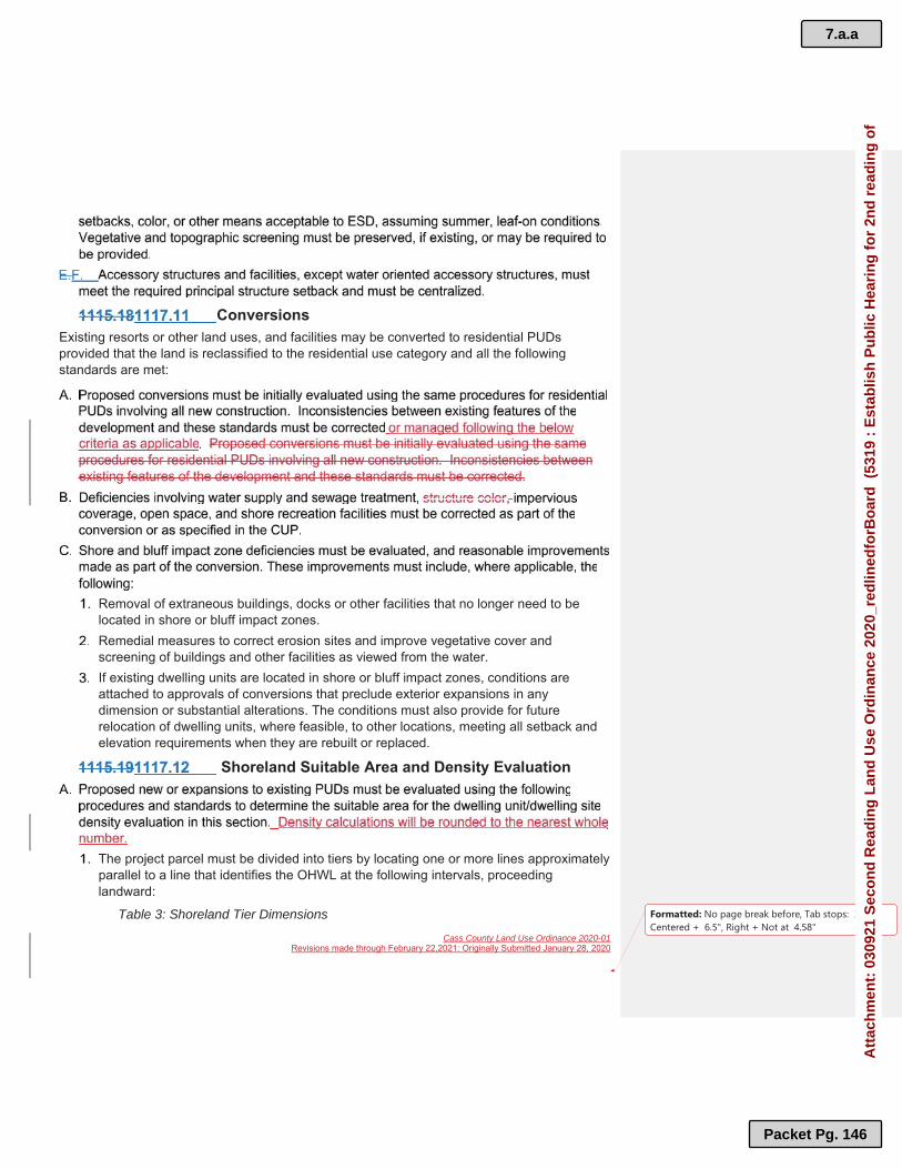
Cass County Land Use Ordinance 2020-01Revisions made through February 22,2021: Originally Submitted January 28, 2020
Formatted: No page break before, Tab stops: 3.25",Centered + 6.5", Right + Not at 4.58"
ConversionsExisting resorts or other land uses, and facilities may be converted to residential PUDsprovided that the land is reclassified to the residential use category and all the following standards are met:
Removal of extraneous buildings, docks or other facilities that no longer need to be located in shore or bluff impact zones.Remedial measures to correct erosion sites and improve vegetative cover and screening of buildings and other facilities as viewed from the water.If existing dwelling units are located in shore or bluff impact zones, conditions are attached to approvals of conversions that preclude exterior expansions in any dimension or substantial alterations. The conditions must also provide for future relocation of dwelling units, where feasible, to other locations, meeting all setback and elevation requirements when they are rebuilt or replaced.
Shoreland Suitable Area and Density Evaluation
The project parcel must be divided into tiers by locating one or more lines approximately parallel to a line that identifies the OHWL at the following intervals, proceeding landward:
Table 3: Shoreland Tier Dimensions
7.a.a
Packet Pg. 146
Att
ach
men
t: 0
3092
1 S
eco
nd
Rea
din
g L
and
Use
Ord
inan
ce 2
020_
red
lined
forB
oar
d (
5319
: E
stab
lish
Pu
blic
Hea
rin
g f
or
2nd
rea
din
g o
f

Cass County Land Use Ordinance 2020-01Revisions made through February 22,2021: Originally Submitted January 28, 2020
Formatted: No page break before, Tab stops: 3.25",Centered + 6.5", Right + Not at 4.58"
Public Water Class Unsewered Structures (ft)
Sewered Structures (ft)
General Development LakesFirst Tier 200 200Second and Additional Tiers 267 200
Recreational Development Lakes
267 267
Natural Environmental Lakes 400 320All River Classes 300 300
The suitable area within each tier is next calculated by excluding from the tier area all wetlands, bluffs or land below the OHWL of public waters. This suitable area and the proposed project are then subjected to either the residential or commercial PUD density evaluation steps to arrive at an allowable number of dwelling units or sites.
Residential PUD "base" density evaluation:The suitable area within each tier is divided by the single residential lot size standard for lakes or, for rivers, the single residential lot width standard times the tier depth, unless the local unit of government has specified an alternative minimum lot size for rivers that shall then be used to yield a base density of dwelling units or sites for each tier. Proposed locations and numbers of dwelling units or sites for the residential PUDs are then compared with the tier, density, and suitability analysesherein.
Commercial PUD "base" density evaluation:Determine the footprint of dwelling units or sites within each tier, including both existing and proposed units and sites. Computation of the footprint need not include decks, patios, stoops, steps, garages, unless they are habitable space.Select the appropriate floor area ratio from Table 4:
Table 4:Commercial Planned Unit DevelopmentPublic Water Class First Tier Second and Additional
TiersGeneral Development Lakes 0.120 0.090Recreational Development Lakes 0.080 0.065Natural Environmental Lakes 0.038 0.038All River Classes 0.038 0.038
Covered Surface Area. Multiply the area within each tier, excluding all public road rights-of way, easements, wetlands, bluffs, and land below the OHWL of public waters by the ratio in Table 4 above to yield the total land surface area that can be covered by structures in each tier. However, overall impervious surface limits cannot be exceeded.
Formatted Table
Formatted Table
7.a.a
Packet Pg. 147
Att
ach
men
t: 0
3092
1 S
eco
nd
Rea
din
g L
and
Use
Ord
inan
ce 2
020_
red
lined
forB
oar
d (
5319
: E
stab
lish
Pu
blic
Hea
rin
g f
or
2nd
rea
din
g o
f

Cass County Land Use Ordinance 2020-01Revisions made through February 22,2021: Originally Submitted January 28, 2020
Formatted: No page break before, Tab stops: 3.25",Centered + 6.5", Right + Not at 4.58"
Transfer of Density. Allowable densities may be transferred from any tier to any other tier further from the shoreline of the public waterway, but allowable densities cannot be transferred to tiers closer to the shoreline.Proposed locations and numbers of dwelling units or sites for the commercial PUDare then compared with the tier, density, and suitability analyses herein.
Density increase multipliers:DeDeDeDensnsnsnsitititityyyy inininincrcrcrcreaeaeaeasesesese mmmmulululultitititiplplplplieieieiersrsrsrs::::Increases to the dwelling unit or dwelling site base densities previously determined InInInIncrcrcrcreaeaeaeasesesesessss totototo tttthhhheeee dwdwdwdwelelelellilililingngngng uuuuninininitttt orororor ddddwewewewellllllllinininingggg sisisisitetetete bbbbasasasaseeee dedededensnsnsnsititititieieieiessss prprprprevevevevioioioioususususlylylyly ddddeteteteterererermimimimineneneneddddare allowable if the dimensional standards in Section 1125 of this Chapter are met or exceeded and the design criteria of this Chapter are satisfied. The allowable density increases in the table below will only be allowed if structure setbacks from the OHWL are increased to at least 50% greater than the minimum setback, or the impact on the water body is reduced an equivalent amount through vegetative management, topography, or additional means acceptable to the local unit of government and the setback is at least 25% greater than the minimum setback. Allowable dwelling unit or dwelling site density increases for residential or AlAlAlAllolololowawawawablblblbleeee dwdwdwdwelelelellilililingngngng uuuuninininitttt orororor ddddwewewewellllllllinininingggg sisisisitetetete ddddenenenensisisisitytytyty iiiincncncncrererereasasasaseseseses fffforororor rrrresesesesididididenenenentitititialalalal oooorrrrcommercial PUDs:
Table 5: Allowable Density IncreasesDensity Evaluation Tiers Maximum Density Increase
Within Each Tier (%)First 50Second 100Third 200Fourth 200Fifth 200
Non-Shoreland Suitable Area and Base Density The suitable area is calculated by excluding all wetlands, bluffs, public road rights-of-way, or easements. Density calculations will be rounded to the nearest whole number. The procedures for determining the "base" density of a PUD are as follows:
RECREATIONAL CAMPING AREAS AND RECREATIONAL CAMPING VEHICLE PARK CAMPGROUND
Permits Required
7.a.a
Packet Pg. 148
Att
ach
men
t: 0
3092
1 S
eco
nd
Rea
din
g L
and
Use
Ord
inan
ce 2
020_
red
lined
forB
oar
d (
5319
: E
stab
lish
Pu
blic
Hea
rin
g f
or
2nd
rea
din
g o
f

Cass County Land Use Ordinance 2020-01Revisions made through February 22,2021: Originally Submitted January 28, 2020
Formatted: No page break before, Tab stops: 3.25",Centered + 6.5", Right + Not at 4.58"
Density
Determine maximum allowable density per tier, then,Subtract the building footprint of all existing buildings in each tier, then,
Subtract 500 sf for each existing RV site, then,Subtract 500 200 sf for each existing transient or tent site to determine the
remaining allowable density.
MANUFACTURED HOUSING PARKSPermits Required
Manufactured housing parks within Cass County shall require a CUP. All applications for manufactured housing parks shall be processed as PUDs or CDs, except those located on licensed resorts, and shall must include the following:
Location and legal description of the site. All streets, streetlights, driveways, parking areas and sidewalks.
Lot locations, lot dimensions, and location and orientation of each manufactured housing and accessory structures on each lot.
7.a.a
Packet Pg. 149
Att
ach
men
t: 0
3092
1 S
eco
nd
Rea
din
g L
and
Use
Ord
inan
ce 2
020_
red
lined
forB
oar
d (
5319
: E
stab
lish
Pu
blic
Hea
rin
g f
or
2nd
rea
din
g o
f

Cass County Land Use Ordinance 2020-01Revisions made through February 22,2021: Originally Submitted January 28, 2020
Formatted: No page break before, Tab stops: 3.25",Centered + 6.5", Right + Not at 4.58"
Location of the community building, if one is provided, and all accessory buildings.Size, location, and species of existing and proposed vegetation. Storm water management and grading plans showing existing and proposed topography at 10-foot intervals.
Areas to be set aside for recreation and open space.A typical lot planplans. Elevation drawings of community building, a typical lot with a mobile housing situated on it, and of any pertinent features of the park.Any other information which the PC or ESD deem necessary to review the proposed application.
Statement of ownership.Provisions for the removal of trash and garbage.A maintenance plan for the common property of the park.A sample lot lease agreement.
Permitted UsesThe following uses are permitted within a manufactured housing park.
Design Standards, Numbers of Lots, and ImprovementsThe following shall be considered as minimum design standards and site improvements which shall be made in developing any manufactured housing park:
7.a.a
Packet Pg. 150
Att
ach
men
t: 0
3092
1 S
eco
nd
Rea
din
g L
and
Use
Ord
inan
ce 2
020_
red
lined
forB
oar
d (
5319
: E
stab
lish
Pu
blic
Hea
rin
g f
or
2nd
rea
din
g o
f

Cass County Land Use Ordinance 2020-01Revisions made through February 22,2021: Originally Submitted January 28, 2020
Formatted: No page break before, Tab stops: 3.25",Centered + 6.5", Right + Not at 4.58"
EARTHMOVING – LAND ALTERATIONSA shoreland or land alteration, land use permit shall not be required for earthmoving associated with site preparation for structures constructed in accordance with the provisions of a valid structure permit under this Ordinance.
General Non-Shoreland Zone StandardsA permit shall be required for all land alterations, restoration, or reclamation, except those done in conjunction with the operation of an active farm, including but not limited to the following:
Stormwater run-off and grading plans including cost estimates prepared by a registered engineer or stormwater design professional.MPCA Storm Water Permit if applicable.Financial assurance, Section 503.
General Shoreland Zone StandardsThe movement of earthen material within the shoreland zone shall require a shoreland alteration or CUP, depending on the scope of the project and the zoning district, and comply with the following standards:
7.a.a
Packet Pg. 151
Att
ach
men
t: 0
3092
1 S
eco
nd
Rea
din
g L
and
Use
Ord
inan
ce 2
020_
red
lined
forB
oar
d (
5319
: E
stab
lish
Pu
blic
Hea
rin
g f
or
2nd
rea
din
g o
f

Cass County Land Use Ordinance 2020-01Revisions made through February 22,2021: Originally Submitted January 28, 2020
Formatted: No page break before, Tab stops: 3.25",Centered + 6.5", Right + Not at 4.58"
Stormwater control and grading plans prepared by a registered engineer or storm water design professional, including cost estimates which may includeincludes but may not be limited to a designed-to-scale drawing, contours, cross sections, erosion control measures, and vegetative stabilization as determined by ESD and or the PC. MPCA Storm Water Permit if applicable.Financial assurance, Section 503.
Bluff Impact Zone Standards These standards apply to the bluff impact zone or slopes greater than 18%, within the setback of Public Waters:
Walkout basements are not allowed.Mechanized earth moving equipment shall not be used except as authorized by ESD.
Public and Private Roads and Parking Areas
Harbor Excavation
A plan, including cost estimates, prepared by a registered engineer including all erosion control measures and retaining structure design.Financial assurance equal to 150% of the engineer’s estimate of construction cost.A MN DNR Harbor Permit.A shoreline buffer plan as prescribed in Section 1124. Harbors shall not be allowed in bluff impact zones or wetlands.Harbors shall not extend landward of the OHWL greater than 200 feet.
7.a.a
Packet Pg. 152
Att
ach
men
t: 0
3092
1 S
eco
nd
Rea
din
g L
and
Use
Ord
inan
ce 2
020_
red
lined
forB
oar
d (
5319
: E
stab
lish
Pu
blic
Hea
rin
g f
or
2nd
rea
din
g o
f

Cass County Land Use Ordinance 2020-01Revisions made through February 22,2021: Originally Submitted January 28, 2020
Formatted: No page break before, Tab stops: 3.25",Centered + 6.5", Right + Not at 4.58"
A MN DNR Harbor Maintenance Permit. A site plan indicating where spoil material will be deposited.An erosion and sediment control plan for the harbor area and the soil deposition site.
Shoreland Alterations – Earthmoving All alterations within SIZ-1 and SIZ-2 (Table 9) require a land use permit for land and shoreland alterations. Alterations are restricted to a corridor (Shoreland Recreational UseArea (SRUA)) 8 feet in width in areas of bluff or steep slope, 20 feet in width for residential properties and 50 feet in width for water oriented commercial properties. One SRUA is allowed per property and must be contiguous. Shoreland alterations involving earthmoving activities are included below; structural components also require a permit and are located in Section 1129.
Table 5: Shore Impact Zones from OHWLWaterway Classification
Shore Impact Zone-1 (ft)
Shore Impact Zone-2 (ft)
GD Lake 0.0 to 37.5 to RD Lake 0.0 to 50.0 to NE Lake 0.0 to 75.0 to Remote 0.0 to 100.0 Forested and 0.0 to 75.0 to Urban and 0.0 to 50.0 to
Shore Impact Zone – 1 StandardsThese standards apply to earth movement in SIZ-1, Table 6:
20 feet wide at the OHWL on residential lots 50 feet wide at the OHWL on commercial lots.8 feet in width on all lots where there is a steep slope or bluff.
Beach sand blankets on residential lots above the OHWL shall not exceed 20 feet in width parallel to the shoreline and shall be incorporated in the shoreline alteration areas as described in Section 1120.6. The beach sand blanket shall not exceed 20 cubic yards of sand within the 20 feet area and requires a shoreland alteration permit.
Formatted Table
7.a.a
Packet Pg. 153
Att
ach
men
t: 0
3092
1 S
eco
nd
Rea
din
g L
and
Use
Ord
inan
ce 2
020_
red
lined
forB
oar
d (
5319
: E
stab
lish
Pu
blic
Hea
rin
g f
or
2nd
rea
din
g o
f

Cass County Land Use Ordinance 2020-01Revisions made through February 22,2021: Originally Submitted January 28, 2020
Formatted: No page break before, Tab stops: 3.25",Centered + 6.5", Right + Not at 4.58"
One addition of not more than 10 cubic yards of sand may be placed on existing beach areas on residential lots with a shoreland alteration permit.Beach sand blankets on WOC properties shall not exceed 50 feet in width and 50 cubic yards of volume.Berms of not less than 12 inches above grade level or diversions not less than 12inches below grade level shall be placed landward of all beach sand blankets to prevent erosion from upland runoff.All activity below the OHWL requires applicable MN DNR and US ACOE approval and permits.
There shall be no topsoil or vegetative matter deposited in the lake.Work shall be completed by November 1st after the damage takes place.An erosion, sediment control, and vegetation stabilization plan must be approved by ESD for the project area and implemented before any construction begins and shall be implemented immediately. All disturbed material shall be graded landward or removed from the site. Any activity below the OHWL requires applicable MN DNR and US ACOE approval and permits.
One alteration site is allowed per lot, or per group of contiguous nonconforming lots in under the same ownership.On residential lots the maximum bottom width shall be 20 feet at the top with 2:1 side slopes at each end.On WOC lots the maximum bottom width shall be 50 feet at the top with 2:1 side slopes at each end.Berms of not less than 12 inches above grade level or diversions not less than 12inches below grade level shall be placed landward of all beach sand blankets to prevent erosion from upland runoff. An erosion, sediment control, and vegetation stabilization plan must be approved by ESD for the project area and be implemented before any construction begins and shall be implemented immediately. All disturbed material shall be graded landward or removed from the site. Any activity below the OHWL requires applicable MN DNR and US ACOE approval and permits.
7.a.a
Packet Pg. 154
Att
ach
men
t: 0
3092
1 S
eco
nd
Rea
din
g L
and
Use
Ord
inan
ce 2
020_
red
lined
forB
oar
d (
5319
: E
stab
lish
Pu
blic
Hea
rin
g f
or
2nd
rea
din
g o
f

Cass County Land Use Ordinance 2020-01Revisions made through February 22,2021: Originally Submitted January 28, 2020
Formatted: No page break before, Tab stops: 3.25",Centered + 6.5", Right + Not at 4.58"
One alteration is allowed per lot, or per group of contiguous nonconforming lots in the same ownership.On residential lots the maximum bottom width shall be 20 feet. On WOC lots, the maximum bottom width shall be 50 feet.An erosion, sediment control, and vegetation stabilization plan must be approved by ESD for the project area and be implemented before any construction begins.All disturbed material shall be graded landward or removed from the site.Any alteration below the OHWL requires applicable MN DNR and US ACOE approval and permits.
Rip-rap will only be allowed in situations where active erosion problems exist. Any permit for rip-rap must contain a plan to establish a vegetative buffer with the depth to be determined by ESD for the entire width of the lot, except for lake or river access areas. Plans for such buffers shall be approved by ESD and shall be implemented immediately. The placement of natural rock rip-rap and retaining walls, where allowed, shall comply with MS 103G.245. Natural rock rip-rap shall only be used for the correction of an established erosion problem that cannot be controlled through the use of suitable vegetation, slope stabilization using natural mulch, biomat or similar bioengineering means. Slope stabilization methods must be approved by ESD.Rip-rap and retaining walls used for ornamental purposes or for terracing natural slopes are prohibited within Shore Impact Zone 1, Shore Impact Zone 2 and the bluff impact zone. (M.S. 103G.245 covers work in Public Waters).
Shoreland Impact Zone – 2 StandardsThese standards apply to earth movement in SIZ-2, Table 6:
Land/Shoreland Alteration Conditions The following conditions shall apply to all the permits and approvals under the jurisdiction of this Ordinance.
Formatted: Underline
7.a.a
Packet Pg. 155
Att
ach
men
t: 0
3092
1 S
eco
nd
Rea
din
g L
and
Use
Ord
inan
ce 2
020_
red
lined
forB
oar
d (
5319
: E
stab
lish
Pu
blic
Hea
rin
g f
or
2nd
rea
din
g o
f

Cass County Land Use Ordinance 2020-01Revisions made through February 22,2021: Originally Submitted January 28, 2020
Formatted: No page break before, Tab stops: 3.25",Centered + 6.5", Right + Not at 4.58"
VEGETATIVE ALTERATIONSAlterations of vegetation will be regulated to prevent erosion into Public Waters, fix nutrients, preserve shoreland aesthetics, preserve historic values, prevent bank slumping and protect fish and wildlife habitat. Removal or alteration of vegetation within the building setback area requires a land use permit for shoreland alterations except for the removal of dead, down or safety hazard trees.
Vegetative alterations are restricted to a corridor or SRUA to 8 feet in width in areas of bluff or steep slope, 20 feet in width for residential properties and 50 feet in width for water oriented commercial properties.
Bluff Impact Zones and Steep SlopesNo trees or shrubs shall be removed within a bluff impact zone or slopes greater than 18% except to accommodate the placement of stairways, landings, lifts or access paths. Clearing width shall not exceed eight feet. Mechanized equipment shall not be used in bluff impact zones or slopes greater than 18% except as authorized by ESD.
Shoreland Impact Zone – 1 A shoreland alteration permit or ESD approval is required to remove any vegetation in the SIZ.
Shoreland Impact Zone – 2
7.a.a
Packet Pg. 156
Att
ach
men
t: 0
3092
1 S
eco
nd
Rea
din
g L
and
Use
Ord
inan
ce 2
020_
red
lined
forB
oar
d (
5319
: E
stab
lish
Pu
blic
Hea
rin
g f
or
2nd
rea
din
g o
f

Cass County Land Use Ordinance 2020-01Revisions made through February 22,2021: Originally Submitted January 28, 2020
Formatted: No page break before, Tab stops: 3.25",Centered + 6.5", Right + Not at 4.58"
A shoreland alteration permit or ESD approval is required to remove any vegetation in the SIZ.
ConditionsAll vegetative alterations are subject to the following conditions.
WILDLIFE PONDS
A wildlife management plan developed by a professional or agency wildlife planner. A sketch of the proposed pond indicating location, dimensions, and depth. The number of cubic yards to be excavated. Where the excavated material will be placed and how it will be stabilized.
SHORELAND BUFFER STANDARDS
Implement erosion control and storm water management according to an approved plan. Restore, implement, and permanently maintain a shoreland buffer within SIZ- 1 as may be determined appropriate.Implement other mitigation practices.
7.a.a
Packet Pg. 157
Att
ach
men
t: 0
3092
1 S
eco
nd
Rea
din
g L
and
Use
Ord
inan
ce 2
020_
red
lined
forB
oar
d (
5319
: E
stab
lish
Pu
blic
Hea
rin
g f
or
2nd
rea
din
g o
f

Cass County Land Use Ordinance 2020-01Revisions made through February 22,2021: Originally Submitted January 28, 2020
Formatted: No page break before, Tab stops: 3.25",Centered + 6.5", Right + Not at 4.58"
STORMWATER MANAGEMENT STANDARDSGeneral Standards
Specific Standards
LOT STANDARDSLot Standards for Shoreland Classifications
The lot area, buildable area standards, and lot width standards for single family residential lots and for lake and river classifications shall be as specified in the tables below. Land below the OHWL of public waters, shall not be used to meet lot area and buildable area standards.
The total area of all impervious surfaces shall not exceed 25% percent of the lot for all lots in the shoreland zone. Paved and all other non-vegetated areas on a lot are considered impervious.
7.a.a
Packet Pg. 158
Att
ach
men
t: 0
3092
1 S
eco
nd
Rea
din
g L
and
Use
Ord
inan
ce 2
020_
red
lined
forB
oar
d (
5319
: E
stab
lish
Pu
blic
Hea
rin
g f
or
2nd
rea
din
g o
f

Cass County Land Use Ordinance 2020-01Revisions made through February 22,2021: Originally Submitted January 28, 2020
Formatted: No page break before, Tab stops: 3.25",Centered + 6.5", Right + Not at 4.58"
Table 6: Single Family Residential Lot Standards LakeClassification
MinimumLot Area (ft2)
MinimumLot Width (ft)
Minimum Buildable Area (ft2)*
GD – Riparian 37,500 100 12,000GD – Non-Riparian
50,000 150 20,000
RD – Riparian 50,000 150 16,000RD – Non-Riparian
50,000 150 20,000
NE – Riparian 100,000 200 40,000NE – Non-Riparian
100,000 200 40,000
River ClassificationForested –Riparian
75,000 200 18,000
Forested –Non-Riparian
150,000 200 24,000
Tributary –Riparian
50,000 150 18,000
Tributary –Non-Riparian
100,000 200 20,000
*A minimum of 50% of the buildable area shall be contiguous.
Any new WOC lot shall not contain less than four acres, and not be less than 300 feet wide at the OHWL and structure setback, and not contain less than three acres buildable area. If it is determined by the County Board and the PC a property be approved for reclassification to WOC with the intent of the applicant to operate a resort or other business, a variance from minimum lot standards shall not be required provided a proper Reclassification and Conditional Use Process is followed.
Lot Standards for Non-Shoreland ClassificationsTable 7: Non-Shoreland Lot StandardsZoning Classification
Min. Lot Area (acres)
Min. Lot Width (ft)
Max. LotImpervious Coverage (%)
Rural Residential –1
1.0 150 40
Rural Residential –2.5
2.5 200 25
Rural Residential –5
5.0 300 20
Rural Residential –10
10.0 300 15
Formatted Table
Formatted Table
7.a.a
Packet Pg. 159
Att
ach
men
t: 0
3092
1 S
eco
nd
Rea
din
g L
and
Use
Ord
inan
ce 2
020_
red
lined
forB
oar
d (
5319
: E
stab
lish
Pu
blic
Hea
rin
g f
or
2nd
rea
din
g o
f

Cass County Land Use Ordinance 2020-01Revisions made through February 22,2021: Originally Submitted January 28, 2020
Formatted: No page break before, Tab stops: 3.25",Centered + 6.5", Right + Not at 4.58"
Rural Residential –20
20.0 300 105
Agricultural/Forested 40.0 300 5Commercial 1 and 2 2.5 300 60
Water Access Lots and Access EasementsTo manage water surface crowding, to reduce fish and wildlife disturbance, to prevent pollution of surface water by suspension of sediment, to maintain property values, and to maintain natural characteristics of shoreline, shoreland controls must regulate access to public waters.
All alternative lake access lots shall be governed by a covenant recorded on the title of every lot or parcel of land allowed to use the access lot. These access lots shall also comply with all of the dimensional standards in Section 1125.1 of this Ordinance. Where more than six lots are served, the width and area of the alternative lake access lot shall be increased 25% for each additional lot in excess of six served not to exceed 50 feet in total width or 8 feet in areas of steep slope or bluff. Alternative lake access lots must be jointly owned by all of those purchasers of riparian lots having rights of usage of the access lot.
Alternative lake access lots shall be suitable in its natural state for the intendedactivities. All facilities shall must be centralized and located in areas suitable for them. Evaluation of suitability shall will include consideration of land slope, lake or river water depth, aquatic and shoreland vegetation, the presence of important fish and wildlife habitat, soils, depth to groundwater, or other relevant factors.Permitted activities may include watercraft launching, loading, beaching, mooring, or docking area, but shall not include residential or commercial uses. A single dock andboat launching ramp may be permitted and no owner shall own or use an individual dock. Boating facilities must be located adjacent to the deepest water available. Continuous boat mooring shall be limited to one watercraft per lot served, and that space shall not be allowed to be rented out. These access lots may include other outdoor recreational activities that do not conflict with general Public use of the Public water or the enjoyment of normal property rights by adjacent property owners. Examples of such activities include but may not be limited to swimming, sunbathing, or picnicking. Covenants governing alternative lake access lots shall limit the total number of vehicles allowed to be parked and must require centralization of all common facilities and activities in the most suitable locations on the lot to minimize topographic and vegetation alterations. All parking areas, storage buildings, and other facilities shall be
7.a.a
Packet Pg. 160
Att
ach
men
t: 0
3092
1 S
eco
nd
Rea
din
g L
and
Use
Ord
inan
ce 2
020_
red
lined
forB
oar
d (
5319
: E
stab
lish
Pu
blic
Hea
rin
g f
or
2nd
rea
din
g o
f

Cass County Land Use Ordinance 2020-01Revisions made through February 22,2021: Originally Submitted January 28, 2020
Formatted: No page break before, Tab stops: 3.25",Centered + 6.5", Right + Not at 4.58"
screened by vegetation or topography as much as practical from view from the public water, assuming summer, leaf-on conditions.Alternative lake access lots shall meet or exceed the shoreline buffer standards in Section 1123 and the vegetative alteration standards in Section 1121 and have a vegetation management plan approved by ESD.The impervious surface coverage for alternative lake access lots must not exceed 12% of lot area, and storm water management must meet the standards in Section 1124.
NON-CONFORMITIESIt is the purpose of this section to provide for the regulation of nonconforming lots, uses, structures and noncompliant SSTS. It is necessary to satisfying the purposes and intent of this Ordinance that nonconforming lots, uses, structures and noncompliant SSTS not be permitted to continue without restriction.
Non-Conforming UsesA use which was permitted or allowed before the passage or amendment of these standards,but which does not conform to the provisions of this Ordinance may be continued. The non-conforming use will be managed according to applicable state statutes and other regulations ofthe County for alterations, expansions discontinuance of use for one year or intensification of use.
Non-Conforming Structures
PC may require an inspection by a licensed building inspector to verify the structural integrity of the nonconforming structure before granting a variance to expand.In the shoreland zone, shoreland buffers as prescribed in Section 1123 shall be implemented and permanently maintained.
7.a.a
Packet Pg. 161
Att
ach
men
t: 0
3092
1 S
eco
nd
Rea
din
g L
and
Use
Ord
inan
ce 2
020_
red
lined
forB
oar
d (
5319
: E
stab
lish
Pu
blic
Hea
rin
g f
or
2nd
rea
din
g o
f

Cass County Land Use Ordinance 2020-01Revisions made through February 22,2021: Originally Submitted January 28, 2020
Formatted: No page break before, Tab stops: 3.25",Centered + 6.5", Right + Not at 4.58"
No expansions of non-conforming Accessory Dwelling Units are allowed.
Construction on Non-Conforming Lots
An individual lot that was of record in the office of the County Recorder before 1972 in shoreland areas that does not meet the requirements of Section 1125.1 may be allowed as a residential building sites without a variance from total lot area, buildable lot area, and lot width requirements provided that the following criteria are met:
All setbacks as prescribed in Section 1129.1 of this Ordinance can be met.A site for a Type I SSTS is identified pursuant to the Cass County SSTS Ordinance.
Development on a lot which does not meet the criteria in Section 1126.2.A requires application for a variance. In evaluating the variance, the PC may require shoreline buffers as prescribed in Section 1123 of this Ordinance. An SSTS site evaluation prepared by a state licensed SSTS evaluator/designer must be submitted with the variance application. The PC shall deny the variance if adequate SSTS facilities cannot be provided.The sale or development of groups of two or more contiguous lots under the same ownership in the shoreland zone shall be governed by MS § 394.36.
An individual lot that became of record in the office of the County Recorder after 1971 in the shoreland area that does not meet the requirements of Section 1125 and does not currently have residential structures may be allowed as a residential building site without variances from total lot area, buildable lot area, and lot width requirements provided the following criteria are met:
The lot was created compliant with official controls in effect at that time it was created.All setbacks as prescribed in Section 1129.1 of this Ordinance can be met.A site for a Type I SSTS is identified pursuant the Cass County SSTS Ordinance.
Development on a lot which does not meet the criteria in Section 1126.2.A above requires application for a variance. In evaluating the variance, the PC may require shoreline buffers as prescribed in Section 1123 of this Ordinance. An SSTS site evaluation prepared by a state licensed SSTS evaluator/designer must be submitted with the variance application. The PC shall deny the variance if adequate SSTS facilities cannot be provided.The sale or development of groups of two or more contiguous lots under the same ownership in the shoreland zone shall be governed by current M.S. § 394.36.
Those lots of record that do not meet the present lot size requirements because of a lake or river classification change approved by the MN DNR may be allowed as
7.a.a
Packet Pg. 162
Att
ach
men
t: 0
3092
1 S
eco
nd
Rea
din
g L
and
Use
Ord
inan
ce 2
020_
red
lined
forB
oar
d (
5319
: E
stab
lish
Pu
blic
Hea
rin
g f
or
2nd
rea
din
g o
f

Cass County Land Use Ordinance 2020-01Revisions made through February 22,2021: Originally Submitted January 28, 2020
Formatted: No page break before, Tab stops: 3.25",Centered + 6.5", Right + Not at 4.58"
separate lots exempt from Section 1126.2.B provided, they were each created after 1971.
Lots in the shoreland zone that became of record in the office of the County Recorder after 1998 shall meet all lot area requirements in this Ordinance, except existing riparian lots on GD lakes that were of record prior to December 1, 2002 and met the 20,000 sftotal lot size and 8,000 sf buildable area standards effective before that date.
RESIDENTIAL LOTS, SINGLE FAMILYUnless otherwise designated, all residential lots shall be considered single family residential lots.
RESIDENTIAL LOTS, MULTIPLE FAMILY New Residential Multi-Family Structures
Family CampgroundsA family campground shall require an IUP or a CUP, must be owned and managed for private use at ESDs discretion and meet the following standards:
Family Compounds
7.a.a
Packet Pg. 163
Att
ach
men
t: 0
3092
1 S
eco
nd
Rea
din
g L
and
Use
Ord
inan
ce 2
020_
red
lined
forB
oar
d (
5319
: E
stab
lish
Pu
blic
Hea
rin
g f
or
2nd
rea
din
g o
f
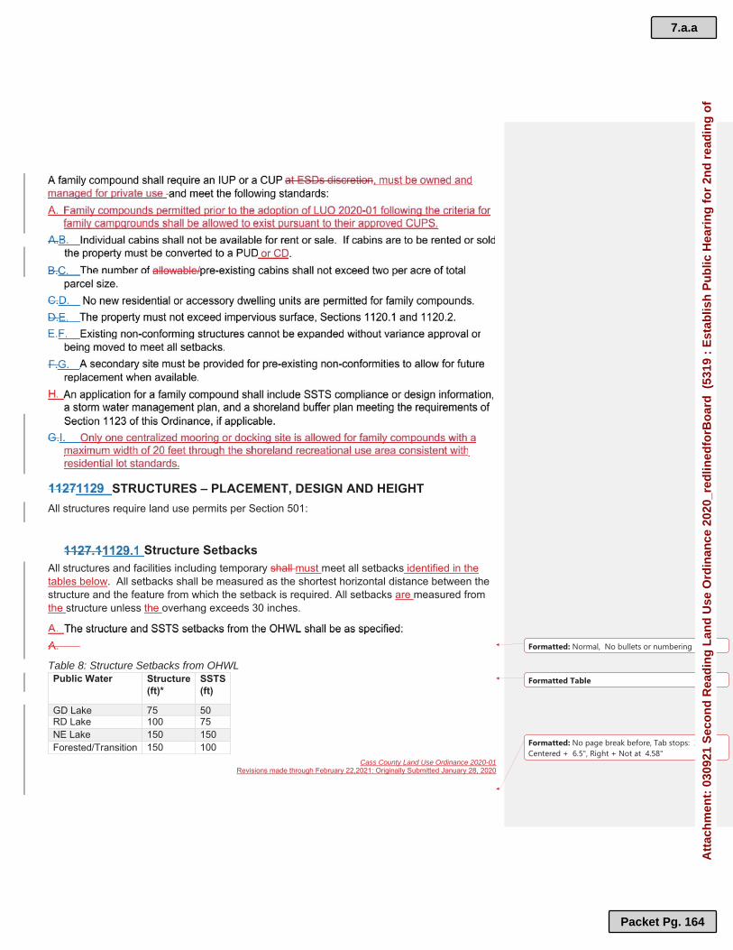
Cass County Land Use Ordinance 2020-01Revisions made through February 22,2021: Originally Submitted January 28, 2020
Formatted: No page break before, Tab stops: 3.25",Centered + 6.5", Right + Not at 4.58"
STRUCTURES – PLACEMENT, DESIGN AND HEIGHTAll structures require land use permits per Section 501:
Structure SetbacksAll structures and facilities including temporary shall must meet all setbacks identified in the tables below. All setbacks shall be measured as the shortest horizontal distance between the structure and the feature from which the setback is required. All setbacks are measured from the structure unless the overhang exceeds 30 inches.
Table 8: Structure Setbacks from OHWLPublic Water Structure
(ft)*SSTS (ft)
GD Lake 75 50RD Lake 100 75NE Lake 150 150Forested/Transition 150 100
Formatted: Normal, No bullets or numbering
Formatted Table
7.a.a
Packet Pg. 164
Att
ach
men
t: 0
3092
1 S
eco
nd
Rea
din
g L
and
Use
Ord
inan
ce 2
020_
red
lined
forB
oar
d (
5319
: E
stab
lish
Pu
blic
Hea
rin
g f
or
2nd
rea
din
g o
f

Cass County Land Use Ordinance 2020-01Revisions made through February 22,2021: Originally Submitted January 28, 2020
Formatted: No page break before, Tab stops: 3.25",Centered + 6.5", Right + Not at 4.58"
Urban/Tributary 100 75*Some structures may be permitted
i hi h b k
Table 9: Additional Property SetbacksFeature Setback (ft)Top of Bluff 30Significant Cultural or Historic Site 50County State or Federal Road ROW* 20Township and Public Road ROW* 20Road, Trail and Utility Easement 10Property Line 10SSTS Tank to Inhabited Structure 10SSTS Treatment Area to Inhabited Structure 20MN DNR Permitted Harbor 50% of the Public Water Setback.*Where a ROW has not been identified, the setback shall be measured from the edge of the maintenance area as identified by the road authority.
Height of StructureThe maximum height of a primary residential structure shall not exceed 30 feet from grade to peak unless otherwise noted in the performance standards. Walkout basements, as identified in Appendix BA and defined in the Environmental Definitions Ordinance are not included in the total height of the structure.
Flood PreventionThe elevation at which the lowest floor, including basement, is placed shall be determined as follows:
Stairways, Lifts and Landings – Lake AccessStairways and lifts are the preferred alternative to major topographic alterations for achieving access up and down bluffs and steep slopes to shore areas. Landings in this section only apply to those needed for access up and down bluffs and areas of steep slopes. Stairways, lifts and landings shall meet the following design requirements:
Formatted Table
7.a.a
Packet Pg. 165
Att
ach
men
t: 0
3092
1 S
eco
nd
Rea
din
g L
and
Use
Ord
inan
ce 2
020_
red
lined
forB
oar
d (
5319
: E
stab
lish
Pu
blic
Hea
rin
g f
or
2nd
rea
din
g o
f

Cass County Land Use Ordinance 2020-01Revisions made through February 22,2021: Originally Submitted January 28, 2020
Formatted: No page break before, Tab stops: 3.25",Centered + 6.5", Right + Not at 4.58"
Landings and Stairways – Structuresgg yyThis section provides guidance for landings and stairways associated with access into structures, both commercial and residential.
Legally non-conforming cabins or units in resorts must have one cabin or unit that gggg yyyy ggggprovides for handicap access. Landings exceeding what is allowable must acquire appropriate permits.ggg ggg qqq pppppp ppp ppp
Platform/Patio Platforms and patios may be placed within the structure setback and require a shoreland alteration, land use permit and shall comply with the following standards. Canopies, roofs,pergolas or other forms of enclosures are not permitted. Please refer to commercial accessory structures, Section 1130.2, to determine criteria for platforms on water oriented commercial properties.
7.a.a
Packet Pg. 166
Att
ach
men
t: 0
3092
1 S
eco
nd
Rea
din
g L
and
Use
Ord
inan
ce 2
020_
red
lined
forB
oar
d (
5319
: E
stab
lish
Pu
blic
Hea
rin
g f
or
2nd
rea
din
g o
f

Cass County Land Use Ordinance 2020-01Revisions made through February 22,2021: Originally Submitted January 28, 2020
Formatted: No page break before, Tab stops: 3.25",Centered + 6.5", Right + Not at 4.58"
Free standing. No railings.Not more than 150 sf.Not be more than one foot below or above ground level.Setback 10 feet from the OHWL.No more than one platform within the setback area.
The patio encroachment toward the OHWL does not exceed 15% of the existing structure setback.The patio does not encroach closer than 40 feet from the OHWL.The patio or portion of the patio adjacent to a residential structure located within the building setback shall not exceed 400 sf. The patio or portion of the patio adjacent to a resort cabin located within the building setback shall not exceed 200 sf.
Decks
The deck encroachment toward the OHWL does not exceed 16 feet or 15% of the existing structure setback, whichever is less. The deck does not encroach closer than 40 feet from the OHWL.The deck is not roofed, screened, or enclosed.The total size of the nonconforming portion of a deck adjacent to a residential structure shall not exceed 400 sf. The total size of the nonconforming portion of a deck adjacent to a resort cabin shall not exceed 200 sf.
Retaining Walls
ESD determines that there is no other alternative to control erosion.No tier of a retaining wall shall exceed four feet in height without a plan signed by a registered professional engineer.
7.a.a
Packet Pg. 167
Att
ach
men
t: 0
3092
1 S
eco
nd
Rea
din
g L
and
Use
Ord
inan
ce 2
020_
red
lined
forB
oar
d (
5319
: E
stab
lish
Pu
blic
Hea
rin
g f
or
2nd
rea
din
g o
f

Cass County Land Use Ordinance 2020-01Revisions made through February 22,2021: Originally Submitted January 28, 2020
Formatted: No page break before, Tab stops: 3.25",Centered + 6.5", Right + Not at 4.58"
No tier of the retaining wall shall exceed 20 feet in width, without approval of ESD and if necessary, the PC.A design plan, showing elevations, storm water drainage patterns, soil erosion factors, and critical area seeding recommendation is submitted. One tier of retaining wall may by permitted adjacent to a lake or river to retain a slope other than a bluff to create area within the shoreland alteration area for dock storage or other recreational purposes. Erosion control measures shall be employed.
Fences
A four-inch right-of-way setback is required for road easements or rights-of-way. All fences need to be entirely located on the property.Height shall not exceed eight feet.No fence shall be constructed so as to obstruct the view for drivers exiting a driveway or otherwise present a safety hazard.Construction design plans shall must be included with the permit application. Both sides of the fence shall be of similar earth-tone finish.
Docks
Boardwalks and Walkways
Shall not exceed six feet in width on residential properties or eight feet for commercial properties.May be placed on temporary or permanent supports.May be constructed of wood or metal.May have railings attached.Shall meet property line/sideyard setbacks.
7.a.a
Packet Pg. 168
Att
ach
men
t: 0
3092
1 S
eco
nd
Rea
din
g L
and
Use
Ord
inan
ce 2
020_
red
lined
forB
oar
d (
5319
: E
stab
lish
Pu
blic
Hea
rin
g f
or
2nd
rea
din
g o
f

Cass County Land Use Ordinance 2020-01Revisions made through February 22,2021: Originally Submitted January 28, 2020
Formatted: No page break before, Tab stops: 3.25",Centered + 6.5", Right + Not at 4.58"
The height of the proposed boardwalk above the wetland area shall be determined by ESD as a condition of the approved permit.Shall not have a canopy, roof or be enclosed.
Shall not exceed four feet in width.Shall be constructed of pervious materials. Shall meet property line setbacks.Shall be located within the shoreland alteration area.Shall not have a canopy, roof or be enclosed.
Watercraft Access RampsAll watercraft access ramps including associated approach roads, and access related parking areas require an IUP or a CUP:
Swimming PoolsA private swimming pool with a filtration system in the ground or prefabricated installation above the ground located within the shoreland zone shall require a shoreland alteration permit and shall meet all setback requirements in Section 1129.1. Water discharged from swimming pools cannot be discharged to wetlands, public waters or other hydrologic features.
ACCESSORY STRUCTURES Residential Accessory Structures
Residential accessory structures shall comply with the following standards:
7.a.a
Packet Pg. 169
Att
ach
men
t: 0
3092
1 S
eco
nd
Rea
din
g L
and
Use
Ord
inan
ce 2
020_
red
lined
forB
oar
d (
5319
: E
stab
lish
Pu
blic
Hea
rin
g f
or
2nd
rea
din
g o
f

Cass County Land Use Ordinance 2020-01Revisions made through February 22,2021: Originally Submitted January 28, 2020
Formatted: No page break before, Tab stops: 3.25",Centered + 6.5", Right + Not at 4.58"
The storage structure must not exceed 10 3 feet in height as measured from the foundation to the peak of the roof and cannot occupy an area greater than 48 15 sf of total area. The setback of the structure from the OHWL must be at least 20 10 feet.The storage structure must be earth tone in color and screened with vegetation to reduce visibility as viewed from public waters and adjacent shorelines.The accessory structure must meet all other setbacks and be situated within the SRUA. The roof of the structure cannot be used as a deck or storage area.The structure cannot be designed or used for human habitation and must not contain a water supply or sewage treatment facilities.Where grading or filling or excavation is necessary for construction, a shoreland alteration permit shall be required and there shall be no excavation waterward of the building line. Any structure or facility not meeting the above criteria, or any additional accessory structures or facilities must meet or exceed structure setback standards, Section 1129.1.
Water Oriented Commercial Accessory StructuresWOC accessory structures. WOC property may have one water oriented accessory structure not meeting the normal structure setbacks in Section 1129 of this Ordinance, ifOrdinance if this water oriented accessory structure complies with the following provisions. Examples of such structures and facilities include but are not limited to boathouses, gazebos, screen houses, fish houses, pump houses, and detached decks and platforms.
The structure shall not exceed 10 feet in height, including a minimum 4:12 pitch roof, and cannot occupy an area greater than 250 sf. The minimum setback of the structure or facility from the OHWL shall be 20 feet or 10feet from a DNR permitted harbor.
7.a.a
Packet Pg. 170
Att
ach
men
t: 0
3092
1 S
eco
nd
Rea
din
g L
and
Use
Ord
inan
ce 2
020_
red
lined
forB
oar
d (
5319
: E
stab
lish
Pu
blic
Hea
rin
g f
or
2nd
rea
din
g o
f

Cass County Land Use Ordinance 2020-01Revisions made through February 22,2021: Originally Submitted January 28, 2020
Formatted: No page break before, Tab stops: 3.25",Centered + 6.5", Right + Not at 4.58"
The structure or facility is treated to reduce visibility as viewed from Public Waters and adjacent shoreland by vegetation, topography, increased setbacks, or color assuming summer, leaf-on conditions.The structure shall not be used for human habitation.The structure shall not be located within a bluff impact zone.
There is no increase in size or aerial coverage.The structure does not exceed 10 feet in height, including a minimum 4:12 pitch roof.The structure is treated to reduce visibility as viewed from Public Waters and adjacent shoreland by vegetation, topography, or color assuming summer leaf-on conditions.The structure shall not be used for human habitation.
ACCESSORY DWELLING UNIT STANDARDS Shoreland Zone
Non-Shoreland Zone
7.a.a
Packet Pg. 171
Att
ach
men
t: 0
3092
1 S
eco
nd
Rea
din
g L
and
Use
Ord
inan
ce 2
020_
red
lined
forB
oar
d (
5319
: E
stab
lish
Pu
blic
Hea
rin
g f
or
2nd
rea
din
g o
f

Cass County Land Use Ordinance 2020-01Revisions made through February 22,2021: Originally Submitted January 28, 2020
Formatted: No page break before, Tab stops: 3.25",Centered + 6.5", Right + Not at 4.58"
The following standards apply to all accessory dwelling units in the Non-Shoreland Zone:
SHORELAND CLASSIFICATION SYSTEMBodies of water created by private users, (for a designated private use authorized by the Commissioner of Natural Resources) shall be considered Public Waters and are not exempt from the provision of this section. The official determination of the size and physical limits of drainage areas of rivers and streams shall be made by the Commissioner of Natural Resources. The official size of lakes, ponds or flowages shall be areas listed in the Division of Waters, Soils and Minerals, Bulletin No. 25, An Inventory of Minnesota Lakes, or in the event of that lakes, ponds or flowages are not listed therein, official determination of size and physical limits shall be made by the Commissioner of Natural Resources in cooperation with ESD. A list of public waters and their classifications in included as Appendix D.
Size and shape.Amount and type of existing development.Road and service center accessibility.Existing natural characteristics of the waters and shoreland.State, Regional, and local plans and management programs.Existing land use restrictions; and,Presence of significant historic sites.
AMENDMENTS TO LAKE OR STREAM CLASSIFICATION
7.a.a
Packet Pg. 172
Att
ach
men
t: 0
3092
1 S
eco
nd
Rea
din
g L
and
Use
Ord
inan
ce 2
020_
red
lined
forB
oar
d (
5319
: E
stab
lish
Pu
blic
Hea
rin
g f
or
2nd
rea
din
g o
f

Cass County Land Use Ordinance 2020-01Revisions made through February 22,2021: Originally Submitted January 28, 2020
Formatted: No page break before, Tab stops: 3.25",Centered + 6.5", Right + Not at 4.58"
ADOPTIONBE IT ORDERED THAT:
ORDINANCE #2020-01 IS HEREBY ADOPTED BY THE CASS COUNTY BOARD OF COMMISSIONERS ON THIS ___ DAY OF _____ 20210.
_________________________________________Chairman, Cass County Board of Commissioners
ATTEST:
_________________________________________Cass County Administrator
7.a.a
Packet Pg. 173
Att
ach
men
t: 0
3092
1 S
eco
nd
Rea
din
g L
and
Use
Ord
inan
ce 2
020_
red
lined
forB
oar
d (
5319
: E
stab
lish
Pu
blic
Hea
rin
g f
or
2nd
rea
din
g o
f

Cass County Land Use Ordinance 2020-01Revisions made through February 22,2021: Originally Submitted January 28, 2020
Formatted: No page break before, Tab stops: 3.25",Centered + 6.5", Right + Not at 4.58"
Appendix A Conservation Design Development
Conservation Development Standards
Conservation development standards are intended to provide a relationship between buildings, and between buildings and sites, that cannot be accomplished by the one building-one lot application of the land use provisions of this Ordinance. In order to encourage well designed building groups, this section provides for the development of more than one structure upon a single lot or tract as well as the integral development of one or more lots as a single tract.
Conservation Development Design Process, Criteria and Density Evaluation
Step One: Identifying conservation areas: pp yy ggFirst, primary conservation areas such as wetlands, bluff impact zones, and ,, ppp yyyy ,, ppp ,,structure setback areas and secondary conservation areas including unprotected elements of the natural landscape such as steep slopes, mature woodlands, prime farmland, meadows, wildlife habitats and cultural features such as historic and archeological sites and scenic views shall be identified and delineated. Second, the developable area shall be identified and shall consist of land completely ,,, pppp pppp yyyyoutside primary conservation areas, and, to the maximum extent feasible, outside secondary conservation areas.
Step Two: Calculate the number of dwelling unit lots allowable under the density section ppp ggg yyyand locate the approximate sites of individual houses within the developable area. Include the delineation of private yards and shared amenities so as to reflect an integrated community, with emphasis on consistency with the County’s Comprehensive Plan. Step Three: Aligning the streets and trails. Align streets in order to access the dwelling ppp ggg ggg ggg gggunit lots. Additionally, new trails should be laid out to create internal and external connections to existing and/or potential future streets, sidewalks, and trails.Step Four: Draw in the lot lines.pppppStep Five: Identify on a design plan map all parts of the project parcel to be permanently pppp yyyy gggg pppp pppp pppp pppp jjjj pppp pppp yyyyprotected as part of the open space.
At least 50% of the total project area shall be permanently preserved as common open ppp jjjj ppp yyyy ppp pppspace. Common open space shall include structure setbacks and bluff impact zones, areas with physical characteristics unsuitable for development in their natural state, and areas containing significant historic sites or unplatted cemeteries. No more than 25% of the required open space may consist of wetlands for developments in the shoreland zone not abutting public waters.
Formatted: Font: Bold
Formatted: Font: 12 pt
Formatted: Heading 2, Numbered + Level: 1 +Numbering Style: A, B, C, … + Start at: 1 + Alignment:Left + Aligned at: 0" + Indent at: 0.25"
Formatted: Heading 3, Numbered + Level: 1 +Numbering Style: 1, 2, 3, … + Start at: 1 + Alignment:Left + Aligned at: 0.25" + Indent at: 0.5"
Formatted: Heading 4, Indent: Left: 0.5", Numbered +Level: 1 + Numbering Style: a, b, c, … + Start at: 1 +Alignment: Left + Aligned at: 0.56" + Indent at: 0.81"
Formatted: Heading 4
Formatted: Heading 3
Formatted: Heading 3, Numbered + Level: 1 +Numbering Style: 1, 2, 3, … + Start at: 1 + Alignment:Left + Aligned at: 0.25" + Indent at: 0.5"
7.a.a
Packet Pg. 174
Att
ach
men
t: 0
3092
1 S
eco
nd
Rea
din
g L
and
Use
Ord
inan
ce 2
020_
red
lined
forB
oar
d (
5319
: E
stab
lish
Pu
blic
Hea
rin
g f
or
2nd
rea
din
g o
f

Cass County Land Use Ordinance 2020-01Revisions made through February 22,2021: Originally Submitted January 28, 2020
Formatted: No page break before, Tab stops: 3.25",Centered + 6.5", Right + Not at 4.58"
To the maximum reasonable extent all open space shall be part of a larger pppp pppp pppp ggggcontinuous and integrated open space system within the parcel being developed. Areas shall be considered contiguous if they are within 100 feet of each other and there are no impediments to access between the areas.Natural features included in open space shall generally be maintained in their ppp ppp ggg yyynatural condition, but may be managed to improve their appearance, or restore their overall condition and natural processes, as recommended by natural resource professionals and in compliance with the long-term management plan approved by the County. Permitted management activities may include: (1) Woodland management.
(2) Reforestation.
(3) Meadow management.
(4) Wetlands management.
(5) Water body bank protection.
(6) Buffer area landscaping.
(7) Wildlife management
(8) Recreation management
The common open space shall maximize common boundaries with existing or future pppp pppp ggggopen space on adjacent lands.Common open space shall properly serve and enhance all dwelling unit lots, cluster ppp ppp ppp ppp yyy ggg ,,groups, and other common facilities.
Dwelling unit lots areas designated as common elements, all road rights-of-way, and all gggg gggg ,,, gggg y,y,y,yland covered by impervious surfaces, shall not be included in the computation of common open space.Dwelling unit lots may be clustered into one or more groups located on suitable areas of ggg yyy ggg pppthe development and must meet all external property line, road, and structure setbacks.The average dwelling unit lot size shall not exceed 30,000 square feet.gggg gggg ,, qqqqDwelling unit lot impervious surface coverage shall not exceed 25%, except as ggg ppp ggg ,,, pppapproved by the Planning Commission. There shall be at least one access corridor to the structure setback as approved by the pppppp yyyPlanning Commission. The corridor shall:
Be accessible to all residents of the conservation development.ppppHave a minimum width of 50 (fifty) feet.(((( y)y)y)y)Provide upland access to the structure setback area without impacting wetlands.pppp pppp ggggHave a trail and vegetation management plan addressed in the long-term gggg gggg pppp ggggmanagement plan.
Formatted: Heading 4, Numbered + Level: 1 +Numbering Style: a, b, c, … + Start at: 1 + Alignment:Left + Aligned at: 0.56" + Indent at: 0.81"
Formatted: Indent: Left: 0.81"
Formatted: Heading 4
Formatted: Heading 3
Formatted: Heading 4, Indent: Left: 0.5", Numbered +Level: 1 + Numbering Style: a, b, c, … + Start at: 1 +Alignment: Left + Aligned at: 0.56" + Indent at: 0.81"
Formatted: Heading 4
7.a.a
Packet Pg. 175
Att
ach
men
t: 0
3092
1 S
eco
nd
Rea
din
g L
and
Use
Ord
inan
ce 2
020_
red
lined
forB
oar
d (
5319
: E
stab
lish
Pu
blic
Hea
rin
g f
or
2nd
rea
din
g o
f

Cass County Land Use Ordinance 2020-01Revisions made through February 22,2021: Originally Submitted January 28, 2020
Formatted: No page break before, Tab stops: 3.25",Centered + 6.5", Right + Not at 4.58"
New developments and redevelopments of existing developments shall meet vegetation pp pp gg pp ggmanagement standards in Sections 1123 and 1128 of this Ordinance.No impervious surfaces shall be allowed within the SIZ, except, stairways, lifts or ppp ,, ppp ,, yyy ,,landings. Those portions of boat launching ramps greater than ten (10) feet landward from the OHWL shall be constructed of pervious materials.Roads within and serving conservation developments shall be constructed according to gggg pppp ggggAmerican Society of Civil Engineers (ASCE) standards (Residential Streets, 2001, 3rd edition or later), (ASCE) and the development plan approved by the Planning Commission, and the local road authority, if applicable.The boundaries of the permanent conservation easement area and the common open pppp ppppspace shall be clearly and visibly marked.
Conservation Development Density Evaluation
The project parcel must be divided into two tiers:pp jj ppThe first tier shall consist of all areas within the following distances landward from ggggthe OHWL of public waters:
Lake or River Class First Tier Landward (ft)General Development 200Recreational Development 267Natural Environment 400Resource Protection Districts 400All River Classes 300
The second tier shall consist of all remaining area in the project parcel.gg pp jj ppThe number of dwelling unit lots allowable in each tier is calculated by dividing the gggg yyyy ggggsuitable area in square feet within each tier by the density factor for the shoreland class from the following table:
Density Factors
**--Use of launch ramp prohibited density factors means that
Possible Launch Ramp Launch Ramp Prohibited**LakeClass
First Tier
Second Tier
Lake Class
First Tier
Second Tier
GD 25,500 40,000 GD 22,500 34,000RD 34,000 40,000 RD 30,000 34,000NE & RP 68,000 80,000 NE & RP 60,000 60,000River Class
River Class
Remote 85,000 200,000 Remote 75,000 170,000Forested 51,000 120,000 Forested 45,000 102,000Transition 68,000 160,000 Transition 60,000 136,000Tributary 34,000 80,000 Tributary 30,000 68,000
Formatted: Heading 3
Formatted: Font: Bold
Formatted: Centered
Formatted: Heading 2, Numbered + Level: 1 +Numbering Style: A, B, C, … + Start at: 1 + Alignment:Left + Aligned at: 0" + Indent at: 0.25"
Formatted: Heading 3, Numbered + Level: 1 +Numbering Style: 1, 2, 3, … + Start at: 1 + Alignment:Left + Aligned at: 0.25" + Indent at: 0.5"
Formatted: Font: 11 pt, Not Small caps
Formatted Table
Formatted: Font: 11 pt
Formatted: Font: 11 pt
Formatted: Font: 11 pt
Formatted: Font: 11 pt
Formatted: Font: 11 pt
Formatted: Font: 11 pt
Formatted: Heading 4
Formatted: Font: 11 pt
Formatted: Centered
Formatted Table
Formatted: Font: 11 pt
Formatted: Font: 11 pt
Formatted: Font: 11 pt
Formatted: Font: 11 pt
Formatted: Font: 11 pt
Formatted: Font: 11 pt
Formatted: Font: 11 pt
Formatted: Font: 11 pt
Formatted: Font: 11 pt
Formatted: Font: Bold
Formatted: Centered
7.a.a
Packet Pg. 176
Att
ach
men
t: 0
3092
1 S
eco
nd
Rea
din
g L
and
Use
Ord
inan
ce 2
020_
red
lined
forB
oar
d (
5319
: E
stab
lish
Pu
blic
Hea
rin
g f
or
2nd
rea
din
g o
f

Cass County Land Use Ordinance 2020-01Revisions made through February 22,2021: Originally Submitted January 28, 2020
Formatted: No page break before, Tab stops: 3.25",Centered + 6.5", Right + Not at 4.58"
launching ramps are prohibited by permanent conservation easement placed upon the development.
Allowable dwelling unit lots may be transferred from the first tier to the second tier, but gggg yyyy ,,,not from the second tier to the first tier. Dwelling unit lots may straddle tier lines.
The number of dwelling unit lots allowable is calculated by dividing the total project ggg yyy ggg ppp jjjparcel area in square feet by:
15,000 in the Urban Growth District.,,,32,670 in the Rural Residential-1 District.,,81,675 in the Rural Residential-2.5 District.,,163,350 in the Rural Residential-5 District.,,326,700 in the Rural Residential-10 District.,,,653,400 in the Rural Residential-20 District.,,
Centralization and Design of Facilities
A long-term management plan shall be submitted to and approved by the Planning Commission. In addition to other required provisions, the plan must include or provide for:
The location and configuration of pathways, launching ramps, dock configuration and gggg pppp yyyy ,,, gggg pppp ,,, gggglocation, and other facilities within the structure setback area, if any. Provisions that allow all residents of the conservation development to use the shore pppprecreation area, exclusive of the dedicated continuous mooring spaces. The size, location, and configuration of the shore recreation area, including but not ,, ,, ggg ,, ggglimited to swimming areas, docks, launching ramps, and watercraft mooring areas, if any.
The total width of the shore recreation area(s) shall not exceed the greater of 50 feet ((( ))) gggor a distance equal to 10% of the Lot Width, Riparian. The depth of the shore recreation area may extend to the structure setback line, subject to the stormwater plan approved by the Planning Commission.All such facilities shall be centralized and located in areas most suitable for them. Evaluation of suitability shall include consideration of land slope, water depth, upland and aquatic vegetation, presence of wetlands, soils, depth to groundwater, or other relevant factors.
Formatted: Heading 3, Numbered + Level: 1 +Numbering Style: 1, 2, 3, … + Start at: 1 + Alignment:Left + Aligned at: 0.25" + Indent at: 0.5"
Formatted: Heading 4, Indent: Left: 0.5", Numbered +Level: 1 + Numbering Style: a, b, c, … + Start at: 1 +Alignment: Left + Aligned at: 0.56" + Indent at: 0.81"
Formatted: Heading 4
Formatted: Font: Bold
Formatted: Centered
Formatted: Heading 2, Numbered + Level: 1 +Numbering Style: A, B, C, … + Start at: 1 + Alignment:Left + Aligned at: 0" + Indent at: 0.25"
Formatted: Heading 2
Formatted: Heading 3, Numbered + Level: 1 +Numbering Style: 1, 2, 3, … + Start at: 1 + Alignment:Left + Aligned at: 0.25" + Indent at: 0.5"
Formatted: Heading 3
Formatted: Heading 4, Indent: Left: 0.5", Numbered +Level: 1 + Numbering Style: a, b, c, … + Start at: 1 +Alignment: Left + Aligned at: 0.56" + Indent at: 0.81"
Formatted: Heading 4
7.a.a
Packet Pg. 177
Att
ach
men
t: 0
3092
1 S
eco
nd
Rea
din
g L
and
Use
Ord
inan
ce 2
020_
red
lined
forB
oar
d (
5319
: E
stab
lish
Pu
blic
Hea
rin
g f
or
2nd
rea
din
g o
f

Cass County Land Use Ordinance 2020-01Revisions made through February 22,2021: Originally Submitted January 28, 2020
Formatted: No page break before, Tab stops: 3.25",Centered + 6.5", Right + Not at 4.58"
Identification of potential safety issues created by and addressing conflicts among pppp yyyy yyyy gggg ggggthe uses permitted under the plan.All such facilities may be used by all occupants of the conservation development,yyy yyy ppp ppp ,,based upon the community bylaws or covenants as defined by the association.
Prohibit shore recreation facilities or uses outside of the designated lake use and ggaccess area and adjacent littoral areas.The number of allowable continuous watercraft mooring spaces for conservation ggg pppdevelopments abutting public waters shall not exceed the number of allowable dwelling unit lots in the first tier. Individual docks are not allowed.Unless prohibited by conservation easement launching ramp facilities, including a dock ppp yyy ggg ppp ,, gggfor loading and unloading equipment may be used by all occupants of the conservation development, provided that all watercraft, other than those afforded continuous mooring spaces, are stored outside the structure setback area such that they are not visible from the public water.
Formatted: Heading 3
Formatted: Heading 2
7.a.a
Packet Pg. 178
Att
ach
men
t: 0
3092
1 S
eco
nd
Rea
din
g L
and
Use
Ord
inan
ce 2
020_
red
lined
forB
oar
d (
5319
: E
stab
lish
Pu
blic
Hea
rin
g f
or
2nd
rea
din
g o
f

Cass County Land Use Ordinance 2020-01Revisions made through February 22,2021: Originally Submitted January 28, 2020
Formatted: No page break before, Tab stops: 3.25",Centered + 6.5", Right + Not at 4.58"
Appendix AAppendix B Lot Width, Bluff, and Height of Structure and Centralized Facilities Examples
I. Lot Width, Non-Riparian Example
“The shortest distance between side lot lines as measured at the midpoint of the longest axis of said lot.”
II. Lot Width, Riparian Example
“The shortest distance between side lot lines measured at the building setback line. This shall also be the minimum width abutting the OHWL of the adjacent lake or river.”
LOT BOUNDARY
Longest Axis
Midpoint of Longest Axis
Lot Width
GD LakeClass
Building Setback
Lot on GD Lake
100 foot lot width
7.a.a
Packet Pg. 179
Att
ach
men
t: 0
3092
1 S
eco
nd
Rea
din
g L
and
Use
Ord
inan
ce 2
020_
red
lined
forB
oar
d (
5319
: E
stab
lish
Pu
blic
Hea
rin
g f
or
2nd
rea
din
g o
f

Cass County Land Use Ordinance 2020-01Revisions made through February 22,2021: Originally Submitted January 28, 2020
Formatted: No page break before, Tab stops: 3.25",Centered + 6.5", Right + Not at 4.58"
III. Bluff Criteria
"Bluff" A topographic feature such as a hill, cliff, or embankment having the following characteristics:
Rises at least 25 feet vertically, and;The grade of the averages 30% or greater, and;The slope drains toward a Public Water, and;Part or the entire feature is located in a shoreland area.
“Bluff Impact Zone” A bluff and land located within 30 feet inland from the top of the bluff.”
IV. Height of Structure Example
The vertical distance between the highest ground level at the building or 10 feet above the lowest ground level, whichever is lower, and the highest point of a flat roof or the highest gable of a pitched or hipped roof.
Lowest ground level
Highest ground level
Highest Point
Walkout Basement
10 feet above lowest ground level plus allowable height of building= 40 feet
Example: Max Height= 30 feet
Height= 30 feet
7.a.a
Packet Pg. 180
Att
ach
men
t: 0
3092
1 S
eco
nd
Rea
din
g L
and
Use
Ord
inan
ce 2
020_
red
lined
forB
oar
d (
5319
: E
stab
lish
Pu
blic
Hea
rin
g f
or
2nd
rea
din
g o
f

Cass County Land Use Ordinance 2020-01Revisions made through February 22,2021: Originally Submitted January 28, 2020
Formatted: No page break before, Tab stops: 3.25",Centered + 6.5", Right + Not at 4.58"
V. Centralized Facilities
The following represents a simplified example of centralized facilities, including docking a fire pit and beach which are for the use and enjoyment of the development. The remainder of the shoreline within the structure setback must be maintained as native vegetation, including trees, shrubs, and forbs.
Formatted: Normal
7.a.a
Packet Pg. 181
Att
ach
men
t: 0
3092
1 S
eco
nd
Rea
din
g L
and
Use
Ord
inan
ce 2
020_
red
lined
forB
oar
d (
5319
: E
stab
lish
Pu
blic
Hea
rin
g f
or
2nd
rea
din
g o
f

Cass County Land Use Ordinance 2020-01Revisions made through February 22,2021: Originally Submitted January 28, 2020
Formatted: No page break before, Tab stops: 3.25",Centered + 6.5", Right + Not at 4.58"
Appendix BAppendix C Shoreline Rapid Assessment Model
7.a.a
Packet Pg. 182
Att
ach
men
t: 0
3092
1 S
eco
nd
Rea
din
g L
and
Use
Ord
inan
ce 2
020_
red
lined
forB
oar
d (
5319
: E
stab
lish
Pu
blic
Hea
rin
g f
or
2nd
rea
din
g o
f

Cass County Land Use Ordinance 2020-01Revisions made through February 22,2021: Originally Submitted January 28, 2020
Formatted: No page break before, Tab stops: 3.25",Centered + 6.5", Right + Not at 4.58"
Appendix D Waterbody Classification in Cass County
7.a.a
Packet Pg. 183
Att
ach
men
t: 0
3092
1 S
eco
nd
Rea
din
g L
and
Use
Ord
inan
ce 2
020_
red
lined
forB
oar
d (
5319
: E
stab
lish
Pu
blic
Hea
rin
g f
or
2nd
rea
din
g o
f

Cass County Land Use Ordinance 2020-01Revisions made through February 22,2021: Originally Submitted January 28, 2020
Formatted: No page break before, Tab stops: 3.25",Centered + 6.5", Right + Not at 4.58"
Appendix CAppendix E Cass County Flexibility Agreements with DNR
7.a.a
Packet Pg. 184
Att
ach
men
t: 0
3092
1 S
eco
nd
Rea
din
g L
and
Use
Ord
inan
ce 2
020_
red
lined
forB
oar
d (
5319
: E
stab
lish
Pu
blic
Hea
rin
g f
or
2nd
rea
din
g o
f

Cass County
Environmental Definitions
Ordinance #2020-01
EFFECTIVE DATE:
__________________
7.a.b
Packet Pg. 185
Att
ach
men
t: 0
3092
1 D
efin
itio
ns
Ord
inan
ce S
eco
nd
Rea
din
g_r
edlin
e (
5319
: E
stab
lish
Pu
blic
Hea
rin
g f
or
2nd
rea
din
g o
f E
nvi
ron
men
tal

Cass County Environmental Definitions Ordinance 2020-01 Revisions made through February 22,2021: Originally Submitted January 28, 2020
Page 2 of 35
1.1 ARTICLE 1 – GENERAL
1.2 SHORT TITLE
This Ordinance shall be known and may be cited as the Cass County Environmental Definitions Ordinance, except as referred to herein, where it shall be known as this Ordinance.
1.3 PURPOSE
The purpose of this Ordinance is to establish a set of definitions applicable to the Land Use Ordinance, Adult Entertainment Ordinance, Feedlot Ordinance, ISTS Ordinance, Subdivision Ordinance, Wetland Ordinance and the Solid Waste Ordinance.
1.4 MEANING OF DEFINITIONS
Unless otherwise expressly stated, or unless the context clearly indicates a different meaning, the words and phrases in the following list of definitions shall, for the purposes of the above-mentioned ordinances in 1.3, have the meanings indicated. All words and phrases not defined in this Ordinance shall have their common meaning.
1.5 TENSES
When used in this Ordinance, the present tense includes the future, the singular includes the plural and words of one gender include the other as may be applicable. The word shall is mandatory. The word use includes designed for use.
1.6 ILLUSTRATIONS
Illustrations are provided for purposes of describing, clarifying, or providing examples of the definitions in the text and do not replace or limit the meaning of the text.
1.7 REPEALOR
All definition in the current versions of the Cass County Land Use Ordinance, Adult Entertainment Ordinance, Feedlot Ordinance, ISTS Ordinance, Subdivision Ordinance, Wetland Ordinance and the Solid Waste Ordinance are hereby repealed.
7.a.b
Packet Pg. 186
Att
ach
men
t: 0
3092
1 D
efin
itio
ns
Ord
inan
ce S
eco
nd
Rea
din
g_r
edlin
e (
5319
: E
stab
lish
Pu
blic
Hea
rin
g f
or
2nd
rea
din
g o
f E
nvi
ron
men
tal

Cass County Environmental Definitions Ordinance 2020-01 Revisions made through February 22,2021: Originally Submitted January 28, 2020
Page 3 of 35
1.8 DEFINITIONS
Abandoned: Any item which has ceased to be used for its designed and intended purpose. The following factors, among others, may be considered in determining whether or not an item has been abandoned:
1. Present operability and functional utility. 2. The date of last effective use. 3. The condition of disrepair or damage. 4. The last time an effort was made to repair or rehabilitate the item. 5. The status of registration or licensing of the item. 6. The age and degree of obsolescence. 7. The cost of rehabilitation or repair of the item versus its market value; and, 8. The nature of the area and location of the item.
Abate: To repair, replace, remove, destroy or otherwise remedy the condition in question by such means and in such a manner and to such an extent as the Department shall determine is necessary in the interest of the general health, safety and welfare of the community.
Access Lot: A parcel of land intended or used to provide accesses to public waters for owners of riparian lots within a subdivision.
Access Path. An area within a shoreland alteration area designated to provide pedestrian ingress and egress to a lake or river.
Accessory Dwelling Unit: A residential living unit that may include permanent provisions for living and or sleeping, cooking, eating and sanitation on the same parcel as, and not attached to, the single-family dwelling it accompanies.
Accessory Structure: A structure which is subordinate to and serving the principal structure customarily incidental to the use district in which the structure is located.
Accessory Use: A land use which is subordinate to and serving the principal use and customarily incidental to the land use district in which the use is located.
Addition: Any construction which increases the size of a building such as a porch, basement, attached garage or carport, or a new room
Administrator: The Cass County Administrator acting as executive officer to the Cass County Board of Commissioners.
Adult Body Painting Studio: An establishment or business that provides the service of applying paint or other substance, whether transparent or non-transparent, to or on the body of a patron when such body is wholly or partially nude in terms of "Specified anatomical areas".
Adult Book Store: An establishment, building or business engaging in the barter, rental, or sale of items or merchandise consisting of printed matter, pictures, slides, records, audio tapes, video tapes, computer or video disks, motion picture film, or any other similar materials, if such shop is not open to the public generally but only to one or more classes of the public, excluding any minor because of age, if more than twenty ( 20) per cent of the useable floor area of the establishment, building, or business, or if at least 500 square feet, whichever is smaller, has products or materials distinguished or characterized by an emphasis on matters depicting, describing or related to "specified sexual activities" or "specified anatomical areas".
Adult Cabaret: An establishment, building or business that provides dancing or other live entertainment if such dancing or live entertainment is distinguished or characterized by an emphasis on the performance or presentation, display, depiction or description of "specified sexual activities" or "specified anatomical areas".
7.a.b
Packet Pg. 187
Att
ach
men
t: 0
3092
1 D
efin
itio
ns
Ord
inan
ce S
eco
nd
Rea
din
g_r
edlin
e (
5319
: E
stab
lish
Pu
blic
Hea
rin
g f
or
2nd
rea
din
g o
f E
nvi
ron
men
tal

Cass County Environmental Definitions Ordinance 2020-01 Revisions made through February 22,2021: Originally Submitted January 28, 2020
Page 4 of 35
Adult Car Wash: A wash facility for any type of motor vehicle that allows employees, agent, independent contractors or persons to appear in a state of partial or total nudity in terms of "specified anatomical areas".
Adult Companionship Establishments: An establishment of business, if such establishment excludes minors because of age, or which provides the service of engaging in or listening to conversation, talk or discussion between an employee of the establishment and a customer, if such service is distinguished or characterized by an emphasis on "specified sexual activities" or "specified anatomical areas".
Adult Entertainment: Adult entertainment encompasses all adult uses and sexually oriented businesses, defined in Cass County’s Ordinance for the Regulation of Adult Uses and Sexually Oriented Business.
Adult Entertainment Facility: A building or space in which an admission is charged for the entrance, or food or non-alcoholic beverages are sold or intended for consumption, and in which may be observed live presentations of entertainment distinguished by an emphasis on matters depicting, describing, or relating to "specified sexual activities" or "specified anatomical areas".
Adult Establishment: An establishment, building or business engaging in any of the following activitiesactivities, or which uses any of the following business procedures or practices, either:
1. Any business conducted exclusively for the patronage of adults and about which minors are specifically excluded from patronage thereat either by law or by the operator of such business; or
2. Any other business that offers its patrons services, products or entertainment characterized by an emphasis on matters depicting, exposing, describing, discussing or relating to "specified sexual activities" or "specified anatomical areas".
3. Specifically included in the term, but without limitation, are adult book storesbookstores, adult motion picture theaters, adult mini motion picture theaters, adult massage parlors, adult health clubs, adult saunas, adult companionship establishments, adult health clubs, adult cabarets, adult car washes, adult novelty businesses, adult motion picture arcades, adult modeling studios, adult hotels or motels and adult body painting studios.
Adult Hotel or Motel: A hotel or motel from which minors are specifically excluded from patronage and in which material is presented that is distinguished or characterized by an emphasis on matters depicting, describing or relating to "specified sexual activities" or "specified anatomical areas".
Adult Massage Parlor, Health/Sport Club: A massage parlor or health/sport club that restricts minors because of age or law, which provides the services of massage if such service is distinguished or characterized by an emphasis on "specified sexual activities" or "specified anatomical areas".
Adult Mini-Motion Picture Theater: A business, building or establishment in an enclosed building with a capacity for less than fifty (50) persons used for the presenting of visual media material if such business as a prevailing practice excludes minors by virtue of age, or law, or if said material is distinguished or characterized by an emphasis on "specified sexual activities" or "specified anatomical areas" for observation by patron.
Adult Modeling Studio: An establishment or business whose major business is the provision to customers of figure models who are provided with the intent of providing sexual stimulation or sexual gratification to such customers who engage in "in “specified sexual activities" or "specified anatomical areas" while being observed, painted, painted upon, sketched, drawn, sculptured, photographed or otherwise depicted by such customers.
Adult Motion Picture Arcade: Any building or place to which the public is allowed or invited in which coin or slug operated or electronically, electrically or mechanically controlled still or motion picture machines, projectors, computers or other image producing devices that show images to give or fewer persons per machine at once, andonce and characterized by an emphasis on depicting or describing "specified sexual activities" or "specified anatomical areas".
Adult Motion Picture Theater: A business premises within an enclosed building with a capacity of fifty (50) or more persons used for presenting visual media material if said business as prevailing practice excludes minors
7.a.b
Packet Pg. 188
Att
ach
men
t: 0
3092
1 D
efin
itio
ns
Ord
inan
ce S
eco
nd
Rea
din
g_r
edlin
e (
5319
: E
stab
lish
Pu
blic
Hea
rin
g f
or
2nd
rea
din
g o
f E
nvi
ron
men
tal

Cass County Environmental Definitions Ordinance 2020-01 Revisions made through February 22,2021: Originally Submitted January 28, 2020
Page 5 of 35
by virtue of age, or if the material is distinguished or characterized by an emphasis on the depiction or description of "specified sexual activities" or "specified anatomical areas" for observation by patrons.
Adult Novelty Business: A business that has as a principal activity the sale of materials or devices that stimulate human genitals or devices designed for sexual stimulation or which depict, or which relate to "specified sexual activities" or "specified anatomical areas".
Adult Sauna/Steam Room/Bathhouse: A business that excludes minors because of age, or which provided a steam bath or heat bathing room used for bathing, pleasure, relaxation or reducing, utilizing steam or hot air as a cleaning, relaxing or reducing agent, if the service provided by the sauna/steam room/bathhouse is distinguished or characterized by an emphasis on “specified sexual activities" or "specified anatomical areas".
Adult Uses: Adult body painting studios, adult book stores, adult car wash, adult hotels or adult motels, adult motion pictures theaters, adult mini motion picture theaters, adult massage parlors, adult health/sport clubs, adult sauna/steam room/bathhouses, adult companionship establishments, adult rap/conversation parlors, adult novelty businesses, adult motion picture arcade, adult modeling studios and other premises, enterprises or establishments, businesses, or places open to some or all members of the public at or in which there is an emphasis on the presentation or display, depiction or description of "specified sexual activities" or "specified anatomical areas" which the public could see. This definition does not apply to the practice of medicine, surgery, osteopathy, chiropractic, physical therapy, or podiatry by State licensed or registered persons. Activities classified as obscene are defined by Minnesota Statutes Section 617.241 are not lawful and are not included in the definitions of adult uses.
Adult Use-Accessory: The offering of goods and/or services classified as adult uses on a limited scale that are incidental to the primary activity and goods and/or services offered by the establishment. Examples of such items include adult magazines, adult movies, adult novelties, and the like.
Adult Uses-Principal: The offering of goods and/or services classified as adult uses as a primary or sole activity of a business or establishment and include, but are not limited to, the following:
Agency: The Minnesota Pollution Control Agency, its agent or representative
Agent: Any person or persons acting on behalf of a landowner in dealing with activities under the jurisdiction of this ordinance.
Agricultural Easement: A restrictive covenant placed on residential developments adjacent to agricultural land waiving all common law rights to object to normal and necessary agricultural management activities legally conducted on adjacent land.
Agricultural Land Conversion: Changing the use of land from agriculture to non-agriculture.
Agricultural Structure: Any structure existing or erected which is used principally for agricultural purposes. Examples of agricultural structures include: Barns, greenhouses, and storage buildings for farm equipment/ animal supplies/farm products.
Agricultural Use: Real or personal property used for the production of crops, tillage, husbandry, or farming including but not limited to, fruit and vegetable production, tree farming, livestock, poultry, dairy products or poultry products, but not a facility primarily engaged in processing agricultural products. An agricultural operation shall also include certain farm activities and uses as follows:
1. Chemical and fertilizer spraying 2. Farm machinery noise 3. Extended hours of operation 4. Storage and spreading of manure and biosolids under state permit 5. Open storage of machinery 6. Odors produced from normal farm activities
7.a.b
Packet Pg. 189
Att
ach
men
t: 0
3092
1 D
efin
itio
ns
Ord
inan
ce S
eco
nd
Rea
din
g_r
edlin
e (
5319
: E
stab
lish
Pu
blic
Hea
rin
g f
or
2nd
rea
din
g o
f E
nvi
ron
men
tal

Cass County Environmental Definitions Ordinance 2020-01 Revisions made through February 22,2021: Originally Submitted January 28, 2020
Page 6 of 35
7. On farm marketing of farm products Air Contaminant: The presence in the outdoor atmosphere of any dust, fume, mist, smoke, vapor, gas or other gaseous fluid, or particulate substance differing in composition from or exceeding in concentration the natural components of the atmosphere.
Air Pollution: The presence in the outdoor atmosphere of any air contaminant or combination thereof in such quantity, of such nature and duration, and under such conditions as would be injurious to human health or welfare, to animal or plant life, or to property, or to interfere unreasonably with enjoyment of life or property.
Airport, Private: A privately-owned area of land designed and set aside for the landing and take-off of aircraft, including all necessary facilities for the housing and maintenance of aircraft.
Alley: Any dedicated public way providing a secondary means of ingress and/or egress to land or structures thereon.
Animal Boarding: The caretaking for hire of domestic pets owned by persons other than the occupants of a subject property which does not constitute a public nuisance.
Animal, Domestic: Any animals commonly kept as household pets such as dog or cats.
Animal, Farm: Cattle, hogs, horses, sheep, goats, chickens and other animals commonly kept for food production or other purposes.
Animal Unit: A unit of measure to compare differences in the production of animal wastes which has as a standard the amount of waste produced on regular basis by a slaughter steer or heifer. Animal units are calculated by dividing the average animal weight for a species by 1,000 pounds. For purposes of these regulations, the following equivalents apply:
Type of Animal AU per each Animal Mature Dairy Cow 1.400 Slaughter Steer or Heifer 1.000 Horse 1.000 Swine Over 55# 0.400 Sheep 0.100 Swine Under 55# 0.050 Turkey 0.018 Chicken 0.010
Animal Waste: Poultry, livestock, or other animal manure or a mixture of manure with feed, bedding, or other materials.
Animal, Wild or Exotic: Any animal not normally considered domesticated which, because of its size, vicious nature or other natural characteristics would constitute a dangerous threat to human life, property or domestic animals including but not limited to venomous reptiles; bird species illegal to own under federal or state law; and mammals including but not limited to lions, tigers, jaguars, leopards, cougars, and bears.
Apartment: A room or suite of rooms, including bath and kitchen facilities, in a multiple-family or commercial building, designed for occupancy by a single family.
Applicant: The owner of land proposed to be subdivided or his designated representative.
As-Built, ISTS: Drawings and documentation specifying the final in-place location, size and type of all ISTS components. These records identify the results of materials testing and describe conditions during construction. As-Builts shall contain a certified statement.
7.a.b
Packet Pg. 190
Att
ach
men
t: 0
3092
1 D
efin
itio
ns
Ord
inan
ce S
eco
nd
Rea
din
g_r
edlin
e (
5319
: E
stab
lish
Pu
blic
Hea
rin
g f
or
2nd
rea
din
g o
f E
nvi
ron
men
tal

Cass County Environmental Definitions Ordinance 2020-01 Revisions made through February 22,2021: Originally Submitted January 28, 2020
Page 7 of 35
As Built, Development: A graphic representation of the actual constructed dimensions, areas, property configurations, improvements, and features of a development.
Attractive Nuisance: Any condition, instrument or machine that is unsafe, unprotected and may prove detrimental to children whether in a building, on the premises of a building, or on an unoccupied lot. This includes any abandoned wells, shafts, basements or excavations; abandoned refrigerators and motor vehicles; any structurally unsound fences or structures; or, any lumber, trash, fences, debris or vegetation which may prove hazardous or dangerous to inquisitive minors.
Auditor-Treasurer: The County Auditor-Treasurer of Cass County, Minnesota or the authorized representative.
Auto or Motor Vehicle Reduction Yard: A lot or yard where one (1) or more unlicensed motor vehicles, or the remains thereof, are kept for the purpose of dismantling, wrecking, crushing, sale of parts, sale as scrap, storage, or abandonment. (See also Salvage yard).
Backyard Compost Site: A site used to compost food scraps, garden wastes, weeds, lawn cuttings, leaves, and prunings from a single family or household, apartment building, or single commercial office, a member of which is the owner, occupant, or lessee of the property.
Basement: The space, 4 feet or greater in height, below the first story of a structure.
Bed and Breakfast: An owner-occupied single-family residential structure used in part as rental units for lodging and providing one or more meals as part of the rental fee.
Bedroom: Any room or unfinished area within a residential structure dwelling that might reasonably be used as a sleeping room.
Berm: A raised, earthen barrier separating two areas with a minimum height of 12 inches.
Best Management Practices: Erosion and sediment control and water quality management practices that are the most effective and practical means of controlling, preventing, and minimizing degradation of surface water, including avoidance of impacts, construction-phasing, minimizing the length of time soil areas are exposed, prohibitions, and other management practices that are adopted by Cass County..
Block: A single lot or series of contiguous lots enclosed within the perimeter of roads, property lines, or boundaries of a subdivision.
Bluff: A topographic feature located either part or fully in the shoreland area and having the following characteristics:
1. The slope shall rise at least 25 feet vertically above the toe of the bluffOHWL. 2. The grade of the slope from the toe of the bluff to a point 25 feet or more above the toe of the bluff
OHWL averages 30 percent or greater, except that an area with an average slope of less than 18 percent over a distance of at least 50 feet shall not be considered part of the bluff and;
3. The slope of the bluff must drain towards a public water.
7.a.b
Packet Pg. 191
Att
ach
men
t: 0
3092
1 D
efin
itio
ns
Ord
inan
ce S
eco
nd
Rea
din
g_r
edlin
e (
5319
: E
stab
lish
Pu
blic
Hea
rin
g f
or
2nd
rea
din
g o
f E
nvi
ron
men
tal

Cass County Environmental Definitions Ordinance 2020-01 Revisions made through February 22,2021: Originally Submitted January 28, 2020
Page 8 of 35
Illustration of bluff.
Exception to Bluff.
Bluff, Toe: For the purpose of measuring setbacks, the point at the bottom of a bluff that is the lower end of a 10 50-foot segment, measured on the ground, which has an average slope of 18 percent, or is the OHW, whichever is higher.
Bluff, Top: For the purpose of measuring setbacks, the point at the upper end of a bluff that is the upper end of a 1050-foot segment, measured on the ground, which has an average slope of 18 percent.
Bluff Impact Zone: A bluff as described above and land located within thirty (30)30 feet inland of the top.
Board: The Board of Water and Soil Resources under MS § 103B.101.
Board of Adjustment: The Cass County Board of Adjustment as described in MS § 394.27.
Boardwalk: A permanent elevated structure intended to provide pedestrian access to a lake or river where a wetland is present, and no other access point is available.
Boat Access: A ramp, road, or other conveyance which allows the launching and removal of a boat with a
7.a.b
Packet Pg. 192
Att
ach
men
t: 0
3092
1 D
efin
itio
ns
Ord
inan
ce S
eco
nd
Rea
din
g_r
edlin
e (
5319
: E
stab
lish
Pu
blic
Hea
rin
g f
or
2nd
rea
din
g o
f E
nvi
ron
men
tal

Cass County Environmental Definitions Ordinance 2020-01 Revisions made through February 22,2021: Originally Submitted January 28, 2020
Page 9 of 35
vehicle and trailer.
Boat House: A structure designed and or used solely for the storage of boats or boating equipment and located within the structure setback area from pPublic waters.
Boulevard: The portion of the street right-of-way between the curb line and the property line.
Boundary Survey: A survey made to establish or to re-establish a boundary line on the ground in order to obtain data which is represented in a Certificate of Survey
Breezeway: A roofed passage connecting two or more buildings.
Brush Disposal Facility: A site used exclusively for disposal in or on the land of trees and tree parts including but not limited to stumps, branches, and their attached leaves. Such disposal may include open burning and burial of the resulting ash and unburned tree parts.
Buffer Zone: An area separating two different types of zones or classes of areas to make each blend more easily with each other.
Buildable Area: The minimum required area remaining on a newly created parcel of land or platted lot after all public road rights-of-way, road easements, setbacks, bluffs, and wetlands are subtracted.
Buildable Lot: A lot having sufficient size to meet the minimum square footage, buildable area, width standards, and setbacks in the Cass County Land Use Ordinance.
Building: Any structure used or intended for storage, shelter, or occupancy.
Building Line: A line parallel to a lot line or the ordinary high-water level at the required setback beyond which a structure may not extend.
Building-Principal or Primary: A building or structure which constitutes, by reason of its use, the primary use (residential, commercial, agricultural, manufacturing, or other) of the parcel on which the building or structure is situated.
Business: Any establishment, occupation, employment, or enterprise where merchandise is manufactured, exhibited, or sold, or where services are offered for compensation.
Cabin, Camping: Any commercial structure constructed, placed, or used as temporary shelter of visitors, tourists, campers, or campground users which is designed and used strictly for shelter, not including pressurized water or bathroom facilities.
Cabin, Resort: Any commercial structures or enclosures kept, used, maintained or advertised as, or held out to the public to be an enclosure which may include sleeping accommodations, kitchen facilities, pressurized water, and bathroom facilities.
Camping Area, Recreational: Any commercial area, whether privately or publicly owned, used on a daily, nightly, weekly, or longer basis for the accommodation of tents or recreational vehicles
Canister System: A facility where solid waste is deposited in mechanically serviced containers as an intermediate step of congregating solid waste from several properties for periodic removal of the accumulated waste by commercial hauler.
Cemetery: Public: and private cemeteries as defined in Minnesota Statutes, Chapter 306.
Cemetery, Unplatted: Any human remains or burials found outside of platted, recorded, or identified cemeteries pursuant to Minnesota Statutes, Chapter 307.08.
7.a.b
Packet Pg. 193
Att
ach
men
t: 0
3092
1 D
efin
itio
ns
Ord
inan
ce S
eco
nd
Rea
din
g_r
edlin
e (
5319
: E
stab
lish
Pu
blic
Hea
rin
g f
or
2nd
rea
din
g o
f E
nvi
ron
men
tal

Cass County Environmental Definitions Ordinance 2020-01 Revisions made through February 22,2021: Originally Submitted January 28, 2020
Page 10 of 35
Certificate Of Compliance, ISTS: A document from a licensed sewage treatment inspector fully licensed by the State of Minnesota or a qualified employee provided to the owner of property on which a residential structure is located which is required to have an ISTS and to Cass County, indicating that said ISTS is not a failing system nor an imminent threat to public health or safety and, for new construction and replacement, is constructed in compliance with Minnesota Rules, Chapter 7080, as amended.
Certificate of Survey: A graphic representation of any parcel, tract, or lot of real property whose primary purpose is to show the results of a boundary survey which is certified and signed by a licensed surveyor.
Church: See Religious Building.
City: A home rule charter or statutory city.
Club or Fraternal Organization: A non-profit organization catering exclusively to members and their guests.
Clustering/Cluster Housing: The development pattern and technique whereby structures are arranged in closely related groups to make the most efficient use of the natural amenities of the land.
Commercial Hauler: Any person who owns, operates, or leases vehicles for the purpose of contracting to collect or transport solid waste or source separated materials from residential, commercial or industrial property.
Commercial Planned Unit Development: Developments that provide transient, short term lodging spaces, rooms, or parcels and their operations are essentially service-oriented. For example, hotel/motel accommodations, resorts, recreational vehicle and camping parks, and other primarily service-oriented activities.
Commercial Recreation: All uses such as bowling alleys, cart tracks, golf courses, pool halls, vehicle racing or amusements, dance halls, skating rinks, taverns, theaters, fire arm ranges, boat rentals, amusement rides, wildlife parks, and casinos that are privately owned and operated with the intention of earning a profit by providing recreation to the public.
Commercial System: An individual sewage treatment system designed to treat waste that is from anything other than a residential structure or their accessory structures.
Commercial Use: The principal use of land or buildings for the sale, lease, rental, or trade of products, goods, and services.
Commissioner: The State Commissioner, Department of Natural Resources, State of Minnesota or the authorized representative.
Common interest community: Contiguous or noncontiguous real estate that is subject to an instrument which obligates persons owning a separately described parcel of the real estate, or occupying a part of the real estate pursuant to a proprietary lease, by reason of their ownership or occupancy, to pay for real estate taxes levied against, insurance premiums payable with respect to, maintenance of, or construction, maintenance, repair or replacement of improvements located on one or more parcels or parts of the real estate other than the parcel or part that the person owns or occupies.
Compliance Inspection: Any evaluation, investigation, inspection, or other such process to make conclusions, recommendations, or statements regarding an individual sewage treatment system to reasonably assure an individual sewage treatment system is in compliance as specified under part this Ordinance. Compliance inspections must be conducted by a State-licensed Inspector with a D1 and/or inspector certification, independent of the owner and the installer.
Composting: The controlled microbial degradation of organic waste to yield a humus-like product.
7.a.b
Packet Pg. 194
Att
ach
men
t: 0
3092
1 D
efin
itio
ns
Ord
inan
ce S
eco
nd
Rea
din
g_r
edlin
e (
5319
: E
stab
lish
Pu
blic
Hea
rin
g f
or
2nd
rea
din
g o
f E
nvi
ron
men
tal

Cass County Environmental Definitions Ordinance 2020-01 Revisions made through February 22,2021: Originally Submitted January 28, 2020
Page 11 of 35
Compost Facility: A site used to compost solid waste including all structures used to control drainage, collect and treat leachate, storage areas for the incoming waste, and the final product.
Comprehensive Plan: The plan for the orderly growth of Cass County as adopted and amended by the Planning Commission and the County Board. This includes the group of maps, charts and texts that make up the comprehensive long-range plan of Cass County.
Conditional Use: A use that may be appropriate in a given zoning district, but which requires special planning considerations in each instance, and which will only be allowed in a specific location under conditions specified by the Cass County Land Use Ordinance and the Planning Commission
Condominium: A form of individual ownership with a multi-family building or development with joint responsibility for maintenance and repairs. In a condominium, each apartment or townhouse is owned outright by its occupant, and each occupant owns a share of the land and other common property of the building.
Conservation Development: A method of subdivision characterized by common open space and compact residential structure unit lots that may or may not be clustered. The purpose of a conservation development is to create greater community value through open space amenities for homeowners and protection of natural resources, while allowing for the residential densities consistent with prevailing densities.
Construction Activity. Construction activity includes construction activity as defined in 40 C.F.R. part 122.26(b)(14) and small construction activity as defined in 40 C.F.R. part 122.26(b)(15). This includes a disturbance to the land that results in a change in the topography, existing soil cover (both vegetative and non-vegetative), or the existing soil topography that may result in accelerated stormwater runoff, leading to soil erosion and movement of sediment into surface waters or drainage systems. Examples of construction activity may include clearing, grading, filling and excavating.
Controlled Access Lot: Any lot which is designated by dedication, easement, or other recorded instrument for use by landowners within a plat as a means to gain access to public water.
Conventional Development: A method of subdivision characterized by limited open space and lots that are spread evenly throughout a parcel in a lot and block design. Conventional developments have a one primary residence per lot configuration.
Conveyance: The sale and every other method, direct or indirect, of disposing or parting with real property, or with an interest therein which requires the filing of a Certificate of Real Estate Value or involves the establishment of an irrevocable trust.
County: Cass County, Minnesota
County Attorney: The County Attorney of Cass County or the authorized representative.
County Board: The Cass County Board of Commissioners
County Surveyor: The County Surveyor of Cass County, Minnesota, or the authorized representative.
Cover: Material that is periodically spread and compacted on the top and side slopes of compacted solid waste to control fire, Infiltration, and erosion.
Crawl Space: The space below the first story of a structure not more than 4 feet high and not intended for human habitation.
Day: Working days when used in a time period of 15 days or less and calendar days when used in a time period greater than 15 days. The day of the event shall not be used in counting any period of time.
Daylight Basement: See Walkout Basement
7.a.b
Packet Pg. 195
Att
ach
men
t: 0
3092
1 D
efin
itio
ns
Ord
inan
ce S
eco
nd
Rea
din
g_r
edlin
e (
5319
: E
stab
lish
Pu
blic
Hea
rin
g f
or
2nd
rea
din
g o
f E
nvi
ron
men
tal

Cass County Environmental Definitions Ordinance 2020-01 Revisions made through February 22,2021: Originally Submitted January 28, 2020
Page 12 of 35
Deck: A horizontal, unenclosed platform which may or may not be permitted to have attached railings, seats, trellises, or other features, attached or functionally related to a principal use or site and at any point extending more than one foot above ground level.
Demolition Debris: Means solid waste resulting from the demolition of buildings, roads, and other man-made structures including but not limited to concrete, brick, bituminous concrete, untreated wood, masonry, glass, trees, rock, and plastic building parts. Demolition debris does not include asbestos debris.
Demolition Debris Landfill: An area of land used for the disposal of demolition debris.
Density, Licensed Resort: The total structure footprint allowed on a licensed resort parcel.
Density, Residential: The number of dwelling units residing upon, or to be developed upon a parcel of land.
Department: The Cass County Environmental Services Department (ESD) or its designated agent.
Design Standards: The specifications applicable to landowners or subdividers for the preparation of sketch plans or plats, both preliminary and final, indicating among other things the optimum minimum or maximum dimensions of such items as right-of-ways, blocks, easements and lots.
Development Objectives: The goals determined from time to time in plan or policy form as part of the County's Comprehensive Planning Program that indicates how the County wishes to develop itself in line with orderly and logical growth.
Development Plan: A plan showing the proposed use of property and indicating such things as location of existing and proposed buildings, sewage systems, utility and drainage easements, and bluffs.
Director: The Director of the Cass County Environmental Services Department.
Dismantled: That from which essential equipment, parts or contents have been removed or stripped and the outward appearance verifies the removal.
District: Any section in Cass County for which the regulations governing the use of buildings and land or the height and area of buildings are uniform.
Dock: A platform extending waterward from the shoreline intended for ingress and egress for moored watercraft or to provide access to deeper water for swimming, fishing, or other water-oriented recreational activities.
Drainage Course: A watercourse or indenture for the drainage of water, whether man-made or provided by nature.
Driveway: See Road, Driveway
Duplex: A structure on a single lot, having two dwelling units, respectively and being attached by common walls and having each dwelling unit equipped with separate sleeping, cooking, eating, living, and sanitary facilities.
Dwelling: See Residential Structure
Dwelling Unit: Any structure or portion of a structure, or other shelter designed as short- or long-term living quarters for one or more persons. These can include but are not limited to bunkhouses, RVs, trailers or any other structure which is being used for short- or long-term human habitation.
Earthen Material: Any materials such as sand, gravel, soil, rocks or crushed graniteaggregate.
Easement: A grant by a property owner for the use of a strip of land for the purpose of constructing and
7.a.b
Packet Pg. 196
Att
ach
men
t: 0
3092
1 D
efin
itio
ns
Ord
inan
ce S
eco
nd
Rea
din
g_r
edlin
e (
5319
: E
stab
lish
Pu
blic
Hea
rin
g f
or
2nd
rea
din
g o
f E
nvi
ron
men
tal

Cass County Environmental Definitions Ordinance 2020-01 Revisions made through February 22,2021: Originally Submitted January 28, 2020
Page 13 of 35
maintaining utilities, including but not limited to sanitary sewers, water mains, electric lines, telephone lines, wetlands, ponding areas, storm sewer or storm drainageways and gas lines. An easement may also be granted for such uses as recreational trails, vehicular access, natural resource protection or management, limiting development, and similar uses.
Employee: A person working for hire other than the occupants of a residential structure.
Energy Power System: Any combination of energy producing system(s).
Engineer: The County Highway Engineer of Cass County, Minnesota, or the authorized representative.
Environmental Services Department Advisory Committee: A 5-member citizen committee appointed by the County Board to assist the Department with policy development and ordinance review.
Environmental Services Department (ESD OR DEPARTMENT): The Environmental Services Department of Cass County, Minnesota, or the authorized representative.
Equipment, Electric Generation: Devices which by themselves are incapable of supplying power in a useable format.
Erosion Control: Best management practices implemented to minimize the mobilization of sediment by water runoff or in the air due to wind.
Erosion Prevention. Measures employed to prevent erosion including but not limited to: soil stabilization practices, limited grading, mulch, temporary or permanent cover, and construction phasing.
ESD: The Cass County Environmental Services Department
Essential Services: The erection, construction, alteration or maintenance by public utilities or municipal department or commissions, of underground or overhead gas, electrical, communication, steam or water transmissions or distribution systems, including but not limited to poles, wires, mains, drains, sewers, pipes, conduits, cables, fire alarm boxes, police call boxes, traffic signals, hydrants, towers and other similar equipment and accessories in connection therewith (but not including buildings or transmission services) reasonably necessary for the furnishing of adequate service by such public utilities or municipal departments or commissions for the public health, safety or general welfare
Existing Violation: Any on-going or completed activity which is not permitted under any Cass County Ordinance or pursuant to the authorization and policies contained in MS § 103F.201 - 103F.221, Minnesota Rules, § 6120.2500 - 6120.3900, and MS § 394.
Extractive Use: The use of land for surface or subsurface removal and sale or compensation of sand, gravel, quarried or loose rock, industrial minerals, other nonmetallic minerals, topsoil, and peat not regulated under MS § 93.44 to 93.51.
Facility, Electric Generation: Any energy power system(s) that is/are connected to a public electrical system on a per connection basis.
Failing System: Any ISTS that discharges sewage to a seepage pit, cesspool, drywell or leaching pit, and any system with less than the required vertical separation as described in part Minnesota Rule § 7080.0060, subpart 3. In addition, any system posing an imminent threat to public health or safety as defined in Minnesota Rule § 7080.0020 Subp.19a shall be considered failing.
Family: One or more persons, each related to the other by blood, marriage, adoption or foster care, or a group of no more than three persons not so related by maintaining a common household and using common cooking and kitchen facilities.
7.a.b
Packet Pg. 197
Att
ach
men
t: 0
3092
1 D
efin
itio
ns
Ord
inan
ce S
eco
nd
Rea
din
g_r
edlin
e (
5319
: E
stab
lish
Pu
blic
Hea
rin
g f
or
2nd
rea
din
g o
f E
nvi
ron
men
tal

Cass County Environmental Definitions Ordinance 2020-01 Revisions made through February 22,2021: Originally Submitted January 28, 2020
Page 14 of 35
Family Campground: Three or more recreational vehicle camping sites and associated accessory structures on the same lot used and managed jointly by members of a family or by more than one family only for residential purposes.
Family Compound: Three or more residential structures and associated accessory structures on the same lot used and managed jointly by members of a family or by more than one family only for residential purposes.
Farm: A lot or lots which are principally used for agricultural use. Such farms may include residential structure and agricultural accessory buildings and structures necessary to the operation of the farm.
Farmstead: A development area designed and arranged to support farm activities. A variety of structures, storage area, and other facilities, including adjacent windbreaks and shelterbelts, typically comprise a farmstead. The area may contain one or more Farm Dwellings. A feedlot may be present within the defined area of a Farmstead, but for the purpose of this Ordinance, Feedlots shall not be considered to be part of a Farmstead. A Farmstead has boundaries which can be approximately defined and differentiated from surrounding fields and pastures, and the Department shall determine such boundaries as necessary.
Feedlot: A lot or building or combination of lots and buildings intended for the confined feeding, breeding, raising, or holding of animals and specifically designed as a confinement area in which manure may accumulate, or where the concentration of animals is such that a vegetative cover cannot be maintained within the enclosure. Pastures shall not be considered animal feedlots under these parts.
Feedlot, Existing: Any feedlot at the time of enactment of this ordinance.
Feedlot, New: A feedlot constructed and operated on a site where no feedlot existed previously, or where a pre-existing feedlot has been abandoned or unused for a period of five years or more.
Fence: An artificially constructed barrier, consisting of rails, timbers, wires, boards, stone walls, or any combination of those materials, or any other materials of similar function or purpose.
Filling: An act of depositing any earthen material.
Filter strip: The use of land topography and native vegetation to provide runoff, erosion, and sedimentation control.
Final Plat: A drawing or map of a subdivision showing the official plat to be filed in the office of the County Recorder according to MS § 505 and Amendments and the subdivision regulations of Cass County.
Final Stabilization. Completion of all soil disturbing activities at the site and a uniform perennial vegetative cover has been established.
Flood: A temporary increase in the flow or stage of a stream or in the stage of a wetland or lake that results in the inundation of normally dry areas.
Flood Frequency: The frequency for which it is expected that a specific flood stage or discharge may be equaled or exceeded.
Floodplain: The areas adjoining a watercourse or water basin which has been or hereafter may be covered by a regional flood.
Flood-proofing: A combination of structural provisions, changes, or adjustments to properties and structures subject to flooding, primarily for the reduction or elimination of flood damages.
Floodway: The bed of a wetland or lake and the channel of a watercourse and those portions of the adjoining flood plain which are reasonably required to carry or store the regional flood discharge.
7.a.b
Packet Pg. 198
Att
ach
men
t: 0
3092
1 D
efin
itio
ns
Ord
inan
ce S
eco
nd
Rea
din
g_r
edlin
e (
5319
: E
stab
lish
Pu
blic
Hea
rin
g f
or
2nd
rea
din
g o
f E
nvi
ron
men
tal

Cass County Environmental Definitions Ordinance 2020-01 Revisions made through February 22,2021: Originally Submitted January 28, 2020
Page 15 of 35
Forbs: Non-woody flowering plants not including grasses.
Footprint: The land surface area occupied by a structure.
Forest Land Conversion: The cutting of forested lands to prepare for a new land use other than re-establishment of subsequent forest stand.for a new land use other than forestry.
Forest Management: The management of land for forest, woodland, or plantation uses for one or more of the following purposes:
1. to establish and maintain timber resources; 2. to harvest timber, including the selling of firewood; 3. to establish and maintain healthy and well-balanced forest; 4. to establish and maintain wildlife diversity and habitat for game and non-game species; 5. to provide outdoor recreation activities; and 6) to protect soil and water resources.
Garage: An accessory structure which is only intended and used for vehicles and storage, and not a residential structure as defined herein.
Gazebo: A free standing accessory structure with no kitchen, sleeping, sanitary facilities, or pressurized water intended as weather and insect protection for such activities as picnicking and lake viewing.
Government Subdivisions: A full government subdivision or a government lot, or a simple fractional part--increments of one half or one quarter of a full government subdivision. A simple quantity part of a full government subdivision such as twenty acres, two hundred feet, ten chains, and similar quantities.
Grading: Changing the natural or existing topography of land.
Ground Water: The supply of freshwater under the surface in an aquifer or soil that forms the natural reservoir for potable water.
Group Care Facility: A facility which provides residential services for individuals that are handicapped, aged, disabled, or undergoing rehabilitation. This includes uses such as homes for the physically handicapped, mentally retarded, chemically dependent, foster children, maternity shelters and half-way houses.
Guest Quarters or Cottage: See Accessory Dwelling Unit.
Habitable Structure: Any building or structure used or intended for use by people for the purpose of sleeping.
Harbor: An inland or offshore area protected from waves which is intended for the mooring of watercraft. As defined and permitted by the MN. DNR.
Hardship: As used in connection with the granting of a variance means the property in question cannot be put to reasonable use if used under the conditions allowed by the official controls; the plight of the landowner is due to circumstances unique to the property not created by the landowner; and the variance, if granted, will not alter the essential character of the locality. Economic considerations alone shall not constitute a hardship if a reasonable use for the property exists under the terms of the ordinance.
Hazardous Waste: Any refuse, sludge, or other waste material or combinations of refuse, sludge or other waste materials in solid, semisolid, liquid, or contained gaseous form which because of its quantity, concentration, or chemical, physical or infectious characteristics may:
1. Cause or significantly contribute to an increase in mortality or an increase in serious irreversible, or incapacitating reversible illness; or,
2. Pose a substantial present or potential hazard to human health or the environment when improperly treated, stored, transported, or disposed of, or otherwise managed.
Hazardous Waste (examples): Categories of hazardous waste materials include, but are not limited to, explosives, flammables, oxidizers, poisons, irritants, and corrosives. Hazardous waste does not include
7.a.b
Packet Pg. 199
Att
ach
men
t: 0
3092
1 D
efin
itio
ns
Ord
inan
ce S
eco
nd
Rea
din
g_r
edlin
e (
5319
: E
stab
lish
Pu
blic
Hea
rin
g f
or
2nd
rea
din
g o
f E
nvi
ron
men
tal

Cass County Environmental Definitions Ordinance 2020-01 Revisions made through February 22,2021: Originally Submitted January 28, 2020
Page 16 of 35
source, special nuclear, or by-product material as defined by the Atomic Energy Act of 1954, as amended.
Height of Structure: The vertical distance between the highest adjoining ground level mean natural grade at the building or ten feet above the lowest ground level, whichever is lower, and the highest point of a flat roof or the highest gable of a pitched or hipped roof, see example below.
High Strength Waste: Septic tank effluent that is higher than residential strength waste.
Highway: Any hard-surfaced thoroughfare or vehicular right-of-way with a federal, state, county, or township numerical route designation.
Holding Tank: A tank for storage of sewage until it can be transported to a point of approved treatment and disposal.
Home Business: A use of a residential property for a commercial use by the inhabitants or their employees thereof which may be conducted inside as well as outside the primary residence.
Home Occupation: A use of a primary residence for a commercial use by the inhabitants thereof.
Horticulture: Horticultural uses and structures designed for the storage of products and machinery pertaining and necessary thereto.
Hotel: A building, structure, or enclosure, or any part thereof kept, used as, maintained as, or advertised as, or held out to the public to be an enclosure where sleeping accommodations are furnished to the public for periods generally of one week or less.
Household: A single detached dwelling unit or a single unit of a multiple dwelling unit.
Lowest ground level
Highest ground level
Highest Point
Walkout Basement
10’above lowest ground level plus allowable height of building= 40’
Example: Max Height= 30’
Height= 30’
7.a.b
Packet Pg. 200
Att
ach
men
t: 0
3092
1 D
efin
itio
ns
Ord
inan
ce S
eco
nd
Rea
din
g_r
edlin
e (
5319
: E
stab
lish
Pu
blic
Hea
rin
g f
or
2nd
rea
din
g o
f E
nvi
ron
men
tal

Cass County Environmental Definitions Ordinance 2020-01 Revisions made through February 22,2021: Originally Submitted January 28, 2020
Page 17 of 35
Household Hazardous Waste: Waste generated from household activity that exhibits the characteristics of or that is listed as hazardous waste under Agency rules but does not include waste from commercial activities that is generated, stored, or present in a household.
Hydric Soils: Soils that are saturated, flooded, or ponded long enough during the growing season to develop anaerobic conditions in the upper part.
Hydrophytic Vegetation: Macrophytic plant life growing in water, soil or on a substrate that is at least periodically deficient in oxygen as a result of excessive water content.
Impervious Surface. Any area on a lot not covered by perennial vegetation except as or otherwise authorized by ESD.
Incorporation: The mixing of manure or septage with the topsoil, concurrent with the application or immediately thereafter, by means such as discing, plowing, rototilling, injection or other mechanical means.
Individual Sewage Treatment System (ISTS): A sewage treatment system, or part thereof, serving a residential structure, or other establishment, or group thereof, and using sewage tanks or advanced treatment followed by soil treatment and disposal. Individual sewage treatment system includes holding tanks and privies.
Industrial Waste: Solid waste resulting from an industrial, manufacturing, service or commercial activity that is managed as a separate waste stream.
Infectious Waste: Waste originating from the diagnosis, care, or treatment of a person or animal that has been or may have been exposed to a contagious or infectious disease. Unless materials have been rendered noninfectious by procedures approved by the Minnesota Commissioner of Health, infectious waste includes:
1. All wastes originating from persons or animals placed in isolation for control and treatment of an infectious disease.
2. Bandages, dressings, casts, catheters, tubing, and similar disposable items which have been in contact with wounds, burns, anatomical tracts, or surgical incisions and which are suspect of being or have been medically verified as in infectious.
3. All infectious anatomical waste, including human and animal parts or tissues. 4. infectious sharps or needles. 5. laboratory and pathology waste of an infectious nature; or 6. any other waste, as defined by the Minnesota Commissioner of Health, which, because of its infectious
nature, requires handling and disposal in a manner prescribed for items 1 to 5.
Injected: When manure is mechanically injected or tilled into the soil during the manure application.
Inspector: An individual qualified to review proposed site evaluations, designs and inspect ISTS. The individual shall meet the licensure and registration requirements of the Minnesota Pollution Control Agency.
Intermediate Solid Waste Disposal Facility: A facility for the preliminary disposal of solid waste including, but not limited to transfer stations, canister sites, incineration facilities, compost sites, recovery or recycling facilities, reduction facilities and shredding facilities.
Interim Use: A temporary use of property until a particular date, until the occurrence of a particular event or until zoning regulations no longer permit it.
Junk: Scrap copper, brass, rope, rags, batteries, paper, trash, rubber debris, ferrous material, nonferrous material, inoperable automobiles, farm and construction machinery and parts thereof.
Junk Yard: See Salvage Yard
Kennel: Any structure or premises in which four (4) or more pets are kept for sale, breeding, profit or similar
7.a.b
Packet Pg. 201
Att
ach
men
t: 0
3092
1 D
efin
itio
ns
Ord
inan
ce S
eco
nd
Rea
din
g_r
edlin
e (
5319
: E
stab
lish
Pu
blic
Hea
rin
g f
or
2nd
rea
din
g o
f E
nvi
ron
men
tal

Cass County Environmental Definitions Ordinance 2020-01 Revisions made through February 22,2021: Originally Submitted January 28, 2020
Page 18 of 35
uses.
Lake, General Development: Generally large, deep lakes or lakes of varying sizes and depths with high levels and mixes of existing development.
Lake, Natural Environment: Generally small and often shallow lakes with limited capacities for assimilating the impacts of development and recreational use.
Lake, Recreational Development: Generally medium-sized lakes of varying depths and shapes with a variety of landform, soil, and groundwater situations on the lands around them.
Land Disposal Facility: Any tract or parcel of land, including any constructed facility, at which solid waste is disposed of in or on the land in a safe and environmentally sound manner.
Land Reclamation or Land Restoration: The process of the re-establishment of acceptable topography, slopes, vegetative cover, soil stability and conditions appropriate to the subsequent reuse of the land.
Land Spreading: The placement of septage or human waste from septic or holding tanks on or into the soil surface.
Land Use Amendment: A change authorized by the County either in the allowed use within a district or in the boundaries of a district.
Land Use District: An area or areas within the limits of the County for which the regulations and requirements governing use are uniform.
Land Use Ordinance: The guidelines established in the most recent version of the Land Use Ordinance for Cass County, Minnesota.
Land Use Permit: Any permit required by the County prior to beginning a particular business, endeavor, development, or any other activity regulated by the County through any ordinance.
Leachate: Liquid that has percolated through refuse and may have extracted, dissolved or suspended materials from it.
Legal Nonconformity: See Pre-Existing Legal Nonconformity.
Licensee: A person who has been issued a license by the County Board for solid waste management purposes pursuant to this ordinance.
Licensed Family Day Care, Licensed Group Family Day Care, Licensed Child Care Center: A facility holding a license from Cass County or Minnesota pursuant to Minnesota Statutes, chapter 245A and/or Minnesota Rules, Chapter 9502 or Chapter 9503, as amended.
Licensed Professional Land Surveyor: Any person who practices land surveying and is licensed as a land surveyor by the State of Minnesota under Minnesota Statutes 326.
Light manufacturing: The use of land or buildings for the commercial production, manufacturing, warehousing, storage, or transfer of goods, products, commodities or other wholesale items.
Liquid Manure: Manure which is four percent solids or less.
Livestock Waste Lagoon: A diked, watertight enclosure designed to contain livestock wastes. Livestock waste lagoons are considered accessory structures for the purpose of this ordinance.
Lot: A parcel of land designated by plat, registered land survey, auditors plat, or other accepted means and separated from other parcels or portions by said description for the purpose of sale, lease or separation that is
7.a.b
Packet Pg. 202
Att
ach
men
t: 0
3092
1 D
efin
itio
ns
Ord
inan
ce S
eco
nd
Rea
din
g_r
edlin
e (
5319
: E
stab
lish
Pu
blic
Hea
rin
g f
or
2nd
rea
din
g o
f E
nvi
ron
men
tal

Cass County Environmental Definitions Ordinance 2020-01 Revisions made through February 22,2021: Originally Submitted January 28, 2020
Page 19 of 35
recorded in the Office of the County Recorder.
Lot Area: Square footage or acreage included within the boundaries of a parcel or platted lot.
Lot, Corner: A lot situated on the intersection of two (2) thoroughfares
Lot Coverage: The part or percentage of impervious surface coverage.
Lot Frontage: A minimum dimension of a lot lying along and abutting a road, lake, river, or other physical feature as required by the Land Use Ordinance for Cass County, Minnesota.
Lot Improvement: Any building, structure, place, work of art, or other object or improvement of the land on which they are situated constituting a physical betterment of real property, or any part of such betterment. Certain lot improvements shall be properly bonded as provided in these regulations.
Lot Line: The property line bounding a lot except that where any portion of a lot extends into the public right-of-way, the public right-of-way shall be the lot line for applying this ordinance.
Lot Line Adjustment: A minor line adjustment between two properties not extending in more than three directions. Existing lots cannot be made more non-conforming.
Lot, Non-conforming: A lot or parcel of land for which a deed has been recorded in the office of the Cass County Recorder upon or prior to the effective date of this ordinance which does not meet the minimum lot area, structure setbacks or other dimensional standards of this ordinance.
Lot of Record: A lot that has been recorded in the Office of the County Recorder.
Lot Width, Non-Riparian: The shortest distance between side lot lines as measured at the midpoint of the longest axis of said lot. The longest axis must be entirely within the property and shall not include sections of property as to misrepresent the actual width.
Lot Width, Riparian: The minimum distance between side lot lines measured at the midpoint of the building setback line; and the minimum distance between side lot lines at the OHWL.
MPCA: Minnesota Pollution Control Agency.
Macrophytic: Plants that can be seen without the aid of a hand lens.
Maintenance: Normal upkeep of a structure to include the replacement of windows, siding, external roof surfaces, or exterior finish such as paint or stain
Manufactured Housing: A structure transportable in one or more sections, which in the travel mode, is eight body feet or more in width or 40 body feet or more in length, or, when erected on site, is 320 or more square feet, and which is built on a permanent chassis and designed to be used as a residential structure dwelling with or without a permanent foundation.
Manufactured Housing Park: Any lot upon which three or more manufactured homes are located, either free of charge or for compensation and includes any building, structure, tent vehicle or enclosure used or intended for use as part of the equipment of the manufactured housing park.
Manure storage structure: Diked or excavated structure lined with a concrete or synthetic liner, or a concrete tank in which manure is stored.
Marina: Either an inland or offshore commercial mooring facility for the concentrated mooring of seven or more watercraft or seaplanes, wherein commercial ancillary services common to marinas are provided.
Metes and Bounds: A description of a tract, lot, or parcel of land by course and distance, by reference to
7.a.b
Packet Pg. 203
Att
ach
men
t: 0
3092
1 D
efin
itio
ns
Ord
inan
ce S
eco
nd
Rea
din
g_r
edlin
e (
5319
: E
stab
lish
Pu
blic
Hea
rin
g f
or
2nd
rea
din
g o
f E
nvi
ron
men
tal

Cass County Environmental Definitions Ordinance 2020-01 Revisions made through February 22,2021: Originally Submitted January 28, 2020
Page 20 of 35
natural or artificial monuments, or any other method or means.
Minor: Any person under the age of eighteen (18) years.
Mixed Municipal Solid Waste: Garbage, refuse, and other solid waste from residential, commercial, industrial, and community activities which is generated and collected in aggregate, but does not include auto hulks, street sweepings, ash, construction debris, mining waste, sludges, tree and agricultural waste, tires, lead acid batteries, used oil, white goods and other materials collected, processed, and disposed of as separate waste streams.
Mobile Home: (See Manufactured Housing).
Model: The Cass County Wetland Functional Assessment Model which will serve as the local wetland plan in accordance with MS § 103G.2243 and Minnesota Rule § 8420.0650 and which is herein adopted by reference.
Monitoring Point: Any installation used to determine the quality or physical characteristics of ground water, surface water, or water in the unsaturated zone.
Motel: A building containing guest rooms or units, each of which has a separate entrance directly from the outside of the building, or corridor and which is designed, used or intended to be used primarily for the accommodation of transient guests.
Motor Vehicle: An automobile, truck, and any other vehicle propelled or driven otherwise than by muscular power, not including railways. Motor Vehicle Sales: An area, enclosed or otherwise, for the purpose of displaying motor vehicles for sale, trade, or other transfer of ownership. Motor Vehicle Service Station: A place for dispensing, sale, or offering for sale of motor fuel directly to users of motor vehicles, together with the sale of minor accessories and the servicing of, and minor repair of, motor vehicles.
Municipality: A city, village, borough, county, town, sanitary district, school district, or other governmental subdivision or public corporation, or agency created by the legislature.
National Pollutant Discharge Elimination System (NPDES). The program for issuing, modifying, revoking, reissuing, terminating, monitoring, and enforcing permits under the Clean Water Act (§ 301, 318, 402 and 405) and United States Code of Federal Regulations Title 33, § 1317, 1328, 1342 and 1345.
Native: Endemic to Cass County prior to European settlement.
NRCS: Natural Resources Conservation Service.
Natural Drainageway: All land surface areas which by nature of their contour or configuration, collect, store and channel surface or runoff water.
Nonconformity: A condition, use or structure that does not meet the standards of the Land Use Ordinance.
Non-compliant ISTS: see failing system
Non-Farm Dwelling: Any dwellings located on a parcel of land contiguous to or surrounded by farmland which is under separate ownership and whose occupants do not derive their predominant income from agricultural activities on the farm.
Non-Public: Those unincorporated areas of Cass County which are not under federal, state, county, or tribal ownership or management.
7.a.b
Packet Pg. 204
Att
ach
men
t: 0
3092
1 D
efin
itio
ns
Ord
inan
ce S
eco
nd
Rea
din
g_r
edlin
e (
5319
: E
stab
lish
Pu
blic
Hea
rin
g f
or
2nd
rea
din
g o
f E
nvi
ron
men
tal

Cass County Environmental Definitions Ordinance 2020-01 Revisions made through February 22,2021: Originally Submitted January 28, 2020
Page 21 of 35
Non-Riparian Lot: A lot that does not abut public waters of the State of Minnesota.
Non-Ruminant: Monogastric animals, including but not limited to swine, chickens, turkeys, and ducks that have a simple digestive tract that is unable to digest forages.
Non-Shoreland Area: Those unincorporated areas of Cass County which are not shoreland as defined herein.
Notice of Noncompliance: A document written and signed by a State Licensed Inspector after a compliance inspection which gives notice that an individual sewage treatment system is not in compliance as specified under part Minnesota Rules § 7080.0060.
Nudity: The showing of the human male or female genitals or pubic area with less than fully opaque covering; the showing of the female breast with less than fully opaque covering of any portion thereof below a point immediately above the top of the areola; or the depiction or showing of the coverage male genitals in a discernibly turgid state.
Obstruction: Any dam, wall, wharf, embankment, levee, dike, pile, abutment, projection, excavation, channel modification, culvert, building, wire, fence, stockpile, refuse, fill, structure, or matter in, along, across, or projecting into any channel, watercourse, or regulatory flood plain which may impede, retard, or change the direction of the flow of water, either in itself or by catching or collecting debris carried by such water.
Odor Management Plan: Plan detailing any system or practice designed to reduce the migration of hydrogen sulfide and other gasses released by animal manure from a manure holding facility or manure application site.
Offices, Business: A building in which business of a non-retail and clerical services and duties are carried out, including corporate offices, banks, credit unions, insurance and real estate offices and similar uses.
Offices, Professional: A building in which professional and management duties and services are carried out, including medical and dental clinics and offices; psychiatrists and psychologists offices; architectural, engineering, planning and legal offices; and similar uses.
Official Map: The map established by the County in accordance with the County Planning Act (MS 394.361).
Official Monument: A certified public land survey corner, or corner shown in a record plat that is based on certified public land survey corners.
Off-Street Loading Space: A space accessible from a street or alley for loading and unloading merchandise or materials. Such space shall be of a size as to accommodate one or more vehicle of the type typically used in that particular business.
Open Burning: Burning any matter whereby the resultant combustion products are emitted directly to the open atmosphere without passing through an adequate stack, duct, or chimney.
Open Dump: A land disposal site at which solid waste is disposed of in a manner that does not protect the environment, is susceptible to open burning, and is exposed to the elements, vermin, and scavengers.
Open Sales Lot: Any land used or occupied for the purpose of buying and selling any goods, materials, or merchandise and for the storing of same under the open sky prior to the sale.
Open Space, Common: A portion of a development site that is permanently set aside to preserve unprotected elements of the natural landscape and to provide areas for public or private use. Common open space may be held in common ownership by all individual owners within a development or some other permanently established management entity and is encumbered by a conservation easement that prohibits development and prescribes allowable uses.
7.a.b
Packet Pg. 205
Att
ach
men
t: 0
3092
1 D
efin
itio
ns
Ord
inan
ce S
eco
nd
Rea
din
g_r
edlin
e (
5319
: E
stab
lish
Pu
blic
Hea
rin
g f
or
2nd
rea
din
g o
f E
nvi
ron
men
tal
Cass County Environmental Definitions Ordinance 2020-01 Revisions made through February 22,2021: Originally Submitted January 28, 2020
Page 22 of 35
Open Space Recreational Uses: Any recreation use particularly oriented to and utilizing the outdoor character of an area including but not limited to hiking and riding trails, primitive campsites, campgrounds, waysides, parks and recreation areas.
Operations: Any site, facility, or activity relating to solid waste management purposes pursuant to this ordinance.
Operator: The person responsible for the overall operation of a facility.
Ordinary High Water Level (OHWL): The boundary of public waters and wetlands, and shall be an elevation established by Department of Natural Resources-Division of Waters benchmark for particular lakes, or, if no benchmark has been established, an elevation delineating the highest water level has been maintained for a sufficient period of time to leave evidence upon the landscape, commonly that point where the natural vegetation changes from predominantly aquatic to predominantly terrestrial. For watercourses, the OHWL is the elevation of the top of the bank of the channel. For reservoirs and flowages, the OHWL is the operating elevation of the normal summer pool. In areas where the OHWL is not evident, setbacks shall be measured from the streambanks of the following water bodies that have permanent flow or open water: the main river channel, adjoining side channels, backwaters, and sloughs. This includes the term OHWL.
Outdoor Entertainment: The gathering or anticipated gathering of persons for an event which involves the charging of an admission fee including donations from spectators or participants. Outdoor Recreation Facilities: Those facilities related to any voluntary activity, including but not limited to hunting, fishing, trapping, boating, hiking, camping, and engaging in winter sports, which is conducted primarily for the purposes of pleasure, rest, or relaxation and is dependent upon or derives its principal benefit from natural surroundings.
Outdoor Storage: The storage of goods, materials, equipment, manufactured products and similar items not fully enclosed by a building. Outlot: That portion of a plat that is either:
1. A lot remnant or parcel of land left over in a plat that is intended as open space, park land, or other specified uses; or
2. Land held in common by an association or a group of lots governed by covenants for use by members of the subdivision; or
3. Land held in reserve for future development. Owner: Any individual, firm, association, syndicate, partnership, public or private corporation, trust or other legal entity having sufficient property interest in a property to commence and maintain proceedings under this Ordinance, or the owner of record or the person or persons who own a facility or part of a facility.
Parcel: (See Lot)
Parking Space: A suitably surfaced and permanently maintained area either within or outside of a building of sufficient size to place one standard automobile.
Parks and Playgrounds: Public or private land and open spaces dedicated or reserved for recreation purposes.
Park Model: A unique towable RV that does not exceed 400 sf of living space designed to provide temporary living quarters for recreational, seasonal, camping or travel use.
Pasture: Areas where grass or other growing plants are used for grazing and where the concentration of animals is such that a vegetation cover is maintained during the growing season except in the immediate vicinity of temporary supplemental feeding, temporary holding facilities, or watering devices.
Patio: An impervious surface adjoining a structure located at ground level.
7.a.b
Packet Pg. 206
Att
ach
men
t: 0
3092
1 D
efin
itio
ns
Ord
inan
ce S
eco
nd
Rea
din
g_r
edlin
e (
5319
: E
stab
lish
Pu
blic
Hea
rin
g f
or
2nd
rea
din
g o
f E
nvi
ron
men
tal

Cass County Environmental Definitions Ordinance 2020-01 Revisions made through February 22,2021: Originally Submitted January 28, 2020
Page 23 of 35
Pedestrian Way: A public or private right-of-way or easement across or within a block to provide access for pedestrians.
Percentage of grade: The distance vertically in feet and tenths of foot divided by one hundred (100) feet of horizontal distance.
Permanent Foundation: The structural supports of a building that allow the building to be physically attached to the ground.
Permitee: Any owner or person who has been granted a permit.
Permitted Use: A use which may be lawfully established in a particular district or districts, provided it conforms to all requirements, regulations, and performance standards of that district.
Person: An individual, firm, partnership, association, corporation, company, including any trustee receiver, assignee or other similar representative thereof.
Personnel: All persons who work at or oversee the operation of a solid waste management facility, and whose actions or failure to act may result in noncompliance with the requirements of this ordinance.
Place of Worship: A building or space that is principally used as a place where people of the same faith or religion regularly assemble for worship.
Planned Unit Development: A type of development characterized by a unified site design for a number of dwelling units or dwelling sites on a parcel, whether for sale, rent or lease, and also usually involving clustering of these units or sites to provide such areas of common open space, and a mix of structure types and land uses. These developments may be organized and operated as condominiums, time share condominiums, cooperatives, full fee ownership, or any combination of these, or cluster subdivisions of dwelling units, residential condominiums, townhouses, apartment buildings, and conversions of structures and land uses to these uses.
Planning Commission: The Cass County Planning Commission as described in MS § 394.30.
Plat: The diagram, map, drawing, or chart drawn to scale and showing all the essential data pertaining to the boundaries and subdivisions of a tract of land, as determined by survey, that is required for a complete and accurate description of the land which it delineates. This is the document on which the subdivider's plan or subdivision is presented to the Planning Commission for consideration according to the provisions of the Cass County Subdivision and Platting Ordinance.
Platform: A horizontal surface with no railings constructed of any material not adjoining a structure.
Post Closure Care: Actions taken for the care, maintenance, and monitoring of a facility after closure that will prevent, mitigate, or minimize the threat to public health and the environment posed by the closed facility.
Pre-Existing Legal Nonconformity: See MS § 394.36.
Preliminary Plat: A tentative drawing or map of a proposed subdivision meeting the requirements herein enumerated.
Principal Use: The main or primary use of land or buildings as distinguished from subordinate or accessory use. A "principal use" may be either permitted or conditional.
Privy: An aboveground structure with an underground cavity which is used for the storage or treatment and disposal of toilet wastes, specifically excluding water for flushing or greywater. For the purposes of this ordinance, a privy shall be considered a standard system.
7.a.b
Packet Pg. 207
Att
ach
men
t: 0
3092
1 D
efin
itio
ns
Ord
inan
ce S
eco
nd
Rea
din
g_r
edlin
e (
5319
: E
stab
lish
Pu
blic
Hea
rin
g f
or
2nd
rea
din
g o
f E
nvi
ron
men
tal

Cass County Environmental Definitions Ordinance 2020-01 Revisions made through February 22,2021: Originally Submitted January 28, 2020
Page 24 of 35
Processing: The treatment of solid waste after collection and before disposal. Processing includes but is not limited to volume reduction, recycling, storage, separation, exchange, resource recovery, chemical, physical, chemical, or biological modifications.
Processing Facility: A building or enclosed space used for the collection and processing of solid waste and may be designated for recyclable materials only.
Property Line: The legal boundaries of a parcel of property, including easements.
Protected waters of the State or Protected Waters: See Public Waters
Protected Waters, Wetlands: All types 3, 4, and 5 wetlands, as defined in United States Fish and Wildlife Service Circular No. 39 (1971 edition), not included within the definition of public waters, that are ten or more acres in size in unincorporated areas or 2-1/2 or more acres in incorporated areas.
Protective Covenants: Restrictions contained in plats, deeds, or other documents on file in the Cass County Recorder's Office which deal with the manner in which land may be used.
Pseudo-Ruminant: Animals, including but not limited to horses, rabbits, guinea pigs, and hamsters that have an enlarged cecum, which allows microbial digestion of forages.
Public Hearing: A public hearing is the forum at which all interested parties are heard for the record concerning a proposed action.
Public Improvement: Any drainage ditch, roadway, parkway, sidewalks, pedestrian way, tree, lawn, off-street parking area, lot improvement or other facility on public land.
Public Land: Land owned or managed by a municipal, school district, county, state, federal, or other unit of government.
Public Library: Any library that provides free access to all residents of a city or county without discrimination and is organized under Minnesota Statutes, Chapter 134.
Public Nuisance: A condition which unreasonably annoys, injures, or endangers the safety, health, morals, comfort, or repose of the neighborhood or any considerable number of members of the public.
Public Park: A park, reservation, playground, beach, or recreation or community center in the County owned, leased, or used wholly or in part by a city, county, state, school district, or federal government for recreational purposes.
Public Uses: Uses owned or operated by any governmental unit.
Public Waters: Lakes, rivers, streams, and wetlands designated under Minnesota Statutes, section 103G.005, subdivision 15, any lakes or wetlands listed in the DNR Public waters Inventory, and any other lakes, rivers, streams, or wetlands
Putrescible Material: Solid waste which is capable of being rotten, or which may reach a foul state of decay or decomposition.
Reach: A hydraulic engineering term to describe a longitudinal segment of a stream or river influenced by a natural or man-made obstruction. In an urban area, the segment of a stream or river between two consecutive bridge crossings would typically constitute a reach.
Recording: Refers to a lot or tract of land recorded through a numbered document in the Cass County Recorder's Office.
Recovered Materials: Materials that have been separated from solid waste and that have been processed,
7.a.b
Packet Pg. 208
Att
ach
men
t: 0
3092
1 D
efin
itio
ns
Ord
inan
ce S
eco
nd
Rea
din
g_r
edlin
e (
5319
: E
stab
lish
Pu
blic
Hea
rin
g f
or
2nd
rea
din
g o
f E
nvi
ron
men
tal

Cass County Environmental Definitions Ordinance 2020-01 Revisions made through February 22,2021: Originally Submitted January 28, 2020
Page 25 of 35
modified, or converted to be a raw material.
Recreational Camping Vehicle Park, Campground: An area accessible by vehicle, containing four sites or more for camping, travel trailers, or recreational camping vehicles.
Recreational Camping, Vehicle: Any unit incorporated in, attached to or intended to be attached to a motorized vehicle which provides living or sleeping facilities. This includes, but is not limited to, travel trailers, campers, fifth wheel campers, over the pickup cab campers, pop up campers, fold out campers, pickup topper campers, camper cars, bus campers, mini-homes, motor homes and other similar units.
Recreation, Commercial: Includes all uses that are privately owned and operated with the intention of earning a profit by providing entertainment for the public.
Recreation Field or Building: An area of land, water or any building in which amusement, recreation or athletic sports are provided for public or semi-public use, whether temporary or permanent, except a theater, whether provision is made for the accommodation of any assembly, including, but not limited to a golf course, baseball park, stadium, or gymnasium.
Recreation, Private: Includes outdoor recreational activities and related structures for the private use of the property owner and guests.
Recreation, Public: Includes all uses that are commonly provided for the public at parks, playgrounds, community centers, and other sites owned and operated by a unit of government for the purpose of providing recreation.
Recyclable Materials: Materials that are separated from mixed municipal solid waste for the purpose of recycling. Refuse derived material or other material that is destroyed by incineration is not a recyclable material.
Recycling Facility: A site used to separate, process, modify, convert, or otherwise prepare solid waste so that component materials may be beneficially used as raw materials. Refuse means putrescible and non-putrescible solid wastes, including garbage, rubbish, ashes, incinerator ash, incinerator residue, street sweepings, and market and industrial solid wastes and including municipal treatment wastes that do not contain free moisture.
Registered Land Survey: A survey meeting the requirements of the Cass County Subdivision Ordinance prepared by a licensed professional surveyor.
Religious Building: A building, together with its accessory buildings and uses, where persons regularly assemble for religious worship and which together with its accessory buildings and uses, is maintained and controlled by a religious body organized to sustain public worship.
Remodel: See Maintenance
Renewable Energy Systems: Wind Energy Systems, Solar Energy Systems, Hydroelectric Energy Systems, Fuel Cell Energy Systems, Electric Vehicular Charging Station Systems and similar systems which do not rely on fossil fuels to create energy.
Residential Lot: Any lot intended for human occupancy.
Residential Strength Waste: Septic tank effluent which has a biochemical oxygen demand (BOD) of 220 mg/l or less, total suspended solids (tss) of 65 mg/l or less, or a fats, oils, and grease (fog) combination of 30 mg/l or less.
Residential Structure: Any building, recreational vehicle, travel trailer, or place which may be used or intended to be used for sleeping, which may or may not provide sanitary or kitchen facilities.
7.a.b
Packet Pg. 209
Att
ach
men
t: 0
3092
1 D
efin
itio
ns
Ord
inan
ce S
eco
nd
Rea
din
g_r
edlin
e (
5319
: E
stab
lish
Pu
blic
Hea
rin
g f
or
2nd
rea
din
g o
f E
nvi
ron
men
tal

Cass County Environmental Definitions Ordinance 2020-01 Revisions made through February 22,2021: Originally Submitted January 28, 2020
Page 26 of 35
Residential Use: A parcel owned and managed for private use.
Responsible Party: The owner, operator, or successor in interest of a solid waste facility.
Resort: A commercial establishment that includes building, lodges, dwelling units, dwelling sites, camping or recreational vehicle sites, manufactured housing sites, enclosures, structures or any part thereof, kept, used, maintained, or advertised as, or held out to the public to be, a place where sleeping accommodations are furnished to the public and having for rent three or more cabins, rooms, dwelling units, dwelling sites, camping or recreational vehicle sites, manufactured housing sites, enclosures or structures. In order to qualify as a resort pursuant to this definition, the commercial establishment must be fully licensed and permitted under the applicable state and local regulations.
Retail, General Sales and Services: Refers to a broad range of commercial activities operating out of a permanent structure catering to the general public.
Right-of-way: An area of land that is surveyed and recorded for the provision of access.
Riparian Lot: A lot that abuts a public or protected water of the State of Minnesota.
River Segment, Forested: River segments that are located in forested, sparsely to moderately populated areas. Predominant land uses include multiple use forestry, some recreation facilities, seasonal residential, and, within commuting distance of major towns, some year-around residential.
River Segment, Remote: River segments that are primarily located in roadless, forested, sparsely populated areas. Common land uses include multiple-use forestry, some recreational facilities, and occasional seasonal or year-around residential.
River Segment, Transition: River segments that are generally located in the middle reaches of river systems. Common land uses include forests with riparian development strips and mixtures of cultivated, pasture, and forested beyond.
River Segment, Tributary: River segments mapped in the DNR Public waters Inventory that were not assigned one of the other river segment classifications.
Road: A vehicular access
Road, Backage: A road not adjacent to a high-speed thoroughfare used to control access and segregate local traffic from higher speed through traffic.
Road, Cartway: A road providing access to no more than 9 lots.
Road, Cul-de-sac: A local street open at one end only with a special turning area at the closed end
Road, Driveway: Private road serving no more than two residential lots.
Road, Frontage: A road adjacent to a higher speed thoroughfare used to control access and segregate local traffic from higher speed through traffic.
Road, Half: The dedication of one half of a required right-of-way width of a local road, granted by exception, whose remaining half will be subsequently added and improved when other adjacent or additional properties are developed in order to safely support added traffic.
Road, Local: Road providing access to more than nine lots.
Road, Private: Any vehicular way which is not an existing federal, state, county, or township roadway; or is not shown upon a certificate of survey, minor subdivision, or plat approved pursuant to law, or is not dedicated to public use.
7.a.b
Packet Pg. 210
Att
ach
men
t: 0
3092
1 D
efin
itio
ns
Ord
inan
ce S
eco
nd
Rea
din
g_r
edlin
e (
5319
: E
stab
lish
Pu
blic
Hea
rin
g f
or
2nd
rea
din
g o
f E
nvi
ron
men
tal

Cass County Environmental Definitions Ordinance 2020-01 Revisions made through February 22,2021: Originally Submitted January 28, 2020
Page 27 of 35
Road, Public: Any vehicular way which is an existing federal, state, county, or township roadway; or is shown upon a certificate of survey, minor subdivision, or plat approved pursuant to law as dedicated to public use; or is dedicated for public use.
Road Right-of-way Width: The shortest distance between lines delineating the sidelines of the linear portions of rights-of-way.
Rule(s): The most current version of the Minnesota Pollution Control Agency (MPCA) Feedlot Rules pursuant to Minnesota Rules § 7020, or MPCA ISTS Rules pursuant to Minnesota Rules § 7080 or Wetland Conservation Act pursuant to Minnesota Rules § 8420.
Ruminant: Polygastric animals, including but not limited to cattle, sheep, and goats that have a rumen, which allows microbial digestion of forages.
Sale or Transfer: See Conveyance.
Salvage yard: A place maintained for keeping, storing or piling, whether temporarily, irregularly, or continually, buying or selling at retail or wholesale any old, used or second hand material of any kind including but not limited to used motor vehicles, machinery, and/or parts thereof, cloth, rugs, clothing, paper, rubbish, bottles, rubber, iron or other metals, or articles which from its worn condition render it practically useless for the purpose for which it was made and which is commonly classed as junk.
Sanitary Facilities: Toilet, bathroom, shower, and floor drains.
Sanitary Landfill: A land disposal site employing any engineering method of disposing of solid waste on land in a manner that minimizes environmental hazards by spreading the solid waste in thin layers, compacting the solid waste into the smallest particle volume, and applying cover material at the end of each operating day, or at intervals as may be required by the agency.
Saturated Soil: The highest seasonal elevation in the soil that is in a reduced chemical state because of soil voids being filled with water. Saturated soil is evidenced by the presence of redoximorphic features or other information.
Scavenging: All unauthorized removal of waste materials from a solid waste disposal facility or container.
Scenic Easement: A strip of land dedicated by easement or covenant on a deed to remain in a natural and protected state.
School: A building or space that is principally used as a place where twenty-five (25) or more persons receive a full course of educational instruction. Any post-secondary or post high school educational building, including any college or any vocational-technical college, shall not be deemed a school for purposes of this Ordinance.
Screening: A practice used to separate two areas, i.e. fences, berms, vegetation.
Sediment Control: Methods employed to prevent sediment from leaving the site. Sediment control practices include silt fences, sediment traps, earth dikes, drainage swales, check dams and temporary or permanent sedimentation basins.
Selective Cutting: The removal of single scattered trees.
Self-Generated Solid Waste: The solid waste produced by any person or firm or corporation owning or operating a residence, business, industry or commercial establishment which generates solid waste by its operations.
Seller: Any person, group, partnership, trust, trustor, corporation, or other entity who initiates the conveyance of ownership of or interest in real property.
7.a.b
Packet Pg. 211
Att
ach
men
t: 0
3092
1 D
efin
itio
ns
Ord
inan
ce S
eco
nd
Rea
din
g_r
edlin
e (
5319
: E
stab
lish
Pu
blic
Hea
rin
g f
or
2nd
rea
din
g o
f E
nvi
ron
men
tal

Cass County Environmental Definitions Ordinance 2020-01 Revisions made through February 22,2021: Originally Submitted January 28, 2020
Page 28 of 35
Semi-public Use: The use of land by a private, non-profit organization to provide a public service that is ordinarily open to some persons outside the regular constituency of the organization.
Sensitive Resource Management: The preservation and management of areas unsuitable for development in their natural state due to constraints such as shallow soils over groundwater or bedrock, highly erosive or expansive soils, steep slopes, susceptibility to flooding or occurrence of flora and/or fauna in need of special protection.
Septage: Solids and liquids removed during periodic maintenance of an ISTS, solids and liquids which are removed from toilet waste treatment devices or a holding tank.
Setback: The minimum horizontal distance between a structure, ISTS, feedlot, manure storage structure or other facility and road, highway, property line or a natural feature such as an OHW, bluff or wetland.
Sewage: Any water-carried domestic waste, exclusive of footing and roof drainage, from any industrial, agricultural, or commercial establishment, any residential structure or any other structure. Domestic waste includes liquid waste produced by toilets, bathing; laundry, culinary operations, and the floor drains associated with these sources, and specifically excludes animal waste and commercial or industrial wastewater.
Sewage Sludge: As defined in Minnesota Statutes, section 115A.03, subdivision 29, means the solids and associated liquids in municipal wastewater which are encountered and concentrated by a municipal wastewater treatment plant. Sewage sludge does not include incinerator residues and grit, scum, or screenings removed from other solids during treatment.
Sewage Treatment System: See Individual Sewage Treatment System.
Sewered Structure: A structure containing plumbing elements. (i.e. a stubbed in sewer line)
Sexually Oriented Business: An adult body painting studios, adult book stores, adult car wash, adult hotels or adult motels, adult motion pictures theaters, adult mini motion picture theaters, adult massage parlors, adult health/sport clubs, adult sauna/steam room/bathhouses, adult companionship establishments, adult rap/conversation parlors, adult novelty businesses, adult motion picture arcade, adult modeling studios and other premises, enterprises or establishments, businesses, or places open to some or all members of the public at or in which there is an emphasis on the presentation or display, depiction or description of "specified sexual activities" or "specified anatomical areas" which the public could see. This definition does not apply to the practice of medicine, surgery, osteopathy, chiropractic, physical therapy, or podiatry by State licensed or registered persons. Activities classified as obscene AS defined by Minnesota Statutes Section 617.241 are not lawful and are not included in the definitions of adult uses.
Shore Impact Zone-1: Land located between the ordinary high-water level of a public water and a line parallel to it at a setback of 50 percent of the structure setback.
Shore Impact Zone-2: Land located between shore impact zone-1 and the structure setback.
Shoreland: Land located within the following distances from Public waters: 1,320 feet from the ordinary high water level of a lake, river, pond or flowage, the Mississippi River corridor as designated in the Mississippi Headwaters Management Plan, and the landward extent of a floodplain designated by ordinance on a river or stream whichever is greater. The limits of shorelands may be reduced whenever the waters involved are bounded by topographic divides which extend landward from the waters for lesser distances and when approved by the commissioner.
Shoreland Alteration Area: A designated portion of a riparian lot within which limited earth moving and vegetative alteration may be permitted for recreational and/or lake or river access purposes.
Shoreland Recreational Use Area: The corridor through the shoreland impact zones where alterations are
7.a.b
Packet Pg. 212
Att
ach
men
t: 0
3092
1 D
efin
itio
ns
Ord
inan
ce S
eco
nd
Rea
din
g_r
edlin
e (
5319
: E
stab
lish
Pu
blic
Hea
rin
g f
or
2nd
rea
din
g o
f E
nvi
ron
men
tal

Cass County Environmental Definitions Ordinance 2020-01 Revisions made through February 22,2021: Originally Submitted January 28, 2020
Page 29 of 35
allowed, 20 feet maximum width for residential lots and 50 feet maximum width for commercial lots or lots where a PUD or CD are present except in cases where there is a steep slope or a bluff, all properties have an 8 foot maximum width.
Shoreline Rapid Assessment Model (SRAM): A tool for quickly and objectively determining the degree of natural vegetation along the shoreline and the amount of natural buffer required to meet Ordinance requirements.
Shrub: A woody plant less than 3 inches in diameter as measured at a point 4.5 feet above ground level.
Sign: A name, identification, description, display, illustration or device which is affixed to or represented directly or indirectly upon a building, structure or land in view of the general public and which directs attention to a product, place, activity, person, institution or business.
Sign area: The length of a sign face multiplied by its width, exclusive of structural supports. For the purpose of calculating the sign area of multiple-faced or back-to-back signs, the stipulated maximum sign area shall refer to a single face.
Sign, Commercial: Any sign which identifies a business or group of businesses, either retail or wholesale, or any sign which identifies a profession or is used in the identification or promotion of any principal commodity or service, including entertainment, intended to bring attention to the location, products, or services of an individual, business or institution, and whose intended message is commercial in nature.
Sign Face: The area of a sign on which copy, or illustrations is placed.
Sign Height: The vertical distance from the finished grade at the base of the supporting structure to the top of the sign, or its frame or supporting structure, whichever is higher.
Sign, Off-premise (Billboard): A sign which directs attention to a business, commodity, service, activity or entertainment not necessarily conducted, sold or offered upon the premises where such sign is located.
Significant Cultural or Historic Site: Any archaeological site, standing structure, or other property that meets the criteria for eligibility to the National Register of Historic Places or is listed in the State Register of Historic Sites, or is determined to be an unplatted cemetery that falls under the provisions of MS § 307.08. A historic site meets this criterion if it is presently listed on either register or if it is determined to meet the qualifications for listing after review by the Minnesota State Archaeologist or the Director of the Minnesota Historical Society. All unplatted cemeteries are automatically considered to be significant historic sites.
Sketch Plan: A preliminary site concept plan prepared for the administrative review, suggesting land use, property configurations and proposed improvements.
Slope: The degree of deviation of a surface from the horizontal usually expressed in percent or degrees
Solid Waste: Garbage, refuse, demolition debris, sludge from a water treatment plant or air contaminant treatment facility, and other discarded waste materials and sludges, in solid, semisolid, liquid, or contained gaseous form resulting from industrial, commercial, mining, agricultural operations and community activities. It does not include hazardous waste, animal waste used as fertilizer, earthen fill, boulders, rock, sewage sludge, solids, or dissolved materials in irrigation return flows or other common pollutants in water resources, such as silt. It does not include dissolved or suspended solids in industrial wastewater effluents, or which are point sources subject to permits under Section 402 of the United States Pollution Control Act, as amended. It also does not include source, special nuclear, or by-product materials as defined by the Atomic Energy Act of 1954, as amended.
Solid Waste Collection: The gathering of solid waste from public or private places.
Solid Waste Facility: All real or personal property which is or may be needed for the processing or disposal of
7.a.b
Packet Pg. 213
Att
ach
men
t: 0
3092
1 D
efin
itio
ns
Ord
inan
ce S
eco
nd
Rea
din
g_r
edlin
e (
5319
: E
stab
lish
Pu
blic
Hea
rin
g f
or
2nd
rea
din
g o
f E
nvi
ron
men
tal

Cass County Environmental Definitions Ordinance 2020-01 Revisions made through February 22,2021: Originally Submitted January 28, 2020
Page 30 of 35
waste. It includes but is not limited to the storage, collection, transportation, processing and reuse, conversion, or disposal of solid waste in a safe environmentally sound manner.
Solid Waste Management: Activities which provide for or control the collection, transportation, processing, and disposal of solid waste.
Solid Waste Management Plan: The Solid Waste Management Plan for Cass County Minnesota.
Solid Waste Storage: The holding of solid waste near the point of generation.
Solid Waste Transportation: The conveying of solid waste from one place to another, by means of vehicle, rail car, water vessel, conveyor, or other means.
Source Separated Materials: Materials that are separated from solid waste by the generator and recovered for reuse in their original form or for use in the manufacturing processes.
Special Protection Area: An instance in which a proposed wetland impact is not allowed due to the existence, in the proposed project area or in an adjacent area, of cultural resources, special habitats, or rare and endangered species.
Specified Anatomical Areas: Anatomical areas consist of: 1. Less than completely and opaquely covering human genitals, pubic region or pubic hair, buttock, anus,
or female breast or breast below a point immediately above the top of the areola or any combination of the foregoing; and
2. Human genitals in a discernibly turgid state, even if completely and opaquely covered. Specified Sexual Activities: Activities consisting of the following:
1. Actual or simulated sexual intercourse, oral copulation, anal intercourse, oral-anal copulation, bestiality, direct physical stimulation or fondling of unclothed genitals, pubic region, buttock, or female breast, flagellation or torture in a sexual relationship, and any of the following sexually oriented acts or conduct: Anilingus, buggery, coprophagy, coprophilia, cunnilingus, fellatio, necrophilia, pederasty, pedophilia, piquerism, sapphism, sodomy, zooerasty; or
2. Human genitals in the state of sexual stimulation, arousal, or tumescence; or 3. Use or acts of human or animal ejaculation, sexual intercourse, sodomy, oral copulation, coitus or
masturbation; or 4. Fondling or touching of human genitals, pubic regions or pubic hair, buttocks, or female breasts; or 5. Situations involving a person or persons, any of whom are nude, clad in undergarments or in sexually
revealing costumes, who are engaged in activities involving the flagellation, torture, fettering, binding or other physical restraint of any such person; or
6. Erotic or lewd touching, fondling or other sexually oriented contact with an animal by a human being; or 7. Human excretion, urination, menstruation, vaginal or anal irrigation; or 8. Any combination of the above.
Stairways, Lifts and Landings: Any structure providing access up and down a slope. Lift means a mechanical conveyance for access up and down a slope.
Standard System: An individual sewage treatment system that is designed in accordance with the minimum standards required in this ordinance and is not commercial, does not have high strength waste, and typically includes a tank and drainfield, but may also include privies or holding tanks.
State: The State of Minnesota.
Steep Slope: Land not recommended or poorly suited to agricultural activity or residential development due to slope steepness and the site's soil characteristics, as mapped and described in available county soil surveys or other technical reports unless appropriate design and construction techniques and farming practices are used in accordance with the provisions of this ordinance. Where specific information is not available, steep slopes
7.a.b
Packet Pg. 214
Att
ach
men
t: 0
3092
1 D
efin
itio
ns
Ord
inan
ce S
eco
nd
Rea
din
g_r
edlin
e (
5319
: E
stab
lish
Pu
blic
Hea
rin
g f
or
2nd
rea
din
g o
f E
nvi
ron
men
tal

Cass County Environmental Definitions Ordinance 2020-01 Revisions made through February 22,2021: Originally Submitted January 28, 2020
Page 31 of 35
are lands having average slopes over 12%, as measured over horizontal distances of 50 feet or more that are not bluffs. Part or all of the slope must be in the shoreland zone and the slope must drain towards a public water.
Storage Building: A one- or two-story accessory structure intended only for use as storage, and not a residential structure as defined herein.
Storm Water: As defined in Minnesota Rule § 7077.0105, subp. 41(b), including precipitation runoff, storm water runoff, snow melt runoff, and any other surface runoff and drainage.
Stormwater, Erosion and Sedimentation Plan (SESP):. Plan for storm water discharge that includes erosion prevention measures and sediment controls that, when implemented, will decrease soil erosion on a parcel of land and decrease off-site nonpoint pollution.
Stormwater Pollution Prevention Plan (SWPPP): A plan created by constructors to demonstrate their plans for sediment and erosion control. Typically, these plans are part of an overall design that details procedures to be followed during various phases of construction.
Story: That portion of a building included between the surface of any floor and the surface of the floor next above it or the space between such a floor and the ceiling next above it. A basement shall be considered a story if its ceiling is over four feet above the average established grade.
Strata: referring to individual plant types, i.e. Trees, Shrubs, Vines, Forbs, and Grasses.
Structure: Anything constructed, placed or erected by humans, including but not limited to homes, garages, accessory buildings, manufactured housing, recreational vehicles, signs, storage buildings, deck, fences, and fish houses.
Structure Setback: The horizontal distance between a structure and some other natural feature, structure, or boundary including but not limited to a lake, river, easement, road right-of-way, well, individual sewage treatment system, or property line.
Subdivider: Any individual, firm, association, syndicate, co-partners, corporations, trust or other legal entity having sufficient proprietary interest in the land sought to be subdivided to commence and maintain proceedings to subdivide the same under this ordinance.
Subdivision: Land that is divided for the purpose of sale, rent or lease, including planned unit developments and conservation developments, regulated by the Cass County Subdivision Ordinance.
Suitable Area: The areas remaining on a parcel of land after all wetlands, bluffs, road rights-of-way, road and utility easements, or land below the ordinary high-water level of public waters are subtracted.
System, Electric Generation: Any combination of equipment connected together for the purpose of electric generation.
Technical Evaluation Panel: A panel of wetland delineators representing Cass County ESD, Cass SWCD, the Board of Water and Soil Resources, and other resource professionals which makes technical recommendations to the Department in relation to the provisions of the Cass County Wetland Ordinance.
Temporary Erosion Protection: Methods employed to prevent erosion during construction. Examples of temporary cover include straw, wood fiber blanket, wood chips, and erosion netting.
Temporary Structure-Any structure placed on a property for less than 14 consecutive days.
Tier: The tract of land located by lines approximately parallel to a line that identifies the ordinary high-water level, proceeding landward.
7.a.b
Packet Pg. 215
Att
ach
men
t: 0
3092
1 D
efin
itio
ns
Ord
inan
ce S
eco
nd
Rea
din
g_r
edlin
e (
5319
: E
stab
lish
Pu
blic
Hea
rin
g f
or
2nd
rea
din
g o
f E
nvi
ron
men
tal

Cass County Environmental Definitions Ordinance 2020-01 Revisions made through February 22,2021: Originally Submitted January 28, 2020
Page 32 of 35
Tire: A pneumatic tire or solid tire for vehicles.
Tire Collector: A person who owns or operates a site used for storage, collection, or deposit of waste tires.
Tire Dump: An establishment, site, or place of business without a required tire collector or tire processor permit that is maintained, operated, used or allowed to be used for storage, keeping, or depositing of waste tires.
Tire Processing: Producing or manufacturing usable materials' which , including fuelincludes fuel, from waste tires. This includes including necessary incidental temporary storage activityactivities.
Thoroughfare: A stretch of road or water, or a pathway between two places.
Toilet Waste Treatment Devices: Privies and other devices including incinerating, composting, biological, chemical, recirculating, or holding toilets.
Top of Bank: For the purposes of determining setbacks, the point at the edge of a river where hydric (wetland) soils end and non-hydric (upland) soils begin.
Total Project Area: For the purposes of a planned unit development or plat, the total area encompassed within the boundaries of a parcel.
Tower, Free Standing: A tower designed to be self supportingself-supporting without guy wires.
Tower, Guyed Lattice: A tower designed with multiple metal columns braced together and supported by guy wires.
Tower, Guyed Non-Lattice: A tower designed of a singular tubular metal column and supported by guy wires.
Tower, Telecommunication: Structures erected and intended to support antennas for the transmission of wireless communications.
Townhouse: Developments typically consisting of multiple dwellings with common walls and ownership of common areas of a subdivision and fall under the platting portion of this subdivision ordinance.
Tract: See Lot
Transfer Station: A facility in which solid waste from collection vehicles or individuals is concentrated for subsequent transport. A transfer facility may be fixed or mobile.
Travel Trailer or Camper: See Recreational Vehicle
Tree: A woody plant greater than 3 inches in diameter as measured at a point 4.5 feet above ground level.
Use: The purpose or activity, for which the land or building thereon is designated, arranged or intended, or for which it is occupied, utilized or maintained.
Use, Agricultural: That use of land for the production of food or fiber, their storage on the farm, and/or the raising thereon of animals.
Useable Floor Space: All horizontal floor areas within a residential structure above which there are 4 or more feet vertical clearance.
Variance: Any modification or variation of official controls where it is determined that, by reason of exceptional circumstances, the strict enforcement of the official controls would cause unnecessary hardship.
Vegetation: The sum of all 4 endemic macrophytic strata which include trees, shrubs, vines, forbs and
7.a.b
Packet Pg. 216
Att
ach
men
t: 0
3092
1 D
efin
itio
ns
Ord
inan
ce S
eco
nd
Rea
din
g_r
edlin
e (
5319
: E
stab
lish
Pu
blic
Hea
rin
g f
or
2nd
rea
din
g o
f E
nvi
ron
men
tal

Cass County Environmental Definitions Ordinance 2020-01 Revisions made through February 22,2021: Originally Submitted January 28, 2020
Page 33 of 35
grasses.
Vegetative Buffer: A strip of well-rooted, natural vegetation at least ten (10) feet wide, consisting of a mixture of grasses, shrubs and trees
Waiver: The intentional or voluntary written relinquishment of a landowner’s right under this ordinance.
Walkout Basement: That portion of a building located partly underground on naturally occurring grades and having an exterior door, where the finished ground at that exterior door is lower than the finished floor. 50% of the footprint must be below natural grade.
Walkway: A linear area designed and used for pedestrian access which may be used in a natural state or be covered with an artificial surface.
Waste Tire: A tire that is no longer suitable for its intended purpose because of wear, damage, or defect.
Waste Tire Collection Site: A licensed waste facility used for the storage of waste tires prior to their transport to a waste tire processing facility.
Waste Tire Processing Facility: A licensed waste facility used for the shredding, slicing, producing or manufacturing of usable materials from waste tires, and may include temporary storage activity at the facility. Processing does not include the retreading of waste tires.
Waste Utilization Plan: A plan developed in accordance with the standards and specifications of the Natural Resources Conservation Service which designates specific land areas for the spreading of animal waste and the rates at which that animal waste can be applied on an annual basis.
Water-Oriented Accessory Structure: A small, building or other improvement, except stairways, fences, docks, and retaining walls, which, because of the relationship of its use to a surface water feature, reasonably needs to be located closer to public waters than the normal structure setback. Examples of such structures and facilities include boathouses, gazebos, screen houses, fish houses, pump houses, and detached decks and platforms.
Water-Oriented Commercial Use: The use of land for commercial purposes, where access to and use of a surface water feature is an integral part of the normal conductance of business. Marinas, resorts and restaurants with transient docking facilities are examples of such use.
Water Pollution: The discharge of any pollutant or contaminant into any waters of Minnesota so as to create a nuisance or render such water unclean, toxic, or impure so as to be injurious to public health, safety or welfare, to domestic, agricultural, commercial, industrial, recreational or other legitimate uses, or to livestock, animals, birds, fish or other aquatic life; or the man-made or man induced alteration of the chemical, physical, biological or radiological integrity of the waters of Minnesota.
Water Table: The surface of the ground water at which the pressure is atmospheric. Generally, this is the top of the saturated zone.
Waters of the State (as defined in MS § 115.01, subd. 22): All streams, lakes, ponds, marshes, watercourses, waterways, wells, springs, reservoirs, aquifers, irrigation system, drainage systems and all other bodies or accumulations of water, surface or underground, natural or artificial, public or private, which are contained within, flow through, or border upon the state or any portion thereof. Constructed wetlands designed for wastewater treatment are not waters of the state.
Waterway: A natural or constructed channel that is shaped or graded and is established in sustainable vegetation for the stable conveyance of run-off.
Wellhead protection area: The surface and subsurface area surrounding a well or well field that supplies a
7.a.b
Packet Pg. 217
Att
ach
men
t: 0
3092
1 D
efin
itio
ns
Ord
inan
ce S
eco
nd
Rea
din
g_r
edlin
e (
5319
: E
stab
lish
Pu
blic
Hea
rin
g f
or
2nd
rea
din
g o
f E
nvi
ron
men
tal

Cass County Environmental Definitions Ordinance 2020-01 Revisions made through February 22,2021: Originally Submitted January 28, 2020
Page 34 of 35
public water system, through which contaminants are likely to move toward and reach the well or well field.
Wetland(s): Use 1987 ACOE Manual Definition.
Wetland Conservation Act Rules: The rules adopted by the Board of Water and Soil Resources to implement the Wetland Conservation Act, Minnesota Rule § 8420 (1995) including subsequent amendments.
Wetland Delineation: The representation of a decision regarding whether or not an area is a wetland after field investigation, including identification of wetland type and size, and outlining the boundaries of the wetland on aerial photography, digital imagery, other graphic representation of the area, or on the land.
White Good: An abandoned, discarded, or inoperable refrigerator, freezer, washer, dryer, dishwasher, water heater, trash compactor, air conditioner, oven, range, stove, microwave oven, dehumidifier, residential furnace, or related household appliance.
Wildlife Pond: A pond excavated for the sole purpose of providing improved habitat and/or a water source for waterfowl and upland game species.
Wrecked: That which has outward manifestation or appearance of damage to parts and contents which are essential to operation.
Wrecking Yard: See Salvage Yard
Yard Waste: Garden waste, leaves, lawn cuttings, weeds, and prunings generated at residential and commercial properties.
Zoning Ordinance: See Land Use Ordinance
7.a.b
Packet Pg. 218
Att
ach
men
t: 0
3092
1 D
efin
itio
ns
Ord
inan
ce S
eco
nd
Rea
din
g_r
edlin
e (
5319
: E
stab
lish
Pu
blic
Hea
rin
g f
or
2nd
rea
din
g o
f E
nvi
ron
men
tal

Cass County Environmental Definitions Ordinance 2020-01 Revisions made through February 22,2021: Originally Submitted January 28, 2020
Page 35 of 35
1.9 ADOPTION
BE IT ORDERED THAT:
ORDINANCE #2020-01 IS HEREBY ADOPTED BY THE CASS COUNTY BOARD OF COMMISSIONERS ON THIS ___ DAY OF _____ 2020.
_________________________________________ Chairman, Cass County Board of Commissioners ATTEST: _________________________________________ Cass County Administrator
7.a.b
Packet Pg. 219
Att
ach
men
t: 0
3092
1 D
efin
itio
ns
Ord
inan
ce S
eco
nd
Rea
din
g_r
edlin
e (
5319
: E
stab
lish
Pu
blic
Hea
rin
g f
or
2nd
rea
din
g o
f E
nvi
ron
men
tal

Date Term Commenter Comment Comment Resolution Status3/11/2020 Bluff DNR 2) Bluff Definition has a couple issues: No action.
3/11/2020 Bluff DNRa. States shall rise at least 25 feet vertically above toe of bluff when that should read above ordinary high water level modify to remove toe of bluff and insert above OHWL. Done.
3/11/2020 Bluff DNR
b. Does not include “exception” for 50 foot area less than 18% between top and toe of bluff, does this matter? Not sure if this was no longer relevant in counties eyes when they went to 10 feet but there are cases where a inter-bluff area could be determined as a buildable site, although rare.
Please review and add this back into the ordinance. Add "except that an area with an average slope of less than 18 percent over a distance of at least 50 feet shall not be considered part of the bluff "; doublecheck with Shoreland Ordinance Done.
3/11/2020 Bluff DNRc. I think the bluff illustration’s from the model ordinance could be used to better explain bluff characteristics replace with illustrations from Model Ordinance. Done.
2/28/2020 Boat House J. Ballenthin change "and" to "or" Agreed. Done.
3/11/2020 Boathouse DNR
Boathouse, definition is associated with accessory structure not those in PUBLIC water, this could be changed or kept the same as it does clarify that between it must be between setback so assumes that it is landward of OHWL.
No change proposed. Done.
3/11/2020 Buffer DNR
May need a Buffer Definition - Buffer. A vegetative feature as defined by Minnesota Statutes, Section 103F.48 . Similar to what you have defined in the County Buffer Ordinance. refer to vegetative buffer. Done.
3/2/2020 Church ESD Change word to Religeous Building from Church Agreed.; leave Church and refered to religeous building. Done.3/12/2020 Commercial PUD ESD; T. Moore Add definition. Agreed; work with ESD staff to develop suitable definition. Done.2/28/2020 Earthen Material J. Ballenthin Change the word "granite" to "aggregate" Agreed Done.2/28/2020 Erosion Control J. Ballenthin Add the word "water" prior to runoff Agreed Done.5/11/2020 Forest Land Conversion J. Ballenthin Cutting forested land for new land use other than forestry ok Done.2/28/2020 Guest Quarter or Cottages J. Ballenthin Add word "accessory" Agreed Done.
3/11/2020 Height of Building DNRHeight of building definition is different than state – Cass County may want to clarify why different or use language from model ordinance. change the mean natural grade to highest adjoining ground level. Done.
2/28/2020 Impervious surface J. Ballenthin Change the word "otherwise" to "except" Agreed Done.
3/2/2020 Land Conversion ESD New Term and define Add to Env. Def. Ordinance Done.
5/11/2020 Land Conversions J. BallenthinChanging the status of land from agricultural to non-agricultural What does “status” mean? How is it intended to use this definition? To what end? changes status to use and moved it to Agricultural Land Conversion. Done.
3/11/2020 Non-Conformity DNR May want to add definition for non-conformity in definitions check definition; identified as legal nonconformity. Done.2/28/2020 Off-Street Loading Space J. Ballenthin Add text "or more" after one Agreed Done.
3/9/2020 Park Model I. Moe add "not to exceed 400 sf of livable space." Agreed Done.2/28/2020 Public Improvement J. Ballenthin Add text "on public land" after current definition. Agreed Done.2/18/2020 Residential Use ESD New term and definition Add to Env. Def. Ordinance Done.
2/28/2020 Resort J. Ballenthin Revert to prior definition which included "Performance Standards"Performance standards are identified within the Land Use Ordinance and should not be included. No action.
4/16/2020 Resort T. Moore add a couple lines back into definition? No action, covered in Land Use Ord. No action.3/2/2020 SRUA ESD Add PUD and CD to definition Agreed. Done.
7.a.c
Packet Pg. 220
Att
ach
men
t: 0
3092
1 C
om
men
t L
og
Def
init
ion
s O
rdin
ance
Sec
on
d R
ead
ing
(53
19 :
Est
ablis
h P
ub
lic H
eari
ng
fo
r 2n
d r
ead
ing
of
En
viro
nm
enta
l

Date Term Commenter Comment Comment Resolution Status4/9/2020 SWPPP ESD Add SWPPP with definition. Agreed Done.
3/11/2020 Top of Bluff and Toe of Bluff DNR
1) Toe and Top of Bluff use 10 foot segment not 50 foot segment, unsure why. Will need to determine if this is allowable. Bluff impact zone is 30 feet not, 20 so mitigating 10 foot to some extent but 10 foot segment is much less than 50. Need to determine when and why this changed in the past.
This needs to match state standards to avoid potential legal issues, Darrin is open to discussion, if the setback of 30' at the top it could help, but to be consistent with the rest of the state it should be a 50' segment. If we use a 50' segment it may be more prudent to go to a 20' setback from the top of bluff. Done.
7.a.c
Packet Pg. 221
Att
ach
men
t: 0
3092
1 C
om
men
t L
og
Def
init
ion
s O
rdin
ance
Sec
on
d R
ead
ing
(53
19 :
Est
ablis
h P
ub
lic H
eari
ng
fo
r 2n
d r
ead
ing
of
En
viro
nm
enta
l

2020‐2021 Land Use Ordinance Comment LogRevised 3/9/2021
Date Section # Section header Commenter Comment Resolution Status
2/28/2020 201 Purpose J. BallenthinThis Ordinance is intended to protect, preserve, and enhance the quality of the lakes, rivers, forests, wetlands, watersheds, natural landforms, and open spaces of Cass County for future generations. Agreed add the word "watersheds" to this statement. Done.
2/28/2020 201 Purpose J. Ballenthin
Add subparagraph L "Controlling or preventing erosion, sedimentation, siltation and related pollution in order to preserve natural resources, ensure continued soil productivity, protect water quality, reduce damages caused by floods, preserve wildlife, protect the tax base and protect public lands and waters." OK Done.
2/28/2020 201 Purpose J. Ballenthin
Last paragraph - revise to read ( deletes specific reference to Mississippi and instead includes all lakes, rivers and watersheds): "This Ordinance is also intended to protect the shoreland of public waters and the lakes, rivers and watersheds in the County and thus preserve and enhance the quality of surface and ground waters, conserve the economic and natural environmental values of shoreland, and provide for the wise use and protection of waters and related land resources. " OK Done.
2/28/2020 206 County Comp. Plan J. Ballenthin Revise to include "and comprehensive watershed management plan(s)" OK, including all countywide management plans as 206. Done.
2/28/2020 206 County Comp. Plan J. Ballenthin
Include the following paragraph "The County by action of the Board is party to a MOA to implement the Leech Lake Comprehensive Watershed Plan and the County by action of the Board may become party to additional Comprehensive Water Management Plans for other watersheds in the County. The County may leave participation in such agreements" OK Done.
2/10/2020 302 B SSTS Upon Conveyance D. Tanner add possible date to bring SSTS into compliance if necessary? SSTS Ordinance and State Septic Code give someone 10 months. No action.
501 Permits Required J. Ringle There should be a statement that says “Permits are required to construct or re-construct a structure” to eliminate confusion if a permit is needed to rebuild a building after a natural disaster. Comment from Mr. Kirk Smith of Land O Lake Marine in Outing. Will add suggested text for clarification. Done.
2/10/2020 501.1 C1 Staff Review of P&Z Apps D. Tanner typo will correct Done.
3/12/2020 501.1 A.1 NLUR, T. Freeman Have a drawing not to scale, but show property boundaries? Show shoreline edge vegetation on a sketch on a pre-application?
Not sure what is being asked, sounds like there are some questions about some of the criteria for the site sketch. The only option to what we have is to require an actual survey. No action.
3/12/2020 503 Financial AssuranceNLUR, T. Freeman
I understand you may have had trouble on people not keeping them current, but taking that away may be difficult for small time operators ie: road builder.
We have not had a lot of financial assurance from road builders in the past; however, if someone has a project they should factor Financial Assurance into their cost. This is especially true with folks applying for variances who need to enhance their shoreline. No action.
3/11/2020 504.1 DNR Notification DNRThis section of ordinance needs to be modified to reflect language in model ordinance or something close to it (section 3.9) DNR notifications OK, Page 7 and 8 of the model ordinance. Use text from model ordinance. Done.
2/24/2020 604 J. ManifoldAdd statement into Septic and Well sections related to priority for replacement when a human health risk is present, it may be possible .
Will add language allowing for permits without correction of violations in instances with potential for human health concerns. Add under Section 604. Done.
3/16/2020 604B Administration and ATF
Fees N. Gaalswyk
This may be the place to address concerns regarding after the fact remediation orders and penalties. This may also be the place to consider adding the language discussed at our County/SWCD liaison committee meeting regarding seller/buyer disclosures.
Added text to cover ATF and remediation fees. Check with John or Neal on the SWCD buyer/seller disclosure language - review meeting minutes. Add buyer/seller language into site inspection section about voluntary compliance inspections prior to sale or purchase. Add into section 501. Done.
2/10/2020 605.2D Abatement of Public
Nusiances D. Tanner Nor shall failure to enforce preclude enforcement against any other property. OK Done.3/11/2020 701 PC Authoriety DNR Could include reference to statute associated with Shoreland. OK, MN Rule 6120 Done.
3/16/2020 703 Terms of Office N. GaalswykThe attendance requirement for PC members has changed from 80% to 10. I assume this means annually, but the language does not specify that. Consider adding the word annual to the requirement. Will clarify. Done.
2/9/2020 704 Duties and Responsibilities T. Moore "What happened to oversee the preparation of County Ordinances administered by ESD?"Wrapped into 704 A.1 - This section was tightened up by the legal team to reflect regulatory requirements. No action.
Page 1of 12
7.a.d
Packet Pg. 222
Att
ach
men
t: 0
3092
1 C
om
men
t L
og
Lan
d U
se O
rd S
eco
nd
Rea
din
g (
5319
: E
stab
lish
Pu
blic
Hea
rin
g f
or
2nd
rea
din
g o
f E
nvi
ron
men
tal D
efin
itio
ns

2020‐2021 Land Use Ordinance Comment LogRevised 3/9/2021
Date Section # Section header Commenter Comment Resolution Status
2/9/2020 704A2 Duties and
Responsibilities T.Moore "Add IUP" add as suggested as well as add Conservation Development. Done.
2/10/2020 705.1 B CUP Purpose and Process D. Tanner typo will correct Done.
3/11/2020 705.1 A Conditional Use Permits DNR
Overall good but is missing under CUP review language associated with MN Rule 6120.3900 3a B “the types, uses, and number of watercraft that the project will generate are compatible in relation to the suitability of public waters to safely accommodate these watercraft.”
add text "the types, uses, and number of watercraft that the project will generate must be compatible in relation to the suitability of public waters to safely accommodate these watercraft per MN Rule 6120.3900 3aB.” - this does not have to do with what the DNR regulates, the types, use and number is done in consultation with the DNR but is not regulated by the DNR. Done.
3/12/2020 705.1 F CUPNLUR, T. Freeman how to record a conditional use on someone’s deed? Could record and tract it to their PID No. ALL CUPs are recorded on the property based on PID and legal description. No action.
3/12/2020 705.1 G CUPNLUR, T. Freeman ANY proposed changes? What was wrong with significant?
"Significant" was arbitrary and opened the county up to liability. We have seen too many things that we feel are significant and the applicant does not. This allows ESD the ability to review the proposal. No action.
6/5/2020 705.1 Conditional Use J. Ballenthin F.can’t record conditional use on the deed (are Variances recorded? is there the same issue with recording variances?) took out "on the deed" from F. This was specific to section 705. Done.
2/28/2020 705.2 J. Ballenthin
Revise subparagraph B. to read: "Consistency with the policies and provisions of the Comprehensive Plan and various Watershed Management Plans and the intent, purposes, and requirements of this Land Use Ordinance and the various other Ordinances. OK Done.
3/11/2020 705.3 Conditions attached. DNR May want to add advanced storm water management treatment.Add another line item to the list of "conditions" indicating that "Advanced stormwater management and/or treatment may be necessary based upon the nature of the use". Done.
2/18/2020 705.3 Conditions Attached J. Ballenthin Can a CUP be denied? If so please specify.
Will add text to address this. "A CUP can be denied if it is not consistent with the intent of the Land Use and other County Ordinances, Comprehensive Plan and various Watershed Management Plans." Added to 705.1 Done.
2/10/2020 705.4 Lapse of CUP D. Tanner would like to evaluate the potential for requiring for CUP reviews on a regular basis.
IUPs will help here and I think we can indicate in conditions that an IUP will require renewal; conditions within the CUP can be used to address this concern. Added 705.3K to specifically address this concern. Done.
3/12/2020 705.4 Lapse of CUPNLUR, T. Freeman maybe add or as extended?
This would open the county up for potential liability; CUPs cannot be extended except by board action and once they are expired it would be the same thing as a new application if they were looking for extension. No action.
2/10/2020 707.4 Reclass Criteria D. Tanner Add line item "the nature and use of surrounding lands". Add new line item. Done.
2/28/2020 707.4 J. Ballenthin
Add 11: "The necessity to protect public waters and the lakes, rivers and watersheds in the County and thus preserve and enhance the quality of surface and ground waters, conserve the economic and natural environmental values of land resources, and provide for the wise use and protection of waters and related land resources." OK Done.
2/18/2020 707.4 B J. Ballenthin Re-title "Additional Factors and Criteria for (PUD) or (CD) OK Done.3/9/2020 707.7 Judicial Review D. Tanner How do you establish reciept of document? Maybe look to rewrite? Noted. Discussed and determined no change was necessary. No action.
2/9/2020 709 Environmental Review T. Moore Why drop TRP? From both hereand section 1117.Should be in one or the otherThis has not been done and it's not required as far as ESD was able to see, thus it was removed. No action.
2/9/2020 801.2 Variance Criteria T. Moore Why did we drop"G. Not change from a previously denied application?" Can't legally deny someone this option. No action.
Page 2of 12
7.a.d
Packet Pg. 223
Att
ach
men
t: 0
3092
1 C
om
men
t L
og
Lan
d U
se O
rd S
eco
nd
Rea
din
g (
5319
: E
stab
lish
Pu
blic
Hea
rin
g f
or
2nd
rea
din
g o
f E
nvi
ron
men
tal D
efin
itio
ns

2020‐2021 Land Use Ordinance Comment LogRevised 3/9/2021
Date Section # Section header Commenter Comment Resolution Status
3/12/2020 803 Records NLUR, T. Freeman Records should it say PAC not County Board? OK Done.
3/11/2020 901.1 Land Use Districts and Maps DNR
I do not see where shoreland classifications for lakes and river are listed? This needs to be understood where these lake and river are listed and what they are listed as for shoreland classification. Was in previous ordinances, not sure when or why it was removed. Will include this entire list as Appendix C and reference Appendix C in 901.1. Done.
3/11/2020 901.1Land Use District Categories
and Descriptions DNRThis is fine if such is the case, I may want to dive in a bit deeper to assure that is the case. I believe not long ago I worked with Scott and Jessica on this.
OK, no proposed changes., Removed classifications that were not present or used in Cass County. No action.
2/18/2020 901.3 Rural Residential - 2.5 J.Ballenthin "light industry" term is used but not defined. change to "light manufacturing" Done.
2/18/2020 901.4Rural Residential - 5, 10 and
20 J. Ballenthinlast line two lines: revise to read " ... to protect agricultural areas or critical habits, or forest resources or surface or ground water resources." OK Done.
3/11/2020 902 Land Use Districts Map DNR I assume the official map will include the shoreland classifications but I believe they should still be listed. Will include this list as Appendix C and reference our online mapping program. Done.
3/12/2020 903 B Interpretation of MapsNLUR, T. Freeman add Court? Added. Done.
3/11/2020 904District Land Use
Classifications DNRCombines all non-commercial landuses (shoreland residential) and appears to be most restrictive to state standards but does have WOC landuse, again most restrict though. Maybe fine but should have discussion with Cass County regarding this.
After discussing with DNR we have a higher standard and no changes are proposed at this time. DNR concurrs no changes necessary. No action.
3/11/2020 904.1 Use Table DNRCombines all non-commercial landuses (shoreland residential) and appears to be most restrictive to state standards but does have WOC landuse, again most restrict though. Maybe fine but should have discussion with Cass County regarding this.
Removed WOC from use as WOC is a classification, may need better discussion in minimum lot size requirements. Add text to 1124.1 Done.
3/16/2020 904.1 Use Table N. Gaalswyk
It appears that this section requires a CUP for wind/solar installations in ag/forestry areas. Section 1109 provides a good deal of guidance for wind systems. The ordinance seems to be silent regarding solar. Would an ag land owner need a CUP to install a solar system for pumping water to livestock as part of a grazing system? If not, ,we should be clear about that. What about a roof top array on a machine shed that would supply electricity for both the residence and the shop? Did I miss something?
Solar power depends on the location height, placement, etc. A roof mounted system that does not increase the height of the overall structure does not require permits, ground mounted systems do require permits to make sure they are not placed in areas inconsistent with the LUO. A solar farm would require a CUP.Will add section into the ordinance to address this. Done.
3/9/2020 904.1 Use Table T. Moore Why did we get rid of RP from the Use Table? There is only 1 RP area in the entire county and it is currently state land. No action.
2/9/2020 904.1 Use Table T. Moore need to discuss definitions of cottage, quarters and ADU
This is lined out in the Environmental Definitions Ordinance and they are all Accessory Dwelling Units. Also a new definition will be added for residential use. Added ** into table to clearly define intent. Done.
2/9/2020 904.1 Use Table T. Moore Family Campgrounds and Family Compounds should not be allowed in WOC Correct to reflect not allowed, would require reclassification first. Done.
5/11/2020 904.1 Use Table J. Ballenthin add Forest Land Conversion; require CUP in all districtsThere is a forest management plan and it is felt this change request would require additional input. No action.
5/11/2020 904.1 Use Table J. Ballenthin
Land Conversion. Table shows N in all districts except AG/F where CU applies. Why can’t Ag be converted to non-Ag in other districts? Why not CU for all districts? CU allows for assessing the impact of the loss of Ag land. See LUO Sec. 901.5. Noted, land conversions in all districts requiring CUPs needs additional input and is not
proposed to be addressed. No action.5/26/2020 904.1 Use Table J. Ballenthin change RR-2 to RR-2.5 Ok Done.5/26/2020 904.1 Use Table J. Ballenthin Change title from “A. Agricultural Uses” to “A. Agricultural/Forested Uses” No proposed changes. No action.5/26/2002 904.1 Use Table J. Ballenthin Agricultural Uses – show P in SR, RR-1, RR-2.5, C-1, C-2 and WOC; and show A in AG/F, and RR-5 to 20 OK Done.5/26/2020 904.1 Use Table J. Ballenthin Agricultural Land Conversions – show A/CU/IU in all districts Ok; modified permitting needs. Done5/26/2020 904.1 Use Table J. Ballenthin Forested Uses – show A in all districts. No proposed changes. There is a county forest management plan. No action.5/26/2020 904.1 Use Table J. Ballenthin Forested Land Conversions – show A/CU/IU in all districts No proposed changes. There is a county forest management plan. No action.3/11/2020 1104 Agrcultural Uses DNR May need to be reviewed again buffer law, may need to add section 5.21 from model ordinance No proposed changes. No action.
Page 3of 12
7.a.d
Packet Pg. 224
Att
ach
men
t: 0
3092
1 C
om
men
t L
og
Lan
d U
se O
rd S
eco
nd
Rea
din
g (
5319
: E
stab
lish
Pu
blic
Hea
rin
g f
or
2nd
rea
din
g o
f E
nvi
ron
men
tal D
efin
itio
ns

2020‐2021 Land Use Ordinance Comment LogRevised 3/9/2021
Date Section # Section header Commenter Comment Resolution Status
3/16/2020 1104 B Agricultural Uses N. Gaalswyk
This section does not clearly exempt agricultural buildings from the ordinance’s permit requirements. The opening clause of 1104 A, “For agricultural purposes,” could be read to require permits for buildings constructed “for agricultural purposes” although the final phrase of the paragraph seems to imply that only structures not used for agricultural purposes are subject to the requirement. I suggest that we add wording in this section that clarifies and specifically exempts agricultural structures from the ordinance’s permit requirements. Language added to clear up confusion. Done.
3/16/2020 1104 F Agricultural Uses N. Gaalswyk
This clause sunsets ag exemptions and assumed usage after a period of 5 years of inactivity. I suggest that we add a phrase that specifically states that land enrolled in the Conservation Reserve Program is considered an ongoing agricultural use. This would be consistent with Federal guidelines and would eliminate relying on memory regarding the underlying use of the land at the conclusion of a 10 or 15 year period of enrollment in the CRP. People get used to peace and quiet and fight when it goes away. OK Done.
3/16/2020 1104Agricultural Easement
section N. Gaalswyk
I was not able to find language requiring notification of folks buying land in ag areas that they are actually buying land in an ag area that may be noisy, smelly and dirty. Was this wording dropped? Or did I miss it? I would like to see this language retained and enforced.
Add agricultural easement section back into the ordinance modified to indicate what must be called out in the easement but not requiring a certain for be used.. Done.
2/9/2020 1104 C Agricultural Uses T. Moore Discuss this and define ag. Structure vs ag building changed all references from building to structure. Done.
5/26/2020 1104 Agricultural J. Ballenthin
Agricultural land may be converted to non-agricultural use in all districts,; however, a CU/IU Permit shall be required for conversions greater than 5 acres in size. Uses on converted properties shall be subject to all other provisions of this ordinance. Added as 1104 H Done
3/11/2020 1104.1 1104.2 DNRMaybe add 5.22 language to section 1104.1 Feedlots , Is feedlot in use table, should it be? If I recall the LGU may not be interested in regulating feedlots if MPCA does in Cass County. Need to clarify. No proposed changes. No action.
3/17/2020 1108 Extractive Use Highway Dept.update the language under 1107.5. The title and section A refer to every road authority in the County but then section A.4. and B only call out County and Township.
Corrected this section to be consistent; however it is noted that the road authorities are not reporting to ESD or the PC prior to construction season. Done.
2/18/2020 1108 Extractive Use S. KruegerWhen expanding larger than the original grandfathered- in pit, they need to get a permit. They cannot put a grandfathered-in status on pits not owned by that name. They cannot claim a huge pit is a small small small pit like has been done.
Add text re EAW and EIS requirements. Expanding more than 50 acres beyond original pit and any new pit or expansion that results in 160 acres of development requires an EIS. Done.
2/18/2020 1108 Extractive Use S. Krueger No haul road through residential zoned neighborhoods. Other counties enforce this rule.Haul roads are discussed and evaluated at the time of the hearing, and specific conditions have been used in the past to dictate location and access routes. No action.
2/18/2020 1108 Extractive Use S. KruegerEnforced amounts is if they promise one old fashioned small truck every 30 minutes, that doesn't mean one semi-size truck every minute.
The number of operators and types of vehicles using the pit cannot be regulated if they follow all other requirements including requirements of the road authoriety, State, Federal and Law Enforcement. No action.
2/18/2020 1108 Extractive Use S. KruegerPolice enforcement giving gravel trucks tickets, no 40 to 60 mph in 20 mph residential zones. And if there is no patrol on backroads then there is no pit allowed there. This is not addressable under the Land Use Ordinance changes. No action.
2/18/2020 1108 Extractive Use S. KruegerPeople live and visit the lake country to smell nature, not gravel pit chemicals, diesel, sand, and rock dust, or the end-of-year smoldering fire of "things contractors left behind."
Gravel operators are required to have permits and must follow emmissions standards, regulated by MPCA. No action.
2/18/2020 1108 Extractive Use S. Krueger
If it is not designated a dump for contractors then it needs enforcement. If that is allowed, then neighbors need notice and a say and rights, because their lives and drinking water can be affected negatively by it. It's bad enough that massive amounts of product are taken at great trauma and duress for residents.
Gravel operators are required to have permits to dump salvage materials at their pit, except for brush. No action.
2/18/2020 1108 Extractive Use S. KruegerNo sound barrier trees taken down between the gravel pit and neighbors unless there is discussion with neighbors, and respect of the people who live there and hear it. A 50' vegetated buffer is required to be maintained per the current land use ordinance. No action.
2/18/2020 1108 Extractive Use S. KruegerUse electricity and not generators when neighbors can hear it. And constant beeping of machines and trucks backing up causes bad health and anger in areas where people live and invest for quiet and healing.
Cass County does not have a noise ordinance, the review criteria for acquiring a CUP for extractive uses require review of hours of operation. No action.
2/18/2020 1108.2 E Application Requirements J. Ballenthin Revise last line to read" ... the quality and quantity of surface or ground waters or nearby wells." OK Done.2/18/2020 1108.3 B Review Criteria J. Ballenthin Remove the word "adjacent" OK Done.
2/18/2020 1108.3 Extractive Use S. Krueger A noise ordinance for neighbors by a pit. Noise in a quiet residential zoned area needs enforcement.Cass County does not have a noise ordinance, the review criteria for acquiring a CUP for extractive uses require review of hours of operation. No action.
Page 4of 12
7.a.d
Packet Pg. 225
Att
ach
men
t: 0
3092
1 C
om
men
t L
og
Lan
d U
se O
rd S
eco
nd
Rea
din
g (
5319
: E
stab
lish
Pu
blic
Hea
rin
g f
or
2nd
rea
din
g o
f E
nvi
ron
men
tal D
efin
itio
ns

2020‐2021 Land Use Ordinance Comment LogRevised 3/9/2021
Date Section # Section header Commenter Comment Resolution Status
2/18/2020 1108.3 Extractive Use S. KruegerEnforced hours of operation. Sane hours with neighbors input. No 24/7 for weeks, unless the neighbors like noise, traffic, pollution, and aggression. The review criteria for acquiring a CUP for extractive uses require review of hours of operation. No action.
2/26/2020 1110 Communications Towers G. Huberty
I have reviewed the proposed changes to the Land Use Ordinance pertaining to section 1110 Communications Towers and agree with these changes in principal but believe some of the wording in 1110.2 (D) and 1110.4 (A) could be subjective and should have a few wording changes pertaining to how tower design engineers specify the area in which towers are engineered to fall if a catastrophic failure were to occur. Tower engineering letters don’t as a standard indicate a specific break point of the tower and typically indicate the designed radius in which a tower is engineered to collapse within. (See attached example of a certified Fall Zone letter). It is my suggestion that the wording of “break point” be replaced with “the engineered fall zone radius of the tower” which would be the outward radius from the tower center in which a tower is designed to collapse within. See my markups below of suggested wording changes. OK No action.
3/6/2020 1110 Towers G. HubertyConsider a potential for an administrative review for towers 200' and shorter, out of shoreland zone, if height increases above 200' a CUP would be necessary.
Noted, however, due to public concers related to towers Cass County feels the CUP requirement is necessary at this time. No action.
2/9/2020 1110.11 D Non-Conforming Towers T. Moore Is this also applicable to new conforming towers? Why or Why not?No, there were no changes made to this section, are there changes that are needed for clarification? No action.
2/26/2020 1110.2CUP Application
Requirements G. Huberty
Suggests language change in 1110.2D from "If the tower is a collapsing tower, please indicate the structural break point" to "If the tower is designed to collapse within a specific fall zone radius then provide a copy of such letter signed by a licensed professional engineer." Accept proposed language change Done.
2/26/2020 1110.4 Tower Setbacks G. HubertySuggests language change in 1110.4A from "an official break point for a" to "the engineered fall zone radius of the tower (Fall Zone Letter)" Accept proposed language change Done.
2/24/2020 1110.4 A Tower Setbacks R. Adams Change the term "break point" to "fall radius" See G. Huberty comments above. Done.
3/16/2020 1112.2 Commercial Kennel N. Gaalswyk
This section requires a CUP/IUP prior to establishing a commercial kennel on Ag/Forestry land. No problem there, but the table at 904.1 lists a commercial kennel as an allowed use, with no permit needed, on Ag/Forestry land. What is our intent and which citation would govern? Added a reference to the Table for what districts that require a CUP or IUP Done.
2/10/2020 1112.3
A6 Motor Vehicle Service Stations and Equipment
Repair D. Tanner add "outdoor" in front of storage. agree Done.
6/5/2020 1112.6 J. Ballenthin unless prior approval from ESD...” – what standard applies? without a standard may be arbitrary/capricious. removed language left permitting requirement in the document. Done
2/10/2020 1113 and 1115 sign size D. Tanner 70 sf signs for home business/occupations and only 32 sf sign for WOC restaurants etc???
Water oriented restaurants and Marinas 32 sf signs are in the SIZ; the 70 sf sign must meet all setbacks and follow the sign portion of the ordinance. We are removing the reference to Home Business and Occupation out of the Signs section. Done.
1116 Resorts T. Moore Add on-site pre application requirement. OK. Done.
3/11/2020 1116 Resorts DNR
Need to address watercraft mooring at resorts 1116.6 F. – continuous docking only for transient lodgers at resort…. This may allow for more than minimum standards and was part of 2005 flexibility . That flexibility allowance required review and such has not happened since that time. We will need to review this item specifically before continuing to allow. It appears some resorts are allowing non-transient permanent mooring and requesting for seasonal trailers and RV’s in some cases; overall good language.
Review the model shoreland ordinance and the flexibility agreement and rework this section working with DNR. DNR going to work to find better language. Limit shoreland footprint but still be able to expand their facility, we are more restrictive on density than state standard. Modify to match State Shoreland Ordinance, Darrin H also looking to come up with alternate language. Done.
3/5/2020 1116 Resorts T. Moore Why was "Prohibited use. Resorts are not permitted in Resource Protection districts." Only one RP district in the county and it is DNR owned land. No action.
3/5/2020 1116 Resorts T. Moore New Ordinance combines existing and new resorts for application requirements.Noted, requirements for expanding a resort must include a reevaluation of the current property, including shoreline, stormwater management etc. No action.
3/5/2020 1116 Resorts T. MooreWhy has item j. "For resorts expanding shoreland property, lake study showing aquatic vegetation in the water…" under site plan requirements been deleted? Ok. Done
Page 5of 12
7.a.d
Packet Pg. 226
Att
ach
men
t: 0
3092
1 C
om
men
t L
og
Lan
d U
se O
rd S
eco
nd
Rea
din
g (
5319
: E
stab
lish
Pu
blic
Hea
rin
g f
or
2nd
rea
din
g o
f E
nvi
ron
men
tal D
efin
itio
ns

2020‐2021 Land Use Ordinance Comment LogRevised 3/9/2021
Date Section # Section header Commenter Comment Resolution Status
3/5/2020 1116 Resorts T. Moore Why has 5. "Documentation. A summary explanation of how the resort will be owned…" under site plan been deleted?The DOH holds and regulates the resort licensing. Added "documentation" back in and modified to fit what ESD feels is reasonable and added abbreviated reporting requirements. Done.
3/5/2020 1116 Resorts T. Moore
Why have some of the application requirements for new resorts been deleted? Areas of this section have been deleted. Please discuss. There are many protections built into this section that do not carry over to the proposed Resort or PUD ordinances.
Some of this was carried over to other sections within the Ordinance, some of these items is covered in permits required. Working within what is permissible under the state shoreland ordinance and melding that with what we do in the county; noting that Cass is more restrictive than the State on many items in an affort to prtect lakes and other resources within the county. If it was not able to be tracked or managed effectively, it was reworded so it could be. Added "Documentation" back into application requirements to allow for flexibility. Done.
3/5/2020 1116 Resorts T. MooreWhy have rental requirements and further statement indicating a resort must meet the definition of a resort under 6. Restrictions been removed? Why have c and d been removed? ( Ref PUD 1117.2)
The DOH hold and regulates resort licensing; the resort definition was modified to remove performance standards. We modified some text to add reporting requirement back into resort section. Done.
3/5/2020 1116 Resorts T. Moore 9 has been removed why? Additional documents under Application Requirements. Added "documentation" back in and modified to fit what ESD feels is reasonable. Done.3/5/2020 1116 Resorts T. Moore o. has been deleted. Why? This is DNR jurisdiction, below OHWL. No action.
3/5/2020 1116 Resorts T. Moore 11. Has been removed. Why? Added "documentation" back in and modified to fit what ESD feels is reasonable. Done.
3/5/2020 1116 Resort T. MooreThis whole section has been removed and is now handled by the proposed PUD Ordinance. There are multiple issues with this. (Ref PUD 1117.12)
After discussing and running numbers the minor differences that resulted from the two different density calculations was best resolved by providing one method of doing density. The DNR feels this section exceeds their current standards. No action.
3/5/2020 1116 Resort T. Moore PUD Does not include garages etc. Not for density, but it does for impervious surface coverage. No action.
3/5/2020 1116 Resort T. Moore No mention of resort camp sites in proposed resort ordinance or PUD. Many resorts have both cabins, camping and RV sites. See 1116.6 G. No action.
3/5/2020 1116 Resort T. Moore Is rounding related to density calculations handled anywhere in the proposed ordinance? Add statement regarding rounding into density calculation section of 1117. Statements will be added to 1117.12 and 1117.13. Done.
3/5/2020 1116 Resort T. Moore See proposed PUD section for proposed changes to non-shoreland density calculations. (Section 1117.13) Noted. No action.
3/5/2020 1116 Resort T. MooreMost of this section has been removed and now falls under the proposed PUD ordinance. There are elements here that are not addressed in the PUD ordinance. "Resort Design Criteria for new resorts."
Work with this section to add elements back into the Resort Section with flexibility statements to accommodate suitable developments or resorts that do not meet criteria. "If it is determined by the County Board and the Planning Commission a property be approved for reclassification to WOC with the intent of the applicant to operate a resort or other business, a variance from minimum standards shall not be required provided a proper reclassification and Conditional Use Process is followed that meets the intent of the LUO and the Comprehensive Plan." Added to lot standards Section 1124. Done.
3/5/2020 1116 Resort T. Moore Removal of minimum area needs to be discussed. See above. Done.
3/5/2020 1116 Resort T. Moore"at least 25% of the open space must be suitable area for recreational use" No mention of this in proposed Resort section. PUD section is silent (Ref 1117.8) Add statement back into section 1117.8 A. Done.
3/5/2020 1116 Resort T. Moore"Open space may include commercial resort facilities..." This is not addressed in either section 1116 or 1117 of the proposed ordinance. Covered under 1117.8 as resort "facilities" are covered. Done.
3/5/2020 1116 Resort T. Moore"The shore and bluff impact zones, based on normal structure setbacks, shall be included as open space. At least 60% of the SIZ area must be preserved in or restored to its natural state." New PUD section reduces this to 50% Change 1117.8 H to indicate "at least 60%" for both commercial and residential PUDs Done.
Page 6of 12
7.a.d
Packet Pg. 227
Att
ach
men
t: 0
3092
1 C
om
men
t L
og
Lan
d U
se O
rd S
eco
nd
Rea
din
g (
5319
: E
stab
lish
Pu
blic
Hea
rin
g f
or
2nd
rea
din
g o
f E
nvi
ron
men
tal D
efin
itio
ns

2020‐2021 Land Use Ordinance Comment LogRevised 3/9/2021
Date Section # Section header Commenter Comment Resolution Status
3/5/2020 1116 Resort T. Moore Is third party manager required for resort SSTS? covered under DOH, MPCA or other county ordinances?
This is part of state septic code Chapters 7080 and 7081 and theCass Septic Ordinance and should not need to be restated in the LUO ordinance. This all depends upon the resort, to difficult to try and articulate in the LUO Ordinance. No action.
3/5/2020 1116 Resort T. MooreThe Resort compliance reporting section has been removed . This protects the county from potential abuse by the newer forms of resort ownership.
There is no good way to track this and after working through this on the ever evoloving resort structuring, they have to be a WOC and maintain resort licensing with the state to be a resort, this is for Commercial PUDs or resorts. No action.
3/12/2020 1116.2 F ResortsNLUR, T. Freeman Do decks need to be shown and counted as density? 1117.12.B.2.a says decks and garages ae not included in the density
They are not proposed to be added to density; however, they are required to be included for the impervious surface calculation which is also a requirement in the Ordinance. No action.
3/5/2020 1116.4 Resort T. Moore See New Section 1116.4B page 59. The county cannot apply density standards to "replacement". This refers to expansions of pre-existing resorts not replacement. No action.
3/5/2020 1116.5 Resort T. MooreThe new resort section does not differentiate between adjoining property and non adjoining property. Maybe it is not needed as spelled out here? (Ref 1116.5E and 1116.6)
This would require a reclassification, and the viability of this property being added would be considered at that time. No action.
2/22/2021 1116.6Application Requirements
new resorts T. Moore Add Lake Study and Open Space Requirements back in proposed ordinance. OK with minor modifications to Open Space Requirements. Done
2/22/2021 1116.7Resort Compliance
Reporting T. Moore Add Compliance reporting back into ordinance.Section added; however ESD feels this reporting is handled by the MN dept of Health per resort licensing and reporting requirements. Done.
3/11/2020 1117 PUD DNRAllowing one dock space per unit if all removed from Tier One would not be compliant with minimum standard. Could lead to overcrowding of the shoreline if numerous back tiers are allowed mooring. This is something that will neeed to be addressed
This was in past Ordinances, but we have been struggling with making sure there is not a funneling effect. Modify to be consistent with model ordinance. Done.
3/8/2020 1117 PUD T. Moore Why was Section 1116.1A B and C under CD removed from the new PUD section?
Not needed with new PUD language.Is not needed with new PUD language and 1116.1 A is language best suited for the Comp Plan and not the ordinance. 1116.1 B Applicability does not apply because a developer can still do lot and block development meeting lot standards. No action.
3/8/2020 1117 PUD T. Moore The entire Conservation Development standards section has been removed.
Much of this language is the same or similar to language in the Comp Plan that speaks to intent of the section, modification of sections of the new PUD section has occurred to help PUD more effectively. If folks want to do Conservation Developments they can, we would always encourage someone to be more restrictive with their development, no reason to add language back into the ordinance. Done.
2/10/2020 1117.1D Centralization and Design
of Facilities D. Tanner typos; moved and approved vs move and approve; Department should be identified as ESD. Section modified. Done.
2/8/2020 1117.1 PUD T. Moore *We should restore language from 1116.1 A. 1 thru 10 and 1116.B, see comments for actual text to restore. Is not needed with new PUD language and 1116.1 A is language best suited for the Comp Plan and not the ordinance. 1116.1 B Applicability does not apply because a developer can still do lot and block development meeting lot standards. No action.
2/8/2020 1117.1 Centralization and Design of Facilities T. Moore
D. The number of spaces provided for continuous docking of watercraft shall not exceed one for each allowable dwelling unit in the first tier, unless all units are move back out of the first tier. If all units are moved, one docking space per unit in the entire PUD may be allowed. A lake access area plan must be submitted and approve by the Department in conjunction with the review process.* I have serious issues with the highlighted text; * We should include language limiting the shoreland recreation
area: “The total width of the shore recreation area(s) shall not exceed the greater of 50(fifty) feet or a distance equal to 10% of the Lot Width, Riparian. The depth of the shore recreation area may extend to the structure setback line, subject to the
stormwater plan approved by the Planning Commission.” (1116.73 B.3a.) Change to match model ordinance, DNR looking into. Done.
3/8/2020 1117.1B Centralization and Design
of Facilities T. Moore Check reference section. correct reference. Done.
Page 7of 12
7.a.d
Packet Pg. 228
Att
ach
men
t: 0
3092
1 C
om
men
t L
og
Lan
d U
se O
rd S
eco
nd
Rea
din
g (
5319
: E
stab
lish
Pu
blic
Hea
rin
g f
or
2nd
rea
din
g o
f E
nvi
ron
men
tal D
efin
itio
ns

2020‐2021 Land Use Ordinance Comment LogRevised 3/9/2021
Date Section # Section header Commenter Comment Resolution Status
3/8/2020 1117.1D Centralization and Design
of Facilities T. MooreIf all units are moved, one docking space per unit in the entire PUD may be allowed. Where did this come from? It is not in any DNR model ordinance language I have been able to identify. I doubt this would pass DNR scrutiny.
Modified language to match model ordinance, this language existed in the prior PUD language and per a 2005 flexibility agreement in Part. The DNR is reevaluating potential for deviation. Done.
2/8/2020 1117.11 Conversions T. Moore
Existing resorts or other land uses and facilities may be converted to residential PUDs provided that the land is reclassified to the residential use category and all the following standards are met:*Since we are not including resorts in the PUD section this language needs to be removed. The resort ordinance has it’s own criteria for conversions and I believe it references current 1116 standards for densities and other deficiencies.*Can existing land uses and facilities be converted to commercial PUDs? If not, why not? Yes. They are tied together, see the resort section. No action.
2/8/2020 1117.11 B Conversions T. Moore
B. Deficiencies involving water supply and sewage treatment, structure color, impervious coverage, open space, and shore recreation facilities must be corrected as part of the conversion or as specified in the CUP.* Structure Color? Where else is this referenced in the 2020 document? remove "structure color" Done.
3/8/2020 1117.11 A. Conversions T. Moore Why just new construction? And Remove duplicate sentence.Removed duplicate, everything is first evaluated against the standards for new development and the deficiencies and inconsistencies can be evaluated. Done.
3/8/2020 1117.11 C3 Conversions T. Moore
This paragraph is inconsistent with 1117.11 A "Inconsistencies between existing features of the development and these standards must be corrected". Refer to resort conversions in the current ordinance "not only should dwelling units be removed but also any docking over the allowed limit of 1 per allowable unit in the first tier...
See 1117.10D and MS 6120.800 subp5B3b Add the following text to 1117.11A " or managed following the below criteria as applicable." Docking was rectified to allow for one per allowable first tier unit. Done.
2/8/2020 1117.11 C3 Conversions T.Moore
If existing dwelling units are located in shore or bluff impact zones, conditions are attached to approvals of conversions that preclude exterior expansions in any dimension or substantial alterations. The conditions must also provide for future relocation of dwelling units, where feasible, to other locations, meeting all setback and elevation requirements when they are rebuilt or replaced.* This paragraph is inconsistent with 1117.11 A. “Inconsistencies between existing features of the development and these standards must be corrected.” * Not only should dwelling units be removed but also any docking over the allowed limit of 1 per allowable unit in the first tier. (Note, this also applies to resort conversions in our current ordinance)
See 1117.10D and MS 6120.800 subp5B3b Add the following text to 1117.11A " or managed following the below criteria as applicable." Docking was rectified to allow for one per allowable first tier unit. Done.
2/8/2020 1117.12Shoreland Suitable are and
Density T. Moore
B. 2 Commercial PUD "base" density evaluation: a. Determine the footprint of dwelling units or sites structures within each tier, including both existing and proposed units and sites. Computation of the footprint need not include decks, patios, stoops, steps, garages, unless they are habitable space.*This makes it consistent with the current Resort section (1104.9.G.2)
We only calculate habitable space, this is consistent with what are neighbors are doing and with 6120.3800 Subp 6A1. The DNR feels out density calculations are more conservative which would allow for less development as well the impervious surface calc would prevent overdevelopment in general. No action.
2/8/2020 1117.12B3 Shoreland Suitable are
and Density T. Moore
a. Increases to the dwelling unit or dwelling site base densities previously determined are allowable if the dimensional standards in Section 1125 of this Chapter are met or exceeded and the design criteria of this Chapter are satisfied. The allowable density increases in the table below will only be allowed if structure setbacks from the OHWL are increased to at least 50% greater than the minimum setback, or the impact on the water body is reduced an equivalent amount through vegetative management, topography, or additional means acceptable to the local unit of government and the setback is at least 25% greater than the minimum setback. * Allowing this additional criterion is a recipe for disaster. I think we should keep it at 50% greater or more.
OK modify as suggested to remove "or the impact on the water body is reduced an equivalent amount through vegetative management, topography, or additional means acceptable to the local unit of government and the setback is at least 25% greater than the minimum setback." Done.
3/8/2020 1117.12B. Shoreland Suitable area
and density calculations T. Moore
There is no definition for Commercial PUD 2. Commercial PUD "Discuss in relation to C. Covered Surface Area Discuss that this paragraph makes no sense for a new commercial PUD. Where are the standards for converting something to a commercial PUD? Why exclude any structure that is not habitable? A definition will be added to the Environmental Definitions Ordinance. Done.
3/8/2020 1117.12B3. Shoreland Suitable area
and density calculations T. Moore This is a last century standard. Its 2020. Refer to Crow Wing County for an example of better multipliers.
We discussed this with the DNR and we modified as suggested above. This exceeds minumum standards and the numbers when calculated are not significantly different from what our neighbors are doing. No action.
3/8/2020 1117.13 A-C T. MooreA. Garages are not included in this shoreland area. Why not? B Why this minimum, why not 1200 or something else? C. 20% of what?
This mirrors 6120 and the DNRs model ordinance, this is also more consistent with our neighbors. Requires less staff time to measure structures. This is built into the density calculations, the difference is minute. No action.
3/8/2020 1117.2 A. Application for PUD T. Moore why were the topographic contours changed? This was changed to match the county's current capabilities and mapping system. No action.
Page 8of 12
7.a.d
Packet Pg. 229
Att
ach
men
t: 0
3092
1 C
om
men
t L
og
Lan
d U
se O
rd S
eco
nd
Rea
din
g (
5319
: E
stab
lish
Pu
blic
Hea
rin
g f
or
2nd
rea
din
g o
f E
nvi
ron
men
tal D
efin
itio
ns

2020‐2021 Land Use Ordinance Comment LogRevised 3/9/2021
Date Section # Section header Commenter Comment Resolution Status
3/8/2020 1117.2 B. Application for PUD T. Moore Why is commercial PUD not added here?This section applies to both Commercial and Residential, statement added to indicate this and definition added for Commercial PUD in the environmental definitions ordinance. Done.
2/8/2020 1117.3 Environmental review T. Moore *Why are we dropping the TRP requirement? We do not use this technical review panel, trying to reflect what is actually done rather than leave language that has not been followed; we referred to the EQB guidelines. No action.
3/8/2020 1117.3 Environmental Review T. Moore Why was the language related to the TRP deleted from the PUD section and abbreviated under We do not use this technical review panel, trying to reflect what is actually done rather than leave language that has not been followed; we referred to the EQB guidelines. No action.
2/8/2020 1117.5 Criteria for Evaluation T. Moore A. The PUD shall generally conform to the regulations of the land use district in which it is proposed to be located, provided that any exceptions to the standard requirements of the land use and subdivision regulations are justified by the design of the development. *Why generally? What are examples of exceptions to the standard requirements? Remove the word "generally" Done.
2/8/2020 1117.5 Criteria for Evaluation T. Moore * Why drop the following language from our current criteria for evaluation? "Access in the form of dedicated right-of-way or easement, as appropriate, shall be provided to adjacent undeveloped properties that do not have direct access to a public road. Developers or subsequent owners may be entitled to compensation for providing such access." (1116.4.D)
This is addressed in Section 304.03B of the subdivision and platting ordinance; Also will add a 1117.5F "E.F.Access in the form of dedicated right-of-way or easement, as appropriate, shall
be provided to adjacent undeveloped properties that do not have direct access to a public road. Developers or subsequent owners may be entitled to compensation for providing such access." Done.
3/8/2020 1117.5 A. Criteria for Evaluation T. Moore Why is the word "generally" used? Remove the word "generally" Done.
6/5/2020 1117.5 J. Ballenthinc.“...minimum area...” – does this mean for a PUD in shoreland GD, for example, the minimum area is 37,000 sq ft? and similar for other shoreland classifications? Why not minimum area of three acres applying to all shoreland classification1125.3.A. ?
2/8/2020 1117.6 A Maintenance Design and Administrative Requirements T. Moore *Consider referencing the definition of “Open Space” that you were showing me on 2.6.2020 with regards to the discussion you
were having with T Freeman (leaving identified open space with natural vegetation as-is). I do not see that definition (you showed me) in the 2020 definition ordinance. It may be someplace else and I am just not seeing it. Open Space is defined in the Environmental Definitions Ordinance. No action.
2/8/2020 1117.6 C Maintenance Design and Administrative Requirements T. Moore *Why have we dropped the requirement that each owner in the development have an undivided ownership in the common
open space and other common elements. (current 1116.6 A 2) Add 1117.6C5 (old 1116.6A2) Done.
2/8/2020 1117.8 Open Space Requirements T. Moore *Some of the elements of 1116.7 B have been dropped. I’d like to discuss adding some back in. * ESD does not feel this language is necessary or it has been incorporated in the new PUD section. No action.
2/8/2020 1117.8 H Open Space Requirements T. Moore Why not have the same 70% requirement for new commercial PUD’s that we have for new residential PUD’s? Change to match 70%. Done.
3/8/2020 1117.8 Open Space Requirements T. MooreThe current resort ordinance requires that 25% of this must be suitable for recreation purposes. The proposed Resort ordinance for new resorts directs applicants here which does not include this requirement. Why? Added back into PUD section 50% open space with 25% suitable for recreation. Done.
3/8/2020 1117.8 Open Space Requirements T. Moore"F. Open space must not include commercial facilities or uses but may contain water-oriented accessory structures or facilities." This is detrimental to resorts. 6120.3800 Subp.5 section b, WOC facilities such as lodges etc, seem to be covered, No action.
3/8/2020 1117.8H. Open Space
Requirements T. MooreThe current resort ordinance requires 60% not 50% open space for existing resorts and 70% for new developments - why are Residential PUDs and Commercial PUDs set up with different standards? Change to 60% from 50% Done.
2/8/2020 1117.9 Erosion and Sediment Control T. Moore
* We must require “Certified Engineered” plans. Or do you think that that is a given? (Going back to the thought that most of what we may see is development of less desirable land) See 1117.9C No action.
3/8/2020 1117.9E. Erosion Control and
Stormwater Management T. Moore "a SWCD"? "may be"? Why not shall and why not reference the MPCA rules for SWPPP.Add "A Stormwater Pollution Prevention Plan is required to be submitted to MPCA if more than one acre of ground is disturbed." Done.
3/11/2020 1118 Rec. Camping, RV DNR 200 sq ft and 2500 sq fee, seem to be higher standard, discuss with ESD. OK as written, possibly tie into CDs as well. No action.
3/11/2020 1119 Manufactured Housing Park DNR Again, appears to be higher standard but discuss with ESD Ok as written, possibly tie into CDs as well. No action.
Page 9of 12
7.a.d
Packet Pg. 230
Att
ach
men
t: 0
3092
1 C
om
men
t L
og
Lan
d U
se O
rd S
eco
nd
Rea
din
g (
5319
: E
stab
lish
Pu
blic
Hea
rin
g f
or
2nd
rea
din
g o
f E
nvi
ron
men
tal D
efin
itio
ns

2020‐2021 Land Use Ordinance Comment LogRevised 3/9/2021
Date Section # Section header Commenter Comment Resolution Status
2/10/2020 1120.1B General Non-Shoreland
Zone Standards D. Tanner Typo "earthen materials" Correct. Done.
3/16/2020 1120.1B General Non-Shoreland
Zone Standards N. Gaalswyk The word “material” seems to be missing from this clause. Please proofread. Correct. Done.2/10/2020 1120.7 E SIZ-1 Standards D. Tanner Typo their should be the Correct. Done.2/10/2020 1120.7 H SIZ-1 Standards D. Tanner add core logs to rip rap discussion? Core logs are allowed without a SA Permit. No action.
3/16/2020 1120.7F Shore Impact Zone 1 -
Standards N. Gaalswyk The language in this section is unclear. It looks like it may have fallen victim to the “cut and paste” bug. Please proofread. Correct. Done.
4/9/2020 1125.1 Lot Standards I. Moe Why are lot standards moving towards being more restrictive?
The proposed lot standards are consistent with what has been done in Cass County for many years and per the flex. Agreement with the DNR, if we went back to duplex lot sizing it would result in more restrictive development in the shoreland zone. No action.
2/18/2020 1125.1Lot Standards for Shoreland
Classifications J. Ballenthin Impervious surface: consider not to exceed 15% in SZl and not 25% in the lot Change considered and not accepted. No action.
9/20/2019 1125.1Lot Standards - Shoreland (prior 1113.1 and 1116.3) P. Gartland
Requesting lot standards be reevaluated and the open space requirements for new lots be minimized to allow for lot line adjustments on lakeshore lots which may include making one lot larger where the other conforming lot becomes smaller and thus results in two non-conforming lots.
ESD does not feel comfortable loosening lot standards in such a manner to allow for the creation of non-conforming lakeshore lots by lot line adjustment, added clear definition to Env. Def. Ordinance for "lot line adjustment" No action.
2/9/2020 1125.1Lot Standards for Shoreland
Classifications T. Moore
Discuss the elimination of this text from current ordinance: “Any new Water Oriented Commercial (WOC) lot shall not contain less than four (4) acres, and not be less than three-hundred (300) feet wide at the OHWL and structure setback and not contain less than three (3) acres buildable area.” Add text to cover existing and any new proposed WOC properties. Done.
2/9/2020 1125.1Lot Standards for Shoreland
Classifications T. Moore Discuss the statement "all other non-vegetated area" with respect to impervious surface.This was changed to match our current definition in the Environmental Definitions Ordinance and to be consistent with what the DNR requires No action.
6/9/2020 1125.1 Lot Standards P. GartlandWe are requesting that the proposed Land Use ordinance provisions (1125.1) under consideration stipulate a minimum lot size of 30,000 square feet for General Development – Riparian lots that were platted prior to the 1972 ordinance adoption.
Current standards require 37,500 sf for the creation of new lots of record and lot line adjustments are not allowable on riparian lots where a non-conforming situation would result. The PC feels a variance may be a more appropriate process 2/22/21. No action.
4/14/2020 1125.1 Lot Standards P. Gartland
We reiterate our request that the ordinance provisions retain a minimum lot size of 30,000 sf for legally established lots of record in General Development – Riparian classification and to allow boundary line adjustments between existing lots which will result in no increase in the number of buildable lots.
Current standards require 37,500 sf for the creation of new lots of record and lot line adjustments are not allowable on riparian lots where a non-conforming situation would result. No action.
2/22/2021 1125.1 Lot Standards P. Gartland
P. Gartland reiterated the request that the ordinance provisions retain a minimum lot size of 30,000 sf for legally established lots of record in General Development – Riparian classification and to allow boundary line adjustments between existing lots which will result in no increase in the number of buildable lots.
Planning commission members do not feel loosening the current lot standards is appropriate to allow for a specific request; it was suggested that this concern may be better addressed as a variance request. No action.
6/5/2020 1125.2 Other J. BallenthinSimilar issue fon non-shoreland classifications, for example in A/F classification the minimum area would be 40 acres. Again, three acres applying to all non-shoreland classifications? No changes are proposed to the zonong classifications at this time. No action.
3/12/2020 1125.2Lot Standards for Non-
Shoreland Class.NLUR, T. Freeman should RR-20 be 10%(not15%)? Agreed Done.
2/18/2020 1125.3A1 Water Access Lots and
Access Agreements J. Ballenthin Discuss additional lake access lot width Add width restrictions. Done.6/5/2020 1125.3 J. Ballenthin A.1.: I don’t understand how this applies. For discussion purposes, an example would be helpful.
6/5/2020 1126.1 J. Ballenthin:”... discontinuance of use for one year or intensification of use of use.” what is the state statute that may apply here? Is there any ordinance provision that applies here?
2/10/2020 1126.2 non-conforming structures D. Tanner Text missing and mis organized, see section 1115.3 for corrections. Reorganize to reflect the intent of the organization. Done.
Page 10of 12
7.a.d
Packet Pg. 231
Att
ach
men
t: 0
3092
1 C
om
men
t L
og
Lan
d U
se O
rd S
eco
nd
Rea
din
g (
5319
: E
stab
lish
Pu
blic
Hea
rin
g f
or
2nd
rea
din
g o
f E
nvi
ron
men
tal D
efin
itio
ns

2020‐2021 Land Use Ordinance Comment LogRevised 3/9/2021
Date Section # Section header Commenter Comment Resolution Status
2/18/2020 1126.2A2-A3 Non-conforming
structures J. Ballenthin Formatting errors OK Done.
2/10/2020 1126.3A1 Construction on Non-
Conforming Lots D. Tanner typo: sites should be site correct. Done.
2/25/2020 1127Residential single family/
1131 ADU standards J. Manifold Add language which prohibits 'additions' or ADUs to be connected by a breezeway and considered one structure. add language as suggested. Done.
2/18/2020 1128.2
and 1128.3 Family Campgrounds and
Compounds J. Ballenthin Discuss Noted. Done.2/18/2020 1128.2 A Family Campgrounds J. Ballenthin What Criteria are governing "ESDs Discretion" Remove "ESDs Discretion" Done.2/18/2020 1128.3 A Family Compounds J. Ballenthin What Criteria are governing "ESDs Discretion" Remove "ESDs Discretion" Done.
2/9/2020 1128.3 A Family Compounds T. Moore Discuss adding "The parcel must be owned and managed for private use"Added this as the definition of Residential Use to Environmental Definitions Ordinance., Added to 1128.2 and 1128.3. Done.
2/9/2020 1128.3 F Family Compounds T. Moore Please explain this standard.The goal would be for structures to meet setback so if they looked to remove and rebuild, provide an alternate location that meets setback. No action.
2/18/2020 1128.3 Family Compounds T. MooreAdd text to reflect a date; family compounds permitted under 1121 Family Campgrounds shall be allowed to exist pursuent to their approved CUPS, new Family Compounds must meet all criteria and performance standards. Work with T. Moore for clarification. Done.
3/11/2020 1129 Structure setbacks DNR 30” setback with overhangs – Discuss with ESDThis has been this way since 2005, Crow wing is the same way. DNR is going to review more closely and possibly include in the flexibility agreement. DNR is okay with this remaining as it is. No action.
2/25/2020 1129Landings into non-
conforming structures J. Manifold
As there is no State regulatory requirement or BOH requirement for landings into structures for residential or resort structures, landings should be established by ordinance to match State Building Code, 2 x 4 or 4 x 4 with one set of 4' wide steps for entry. Only One cabin in a resort is required to have handicap accessibility.
Add section in the ordinance to addess, needed to eliminate potential confusion and all such structures must be a minimum of 10' from the OHWL. Done.
3/11/2020 1129.1 Structure setbacks DNRMinimum standard is 50’ setback from county, state & federal roads – ordinance has 20’ which is 30 ‘ less, need to understand why and would this be allowable
This has been this was for years, if we need to modify we can but it was changed due to the nature of our roadways in Cass County and the excessive number of variances that resulted. DNR does not have an issue with this. No action.
3/16/2020 1129.1 Structure Setback N. Gaalswyk There seems to be a word missing in the first sentence. Please proofread. Final sentence seemed to be missing words. Language added to first sentence to clarify. Done.
3/11/2020 1129.2 Height of structure DNRStatewide minimum is 25’ and county ordinance is 30’ which does not meet minimum statewide standard. Need to address when, why and if this should be allowed as it is 5’ higher than statewide minimum.
This has been this way for years, Crow Wing Height is 35' if we need to modify we can, but it would be better if we could have this as a flexibility to reduce potential for additional variances for 2 story structures. DNR is reviewing this as it is specific to cities in the model ordinance and the DNR does not have a problem with this. No changes. No action.
3/11/2020 1129.3 Flood Prevention DNR Should also include “or three feet higher than OHWL, whichever is higher” OK, modify text to include. Done.
2/25/2020 1129.5 Platforms and patios R. Wright Differentiate between commercial and residential? - add to WOC Accessory structure section.Only one per property to be located in the SRUA. Directed WOCs to commercial accessory structures. Done.
3/16/2020 1130
Commercial Storage/Residential
Accessory Structures D. Prochazka Why was "shipping container" added to these sections?Add laguage qualifying this restriction related to shipping containers. Added test "unless prior approval from ESD and appropriate land use permits are obtained." Done.
3/12/2020 1130.1D Residential Accessory
StructuresNLUR, T. Freeman
What is wrong with shipping containers? Shipping containers have become a growing unpermitted problem throughout the county. Add text "unless prior approval from ESD and appropriate land use permits are obtained.". Done.
Page 11of 12
7.a.d
Packet Pg. 232
Att
ach
men
t: 0
3092
1 C
om
men
t L
og
Lan
d U
se O
rd S
eco
nd
Rea
din
g (
5319
: E
stab
lish
Pu
blic
Hea
rin
g f
or
2nd
rea
din
g o
f E
nvi
ron
men
tal D
efin
itio
ns

2020‐2021 Land Use Ordinance Comment LogRevised 3/9/2021
Date Section # Section header Commenter Comment Resolution Status
1/1/2021 1130.1F Residential Accessory
Structures email commentAllowance for small structures by the water,does not agree with this. This comment came in aftrer the close of the comment period.
2/21T. Moore recommends review of the City of Lakshore reules with respect to sheds down by the lake. Tanner feels allowance for closer than 20' and shorter in overall height. Laporte feels a 6x8 structure at 20' with screening. Freeman feels something down near the water is useful. Holten, wants to make sure things are well maintained and screened to maintain visual. - based upon PC Comments, The total height was changed to 3' with total area being 15 sf and allowing at 10' rather thaqn 20' from the OHWL. ESD still feels a small shed not exceeding 10' in height, 48 sf in area at a minimum of 20' is more reasonable for storage of supplies near the lake. In process.
6/5/2020 1130.1 J. Ballenthin D. “...unless prior approval from ESD...” – what standard applies? without a standard may be arbitrary/capricious.
3/11/2020 1131 ADU standards DNRAdded language about accessory dwelling unit to address prior flexibility agreement, with mitigating conditions still in ordinance agreement likely still fine, will need to address with amendment approval process.
OK, add flex agreements as an Appendix to the Ordinance. - DNR recommends a fact sheet! Will be added when the document is approved. In Process.
2/9/2020 1131 ADU Standards T. Moore Discuss prohibiting rental or commercial use.We do not regulate VRBOs, some lots can have an ADU which is allowable and renting up to two properties does not constitute a resort. No action.
3/11/2020 1200Shoreland Classification
System DNRMay need to added specific list of lakes and rivers to document such. You likely have that in your maps and we can discuss when and why it was removed from the ordinance. Add list back As Appendix C will be added once the document is approved. In Process.
6/5/2020 Acronyms J. Ballenthin add IU (and/or IUP) for Interim Use and Review ordinance for consistency in using IU or IUP Ok Done
3/12/2020 Appendix Appendix A IINLUR, T. Freeman Should it say 100 on GD, 150 on RD and 200 on NE? We gave 1 example as has been done in the past; refer to lot standards for all requirements. No action.
2/22/2021 Appendix A Add Conservation Design
Development as an appendix T. Moore Add Conservation Design back into OrdinanceAdded as Appendix A and added reference in Section 1117; however, ESD would allow more restrictive development than the ordinance allows. Done.
2/22/2021 Appendix BAdd Centralized
Facilitiesesign figure T. Moore Create figure depicting centralized design, with respect to PUD, resort, CD etc. Added figure in Appendix B. Done.2/28/2020 General J. Ballenthin do a find and replace for "including" to "including not limited to" OK, checked and corrected both the EDO and the LUO for this language Done.2/28/2020 General J. Ballenthin check and verify cross referenced sections within the document. OK, will be done once all other comments are addressed.
2/22/2021 General References to MS T. MooreWe have gotten rid of some portions within the ordinance that tie into MS for regulating PUDs and CICs are those necessary? The PC requested a legal opinion.
3/9/21 Manifold spoke to Reuvers regarding these regulations and it was conveyed that these are not required to be in our ordinance as they are not the responsibility of the county to track compliance. No action.
3/11/2020 otherRoadway standards, past
appendix DNRNot sure why it was removed and I don’t readily see that language in the subdivision and platting ordinance. Section 7.1 of model ordinance
This is Appendix A (pages 25-26) in the Subdivision and Platting Ordinance, if we add it back in we need better figures. Add text to 1129.1B that indicates that all roads, driveways and parking facilities need to meet all structure setbacks. Done.
3/11/2020 other Development Standards DNR Unsure what was removed from this section, Old Section1116. Review with DNR, DNR is okay with this. No action.
5/11/2020 Other Forest Land Conversion J. Ballenthin
No provision in the LU Ordinance dealing with Forest Land Conversion? What is the purpose of this definition? How is it intended to use this definition? To what end? Forest land conversion has been a major issue and likely will continue to be. CU allows for assessing the impact of the loss of Forested lands. See LUO Sec. 901.5. needs further discussion No action.
5/11/2020 Other Uses J. Ballenthin
Agricultural uses currently exist in all districts. New residential is expected and promoted in SR, RR-2.5, RR-5, RR-10, and RR 20. Is it intended that there be no new residential development in existing agricultural use areas except AG/F? And is it intended that new residential development be shifted to the AG/F district with a CU permit? needs further discussion No action.
5/26/2020 Forest Land Conversion J. Ballenthin
Add New Section 11__ Forest Land Conversion – Forested land may be converted to non-forested use in all districts; however, a CU/IU Permit shall be required for conversions greater than 5 acres in size. Uses on converted properties shall be subject to all other provisions of this ordinance needs further discussion No action.
Page 12of 12
7.a.d
Packet Pg. 233
Att
ach
men
t: 0
3092
1 C
om
men
t L
og
Lan
d U
se O
rd S
eco
nd
Rea
din
g (
5319
: E
stab
lish
Pu
blic
Hea
rin
g f
or
2nd
rea
din
g o
f E
nvi
ron
men
tal D
efin
itio
ns

CASS COUNTY ITEM: Approve Contract to Update the Cass
County Comprehensive Plan REQUEST FOR BOARD ACTION
Requested Board Date: March 16, 2021
Originating Department: Environmental Services Department
Presenter: John Ringle
Requested Time:
For Discussion:
Regular Agenda Item
At their February 16, 2021 County Commissioner’s meeting, the Board authorized ESD to issue a Request for Proposals to Update the Cass County Comprehensive Plan. This Plan was due for a 10-year review and update last year, but an extremely busy field season and the COVID-19 pandemic pushed the schedule back. The RFP was sent to 5 five consultants who have done work of this nature. We received 2 proposals and letters of disinterest from the other 3. We are proposing that Huston Engineering, Inc. be selected even though their quote was $7,722 higher. Reasons for this include that they propose to complete their work by August of 2021 and the other consultant expects to be completed in April of 2022. The SWCD committed funding was budgeted for work in 2021 as well. In addition, the proposal from Huston Engineering indicates they will be more involved in the actual document preparation and writing rather than just primarily facilitating meetings. ESD Staff feels that a more thorough review and update occur and, because of our past involvement with Huston Engineering in plan writing, we are set up to have a better outcome.
MOTION: Motion to approve the proposal from Huston Engineering, Inc. (HEI) and enter a not to exceed agreement for $19,872 to update the Cass County Comprehensive Plan as per HEI proposal and further, to expend $4,872 from Natural Resources Fund 73 to cost-share with $15,000 in funding obligated from the Cass Soil Water Conservation District (SWCD) in 2021 to complete the Comprehensive Plan update as proposed.
Supporting Documentation: R5DC Cass County Proposal 3.8.21 HEI-for-Cass-Co-Comp-Plan-Update_3.8.21 73. Budget Control 12.31.21
Distribution List: John Ringle Completed 03/09/2021 2:47 PM Betsy Woodford Completed 03/10/2021 10:18 AM Jessica Manifold Skipped 03/10/2021 2:29 PM skipped Josh Stevenson Completed 03/10/2021 2:30 PM Board of Commissioners Pending 03/16/2021 9:00 AM
7.b
Packet Pg. 234

Bridging Relationships & Resources
200 1st Street NE Suite 2, Staples, MN 56479 | 218.894.3233 | regionfive.org
Cass County - Comprehensive Plan PROPOSAL
Cass County, Land Services
March, 2021
7.b.a
Packet Pg. 235
Att
ach
men
t: R
5DC
Cas
s C
ou
nty
Pro
po
sal 3
.8.2
1 (
5316
: A
pp
rove
Co
ntr
act
to U
pd
ate
the
Cas
s C
ou
nty
Co
mp
reh
ensi
ve P
lan
)

Cass County, Comprehensive Plan Update Proposal
Cass County, Land Services | R5DC, Comprehensive Plan Update Proposal
2
Statement of Qualifications
Comprehensive Planning –
For more than four decades, Region Five Development Commission (R5DC) has been
provided communities across the region with comprehensive planning services ranging
from developing a local planning team, facilitating groups in identifying and prioritizing
issues, to developing goals and strategies as well as assisting in the plan adoption process.
Our experienced team has assisted with dozens of comprehensive land use plans, with a
reputation of projects being completed on time, under budget, and with a high level of
stakeholder satisfaction. R5DC’s delivery of comprehensive planning is done with an
intentional focus on inclusion of residents that are not typically part of municipal planning
processes. We incorporate a diverse and well-rounded group of people to make up the
planning team.
Watershed Planning-
The Region Five Development Commission (R5DC) assists communities and SWCD’s
throughout the planning process by facilitating a strategic policy framework that is
based on obtaining input from a broad array of soil and water conservation
stakeholders ranging from hydrologists, well drillers, and farmers, to state agencies like
the DNR and MPCA. Through this process, Region Five helps communities navigate a
process to identify issues, barriers and solutions related to soil and water conservation
on a watershed basis, which naturally transcends local municipal and county boundaries.
Region Five has been one of the lead consultants and completed two One Watershed;
One Plan (1W1P) projects: The Pine River Watershed, 1W1P, and the RedEye River
Watershed 1W1P. Additionally, Region Five is currently engaged in a third 1W1P for the
Long Prairie Watershed.
Background
Cass County is undertaking the development of an update to its comprehensive plan.
The Counties existing comprehensive plan was developed a decade ago in 2009. Due to
changes in land use, demographics, socio-economic factors, and new community and
economic development, the County has determined that an update to its existing
comprehensive plan is warranted.
The Cass County Land Services Department is requesting proposals for qualified
professional technical assistance to help guide the planning process, facilitate meetings,
and draft the updated comprehensive plan with particular attention paid to
incorporating the Counties water plan.
This document is intended to serve as a proposal from the Region Five Development
Commission (R5DC) for professional services pertaining to facilitating a multifaceted,
long term planning process. This proposal will provide a brief background on R5DC, an
outline of the proposed division of roles/responsibilities, a detailed timeline, a
description of deliverables, and a breakdown of costs associated with executing these
professional services.
The process laid out in this proposal provides a descriptions of a strategic policy
framework that is based on extensive analysis and community engagement. This
7.b.a
Packet Pg. 236
Att
ach
men
t: R
5DC
Cas
s C
ou
nty
Pro
po
sal 3
.8.2
1 (
5316
: A
pp
rove
Co
ntr
act
to U
pd
ate
the
Cas
s C
ou
nty
Co
mp
reh
ensi
ve P
lan
)

Cass County, Comprehensive Plan Update Proposal
Cass County, Land Services | R5DC, Comprehensive Plan Update Proposal
3
bottom-up approach ensures that the communities voice is heard, as the steering
committee translates the community solutions to issues and barriers into goals and
policies that can assist local elected officials in making difficult decisions. This framework
also serves as a tool for developing and maintaining sustainable growth and
development practices to assist local communities as they face future challenges.
Given R5DC’s unique blend of experience with both comprehensive planning and
involvement in water planning through several One Watershed; One Plan projects, we
feel particularly well suited, and would be honored to complete this important work on
behalf of Cass County.
Introduction
The Region Five Development Commission’s (R5DC) mission is to enhance the vitality
and quality of life in Cass, Crow Wing, Morrison, Todd, and Wadena Counties.
DYNAMIC CAPABILITIES
We act as a dynamic, forward-thinking organization, constantly working in a state of
change. When appropriate, we stimulate activities, change or progress. We carry a
positive energy and attitude and work efficiently to solve problems. We demonstrate
competency and proficiency in community and economic development practices. This
enables us to meet the evolving needs of our communities.
COLLABORATION
We value authentic partnerships, innovation and teamwork. We establish alliances with
organizations that align with our mission. We work in cooperation as a team and with
diverse groups to promote and manage projects and programs. We share in our
dedication and commitment to each other and strive to support one another in reaching
our full potential, both professionally and personally.
GROWTH
We focus on building economic prosperity and success in our region and strive to
establish equitable economic ecosystems. We promote, encourage and provide
opportunities for development, leadership and mentoring. We promote continuous
learning in our organization and invest in opportunities to enhance our growth through
knowledge and practice.
INTEGRITY
We are accountable to the public, our funding agencies and to each other for the quality
of our work, promoting development of the region and being fiscally responsible. We
expect professionalism to be demonstrated in our behavior and our conduct. We value
timely, open and honest communication.
7.b.a
Packet Pg. 237
Att
ach
men
t: R
5DC
Cas
s C
ou
nty
Pro
po
sal 3
.8.2
1 (
5316
: A
pp
rove
Co
ntr
act
to U
pd
ate
the
Cas
s C
ou
nty
Co
mp
reh
ensi
ve P
lan
)

Cass County, Comprehensive Plan Update Proposal
Cass County, Land Services | R5DC, Comprehensive Plan Update Proposal
4
INTENTION
The work of our team and the inclusive nature of our programs are planned, purposeful,
and deliberate. We value and respect the diversity of our region, all of its people, our
partners and our organization. We understand uniqueness and recognize differing
viewpoints, and we respond in a balanced, flexible and open-minded way.
We feel that an update to the Cass County, comprehensive plan, being multi-
jurisdictional in nature, and addressing critical regional issues, fits both the mission and
the values of the Region Five Development Commission (R5DC). And therefore, we
respectfully submit this proposal to assist with the facilitation and development of the
Cass County, Comprehensive Plan Update.
Key Staff
Tad Erickson
Tad Erickson started working at Region Five Development Commission in 2010. He is
currently the Regional Transportation Planner, responsible for planning and programming
of several State and Federal Transportation programs and initiatives including oversight
of the Transportation Alternatives (TA) Program, Area Transportation Improvement Plan
(ATIP), Safe Routes to School planning (SRTS) as well as facilitating the 19-member
Transportation Advisory Council (TAC). In addition to these and other transportation
related responsibilities, he is also engaged in Comprehensive Planning for numerous
communities throughout the region, assisting local partners in watershed-based planning
as well as a variety of other planning initiatives.
Tad can be reached directly at 218.894.6012 or via email at [email protected]
Jordan Zeller
Jordan Zeller has nearly twenty years of experience in the Community Development &
Planning field and has been lead planner on over two dozen comprehensive land use
planning and ordinance development projects for cities, counties and townships under
the employ of Region 5 Development Commission, the East Central Regional
Development Commission and JZP LLC.
Jordan can be reached directly at 320.212.0455 or via email at [email protected]
Staci Headley
Staci joined R5DC in 2015 with a degree in Organizational Behavior. She is responsible for
the annual planning grant through the Economic Development Administration (EDA). In
conjunction with the CREDS Strategy Committee and the CREDS Governing Body, Staci
develops and recommends overall economic strategies and objectives and is responsible
for completing the Comprehensive Regional Economic Development Strategy plan
(CREDS) on a five-year cycle. Staci also implements programs of economic and community
development assistance to local units of government and businesses to improve the
overall economic vitality of the Region Five service area.
7.b.a
Packet Pg. 238
Att
ach
men
t: R
5DC
Cas
s C
ou
nty
Pro
po
sal 3
.8.2
1 (
5316
: A
pp
rove
Co
ntr
act
to U
pd
ate
the
Cas
s C
ou
nty
Co
mp
reh
ensi
ve P
lan
)

Cass County, Comprehensive Plan Update Proposal
Cass County, Land Services | R5DC, Comprehensive Plan Update Proposal
5
Staci can be reached directly at 218.894.6010 or via email at [email protected].
Matt Kallroos
Matt is responsible for facilitating community development and transportation projects,
including comprehensive planning, implementation of phase 2 of the Regional
Transportation Coordinating Council (RTCC) as well as prioritized implementation
planning. He serves on the advisory committee for the One Watershed – One Plan and
works with communities to develop and implement Safe Routes to Schools plans.
Matt holds a Bachelor of Arts degree in Planning and Community Development from St.
Cloud State University. Prior to accepting this position Matt worked for the City of
Brainerd as their Planning Intern. During his internship he helped with Brainerd’s
upcoming comprehensive plan update, as well as assisted staff with project research, data
collection, and preparation.
Matt can be reached directly at 218.894.6016 or via email at [email protected]
References
Mille Lacs County 2011-2013 Comprehensive Plan project. This was a two year
planning project with a Steering Committee, under the Planning Commission,
overseeing the project, with ad hoc Task Forces appointed for each individual topic area.
Four meets were held at the kickoff, and quarterly there after, as well as a community
survey to garner input and feedback. Planning assistance provided by Jordan Zeller
under the employ of the East Central Regional Development Commission.
Reference: Roxy Traxler, former Mille Lacs County Administrator. (507) 380-0297 /
City of Pierz 2017 Comprehensive Plan project. This was a one year planning project
under the direction of an ad hoc Task Force under the Pierz Planning Commission.
Project included a kickoff meeting to garner input from residents and stakeholders.
Planning assistance provided by Jordan Zeller under the employ of JZP LLC.
Reference: Nicole Smude, former Pierz City Administrator. (320) 266-1373 /
City of Brainerd Comprehensive Plan. This was an 18-month planning project which
R5DC worked alongside Sourcewell to lead a local planning team through. The process
identified and prioritized city issues, involved extensive community engagement, and
included the development of goals.
Reference:
David Chanski, Brainerd Community Development Director. 218.828.2307,
Pine River One Watershed; One Plan.
Redeye River, One Watershed; One Plan
These projects were both one-year planning process which Region Five had the privilege
to facilitate the technical advisory committees through intensive issue identification,
prioritization and goals/strategy development. Both plans were successfully adopted
and are being implemented.
7.b.a
Packet Pg. 239
Att
ach
men
t: R
5DC
Cas
s C
ou
nty
Pro
po
sal 3
.8.2
1 (
5316
: A
pp
rove
Co
ntr
act
to U
pd
ate
the
Cas
s C
ou
nty
Co
mp
reh
ensi
ve P
lan
)

Cass County, Comprehensive Plan Update Proposal
Cass County, Land Services | R5DC, Comprehensive Plan Update Proposal
6
Reference: Chris Pence, Board of Water and Soil Resources (BWSR), State of MN.
218.232.3508, [email protected]
Division of Roles/Responsibility
Based on past involvement with the facilitation and development of comprehensive plan
updates, we feel a successful process includes four layers of collaboration between:
- A small core team of county staff (Department Heads) and consultants who
set the specific agenda items and plan the meetings.
- An Advisory Committee comprised of county department heads, community
leaders, that provides expertise and input regarding a broad range of issues
and impacts pertaining to land use, community development, Economic
Development, Transportation, and others as identified by the Advisory
Committee.
- A Policy Committee. In this instance, the policy committee is the Cass County
Board and has authority over the overall direction for the planning process
and will receive regular updates from County Staff and/or consultants as
deemed appropriate by the Cass County Environmental Services Director.
- And a larger group of community and public stakeholders who are viewed as
a partner in the process even though they are only involved periodically.
Intentionality is put towards gathering public input, and community
engagement is woven throughout the planning process in order to both
garner public input and share with the public the work of the advisory
committee throughout the planning process.
The roles of these groups are summarized in Table 1 below. The proposed timeline of
the meetings and interaction of these groups throughout the planning process is
outlined and described in detail in Table 2.
Table 1
Committees and Core Teams
Core Team – Dept Heads Purpose is to set agendas, prepare
supporting documents/handouts, plan the
meetings and communicate with the
Advisory Committee. Comprised of Cass
County staff, and Region Five staff and
others as identified by Cass County
Environmental Service Director.
Advisory Committee – Local Planning
Team
Purpose is to provide input to county staff
and consultants regarding a broad range
of issues and impacts pertaining to land
use, community development, Economic
Development, Transportation, and others
as identified by the Advisory Committee.
Policy Committee – County Baord Purpose is to provide overall direction,
and guidance to both the advisory
committee, consultants and staff, and is
responsible for taking action on the final
7.b.a
Packet Pg. 240
Att
ach
men
t: R
5DC
Cas
s C
ou
nty
Pro
po
sal 3
.8.2
1 (
5316
: A
pp
rove
Co
ntr
act
to U
pd
ate
the
Cas
s C
ou
nty
Co
mp
reh
ensi
ve P
lan
)

Cass County, Comprehensive Plan Update Proposal
Cass County, Land Services | R5DC, Comprehensive Plan Update Proposal
7
plan update. The policy Committee is
comprised of all the members of the Cass
County Board.
Public The purpose of these meetings will be to
gather input from the public throughout
the planning process, inform the public,
regularly.
Proposed Timeline
Table 2, below is a timeline that outlines the interaction between the Core Team, the
Advisory Committee, The Policy Committee and the Public.
Table 2
Proposed Timeline
Department Heads
Call/Zoom
Initial contact with
County Staff and
Consultants to execute
agreement, scope of
work, and workplan,
AND begin developing
the Advisory Committee.
May 2021
Advisory Committee
Meeting #1
Meet with the Advisory
Committee to identify
sections to include in
the plan, develop a
DRAFT Vision Statement,
and develop Guiding
Principles.
Jun 2021
Public Informational Kickoff
Meeting #1
Begin public promotion
of the comp. plan
process to inform the
public
July 2021
Policy Committee Meeting 1 Initial
Presentation/Update to
July 2021
7.b.a
Packet Pg. 241
Att
ach
men
t: R
5DC
Cas
s C
ou
nty
Pro
po
sal 3
.8.2
1 (
5316
: A
pp
rove
Co
ntr
act
to U
pd
ate
the
Cas
s C
ou
nty
Co
mp
reh
ensi
ve P
lan
)

Cass County, Comprehensive Plan Update Proposal
Cass County, Land Services | R5DC, Comprehensive Plan Update Proposal
8
County Board.
Department Heads
Call/Zoom
Core Team meets to
plan Advisory
Committee Meeting
July 2021
Advisory Committee
Meeting #2
County Department
Heads Review and
comment on their own
sections of the plan
respectively.
AND
Begin developing DRAFT
community survey
questions.
July 2021
Department Heads
Call/Zoom
Core Team meets to
plan Advisory
Committee Meeting
August 2021
Advisory Committee
Meeting #3
Finalize County
Department Head
review and comment on
their own sections of the
plan,
AND
Finalize developing
DRAFT community
survey questions.
August 2021
Department Heads
Call/Zoom
Core Team meets to
plan Advisory
Committee Meeting
AND administer
community survey.
September 2021
Advisory Committee
Meeting #4
Analyze the responses
to the community survey
AND
Prepare presentation on
the development of and
responses to the
community survey for
County Board
September 2021
Policy Committee Meeting
#2
Update the Cass County
Board on the
development of the
survey, the
administration of the
survey and the
responses to the survey.
September 2021
Department Heads
Call/Zoom
Core Team meets to
plan Advisory
October 2021
7.b.a
Packet Pg. 242
Att
ach
men
t: R
5DC
Cas
s C
ou
nty
Pro
po
sal 3
.8.2
1 (
5316
: A
pp
rove
Co
ntr
act
to U
pd
ate
the
Cas
s C
ou
nty
Co
mp
reh
ensi
ve P
lan
)
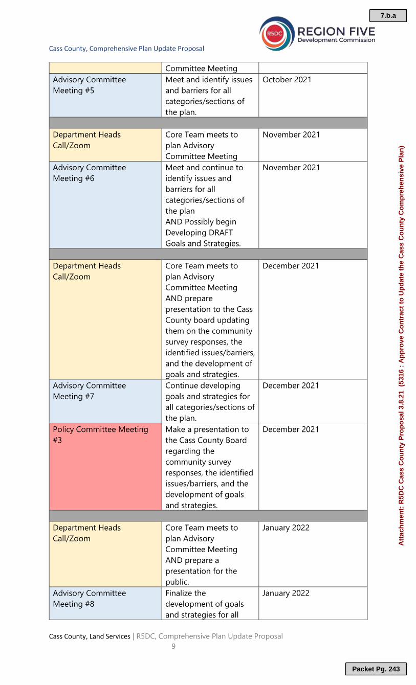
Cass County, Comprehensive Plan Update Proposal
Cass County, Land Services | R5DC, Comprehensive Plan Update Proposal
9
Committee Meeting
Advisory Committee
Meeting #5
Meet and identify issues
and barriers for all
categories/sections of
the plan.
October 2021
Department Heads
Call/Zoom
Core Team meets to
plan Advisory
Committee Meeting
November 2021
Advisory Committee
Meeting #6
Meet and continue to
identify issues and
barriers for all
categories/sections of
the plan
AND Possibly begin
Developing DRAFT
Goals and Strategies.
November 2021
Department Heads
Call/Zoom
Core Team meets to
plan Advisory
Committee Meeting
AND prepare
presentation to the Cass
County board updating
them on the community
survey responses, the
identified issues/barriers,
and the development of
goals and strategies.
December 2021
Advisory Committee
Meeting #7
Continue developing
goals and strategies for
all categories/sections of
the plan.
December 2021
Policy Committee Meeting
#3
Make a presentation to
the Cass County Board
regarding the
community survey
responses, the identified
issues/barriers, and the
development of goals
and strategies.
December 2021
Department Heads
Call/Zoom
Core Team meets to
plan Advisory
Committee Meeting
AND prepare a
presentation for the
public.
January 2022
Advisory Committee
Meeting #8
Finalize the
development of goals
and strategies for all
January 2022
7.b.a
Packet Pg. 243
Att
ach
men
t: R
5DC
Cas
s C
ou
nty
Pro
po
sal 3
.8.2
1 (
5316
: A
pp
rove
Co
ntr
act
to U
pd
ate
the
Cas
s C
ou
nty
Co
mp
reh
ensi
ve P
lan
)

Cass County, Comprehensive Plan Update Proposal
Cass County, Land Services | R5DC, Comprehensive Plan Update Proposal
10
categories/sections of
the plan based on input
from the public.
Public Informational Meeting
#2
Deliver a presentation
for members of the
public and get their
input on the DRAFT
goals
January 2022
Department Heads
Call/Zoom
Consultants develop
DRAFT plan. AND begin
30-day public review
simultaneously with a 60
day county and agency
review.
February 2022
Advisory Committee
Meeting #9
February 2022
Public 30-Day Review Period,
AND 60-Day Agency Review
Period.
Opportunity for
Members of the public
to provide any
additional input.
February 2022
Department Heads
Call/Zoom
Continue to develop
DRAFT plan, incorporate
public comments as
determined by Advisory
Committee.
March 2022
Advisory Committee
Meeting #10
Continue to develop
DRAFT plan, incorporate
Agency comments as
determined by the
Advisory Committee.
March 2022
60-Day Agency Review
Period closes
March 2022
Department Heads
Call/Zoom
Prepare to present the
FINAL Draft of the Plan
update to the County
Board for approval.
April 2022
Policy Committee Meeting
#4
Board Takes Action on
the FINAL Draft of the
Plan Update
April 2022
7.b.a
Packet Pg. 244
Att
ach
men
t: R
5DC
Cas
s C
ou
nty
Pro
po
sal 3
.8.2
1 (
5316
: A
pp
rove
Co
ntr
act
to U
pd
ate
the
Cas
s C
ou
nty
Co
mp
reh
ensi
ve P
lan
)

Bridging Relationships & Resources
200 1st Street NE Suite 2, Staples, MN 56479 | 218.894.3233 | regionfive.org
Pandemic Response
The Region Five Development Commission (R5DC) has modified its service delivery both in
light of the risks and the response to COVID 19. We are finding that some groups,
communities or organizations are able to resume in person meetings by taking appropriate
precautions to ensure they are in compliance with pandemic response Executive Orders
and recommended guidance such as appropriate social distancing, the wearing of masks
when needed, the availability of hand sanitizer, and minimizing the sharing meeting
materials.
Furthermore, whenever an in-person meeting is appropriate, it is the proactive for R5DC to
also provide a virtual meeting option simultaneously for those who choose not to
participate in person for whatever reason (immune-compromised, workplace restrictions,
personal preference etc.)
R5DC is committed to providing seamless meeting facilitation services regardless of the
format (in person, virtual, hybrid) determined by the client.
Deliverable and Cost Estimate
Upon completion of the Cass County Comprehensive Plan Update, the following will be
provided by the Region Five Development Commission:
1. Preparation of agendas, meeting materials, and facilitation for all Advisory
Committee meetings, and Public Informational meetings.
2. Additionally, R5DC will be responsible for maintaining a list of committee members
emails and providing meeting notices for core team calls/zoom meetings, advisory
committee meetings, and public informational meetings.
3. Additionally, R5DC will assist the Client with promoting the public informational
meetings when appropriate.
4. Finally, R5DC will provide two printed, bound, color hardcopies, and an electronic
copy of the Final Comprehensive Plan Update.
7.b.a
Packet Pg. 245
Att
ach
men
t: R
5DC
Cas
s C
ou
nty
Pro
po
sal 3
.8.2
1 (
5316
: A
pp
rove
Co
ntr
act
to U
pd
ate
the
Cas
s C
ou
nty
Co
mp
reh
ensi
ve P
lan
)

Cass County, Comprehensive Plan Update Proposal
Cass County, Land Services | R5DC, Comprehensive Plan Update Proposal
12
Estimated Costs
Estimated Costs
Item Description/Quantity Total
R5DC Staff Time 162 Hrs. (27 meetings @
6Hrs/meeting x $75/Hr.)
$12,150
R5DC In Kind Time 20% of 162 Hrs. = 32 Hrs. @
$75/hr.
$2,400
Total R5DC Staff Time
Value including In Kind
Staff Time
14,550
R5DC In Kind Time ($2,400)
Estimated Cost to Client 12,150
The costs associated with the estimates provided, derives from total costs associated
with similar projects completed by the Region Five Development Commission (R5DC).
General Notation on Cost
1. Based on past projects Region Five estimates six (6) hours of staff time for each
meeting including pre-meeting preparation, actual meeting hours, and meeting follow
up.
2. Total project costs to the local unit of government shall not exceed the amount
estimated.
3. The Region Five Development Commission’s billing schedule is on a monthly basis.
4. An approved Contract for Services is required prior to the work being performed.
5. R5DC reserves the right to invoice for an additional 10% of the total cost to the client
if, through the course of this project, the client requests additions beyond this scope
of work. All required services not included in this original work plan will be negotiated
by the Region Five Development Commission and the local unit of government prior
to those services being performed.
6. Project costs within this proposal are estimates. If the number of hours to meet the
needs of the customer are to exceed the contracted amount, notification will be given
to the customer and costs will be negotiated.
7.b.a
Packet Pg. 246
Att
ach
men
t: R
5DC
Cas
s C
ou
nty
Pro
po
sal 3
.8.2
1 (
5316
: A
pp
rove
Co
ntr
act
to U
pd
ate
the
Cas
s C
ou
nty
Co
mp
reh
ensi
ve P
lan
)

Cass County, Comprehensive Plan Update Proposal
Cass County, Land Services | R5DC, Comprehensive Plan Update Proposal
13
Contract for Services
This contract for services between Cass County, Minnesota (hereinafter Client) and the
Region Five Development Commission, 200 1st Street NE, Suite 2, Staples, MN 56479
(hereinafter R5DC).
Contact Person(s):
Client: John Ringle, Environmental Services Director
R5DC: Tad Erickson, Senior Regional Transportation Planner
Terms of Contract:
This Agreement will become effective on____________________, when executed in full by
authorized representatives of the Client and R5DC, and will remain in effect
until_____________________, or until all obligations set forth in this Agreement have been
satisfactorily fulfilled, whichever comes first.
In witness whereof the parties have hereunto set their hands and each warrant that he/she
is empowered and authorized to execute this Agreement and accept Terms and Conditions
A through H on page 5 of this document.
__________________________________________________ Date _____________
Authorized Client Representative
__________________________________________________ Date _____________
Authorized R5DC Representative
7.b.a
Packet Pg. 247
Att
ach
men
t: R
5DC
Cas
s C
ou
nty
Pro
po
sal 3
.8.2
1 (
5316
: A
pp
rove
Co
ntr
act
to U
pd
ate
the
Cas
s C
ou
nty
Co
mp
reh
ensi
ve P
lan
)

Cass County, Comprehensive Plan Update Proposal
Cass County, Land Services | R5DC, Comprehensive Plan Update Proposal
14
A. QUALIFICATIONS. R5DC represents that it is qualified and willing to perform the services set forth
herein.
B. AMENDMENTS. Any alterations, variations, modifications or waivers of terms of this Agreement shall be
binding upon the Client and R5DC only upon being reduced to, writing, and signed by a duly authorized
representative of the Client and R5DC.
C. ASSIGNMENT. R5DC represents that it will utilize only its personnel in the performance of services set
forth herein; and further agrees that it will neither assign, transfer, or subcontract any rights or obligations
under this Agreement without prior written consent of the Client.
D. DATA AND COPYRIGHT.
1. The Client agrees that it will make available all pertinent information, data, and records under its control
for R5DC to use in the performance of this Agreement, or to assist R5DC wherever possible to obtain such
records, data, and information.
2. All reports, data, information, and documentation, and material given to or prepared by R5DC pursuant
to this Agreement will be confidential and will not be released by R5DC during the Contract period
without prior authorization from the Client.
3. No reports, maps, data, commentaries, or other documentation produced in whole or in part under this
agreement will be the subject of an application for copyright by or on behalf of R5DC or R5DC’s agents or
employees.
E. COMPLIANCES. R5DC agrees to abide by and assures that no person in the United States shall on the
grounds of sex, age, race, or religion be eluded from participating in, be denied the benefit of, or be
otherwise subject to discrimination in connection with the operations of this Contract.
F. FINANCIAL RECORDS. R5DC agrees that it will establish and keep for a period of three (3) years
following the receipt of payment from the final invoice for services performed hereunder such financial
records as will fully disclose the amount and disposition of the funds received pursuant to this Contract.
G. TERMINATION.
1. If either party shall fail to fulfill its obligations hereunder, or shall violate any terms of this Contract, the
other party shall have the right to terminate this Contract by giving written notice to the defaulting party
at least fourteen (14) days prior to termination. Such written notice shall specify the nature of the default.
2. In the event of the termination of this Contract prior to normal completion, all unfinished documents,
data, studies, surveys, drawings, maps, photographs, and reports prepared by R5DC in carrying out the
work tasks hereunder shall become the property of the Client. R5DC shall be entitled to receive from
Client the reasonable value.
H. PUBLISHING. R5DC reserves the right to publish all final reports and/or documents that are created
through this contract on the R5DC website and/or Resilient Region website.
7.b.a
Packet Pg. 248
Att
ach
men
t: R
5DC
Cas
s C
ou
nty
Pro
po
sal 3
.8.2
1 (
5316
: A
pp
rove
Co
ntr
act
to U
pd
ate
the
Cas
s C
ou
nty
Co
mp
reh
ensi
ve P
lan
)

March 8, 2021
CASS COUNTY ENVIRONMENTAL SERVICES DEPARTMENT
Proposal for
CASS COUNTY COMPREHENSIVE PLAN UPDATE
7.b.b
Packet Pg. 249
Att
ach
men
t: H
EI-
for-
Cas
s-C
o-C
om
p-P
lan
-Up
dat
e_3.
8.21
(53
16 :
Ap
pro
ve C
on
trac
t to
Up
dat
e th
e C
ass
Co
un
ty C
om
pre
hen
sive
Pla
n)

TABLE OF CONTENTS Cass County Comprehensive Plan Update
Page
1. Cover Letter 1
2. About Houston Engineering, Inc. 2
3. Project Personnel 3 A. Organizational Chart 3 B. Resumes 4
4. Project Scope 9
5. Proposed Budget 12
6. Proposed Schedule 13
7. Related Experience 14
8. References 16 Attachments Draft Plan Cover
7.b.b
Packet Pg. 250
Att
ach
men
t: H
EI-
for-
Cas
s-C
o-C
om
p-P
lan
-Up
dat
e_3.
8.21
(53
16 :
Ap
pro
ve C
on
trac
t to
Up
dat
e th
e C
ass
Co
un
ty C
om
pre
hen
sive
Pla
n)

Maple Grove Office P 763.493.4522
7550 Meridian Circle North, Suite 120 | Maple Grove, MN 55369
houstoneng.com
1. COVER LETTER
VIA Email: [email protected]
March 8, 2021
John P. Ringle Cass County Environmental Services Department Cass County Courthouse P.O. Box 3000 Walker, MN 56484
Subject: Request for Proposal to Update the Cass County Comprehensive Plan
Dear John:
Thank you for including Houston Engineering, Inc. in your search for a qualified firm to provide updates to Cass County’s (County) Comprehensive Plan. Our team is eager to assist you with this important project and we are confident we can provide the following benefits to you and the County: • Local Knowledge: I have a deep personal connection to the area as my family has a cabin on Leech Lake
(Agency Bay) that I have been visiting my whole life. Based on this knowledge and work in the area, I am familiar with local ordinances, programs, and priorities such as water resource and forest management. I will be able to seamlessly integrate the Pine River and Leech Lake River One Watershed, One Plans into the updated Cass County Comprehensive Plan.
• Established Relationships: Through working on various projects in the area, I have become familiar with County staff, board members, and other local groups such as the Association of Cass County Lakes, local lake associations, state agency staff, and the Northern Waters Land Trust. I am eager to continue strengthening those relationships through this project.
• Related Experience: Planning Lead Rachel Olm and I both have extensive experience with stakeholder engagement and workshop development and are prepared to put those skills to use for the County on this project. Our team has a good blend of watershed plan experience, with infrastructure and land use planning from Jeff Lutz. Please refer to page 14 to learn more about the projects we’ve worked on that align closely with your plan update.
Thank you for your consideration—please feel free to contact me with any questions via the information below.
Sincerely,
HOUSTON ENGINEERING, INC.
Moriya Rufer, MS, CLM Barton L. Schultz, PE Project Manager Signing Authority Direct: 218.396.1169 Direct: 763.493.6662 [email protected] [email protected] 1
7.b.b
Packet Pg. 251
Att
ach
men
t: H
EI-
for-
Cas
s-C
o-C
om
p-P
lan
-Up
dat
e_3.
8.21
(53
16 :
Ap
pro
ve C
on
trac
t to
Up
dat
e th
e C
ass
Co
un
ty C
om
pre
hen
sive
Pla
n)

2 HEI PROPOSAL MARCH 8, 2021
CASS COUNTY ENVIRONMENTAL SERVICES DEPARTMENT CASS COUNTY COMPREHENSIVE PLAN UPDATE
2. ABOUT HOUSTON ENGINEERING, INC. Primary Contact
About Houston Engineering, Inc. Houston Engineering, Inc. (HEI) is a community-focused engineering firm that serves Minnesota clients with a variety of technical services key to natural resource management. Conveniently located with eight offices across the Upper Midwest, we are committed to projects that can lead to visible improvements in the intersection of water quality and land stewardship. Our team includes engineers, scientists, and analysts, all seasoned in natural resource management and local planning. Most of our project team is local to Minnesota. Moriya will serve you out of Detroit Lakes with her support staff serving out of HEI’s Maple Grove and Fargo offices.
QUICK FACTS:
Website: houstoneng.com Number of Employees: 225+ professionals Year Founded: 1968
Moriya Rufer, as Project Manager, will serve as your main point of contact throughout the course of your plan update. Moriya has more than 17 years of experience serving the water resources community, specifically working with lakes and water quality issues. Moriya’s heart and her experience lie in northern Minnesota and she will use this passion in her work on your plan update. Email: [email protected] Phone: 218.396.1169
MORIYA’S CABIN IS NESTLED ON LEECH LAKE, SO SHE IS WELL VERSED IN THE PROJECT AREA
Moriya’s Direct Experience • Project Manager and Plan Writer for the Pine
River One Watershed, One Plan • Completed an aquatic invasive species risk
assessment for Cass County • Completed lake assessments for 45 lakes in
Cass County for the Cass County Water Plan • Assisted the Association of Cass County Lakes
and lake associations with lake monitoring • Assisted the Leech Lake Band of Ojibwe with a
surface water assessment grant
MORIYA IS PASSIONATE ABOUT MINNESOTA’S NATURAL RESOURCES
7.b.b
Packet Pg. 252
Att
ach
men
t: H
EI-
for-
Cas
s-C
o-C
om
p-P
lan
-Up
dat
e_3.
8.21
(53
16 :
Ap
pro
ve C
on
trac
t to
Up
dat
e th
e C
ass
Co
un
ty C
om
pre
hen
sive
Pla
n)

HEI PROPOSALMARCH 8, 2021
CASS COUNTY ENVIRONMENTAL SERVICES DEPARTMENT CASS COUNTY COMPREHENSIVE PLAN UPDATE
Moriya Rufer, MS, CLMProject Manager
Jeff LutzLand Use and Infrastructure
Lead
Whitney Bartholmy
Communications Specialist
Rachel Olm, MS
Planning Lead
3. PROJECT PERSONNELA. Organizational Chart
Support Staff
Kylie Beard, MS
Plan Writer
3
7.b.b
Packet Pg. 253
Att
ach
men
t: H
EI-
for-
Cas
s-C
o-C
om
p-P
lan
-Up
dat
e_3.
8.21
(53
16 :
Ap
pro
ve

MORIYA RUFER, MS, CLM
Project Manager
CASS COUNTY ENVIRONMENTAL SERVICES DEPARTMENT CASS COUNTY COMPREHENSIVE PLAN UPDATE
HEI PROPOSAL MARCH 8, 2021
B. Resumes
Education MS in Entomology, University of Minnesota
BA in Biology, College of St. Benedict
Certifications NALMS Certified Lake Manager (CLM)
Facilitator Certification, Durrell Wildlife Conservation Trust
Training Facilitation Training, The Art of Hosting Conversations that Matter
Professional Experience Houston Engineering, Inc.—2019-Present
Total Years of Experience—17 Years
Moriya Rufer is a familiar face to the County and will serve as your Project Manager for your plan update. She has a deep personal connection to the area and has a family cabin on Leech Lake (Agency Bay) that she has visited every summer of her life. She has 17 years of experience serving the water resources community, specifically working with lakes, water quality, aquatic invasive species, and protection in central and northern Minnesota. She is also a skilled facilitator, having completed specific training and guided discussion at countless meetings relating to lake management and comprehensive watershed management plans. • Pine River Watershed One Watershed, One Plan, Crow Wing Soil and
Water Conservation District, Brainerd, MN. As Plan Writer, Moriya preparednatural resources analysis and written sections for the plan document. This is aprotection-focused plan in Cass and Crow Wing counties with very few waterquality impairments. Highlights to this plan include a lake prioritization,incorporating the first-time target load reductions for non-impaired protectionlakes, and a protection-focused goal with multiple benefits to lakes andstreams, drinking water, and forests. This plan was approved by the MinnesotaBoard of Soil and Water Resources (BWSR) in 2019.
• South Fork Pine Subwatershed PTMApp Project, Crow Wing Soil andWater Conservation District, Brainerd, MN. Project Manager. As the first stepof implementing the Pine River One Watershed, One Plan, HEI is helping thecounties target and measure phosphorus reductions to Whitefish Lake fromagricultural lands in the South Fork Subwatershed of Cass County. HEI'sapproach included hydroconditioning, followed by running the Prioritize, Target,and Measure Application (PTMApp) to target best management practices andmeasure phosphorus reduction in the South Fork Subwatershed.
Experience Prior to HEI
• Large Lake Prioritization and Assessment Reports, Cass CountyEnvironmental Services Department, Walker, MN. Lead Writer and DataAnalyst. Responsible for completing 45 lake assessments and prioritizationreports for the Cass County Water Plan.
• Aquatic Invasive Species Risk Assessment Tool for Cass County AISPlan, Cass County Environmental Services Department, Walker, MN.Developed an aquatic invasive species (AIS) risk assessment tool that countiescan use to increase the effectiveness of AIS plans. This tool was developedwith the assistance of a Legislative-Citizen Commission on MinnesotaResources (LCCMR) grant through the Red River Basin Commission. To date,eight counties and three watersheds have utilized the tool.
• US Fish and Wildlife Service National Wildlife Refuge ComprehensiveConservation Plans, Conservation Planning Specialist Group. Assistedsenior program staff with facilitating stakeholder meetings and writingcomprehensive conservation plans for USFWS National Wildlife Refuges(NWR), including Sherburne NWR (MN), Hanford Reach NWR (WA), and BigBranch Marsh NWR (LA).
Moriya has 17 years of experience serving counties and watersheds in northern Minnesota and will bring an unparalleled passion to her role as Project Manager.
4
7.b.b
Packet Pg. 254
Att
ach
men
t: H
EI-
for-
Cas
s-C
o-C
om
p-P
lan
-Up
dat
e_3.
8.21
(53
16 :
Ap
pro
ve C
on
trac
t to
Up
dat
e th
e C
ass
Co
un
ty C
om
pre
hen
sive
Pla
n)

RACHEL OLM, MSPlanning Lead
CASS COUNTY ENVIRONMENTAL SERVICES DEPARTMENT CASS COUNTY COMPREHENSIVE PLAN UPDATE
HEI PROPOSAL MARCH 8, 2021
Education MS in Water Resources Science, University of Minnesota
BA in Environmental Studies, Biology, University of Minnesota, Morris
Training Facilitation Training, The Art of Hosting Conversations that Matter
Professional Experience Houston Engineering, Inc.—2015-Present
Total Years of Experience—8 Years
Rachel Olm will be your secret weapon in leading your plan update. Rachel recently led a watershed management plan update for the Rice Creek Watershed District and leads many of our One Watershed, One Plan projects. She has facilitated several planning meetings with the District during the update to ensure the updated plan meets District goals and Minnesota Board of Soil and Water Resources requirements. Her technical knowledge and experience mean you can feel confident that your team is guided by one of the state’s leaders in planning. Making your life easier is a consultant’s primary job, and it can’t get much easier than having a true expert ready and willing to do her best work for you.
• Watershed Management Plan Update, Rice Creek Watershed District,Blaine, MN. Project Manager for the update of the watershed managementplan (WMP) for the Rice Creek Watershed District, which is located within theMinneapolis-Saint Paul metropolitan area. Rachel led several presentations andworkshops with the District to help determine a strategic direction and prioritizecurrent and future issues for the WMP to focus on. The updated plan includesconsiderations about both water quality and quantity; a long-range workplanand budget; and new goals, policies, and objectives for the District. Theupdated plan was approved in 2020.
• Bois de Sioux-Mustinka One Watershed, One Plan (1W1P) Bois de SiouxWatershed District, MN. Project Manager and Facilitator for the developmentof the Bois de Sioux-Mustinka 1W1P. Rachel facilitated additional meetingsamong partners to allocate implementation dollars among prioritized capitalimprovement projects. HEI helped to create a common vision between 13 localgovernment entities for the next decade of resource management in thewatersheds. The completed plan communicates the 1W1P and engagementprocess with the public, emphasizes the importance of soil health and existingconservation programs, and prioritizes actions and capital improvements withinthe two watersheds.
• Lake of the Woods One Watershed, One Plan, Lake of the Woods Soil andWater Conservation District, Baudette, MN. As Plan Advisor, contributed tothe development of a plan for this northern Minnesota watershed. Rachelhelped review existing information about the watershed and prepare materialsfor public meetings. The final plan will not only meet state requirements butdrive implementation for improvements.
• Missouri River One Watershed, One Plan, Nobles County, Worthington,MN. As Project Manager and Lead Facilitator, led the development of theMissouri River One Watershed, One Plan. Rachel led public and stakeholdercommittee meetings, created vision presentations, aggregated priority issues,and leveraged modeling data to target implementation efforts. The final plan notonly meets state and federal watershed planning requirements but also drivesimplementation for improvements. The plan was approved in 2019, and thegroup is beginning to move into the implementation phase.
• Buffalo-Red River One Watershed, One Plan, Buffalo-Red River WatershedDistrict, MN. As Project Manager and Lead Writer, Rachel led the developmentof the Buffalo-Red River One Watershed, One Plan. Rachel wrote the plandocument, developed methods to estimate current expenditures on watermanagement, leveraged existing tools to target implementation efforts, createdvision presentations, coordinated with all stakeholders, and led the projectteam. The plan was approved in 2020.
Rachel has a rich understanding of what it takes to draft reliable plans for Minnesota watersheds and counties and will lend her insights to this project.
5
7.b.b
Packet Pg. 255
Att
ach
men
t: H
EI-
for-
Cas
s-C
o-C
om
p-P
lan
-Up
dat
e_3.
8.21
(53
16 :
Ap
pro
ve C
on
trac
t to
Up
dat
e th
e C
ass
Co
un
ty C
om
pre
hen
sive
Pla
n)

JEFF LUTZLand Use and Infrastructure Lead
CASS COUNTY ENVIRONMENTAL SERVICES DEPARTMENT CASS COUNTY COMPREHENSIVE PLAN UPDATE
HEI PROPOSAL MARCH 8, 2021
Education BS in Geography, South Dakota State University
Professional Experience Houston Engineering, Inc.—2015-Present
Total Years of Experience—33 Years
As Land Use and Infrastructure Lead, Jeff Lutz will provide support related to specific issues identified in the plan update. Jeff is a Senior Planner with more than 30 years of experience. Jeff’s multi-faceted planning experience includes local comprehensive land use plans and economic development documents; preparing transportation plans, corridor studies, and feasibility studies; Phase 1 environmental site assessments; and National Environmental Policy Act (NEPA) environmental documentation. Jeff also provides local government technical assistance pertaining to planning in addition to zoning and land use studies.
• Greater Bemidji Area 2045 Comprehensive Smart Plan, Greater BemidjiArea Joint Planning Board, Bemidji, MN. As Project Manager, Jeff led theeffort to review and update the Greater Bemidji Area Joint Planning BoardComprehensive Plan. Jeff worked with the public, stakeholders, and staff toprovide informed direction and goals as the basis for future land use in thegreater Bemidji area. HEI staff conducted reviews of existing background and/orspecial studies to ensure relevant data was incorporated into theComprehensive Plan update. Jeff led the effort for public and stakeholdermeetings and a workshop to listen to stakeholder needs. He also providedobjective guidance to ensure that plan development aligned with big-picturefuture needs and identified issues the new plan needed to address.
• Southwest Regional Stormwater Pond Master Plan, City of Fargo, ND.Project Planner. HEI was hired by the City of Fargo to provide planning,engineering, and landscape architecture services for the Southwest RegionalStormwater Pond Master Plan. The project consists of land use analysis of2,400 acres in coordination with a regional stormwater management plan thatincludes an accompanying flood pump station for a portion of the future growtharea in southwest Fargo. By studying the potential land uses in conjunction withregional stormwater needs, the City will consider traffic impacts, a broader mixof uses, pedestrian oriented design, connected greenways, and environmentalimpacts on a broader, more proactive level.
• Environmental Review and Planning. Conducts environmental planning andenvironmental reviews for a wide variety of projects. Project experienceincludes environmental review, permitting, technical analyses, environmentalfield logistics, public involvement, and overall project and task management.Responsibilities include project need development, alternatives development,and identification of level of study required for environmental issues (e.g., landuse, socioeconomic and wetland impacts, cultural resources, and parks) for avariety of project types.
• RDO Dayton Master Plan, Arista Development, Dayton, MN. As ProjectManager, led the preparation of a Phase I ESA of a 26-acre farmstead,including a residence, outbuildings, and cultivated agricultural land. The Phase IESA was performed in accordance with ASTM Standard Practice forEnvironmental Site Assessment: Phase I Environmental Site AssessmentsE1527-13. Based on HEI’s review of recent and historical information and asite-visit (on and off-site), we determined that environmental conditions with thepotential to affect the property were not identified.
Jeff has more than 30 years of experience that blends planning and environmental work, making him a unique asset for the County’s planning efforts.
6
7.b.b
Packet Pg. 256
Att
ach
men
t: H
EI-
for-
Cas
s-C
o-C
om
p-P
lan
-Up
dat
e_3.
8.21
(53
16 :
Ap
pro
ve C
on
trac
t to
Up
dat
e th
e C
ass
Co
un
ty C
om
pre
hen
sive
Pla
n)

KYLIE BEARD, MS
Plan Writer
CASS COUNTY ENVIRONMENTAL SERVICES DEPARTMENT CASS COUNTY COMPREHENSIVE PLAN UPDATE
HEI PROPOSAL MARCH 8, 2021
Education MS in Sustainability Studies, Water Resources Emphasis, Texas State University
BA in Anthropology, University of Mary Washington
Professional Experience Houston Engineering, Inc.—2020-Present
Total Years of Experience—3 Years
Kylie Beard will serve the County as Plan Writer. She is a well trained and experienced scientist with a passion for preserving and working in the environment around us. Having been raised on the Red River, Kylie has a specific interest in surface water quality and community planning through stakeholder facilitation. She firmly believes that solutions result from cooperation. Kylie has studied and worked in areas throughout the country similar to, as well as vastly different from our own, giving her fresh insights and ideas on new approaches that can be implemented right here at home. Her multi-faceted experience includes work with the National Environmental Policy Act (NEPA) and Minnesota Environmental Policy Act (MEPA) that consists of environmental impact statements (EISs), environmental assessments (EAs), and environmental assessment worksheets (EAWs).
• Nemadji River One Watershed, One Plan, Carlton County Soil and WaterConservation District, MN. Scientist. Kylie assisted in plan writing anddevelopment with watershed partners. This planning process is acomprehensive look at the watershed incorporating water quality, flood damagereduction, habitat, and land management.
• Wild Rice – Marsh River Watershed One Watershed, One Plan, Wild RiceRiver Watershed District, Northwest MN. In her role as Scientist, Kylieassisted with plan writing and GIS mapping including an analysis that identifiedpriority acreage for forest management and conservation easements. This planhas recently been approved by the Minnesota Board of Soil and WaterResources after successful adoption by local counties.
• MS4 Stormwater Pollution Prevention Plan, Buffalo-Red River WatershedDistrict, Clay County, MN. Kylie is responsible for maintaining the permittingand reporting responsibilities of the MS4 permit and stormwater pollutionprevention plan (SWPPP) for the District. This process involves the design of aplan that includes management activities to satisfy regulatory requirements.
• Bylin Dam Rehabilitation Plan, Walsh County Water Resource District, ND.Scientist. HEI was retained to develop a supplemental watershed plan for BylinDam. Kylie assisted in the preparation of the biological inventory report, whichinvolves compiling, analyzing, and describing the results of field studies.
Experience Prior to HEI
• Plan Writer for Shoal Creek Watershed Action Plan – The Meadows Centerfor Water and the Environment, Texas State University, San Marcos, TX.Consultant. Kylie wrote and developed the Shoal Creek Watershed Action Planwith local city, county, state, and public stakeholders. In addition to writing thedocument, Kylie provided environmental research and coordination for multipleinterests and priorities.
• Drainage Utility Training Manual, Watershed Protection Department, Cityof Austin, TX. IT Geospatial Technician. Kylie authored technical sections ofthe drainage utility training manual, including training scenarios for databaseupdates.
• Water Supply and Management Study, Lower Colorado River Authority,Austin, TX. Graduate Intern. Kylie coordinated a study of modeling developedfor water management activities in Gulf Coast rice fields, utilizing the input oflocal farmers to verify conservation effects.
Kylie is an experienced plan writer who is prepared to use the knowledge she has gained from her involvement in projects across the country to update your comprehensive plan.
7
7.b.b
Packet Pg. 257
Att
ach
men
t: H
EI-
for-
Cas
s-C
o-C
om
p-P
lan
-Up
dat
e_3.
8.21
(53
16 :
Ap
pro
ve C
on
trac
t to
Up
dat
e th
e C
ass
Co
un
ty C
om
pre
hen
sive
Pla
n)

WHITNEY BARTHOLMYCommunications Specialist
CASS COUNTY ENVIRONMENTAL SERVICES DEPARTMENT CASS COUNTY COMPREHENSIVE PLAN UPDATE
HEI PROPOSAL MARCH 8, 2021
Education BA in English, Bemidji State University
BFA in Creative and Professional Writing, Bemidji State University
Minors in Electronic Writing and Psychology, Bemidji State University
Professional Experience Houston Engineering, Inc.—2019-Present
Total Years of Experience—5 Years
Whitney Bartholmy is an integral part of HEI’s communications team. She is committed to creating effective graphics, drafting clear messages, and transforming dense technical data into easy-to-comprehend formats that anyone can understand. She works closely with HEI’s engineers and scientists to help shape final deliverables, including as part of Minnesota’s One Watershed, One Plan initiative. Whitney has a rich understanding of the plan area through her time attending Bemidji State University.
• Redeye River Watershed One Watershed, One Plan, East Otter Tail Soiland Water Conservation District, MN. Communications Specialist. Theobjective of this plan is to develop a new way to analyze best managementpractices (BMPs) on the landscape, summarizing where BMPs are currentlybeing implemented and prioritizing where new BMPs could be beneficial towater quality. Whitney’s tasks included graphic creation, formatting, and editingplan sections. This plan was approved by the Minnesota Board of Water andSoil Resources in 2020.
• Watonwan One Watershed, One Plan, Watonwan County Soil and WaterConservation District, St. James, MN. Communications Specialist for thismulti-stakeholder project. The goal of this project is to develop consensusamong many stakeholders for a watershedwide plan to develop and implementBMPs on the landscape. Whitney’s tasks include graphic creation, formatting,and editing plan sections.
• Headwaters Agriculture Sustainability Partnership (HASP) MinnesotaDepartment of Agriculture Dairy Sustainability Project, EnvironmentalInitiative, Minneapolis, MN. Communications Specialist tasked with creating astoryboard showcasing the financial return to local farmers on conservation.Whitney created a custom layout with graphics to highlight the differencesbetween the stewardship farm and benchmark farm.
• Ecosystem Services Programs Survey, Minnesota Soybean Research andPromotion Council, Mankato, MN. Communications Specialist tasked withdrafting a scorecard of different ecosystem services marketplaces to providefarmers and landowners easily accessible differences between whatmarketplaces offer. The scorecard will provide science-based information tohelp a farmer or landowner decide if participating in an ecosystem servicesmarketplace would benefit them.
Experience Prior to HEI
• Staff Writer, The Journal, International Falls, MN. Whitney served for twoand a half years as a staff writer for The Journal, a local newspaper distributedthroughout the Koochiching County area, encompassing the cities ofInternational Falls, Littlefork, Big Falls, and Indus. Whitney was responsible fordrafting and editing articles on a daily basis, pitching original content,researching a variety of topics, and interviewing both officials and members ofthe public.
Whitney is prepared to lend her communications and design expertise to the County’s plan update.
8
7.b.b
Packet Pg. 258
Att
ach
men
t: H
EI-
for-
Cas
s-C
o-C
om
p-P
lan
-Up
dat
e_3.
8.21
(53
16 :
Ap
pro
ve C
on
trac
t to
Up
dat
e th
e C
ass
Co
un
ty C
om
pre
hen
sive
Pla
n)

CASS COUNTY ENVIRONMENTAL SERVICES DEPARTMENT CASS COUNTY COMPREHENSIVE PLAN UPDATE
HEI PROPOSAL MARCH 8, 2021
4. PROJECT SCOPEProject UnderstandingWATERSHED AND LOCAL PLANNINGEXPERIENCEAmong Cass County’s (County) greatest assets areits natural resources. Cass County has invested inmultiple planning efforts to ensure that it is setting adiligent and efficient path forward to wisely manageand protect these natural resources for generationsto come.
HEI is uniquely positioned to seamlessly integrate the great planning work you have already done into the County’s updated Comprehensive Plan. Moriya Rufer, HEI’s Project Manager, has a deep personal connection to the area with a family cabin on Leech Lake that she visits frequently. She has worked with the County on previous projects including Large Lake Assessments for the County Water Plan and an AIS Risk Assessment for the County AIS Plan. Moriya was also fortunate enough to serve you in partnership with John Ringle, Kelly Condiff, and Jeff Peterson during the Pine River One Watershed, One Plan (1W1P) planning process, and therefore, we intimately know your plans and the issues and natural resources most important to you. We will draft a plan that is nimble, allowing you to incorporate by reference the next 1W1Ps in your county as they come to life: the Mississippi River Headwaters, Crow Wing, and Mississippi River – Grand Rapids.
FACILITATION We applaud the emphasis the County places on ensuring the public is involved in the planning process. We believe a planning process that engages the public through well-facilitated workgroup meetings creates a plan that is more practical and supported by the community it’s designed to support.
Moriya and Rachel Olm, Planning Lead, are facilitators trained in leading engaging meetings with diverse stakeholder groups. In addition, Moriya is already a trusted person with many local groups including the Association of Cass County Lakes, lake associations, the Northern Waters Land Trust, and state agency staff that serve the area. During COVID-19, Moriya and Rachel transitioned all ongoing 1W1P stakeholder meetings to virtual platforms without missing project deadlines or sacrificing meeting outcomes.
Our team will build on this experience, by creating platforms for engagement, participation, and relationship building in a virtual environment to support your planning process. We will use tools like check-in questions, break-out groups, virtual whiteboards, and real-time surveys. We will craft approaches for engaging the public and recommend tailored meeting strategies to accomplish the outcome you wish to achieve from each meeting.
Project Scope STEP 1: COUNTY DEPARTMENT ASSESSMENT OF EXISTING PLAN AND EMERGING ISSUES Reviewing existing planning documents is critical for understanding existing priorities, goals, objectives, policies, and programs currently in use throughout the county. HEI will gather and review the existing comprehensive plan, local water plan, and pertinent components of existing local comprehensive watershed management plans developed during 1W1P processes.
Following this data review, HEI will schedule six one-hour virtual meetings with department heads to discuss their suggested revisions to plan sections of which they are the content owner. HEI has had the opportunity to assist dozens of local government unit (LGU) staff across the state with their watershed and community planning efforts.
PROJECT MANAGER MORIYA RUFER IS VERY FAMILIAR WITH THE COUNTY HAVING A CABIN ON LEECH LAKE
9
7.b.b
Packet Pg. 259
Att
ach
men
t: H
EI-
for-
Cas
s-C
o-C
om
p-P
lan
-Up
dat
e_3.
8.21
(53
16 :
Ap
pro
ve C
on
trac
t to
Up
dat
e th
e C
ass
Co
un
ty C
om
pre
hen
sive
Pla
n)

CASS COUNTY ENVIRONMENTAL SERVICES DEPARTMENT CASS COUNTY COMPREHENSIVE PLAN UPDATE
HEI PROPOSAL MARCH 8, 2021
Although this scope assumes primary revisions will be generated by the department head, HEI will add value to your process by providing additional recommended revisions for your consideration, based upon our planning experience with other LGUs. Following each meeting, HEI will organize and research new emerging issues identified or confirmed by department heads and begin organizing any gaps in policies and objectives to be considered in the plan update.
HEI Deliverables: • Six, one-hour virtual meetings with department
heads• Collated, tracked-changes document of each
department head plan section
STEP 2: COUNTY PLANNING COMMISSION PUBLIC WORKSHOP 1 HEI is a leader in facilitating meetings to support planning processes. We will make valuable use of you and your stakeholder’s time by ensuring planning workshops engage participants and receive feedback needed to mold the plan update. Before this workshop, HEI will design a strategy for effective, virtual stakeholder participation in an emerging issue prioritization process and tailor the meeting agenda accordingly. This prioritization process may include virtual surveys, use of virtual whiteboards, and harvesting group feedback using a World Café format. We will provide a draft agenda and prioritization process to the Cass County Project Lead for feedback prior to formalizing any meeting content.
We will consolidate outcomes from this workshop to summarize prioritized emerging issues that will be integrated into the updated plan. This document will be the starting point for Step 3: Policy Development.
HEI Deliverables: • One, two-hour virtual workshop for County
Planning Commission• Meeting outcome summary of prioritized
emerging issues
STEP 3: POLICY DEVELOPMENT Based on outcomes from the Planning Commission workshop, HEI will begin drafting policies to address the newly prioritized emerging issues.
HEI has researched emerging issues impacting LGUs across the state. We can leverage this experience and knowledge for your plan update, saving project cost. Using documents created in Step 1: County Department Assessment of Existing Plan and Emerging Issues, HEI will revise each plan section to include prioritized emerging issues and drafted policy statements to address them. These will be provided to department heads at least one week before the scheduled one-hour virtual meetings to discuss them. Following these input meetings, HEI will complete the first full revision of the plan, combining all sections into one cohesive document.
HEI Deliverables: • Six, one-hour virtual meetings with department
heads• Draft sections for each department head review• Complete draft of the updated Cass County
Comprehensive Plan
STEP 4: COUNTY PLANNING COMMISSION PUBLIC WORKSHOP 2 The updated Cass County Comprehensive Plan will include department head revisions, prioritized emerging issues, and new policies to address each emerging issue. HEI will craft a County Planning Commission workshop to review and explain changes made, provide opportunities for discussion and feedback, and obtain approval to release the plan for 30-day review.
HEI Deliverables: • One, two-hour virtual workshop for County
Planning Commission• Updated Cass County Comprehensive Plan for
30-day review
STEP 5: DRAFT COMPREHENSIVE PLAN REVIEW AND FINAL REVISIONS Following the 30-day comment period, HEI will put the comments consolidated by Cass County into a Comment and Response Table. The Comment and Response Table will be used to memorialize each comment received and how the comment was resolved. HEI will recommend a resolution to each comment and whether the comment merits a change in the plan. HEI will provide this table to the Cass County Project Lead for approval, prior to making plan changes.
10
7.b.b
Packet Pg. 260
Att
ach
men
t: H
EI-
for-
Cas
s-C
o-C
om
p-P
lan
-Up
dat
e_3.
8.21
(53
16 :
Ap
pro
ve C
on
trac
t to
Up
dat
e th
e C
ass
Co
un
ty C
om
pre
hen
sive
Pla
n)

CASS COUNTY ENVIRONMENTAL SERVICES DEPARTMENT CASS COUNTY COMPREHENSIVE PLAN UPDATE
HEI PROPOSAL MARCH 8, 2021
Once approval is granted, HEI will revise the updated plan and provide a final version of the Cass County Comprehensive Plan.
HEI Deliverables: • Comment and Response Table• Final Cass County Comprehensive Plan
STEP 6: COUNTY BOARD TAKES ACTION ON THE FINAL DRAFT OF THE PLAN UPDATE No involvement from HEI’s team.
MORIYA WALLEYE FISHING ON LEECH LAKE
11
7.b.b
Packet Pg. 261
Att
ach
men
t: H
EI-
for-
Cas
s-C
o-C
om
p-P
lan
-Up
dat
e_3.
8.21
(53
16 :
Ap
pro
ve C
on
trac
t to
Up
dat
e th
e C
ass
Co
un
ty C
om
pre
hen
sive
Pla
n)

CASS COUNTY ENVIRONMENTAL SERVICES DEPARTMENT CASS COUNTY COMPREHENSIVE PLAN UPDATE
HEI PROPOSAL MARCH 8, 2021
5. PROPOSED BUDGETHEI’s proposed budget for this project is outlined below.
Task Description Total Dollars Step 1: County Department Assessment of Existing Plan and Emerging Issues $6,569 Step 2: County Planning Commission Public Workshop 1 $1,812 Step 3: Policy Development $6,734 Step 4: County Planning Commission Public Workshop 2 $810 Step 5: Draft Comprehensive Plan Review and Final Revisions $2,975 Step 6: County Board Takes Action on the Final Draft of the Plan Update $0 HEI Coordination $972
Project Total $19,872
12
7.b.b
Packet Pg. 262
Att
ach
men
t: H
EI-
for-
Cas
s-C
o-C
om
p-P
lan
-Up
dat
e_3.
8.21
(53
16 :
Ap
pro
ve C
on
trac
t to
Up
dat
e th
e C
ass
Co
un
ty C
om
pre
hen
sive
Pla
n)

6. PROPOSED SCHEDULEHEI’s proposed schedule for this project is outlined below.
CASS COUNTY ENVIRONMENTAL SERVICES DEPARTMENT CASS COUNTY COMPREHENSIVE PLAN UPDATE
HEI PROPOSAL MARCH 8, 2021
13
7.b.b
Packet Pg. 263
Att
ach
men
t: H
EI-
for-
Cas
s-C
o-C
om
p-P
lan
-Up
dat
e_3.
8.21
(53
16 :
Ap
pro
ve C
on
trac
t to
Up
dat
e th
e C
ass

CASS COUNTY ENVIRONMENTAL SERVICES DEPARTMENT CASS COUNTY COMPREHENSIVE PLAN UPDATE
HEI PROPOSAL MARCH 8, 2021
PINE RIVER ONE WATERSHED, ONE PLAN CASS AND CROW WING COUNTIES, MINNESOTA
Background Houston Engineering, Inc.’s (HEI) Watershed Planner, Moriya Rufer, was working as Plan Writer for the Pine River One Watershed, One Plan (1W1P) prior to beginning at HEI. The Pine River Watershed, located in northern Minnesota, has excellent water quality and very few water quality impairments. The main focus of this plan was protecting existing natural resources.
The Project The Pine River 1W1P was a highly collaborative process with local stakeholders, state agencies, and the Cass County Soil and Water Conservation District and the Crow Wing County Soil and Water Conservation District (Districts). Highlights of this 1W1P include a lake prioritization that separated lakes into protection and enhancement
categories based on water quality trends. Phosphorus load reduction goals were established for non-impaired lakes that were showing declining water quality. A land protection goal with multiple benefits to lakes, streams, drinking water, and forests was established for priority protection lakes.
The planning partnership worked together to make the plan vibrant, colorful, and easy to use in implementation. A six-page summary of the plan was created to make it easy for landowners and policy-makers to understand.
The plan was approved by the Minnesota Board of Water and Soil Resources in 2019.
In 2020, HEI was contracted to help the Districts begin implementing the 1W1P.
To engage lake associations in the implementation of the 1W1P, HEI helped the Districts create individual lake management plans that tailor watershed goals to each lake. To target where to implement agricultural best management practices, HEI ran the Prioritize, Target, Measure Application (PTMApp) for the South Fork Pine Subwatershed.
» LocationCass and Crow Wing Counties, Minnesota
» ClientCass County Soil and Water Conservation District Crow Wing County Soil and Water Conservation District
» ContactMelissa Barrick Crow Wing County Soil and Water Conservation District District Manager 218.828.6197
13 (6129_002 & _004) 3-4-21
» Client Benefits• Coordination with and input from numerous stakeholders, including
the public.• Protection-focused plan in northern Minnesota with very few water
quality impairments.• An implementation schedule based on existing data as well as public
and stakeholder feedback.• The plan was approved by the Minnesota Board of Water and Soil
Resources in 2019.
7. RELATED EXPERIENCE
14
7.b.b
Packet Pg. 264
Att
ach
men
t: H
EI-
for-
Cas
s-C
o-C
om
p-P
lan
-Up
dat
e_3.
8.21
(53
16 :
Ap
pro
ve C
on
trac
t to
Up
dat
e th
e C
ass
Co
un
ty C
om
pre
hen
sive
Pla
n)

CASS COUNTY ENVIRONMENTAL SERVICES DEPARTMENT CASS COUNTY COMPREHENSIVE PLAN UPDATE
HEI PROPOSAL MARCH 8, 2021
GREATER BEMIDJI AREA 2045 COMPREHENSIVE SMART PLAN BEMIDJI, MINNESOTA
Background The Greater Bemidji Area Joint Planning Board (JPB) was established in 2007 and amended in 2017. The JPB consists of three Bemidji City Council members and two Northern Township Board members. This group provides planning, zoning, land use permitting, septic, signage, and tree preservation services for the residents of the Greater Bemidji Area (GBA). The JPB began updating the Bemidji Comprehensive Plan (Plan) and hired Houston Engineering, Inc. (HEI) to finalize it.
The Project HEI reviewed and edited all required components of the Plan, including text and graphics, based on data gathered and incorporated in the previous Plan updated by JPB staff. HEI reviewed all local and state regulations applicable to the Plan.
HEI also provided meeting support for the Plan Community Meeting and Future Land Use Planning/Community Needs Workshop. These meetings ensured the community was aware of the updates and had the opportunity to provide their own input for the Plan.
HEI was able to provide to JPB a final Plan of which the individual chapters outline specific terms the goals and policies to ensure the GBA grows in a way that: • supports the values of the
community,• enhances the economic vitality,• promotes maintenance and
enhancement of existingneighborhoods and commercialdistricts (including downtownBemidji),
• provides affordable housing for allages and groups, and
• determines and reinforcesapproaches for protecting naturalresources and open spaces.
The Plan is intended to be a dynamic document used to guide local officials and staff to assist with development and infrastructure decisions, acquisition and use of land, budget capital improvements, and establish regulatory changes.
It is meant to guide residents, businesses, and property owners to assist in determining property use, understanding possible land use changes in the GBA, establish reasonable land value expectations, understand future infrastructure improvements, and make improvements and investments to their own properties.
This innovative approach to planning and zoning has created uniform development throughout the area.
» LocationBemidji, Minnesota
» ClientGreater Bemidji Area Joint Planning Board
» ContactJess Frenzel Greater Bemidji Area Joint Planning Board Chair 218.556.1728
(008614_0001) 3-4-21
» Client Benefits• An accessible, user-friendly plan that communicates the GBA’s
goals.• Thorough reviews by HEI staff to ensure the Plan is technically sound
yet aesthetically appealing.
15
7.b.b
Packet Pg. 265
Att
ach
men
t: H
EI-
for-
Cas
s-C
o-C
om
p-P
lan
-Up
dat
e_3.
8.21
(53
16 :
Ap
pro
ve C
on
trac
t to
Up
dat
e th
e C
ass
Co
un
ty C
om
pre
hen
sive
Pla
n)

HEI PROPOSAL MARCH 8, 2021
CASS COUNTY ENVIRONMENTAL SERVICES DEPARTMENT CASS COUNTY COMPREHENSIVE PLAN UPDATE
Melissa Barrick, District Manager Crow Wing County Soil and Water Conservation District 322 Laurel Street, Suite 22 Brainerd, MN 56401
218.828.6197 [email protected]
Significant Project: • Pine River One Watershed, One Plan (page 14)
1
8. REFERENCESOur team has worked with various clients on many similar projects to meet their needs, budgets, and timelines.
Kevin Ruud, Administrator Wild Rice Watershed District 11 5th Avenue East Ada, MN 56510-1337 701.784.5501
[email protected] Significant Project: • Wild Rice – Marsh Watershed One Watershed, One Plan
2
Jamie Beyer, Administrator Bois de Sioux Watershed District 704 Highway 75 South Wheaton, MN 56296 320.563.4185 [email protected] Significant Project: • Bois de Sioux One Watershed, One Plan
3
16
7.b.b
Packet Pg. 266
Att
ach
men
t: H
EI-
for-
Cas
s-C
o-C
om
p-P
lan
-Up
dat
e_3.
8.21
(53
16 :
Ap
pro
ve C
on
trac
t to
Up
dat
e th
e C
ass
Co
un
ty C
om
pre
hen
sive
Pla
n)
Attachments
7.b.b
Packet Pg. 267
Att
ach
men
t: H
EI-
for-
Cas
s-C
o-C
om
p-P
lan
-Up
dat
e_3.
8.21
(53
16 :
Ap
pro
ve C
on
trac
t to
Up
dat
e th
e C
ass
Co
un
ty C
om
pre
hen
sive
Pla
n)

Cass County
Comprehensive Plan
7.b.b
Packet Pg. 268
Att
ach
men
t: H
EI-
for-
Cas
s-C
o-C
om
p-P
lan
-Up
dat
e_3.
8.21
(53
16 :
Ap
pro
ve C
on
trac
t to
Up
dat
e th
e C
ass
Co
un
ty C
om
pre
hen
sive
Pla
n)

Houston Engineering, Inc. • 7550 Meridian Circle North, Suite 120 • Maple Grove, MN 55369 • 763.493.4522
houstoneng.com
7.b.b
Packet Pg. 269
Att
ach
men
t: H
EI-
for-
Cas
s-C
o-C
om
p-P
lan
-Up
dat
e_3.
8.21
(53
16 :
Ap
pro
ve C
on
trac
t to
Up
dat
e th
e C
ass
Co
un
ty C
om
pre
hen
sive
Pla
n)

Fund 73 Project Budget Control
Report date: December 31, 2019
Source of Funds
The MN legislature in the year 2000 directed Cass County and other counties to sell former State lakeshore lease lots and to legally reserve the principal amount of the proceeds in perpetuity ($4,124,700.00).
The interest earnings are available to Cass County for "improvement of natural resources". The financial activity is designated locally as Fund 73 and this report includes project activity to date.
Interest Revenue by Year modified acc ->
Year 2001 - 2006 2007 2008 2009 2010 2011 2012 2013 2014 2015 2016 2017 2018 2019 2020 Total
713,056.36$ 264,508.60 238,145.12 166,175.56 157,431.39 145,710.16 114,695.72 78,748.05 106,320.65 85,977.04 83,821.82 81,485.01 86,761.82 87,622.19 48,330.88 2,458,790.37
All other revenues to date (includes gravel/land leases, LCCMR repayments, USFS Nellie lake project ) 279,488.79
2,738,279.16
Board Project Paid Budget Committed Pending
Grant Supervisor Meeting Budget To Date Balance Costs Action
Auditor-Treasurer 6/3/08 6,000.00 3,990.50 2,009.50 -
ESD 12/20/05 20,000.00 7,135.00 12,865.00 -
ESD 10/3/06 20,000.00 2,835.00 17,165.00 -
ESD 12/18/07 20,000.00 5,250.00 14,750.00 -
ESD 1/8/08 6,120.00 6,120.00 - -
ESD 5/6/08 15,000.00 6,750.00 8,250.00 -
ESD 4/7/09 5,000.00 5,000.00 - -
ESD 2/2/10 30,000.00 6,365.67 23,634.33 -
ESD 12/9/10 5,000.00 5,000.00 - -
ESD 12/9/10 4,350.00 1,080.00 3,270.00 -
ESD 3/4/14 5,000.00 5,000.00 - -
ESD 11/18/14 10,000.00 - 10,000.00 -
ESD 12/9/10 3,250.00 1,666.00 1,584.00 -
ESD 4/17/12 5,000.00 5,131.06 (131.06) -
148,720.00 57,332.73 91,387.27 -
Hwy Dept 4/6/10 4,000.00 1,507.47 2,492.53 -
Hwy Dept 6/7/11 9,292.00 9,292.00 - -
Hwy Dept 6/21/11 30,000.00 30,000.00 - -
Hwy Dept 8/30/11 15,000.00 6,939.72 8,060.28 -
Hwy Dept 6/5/12 24,900.00 24,900.00 - -
Hwy Dept 8/6/13 173,000.00 190,560.55 (17,560.55) -
256,192.00 263,199.74 (7,007.74) -
Land Dept 6/19/03 140,000.00 140,000.00 - -
Land Dept 1/13/05 10,000.00 10,000.00 - -
Land Dept 7/5/06 - - - -
Land Dept 10/15/13 10,000.00 10,000.00 - -
Land Dept 10/1/13 16,000.00 16,000.00 - -
Land Dept 6/21/11 160,000.00 160,000.00 - -
Land Dept 8/6/13 - - - -
336,000.00 336,000.00 - -
Sheriff Office 6/6/04 41,101.49 41,101.49 - -
Sheriff Office 6/5/12 1,000.00 106.86 893.14 -
42,101.49 41,208.35 893.14 -
East Gull Lake 9/19/06 100,000.00 242,327.31 (142,327.31) -
East Gull Lake 9/13/07 175,000.00 32,672.69 142,327.31 -
East Gull Lake 4/27/09 100,000.00 173,058.81 (73,058.81) -
East Gull Lake 12/9/10 70,000.00 - 70,000.00 -
East Gull Lake 10/18/11 3,000.00 - 3,000.00 -
448,000.00 448,058.81 (58.81) -
Match Notes Project
BWSR
Lake Assn's
CSAH Project
Leech Lake Band
LCCMR
CSAH #5 Bicycle Signage
Region 5 Ripley Veteran Trail
Federal RAC - Pug Hole Road
USFS Willow River
2006 ISTS audit allocation
2007 ISTS audit allocation
Trout stream land acquisition
Outing storm water project
Initiative Found 2008 ISTS audit allocation
Child,Girl,Woman ISTS audits
SW Leech Lake ISTS audits
Aquatic Invasive Species
Clubs
Ten Mile Lake ISTS audits
Roosevelt Area ISTS audits
2010 Ten Mile ISTS audits
2011 Lake Margaret ISTS
SWCD/Twps/Assn's
SWCD & Land
Forest Service
US Geological Survey
2011 Sylvan Lake ISTS
BWSR & MnDOT
ATV trail engineering
Pillager Trail Access
CR 75 (Casino Road) trail
MN DNR & Club
Lake Assn's
County
DP Foundation
Forest Service
City of Pine River
Deep Portage
Boat/Water building
AIS boat key chains
Trail development
Trail development
Big Deep land acquisition
USFS Stewardship Contract
Match BWSR and MnDOT funds - project closed
Local match to grant - project closed
Match 1:1 for AIS program - project closed see County aid program
Geologic atlas accelerate timetable funded elsewhere
Over the Hills & Woodtick Wheelers preliminary design - project closed
Multiple fund sources needed - phase 1 closed
Trail development
Trail development
Trail development
Local match to grant - project closed
Project cost ~$32,000 - DP Foundation will fund 50% - project closed
To be repaid by sale of County fee owned land - project closed
$52.5K match not needed LSOHC land purchase reduced costs - closed
Prelim engineering - dam
Bog walk replacement
LCCMR repayment
CR #5 trail @ Longville
Pine Mtn, Ten Mile, Wabedo, Little Boy - project closed
Woman Chain - project closed
Project closed
Project closed
Two year program - project closed
Local Match - project closed
Local Match and Grant Match - project closed
Notes
Project closed
Woman Chain, Birch - project closed
Sand, Hattie - project closed
Part of land purchase ($39,900) river access/storm sewer outfall - closed
Match 50% with LLBO - amended 06/21/11 $125K to $173K - project closed
Project closed, USFS Cedar Springs improvements pending
Project closed
Project closed
Hackensack to Longville paved shoulder route - project closed
Base study $5,000; Alternate route $4,292 - project closed
ACCL donation $350 - project closed see County aid program
Project closed
See Sep 13, 2007 allocation
Phase 1 & 2 completed
Phase 3
CSAH 77 & CR 118
Project closed
City
Private
Soil correction
1
7.b.c
Packet Pg. 270
Att
ach
men
t: 7
3. B
ud
get
Co
ntr
ol 1
2.31
.21
(53
16 :
Ap
pro
ve C
on
trac
t to
Up
dat
e th
e C
ass
Co
un
ty

Board Project Paid Budget Committed Pending
Grant Supervisor Meeting Budget To Date Balance Costs ActionMatch Notes Project Notes
Shingobee 9/13/07 165,000.00 162,430.73 2,569.27 -
Shingobee 10/7/08 40,000.00 30,812.50 9,187.50 -
Shingobee 5/19/09 85,000.00 161,056.03 (76,056.03) -
Shingobee 9/15/09 100,000.00 68,246.93 31,753.07 -
Hwy Dept 12/16/14 150,000.00 77,453.81 72,546.19 -
Shingobee 8/4 &9/1/15 - 13,100.00 (13,100.00) -
Shingobee 10/16/18 150,000.00 150,000.00 150,000.00
Shingobee 2/2/21 50,000.00 50,000.00 50,000.00
740,000.00 513,100.00 226,900.00 200,000.00
Lake Shore 2/21/12 20,000.00 20,000.00 - -
Lake Shore 1/21/2014 (11/21/17) 82,000.00 82,000.00 - -
Lake Shore 12/20/2016 (2/19/19) 150,000.00 150,000.00 - -
Lake Shore 3/19/19 55,000.00 55,000.00 55,000.00
307,000.00 252,000.00 55,000.00 55,000.00
City of Walker 9/6/16 4,260.00 4,200.00 60.00 -
City of Pillager ? 200,000
Fairview Township 7/18/17 60,000.00
Fairview Township 7/18/17 60,000.00
Fairview Township 7/18/17 60,000.00
4/17/2018 & 7/3/2018
City of Hackensack (02/04/19)(7/2/19) 65,000.00 65,000.00 - -
Total 2,353,273.49 1,984,090.13 369,183.36 435,000.00
pending action
Revenue 2,738,279.16 Expense 1,984,090.13 Committed 435,000.00 200,000.00 119,189.03$ Remaining balance to commit (reduced for commitments and pending action)
Expended (1,984,090.13)
Committed (435,000.00)
Pending action:
Pillager (200,000.00)
Remaining 119,189.03 ¥
Trail development
Trail development
Trail development
Trail improvements
Trail development
City
MNDOT/ Initiative Found/ Legacy
Trail developmentDNR/City
Phase 4 completed (Phase 4 final pay $68,246.93 allocated)
Tunnel under 371 at the intersection of Front St NW request #1Twsp Trail development
Legacy
Trail relocateTwsp
Matching funds to other in-kind donations
Additional construction costs per letter in 12/20/16 meeting minutes
Christmas Point trail relocate - project closed
Conceptual design - completed
Phase 1
Design and engineering cost match
Design and engineering cost match
Design and engineering cost match
Matching funds
Matching fund request for final phase of Gull Lake Trail (multi-use)
Trail development
Trail development
Twsp
Trail planning
City/ local match Sea Wall on Birch Lake
Township/Legacy Funds Gull Lake Trail Phase I
Gull Lake Trail Phase II
Gull Lake Trail Phase III
Township/Legacy Funds
Township/Legacy Funds
City Trail Connection - Camp Ripley
MNDoT Trail development Tunnel under 371 at the intersection of Front St NW request #2
Summary to Date
Trail development Phase 5 & 6 $32,546.19 allocated
Phase 1 completed and budget carried forward
Phase 2 completed and budget carried forward
Phase 3 completed (Phase 3 engineering $42,243.80 allocated)
City
MNDOT/ Initiative Found/ Legacy
Fed Transport
City
State Bonds
2
7.b.c
Packet Pg. 271
Att
ach
men
t: 7
3. B
ud
get
Co
ntr
ol 1
2.31
.21
(53
16 :
Ap
pro
ve C
on
trac
t to
Up
dat
e th
e C
ass
Co
un
ty

CASS COUNTY ITEM: Community Collection Events for
Household Hazardous Waste REQUEST FOR BOARD ACTION
Requested Board Date: March 16, 2021
Originating Department: Environmental Services Department
Presenter: John Ringle
Requested Time:
For Discussion:
Regular Agenda Item
As in past years, Cass County will sponsor Community Collection Events for the collection of residential Household Hazardous Waste such as old paint and solvents, pesticides, and fluorescent lightbulbs also used electronics such as old T.V. s and computers. The locations and date and times are as follows: Walker - Tuesday, June 8th - 1:00 p.m. to 4:00 p.m. - Cass County Highway Garage on Co. Rd. 13 East Gull Lake - Thursday, June 24th - 1:00 p.m. to 4:00 p.m. - East Gull Lake City Hall Longville - Wednesday, July 14th - 12:00 p.m. - 3:00 p.m. - Longville City Hall Remer - Thursday, August 12th - 10:00 a.m. - 12:00 noon - Do it Best Hardware Outing - Thursday, August 12th - 1:00 p.m. - 3:00 p.m. - Crooked Lake Town Hall May Township - Tuesday, August 17th - 1:00 p.m. - 3:00 p.m. - Transfer Station/Hwy. Garage N. of Pillager On February 17, 2021, Commissioner Scott Bruns and ESD Director John Ringle attended the Northwest MN Household Hazardous Waste Joint Powers Board meeting. The NWMHHW JPB is comprised of 10 counties in NW Minnesota that work collectively to manage Household Hazardous Waste in our Region. Randall Bodensteiner is the manager of the program, hosed out of their facility in Bagley, MN. Mr. Bodensteiner reported that of the 10 Counties, Cass County had the highest number of participants in the disposal program (1,489 total) of any of the 10 Counties. We also had 280 participants at our local collection events, which was also the largest number reported. All disposers of HHW must log in when they drop off HHW. We feel this segment of our Solid Waste Program is performing extremely well. Membership assessments for NWMHHW are $7827 annually for each participating count and have not increased in several years. We also spent $8,904 in disposal costs in 2020, making this an extremely cost-effective way to manage our Household Hazardous Waste.
MOTION: Receive & File - Dates and Locations for 2021 Cass County Community Collection Events for Household Hazardous Waste.
Supporting Documentation:
Distribution List: John Ringle Completed 03/08/2021 12:12 PM Betsy Woodford Completed 03/08/2021 2:10 PM Jessica Manifold Skipped 03/10/2021 3:45 PM skipped Josh Stevenson Completed 03/10/2021 3:45 PM Board of Commissioners Pending 03/16/2021 9:00 AM
7.c
Packet Pg. 272

TRANSCRIPT AND REPORT OF PROCEEDINGS
CASS COUNTY
COUNTY OF CASS
MARCH 2, 2021
1. Call to Order
Chair Jeff Peterson convened the regular meeting of the Cass County Boards of Commissioners at 9:00 AM on Tuesday, March 2, 2021 with the flag pledge in the Land Department Meeting Room, Backus, MN.
1.a
Attendee Name Title Status Arrived
Neal Gaalswyk Commissioner Absent
Robert Kangas Vice Chair Present 8:45 AM
Jeff Peterson Chair Present 8:45 AM
Scott Bruns Commissioner Present 8:45 AM
Rick Haaland Commissioner Present 8:45 AM
NAME REPRESENTING NAME REPRESENTING Josh Stevenson Administrator Sandra Norikane Chief Financial Officer Kyndra Johnson Pine Cone Press-Citizen Allan Olson Cass Lake Times Chris Haugene Pilot Independent Betsy Woodford Administrator’s Office Darrick Anderson County Engineer Jerry Young Young Excavating Ray Schrupp Schrupp Excavating, LLC
Staff and others present during all portions of the meeting include participants attending by phone.
1.b. Approval of agenda for discussion. (Any requests to be heard not on the proposed agenda are considered for inclusion at this time.)
Administrator Stevenson presented the regular agenda for Board consideration. He requested to add item 4b, to adopt a Resolution to support the Local Road Improvement Project Application with Woodrow Township. He then asked for a motion to approve the regular agenda as amended.
RESULT: ADOPTED [UNANIMOUS]
MOVER: Robert Kangas, Vice Chair
SECONDER: Rick Haaland, Commissioner
AYES: Robert Kangas, Jeff Peterson, Scott Bruns, Rick Haaland
ABSENT: Neal Gaalswyk
2. Josh Stevenson - County Administrator
2.a. Consent Agenda Administrator Stevenson presented the consent agenda for Board Consideration. He noted no changes to the consent agenda as presented. He then asked for a motion to waive the reading and approve as presented.
a
Packet Pg. 273
Min
ute
s A
ccep
tan
ce:
Min
ute
s o
f M
ar 2
, 202
1 9:
00 A
M (
Co
nse
nt
Ag
end
a It
ems)

RESULT: ADOPTED [UNANIMOUS]
MOVER: Scott Bruns, Commissioner
SECONDER: Robert Kangas, Vice Chair
AYES: Robert Kangas, Jeff Peterson, Scott Bruns, Rick Haaland
ABSENT: Neal Gaalswyk
Approve - Minutes of February 16th, 2021
Approve – Auditor Warrants dated February 11, 2021 in the amount of $284,984.30
Approve – Auditor Warrants dated February 18, 2021 in the amount of $418,325.72
Approve – Auditor ACH (2021 Gas Tax Distribution) dated February 19, 2021 in the amount of $531,543.89
Approve – Auditor Manual Warrants/Voids/Corrections (Batch 1) dated February 2021 in the amount of $199,646.39
Approve – HHVS IFS Auditor Warrants dated February 19, 2021 in the amount of $83,018.55
Approve – HHVS IFS-SSIS Auditor Warrants dated February 19, 2021 in the amount of $294,172.34
Receive & file - Notice of probation completion for Alycia Kraker, Eligibility Worker, Grade 22, Step 2, effective February 19, 2021.
Receive & file - Notice of probation completion for Katheryn Kamphaus, Eligibility Worker, Grade 22, Step 2, effective February 19, 2021.
Receive & file - Notice of probation completion for Lacey Schermann, Accounting Technician, Grade 19, Step 3, effective March 2, 2021.
Receive & file - Notice of appointment of Tia Monnens, Accounting Technician Grade 19, Step 1, effective March 3, 2021.
Receive & file - Notice of intent to advertise and fill budgeted Seasonal Engineering/Surveying Technicians, Grade 12.
On & Off Sale 3.2 Beer:
Anderson Pine Point Resort – Jeff Anderson – Turtle Lake
Grand Vu Lodge – Jeff Anderson – Turtle Lake
All Pine Inn Resort – Richard A. Anderson - Beulah
Set-Up:
Salty Dog Saloon & Eatery – Thomas Sewall – Powers
Gambling: Adopt Resolution 17-21
Crooked Lake Firefighters Relief Association – Brian Palkovich – Crooked Lake
Commissioner Bruns offered Resolution No. 17-21 and moved its adoption, Commissioner Kangas seconded:
Resolution to Approve Gambling License Application
WHEREAS, During the Board proceeding of Tuesday, March 2, 2021, the Cass County Board of Commissioners took the following action:
BE IT RESOLVED, the County of Cass agrees to approve the LG214 Gambling Activity for Exempt Premises
Permit for the
Crooked Lake Firefighters Relief Association, 509 State 6 NE, Outing, MN 56662 to conduct lawful
gambling in Crooked Lake Township at the at The Village Inn, 6524 County 58 NE, Outing, MN 56662.
Resolution No. 17-21 was adopted by majority vote: Ayes: Haaland, Peterson, Kangas, Bruns
a
Packet Pg. 274
Min
ute
s A
ccep
tan
ce:
Min
ute
s o
f M
ar 2
, 202
1 9:
00 A
M (
Co
nse
nt
Ag
end
a It
ems)

Nays: None Absent: Gaalswyk
Approve – Classification of parcels 85-377-1530, 85-337-1550, and 85-350-0230 as non-conservation and authorize the direct sale to the City of Cass Lake pursuant to MS 282.01 Subd7a. at the appraised value of $10,500 plus associated fees for a total amount of $11,057.37.
Approve – Approve Amendment to the County Participation Agreement between Cass County Health, Human and Veterans Services and UCare Minnesota for Public Health Nurse Home Visits reimbursement and authorization for the Director of Health, Human and Veterans Services, Michele Piprude, to Docusign on behalf of the County Board as the authorized representative.
Approve – Purchase of Service Agreement with Stellher Human Services for home-based mental health services/In-home family counseling.
Approve – Purchase of Service Agreement with Nystrom & Associates for home-based mental health services/In-home family counseling.
Approve - Grant easement #21-35-142-30-41 to Tammy L. Anderson, Rudy G. Sauerer and Michael F. Bonde, Trustee of the Michael F. Bonde Revocable Trust.
Approve – Change of Oral Timber Auction to a Sealed Bid Timber Auction on April 29, 2021.
Award – Survey contracts identified as Projects #92 and #93 to Lakes Area Surveying not to exceed $3,500 (92), $4,900 (93); Project #94 to Stonemark Land Surveying not to exceed $5,475 (94); Projects #90, #91 and #96 TO KLD not to exceed $4,265 (90), $4,250 (91), $4,750 (96) and Project #95 to Northern Engineering not
to exceed $8,710 (95).
Accept – Donation in the amount of $50.00 from David W. Rother, which will be used towards the purchase of field supplies.
Accept – Donation of backpacks from an anonymous donor to be distributed to children in foster care.
Receive & file - Letter from Medica regarding the termination of the Amended and Restated MSHO/MSC+ Care Coordination Participation Agreement effective June 30, 2021.
Receive & file - Out-Of-Home Placement cost through December 2020 in the amount of $2,239,713.75.
2.b. Report Back from SWCD Liaison Committee of the Board
Administrator Stevenson provided a summary of the Soil Water Conservation District (SWCD) Liaison Committee Meeting of February 11, 2021. He reported topics of discussion including status of current Comprehensive Watershed Management Plans, plans to update the County comprehensive management plan, staff updates for 2021, the AIS program plan update, 2021 County financial support, noxious weed program, and aerial photography funding. He noted that the three current comprehensive watershed management plans for Leech Lake, Pine River and Mississippi Headwaters were in various stages of the completion and implementation process. He also noted local projects that have been funded through plan implementation including storm water treatment, chloride reduction with the highway department and private forest management plans. He also noted that the SWCD Board committed up to $15,000 to update the County Comprehensive Management plan. He reported that staff updates included an additional Resource Specialist to help with the increase of building permits and planning commission agenda items, filling the AIS Lake Technician position, filing the County Surveyor position and hiring additional Deputies for Courthouse Security. He also reported that the AIS program plan was updated in 2020 and that the current County support is working great. He noted additional work needed with the noxious weed program as some public road right of ways are seeing increased noxious weed establishment. He also noted that the current aerial photos are from the spring of 2020, that the resolution of the photos is limited on the website to protect privacy, and that funding for the photos was a combination of riparian buffer and land department funds. He reported that no recommendations from the Committee to the SWCD or County Board were made at this time.
RESULT: RECEIVED AND FILED
2.c. Report Back from Deep Portage Area With Limitations and Timber Management Committee of the Board
a
Packet Pg. 275
Min
ute
s A
ccep
tan
ce:
Min
ute
s o
f M
ar 2
, 202
1 9:
00 A
M (
Co
nse
nt
Ag
end
a It
ems)

Administrator Stevenson provided a summary of the Deep Portage Area with Limitations and Timber Management Committee Meeting of February 12, 2021. He noted topics of discussion including a review of the existing Area with Limitations designation and the history of non-motorized use in Deep Portage. It was noted that the committee acknowledged the request to open three gates on the snowmobile trail two weeks before the regular firearms deer hunting season with the gates to be closed in the spring. It was noted that COVID-19 has increased the number of users and the appreciation for the existing gates. It was also noted that increased law enforcement is needed. It was reported that consideration should be given to opening the gates year-round to accommodate all hunters and seasons. It was reported that the committee asked staff to update existing maps showing all trails, gates, signs, and access roads with proposed motorized access route changes for consideration at the next committee meeting. It was also reported that the Committee reviewed the current resource management, impact on education programs, and the impact to the trail system for visitors. It was further reported that communication needs to increase between the Land Department and Deep Portage as recent timber sale activity had an adverse impact to trail improvements funded by the foundation and programming. It was also noted that previous timber sales were smaller and had little impact on trails. It was further noted that with COVID-19 Deep Portage is facing one of the most difficult times in the history of the center. Concerns about the ability to get Deep Portage back on its feet with COVID-19 were noted. It was reported that the Committee asked staff to report back with the timber management plan for the next six to ten years and current information regarding the locations of gates, signs and other user trails. It was noted that there were no recommendations from the Committee to the County Board at this time.
RESULT: RECEIVED AND FILED
2.d. Report Back from Gravel from County Land Policy Committee of the Board
Administrator Stevenson provided a summary of the Gravel from County Land Policy Committee Meeting on February 12, 2021. He noted that many of the existing gravel pits in the County are close to being exhausted. It was reported that more sources are needed for County and Township road projects. It was noted that the owners of private pits prefer to sell their limited amount of remaining material to private parties. It was also noted that when the County creates gravel in a private pit it is not secure. It was reported that smaller stockpiles are created in private pits because there is no way to secure them or monitor the stockpiles after they have been created. It was also reported that the Committee reviewed Current Policy regarding new pits on County land. It was noted that the ordinance requirements regarding County gravel pits and County road project pits are appropriate. It was also noted that the County should avoid County project pits because they are temporary and to be closed after the project is complete. It was reported that our current policy of not creating new pits adjacent to private pits to avoid competition with private pits is appropriate. It was noted that the Highway Department does not have accurate information regarding gravel material on County land and that soil borings are needed to determine amounts. Contractors that own pits adjacent to the areas requested to open a new County pit reported that there is plenty of gravel in their pits for road projects. They reported that Townships have not asked, and they have not had a need to crush additional gravel. They requested that the County does not open a pit next to their existing private pits. County Engineer Darrick Anderson reported that the County is not in the business to compete with private pits however, he does believe that some areas of the County need gravel. The Board agreed that existing resources of gravel can be found on County land, but it was important to utilize the existing private pits that are available. Administrator Stevenson then asked for a Motion to direct the Highway Department to begin searching for gravel resources on County land to create an inventory of sources and volumes and to not begin the Conditional Use Permit process for new County gravel pits at this time.
RESULT: APPROVED [UNANIMOUS] MOVER: Jeff Peterson, Chair SECONDER: Robert Kangas, Vice Chair AYES: Robert Kangas, Jeff Peterson, Scott Bruns, Rick Haaland ABSENT: Neal Gaalswyk
2.e. Continuity of Operations Plan
Administrator Stevenson provided an update on the current Continuity of Operations Plan due to COVID-19. He reported that Cass County is currently experiencing stable COVID-19 case numbers as reported by the Minnesota Department of Health. He noted that the County continues to provide service to the public while following current social distancing recommendations. He also noted that consistent with current Executive Orders from the Governor and public service demands, it is recommended that we continue our current service delivery. He reported that pending case numbers and vaccination activity, the plan is to increase public access to County buildings beginning May 3, 2021. Mr. Stevenson then asked for a motion to limit public access to
a
Packet Pg. 276
Min
ute
s A
ccep
tan
ce:
Min
ute
s o
f M
ar 2
, 202
1 9:
00 A
M (
Co
nse
nt
Ag
end
a It
ems)

County Buildings through April 20, 2021 with courtrooms and court proceedings remaining open.
RESULT: APPROVED [UNANIMOUS] MOVER: Robert Kangas, Vice Chair SECONDER: Scott Bruns, Commissioner AYES: Robert Kangas, Jeff Peterson, Scott Bruns, Rick Haaland ABSENT: Neal Gaalswyk
3. Sandra Norikane - Chief Financial Officer
3.a. Approve MN COVID-19 Relief Grant Awards
Chief Financial Officer Sandra Norikane provided a summary of the current COVID-19 Relief Grant activity. She reported that a total of 198 applications have been received to date. She also reported that $7,111 from administrative funds is needed to approve the requests as presented. She noted that without using $7,111 in administrative funds, at least two grant awards would need to be denied. She then asked for a motion to approve the Minnesota COVID-19 Relief Grant awards as presented. Approve - MN COVID-19 Relief Grant Awards: New Applicants: Twisted B Photography $2,000 Hackensack Area Fire and Rescue Department $3,000 From Hair to There $3,000 Barnett Bookkeeping Service $3,000 Horseshoe Bay Lodge, Inc. $3,000 Norther Gospel Mission dba Miracle Bible Camp $3,000 ZKR Investments, LTD dba Guidepoint Pharmacy Pine River $3,000 Lena Richards Photography $2,000 Atwater Bookkeeping Services $2,000 Captain Gary LLC dba Leech Lake Bed and Breakfast $3,000 Laceys Helping Hand LLC $2,000 Countrywide Tax Services, LLC $3,000 Johnson Landscaping LLC $2,000 Walker Wellness Chiropractic Center PA $3,000 Classic Wood Floors North, LLC $3,000 Nature’s Own LLC $2,000 Just Another Johnson Painting, LLC $2,000 Jac of Some Trade LLC $2,000 JLAnchorage LLC $3,000 Prior Grant Applicants: Portage Brewing Company $3,000 YMCA Camp Olson $4,000 Family Safety Network $3,000 Up North Eye Care, PA $3,000 IGO Legacy Hotel Group LLC dba Country Inn Walker $3,000 Eagle Lake Realty LLC $3,000 K4 Restaurants LLC dba Cowboy’s $3,000 Daniel Houchin Trucking LLC $2,000 City of Longville (Docksider’s) $3,000 Ski Gull, Inc. dba Mount Ski Gull $4,000 Shirdi Sai LLC dba Rodeway Pine River $3,000 Pleasant Pines Resort LLC $3,000 TK Meyers Holdings LLC (The Shante) $3,000 Cass County Historical Society $3,000 Outback Trail Rides, Inc $3,000 Huntin’ Shack Bar and Grill LLC $3,000 Lazy Days $3,000 Burks on Woman Lake LLC dba Woman Lake Lodge $3,000 City of Hackensack (Hackensack Muni Liquor) $3,000 Salem Lutheran Church $3,000
a
Packet Pg. 277
Min
ute
s A
ccep
tan
ce:
Min
ute
s o
f M
ar 2
, 202
1 9:
00 A
M (
Co
nse
nt
Ag
end
a It
ems)

Blue Canoe B&B LLC dba The Piggy BBQ $4,000 Walk Her Way Boutique $3,000 Empowered Fitness LLC $3,000 Deep Portage Foundation $3,000 Paws and Claws Animal Shelter $4,000
RESULT: APPROVED [UNANIMOUS] MOVER: Jeff Peterson, Chair SECONDER: Robert Kangas, Vice Chair AYES: Robert Kangas, Jeff Peterson, Scott Bruns, Rick Haaland ABSENT: Neal Gaalswyk
4. Darrick Anderson - Highway Department
4.a. Approve CR 103 (Bridge 88243) & CSAH 25 (Bridge 5711) Replacements
County Engineer Darrick Anderson presented resolution 18-21 updating the bridge replacement schedule for Board consideration. He reported that Cass County was awarded Local Bridge Replacement Program (LBRP) money for the replacement of the CR 103 Bridge over Mosquito Creek (Bridge #88243). He noted the bridge replacement was scheduled for 2023 when funds were aniticpated. He reported that with the current award he would like to advance this project to get it completed in 2021. He also reported the structural bridge will be replaced with a box culvert. He further reported the LBRP funds will cover $141,037.50 of the project and the remaining estimated $36,567.50 will come from County Road Construction levied funds. He reported that originally the CR 103 bridge, the worst bridge in the County, was planned to be replaced at the same time as the bridge on CSAH 25 over Bungo Creek (Bridge #5711), the second-worst bridge in the County. He further reported that during the design of the CSAH 25 bridge it was determined to receive state aid funding (50% of the replacement cost) they would need to re-align the curve just to the east of the bridge. He noted the costs and impacts to re-align this curve are substantialy more than the bridge replacement cost and with the existing windy nature of this low volume roadway, it was determined not to proceed with the project. He reported the structural bridge is to be replaced with a box culvert as well. He then asked for a motion to adopt Resolution 18-21 to replace the CSAH 25 bridge using local county road construction levy dollars and to combine the project with the CR 103 bridge replacement for cost efficiencies. The estimated construction cost for the CSAH 25 bridge is $175,000. Commissioner Kangas offered Resolution No. 18-21 and moved its adoption, Commissioner Bruns seconded: RESOLUTION TO ESTABLISH BRIDGE REPLACEMENT PRIORITY LIST PURSUANT to the procedures outlined in Minnesota Department of Transportation Technical Memorandum No. 85-7-SA-1 (April 5, 1985), regarding application for grants for Bridge Replacement projects on County Highways, Township Roads, and City Streets, the following priority lists are hereby established, revising all previously established priority lists. County State Aid Highways Bridge No. Sufficiency Ratinq CSAH 25 5711 15.7 CSAH 53 7432 75.2 CSAH 43 93530 63.9 CSAH 1 11501 88.1 CSAH 8 11504 85.2 County Highways Bridge No. Sufficiency Rating C.R. 103 88243 46.3 C.R. 161 1660 75.2 C.R. 133 7440 75.5 Township Roads Bridge No. Sufficiency Rating City Streets Bridge No. Sufficiency Rating Lake Shore L5920 22.0 East Gull Lake 7435 61.8 Resolution No. 18-21 was adopted by majority vote: Ayes: Haaland, Peterson, Kangas, Bruns Nays: None Absent: Gaalswyk
a
Packet Pg. 278
Min
ute
s A
ccep
tan
ce:
Min
ute
s o
f M
ar 2
, 202
1 9:
00 A
M (
Co
nse
nt
Ag
end
a It
ems)

RESULT: APPROVED [UNANIMOUS] MOVER: Robert Kangas, Vice Chair SECONDER: Scott Bruns, Commissioner AYES: Robert Kangas, Jeff Peterson, Scott Bruns, Rick Haaland ABSENT: Neal Gaalswyk
4.b. Adopt Local Road Improvement Program Resolution with Woodrow Township
County Engineer Darrick Anderson presented Resolution 19-21 to sponsor a Local Road Improvement Project (LRIP) in Woodrow Township for Board consideration. He reported that the township is requesting Cass County sponsor their Local Road Improvement Program (LRIP) grant application to reconstruct and improve 17 th Ave NW around the Boy River Crossing including paving and replacement of the existing culvert. He reported 17th Ave is located within and maintained by Woodrow Township and meets the LRIP definition of routes or regional significance in that it provides a connection to the regional tourist destination Big Deep Lake. He also reported that MnDOT requires that townships secure a county sponsorship for the project. He noted that Woodrow Township is responsible for all costs associated with this project and Cass County is serving as the sponsor and fiscal agent for the LRIP funds. He then asked for a motion to adopt Resolution 19-21 appointing Cass county as the sponsoring agency for the Woodrow Township’s Local Road Improvement Program (LRIP) grant application. Commissioner Haaland offered Resolution No. 19-21 and moved its adoption, Commissioner Kangas seconded: WHEREAS, the Local Road Improvement Program (LRIP) administered by the State of Minnesota Department of Transportation has $75 million in LRIP funding available, with a cap of $1.25 million for each project; and WHEREAS, Woodrow Township is submitting an application for funding from the Local Road Improvement Program (LRIP) to reconstruct and improve 17th Ave NW around the Boy River Crossing including paving and replacement of the existing culvert; WHEREAS, 17th Ave NW is located within and maintained by Woodrow Township and meets the LRIP definition of routes of regional significance in that it provides a connection to the regional tourist destination Big Deep Lake; and WHEREAS, the Local Road Improvement Program (LRIP) requires that a township applying for project funding to have a County sponsor and said sponsor must have the support of the County Board; Woodrow Township has requested county sponsorship; and WHEREAS, the Cass County Highway Department is willing to sponsor Woodrow Township and provide assistance with project and grant administration should the Township be awarded LRIP funding; and WHEREAS, the Township understands that it will be responsible for all costs not covered by LRIP including but not limited to consultant engineering and inspection, utility construction, as well as construction costs above the LRIP award; and WHEREAS, the Township has agreed to maintain such improvements for the lifetime of the improvements. NOW THEREFORE BE IT RESOLVED that the Cass County Board of Commissioners supports Woodrow Township’s pursuit of Local Road Improvement Program (LRIP) funding; and BE IT FURTHER RESOLVED, that should the Township be awarded LRIP funding for any or all the aforementioned road reconstruction projects, that the Cass County Highway Department shall sponsor the project or projects by acting as fiscal agent and providing other assistance. Resolution No. 19-21 was adopted by majority vote: Ayes: Haaland, Peterson, Kangas, Bruns Nays: None Absent: Gaalswyk
a
Packet Pg. 279
Min
ute
s A
ccep
tan
ce:
Min
ute
s o
f M
ar 2
, 202
1 9:
00 A
M (
Co
nse
nt
Ag
end
a It
ems)

RESULT: APPROVED [UNANIMOUS] MOVER: Rick Haaland, Commissioner SECONDER: Robert Kangas, Vice Chair AYES: Robert Kangas, Jeff Peterson, Scott Bruns, Rick Haaland ABSENT: Neal Gaalswyk
5. Confirm Upcoming Meeting Schedule
5.a. Commissioner's Board Meeting on Tuesday, March 16, 2021, beginning at 9:00 a.m., Land Department Meeting Room, Backus, MN.
5.b. Commissioner's Board Meeting on Tuesday, April 6, 2021, beginning at 9:00 a.m., Land Department Meeting Room, Backus, MN
6. Adjourn
Chairman Peterson adjourned the meeting at 9:53am.
SIGNED: ATTEST: Neal Gaalswyk, Chair Joshua Stevenson Cass County Board of Commissioners Cass County Administrator
a
Packet Pg. 280
Min
ute
s A
ccep
tan
ce:
Min
ute
s o
f M
ar 2
, 202
1 9:
00 A
M (
Co
nse
nt
Ag
end
a It
ems)

CASS COUNTY ITEM: Approve Auditor Warrants and HHVS
Warrants REQUEST FOR BOARD ACTION
Requested Board Date: March 16, 2021
Originating Department: Auditor-Treasurer
Presenter: Sandra Norikane
Requested Time:
For Discussion:
Consent Agenda Item
Insert Summary of item
MOTION: Approve – Auditor Warrants dated February 25, 2021 in the amount of $497,423.91 Approve – Auditor Manual Warrants/Voids/Corrections (Use Tax) dated February 26, 2021 in the amount of $55.00 Approve – Auditor Manual Warrants/Voids/Corrections (Batch 2) dated February 2021 in the amount of $332,022.96 Receive & File – February 2021 Monthly budget reports. Approve – Auditor Warrants dated March 4, 2021 in the amount of $440,368.05 Approve – HHVS IFS-SSIS Special Auditor Warrants dated February 22, 2021 in the amount of $702.15 Approve – HHVS-Manual Warrants/Voids/Corrections (Batch 1) dated February 2021 in the amount of ($315.85) Approve – HHVS IFS Auditor Warrants dated March 5, 2021 in the amount of $69,338.88 Approve – HHVS IFS-SSIS Auditor Warrants dated March 5, 2021 in the amount of $77,335.70
Supporting Documentation:
Distribution List: Sandra Norikane Completed 03/08/2021 8:58 AM Betsy Woodford Skipped 03/10/2021 2:22 PM skipped Josh Stevenson Completed 03/10/2021 2:22 PM Board of Commissioners Pending 03/16/2021 9:00 AM
b
Packet Pg. 281

CASS COUNTY ITEM: Approve HHVS Personnel Items
REQUEST FOR BOARD ACTION
Requested Board Date: March 16, 2021
Originating Department: Health, Human and Veteran Services
Presenter: Kim Minton
Requested Time:
For Discussion:
Consent Agenda Item
Insert Summary of item
MOTION: Receive & File - Notice of probation completion for Matthew Ogaard, Eligibility Worker, Grade 22, Step 02, on March 21, 2021. Receive & File - Notice of change to start date for Tia Monnens, Accounting Technician, from March 3, 2021, to March 8, 2021. Receive & File - Notice of appointment of Jordan Spenst to County Agency Social Worker – CPS, Grade 30, Step 1, effective March 22, 2021.
Supporting Documentation:
Distribution List: Kim Minton Completed 03/09/2021 4:21 PM Betsy Woodford Completed 03/10/2021 9:23 AM Josh Stevenson Completed 03/10/2021 2:34 PM Board of Commissioners Pending 03/16/2021 9:00 AM
c
Packet Pg. 282
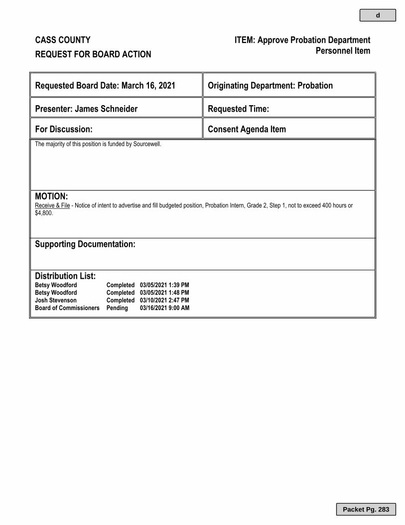
CASS COUNTY ITEM: Approve Probation Department
Personnel Item REQUEST FOR BOARD ACTION
Requested Board Date: March 16, 2021
Originating Department: Probation
Presenter: James Schneider
Requested Time:
For Discussion:
Consent Agenda Item
The majority of this position is funded by Sourcewell.
MOTION: Receive & File - Notice of intent to advertise and fill budgeted position, Probation Intern, Grade 2, Step 1, not to exceed 400 hours or $4,800.
Supporting Documentation:
Distribution List: Betsy Woodford Completed 03/05/2021 1:39 PM Betsy Woodford Completed 03/05/2021 1:48 PM Josh Stevenson Completed 03/10/2021 2:47 PM Board of Commissioners Pending 03/16/2021 9:00 AM
d
Packet Pg. 283

CASS COUNTY ITEM: Approve Licenses - Tobacco, 3.2 Beer,
Liquor, Gambling, Etc. REQUEST FOR BOARD ACTION
Requested Board Date: March 16, 2021
Originating Department: Auditor-Treasurer
Presenter: Shari Splichal
Requested Time:
For Discussion:
Consent Agenda Item
MOTION: On & Off Sale 3.2 Beer: Woman Lake Lodge - Burk’s on Woman Lake – Woodrow Agency Bay Lodge – Fishing for Weeks, LLC – Turtle Lake Gambling: Adopt Resolution 22-21 PRBHS Clay Target League @ Backus American Legion Post 368 – Zachary A. Abraham – Powers Tobacco: Remer Municipal Liquor Store – City of Remer – Remer Wine & Strong Beer including Sunday: Agency Bay Lodge – Fishing for Weeks, LLC – Turtle Lake Set-Up: All Pine Inn Resort – Richard Anderson - Beulah
Supporting Documentation: 22-21 Gambling PRBHS Clay Target League
Distribution List: Shari Splichal Completed 03/09/2021 10:41 AM Sandra Norikane Completed 03/09/2021 10:57 AM Betsy Woodford Completed 03/10/2021 9:51 AM Josh Stevenson Completed 03/10/2021 2:42 PM Board of Commissioners Pending 03/16/2021 9:00 AM
e
Packet Pg. 284

CERTIFIED COPY OF RESOLUTION COUNTY BOARD OF CASS COUNTY RESOLUTION NO. 22-21 ADOPTED: March 16, 2021 Commissioner offered Resolution No. 22-21 and moved its adoption, Commissioner seconded: WHEREAS, During the Board proceeding of Tuesday, March 16, 2021, the Cass County Board of Commissioners took the following action:
BE IT RESOLVED, the County of Cass agrees to approve the LG220 Gambling Activity for Exempt Permit for the
PRBHS Clay Target League, 217 44 th Ave SW, Backus, MN 56435 to conduct lawful gambling in Powers Township
at the Backus American Legion Post 368, 426 Wren Trail, Backus, MN 53435 drawing to be held on June 5, 2021. Resolution No. 22-21 was adopted by majority vote: Ayes: Nays: None.
STATE OF MINNESOTA } County of Cass } ss. Office of County Administrator }
I, Joshua D. Stevenson, Administrator of the County of Cass, do hereby certify that I have compared the foregoing with
the original resolution filed in my office on the 16th day of March A. D. 2021, and the same is a true and correct
copy of the whole thereof.
WITNESS MY HAND AND SEAL OF MY OFFICE at Walker, Minnesota, this 16th day of March, A. D. 2021.
_________________________
Joshua D. Stevenson Cass County Administrator
e.a
Packet Pg. 285
Att
ach
men
t: 2
2-21
Gam
blin
g (
5290
: A
pp
rove
Lic
ense
s -
To
bac
co, 3
.2 B
eer,
Liq
uo
r, G
amb
ling
, Etc
.)

e.b
Packet Pg. 286
Att
ach
men
t: P
RB
HS
Cla
y T
arg
et L
eag
ue
(52
90 :
Ap
pro
ve L
icen
ses
- T
ob
acco
, 3.2
Bee
r, L
iqu
or,
Gam
blin
g, E
tc.)

e.b
Packet Pg. 287
Att
ach
men
t: P
RB
HS
Cla
y T
arg
et L
eag
ue
(52
90 :
Ap
pro
ve L
icen
ses
- T
ob
acco
, 3.2
Bee
r, L
iqu
or,
Gam
blin
g, E
tc.)

e.b
Packet Pg. 288
Att
ach
men
t: P
RB
HS
Cla
y T
arg
et L
eag
ue
(52
90 :
Ap
pro
ve L
icen
ses
- T
ob
acco
, 3.2
Bee
r, L
iqu
or,
Gam
blin
g, E
tc.)

CASS COUNTY ITEM: Approve Capital Fund Activity
REQUEST FOR BOARD ACTION
Requested Board Date: March 16, 2021
Originating Department: Administration
Presenter: Sandra Norikane
Requested Time:
For Discussion:
Consent Agenda Item
Insert Summary of item
MOTION: Approve- Capital Fund Activity: Expenditures: Dultmeier Sales Davenport (Walker Salt/Brine Facility) $1,732.40 Northern Air Corporation (Boiler Replacement Project) $177,650.00
Supporting Documentation: Capital 03.16
Distribution List: Sandra Norikane Completed 03/09/2021 11:03 AM Betsy Woodford Completed 03/10/2021 9:11 AM Josh Stevenson Completed 03/10/2021 2:22 PM Board of Commissioners Pending 03/16/2021 9:00 AM
f
Packet Pg. 289
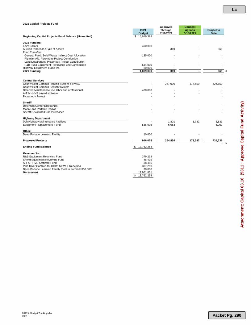
2021 Capital Projects FundApproved Consent
2021 Through Agenda Project toBudget 2/16/2021 3/16/2021 Date
Beginning Capital Projects Fund Balance (Unaudited) 13,619,329$
2021 Funding:Levy Dollars 400,000 - - - Auction Proceeds / Sale of Assets 369 - 369 Fund Transfers: General Fund: Solid Waste Indirect Cost Allocation 135,000 - - - Riparian Aid: Pictometry Project Contribution - - - - Land Department: Pictometry Project Contribution - - - - R&B Fund Equipment Revolving Fund Contribution 534,000 - - - Highway Equipment Trade-Ins 20,000 - - - 2021 Funding 1,089,000 369 - 369 ¥
-
Central ServicesCounty Seat Campus Heating System & HVAC - 247,000 177,650 424,650 County Seat Campus Security System - - - - Deferred Maintenance, incl labor and professional 400,000 - - - A-T & HHVS payroll software - - - - Pictometry Project - - -
SheriffDetention Center Electronics - - - - Mobile and Portable Radios - - - - Sheriff Revolving Fund Purchases - - - -
Highway Department(All) Highway Maintenance Facilities - 1,801 1,732 3,533 Equipment Replacement Fund 536,075 6,053 - 6,053
Other:Deep Portage Learning Facility 10,000 - - -
Proposed Projects 946,075 254,854 179,382 434,236 - ¥
Ending Fund Balance 13,762,254$
Reserved for:R&B Equipment Revolving Fund 379,233 Sheriff Equipment Revolving Fund 45,435 A-T & HHVS Software Fund 38,485 Pine River Campus for HHW, MSW & Recycling 307,250 Deep Portage Learning Facility (goal to earmark $50,000) 30,000 Unreserved 12,961,851
13,762,254$
2021X. Budget Tracking.xlsx2021
f.a
Packet Pg. 290
Att
ach
men
t: C
apit
al 0
3.16
(53
11 :
Ap
pro
ve C
apit
al F
un
d A
ctiv
ity)
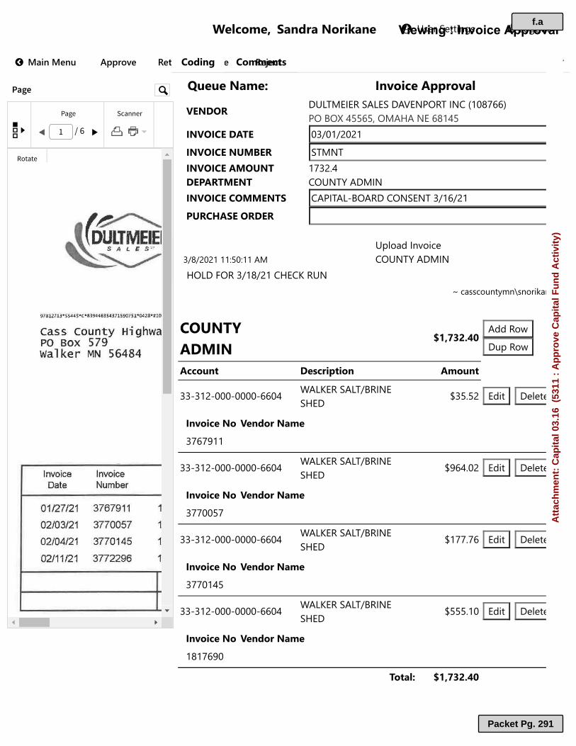
�
���������� ���������� ��������������������� !" #$%&#'&( )**+,-' .'/(+&0,1('(' .'2'3/45 67 89 : ; < = >?@AB C D E F GH I J K L
M� ��N M�����OPQR�R�����S T�U����VWW��U��XY�Z[\ ] _abcbdef_be]fgbhijdchklmnopqqrijsjtuvvqvwjafxfhbqomuvT�X[TMYZVyY nz{nm{|n|mT�X[TMY�}~�Y\ eahT�X[TMYV~[}�y mpz|�uZY�V\y~Y�y kj h �f]achT�X[TMYM[~~Y�y kficf_�sjfd]kjhebh z{mq{|m�}\M�VY[\ZY\z{o{|n|mmm�vn�mmfa �����c������kj h �f]achxj_]�jdz{mo{|mkxbk�d h �����������������������M[}�y�VZ~T� ����� ¡¢£ f��d�¤]��d�¤V���R�O Z�P���WO��� V��R�Ozz�zm|�nnn�nnnn�qqnu ¥f_�bdef_{sdchbexb] ¦zv�v| b��� ]�����T�U������X�� ������zpqp§mmzz�zm|�nnn�nnnn�qqnu ¥f_�bdef_{sdchbexb] ¦§qu�n| b��� ]�����T�U������X�� ������zppnnvpzz�zm|�nnn�nnnn�qqnu ¥f_�bdef_{sdchbexb] ¦mpp�pq b��� ]�����T�U������X�� ������zppnmuvzz�zm|�nnn�nnnn�qqnu ¥f_�bdef_{sdchbexb] ¦vvv�mn b��� ]�����T�U������X�� ������mompq§n y�O��S ����� ¡¢£
¨©_�ª���«���e�����ª� f.a
Packet Pg. 291
Att
ach
men
t: C
apit
al 0
3.16
(53
11 :
Ap
pro
ve C
apit
al F
un
d A
ctiv
ity)
snorikane
Rectangle
snorikane
Rectangle

Dultmeier Sales, LLC P.O. Box 45565
Omaha, NE 68145-0565 USA Phone: {800) 228-9666 or (402) 333-1444
Fax: (402) 333-5546 E-mail: [email protected]
97 8127 lr 5 S'J 4 S "C • 8 394 463543 715907 51 "'0428"'I 10 1/ 1
Cass county Highway Dept PO BOX 579 walker MN 56484
Invoice Invoice Order Date Number Number
01/27/21 3767911 1812758
02/03/21 3770057 1815143
02/04/21 3770145 1815176
02/11/21 3772296 1817690
Current
$1,696.88
Customer ID: 128865
Cass County Highway Dept
PO Box 579
Walker, MN 56484-0000
Remit To:
Oultmeier Sales PO Box 45565 Omaha, NE 68145
1111111111111111111111111
Purchase Order Number
Shannon-1/2712021 16:02:45
Shannon-2/3/2021 15:24:23
Shannon-2/3/202116:14:16
Shannon-2/11/202111:15:49
30 Days 60 Days
$35.52 $0.00
\S Pay by phone: 800-228-9666 x 5011
Statement CUSTOMER ID
128865 Statement as of: 3/1 /2021
Page 1of1
r~ [E [@ re a w re ~ lfil MAR 0 8 2021 ~I By
Due Amount Balance Date Due
02/26/21 $35.52v $35.52
03/05/21 $964.02 ./ $999.54
03/06/21 $177.76 v $1, 177.30
03/13/21 $555.10 ./ $1,732.40
90 Days+ Total Balance
$0.00 $1,732.40
Invoice Balance Amt
3767911 $35.52
3770057 $964.02
3770145 $177.76
3772296 $555.10
f.a
Packet Pg. 292
Att
ach
men
t: C
apit
al 0
3.16
(53
11 :
Ap
pro
ve C
apit
al F
un
d A
ctiv
ity)

Dultmeier Sales Davenport, Inc. INVOICE P.O. Box 45565
Omaha, NE 68145-0565 USA Phone: (800) 228-9666 or (402) 333-1444
Fax: (402) 333-5546 E-mail: [email protected]
96398as3•ss44s•c•a30037313431146920•042a•110 1/ 1 lllll Ill I llllllllll II I Ill Bill To: Cass county Highway Dept PO BOX 579 walker MN 56484 1m ~ IT:5 [E o w re m
w FEB 0 4 2021 ~
Go Paperless!!!: htt s:.',\nn,.dultmeier.fom/papc11U·!3~Y~rr;g;;!========~ Customer ID: 128865
INVOICE: 3767911
Invoice Date I Page
1127/2021 16:53:19 l l ofl
ORDER NUMBER: 1812758
Ship
Cass County Highway Dept
8045 County Rd 12 NW
Walker, MN 56484-0000
USA
Shannon Rettki
PO Number NetDueDat DiscDueDa Discount Amount
Shannon-1/27/2021 16:02:45 2/26/2021
Order Date Pick Ticket Dultmeier Sales
1/27/2021 15:57:15 2759653 Thank You for Your Business
Quantities Item ID
1-~~~~r-~~~...-~~~~.--~~~.---1
Ordered I Shippe I R .. I UOM I .::; Item Description I ema1ml Unitl ~
Carri UPS Ground Tracking J Z531260033 l 26094 l
4 4 0 EA TKP200E
1.0 2 IN Shank Adaptor
Camlock Lever Coupling, Poly, 21N Shank Adapter
Total Lin 1
2/10/2021 0.19
Taker
RSCHWANINGER
Prici
ng Uni
UnitS
EA 4.8500
1.0000
SUB-TOTAL:
Ext en Price
19.40
TOTAL FREIGHT & HANDLING: 19.40
16.12
0.00
Please include invoice number/numbers with check
Tenns: Open account tenns as stated on each invoice. Credit card
Transactions and cash with order shipments do not qualify for open account
tenns. Shipments are FOB shipping Point. Pay from this invoice, no
ORIGINAL '\ Ill I l / 14·"lf\IO
TAX:
AMOUNT DUE: 35.52 U.S. Dollars ~
=
--iiiiiii
f.a
Packet Pg. 293
Att
ach
men
t: C
apit
al 0
3.16
(53
11 :
Ap
pro
ve C
apit
al F
un
d A
ctiv
ity)

Dultmeier Sales, LLC INVOICE P.O. Box 45565
Omaha, NE6814S-0565 USA Phone: (800) 228-9666 or (402) 333-1444
Fax: (402) 333-5546 E-mail: [email protected]
INVOICE: 3770057
Invoice Date Page
2/3/2021 16:09:13 1 of2
ORDER NUMBER: 1815143
96711863 • S 5 44 S*C • 83195203 5163907176*0428*'10 1/2
Ship To:
11111111111/1111111111111 Cass County Highway Dept
Bill To: Cass county Highway PO BOX 579 walker MN 56484
Dept
Go Paperless!!!: https://www.dultmeier.com /paperle~s.php
Customer ID: 128865
W ft: (it) re ---_..,KA4.!) County Rd 12 N W
l.f; (J9 lJ; 0 rf} re er, MN 56484-0000
FEB 0 9 2021
By
Shannon Rettki
PO Number Net Due Date Disc Due Date Discount Amount
Shannon-2/3/2021 15:24:23 3/5/2021 2/17/2021 8.79
Order Date Pick Ticket No Dultmeier Sales Taker
2/3/2021 15:19:28 2761789 Thank You for Your Business KMONTAG
Quantities Item JD
Ordered I Shipped I IUOM ,1 -~ Item Description Remaining Unit Size ~
200
Carrier: SpeeDee Delivery
Carrier: SpeeDee Delivery
Carrier: SpeeDee Delivery
Carrier: SpeeDee Delivery
200 0 FT
Hose, Suction, Tigerflex, 1-112IN, Yellow
25 25 0 FT
TFTY150
Tracking#: SP0079270307657 l
Tracking#: SP00792703076570
Tracking#:SP00792703076569
Tracking#: SP00792703076568
1.0 1-1/2 Yellow Suction Hose
TFTY200
1.0 2" Yellow Suction Hose
Hose, Suction, Tigertlex, 2IN, Yellow --If out temp# is KA300Y-2
10 10 0 EA TKP200A
1.0 2 IN Female Adaptor
Camlock Lever Coupling, Poly, 2IN Female Adapter
10 10 0 EA TKPHB200150
1.0 2Mptxl-l/2Hb Poly Fittng
Fitting, Poly, 2IN Mpt X 1-112IN Hose Barb
10 10 0 EA TKP150C
1.0 1-1/2 Shank Coupler
Camlock Lever Coupling, Poly, l-l/2IN Shank Coupler
4 4 0 EA TKP200F
1.0 2 IN Male Adaptor
Camlock Lever Coupling, Poly, 2IN Male Adapter
4 4 0 EA TKPl50A
1.0 1-112 Female Adapter
Pricing UOM Unit
Price UnitSi;.e
FT 1.7200
1.0000
FT 3.0500
1.0000
EA 3.9425
1.0000
EA 3.3750
1.0000
EA 8.9300
1.0000
EA 4.8500
1.0000
EA 3.5500
1.0000
Terms: Open account terms as stated on each invoice. Credit card Transactions and cash with order shipments do not qualify for open account terms. Shipments are
FOB shipping Point. Pay from this invoice, no statement sent. Late charge assessed at 1-1/3% monthly on all past due invoices. U.S. Export control laws and
regulations may apply to this shipment. An export license may be required before export. Diversion contrary to U.S. Law is prohibited.
ORIGINAL ~ 11'\ 1111400 10
Extended Price
344.00
76.25
39.43
33.75
89.30
19.40
14.20
~ -
f.a
Packet Pg. 294
Att
ach
men
t: C
apit
al 0
3.16
(53
11 :
Ap
pro
ve C
apit
al F
un
d A
ctiv
ity)

Dultmeier Sales, LLC INVOICE P.O. Box 45565
Omaha, NE68145-0565 USA Phone: (800) 228-9666 or (402) 333-1444
Fax: (402) 333-5546 E-mail: [email protected]
Quantities Item ID
Ordered I Shipped I .. ~luoM ,I ~ Remarmng Unit Size ~ Item Description
Camlock Lever Coupling, Poly, 1- J/2fN Female Adapter
10 JO 0 EA
Camlock Lever Coupling, Poly, 2fN Dust Cap
5 5 0 EA
Camlock Lever Coupling, Poly, 2IN Plug
10 IO 0 EA
Camlock Lever Coupling, Poly, l-J/2IN Dust Cap
10 10 0 EA
Camlock Lever Coupling, Poly, l-l/2fN Plug
Total Lines: 11
1.0
TKP200CAP
2 IN Dust Cap
TKP200PL
1.0 2 IN Poly Plug
TKP150CAP
1.0 1-1/2 Dust Cap
TKP150PL
1.0 l-l/2PolyPlug
INVOICE: 3 770057
Invoice Date Page
2/3/2021 16:09:13 2 of2
ORDER NUMBER: 1815143
Pricing UOM Unit
Price Unit Size
EA 11.0200
1.0000
EA 4.8500
1.0000
EA 8.9300
1.0000
EA 4.1325
1.0000
SUB-TOTAL:
TOTAL FREIGHT & HANDLING:
TAX:
Extended Price
110.20
24.25
89.30
41.33
881.41
82.61
0.00
AMOUNT DUE: 964.02 Please include invoice number/numbers with check
Terms: Open account terms as stated on each invoice. Credit card Transactions and cash with order shipments do not qualify for open account terms. Shipments are FOB shipping Point. Pay from this invoice, no statement sent. Late charge assessed at 1-113% monthly on all past due invoices. U.S. Export control laws and regulations may apply to this shipment. An export license may be required before export. Diversion contrary to U.S. Law is prohibited.
ORIGINAL ~ I 11 11114/?0 IO
U.S. Dollars
=
= =
= = !!!!! -
f.a
Packet Pg. 295
Att
ach
men
t: C
apit
al 0
3.16
(53
11 :
Ap
pro
ve C
apit
al F
un
d A
ctiv
ity)

Dultmeier Sales, LLC INVOICE P.O. Box 45565
Omaha, NE68145-0565 USA Phone: (800) 228-9666 or (402) 333-1444
Fax: (402) 333-5546 E-mail: [email protected]
967787<12*5544S•c•832ll0U4SS3502843*0428"itl0 1/ 1 1111111111111111111111111 Bill To: Cass county Highway Dept PO BOX 579 walker MN 56484
~re ufiE n w IE~ ~u FEB 1 2 2021 \!
Go Paperless!!!: https; 1/www.dultmeicr.com1paperless.phn
Customer ID: 128865
INVOICE: 3770145
Invoice Date Page
21412021 09:41:43 I of I
ORDER NUMBER: 1815176
Ship To:
Cass County Highway Dept
8045 County Rd 12 NW
Walker, MN 56484-0000
USA
Shannon Rettki
PO Number Net Due Date Disc Due Date Discount Amount
Shannon-2/3/202116:14:16
Order Date Pick Ticket No
2/3/2021 15:40:51 2761812
Quantities
Ordered I Shipped I .. ~luoM ~I ~ Remaining Unit Size i:\
Carrier: SpeeDee Delivery
20 20 0 EA 1.0
T-Bolt Hose Clamp, l-l/2IN, Stainless
10 10 0 EA 1.0
T-Bolt Hose Clamp, 2IN, Stainless
Total Lines: 2
3/6/2021 2/18/2021 1.65
Dultmeier Sales Taker
Thank You for Your Business KMONTAG
Pricing Item JD UOM Unit Item Description Price
Unit Size
Tracking#: SP00792703076585
TKTCI81 EA 5.4000
l-l/2IN T Bolt Clamp,1.88IN To 2.19IN 1.0000
TKTC231 EA 5.6700
2 IN T Bolt Clamp 2.31 To 2.62 IN 1.0000
SUB-TOTAL:
TOTAL FREIGHT & HANDLING:
TAX:
Extended Price
108.00
56.70
164.70
13.06
0.00
AMOUNT DUE: 177.76
U.S. Dollars 94-Please include invoice number/numbers with check
Terms: Open account terms as stated on each invoice. Credit card Transactions and cash with order shipments do not qualify for open account terms. Shipments are
FOB shipping Point. Pay from this invoice, no statement sent. Late charge assessed at l-l/3% monthly on all past due invoices. U.S. Export control laws and
regulations may apply to this shipment. An export license may be required before export. Diversion contrary to U.S. Law is prohibited.
ORIGINAL ~II' 111141?010
-!!!! ---;;;;;;;; !!!! --
f.a
Packet Pg. 296
Att
ach
men
t: C
apit
al 0
3.16
(53
11 :
Ap
pro
ve C
apit
al F
un
d A
ctiv
ity)

Dultmeier Sales, LLC INVOICE
P.O. Box 45565 Omaha, NE68145-0565 USA
Phone: (800) 228-9666 or (402) 333-1444 Fax: (402) 333-5546
E-mail: [email protected]
97097974"5544s•c•u4z21411201312oso•042s•.uo Ul 1111111111111111111111111 Bill To: Cass county Highway Dept PO Box 579 walker MN 56484
m IH~ IH ~ Ir. ffi \\hl ft_B \ 1 2U21 ®\
BY-=
Go Paperless!!!: htl ps:/lwww.dultmeier.com/p.tperll·ss.oh n
Customer ID: 128865
INVOICE: 3772296
Invoice Date Page
2/11/2021 13:06:24 l of l
ORDER NUMBER: 1817690
Ship To:
Cass County Highway Dept
8045 County Rd 12 NW
Walker, MN 56484-0000
USA
Shannon Rettki
PO Number Net Due Date Disc Due Date Discount Amount
Shannon-2/11/2021 11: l 5 :49 3/13/2021
Order Date Pick Ticket No Dultmeier Sales
2/11/202111:02:20 2764083 Thank You for Your Business
Quantities Item JD
1-~~~~...-~~~.....-~~~~---~~~---.~-t
I I I UOM I -~ Item Description Ordered Shipped Remaining I Unit Sizel Ci
20
Carrier: SpeeDee Delivery
Carrier: SpeeDee Delivery
20 0 EA
T-Bolt Hose Clamp, 2IN, Stainless
75 75 0 FT
1.0
1.0
TKTC231
Tracking #: SP00792703076866
Tracking#: SP00792703076865
2 IN T Bolt Clamp 2.31 To 2.62 IN
TFfY200
2" Yellow Suction Hose
Hose, Suction, Tigerflex, 2IN, Yellow --If out temp# is KA300Y-2
10 IO 0 EA TKP200150C
1.0 2Xl-1/2 Female Quick Connect
Camlock Lever Coupling, Quick Connect, 2IN X l-1/2IN, Female
Total Lines: 3
2/25/2021
Pricing UOM
Unit Size
EA 1.0000
FT 1.0000
EA 1.0000
4.57
Taker
CEBERT
Unit Price
5.2200
3.0500
12.4450
SUB-TOTAL:
Extended Price
104.40
228.75
124.45
457.60
TOTAL FREIGHT & HANDLING: 97.50
TAX: o.oo
AMOUNT DUE: 555.10 Please include invoice number/numbers with check U.S. Dollars
Terms: Open account terms as stated on each invoice. Credit card Transactions and cash with order shipments do not qualify for open account terms . Shipments are
FOB shipping Point. Pay from this invoice, no statement sent. Late charge assessed at 1-1/3% monthly on all past due invoices. U.S . Export control laws and
regulations may apply to this shipment. An export license may be required before export. Diversion contrary to U.S. Law is prohibited.
ORIGINAL • <:; 111 11 114/?0JO
-!!!!!
iiiii
iiiii -=
f.a
Packet Pg. 297
Att
ach
men
t: C
apit
al 0
3.16
(53
11 :
Ap
pro
ve C
apit
al F
un
d A
ctiv
ity)

Page 1 of 1
NORTHERN AIR CORPORATION (NAC)
1001 LABORE INDUSTRIAL CT STE B
VADNAIS HEIGHTS MN 55110
VENDOR #: 105094
CHECK #: 1029468
CHECK AMOUNT: 177650.00
CHECK DATE: 03/04/2021
WARRANT TYPE: Auditor
ACCOUNT NUMBER AMOUNT DESCRIPTION INVOICE #
33-110-000-0000-6606 177650.00 A2802BTH BOILER REPL PROJECT 2802-03
TOTAL 177,650.00
Invoice Activity Summary
Date User Action
02-26-2021 01:00 PM SNORIKANE Clicked 'Notify Approver' in 'Invoice Coding'02-26-2021 01:00 PM SNORIKANE Clicked 'Return To Queue' in 'Invoice Approval'02-26-2021 01:06 PM JOSHS Clicked 'Approve' in 'Invoice Approval'03-02-2021 09:05 AM DELLAC Clicked 'Return To Queue' in '2 - Review Invoices'03-02-2021 11:54 AM DELLAC Clicked 'Continue' in '2 - Review Invoices'03-02-2021 04:00 PM DELLAC Clicked 'Complete' in '3 - Submit Invoices'
f.a
Packet Pg. 298
Att
ach
men
t: C
apit
al 0
3.16
(53
11 :
Ap
pro
ve C
apit
al F
un
d A
ctiv
ity)
snorikane
Highlight
snorikane
Highlight

Page: 1 of 2 A2802BTH 2802-03
9475
02/25/20212802-03
CLIENT ID:INVOICE #:INVOICE DATE:DUE DATE: 03/25/2021BILLED THROUGH: 02/25/2021
Bill To: CASS COUNTY GOVERNMENT BUILDING303 MINNESOTA AVENUEWALKER MN 56484
Site Address:303 MINNESOTA AVENUEWALKER MN 56484
CASS COUNTY GC AND HHVS BOILER UPGRADES JOB ID: PO #:
A2802BTH
FIXED FEE ITEMS CONTRACTAMOUNT
%COMPLETE
AMOUNTREMAINING
TOTAL BILLED
TO DATE
AMOUNTPREVIOUSLY
BILLEDTHIS
AMOUNT
BILLING
MAIN CONTRACT 1,036,850.00 90.85% $94,850.00 $942,000.00 $755,000.00 $187,000.00
1,036,850.00 90.85% $94,850.00 $187,000.00 $755,000.00 $942,000.00
PLEASE REMIT TO: Northern Air Corporation 1001 Labore Industrial, Suite B Vadnais Heights, MN 55110
Gross Billing $187,000.00 Less Retainage $9,350.00
Total Invoice $177,650.00
f.a
Packet Pg. 299
Att
ach
men
t: C
apit
al 0
3.16
(53
11 :
Ap
pro
ve C
apit
al F
un
d A
ctiv
ity)

Page: 2 of 2 A2802BTH 2802-03
EXPLANATION OF CHARGES RETAINAGE CALCULATIONS
%RETAINAGE TOTAL
EARNEDTOTAL
RETAINAGE RETAINAGE PREVIOUS CURRENT
RETAINAGE
MAIN CONTRACT 5.00% $942,000.00 $47,100.00 $37,750.00 $9,350.00
PLEASE REMIT TO: Northern Air Corporation 1001 Labore Industrial, Suite B Vadnais Heights, MN 55110
Gross Billing $187,000.00 Less Retainage $9,350.00
Total Invoice $177,650.00
f.a
Packet Pg. 300
Att
ach
men
t: C
apit
al 0
3.16
(53
11 :
Ap
pro
ve C
apit
al F
un
d A
ctiv
ity)

APPLICATION AND CERTIFICATE FOR PAYMENT CONSTRUCTION MANAGER‐ADVISER EDITIONAIA DOCUMENT G702/CMa PAGE 1 OF 2
TO OWNER: PROJECT: CASS COUNTY GC AND HHVS APPLICATION NO: 3 Distribution to:CASS COUNTY FACILITY BOILER SYSTEM UPGRADES INVOICE NO: 2802‐03 OWNER303 MINNESOTA AVE PERIOD TO: 02/28/21 CONSTRUCTIONWALKER, MN 56484 PROJECT NO: MANAGERFROM CONTRACTOR: ARCHITECTNAC MECHANICAL & ELECTRICAL SERVICES CONTRACT DATE: 08/14/20 CONTRACTOR1001 LABORE INDUSTRIAL COURT, SUITE BVADNAIS HEIGHTS, MN 55110 VIA CONSTRUCTION MANAGER: CONTRACT FOR: JOB # A2802BTHCONTRACTOR'S APPLICATION FOR PAYMENT The undersigned Contractor certifies that to the best of the Contractor's knowledge,Application is made for payment, as shown below, in connection with the Contract. information and belief the Work covered by this Application for Payment has been Continuation Sheet, AIA Document G703, is attached. completed in accordance with the Contract Documents, that all amounts have been paid
by the Contractor for Work for which previous Certificates for Payment were issued and payments received from the Owner, and that current payment shown herein is now due.
1. ORIGINAL CONTRACT SUM $ 1,036,850.002. Net change by Change Orders $ CONTRACTOR: NAC MECHANICAL & ELECTRICAL SERVICES3. CONTRACT SUM TO DATE (Line 1 ± 2) $ 1,036,850.004. TOTAL COMPLETED & STORED TO DATE $ 942,000.00 (Column G on G703) By: __________________________________________________ Date: ___5. RETAINAGE:
a. 5 % of Completed Work $ 47,100.00 State of: MINNESOTA County of: RAMSEY(Column D + E on G703) Subscribed and sworn to before me this day of
b. 5 % of Stored Material $ Notary Public:(Column F on G703) My Commission expires:
Total Retainage (Lines 5a + 5b or
Total in Column I of G703) $ 47,100.00 CERTIFICATE FOR PAYMENT6. TOTAL EARNED LESS RETAINAGE $ 894,900.00 In accordance with the Contract Documents, based on on‐site observations and the data
(Line 4 less Line 5 Total) $ comprising this application, the Construction Manager and Architect certify to the 7. LESS PREVIOUS CERTIFICATES FOR Owner that to the best of their knowledge, information and belief the Work has PAYMENT (Line 6 from prior Certificate) $ 717,250.00 progressed as indicated, the quality of the Work is in accordance with the Contract8. CURRENT PAYMENT DUE $ 177,650.00 Documents, and the Contractor is entitled to payment of the AMOUNT CERTIFIED.9. BALANCE TO FINISH, INCLUDING RETAINAGE $ 141,950.00
(Line 3 less Line 6) AMOUNT CERTIFIED $CHANGE ORDER SUMMARY ADDITIONS DEDUCTIONS (Attach explanation if amount certified differs from the amount applied for. Initial all
Total changes approved figures on this Application and on the Continuation Sheet that changed to conform to the in previous months by Owner amount certified.)
CONSTRUCTION MANAGER: Total approved this Month By: __________________________________________________ Date: ___________________
ARCHITECT:TOTALS $0.00 $0.00 By: __________________________________________________ Date: ___________________
NET CHANGES by Change Order $0.00 This Certificate is not negotiable. The AMOUNT CERTIFIED is payable only to theContractor named herein. Issuance, payment and acceptance of payment are withoutprejudice to any rights of the Owner or Contractor under this Contract.
AIA DOCUMENT G702/CMa ∙ APPLICATION AND CERTIFICATION FOR PAYMENT ∙ CONSTRUCTION MANAGER‐ADVISER EDITION ∙ 1992 EDITION ∙ AIA® ∙ © 1992 G702/CMa‐1992THE AMERICAN INSTITUTE OF ARCHITECTS, 1745 NEW YORK AVE., N.W., WASHINGTON, DC 20006‐5292
Users may obtain validation of this document by requesting of the license a completed AIA Document D401 ‐ Certification of Document's Authenticity
f.a
Packet Pg. 301
Att
ach
men
t: C
apit
al 0
3.16
(53
11 :
Ap
pro
ve C
apit
al F
un
d A
ctiv
ity)
nbishop
NOTARY
nbishop
Stamp
nbishop
Typewritten Text
02/25/2021
nbishop
Typewritten Text
25TH
nbishop
Typewritten Text
FEB 2021
nbishop
Typewritten Text
NICOLE BISHOP
nbishop
Typewritten Text
01/31/24

CONTINUATION SHEET AIA DOCUMENT G703 PAGE OF PAGES 1 OF 2
AIA Document G702, APPLICATION AND CERTIFICATION FOR PAYMENT, containing APPLICATION NO: 3Contractor's signed certification is attached. APPLICATION DATE: 2/23/21In tabulations below, amounts are stated to the nearest dollar. PERIOD TO: 2/28/21Use Column I on Contracts where variable retainage for line items may apply. ARCHITECT'S PROJECT NO:
JOB # A2802BTH NORTHERN AIR CORPORATIONA B C D E F G H I
ITEM DESCRIPTION OF WORK SCHEDULED WORK COMPLETED MATERIALS TOTAL % BALANCE RETAINAGENO. VALUE FROM PREVIOUS THIS PERIOD PRESENTLY COMPLETED (G ÷ C) TO FINISH (IF VARIABLE
APPLICATION STORED AND STORED (C ‐ G) RATE)(D + E) (NOT IN TO DATE
D OR E) (D+E+F)General, Bonds Permits $36,850.00 $25,000.00 $5,000.00 $30,000.00 81.41% $6,850.00 $1,500.00Sheetmetal $70,000.00 $40,000.00 $20,000.00 $60,000.00 85.71% $10,000.00 $3,000.00Piping $320,000.00 $220,000.00 $75,000.00 $295,000.00 92.19% $25,000.00 $14,750.00Insulation $25,000.00 0.00% $25,000.00 $0.00Controls $220,000.00 $160,000.00 $40,000.00 $200,000.00 90.91% $20,000.00 $10,000.00Electrical $65,000.00 $45,000.00 $12,000.00 $57,000.00 87.69% $8,000.00 $2,850.00Equipment $300,000.00 $265,000.00 $35,000.00 $300,000.00 100.00% $15,000.00
$0.00$0.00$0.00$0.00$0.00$0.00$0.00$0.00$0.00$0.00$0.00$0.00$0.00$0.00$0.00$0.00$0.00
GRAND TOTALS $1,036,850.00 $755,000.00 $187,000.00 $942,000.00 90.85% $94,850.00 $47,100.00
Users may obtain validation of this document by requesting of the license a completed AIA Document D401 ‐ Certification of Document's Authenticity
f.a
Packet Pg. 302
Att
ach
men
t: C
apit
al 0
3.16
(53
11 :
Ap
pro
ve C
apit
al F
un
d A
ctiv
ity)

1
Sandra Norikane
From: Tom BuhlSent: Friday, February 26, 2021 12:24 PMTo: Della Meyer; Tim Richardson; Sandra NorikaneSubject: Re: NAC INV # 2802-03
It should be ok to bring before the board for approval. Thank you, Tom
From: Della Meyer <[email protected]> Sent: Friday, February 26, 2021 11:19 AM To: Tom Buhl <[email protected]>; Tim Richardson <[email protected]>; Sandra Norikane <[email protected]> Subject: FW: NAC INV # 2802‐03 Tim/Tom – Please look over and let Sandra know it’s okay to be board approved. Thanks, Della
From: Nicole Bishop <nbishop@nac‐hvac.com> Sent: Thursday, February 25, 2021 11:03 AM To: Della Meyer <[email protected]> Subject: NAC INV # 2802‐03 Please see the attached invoice. Thanks!
Nicole Bishop Construction Project Accountant
Direct: 651‐255‐3534 | O: 651‐490‐9868 | F: 651‐490‐1636 | TF: 888‐257‐5248 nbishop@nac‐hvac.com | 24‐hour service | website An Affirmative Action, Equal Employment Opportunity Employer This email is the property of NAC Mechanical & Electrical Services and may contain confidential and/or privileged information.
f.a
Packet Pg. 303
Att
ach
men
t: C
apit
al 0
3.16
(53
11 :
Ap
pro
ve C
apit
al F
un
d A
ctiv
ity)

CASS COUNTY ITEM: Approve Abatements
REQUEST FOR BOARD ACTION
Requested Board Date: March 16, 2021
Originating Department: Assessor
Presenter: Mark Peterson
Requested Time: 10 Minutes
For Discussion: 10 Min
Consent Agenda Item
Requesting County Commissioner approval of Abatements, dated March 16, 2021, that require certain actions in order to correct property tax valuations and / or classification changes.
MOTION: Approve- Assessor’s Office Abatements. 2021, Jeffrey Schultz, 38-519-0120, Shingobee, Reinstate 50% Homestead Current $1,814.00, Proposed & Tax Dollar Change: Unavailable at This Time 2021, CMERCH, LLC, 45-122-3301 & 45-122-3307, Turtle Lake, Correct Resort Classification Current $21,454.00 & $3,846.00, Proposed & Tax Dollar Change: Unavailable at This Time 2021, Rob Smith, 14-112-1205, Fairview, Reinstate Homestead Current $ 1,886.00, Proposed & Tax Dollar Change: Unavailable at This Time 2020, USA in Trust for Leech Lake, 19-014-4200, Kego, Correct Class Current $7,124.00, Proposed 0.00, Tax Dollar Change ($7,124.00) 2021, USA in Trust for Leech Lake, 19-014-4200, Kego, Correct Class Current $7,128.00, Proposed 0.00, Tax Dollar Change ($7,128.00)
Supporting Documentation: 2021-3-16 Abatements
Distribution List: Bonnie Lembke Completed 03/09/2021 1:21 PM Mark Peterson Completed 03/09/2021 1:25 PM Sandra Norikane Completed 03/09/2021 1:44 PM Betsy Woodford Completed 03/10/2021 9:06 AM Josh Stevenson Completed 03/10/2021 2:21 PM Board of Commissioners Pending 03/16/2021 9:00 AM
g
Packet Pg. 304
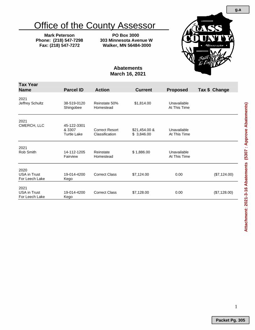
Office of the County Assessor
Mark Peterson PO Box 3000 Phone: (218) 547-7298 303 Minnesota Avenue W Fax: (218) 547-7272 Walker, MN 56484-3000
1
Abatements
March 16, 2021
Tax Year Name Parcel ID Action Current Proposed Tax $ Change 2021 Jeffrey Schultz 38-519-0120 Reinstate 50% $1,814.00 Unavailable Shingobee Homestead At This Time
2021 CMERCH, LLC 45-122-3301
& 3307 Correct Resort $21,454.00 & Unavailable Turtle Lake Classification $ 3,846.00 At This Time
2021 Rob Smith 14-112-1205 Reinstate $ 1,886.00 Unavailable Fairview Homestead At This Time
2020 USA in Trust 19-014-4200 Correct Class $7,124.00 0.00 ($7,124.00) For Leech Lake Kego
2021 USA in Trust 19-014-4200 Correct Class $7,128.00 0.00 ($7,128.00) For Leech Lake Kego
g.a
Packet Pg. 305
Att
ach
men
t: 2
021-
3-16
Ab
atem
ents
(53
07 :
Ap
pro
ve A
bat
emen
ts)

CASS COUNTY ITEM: Approve Contract for Services with
Mark Beard 2021 REQUEST FOR BOARD ACTION
Requested Board Date: March 16, 2021
Originating Department: Administration
Presenter: Josh Stevenson
Requested Time:
For Discussion:
Consent Agenda Item
MOTION: Approve - The 2021 Contract for services with Mark Beard at the same rate for the eight previous years and conditions the same as the previous year.
Supporting Documentation: Mark Beard Contract 2021
Distribution List: Josh Stevenson Completed 03/10/2021 2:24 PM Betsy Woodford Completed 03/10/2021 11:16 AM Josh Stevenson Completed 03/10/2021 2:24 PM Board of Commissioners Pending 03/16/2021 9:00 AM
h
Packet Pg. 306

h.a
Packet Pg. 307
Att
ach
men
t: M
ark
Bea
rd C
on
trac
t 20
21 (
5292
: A
pp
rove
Co
ntr
act
for
Ser
vice
s w
ith
Mar
k B
eard
202
1)

h.a
Packet Pg. 308
Att
ach
men
t: M
ark
Bea
rd C
on
trac
t 20
21 (
5292
: A
pp
rove
Co
ntr
act
for
Ser
vice
s w
ith
Mar
k B
eard
202
1)

h.a
Packet Pg. 309
Att
ach
men
t: M
ark
Bea
rd C
on
trac
t 20
21 (
5292
: A
pp
rove
Co
ntr
act
for
Ser
vice
s w
ith
Mar
k B
eard
202
1)

CASS COUNTY ITEM: Approve Inspection Contract Renewal
for New SSTS Installations REQUEST FOR BOARD ACTION
Requested Board Date: March 16, 2021
Originating Department: Environmental Services Department
Presenter: John Ringle
Requested Time:
For Discussion:
Consent Agenda Item
Devon Schafer has been performing new SSTS (septic system) Installation Compliance Inspections for Cass County for the past 5 years. Mr. Schafer’s current contract expires on March 31, 2021. Mr. Schafer has requested a 2-year extension to renew his contract under the same terms, conditions, and payment schedule as specified in the current contract. Currently, Mr. Schafer receives $110 per inspection or $50 for approving as-built inspections for conducting inspections that meet Cass County and MPCA standards. No additional fees are allocated for mileage.
MOTION: Approve – Extension of Contract between Cass County Environmental Services Department and Devon Schafer for New Subsurface Septic Treatment System (SSTS) Compliance Inspections for a 2-year period (April 6, 2021 to March 31, 2023). To be extended under the same terms and payment per system as with the current contract ($110 per system on-site and $50 as built). Compliance Inspections shall meet the requirements of both Cass County and MPCA.
Supporting Documentation: Contract 2021 ---Devon Schafer dba Schafer Excavating
Distribution List: John Ringle Completed 03/08/2021 2:10 PM Betsy Woodford Completed 03/08/2021 2:15 PM Jessica Manifold Skipped 03/10/2021 2:40 PM skipped Josh Stevenson Completed 03/10/2021 2:40 PM Board of Commissioners Pending 03/16/2021 9:00 AM
i
Packet Pg. 310

CONTRACT FOR INDEPENDENT INDIVIDUAL SEWAGE TREATMENT SYSTEM INSPECTION CONTRACTOR
This contract, dated April 6, 2021 is made between the following parties:
Cass County (hereinafter County) 300 Minnesota Avenue
Walker, MN. 56484; And Cass County Environmental Services Department (hereinafter Department); And Devon Shafer
Shafer Excavating LLC (hereinafter Contractor) 3109 Hwy 371 Hackensack, MN 56452
The Project: CASS COUNTY NEW INSTALLATION SSTS COMPLIANCE INSPECTIONS The County, the Department, and the Contractor agree as set forth below:
ARTICLE 1 SERVICES
The County has adopted an ordinance to provide for the proper design, location, installation, use, and maintenance of subsurface sewage treatment systems (SSTS) entitled the Cass County Subsurface Sewage Treatment System Ordinance and, as required by Minnesota Chapter 7080, must enforce the provisions of that ordinance. The Cass County Board of Commissioners has authorized contract compliance inspection of new and replacement SSTS in Cass County for 2021-2023. The Contractor is hereby retained to perform SSTS inspections for Cass County, Minnesota and provide to the County documentation as herein required of the results of each inspection. Duties and Responsibilities of the Contractor:
1. To be available for inspections and schedule inspection dates and times directly with SSTS installers;
2. To inspect individual sewage treatment systems as designated by the Department for compliance with the Cass County Individual Sewage Treatment System Ordinance according to the attached protocol;
3. To instruct SSTS installers when it is appropriate to complete systems without inspection and prepare as-built data and drawings for submittal to the Contractor.
4. To receive and review all as-built data and drawings and submit approved copies to the Department;
5. To complete to the satisfaction of the Department the inspection forms provided by the Department;
i.a
Packet Pg. 311
Att
ach
men
t: C
on
trac
t 20
21 -
--D
evo
n S
chaf
er d
ba
Sch
afer
Exc
avat
ing
(53
04 :
Ap
pro
ve In
spec
tio
n C
on
trac
t R
enew
al f
or
New
SS
TS
Inst
alla
tio
ns)

6. To provide a photographic record of the installed system prior to trench closure or drainfield covering;
7. To have available all tools and equipment necessary to adequately complete an SSTS inspection (including but not limited to camera, soil auger, Munsell Soil Color Chart, and tape measure) and to use the forms developed by The Department for SSTS inspections and Certificates of Compliance;
8. To provide transportation to the job site and to secure and maintain automobile licensure and insurance as required by law and provide proof of same to the County;
9. To comply with all provisions of the Cass County General Contract Addendum attached hereto as Attachment A.
Duties and Responsibilities of the Department:
1. To process SSTS permit applications; 2. To review and approve SSTS designs; 3. To provide the contractor permit information, and SSTS designs; 4. To make available necessary reporting forms and current installer information; 5. To enforce the Cass County Individual Sewage Treatment System Ordinance. 6. To perform inspections in Cass County when the contractor is not available. 7. To perform periodic spot checks of the contractor’s work for quality control.
ARTICLE 2 INSPECTION DEADLINE
The Independent SSTS Inspector shall perform all inspections, including the verification of any required tests, and submit the inspection forms to the Department within 5 working days following the completed inspection.
ARTICLE 3 MAINTAIN LICENSURE
The Contractor shall maintain an MPCA Inspector certification as required in Minnesota Rules, Chapter 7080, and show proof of his/her license number as a part of executing this contract and throughout the contract period. If the required state license is rendered invalid for any reason during the contract period, the Independent Individual Sewage Treatment System Inspector shall cease further inspections until such time as the license is reinstated.
ARTICLE 4 CONFLICT OF INTEREST
The Contractor shall not perform SSTS inspections on systems they or their associated companies have installed. Contractor shall not install new systems in Cass County during the term of this contract unless final inspection is performed by Cass County ESD.
ARTICLE 5 INDEPENDENT CONTRACTOR STATUS
The Contractor is an independent Contractor and nothing herein contained shall be construed to create the relationship of an employer and employee between the County and Contractor. The Contractor shall at all times be free to exercise initiative, judgment and discretion as to how to best perform or provide services. Contractor acknowledges and agrees that Contractor is not entitled to receive any of the benefits received by the County employees and is not eligible for workers' or
i.a
Packet Pg. 312
Att
ach
men
t: C
on
trac
t 20
21 -
--D
evo
n S
chaf
er d
ba
Sch
afer
Exc
avat
ing
(53
04 :
Ap
pro
ve In
spec
tio
n C
on
trac
t R
enew
al f
or
New
SS
TS
Inst
alla
tio
ns)
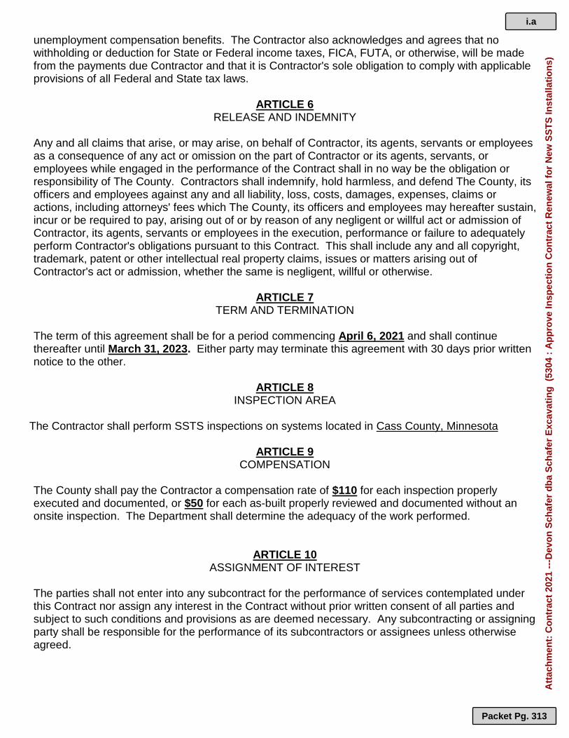
unemployment compensation benefits. The Contractor also acknowledges and agrees that no withholding or deduction for State or Federal income taxes, FICA, FUTA, or otherwise, will be made from the payments due Contractor and that it is Contractor's sole obligation to comply with applicable provisions of all Federal and State tax laws.
ARTICLE 6 RELEASE AND INDEMNITY
Any and all claims that arise, or may arise, on behalf of Contractor, its agents, servants or employees as a consequence of any act or omission on the part of Contractor or its agents, servants, or employees while engaged in the performance of the Contract shall in no way be the obligation or responsibility of The County. Contractors shall indemnify, hold harmless, and defend The County, its officers and employees against any and all liability, loss, costs, damages, expenses, claims or actions, including attorneys' fees which The County, its officers and employees may hereafter sustain, incur or be required to pay, arising out of or by reason of any negligent or willful act or admission of Contractor, its agents, servants or employees in the execution, performance or failure to adequately perform Contractor's obligations pursuant to this Contract. This shall include any and all copyright, trademark, patent or other intellectual real property claims, issues or matters arising out of Contractor's act or admission, whether the same is negligent, willful or otherwise.
ARTICLE 7 TERM AND TERMINATION
The term of this agreement shall be for a period commencing April 6, 2021 and shall continue thereafter until March 31, 2023. Either party may terminate this agreement with 30 days prior written notice to the other.
ARTICLE 8 INSPECTION AREA
The Contractor shall perform SSTS inspections on systems located in Cass County, Minnesota
ARTICLE 9 COMPENSATION
The County shall pay the Contractor a compensation rate of $110 for each inspection properly executed and documented, or $50 for each as-built properly reviewed and documented without an onsite inspection. The Department shall determine the adequacy of the work performed.
ARTICLE 10 ASSIGNMENT OF INTEREST
The parties shall not enter into any subcontract for the performance of services contemplated under this Contract nor assign any interest in the Contract without prior written consent of all parties and subject to such conditions and provisions as are deemed necessary. Any subcontracting or assigning party shall be responsible for the performance of its subcontractors or assignees unless otherwise agreed.
i.a
Packet Pg. 313
Att
ach
men
t: C
on
trac
t 20
21 -
--D
evo
n S
chaf
er d
ba
Sch
afer
Exc
avat
ing
(53
04 :
Ap
pro
ve In
spec
tio
n C
on
trac
t R
enew
al f
or
New
SS
TS
Inst
alla
tio
ns)

ARTICLE 11 SEVERABILITY
The provisions of this Contract shall be deemed severable. If any part of this Contract is rendered void, invalid, or unenforceable, such rendering shall not affect the validity and enforceability of the remainder of this Contract unless the part or parts which are void, invalid or otherwise unenforceable shall substantially impair the value of the entire Contract with respect to either party.
ARTICLE 12 PAYMENT
The County shall make full payment at the rate specified in Article 9 of this contract for the SSTS actually inspected after the work has been completed, and the Contractor has complied with all other requirements of this Contract. Payments will be processed on a monthly basis. IN WITNESS WHEREOF: The parties hereto have executed this Contract on the date(s) indicated below. CONTRACTOR: By: _____________________________ ________________ __________________ MPCA Lic. # Date COUNTY OF CASS By:____________________________________________ __________________ Chairman, Cass County Board of Commissioners Date Attest: _________________________________________ ___________________ Cass County Administrator Date By: ____________________________________________ __________________ Environmental Services Department Director Date
i.a
Packet Pg. 314
Att
ach
men
t: C
on
trac
t 20
21 -
--D
evo
n S
chaf
er d
ba
Sch
afer
Exc
avat
ing
(53
04 :
Ap
pro
ve In
spec
tio
n C
on
trac
t R
enew
al f
or
New
SS
TS
Inst
alla
tio
ns)

ATTACHMENT A Cass County General Contract Requirements Addendum
The Contractor:
Shall maintain General Liability Insurance to include coverage of $400,000 per claimant and $1,200,000.00 per occurrence for contracts effective through June 30, 2010, and for contracts effective July 1, 2010 and after to include coverage of $500,000 per claimant and $1,500,000.00 per occurrence.
Shall maintain automobile liability coverage with a minimum coverage of $400,000 per claimant and $1,200,000.00 per occurrence for contracts effective through June 30, 2010, and for contracts effective July 1, 2010 and after to include coverage of $500,000 per claimant and $1,500,000.00 per occurrence.
Shall maintain Minnesota statutory limits of workers compensation and employers liability insurance.
Shall name Cass County as an additional insured and shall provide Cass County with a certificate of insurance before work commences.
Shall hold harmless and indemnify Cass County for any and all claims caused either in whole or in part by the contractor.
Shall have the duty to comply (without County supervision) with all applicable labor laws and provide appropriate safety measures based on relevant OSHA standards.
Shall have the duty to comply (without County supervision) with all applicable State and Federal labor laws regarding discrimination, wages, benefits, and other conditions of employment.
Shall provide performance and payment bonds as required by Minnesota statutes.
Must have a current W9 on file with Cass County.
Must not be delinquent in the payment of Federal, State or Local taxes.
Must submit an IC-134 from the Minnesota Department of Revenue in accordance with Minnesota statute before final contract payment can be made.
Is hereby notified that in the event of default, any and all means shall be used by the County to recover damages and fees from the Contractor. All disputes that require judicial action shall be filed in Cass County District Court.
The above requirements may be waived, in the case of contractual arrangements involving client based services as determined by the Director of Health, Human and Veteran Services.
i.a
Packet Pg. 315
Att
ach
men
t: C
on
trac
t 20
21 -
--D
evo
n S
chaf
er d
ba
Sch
afer
Exc
avat
ing
(53
04 :
Ap
pro
ve In
spec
tio
n C
on
trac
t R
enew
al f
or
New
SS
TS
Inst
alla
tio
ns)

CASS COUNTY ITEM: Approve Emergency Management
Performance Grant REQUEST FOR BOARD ACTION
Requested Board Date: March 16, 2021
Originating Department: Sheriff's Office
Presenter: Tom Burch
Requested Time:
For Discussion:
Consent Agenda Item
Insert Summary of item
MOTION: Approve –2020 Emergency Management Performance Grant (EMPG) in the amount of $27,802.00 with a local match of $27,802.00. Grant Agreement # A-EMPG-2020-CASSCO-013 Grant Agreement Term: 01-01-2020 to 04-30-2021 Federal Funding: CFDA 97.042 FAIN: EMC-2020-EP-00006
Supporting Documentation: 2020 EMPG Grant
Distribution List: Tom Burch Completed 03/08/2021 3:15 PM Tom Burch Completed 03/08/2021 3:15 PM Betsy Woodford Completed 03/10/2021 10:08 AM Josh Stevenson Completed 03/10/2021 2:32 PM Board of Commissioners Pending 03/16/2021 9:00 AM
j
Packet Pg. 316

j.a
Packet Pg. 317
Att
ach
men
t: 2
020
EM
PG
Gra
nt
(53
05 :
Ap
pro
ve E
mer
gen
cy M
anag
emen
t P
erfo
rman
ce G
ran
t)

j.a
Packet Pg. 318
Att
ach
men
t: 2
020
EM
PG
Gra
nt
(53
05 :
Ap
pro
ve E
mer
gen
cy M
anag
emen
t P
erfo
rman
ce G
ran
t)

j.a
Packet Pg. 319
Att
ach
men
t: 2
020
EM
PG
Gra
nt
(53
05 :
Ap
pro
ve E
mer
gen
cy M
anag
emen
t P
erfo
rman
ce G
ran
t)

CASS COUNTY ITEM: Approve Cass Lake-Bena ISD 115
Special Election Press Release REQUEST FOR BOARD ACTION
Requested Board Date: March 16, 2021
Originating Department: Auditor-Treasurer
Presenter: Pamela Smith
Requested Time:
For Discussion:
Consent Agenda Item
Cass Lake-Bena School District 115 will hold a special election on May 11, 2021. The school district has designated Cass County to be an absentee voting location for this Special Election. Absentee voting begins March 25 and ends March 10. Due to the COVID-19 pandemic the courthouse has limited public access. The public is to enter through the Law Enforcement Center. This is same process Cass County utilized during the 2020 election cycle. Two news releases explaining the absentee ballot application process have been drafted per contracted services for this special election for publication in School District 115 official newspaper. These news release may be posted weekly throughout the absentee voting timeline.
MOTION: Approve- Cass Lake-Bena ISD 115 Press Release.
Supporting Documentation: ISD 115 Special Election News Release -Absentee Ballots 1 of 2 ISD 115 Special Election News Release -Absentee Ballots 2 of 2
Distribution List: Pamela Smith Completed 03/05/2021 10:32 AM Sandra Norikane Completed 03/05/2021 10:47 AM Betsy Woodford Completed 03/10/2021 9:16 AM Josh Stevenson Completed 03/10/2021 2:23 PM Board of Commissioners Pending 03/16/2021 9:00 AM
k
Packet Pg. 320

March 24, 2021
FOR IMMEDIATE RELEASE
Voter information for Cass Lake-Bena Schools special election
Cass Lake-Bena Schools will hold a special election to fill a school board vacancy on May 11,
2021 from 7 am to 8 pm Voters residing in Bena or Winnie Portage precinct will vote at the Bena
Community Center. All other voters residing in the district will vote at Pike Bay Town Hall. Voters
may also vote in advance by absentee ballot. Voters living in precincts that vote by mail in
statewide elections will not receive a ballot by mail for this election.
Voters not already registered may pre-register no later than April 20, 2021 by submitting a voter
registration application to the Cass County Auditor-Treasurer’s Office (address below), on-line at
mnvotes.org, or may register at the polling place on election day. If registering on election day,
proof of residency in the precinct is required.
To be eligible to register, voters of the district must be at least 18 years old on election day; a
citizen of the United States; have resided in Minnesota for 20 days immediately preceding election
day; maintain residence at the address given on the registration form; cannot be under court-
ordered guardianship in which the court has revoked the right to vote; cannot have been found by
a court to be legally incompetent to vote; and if convicted of a felony, the felony sentence has
expired (been completed) or the sentence has been discharged.
Any eligible voter may vote by absentee ballot. Absentee ballots are available now through May
10. Absentee ballot applications are available on-line at the Cass County website
www.co.cass.mn.us on the elections page or may be picked up at the Cass Lake-Bena Schools
District Offices.
Upon receiving a completed application, the absentee ballot will be mailed to the voter, or absentee
ballots may be applied for and cast in person throughout the absentee voting period at the Cass
County Auditor-Treasurer’s Office in Walker at the courthouse during normal business hours.
Extended hours for in-person absentee voting will be available on Saturday, May 8 from 10 am to
3 pm, and until 5 p.m. on May 10 at the Cass County Auditor-Treasurer’s Office. Due to the
COVID-19 pandemic the courthouse has limited public access. Please enter through the Law
Enforcement Center entrance.
To vote by absentee or register through the mail, voters should return completed voter registration
forms and absentee ballot applications to the Cass County Auditor-Treasurer’s Office, PO Box
3000, Walker, MN 56484, or by email to [email protected]. Voters sending absentee
ballot applications by regular mail are encouraged to mail their application by April 27, 2021 to
allow for mail delivery timeframes.
k.a
Packet Pg. 321
Att
ach
men
t: IS
D 1
15 S
pec
ial E
lect
ion
New
s R
elea
se -
Ab
sen
tee
Bal
lots
1 o
f 2
(52
98 :
Ap
pro
ve C
ass
Lak
e-B
ena
ISD
115
Sp
ecia
l Ele
ctio
n P
ress

March 24, 2021
FOR IMMEDIATE RELEASE
Absentee ballots available for Cass Lake-Bena Schools special election
Absentee ballots are available through May 10 for the Cass Lake-Bena Schools special election
that will be held on May 11, 2021. The election is to fill a vacancy on the school board. Voters
living in precincts that vote by mail in statewide elections will not receive a ballot by mail for this
election.
Voters may vote at their designated polling place from 7 am to 8 pm on election day or by absentee
ballot in advance. There is still time to vote by absentee ballot in-person at the Cass County
Auditor-Treasurer’s Office in Walker at the courthouse during normal business hours. Extended
hours for in-person absentee voting will be available on Saturday, May 8 from 10 am to 3 pm, and
until 5 pm on May 10 at the Auditor-Treasurer’s Office. Due to the COVID-19 pandemic the
courthouse has limited public access. Please enter through the Law Enforcement Center entrance.
For questions or more information about absentee voting, contact the Cass County Auditor-
Treasurer’s Office at 218-547-7260, or by email to [email protected].
k.b
Packet Pg. 322
Att
ach
men
t: IS
D 1
15 S
pec
ial E
lect
ion
New
s R
elea
se -
Ab
sen
tee
Bal
lots
2 o
f 2
(52
98 :
Ap
pro
ve C
ass
Lak
e-B
ena
ISD
115
Sp
ecia
l Ele
ctio
n P
ress

CASS COUNTY ITEM: Approve Grant with MN Department of
Health for COVID-19 Investigations and Tracing
REQUEST FOR BOARD ACTION
Requested Board Date: March 16, 2021
Originating Department: Health, Human and Veteran Services
Presenter: Kim Minton
Requested Time:
For Discussion:
Consent Agenda Item
MOTION: Approve – Grant Project Agreement with Department of Health for COVID-19 Case Investigation and Contact Tracing (CICT) for residents of each Community Health Board (CHB) jurisdiction and other residents of the CHB’s assigned region using established protocols and document investigations in Minnesota Electronic Disease Surveillance Systems (MEDSS) in the amount of $19,968.00. CHB CICT staff will interview COVID-19 cases and solicit information on their potential exposures and contacts, interview contacts, provide education on isolation and quarantine, identify of essential services are needed and answer COVID-19 related questions. Request for authorization for the Cass County Health, Human & Veterans Services Team Leader, Renee Lukkason, to DocuSign on behalf of the County Board as the authorized representative, Community Health Services Administrator (CHS).
Supporting Documentation: Consent Agenda - Grant - COVID-19 Case Investigation & Contact Tracing (CICT)
Distribution List: Kim Minton Completed 03/09/2021 4:20 PM Betsy Woodford Completed 03/10/2021 9:20 AM Josh Stevenson Completed 03/10/2021 2:33 PM Board of Commissioners Pending 03/16/2021 9:00 AM
l
Packet Pg. 323

l.a
Packet Pg. 324
Att
ach
men
t: C
on
sen
t A
gen
da
- G
ran
t -
CO
VID
-19
Cas
e In
vest
igat
ion
& C
on
tact
Tra
cin
g (
CIC
T)
(53
10 :
Ap
pro
ve G
ran
t w
ith
MN
Dep
artm
ent
of

l.a
Packet Pg. 325
Att
ach
men
t: C
on
sen
t A
gen
da
- G
ran
t -
CO
VID
-19
Cas
e In
vest
igat
ion
& C
on
tact
Tra
cin
g (
CIC
T)
(53
10 :
Ap
pro
ve G
ran
t w
ith
MN
Dep
artm
ent
of

l.a
Packet Pg. 326
Att
ach
men
t: C
on
sen
t A
gen
da
- G
ran
t -
CO
VID
-19
Cas
e In
vest
igat
ion
& C
on
tact
Tra
cin
g (
CIC
T)
(53
10 :
Ap
pro
ve G
ran
t w
ith
MN
Dep
artm
ent
of

l.a
Packet Pg. 327
Att
ach
men
t: C
on
sen
t A
gen
da
- G
ran
t -
CO
VID
-19
Cas
e In
vest
igat
ion
& C
on
tact
Tra
cin
g (
CIC
T)
(53
10 :
Ap
pro
ve G
ran
t w
ith
MN
Dep
artm
ent
of

l.a
Packet Pg. 328
Att
ach
men
t: C
on
sen
t A
gen
da
- G
ran
t -
CO
VID
-19
Cas
e In
vest
igat
ion
& C
on
tact
Tra
cin
g (
CIC
T)
(53
10 :
Ap
pro
ve G
ran
t w
ith
MN
Dep
artm
ent
of

l.a
Packet Pg. 329
Att
ach
men
t: C
on
sen
t A
gen
da
- G
ran
t -
CO
VID
-19
Cas
e In
vest
igat
ion
& C
on
tact
Tra
cin
g (
CIC
T)
(53
10 :
Ap
pro
ve G
ran
t w
ith
MN
Dep
artm
ent
of

l.a
Packet Pg. 330
Att
ach
men
t: C
on
sen
t A
gen
da
- G
ran
t -
CO
VID
-19
Cas
e In
vest
igat
ion
& C
on
tact
Tra
cin
g (
CIC
T)
(53
10 :
Ap
pro
ve G
ran
t w
ith
MN
Dep
artm
ent
of

l.a
Packet Pg. 331
Att
ach
men
t: C
on
sen
t A
gen
da
- G
ran
t -
CO
VID
-19
Cas
e In
vest
igat
ion
& C
on
tact
Tra
cin
g (
CIC
T)
(53
10 :
Ap
pro
ve G
ran
t w
ith
MN
Dep
artm
ent
of

l.a
Packet Pg. 332
Att
ach
men
t: C
on
sen
t A
gen
da
- G
ran
t -
CO
VID
-19
Cas
e In
vest
igat
ion
& C
on
tact
Tra
cin
g (
CIC
T)
(53
10 :
Ap
pro
ve G
ran
t w
ith
MN
Dep
artm
ent
of

l.a
Packet Pg. 333
Att
ach
men
t: C
on
sen
t A
gen
da
- G
ran
t -
CO
VID
-19
Cas
e In
vest
igat
ion
& C
on
tact
Tra
cin
g (
CIC
T)
(53
10 :
Ap
pro
ve G
ran
t w
ith
MN
Dep
artm
ent
of

l.a
Packet Pg. 334
Att
ach
men
t: C
on
sen
t A
gen
da
- G
ran
t -
CO
VID
-19
Cas
e In
vest
igat
ion
& C
on
tact
Tra
cin
g (
CIC
T)
(53
10 :
Ap
pro
ve G
ran
t w
ith
MN
Dep
artm
ent
of

l.a
Packet Pg. 335
Att
ach
men
t: C
on
sen
t A
gen
da
- G
ran
t -
CO
VID
-19
Cas
e In
vest
igat
ion
& C
on
tact
Tra
cin
g (
CIC
T)
(53
10 :
Ap
pro
ve G
ran
t w
ith
MN
Dep
artm
ent
of

l.a
Packet Pg. 336
Att
ach
men
t: C
on
sen
t A
gen
da
- G
ran
t -
CO
VID
-19
Cas
e In
vest
igat
ion
& C
on
tact
Tra
cin
g (
CIC
T)
(53
10 :
Ap
pro
ve G
ran
t w
ith
MN
Dep
artm
ent
of

l.a
Packet Pg. 337
Att
ach
men
t: C
on
sen
t A
gen
da
- G
ran
t -
CO
VID
-19
Cas
e In
vest
igat
ion
& C
on
tact
Tra
cin
g (
CIC
T)
(53
10 :
Ap
pro
ve G
ran
t w
ith
MN
Dep
artm
ent
of

l.a
Packet Pg. 338
Att
ach
men
t: C
on
sen
t A
gen
da
- G
ran
t -
CO
VID
-19
Cas
e In
vest
igat
ion
& C
on
tact
Tra
cin
g (
CIC
T)
(53
10 :
Ap
pro
ve G
ran
t w
ith
MN
Dep
artm
ent
of

l.a
Packet Pg. 339
Att
ach
men
t: C
on
sen
t A
gen
da
- G
ran
t -
CO
VID
-19
Cas
e In
vest
igat
ion
& C
on
tact
Tra
cin
g (
CIC
T)
(53
10 :
Ap
pro
ve G
ran
t w
ith
MN
Dep
artm
ent
of

CASS COUNTY ITEM: Approve Human Trafficking
Investigators Task Force Joint Powers Agreement
REQUEST FOR BOARD ACTION
Requested Board Date: March 16, 2021
Originating Department: Health, Human and Veteran Services
Presenter: Kim Minton
Requested Time:
For Discussion:
Consent Agenda Item
Insert Summary of item
MOTION: Approve - State of Minnesota Human Trafficking Investigators Task Force Joint Powers Agreement between the State of Minnesota, Commissioner of Public Safety on behalf of the Bureau of Criminal Apprehension (BCA) and Cass County Health, Human & Veterans Services to work together to investigate and prosecute sex trafficking and sexual exploitation of children. The Minnesota Public Utilities Commission (PUC) has issued a permit to Enbridge for the Line 3 Pipeline Replacement Project and as a requirement for the issuance of the permit, Enbridge created a Public Safety Escrow Account to make funding available to public safety service providers involved in sex trafficking and sexual exploitation of children enforcement activities. This Agreement is effective on the date the BCA obtains all required signatures and expires five (5) years from the Effective Date or when state escrow funds have been exhausted.
Supporting Documentation: Consent Agenda - Agreement - MNHITF_Affiliate JPA CO CPS
Distribution List: Kim Minton Completed 03/09/2021 4:21 PM Betsy Woodford Completed 03/10/2021 9:39 AM Josh Stevenson Completed 03/10/2021 2:34 PM Board of Commissioners Pending 03/16/2021 9:00 AM
m
Packet Pg. 340
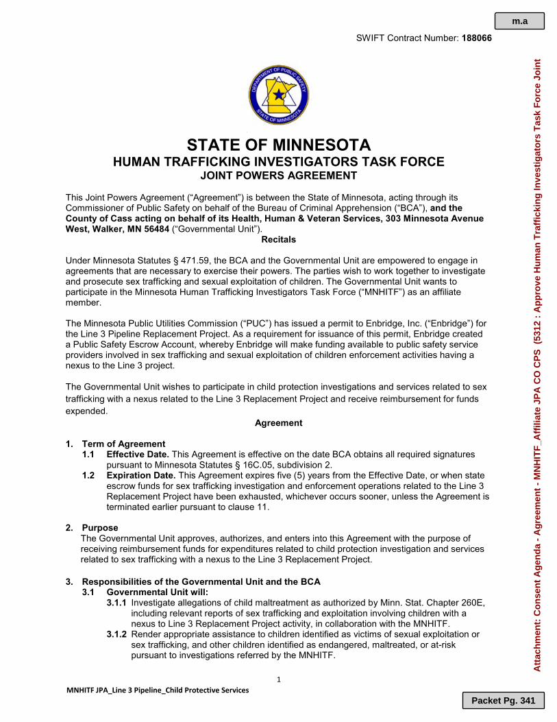
SWIFT Contract Number: 188066
1 MNHITF JPA_Line 3 Pipeline_Child Protective Services
STATE OF MINNESOTA
HUMAN TRAFFICKING INVESTIGATORS TASK FORCE JOINT POWERS AGREEMENT
This Joint Powers Agreement (“Agreement”) is between the State of Minnesota, acting through its Commissioner of Public Safety on behalf of the Bureau of Criminal Apprehension (“BCA”), and the County of Cass acting on behalf of its Health, Human & Veteran Services, 303 Minnesota Avenue West, Walker, MN 56484 (“Governmental Unit”).
Recitals Under Minnesota Statutes § 471.59, the BCA and the Governmental Unit are empowered to engage in agreements that are necessary to exercise their powers. The parties wish to work together to investigate and prosecute sex trafficking and sexual exploitation of children. The Governmental Unit wants to participate in the Minnesota Human Trafficking Investigators Task Force (“MNHITF”) as an affiliate member. The Minnesota Public Utilities Commission (“PUC”) has issued a permit to Enbridge, Inc. (“Enbridge”) for the Line 3 Pipeline Replacement Project. As a requirement for issuance of this permit, Enbridge created a Public Safety Escrow Account, whereby Enbridge will make funding available to public safety service providers involved in sex trafficking and sexual exploitation of children enforcement activities having a nexus to the Line 3 project.
The Governmental Unit wishes to participate in child protection investigations and services related to sex trafficking with a nexus related to the Line 3 Replacement Project and receive reimbursement for funds expended.
Agreement 1. Term of Agreement
1.1 Effective Date. This Agreement is effective on the date BCA obtains all required signatures pursuant to Minnesota Statutes § 16C.05, subdivision 2.
1.2 Expiration Date. This Agreement expires five (5) years from the Effective Date, or when state escrow funds for sex trafficking investigation and enforcement operations related to the Line 3 Replacement Project have been exhausted, whichever occurs sooner, unless the Agreement is terminated earlier pursuant to clause 11.
2. Purpose The Governmental Unit approves, authorizes, and enters into this Agreement with the purpose of receiving reimbursement funds for expenditures related to child protection investigation and services related to sex trafficking with a nexus to the Line 3 Replacement Project. 3. Responsibilities of the Governmental Unit and the BCA
3.1 Governmental Unit will: 3.1.1 Investigate allegations of child maltreatment as authorized by Minn. Stat. Chapter 260E,
including relevant reports of sex trafficking and exploitation involving children with a nexus to Line 3 Replacement Project activity, in collaboration with the MNHITF.
3.1.2 Render appropriate assistance to children identified as victims of sexual exploitation or sex trafficking, and other children identified as endangered, maltreated, or at-risk pursuant to investigations referred by the MNHITF.
m.a
Packet Pg. 341
Att
ach
men
t: C
on
sen
t A
gen
da
- A
gre
emen
t -
MN
HIT
F_A
ffili
ate
JPA
CO
CP
S (
5312
: A
pp
rove
Hu
man
Tra
ffic
kin
g In
vest
igat
ors
Tas
k F
orc
e Jo
int

SWIFT Contract Number: 188066
2 MNHITF JPA_Line 3 Pipeline_Child Protective Services
3.1.3 Assign a point of contact to act as liaison between the Governmental Unit and the MNHITF to coordinate referrals and assist in submissions for reimbursement requests.
3.1.4 Submit reimbursement requests pursuant to clause 4.3 for only those activities related to activities with a nexus to the Line 3 Replacement Project in collaboration with the MNHITF.
3.1.5 Maintain accurate records (summary and anonymized) pertaining to relevant reimbursement-qualifying investigative and victim service activities, to be collected and forwarded to the MNHITF Commander (or designee) for statistical reporting purposes.
3.1.6 Participate fully in any audits required by the MNHITF. 3.2 BCA will: 3.2.1 Through its MNHITF, refer allegations of child maltreatment/endangerment stemming
from child sexual exploitation and sex trafficking with a nexus to Line 3 Replacement Project activity to Governmental Unit for investigation and victim services.
3.2.2 Assist the Governmental Unit point of contact in preparing and submitting reimbursement requests pursuant to clause 4.3.
3.2.3 Distribute qualifying reimbursement funds pursuant to clause 4. 3.3 Nothing in this Agreement shall otherwise limit the jurisdiction, powers, and responsibilities normally possessed by either entity or employees thereof. 3.4 The Governmental Unit and BCA will abide by the cross-reporting requirements for child sex trafficking cases pursuant to Minn. Stat. § 260E.12.
4. Reimbursement Requests and Payments
4.1 Upon the Effective Date of this Agreement, Governmental Unit will be entitled to reimbursements in accordance with clause 4.3.
4.2 Governmental Unit will submit in advance a written request explaining any fund reimbursement and must receive written pre-approval from the MNHITF Commander or his/her designee for the reimbursement before proceeding.
4.3 The Governmental Unit will only be reimbursed for the following expenses, which must be pre-approved by the MNHITF Commander of designee: 4.3.1 Overtime salary including fringe benefits; 4.3.2 Training and training-related expenses directly incurred and relating to performance of child protection investigations/victim assistance activities with a nexus to the Line 3 Replacement Project; 4.3.3 Other pre-approved expenses such as but not limited to; transportation, emergency housing, clothing, food, medical expenses, etc., resulting from reactive child protection
investigations/victim assistance activities with a nexus to the Line 3 Replacement Project.
4.4 Governmental Unit will submit all pre-approved reimbursement requests to the MNHITF Commander or his/her designee, such requests made using the Minnesota Human Trafficking Investigators Task Force Outside Agency Reimbursement form which will be provided to the Governmental Unit by the BCA.
4.5 Governmental Unit shall supply original receipt(s) or other expenditure documents acceptable to the BCA in order to be reimbursed for pre-approved reimbursement requests.
4.6 Reimbursement requests properly pre-approved and submitted by the Governmental Unit will be reviewed by the MNHITF Commander or his/her designee. Upon approval by BCA, the reimbursement request will be forwarded to the Department of Public Safety’s designated Line 3 public safety liaison for additional review and approval. Upon approval by the liaison, the reimbursement request will be forwarded to the Public Utilities Commission’s Executive Secretary for processing and payment by Enbridge. Reimbursement to the Governmental Unit will be made directly by Enbridge to the Governmental Unit using its Public Safety Escrow Account until all Escrow Account funds have been expended.
4.7 Reimbursements to the Governmental Unit will be paid to: Cass County Health, Human & Veteran Services 400 Michigan Avenue West Walker, MN 56484
m.a
Packet Pg. 342
Att
ach
men
t: C
on
sen
t A
gen
da
- A
gre
emen
t -
MN
HIT
F_A
ffili
ate
JPA
CO
CP
S (
5312
: A
pp
rove
Hu
man
Tra
ffic
kin
g In
vest
igat
ors
Tas
k F
orc
e Jo
int

SWIFT Contract Number: 188066
3 MNHITF JPA_Line 3 Pipeline_Child Protective Services
5. Authorized Representatives The BCA’s Authorized Representative is the following person or his successor:
Name: Jeffrey Hansen, Deputy Superintendent Address: Department of Public Safety; Bureau of Criminal Apprehension 1430 Maryland Street East Saint Paul, MN 55106 Telephone: 651.793.7000
E-mail Address: [email protected]
The Governmental Unit’s Authorized Representative is the person below or her successor: Name: Michele Piprude, Director Address: Cass County Health, Human & Veteran Services 400 Michigan Avenue West Walker, MN 56484 Telephone: 218-547-6863 E-mail Address: [email protected]
If the Governmental Unit’s Authorized Representative changes at any time during this Agreement, the Governmental Unit must immediately notify the BCA in writing/email.
6. Assignment, Amendments, Waiver, and Agreement Complete 6.1 Assignment. The Governmental Unit may neither assign nor transfer any rights or obligations
under this Agreement. 6.2 Amendments. Any amendment to this Agreement must be in writing and will not be effective
until it has been executed and approved by the same parties who executed and approved the original Agreement, or their successors in office.
6.3 Waiver. If the BCA fails to enforce any provision of this Agreement, that failure does not waive the provision or its right to enforce it.
6.4 Agreement Complete. This Agreement contains all negotiations and agreements between the BCA and the Governmental Unit. No other understanding regarding this Agreement, whether written or oral, may be used to bind either party.
7. Liability The BCA and the Governmental Unit agree each party will be responsible for its own acts and the results thereof to the extent authorized by law and shall not be responsible for the acts of any others and the results thereof. The BCA’s liability shall be governed by provisions of the Minnesota Tort Claims Act, Minnesota Statutes § 3.736, and other applicable law. The Governmental Unit’s liability shall be governed by provisions of the Municipal Tort Claims Act, Minnesota Statutes §§ 466.01-466.15, and other applicable law.
8. Audits
Under Minnesota Statutes § 16C.05, subdivision 5, the Governmental Unit’s books, records, documents, and accounting procedures and practices relevant to this Agreement are subject to examination by the BCA and/or the State Auditor and/or Legislative Auditor, as appropriate, for a minimum of six (6) years from the end of this Agreement.
9. Government Data Practices
The Governmental Unit and the BCA must comply with the Minnesota Government Data Practices Act, Minnesota Statutes Chapter 13, and other applicable law, as it applies to all data provided by the BCA under this Agreement and as it applies to all data created, collected, received, stored, used, maintained, or disseminated by the Governmental Unit under this Agreement. The civil remedies of Minnesota Statutes § 13.08 apply to the release of the data referred to in this clause by either the Governmental Unit or the BCA. If the Governmental Unit receives a request to release the data referred to in this Clause, the Governmental Unit must immediately notify the State. The State will give the Governmental Unit instructions concerning the release of the data to the requesting party before the data is released.
m.a
Packet Pg. 343
Att
ach
men
t: C
on
sen
t A
gen
da
- A
gre
emen
t -
MN
HIT
F_A
ffili
ate
JPA
CO
CP
S (
5312
: A
pp
rove
Hu
man
Tra
ffic
kin
g In
vest
igat
ors
Tas
k F
orc
e Jo
int

SWIFT Contract Number: 188066
4 MNHITF JPA_Line 3 Pipeline_Child Protective Services
10. Venue
The venue for all legal proceedings out of this Agreement, or its breach, must be in the appropriate state or federal court with competent jurisdiction in Ramsey County, Minnesota.
11. Expiration and Termination
11.1 Either party may terminate this Agreement at any time, with or without cause, upon 30 days written notice to the other party. To the extent, funds are available; the Governmental Unit shall receive reimbursement in accordance with the terms of this Agreement through the date of termination.
11.2 Upon expiration or earlier termination of this Agreement, the Governmental Unit shall provide the MNHITF Commander all investigative equipment that was acquired under this Agreement.
12. E-Verify Certification (In accordance with Minnesota Statutes § 16C.075)
For services valued in excess of $50,000, the Governmental Unit certifies that as of the date of services performed on behalf of the BCA, the Governmental Unit and all its subcontractors will have implemented or be in the process of implementing the federal E-Verify program for all newly hired employees in the United States who will perform work on behalf of the BCA. The Governmental Unit is responsible for collecting all subcontractor certifications and may do so utilizing the E-Verify Subcontractor Certification Form available at http://www.mmd.admin.state.mn.us/doc/EverifySubCertForm.doc. All subcontractor certifications must be kept on file with the Governmental Unit and made available to the BCA upon request.
13. Continuing Obligations
The following clauses survive the expiration or cancellation of this Agreement: 7, Liability; 8, Audits; 9, Government Data Practices; and 10, Venue.
The parties indicate their agreement and authority to execute this Agreement by signing below.
1. GOVERNMENTAL UNIT 2. DEPT. OF PUBLIC SAFETY; BUREAU OF CRIMINAL APPREHENSION Governmental Unit certifies that the appropriate person(s) Individual certifies the applicable provisions of Minn. Stat. 16C.08, has(have) executed this Amendment on behalf of the subdivisions 2 and 3, laws, are reaffirmed. Governmental Unit and its jurisdictional government entity as required by applicable articles, by-laws, resolutions or ordinances.
By: ________________________________________________ By: _________________________________________________
Title: _______________________________________________ Title: _______________________________________________
Date: _______________________________________________ Date: _______________________________________________
By: _________________________________________________ 3. COMMISSIONER OF ADMINISTRATION As delegated to the Office of State Procurement
Title: _______________________________________________ By: __________________________________________________
Date: _______________________________________________ Date: ________________________________________________
By: __________________________________________________
Title: _________________________________________________
Date: _________________________________________________
m.a
Packet Pg. 344
Att
ach
men
t: C
on
sen
t A
gen
da
- A
gre
emen
t -
MN
HIT
F_A
ffili
ate
JPA
CO
CP
S (
5312
: A
pp
rove
Hu
man
Tra
ffic
kin
g In
vest
igat
ors
Tas
k F
orc
e Jo
int

CASS COUNTY ITEM: Approve Purchase of Service
Agreement with Daniel Marquardsen Therapy, LLC
REQUEST FOR BOARD ACTION
Requested Board Date: March 16, 2021
Originating Department: Health, Human and Veteran Services
Presenter: Kim Minton
Requested Time:
For Discussion:
Consent Agenda Item
1. Who will the contract serve? Adults & Children 2. Who is the contractor? Daniel Marquardsen Therapy, LLC. 3. What is the service? Home-based mental health services which may include individual, family and group psychotherapy,
psychological testing and diagnostic services 4. How much will be spent? $100 per hour 5. Term of the Contract? January 1, 2021 - December 31, 2021
MOTION: Approve – Purchase of Service Agreement with Daniel Marquardsen Therapy, LLC for home-based mental health services which may include individual, family and group psychotherapy, psychological testing and diagnostic services.
Supporting Documentation: Consent Agenda - Contract - Daniel Marquardsen Therapy
Distribution List: Kim Minton Completed 03/09/2021 4:22 PM Betsy Woodford Completed 03/10/2021 9:57 AM Josh Stevenson Completed 03/10/2021 2:48 PM Board of Commissioners Pending 03/16/2021 9:00 AM
n
Packet Pg. 345

n.a
Packet Pg. 346
Att
ach
men
t: C
on
sen
t A
gen
da
- C
on
trac
t -
Dan
iel M
arq
uar
dse
n T
her
apy
(53
13 :
Ap
pro
ve P
urc
has
e o
f S
ervi
ce A
gre
emen
t w
ith
Dan
iel

n.a
Packet Pg. 347
Att
ach
men
t: C
on
sen
t A
gen
da
- C
on
trac
t -
Dan
iel M
arq
uar
dse
n T
her
apy
(53
13 :
Ap
pro
ve P
urc
has
e o
f S
ervi
ce A
gre
emen
t w
ith
Dan
iel

n.a
Packet Pg. 348
Att
ach
men
t: C
on
sen
t A
gen
da
- C
on
trac
t -
Dan
iel M
arq
uar
dse
n T
her
apy
(53
13 :
Ap
pro
ve P
urc
has
e o
f S
ervi
ce A
gre
emen
t w
ith
Dan
iel

n.a
Packet Pg. 349
Att
ach
men
t: C
on
sen
t A
gen
da
- C
on
trac
t -
Dan
iel M
arq
uar
dse
n T
her
apy
(53
13 :
Ap
pro
ve P
urc
has
e o
f S
ervi
ce A
gre
emen
t w
ith
Dan
iel

n.a
Packet Pg. 350
Att
ach
men
t: C
on
sen
t A
gen
da
- C
on
trac
t -
Dan
iel M
arq
uar
dse
n T
her
apy
(53
13 :
Ap
pro
ve P
urc
has
e o
f S
ervi
ce A
gre
emen
t w
ith
Dan
iel

n.a
Packet Pg. 351
Att
ach
men
t: C
on
sen
t A
gen
da
- C
on
trac
t -
Dan
iel M
arq
uar
dse
n T
her
apy
(53
13 :
Ap
pro
ve P
urc
has
e o
f S
ervi
ce A
gre
emen
t w
ith
Dan
iel

n.a
Packet Pg. 352
Att
ach
men
t: C
on
sen
t A
gen
da
- C
on
trac
t -
Dan
iel M
arq
uar
dse
n T
her
apy
(53
13 :
Ap
pro
ve P
urc
has
e o
f S
ervi
ce A
gre
emen
t w
ith
Dan
iel

n.a
Packet Pg. 353
Att
ach
men
t: C
on
sen
t A
gen
da
- C
on
trac
t -
Dan
iel M
arq
uar
dse
n T
her
apy
(53
13 :
Ap
pro
ve P
urc
has
e o
f S
ervi
ce A
gre
emen
t w
ith
Dan
iel

n.a
Packet Pg. 354
Att
ach
men
t: C
on
sen
t A
gen
da
- C
on
trac
t -
Dan
iel M
arq
uar
dse
n T
her
apy
(53
13 :
Ap
pro
ve P
urc
has
e o
f S
ervi
ce A
gre
emen
t w
ith
Dan
iel

n.a
Packet Pg. 355
Att
ach
men
t: C
on
sen
t A
gen
da
- C
on
trac
t -
Dan
iel M
arq
uar
dse
n T
her
apy
(53
13 :
Ap
pro
ve P
urc
has
e o
f S
ervi
ce A
gre
emen
t w
ith
Dan
iel

n.a
Packet Pg. 356
Att
ach
men
t: C
on
sen
t A
gen
da
- C
on
trac
t -
Dan
iel M
arq
uar
dse
n T
her
apy
(53
13 :
Ap
pro
ve P
urc
has
e o
f S
ervi
ce A
gre
emen
t w
ith
Dan
iel

n.a
Packet Pg. 357
Att
ach
men
t: C
on
sen
t A
gen
da
- C
on
trac
t -
Dan
iel M
arq
uar
dse
n T
her
apy
(53
13 :
Ap
pro
ve P
urc
has
e o
f S
ervi
ce A
gre
emen
t w
ith
Dan
iel

CASS COUNTY ITEM: Approve Minnesota Residential Group
Home Agreement with Nexus Family Healing REQUEST FOR BOARD ACTION
Requested Board Date: March 16, 2021
Originating Department: Health, Human and Veteran Services
Presenter: Kim Minton
Requested Time:
For Discussion:
Consent Agenda Item
1. Who will the contract serve? Youth 2. Who is the contractor? Nexus Family Healing 3. What is the service? Residential group home services to youth in highly structured, self-contained environment, providing room &
board, clinical services and education 4. How much will be spent? See Program Rates effective August 1, 2020 to December 31, 2021 5. Term of the Contract? Upon all required signatures obtained until terminated by either party at any time upon thirty (30) day's
written notice.
MOTION: Approve – Minnesota Residential Group Home Agreement with Nexus Family Healing to provide residential group home services to youth in highly structured, self-contained environment, providing room & board, clinical services and education in its facility located in Onamia, Minnesota.
Supporting Documentation: Consent Agenda - Contract - Nexus-Mille Lacs Family Healing
Distribution List: Kim Minton Completed 03/09/2021 4:21 PM Betsy Woodford Completed 03/10/2021 9:55 AM Josh Stevenson Completed 03/10/2021 2:44 PM Board of Commissioners Pending 03/16/2021 9:00 AM
o
Packet Pg. 358

o.a
Packet Pg. 359
Att
ach
men
t: C
on
sen
t A
gen
da
- C
on
trac
t -
Nex
us-
Mill
e L
acs
Fam
ily H
ealin
g (
5314
: A
pp
rove
Min
nes
ota
Res
iden
tial
Gro
up
Ho
me
Ag
reem
ent
wit
h

o.a
Packet Pg. 360
Att
ach
men
t: C
on
sen
t A
gen
da
- C
on
trac
t -
Nex
us-
Mill
e L
acs
Fam
ily H
ealin
g (
5314
: A
pp
rove
Min
nes
ota
Res
iden
tial
Gro
up
Ho
me
Ag
reem
ent
wit
h

o.a
Packet Pg. 361
Att
ach
men
t: C
on
sen
t A
gen
da
- C
on
trac
t -
Nex
us-
Mill
e L
acs
Fam
ily H
ealin
g (
5314
: A
pp
rove
Min
nes
ota
Res
iden
tial
Gro
up
Ho
me
Ag
reem
ent
wit
h

o.a
Packet Pg. 362
Att
ach
men
t: C
on
sen
t A
gen
da
- C
on
trac
t -
Nex
us-
Mill
e L
acs
Fam
ily H
ealin
g (
5314
: A
pp
rove
Min
nes
ota
Res
iden
tial
Gro
up
Ho
me
Ag
reem
ent
wit
h

o.a
Packet Pg. 363
Att
ach
men
t: C
on
sen
t A
gen
da
- C
on
trac
t -
Nex
us-
Mill
e L
acs
Fam
ily H
ealin
g (
5314
: A
pp
rove
Min
nes
ota
Res
iden
tial
Gro
up
Ho
me
Ag
reem
ent
wit
h

o.a
Packet Pg. 364
Att
ach
men
t: C
on
sen
t A
gen
da
- C
on
trac
t -
Nex
us-
Mill
e L
acs
Fam
ily H
ealin
g (
5314
: A
pp
rove
Min
nes
ota
Res
iden
tial
Gro
up
Ho
me
Ag
reem
ent
wit
h

o.a
Packet Pg. 365
Att
ach
men
t: C
on
sen
t A
gen
da
- C
on
trac
t -
Nex
us-
Mill
e L
acs
Fam
ily H
ealin
g (
5314
: A
pp
rove
Min
nes
ota
Res
iden
tial
Gro
up
Ho
me
Ag
reem
ent
wit
h

o.a
Packet Pg. 366
Att
ach
men
t: C
on
sen
t A
gen
da
- C
on
trac
t -
Nex
us-
Mill
e L
acs
Fam
ily H
ealin
g (
5314
: A
pp
rove
Min
nes
ota
Res
iden
tial
Gro
up
Ho
me
Ag
reem
ent
wit
h

CASS COUNTY ITEM: Approve Amendment to Road Use
Agreement with Enbridge REQUEST FOR BOARD ACTION
Requested Board Date: March 16, 2021
Originating Department: Highway Department
Presenter: Darrick Anderson
Requested Time:
For Discussion:
Consent Agenda Item
Enbridge has requested an exemption to Seasonal Load Limits on several gravel roadways within Cass County. They include a 0.6 mile segment of CSAH 42, a 1.0 mile segment of gravel on CSAH 49, a 1.5 mile segment of gravel roadway on CSAH 48 and approximately 11.0 miles of CR 160. The request would allow Enbridge to continue working and to remove their equipment by the end of March, 2021. These gravel roadways are currently under a Seasonal Load Limit of 5-tons per axle that went into affect on March 8, 2021. The original Road Use Agreement dated July 2, 2019 set forth the use of these roadways as haul roads and those operations were to occur outside of the seasonal load limits. Other than CSAH 42 the roadways impacted are very low volume roadways. This short segment of CSAH 42 (0.6 miles) is well drained and is very likely to not see much deterioration during spring load limits. However, this agreement requires Enbridge to maintain these highways for public traffic and if the road is not maintained to the County's satisfaction the use as a haul road will be terminated. In addition, once the road is impacted/damaged, even if it is maintained for public traffic Enbridge will be required to restore the gravel surface of the roadway with the placement of 4-inches of new gravel of the entire roadway surface. Cass County will retain oversight and ownership of these roadways and will regulate their use to maintain a safe use by the public. Enbridge will provide a bond to cover the cost of furnishing, hauling and placement of the gravel material.
MOTION: Approve - Amendment to the July 2, 2019 Enbridge Road Use Agreement and authorize for signature.
Supporting Documentation: Spring Road Bans 342021 Cass County Haul Road Agreement- 2021 (003)
Distribution List: Darrick Anderson Completed 03/10/2021 3:27 PM Betsy Woodford Completed 03/10/2021 3:47 PM Josh Stevenson Completed 03/10/2021 3:59 PM Board of Commissioners Pending 03/16/2021 9:00 AM
p
Packet Pg. 367

p.a
Packet Pg. 368
Att
ach
men
t: S
pri
ng
Ro
ad B
ans
3420
21 (
5317
: A
pp
rove
Am
end
men
t to
Ro
ad U
se A
gre
emen
t w
ith

p.a
Packet Pg. 369
Att
ach
men
t: S
pri
ng
Ro
ad B
ans
3420
21 (
5317
: A
pp
rove
Am
end
men
t to
Ro
ad U
se A
gre
emen
t w
ith

p.a
Packet Pg. 370
Att
ach
men
t: S
pri
ng
Ro
ad B
ans
3420
21 (
5317
: A
pp
rove
Am
end
men
t to
Ro
ad U
se A
gre
emen
t w
ith

p.a
Packet Pg. 371
Att
ach
men
t: S
pri
ng
Ro
ad B
ans
3420
21 (
5317
: A
pp
rove
Am
end
men
t to
Ro
ad U
se A
gre
emen
t w
ith

1
AMENDMENT TO JULY 2, 2019
ROAD USE AGREEMENT ON CR 160, CSAH 42, 48 (E), and 49
THIS ROAD USE AGREEMENT AMENDMENT is made this __ day of , 2021 (“Effective Date”), by and between Cass County , a political subdivision of the State of Minnesota (the “County”), and Enbridge Energy, Limited Partnership, a Delaware limited partnership, with an office located at 119 N. 25th Street East, Superior, Wisconsin 54880, and its affiliates and any of its or its affiliates’ respective agents, employees, contractors, subcontractors, material suppliers, vendors, transport providers, designees and representatives (“Company”) (collectively the “Parties” and each a “Party”). WHEREAS, The Company is requesting the use of the attached identified haul roads during the Seasonal Load Limits, which started on March 8, 2021 for the North-Central Frost Zone; and WHEREAS, The segments of roads they are requesting to use are on CR 160, CSAH 42, CSAH 49 and a segment of CSAH 48 (E) are all gravel roadways and are posted during spring load limits to 5 tons per axle; and WHEREAS, The Company is requesting an exemption of the Spring Load Limits to allow 9 tons per axle through March 31, 2021. NOW, THEREFORE, in consideration of the above recitals and the mutual covenants contained herein, the Parties agree as follows:
Gravel Roadways: Once the Company begins hauling on these roadways it will take on the
responsibility to maintain the roadways for public and Company use. This may include but not limited to traffic control measures, stabilizing materials and/or gravel in order to keep the roads open to traffic. If at any time these roads begin to be unpassable for public use hauling operations will cease until the roadway is restored and approved for public use.
The Company agrees that damage to these gravel roadways during spring load limits is likely and that once the road is rutted the integrity of the gravel surface is lost. In order to restore the surface of these roadways the Company agrees to provide a bond and/or letter of credit that will cover the re-graveling of these roadways with 4-inches of gravel over the entire road surface at a minimum width of 22-feet. This work shall occur once the Company has completed their hauling operations and the roads are dry enough to accept new gravel. The Company will be responsible for maintenance of the roadways until the new gravel is placed.
The Company is responsible for providing, hauling and placing the Class 1 (modified) material in accordance with the County’s standards and direction. Gradations shall be provided to the County assuring the material is placed in accordance with the County gradation requirements.
p.b
Packet Pg. 372
Att
ach
men
t: C
ass
Co
un
ty H
aul R
oad
Ag
reem
ent-
202
1 (0
03)
(53
17 :
Ap
pro
ve A
men
dm
ent
to R
oad
Use
Ag
reem
ent
wit
h E
nb
rid
ge)

2
Shallow centerline culverts may potentially be impacted as well with the structure of the road being compromised. The Company agrees to replace all culverts damaged by their operations at the direction and approval of the County.
Financial Security. To guarantee compliance with the terms of this Agreement, payment of costs incurred by the County, or the remediation of any damage or nuisance caused by the Company’s failure to comply with the terms of this Agreement, Company shall furnish to the County a surety bond or such other security as is reasonably acceptable to the County. The bond or other acceptable security shall be in a form that automatically renews until the end of the Term of this Agremment and shall be issued by an insurer or a financial institution with credit ratings of at least A- by A.M. Best, A- by S&P Global Ratings or A3 by Moody’s Investor Services Inc. The bond shall be in an amount of $350,000 which is an estimated cost of the potential Road impacts from the hauling and permitted activities contemplated by this Agreement. Company and the County Engineer may agree on a reduced amount for the bond for any warranty period once all final punch list items for the restoration work, if any, are completed. The bond shall meet the following schedule:
County Highway Length (miles) Estimated Cost
CR 160 11.0 $265,000 CSAH 42 0.6 $15,000 CSAH 48 (E) 1.5 $40,000 CSAH 49 1.0 $30,000
Cass County
By:
By: Enbridge Energy, Limited Partnership
By: Enbridge Pipelines (Lakehead) L.L.C. It’s Managing General Partner
By: ______________________________ Rich Kern, Authorized Agent
p.b
Packet Pg. 373
Att
ach
men
t: C
ass
Co
un
ty H
aul R
oad
Ag
reem
ent-
202
1 (0
03)
(53
17 :
Ap
pro
ve A
men
dm
ent
to R
oad
Use
Ag
reem
ent
wit
h E
nb
rid
ge)

CASS COUNTY ITEM: Approve Amendment No 2 to CSAH 27
Road Use Agreement with Enbridge REQUEST FOR BOARD ACTION
Requested Board Date: March 16, 2021
Originating Department: Highway Department
Presenter: Darrick Anderson
Requested Time:
For Discussion:
Consent Agenda Item
Enbridge has requested an exemption to Seasonal Load Limits on CSAH 27 within Cass County. The segment of CSAH 27 they are requesting extends off TH 87 south to their pump station, approximately 1.2 miles. The request would allow Enbridge to continue working and to allow them to remove their equipment by the end of March, 2021. This gravel roadway is currently under a Seasonal Load Limit of 5-tons per axle that went into affect on March 8, 2021. The original Road Use Agreement dated August 7, 2015 set forth the use of CSAH 27 as a haul road and those operations were to occur outside of the seasonal load limits. This short segment of CSAH 27 (1.2 miles) is well drained and is very likely to not see much deterioration during spring load limits. However, this agreement requires Enbridge to maintain CSAH 27 for public traffic and if the road is not maintained to the County's satisfaction the use as a haul road will be terminated. In addition, once the road is impacted/damaged, even if it is maintained for public traffic Enbridge will be required to restore the gravel surface of the roadway with the placement of 4-inches of new gravel of the entire roadway surface. Cass County will retain oversight and ownership of these roadways and will regulate their use to maintain a safe use by the public. Enbridge will provide a bond to cover the cost of furnishing, hauling and placement of the gravel material.
MOTION: Approve - Amendment No. 2 to the August 7, 2015 Enbridge Road Use Agreement on CSAH 27 and authorize for signature.
Supporting Documentation: Amendment No. 2 Haul Road Agreement CSAH 27 - 2021
Distribution List: Darrick Anderson Completed 03/10/2021 3:26 PM Betsy Woodford Completed 03/10/2021 3:51 PM Josh Stevenson Completed 03/11/2021 7:51 AM Board of Commissioners Pending 03/16/2021 9:00 AM
q
Packet Pg. 374

1
AMENDMENT NO. 2 TO
ROAD USE AGREEMENT DATED AUGUST 7, 2015 ON
CSAH 27
THIS ROAD USE AGREEMENT AMENDMENT is made this __ day of , 2021 (“Effective Date”), by and between Cass County , a political subdivision of the State of Minnesota (the “County”), and Enbridge Energy, Limited Partnership, a Delaware limited partnership, with an office located at 119 N. 25th Street East, Superior, Wisconsin 54880, and its affiliates and any of its or its affiliates’ respective agents, employees, contractors, subcontractors, material suppliers, vendors, transport providers, designees and representatives (“Company”) (collectively the “Parties” and each a “Party”). WHEREAS, The Company is requesting the use of CSAH 27 as a haul road during the Seasonal Load Limits, which started on March 8, 2021 for the North-Central Frost Zone; and WHEREAS, CSAH 27 is a gravel roadway that is posted during spring load limits to 5 tons per axle; and WHEREAS, The Company is requesting an exemption of the Spring Load Limits to allow 9 tons per axle through March 31, 2021. NOW, THEREFORE, in consideration of the above recitals and the mutual covenants contained herein, the Parties agree as follows:
Once the Company begins hauling on the roadway it will take on the responsibility to maintain the roadway for public and Company use. This may include but not limited to traffic control measures, stabilizing materials and/or gravel in order to keep the road open to traffic. If at any time the road begins to be unpassable for public use hauling operations will cease until the roadway is restored and approved for public use.
The Company agrees that damage to this gravel roadway during spring load limits is likely and that once the road is rutted the integrity of the gravel surface is lost. In order to restore the surface of this roadway the Company agrees to provide a bond and/or letter of credit that will cover the re-graveling of this roadway with 4-inches of gravel over the entire road surface at a minimum width of 28-feet. This work shall occur once the Company has completed their hauling operations and the roads are dry enough to accept new gravel. The Company will be responsible for maintenance of the roadway until the new gravel is placed.
The Company is responsible for providing, hauling and placing the Class 1 (modified) material in accordance with the County’s standards and direction. Gradations shall be provided to the County assuring the material is placed in accordance with the County gradation requirements.
q.a
Packet Pg. 375
Att
ach
men
t: A
men
dm
ent
No
. 2 H
aul R
oad
Ag
reem
ent
CS
AH
27
- 20
21 (
5321
: A
pp
rove
Am
end
men
t N
o. 2
to
CS
AH
27
Ro
ad U
se A
gre
emen
t w
ith

2
Shallow centerline culverts may potentially be impacted as well with the structure of the road being compromised. The Company agrees to replace all culverts damaged by their operations at the direction and approval of the County.
Financial Security. To guarantee compliance with the terms of this Agreement, payment of costs incurred by the County, or the remediation of any damage or nuisance caused by the Company’s failure to comply with the terms of this Agreement, Company shall furnish to the County a surety bond or such other security as is reasonably acceptable to the County. The bond or other acceptable security shall be in a form that automatically renews until the end of the Term of this Agremment and shall be issued by an insurer or a financial institution with credit ratings of at least A- by A.M. Best, A- by S&P Global Ratings or A3 by Moody’s Investor Services Inc. The bond shall be in an amount of $50,000 which is an estimated cost of the potential Road impacts from the hauling and permitted activities contemplated by this Agreement. Company and the County Engineer may agree on a reduced amount for the bond for any warranty period once all final punch list items for the restoration work, if any, are completed.
Cass County
By:
By: Enbridge Energy, Limited Partnership
By: Enbridge Pipelines (Lakehead) L.L.C. It’s Managing General Partner
By: ______________________________ Rich Kern, Authorized Agent
q.a
Packet Pg. 376
Att
ach
men
t: A
men
dm
ent
No
. 2 H
aul R
oad
Ag
reem
ent
CS
AH
27
- 20
21 (
5321
: A
pp
rove
Am
end
men
t N
o. 2
to
CS
AH
27
Ro
ad U
se A
gre
emen
t w
ith

CASS COUNTY ITEM: Adopt Resolution Approving MnDot
Detour Agreement No. 1045955 REQUEST FOR BOARD ACTION
Requested Board Date: March 16, 2021
Originating Department: Highway Department
Presenter: Darrick Anderson
Requested Time:
For Discussion:
Consent Agenda Item
This agreement between MnDOT and Cass County will provide payment to Cass County from MnDOT for road life consumed on CSAH 65, CSAH 74 and CSAH 3 which will be used as a Trunk Highway Detour for MnDOT construction project on Trunk Highway 6.
MOTION: Adopt- Resolution 20-21 approving the proposed Detour Agreement No.1045955 between MnDOT and Cass County for the Trunk Highway 6 detour.
Supporting Documentation: MnDOT Detour Agreement-TH 6 20-21 Detour Agreement CSAH 65,74,3
Distribution List: Darrick Anderson Completed 03/04/2021 10:06 AM Betsy Woodford Completed 03/04/2021 10:28 AM Josh Stevenson Completed 03/10/2021 3:23 PM Board of Commissioners Pending 03/16/2021 9:00 AM
r
Packet Pg. 377

r.a
Packet Pg. 378
Att
ach
men
t: M
nD
OT
Det
ou
r A
gre
emen
t-T
H 6
(52
87 :
Ad
op
t R
eso
luti
on
Ap
pro
vin
g M
nD
ot
Det
ou
r A
gre
emen
t N
o. 1
0459
55)

r.a
Packet Pg. 379
Att
ach
men
t: M
nD
OT
Det
ou
r A
gre
emen
t-T
H 6
(52
87 :
Ad
op
t R
eso
luti
on
Ap
pro
vin
g M
nD
ot
Det
ou
r A
gre
emen
t N
o. 1
0459
55)

r.a
Packet Pg. 380
Att
ach
men
t: M
nD
OT
Det
ou
r A
gre
emen
t-T
H 6
(52
87 :
Ad
op
t R
eso
luti
on
Ap
pro
vin
g M
nD
ot
Det
ou
r A
gre
emen
t N
o. 1
0459
55)

r.a
Packet Pg. 381
Att
ach
men
t: M
nD
OT
Det
ou
r A
gre
emen
t-T
H 6
(52
87 :
Ad
op
t R
eso
luti
on
Ap
pro
vin
g M
nD
ot
Det
ou
r A
gre
emen
t N
o. 1
0459
55)

r.a
Packet Pg. 382
Att
ach
men
t: M
nD
OT
Det
ou
r A
gre
emen
t-T
H 6
(52
87 :
Ad
op
t R
eso
luti
on
Ap
pro
vin
g M
nD
ot
Det
ou
r A
gre
emen
t N
o. 1
0459
55)

r.a
Packet Pg. 383
Att
ach
men
t: M
nD
OT
Det
ou
r A
gre
emen
t-T
H 6
(52
87 :
Ad
op
t R
eso
luti
on
Ap
pro
vin
g M
nD
ot
Det
ou
r A
gre
emen
t N
o. 1
0459
55)

r.a
Packet Pg. 384
Att
ach
men
t: M
nD
OT
Det
ou
r A
gre
emen
t-T
H 6
(52
87 :
Ad
op
t R
eso
luti
on
Ap
pro
vin
g M
nD
ot
Det
ou
r A
gre
emen
t N
o. 1
0459
55)

r.a
Packet Pg. 385
Att
ach
men
t: M
nD
OT
Det
ou
r A
gre
emen
t-T
H 6
(52
87 :
Ad
op
t R
eso
luti
on
Ap
pro
vin
g M
nD
ot
Det
ou
r A
gre
emen
t N
o. 1
0459
55)

r.a
Packet Pg. 386
Att
ach
men
t: M
nD
OT
Det
ou
r A
gre
emen
t-T
H 6
(52
87 :
Ad
op
t R
eso
luti
on
Ap
pro
vin
g M
nD
ot
Det
ou
r A
gre
emen
t N
o. 1
0459
55)

r.a
Packet Pg. 387
Att
ach
men
t: M
nD
OT
Det
ou
r A
gre
emen
t-T
H 6
(52
87 :
Ad
op
t R
eso
luti
on
Ap
pro
vin
g M
nD
ot
Det
ou
r A
gre
emen
t N
o. 1
0459
55)

r.a
Packet Pg. 388
Att
ach
men
t: M
nD
OT
Det
ou
r A
gre
emen
t-T
H 6
(52
87 :
Ad
op
t R
eso
luti
on
Ap
pro
vin
g M
nD
ot
Det
ou
r A
gre
emen
t N
o. 1
0459
55)

r.a
Packet Pg. 389
Att
ach
men
t: M
nD
OT
Det
ou
r A
gre
emen
t-T
H 6
(52
87 :
Ad
op
t R
eso
luti
on
Ap
pro
vin
g M
nD
ot
Det
ou
r A
gre
emen
t N
o. 1
0459
55)

CERTIFIED COPY OF RESOLUTION COUNTY BOARD OF CASS COUNTY RESOLUTION NO. 20-21 ADOPTED: March 16, 2021 Commissioner offered Resolution No. 20-21 and moved its adoption, Commissioner seconded: IT IS RESOLVED that Cass County enter into MnDOT Agreement No. 1045955 with the State of Minnesota, Department of Transportation for the following purposes: To provide for payment by the State to the County for the use of County State Aid Highway No. 65, 74 and 3 as a detour route during the construction to be performed upon, along and adjacent to Trunk Highway No. 6 from the Cass/Itasca County Line to Trunk Highway No. 2 under State Project No. 3106-24 (T.H.6=34) IT IS FURTHER RESOLVED that the Board Chairman and the County Administrator are authorized to execute the Agreement and any amendments to the Agreement.
Resolution No. 20-21 was adopted by majority vote: Ayes: Nays: None Absent:
STATE OF MINNESOTA } County of Cass } ss. Office of County Administrator }
I, Joshua D. Stevenson, Administrator of the County of Cass, do hereby certify that I have compared the foregoing with
the original resolution filed in my office on the 16th day of March A. D. 2021, and the same is a true and correct
copy of the whole thereof.
WITNESS MY HAND AND SEAL OF MY OFFICE at Walker, Minnesota, this 16th day of March, A. D. 2021. _________________________ Joshua D. Stevenson
Cass County Administrator
r.b
Packet Pg. 390
Att
ach
men
t: 2
0-21
Det
ou
r A
gre
emen
t C
SA
H 6
5,74
,3 (
5287
: A
do
pt
Res
olu
tio
n A
pp
rovi
ng
Mn
Do
t D
eto
ur
Ag
reem
ent
No
. 104
5955
)

CASS COUNTY ITEM: Adopt Resolution Approving MnDot
Detour Agreement No.1045954 REQUEST FOR BOARD ACTION
Requested Board Date: March 16, 2021
Originating Department: Highway Department
Presenter: Darrick Anderson
Requested Time:
For Discussion:
Consent Agenda Item
This agreement between MnDOT and Cass County will provide payment to Cass County from MnDOT for road life consumed on CSAH 44 and CSAH 1 which will be used as a Trunk Highway Detour for MnDOT construction project on Trunk Highway 84.
MOTION: Adopt- Resolution 21-21 approving the proposed Detour Agreement No.1045954 between MnDOT and Cass County for the Trunk Highway 84 detour.
Supporting Documentation: MnDOT Detour Agreement-TH 84 21-21 Detour Agreement CSAH 44,1
Distribution List: Darrick Anderson Completed 03/04/2021 10:06 AM Betsy Woodford Completed 03/04/2021 11:10 AM Josh Stevenson Completed 03/10/2021 3:21 PM Board of Commissioners Pending 03/16/2021 9:00 AM
s
Packet Pg. 391

s.a
Packet Pg. 392
Att
ach
men
t: M
nD
OT
Det
ou
r A
gre
emen
t-T
H 8
4 (
5288
: A
do
pt
Res
olu
tio
n A
pp
rovi
ng
Mn
Do
t D
eto
ur
Ag
reem
ent
No
.104
5954
)

s.a
Packet Pg. 393
Att
ach
men
t: M
nD
OT
Det
ou
r A
gre
emen
t-T
H 8
4 (
5288
: A
do
pt
Res
olu
tio
n A
pp
rovi
ng
Mn
Do
t D
eto
ur
Ag
reem
ent
No
.104
5954
)

s.a
Packet Pg. 394
Att
ach
men
t: M
nD
OT
Det
ou
r A
gre
emen
t-T
H 8
4 (
5288
: A
do
pt
Res
olu
tio
n A
pp
rovi
ng
Mn
Do
t D
eto
ur
Ag
reem
ent
No
.104
5954
)

s.a
Packet Pg. 395
Att
ach
men
t: M
nD
OT
Det
ou
r A
gre
emen
t-T
H 8
4 (
5288
: A
do
pt
Res
olu
tio
n A
pp
rovi
ng
Mn
Do
t D
eto
ur
Ag
reem
ent
No
.104
5954
)

s.a
Packet Pg. 396
Att
ach
men
t: M
nD
OT
Det
ou
r A
gre
emen
t-T
H 8
4 (
5288
: A
do
pt
Res
olu
tio
n A
pp
rovi
ng
Mn
Do
t D
eto
ur
Ag
reem
ent
No
.104
5954
)

s.a
Packet Pg. 397
Att
ach
men
t: M
nD
OT
Det
ou
r A
gre
emen
t-T
H 8
4 (
5288
: A
do
pt
Res
olu
tio
n A
pp
rovi
ng
Mn
Do
t D
eto
ur
Ag
reem
ent
No
.104
5954
)

s.a
Packet Pg. 398
Att
ach
men
t: M
nD
OT
Det
ou
r A
gre
emen
t-T
H 8
4 (
5288
: A
do
pt
Res
olu
tio
n A
pp
rovi
ng
Mn
Do
t D
eto
ur
Ag
reem
ent
No
.104
5954
)

s.a
Packet Pg. 399
Att
ach
men
t: M
nD
OT
Det
ou
r A
gre
emen
t-T
H 8
4 (
5288
: A
do
pt
Res
olu
tio
n A
pp
rovi
ng
Mn
Do
t D
eto
ur
Ag
reem
ent
No
.104
5954
)

s.a
Packet Pg. 400
Att
ach
men
t: M
nD
OT
Det
ou
r A
gre
emen
t-T
H 8
4 (
5288
: A
do
pt
Res
olu
tio
n A
pp
rovi
ng
Mn
Do
t D
eto
ur
Ag
reem
ent
No
.104
5954
)

s.a
Packet Pg. 401
Att
ach
men
t: M
nD
OT
Det
ou
r A
gre
emen
t-T
H 8
4 (
5288
: A
do
pt
Res
olu
tio
n A
pp
rovi
ng
Mn
Do
t D
eto
ur
Ag
reem
ent
No
.104
5954
)

s.a
Packet Pg. 402
Att
ach
men
t: M
nD
OT
Det
ou
r A
gre
emen
t-T
H 8
4 (
5288
: A
do
pt
Res
olu
tio
n A
pp
rovi
ng
Mn
Do
t D
eto
ur
Ag
reem
ent
No
.104
5954
)

s.a
Packet Pg. 403
Att
ach
men
t: M
nD
OT
Det
ou
r A
gre
emen
t-T
H 8
4 (
5288
: A
do
pt
Res
olu
tio
n A
pp
rovi
ng
Mn
Do
t D
eto
ur
Ag
reem
ent
No
.104
5954
)

CERTIFIED COPY OF RESOLUTION COUNTY BOARD OF CASS COUNTY RESOLUTION NO. 21-21 ADOPTED: March 16, 2021 Commissioner offered Resolution No. 21-21 and moved its adoption, Commissioner seconded: IT IS RESOLVED that Cass County enter into MnDOT Agreement No. 1045954 with the State of Minnesota, Department of Transportation for the following purposes: To provide for payment by the State to the County for the use of County State Aid Highway No. 44 and 1 as a detour route during the construction to be performed upon, along and adjacent to Trunk Highway No. 84 from 0.233 miles East of Trunk Highway No. 371 to 0.371 miles East of Trunk Highway No. 371 under State Project No. 1110-11 (T.H. 84=139) IT IS FURTHER RESOLVED that the Board Chairman and the County Administrator are authorized to execute the Agreement and any amendments to the Agreement.
Resolution No. 21-21 was adopted by majority vote: Ayes: Nays: None Absent:
STATE OF MINNESOTA } County of Cass } ss. Office of County Administrator }
I, Joshua D. Stevenson, Administrator of the County of Cass, do hereby certify that I have compared the foregoing with
the original resolution filed in my office on the 16th day of March A. D. 2021, and the same is a true and correct
copy of the whole thereof.
WITNESS MY HAND AND SEAL OF MY OFFICE at Walker, Minnesota, this 16th day of March, A. D. 2021. _________________________ Joshua D. Stevenson
Cass County Administrator
s.b
Packet Pg. 404
Att
ach
men
t: 2
1-21
Det
ou
r A
gre
emen
t C
SA
H 4
4,1
(52
88 :
Ad
op
t R
eso
luti
on
Ap
pro
vin
g M
nD
ot
Det
ou
r A
gre
emen
t N
o.1
0459
54)

CASS COUNTY ITEM: Award Demolition Contract
REQUEST FOR BOARD ACTION
Requested Board Date: March 16, 2021
Originating Department: Land Department
Presenter: Kirk Titus
Requested Time:
For Discussion:
Consent Agenda Item
The Cass County Land Department recently requested proposals on three properties for demolition. The Land Department has received the following quotes from qualified bidders. The demolition of structures will be paid for from the Solid Waste Assessment Fund. The properties are located in Pine River and Pike Bay Townships and the City of Cass Lake.
2021 Cass Co. Land Demo Results
Contractor Project 1: 208 Spruce Ave,
Cass Lake 56633 PIN# 85-
341-0710 Lots 3 & $ Block 7
Townsite of Cass Lake
Project 2: 6830 Memengwaa
Lane NW Cass Lake MN
56633 PIN# 29-390-0150 Lot
5 Block 1 Pine Hollow
Estates
Project 3: 4436 24th St SW
Pine River MN 56474 PIN# 31-
031-4403 East 120 feet of
south 363 feet of SE1/4 of
SE1/4
Northfork Boulders and
Excavating
$11,900 $7,800 $11,800
Houle Excavating $6,900 $4,900 $9,000
Schrupp Excavating LLC. No Bid No Bid $6,700
DeChantal Excavating $9,194 $4,450 $7,363
Hengel Ready Mix &
Construction
No Bid No Bid $8,300
American Disposal $11,700 $4,750 No Bid
Fenstermaker $20,000 $10,000 $20,000
Storlie Construction $6,350 $4,275 $14,950
MOTION: Award - Project 1 demolition to Storlie Construction not to exceed $6,350, Project 2 demolition to Storlie Construction not to exceed $4,275, and Project 3 demolition to Schrupp Excavating not to exceed $6,700.
Supporting Documentation: 2021 Demo Results
Distribution List: Kirk Titus Completed 03/05/2021 1:44 PM Betsy Woodford Completed 03/08/2021 2:24 PM Josh Stevenson Completed 03/10/2021 2:50 PM Board of Commissioners Pending 03/16/2021 9:00 AM
t
Packet Pg. 405

LAND DEPARTMENT 218 Washburn Ave E PO Box 25 Backus, MN 56435 Phone: 218-947-7501 Fax: 218-947-3230 [email protected] www.co.cass.mn.us
Land Commissioner Kirk Titus 218-947-7501 Forest Resource Managers Pat Bundy 218-947-7502 Erik Lindquist 218-947-7505 Amy Rand 218-947-7508 Kim Frame 218-947-7507
March 5, 2021
To: Demolition Contractors
From: Cass County Land Department, Kirk Titus
Re: RESULTS for Demolition 2021
The Cass County Land Department sought quotes for demolition the following property.
Project 1: Demo Only 208 Spruce Ave, Cass Lake 56633
PIN# 85-341-0710
Lots 3 & $ Block 7 Townsite of Cass Lake
House, 2 shed
Project 2: Demo Only 6830 Memengwaa Lane NW Cass Lake MN 56633
PIN# 29-390-0150
Lot 5 Block 1 Pine Hollow Estates
House, septic, well
Project 3: Demo Only 4436 24th St SW Pine River MN 56474
PIN# 31-031-4403
East 120 feet of south 363 feet of SE1/4 of SE1/4
3 mobile homes, shed, well, septic
The low bidder will be recommended to the Cass County Board at the March 16, 2021 regular meeting.
Thanks to all the contractors who submitted bids.
Sincerely
Kirk Titus
Land Commissioner
t.a
Packet Pg. 406
Att
ach
men
t: 2
021
Dem
o R
esu
lts
(52
99 :
Aw
ard
Dem
olit
ion
Co
ntr
act)

LAND DEPARTMENT 218 Washburn Ave E PO Box 25 Backus, MN 56435 Phone: 218-947-7501 Fax: 218-947-3230 [email protected] www.co.cass.mn.us
Land Commissioner Kirk Titus 218-947-7501 Forest Resource Managers Pat Bundy 218-947-7502 Erik Lindquist 218-947-7505 Amy Rand 218-947-7508 Kim Frame 218-947-7507
2021 Cass Co. Land Demo Results
Contractor Project 1: 208 Spruce Ave, Cass Lake 56633 PIN# 85-341-0710 Lots 3 & $ Block 7 Townsite of Cass Lake
Project 2: 6830 Memengwaa Lane NW Cass Lake MN 56633 PIN# 29-390-0150 Lot 5 Block 1 Pine Hollow Estates
Project 3: 4436 24th St SW Pine River MN 56474 PIN# 31-031-4403 East 120 feet of south 363 feet of SE1/4 of SE1/4
Northfork Boulders and Excavating
$11,900 $7,800 $11,800
Houle Excavating $6,900 $4,900 $9,000
Schrupp Excavating LLC. No Bid No Bid $6,700
DeChantal Excavating $9,194 $4,450 $7,363
Hengel Ready Mix & Construction
No Bid No Bid $8,300
American Disposal $11,700 $4,750 No Bid
Fenstermaker $20,000 $10,000 $20,000
Storlie Construction $6,350 $4,275 $14,950
t.a
Packet Pg. 407
Att
ach
men
t: 2
021
Dem
o R
esu
lts
(52
99 :
Aw
ard
Dem
olit
ion
Co
ntr
act)

LAND DEPARTMENT 218 Washburn Ave E Land Commissioner PO Box 25 Kirk Titus 218-947-7501
Backus, MN 56435 Forest Resource Managers
Phone: 218-947-7501 Pat Bundy 218-947-7502 Fax: 218-947-3230 Erik Lindquist 218-947-7505
[email protected] Amy Rand 218-947-7508 www.co.cass.mn.us Kim Frame 218-947-7507 Kevin Dahlman 218-947-7503
February 11, 2021
To: Certified Demolition Contractors and Asbestos and Regulated Material Abatement Contractors
From: Cass County Land Department, Kirk Titus
Re: Quotes for Demolition 2021
The Cass County Land Department is seeking quotes for demolition and abatement on the following
property.
BIDS DUE Friday March 5, 2021 – 10:00AM
Project 1: Demo Only 208 Spruce Ave, Cass Lake 56633
PIN# 85-341-0710
Lots 3 & $ Block 7 Townsite of Cass Lake
House, 2 shed
Project 2: Demo Only 6830 Memengwaa Lane NW Cass Lake MN 56633
PIN# 29-390-0150
Lot 5 Block 1 Pine Hollow Estates
House, septic, well
Project 3: Demo Only 4436 24th St SW Pine River MN 56474
PIN# 31-031-4403
East 120 feet of south 363 feet of SE1/4 of SE1/4
3 mobile homes, shed, well, septic
The following specifications reference the projects listed. Inspection reports for asbestos and regulated
materials will be provided upon request.
t.a
Packet Pg. 408
Att
ach
men
t: 2
021
Dem
o R
esu
lts
(52
99 :
Aw
ard
Dem
olit
ion
Co
ntr
act)

CASS COUNTY LAND DEPARTMENT
Specifications for Demolition –2021
These specifications shall govern the demolition of structures, abatement of asbestos and regulated materials
and site cleanup on State of Minnesota Lands in Trust for Taxing Districts in Cass County. All projects are
located in Cass County. The term “County” will refer to Cass County for the purpose of these specifications.
Demolition of identified structures, garbage cleanup, dirt work, and seeding shall be completed by
September 1, 2021 weather permitting. The County reserves the right to withhold 20% of total bid price if
final dirt work cannot be completed due to weather conditions. Total payment will be made as soon as the
total project is complete. Contractor must show a good faith effort to complete as much of the project as
possible by September 1, 2021. Contractor must have all required documentation to the County before
moving on site. There are two sites scheduled for demolition. The sites have public access and may be
viewed at any time. Buildings may be locked and may require a key from County Land Department. If you
would like to be accompanied by County staff, please call for an appointment.
Instructions to Bidders
The County will provide a map of the site and the inspection for asbestos and regulated materials reports
for inspection by bidders. The inspection report provided to bidders is in no way to be used for volume
estimates during the bidding process. This document is strictly provided to identify asbestos and regulated
materials found on the site. It is the responsibility of all bidders to examine such sites for purposes of
bidding. Failure of a bidder to examine a demolition site will not relieve them from any of the provisions
of the contract. Submission of a Quote shall be considered as prima facie evidence that such examination
has been made by the bidder.
Experience Clause
Bidders are required to furnish a statement showing whether they are now or ever have engaged in any
contract or other work similar to that proposed when requested. The name of the companies or agencies for
which such work has been done, the name of persons representing said company or agency responsible for
the work, and to give such other information as will tend to show his ability to complete the work required
by these specifications.
If you have any questions, please contact Kirk Titus at the Cass County Land Department at 218-947-7501.
Opening of Quotes
Date of opening – March 5, 2021 @ 10:00 A.M.
ALL BIDS WILL BE MARKED “2021 Demolition and Abatement.”
The right is reserved by the County to reject any or all quotes. Bids will be accepted by fax, regular mail,
email or delivered in person.
County's Right to Terminate the Contract
If contractor is insolvent or commits any act of bankruptcy, or if contractor fails, for a period exceeding 48
hours, to supply sufficient manpower and material to diligently prosecute the work or shall otherwise breach
its obligations under this contract, the County may terminate this contract for cause, exclude contractor from
the work site and finish work by means as it may see fit.
In the event of such termination, Contractor shall supply the County with a statement of its uncompensated
costs incurred prior to the effective date of such termination and the County shall within 30 days verify the
amount claimed and pay such amount to Contractor along with any retainage held by the County, provided
t.a
Packet Pg. 409
Att
ach
men
t: 2
021
Dem
o R
esu
lts
(52
99 :
Aw
ard
Dem
olit
ion
Co
ntr
act)

that if the termination is for cause (such as Contractor's bankruptcy or breach), the County shall be entitled
to retain an amount sufficient to offset damages incurred by the County as a result of Contractors breach.
Contractor Responsibilities
• Contractor will submit the Minnesota Pollution Control Agency (MPCA) Intent to Demo
notification and follow time restraints of that notification before work begin. The County will be
provided a copy of the submitted notification before work can begin.
• Contractor agrees to hire, supervise, pay, provide transportation and have required insurance for all
subcontractors and employees.
• Contractor will accept responsibility in regard to protecting the site and adjacent property from
damage as a result of the demolition and or abatement process.
• No part of the structures or foundations of structures will be buried or left on site. Any voids left
from foundations will be filled by the contractor. The contractor will provide and install clean fill
for this purpose. All concrete and bituminous driveway surfaces will be removed from site at the
contactors expense.
• Any wells, outhouses, or septic systems on the site will be sealed and abandoned under current
MPCA regulations and requirements by the contractor at the contractors’ expense. Well and Boring
Sealing Record must be provided to the County before final payment is made.
• Contractor will provide and install erosion control devices as needed to protect exposed soil during
demolition.
• Contractor will provide final grading suitable for mowing and free of walking hazards. This includes
but is not limited to a site free of holes, exposed tree roots, steep grade changes, and all exposed soil
covered with back dirt. All exposed soil areas will be covered with at least 3” of black dirt and
seeded with a mixture of MNDOT Seed Mixture 330 at 85lbs per acre.
• Contractor shall contact the appropriate electric company to verify that power has been disconnected
before work begins.
• Contractor will make provisions to complete work during City and County working hours so that
final inspections and utility inspections can be completed as required.
• Contractor shall provide the County with proof of an underground utility locate before moving any
equipment on site. This will be in the form of a locate number.
• Contractor will accept responsibility for all materials removed from the site and disposal of said
material will be done in accordance with all Minnesota Pollution Control Agency regulations.
• Contractor shall provide all necessary equipment required to perform work including safety
equipment for the contractor’s employees required to safely perform the demolition or abatement.
• Contractor shall diligently prosecute the work, providing sufficient manpower, materials and other
supplies at all times to assure completion of the work in an orderly fashion by the completion date
stated in the specifications attachment. Contractor shall at all times keep the work site reasonably
neat and clean and upon completion shall remove and dispose of all rubbish, trash and refuse from
the work area and leave the work site clean. Contractors shall at all times coordinate its work and
cooperate with the County.
• Contractor shall, in its performance of the work, comply with all applicable codes and industry
standards and with all applicable federal, state and local laws, rules and regulations, including but
not limited to, the requirements of the Federal Occupational Safety and Health Act, the Federal Fair
Labor Standards Act of 1938 as amended, the Minnesota State Worker's Compensation Laws, and
all applicable Civil Rights laws, rules and regulations.
• Contractor shall promptly pay all laborers, subcontractors or materialmen connected with the work
and if any shall file liens against the work, contractor shall promptly obtain a release of any such
lien or post a bond indemnifying the County against all loss by reason of such lien. The County
shall have the right, prior to making any payment due under this contract, to require Contractor to
deliver lien waivers duly executed by itself and each of its subcontractors and materialmen for all
t.a
Packet Pg. 410
Att
ach
men
t: 2
021
Dem
o R
esu
lts
(52
99 :
Aw
ard
Dem
olit
ion
Co
ntr
act)

work done prior to such payment.
• Survey markers will be marked in the field with flagging and paint and labeled on the site map.
Damage to any of these markers is prohibited. Flagged or painted survey monuments or reference
objects, which are damaged or destroyed during contract operations, must be properly replaced by
a Registered Land Surveyor hired by the contractor. The cost of this replacement shall be the sole
responsibility of the contractor.
• Contractor shall contact the County before moving any equipment or personnel on the site to begin
work.
• Contractor shall remove all trees that are damaged as part of the demolition of structures. The stumps
from removed trees will be removed or ground in-place from each tree removed.
• The County does not guarantee salvage items in any way. Contractor shall retain the rights and
responsibilities associated with all salvage items on property. Salvage items do not include dirt or
minerals. The risk of loss with regards to salvage items goes to the contractor.
Inspection and Penalties
• The Contractor shall contact the County before moving off site. If the contractor moves off site before
a final inspection is completed, they may be asked to come back to the site for additional work without
compensation and payment will held until requested work is completed.
• Burning of any materials, trees, or brush on site is strictly prohibited and may result in fines from local
fire authorities.
• On sites with City utilities, the Contractor is required to have a City Employee sign a waiver stating they
have inspected the disconnection of utilities and agree they have been done in accordance with City
specifications. Failure to provide a signed waiver upon completion of the work may result in a reduction
in payment equal to the cost of exposing disconnected utilities for inspection.
• The Contractor agrees that failure to complete the work as specified shall result in liquidated damages
not less than the difference between their bid and another bid required to complete the work. Associated
fees required to re-bid the work will be included with the liquidated damages.
County Responsibilities
• Provide access to the site for equipment and personnel
• Provide City Contacts for utility disconnection inspections
• Provide verification of project area and property lines in the field
• Provide a MPCA Intent to Demo form for the Contractor to submit
County's Rights
County shall have the right at all times during the performance of the work to conduct such tests and
inspections as it deems necessary to assure Contractor's compliance with this contract. If any work or
materials are found not to be in compliance with the specifications, the County shall have the right to order
such work redone in conformance with this contract. No payment by the County of any sums due pursuant
to this contract shall be interpreted as a waiver of any defect in labor and materials.
County shall have the right to order changes in the work at any time. Contractor shall proceed with such
changes immediately upon receipt of a written change order signed by the County. The contract price and
the completion date specified shall be equitably adjusted to reflect any increase or decrease in the work.
Upon the County's request, contractor shall provide satisfactory evidence from which contract price
adjustments can be made. These changes include but are not limited to environmental conditions such as:
drought, rain, and wind speed.
t.a
Packet Pg. 411
Att
ach
men
t: 2
021
Dem
o R
esu
lts
(52
99 :
Aw
ard
Dem
olit
ion
Co
ntr
act)

Responsibility for Damage Claims
Within ten (10) days after the bid has been awarded, the successful bidder will be required to furnish a
certificate of insurance indicating that he is adequately protected by public liability and property damage
insurance. The owner shall, at his own cost and expense, carry and maintain public liability insurance,
protecting the County against any and all kinds of liability by or from the operation and use of any equipment
leased by the County under this agreement. Contractor must name the County as an additional insured. The
Contractor shall provide Workman's Compensation (Certificate of Insurance) protection as required by State
law.
The Contractor shall indemnify and save harmless the County, its officers, and employees from all suits,
actions and claims of any character brought because of injuries or damages received or sustained by any
person, persons or property on account of the operations of the said Contractor or on account of or in
consequence of any neglect in safeguarding the work; or through the use of unacceptable materials in
constructing the work; or because of any act or omission, neglect or misconduct of said Contractor; or
because of any claims arising or amount recovered from infringements of patent, trademark or copyright;
or because of any claims arising or amounts recovered under the Workmen's Compensation Act or under
any other law, ordinance, order or decree. See attached “Insurance & Other Requirements” for more specific
responsibilities.
Insurance & Other Requirements
• Shall maintain General Liability Insurance to include coverage of $500,000 per claimant and
$1,500,000.00 per occurrence.
• Shall maintain automobile liability coverage of $500,000 per claimant and $1,500,000.00 per
occurrence.
• Shall maintain Minnesota statutory limits of workers compensation and employer’s liability insurance.
• Shall name the County as an additional insured and shall provide the County with a certificate of
insurance before work commences.
• Shall hold harmless and indemnify the County for any and all claims caused either in whole or in part
by the contractor.
• Shall have the duty to comply (without County supervision) with all applicable labor laws and provide
appropriate safety measures based on relevant OSHA standards.
• Shall have the duty to comply (without County supervision) with all applicable State and Federal labor
laws regarding discrimination, wages, benefits, and other conditions of employment.
• Shall provide performance and payment bonds as required by Minnesota statutes.
• Must have a current W9 on file with the County.
• Must not be delinquent in the payment of Federal, State or Local taxes.
• Must submit an IC-134 from the Minnesota Department of Revenue in accordance with Minnesota
statute before final contract payment can be made.
• Is hereby notified that in the event of default, any and all means shall be used by the County to recover
damages and fees from the Contractor. All disputes that require judicial action shall be filed in Cass
County District Court.
t.a
Packet Pg. 412
Att
ach
men
t: 2
021
Dem
o R
esu
lts
(52
99 :
Aw
ard
Dem
olit
ion
Co
ntr
act)

AGREEMENT
In consideration of the mutual covenants contained herein, the parties hereto hereby agree:
1. That the undersigned Contractor agrees to demolish and or abate regulated materials for the County
on the State of Minnesota in Trust for Taxing Districts on the properties identified.
2. That said demolition and abatement shall be performed in accordance with Cass County's
Specifications for – 2021 Cass County Demolition, a copy of which Specifications are attached
hereto and made a part thereof.
3. That the Contractor shall be responsible for providing all necessary tools and equipment and
transportation necessary for the performance of this Agreement.
4. The Contractor will complete demolition and or abatement of all regulated materials as specified for
the following price.
Demo Only
Project 1
208 Spruce Ave, Cass Lake 56433 $______________
PIN# 85-341-0710
Lots 3 & $ Block 7 Townsite of Cass Lake
House, shed
Demo Only
Project 2:
6830 Memengwaa Lane NW Cass Lake MN 56633 $______________
PIN# 29-390-0150
Lot 5 Block 1 Pine Hollow Estates
House, septic, well
Demo Only
Project 3
4436 24th St SW Pine River MN 56474 $_____________
PIN# 31-031-4403
East 120 feet of south 363 feet of SE1/4 of SE1/4
3 mobile homes, shed, well, septic
5. It is specifically understood and agreed by and between the parties hereto that the Contractor
performs this contract as an independent contractor, and is not an employee of the County,
Township, or any of its agencies. The Contractor is responsible for providing all necessary insurance
for his or her own protection, as well as being responsible for payment of all applicable taxes.
_________________________________________
Date Contractor
Date County Board of Commissioners – Chair
t.a
Packet Pg. 413
Att
ach
men
t: 2
021
Dem
o R
esu
lts
(52
99 :
Aw
ard
Dem
olit
ion
Co
ntr
act)

Project # 1
t.a
Packet Pg. 414
Att
ach
men
t: 2
021
Dem
o R
esu
lts
(52
99 :
Aw
ard
Dem
olit
ion
Co
ntr
act)

Project 2
Project 3
t.a
Packet Pg. 415
Att
ach
men
t: 2
021
Dem
o R
esu
lts
(52
99 :
Aw
ard
Dem
olit
ion
Co
ntr
act)

Project 3 cont.
Project 3 cont.
t.a
Packet Pg. 416
Att
ach
men
t: 2
021
Dem
o R
esu
lts
(52
99 :
Aw
ard
Dem
olit
ion
Co
ntr
act)

CASS LAKE
!
!
!
!
!
!
!
!
!
!
!
!
!
!
!
!
!
!
!
!
!
!
!
!
!
!
!
!
!
EXPERIMENTLAKE
TEN SECTION LAKE
MOSSLAKE
CASSLAKE
DREWERYLAKE
LITTLEWOLFLAKE
PIKEBAY
PIKEBAY
SPIKE LAKESTRAWBERRY LAKE
W & F F40.32W & F F
39.88
W & F F41.08
TAXFORFEITED
40.87W & F F
40.59
W & F F41.12
CITY OFCASS LAKE
80.07R & T W
40.78
USA635.9
STATE OFMINNESOTA
49.34
P C40.68
P C15.29
P C19.99
A
STATEOF MN, DNR
43.2
R C40.22
S I39.53
R C19.75R C
19.72
LLBO9.85
A B6.62
D & K Y19.5
L L79.05
R & J E36.25
LLBO19.92
L & T J9.05
LLBO9.14
R & J E39.52
R & T E59.31
R & J E39.44
R & J E19.7E M
19.68
LLBO19.74LLBO19.73
H K7.94
A
T R9.85
B
LLBO16.36
R W35.14
R W39.71
LLBO56.22
L & S G37.29
E & H S38.65
T F8.18
B
D C6.63
C
DS I39.58
M & J R26.38
E K C14.88
FK H5.32
K H5.32
R C12.42G
P A9.75 H
JASPERS,ROBERT JR
35.43
J H10C USA
118.17A
D & R S35.92
B M A5.06
M & V P79.51
H & T F58.11
C
D & R S53.25
D
T B5.47
E
M G15.37
INDIANRESERVATION
45.03 USA8.76
USA205.46
USA146.78
USA146.78
USA146.78
STATE OFMINNESOTA
32.26
USA104.22
STATE OFMINNESOTA
44.84CITY OF
CASS LAKE36.31
OLMANSON,THOR, A &
39.98
AB
D R10.11 A & M D
14.08
CD
O D10.05
STATE OFMINNESOTA
28.76
USA234.22
USA126.5
STATE OFMINNESOTA
163.88
USA86.17
D S44.64
K & W W40.62
D & K W40.4
LLBO39.35T & S G
39.58
LLBO34.11
LLBO5.26
T C34.1
A
T & S G40.78
B
C DE
FG
H
LLBO20.08
A
D & K G17.05
D & K G13.11
L G18.12
S G10
POTLATCH MINNESOTATIMBERLANDS, LLC
194.84
ALLBO39.93
LLBO18.99
LLBO39.25
LLBO37.44
H & J P69.43
C & B W30.18
C & B W28
A W5.64
J R6.66
A
WESTLUND, CLIFFORDD & BETTY L
199.09
C & B W25.12
C C10.01
P F6.98B
LLBO20.21
CAL27.38
C
D E
E E6.35
F GH
R B8.46 I
JKL
M & M A40.65
T L9.97
J B9.94
E N10
J B7.09 ABDEFG
HIJ
KL M
NO
P Q
RSV R
19.92 TU
K F14.29
POTLATCH79.23
H &M M
19.88
S M9.94
I C18.41
J & P J18.44
W
XY
Z
V R29.54
LLBO10.06 AA
BB
ALLBO17.58LLBO20.14
LLBO40.15
B
LLBO15.78
A
I
K F11.72
I
I C27.01
J & D J40.61
J &C G8.79
S F8.26
A
R W8.58
C R10.01 L C
69.08
L C13.14
FOSTER,NANCY M
33.64
R & S W6.45
B
CLLBO20.18
DS N
18.15
E
F
G HI
JKL
W &J A
19.79L M9.91
J &J P9.91
L M19.82
L M39.68
MICHALETZ LANDMANAGEMENT, LLC
119.09
AB
CL M9.84 M A
9.87
L M39.45L M
39.4
L M39.46
L M39.51
L M39.36L M
38.95
L M39
L M39.42
L M39.48S & M G
39.04L M
39.53
L M39.59
L M29.63
A
J & M B39.87
CLOW,SANDRA L
40.49
C & B W24.85
C & B W24.56
R C39.81
D & G C20.02
DLLBO14.86
I C
D
A & L W28.69
LARSON,DARRYL R
0 O S13.3
E L6.24
L &M G8.04
EEFF R F5.59
J &Z I
7.33
CASSLAKE10.05
CASSLAKE10.05
USA10.38
B
BOWLEY,JAMES J &
51.73
F &L T7.39
G & K S7.32
S & L L14.46
LLBO40.23
B
CD
E
F G HI J
KL
Q
MGEHRKE,
KENNETH L44.3
N O K & S G5.77
GEHRKE,KEN NETH L
20.44P Q
R S TU
E E7.35
LLBO6.51EIDSMOE,
BARRY R38.11
L L33.3
L L40.72
E E26.22
B
L L70.18
D
P & F F36.18
RSV
LLBO10.05
E
L L32.23
STATE OFMINNESOTA
40.82
STILWELL,HARRY P
40.75
STATE OFMINNESOTA
99
STATE OFMINNESOTA
99
L L35.54
C M2.68
J
T
K
C M LLBO7.66
CITY OFCASS LAKE
20.51STATE OF
MINNESOTA69.71
ARMSTRONG,KURT, JR
48.06A & G H
46.74L R
30.52R & M P
46.35PATTON, RALPH
L & MARIA J86.02
F & G G46.16
K & J A39.13 K & J A
39.07L R
27.71A & G H
38.96STATE OF
MINNESOTA78.99A
BM & R P
18.85
K & W W30.27
K & W W40.9
K & W W40.89
J &K W
10.07W & F F39.69
B
L M39.54S M
9.78
L M39.95T & L H
37.92
L M78.81
L M39.97
L M39.88
L M39.89
E F
LEECH LAKEBAND OF OJIBWE
150.68L M
30.13
C & S H15.17
CL L
24.17
B & R S11.92 A &
R T9.8
D
R&AB10
H G12.99
LEEC H LAKEBAN D OF OJ IBW E
94.27
LEEC H LAKEBAN D OF OJ IBW E
94.27
TAXFORFEITED
40.51
J P10.15
LLBO18.2
LLBO46.09
B C
LLBO12.36LLBO5.07
STATE OFMINNESOTA
120.87
LLBO40.39
LLBO40.38
D & C N37.33
E & M H25.11 E & M H
30.32
D G25.16
R E18.78
D & D T79.14
J & T G39.68
L M39.6
CAL5.79
N B70.54
F C
E
D & J M28.66
TAXFORFEITED
38.43
B
USA57.11
STATE OFMINNESOTA
41.03
USA321.44
USA309.21
STATE OFMINNESOTA
83.36 C &B W
20.16
LLBO48.65
US BANK, NA47.69
D & B L45.67
USA610.47
J & P E48.68
W & F F43.15
USA397.82USA
190.37D & B L39.15 J & P E
41.29LLBO39.37LLBO
39.41
LEECH LAKEBAND OF OJIBWE
129.61
W & F F40.33
W & F F40.28
LEEC H LAKEBAN D OF OJ IBW E
80.56LLBO40.33
W & F F40.61
S & E L40.3
HINKEMEYER,MIKE40.29
S & E L25.21
MJ & A H20.18
CONNER ,BONITA
25.26
NJ & T G39.65
L M16.78
EFG
L M42.08
H
V & L B19.54
L M39.4
K & W W40.82
TAXFORFEITED
40.35
TAXFORFEITED
40.37
CROAKER,ROGER J
39.49CROAKER,ROGER J
39.28
J & M B37.9
CHASTEK,SHERWIN L
40.41
J & T C6.85
S P33.23
T & K K19.94
L M12.92
G H16.63
I
W & F F42.9
R & C F41.17
C
R E5.13
INDEPENDENT SCHOOLDISTRICT NO 115
163.52
C
L M39.56
R M10.13
D M10.14
U
B S6.91
W
F G
R &B D
22.68
J T10
L M56.5
L M7.5
C
J P10.17
E E33
J
L C20.21
FA R5.54
L M30.2
H
L &J J19L C
12.3
R Z7.39
E
D
JOHNSTON,PAULINE A78.86
H T0
E E37.61
C
D
J & A M53.71
CASSLAKE
I
R C20.85
W & F F34.74
K & W W40.64
D &O G
13.95
FGH
G L5.05
LEEC H LAKEBAN D OF OJ IBW E
80.15
L C75.42
T & S G33.45
LEEC H LAKEBAN D OF OJ IBW E
80.72
LEECH LAKEBAND OF OJIBWE
116.02
POTLATCH MINNESOTATIMBERLANDS, LLC
117.54
T O13.26
ERICKSON,RYAN M
30.95
II
L L18.19
LARSON, GARYC & BEVERLY
84.31
J
C & J E14.59
WITTNER,RUTH, ETAL
29.09
W C19.2
N B45.11
L &M S9.58
D & J E19.98
R W28.26
PATTON, RALPHL & MARIA J
210.51
H & M M14.94
H & T F32.48
V
J &G H
17.66
F
R F9.01
TAXFORFEITED
33.81
IR J5.96
AA
C R29.72 H
& T F8
LEECH LAKEBAND OF OJIBWE
152.95
K
LEECH LAKEBAND OF OJIBWE
150.39
BB
BeltramiCounty
HubbardCounty
167TH ST NW
TAKAG
AMILOOP NW
69TH
AVE N
W
65TH
AVE N
W
56TH
AVE N
W
PIKE BAY LOOP NW144TH ST NW
61ST
AVE N
W
73RD
AVE N
W
152ND ST NW
BAYVIEW LOOPNW
")144
")149
")151
")143
")146
")150
")146
")143
")146
")147
")146
")149
")176
")143
")147
!(371
£¤2
£¤2
These data are provided on an "AS-IS" basis, without warranty of any type, expressed or implied, including but not limitedto any warranty as to their performance, merchantability, or fitness for any particular purpose.
This map is not a substitute for accuratefield surveys or for locating actual property
lines and any adjacent features.
Cass County, Minnesota 145 N ®
OwnershipCountyTax ForfeitStateFederalTribalTownshipCityOther Exempt
31 WT R0 0.5 1 1.5 20.25
Miles 10/23/2020
4
ParcelsSections
City LimitsPublic Waters
Township
Pike Bay TownshipPipelineRailroadNorth Country TrailPaved Bike TrailsSnowmobile Trails
Road ClassificationUSSTATECNTY-PAVEDCNTY-GRAVELLLBO-PAVEDLLBO-GRAVELTWP-PAVED
TWP-GRAVELTWP-UNIMPROVEDMUNICIPALUNDESIGNATEDFORESTOTHER COUNTY
t.a
Packet Pg. 417
Att
ach
men
t: 2
021
Dem
o R
esu
lts
(52
99 :
Aw
ard
Dem
olit
ion
Co
ntr
act)
ktitus
Text Box
Project #1
ktitus
Text Box
Project # 2

PINE RIVER
!!
!
!
!
!
!
!
!
!
!
!
!
!
PINE MOUNTAINLAKE
LAKE HATTIE
BOWENLAKE
PEEWEE LAKE
HORSELAKE
PIG LAKE
EAGLELAKE
COW LAKE
BOOTLAKE
DICK LAKE
NORWAY LAKETAMARACK LAKERABBITLAKE
CLAMLAKE
PINE RIVER
T H6.37
AB
R L39.49
PM5
ARMSTR ONG,
DAVIDE35
MATTSON,JAN W &
20.1M & L H
20.1
TAXFORFEITED
40.35
TAXFORFEITED
40.19L & S H
40
D W26
J M18.3
TAXFORFEITED
65.8H & V K40.49
H & V K35.5
THALER,CHARLES
33.84B W39
J P5.16
O V21
KUNDE,LESLIE P
38.98
B
B W39.18
INGALLS,MICHAEL W
38.9
TAXFORFEITED
39.35
TAXFORFEITED
39.38
TAXFORFEITED
39.43TAX
FORFEITED39.4
H & V K15.7
L &S N19.2
CDH & V K26.4M & J C
25.22
D & D D13.4
G
SAWYER,KURTIS W
63.37 L
CITY OFBACKUS20.22
S & O O20.22
M &J C
15.33
B &B B
13.65F L
19.55
J K14.3
C J29.2
M & D R25
H & M K22.97O
PO J
14.95
K U6.08
R
INGALLS,MICHAEL W20.6
O J19.45O J
20.37
GROBEL, JOHNK, ETAL
81.77R
S
S
D E40
M D68.02
Z A20.17
A B P10
R &M S15.2
R & D S19.7
J M17
BCD B
5.1
R & D D6.88
DIX, DANIEL& DONNA
45.3
T & J H25.22
TAXFORFEITED
40.31
M & M H45.78G & J H
34.55G & J H35.09NORMAN, RANDALL
E & PEGGY L100.62
IH R KE,SHA NN O N N
23.02
A
D E34.8 COFFLAND,
JAMES A33.42 M & M D
15
B &L D11.1
A
LINN,SHARON R
40
M D70 H T
6.04
J D17.84
AJ D11.1
DAY,JASON P
79.55COFFLAND,
JAMES A39.98
B &K E18.6
SYCKS, ROLLIN G &DOREEN D,TRUSTEES
93.5
J S7.4
C & P B40.68
E E40.03
LOCKHART,RUSSELL G
39.96
TAXFORFEITED
39.96
KORDIAK,PHILIP J
40.78D & L K39.27
E J CRIMMINSLLC
40.36
E J CRIMMINSLLC
40.21
G &W G9.98
R & Q Q6
S & S S23.84
J &C H
20.03A & W T
40.08
M &J O
20.21
D &K R9.92
MCALLISTER,JASON E
20.3
M M40.76
A
WEGNER,DARIN L
21.73
COFFLAND,JAMES A
37.7
J C12
B
TAXFORFEITED
40.28 SEPIN, KENNETHD & RITA L
139
AC & L S40.27
J & S F41.46
C & H O74.11
CROWLEY,FRANCIS W
35.42
C C10.03
M & T S22.02
EDGETON,RICHARD E
23.33K & D F13.34
AF &W F
10.16
D & M H15.06
T M14.93
B
CD
BD E39.9
M &H E12
M D28
M D40
EVELAND,KENT A
39.88
M D39.83
D E40
A
B
C D
R &S N
20.03
F
G
H
IJ
BORMAN,CORY & PAM
40.15
CAL40.16TAX
FORFEITED40.24
COFFLAND,JAMES A
40
CHANTLAND,SIDNIE A
39.9
C
B & E P20.14
D & K S20.15
SHELEY,DAVID, JR, & KIM
113.35
THENE,NANCY R
24.52FISHER, STEVEN
& GARNET97.97
T & J G33.67
CE
STATE OFMINNESOTA
91.01
C S8.87
R M20.29
C & P B45.6
T & B S39.38
EFG
F F5.5
D & H J15.86
A E14
D R9.05
ACLEMEN,
LARRY40.63
R & D R40.66
R & D R40.6J & K H
18.48R & D P15
C & J R29.69T & L R
40A
U H58.24
D
DEERHUNTERS, LLC
39.49
EF
CRIMMINS,JASON
40
TAXFORFEITED
40.12
TAXFORFEITED
40.16
TAXFORFEITED
39.83
TAXFORFEITED
39.89
M J39.95
G & S S40
TAXFORFEITED
40.17
TAXFORFEITED
39.88
C & E B39.59
R & K K39.3
TAXFORFEITED
39.75
G
M & R S16.93
D T5
K &L S
18.72
J & A S33.6
R K16.53
M & C K16.55
R & K K16.47
T & P K16.47
M & C R16.35
D &M L6.11
J &K M
10.24
STATE OFMINNESOTA
104.65
D E32
D E32.75
EVELAND,KENT A
33.5
EVELAND,MICAH34.24
KF5
HI
T & J N19.21
JK
B
C
D
E
A
F
G
D & S S34.85
D & S S29.85
HIJ
A
HIJ
K
A
R P7.84
R P7.84
A
A
K &B B10
S & D M8.21
L M N OP
QR
SC & J S18.68
T M G10
BCD
T & P S79.98
M & V S30
CLEMEN,LARRY40.55
K K12.11
CLEMEN,LARRY40.47
MALECKA,STEVEN D
40.48
CLEMEN,LARRY40.39
CLEMEN,LARRY40.47
L & C H35.1
C &J R40
ENGELHART,CRAIG O
40
YLINEN,APRIL80.18
PETERSEN, STEVENL & SARAH L
80.26
S L39.84
TAXFORFEITED
39.84
TAXFORFEITED
39.9
TAXFORFEITED
39.9
AB
D &K R9.93
D & K R19.89
D E9.93 C D
E
B
F C9.59
CD C8.45
J & C R5.97
AB
G & J H41.01
MP&L8.04
TAXFORFEITED
40.26
TAXFORFEITED
40.26
B
C
L & D N9.01MCNAMARA,
BRIAN D39.78
KOPACHEK,JAMES C
40.19
COULTER,DONOVAN E
40.1
W V25.61J K
10.44
KOPACHEK,JAMES C
37.74
KOPACHEK,JAMES C
40.12
J K6.85
B
C
E
TAXFORFEITED
40.37
GRIEP,MICHAEL A
20.78
JOHNSON,ALICIA R &
20.78
A & E D41.68
TAXFORFEITED
41.41
TAXFORFEITED
41.26
TAXFORFEITED
41.23TAX
FORFEITED41.38
J & S F41.34
J & K H41
TAXFORFEITED
40.97
C & S S10.68
K
A
L
M
NO
DEFG I
MOORE,IDA MAY
29.2
A C40.54
PINCE,RODNEY W
20.36
PINCE,RODNEY W
20.32R & P L40.84
G & Y F40.71
R & P L40.77
JACEN LLC40.76
TAXFORFEITED
40.24T S13.26
M T40.19
G & M D40
C&EB10
C & E B30.34
C &E B
20.12A
C &E B
39.33
C &E B20.2
C & E B40.53
C & E B40
C & E B40.1
C & E B39.81 C & E B
39.74
C & E B39.46
C & E B39.52
C & E B39.23
C & E B39.17
CAL28.5
J & R R21.13
ABCD
TAXFORFEITED
35.4
OBERFELL,ALAN58.6
J & V C40.52
D & T S40.4
E W12.93
P
Q
RS
TUVXYZ
S R5.14
BB
D & C T38.44
I & G P41
J W5.55
F & D S40.58
S M15.14
S M15.08
B CDG K
10.09
J Z6.03
RAETH,JULI L39.85
PELZL,CHARLES R
79.66
D & B G39.82
D & S S39.84
MEYER,RONALD W
39.78MEYER,
RONALD W39.78
CC
A
A
D &D P
10.16
W & J H30.73
C
S M9.89
MONNENS,NICOLA E
30
H &R S
15.27D E
F
C & P B40.18
C & P B40.1
CHANTLAND,SIDNIE A
40COFFLAND,
JAMES A40
R & D S29.3
R & D S39.5
P R11.6
T S38.28
SAWYER,SHERRYE D
29.7
DAY,JASON P
39.92N & J R39.87
MOLL,DALE E
22.56
DNR9
D & D L28.2
L Z5.37
R W ACRES,LLC
58.67
M & S B20.58
D A22.5
ABCDEF
LINN,KYLE42.3
C & M P40.79
C & M P36.3
WARNER,TIMOTHY F &
40.9WARNER,
TIMOTHY F &41.95
TAXFORFEITED
40.5
TAXFORFEITED
40.5
TAXFORFEITED
40.36
TAXFORFEITED
40.23TAX
FORFEITED40.1
TAXFORFEITED
40.92
TAXFORFEITED
41.27TAX
FORFEITED41.63
TAXFORFEITED
41.98
M & J G78
B
B & P C40.93
TAXFORFEITED
41TAX
FORFEITED40.97
TAXFORFEITED
41TAX
FORFEITED41
TAXFORFEITED
42.76
TAXFORFEITED
42.29
W &J H
10.24
FREDERICK,JOSEPH W
121.55
D &M D
12.15
C & K B60.38
C
TAXFORFEITED
40.28
D E40
D A5 J M
19.87J M
19.87J M
19.88
K W9.97
H T39.82
R G33.76
K &J N9.9
J &S R15.8
J & C A39.63
W &E S
19.83
J & T T40.79
A B57.5
O S20.32
D H10.16 TAX
FORFEITED40.6
TAXFORFEITED
40.65
U
V
H & P Y28.2
A
R M11.91
D
DD
R E5
HOLLOWAY, JOHNW & CAROLE A
81.2
ROWELL, RICKR & DEBORAH B
81.15
J H15.43
EEFF
BOTKO,JEROME T
40.25
D R5
B
F
W
B
R & B C40.3
X
KII
H B6.6
LM
S L40.2
N
A T7.2
A
TAXFORFEITED
43.63
J & S S22.44
S & J S22.68
B & H D21.86
D & M T23.84
A L13.14
C & M P40.08
R S6.04
STATE OFMIN NESOTA28.38E & A B9.55
EEFF
T &C G
10.03
G &D J
10.03
STATE OFMINNESOTA
99.71
R & P N39.53
J & K N39.53
B &B N9.85
R & P N39.57
M C39.5
CAL14.33
S I23.71
S I43.03
PINERIV*
P R17.16
A B
TAXFORFEITED
40.45
R & H P38.49
R & P N38.9
M C38.74
TAXFORFEITED
40.79
TAXFORFEITED
40.99
TAXFORFEITED
40.97BROGLE,JOHN J40.81
A F40.69
CAL16.05
TAXFORFEITED
20.41
BACHMAN,ROBERT LEE
40.75
T & J A24.98 TAX
FORFEITED41
BROGLE,JOHN J20.41
GROSSOEHME,JERRY44.34
A
BCDFT & J A29.38
T & J A39.68
TAXFORFEITED
39.8
BACHMAN,ROBERT LEE
39.49
M & J O20.34
M C39.56
R & J P39.03
G
R B19.78 H
B & E M28.12
TAXFORFEITED
40.95
K LD &D G
5M
NO
PR & J P23.63
P R40.47
J S15.4
CHANTLAND,LARRY J
35.42
DIXON,MATTHEW B
79.8
ASLESON,CURTIS J - TTEE
80.2G & S H
40.26
J K
M M15.23
R & K K33.3
D &C S
20.15
D & C S40.16
Y
TL S6.1
ZAA B W
5.5
BB
POTLATCH MINNESOTATIMBERLANDS, LLC
359.68
MOEN,WILLIAM E &
68.25
B W12.2
M &J O
40.18
ORTH,DONALD E
20.12
M & J O40.31
ORTH,DONALD E
40.33
ORTH,DONALD E
40.46
M &J O
20.21
K V14.71
JJ
KKLL
B
M & J O60.75
C & E B40.55
N P40.64
N P40.61
N P40.73
T & K B40.88
N P40.76
N P40.85 T &
K B15.36 C
J & S F36.4
EE &A S10
G &M S
5
CC
DAY,JASON P
39.7
D C39.76
TAXFORFEITED
40.54C & P B
41.1
TAXFORFEITED
40.77
C & P B40.94
TAXFORFEITED
40.78
A
B &J S
MM
NN
OOPP
ODEGARD,DENNIS R
39.42
JACEN LLC35.1
MALECKA,STEVEN D
40.71
W &R D
12.59
E
DDC I
12.65EE
FFII
B W10.23
JJ
MMNN
OO
M &C B
CAL
J & T D20
F GHI
J K
OWENS,DAVID R
27.57
M
CLEMEN,LARRY40.56
R &M R
30.58D & D R
38.3
R & D R40.63
R & D R40.69
R & D R40.66
R & M R40.75
T & P S39.72
LM
N
TAXFORFEITED
39.3TAX
FORFEITED32.55
M H14.4 TAX
FORFEITED34.7
C &P B8.2
CAL9.97
CAL19.8
R
F
W V22
T S23.3
CASS CO12.49
B M34.75
O & E G24.77
O & E G23.2 B M
40.75
B
C
S &D R15.3
C & D M40.85
R &P L
40.78
G & Y F36.6
R & P L40.77
JACEN LLC33.6
I & J B40.13
TAXFORFEITED
37.7
TAXFORFEITED
47.4
EASTVOLD,BRENT W
68
EASTVOLD,BRENT W
41
EASTVOLD,BRENT W
40.37
TAXFORFEITED
45TAX
FORFEITED53.74
TAX FORFEITED27
TAXFORFEITED
33.87
R & A O41.25
J M20.4A & E D
11.72
HENRY,JOSEPH L41.16
TAXFORFEITED
41.14
RRSSTT
O
UUVV
PAULSON,DENNIS B
40
P
QS &S O
10.35
ST
J & C R31.4
WWXX
YYZZ[[\\]]^^__
``aabbcc
C & B B51.01& E C
40.72
ODEGARD,DENNIS R
41.25
F & D S66.56
F & D S40.57
D &S S39.8
SORENSON,WAYNE
39.77
dd
C
WILKUS,CAROLE D
20
K & K H40.43
FALLS, MARK J& ROXANNE M
80.56C N20
R & B P20
R &B P20
C
M N5.65
C & G L28.6G
C & P B32.85
NEESER, DAVIDE, AS TRUSTEE
85.5
TAXFORFEITED
41
TAXFORFEITED
40.92
TAXFORFEITED
40.64
TAXFORFEITED
40.78
TAXFORFEITED
40.78M & J G
40.87TAX
FORFEITED40.96
SORENSON,WAYNE
34.74
M F19.83
K & D G39.83 FINK,
MICHAEL J39.81
TAXFORFEITED
40D
TAXFORFEITED
40.12THURBER, JOHN
L & TARA M80.18
TAXFORFEITED
40.64
U
E O10.04 V
J &K H20.4
G
W & T G18.73
C &E B
13.14
WUBBEN,MICHAEL
34.9
D
ee
M R7
CRIMMINS,JANICE M
20.09
EF
R K9.96
A &R K5.62
S
C P5.12
G
J H10.38
H
D R19.7
N P40.52
SCHMIDTKE, STEVENJ & REBECCA L
139.6
CHANTLAND,LARRY J
81.35
M & D P24
SMITH,JUSTIN C
21
R & A O41.33
D & T P15.48
J & A B31.5
J & L E20.3
DALE,LINDA K
32.4
G & S H40.18
IT &M M20.31
J & L E11.9
JS O19.7
K
R & M R40.69
E
C & E BRISTOWREALTY LLC
201.59
C & E B35.46
R C7.3
H & S R40.3 J & R R
39.78
H T20
KLINE,DANIEL J
20.15
TAXFORFEITED
40.45
TAXFORFEITED
40.62
TAXFORFEITED
40.46
C N20
J G20
T & D J39.86
M & R S20.13
OSMONSON,ARDYCE
20.13
M &N B
10.09
MILLER,DANIEL J
40J & K C40.22
T
A &D A
10.16B P
10.02
C & B F7.5
M & S A61.74
TAXFORFEITED
40.75
D L15.32
TAXFORFEITED
40.16
KOHOUT,DARRYL82.54
TAXFORFEITED
40.03
R & B C40.36
LIANE,MARK A
40.71
N
O
T &L S5
P
G & S S7.93
BS8
CLEMEN,LARRY40.62
LIANE,MARK A
40.9
M &K K
12.44D &B E
14.86
WINDER, EBRUCE
56.5
GH
S M19.92
E W19.92
C & T S40.1
STATE OFMINNESOTA
160.24
CLEMEN,LARRY29.54
P &N T11
D & R V40.43
TAXFORFEITED39.82
C & B F32.38
TAXFORFEITED
40.95
R E20
S & L G15
T & J H33.9
J &T L12.3
R M7.7
R M10.6
C &R C
8G & P S
16.8
A
B
C & L S38.66
K K5.4
R R10.54
C & L S40.14
BORMAN, CORY& PAMELA L
198.54A O15.8
BORMAN,ARTHUR H
40.34
BORMAN,ARTHUR H
40.24
TAXFORFEITED
40.78
C & S O30.7
C
TAXFORFEITED
40.93W & W S
39.73
C
FALLS, DONALD T &JOAN L, TRUSTEES
80.45
E & M L19.89
TAXFORFEITED
41.13
J & V C40
SMITH, ROBERT J &LINDA R, TRUSTEES
82.4
A
SWANSON, BRADLEYD & JOANIE
105.5
C
J & K P16
TRAPP,CLARA L
38.13
F
TAXFORFEITED
42.7
TAXFORFEITED
40.75
TAXFORFEITED
40.7
TAXFORFEITED
40.55
J & M M43.27
C
E H7.15
TAXFORFEITED
40.69
TAXFORFEITED
40.6
JOHNSON, GREGORY& MARY, TRUSTEES
106.98
D &B M
10.03
E
TAXFORFEITED
40.78
TAXFORFEITED
40.74
TAXFORFEITED
45.33
TAXFORFEITED
44.48
STATE OFMINNESOTA
380
P M39.52
M & J O20.18
R R14.95
R WACRES LLC30.48
J B37.74
M M18.47
D K16.93
A
MEKOLA,MARY J
38.57
J B40.35
J B35.16
J B34.73
MCALLISTER,MAURICE E
80.99
B & L L20.37
J B40.59
MCALLISTER,MAURICE E
121.33
J B36.14
J B34.29
S &M L10
WITT, ALLEN& JULIE
40.65B
CLEMEN,LARRY30.64
J & L S12.25TAX
FORFEITED38.16
H & M S20.45TAX
FORFEITED40.49
R & B C40.28
A
R & P N39.52
R & P N78.88 C
D E FG H
G & J H40.87
G & J H16.16
G & J H40.8
M H14.72
G AM & J O
33.93SS
BAKER, SUSANM & DAVID L &
80.68
R R12.3 C & L S
40
M & C F13.4
R
STT
A & T K39.13
T D13.13J D
20
SPARTZ,RONALD
40.68
Q
H
D & M K17.12
A L20.37
E &N W20.37
EASTVOLD,BRENT W
40.22
EASTVOLD ,BRENT W
40.25
EASTVOLD,BRENT W
40.1
J & V C40.13
STATE OFMINNESOTA
73
UU
VV
WWXX
D T15.55
J & B B40.26
M & C B27.7
W & D N0
KOUBA,GARY W
32.32
W
X M P8.11
K & S Z21.1
YZ
AA
ODEGARD,DENNIS R
32.35
T &S H
6.32
M & J O40.28
W & B P0
T & S S20
BUCHANAN,DAVID L
39.85
LJ F5.46
UD H9.48
M &G G
10.03
A & E D31
BC & M N13.51
K & K H14.5
T &N N7.08
H B8.5
J & K S18.47
TAXFORFEITED
39.49
YY
L N11
R
W &S M
20.03
ZZ
J & S C20.15
J & S C20.15
R & P N34.89
M & S B20.41
R & P N30.19
SORENSON,WAYNE
27.32
T & A V14.02
A
D
hh
D & T S66.3
ii
KNOTT,ROBERT G F
37.5
K C10.58
R & K S14.35
R S5.3
I
C R8.3
E & J J24.12
T & K J
M & J O12.64
F G
M B17.31
LINN,SHARON R
34.12
R P0
R G9.9
S
C
V
MILLER,DANIEL J
30
T & J H14.28
N K19.25
D
B
MALWITZ,MICHAEL W
25.37
T &R W10.9
jj M T2.88
D T9.44
G & J H23.4
O
J & T L27.87
H T22.44
[[
A & E D41.36
T &A V
13.26D &R H
10.11
I
B
P & J P20.5
I &L F
26.38
W & C S37.2
T
D W17.22
D & K W6.08
BORMAN, CORY& PAMELA L
124.96
C & P B56.02
M G5.04
D M54.2
K & E M27.37
TJ & K N29.58
JOHNSON,CORY
20.6
R &P M10.2
S T5.5
BRISTOW, THOMASP & KAREN M
118.09
W B9.9
M &M D10
BB
& E C79.2
C & B B77.1
R & A H15
A B
C T79.87
J S16.87
kkWX
C S10.11
BRISTOW, CALVINM, JR & BONNIE J
163.55
ROWELL, RICKR & DEBORAH B
119.77
J & T S35.49
J & J K10.2
DIVISION ST W
44T H
AVE S
W 4TH ST SW
LAKE
HATTI E
DRNW
36TH
AVE S
W
21ST ST SW
32ND
AVE S
W
2 8T HAV E
SW
24TH
AVE S
W
28TH
AVE S
W
16TH ST SW
20TH ST SW
12TH ST SW
16TH ST SW
12TH ST SW
14TH ST SW
18TH ST SW
20TH ST SW
44TH
AVE S
W
42ND
AVE S
W
40TH
AVE S
W
!(371
!(87
These data are provided on an "AS-IS" basis, without warranty of any type, expressed or implied, including but not limitedto any warranty as to their performance, merchantability, or fitness for any particular purpose.
This map is not a substitute for accuratefield surveys or for locating actual property
lines and any adjacent features.
Cass County, Minnesota 138 N ®
OwnershipCountyTax ForfeitStateFederalTribalTownshipCityOther Exempt
30 WT R0 0.5 1 1.5 20.25
Miles 10/23/2020
54
ParcelsSections
City LimitsPublic Waters
Township
Pine River TownshipPipelineRailroadNorth Country TrailPaved Bike TrailsSnowmobile Trails
Road ClassificationUSSTATECNTY-PAVEDCNTY-GRAVELLLBO-PAVEDLLBO-GRAVELTWP-PAVED
TWP-GRAVELTWP-UNIMPROVEDMUNICIPALUNDESIGNATEDFORESTOTHER COUNTY
t.a
Packet Pg. 418
Att
ach
men
t: 2
021
Dem
o R
esu
lts
(52
99 :
Aw
ard
Dem
olit
ion
Co
ntr
act)
ktitus
Text Box
Project #3

t.a
Packet Pg. 419
Att
ach
men
t: 2
021
Dem
o R
esu
lts
(52
99 :
Aw
ard
Dem
olit
ion
Co
ntr
act)

t.a
Packet Pg. 420
Att
ach
men
t: 2
021
Dem
o R
esu
lts
(52
99 :
Aw
ard
Dem
olit
ion
Co
ntr
act)

t.a
Packet Pg. 421
Att
ach
men
t: 2
021
Dem
o R
esu
lts
(52
99 :
Aw
ard
Dem
olit
ion
Co
ntr
act)

t.a
Packet Pg. 422
Att
ach
men
t: 2
021
Dem
o R
esu
lts
(52
99 :
Aw
ard
Dem
olit
ion
Co
ntr
act)

t.a
Packet Pg. 423
Att
ach
men
t: 2
021
Dem
o R
esu
lts
(52
99 :
Aw
ard
Dem
olit
ion
Co
ntr
act)

t.a
Packet Pg. 424
Att
ach
men
t: 2
021
Dem
o R
esu
lts
(52
99 :
Aw
ard
Dem
olit
ion
Co
ntr
act)

AsbestosDetected
Layer Name /Sample Description
Lab ID SampleLocation
Bulk Asbestos Analysis by Polarized Light Microscopy
Non-AsbestosConstituents
Laboratory Report
0246692
NVLAP#101926-0
Client ID
Client:Address: 301 BIRCH ST.
DENT MN 56528
TIM STOLL
Date Received: 12/11/2020
12/14/2020Date Analyzed:
Job# / P.O. #:
EMC LABS, INC.
Collected: 11/23/2020
EPA Method: Project Name: 208 SPRUCE AVE NE, CASS LAKE
Submitted By: TIM STOLLAddress:
Collected By:
9830 S. 51st Street, Suite B109, Phoenix, AZ 85044Phone: 800-362-3373 or 480-940-5294 - Fax: (480) 893-1726
12/14/2020Date Reported:
EPA 600/R-93/116
Asbestos Type(%)
P.O. BOX 122
Cellulose FiberNoShingle, White/ Black None Detected0246692-001 EXTERIOR
CL-1-20
15%
QuartzCarbonatesBinder/Filler
85%
NoLAYER 1Tile, White/ Gray
None Detected0246692-002 KITCHEN
CL-2-20 CarbonatesQuartzBinder/Filler
100%
Cellulose FiberNoLAYER 2Mastic, Clear
None Detected 5%
QuartzCarbonatesBinder/Filler
95%
Fibrous GlassNoLinoleum, Lt. Gray/ Gray None Detected0246692-003 BATHRM
CL-3-20
10%
CarbonatesBinder/Filler
90%
Analyst - Johann Hofer Signatory - Lab Director - Kurt Kettler
Distinctly stratified, easily separable layers of samples are analyzed as subsamples of the whole and are reported separately for each discernible layer. All analyses are derived from calibrated visual estimate and measured in area percent unless otherwise noted. The report applies to the standards or procedures identified and to the sample(s) tested. The test results are not necessarily indicated or representative of the qualities of the lot from which the sample was taken or of apparently identical or similar products, nor do they represent an ongoing quality assurance program unless so noted. These reports are for the exclusive use of the addressed client and that they will not be reproduced wholly or in part for advertising or other purposes over our signature or in connection with our name without special written permission. The report shall not be reproduced except in full, without written approval by our laboratory. The samples not destroyed in testing are retained a maximum of thirty days. The laboratory measurement of uncertainty for the test method is approximately less than 1 by area percent. Accredited by the National Institute of Standards and Technology, Voluntary Laboratory Accreditation Program for selected test method for asbestos. The accreditation or any reports generated by this laboratory in no way constitutes or implies product certification, approval, or endorsement by the National Institute of Standards and Technology. The report must not be used by the client to claim product certification, approval, or endorsement by NVLAP, NIST, or any agency of the Federal Government. Polarized Light Microscopy may not be consistently reliable in detecting asbestos in floor coverings and similar non-friable organically bound materials.
Page 1 of 1
t.a
Packet Pg. 425
Att
ach
men
t: 2
021
Dem
o R
esu
lts
(52
99 :
Aw
ard
Dem
olit
ion
Co
ntr
act)
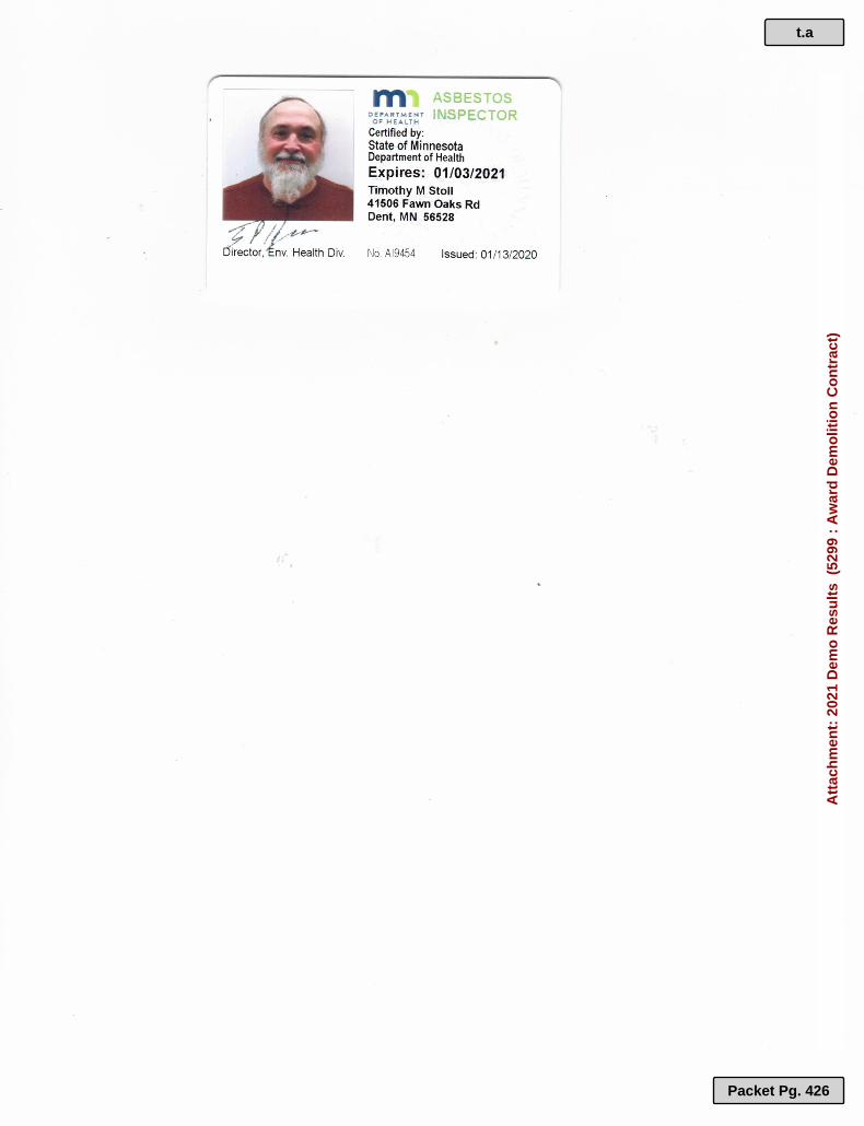
t.a
Packet Pg. 426
Att
ach
men
t: 2
021
Dem
o R
esu
lts
(52
99 :
Aw
ard
Dem
olit
ion
Co
ntr
act)

t.a
Packet Pg. 427
Att
ach
men
t: 2
021
Dem
o R
esu
lts
(52
99 :
Aw
ard
Dem
olit
ion
Co
ntr
act)

t.a
Packet Pg. 428
Att
ach
men
t: 2
021
Dem
o R
esu
lts
(52
99 :
Aw
ard
Dem
olit
ion
Co
ntr
act)

t.a
Packet Pg. 429
Att
ach
men
t: 2
021
Dem
o R
esu
lts
(52
99 :
Aw
ard
Dem
olit
ion
Co
ntr
act)

t.a
Packet Pg. 430
Att
ach
men
t: 2
021
Dem
o R
esu
lts
(52
99 :
Aw
ard
Dem
olit
ion
Co
ntr
act)

Kirk Titus
Land Commissioner
Cass County Land Department
218 Washburn Ave E P.O. Box 25
Backus, MN 56435
Hazardous and Asbestos Materials Inspection location:
4436 24th Street Southwest Pine River, MN 56474
Elite Environmental Services LLC
23518 Cross Dr
Deerwood, MN 56444
Fax# (218) 546-5504
Cell# (218) 851-1133
Project Inspected By:
Brad Johnson MN Asbestos Inspector #: AI-11921
t.a
Packet Pg. 431
Att
ach
men
t: 2
021
Dem
o R
esu
lts
(52
99 :
Aw
ard
Dem
olit
ion
Co
ntr
act)

Asbestos Inspection completion documentation 2020
2 | P r o j e c t C o m p l e t i o n D o c u m e n t a t i o n
December 7th, 2020
Mr. Kirk Titus
Cass County Land Commissioner 218 Washburn Ave E. P.O. Box 25 Backus, MN 56435 Phone: 218-947-7501
Inspection Completion Documentation
Asbestos Sampling – Pre-Demolition:
It is with great pleasure to provide Kirk Titus with documentation for the asbestos-
containing building material (ACBM) and hazardous material sampling conducted at the
residence of 4436 24th St. SW Pine River, MN 56474. Elite Environmental Services
(EES) was hired to inspect the residence for all ACBM, hazardous material and
completing a MPCA pre-demolition checklist, in accordance with MDH recommended
techniques (asbestos rules Part 4620-3460). The property is planned to be demolished, so
EES sampled all accessible building material. EES conducted the inspection on the
afternoon of November 23rd, 2020.
Property Inspection Details & Environmental Services
--- 4436 St. SW Pine River, MN 56474
Observations & Environmental Services
Suspect building materials were grouped as homogeneous areas/materials and each
homogeneous area was sampled as per MDH rules. five (5) suspect materials were
sampled then sent to SanAir analytical laboratory for analysis to determine any
asbestos content. Please see the bulk sample SanAir laboratory results, which will be e-
mailed to Kirk Titus. Please note that the regulated asbestos containing materials are
those which contain greater than one percent (>1%) asbestos.
EES is willing to continue to help with any further consultation services moving forward,
and is prepared to help answer any technically-related questions. EES ensures that all
contracted services were completed within regulatory compliance. EES contracts with
the Virginia-based sample analysis company SanAir Analytical Inc.
t.a
Packet Pg. 432
Att
ach
men
t: 2
021
Dem
o R
esu
lts
(52
99 :
Aw
ard
Dem
olit
ion
Co
ntr
act)

Asbestos Inspection completion documentation 2020
3 | P r o j e c t C o m p l e t i o n D o c u m e n t a t i o n
Laboratory Analysis
➢ EES collected a total of five (5) bulk samples. All bulk samples were analyzed by
SanAir Analytical Inc., utilizing polarized light microscopy techniques.
➢ SanAir Analytical tested a total of eight (8) different types of building materials
(layers) found within the five bulk samples.
➢ SanAir DID NOT identify chrysotile asbestos fibers within any of the sampled
bulk sample layers.
Non-Asbestos Containing Materials:
The following samples were found negative for asbestos content:
• Middle Trailer, throughout residence – ceiling material, ceiling tiles
• Middle Trailer, throughout residence – ceiling material, texture
• Middle Trailer, exterior – roof system, coating, roof tar
• Middle Trailer, throughout residence – floor tile
• Far Trailer, throughout residence – floor tile
• Close Trailer, throughout residence – floor tile
• Close Trailer, throughout residence – floor tile, mastic
• Close Trailer, throughout residence – floor tile, vapor barrier SanAir Laboratory sampling results will be e-mailed to Kirk Titus
OSHA Worker Protection
Materials testing less than 1% asbestos are not considered to be asbestos containing
materials in the state of Minnesota; however, as they do contain asbestos fibers, all
OSHA rules must be followed during the removal of such material.
• SanAir Technologies did not identify any sampled bulk layer to contain <1%
asbestos, within any building material.
t.a
Packet Pg. 433
Att
ach
men
t: 2
021
Dem
o R
esu
lts
(52
99 :
Aw
ard
Dem
olit
ion
Co
ntr
act)

Asbestos Inspection completion documentation 2020
4 | P r o j e c t C o m p l e t i o n D o c u m e n t a t i o n
Recommendations & Property Considerations
Please note that OSHA regulations, regarding building demolitions, require that “friable”
and other “regulated” asbestos containing material must be removed from the building
prior demolition activities that involve destruction of the building to the ground. These
regulated hazardous materials must be disposed of properly at a regulated landfill that
accepts asbestos-containing building material waste; Crow Wing County landfill will
accept ACBM waste.
SanAir Technologies and Elite Environmental Services did not sample, or identify, any
suspect building materials that contain asbestos fibers. None of the bulk sample layers
collected are0 considered asbestos-containing building materials (ACBM).
Please note that in addition to the above requirements for asbestos removal, the owner
or demolition contractor must file a “notification of Intent to Perform a Demolition” with
the MPCA, at least ten (10) working days in advance of the demolition/burning. I have
attached a blank copy of this notification form.
Other material to remove prior to demo
1. Fluorescent tubes 2. Smoke detectors 3. exit sign batteries 4. PCB ballasts 5. Mercury thermostats 6. and other hazardous chemicals 7. Please refer to the MPCA check list for other materials.
➢ EES noted multiple fluorescent ballasts and tubes within the trailers. ➢ EES recommends on removing these items prior to demolition.
EES recommends that the items noted on the MPCA “Pre-Demolition Checklist” be
removed from the property, prior to demolition. The pre-demolition checklist will be
provided along with this report.
t.a
Packet Pg. 434
Att
ach
men
t: 2
021
Dem
o R
esu
lts
(52
99 :
Aw
ard
Dem
olit
ion
Co
ntr
act)

Asbestos Inspection completion documentation 2020
5 | P r o j e c t C o m p l e t i o n D o c u m e n t a t i o n
EES would like to thank Kirk Titus for the opportunity to complete this pre-demolition
hazardous material inspection. If there are any additional questions, feel free to contact
Brad Johnson, at your convenience, by email at: [email protected], or by
phone at 218-851-1133.
Thank you for your business,
Bradley W. Johnson Jr , Owner
Appendix A: SanAir Sampling Results & Chain-of-Custody Form
t.a
Packet Pg. 435
Att
ach
men
t: 2
021
Dem
o R
esu
lts
(52
99 :
Aw
ard
Dem
olit
ion
Co
ntr
act)

Asbestos Inspection completion documentation 2020
6 | P r o j e c t C o m p l e t i o n D o c u m e n t a t i o n
t.a
Packet Pg. 436
Att
ach
men
t: 2
021
Dem
o R
esu
lts
(52
99 :
Aw
ard
Dem
olit
ion
Co
ntr
act)

Asbestos Inspection completion documentation 2020
7 | P r o j e c t C o m p l e t i o n D o c u m e n t a t i o n
t.a
Packet Pg. 437
Att
ach
men
t: 2
021
Dem
o R
esu
lts
(52
99 :
Aw
ard
Dem
olit
ion
Co
ntr
act)

Asbestos Inspection completion documentation 2020
8 | P r o j e c t C o m p l e t i o n D o c u m e n t a t i o n
t.a
Packet Pg. 438
Att
ach
men
t: 2
021
Dem
o R
esu
lts
(52
99 :
Aw
ard
Dem
olit
ion
Co
ntr
act)

CASS COUNTY ITEM: Award Tree Planting Contract
REQUEST FOR BOARD ACTION
Requested Board Date: March 16, 2021
Originating Department: Land Department
Presenter: Kirk Titus
Requested Time:
For Discussion:
Consent Agenda Item
The Land Department has received the following quotes to plant approximately 36,600 trees during the 2021 spring planting season. The tree planting sites are in Inguadona, Poplar Loon Lake, Byron and Moose Lake Townships.
Superior Forestry Services, Inc. $94.94/thousand seedlings Northwoods Forestry, Inc. $300.00/thousand seedlings
MOTION: Award – Contract for tree planting in 2021 to Superior Forestry Services, Inc. at $94.94 per thousand seedlings.
Supporting Documentation: 2021 Tree Planting_specs&bidsheet
Distribution List: Kirk Titus Completed 03/08/2021 10:25 AM Betsy Woodford Completed 03/08/2021 2:18 PM Josh Stevenson Completed 03/10/2021 2:53 PM Board of Commissioners Pending 03/16/2021 9:00 AM
u
Packet Pg. 439

CASS COUNTY LAND DEPARTMENT
Specifications for Care and Planting of Bare Root and Containerized Seedlings – 2021
These specifications shall govern the care of seedlings and planting of the seedlings on County lands in Cass
County.
Planting shall be completed between the dates of April 15, 2021 and May 30, 2021. Contractor must have planters
available no later than May 16, 2021. There will be approximately 36,600 containerized trees available for
planting. Sites have been site-prepared with a TTS trencher or untreated.
Instructions to Bidders
The Cass County Land Department will provide typical planting sites for inspection by bidders. It is the
responsibility of all bidders to examine such sites for purposes of bidding. Failure of a bidder to examine a
planting site will not relieve them from any of the provisions of the contract. Submission of a Quote shall be
considered as prima facie evidence that such examination has been made by the bidder.
Experience Clause
Bidders are required to furnish a statement showing whether they are now or ever have engaged in any contract
or other work similar to that proposed. The name of the companies or agencies for which such work has been
done, the name of persons representing said company or agency who were responsible for the work, and to give
such other information as will tend to show his ability to complete the work required by these specifications.
If you have any questions, please contact Erik Lindquist at the Cass County Land Department
at (218)-947-3338
Opening of Quotes
Date of opening – March 8, 2021 @ 10:00 A.M.
The right is reserved by Cass County to reject any or all quotes and the winning bid is subject to county board
approval.
Cass County's Right to Terminate the Contract
If contractor is insolvent or commits any act of bankruptcy, or if contractor fails, for a period exceeding 48 hours,
to supply sufficient manpower and material to diligently prosecute the work or shall otherwise breach its
obligations under this contract, the County may terminate this contract for cause, exclude contractor from the
work site and finish work by means as it may see fit.
In the event of such termination, Contractor shall supply the County with a statement of its uncompensated costs
incurred prior to the effective date of such termination and the County shall within 30 days verify the amount
claimed and pay such amount to Contractor along with any retainage held by the County, provided that if the
termination is for cause (such as Contractor's bankruptcy or breach), the County shall be entitled to retain an
amount sufficient to offset damages incurred by the County as a result of Contractors breach.
u.a
Packet Pg. 440
Att
ach
men
t: 2
021
Tre
e P
lan
tin
g_s
pec
s&b
idsh
eet
(53
01 :
Aw
ard
Tre
e P
lan
tin
g C
on
trac
t)

Contractor Responsibilities
• Contractor agrees to hire, supervise, pay, provide transportation and have required insurance for crew.
• Contractor will accept responsibility for care of trees and protect cardboard boxes and styro-block
containers from damage.
• Contractor will plant one tree per scalp on high side of scalp on scalped sites and high side of trench on
trenched sites. Seedling spacing will be 8 feet apart on sites that are disc-trenched unless otherwise
specified. Contractor will plant seedlings so that roots of seedlings are placed in ground so they assume
a natural vertical position. Root collar of seedlings must be at or near soil surface. Each seedling must
be planted firmly in the ground. Soil around roots shall be packed so that there are no air pockets around
the roots. No trees shall be root pruned or culled unless approved by county personnel.
• Contractor will ensure that seedlings are kept out of direct sunlight (they must be shaded) and root systems
kept moist at all times. Damage caused to seedling due to storing trees in direct sunlight or allowing the
root systems to dry out will be charged at 3 times the cost of the seedlings.
• Contractor shall provide all necessary equipment required to perform work.
• Contractor shall diligently prosecute the work, providing sufficient manpower, materials and other
supplies at all times to assure completion of the work in an orderly fashion by the completion date stated
in the specifications attachment. Contractor shall at all times keep the work site reasonably neat and clean
and upon completion shall remove and dispose of all rubbish, trash and refuse from the work area and
leave the work site clean. Contractors shall at all times coordinate its work and cooperate with the County.
• Contractor shall, in its performance of the work, comply with all applicable codes and industry standards
and with all applicable federal, state and local laws, rules and regulations, including but not limited to, the
requirements of the Federal Occupational Safety and Health Act, the Federal Fair Labor Standards Act of
1938 as amended, the Minnesota State Worker's Compensation Laws, and all applicable Civil Rights laws,
rules and regulations.
• Contractor shall promptly pay all laborers, subcontractors or materialmen connected with the work and if
any shall file liens against the work, contractor shall promptly obtain a release of any such lien or post a
bond indemnifying the County against all loss by reason of such lien. The County shall have the right,
prior to making any payment due under this contract, to require Contractor to deliver lien waivers duly
executed by itself and each of its subcontractors and materialmen for all work done prior to such payment.
• Survey markers will be marked in the field with flagging and paint, and labeled on the site map. Damage
to any of these markers is prohibited. Flagged or painted survey monuments or reference objects, which
are damaged or destroyed during contract operations, must be properly replaced by a Registered Land
Surveyor hired by the contractor. The cost of this replacement shall be the sole responsibility of the
contractor.
• Contractor shall furnish daily requirements of seedlings needed at least five (5) days prior to the start of
planting. Failure to do so may result in loss of trees or delay in planting.
Inspection and Penalties
• Number of trees planted per acre will be determined by plot sampling system. Incorrectly planted trees will
not be counted. The following range is satisfactory: total trees per acre as specified on site map, 50 trees high
or low. If stocking falls outside these ranges, the contractor will be penalized.
u.a
Packet Pg. 441
Att
ach
men
t: 2
021
Tre
e P
lan
tin
g_s
pec
s&b
idsh
eet
(53
01 :
Aw
ard
Tre
e P
lan
tin
g C
on
trac
t)

Inspection and Penalties (continued)
The following penalties apply:
50 trees per acre
Incorrectly planted
or missing
No penalty
51-120 trees per
acre
Incorrectly planted
or missing
10% reduction in
payment 121-200 trees per
acre
Incorrectly planted
or missing
20% reduction in
payment Below or over above
guidelines
No Payment
100% reduction in
Payment
Cass County Land Department Responsibilities
• Provide seedlings at planting site or tree storage facility
• Provide qualified personnel at site to assist
Cass County's Rights
County shall have the right at all times during the performance of the work to conduct such tests and inspections
as it deems necessary to assure Contractor's compliance with this contract. If any work or materials are found not
to be in compliance with the specifications, the County shall have the right to order such work redone in
conformance with this contract. No payment by the County of any sums due pursuant to this contract shall be
interpreted as a waiver of any defect in labor and materials.
County shall have the right to order changes in the work at any time. Contractor shall proceed with such changes
immediately upon receipt of a written change order signed by the County. The contract price and the completion
date specified shall be equitably adjusted to reflect any increase or decrease in the work. Upon the County's
request, contractor shall provide satisfactory evidence from which contract price adjustments can be made. These
changes include but are not limited to environmental conditions such as: drought, rain, and wind speed.
Responsibility for Damage Claims
Within ten (10) days after the bid has been awarded, the successful bidder will be required to furnish a certificate
of insurance indicating that he is adequately protected by public liability and property damage insurance. The
owner shall, at his own cost and expense, carry and maintain public liability insurance, protecting the County
against any and all kinds of liability by or from the operation and use of any equipment leased by the County
under this agreement. Contractor must name Cass County as an additional insured. The Contractor shall provide
Workman's Compensation (Certificate of Insurance) protection as required by State law.
The Contractor shall indemnify and save harmless the Cass County Land Department, Cass County and its officers
and employees from all suits, actions and claims of any character brought because of injuries or damages received
or sustained by any person, persons or property on account of the operations of the said Contractor or on account
of or in consequence of any neglect in safeguarding the work; or through the use of unacceptable materials in
constructing the work; or because of any act or omission, neglect or misconduct of said Contractor; or because of
any claims arising or amount recovered from infringements of patent, trademark or copyright; or because of any
claims arising or amounts recovered under the Workmen's Compensation Act or under any other law, ordinance,
order or decree.
See attached “Insurance & Other Requirements” for more specific responsibilities.
u.a
Packet Pg. 442
Att
ach
men
t: 2
021
Tre
e P
lan
tin
g_s
pec
s&b
idsh
eet
(53
01 :
Aw
ard
Tre
e P
lan
tin
g C
on
trac
t)

Insurance & Other Requirements
• Shall maintain General Liability Insurance to include coverage of $500,000 per
claimant and $1,500,000.00 per occurrence.
• Shall maintain automobile liability coverage of $500,000 per claimant and
$1,500,000.00 per occurrence.
• Shall maintain Minnesota statutory limits of workers compensation and
employers liability insurance.
• Shall name Cass County as an additional insured and shall provide Cass County
with a certificate of insurance before work commences.
• Shall hold harmless and indemnify Cass County for any and all claims caused
either in whole or in part by the contractor.
• Shall have the duty to comply (without County supervision) with all applicable
labor laws and provide appropriate safety measures based on relevant OSHA
standards.
• Shall have the duty to comply (without County supervision) with all applicable
State and Federal labor laws regarding discrimination, wages, benefits, and other
conditions of employment.
• Shall provide performance and payment bonds as required by Minnesota statutes.
• Must have a current W9 on file with Cass
County.
• Must not be delinquent in the payment of Federal, State or Local taxes.
• Must submit an IC-134 from the Minnesota Department of Revenue in
accordance with Minnesota statute before final contract payment can be made.
• Is hereby notified that in the event of default, any and all means shall be used by
the County to recover damages and fees from the Contractor. All disputes that
require judicial action shall be filed in Cass County District Court.
u.a
Packet Pg. 443
Att
ach
men
t: 2
021
Tre
e P
lan
tin
g_s
pec
s&b
idsh
eet
(53
01 :
Aw
ard
Tre
e P
lan
tin
g C
on
trac
t)

Please indicate your bid on this sheet, fill out the information on the bottom portion of this page and return in a sealed envelope to: Cass County Land Dept., P.O. Box 25, Backus, MN 56435
Or fax to: (218)-947-3230 Or email to: [email protected]
AGREEMENT
In consideration of the mutual covenants contained herein, the parties hereto hereby agree:
1. That the undersigned Contractor agrees to plant seedlings for Cass County during the 2021 spring planting season.
2. That said planting shall be performed in accordance with Cass County's Specifications for planting of Bare Root and Containerized Seedlings – 2021, a copy of which Specifications are attached hereto and made a part thereof.
3. That the Contractor shall be responsible for providing all necessary tools and equipment and transportation necessary for the performance of this Agreement.
4. The Contractor will plant approximately 36,600 seedlings during the 2021 planting season for the sum of $ /thousand seedlings.
Total Contract Value $___________________
5. It is specifically understood and agreed by and between the parties hereto that the Contractor performs this contract as an independent contractor, and is not an employee of Cass County or any of its agencies. The Contractor is responsible for providing all necessary insurance for his or her own protection, as well as being responsible for payment of all applicable taxes.
Bidder: Name:________________________________________________ Address:________________________________________________ ________________________________________________ Phone:___________________ Date:_____________ Signature:________________________________________________
u.a
Packet Pg. 444
Att
ach
men
t: 2
021
Tre
e P
lan
tin
g_s
pec
s&b
idsh
eet
(53
01 :
Aw
ard
Tre
e P
lan
tin
g C
on
trac
t)

u.a
Packet Pg. 445
Att
ach
men
t: 2
021
Tre
e P
lan
tin
g_s
pec
s&b
idsh
eet
(53
01 :
Aw
ard
Tre
e P
lan
tin
g C
on
trac
t)

u.a
Packet Pg. 446
Att
ach
men
t: 2
021
Tre
e P
lan
tin
g_s
pec
s&b
idsh
eet
(53
01 :
Aw
ard
Tre
e P
lan
tin
g C
on
trac
t)

u.a
Packet Pg. 447
Att
ach
men
t: 2
021
Tre
e P
lan
tin
g_s
pec
s&b
idsh
eet
(53
01 :
Aw
ard
Tre
e P
lan
tin
g C
on
trac
t)

u.a
Packet Pg. 448
Att
ach
men
t: 2
021
Tre
e P
lan
tin
g_s
pec
s&b
idsh
eet
(53
01 :
Aw
ard
Tre
e P
lan
tin
g C
on
trac
t)

u.a
Packet Pg. 449
Att
ach
men
t: 2
021
Tre
e P
lan
tin
g_s
pec
s&b
idsh
eet
(53
01 :
Aw
ard
Tre
e P
lan
tin
g C
on
trac
t)

u.a
Packet Pg. 450
Att
ach
men
t: 2
021
Tre
e P
lan
tin
g_s
pec
s&b
idsh
eet
(53
01 :
Aw
ard
Tre
e P
lan
tin
g C
on
trac
t)

CASS COUNTY ITEM: Receive and File February 2021
Interest Report REQUEST FOR BOARD ACTION
Requested Board Date: March 16, 2021
Originating Department: Auditor-Treasurer
Presenter: Karen Flier
Requested Time:
For Discussion:
Consent Agenda Item
Insert Summary of item
MOTION: Receive & file – February 2021 Interest Report
Supporting Documentation: FEBRUARY 2021 INTEREST REPORT
Distribution List: Karen Flier Completed 03/02/2021 10:49 AM Sandra Norikane Completed 03/02/2021 11:19 AM Betsy Woodford Completed 03/04/2021 11:24 AM Josh Stevenson Completed 03/10/2021 3:26 PM Board of Commissioners Pending 03/16/2021 9:00 AM
v
Packet Pg. 451

FEBRUARY 2021 INTEREST REPORT Percent of Year: 17%
FUND INTEREST INTEREST YTD ACTUAL YTD ACTUAL YTD 2021 ACTUAL
Feb-20 Feb-21 JAN-DEC 2020 JAN-DEC 2021 % BUDGET 2020 FYE
REVENUE $80,812.72 $44,985.46 $229,712.25 $104,717.31 14% $750,000.00 $1,090,191.54
SELF INSURANCE $3,500.00 $2,250.00 $7,000.00 $4,500.00 $28,078.58
MCIS $0.00 $0.00 $433.49 $0.00 $433.49
E911 $27.59 $16.00 $102.27 $28.85 $272.74
TRUST ACCT $2,707.58 $3,658.33 $10,363.89 $3,859.48 $51,674.31
SISWD $8.06 $6.17 $16.27 $12.81 $80.91
TOTALS $87,055.95 $50,915.96 $247,628.17 $113,118.45 $1,170,731.57
v.a
Packet Pg. 452
Att
ach
men
t: F
EB
RU
AR
Y 2
021
INT
ER
ES
T R
EP
OR
T (
5291
: R
ecei
ve a
nd
File
Feb
ruar
y 20
21 In
tere
st R
epo
rt)

Outstanding Investments ReportCass County Investments
Accrual Date 02/26/2021
Financial Institution
Principal Percent of
Total PortfolioCurrent
PrincipalInstitution Collateral
Principal Percent of
Collateral
$500,000.00BREMER-Bremer Bank $550,000.000.62% 90.91%
$17,773,805.12FNBN-First National Bank North $23,068,158.1922.14% 77.05%
$4,004,032.06MAGIC-MAGIC $99,999,999.004.99% 4.00%
$12,642,815.82MBS-Multi-Bank Securities, Inc. $99,999,999.0015.75% 12.64%
$525,334.15PINE-Pine River State Bank $751,000.000.65% 69.95%
$11,812,741.58RAY JAMES-Raymond James $99,999,999.0014.72% 11.81%
$33,010,000.00WFA-Wells Fargo Advisors $99,999,999.0041.12% 33.01%
Total Current Portfolio $80,268,728.73
Tuesday, March 2, 2021 Page 1 of 1
v.a
Packet Pg. 453
Att
ach
men
t: F
EB
RU
AR
Y 2
021
INT
ER
ES
T R
EP
OR
T (
5291
: R
ecei
ve a
nd
File
Feb
ruar
y 20
21 In
tere
st R
epo
rt)

$0.00
$20,000,000.00
$40,000,000.00
$60,000,000.00
$80,000,000.00
$100,000,000.00
$120,000,000.00
JAN FEB MAR APRIL MAY JUNE JULY AUG SEPT OCT NOV DEC
MONTH END CASH BALANCES
2017 2018 2019 2020 2021
v.a
Packet Pg. 454
Att
ach
men
t: F
EB
RU
AR
Y 2
021
INT
ER
ES
T R
EP
OR
T (
5291
: R
ecei
ve a
nd
File
Feb
ruar
y 20
21 In
tere
st R
epo
rt)

CASS COUNTY ITEM: Receive and File Letter of Perfect
Performance for 2020 Financial Reporting to MN DHS
REQUEST FOR BOARD ACTION
Requested Board Date: March 16, 2021
Originating Department: Administration
Presenter: Josh Stevenson
Requested Time:
For Discussion:
Consent Agenda Item
Insert Summary of item
MOTION: Receive & file – Letter from Minnesota Department of Human Services Commissioner Jodi Harpstead regarding perfect performance in meeting financial requirements for calendar year 2020 from Cass County Health, Human and Veterans Services.
Supporting Documentation: CY2020 kudos letters approved 11
Distribution List: Josh Stevenson Completed 03/10/2021 3:26 PM Betsy Woodford Completed 03/10/2021 11:17 AM Josh Stevenson Completed 03/10/2021 3:27 PM Board of Commissioners Pending 03/16/2021 9:00 AM
w
Packet Pg. 455

Minnesota Department of Human Services Elmer L. Andersen Building Commissioner Jodi Harpstead Post Office Box 64998 St. Paul, Minnesota 55164-0998
March 1, 2021
Mr. Neal Gaalswyk Chair, Cass County Board of Commissioners PO Box 3000 Walker, MN 56484-3000
Re: Calendar year 2020 financial reporting
Dear Commissioner Gaalswyk:
It is my pleasure to commend you and your staff for perfect performance in meeting the Department of Human Services (DHS) financial reporting requirements for calendar year 2020. All key quarterly fiscal reports for programs your county participates in were submitted to our Financial Operations Division on or before the report deadlines and in perfect order. This effort required submission of 32 major reports covering the four calendar quarters of 2020. These reports are:
Local Collaborative Time Study (LCTS)* Income Maintenance Expense MFIP Consolidated Fund Social Service Fund Client Statistics Title IV-E SEAGR BRASS-Based Grant Fiscal Report
*If your county participates in a “local collaborative,” submission of this report may require the collection of multiple local partner reports for consolidated submission to DHS.
I know this accomplishment requires planning, an efficient operation, and teamwork within your county Human Services Department. The result is timely revenue for your county and compliance with federal reporting for us at the State. Please congratulate your management and staff on this superb effort.
Sincerely,
/s/ Jodi Harpstead Commissioner
Cc: Michele Piprude, Cass County Director
w.a
Packet Pg. 456
Att
ach
men
t: C
Y20
20 k
ud
os
lett
ers
app
rove
d 1
1 (
5320
: R
ecei
ve a
nd
File
Let
ter
of
Per
fect
Per
form
ance
fo
r 20
20 F
inan
cial
Rep
ort
ing
to
MN
DH
S)

CASS COUNTY ITEM: Receive and File Recorder's Office
Summary of Fees Collected and Electronic Recording Report
REQUEST FOR BOARD ACTION
Requested Board Date: March 16, 2021
Originating Department: Recorder
Presenter: Katie Norby
Requested Time:
For Discussion:
Consent Agenda Item
Attached is a summary of the annual fees collected by the Recorder's Office from 2010 - 2020. Please note that we were not accepting first time passport applications or taking passport photos the last 9 months of the year. We are now accepting first time passport applications and passport photos by appointment only beginning in January, 2021. As you can see from the attached electronic recordings report, Cass County recorded over 52% of the real estate documents electronically in 2020. Based solely on the first two months of 2021, the average is now over 56%.
MOTION: Receive & file - Recorder’s Office summary of annual fees collected and electronic recording report showing the percentage of documents that were recorded electronically in our county.
Supporting Documentation: SUMMARY OF ANNUAL FEES COLLECTED 2010-2020 e-recording report sheet
Distribution List: Katie Norby Completed 03/03/2021 1:49 PM Betsy Woodford Completed 03/04/2021 11:20 AM Josh Stevenson Completed 03/10/2021 2:59 PM Board of Commissioners Pending 03/16/2021 9:00 AM
x
Packet Pg. 457

CASS COUNTY RECORDER'S OFFICE
SUMMARY OF ANNUAL RECORDING FEES COLLECTED
2010 2011 2012 2013 2014 2015 2016 2017 2018 2019 2020FEES
Abstract 528,353.97$ 512,953.85$ 591,353.96$ $557,181.05 $474,091.65 $519,580.85 $514,559.12 $543,917.45 $536,349.75 $527,866.30 $642,077.09
Torrens 42,485.00$ 36,094.00$ 40,912.00$ $37,204.00 $25,040.50 $35,298.00 $34,518.00 $38,616.00 $35,356.00 $33,036.00 $43,012.00
UCC 9,052.00$ 10,272.00$ 15,192.00$ $15,211.00 $5,903.00 $0.00 $0.00 $0.00 $0.00 $20.00 $0.00
(Began 5-1-2011) Passports $6,150.00 $8,925.00 $6,950.00 $8,000.00 $7,350.00 $6,000.00 $6,725.00 $6,995.00 $7,367.00 $3,258.00
GRAND TOTAL
OF FEES COLLECTED 579,890.97$ 565,469.85$ 656,382.96$ $616,546.05 $513,035.15 $562,228.85 $555,077.12 $589,258.45 $578,700.75 $568,289.30 $688,347.09
NUMBER OF DOCUMENTS
Year 2010 2011 2012 2013 2014 2015 2016 2017 2018 2019 2020Abstract 10047 9717 11601 11152 9256 9906 9136 9827 9556 9505 11349
Torrens 832 687 782 735 592 706 662 699 688 637 847
UCC (Terminated 12-1-14 by
Sec. of State) 450 511 757 759 290 0 0 0 0 1 0
(Began 5-1-2011) Passports 0 246 357 278 320 294 240 269 217 244 54
Passport Photos 0 0 0 0 0 0 0 0 0 38 114
TOTAL DOCUMENTS 11329 11161 13497 12924 10458 10906 10038 10795 10461 10387 12250
x.a
Packet Pg. 458
Att
ach
men
t: S
UM
MA
RY
OF
AN
NU
AL
FE
ES
CO
LL
EC
TE
D 2
010-
2020
(52
93 :
Rec
eive
an
d F
ile R
eco
rder
's

E-Recording ReportABSTRACT TORRENS
All docs for mo.
Total edocs for mo.
Paper Docs
Percent of Abst. edocs
All docs for mo.
Total edocs for mo.
Paper Docs
Percent of Torrens edocs Date Reported
Annual % of all edocs
January 2013 1022 160 862 15.66% 51 4 47 7.84% 2/4/2013February 2013 1130 118 1012 10.44% 81 11 70 13.58% 3/4/2013March 2013 768 119 649 15.49% 38 6 32 15.79% 4/3/2013April 2013 963 129 834 13.40% 43 7 36 16.28% 5/2/2013May 2013 1016 123 893 12.11% 66 4 62 6.06% 6/5/2013June 2013 975 155 820 15.90% 63 10 53 15.87% 7/8/2013July 2013 987 178 809 18.03% 68 7 61 10.29%August 2013 958 165 793 17.22% 72 14 58 19.44% 9/16/2013September 2013 910 127 783 13.96% 66 4 62 6.06% 10/8/2013October 2013 961 211 750 21.96% 65 5 60 7.69% 11/18/2013November 2013 674 147 527 21.81% 49 8 41 16.33% 12/17/2013December 2013 1056 203 853 19.22% 99 7 92 7.07% 1/10/2013TOTALS 2013 11420 1835 9585 16.07% 761 87 674 11.43% 15.7787%
January 2014 750 135 615 18.00% 52 5 47 9.62% 2/7/2014February 2014 602 99 503 16.45% 22 6 16 27.27% 7/11/2014March 2014 605 94 511 15.54% 45 3 42 6.67% 7/11/2014April 2014 727 137 590 18.84% 49 6 43 12.24% 7/11/2014May 2014 737 211 526 28.63% 65 3 62 4.62% 7/11/2014June 2014 750 207 543 27.60% 55 25 30 45.45% 7/11/2014July 2014 855 235 620 27.49% 73 7 66 9.59% 10/16/2014August 2014 784 231 553 29.46% 47 8 39 17.02% 10/16/2014September 2014 899 230 669 25.58% 59 12 47 20.34% 10/16/2014October 2014 1012 316 696 31.23% 45 9 36 20.00% 11/20/2014November 2014 698 222 476 31.81% 47 11 36 23.40% 12/3/2014December 2014 837 190 647 22.70% 42 7 35 16.67% 1/27/2015TOTALS 2014 9256 2307 6949 24.92% 601 102 499 16.97% 24.4395%
x.b
Packet Pg. 459
Att
ach
men
t: e
-rec
ord
ing
rep
ort
sh
eet
(52
93 :
Rec
eive
an
d F
ile R
eco
rder
's O
ffic
e S
um
mar
y o
f F
ees

E-Recording ReportABSTRACT TORRENS
All docs for mo.
Total edocs for mo.
Paper Docs
Percent of Abst. edocs
All docs for mo.
Total edocs for mo.
Paper Docs
Percent of Torrens edocs Date Reported
Annual % of all edocs
January 2015 639 180 459 28.17% 52 6 46 11.54% 3/12/2015February 2015 613 193 420 31.48% 32 8 24 25.00% 3/12/2015March 2015 669 181 488 27.06% 39 20 19 51.28% 9/1/2015April 2015 826 286 540 34.62% 54 11 43 20.37% 9/1/2015May 2015 789 275 514 34.85% 48 12 36 25.00% 9/1/2015June 2015 959 358 601 37.33% 56 20 36 35.71% 9/1/2015July 2015 985 338 647 34.31% 58 21 37 36.21% 9/1/2015August 2015 907 320 587 35.28% 84 18 66 21.43% 9/1/2015September 2015 1315 481 834 36.58% 79 19 60 24.05% 10/15/2015October 2015 959 339 620 35.35% 65 19 46 29.23% 11/2/2015November 2015 814 282 532 34.64% 70 18 52 25.71% 1/14/2016December 2015 867 338 529 38.99% 101 20 81 19.80% 1/14/2016TOTALS 2015 10342 3571 6771 34.53% 738 192 546 26.02% 33.9621%
January 2016 579 201 378 34.72% 31 9 22 29.03% 5/2/2016February 2016 540 196 344 36.30% 32 12 20 37.50% 5/2/2016March 2016 583 190 393 32.59% 28 11 17 39.29% 5/2/2016April 2016 665 248 417 37.29% 56 12 44 21.43% 5/2/2016May 2016 832 304 528 36.54% 68 10 58 14.71% 6/2/2016June 2016 905 358 547 39.56% 60 9 51 15.00% 7/8/2016July 2016 834 314 520 37.65% 80 25 55 31.25% 11/8/2016August 2016 806 329 477 40.82% 67 25 42 37.31% 11/8/2016September 2016 860 338 522 39.30% 47 17 30 36.17% 11/8/2016October 2016 911 385 526 42.26% 64 21 43 32.81% 11/8/2016November 2016 730 288 442 39.45% 48 13 35 27.08% 12/5/2016December 2016 891 314 577 35.24% 81 13 68 16.05% 1/11/2017TOTALS 2016 9136 3465 5671 37.93% 662 177 485 26.74% 37.1709%
x.b
Packet Pg. 460
Att
ach
men
t: e
-rec
ord
ing
rep
ort
sh
eet
(52
93 :
Rec
eive
an
d F
ile R
eco
rder
's O
ffic
e S
um
mar
y o
f F
ees

E-Recording ReportABSTRACT TORRENS
All docs for mo.
Total edocs for mo.
Paper Docs
Percent of Abst. edocs
All docs for mo.
Total edocs for mo.
Paper Docs
Percent of Torrens edocs Date Reported
Annual % of all edocs
January 2017 741 320 421 43.18% 41 18 23 43.90% 6/1/2017February 2017 614 197 417 32.08% 27 10 17 37.04% 6/1/2017March 2017 710 243 467 34.23% 62 16 46 25.81% 6/1/2017April 2017 648 257 391 39.66% 50 14 36 28.00% 6/1/2017May 2017 840 336 504 40.00% 94 25 69 26.60% 6/1/2017June 2017 941 367 574 39.00% 66 23 43 34.85% 9/21/2017July 2017 835 336 499 40.24% 76 18 58 23.68% 9/21/2017August 2017 989 357 632 36.10% 58 24 34 41.38% 9/21/2017September 2017 823 318 505 38.64% 52 23 29 44.23% 11/7/2017October 2017 1035 439 596 42.42% 75 20 55 26.67% 11/7/2017November 2017 827 296 531 35.79% 61 12 49 19.67% 1/2/2018December 2017 824 262 562 31.80% 46 17 29 36.96% 1/2/2018TOTALS 2017 9827 3728 6099 37.94% 708 220 488 31.07% 37.4751%
January 2018 744 269 475 36.16% 45 15 30 33.33%February 2018 584 249 335 42.64% 31 15 16 48.39%March 2018 634 277 357 43.69% 71 18 53 25.35%April 2018 717 251 466 35.01% 58 17 41 29.31%May 2018 797 326 471 40.90% 82 31 51 37.80%June 2018 934 382 552 40.90% 53 16 37 30.19%July 2018 945 413 532 43.70% 67 19 48 28.36%August 2018 924 358 566 38.74% 67 28 39 41.79%September 2018 821 343 478 41.78% 67 19 48 28.36%October 2018 980 365 615 37.24% 72 21 51 29.17%November 2018 762 273 489 35.83% 31 11 20 35.48%December 2018 714 266 448 37.25% 44 14 30 31.82%TOTALS 2018 9556 3772 5784 39.47% 688 224 464 32.56% 39.0082%
x.b
Packet Pg. 461
Att
ach
men
t: e
-rec
ord
ing
rep
ort
sh
eet
(52
93 :
Rec
eive
an
d F
ile R
eco
rder
's O
ffic
e S
um
mar
y o
f F
ees

E-Recording ReportABSTRACT TORRENS
All docs for mo.
Total edocs for mo.
Paper Docs
Percent of Abst. edocs
All docs for mo.
Total edocs for mo.
Paper Docs
Percent of Torrens edocs Date Reported
Annual % of all edocs
January 2019 699 292 407 41.77% 52 18 34 34.62%February 2019 448 173 275 38.62% 42 11 31 26.19%March 2019 558 206 352 36.92% 42 15 27 35.71%April 2019 703 296 407 42.11% 48 15 33 31.25%May 2019 770 280 490 36.36% 64 26 38 40.63%June 2019 793 294 499 37.07% 43 13 30 30.23%July 2019 945 407 538 43.07% 46 20 26 43.48%August 2019 937 394 543 42.05% 51 31 20 60.78%September 2019 969 421 548 43.45% 70 28 42 40.00%October 2019 1022 432 590 42.27% 64 24 40 37.50%November 2019 805 369 436 45.84% 50 28 22 56.00%December 2019 856 360 496 42.06% 65 24 41 36.92%TOTALS 2019 9505 3924 5581 41.28% 637 253 384 39.72% 41.1852%
January 2020 691 316 375 45.73% 48 16 32 33.33%February 2020 597 265 332 44.39% 45 25 20 55.56%March 2020 661 271 390 41.00% 57 17 40 29.82%April 2020 609 332 277 54.52% 48 25 23 52.08%May 2020 780 427 353 54.74% 54 28 26 51.85%June 2020 1054 517 537 49.05% 72 27 45 37.50%July 2020 1108 672 436 60.65% 79 43 36 54.43%August 2020 1193 671 522 56.24% 66 23 43 34.85%September 2020 1107 616 491 55.65% 116 40 76 34.48%October 2020 1165 631 534 54.16% 85 47 38 55.29%November 2020 1034 561 473 54.26% 69 25 44 36.23%December 2020 1350 728 622 53.93% 108 46 62 42.59%TOTALS 2020 11349 6007 5342 52.93% 847 362 485 42.74% 52.2220%
x.b
Packet Pg. 462
Att
ach
men
t: e
-rec
ord
ing
rep
ort
sh
eet
(52
93 :
Rec
eive
an
d F
ile R
eco
rder
's O
ffic
e S
um
mar
y o
f F
ees

E-Recording ReportABSTRACT TORRENS
All docs for mo.
Total edocs for mo.
Paper Docs
Percent of Abst. edocs
All docs for mo.
Total edocs for mo.
Paper Docs
Percent of Torrens edocs Date Reported
Annual % of all edocs
January 2021 912 522 390 57.24% 85 29 56 34.12%February 2021 896 525 371 58.59% 76 33 43 43.42%March 2021 0 #DIV/0! 0 #DIV/0!April 2021 0 #DIV/0! 0 #DIV/0!May 2021 0 #DIV/0! 0 #DIV/0!June 2021 0 #DIV/0! 0 #DIV/0!July 2021 0 #DIV/0! 0 #DIV/0!August 2021 0 #DIV/0! 0 #DIV/0!September 2021 0 #DIV/0! 0 #DIV/0!October 2021 0 #DIV/0! 0 #DIV/0!November 2021 0 #DIV/0! 0 #DIV/0!December 2021 0 #DIV/0! 0 #DIV/0!TOTALS 2021 1808 1047 761 57.91% 161 62 99 38.51% 56.3230%
x.b
Packet Pg. 463
Att
ach
men
t: e
-rec
ord
ing
rep
ort
sh
eet
(52
93 :
Rec
eive
an
d F
ile R
eco
rder
's O
ffic
e S
um
mar
y o
f F
ees

CASS COUNTY ITEM: Receive and File Timber Auction
Results REQUEST FOR BOARD ACTION
Requested Board Date: March 16, 2021
Originating Department: Land Department
Presenter: Kirk Titus
Requested Time:
For Discussion:
Consent Agenda Item
Insert Summary of item
MOTION: Receive & file – February 25, 2021 Timber Auction results 7,714 cords totaling $259,668.
Supporting Documentation: Feb Timber Auction Results
Distribution List: Kirk Titus Completed 03/04/2021 2:50 PM Betsy Woodford Completed 03/08/2021 1:55 PM Josh Stevenson Completed 03/10/2021 3:28 PM Board of Commissioners Pending 03/16/2021 9:00 AM
y
Packet Pg. 464

ASPEN 5003.00 $183,952.30 $36.77
BIRCH 477.00 $9,258.56 $19.41
MAPLE 303.00 $5,756.82 $19.00
ASH 593.00 $7,803.93 $13.16
BASSWOOD 145.00 $2,659.28 $18.34
JACKPINE 139.00 $4,766.30 $34.29
R.PINE BOLTS & PULP 328.00 $22,859.16 $69.69
RED OAK 564.00 $19,960.28 $35.39
SPRUCE 29.00 $417.02 $14.38
BUR OAK 133.00 $2,234.36 $16.80
7,714.00 $259,668.00Cords
ProductAmount
Sold Value $Average
Price
TIMBER AUCTION PRODUCT SUMMARYThursday, February 25, 2021
Grand Totals: $259,668.00
7 out of 7 Tracts Sold
Thursday, February 25, 2021 Page 1 of 1TSM Timber Sold -Grand Total
y.a
Packet Pg. 465
Att
ach
men
t: F
eb T
imb
er A
uct
ion
Res
ult
s (
5295
: R
ecei
ve a
nd
File
Tim
ber
Au
ctio
n R
esu
lts)