Synthesis, structure and chiroptical properties of isoxazolidin-5-ones
Upload
khangminh22Category
view
2download
0
Making ones way in the world: the footprints and trackways of prehistoric people
Book
Accepted Version
Bell, M. (2020) Making ones way in the world: the footprints and trackways of prehistoric people. Oxbow Books, Oxford, pp304. ISBN 9781789254020 Available at http://centaur.reading.ac.uk/67596/
It is advisable to refer to the publisher’s version if you intend to cite from the work. See Guidance on citing .
Publisher: Oxbow Books
All outputs in CentAUR are protected by Intellectual Property Rights law, including copyright law. Copyright and IPR is retained by the creators or other copyright holders. Terms and conditions for use of this material are defined in the End User Agreement .

www.reading.ac.uk/centaur
CentAUR
Central Archive at the University of Reading
Reading’s research outputs online
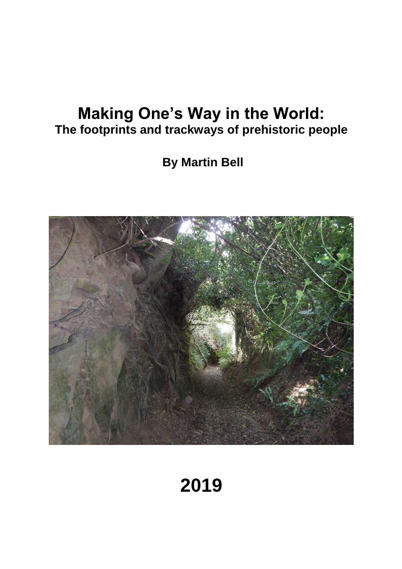
Making One’s Way in the World: The footprints and trackways of prehistoric people
By Martin Bell
2019

Contents
Acknowledgements List of Figures List of Tables List of Supplementary Tables (on WWW) Chapter 1: Steps towards understanding: routeways in practice, theory and
life Background Introduction False paths Talking stock and steps forward Environmental and geoarchaeology Landscape archaeology Theoretical perspectives Anthropology: the contribution of Tim Ingold Landscape change and clues to movement Agency and niche construction: human and non-human Cognition: thinking through things How literature and art help us think about movement Timescale, dating and spatial scale Terminology Conclusions Chapter organisation
Chapter 2 Walks in the temperate rainforest: developing concepts of niche
construction and linear environmental manipulation Introduction: Why the American North West coast? The Douglas Map The area and its archaeology Trails and prairies Plant utilisation Elsewhere in North America Palaeoenvironmental perspectives The social significance of routes Conclusions
Chapter 3 Niche construction and place making: hunter-gatherer routeways in
north west Europe Introduction Anthropological perspectives Topographic factors and ‘natural’ routeways The wildwood, disturbance factors and routeways Woodland manipulation and management The broad spectrum revolution and niche construction Hunter-gatherer plant use Hunter-gatherer vegetation disturbance in Britain

Star Carr Case Study: Kennet Valley
Case Study: A Welsh model of river valley based mobility Continental Europe
Mobility and Sedentism Artefact areas and ‘monuments’ Isotopes and mobility Material culture and movement Conclusions
Chapter 4 Footprints of people and animals as evidence of mobility
Introduction Trace fossils Formation processes and terminology Recording methodology Dating and timing Identification and interpretation Associated animals Palaeolithic footprint-tracks on open sites Volcanic and related contexts Coastal and riverine contexts Aeolian contexts Travertine Caves Holocene hunter-gatherer-fishers
Case Study: Mesolithic paths in the Severn Estuary Footprint-tracks in later prehistoric contexts
Case Study: Seasonal pastoralists in the Severn Estuary Other later prehistoric examples Footprint-tracks in the Americas Footprints: perceptual and symbolic aspects Conclusions
Chapter 5 Early farmers: mobility, site location and antecedent activities
Introduction Case Study: The Ice Man Skeletal, isotopic and DNA evidence for Neolithic mobility Neolithic landscapes in Britain Neolithic monuments in Britain Megalithic tombs in Britain Tree throw pits and causewayed enclosures Cursus monuments Henges and avenues
Case Study: Avebury henge, Wiltshire Case Study: Stonehenge, Wiltshire
Other henges and linear landscapes Geological evidence for Neolithic mobility Conclusions
Chapter 6 Wetland trackways and communication

Introduction Wheeled vehicles Trackways dates Mesolithic trackways? Neolithic trackways in mainland Europe
Germany Netherlands and Scandinavia
Neolithic trackways in the British Isles Somerset Levels Other British sites Bronze Age and Iron Age trackways in Northern Europe Germany Scandinavia Netherlands, Bourtranger Moor Bronze Age and Iron Age trackways in the British Isles
Case Study: Somerset Levels Case Study: Severn Estuary Thames Estuary
Later prehistoric trackways in Ireland Bridges, post alignments and associated ritual deposits Conclusions
Chapter 7 Barrow alignments as clues to Bronze Age routes
Introduction Denmark
Case Study: Kilen a Bronze Age cross roads in Jutland Germany Netherlands Case Study: Veluwe barrow roads North European connections England and Wales Conclusions
Chapter 8 Trackways in later prehistoric agricultural landscapes Introduction
Recognising tracks in agricultural landscapes Dating tracks in agricultural landscapes Agents of transformation: horses, carts and chariots Hollow ways Coaxial fields and tracks in the moorland Yorkshire Wolds Coaxial fields and droveways in lowland Britain Survival of coaxial field systems Ridgeways Case Study: The Wiltshire and Oxfordshire Ridgeway The Icknield Way The origins of Roman roads in Britain Conclusions

Chapter 9 Maritime and riverine connectivity and the allure of the exotic
Introduction Riverine transport Log boats Hide boats Sewn plank boats in the British Isles Possible wrecks round Britain Landing places in Britain Artefact distributions in Scandinavia Transported things in Britain and Europe Scandinavia: ships and rock art Conclusions: Maritime connections and cultures
Chapter 10 A case study of the Wealden District in South East England Introduction The South Downs Case studies: Bishopstone and Bullock Down, ‘ghost routes’ Other Downland routes The Rother valley Land allotment, tracks and fields in the Low Weald The North Downs Case study: Multi-method dating at Lyminge , Kent Riverine and Maritime connections Conclusions
Chapter 11 Conclusions: why paths matter Bodily engagement, perception, anthropology and literature Steps forward Multi-scalar and multi-disciplinary approaches Landscape structures and retrogressive analysis ‘Natural routes’ and ridgeways Droveways Ethnohistory of Lesser Transhumance Excavation Linear environmental archaeology Geoarchaeological approaches to human and landscape connectivity Movement as niche construction Critical thresholds Routes to sustainable heritage and nature conservation Bibliography Index

List of Tables Table 3.1 Mesolithic sites in the Kennet valley outlining date, environmental evidence
and sources. Table 8.1 Hypothetical types of later prehistoric trackways in Figure 8.2 linked to
illustrated examples in Chapters 8 and 10 and other publications. Supplementary Appendices on WWW Supplementary Appendix 3.1 Mesolithic sites in Britain with evidence of vegetation
disturbance: date, types of evidence , OD height, and sources. The evidence behind Figures 3.1 and 3.8.
Supplementary Appendix 4.1 Catalogue of human and animal footprint tracks
worldwide with evidence for Location, date sedimentary context and associations. The evidence behind Figures 4.2 and 4.15.
Supplementary Appendix 6.1 Catalogue of wetland trackways. The evidence behind
Figure 6.2.

Making Ones Way in the World
Acknowledgements
Several colleagues have been kind enough to provide comments on earlier versions
of some of the chapters: Prof Duncan Garrow kindly commented on the whole book;
Prof Richard Bradley read Chapters 5-11; and other colleagues who have provided
comments on individual chapters are Professor J.R.L. Allen, Prof John Boardman, Dr
Richard Brunning, Dr Dale Croes, Dr Petra Dark, Professor Nancy Turner, Dr Darcy
Mathews and Professor Nicki Whitehouse. I am especially grateful for advice from
anonymous reviewers and Professor Stephen Rippon. I have benefited from
discussions on mobility and collaborative fieldwork in the Vale of Pewsey with my
colleague Dr Jim Leary who shares my fascination with these topics. All have been
most helpful in suggesting improvements and things I had missed. Time did not allow
me to follow up every one of the valuable leads they provided and I remain
responsible for the limitations of what is here.
My research on this topic started to take shape for a conference at Olympia, USA in
2003 and it came towards a conclusion with the presentation of some of the results
at the Society of American Archaeologists conference at Vancouver, Canada in
2017; those two visits were especially stimulating, providing introductions to new
research areas. Between them lectures on this topic were given at several
conferences in the UK and Europe. I am most grateful for the opportunities these
provided for discussions with colleagues. My research has benefited in particular
from discussions with Professor Nick Barton, Dr Damian Goodburn, Dr Alasdair
Barclay, Dr Mark Knight, Dr Matija Cresnar and Dr Jette Bang. Professor John
Boardman has been especially helpful and stimulating in discussing our mutual
interest in hollow ways, soil erosion and the Wealden evidence. Several of my PhD
students have shared with me the exploration of aspects of this theme, including Dr
Rachel Scales and Dr Kirsten Barr (footprints); Dr Simon Maslin (Lyminge case
study); Elspeth St John Brookes (geochemistry); Dr Lionello Morandi (non-pollen
palynomorphs); Dr Alex Brown (wetland-dryland relations); Dr Scott Timpany
(wetland botany); Dr Chris Speed (experimental aspects); Claire Nolan (wellbeing);
Katie Whitaker (stone mobility); and Dr Tom Walker (Mollusca). Dr Stuart Black and
Professor Phil Toms have collaborated on dating aspects of hollow ways. The South
Downs National Park, The Heritage Lottery Funded Secrets of the High Woods
Project and Cotswold Archaeological Trust (especially Buz Busby) are thanked for
collaboration at East Dean Woods. David Rudling, Dr John Manley, Peter Herring
and Dr Malcolm Lillie have answered questions about aspects of their research.
Believing that first-hand experience of sites is important in understanding patterns of
movement I have tried to visit nearly all the sites discussed in any detail, but there
remain a few that I have yet to explore. I am grateful to the many people who have
helped to make visits possible and have told me about aspects of their work: in
Canada and North America: Professor Dale Croes, Jill and Wyn Taylor, Daryl Fedje,
Joanne McSporran, Duncan McLearon, Al Mackie and Nicole Smith; in Denmark:
Professor Søren Andersen; in Germany: Dr Helmut Schlichterle, Dr Bodo Diekmann
and Dr Harald Lübke; in the Netherlands: the late Dr J.A. Bakker, Professor Leendert
Louwe Kooijmans, Professor Annelou van Gijn and Dr Hans Peters. Professors

John and Bryony Coles have done much to stimulate and encourage my researches
on wetlands and many of the other topics which occur in this book.
My fascination with this topic began long ago in South East England where my work
was encouraged by Professor G.W. Dimbleby, Dr Ken Thomas and the late
Professor Peter Drewett. Since those days I have benefitted from a shared interest in
many of these topics with Dr Mike Allen.
Thirty-five years of research in the Severn Estuary has played a big part in
developing my interest and ideas in this subject and I am grateful to Cadw, NERC
and the British Academy for funding this research, and the late Dr Rick Turner for
facilitating our research. Thanks are also due to the hundreds of people who have
assisted with the excavations. Collaboration with the following was particularly
important in developing the Severn Estuary cases: Professor John Allen, Dr Alex
Brown, Dr Richard Brunning, Dr Heike Neumann, Professor Steve Rippon, Dr Rick
Turner and Dr Tom Walker. The Severn Estuary Levels Research Committee has
provided a collaborative framework for discussion and research. I am grateful to the
University of Reading for allowing me research leave during which much of this book
was written.
My wife Dr Jennifer Foster provided major assistance throughout; she accompanied
me on many of the site visits that went into preparing this book, helped clarify the
developing ideas, provided most helpful comments on the text and prepared nearly
all the graphics and the index - as ever I am most grateful.
Martin Bell

Making ones way in the World Revised 1.7.19 Words 12096
Chapter 1: Steps towards understanding:
routeways in practice, theory and life
Background
I arrived at this study along an experiential path. As a child I explored the sunken
and mysterious hollow ways of the chalk downland where I grew up and which have
exercised my curiosity ever since. Near the beginning of my archaeological activities
my first excavation revealed the ghost of a trackway which survived only as an
alignment of entrances and features. As an environmental archaeologist and
geoarchaeologist I studied traces of people and animals in the landscape, and went
on to excavate wooden trackways. More recently my interests in traces of human
movement have been crystallised by the magical experience of discovering 8000
year old human footprints in intertidal silts (Figure 1.1). Eventually these seemingly
unconnected topics coalesced unexpectedly during walks in the temperate rainforest
of the American North West coast. That led to a conviction that we need to develop
an approach to environmental and landscape archaeology which has a greater
emphasis on connectivity than the current preoccupation with sites. This approach
would illuminate the most ubiquitous, and probably the earliest, way in which people
structure and comprehend landscape, through the movement of their bodies.
Introduction
The objective is to demonstrate that the study of prehistoric patterns of movement is
important, achievable and relevant in all areas and periods. For some sections of the

book, particularly regarding hunter-gatherers, vegetation changes and footprints
examples are drawn globally. For other sections concerned with burial monuments,
fields and trackways, where the evidence base is vast, but is seldom considered in
detail, the focus is mainly on examples drawn from the area the writer knows best:
Britain and north-west Europe, although many of the approaches adopted are much
more widely applicable. The book aims to demonstrate that, notwithstanding the
pessimism of many previous scholars, there is an ever-increasing range of ways in
which we can investigate patterns of movement in the past. The intention is to
encourage archaeologists, and others who share a fascination with landscape, to
raise their sights from the individual dots on the map that we call sites, to the ways in
which those foci were networked together by patterns of habitual movement
constituting living landscapes. The approach is necessarily multi-scalar, from the
information contained in the individual footstep or walk to issues of longer distance
communication.
One reason prehistoric routeways have often seemed intractable is that they have
been approached from the perspective of one source of evidence, be it landscape
analysis, historical sources, phenomenological inference and so on. Archaeologists
have long learnt to adopt a multi-disciplinary approach to the study of settlements,
burials, ritual sites etc. Routeways are of such significance they are also deserving of
a full battery of techniques applied in an integrated way, using archaeological
features, artefact distributions, environmental archaeology, footprint studies,
geochemistry, sediments, social theory and the application of a range of dating
techniques. The approach also needs to be multi-site so that we can think beyond

the boundaries of our site, focusing not so much about how landscapes were, but
about how they worked and interacted with others through axes of movement.
A multi-period approach is necessary since some tracks once established are
perpetuated over millennia and thus significantly influence the encounters which
successive generations have with that landscape and the perspective and angle
from which their perception occurs. Here the focus is mainly on prehistory. The
justification is that until recently there has been much less emphasis on routeways in
prehistory as compared to those of historic periods. Consequently the case that
prehistoric routes are capable of investigation needs to be articulated and
appropriate techniques identified. When it comes to detailed investigation of
routeways in specific areas, however, our research can seldom be confined to
prehistory. One of the key approaches, certainly in areas where there has been a
long history of settlement and activity, is retrogressive analysis, beginning with the
present landscape, using air photographs and maps and diverse other sources to
work progressively back in time from historic to prehistoric periods. Thus we can
effectively peel away successive layers of landscape revealing the underlying
structure of earlier prehistoric landscapes. For this reason we will necessarily stray in
places onto the routeways of historic periods, when considering, for instance, the
ethnohistorical records of people’s movement in the American North West in Chapter
2 or British droveways in Chapter 10.
False paths
One factor which helps to explain a puzzling neglect of trackways for some 80 years,
at least in Britain, is a book published by Alfred Watkins (1925) The Old Straight
Track. He was an amateur archaeologist and his book was grounded in the
Herefordshire countryside in which he grew up and reflects his empathy for that

landscape. It is illustrated by some fine photography, a medium in which Watkins
was a notable pioneer. He nonetheless drew totally erroneous conclusions from the
landscape, observing that some historic places could be joined by dead straight
lines. His argument was fatally undermined by the very varied character and date of
the sites involved and the special and unsubstantiated pleading which permeates the
work. The monuments include Neolithic and Bronze Age barrows, prehistoric
settlements, boundary and waymark stones, Christian churches, medieval moated
sites, avenues of trees, even isolated pines, and many others. The dead straight
lines joining these places he called ley lines, which he regarded as ancient
communication or trading routes. They went up hill and down dale with no reference
to topographic barriers. He rationalised the inclusion of sites of wildly different dates
by arguing that, for instance, Christian churches were put on previously significant
sites. However, why this should apply to moated sites and many others was not
explained. Suffice to say there is no convincing evidence for the ancient ley routes
which Watkins claimed.
Robert Macfarlane, whose significant literary contribution to the study of paths will be
noted below (p00), has recently provided an introduction to a new edition of Watkin’s
book. Macfarlane (2014) sees his work, naturally enough, from the perspective of the
leading English scholar of landscape writing. He says ‘Watkins re-enchanted the
English landscape, investing it with fresh depth and detail and prompting new ways
of looking and new reasons to walk’. Watkins was certainly a lyrical and persuasive
writer on a landscape he clearly loved, and that must have contributed to the
popularity of his writing. Macfarlane sees Watkins as somebody who opened up the
countryside to the popular imagination, whilst he acknowledges the highly dubious

nature of Watkins’ interpretations. Watkins’ message was that anybody could be a
landscape historian; all they needed was a map. Macfarlane describes Watkins’
ideas as going ‘viral’; they provoked widespread interest and to this day are
elaborated in a whole host of New Age theories. One can only speculate as to
whether, if archaeologists in the 1920s had engaged more actively in critique of
Watkins, his ideas would have proved so persistent. The pioneering field
archaeologist O.G.S. Crawford, Archaeology Officer of the Ordnance Survey,
dismissed Watkins’ ideas (Hauser 2008) but refused to review The Old Straight
Track in the journal Antiquity which he edited, or to debate with Watkins. A half
sentence dismissal of Watkins’ ideas was included in the Ordnance Survey (1973,
157) Field Archaeology in Britain which Crawford originally wrote. The first really
substantive critique of Watkins’ ideas was published 58 years after his first edition by
Williamson and Bellamy (1983) and that provides a systematic demolition of ley lines
and the subsequent new age paraphernalia which has been built upon them.
Whilst Watkins could be argued to have encouraged thought about long term
structures in the landscape, his ideas about them were so significantly in error that
they have proved a Upas Tree which poisoned the ground for research on past
communication routes for three generations. Two pieces of evidence demonstrate
the extent to which this occurred. Before 1925 the study of prehistoric routeways had
been quite an active field with very good empirically-based field surveys by
pioneering archaeologists: Curwen and Curwen (1923); Williams-Freeman (1915);
Crawford (1922); and Fox (1923). After publication of Watkins’ book this promising
area of research virtually died. Instead, archaeologists like the Curwens focused on
settlements, fields and burials; they noted the existence of tracks but after 1925

seldom made very much of them in terms of wider patterns of communication. It is
interesting to compare Watkins to the very measured approach of the great
archaeologist Curwen (1929, 119) who, in considering prehistoric routes in Sussex,
was at pains to separate out evidence which he regards as conclusive from
circumstantial inconclusive evidence, and thereby showed a pioneering appreciation
of both the problems of dating early routes and how those problems may be
addressed.
A second piece of evidence for the Upas tree effect of Watkins’ book is provided by
comparison with continental Europe. Here the pioneering studies of Sophius Müller
(1904) were followed by a steady stream of archaeological writing on past
routeways, of which the work of J.A. Bakker (1976) is especially notable, and draws
on evidence for alignments of barrows and other monuments reviewed in Chapter 7.
Perhaps the main lesson from Watkins is that a feel and empathy for the landscape,
whilst something of great value, is insufficient for an adequate appreciation of its
origins. It comes back to the need for detailed examination of individual features,
critique of ideas and interpretations and the need to develop a robust chronology and
interpretative framework.
Taking stock and steps forward
Evidence of past trackways is extensive but often fragmentary, dispersed and
difficult to interpret and still in many ways neglected. We are still well short of a
toolbox of methods for the study of prehistoric routes and this book attempts
tentative first steps in that direction. The Dutch scholar Bakker (1991, 518) observes,
in Britain the phenomenon of roads marked by monuments is ‘regarded with
scepticism and its study seems somewhat neglected’. Illustrative of scepticism in the

British literature is Coles’ (1984, 1) observation that discussion of roads allows ‘the
prehistorian to indulge in conjecture unencumbered by the need to pay attention to
observable evidence’. Fowler (1998, 25) describes tracks as ‘the haunt of the
romantic, the irrational and the obsessional’. Bradley (1997, 81) says: ‘the
recognition of ancient roads or trackways is notoriously subjective and all too often
turns out to be based on circular argument’. As Fleming (2012) notes,
archaeologists have never felt completely comfortable handling old roads and the
subject has been left to amateurs. One of the most notable British studies is
Christopher Taylor’s (1979) Roads and tracks of Britain. He begins, somewhat
disarmingly, by saying that ‘most popular books on ancient trackways are nonsense’.
Taylor was the greatest British landscape archaeologist of his generation; the main
strengths and most detailed treatment in his book concerns Roman and later roads
and it repeatedly concludes that ‘all but a few [prehistoric tracks] are quite impossible
to date’ (Taylor 1979, 1). Similar views are echoed by other British syntheses which
have a Roman and later emphasis with just a few pages on prehistory, eg Hindle
(1993; 2001) and Morriss (2005). A topic, which partly accounts for the scepticism of
previous British writers, is the ridgeways, which have long been supposed to
represent ancient routes along the ridge crests. Of these the best-known example is
the Wiltshire Ridgeway, and its continuation the Icknield Way in eastern England.
These will be more fully discussed in Chapter 8, but suffice it to say there is
remarkably little supporting evidence for the early origins of some claimed
ridgeways. These rather pessimistic views actually reflect the position 20 or 30
years ago.
Today archaeologists are starting to use a new and imaginative range of concepts
and techniques to investigate past mobility as shown by several edited surveys of

diverse geographical areas and periods including site and area specific case studies
from British prehistory (Cummings and Johnston 2007; Leary 2014; Leary and Kador
2016; Preston and Schorle 2013). Alcock et al (2012) provide diverse case studies
from many parts of the world mainly from historic periods. Sellet et al (2006) and
Snead et al (2009) consider mobility from the combined perspectives of field
archaeology and anthropology, the latter with a focus mainly on middle and north
America. Leary (forthcoming) provides an accessible account of the role of mobility
in human affairs generally. Written from an archaeological viewpoint, it has
multidisciplinary relevance and will help introduce a wider audience to the necessity
for detailed examination of multiple sources of evidence and case studies attempted
in the present book. Field archaeology is also providing a wealth of evidence
particularly from extensive landscape scale excavations, and there is also the
increasing deployment of a range of scientific and dating techniques. Consequently
there is within our sights an understanding of prehistoric movement in the landscape
that seemed out of reach a generation ago.
Environmental and geoarchaeology
Environmental archaeology has an ecological emphasis and draws on an ever-
increasing range of biological evidence to address archaeological questions
(Dincauze 2000; Evans and O’Connor 1999). Its emphasis has been on the role of
people in transforming environments, for instance by clearance and agriculture, and
evidence of their economy. Geoarchaeology uses earth science concepts and
techniques to address archaeological questions (Allen, J. R.L. 2017). It has mainly
been concerned with the sedimentary context of sites and the use of geological
resources (French 2015). Both approaches have contributed to many aspects of

archaeological investigation but neither has been especially focused on questions of
routeways and mobility, to which it is argued in the following chapters they can make
a significant contribution. Some types of biological evidence, which are particularly
abundant in waterlogged contexts, have already contributed to studies of routeways
and figure in later chapters. Several cases are considered in which pollen and
charred plant macrofossils (eg seeds or charcoal; Figure 1.2a) contribute to the
identification of more open corridors associated with possible routeways. Likewise,
beetles may point to concentrations of dung on routes used by herbivores and mites
may identify areas where animals congregated (Schelvis 1992). Plant macrofossils,
beetles and molluscs originating in wetland environments, but found on dry ground
sites, may also point to patterns of connectivity between these environments.
There are a number of other sources which, whilst not widely applied in the past,
have potential in future environmental investigations of routeways. An introduction to
several of these is provided by Nicosia and Stoops (2017) in the context of their
presence in sediment thin sections (micromorphology). Non-pollen Palynomorphs
(NPP; microscopic organic particles), such as fungal spores, include carbonicolas
(carbon associated) fungi indicative of burning (Figure 1.2b) and coprophilous (dung
associated) spores indicative of the presence of herbivore dung (Figure 1.2f and g).
NPP and pollen are increasingly used in a complementary way to establish the role
of natural disturbance and human activity in Mesolithic environmental change (Innes
et al 2010; 2013; Ryan and Blackford 2010). Dung of herbivores has been shown to
provide clues as to where animals had been grazing (Caseldine et al 2013) and also
the seasonality of grazing (Aberet and Jacomet 1997) and could potentially provide
valuable clues to the vegetation zones through which animals had recently moved on

transhumant routes (van Asperen 2017). Faecal spherulites (spherical calcareous
particles found in dung; Figure 1.2e) may also be present where herbivores are
abundant, depending on alkaline soil conditions (Canti and Brochier 2017). The eggs
of human intestinal parasites (Figure 1.3c and d) could also contribute to the
identification of frequented routeways. Of these Trichuris occurred in pollen samples
around activity areas at the Mesolithic site of Goldcliff, Wales (Dark 2004; 2007) and
provided insights to defecation behaviour, an aspect of the human use of space
seldom considered in prehistory outside the arid zone contexts where coprolite
evidence is well preserved (Sobolik 1996). Micromorphological thin sections also
provide evidence of layered and trampled dung and the effects of animal presence
and traffic which can assist in the identification of routeways (Goldberg and Macphail
2006; Rentzel et al 2017). A range of analytical techniques, including biomolecular
studies, gas chromatography and mass spectroscopy, can be applied to the
identification of faecal and bile acid biomarkers (Shillito 2017). Sedimentary DNA has
been used to identify the presence of grazing animals in agricultural contexts in the
French Alps (Giguet-Covex et al 2014) and could be used more widely to identify
areas of concentrated animal movement and transhumant routes. Where it is
possible to employ a combination of the foregoing techniques as part of a multi-proxy
investigation the interpretations will be most persuasive.
In foregrounding scientific approaches it is important to avoid an overly deterministic
position which assumes that societies or sites can necessarily be explained by their
environmental context. Although routeways are clearly functional, they are not solely
so, and cannot simply be explained by concepts of least effort and the distribution of
resources. Where we have the benefit of ethnohistorical sources, as in the case of

Middle-American routes discussed in Snead et al (2009), it is evident that many were
far from utilitarian and had social, symbolic and ceremonial roles. The same is self-
evidently the case with pilgrimage routes wherever they occur (Maddrell et al 2015)
and the Buddist concept of pathways to enlightenment (Neelis 2012). Investigations
need to take account of cognitive and social aspects including perception,
cosmology, religion and ideology (Flannery and Marcus 1993) as well as issues such
as habitual usage and taboo areas (Jordan 2003a; Seitsonen et al 2014).
Landscape Archaeology
Landscape can be defined as environments understood and modified by human
agency, in terms of effects on vegetation, the creation of fields, paths, monuments,
etc. The extent to which agency is implicated is highlighted by the root of the term
landscape in Old Frisian meaning coastal land drained and protected from the sea
(Stilgoe 2015). That author describes landscape studies as interdisciplinary and
strongly linked to the experience of walking and fieldwork. Landscape archaeology
is one of the ways in which archaeologists have succeeded in moving beyond the
straight-jacket of individual site-based studies. It draws on a map-based approach
and historical documents to complement the results of air photography and field
survey which reveal traces of settlements, fields, trackways, ancient woodland, old
pasture and other living biological communities that tell us about past landscape
(Aston and Rowley 1974; Aston 1985). A pioneering study was W.G. Hoskins (1955)
The making of the English Landscape, the cover of my much thumbed 1974
paperback edition (Figure 1.3) exemplifies the retrogressive landscape approach,
demonstrating how early topography and vegetation patterns affect the subsequent
patterns of tracks, fields and woods, features which become in part fossilised in the

subsequent urban plan. The approach is exemplified by a trilogy of books by
Christopher Taylor: on fields (Taylor 1975), settlements (1983) and tracks (Taylor
1979). In the latter Taylor argued that much of the pattern of roads in Britain is
essentially the same as 900 years ago. In a comment that can be seen as three to
four decades ahead of its time, foreshadowing a key theme of this book, Taylor
(1979, 153) made the observation that ‘roads are not just changed by the demands
of external pressures and events, they change their own environment and the social
organisation of their users.’ Oliver Rackham has also made a major contribution to
the study of landscape history, initially on botanical aspects, such as ancient and
managed woodland (Rackham 1980), later exploring a diversity of landscape
features including many perceptive observations on the early origins of some roads
and tracks (Rackham 1986). Landscape archaeology can achieve particularly
detailed reconstructions in medieval and later periods for which documentary
sources are also available. In the following chapters we will review several cases
where large landscape-scale archaeological projects have enabled dated and
excavated features to be spatially related to surviving routeways and field banks
demonstrating that existing boundaries and tracks are in some cases of prehistoric
origin.
.
Andrew Fleming (1988) has pioneered prehistoric landscape archaeology on
Dartmoor and elsewhere and has recently developed a particular research focus on
the trackways of early historic periods which can also contribute to an understanding
of prehistoric routes (Fleming 2012). He argues that we should focus, not just at the
very local scale, but search for coherence and integrity of neglected long-distance
networks which have, for the last two millennia, been associated with what he calls

horse elites (Fleming 2010). In a Devon case study he makes the important
observation that these routes often seem to bypass villages and farms that lie on
spurs off the route. Fleming also observes that many open fields, which were
established around the tenth century AD, respect existing roads. He further observes
that early inscribed stones of pre-Saxon date (ie in Devon pre c 700 AD) are on long
distance routes, including those he associates with elites, and also those associated
with long distance transhumance routes which Fox (2012) has shown go back to
before the Norman conquest.
Theoretical perspectives
Johnson (2007) has criticized what he describes as the atheoretical and romantic
approach of the landscape archaeology of Hoskins and his successors and has
advocated an emphasis on practice and agency, in which he explicitly mentions
routes and hollow ways. One of the contentions of this book is that in order to
overcome the problems of investigating past routeways we need to draw on the
perspectives provided by social theory, anthropology and science. At times these
approaches have seemed to be in opposition. The proponents of scientific method
were dubbed processualists, and those who advocated the primacy of social factors,
post-processualists (Johnson 2002). Processualists were mainly concerned with
very detailed investigations of specific sites as a basis for generalisation, the post-
processualists with philosophical approaches and particular classes of prehistoric
monument which illuminated the role of social factors. Neither initially was
particularly interested in mobility and the connections between sites. However, this
later became an increasingly significant strand of thought from those with a social
emphasis (eg Tilley 1994), less so within the scientific strand. Increasingly in the last
20 years, theory and science have come together, a key work being Hodder (1999)
The Archaeological Process which outlined the complementary perspectives which
they can provide, as illustrated by the philosophical framework for excavations at
Çatal Höyük, Turkey. Increasingly, scientific techniques are being employed to
answer, not just questions about the environment and dating, but social questions.
It is appropriate to begin by considering some of the theoretical discussions of recent
decades which have brought the study of mobility to the forefront of archaeological
thought. A key influence on much theoretical writing has been Heidegger’s (1962)
Being and Time, which focuses on dwelling in the world, the context-specific
situatedness of the human condition in terms of the relationship between people,
place and time. This challenged the tendency of processual archaeologists to look
for universally applicable patterns and for environmental archaeologists, consciously
or unconsciously, to slip into deterministic reasoning. However, as Ingold (2011, 12)
observes, dwelling should be less about a situated place and more to do with
movement along paths constituting a way of life. Gosden’s (1994) Social Being and
Time, which built closely on Heidegger’s work, highlighted the role which monuments
and artefacts play in creating patterns of recursiveness by which the past is used to
create present and future action. Gosden (1994, 17) argues that ‘thought arises from
within the flow of life helping us to cope with problems encountered by habitual
action’, a point which clearly highlights the significant role of walking and thus the
marks made on the landscape by habitual patterns of movement. Also strongly
influenced by Heidegger was Thomas (1996, 89) who argued: ‘ in creating paths in
the forest they also created links between both places and people’. Myths were then
told and the place became historical.

Perceptions of place relate not just to observation with the eyes but to the bodily
experience derived from all five senses; these include the haptic sense derived from
touch and walking. Spatial skills are developed through the conduct of various tasks,
including habitual action. In navigating landscapes, people remember a sequence of
patterns of bodily movement, changes of direction and topography which provide
prompts. Tuan Yi-Fu (1977) described this by reference to diverse ethnographic
examples ranging from understandings of architectural space to the spatial skills of
Eskimos and the navigational skills of Pacific islanders. Just as architecture
structures space and choreographs patterns of movement (Barrett 1994), so, on a
much larger spatial scale, do the structures, including routes, which exist in
landscapes, many of them created by past human agency. The spatial information
acquired by the senses is augmented by stories, myth and legend as exemplified for
instance by the Dreamtime of aboriginal Australians (Chatwin 1989). Together these
all form part of the Lifeworld which Simmons (1993) defined as the sum total of a
person’s involvement with the cosmos, landscape being as much the work of mind
and memory as the topography which is created by layers of rock.
Landscapes have both spatial and temporal dimensions, since all movement in
space is movement in time which is the essence of time-space geography.
Hägerstrand (1975) developed a social-environmental web model in which individual
paths flow through time and space. An example is shown in Figure 1.4 with space on
the horizontal plain, and time on the vertical plain. Places are marked by vertical
columns and the model depicts a day in the life of four individuals in a rural
landscape. At times paths converge, they meet and move around together in what
has been called a space – time aquarium (Carlstein 1982). In this chronogeographic
approach places are but pauses in movement (Parkes and Thrift 1980).
A focus on an individual’s situatedness within the landscape led to an emphasis on
phenomenology, which is concerned with the world as perceived by an observer and
their embodied experiences of the landscape, its rocks, mountains, rivers and
coasts. It also looks at the influence of such features on the placing of monuments
and the structuring of people’s lives and patterns of movement (Tilley 1994).
Phenomenology facilitates thought, not just about how landscapes were in abstract,
but about how landscapes appeared to people in the past and how that experience
related to patterns of movement through the landscape. As Aldred (2014) says, ‘It is
only by using our own bodies that we can begin to enter a dialogue about actual past
movements’. The approach has led to many prehistoric case studies and
phenomenological approaches have been increasingly adopted (Cummings and
Whittle 2004; Tilley 2010). Inevitably, however, consideration of prehistoric
environmental perception can be quite subjective; how do we know which particular
route, or direction, was taken through a landscape and which particular features
were important to people at the time? Tilley (2010) contends that he does not claim
to be able to see landscape phenomena in the way in which people did in prehistory.
However, unless that is the objective it surely limits the value of the approach. To
counter these difficulties Evans (C. 2009) has argued that, rather than adopting a
single phenomenological perspective, multiple perspectives need to be evaluated.
Developing a phenomenological approach requires investigation of the precise
relationship between prehistoric monuments and natural features and identification
of actual evidence for routes of movement. Fleming (1999; 2006) has demonstrated

that this demands a significantly more critical and rigorous methodology than is
evident from some published phenomenological studies. Since perception is clearly
influenced by directions and patterns of movement (Ingold 2011), it is important that
these patterns are identified in a precise and defined way using a methodology
which is explicit and open to critique by others.
Phenomenological studies have also seldom taken into account the ways in which
the landscape has changed since the period in question, for instance by using the
available palaeoenvironmental evidence to evaluate past vegetation patterns,
visibility and the influence which these patterns would have exerted on routes taken
through landscape (Chapman and Gearey 2000). These are increasingly attainable
objectives as the density of palaeoenvironmental sites in some landscapes increases
and they become more precisely dated, such that Geographical Information Systems
(GIS) and modelling can be used to upscale site specific data creating landscape
scale reconstructions. The environments around Neolithic complexes at Avebury
and Stonehenge, Wiltshire have been reconstructed in this way and are discussed in
Chapter 5 (Gillings et al 2008; Allen, M. 1997). In the Netherlands Doorenbosch
(2013) has reconstructed the environment associated with heathland barrows and
their relationship to routeways. Models of past landcover are now being produced
using a multiple scenario approach to reconstruction which generates multiple
computer models based on the various parameters and estimates which best fits the
pollen data (Bunting and Farrell 2017).
Anthropology: the contribution of Tim Ingold

Of the other disciplines which interface with archaeology in the study of past mobility
perhaps the most pertinent is anthropology, which shares with archaeology the
central mission of exploring the rich diversity of human existence. Particularly
influential, from this writer’s perspective, has been the work of Tim Ingold who in a
series of papers over the last 20 years has written from the perspective of
anthropology in a way which resonates with, and informs, the work of the landscape
archaeologist. His much quoted paper ‘The temporality of landscape’ (Ingold 1993)
animated the landscape which he saw as ‘the congealed form of the taskscape’ in
which ‘paths and tracks impose a habitual pattern of movement on people’ by the
patterns of recursiveness they establish (Ingold 1993,162, 167). How people
perceive the landscape is to a large extent seen as a result of the tasks undertaken
within it and thus the associated patterns of movement. In The perception of the
Environment Ingold (2000) brought together a series of papers on the perceptual
theme, including one which contrasted the life-world as seen from an experiential
centre with the externally viewed world perspective of the present-day
environmentalist (Figure 1.5a and b). Thus the experiential world of Yupik Inuit
cosmology is illustrated diagrammatically in Figure 1.5c in which the home is
surrounded by concentric environmental zones to which it is linked by paths. Two
other graphical representations which convey the importance of paths come from
Walbiri aboriginal Australian iconography. Figure 1.5d represents their world as a
network of concentric camps with waterholes at the centre linked by paths which
were originally laid down by the movements of ancestral beings (Munn 1973). Figure
1.5e is a representation of kangaroo footprints and tail impressions moving towards
a camp. The ancestral and mythical origins of these routes demonstrate one of the
ways routes become entrenched over extended timescales. Such routes structure

the encounters of successive generations, and thus to a degree their environmental
perception, since each generation sees the landscape from the particular
perspective provided by that route.
Ingold (2007) has increasingly focused on the importance of lines which human
beings generate wherever they go; as he says, life is lived along paths and it is along
paths that people grow in the knowledge of the world around them, ‘inhabitants
journey from place to place along a way of life’ (Ingold 2000,193). Ingold (2011)
acknowledges that his own intellectual journey has taken him in recent years from a
focus on the experiential centre of place or dwelling, to recognise the importance of
lines of movement in perception. He argues that ‘the path and not the place is the
primary condition of being or becoming’ (Ingold 2011,12). Paths he sees as ways of
animating or bringing the statics of anthropology to life. The same can be said of
archaeology’s need to escape from a rather static preoccupation with sites
investigated in depth. Ingold contends that those who walk with bare feet are
naturally more in touch and engaged with their environment and that for them the
feet are as important as the heads and hands in their perception of the environment.
A similar concept is translated to an educational experience at the Hunybedder
Centre at Borger in the Netherlands, an open air museum focused on prehistory
which includes a footpath along which children are encouraged to walk barefoot,
experiencing the contrasting tactile properties of wooden trackways, mud,
woodchips, charcoal, pebbles, peat and shell etc (Figure 1.6). Following an
established route recalls previous patterns of past movement and tactile experiences
(Ingold and Vergunst 2008, 17). That activity is seen, not purely as a set of individual
acts, but a form of social activity whereby people’s feet and patterns of movement

are responsive to the presence and activity of others, whether they are actually
present, or have created memories of their former presence in the landscape; these
could be monuments, or traces of former presence in vegetation. Two studies should
be noted as putting some of these ideas into practice by adopting a joint
anthropological and archaeological approach. One concerned evidence for mass
migration of the Tamu-mai people of the Annapurna Highlands in Central Nepal; the
project looked at both the archaeological traces and the social memory of that
movement (Evans C. 2009). The other is Jordan’s (2003a) anthropological study of
the Siberian Khanty which challenges the frequent assumption that hunter-gatherer-
fishers operated in a pristine ‘natural’ world, by documenting the rich social
symbolism of their encultured landscape and the ways in which physical
transformation occurs through the making of places, shrines, paths and artefact
deposition. Ethnographic evidence for the mobility of recent hunter-gatherers is
increasingly being used by archaeologists to conceptualise the potential scale,
nature and frequency of movement and its effects on the landscape (Sellet et al
2006).
Landscape change and clues to movement
Environments are not just a given product of particular factors such as climate, soils,
geology, flora and fauna. Progressively through the Holocene they have been
subject to significant transformation by human agency (Bell and Walker 2005;
Dincauze 2000). Deforestation, drainage and embankment against the sea are
some of the most obvious, but it goes right down in scale to the marks on the
landscape made by paths or modification of individual trees. Environmental
archaeological studies draw on a wide range of proxy sources to reconstruct

landscapes and their changing nature. Where multiple sites have been investigated
in a study area then it becomes possible to create a high resolution picture of the
spatial variation of environment types. Where sources of evidence are fewer, spatial
variation is less identifiable and there can be an unfortunate tendency to assume
landscape homogeneity. However, certain locations would have provided particular
attractions, such as the edges of lakes and rivers. The effects will also be
concentrated in frequented routeways, and in places these can be readily predicted,
for example where natural topography funnels movement, particularly in the passes
between valleys. Such are often referred to as ‘ natural routes’ and ridgeways along
uplands are frequently cited examples. We need, however, to be cautious in
identifying ‘natural routes’ given the risks of circular reasoning; we should not accept
a route simply because it seems suitable. The hypothesis of its existence needs to
be tested using other evidence, be it the spatial relationship to the distribution of
monuments, such as barrows, or rock art, or dating evidence for particular sections
of track.
Frequent travel along paths on a slope gives rise to erosion, forming a linear
depression which during times of high rainfall acts as a channel for runoff and thus
become more deeply incised, creating a pronounced hollow way (Figure 1.7). Such
features are widespread on slopes in North West Europe, particularly on more
erodible geologies such as chalk, limestone and sandstone. Boardman (2013) has
recently shown that hollow ways can act as alternative lines of drainage and thus
represent humanly-created geomorphic features, an example of geomorphic
connectivity from slopes to valleys brought about by human agency (Wohl et al
2014). In North West Europe hollow ways can be difficult to date, but not always

impossible, a problem explored in Chapters 8 and 10. In arid areas of the American
South West major erosion gullies created by runoff were, in some cases, initiated by
earlier routeways such as wagon trails. Similarly in semi-arid Near Eastern contexts,
a landscape survey by Wilkinson (2003) has revealed extensive hollow ways. Some
represent local routes radiating from tell sites of the third millennium BC, at Tell al
Hawa, Iraq (Figure 1.8a), where they extend up to 5km from the tell, connecting it to
its fields, a relationship evidenced by sherd scatters. Other hollow ways represent
longer distance routes connecting major centres and providing clues to hierarchies of
connectivity between settlements, some being connected, whilst minor sites lie away
from these routes (Figure 1.8b-d; Wilkinson 1992).
On a wider spatial scale, clues to patterns of movement can be obtained from
materials which have been transported, whether these are geological materials,
plants, shells or animals. A decade ago we would have been more inclined to
interpret the distributions of artefacts, such as stone or metal axes, mainly in terms of
down the line exchange whereby the object was passed from one community to the
next without much long distance movement of people. However, studies of isotope
geochemistry have provided a contrasting perspective. In the Neolithic and Bronze
Age of Britain, for instance, there is growing evidence that some people and animals
came from areas of very different isotope geochemistry to that in which they were
buried (Evans et al 2006) implying much greater mobility than previously supposed.
Brown (2014) shows how a combination of isotope and DNA analysis of human
skeletal remains can contribute to an understanding of female or male mobility and
exogamy (marriage out of one’s community). Schulting (2003) showed that in
Mesolithic Brittany some women had moved from inland locations, where they grew

up, to coastal environments, again reflecting exogamy. Transported materials, or
contrasting isotope geochemistry, provide clues to patterns of connectedness but will
rarely inform on the precise routes followed. However, in some cases routes can be
predicted from topography and may also be attested from later historical sources.
The Silk Route between China and South West Asia is well attested in later historical
times but was clearly significant much earlier, as evidenced by the movement of
artefacts (Cunliffe 2015; Frankopan 2015) and the introduction of millet from China to
south west Asia and wheat from south west Asia to China (Jones 2016). Likewise,
the astonishing diversity of artefacts from east and west deposited in Scythian
graves in Central Asia (Simpson and Pankova 2017).
Since the 1960s archaeologists tended to interpret changes in material culture in
terms of either development or acculturation, ie adoption from neighbouring
influences, having rejected the waves of population movement favoured by earlier
generations. However, the increasing capacity and sophistication of ancient DNA
analyses presents a major challenge to recent assumptions. Re-evaluation has been
especially marked in relation to the arrival of the Beaker complex in north west
Europe (Olalde 2018) which demonstrates a significant ingression of steppe ancestry
from eastern Europe. The change is particularly marked in Britain where in c 2400
cal BC the genetic evidence indicates a 90% population replacement within a few
centuries. The same study has indicated that the earlier arrival of Neolithic farmers in
Britain c 4000 cal BC involved significant genetic input from Iberia rather than just
the Danubian farmers of central Europe. If further studies confirm these results it will
bring about a fundamental rethink of the extent of population mobility and the causes
of cultural change.

Agency and niche construction: human and non-human
Pierre Bourdieu (1977) introduced the concept of habitus, underlying structures
created by practice, as people interact with environments and with other people; the
ways they do so influence future interactions. A development of this is Giddens’
(1984) structuration theory whereby actions are influenced by pre-existing structures,
but with the opportunity for active agents to act reflexively in making independent
choices to change the social and environmental structures which they inhabit. Van
de Noort and O’Sullivan (2006, 19) define agency as people’s ability to make their
own way, to choose and experience different aspects of identity. Thus, people make
their own history but under particular circumstances and conditions inherited from
previous generations (Simmons 1993, 154). There are two types of influence acting
in opposition: one the creation of structures trending towards long term continuity
and stability, and the other a capacity for radical change. As Kador (2013) has
emphasised, the study of mobility must embrace both, the everyday routine actions
as well as periods of change and their social consequences. This is essentially the
distinction which the geographer David Harvey (1989) has made between routine
and transformative action. As subsequent chapters will show both continuity and
radical change are evident in the history of trackways. There are instances where
people seem to have followed the same route for many millennia, and yet other
cases where routes are totally abandoned and very different patterns emerge.
People gain a sense of security and belonging from the familiarity of habitual daily
actions and the reassuring marks on the landscape which these create. However,
there is another trait of human nature, perhaps stronger in some individuals than the
majority, to always want to look over the horizon, to beat a new path and to explore

the new and unfamiliar. We will look at examples of this in Chapter 9 on maritime
communication where at great, often to our minds, perhaps irrational, personal risk,
people travelled distantly to obtain exotic goods and esoteric knowledge.
In preceding sections we have seen how human agency alters environments through
its effects on plant and animal communities and the creation of routeways.
Increasingly researchers are coming to realise that not only people, but also other
entities, modify their own environments in ways that influence the activities of other
organisms. The term ecosystem engineering has been employed to convey the way
in which various organisms contribute to the development of ecosystem structure
(Smith 2011). A wide range of organisms can be implicated as ‘engineers’ eg
earthworms, ants, termites, beavers and many of these contribute to the ways in
which the archaeological record itself is structured (Bell 2015).
The reciprocal and coevolutionary relationships between environment and culture
have tended to be obscured by false dichotomies set up between people and nature
in identifying the causes of environmental change (McGlade 1995). An integrated
solution to this problem is provided by Niche Construction Theory (NCT) ‘the process
whereby organisms, through their metabolism, their actions and their choices modify
their own and / or each others niches’ (Olding-Smee et al 2003, 419; Laland and
O’Brien 2010). Feedback loops within a niche alter the dynamics of the system
creating change. Niche construction envisages that organisms have a triple
inheritance, from genetics, culture and ecology. These influence future generations,
including evolutionary processes, which can be seen as driven, not just by external
factors such as climate, but for instance by the effects of human cultural practices

which favour particular genes (Laland and O’Brien 2010). An example would be the
transmission of environmental knowledge resulting in a modification of behaviour
and selective advantage. Human niche construction involving the manipulation of
wild plant and animal resources often mimics natural processes, eg the opening of
woodland as a result of storms, floods etc. In these ways the effects of people and
non-human agents reset succession to create more productive ecosystems (Smith
2011). This theory has been especially important in the study of coevolutionary
relationships evident in the domestication of plants and animals (Zeder 2012; Smith
2011; Rowley-Conwy and Layton 2011). This is seen, not just as the one way street
of people domesticating organisms, but a mutual process whereby organisms are in
some senses domesticating people.
Through recognition of the mutual relationships between people and organisms
comes an appreciation that both can be seen as having agency in the sense that
they can instigate change. In these ways Niche Construction Theory provides a
significant bridge between science and culture which is attracting increasing cross-
disciplinary interest. Ingold (2011, 6) expresses a similar point with his usual clarity
and insight: ‘producers, both human and non-human do not so much transform the
world, imposing their preconceived designs upon the material substraight of nature,
as play their part from within in the world’s transformation of itself’. Ingold and
Vergunst (2008) highlight the case of pastoralists accompanying animals: Which is
leading which? And where does the agency reside? Or is it in some way mutual?
The close associations between people and animals, whether it be herders
accompanying reindeer (Lorimer 2006), or naturalists engaged in the close and
intimate observation of animal behaviour (ethology; Lorimer 2010), cause people and

animals to develop entwined lives, each experiencing the agency of the other. In
considering pastoralism, Chadwick (2007, 134-5) has similarly argued that ‘agency is
the outcome of relationships between humans and the living and material world’.
Herding, he suggests, should not be seen in purely functional terms because of the
role it plays in the construction of identity and memory (Chadwick 2016). Nor can this
active role be restricted to people and animals. Jones and Cloke (2002) critique the
tendency to separate people and nature and argue for the agency of non-human life
forms such as trees, thus making a case for what has been called hybrid
geographies which are inclusive of non-human agents. A similar argument for the
active role of woodland in Neolithic landscapes has been made by Noble (2017).
Comparable cases have been made for the agency of inanimate material culture by
Robb (2004) and by Van de Noort (2011) in terms of the influence exerted by the
creation of powerful and iconic items such as boats.
Cognition: thinking through things
Recent developments in cognitive studies are especially pertinent to the routeway
theme of this book because it is increasingly evident that thinking is not just an
internal cerebral process but a process which is acted out through the engagement
of our bodies with the material world. In short we think through things; our
interactions with things and with the world provide clues and prompts influencing
how we remember, think or act in a given context. These are the concepts of the
extended mind and material engagement theory which so far have been mainly
worked through in terms of the active role of material culture in the ways in which
people act, perceive and think (DeMarrais et al 2004; Malafouris and Renfrew 2010).
In the case of some routine actions this influence may be almost unconscious. We

may speculate that habitual actions contribute to a sense of security and well being,
that in a sense an individual is at one with the world through patterns of familiar and
repeated engagement. The hippocampus is the part of the brain which is particularly
concerned with long term memory and spatial navigation whereby cognitive maps of
the life world are created. This part of the brain has been shown to be especially
enlarged in highly experienced London taxi drivers who are trained in ‘The
Knowledge’, a detailed understanding of the street map of the city (Maguire et al
2000). Thus habitual actions develop neural pathways, whereby parts of the brain
become enlarged (Gosden 2010). Clearly these concepts are relevant, not just to
the clues and prompts provided by material culture, but potentially to a greater extent
at a landscape scale, where clues are provided by landscape features and the ways
they are modified by human agency, the paths, monuments, and altered vegetation
etc which influence the ways subsequent actors encounter that landscape. A
pioneering application of these ideas has given new significance to barrow
alignments in Himmerland, Denmark and suggested how movement through, and
perception of, that landscape, could have been prompted by the disposition of burial
monuments (Lovschal 2013).
How literature and art help us to think about movement
Archaeologists cannot expect to fully understand past routeways by looking at site
plans, maps and air photographs. A fuller appreciation comes from the three-
dimensional experience of walking routes on the ground (Stilgoe 2015). Our studies
can be further nourished and given fresh stimulus by writers and artists who have
thought deeply about, and recorded, their experiences of landscape from different
points of view. Literature on movement, walking and observation has a long
pedigree, much of it of great value to the landscape historian; two Welsh examples
are Giraldus Cambrensis (1191) Itinerary through Wales and much later George
Borrow (1862) Wild Wales. Examples where a journey provides the vehicle for
social and religious commentary include Geoffrey Chaucer’s (c1400) The Canterbury
Tales, recounting a pilgrimage from London to Canterbury, and John Bunyan’s
(1678) The Pilgrims Progress, which was partly anchored in the Bedfordshire
landscape Bunyan knew. The ancient hollow ways of the Weald around Selborne
fascinated the pioneer of Natural History writing, Gilbert White (1788; Mabey 2006),
and later the rural reminiscences of Flora Thompson (Mabey 2014). The inspiration
of both writers clearly derives from walking, meticulous observation and a deep
empathy with landscape. Edward Thomas (1909) was similarly inspired by walking
the paths of southern Britain and wrote on the Icknield Way (Thomas 1916), just as
his fellow poet Hilaire Belloc (1910) wrote on the Pilgrims Way in Hampshire, Surrey
and Kent. The supposed ancient origins of these long distance ridgeway routes has
influenced subsequent generations but will be critically examined in Chapter 8.
What we might call the pedestrian literature of the early twentieth century reflects a
world of increasing leisure, education and access to the countryside by railway and
road as well as the wider availability of tourist maps. It was an interest fuelled by
nostalgia for a rural pre-urban and pre-industrial idyll, exemplified by the writing of
H.J. Massingham (Mabey 2014). The significance of a sense of place and the history
of place in environmental writing and ecological understanding is particularly
demonstrated in a North American context by the writings of Cronon (1983) and
Worster (1990). Lang (1999) argues from an American North West coastal
perspective that an ethical environmental history has to be informed by a developed
sense of place.

Recently, the somewhat nostalgic walking-based literature of the twentieth century
has been eclipsed by a more experiential and biographical literature, in which
movement, encounters with landscape, individual memoir and a deep time
perspective are frequent elements. The appeal of this literature must be, in part,
because it maps onto what people actually do: thinking on their feet and through
movement. This current literature defies disciplinary classification. It is not primarily
archaeological, yet it so often exhibits the fascination which archaeologists have for
landscape, frequently drawing on history and archaeology for evidence and
inspiration. It encourages archaeologists to think in new ways about mobility and is
introducing ideas and concepts which are helpful in doing so. An influential early
example is Schama’s (1995) Landscape and Memory, a wide ranging discourse on
art, history and literature and nature, how they are perceived, altered and ‘recreated’
by successive generations. The symbolic associations of landscape are seen to be
imbued with a wealth of myth and recollection, a bulging backpack of memories
which we carry around. Many begin as highly personal stories, indeed Schama starts
the book with the landscapes of his Essex childhood, then progresses backwards to
those of his ancestors in eastern Europe. Writing from a more modernist and
political North American perspective, Rebecca Solnit’s (2014) Wanderlust promotes
walking as a way of thinking and remembering, her argument punctuated by
accounts of her own very varied walks through landscapes and life. Her Book of
Migrations (Solnit 2011) concerns reflective self-discovery through travel, partly on
foot, and a historical meditation on the Irish transatlantic diaspora. Focusing down on
a local scale, Julia Blackburn’s (2012) Thin Paths recounts walks around an Italian
mountain village; through this she tells the story of its people and the last vestiges of

seasonal transhumance, involving flocks moving for the summer to high mountain
pastures, and how that way of life engendered the anti-fascism of an independent-
minded mountain people. Her latest work recounts a personal quest to understand
the vanished landscape of Doggerland, art and poetry inspired by the quest and its
relationship to points and relationships in the writer’s own life (Blackburn 2019).
Juxtaposing the local and global is Gooley’s (2012) The Natural Explorer, which
begins each chapter with a segment of one day’s walk near his home; this leads to
wide-ranging reflections on diverse landscape themes around the notion that a
traveller becomes a natural explorer by turning observation into art. Gooley’s (2010)
Natural Navigator concerns the ways in which people use evidence within the
landscape to situate themselves and find their way around. He proposes that
environmental clues create a sort of ‘sixth sense’ whereby we partly unconsciously
navigate our way in the world (Gooley 2018). Stroud (2017) The Wild Other
resonates with a significant theme of this book, the transformative effects of the
horse on human connectivity, through an account of the role of horses in a young
woman’s self-discovery set against the backdrop of the Oxfordshire Ridgeway and
its Uffington White Horse (Chapter 8).
Recent writing is particularly concerned with the relationship between nature and
culture and has often been stimulated by a desire to connect with nature and
discover a greener, more ecologically balanced way of life. A recent example is
George Monbiot’s (2013) Feral, which is a passionate case for rewilding with native
trees and the reintroduction of regionally extinct animals, which challenges many of
the tenets of agricultural and nature conservation policy. Such ideas gain increasing
traction from the ecological success of current species reintroductions, especially of

the beaver, and also pioneering rewilding projects (Tree 2018). Ecological emphasis
is also strongly reflected in Wildwood; a journey through trees by Roger Deakin
(2007), which is not so much a book about natural trees as trees and woods altered
and perceived by people, just as other aspects of his empathy for landscape and its
history is exhibited in his two other books (Deakin 2000; 2008). Deakin was very
much an activist whose main writing was at the very end of a varied life. He was one
of the founders of the organisation Common Ground, which aimed to encourage
communities to empathise with their landscape context.
Robert Macfarlane is from a more traditionally academic background, a Fellow in
English at Emmanuel College, Cambridge, who has published what he describes as
a loose trilogy about people and landscapes: on mountains (Macfarlane 2003); wild
places (Macfarlane 2007); and, especially pertinent to the subject in hand,The Old
Ways (Macfarlane 2012). The latter he describes as about ‘walking as a way of
knowing’; it concerns ‘ the subtle ways in which we are shaped by the landscape
through which we move’ (Macfarlane 2012, xi). As an English scholar his
perambulations are in part about understanding and situating other writers, such as
the poet and essayist Edward Thomas, whose book on the Icknield Way was noted
above (Thomas 1916). A recent short work on a title very pertinent to our theme is
Holloway (Macfarlane et al 2013), an account stimulated by Geoffrey Household’s
(1939) novel Rogue Male, an adventure story of one man’s battle against
totalitarianism in which the ultimate hiding place was an overgrown and forgotten
Holloway, a device which highlights the lost and mysterious nature of these
enigmatic features (Figure 1.7). In Landmarks, Macfarlane (2015) considers the
vernacular names given to landscape features and how those specific local names

contribute to our sense of place. He lists 38 regional vernacular British names for
tracks and paths (Macfarlane 2015, 202). Many of these are slipping out of use with
the loss of the knowledge which those names convey concerning local perception
and ways of life.
Macfarlane’s writing, particularly on mountains and wild places, and most recently
his journeys underground and in the Arctic (Macfarlane 2019), are characterised by
remarkable feats of endurance and hardship through which he sought to escape
from the paraphernalia and comforts of modern life to connect with nature and roots.
Perhaps the most extreme of this genre is Nicholas Crane’s (1997) gruelling walk
along the mountain chains of Europe between Cape Finisterre in Western Spain and
Istanbul, Turkey. During this seventeen month continuous walk he encountered
surviving remnants of the way of life and ethnographic artefacts of seasonal herders
who used the mountain pastures and paths. It is a book nostalgic for the old Europe
and its folk life, and of historical value for insights to the rapid changes and economic
challenges faced by many East European remote rural communities following the
collapse of communism. Later in his career Crane (2010) went on to present the
BBC television series Coasts, recounting journeys round the coast of the British Isles
which brought many aspects of coastal ways of life and archaeology, including the
footprints mentioned at the start of this chapter and Chapter 4, to a wide audience.
Also on a coastal theme but local in its spatial ambition, is Jean Sprackland’s (2012)
Strands, which records the thoughts, observations and discoveries made by walking
during one year along the same stretch of beach from Southport to Formby in north-
west England, a distance of some 15km. That shore is especially significant in the
present context because, as Sprackland observes, it is where some of the best

examples of prehistoric human footprints have been found in Britain (Chapter 4). The
highly individual and local accounts of writers such as Sprackland and Blackburn are
more aligned to the experiences of the average walker for leisure. The bold
adventurers in the writings of Macfarlane and Crane are more akin to Homer’s
Odyssey or medieval pilgrimage whereby endurance and hardship contribute to
status building, demonstration of faith, or writers’ credibility. Thus landscape writing
contributes in myriad ways to our capacity to think about mobility past and present.
Art, just as powerfully as literature, provides a way of thinking about the traces we
leave in the landscape including the vestiges, both physical and mental, of patterns
of movement. Paths are a prominent aspect of the paintings of both Paul Nash
(1889-1946) and Eric Ravilious (1903-42), whose work reflects a preoccupation with
the paths of chalkland landscapes (Russell 2009), where routes stand out as white
markings against the downland turf, as shown in his Chalk Paths painted in 1935
(Figure 1.9). The hollow ways, terrace ways and ridgeways of the downlands will be
a significant theme in Chapters 8 and 10. Land artists such as Andy Goldsworthy
and Richard Long also work in the landscape, creating instillations of rocks, patterns
in sand and objects which mark the land (Malpas 2007), and a comparison is often
drawn between their work and the monuments and symbols of prehistory (Renfrew
2003). A work particularly pertinent to the theme here is Richard Long’s photograph
‘A Line Made by Walking’ taken in 1967, a path in grassland evidenced only by the
effects of light catching moderate trample on the grass (Malpas 2007). The
connectedness between these varied art forms is exemplified by Nicholas Crane’s
(1997, 157) rather startling revelation that his epic mountain journey was in part
inspired by the linear land art of Long. Especially redolent of the coastal footprint
theme developed in Chapter 4 is some of Anthony Gormley’s work, especially
‘Another Place’ created 1997, which comprises 100 actual-size cast iron images of
the artist’s body in the intertidal zone at Crosby, all gazing out to sea and covered
and uncovered by the ebb and flow of tides, just as the prehistoric footprints on the
same foreshore at Formby 9 km to the north are uncovered and covered (Roberts et
al 1996). As far as the writer is aware there is no link between the location selected
by Gormley and the footprints, though both excite similar fascination. A work by
Gormley more directly revealing of his interest in the past is a life-sized statue buried
upside down with only the soles of the feet exposed in the pavement outside the
Archaeology Department, Cambridge University where Gormley was a student. A
photograph of those feet was used by Jim Leary to illustrate the introductory chapter
of his Past Mobilities (Leary 2014, Fig 1.2).
So what more specifically do literature and art contribute to studies of past mobility?
Firstly, in a multivocal sense there are the different perspectives provided by those
whose primary focus is much broader than archaeology. Secondly the imperative of
applying the particular skills of the archaeologist, or landscape historian, in ways
which are relevant to a wider audience and contribute to broader debates
concerning people, nature, sustainability, quality of life, connectivity and migration.
The biographical nature of much current landscape writing demonstrates how
reflections on, and encounters with, heritage and nature contribute to self-discovery
and well-being.
Timescale, dating and spatial scale
Fortunately today, we have many advantages over the pioneering archaeologists,
including the availability of scientific dating techniques which can be applied to
trackways, footprints etc. A guide to each of the main dating techniques is provided
by Walker (2005). Most widely applicable of these is radiocarbon dating. The dates
given in this book are all calibrated to dates BC / AD. The original uncalibrated
radiocarbon dates and laboratory numbers are not given when they are cited in the
original published source referenced; to include them here would make the text
cumbersome. Exceptions to dates BC are those of the pre-Holocene (ie before 9500
cal BC) where BP (Before Present 1950) is used, as are abbreviations ka, thousands
of years, and ma, millions of years. Some sections, notably on wooden trackways,
make use of dendrochronological (tree ring) dates which are given in the BC form.
Also increasingly relevant to the dating of sediments associated with trackways is
Optically Stimulated Luminescence dating (Duller 2008). Some sediments
associated with footprints and trackways are also dated by the Uranium Series
method. Dates derived from these various methods are frequently quoted in the text
as a way of helping the reader to relate sites to a sequence and one site to another.
This is necessary because the large number of site examples, from many areas and
periods, means that it is generally not possible to introduce the local archaeological
cultural sequences.
A particular concern in this book is the relationship between movement in space/
time continua and issues of perception as related to movement. We therefore need
to keep in mind that scientific dating is only one way of measuring time. There is a
distinction between linear chronometric time, as measured by scientific dating
techniques, and time as perceived by people, which may for instance be circular or

cyclical (Dietler and Herbich 1993; Gosden 1994) and marked, not by dates or
calendars, but by the traces that people leave on the landscape. As regards spatial
scale any form of movement is clearly relevant, ranging from the information we can
gain from the individual footprint, through the activity space associated with specific
tasks, to the scale of movement associated with the daily life of a settlement, or the
more distant seasonal rounds and transhumant patterns of its occupants. There is
also the more distant communication between peoples and places by walking, using
animal traction, or travel on water. All are relevant to our understanding of the past,
although in the space available only a selection of examples can be given.
Terminology
Mobility refers to the study of movement by people (and animals). Route and
routeway are used here for any frequented axis of movement. Paths refer to
movement on foot, and Trails movement on foot and by horse. Lane is a local route
from settlement to its fields. Trackways generally imply constructed routes in
wetland. Footprint-tracks are the traces left by the feet of people and animals. Roads
are prepared surfaces generally allowing year-round passage by wheeled vehicles.
Hollow ways are routes incised by erosion. Use of the word droveway requires
special clarification. Here it is used for routes along which domestic animals were
moved on any spatial scale: some went locally from farm to field; some were long-
distance seasonal movement of tens of kilometres; and some went much further. A
potential distinction needs to be recognised between these practices and medieval
and post-medieval practices of droving involving the movement of animals from
remote rural areas to urban and port markets. Animals were, for instance, moved
from Wales to London along routes which acquired names such as ‘Welsh Way’.

Although growing evidence from isotope studies for the long-distance movement of
animals in prehistory is noted in subsequent chapters, we should make a distinction
between this and the market-oriented droving of recent centuries. Prehistoric long-
distance animal movement may have had very different motivation, including ritual,
symbolism, cosmology and tribute. Transhumance is used to refer to the seasonal
movement of animals and people generally over long distances, tens to hundreds of
kilometres, usually from lowland to mountain uplands, a practice which was
particularly prevalent in the Mediterranean. Lesser transhumance implies smaller
scale seasonal movement of a few kilometers to c 30km between contrasting
ecological zones, such as between lowland and upland mountains and moors. It also
includes movement from lowlands and hills to seasonally available coastal saltmarsh
pastures which in prehistory, before seawalls, reclamation and erosion, were far
more extensive and more socially significant than they are today. Stilgoe’s (2015)
approach to landscape puts particular emphasis on the names and origins of
landscape features and what that can tell us about the perception of landscape. This
work and Macfarlane’s (2015) Landmarks highlights the importance of preserving
and recording local vernacular terminology as part of local identity and a source for
understanding its origins.
Conclusions
It has been argued that, by comparison with many other aspects of archaeology,
trackways and mobility have often been neglected. New strands of evidence from
many disciplinary sources, augmented by perspectives from the arts and literature
help to chart a way forward. It is timely, therefore, to review the evidence and
consider the challenge represented by translating field traces into an understanding

of prehistoric people’s encounters with landscape. The conscious act of translation
which requires careful and critical analysis of the field evidence, the testing of ideas
and the integration of evidence from diverse disciplines to establish whether, what
may be an interesting and stimulating theory, is borne out by the evidence on the
ground.
The disciplines, or strands of knowledge, which can contribute to the study of how
people moved around the landscape include: ethnohistory; tracking skills; ichnology
(traces of animal behaviour, eg footprints); field archaeology; botanical and other
biological traces; historical analogues; geoarchaeological and geochemical traces,
etc. The solution to the problems of identifying prehistoric patterns of movement
advocated here is the adoption of a multidisciplinary approach, or what the
environmental archaeologist refers to as a multi-proxy approach. Above all, the
challenge is to integrate perspectives which are both social and scientific, using one
source to test and develop ideas derived from the other. In anthropology Wylie
(2002) has described such interpretations as being based on cables, comprising
multiple strands of evidence, and as tacking, a dialectical process between the
contrasting perspectives of the anthropologist and the subject (Wylie 2002, chapter
11). This is analogous to the process which Wylie (2002) has called ‘triangulation’,
whereby an interpretation, which may not be entirely convincingly demonstrated from
any one source, becomes more precisely grounded by triangulation with other
sources of varying independence. The writer has recently reviewed these concepts
in terms of their application in experimental archaeology (Bell 2014). The academic
resilience of such a multi-stranded approach is significantly enhanced by two key
concepts introduced by Hodder (1999). The first of these is multivocality, which

values the contributions of a diversity of voices and approaches, both scientific and
social. The second is self reflexivity, a critical awareness of the effects of scientific
and archaeological assumptions on the data obtained and the effects of these on the
communities involved. Together these two concepts challenge tendencies to
scientific dogmatism and the arrogance of the ‘expert view’ which has made some
people resistant to a scientific approach. Later, in Chapter 4, when reviewing
Robbins’ work on the forensic use of human footprint evidence, we will see rather
dramatically the dangers of uncritical acceptance of the expert view.
Many of the points made in foregoing sections, concerning archaeologists’ previous
neglect of trackways, are made with specific reference to dryland situations and
certainly do not apply to wetlands where there is a long history of successful studies,
reviewed in Chapter 6. In wetlands trackways are readily identified and dated and
there is a wealth of associated environmental evidence. In these wetland contexts
the challenges are rather different, they particularly concern the relationship between
wetland tracks and the wider picture of dry ground activity so that the wetland
evidence can become more fully integrated into archaeological discourse (Van de
Noort and O’Sullivan 2006). To a significant extent this is about bridging the gap
between wetland archaeology, which is rich in evidence, but where social theoretical
concepts have not been so much employed, and dryland prehistoric research, where
the theoretical concepts have often been to the fore, and the available field evidence
has sometimes been less rigorously engaged with. Chapter 6 shows that there are
areas where both dry ground and wetland evidence is beginning to be integrated and
the development of this field potentially offers new ways of identifying and dating
past trackways.

A substantial part of the way forward is about patterns of connectivity between
people, places and ideas. The proposition has been put forward that not just people
but plants, animals, material culture and landscape features such as tracks influence
behaviour and have agency. Each component, both people and the many facets of
the world in which they live, contribute to Niche Construction. Interconnected
relationships are increasingly foregrounded by recent writers who use related, but
somewhat different, labels, what Ingold (2011) called meshwork, and Hodder (2012)
refers to as entanglement. Establishing networks involves integration of evidence
from multiple sources, linking wetland and dry ground perspectives, using one strand
of evidence to test ideas derived from another, and in particular connecting the
scientific and social evidence. In a landscape context it is often not possible, nor
academically at all desirable, to separate the natural and the cultural; they are, in
Ingold’s (2011) terms, an interwoven meshwork. The path a hunter-gatherer follows
will often be influenced as much by the activities of animals as any human decision-
making. People may follow paths originated by animals and vice-versa (Figure 1.10).
Macfarlane (2019, 273) visited a long abandoned settlement in remote north Norway
at Lofoten where thin paths linking the doorways of ruined houses survived because
they are still used by otters and other animals. Cleared areas which attract grazing
by animals, foraging and settlement by people, come about through the combined
effects of animals, people and other environmental processes such as storms and
floods. The hollow ways which form in oft-frequented routes on certain geologies
channel storm water and become geomorphical features. Routes which people take
through a landscape are the result of interacting factors including issues of human
environmental relationships, such as the food quest, patterns of contemporary social

interaction and recursiveness to the past. Routes are often perpetuated over
extended timescales creating a legacy effect for subsequent generations (Wohl et al
2014). Bradley (1993) has shown how sites of one period are frequently referenced
by much later monuments, their status being legitimated by association. Thus, routes
are created and maintained by an interaction of natural and cultural factors and may
be said to have an agency of their own in influencing the subsequent structure of the
cultural landscape and human activity.
Chapter organisation
Succeeding chapters look first at the ways in which non-agricultural communities use
and mark paths and landscapes in ways which influence movement. Chapter 2
focuses on the North West coast of North America where archaeological evidence is
augmented by a rich ethnohistorical record enabling the development of two key
themes: niche construction and a more mobility-based or linear environmental
archaeology. Chapter 3 considers the more ephemeral traces of hunter-gatherer
movement in north-west Europe. Then occurs a distinct scalar shift down to the
footprints of humans and animals, a relatively new topic for archaeologists and one
which is considered drawing on evidence worldwide and from all periods. Traces of
movement by early farmers are reviewed in Chapter 5 drawing on evidence from
Britain and north west Europe and mainly focusing on the spatial relationships
between monuments. Chapter 6 looks at the abundant evidence of wooden
trackways in north west Europe, and attempts to draw some lessons from these
about wider patterns of movement. Bronze Age alignments of monuments in north
west Europe are considered as evidence of routeways in Chapter 7. Chapter 8 looks
at the very abundant evidence for trackways in agricultural landscapes; so abundant

is the latter that it is mainly focused on the British Isles. In Chapter 9 we then move
from land to water to consider communication by river and sea which, it is argued,
was a more significant aspect of long distance communication than often
appreciated, its routes logically complementing and integrating with those on land.
Communication by sea is comparatively brief because it has been well served by
many recent publications. Chapter 10 presents a case study from the Weald District
of south east England utilising many of the lessons derived in preceding chapters
and relating these to patterns of prehistoric and later historic landscapes. The
concluding Chapter 11 pulls together evidence from diverse contexts and periods to
identify general concepts and criteria which will help to advance the study of early
routeways. In most of the chapters after this certain examples are designated as
Case Studies which indicates that they are especially central examples of the key
themes of this book, and they are outlined in a little more detail. The student who
recently asked me which page of my last monograph that I was recommending that
he should read will get some idea of the theme of this book by reading Chapters 1
and 11 and the designated case studies between, and my hope is this may whet the
appetite to read the rest!

Making Ones Way in the World Revised 2.7.19 Words 8295
Chapter 2: Walks in the temperate rainforest:
developing concepts of niche construction and linear
environmental manipulation.
Introduction: Why the American North West Coast?
This chapter in part derives from thoughts stimulated by walks in the remnants of the
temperate rainforest and in other areas of remote woodland on Vancouver Island,
Canada and the Olympic Peninsula, Washington State, USA. Observations provide a
framework within which to review evidence from a range of sources concerned with
the archaeology, ethnography, botany and environmental history of the area. Though
remote from north-west Europe, which is the main geographical focus of this book, It
is an ideal area in which to explore some of the themes identified in Chapter 1,
notably the ways in which trails and places are created through the interaction of
human agency and the activities of animals, the role of non-agricultural communities
in ecosystem change and how these factors relate to the paths along which First
Nations people walked (Figure 2.1). The presence of a strong ethnohistoric record
means that there is direct oral and written evidence of intentionality and the social
significance of routeways, which in prehistoric European contexts we can only infer
from very fragmentary clues. The North West Coast of North America offers these
advantages because of the relatively late eighteenth century arrival of Europeans.
Furthermore, some explorers, naturalists and early colonists had good scientific
educations, so that they could compile detailed accounts of the way of life of First

Nations people. Today many of the traditions of plant use and manipulation still
survive and are well documented (Turner 2014). It is also an extremely culturally rich
area which has been the subject of extensive archaeological and ethnographic work
and there are areas of surviving and historically documented semi-natural vegetation
which themselves provide clues to the activities, patterns of movement and
ecosystem management of past communities.
This chapter illustrates the role of people in modifying vegetation communities and
how this might lead to a more linear and mobility focused approach to environmental
archaeology. This is certainly not to imply that evidence from the American North
West Coast can be directly extrapolated to pre-agricultural Europe. Clearly the
context and biological resources are very different and there are evident
philosophical and practical dangers in using the ethnographic recent to populate the
prehistoric past (Finlayson and Warren 2010). The case is not for direct analogy but
that the richness of the north American evidence provides the thinking space within
which the writer, and hopefully readers, can come to appreciate the diversity of ways
in which routes can be formed and marked. Many of these have been little
considered in a European context.
The Douglas Map
The potential is demonstrated by a trail documented in a diary of 1840 by James
Douglas, then of the Hudson’s Bay Company, who went on to found Victoria and
was later the first Governor of British Columbia. He recorded a route north of the
Willamette Valley between the Nesquilly River and the Cowlitz Plain (Leopold and
Boyd 1999). His map (Figure 2.2) is especially revealing in depicting a chain of small

prairie areas in a wooded landscape, resembling the beads on a necklace. It is
recorded that the prairie areas were burnt by First Nations groups to encourage the
growth of berries and other plants. The burning took place as they moved to their
winter camps in anticipation of rejuvenated plant growth when they returned the
following year. These burnt prairie patches would also have attracted deer.
The area and its archaeology
The coastal belt of the north-western part of the United States west of the Cascade
mountain range and western Canada west of the Coast Mountains, referred to here
as the North West Coast (Figure 2.3), is dominated by maritime influences with
annual rainfall up to 2.5m in parts of the Olympic Peninsula and the west coast of
Vancouver Island. The Canadian coast is indented with numerous estuaries
extending far inland and there are many islands, the largest being Vancouver Island
and the group of islands known as the Haida Gwaii (formerly Queen Charlotte
Islands). The maritime climate gave rise to a coastal temperate rainforest of which
small areas have survived the effects of rapacious logging in the nineteenth and
especially twentieth centuries. These remnants of Old Growth Forest are mainly
characterised by western hemlock, Sitka spruce, Douglas fir and western red cedar.
Some red cedars and Douglas firs may be up to 1000 years old (Nuszdorfer 2000).
Trees modified by people, and known as Culturally Managed Trees (CMT), bear
tangible witness to past ways of life.
The earliest reliably attested settlement of this area, and indeed in North America, is
around 12-15ka BP (Fagan 1991). Over the last few thousand years before present
there had developed a remarkably complex and sophisticated fisher-gatherer-hunter

society not employing agriculture, in which the only domesticate was the dog. For
this reason it is an especially instructive, and well documented, case of the
environmental relationships of communities where the economy was not based on
domesticates but nonetheless had extremely sophisticated and complex
relationships with plant resources involving landscape niche construction on a scale
which is only now becoming clear. The richness of coastal resources meant that this
area achieved the highest population densities of any area in pre-contact North
America. The people of the North West Coast had substantial winter villages; some
virtually sedentary communities were established as early as 5000 cal BP. The
houses were made of giant western red cedar posts and boards, which in the
northern part of this area were fronted by totem poles often ranged along the shore,
both houses and poles being richly decorated with painted carvings (Figure 2.4;
Ames and Maschner 1999; Matson and Coupland 1995). The cedar houses and
organic material culture of the area is most effectively demonstrated by the site of
Ozette in Washington State, buried by a mudslide c AD 1750 (Kirk 2015). Here 90%
of the material culture was wood and fibre. Anthropologists recorded that this was a
winter village with people moving elsewhere to summer villages; however, faunal
evidence indicates a more complex picture showing that part of the Ozette
population remained year round (Samuels 1994). The evidence seems to point to
sedentism on some coastal sites rich in resources, and greater mobility among
inland groups (Deur 1999). Some groups moved five or six times in a year,
dispersing in summer to smaller camps from which particular resources of fish,
shellfish, game, root vegetables, berries and greens could be exploited (Ames and
Maschner 1999). The patchiness of resources, spatially and seasonally, created a

need for seasonal movement and the preservation and storage of food, such as
salmon, halibut, shellfish, berries and plant foods.
Whilst in dietary terms plant resources contributed less than fishing and hunting,
their use is especially significant in the present context because there is such a
comprehensive record thanks to the activities of anthropologists such as Franz Boas
(1921), and because plant resources have continued to be utilised up to recent times
and have been carefully documented by ethnobotanists. A recent comprehensive
survey by Nancy Turner (2014) provides a wealth of information about the traces in
the landscape left by plant utilisation. First Nations communities were also
characterised by a respect and empathy for nature. This indigenous understanding
of biological interrelatedness has been called ethnoecology, or traditional ecological
knowledge. This provides insights to the environmental perception of the
communities involved and has informed recent debates about the sustainable use of
resources, especially when compared to the ways in which Europeans have used
the same areas in the last 200 years (Turner 2005; 2014; Goble and Hirt 1999).
This area has such a wealth of anthropological information due to the lateness of
encounters with explorers from the Old World. It appears to have been visited by
Juan de Fuca in 1592, after whom the straits between Canada and the USA were
named, but only a limited second-hand account of that voyage exists. Much later
Russian expeditions led by Vitus Bering in 1728 and 1741 began the fur trade in
North West America. The Spanish began to colonise California in 1769 and sailed
north to the Straits of San Juan de Fuca in 1778. There followed the expeditions of
Captain James Cook in 1778 (Cook 1784) and Captain George Vancouver in 1792-4

(Vancouver 1801). European contact resulted in very rapid cultural change, which
initially magnified certain characteristics of the indigenous communities. The ready
availability of iron tools led to a fluorescence of wood carving and the production of
totem poles which seem to have been less frequent previously, their production now
being partly fuelled by the wealth generated by the fur trade (Kramer 1999). This
also magnified the scale of potlatch ceremonies during which goods were
competitively distributed by chiefs, often accompanied by the erection of totem poles.
The fur trade initially conducted by Russia, then Britain and fuelled by demand from
China, illustrates the severe consequences of early globalisation for First Nations
communities. Such exploitation was unsustainable and rapidly brought one of the
main hunted animals, the sea otter, to the verge of extinction (Riedman 1997) with
the result that trade with some areas, such as Haida Gwaii, virtually ceased. The
damage had been done, however; European infections, particularly smallpox in the
north, led to major epidemics and a catastrophic reduction in the native American
population (Ames and Maschner 1999). Malaria had an equally devastating impact in
Oregon. Many settlements were abandoned, and survivors moved to a smaller
number of large settlements.
These dramatic cultural and settlement pattern changes inevitably make it difficult to
separate pre-contact from post-contact practices, much of the evidence being drawn
from anthropological and ethnobotanical accounts of the twentieth century.
Particularly difficult to disentangle, given the settlement pattern changes of the last
three centuries, are the patterns of seasonal movement before and after contact.
However, Brody’s (2002) anthropological investigations, related to land claim issues,
have shown that traditional economies, and a seasonal hunting and gathering round,

remain important to this day in some areas, notwithstanding the effects of European
contact.
Although maritime and plant resources in certain areas, and at certain times of year,
were very abundant, the environment was, and is, patchy both in time and space,
varying with successional stages of forests, topography, moisture and habitat type.
These communities adapted to this by developing sophisticated techniques for
preserving, eg drying fish and plant foods and storing them in bentwood cedar boxes
and in cedar packbaskets and storage baskets. Transport of edible roots, berries and
other food stores, from harvesting sites to winter camps was a significant
undertaking (Hunn 1999). Resource patchiness also gave rise to seasonal
movements and to exchange with groups whose environments were differently
favoured. Both Captains Cook (Cook 1784) and Vancouver (1801, 110) incorrectly
inferred the wandering nature of these groups from the many seemingly deserted
settlements and habitations observed on their voyages. Lewis and Clarke, in their
expedition from the east down the Columbia River in 1804-6, made many
observations concerning the seasonal movement of village groups to exploit
particular resources during which temporary huts of matting are recorded as used by
some communities (McMaster et al 1814). These expeditions noted that
communities had already been decimated by small pox.
Helm (1972), writing of the Dogrib, a subarctic boreal forest group further north,
records that each group was defined in terms of the main routes or axes of summer-
winter movement. In the maritime western parts of the North West Coast, movement
was often by canoe, whether locally to collect food for a day (Turner 1995), or as part
of longer seasonal movements. Water transport would have been essential to move
the cedar planks for housing, placed across canoes in catamaran fashion and
stacked with supplies, children and dogs; these planks were often taken to summer
encampments leaving only the massive cedar trunk frames of houses for the autumn
return. Dugout canoes of cedar would also have been essential to move the
bentwood boxes and woven baskets of preserved food. The flexibility which water
transport confers means that the reconstruction of these patterns of movement is to
a significant extent reliant on ethnographic records, supplemented by oral history
and increasingly by materials analysis, such as the sourcing of lithic artefacts.
Ethnohistorical sources show people travelled to the Cascade Range and Columbia
River to obtain some lithic resources, particular types and colours of rocks being
used for specific purposes (Stein 2000). Long distance trade networks are also
known from Vancouver Island to the south carrying acorns, salt fish, shells, clothing,
baskets and dogs. Obsidian came from eastern Oregon as established analytically
by X-Ray Florescence. Groups from the south coast of Vancouver Island paddled 15
km across the Straits each summer to San Juan Island where they fished and dug
camas bulbs (Stein 2000). The Straits Salish groups exchanged camas bulbs with
people of the wetter rainforest areas on the west coast of Vancouver Island for other
goods (Beckwith 2004). To the north the Haida people traded with mainland
communities exchanging dried seaweed, crab apples and native tobacco for a range
of berries and other products. In the south, communities on both sides of the
Cascades Range met at portage sites (where canoes were carried past obstacles)
and very rich salmon fishing stations on the Columbia River at The Dalles and Celilo
Falls to trade products of the different environmental zones, coastal resources from
the west being exchanged with those derived from the bison prairies to the east

(Ewert 1999). On the Columbia Plateau, winter was spent in the river valleys and
groups went up into the mountains in spring and summer (Deur 1999). The extensive
seasonal mobility which characterised the Columbia Plateau has been highlighted as
a key factor ensuring that resources were not depleted, whilst at the same time
supporting free access to resources facilitating socially significant large seasonal
gatherings occasioned by the digging of camas bulbs (Hunn 1999).
Trails and Prairies
An individual insight to patterns of movement is provided by a body preserved in the
ice of a glacier in northern British Columbia 800km north of the area shown in Figure
2.3. We now know that person was male aged about 20 and died AD 1400-90
(Beattie 2000). He is called Kwaday Dan Ts’inchi, which in the local First Nation
Tutchone language is ‘long ago dead person found’ (Hebda 2017). His clothing
included a hat of woven plant fibres and a robe of squirrel fur. He was found 80km
inland from the nearest coast but isotopic studies showed that 90% of his diet in the
preceeding 5-10 years had been of marine derivation and furthermore his gut
contents included sea fish and crab. The pollen of maritime plants on his clothing
showed he had been on the coast shortly before his death (Dickson et al 2004). He
had also spent part of his life in inland locations and the ingested mineral particles in
his gut identified the geology he passed through on his last journey from coast to
high mountains. It is inferred from his movements that he was probably on a regular
trading route because in the same area artefacts of more recent date have been
recovered from the melting glacier. Ice which formed much earlier in the Yukon
some 7000 years ago is today melting due to global warming; as it does so large
amounts of equipment from the hunting of caribou are revealed; the animals have a

habit of congregating on snow patches as their dung in the melting ice shows (Greer
2002). That illustrates one of the factors which would have taken people to the
mountains seasonally.
Journeys would have been undertaken on foot to obtain resources and for hunting
expeditions. Routes in the mountains are in places marked by sunken paths (Wells
1987) and here and there routes or changes of direction are marked by small piles of
stones (Figure 2.5). Routes may also be marked by small cairns marking the position
of burials (Figure 2.6), or events. In the case of animal tracks the convergence of
routes would have pointed the ways to watering places and river crossings. Thus, in
addition to the physical traces of paths and cairns, plant communities may have
provided subtle clues to a route very obvious to the experienced tracker alert to the
merest traces.
First Nations people marked places with petroglyphs which were spiritually charged
and associated with shamanic practices. Figure 2.7 shows examples from a
concentration of petroglyphs at Nanaimo, Vancouver Island, the social significance
of which is emphasised by the Coastal Salish name which means ‘meeting place’.
Wood structures would also have marked activity areas and special places; of these
fish traps of many different kinds are recorded among First Nation communities
(Stewart 1977). Figure 2.8 shows an example near the Mud Bay settlement in
Washington State which is dated c 1450 AD. The scale of niche construction is also
demonstrated by landscape modifications including the placing of lines of large
boulders on beaches to promote sedimentation and extend habitats suitable for
clams, known as ‘clam gardens’ (Williams 2006; Moss 2013). There is also evidence

for saltmarsh environments being modified to create favourable conditions for the
growth of plants such as springbank clover, Pacific silverweed and northern riceroot
(Deur 1999;Turner 2014).
When one walks along the rarely used paths in mountain uplands one is often aware
that the path one is following is not only a human path but one which is far more
regularly used by animals; footprints and faeces of Black tailed deer, bears, etc
(Figure 2.9) are regularly found on the path. Writing about present day First Nations
hunting practices on the British Columbia/ Alberta border, Brody (2002) records how
the lines followed by trappers out from the winter camps follow the hunting trails of
fur-bearing predators from one stream bed to the next. The tendency to use paths
frequented by animals would be particularly evident in areas of very dense
vegetation, such as the remaining areas of temperate rainforest where the forest
floor is covered with decaying dead trees, and broken up by depressions, some
water filled, resulting from tree throw etc. As Liebenberg (1990) writes, concerning
the tracking skills of people in South Africa, they utilise a wide range of pieces of
evidence including: footprints, slight disturbance, vegetation bent in the direction of
travel, cracked twigs, kicked pebbles, scent, urine, faeces, saliva, pellets and feeding
signs. Jaeger (1948) describes the many clues employed by Native American
trackers and the way the strong nimble feet of these trackers literally feel their way
along a trail. In North America generally, Jaeger also describes the technique of trail
blazing whereby trees were marked to indicate routes (Figure 2.10). Practices
included: bending a sapling in the direction of a journey; removing patches of bark
on trees or groups of stones to indicate right or left turns; pieces of bark slotted into
trees; carvings indicating rights to beaver trapping; stakes indicating crossing places

over water, or the direction to be taken at a river fork. Saplings were also bent in the
direction of travel and these indications could be perpetuated in the form of the tree’s
growth for centuries (Blackstock 2001). Dale Croes (pers comm) reports that
Squaxin Indians split conifers so that they grow in a fork, and split evergreen bushes
3 ways, braiding them so that the braided growth marks territories, events or burials.
One of the most striking and increasingly well documented ways in which
communities in the temperate rainforest marked their landscape and provided clues
to settlement and routeways is through the cultural modification of trees (CMT). At
least twelve species have been recorded as showing evidence for various forms of
cultural modification, with cedar the most important (Stewart 1984; British Columbia
Ministry of Forests 2001; Mobley and Eldridge 1992). This cultural modification is
particularly significant because of the extreme longevity of trees in the rainforest,
some living trees providing evidence of tree management practices in pre-contact
times. On the west coast of Vancouver Island some 15% of CMT go back to pre-
contact (1778) times and one example is as old as AD 903 (Earnshaw 2017). Living
trees had part of their bark stripped for fibre to make clothing, baskets etc. Planks
were also split from living trees. Provided only part of the bark circumference was
stripped, the tree continued living but was left with distinctive scars on the bark which
are visible centuries later. The trees provide a fascinating example of the sustainable
use of woodland resources. They are now recognised as important cultural artefacts
and are protected under heritage conservation legislation. For archaeologists they
provide evidence of trail locations and population movements and their presence is
increasingly invoked as evidence of former possession in First Nations land claim
cases (Turner et al 2009).

We may also speculate that routes which were particularly frequented, either by
people or animals, may over time have developed a distinctive flora. Grazing animals
would have removed new shoots preventing regeneration and gradually a somewhat
more open corridor is likely to have come about, even without any deliberate
intention by people. Frequented routes on impoverished soils would have nutrient
enhancement from urine and faeces of animal or human origin, favouring certain
plants eg of nitrogen-rich conditions. Seeds introduced from elsewhere on clothing,
or the coats of animals, are likely to have sprouted along routeways. Seeds which
remained viable after they had passed through the gut may have propagated. One
may also speculate that some degree of transplantation is likely to have occurred,
perhaps a stick from a favoured nut tree thrust into suitable ground beside a trail, or
a stem from a berry shrub pushed in the ground at a sunny woodland edge. In these
ways it may be supposed that some frequented paths could have developed a
distinctive trail-side plant community which in time would provide valued resources
for passers-by. Although these are to varying degrees suppositions, they are borne
out by the observation in many geographic areas of useful plants along frequented
routes. They are also in line with what we know of First Nations plant use in general
(Turner 1995; 1998; 2014) and the specific association with trails can be suggested
in some cases.
Three examples in particular provide evidence of an association between
manipulation of plant resources and trails. The first is the Douglas Map (Figure 2.2).
The second is the Willamette Valley, Oregon where the first European travellers
described a pleasant park-like oak savannah landscape (Figure 2.11). A land survey

of the 1850s shows prairies covering much of the valley. Leopold and Boyd (1999)
show that the oak savannah had existed from 4000 BC originating in a drier period
until 2000 BC, but was subsequently perpetuated by a combination of grazing by
wild animals and burning by First Nations groups. Both grazing and burning will
inevitably have been concentrated along favoured routes of animal and human
movement (Boyd 1999). When burning ceased in the 1850s, after European
colonisation, woodland regenerated in some areas, showing that the park savannah
was fire climax vegetation. From the 1840s the Willamette valley was a key
destination of the Oregon trail by which 350,000 Europeans colonised the west
coast, the ruts of their waggon trains today being designated as cultural treasures.
Colonists described the valley as a sort of untouched Eden, the fertile soil of which
was brought to civilisation by the establishment of European farming. In reality it had
been managed by First Nations communities for millennia and the fertile prairie soil
was of their creation, although not necessarily deliberately so (Robbins 1999).
A third example concerns some well-documented ‘grease trails’ which were
especially associated with the transportation of fish oil from coastal to inland sites. In
Tsimshian territory the routes were owned by a chief who commissioned his likeness
to be carved on trees along the way, which is also marked by culturally modified
hemlocks (D. Mathews pers. comm). In the Fraser valley First Nations trade
networks are well documented and have been mapped (Schaepe 2001; Oliver
2010).
Brody (2002, 193) describes former First Nations practices of burning in Northern
British Columbia, in this case during spring, of very carefully chosen areas, to
encourage new growth of browse for moose and deer, and to renew pasture for

horses. He also recounts the burning of dead fallen trees on paths and trails. Prairies
inland of the famous Ozette settlement have been shown to have been maintained
by First Nations burning, although with the abandonment of this practice they are
subject to incursion by trees. Here early historical sources make it possible to map
trails connecting prairies and other resources (Anderson 2009).
In voyaging north along the coast from what is now northern California, Oregon and
Washington State, George Vancouver (1801) recorded a predominantly forested
landscape but with discrete cleared areas and settlements. South of Cape Flattery
he noted cleared spaces in the forest ‘which gave the resemblance of a country in an
advanced state of cultivation‘ (Vancouver 1801, 27). The islands in the Strait of Juan
de Fuca and Puget Sound, such as Widbey Island, were especially noted for their
open grassy aspect with just scattered trees within the forest which again gave the
appearance of having been cleared (Vancouver 1801, 66). Vancouver says of the
park-like landscapes in parts of the Northwest Coast, ‘a picture so pleasing could not
fail to call to our remembrance certain delightful and beloved situations in old
England’ (Vancouver 1801, 66). Only later does he seem to have come to
understand that these people were not farmers and the cleared areas were a result
of Native American burning practices (Boyd 1999). Alexander Henry described in
1814 ‘a most delightful situation for a fort, on a prairie 2 miles long and broad… with
pines at the rear’ and deer in abundance; a decade later that became Fort
Vancouver, Washington (Leopold and Boyd 1999,146). Similarly in 1842 the
previously mentioned James Douglas was looking for a site for a Hudson’s Bay Fort
and selected Victoria at the southern end of Vancouver Island. It was, he described,
‘a perfect Eden in the midst of the dreary wilderness of the North-West coast’

(Turner 2005,147). Grass and herbs covered the area and there were stands of
Garry Oak trees. In some small areas, such as Beacon Hill Park and Cattle Point in
Victoria, remnants of this park-like savannah landscape remain today (Figure 2.12;
Huck 2006). By 1858 it was evident that this parkland was not entirely natural; ‘miles
of ground burnt and smokey’ are described. The Hudson Bay Company records at
Victoria document the firing of prairies every year before the first autumn rains. Thus,
both the modern city of Victoria and Fort Vancouver, Washington were originally
selected because the sites exhibited discrete patches of park-like landscape of a
type familiar and attractive to British colonists, although in fact they were the human
artefact of a very different First Nations way of life. This is a significant point
demonstrating that modification of landscape by one group, including the creation of
routeways, may create conditions favourable for another human group, whether or
not there is any direct continuity between them.
Plant utilisation
George Vancouver (1801, 123) describes all the inhabitants of a village of 80-100
people ‘engaged like swine rooting up this beautiful verdant meadow in the quest of
a species of wild onion and two other roots’. The account of the Lewis and Clark
expedition of 1806, down the Columbia River, describes small alluvial prairies within
woodland, these being characterised by many of the plants used by First Nations
communities, including areas of almost pure wild onion or camas lily (McMaster et al
1814, 24 and 59). Such pure stands are little found today and are considered to have
been the product of First Nations practices. The blue camas bulb was an especially
favoured food plant (Figure 2.13). Good plots were owned and inherited, areas
being marked by modified trees/plants; they were looked after in a way which can be

described as cultivation (Beckwith 2004; Turner 2014). Plants were encouraged by
burning and the removal of rocks and scrub (Turner 1999). The poisonous Death
camas was weeded out at flowering time. The larger blue camas bulbs were dug
using digging sticks and small bulbs and seed heads returned to the ground;
disturbance encouraged propagation. There is also evidence that camas was
transplanted to areas where it had not grown naturally (Lepofsky et al 2005). Harvest
was followed by burning which helped to fertilise the ground as did deer attracted to
the later lush growth of young plants. The bulbs were cooked by steaming with hot
rocks in pits and could be stored for the winter. Charred camas are found on sites
as early as 5000 BC and earth ovens used in camas processing occur from 3000 BC
in the Willamette Valley (Beckwith 2004). Today the park-like landscape
characterised by camas field and Garry Oaks is reduced by some 98% but areas of
this distinctive landscape survive in Beacon Hill Park where there are also burial
cairns made by removing rocks from the camas fields (Figure 2.12; Huck 2006).
Camas provides one of the clearest cases of cultivation and deliberate
environmental modification but many other plants were associated with similar
practices. Berry patches were burnt and pruned. Turner (2005, 220) documented the
fertilisation of berry patches using waste from cleaning salmon and animals and the
scattering of ashes and broken clam shells to improve the soil. Berry bushes were
also transplanted to favoured sites. Nettles were extensively used for medicine, dye,
fibre, string and nets and were effectively cultivated in areas of nutrient-rich
conditions created by long occupation. To ensure a good fibre
supply the best plants were transplanted to these areas. Captain Cook (1784,310)
records the consumption of bracken fern rhizomes by Nuu-chah-nulth people at
Nootka Sound. Later sources record how bracken was particularly found in disturbed
and burnt areas and the rhizomes were used to make flour for bread. Both grinding
stones and rhizomes were found on the wet site at Hoko River, c 1000 cal BC (Croes
1995). Estuarine root gardens were established to expand areas where valued
plants grew and these were owned and inherited. Fruit and fibre plants were
transplanted to settlements (Turner et al 2013). A range of plants, cedar bark and
roots, grasses, etc. were carefully husbanded to provide materials for baskets used
for transporting and storing foods. Many of those which survive in museums are of
superb quality. The designs and techniques of basket making were distinctive of a
group’s social identity for millennia (Croes 2015). Acorns were also very important
resources in some areas, as demonstrated by the excavation of 114 acorn leaching
pits in the Sunken Village site, Oregon (Croes et al 2009) and the discovery of many
acorns during excavations at the Qwu?gwes site (D. Croes pers comm.)
Many First Nations groups made use of well over 150 plant types (Turner 2014).
Where there was a concentration of plant resources, or fish, different communities
came together and routeways converge. Turner (2014, vol 2, 23) called these
‘Cultural Keystone Places’ because of their role in sharing social knowledge. The
range of documented management and enhancement practices includes burning,
trimming or pruning, coppicing, thinning, bark ringing, selective harvesting, water
diversion to encourage growth, sparing (setting aside for later use), replanting of
propagules, fertilising, mulching, weeding and transplanting (Turner 2014). There
was a sort of empathetic belief among First Nations communities that plants need to
feel human presence as they do when people walk on them, prune, harvest, burn
etc. These practices are best described as cultivation (ie the encouragement of

growth) rather than domestication (control of reproduction) (Harris 1969). The only
apparent domesticated plant may be tobacco, the growing of which from seed is
documented by the Haida and Tlingit just 13 years after European contact in 1776
(Deur 1999).
Elsewhere in North America
In considering the relationship between people and plant resources in North America
as a whole, Smith (2011) has drawn on ethnographic evidence to identify six main
categories of ways in which people act as Niche Constructors: (1) general
modification of vegetation; (2) broadcast sowing of wild annuals; (3) transplanting of
perennial fruit-bearing species eg near settlements and along major trails; (4) in-
place encouragement of economically important perennials; (5) transplanting and in-
place encouragement of root crops; (6) landscape modifications to increase
abundance in specific locations. In California, as in the North West Coast, where
there were no pre-contact domesticated crops except tobacco, there is extensive
evidence for the use of fire and the manipulation of plant resources (Blackburn and
Anderson 1993; Fowler 1996). Acorn crops in this area were particularly important,
management of this resource by some groups amounting to tree agriculture. Willows
were coppiced near springs or seeps to provide long straight stems for basketry.
Pinon pine nut trees were whipped, which stimulated bud and thus nut production,
and the areas of Pinon pines were kept clear of dead wood to facilitate nut collection.
Some groups sowed wild seeds, irrigated favoured food plants and tended root
crops. In the semi-arid areas of the American South West routes can sometimes be
followed for hundreds of kilometres and there are ethnographic records of some
being associated with the acquisition of salt and others served primarily spiritual and

ceremonial purposes (Snead et al 2009; Sneed 2011). In the Mojave Desert Native
American routes are ethnographically recorded and networks of them have been
mapped (Fowler 2009).
On the east coast of North America, Europeans arrived very much earlier than on the
west coast, beginning with John Cabot in 1497 AD, so the early contact period
historical sources are often less detailed. Early explorers, such as Drake in the
1570s and Hudson c 1600, observed clouds of smoke arising from Native American
burning. The cultivation of domestic crops such as maize, beans and squash
occurred in New England and some burning was to prepare ground for crops.
However, this burning was documented as occurring much more widely in
connection with hunting and gathering, including in areas to the north beyond the
limits of crop growing. William Wood (1635), writing of New England, described a
landscape which was open and park-like with a greater abundance of fruits and wild
animals. The accounts of early writers highlight the role which fire played in hunting
animals, improving pasture for wild grazers, driving animals for the hunt and
increasing the ease with which people could move through the landscape. Drawing
both on the accounts of early travellers, and recent evidence of management for
nature conservation purposes, Mellars (1976) showed that burning can increase the
carrying capacity for herbivores between 300 and 700 per cent. In areas where crops
had been grown, continued burning created conditions favourable to strawberries,
blackberries, raspberries and other plant foods.
By the mid nineteenth century Native American management practices had been
prevented or abandoned through exclusion of people from their traditional lands, and

many areas of earlier fire climax vegetation became colonised by secondary
woodland. Introduced plants provided clues to patterns of movement. The broad-
leaved Plantain (Plantago major) thrives on trampled paths, hence Native Americans
calling the plant ‘English Man’s Foot ‘; wherever the white men went it was found
(Mabey 1972). Following the introduction of the horse, weeds such as fat hen
proliferated along trails dispersed in horse dung (Turner 2014, vol 1, 209). In the
Great Lakes region of Canada, First Nations people often made use of animal paths
and dried stream beds to move through woodland (Coles 1984). Intriguing evidence
for the influence of wild animals on patterns of movement, settlement and land use is
shown by beavers, as their dams provided crossing places over rivers and wetlands.
Following European colonisation the sites of some beaver dams were perpetuated
as crossing places for roads (Cronon 1983, 106). Where bodies of water were
retained behind beaver dams Europeans harnessed the water to power mills. Thus
in New England many of the first European settlements were in the more open areas
of landscape created by Native American burning, departed beavers, or in some
cases by the effects of seasonal floods (Cronon 1983). These rivers, once
considered by geomorphologists as models of natural meandering steams, have now
been shown to be the result of patterns of sedimentation resulting from successional
niche construction by beavers and later people (Edgeworth 2011). Goldfarb (2018)
assembles evidence showing that in many parts of North America beavers are a
keystone species, ie they often determine the character of entire ecological
communities to the advantage of their biodiversity. In Pennsylvania it has been
possible to map networks of Native American paths using the journals of early
travellers, maps and land records (Wallace 1965); some routes served as
documented war paths (Snead 2011). Levy (2007) has considered how these trails

provided a context for the interaction of Native Americans who initially guided
Europeans but were progressively supplanted by them.
Palaeoenvironmental perspectives
The foregoing discussion has presented evidence for the role of human
agency in environmental change in pre-contact North America which is a significant
part of this book’s argument that the effect of human activity will, more often than
generally realised, have been concentrated along trails. Evidence for the
manipulation of vegetation, particularly by burning, comes both from groups on the
east coast which combined small-scale crop husbandry with hunting and foraging
and also from non-agricultural groups on the west coast which have been the main
focus of this chapter. The evidence comes from the accounts of the early European
explorers who describe discrete prairie patches and burning and anthropologists who
describe plant manipulation by First Nations communities (Turner 1999). That these
changes occurred on some scale is evident from the widely reported secondary
successions from prairie to woodland that followed the cessation of burning in some
areas, one such case is the Nisqually prairies between 1850 and today (Leopold and
Boyd 1999). Although these practices go back well before European contact, their
origins and time depth are more difficult to identify. Pollen studies provide only
limited evidence for the effects of First Nations peoples. Kruckeberg (1999, 58)
states that, prior to the arrival of Europeans, people made hardly any detectable sign
on the pollen record of the Puget Sound Basin, whilst also acknowledging that some
bogs may show an increase in fire. This seems oddly at variance with the
ethnohistorical evidence from the Puget Sound area. A partial explanation may lie in
the contrasting spatial scales and locations of ethnobotanical knowledge and pollen

analysis and the fact that much North West Coast pollen analysis has been
concerned with the broad scale, very much off-site, patterns of Holocene vegetation
colonisation and change, as opposed to high resolution, often on-site, studies where
there are concentrations of past human activity in, for instance, Britain. The broad-
scale Holocene vegetation histories from the North West Coast are nonetheless
informative. They demonstrate that in the earlier Holocene there were episodes
when savanna and prairie vegetation was more extensive in the south-west
Washington rain shadow of the Olympic Mountains (Anderson 2009). More open
conditions are attested in pollen diagrams at Battleground Lake between 8800-3200
cal BC and at Cranberry Lake prior to the deposition of volcanic ash from Mount
Mazama c 5700 BC (Leopold and Boyd 1999); this is inferred to be the result of
more arid climatic episodes which were followed by a wetter late Holocene when
woodland expanded. Similarly on the south-eastern coast of Vancouver Island and
the islands in Puget Sound there is also some rain-shadow effect from the Olympic
range and Vancouver Island ranges giving rise to rather drier and more open
woodland of Garry oaks as compared the temperate rainforest on the west coast.
This may explain why the 1778 expedition of Captain Cook (1784) described a
virtually continuously forested landscape, since his landfalls in what are now
Washington State and British Columbia were confined to the west coast temperate
rainforest. In contrast the 1792-4 expedition of Captain Vancouver (1801) explored
inner Puget Sound, and the south and east coasts of Vancouver Island where
occasional grassy prairies with settlements surrounded by woodland were described;
these we now appreciate are the combined result of rain shadow effects and First
Nations burning practices (Weiser and Lepofsky 2009; Boyd 1999). Charcoal from
sediment cores on southern Vancouver Island indicate increased levels in the last

2000 years, which do not appear to be climatically related and suggest deliberate
burning (Brown and Hebda 2002, 2003).
On the east side of North America there are similar issues on a much larger scale.
Pollen analysis shows that west of the Great Lakes the boundary between the
continental interior prairie has undergone significant fluctuations, with the prairie
advancing to the east between 10,000 and 7500 BP at a time of drier conditions, and
then retreating west between 7500 and 500 BP (Webb et al 1984). In this area
charcoal occurrence varies through the Holocene and has generally been interpreted
as an indicator of natural fires during drier periods, rather than evidence of human
agency. In terms of North America as a whole McAndrews (1988) considered that
less than 7% of Holocene pollen diagrams register prehistoric agricultural impacts,
perhaps reflecting the absence of domestic stock and relatively small-scale crop
growing within a more diverse economy in many areas (Wills 1995). Even so, on
some sites vegetation changes and evidence of fire can be related to periods of
occupation at nearby sites, for instance at Crawford Lake (McAndrews 1988; Clark
and Royall 1995). As already noted, early accounts by Europeans provide a good
deal of evidence for burning by First Nations people in the eastern part of North
America. When burning ceased and bison which grazed the prairies were driven to
the verge of extinction by Europeans, then in some areas secondary woodland
regeneration from prairie occurred. For instance, after burning was controlled in
Illinois the forest margin advanced markedly and it was concluded that some prairie
areas would naturally have been wooded if it were not for Native American burning in
the last 5000 years (Williams 2003).

The social significance of routes
So far in this chapter we have been concerned with various types of physical
evidence for environmental manipulation, some of which provide clues to the mobility
practices and routes of Native American communities. The anthropologist Ken Basso
(1996), working with the western Apache on a reserve in Arizona, provides a very
different philosophical perspective on the issue of landscape routes. The Apache
hunters and gatherers of the Great Plains had a mobile way of life, the range of
which increased greatly with the acquisition of the horse c 1650 AD. Basso recounts
how the Apache see their past in terms of a well-worn path or trail which was
travelled by ancestors and which subsequent generations have travelled ever since.
It could be understood with the aid of clues or prompts provided by historical
materials, or memorable landscape traces which were sometimes called ‘footprints’
or ‘tracks’ that have survived to the present. Descriptive names given to these places
conveyed the optimal viewing points from which the ancestor originally gave a place
its name, so that people could situate themselves at that point standing in their
ancestor’s tracks. Descriptive place names served as shorthand anchors for stories
which were at the same time moral object lessons guiding people as to social norms.
They were reminded about how to behave by events which had taken place at a
specific location, hence the title of Basso’s book Wisdom sits in places. The
enlightened were seen as moving along a trail of wisdom. In similar terms the
English writer Robert Macfarlane (2012, 28), who has drawn on Basso’s writing,
notes that the Klinchon people of North West Territories, Canada use the terms
knowledge and footprint interchangeably, as do the Tlicho (Dogrib) Athabaskan
people of Canada’s North West Territories. Legat (2008) recounts how among the
latter, learning takes place through recounting stories and travelling along trails

whilst carrying out tasks in places. People describe themselves as following an
ancestor’s footsteps and using this transmitted knowledge about trails and places to
survive (Johnson 2010).
Conclusions
Emerging from this narrative are factors influencing the location and extent of human
activity and prairies. These include climatic factors relating to continental interiors
and rain shadows, the incidence of wildfire related to climate, the activities of wild
grazing animals and other fauna such as beavers, the use of fire by people and their
other effects on vegetation. All this is more relevant to the theme of routeways than
has generally been supposed because the activities of both grazers and people can
be predicted to be more concentrated along the main axes of movement. We have
also noted that beaver dams may provide crossing places and beaver lawns attract
settlement. This is analogous to the synergistic relationships which have been
identified by Smith’s (1995) studies of early agriculture in North America where
natural disturbance factors in river valleys are also associated with anthropogenic
disturbance related to agriculture. People used, and brought into domestication, the
plants of disturbed riverine environments. It may also be that the disturbed and
nitrogen-rich conditions along routeways brought about the conditions for closer
relationships between people and some plants; many of those utilised are, after all,
plants of the woodland edge (Turner et al 2003). These processes can be seen as
examples of niche construction or co-evolutionary relationships between a series of
factors, each of which has some degree of agency (Smith 2011). This situation is
very much as foreshadowed in Chapter 1. It no longer seems particularly profitable
to search for a single causative factor such as: climate, people, animals etc, when

the more realistic and interesting story relates to the interactive agency between a
range of factors.
Of the people of the North West Coast White (1999, 46) has written: ‘far from being
creatures of their environment the Indians had shaped their world and made it what it
was when the whites arrived’. This chapter has emphasised that they did so in the
context of a range of interacting influences, or active agents, the existence of which
undermines long standing, but artificial, distinctions between human and natural
factors. Examples from the Willamette Valley (Figure 2.11) and the bead-like string
of prairies depicted in Douglas’s map of the Cowlitz to Nisqually trail (Figure 2.2)
show more clearly than anything the relationship between human environmental
manipulation and trails. If we could visualise the pre-European contact prairie /
woodland edge at a large scale we may predict the existence of corridors of prairie
extending into woodland along major axial routes. We may also predict that patterns
of movement will have occurred between more open grassy areas and those with
abundant woodland edge resources. These are working hypotheses suggested by
the North American evidence; they remain to be tested by developing a linear
approach to environmental archaeology which is more focused on routeways than
the present site-based emphasis.
Nor should we see people’s activity in the landscape in purely economic and
utilitarian terms. Basso’s Apache studies serve to emphasise the role of perception
and storytelling, just as, in many communities no doubt, song, dance and art
contributed to understandings of place. Those who have explored phenomenological
approaches in archaeology (Chapter 1) emphasise geological and topographic

features: rock outcrops, upland peaks, coastal features etc. Such landscape features
would have been much more prominent in an open landscape than in one which was
densely wooded. Less widely appreciated is that in forest venerable trees, traces of
woodland management, cleared areas, food plants and places where animals
gathered, are likely to have figured prominently in storytelling and mythology. This
highlights the imperative of building a palaeoenvironmental dimension into
phenomenological studies.
Oral history would have served to perpetuate patterns of movement through the
landscape and the activities conducted, so that the ways in which people have
modified plant communities would have helped provide, not just sustenance, but
prompts as to the correct way of life. Traces left by people are likely to have created
readable routes, along which were favoured resources, some naturally there, some
enhanced by human agency. More subtle signatures would also have played a part.
Animals would deposit faeces rich in both nutrients and the seeds of their favourite
food plants such as huckleberries. The same would apply, probably to a lesser
extent due to gut chemistry, to human defecation along regularly used routes. This
may have given rise to linear occurrences of those of their favourite food plants
which remain viable after passage through the gut and which are suitable for local
growing conditions. This would have reinforced the value of using that route during
subsequent foraging expeditions. Other factors could include deliberate landscape
modification, eg by burning along corridors (Lewis and Ferguson 1999), the effects of
sharing routes with wild and domestic animals, and the more subtle effects of
trampling, disturbance and defecation. Each would have contributed, both to the
readability of a route, and its capacity to provide food in transit. It may also be

speculated that, because of the botanical and other traces along a route, these could
have provided readable evidence for the frequency and seasonality of use. The
physical evidence of trail-marking blazes and the plants present may also have
afforded visual clues as to the particular social groups involved and the bounds of
their territories since Hastorf (1999) demonstrates that food preference is a key
medium by which people establish their social identity.

Making Ones Way
Revised 2.7.19
Chapter 3: Niche construction and place making:
hunter-gatherer routeways in north west Europe
Introduction
This chapter picks up the theme of hunter-gather environmental relationships and
the evidence which these can provide for routeways from a European perspective.
Identification of hunter-gatherer routeways is inevitably speculative. Here we look at
sources of evidence for the structuring of landscape by movement from ecology,
environmental archaeology, isotopic evidence and material culture. A new direction
in environmental archaeology is advocated, with an emphasis on movement and
connectivity between sites. This builds on the increasing availability of landscape-
scale environmental reconstructions in areas where evidence from multiple sites
facilitates the creation of a spatial picture. That aligns with Jordan’s (2003a and b)
advocacy for increased consideration of the ways in which hunter-gatherer social
symbolism transformed landscapes. Evidence presented in Chapter 2 for the ways
routeways became defined in North American landscapes suggests how we can
approach these questions in much more challenging earlier contexts in Europe.
Environmental archaeologists have written a great deal about vegetation disturbance
and burning by hunter-gatherers, yet there has been surprisingly little consideration
that these changes would often have been concentrated along axes of movement. In
part this reflects an almost unconscious tendency by archaeologists to think in terms

of a static site-focused picture. In this chapter a deliberately broad view of
disturbance factors is taken, on the premise that since all actions are articulated by
movement then the traces they create will be concentrated on the routes used. This
chapter is mainly concerned with dry ground situations and how movement may
affect woodland and other terrestrial environments. The locations of the British sites
discussed are shown on Figure 3.1. Chapter 4 reviews the smaller-scale clues
provided by footprints and Chapter 6 evidence for wetland trackways, but those latter
are almost all associated with later farming communities. In considering patterns of
movement we must keep in mind that terrestrial evidence is only part of the picture of
mobility; in prehistory many trips will have been undertaken by boat on rivers and the
sea, which would have served as arteries of connectivity, rather than the obstacles
sometimes imagined (Chapter 9). Where there was a heavy dependence on boat
transport, dryland routes may be short, interrupted stretches originally connected by
boat, such that the dry ground parts may appear counter-intuitive in today’s very
different environmental context, or to those unfamiliar with moving around by boat.
Anthropological perspectives
Insights into the range of ways in which landscapes can be structured by movement
may be derived from situations where anthropologists have mapped the paths of
recent hunter-gatherers. For the Nunamiut of Alaska, Binford (1983) has mapped the
annual seasonal round of a group (Figure 3.2a). He also looked at the contrasting
activity areas represented in different landscape facets, and the ways in which
residential areas shift due to resource depletion at c 10 year intervals and at stages
of an individual’s life course. Such studies emphasise the considerable areas over
which hunter- gatherer activity ranges, both over a year and a lifetime. The

household patterns of movement of Skolt Lapps in Finland in the year 1938 (Figure
3.2b) are very much focused on branching radii from the focal point of the winter
camp. Figure 3.2c is derived from the Kutchin of Alaska where two separate traplines
in places cross (Nelson 1973). It is notable that three out of four cabin sites are at
points where lines of the same trail join. For the Inuit, their country was perceived as
a mesh of interconnecting lines rather than a continuous surface (Ingold 2007). Both
maps a and c illustrate situations in which the main effects on the environment are
focused on seasonal or temporary dwelling sites. Figure 3.2d demonstrates a
contrasting pattern created by the migration paths of Swedish mountain Lapps who
intercept reindeer at various points along the migratory routes (Ingold 1986, Fig 7.7).
There was inevitably great diversity in the forms of hunter-gatherer mobility and
settlement. As Broadbent (2010) has demonstrated, in the harsh environment of
northern Sweden, periodic changes in economy and patterns of movement can be
related to cyclical changes in the abundance of coastal sea mammals and inland
caribou. The capacity for such adaptability is a key part of the resilience of hunter-
gatherer communities. The duration of stays and the distances travelled between
camps and during the course of a year will vary greatly. In the course of a single
foraging day it is recorded that the Anbarra of Australia travelled 20 km or more
before returning to base camp (Meehan 1982). Of 161 mobile hunter-gatherer
groups documented worldwide by Binford (2001; 2006), mean mobility distance
among those most dependent on animals as 548km, those most dependent on
plants 373km, and those dependent on aquatic resources 289km. What is clear
from anthropological perspectives is that we cannot reduce patterns of movement to
ecological or economic necessity (Politis 2006). Jordan’s (2003a) work among the
Siberian Khanty shows how space was socially encultured by placement of animal

bones, artefacts, shrines and carvings on trees in special places. Settlements were
always located upstream of burials, usually 0.8-1km and some 10% of the landscape
regarded as sacred was not visited.
In Australian aboriginal thought (Munn 1970; 1973) ‘objects or features of the
landscape engender subjects in the form of living persons and are the congealed
embodiments of the past creative activity of ancestral beings’ (Ingold 1986, 139;
Munn 1970; 1973). The Walbiri of Australia see the life of a person as the sum of
that person’s tracks, the total inscriptions of lifetime’s movement. Here again they
imagine country as a network of lines (Chatwin 1989; Ingold 2007). Footprints left by
humans and animals provide clues to the location of resources and the movements
and activities of other groups (Ingold and Vergunst 2008). Often there may be no
meaningful distinction between the movements of people and animals. In this context
the agency, in creating a linear space, lies not with people or animals, but through
their mutual interaction. People must often have followed routes favoured by
animals. As Olwig (2005) observes, hunter-gatherers develop a ‘feel’ for the land
which is mediated as much by the feet of the animals they follow as their own and
this is also true, to an even greater extent, of pastoralists who walk with animals
(Jordan 2003a; Lorimer 2006). Hunter-gatherers normally share territory with other
visiting groups; meeting with them provides a means of acquiring information about
resources, exchanging materials and, most crucially for long-term survival,
genetically different sexual partners. It is likely, therefore, that the most important
intersections of paths where group meetings occurred acquired a special
significance. It will be argued in Chapter 5 that these places of deep-seated
ancestral significance may, much later, have become elaborated and celebrated as
monuments.

Topographic factors and ‘natural routeways’
In landscapes of dramatic topography, extensive water bodies, or restricted river
crossing places, it may be possible to predict the existence of ‘natural’ routeways, a
concept which will be introduced using Pleistocene and early Holocene examples.
The role of topography will be introduced using Pleistocene and early Holocene
examples. Creswell Crags, Derbyshire is a prominent gorge in limestone (Figure
3.3). The flanking cliffs have many caves, some occupied by Neanderthals (c 60-36
ka BP) and later by Creswellian hunters (c12.5ka BP), who were responsible for art
in some caves in the Upper Palaeolithic (Bahn and Pettitt 2009). In each case the
evidence suggests short-term visits during which both people and animals made use
of the natural routeway through the gorge. Cheddar Gorge in Somerset provides a
comparable example; it is a routeway from the lowlands of the Somerset Levels and
Axe Valley to Mendip uplands. Caves, such as Goughs Cave, were occupied in the
Upper Palaeolithic (Jacobi and Currant 2011) and there is also a very early
Mesolithic burial. On the north side of Mendip, the gorge at Burrington Combe, is the
location of Aveline’s Hole, a cave occupied in the Upper Palaeolithic and containing
the largest Mesolithic cemetery in Britain, with evidence for Mesolithic geometric art
(Schulting 2005; Mullin and Wilson 2004). The associations with art and, in both the
Somerset cases, with burial, hints that the ‘natural’ gorge routeways were not purely
significant as hunting, or stopping places, but they accrued particular social
significance.
In the late glacial of northern Europe topographic features inherited from the glaciers
both channelled movement and created contexts where animals could be
intercepted. The tunnel valley at Stellmoor, Germany creates a natural crossing
point, providing the perfect place for interception hunting of reindeer by
Ahrensburgian hunters (Terberger 2006).Topography inherited from glaciation can
serve as an important influence on patterns of movement in the Holocene. On the
Bothnian coast of northern Sweden, eskers (ridges formed by sub-glacial drainage)
were favoured dry locations for Sami settlement and provided the axial routes of
coastal-inland movement, defining economic zones which are reflected in the
distributions of artefact types (Broadbent 2010).
The wildwood, disturbance factors and routeways
The Mesolithic has often been portrayed as a period in which people were puppets
of the environment affected by the rapid environmental and sea level changes which
resulted, for instance, in the inundation of Doggerland between Britain and north
west Europe. There was once an assumption of virtually continuous closed
woodland in north-west Europe during the Holocene climatic optimum c 9000-4000
cal BC, such that a squirrel could traverse the country from end to end without
needing to touch the ground (Fox 1932). That view, maintained until recently, is now
being significantly revised in the light of ongoing ecological debates, particularly
given the increasing number and geographical coverage of palaeoenvironmental
studies. These suggest a distinctly more variable and patchy picture than previously
imagined. Drawing on experience of conservation ecology, Vera (2000) argued that
the natural wildwood of the early Holocene was more open and park-like than
previously imagined. His observations suggested that light-demanding oak and
hazel, which are important components of the pollen record at this time, could not
have regenerated in closed woodland. He proposed that grazing animals, such as

deer and aurochs, created more open areas and that patches of thorny scrub acted
as nurseries for woodland regeneration on a cyclical basis. Vera’s theories have
been significant in promulgating a more dynamic view of woodland history and
highlighting the significant role of grazing animals. However, as a universal model of
temperate zone wildwood history the Vera model has been subject to critique from
multiple palaeoecological perspectives. In Ireland, it is now clear that the main
potential grazers, red deer and aurochs, were not present in the first half of the
Holocene, yet pollen diagrams show oak and hazel were abundant and must
therefore have been able to regenerate (Mitchell 2005). The same applies on Danish
islands, after wild grazing animals became locally extinct, probably as a result of
Mesolithic hunting. Trees preserved below peat, for instance in the East Anglian
Fenland, or in coastal submerged forests, generally have very tall straight trunks
(Figure 3.4) showing that they grew in dense closed woodland, rather than the low
branched trees familiar to us today from the park-like landscape which Vera
envisaged.
In critiquing Vera we must avoid throwing the baby out with the bath water. It is
increasingly clear, from a range of modern analogue studies, that pollen analysis
consistently overestimates the proportion of woodland cover, trees being so much
more productive of pollen than grasses and herbs. Grazed semi-open woodland in
Denmark produces tree pollen values as high as 85-96% of the total pollen count
(Buchwald and Svenning 2005). Pollen analysis in present-day parklands in the
Netherlands shows trees are greatly overrepresented by comparison with grasses
and herbs, the pollen productivity of which is suppressed by grazing (Groenman-van
Waateringe 1993). A more realistic evaluation of the degree of openness and the

effects of grazing animals can be obtained from a multi-proxy approach, both in the
case of modern analogues and palaeoenvironmental studies. Non-pollen
palynomorphs, such as fungal spore types associated with animal dung or fire, are
increasingly used to assess disturbance factors within woodland (Buchwald and
Svenning 2005). Modern analogue comparisons of pollen and beetle evidence have
been successfully employed to evaluate the extent of disturbance and openness in
grazed and ungrazed woodland (Smith et al 2010; Hill 2015). In earlier Holocene
contexts, beetles also indicate the presence of grazing animals and openings within
woodland, although not generally on the scale which the Vera hypothesis would lead
us to expect (Whitehouse and Smith 2004; 2010).
A central weakness of the Vera hypothesis is the emphasis placed on a single
disturbance factor: grazers. In the wildwood a range of factors would have
contributed to the creation of sub-climax plant communities, these include people,
fire (wild and anthropogenic), storms, floods, disease etc (Brown, T. 1997; Svenning
2002; Bell and Walker 2005). A further significant problem is the implicit assumption
of the park-like model that disturbance was somehow evenly distributed across the
landscape. This is not what the palaeoecological record suggests, nor is it what we
would predict from consideration of any of the disturbance factors. The effects of
storms (Figure 3.5) and floods will be focused on particular topographic locations, ie
those susceptible to high winds, or low-lying areas subject to flood. Fire will be more
frequent in areas of dry woodland, those in which pine and birch dominate, and
topographic locations susceptible to frequent lightning occurrence. Opening due to
pests and tree diseases will often be of patchy occurrence and on average probably
more frequent along routes of animal and human movement. The activities of

beavers will be concentrated in low lying areas with streams and water bodies.
Many finds of bones and beaver-gnawed wood (Figure 3.6) show they were
widespread in riverine environments in Britain during prehistory (Coles and Orme
1983; Coles 2006). Beavers fell trees and create dams in streams and wetlands
which can lead to extensive flooding. When beaver ponds fill with sediment, fertile
beaver lawns are created. The activities of beavers will create more open tracts in
river valleys; their encouragement of flooding must often have made the floodplain
difficult to traverse, whereas felling activities could have created more open, easily
traversed areas along the floodplain edges. Dams, which in some instances have
been shown to persist for millennia, would have made ideal crossing places as noted
in Chapter 2 (Coles 2006). Grazing animals play a pivotal role as ecosystem
engineers in nutrient biochemical cycling and distribution, depending on the density
of grazers. The effects of grazing animals will have been concentrated near
waterbodies, in areas of good grazing or browse, or in the case of deer, good rutting
grounds. Locations which were warmer and sheltered in the most hostile periods of
the year will also have been favoured. Pertinent to the present context, the effects of
animals will also have been concentrated on the paths and routeways which link
frequented places. They help spread seeds and concentrate edible food sources
along animal tracks. Likewise, the activities of hunters and gatherers will also be
concentrated in many of the same areas. The various disturbance factors can
seldom be envisaged as operating individually. Warren et al (2014) have highlighted
the applicability of Niche Construction Theory to the role of people in studies of the
Mesolithic landscape of Ireland. Openings created in woodland by one factor, storms
for instance, are likely to have been perpetuated by another, such as grazing
animals (Buckland and Edwards 1984), or people attracted to an open area and

resources of the woodland edge which it offered. These mutual attractions are
especially pertinent to the way in which patterns were created within landscapes. It
follows that the effects of human agency will often mimic ‘natural’ disturbance factors
(Smith 2011), indeed are integral to them in ways which make the extent of ‘natural’
or human agency difficult or impossible to disentangle.
Contrary to Vera, we should envisage more of a mosaic environment (Forman 1995;
Pickett and White 1985 ) with extensive areas densely wooded, but other areas, in
which disturbance factors were concentrated, being more open and park-like, as well
as areas of scrub and grassland (Svenning 2002; Fyfe 2006). An additional factor
affecting the openness of landscape is geology. Svennings’ (2002) palaeoecological
survey of vegetation openness in North West Europe shows that areas with shallow
soils, eg chalkland and sandy soils, had more open and patchy woodland with
grassland. The hypothesised mosaic environment gains a measure of support from
recent palaeoecological studies on the English chalklands. On Cranbourne Chase in
Dorset the evidence suggests thin Holocene soils and only a partial tree cover during
at least the first part of the Mesolithic (French et al 2007). Conversely in another
chalk landscape, the South Downs, palaeoecological evidence indicates woodland
during the Mesolithic and this was also the case with some sites selected for
monument construction during the Neolithic (Thomas 1982). It remains open to
question whether these emerging spatial contrasts are the result of superficial
geology, soils, the social behaviour of people, or animals, or a combination of these.
In the chalk landscape of the Upper Kennet valley, Wiltshire the Encountering
Avebury Project (Gillings et al 2008) modelled the susceptibility of landscape
topography with a tree throw windfall risk map (Figure 3.7a). This in turn generated a

predictive map of the locations of possibly clearer areas and hypothetical paths were
drawn between these clearings (Figure 3.7b). This map highlights the susceptibility
to tree throw of particular topographic contexts : (i) the steep escarpment on the
north side of the Vale of Pewsey on the bottom edge of the map; (ii) to a lesser
extent the escarpment formed by the present Ridgeway route to the north of
Avebury; (iii) the susceptibility of valley sides to tree throw is also highlighted.
It is clear from the foregoing discussion that closed woodland was more extensive in
the early Holocene than a literal interpretation of the Vera hypothesis would suggest
and that is confirmed by analysis of the pollen data in some areas, such as Wales
(Fyfe 2006). Nonetheless, a range of disturbance factors would have created some
open disturbed and park-like areas. In the more open areas routes may have been
quite fluid and changeable. The creation of more open areas will rarely have been
attributable to one disturbance factor and more often would be the result of
interactions between a combination of factors, each exhibiting, to various degrees,
agency in influencing change in other factors. The key point for archaeologists,
which has not so far emerged clearly from the extensive literature on the nature of
early Holocene woodland, is that to a significant extent, particularly in wooded areas,
the mosaics created by disturbance factors would have exhibited linear patterns
along frequented routes of animal and human movement just as we saw in the North
West Coast American examples, the Douglas map and Willamette Valley (Chapter
2).
Woodland manipulation and management

In addition to the effects of mobility itself we need to consider European evidence for
the deliberate modification of vegetation and its possible role in the structuration of
landscape by routeways. Trees may have been consciously modified and thus enter
the cultural sphere by virtue of modification, or because they were perceived in
particular ways (Jones and Cloke 2002). Examples of Culturally Modified Trees
(CMT) have been referred to from North America and there is similar evidence from
the Siberian Kante (Jordan 2003a). Aboriginal Australians also modified trees,
removing bark for canoes, containers, shields and shelters; some trees were carved,
or decorated (Victoria State Government 2008a). In Denmark Mesolithic coastal sites
have recently produced vast numbers of even-sized long straight poles which clearly
formed part of fish traps: at the site of Ronas Skov there were 100,000 such rods,
and at Tybrind Vig there were 7000 (Andersen 2013). Such numbers of poles imply
the deliberate management of hazel coppice in order to provide suitable materials,
an inference supported by the high hazel pollen values which are found at coastal
sites (Christensen 1997b). Fixed fishtraps and the concomitant long-term
management of woodland resources raises important issues of the ownership of
resources by hunter-gatherers; ownership is recorded in relation to these intensified
practices in a north American context (Stewart 1977, 20). Similarly, very finely-made
basketry fish traps at several sites, including Magrethes Naes on the Storebaelt,
Denmark and Agerod V, Sweden (Pedersen et al 1997; Larsson 1983), imply careful
management of willow and hazel in order to produce the perfect materials for such
fine work, analogous indeed to the husbanding of basketry resources seen
ethnohistorically in North America (Chapter 2). Mesolithic fish traps recently found in
Ireland in the River Liffy, Dublin and at Clowanstown have both been interpreted as
evidence of the husbandry of wood resources (McQuade and O’Donnell 2007;

Fitzgerald 2007). Warren et al (2014), however, highlight the problems in
establishing the extent to which formal coppice cycles, as opposed to adventitious
coppicing (selecting suitable rods), were practised in the Mesolithic. From the
perspective of the development of landscape structures and routes, the distinction
between regular and adventitious coppice is not so significant because places where
either was practised are likely to have produced readable signs in the landscape.
The broad spectrum revolution and niche construction
People have often husbanded plants and animals which do not differ from wild taxa
(Ingold 1996) and they do not necessarily recognise the distinction which westerners
make between wild and domestic, nor the concept of nature being transformed by
people. Barker (2006) argues that in many parts of the world hunter-gatherers
adopted forms of behaviour presaging animal and plant husbandry long before
domestication occurred. These often took the form of a developing co-evolutionary
process with mutualistic benefits. The development of these relationships, involving
a widening range of plant and animal resources, occurred in many parts of the world
in the late glacial and initial Holocene, a transformation labelled by Flannery (1969)
the Broad Spectrum Revolution (BSR). Such an expansion of the range of resources
seems often to have been linked to a process of induced environmental change or
Niche Construction which significantly increased the abundance of these resources
(Smith 2011; Zeder 2012). In some areas plants and animals which formed part of
the BSR became domesticated, in others they did not. The BSR is often linked to
more sedentary, less mobile, communities, in part perhaps because, as populations
grew, there was less opportunity to move around and greater need to intensify the
use of available resources. Zeder (2012, 259) observes that ‘greater permanence of

human presence opens up new opportunities for plants and animals to move into
new anthropogenic environments and develop a range of relationships with humans’.
The social implications of this are likewise significant. Increased concentration on
local resources strengthens the community’s role as a source of environmental
knowledge and the social ramifications of this may help to explain the flowering of
art, ritual and symbolism which is a characteristic of immediately pre-agricultural and
early farming communities in the Near East (Zeder 2012).
Hunter-gatherer plant use
Plant foods would have made a significant contribution to Mesolithic diet. Arguably,
human physiology generally requires something like 30-40% of plant food (Zvelebil
1994). Clarke (1976) observed that archaeologists tend to foreground the role of
hunting, giving insufficient emphasis to plant resources, of which there are several
hundred potentially edible and useful plants in the deciduous forests of north west
Europe (Mears and Hillman 2007). Zvelebil (1994) assembled the evidence for wild
plant use in Mesolithic Europe and Bishop et al (2015) have demonstrated
systematic and intensive plant exploitation in Scotland. Hazelnuts are the most
frequently represented plant resources in Mesolithic Europe; hazel was widespread
in many areas and its charred nuts are frequently preserved. The settlement of
Staosnaig, Colonsay, Scotland had a pit, dated to 6700 cal BC, containing a large
cache of hazelnuts, together with evidence for other plant resources such as lesser
celandine tubers and crab apples (Mithen 2000). Significant hazelnut exploitation is
likewise demonstrated on various sites in Ireland (McComb 2009) and the
Duvensee, Germany (Holst 2010). Charred tubers and evidence for the use of white
waterlily (Nymphaea alba) seeds occurs on sites in Ireland (Warren et al 2014). At
the waterlogged site of Tybrind Vig, Denmark use of a wide range of plant resources
is documented (Andersen 2013).
Zvelebil (1994) noted that antler mattocks are widely found in riverine and coastal
contexts and he argues these were used for digging of roots and tubers. As noted in
Chapter 2, from North American evidence, the very digging of roots and tubers
encourages their reproduction and growth. In a similar way, fruit trees can be seen
as weedy colonisers which will have flourished in disturbed habitats, to which they
may also have been transplanted. Many species with weedy tendencies are plants of
the woodland edge which will have been spread along routeways and flourished in
these more open, disturbed and nutrient enriched environments. Rackham (1986,
279) notes a number of species characteristic of trackway edges, some fertilised by
dung, or by mineral material washed from a road surface, others germinated in water
seeps in hollow ways.
Hunter-gatherer vegetation disturbance in Britain
This topic is significant because, as the North American evidence in Chapter 2
demonstrated, environmental disturbance is one of the ways in which early
routeways are likely to have become marked. There is significant evidence for
Mesolithic disturbance in Britain but specific instances have not generally been
related to the topic of routeways. Zvelebil (1994) identified 105 sites with possible
evidence of Mesolithic vegetational disturbance, fire being implicated at 29 of them.
A predominantly upland moorland distribution and later Mesolithic date also seemed
apparent (Simmons 1996; Innes et al 2013 ). This carried the possible implication
that vegetation disturbance was an evolutionary development arising from increased

population density, sedentism and environmental manipulation. Sites have continued
to be identified and a subsequent survey prepared as background for this book, and
presented in detail in supplementary Appendix 3.1, lists 195 sites which are mapped
in Figure 3.1. The evidence is predominantly derived from pollen and charcoal but
other palaeoenvironmental evidence contributes in a smaller number of cases
(Figure 3.8a). The new sites change the distribution significantly, with many more
sites in southern Britain and Wales. No longer is there a mainly upland distribution.
46% of sites are below 50m OD and 17% below 0OD (Figure 3.8b), emphasising the
importance of the coasts to Mesolithic communities, especially if one considers that
the majority of coastal sites must now be permanently submerged. There are more
radiocarbon-dated sites in the last 2 millennia of the period (56%; Figure 3.8c). That
is further increased to 63% if we include sites which are not radiocarbon-dated but
where disturbance clearly predates the elm decline, although not all of these are
necessarily pre-farming. However, if we look at the sites where there is a clear
association with human agency in the form of artefacts, there is a more even
distribution across the period. Earlier arguments that the changes are of late
Mesolithic inception are challenged because some of the clearest evidence of
human involvement, at sites like Star Carr and Thatcham as outlined below, occurs
in the first 1-2 millennia of the Holocene.
The strength of the evidence for human agency as a cause of disturbance varies
greatly. In a small number of cases (4%) it is based solely on the presence of cereal-
type pollen which could be attributed to certain wild grasses, or precocious farmers
(Edwards 1988). In a much larger number of cases there are only slight changes of
vegetation eg woodland reductions and the presence of species of disturbed
conditions which could be the result of a range of disturbance factors. It would

probably be fair to say that there has been too much readiness to attribute
disturbances to people without considering alternatives. Also problematic is
establishing the contribution of fire, whether deliberate or natural wildfire. Fire
determines the character of vegetation in many parts of the world, interfacing with
human culture in myriad ways (Pyne 2012) from its earliest occurrences associated
with archaeological sites in Africa c 1,500,000 years ago (Gowlett 2016). The
occurrence of natural wildfire provides a proxy record of drier climatic periods in
many areas (Harrison and Sanchez Goni 2010; Marlon et al 2013). Some episodes
of charcoal occurrence in Britain do seem to correlate with periods of drier
conditions, for instance in late glacial Scotland (Tipping 1996; Edwards et al 2000).
As dating precision increases due to Bayesian statistical modelling of sequences, so
the possibility of correlating disturbance phases with distinctive climatic episodes
attested from other sources increase and Wicks and Mithen (2014) have recently
argued that disturbance phases in woodlands of the Inner Hebrides correlate with
climatic episodes. It is also probable that a proportion of the charcoal occurrences
relate to campfires as opposed to the deliberate modification of vegetation. Even so,
there are many cases of marked charcoal occurrence in pollen sequences of
Mesolithic date, both on sites with artefacts and in off-site contexts. Often this
accompanies other forms of vegetation disturbance such as a reduction of trees and
peaks of plants of open conditions. It is generally agreed that the temperate
woodlands of Western Europe , and Britain in particular, are very difficult to ignite
(Pyne 2012; Rackham 1988; Brown 1977). Mellars (1976) has highlighted the role of
fire among hunter-gatherers generally and in terms of the significant archaeological
evidence from Britain, arguing that it created favourable conditions for game
especially deer. Clarke (1976) also highlighted the role of fire in the encouragement
of wild plant foods. Particularly telling is that in several moorland sequences
charcoal occurrence virtually ceases with the appearance of the first farmers c
4000cal BC and this is without obvious climatic explanation (Edwards 1988). There
is a marked concentration of sites in upland moors especially the North York Moors
and Pennines (Figure 3.1) where some episodes of charcoal deposition are
associated with artefacts below later blanket peats. The evidence is most persuasive
on sites such as North Gill and Bonfield Gill, Yorkshire where there were repeated
episodes of charcoal occurrence (Simmons 1996) and those where pollen and
charcoal evidence is supplemented by additional sources such as non-pollen
palynomorphs indicating the presence of grazing animals (Innes et al 2013; Innes et
al 2010; Ryan and Blackford 2010). Evidence for Mesolithic vegetation disturbance
in Ireland has recently been reviewed by Warren et al (2014); out of 33
palaeoenvironmental sequences they found evidence of disturbance at 16. On two
sites this was as early as the 8th millennium cal BC but instances were more
frequent late in the Mesolithic, with 16 sites having disturbance evidence after 6000
cal BC; one site, Mount Gabriel, showed evidence for multiple episodes of burning.
Deer and aurochs being absent in Mesolithic Ireland anthropogenic disturbance was
more likely for the encouragement of wild plant resources.
Star Carr
One of the most pronounced concentrations of Mesolithic sites is in the Vale of
Pickering, Yorkshire around a former lake. Here the Mesolithic site at Star Carr has
long been recognised as the most significant of this period in Britain. Occupation
occurred at the beginning of the Mesolithic between 9300-8500 cal BC in open
grassland with birch scrub and reeds fringing a lake shore. Beavers were already
active in a landscape undergoing gradual woodland colonisation (Milner et al 2018).

However, the vegetation was impacted by repeated burning of vegetation including
reedswamp on the lake shore (Mellars and Dark 1998). Phases without burning and
with reduced activity suggest occupation was not continuous. Evidence for a distinct
seasonal focus is not apparent because animals were killed in all seasons. There is
evidence of dwelling structures on the dryland and at the lake edge successive
timber platforms were constructed and ritual deposition of artefacts took place,
including frontlets of deer antler. These activities attest to common patterns of
deposition and belief over some 800 years at what was clearly a focal and socially
significant point repeatedly returned to over centuries. Flint sources suggest patterns
of connectivity to the coast 10-20km to the east and also south to the Yorkshire
Wolds.
Case study : Kennet valley
At about the same time in the early Holocene in southern Britain the Kennet Valley, a
tributary of the Thames, has a concentration of Mesolithic activity and disturbance
along a 25km stretch of the valley around Thatcham (Figure 3.9); key aspects of the
evidence from these sites is summarised in Table 3.1. The sites are on the floodplain
and the edge of the river terrace (Wymer 1962; Froom 2012). Activity is
concentrated in the first two millennia of the Holocene, with some sites occupied in
the later Mesolithic. Activity occurred as woodland became established on the valley
sides, initially birch and pine, then hazel. However, trees remained patchy. The
floodplain was more open and colonisation by woodland seems to have taken place
more slowly than in surrounding areas, apparently due to a combination of
disturbance factors. Several of the occupation sites begin on dry ground but became
subject to increasing seasonal flooding, though activity continued despite increased
wetness, suggesting occupation was seasonal. The flooding can be attributed to the

activities of beavers, represented by bones on several sites, and they will have
contributed to the maintenance of open areas (Coles 2006). Deer bones and boar
predominate on many sites of this period and grazing by animals moving up the river
valley may have helped maintain more open conditions. Particularly significant is
evidence from Thatcham reedbeds for repeated episodes of burning, including that
of reedswamp, suggesting that Mesolithic communities were deliberately creating
more open conditions to favour grazing animals and the plants of the woodland edge
(Barnett 2009). Thus, a series of niche-constructing factors were in play: the river
flooding, animals and human agency interacting together to create a linear corridor
of more open conditions and productive environments attractive to human
communities. The corridor can be seen as part of a natural axis of movement
between the Thames valley to the east and the River Avon and the Severn Estuary
to the west. That the later Neolithic centre at Avebury lies mid-way along this
hypothetical axis may be further evidence of its longer term significance.
A notable feature of these sites, both the Vale of Pickering, the Kennet and also
other tributaries of the Thames such as the Colne is that the concentration of early
Mesolithic activity occurs near Long-Blade sites of the late glacial or initial Holocene
(Figure 3.9; Conneller and Schadla-Hall 2003; Froom and Cook 2005; Lewis and
Rackham 2011). This may indicate that patterns of river valley focused mobility were
originally established in the Pleistocene-Holocene transition, at a time when horse
and reindeer roamed very different open landscapes. Such patterns may then have
perpetuated by following existing trails enhanced by human and animal niche-
constructors, as woodland encroached in the first millennia of the Holocene. Such a
natural corridor of mobility may be seen as analogous in a way to the case of human

niche construction documented from botanical and historical sources in North
America such as the Willamette Valley (Chapter 2).
Site Date cal BC
Environment
Sediments
Pollen
Mollusca
Flooding
Beaver
Reference
Victoria Park
8430-8240
floodplain open, some woodland
Bell et al in prep.
Faraday Road
8600-8300
grassland / sedge floodplain some trees
Ellis et al 2003
Thatcham Sewage Works
8500-7200
pine hazel grass herbs partly open
Healy et al 1992
Thatcham Wymer sites
10300-6550
pine, birch grasses
Wymer 1962
Thatcham reedbeds
9150-7520
floodplain sedge and grass, dry ground birch, pine then hazel
Barnett 2009
Ufton Bridge
9300-7380
pine birch partly open floodplain
Barnett 2009
Table 3.1 Mesolithic sites in the Kennet Valley outlining date, environmental
evidence and its sources.
Case study: A Welsh model of river valley based mobility
A hypothetical model of coastal and river valley based mobility is shown in Figure
3.10 based on evidence from sites in Wales (Bell 2007a). Here coastal locations with
submerged forests have produce evidence of burning, from both on- and off-site
locations (Figure 3. 4). Goldcliff is an example of the former. On the edge of a
bedrock island surrounded by wetland are several small and short-lived seasonal
camps (Bell 2007a). The model envisages episodes of activity on the coast to gather
plant resources, hunt and fish at times of eel and salmon runs. Seasonality evidence
shows this was particularly in the autumn, with shorter visits at other times of year.
The model postulates the existence of aggregation camps, represented by major
artefact concentrations, at times of particular abundance in autumn. The possibility
of winter-base camps in sheltered locations such as estuary heads is suggested and
in summer movement upriver to the uplands is attested. Caves in the Wye valley
were used and seashell beads attest to a coastal connection ( Barton and Roberts
2015). People went upvalley to exposed moorlands, probably following deer in the
summer, where, at sites such as Waun-Fignen-Felen, there is evidence for the
repeated burning of vegetation over several millennia from 6000 cal BC, a classic
case of a regularly visited ‘persistent place’ (Smith and Cloutman 1988; Barton et al
1995). The evidence for burning in both coastal locations, favoured in autumn, and in
uplands, utilised in summer, means that Mesolithic communities were engaged in
niche construction at both ends of their hypothetical annual territories. Such a
coastal / inland model makes sense in the topographic context of Wales with an
extensive central upland and a radial pattern of rivers flowing to a generally narrow
coastal plain. If this model is anything like reality then the drowning of coastal
lowlands as a result of sea-level rise, which inundated the Severn Estuary, Cardigan
and Liverpool Bays, as Figure 3.11 shows, would have had the effect of reducing
annual river catchment-based territories by an average of 46% (Bell 2007a, 335).
Continental Europe
Until recently, the evidence for Mesolithic vegetation disturbance and burning in
Britain was in marked contrast to that from continental Europe, where it is still much

more limited, but instances are increasingly recognised (Figure 3.11). Some charcoal
occurrences in late glacial Allerød contexts have been interpreted as a result of
lightning strikes (Behre 1988). However, at the Upper Palaeolithic site at Milheeze,
Netherlands a reduction in birch / pine forest is associated with pine charcoal and is
contemporary with an Upper Palaeolithic site dated 11200-10600 cal BC (Bos and
Janssen 1996), appearing to suggest an association with human activity. A little later
at Zutphen, Netherlands an early Mesolithic site c 9100-8500 cal BC was in open
grassland which seems to have been maintained by burning (Groenewoudt et al
2001). Particularly revealing is the site of Weimer-Nieder-Weimar, Germany in the
valley of the River Lahn, a Rhine tributary, where there are two episodes of
woodland reduction (c. 8470 and 8350 cal BC) at Mesolithic sites on the river
terraces; both were associated with charcoal and the occurrence of plants of
disturbed and nutrient-rich conditions (Bos and Urz 2003). The association on this
site of charcoal with disturbed, nutrient-rich conditions hints at a natural routeway of
animal movement along these river terraces, as was suggested in the case of the
Kennet. The Dutch and German evidence for vegetation disturbance seems to be
more marked in the early Mesolithic, as woodland cover was developing, and
perhaps as communities burnt to retard woodland succession in areas of key
resources, which may often have been along routeways.
In Denmark there has been extensive research on the Mesolithic, including many
substantial shell midden sites, the oldest dating from c 5600 cal BC and some in use
for 700-1000 years (Milner 2002). In such cases a significant effect on the
environment might be anticipated. Yet in terms of clear evidence for burning, or
vegetation disturbance, there is limited evidence from palynology. Only at one site,

the inland site at Ringkloster, does a reduction of woodland occur at the time of the
site’s occupation c 4400 cal BC (Rasmussen 1995). Submerged forest trees in the
Storebaelt also produced two charred trees, which might be attributed to human
activity (Christiansen 1997a, 40). At Hassing Huse, Jutland, two elm declines, slight
hazel rises and slight charcoal peaks in the mid and late 5th millennium cal BC occur
(Andersen 1993; Andersen and Rasmussen 1993), but the authors regard the
evidence for Mesolithic disturbance as extremely weak. Paradoxically, however, as
already noted above, Denmark has yielded the most convincing evidence for the
manipulation of woodland by hazel coppicing to produce vast numbers of straight
poles and some fine basketry for fish traps (Christiansen 1997b). At Tybrind Vig the
pollen diagrams show a landscape of primeval forest with a dense canopy and it is
clear from submerged trees that the forest extended to the shore (Andersen 2013).
The pollen of terrestrial herbs was very limited and it was concluded that openings in
the forest were few, and that ‘the forest was without visible trace of human
interference’. However, the plant macrofossil evidence suggests a different picture:
42% of the utilised wood was of hazel and the charcoal is dominated by hazel and
other understorey species. This indicates that people had affected the composition of
the lime forest, to encourage hazel which provided nuts and poles for fish traps.
Evidence for burning occurs in association with a small number of Mesolithic sites in
Norway, Sweden and Finland (Welinder 1990; Regnell et al 1995; Berglund et al
1996, 167).
Across Europe some notable and paradoxical contrasts emerge in terms of
Mesolithic environmental disturbance. In what is now mainland Europe, the evidence
seems to be mainly early in the Mesolithic and to relate particularly to the stages of

vegetation succession prior to the development of climax woodland. In that sense it
is analogous to the early Holocene British sites at Star Carr and Thatcham. At this
time Britain was linked to continental Europe. In the later Mesolithic, after the
drowning of Doggerland (Figure 3.11) c 7000 cal BC, which must have had a
severely disruptive effect on patterns of Mesolithic connectivity and environmental
knowledge (Leary 2015), there is very little evidence for vegetation disturbance, even
in parts of Denmark and Schleswig Holstein where sites are abundant, rich and long-
lived. Overall there is far more evidence for Mesolithic vegetation disturbance in the
British Isles than continental Europe.
Mobility and Sedentism
The emphasis here has been on the identification of patterns of movement in the
Mesolithic, but it has been argued that some groups were sedentary or semi-
sedentary, especially in rich coastal environments capable of supporting year-round
occupation. The later Mesolithic shell middens of Denmark are vast accumulations of
shells and cultural material which demonstrate a wide range of resource utilisation.
Some may represent year-round activity (Andersen 2000), associated perhaps with
the ownership of fixed resources, such as the fish-traps and managed woodland and
also burials in some middens. However, studies of shell collection seasonality have
revealed concentrations at certain times of year and clear evidence for year-round
occupation remains elusive (Milner 2005). Identification of seasonality and sedentism
is a challenging topic and, in common with many of the themes discussed here, rests
generally, not on a single source of evidence, but on evaluating a range of sources in
a comparative way. The middens may have served as base camps, with sections of
the community decamping elsewhere for periods to exploit specific resources in

logistical (ie task-specific) camps. The shell middens on the tiny Scottish island of
Oronsay provide biological evidence for occupation of the island in all seasons of the
year (Mellars 2004), although that seems counter-intuitive on a small and exposed
island and Mithen (2000) has argued for shorter visits at various times through the
year. Sedentism has also been proposed where there are substantial pit houses, as
for instance at Mount Sandel, Ireland (Woodman 1985) and Howick, Northumberland
(Waddington 2007). However, recent analysis of date sequences from pit house
sites suggests that, rather than continuous occupation, they are characterised by
repeated visits with interruptions over extended timescales (Mithen and Wicks 2018).
Some recent British excavations have uncovered extensive areas of Mesolithic
landscape, revealing multiple discrete artefact scatters with little between, which
would seem to suggest recurrent, relatively short-term, activity over extended
timescales. Had activity been more continuous one would have expected a much
more blurred picture and substantially greater quantities of artefacts than
characterise most sites. Discrete clusters are found at some of the Vale of Pickering
sites, such as Seamer Carr (Conneller and Schadla-Hall 2003), a site complex at
Bletchingly, Surrey where activity occurred over 4000 years (Jones 2013), the
Goldcliff intertidal sites occupied for 1000 years (Bell 2007a), and at Bexhill, Sussex
there is a complex of over 200 discrete artefact scatters on the edge of coastal
wetland (M. Donnelly pers comm). Discrete artefact clusters are also seen in the
Kennet valley sites at Thatcham and Wawcott (Froom 2012). Where various
comparative sources of seasonality evidence are available, as at Goldcliff, Wales,
they tend to point to activity mainly concentrated in one time of year, but with
evidence for occasional visits at other times of year (Bell 2007a). In other words the
general picture seems to be of seasonal and logistical (task specific) mobility. The

discrete multiple artefact scatters and the pit houses with episodic use, point to
recurrent patters of activity which have often been rationalised in terms of the
attractive ecological resources of the place. Such long-term foci may, however, make
more sense as places on frequented routes marked by animal and human passage
imprinted on landscapes by linear niche construction. Sometimes, as perhaps at Star
Carr, these places may have become significant for social reasons as much as for
the ecological resources they provided.
Artefact areas and ‘monuments’
Much of the evidence considered so far takes the form of what may often have been
unconscious traces of human activity and movement in the landscape. Mesolithic
communities also left traces of their activities in the form of lithic and artefact scatters
which would often have been obvious to others moving along the same trackways.
Sometimes there is evidence that artefacts were deliberately buried and hidden in
tree throw pits before people moved on, although this might relate to the deliberate
caching of materials which could be reused on a subsequent visit (Evans et al 1999).
Lithic artefacts with distinct episodes of reuse, for instance retouch through
patination on previously worked flints, indicate that this occurred. The association
between Mesolithic artefacts and tree throw pits is seen also in Belgium where the
inference drawn is that people were attracted to tree throw areas (Crombé 1993).
Animal footprints on the edge of tree throw features in Belgium are noted by Langohr
(1993) as highlighting the attractiveness of these areas to grazing animals.

In coastal areas the focal points of activity often left obvious traces in the form of
shell middens. These would have stood out on account of their smell which would
have been obvious at significant distance; their white colour; the trails and
disturbance by scavenging animals they attracted; and the distinctive plant
communities associated with the geochemical signature created by such
concentrations of calcium and nitrogen-rich midden material. This would have been
enhanced by a halo of plants growing from seeds deposited in faeces. It has been
argued that middens should be seen as Mesolithic monuments playing a social role
in delineating landscape (Chatterton 2006). This inference is strengthened by
middens, such as those on Oronsay, which contain individual human bones (Mellars
1987; Richards and Sheridan 2000), and some Scottish middens which have
Neolithic tombs built on them (Pollard 1996). An association between shell middens
and Neolithic tombs is also found on Guernsey (Sabre 2005). Shell middens are
numerous and often very substantial round the coast of Denmark and are likely to
have acted as important way marks for those travelling by water. The soils created
by concentrations of shells in otherwise non-calcareous environments are also likely
to have attracted early farmers to the sites of Mesolithic middens because they
would have been fertile places for garden agriculture, as is suggested by evidence
for later Neolithic cultivation on middens at Northton, Harris and Prestatyn, north
Wales (Gregory et al 2005; Bell 2007a).
However one interprets the midden evidence, it has become increasingly clear that
Mesolithic communities did create structures which are akin to monuments and there
is growing evidence that these related to routes. Three or four substantial post pits
found in the Stonehenge car park have been dated between 8800-6590 cal BC. It is

at least possible that the relationship to the much later Stonehenge (Chapter 5) is not
coincidental and that the posts mark the special significance of a place which was
much later monumentalised, Mesolithic activity having left some tangible trace
marking the significance of the place. That possibility becomes less fanciful if we
posit a path or route, or a convergence of paths, which led successive generations of
people and animals to the same point, maintaining a grassy clearing to which myths
and legends and genealogies became attached. Allen and Gardiner (2002) cite
several other instances of post holes and / or pits dated to the Mesolithic on sites
which later became significant foci of Neolithic activity, some of which are discussed
in Chapter 5. A particularly interesting example is at Crathes, Aberdeenshire,
Scotland where 12 pits have been excavated forming an alignment over 50m; at
least two seem to have held wooden posts (Murray et al 2009). They have
radiocarbon dates centring on the period 7000-6800 cal BC and appear to have
been dug in open hazel and birch woodland over several hundred years, with some
activity continuing to the Neolithic. The surrounding area remained important in the
Neolithic with two rectangular buildings at Warren Field and Balbridie nearby.
Isotopes and mobility
So far this chapter has concentrated on the traces that peoples’ activities and
movements leave on the landscape. A complementary perspective may be obtained
from the evidence which movement leaves in the stable isotopes incorporated in the
bodies of people and animals (Sealy 2001). Carbon (ɖ13C) and Nitrogen (ɖ15N)
isotopes provide evidence of diet and trophic level (position in the food chain). Using
this evidence, it is possible to estimate the proportion of marine / terrestrial food in
diet from the carbon isotopes. Nitrogen isotopes can produce evidence of what

contributed to that diet as between, for instance, primary producers and top
carnivores. In the Bristol Channel, UK analysis of early Mesolithic burials in
Aveline’s Hole, a site 100km from the coast at the time of its occupation before sea
level rise, shows no evidence for the consumption of marine resources, indicating
that the people did not spend extended periods on the coast (Schulting 2005).
Burials further to the west on the south Wales coast mostly show a high reliance on
marine foods, indicating that people spent most of the year on the coast (Schulting
and Richards 2002). Significantly, there are one or two individuals with little evidence
of marine diet and they may have spent most of their time at inland locations,
although they were buried near the coast. In Denmark some individuals from inland
locations have been shown to obtain a significant proportion of their diet from marine
resources indicating that most of the year was spent on the coast (Fischer 2003). On
the tiny island of Oronsay, Scotland human bones from shell middens have an
isotopic composition indicating that most of the year was spent in coastal locations
(Richards and Mellars 1998). Midden sites on the islands of Teviec and Hoedic,
Brittany have male burials who consumed higher proportions of marine protein than
younger adult females, who, it was inferred, had spent the early part of their lives in
inland locations (Schulting and Richards 2001; Schulting 2003). From this it was
deduced that some females moved to coastal locations on marriage indicating
patrilocal postmarital residence. In many areas of north west Europe, it is striking
that, following the advent of farming, most burials, even those close to the coast,
show little or no evidence for the consumption of marine resources, pointing to a
marked and rapid change in economy and patterns of movement (Richards et al
2003). There is, however, continuing debate concerning the interpretation of this
evidence and its implications for understanding the process of Neolithisation (Milner

et al 2004). Oxygen isotopes could also be employed to identify individuals who
derive from climatically contrasting areas and strontium isotopes those who originate
from areas of contrasting geology.
Material culture and movement
Material culture, particularly the geological sourcing of lithic materials, can also
provide clues to patterns of hunter-gatherer movement (Conneller and Schadla-Hall
2003; Preston and Schorle 2013). However, in this case we have to consider the
question of whether it is the people that are moving, or just materials being passed
on from one community to another by a process known as down the line exchange.
In northern Fennoscandia patterns of Mesolithic mobility can be established from the
occurrence of lithic raw materials that originate on the coast but are found on sites
up to 100km inland (Manninen 2009). That indicates a similar extent of mobility to
that recorded for recent East Sami people in the same area (Figure 3.2d). In the
Mesolithic, movements of raw materials suggest movements of tens, sometimes
hundreds of kilometres. The Dutch sites at Hardinxveld derived some lithic raw
materials from distances of between 50 and 150km (Louwe Kooijmans 2001a and b).
Lithic raw materials from the Mesolithic site of Chedzoy in the Somerset Levels
include flint obtained from chalk outcrops and Greensand chert, both indicating
connections to Cretaceous strata 40-50km to the east (Norman 2003). In north west
England, Preston (2013) has used lithic raw materials, artefact typology and the
sequence of lithic artefact production (chaines operatoires) to challenge existing
simple models of east-west movement and others suggesting distinct coastal and
inland social groups. He argues that the evidence points to a more complex and
extensive regional pattern of mobility, with the Pennine upland as a key node. On the

Inner Hebrides islands of Scotland there is a developing picture of task-specific
settlements on several islands, with mobility between relatively distant groups of
islands (Mithen 2000; Wicks et al 2014). Wickham-Jones (2005) has identified the
use of bloodstone from the island of Rhum on sites up to 40km away, whilst
mudstone from Staffin on the island of Skye was used on sites up to 120km distant.
Conclusions
Tilley (1994, 206) in writing about phenomenology noted that Mesolithic sites would
often have been situated on paths. We have noted a whole range of ways in which
the places and paths used by hunter-gatherers would have left visible traces. Some
might be seen as accidental, others deliberate, although for people who would have
been so adept at the skills of tracking that distinction must often be questionable.
What to us are ephemeral or equivocal traces are likely to have been very obvious to
them. This range of traces, together with the presence of natural routes produced by
topography would all have contributed to the creation of persistent places used over
extended timescales (Barton et al 1995).
A range of disturbance factors will have created openings within woodland and thus
contributed to the patch dynamic, eg storms, floods, the activities of animals, disease
etc. Open areas, however caused, are likely to have attracted both animals and
people. It will often have been easier for people to maintain existing openings than to
create them anew (Simmons 1996). It could thus be argued that debates about
causation are, to an extent, academic because in most cases cleared areas,
including those along routes, will reflect the interaction of animals, natural

disturbance factors and people, which in combination had agency in helping to
determine subsequent actions and routes through landscape. Burning may often
have taken place for social reasons as much as resource enhancement (Lillie 2015).
The ethnohistorical record refers to ease of movement as one reason for burning by
aboriginal Australians (Jones 1969). Fire may sometimes have served as a symbol
of presence and territoriality (Simmons 1996), perhaps marking, or laying claim to an
area, as much as for any direct economic benefits. What cannot at this stage be
directly demonstrated is that the distribution of those clearings was determined in
part by routeways, although this seems a likely proposition which would repay
investigation of the spatial distribution of disturbance whether linear, or curvilinear,
patterning related for instance to topographically ‘natural routes’.
As noted, multiple sources of evidence can contribute to the identification of patterns
of movement by hunter-gatherers including: artefact typology and raw material
sourcing; groupings of sites on natural topographic routes; and isotopic studies.
Further sources at a more intimate scale will be discussed in Chapter 4 on footprints.
Geographical Information Systems and Agent Based Modelling provide ways of
integrating these various strands of evidence in models of Mesolithic settlement, as
has been done for the Southern Hebrides (Woodman 2000; Lake 2000). Fieldwork
around the Federsee, Germany adopted a least-cost path approach to the study of
Mesolithic movement; in that case it was concluded that there was a need to
integrate other factors than functional least cost, including social factors concerned
with the significance of particular places (Star and Harris 2009). Inevitably the
emphasis here has been on paths which may have engendered long term routeway
continuity. However, the converse is equally interesting, where factors led to the

closure of routeways. Sometimes the cause would have been environmental, such
as the radical changes consequent on the inundation of Doggerland by sea level
rise. Other more local changes are described, for instance, by Jordan (2003a),
writing of Khanty ethnohistorical practices in Siberia, where paths leading to burial
places were symbolically closed with saplings after feasts to remember the dead.
A key point is that the effects of human activity such as disturbance and the
associated plants, animals, chemistry etc will be concentrated around settlement
areas as archaeologists generally recognise; less routinely recognised is their
enhancement along routeways. This is perhaps most evident in the case of plant
resources, but routeways and associated more open grassy areas will also attract
many animals which will act to reinforce the distinctive character of the route. In the
case of both plants and animals the manipulation is a mutual process, people
affecting and being affected by the floral and faunal patterns which people, animals
and natural disturbance factors have helped to create. As people settle down, the
way they construct their environment may be predicted to change from circular/ net-
like, linear/ branched or multi-stranded patterns, identified in Figure 3.2 a and c-d, to
patterns with a stronger focus on individual sites, more like Figure 3.2b. Settling
down has other consequences; it concentrates things in a central place and in the
routes to and from that place. Places and routes become enriched biologically and
chemically. Parasites and disease organisms will likewise become concentrated and,
as routes become more formal and frequently used, so that transmission of these
organisms and that of exotic species from place to place will increase.

There does seem to be clear evidence that hunter-gatherers in Europe played an
important role in niche construction which involved the manipulation of plant
resources. In some cases, the active agency is not with humans alone but in the
interactions between people, animals, plants and fire, all of which contribute to the
conditions which bring about change. The evidence for niche construction, and the
intensified use of plant resources and burning, fits a larger pattern of the Broad
Spectrum Revolution, which in some areas of the world, such as the Mediterranean
and south west Asia and east Asia, is well-attested from the Upper Palaeolithic and
initial Holocene when conditions ameliorated after the Last Glacial Maximum (Barker
2006). Many of the situations considered in this chapter such as environmental
changes associated with settlement areas, burnt patches and areas of modified
vegetation, will have been articulated together by patterns by movement. All of these
contribute to what the writer has described as the structuration of landscape by
antecedent conditions (Bell 2007a). The legacy traces of these movements will often
be one of the most significant factors in that landscape, and will sometimes have
long-lasting influences on subsequent activity.

Making One’s Way in the World Revision10.819 Words before 12,991 after 12527
Chapter 4 Footprints of people and animals as evidence of mobility
Introduction
Investigation of patterns of prehistoric movement is necessarily multi-scalar,
encompassing everything from a footstep to an intercontinental journey. The human
footprint is a key piece of evidence and a topic which readily captures the
imagination of the public (Figure 4.1). People feel that they can relate to the
individual in a way that is more difficult to achieve with artefacts such as pottery and
metalwork, because we are observing the actions of a living flesh-covered body.
Obvious as the popular appeal may be; the question remains: can this, rather
unusual, evidence supplement and go beyond what we can learn from other
sources? We often have some idea of the age-group structure of a population from
burials, but it is frequently clear that that only a sample of the population is
represented in the burial record and footprints provide an alternative way of
addressing demographic questions. They also tell us about human ecology at a
specific place, and in a defined environment and sedimentary context and individual
human actions and sometimes patterns of social and family interaction. Ingold (2011)
contended that movement is the heart of perception, being in the world and how we
make ourselves. Walking is a way of knowing the world which Ingold and Vergunst
(2008) refer to as ‘tactile feet first engagement with the world’. Those who habitually
go barefoot have much greater dexterity with their feet and are bound to have an
enhanced perception of the terrain and substrate over which they move.

Ingold (2011) goes so far as to say that a function of modern footwear has been to
separate locomotion from cognition so that people are no longer able to think
through their feet. Thus, traces of movement, however fragmentary and difficult to
interpret, should lie at the heart of the archaeological project. In some situations we
may be able to glimpse multiple fragments of past footprint trails and thus to identify
the locations of lost or buried settlements. Previously, when the discoveries of
footprints in archaeological contexts were very few, these would have seemed rather
pious expectations, however, in the last few years discoveries have proliferated,
especially in British coastal environments, greatly encouraging the belief that this is a
form of evidence which is far more common than previously supposed, and the vast
majority of footprint finds probably go unrecognised. As the number of finds
increases, so does our capacity to generalise about them in a way not previously
possible.
Methodologies for footprint investigation are still being developed. Some previous
studies have been insufficiently critical and many, whilst identifying past human and
animal footprints, have not made a great deal of the evidence they can provide.
Fortunately a recent monograph by Bennett and Morse (2014) makes a substantial
contribution to the field of archaeological footprint recording and analysis by putting it
in a more solid scientific basis. That book has its main emphasis on Palaeolithic
human footprints and their implications for human anatomical evolution. This
chapter, whilst briefly reviewing the Palaeolithic evidence, has a particular emphasis
on Holocene human and animal footprints and the social implications of the evidence
they provide. Bennett and Morse (2014) refer to some 44 sites and partial surveys

have also been published by Lockley et al (2008) and Willey et al 2009 for the
Americas. Figure 4.2 shows the location and sedimentary context of 93 sites of
which 79 have human footprints and 39 animal footprints. Supplementary Table 4.1
provides details of all sites. The list of sites is certainly not comprehensive;
discoveries are now regularly being made and many are not yet fully reported.
Trace fossils
Footprints are a form of trace fossil known as ichnofossils after Ichnos, Greek for
trace. They are the marks made by the activities of organisms in sediment, as
distinct from fossils of body parts, such as bones, shells etc. The field of ichnology
has grown and a journal Ichnos devoted to trace fossils was founded in 1990. It has
published many papers on footprints in geological deposits, especially those of
dinosaurs. Only since 2008, however, have Quaternary animal and human footprints
started to feature in the journal, highlighting the developing nature of this field. The
investigation of footprints draws on a remarkable range of disciplinary fields,
including palaeobiology, archaeology, physical anthropology, forensic science,
natural history and ecology, ergonomics and biomechanics, but there has been
limited exchange of information between these separate fields (Allen et al 2003, 55).
The study of dinosaur prints is particularly instructive, in terms of comparison with
the trajectory of archaeological research (Lockley and Hunt 1995; Lockley and Meyer
2000). The first examples were described in Scotland in 1828, although incorrectly
identified at the time as tortoise prints (Pemberton et al 2008). Rapidly growing
interest in dinosaurs in the 1970s was followed by something of a revolution in the
study of dinosaur tracks from the last two decades of the twentieth century, when it

became clear that the evidence they provided significantly supplemented that from
fossils of body parts. The new evidence concerned herding, social activity, the
ecological and sedimentary environments in which the animals were actually living.
For work on human footprints the field of forensic science, the use of footprints in
criminal investigations, has been especially influential. Robbins (1985) developed
this field of study in the United States and contributed to a number of related
archaeological investigations including the earliest human footprints at Laetoli,
Kenya and footprints in a number of North American caves; however, her work was
not, as we shall see, without controversy.
Formation processes and terminology
As with any form of archaeological evidence particular attention needs to be given to
the formation processes of footprint-tracks, a topic pioneered by Allen (J.1997). His
careful observation of present-day examples was followed by laboratory experiments
employing, for instance, punches and laminated plasticine to refine understanding of
footprint impact on sediment. The effects will differ according to the type and
consistency of the sediment, the same foot leaving very different traces under
contrasting conditions (Bromley 1996; Allen, J. 1997; Bennett and Morse 2014;
Gatesy and Falkingham 2017). The ideal conditions for preservation are, relatively
fine grained sediments, moderately moist conditions, a change of lithology (eg clays
or silts to sand), low rate of disturbance, rapid sedimentation, and minimal
compaction (Ashley 2003). In the case of minerogenic sediment, water content is a
particularly important factor. A footprint in very wet sediment may leave little more
than a disturbed oval crater. Sediment which is yielding but not too sloppy may
produce a faithful print, if it is then allowed to dry and becomes rapidly filled with
sediment of a contrasting type, for instance a print in silt filled with sand, or volcanic
ash. Footprints can be particularly well preserved in alternating laminated bands
where, for instance, the footprint being made in relatively fine grained silts or clays
and then buried by sand laminations (Figure 4.1).
When laminated sediments are exposed by natural erosion, most commonly marine
or deflation (wind blow), the contrasting particle size, compaction and cementation
may result in lamination surfaces being revealed. If the footprint fill is of a coarser
particle size, or less compact, it will be differentially eroded away so that the original
footprint is exposed. In other cases, a footprint-track is revealed by differential fill, as
for instance when a footprint in peat is filled with minerogenic silt (Figure 4.14.c-e).
Footprint horizons may also be cemented by secondary carbonate deposition; this
contributed to preservation of footprints at Willandra Lakes, and Clare Bay, Australia
(Webb et al 2006; Belperio and Fotheringham 1990). Deposition of secondary
carbonates in some contexts is associated with the development of microbial mats
(Marty et al 2009). Given the exigencies of preservation we need to consider to what
extent the footprints preserved are a representative sample. If people or animals
were present at a site at a time when conditions were unfavourable for preservation
they may be unrepresented or underrepresented.
Based on observation of modern tracks and simple experiments, a terminology has
been developed by Allen (J.1997; Allen et al 2003) which is applicable in the range
of fields to which footprint-tracks contribute. The following key terms are illustrated,
where appropriate, on Figure 4.3.

Footprint-tracks, the individual traces made by people and animals. The entire three-
dimensional body of sediment disturbed by the descent of the foot and subsequent
sedimentary processes (Figure 4.3a-c).
Trail, a succession of footprint-tracks representing the axis of movement.
Stride length, the complete cycle of limb movements, eg from left heel to left heel of
successive prints.
Cadence, the rate or timing of footfalls.
Footprint, the surface which was in contact with the underside of the foot.
Undertraces are formed when the footprint pushes into and distorts the sediments
below producing deformations which are particularly clear where sediments are
laminated (Figure 4.3a-c).
Shaft is created by the impressed foot, which, when withdrawn, becomes filled with
sediment.
Overtraces are the distorted, often layered sediments which blanket the uneven
surface created by a footprint-track.
Marginal ridges, sediment squashed up in a rim around the print.
Marginal folds, emplacement of a foot produces small-scale folding of adjacent
sediment.
Footprint assemblage, the complete sample from a site.
Recording methodology
Footprint- tracks are three-dimensional forms, the detail of which is important in
understanding of the formation processes of the evidence and identification of the
maker. Conventional archaeological planning is important in putting the evidence in a
wider context. However, the challenges of recording are greatly exacerbated in

intertidal contexts in which discoveries may only be exposed for an hour or two.
Previous studies have used conventional photography, tracing and have taken casts
using plaster of Paris or dental alginate. Today’s more sophisticated approaches
include photogrammetry, and portable optical laser scanning; the range of methods
and their relative strengths and limitations are outlined by Bennett and Morse (2014).
Where exposures are brief 3-D photogrammetric recording (often called ‘structure
from motion’) provides major advantages (De Reu et al 2013; Plets et al 2012).
Distinctive targets at measured intervals are placed around the subject and multiple
photographs are taken from all angles in a surrounding hemisphere. These are then
digitally stitched together to make a 3D model of the surface which can be rotated, lit
and viewed from any position and converted to a contour diagram. Figure 4.4 shows
this method being used in the Severn Estuary by Dr Kirsten Barr (2018).
Dating and timing
A wide range of dating techniques can be applied to sediments with footprint-tracks.
In some cases dates will be derived from stratigraphic context in relation to units of
known date. For Pleistocene contexts before about 50ka BP dates are often
provided by Potassium-Argon in volcanic situations and by Uranium Series where
there is calcareous sediment, bones or shells; where the latter are present Amino
Acid Racemisation can also be used as a dating technique. In the case of quartz or
feldspar-rich minerogenic sediments with footprints, Optically Stimulated
Luminescence (OSL; Duller 2008) dating is appropriate. From c 50ka BP
radiocarbon dating is the most widely employed technique used to date footprints in
peat, or where organic material is incorporated in minerogenic sediments, although
care is needed to avoid reworked organics. There are a few Holocene sites where

dendrochronology has contributed. There is also a growing number of sites where
footprints occur within occupation contexts on archaeological sites which provide
artefacts, or other evidence for date. In these cases the footprints may make a
particularly direct contribution to the understanding of human activity patterns, or, in
the case of animal footprints, patterns of husbandry. In the case of some laminated
minerogenic sediments which are seasonally banded the footprints provide evidence
for the seasonality of human or animal activity at that site.
Identification and Interpretation
The information which can be obtained from a footprint-track is dependent on the
faithfulness and detail of the footprint impression. Where these are excellent and
there is a trail of footprints much can be deduced. In the case of poorly preserved, or
indistinct footprint-tracks (often over- or under-traces), the first issue is to identify
specific features which indicate whether they were made by humans, or other
animals. Some previous studies have been insufficiently rigorous in this regard.
Claimed footprints at Valseqvillo, Mexico (Huddart et al 2008) were said to indicate
human colonisation of the Americas c 40ka BP, which is about 25,000 years before
the earliest well-attested other evidence. Published photos show no characteristic
features of human footprints and they are now thought to be the teeth marks of a
quarry machine. If marks form a trail with a distinct bipedal gait (alternating right /
left), and no other bipeds (eg apes) are known in the area, they are clearly human.
Where other bipeds may be present, or in the case of single footprints, there are
identification features (Figure 4.3d), which may be present even in poorly-preserved
examples. A prominent big toe is often evident, somewhat splayed from the other
toes which are often less clear. Other features are the presence of a distinct heel

and a curving arch between the heel and the ball of the foot with a relatively straight
outer edge to the foot. These and other features are more fully outlined in anatomical
terms by Bennett et al (2010, 69) and Bennett and Morse (2014). Even poorly
preserved overtraces, or undertraces, have value if they are clearly the product of
human bipedal gait. They demonstrate that people were present in the area, the
number of trails providing some idea of the intensity of activity. The directions in
which they are moving may give clues to the resources being used, and axes of
movement, for instance towards the sea or a lake or they may converge on activity
areas.
When a footprint is sufficiently well-preserved for its size to be measured, then it is
possible to make an estimate of the age of an individual. Calculations are based on
the relationship between foot size and age in modern human populations. Figure 4.5
shows a graph of this relationship. For a given age female feet are on average up to
1cm smaller. Up to about age 14 in girls and 16 in boys there is a steady increase in
foot size with age, so footprints provide a reasonable estimation of age, although
from the age of about 10 there is an overlap between children and a proportion of
smaller adult foot sizes (Bennett and Morse 2014, fig 6.2). Above the teens we may
simply be able to say that an adult is represented. We do need to be aware of course
that these figures are based on modern populations; a range of factors particularly
genetic and dietary, but perhaps also behavioural, are likely to mean that the
relationship between foot size and age differed in prehistory to some degree. To
address this problem a number of studies have used comparative footprint data from
non-western populations local to the footprint site. For instance, recent aboriginal
data was used in the interpretation of the late Pleistocene footprints from Willindra

Lakes, Australia (Webb 2007). Davies et al (2014) discuss the effects of habitual
movement on skeletal plasticity and the extent to which specific activities and
degrees of mobility may be identified in the skeleton. In discussing early Neolithic
burials Wysocki and Whittle (2000) have observed that the males show stronger
musculature than females, which they interpret as showing they had a more mobile
lifestyle accompanying herds.
The topic of ageing is an important one, because as we will see, children are
remarkably numerous among prehistoric footprint-tracks. However, many of those
children are so young, in several cases below 10, that any likely difference in
prehistory in the age / size relationship will not alter the inference that young children
were involved, though it may alter their ages by a year or two. It has long been
established that there is a relationship between foot length and a person’s height and
it is generally taken that foot length is 15% of height (Tuttle 2008; Scales 2006;
2007). Formulae are also available which enable calculation of the speed of walk
from the foot and stride length (Bennett and Morse 2014, 154).
There are many other attributes which may be determined from footprint-tracks. In
the case of Pleistocene examples such as the 3.6 ma year old tracks at Laetoli,
Kenya, there is the question of whether they are made by a fully bipedal hominid,
and in later Palaeolithic examples there are comparisons between the footprints
made by Hominins at different evolutionary stages. There is also the question of
footwear and the differences which wearing shoes makes to the structure of the foot.
Nearly all prehistoric footprint-tracks are barefoot and distinct from those of shod
individuals today. A doctor writing in The Lancet from on a mission hospital on the
Soloman Islands compared shod and unshod footprints (James 1939). Those of the
natives were broader than the Europeans, the toes were spread and radiated. The
prehistoric examples are similar; they tend to have a more prominent splayed big
toe, often with a gap between that and the other toes (Bennett et al 2010). Tuttle et
al (1990) compared early hominid footprint-tracks at Laetoli, Kenya with those of
present day Machiguenga people from Peru who have never worn shoes; they show
many similar features which it was argued showed that the Laetoli individuals
exhibited many features of modern human gait.
More problematic is attribution of sex. On average female feet are smaller than those
of males but there is significant overlap between small male and large female foot
sizes (Bennett and Morse 2014, fig 6.2). Whilst we may be reasonably confident that
especially large footprints are mostly those of adult males, smaller examples cannot
be confidently assigned, nor does it seem to be possible to make a clear distinction
between females and a small proportion of males with small feet and adolescents.
Some writers have taken a far more optimistic view. Robbins (1985) maintained that
an individual’s footprints were almost unique and could be used to determine sex,
ethnicity etc. The most ambitious of Robbins’ claims have been successfully
challenged as pseudo-scientific since her death in 1987 (Tuttle 2008). This had
significant implications for the role of forensic expert opinion in criminal justice,
because convicts were on death row awaiting execution on the basis of her footprint
interpretations and were subsequently released (Tuttle 2008).
As generally in palaeoenvironmental studies, the pitfalls of a single ‘expert’ view are
reduced if a critical and questioning approach to scientific evidence and a multiproxy

approach is employed, whereby evidence from a range of sources is compared in a
self-reflexive (ie critical) way by a group of researchers of varied disciplinary
backgrounds. This in any case reflects the collaborative nature of many
archaeological projects (Hodder 1999; Bell 2015). Significant extensions of this
approach have been Pastoors’ et al (2015) involvement of Bushmen trackers in
interpretation of Palaeolithic footprint-tracks in French caves and Webb’s (2007)
work with Pintubi Australian Aboriginal communities, brought up without European
influence, in the interpretation of the Late Pleistocene Willandra Lakes human
footprint trails. With their tracking skills they were able to enhance some
archaeological interpretations and challenge others. However, in the Willandra case
it would also have been interesting to know if there were any interpretations by which
they were less convinced and whether archaeologists modified these accordingly.
Associated animals
Animal footprints are very relevant to our theme given the evidence presented in
Chapters 1-3 that humans and animals often follow the same paths and that much
human mobility is related to animals in terms of hunting, herding, etc. The
identification of animal tracks is aided by some very good guides, mainly created for
those with wildlife interests; the best of these cover not only the footprints and trails
but also trace fossils such as beak marks, feeding traces, faeces etc. Available
guides include coverage of Europe (Bang and Dahlstrøm 2001); European birds
(Brown et al 2003); south and east African wildlife (Stuart and Stuart 1998); and
North America (Jaeger 1948; Sheldon and Hartson 1999; Halfpenny 2007).
Modern analogies of animal footprint-tracks have been used in the interpretation of
sub-fossil examples. Allen (J.1997) compared the tracks of recent domestic animals

in the Severn Estuary and Barr and Bell (2016) compared the footprints of primitive
rare breed sheep and cattle with prehistoric examples, especially to establish the
age structure of the herds and test the hypothesis of seasonal estuarine saltmarsh
utilisation (Bell 2013).
Palaeolithic footprint-tracks on open sites
Volcanic and related contexts. The discovery which put footprints on the
archaeological radar was made in 1978 at Laetoli, Kenya in an expedition led by the
renowned archaeologist Mary Leakey (1984). Even so, it was to be another 20-30
years before they started to be more widely recorded; although there had been
several earlier discoveries in the Americas and in French caves, these did not
generate widespread attention. What made Laetoli so significant was its Potassium-
Argon date 3.66 million years ago (ma) and the fact that the prints were made by a
fully bipedal hominin prior to the earliest evidence for stone tool use, currently 3.3ma
(Gowlett 2016). Tuttle (1987) describes this as ‘among the most dramatic and
scientifically important discoveries of modern palaeoanthropologists’. The footprint-
tracks were of 3 individuals walking in parallel (Figure 4.6): G1 was the smallest
(1.2m tall); G2 was the tallest (1.8m); and G3 was 1.4m tall and walked, apparently
deliberately, in the footprints of G2. It was suggested that they walked as a group
which may have comprised male, female and offspring (Leakey and Harris 1987).
They are generally considered to have been made by Australopithecus afarensis
(Bennett and Morse 2014, 47) and were walking in an area of falling volcanic ash
from an eruption of the Sadiman volcano 35km to the east. The volcanic tuff is
cemented, resistant to erosion and splits along bedding plains exposing footprints
(Hay 1987). It was inferred that it was laid down in a few weeks at the end of a dry

season and in the early stages of the wet season; grass had been grazed down to
stubble and later in the tuff there are traces of raindrop impact. Study of associated
animal footprint-tracks supplemented this picture significantly. In all 9500 animal
prints were recorded from 9 separate exposures of the footprint tuff (Leakey and
Harris 1987). In places there were deeply-worn game tracks, some produced by
rhinocerus, others by buffalo. Below the human footprint level those of animals
represent a restricted range of species which remain in the savannah during the dry
season. Above this, in the horizon with human footprint-tracks, there is a wider range
of animals suggestive of rainy season migration.
Two Palaeolithic footprint-track sites have been located in the Koobi Fora Formation
of Kenya where much other early hominid evidence has been found (Bennett and
Morse 2014, 53). At Ileret, two distinct footprint-track horizons were identified, they
are thought to have been made by Homo erectus and were accompanied by animal
and bird footprint-tracks. The two levels were bracketed by volcanic tuffs with dates
c.1.52ma (Bennett et al 2009). In the same sedimentary formation 45km away on
the shores of Lake Turkana are footprint-tracks in lake margin and fluvial sandy mud
sediments, buried by sands and dated to 1.4ma (Behrensmeyer and Laporte 1981;
Bennett and Morse 2014, 58). They include a bipedal hominin trail; large vertebrates
including hippopotamus and bovids, as well as birds. Olduvai Gorge, Tanzania, cuts
through a major sedimentary sequence made famous by the Leakey family’s
discoveries of hominid fossils; there are also footprint-tracks in sediments here
representing groundwater-fed wetlands between volcanic tuffs dated 1.75ma. There
is much evidence for trample by vertebrates including hippopotamus (Ashley 2003),
but no human footprints. Early Palaeolithic footprint-tracks were preserved in
volcanic sediments at Roccamonfina, Italy. Three fossil trails are dated by
Argon/Argon to 345 ka BP; they were on the surface of a pyroclastic flow (Mietto et
al 2003; Avanzini et al 2008). The trails had been recognised by local people prior to
scientific investigation and were given the name ‘devils trails’. The prints are not well
preserved; some have traces of toes, but they were fully bipedal, they appear to be
adult, and one of them zig-zags down an 80° slope, where there is occasional use of
the hands to steady the walker in steep areas. A large collection of 350 human
footprints is also reported from Engare Sero, Tanzania; preliminary dating suggests
they were made c 120ka BP in wet volcanic ash near the former shore of Lake
Natron. They are of children and adults, walking at different speeds, thus not
apparently walking together (Hatala et al 2011) The volcanic contexts are particularly
important because of their contribution to human anatomical evolution, because they
can be dated by U-Series and in some cases, as at Laetoli, the wealth of associated
environmental evidence.
Coastal and riverine contexts. Lower Palaeolithic footprint-tracks have recently
been found in estuarine sediments at Happisburgh, Norfolk, UK (Ashton et al 2014).
This forms part of a sequence of Pleistocene freshwater, terrestrial and marine
sediments which are extensively exposed in cliff sections round the coast of Norfolk
and north Suffolk and have been well known since the nineteenth century for the
animal bone and other biological evidence they contain (Ashton 2017). No human
artefacts had been found in these sediments until, in 2000, flint tools were found with
the bones of deer and bison at Happisburgh. These deposits are thought to date
between 1-0.78ma and this represents the earliest evidence of hominins in northern
Europe (Parfitt et al 2010). Above gravels containing flint artefacts there were

laminated estuarine sediments and it was within these that human footprint-tracks
were revealed by intertidal erosion (Figure 4.7). A recent origin for these prints could
be discounted because the sediments were compacted, had a low water content and
were too firm for recent prints. The footprints were recorded by multi-image
photogrammetry and laser scanning. They survived coastal erosion for less than a
month. Five individuals, possibly Homo antecessor, both adults and children, were
present, suggesting that people were out foraging with no division of labour between
sexes and ages (Ashton et al 2014). They walked across mudflats to a tidally
influenced river within a wider landscape of coniferous forest with alder in wet areas,
and on drier ground, heath and grassland. The plant communities suggest the
activity took place at the beginning or end of an interglacial which is thought to
correlate with Marine Isotope Stage 21 or 25. A younger coastal campsite dating to
c 400ka BP at Terra Amata, Nice, France was associated with a single human
footprint in sand (de Lumley 1969). Footprints also occurred in later Hoxnian
interglacial riverine sediments in the Thames valley at Swanscombe dated c 420ka
BP; these were of animals, probably elephant, rhinoceros, cervid and bovid (Davis
1996). They were in riverine sediments, the Lower Loam, where it was overlain by
sand and pebbles. Coastal and riverine sites are important because of the
information they provide for early human colonisation at Happisburgh, the utilisation
of these environments and the associated biological evidence.
Aeolian contexts. In south Africa coastal wind-blown calcified sands preserve
footprints thought to be those of anatomically modern humans at two sites of last
glacial date c 120ka BP: at Langebaan, where there are human and hyena trails, and
Nahoon where humans are accompanied by other animals and birds (Roberts 2008).

Probably the most extensive area of footprints so far recorded is at Willandra Lakes,
Australia, a complex of lakes and former wetlands associated with runoff from the
last glacial maximum; Optically Stimulated Luminescence provides dates between
23-19ka BP (Webb et al 2006; Webb 2007). The footprints are in laminated
calcareous silts deflated from a lake and buried by aeolian sands (Figure 4.8).
Extensive areas of clay lamination were exposed by wind erosion and trails could be
excavated where they were still buried by laminated sediments. In all 563 human
prints were identified, made by both adults and children, and forming 23 distinct
trails.
Travertine. Finds from the Tibetan Plateau illustrate particularly unusual contexts in
which footprint-tracks may be preserved. They were found at a height of 4200m and
provide remarkable evidence for the human presence close to the last glacial
maximum at 20ka BP in an area previously believed to be completely covered in a
huge ice sheet (Zhang and Li 2002). The evidence is in the form of foot and hand
prints of 6 individuals, 2 of them children, in a calcareous travertine laid down by hot
springs and dated using Optically Stimulated Luminescence. Nearby was a hearth
shown by luminescence dating to be contemporary, important evidence from an area
where prehistoric finds are few. Of even greater significance in terms of the history of
human colonisation is the finding of human footprints at Monte Verde, Chile dated c
14.6ka BP. Though at the extreme south of the Americas this represents one of the
earliest really securely documented sites of human occupation in the continent
(Dillehay 1989; Dillehay et al 2008).

Caves. The wider practical and spiritual motivations for people venturing
underground have been imaginatively explored by Macfarlane (2019) and it is in
caves that people’s footprints leave some of their most insightful traces. The earliest
examples are Vartop Cave, Romania, dated 62ka BP (Onac et al 2005), and
Theopetra Cave, Greece, dated 48ka BP (Bennett and Morse 2014, 67). There are
also a series of important finds from the floors of French caves. These sites inform,
not so much about everyday activities, but those possibly involved in ritual within
these caves and, surprisingly perhaps, children are often well represented. Where
caves have remained sealed from prehistory to the time of discovery and the finders
have had the foresight to protect the traces of activities left on cave floors,
remarkably detailed records can be obtained, some from caves with Palaeolithic art.
The way people moved around the caves can be established from footprints,
invariably barefoot, the remains of torches, carbon smudges on the roof of caves and
human faeces. A particularly well-documented example is Chauvet cave, which is
exceptionally rich in Palaeolithic art dated 30ka BP. In this case a good radiocarbon
chronology demonstrates that the footprints are later than the art (Clottes 2003). The
art was followed by a period of cave bear occupation represented by hollows in
which the bears hibernated, many bear bones and footprints. Then c 26ka there
followed a human visit represented by 20 footprints forming a trail of 70m made by a
single pre-adolescent of height 1.3m, with sootmarks on the roof and path showing
the passage of the person’s torch. The cave has also produced a single wolf or dog
print, fossil canid faeces and ibex prints. Reinvestigation of footprint-tracks in four
French caves employed the expertise of African Bushmen trackers who advanced
more detailed and precise interpretations, than had been suggested by conventional
analysis (Pastoors et al 2015). In the extensive cave system at Niaux, France, parts

of which are richly decorated with art, the trackers identified footprint-tracks forming
deliberately made patterns created by a 12 year old girl (Bahn and Vertut 1997, figs
1 and 2). Fontanet cave found in 1972 had been preserved because the entrance
became blocked in the Magdalenian period. The front part of the cave is decorated
with paintings dated 13-14ka BP, whilst deeper within the cave are what the trackers
identified as the footprint-tracks of 13 individuals, men, women and children aged 3
to 60. Peche Merle cave, richly decorated with art, had the tracks of five individuals
aged 9 to 50 (Lockley and Meyer 2000). Particularly notable were the trackers’
observations at Tuc d’Audoubert where they concluded that the footprint- tracks
were those of a man aged 38 and a boy of 14 engaged in obtaining clay to model
two bison figurines. At other cave art sites a relationship to animal tracking is
demonstrated by the depiction of feet in twisted perspective such that the footprint is
depicted at the base of the leg. On this basis it has been argued that art played a
part in the acquisition of hunting skills in the young, something potentially critical to
survival in the worsening environmental conditions of the last glacial maximum
(Mithen 1991). One other cave site should be noted, although it is not associated
with rock art. This is Ciur-Izbuc cave, Romania where 400 footprint-tracks were
found in 1965; dating cave bear bones has recently revised the date of this site to
36ka BP (Webb 2014; Webb et al 2014). Other Pleistocene caves with evidence of
human footprints are shown on Figure 4.2 with details in Supplementary Table 4.1.
Holocene hunter-gatherer-fishers
Case Study: Mesolithic paths in the Severn Estuary
The Severn Estuary in western Britain has emerged as a particularly significant area
for the study of prehistoric footprint-tracks, due to the extensive exposures of

sedimentary contexts, especially laminated sediments, that preserve them well. An
additional factor is the enormous tidal range of 14.8m, the second or third greatest in
the world, which means that large areas of intertidal sediments are exposed at low
tide. The great body of water mobilised by the tides and the effects of wave erosion,
especially during storms, cuts sections through the stack of Holocene and earlier
sediments exposing impressive sections on the foreshore. Extensive investigation
and dating of the sedimentary sequence by Professor J.R.L. Allen (1987, 1997,
2001) has established a secure framework for the many archaeological sites and
footprint-tracks which have been discovered in the intertidal exposures. It is the close
association of footprint-tracks with excavated sites which justifies rather more
detailed treatment of the evidence than that from other areas.
The first footprint-tracks in the estuary were discovered by the late Mr Derek Upton,
an amateur archaeologist and natural historian with a lifetime’s intimate knowledge
of the estuary and exceptional gifts of observation. He spotted the first footprint-
tracks on the foreshore at Uskmouth in 1986 and a team of specialists under
Aldhouse-Green (et al 1992) was assembled for their investigation, leading to further
work on the formation and stratigraphic occurrence of footprint-tracks in the Severn
Estuary by Allen (J. 1997). The Uskmouth footprints were below reed peat dated c
5245 cal BC and an antler mattock found on the foreshore nearby was of a similar
date (Aldhouse-Green and Housley 1993). Three trails were identified in laminated
sandy silts, two made by adult males, one by a child. Palaeoenvironmental evidence
shows they were walking in a saltmarsh / mudflat environment. Red deer footprint-
tracks are also very abundant in the laminated sediments (Figure 4.9). Modelling of
the palaeotopography from coring indicated that the nearest dry ground at the time

was 4km to the north or east (Allen 2001), and the nearest known setlements are at
Goldcliff 4km east.
Goldcliff is of special significance because a series of four excavated Mesolithic
settlement areas are associated with extensive areas of footprint-tracks and
abundant palaeoenvironmental evidence (Bell 2007a). Figure 4.10a shows the
geography of the area which is dominated by the remains of a former bedrock island
originally 1km by 0.5km, today much reduced in extent by coastal erosion (Allen
2001). The margins of the island are buried by Pleistocene and Holocene sediments
which in places reach 12m and are exposed in section by coastal erosion as shown
in Figure 4.10b. At the base of the sequence above Pleistocene Head is an old land
surface with a submerged forest of large oak trees (Figure 3.4). These were drowned
by rising sea levels, and a thin reed peat formed c 5700 cal BC. Then, with
continuing sea-level rise, 4-6m of silts were laid down, some parts of which are
strongly laminated and have very abundant footprint-tracks. An upper peat started
forming 4500 cal BC and a second submerged forest grew from about 4400 cal BC.
Most of the footprint-tracks are in the lower part of the laminated sediments, which
formed between c 5500-5200 cal BC. The Mesolithic occupation sites date between
5900-4800 cal BC; each successive occupation was at a higher level on the island
edge as people moved upslope in response to sea level rise which buried and
preserved the earlier settlements below estuarine silts. The sediments are
laminated and comprise fine silts alternating with more sandy bands. It has been
shown that these rhythmical coarse and fine bands reflect annual changes in the
estuarine tidal regime with the coarse bands being laid down in the cooler and more
turbid waters of autumn and winter months and the finer silts in the warmer and

calmer waters of spring and summer (Allen 2004; Allen and Haslett 2006). This
interpretation has been confirmed, both by sedimentary modelling and the study of
pollen in the bands, which has also shown that charcoal, and thus perhaps human
activity, was more frequent in the summer months (Dark and Allen 2005). This
banding evidence is of great significance for the interpretation of the footprint-tracks
because it contributes to understanding the seasonality of activity by showing that
the most well-preserved examples were made during occupation in high summer.
The footprint-tracks were securely stratified in laminated sediments as demonstrated
by a sequence of photographs of Site E (Figure 4.11): (a) shows initial discovery
where they project from a small erosion cliff; (b) and (c) show trails progressively
revealed by a technique Dr Rachel Scales developed by careful finger-tip peeling
back of laminations over a month to expose four trails comprising 33 overtraces. All
were heading out to sea; three were youths aged c 12-14, and one aged c16. Scales
(2007) demonstrated they almost certainly walked together, no prints overlapped and
tellingly the individuals paused, and the stride pattern altered at the same point,
indicating that they acted together with common purpose, perhaps hunting, or
fowling; red deer prints were found at the same level. As this excavation was ending
the tide eroded part of the area exposing an exceptionally well-preserved footprint
(Figure 4.11d-e) of a young person aged 8-9 walking in the finest of summer silts in
the opposite direction to the party of four. In a second area (Site C), where footprint-
tracks were also observed disappearing into a low erosion cliff, Scales uncovered
165 footprint-tracks of two individuals, one a child aged 3-5, the other aged 10-11
(Figure 11.1). A year later erosion exposed a really well-preserved footprint in the
same area (Figure 4.1), of a young person aged 10-12.

When all the evidence assembled over 19 years of intertidal survey at this site is put
together, this includes 342 recorded footprint-tracks and 21 distinct trails (Barr 2018).
These create maps of footprint alignments, although in interpreting this we cannot
necessarily assume that paths were straight (Figure 4.10a). A few lead to excavated
settlement sites, others converge on points on the former island edge where we may
suppose there were settlements now lost to erosion. Two predominant axes of
movement are evident. Low in the laminated sequence (below – 4.2mOD) the
footprint-trails have a predominantly north –east / south-west orientation, roughly at
right angles to the axis of the palaeochannel within which they lie (Figure 4.12). On
Site N multiple roughly parallel trails form a band 16m wide which could be
described as a Mesolithic footpath (Figure 4.13) perhaps leading from a lost island
edge encampment to traps, or a boat landing place in the channel. Indeed, in 2017
V-shaped post and wattle structures identified as fish traps, and dated 5210-4912
cal BC, were found at Site T on the alignment of this path between Site N and the
island edge (Bell et al forthcoming a). It is notable that the trails on Site N mainly
lead away from the island and those on Site M predominantly converge on an area
at the island edge, the inference being that people followed a circuit, rather than two
way path, although two way passage is also represented in several cases. A circuit
would perhaps be consistent with visiting a number of fish traps or other stations.
Later in the laminated sequence (above -4.2mOD; Figure 4.12) footprint-trail
orientation is more varied but predominantly north west / south-east, which is parallel
to the axis of the palaeochannel, probably as a result of walking along its banks, as
in the case of the four companions at Site E.

Of the 21 distinct trails 19% were of children under 8, 19% probably children under
10, 43% older children, females or slight males and 19% probably adult males.
These proportions may imply that activities within 300-500m of the campsites were
mainly the province of children and females rather than adult males. Children, some
as young as 4, were venturing out into the muddy estuary and can be assumed to
have contributed to the active life of the community. The Uskmouth footprint-tracks
show that children with adults also ventured several kilometres from dryland camps.
The most faithfully preserved footprints were clearly made in the fine sediments of
spring and summer, although much of the other seasonality evidence indicates that
the main period people were present at the occupation sites was late summer and
autumn (Bell 2007a, Table 18.4); only one site had animal bone evidence of winter
occupation. Virtually all the footprints which were clear enough were made by people
who were barefoot. Associated with the human footprint-tracks at Goldcliff were
those of red and roe deer, the occasional aurochs and many birds.
Recognition of footprint-tracks in the Severn Estuary has been followed by
discoveries in similar intertidal contexts round the Welsh coast. At Lydstep,
Pembrokeshire, a boar with microliths from a weapon was found in intertidal peat
(Leach 1918) and is dated to the final Mesolithic; footprint-tracks of adults, children
and deer have recently been found on the peat (Murphy et al 2014). Other Mesolithic
footprint-tracks of people and deer were found at Rhyl, North Wales (Bell 2007a) and
Porth Eynon, Gower (Philp 2019).
On the other side of the world, around Clare Bay in South Australia, calcified saline
coastal lagoonal sediments revealed footprints of adult and child humans, emus,

kangaroos and wallabies dated c 5000 BP (Belperio and Fotheringham 1990).
Footprints were first spotted here by the notable pioneer of aboriginal studies Daisy
Bates c 1914.
Footprint-tracks in later prehistoric contexts
Footprint-tracks from contexts post-dating the introduction of farming provide similar
information to the foregoing hunter-gatherer contexts, concerning localised patterns
of movement and demographic composition. Additionally there are often footprints of
domestic animals which provide insights to patterns of animal husbandry. A site
similar to the Mesolithic examples previously discussed comes from the very
extensive excavation of coastal environments at Rodbyhaven, Denmark in advance
of a major tunnel between Lolland, Denmark and Fehmern, Germany (S. Sorensen
pers comm 12.8.15). Many wooden fishtraps have been discovered in former
lagoons and next to one of these, dated c 3000 cal BC and thus Neolithic Funnel
Beaker period, were c 20 human footprint-tracks. The footprints were made in gyttja
(organic mud) and filled with sand in a storm which preserved the prints but
damaged the fish trap. A further very significant outcome of this major excavation
has been to demonstrate that people did not visit this coastal wetland for purely
utilitarian activities such as fishing, for there is also evidence for the ritual deposition
of artefacts in the late Mesolithic and Neolithic. Similar deposition practices occur
across the two periods thus providing new insights to the process of Neolithisation.
Another huge archaeological project which has recently produced footprint-tracks is
the Istanbul Metro and associated rail link across the Bosphorus in Turkey (Polat
2013). Not only has this revealed 37 ships, many complete with cargo, of Roman to

medieval date but also a Neolithic settlement some 8m below sea level dated 6500-
6000 BC. Associated with this were more than 2000 footprints of people who had
walked on wet clay around the settlement, their prints then filling with sand. Animal
footprints have not so far been reported. The published human prints are all clearly
made by people that wore footwear. This is the earliest evidence the writer has found
for shoes specifically related to footprint tracks, although examples in mud brick and
other contexts in the Near East are to be expected. One sedimentary context where
we might expect footprint evidence is the lake edge contexts of the circum-Alpine
zone where so many wonderfully preserved Neolithic and Bronze Age lake villages
have been excavated.Surprisingly, the writer has only come across one example
with human footprints, the Neolithic site at Clairvaux, France (Pétrequin and
Pétrequin 1988, 171).
The greatest concentration of human footprint-tracks from later prehistory has been
recorded on the foreshore at Formby, Lancashire,UK, as a result of 25 years of
dedicated recording by retired Formby schoolmaster Gordon Roberts (2014; Roberts
et al 1996; Huddart et al 1999b; Roberts and Worsley 2008). The evidence extends
along 4km of shore and the best footprints are preserved in laminated silts,
interstratified with sand which are seaward of extensive dune sands along the shore.
Some of the 219 trails which Roberts reports were excellently preserved. Most
people were barefoot, though some had footwear. They occur in two main horizons;
the lower horizon has Optically Stimulated Luminescence dates with quite large
standard deviations which dates them between 5400-3200 cal BC, ie late Mesolithic
to early Neolithic. Others are dated from c 2000 cal BC and through the Bronze Age.
As at Goldcliff children predominate, with smaller numbers of adult females and a

few adult males. The latter tend to be associated with red deer prints and this has
been interpreted as reflecting hunting activity. Other wild animal prints are roe deer,
aurochs, wild boar, with crane, oyster catcher, and many wading birds. Domestic
animals are cattle, sheep/ goat, small unshod horse and dog / wolf.
Palaeoenvironmental evidence shows that at times there were offshore dunes to
seaward and the humans and animals were walking on lagoonal mudflats subject to
direct marine influence (Gonzalez et al 1997). No artefacts have been found
associated with the Formby footprint-tracks. The nearest known occupation sites are
Neolithic, c 5 km inland around the peatlands of Downholland Moss, and there are
also lithic scatters of Mesolithic to Bronze Age date and a Neolithic trackway at
Hightown c 6km to the south (Cowell 2008). Pollen analysis from the peatlands of
Merseyside has produced a good deal of evidence for burning in the Mesolithic and
later (Cowell and Innes 1994), including charcoal in sediments in which footprints
occur (Roberts and Worsley 2008). It appears therefore that the Formby footprints
relate to people whose settlement were on drier land at some distance and that they
were visiting the shore particularly for foraging, hunting and fishing activities;
domestic animals were grazed in the coastal environment, but not apparently to the
extent discussed below in the Severn Estuary, perhaps because the sandy Formby
shore offered less rich grazing than the Severn saltmarshes.
Case Study: seasonal pastoralists in the Severn Estuary
In the Severn Estuary many foreshore sites have produced footprint-tracks of
domestic animals; they are particularly found on the surface of a Bronze Age peat
which overlies silts containing the Mesolithic footprint-tracks discussed above. The
peat is in turn overlain by estuarine silts of the middle Bronze Age to Iron Age (Allen,

J. 1997). At the stratigraphic interface between the peats and silts are footprints, six
sites with buildings and trackways interpreted as seasonal settlements of pastoralists
who grazed animals on the saltmarsh during the spring and summer period of lush
vegetation growth and reduced tidal range. The most detailed study of footprint-
tracks from one of these settlements has been at Redwick, where they were
associated with four rectangular buildings dated to the middle Bronze Age (Figure
4.14a-b; Bell 2013). Ten human footprint-tracks were present and one of these was
very well preserved where a child aged c7 had trodden a thin layer of silt into the
peat (Figure 4.14c). In all five were of children aged under 11 and two may have
been adults. The presence of young children is significant, especially given the
specialist pastoral nature of this seasonal settlement, once again it suggests the
active engagement of children in the activities of the community. The rectangular
Bronze Age buildings are on slight natural rises of peat partly encircled by shallow
curvilinear depressions. The floors of these depressions are covered by animal
footprint-tracks, mostly cattle (71%), with some sheep / goat (16%), and a few pigs
(Figure 4.14 c-e). The presence of footprints and bones of neonatal calves and
lambs in the first three months of life indicates activity in spring and summer. Isotopic
evidence from animal teeth strengthens the case for saltmarsh grazing for part of the
year (Britton et al 2008; Britton and Müldner 2013).
Figure 4.14f is a reconstruction of the setting of one building constructed from
palaeoenvironmental evidence. A cow is being driven by the seven year old along
the depression to the building for milking. Tidal incursion occurs along the
depression and there are saltmarsh plants on its margins and to seaward and this

provides grazing. Landward is extensive raised bog and beyond, about 4km away,
the rising land where the main settlements of this community probably lay.
Six kilometres west is an Iron Age site at Goldcliff with eight rectangular buildings of
Iron Age date, again occupied in the summer months, some were associated with
the footprint-tracks of cattle (Bell et al 2000). One such building housed subdivisions
interpreted as animal stalls and the inference that the buildings were shared by
people and animals is confirmed by the presence of cattle lice (Damalina bovis) and
human fleas (Pulex irritans) in the flooring. The widespread occurrence of cattle
footprint-tracks on the surface of the Bronze Age peat is testimony to the extensive
nature of seasonal animal husbandry on the coastal wetlands from the middle
Bronze Age to the Iron Age.
Other later prehistoric examples
There is evidence for similar practices more widely. On the north shore of the Bristol
Channel at Kenfig, Wales the surface of an intertidal peat exposure revealed by a
storm was marked by some rather indistinctly preserved footprint-tracks, some
forming trails and thus apparently human; they were optical laser scanned by
Bennett et al (2010) and dated between 3700-2200 cal BC.
Further north in west Wales at Borth is probably the finest intertidal exposures of
submerged forest in Britain. Marine erosion is eating into the margins of the vast
Borth Bog at the mouth of the Dovey Estuary. A storm early in 2012 revealed
footprint-tracks on the peat surface dating between c 2000-1000 cal BC (BBC 2012).

They were of people ranging in age from a 4 year old child to adults, with cattle,
sheep/ goat and possibly bear.
In the East Anglian Fenland footprints of animals including cattle and people have
been found in the edge of a palaeochannel, some predating a wonderfully preserved
settlement at Must Farm (Figure 6.11) dated 900-800 BC and some just outside the
palisade which surrounded the settlement (M. Knight pers. comm.). Nearby at
Fengate / Flag Fen, animal footprints were found at the end of a droveway where it
reached the wetland, consistent with use of the droveway to move animals from
enclosed dryland fields to open wetland seasonal grazing (Pryor 1998a). In the
Netherlands at Kolhorn a context of the single grave Neolithic culture had cattle hoof
prints, which were in soft clay of the maritime zone with a fill of darker sediment.
They mainly defined a path across a channel and also radiated from a freshwater
well in the settlement. The animal bone assemblage is cattle-dominated but there
was also much evidence of fowling and fishing. No buildings were found, despite
favourable preservation conditions, and the site is interpreted as seasonal (Bakels
and Zeiler 2005).
A significant Swedish footprint site is at Ullunda, in an area on the Baltic still subject
to huge isostatic land rise following the melting of the ice sheets (Bell and Walker
2005,117); consequently this site, originally just above the beach on a fjord, is now
well inland. The site is a Bronze Age long house dated 1400-1200 BC (Price 1995).
On a clay surface below a gravel spread several hundred unshod horse hoofprints
were recorded; they appeared to be engaged in the very specific activity of importing
the gravel to the site as hard standing. They provide the earliest evidence for the

horse in Sweden and demonstrate the involvement of horses in apparently everyday,
rather than purely high status, activities, as had previously been supposed.
A site at Walvis Bay, Namibia highlights the potential of coastal sediments in other
parts of the world. Here the footprints date to between 450-1450 AD. Thousands of
probable ovicaprid prints are represented and the animals were apparently being
driven as a flock. Overlying human prints are interpreted as those engaged in driving
them and significantly some are of children as young as 5.
Footprint-tracks are rather rarely reported from inland locations, perhaps because
excavators have not considered the possibility of their occurrence. However, there
are some examples and significantly they tend to be associated with the coaxial field
systems and drove roads of Bronze Age date which are more fully discussed in
Chapter 8. A muddy ditch which formed part of the Shaugh Moor Bronze Age reave
field system on Dartmoor revealed many footprint-tracks of cattle, sheep, the
occasional horse and badger (Smith et al 1981), welcome evidence of the animals
living on acid moorlands where bones rarely survive.
Very different contexts for footprint preservation are represented by later prehistoric
volcanic deposits. The most spectacular of these is at Avellino, near Vesuvius, Italy
where thousands of human footprint-tracks are associated with a Bronze Age
settlement at Affagola; many were apparently footprints of those fleeing an eruption c
1830 cal BC, the ash from which preserved the settlement and footprints ( Livadie
2002; di Vitro et al 2009). At Jeju island off the south coast of the Korean Peninsula,
human footprint-tracks were found in shoreline sediments stratigraphically related to

volcanic deposits. They were originally dated to the Pleistocene (Kim et al 2009) but
a critical review of the stratigraphic context and redating using a combination of
radiocarbon, U-Series and OSL has shown that the footprint horizon is coeval with a
volcanic eruption dated c 1750 cal BC (Sohn et al 2015). Paradoxically it was the
apparent Pleistocene age of the Jeju site, and its implications for human colonisation
of Korea, which stimulated a conference bringing together much of the existing work
on footprints (Lockley et al 2008). Almost two thousand human footprint-tracks are
reported at Kilavea, Hawaii and are interpreted as people fleeing a volcanic eruption
in the eighteenth century AD (Mayor and Sarjeant 2001).
Footprint-tracks in the Americas
The earliest and most significant find from the Americas at Monte Verde II, Chile has
already been note in the Palaeolithic section which, given the site’s date c 14 ka BP,
is of great significance in terms of the human colonisation of the Americas.
Colonisation is generally considered to have taken place when low sea level linked
Beringia to Alaska with people moving south of Alaska around 14ka BP. The recent
discovery of 29 human footprints, of three individuals including a child on Calvert
Island, coastal British Columbia has a radiocarbon date of 13ka BP and
demonstrates coastal adaptation and a possible coastal colonisation route into the
Americans (McLaren et al 2018). Also of significance in demonstrating early human
presence are footprint-tracks at Cuatro Ciengas, Mexico within tufa (calcareous
spring) deposits dated 10550 BP and the later 7240 BP (Felstead et al 2014). The
earlier group demonstrates human presence in that area c 1500 years before the
earliest other dated evidence, which comes from coprolites.
At Monte Hermoso, near Buenos Aires, Argentina footprint-tracks are associated
with freshwater pools with a fill of silty clay laminae intercalated with wind blown
sands, which as a result of erosion are now exposed in the intertidal zone, though
there was no marine influence at the time of their formation (Politis and Bayon 1995;
Aramayo 2009). In these lagoon silts 420 human footprint-tracks have been
recorded; they were predominantly of children, with some probable women’s prints
and infrequent prints of adult males. Associated plant and animal remains are dated
around 5900 cal BC. Footprint-tracks of birds and artiodactyls (even toed ungulates)
are also present. Just 200m away is the site of La Olla, where there are bones
associated with the processing and consumption of sea mammals dated 6200-5500
cal BC; the site is considered to be associated with the nearby footprint-tracks.
These well stratified and dated sites have resolved debates about the early coastal
settlement of this area. Around Lake Managua, Nicaragua, footprints were revealed
in a quarry in 1874; and were once considered as evidence for the very early
colonisation of the Americas. They have now been redated to c 4800 cal BC. They
were in volcanic mud which was covered by volcanic ash. A total of 322 human
footprint-tracks, some of exceptional quality, were found together with those of deer,
opossum and bird. The humans represented 15-16 individuals in a series of sub-
parallel lines, some forming trample paths and certainly indicating defined axes of
movement. It was suggested that the people were fleeing from a volcanic eruption to
the nearby lake shore (Bryan 1973; Lockley et al 2009). On a terrace of the Mojave
River, California footprints dated c 3000 BC were found in silty clays underlying a
later excavated settlement. There were 54 footprints of 5 individuals and several
animal tracks forming a pathway; 3 of the individuals were immature. A few artefacts

were found at the footprint horizon suggesting nearby occupation (Rector 1979;
Rector et al 1983).
North American caves have, like the Palaeolithic caves of France, been productive of
footprint evidence and some of them have particularly dry (and / or saline) conditions
which also preserve remarkable organic evidence such as footwear, plant remains
and coprolites. One of the most productive is Salts Cave, Kentucky (Watson 1969).
Two individuals left adult size prints in dust where they walked along the passage
and back leaving the cave walls with soot marks from their torches. That cave also
contained a child’s mummified body and bundles of wood faggots. The people had
left faeces in which 45% of the plants were of varieties cultivated by these early
woodland communities, with dates from the cave between 1400-270 cal BC. Jaguar
Cave, Tennessee has produced the footprint-tracks of nine cave explorers, the
number based on metrical analysis (Watson et al 2005). They were identified as
males and possibly some female; most were barefoot but one was shod. Their route
was also marked by carbon smudges from torches on the cave roof and radiocarbon
dating of this carbon showed they were formed c 3000 cal BC. Ritual practice in
caves is illustrated by middle American cases, such as Naj Tunich, Guatemala
where Maya art, hieroglyphs and associated footprints on the cave floor date to the
eighth century AD (Brady and Stone 1986). Extensive cave systems on Isla de
Mona, Puerto Rico are decorated with pre-Columbian art c AD 1200-1500 below
which are footprints of the artists in calcite crusts on the cave floor (Cooper J. pers.
comm.).
Footprints: perceptual and symbolic aspects

Just as we may be able to predict the location of a campsite 7000 years ago from
patterns of footprint-tracks one wonders what people then made of the footprints
they observed as they moved around. Observing animal footprints would have been
an important part of tracking skills. Reading human footprints as evidence of the
composition, routes and activities of other groups would have been an equally
important part of life. It is a reasonable proposition that adolescent males living in a
sparsely populated Palaeolithic or Mesolithic world were a great deal better at
identifying the footprints of young females (and vice versa) than we are today.
People would naturally think about and rationalise the footprints they observed
whether fresh or fossil.
Fossil footprints in many parts of the world have provided a basis for mythology and
beliefs (Mayor and Sarjeant 2001). One example is the Algerian legend of a giant
Roc bird which may derive from observation of dinosaur footprints. A fascinating
insight to the perception of footprints comes from a !Kung Bushmen cave painting in
Mokhali cave, Lesotho (Ellenberger et al 2007). It is thought to have been made in
the first two decades of the nineteenth century and depicts a footprint and an image
which is interpreted as the print maker, a large bird-like bipedal creature like an
ornithopod dinosaur. Tellingly a dinosaur skeleton is exposed in the cave and their
remains are frequent in the area. It is supposed that the !Kung, renowned trackers,
observed the footprint and imagined the creature which produced it, which we now
know had been extinct for some sixty-five million years. Equally tantalising is a case
reported from the Weaber Range in Australia. Here aboriginal communities depicted
bird tracks and images in their art. One of them appears to be a precise anatomical
representation of the footprint of a bird which is thought to have become extinct

either just before, or just after, the human colonisation of Australia (Ouzman et al
2002). Although undated, the artistic representation is not thought to be anything like
that old. The favoured interpretation is that it represents a creature from aboriginal
dreamtime mythology. Oddly the possibility does not appear to have been
considered that Aboriginals had observed sub-fossil footprints of the extinct bird and
that these contributed to the mythology.
The perception of footprints by prehistoric people is also illustrated by footprints in
the Bronze Age rock art of Scandinavia (Figure 11.2; Nimura 2016). A recent study
of their orientations suggests they may relate to solar observance and are part of the
wider cosmological scheme of Bronze Age Scandinavia which involved ships, horses
and the passage of the sun, all significantly symbols of mobility (Chapter 10;
Skogland et al 2017). Assuming the footprints are lifesize, some appear to represent
children or adolescents (Bradley 2009). A surprising number appear to be shod. This
is the reverse of the actual footprint-tracks where shod prehistoric examples are very
rare. Some lines of footprints are seen as walking away from barrows as at
Järrestad, Sweden where Bradley (2000) suggests these are the footprints of the
dead moving from cairns across the liminal coast to the sea.
In more recent medieval Christian times marks on rocks interpreted as the supposed
footprints of saints were venerated and in contrast others were supposed to be the
cloved hooves of the devil (Mayor and Sarjeant 2001; Walsham 2010). One wonders
if some of these ideas were based on religious rationalisation of observed sub-fossil
footprints. It was noted above that Lower Palaeolithic footprints at Roccamonfina,
Italy which, when originally observed, were interpreted by local people as ‘devils

trails’. In terms of perception most recent and evocative of all are the bare footprints
in concrete of Jewish slave labour workers involved during World War II in the
construction of the Atlantic defensive wall in France (Roberts 2010). They represent
a permanent ichnofossil record of one of the darkest episodes in recent human
history.
Conclusions
When footprint evidence began to be found more frequently on archaeological sites
a comment made several times to the writer by archaeologists was that they were
fascinating, but what could they actually tell us? The question perhaps tells us more
about archaeologist’s preoccupation with pottery, flints and buildings than it does
about the limitations of footprint evidence. It is up to us as scientists to tease out
what they can reveal and the objective of this chapter has been to show that they
can contribute to a very wide range of archaeological questions. The chapter has
also included as many different examples as possible with the objective of
demonstrating the increasingly widespread nature of this form of evidence and types
of context in which it occurs. Figure 4.15 (based on supplementary Table 4.1) picks
out some of the key patterns in the footprint data presently available including: (a)
the geographical spread of footprints; (b and c) the sedimentary contexts in which
they occur; (d) the occurrence of children; (e) occurrence of human and animals; (f)
associations with art and archaeology; (g) footprint occurrence through time. Note
the changes of scale marked by vertical lines.
It follows from the range of sedimentary contexts that sub-fossil footprints are likely
to be far more frequent than the published literature indicates, a point also made by

Bennett and Morse (2014). That point is also demonstrated by a dramatic increase in
the number of finds in recent years. Of the British finds mapped on Figure 4.2a,
seven out of eighteen have been reported in the last six years, almost entirely as a
result of an increasing focus on the archaeology of the intertidal zone. There must,
however, also be many terrestrial contexts where the evidence will be found. Lockley
and Hunt (1995), writing about dinosaur tracks, make the point that footprints ought
to be far more abundant than bones; a creature has one skeleton but creates myriad
footprints during a lifetime. A active individual human has been estimated to make
224 million footprints in a lifetime (McLaren et al 2018). Of course, only a minute
proportion is likely to escape the destroying hand of time.
So many of the cases touched on in this chapter highlight the importance of a
geoarchaeological approach, which has been so well illustrated by the work of Allen
(J. 1997) and Bennett and Morse (2014). These show why it is important to pay
particular attention to the sedimentary and geomorphic context of the footprints, the
formation processes of the record and of course the palaeoenvironmental evidence,
to which animal footprint-tracks make their own distinctive contribution.
Just as we need to be aware of the possibilities of this relatively new form of
evidence so we need to be alert to its limitations and the problems of interpretation. It
was noted above that footprints occur in specific sedimentary contexts, so we need
to consider to what extent these patterns are representative of the totality of activity.
Some apparently represent people fleeing the catastrophic event of a volcanic
eruption. Those are not everyday activities but provide a snapshot of humans coping
with environmental disaster. In other situations, such as the laminated silts at

Formby, the Severn Estuary, and Monte Hermoso, we are dealing with something
much more like the palimpsest pattern created by everyday activities. However, the
evidence may be more likely to be preserved at particular seasons, or events
resulting, for instance, in the change from fine to coarse sediments at the transition
from summer to autumn. We have therefore to consider to what extent the footprint-
track record can be considered representative.
In the study of footprint-tracks we are particularly constrained by the quality of the
record. The vast majority of cases are poorly preserved and in these cases it is
important that interpretation is not pushed beyond what the evidence will allow. It
may for instance be clear from the overall shape of the print that it is human and if it
is part of a bipedal trail then that may provide confirmation. We can infer from this
that people were present and in what direction they were moving. Only if the
dimensions of the foot can be accurately determined can we say anything about the
age and height of the individual, the speed of walk etc.
There is obviously a level of uncertainty concerning the age of those represented.
Present estimates of age as quoted from many studies earlier in this chapter are
based on averages of modern population without consideration of the standard
deviations of those averages, or how modern populations may have differed in terms
of growth rates, height or physique from those of the past. We can, however,
compare stature determined from footprints with that derived from skeletal remains.
Scales (2006) did this for Mesolithic examples and found that the range of heights
were similar. More problematic are uncertainties in establishing the sex of footprint
makers. Identifying large males is perhaps possible with greater confidence, but
distinguishing small males and females is problematic. Indeed Tuttle (2008), with an
eye to the forensic and criminal applications of footprints, argues that, without
knowledge of the range of statures and habitual footwear of an individual, it is
probably not possible to establish age and sex. As footprint evidence starts to be
found and used more in archaeology the uncertainties and problems of interpretation
clearly need to be addressed. It remains to be established whether heightened
observational skills, such as those applied by Bushmen trackers to interpretation of
footprint-tracks in French Palaeolithic caves (Pastoors et al 2015), can facilitate
more precise determination of age, sex and activity patterns than currently achieved
by western metrical scientific methods.
Perhaps the most striking aspects of many of the sites noted in this chapter are the
proportions of children represented by footprint-tracks. This is particularly marked in
the case of the Severn Estuary, Formby, Monte Hermoso and the Palaeolithic
French Caves. It may be contended that this evidence is put in question by the
uncertainties of establishing the ages of footprint makers. Whilst that may introduce
an element of doubt in some cases it does not undermine the overall point because
in many of the cases the footprints are so small that they are highly likely to belong
to young children and we have noted many cases involving children under ten and
some as young as 3 or 4. This is important evidence because it casts light on a
segment of the population which is generally very hard to recognise in the
archaeological record, except in death (Moore and Scott 1997). Chamberlain (1997)
makes the point that children (defined in his case as under 18) would have formed
about 50% of prehistoric communities and the tendency for them to be ignored in
archaeological discourse he sees as a result of an academic male hegemony.

The footprint evidence shows children actively engaged, particularly in the activities
of hunting and gathering communities. It demonstrates that a range of age groups
were involved in the seasonal camps of Mesolithic communities of the Severn
Estuary, in the foraging parties at Formby and in the seasonal pastoralist camp at
Bronze Age Redwick. Nor of course should we ignore the possibility that the
presence of children in some of these situations might reflect, not everyday activities,
but special circumstances such as initiation rites, or rites of passage. Van de Noort
and O’Sullivan (2006) have made the interesting suggestion that seasonal pastoral
camps may have been significant contexts for adolescent rites of passage. This
might also be an explanation for the predominance of child prints deep within some
cave systems.
The involvement of children in activities is what we would expect from the
ethnographic record which shows some as young as 3-5 as fully participating
members in many activities of hunter-gatherer groups (Bird-David 2005; Hawkes et
al 1995; Zeller 1987; Politis 2005). Meehan (1982) records that shellfish collection
among the Anbarra aboriginals of Australia was largely done by woman, often
accompanied by girls and children as young as 2- 4; it often incorporated family time
and opportunities for play (Cläassen 1991). Turner (2005) writing about the First
Nations communities of the Canadian North West Coast discusses the opportunities
which logistical harvesting expeditions provided for children to observe, practise
skills and learn the techniques needed for their future survival. In the Mesolithic
cemeteries of Teviec and Hoedic , Brittany some child burials had rich grave goods
and elaborate ritual (Cunliffe 2001a). Likewise Mesolithic and early Neolithic child
burials from Ukraine show that they were buried with status objects and there was no

evidence of differential access to food resources (Lillie 1997, 225). This supports the
footprint evidence that they were fully active participating members of their
communities. Zeder (2012, 258) emphasises that the Broad Spectrum Revolution
and the intensified process of niche construction which took place in the late glacial
and initial Holocene, led to an increased role for women and children in the
exploitation of a wider range of resources at a range of times of year from one site.
Around such places, one supposes, a more clearly defined radial network of paths
would develop.
Footprint evidence from Palaeolithic sites, most notably from Laeotoli, has made an
important contribution to the study of hominid evolution and especially the
development of bipedalism. It also contributes to the study of social behaviour, as
illustrated for instance by the three Laeotoli individuals apparently walking together.
There is also the evidence for patterns of human colonisation. Some footprints
represent the earliest evidence for human presence in particular areas, for example
the Tibetan plateau at a time when it was thought to be ice covered. Others are the
Calvert Island evidence for human colonisation of the Americas down the coastal so-
called ‘kelp corridor’ or the Monte Verde examples from Chile, so soon after the
apparent date of the colonisation of the Americas via Alaska.
In many of the examples reviewed in this chapter footprints contribute to an
understanding of the ecological context of particular deposits by providing evidence
for the range of animals present. In this respect the footprint evidence is
complementary to that provided by animal bones. Footprints have the advantage of
providing information about animals actually present at a site, whereas bones may

represent food brought from elsewhere. The ecological aspect was particularly well
illustrated by Laeotoli where a stratigraphic sequence of contrasting assemblages of
animal footprint-tracks established the seasonality of human activity.
Human footprint-tracks have also contributed to the investigation of seasonality in
the British Mesolithic at Goldcliff by demonstrating that the most well-preserved
examples were made in the height of summer when the finest sediments were
deposited. This is the most conclusive of a wide range of seasonality indicators from
these sites (Bell 2007a). As regards later agricultural communities, footprint-tracks
contribute to an understanding of the animal economy and particularly the evidence
for seasonal saltmarsh grazing in the Severn Estuary during the later Bronze Age
and Iron Age. We have also noted instances in which human footprint-tracks provide
evidence of particular patterns or axes of movement such as paths which have been
identified at Lake Managua, Mojave and Goldcliff. The convergence points of trails
indicate the location of lost, or buried, campsites or activity areas. It is clear from the
sites which have been studied in the greatest detail, that when we have the
opportunity to use footprint-tracks as part of a multi-proxy approach to interpretation,
comparing animal and human footprint-tracks, sedimentary, pollen, macrobotanical,
bones, molluscan and other evidence, then interpretations are notably rich and more
robust.
Bennett and Morse (2014) whilst highlighting the importance of footprint-tracks in the
Pliocene and Pleistocene to studies of human evolution, a particular strength of their
book, imply that footprint studies are less significant in Holocene contexts to which
they add ‘local colour’. It is hopefully by now clear from the foregoing examples that

they offer far more in terms of evidence for social interaction, axes of movement,
seasonality, interaction with animals, demographic composition of groups and the
role of children in society, and even aspects of human perception etc. They reveal
the small-scale patterns of movement by which people structure their daily lives and
their relationships with animals.

Making ones Way in the World
Version revised 3.7.19
Words 9469
Chapter 5: Early farmers: mobility, site location and
antecedent activities
Introduction
In the previous chapter we explored how the footprints of individuals can contribute
to understanding of small-scale patterns of mobility. That was a form of evidence so
individual, fleeting and personal that everybody feels they can relate to it. This
chapter begins with a case study illustrating how the exceptional preservation of one
individual, the Ice Man, can enhance our understanding of mobility in many ways.
This is followed by evidence from skeletal and isotopic sources for human and
animal movement as preludes to the body of the chapter which focuses on the first
farmers in the British Isles, beginning with site-based and environmental evidence for
their patterns of movement, and then briefly considering artefacts. Linking themes
between the introductory sketches and the body of the chapter are the importance of
remembering that we are dealing with people rather than sites, environments and
things and that to understand people’s patterns of movement we must necessarily
integrate multiple forms of evidence and work on diverse spatial scales.
Case Study: The Ice Man
The so-called Ice Man or ‘Otzi’ from the high Alps of the Austrian-Italian border
illustrates the wide range of evidence for movement which may be preserved under
deep frozen conditions in glacier ice (Spindler 1993; Fleckinger and Steiner 1999).

This formed in prehistory and is now melting for the first time in 5000 years as a
result of global warming. The body was found at a height of 3210m and dates to
3365-3041 cal BC. His clothing and artefacts, which were superbly adapted to the
harsh conditions, provide many clues to his origins. Charcoals, wood and pollen
evidence shows him passing through a sequence of Alpine vegetation zones with
mixed oak and hornbeam woods at lower elevations, then mature spruce forest
pollen from higher elevations to the snowfields above the woodlands where he was
found. He originated in an agricultural settlement; spikelets of cereals were found in
his clothing, he had eaten cereals and the evidence suggests he was in the valleys
as little as 12 hours before his death, which appears to have occurred in late spring
or early summer. He carried a very early copper axe, for which the closest parallels
are the Remedello culture of northern Italy, where carvings on menhirs also show
similar axes. Pollen evidence and wood from his tools suggest he came from the
Senales valley to the south, where there are Neolithic settlements (Bortenschlager
and Oeggl 2000). Some of the plants present are also found to the south, the moss
Neckera and hop hornbeam (Ostrya carpenifolia) (Dickson et al 1996). Well before
the Ice Man, c 4300 cal BC, people were already engaged in niche construction at
lower elevations around the tree line, c 2760m. Heather with dwarf birch was being
burnt and replaced by meadows typical of Alpine grazing land. This is thought to
reflect the activities of transhumant pastoralists, who even today take their animals
across high Alpine passes to exploit seasonal pastures to the north. Spindler
suggests that it was transhumance which brought the Ice Man to the High Alps.
However, it is questionable whether he was directly involved in animal herding; had
he been one would have expected abundant animal hairs in his clothing.

Also in the Swiss Alps melting ice patches are revealing organic artefacts such as
clothing, shoes, bows and arrows as evidence of Alpine hunting expeditions some
5000 years ago (Suter et al 2005). In the north Italian Alps at Monte Bego, Neolithic
and Bronze Age rock art most frequently depicts horned cattle (Figure 5.1) in a valley
leading to Alpine passes between Italy and France. Above the tree line in those high
mountain pastures animals are likely to have grazed for about three months of the
year (Bradley 2009; Huet 2017); the sojourn of their herders would have provided
opportunities for social interaction and exchange with groups from across the pass,
which might help to explain the very many depictions of weapons. What we may be
glimpsing in the case of the Ice Man and the Monte Bego art are the early origins of
patterns of Mediterranean transhumance from lowlands in winter to upland pastures
in spring and summer. Such practices are well-documented aspects of the economy
in Classical, Medieval and up to recent times (Walsh 2013). It may be questioned
whether at this early date grazing was in such short supply as to necessitate
transhumance. Two points should be made in response to this. Firstly, that extensive
natural meadows would have existed above the tree line and could have been
extended by burning. Secondly, transhumant expeditions may well have been as
much for social as stock management objectives; they presented opportunities to
meet with people, and exchange goods, genes and knowledge with those from the
other side of the mountains. This point is also pertinent to other areas where mobility
with animals occurred, including Neolithic to Iron Age Britain.
Skeletal, Isotopic and DNA evidence for Neolithic mobility
Human skeletal evidence from the Neolithic enables us to identify the movement of
individuals. Male burials from the Parc le Breos, a megalithic tomb in south Wales

dated c 3800-3400 cal BC, exhibited musculoskeletal stress markers evidencing
extensive leg exercise, suggestive perhaps of transhumant herding (Whittle and
Wysocki 1998). Isotope evidence indicated the diet of these people was mainly
terrestrial and meat-based with no significant use of marine resources despite their
availability within 1km of the tomb. Isotopic evidence can also provide more specific
evidence of patterns of mobility, as in the case of burials from a henge-like ritual site
at Monkton-up-Wimbourne on Cranborne Chase (Budd et al 2003). These included a
male aged 30 and a young girl who had previously lived in an area where there was
a high lead content in the water; the nearest is Mendip, 34 km distant.
Later Neolithic cremated humans from Stonehenge also exhibit isotopic evidence for
non-local origins, possibly including West Wales from whence the site’s famous
bluestones originated (Snoeck et al 2018). In the final Neolithic, evidence for animals
such as cattle and pigs being driven to the great henges of Wessex at Avebury,
Durrington Walls by Stonehenge, Marden and Mount Pleasant, from diverse
isotopically distinct areas across the British Isles, points to previously unsuspected
pan-British connectivity (Chan et al 2016; Madgwick et al 2019). Only relatively small
proportions of these animals had been raised locally and they are interpreted as
having been driven considerable distances for gatherings at particular times of year,
in the case of the Durrington Walls cattle in late autumn and winter (Viner et al 2010;
Parker Pearson 2012).
Isotopic evidence is likewise transforming our understanding of mobility patterns
involving the first metal users in Britain who were buried with beakers. The earliest
and richest of these, dated 2470-2280 cal BC, is the Amesbury Archer from

Wiltshire, 5km east of Stonehenge (Evans et al 2006; Fitzpatrick 2011). This adult
male was accompanied by beakers, barbed and tanged arrowheads, copper
daggers, a boar’s tusk, a tiny stone anvil for metal testing, 2 gold earrings and
archers wrist guards. Strontium and oxygen isotope analysis of his teeth indicate
mainland European origins; the Alps were initially proposed but subsequent work
has suggested perhaps the Middle Rhine (Parker Pearson 2012). Three other
Beaker burials near Stonehenge, known as the Boscombe Bowmen, all appeared to
have originated from an area of older Palaeozoic rocks, probably in the west of the
British Isles (Evans et al 2006). Isotopic analysis involving 360 burials of this period
indicates that something like half grew up in an area different from that in which they
were buried; however, a very small proportion (c 2%) produced detectable isotopic
evidence of origins outside Britain (Jay et al 2011; Parker Pearson 2012).
The emerging picture seems consistent with significant pastoral mobility in the earlier
Neolithic developing into longer distance ceremonially-motivated mobility in the final
Neolithic henge period, with significant human mobility among early metal users.
This is consistent with the paucity of evidence for permanent settlements through
much of the Neolithic (Whittle 1997). Current opinion sees Beaker communities as
semi-mobile cattle pastoralists, and micro residues in Beaker pots indicates some
contained milk products (Soberl et al 2009). However, in parts of southern Britain at
least there is evidence for arable activity and changed patterns of animal husbandry
in the Beaker period (Allen and Maltby 2012), so perhaps we may be seeing a
degree of spatial variation and specialism.

Work on ancient DNA (aDNA) is radically changing our understanding of patterns of
connection between populations and movements associated with the spread of
farming. The current view among most writers is that both indigenous and incoming
groups made a significant contribution to Neolithisation, both being fundamentally
changed in cultural terms in the process (Cummings and Harris 2011; Garrow and
Sturt 2011). The early Neolithic Linearbandkeramik groups of Central Europe have
been shown to have a connection with the Starçevo gene pool of the Balkans, which
could point to population migration rather than the adoption of farming by indigenous
communities of Mesolithic origin (Bickle 2016). Other studies infer that the female
line of the present-day population of Europe is largely of pre-Neolithic genetic origin
(Haak et al 2005), with the implication that overall acculturation (adoption of farming
by indigenous groups) was more significant than population replacement. That the
latter took place in certain periods is indicated by evidence from the Beaker period in
Britain where the latest aDNA studies point to an almost total population
replacement over a few centuries, as noted in Chapter 1 (Olalde et al 2018). The
scene is clearly set for aDNA studies to totally transform our understanding of
prehistoric mobility in the coming years.
Neolithic Landscapes in Britain
Growing evidence for the mobility of people and animals in Neolithic Britain requires
a focused investigation of the routeways involved. With the advent of the Neolithic
we have many more sites, including the creation of monuments some in alignments.
These are potential clues as to how the early farmers moved around, although the
interpretation of that evidence is frequently contested. Recent studies of the Neolithic
have also given a greater emphasis to mobility by comparison with the prehistoric

periods considered in other chapters. Two edited books in particular explore this
theme: Prehistoric Journeys (Cummings and Johnston 2007) contains several
Neolithic case studies and Moving on in Neolithic Studies (Leary and Kador 2016) is
entirely focused on the period. Both are case study based, rather than focused on
the general theme of how we can identify past routeways; they are also generally
site and artefact-based studies rather than having the palaeoenvironmental
dimension which is emphasised here.
The Neolithic is marked by the appearance of domesticated plants and animals,
pottery and, within two or three centuries, the appearance of monuments. The
chronology of the beginning of the Neolithic has recently been greatly refined due to
the increasing availability of radiocarbon dates, the critical examination of the
significance and validity of dates, and the Bayesian statistical analysis of sequences
of dates on stratified sites (Bayliss and Whittle 2007; Whittle et al 2011). This
indicates that farming first arrived in the British Isles around 4100 cal BC and rapidly
spread to the west, reaching Ireland and Scotland around 3800 cal BC. The first long
barrows were constructed from c 3800 and by 3700 there was a peak of
causewayed enclosure construction. Between 3800-3700 cal BC the first rectangular
buildings are represented; in Britain, and even more so in Ireland, rectangular
buildings are very much concentrated in the early centuries of the Neolithic and later
there are fewer domestic structures. Despite the rather dramatic changes which this
chronology implies, it is generally considered that in many areas of the British Isles
the Neolithic way of life was not totally settled, hence the paucity of domestic
structures. In Ireland and Scotland where more structures occur, some with
significant evidence of crop growing, there seems to have been less emphasis on

mobile pastoralism (Cooney 2000), reminding us that regional variability is to be
expected.
In much of the British Isles the Neolithic seems to involve mobility focused on animal
husbandry (Whittle 1997; Thomas 1991; Bradley 1993; Pollard 2000b). Neolithic
communities grew crops, but to what extent remains a matter of debate (Fairbairn
2000; Stevens and Fuller 2015). There is often evidence that crop growing was
combined with the continued use of wild plant resources. There is little physical
evidence of their fields. However, long accepted models of shifting Neolithic
agriculture have recently been called into question as a result of the detailed analysis
of weed seeds associated with crops, both in Central Europe and the British Isles,
which points to longer established fields in which fertility was maintained by
manuring (Bogaard 2004; Bogaard and Jones 2007). The agricultural activities of
Neolithic communities have mainly to be inferred from pollen evidence for clearings
and cultivation (Simmons and Tooley 1981). There has been a tendency to treat
environmental and cultural evidence as separate categories in the Neolithic, whereas
understanding requires an integrated perspective in which the woodland and other
vegetation forms part of the ‘architecture’, as it were, of sites and landscapes (Noble
2017). Many pollen diagrams show distinct vegetation changes, a reduction in trees,
and an increase in herbs and plants of disturbed ground soon after 4000 cal BC.
Sometimes these changes are associated with small numbers of cereal-type pollen
grains, which are generally interpreted as reflecting the activities of the first farmers.
This interpretation is complicated by several factors. One is the increasing evidence
for Mesolithic vegetation disturbance and burning discussed in Chapter 3. Another is
the pronounced decline in elm pollen which occurs c 3800 cal BC across a wide area

of western Europe. This was once interpreted as the result of Neolithic farmers using
elm leaf fodder for animals; today it is widely considered to be an early outbreak of
Dutch Elm Disease, although early farmers’ movements and practices may have
contributed to the spread of the disease (Parker et al 2002). The fact that the elm
decline occurs at about the same time as the onset of the Neolithic means that these
parts of pollen sequences tend to be subject to particularly close sampling, with the
consequent likelihood of detecting more small-scale vegetation changes than have
been recognised at other times by less high-resolution sampling. A further issue is
that plants of disturbed ground have tended to be interpreted in terms of areas used
for agriculture, although as emphasised in Chapters 2 and 3, they are often
associated with the woodland edge and concentrated along routeways. Human and
animal movement along routeways will have played an important part in the
introduction, not only of crop plants, but also weeds, some introduced with seed
corn. Plaintain (Plantago lanceolata) is an obvious example; it is associated with
trampled ground and often taken to indicate grazing animals, yet it is particularly
likely to be associated with paths. Many weed species are known to be introductions
and often become particularly aggressive colonisers in their new environment.
People and animals moving around disperse seeds, in animal coats, clothing, mud
on feet etc. Herbivores also disperse seeds and Salisbury (1964) gives a list of those
propagated from herbivore dung: cattle (42 species), horse (25 species), pig (6
species), goat (4 species). The significance of routeways in the spread of weedy
species has been illustrated in recent times by successive waves of weedy invasions
along the corridors created by the construction of canals, railways and motorways.
These provide some indication of the much smaller scale and less dramatic
introductions which must have been associated with the paths, trackways and roads

in the past, especially since the introduction of weed species with crop plants. This is
illustrated by the many Old World weeds introduced to the New World of the
Americas and also by the case of New Zealand where the weed flora is largely of
European origin; of 500 introduced species, 80% are from the Old World.
Neolithic monuments in Britain
Movement was evidently part of Neolithic life: seasonal movement with animals; the
movement of rocks and other artifacts; and the emergence of ceremonial complexes
which clearly served groups from wide catchments. It is inherently likely that
ceremonial sites lay on significant routes. In a review of the distribution of Neolithic
monument complexes in Scotland, Noble (2007) concludes that they are on natural
routeways, and have an association with objects of non-local origin. For instance, he
identified cross peninsula routes which avoid hazardous sea crossings.
Some monuments can be argued to mark, or respect, routes, stone avenues being
obvious examples. Henges with opposed double entrances can also be convincingly
argued to represent routes. Some other alignments such as cursus monuments are
far more enigmatic although many people think they have something to do with
movement through the landscape (Johnson 1999; Last 1999; Loveday 2006). Very
often, however, we infer routes based on recurrent use of the same site, for instance
in Mesolithic and then in successive Neolithic phases. In a largely wooded landscape
it is reasonable to expect that recurrent activity will take place (as outlined in Chapter
3) at key points along paths, such as where the route overlooks tracts of landscape,
approaches open water, or especially where paths intersect. Some intersection

places may have achieved social significance as the places where groups moving in
different directions met.
It is a reasonable, and generally argued proposition, that many of the paths on which
Neolithic communities moved around the landscape will have been established
earlier in the Mesolithic (Tilley 1994; Edmonds 1997). The creation of monuments of
various types, but especially tombs, created fixed points in the landscape to which
subsequent activities referenced. The making of monuments creates in Gosden’s
(1994) words ‘patterns of recursiveness’. Barrett (1994) saw Neolithic sites such as
megaliths, long mounds and causewayed enclosures, not so much as the centres of
land territory, but at the beginning and end of paths, the intersection and meeting
places in a wider seasonal cycle. Phenomenological approaches envisaged the
monuments as drawing their significance in part from their relationship to specific
topographic features, hills, mountains, prominent rock outcrops and the coast in
relation to which they were positioned (Tilley 1994; Cummings 2002, Cummings and
Whittle 2004; Cummings and Harris 2011). Certain outcrops and types of rock were
attributed particular significance and this led to these being transported great
distances, either as portable artefacts such as axes, or as huge stones which formed
part of later Neolithic monuments. Perceptual and phenomenological perspectives
have made a significant contribution to the study of prehistoric movement; however,
the application of these approaches, for instance to Neolithic tomb location, has not
always been sufficiently rigorous or evidence-based, as demonstrated by Fleming
(1999; 2005b). Up to now phenomenological approaches have made little use of
palaeoenvironmental evidence (Chapman and Gearey 2000). The extent of tree
cover will have been a key factor in the visibility of landscape features and thus
landscape perception, for instance routes themselves would open up a more distant
vista in an otherwise wooded landscape. Bradley (2012) has further proposed that,
for people living in a closed woodland, this may engender a linear perception of
space, whereas for those living in an open landscape, the perception of space may
be more circular, such perceptions perhaps being reflected in the form of
monuments.
In seeking to identify ancient routeways, a rigorous and questioning approach is
essential in order to avoid the pitfalls which waylaid Alfred Watkins (1925) almost a
century ago (p000). Former routes will be more readily recognised where they follow
a relatively straight course, but there can be no assumption that routes were straight,
they are just as likely to be curved if following topography. Identification of curvilinear
routes connecting sites can be aided by GIS approaches using least cost paths
(Conolly and Lake 2006). Instructive as such tools can be, we also need to keep in
mind that routes may be governed by non-functionalist, non-utilitarian factors such
as ritual observance, cosmology etc.
Megalithic tombs
Neolithic tombs are often seen as fixed points in a landscape in which earlier
Neolithic communities and their herds remained mobile. It is striking that many of
those tombs excavated under modern scientific conditions have produced evidence
of long histories of environmental disturbance and episodes of occupation, by both
Mesolithic and Neolithic communities, before the period of tomb construction. Where
environmental evidence is available, it generally indicates construction in grassy
clearings. Thus, they were already places with a history.

On a terrace above the River Usk the tomb at Gwernvale, Wales, focused on a
natural group of boulders, round which were early and late Mesolithic artefacts and a
hearth dated to 5878-5714 cal BC (Figure 5.2; Britnell and Savory 1984). There was
also an early Neolithic rectangular building with cereals and bones of domestic
animals, all sealed by the tomb (Figure 5.2b-c). The coincidence of activity over
such an extended timescale could well reflect a long-lived routeway with the
boulders providing a focal point. Indeed, this is the route that Parker-Pearson (2012,
289) advocates for the later dryland transport of the bluestones from Preseli to
Stonehenge. There are number of standing stones along the same route, which is a
classic ‘natural’ routeway later taken by a Roman road and today by the A40T
(Figure 5.2a).
Below the Neolithic chambered cairn at Hazleton, Gloucestershire there was
evidence of late Mesolithic activity, then a midden dated 3900-3800 cal BC (Saville
1990). Micromorphological and environmental evidence indicates cultivation, then
reversion to scrub, before construction of the tomb around 3600 cal BC (Meadows et
al 2007). Below the chambered cairn at Ascott-under-Wychwood, Oxfordshire there
were earlier and later Mesolithic artefacts and mollusc evidence for a phase of more
open vegetation followed by closed woodland (Benson and Whittle 2006; Evans
1972). Clearance created grassland which was followed by occupation, a building
and a midden in the 40th and 39th centuries BC, then the tomb was constructed c
3760-3695 cal BC (Bayliss et al 2007). Below a long mound at Raunds,
Northamptonshire, constructed 3940-3780 cal BC, was evidence of repeated
Mesolithic visits during the 5th millennium BC (Harding and Healy 2007, 47).

In each of these cases activity was periodic rather than continuous. As Thomas (J.
2013) says, ‘it is hard to avoid the conclusion that particular places had significance
maintained by social memory’. Trackways and especially their intersection points,
and maybe the stories that accompanied the recurrent use of trackways, are likely
ways in which this social memory was maintained.
Tree-throw pits and causewayed enclosures
Pits created by natural tree-throw are often revealed by excavations and can be
recognised by their distinctive shape and fill: roughly circular with a banana shape of
humic fill and the remainder of the fill redeposited subsoil weathered from the tree
bole (Figure 3.5). Such pits often contain palaeoenvironmental evidence of former
woodland. More surprisingly there are numerous examples containing artefacts,
such as flint, pottery and charcoal, pointing to activity in the clearing created by tree
throw. Sometimes it is evident that the artefacts have been deliberately deposited.
Evans et al (1999) give an example at Barleycroft, Cambridgeshire where tree-throw
features dated 3780-3650 cal BC contain artefacts and are cut by later pits c 3690-
3530 cal BC, demonstrating recurrent visits. Deposition of artefacts has been
interpreted as possibly relating to settlement closure and hiding of human presence,
the fallen trees perhaps serving as settlement markers or foci for camps. Artefacts
may sometimes have been cached (stored) in tree-throw holes pending scheduled
return as part of seasonal mobility. Evans (1988) makes the very interesting
suggestion that enclosures may have mimicked a concentric spatial principle
presented by clearings and this resonates with the case developed in Chapter 10 at
Bishopstone, Sussex (Figure 10.3) where a probable Neolithic clearing seems to

have been bounded by a ring of pits including at least one tree-throw (Bell 1977). It
was not a formal enclosure, but might have developed into one, had its development
not been arrested.
Causewayed enclosures were created from 3800 cal BC with a peak around 3700
cal BC (Whittle et al 2011). They seem to have been communal gathering places,
perhaps seasonal rather than permanent settlements. Surprisingly, those which have
been subject to detailed palaeoenvironmental study appear to have been
constructed in woodland or scrub, for example those at Windmill Hill (Whittle et al
1999); Hambledon Hill (Bell et al 2008), Knap Hill (Connah 1965); and the Sussex
causewayed enclosures (Thomas 1982). The artefactual evidence certainly suggests
that materials, pottery, axes, stones etc were brought to the site, sometimes from a
significant distance, and may have been exchanged at the site.
Cursus monuments
Cursus monuments are among the most enigmatic sites in prehistory and some may
wonder how they feature in a book on prehistoric tracks. The origins of their name is
no less curious. It derives from Stukeley (1740) who thought they were for chariot
races; that at least we can dismiss because they mostly date from 3650-3050 cal
BC (Barclay and Bayliss 1999), some two and a half thousand years before the first
chariots in Britain. They can be defined as long enclosures, sometimes several
kilometres long, defined by parallel ditches; they may possess banks and sometimes
a central mound; at least one end is closed (Loveday 2006). Lengths varies from
170m to 4km and the conjoined Gussage and Pentridge cursuses in Dorset together
cover 9.8km. Related sites are defined by lines of pits or posts (Thomas 2006).

Around 110 convincing and possible cursuses are known in Britain (Loveday 2006;
Barclay and Harding 1999). Some examples have an entrance gap at the middle of
one end, encouraging the idea that they may have created processional space
(Loveday 2006, Fig 56), which is how Atkinson (1955) interpreted the Dorset cursus.
Other examples have opposed gaps suggesting that they may have been crossed by
paths (eg Holywood north; Dorchester; Drayton; and recent discoveries at the
Stonehenge cursus). They are often located on river terraces and roughly parallel to
rivers, terminating near streams. A number cluster around confluences, for instance
in the Thames valley at Lechlade and Dorchester, and elsewhere they coincide with
historically important river crossings, for instance that of the River Welland at Maxey
and the River Severn at Welshpool (Loveday 2006, 134).
The ditches of cursuses tend to produce very few artifacts but once established they,
or the significant places which they represent, tend to become the focus of later
Neolithic and early Bronze Age monuments such as barrows and sometimes
henges, as demonstrated by extensive excavations at Drayton (Barclay et al 2003)
and Dorchester on Thames, a site respected by other monuments for a thousand
years (Whittle et al 1992).
The very nature of these long linear monuments is suggestive of construction in an
open grassland environment and hints perhaps at openness resulting from
movement of animals along a path, or clearance by people along a path. Where
detailed palaeoenvironmental analysis has taken place it supports the idea of an
open environment: in the Thames valley (Barclay et al 2003); round the Stonehenge
Cursus (Richards 1990); and the Dorset Cursus (Barrett et al 1991). However, in the

Dorset case there is growing evidence that the chalklands of Cranbourne Chase may
never have been fully wooded in the Holocene (French et al 2007). The 2km long
cursus, or bank barrow, Cleaven Dyke, Scotland was in a landscape of heath and
grassland with birch and hazel woodland; turves were used in construction and there
was evidence of grazing before the monument (Noble 2017), which would be
consistent with elaboration of an existing path. Some cursuses are in areas with
preceding Neolithic activity; at Drayton, for instance, there are tree-throw pits with
artefacts and charcoal (3960-3360 cal BC) which predate the cursus (Barclay et al
2003). A cursus at Stanwell (Lewis et al 2006) was 3.6km long along a break of
slope between a Thames terrace and the floodplain of the river Colne. There was
evidence of Mesolithic activity in the form of pits some 3000 years earlier and the
excavators concluded that it was constructed along a pre-existing path of great
antiquity. The Dorset Cursus incorporates an earlier long barrow in its construction
and is so designed that a barrow at its end is illuminated by the midwinter sunset
when observed from a position along the cursus (Bradley 1993). Johnston (1999)
interprets that cursus as representing a pre-existing path which linked earlier
monuments and may have also related to cosmological alignments. He sees earlier
processions as defining the route but argues that the route was put out of use by the
act of construction. The Stonehenge cursus (Figure 5.6) meets dry valleys at either
end which might have formed part of a pre-existing route and also seems to
reference a longer alignment with long barrows to east and west and the later
Woodhenge further east. Whether that axis relates to a real or metaphorical route,
cosmology, or some other factor remains a matter of debate (Bowden et al 2015).

Particularly striking in terms of the marks they made on the landscape are the four
cursus monuments which converge / frame a turning point in the Gypsey Race river
at Rudston, Yorkshire where there is a huge standing stone at the end of the main
cursus (Figure 5.3). Three of the cursuses run from the chalk uplands to the river
valley and one crosses the valley between uplands. Woodward (2000) sees the
cursus as providing a connection between the lowlands and the uplands where
barrows, some perhaps contemporary, others Beaker and Bronze Age, are located.
Most of those who have written about cursus monuments recognise some
connection with movement through the landscape such as paths. Last (1999) sees
them as monumentalised paths, Tilley (1994, 149) as a pathway for rites of passage,
Barrett (1994,137) as formally demarcated paths, their relationship to other
monuments suggesting they were parts of a longer route. Bradley and Chambers
(1988) speculate they may have been paths connecting the living and the dead.
Many provided a focus for subsequent burials and some were preceded by earlier
burials, a mortuary enclosure in the case of Dorchester-on-Thames, and barrows in
the case of the Dorset Cursus. However, there is little evidence of formal burial
directly associated with the cursuses themselves, although fragmentary human
remains sometimes occur.
Whilst many authors accept the idea that cursuses may reflect earlier paths, there is
some ambiguity as to whether these preceding paths represent everyday paths,
originating perhaps in the Mesolithic, as argued at Stanwell, or metaphorical paths
for the ancestors, or the gods. Astronomical evidence from the Dorset cursus in
particular does seem to point to actual physical movement by people because the

cursus structures people’s experience of landscape and encounters with specific
monuments. Given wide recognition that cursus monuments may have originated in
paths it remains unclear whether they served as active routes once they were
demarcated as a cursus. For instance, Lewis et al (2006, 52) argue for the pathway
origins of the Stanwell cursus but evaluate a list of possible functions which does not
include a route, which may have been considered too functionalist an interpretation.
However, we should at least consider the possibility that they continued to mark
routes in some way, perhaps the parts of routes which required a particular form or
permission, ritual observance, or status. The clustering of later ritual monuments
round many cursuses might support the idea that they lay on routes, as might the
association of some with previously grazed areas, with river crossings and floodplain
edges. It must also be acknowledged, however, that the absence of artefacts in the
ditches, and the fact that in no case, known to the writer, is there an obviously later
path leading out of them may be more consistent with the hypothesis of
metaphorical paths, or the idea that they put paths out of use.
Henges and avenues
In the case of henges the relationship to movement and routes is often more tangible
than with the cursus monuments. Henges are circular monuments, often with an
external bank and internal ditch; some have circular arrangements of posts or stones
in the interior (Burl 2000). Stone settings sometimes relate to a later phase in the
history of the monuments. Henges were constructed in the later Neolithic with some
modest examples before 2500 cal BC and large ones after that date (Bradley 2007).
Some continued in use into the Bronze Age. A few henges are approached by
avenues flanked by stones; some have two opposed entrances suggesting they
were aligned on a route; some have four entrances, perhaps implying the

intersection point of two routes; some are aligned with other monuments which may
imply an axis of movement. On mainland Orkney, the double entrance henge, the
Ring of Brodgar, is oriented with one other henge, many barrows and several
standing stones along the axis of an isthmus between expanses of open water, so it
is easy to conceive of this as a natural processional route.
The sequence at Thornborough Henges, Yorkshire (Figure 5.4) begins with a cursus
on a north-east to south-west alignment, which was succeeded by three henges,
each 0.5km apart, with double entrances all aligned south-east to north-west which
is at right angles to the cursus which underlies the central henge (Harding 2013). A
double line of pits 350m long stopped on the common axis between the two southern
henges. More widely the three henges are roughly aligned with three other henges
between 5-10km to the south-east, and also 15km to the south-east a line of 4 or 5
giant standing stones, the Devil’s Arrows, at a crossing place of the River Ure. The
alignment may have related to the winter solstice perhaps legitimating the direction
of travel which Harding likens to pilgrimage. Other henges, nine in all, may extend
the hypothetical routeway along the lowland east of the Pennine upland to a
remarkable 80km (Harding 2012). That may represent a long-distance route which
led eventually through Wensleydale across the Pennines to Cumbria. Artefactual
evidence at Thornborough suggests it was not a place of permanent residence but
somewhere visited from time to time.
The relationship between henges and routes will be further explored using the two
best known henges at Avebury and Stonehenge where archaeological and
palaeoenvironmental research over the last 40 years means that we have a spatial
picture of environmental change which can be related to evidence for prehistoric
routeways.
Case Study: Avebury Henge, Wiltshire (Figure 5.5). This site is defined by an
enormous encircling bank and interior ditch with huge stones forming a circle inside
the ditch; within this are two stone circles and a recently discovered rectangular
setting. The stones are sarsens, which are the silicified remnants of a Tertiary
deposit which once covered the chalk. Four entrances define quadrants. The south
and west entrances are approached by long avenues of standing stones. Land
molluscs from below the bank demonstrate that the area had formerly been wooded,
but by 3620-3350 cal BC, well before henge construction, the landscape was grazed
grassland (Evans 1972; Evans et al 1985). Valley sediment sequences c 350m west
of the henge show Mesolithic activity, early Neolithic clearance, grazing and some
artefacts (Evans et al 1993). Thus, the henge was made c 3000-2600 cal BC in a
grazed clearing at least 800m in diameter. The four henge entrances meeting at a
crossroads provide a possible explanation for the location of the clearing and
recurrent activity in the Mesolithic and early Neolithic. The site is at the intersection
points of two ‘natural routeways’: it is at the beginning of the interfluve between the
headwaters of the Kennet which flows east to the Thames and the River Avon which
flows west into the Severn Estuary. This east-west route is crossed by a lesser
northerly route along a valley.
Palaeoenvironmental studies on several sites in the immediate area show that it was
wooded in the mid Holocene; there was a progressive opening up of the landscape
from the early Neolithic, so that by the mid-Neolithic the landscape was perhaps half

open; it was largely cleared by the early Bronze Age. These changes have been
documented in the form of a sequence of landscape reconstructions (Allen 2005;
Gillings et al 2008; Figure 3.7). The significance of routes into Avebury is
emphasised by the great avenues lined by large sarsen stones which are thought to
have been constructed 2600-2200 cal BC (Gillings et al 2008). The West Kennet
avenue approaching the south entrance is the best preserved, 2.4km long curving
down from the Sanctuary on Overton Hill. The sanctuary comprised successive
circular timber circles, then two concentric stone circles. Significantly, or not, the end
of the Avenue at the Sanctuary meets a hypothetical north - south route (the
Ridgeway) which many have supposed is a prehistoric routeway, an hypothesis
further discussed in Chapter 8. The east entrance to the Avebury also leads up onto
Overton Down via an old trackway called Greenstreet, to cross the Ridgeway 2.1km
away; it then continues along the downs to the east where it was a significant Post-
medieval route. Here it is frustratingly not possible to identify one clear prehistoric
line among the many well-preserved early fields and associated tracks which have
been mapped in this area, perhaps because there was not one prehistoric route but
many (Fowler 2000). This east-west route into Avebury is of special significance
since it was probably down this that the huge sarsens forming the henge were
transported from the Fyfield Down area, where even today sarsens litter the
downland surface in their thousands.
The north entrance to the henge faces up a valley which was dry in the Neolithic but
now carries the headwaters of the Kennet up to the chalk escarpment and a
tributary of the Thames beyond. The west entrance to the henge was approached by
a second avenue 1.2km long flanked by sarsen stones. Few now remain, though

they were recorded in historical sources and have recently been relocated by a
combination of geophysics and excavation. That avenue led from Beckhampton
where an earlier earthwork enclosure was levelled for its construction (Gillings et al
2008). One puzzling point is that where the two avenues approach Avebury they are
are offset in relation to the entrances, leading some to argue that they were not
processional routes but were set alongside processional routes (Gillings et al 2008).
In the surrounding landscape there are many other major prehistoric monuments,
including the early Neolithic chambered tomb at West Kennet, which, as
environmental evidence shows, was made in a grassy clearing, and the long barrow
at South Street, another place with a long history. Here barrow construction c. 3660-
3020 cal BC was preceded by a sequence of open woodland, clearance and
ploughing followed by grassland (Evans 1972). Perhaps the most enigmatic of the
neighbouring monuments is the huge mound of Silbury Hill, constructed c 2400-2300
cal BC, below which turves and exceptionally preserved biological evidence show it
too was constructed on grazed grassland (Leary et al 2013).
Case Study: Stonehenge, Wiltshire (Figure 5.6). Stonehenge is an iconic
prehistoric site recognised worldwide, indeed it shares the status of a World Heritage
site with Avebury. Understanding of this landscape has been greatly increased over
the last 40 years by a programme of publishing previous excavations (Cleal et al
1995), and new fieldwork (Richards 1990; Parker Pearson 2012; Bowden et al
2015). Associated palaeoenvironmental research has facilitated development of a
spatial picture of the changing environment in time slices between 8100-1600 cal BC
(Allen, M 1997). As a result it has become clear that Stonehenge was a significant
place long before erection of the iconic sarsen trilithon circle, or the arrival from
Wales of exotic bluestones. In common with cases outlined earlier in this chapter,
activity on the same site was over an extended timescale and was episodic rather
than continuous, providing a clue that significant routeways lay behind recurrent use.
That notion is persuasive because routeways became monumentalised in the
Neolithic. The sequence starts in the early Mesolithic around 5000 years before the
stone circle, when four or five large pits were dug 200m north-west of the later stone
circle and dated 8800-6590 cal BC. At least two of the pits held enormous
freestanding posts; there is no evidence of a domestic site and a ritual or symbolic
function for the pits has generally been favoured; possible analogies have been
suggested with the totem poles of the American North West coast (Allen, M 1995).
Mollusc, charcoal and pollen evidence shows that they were in a cleared area within
pine and hazel woodland. The recent discovery of a major Mesolithic site with dates
between 7600-4700 cal BC at Blick Mead beside the River Avon 2.2km east-south-
east of Stonehenge strengthens the case for significant Mesolithic activity in the
landscape (Jacques et al 2018). Palaeoenvironmental evidence from the Avon
Valley at Durrington Walls shows that here also there was vegetation disturbance in
the later Mesolithic and Neolithic (French et al 2012).
Later in the Neolithic (c. 3800-3400 cal BC) the basin, later to be occupied by
Stonehenge, was encircled by 13 Neolithic long barrows, marking an ancestral
grassy clearing with some secondary woodland development and, beyond the basin
itself, primary oak woodland (Allen, M. 1997). The evidence of a sizeable grassland
clearing of some duration is strengthened by the laying out of the greater cursus c

3600-3000 cal BC (Parker Pearson 2012) which might be suggestive of some sort of
axial east-west movement across the plain.
Then c 3000-2920 cal BC the first phase Stonehenge I was constructed, a ditch with
internal bank, and within this a circle of Aubrey Holes, which might originally have
held bluestones (Cleal et al 1995; Parker Pearson 2012). This monument became
progressively elaborated, first as Stonehenge II with timber settings, then
Stonehenge III c 2620-2020 cal BC, with increasingly sophisticated settings of
stones including the giant sarsen trilithons and the settings of bluestone brought from
Wales for which the site is so famous. During Stonehenge III, 2480-2200 cal BC, the
great embanked avenue was constructed, forming a curving processional way from
the River Avon to the henge entrance (Parker Pearson 2012, 219). Its end at the
river is interesting in two respects. Firstly, it is close to the main concentration of
early Mesolithic activity at Blick Mead which might hint at a long established axis of
movement linking river-side settlement to the ritual focus of putative totem poles.
Secondly, and more tangibly, recent excavations at the end of the avenue beside the
river Avon have revealed a further henge, perhaps the original site of a Bluestone
circle, the West Amesbury Henge. This went out of use c. 2460-2190 cal BC, after
which perhaps the stones were transported up the newly constructed avenue and
erected at Stonehenge itself (Parker Pearson 2012).
The connection between the avenue and the River Avon very clearly demonstrates
the significance of riverine movement in prehistory, a theme developed in Chapter
10. That significance is further highlighted by recent discoveries 6km up the
meandering course of the River Avon at Durrington Walls. Here recent excavations

have revealed a sizeable settlement of many small rectangular houses covering
perhaps 17ha and dating between 2505-2465 cal BC. There were also great wood
structures of concentric rings of huge posts. A large enclosure was defined at first by
a ring of large posts, then later by an internal henge ditch and external bank made c
2480-2460 cal BC (Wainwright and Longworth 1971; Parker Pearson 2012). That
enclosure originally had four entrances so perhaps, as suggested above at Avebury,
the site’s original location reflected the intersection of two routes. The routeway
running north-west to south-east predated the henge enclosure and was blank of
houses, suggesting that route predates the earthwork entrances. Excavations found
clear evidence of a road leading from the south-east entrance down to the river
Avon, confirming the significance of the river as a key transport route in the Neolithic.
The idea of an earlier routeway also gains a measure of support for evidence of
woodland openings in the Mesolithic and early Neolithic (French et al 2012). It was
argued, originally on the basis of analogy with monuments in Madagascar, that the
river connected the world of the living represented by settlement and timber
structures at Durrington Walls with the world of the dead, represented by stone
structures downstream at Stonehenge (Parker Pearson and Ramilisonina 1998).
Loveday (1998) makes the interesting point that one route through a crossing point
of the Avon at Durrington Walls was still a significant route in the Medieval period.
The Stonehange landscape remained a particular ceremonial focus beyond the
Neolithic and through the early Bronze Age: flat axes and daggers were carved on
the sarsen uprights c 1750-1500 cal BC (Field et al 2015) and large numbers of
round barrows were also constructed in a dry grazed grassland landscape. Some of
the barrows are in very pronounced alignments. One of the clearest is parallel to and

120m south of the cursus. The possibility that some barrow alignments reflect former
routeways is more fully discussed in the next chapter. At Stonehenge, however,
supporting evidence for this theory is lacking and the main pattern which has been
recognised is a loosely concentric arrangement of barrows, perhaps demarcating the
sacred space of the Stonehenge basin (Woodward and Woodward 1996).
Though the development of the Stonehenge landscape is now very well known
thanks to some outstanding recent archaeological work it must be acknowledged,
that the interpretation of that evidence in terms of routes is in many respects highly
speculative. We cannot be sure of any connection between early Mesolithic and
Neolithic activity, or that routes later monumentalised as the cursus or avenue
reflected pre-existing axes of movement. However, taken together the cumulative
evidence does at least provide food for thought and one hopes may stimulate further
work on routes in the future. The culmination of the recent archaeological work at
Stonehenge has been the opening of a new visitor centre at the end of 2013. That
includes some fine dioramas reconstructing the changing environment and
landscape from the Mesolithic to the Bronze Age. These reconstructions include
various paths linking contemporary monuments. Such things must obviously have
been an important aspect of the way it was structured and encountered. The
problem is that their precise location and form, whether curving or straight, is
inevitably largely a matter of speculation, although it would be interesting to see if
any traces have been detected in the recent comprehensive geophysical coverage of
the landscape. The dioramas show the paths as curving, wavy and bifurcating; one
suspects that may be a reaction to Alfred Watkins’ continuing legacy (p00) in that
archaeologists dare not depict a straight path in prehistory.

Other henges and linear landscapes
The case for an associated routeway is particularly clear at Thornborough, with three
pairs of aligned entrances, routeways at Avebury and Stonehenge are identified by
the avenues and by archaeological and palaeoenvironmental evidence. These sites
are not alone; many other henges and related sites show patterns which suggest a
relationship to routeways, highlighting the potential significance of this theme. At
Stanton Drew, Somerset is a complex of three partially-preserved stone circles and
two other stone settings, together forming at least two distinct alignments. The
larger Great Circle was preceded by concentric circles of large posts similar to
Durrington Walls (David et al 2004). Two of the stone circles have traces of stone
avenues leading to the river Chew, reminiscent of the situation at Stonehenge and
Durrington and highlighting the role of riverine transport (Darvill 1986; Burl 2000).
Other henges approached by stone avenues include Broomend of Crichie, Aberdeen
and Callanish, Outer Hebrides (Burl 2000). In the Milfield Basin, Northumberland
there is a group of three henges and a routeway has been hypothesised passing
through the opposed entrances of one and tangentially skirting the two others
(Harding 1981). Waddington (1998; 2005) makes a case that this is part of a longer
processional way which, from a sequence of vistas and monuments, he argues was
approached from north to south. The northern part is marked by what he interpreted
as a double-ditched avenue. South of this he suggests some pronounced changes of
direction indicated by the alignment of entrances, pits and the disposition of
monuments, thus demonstrating that in the identification of routeways from
monument relationship we are not limited to straight lines. A prehistoric date for the
double-ditched avenue has been questioned by Bradley (1993) in favour of an

association with a later Anglian seventh century AD site at Milfield, the status of
which he suggests was legitimated by association with the much earlier prehistoric
monuments. If we accept the case for an earlier route linking the monuments, the
double-ditched avenue, whatever its date, contributes to the case for legitimisation
proposed by Bradley.
Around Dorchester, Dorset (Figure 5.7) there is a major complex of Neolithic
monuments, which includes a large henge at Mount Pleasant with a recently
identified hollow way, perhaps Neolithic in date, leading from its east entrance to the
river Frome (Barber 2014). This is one of a sequence of monuments along the
Allington Ridge (Smith et al 1997; Wainwright 1989). Activity on the ridge starts in
the earlier Neolithic, c 3800 cal BC, with pits at Flagstones and some activity at
Mount Pleasant. From this phase at Flagstones, and more widely on the ridge from
the middle Neolithic, there was an open grassland environment. Then in the middle
Neolithic, c 3300 cal BC, an enclosure was created at Flagstones and a long mound
at Allington. Subsequently in the late Neolithic the Mount Pleasant henge was made
and a site created at Maumbury Rings, where a great circle was defined by 45
shafts, some 10m deep (Bradley 1975). In the early Bronze Age barrows were
constructed along the same alignment, in the centre of the Flagstones enclosure and
at either end of the Allington long mound, forming an alignment of at least 7 barrows
over 2km, or 4km if a more distant further group of four to the west are included. This
linear monument complex evolved over an extended timescale, from the early
Neolithic to the end of the early Bronze Age, some two millennia.

Another site where Neolithic monuments of contrasting character and date have a
linear arrangement is at Fengate, East Anglia (Figure 5.8; Pryor 1991). The sites
include an alignment of paired ditches, probably a long barrow, a rectangular ditched
enclosure, a house/ ritual structure and multiple burials. Pryor made the reasonable
inference that the alignment reflects a Neolithic path which is on a slightly different
alignment (25° degrees difference) to a very prominent alignment of ditches and
droveways laid out in the Bronze Age, as shown on Figure 6.10a. On a smaller scale
the Neolithic ceremonial complex at Catholme in the west Midlands shows some
similar traits (Figure 5.9; Buteux and Chapman 2009). It begins with a short cursus
type monument of third millennium BC date. Then, aligned on a similar axis 200m
east, is a radial ‘starburst’ of pits which evolved into a henge, and 200m east of that
a structure (Woodhenge) comprising multiple circles of posts constructed c 2500 cal
BC. What gives the aligned relationship between all three monuments added
significance is that in the late Bronze Age or early Iron Age pit alignments were laid
out on both sides c50m outside the Neolithic monuments. Buteux and Chapman
favour an interpretation of the linear pattern and the pit alignments at Catholme as
boundaries, a hedge or wood edge; however, such longevity again over 2000 years,
may alternatively be explained as a routeway, a possibility they acknowledge
(Buteux and Chapman 2009, 107).
Loveday (1998, fig 2.2) identifies 14 double entrance henges which are on the same
alignment as nearby Roman roads at distances ranging from 0.5 to 5km (average
1.65km). That implies that double entrance henges were on, or close to, ‘natural
routes,’ perhaps of wider utility rather than of a restricted ritual or ceremonial role.

Beside these somewhat speculative inferences of Neolithic routeways is one
example of a hollow way at Oversley Farm, Cheshire (Garner 2007). It was a
prominent feature, 7.5m wide and 0.5m deep, traced for 300m; the basal fill had
early Bronze Age artefacts and a radiocarbon date c 2100 cal BC, so it is reasonable
to infer that erosion of the hollow way occurred in the Neolithic. The site produced
Neolithic structures and it is inferred that the hollow way was in existence from the
Neolithic to the Iron Age and determined the orientation of some of the later
prehistoric features. It was interpreted as a drove road leading to a river fording
place. One suspects that the early origins for such features may often go
unrecognised.
Geological evidence for Neolithic mobility
Physical evidence for routes is by no means the only way of looking at prehistoric
mobility and there is thankfully a growing battery of scientific techniques which can
contribute to this question. The most long-established is the technique of artefact
sourcing of stone axes. Especially far travelled are the Jadeitite axes from the Alps
which reached Britain, including an example ritually deposited below a plank of the
Sweet Track 3807-6 BC (Chapter 6). The old hard rocks in western Britain were also
the source of polished axes which were widely distributed. Thin-sections enable the
identification of petrological groups, many of which can be attributed to specific
outcrops, and in some of these places quarry traces, debris and roughouts from axe
production have been found, as for instance, Group VI Langdale axes from the Lake
District; and Group VII Graig Lwyd and Group XXI Mynydd Rhiw axes, both from
north Wales.

The movement of rocks formed a key part of the most significant henges, particularly
Stonehenge. The bluestones of Stonehenge are of spotted dolerite which has now
been geochemically traced to specific outcrops in the Preseli hills of south-west
Wales, a distance of 225km; other rocks of Welsh origin were also used (Williams-
Thorpe et al 2006). Up to 80 Welsh rocks were moved, most weighing around 4
tonnes. How this was achieved remains a matter of speculation; probably a sledge
and rollers and large numbers of people were involved. Generally it has been
assumed that a large part of the journey was by sea, although experiments and
Madagascan analogy suggested to Parker Pearson (2012) overland transport was
more likely. Those parts of a journey by land would surely have involved careful
preparation of the route, given the points made in Chapter 3 concerning the likely
hummocky nature of the landscape before it was smoothed by millennia of
agriculture. An equally impressive feat was the movement of the sarsen stones, the
largest at Stonehenge weighing about 35 tonnes; they are thought to have come
from the Marlborough Downs some 29km away. Huge sarsen blocks, 166 in all of up
to 20 tonnes, were also transported the rather shorter distance c 3.5km down
Greenstreet to Avebury henge (Gillings and Pollard 2016). Transported rocks also
feature prominently in other great Neolithic monuments, including some very
impressive examples in megalithic tombs. The greatest of all megalithic tombs,
Knowth and New Grange in the Boyne Valley, Ireland, employed boulders brought
from an offshore island on the coast some 75km away, and a huge quantity of small
quartz boulders brought 60km from the Wicklow Mountains (Hensey 2015).
Conclusions

We have considered mobility from the perspectives of skeletal and isotopic evidence
and artefacts and geology; each implies greater mobility than is evident from the
more enigmatic evidence of actual routeways. There are hints of these from the
repeated and discontinuous activity preceding Neolithic tombs, the enigmatic cursus
evidence and the more tangible evidence of henges and avenues. In lowland areas
Neolithic routes may have been obliterated, or obscured, by subsequent arable
agriculture, yet the question remains: why are Neolithic tracks so rare outside of
ceremonial contexts and wetlands? A partial explanation may be that mobile
pastoralists will not stick to rigidly defined routes along which grazing for animals
would be rapidly depleted. Perhaps during this period we should think in terms of
broad corridors of movement, which fits in with the evidence outlined for linear
landscapes, for instance around Mount Pleasant. That concept gains strength in later
chapters where extensive excavations of later prehistoric routeways have revealed
Neolithic or early Bronze Age barrows, pits, postholes and activity areas clustered
along roughly the same alignment, suggesting the possibility of much earlier origins.
Examples illustrated by plans include the Yorkshire Wolds (Figure 8.6); Peacehaven
(Figure 10.5), and Whitehorse Stone (Figure 10.11b). In some more open areas
defined routes may not have existed and very broad corridors of movement will be
more difficult to define, as for instance in the ethnohistorical case of the movement of
Lapps with reindeer depicted in Figure 3.2d.
Making Ones Way in the World
Revised 3.7.19
Words 11,811
Chapter 6: Wetland trackways and communication
Introduction
The study of trackways in wetlands has, more than most aspects of archaeology,
depended on the activities of a small band of pioneers working at different stages in
the second half of the twentieth century: Hajo Hayen in Lower Saxony, Wil Casparie
in the Netherlands, John and Bryony Coles in the Somerset Levels, UK and Barry
Raftery in Ireland. A major expansion of wetland archaeology in the 1970s and
1980s is reflected in the publication of Coles and Coles 1989 and a succession of
conferences, organised by the Wetland Archaeological Research Project which the
Coles founded in 1986. Recently these pioneering studies have been followed by
reviews of wetland archaeology by Van de Noort and O’Sullivan (2006), Menotti
(2012), and Menotti and O’Sulllivan (2013). One of the primary arguments made in
these recent reviews is that wetland archaeology should not be treated as a separate
class of evidence but needs to be contextualised by consideration of its relationship
with dry ground archaeology. It is also argued that wetland archaeology has a
tendency to be descriptive and has favoured environmentally deterministic rather
than cultural / social explanations. They suggest that the result has been limited
engagement with archaeological theory; this contrast has been especially apparent
in Britain and Ireland, where since the late 1980s social theory has been a much
more dominant theme in prehistory than, for instance, in the German-speaking world
(Menotti 2012). The challenge is to demonstrate what may be achieved by the
effective linking of both wetland and dryland perspectives by integrating wetland

sites in theoretically-informed wider syntheses, a task just as much the responsibility
of dryland as wetland archaeologists.
It might be anticipated that relating patterns of wetland and dry ground prehistoric
activity would be relatively straightforward. However, as the critiques of Van de Noort
and O’Sullivan (2006) and Menotti (2012) demonstrate this is something which has
infrequently been achieved in practice. One problem is that the two types of
environment present such contrasting forms of evidence. Frequently the wetlands
have abundant evidence for particular activities such as trackways or fish traps, but
there is very little known about settlement on the neighbouring dry ground. For
instance, the wealth of trackways in the Mountdillon area of the Irish Midlands is
seen in the context of very limited evidence for prehistoric dry ground sites (Raftery
1996). Where dry ground sites are present they may be just flint scatters disturbed
by subsequent cultivation and containing little opportunity for dating or environmental
analysis.
There are a surprisingly limited number of cases in which archaeologists have
extrapolated from wetland tracks to make inferences about patterns of dryland
movement or settlement locations. It has proved difficult to find continuations of
wetland tracks on dry ground. Because of peat wastage the terminals of trackways
are often poorly preserved and seldom investigated. Many wetland trackways are
relatively ephemeral and short lived but often very well dated. Conversely some dry
ground routes are clearly long lived but generally undated. The question is, however,
have we really tried hard enough, and often enough, to make connections? The
writer suspects not, furthermore suspecting that in certain cases, where there is clear

evidence that wetland routes were in use for an extended period and continued onto
dry ground, the significance and lessons of that relationship have been obscured by
what may well be a false dichotomy between the functional properties of a routeway
and its social and symbolic role demonstrated by the structured (eg ritual) deposition
of artefacts. This case will be made with reference to the multiple post alignments /
bridges of the late Bronze and Iron Age in Europe including the sites of Flag Fen,
England and La Tène, Switzerland.
Wooden trackways in north-west Europe are mostly Neolithic to Iron Age, c 4700 cal
BC to AD 500, a phenomenon of the peatlands in the Netherlands, North Germany,
Denmark and the British Isles. By far the greatest number is in Ireland where there
are an estimated 3500 of which 10% are dated (Brunning and McDermott 2013). The
most substantial and longest trackways are in Lower Saxony and its border with the
Netherlands where peat bogs once covered very extensive tracts between the rivers
Elbe and Ems. In the eighteenth century AD one third of north-west Germany was
peat covered and some 350 trackways are known. Current knowledge suggests that
long trackways are concentrated in north-west Europe, although shorter wooden
routes approaching and around settlements are reported from various other parts of
the world (Menotti 2012, 168). The distribution must reflect in part the distribution of
peatlands where trackways were needed, the extent of peat cutting to reveal them,
and also whether there has been archaeological monitoring leading to their
discovery.
Wooden trackways display a considerable diversity of constructional techniques as
Figure 6.1 shows. Some are simple discontinuous bundles of brushwood along the
axis pegged in places at the edges (Figure 6.1i), others are corduroy (roundwood) or
planks laid at right angles to the axis and held in place with pegs (Figure 6.1h).
Some have a cradle-like construction of opposed diagonals to create a raised
walkway of planks (Figure 6.1a) or brushwood (Figure 6.1f) over flooded areas.
Some are made of woven hurdles (Figure 6.1b), others are of planks forming a range
of types from simple pedestrian walkways (Figure 6.1 c-e), to very carefully
constructed wide trackways in which considerable work has been invested and with
quite complex forms of construction with multiple pegs, lateral timbers below (Figure
6.1j and k), and sometimes above, to help maintain a level surface for wheeled
transport (Figure 6.1g). In many cases considerable woodland resources and
communal effort must have been committed. There is no simple evolutionary
sequence; the Sweet Track, although a pedestrian walkway, is both one of the most
sophisticated in the UK and also the earliest. In Saxony there are substantial and
wide examples suitable for wheeled vehicles in the later Neolithic, although those
with the most carefully constructed level surfaces tend to be later Bronze Age and
Iron Age, especially the eighth to sixth centuries cal BC (Menotti 2012, 166). The
most sophisticated tracks tend to be the longest and of greatest duration but this is
by no means invariably the case: the Sweet Track had a life of less than a decade
(Coles and Brunning 2009) and other major trackways such as the Corlea road in
Ireland have provided very limited evidence of use (Raftery 1996). The simplest
brushwood track may only have been used for one season. There are only a few for
which a century or more of use is indicated. Limited periods of use create limitations
in trying to infer wider patterns of communication.

Wood trackways are of particular importance because they are so readily datable
using radiocarbon, or dendrochronology, sometimes to the precise year, with all the
possibilities that creates for correlation with other sites and environmental changes,
Trackways stratified within peats provide independent evidence for the environment
at the time of construction in the form of pollen, plant macrofossils, testate amoebae,
insects, peat humification or isotopic composition. In addition to wooden trackways
there are also stone causeways in wetland and riverine contexts; examples have
long been recognised in Denmark but short causeways are increasingly found in
river valley contexts in Britain and Ireland where large scale excavations have
exposed extensive tracts of floodplain. The more permanent character of these stone
causeways means that some of them have proved of particular importance in
establishing a connection between wetland and dry ground routes.
Wheeled vehicles
Wheeled transport would have been a huge advantage to past communities in
moving bulk goods such as ore, wood and stone as well as in seasonal movements
and military campaigns. The use of the wheel depends on two things; first,
knowledge of the technology of wheeled transport and secondly on a suitable
landscape, or surface, for wheeled vehicles. Vehicles could have been drawn by
people but would have been vastly more useful when draft animals were available.
The wheel is first attested at about the same time c 3600 cal BC in the Near East
(late Uruk period), in north west Europe (Funnel Beaker culture; Bakker et al 1999),
the Ljubljana marshes, Slovenia (Gasser 2003) and the grass steppes of eastern
Europe where many cart burials are known (Anthony 2007). By 3000 cal BC there

are examples of wheels in north Germany, the north Alpine lake areas, Holland and
Denmark (Fansa and Burmeister 2004) and apparent cart burials in Denmark
(Johannsen and Laursen 2010). Of the 14 single piece disc wheels from peat bogs,
all but one dates from a short period c. 2600-2500 cal BC (Fokkens 2005, 358). The
wheel is represented in Egypt, India and China in the second millennium BC (Piggott
1983, 14). It was unknown in Africa south of the Sahara, south-east Asia and the
Americas before historical contact. Wheeled vehicles are widely represented in the
Bronze Age rock art of Europe in Norway and Sweden (Coles 2005), Val Camonica
and Monte Bego in Italy, and on stelae in Iberia. Wheels are present on model carts
of the Bronze Age of which the best known is the Trundholm sun wagon from a bog
in Denmark dated c 1400 BC. Waggon graves are numerous in Urnfield and Hallstatt
contexts (13-5th centuries BC) in central Europe north of the Alps (Pare 1992). In the
British Isles evidence for wheels is more limited than in continental north-west
Europe, and is apparently somewhat later. In Ireland there is part of a wheel from the
Edercloon 45 trackway (1206-970 cal BC; Sands 2013) and an example from Blair
Drummond, Scotland 1035 cal BC. There are also later Bronze Age examples from
Flag Fen, Peterborough and Cottenham, Cambridgeshire (Pryor 2001) and two
recent finds from a waterlogged settlement at Must Farm c 900-800 cal BC (Knight et
al 2016).
The widespread evidence for various kinds of wheeled vehicles in Europe from c
3600 cal BC contrasts markedly with the very limited surviving evidence for roads on
which they might have been used. In Germany and the Netherlands there is a clear
association of wheel and other vehicle finds with wooden trackways (Figure 6.2; Both
and Fansa 2011a), some of which are manifestly constructed to provide a level

surface for wheeled transport. Such trackways often combine lateral planks overlying
transverse runners and with a second layer of transverse runners above, mortised
into vertical posts to maintain a level surface; a particularly sophisticated example is
the IIIPr track in Lower Saxony (Figure 6.1g). Other trackways are thought to be for
wheeled vehicles by virtue of their size, solidity and width, such as Corlea 1, Ireland
(Figure 6.9). Beyond the north European wetlands, evidence for suitable routes is
much more limited and tends to be found within excavated settlements. Wheeled
vehicles could of course have been used in areas of open country such as the grass
steppes of Eastern Europe, or the grazed grasslands established in western Europe
as a result of agricultural activity (Behre 1988; 2008). However, in prehistory people
moving around would have encountered much more uneven surfaces with hollows
and gullies, boggy areas, the legacy of glaciation, solifluction, generations of tree
throw, erosion, etc, which would have restricted the use of wheeled vehicles in many
areas without the preparation of defined routeways. Where they have suitable
surfaces, trackways in wetlands do at least provide us with some indication of the
areas where wheeled vehicles may have been in use.
Trackways dates
Figure 6.2 illustrates the date distribution of trackways which are securely dated by
radiocarbon or dendrochronology in north west Europe. Full details of sites and
sources are given in Appendix 6.1. It has been compiled mainly using the data from
Both and Fansa (2011a) for Germany; Casparie (1987) and van der Sanden (2002)
for the Netherlands; Brunning (2007) for the UK; and for Ireland, Raftery (1996),
supplemented by Moloney et al (1995), Brindley and Lanting (1998), Gowan et al
(2005) and a data-base of dates compiled by Chapple (2016). Figure 6.2 is compiled

in 250 year time slices; in the case of radiocarbon dates the mid-point of the
calibrated range is taken. It should be emphasised that these are recorded
trackways which will be a biased sample of those which once existed. Most have
been found through peat digging. Later tracks are likely to have been cut away
before archaeological recording began, and this may partly account for a paucity of
tracks in the last two millennia. Some older trackways may still remain buried in
peat. In order to avoid confusion in areas of Germany and the Netherlands where
there are multiple trackways, in the following discussion they are numbered using a
scheme developed by Hayen (1963), a Roman numeral number followed by 2 letters
to designate the district.
Mesolithic trackways?
Movement through the landscape by hunter-gatherers has been discussed in
Chapter 3 and the traces of their footprints in Chapter 4. This chapter concerns the
physical construction and marking of routeways and here the evidence for Mesolithic
trackways is perhaps surprisingly inconclusive. The most famous and intensively
investigated British Mesolithic site at Star Carr, Yorkshire saw periodic lake edge
occupation over some 800 years between 9300-8500 cal BC (Mellars and Dark
1988; Milner et al 2018). There were pit houses on dry ground and along the lake
edge three distinct platforms of split timber made over about 175 years, each
between 11 and 17m long. Two were roughly parallel with the shore and one at 45°
to the shore. They were not interpreted as trackways, nor were they activity areas,
but they seem to have been created to facilitate access to the lake shore where
small discrete episodes of artefact deposition occurred between the timbers.

Lake edge platforms and settlement mounds are further attested on Irish sites such
as Derragh on Lough Kinale (O’Sullivan 2007; Fredengren 2010). A possible
Mesolithic track has been reported from Lullymore Bog, Ireland but its dating in the
early sixth millennium BC cannot be regarded as secure (Brindley and Lanting
1998). Possible trackways of sand with some wood have been identified in the
Federsee, southern Germany, leading to a small island with Mesolithic finds
(Brindley and Lanting 1998). Mesolithic communities certainly had the capability to
create trackways: the platforms noted, the evidence for wooden houses and fish
traps and the quality of woodworking attested particularly from sites in Scandinavia
makes that clear. However, given the abundance of Mesolithic discoveries in wetland
contexts, particularly in Denmark and parts of northern Germany, it is striking that
there do not seem to be any fully convincing examples of wooden trackways, which
should perhaps lead us to question whether hunter-gatherers chose to mark their
favoured routes in this way, just as, with a few exceptions (Chapter 3), they did not
create the monuments which are such a distinctive feature of early farmers. It is
tempting to see this in terms of the distinction which Ingold (1980) draws between
the fluid and cooperative territoriality of hunter-gatherers as opposed to the tenure of
land by agriculturalists. If so, the trackways of the latter might have as much to do
with ownership as access.
Neolithic trackways in mainland Europe
Germany
The earliest of the fully convincing wooden trackways is found in north Germany in
the peatlands west of Lake Dummer at Campemour (XXXIPr) dated by radiocarbon
to c4682 cal BC; dendrochronological evidence suggests it was in use for a century

(Both and Fansa 2011a). This is some 130km south of the North Sea coast, just
beyond the loess lands occupied by the first Neolithic Linear Bandkeramik farmers.
The trackway coincides with initial clearance and occurs at about the time of the
earliest cereal cultivation and domestic livestock in the area (Hartz et al 2002). It is
thus assumed to be Neolithic, although to its north hunter-gatherer communities
persisted for up to 700 years later, so it may be unsafe to make assumptions about
the economy of the people who built the Campemour trackway. That first trackway is
quite substantial with a foundation of lateral runners and a surface of transverse
corduroy roundwood between 2.5 and 5m wide. Two later Neolithic trackways are of
particular note in having evidence of vehicles associated with them. A Meerhusener
Moor trackway (XVLe) dated to c 2490 cal BC, was a substantial affair, 3.3m wide
and 2.5km long; associated with fragments of six wheels, and other cart fragments,
and there were many broken hooves of cattle between the track timbers
demonstrating their somewhat hazardous employment as draft animals (Hayen
1987; Both and Fansa 2011a). The Grosse Moor north of Lake Dummer is crossed
by a succession of prehistoric trackways including two Neolithic examples. One of
these, VII (Pr), dated 2650 cal BC was of substantial corduroy construction, 2km
long, 3.3m wide; part of an axle was also found here. It is very clear from these finds
that in Germany wheeled vehicles were being used on these wooden tracks,
presumably to transport bulk goods, from at least the later Neolithic, and probably
from 3000 cal BC, when wheels are first found in peat bogs in the area. In the south
German Federsee bog a wooden pathway was found within the Neolithic settlement
of Seekirch Stockeiesen, dating to 3036-2894 cal BC, where disc wheels were also
found (Schlichtherle and Strobel 1999).

Netherlands and Scandinavia
In the Netherlands there is just one Neolithic trackway (XXI Bou) dated to 2610 cal
BC; it is of transversely laid roundwood, 3m wide and 1km long. Casparie (1987)
argues it was intended for wheeled transport and indeed a broken disc wheel was
associated. It extends for 1km into the bog (see Fig 6.6) then ends, indicating that
access to the bog rather than crossing it was the objective. By the time of its
construction the dryland woods were already subject to localised clearance
(Casparie 1982). A Neolithic track has also been found at Tibirke in the North of
Zealand, Denmark dating to c 3000-2500 cal BC; it comprises a vertical stake-built
causeway 3m wide, 150m long, which Schou Jørgensen (1988a) describes as
suitable for waggons. It runs across what at the time was a tidal estuary to a
settlement on an island. A wooden causeway was also associated with a large wood
platform of Pitted Ware mid-Neolithic date at Alvastra, Sweden. This has been
interpreted as a gathering place for votive activities as suggested by finds including
human skulls, smashed battle axes and miniature axes but also numerous hearths
and some evidence for agricultural activities (N. Hinders, pers comm).
Neolithic Trackways in the British Isles
Somerset Levels
The Sweet Track is the best known trackway in Britain (Coles and Coles 1986) and
was once the earliest known trackway in the world; now predated by German
examples. A recently discovered possible trackway at Belmarsh in London appears
to be as early, maybe slightly earlier (3960-3710 cal BC) than the Sweet Track (Hart
2010). The Sweet Track (Figure 6.3) has the great benefit of precise dating by
dendrochronology to 3807/6 BC and was preceded by the earlier, and fragmentary,

Post Track dated 3838 BC (Hillam et al 1990). Repairs to the Sweet Track were
made between 4 and 6 years after construction and it is thought that the trackway
only lasted about a decade (Coles and Brunning 2009). The dates for the main
Sweet Track are highly significant because the latest Bayesian modelling of
radiocarbon dates suggests that the earliest Neolithic in western Britain is c 3800 cal
BC (Whittle et al 2011). It is striking that trackways are present from the very
beginning of the Neolithic in both Germany at Campemoor and in Britain. The Sweet
Track also stands out by virtue of its length (1.8km) and the sophistication of its
construction, which exceeds nearly all of the later British trackways. Construction
involved a rail on the bog surface, stakes driven in at 45°from either side, a carefully
fashioned plank with mortices laid in the V-formed and a peg through the mortice to
hold the plank in place (Fig.6.1a) to create a raised single file pedestrian walkway.
Tree ring studies showed that the wood used for most of the trackway came from
400 year old mature oak woodland to the north, whilst that for the southern 200m
was from secondary woodland 100-150 years old (Morgan 1988); the wood grew
following clearance around 3950 BC, which might date or predate the arrival of
farming in this area. Pollen evidence shows that the trackway was constructed at the
time of the elm decline (see p 00), but there was evidence of woodland disturbance
some decades before the trackway construction and some clearance herbs just after
construction. Dung beetles suggest that parts of the wetland may have been grazed
(Girling 1984; Thomas, J. 2013).
The Sweet Track is also exceptional in terms of the amount of associated material
culture. This includes deliberate ritual deposition of many of the distinctive artefacts
which we associate with the first farmers: 10-15 fine ware pots, leaf arrowheads and

axes, as well as wooden tools. An axe of jadeitite had come from 1000km away in
the high Alps (Pétrequin et al 2008) and was deposited below a trackway plank
without ever being used; it was of a type produced between 6000-4000 cal BC and
may have entered circulation before farming came to Britain (Parker Pearson 2012,
21). A flint axe beside the track apparently came from mines established at the very
beginning of the Neolithic, 180km away on the South Downs. It appears that
geological materials were moving around before the evidence for the first gathering
places in the form of causewayed enclosures c 3700 cal BC (Whittle et al 2011).
Such finds seem to underline the role of the trackway, not just in local
communication, but in far more distant patterns of communication. Interpretation of
the Sweet Track has tended to follow the fashions in archaeology. At first seen in
largely functional terms, more recent writers have highlighted the social symbolism
represented by the deposited artefacts without particularly focusing on the social
significance of the act of communication itself (Bond 2004; van de Noort and
O’Sullivan 2006). Bond (2004) styles it ‘a place mediating culture and spirituality’. It
might equally be interpreted as mediating people and nature or mediating between
communities? Interestingly the Somerset Levels is not characterised by any great
concentration of dryland early Neolithic activity. This could fit a model of relatively
mobile communities for whom the creation and marking of connections, both local
and long distance, was of special social significance.
In total there are 25 Neolithic trackways and platforms from the Somerset Levels
and, as Figure 6.2 shows, this is a greater concentration than in the other key areas
of trackway discoveries in Germany and Ireland. The main period of trackway
construction 3600-3000 cal BC is marked by increasing clearance, demonstrating a

connection between use of the wetland and agricultural activity on the islands and
bedrock ridges within the Levels (Coles and Coles 1998). The trackways include
substantial laid roundwood tracks such as the Abbot’s Way, 2.2km long and dated c
2500 cal BC, and the woven hurdle trackways at Walton Heath and Rowlands, dated
c 2800 cal BC, and made of coppiced hazel wood demonstrating woodland
management.
Other British Sites
Elsewhere in the British Isles there are a number of wooden structures which are
apparently trackways in the intertidal zone at Wooton-Quarr, Isle of Wight (Tomalin
et al 2012). These are notable in running at right angles to the shore and thus
apparently providing communication across the transition from freshwater wetland to
saltmarsh. Neolithic trackways are also reported from the Thames Estuary with the
already noted very early example at Belmarsh and a brushwood and roundwood
trackway at Ebbsfleet (Bates and Stafford 2013). A corduroy track on Hatfield Moors,
Yorkshire is dated 2950-2500 cal BC (Chapman and Gearey 2006). It ended in a
small platform out in the bog and certain features of its plan suggested to the
excavators that it may have had a ceremonial role. Eight Neolithic trackways are
reported from the peatlands of Ireland, but this is a small number compared to those
of the Bronze Age. Of particular note is a 400m long track at Cloonbony, Shannon,
dated 2500BC; at one end it forks into two lines, which has been interpreted as
suggesting a route leading to two distinct settlements (Raftery 1990).
Bronze Age and Iron Age trackways in Northern Europe
Germany
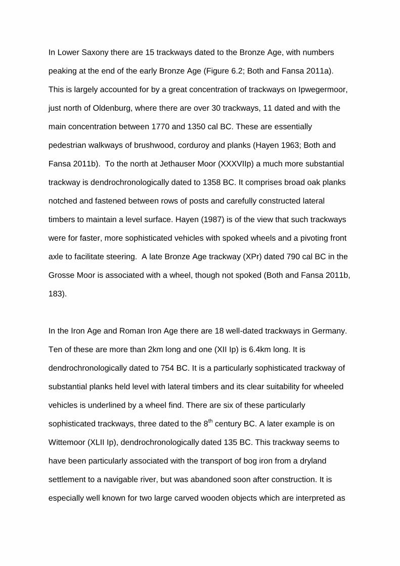
In Lower Saxony there are 15 trackways dated to the Bronze Age, with numbers
peaking at the end of the early Bronze Age (Figure 6.2; Both and Fansa 2011a).
This is largely accounted for by a great concentration of trackways on Ipwegermoor,
just north of Oldenburg, where there are over 30 trackways, 11 dated and with the
main concentration between 1770 and 1350 cal BC. These are essentially
pedestrian walkways of brushwood, corduroy and planks (Hayen 1963; Both and
Fansa 2011b). To the north at Jethauser Moor (XXXVIIp) a much more substantial
trackway is dendrochronologically dated to 1358 BC. It comprises broad oak planks
notched and fastened between rows of posts and carefully constructed lateral
timbers to maintain a level surface. Hayen (1987) is of the view that such trackways
were for faster, more sophisticated vehicles with spoked wheels and a pivoting front
axle to facilitate steering. A late Bronze Age trackway (XPr) dated 790 cal BC in the
Grosse Moor is associated with a wheel, though not spoked (Both and Fansa 2011b,
183).
In the Iron Age and Roman Iron Age there are 18 well-dated trackways in Germany.
Ten of these are more than 2km long and one (XII Ip) is 6.4km long. It is
dendrochronologically dated to 754 BC. It is a particularly sophisticated trackway of
substantial planks held level with lateral timbers and its clear suitability for wheeled
vehicles is underlined by a wheel find. There are six of these particularly
sophisticated trackways, three dated to the 8th century BC. A later example is on
Wittemoor (XLII Ip), dendrochronologically dated 135 BC. This trackway seems to
have been particularly associated with the transport of bog iron from a dryland
settlement to a navigable river, but was abandoned soon after construction. It is
especially well known for two large carved wooden objects which are interpreted as

highly stylised male and female human figures; they were placed in an area where
there was also evidence for fires, apparently marking a particularly treacherous part
of the route (Figure 6.1k; Coles and Coles 1989). That trackway encapsulates two
key themes: the use of trackways as a means of practical communication, and as
places of special ritual and symbolic importance. The same point is made by the
wheels. Altogether seven of the dated trackways have associated wheels or axles
and they are mainly associated with the more sophisticated, or substantially
constructed, trackways which were clearly intended for wheeled transport.
In the southern German peat bog of Federsee (Schlichtherle and Strobel 1999;
Heumüller 2000), a major track at Bad Buchau comprised three successive plank-
built walkways, the first made in 1505 BC, the others made over a period of 170
years. They connected the dryland to a gravel ridge in the bog. Another track,
dendrochronologically dated 1767-1481 BC, led from the entrance of the palisaded
settlement at Sielung Forschier and a further example is dated dendrochronologically
to the early Iron Age, 721-621 BC.
Scandinavia
This area has much less evidence of trackways. In Norway a single prehistoric
example at Båsmyr, in Vestfold dated from 500-800 BC crosses a shallow coastal
sound at high water (Smedstad 2001). From about 900 AD there are more trackways
near the coast of central Norway and many of these are on ‘natural’ communication
routes. Short paved causeways across wetlands are also found in southern Sweden
in the Bronze Age and Iron Age (Westerdahl 2006). Denmark has an early Bronze
Age track at Speghhoje (Schou Jørgensen 1988b) and a wooden trackway at Tibirke

(Kunwald 1984; Schou Jørgensen 1988 a and b) overlying an earlier Neolithic track;
this is in turn overlain by a paved road of 200 BC, thus demonstrating the longevity
of routes in key topographic locations. The emergence of stone paved causeways in
Denmark from the late Bronze Age is of special interest, the more so because some
are associated with settlements, fields etc. At Borremose, Jutland a substantial stone
causeway leads across a bog to a small island with a defended Iron Age settlement
of rectangular houses comprising living accommodation and byres for animals
(Figure 6.4; Martens 1990). The settlement has every appearance of an agricultural
village but the discovery of four bog bodies, one strangled with a rope, highlights the
recurrent association of everyday activities and ritual behaviour in wetland contexts.
The point is further highlighted just 4km north of Borremose; in a small bog at
Gundestrup was a great bronze cauldron, which is one of the greatest art works of
the European Iron Age; it is decorated with strange animals, warriors and scenes of
sacrifice, and wheels (Klindt-Jensen 1979).
At Broskov, in southern Zeeland, Denmark successive stone trackways, some 60m
long, cross the narrowest point in a bog valley (Figure 6.5; Kunwald 1962). The first
is dated to the Danish Iron Age, c 300 AD, and comprises flat stones with larger
stones forming an edge. This was succeeded by a later trackway of smaller stones in
the twelfth century AD. Thus, the route had a duration of around 1000 years. What
makes this site of special note is that hollow ways converge from the neighbouring
slopes on the trackway at its ends. To the north is a series of three distinct hollow
ways, 4-14m wide, some sunken up to 4m. The hollow ways partly delimit fields,
represented by lynchets of the type which Nielsen (2010) has shown formed from
the late Bronze Age to the Roman Iron Age, in landscapes first intensively cleared in

the middle Bronze Age (Rasmussen 2010). Also of note is a prominent stone with
many cup marks at the southern end of the road (Figure 6.5); such stones are shown
by Nielsen (2010) to be particularly found in wet places at the edges of fields,
highlighting the symbolic, as well as functional, aspects of these routes.
Netherlands, Bourtranger Moor
Key themes which have emerged in Denmark in terms of ritual associations and
dryland connections can be further explored in the context of evidence from the
Netherlands. The vast Bourtranger Moor on the border between the Netherlands and
Germany is some 13km across and here most of the known Dutch trackways are
located (Figure 6.6). This area is one of the few where direct connections between
dryland and wetland archaeology can be made, likewise between categories of the
wetland evidence, such as trackways and ritual deposition, which, even in this area,
have generally being discussed separately. The tracks lead across the moor from
the Hondsrug sand ridge, which in prehistory was surrounded to east, west and
south by bog and riverine sediments; here a seemingly complete prehistoric
settlement pattern has been reconstructed. There are clear indications from
alignments of barrows etc for a main communication route down the axis of the
Hondsrug ridge (discussed in Chapter 7). Discrete areas of ‘Celtic fields’ have been
mapped from the air (Brongers 1976, plates 23 and 25); there are farmsteads, each
associated with one, or sometimes two, successive urnfield cemeteries enabling the
approximate territories of each grouping to be defined (Louwe Kooijmans 2005).
The vegetation history of Bourtranger Moor has been established by a series of
pollen diagrams linked to trackway investigations, coupled with analysis of peat

stratigraphy and the wood used for trackways (Casparie 1982; 1984; 1986). By the
time trackways were constructed in the middle Bronze Age, c 1300 cal BC, the
dryland of the Hondsrug was substantially deforested, settled and used for
agriculture as the distribution of prehistoric sites and fields shows (Figure 6.6).
Woodland was quite limited and the construction of trackways would have
represented a very considerable investment, both of woodland resources and social
capital. This highlights the importance which would have attached to trackway
construction. Six are known, covering 2000 years, and several seem to have been
short lived. XV Bou may have been dismantled soon after construction because of a
bog burst. The trackways lead east from the sand ridge, one, already noted (XXI
Bou), is Neolithic, the others are Bronze and Iron Age in date, thus broadly
contemporary with the sand ridge landscape. It is tempting to see each trackway as
providing access to the bog for individual settlement territories, thus implying the
extension of territories out into the bog. However, the trackways are by no means all
contemporary and most of them seem to have had a short life before they were
engulfed by peat. Casparie (1987) argues that several of the trackways went part
way onto the moor because they provided access to areas rich in bog iron.
Interestingly one of these (XVII Bou) is middle Bronze Age in date (c1410 cal BC)
which may indicate precocious local iron working, as seemingly confirmed by the
discovery of an iron pin on the trackway surface (Casparie 2005).
There is another side to this bog, however, which belies any purely functionalist
explanation for the trackways, whether in terms of communication, or bog iron
winning. This is the evidence for ritual deposition in the wetland. On the peat at
Barger-Oosterveld is a cult site, a ring of boulders surrounding a four post structure

with horned lintels, dating to the middle Bronze Age (van den Broeke 2005). In the
surrounding bog, although not closely associated with the cult site, were a wide
range of objects which had apparently been ritually deposited in the peat (Figure
6.6b). These include bog bodies, some close to a trackway (XV Bou) dated 690 cal
BC. Other deposited items include bronze weapons, wooden artefacts, bracelets,
beads, 2 wheels and pottery. The Valtherbrug trackway (I Bou) is particularly
substantially constructed of transverse planks and roundwood on a substructure of
longitudinal roundwood; its construction required 60,000 logs from 10,000 trees
(Casparie 1987). It crosses the moor for a distance of 12km and is 2-3m wide. There
are a wide range of dates between 390 BC and AD 112 suggesting the track may
comprise more than a single structure. It is thought to be associated with the ritual
deposition of bog bodies, parts of carts and querns in the bog (van der Sanden
2002). It seems that the wetlands were of special significance for ritual purposes,
and the trackways may therefore have provided processional routes for these
purposes, although it should be noted that many of the deposited artefacts suggest
small-scale domestic acts rather than major ceremonies, a theme to which we will
return later in the case of Flag Fen (p00).
Also notable among the Dutch trackways are two at Smilde (I and II Sm), near
Assen. The wooden trackways of c 220 cal BC cross two narrow bog depressions
(280 and 170m wide) but they also form part of what Casparie (1987) identifies as an
11km long routeway along sand ridges. At the end of the wooden trackway it
continued as a sand route and the mottled sand surface shown in Casparie’s
photographs (1987, fig 24) looks as if it may be created by cattle footprints.

Bronze Age and Iron Age trackways in the British Isles
Case Study: Somerset Levels
In the Somerset Levels there are thirteen trackways of Bronze Age date, three in the
early Bronze Age and ten in the middle and late Bronze Age from 1400-800 cal BC.
These principally traverse the area between the Polden Hills and the bedrock and
sandy islands, especially Meare and Westhay, to the north (Figure 6.7). Coles and
Coles (1986) made the highly significant observation that Bronze Age trackways
north of the Polden Hills converged on points which they suggested represented the
locations of Bronze Age wetland edge settlements spaced at intervals of c 1.2km.
The most sophisticated and substantial is the 2.5km long Meare Heath Track, made
of oak planks laid on transverse sleepers held in place by vertical stakes through
mortices (Figure 6.1c; Coles and Orme 1978a; Coles and Coles 1986), this is
dendrochronologically dated 1530-1503 BC (Brunning 2013,68). It is one of a group
of trackways converging on the same point and spanning most of the Bronze Age
from c 1790-830 cal BC. It is difficult to escape the conclusion that there must have
been a dryland track upslope. The Shapwick project revealed traces of Bronze Age
settlement along the north edge of the Polden ridge and it was further hypothesised
by Aston and Gerrard (2013) that coaxial field systems (see p 00) at Shapwick may
have their origins in the later Bronze Age. The longevity of one boundary was
demonstrated by a later Bronze Age ditch on the same alignment as Roman and
later boundaries and a modern hedge. If elements of the field layout originated in the
Bronze Age then the same may be true of routeways. This is not to imply continuity
of the Meare Heath track route, which would surely have left greater traces in the
wetland. What it could mean is that existing routes on dryland imposed a structure
on wetland during those episodes when particular routes were passable, or socially

important. This is no more than a hypothesis sketched to illustrate the type of field
investigation necessary in order to establish links, or the lack of links, between
dryland and wetland routes. Techniques for dating routeways within field systems
are explored in Chapters 8 and 10.
The Tinney’s Trackway complex is another of these radiating groupings, in this case
of multiple successive, mainly brushwood, trackways, perhaps at times replaced
almost annually (Coles and Coles 1986). One was reinforced with oak planks
dendrochronologically dated 1703-1478 BC (Brunning 2013, 68), others are later,
c1400-1000 cal BC. They radiate from a point north of the Sharpham Peninsula
where it is probable that a settlement was located: pollen shows quite intensive
clearance and cultivation, with dung beetles indicating grazing animals. Drawing on
environmental evidence from the wetland it has also been possible to infer locations
of settlements on the dry islands to the north (Coles 1989), including Meare island
where there was clearance at the time of the Meare Heath Track and this continued
well after (Beckett 1978). The Somerset Levels is an area where, drawing on a
combination of trackway orientations, spatial evidence from multiple
palaeoenvironmental studies, and retrogressive map analysis as part of the multi-
period Shapwick Survey, we may be beginning to approach an understanding of a
complete landscape, wetland with dryland, and how communication routes through it
may have developed through time.
Case Study: Severn Estuary
Just to the north of the Somerset Levels, prehistoric peats and associated
archaeological sites are extensively exposed in the intertidal zone of the Severn

Estuary. Mesolithic and later footprint-tracks from the same area were discussed in
Chapter 4. Twenty-nine years of monitoring sites revealed by erosion has led to the
identification of two settlement sites of rectangular buildings at Redwick and
Goldcliff, the first middle Bronze Age, c 1500-1000 cal BC, the second Iron Age c
400-100 cal BC (Bell et al 2000; Bell 2013). The occupation evidence is at the
interface between peat and overlying estuarine sediments showing that on both sites
activity occurred in the early stages of marine transgressions. These sites are
interpreted as seasonal settlements, mainly used in spring and summer for animal
husbandry on saltmarsh. One of the strands of evidence supporting this hypothesis
is the animal footprints (Figure 4.15). Peat surfaces which were inundated by the
transgressions are covered by a pattern of curvilinear depressions, just a few metres
across, which drained the saltmarsh. Many of these channels have traces of short,
very simple trackways; a few bundles of brushwood were laid across the channel
and held in place at the edges with pegs; generally only a few pegs and a little
brushwood remained. Rather more substantial tracks crossed a few larger
palaeochannels. The Bronze Age trackways are generally parallel to the shoreline
suggesting that this was the primary axis of movement during spring tidal periods of
maximum tidal inundation. This suggests movement from settlements to river and
stream channels where evidence has been found for fish traps. Similar patterns of
trackways parallel to the shore and crossing channels have been noted by Van de
Noort (2004) in the Humber Estuary, eg at Melton during the Bronze Age.
At the Iron Age seasonal settlement at Goldcliff there is rather more to go on in
detecting patterns of local movement. Eighteen trackways (shown in Figure 6.8d)
have been exposed by erosion on the foreshore. All are pedestrian walkways but

they are of a wide range of types: some simple brushwood; some brushwood with
the edges held in place by pegged round wood (Figure 6.8a); some V-shaped
formed of opposed diagonal stakes with brushwood and planks between; some
roundwood and planks with pegs (Figure 6.8b-c). The differences may partly reflect
the different environments in which they were made: reedswamp, fen woodland and
raised bog. One trackway (1108) is dendrochronologically dated 336-318 BC; other
radiocarbon dated examples are between 500 cal BC and 100 cal AD. Trackway
1130 (Figure 6.8b) could be traced for 100m across the foreshore. Some trackways
converged; Trackway 1108 led directly to excavated Building 4, while discontinuous
brushwood Trackway 1311 led between Buildings 6 and 8. Since some of the tracks
lead to, and between, buildings, it can be argued that they link activity areas and
thus provide clues to patterns of habitual movement. On Figure 6.8d the lines of the
trackways have been projected. This is a speculative exercise, as not all trackways
will be straight as Figure 6.9a shows, but many are, and the exercise has possible
predictive value. Several trackways converge on three locations to the north,
perhaps the locations of still buried buildings or activity areas. Three trackways
converge to the south, perhaps the location of some activity now lost to erosion.
What is striking is that many of the trackways are not aligned east-west to the
bedrock island of Goldcliff, where incidentally no evidence of Iron Age activity has
been found. The orientation of communications is more north-south and that
suggests perhaps the importance of channels for boat communication and other
estuarine resources such as fish traps.
Thames Estuary

From the Thames Estuary east of London there is also growing evidence for
trackways, mostly found in development led excavations. They span the period from
the late third millennium to the late second millennium cal BC with a peak c 1500 cal
BC (Stafford et al 2012). One example at Hayes Storage Depot was a 4m wide track
of gravel, flint and sand with evidence of animal trample (Bates and Stafford 2013).
The trackways were made at a time when the palaeoenvironmental evidence points
to intensified land use on the neighbouring dry ground with creation of extensive
coaxial field systems, some with droveways leading towards in the river (Yates
2007). The East London trackways are comparably situated, running from the edge
of gravel river terraces onto the floodplain wetland and are thought to be associated
with seasonal grazing of animals on the floodplain (Meddens 1996; Meddens and
Sidell 1995).
Later Prehistoric trackways in Ireland
In the Midlands of Ireland, where peat bogs cover such a large area that, even today,
they are extensively milled as fuel for power stations, trackway finds are more
numerous than anywhere else. Archaeologists did not take much notice of them until
the discovery in 1984 of the most impressive example at Corlea led to the instigation
by Professor Barry Raftery of a programme of wetland research which has
transformed understanding. Some 97 of the trackways have now been scientifically
dated (Figure 6.2). A few, as noted above, are Neolithic but the vast majority (73%),
are Bronze Age; there is a very marked dropping off in the Iron Age (except in the
Derryville area; Cross et al 2001) and none from 0-500 cal AD (Raftery 1996, plate
51). Even allowing for the probability that earlier trackways may still be buried, and

later examples are more likely to have been milled away, this suggests a particular
focus on bog-related activities during the middle and late Bronze Age (Figure 6.2).
The trackways are of a great diversity of types: most are of simple brushwood, often
short lengths designed to get across a particularly wet patch, others are much more
substantial, providing a defined path across extensive bogs. Some areas, such as
the Mountdillon Bogs, Derryville and Edercloon, have produced great concentrations
of trackways. At Edercloon 45 individual structures, including 26 trackways and
several platforms, have been recorded. Some tracks were repeatedly rebuilt and
used throughout the Bronze and Iron Ages. They were not orientated to cross the
bog but apparently provided access to the wetland for activities (Brunning and
McDermott 2013). Of the Edercloon tracks no 5 is dated 1206-970 BC and was
associated with a range of wooden artefacts apparently deliberately deposited in the
foundations (Sands 2013). The objects included a disc wheel, which was unfinished
and deposited as part of a trackway wholly unsuitable for wheeled transport
(Brunning and McDermott 2013).
Corlea 6 was a 750m long construction of split timber on roundwood laterals and
brushwood, dated by dendrochronology to 2259+/-9BC. It is of particular note
because the timbers were worked with a metal axe, providing a secure date for early
metal use in Ireland. This highlights the significance of trackways in wider material
cultural studies, as well perhaps as hinting at the high status association of the more
substantial structures from the earliest Bronze Age (Raftery 1996). Some other more
substantial trackways are of the late Bronze Age and comprise mortised oak planks
and split timber as at Derroghill 1, a 650m track dendrochronologically dated
938±9BC, and Annaghcorrib, Galway, a 1.5km route from dryland to the River Suck

dendrochronologically dated 892±9 BC. Very extensive excavation of bog and bog
margins was occasioned by the construction of a mine at Lisheen (Gowan et al
2005) leading to the discovery of 34 trackways and two stone causeways dating
between the early Bronze Age and Iron Age. Only two of the trackways crossed the
bog completely: Killoran 18 of stone and wood dated dendrochronologically to
1400±9BC, and Cooleeny 31, a substantial and well-constructed route destroyed by
a bog burst in 600-595 cal BC, perhaps as a result of drainage being blocked by
track construction (Casparie 2001). This track is thought to have connected high
status regional sites. The other tracks were short lengths in what was described as a
vernacular tradition. They were mostly located in areas of settlement and
fulachtafiadh (cooking places) on the bog edge. Repeated use of the same sites was
considered to be because they lay at the end of dryland routes, some of which were
continued into the bog by short tracks. The middle Bronze Age period of most
intensive trackway construction equates with a period, between 1550 and 1350 cal
BC, when greater activity is attested by pollen analysis. However, the Bronze Age
clearances are small, evidence for agriculture limited and the economy was mainly
pastoral. Some trackway construction also took place at times when woodland was
regenerating and there is little other evidence of activity (Caseldine et al 1996).
Of particular significance among the Irish trackways is Corlea 1 (Figure 6.9), the
discovery of which in 1984 sparked the subsequent campaigns of wetland research.
It is a road so impressive and out of scale with the other Irish examples, that it has
been dubbed by its excavator ‘the colossus of roads’ (Raftery 1996). Corlea 1 runs
for 1km from uplands to a small island and it is clearly part of a longer routeway
since the contemporary Derraghan 1 trackway, extends west of the island.

Altogether they form a route of 4.7km (Figure 6.9b). Corlea 1 is
dendrochronologically dated 147/148 BC. It is built of large oak planks and split logs
on lateral runners pegged in place through mortices (Figure 6.1j). The scale of the
trackway made Raftery confident that it was built for wheeled transport, although
careful examination produced no evidence of wear, leading some to question, on the
basis of areas of disrupted timber, whether it had ever been completed and used,
though in places repairs were made as a pedestrian walkway (Raftery 1999). The
heavy timbers mean that its life would have been limited as Casparie and Moloney
(1996) have estimated that it would have sunk into the bog within a decade.
Construction of the Corlea trackway is very close in time to that of other major
constructions in Ireland (Raftery 1996, 420), such as a dendrochronological date for
part of a defensive earthwork, The Dorsey (150BC), and other radiocarbon dated
linear earthworks are of similar date. A huge building at the Navan Fort is
dendrochronologically dated a little later to 95BC. It appears therefore that Corlea
coincides with a period of great communal works in Ireland. Its surrounding area
contains few Iron Age sites and finds suggesting, as does the scale of the trackway,
that it has more to do with regional communication than local exploitation. Raftery
(1990) has made the fascinating suggestion that the trackway may have been part of
a longer route connecting two ceremonial foci, Ulsneach 22km to the south east and
Cruachain 35km to the north west, via the major historical fording point at
Lanesborough at the head of Lough Ree (Figure 6.9b).
Bridges, post alignments and associated ritual deposits

This brings us to a group of sites of later Bronze Age and Iron Age date which are
arguably central to the theme of movement but for which current interpretations
generally emphasise associated ritual deposits of artefacts, particularly weapons, in
wetland contexts (Bradley 2016). The question is whether these two aspects of
communication and ritual are really so separate. The issue is especially highlighted
by the site of La Tène, Switzerland where the artefact assemblage was so
spectacular that the site gave its name to the later Iron Age culture in Europe.
Interpretation is made more difficult by the fact that the main finds were in the
second half of the nineteenth and first two decades of the twentieth century (Servais
2007). Finds came to light when drainage works and lake level changes revealed at
least two separate alignments of large timber piles crossing a former river channel at
the north end of Lake Neuchatel. Between the two was a substantial deposit
representing many episodes of metalwork deposition, mostly weapons (swords,
shields, spears, tools) with human skeletons. Dendrochronological dating indicates
construction of one alignment 278±6 BC and with a continuance of activity in the
area to 65 BC (De Navarro 1972). The most economical interpretation is that it
represents a crossing point utilised by successive bridges where ritual deposition
took place. Pryor (2001, 434), in the context of discussion about Flag Fen in the UK,
highlights the ritual deposition role. He questions whether the alignments were
functional bridges rather than ritual demarcations. But are these two roles
incompatible, or have we privileged one aspect of social communication, ritual
deposition, over another, the physical act of movement, in ways which may have
made us play down some of the best evidence for axes of movement in later
prehistory?
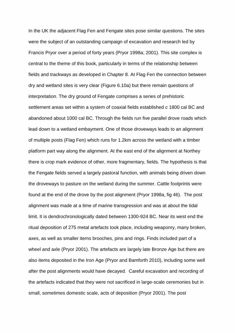
In the UK the adjacent Flag Fen and Fengate sites pose similar questions. The sites
were the subject of an outstanding campaign of excavation and research led by
Francis Pryor over a period of forty years (Pryor 1998a; 2001). This site complex is
central to the theme of this book, particularly in terms of the relationship between
fields and trackways as developed in Chapter 8. At Flag Fen the connection between
dry and wetland sites is very clear (Figure 6.10a) but there remain questions of
interpretation. The dry ground of Fengate comprises a series of prehistoric
settlement areas set within a system of coaxial fields established c 1800 cal BC and
abandoned about 1000 cal BC. Through the fields run five parallel drove roads which
lead down to a wetland embayment. One of those droveways leads to an alignment
of multiple posts (Flag Fen) which runs for 1.2km across the wetland with a timber
platform part way along the alignment. At the east end of the alignment at Northey
there is crop mark evidence of other, more fragmentary, fields. The hypothesis is that
the Fengate fields served a largely pastoral function, with animals being driven down
the droveways to pasture on the wetland during the summer. Cattle footprints were
found at the end of the drove by the post alignment (Pryor 1998a, fig 46). The post
alignment was made at a time of marine transgression and was at about the tidal
limit. It is dendrochronologically dated between 1300-924 BC. Near its west end the
ritual deposition of 275 metal artefacts took place, including weaponry, many broken,
axes, as well as smaller items brooches, pins and rings. Finds included part of a
wheel and axle (Pryor 2001). The artefacts are largely late Bronze Age but there are
also items deposited in the Iron Age (Pryor and Bamforth 2010), including some well
after the post alignments would have decayed. Careful excavation and recording of
the artefacts indicated that they were not sacrificed in large-scale ceremonies but in
small, sometimes domestic scale, acts of deposition (Pryor 2001). The post

alignment comprises five rows of posts and five levels of horizontal wood.
Interpretation of the structure has ranged from a symbolic barrier against marine
transgression, to successive post alignments mainly related to ritual acts of
deposition. The final report (Pryor 2001) makes it clear that during at least some
phases of its development a trackway formed part of the structure, initially of laid
roundwood and later planks or other wood laid along the axis. The fact that a clear
droveway leads to the alignment surely suggests that it is primarily a trackway/
bridge where the ritual deposition of artefacts also took place. It is thus perhaps our
clearest physical demonstration of direct wetland and dry ground relationships in
later prehistory. The significance of this place as a crossing place is further
emphasised by the fact that a similar route was taken by the only Roman road to
cross the Fenland, the Fen Causeway (Pryor 2001).
Close to Flag Fen (2.4km south; Figure 6.10b), and very close in date to the
construction of that post alignment, is another alignment recently excavated at Must
Farm (Gibson et al 2016; Knight et al 2016). It was a simpler structure, a raised 2m
wide walkway supported on large squared paired posts and incorporating some large
planks (Figure 6.11). It is dated 1290-1250 cal BC and crossed a palaeochannel.
Earlier footprint-tracks indicate that the causeway may have formalised an existing
path. The causeway is interpreted as part of a routeway across the Fens, part of
what, with Flag Fen, seems to be an emerging network linking dryland areas within
the wetland. As at Flag Fen there was deposition of metalwork nearby in the river
channel, mainly weapons (spearheads, a dirk, rapier) and pins. After the causeway
had gone out of use the routeway to which it was connected may have determined
the location of a settlement on the same site. This comprised five roundhouses dated

c 900-800 cal BC destroyed by fire very soon after construction; the complete
organic and inorganic artefact inventory of this Bronze Age community, including two
wheels, was preserved in the waterlogged sediments of the channel.
Other possible Fenland trackways or causeways are associated with approaches to
the Isle of Ely, one to its south-east at Stuntney, the other to its south at Barway
dated 530 cal BC and Bronze Age artefacts are reported near both (Godwin 1978;
Hall and Coles 1994, 84). Excavated droveways on dry islands are also thought to
approach causeways and areas of metalwork deposition (Evans 2002). This Ely
evidence has echoes of Flag Fen but the similarities with the latter are particularly
strong in the case of Fiskerton, in the Witham Valley of Lincolnshire where, since the
eighteenth century, metalwork and 19 log boats have been found during river
canalisation, the finds covering a long period from the Bronze Age to medieval
period (Field and Parker Pearson 2003). The main concentrations of metalwork
correspond to river crossing places still in use in historic times. At Fiskerton a double
row of 195 large posts was erected, with limestone metalling between;
dendrochronology showed that this took place in 10 episodes over a period of 150
years between 457 and after 321 BC. The structure crossed what at the time was a
reed swamp. It was associated with deposition of metalwork: swords, spears, and
axes as well as pottery, amber, jet objects and fragments of human bone. Some 250
years later in the Roman period this was the site of a causeway, that too being
associated with artefact deposition: bronze bowls, a bracelet and pottery. There are
also medieval causeways in the area (van de Noort and O’Sullivan 2006). The
published monograph concludes that it is uncertain as to whether the site is entirely
ceremonial, or served as a crossing point or jetty (Field and Parker Pearson 2003).

Despite its being 467 years later than the latest date of the Flag Fen alignment, the
similarities are striking even to the extent of the same route being followed by
Roman causeways in both cases; this raises some interesting issues about the
extent to which Roman roads formalised existing routes, a point developed by
examples in Chapter 8.
Causeways or bridge-type structures also occur more widely. On the south coast of
England at Shinewater on the Willingdon Levels, Sussex a substantial trackway was
recorded, with three rows of vertical posts and horizontal beams and rails (Greatorex
2003; Jennings et al 2003). The inclusion of sand and fine gravel along the
alignment might be part of the construction, but might perhaps relate to trample by
animals. It crossed a freshwater fen with saltmarsh to seaward. Along the trackway
was a wooden platform on which hearths and evidence of cereal processing may
indicate occupation. Here again ritual deposition is indicated by axes, a bracelet, a
sickle, amber beads and human bone. Shinewater, which is dated 900-800 cal BC,
may represent a route from the Bronze Age agricultural landscape of the chalk in the
south west to the seasonal wetland pastures of the Willingdon and Pevensey Levels.
Also on the south coast, inland of the Solent in the Test Valley, excavations have
found lines of posts and planks representing 3 bridges dating between 1700 and
1400 cal BC; one is associated with a fragment of boat cleat and there is also a
middle Bronze Age rapier from the site (Fitzpatrick et al 1996; Van de Noort 2011).
In the Severn Estuary/ Somerset Levels region there are three further sites which
invite comparison with those under discussion. Of these the most fully investigated is
at Caldicot, south Wales where palaeochannels contain a series of Bronze Age

structures and stone scatters (Nayling and Caseldine 1997). Most notable is a
double line of large posts, dendrochronologically dated 990-989 BC, crossing a river
channel at about the limit of tidal influence. Artefact deposition is indicated by two
sword chapes, a tin strip, pottery and wooden objects. In the Somerset Levels are
two similar structures built at much the same date. At Greylake there are earlier
reports of alignments of posts at a natural crossing point between two projecting
areas of dry ground. This may be associated with recent finds of oak posts, dated
dendrochronologically 963-952 BC, found with bones of humans and animals and a
broken axe (Brunning 1997; 2013). The structure crossed a freshwater fen.
Horizontal planks and some cut roundwood was found but the small excavation did
not produce clear evidence of a superstructure and Brunning argued that it may have
related to ritual deposition and demarcation rather than communications. Also on
the Somerset Levels at Harter’s Hill (Figure 6.12) two parallel rows comprising at
least 34 large posts, associated with plank fragments and cut roundwood, run from
the hill slope out into Queen’s Sedgemoor (Brunning 2013). The earliest pile is
dendrochronologically dated to 1076-5 BC and the structure was in use for at least
30 years. Conditions were getting wetter at the time and previous alder woodland
had been replaced by sedge swamp and shallow open water. The previous
discovery of a bronze sword from the same field is likely to be associated. Although
the sword and the substantial posts of the alignment shows similarities with the
others discussed in this section it must be acknowledged that unlike the others it is
not positioned at a natural crossing point but heads more or less to the middle of the
Moor.

In the Thames valley there are a number of finds of post alignments which appear to
be bridges or jetties (Stafford et al 2012). Beside the modern Vauxhall Bridge,
London 25 oak posts occur in two parallel rows dated to 1750-1285 cal BC and were
at about the tidal limit at the time (Cohen and Wragg 2017). Pottery and spear heads
have come from the area. Another probable bridge at Freemasons Road is dated c
1600-1750 cal BC. At Ebbsfleet in the Lower Thames (Figure 6.13) a double post
alignment may represent a walkway or bridge dated 1410-1220 cal BC; this is
particularly significant because a continuation of this route seems to be indicated by
small brushwood tracks, clusters of pits and barrows. This hypothetical route is not
across the wetland but along the edge of the Ebbsfleet Valley which at the time was
saltmarsh (Bates and Stafford 2013, fig 86). Upstream on the Thames at Eton
Rowing Lake a succession of six later Bronze Age and Iron Age bridges were
constructed across river channels. They were made with roundwood uprights and
mortised planks (Lambrick and Robinson 2009). They form part of a Bronze Age
landscape of pasture, settlements and fields which has been extensively excavated.
Gravel and limestone causeways across the flood plain have been found at Thrupp,
Abingdon dated to the middle Iron Age and at Yarnton where stone for the causeway
(Figure 6.14) was transported from 4km away. Metalwork finds suggest this had
been a significant crossing point from the late Bronze Age and wheel ruts are
reported from the causeway. Lambrick and Robinson (2009) observe that there is
little evidence as to how the bridges, trackways, causeways etc found in riverine
contexts in the Thames valley link to wider dry ground routes. It is clearly a task for
the future to extrapolate beyond the clues provided in riverine contexts.

Bronze and Iron Age metalwork was found in the Thames during dredging, including
many finds from the Eton area and further downstream in London. It seems probable
that some of this deposition took place from the bridges / post alignments which are
increasingly being found along the Thames. The possibility should also be
considered that what appear, to this writer at least, as bridges or causeways may
also have served as territorial boundaries or barriers to upriver movement, or they
may have combined multiple functions. Acts of ritual deposition, such as bog bodies,
metalwork and other artefacts occur in Ireland on what were later recorded as minor
kingship boundaries (Kelly 2006). Ritual deposition is not necessarily taking place in
remote locations but in wetlands which, in some cases, the environmental or field
archaeological evidence shows were close to agricultural land and settlement. This
again highlights the importance of trying to join up the landscape, the tracks, fields,
environmental evidence, settlement and ritual places and to avoid treating these as
separate categories.
Conclusions
Wooden trackways are present from the very beginning of the Neolithic in north
Germany and the Somerset Levels (Figure 6.2), but only in the latter are Neolithic
examples particularly well represented. It is during the middle and late Bronze Age
that trackways are frequent in each of the main areas, implying that some
characteristic of Bronze Age life made trackway construction especially prevalent.
Indeed Kristiansen and Larsson (2005) draw on quite different evidence from
material culture and wheels to contend that mobility was a particularly distinctive trait
of the Bronze Age. Numbers reduce in the Iron Age especially in Ireland and
Somerset but not in Lower Saxony. Overall there are far fewer in the last two

millennia. However, early trackways are likely to remain buried in some areas and
later ones will have been removed by peat digging before archaeologists came on
the scene.
The factors that occasioned trackway construction have been much debated. Often
trackways have been interpreted as maintaining communications in the face of
wetter conditions. In other cases, it has been suggested that they reflect drier
episodes when routes, previously impassable, became accessible. In Ireland
evidence of testate amoebae and peat humification, testifying to temporal changes in
bog surface wetness, have been compared with radiocarbon and
dendrochronological dates for wetland structures, including trackways (Plunkett et al
2013). Wetland activity was shown to be clearly episodic, with six pronounced
episodes of wetland activity identified in the last 4500 years, separated by five lulls in
activity lasting between 100 and 400 years. However, no correlation was found
between activity and lull phases and the changing patterns of bog surface wetness.
Instead, the episodes of wetland activity show greater correspondence to phases of
clearance and activity on dryland during which the landscape was being more
intensively used. In Ireland the concentration of tracks in the middle and late Bronze
Age coincides with increased clearance and agricultural activity and for Raftery
(1996) in the Mountdillon bogs this was the main factor prompting trackway
construction. Similarly, in Somerset there is a good correspondence between the
temporal concentrations of trackway construction and palynological evidence for
clearance on dryland in the middle Neolithic and middle to late Bronze Age (Coles
and Coles 1998, fig. 4). However, several trackways, such as those at Meare Heath,
are also associated with periods of increased wetness, notably c 1500 cal BC

(Brunning and McDermott 2013; Brunning 2013). The Bourtanger Moor tracks in the
Netherlands can also be related to pollen and settlement pattern evidence for activity
on the neighbouring Hondsrug dryland.
There can be no assumption, however, that trackway construction had the same
driver in each case or region. In North West Germany detailed comparison of
dendrochronologically dated trackways and the deaths of trees growing on bog
surfaces indicates that trackway construction frequently corresponded to a rise in
bog surface wetness (Achterberg et al 2015). Not only may wetland environmental
changes have affected patterns of human activity, but people also influenced the
wetland environment itself. The very act of trackway use created an artificial linear
depression and Casparie (1986;2001) has argued that at Derryville, Ireland and
Bourtranger, Netherlands, the disruption of drainage by the creation of a substantial
track may have triggered bog bursts, fundamentally changing bog hydrology and
putting trackways out of use.
As a generalisation it seems that social factors were more significant drivers of
trackway construction than has often been assumed. Many trackways seem to have
been built to facilitate fairly local movement from dryland onto the edge of bogs, thus
providing access for activities at the wetland edge, eg the Derryville examples, or
activities on the bog surface at Edercloon. For a few in The Netherlands and North
Germany they appear to have had a role in the extraction of bog iron ore. Only in a
minority of cases are trackways presently understood as part of wider
communication systems. Corlea 1 is clearly an example; similarly two trackways
crossed Derryville bog and of these Cooleeny 31 is interpreted as a high status

regional route. In the Netherlands only two tracks crossed from one side to the other
of the vast Bourtranger Moor. Also fragments of much slighter tracks elsewhere at
Smilde have been identified as part of a longer route linking sand ridges. In north
Germany there is a greater concentration of substantially constructed trackways and
they have been seen by Hayen (1987) as part of regional communication networks.
Where bogs are especially extensive, as in Lower Saxony, they often formed natural
barriers between cultural groupings (Hayen 1987). We have identified other
examples where communication routes persisted over long timescales. However,
these tend to be the exceptions. It is striking that many trackways, including some of
the more substantial and carefully constructed examples such as Corlea I and the
Wittemore track (XLII Ip), seem to have been abandoned not long after construction.
This might be explained in environmental terms, but the possibility should also be
considered that they reflect social relations such as alliances, trade connections, or
periods of religious observance etc which were of a short-lived nature.
Wheels and other parts of vehicles are associated with trackways in Saxony and the
Netherlands from the late Neolithic and those areas have more examples of
substantial trackways suitable for wheeled vehicles. In Lower Saxony sophisticated
trackways have upper lateral timbers to maintain a level surface suitable for vehicles;
these appear in the middle Bronze Age and are especially marked in the eighth
century BC. In Britain and Ireland only the Corlea 1 trackways seems clearly
intended for vehicles. Perhaps the more substantial double post alignments / bridges
and especially the stone causeways that occur in lowland England mainly in the late
Bronze Age were intended for vehicles. However, aside from the wheel at Flag Fen,

where the post alignment does not seem obviously suitable for wheeled transport,
and wheel ruts on an Iron Age causeway at Yarnton, there is no direct evidence.
Trackway construction and use cannot be seen in purely functional terms because
there is so much evidence for ritual deposition and symbolism associated with them.
This is highlighted by the wooden outlines of human figures at the Wittemoor XLII Ip
trackway, wooden human figures from Irish trackways (O’Sullivan 2007, 186), and
the many other objects associated with some trackways such as Sweet Track and
Edercloon 5. In the case of the British double post alignments, particularly of late
Bronze Age date, the ritual deposition of artefacts is very clearly evident at Flag Fen
and seen also to a lesser extent at most of the other sites. It has been argued here
that the ritual deposition evidence has tended to eclipse evidence that these
structures also served as communication routes and may therefore have obscured
their full social significance. For the purposes of this study of prehistoric routeways,
wetland tracks possess the huge advantage of being well dated and associated with
a wealth of environmental evidence. In all but a few cases the real challenge remains
to relating the wonderfully detailed local picture they provide to the wider patterns of
communication.

Making Ones Way in the World Revisions 3.7.19 Words 3656
Chapter 7: Barrow alignments as
clues to Bronze Age routes
Introduction
In Chapter 6 we have looked at some relatively clearly-defined evidence for wetland
tracks but only in a few instances could those be related to dryland routes. In
Chapter 5 we reviewed rather more tentative evidence for dryland routes used by the
first farmers, concluding that quite often these related to bands of movement rather
than closely demarcated paths. The clues that were suggested as significant in
relation to these Neolithic dryland routes included recurrent patterns of activity on the
same site separated by centuries, sometimes millennia, as for instance below
megalithic tombs. A second key feature was the construction of monuments on the
same alignment, again often over extended timescales. Alignments are not easy to
interpret because, whilst they could indicate routeways, they have also often been
interpreted in terms of cosmology (eg astronomical alignment), not that one needs
necessarily to exclude the other. Recurrent patterns of activity and significant
alignments may also provide clues to patterns of movement in later prehistoric
periods such as the Bronze Age. Not infrequently patterns that emerge in the Bronze
Age also incorporate some Neolithic monuments, suggesting that the alignments
may be of earlier origin. In the early Bronze Age we have a much larger number of
monuments, particularly barrows, making alignments clearer and we can also begin
to detect relationships to defined routeways which become formalised and

demarcated in the agricultural landscapes of later periods, particularly the middle
and late Bronze Age and Iron Age, which are considered in Chapters 8 and 10.
However, the case is not simple. The evidence for barrow alignments on routeways
is far stronger, and accepted as orthodox in Denmark, north Germany and the
Netherlands, but less so in the British Isles, although it will be argued that even in
Britain there are convincing cases and probably more which are deserving of
detailed investigation.
Denmark
In Denmark there is far more evidence for ancient dry ground trackways than in any
of the other areas considered. This is partly because a national inventory of these
sites has been created for heritage protection purposes. Figure 7.1a shows the 2300
sites on that inventory with evidence of ancient tracks including hollow ways (Bang
2013). Three major long distance routes can be identified. These are in a sense
‘natural’ topographically-determined routes, related to watersheds and crossing
places over water. Each is supported by the evidence of trackway traces, alignments
of barrows and other evidence. Linear arrangements of barrows have, since the
work of Müller (1904), and subsequently by Bakker (1991), been recognised as
routeways. The most prominent of these routes runs north to south from Viborg
down the watershed in the centre of Jutland and is known as the Haervejen, or ‘army
road’. This is considered to be, not so much a closely demarcated line, as a broad
communication corridor, the course varying seasonally according to weather
conditions (Schou Jørgensen 1988b). The evidence is strengthened by the discovery
at historical fording places of Bronze Age ritual deposits, wheel ruts below a few of
the barrows and alignments of cooking pits corresponding to that of barrows. The

evidence is assembled by Lovschal (2013) who contends that the barrow alignments
should be seen, not just in functional terms, but in terms of the cues and prompts to
genealogy and ideology created by the patterns of monuments, physical movement
being related to paths of thought and recollections of social significance. This
resonates with the ideas of Bradley (2000) who, in discussing acts of ritual
deposition in natural places such as bogs and rivers over extended timescales,
suggests that this relates to some memory of past acts. Such an explanation
becomes more tenable if they were linked to stories attached to particular routes
through landscape. The second major route in Denmark the Oldtidsvejen is an east-
west route just south of the Limfjorden which is picked out by the curvilinear grouping
of barrows shown in Figure 7.1b. Another north-south route, the Ravvejen, is marked
by a barrow alignment down the west coast of Jutland.
Case Study: Kilen, a Bronze Age cross roads in Jutland
Travelling from the north coast of Thy, where Bronze Age settlements and fields are
preserved below blown sand and where amber was collected for transport south
(Bech and Mikkelsen 1999), travellers would have taken a ’natural’ route via a
narrow strip of land across the Oddessund. At the head of another inlet of the sea at
Kilen was a natural crossing point where two routes converged. The north-south
route known as Ravvejen crossed with the east-west route, the Oldtidsvejen, both
marked by prominent alignments of barrows (Figure 7.1-2). A particularly large
barrow (Figure 7.2b) occurs where the west-east route begins its descent to the
Bredkaer valley. Here four alternative routes spread like the fingers of a hand down
into the valley. Each is deeply incised into highly erodible Pleistocene sands and
gravels. In their present form they are hollow ways formed by the passage of

people, animals and carts, natural erosion processes have also contributed to their
morphology (Figure 7.2c). Numerous prominent hollow ways (Figure 7.2d) mark
alternative routeways from the plateau into the valley on both sides and these have
been mapped in the surrounding area using LiDAR (Bang 2013, fig. 4). The
alternatives may reflect the changing extent of the inlet and where the Bredkaer
Baek was most easily crossed. On the south side of the valley two prominent hollow
ways ascend to the plateau. On either side of these routes are spurs on which, within
100-200m of the routes, are two Neolithic causewayed enclosures (Molbjerg I and
Molbjerg II; Klassen 2014). From here the main route is marked by a prominent
barrow alignment which includes two Neolithic long barrows and many Bronze Age
round barrows (Figure 7.2e), marking a clear line which was originally identified as a
prehistoric routeway by Muller (1904); part of this route is still followed by a historic
road. The evidence in this area is particularly clear because it represents the
crossing point of two important routes, clearly marked by barrow alignments and by
multiple deeply-incised hollow ways. The multiplicity of hollow ways and alternative
barrow alignments at Kilen is something often seen in prehistory, the result perhaps
of changing local conditions as some routes became impassable. The hollow ways
and barrow alignments in this area are marked by display boards informing walkers
of their relationship to prehistoric routes.
Klassen (2014) drawing on evidence from Kilen and other Danish sites has observed
regular relationships between routeways marked by barrows, river crossings and
Neolithic enclosures. Based on these relationships he used GIS to build predictive
models of routeways and Neolithic enclosure locations in the Dyursland peninsula,
east Jutland, testing these predictions by air photography, fieldwalking and
geophysics. This led to the discovery of several new Neolithic enclosures, thus

validating the predictive model and the inferred routeways. Fieldwork appears,
however, to have been limited to the individual enclosure sites and did not include
actual physical evidence for the inferred routeways such as the hollow ways which
Bang (2013) recognised at Kilen. A further complicating factor in the Djursland
peninsula is that marine inlets were very extensive in the Neolithic and much
communication might be expected to be by water. Klassen (2014) has identified
several other cases where routeways can be inferred from alignments of Neolithic
graves and barrows, at Vroue Hede, Jutland and at Haslov, Sweden, where a TRB
(Funnel Beaker Culture) road of 0.7km is delimited by palisades and standing stones
adjoining tombs along the edge of a wetland (Klassen 2014; fig.19).
Germany
In the Uelzen area of north Germany between Hannover and Hamburg abundant
hunebed (megalithic tombs) of the TRB (c 3500-2800 cal BC) also show evidence of
pronounced alignments, many of which correspond to existing routes, often on
higher terraces and watersheds, as distinct from the mainly riverine distribution of
contemporary settlements (Bakker 2008, fig 23.2). It is notable that two settlements
in this area are on hunebed alignments at probable fording points in river valleys.
The Uelzen evidence may point to a complementary system of dryland tracks on
watersheds and higher terraces and a transport system which may have been mainly
river based. South of Kiel at Flinkbek in Schleswig Holstein, a major alignment of
barrows extends over 4km along the ridge of a seemingly ‘natural’ route which may
have extended to the head of the Kiel Fjord to the north. It was flanked by wetlands
to the east and the valley of the River Eider to the west (Bakker et al 1999; Klassen
2014). The barrows span some two millennia from the early Neolithic to the Bronze

Age. Cultivation preceded some of the barrows, as ploughmarks and pollen evidence
for agricultural activity showed (Diers et al 2014). Below one Funnel Beaker culture
barrow dated c3420-3385 cal BC were wheel ruts, providing some of the earliest
evidence for the use of wheeled transport in Europe (Fansa and Burmeister 2004;
Mischka 2011).
Netherlands
Case Study: Veluwe barrow roads
On the sandy soils of the central Netherlands, in the Veluwe area between Epe and
Vaassen, there are very distinct alignments of barrows which have been interpreted
as marking one axial and two divergent side roads (Figure 7.3; Bakker 1976; 2008).
The main alignment runs for 6km and comprises 35 barrows; the earliest date to the
third millennium BC, and there are many Bronze Age and a few Iron Age burials.
Further alignments of barrows to the west of the mapped area may hint at the
existence of other routes (Fokkens 2005, fig 16.7). Much of the heathland is now
farmland, or forested, with the barrows in small clearings. Some of the barrows are
marked by geocaches so that those walking along the prehistoric route can lift a
handle raising a cylinder in which are models and information about the prehistoric
barrows and the routeway they marked (Figure 7.3c). The alignments are thought to
have created landscape structures representing, perhaps, lineages, or dynastic
successions of those buried, animated by movement along the axis (Bourgeois
2013). Many of the barrows have been excavated and were constructed of turves;
pollen analysis demonstrates these were cut from heathland. This led Doorenbosch
(2013) to infer that linear corridors of heathland existed from the Neolithic since
pollen analysis showed that heath had developed well before barrow construction.

Some woodland remained, but away from the alignments and settlement seems not
to have been near. Doorenbosch calculated the numbers of animals, the burning and
de-turfing activities which would have been required to maintain these heathland
corridors. She appears to envisage acts of deliberate clearance to maintain linear
heathland tracts. A more economical explanation might be that the linear heathy
tracts reflect regular patterns of animal and human movement, perhaps to seasonal
wetland pastures. Continuing burials may indicate that these routes remained to
some extent active into the Iron Age when ‘Celtic fields’ were laid out beside parts of
the alignments, but without disturbance to the barrows (Brongers 1974). Cart tracks
have been identified alongside some barrows but predating the fields (Bourgeois
2013). The field patterns do not incorporate identifiable trackways running alongside
the alignments, so perhaps the inferred patterns of movement had lost at least some
of their significance by the Iron Age.
In north Holland the Hondsrug is a ridge of Pleistocene glacial origin which stretches
for 70km south east of Groningen to Emmen forming a natural routeway between
peat bogs and riverine wetlands. Its significance, in terms of the relationship between
wetland and dryland routeways, was discussed in Chapter 6. In the northern part of
the ridge Jager (1984) has mapped a pronounced linear pattern of megaliths,
barrows and urnfields which, from the date of the monuments, he argues indicates a
route in use from the period of Funnel Beakers to the late Iron Age. Excavations
along this line have uncovered trackways and wheel ruts beside, rather than below,
the barrows; on one site a hollow way was sectioned. The tracks were abandoned by
the early medieval period when axes of communication changed and earlier routes
were buried by plaggen (man-made manured) soils of medieval date. In the southern

part of the Hondsrug around Emmen the distribution of Bronze Age and later
settlements, fields and urnfields has been illustrated in Figure 6.6 in relation to the
wooden trackways which run across peat east of the Hondsrug. Bakker (1976, fig
10) maps the distribution of hunebed megalithic tombs in the same area; they are
mainly down the centre of the sandy ridge, and track ruts are again found on the
same axis. This alignment corresponds approximately to the hypothetical territorial
boundaries down the axis of the sand ridge shown on Figure 6.6. This suggests
firstly the possibility of a routeway going back to the Neolithic and secondly that it
provided the boundaries between hypothetical settlement territories in the Bronze
Age. Bakker (1976, 79) also notes that cart tracks in some Bronze Age urnfields are
often aligned on the grave field and sometimes as at Sleen (4km west of the area
mapped in Figure 7.3), with a reserved space for a road.
North European connections
Bakker (1976) argues that despite the obstacles to communication created by
extensive coastal wetlands, some extending 150km inland, there are considerable
similarities between the TRB in Denmark, North Germany and the Netherlands.
These he explains by evidence for the movement of lithic raw materials, for instance
axes, from the Limfjord in northern Jutland, to north west Germany where the
distributions fan out from crossing points on the Elbe (Bakker 1976, fig 13). Later in
the Bronze Age the routes south from Denmark are considered to have played a part
in movement of amber which was gathered in settlements such as Bjerre in northern
Jutland and traded, or exchanged, as far as southern Europe. In the TRB period,
artefact distributions highlight the importance both of north-south routes from
Denmark and east-west routes inland of the coastal wetlands in northern Germany

and the Netherlands. In the Iron Age from c 500 cal BC there seems to have been an
interdependence between the terp (artificial settlement mound) sites on coastal
saltmarsh in the Netherlands and north Germany, where the farmers were engaged
in cattle husbandry, fishing and salt production, and the settlements inland on sandy
soils with evidence of Celtic fields which produced crops, wood and iron (Brongers
and Woltering 1973). Such interdependence assumes an effective system of
communication routes of the type demonstrated along the Hondsrug ridge and
probably by the network of wooden trackways traversing the wetlands of Lower
Saxony discussed in Chapter 6.
England and Wales
In mainland north-west Europe we have seen some convincing evidence for the
positioning of barrows on trackways. However, the impression should not be given
that all barrow alignments indicate trackways. In Britain (site locations on Figure 8.1)
alignments of barrows are common, but usually without any convincing evidence that
they had anything to do with tracks. Some follow topography, or may relate to
cosmology, or lineages of those interred. However, even here there is evidence that
sometimes barrow alignments do relate to routeways. One such is at Bishopstone ,
East Sussex where a line of Bronze Age barrows was aligned on a track of Iron Age
and Romano-British date, this is outlined in more detail as a case study in Chapter
10. In the highland zone of Wales, Bronze Age monuments have been observed to
cluster along mountain trackways (Lynch 2000). One such example is the extinct
volcano at Penmaenmawr, a dramatic situation with panoramic views of the coast of
north Wales (Figure 7.4). Here a curving trackway, in places a hollow way, is marked
by Bronze Age cairns. The track passes a stone circle, the early Bronze Age Druids’

Circle (Figure 7.4b-c), which is flattened on the trackway side apparently respecting
the earlier trackway line (Griffiths 1960). 200m north of the trackway is the rock
outcrop of Graig Lwyd which was a Neolithic axe factory site. The axes from here,
most likely given special significance not just because of the properties of the stone
but the dramatic upland from which they originated, can be shown by petrological
analysis to have been distributed widely in southern Britain (Clough and Cummins
1988). A standing stone also marks a continuation of the track at Penmaenmawr.
Roughly parallel and 3km south another routeway is marked by three stone circles,
standing stones and cairns and a much later Roman road on the same line
demonstrates the longevity of that route. Williams (1988) observed that standing
stones sometimes mark the positions of ancient tracks.
Lest we get carried away with the notion of an inevitable association between
barrows and routes, there are many more examples where arrangements of barrows
seem to have a rather different landscape role which might for instance reflect
cosmological alignments, genealogies, or territorial divisions. In Ireland, Cooney
(2009) identifies linear arrangements of barrows of Bronze Age to Iron Age date
interpreting them in terms of lineages of the people buried, although such a
sequence might also imply an axis of movement. Bakker (1991, 518 ) from the
position of his considerable experience of prehistoric trackways in mainland Europe,
says that he has never understood why the barrow alignments around Stonehenge
were not interpreted as following routes. There are indeed very prominent barrow
alignments, most obviously 2km west of Stonehenge at Winterbourne Stoke cross
roads comprising a Neolithic long barrow and fourteen, early Bronze Age round
barrows (Figure 5.6). Other prominent alignments are on Normanton Down 1km

south of Stonehenge and on King Barrow ridge 1km to the east of Stonehenge.
These, and the other Stonehenge barrow alignments, do not have any clear
association with routes, they do not lead to Stonehenge, or other monuments, which
might be expected if they perpetuated routes of the Neolithic, or Beaker period.
Rather they are, as it were, tangents, or curvilinear arrangements, framing and
enclosing the basin within which Stonehenge lies. It has been argued that barrows
may be so positioned that they are skylined from routes rather than being on routes
themselves (Watson 2001). The King Barrow alignment cuts across the Stonehenge
Avenue which is the one really clear prehistoric route in this landscape (Figure 5.6).
Perhaps we should not exclude completely that they could represent routes
tangential, or concentric, to Stonehenge by channelling access around, rather than
directly to, Stonehenge (Woodward and Woodward 1996). That may not be not too
fanciful if there was one correct way to approach the great monument as the avenue
implies. However, in response to Bakker’s point one must acknowledge that there
are none of the distinctive clues to the former existence of tracks associated with the
Stonehenge barrows that are convincing in the case of some of the continental
alignments, or the Yorkshire Iron Age barrows discussed in the next chapter. It is,
however, rather intriguing that there is a line of eleven barrows 130m to the south of
the Neolithic Stonehenge cursus. Cursus monuments and their very enigmatic
relationship to movement through the landscape were discussed in Chapter 5. On
Salisbury Plain east of Stonehenge some barrow groups of the early Bronze Age
were linked by later Bronze Age linear ditches suggested that the barrows may have
lain on territorial boundaries (Bradley et al 1994), an interpretation which is also

proposed for curvilinear barrow groups in the South Dorset Ridgeway (Woodward
and Woodward 1996).
On the North York Moors barrows define the watersheds and are thought to reflect
seasonal grazing lands linked by deep hollow tracks to the valleys where there is
evidence of Bronze Age settlement (Spratt 1982; Woodward 2000). That introduces
us to another aspect of movement in the landscape relating to seasonal movement
and transhumance. In the Brenig Valley of upland north Wales there is a complex of
Bronze Age round barrows (Lynch 1993). Some barrows can be shown by pollen
analysis to have been constructed, not just of local turves but of turves with more
evidence of cereals and weeds of arable land, which are thought to have been
brought from lowland agricultural landscapes. This establishes a direct connection
between the seasonal pasture on the upland, where barrows were made, and the
lowland of the parent settlements where farming took place. The great late Neolithic
mound at Silbury Hill in Wiltshire likewise had turves at its core which came from
several contrasting soil topographic and vegetation locations. Although in that case
they were available relatively close to the hill, they do nonetheless provide biological
evidence for the movements of people and materials in the landscape (Leary et al
2013).
Conclusions
In Chapter 5 and this chapter we have seen there is clear evidence of distinct
alignments of monuments in Neolithic and Bronze Age landscapes. In continental
Europe the evidence mainly relates to barrows and the alignments seem generally to
be of Neolithic origin and continue into the Bronze Age. In Britain the alignments are

most clearly defined in the Neolithic in relation to ritual monuments but they
sometimes include barrows. In the British Bronze Age barrow alignments are
frequent but not as long or with the numbers of barrows seen in Denmark and the
Netherlands. In Britain there is no consensus as to their significance. In Britain and
to a less pronounced extent in continental Europe many ideas have been proposed
for the origins of these alignments, they may relate to routeways, cosmology,
sequencing of monuments may be related to religious practice or genealogies of
those buried, or some combination of these factors. In the Netherlands, north
Germany and Denmark it is widely accepted that the barrow alignments often mark
routeways, although it is not argued that all, or even most, barrows are on
routeways. There is persuasive evidence to support this hypothesis, including the
evidence for linear grazed landscapes preceding barrows on the Veluwe where there
are also aligned pre-Iron Age cart tracks. At Flintbek, Germany there are wheel
marks associated the barrow alignment. In Britain we have noted cases where
barrows do seem to represent routeways, but there is not such clear evidence as in
continental Europe. However, we will return to this question in Chapter 8 which looks
at the very much more abundant evidence for routeways in middle Bronze Age to
Iron Age agricultural landscapes with fields in Britain. Where trackways are defined
by flanking ditches or field banks it is possible to identify many more examples of
earlier barrows on the same alignments which suggests that some of those routes
are of earlier Bronze Age or in some cases Neolithic date.

Making one’s way in the world Revised 3.7.19 Words 10,350
Chapter 8
Trackways in later prehistoric agricultural landscapes
Introduction
We have seen in earlier chapters how hints and fragments of prehistoric routeways
can be reconstructed from various sources, such as recurrent use of the same
locations, alignments of monuments and palaeoenvironmental traces. Only in
wetlands are routes clearly archaeologically visible and datable and only in rare
cases can those be related to what was happening on dry ground. The situation is
very different in later prehistory when we have extensive agricultural landscapes with
droveways and fields, which makes it easier to identify routeways. As regards longer
distance routes it has generally been assumed that prehistoric travel was mainly
along the hill crests, the so-called ridgeways (Fox 1923). A particular challenge is to
establish whether ridgeways do actually represent early routes, and in many cases,
as we will see below, the evidence remains quite ambiguous.
An additional problem is that in dryland situations we have very little evidence for
purposeful construction involving deposition of stone, sand, gravel etc to form a hard
surface which would have created stratified sequences with potential for dating.
Often early trackways are negative features formed by the erosion of bedrock by
traffic. When deeply incised these are called hollow ways, or sunken ways. They
were created by the erosive effects of travel along the route by people, animals,
wheeled vehicles etc. Hollow ways, once established, also become accentuated by

the erosive effects of rainfall runoff, and incision may often cut away any evidence of
earlier routes along the same line. Over 50 years ago Bowen (1961, 61) identified
the urgent need to establish how hollow ways can be dated and what light they throw
on the possible existence of ridgeways; that challenge has, until now, gone largely
unheeded.
In Britain, Neolithic and early Bronze Age landscapes are characterised by funerary
and ritual monuments, particularly barrows. A more domestic landscape of
settlements, fields, trackways and linear boundary ditches is widespread from the
middle Bronze Age. After this there is more direct evidence for trackways associated
with settlements and fields, sometimes as surviving earthworks where there has
been little or no later ploughing. Where later ploughing has occurred these patterns
can sometimes be recovered by air photography, geophysics or open area
excavation. Recent large-scale, developer-funded excavations, often related to
infrastructure projects and aggregate extraction, reveal great tracts of prehistoric
landscape in which spatial and stratigraphic relationships between datable features,
such as ditches and banks, provide evidence of the existence and date of routeways.
Problems of dating may also be overcome by careful retrogressive landscape
analysis, the observation of morphology, spatial relationships between features and
strategic excavation. Examples will be outlined to demonstrate that the study of early
routes is not as intractable as the sparse literature suggests. This chapter considers
how tracks in prehistoric agricultural landscapes can be recognised and dated and
develops this by examination of examples from various parts of the British Isles.
Chapter 10 develops this picture with more detailed consideration of routeways in

and around the Weald in South East England. Figure 8.1 shows the locations of the
trackway sites discussed in Chapter 7 and this chapter.
Recognising tracks in agricultural landscapes
Before considering individual case examples it is helpful to consider some of the
ways in which trackways in agricultural landscapes may be recognised and to define
some key terms. This is a basic first step towards a typology of trackways in
agricultural landscapes without stone walls. Those with stone walls are clearer and
more generally understood. The types are shown on Figure 8.2, which illustrates
archaeological examples in isometric plan and below this in section. Table 8.1
provides reference to actual examples illustrated in this chapter, Chapter 10 and in
other publications.
Type of track Site example Figure no
Published example
a Droveway between ditches or walls
Heathrow T5 Dartmoor Peacehaven
8.8 8.6 10.5
Lewis et al 2010 Fleming 1988 Hart 2015
b Track marked by strip without features (eg in settlement)
Danebury Cunliffe & Poole 1991, fig 4.1
c Terrace Way Wilmington Ports Way
10.6-7
Curwen 1954, Plate XXXII Curwen & Curwen 1926
d Hollow way (shallow, d1; buried d2)
e Hollow way (deeply incised)
Saddlescombe All Cannings Rother Valley Shepton Beauchamp & East Coker
10.7c 8.5 10.10
Boardman 2013 Boardman 2014 “ “
f Double lynchet trackway
Thundersbarrow Plumpton Plain
10.8 10.2a
Curwen 1933 Holleyman & Curwen 1935

Bullock Down Ports Way Itford Bottom East Dean Woods
10.4 10.6-7 10.2b 10.9
Drewett 1982 Curwen & Curwen 1914; 1926 Bell 1983 Manley 2016
g Hollow way flanked by double lynchets
Lyminge
10.13
Bell et al forthcoming b
h Terraceway on lynchet
Saddlescombe 10.7d Curwen & Curwen 1914
1 Droveway succeeded by linear ditch boundary
Yorkshire Wolds Danebury
8.7 Stoertz 1997; Fenton-Thomas 2005 Palmer 1984
Table 8.1. Hypothetical types of later prehistoric trackways in Figure 8.2 linked to illustrated examples in Chapters 8 and 10 and other publications.
Tracks are often delimited by two parallel ditches, or in upland areas stone walls,
marking a droveway, the ditches designed for drainage and both ditches and walls to
keep animals on the track away from fields (Figure 8.2a). Occasionally a metalled
surface may be present, but usually this has been eroded by later cultivation; it is
more likely to survive in environments of alluvial or colluvial deposition. Trackways
may also be defined by linear strips free of other archaeological features; in the
hypothetical example on Figure 8.2b definition is by the edge of quarry pits on the
right and buildings aligned at right angles on the left. Trackways may also be
represented by relatively slight linear hollows, the result of small-scale erosion
(Figure 8.2c). Sometimes a hollow track may be buried by later sediment (Figure
8.2d1) and sometimes traces of earlier buried routes may survive at the sides
(Figure 8.2d2). On steep slopes and on more easily erodible bedrock much more
dramatic hollow ways are created, sometimes many metres deep (Figure 8.2e).
Hollow ways are often enhanced by the erosive effects of rainfall demonstrated by
observations during storms and meandering erosion gullies on their floor. Where
there were ploughed fields alongside a trackway, cultivation often gave rise to

erosion and deposition processes within a field which create linear features called
lynchets (Bowen 1961) along the trackway edge. A positive lynchet is an
accumulation of eroded soil called colluvium at the downslope edge of a field, in this
case abutting a track. Positive lynchets can be easily recognised because there is a
more level terrace-like strip along the top of the bank interrupting the general slope
of the topography. A negative lynchet is formed by the erosion of soil on the upslope
part of a field. This occurs where, as soils thinned, the plough cuts into subsoil, or
bedrock, again producing a more level terrace strip, in this case running along the
downslope edge of a trackway. Where a trackway is marked by a positive lynchet
upslope and a negative lynchet downslope, it is known as a double-lynchet trackway
(Figure 8.2f). Far more frequently than is generally appreciated, hollow ways are
enhanced by positive and /or negative lynchets as shown on Figure 8.2 g. Tracks
may also utilise level surfaces created by earlier field terraces (Figure 8.2 h). Figure
8.2i illustrates a more complex example where a droveway defined by parallel
ditches has been succeeded by a larger linear bank and ditch representing a land
allotment boundary.
Figure 8.3 further illustrates relationships between routeways, fields, landscape
topography and colluvial sediments. In addition to lynchets bounding individual fields,
the writer’s observations on the ground have identified linear colluvial deposits which
are associated with specific topographic contexts where cultivation perennially
ceased and sediment accumulated, because, for instance, land became too steep or
wet. It is not unusual to encounter such contexts where little or no trace of
associated fields has survived subsequent agriculture. Two such contexts were
originally identified by the writer at plateau edges and alluvium / floodplain edges

(where sometimes they can be mistaken for, or mask, river terraces; Bell 1981, fig
5.1). In the present context a third type should be added, Trackway edge colluvium:
where soil has accumulated on the uphill side of a linear boundary created by a
track. Where such deposits have the previously noted level step on their surface,
extend lineally well beyond individual fields, and the track is not itself on either a
positive or negative lynchet, it may reasonably be inferred that the trackway is
contemporary with, or earlier than, the colluvial terrace, rather than something slotted
into a landscape of existing fields.
Observation suggests that in the case of hollow ways cross section sometimes
provides clues to their origins. A V-shaped hollow is formed by people or animals in
single file, perhaps shepherd’s tracks; a wider U-shaped form perhaps represents
larger herd animals, maybe cows or pigs; and U-shaped forms with a flattish base
and sometimes wheel ruts are those produced by the passage of vehicles. Many of
course served multiple purposes.
Dating tracks in agricultural landscapes
But how might we date these tracks? As noted in Chapter 1, attempts to date
trackways have been rather few and too often there have been an assumption they
are undatable. On the contrary, provided we are sensitive to the problems of
interpretation and the precise meaning of the dates obtained, there are dating
techniques we can apply. Retrogressive landscape analysis using old maps
unaffected by recent changes can provide important evidence for the relative dating
of trackways. Relationships between routes may show, as in Figure 8.4a, that one
route (A) is continuous whilst others dog-leg (B) and are likely to be later, provided

there is no evident topographic explanation. Figure 8.4 b shows an early oval
woodland enclosure at Rowfold, West Sussex round which a routeway and a long
linear landholding curve suggesting both are later features (Chatwin and Gardiner
2005). Figure 8.4c shows a more complex case in Hertfordshire in which east-west
coaxial tracks from higher ground to the River Lea are cut across by and predate
Roman Ermin Street. Cheshunt Park is later than both and within the park a pre-
Roman ditch has been excavated on the same alignment as the coaxials, which may
therefore be prehistoric (Bryant et al 2005). Continuity of land boundaries may be
suggested where, for instance, excavated Romano-British boundaries align with
surviving boundaries (Rippon et al 2015). There are many cases where the spatial
relationships between trackways and sites of various types may indicate date but
the strength and significance of those relationships requires critical evaluation.
Also applicable to dating trackways are a range of methods that have been
previously applied to the dating of fields. First two concepts need to be introduced:
‘terminus post quem’ (TPQ or date after which), meaning in this context that the
trackway is later than the date obtained. Secondly, ‘terminus ante quem’ (TAQ or
‘date before which’), meaning in this context the trackway is earlier than the date
obtained. Perhaps the most straightforward means of dating is when a trackway is
integral to a settlement or a field system which has been dated, either typologically,
or by excavation. For instance, a trackway may be integral with a hut circle, a hillfort,
or a field system or, as in the case of Figure 8.2b, be delimited by datable features
such as quarry pits. Artefacts such as pottery and metalwork can also assist with
dating. In these contexts one has to be aware that some artefacts might be residual,
or reworked. However, colluvial deposits often contain large numbers of artefacts,

many probably derived from manuring, and if each of these objects is plotted on a
section then a good indication of the periods when the colluvium accumulated can be
obtained; this is especially so in areas where the sequence of pottery types and
fabrics is well understood because sites of many periods have been investigated.
This technique has been successfully applied to the dating of many colluvial valley
sediments (Bell 1983; Allen 1992) and in a few cases noted below it has been used
to date double lynchet trackways. Radiocarbon dating is applicable where organic
material such as charcoal or bone is found in a functional relation to a stratigraphic
context, ie there is clear evidence that it is not residual or reworked. An example
would be a defined patch of burning in the fill of a hollow way or below an associated
positive lynchet. Also applicable is Optically Stimulated Luminescence dating (OSL;
Duller 2008; Rhodes 2011). OSL has been very successfully used to date prehistoric
and historic colluvial sediments derived from agricultural fields in Germany (Fuchs
and Lang 2009; Lang and Wagner 1996). The writer is not aware of its previous use
to date lynchets delimiting or overlying trackways, but an example of this application
is provided in Chapter 10 by a case study at Lyminge, Kent. That example also
illustrates the application of molluscan evidence derived from apparently known
introduction dates (or in other cases extinction dates) and the application of Uranium
Series dating of shells (Walker 2005).
On Figure 8.2 stars mark contexts from which dating evidence may be obtained. In
(8.2a) artefacts or OSL from ditch primary fills, or within metalling, may provide a
date for trackway use. Artefacts or a radiocarbon date from below metalling or below
a bank associated with the ditch will provide a TPQ for the track. In (8.2d) artefacts,
OSL or biota in the fill of a track hollow will provide a TAQ. Hollow ways (8.2c) are a
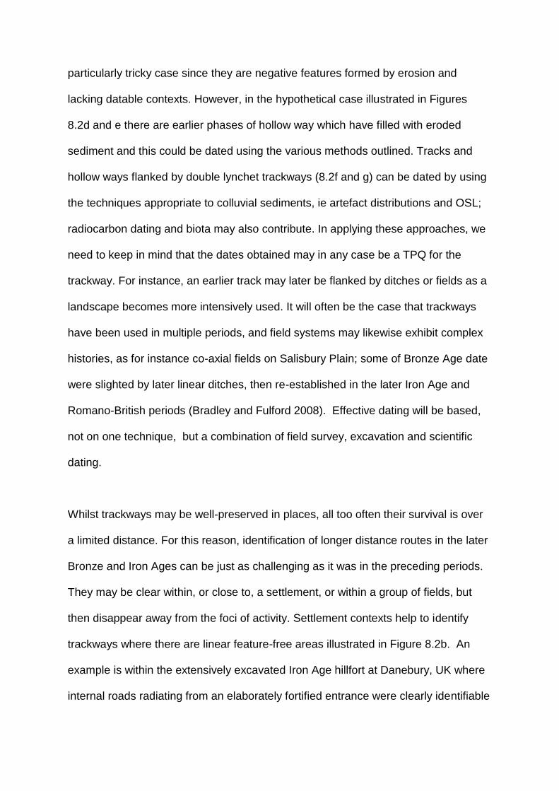
particularly tricky case since they are negative features formed by erosion and
lacking datable contexts. However, in the hypothetical case illustrated in Figures
8.2d and e there are earlier phases of hollow way which have filled with eroded
sediment and this could be dated using the various methods outlined. Tracks and
hollow ways flanked by double lynchet trackways (8.2f and g) can be dated by using
the techniques appropriate to colluvial sediments, ie artefact distributions and OSL;
radiocarbon dating and biota may also contribute. In applying these approaches, we
need to keep in mind that the dates obtained may in any case be a TPQ for the
trackway. For instance, an earlier track may later be flanked by ditches or fields as a
landscape becomes more intensively used. It will often be the case that trackways
have been used in multiple periods, and field systems may likewise exhibit complex
histories, as for instance co-axial fields on Salisbury Plain; some of Bronze Age date
were slighted by later linear ditches, then re-established in the later Iron Age and
Romano-British periods (Bradley and Fulford 2008). Effective dating will be based,
not on one technique, but a combination of field survey, excavation and scientific
dating.
Whilst trackways may be well-preserved in places, all too often their survival is over
a limited distance. For this reason, identification of longer distance routes in the later
Bronze and Iron Ages can be just as challenging as it was in the preceding periods.
They may be clear within, or close to, a settlement, or within a group of fields, but
then disappear away from the foci of activity. Settlement contexts help to identify
trackways where there are linear feature-free areas illustrated in Figure 8.2b. An
example is within the extensively excavated Iron Age hillfort at Danebury, UK where
internal roads radiating from an elaborately fortified entrance were clearly identifiable

from linear strips free of pits and structures (Cunliffe and Poole 1991, fig 4.1).
Outside the hillfort a route continues from the main entrance for some 2.3km marked
in part by a linear ditch which later formed part of a trackway (Palmer 1984). This
illustrates a case where, if we start in settlement context where routes are datable, it
is sometimes possible to project the evidence onto a wider landscape scale.
Agents of transformation: horses, carts and chariots
Horses, which were present in Pleistocene landscapes, are thought to have become
extinct in Britain in the early Holocene. They were domesticated in the Pontic
Caspian steppes c 4800 cal BC (Anthony 2007) and seem to have been introduced
to Britain much later in the middle Bronze Age c 1500 cal BC (Bendrey 2012;
Bendrey et al 2013). Antler cheek pieces suggest that horses were being ridden, and
winged sword chapes indicate mounted warriors from the 8th century BC in Britain.
Thus it was, from the final Bronze Age that the greater speed and distance facilitated
by horse riding transformed communication. That this is likely to have been of some
significance in the development of trackways is suggested by the effects of horse
introduction in the American North West c AD 1720 which brought about a marked
change in communication routes because it became easier to ride along ridge tops
and upland slopes than to traverse valley bottoms (Turner 2014, 207). Perhaps this
was a significant factor in the development of ridgeway routes in Europe?
In the context of the medieval period, Fleming (2010) has discussed the significance
of horse-borne communication as an instrument of elite control, identifying
characteristics of routes in Devon which he sees as associated with horse elites
(2012). In mid-Wales he identifies a long-distance route, the Monks Trod, which he

traced for 36.5km across the Cambrian Mountains linking Cistercian Abbeys. On
grounds of historical context he deduces that the route was probably established by
c AD 1170 (Fleming 2009a). A characteristic of the route adopted was that it
represented good going for horses with, in places, longer alternatives for use under
less favourable winter conditions. Just as Fleming shows communication by horse
was an important element of elite control in the medieval period, so the same
argument might be applied to the increased evidence of horse riding in the final
Bronze Age and Iron Age. This topic has barely been considered in Britain, although
an approach which could be adopted is demonstrated by a GIS based landscape
approach in Burgundy, France, which convincingly identified the routes of pre-
Roman roads linking hillforts (Madry and Crumley 1990; Crumley and Marquardt
1987).
A second transformative agent in communication is the wheeled vehicle. As we saw
in Chapter 6, wheels are more common and earlier in continental Europe. The
earliest surviving examples in Britain are middle and late Bronze Age. Cart burials
are known from the late Bronze Age in Europe and there are cart fittings of this date
from Heathery Burn, Yorkshire (Piggott 1983). Some 20 chariot burials are known
from the third and second centuries BC, all but two from the Arras culture of
Yorkshire (Stead 1979). There are recent finds of an earlier chariot, c 536-382 cal
BC, well to the north at Newbridge near Edinburgh (Carter et al 2010) and a very late
Iron Age example in Pembrokeshire (Dyfed Archaeological Trust pers. comm 2019).
Wheel ruts also point to the existence of vehicles in the late Bronze Age at Welland
Bank, Lincolnshire (Pryor 1988b, plate 11), and in the Iron Age and at Cherbury
hillfort and on a limestone causeway at Yarnton, both in Oxfordshire (Lambrick and

Robinson 2009). Wheeled vehicles would have increased erosion in hollow ways,
where deep wheel ruts are often seen. Mottershead et al (2008) employed a
geotechnical and geomorphological approach to demonstrate that deeply incised
and extensive cart ruts on soft limestone in Malta were produced by two wheeled
carts of gauge 1.4m. They formed at a time of active soil erosion but are essentially
undated. By the close of the Iron Age classical writers provide accounts of great
battles between Britains and Romans involving many chariots, a perhaps debatable,
figure of 4000 in the case of the Iron Age leader Cassivellaunus (Piggott 1983). A
single farm site at Gussage-All-Saints, Dorset produced moulds from the casting of
an estimated 50 sets of chariot fittings (Foster 1980). If the Cassivellaunus figure is
anywhere near numerical accuracy it has major implications for the later Iron Age,
both in terms of the availability of horse transport and the existence of viable
routeways along which large numbers of vehicles could be marshalled (Spratling
1979, 149).
Hollow ways
Hollow ways (Figure 1.7) have fascinated many writers who recognise them as
ancient routes, their origins lost perhaps in the mist of time. Some have totally gone
out of use and represent lost ways of life. One such abandoned way was chosen by
Geoffrey Household (1939) as the hiding place for a fictional fugitive in Rogue Male.
That mysterious place so fascinated the writers Roger Deacon and Robert
Macfarlane that they went in search of the track of Household’s inspiration and found
it in the Chideock valley in Devon (Macfarlane et al 2012). A question to be
addressed in this chapter and the next is whether hollow ways are condemned to

being places of perpetual mystery, or whether we can find ways of investigating their
origins. There are positive signs because increasingly hollow ways are exciting
interest from a range of disciplines and internationally. Their study occupies a fertile
interface between landscape archaeology and geomorphology. Even so, there are
significant challenges, especially in terms of dating, due to their erosive origins.
On bedrocks which were particularly erodible such as chalk, limestone, sandstones
and loess, hollow ways can be deeply incised leaving a significant mark on local
topography. Frequently, as one route became deeply gullied, or muddy, alternative
routes were adopted, so that one finds a cluster of parallel hollow ways descending
steeper escarpment slopes (Figure 8.5). They can act as channels for temporary
streams and eroded soil from arable fields during high rainfall events, as Boardman
(2013; 2014) has demonstrated for some particularly deeply-incised hollow ways in
the Rother valley, Sussex, which now act as drainage channels in storms.
Interest in these features is developing in several parts of Europe. In Denmark,
where routeways on lowland plateaus descend steeper slopes into valleys, there are
fine examples, such as those illustrated at Broskov on Zeeland in Figure 6.5, where
the multiple ways are both integral with a field system on the plateau and lead to
successive excavated causeways across the valley (Kunwald 1962). Similarly, at
Kilen in Jutland and elsewhere, Bang (2013) has used LiDAR to document multiple
hollow ways in the form of deep V-shaped incisions in the plateau edge representing
routes down to river crossing places. Several examples in Sweden are illustrated by
Westerdahl (2006), some converging on river crossings. In the Ljubljana marshes of
Slovenia, Cresnar (2016) has identified multiple hollow ways around the wetland

basin, one leading to a crossing place of the wetland where there is evidence of
Bronze Age ritual deposition. Although the hollow ways themselves are undated,
some examples go through the entrances of Iron Age sites. Where areas of
European loess support ancient forests, such as the Meeerdaal Forest in Belgium,
Holocene erosion gullies are preserved; some are hollow ways and their distribution
relates to sites of the Iron Age and Roman period (Vanwelleghem et al 2003; 2006).
It is also probable that earlier routeways determined the location of some of the
large-scale erosion gullies which have been documented by Bork et al (1998) on the
Central European loess. It follows from this that disentangling the role of routeways
and large-scale gullying may, more often than imagined, require a combined
geomorphological and archaeological approach. On the loess of eastern Austria
there are deeply-incised hollow ways (Wiesbauer and Zettel 2014). They are
mapped historically and the assumption has tended to be that they date to the
Middle Ages. However, Lidar survey of these wooded landscapes has provided a
fuller picture of their distribution and relationship to sites, demonstrating that some
ways lead to Iron Age hillforts (Doneus et al 2011).
Coaxial fields and tracks in moorland
During the later Bronze Age extensive systems of fields, some coaxial, were
established in areas of Britain. There is also increasing evidence for coaxial fields on
the continental side of the English Channel (Bradley et al 2015). The coaxial plan
has one clearly defined long main axis, formed by parallel boundaries, from which
fields are divided on a secondary axis at right angles, rather like the face of a brick
wall. Figure 8.6a shows a part of the extensively preserved coaxial fields on the
moorland edge Dartmoor. Such systems are often terrain oblivious, ie the main axis

does not follow topography (Fleming 1988, 112). This is opposed to aggregate field
layouts characterised by more piecemeal development.
The fringes of Dartmoor exhibit the most extensive survivals of prehistoric fields in
Europe; they were discovered and extensively investigated by Fleming (1988), with
recent survey by Newman (2011). Extensive surveys of past field systems have also
taken place on Bodmin Moor (Johnson and Rose 1994) and west Penwith (Herring
et al 2016). Moorlands are today areas of open and rough grazing with
impoverished, acidic soils on the higher and wetter parts on which peat has
accumulated. Soil acidification followed the loss of woodland, but in the middle
Bronze Age the moors were less marginal than today and more intensively used. In
the moors, above the present-day limits of farming, low stone banks form parallel
coaxial systems with a terminal reave (stone bank) at the moorland edges (Figure
8.6a). The parallel reaves are divided to varying extents by cross banks which define
smaller fields and enclosures, particularly around hut circles which are in
neighbourhood groups, as illustrated by the example on Holne Moor (Figure 8.6a).
The reaves were originally constructed c 1700 cal BC and appear to have mainly
gone out of use by the end of the Bronze Age c 800 cal BC, when climate
deterioration may have contributed to a reduction of the intensity of land use. It is
clear from the palaeoenvironmental evidence that the reaves relate to an open
environment which was mainly used for pasture, indeed footprints of cattle and
sheep in a reave ditch on Shaugh Moor were noted in Chapter 4. There was some
small-scale arable activity attested by pollen analysis and lynchet accumulations
against some reaves (Balaam et al 1982).

Despite the extensive traces of prehistoric fields of coaxial form on moorlands, they
seldom exhibit the clear evidence of multiple parallel tracks noted below in lowland
contexts. The moorland tracks which are visible have not been a major theme in
previous surveys which focus more on the fields. Lengths of parallel walls frequently
occur, particularly in relation to hut circles representing settlements, but they are
often frustratingly short lengths. Occasionally longer lengths of track represented by
double walls can be identified. An example highlighted on Figure 8.6a running west-
east (A-B) is roughly parallel to the Venford Terminal Reave which was the edge of
the open moor in the Bronze Age. Other shorter lengths of parallel walls at right
angles to the Venford Reave probably represent tracks from settlement clusters to
the open moor. A rather longer track leading from settlement huts to the open moor
is illustrated on Throwleigh Common, where short tracks, also leading to earlier
positions of the moorland edge, are highlighted (Figure 8.6b). Beyond the parallel
reave system on open moorland other reaves along watersheds define great tracts
of grazing on the open moor, for instance in the Plym valley, where, beyond the
coaxial reaves, there are many enclosures and hut circles (Balaam et al 1982). It
seems probable that these related to seasonal grazing. Seasonal transhumance
characterised Dartmoor in the Medieval period (Fox 2012). The multiple moorland
fringe routes associated with this practice were called by Fox ‘multiflex routes’.
Fleming (2012) has established that some of the lanes used as transhumance routes
go back at least to the immediately post-Roman period, since there are inscribed
stones of that date on the routes. This has also been demonstrated in West Penwith,
Cornwall where parts of today’s landscape of irregular small curved fields can be
shown to originate at least as early as the Romano-British period (Herring et al
2017). Probably later in origin are the Trods, or narrow flagstone paths, on the North

York Moors (Evans 2008). Some lead to bridges of known medieval origin, some
have monastic associations and one leads to a monastic grange; others have a
relationship to Post-medieval markets. In their present form most seem likely to be
medieval or later but the possibility that some formalise earlier routes should be
considered.
Yorkshire Wolds
Air photography on the chalk landscapes of the Yorkshire Wolds has revealed very
extensive evidence of prehistoric landscapes in which it is possible to trace early
routeways over greater distances than in most other areas (Stoertz 1997). Extensive
excavations in advance of quarrying have also contributed significantly to the
understanding of landscape history of this area. Figure 8.7a shows part of this
landscape. A linear feature, which can be traced for more than 12km, approximately
follows the 100m contour at the boundary between lowland to the south, which is
closely divided by many ditches and fields, and, to the north, open upland grazing
with some linear ditch divisions. The form of the long linear feature in places is
clearly that of a trackway, indicating that at some stages in its life it was a significant
routeway. It was followed by later linear boundary ditches c 1000 BC (Fenton-
Thomas 2005); this is the type of sequence which is illustrated in Figure 8.2i. Other
stretches appear more like a linear boundary ditch, demonstrating a rather
ambiguous relationship between tracks and linear ditches, which is seen elsewhere,
for instance at Danebury and other Wessex sites (Palmer 1984; Bradley et al 1994).
Less ambiguity attaches to a trackway which winds from south-east to north-west for
7.5km. Early origins are suggested by a band of Neolithic and Bronze Age barrows

along this line. By the Iron Age it is delimited in part by double ditches with land
allotment boundaries laid out at right angles. The track delimits the extensive middle
Iron Age cemeteries at Garton Slack and Wetwang Slack, the latter encroaching in
places on its line (Figure 8.7b; Dent 1982). Notable in both cemeteries is the
occurrence of cart burials dated c 450-200 BC (Figure 8.7 d) providing evidence of
the vehicles which used these routeways. Perhaps it is not by chance that some of
the longest clearly traceable prehistoric routeways in the British Isles are so closely
associated with the very localised distribution of Iron Age cart burials of the Arras
culture (Stead 1979, fig 9). It also indicates a relationship between mobility and
status in the Iron Age of this specific area (Giles 2012). On the eastern side of
Figure 8.7a there are a series of shorter parallel trackways running through enclosed
settlement and field areas towards the higher ground, perhaps associated with the
seasonal movement of animals from enclosed lowland to open upland grazing.
Droving practices are further attested by funnel-shaped entrances leading to
trackways, as illustrated by Figure 8.7c.
Coaxial fields and droveways in lowland Britain
Drawing on a wealth of evidence from developer-funded excavations, Yates (2007)
has demonstrated that later Bronze Age coaxial fields are widespread in lowland
areas along the Thames Valley, in coastal areas flanking the Thames Estuary and
along the south coast of England. Yates has shown convincingly that these lowland
fields are associated with intensive animal husbandry. Where excavation has been
on some scale, droveways often lie between fields and are flanked by ditches. Often
the droveways are aligned towards rivers such as the Thames, suggesting that
animals were being driven down to seasonal pasture on the floodplain and

saltmarshes. Gravel causeways and wood trackways carried routes of this type onto
the wetland itself (Meddens 1996). An important example of coaxial fields at Fengate
dated to the earlier Bronze Age has been discussed above, in the context of dryland-
wetland communication routes (Figure 6.10). An example of aligned droveways was
found at South Hornchurch, Essex where a droveway flanked by fields is beside a
late Bronze Age ringwork of the eighth to ninth century BC (Guttman and Last 2000).
The scale of these Bronze Age field systems is apparent from the very extensive
excavation of an area 1.3 by 1km in advance of construction of Terminal 5 at
Heathrow Airport, London (Lewis et al 2010). Here 12 trackways were identified, the
most prominent seven were oriented north-south, and spaced at intervals of between
270m and 100m. The trackways formed the main axis of an extensive area of coaxial
fields (Figure 8.8). Twelve farmsteads lay within the fields and there were 48
watering holes, which are very much a feature of the Thames valley fields, and,
together with environmental evidence, such as dung beetles and pollen, these
strengthen the view that the landscape was mainly associated with animal
husbandry. The river Thames is 2km south of this site and it is probable that animals
were being driven down to floodplain pastures, just as has been suggested at
Fengate and sites in the Severn Estuary (Chapter 6).
Survival of co-axial field systems
There is also evidence for extensive coaxial field systems surviving in some areas in
the pattern of fields today. Whether some of these originate in the previously
described coaxials of the later Bronze and Iron Ages remains to be established. One
of the clearest examples of surviving coaxials is in the Scole-Dickleburgh area of
East Anglia where a landscape of fields and tracks documented from early maps

appears to be cut across by the Roman road from Colchester to Norwich (Williamson
1987). Environmental evidence from the adjoining Diss Mere indicates extensive
clearance and agriculture from the Iron Age (Peglar 1993). In the Lea Valley,
Hertfordshire coaxial fields are bounded by long east-west tracks running down to
the River Lea and predating Roman Ermine Street. Excavation of a ditch suggested
the system originated in the pre-Roman period (Figure 8.4c; Bryant et al 2005).
Identification of a coaxial pattern of roads and tracks on the Chiltern Hills (Bull 1993)
may have early origins as suggested by the discovery of an Iron Age track at Aston
Clinton below a later parish boundary (Lambrick and Robinson 2009). At Shapwick,
Somerset the boundary of a surviving coaxial field system was shown to directly
overlie medieval, Roman and Bronze Age ditches (Aston and Gerrard 2013). Whilst
not directly related to documented coaxial systems, parallel droves have been
mapped connecting the chalk downs and lowland in south east Hertfordshire and
Cambridgeshire (Harrison 2003) and extensively in the Wealden landscape
investigated as a case study in Chapter 9. The first detailed synthesis of the extent
to which Romano-British field orientations survived into recent landscapes came to
the very significant conclusion that 64% of the excavated Romano-British field
systems studied shared a common orientation with medieval landscapes, though the
proportion varied regionally (Rippon et al 2015). Furthermore, pollen analysis
showed that the oft postulated abandonment of agricultural land and woodland
regeneration at the end of the Roman period was far less than generally assumed, in
the south east of England, attested by only a 5-6% increase in woodland.
To date, discourse about coaxial landscapes has been largely framed around the
fields themselves, but there are signs of an emerging view that it is not so much the

individual fields that demonstrate continuity, as the systems of parallel droveways
connecting environmental zones which are the key to landscape structuration
(Williamson 2008). Within these patterns some individual field boundaries show
continuity and there are others which clearly do not (Rippon et al 2015). What is
emerging as controversial is the extent to which continuity of tracks and fields may
be interpreted in terms of social continuity of land-use practices, such as common
property rights, commons and field system organisation, for which Oosthuizen (2011;
2013) has argued. Rippon et al (2015, 320) do not accept the arguments for long-
term continuity of social practices. It could be argued that the existence of bands of
landscape offering complementary resources, connected by droveways, in places
deeply incised as hollow ways, created structures within which similar practices of
resource connectivity and lesser transhumance might have been practised, whether
or not there was any actual continuity in the social arrangements which articulated
these practices.
Ridgeways
This brings us to perhaps the most contentious topic in the study of prehistoric
routeways, the so-called ridgeways. These are supposed routes along the crests of
escarpments and ridges, particularly those of chalk and limestone, in lowland
England. They were regarded by early prehistorians as routeways. Some were
marked on the Ordnance Survey maps of Iron Age and Roman Britain (Ordnance
Survey 1956; 1962) on the basis that they were ‘natural routes’ marked by
concentrations of sites (Figure 8.1). Those marked were: the Wiltshire/ Oxfordshire
Ridgeway and its continuation into East Anglia to the Wash as the Icknield Way; the
North Downs Way to Dover; the Jurassic Way, shown as running from the Cotswold

Hills to the Humber; and a route called the High Street along the Lincolnshire Wolds.
Many of these are now long-distance walking paths of great recreational importance.
In Chapter 1 it was emphasised that routeways play a seminal role in how people
encounter and perceive particular landscapes, so it follows that the long-distance
ridgeway paths are an important aspect of a twenty-first century walker’s encounters
with landscape, whatever the history of their origins. Many have acquired a sort of
iconic status providing a veneer of great antiquity and were beloved by many of the
landscape writers celebrated in Chapter 1. The poet Edward Thomas (1916) wrote
on the Icknield Way. Stroud (2017) has described the magnetic attraction of the
Oxfordshire Ridgeway and its Uffington White Horse. Hilaire Belloc (1904) wrote
lyrically of the North Downs Way; illustrations in his book include a map of six
ridgeways which in a very general way he saw as converging on Stonehenge. Their
assumed prehistoric origins are, however, open to debate. Sherratt (1996) regarded
them as a myth, proposing instead the significance of riverine transport, a theme
returned to in Chapter 9.
A key factor which originally led to their identification as routes was that they seemed
to be associated with concentrations of prehistoric monuments such as barrows,
hillforts and other settlements along the ridges. At the time it was assumed that the
lowlands and clay vales remained wooded and impenetrable. The situation changed
when air photography, and increased archaeological survey and excavation,
demonstrated there were equally dense concentrations of barrows, prehistoric ritual
sites and settlements in the surrounding lowlands, such as the Thames valley north
of the Oxfordshire Ridgeway (Hey et al 2011). Grimes (1951) discussed the Jurassic
Way across England from Mendip to the Humber but frankly does not produce any

convincing evidence for its former existence. Taylor (1979) showed that the part of
that route which crosses Northamptonshire was neither a ‘natural’ route, since it is
crossed by multiple wet valleys, nor one that was associated with a particular
concentration of prehistoric sites, once the many newly discovered sites in the
lowlands and valleys were taken into account; consequently, the existence of the
Jurassic Way in prehistory seems especially questionable.
Where we have environmental evidence from barrows, both long (Neolithic) and
round (mainly Bronze Age), they were constructed in open short grassland
environments with little evidence for scrub and woodland (Evans 1972). For such an
environment to have been maintained, active grazing must have occurred. Thus,
environmental evidence strongly supports Fleming’s (1971) view of the ridge crests
as upland pasture and it seems reasonable to infer that concentrations of barrows
are found in ancestral grazing lands.
Case Study: The Wiltshire and Oxfordshire Ridgeway
Two recent landscape archaeology projects have contributed to an understanding of
the history of the Ridgeway: one in Oxfordshire, the other in Wiltshire. The
Oxfordshire project was focused on the Iron Age hillfort of Uffington Castle which is
right next to the present Ridgeway as Figure 8.9a shows (Miles et al 2003). Two
kilometres west of Uffington, beside the Ridgeway, is the Neolithic tomb at
Wayland’s Smithy (Figure 9c), which has often been cited as evidence for the route’s
early origins. Dominating the Vale below the escarpment and just 160m from the
hillfort is the giant hill figure of the White Horse of Uffington which OSL dating

showed originated in the late Bronze, or early Iron Age (Miles et al 2003). The hillfort
originally had two opposed entrances, so any route along this line may have passed
through that axis; however, one entrance was blocked c 400BC. The landscape
south of the escarpment is dissected by a series of north-south dry valleys with the
result that the Ridgeway can be seen as a ‘natural route’. Acceptance of the
Ridgeway as a route gains support from computer modelling of least-effort paths of
movement, which did nonetheless involve certain assumptions about sticking to
higher ground (Bell and Lock 2000). The computer model shows that the least cost
path passes through three of the four hillforts on the ridge and within 80m of the
fourth, that at Uffington Castle.
However, early origins for the Ridgeway are called into question by a linear ditch of
probable later Bronze Age date which runs up to the hillfort from the south at right
angles to the Ridgeway (Figure 8.9a). Excavation showed that the ditch was infilled
by the Romano-British period and that the present Ridgeway, which crosses it here,
is not earlier than this date (Miles et al 2003). The project concluded that there was
no certain evidence for the prehistoric origins of the Ridgeway; however, a route
could have taken somewhat different line in some periods, eg through the hillfort, or
to its north. Other prominent features of this landscape are the hollow ways, which
descend the steep escarpment and form north / south routes to the clay vale below;
these are undated. Multi-isotope studies of herbivore teeth from sites on the
Ridgeway and the clay vale to the north demonstrate that sheep were mainly raised
on the chalk, whilst cattle spent their first two or three years in the isotopically-distinct
vale but subsequently spent time on the chalk (Schulting et al 2019). That could be

consistent with a model of seasonal movement of older cattle up the hollow ways to
the downs in summer but if so they were not accompanied by sheep.
One hollow way curves round the slope behind the back and tail of the White Horse
(Figure 8.9b) raising the intriguing possibility that what inspired the horse image were
the curving lines of an early chalky hollow way showing up against the green of the
escarpment. Either way, the horse symbolism is highly significant given the
transformative effect of horse riding in facilitating far greater mobility from the late
Bronze Age. It has furthermore been proposed by Pollard (2017) that the white
horse, which is clearly running from east to west, reflects the mobility-related sun
horse imagery, depicted on razors and rock art, which is such a feature of Bronze
Age Scandinavian cosmology (Chapter 9).
The second project which has proved important for an understanding of the
Ridgeway is on Overton Down, Wiltshire. Here the Ridgeway runs along the top of
the escarpment 1.7km east of the great late Neolithic henge at Avebury (Figure 5.5).
A detailed survey based on air photographs of the field systems and settlements of
Overton and Fyfield Down, and selected excavation of settlements and fields, though
not the Ridgeway itself, enables the Ridgeway to be seen in the context of its wider
landscape (Fowler 2000; Fowler and Blackwell 1998). The Sanctuary on Overton Hill
lies beside the Ridgeway and along it running north for 800m is a line of barrows.
However, detailed mapping of the early landscape shows that the present Ridgeway
line overlies ‘Celtic’ fields and must have been established after these went out of
use in about the fifth century AD. The present line appears to have been established
by about the tenth century AD when the Ridgeway formed the boundary of several

parishes. Four kilometres to the south of Overton the Ridgeway was in existence
when the long distance defensive dyke, Wansdyke, was laid out in the post-Roman
period (5th to 10th centuries AD), because there is a defended gateway in the Dyke
where the Ridgeway crosses at right angles (Fowler 2000; Reynolds and Langlands
2011). The Ridgeway as currently defined does not accord with the track systems of
the prehistoric and Romano-British landscape which Fowler (1998; 2000) identified,
at Overton and Fyfield, but he argues that rather than one ridgeway route, landscape
analysis reveals multiple, roughly parallel routes forming an axis of movement. He
suggests that this is of at least Romano-British date and probably had its origins in
later prehistory with the seasonal movement of animals from the lowland to the south
up to the high downland in summer (Fowler 1998).
The relationship between the Ridgeway and the great Neolithic Henges remains
enigmatic. The West Kennet Avenue (Figure 5.5) leads from Avebury to the
Sanctuary on the present ridgeway, but there is no obvious connection (eg entrance)
linking the two. The east entrance to Avebury leads up the Herepath crossing the
Ridgeway and continuing along the north flank of the Kennet Valley. The great
sarsens used to construct Avebury are likely to have travelled down this route from
Fyfield Down where the greatest concentration of sarsens is found today. It has also
been assumed that the sarsen stones used at Stonehenge may have come from the
Overton and Fyfield areas. If so, they are likely to have been transported 30km south
along a continuation of the Ridgeway across the Vale of Pewsey to Salisbury Plain.
Figure 8.5 shows one of two places where multiple incised hollow ways descend into
the Vale of Pewsey in the general direction of Stonehenge. The other hollow way

route descends from a prominent col between the Neolithic tomb of Adam’s Grave
and the causewayed enclosure on Knap Hill.
The Icknield Way
The Wiltshire-Oxfordshire Ridgeway continues east through Buckinghamshire,
Cambridgeshire and into East Anglia as the Icknield Way, a name sometimes
applied to the entire route. Together the Ridgeway and the Icknield Way are
probably Britain’s most widely acknowledged ‘prehistoric’ route. Fox (1923)
described it as a superb ‘natural’ routeway with many barrows and other
archaeological sites along its line. Today, however, it is appreciated that
archaeological sites are also very abundant in the surrounding lowlands, for example
along the Fen edge to the north (Taylor 1979, fig 17). In Norfolk the Icknield Way
runs to the east of the Fenland; it is paralleled by another route, the Pedders Way,
which was a road in the Roman period (Figure 8.10a). Neither has been the subject
of very detailed field investigation. The Icknield Way and Pedders Way converge on
the North Norfolk coast close to Holne-next-the-Sea which is a natural crossing point
by sea over the Wash (Figure 8.1). At Holne two circular wood structures known as
‘sea henges’, together with trackways and other wood structures, have been
revealed by coastal erosion on the foreshore (Figure 8.10b). Both are dated
dendrochronologically to 2049 BC (Brennand and Taylor 2003; Robertson 2016).
The henges were erected in a saltmarsh environment. It seems possible that the
location of the sea henges reflects the landward end of a significant routeway, but
whether this represents the long-distance route envisaged by previous generations,
or a more localised route is open to question.

Recent writers have grown more sceptical of the Icknield Way’s prehistoric reality. In
Buckinghamshire cross dykes of the first millennium BC cut across the ridge (Bryant
and Burleigh 1995). In Cambridgeshire the bundle of Ridgeway routes seem to
postdate apparently defensive dykes of the Post-Roman period and Harrison (2003)
calls into question the very existence of a long distance route in prehistory. Post-
medieval maps suggest an escarpment foot route of the Icknield Way was at that
time more significant and at Aston Clinton that route has been shown by excavation
to postdate features of Iron Age to Anglo-Saxon date.
The origins of Roman roads in Britain
The Roman roads of Britain were comprehensively reviewed in a pioneering study by
Margary (1955). They were mapped on the Ordnance Survey Map of Roman Britain
(1956) and the network is constantly being extended by new discoveries. They are
one aspect of past routeways which has long been the subject of quite lively
archaeological research, in contrast to prehistoric routes. Roman roads are readily
recognisable since they run more or less straight between towns and other sites, are
generally flanked by ditches and have well-constructed metalled surfaces. The more
important routes are described in written sources: the Antonine Itinerary, the Tabula
Peutingeriana and the Ravenna Cosmology (Jones and Mattingly 1990). The general
assumption is that they represent a radical, efficient and entirely new imposition on
the British landscape, an imposed system of elite control.

Roman roads themselves are outside the prehistoric scope of this book but a
pertinent aspect, which has received little attention, concerns the extent to which
some of those routes may have appropriated pre-Roman antecedents. Bishop
(2014) in reviewing the Roman roads of Britain argues that although we know
virtually nothing of the pre-Roman road network, it is inherently likely that the
invading Romans made at least some use of existing routes on arrival. The last two
decades of research have been notable in demonstrating the extent to which some
of the trappings of a Roman way of life were introduced as a result of contact and
trade in the century before the conquest in AD 43 (eg Creighton 2005). Oppida
settlements developed and were defended by systems of ditches. Excavations have
revealed that within the oppidum at Silchester a system of laid roads and buildings
was established from the last two decades BC (Fulford 2012). A series of oppida
existed in lowland Britain and, given the importance of trade and continental contact
in the genesis of these sites, it seems probable that they would have been
connected by roads which are likely to have been on a similar line to the Roman
roads which connected towns that developed from oppida. The dykes round the
Silchester oppidum seem to have had entrances in the same position as the later
Roman gates, suggesting roads radiating in the same directions. A late Iron Age
mirror burial dated 75-25 BC 2km south of Silchester (Fulford and Creighton 1998)
lies close to the point where roads to Winchester and Chichester, both pre-Roman
foundations, diverged. At the Winchester end of one of these roads, 48km to the
south west, the Roman road enters the town through an entrance which was also
that of the Iron Age defended site of Orams Arbour which was on a different plan to
the Roman town (Cunliffe 1965). Within Orams Arbour a hollow way has been
excavated linking this entrance to another. It is argued that the site originated in the

middle Iron Age to control a network of routes at a point where there was a river
crossing (Ford and Teague 2011; Ottaway 2017).
The Roman road between Colchester and Verulamium, which both originated as Iron
Age oppida and became Roman towns, has been argued to be a development of a
late Iron Age route (Witcher 1998). Copeland (2009) reviewed this question in the
case of the Roman Akeman Street between the late Iron Age oppida at Verulamium
and Bagendon but without identifying any conclusive evidence that the road had Iron
Age origins. Roman roads also meet at Iron Age hillforts, at Badbury Rings and Old
Sarum, suggesting the possibility of earlier origins (Bishop 2014). Rackham (1986)
advocates a pre-Roman origin for many routes in areas of ancient British
countryside, in support of which he draws particular attention to Wool Street which,
close to Cambridge, is a typical Roman road, whereas 14km out it no longer has a
typically Roman form and its route is less direct; this, he maintains, is suggestive of
an earlier route, only part of which was adopted and improved by the Romans. In
cases where the end points of a late Iron Age road appear to be known it should not
be impossible to identify by survey or excavation traces of an early route between
them.
Evidence for the pre-Roman origins of a Roman road is most clearly demonstrated
by excavation in advance of quarrying at Sharpstone, west of Wroxeter Roman town
(Malim and Hayes 2010). Several phases of earlier tracks were dated using a
combination of radiocarbon, Optically Stimulated Luminescence and Bayesian
statistical analysis of the stratified dated sequence (Figure 8.11). The phases of road
construction in the last two centuries of the Iron Age from about 200 cal BC involved

initially brushwood and later sand, pebbles and gravel. The Iron Age road was
straight, had been carefully engineered and was well maintained. Phases of road
construction were interleaved with colluvial sediments. On the surface of one phase
were wheel ruts, and another phase had spherulite particles indicative of herbivore
dung and dung beetles, indicating that animals were moved along the route. Cattle
footprints below the earliest brushwood phase indicated it originated with animal
droving. An underlying post was dated to the Bronze Age suggests the possibility of
still earlier origins.
Whilst Sharpstone was perhaps unexpected in terms of its remoteness from the
main late Iron Age elite centres, there is evidence that it is not an isolated example.
In this and earlier chapters we have identified several cases where earlier routes
appear to be succeeded by Roman roads. In some cases, these may justifiably be
described as ‘natural’ routes, because they are by far the most suitable way to
access an area. One example is the Roman road linking forts up the Usk Valley,
Wales which we have suggested originated as a Neolithic route (Figure 5.2). The
presence of Roman forts also carries with it the implication that it was also a
significant route in the Iron Age. Another example is the main east-west Roman
road across upland in north Wales at Tal-y-fan which follows a route marked by
Bronze Age monuments (Figure 7.4). There is also the Roman Fen Causeway which
crosses the Flag Fen embayment at the same natural crossing point as the Flag Fen
late Bronze and Iron Age post alignment (Figure 6.10). Other examples are less
obviously ‘natural’ routes. A Roman road descending the North Downs escarpment
at Whitehorse Stone has been argued to be on the same alignment as a probable
Neolithic route (Figure 10.11).

Conclusions
With the appearance of extensive agricultural landscapes of fields and settlement in
the middle Bronze Age evidence for trackways becomes far more extensive. So
much so that in this chapter we have had to focus down and concentrate on the
evidence from Britain with only occasional references to elsewhere in Europe. The
various ways in which trackways may be preserved, recognised and dated in relation
to fields have been identified. The potential transformative effects on routeways of
the horse and wheel have been suggested but this is a topic awaiting investigation in
prehistory. Two types of routeway have been given special emphasis in this chapter.
One is the hollow way, important because once deeply incised they are virtually
permanent features of the landscape and are likely to have influenced subsequent
long-term human mobility. The second main topic has been coaxial field systems
which in lowland and river valley areas provide evidence for multiple parallel routes
linking areas of contrasting landscape. These survive in the present-day landscape
and some may have had prehistoric origins.
As for the Ridgeways, on which archaeologists pinned their faith for generations, we
have seen there is surprisingly little evidence of prehistoric use. Burials and historical
sources show that some, such as the Wiltshire-Oxfordshire Ridgeway and the
Pilgrims Way in Kent were established routes by mid-Saxon times (Reynolds and
Langlands 2011). Notwithstanding these uncertainties there remain grounds for
anticipating longer distance routes from at least the later Bronze Age, as the
evidence for wetland causeways / bridges discussed in Chapter 6 suggests.
Evidence for wheeled vehicles from the late Bronze Age and Iron Age strengthens

that inference. However, to date there is surprisingly little evidence for prehistoric
routes covering any distance in Britain, compared with the evidence reviewed in
Chapter 7 from the Netherlands, North Germany and Denmark. That this is a
puzzling conundrum is highlighted by growing evidence for the movement of
artefacts, people and animals, the last two especially attested by recent isotopic
evidence. The next chapter argues that riverine and maritime communication
provides a partial solution to this conundrum.

Making ones Way in the World Revised 3.7.19 Words 8098
Chapter 9
Maritime and riverine connectivity and
the allure of the exotic.
Introduction
Preceding chapters have found limited evidence for long-distance prehistoric
communication routes on dryland, particularly in the British Isles. Long accepted
prehistoric origins for the ridgeways have been shown to be limited and
questionable. Thus far the focus has been on movement and routes in terrestrial
landscapes, but that is only part of the story. Terrestrial routes will have been linked
by boat on rivers and the sea and may often only make sense when considered in
that wider context. In some areas, and during some periods, it is likely that most
journeys were by water. Archaeologists have tended to treat movement on land and
by water as separate specialist categories whereas the two must often have been
complementary as Westerdahl (2006) has argued in a Scandinavian context. Most
early journeys would have been along the coast and people would have navigated
using many of the markers which we considered in a terrestrial context: cairns,
standing stones, local clearings, modified trees; all, along with natural features, are
likely to have played a part and connected maritime with terrestrial routes.
The purpose of this chapter is to complete the story by highlighting the
complementary role of transport by water. The comparatively brief treatment here is
justified in two ways. Firstly, in relation to riverine transport, although many log boats
are known, there has been comparatively little synthetic treatment of the role which
rivers and lakes played in movement. This is a challenging topic beyond the scope of

this book. However, one or two case studies provide pointers to possible ways
forward. Secondly, in relation to maritime transport, the situation is almost the
opposite; there has been much recent research and synthesis which has advanced
understanding significantly, so what is required here is to signpost this work and
consider how it may have linked to patterns of riverine and terrestrial movement.
The advantages of water in facilitating rapid movement over distance are evident;
however, such practical issues are not the only reasons prehistoric communities
were interested in watery places. They were also sometimes places of ritual and
symbolic significance, liminal places where ritual deposition took place in many
periods from the Mesolithic to the Iron Age and later. Certain rivers are particularly
associated with the deposition of selected artefact types such as weapons and also
human skulls, as for instance in the Thames during the Bronze Age and Iron Age
(Bradley 1990; 2016). The deposition of metalwork in association with bridge and
trackway crossing places has already been noted in the context of Flag Fen and
several similar sites in the UK and La Tène in Switzerland (Chapter 6; Schulting and
Bradley 2013). On the Atlantic fringe and the Baltic travel by sea was the connecting
factor. In much of continental Europe the major river arteries such as the Danube
and the Rhine would have served as the main conduits. Thus there is a need to
extend recent advances in the understanding of maritime connectivity to riverine
environments.
Riverine transport
Riverine movement is not particularly easy to identify. We have to consider the
character of the river and its suitability for transport at relevant periods in the past.

Many channels may have been very different prior to the human modifications in
recent centuries. Increasingly their past character can be reconstructed using
geoarchaeological techniques (Brown 1997). We can be reasonably confident of the
major rivers being navigable at most times, whilst minor rivers may only have been
seasonally navigable. In some cases it may be the river valley itself which acted as
corridors of movement rather than riverine transport. Where drainage was disrupted
by the effects of glaciation, or the activities of beavers (Coles 2006), extensive early
Holocene water bodies would have facilitated local movement, although, in the more
minor rivers and streams, beaver dams may have blocked routes, so that easily
carried lightweight canoes were more suitable than dugouts fashioned from trees.
There are finds of dug-out canoes demonstrating water transport but only rare
occurrences of artefacts in them providing evidence for their purpose, or where they
came from.
This highlights the importance of making the connection between dry ground and
wetland landscapes. Such links have been most effectively demonstrated in the
Stonehenge landscape, as discussed in Chapter 5. The Avenue at Stonehenge
leads down to the river Avon leaving no doubt about the relationship here between a
route and riverine movement. This case has been significantly strengthened by the
recent discovery of a short avenue leading from the entrance to Durrington Walls
henge down to the same river. It has generally been considered that the bluestones
at Stonehenge completed their journey from west Wales on the Wiltshire River Avon;
the much larger sarsen trilithon stones could also have completed their journey from
the Marlborough Downs on the same river. Both journeys would also have involved
overland tracts and, in the case of the bluestones, transport by sea, probably up the
Bristol Channel, then the Bristol River Avon as the least risky route (Parker Pearson
2012).
The recent evidence from the Stonehenge landscape demonstrates the perspicacity
of an earlier paper by Sherratt (1996) which encouraged prehistorians to consider
the role of rivers as arteries of communication in prehistory. Sherratt argued that the
rivers were much more important than the ridgeways which archaeologists had
previously emphasised, but which he regarded as a myth. Sherratt particularly
emphasised the role of the Wiltshire and Bristol Avon rivers in providing a key
communication route across southern Britain. He also suggested that both rivers
may share the name Avon, the Celtic word for river, because the corridor that they
together provide was seen as part of one conceptual entity. Coles (1994) has
extended this argument by proposing that other river names such as Trent and
Tarrent, also of Celtic derivation, may point to their role as routes in later prehistory;
several such names occur on the Avon/ Severn route. The distribution of amber
artefacts of early Bronze Age date particularly highlights the key role of maritime
connections into the Poole Harbour area and riverine transport up the Wiltshire Avon
to Stonehenge (Figure 9.5).
Log boats
Many types of boat will have proved suitable for river and lake transport under
certain conditions. Log, hide and bark boats can be inferred to have been used in the
Mesolithic and Neolithic periods, though only log boats are represented in the
prehistoric archaeological record and these are likely to have been used principally
for riverine and lacustrine travel, as indeed the findspots of most examples indicate

(McGrail 1978; Mowat 1996; Gregory 1997). More sophisticated forms extended, or
improved, the shape with separate fitted transoms, bows and plank extensions at the
side to create larger, more complex craft. A database of European log boats
compiled by Arnold (1995; 1996) comprises some 2400 examples. Many are old
discoveries of the nineteenth and twentieth centuries and do not survive. Scientific
dating programmes provide radiocarbon dates for 571 examples and
dendrochronological dates for 58 (Lanting 1997-8). The earliest dugout in Europe
seems to be from Pesse, Netherlands dated 8010-7510 cal BC (Menotti 2012).
Excavations of a major waterlogged Mesolithic site on the edge of a river dune at
Hardinxveld-De Bruin, Netherlands revealed a dugout at the dune edge and dated c
5400 cal BC (Figure 9.1; Louwe Kooijmans 2001b). The greatest concentration of
Mesolithic dugouts is in Denmark where they are known from 15 sites, all of them
later Mesolithic in date; wooden paddles are also recorded from 14 sites (Figure
9.2b-c). This distribution suggests that the dugouts were important not just in riverine
communication but along the coast and between the mainland and islands of the
Baltic. A dugout from the submerged settlement at Tybrind Vig (Andersen 2013) had
a clay hearth, which recent folk practice suggests was used in night fishing to attract
eels. Tybrind Vig also produced richly decorated wooden paddles (Figure 9.2c)
highlighting the role which boats are likely to have played in social communication
both within and between communities. Excavations in advance of the fixed link
bridge and tunnel across the Storebaelt, Denmark revealed fragments of 19 dugouts
in a mass of drifted wood, much of it derived from fishtraps, at Magrethes Naes,
Zealand; these dated between c 5440 and 4950 BC (Pedersen et al 1997).

From the British Isles the evidence for early logboats is much more limited. There is
an early Mesolithic paddle from Star Carr but that could have been used on a boat of
hide or bark. Two Mesolithic logboats are know from Ireland, at Brookland dated
5407 BC and at Lough Neagh dated 5490-5246 BC, and there are three Neolithic
examples from Ireland (Gregory 1997; McErlean et al 2002). In the rest of the British
Isles there are no certain Mesolithic dugouts, although two old finds from Scotland at
Friarton on the river Tay and the river Carron were described respectively as coming
from under, and within, a Carse clay deposit which was laid down in the Mesolithic.
However, without direct dating this remains uncertain. Three Scottish logboats are
dated to the Bronze and Iron Ages. No Neolithic logboats are known from England
where the earliest is early Bronze Age. Several British early Bronze Age log coffin
burials are boat-shaped and interpreted as either metaphorical, or reused, dugout
boats, for example the burial of Gristhorpe Man (Melton et al 2013). Boat-shaped
stone settings and graves also occur, mostly close to the coast in Scotland with
some round the Bristol Channel; these are argued to highlight the significance of
connectivity by water in the early Bronze Age (Bradley forthcoming). Six log boats
dated between 1300-700 BC have recently been found in a palaeochannel at Must
Farm in the English Fenland, near a timber platform settlement and with evidence for
some very well-preserved basketry fish traps (Gibson et al 2012; Knight and Murrell
2012).
Although experiments have shown that log boats can be used at sea under certain
conditions (Dunkley 2014), in practice their use is likely to have been restricted to the
more sheltered locations. We may suppose logboats were the general workhorse of
communication in many inland waters. At Shardlow a logboat dated 1430-1190 cal
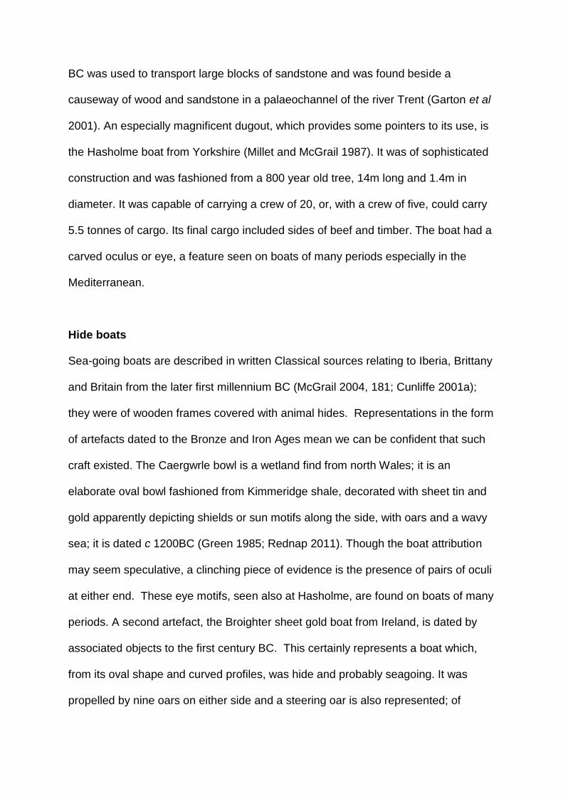
BC was used to transport large blocks of sandstone and was found beside a
causeway of wood and sandstone in a palaeochannel of the river Trent (Garton et al
2001). An especially magnificent dugout, which provides some pointers to its use, is
the Hasholme boat from Yorkshire (Millet and McGrail 1987). It was of sophisticated
construction and was fashioned from a 800 year old tree, 14m long and 1.4m in
diameter. It was capable of carrying a crew of 20, or, with a crew of five, could carry
5.5 tonnes of cargo. Its final cargo included sides of beef and timber. The boat had a
carved oculus or eye, a feature seen on boats of many periods especially in the
Mediterranean.
Hide boats
Sea-going boats are described in written Classical sources relating to Iberia, Brittany
and Britain from the later first millennium BC (McGrail 2004, 181; Cunliffe 2001a);
they were of wooden frames covered with animal hides. Representations in the form
of artefacts dated to the Bronze and Iron Ages mean we can be confident that such
craft existed. The Caergwrle bowl is a wetland find from north Wales; it is an
elaborate oval bowl fashioned from Kimmeridge shale, decorated with sheet tin and
gold apparently depicting shields or sun motifs along the side, with oars and a wavy
sea; it is dated c 1200BC (Green 1985; Rednap 2011). Though the boat attribution
may seem speculative, a clinching piece of evidence is the presence of pairs of oculi
at either end. These eye motifs, seen also at Hasholme, are found on boats of many
periods. A second artefact, the Broighter sheet gold boat from Ireland, is dated by
associated objects to the first century BC. This certainly represents a boat which,
from its oval shape and curved profiles, was hide and probably seagoing. It was
propelled by nine oars on either side and a steering oar is also represented; of

special significance is the presence of a mast demonstrating the use of a sail
(McGrail 2004). Its proportions suggest a boat maybe 12-15m long. Hide boats
known as currachs have been used in areas such as the Aran Islands in the west of
Ireland into recent times, demonstrating their suitability for challenging sea
conditions (Synge 1979). McGrail (2004) is of the view that hide boats were more
seaworthy than the types of prehistoric plank boats discussed below. From Nors in
north-west Jutland, Denmark there are 100 miniature gold leaf canoe-shaped boats,
some decorated with solar symbols. Their form is suggestive of skin rather than log
boats (National Museum, Copenhagen, Denmark). A much more modest type of hide
boat, which has survived to the present day in Wales, is the coracle, traditionally a
bowl-shape of woven wickerwork with a hide covering and seat for one person,
which was used on rivers for fishing (Jenkins 1988). One such fisherman, Mr Edward
Thomas, crossed the English Channel in a coracle in 1974 in 13.5 hours (Dunkley
2014), but their historical use was in riverine and very sheltered estuarine locations.
A key point is they were light weight, easily carried on a person’s back, and are thus
illustrative of the intimate connection between dryland and water mobility. An oval,
bowl-shaped burial with traces of organic lining from Fife, Scotland has been
interpreted as a hide coracle reused for burial in the early Bronze Age (Watkins
1980).
Sewn-plank boats in the British Isles
In the Bronze Age and Iron Age, the one boat type which is very well represented in
the archaeological record is the sewn plank boat. In all probability, these were the
vessels which provided the connections between cultural groups both in north-west

Europe and the Baltic, the means by which metals and other commodities of great
social significance were obtained. The archaeological evidence for these boats
contrasts geographically: in England and Wales there are finds of the boats
themselves mainly of Bronze Age date, while in Scandinavia there is very abundant
evidence for Bronze Age boats in rock art and images on metalwork but the only
boat finds are of Iron Age date. We will consider first the boats themselves, then the
Scandinavian iconographic evidence.
The sewn plank boats are typified by the most complete example found at Dover in
1992 and now magnificently displayed in its own galley in Dover Museum (Clark
2004a). There is another group of finds from the river Humber, especially the
discoveries from Ferriby made by the pioneering boat archaeologist Ted Wright from
1937 onwards (Wright 1990). These boats are sophisticated and complex pieces of
carpentry (Figure 9.3a and b) which demonstrates the importance of maritime
communication during the Bronze Age. The boats were made from hewn planks
sewn together with withy ties (twisted thin roundwood) through individual holes on
the planks. The ties were generally rebated into the wood to reduce abrasion on
beaching. The planks have internal raised ridges and semi-circular cleat bosses
which were perforated for transverse timbers providing lateral strength. The joints
between planks were caulked with moss and covered with laths to create a more
effective seal between planks. None of the sewn-plank boats have produced any
evidence for a mast, sail or fitments for oars and they are presumed to have been
paddled.

Eleven or twelve sewn plank boats are known in the British Isles (Figure 9.3c): 4 or 5
from Ferriby, 1 from Brigg and a fragment from Kilnsea, all in the Humber wetlands;
3 fragments of 2 or 3 phases from Caldicot, and 2 planks of the same date from
Goldcliff, both in the Severn Estuary; the two-thirds complete boat from Dover; and a
fragment from Testwood Lakes inland of the Solent. The dates of these finds are
shown on Figure 9.3d which demonstrates they are mainly Bronze Age, with
fragments from Ferriby of Iron Age date. The earliest are very close to the beginning
of the Bronze Age. Van de Noort (2011) has argued that such complex carpentry
became possible with Bronze Age technology and that the sewn plank boat was of
Beaker origin, associated with accelerated maritime contacts which occur at this
time, although the earliest radiocarbon dates are a few centuries later (Figure 9.3d).
As reconstructed Ferriby 1 is the largest of the sewn plank boats, 15.4 by 2.6m and
0.7m high, a boat capable of carrying about 3 tonnes including a crew of up to
twelve. When complete the Dover boat would have been c 11m long and was 2.2m
wide and capable of carrying 2 tonnes. It was calculated that with 16 paddlers it
could travel at 5 knots and cover up to 56 km a day.
There have been conflicting views as to the environment in which the sewn plank
boats were used. McGrail has argued that they were boats for river and estuary use
but not seagoing, a purpose for which he favoured the use of hide boats. The
locations in which they were found are mostly estuarine, with Dover, Brigg and
Testwood being riverine (Van de Noort 2011, fig 40), but the finding of a boat in a
river, need not indicate where it was habitually used. Environmental evidence
showed that the Dover boat lay in freshwater conditions yet the presence of
glauconitic sand and beach-rounded marine shells within the boat suggest it

travelled along the coast (Green 2004), whilst a fragment of Kimmeridge shale from
the boat may indicate longer sea journeys some 220km west as far as Dorset. The
river Dour on which it was found is such a minor drainage of c 6 km that it scarcely
seems to have justified such a boat and the same can be said of the Nedern Brook
where the Caldicot fragments were found, at the tidal limit in this inlet of the Severn
Estuary (Nayling and Caseldine 1997).
Understanding of the capability of these boats has recently been significantly
advanced by the making of two experimental reconstructions. A half scale replica of
the Dover boat was launched in 2012 (Figure 9.3b) and has been trialled in waves in
the outer harbour at Dover (Lehoërff et al 2012). A full-size replica of a Ferriby boat
(Figure 9.3a) was made in 2012 at the National Maritime Museum, Falmouth and
has undergone trials in Falmouth Harbour (Van de Noort et al 2014). Though neither
boat has yet been trialled in the open sea, mainly due to modern health and safety
and training issues, those responsible for the trials are confident of the boats’ sea-
going capabilities. It is reasonable to suppose that Bronze Age people would have
chosen the time to travel very carefully and that journeys would generally have been
made under the calmest conditions of summer. Even so, journeys in the open sea
would have carried a high risk to set against the substantial rewards in terms of
material goods and status for those that succeeded. Boats, and the distant contacts
which they facilitated, can be seen as having an pivotal social role by providing
access to exotic raw materials, especially the metals which were only available in
very restricted areas. Production of the most prestigious artefacts involved the
combination of alloys and raw materials available in very different locations. In that
sense long distance communication was central to Bronze Age society. Voyages

would also have provided access to exotic and esoteric knowledge and are likely to
have been rites of passage for young elite crews. Van de Noort (2011) has argued
that the sewn plank boats were seen as such powerful symbols on account of their
exotic contacts that boat pieces were ritually incorporated in structures such as
bridges and tracks at Caldicot 2, Testwood Lakes and Goldcliff.
Possible wrecks round Britain
Support for the transport of exotic goods by boat may be provided by two collections
of Bronze Age metalwork from the seabed which are both interpreted as the sites of
wrecks (Needham et al 2013). Both are from high energy exposed sea beds, so no
trace of a boat itself can be expected to survive. Both collections of metalwork date
to the thirteenth century BC on metalwork typology. The most productive of these
sites is at Langdon Bay just outside the east harbour wall at Dover, 0.5 km from the
present shore and just 2.25 km east of the find spot of the Dover Boat. The find
comprises some 360 bronzes, many of them types which are normally found in
continental Europe, though some are of types thought to have been made in Britain
(Needham et al 2013; Lehoërff et al 2012). The second collection is from Salcombe,
Devon and was made 450 m seaward of a rocky cliffed shore. It comprises 29
objects, mostly bronzes but also gold, tin, iron and bone.
Landing places in Britain
Making connections between waterborne and terrestrial routes is made more difficult
by the fact that the dugouts, skin boats and other lightly constructed boats of

prehistory could have been beached at any gently shelving, sheltered location with
no need for a landing stage. No recognisable dock arrangements are represented in
north-west Europe until the Roman period. Nonetheless there are indications of
landing places. In a riverine context, it was noted in Chapter 5 that the intersections
of the Stonehenge avenue with the river Avon and those of routes at Durrington
Walls indicate the locations of landing places. In marine contexts a series of sites
have been identified, mostly in Scotland. They are protected havens at river mouths,
often associated with sand dunes and characterised by artefacts dated between
4000 and 2000 cal BC, including the use of exotic lithic raw materials, evidence of
artefact production and the implication that they were places where traders arrived,
and goods were produced and exchanged (Bradley et al 2016). The presence at
Ferriby, Humberside of fragments of plank boats spanning some 1500 years right
through the Bronze Age and into the Iron Age can be interpreted as both a
frequented landing place and somewhere where boats were also dismantled,
repaired and rebuilt. The case is strengthened by the presence of trackways and
other wood structures in the Ferriby intertidal area (Van de Noort and Ellis 1999) and
by the presence of a long established routeway which later became a Roman road,
known today as High Street, along the Lincolnshire Wolds to south Ferriby on the
opposite bank of the Humber (Figure 8.1; Van de Noort and Ellis 1999). Also in the
Humber wetlands at Brigg, a natural crossing place where the Ancholme valley
narrows, is the findspot of a middle to late Bronze Age dugout canoe, an early Iron
Age trackway and the Brigg sewn plank boat of the late Bronze Age. The presence
at Caldicot, Wales of three sewn plank fragments, one early and two late Bronze
Age, also implies a frequently used landing place, an idea supported by other wood
structures including a bridge / jetty of the late Bronze Age (Nayling and Caseldine

1997). In the intertidal zone of the Essex coast a number of wood structures were
interpreted as possible jetties and landing places (Wilkinson and Murphy 1995). The
possibility also needs to be considered that some of the double post alignments on
the river Thames at London, for instance that of middle Bronze Age date at Vauxhall
(Cohen and Wragg 2017), may represent landing places rather than bridges, or
perhaps a combination of the two, since the place where riverine and terrestrial
routes cross are natural landing places. In the Thames Estuary trackways, of both
wood and stone, are reported leading in the direction of the estuary, some, as noted
in Chapter 6, continuing dryland droveways. The destinations of these are potential
landing places and potential locations for boat finds. The clearest evidence for
prehistoric harbour installations comes from Poole Harbour, Dorset where two
substantial timber and stone jetties were constructed in the later Iron Age (Wilkes
2007). Poole is one of a series of natural harbours on the English Channel Coast
associated with cross channel trade at this time.
Portages are places where boats, or goods, can be transported across an isthmus or
promontory to avoid long, or dangerous, sea crossings, or river rapids; they are
obvious focal points for future investigation. There are many examples in
Scandinavia and Scotland which are documented using historical and place-name
sources. Some Scandinavian examples have hollow ways leading to them and it has
been suggested that such places might be associated with ballast dumps, though no
such examples are yet documented (Westerdahl 2006; Bradley et al 2016).
Artefact distributions in Scandinavia

In the identification of patterns of maritime communication we can also deploy
evidence provided by artefact distributions. As early as the late glacial interstadial
(Allerød, c 13000BP) it has been inferred that upper Palaeolithic groups colonised
the west coast of Norway by boat since there seems to have been no ice-free
corridor on land at that time (Coles 2000). In the Mesolithic of Denmark, the
distribution of distinctive axe styles has been used to suggest Mesolithic territories
spanning 50km at most (Fischer 2003). During the Danish Kongemose c 6500-5400
cal BC, the distribution of a distinctive so-called ‘wheatsheaf’ decorative motif on
bone artefacts points to maritime connections around the Little Baelt, between the
west of Fyn, the east coast of Jutland and south to Schleswig-Holstein (Figure 9.4;
Terberger 2006). This argument is strengthened by similarities of material culture
between what is argued to be a year-round site at Tybrid Vig and other sites in this
area which may have been visited as a result of logistical (ie task specific) mobility
(Andersen 2013). Close similarities in material culture between Scania in southern
Sweden and the island of Bornholm, 37km to its south, point to the maintenance of
connections across this open sea (Fischer 2002). In the final Mesolithic Ertebolle
period, much more distant connections are manifest with the appearance of stone
‘shoe last’ axes obtained from Danubian farmers and originating from outcrops 1000-
1500 km to the south in Bulgaria and Slovakia (Fischer 2002). These probably do not
reflect the actual movement of people but of objects. However, the significant point is
that they are found on Baltic Islands well to the north of contemporary farming
communities and must have arrived there by boat.
Transported things in Britain and Europe

Britain was recolonised c 12700 cal BC but that was overland at a time when low sea
level connected it to continental Europe by Doggerland in the North Sea. Britain
finally became an island as a result of sea level rise c 6000 cal BC and subsequent
contact required a boat crossing of at least 38km. Ireland was colonised by
Mesolithic communities about 8000 cal BC and that must have been by boat since it
became an island c 12,000 cal BC. Recent evidence shows that Orkney, Shetland,
the Outer Hebrides and Isles of Scilly were visited in the Mesolithic. There is
increasing evidence from the western seaways of the British Isles of the facility with
which people moved significant distances, both in the Mesolithic and Neolithic
(Garrow and Sturt 2017). Domesticated animals and plants reached the British Isles
by boat. Domestic cereals and sheep /goat are non-native and bone measurements
also show that domestic cattle and pigs were from introduced stock rather than local
domestication (Davis 1987). The scale of human migration as opposed to
acculturation of Mesolithic populations remains the subject of active debate,
nonetheless it is clear that there was active maritime communication through the
Neolithic. Curiously, the earliest dated domesticate, a bone of Bos dated 4495-4165
cal BC, is from the west of Ireland on a Mesolithic site at Ferriter’s Cove (Woodman
et al 1999). Bos was non-native in Ireland and this suggests the possibility of
precocious Neolithic contact up the Atlantic fringe, for which Sheridan (2003; 2004)
has argued on the basis of tomb and pottery typology. In England the earliest
Neolithic dates are from Kent and the Thames valley, c 4100 cal BC. From there
Neolithic attributes spread widely and rapidly west and north as far as Wales and
Scotland by c 3800 cal BC (Whittle et al 2011). West to east Irish Sea connections
are demonstrated by links of megalithic tomb type and art between the great tombs
of the Irish Boyne Valley and north Wales, and from south to north between the

Boyne valley and the tombs of Orkney. Cunliffe (2001a, 199) saw this as reflecting a
common Atlantic cultural province. Noble (2006) has likewise argued that travel by
sea was a significant factor in the positioning of Orkney Neolithic tombs. Even
Britain’s most remote island, St Kilda, has produced evidence of Neolithic material
culture (Fleming 2005a).
With the arrival of metals, maritime connections are even more clearly demonstrated.
Maritime Beakers, among the earliest of the type, have, as the name suggests, a
strongly Atlantic distribution from Iberia to Britain (Cunliffe 2001a, fig 6.11). Sheridan
(2008) has pointed to close similarities between early Beakers and associated burial
practice in Holland and Scotland. Similarly, gold lunulae, which are mostly found in
Ireland, also occur on the Cornish coast where one example is almost identical to a
find at Kerivoa on the French Cotes d’Amour (Figure 9.5). Figures on stone menhirs
in Brittany and Guernsey are shown wearing lunulae (Cunliffe 2001a, fig.6.13).
Recently a combination of lead isotope and elemental analysis has concluded that
much of the Chalcolithic and early Bronze Age gold, originally thought to come from
Ireland, may derive from south-west British alluvial, or other, as yet unidentified,
sources (Standish et al 2015). Many metal artefacts demonstrate connections
between Ireland, the Wessex region and continental Europe, as shown for instance
by gold hair rings, neckrings and bar torcs (Eogan 1994), and Cunliffe (2001a)
includes many distributions of bronze artefacts illustrating these Atlantic connections.
Some of the most compelling evidence for maritime connections has been
assembled from the English Channel area, leading Needham to refer to this as a
‘maritory’, meaning a maritime cultural area (Needham and Parfitt 2006).
Connections are demonstrated by a series of precious cups of gold, silver, amber

and shale, which span the period 1850-1550 cal BC and occur on the south coast of
England, the Netherlands and Brittany (Figure 9.5c). Needham proposes that these
cups may have had a role in propitiatory rites associated with maritime travel and
related exchange networks. The distribution of amber in southern Britain, much of it
probably of Baltic origin, indicates transport along the Channel coast and then, as
previously noted, riverine transport to the Stonehenge area (Figure 9.5d). Amber
spacer beads and discs mounted in gold, an artefact type distinctive of Wessex, then
found their way to the shaft graves of Mycenae and to Crete respectively, perhaps
via an Atlantic, French and Mediterranean route (Bouzek 1993). Amber in central
Europe seems to have moved south via riverine exchange networks. This is part of a
network of amber trade between the Baltic coast of Jutland, where vast numbers of
amber beads are found in Bronze Age contexts, and Europe as far as the
Mediterranean (Beck and Shennan 1991). In reviewing the rock art of Atlantic
Europe, Bradley (1997) has observed that from Scotland to Iberia similar motifs are
arranged in similar ways at a similar chronological horizon between c 3000 and the
early second millennium BC suggesting that these communities were linked by
maritime communication.
In the middle Bronze Age the volume of metalwork as represented by hoards and
other finds increases markedly and there is abundant evidence for occurrence in
British hoards of types characteristic of production on the continent, and vice versa.
(Needham et al 2013; Lehoërff et al 2012). Combining materials of high status to
create artefacts of probable cosmological significance contributes to the evidence for
exotic maritime contacts. Pre-eminant among them is the Nebra sky disc of c 1600
BC, found in central Germany, and apparently depicting the phases of the moon and

stars, perhaps used in navigation (Meller 2004). Geochemistry has shown that the
gold used was of Cornish origin (Ehser et al 2011). Another example is the
Caergwrle bowl combining materials of diverse geographic origin: shale, gold and tin
(Green 1985; Rednap 2011).
In recent years, evidence of distant metalwork connections has been supplemented
by other forms of artefactual and settlement pattern evidence which suggest the
connections extended well beyond simple concepts of trade, as indeed Needham’s
‘maritory’ label implies. Among the most telling evidence is the discovery of a very
distinctive large pot in the Cornish Trevisker style which was made of Gabbroic clay
from Cornwall but was found at the other end of the English Channel on the Isle of
Thanet, Kent (Gibson et al 1997). Pottery in Trevisker style also turns up on the
French side of the English Channel. That pottery also has a coastal distribution up
the Bristol Channel and Severn Estuary into south Wales (Bell 2013, fig 17.4) which
may suggest that the Trevisker-producing communities of middle Bronze Age
Cornwall played a significant role in maritime communication in western Britain and
the English Channel. Pots made in Finistère, France are also found in the Solent
region of England, for instance on the Isle of Wight (Murphy 2009). Coaxial field
systems, discussed in Chapter 8, which are widespread in coastal areas of south-
east England have been found in the Cherbourg peninsula, Normandy and
elsewhere on the continental side of the Channel (Bradley et al 2015). A range of
evidence has been assembled in terms of pottery, fields and house forms for strong
cross-Channel connections in the middle and late Bronze Age (Marcigny et al 2007;
Lehoërff et al 2012).
During the Iron Age metalwork continued to reach Britain from continental Europe via
both Atlantic connections and cross-Channel links to central Europe (Cunliffe 1991).
In the later Iron Age cross-Channel trade appears to have particularly focused on
favoured harbours at sites such as Hengistbury Head, Mount Batten and Poole
Harbour. Particularly illuminating are the writings of Pytheas of Massalia some time
before 320 BC whose book On the Ocean is only known from references in later
works. Pytheas appears to have circumnavigated Britain, voyaging as far as Iceland
since volcanos and frozen seas are described (Cunliffe 2001b). In the final centuries
of the Iron Age other Greek and Roman writers such as the Massaliote Periplus,
Timaeus and others provide tantalising glimpses of voyages up the Atlantic coast to
Britain and beyond, often for trade in tin (Cunliffe 2001 a and b). From the north
coast of the Isle of Wight, pottery and foreign stone from Brittany and south west
England, inferred to be ships’ ballast, indicates increasing cross-Channel and along
Channel shipping in the later Iron Age (Tomalin et al 2012). By the late Iron Age
pottery was reaching the Solent area from Brittany (Cunliffe 1991, 437) and wine
amphorae of Mediterranean origin were reaching Britain, at first via Hengistbury
Head and later, when Caesar’s conquest of Gaul disrupted Atlantic routes, the focus
of trade shifted to a cross-Channel route into Eastern England for the century
preceding the Roman conquest in 43 AD.
As regards the ships which carried this Iron Age trade, we have only indirect
evidence. Ships illustrated on Celtic coins of Cunobelin (c AD 10-43) show a mast,
square sail and side rudder (McGrail 2004). Anchors of Iron Age date are known
from Bulbury, Dorset and Porth Felen, Wales, the latter apparently a Graeco-Roman
type of the second or first century BC (Cunliffe 2001a). Caesar, when writing of the

Veneti of western Brittany, describes ships with leather sails, the hull fashioned from
flush-laid oak planks fastened to thick framing with substantial iron nails, vessels
more suited to Atlantic conditions than the ships at the disposal of the Romans.
Thus, at least by the later Iron Age, there were larger and more substantial ships
than sewn-plank boats. Further evidence of their character is provided by a series of
so-called Romano-Celtic boats which share some of the characteristics Caesar
described but which were made after the Roman conquest and have been found in
the Severn Estuary, the Thames at London, the Channel Islands, the Rhine basin
and in Switzerland (Nayling and McGrail 2004). The construction of these ships
differs markedly from Roman vessels in the Mediterranean hence the view that the
type is of indigenous Iron Age derivation.
Scandinavia: ships and rock art
Sewn-plank boats are represented in continental Europe only by a more-or-less
complete example from Hjortspring, Denmark, displayed in the National Museum,
Copenhagen. It is a light slender war canoe with bevelled lap planks with raised
cleats lashed to frames, some 19m long and 2m wide with distinctive upturned
projections (horns, ie keel and prow extensions) at either end. It would have carried
18 paddlers. It was found in a tiny peat bog 3.4 km from the sea, in which it had been
ritually deposited together with the weaponry of 70-100 warriors, perhaps the booty
of a defeated raiding party (Crumlin-Pedersen and Trakadas 2003). An experimental
full size replica performed effectively as rapid marine transport capable of covering c
100km a day. Other probable fragments of sewn plank boats are reported from

Haugvik, northern Norway dated to the first or second century BC, and Hampnas,
Vasternorrland, Sweden, dated c 220BC (Sylvester 2009; Janssen 1994).
For the Bronze and Iron Ages the rock art of Norway and Sweden, and depictions of
boats on bronzes from Denmark, provide a complementary perspective on later
prehistoric maritime communication which is especially important in illuminating the
social and cosmological aspects of exotic contacts. The rock art of southern
Scandinavia is dominated by pictures of boats of which 19,322 images are
documented (Nimura 2016). Many examples are remarkably informative as to boat
type; they apparently show sewn-plank boats with the distinctive horned prow as at
Hjortspring. The prow often has an animal head, usually horse.
Figure 9.6 is an example from Soletorp, Sweden depicting three boats, the upper
with 13 crew, larger figures fore and aft with horned helmets and axes, horse head
terminals at either end of the boat and an acrobat above the boat. A few examples
with deeper hulls are thought to depict hide boats (Crumlin-Pedersen 2010). Many of
the plank boats depict rows of paddlers and occasionally a steering oar is shown.
They do not generally have obvious sails although Bengtsson (2017) has recently
argued that aspects of the iconography should be interpreted as sails. Among the
crew there is often one or more much larger figure interpreted as leader(s). These
prominent figures are often phallic and the overall imagery with the emphasis on
weapons is strongly male with a near absence of female figures and obvious children
(Hygen and Bengtsson 2000). Prominent figures are sometimes depicted with
distinctive types of artefacts which can be dated typologically (Coles 1990), for
example, sword scabbards with forked terminals and swords with curved blades

(early Bronze Age), horned helmets (late Bronze Age), shield types (round Bronze
Age, rectangular Iron Age), lurs (late Bronze Age), and crescentic axes (middle
Bronze Age). Sometimes, as in Figure 9.6, mysterious acrobatic figures are shown
leaping over the boat.
The Scandinavian rock art is pecked on prominent glacially smoothed rockfaces
which often sit at the edges of level plains. Ling (2004; 2008) has shown that many
examples sit around the margins of former shorelines, 15-20m above today’s sea
level, as a result of still continuing isostatic readjustment which followed removal of
the huge weight represented by the Pleistocene ice sheets. Many boat images are
now kilometres inland but at the time they were made they overlooked the beach and
would have been visible from the sea (Hygen and Bengtsson 2000). Isostatic
readjustment also provides some guide to dating since earlier images and types of
boat relate to higher former shorelines. Sites where ship representations are
abundant may represent places where boats from across the Baltic habitually landed
for seasonal gatherings involving social and economic exchange. They are
concentrated in areas where the effects of shoreline displacement were especially
marked, and it has been argued by Nimura (2016) that the art may have had active
agency in enabling communities to cope with dramatic environmental changes.
The case for cross-Baltic connections is strengthened by links between the belief
systems, symbolism and cosmology of the art in southern Norway and Sweden and
those represented iconographically on bronzes in Denmark. Indeed the significance
and meaning of the ships, their horse head prows, the acrobats and other features,
is greatly augmented by depictions of ships on bronze objects, mainly razors, of

which there are 800 from Denmark (Kaul 1998). Kaul has shown that the ships on
bronzes are a central part of a sophisticated cosmological scheme representing the
solar cycle and the passage of day and night and probably also the seasons, life and
death. A significant clue in deciphering this scheme was the Chariot of the Sun from
Trundholm, Denmark (c 1400 BC), a bronze wheeled model of a horse, drawing a
solar disc, with gold on one side, representing day, and silver grey on the other
representing night. In Denmark the mysterious acrobatic figures, horse head
terminals, figures with horned helmets and axes are also represented as cast
bronzes, probably originally fitted to models of ships (Kjaerum and Olsen 1990). All
this seems to point to a common cross-Baltic cosmological belief shared by southern
Norway, Sweden and Denmark, in which boats played a central part and to which
other means of transport, the horse and wheeled vehicles, also contributed. The
significance of the means of transport, and particularly the boat, is partly explained
by the fact that the metals and ostentatious metal artefacts used in Norway and
Sweden were imported from central Europe, as lead isotope and elemental analysis
shows (Ling et al 2014).
Conclusions: Maritime connections and cultures
A theme of this chapter has been the role of movement by water, rivers and the sea
in connecting rather than dividing communities (Van de Noort 2011). The
significance of this from an early date is demonstrated by the Palaeolithic and early
Holocene colonisation of islands in the Mediterranean and South East Asia
(Broodbank 2013; Gamble 1993). It is also increasingly apparent from material
cultural evidence, that many islands had more connection with outside communities
than previously imagined and that their distinctiveness sometimes relates not so
much to isolation as to the establishment of a cultural identity in the context of wider
contacts. This case has been effectively made by Fleming (2005a) in the case of
Britain’s most remote island, St Kilda. A similar case can be made for Orkney and
the Isles of Scilly, which are now known to have been more connected to other areas
in the Mesolithic to Bronze Age than previously imagined (Garrow and Sturt 2017).
The implication of this is that archaeologists have tended to underplay the social
significance and probably the frequency of maritime communication. Maritime
archaeology has suffered from pigeonholing as a separate category of evidence
disconnected from the mainstream. Fortunately, that tendency is now being very
actively counteracted by Cunliffe’ s (2001a) approach to the archaeology of the
Atlantic and that of Broodbank (2013) in the Mediterranean. Such studies take
account of currents and winds and the natural patterns of movement which are
observed today and would have been utilised in the past. These help to explain the
patterns of artefactually attested connectivity between Aegean islands and the routes
used to cross the English Channel (McGrail 1983). The challenge is to develop an
approach to maritime cultural landscapes or seascapes which integrates the
archaeology of the sea and land (Westerdahl 1992; 2006; Hunter 1994). A move
towards this has been the development of a seamless approach to coastal
archaeology which incorporates submarine, intertidal and terrestrial evidence, as
pioneered on the Langstone Harbour Survey, UK (Allen and Gardiner 2000) and the
Strangford Lough Survey in Northern Ireland (McErlean et al 2002). The subject has
certainly benefited from greater attention in recent decades, because heritage
agencies in many countries have placed increasing emphasis on coastal
archaeology. In the UK this has dramatically increased our knowledge of the coastal
and maritime heritage resource (Murphy 2014). In seeking to understand distinctive

maritime ways of life we can draw not just on the direct archaeological evidence, but
on a wider studies of human engagement with the sea from a diversity of periods
and perspectives including anthropology, literature and history (Mack 2011; Gillis
2012). Examples where ethnohistorical perspectives have proved especially
illuminating include an understanding of traditional fishing practice (O’Sullivan 2003c)
and the performance and role of skin curragh boats in the Aran Islands on the west
of Ireland (Synge 1979). As Van de Noort (2011) has emphasised, people’s
relationship with seascapes defined them in terms of their livelihood, identity and
place in history.
So why do coasts often appear to be seen as special places and what motivated
distant maritime communication? It has been widely recognised that coasts have
been seen as liminal places representing transitions, for instance from life to death.
Mesolithic Ertebolle burials in dug-out canoes have been interpreted in these terms
(Bradley 2000), as have ship images on Bronze Age razors from Denmark and the
related rock art of Scandinavia. The liminal properties of the coast may also account
for the concentration of megalithic tombs on the coastal fringes of Atlantic Europe,
for instance in Brittany (Scarre 2002) and Pembrokeshire (Tilley 1994). An extension
perhaps of this liminality or transitional concept concerns the particular properties of
the ship itself. Van de Noort (2011) has highlighted the notion of the ship as
hererotopia, a space where the conventional is contested. He further argues that,
through the significant social role that ships played, the ships themselves acquired
iconic status and were ritually deposited. That is a somewhat different emphasis
from the ritual deposition of the boats of defeated raiders which has been proposed
at Hjortspring in Denmark. Regarding the motivation of distant contact, valuable

insights are provided by Homer’s (ND) Odyssey written in the ninth century BC but
set in the time of the Trojan War in the thirteenth century BC. It describes a distant,
immensely challenging voyage by which the status and character of those involved
were built. Helms (1988) has developed this idea from the perspective of
anthropology, demonstrating that by distant travel people acquired esoteric
knowledge and privileged access to exotic objects; this exoteric knowledge became
part of the validation, or legitimation, of elite status (Kristiansen and Larsson 2005).
Amber can be seen in these terms (Beck and Shennan 1991) and the same can be
said of many of the prestige goods of later prehistoric north-west Europe. It is striking
how many of them combine metals and geological material derived from diverse
geographical sources and are themselves icons of mobility, for instance the
Cergwyle bowl in the form of a boat, the Broighter boat, the Nebra Sky Disc and the
Trondholm ‘Chariot of the Sun’. Clearly acquisition and display of exotic objects was
of central importance to the maintenance and reproduction of elites who, through
distant travel, had privileged access to other worlds and the esoteric knowledge
which they provided.
This chapter has highlighted the importance of understanding relationships between
terrestrial, riverine and maritime transport and the significant social role which these
relationships played in prehistory. These relationships will be further touched on at
the end of the following case study chapter and in the conclusions.

Making ones Way in the World Revised 3.7.19 Words 8098
Chapter 9
Maritime and riverine connectivity and
the allure of the exotic.
Introduction
Preceding chapters have found limited evidence for long-distance prehistoric
communication routes on dryland, particularly in the British Isles. Long accepted
prehistoric origins for the ridgeways have been shown to be limited and
questionable. Thus far the focus has been on movement and routes in terrestrial
landscapes, but that is only part of the story. Terrestrial routes will have been linked
by boat on rivers and the sea and may often only make sense when considered in
that wider context. In some areas, and during some periods, it is likely that most
journeys were by water. Archaeologists have tended to treat movement on land and
by water as separate specialist categories whereas the two must often have been
complementary as Westerdahl (2006) has argued in a Scandinavian context. Most
early journeys would have been along the coast and people would have navigated
using many of the markers which we considered in a terrestrial context: cairns,
standing stones, local clearings, modified trees; all, along with natural features, are
likely to have played a part and connected maritime with terrestrial routes.
The purpose of this chapter is to complete the story by highlighting the
complementary role of transport by water. The comparatively brief treatment here is
justified in two ways. Firstly, in relation to riverine transport, although many log boats
are known, there has been comparatively little synthetic treatment of the role which
rivers and lakes played in movement. This is a challenging topic beyond the scope of

this book. However, one or two case studies provide pointers to possible ways
forward. Secondly, in relation to maritime transport, the situation is almost the
opposite; there has been much recent research and synthesis which has advanced
understanding significantly, so what is required here is to signpost this work and
consider how it may have linked to patterns of riverine and terrestrial movement.
The advantages of water in facilitating rapid movement over distance are evident;
however, such practical issues are not the only reasons prehistoric communities
were interested in watery places. They were also sometimes places of ritual and
symbolic significance, liminal places where ritual deposition took place in many
periods from the Mesolithic to the Iron Age and later. Certain rivers are particularly
associated with the deposition of selected artefact types such as weapons and also
human skulls, as for instance in the Thames during the Bronze Age and Iron Age
(Bradley 1990; 2016). The deposition of metalwork in association with bridge and
trackway crossing places has already been noted in the context of Flag Fen and
several similar sites in the UK and La Tène in Switzerland (Chapter 6; Schulting and
Bradley 2013). On the Atlantic fringe and the Baltic travel by sea was the connecting
factor. In much of continental Europe the major river arteries such as the Danube
and the Rhine would have served as the main conduits. Thus there is a need to
extend recent advances in the understanding of maritime connectivity to riverine
environments.
Riverine transport
Riverine movement is not particularly easy to identify. We have to consider the
character of the river and its suitability for transport at relevant periods in the past.

Many channels may have been very different prior to the human modifications in
recent centuries. Increasingly their past character can be reconstructed using
geoarchaeological techniques (Brown 1997). We can be reasonably confident of the
major rivers being navigable at most times, whilst minor rivers may only have been
seasonally navigable. In some cases it may be the river valley itself which acted as
corridors of movement rather than riverine transport. Where drainage was disrupted
by the effects of glaciation, or the activities of beavers (Coles 2006), extensive early
Holocene water bodies would have facilitated local movement, although, in the more
minor rivers and streams, beaver dams may have blocked routes, so that easily
carried lightweight canoes were more suitable than dugouts fashioned from trees.
There are finds of dug-out canoes demonstrating water transport but only rare
occurrences of artefacts in them providing evidence for their purpose, or where they
came from.
This highlights the importance of making the connection between dry ground and
wetland landscapes. Such links have been most effectively demonstrated in the
Stonehenge landscape, as discussed in Chapter 5. The Avenue at Stonehenge
leads down to the river Avon leaving no doubt about the relationship here between a
route and riverine movement. This case has been significantly strengthened by the
recent discovery of a short avenue leading from the entrance to Durrington Walls
henge down to the same river. It has generally been considered that the bluestones
at Stonehenge completed their journey from west Wales on the Wiltshire River Avon;
the much larger sarsen trilithon stones could also have completed their journey from
the Marlborough Downs on the same river. Both journeys would also have involved
overland tracts and, in the case of the bluestones, transport by sea, probably up the

Bristol Channel, then the Bristol River Avon as the least risky route (Parker Pearson
2012).
The recent evidence from the Stonehenge landscape demonstrates the perspicacity
of an earlier paper by Sherratt (1996) which encouraged prehistorians to consider
the role of rivers as arteries of communication in prehistory. Sherratt argued that the
rivers were much more important than the ridgeways which archaeologists had
previously emphasised, but which he regarded as a myth. Sherratt particularly
emphasised the role of the Wiltshire and Bristol Avon rivers in providing a key
communication route across southern Britain. He also suggested that both rivers
may share the name Avon, the Celtic word for river, because the corridor that they
together provide was seen as part of one conceptual entity. Coles (1994) has
extended this argument by proposing that other river names such as Trent and
Tarrent, also of Celtic derivation, may point to their role as routes in later prehistory;
several such names occur on the Avon/ Severn route. The distribution of amber
artefacts of early Bronze Age date particularly highlights the key role of maritime
connections into the Poole Harbour area and riverine transport up the Wiltshire Avon
to Stonehenge (Figure 9.5).
Log boats
Many types of boat will have proved suitable for river and lake transport under
certain conditions. Log, hide and bark boats can be inferred to have been used in the
Mesolithic and Neolithic periods, though only log boats are represented in the
prehistoric archaeological record and these are likely to have been used principally
for riverine and lacustrine travel, as indeed the findspots of most examples indicate

(McGrail 1978; Mowat 1996; Gregory 1997). More sophisticated forms extended, or
improved, the shape with separate fitted transoms, bows and plank extensions at the
side to create larger, more complex craft. A database of European log boats
compiled by Arnold (1995; 1996) comprises some 2400 examples. Many are old
discoveries of the nineteenth and twentieth centuries and do not survive. Scientific
dating programmes provide radiocarbon dates for 571 examples and
dendrochronological dates for 58 (Lanting 1997-8). The earliest dugout in Europe
seems to be from Pesse, Netherlands dated 8010-7510 cal BC (Menotti 2012).
Excavations of a major waterlogged Mesolithic site on the edge of a river dune at
Hardinxveld-De Bruin, Netherlands revealed a dugout at the dune edge and dated c
5400 cal BC (Figure 9.1; Louwe Kooijmans 2001b). The greatest concentration of
Mesolithic dugouts is in Denmark where they are known from 15 sites, all of them
later Mesolithic in date; wooden paddles are also recorded from 14 sites (Figure
9.2b-c). This distribution suggests that the dugouts were important not just in riverine
communication but along the coast and between the mainland and islands of the
Baltic. A dugout from the submerged settlement at Tybrind Vig (Andersen 2013) had
a clay hearth, which recent folk practice suggests was used in night fishing to attract
eels. Tybrind Vig also produced richly decorated wooden paddles (Figure 9.2c)
highlighting the role which boats are likely to have played in social communication
both within and between communities. Excavations in advance of the fixed link
bridge and tunnel across the Storebaelt, Denmark revealed fragments of 19 dugouts
in a mass of drifted wood, much of it derived from fishtraps, at Magrethes Naes,
Zealand; these dated between c 5440 and 4950 BC (Pedersen et al 1997).

From the British Isles the evidence for early logboats is much more limited. There is
an early Mesolithic paddle from Star Carr but that could have been used on a boat of
hide or bark. Two Mesolithic logboats are know from Ireland, at Brookland dated
5407 BC and at Lough Neagh dated 5490-5246 BC, and there are three Neolithic
examples from Ireland (Gregory 1997; McErlean et al 2002). In the rest of the British
Isles there are no certain Mesolithic dugouts, although two old finds from Scotland at
Friarton on the river Tay and the river Carron were described respectively as coming
from under, and within, a Carse clay deposit which was laid down in the Mesolithic.
However, without direct dating this remains uncertain. Three Scottish logboats are
dated to the Bronze and Iron Ages. No Neolithic logboats are known from England
where the earliest is early Bronze Age. Several British early Bronze Age log coffin
burials are boat-shaped and interpreted as either metaphorical, or reused, dugout
boats, for example the burial of Gristhorpe Man (Melton et al 2013). Boat-shaped
stone settings and graves also occur, mostly close to the coast in Scotland with
some round the Bristol Channel; these are argued to highlight the significance of
connectivity by water in the early Bronze Age (Bradley forthcoming). Six log boats
dated between 1300-700 BC have recently been found in a palaeochannel at Must
Farm in the English Fenland, near a timber platform settlement and with evidence for
some very well-preserved basketry fish traps (Gibson et al 2012; Knight and Murrell
2012).
Although experiments have shown that log boats can be used at sea under certain
conditions (Dunkley 2014), in practice their use is likely to have been restricted to the
more sheltered locations. We may suppose logboats were the general workhorse of
communication in many inland waters. At Shardlow a logboat dated 1430-1190 cal

BC was used to transport large blocks of sandstone and was found beside a
causeway of wood and sandstone in a palaeochannel of the river Trent (Garton et al
2001). An especially magnificent dugout, which provides some pointers to its use, is
the Hasholme boat from Yorkshire (Millet and McGrail 1987). It was of sophisticated
construction and was fashioned from a 800 year old tree, 14m long and 1.4m in
diameter. It was capable of carrying a crew of 20, or, with a crew of five, could carry
5.5 tonnes of cargo. Its final cargo included sides of beef and timber. The boat had a
carved oculus or eye, a feature seen on boats of many periods especially in the
Mediterranean.
Hide boats
Sea-going boats are described in written Classical sources relating to Iberia, Brittany
and Britain from the later first millennium BC (McGrail 2004, 181; Cunliffe 2001a);
they were of wooden frames covered with animal hides. Representations in the form
of artefacts dated to the Bronze and Iron Ages mean we can be confident that such
craft existed. The Caergwrle bowl is a wetland find from north Wales; it is an
elaborate oval bowl fashioned from Kimmeridge shale, decorated with sheet tin and
gold apparently depicting shields or sun motifs along the side, with oars and a wavy
sea; it is dated c 1200BC (Green 1985; Rednap 2011). Though the boat attribution
may seem speculative, a clinching piece of evidence is the presence of pairs of oculi
at either end. These eye motifs, seen also at Hasholme, are found on boats of many
periods. A second artefact, the Broighter sheet gold boat from Ireland, is dated by
associated objects to the first century BC. This certainly represents a boat which,
from its oval shape and curved profiles, was hide and probably seagoing. It was
propelled by nine oars on either side and a steering oar is also represented; of

special significance is the presence of a mast demonstrating the use of a sail
(McGrail 2004). Its proportions suggest a boat maybe 12-15m long. Hide boats
known as currachs have been used in areas such as the Aran Islands in the west of
Ireland into recent times, demonstrating their suitability for challenging sea
conditions (Synge 1979). McGrail (2004) is of the view that hide boats were more
seaworthy than the types of prehistoric plank boats discussed below. From Nors in
north-west Jutland, Denmark there are 100 miniature gold leaf canoe-shaped boats,
some decorated with solar symbols. Their form is suggestive of skin rather than log
boats (National Museum, Copenhagen, Denmark). A much more modest type of hide
boat, which has survived to the present day in Wales, is the coracle, traditionally a
bowl-shape of woven wickerwork with a hide covering and seat for one person,
which was used on rivers for fishing (Jenkins 1988). One such fisherman, Mr Edward
Thomas, crossed the English Channel in a coracle in 1974 in 13.5 hours (Dunkley
2014), but their historical use was in riverine and very sheltered estuarine locations.
A key point is they were light weight, easily carried on a person’s back, and are thus
illustrative of the intimate connection between dryland and water mobility. An oval,
bowl-shaped burial with traces of organic lining from Fife, Scotland has been
interpreted as a hide coracle reused for burial in the early Bronze Age (Watkins
1980).
Sewn-plank boats in the British Isles
In the Bronze Age and Iron Age, the one boat type which is very well represented in
the archaeological record is the sewn plank boat. In all probability, these were the
vessels which provided the connections between cultural groups both in north-west

Europe and the Baltic, the means by which metals and other commodities of great
social significance were obtained. The archaeological evidence for these boats
contrasts geographically: in England and Wales there are finds of the boats
themselves mainly of Bronze Age date, while in Scandinavia there is very abundant
evidence for Bronze Age boats in rock art and images on metalwork but the only
boat finds are of Iron Age date. We will consider first the boats themselves, then the
Scandinavian iconographic evidence.
The sewn plank boats are typified by the most complete example found at Dover in
1992 and now magnificently displayed in its own galley in Dover Museum (Clark
2004a). There is another group of finds from the river Humber, especially the
discoveries from Ferriby made by the pioneering boat archaeologist Ted Wright from
1937 onwards (Wright 1990). These boats are sophisticated and complex pieces of
carpentry (Figure 9.3a and b) which demonstrates the importance of maritime
communication during the Bronze Age. The boats were made from hewn planks
sewn together with withy ties (twisted thin roundwood) through individual holes on
the planks. The ties were generally rebated into the wood to reduce abrasion on
beaching. The planks have internal raised ridges and semi-circular cleat bosses
which were perforated for transverse timbers providing lateral strength. The joints
between planks were caulked with moss and covered with laths to create a more
effective seal between planks. None of the sewn-plank boats have produced any
evidence for a mast, sail or fitments for oars and they are presumed to have been
paddled.

Eleven or twelve sewn plank boats are known in the British Isles (Figure 9.3c): 4 or 5
from Ferriby, 1 from Brigg and a fragment from Kilnsea, all in the Humber wetlands;
3 fragments of 2 or 3 phases from Caldicot, and 2 planks of the same date from
Goldcliff, both in the Severn Estuary; the two-thirds complete boat from Dover; and a
fragment from Testwood Lakes inland of the Solent. The dates of these finds are
shown on Figure 9.3d which demonstrates they are mainly Bronze Age, with
fragments from Ferriby of Iron Age date. The earliest are very close to the beginning
of the Bronze Age. Van de Noort (2011) has argued that such complex carpentry
became possible with Bronze Age technology and that the sewn plank boat was of
Beaker origin, associated with accelerated maritime contacts which occur at this
time, although the earliest radiocarbon dates are a few centuries later (Figure 9.3d).
As reconstructed Ferriby 1 is the largest of the sewn plank boats, 15.4 by 2.6m and
0.7m high, a boat capable of carrying about 3 tonnes including a crew of up to
twelve. When complete the Dover boat would have been c 11m long and was 2.2m
wide and capable of carrying 2 tonnes. It was calculated that with 16 paddlers it
could travel at 5 knots and cover up to 56 km a day.
There have been conflicting views as to the environment in which the sewn plank
boats were used. McGrail has argued that they were boats for river and estuary use
but not seagoing, a purpose for which he favoured the use of hide boats. The
locations in which they were found are mostly estuarine, with Dover, Brigg and
Testwood being riverine (Van de Noort 2011, fig 40), but the finding of a boat in a
river, need not indicate where it was habitually used. Environmental evidence
showed that the Dover boat lay in freshwater conditions yet the presence of
glauconitic sand and beach-rounded marine shells within the boat suggest it
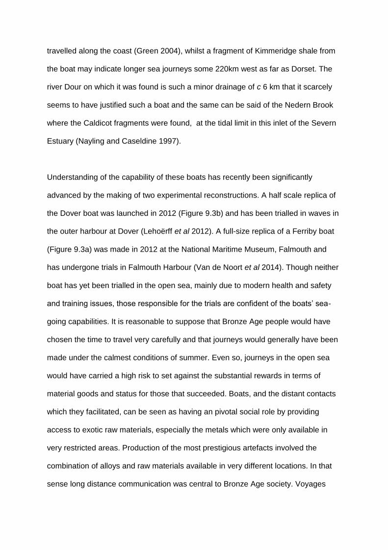
travelled along the coast (Green 2004), whilst a fragment of Kimmeridge shale from
the boat may indicate longer sea journeys some 220km west as far as Dorset. The
river Dour on which it was found is such a minor drainage of c 6 km that it scarcely
seems to have justified such a boat and the same can be said of the Nedern Brook
where the Caldicot fragments were found, at the tidal limit in this inlet of the Severn
Estuary (Nayling and Caseldine 1997).
Understanding of the capability of these boats has recently been significantly
advanced by the making of two experimental reconstructions. A half scale replica of
the Dover boat was launched in 2012 (Figure 9.3b) and has been trialled in waves in
the outer harbour at Dover (Lehoërff et al 2012). A full-size replica of a Ferriby boat
(Figure 9.3a) was made in 2012 at the National Maritime Museum, Falmouth and
has undergone trials in Falmouth Harbour (Van de Noort et al 2014). Though neither
boat has yet been trialled in the open sea, mainly due to modern health and safety
and training issues, those responsible for the trials are confident of the boats’ sea-
going capabilities. It is reasonable to suppose that Bronze Age people would have
chosen the time to travel very carefully and that journeys would generally have been
made under the calmest conditions of summer. Even so, journeys in the open sea
would have carried a high risk to set against the substantial rewards in terms of
material goods and status for those that succeeded. Boats, and the distant contacts
which they facilitated, can be seen as having an pivotal social role by providing
access to exotic raw materials, especially the metals which were only available in
very restricted areas. Production of the most prestigious artefacts involved the
combination of alloys and raw materials available in very different locations. In that
sense long distance communication was central to Bronze Age society. Voyages

would also have provided access to exotic and esoteric knowledge and are likely to
have been rites of passage for young elite crews. Van de Noort (2011) has argued
that the sewn plank boats were seen as such powerful symbols on account of their
exotic contacts that boat pieces were ritually incorporated in structures such as
bridges and tracks at Caldicot 2, Testwood Lakes and Goldcliff.
Possible wrecks round Britain
Support for the transport of exotic goods by boat may be provided by two collections
of Bronze Age metalwork from the seabed which are both interpreted as the sites of
wrecks (Needham et al 2013). Both are from high energy exposed sea beds, so no
trace of a boat itself can be expected to survive. Both collections of metalwork date
to the thirteenth century BC on metalwork typology. The most productive of these
sites is at Langdon Bay just outside the east harbour wall at Dover, 0.5 km from the
present shore and just 2.25 km east of the find spot of the Dover Boat. The find
comprises some 360 bronzes, many of them types which are normally found in
continental Europe, though some are of types thought to have been made in Britain
(Needham et al 2013; Lehoërff et al 2012). The second collection is from Salcombe,
Devon and was made 450 m seaward of a rocky cliffed shore. It comprises 29
objects, mostly bronzes but also gold, tin, iron and bone.
Landing places in Britain
Making connections between waterborne and terrestrial routes is made more difficult
by the fact that the dugouts, skin boats and other lightly constructed boats of

prehistory could have been beached at any gently shelving, sheltered location with
no need for a landing stage. No recognisable dock arrangements are represented in
north-west Europe until the Roman period. Nonetheless there are indications of
landing places. In a riverine context, it was noted in Chapter 5 that the intersections
of the Stonehenge avenue with the river Avon and those of routes at Durrington
Walls indicate the locations of landing places. In marine contexts a series of sites
have been identified, mostly in Scotland. They are protected havens at river mouths,
often associated with sand dunes and characterised by artefacts dated between
4000 and 2000 cal BC, including the use of exotic lithic raw materials, evidence of
artefact production and the implication that they were places where traders arrived,
and goods were produced and exchanged (Bradley et al 2016). The presence at
Ferriby, Humberside of fragments of plank boats spanning some 1500 years right
through the Bronze Age and into the Iron Age can be interpreted as both a
frequented landing place and somewhere where boats were also dismantled,
repaired and rebuilt. The case is strengthened by the presence of trackways and
other wood structures in the Ferriby intertidal area (Van de Noort and Ellis 1999) and
by the presence of a long established routeway which later became a Roman road,
known today as High Street, along the Lincolnshire Wolds to south Ferriby on the
opposite bank of the Humber (Figure 8.1; Van de Noort and Ellis 1999). Also in the
Humber wetlands at Brigg, a natural crossing place where the Ancholme valley
narrows, is the findspot of a middle to late Bronze Age dugout canoe, an early Iron
Age trackway and the Brigg sewn plank boat of the late Bronze Age. The presence
at Caldicot, Wales of three sewn plank fragments, one early and two late Bronze
Age, also implies a frequently used landing place, an idea supported by other wood
structures including a bridge / jetty of the late Bronze Age (Nayling and Caseldine
1997). In the intertidal zone of the Essex coast a number of wood structures were
interpreted as possible jetties and landing places (Wilkinson and Murphy 1995). The
possibility also needs to be considered that some of the double post alignments on
the river Thames at London, for instance that of middle Bronze Age date at Vauxhall
(Cohen and Wragg 2017), may represent landing places rather than bridges, or
perhaps a combination of the two, since the place where riverine and terrestrial
routes cross are natural landing places. In the Thames Estuary trackways, of both
wood and stone, are reported leading in the direction of the estuary, some, as noted
in Chapter 6, continuing dryland droveways. The destinations of these are potential
landing places and potential locations for boat finds. The clearest evidence for
prehistoric harbour installations comes from Poole Harbour, Dorset where two
substantial timber and stone jetties were constructed in the later Iron Age (Wilkes
2007). Poole is one of a series of natural harbours on the English Channel Coast
associated with cross channel trade at this time.
Portages are places where boats, or goods, can be transported across an isthmus or
promontory to avoid long, or dangerous, sea crossings, or river rapids; they are
obvious focal points for future investigation. There are many examples in
Scandinavia and Scotland which are documented using historical and place-name
sources. Some Scandinavian examples have hollow ways leading to them and it has
been suggested that such places might be associated with ballast dumps, though no
such examples are yet documented (Westerdahl 2006; Bradley et al 2016).
Artefact distributions in Scandinavia

In the identification of patterns of maritime communication we can also deploy
evidence provided by artefact distributions. As early as the late glacial interstadial
(Allerød, c 13000BP) it has been inferred that upper Palaeolithic groups colonised
the west coast of Norway by boat since there seems to have been no ice-free
corridor on land at that time (Coles 2000). In the Mesolithic of Denmark, the
distribution of distinctive axe styles has been used to suggest Mesolithic territories
spanning 50km at most (Fischer 2003). During the Danish Kongemose c 6500-5400
cal BC, the distribution of a distinctive so-called ‘wheatsheaf’ decorative motif on
bone artefacts points to maritime connections around the Little Baelt, between the
west of Fyn, the east coast of Jutland and south to Schleswig-Holstein (Figure 9.4;
Terberger 2006). This argument is strengthened by similarities of material culture
between what is argued to be a year-round site at Tybrid Vig and other sites in this
area which may have been visited as a result of logistical (ie task specific) mobility
(Andersen 2013). Close similarities in material culture between Scania in southern
Sweden and the island of Bornholm, 37km to its south, point to the maintenance of
connections across this open sea (Fischer 2002). In the final Mesolithic Ertebolle
period, much more distant connections are manifest with the appearance of stone
‘shoe last’ axes obtained from Danubian farmers and originating from outcrops 1000-
1500 km to the south in Bulgaria and Slovakia (Fischer 2002). These probably do not
reflect the actual movement of people but of objects. However, the significant point is
that they are found on Baltic Islands well to the north of contemporary farming
communities and must have arrived there by boat.
Transported things in Britain and Europe

Britain was recolonised c 12700 cal BC but that was overland at a time when low sea
level connected it to continental Europe by Doggerland in the North Sea. Britain
finally became an island as a result of sea level rise c 6000 cal BC and subsequent
contact required a boat crossing of at least 38km. Ireland was colonised by
Mesolithic communities about 8000 cal BC and that must have been by boat since it
became an island c 12,000 cal BC. Recent evidence shows that Orkney, Shetland,
the Outer Hebrides and Isles of Scilly were visited in the Mesolithic. There is
increasing evidence from the western seaways of the British Isles of the facility with
which people moved significant distances, both in the Mesolithic and Neolithic
(Garrow and Sturt 2017). Domesticated animals and plants reached the British Isles
by boat. Domestic cereals and sheep /goat are non-native and bone measurements
also show that domestic cattle and pigs were from introduced stock rather than local
domestication (Davis 1987). The scale of human migration as opposed to
acculturation of Mesolithic populations remains the subject of active debate,
nonetheless it is clear that there was active maritime communication through the
Neolithic. Curiously, the earliest dated domesticate, a bone of Bos dated 4495-4165
cal BC, is from the west of Ireland on a Mesolithic site at Ferriter’s Cove (Woodman
et al 1999). Bos was non-native in Ireland and this suggests the possibility of
precocious Neolithic contact up the Atlantic fringe, for which Sheridan (2003; 2004)
has argued on the basis of tomb and pottery typology. In England the earliest
Neolithic dates are from Kent and the Thames valley, c 4100 cal BC. From there
Neolithic attributes spread widely and rapidly west and north as far as Wales and
Scotland by c 3800 cal BC (Whittle et al 2011). West to east Irish Sea connections
are demonstrated by links of megalithic tomb type and art between the great tombs
of the Irish Boyne Valley and north Wales, and from south to north between the

Boyne valley and the tombs of Orkney. Cunliffe (2001a, 199) saw this as reflecting a
common Atlantic cultural province. Noble (2006) has likewise argued that travel by
sea was a significant factor in the positioning of Orkney Neolithic tombs. Even
Britain’s most remote island, St Kilda, has produced evidence of Neolithic material
culture (Fleming 2005a).
With the arrival of metals, maritime connections are even more clearly demonstrated.
Maritime Beakers, among the earliest of the type, have, as the name suggests, a
strongly Atlantic distribution from Iberia to Britain (Cunliffe 2001a, fig 6.11). Sheridan
(2008) has pointed to close similarities between early Beakers and associated burial
practice in Holland and Scotland. Similarly, gold lunulae, which are mostly found in
Ireland, also occur on the Cornish coast where one example is almost identical to a
find at Kerivoa on the French Cotes d’Amour (Figure 9.5). Figures on stone menhirs
in Brittany and Guernsey are shown wearing lunulae (Cunliffe 2001a, fig.6.13).
Recently a combination of lead isotope and elemental analysis has concluded that
much of the Chalcolithic and early Bronze Age gold, originally thought to come from
Ireland, may derive from south-west British alluvial, or other, as yet unidentified,
sources (Standish et al 2015). Many metal artefacts demonstrate connections
between Ireland, the Wessex region and continental Europe, as shown for instance
by gold hair rings, neckrings and bar torcs (Eogan 1994), and Cunliffe (2001a)
includes many distributions of bronze artefacts illustrating these Atlantic connections.
Some of the most compelling evidence for maritime connections has been
assembled from the English Channel area, leading Needham to refer to this as a
‘maritory’, meaning a maritime cultural area (Needham and Parfitt 2006).
Connections are demonstrated by a series of precious cups of gold, silver, amber
and shale, which span the period 1850-1550 cal BC and occur on the south coast of
England, the Netherlands and Brittany (Figure 9.5c). Needham proposes that these
cups may have had a role in propitiatory rites associated with maritime travel and
related exchange networks. The distribution of amber in southern Britain, much of it
probably of Baltic origin, indicates transport along the Channel coast and then, as
previously noted, riverine transport to the Stonehenge area (Figure 9.5d). Amber
spacer beads and discs mounted in gold, an artefact type distinctive of Wessex, then
found their way to the shaft graves of Mycenae and to Crete respectively, perhaps
via an Atlantic, French and Mediterranean route (Bouzek 1993). Amber in central
Europe seems to have moved south via riverine exchange networks. This is part of a
network of amber trade between the Baltic coast of Jutland, where vast numbers of
amber beads are found in Bronze Age contexts, and Europe as far as the
Mediterranean (Beck and Shennan 1991). In reviewing the rock art of Atlantic
Europe, Bradley (1997) has observed that from Scotland to Iberia similar motifs are
arranged in similar ways at a similar chronological horizon between c 3000 and the
early second millennium BC suggesting that these communities were linked by
maritime communication.
In the middle Bronze Age the volume of metalwork as represented by hoards and
other finds increases markedly and there is abundant evidence for occurrence in
British hoards of types characteristic of production on the continent, and vice versa.
(Needham et al 2013; Lehoërff et al 2012). Combining materials of high status to
create artefacts of probable cosmological significance contributes to the evidence for
exotic maritime contacts. Pre-eminant among them is the Nebra sky disc of c 1600
BC, found in central Germany, and apparently depicting the phases of the moon and

stars, perhaps used in navigation (Meller 2004). Geochemistry has shown that the
gold used was of Cornish origin (Ehser et al 2011). Another example is the
Caergwrle bowl combining materials of diverse geographic origin: shale, gold and tin
(Green 1985; Rednap 2011).
In recent years, evidence of distant metalwork connections has been supplemented
by other forms of artefactual and settlement pattern evidence which suggest the
connections extended well beyond simple concepts of trade, as indeed Needham’s
‘maritory’ label implies. Among the most telling evidence is the discovery of a very
distinctive large pot in the Cornish Trevisker style which was made of Gabbroic clay
from Cornwall but was found at the other end of the English Channel on the Isle of
Thanet, Kent (Gibson et al 1997). Pottery in Trevisker style also turns up on the
French side of the English Channel. That pottery also has a coastal distribution up
the Bristol Channel and Severn Estuary into south Wales (Bell 2013, fig 17.4) which
may suggest that the Trevisker-producing communities of middle Bronze Age
Cornwall played a significant role in maritime communication in western Britain and
the English Channel. Pots made in Finistère, France are also found in the Solent
region of England, for instance on the Isle of Wight (Murphy 2009). Coaxial field
systems, discussed in Chapter 8, which are widespread in coastal areas of south-
east England have been found in the Cherbourg peninsula, Normandy and
elsewhere on the continental side of the Channel (Bradley et al 2015). A range of
evidence has been assembled in terms of pottery, fields and house forms for strong
cross-Channel connections in the middle and late Bronze Age (Marcigny et al 2007;
Lehoërff et al 2012).

During the Iron Age metalwork continued to reach Britain from continental Europe via
both Atlantic connections and cross-Channel links to central Europe (Cunliffe 1991).
In the later Iron Age cross-Channel trade appears to have particularly focused on
favoured harbours at sites such as Hengistbury Head, Mount Batten and Poole
Harbour. Particularly illuminating are the writings of Pytheas of Massalia some time
before 320 BC whose book On the Ocean is only known from references in later
works. Pytheas appears to have circumnavigated Britain, voyaging as far as Iceland
since volcanos and frozen seas are described (Cunliffe 2001b). In the final centuries
of the Iron Age other Greek and Roman writers such as the Massaliote Periplus,
Timaeus and others provide tantalising glimpses of voyages up the Atlantic coast to
Britain and beyond, often for trade in tin (Cunliffe 2001 a and b). From the north
coast of the Isle of Wight, pottery and foreign stone from Brittany and south west
England, inferred to be ships’ ballast, indicates increasing cross-Channel and along
Channel shipping in the later Iron Age (Tomalin et al 2012). By the late Iron Age
pottery was reaching the Solent area from Brittany (Cunliffe 1991, 437) and wine
amphorae of Mediterranean origin were reaching Britain, at first via Hengistbury
Head and later, when Caesar’s conquest of Gaul disrupted Atlantic routes, the focus
of trade shifted to a cross-Channel route into Eastern England for the century
preceding the Roman conquest in 43 AD.
As regards the ships which carried this Iron Age trade, we have only indirect
evidence. Ships illustrated on Celtic coins of Cunobelin (c AD 10-43) show a mast,
square sail and side rudder (McGrail 2004). Anchors of Iron Age date are known
from Bulbury, Dorset and Porth Felen, Wales, the latter apparently a Graeco-Roman
type of the second or first century BC (Cunliffe 2001a). Caesar, when writing of the

Veneti of western Brittany, describes ships with leather sails, the hull fashioned from
flush-laid oak planks fastened to thick framing with substantial iron nails, vessels
more suited to Atlantic conditions than the ships at the disposal of the Romans.
Thus, at least by the later Iron Age, there were larger and more substantial ships
than sewn-plank boats. Further evidence of their character is provided by a series of
so-called Romano-Celtic boats which share some of the characteristics Caesar
described but which were made after the Roman conquest and have been found in
the Severn Estuary, the Thames at London, the Channel Islands, the Rhine basin
and in Switzerland (Nayling and McGrail 2004). The construction of these ships
differs markedly from Roman vessels in the Mediterranean hence the view that the
type is of indigenous Iron Age derivation.
Scandinavia: ships and rock art
Sewn-plank boats are represented in continental Europe only by a more-or-less
complete example from Hjortspring, Denmark, displayed in the National Museum,
Copenhagen. It is a light slender war canoe with bevelled lap planks with raised
cleats lashed to frames, some 19m long and 2m wide with distinctive upturned
projections (horns, ie keel and prow extensions) at either end. It would have carried
18 paddlers. It was found in a tiny peat bog 3.4 km from the sea, in which it had been
ritually deposited together with the weaponry of 70-100 warriors, perhaps the booty
of a defeated raiding party (Crumlin-Pedersen and Trakadas 2003). An experimental
full size replica performed effectively as rapid marine transport capable of covering c
100km a day. Other probable fragments of sewn plank boats are reported from

Haugvik, northern Norway dated to the first or second century BC, and Hampnas,
Vasternorrland, Sweden, dated c 220BC (Sylvester 2009; Janssen 1994).
For the Bronze and Iron Ages the rock art of Norway and Sweden, and depictions of
boats on bronzes from Denmark, provide a complementary perspective on later
prehistoric maritime communication which is especially important in illuminating the
social and cosmological aspects of exotic contacts. The rock art of southern
Scandinavia is dominated by pictures of boats of which 19,322 images are
documented (Nimura 2016). Many examples are remarkably informative as to boat
type; they apparently show sewn-plank boats with the distinctive horned prow as at
Hjortspring. The prow often has an animal head, usually horse.
Figure 9.6 is an example from Soletorp, Sweden depicting three boats, the upper
with 13 crew, larger figures fore and aft with horned helmets and axes, horse head
terminals at either end of the boat and an acrobat above the boat. A few examples
with deeper hulls are thought to depict hide boats (Crumlin-Pedersen 2010). Many of
the plank boats depict rows of paddlers and occasionally a steering oar is shown.
They do not generally have obvious sails although Bengtsson (2017) has recently
argued that aspects of the iconography should be interpreted as sails. Among the
crew there is often one or more much larger figure interpreted as leader(s). These
prominent figures are often phallic and the overall imagery with the emphasis on
weapons is strongly male with a near absence of female figures and obvious children
(Hygen and Bengtsson 2000). Prominent figures are sometimes depicted with
distinctive types of artefacts which can be dated typologically (Coles 1990), for
example, sword scabbards with forked terminals and swords with curved blades

(early Bronze Age), horned helmets (late Bronze Age), shield types (round Bronze
Age, rectangular Iron Age), lurs (late Bronze Age), and crescentic axes (middle
Bronze Age). Sometimes, as in Figure 9.6, mysterious acrobatic figures are shown
leaping over the boat.
The Scandinavian rock art is pecked on prominent glacially smoothed rockfaces
which often sit at the edges of level plains. Ling (2004; 2008) has shown that many
examples sit around the margins of former shorelines, 15-20m above today’s sea
level, as a result of still continuing isostatic readjustment which followed removal of
the huge weight represented by the Pleistocene ice sheets. Many boat images are
now kilometres inland but at the time they were made they overlooked the beach and
would have been visible from the sea (Hygen and Bengtsson 2000). Isostatic
readjustment also provides some guide to dating since earlier images and types of
boat relate to higher former shorelines. Sites where ship representations are
abundant may represent places where boats from across the Baltic habitually landed
for seasonal gatherings involving social and economic exchange. They are
concentrated in areas where the effects of shoreline displacement were especially
marked, and it has been argued by Nimura (2016) that the art may have had active
agency in enabling communities to cope with dramatic environmental changes.
The case for cross-Baltic connections is strengthened by links between the belief
systems, symbolism and cosmology of the art in southern Norway and Sweden and
those represented iconographically on bronzes in Denmark. Indeed the significance
and meaning of the ships, their horse head prows, the acrobats and other features,
is greatly augmented by depictions of ships on bronze objects, mainly razors, of

which there are 800 from Denmark (Kaul 1998). Kaul has shown that the ships on
bronzes are a central part of a sophisticated cosmological scheme representing the
solar cycle and the passage of day and night and probably also the seasons, life and
death. A significant clue in deciphering this scheme was the Chariot of the Sun from
Trundholm, Denmark (c 1400 BC), a bronze wheeled model of a horse, drawing a
solar disc, with gold on one side, representing day, and silver grey on the other
representing night. In Denmark the mysterious acrobatic figures, horse head
terminals, figures with horned helmets and axes are also represented as cast
bronzes, probably originally fitted to models of ships (Kjaerum and Olsen 1990). All
this seems to point to a common cross-Baltic cosmological belief shared by southern
Norway, Sweden and Denmark, in which boats played a central part and to which
other means of transport, the horse and wheeled vehicles, also contributed. The
significance of the means of transport, and particularly the boat, is partly explained
by the fact that the metals and ostentatious metal artefacts used in Norway and
Sweden were imported from central Europe, as lead isotope and elemental analysis
shows (Ling et al 2014).
Conclusions: Maritime connections and cultures
A theme of this chapter has been the role of movement by water, rivers and the sea
in connecting rather than dividing communities (Van de Noort 2011). The
significance of this from an early date is demonstrated by the Palaeolithic and early
Holocene colonisation of islands in the Mediterranean and South East Asia
(Broodbank 2013; Gamble 1993). It is also increasingly apparent from material
cultural evidence, that many islands had more connection with outside communities
than previously imagined and that their distinctiveness sometimes relates not so

much to isolation as to the establishment of a cultural identity in the context of wider
contacts. This case has been effectively made by Fleming (2005a) in the case of
Britain’s most remote island, St Kilda. A similar case can be made for Orkney and
the Isles of Scilly, which are now known to have been more connected to other areas
in the Mesolithic to Bronze Age than previously imagined (Garrow and Sturt 2017).
The implication of this is that archaeologists have tended to underplay the social
significance and probably the frequency of maritime communication. Maritime
archaeology has suffered from pigeonholing as a separate category of evidence
disconnected from the mainstream. Fortunately, that tendency is now being very
actively counteracted by Cunliffe’ s (2001a) approach to the archaeology of the
Atlantic and that of Broodbank (2013) in the Mediterranean. Such studies take
account of currents and winds and the natural patterns of movement which are
observed today and would have been utilised in the past. These help to explain the
patterns of artefactually attested connectivity between Aegean islands and the routes
used to cross the English Channel (McGrail 1983). The challenge is to develop an
approach to maritime cultural landscapes or seascapes which integrates the
archaeology of the sea and land (Westerdahl 1992; 2006; Hunter 1994). A move
towards this has been the development of a seamless approach to coastal
archaeology which incorporates submarine, intertidal and terrestrial evidence, as
pioneered on the Langstone Harbour Survey, UK (Allen and Gardiner 2000) and the
Strangford Lough Survey in Northern Ireland (McErlean et al 2002). The subject has
certainly benefited from greater attention in recent decades, because heritage
agencies in many countries have placed increasing emphasis on coastal
archaeology. In the UK this has dramatically increased our knowledge of the coastal
and maritime heritage resource (Murphy 2014). In seeking to understand distinctive

maritime ways of life we can draw not just on the direct archaeological evidence, but
on a wider studies of human engagement with the sea from a diversity of periods
and perspectives including anthropology, literature and history (Mack 2011; Gillis
2012). Examples where ethnohistorical perspectives have proved especially
illuminating include an understanding of traditional fishing practice (O’Sullivan 2003c)
and the performance and role of skin curragh boats in the Aran Islands on the west
of Ireland (Synge 1979). As Van de Noort (2011) has emphasised, people’s
relationship with seascapes defined them in terms of their livelihood, identity and
place in history.
So why do coasts often appear to be seen as special places and what motivated
distant maritime communication? It has been widely recognised that coasts have
been seen as liminal places representing transitions, for instance from life to death.
Mesolithic Ertebolle burials in dug-out canoes have been interpreted in these terms
(Bradley 2000), as have ship images on Bronze Age razors from Denmark and the
related rock art of Scandinavia. The liminal properties of the coast may also account
for the concentration of megalithic tombs on the coastal fringes of Atlantic Europe,
for instance in Brittany (Scarre 2002) and Pembrokeshire (Tilley 1994). An extension
perhaps of this liminality or transitional concept concerns the particular properties of
the ship itself. Van de Noort (2011) has highlighted the notion of the ship as
hererotopia, a space where the conventional is contested. He further argues that,
through the significant social role that ships played, the ships themselves acquired
iconic status and were ritually deposited. That is a somewhat different emphasis
from the ritual deposition of the boats of defeated raiders which has been proposed
at Hjortspring in Denmark. Regarding the motivation of distant contact, valuable

insights are provided by Homer’s (ND) Odyssey written in the ninth century BC but
set in the time of the Trojan War in the thirteenth century BC. It describes a distant,
immensely challenging voyage by which the status and character of those involved
were built. Helms (1988) has developed this idea from the perspective of
anthropology, demonstrating that by distant travel people acquired esoteric
knowledge and privileged access to exotic objects; this exoteric knowledge became
part of the validation, or legitimation, of elite status (Kristiansen and Larsson 2005).
Amber can be seen in these terms (Beck and Shennan 1991) and the same can be
said of many of the prestige goods of later prehistoric north-west Europe. It is striking
how many of them combine metals and geological material derived from diverse
geographical sources and are themselves icons of mobility, for instance the
Cergwyle bowl in the form of a boat, the Broighter boat, the Nebra Sky Disc and the
Trondholm ‘Chariot of the Sun’. Clearly acquisition and display of exotic objects was
of central importance to the maintenance and reproduction of elites who, through
distant travel, had privileged access to other worlds and the esoteric knowledge
which they provided.
This chapter has highlighted the importance of understanding relationships between
terrestrial, riverine and maritime transport and the significant social role which these
relationships played in prehistory. These relationships will be further touched on at
the end of the following case study chapter and in the conclusions.

Making One’s Way in the World
3.7.19
Words before 5842
Chapter 11
Conclusions: Why paths matter
Bodily engagement, perception, anthropology and literature
The almost boundless nature of archaeology is both daunting and exciting. It is a
discipline concerned with material evidence for the entire history of human activity.
This is daunting, because so many lines of evidence contribute and are inevitably
fragmentary, due to the destroying hand of time. It is exciting, because of the
opportunities for interdisciplinary engagement which are much in evidence in the
study of past patterns of movement. The daunting aspect of studying past routeways
has too often been emphasised. Today, however, past patterns of mobility are the
subject of active academic engagement, not just in archaeology, but in several
cognate disciplines. Especially influential in this regard has been the
anthropologically-developed ideas on mobility of Tim Ingold (eg Ingold and Vergunst
2008), who contends that one knows the world, not purely by thinking, but through
the bodily engagement of movement, which is central to the way we structure space
and understand our identify and place in the world. There is also a much wider and
growing recognition of the cultural role and value of walking. Representative of this
are the writings of Robert Macfarlane (eg 2012) who conveys empathy with
landscape and enthusiasm for what can be perceived through movement. Such
concepts are accessible to everybody because, at some level, this is something we
all do all the time. The observations that we make are not a series of separate still

frames, like photographs, but their significance is derived through movement, from
sensory engagement creating perspectives, which change and are enriched as we
move.
Prehistorians are increasingly aware of the need to develop an approach to mobility
which can animate prehistory; this helps us to escape from a static picture of the
past, with its focus on individual sites, to one which looks at the relationships
between places as part of living landscapes. Many of the advances so far have been
in terms of theoretical perspectives. Moving forward requires consideration of the full
range of sources of evidence for past patterns of movement and the development of
a practical toolkit of approaches for their application in the field and laboratory.
Steps forward
An obvious first step is getting out into the field, developing an understanding and
empathy with existing routes and the landscape of which they form part. The
approach draws on phenomenological perspectives but seeks to enhance this with
other sources of evidence to facilitate evaluation of the strength and reliability of
subjective interpretations. The same point applies to the identification of ‘natural
routes’, those places where constricted topography, such as a watershed between
two valleys, suggests a route once existed. They too can only be accepted if there is
independent evidence demonstrating their use at a particular time, eg sites or rock
art along the route.
Conceptual changes are also required, a shift of focus from the individual site to a far
wider landscape perspective. Drawing on his work on prehistoric routeways in the

Netherlands, Bakker (1976, 76-80) outlined some principles for the identification of
ancient roads, particularly highlighting the need to draw on a combination of
prehistory, protohistory and historical geographic sources and make full use of the
evidence provided by topographic maps. As Bakker (1976, 79) acknowledges, there
is a great deal of fragmentary information, eg in individual site reports, but there
remains the considerable challenge of putting this together into an understanding of
wider patterns of communication. Although, much significant work has been done
recently, the essential challenge still remains 40+ years after Bakker wrote this.
Other sage advice not yet adequately responded to is Coles’ (1984) entreaty that we
look at places where supposed ridgeways cross wetlands, and Bowen’s (1961)
emphasis on the need to establish ways of dating hollow ways and working out their
relationship to the ridgeways, a call which has been responded to in Chapter 10.
A wider understanding of routeways and their significance also requires the
identification of recurrent characteristics of routeways produced in different areas
and by different cultural groups, thus developing a comparative approach to their
study. A conference on Landscapes of Movement published by Snead et al (2009)
adopted this approach for cases mainly in middle America and the American South
West. Variables included the amount of construction involved, technology of
movement, sites at terminals, functions, scale and meaning. Many of those cases
had the benefit of direct ethnographic evidence so that it was possible to establish
that many routes had a primarily ideological, rather than practical purpose, such as
linking settlements to ceremonial centres. A relationship was also demonstrated
between the characteristics of routeways and the social complexity of the groups
concerned. The semi-desert context, relatively late date and available

anthropological perspectives contrasts with the European cases. However, as
Chapter 2 on North America set out to show, perspectives from very different areas
can stimulate new approaches and ways forward,in that case highlighting the
contribution of niche construction and the manipulation of plant resources to the
creation and marking of routes.
Multi-scalar and multi-disciplinary approaches
This book has progressed from the local scale of footpaths and footprints to longer
routeways and riverine and marine movement. Evidence at a local scale has been
deliberately foregrounded. This approach is encapsulated by two terms, often
employed in a pejorative way, but amenable to more positive definition. One is
parochial, highlighting the benefits of knowledge gained from an intimate
understanding of an area. The other is pedestrian, highlighting the value of walking
as a way of knowing. Our approach cannot, however, confine itself to a local scale; it
is necessarily multi-scalar, from a footprint-track to a long-distance route.
In the case of footprints, particularly important contributions concern the population
structure and the axes of movement (Figure 11.1). Prehistoric footprints, discussed
in Chapter 4, highlighted the role of children in prehistoric communities. Footprints
can also help us understand the relationship between animal and human movement
and provide a new and independent perspective on human / animal relationships
based on the animals actually present at the spot in question. This has, for instance,
contributed to an understanding of the seasonality of early hominid activity at Laetoli
and evidence for the role of saltmarsh exploitation in the later prehistory of the
Severn Estuary. In considering the footprint evidence, a relatively new topic for most

archaeologists, it has been important to identify the extent of present evidence
worldwide and the range of sedimentary and topographic contexts in which it occurs.
The preservation of footprints is inevitably restricted to certain geographic and
sedimentary contexts and that will influence the conclusions we can draw. However,
logic and observation suggests that this form of evidence is far more widespread
than is generally appreciated. Wider recognition and recording could make a very
significant contribution to work on patterns of past human movement.
Research is inhibited if we confine ourselves to one environment type, or one class
of evidence. As Chapter 6 showed, the connectivity implications of wetland tracks
have been limited because so few wetland routes have successfully been related to
those on dryland. Maybe many were so ephemeral and short-lived that there was no
detectable continuation, but the question remains how often have such continuations
been actively sort. A notable exception is the suggestion that Corlea Irish bog road
formed part of a much longer route apparently linking two royal centres (Figure 6.9).
Two chapters have focused on wetlands, Chapter 4 on footprints and Chapter 6 on
constructed tracks, mostly of wood. It is striking how few trackway sites, beyond the
Severn Estuary, have also produced footprints. This is puzzling, because in many
ways wetlands provide ideal contexts for footprint preservation. Again, we must
consider whether we have always looked hard enough. A common theme linking
footprint tracks and constructed trackways, particularly in wetlands, is the
contribution they make to understanding patterns of connectivity at both a site and
landscape scale. We have seen how, in the Severn Estuary, convergent patterns of
both footprint-tracks (Figure 4.10) and wooden trackways (Figures 6.8) may enable

us to predict the locations of occupation sites and activity areas and how, when, in
the case of the Somerset Levels, the evidence for convergence can be combined
with palaeoenvironmental evidence for foci of activity, the settlement pattern picture
can be further refined (Figure 6.7).
The value of a broad-scale and multi-period approach is demonstrated by
excavations in advance of HS1, the high speed rail link between London and the
Channel Tunnel (Booth et al 2011). Because that work originated in a modern
communication route, it was logical that the archaeological investigation included
routeway themes and this resulted in particularly important case studies at
Whitehorse Stone, where a cross topography route was apparently earlier than the
ridgeway routes, and Saltwood Tunnel, where tracks established in the Bronze Age
were shown to survive in the Post-medieval landscape. Since major transport
infrastructure inevitably changes and disrupts earlier patterns of communication, it is
appropriate that environmental mitigation should include documentation,
investigation and preservation of these earlier routes. The need to work across all
periods has been highlighted by the Wealden case study in Chapter 10. Here there
were three main types of routeway: the ridgeways which have been little
investigated, the Roman roads which have been well studied, and the multiple
parallel droveways at right angles to the topography. Paradoxically each has been
considered in isolation respectively by prehistorians, Romanists and medieval
historians, without any real focus on the opportunities which their spatial
relationships offer for establishing chronology. Clearly this topic needs a great deal
more investigation on the ground. However, on present evidence it appears that
some of the droveways may be older than the ridgeways and the Roman roads. On

the subject of Roman roads, the case of Sharpstone, Shropshire (Figure 8.10) and
several other cases have demonstrated there is clear evidence that some had pre-
Roman origins.
The American North West Coast has provided a rich seam of ethnographic analogy
due to the lateness of European contact and the quality of the ethnohistorical record,
particularly with regard to the wide range of plant resources utilised and the effect of
people and movement on plant communities (Turner 2014). Evidence for the
manipulation and encouragement of plant resources by hunter-gather communities,
and the ways in which these were concentrated in particularly favoured places and
along routeways, is illustrated by the Douglas map (Figure 2.2). Many types of effect
on landscape (eg hollow ways), vegetation, the creation of occupation sites and
monuments give rise to spatial structures which influence subsequent patterns of
movement. It has been argued that tracks, and especially their intersection points,
provide a logical explanation for the frequently observed reoccupation of sites
centuries, or even millennia, apart in date; examples include Megalithic tombs in
Britain on sites which were previously occupied in the Mesolithic; or evidence of
giant posts at Stonehenge millennia before it became enhanced by the great stone
monument. The point about the intersection of routeways is especially illustrated by
Avebury henge, the four opposed entrances of which make it clear that the grassy
clearing which preceded henge construction was at the intersection of two routes.
Landscape structures and retrogressive analysis

Although the emphasis here has been on prehistory, there can be no apologies for
straying at various points into historic periods, for instance in discussing the origins
of Roman roads, and, in the Wealden case study, where droveways are attested
from early medieval times, but in some cases these have been shown to have
prehistoric origins. The prehistoric focus has served a purpose in demonstrating that,
contrary to many earlier opinions, there is much evidence for routeways in prehistory
and ways of studying and dating them have been identified. However, when it comes
to the identification of specific localised areas, it is acknowledged that a prehistoric
focus is often not the most appropriate approach. More applicable is a uniformitarian
approach which acknowledges that we have no other way of knowing the past
except from the perspective of the world in which we live. Retrogressive landscape
analysis starts from the landscape of today and works progressively back in a time
transgressive way. Use is made of air photographs, and old maps to identify patterns
of landholding, settlement etc in historic periods (Rippon 2012), such that one arrives
at a residue of trackways and fields which underlie the historic frameworks and may
be prehistoric. LiDAR has great potential in this regard because it can detect the
microtopographic features such as lynchets and hollow ways which, as we saw in
earlier chapters, are important in tracing and dating past routeways. The case for
LiDAR is well made by the success of the Secrets of the High Woods project on the
South Downs, UK (Manley 2016) and the recent mapping of hollow ways in several
areas of Europe enabling their prehistoric origins to be identified. It was argued in
Chapter 8 that elements of continuity in co-axial landscapes may owe more to
landscape structures imposed by multiple parallel droveways than to the continuity of
individual fields or forms of land use. We have certainly seen some notable cases of
routeway continuity, particularly at Saltwood, Kent (Figure 10.12) and in the Kilen

area of Denmark (Figure 7.2). However, because so little research has been
specifically focused on ancient routeways, and most discoveries were made during
other investigations, we still have a very fragmentary picture of the extent to which
continuities exist. It must also be acknowledged that many of the prehistoric
routeways identified here have no apparent relationship to surviving, or historically
recorded, routes. Indeed, many case studies demonstrate radical changes over time
in the alignment of routes; these are just as culturally significant as the cases of
continuity. Indeed many excavated Bronze Age and Iron Age drove ways have no
obvious relationship to later routes. In Wessex during the late Bronze Age, c 850-
750 cal BC, extensive linear ditches cut across the earlier fields and trackways alike.
This created extensive ranch boundaries for cattle and sheep husbandry, with some
boundaries radiating from sites which then developed as hillforts (Bradley et al 1994;
McOmish et al 2002; Cunliffe 2004). At Danebury and on the Yorkshire Wolds
(Figure 8.6) trackways later became ranch boundaries. Again the relationship of this
evidence to routeways requires further and wider investigation.
‘Natural routes’ and ridgeways
In some cases what generations of archaeologists have defined as natural routes
are well supported by field evidence; examples are the axial route down the
watershed of Jutland in Denmark (Figure 7.1) and the Hoddersrug route in the
Netherlands (Figure 6.6). ‘Natural routes’ should, however, only be accepted when
they are substantiated by other forms of evidence for use in the period in question.
Other routes regarded as ‘natural’ by generations of archaeologists are more open to
question and this is particularly so of the Ridgeways, seen as the main long-term
routes of prehistoric movement in lowland England. In some cases the evidence is

hopelessly weak, for instance the so-called Jurassic Way. Other cases may be seen
as a little stronger, for instance the Wiltshire-Oxfordshire Ridgeway. Even here,
however, both the Uffington (Figure 8.8) and Avebury/Overton (Figure 5.5) studies
showed that the present routes seem to be post-Roman, likewise the Pilgrim’s Way
at Whitehorse Stone (Figure 10.11b).
Perhaps we have been misled by erroneous expectations as to how ridgetops were
used, seeing them as a bounded trackway a few metres to tens of metres wide and
used over long distances as they are today. Such expectations overlook two closely
linked factors: the environmental evidence and the reasons prehistoric communities
were using and moving through these landscapes. Burial monuments such as
barrows of Neolithic and Bronze Age date tend to be concentrated along the ridges.
Where we have environmental evidence from barrows of both periods, it generally
indicates cleared landscapes characterised by grassland (Evans 1972). The
maintenance of that environment indicates regular grazing; such areas are likely to
have been grazed during the later spring and summer when it would have been
necessary to keep animals away from growing crops and to allow the winter pastures
to regrow for hay. It has been widely accepted that Neolithic and early Bronze Age
communities in Britain remained quite mobile and moved around seasonally with
their animals. The open landscape of the ridge tops are likely to have been used in
this way. However, animals as they were moving around required grazing so a broad
expanse of grassland a few kilometres wide is likely to have been utilised. Individual
routes taken would not have been closely defined but meandered depending where
grazing was best and the effects of the weather most favourable, or least harsh.
What this envisages is not a closely defined route but a broad band, maybe

hundreds of metres to, in places perhaps, kilometres wide. During the middle to late
Bronze Age cross-ridge dykes may represent attempts to restrict movement, or
perhaps to lay proprietary claim to some tracts of grazing where others could pass
but not tarry. Later in about the Iron Age or Roman period, as pressure on land
increased and fields encroached, broad ridge top belts may have become defined as
multi-stranded trackways.
Droveways
Rather more tangible than the ridgeways has been the identification of multiple
parallel routes often running down the crest of spurs at right angles to the
escarpments. Their significance lies in the fact that they link areas of contrasting
topography, geology, vegetation and economic resource. They also connect areas
on the ridgetops associated with burial, with lower areas more suitable for
settlement. In the medieval period, these routes served as droveways connecting the
resources of parent and daughter settlements. They are in places marked by very
prominent hollow ways descending steep escarpments (Figure 8.4), or crossing the
Lower Greensand in the Rother valley (Figure 10.10d). The Wealden case study has
shown that some cross-topographic routes were of early origin. That at Whitehorse
Stone (Figure 10.11b) had possible Neolithic origins and, on the South Downs,
routes down spurs at right angles to the escarpment had Iron Age origins at
Thundesbarrow Hill and Ports Road (Figure 10.6). A route down an escarpment spur
at Bishopstone (Figure 10.3) may have Neolithic origins and have been in use for
perhaps 4500 years until abandonment by the Anglo-Saxon period.

Where routeways were associated with the seasonal movement of animals it is
probable that the requirements to provide grazing involved belts of grassland rather
than narrowly constrained tracks. That might explain some curiously long thin
landholdings in the Weald (Figure 8.3; Chatwin and Gardiner 2012).
Many instances have been noted where there are multiple parallel routes, for
instance in the Bronze Age at Fengate (Figure 6.10) and Heathrow T5 (Figure 8.7)
and in the historical period, the cross topographic droveways; these have all been
associated with the seasonal movements of animals, as particularly discussed in the
Wealden case study in Chapter 10, but also reported in many other areas of the UK.
It seems that individual communities each had their own droveway, which might at
first seem like redundant duplication, but makes sense in terms of the need to
provide adequate grazing, especially if animals were being moved from many
settlements at the same time of year.
Ethnohistory of Lesser Transhumance
Around the uplands of western Britain trackways have been identified connecting
lowland farms and upland seasonal pastures in a system of Lesser Transhumance
which continued into historical times in Wales, Scotland and Ireland. In Wales the
lowland settlement is known as the hafod or home farm and up in the hills is the
hendref or summer farm. This system is attested in Cornwall by place-name
evidence and, because the same Welsh terms are used, Herring (2012) was able to
demonstrate that the system was in place before the seventh century AD when
Anglo-Saxon influence extended to the area. In that area the home farm and upland
pastures were at distances of 4-10km. Similarly, writing of the upland moors beyond

the enclosed landscape of Swaledale, Yorkshire, Fleming (1998) describes
routeways down to Swaledale marked by pronounced hollow ways which can be
documented at least as far back as the twelfth century AD. Fleming (1998) and
Herring (2012) draw on the ethnohistorical evidence from Wales and Ireland to infer
that seasonal settlement of the moorland was during the upland vegetation growing
season between Beltane (early May) and Samhain (late October) (Kelly 1997). In
recent ethnohistorical practice it was the teenage girls and young women who went
to the upland pasture where they engaged in dairying, butter and cheese production;
a spinning wheel was also invariably taken by them. Men and older women stayed at
the home farm to work the fields. Although these Lesser Transhumance practices
are generally thought of as involving the uplands, there is evidence from both Wales
and Ireland of comparable seasonal movement between lowland farms and
seasonally available saltmarsh grazing resources. This was the interpretation
suggested in Chapter 6 for middle Bronze Age to Iron Age seasonal settlements in
the Severn Estuary. Such practices may also be suggested by the droveways
associated with coaxial fields which lead to coastal and riverine lowlands. The
Wealden case in Chapter 10 provided evidence that some of the multiple parallel
long-distance droves, which have generally been associated with medieval lesser
transhumance, may have their origins in prehistory. Thus it seems that parts of later
prehistoric communities, at least in some areas, were a good deal more seasonally
mobile than has generally been assumed.
Excavation
In resolving the many research questions concerning prehistoric routeways we
cannot rely only on the sort of chance exposure which was exploited at Lyminge

(Figure 10.13), or assessments in advance of development. There is also a need for
research-led excavation specifically to establish the date and character of past
routeways. Some of the cases most in need of attention are: droveways connecting
uplands and lowlands wetland and dry ground; those associated with surviving co-
axial patterns; routes associated with prehistoric bridges; possible routeways of the
late Iron Age oppida; and those connecting terrestrial, riverine or marine transport
such as landing places.
Dating and sequencing palimpsests of field, settlement and trackway evidence can
often not be resolved without excavation. However, sometimes this can be relatively
small-scale excavations, as demonstrated, for instance, by the dating of double
lynchet trackways at Itford Bottom and Bullock Down (Figure 10.4). The value of
excavation and dating programmes using a combination of radiocarbon, artefacts
and OSL has been very effectively shown by the demonstration that the road at
Sharpstone, Shropshire had its origins in the Iron Age rather than the Roman period
(Figure 8.10).
Linear environmental archaeology
The writer approached the topic of this book from the perspective of landscape
archaeology and a background in environmental archaeology and geoarchaeology.
Environmental archaeology has often had a site-based focus. Now, as the density of
investigated sites increases, it has become possible, in some areas, to develop a
more spatial picture derived from multiple environmental sequences in an area, as
demonstrated for instance by reconstructions of environmental change round
Stonehenge and Avebury (Allen, M. 1997; 2005). One of the messages of the review

of hunter-gather landscapes in north America (Chapter 2) and Europe (Chapter 3), is
that landscapes are likely to be at least partially structured by linear patterns of
movement between sites, which was most clearly exemplified by the James Douglas
map (Figure 2.2). Linear heathland strips associated with barrow marked routes on
the Veluwe, Netherlands have also been identified by Doorenbosch (2013). This
proposition that environmental patterns in some areas may relate to routeways is an
hypothesis which is likely to repay testing elsewhere; it could make a significant
contribution both to the identification of past routeways and recognising one of the
ways in which humans contribute to niche construction. This constitutes the case for
an approach to environmental archaeology which is less static and with a greater
focus on mobility, ie one which has a linear focus. In Chapter 1 a wide range of
palaeoenvironmental sources which can contribute to identification of routes used by
people and animals was identified (Figure 1.2). In subsequent chapters we have
seen the contribution made by many of them, others such as non-pollen
palynomorphs, stable isotopes, geochemical analysis and sedimentary DNA are set
to make even greater contributions to the study of early routeways in the years to
come.
Geoarchaeological approaches to human and landscape connectivity
It has been shown that dating can be achieved by developing a geoarchaeological
approach focused on the sedimentary context of routeways and the composite
landforms which they often represent, an approach which might be called
archaeogeomorphology. It has been demonstrated that, in agricultural landscapes,
hollow ways are often not simply negative erosive features, but have datable positive
lynchets running along their upslope flanks, and negative lynchets along their

downslope edges. It should be emphasised that these features were not deliberately
constructed; they are the product of gradual soil movement downslope within
cultivated fields. It was the realisation that a positive lynchet defined part of the route
at Woodland Road, Lyminge, which facilitated its dating using a combination of
techniques: artefacts, mollusc analysis, OSL and Uranium Series (Figure 10.13).
The processes of water erosion which contribute to the formation of hollow ways
have also been shown by Boardman’s (2013) Rother Valley study (Figure 10.10) to
be geomorphologically significant. These processes created new drainage channels,
which in some cases went against the grain of the topography, eg by running down
the axis of spurs. In this way, the density of drainage and amount of runoff was
increased. The contribution of routeways to drainage has been quantified in wooded
landscapes of the Polish Carpathians, where, on sedimentary flysch geology, 70-
80% of suspended sediment entering drainage basins is derived from unmetalled
road surfaces which, under modern conditions, are being incised at an average rate
of 6.6mm per year (Froehlich 1991). In the case of both agricultural fields in the
Rother Valley and wooded landscapes in the Carpathians, routeways are shown to
be very significant sources of sediment entering river systems. We may infer that, in
at least some river systems, hollow ways may be a significant contributor to the
increased minerogenic alluvial sedimentation which is a widespread characteristic of
later prehistory (Brown, A 1997). Identification of discharge fans of sediment from
hollow ways to floodplains thus offers a further potential way of dating hollow ways
by identifying and dating the sedimentary increments from eroded tracks.

The implications of this are not restricted to dating and geomorphology. Routeways
are created by people and are thus reflective of social and economic relationships.
By so doing, people have created additional channels for water and sediment
movement. Such relationships exemplify the increasingly recognised
interdependence of hydro-geomorphic, ecological and human processes and
functions highlighted by Harden et al (2014). They represent coupled relationships
between human and natural systems with feedback loops (Chin et al 2014). It is
likewise illustrative of the interrelationships between multiple agents: human agents
had a significant effect on geomorphic processes, which is not perhaps so surprising.
More notable is the effect of geomorphic agents, literally making patterns of human
movement entrenched and in that way influencing future patterns of movement, land
use and the perspective from which perceptions are formed.
Movement as niche construction
The entrenchment of hollow ways is just one of the myriad contributions which
movement makes to niche construction. This has emerged as a significant theme,
linking the social connectivity represented by past routeways and the scientific
aspects of environmental archaeology and geoarchaeology which contribute to their
study. Niche construction was defined in Chapter 1 as the process whereby
organisms modify their own and each other’s niches, thus creating the potential for
change and evolution. It recognises that all organisms can play a part in the
construction of their own niches and those of others. The concept is particularly
significant for environmental archaeology with its ecological emphasis. Early
ecologists struggled to accommodate human agency into their models by attempting
to define ‘natural ecology’. This approach which became increasingly untenable

when it become apparent that there are few ecosystems on earth unaffected by
humans. The attempt to isolate ‘natural ecology’ is also challenged by the realisation
that many organisms, not just humans, contribute to niche construction, such that the
difference between humans and other organisms becomes a matter of degree rather
than fundamental difference. That resonates with one of the themes developed in
Chapters 2 and 3 that some tracks which are influential in the patterns of human
movement are likely to have originated as animal tracks. The influence exerted by
tracks can be longstanding. When people move through a landscape on a route
established centuries or millennia earlier, their approach to, and perception of, that
landscape will be influenced by those who first took that route long before. That
remains the case whether the original walkers were aurochs, Mesolithic hunter-
gatherers, or prehistoric herders. This does not imply that their choices are
conditioned by precedent, they are themselves active agents with free will, so in
some cases the choice will be to deliberately avoid what has gone before, and set off
on a new path. To the landscape historian both continuity and radical change are of
interest and can tell us much more than just the daily habits of those who used that
route. Long continuities of use may serve to legitimise the landholdings of
communities, or the authority of elites. Radical changes of routeway can help identify
periods of social and ideological change and conflict.
Human geographers have demonstrated that it is not animals alone that exhibit
agency in their capacity to engender change, but also plants, as Jones and Cloke
(2002) showed in the context of the cultural significance of trees. Archaeologists
have similarly argued, through concepts of the extended mind and material
engagement theory (DeMarrais et al 2004), that material culture, such as the objects

made by people, can have agency and the capacity to lead to change. The material
things that facilitated, or enhanced, travel clearly took on iconic significance. These
range from human footprints, rock art depictions and models of boats, wheeled
objects, deposits of wheels and depictions of the horse. Many such traits appear
together in the Bronze Age rock art of Norway and Sweden (Figure 11.2). Likewise
significant are high status travel-related objects fashioned from exotic materials
drawn from several places: the Chariot of the Sun, the Nebra Sky disc and the
Caergwle bowl (Chapter 10). These serve to highlight the social and cosmological
significance of travel, which is especially apparent in the middle and late Bronze
Age. This is further emphasised by Kaul’s (1998) cosmological interpretations
concerning the depictions of boats and horses on Danish bronze objects to which
may now be added the apparent relevance of footprints to the cosmological scheme
(Skogland et al 2017). Communities acquired materials, esoteric knowledge and
status through travel to distant and exotic places (Helms 1988).
Pathways are the material manifestation of the activities of human and animals in the
landscape and as such they represent classic cases of both agency and niche
construction. In the foregoing chapters we have seen many ways in which routeways
of human movement became part of living landscapes and thus contributed to the
construction of those niches. In hunter-gatherer landscapes there are the effects on
vegetation of trampling, transplanting, burning, marks on trees from utilisation or trail
marking blazes, plants propagated from faeces or those which flourished because of
the chemical conditions created by faeces. In later prehistoric landscapes the traces
become more tangible, and potentially more long lasting, with the construction of
monuments and barrows which may be designed to channel movement and convey
a particular message to travellers about ancestry, genealogy and ownership. With
the development of agricultural landscapes in which routes run between fields
trackways can be more easily identified. Technology, engineering and the
development of elite centres are likewise contributory factors, along with the
development of bridges, constructed roads, wheeled transport and the horse.
Critical thresholds
From the various case studies reviewed we may begin to discern some key
thresholds in terms of trackway development in north west Europe. Some of these
are perhaps predictable, because they correspond to significant boundaries between
periods, others are perhaps more surprising. Some vary regionally. Some may be
questionable, but still worth stating to stimulate debate and critical research.
One perhaps surprising conclusion has been that, on present evidence, there are no
certain Mesolithic constructed wood trackways and the first clearly constructed
wetland trackways appear with the earliest farmers in both North Germany and later
in the UK. Barrow alignments indicating former routeways are also present from
early in the Neolithic in Denmark, north Germany and the Netherlands. Such
evidence from Britain has been argued on the grounds of antecedent activity
episodes but is less securely attested. The first widespread, clearly defined dry
ground tracks in Europe appear with extensive field systems in the middle Bronze
Age. They are particularly clear in the coaxial field systems and associated
droveways of south-east England. The use of wheeled transport is a further critical
threshold; in northern Europe this begins in the later Neolithic and, on present
evidence, later in the British Isles, around the middle Bronze Age. Bridges appear in

the UK in the later Bronze Age and one may speculate that they were associated
with some form of road, so far unattested, which was at least partly constructed. A
further threshold is represented by the greater speed and distance of communication
facilitated by the horse from the Later Bronze Age. The next threshold, which can be
predicted, but again is not yet attested, may be associated with the emergence of
oppida settlements in the later Iron Age. Finally, the most dramatic change of all,
within the zone of Roman influence was the development of the Roman road
network. In some ways the most intriguing aspect of this story is the evidence from
Britain for chariots in the Iron Age and the pre-Roman origins of some Roman roads
(Chapter 8). Such fragments of evidence seem to presage a network of routes in the
final Iron Age which we have hardly begun to glimpse.
In terms of maritime and riverine communication thresholds are less clear; log boats
are attested from the Mesolithic but, given evidence for Palaeolithic island
colonisation, boats of some kind are clearly earlier. Advances in the use of skin
boats are not archaeologically attested except in terms of their representation in
Bronze Age and Iron Age boat models. However, with the identification of possible
boats in burials near the coast and prehistoric coastal havens it is at least becoming
clearer where we need to look. The first evidence of the sewn plank boat is early
Bronze Age in Britain, and may suggest introduction with Beakers and the use of
metals. Iconographic evidence in Scandinavia begins c 1700 BC (Ling 2008). A
further critical threshold is the advent of sail. In the Mediterranean this appeared
during the Bronze Age and in north west Europe apparently in the later Iron Age,
with the substantially-built Romano-Celtic boat type which is described in historical
sources such as Caesar and depicted on coins (McGrail 2001).

In the foregoing chapters a greater role has been proposed for maritime and riverine
communication than is generally appreciated . This partly reflects a growing
awareness of maritime archaeology, but perhaps the most compelling evidence is
negative, the surprisingly limited evidence for well-defined long distance routeways
in prehistory, especially in Britain. This implies that the study of ancient routeways
requires some reorientation towards integration of terrestrial, riverine and maritime
routes and ways of identifying landing places. It would additionally be appropriate to
look at those watershed locations where waterborne transport would have to be
replaced by tracks, such as east to west across the Pennines, UK.
There is evidence of regional contrasts as between waterborne and terrestrial
transport. The clearer evidence for longer routes and the earlier and more abundant
use of the wheel in Denmark, north Germany and the Netherlands could reflect a
greater terrestrial emphasis to communication, compared to the British Isles with
radial drainage to an encircling sea. However, one might anticipate maritime
communication being particularly important in Denmark, as in historic times.
Regional contrasts may be as much cultural as environmental, and quite possibly
cultural in two very different ways. Firstly, during prehistory, particularly in Bronze
Age northern Europe in terms of a link to metal producing areas to the south creating
a need for overland transport. Whereas Britain was connected by sea to the
continent. Secondly, in terms of the emphasis of archaeologists who in continental
Europe have perhaps given greater attention to patterns of prehistoric
communication than in Britain where archaeologists can be argued to have been

intimidated by the legacy of Alfred Watkins (1925) and mesmerised by the chimera
of the ridgeways.
Route to sustainable heritage and nature conservation
It has hopefully been shown that past routeways are central to understanding
landscapes and how they became structured through movement. It has also been
observed that their study in many ways has been a neglected topic, especially in
prehistory. Limited research has contributed to inadequate attention to routeways in
Historic Environment Records in the UK. The paved paths or Trods of the North York
Moors are a locally appreciated historic asset but only 20% of those recorded in the
late nineteenth and early twentieth century survive (Evans 2008). In Britain some
routes are protected because they form part of wider sites such, as Neolithic stone
avenues, also some wooden trackways are protected, for instance in the Somerset
Levels. The vast majority are unrecognised and without protection except
tangentially through footpath and access legislation. In Denmark the situation is
more positive an inventory of early routes having been established for heritage
protection purposes (Bang 2013). In Chapter 7 case studies were reviewed at Kilen,
Denmark and Veluwe, Netherlands where walks along prehistoric routeways were
marked by display boards or geocaches explaining the relationship between the
barrow alignments, hollow ways and ancient routes. People informed in this way are
more likely to support the preservation and enhancement of this significant evidence
for past landscape connectivity.
Walking is increasingly recognised for the contribution it makes to quality of life and
health. Political initiatives have increased access to the countryside, freedom to
roam and in Britain to the creation of an almost complete coastal path. Some long

distance paths provide people with opportunities for encounters with the past which
are stimulating and well attested such as those along Hadrians Wall and Offas Dyke.
Other initiatives aimed at walkers make much of the supposedly ancient origins of
the Ridgeways, which as we have seen are open to question. In other cases
attractive walks are promoted using quasi-historical tags of variable validity.
Examples are the Monarchs Way a serpentine 625 mile route approximating to that
of Charles II on his escape from the battle of Worcester to the south coast, Robin
Hoods Way in Nottinghamshire, or the Vangard Way in the Weald which follows the
path of a 1960s rambling group. If such designations encourage people out in the
countryside walking they are in many ways a good thing. To often, however, those
who go out into the landscape, are fascinated and moved by the obviously ancient
nature of some of the routeways they are following, have only debatable assertions
and quasi-historical associations to satisfy their curiosity. The case presented here
is that if the origins of these route were the subject of focused scientific research
then the encounters with landscape which they provide would be significantly more
stimulating. The importance of learning about these things becomes especially
apparent when we consider the imperative of getting children out into the landscape
and the educational benefits derived from walking and thinking on one’s feet.
Routeways are not just historic assets but contribute to wider agendas and inform
broader debates concerning people, nature, connectivity, quality of life and
migration. This is apparent from the strongly biographical flavour of much writing
about landscape as outlined in Chapter 1. That literature demonstrates how walking
is both a metaphor for, and a route to, self discovery. Giddens (1991) described
thoughts engendered in such ways as contributing to a sense of ontological security,

through which people negotiate their sense of self and place in the world.
Increasingly the experience of heritage and landscape is seen as of therapeutic
value because of its contribution to an individuals self-discovery (Raily et al 2018;
Nolan forthcoming). When that occurs through the bodily engagement of walking the
benefits become both physically and mentally embedded.
Nor should these issues be seen from a purely human perspective. Just as animals
have contributed to the construction of routeway niches so the ancient routeways
formed by human agency have created specific niches for plant and animal life
which has significance in terms of sustainable nature conservation. In eastern
Austria the deeply incised hollow ways in loess are recognised for their nature
conservation significance because of the habitats they provide for rare plants,
insects etc (Wiesbauer and Zettel 2004). In her book on rewilding the Knapp estate,
Sussex Isabella Tree (2019) highlights the contribution which Wealden droveways
make to the connectivity of nature conservation sites. Having walked along many
miles of hollow ways and other early routes in conducting this research the writer is
aware from the footprint tracks and signs of wild animals that they serve as
significant corridors for animal movement, and with them seeds etc, today. This is
important because in Britain a recent review of the condition of wildlife sites
conducted for the government concluded that nature conservation sites are generally
too small, fragmented and isolated from one another by tracts of intensively farmed
landscape with significant risks of loss of species biodiversity and local or wider
extinction (Lawton et al 2010). A proposed solution is the creation of corridors of
connectivity between nature reserves. It may not be sufficiently appreciated that in
many areas such corridors already exist in the form of the long established
routeways. Many are deeply incised, semi-abandoned and overgrown. Of special

significance is the connectivity they often provide across topographic and
environmental zones. Quite often these favourable circumstances have been
created by benign neglect of a routeway that has gone out of active use, a form of
unconscious rewilding. In other case it may be that targetted management of the
trackway habitat and enhancement of the connectivity they provide could
significantly add to their conservation value. The proposition is that learning to
appreciate the significance of past routeways makes a major contribution to
understanding landscape origins and structures, contributes to access to the
outdoors with the associated mental and physical benefits and also contributes to
developing agendas for wildlife sustainability.

Bibliography Aberet, O. and Jacomet, S. 1997 Analysis of plant macrofossils in goat/sheep faeces from the
Neolithic lake shore settlement of Horgen Scheller - an indication of prehistoric transhumance, Vegetation History and Archaeobotany 6, 235-9.
Achterberg, I., Bauerochse, A., Giesecke, T., Metzler, A. and Leuschner, H. 2015 Comtempora-eousness of trackway construction and environmental change: a dendrochronological study in Northwest German mires, Interdisciplinaria Archaeologica VI, 19-20.
Alcock, S., Talbert, R. and Bodel, J. 2012 Highways, Byways and Road Systems in the Pre-Modern World. New York: Wiley-Blackwell.
Aldhouse-Green, S.H.R. and Housley, R.A. 1993 The Uskmouth mattock: a radiocarbon date, Archaeologia Cambrensis 117, 340.
Aldhouse-Green, S.H.R., Whittle, A., Allen, J.R.L., Caseldine, A.E., Culver, S.J., Day, M.H., Lundqvist, J. and Upton, D. 1992 Prehistoric human footprints from the Severn Estuary at Uskmouth and Magor Pill, Gwent, Wales, Archaeologia Cambrensis 141 (1992), 14-55.
Aldred, O. 2014 Past movements, tomorrow's anchors. On the relational entanglements between archaeological mobilities. In: Leary, J. (ed), Past Mobilities. Farnham: Ashgate, 21-48.
Allen, C. 2009 Exchange and Ritual at the Riverside: Late Bronze Age life in the lower Witham valley at Washingborough, Lincs. Lincoln: Pre-Construct Archaeology Mon 1.
Allen, J.R.L. 1987 Late Flandrian shoreline oscillations in the Severn Estuary: the Rumney Formation and its typesite, Philosophical Transactions of the Royal Society B315, 157-74.
Allen, J.R.L. 1997 Subfossil mammalian track (Flandrian) in the Severn Estuary, S.W. Britain: mechanics of formation, preservation and distribution, Philosophical Transactions of the Royal Society of London 352, 481-518.
Allen, J.R.L. 2001 Late Quaternary stratigraphy in the Gwent Levels (southeast Wales): the subsurface evidence, Proceedings of the Geologists Association 112, 289-315.
Allen, J.R.L. 2004 Annual textural banding in Holocene estuarine silts, Severn Estuary Levels (SW Britain): patterns, causes and implications, The Holocene 14, 536-52.
Allen, J.R.L. 2017 Geology for Archaeologists. Oxford: Archaeopress. Allen, J.R.L., Bell, M. and Scales, R. 2003 Animal and human footprint-tracks in archaeology:
description and significance, Archaeology in the Severn Estuary 14, 55-68. Allen, J.R.L. and Haslett, S.K. 2006 Granulometric characterisation and evaluation of annually banded
mid-Holocene estuarine silts, Welsh Severn Estuary (UK): coastal change, sea level and climate, Quaternary Science Reviews 25, 1418-46.
Allen, M.J. 1992 Products of erosion and the prehistoric land-use of the Wessex Chalk. In: Bell, M. and Boardman, J. (ed), Past and Present Soil Erosion. Oxford: Oxbow Monograph 22, 37-52.
Allen, M.J. 1995 Before Stonehenge. In: Cleal, R.M.J., Walker, K.E. and Montague, R. (ed), Stonehenge in its Landscape. London: English Heritage, 41-62.
Allen, M.J. 1997 Environment and land-use: the economic development of the communities who built Stonehenge (an economy to support the stones). In: Cunliffe, B. and Renfrew, C. (ed), Science and Stonehenge. Oxford: Oxford University Press, 115-44.
Allen, M.J. 2005 Considering prehistoric environmental changes on the Marlborough Downs. In: Brown, G., Field, D. and McOmish, D. (ed), The Avebury Landscape. Oxford: Oxbow, 77-86.
Allen, M.J. 2017 Molluscs in Archaeology: Methods, approaches and applications. Oxford: Oxbow. Allen, M.J. and Gardiner, J. 2000 Our Changing Coast: a survey of the intertidal archaeology of
Langstone Harbour, Hampshire. York: CBA Research Report 124. Allen, M.J. and Gardiner, J. 2002 A sense of time: cultural markers in the Mesolithic of southern
England. In: David, B. and Wilson, M. (ed), Inscribed Landscapes: marking and making place. Honolulu: University of Hawai'i Press, 139-53.
Allen, M.J. and Maltby, M. 2012 Chalcolithic land-use, animals and economy - a chronological changing point? In: Allen, M.J., Gardiner, J. and Sheridan, A. (ed), Is there a British Chalcolithic? Oxford: Oxbow: Prehistoric Society Res Papers 4, 281-97.
Allen, T., Donnelly, M., Hardy, A. and Powell, K. 2012 A Road Through the Past: Archaeological discoveries on the A2 Pepperhill to Cobham road-scheme in Kent. Oxford: Oxford Archaeology Monograph 16.
Allen, T., Barclay, A., Cromarty, A.M., Anderson-Whymark, H., Parker, A., Robinson, M. and Jones, G. 2013 Opening the Wood, Making the Land. Oxford/Salisbury: Oxford Archaeology: Thames Valley Landscapes Monograph 38.

Ames, K.M. and Maschner, H.D.G. 1999 Peoples of the Northwest Coast. London: Thames and Hudson.
Andersen, S.H. 1993 History of vegetation and agriculture at Hassing House, Mose Thy, Northwest Denmark since the Ice Age, Journal of Danish Archaeology 11, 57-79.
Andersen, S.H. 2000 'Køkkenmøddinger' (Shell middens) in Denmark: a survey, Proceedings of the Prehistoric Society 66, 361-384.
Andersen, S.H. 2013 Tybrind Vig: submerged Mesolithic setttlements in Denmark. Aarhus: Jutland Archaeological Society.
Andersen, S.H. and Rasmussen, A.P. 1993 Radiocarbon wiggle-dating of elm declines in Northwest Denmark and their significance, Vegetation History and Archaeobotany 2, 125-35.
Anderson, M.K. 2009 The Ozette Prairies of Olympic National Park: their former indigenous uses and management. Washington: report to Olympia National Park.
Anderson-Whymark, H., Garrow, D. and Sturt, F. 2015a Continental Connections: Exploring cross-Channel relationships from the Mesolithic to the Iron Age. Oxford: Oxbow. 2015b Micoliths and maritime mobility: a continental European-style late Mesolithic flint assemblage from the Isles of Scilly, Antiquity 89, 954-71.
Anthony, D.W. 2007 The Horse, the Wheel and Language: How Bronze-Age riders from the Eurasian steppes shaped the modern world. Oxford: Princeton University Press.
Aramayo, S. 2009 A brief sketch of the Monte Hermoso human footprint sites, South Coast, Buenos Aires province, Argentina, Ichnos 16: 1-2, 49-54.
Arnold, B. 1995 Pirogues Monoxyles d'Europe Centrale. Tome 1: construction, typologie, évolution. Neuchâtel: Archéologie Neuchâteloise 20.
Arnold, B. 1996 Pirogues Monoxyles d'Europe Centrale. Tome 2: construction, typolgoie, évolution. Neuchâtel: Archéologie Neuchâteloise 21.
Arnold, T.G. 2002 Radiocarbon dates from the ice-free corridor, Radiocarbon 44, 437-454. Ashley, G. 2003 Tracks, trails and trampling by large vertebrates in a Rift Valley palaeo-wetland,
Lowermost Bed II, Olduvai Gorge, Tanzania, Ichnos 9: 1-2, 23-32. Ashton, N. 2017 Early Humans. London: William Collins. Ashton, N., Lewis, S.G., De Groote, I., Duffy, S.M., Bates, M., Bates, R., Hoare, P., Lewis, M.P.,
Parfitt, S.A., Peglar, S., Williams, C. and Stringer, C. 2014 Hominin footprints from early Pleistocene deposits at Happisburgh, UK, PLOS ONE 9: 2, e88329.
Aston, M. 1985 Interpreting the Landscape. London: Batsford. Aston, M. and Gerrard, C. 2013 Interpreting the English Village. Oxford: Windgather Press. Aston, M. and Rowley, T. 1974 Landscape Archaeology: An introduction to fieldwork techniques on
Post-Roman landscapes. London: David and Charles. Atkinson, R.J.C. 1955 The Dorset cursus, Antiquity 29, 4-9. Avanzini, M., Mietto, P., Panarello, A., De Angelis, M. and Rolandi, G. 2008 The Devil's Trails: middle
Pleistocene human footprints preserved in a volcanoclastic deposit of South Italy, Ichnos 15: 3-4, 179-89.
Bahn, P. and Vertut, J. 1997 Journey through the Ice Age. London: Weidenfeld and Nicolson. Bahn, P. and Pettitt, P. 2009 Britain's Oldest Art: The Ice Age Cave Art of Creswell Crags. Swindon:
English Heritage. Bakels, C. and Zeiler, J. 2005 Neolithic subsistence. In: Louwe Kooijmans, L.P., van den Broeke,
P.W., Fokkens, H. and van Gijn, A.L. (ed), The Prehistory of the Netherlands Volume1. Amsterdam: Amsterdam University Press, 311-66.
Bakker, J.A. 1976 On the possibility of reconstructing roads from the TRB period, Berichten van de Rijksdienst voor het Oudheidkundig Bodemonderzoek Jaargang 26, 63-91.
Bakker, J.A. 1991 Prehistoric long-distance roads in North-West Europe. In: Lichardus, J. (ed), Die Kupferzeit als historische Epoche. Bonn: R. Habelt, 502-28.
Bakker, J.A. 2008 A note on prehistoric routes on the Veluwe and near Uelzen, Analecta Praehistoria Leidensia 40, 281-6.
Bakker, J.A., Kruk, J., Lanting, A.E. and Milisouskas, S. 1999 The earliest evidence of wheeled vehicles in Europe and the Near East, Antiquity 73, 778-90.
Balaam, N.D., Smith, K. and Wainwright, G.J. 1982 The Shaugh Moor Project: Fourth Report - Environment, context and conclusion, Proceedings of the Prehistoric Society 48, 203-78.
Balaam, N.D., Bell, M., David, A., Levitan, B., Macphail, R., Robinson, M.A. and Scaife, R. 1987a Prehistoric and Romano-British sites at Westward Ho!, Devon: archaeological and palaeoenvironmental surveys 1983 and 1984. In: Balaam, N.D., Levitan, B. and Straker, V. (ed), Studies in palaeoeconomy and environment in South West England. Oxford: British Archaeological Reports 181, 163-264.

Balaam, N.D., Levitan, B. and Straker, V. (ed) 1987b Studies in palaeoeconomy and environment in South West England. Oxford: British Archaeological Reports 181.
Banffy, E. 2004 The Sixth Millennium BC Boundary in Western Transdanubia and its role in the Central European Transition. Budapest: Institute of Archaeology Hungarian Academy.
Bang, J. 2013 The route to a history of the cultural landscape: a Danish record of prehistoric and historic roads, tracks and related structures. In: Bergerbrant, S. and Sabatini, S. (ed), Counterpoint: Essays in archaeology and heritage studies in honour of Professor Kristian Kristiansen. Oxford: BAR IS 2508, 703-15.
Bang, P. and Dahlstrøm, P. 2001 Animal tracks and Signs. Oxford: Oxford University Press. Barber, K.E., Chambers, F.M. and Maddy, D. 2003 Holocene palaeoclimates from peat stratigraphy:
macrofossil proxy climatic records from three oceanic raised bogs in England and Ireland, Quaternary Science Reviews 22, 521-39.
Barber, M. 2014 Mount Pleasant, Dorset: a survey of the Neolithic 'henge enclosure' and associated features. Swindon: English Heritage Research Report 70.
Barclay, A. and Bayliss, A. 1999 Cursus monuments and the radiocarbon problem. In: Barclay, A. and Harding, A. (ed), Pathways and Ceremonies: the cursus mouments of Britain and Ireland. Oxford: Oxbow, 11-29.
Barclay, A. and Harding, A. 1999 Pathways and Ceremonies: the cursus mouments of Britain and Ireland. Oxford: Oxbow.
Barclay, A., Lambrick, G., Moore, J. and Robinson, M. 2003 Lines in the Landscape: Cursus monuments in the Upper Thames Valley. Oxford: Oxford Archaeology Thames Valley Landscape Monographs 15.
Barker, G. 2006 The Agricultural Revolution in Prehistory. Oxford: Oxford University Press. Barnett, C. 2009 The chronology of early Mesolithic occupation and environmental impact at
Thatcham reedbeds, southern England. In: Combé, P., van Strydonck, M., Sergant, J., Boudin, M. and Bats, M. (ed), Chronology and Evolution within the Mesolithic of North-West Europe. Newcastle-upon-Tyne: Cambridge Scholars, 57-76.
Barr, K. 2018 Prehistoric avian, mammalian and Homo sapiens footprint-trackis from intertidal sediments as evidence of human palaeoecology. Reading University: Unpublished PhD thesis.
Barr, K. and Bell, M. 2016 Neolithic and Bronze Age ungulate footprint-tracks of the Severn Estuary: species, age, identification and the interpretation of husbandry practices, Environmental Archaeology, DOI 10.1080/14614103.2016.1222691.,
Barrett, J. 1994 Fragments from Antiquity. Oxford: Blackwell. Barrett, J., Bradley, R. and Green, M. 1991 Landscape, Monuments and Society: The prehistory of
Cranbourne Chase. Cambridge: Cambridge University Press. Barriere, C. and Sahly, A. 1964 Les empreintes humaines de Lascaux. In: Ripoll, E. (ed), Miscelanea
en Homenaje a Abate H. Breuil Vol 1. Barcelona: Diputación Provincial, 173-180. Barton, R.N.E. and Roberts, A. 2015 Marine shell beads from three inland Later Mesolithic sites in
western Britain. In: Ashton, N. and Harris, C. (ed), No Stone Unturned: Papers in Honour of Roger Jacobi. London: Lithic Studies Society, 191-208.
Barton, R.N.E., Berridge, P.J., Walker, M.J.C. and Bevins, R.E. 1995 Persistent places in the Mesolithic landscape: an example from the Black Mountain uplands of South Wales, Proceedings of the Prehistoric Society 61, 81-116.
Basso, K.H. 1996 Wisdom Sits in Places: Landscape and language among the Western Apache. Albuquerque: University of New Mexico Press.
Bates, M. and Stafford, E. 2013 Thames Holocene: A geoarchaeological approach to the investigation of the river floodplain for the Channel Tunnel Road Link. Oxford: Wessex Archaeology.
Bayliss, A. and Whittle, A. 2007 Histories of the dead: building chronologies for 5 south British long barrows, Cambridge Archaeological Journal 17, 1-147.
Bayliss, A., Benson, D., Galer, D., Humphrey, L., McFadyen, L. and Whittle, A. 2007 One thing after another: the date of the Ascott-under-Wychwood long barrow, Cambridge Archaeological Journal 17, 29-44.
BBC 2012 Ancient footprints found in peat at Borth Beach www., bbc.c.uk /news/uk_Wales-midwales-, 17353470.
Beattie, O. 2000 The Kwaday Dön Ts'ínchi Discovery from a glacier in British Columbia, Canadian Journal of Archaeology 24, 129-148.
Bech, J.-H. and Mikkelsen, M. 1999 Landscapes, settlement and subsistence in Bronze Age Thy, NW Denmark. In: Fabech, C. and Ringtved, J. (ed), Settlement and Landscape: Proceedings of a Conference in Århus, Denmark May 4-7 1998. Århus: Jutland Archaeological Society, 69-77.
Beck, K.W. and Shennan, S. 1991 Amber in Prehistoric Britain. Oxford: Oxbow.

Beckett, S.C. 1978 The environmental setting of the Meare Heath Track, Somerset Levels Papers 4, 42-6.
Beckwith, B.R. 2004 'The queen root of this clime': ethnoecological investigations of blue camas (Camassia leichtlinii (Baker) Wats., C. quamash (Pursh) Greene; Liliaceae) and its landscapes on southern Vancouver Island, British Columbia. University of Victoria, Canada, BC: Unpublished PhD thesis.
Behre, K.-E. 1988 The role of man in European vegetation history. In: Huntley, B. and Webb, T. (ed), Vegetation History. Dordrecht: Kluwer, 633-672.
Behre, K.-E. 2008 Lanschafts-geschichte Norddeutschlands. Neumünster: Wachholtz. Behrensmeyer, A. and Laporte, L. 1981 Footprints of a Pleistocene hominid in northern Kenya,
Nature 289, 167-9. Bell, M. 1977 Excavations at Bishopstone. Lewes: Sussex Archaeological Society Vol 115. Bell, M. 1981 Valley sediments and environmental change. In: Jones, M. and Dimbleby, G.W. (ed),
The Environment of Man: the Iron Age to the Anglo-Saxon period. Oxford: BAR BS 87, 75-91. Bell, M. 1983 Valley sediments as evidence of prehistoric land-use on the South Downs, Proceedings
of the Prehistoric Society 49, 119-150. Bell, M. 2005 Derek John Upton, 1941-2005: an appreciation, Archaeology in the Severn Estuary 16,
1-6. Bell, M. 2007a Prehistoric Coastal Communities: the Mesolithic in Western Britain. York: CBA
Research Report 149. Bell, M. 2007b Wetland-dryland relationships in the Severn Estuary and surroundings during the
Mesolithic and Neolithic. In: Sidell, E.J. (ed), Neolithic Archaeology in the Intertidal Zone of Rivers and Estuaries. Oxford: Oxbow, 26-47.
Bell, M. 2013 The Bronze Age in the Severn Estuary. York: CBA Research Report 172. Bell, M. 2015 Experimental Archaeology at the cross roads: a contribution to interpretation or
evidence of 'xeroxing'? In: Wylie, A. and Chapman, R. (ed), Material Evidence: learning from archaeological practice. Abingdon: Routledge, 42-58.
Bell, M. and Boardman, J. 1992 Past and Present Soil Erosion. Oxford: Oxbow Monograph 22. Bell, M., Caseldine, A.E. and Neumann, H. (ed) 2000 Prehistoric Intertidal Archaeology in the Welsh
Severn Estuary. York: Council For British Archaeology, Research Report 120. Bell, M. and Walker, M.J.C. 2005 Late Quaternary Environmental Change. Physical and human
perspectives. Harlow: Pearson Education. Bell, M., Allen, M.J., Smith, R.W. and Johnson, S. 2008 Molluscan and sedimentary evidence for the
palaeoenvironmental history of Hambledon Hill and its surroundings. In: Mercer, R. and Healy, F. (ed), Hambledon Hill, Dorset, England: excavation and survey of a Neolithic monument complex and its surrounding landscape. Swindon: English Heritage, 412-53.
Bell, M., Barr, K., Walker, T., White, K. and Toms, P. forthcoming (a) A Mesolithic fish trap and footpath revealed by intertidal survey at Goldcliff, Wales,
Bell, M., Black, S., Maslin, S. and Toms, P. forthcoming (b) Multi-method solutions of the problems of dating early trackways and associated colluvial sequences, Journal of Archaeological Science Reports
Bell, T.W. and Lock, G. 2000 Topographic and cultural influences on walking the Ridgeway in later prehistoric times:. In: Lock, G. (ed), Beyond the Map: archaeology and spatial technology. Nato Advanced Research Workshop, Netherlands. Amsterdam: IOS Press, 85-100.
Belloc, H. 1904 The Old Road. London: Constable. Belperio, A.P. and Fotheringham, D.G. 1990 Geological setting of two Quaternary footprint sites,
western South Australia, Australian Journal of Earth Sciences 37, 37-42. Bender, B. 1986 The Archaeology of Brittany, Normandy and the Channel Islands. London: Faber and
Faber. Bender, B., Hamilton, S. and Tilley, C. 2007 Stone Worlds: narrative and reflexity in landscape
archaeology. Walnut Creek: Left Coast Press. Bendrey, R. 2012 From wild horses to domestic horses: a European perspective, World Archaeology
44, 135-57. Bendrey, R., Thorpe, N., Outram, A. and van Wijngaarden-Bakker, L.H. 2013 The origins of domestic
horses in NW Europe: new direct dates on the horses of Newgrange, Ireland, Proceedings of the Prehistoric Society 79, 91-103.
Bengtsson, B. 2017 Sailing Rock Art Boats. Oxford: BAR Int 2865. Bennett, K.D. 2015 Comment on ”Sedimentary DNA from a submerged site reveals wheat in the
British Isles 8000 years ago”, Science 349, 247. Bennett, M.R. and Morse, S.A. 2014 Human Footprints: fossilised locomotion? London: Springer.
Bennett, M.R., J.W.K., H., Richmond, B.G., Braun, D.R., Mbua, E., Kiura, P., Olago, D., Kibunjia, M., Omuombo, C., Behrensmeyer, A., Huddart, D. and Gonzalez, S. 2009 Early hominin foot morphology based on 1.5-million-year-old footprints from Ileret, Kenya, Science 323, 1197-1201.
Bennett, M.R., Gonzalez, S., Huddart, D., Kirby, J. and Toole, E. 2010 Probable Neolithic footprints preserved in inter-tidal peat at Kenfig, South Wales (UK), Proceedings of the Geologists' Association 121, 66-76.
Benson, D. and Whittle, A. 2006 Building Memories: the Neolithic Cotswold Long Barrow at Ascott-under-Wychwood, Oxfordshire. Oxford: Oxbow.
Bentley, R.A., Bickle, P., Fibiger, L., Nowell, G., Dale, C., Hedges, R., Hamilton, J., Wahl, J., Francken, M., Grupe, G., Lenneis, E., Teschler-Nicola, M., Arbogast, R.-M., Hofmann, D. and Whittle, A. 2012 Community differentiation and kinship among Europe's first farmers, Proceedings of the National Academy of Sciences of the United States of America 109, 9326-30.
Berglund, B.E., Digerfeldt, G., Engelmark, R., Gaillard, M.-J., Karlsson, S., Miller, U. and Risberg, J. 1996 Sweden. In: Berglund, B.E., Birks, H.J.B., Ralska-Jasiewiczowa, M. and Wright, H.E. (ed), Palaeoecological events during the last 15,000 years. Chichester: John Wiley, 233-280.
Bickle, P. 2016 Varied mobility in the Neolithic: the LBK on the move. In: Leary, J. and Kadar, T. (ed), Moving on in Neolithic Studies. Oxford: Oxbow, 14-27.
Binford, L. 1983 In Pursuit of the Past. London: Thames and Hudson. Binford, L. 2001 Constructing Frames of Reference. Berkeley: University of California Press. Binford, L. 2006 Bands as characteristic of "mobile hunter-gatherers" may exist only in the history of
anthroplogy. In: Sellet, F., Greaves, R. and Yu, P.-L. (ed), Archaeology and Ethnoarchaeology of Mobility. Gainesville: University Press of Florida, 3-22.
Bintliff, J. (ed) 1999 Structure and Contingency: Evolutionary Processes in Life and Human Society. London: Leicester University Press.
Bird-David, N. 2005 Studying children in "hunter-gatherer" societies: reflections from a Nayaka perspective. In: Hewlett, B.S. and Lamb, M.E. (ed), Hunter-Gatherer Childhoods: evolutionary, developmental and cultural perspectives. New Jersey: Transaction Publishers, 92-101.
Bishop, M.C. 2014 The Secret History of the Roman Roads of Britain. Barnsley: Pen and Sword. Bishop, R.R., Church, M.J. and Rowley-Conwy, P. 2015 Firewood, food and human niche
construction: the potential role of Mesolithic hunter-gatherers in actively structuring Scotland's woodlands, Quaternary Science Reviews 108, 51-75.
Blackburn, J. 2012 Thin Paths. London: Vintage Books. Blackburn, J. 2019 Timesong: Searching for Doggerland. London: Jonathan Cape. Blackburn, T.C. and Anderson, K. (ed) 1993 Before the Wilderness. Menlo Park, California: Balkema
Press. Blackstock, M. 2001 Faces in the Forest: First Nations art created on living trees. Montreal: McGill
University Press. Blair, J. 1991 Early Medieval Surrey: Landholding, church and settlement. Stroud: Alan Sutton
Publishing and Surrey Arch Soc. Bliege Bird, R., Bird, D.W., Codding, B.F., Parker, C.H. and Jones, J.H. 2008 The "fire-stick farming"
hypothesis: Australian Aboriginal foraging strategies, biodiversity and anthropogenic fire mosaics, Proceedings of the National Academy of Sciences of the United States of America 105, 14796-14801.
Bliege Bird, R., Taylor, N., Codding, B.F. and Bird, D.W. 2013 Niche construction and Dreamland logic: Aboriginal patch mosaic burning and varanid lizards (Varanus gouldii) in Australia, Royal Society Proceedings Biological Sciences B 280, 20132297.
Boardman, J. 1993 The sensitivity of downland arable land to erosion by water. In: Thomas, D.S.G. and Allison, R.J. (ed), Landscape Sensitivity. Chichester: John Wiley and Sons, Ltd, 211-228.
Boardman, J. 1999 The Greeks Overseas. London: Thames and Hudson. Boardman, J. 2013 The hydrological role of 'sunken lanes' with respect to sediment mobilization and
delivery to watercourses with particular reference to West Sussex, southern England, Journal of Soils and Sediments 13, 1636-1644.
Boardman, J. 2014 Sunken lanes. Historical landmark or flood risk?, Geography Review April 2014, 28-30.
Boardman, J. 2016 The value of Google Earth TM
erosion mapping, Catena 143, 123-7. Boas, F. 1921 Ethnology of the Kwakuitl. Washington: Smithsonian Institution. Bogaard, A. 2004 Neolithic Farming in Central Europe. London: Routledge.

Bogaard, A. and Jones, G. 2007 Neolithic farming in Britain and central Europe: contrast or continuity. In: Whittle, A. and Cummings, V. (ed), Going Over: the Mesolithic-Neolithic transition in North-West Europe. Oxford: Proceedings of the British Academy 144, 357-75.
Bond, C.J. 2004 The Sweet Track, Somerset: a place mediating culture and spirituality? In: Insoll, T. (ed), Belief in the Past. Oxford: Archaeopress/BAR Int Ser 1212, 37-50.
Bonsall, C. and Smith, C. 1989 Late Palaeolithic and Mesolithic bone and antler artifacts from Britain: first reactions to accelerator dates, Mesolithic Miscellany 10, 33-8.
Booth, P. 2011 Romano-British trackways in the Upper Thames Valley, Oxoniensia 76, 1-14. Booth, P., Champion, T., Foreman, S., Garwood, P., Glass, H., Munby, J. and Reynolds, A. 2011 On
Track: The Archaeology of High Speed I Section I in Kent. Oxford: Oxford Wessex Archaeology.
Bork, H.-R., Bork, H., Dalchow, C., Faust, B., Piorr, H.-P. and Schatz, T. 1998 Landschafts-entwicklung in Mitteleuropa. Stuttgart: Klett-Perthes.
Borrow, G. 1862 Wild Wales. London: John Murray. Bortenschlager, S. and Oeggl, K. (ed) 2000 The Iceman and his Natural Environment. Vienna:
Springer. Bos, J.A.A. and Janssen, C.R. 1996 Local impact of Palaeolithic man on the environment during the
end of the last glacial in The Netherlands, Journal of Archaeological Science 23, 731-739. Bos, J.A.A. and Urz, R. 2003 Late Glacial and early Holocene enviroment in the middle Lahn river
valley (Hessen, central-west Germany) and the local impact of early Mesolithic people - pollen and macrofossil evidence, Vegetation History and Archaeobotany 12, 19-36.
Both, F. and Fansa, M. 2011a Die Moorwege im Wesr-Ems-Gebiet. In: Fansa, M. and Both, F. (ed), "O, schaurig ist's, übers Moor zu gehn": 220 Jahre Moorarchäologie. Mainz: Philipp von Zabern, 61-188.
Both, F. and Fansa, M. 2011b Geschichte der Moorwegforschung zwischen Weser und Ems. In: Fansa, M. and Both, F. (ed), “O, schaurig ist's, übers Moor zu gehn": 220 Jahre Moorarchäologie. Mainz: Philipp von Zabern, 43-60.
Bourdieu, P. 1977 Outline of a Theory of Practice. Cambridge: Cambridge University Press. Bourgeois, Q. 2013 Monuments on the Horizon: the formation of the barrow landscape throughout the
3rd and 2nd millennium BC. Leiden: Sidestone Press. Bouzek, J. 1993 The shifts of the amber route. In: Beck, K.W. and Bouzek, J. (ed), Amber in
Archaeology: Proceedings of conference in Liblice, 1990. Praha: Czech Academy of Science, 141-6.
Bowden, M., Soutar, S., Field, D. and Barber, M. 2015 The Stonehenge Landscape. Swindon: Historic England.
Bowen, H.C. 1961 Ancient Fields. Wakefield: S.R. Publishers Ltd. Boyd, R. 1999 Indians, Fire and the Land in the Pacific Northwest. Corvallis, Oregon: Oregon State
University Press. Bradley, R. 1970 The excavation of a Beaker settlement at Belle Tout, East Sussex, England,
Proceedings of the Prehistoric Society 36, 312-79. Bradley, R. 1975 Maumbury Rings, Dorchester: The excavations of 1908-13, Archaeologia 105, 1-97. Bradley, R. 1984 The Social Foundations of Prehistoric Britain. London: Longman. Bradley, R. 1990 The Passage of Arms. Cambridge: Cambridge University Press. Bradley, R. 1993 Altering the Earth. Edinburgh: Society of Antiquaries of Scotland. Bradley, R. 1997 Rock Art and the Prehistory of Atlantic Europe. London: Routledge. Bradley, R. 2000 An Archaeology of Natural Places. London: Routledge. Bradley, R. 2007 The Prehistory of Britain and Ireland. Cambridge: Cambridge University Press. Bradley, R. 2009 Image and Audience: rethinking prehistoric art. Oxford: Oxford University Press. Bradley, R. 2012 The Idea of Order: the circular archetype in prehistoric Britain. Oxford: Oxford
University Press. Bradley, R. 2016 A Geography of Offerings: deposits of valuables in the landscape of ancient Europe.
Oxford: Oxbow. Bradley, R. forthcoming Bradley, R. and Chambers, R. 1988 A new study of the cursus complex at Dorchester-on-Thames,
Oxford Journal of Archaeology 7 (3), 271-89. Bradley, R. and Fulford, M.G. 2008 The chronology of co-axial field systems. In: Rainbird, P. (ed),
Monuments in the Landscape. Stroud: Tempus, 114-122. Bradley, R., Entwistle, R. and Raymond, F. 1994 Prehistoric Land Divisions on Salisbury Plain.
London: English Heritage.

Bradley, R., Haselgrove, C., Vander Linden, M. and Webley, L. 2015 The Later Prehistory of North-West Europe: the evidence of development-led fieldwork. Oxford: Oxford University Press.
Bradley, R., Rogers, A., Sturt, F. and Watson, A. 2016 Maritime havens in earlier prehistoric Britain, Proceedings of the Prehistoric Society 82, 125-59.
Brady, J. and Stone, A. 1986 Naj Tunich: Entrance to the Maya underworld, Archaeology 39.6, 18-25. Brady, K. 2014 The logboats in the lake, Current Archaeology 292, 10-15. Brandon, P. 1974 The Sussex Landscape. London: Hodder and Stoughton. Brandon, P. and Short, B. 1990 The South East from AD 1000. London: Longman. Brennand, M. and Taylor, M. 2003 The survey and excavation of a Bronze Age timber circle at
Holme-next-the-Sea, Norfolk, 1998-9, Proceedings of the Prehistoric Society 69, 1-84. Brindley, A.L. and Lanting, J.N. 1998 Radiocarbon dates for Irish trackways, Journal of Irish
Archaeology 8, 5-8. British Columbia Ministry of Forests 2001 Culturally Modified Trees of British Columbia: Handbook of
Identification and Records. Vancouver: British Columbia Ministry of Forests. Britnell, W.J. and Savory, H.N. 1984 Gernvale and Penwrlod: two Neolithic long cairns in the Black
Mountains of Brecknock. Cardiff: Cambrian Archaeological Monographs 2. Britton, K. and Müldner, G. 2013 Stable isotope evidence of saltmarsh economies. In: Bell, M. (ed),
The Bronze Age in the Severn Estuary. York: CBA Research Report 172, 263-73. Britton, K., Müldner, G. and Bell, M. 2008 Stable isotope evidence for salt-marsh grazing in the
Bronze Age Severn Estuary, UK: implications for palaeodietary analysis at coastal sites, Journal of Archaeological Science 35, 2111-2118.
Broadbent, N.D. 2010 Lapps and Labyrinths. Washington: Arctic Studies Center. Brody, H. 2002 Maps and Dreams: Indians and the British Columbia Frontier. London: Faber and
Faber. Bromley, R.G. 1996 Trace Fossils: Biology, taphonomy and applications. London: Chapman and Hall. Brongers, J.A. 1974 Vaassen: een akkercomplex vit de Ijzertijd. Bussum/Amersfart: Nederlandse
Oudheden 6. Brongers, J.A. 1976 Air Photography and Celtic Field Research in The Netherlands. Amersfoort:
ROB: Nederlandse Oudheden 6. Brongers, J.A. and Woltering, P.J. 1973 Prehistory in the Netherlands; an economic-technological
approach, Berichten van de Rijksdienst voor het Oudheidkundig Bodermonderzoek 23, 7-47. Broodbank, C. 2013 The Making of the Middle Sea. London: Thames and Hudson. Brookes, S. 2007 Walking with Anglo-Saxons: Landscapes of the dead in Early Anglo-Saxon Kent,
Anglo-Saxon Studies in Archaeology and History 14, 143-53. Brookes, S. and Harrington, S. 2010 The Kingdom and People of Kent AD 400-1066. Stroud: History
Press. Brown, A.G. 1986 Flint and chert small finds from the Somerset Levels. Part 1: the Brue Valley,
Somerset Levels Papers 12, 12-26. Brown, A.G. 1997 Alluvial Geoarchaeology. Cambridge: Cambridge University Press. Brown, K.A. 2014 Women on the move: the DNA evidence for female mobility and exogamy in
prehistory. In: Leary, J. (ed), Past Mobilities. Farnham: Ashgate, 155-74. Brown, K.J. and Hebda, R.J. 2002 Ancient fires on southern Vancouver Island, British Columbia,
Canada: a change in causal mechanisms at about 2,000 ybp, Environmental Archaeology 7, 1-12.
Brown, K.J. and Hebda, R.J. 2003 Coastal rainforest connections disclosed through a Late Quaternary vegetation, climate, and fire history investigation from the Mountain Hemlock Zone on southern Vancouver Island, British Columbia, Canada, Review of Palaeobotany and Palynology 123, 247-69.
Brown, R., Ferguson, J., Lawrence, M. and Lees, D. 2003 Tracks and Signs of the Birds of Britain and Europe. London: Christopher Helm.
Brown, T. 1997 Clearances and Clearings: deforestation in Mesolithic/Neolithic Britain, Oxford Journal of Archaeology 16, 133-46.
Brunning, R. 1997 Waterlogged Wood: Guidelines on the recording, sampling, conservation and curation of waterlogged wood. London: English Heritage.
Brunning, R. 2007 Structural Wood Remains from Prehistoric England and Wales. University of Exeter: Dept of Archaeology, unpublished PhD thesis.
Brunning, R. 2013 Somerset's Peatland Archaeology: Managing and investigating a fragile resource. Oxford: Oxbow.

Brunning, R. and McDermott, C. 2013 Trackways and roads across the wetlands. In: Menotti, F. and O'Sullivan, A. (ed), The Oxford Handbook of Wetland Archaeology. Oxford: Oxford University Press, 359-85.
Bryan, A.L. 1973 New light on ancient Nicaraguan footprints, Archaeology 26, 146-7. Bryant, S. and Burleigh, G. 1995 Later prehistoric dykes of the eastern Chilterns. In: Holgate, R. (ed),
Chiltern archaeology: recent work. A handbook for the new decade. Dunstable: Book Castle, 17-27.
Bryant, S., Perry, B. and Williamson, T. 2005 A 'relict' landscape in south-east Hertfordshire: archaeological and topographic investigations in the Wormley area, Landscape History 27, 5-16.
Buchwald, E. and Svenning, J.-C. 2006 Premature rejection of a controversial hypothesis? Primeval forest openess revisited, Journal of Ecology 93, 168-77.
Buckland, P.C. and Edwards, K.J. 1984 The longevity of pastoral episodes of clearance activity in pollen diagrams: the role of post-occupation grazing, Journal of Biogeography 11, 243-249.
Budd, P., Chenery, C., Montgomery, J. and Evans, J. 2003 You are where you ate: isotopic analysis in the reconstruction of prehistoric residency. In: Parker Pearson, M. (ed), Food, Culture and Identity in the Neolithic and early Bronze Age. Oxford: BAR Int Ser 1117, 69-78.
Bull, E.J. 1993 The bi-axial landscape of prehistoric Buckinghamshire, Records of Bucks 35, 11-18. Bunting, M.J. and Farrell, M. 2017 Seeing the Wood for the Trees: Recent advances in the
reconstructon of woodland in archaeological landscapes using pollen data, Environmental Archaeology http://www.tandfonline.com/10.1080/14614103.2017.1377405.
Bunyan, J. 1678 The Pilgrim's Progress from this world to that which is to come. London: Nathaniel Ponder.
Burl, A. 2000 The Stone Circles of Britain, Ireland and Brittany. London: Yale University Press. Burstow, G.P. and Holleyman, G.A. 1957 Late Bronze Age settlement on Itford Hill, Sussex,
Proceedings of the Prehistoric Society 23, 167-212. Bush, M.B. 1988 Early Mesolithic disturbance: a force in the landscape, Journal of Archaeological
Science 15, 453-62. Buteux, S. and Chapman, H. 2009 Where Rivers Meet: the archaeology of Catholme and the Trent-
Tame confluence. York: CBA Research Report 161. Canti, M. 1999 The production and preservation of faecal sperulites: animals, environment and
taphonomy, Journal of Archaeological Science 26.3, 251-8. Canti, M. and Brochier, J.E. 2017 Faecal Spherulites. In: Nicosia, C. and Stoops, G. (ed),
Archaeological Soil and Sediment Micromorphology. Chichester: Wiley Blackwell, 51-4. Carlstein, T. 1982 Time, Resources, Society and Ecology Vol 1: Pre-Industrial Societies. Lund: Allen
and Unwin. Carter, S. 1990 The stratification and taphonomy of shells in calcareous soils: implications for land
snail analysis in archaeology, Journal of Archaeological Science 17, 495-507. Carter, S., Hunter, F. and Smith, A. 2010 A 5th century BC Iron Age chariot burial from Newbridge,
Edinburgh, Proceedings of the Prehistoric Society 76, 31-74. Caseldine, C., Hatton, J. and Caseldine, A. 1996 Palaeoecological studies at Corlea (1988-1992). In:
Raftery, B. (ed), Trackway Excavations in the Mountdillon Bogs, Co Longford 1985-1991. Dublin: Irish Archaeological Wetland Unit, 379-92.
Caseldine, A., Griffiths, C. and Druce, D. 2013 The botanical evidence from Redwick. In: Bell, M. (ed), The Bronze Age in the Severn Estuary. York: CBA Research Report 172, 95-129.
Casparie, W.A. 1982 The Neolithic wooden trackway XXI (Bou) in the raised bog at Niew-Dordrecht (The Netherlands), Palaeohistoria 24, 115-64.
Casparie, W.A. 1984 The three Bronze Age footpaths XVI (Bou), XVII (Bou) and XVIII (Bou) in the raised bog of Southeast Drenthe (The Netherlands), Palaeohistoria 26, 41-94.
Casparie, W.A. 1986 The two Iron Age wooden trackways XIV (Bou) and XV (Bou) in the raised bog of Southeast Drenthe (The Netherlands), Palaeohistoria 28, 169-210.
Casparie, W.A. 1987 Bog trackways in the Netherlands, Palaeohistoria 29, 35-65. Casparie, W.A. 2001 Prehistoric building disasters in Derryville Bog, Ireland: trackways, floodings and
erosion. In: Raftery, B. and Hickey, J. (ed), Recent Developments in Wetland Research. Dublin: Seandálaíocht, 115-128.
Casparie, W.A. 2005 Opening up the peat bogs: the timber trackways of Drenthe. In: Louwe-Kooijmans, L.P., van den Broeke, P.W., Fokkens, H. and van Gijn, A.L. (ed), The Prehistory of the Netherlands Volume 1. Amsterdam: Amsterdam University Press, 401-5.

Casparie, W.A. and Moloney, A. 1996 Corlea 1: Palaeo-environmental aspects of the trackway. In: Raftery, B. (ed), Trackway Excavations in the Mountdillon Bogs, Co Longford 1985-1991. Dublin: Irish Archaeological Wetland Unit, 3670-77.
Chadwick, A.M. 2007 Trackways, hooves and memory-days: human and animal movements and memories around Iron Age and Romano-British rural landscapes of the English north Midlands. In: Cummings, V. and Johnston, R. (ed), Prehistoric Journeys. Oxford: Oxbow, 131-52.
Chadwick, A.M. 2016 Foot-fall and hoof-hit agencies. Movements, materialities and identities; and later prehistoric and Romano-British trackways, Cambridge Archaeological Journal 26, 93-120.
Chamberlain, A.T. 1997 Missing stages of life : towards the perception of children in archaeology. In: Moore, J. and Scott, E. (ed), Invisible People and Processes: writing gender and childhood into European archaeology. Leicester: Leicester University Press, 248-50.
Champion, T. 2014 Food, technology and culture in the late Bronze Age of southern Britain: perforated clay plates of the lower Thames Valley, Proceedings of the Prehistoric Society 80, 279-98.
Chan, B., Viner, S., Parker Pearson, M., Albrella, U. and Ixer, R. 2016 Resourcing Stonehenge: Paths of human, animal and goods mobility in the late Neolithic. In: Leary, J. and Kadar, T. (ed), Moving on in Neolithic Studies. Oxford: Oxbow, 28-44.
Channel 4 2016 Britain's Ancient Tracks. 3 part TV series: first broadcast in UK Autumn 2016. Chapman, H. and Gearey, B.R. 2006 The henge that went straight, British Archaeology Sept/Oct, 43-
7. Chapman, H.P. and Gearey, B.R. 2000 Palaeoecology and the perception of prehistoric landscapes:
some comments on visual approaches to phenomenology, Antiquity 74, 316-31. Chapple, R. 2016 https//sites.google.com/site/Chapple archaeology, Chatterton, R. 2006 Ritual. In: Conneller, C. and Warren, G. (ed), Mesolithic Britain and Ireland: new
approaches. Stroud: Tempus, 101-120. Chatwin, B. 1989 The Songlines. London: Jonathan Cape. Chatwin, D. and Gardiner, J. 2005 Rethinking the early Medieval settlement of Woodlands: Evidence
from the western Sussex Weald, Landscape History 27.1, 31-49. Chaucer, G. 1400 (1951 edition: translation by Nevill Coghill) The Canterbury Tales. Harmondsworth:
Penguin. Chin, A., Galvin, K.A., Gerlak, A.K., Harden, C.P. and Wohl, E. 2014 The future of human landscape
introductions: Drawing on the past, anticipating the future, Environmental Management 53, 1-3. Chisham, C. 2004 Early Mesolithic Human activity and Environmental Change: a case study of the
Kennet Valley. University of Reading: Dept of Archaeology, Unpublished PhD thesis. Christensen, K. 1997a Oak trunks from the Halsskov Fjord. In: Pedersen, L., Fischer, A. and Aaby, B.
(ed), The Danish Storebælt since the Ice Age. Copenhagen: Storebælt Publications, 37-44. Christensen, K. 1997b Wood from fish weirs - forestry in the Stone Age. In: Pedersen, L., Fischer, A.
and Aaby, B. (ed), The Danish Storebælt since the Ice Age. Copenhagen: Storebælt Publications, 147-56.
Claassen, C.P. 1991 Gender shellfishing and the Shell Mound Archaic. In: Gero, J.M. and Conkey, M.W. (ed), Engendering Archaeology: Women and prehistory. Oxford: Blackwell, 276-97.
Clark, J.D.G. 1954 Excavations at Star Carr. Cambridge: Cambridge University Press. Clark, J.S. and Royall, P.D. 1995 Transformation of a northern hardwood forest by aboriginal
(Iroquois) fire: charcoal evidence from Crawford Lake, Ontario, Canada, The Holocene 5, 1-9. Clark, J.S., Merkt, J. and Müller, H. 1989 Post-glacial fire, vegetation and human history on the
Northern Alpine Forelands, south-western Germany, Journal of Ecology 77, 897-925. Clark, P. 2004a The Dover Bronze Age Boat. Swindon: English Heritage. Clark, P. 2004b The Dover Bronze Age Boat in Context: society and water transport in prehistoric
Europe. Oxford: Oxbow. Clarke, D. 1976 Mesolithic Europe: the economic basis. In: Sieveking, G.d.G., Longworth, I.H. and
Wilson, K.E. (ed), Problems in Economic and Social Archaeology. London: Duckworth, 449-81. Cleal, R.M.J., Walker, K.E. and Montague, R. 1995 Stonehenge in its Landscape. London: English
Heritage. Close, A.E. 2006 Finding the People who Flaked the Stone at English Camp (San Juan Island). Salt
Lake City: University of Utah Press. Clottes, J. 2003 Return to Chauvet Cave. London: Thames and Hudson. Clough, T. and Cummins, W. 1988 Stone axe studies. London: CBA. Cohen, N. and Wragg, E. 2017 The River's Tale: Archaeology on the Thames foreshore in Greater
London. London: Mola.

Coles, B. 1994 Trisantona rivers: a landscape approach to the interpretation of river names, Oxford Journal of Archaeology 13, 295-312.
Coles, B. 2000 Doggerland: the cultural dynamics of a shifting coastline. In: Pye, K. and Allen, J.R.L. (ed), Coastal and Estuarine Environments: Sedimentology, geomorphology and geoarchaeology. London: Geological Society Special Publication 175, 393-402.
Coles, B. 2006 Beavers in Britain's Past. WARP Occasional Paper 19. Oxford: Oxbow Books. Coles, B. and Coles, J. 1986 Sweet Track to Glastonbury. London: Thames and Hudson. Coles, B. and Coles, J. 1989 People of the Wetlands. London: Guild Publishing. Coles, B. and Coles, J. 1998 Passages of Time, Archaeology in the Severn Estuary 9, 3-16. Coles, B. and Brunning, R. 2009 Following the Sweet Track. In: Cooney, G., Becker, K., Coles, J. and
Sievers, S. (ed), Relics of Old Decency: Archaeological studies in later prehistory. Dublin: Wordwell, 25-37.
Coles, J. 1984 Prehistoric roads and trackways in Britain: problems and possibilities. In: Fenton, A. and Stell, G. (ed), Loads and Roads in Scotland and Beyond: road transport over 6000 years. Edinburgh: John Donald, 1-21.
Coles, J. 1989 Prehistoric settlement in the Somerset Levels, Somerset Levels Papers 15, 14-32. Coles, J. 1990 Images of the Past. Vitlycke: Hallristningsmuseet. Coles, J. 2005 Shadows of a Northern Past: rock carvings of Bohuslän and Østfold. Oxford: Oxbow
Books. Coles, J. and Orme, B. 1978a The Meare Heath Track, Somerset Levels Papers 4, 11-39. Coles, J. and Orme, B. 1978b Multiple trackways from Tinney's Ground, Somerset Levels Papers 4,
47-81. Coles, J. and Orme, B. 1983 Homo sapiens or Castor fiber?, Antiquity 57, 95-102. Coles, J. and Orme, B. 1984 Ten excavations along the Sweet Track (320 bc), Somerset Levels
Papers 10, 5-45. Connah, G. 1965 Excavations at Knap Hill, Alton Priors, 1961, Wiltshire Archaeological and Natural
History Magazine 60, 1-23. Conneller, C. 2006 Death. In: Conneller, C. and Warren, G. (ed), Mesolithic Britain and Ireland: new
approaches. Stroud: Tempus, 139-64. Conneller, C. and Schadla-Hall, T. 2003 Beyond Star Carr: Vale of Pickering in the 10th millennium
BP, Proceedings of the Prehistoric Society 69, 85-105. Conolly, J. and Lake, M. 2006 Geographical Information Systems in Archaeology. Cambridge:
Cambridge University Press. Cook, J. 1784 (1967 edition) The Journals of Captain James Cook Volume III.1: The Voyage of the
Resolution and Discovery 1776-1780. Cambridge: Hakluyt Society. Cooney, G. 2000 Landscapes of Neolithic Ireland. London: Routledge. Cooney, G. 2009 Tracing lines across landscapes: corporality and history in later prehistory. In:
Cooney, G., Becker, K., Coles, J., Ryan, M. and Sievers, S. (ed), Relics of Old Decency: Archaeological studies in Later Prehistory. Dublin: Wordwell, 375-88.
Copeland, T. 2009 Akeman Street: moving through Iron Age and Roman landscapes. Stroud: History Press.
Cowell, R.W. 2008 Coastal Sefton in the prehistoric period. In: Lewis, J.M. and Stanistreet, J.E. (ed), Sand and Sea: Sefton's Coastal Heritage. Bootle: Sefton Council, 20-27.
Cowell, R.W. and Innes, J.B. 1994 The Wetlands of Merseyside. Lancaster: Lancaster Imprints. Crane, N. 1997 Clear Waters Rising: a mountain walk across Europe. London: Penguin. Crane, N. 2010 Coast: Our Island Story. London: Random House. Crawford, O.G.S. 1922 The Andover District: an account of Sheet 283 of the one-inch Ordnance
Survey Map. Oxford: Oxford University Press. Creighton, J. 2005 Britannia: the creation of a Roman province. London: Routledge. Cresnar, M. 2016 Lubljana marshes, landscape and movement, Slovenia. UK: Lecture to Wetland
Archaeology Research Project Conference, 28/6/16 and pers comm. Crockett, A.D., Allen, M.J. and Scaife, R.G. 2002 A Neolithic trackway within peat deposits at
Silvertown, London, Proceedings of the Prehistoric Society 68, 185-213. Croes, D.R. 1995 The Hoko River Archaeological Site Complex, the Wet/Dry Site (45CA213), 3,000-
2,600 B.P. Pullman, WA: Washington State University Press. Croes, D.R. 2015 The Salish Sea: using wet and dry site archaeology to explore the defining temporal characteristics of this inland sea, Journal of Wetland Archaeology 15(1), 72-108. Croes, D.R., Fagan, J.L. and Zehender, M.N. 2009 Sunken village, Sauvie Island, Oregon, USA: a
report on the 2006-7 investigations of National Historic Landmark wet site 35MU4, Journal of Wetland Archaeology 9, 1-216.

Crombé, P. 1993 Tree-fall features on Final Palaeolithic and Mesolithic sites situated on sandy soils: how to deal with it, Helinium 33.1, 50-66.
Cronon, W.M. 1983 Changes in the Land: Indians, Colonists and the Ecology of New England. New York: Hill and Wang.
Cross, S., Murray, C., Ó Néill, J. and Stevens, P. 2001 Derryville Bog: a vernacular landscape in the Irish Midlands. In: Raftery, B. and Hickey, J. (ed), Recent Developments in Wetland Research. Dublin: Seandálaíocht, 87-97.
Crumley, C.L. and Marquardt, W.H. 1987 Regional dynamics: Burgundian landscapes in historial perspective. London: Academic Press.
Crumlin-Pedersen, O. 2010 Archaeology and the Sea in Scandinavia and Britain. Roskilde: Viking Ship Museum.
Crumlin-Pedersen, O. and Trakadas, A. 2003 Hjortspring: A Pre-Roman Iron-Age Warship in Context. Roskilde: National Museum.
Crutchley, S. and Crow, P. 2010 The Light Fantastic: using airborne laser scanning in archaeological survey. Swindon: English Heritage.
Cummings, V. 2002 Landscapes in motion: interactive computer imagery and Neolithic landscapes of the Outer Hebrides. In: Buck, C., Cummings, V., Henley, C., Mills, S. and Trick, S. (ed), UK Chapter of Computer Applications and Quantitative Methods in Archaeology. Oxford: BAR Int Ser 844, 11-20.
Cummings, V. and Whittle, A. 2004 Places of Special Virtue: megaliths in the Neolithic landscapes of Wales. Oxford: Oxbow.
Cummings, V. and Johnston, R. 2007 Prehistoric Journeys. Oxford: Oxbow. Cummings, V. and Harris, O. 2011 Animals, people and places: the continuity of hunting and
gathering practices across the Mesolithic-Neolithic transition in Britain, European Journal of Archaeology 14, 361-82.
Cunliffe, B. 1965 Winchester excavations Vol 1, 1949-60. Winchester: Winchester Museum. Cunliffe, B. 1973 Chalton, Hampshire: the evolution of a landscape, Antiquaries Journal 53, 173-90. Cunliffe, B. 1991 Iron Age Communities in Britain. London: Routledge. Cunliffe, B. 2001a Facing the Ocean: the Atlantic and its peoples. Oxford: Oxford University Press. Cunliffe, B. 2001b The Extraordinary Voyage of Pytheas the Greek. New York: Walker and Co. Cunliffe, B. 2004 Wessex cowboys, Oxford Journal of Archaeology 23 (1), 61-81. Cunliffe, B. 2015 By Steppe, Desert and Ocean: the Birth of Eurasia. Oxford: Oxford University Press. Cunliffe, B. and Poole, C. 1991 Danebury: An Iron Age fort in Hampshire. Vol 4: The excavations
1979-1988: the site. London: CBA Research Report 73. Curwen, E. 1933 Excavations on Thundersbarrow Hill, Sussex, Antiquaries Journal 13, 109-33. Curwen, E. 1951 Cross-ridge dykes in Sussex. In: Grimes, W.F. (ed), Aspects of Archaeology in
Britain and Beyond. London: HW Edwards, 93-107. Curwen, E. and Curwen, E.C. 1914 Ancient trackways near Saddlecombe, Brighton and Hove
Archaeologist 1914, 36-42. Curwen, E. and Curwen, E.C. 1923 Sussex lynchets and their associated field ways, Sussex
Archaeological Collections 64, 1-65. Curwen, E. and Curwen, E.C. 1926 Port's Road, the ancient road of Portslade, Brighton and Hove
Archaeologist 3, 28-41. Curwen, E.C. 1929 Prehistoric Sussex. London: The Homeland Association. Curwen, E.C. 1954 The Archaeology of Sussex. London: Methuen. Darby, H.C. and Campbell, E.M.J. 1962 The Domesday Geography of South-East England.
Cambridge: Cambridge University Press. Dark, P. 2000 Revised absolute dating of the early Mesolithic site of Starr Carr, North Yorkshire in the
light of changes in the early Holocene tree ring chronology, Antiquity 74, 304-8. Dark, P. 2004 New evidence for the antiquity of the intestinal parasite Trichuris in Europe, Antiquity
78, 676-81. Dark, P. 2007 Plant Communities and human activity in the Lower Submerged Forest and on
Mesolithic occupation sites. In: Bell, M. (ed), Prehistoric Coastal Communities: the Mesolithic in Western Britain. York: CBA Research Report 149, 169-87.
Dark, P. and Allen, J.R.L. 2005 Seasonal deposition of Holocene banded sediments in the Severn Estuary Levels, southwest Britain: palynological and sedimentological evidence, Quaternary Science Reviews 24, 11-33.
Darvill, T. 1986 Neolithic Avon 3500-1650 BC. In: Aston, M. and Iles, R. (ed), The Archaeology of Avon. Bristol: Avon County Council, 13-28.

Darwin, C. 1881 The Formation of Vegetable Mould through the Action of Worms with Observations on their Habits. London: Faber and Faber.
David, A., Cole, M., Horsley, T., Linford, N., Linford, P. and Martin, L. 2004 A rival to Stonehenge? Geophysical survey at Stanton Drew, England, Antiquity 78, 341-58.
David, B. and Thomas, J. (ed) 2008 Handbook of Landscape Archaeology. Walnut Creek: Left Coast Press.
Davies, H. 2006 From Trackways to Motorways: 5000 years of highway history. Stroud: Tempus. Davies, P. 2010 Land and Freshwater molluscs. In: O'Connor, T. and Sykes, N. (ed), Extinctions and
Invasions: A social history of British fauna. Oxford: Windgather Press, 175-80. Davies, T.G., Pomeroy, E., Shaw, C.N. and Stock, J.T. 2014 Mobility and the skeleton: a biomedical
view. In: Leary, J. (ed), Past Mobilities. Farnham: Ashgale, 129-53. Davis, P. 1996 The footprint surfaces at the Barnfield Pit, Swanscombe. In: Conway, B., McNabb, J.
and Ashton, N. (ed), Excavations at Barnfield Pit, Swanscombe 1968-72. London: BMP, 169-85.
Davis, S. 1987 The Archaeology of Animals. London: Batsford. De Navarro, J.M. 1972 The Finds from the Site of La Tène Volume I: scabbards and the swords found
in them. London: Oxford University Press. De Reu, J., Plets, G., Verhoeven, G., De Smedt, P., Bats, M., Cheretté, B., De Maeyer, W.,
Deconynck, J., Herremans, D., Laloo, P., Van Meirvenne, M. and De Clerq, W. 2013 Towards a three-dimensional cost-effective registration of the archaeological heritage, Journal of Archaeological Science 40, 1108-21.
Deakin, R. 2000 Waterlog: a swimmer's journey through Britain. London: Vintage. Deakin, R. 2007 Wildwood: a journey through trees. London: Hamish Hamilton. Deakin, R. 2008 Notes from Walnut Tree Farm. London: Hamish Hamilton. DeLumley, H. 1969 A Palaeolithic camp site at Nice, Scientific American 220, 42-50. DeMarrais, E., Gosden, C. and Renfrew, C. (ed) 2004 Rethinking Materiality: the engagement of mind
with the material world. Cambridge: McDonald Institute. DeMarrais, E., Gosden, C. and Renfrew, C. (ed) 2010 Rethinking Materiality. Cambridge: McDonald
Institute. Dent, J.S. 1982 Cemeteries and settlement patterns of the Iron Age on the Yorkshire Wolds,
Proceedings of the Prehistoric Society 48, 437-57. Dent, J.S. 1985 Three cart burials from Wetwang Slack, Antiquity 59, 85-92. Deur, D. 1999 Salmon, sedentism and cultivation: toward an environmental prehistory of the
Northwest Coast. In: Goble, D.D. and Hirt, P.W. (ed), Northwest Lands, Northwest Peoples. Seattle and London: University of Washington Press, 129-55.
di Vitro, M.A., Zanella, E., Gurioli, L., Lanza, R., Sulpizio, R., Bidshop, J., Tema, E., Boenzi, G. and Laforgia, E. 2009 The Afragola settlement near Versuvius, Italy: the destruction and abandonment of a Bronze Age village revealed by archaeology, volcanology and rock-magnetism, Earth and Planetry Science Letters 277, 408-21.
Dickson, J.H., Bortenschlager, S., Oeggl, K., Porley, R. and McMullen, A. 1996 Mosses and the Tyrolean Iceman's southern provenance, Proceedings of the Royal Society of London B 263, 567-571.
Dickson, J.H., Richards, M.P., Hebda, R.J., Mudie, P.J., Beattie, O., Ramsay, S., Turner, N.J., Leighton, B.J., Webster, J.M., Hobischak, N.R., Anderson, G.S., Troffe, P.M. and Wigen, R.J. 2004 Kwäday Dän Ts'ìnchí, the first ancient body of a man from a North American glacier: reconstructing his last days by intestinal and biomolecular analyses, The Holocene 14, 481-6.
Diers, S., Jonsen, D., Aslsleben, A., Dörfler, W., Müller, J. and Mischka, D. 2014 The western Altmark versus Flintbek: palaeoecological research on two megalithic regions, Journal of Archaeological Science 41, 185-98.
Dietler, M. and Herbich, I. 1993 Living on Luo time: reckoning sequence, duration, history and biography in a rural society, World Archaeology 25, 248-60.
Dillehay, T.D. 1989 Monte Verde: a late Pleistoene settlement in Chile: palaeoenvironment and site context, Vol 1. Washington: Smithsonian Institutional Press.
Dillehay, T.D., Ramirez, C., Pino, M., Collins, M.B., Rossen, J. and Pino-Navarro, J.D. 2008 Monte Verde: seaweed, food, medicine and the peopling of South America, Science 320, 784-6.
Dimbleby, G.W. 1978 Plants and Archaeology. London: Baker. Dincauze, D.F. 2000 Environmental Archaeology: principles and practice. Cambridge: Cambridge
University Press. Doneus, M., Janner, M. and Fera, M. 2011 Flugzeuggetragenes Laserscanning im Leithagebirge,
Archäeologie Österreichs Spezial 3, 1-12.

Doorenbosch, M. 2013 A history of open space: barrow landscapes and the significance of heaths: the core of the Echoput barrows. In: Fontijn, D., Louwen, A.J., van der Vaart, S. and Wentink, K. (ed), Beyond Barrows. Amsterdam: Sidestone, 197-223.
Doughty, C., Wolf, A. and Malhi, Y. 2013 The legacy of the Pleistocene mega fauna extinctions on nutrient availability in Amazonia, Nature Geoscience 6, 761-4.
Douka, K. 2017 Radiocarbon dating of marine and terrestrial shell. In: Allen, M.J. (ed), Molluscs in Archaeology: Methods, approaches and applications. Oxford: Oxbow, 381-399.
Drewett, P. 1982 The Archaeology of Bullock Down, Eastbourne, East Sussex: the development of a landscape. Lewes: Sussex Archaeological Society.
Drewett, P., Rudling, D. and Gardiner, J. 1988 TheSouth-east to AD 2000: a regional history of England. London: Longman.
Duller, G.A.T. 2008 Luminescence Dating. Swindon: English Heritage. Dunkley, M. 2014 Travelling by water: a chronology of prehistoric boat archaeology/mobility in
England. In: Leary, J. (ed), Past Mobilities: archaeological approaches to movement and mobility. Ashgate: Farnham, 187-200.
Dunning, C. 1991 La Tène. In: Moscati, S., Frey, O.H., Kruta, V., Raftery, B. and Szabó, M. (ed), The Celts. Milan: Bompiani, 366-8.
Earnshaw, J. 2017 Cultural Forests in cross-section: the exposure and destruction of CMT chronologies on Vancouver Island's West Coast. Lecture to Society of American Archaeology Conference, Vancouver: 30.3.17.
Edgeworth, M. 2011 Fluid Pasts: Archaeology of flow. London: Bristol Classical Press. Edgeworth, M. 2014 Enmeshments of shifting landscapes and embodied movements of people and
animals. In: Leary, J. (ed), Past Mobilities. Farnham: Ashgate, 49-62. Edmonds, M. 1995 Stone Tools and Society. London: Batsford. Edmonds, M. 1997 Taskscape, technology and tradition, Analecta Praehistoria Leidensia 29, 99-110. Edwards, K.J. 1988 The hunter-gatherer ? agricultural transition and the pollen record in the British
Isles. In: Birks, H., Birks, H.J.B., Kaland, P.E. and Moe, D. (ed), The Cultural Landscape - Past, Present and Future. Cambridge: Cambridge University Press, 255-66.
Edwards, K.J., Whittington, G. and Tipping, R. 2000 The incidence of microscopic charcoal in late glacial deposits, Palaeogeography, Palaeoclimatology and Palaeoecology 164, 247-62.
Ehser, A., Borg, G. and Pernicka, E. 2011 Provenance of the gold of the early Bronze Age Nebra sky disc, central Germany: geochemical characterisation of natural gold from Cornwall, European Journal of Mineralogy 23.6, 895-910.
Ellenberger, P., Mossman, D.J., Mossman, A.D. and Lockley, M.G. 2007 Bushmen cave paintings of ornithropoid dinosaurs. Palaeolithic trackers interpret early Jurassic footprints, Ichnos 12.3, 223-6.
Ellis, C., Allen, M.J., Gardiner, J., Harding, P., Ingrem, C., Powell, A. and Scaife, R. 2003 An Early Mesolithic seasonal hunting site in the Kennet Valley, Southern England, Proceedings of the Prehistoric Society 69, 107-35.
Eogan, G. 1994 The Accomplished Art: gold and gold working in Britain and Ireland during the Bronze Age. Oxford: Oxbow.
Evans, C. 1987 Nomads in "waterland"? Prehistoric transhumance and fenland archaeology, Proceedings of the Cambridge Antiquarian Society 76, 27-40.
Evans, C. 1988 Acts of enclosure: a consideration of concentrically organised causewayed enclosures. In: Barrett, J.C. and Kinnes, I. (ed), The Archaeology of Context in the Neolithic and Bronze Age: Recent Trends. Sheffield: Department of Archaeology and Prehistory, University of Sheffield, 85-96.
Evans, C. 2002 Metalwork and cold 'clay-lands': pre-Iron Age occupation on the Isle of Ely. In: Lane, T. and Coles, J. (ed), Through Wet and Dry: Essays in honour of David Hall. Exeter: WARP, 33-53.
Evans, C. 2009 Grounding Knowledge Walking Land: Archaeological research and ethnohistory identity in Central Nepal. Cambridge: McDonald Institute.
Evans, C., Pollard, J. and Knight, M. 1999 Life in woods: tree throws, 'settlement' and forest cognition, Oxford Journal of Archaeology 18/3, 241-54.
Evans, C.P. 2008 Trods of the North York Moors: A gazeteer of flagged paths. Scarborough: Scarborough Archaeological and Historical society Res Rep 13.
Evans, J. 1972 Land Snails in Archaeology. London: Seminar Press. Evans, J., Pitts, M. and Williams, D. 1985 An excavation at Avebury, Wiltshire, 1982, Proceedings of
the Prehistoric Society 51, 305-20.

Evans, J., Limbrey, S., Máté, I. and Mount, R. 1993 An environmental history of the Upper Kennett Valley, Wiltshire, for the last 10,000 years, Proceedings of the Prehistoric Society 59, 139-95.
Evans, J.A., Chenery, C. and Fitzpatrick, A.P. 2006 Bronze Age childhood migration of individuals near Stonehenge, revealed by strontium and oxygen isotope tooth enamel analysis, Archaeometry 48, 309-21.
Evans, J.G. 1975 The Environment of Early Man in the British Isles. London: Paul Elek. Evans, J.G. and O'Connor, T. 1999 Environmental Archaeology. Stroud: Sutton Publishing. Eve, S. 2014 An undiscovered county? New field systems found on the South Downs, PAST 78, 3-5. Everitt, A. 1986 Continuity and Colonization: the evaluation of Kentish settlement. Leicester: Leicester
University Press. Ewert, E.C. 1999 Setting the Pacific Northwest stage: the influence of the natural environment. In:
Goble, D.D. and Hirt, P.W. (ed), Northwest Lands, Northwest Peoples. Seattle and London: University of Washington Press, 3-25.
Fagan, B.M. 1991 Ancient North America. London: Thames and Hudson. Fairbairn, A.S. 2000 Plants in Neolithic Britain and Beyond. Oxford: Oxbow. Fansa, M. and Burmeister, S. (ed) 2004 Rad und Wagen: der Ursprung einer Innovation Wagen im
Vorderen Orient und Europa. Mainz: Philipp von Zabern. Fedje, D.W. and Mathewes, R.W. 2005 Haida Gwaii. Vancouver: UBC Press. Felstead, N.J., Gonzalez, S., Huddart, D., Noble, S.R., Hoffmann, D.L., Metcalfe, S.E., Leng, M.J.,
Albert, B.M., Pike, A.W.G., Gonzalez-Gonzalez, A. and Jiminez-Lopez, J.C. 2014 Holocene-aged human footprints, Journal of Archaeological Science 42, 250-59.
Fenton, A. and Stell, G. 1984 Loads and Roads in Scotland and Beyond: road transport over 6000 years. Edinburgh: John Donald.
Fenton-Thomas, C. 2005 The Forgotten Landscapes of the Yorkshire Wolds. Stroud: Tempus. Field, D., Anderson-Whymark, H., Linford, N., Barber, M., Bowden, M., Linford, P. and Topping, P.
2015 Analytical surveys of Stonehenge and its environs, 2009-2013: Part 2 - the Stones, Proceedings of the Prehistoric Society 81, 125-48.
Field, N. and Parker Pearson, M. 2003 Fiskerton: an Iron Age timber causeway with Iron Age and Roman votive offerings. Oxford: Oxbow.
Finlayson, B. and Warren, G.M. 2010 Changing Nations: Hunter-gatherers, First Farmers and the Modern World. London: Duckworth.
Fischer, A. 1991 Pioneers in deglaciated landscapes: the expansion and adaptation of late Palaeolithic societies in South Sandinavia. In: Barton, R.N.E., Roberts, A.J. and Roe, D.A. (ed), The Lateglacial in North-west Europe. London: CBA, 100-21.
Fischer, A. 2002 Food for feasting? An evaluation of explanations of the neolithicisation of Denmark and southern Sweden. In: Fischer, A. and Kristiansen, K. (ed), The Neolithicisation of Denmark. Sheffield: J.R.Collis Publications, 343-93.
Fischer, A. 2003 Trapping up the rivers and trading across the sea-steps towards the neolithicisation of Denmark. In: Larsson, L. (ed), Mesolithic on the Move: papers presented at the sixth International Conference on the Mesolithic in Europe, Stockholm 2000. Oxford: Oxbow, 404-13.
Fitzgerald, M. 2007 Catch of the day at Clowanstown, Co. Meath, Archaeology Ireland 21, 12-15. Fitzpatrick, A.P. 2011 The Amesbury Archer and the Boscombe Bowmen: Bell Beaker burials at
Boscombe Down, Amesbury, Wiltshire. Salisbury: Wessex Archaeology: Wessex Archaeological Reports 27.
Fitzpatrick, A.P., Ellis, C. and Allen, M.J. 1996 Bronze Age "jetties" or causeways at Testwood lakes, Hampshire, Great Britain, NewsWARP 20, 19-22.
Flannery, K.V. 1969 Origins and ecological effects of early domestication in Iran and the Near East. In: Ucko, P.J. and Dimbleby, G.W. (ed), The Domestication and Exploitation of Plants and Animals. London: Duckworth, 73-100.
Flannery, K.V. and Marcus 1993 Cognitive Archaeology, Cambridge Archaeological Journal 3 (2), 260-67.
Fleckinger, A. and Steiner, H. 1999 The Fascination of the Neolithic Age: the Ice Man. Bolzano: Folio Verlag.
Fleming, A. 1971 Territorial patterns in Bronze Age Wessex, Proceedings of the Prehistoric Society 37, 138-66.
Fleming, A. 1988 The Dartmoor Reaves. London: Batsford. Fleming, A. 1998 Swaldedale: valley of the wild river. Edinburgh: Edinburgh University Press. Fleming, A. 1999 Phenomenology and the megaliths of Wales: a dreaming too far, Oxford Journal of
Archaeology 18.2, 119-25. Fleming, A. 2005a St Kilda and the Wider World. Macclesfield: Windgather Press.

Fleming, A. 2005b Megaliths and Post-Modernism: the case of Wales, Antiquity 79, 921-32. Fleming, A. 2006 Post-Processual landscape archaeology: a critique, Cambridge Archaeological
Journal 16, 267-80. Fleming, A. 2009a The making of a Medieval road: the Monk's Trod routeway, mid Wales,
Landscapes 1, 77-100. Fleming, A. 2009b The Monk's Trod: Britain's best Medieval road, British Archaeology Nov/Dec 2009,
22-27. Fleming, A. 2010 Horses, elites ... and long-distance roads, Landscapes 11 (2), 1-20. Fleming, A. 2011 The Lich Way: a path for all seasons, Trans Devonshire Assoc 143, 91-103. Fleming, A. 2012 Devon's early roads: Devon Archaeological Society Presidential Lecture 2011,
Proceedings of the Devon Archaeological Society 70, 1-23. Fokkens, H. 2005 Late Neolithic, Early and Middle Bronze Age: introduction. In: Louwe-Kooijmans,
L.P., van den Broeke, P.W., Fokkens, H. and van Gijn, A.L. (ed), The Prehistory of the Netherlands Volume 1. Amsterdam: Amsterdam University Press, 357-69.
Ford, B. and Teague, S. 2011 Winchester: a city in the making. Oxford: Oxford Archaeology Monograph 12.
Forman, R.T.T. 1995 Land Mosaics: the ecology of landscapes and regions. Cambridge: Cambridge University Press.
Foster, J. 1980 The Iron Age moulds from Gussage All Saints. London: British Museum Occasional Paper 12.
Fowler, C.S. 1996 Historical perspectives on Timbisha Shoshone land management practices, Death Valley, California. In: Reitz, E.J., Newsom, L.E. and Scudder, S.J. (ed), Case Studies in Environmental Archaeology. London: Plenum Press, 87-102.
Fowler, C.S. 2009 Reconstructing Southern Paiute-Chemehuevi trails in the Mojave Desert of Southern Nevada and California: ethnographic perspectives from the 1930s. In: Snead, J.E., Erickson, C.L. and Darling, J.A. (ed), Landscapes of Movement: Trails, paths and roads in anthropological perspective. Philadelphia: University of Pennsylvania, 84-105.
Fowler, P. 1998 Moving through the landscape. In: Everson, P. and Williamson, T. (ed), The Archaeology of Landscape: studies presented to Christopher Taylor. Manchester: Manchester University Press, 25-41.
Fowler, P. 2000 Landscape Plotted and Pieced: landscape history and local archaeology in Fyfield and Overton, Wiltshire. London: The Society of Antiquaries.
Fowler, P. and Blackwell, I. 1998 The Land of Lettice Sweetapple. Stroud: Tempus. Fox, C. 1923 The Archaeology of the Cambridge Region. Cambridge: Cambridge University Press. Fox, C. 1932 The Personality of Britain. Cardiff: National Museum of Wales. Fox, H. 2012 Dartmoor's Alluring Uplands. Exeter: Exeter University Press. Frankopan, P. 2015 The Silk Roads. London: Bloomsbury. Fredengren, C. 2010 Lough Kinale: Studies of an Irish Lake. Bray: Wordwell. French, C. 2015 A Handbook of Geoarchaeological Approaches for investigating Landscapes and
Settlement Sites. Oxford: Oxbow. French, C., Lewis, H., Allen, M.J., Scaife, R.J. and Gardiner, J. 2007 Prehistoric Landscape
Development in the Upper Allen Valley, Cranbourne Chase, Dorset. Cambridge: McDonald Institute.
French, C., Scaife, R.G. and Allen, M.J. 2012 Durrington Walls to West Amesbury by way of Stonehenge: a major transformation of the Holocene landscape, Antiquaries Journal 92, 1-36.
Froehlich, W. 1991 Sediment production from unmetalled road surfaces. In: Peters, N.E. and Walling, D.E. (ed), Sediment and Stream Water Quality in a Changing Environment: Trends and Explanation. Wallingford: IAHS Press, 21-9.
Froom, R. 2012 The Mesolithic of the Kennet Valley. Newbury: R. Froom. Froom, R. and Cook, J. 2005 Late Glacial Long Blade Sites in the Kennet Valley. London: British
Museum. Fuchs, M. and Lang, A. 2009 Luminescence dating of hillslope deposits - a review, Geomorphology
109, 17-26. Fulford, M.G. 2012 Silchester and the Study of Romano-British Urbanism. Portsmouth, Rhode Island:
Journal of Roman Archaeology Supplement 90. Fulford, M.G. and Creighton, J. 1998 A Late Iron Age mirror burial from Latchmere Green, near
Silchester, Hampshire, Proceedings of the Prehistoric Society 64, 331-42. Fyfe, R. 2006 GIS and the application of a model of pollen deposition and dispersal: a new approach
to testing landscape hypotheses using the POLLANDCAL models, Journal of Archaeological Science 33 (4), 483-93.

Gallois, R.W. and Edmunds, F.H. 1965 British Regional Geology: The Wealden District. London: HMSO.
Gamble, C. 1993 Timewalkers: the prehistory of global colonisation. Stroud: Alan Sutton. Gardiner, M. 1990 The archaeology of the Weald - a survey and a review, Sussex Archaeological
Collections 128, 33-53. Garner, M. 2007 The Neolithic and Bronze Age Settlement at Oversley Farm, Styal, Cheshire:
excavation in advance of Manchester airport's second runway 1997-8. Oxford: BAR 435. Garrow, D. and Sturt, F. 2011 Grey waters bright with Neolithic argonauts? Maritime connections and
the Mesolithic-Neolithic transition within the 'western seaways' of Britain, c 5000-3500 BC, Antiquity 85, 59-72.
Garrow, D. and Sturt, F. 2017 Neolithic Stepping Stones: excavation and survey within the western seaways of Britain. Oxford: Oxbow.
Garton, G., Elliot, L. and Salisbury, C. 2001 Ashton-upon-Trent, Argosy Washolme. In Guilbert, G. and Garton, D. Some recent fieldwork in Derbyshire by Trent Peak Archaeological Unit, Derbyshire Archaeological Journal 121, 196-200.
Garwood, P. 2012 The present dead: the making of past and future landscapes in the British Chalcolithic. In: Allen, M.J., Gardiner, J. and Sheridan, A. (ed), Is there a British Chalcolithic? Oxford: Oxbow: Prehistoric Society Res Papers 4, 298-316.
Gasser, A. 2003 World's oldest wheel found in Slovenia, www.ukom.gov.sl/en/media,oldest wheel. Gatesy, S.M. and Falkingham, P.L. 2017 Neither bones nor feet: track morphological variation and
'preservation quality', Journal of Vertebrate Paleontology DOI, 10.1080/02724634.2017.1314 298.
Gerrard, C. and Aston, M. 2007 The Shapwick Project, Somerset: a rural landscape explored. Leeds: Society for Medieval Archaeology Monograph 25.
Gibson, A., MacPherson-Grant, N. and Stewart, I. 1997 A Cornish vessel from farthest Kent, Antiquity 71, 438-41.
Gibson, D., Knight, M. and Murrell, K. 2012 Waterworld: Must Farm's Bronze Age boats, Current Archaeology 263, 13-19.
Gibson, D., Knight, M., Davenport, S. and Wakefield, C. 2016 The Must Farm Inferno, Current Archaeology 312, 12-18.
Giddens, A. 1984 The Constitution of Society. Oxford: Polity Press. Giddens, A. 1991 Modernity and self-identity: selfand society in the late modern age. Cambridge:
Polity Press. Giguet-Covex, C., Pansu, J., Arnaud, F., Rey, P.-J., Criggo, C., Gielly, L., Domaizon, I., Coissac, E.,
david, F., Choler, P., Poulenard, J. and Taberlet, P. 2014 Long livestock farming history and human landscape shaping revealed by lake sediment DNA, Nature Communications 5:3211 DOI: 10.1038, 1-7.
Giles, M. 2012 A Forged Glamour: Landscape, identity and material culture in the Iron Age. Oxford: Windgather Press.
Gillings, M. and Pollard, J. 2016 Making Megaliths: shifting and unstable stones in the Neolithic of the Avebury landscape, Cambridge Archaeological Journal 26, 1-32.
Gillings, M., Pollard, J., Wheatley, D. and Peterson, R. 2008 Landscape of the Megaliths: excavation and fieldwork on the Avebury monuments 1997-2003. Oxford: Oxbow.
Gillis, J.R. 2012 The Human Shore. Chicago: University of Chicago Press. Giraldus Cambrensis 1191 (1908 edition) The Itinerary through Wales: description of Wales. London:
Dent, Everyman. Girling, M.A. 1984 Investigations of a second insect assemblage from the Sweet Track, Somerset
Levels Papers 10, 79-91. Goble, D.D. and Hirt, P.W. 1999 Northwest Lands, Northwest Peoples. Seattle and London:
University of Washington Press. Godwin, H. 1978 Fenland: its ancient past and uncertain future. Cambridge: Cambridge University
Press. Goldberg, P. and Macphail, R.I. 2006 Practical and Theoretical Geoarchaeology. Oxford: Blackwell. Goldfarb, B. 2018 Eager: The surprising secret life of beavers and why they matter. London: Chelsea
Green Publishing. Gonzalez, S., Huddart, D. and Roberts, G. 1997 Holocene development of the Sefton coast: a
multidisciplinary approach to understanding the archaeology. In: Sinclair, A., Slater, E. and Gowlett, J. (ed), Archaeological Sciences 1995. Oxford: Oxbow Monograph 64, 289-99.
Gooley, T. 2010 The Natural Navigator. London: Virgin Books.

Gooley, T. 2012 The Natural Explorer: Understanding your landscape. London: Hodder and Stoughton.
Gooley, T. 2018 Wild Signs and Star Paths: The keys to our lost sixth sense. London: Sceptre. Gosden, C. 1994 Social Being and Time. Oxford: Blackwell. Gosden, C. 2010 The death of the mind. In: Malafouris, L. and Renfrew, C. (ed), The Cognitive Life of
Things. Cambridge: McDonald Institute, 39-46. Gould, R.A. 2011 Archaeology and the Social History of Ships. Cambridge: Cambridge University
Press. Gowan, M., O'Neill, J. and Phillips, M. 2005 The Lisheen Mine Archaeological Project 1996-8. Bray:
Wordwell. Gowlett, J. 2016 The discovery of fire by humans: a long and convoluted process, Philosophical
Transactions of the Royal Society 371, 20150164. Greatorex, C. 2003 Living on the margins? The Late Bronze Age landscape of the Willingdon Levels.
In: Rudling, D. (ed), The Archaeology of Sussex to AD 2000. Bexhill on Sea: Heritage Marketing, 89-100.
Green, C. 1985 The Caergwrle Bowl, not oak but shale, Antiquity 59, 116-17. Green, C. 2004 Evidence of a marine environment associated with the Dover boat. In: Clark, P. (ed),
The Dover Bronze Age Boat in Context: society and water transport in prehistoric Europe. Oxford: Oxbow, 13-16.
Green, M. 1992 Dictionary of Celtic Myth and Legend. London: Thames and Hudson. Greer, S. 2002 Ice Patch. Yukon, Canada: South Yukon First Nations. Gregory, N.T.N. 1997 A Comparative Study of Irish and Scottish Logboats. Edinburgh University:
Unpublished PhD thesis. Gregory, R.A., Murphy, E.M., Church, M.J., Edwards, K.J., Guttmann, E.B. and Simpson, D.A. 2005
Archaeological evidence for the first Mesolithic occupation of the Western Isles of Scotland, The Holocene 15.7, 944-50.
Griffiths, W.E. 1960 The excavation of stone circles near Penmaenmawr, north Wales, Proceedings of the Prehistoric Society 26, 303-39.
Grimes, W.F. 1951 The Jurassic Way across England. In: Grimes, W.F. (ed), Aspects of Archaeology in Britain and Beyond: Essays presented to OGS Crawford. London: H.W.Edwards, 144-71.
Groenewoudt, B.J., Deeben, J., van Geel, B. and Lauwerier, C.G.M. 2001 An early Mesolithic assemblage with faunal remains in a stream valley near Zutphen, The Netherlands, Archäologisches Korrespondenzblatt 31, 329-348.
Groenmann-van Waateringe, W. 1993 The effects of grazing on the pollen production of grasses, Vegetation History and Archaeobotany 2, 157-162.
Grove, R.H. 1995 Green Imperialism. Cambridge: Cambridge University Press. Guttmann, E.B. and Last, J. 2000 A Late Bronze Age landscape at South Hornchurch, Essex,
Proceedings of the Prehistoric Society 66, 319-59. Haak, W., Forster, P., Bramanti, B., Matsumura, S., Brandt, G., Tänzer, M., Villems, R., Renfrew, C.,
Gronenborn, D., Werner Alt, K. and Burger, J. 2005 Ancient DNA from the first European farmers in 7500-year-old Neolithic sites, Science 310 (no 5750), 1016-18.
Hägerstrand, T. 1975 Spacetime and human conditions. In: Karlqvist, A., Lundqvist, J. and Snickars, F. (ed), Dynamic Allocation of Urban Space. Farnborough: Saxon House, 3-12.
Halfpenny, J.C. 2007 Scats and Tracks. Guilford, Connecticut: The Globe Pequot Press. Hall, D. and Coles, J. 1994 Fenland Survey: An essay in landscape and persistence. London: English
Heritage. Hallam, S.J. 1989 Plant usage and management in Southwest Australian Aboriginal societies. In:
Jones, R. and Meehan, B. (ed), Foraging and Farming. London: Unwin Hyman, 136-51. Hamilton, S. 2003 Sussex not Wessex: a regional perspective on Southern Britain c 12-200 BC. In:
Rudling, D. (ed), The Archaeology of Sussex to AD 2000. Great Dunham: Heritage Marketing and Publications, 69-88.
Hansen, K.M. and Pedersen, K.B. 2006a Across the Western Baltic. Vordingborg: Sydsjællands Museum.
Hansen, K.M. and Pedersen, K.B. 2006b With or without bones - Late Palaeolithic hunters in South Zealand. In: Hansen, K.M. and Pedersen, K.B. (ed), Across the West Baltic. Vordingborg: Sydsjællands Museum, 93-110.
Harden, C.P., Chin, A., English, M., Fu, R., Galvin, K.A., Gerlak, A.K., McDowell, P., McNamara, D., Peterson, J., Puff, N.L., Rosa, E., Solecki, W. and Wohl, E. 2014 Understanding human-landscape interactions in the 'Anthropocene', Environmental Management 53, 4-13.

Harding, A. 1981 Excavations in the prehistoric ritual complex near Milfield, Northumberland, Proceedings of the Prehistoric Society 47, 87-135.
Harding, J. 2012 Conformity, routeways and religious experience - the henges of central Yorkshire. In: Gibson, A. (ed), Enclosing the Neolithic: Recent Studies in Britain and Europe. Oxford: BAR Int 2440, 67-80.
Harding, J. 2013 Cult, Religion and Pilgrimage. York: CBA Research Report 174. Harding, J. and Healy, F. 2007 A Neolithic and Bronze Age Landscape in Northamptonshire.
Swindon: English Heritage. Harlan, J.R. 1989 Wild-grass seed harvesting in the Sahara and Sub-Sahara of Africa. In: Harris, D.
and Hillman, G. (ed), Foraging and Farming: the evolution of plant exploitation. London: Unwin Hyman, 79-97.
Harris, D. 1969 Agricultural systems, ecosystems and the origins of agriculture. In: Ucko, P.J. and Dimbleby, G.W. (ed), The Domestication and Exploitation of Plants and Animals. London: Duckworth, 3-16.
Harrison, S. 2003 The Icknield Way: some queries, Archaeological Journal 160, 1-22. Harrison, S.P. and Sanchez Goni, M.F. 2010 Global patterns of vegetation response to millennial-
scale variability and rapid climate change during the last glacial period, Quaternary Science Reviews 29, 2957-2980.
Hart, D. 2010 Excavations at Belmarsh West, Woolwich, London Archaeologist 12, 203-7. Hart, D. 2015 Around the Ancient Track. Portslade: SpoilHeap Publications Mon 10. Hartz, S., Heinrich, D. and Lübke, H. 2002 Coastal Farmers - the neolithicisation of northernmost
Germany. In: Fischer, A. and Kristiansen, K. (ed), The Neolithicisation of Denmark: 150 years of debate. Sheffield: J.R.Collis Publications, 321-40.
Harvey, D. 1989 The Condition of Postmodernity. Oxford: Basil Blackwell. Hastorf, C.A. 1999 Cultural implications of crop introductions in Andean prehistory. In: Gosden, C.
and Hather, J. (ed), The Prehistory of Food: appetites for change. London: Routledge: One World 32, 35-58.
Hatala, K.G., Richmond, B.G., Liutkus, C.M., Harcourt-Smith, W.E.H., Pobiner, B.L., Rossi, V., Metallo, A., Dingwall, H., Zimmer, B., OlleMoita, G. and Brett, J. 2011 Early modern human footprints from Engare Sero, Tanzania, American Journal of Physical Anthropology 144, 158.
Haughey, F.M. 1999 The archaeology of the Thames: prehistory within a dynamic landscape, London Archaeologist 9 (1), 16-21.
Haughey, F.M. 2003 From prediction to prospection: finding prehistory on London's river. In: Howard, A.J., Macklin, M.G. and Passmore, D.G. (ed), Alluvial Archaeology in Europe. Abingdon: Balkema, 61-79.
Hauser, K. 2008 Bloody Old Britain: O.G.S. Crawford and the archaeology of modern life. London: Granta Books.
Hawkes, J. 1951 A Land. London: Cresset Press. Hawkes, K., O'Connell, J.F. and Blurton Jones, N. 1995 Hardworking Hadza grandmothers. In:
Standen, V. and Goley, R. (ed), Comparative Socioecology: The behavioural ecology of humans and other mammals. London: Basil Blackwell, 341-66.
Hay, R.L. 1987 The Geology of the Laetoli area. In: Leakey, M.D. and Harris, J.M. (ed), Laetoli: a Pliocene site in North Tanzania. Oxford: Clarendon Press, 23-47.
Hayden, B. and Cousins, S.M. 2004 The social divisions of roasting pits in a winter village site. In: Prentiss, W.C. and Kuijt, I. (ed), Complex Hunter-gatherers. Utah: Utah University Press, 140-54.
Hayen, H. 1963 Zwei hölzerne Moorwege aus dem Fundgebiet Ipwegermoor B, Kreis Ammerland, Neue Ausgrabungen und Forschungen in Niedersachsen 1, 113-31.
Hayen, H. 1987 Peatbog archaeology in Lower Saxony, West Germany. In: Coles, J. and Lawson, A.J. (ed), European Wetlands in Prehistory. Oxford: Oxford University Press, 117-136.
Healy, F., Heaton, M. and Lobb, S.J. 1992 Excavations of a Mesolithic site at Thatcham, Berkshire, Proceedings of the Prehistoric Society 58, 41-76.
Healy, P.F. 1980 Archaeology of the Rivas Region, Nicaragua. Waterloo: Wilfrid Laurier Press. Hebda, R.J. 2017 Kwäday Dän Ts'ìnchí: Teachings from Long Ago Dead Person Found. Victoria:
Royal British Columbia Museum. Heidegger, M. 1962 Being and Time. Oxford: Blackwell. Hellstrom, J. and Pickering, R. 2015 Recent advances and future prospects of the U-Th and U-Pb
chronometers applicable to archaeology, Journal of Archaeological Science 56, 32-40. Helm, J. 1972 The Dogrib Indians. In: Bicchieri, M.G. (ed), Hunters and Gatherers Today. New York:
Holt, Rinehart and Winston, 51-89.

Helms, M.W. 1988 Ulysses' Sail: an ethnographic odyssey of power, knowledge and geographical distance. Princeton: Princeton University Press.
Hencken, H.O. 1932 The Archaeology of Cornwall and Scilly. London: Methuen. Hensey, R. 2015 First Light: The origins of Newgrange. Oxford: Oxbow. Herring, P. 2009 Early Medieval transhumance in Cornwall, GB. In: Klapsle, J. and Somner, P. (ed),
Medieval Rural Settlements in Marginal Landscapes. Cardiff: Ruralia VII 2007, 47-56. Herring, P. 2012 Shadows of ghosts: early medieval transhumants in Cornwall. In: Turner, S. and
Silvester, B. (ed), Life in Medieval Landscapes: people and places in the Middle Ages. Oxford: Windgather, 89-105.
Herring, P., Johnson, N., Jones, A.M., Nowakowski, J., Sharpe, A. and Young, A. 2017 Archaeology and Landscape at the Land's End, Cornwall: the West Penwith Surveys 1980-2010. Truro: Cornwall Heritage Trust.
Heumüller, M. 2000 Die Bohlenwege des Federseemoor, Nachrichtenblatt Arbeitskreis Unterwasserarchäologie 7, 75-80.
Hey, G., Garwood, P., Robinson, M., Barclay, A. and Bradley, P. 2011 The Thames Through Time: The Archaeology of the Gravel Terraces of the Upper and Middle Thames: Early Prehistory to 1500 BC. Part 2 - the Mesolithic, Neolithic and early Bronze Age and the establishment of permanent human occupation in the valley. Oxford: Oxford Archaeology.
Higgs, E.S. and Vita-Finzi, C. 1972 Prehistoric economies: a territorial approach. In: Higgs, E.S. (ed), Papers in Economic Prehistory. Cambridge: Cambridge University Press, 27-36.
Hill, G. 2015 Reconstructing Holocene Landscape cover using subfossil Coleoptera. Queen's University, Belfast: Unpublished PhD thesis.
Hillam, J., Groves, C.M., Brown, D.M., Baillie, M.G.L., Coles, J.M. and Coles, B.J. 1990 Dendrochronology of the English Neolithic, Antiquity 64, 210-20.
Hindle, B.P. 1993 Roads, Tracks and their Interpretation. London: Batsford. Hindle, B.P. 2001 Roads and Tracks for Historians. Chichester: Phillimore. Hinton, D.A. 1997 The 'Scole-Dickleburgh field system' examined, Landscape History 19, 5-12. Historic England 2015 Where on earth are we? The role of global navigation satellite systems in
archaeological field survey. Swindon: Historic England. Hodder, I. 1990 The Domestication of Europe. Oxford: Blackwell. Hodder, I. 1999 The Archaeological Process: an introduction. Oxford: Blackwell. Hodder, I. 2012 Entangled: An archaeology of the relationship between humans and things.
Chichester: Wiley Blackwell. Holden, E.W. 1963 Excavations at the deserted Medieval village of Hangleton, Sussex Archaeological
Collections CI, 54-181. Holleyman, G. and Curwen, E.C. 1935 Late Bronze Age lynchet-settlements on Plumpton Plain,
Sussex, Proceedings of the Prehistoric Society 1, 16-38. Holst, D. 2010 Hazelnut economy of Early Holocene hunter-gatherers: A case study from Mesolithic
Duvensee, Northern Germany, Journal of Archaeological Science 37, 2871-80. Homer nd The Odyssey. (English translation by Alexander Pope, published 1978), Norwalk,
Connecticut: The Easton Press. Horton, D. 1994 The Encyclopedia of Aboriginal Australia. Canberra: Australian Institute of Aboriginal
and Torres Strait Islander Studies. Hoskins, W.G. 1955 The Making of the English Landscape. London: Hodder and Stoughton. Hoskins, W.G. 1974 The Making of the English Landscape. Harmondsworth: Penguin. Household, G. 1939 Rogue Male. London: Chatto and Windus. Housley, R.A., Gamble, C., Street, M. and Pettitt, P. 1997 Radiocarbon evidence for the late glacial
recolonisation of north Europe, Proceedings of the Prehistoric Society 63, 25-54. Huck, B. 2006 In Search of Ancient British Columbia. Winipeg: Heartland. Huddart, D. 1992 Coastal environmental changes and morphostratigraphy in southwest Lancashire,
England, Proceedings of the Geologists' Association 103, 217-36. Huddart, D., González, S. and Roberts, G. 1999a The Archaeological Record and Mid-Holocene
Marginal Coastal Palaeoenvironments around Liverpool Bay. In: Edwards, K.J. and Sadler, D. (ed), Holocene Environments of Prehistoric Britain. London: Wiley, Quaternary Proceedings 7, 563-74.
Huddart, D., Roberts, G. and Gonzalez, S. 1999b Holocene human and animal footprints and their relationship with coastal environmental change, Formby Point, NW England, Quaternary International 55, 29-41.

Huddart, D., Bennett, M.R., González, S. and Velay, X. 2008 Analysis and preservation of Pleistocene human and animal footprints: an example from Toluquilla, Vasequillo Basin (Central Mexico), Ichnos 15, 232-45.
Huet, T. 2017 New perspectives on the chronology and meaning of Mont Bégo Rock Art (Alpes-Maritimes, France), Cambridge Archaeological Journal 272, 199-221.
Hughes, P.D.M., Mauquoy, D., Barber, K.E. and Langholm, P.G. 2000 Mire-development pathways and palaeoclimatic records from a full Holocene peat archive at Walton Moss, Cumbria, England, The Holocene 10, 465-79.
Hunn, E.S. 1999 Mobility as a factor limiting resource use on the Columbia Plateau. In: Goble, D.D. and Hirt, P.W. (ed), Northwest Lands, Northwest Peoples. Seattle and London: University of Washington Press, 156-72.
Hunter, J. 1994 'Maritime culture': notes from the land, International Journal of Nautical Archaeology and Underwater Exploration 23, 261-4.
Hygen, A.-S. and Bengtsson, L. 2000 Rock Carvings in the Borderlands. Gothenburg: Warne Förlag. Ingold, T. 1980 Hunters, Pastoralists and Ranchers. Cambridge: Cambridge University Press. Ingold, T. 1986 The Appropriation of Nature. Manchester: Manchester University Press. Ingold, T. 1993 The temporality of the landscape, World Archaeology 25, 152-174. Ingold, T. 1996 Growing plants and raising animals: an anthropological perspective on domestication.
In: Harris, D. (ed), The origins and Spread of Agriculture and Pastoralism in Eurasia. London: UCL Press, 12-24.
Ingold, T. 2000 The Perception of the Environment: essays in livelihood, dwelling and skill. London: Routledge.
Ingold, T. 2007 Lines: A brief history. London: Routledge. Ingold, T. 2011 Being Alive: essays on movement, knowledge and description. Abingdon: Routledge. Ingold, T. and Vergunst, L.J. 2008 Ways of Walking: Ethnography and Practice on Foot. Aldershot:
Ashgate. Ings, M. and Murphy, F. 2011 The Lost Lands of our Ancestors. Llandeilo: Dyfed Archaeological
Trust. Innes, J.B. and Simmons, A.H. 1988 Disturbance and Diversity: Floristic changes associated with pre-
elm decline woodland recession in North East Yorkshire. In: Jones, M. (ed), Archaeology and the Flora of the British Isles. Oxford: University Committee for Archaeology, 7-20.
Innes, J.B., Blackford, J.J. and Simmons, I.G. 2010 Forest disturbance and possible land-use regimes during the Late Mesolithic in the English uplands: pollen, charcoal and non-pollen palynomorph evidence from Bluewath Beck, North York Moors, UK, Vegetation History and Archaeobotany 19, 439-52.
Innes, J.B., Blackford, J.J. and Rowley-Conwy, P. 2013 Late Mesolithic and early Neolithic forest disturbance: a high resolution palaeoecological test of human impact hypotheses, Quaternary Science Reviews 77, 80-100.
Jacobi, R.M. and Currant, A. 2011 The Late Pleistocene mammalian palaeontology and archaeology of Mendip. In: Lewis, J. (ed), The Archaeology of Mendip. Oxford: Oxbow Books, 45-84.
Jacques, D. 2014 New dates for Vespasian's camp, Current Archaeology 292, 8-9. Jacques, D. and Phillips, T. 2014 Mesolithic Settlement near Stonehenge: excavations at Blick Mead
and Vespasian's Camp, Amesbury, Wiltshire Archaeological and Natural History Magazine 107, 7-27.
Jacques, D., Phillips, T. and Lyons, T. 2018 Blick Mead: Exploring the 'First Place' in the Stonehenge Landscape. Oxford: JP Lang.
Jaeger, E. 1948 Tracks and Trailcraft. New York: Macmillan. Jager 1984 A prehistoric route and ancient cart-tracks in the Gemeente, Antloo, Province of Drenthe,
Palaeohistoria 27, 185-245. James, C.S. 1939 Footprints and feet of natives in the Soloman Islands, The Lancet 1939:2, 1390-93. Janssen, S. 1994 A Hjortspring boat from North Sweden?, Maritime Newsletter from Roskilde 2, 16-
17. Jay, M., Parker Pearson, M., Richards, M.P., Nehlich, O., Montgomery, J., Chamberlain, A.T. and
Sheridan, A. 2011 The Beaker People Project: an interim report on the progress of the isotopic analysis of the organic skeletal material. In: Allen, M.J., Gardiner, J., Sheridan, A. and McOmish, D. (ed), The British Chalcolithic: people, place and polity in the later 3rd millennium. Oxford: Oxbow, PPS Res Paper 4, 226-36.
Jenkins, J.G. 1988 The Coracle. Carmarthen: Golden Grove Book Company. Jennings, S., Greatorex, C., Smyth, C. and Spurr, G. 2003 The environmental archaeology of the Late
Bronze Age occupation platform at Shinewater, near Eastbourne, UK. In: Howard, A.J.,

Macklin, M.G. and Passmore, D.G. (ed), Alluvial Archaeology in Europe. Abingdon: A.A. Balkema Publishers, 93-110.
Johannsen, N. and Laursen, S. 2010 Routes and wheeled transport in late 4th-early 3rd millennium funerary customs of the Jutland peninsula: regional evidence and European context, Praehistorische Zeitschrift 88, 5–58.
Johnson, D.L. 2002 Darwin would be proud: bioturbation, dynamic denudation and the power of theory in science, Geoarchaeology 17, 7-40.
Johnson, L.M. 2010 Trail of Story, Travellers' Path: Reflections on ethnoecology and landscape. Edmonton: Athabasca University Press.
Johnson, M. 2007 Ideas of Landscape. Oxford: Blackwell. Johnson, N. and Rose, P. 1994 Bodmin Moor: an Archaeological Survey: Volume 1: Human
Landscape to c 1800. London: English Heritage. Johnston, R. 1999 An empty path? Processions, memories and the Dorset cursus. In: Barclay, A. and
Harding, A. (ed), Pathways and Ceremonies: the cursus monuments of Britain and Ireland. Oxford: Oxbow, 39-48.
Jones, B. and Mattingly, D. 1990 An Atlas of Roman Britain. Oxford: Blackwell. Jones, M. 2016 Food globalisation in prehistory: The agrarian foundations of an interconnected
continent, Journal of the British Academy 4, 73-87. Jones, O. and Cloke, P. 2002 Tree Cultures: the place of trees and trees in their place. Oxford: Berg. Jones, P. 2013 A Mesolithic 'persistent place' at North Park Farm, Bletchingley, Surrey. Woking: Spoil
Heap Publications. Jones, R. 1969 Fire-stick farming, Australian Natural History September, 224-228. Jones, R. and Meehan, B. 1989 Food plants of the Gidjingali: ethnographic and archaeological
perspectives from northern Australia on tuber and seed exploitation. In: Harris, D. and Hillman, G. (ed), Foraging and Farming. London: Unwin Hyman, 120-135.
Jordan, P. 2003a Material Culture and Sacred Landscape: The anthropology of the Siberian Khanty. Oxford: Altamira Press.
Jordan, P. 2003b Peopling the Mesolithic: insights from ethnographies of landscape and material culture. In: Bevan, L. and Moore, J. (ed), Peopling the Mesolithic in a Northern Environment. Oxford: BAR 1157, 27-34.
Jørgensen, L., Storgaard, B. and Gebauer Thomsen, L. 2003 The Spoils of Victory: the North in the shadow of the Roman Empire. Copenhagen: Nationalmuseet.
Kador, T. 2013 Taking on the final frontier: Movement, mobility and social change in early prehistoric Ireland. In: Preston, P.R. and Schörle, K. (ed), Mobility, Transition and Change in Prehistory and Classical antiquity. Oxford: BAR BS2534, 17-28.
Kador, T. and Leary, J. 2015 Moving on in Neolithic Studies: Understanding mobile lives. Oxford: Oxbow.
Kaul, P. 1998 Ships on Bronzes: A study in Bronze Age religion and iconography. Volume 1: text, Volume 2: Catalogue. Copenhagen: National Museum.
Kelly, E.P. 2006 Secrets of the bog bodies: the enigma of the Iron Age explained, Archaeology Ireland 20, 26-30.
Kelly, F. 1997 Early Irish Farming. Dublin: Institute of Irish Studies. Kennett, D.J. 2005 The Island Chumash. Berkeley: University of California Press. Kerney, M. 1999 Atlas of the Land and Freshwater Molluscs of Britain and Ireland. Colchester: Harley
Books. Kim, K.S., Kim, J.Y. and Kim, S.H. 2009 Preliminary report on hominid and other vertebrate footprints
from the Late Quaternary strata of Jeju Island, Korea, Ichnos 16, 1-11. Kirk, R. 2015 Ozette: Excavating a Makah whaling village. Seattle: University of Washington Press. Kjaerum, P. and Olsen, R.A. (ed) 1990 Oldtidens Ansigt: Faces of the Past. Aarhus: Jysk Arkæologisk
Selskab. Klassen, L. 2014 Along the Road: Aspects of causewayed enclosures in South Scandinavia and
beyond. Aarhus: Aarhus University Press. Klindt-Jensen, O. 1979 Gundestrup Kedelen. Copenhagen: Nationalmuseet. Knapp, A.B. 2013 The Archaeology of Cyprus. Cambridge: Cambridge University Press. Knight, M. and Murrell, K. 2012 Must Farm and Bradley Fen, British Archaeology 123, 15-21. Knight, M., Harris, S. and Appleby, G. 2016 Must Farm: An extraordinary tale of the everyday, Current
Archaeology 319, 12-18. Kohen, J. 1995 Aboriginal environmental impacts. Sydney: University of South Wales Press. Kramer, P. 1999 Totem Poles. Vancouver: Altitude Publishing Canada Ltd.

Kristiansen, K. and Larsson, T.B. 2005 The Rise of Bronze Age Society: Travels, transmissions and transportations. Cambridge: Cambridge University Press.
Kruckeberg, A.R. 1999 The Natural History of Puget Sound Country. Washington: Weyerhaeuser Environmental Books.
Kuhnlein, K.V. and Turner, N.J. 1991 Traditional Plant Foods of Canadian Indigenous Peoples: nutrition, botany and use. Philadelphia: Garden and Breach.
Kunwald, G. 1962 Broskovvejene, Nationalmuseets arbejdsmark 149-67. Kunwald, G. 1984 Ældre Vej, Skalk 4, 12-15. Lake, M. 2000 MAGICAL computer simulation of Mesolithic foraging on Islay. In: Mithen, S. (ed),
Hunter-gatherer Landscape Archaeology: the Southern Hebrides Mesolithic Project 1988-98. Vol 2 Colonsay. Cambridge: McDonald Institute for Archaeological Research, 465-95.
Laland, K.N. and O'Brien, M.J. 2010 Niche construction theory and archaeology, Journal of Archaeological Method and Theory 17, 303-22.
Lambrick, G. and Robinson, M. 2009 Thames through Time : The Archaeology of the gravel terraces of the Upper and Middle Thames: Late Prehistory 1500 BC-AD 50. Oxford: Oxford Archaeology.
Lang, A. and Wagner, G.A. 1996 Infrared stimulated luminescence dating of archaeosediments, Archaeometry 38, 129-41.
Lang, A. and Hönscheidt, S. 1999 Age and source of colluvial sediments at Vaihingen-Enz, Germany, Catena 38, 89-107.
Lang, A., Rieser, U., Habermann, J. and Wagner, G.A. 1998 Luminescence dating of sediments, Naturwissenschaften 85, 515-23.
Lang, W.L. 1999 The sense of place and environmental history. In: Goble, D.D. and Hirt, P.W. (ed), Northwest Lands, Northwest Peoples. Seattle: University of Washington Press, 79-94.
Langohr, R. 1993 Types of tree windthrow, their impact on the environment and their importance for the understanding of archaeological excavation data, Helinium 31-2/1, 36-49.
Lanting, J.N. 1997-8 Dates for origin and diffusion of the European logboat, Palaeohistoria 39/40, 627-50.
Larsson, L. 1983 Agerod V: an Atlantic Bog Site in Central Scania. Lund: Acta Archaeologica Lundensia Series 8:12.
Last, J. 1999 Out of line: cursuses and monument typology in eastern England. In: Barclay, A. and Harding, A. (ed), Pathways and Ceremonies: the cursus mouments of Britain and Ireland. Oxford: Oxbow, 86-91.
Lawton, J.H., Brotherton, P.N.M., Brown, V.K., Elphick, C., Fitter, A.H., Forshaw, J., Haddow, R.W., Hilborne, S., Leafe, R.N., Mace, G.M., Southgate, M.P., Sutherland, W.J., Tew, T.E., Varley, J. and Wynne, G.R. 2010 Making Space for Nature: a review of England's wildlife sites and ecological network. Unpublished report to Defra.
Lea, D.L., English, J. and Tapper, R.Q. 2017 South Downs Cross-Ridge Dyke Project: Part 2: River Cuckmere to River Ouse, https://www.worthingarchaeological.org/uploads /8/6/3/9/86390614/ report_lea_english_tapper_arun_to_adur_cross_ridge_dyke_project_interim_5.pdf
Leach, A.L. 1918 Flint-working sites on the submerged land (Submerged Forest) bordering the Pembrokeshire Coast, Proceedings of the Geologists Association 29, 46-7.
Leakey, M. 1984 Disclosing the Past. London: Doubleday. Leakey, M.D. and Harris, J.M. 1987 Laetoli: a Pliocene site in North Tanzania. Oxford: Clarendon
Press. Leary, J. 2014 Past Mobilities. Farnham: Ashgate. Leary, J. forthcoming Roam: An archaeology of movement. Leary, J. and Field, D. 2012 Journeys and juxtapositons: Marden henge and the view from the Vale.
In: Gibson, A. (ed), Enclosing the Neolithic: recent studies in Britain and Europe. Oxford: Archaeopress BAR IS 2440, 55-65.
Leary, J. and Kador, T. 2016 Moving on in Neolithic Studies. Oxford: Oxbow. Leary, J., Field, D. and Campbell, G. 2013 Silbury Hill. Swindon: English Heritage. Legat, A. 2008 Walking stories; leaving footprints. In: Ingold, T. and Vergunst, L.J. (ed), Ways of
Walking. Farnham: Ashgate, Lehoërff, A., Bourgeois, J., Clark, P. and Talon, M. 2012 Beyond the Horizon. Paris: Somogy Art
Publishers. Leopold, E.B. and Boyd, R. 1999 An ecological history of old prairie areas in Southwestern
Washington. In: Boyd, R. (ed), Indians, Fire and the Land in the Pacific Northwest. Corvallis, Oregon: Oregon State University Press: Oregon State University Press, 139-63.
Lepofsky, D. and Peacock, D. 2004 A question of intensity: exploring the role of plant foods in North Plateau prehistory. In: Prentiss, W.C. and Kuijt, I. (ed), Complex Hunter-Gatherers. Utah: Utah University Press, 115-31.
Lepofsky, D., Hallett, D., Lertzman, K., Mathewes, R., McHalsie, A. and Washbrook, K. 2005 Documenting Precontact plant management on the Northwest Coast: An example of prescribed burning in the Central and Upper Fraser Valley, British Columbia. In: Deurand, D. and Turner, N.J. (ed), Keeping it Living: Indigenous Plant Management on the Northwest Coast. Seattle: University of Washington Press, 218-39.
Leslie, K. and Short, B. 1999 An Historical Atlas of Sussex. Chichester: Phillimore Press. Levy, P. 2007 Fellow Travelers: Indians and Europeans contesting the early American Trail.
Gainsville: University Press of Florida. Lewis, H.T. and Ferguson, T.A. 1999 Yards, corridors and mosaics. In: Boyd, R. (ed), Indians, Fire
and the Land in the Pacific Northwest. Corvallis, Oregon: Oregon State University Press, 164-84.
Lewis, J.M., Brown, L. and Smith, A. 2006 Landscape Evolution in the Middle Thames Valley: Heathrow Terminal 5 Excavations, Vol 1: Perry Oaks. Salisbury/Oxford: Framework Archaeology.
Lewis, J.M., Leivers, M., Brown, L., Smith, A., Cramp, K., Mepham, L. and Phillpotts, C. 2010 Landscape Evolution in the Middle Thames Valley; Heathrow Terminal 5 excavations Volume 2. Oxford and Salisbury: Framework Archaeology.
Lewis, J.S.C. and Rackham, J. 2011 Three Ways Wharf, Uxbridge: a lateglacial and early Holocene hunter-gatherer site in the Colne Valley. London: Museum of London Archaeology.
Lewis, M.P. 1992 The Prehistory of Coastal South-west Wales 7500-3600 BP: an interdisciplinary palaeoenvironmental and archaeological investigation. University of Wales: Lampeter: Dept of Archaeology, Unpublished PhD thesis.
Liebenberg, G.L. 1990 The Art of Tracking. Claremont: David Philips. Lillie, M. 2015 Hunters, Fishers and Foragers in Wales. Oxford: Oxbow. Lillie, M.C. 1997 Women and children in prehistory: resource sharing and social stratification at the
Mesolithic-Neolithic transition in Ukraine. In: Moore, J. and Scott, E. (ed), Invisible People and Processes: Writing Gender and Childhood into European Archaeology. London: Leicester University Press, 213-28.
Ling, J. 2004 Beyond transgressive lands and forgotten seas: towards a maritime understanding of rock art in Bohuslän, Current Swedish Archaeology 12, 121-40.
Ling, J. 2008 Elevated Rock Art: Towards a maritime understanding of rock art in northern Bohuslän. Gothenburg Archaeological Thesis: GOTARC Series B.
Ling, J., Stos-Gale, Z., Grandin, L., Billström, K., Hjärthner-Holdar, E. and Persson, P.O. 2014 Moving metals II: Provenancing Scandinavian Bronze Age artefacts by lead isotope and elemental analyses, Journal of Archaeological Science 41, 106-132.
Lipke, P. 1984 The Royal Ship of Cheops. Oxford: BAR 225. Livadie, C.A. 2002 A first Pompeii: the Early Bronze Age village of Nola-Croce del Papa (Palma
Campania phase), Antiquity 76, 941-2. Lockley, M.G. and Hunt, A.P. 1995 Dinosaur Tracks and Other Fossil Footprints in the Western
United States. New York: Columbia University Press. Lockley, M.G. and Meyer, C. 2000 Dinosaur Tracks and Other Fossil Footprints of Europe. New York:
Columbia University Press. Lockley, M.G., Roberts, G. and Kim, J.Y. 2008 In the footprints of our ancestors: an overview of
hominid track record, Ichnos 15, 106-25. Lockley, M.G., Vasquez, R.G., Espinoza, E. and Lucas, S.G. 2009 America's most famous human
footprints: history, context and first description of Mid-Holocene tracks from the shores of Lake Managua, Nicaragua, Ichnos 16, 55-69.
Lødøen, T. and Mandt, G. 2005 The Rock Art of Norway. Oxford: Windgather Press. Lorimer, H. 2006 Herding memories of humans and animals, Environment and Planning D: Society
and Space 24, 497-518. Lorimer, H. 2010 Forces of nature, forms of life: calibrating ethology and phenomenology. In:
Anderson, B. and Harrison, P. (ed), Taking-Place: Non-Representational Theories and Geography. London: Ashgate, 55-78.
Louwe Kooijmans, L.P. (ed) 2001a Hardinxveld-Giessendam Polderweg. Een Mesolithisch jachtkamp in het riverengebied (5500-4450 v. Chr). Amersfoort: RAM 83.
Louwe Kooijmans, L.P. (ed) 2001b Hardinxveld-Giessendam De Bruin. Een kampplaats uit het Laat-Mesolithicum en het begin van de Swifterbant-cultur (5500-4450 v. Chr). Amersfoort: RAM 88.

Louwe Kooijmans, L.P. 2005 The Netherlands in prehistory: retrospect. In: Louwe Kooijmans, L.P., van den Broeke, P.W., Fokkens, H. and van Gijn, A.L. (ed), The Prehistory of the Netherlands Volume 2. Amsterdam: Amsterdam University Press, 695-720.
Loveday, R. 1998 Double entrance henges: routes to the past? In: Gibson, A. and Simpson, D.A. (ed), Prehistoric Ritual and Religion. Stroud: Sutton, 14-31.
Loveday, R. 2006 Inscribed across the Landscape. Stroud: Tempus. Lovschal, M. 2013 Ways of wandering: the LBA barrow landscape of the Himmerlant area, Denmark.
In: Fontijn, D., Louwen, A.J., van der Vaart, S. and Wentink, K. (ed), Beyond Barrows. Amsterdam: Sidestone, 225-50.
Lucas, S.G., Spielmann, J.A. and Lockley, M.G. 2007 Cenozoic Vertebrate Tracks and Traces Bulletin 42. Albuquerque: New Mexico Museum of Natural History and Science.
Lynch, F. 1993 Excavations in the Brenig Valley. Bangor: Cambrian Archaeological Association. Lynch, F. 2000 The later Neolithic and earlier Bronze Age. In: Lynch, F., Aldhouse-Green, S.H.R. and
Davies, J.L. (ed), Prehistoric Wales. Stroud: Sutton Publishing, 79-138. Mabey, R. 1972 Food for Free. London: Collins. Mabey, R. 2006 Gilbert White. London: Profile Books. Mabey, R. 2014 Dreams of the Good Life: the life of Flora Thompson and the creation of Lark Rise to
Candleford. London: Allen Lane. MacFarlane, R. 2003 Mountains of the Mind. London: Granta Books. MacFarlane, R. 2007 The Wild Places. London: Granta Books. MacFarlane, R. 2012 The Old Ways: a journey on foot. London: Penguin. MacFarlane, R. 2014 Introduction to: Watkins, A., The Old Straight Track. London: Head of Zeus: MacFarlane, R. 2015 Landmarks. London: Hamish Hamilton. MacFarlane, R. 2019 Underland: A deep time journey. London: Hamish Hamilton. MacFarlane, R., Donwood, S. and Richards, D. 2012 Holloway. London: Faber and Faber. Mack, J. 2011 The Sea: a cultural history. London: Reaktion Books. Maddrell, A., Terry, A. and Gale, T. 2015 Sacred Mobilities: Journeys of belief and belonging.
Farnham: Ashgate. Madgwick, R., Lamb, A.L., Sloane, H., Nederbragt, A.J., Albarella, U., Parker Pearson, M. and Evans,
J.A. 2019 Multi-isotope analysis reveals that feasts in the Stonehenge environs and across Wessex drew people and animals from throughout Britain, Science Advances 5, no 3, eaau6078.
Madry, S. and Crumley , C. 1990 An Application of Remote Sensing and GIS in a. Regional Archaeological Settlement Pattern Analysis: The Arroux River Valley, Burgundy, France. In: Allen, K., Green, S. and Zubrow, E. (ed), Interpreting Space: GIS and Archaeology. London: Taylor and Francis, 364–81.
Mafart, B. 2006 Anthropological study of Holocene human footprints of the sebkra El Azrag (Islamic Republic of Mauritania), Anthropologie 110, 766-87.
Magnani, G., Bartolomei, P., Cavulli, F., Esposito, M., Marino, E.C., Neri, M., Rizzo, A., Scaruffi, S. and Tosi, M. 2007 U-series and radiocarbon dates on mollusc shells from the uppermost layer of the archaeological site of KHB-1, Journal of Archaeological Science 34, 749-55.
Maguire, E.A., Gardian, D.S., Johnsrude, I.S., Good, C.D., Ashburner, J., Frackowiac, R.S.J. and Frith, C.D. 2000 Navigation-related structural changes in the hippocampi of taxi drivers, Proceedings of the National Academy of Sciences of USA 97 (8), 4398-4403.
Malafouris, L. 2004 The cognitive basis of material engagement: where brain, body and culture conflate. In: De Marrais, E., Gosden, C. and Renfrew, C. (ed), Rethinking Materiality. Cambridge: McDonald Institute, 53-62.
Malafouris, L. and Renfrew, C. (ed) 2010 The Cognitive Life of Things: recasting boundaries of the mind. Cambridge: McDonald Institute.
Malim, T. and Hayes, L. 2010 An engineered Iron Age road, associated Roman use (Margary Route 64) and Bronze Age activity recorded at Sharpstone Hill, 2009, Trans Shropshire Arch and Hist Soc 85, 7-80.
Malim, T. and Hayes, L. 2011 The Road, British Archaeology 120, 14-19. Malpas, W. 2007 The Art of Richard Long. Maidstone: Crescent Moon Publishing. Manker, E. 1953 The Nomadism of the Swedish Mountain Lapps. Stockholm: Nordiska Museet (Acta
Lapponica 7). Manley, J. (ed) 2016 Secrets of the High Woods: revealing hidden landscapes. Midhurst: South
Downs National Park Authority.

Manninen, M.A. 2009 Evidence of mobility between the coast and the inland region in the Mesolithic of northern Fennoscandia. In: McCartan, S., Schulting, R., Warren, G. and Woodman, P.C. (ed), Mesolithic Horizons. Oxford: Oxbow, 102-8.
Manning, S.W., Pulak, C., Kromer, B., Talamo, S., Bronk Ramsay, C. and Dee, M. 2009 Absolute dating of the Uluburum shipwreck: a very late Bronze Age time-capsule for the East Mediterranean. In: Manning, S.W. and Bruce, M.J. (ed), Tree-rings, Kings and Old World Archaeology and Environment: Papers presented in honour of Peter Ian Kuniholm. Oxford: Oxbow, 163-87.
Marcigny, C., Ghesquière, E. and Kinnes, I. 2007 Bronze Age Cross Channel relations: The Lower Normandy, France example. In: Burgess, C., Topping, P. and Lynch, F. (ed), Beyond Stonehenge: Essays in the Bronze Age in honour of Colin Burgess. Oxford: Oxbow, 255-67.
Margery, I.D. 1955 Roman Roads in Britain. London: Phoenix House. Margery, I.D. 1965 Roman Ways in the Weald. London: J.M.Dent and Sons. Margetts, A. 2018 a Wealdbæra: Excavations at Wickhurst Green, Broadbridhge Heath and the
landscape of the West Central Weald. London: Spoil Heap Publications. Margetts, A. 2018 b A world of summer and autumn: the Romano-British to early Medieval Weald and
signs of continuity, Archaeoloogy International 21, 89-94. Marlon, J.R., Bartlein, P.J., Daniau, A.-L., Harrison, S.P., Maezumi, S.Y., Power, M.J., Tinner, W. and
Vanniere, B. 2013 Global biomass burning: a synthesis and review of Holocene paleofire records and their controls, Quaternary Science Reviews 65, 5-25.
Marples, N. and Poulton, R. 2019 Prehistoric and Early Medieval Landscapes at North Park Farm, Bletchingley, Surrey. London: Spoil Heap Publications.
Martens, J. 1990 Borremose reconstructed, Journal of Danish Archaeology 7, 159-81. Marty, D., Strasser, A. and Meyer, C.A. 2009 Formation and taphonomy of human footprints in
microbial mats of present-day tidal-flat environments: implications for the study of human footprints, Ichnos 16, 127-42.
Matson, R.G. and Coupland, G. 1995 The Prehistory of the Northwest Coast. London: Academic Press.
Matsui, A. 2008 The Higashimyo wetland site: basket makers of the Jomon period around 7000 BP. Nara: Meishinsha.
Matsui, A. and Kanehara, M. 2006 The question of prehistoric plant husbandry during the Jomon period in Japan, World Archaeology 38.2, 259-73.
Mayor, A. and Sarjeant, W.A.S. 2001 The folklore of footprints in stone: from classical antiquity to the present, Ichnos 8.2, 143-63.
McAndrews, J.H. 1988 Human disturbance of North American forests and grasslands: the fossil pollen record. In: Huntley, B. and Webb, T. (ed), Vegetation History. Dordrecht: Kluwer, 674-607.
McComb, A.M.G. 2009 The ecology of hazel (Corylus avelana) nuts in Mesolithic Ireland. In: McCartan, S., Schulting, R., Warren, G. and Woodman, P.C. (ed), Mesolithic Horizons: papers presented at the seventh International Conference on the Mesolithic in Europe. Oxford: Oxbow, 225-231.
McDermott, C., Moore, C., Murray, C., Plunkett, G. and Stanley, M. 2009 A Colossus of roads: the Iron Age archaeology of Ireland's peatlands. In: Cooney, G., Becker, K., Coles, J., Ryan, M. and Sievers, S. (ed), Relics of Old Decency: archaeological studies in later prehistory: Festschrift for Barry Raftery. Dublin: Wordwell, 49-65.
McEarlean, T., McConkey, R. and Forsythe, W. 2002 Strangford Lough. Belfast: Environment and Heritage Service.
McGlade, J. 1995 Archaeology and the ecodynamics of human-modified landscapes, Antiquity 69, 113-132.
McGrail, S. 1978 Logboats of England and Wales. Oxford: BAR 51. McGrail, S. 1981 Brigg "Raft" and her Prehistoric Environment. Oxford: BAR 89. McGrail, S. 1983 Cross-Channel seamanship and navigation in the late 1st millennium BC, Oxford
Journal of Archaeology 2, 299-337. McGrail, S. 2004 Boats of the World: from the Stone Age to Medieval times. Oxford: Oxford
University Press. McLaren, D., Fedje, D., Dyck, A., Mackie, Q., Gauvreau, A. and Cohen, J. 2018 Terminal Pleistocene
epoch human footprints from the Pacific coast of Canada, March 28, 2018https://doi.org/10.1371/journal.pone.0193522
McLaren, S.J. and Rowe, P.J. 1996 The reliability of U-series mollusc dating from the western Mediterranean Basin, Quaternary Science Reviews 15, 709-17.

McMaster, J.B., Lewis, M.P., Clark, W. and Biddle, N. 1814 History of the Expedition under the Command of Captains Lewis and Clarke to the Sources of the Missouri, thence across the Rocky Mountains and down the River Columbia to the Pacific Ocean: Performed during the Years 1804-5 by Order of the Government of TH. New York: Allerton Book Co.
McOmish, D., Field, D. and Brown, G. 2002 The Field Archaeology of the Salisbury Plain Training Area. Swindon: English Heritage.
McQuade, M. and O'Donnell, L. 2007 Late Mesolithic fish traps from the Liffey estuary, Dublin, Ireland, Antiquity 81, 569-84.
Meadows, J., Barclay, A. and Bayliss, A. 2007 A short passage of time:the dating of the Hazelton long cairn revisited, Cambridge Archaeological Journal 17, 45-64.
Mears, R. and Hillman, G. 2007 Wild Food. London: Hodder and Stoughton. Meddens, F.M. 1996 Sites from the Thames Estuary wetlands, England, and their Bronze Age use,
Antiquity 70, 325-334. Meddens, F.M. and Beasley, M. 1990 Wetland use in Rainham, Essex, London Archaeologist 6, 242-
8. Meddens, F.M. and Sidell, E.J. 1995 Bronze Age trackways in East London, Curent Archaeology 143,
412-16. Meehan, B. 1982 Shell Bed to Shell Midden. Canberra: Australian Institute of Aboriginal Studies. Mellars, P. 1976 Fire, ecology, animal populations and man: a study of some ecological relationships
in prehistory, Proceedings of the Prehistoric Society 42, 15-45. Mellars, P. 1987 Excavations on Oronsay: Prehistoric human ecology on a small island. Edinburgh:
Edinburgh University Press. Mellars, P. 2004 Mesolithic Scotland, coastal occupation, and the role of the Oronsay middens. In:
Saville, A. (ed), Mesolithic Scotland and its Neighbours. The Early Holocene Prehistory of Scotland, its British and Irish context, and some Northern European Perspectives. Edinburgh: Society of Antiquaries of Scotland, 167-183.
Mellars, P. and Dark, P. 1998 Star Carr in Context: new archaeological and palaeoecological investigations at the Early Mesolithic site of Star Carr, North Yorkshire. Cambridge: McDonald Institute for Archaeological Research.
Meller, H.H. 2004 Der Geschmiedete Himmel. Theiss: Landesmuseum für Vorgeschichte. Melton, N.D., Montgomery, J. and Knüssel, C.J. 2013 Gristhorpe Man: A life and death in the Bronze
Age. Oxford: Oxbow. Menotti, F. 2012 Wetland Archaeology and Beyond. Oxford: Oxford University Press. Menotti, F. and O'Sullivan, A. 2013 The Oxford Handbook of Wetland Archaeology. Oxford: Oxford
University Press. Mietto, P., Avanzini, M. and Rolandi, G. 2003 Human footprints in Pleistocene volcanic ash, Nature
422, 133. Miles, D., Palmer, S., Lock, G., Gosden, C. and Cromarty, A.M. 2003 Uffington White Horse and its
Landscape. Oxford: Oxford Archaeology. Millet, M. and McGrail, S. 1987 Archaeology of the Hasholme logboat, Archaeological Journal 144,
69-155. Milner, N. 2002 Oyster, cockles and kitchen middens: changing practices at the Mesolithic/ Neolithic
transition. In: Miracle, P. and Milner, N. (ed), Consuming Passions and Patterns of Consumption. Cambridge: McDonald Institute, 89-96.
Milner, N. 2005 Seasonal consumption practices in the Mesolithic: economic, environmental, social or ritual? In: Milner, N. and Woodman, P.C. (ed), Mesolithic Studies at the beginning of the 21st century. Oxford: Oxbow, 56-68.
Milner, N., Craig, O.E., Bailey, G.N., Pedersen, K. and Andersen, S.H. 2004 Something fishy in the Neolithic? A re-evaluation of stable isotope analysis of Mesolithic and Neolithic coastal populations, Antiquity 78, 9-22.
Milner, N., Taylor, B., Conneller, C. and Schadla-Hall, T. 2013 Starr Carr: Life in Britain after the Ice Age. York: CBA.
Milner, N., Conneller, C. and Taylor, B. 2018 Starr Carr: Volumes 1 and 2. York: Whie Rose Press. Mischka, D. 2011 The Neolithic burial sequence at Flintbek LA3, North Germany and its cart tracks: a
precise chronology, Antiquity 85, 742-58. Mitchell, F. 1992 Notes on some non-local cobbles at the entrances to the passage graves at
Newgrange and Knowth, County Meath, Journal of the Royal Society of Antiquaries of Ireland 122, 128-45.
Mitchell, F. 2005 How open were the European primeval forests? Hypothesis testing using palaeoecological data, Journal of Ecology 93, 168-77.

Mithen, S. 1991 Ecological interpretations of Palaeolithic art, Proceedings of the Prehistoric Society 57, 103-114.
Mithen, S. (ed) 2000 Hunter-gatherer Landscape Archaeology: the Southern Hebrides Mesolithic Project 1988-98. Vol I: Islay; Vol 2 Colonsay. Cambridge: McDonald Institute for Archaeological Research.
Mithen, S. and Wicks, K. 2018 The interpretation of Mesolithic structures in Britain: new evidence from Criet Dubh, Isle of Mull, and alternative approaches to chronological analysis for inferring occupation tempos and settlement patterns, Proceedings of the Prehistoric Society doi: 10.1017/ppr.2018.13.
Mobley, C.M. and Eldridge, M. 1992 Culturally modified trees of the Pacific North-West, Arctic Anthropology 29, 91-110.
Molloy, K. and O'Connell, M. 1995 Palaeoecological investigations towards the reconstruction of environment and land use changes during prehistory at Céide Fields, West Ireland, Probleme der Künstenforschung in Südlichen Nordseegebiet 23, 187-225.
Moloney, A., Bermingham, N., Keane, M., McDermott, C. and O'Carroll, E. 1995 Blackwater Survey and Excavations: artefact deterioration in peatlands, Lough More, Co Mayo. Transactions of the Irish Archaeological Wetland Unit 4. Dublin: Crannóg Publications.
Monbiot, G. 2013 Feral: Searching for enchantment on the frontiers of rewilding. London: Allen Lane. Moore, J. and Scott, E. 1997 Invisible People and Processes: writing gender and childhood into
European archaeology. Leicester: Leicester University Press. Morgan, R.A. 1988 Tree-ring studies of wood used in Neolithic and Bronze trackways from the
Somerset Levels. Oxford: BAR BS 184. Morriss, R.K. 2005 Roads, Archaeology and Architecture. Stroud: Tempus. Moss, M.L. 2013 Beyond subsistence: the social and symbolic meanings of shellfish in Northwest
Coast societies. In: Bailey, G.N., Hardy, K. and Camara, A. (ed), Shell Energy. Oxford: Oxbow, 7-20.
Mottershead, D., Pearson, A. and Schaefer, M. 2008 The cart ruts of Malta: an applied geomorphology approach, Antiquity 82, 1065-79.
Mowat, R.J.C. 1996 The Logboats of Scotland. Oxford: Oxbow Monograph 68. Muir, R. 2000 The New Reading the Landscape. Exeter: Exeter University Press. Mullan, G. and Wilson, L. 2005 Cave art in Somerset, Current Archaeology 197, 227. Müller, S. 1904 Vei og bygd i sten-og bronzealderen, Aarbøger for Nordisk Oldkyndighed og Historie
1904, Munn, N.D. 1970 The transformation of subjects into objects in Walbiri and Pitjantjatjara myth. In:
Berndt, R.M. (ed), Australian Aboriginal Anthropology: modern studies in the social anthropology of the Australian Aborigines. Perth: University of Western Australia Press, 141-63.
Munn, N.D. 1973 The spatial presentation of cosmic order in Walbiri iconography. In: Forge, J.A.W. (ed), Primitive Art and Society. Oxford: Oxford University Press, 193-220.
Murphy, K., Caseldine, A., Barker, K., Fielding, S., Burrow, S. and Carlsen, S. 2014 Mesolithic human and animal footprints at Lydstep Haven, Pembrokeshire, 2010: the environmental context, Archaeologia Cambrensis 163, 23-41.
Murphy, P.L. 2009 The English Coast. London: Continuum. Murphy, P.L. 2014 England's Coastal Heritage: a review of progress since 1997. Swindon: English
Heritage. Murray, H.K., Murray, C. and Fraser, S.M. 2009 A Tale of the Unknown Unknowns. Oxford: Oxbow. National Maritime Museum Falmouth 2012 Exhibition: Cornwall and the Sea in the Bronze Age.
Falmouth: National Maritime Museum. Nayling, N. and Caseldine, A. 1997 Excavations at Caldicot, Gwent: Bronze Age palaeochannels in
the Lower Nedern valley. York: CBA Research Report 108. Nayling, N. and McGrail, S. 2004 The Barland's Farm Romano-Celtic Boat. York: CBA Research
Report 138. Needham, S. and Parfitt, K. 2006 The Ringlemere cup: precious cups and the beginning of the
Channel Bronze Age. London: BMP Research publication. Needham, S., Parham, D. and Frieman, C.J. 2013 Claimed by the Sea: Salcombe, Langdon Bay and
other marine finds of the Bronze Age. York: CBA Res Rep 173. Neelis, J. 2012 Overland shortcuts for the transmission of Buddhism. In: Alcock, S., Bodel, J. and
Talbert, R. (ed), Highways, Byways and Road Systems in the Pre-Modern World. New York: Wiley-Blackwell, 12-32.
Nelson, R.K. 1973 Hunters of the Northern Forest. Chicage: University of Chicago Press. Newman, P. 2011 The Field Archaeology of Dartmoor. Swindon: English Heritage.

Nickel, K. 1948 The Skolt Lapp Community Suenjelsijd during the year 1938. Stockholm: Hugo Gebers: Nodiska Museet: Acta Lapponica 5.
Nicosia, C. and Stoops, G. 2017 Archaeological Soil and Sediment Micromorphology. Chichester: Wiley Blackwell.
Nielsen, V. 2010 Oldtidsagre i Danmark: Sjælland, Møn og Lolland-Falster. Moesgård: Jysk Arkæologisk Selskab.
Nimura, C. 2016 Prehistoric Rock Art in Scandinavia. Oxford: Oxbow. Noble, G. 2006 Harnessing the waves: monuments and ceremonial complexes in Orkney and
beyond, Journal of Maritime Archaeology 1, 100-17. Noble, G. 2007 Monumental journeys: Neolithic monument complexes and routeways across
Scotland. In: Cummings, V. and Johnston, R. (ed), Prehistoric Journeys. Oxford: Oxbow, 64-74. Noble, G. 2017 Woodland in the Neolithic of Northern Europe. Cambridge: Cambridge University
Press. Nolan, C. forthcoming Prehistoric Landscapes as a source of Ontological Security for the Present
Day. Submitted to: Heritage and Society. Norman, C. 2003 Mesolithic to Bronze Age activity at Parchey Sandbatch, Chedzoy, Proceedings of
the Somerset Archaeological and Natural History Society 145, 9-38. Noshiro, S. and Sasaki, Y. 2014 Pre-agricultural management of plant resources during the Jomon
period in Japan - a sophisticated subsistence system on plant resources, Journal of Archaeological Science 42, 93-106.
Nuszdorfer, F. 2000 Old and large Douglas Fir and Western Red Cedar in the Squamish Forest District, British Columbia, Canada. Report on file with Squamish Forest District,
Olalde, I. and etal 2018 The Beaker phenomenon and the genomic transformation of northwest Europe, Nature Mar 8; 555 (7695) doi: 10.1038/nature25738. Epub 2018 Feb 21., 190-196.
Oldling-Smee, F.J., Laland, K.N. and Feldman, M.W. 2003 Niche construction, American Naturalist 147, 641-8.
Oliver, J. 2010 Landscapes and Social Transformations on the Nothwest Coast: Colonial encounters in the Fraser Valley. Tucson: University of Arizona Press.
Olwig, K.R. 2005 Performing on the landscape. In: Ingold, T. and Vergunst, L.J. (ed), Ways of Walking. Aldershot: Ashgate, 81-92.
Onac, B.P., Viehmann, I. and Lundberg, J. 2005 U-Th ages constraining the Neanderthal footprint at Vârtop Cavem Romania, Quaternary Science Reviews 10, 1151-7.
Oosthuizen, S. 2011 Anglo-Saxon fields. In: Hamerow, H., Hinton, D.A. and Crawford, S. (ed), Handbook of Anglo-Saxon Archaeology. Oxford: Oxford University Press, 377-401.
Oosthuizen, S. 2013 Tradition and Transformation in Anglo-Saxon England: Archaeology, common rights and landscape. London: Bloomsbury.
Ordnance Survey 1956 Map of Roman Britain. Southampton: Ordnance Survey. Ordnance Survey 1962 Map of Southern Britain in The Iron Age. Southampton: Ordnance Survey. Ordnance Survey 1973 Field Archaeology in Britain. Southampton: Ordnance Survey. O'Sullivan, A. 2003a Exploring past people's interactions with wetland environments in Ireland,
Proceedings of the Royal Irish Academy 107C, 147-203. O'Sullivan, A. 2003b The Social and Ideological Role of Crannogs in Early Medieval Ireland. National
University of Ireland, Dublin: Unpublished PhD thesis. O'Sullivan, A. 2007 Exploring past people's interactions with wetland environments in Ireland,
Proceedings of the Royal Irish Academy 107C, 147-203. Ottoway, P. 2017 Winchester: Swithun's 'City of Happiness and Good Fortune': an Archaeological
Assessment. Oxford: Oxbow Books. Out, W. 2009 Sowing the Seed? Human impact and plant subsistence in Dutch wetlands during the
late Mesolithic and early and middle Neolithic (5500-3400 cal BC). Leiden: Leiden University Press.
Ouzman, S., Taçon, M., Mulvaney, K. and Fulagar, R. 2002 Extraordinary engraved bird track from North Australia: extinct fauna, Dreaming being and/or aesthetic masterpiece?, Cambridge Archaeological Journal 12, 103-12.
Palmer, R. 1984 Danebury: an Iron Age Hillfort in Hampshire: an aerial photographic interpretation of its environs. London: RCHME.
Pare, C.F.E. 1992 Wagons and Wagon-Graves of the Early Iron Age in Central Europe. Oxford: Oxford University Committee for Archaeology no 35.
Parfitt, K. 2014 Settlement at the Church Whitfield Crossroads. In: Bennett, P., Parfitt, K. and Rady, J. (ed), Prehistoric and Anglo-Saxon Discoveries on the East Kent Chalklands. Canterbury: Canterbury Archaeological Trust, 87-180.

Parfitt, S.A., N.M, A., Lewis, S.G., Abel, R.L. and Coope, G.R. 2010 Early Pleistocene human occupation at the edge of the Boreal zone in northwest Europe, Nature 466, 229-33.
Parker, A.G., Goudie, A.S., Anderson, D.E., Robinson, M.A. and Bonsall, C. 2002 A review of the mid-Holocene elm decline in the British Isles, Progress in Physical Geography 26, 1-45.
Parker Pearson, M. 2012 Stonehenge: exploring the greatest Stone Age mystery. London: Simon and Schuster.
Parker Pearson, M. and Godden, K. 2002 In Search of the Red Slave: shipwreck and captivity in Madagascar. Stroud: Sutton Publishing.
Parker Pearson, M. and Ramilisonina 1998 Stonehenge for the ancestors: the stones pass on the message, Antiquity 72, 308-26.
Parkes, D. and Thrift, N.J. 1980 Times, Spaces and Places: A chronogeographic perspective. Chichester: J. Wiley.
Pastoors, A., Lenssen-Erz, T., Ciqae, T., Kxunta, U., Thao, T., Bégouën, R., Biesele, M. and Clottes, J. 2015 Tracking in Caves: experience based reading of Plaistocene human footprints in French caves, Cambridge Archaeological Journal 25, 551-64.
Pedersen, L., Fischer, A. and Aaby, B. (ed) 1997 The Danish Storebælt since the Ice Age.
Copenhagen: Storebælt Publications. Peglar, S. 1993 The development of the cultural landscape around Diss Mere, Review of Paleobotany
and Palynology 76, 1-47. Peglar, S., Fritz, S.C. and Birks, H.J.B. 1989 Vegetation and land-use history at Diss, Norfolk, UK,
Journal of Ecology 77, 203-22. Pemberton, S.G., Sarjeant, W.A.S. and Torrens, H.S. 2008 History of ichnology, Ichnos 4, 321-4. Pétrequin, A.-M. and Pétrequin, P. 1988 Le Néolithique des Lacs: Préhistoire des lacs de Chalain et
de Clairvaux (4000-2000 av J.-C.). Paris: Editions Errance. Pétrequin, P., Sheridan, A., Cassen, S., Errera, M., Gauthier, E., Klassen, L., Le Maux, N. and Pailler,
Y. 2008 Neolithic Alpine axeheads, from the Continent to Great Britain, the Isle of Man and Ireland, Analecta Praehistoria Leidensia 40, 261-79.
Philllips, M., Duncan, H. and Mallows, C. 2009 Four Millennia of Human Activity along the A505 Baldock Bypass, Hertfordshire. Bedford: Albion Archaeology, East Anglian Archaeology Report 128.
Philp, R. 2019 Changing tides: the archaeological context of sea-level change in prehistoric South Wales. Cardiff University: Unpublished PhD thesis.
Pickett, S.T.A. and White, P.S. 1985 The ecology of natural disturbance and patch dynamics. Orlando: Academic Press.
Piggott, S. 1983 The Earliest Wheeled Transport. London: Thames and Hudson. Pitts, M. 2015 Blick Mead: discovering the Mesolithic of Southern England, British Archaeology
May/June 2015, 28-35. Plets, G., Gheyle, W., Verhoeven, G., De Reu, J., Bourgeois, J., Verhegge, J. and Stichebaut, B.
2012 Three-dimensional recording of archaeological remains in the Altai Mountains, Antiquity 86, 884-97.
Plunkett, G., McDermott, G., Swidles, G.T. and Brown, D.M. 2013 Environmental indifference? A critique of environmentally deterministic theories of peatland archaeological site construction in Ireland, Quaternary Science Reviews 61, 17-31.
Polat, M.A. 2013 Neolithic period. In: Kiziltan, Z. and Baran Çelik, G. (ed), Stories from the Hidden Harbour: the shipwrecks of Yenikapi. Istanbul: Istanbul Archaeological Museums Press, 77-93.
Politis, G.G. 2005 Children's activity in the production of the archaeological record of hunter-gatherers: an ethnoarchaeological approach. In: Funari, P.P., Zarankin, A. and Stovel, E. (ed), Global Archaeological Theory: contextual voices and contemporary thought. New York: Kluwer, 121-143.
Politis, G.G. 2006 The different dimensions of mobility among the Nukak foragers of the Columbian Amazon. In: Sellet, F., Greaves, R. and Yu, P.-L. (ed), Archaeology and Ethnoarchaeology of Mobility. Gainesville: University Press of Florida, 23-43.
Politis, G.G. and Bayon, C. 1995 Early Holocene human footprints and sea mammals in the tidal zone of the Argentinian sea shore, Past 20, 5-6.
Pollard, J. 2000a Ancestral places in the Meolithic landscape, Archaeological Revue from Cambridge 17:1, 123-38.
Pollard, J. 2000b Neolithic occupation practices and social ecologies from Rinyo to Clacton. In: Ritchie, A. (ed), Neolithic Orkney in its European Context. Cambridge: McDonald Institute, 363-9.
Pollard, J. 2017 The Uffington White Horse geoglyph as sun-horse, Antiquity 91, 406-21.

Pollard, T. 1996 Time and Tide: coastal environments, cosmology and ritual practice in early prehistoric Scotland. In: Pollard, T. and Morrison, A. (ed), The Early Prehistory of Scotland. Edinburgh: Edinburgh University Press, 198-212.
Polzer, M.E. 2011 Early shipbuilding in the Eastern Mediterranean. In: Catsambis, A., Ford, B. and Hamilton, D.L. (ed), Maritime Archaeology. Oxford: Oxford University Press, 349-78.
Powesland, D. 2001 The Heslerton Parish Project: an integrated multi-sensor approach to the archaeological study of Eastern Yorkshire, England, Remote Sensing in Archaeology XI : Ciclo di Lezioni sulla ricerca applicata in archeologia, 233-56.
Preston, P.R. 2013 Bones, stones or ethnography? Challenging the Mesolithic mobility models for northern England. In: Preston, P.R. and Schorle, K. (ed), Mobility and Change in Prehistory and Cassical Antiquity. Oxford: BAR IS 2534, 29-48.
Preston, P.R. and Schorle, K. 2013 Mobility and Change in Prehistory and Classical Antiquity. Oxford: BAR IS 2534.
Price, N. 1995 Houses and horses in the Swedish Bronze Age, Past 20, 10-12. Pringle, H. 2015 Could these be the oldest human footprints in North America?, Hakai Magazine June
22, hakaimagazine.com. Pryor, F. 1991 Flag Fen Prehistoric Fenland Centre. London: Batsford. Pryor, F. 1998a Farmers in Prehistoric Britain. Stroud: Tempus. Pryor, F. 1998b Welland Bank Quarry, South Lincolnshire - a tale of a sausage sandwich, Current
Archaeology 160, 139-45. Pryor, F. 2001 The Flag Fen Basin: Archaeology and environment of a Fenland landscape. Swindon:
English Heritage. Pryor, F. and Bamforth, M. 2010 Flag Fen, Peterborough: excavations and research 1995-2007.
Oxford: Oxbow. Pulak, C. 1988 Uluburun shipwreck: an overview, International Journal of Nautical Archaeology and
Underwater Exploration 27, 188-224. Pyne, S.J. 2012 Fire: Nature and Culture. London: Reaktion Books. Rackham, O. 1980 Ancient Woodland. London: Arnold. Rackham, O. 1986 The History of the Countryside. London: Dent and Sons. Rackham, O. 1988 Wildwood. In: Jones, M. (ed), Archaeology and the Flora of the British Isles.
Oxford: Oxford Committe for Archaeology Mon 14, 3-6. Raftery, B. 1990 Trackways through Time. Dublin: Headline Publishing. Raftery, B. (ed) 1996 Trackway Excavations in the Mountdillon Bogs, Co Longford 1985-1991. Dublin:
Irish Archaeological Wetland Unit. Raftery, B. 1999 Paths, tracks and roads in Early Ireland: viewing the people rather than the trees. In:
Harding, A. (ed), Experiment and Design: archaeological studies in honour of John Coles. Oxford: Oxbow, 170-182.
Rahtz, P. and ApSimon, A.M. 1962 Excavations at Shearplace Hill, Sydling St Nicholas, Dorset, England, Proceedings of the Prehistoric Society 28, 329-61.
Rasmussen, A.P. 2010 Geelskov: Vegetationshistorisk undersøgelse i forbindelse med oldtidagersystemet. In: Nielsen, V. (ed), Oldtidsagre i Danmark: Sjælland, Møn og Lolland-Falster. Moesgård: Jysk Arkæologisk Selskab, 223-33, 391-3.
Rasmussen, P. 1995 Mid-Holocene vegetation development at the inland Ertebølle settlement of Ringkløster, Eastern Jutland, Journal of Danish Archaeology 12, 65-85.
Rector, C. 1979 5,000-year-old footprints on the Mojave River, California, USA, Antiquity 53, 149-50. Rector, C. 1999 Human and animal trackway at Oro Grande. San Bernardino: County Museum
Association. Rector, C., Swenson, J.D. and Wilke, P.J. 1983 Archaeological Studies at Oro Grande, Mojave
Desert, California. Redlands: San Bernardino County Museum Association. Rednap, M. 2011 Discovered in Time: treasures from early Wales. Wales: Cardiff National Museum of
Wales. Regnell, J., Gaillard, M.-J., Bartholin, T.S. and Karsten, P. 1995 Reconstruction of environment and
history of plant use during the late Mesolithic /Ertebolle culture at the inland settlement of Bikeberg III, south Sweden, Vegetation History and Archaeobotany 4, 67-91.
Reilly, S., Nolan, C. and Monkton, L. 2018 Wellbeing and the Historic Environment. Historic England: https://historicengland.org.uk/images-books/publications/wellbeing-and-the-historic-environment/wellbeing-and-historic-environment/.
Remondino, F., Rizzi, A., Girardi, S., Petti, F.M. and Avanzini, M. 2010 3D Ichnology - recovering digital 3D models of dinosaur footprints, The Photogrammetric Record 25, 266-82.

Renfrew, C. 2003 Fighting It Out: the parallel visions of artists and archaeologists. London: Thames and Hudson.
Renfrew, C. 2004 Towards a theory of material engagement. In: De Marrais, E., Gosden, C. and Renfrew, C. (ed), Rethinking Materiality. Cambridge: McDonald Institute, 23-31.
Rentzel, P., Nicosia, C., Gebhardt, A., Brönnimann, D., Pümpin, C. and Ismail-Meyer, K. 2017 Trampling, poaching and the effect of traffic. In: Nicosia, C.a.S., G. (ed), Archaeological Soil and Sediment Micromorphology. Chichester: Wiley Blackwell, 281-98.
Reynolds, A. and Langlands, A. 2011 Travel as communication: a consideration of overland journeys in Anglo-Saxon England, World Archaeology 43, 410-27.
Rhodes, E.J. 2011 Optically Stimulated Luminescence dating of sediments over the past 200,000 years, Annual Review of Earth and Planetary Sciences 39, 461-88.
Richards, J. 1990 The Stonehenge Environs Project. London: HBMC. Richards, J. 2007 Stonehenge: the story so far. Swindon: English Heritage. Richards, M.P. and Mellars, P.A. 1998 Stable isotopes and the seasonality of the Oronsay Middens,
Antiquity 72, 178-184. Richards, M.P. and Sheridan, J.A. 2000 New AMS dates on human bone from Mesolithic Orkney,
Antiquity 74, 313-15. Richards, M.P., Schulting, R.J. and Hedges, R. 2003 Sharp shift in diet at onset of Neolithic, Nature
425, 38-66. Riedman, M. 1997 Sea Otters. Monterey, California: Monterey Bay Aquarium. Rippon, S. 1996 Gwent Levels: the evolution of a wetland landscape. York: CBA Research Report
105. Rippon, S. 2012 Historic Landscape Analysis. York: CBA. Rippon, S., Smart, C. and Pears, B. 2015 The Fields of Britannia. Oxford: Oxford University Press. Robb, J. 2004 The extended artefact and the monumental economy: methodology for material
agency. In: De Marrais, E., Gosden, C. and Renfrew, C. (ed), Rethinking Materiality. Cambridge: McDonald Institute, 131-40.
Robbins, L.M. 1985 Footprints: Collection, Analysis and Interpretation. Springfield: Thomas. Robbins, W.G. 1999 Landscape and environment: ecological change in the intermontane Northwest.
In: Boyd, R. (ed), Indians, Fire and the Land in the Pacific Northwest. Corvallis, Oregon: Oregon State University Press, 219-54.
Roberts, A. 1996 Late Upper Palaeolithic and Mesolithic hunting-gathering communities. In: Kain, R. and Ravenhill, W. (ed), Historical Atlas of South-West England. Exeter: University of Exeter Press, 47-50.
Roberts, D.L. 2008 Last Interglacial hominid and associated vertebrate fossil trackways in coastal eolianites, South Africa, Ichnos 15, 190-207.
Roberts, G. 2014 The Lost World of Formby Point. Liverpool: The Alt Press. Roberts, G. and Worsley, A. 2008 Evidence of human activity in mid-Holocene coastal
palaeoenvironments of Formby, North West England. In: Lewis, J.M. and Stanistreet, J.E. (ed), Sand and Sea: Sefton's Coastal Heritage. Bootle: Sefton Council, 28-43.
Roberts, G., Gonzalez, S. and Huddart, D. 1996 Intertidal Holocene footprints and their archaeological significance, Antiquity 70, 647-51.
Roberts, M.R. 2010 'Footprints in the concrete': a study of the Chemin des Juifs (Jews' Road), Jewish slave labour camps, and related sites, in the Nord-de-Calais, France, The Historic Environment 1, 70-102.
Roberts, O.T.P. 1992 Brigg "raft" reassessed as a round bilge Bronze Age boat, International Journal of Nautical Archaeology and Underwater Exploration 21, 245-58.
Robertson, D. 2016 A second timber circle, trackways, and coppicing at Holme-next-the -Sea Beach, Norfolk: use of salt- and freshwater marshes in the Bronze Age, Proceedings of the Prehistoric Society 82, 227-58.
Rowley-Conwy, P. 2004 How the West was lost: a reconsideration of agricultural origins in Britain, Ireland, and Southern Scandinavia, Current Anthropology 45, S83-S113.
Rowley-Conwy, P. and Layton, R.H. 2011 Foraging and farming as niche construction: stable and unstable adaptations, Philosophical Transactions of the Royal Society 366, 849-62.
Rudling, D. 2002 Downland Settlement and Land-use: The archaeology oif the Brighton Bypass. London: English Heritage.
Rudling, D. 2016 Impact of Rome. In: Moore, D., Allen, M.J. and Rudling, D. (ed), Archaeology of the Ouse Valley, Sussex, to AD 1500. Oxford: Archaeopress, 73-94.
Russell, J. 2009 Ravilious in Pictures: Sussex and the Downs. Sparham: The Mainstone Press.

Ryan, P. and Blackford, J.J. 2010 Late Mesolithic environmental change at Black Heath, south Pennines, Uk: a test of Mesolithic woodland management models using pollen, charcoal and non-pollen palynomorph data, Vegetation History and Archaeobotany 19, 545-58.
Salisbury, E.J. 1964 Weeds & Aliens. London: Collins New Naturalist 43. Samson, A., Cooper, J. and Caamonso-Dones, J. 2016 European visitors in native spaces: using
palaeography to investigate religious dynamics in the New World, Latin American Antiquity 27, 443-61.
Samuels, S.R. 1994 Ozette Archaeological Project Research Reports Vol 1: house structure and floor midden. Seattle: Washington State University Rep 63.
Sandom, C.J., Ejrnaes, R., Hansen, M.D.D. and Svenning, J.-C. 2013 High herbivore density associated with vegetation diversity in interglacial ecosystems, Proceedings of the National Academy of Sciences of the United States of America 111.1, 4162-7.
Sands, R. 2013 Portable wooden objects from wetlands. In: Brunning, R. and McDermott, C. (ed), The Oxford Handbook of Wetland Archaeology. Oxford: Oxford University Press, 305-322.
Saville, A. 1990 Hazelton North, Gloucestershire1979-82: the excavation of a Neolithic long cairn of the Cotswold-Severn group. London: English Heritage Arch Rep 13.
Saville, A. 2000 Orkney and Scotland before the Neolithic. In: Ritchie, A. (ed), Neolithic Orkney in its European Context. Glasgow: McDonald Institute, 91-100.
Scales, R. 2006 Prehistoric Coastal Wetland Exploitation: the evidence of footprint-tracks and animal bones, with reference to the Severn Estuary. University of Reading: Dept of Archaeology, Unpublished PhD.
Scales, R. 2007 Footprint-tracks of people and animals. In: Bell, M. (ed), Prehistoric Coastal Communities: the Mesolithic in Western Britain. York: CBA Research Report 149, 139-59.
Scarre, C. 2002 A Pattern of Islands: the Neolithic monuments of north-west Brittany, European Journal of Archaeology 5, 24-41.
Schaepe, D.M. 2001 Stó:ló communication and Transportation routes c 1850. In: Carlson, K.T. (ed), A Stó:ló Coast Salish Historical Atlas. Vancouver: Douglas & McIntyre, 60-1.
Schama, S. 1995 Landscape and Memory. London: Harper Collins. Schelvis, J. 1992 The identification of archaeological dung deposits on the basis of remains of
predatory mites Acari:Gamasida, Journal of Archaeological Science 19, 677-82. Schlichtherle, H. and Strobel, M. 1999 Archaeology and Protection of Nature in the Federsee Bog.
Stuttgart: Landesdenkmalamt Baden-Würrtemberg. Schou Jørgensen, A.M. 1988a Færdsel over stenalderfjorden: om den ældste vej i Tibirke,
Fortidsminder og Kulturhistorie Antikvariske Studies 9, 157-67. Schou Jørgensen, A.M. 1988b Vej, Vejstrøg og vejspærring. In: Morlensen, P. and Rassmussen,
B.M. (ed), Jernalderens Stammesamfund. Aarhus: Jutland Archaeological Society, 101-116. Schulting, R. 2003 The marrying kind: evidence for a patrilocal postmarital residence pattern in the
Mesolithic of Southern Brittany? In: Larsson, L. (ed), Mesolithic on the Move. Oxford: Oxbow Books, 431-41.
Schulting, R. 2005 'Pursuing a rabbit in Burrington Combe': new research on the Early Mesolithic burial cave of Aveline's Hole, Proceedings of the University of Bristol Spelaeological Society 23, 171-265.
Schulting, R. and Richards, M.P. 2001 Dating women and becoming farmers: palaeodieting and AMS dating evidence from the Breton Mesolithic cemeteries of Téviec and Hoëdic, Journal of Anthropological Archaeology 20, 314-44.
Schulting, R. and Richards, M.P. 2002 Finding the coastal Mesolithic in southwest Britain: AMS dates and stable isotope results on human remains from Caldey Island, Pembrokeshire, South Wales, Antiquity 76, 1011-25.
Schulting, R. and Bradley, R. 2013 Of human remains and weapons in the neighbourhood of London’: New AMS 14C dates on Thames ‘River Skulls’ and their European context, Archaeological Journal 170, 30-77.
Schulting, R.J., le Roux, P., Gan, Y.M., Pouncett, J., Hamilton, J., Snoeck, C., Ditchfield, P., Henderson, R., Lange, P., Lee-Thorpe, J.A., Gosden, C. and Lock, G. 2019 The ups and downs of Iron Age animal management on the Oxfordshire Ridgeway, south-central England: A multi-isotope approach, Journal of Archaeological Science 101, 199-212.
Sealy, J. 2001 Body tissue chemistry and palaeodiet. In: Brothwell, D.R. and Pollard, T. (ed), Handbook of Archaeological Sciences. Chichester: John Wiley, 268-79.
Sebire, H. 2005 The Archaeology and Early History of the Channel Islands. Stroud: Tempus.

Seitsonen, O., Houle, J.-L. and Broderick, L.G. 2014 GIS approaches to past mobility and accessibility: an example from the Bronze Age Khanuy Valley, Mongolia. In: Leary, J. (ed), Past Mobilities. Farnham: Ashgate, 79-112.
Sellet, F., Greaves, R. and Yu, P.-L. 2006 Archaeology and Ethnoarchaeology of Mobility. Gainesville: University Press of Florida.
Servais, G.R. 2007 La Tène, un Site, un Mythe 1: Chronique en images (1857-1923). Neuchâtel: Office et musée cantonal d'archéologie de Neuchâtel.
Sheets, P. 2009 When the construction of meaning preceded the meaning of construction: from footpaths to monumental entrances in ancient Costa Rica. In: Snead, J.E., Erickson, C.L. and Darling, J.A. (ed), Landscapes of Movement: Trails, paths and roads in anthropological perspective. Philadelphia: University of Pennsylvania, 158-79.
Sheldon, I. and Hartson, T. 1999 Animal Tracks of British Columbia. Edmonton: Lone Pine. Shennan, S., Lambeck, K., Flather, R., Horton, B., McArthur, J., Innes, J.B., Lloyd, J., Rutherford, M.
and Wingfield, R. 2000 Modelling western North sea palaeogeographies and tidal changes during the Holocene. In: Shennan, S. and Andrewss, J. (ed), Holocene Land-Ocean Interaction and Environmental Change around the North Sea. London: Geological Society Special Publications 166, 299-319.
Sheridan, A. 2003 French conections I: spreading the marmites thinly. In: Armit, I., Murphy, E.M., Nelis, E. and Simpson, D.A. (ed), Neolithic Settlement in Ireland and Western Britain. Oxford: Oxbow Books, 3-17.
Sheridan, A. 2004 Neolithic connections along and across the Irish Sea. In: Cummings, V. and Fowler, C.S. (ed), The Neolithic of the Irish Sea: materiality and traditions of practice. Oxford: Oxbow, 9-21.
Sheridan, A. 2008 Upper Largie and Dutch-Scottish connections during the Beaker period, Analecta Praehistoria Leidensia 40, 246-60.
Sherratt, A. 1996 Why Wessex? The Avon route and river transport in later British prehistory, Oxford Journal of Archaeology 15, 211-34.
Shields, G. 2005 The Roman roads of the Portslade/Aldrington area in relation to a possible Roman port at Copperas Gap, Sussex Archaeological Collections 143, 135-50.
Shillito, L.-M. 2017 Gas Chromatography - Mass Spectrometry (GC/MS). In: Nicosia, C. and Stoops, G. (ed), Archaeological Soil and Sediment Micromorphology. Chichester: Wiley Blackwell, 399-402.
Simmons, A.H. 2014 Stone Age Sailors: Paleolithic Seafaring in the Mediterranean. Walnut Creek: Left Coast Press.
Simmons, I.G. 1993 Interpreting Nature: cultural constructions of the environment. London: Routledge.
Simmons, I.G. 1996 The Environmental Impact of Later Mesolithic Cultures: the creation of moorland landscape in England and Wales. Edinburgh: Edinburgh University Press.
Simmons, I.G. and Tooley, M.J. 1981 The Environment in British Prehistory. London: Duckworth. Simpson, S.J. and Pankova, S. 2017 Scythians: Warriors of ancient Siberia. London: British Museum. Sjögren, K. 2006 Ecology and Economy in Stone Age and Bronze Age Scania. Stockholm:
Riksantikvarieämbetet. Skoglund, P., Nimura, C. and Bradley, R. 2017 Interpretations of footprints in the Bronze Age rock art
of south Scandinavia, Proceedings of the Prehistoric Society 83, 289-303. Smedstad, I. 2001 Research on wooden trackways in Norway. In: Cross, S., Murray, C., Ó Néill, J.
and Stevens, P. (ed), Recent Developments in Wetland Research. Dublin: Seandálaíocht, 191-200.
Smith, A.G. and Cloutman, E.W. 1988 Reconstruction of Holocene vegetation history in three dimensions at Waun-Fignen-Felen, an upland site in South Wales, Philosophical Transactions of the Royal Society B 322, 159-219.
Smith, B.D. 1995 Seed plant domestication in eastern North America. In: Price, T.D. and Gebauer, A.B. (ed), Last Hunters - First Farmers. Santa Fe: School of American Research Press, 193-213.
Smith, B.D. 2011 General patterns of niche construction and the management of 'wild' plant and animal resources by small-scale pre-industrial societies, Philosophical Transactions of the Royal Society B 366, 836-848.
Smith, D.N., Whitehouse, N., Bunting, M.J. and Chapman, H. 2010 Can we characterise 'openness' in the Holocene palaeoenvironmental record? Analogue studies from Dunham Massey deer park and Epping Forest, England, The Holocene 20, 215- 229.

Smith, K., Coppen, J., Wainwright, G.J. and Beckett, S.C. 1981 The Shaugh Moor Project: Third report - settlement and environmental investigations, Proceedings of the Prehistoric Society 47, 205-73.
Smith, O., Momber, G., Baltes, R., Garwood, P., Fitch, S., Pallen, M., Gaffney, V. and Allaby, R.G. 2015 Sedimentary DNA from a submerged site reveals wheat in the British Isles 8000 years ago, Science 347, 998-1001.
Smith, R.J.C., Healy, F., Allen, M.J., Morris, E.L., Barnes, I. and Woodward, P.J. 1997 Excavations along the Route of the Dorchester By-pass, Dorset, 1986-8. Salisbury: Wessex Archaeology.
Smithson, M. 1993 Olympic: Ecosystems of the Peninsula. Helena: American and World Geographical Publishing.
Snead, J.E. 2011 The 'secret and bloody war path'; movement, place and conflict in the archaeological landscape of North America, World Archaeology 43 (3), 478-92.
Snead, J.E., Erickson, C.L. and Darling, J.A. 2009 Landscapes of Movement: Trails, paths and roads in anthropological perspective. Philadelphia: University of Pennsylvania.
Snoeck, J., Pouncett, J., Claeys, P., Goderis, S., Mattielli, N., Parker Pearson, M., Willis, C., Zazzo, A., Lee-Thorp, J.A. and Schulting, R.J. 2018 Strontium isotope analysis on cremated human remains from Stonehenge support links with west Wales, Science Report 8, 10790.
Soberl, L., Pollard, J. and Evershed, R. 2009 Pots for the afterlife: organic residue analysis of British Bronze Age pottery from funerary contexts, Past 63, 6-8.
Sobolik, K.D. 1996 Nutritional constraints and mobility patterns of hunter-gatherers in the northern Chihuahuan Desert. In: Reitz, E.J., Newsom, L.E. and Scudder, S.J. (ed), Case Studies in Environmental Archaeology. London: Plenum Press, 195-214.
Sohn, Y.K., Yoon, W.S., Ahn, U.S., Kim, G.B., Lee, J.-H., Ryu, C.K., Jeon, Y.M. and Kang, C.H. 2015 Stratigraphy and age of the human footprint-bearing strata in JeJo Island, Korea: controversies and new findings, Journal of Archaeological Science Reports 4, 264-75.
Solnit, R. 2011 A Book of Migrations. London: Verso. Solnit, R. 2014 Wanderlust: a history of walking. London: Granta. Spindler, K. 1993 The Man in the Ice. London: Weidenfeld and Nicolson. Sprackland, J. 2012 Strands: a year of discoveries on the beach. London: Jonathan Cape. Spratling, M. 1979 The debris of metalworking. In: Wainwright, G.J. (ed), Gussage All Saints. London:
HMSO, 125-49. Spratt, D. 1982 Prehistoric and Roman Archaeology of North-east Yorkshire. Oxford: BAR BS 104. Stafford, E., Goodburn, D. and Bates, M. 2012 Landscape and Prehistory of the East London
Wetlands: Investigations along the A13 DBFO Roadscheme, Tower Hamlets, Newham, Barking and Dagenham, 2000-2003. Oxford: Oxford Archaeology Monograph 17.
Standish, C.D., Dhuime, B., Hawkesworth, C.J. and Pike, A.W.G. 2015 A non-local source of Irish Chalcolithic and Early Bronze Age gold, Proceedings of the Prehistoric Society 81, 149-77.
Starr, H. and Harris, S. 2009 Are we there yet? Using GIS to investigate paths and landmarks in the Mesolithic of south-west Germany. In: McCartan, S., Schulting, R., Warren, G. and Woodman, P.C. (ed), Mesolithic Horizons. Oxford: Oxbow, 89-95.
Stead, I. 1979 The Arras Culture. York: The Yorkshire Philosophical Society. Stein, J.K. 1992 Deciphering a Shell Midden. London: Academic Press. Stein, J.K. 1993 Scale in archaeology, geosciences, and geoarchaeology. In: Stein, J.K. and Linse,
A.R. (ed), Effects of Scale on Archaeological and Geoscientific Perspectives. Colorado: Geological Society of America Special Paper 283, 1-10.
Stein, J.K. 2000 Exploring Coast Salish Prehistory: the archaeology of San Juan Island. Seattle: University of Washington Press.
Stevens, C.J. and Fuller, D.Q. 2015 Alternative strategies to agriculture: the evidence for climatic shocks and cereal declines during the British Neolithic and Bronze Age (a reply to Bishop), World Archaeology 47.5, 856-75.
Stewart, H. 1977 Indian Fishing: Early methods on the Northwest Coast. Seattle: University of Washington Press.
Stewart, H. 1984 Cedar. Seattle: University of Washington Press. Stilgoe, J.R. 2015 What is Landscape? Cambridge: MA: MIT Press. Stoertz, C. 1997 Ancient Landscapes of the Yorkshire Wolds. Swindon: Royal Commission on the
Historical Monuments of England. Strachan, D. 2010 Carpow in Context. Edinburgh: Society of Antiquaries of Scotland. Stringer, C. 2006 Homo Britannicus: the incredible story of human life in Britain. London: Allen Lane. Stroud, C. 2017 Thye Wild Other. London: Hodder and Stoughton.

Stuart, C. and Stuart, T. 1998 A Field Guide to the Tracks and Signs of Southern and East African Wildlife. Cape Town: Struik.
Stukeley, W. 1740 Stonehenge: A Temple Restor'd to the British Druids. London: W. Innnys and R. Maney.
Sutikna, T., Tocheri, M.W., Morwood, M.J., Wahyu Saptomo, E., Jatmiko, RokusDueAwe, SriWasisto, Westaway, K.E., Aubert, M., BoLi, Jian-XinZhao, Storey, M., Alloway, B.V., Morley, M.W., Meijer, H.J.M., van den Bergh, G.D., Grün, R., Dosseto, A., Brumm, A., Jungers, W.L. and Roberts, R.G. 2016 Revised stratigraphy and chronology for Homo floresiensis at Liang Bua in Indonesia, Nature 532, 366-9.
Svenning, J.-C. 2002 A review of natural vegetation openness in north-western Europe, Biological Conservation 104, 133-148.
Sylvester, M. 2009 The Haugvik Boat - A Pre-Roman Iron Age boat find from northern Norway. In: Bockius, R. (ed), Between the Seas: transfer and exchange in nautical technology. Symposium at Mainz. Mainz: Römisch-Germanisches Zentralmuseum, 52-8.
Synge, J.M. 1979 The Aran Islands. Oxford: Oxford University Press. Taylor, C. 1975 Fields in the English Landscape. London: Dent. Taylor, C. 1979 Roads and Tracks of Britain. London: Dent. Taylor, C. 1983 Village and Farmstead. London: George Phillip and Son. Terberger, T. 2006 The Mesolithic hunter-fisher-gatherers on the Northern German Plain. In: Møller
Hansen, K. and Buck Pedersen, K. (ed), Across the West Baltic. Vordingborg: Sydsjællands Museum, 111-84.
Thomas, E. 1909 (2009 edition) The South Country. Toller Fratrum: Little Toller Books. Thomas, E. 1916 The Icknield Way. London: Constable. Thomas, G. 2013 Life before the Minster: the social dynamics of monastic foundation at Anglo-Saxon
Lyminge, Antiquaries Journal 93, 109-45. Thomas, J. 1991 Rethinking the Neolithic. Cambridge: Cambridge University Press. Thomas, J. 1996 Time, Culture and Identity. London: Routledge. Thomas, J. 2006 On the origins and development of cursus monuments in Britain, Proceedings of the
Prehistoric Society 72, 229-41. Thomas, J. 2013 The Birth of Neolithic Britain. Oxford: Oxford University Press. Thomas, K.D. 1982 Neolithic enclosures and woodland habitats on the South Downs in Sussex,
England. In: Bell, M. and Limbrey, S. (ed), Archaeological Aspects of Woodland Ecology. Oxford: BAR Int Ser 146, 147-70.
Thorne, A. 2016a Secrets of the High Woods: Landscapes and Lasers, PAST 83, 1-3. Thorne, A. 2016b Landscapes and tasers, Current Archaeology 317, 42-3. Tilley, C. 1994 A Phenomenology of Landscape. Oxford: Berg. Tilley, C. 2010 Interpreting Landscapes, Geologies, Topographies, Identities: Explorations in
Landscape Phenomenology. Walnut Creek, California: Left Coast Press. Tipping, R. 1996 Microscopic charcoal records, inferred human activity and climate change in the
Mesolithic of northernmost Scotland. In: Pollard, T. and Morrison, A. (ed), The Early Prehistory of Scotland. Edinburgh: Edinburgh University Press, 39-61.
Tomalin, D.J., Loader, R.D. and Scaife, R.G. 2012 Coastal Archaeology in a Dynamic Environment: a Solent case study. Oxford: BAR 568.
Tooley, M.J. 1985 Sea-level Changes in Northern England during the Flandrian Stage. Oxford: Clarendon Press.
Tree, I. 2018 Wilding. London: Picador. Tuck-Po, L. 2008 Before a step too far: walking with Batek hunter-gatherers in the forests of Pahang,
Malaysia. In: Ingold, T. and Vergunst, L.J. (ed), Ways of Walking. Aldershot: Ashgate, 21-34. Turner, D.J. 1980 The North Downs trackway, Surrey Archaeological Collections 72, 1-13. Turner, N. 1999 "Time to burn". In: Boyd, R. (ed), Indians, Fire and the Land. Corvallis, Oregon:
Oregon State University Press, 185-218. Turner, N.J. 1995 Foodplants of Coastal First Peoples. Vancouver: UBC Press. Turner, N.J. 1998 Plant Technology of First Peoples in British Columbia. Vancouver: UBC Press. Turner, N.J. 2005 The Earth's Blanket. Vancouver: Douglas and McIntyre. Turner, N.J. 2014 Ancient Pathways, Ancestral Knowledge. Vol 1: The History and Practice of
Indigenous Plant Knowledge; Vol 2: The Place and Meaning of Plants in Indigenous Cultures and Worldviews. Montreal: McGill-Queen's University Press.
Turner, N.J., Davidson-Hunt, I.J. and O'Flaherty, M. 2003 Living on the Edge: Ecological and cultural edges as sources of diversity for social-ecological resilience, Human Ecology 31 (3), 439-61.

Turner, N.J., Ari, Y., Berkes, F., Davidson-Hunt, I.J., Ertug, Z.F. and Miller, A.M. 2009 Cultural management of living trees: an international perspective. In: Lepofsky, D. (ed) Indigenous Resource Management: Past, present and future. Special issue, Journal of Ethnobiology 29, 237-70.
Turner, N.J., Deur, D. and Lepofsky, D. 2013 Plant Management Systems of British Columbia's First Peoples, BC Studies 179, 107-11.
Tuttle, R.H. 1987 Kinesiological inferences and evolutionary implications from Laetoli bipedal trails. In: Leakey, M.D. and Harris, J.M. (ed), Laetoli: a Pliocene site in North Tanzania. Oxford: Clarendon Press, 503-23.
Tuttle, R.H. 2008 Footprint clues in hominid evolution and forensics: lessons and limitations, Ichnos 15: 3-4, 158-65.
Tuttle, R.H., Webb, D., Weidl, E. and Baksh, M. 1990 Further progress on the Laetoli trails, Journal of Archaeological Science 17, 347-62.
van Asperen, E.N. 2017 Fungal diversity on dung of tropical animals in temperate environments: implications for reconstructing post mega faunal populations, Fungal Ecology 28, 25-32.
Van de Noort, R. 2004 The Humber Wetlands: the archaeology of a dynamic landscape. Macclesfield: Windgather Press.
Van de Noort, R. 2011 North Sea Archaeologies: A maritime biography, 10,000 BC-AD 1500. Oxford: Oxford University Press.
Van de Noort, R. and Ellis, S. 1999 Wetland Heritage of the Vale of York, an archaeological survey. Hull: Humber Wetlands Project.
Van de Noort, R. and O'Sullivan, A. 2006 Rethinking Wetland Archaeology. London: Duckworth. Van de Noort, R., Cumby, B., Blue, L., Harding, A., Hurcombe, L., Hansen, T.M., Wetherelt, A.,
Wittamore, J. and Wyke, A. 2014 Morgawr: an experimental Bronze Age type sewn-plank craft based on the Ferriby boats, International Journal of Nautical Archaeology and Underwater Exploration 43, 292-313.
van den Broeke, P.W. 2005 Gifts to the gods: rites and cult sites in the Bronze Age and Iron Age. In: Louwe Kooijmans, L.P., van den Broeke, P.W., Fokkens, H. and van Gijn, A.L. (ed), The Prehistory of the Netherlands Volume 2. Amsterdam: Amsterdam University Press, 659-77.
van der Sanden, W.A.B. 2002 Veenwagen in Drenthe: enkele nieuwe dateringen, Nieuwe Drentse Volksalmanak 2002, 101-12.
van Geel, B., Buurman, J. and Waterbolk, H.T. 1996 Archaeological and palaeoecological indications of an abrupt climate change in The Netherlands, and evidence for climatological teleconnections around 2650 BP, Journal of Quaternary Science 11, 451-60.
Vancouver, G. 1801 A Voyage of Discovery to the North Pacific Ocean and round the World. London: J.S.Stockdale.
Vanwalleghem, T., van den Eeckhaut, M., Poesen, J., Deckers, J., Nachtergaele, J., van Oost, K. and Slenters, C. 2003 Characteristics and controlling factors of ole gullies under forest in a temperate humid climate: a case study from the Meerdaal Forest (Central Belgium), Geomorphology 56, 15-29.
Vanwalleghem, T., Bork, H.R., Poesen, J., Dotterweich, M., Schmidten, G., Deckers, J., Scheers, S. and Martens, M. 2006 Prehistoric and Roman gullying in the European loess belt: a case study from central Belgium, The Holocene 16, 393-401.
Vera, F.W.M. 2000 Grazing, Ecology and Forest History. Wallingford: CABI. Victoria State Government 2008a Aboriginal scarred trees. Melbourne: Victoria State Government
leaflet. Victoria State Government 2008b Aboriginal Mounds. Melbourne: Victoria State Government leaflet. Viner, S., Evans, J., Albarella, U. and Parker Pearson, M. 2010 Cattle mobility in prehistoric Britain:
strontium isotope analysis of cattle teeth from Durrington Walls (Wiltshire, Britain), Journal of Archaeological Science 37, 2812-20.
von Thunen, J.H. 1826 (1966 edition) The Isolated State: with respect to agriculture and political economy. Oxford: Pergamon Press.
Wachsmann, S. 2009 Seagoing Ships and Seamanship in the Bronze Age Levant. College Station: Texas A & M University.
Waddington, C. 1998 A Landscape Archaeological Study of the Mesolithic/Neolithic in the Millfield Basin, Northumberland. Unpublished D. Phil Thesis.
Waddington, C. 2005 Yeavering in its Stone Age Landscape. In: Frodsham, P. and O'Brien, C. (ed), Yeavering: People, power and place. Stroud: History Press, 84-97.
Waddington, C. 2007 Mesolithic Settlement in the North Sea Basin: a case-study from Howick, North-east England. Oxford: Oxbow Books.

Waddington, C. 2014 Battling the Waves, British Archaeology Nov/Dec 2014, 34-9. Wainwright, G.J. 1989 The Henge Monuments. London: Thames and Hudson. Wainwright, G.J. and Longworth, I.H. 1971 Durrington Walls. London: Society of Antiquaries. Walker, M. 2005 Quaternary Dating Methods. Chichester: John Wiley and Sons. Walker, T. 2018 The Gwithian Landscape: Molluscs and archaeology in Cornish sand dunes. Oxford:
Archaeopress. Wallace, P.A.W. 1965 Indian Paths of Pennslyvania. Harrisburg: Pensylvania Historical and Museum
Commission. Walsh, K. 2013 The Archaeology of Mediterranean Landscapes. Cambridge: Cambridge University
Press. Walsham, A. 2010 Footprints and faith: religion and the landscape in early modern Britain and Ireland,
Studies in Church History 46, 169-83. Warren, G., Davis, S., McClatchie, M. and Sands, R. 2014 The potential role of humans in structuring
the wooded landscapes of Mesolithic Ireland: a review of data and discussion of approaches, Vegetation History and Archaeobotany 23, 629-46.
Watkins, A. 1925 (2014 edition) The Old Straight Track. London: Head of Zeus. Watkins, T. 1980 A prehistoric coracle in Fife, International Journal of Nautical Archaeology and
Underwater Exploration 9, 277-86. Watson, A. 2001 Round barrows in a circular world: monumentalising landscape in Early Bronze Age
Wessex. In: Brück, J. (ed), Bronze Age Landscapes: tradition and transformation. Oxford: Oxbow, 207-16.
Watson, P.J. 1969 The Prehistory of Salts Cave, Kentucky. Chicago: Illinois State Museum Reports of Investigations 16.
Watson, P.J. 1974 Archaeology of Mammoth Cave area. New York: Academic Press. Watson, P.J., Kennedy, M.C., Willey, P., Robbins, L.M. and Wilson, R.C. 2005 Prehistoric footprints in
Jaguar Cave, Tennessee, Journal of Field Archaeology 30.1, 25-43. Webb, D. 2014 Oldest human footprints, Current World Archaeology 67, 10. Webb, D., Robu, M., Moldovan, O., Constantin, S., Tomus, B. and Naeg, I. 2014 Ancient human
footprints in Ciur-Izbuc Cave, Romania, American Journal of Physical Anthropology 155, 128-35.
Webb, S. 2007 Further research of the Willandra Lakes fossil footprint site, southeastern Australia, Journal of Human Evolution 52, 711-15.
Webb, S., Cupper, M.L. and Robins, R. 2006 Pleistocene human footprints from the Willandra Lakes, southeastern Australia, Journal of Human Evolution 50, 405-13.
Webb, T., Cushing, E.J. and Wright, H.E. 1984 Holocene changes in the vegetation of the Midwest. In: Wright, H.E. (ed), Late Quaternary Environments of the United States. Volume 2. London: Longman, 142-165.
Weiser, A.L. and Lepofsky, D. 2009 Ancient land use and management of Ebey's Prairie, Whidbey Island, Washington, Journal of Ethnobiology 29, 184-212.
Welinder, S. 1990 Mesolithic forest clearance in Scandinavia. In: Bonsall, C. (ed), The Mesolithic in Europe. Edinburgh: John Donald, 362-366.
Wells, O.N. 1987 The Chilliwacks and their Neighbours. Vancouver: Tulon Books. Westerdahl, C. 1992 The maritime cultural landscape, International Journal of Nautical Archaeology
and Underwater Exploration 21, 5-44. Westerdahl, C. 2006 The relationship between land roads and sea routes in the past: some
reflections, Deutches Schiffartsarchiv 5, 59-114. White, G. 1788 (1890 edition) The Natural History of Selbourne. London: George Bell. White, R. 1999 Indian land use and environmental change. Island County, Washington: a case study.
In: Boyd, R. (ed), Indians, Fire and the Land in the Pacific. Corvallis, Oregon: Oregon State University Press, 36-49.
Whitehouse, N. and Smith, D. 2010 What is "Natural"? Forest Composition, Open-ness and the British "Wildwood": implications from palaeoentomology for Holocene development and landscape structure, Quaternary Science Reviews 29, 539-53.
Whitehouse, N. and Smith, D.N. 2004 'Islands' in Holocene forests: Implications for forest openness, landscape clearance and 'culture steppe' species, Environmental Archaeology 9, 203-12.
Whittle, A. 1997 Moving on and moving around: Neolithic settlement mobility. In: Topping, P. (ed), Neolithic Landscape. Oxford: Oxbow Mon 86, 15-22.
Whittle, A. and Wysocki, M. 1998 Parc le Breos Cwm transepted long cairn, Gower, West Glamorgan: date, content and contexts, Proceedings of the Prehistoric Society 64, 139-82.

Whittle, A., Atkinson, R.J.C., Chambers, R. and Thomas, N. 1992 Excavations in the Neolithic and Bronze Age complex at Dorchester-on-Thames, Oxfordshire, 1947-52 and 1981, Proceedings of the Prehistoric Society 58, 143-201.
Whittle, A., Pollard, J. and Grigson, C. 1999 The Harmony of Symbols: the Windmill Hill causewayed enclosure, Wiltshire. Oxford: Oxbow.
Whittle, A., Healy, F. and Bayliss, A. 2011 Gathering Time: Dating the Early Neolithic enclosures of south Britain and Ireland. Oxford: Oxbow.
Wickham-Jones, C.R. 2005 Summer walkers? Mobility and the Mesolithic. In: Milner, N. and Woodman, P.C. (ed), Mesolithic Studies at the beginning of the 21st century. Oxford: Oxbow, 30-41.
Wicks, K. and Mithen, S. 2014 The impact of the abrupt 8.2 ka cold event on the Mesolithic population of western Scotland: A Bayesian chronological analysis using 'activity events' as a population proxy, Journal of Archaeological Science 45, 240-69.
Wicks, K., Pirie, A. and Mithen, S. 2014 Settlement patterns in the late Mesolithic of western Scotland: the implications of Bayesian analysis of radiocarbon dates and inter-site technological comparisons, Journal of Archaeological Science 41, 406-22.
Wiesbauer, H. and Zettel, H. 2014 Hohlwege und Lössterrassen in Niederösterreich. Vienna: Wissenschaft Forschung Niederösterreich.
Wilkes, E. 2007 Prehistoric sea jouneys and port approaches: the south coast and Poole Harbour. In: Cummings, V. and Johnston, R. (ed), Prehistoric Journeys. Oxford: Oxbow, 121-30.
Wilkinson, T.J. 1992 Off-site Archaeology: Land-use diversity in Bronze Age Upper Mesopotamia, National Geographic Research and Exploration 8, 196-207.
Wilkinson, T.J. 2003 Archaeological Landscapes of the Near East. Tucson: University of Arizona Press.
Wilkinson, T.J. and Murphy, P.L. 1995 The Archaeology of the Essex Coast, Vol 1: The Hullbridge survey. Chelmsford: East Anglian Archaeology.
Willey, P., Watson, P.J., Crothers, G. and Stolen, J. 2009 Holocene human footprints in North America, Ichnos 16, 70-75.
Williams, G. 1988 The Standing Stones of Wales and South West England. Oxford: BAR BS 197. Williams, J. 2006 Clam Gardens: aboriginal mariculture on Canada's west coast. Vancouver: New
Star Books. Williams, M. 1990 Clearing of the Forests. In: Conzen, M.P. (ed), The Making of the American
Landscape. Boston: Unwin Hyman, 146-168. Williams, M. 2003 Deforesting the Earth. Chicago: University of Chicago Press. Williams-Freeman, J.P. 1915 An Introduction to Field Archaeology as Illustrated by Hampshire.
London: MacMillan. Williamson, T. 1987 Early co-axial field systems on the East Anglian Boulder Clays, Proceedings of
the Prehistoric Society 53, 419-31. Williamson, T. 2008 Co-axial landscapes: time and typography. In: Rainbird, P. (ed), Monuments in
the Landscape. Stroud: Tempus, 123-35. Williamson, T. and Bellamy, L. 1983 Ley Lines in Question. Tadworth: World's Work. Williams-Thorpe, O., Jones, M.C., Potts, P.J. and Webb, P.C. 2006 Preseli dolerite bluestones: axe-
heads, Stonehenge monoliths and outcrop sources, Oxford Journal of Archaeology 25, 29-46. Wills, W.H. 1995 Archaic Foraging and the beginning of food production in the American southwest.
In: Price, T.D. and Gebauer, A.B. (ed), Last Hunters - First Farmers. Santa Fe: School of American Research Press, 215-243.
Winn, R. 2018 The Salt Path. London: Michael Joseph. Witcher, R. 1998 Roman roads: phenomenological perspectives on roads in the landscape. In:
Forcey, C., Witcher, R. and Hawthorne, J. (ed), Theoretical Roman Archaeology Conference. 1997: Oxford, 60-70.
Wohl, E., Gerlak, A.K., Poff, N.L. and Chin, A. 2014 Common core themes in geomorphic, ecological and social systems, Environmental Management 53, 14-27.
Wood, W. 1635 New England's Prospect. (1865 edition) Boston: Prince Society. Woodman, P.C. 1985 Excavations at Mount Sandel, 1973-77. Belfast: HMSO, Northern Ireland
Archaeological Monographs no 2. Woodman, P.C., Andersen, E. and Finlay, N. 1999 Excavations at Ferriter's Cove, 1983-95: last
foragers, first farmers in the Dingle Peninsula. Bray: Wordwell. Woodman, P.E. 2000 A predictive model for Mesolithic site location on Islay using logistic regression
and GIS. In: Mithen, S. (ed), Hunter-gatherer Landscape Archaeology: Vol 2: Archaeological

Work on Colonsay, Computer Modelling, Experimental Archaeology and Final Interpretations. Oxford: Oxbow, 445-464.
Woodward, A. 2000 British Barrows: a matter of life and death. Stroud: Tempus. Woodward, A. and Woodward, P. 1996 The topography of some barrow cemeteries in Bronze Age
Wessex, Proceedings of the Prehistoric Society 62, 275-91. Woodward, P. 1991 The South Dorset Ridgeway: survey and excavation 1977-84. Dorchester: Dorset
Nat Hist and Arch Soc. Wooldridge, S.W. and Goldring, F. 1953 The Weald. London: Collins. Worster, D. 1990 The ecology of order and chaos, Environmental History Review 14, 1-18. Wright, E. 1990 The Ferriby Boats: seacraft of the Bronze Age. London: Routledge. Wylie, A. 2002 Thinking from Things. Berkeley: University of California Press. Wymer, J. 1962 Excavations at the Maglemosian sites at Thatcham, Berkshire, England, Proceedings
of the Prehistoric Society 28, 329-62. Wysocki, M. and Whittle, M. 2000 Diversity, lifestyle and rites: new biological and archaeological
evidence from British earlier Neolithic mortuary assemblages, Antiquity 74, 591-601. Yates, D.T. 2007 Land, Power and Prestige: Bronze Age field systems in Southern England. Oxford:
Oxbow. Yen, D.E. 1989 The domestication of environment. In: Harris, D.R. and Hillman, G.C. (ed), Foraging
and Farming. London: Unwin Hyman, 55-75. Yi-Fu, T. 1977 Space and Place: the prospective of experience. London: Arnold. Zeder, M.A. 2012 The Broad Spectrum Revolution at 40: resource diversity, intensification and an
alternative to optimal foraging explanations, Journal of Anthropological Archaeology 31, 241-64.
Zeller, A.C. 1987 A role for children in hominid evolution, MAN 22, 528-557. Zhang, D.D. and Li, S.H. 2002 Optical dating of Tibetan human hand and footprints: an implication for
the palaeoenvironment of the last glaciation of the Tibetan Plateau, Geophysical Research Letters 29: 5, 16.1-16.3.
Zvelebil, M. 1994 Plant use in the Mesolithic and its role in the transition to farming, Proceedings of
the Prehistoric Society 60, 35-74.
Copyright © 2022 FDOKUMEN