SPATIAL DISTRIBUTION OF FOOD PROCESSING ACTIVITIES AT LATE IRON I MEGIDDO

32 NEAR EASTERN ARCHAEOLOGY 77:1 (2014)
THE RISE OF A COMPLEX SOCIETY:New Evidence from Tel Megiddo East
in the Late Fourth Millennium
Figure 1. Aerial photo of Megiddo Area BB looking eastward. Note the deeper eastern area (top right). The structures in the west (foreground), including the round altar at center-right, date to the very end of the EB and early Middle Bronze. New EB remains in this large area were accessible by excavating among these buildings. The EB I
settlement at Tel Megiddo East lies just outside of the picture across the road at top. Photograph courtesy of the Megiddo Expedition.
Matthew J. Adams, Jonathan David, Robert S. Homsher, and Margaret E. Cohen
Tel Megiddo lies in the heart of the Jezreel Valley, Israel, a region vivified by its role as a hub of international roads (figs. 1–3). The east-west valley provides one of the
easiest transits from the coastal areas to the interior mountains and valleys, and, consequently, links the international roads between Egypt and Syria, and beyond. Due to this geographi-cal situation and to the fertile and well-watered plain itself, the valley has attracted human occupation since the Paleolithic period, and the region has enjoyed great prosperity during most subsequent periods.
While several major excavations have taken place at individ-ual and well-known sites like Megiddo, Jezreel, and Taanach, the valley as a region has received little archaeological and historical attention. The Jezreel Valley Regional Project (JVRP), initiated in 2009, is designed to focus attention on this important area in order to facilitate concentrated research at the regional level through long-term, multi-disciplinary survey and excavation. The project strives for a total history of the region using the tools and theoretical approaches of such disciplines as archaeology, anthropology, geography, history, ethnography, and the natural sciences, within an organizational framework provided by land-scape archaeology.1
Within the context of this broader effort, the JVRP has fo-cused four seasons of excavation on the Early Bronze Age I (EB; ca. 3300–3000 b.c.e.) site of Tel Megiddo East (fig. 3). This settle-ment was the home to the community that was responsible for building the recently excavated Great Temple complex at the ad-jacent site of Tel Megiddo. Together, the town and temple are providing new evidence for significant developments in monu-mental architecture, centralized planning, and remarkable con-trol of resources that will presage the urban societies of the EB II–III (ca. 3000–2500 b.c.e.). In this article, we present some of the first results of the JVRP’s current excavations at Tel Megiddo East and how they are beginning to elucidate the society that built the Great Temple.
The Early Bronze AgeThe Early Bronze Age in the Near East (ca. 3500–2200 b.c.e.) wit-nessed the rise of the world’s first state-level societies, cities, monu-mental architecture, bureaucracies, and writing. Of course, Egypt and Mesopotamia are most associated with the origins of these in-stitutions, but urbanism, administrative systems, and monumental architecture are known from contemporary societies in Anatolia and the Levant. Often on smaller scales, these societies developed

NEAR EASTERN ARCHAEOLOGY 77:1 (2014) 33
out of local conditions, not necessarily related to their more “famous” neighbors.
In the southern Levant, an urban culture can be identi-fied for the Early Bronze Age II and III periods (3000–2500 b.c.e.). Its nature is quite a bit different from the con-temporary societies in Egypt and Mesopotamia, but can be defined by important towns, many of which were fortified and feature public buildings, including palaces and tem-ples. As an example, the EB II at the Galilee site of Bet Yerah features an 8m-thick mud-brick fortification wall with a gate admitting a stone-paved street (Greenberg et al. 2012). Within the walls of the town, a sophisticated gridded street pat-tern provided a strikingly modern organization to the settlement. Centralized production is evident in standardized ceramics, and social hierarchy is exemplified by the presence of exotic pres-tige items from Egypt. While Bet Yerah has provided some of the most extensive evidence for an urbanized EB II–III society, simi-lar evidence can be found at numerous sites spread across the region, including such large sites as Arad, Bab edh-Drah, Yarmut, ‘Ai, Tell el-Farah North, Megiddo, Hazor, Khirbet Zeraqun, and Tel Dan – variably exhibiting palaces, temple complexes, storage
facilities, and fortifications (de Miroschedji 2014).
The nature of the preced-ing EB I (3500–3000 b.c.e.) culture in this region, howev-er, has proved more difficult to define, but it is generally understood as a village-level society, and a cultural pre-cursor to that which emerged in the EB II. The difficulty in understanding the EB I stems from a number of factors. First, the ca. 500-year-long period demonstrates a range of cultural, economic, and so-cial developments that (dur-ing the first half of the period; EB Ia) remade the preceding Chalcolithic societies, and (in
the second half; EB Ib) paved the way for institutions of the suc-ceeding EB II/III. Thus, while there was some degree of cultural continuity and evolution from the beginning to the end, the in-ternal changes signify very different contexts that distinguish the earlier from the later phases. Second, the EB I levels of major sites are often less accessible than the later periods. Consequently, the range of data available for the EB I has been restricted to minor sites, small exposures at sites that remained significant into later periods, and surface surveys or salvage work at otherwise unexca-vated sites.
Figure 2. The Jezreel Valley in Northern Israel indicating significant EB sites. Arrows mark major routes in and out of the valley. Image © 2012 Google and © 2014 Digital Globe.
Figure 3. The dual site of Early Bronze Age I Megiddo. Tel Megiddo on the west, with estimated EB I size in white dashed lines, and Tel Megiddo East, with estimated boundaries in black dash. The blue line represents the wadi cut by run-off from the local water source at ‘Ain el-Qubbi, and the blue dashed line is a reconstruction of the
location of the EB I marsh identified in JVPR excavations. Aerial Orthophoto of Jezreel Valley, Israel. Israel: Ofek Aerial Photography Ltd., January-February 2011.

34 NEAR EASTERN ARCHAEOLOGY 77:1 (2014)
As excavations in recent decades have produced new data for the later part of the EB I, an increasingly detailed picture is emerging of the development of EB I village society into the EB II/III urban society. New evidence of large-scale public archi-tecture (e.g., Megiddo, Beth Shean) and fortifications (e.g., Bet Yerah, Tel Shalem) in the very late EB Ib indicate that the transi-tion to the EB II is not only nuanced, but proceeded at different rates in different regions. Among these new data is the discovery of a sophisticated cultic complex at Tel Megiddo excavated by Tel Aviv University and, more recently, the settlement associated with it at nearby Tel Megiddo East (figs. 3–5).
The Great Temple of MegiddoTel Megiddo became recognized as an important site in the ar-chaeology of the southern Levant in the 1920s and 1930s as a result of the extensive excavations by the Oriental Institute (OI) of the University of Chicago. Their pioneering work yielded a tremendous volume of material from the Early Bronze through Iron Age. In their 1935–1939 campaigns, the OI focused on an enormous 5000 m2 excavation area on the eastern side of the tell, Area BB (Loud 1948). The easternmost 2000 m2 was com-
pleted first, reaching bedrock after having excavated some 15 m of Bronze and Iron Age remains (figs. 1, 3). The result was the identification of the complete stratigraphy of the site through 20 major strata, and consequently one of the largest areas of Ear-ly Bronze Age exposure at a major site in the southern Levant. Among their discoveries in the east was the 120 m2 broad-room temple of Stratum XIX (Level J-3; fig. 6), dating to the EB Ib. Ar-chitecturally similar to a Chalcolithic cultic building found at Ein Gedi near the Dead Sea (see Ussishkin, this issue), the temple fea-tured an altar and four basalt slabs placed along the long axis of the sanctuary. In the western 3000 m2, their team only reached the early Middle Bronze Age strata, as work was cut short by the onset of World War II (fig. 1).
When the Tel Aviv University Megiddo Expedition began work at Megiddo in 1992, Area BB provided an unprecedent-ed opportunity to revisit the Early Bronze Age in the extensive area untouched by the OI without the burden of later strata and with modern techniques.2 Through 2010, the Megiddo Expe-dition conducted extensive excavations in this area (Area J, in their terminology; figs. 1, 4) in order to refine the 60-year-old understanding of the EB stratigraphy, which was coarse by mod-
Figure 4. Remains of the Great Temple in Area J after the 2008 season. South is at the top of the photograph, basalt tables are at center, and the altar is at center left. Compare with figure 5. Photograph courtesy of the Megiddo Expedition.

NEAR EASTERN ARCHAEOLOGY 77:1 (2014) 35
taining six column bases, six basalt tables, and a corridor.4 The central axis of the build-ing, one module wide, con-tained the entrance and altar, both also one module wide. These spaces were inviolable – the column bases closest to the axis were placed off the main line of the bases so as not to enter into the central aisle. Further, each column base was exactly one module
from its neighbor, and each basalt table was one module from its twin and two modules from its neighbor. Finally, the geometric center of the temple (where the diagonals of its outer corners would cross) is exactly at the center of the altar. Significant intel-lectual effort, complementing the manual effort, was invested in the design of this building.
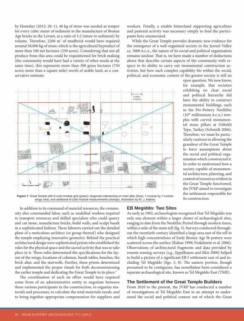
By the end of the 2010 excavation season, the cultic complex itself was the only piece of the puzzle to provide information on the society that constructed it. However, several observa-tions could be made as a starting point for further investigation (Adams et al. 2014). First, the community controlled significant quantities of raw material resources for construction, in the form of stone for foundations (1100 m3 of stone in the foundations alone) and mud, straw, and water for bricks. For example, con-sider the mundane necessity of straw for mudbrick production as a useful illustration of the scale of these resources. We have estimated that a volume of 2200 m3 of mudbricks were used in the construction of the temple alone. Following estimates made
Figure 5 (above). Isometric drawing of the Great Temple. Figure 6 (below). Comparative plans of the Megiddo Level J-3 (left) and Level J-4 (right) temples to scale. Illustrations by M. J. Adams.
ern standards (Adams 2013; Adams et al. 2014).
Perhaps the most surpris-ing result of this work was the discovery of the Great Temple in Level J-4, a monu-mental shrine dating to the latest phase of the EB Ib (ca. 3000 b.c.e.).3 This building was a 47.5 m by 22 m broad-room sanctuary with two rear corridors found stacked with the bone refuse from animal sacrifices (figs. 4–5). The main sanctuary was en-tered through a basalt-paved doorway in the northern wall, opposite a mudbrick and stone altar. A row of twelve column bases was located along the longitudinal axis of the sanctuary flanked by two
rows of round and rectangular 1-ton basalt slabs, twelve in all.At 1100 m2, the sheer size of the building is impressive and
unprecedented. It was built to replace the similarly-styled 120 m2 temple of Level J-3 (fig. 6), which itself was slightly larger than the 100 m2 average size of known Early Bronze (I–III) temples in the southern Levant (Adams et al. 2014, fig. 9). After the Great Temple, the next largest similar structure, the EB II temple at ‘Ai, just north of Jerusalem, was 360 m2. But what is more impressive than the size of the temple is the precision of the craftsmanship, the scale of the labor involved, and the underlying organization of the society responsible for it.
The temple was designed to exacting standards. It was laid out according to a well-planned grid using a 52.5 cm standard unit of measurement (a cubit) arranged in modules of six cubits (fig. 7). These units determined the layout of the building as well as the placement of the cultic furniture within it. The structure was planned as a symmetrical bipartite structure of two wings, each measuring seven modules by seven modules, and each con-
36 NEAR EASTERN ARCHAEOLOGY 77:1 (2014)
by Homsher (2012: 20–1), 40 kg of straw was needed as temper for every cubic meter of sediment in the manufacture of Bronze Age bricks in the Levant, at a ratio of 1:2 (straw to sediment) by volume. Therefore, 2200 m3 of mudbrick would have required around 58,000 kg of straw, which is the agricultural byproduct of more than 100 net hectares (250 acres). Considering that not all produce from this area could be requisitioned for brick making (the community would have had a variety of other needs at the same time), this represents more than 300 gross hectares (750 acres; more than a square mile) worth of arable land, as a con-servative estimate.
In addition to its command of material resources, the commu-nity also commanded labor, such as unskilled workers required to transport resources and skilled specialists who could quarry and cut stone, manufacture bricks, build walls, and sculpt basalt in a sophisticated fashion. These laborers carried out the detailed plans of a meticulous architect (or group thereof) who designed the temple employing innovative geometry. Behind the practical architectural design were sophisticated priests who established the rules for the physical space and the sacred activity that was to take place in it. These rules determined the specifications for the lay-out of the wings, locations of columns, basalt tables, benches, the brick altar, and the stairwells. Further, these priests determined and implemented the proper rituals for both decommissioning the earlier temple and dedicating the Great Temple in its place.5
The coordination of such an effort would have required some form of an administrative entity to negotiate between these various participants in the construction, to organize ma-terials and processes, to calculate the total materials needs, and to bring together appropriate compensation for suppliers and
workers. Finally, a sizable hinterland supporting agriculture and pastoral activity was necessary simply to feed the partici-pants here enumerated.
While the Great Temple provides dramatic new evidence for the emergence of a well-organized society in the Jezreel Valley ca. 3000 b.c.e., the nature of its social and political organization remains unclear. That is, we have made a number of deductions above that describe certain aspects of the community with re-spect to its ability to carry out monumental construction ac-tivities, but how such complex capability fits within the social, political, and economic context of the greater society is still an
open question. We now know, for example, that societies exhibiting no clear social and political hierarchy did have the ability to construct monumental buildings, such as the Pre-Pottery Neolithic (10th millennium b.c.e.) tem-ples with carved monumen-tal stone pillars at Göbekli Tepe, Turkey (Schmidt 2006). Therefore, we must be partic-ularly cautious in allowing the grandeur of the Great Temple to force assumptions about the social and political orga-nization which constructed it. In order to understand how a society capable of monumen-tal architecture, planning, and control of resources evident in the Great Temple functioned, the JVRP aimed to investigate the settlement responsible for its construction.
EB Megiddo: Two SitesAs early as 1902, archaeologists recognized that Tel Megiddo was only one element within a larger cluster of archaeological sites, ranging in date from the Neolithic Period through modern times, within a mile of the main tell (fig. 3). Surveys conducted through-out the twentieth century identified a large area east of the tell in which high concentrations of Early Bronze Age Ib pottery were scattered across the surface (Raban 1999; Finkelstein et al. 2006). Observations of architectural fragments and data provided by remote sensing surveys (e.g., Eppelbaum and Itkis 2000) helped to build a picture of a significant EB I settlement east of and in-cluding Tel Megiddo (figs. 3, 8). The eastern portion, though presumed to be contiguous, has nonetheless been considered a separate archaeological site, known as Tel Megiddo East (TME).
The Settlement of the Great Temple BuildersFrom 2010 to the present, the JVRP has conducted a number of investigations at Tel Megiddo East in an attempt to under-stand the social and political context out of which the Great
Figure 7. Great Temple with 6-cubit module grid (green), diagonals intersecting on main altar (blue), 7-module by 7-module wings (red), and additional 6-cubit module measurements (orange). Illustration by M. J. Adams.

NEAR EASTERN ARCHAEOLOGY 77:1 (2014) 37
Temple emerged. These have included geophysical studies such as ground penetrating radar and magnetometer, paleoenviron-mental studies to reconstruct the environment in the EB I, and trial excavations to determine the extent of the settlement.
The core of the settlement at TME was centered on an outcrop of bedrock approximately 450 m east of Tel Megiddo, across a shallow wadi formed by the run-off from the local water source, the spring at ‘Ain el-Qubbi (figs. 3, 8). The boundaries of the site are not yet clearly known, but trial excavations at strategic sampling points in the broader vicinity provide an approximate maximum area of 8 hectares (20 acres) over which the site, as preserved, might extend (fig. 3). Significantly, these trial excava-tions demonstrated that the settlement itself was not contiguous with the cultic acropolis at Tel Megiddo – no settlement existed in the ca. 250 m between the wadi and the rocky ascent (a.k.a the “East Slope”) below the Great Temple; rather, this area is now known to have been wet marshland unsuitable for settlement (but probably a great resource for feeding and watering flocks of sheep, goats, cattle, and pigs attested in the remains from excava-tions) (see "Climate and Environment at EB I Megiddo" text box to the right).
Unfortunately, the spatial extent of the EB I on the main tell remains hidden beneath later material, and so the potential types of occupation there (cultic? domestic? administrative?) are open
Figure 8. View of TME from the height of Tel Megiddo looking westward. The excavation shades just right of center mark the area of the site under excavation by the JVRP. Photograph courtesy of JVRP.
Climate and Environment at EB I Megiddo
An important goal of our trial excavations was to acquire paleoenviron-mental data with which to reconstruct the environment surrounding Megid-do. In the EB I, the climate of the Southern Levant was generally quite moist, with a high frequency of fluctuating rainfall (Rosen 1995; 1997; 2006). Evi-dence for this moist episode comes from a variety of data sources, including isotope analyses of cave speleothems and snail shells (Bar-Matthews et al 1998; 1999), geomorphology, and pollen (Baruch and Bottema 1999). Higher reso-lution evidence regarding the landscape of the Jezreel Valley results mostly from pollen and geomorphology data, indicating a high degree of alluviation during this time, which resulted more from rainfall runoff than hillslope ero-sion (Rosen 1997; 2006). Around Megiddo and TME, sediments from this period are characterized by thick units of heavy dark clays of a marshy envi-ronment with a high water table. The lacustrine-type sediments found in our study near the spring (Ain’ el-Qubbi) and the wadi suggest the presence of a standing body of water, perhaps a small lake. In other places, particularly in the area between Megiddo and TME, gravel deposits in a clayey matrix indicate a network of streams channeling runoff into many small, low-energy streams that meandered across the marshy plain. The rich, clayey valley de-posits with a high content of organic matter (hence the dark color) demon-strate that the land surrounding the EB I tell and settlement consisted of rich and well-watered soil probably ideal for farming and grazing animals but, with the lack of drainage, certainly not conducive to a large, contiguous settlement on the plain itself. Thus, the situation of TME on an elevated bedrock outcrop provided an ideal location for settlement until the terminus of the EB I, after which time the climate became more stable, but comparatively drier.

38 NEAR EASTERN ARCHAEOLOGY 77:1 (2014)
to speculation. However, it is most probable that in the EB Ib Tel Megiddo was an approximately 4 hectare site consisting primar-ily of a cultic compound and cemetery.6 EB I greater Megiddo, then, was a dual site consisting of a cultic acropolis at Tel Megid-do and the settlement at TME. At a combined size of approxi-mately 12 hectares (ca. 30 acres; not including the marsh that separated them), EB Ib Megiddo is among the largest of known Early Bronze Age sites in the southern Levant, dwarfed only by EB II/III Bet Yerah and Yarmut (Greenberg et al. 2012; de Miros-chedji 1988).
The JVRP excavations at TME to date have revealed nearly 600 m2 of the settlement (fig. 9). Although parts of the site, par-ticularly on the western slopes, have been greatly disturbed due to erosion and bioturbation, excavations from our most recent
season (2013) indicate that the central portion of the site is in good condition. Four major architectural phases have so far been eluci-dated, all dating to the EB Ib, that roughly parallel the four phases of the EB Ib on Tel Megiddo (Levels J-2–4; see table on p. 42). The latest phase at TME is contemporary with the Great Temple at the very end of the period (ca. 3000 b.c.e.), and demonstrates some of the new phenomena that accompanied its construction.
The limestone outcroppings upon which the latest incarna-tion of the settlement was built are very uneven, with irregular promontories and deeper cavity-like depressions that would have been very difficult to build upon (figs. 9–10). Thus, it is not surprising that the earliest architectural remains (Phase 9) are located at the base of this bedrock (beneath Building C, fig. 9),
the builders having taken advantage of the flatter early Holocene clay beds from which the outcroppings protrude. Here the team revealed a prevalence of Bow-rim storage jars and Grey Bur-nished Ware bowls, both styles typical of the middle of the EB I (ca. 3200 b.c.e.). Due to the aforementioned disturbances on the western slopes, little could be discerned about the layout of the settlement for this earliest phase, but that it was characterized by a lack of planning and regularity. Some walls continued to be rebuilt along the same plan into the latest phases, suggesting a degree of continuity throughout the period.
While these buildings indicate consistency in the layout, oth-er important changes within the settlement confirm significant developments in the organizational mind of the community. The latest occupational phase at the site (Phase 6, figs. 9–12), con-
temporary with the Great Temple, reveals a new effort on be-half of the inhabitants to terraform the uneven bedrock into us-able building space. Well-built terraces and strategically placed foundation walls among the sharp bedrock angles allowed for the expansion of the settlement increasingly upslope onto the jagged outcroppings (fig. 10). This phase not only demonstrates significant manual labor by the inhabitants, but also a strategic engineering sense and site-wide plan, especially since at least one of the new buildings (“A”) was particularly large (fig. 11).
This partially excavated building (labeled “A” in figs. 9; 11) provides intriguing evidence for its special nature. It is at least 25 m north to south and 15 m east to west (minimum ca. 375 m2, ca. seven times larger than a decent house of the period). The long
Figure 9. Photogrammetric plan of the JVRP Excavations at TME (Area C) showing primarily elements belonging to Phase 6, the period of the Great Temple. Note the complimentary orientations of Buildings A, B, and C. Photogrammetry by A. Prins.

NEAR EASTERN ARCHAEOLOGY 77:1 (2014) 39
western wall was supported by stone terrace walls adapted to the irregular bedrock beneath (figs. 10a, b; 11). The northern parallel walls, forming a street or hallway, curved into the eastern walls. One impressive fragment of floor here was made of crushed lime approximately 10 cm thick, though much of it was badly erod-ed and none of its occupational contents have been preserved. Two flat basalt slabs, which appear to have been column bases, remained in situ inside the building. The distance between the north wall and the northern slab was precisely the same distance as that between the two slabs. Significantly, this distance was ap-
proximately 5.25 m, that is ten 52.5-cm cubits.7 Despite its poor state of preservation, we might reconstruct a large interior space defined by evenly spaced columns on basalt slabs, perhaps (on the basis of its large size) serving a public function.5 Building “A” therefore appears to be a well-planned structure designed ac-cording to the same metrical principles as the Great Temple (cf. figs. 7, 11).
Further evidence of the use of the cubit as an organizing prin-ciple was present in other structures of this latest EB Ib phase. The walls of both the fragmentary building “C,” west of building
“A” (fig. 9), and those of building “B” (figs. 9, 12) in the north-eastern part of the excavation area were 1.05 m thick (2 cubits). In the case of ”C,” these 2-cubit walls replaced on the same plan earlier walls of irregular dimensions, as though it was simply rebuilt to meet the new standard. In the case of building “B,” a typical domestic style structure, the only one for which we have a (nearly) complete plan (fig. 12), the entire house conforms to the cubit standard, measuring 21 cubits by 12 cubits (in mod-ules of 3), with an impressive basalt slab occupying the place of the central, axial cubit (much like the axis of the Great Temple).
Even the small room appended to the east side of the building is an addition of exactly 6 cubits (with walls 1 cubit thick).
Phase 6 Buildings A, B, and C at TME make significant con-tributions to our understanding of the society which built the Great Temple. First, Building A shows that the development of large-scale public architecture was not confined to the Great Temple, but that it was a phenomenon that was also present in the broader community. Second, the use of the cubit as an or-ganizing principle in the temple, the columned public building (“A”), the domestic structure (“B”), and building “C” shows how
Figure 10. Examples of terrace walls constructed within and upon jagged bedrock. Photographs courtesy of JVRP.

40 NEAR EASTERN ARCHAEOLOGY 77:1 (2014)
pervasive was the effort of standardization. Finally, The TME Phase 6 buildings and the fragments of others excavated to date are laid out in an organized grid-like fashion – the walls of each building are parallel to the others’ (fig. 9) – despite the difficulties of constructing on jagged bedrock. This last observation demon-strates that a general plan existed for (at least this part) of the site.
While there is still much work to be done at TME, the results of just a few short seasons of excavation have demonstrated a pattern of development in the later EB I that parallels the pattern observed on the acropolis. At both sites, substantial activity and construction suggest a prosperous mid-to-late EB Ib society, cul-minating in the Great-Temple phase, which featured monumen-tal architecture, standardization of measurements in a variety of public and private buildings both on the acropolis and in the settlement, and an effort to plan over broad spaces in the settle-ment. Further, sophisticated engineering and significant effort at both sites is indicated, on one hand, by the terraces supporting settlement expansion onto rough terrain and, on the other, the monumental feat of the temple itself (which also included major terracing, including a four-meter thick retaining wall on the east side of the compound; Adams et al. 2014).
The Jezreel Valley in the Late Fourth MillenniumThe evidence amassing at Tel Megiddo and Tel Megiddo East reveals a community undergoing significant developments late in the EB I, inspired by new motivations and demonstrat-ing abilities to construct an unprecedented cultic complex. The methods and standards used to construct the Great Temple were further dispersed into the community, and other struc-tures were remodeled or built anew according to these same standards and with a central plan. The control of resources apparent in these new en-deavors suggests access to a sizable hinterland, including building materials, food, and especially human inhabitants willing (or perhaps coerced) to participate in this unprec-edented construction project.
The next major project awaiting the JVRP is a de-tailed survey of the Jezreel Valley that aims to specifi-cally contextualize the devel-opments at Megiddo within its regional setting. Data ac-quired by previous surveys and excavations around the valley provide a starting point and suggest that what oc-curred at Megiddo was part of a valley-wide phenomenon (Finkelstein et al. 2006; Raban
1999). Settlement patterns and site-size estimates suggest a dra-matic population boom in the EB Ib. The Megiddo Hinterland Survey conducted in the 1990s (Finkelstein et al. 2006) identi-fied more than 45 settlement sites, the most for any single period before the Iron Age. The average size of these sites was over 2 hectares, the largest average of any period in the Valley. Based on these metrics alone, the EB Ib seems to have been one of the most prosperous periods in the history of the region. A major-ity of these sites were medium-sized (close to 2 hectares) and distributed around the valley, and several larger sites were evenly disbursed among them, Megiddo being the largest and exhibit-ing unique elite architecture. Overall, the emerging impression is of a well-integrated regional network, within which Megiddo played a central role somehow related to its elaborate cult com-plex.
Epilogue: The Fall of EB I MegiddoDespite the major developments that left their mark on Megid-do and elsewhere in the valley, the EB I terminated in what may be considered a collapse or failed social experiment. The abandonment of Megiddo and the Great Temple coincided with broader regional changes that suggest a widespread crisis at the end of the EB I. The Megiddo Hinterland Survey demonstrat-ed that severe settlement changes accompanied the transition from the EB I to the EB II. More than half of the sites in the valley were abandoned, and nearly every surviving site was sig-nificantly reduced in size. The new settlement arrangement in the valley involved the emergence of fortified towns (e.g., Giv’at
Mish’ol/Har Haruvim, Mitz-pe Zevulun, Ta’anach). R. Greenberg (2003) has made the intriguing suggestion that the rise of an EB II regional entity in the northern Jordan Valley (centered on the main large sites of Dan, Hazor, and Bet Yerah) redrew territo-rial boundaries that severely impacted the Jezreel Valley. Similar changes in the land-scape of settlement in the EB I–II transition have been identified all over the south-ern Levant, and identifying their causes remains one of the main challenges facing the archaeology of the peri-od. The change in settlement from EB I to II is among the many questions that the JVRP intends to pursue in future research, including the question of how this transi-tion correlates with environ-mental factors, such as cli-mate change.
Figure 11. Plan of building “A” overlaid with a grid of 52.5cm cubits. Yellow highlights indicate two cubit thick walls and red highlights mark increments of five
cubits. Grey features are basalt slabs. Illustration by M. J. Adams.

NEAR EASTERN ARCHAEOLOGY 77:1 (2014) 41
Notes1. The JVRP is directed by Matthew J. Adams (W.F. Albright Institute of
Archaeological Research) with Jonathan David (Gettysburg College), Margaret E. Cohen (Lycoming College), and Robert S. Homsher (San Francisco State University) as Assistant Directors. The University of Hawai’i and the University of Oklahoma are consortium members of the project. www.jezreelvalleyregionalproject.com
2. The Megiddo Expedition is conducted under the auspices of Tel Aviv University and directed by Israel Finkelstein (Tel Aviv University) and David Ussishkin (through 2010) and Eric Cline (The George Washington University). www.megiddo.tau.ac.il
3. The Megiddo Level J-4 Temple has been the subject of several pub-lications to date. The description that follows draws on a variety of data not repeated here. See Adams et al. 2014 and citations therein for further reading.
4. These corridors apparently were the stairwells for steps leading up to a second floor or roof of the structure. Later, near the end of the life of the building, these stairwells served as favissae for the storage of animal bones, apparently from sacrifice associated with the temple cult (Ad-ams 2013; Adams et al. 2014; Adams and Schimelmitz forthcoming).
5. A foundation stone was found beneath the floor of the temple, evidently placed there late in the construction process. This stone
had markings identical to others found associated with the earlier temple, suggesting (on the model of foundation rituals practiced in Egypt and Mesopotamia) that the removal of this representative architectural element decommissioned the earlier sacred structure and served to imbue the new one with life (Adams 2013; Adams et al. 2014).
6. See Braun forthcoming for the mortuary nature of the East Slope. The approximate limits of the site in the EB I can be roughly determined by trajectories of major terrace walls found in excavation (Adams 2013).
7. The building appears similar in plan to the contemporary EB Ib Building MA at Beth Shean (Mazar 2012).
8. The phase numbering scheme presented here is provided solely for the convenience of this essay, as it is too soon in our excavations to commit to a final numbering scheme.
9. Dates for Level J-4 and J-4a are based on the recent radiocarbon study by Regev et al. (forthcoming).
ReferencesAdams, M. J. 2013. Area J (The 2004–2008 Seasons). Part III: The Early
Bronze Age, Stratigraphy and Architecture. Pp. 47–118 in Megid-do V: The 2004–2008 Seasons, eds. I. Finkelstein, D. Ussishkin, E. Cline, M. Adams, E. Arie, N. Franklin, and M. Martin. Mono-
Figure 12. Photogrammetric plan of building “B” with a grid of three cubit modules overlaid. Photogrammetry by M. J. Adams.

42 NEAR EASTERN ARCHAEOLOGY 77:1 (2014)
graph Series of the Institute of Archaeology of Tel Aviv University. Tel Aviv: Institute of Archaeology.
Adams, M. J., I. Finkelstein, and D. Ussishkin. 2014. The Great Temple of Early Bronze I Megiddo. American Journal of Archaeology 118.2.
Braun, E. Forthcoming. Early Megiddo on the East Slope (The “Megid-do Stages”). A Report on the Early Occupation of the East Slope of Megiddo-Results of the Oriental Institute’s Excavations, 1925–1933.
Bar-Matthews, M., A. Ayalon, and A. Kaufman. 1998. Middle to Late Holocene (6,500-Year Period) – Paleoclimate in the Eastern Med-iterranean Region from Stable Isotopic Composition of Speleo-thems from Soreq Cave, Israel. Pp. 203–14 in Water, Environment and Society in Times of Climatic Change, eds. A. Issar and N. Brown. Dordrecht: Kluwer Academic Publishers
Bar-Matthews, M., A. Ayalon, A. Kaufman and G. J. Wasserburg. 1999. The Eastern Mediterranean Paleoclimate as a Reflection of Regional Events: Soreq Cave, Israel. Earth and Planetary Science Letters 166(1–2): 85–95.
Baruch, U. and S. Bottema, S. 1999. A New Pollen Diagram from Lake Hula: Vegetational, Climatic and Anthropogenic Implications. Pp. 75–86 in Ancient Lakes: Their Cultural and Biological Diversity. Brussels, eds. H. Kawanabe, G. W. Coulter, and A. C. Roosevelt.
Eppelbaum, L., and S. Itkis. 2000. Magnetic Investigations in the Pro-to-Historic Site to the East of Tel Megiddo. Pp. 504–513 in Megid-do III: The 1992–1996 Seasons, eds. I. Finkelstein, D. Ussishkin, and B. Halpern. Monograph Series of the Institute of Archaeology of Tel Aviv University. Tel Aviv: Institute of Archaeology.
Finkelstein, I., B. Halpern, G. Lehmann, and H. M. Niemann. 2006. The Megiddo Hinterland Project. Pp. 705–776 in Megiddo IV: The 1998–2002 Seasons, eds. I. Finkelstein, D. Ussishkin, and B. Halpern. Monograph Series of the Institute of Archaeology of Tel Aviv University. Tel Aviv: Institute of Archaeology.
Greenberg, R. 2003. Early Bronze Age Megiddo and Bet Shean: Discontinuous Settlement in Sociopolitical Context. Journal of Mediterranean Archaeology 16: 17–32.
Greenberg, R., S. Paz, D. Wengrow, and M. Iserlis. 2012. Tel Bet Yerah: Hub of the Early Bronze Age Levant. Near Eastern Archaeology
75.2: 88–107.Homsher, R. S. 2012. Mud Bricks and the Process of Construction in
the Middle Bronze Age Southern Levant. Bulletin of the Ameri-can Schools of Oriental Research 368: 1–27.
de Miroschedji, P. 1988. Yarmouth I. Rapport sur les trois premières campagnes de fouilles à Tel Yarmouth (Israël) (1980–1982). Paris: Editions Recherche sur les Civilisations. . 2014. The Southern Levant (Cisjordan) during the Early Bronze Age. Pp. 307–29 in The Oxford Handbook of the Archaeology of the Levant, c. 8000–332 BCE, eds. M. Steiner and A. Killebrew. Oxford: Oxford University Press.
Philip, G. 2008. The Early Bronze Age I–III. Pp. 161-226 in Jordan: An Archaeological Reader, ed. In: R. B. Adams. London: Equinox.
Raban, A. 1999. Archaeological Survey of Israel: Map of Mishmar Ha’emeq (32). Jerusalem: Israel Antiquities Authority.
Regev, J., I. Finkelstein, M. J. Adams, and E. Boaretto. Forthcoming. Wiggle-matched 14C Chronology of Early Bronze Megiddo and the Synchronization of Egyptian and Levantine Chronologies.
Rosen, A. M. 1995. The Social Response to Environmental Change in Early Bronze Age Canaan. Journal of Anthropological Archaeolo-gy 14: 26–44.. 1997. Environmental Change and Human Adaptational Failure at the End of the Early Bronze Age in the Southern Levant. Pp. 25–38 in Third Millennium BC Climate Change and Old World Collapse, eds. H. N. Dalfes, G. Kukia, and H. Weiss. Berlin: NATO/Springer. 2006. Climate Change, Landscape and Shifting Agricultural Po-tential. Pp. 463–70 in Megiddo IV: The 1998–2002 Seasons, eds. I. Finkelstein, D. Ussishkin and B. Halpern. Tel Aviv: Emery Claire Yass Publications in Archaeology.
Shimelmitz, R., and M. J. Adams. 2014. Flint Knapping and the Early Bronze Age I Temple of Megiddo, Israel: Some Aspects of the Organization of Late Prehistoric Cult. Journal of Mediterranean Archaeology 27.1.
Schmidt, K. 2006. Sie bauten die ersten Tempel: Das rätselhafte Heilig-tum der Steinzeitjäger: Die archäologische Entdeckung am Göbekli Tepe. Munich: C. H. Beck.
Stratigraphic Chart of the EB Ib at Tel Megiddo and Tel Megiddo East
Tel Megiddo Tel Megiddo EastCa.
DatesTAU Level OI Stratum Description JVRP Phase8 Description
J-4a Not detected Periodic squatter activity in abandoned temple
Not detected Not enough data 2950–2850
J-4 XVIII Great Temple TME 6 Public Building A
Domestic Building B
3090–29509
J-3 XIX 120 m2 Broad-room Temple
TME 7-8 Domestic structures 3150–3090
J-2 Not detected Pre-XIX Temple TME 9 Not enough data 3250–3150

ABOUT THE AUTHORS
Jonathan David is currently Assistant Professor of Classics at Gettysburg College, and he has taught previously at Penn State University and California State University, Stanislaus. He special-izes in the history and archaeology of ancient Greece, but his particular interests involve earliest historiography and the interconnections between the Graeco-Roman world and the Near East. He has been a regular member at the American School of Classical Studies at Athens, a Mellon Foundation research fellow, and a founding member of American Archaeology Abroad.
Matthew J. Adams is the incoming Dorot Director of the W.F. Albright Institute of Archaeologi-cal Research in Jerusalem. While he has broad interests in space and time throughout the ancient world, much of his research has focused on the history and archaeology of third millennium Egypt and Levant. His early work focused on the Early Dynastic to Middle Kingdom stratigraphic sequence at Mendes, Egypt. As a member of the Megiddo Expedition in Israel, he has recently overseen the publication of the Early and Middle Bronze Age cult and palatial area at Megiddo. Now Director of the Jezreel Valley Regional Project, he and his team are engaged in survey and excavation projects at sites from a variety of periods, around the valley.
Though Margaret E. Cohen has been excavating at sites in Israel, Egypt, and Jordan for over a decade, her primary areas of expertise are Hebrew Bible and the history of ancient Israel. She teaches courses in archaeology, Hebrew Bible and New Testament, Hebrew language and Jewish Studies, and is currently teaching in the Religion Department at Lycoming College in Williamsport, Pennsylvania. Her Ph.D. is from Penn State University, where she was the recipi-ent of a National Foundation for Jewish Culture Dissertation Fellowship and partnered with col-leagues on a Legacy Heritage Jewish Studies Project Grant from the Association for Jewish Studies.
Robert S. Homsher received his Ph.D. from the Institute of Archaeology at University College London and now lectures in the Anthropology Department at San Francisco State University. He is an Assistant Director of the Jezreel Valley Regional Project, where he supervises excava-tion and coordinates research in environmental and archaeological sciences. He also serves as a long-term staff member of the Megiddo Expedition, where he supervises excavations in Area Q. His primary research interests include the archaeology of the Bronze and Iron Ages and Ho-locene paleoenvironmental studies throughout the Near East, often utilizing a wide range of geoarchaeological methods.
NEAR EASTERN ARCHAEOLOGY 77:1 (2014) 43
Copyright © 2022 FDOKUMEN


![E=F9;mklge]j ZYjge]l]j L`ak lae] alÌk h]jkgfYd2 ^jge [gfkme]j lg [g%[j]Ylgj](https://static.fdokumen.com/doc/165x107/631789cb7451843eec0ab6f2/ef9mklgej-zyjgelj-lak-lae-alik-hjkgfyd2-jge-gfkmej-lg-gjylgj.jpg)