Miller Review of Nebojsa Popov, ed., The Road to War in Serbia
Climate Change and Cultural Dynamics: A Global Perspective on Mid-Holocene Transitions
David G. Anderson, Kirk A. Maasch and Daniel H. Sandweiss (Editors)
r 2007 Elsevier Inc. All rights reserved. 331
Chapter 10
Mid-Holocene climatic changes and cultural dynamics in the basin
of the Sea of Japan and adjacent areas
Konstantin A. Lutaenko1, Irina S. Zhushchikhovskaya2, Yuri A. Mikishin3
and Alexander N. Popov4
1Institute of Marine Biology, Far East Branch of the Russian Academy of Sciences,Vladivostok 690041, Russia2Institute of History, Archaeology and Ethnography of the Peoples of the Far East,Far East Branch of the Russian Academy of Sciences, Vladivostok 690001, Russia3Coastal Research Center, Far East State University, Vladivostok 690000,Russia4Museum of Archaeology and Ethnography, Far East State University, Vladivostok690000, Russia
Abstract
Mid-Holocene climatic/paleogeographical changes, cultural dynamics, and their relations in
the basin of the Sea of Japan are reviewed. The sequence and chronology of warmings/
coolings are reconstructed as follows: the first warming of the mid-Holocene took place
between 7200 and 6200 14C yr BP in Sakhalin, although the maximum warming was between
5000 and 6000 14C yr BP; in Japan, the peak of warmth might be traced at the level of 6500–
5500 or 6500–5000 14C yr BP; a significant cooling in Japan is detected between 4000 and
4500 14C yr BP, which corresponds to the Early Subboreal cooling in Sakhalin Island about
4400 14C yr BP, to that in Primorye about 4200–4700 14C yr BP, and in the Kurile Islands
approximately 4500–4800 14C yr BP. The Tsushima Current’s inflow in the Sea of Japan
started after 9000–9500 14C yr BP, but the influx of the current on a full scale might occur
approximately 8000 14C yr BP. It is suggested that a period of high storm frequency in Korea
and Primorye, corresponding to maximum warming in Japan and Sakhalin, took place 5300–
6000 14C yr BP, Climatic estimates show that the ‘‘climatic optimum’’ (time span between
5000 and 6000 14C yr BP) is characterized in the Russian Far East by the annual average
temperature excess of 2–61C and more humid conditions. Annual average sea surface
temperatures (SSTs) in the Sea of Japan were 1–21C higher compared to the present.
Archaeological records from Japan, Korea, and the southern Russian Far East (i.e., evidence
for material and spiritual culture, and the subsistence patterns of the prehistoric populations)
indicate important changes were occurring around 5000 14C yr BP. In general, the main
cultural changes in the Japan Sea basin correspond to the period after the climatic optimum
of the Holocene. This conclusion reinforces the need for further investigation of the dynamics
of climate and culture in the mid-Holocene.

1. Introduction
The basin of the Sea of Japan is the most studied area in the northwestern Pacificfrom the viewpoint of both Holocene climate and archaeological evidence. For thatreason we selected this area for analytical review of mid-Holocene changes in cli-mate and cultural dynamics. The study area includes the Russian Far East, Japan,and Korea (Fig. 10.1). The southern part of the Russian Far East consists of theterritories of Sakhalin Island and two areas – Primorsky Krai (or Primorye) andKhabarovsky Krai (‘‘krai’’ is an administrative unit of ‘‘provincial’’ level in theRussian Federation) located along the coasts of the Japan and Okhotsk Seas. Thesouthern part of the Khabarovsky Krai is also called Priamurye (the area lying inthe basin of Amur River, the largest river in the Russian Far East). The southernpart of the Russian Far East covers an area between �551N and 421N. Precisepaleoclimatic data for the northern Okhotsk Sea, Kurile Islands, Kamchatka, andChukotka Peninsulas are still scarce.Some geographical features of the research area are of great importance for the
understanding of past cultural–historical processes. The territories of the research
35°N
40°N
30°N
45°N
55°N
50°N
35°N
40°N
30°N
45°N
55°N
50°N
125°E 130°E 135°E 140°E 145°E 150°E 155°E 160°E
125°E 130°E 135°E 140°E 145°E 150°E 155°E 160°E
76
3
4
5
2
2
1
910
Primorye
Kyushu Shikoku
Honshu
Hokkaido
Kurile Islands
SEA OF JA
PAN
Kor
ea
Sakhalin
2
SEA OF OKHOTSK
8
Figure 10.1. A map of the Sea of Japan region showing localities and geographical areasmentioned in the text. 1 – Peter the Great Bay, 2 – Amur River, 3 – Tatarsky Strait,4 – Terpenya Bay, 5 – Aniva Bay, 6 – Kunashir(i) Island, 7 – Ishikari Bay, 8 – Toyama Bay,9 – Tokyo Bay, and 10 – Wakasa Bay.
K.A. Lutaenko et al.332

area form a circular pattern surrounding the Sea of Japan. Some territories aremainland, such as the Korean Peninsula, Primorye, and Lower Amur River regions,while the others are insular, such as the Japanese Archipelago and Sakhalin.Neighboring territories separated by the sea are located at short distances one fromanother (Fig. 10.1). Mainland regions of the research area representing the easternoutskirts of the Eurasian continent are linked with more distant western territoriesby two natural ‘‘roads’’ – the Amur River streaming in a west-to-east direction, anda ‘‘steppe corridor’’ passing through southern Siberia, Mongolia, and NortheasternChina. These geographical peculiarities influenced to a certain extent the past cul-tural history of the research area, especially processes of cultural contacts, migra-tions and diffusions, and the continuity and discontinuity of prehistoric populationdevelopment.The chronological framework of our investigation span the interval from 8000 to
3000 yr BP; all dates used in the text are non-calibrated radiocarbon ages (hereafter‘‘14C yr BP’’). According to the classic Blytt–Sernander scheme, the mid-Holoceneincludes the Atlantic and the Subboreal (8000–2200 14C yr BP). The most importantevent of the mid-Holocene is believed to be the post-glacial climatic optimum andhigh stand of the sea level, whose traces are recognized in many areas of the WorldOcean, and by biotic events such as the northward shift of the boundary of broad-leaved forests, the northward migrations of warm-water faunal elements (i.e., asdocumented by the appearance of so-called thermally anomalous faunas in coastalareas), an increase in the bioproductivity of some marine waters, and so on. Itshould be noted that the definition of the ‘‘climatic optimum’’ is not generallyaccepted. Optimum in itself is a combination of most favorable conditions, and thisdefinition is frequently intuitively used in paleoecology. But what is optimum forthermophilous organisms is not so for organisms living in cold or even temperateenvironments. Hereafter, when we use the term ‘‘climatic optimum’’, we merelymean the maximum warm climatic conditions of the Middle Holocene.The main purpose of this paper is to delimit climatic patterns and analyze cul-
tural dynamics during the mid-Holocene in the basin of the Sea of Japan, to cor-relate climatic, environmental, and cultural changes. Explanatory models areproposed to show probable relationships between culture and climate in the past.Detailed climatic and environmental change research has been underway in
Japan and the southern Russian Far East since the 1960s, resulting in a significantunderstanding of the region’s Holocene paleogeography. The approaches of theRussian and Japanese authors are sometimes sufficiently different that it is difficultto directly correlate the paleoclimatic data. For instance, Russian authors widelyaccept and make use of the Blytt–Sernander climatostratigraphic scheme, whereasJapanese paleogeographers mainly use cultural periodization. The details ofHolocene vegetation changes are the main ‘‘fine’’ indicator of climatic changes.Radiocarbon determinations are much more common and better known in Japancompared to Korea and the Russian Far East. The Russian literature dealing withHolocene paleoenvironmental changes is difficult for many scholars to access giventhe language barrier, and is rarely cited or critically analyzed by Japanese authors.
Sea of Japan 333

At the same time, the extensive Japanese literature is itself difficult to review bynon-Japanese-speaking authors.The primary evidence for past cultural dynamics is obtained from the archae-
ological record. In all parts of the research area, the mid-Holocene chronologicallimits correspond to what is known broadly as the Neolithic period. The amountof archaeological research in these different regions encompassing this period isuneven.In Japan, large-scale systematic archaeological investigation has occurred on
many sites of this period. Dozens of sites have been completely excavated, dated,and published in detail. The archaeological record includes sites of the famousNeolithic Jomon culture, some stages of which correlate with the mid-Holocenetemporal limits of 8000–3000 14C yr BP. Jomon culture has been examined in detailfor about a century, but it is only after World War II, with the advent of radi-ocarbon dating, that the ‘‘golden age’’ of Jomon studies started. At present manyJomon sites are being found and excavated in all part of the Japanese Archipelago,from Hokkaido in the north to Okinawa in the south. The cultural complexes of theNeolithic have been most completely worked out in Japan, where there are far moreradiocarbon dates than in other parts of the research area.The Korean Peninsula has witnessed intensive archaeological investigations since
the 1950s and 1960s, and many Neolithic sites are known that date from 8000 to3000 14C yr BP. The basic cultural sequence of the Korean Neolithic is now known,although a current problem is to attain a more detailed systematization of thearchaeological contexts. Radiocarbon dating is increasingly commonplace inKorean archaeology, and large numbers of absolute dates exist for the Neolithic,more than for most other cultural periods.Periodic archaeological investigations in the Russian Far East began in the 1950s.
At present, the general time-space systematics of cultural remains from the Pale-olithic to the Early States period are known and outlined. Increasing amounts ofinformation are being recovered, and recent discoveries are correcting and addingto our conceptions of the past.The Neolithic of the Russian Far East closely correlates with the mid-Holocene
period. All recognized Neolithic cultures fall within or partially overlap with thechronological limits under consideration herein, from ca. 8000 to 3000 cal yr BP.The Russian Far East has fewer completely excavated and securely dated Neolithicsites than Korea and especially Japan. The lack radiocarbon dates is most pro-nounced for the Lower Amur region than for other parts of the Russian Far East.The Neolithic cultural sequence of the Lower Amur region is based, in large part,on relative dating.To reconstruct past cultural dynamics, we must distinguish the changing com-
ponents of culture and their archaeological indicators. The former include infor-mation about subsistence, demography, social structure, basic cultural context,material culture, and spiritual culture. The latter are the remains and evidences ofsettlements and dwellings patterns, subsistence patterns, burial and ritual objectspatterns, and tools and ceramic patterns. Obviously, the availability of certain
K.A. Lutaenko et al.334
indicators of cultural dynamics depends primarily on the degree of preservation,and the volume and completeness of the archaeological record. The sets of ar-chaeological indicators of past cultural processes in the various regions of theresearch area are different. They are most variable and representative for Japan andKorea and more restricted for the Russian Far East.
2. Climatic and environmental changes
Climatically, the structure of the mid-Holocene was heterogenous. Although it isgenerally believed that a warming occurred in the mid-Holocene, there were severalwarm epochs alternating with cold ones. This has been shown most clearly for theRussian territory in its European and Siberian parts, and only recently for SakhalinIsland.Khotinsky (1982) recognized in the ‘‘Middle Holocene’’ three thermal maxima:
the Boreal maximum (8300–8900 14C yr BP), the Late Atlantic maximum (4700–6000 14C yr BP), and the Middle Subboreal maximum (3200–4200 14C yr BP). TheBoreal thermal maximum was most pronounced in Siberia and the Far East; theMiddle Subboreal in the north of Russian Plain, and the Late Atlantic in the greaterpart of the forest zone of Northern Eurasia. The Late Atlantic maximum mostclosely corresponds to the global climatic optimum of the Holocene. The warmingin the Boreal was no less significant, when compared to that during the Atlantic, butthe Boreal warming was not expressed widely and was not lengthy (Khotinsky,1982, p. 145). These conclusions are based on generalized schemes of paleoclimatesdeduced from pollen analysis.There are several other reconstructions by Russian authors providing maps of
paleotemperatures and precipitation for the entire territory of the former SovietUnion, including areas adjacent to the Sea of Japan basin. According to a quan-titative reconstruction of Burashnikova et al. (1982), during the period from 5000 to6000 14C yr BP a gradual increase in temperatures compared to present-day occurrednorth of ca. 481N, from 1–21C in the south to 3–41C in the north, northeast, and inKamchatka. At a latitude of 40–501N, there was a ‘‘neutral belt’’ where July tem-peratures at 5000–6000 14C yr BP were not significantly different from recent ones.Thus, the changes in temperatures during the climatic optimum were geographicallyheterogenous – the greatest increases in temperature took place in the northern andnortheastern parts of the research region in the former USSR, where temperaturedifferences reached 41C above present-day temperatures (Burashnikova et al., 1982).In a north–south direction, there was also a gradual lowering of precipitation, and inthe Russian Far East the climate was more dry than today. This indicates met-achronous climatic variations during the climatic optimum in different geographicalzones and regions.Borzenkova (1990), analyzing the paleotemperature curves for northwestern
Europe and western Siberia, suggested about 30 global warmings and coolings tookplace during the Holocene. He emphasized the importance of distinguishing two
Sea of Japan 335
warmings, the Early Boreal (9200–8900 14C yr BP) and the Late Atlantic. The firstwarming was evidenced by the changes of vegetation in the continental (non-glacial) regions of the Northern and Southern Hemispheres, and the second one bymaximum temperatures (i.e., a warming up) of the upper layer of the ocean. TheEarly Boreal warming was thought to be characterized by the summer temperatures5–61C above present-day ones in the northeast of the former USSR (i.e., north-western Pacific areas), in Alaska, and in temperate latitudes of the Southern Hem-isphere, and by the maximum northward shifting of forests during the Holocene(Borzenkova, 1990).Climatic reconstructions for the entire territory of the former USSR and North-
ern Hemisphere were undertaken, respectively, by Khotinsky and Savina (1985),Klimanov (1989a), and Velichko and Klimanov (1990), inclusive of areas adjacentto the coast of the North Pacific Ocean. According to Velichko and Klimanov(1990), the warmest period of the Holocene history occurred about 5000–6000 14Cyr BP, and it corresponds to Atlantic-3, or climatic optimum. These authors pre-sented maps of the distribution of annual average temperatures, average Januaryand July temperatures, total amounts of annual precipitation and deviations ofthese parameters from recent ones. The authors noted that their schemes agreedquite well with reconstructions produced by Khotinsky and Savina (1985). Whendetermining the quantitative characteristics of climate, Velichko and Klimanov(1990) used the information-statistical method, which is based on the statisticalrelationship between the composition of Recent spore-pollen spectra and present-day climatic conditions. According to their reconstructions, average July temper-atures were higher by 21C or more compared to recent average July temperatures inthe Russian Far East territory, eastern China, and Japan. This is in agreement withthe data of Burashnikova et al. (1982) for Sakhalin and Kamchatka, and with thoseof Klimanov (1989b) for Primorye where average July temperatures were approx-imately 21C higher than at present. Klimanov (1989b) estimated that averageJanuary temperatures during the climatic optimum were higher than present onesthroughout the territory of the former Soviet Union. In the Far East, wet con-ditions dominated, and precipitation increased by 25–50mm (Klimanov, 1989b);this viewpoint, however, is in conflict with the reconstruction of Burashnikova et al.(1982).Using the zonal formational method for the climatic reconstructions at about
5000 14C yr BP (i.e., the establishment of relations between Recent vegetationzones, groups of vegetational formations, and present-day climatic characteristics),Khotinsky and Savina (1985) argued for an increase in annual amounts of pre-cipitation in the northern, southern, and partly eastern regions of the former USSR.The authors also reconstructed January and July temperatures in the form of maps.All of the above-mentioned reconstructions were based on either statistical
methods or other methods of analysis of pollen data. Punning and Raukas (1985),in their extensive review of paleogeography of Northern Europe, correctly notedthat the higher the latitude, the less palynological information there is available;thus, the reliability of reconstructions based on this kind of data is decreased in
K.A. Lutaenko et al.336
these areas. This is, probably, a major type of error associated with paleoclimaticreconstructions based on this method – an inadequate number of paleoclimatic sitesare averaged to indicate climate at a large-scale (Liao et al., 1994).
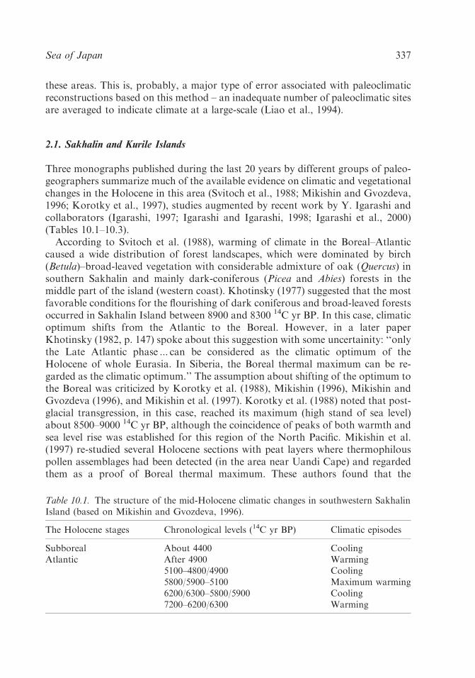
2.1. Sakhalin and Kurile Islands
Three monographs published during the last 20 years by different groups of paleo-geographers summarize much of the available evidence on climatic and vegetationalchanges in the Holocene in this area (Svitoch et al., 1988; Mikishin and Gvozdeva,1996; Korotky et al., 1997), studies augmented by recent work by Y. Igarashi andcollaborators (Igarashi, 1997; Igarashi and Igarashi, 1998; Igarashi et al., 2000)(Tables 10.1–10.3).According to Svitoch et al. (1988), warming of climate in the Boreal–Atlantic
caused a wide distribution of forest landscapes, which were dominated by birch(Betula)–broad-leaved vegetation with considerable admixture of oak (Quercus) insouthern Sakhalin and mainly dark-coniferous (Picea and Abies) forests in themiddle part of the island (western coast). Khotinsky (1977) suggested that the mostfavorable conditions for the flourishing of dark coniferous and broad-leaved forestsoccurred in Sakhalin Island between 8900 and 8300 14C yr BP. In this case, climaticoptimum shifts from the Atlantic to the Boreal. However, in a later paperKhotinsky (1982, p. 147) spoke about this suggestion with some uncertainity: ‘‘onlythe Late Atlantic phase ... can be considered as the climatic optimum of theHolocene of whole Eurasia. In Siberia, the Boreal thermal maximum can be re-garded as the climatic optimum.’’ The assumption about shifting of the optimum tothe Boreal was criticized by Korotky et al. (1988), Mikishin (1996), Mikishin andGvozdeva (1996), and Mikishin et al. (1997). Korotky et al. (1988) noted that post-glacial transgression, in this case, reached its maximum (high stand of sea level)about 8500–9000 14C yr BP, although the coincidence of peaks of both warmth andsea level rise was established for this region of the North Pacific. Mikishin et al.(1997) re-studied several Holocene sections with peat layers where thermophilouspollen assemblages had been detected (in the area near Uandi Cape) and regardedthem as a proof of Boreal thermal maximum. These authors found that the
Table 10.1. The structure of the mid-Holocene climatic changes in southwestern SakhalinIsland (based on Mikishin and Gvozdeva, 1996).
The Holocene stages Chronological levels (14C yr BP) Climatic episodes
Subboreal About 4400 CoolingAtlantic After 4900 Warming
5100–4800/4900 Cooling5800/5900–5100 Maximum warming6200/6300–5800/5900 Cooling7200–6200/6300 Warming
Sea of Japan 337

Ta
ble
10
.2.ClimaticparametersoftheAtlanticin
SakhalinIsland.
Area
Averageannual
temperature
(1C)
July/A
ugust
temperature
(1C)
January
temperature
(1C)
Precipitation
(mm/year)
Source
SakhalinIsland
015(July)
�24
700or500
Korotkyet
al.
(1996a,1997)
Southeastern
SakhalinIsland
5–7,5
18–21(A
ugust)
�5–7
Upto
1000–1200
ormore
than800
Mikishin
and
Gvozdeva(1996)
Western
Sakhalin
Island(coastal
areaofTatarsky
Strait)
–17(July)
–500
Burashnikovaet
al.
(1982)
K.A. Lutaenko et al.338
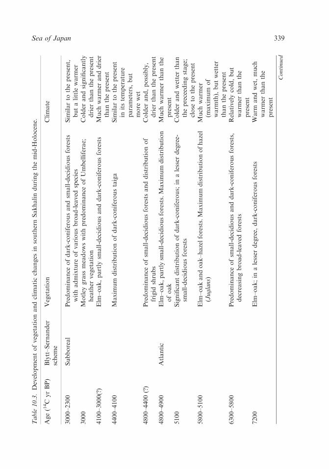
Ta
ble
10
.3.Developmentofvegetationandclim
aticchanges
insouthernSakhalinduringthemid-H
olocene.
Age(14C
yrBP)
Blytt–Sernander
schem
eVegetation
Climate
3000–2300
Subboreal
Predominance
ofdark-coniferousandsm
all-decidiousforests
withadmixture
ofvariousbroad-leaved
species
Sim
ilarto
thepresent,
butalittle
warm
er3000
Motley
grass
meadowswithpredominance
ofUmbelliferae;
heather
vegetation
Colder
andsignificantly
drier
thanthepresent
4100–3000(?)
Elm
–oak,partly
small-decidiousanddark-coniferousforests
Much
warm
eranddrier
thanthepresent
4400–4100
Maxim
um
distributionofdark-coniferoustaiga
Sim
ilarto
thepresent
initstemperature
parameters,
but
more
wet
4800–4400(?)
Predominance
ofsm
all-decidiousforestsanddistributionof
frigid
shrubs
Colder
and,possibly,
drier
thanthepresent
4800–4900
Atlantic
Elm
–oak,partly
small-decidiousforests.Maxim
um
distribution
ofoak
Much
warm
erthanthe
present
5100
Significantdistributionofdark-coniferous;in
alesser
degree-
small-decidiousforests
Colder
andwetterthan
thepreceedingstage;
close
tothepresent
5800–5100
Elm
–oakandoak–hazelforests.Maxim
um
distributionofhazel
(Ju
gla
ns)
Much
warm
er(m
axim
um
of
warm
th),butwetter
thanthepresent
6300–5800
Predominance
ofsm
all-decidiousanddark-coniferousforests,
decreasingbroad-leaved
forests
Relativelycold,but
warm
erthanthe
present
7200
Elm
–oak;in
alesser
degree,
dark-coniferousforests
Warm
andwet,much
warm
erthanthe
present
Co
nti
nu
ed
Sea of Japan 339

Ta
ble
10
.3.continued
Age(14C
yrBP)
Blytt–Sernander
schem
eVegetation
Climate
7800
Boreal–Atlantic
DistributionofSphagnum
swamps,
sedgemeadows,frigid
shrubwithpredominance
of
Aln
ast
er;in
alesser
degree,
birch
forests
Cold
andwet
9300–8100
Decreasingbirch
forests,
distributionofdark-coniferousand
broad-leaved
species.Appearance
of
Ara
lia
,F
rax
inu
s,and
fern
Osm
un
da
Close
tothepresent,but
wetterandslightly
colder
Predominance
ofbirch
forests,decreasingfrigid
shrub.
Appearance
ofoak,disappearance
offern;distributionof
Art
emis
iaandheather
Relativelywarm
,but
colder
andwetter
thanthepresent
Larixandbirch
forests,frigid
shrub.Increasingdark-coniferous
species,appearance
ofelm,flourishingoffern
(Polypodiaceae)
Warm
erandwetter
thanpreceedingstage,
butcolder
anddrier
thanthepresent
K.A. Lutaenko et al.340

‘‘thermal maximum’’ took place in the mid-Boreal: climate was warmer than thepresent-day one, but, at the same time, colder compared to the Atlantic warming.The main type of vegetation was birch (Betula) with admixture of elm (Ulmus).According to Mikishin et al. (1997), this phenomenon might have been caused by asignificant influence of the warm Tsushima Current which could penetrate muchnorthward along the western coast of Sakhalin Island because of an incompleteopening of La Perouse (Soya) Strait (the strait between Hokkaido and Sakhalin) at9000–8300 14C yr BP. In southeastern Sakhalin, the Boreal warming was weaker(Mikishin and Gvozdeva, 1996). A similar viewpoint was substantiated by Korotkyet al. (1997) who stressed that sea level was about 20m below its present position atthat time. These authors confirmed that the Boreal climate in its optimum phasewas warmer than present-day, thus causing a disappearance of permafrost in thecoastal zone of western and southern Sakhalin, an enhancement of eolian processes,development of Betula–Ulmus forests characterized by maximum participation ofthe grass pollen during the Holocene history (up to 60%), and inlaid distribution ofspruce (Picea) forests.Based on a study of the Holocene deposits on the coast of western and southern
Sakhalin and using numerous C 14 dates, Korotky et al. (1997) showed thatclimatic optimum occurred at the chronological level of 5000–7000 14C yr BP with awell-expressed within-Atlantic warming. At that time, broad-leaved forests weredistributed north up to 491N (near Shakhtersk Town). Abies–Picea taiga flourishedin highlands. The birch–spruce (Betula–Picea) forests (in lowlands) and Picea–Abiestaiga (in highlands) formed in the northern Sakhalin (western coast). Broad-leavedtrees (oak and elm) also played a limited role in the formation of these forests.Along the eastern coast of northern Sakhalin, birch–spruce (Betula–Picea) forests
were common. Forests consisting of birch–alder (Betula–Alnus) and larch (Larix)formed in the coastal plains; on the southern coast (Aniva Bay), spruce–broad-leaved forests existed. Asymmetry in the distribution of vegetation (more thermo-philous in the west, more frigid in the east) can be explained by differences in thehydrothermal regime of the Sea of Japan and the Sea of Okhotsk and by theinfluence of the branch of the warm Tsushima Current flowing in Tatarsky(Mamiya) Strait (the strait between continent and Sakhalin) on coastal vegetation(Korotky et al., 1997).According to Igarashi (1997) and Igarashi et al. (2000), about 7500 14C yr BP
Larix decreased markedly in north Sakhalin, and climate began to change fromcold/dry to warm/moist, and ca. 6000 14C yr BP almost the same climatic conditionsas the present began to exist. Since about 6000 14C yr BP, Picea-dominated taigahas flourished till present.In southeastern Sakhalin, the Atlantic period was characterized by an uneven
temperature regime with three ‘‘waves’’ of warmth (Mikishin and Gvozdeva, 1996;see Tables 10.1 and 10.3). The ‘‘First wave’’ took place about 7200 14C yr BP whenthe predominant type of vegetation became broad-leaved elm–birch forests withan admixture of thermophilous Tilia, Juglans, Fraxinus, Phellodendron, etc. Lesscommon were decidious alder–birch (Alnus–Betula) forests located at the slopes of
Sea of Japan 341

mountain ridges. Warming was accompanied by the wetting of climate, as evi-denced by the predominance of sedge (Carex) and fern Osmunda. Then, since 6200–6300 14C yr BP, an insignificant cooling of climate occurred and it continued up to5800–5900 14C yr BP. Broad-leaved forests were replaced by small-decidious anddark-coniferous trees. The most optimum climatic conditions occurred in south-eastern Sakhalin about 5400 14C yr BP. At that time, broad-leaved elm–oak(Ulmus–Quercus) and oak–walnut (Quercus–Juglans) forests were widely distrib-uted. The Korean cedar (Pinus koraiensis) appeared on the slopes of the SusunaiskyRidge, a species growing now only in the continental area of the Far East. Chron-ological boundaries of the main climatic optimum are tentatively considered to bebetween 5800 and 5100 14C yr BP (Mikishin and Gvozdeva, 1996). After that acooling detected at about 5100 14C yr BP took place, temperatures were similar topresent, but humidity of climate markedly increased compared to the previousepoch. Dark-coniferous Pinus–Picea forests were widely distributed during thecooling episode. The cooling changed into a substantial warming similar to thethermal maximum of 5400 14C yr BP. The main type of vegetation was elm–oakforests, especially oak, which reached its maximum distribution since the beginningof the Holocene. Most likely, winters were mild and heavy snowfall occurred. Dark-coniferous (Picea–Pinus) forests did not play any significant role in vegetation;grasslands were dominated by sedge (Carex), cereals, wormwood, and motley grass.According to Igarashi and Igarashi (1998), mixed forest composed mainly of Picea
jezoensis and/or Picea glehnii, Abies sachalinensis, Betula, and Alnus coexisting withLarix gmelini, Pinus pumila, Quercus, and Alnus developed in southern Sakhalinbetween 4600 14C yr BP and 300–400 14C yr BP. At the end of the Atlantic a coolingagain occurred which was followed by a more significant cooling in the Subboreal,but climate was still warmer than the present. Mikishin and Gvozdeva (1996)believe that the climate of the Atlantic was similar to the present climate ofHokkaido for most of this period in southeastern Sakhalin; their reconstructions ofquantitative parameters are given in Table 10.2 along with those of Burashnikovaet al. (1982) and Korotky et al. (1997). In the periods of within-Atlantic coolings,annual average temperatures decreased by 1–21C, as compared to warm stages, butonly by 5100 14C yr BP did they approached present-day conditions (Mikishin andGvozdeva, 1996). As one can see from comparison of climatic parameters inTable 10.2, data obtained by analogy (comparison of distribution and dominants ofmid-Holocene vegetation with Recent analogous vegetation in Hokkaido and otherareas; Mikishin and Gvozdeva, 1996; Korotky et al., 1997) and by statistical meth-ods of treatment of fossil pollen (Burashnikova et al., 1982) may differ substan-tially, although local climatic differences related to relief, influence of coastalcurrents, etc. should also be taken into consideration.Sakaguchi (1989) studied three Holocene pollen diagrams from the western coast
of Sakhalin (the samples were collected before World War II) and found that thereconstruction of paleoclimate is difficult due to remarkable fluctuations resultingfrom wildfires, which strongly influenced the Sakhalin forests. However, his datarefer to the Late Holocene.
K.A. Lutaenko et al.342

New data on the vegetational and climatic history were recently obtained from astudy of the Holocene deposits of Kunashir(i) Island, southern Kurile Islands. Acomprehensive paleogeographical investigation was based on more than 10 sections(Korotky et al., 1995, 1996b,c, 1998, 1999, 2000a).During the climatic optimum dated at the level of 6400–5000 14C yr BP, broad-
leaved/dark-coniferous and broad-leaved forests (Quercus, Juglans, Ulmus,Phellodendron, Corylus) were common. The beginning of the Atlantic (about7100 14C yr BP) is characterized by the development of birch; about 6500–6300 14Cyr BP oak expansion took place. According to the above-mentioned authors, notonly global warming influenced the course of natural processes in the island, butalso a warm current that was displaced northwardly about 4700–5900 14C yr BP.Two warm stages recognized in the Atlantic were divided by a mild cooling at thelevel of 5600–5700 14C yr BP; at that time, alder forests flourished on coastal plains.In general, dry and cool climate in Kunashiri Island changed to warm and moistabout 7000–6500 14C yr BP, later than on Hokkaido, and highest sea level positionwas about 6500–6300 14C yr BP (Korotky et al., 1999, 2000a).A cooling recorded at the boundary of the Atlantic–Subboreal led to the for-
mation of large dune fields (up to 20m high) and peatlands. This cold stage is about4500–4800 years in age. The climate and landscapes in the early stage of the Sub-boreal were similar to those of the Atlantic period, but they significantly changed inthe second half of the former period. While the Early Subboreal is characterized bythe development of coniferous–broad-leaved forests with a predominance of Abiesin the central part of the Kunashiri Island and broad-leaved forests in the southernpart, the second half of the Subboreal was a time of shifting of coniferous–broad-leaved forests to the southern part of the island and appearance of dark-coniferousforests dominated by spruce (Picea) in the north.On Iturup Island located to north of Kunashiri Island, the climatic optimum
coincides with the Atlantic period; at that time, the central part of the island wascovered by nemoral oak–broad-leaved forests with participation of thermophilousAmur cork-tree, horn beam, walnut, beech, ash-tree, and lilac which shows evidenceof a substantial rise in summer temperatures (Korotky et al., 2000b). The sea levelwas 3.5m above the present-day position.
2.2. Japan and Korea
Traditional chronological units of the Holocene based on archaeological studiesaccepted in Japan include the Jomon, Yayoi and Kofun periods, and the historicalepoch. Correlation between European post-glacial chronology and climatic fluctu-ations and Japanese historical and cultural chronology are given by Sakaguchi(1982, 1983) and are shown in Figure 10.2. According to this scheme, the warmeststage of the Holocene climate occurred in Japan about 7600–6500 14C yr BP (EarlyJomon warmest stage); from the second half of the early stage to the beginning ofthe late stage of Jomon the climate became warm, from the middle part of the late
Sea of Japan 343

Early
Middle
Earliest
Late
Su
b-A
tla
nti
cS
ub
-Bo
rea
l
Atl
an
tic
Su
b-A
tla
nti
cS
ub
-Bo
rea
l
Atl
an
tic
Early
Latest
Middle
Late
KOFUN
HEIAN
EDO
MUROMACHI
?
N
O
M
O
J
YAYOI
A CB
?
KAMAKURA
3000
4000
5000
6000
7000
8000
1000
2000
0MEIJI TAISHO SHOWA
N A K A
AZUCHI - MOMOYAMA
14C
yr
BP
a b
1
2
3
4
5
6
3200
4500
5800
6850
7800
9000
950
1950
0
ca
l y
r B
P
Figure 10.2. Long-term climatic fluctuations during the past 8000 years in Japan (afterSakaguchi, 1983). A – Climatic history; B – historical/cultural changes; C – variants ofBlytt–Sernander scheme; 1 – warmer; 2 – warm; 3 – unstable warm; 4 – cold; 5 – unstablecold; and 6 – range of corrected data.
K.A. Lutaenko et al.344

stage to the first half of the latest stage it became warm and unstable warm, and inthe second half of the latest stage it became cold. Climatic conditions of the EarliestJomon were never repeated in the Holocene, and, thus, the climatic optimum was aunique event. However, the cold episodes of the mid-Holocene established byMikishin and Gvozdeva (1996) for Sakhalin are not evident in the Sakaguchi (1982,1983) scheme. Moreover, as mentioned above, the most optimum conditions of theHolocene in Sakhalin were found in levels of between 5800 and 5100 or between5000 and 7000 14C yr BP, while Sakaguchi (1983) believes that the Early Jomonwarmest stage ended about 6500 14C yr BP. Three minima of the paleotemperaturecurve of the Ozegahara peat column (150 km north of Tokyo, 361 560N and 1391140E) mentioned in the text (Sakaguchi, 1983, p. 9) and studied in detail by thepollen method, namely, 6650, 5650, and 4300 14C yr BP, are not shown in the long-term climatic fluctuations scheme (Fig. 10.2). They partly coincide with those inSakhalin (Table 10.1).According to generalized data of Gohara (1976), the climatic optimum is dated
at 6000 14C yr BP with a temperature slightly higher than that of the present. Thefossil coral reefs (Numa Coral Bed, about 6000 14C yr BP [Numa age]) referred tothis period were found in the southern part of Boso Peninsula in 1911 by thefamous Japanese paleontologist M. Yokoyama (Gohara, 1976). However, the ra-diocarbon ages of the fossil corals and the associated mollusks near Tokyo (NumaBed) indicate that the optimum conditions might have lasted for several thousandyears, from about 8000 to 3000 14C yr BP (Hamada, 1977). The Numa coralassemblage formed under warmer conditions than the present oceanological situ-ation of Tokyo Bay, is similar to those of Shikoku and/or Kyushu (Hamada, 1977).Fujii and Fuji (1967) divided the Holocene climatic cycle into seven phases, and
one of them, phase C, corresponds to the Atlantic and early part of the Subboreal inEurope; its age is between 8000 and 4000 or 3000 14C yr BP (¼post-glacial climaticoptimum, according to these authors). At that time, the forest zone was 200–300mhigher, and the average temperature was 21C or 31C higher than at present. Thus,the authors accept a broad chronological definition of the climatic optimum. Mostlikely, as in case of northward-extended Holocene distribution of corals in Japan,the warm climatic conditions continued for several thousand years, as exemplifiedby the development of vegetation, but this climate trend had a more complicatedstructure, namely, an alternation of short warm and cold epochs.At about 8000 14C yr BP, oak abruptly became dominant in many parts of
Hokkaido, and it decreased a little at 5000 14C yr BP (Igarashi et al., 1993). Duringthe interval from 6000 to 1000 14C yr BP, Quercus forests shifted to the presentsubalpine zone under a warmer and moister climate than present (Igarashi, 2000).The warm, moist climate caused by the inflow of the warm Tsushima Current wasthe factor that caused the increase in cool-temperate forests at ca. 8000 14C yr BP;the climatic optimum in Hokkaido, therefore, began at ca. 8000 14C yr BP and itbegan to decline after its peak at ca. 6000 14C yr BP, with cooler climate arrivingapproximately 5000 14C yr BP (Igarashi, 1993); climate in Hokkaido has been coolsince 2000 14C yr BP (Igarashi and Takahashi, 1985; Igarashi et al., 2001). However,
Sea of Japan 345
about 7000 14C yr BP Picea and Abies expanded in the island, suggesting climatedeterioration. Cool and moist climate reconstructed for this time can be correlatedwith a cold interval around 7500 14C yr BP named mesoglaciation and knownworldwide (Igarashi, 1994). Sakaguchi (1989) suggested that the cold climatechanged abruptly to a warm climate at 8800 14C yr BP in Hokkaido. Igarashi andKumano (1974) recognized in Hokkaido at the level of about 7000 14C yr BP aPicea–Betula–Myrica pollen zone which characterizes climatic conditions as coolercompared to the present but, in contrast to the terrestrial conditions, warm-watermollusks lived in the surrounding sea. The overlying Quercus–Juglans zone isdominated by the temperate broad-leaved forests; the climate was warmer than thepresent. This is in contradiction with pollen data on Sakhalin where first warmingoccurred about 7200 14C yr BP (Table 10.1). In the northeastern Hokkaido, theoyster settlements were widely developed at the level of 5000–6000 14C yr BP(Ohshima et al., 1972; Matsushima, 1982a,b). Several warm-water subtropical bi-valve mollusks at this time invaded the area of Kushiro Bay (eastern Hokkaido)and Nemuro (northeastern Hokkaido), but they do not live in these areas at present(Matsushima, 1984). The hydroclimatic conditions under which the so-called ther-mally anomalous molluscan fauna (TAMA) existed on the northern and easterncoasts of Hokkaido in the mid-Holocene can be compared with those of thepresent-day Mutsu Bay (northern Honshu) (Matsushima and Yamashiro, 1992).According to Matsushima and Ohshima (1974), the minimum temperature of sur-face waters during climatic optimum (5000–6000 14C yr BP) is estimated to be about51C higher than the present temperature on the Sea of Okhotsk side of Hokkaido.In numerous shell middens on the coast of Hokkaido, some warm-water mollusks
(which disappeared in the Late Holocene) were tentatively referred to the lateEarliest to the middle Early Jomon stage (5000–6000 14C yr BP) (Akamatsu, 1969).It was found later that the species–indicators of the climatic optimum first appearedon the Sea of Japan side of Hokkaido at about 8000 (or 7500) 14C yr BP andcontemporaneously they reached Cape Soya; they appeared about 6800 14C yr BPon the Sea of Okhotsk side of Hokkaido and invaded the Pacific coast (Erimo Capeand Uchiura Bay) of the island at about 6000 14C yr BP (Akamatsu and Kitagawa,1983; Takagi et al., 1990; Akamatsu et al., 1995). A similar chronological pattern ofthe immigration of the thermophilous mollusks in the mid-Holocene in Hokkaidowas revealed by Matsushima (1984); warm-water species appeared on the Sea ofJapan side of the island 7000 14C yr BP, and on the Pacific side ca. 6000 14C yr BP.This reflects peculiar oceanographic changes around Japan during the Holocene,i.e., the formation of the system of currents we will discuss below.Thus, the substantial characteristic features of the climate and biota of the
Middle Holocene in Hokkaido were (a) the discrepancy in migration rates of ma-rine animals along the eastern and western coasts of the island and (b) the differencebetween the pattern of change of air temperature and the degree of hydroclimaticwarming; the latter occurred later.In Honshu Island, the warmest period (2–31C higher than today) occurred about
7000–4000 14C yr BP, and vegetation was in a stage of equilibrium (Tsukada, 1986).
K.A. Lutaenko et al.346

At that time (R II period, according to this author), the upper limit of the Fagus
zone was 400 km higher than its modern level; southwestern Japan was character-ized by warm-temperate evergreen forests (Cyclobalanopsis, Castanopsis, Camellia,and Podocarpus), and northwestern Japan by cool-temperate forests (Fagus,Quercus, Juglans, Ulmus, Pterocarya, and Tilia) (Tsukada, 1986). The age of 800014C yr BP corresponds to the expansion of Fagus crenata north of 401N, indicatingthe development of a maritime climate in Japan, but only ca. 6500 14C yr BPevergreen broad-leaved trees such as Quercus (Cyclobalanopsis) and Castanopsisincreased rapidly and climate became warmer than before (Yasuda, 1984). Thedevelopment of maritime conditions between 8000 and 8500 14C yr BP also resultedin heavy snowfall.The climatic changes by one way or another influenced sea level changes, and the
sea level reached maximal high position in the mid-Holocene. The traces of the highstand and related paleoenvironmental changes in the course of global warming arestudied in detail in many areas of Japan (see for reviews Pirazzoli, 1978; Ota et al.,1990; Umitsu, 1991). However, local peculiarities of the climate during the mid-Holocene are known insufficiently.Based on the data of Matsushima (1984), who studied the Holocene molluscan
faunal changes and related environmental changes, the tropical mollusks now liv-ing in the south of Kyushu and Taiwan appeared in southwestern Japan at about7000 14C yr BP and reached southern Kanto (the plain around Tokyo Bay) at6500–6000 14C yr BP, although subtropical species appeared as early as 9000 14Cyr BP in southern Kanto and extended their distribution to northern Honshu atabout 6000–5500 14C yr BP. Warm embaymental conditions were documentedbased on the molluscan fossils from the Taito-zaki Formation (Boso Peninsula)dated 6400–7300 14C yr BP (Ohara and Taira, 1974). Studies of the Holoceneenvironmental history in areas near Tokyo City show that the highest stage of thesea level was probably younger than about 5950–5540 14C yr BP (this might becorrelated with maximal warming) (Ando, 1986). At the same time, in the centralKanto Plain, oyster reefs were formed over a wide area at 6500–5300 14C yr BP,indicating favorable hydroclimatic conditions for thermophilous marine animals(Endo et al., 1989). The maximum stage of the Jomon transgression in Tokyo Bayis estimated by Kosugi (1989) at 6500–5300 14C yr BP, indirectly suggesting maxi-mum warming as well. The highest sea level of the transgression based on radio-carbon dating of molluscan shells was determined to be between 6500 and 550014C yr BP in central Japan (Mikawa Bay) (Matsushima, 1989) and between 6400and 5500 14C yr BP in northeastern Japan (Shimokita Peninsula) (Matsushima andNara, 1987). In general, these estimates correspond to those for the entire Japanesecoast: about 6500–6000 14C yr BP (Ota et al., 1990), 6500–5000 14C yr BP (Umitsu,1991), or 6000–5000 14C yr BP (Fuji, 1982). However, if even maximal warmingindicated by marine organisms generally coincided with the time of maximumstand of the sea level, we have to take into account that sea surface warming maynot reflect air temperatures because of the influence of warm or cold currents.Thus, the trend of paleotemperature changes for terrestrial environments and their
Sea of Japan 347
dynamics can be different from that of sea surface temperature changes. Besides alack of coincidence of hydroclimatic warming with the course of air temperaturesmentioned for Hokkaido at 7000 14C yr BP (Igarashi and Kumano, 1974), ananalogous event was also documented for the Sea of Japan coast of Honshu(Wakasa Bay, central Japan). The pollen analysis of the Holocene TakahamaShell Bed dated between 4000 and 3500 14C yr BP showed that climate in that areawas very similar to the present, but the fossil shell composition of the bed hassome resemblance to the living fauna along the Kii Peninsula where climate iswarmer than that of Takahama Shell Bed (Umeda and Nakagawa, 1993). Fourspecies of gastropods and bivalves dated 4000–2000 14C yr BP from the shellbed cannot be found in the present Wakasa Bay, being locally extinct (Nakagawaet al., 1993a,b).Despite the fact that a majority of Japanese paleogeographers agree that the
highest sea level during the Holocene occurred around 6000 14C yr BP, Fujimoto(1990, 1993) obtained three sea level curves from Matsushima and Oku-Tokyo(Paleo-Tokyo) Bays (Pacific side) and Nanao-nishi Bay (Noto Peninsula; Sea ofJapan side) showing a similar trend with the highest sea level at about 3500 14C yrBP. The sea level at that time seems to have stood 1.0–1.5m above the present. Inthis case, the highest sea level stand and ‘‘the peak of warmth’’ in Japan andadjacent areas do not coincide. This is inconsistent with geoarchaeological datademonstrating that many ancient shell middens were present along the former coastof the Japanese Islands during the mid-Holocene and they were located near themargin of the uplands where early peoples settled (Sakaguchi, 1983). If the sea level5000–6000 14C yr BP was several metres lower than at present (Fujimoto, 1990), it isdifficult to explain why ancient people gathered mollusks at a great distance fromtheir settlements and then carried them inland. Sakaguchi (1983) reported that theshell middens increased explosively with the beginning of the late stage of theJomon period (maximum warming) and suddenly decreased with the closing of thisstage. Based on radiocarbon dating of shell middens from environs of Tokyo, Taira(1980) showed that even minor fluctuations of sea level correspond in time toclimatic events and changes of ocean surface temperature in Japan: positive sealevel oscillations (‘‘transgressions’’) occur at periods of northward incursion ofwarm waters, and vice versa, times of southward retreat of the warm waters cor-respond to ‘‘regressions’’ (Table 10.4).Similar to Fujimoto’s (1990) viewpoint, Shimoyama et al. (1986) documented the
highest sea level to be about 3300 14C yr BP in the Itoshima Lowland (Kyushu).However, in other Kyushu localities, Shimoyama and Shuto (1978) detected athree-meter higher sea level between 5800 and 6000 14C yr BP, or ‘‘at least threehigh sea levels are suggested in the Jomon transgression ... about 6,000 y.B.P., about4,700 y.B.P. and about 3,100 y.B.P., respectively’’ (Shimoyama, 1989). Kawana andPirazzoli (1990) did not find evidence of higher Holocene sea level stands in theSouth Ryukyus (Irabu and Shimoji Islands), and they suggested that the sea levelreached its present position some 1000–2000 14C yr BP and has remained almoststable since that time.
K.A. Lutaenko et al.348

Although a detailed evaluation of sea level change is beyond the scope of thispaper, we would merely like to emphasize once again that a close correlationbetween the sea level and climatic changes should not be neglected.Paleoclimatic and paleoenvironmental reconstructions in Korea for the last
18,000 years are based on a limited data set, compared to extensive studies of theChinese coast, the Japanese Islands, and the Russian Far East, and much moredetailed and substantial studies are required as pointed out in a review of Park andYi (1995). In general, the mid-Holocene time is believed to be a warm and dryperiod (Kong, 1994). The post-glacial hypsithermal period is defined in a time spanbetween 8000 and 4500 14C yr BP and is characterized by the dominance of pine(Pinus (Diploxylon)) and oak (Quercus), a gradual increase of decidious broad-leaved trees in central Korea, and the appearance of thermophilous evergreenbroad-leaved trees in southern Korea (Kong, 1994). Within the climatic optimum(hypsithermal), the three stages were recognized, but their chronological levels areunknown (Yi et al., 1996a,c). Han et al. (1996) and Yi et al. (1996b) also suggestedthat sea level was higher than present-day on the western coast of Korea during themid-Holocene, which is in contradiction with viewpoint of Park (1987). The formerauthors interpreted gravel deposits with inclusion of shells of the oyster Crassostrea
gigas found 4 and 5–6m above the present sea level in some coastal areas as formedduring periods of increasing storm activity of the Yellow Sea. The North Koreangeologists also suggested a high stand of sea level occurred at 6000 14C yr BP (Ryuand Sin, 1993). In the neighboring Liaoning Province of China (coast of the YellowSea), a warm period occurred at the level of 8000–3000 14C yr BP and was char-acterized by a humid temperate climate with an annual mean temperature ofabout 131C (3–51C higher than present) in its early phase (Early Takushanperiod ¼ Atlantic) (Chen et al., 1978). Rapid warming in China began at 8500–830014C yr BP, and deviation of annual mean temperatures from present ones about7000–6000 14C yr BP was roughly estimated at about 21C in the Yangtze Valley,
Table 10.4. Correlation between the Holocene sea level oscillations in Japan and relativeocean surface temperatures in Eastern Asia (after Taira, 1980).
Sea level stage (14C yr BP) Age of sea level stage(14C yr BP0
Age of sea surface warming(w)/cooling (c)
Regression 8700–7500 7800–7100 (c)Transgression 7500–6700 7100–6100 (w)Regression 6700–6000 6100–5900 (c)Transgression 6000–5300 5900–4700 (w)Regression 5300–4300 4700–4300 (c)Transgression 4300–3900 4300–3900 (w)Regression 3900–3500 3900–3600 (c)Transgression 3500–3100 3600–2700 (w)Regression 3100–3000 2700–2000 (c)Transgression 3000–2800 –
Sea of Japan 349

and 31C in northern and Northeastern China (Shi et al., 1993). The Holocenehighest sea level in eastern China occurred within 6500–5000 14C yr BP (Shi et al.,1994). In general, climatic optimum in China is placed between 8500 and 3000 14Cyr BP (Zhang, 1995).
2.3. Primorye and Priamurye
The beginning of the mid-Holocene (Boreal period) in Primorye is characterized bythe appearance of birch–broad-leaved (Betula–Quercus) and birch–elm (Betula–
Ulmus) forests (the latter occurred in northern part of the province) with an ad-mixture of various thermophilous trees (Phellodendron, Juglans, Tilia, Carpinus,
Fraxinus, Aralia) and the Korean cedar (Pinus koraiensis) in mountain areas(Korotky et al., 1980, 1988; Golubeva and Karaulova, 1983; Shumova, 1995). Non-forest space was occupied by wormwood associations. It is believed that annualaverage and average July air temperatures were higher by 1–21C compared to thepresent, average January temperatures were 0.5–11C above the present; and theamount of precipitation was close to present or slightly lower (Shumova, 1995). Acooling of climate took place at a chronological level of 8000–8500 14C yr BPcorresponding to the Novosantchugian cold episode of Siberia (Golubeva andKaraulova, 1983; Shumova, 1995). At that time (the second half of the Boreal), theareas occupied by steppes increased along with a decline of forests and impover-ishment of their floral composition. Forest-steppe of birch–oak type with an in-clusion of linden (Tilia), elm (Ulmus), and hazel (Corylus) was the predominantkind of vegetation. Alder–birch (Alnus–Betula) forests and heaths (Erycales) withlarch (Larix) were distributed along the seacoast. According to Shumova (1995),the climate in the Late Boreal phase was colder and drier than the present; annualaverage as well as average July and average January temperatures were, respec-tively, 2, 1, and 2–31C lower compared to the present values.A majority of paleogeographers agree that the Atlantic period was the time of
maximum warming and wetting of the climate in Primorye. The range of estimatesof climatic parameters for the mid-Holocene of the Russian Far East is presented inTable 10.5. As one can see, excess of annual average temperatures varies between 2and 61C; all these figures are based on the palynological analysis. Vertical naturalbelts in the southern Sikhote-Alin Mountains shifted 600–1000m upward. Themain type of vegetation were polydominant broad-leaved forests (with the pre-dominance of oak), and with an increased role, compared with the present, ofthermophilous trees such as Carpinus and Juglans. The share of their pollen reached10% or even 15%. A number of other species whose pollen is rarely found in recentsurface samples were characteristic elements of the mid-Holocene vegetation inPrimorye – Acer, Tilia, Fraxinus, Syringa, Aralia (Korotky and Karaulova, 1976;Golubeva and Karaulova, 1983; Verkhovskaya and Kundyshev, 1993, 1995;Gvozdeva et al., 1997; Korotky, 1998). The Sikhote-Alin’ Mountains characterizedat present by dark-coniferous taiga were covered with cedar/broad-leaved and
K.A. Lutaenko et al.350

broad-leaved forests with an admixture of oak. Boreal (temperate) dark-coniferoustrees (Picea and Abies) occurred very rarely because their pollen is volatile and it isdetected in small quantities in samples of deposits. Analogous vegetation grew inthe northern regions of Primorye, but it additionally included the birch Betula
schmidti (Golubeva and Karaulova, 1983). The forest coverage in Primorye wasmaximal as compared to the previous and subsequent stages of the Holoceneexcept, probably, for the extreme southwestern part of the territory – a coastallowland near the Talmi Lagoon (located near the Russian/North Korean border)where motley grass meadows were distributed at 5300–5600 or even since 6000 14Cyr BP as well as at present (Golubeva and Karaulova, 1983). According toVerkhovskaya and Kundyshev (1995), this type of vegetation formed later, at thevery end of climatic optimum, when global warming and dry conditions took place.A cooling in the beginning of the Subboreal (4200–4700 14C yr BP, according to
Korotky (1994)) brought about a decline of thermophilous broad-leaved speciesand a wide distribution of dark-coniferous trees, e.g., spruce (Picea), Abies and theKorean cedar (Pinus), and the appearance of frigid shrubs. There is no agreementconcerning the type of vegetation at that time. According to Shumova (1995),spruce–oak (Picea–Quercus) and cedar–oak (Pinus–Quercus) dominated and theytended to occur in the mountain areas in southern Primorye; larch (Larix) and alder(Alnus) forests occupied near-shore areas. The lowering of annual average temper-atures reached 21C compared to the present values; the amount of precipitation wassimilar to or a little lower than that of the preceding period (Shumova, 1995). Basedon other data obtained from archaeological sites of the Zaysanovskaya culture
Table 10.5. Climatic estimates of the mid-Holocene in the Russian Far East.
Area Excess of averageannual temperature(as compared to thepresent) (1C)
Precipitation(mm/year)
Source
Southern Far East 4–6 ‘‘More humid’’ Korotky et al.(1988)
3–5 – Korotky et al.(1980, 1996a)
Latitude ofVladivostok City(431 070N)
3–4 More than 1000 Korotky (1994)
Northern Sikhote-Alin’ Mountains
3–5 – Korotky et al.(1981)
Kievka Bay (southernPrimorye)
2 ‘‘More humid’’ orabove 50–100 ascompared to thepresent
Kuzmina et al.(1987); Shumovaand Klimanov(1989); Shumova(1995)
Sea of Japan 351

(Verkhovskaya and Kundyshev, 1993), the climate in southern Primorye at ca.4000–4600 14C yr BP was much drier than the recent climate: forest-steppe andsteppe occupied extensive areas; birch and hazel (Corylus) were the dominant forestvegetation. Eolian processes increased on the seacoast.A warming of the mid-Subboreal that followed the Early Subboreal cooling was
significant, but not as pronounced as that of the Atlantic. This time was also drierthan the Atlantic as confirmed by quantitative and qualitative analysis of moisture-loving thermophilous broad-leaved trees (Korotky et al., 1980, 1988; Golubeva andKaraulova, 1983). According to Shumova (1995), excess of annual average tem-peratures were 1–21C compared to the present values. These figures are obviouslytoo low. Declines of broad-leaved trees in forests was caused by the dry climate andnot by low temperatures; the Subboreal warming in southern Sakhalin 3300–370014C yr BP was similar in its temperature parameters to the Atlantic warming(Mikishin and Gvozdeva, 1996) or even stronger than the latter. Oak forests weredominated in Primorye at that time. It was a period of maximum distribution andflourishing of oak in the Holocene in the Russian Far East: Quercus forests weredisplaced northwardly as far as Sovetskaya Gavan’ Town (nearly 501N) along thecoast of the Sea of Japan. In the northern Sikhote-Alin’ Mountains, dark-coniferous forests were distributed more widely when compared to the Atlantic(Korotky et al., 1980; Golubeva and Karaulova, 1983).The history of the development of the vegetation and climate of the Lower
Priamurye in the Holocene was reconstructed based on more than 20 sections andoutcrops (Sokhina et al., 1978). The authors distinguished five phases of the vege-tational development, but the primary shortcoming of this investigation was thesmall number of radiocarbon determinations, and, thus, the chronological framesof the phases can be re-considered upon appearance of new data.The second phase of this scheme corresponds to the Boreal period. At that time,
cedar (Pinus)–broad-leaved forests with the participation of birch in the south, andconiferous and birch forests (with a small inclusion of broad-leaved trees) in thenorthern areas were common. Lowlands in the valley of the Amur River wereoccupied by larch, sedge (Carex), and bog-moss (Sphagnum) swamps. In the north-ern continental regions, larch–dark-coniferous forests with an admixture of birchand rare broad-leaved trees as well as shrub vegetation dominated. Probably, theBoreal vegetation in the near-mouth area of the Amur River was more ‘‘northern’’in character than described by the above authors. As evidenced by data of Mikishinet al. (1987), in this area small-decidious and larch forests were predominant about8400–9300 14C yr BP; this is confirmed by the findings of massive trunks and stumpsburied under more younger peats. Dark-coniferous trees were sparse, and therm-ophilous broad-leaved species did not grow in this area.The third phase coincides with the boundary between the Boreal and Atlantic and
is characterized by a cooling of climate. This phase is more expressed in the south-ern regions of Priamurye where Abies–Picea (with an admixture of the Koreancedar) increased in the mountains; birch forests and shrub–bog-moss swampsoccurred in the northern areas.
K.A. Lutaenko et al.352

The fourth phase is correlated with the Holocene optimum, i.e., the Atlantic, andpartly with the Subboreal (6000–3000 14C yr BP). This phase is characterized by themaximum warming and further advancement of the broad-leaved forests tothe north, and by upward migration of forest vegetation on the mountain slopes.The upper limit of the forest zone in the Yam-Alin’ Range (53.51N) shifted 300–400m upward (Korotky et al., 1988). Birch–broad-leaved forests thrived in thesouthern regions of Priamurye; dark-coniferous forests advanced to high part ofmountain slopes. In the northern coastal areas (the mouth of the Amur River),cedar–broad-leaved and Abies–Picea forests were developed, but birch-dominatedforests with sparse growth (and with rare inclusion of broad-leaved species) weredistributed in the plains. Dark-coniferous (with an admixture of small-decidiousand broad-leaved species and larch) forests were distributed in the northern con-tinental areas. Unfortunately, no precise estimates of temperature parameters havebeen obtained for Priamurye.
2.4. Mid-Holocene paleoceanography of the Sea of Japan
The Sea of Japan (East Sea in Korean terminology) is a marginal, deep basinenclosed by an island arc, which separates it from the Pacific Ocean. The Sea ofJapan is directly connected with the Sea of Okhotsk by the Tatarsky (Mamiya)Strait (sometimes called ‘‘the Gulf of Tartary’’), and with the East China Sea by theTsushima and Korea Straits (between Korea and Kyushu Island). Tsugaru (be-tween Honshu and Hokkaido) and La Perouse (or Soya; between Sakhalin andHokkaido) Straits connect the sea with the Pacific Ocean. The sea is rather isolatedas the straits mentioned are shallow; the maximum depth of Korea Strait is 150m,and Tsugaru Strait, 200m; Nevelskogoko Strait (northernmost Tatarsky Strait) hasa sill depth of 5m, La Perouse Strait, 53m. This suggests that the deep basin ofthe Sea of Japan has no exchange with deep Pacific waters (the maximum depth ofthe sea is 3695m in its eastern part (Nishimura, 1983), or 3670m (Yurasov andYarichin, 1991)). The Sea of Japan is unique among the enclosed seas of thenorthwestern Pacific in having strong ocean currents in the form of powerfulstreams, and we will briefly describe the present-day system of currents based onNishimura (1983) and Yurasov and Yarichin (1991).The Sea of Japan is divided by a frontal zone (or ‘‘polar front’’) into two distinct
areas: the southeastern warm-water area washed by the Tsushima Current withthree branches (T-1, coastal branch flowing along western Japan; T-2 and T-3,offshore branches; T-3 is called the East Korean Current in Russian oceanograph-ical literature), and the northwestern area dominated by the cold Liman(ian),Primorskoye, and North Korean Currents. This division is clearly reflected in thebiota and biological production of the sea (Nishimura, 1965a,b, 1966, 1968, 1969).A variant of the modern system of currents in the Sea of Japan is shown inFigure 10.3. The Tsushima Current enters the sea particularly through the KoreaStrait and flows northeastward in three meanders including the East Korean
Sea of Japan 353
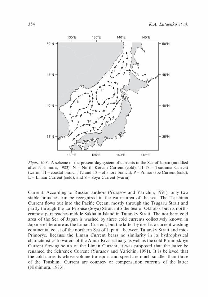
Current. According to Russian authors (Yurasov and Yarichin, 1991), only twostable branches can be recognized in the warm area of the sea. The TsushimaCurrent flows out into the Pacific Ocean, mostly through the Tsugaru Strait andpartly through the La Perouse (Soya) Strait into the Sea of Okhotsk but its north-ernmost part reaches middle Sakhalin Island in Tatarsky Strait. The northern coldarea of the Sea of Japan is washed by three cold currents collectively known inJapanese literature as the Liman Current, but the latter by itself is a current washingcontinental coast of the northern Sea of Japan – between Tatarsky Strait and mid-Primorye. Because the Liman Current bears no similarity in its hydrophysicalcharacteristics to waters of the Amur River estuary as well as the cold PrimorskoyeCurrent flowing south of the Liman Current, it was proposed that the latter berenamed the Schrenck Current (Yurasov and Yarichin, 1991). It is believed thatthe cold currents whose volume transport and speed are much smaller than thoseof the Tsushima Current are counter- or compensation currents of the latter(Nishimura, 1983).
130°E 135°E 140°E 145°E
130°E 135°E 140°E 145°E
35°N
45°N
40°N
50°N
35°N
45°N
40°N
50°N
SL
P
N
T1
T2
T3
Figure 10.3. A scheme of the present-day system of currents in the Sea of Japan (modifiedafter Nishimura, 1983). N – North Korean Current (cold); T1-T3 – Tsushima Current(warm; T1 – coastal branch; T2 and T3 – offshore branch); P – Primorskoe Current (cold);L – Liman Current (cold); and S – Soya Current (warm).
K.A. Lutaenko et al.354

The system of currents influenced significantly the climatic conditions (air tem-peratures, humidity, etc.), distribution of coastal and open-sea organisms and,probably, cultural dynamics of along-shore settlements of the ancient people. Es-timations of time of the appearance of warm currents in different areas of the Sea ofJapan are controversial and are based chiefly on diatom analysis, oxygen isotopeanalysis of benthic and planktonic foraminifers, distributions of the foraminifersalone, and molluscan assemblages considerations. According to Chinzei and Oba(1986), the inflow of the Tsushima Current started after 9500 14C yr BP, and, at thelevel of 6300 14C yr BP, low d18O value as well as planktonic foraminifers and othermicrofossils rich in warm-water species indicate a predominant influence of theTsushima Current in the southeastern Sea of Japan. The influx of the TsushimaCurrent might have occurred on a full scale since 8000 14C yr BP and it caused aremarkable wetting in Japan, but the strongest influx was after 6000 14C yr BP(Koizumi, 1987, 1989). After that time, four peaks of ‘‘diatome temperature’’ weredetected in the mid- and late Holocene. Yi et al. (1997) estimated the time of fullcirculation of water mass between the East Sea (Sea of Japan) and the East ChinaSea (‘‘the South Sea [of Korea] and Okinawa Sea’’), i.e., the full influence ofTsushima Current on the southern part of the Sea of Japan (Ulleung Basin) oc-curred about 8000 14C yr BP. Igarashi (1993) also supported the viewpoint that thefull-scale onset of the Tsushima Current was approximately 8000 14C yr BP.Gorbarenko et al. (1995) assumed that oceanographic parameters are similar tothose of the present onset in the Sea of Japan some 7000 14C yr BP. The rising seasurface temperatures are recorded from 6000 14C yr BP by study of the ratio ofplanktonic foraminifers (Gorbarenko, 1991). The isotopic values of mollusk shellscollected from archaeological sites and natural shell beds in central Japan (thePacific side) indicate that the water temperature was highest about 7000 14C yr BP,and then became lower at around 4500–4000 14C yr BP (Chinzei et al., 1987b).Gorbarenko and Southon (2000) concluded that the warmest conditions in the Seaof Japan occurred at 6500–6000 14C yr BP. A brief cooling event that occurredabout 4000 14C yr BP is registered also for the Okinawa area (Ujiie, 1997) and thenortheastern South China Sea (Wei et al., 1997, 1998; see also Jian et al., 1998).Sakaguchi (1987) also recorded a cold episode at 4500 14C yr BP in the Ozegaharapeat bog. The same trend seems to be shown for the subtropical Kuroshio frontalong the Pacific coast of Japan based on the oxygen and ecological analyses ofmicrofossil assemblages; an increase of warm-water species continued until about6500 14C yr BP when temperature record shows a value much higher than present(Chinzei et al., 1987a). Taira (1975) established that ca. 7000 14C yr BP, theKuroshio temperatures were up to 81C or averaging 61C above the present values.This estimate seems to be too high. Likewise, Matsushima and Ohshima (1974),based on an analysis of molluscan assemblages, argued that minimum surfacetemperature of the southern Sea of Okhotsk was 51C higher than at present. Taira’s(1975) estimates were based on the oxygen isotope analysis of molluscan shells andcorals. Chinzei et al. (1987b) demonstrated that direct conversion of isotope valuesinto the water temperatures yields higher temperature values than expected, i.e., the
Sea of Japan 355

minimum summer temperature for 7000 14C yr BP would be 351C, which is un-natural for this area (Boso Peninsula).Sakaguchi et al. (1985) found a tropical–subtropical (in zonal-geographical ter-
minology used hereafter; for explanation see Lutaenko, 1993) species of bivalvemollusk, Trapezium liratum, in a core obtained in Tokoro Plain (northernHokkaido) at the level of 85207120 14C yr BP. Sakaguchi (1992) suggested thatthis finding indicates the birth of the warm La Perouse (Soya) Current, a branch ofthe Tsushima Current. Thus, the Tsushima Current reached the Sea of Japan side ofHokkaido before 8500 14C yr BP, which accords with data of M. Akamatsu and hisco-workers (Akamatsu and Kitagawa, 1983; Akamatsu et al., 1995) on the ap-pearance of warm-water mollusks in the western Hokkaido at about 7500–8000 14Cyr BP. However, the warm-water mollusks invaded the Hokkaido coast of the Seaof Okhotsk at about 6800 14C yr BP (Takagi et al., 1990). These differences may beexplained by insufficient geochronological evidence and the controversy will besettled with increasing of accelerated mass spectrometry (AMS) datings of mollu-scan shells.Taira (1979) suggested an abrupt Holocene oceanic warming started between
9000 and 8000 14C yr BP. At 9000–7800 14C yr BP (T-1 transgressive stage, ac-cording to his scheme), warm waters were introduced into the Sea of Japan, YellowSea, and northwestern Pacific, but it seems that the Tsushima Current did not movenorthward at that time, at least, the current did not reach Hokkaido yet (Taira,1992). The warmest interval in relative surface temperatures occurred 5900–470014C yr BP, the Tsushima Current reached north Hokkaido, and warm waters werefirst imported into the Sea of Okhotsk through the Soya Strait, and at 4300–390014C yr BP the Kuroshio Current retreated southward (Taira, 1992); this nearlycorresponds to an observed lowering of temperature on the Pacific side of Japanduring 4500–4000 14C yr BP (Chinzei et al., 1987b) and a cooling event around4000–2000 14C yr BP based on planktonic foraminifera from the Okinawa Troughand the South China Sea (Jian et al., 1996). The warming of surface waters in theSea of Japan seems to occur later than that of the Pacific side of Japan because ofcold deep circulation, meltwater discharge from the Siberia, and winter sea ice inthe northern part of the sea (Taira, 1992). A pronounced, but relatively short periodregional cooling (called Kuromatsunai cold episode 2) was detected at ca. 9000 14Cyr BP; it was caused by cold meltwater spreading over the Seas of Okhotsk andJapan because the maximum solar radiation brought about an enormous volume ofpermafrost meltwater from the Amur River basin, Primorye, Sakhalin, and Ho-kkaido (Sakaguchi, 1992). In this case, Taira’s (1992) scenario explaining the dis-crepancy between Holocene current patterns around Japan is possible. Forinstance, Oba (1997) demonstrated that the Kuroshio front migrated northwardpassing off Boso Peninsula (Tokyo) at 10,000 14C yr BP, but the Tsushima was notactive at that time.Another important feature of the mid-Holocene paleoceanography is a difference
in the rate of penetration of warm currents not only along the Pacific and Sea ofJapan sides of Japan, but also along the island and continental coasts of the sea,
K.A. Lutaenko et al.356

as was demonstrated by using molluscan assemblages (Taira and Lutaenko, 1993).In the Early Holocene, the coasts of North Korea and Primorye were washed byintensified cold currents of the Liman (Schrenck), Primorskoye, and North KoreanCurrents, and thereby their cold waters acted as a barrier to any northward flow ofwarm waters. This seems to be supported by the lack of subtropical bivalve moll-usks in the Early Holocene deposits along the Primorye (Evseev, 1981). We sug-gested that about 7000–6000 14C yr BP, the East Korean Current, a branch of theTsushima, moved northward at about 401N, and subtropical bivalve mollusksreached Peter the Great Bay (northwestern Sea of Japan) (Taira and Lutaenko,1993). The meandering stream of the Tsushima Current, T-3 offshore stream(¼East Korean Current), is known to be strongest (Nishimura, 1983). The pos-sibility of the East Korean Current axis shifting northeastward in the mid-Holoceneis confirmed by the fact that even at present, during some ‘‘warm’’ years, the T-3can be observed near Peter the Great Bay, as evidenced by the findings of somepelagic subtropical and tropical animals like some fishes, etc. (Ivankov, 1996). Theintensification of the East Korean Current in the mid-Holocene led to the appear-ance in the northwestern Sea of Japan not only of subtropical, but also tropical–subtropical bivalve mollusks (whose geographical ranges are extended southwardto the Philippines, Vietnam, and Indonesia) which formed stable populations withannual reproduction, species such as Anadara inaequivalvis, T. liratum, and Dosiniapenicillata (Lutaenko, 1991a, 1993). They settled in bays characterized by intensesummer warming, which is necessary for successful reproduction (winter cooling initself does not prevent warm-water fauna from living in temperate latitudes(Scarlato, 1981)). Thus, a combination of such factors as the considerable inden-tation of the coast (ria type of bays with shallow water semi-enclosed areas in theirtops) and penetration of the warm Tsushima waters to the northwestern Sea ofJapan which intensified the effect of local warming had resulted in the formation ofsubtropical-type molluscan fauna in this area during the Middle Holocene(Lutaenko, 1991b, 1993). The correlation and relative role of warm currents andgeomorphological processes in the appearance/disappearance of TAMAs have beendiscussed in the literature (DeVries and Wells, 1990; Sandweiss et al., 1996, 1997;DeVries et al., 1997; Wells and Noller, 1997), illustrating the importance of correctinterpretation of paleomalacological data when reconstructing Holocene oceano-graphical conditions. The example of Peter the Great Bay mid-Holocene TAMAshows that three species of warm-water bivalves became extinct in the course of theLate Holocene coolings (distributional ranges of two of them are shown inFig. 10.4), while embaymental environments were still existing. This means that theclimatic changes, and not solely changes in coastal morphology, are responsible forlocal extinctions of warm-water species.The Kuroshio Current probably extended to the Hokkaido coast earlier than
5900–4700 14C yr BP, since the first warm-water mollusks appeared here about7500–8000 14C yr BP. However, there is still no direct evidence on the chronologicalranges of existence of thermophilous species on Hokkaido due to a lack of AMSdatings. Fifteen AMS dates on three ‘‘extinct’’ (locally disappeared) species of
Sea of Japan 357

bivalves from the coast of Peter the Great Bay coast demonstrate that theirHolocene ranges lie between 7140 and 1260 14C yr BP (taking into account areservoir effect) (Jones and Kuzmin, 1995; Kuzmin, 1995). As mollusks reflect theeffect of the East Korean Current, we can assume that the current penetrated to thenorthwestern Sea of Japan about 7000 14C yr BP, which is 500–1000 years latercompared to Hokkaido. A comparison of the mid-Holocene TAMAs from the shellmiddens of Hokkaido and Primorye (Rakov et al., 1996; Rakov and Lutaenko,1997) revealed a difference in species composition: at least five species found inHokkaido have never lived in Peter the Great Bay. The oyster, Crassostrea gigas,invaded the coast of Terpenye Bay (�501N) in Sakhalin Island (Sea of Okhotskside) (Akamatsu and Ushiro, 1992) and also penetrated to the coast of middlePrimorye (Vladimir Bay – V.A. Rakov, personal communication) (Fig. 10.4).Another example is provided by the subtropical mollusk, Anadara broughtoni,discovered in the Neolithic shell midden in Chertovy Vorota Cave (Khudik, 1991).A refuge for the oyster exists in the northern Tatarsky Strait, in De Kastri Bay(Scarlato, 1981), clearly illustrating the mid-Holocene strong influence of theTsushima Current flowing along the eastern side of Sakhalin, as the continentalcoastal area was occupied by the cold Schrenck Current. These new data make itpossible to reject an early interpretation postulating an absence of subtropical spe-cies of bivalve mollusks on the mid-Primorye coast (Lutaenko, 1993).Pletnev et al. (1987) suggested that an increase of convective mixing of water
masses occurred during the Atlantic in the eastern part of the Tatarsky Straitdespite the influence of the Tsushima Current. This resulted in a lack of stablestratification and warming of surface water layer manifested in a high (for theperiod of climatic optimum) population density of diatoms (due to upwelling ofnutrients to photic zone) and an increase of the level of carbonate compensation
130°E 135°E 140°E 145°E
130°E 135°E 140°E 145°E
35°N
45°N
40°N
50°N130°E 135°E 140°E 145°E
130°E 135°E 140°E 145°E
35°N
45°N
40°N
50°N
35°N
45°N
40°N
50°N?
? ?
?
?
?
Figure 10.4. The distribution of the TAMA’s elements – warm-water bivalve mollusksAnadara kagoshimensis (right) and Crassostrea gigas (left) during the mid-Holocene in theSea of Japan and adjacent areas.
K.A. Lutaenko et al.358

(strong dissolution of planktonic foraminifers). However, the boundary of winterdrift ice shifted northward during the mid-Holocene compared to at present in thearea of Tatarsky Strait (Korotky et al., 1997).Quantitative estimates of hydroclimatic warming of surface waters in the Sea of
Japan and adjacent areas the Sea of Okhotsk are given in Table 10.6 and areshown in Figure 10.5. Many authors estimated an excess of annual average SSTsas compared to the present values to be 1–21C in different areas of the Sea ofJapan or the entire basin. Troitskaya (1974) did not define clearly the temperatureparameters, and, based on the comparison of the species composition of benthicforaminifers, gave an excessively high figure (Table 10.6). Unfortunately, this es-timate was cited by subsequent authors without any substantiation (Pushkar, 1979;Korotky and Vostretsov, 1998). Rakov (1995) estimated the July–August
Table 10.6. Hydroclimatic estimates of surface waters of the Sea of Japan and the Sea ofOkhotsk in the period of climatic optimum of the Holocene (based on data of Russianauthors).
Area Watertemperatureparameters
Excess as comparedto the present (1C)
Source
Sea of Japan Annual averageSSTs
1–2 Pletnev (1985);Pletnev andGrebennikova(1991)
Annual averageSSTs
1–2 Korotky et al. (1988)
SSTs 3–8 Korotky (1994)Yamato Rise(southern Sea ofJapan)
SSTs 1–2 Pletnev (1978)
Tatarsky (Mamiya)Strait
SSTs 2 Pletnev et al. (1987)
Tatarsky Strait andnorthern Sea ofJapan
SSTs 2 Korotky et al. (1997)
Peter the Great Bay(northwestern Seaof Japan)
July–Augustshallow watertemperatures
3–11 Rakov (1995) (basedon Fig. 8)
Peter the Great Bay(northwestern Seaof Japan)
Shallow watertemperatures
10 Troitskaya (1974)
Southern Sakhalinshelf (southern Seaof Okhotsk)
Annual averageSSTs
5–7 Cherepanova et al.(1988)
Sea of Japan 359

temperatures in shallow inlets of Peter the Great Bay to be 3–111C higher than thepresent-day values, and, moreover, he suggested that this area was devoid of shoreice during the winter time in the mid-Holocene (see also Rakov and Vostretsov,1998) (at present, shallow water bays and lagoons are completely covered by
130°E 135°E 140°E 145°E
130°E 135°E 140°E 145°E
35°N
40°N
45°N
35°N
40°N
45°N
13
11
12
14
15
16
17
18
A
130°E 135°E 140°E 145°E
35°N
40°N
45°N
35°N
40°N
45°N
13
11
12
14
15
16
B
Figure 10.5. Present-day (A) and the mid-Holocene (B) annual average SSTs (C) in the Seaof Japan as evidenced by the planktonic foraminifers (modified after Pletnev, 1982, 1985).
K.A. Lutaenko et al.360
seashore ice in winter). This conclusion is based on the temperature tolerance of alocally extinct element of TAMA, Meretrix lusoria. However, this species inhabitsthe intertidal and upper subtidal zone of the Yellow Sea (Pak, 1985; Bernard et al.,1993) including its upper part, the Bohai Sea, which is covered with ice during thewinter at present. Chinzei (1993) showed that paleotemperature analysis based onthe existence of the extant molluscan taxa or associations incorporates a largedegree of uncertainty because mollusks react to overall environmental conditions(not only temperature) in an intricate way. Some problems related to interpre-tation of the Holocene assemblages of mollusks were discussed by Maeda (1978)with examples from Osaka and Tokyo Bays (the Pacific coast of Japan); despitethe warming in the mid-Holocene, thermophilous species did not inhabit theseareas due to the narrow opening of the bays, and, possibly, limited larvae ex-change between the open and semi-enclosed, protected environments. Thus, themolluscan data should be used with caution for the precise estimations of the seasurface temperatures.Yi et al. (1996b) suggested that a series of ‘‘old’’ spits (mid- and late Holocene in
age) consisting of gravel mixed with reworked oyster shells (beach driftage)discovered on the western coast of Korea should be interpreted as traces of stormor, at least, storm-influenced deposits. Their origin is believed to be related to aglobal warming which caused high storm frequency (Yi et al., 1996b; Lutaenko,2001). We explained in a similar way the origin of a high gravel terrace withabundant TAMA’s elements, Anadara inaequivalvis, found near the Russian/NorthKorean border, on the northern coast of Talmi Lagoon (Lutaenko, 1997). Theheight of this terrace (old beach ridge) is about 4m above the present sea level.Molluscan fossils from the ‘‘old’’ terrace were dated by both conventional andAMS methods (Alekseev and Golubeva, 1980; Jones and Kuzmin, 1995), and theirages are 5320745 (OS-3026), 5360735 (OS-3028), 60007130 (GIN-759b), and56307110 (GIN-759a) 14C yr BP. This provides an example of the geomorphicimprint of the mid-Holocene storm activity in the Sea of Japan between 5000 and6000 14C yr BP. At present there is no evidence of storm accumulation of coarse-grained deposits in the two above areas of Korea and Primorye.The suggestion about increased storm activity during the mid-Holocene in the
Asian marginal seas seems to be confirmed by the analysis of data on the prevalenceof different types of coastal accumulation throughout the Holocene in Japan,Primorye, and Sakhalin (Afanasiev, 1992). This author used more than 400 radi-ocarbon datings of coastal terraces characterized by different sedimentologicalcomposition. According to the scheme compiled (Fig. 10.6), there were three syn-chronous phases of storm and storm-influenced accumulation in the above areas,i.e., at 5300–6000, 3000–4300, and 1400–1700 14C yr BP. In general, they coincidewith the main warmings in the Russian Far East; the first phase of storm accu-mulation is in close accord with maximum stage of warmth in Sakhalin at the levelof 5900–5100 (Table 10.1). It is likely that increased storm frequency was one of thepaleoceanographic features in the Sea of Japan along with intensification of thewarm currents.
Sea of Japan 361

3. Cultural dynamics in the mid-Holocene in the basin of the Sea of Japan
3.1. Japanese Archipelago
Neolithic Jomon culture represents a classic case of continuous cultural develop-ment over a long time – roughly ten thousands years – in isolated or almost isolatedterritory. The abundance and great variability of its archaeological assemblageshave ensured a special place for Jomon in the archaeology and prehistory of theJapanese Archipelago (Yamanouchi, 1937, 1964; Sugiyama, 1942; Watanabe, 1966;Kidder and Esaka, 1968; Iofan, 1974; Aikens and Higuchi, 1982; Vasil’evsky et al.,1982; Pearson, 1986, 1992; Nishida, 1989; Kobayashi, 1992a,b, 2004; Ishikawa andSuzuki, 1994; Aikens, 1995; Takahashi et al., 1997). The problems of systemati-zation, periodization, and dating of Jomon culture sites are an area of concentra-tion for many research efforts. Some of the most accepted versions of the dating ofJomon culture’s stages are represented in the Table 10.7. Despite of some differ-ences between the versions, chronological frameworks for the Jomon culture overallcorrespond to the Early and Middle Holocene periods. Within these frameworksthe earliest stages of Jomon (Incipient, Initial) correlate with the Early Holoceneand the beginnings of Middle Holocene; the early and middle stages (Early andMiddle Jomon) closely correspond to the mid of Middle Holocene; and the latestages (Late and Final Jomon) correspond to the end of the Middle Holocene andthe beginnings of Late Holocene.In the context of our topic, the Early, Middle, and Late Jomon stages are most
interesting as the ones representing cultural dynamics during the Middle Holoceneperiod. Cultural dynamics are reflected in characteristic traits of every stage.
storm
estuarine-lagoonal
organogenic
eolian
soil formationon eolian deposits
type ofaccumulation cal yr BP
14C yr BP7000 6000 5000 1000200030004000
7800 6850 5800 950195032004500
Figure 10.6. Temporal predominance of the coastal sedimentation processes throughoutthe Holocene in Japan, Sakhalin, and Primorye (after Afanasiev, 1992).
K.A. Lutaenko et al.362

3.1.1. Early Jomon
The changes in Jomon culture connected with its Early stage are concerned mainlywith mode of life, subsistence, and material culture. Early Jomon sites (Fig. 10.7)give sure evidence for the establishment of stabilized or long-lived settlements. Thedwelling type was the semi-subterranean pit-house of rectangular shape with two orthree rows of wooden pillars along long axes supporting the walls and roof. Theappearance of stable long-lived settlements may be considered as an indicator of theestablishment of a sedentary mode of life. In the previous Incipient and InitialJomon periods a mobile or semi-sedentary style of existence dominated (Nishida,1989).The subsistence of Early Jomon followed the traditions of previous times and
consisted of the hunting and fishing of terrestrial and maritime resources. Geo-graphic variability in the occurrence of food resources in Japan resulted in variouslocal patterns of subsistence. The population of seacoast areas was oriented pri-marily to marine resources, while the habitants of inland zones intensively exploitedterrestrial food sources. This subsistence variability was preserved until the FinalJomon stage (Aikens and Higuchi, 1982, pp. 182–186; Pearson, 1992, pp. 65–66;Takahashi et al., 1997).A significant innovation appeared during the Early Jomon stage, the cultivation
of edible plants like bottle gourds (Lagenaria siceraria), beans (Vigna angularis),burdock (Arctium), and others. Cultivated plants formed a relatively small part ofthe diet and did not require a lot of effort in cultivation; intensive gathering ratherthan the agriculture predominated (Pearson, 1992, p. 68; Takahashi et al., 1997).The Early stage was the time when the technical complex, or set of tools for the
hunting, fishing, and gathering way of life that characterizes Jomon culture, wasestablished. Main types of tools that existed from the Early Jomon to the FinalJomon stage included flaked triangular-shaped arrowpoints and spearheads withconcave bases often made of obsidian or other volcanic material, handled scrapers,
Table 10.7. Chronological scales of Jomon culture.
Jomon culturestages
Versions of dating according to
Watanabe(1966)
Ikawa-Smith(1980)
Pearson (1992) Hatsushige andMitsunori(1996)
Incipient 13,000–9500 12,500–10,000 12,000–9000Initial 10,750–6200 9500–7500 10,000–7000 9000–6000Early 3400–2800 7500–5600 7000–4500 6000–5000Middle 2800–2230 5600–4500 4500–3500 5000–4000Late 1800–1050 4500–3000 3500–3000 4000–3000Final 1100–300 3000–2300 3000–2400 3000–2400
Sea of Japan 363
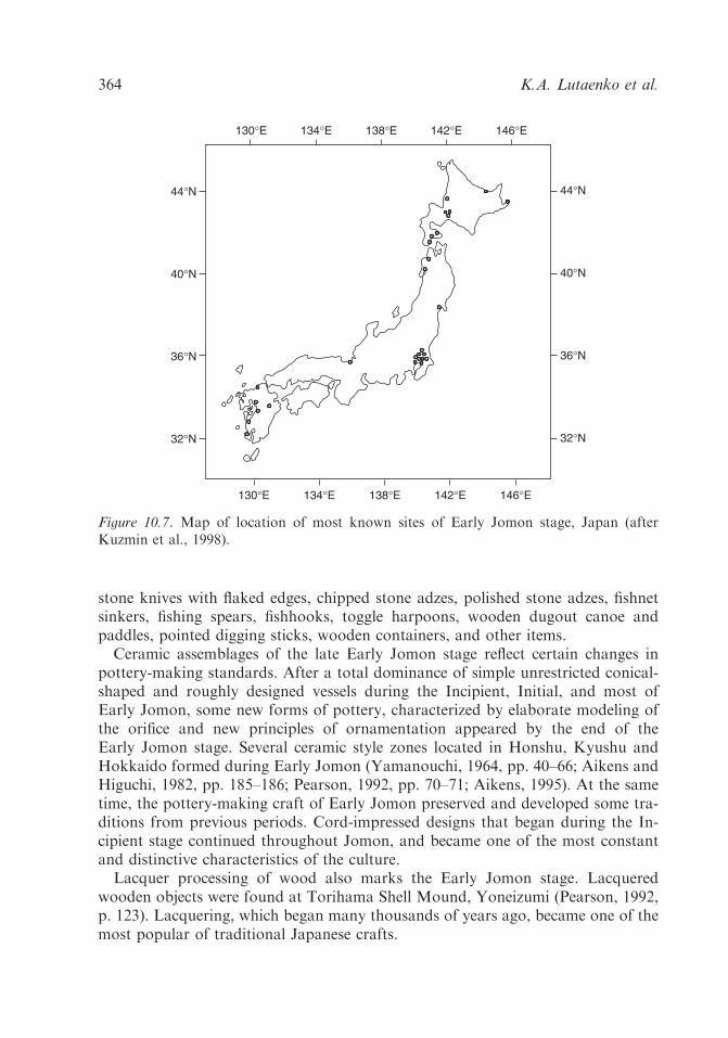
stone knives with flaked edges, chipped stone adzes, polished stone adzes, fishnetsinkers, fishing spears, fishhooks, toggle harpoons, wooden dugout canoe andpaddles, pointed digging sticks, wooden containers, and other items.Ceramic assemblages of the late Early Jomon stage reflect certain changes in
pottery-making standards. After a total dominance of simple unrestricted conical-shaped and roughly designed vessels during the Incipient, Initial, and most ofEarly Jomon, some new forms of pottery, characterized by elaborate modeling ofthe orifice and new principles of ornamentation appeared by the end of theEarly Jomon stage. Several ceramic style zones located in Honshu, Kyushu andHokkaido formed during Early Jomon (Yamanouchi, 1964, pp. 40–66; Aikens andHiguchi, 1982, pp. 185–186; Pearson, 1992, pp. 70–71; Aikens, 1995). At the sametime, the pottery-making craft of Early Jomon preserved and developed some tra-ditions from previous periods. Cord-impressed designs that began during the In-cipient stage continued throughout Jomon, and became one of the most constantand distinctive characteristics of the culture.Lacquer processing of wood also marks the Early Jomon stage. Lacquered
wooden objects were found at Torihama Shell Mound, Yoneizumi (Pearson, 1992,p. 123). Lacquering, which began many thousands of years ago, became one of themost popular of traditional Japanese crafts.
44°N
40°N
36°N
32°N
44°N
40°N
36°N
32°N
146°E130°E 134°E 142°E138°E
146°E130°E 134°E 142°E138°E
Figure 10.7. Map of location of most known sites of Early Jomon stage, Japan (afterKuzmin et al., 1998).
K.A. Lutaenko et al.364

3.1.2. Middle Jomon
The term Jomon culture is most typically associated with the impressive images ofthe Middle Jomon stage – ceramic vessels of splendid design, giant shell mounds,cemeteries, and a variety of ritual objects. Japanese archaeological science recog-nizes the Middle Jomon as a period when significant changes occurred in Jomonculture (Aikens and Higuchi, 1982, pp. 137–164, 329; Nishida, 1989; Kobayashi,1992a, 2004; Pearson, 1992, pp. 64–127; Takahashi et al., 1997). On one hand,Middle Jomon’s traditions followed those of Early Jomon but, on the other, manynew traits separate Middle Jomon from the previous stage. Archaeological evidenceindicates changes occurred in all parts of prehistoric life, including in subsistence,social organization, material production, and spiritual culture.Two parallel processes took place during the Middle Jomon stage – an increase in the
sizes and numbers of shell mounds and in the sizes and density of settlements – whichreflect population growth (Fig. 10.8). Both trends were most intensive in northeasternand central Japan, on Honshu Island (Tohoku and Kanto Districts). The shell mounds’sizes began to increase rapidly from the end of Early Jomon and reached a maximumafter 5000 14C yr BP. For example, Nakazato shell mound site (Tokyo) has shalldeposits about 200m in diameter and 3–4m in thickness (Takahashi et al., 1997, p. 116).The number of pit dwellings in the sites of terminal Early Jomon and Middle Jomonage reaches several hundred, as in the case of the San’naimaruyama site (Aomori),
44°N
40°N
36°N
32°N
44°N
40°N
36°N
32°N
146°E130°E 134°E 142°E138°E
146°E130°E 134°E 142°E138°E
Figure 10.8. Map of location of most known sites of Middle Jomon stage, Japan (afterKuzmin et al., 1998).
Sea of Japan 365
where 600 pits were detected (Takahashi et al., 1997, p. 124). The sizes of housestructures increased significantly, reaching 200 and more square meters in some cases.A burial system that was practiced through the Final Jomon stage formed in the
Middle Jomon. The temporal sequence of the Jomon burial system is documentedmost completely in eastern Japanese sites. The pattern of burials was relativelycomplex and reflected social patterns in Jomon communities (Kobayashi, 1992b,2004, pp. 99–136; Pearson, 1992, pp. 80–81; Yamada, 1996).The changes in material production patterns are most obvious in pottery-making
activity. First, in the Middle Jomon stage the variety of forms and sizes of ceramicvessels increased greatly in comparison with the previous period (Fig. 10.9). Second,the Middle Jomon’s pottery is characterized by a complication of design. Reliefdecoration on vessel rims and walls required a high level of pottery-making skill.The ceramics of the most sophisticated flame-like style may be called Jomon’sBaroque – they represent the apex of the pottery-making art during the JapaneseNeolithic (Fig. 10.10). Third, new technologies of surface treatment appeared anddeveloped, such as polishing and ocher painting. By the end of the Middle Jomonstage the technologies of polishing and painting came to be used more frequently.The innovations of Middle Jomon pottery-making indicate increasing labor
intensity and improvements in craft skills. The pottery of the Middle Jomon is anoutstanding cultural phenomenon (Yamanouchi, 1964; Iofan, 1974, pp. 12–18;Sahara, 1979; Harris, 1997; Kobayashi, 2004, pp. 19–72; etc.).The last part of the Middle Jomon stage was a time of broad distribution
of various types of ritual and prestige objects (Yamanouchi, 1964; Iofan, 1974,pp. 12–20; Pearson, 1992, pp. 82–85; Kobayashi, 2004, pp. 137–168). These in-cluded ceramic vessels of the Katsusaka type with anthropomorphic and zoomor-phic designs, ceramic anthropomorphic figurines or dogu, and stone rods andbar-like objects called sekibo. Some sites contain the remains of ritual activities,such as anthropomorphic figurines in human burial areas on the site of Tanabatake,cases of broken ceramic figurines scattered over wide areas on the site of Shakado,and stone rods buried under the floor or displaced near the hearth in houses, etc.
3.1.3. Late Jomon
Archaeological records of the Late Jomon stage (Fig. 10.11) demonstrate mostly thecontinuity and gradual development of the main tendencies of Middle Jomon. TheLate Jomon stage was not marked by outstanding events similar to those whichoccurred in Middle Jomon, such as a rapid increase in the numbers and sizes of shellmounds and settlements, or the extremely ornate style of the ceramics. Archaeologicalcontexts of the Late Jomon stage are not as impressive as those of Middle Jomon;however, they too contain certain information about cultural dynamics in that time.The subsistence pattern based on hunting, fishing, gathering, and partial plant
cultivation followed the experience and traditions of previous periods. A tendencytoward a reduction in size of shell mounds began to develop, although in some local
K.A. Lutaenko et al.366

areas giant shell mounds continued to be accumulated. The Kasori-minami shellmound (Chiba), for example, is estimated to be 9500m2 in area and 5500m3 involume (Suzuki, 1989).The density of Late Jomon settlements was lower than the density during Middle
Jomon. The number of sites of Late or Final Jomon in central Japan is less than
Incipient
Initial
Early
Middle
Late
Final
0 5 10 in (approx)
10 20 cm (approx)
Figure 10.9. Table of development of Jomon pottery forms (after Pearson, 1992).
Sea of Japan 367

1/3rd that of Middle Jomon sites (Komiyama, 1996). At the same time Late Jomonsites give interesting evidences of inter-village communication and co-operation;communal burials and fish weirs, for example, were used by the habitants of severalneighboring villages (Nishida, 1989; Pearson, 1992, pp. 79–80).
Figure 10.10. Ceramic vessels of flame-like style, Middle Jomon stage.
44°N
40°N
36°N
32°N
44°N
40°N
36°N
32°N
146°E130°E 134°E 142°E138°E
146°E130°E 134°E 142°E138°E
Figure 10.11. Map of location of most known sites of Late Jomon stage (after Kuzminet al., 1998).
K.A. Lutaenko et al.368

In the Late Jomon ritual practice expanded further. New types of ritual anthro-pomorphic ceramic figurines appeared, and a most remarkable image is a snow-goggle figure in ornamented cloth and a crown-like headdress (Aikens and Higuchi,1982, pp. 165, 170; Pearson, 1992, p. 84).Temporal changes are most obvious in the pottery-making traditions of the Late
Jomon (Aikens and Higuchi, 1982, pp. 164–181; Pearson, 1992, pp. 73–75). Theceramic vessels of that time were less splendid and sophisticated than thoseof Middle Jomon. However, the invention and distribution of some new types –especially those with complicated morphology (Fig. 10.9), as well as the elaborationof ceramic paste, surface treatment, and firing technology – reflected progressivedevelopment of the pottery-making craft. Pottery design became less ornate andmore elegant while preserving some essential principles of the previous period(Fig. 10.12). It may be said that Late Jomon’s potters added new quality to theirceramics by improving all stages of the production process.The changes and innovations of the Early, Middle, and Late Jomon stages took
place within a cultural context that was under continual change, what we here call adevelopment. The tempo and scope of these cultural changes varied appreciably. Inthe Early Jomon some important changes and innovations began and developedgradually. The period encompassing the end of the Early Jomon and most of theMiddle Jomon was one of the intensive cultural change. During the Late Jomon,
Figure 10.12. Ceramic vessel of Late Jomon stage.
Sea of Japan 369

cultural dynamics had a progressive character yet lacked the splashes and intensity,which marked the Middle Jomon.
3.1.4. Korean Peninsula
Beginning from 8000 14C yr BP Neolithic cultures united under the common nameChulmun were spread over all parts of the Korean Peninsula (Fig. 10.13). The mostdistinctive trait of these cultures was pottery decorated predominantly with comb-impressed or comb-incised patterns (Arimitsu, 1962; Nelson, 1975, 1990, 1992,1993, pp. 58–109; Larichev, 1978; Pak, 1979, pp. 28–52; Choe and Bale, 2002). TheKorean term Chulmun means ‘‘the comb’’. At present, archaeological remains ofChulmun populations have been discovered and excavated in various parts of theKorean Peninsula. Chronological frameworks for Chulmun cultural complexesdeveloped using radiocarbon dating extend from 8000 to 2000 14C yr BP with themost of the dated sites belonging to the interval from 6000 to 3500 14C yr BP(Nelson, 1993, pp. 58–59, 64–65). Based on recent investigations some researchersplace the beginning of the Korean Neolithic at around 10,000 14C yr BP. Accordingto this view, Neolithic assemblages are attributed to the Bissalmuneui culturalperiod, which has an upper temporal limit of around 3500 14C yr BP. The term
124°E 126°E 128°E 130°E124°E 126°E 128°E 130°E
124°E 126°E 128°E 130°E124°E 126°E 128°E 130°E
42°N
40°N
38°N
36°N
34°N
42°N
40°N
38°N
36°N
34°N
42°N
40°N
38°N
36°N
34°N
Sea ofJapan
YellowSea
Mumun Sites
Sea ofJapan
YellowSea
Chulmun Sites
Figure 10.13. Maps of location of sites of Chulmun and Mumun cultural periods, KoreanPeninsula (after Nelson, 1993).
K.A. Lutaenko et al.370

‘‘Bissalmuneui’’ is considered an analogy to ‘‘Chulmun.’’ The time from 10,000 to8000 14C yr BP is considered the Incipient stage of Bissalmuneui (Choe and Bale,2002).Chulmun cultures are characterized by long-lived village settlements with pit-
houses of oval-like or round-like shape. The subsistence pattern was complex con-sisting of land and marine hunting, fishing, gathering, and edible plant cultivation,with the importance of each depending on natural conditions in certain areas. Theset of tools included stone-chipped arrowheads, scrapers, gravers, drills, polishedaxes and adzes, grinding slabs and stones, mortars, pestles, hoes, weights (net-sinkers), and various bone and antler implements.Chulmun style pottery has a simple morphological structure, consisting mostly of
conical-shaped forms with flat or round bottoms. Its technological features are thinfragile walls, rough surface treatment, and low-temperature firing. Typical variantsof decoration were vertical zigzag pattern made by comb-incising and horizontalrows of comb impressions (Fig. 10.14). Several regional styles of Chulmun potterytradition have been distinguished (Nelson, 1993, pp. 61–62; Choe and Bale, 2002).Around 5500–5000 14C yr BP settlements with ceramics of a new style known as
Mumun appeared in the Korean peninsular (Nelson, 1993, pp. 110–163; Choe andBale, 2002). Distinctive traits of Mumun pottery assemblages compared with thepreceeding Chulmun style include the occurrence of complicated forms with a de-veloped morphological structure, geometric designs or the absence of any design,
0 20 cm
0 5 cm
0 10 cm
A B
Figure 10.14. Ceramics assemblages of Chulmun cultural tradition (A) and Mumun cul-tural tradition (B), Korean Peninsula.
Sea of Japan 371
and the appearance of new technologies of surface treatment and firing (Larichev,1978, pp. 54–56, 73–75; Nelson, 1993, pp. 116–123; Choe and Bale, 2002, p. 96)(Fig. 10.14). Typical Mumun vessels forms have well-formed structural parts suchas the neck and body, and red painted and polished walls. Obviously, the Mumunpottery style was not connected closely with the preceding Chulmun style, andrepresented another cultural tradition of pottery-making.Comparing the locations of Chulmun and Mumun ceramics sites, it is evident
that the areas settled were the same in both cases. However, settlement density ismarkedly higher for the period of Mumun sites (Fig. 10.13). According to C.M.Nelson, Mumun sites are dated from 4800 to 2800 14C yr BP, with many of the sitesfalling into the interval from 4100 to 3750 14C yr BP (Nelson, 1993, pp. 113–116).The period of overlap for the dates of Chulmun and Mumun sites correspondsmainly to the interval 5000–4000 14C yr BP. C.P. Choe and M. Bale date the periodof co-existing of Bissalmuneui (Chulmun) and Mumun cultural traditions from3500 to 3000 14C yr BP (Choe and Bale, 2002).Some important changes and innovations in subsistence, settlement pattern,
social structure, and spiritual culture are connected with the period of Mumun sites.The most progressive innovation in subsistence was the beginning of rice cultiva-tion. Recent investigations connect small-scale cultivation of millet, barley, andsome other plants with Chulmun, or Bissalmuneui, cultural context while the ap-pearance of rice agriculture seems to be attributed to Mumun and a new population(Choe and Bale, 2002). It was the background for the further development ofagricultural economy in the Korean peninsular. The oldest evidence for rice grow-ing was discovered in western Korean sites dated to about the middle to second halfof the fifth millennium BP. The rice that was found is not indigenous to the Koreanpeninsular. This plant began to be cultivated about 8500–7000 14C yr BP in neigh-boring China, and it is from there that it came to the Korea region (Nelson, 1993, p.163; Kong, 1994; Choe and Bale, 2002).The beginning and spread of rice cultivation caused the invention of new types of
tools. The best known and most common types are stone polished harvesting knivesthat are found in agricultural regions of Eastern Asia and neighboring areasfrom 5000 to 3000 14C yr BP (Pearson, 1976; Nakamura, 1993; Nelson, 1993,pp. 123–126). The Mumun period was the time of the blossoming of abrasive stoneprocessing, when polished tools replaced chipped ones almost completely.Settlement and dwelling patterns changed during the Mumun period. Mumun
houses look more developed and formal compared with Chulmun ones. Semi-subterranean pit-houses are clearly rectangular in shape, with lines of postholesalong the structure’s long axis, as well as the presence of storage pits and otherinterior constructions. The sizes of dwellings increased, reaching 50m2 in some cases.New type of settlements consisting of one or two large house structures appeared. Atthe same time, very large sites like Soktalli existed, covering an area near 100,000m2
and consisting of at least a 100 dwellings (Nelson, 1993, pp. 138–144).The most impressive phenomenon of the Mumun period is represented by the
megalithic construction of dolmens. The oldest dolmen discovered comes from the
K.A. Lutaenko et al.372

site of Yangsuri and is dated to 3900 14C yr BP. Dolmens constructed of massivestone slabs spread very widely from the north to the south in the Korean Peninsulafrom 5000 to 4000 14C yr BP, and were accompanied by Mumun style pottery.Three types of dolmens are distinguished: (1) the table type, (2) the go-table type,and (3) the unsupported cap-like type. The dolmens are interpreted as ritual objectsassociated with burial ceremony (Larichev, 1978, pp. 56–81; Pak, 1979, pp. 58–60;Nelson, 1993, pp. 147–152).By the end of Mumun period the first bronze items had appeared in the Korean
Peninsula. It was a great innovation, the origin of which seems to have been locatedoutside the Korea region – probably in more western and northern centers ofbronze metallurgy such as in China and southern Siberia (Pak, 1979, pp. 52–73;Nelson, 1990, 1993, pp. 132–138, 159–161).Archaeology provides evidence for complex changes in cultural dynamics in the
Korean Peninsula beginning about 5000 14C yr BP. The changes in culture reflectedmost obviously in the substitution of ceramics styles were accompanied by changesin subsistence, tool-making technology, and social organization and settlementpatterning. The latter may be interpreted as a development generally. The changes inthe field of spiritual culture are represented by such remarkable innovations asmegalithic funeral cult constructions, the dolmens.At present, a commonly accepted model explaining and linking all these changes
with each other has not yet been developed in Korean archaeology. The mainproblem is to distinguish the changes which had an independent character occurringin place and the ones which were influenced from outside. Among the latter, theappearance of rice cultivation accompanied by some new types of stone toolslooks the most obvious and China is considered as the source of these innovations(Nelson, 1993, pp. 157–163). It seems likely that the appearance of Mumunstyle pottery was also connected with cultural impulses from Northeastern China(Nelson, 1993, p. 158), although some researchers propose that independent localtransformations of pottery-making traditions occurred about 5000 14C yr BP(Choe, 1982). The origin of dolmens is mysterious: stone burial constructions werespread over a broad area of Eastern, South, and Southeastern Asia from 5000 to3000 BP (Nelson, 1993, pp. 147–151, 158–159, 1995, pp. 206–221), but the Koreanpeninsular was where the greatest concentration of dolmen megaliths occurred.Dolmens are thus not know with certainty to be an outside innovation; at the sametime, the local background for the appearance of dolmens is not yet known.
3.2. Primorye
In the Primorye region, Neolithic cultures are fixed within existing chronologicalframeworks from ca. 7500 to 3500 14C yr BP (Fig. 10.15). About 400 Neolithic sitesare known, although only around 30 have been studied fairly completely. Basicconceptions of Primorye region’s Neolithic cultural systematization and periodi-zation were worked out from the 1960s to the 1990s (Andreev, 1960; Okladnikov,
Sea of Japan 373

1970; Brodyansky, 1979, 1987; Andreeva, 1987, 1991; Dyakov, 1992; Popov et al.,1997; Vostretsov, 1998). At present the process of discovering and explaining newarchaeological sites is continuing. In this chapter, we summarize the most widelyadopted framework for cultural systematization of the Neolithic.
3.2.1. Rudninskaya culture
The Rudninskaya culture occupies the northeastern portions of the central Primoryeregion. The culture is dated to 7500–6000 14C yr BP. The sites are represented bysettlements and seasonal camps. Important sites include the lower horizon of themulti-layered settlement Rudnaya Pristan, and a one-dwelling settlement in theChertovy Vorota cave. Semi-subterranean pit-houses were of rectangular-like shapeand no more than ca. 30–35m2 in extent, had a central pitted fireplace, and ar-rangements of postholes.The lithic industry is characterized by a combination of the Late Paleolithic
tradition of blade technology and Neolithic technologies employing bifacial
130°E 132°E 134°E 136°E 138°E
130°E 132°E 134°E 136°E 138°E
42°N
44°N
46°N
48°N
42°N
44°N
46°N
48°N
Single-layer site of Atlanic climate periodMulti-layer site Single-layer site ofSubboreal climate period
Sea of Japan
Oleny
Osinovka
Siniy Gai
NovoselishcheL.Khanka
Ussuri
BoimanaGladkaya-1Zaisanovka
Zarecheye
Bikin
Bolshaya Ussurka
Razdolnaya
Chortovy Vorota
Rudnaya Pristan
Morak Ribolov
Vladivostok
Figure 10.15. Map of location of basic Neolithic (mid-Holocene) sites of Primorye.
K.A. Lutaenko et al.374

processing and abrasion. The set of tools included arrowheads, spearheads, knives,scrapers, drills, polished axes, and adzes. Abrasive techniques were applied to themaking of stone ornaments such as pendants and beads. Bone items compose ofa significant part of the archaeological assemblage of Rudninskaya culture, andinclude toothed harpoons, points, and ornaments. The remains of basketry madefrom plant fibers, including fragments of fishing nets, were discovered in theChertovy Vorota cave site.Distinctive traits of the ceramics are a coiling method of forming, the dominance
of vessels of simple form with unmarked orifices and flat bottoms, mineral-temperedceramic paste, slipping as surface treatment technology, and low-temperature firing.The pottery was decorated mainly by stamping. The most popular designs imitatedthe pattern of a fishing net (Amurian weaving) or fish scales.The population which carried the traditions of Rudninskaya culture had a com-
plex subsistence system based on the hunting, fishing, and gathering of terrestrialresources (Andreeva, 1991; Dyakov, 1992).
3.2.2. Boismanskaya culture
The sites of the Boismanskaya culture are distributed over the seacoastal areaof southwestern Primorye and are represented by settlements with shell mounds.According to current data the chronological limits of this culture are from about7000 to 5000 14C yr BP. Basic sites are Boismana-1 and Boismana-2 (Popov et al.,1997; Vostretsov, 1998; Moreva and Popov, 2003). Archaeological assemblages ofthe Boismanskaya culture are similar to those in northeastern Korea belonging tothe Neolithic Chulmun cultural tradition.Settlements of the Boismanskaya culture are characterized by semi-subterranean
pit-houses that are rectangular in shape and small in size, from ca. 9 to 12m2 inarea. Shell mounds are up to 1.10m in thickness. A remarkable feature ofBoismanskaya culture is the presence of burial grounds in the shell mounds. Theburial grounds consist of one central burial surrounded by several in a circularpattern. All individuals were buried in flexed position. Boismanskaya culture’spopulation is attributed to an Arctic race according to anthropological research(Popov et al., 1997).The lithic industry was based on the production and utilization of blade-like and
amorphous flakes in tool-making. Bifacially retouched chipped tools were domi-nant while abrasive technology use was fairly restricted. Stone tools includedarrowheads, spearheads, knives, drills, adzes and axes, net-sinkers, and some othertypes. Bone tools were preserved perfectly in the shell mounds and included toothedand turned harpoons, fishhooks, fish-sparkles, and points (Fig. 10.16).Standard traits of the Boismanskaya culture’s pottery are an absolute dominance
of simple vessel morphology with unmarked orifices, plain wall profiles, an absence ofartificial tempering of the ceramic paste excluding occasional cases of shell-tempering,a combination of coiling and molding, an absence of special surface treatment, low-
Sea of Japan 375

temperature firing, and comb-impressed designs (Zhushchikhovskaya, 1998). It mustbe noted that the earliest stage of the pottery tradition found recently at Boismana-2site is characterized by vessels with pointed bottoms, which over time become flat-bottomed forms (Moreva and Popov, 2003).A special category of the finds are art creations and ritual objects like bone
zoomorphic figurines, bone and shell ornaments like bracelets and pendants, andstone anthropomorphic masks.The subsistence of the Boismanskaya culture was based on the hunting, fishing, and
gathering of marine resources, which formed the main part of the diet (Yoneda et al.,1998; Vostretsov, 2001). Some researchers have suggested that the Boismanovskayaculture’s populations invented the practice of aquaculture, specifically the intentionalcultivation of marine mollusks (Brodyansky and Rakov, 1992, 1996).
3.2.3. Zaisanovskaya culture
The area of the Zaisanovskaya culture includes southern, eastern, central, andsouthwestern Primorye. The dates of the Zaisanovskaya culture fall into the in-terval from 5370740 to 3090735, concentrating mainly from 49007200 to3635730 (Popov et al., 1997, p. 39; Kuzmin et. al., 1998, pp. 16–17; Vostretsovet al., 2003b).
0 10 cm
A B
50 10 cm
0 8 cm
0
0 2 cm
2 cm
Figure 10.16. Archaeological assemblages of Boismanovskaya culture (A) and Zaisanovskayaculture (B), Primorye.
K.A. Lutaenko et al.376

The sites of the Zaisanovskaya culture are represented by long- and short-livedsettlements. Important sites are Oleny, Zaisanovka-1, Rudnaya Pristan (upperlayer), Valentin-Peresheek, Siny Gai (lower layer), and Novoselishche-4 (lowerlayer) (Andreev, 1957; Brodyansky, 1979, 1987; Andreeva, 1987; Dyakov, 1992;Kluiev and Zhushchikhovskaya, 1996). Some interesting sites were discovered mostrecently such as Krounovka-1 (lower layer) that contain important records for ourunderstanding of the Zaisanovskaya culture (Vostretsov et al., 2003a,b). Two typesof houses are distinguished – semi-subterranean houses and ground or surfacestructures. The sizes of houses are ca. 60m2, markedly exceeding the sizes of housesof the Rudninskaya and Boismanskaya cultures. Cemeteries and burial areasremain undiscovered at present.The lithic industry demonstrates certain changes in comparison with the previous
period. Stone assemblages contain various types of polished tools, instrumentsmade of chipped flakes, and microliths. Obsidian was used widely for making ofsmall chipped tools. Besides the usual Neolithic axes and adzes, arrowheads,spearheads, knives, drills, and scrapers, new implements appeared, includingground stone and hoes, and are widely distributed.Pottery assemblages of the Zaisanovskaya culture were marked by the dominance
of artificial or natural sandy pastes, morphological variability, and the developmentof special surface technologies like slipping and polishing. New techniques andmotifs of design began to be used, including incised vertical zigzags, meander-likeand sometimes curve-lined patterns, and dotted impressions (Zhushchikhovskaya,2005, pp. 120–123). A new category of ceramic artifact, the spindle whorl, alsoappeared during the period of the Zaisanovskaya culture. These artifacts, togetherwith the textile impressions on ceramic vessels’ bottoms, indicate the developmentof weaving craft (Fig. 10.16). Several local variants of the Zaisanovskaya pottery-making tradition may be distinguished. The most obvious differences are betweenthe eastern site assemblages and those to the west and southwest. In general, west-ern and southwestern pottery-making standards are more elaborate and advancedthan on the eastern sites.The main branches of the Zaisanovskaya culture subsistence were terrestrial
hunting and gathering. River fishing played a less important role. It must be em-phasized that seacoast sites do not contain evidence for intensive exploitation ofmarine resources. Based on the finds of stone net-sinkers on some seacoast sites,marine gathering may be assumed in few cases (Vostretsov, 2001). An importantrecent discovery is the identification of agricultural remains. Paleobotanical evi-dence indicating plant cultivation was found at the site of Krounovka-1 (lowerlayer) dated to 4640740, the earliest evidence for agriculture in the Primorye region(Vostretsov et al., 2003b). Some other sites also contain paleobotanical remains ofplant cultivation (Popov et al., 1997, p. 39).The chronological sequence of Primorye’s Neolithic cultures is confirmed by
stratigraphical observations on some multi-layered sites like Rudnaya Pristan,Osinovka, Pereval, and Boismana-2. On these sites the horizons of Zaisanovskayaculture overlie those of the Rudninskaya and Boismanskaya cultures. The
Sea of Japan 377

lithological characteristics of Neolithic cultural horizons differ. The assemblages ofthe Rudninskaya and Boismanskaya cultures occur in brown loams, which accu-mulated during the Atlantic period of the Holocene, from ca. 7000 to 5000 14C yrBP. In most cases, the remains of the Zaisanovskaya culture are associated with theyellow and gray sands and sandy loams which formed in the relatively cool and dryclimate of the post-Atlantic period of the Holocene, after ca. 5000 14C yr BP(Verkhovskaya and Kundyshev, 1993).The Rudninskaya and Boismanskaya cultures differ one from another in their
cultural characteristics, although both are roughly contemporaneous chronologi-cally, and represent the same stage of the Neolithic. The assemblages of theZaisanovskaya culture reflect the next stage of the development of Neolithic tech-nology in lithic industry and pottery-making. The widening of the area the cultureencompassed, and the increasing sizes of settlements and houses probably indicatean intensification of social processes in that period. The evidences for progressivechanges are most obvious in the assemblages of the late phase of the Zaisanovskayaculture, and include the probable beginnings of agriculture, and increased techno-logical specialization in the pottery-making craft.The traditions of the Zaisanovskaya culture did not follow directly from those of
the Boismanskaya and Rudninskaya cultures. Some elements of the Boismanskayaculture are present in Zaisanovskaya culture assemblages – generally in ceramicstyles – although they do not play a leading role. Many traits of the Zaisanovskayaculture do not appear to have a local origin and may be interpreted as the result ofthe appearance of a new population in the Primorie region about 5000 14C yr BP.Continental regions of Eastern Asia located to the west from Primorye, such assouthern and eastern Manchuria, are considered the most probable native land orsource area for the Zaisanovskaya culture’s traditions. In that area the NeolithicLower Houwa, Fuhe, and Zhaobaogou cultures existed from ca. 7500 to 5000 14Cyr BP. In their assemblages one can detect the traits which are similar to char-acteristics of the Zaisanovskaya culture: the wide usage of the obsidian in the lithicindustry, a high percentage of the tools connected with plant gathering and theinitial steps toward plant cultivation, morphological variability in pottery includingvessels with marked orifices and the presence of bowl-like vessels, the popularity ofincised vertical zigzag and meander-like motifs in pottery decoration, andrelief cornice-like thickening along the vessel rim (Li Tzjian, 1994; Nelson, 1995,pp. 21–146).
3.3. Lower Amur region (Priamurye)
The Amur River is one of the biggest water arteries of Eurasia and the largest in theterritory of the Russian Far East. Its length is about 3000 km, with a width along itslower course of 3–5 km, and about 15 km in the estuary. It streams from the west tothe east and enters into the Okhotsk Sea. Two characteristics of the Amur River are
K.A. Lutaenko et al.378

most important in the context of our topic. Firstly, it is a natural water road forpeoples moving through the region. Secondly, the Amur, especially its lower course,is a river providing highly favorable conditions for the fishery, and for peoplesexploiting fish resources.Researchers connect the origin of early Neolithic traditions in this area with the
Osipovskaya culture, which is attributed to the final Pleistocene–early Holoceneand dated to around 13,000–10,000 14C yr BP. Within the chronological interval9000–3500 14C yr BP several Neolithic cultures are distinguished (Fig. 10.17). Ingeneral, Neolithic horizons were discovered on multi-layered sites which tend to belocated in river valleys (Okladnikov, 1984; Derevyanko and Medvedev, 1995a,1996; Medvedev, 1995, 2003). The following cultures are most interesting in thecontext of mid-Holocene climate and culture change.
130°E 135°E 140°E
130°E 135°E 140°E
55°N
50°N
45°N
55°N
50°N
45°N
Sea o
f Jap
an
Voznesenovka
Amur
Amur
Uss
uri
Bikin
Kondon
Suchu
MalyshevoGasya
Khabarovsk
Tatarsky Straight
Single-layer site of Atlanic climate periodMulti-layer site Single-layer site ofSubboreal climate period
L. Khanka
Figure 10.17. Map of location of basic Neolithic (mid-Holocene) sites of Lower AmurRiver region (Priamurye).
Sea of Japan 379
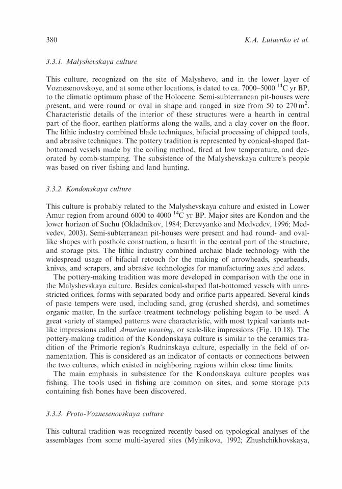
3.3.1. Malyshevskaya culture
This culture, recognized on the site of Malyshevo, and in the lower layer ofVoznesenovskoye, and at some other locations, is dated to ca. 7000–5000 14C yr BP,to the climatic optimum phase of the Holocene. Semi-subterranean pit-houses werepresent, and were round or oval in shape and ranged in size from 50 to 270m2.Characteristic details of the interior of these structures were a hearth in centralpart of the floor, earthen platforms along the walls, and a clay cover on the floor.The lithic industry combined blade techniques, bifacial processing of chipped tools,and abrasive techniques. The pottery tradition is represented by conical-shaped flat-bottomed vessels made by the coiling method, fired at low temperature, and dec-orated by comb-stamping. The subsistence of the Malyshevskaya culture’s peoplewas based on river fishing and land hunting.
3.3.2. Kondonskaya culture
This culture is probably related to the Malyshevskaya culture and existed in LowerAmur region from around 6000 to 4000 14C yr BP. Major sites are Kondon and thelower horizon of Suchu (Okladnikov, 1984; Derevyanko and Medvedev, 1996; Med-vedev, 2003). Semi-subterranean pit-houses were present and had round- and oval-like shapes with posthole construction, a hearth in the central part of the structure,and storage pits. The lithic industry combined archaic blade technology with thewidespread usage of bifacial retouch for the making of arrowheads, spearheads,knives, and scrapers, and abrasive technologies for manufacturing axes and adzes.The pottery-making tradition was more developed in comparison with the one in
the Malyshevskaya culture. Besides conical-shaped flat-bottomed vessels with unre-stricted orifices, forms with separated body and orifice parts appeared. Several kindsof paste tempers were used, including sand, grog (crushed sherds), and sometimesorganic matter. In the surface treatment technology polishing began to be used. Agreat variety of stamped patterns were characteristic, with most typical variants net-like impressions called Amurian weaving, or scale-like impressions (Fig. 10.18). Thepottery-making tradition of the Kondonskaya culture is similar to the ceramics tra-dition of the Primorie region’s Rudninskaya culture, especially in the field of or-namentation. This is considered as an indicator of contacts or connections betweenthe two cultures, which existed in neighboring regions within close time limits.The main emphasis in subsistence for the Kondonskaya culture peoples was
fishing. The tools used in fishing are common on sites, and some storage pitscontaining fish bones have been discovered.
3.3.3. Proto-Voznesenovskaya culture
This cultural tradition was recognized recently based on typological analyses of theassemblages from some multi-layered sites (Mylnikova, 1992; Zhushchikhovskaya,
K.A. Lutaenko et al.380
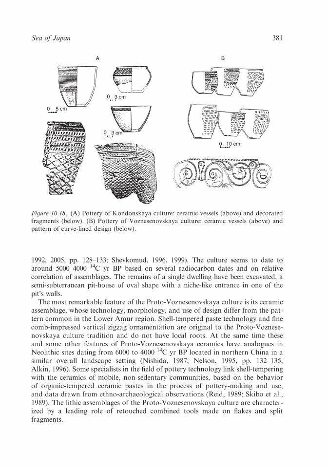
1992, 2005, pp. 128–133; Shevkomud, 1996, 1999). The culture seems to date toaround 5000–4000 14C yr BP based on several radiocarbon dates and on relativecorrelation of assemblages. The remains of a single dwelling have been excavated, asemi-subterranean pit-house of oval shape with a niche-like entrance in one of thepit’s walls.The most remarkable feature of the Proto-Voznesenovskaya culture is its ceramic
assemblage, whose technology, morphology, and use of design differ from the pat-tern common in the Lower Amur region. Shell-tempered paste technology and finecomb-impressed vertical zigzag ornamentation are original to the Proto-Voznese-novskaya culture tradition and do not have local roots. At the same time theseand some other features of Proto-Voznesenovskaya ceramics have analogues inNeolithic sites dating from 6000 to 4000 14C yr BP located in northern China in asimilar overall landscape setting (Nishida, 1987; Nelson, 1995, pp. 132–135;Alkin, 1996). Some specialists in the field of pottery technology link shell-temperingwith the ceramics of mobile, non-sedentary communities, based on the behaviorof organic-tempered ceramic pastes in the process of pottery-making and use,and data drawn from ethno-archaeological observations (Reid, 1989; Skibo et al.,1989). The lithic assemblages of the Proto-Voznesenovskaya culture are character-ized by a leading role of retouched combined tools made on flakes and splitfragments.
0 3 cm
0 3 cm
0 5 cm
0
A B
10 cm
Figure 10.18. (A) Pottery of Kondonskaya culture: ceramic vessels (above) and decoratedfragments (below). (B) Pottery of Voznesenovskaya culture: ceramic vessels (above) andpattern of curve-lined design (below).
Sea of Japan 381

3.3.4. Voznesenovskaya culture
The major sites defining this culture are Voznesenovskoye, and some dwellingsat the Kondon multi-layered settlement. Semi-subterranean pit-houses are ofoval- or rectangular-like shape with a central hearth. On some sites dwellingsconnected with ritual or cult functions were discovered (Derevyanko andMedvedev, 1995b).The lithic industry is characterized by the total dominance of a bifacial retouch-
ing technique. Combined tools, arrowheads, scrapers, and knives were very care-fully made. The abrasive technique was also used for the making of axes and adzes,knives, and arrowheads. The archaic blade technology disappeared entirely.Pottery-making was marked by new ceramic paste and surface treatment tech-
nologies, and sophisticated designs. Grog temper (i.e., crushed sherds) was used,vessel walls were treated by fine polishing or painted with red ocher. Refined ge-ometric curve-lined style blossomed in the pottery-making of the Voznesenovskayaculture (Fig. 10.18). It represents the earliest occurrence of the Amur region’sfamous curve-lined ornamental art, which has survived in various crafts of theregion’s native peoples (Okladnikov, 1981). Unique samples include curve-linedanthropomorphic images on ceramic vessels that were probably used in non-util-itarian functions. The Voznesenovskaya culture’s ceramic tradition was for theprehistoric cultures of the Russian Far East, the same as the Middle Jomon ceramictradition was for the Japanese Neolithic – it represented the peak of development ofNeolithic Far Eastern pottery-making.The subsistence of the Voznesenovskaya culture’s bearers was oriented toward
exploiting riverine resources. Stone pebble net-sinkers and storage pits containingfish bones indicate the intensive development of the fishery. A remarkable trait ofVoznesenovskaya culture’s sites is evidences for ritual activity, indicated by thepresence of probable special sacral places within the sites, and fine ceramic vesselswith anthropomorphic images.The chronology of the Voznesenovskaya culture is not entirely clear. Based on
current data it may be supposed that this cultural tradition existed around 4500–3500 14C yr BP. As a whole, the Voznesenovskaya culture looks more advancedthan other Neolithic cultures of the Lower Amur region. This is reflected in variouskinds of archaeological records. Stratigraphical observations at the multi-layeredsite of Gasya show a sequence deposit of the Malyshevskaya and Voznesenovskayacultures (Derevyanko and Medvedev, 1995a). The horizons of the Malyshevskayaculture are connected with light-yellow loams accumulated during the Atlanticperiod of Holocene, while the horizons of Voznesenovskaya culture are layeredabove in grayish-brown sandy loam formed during the post-Atlantic period.Complicated cultural processes occurred in the Lower Amur region during
the Neolithic, which are not clearly understood at present. The Neolithic cultures ofthe Lower Amur region are not linked in a continuous succession. One can dis-tinguish the stage of local cultural development represented by the Malyshevskayaand Kondonskaya cultures at 7000–5000 14C yr BP from the assemblages of the
K.A. Lutaenko et al.382
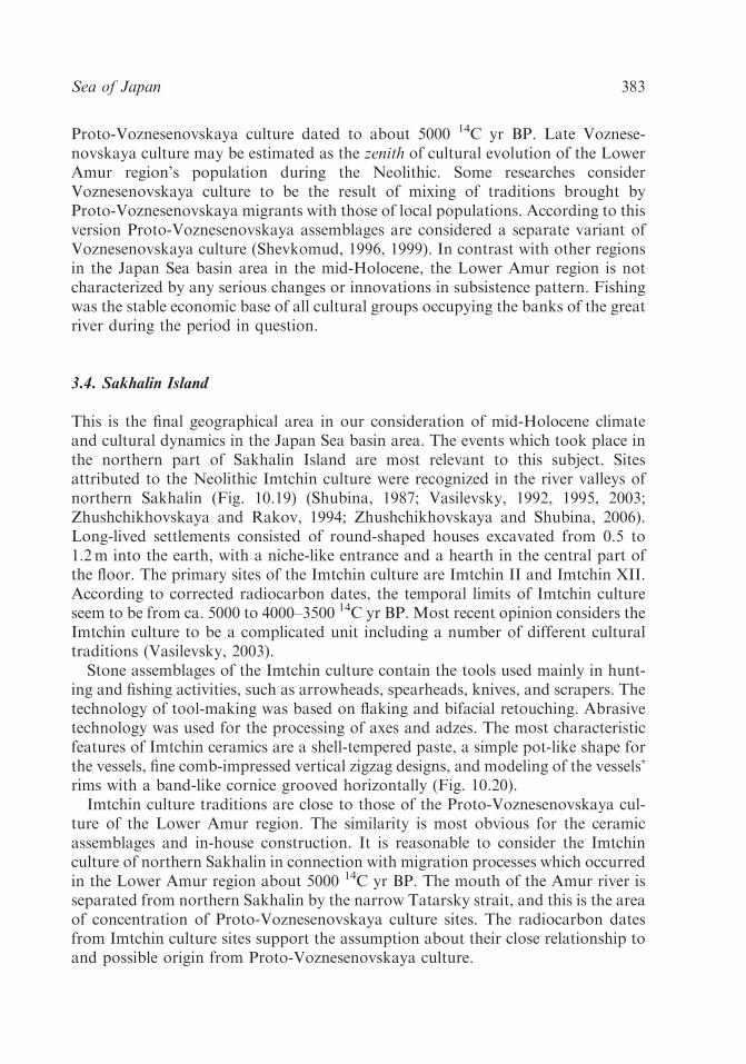
Proto-Voznesenovskaya culture dated to about 5000 14C yr BP. Late Voznese-novskaya culture may be estimated as the zenith of cultural evolution of the LowerAmur region’s population during the Neolithic. Some researches considerVoznesenovskaya culture to be the result of mixing of traditions brought byProto-Voznesenovskaya migrants with those of local populations. According to thisversion Proto-Voznesenovskaya assemblages are considered a separate variant ofVoznesenovskaya culture (Shevkomud, 1996, 1999). In contrast with other regionsin the Japan Sea basin area in the mid-Holocene, the Lower Amur region is notcharacterized by any serious changes or innovations in subsistence pattern. Fishingwas the stable economic base of all cultural groups occupying the banks of the greatriver during the period in question.
3.4. Sakhalin Island
This is the final geographical area in our consideration of mid-Holocene climateand cultural dynamics in the Japan Sea basin area. The events which took place inthe northern part of Sakhalin Island are most relevant to this subject. Sitesattributed to the Neolithic Imtchin culture were recognized in the river valleys ofnorthern Sakhalin (Fig. 10.19) (Shubina, 1987; Vasilevsky, 1992, 1995, 2003;Zhushchikhovskaya and Rakov, 1994; Zhushchikhovskaya and Shubina, 2006).Long-lived settlements consisted of round-shaped houses excavated from 0.5 to1.2m into the earth, with a niche-like entrance and a hearth in the central part ofthe floor. The primary sites of the Imtchin culture are Imtchin II and Imtchin XII.According to corrected radiocarbon dates, the temporal limits of Imtchin cultureseem to be from ca. 5000 to 4000–3500 14C yr BP. Most recent opinion considers theImtchin culture to be a complicated unit including a number of different culturaltraditions (Vasilevsky, 2003).Stone assemblages of the Imtchin culture contain the tools used mainly in hunt-
ing and fishing activities, such as arrowheads, spearheads, knives, and scrapers. Thetechnology of tool-making was based on flaking and bifacial retouching. Abrasivetechnology was used for the processing of axes and adzes. The most characteristicfeatures of Imtchin ceramics are a shell-tempered paste, a simple pot-like shape forthe vessels, fine comb-impressed vertical zigzag designs, and modeling of the vessels’rims with a band-like cornice grooved horizontally (Fig. 10.20).Imtchin culture traditions are close to those of the Proto-Voznesenovskaya cul-
ture of the Lower Amur region. The similarity is most obvious for the ceramicassemblages and in-house construction. It is reasonable to consider the Imtchinculture of northern Sakhalin in connection with migration processes which occurredin the Lower Amur region about 5000 14C yr BP. The mouth of the Amur river isseparated from northern Sakhalin by the narrow Tatarsky strait, and this is the areaof concentration of Proto-Voznesenovskaya culture sites. The radiocarbon datesfrom Imtchin culture sites support the assumption about their close relationship toand possible origin from Proto-Voznesenovskaya culture.
Sea of Japan 383

Active settlement of northern Sakhalin began with the coming of the Imtchinculture bearers. Probably, there were several waves of population moving from theLower Amur region to Sakhalin Island. The early complexes of the Imtchin culturemost closely resemble the assemblages of the Proto-Voznesenovskaya culture ofthe Lower Amur region. The late Imtchin complexes contain features probablyrelated to Voznesenovskaya culture, such as well-made pottery decorated with thein curve-lined style.Cultural processes which occurred in the southern part of Sakhalin Island were of
another character. The first Neolithic culture recognized in this area is Yuzhno-Sakhalinskaya, with sites located mostly in the southwestern seacoast (Fig. 10.19).Major sites include Sadovniki-2 and Kuznetsovo-4 (Shubin et al., 1982; Vasilevsky,1992, 1995). Calibrated radiocarbon dates indicate that the temporal limits ofYuzhno-Sakhalinskaya culture are mainly from 7500 to 6500 14C yr BP.Semi-subterranean pit-houses of rectangular-like shape are present, whose size
was up to 100m2 in some cases. A hearth was located near the wall opposite the
55°N
50°N
45°N
55°N
50°N
45°N
145°E140°E
Ta
tars
ky
Str
ai t
Sadovniki-2
Kuznetsovo-3,4
Yuzhnaya-2
TerpeniyaBay
AnivaBay
Predreflianka
Tym
Single-layer site of Atlantic climatic periodSingle-layer site of Subboreal climatic period
Yuzhno-Sakhalinsk
Imtchin - III,XII
145oE140oE
Figure 10.19. Map of location of basic Neolithic (mid-Holocene) sites of Sakhalin Island.
K.A. Lutaenko et al.384

entrance, bench-like earthen projections extended along the walls, and the entranceswere corridor-shaped.The lithic assemblages include retouched tools made on blades and blade-like flakes.
Only a few partially polished tools have been found. As a whole, the stone artifacts arecharacterized by a combination of Paleolithic and Neolithic technical traits.Ceramics of the Yuzhno-Sakhalinskaya culture represent the earliest pottery-
making tradition in southern Sakhalin Island (Zhushchikhovskaya, 1997;Zhushchikhovskaya and Shubina, 2006). Its technological features include plant-organic-tempered paste, a slab construction method of forming, an absence of anysurface treatment, and very low temperature firing (about 5001C). The most dis-tinctive trait is the box-like shape of the ceramic vessels, a form that is unusual forFar Eastern prehistoric pottery. Box-shaped vessels occur in some early ceramicsassemblages of northern Japan dated to 13,000–10,000 14C yr BP according to someresearchers (Suda, 1995). Organic-tempered box-like ceramics are recognized inearly assemblages from eastern North America where it has been suggested that theform is related to wooden containers (Griffin, 1965).The subsistence of Yuzhno-Sakhalinskaya culture was based on hunting, fishing,
and gathering. Although the main area of the Yuzhno-Sakhalinskaya culture islocated in southern Sakhalin, recently some evidence for these cultural assemblageswas discovered in the northern part of the island (Vasilevsky, 2003).Archaeological records of southern part of Sakhalin Island do not provide ev-
idence for developments following the Yuzhno-Sakhalinskaya cultural tradition in
0 10cm 0 8cm
0 6m
0 4cm
Figure 10.20. Archaeological assemblage of Imtchinskaya culture, Sakhalin Island.
Sea of Japan 385

later cultural contexts. By around 4000–3500 14C yr BP, new population groupsappeared in southern Sakhalin and settled mainly in the southeastern part of theisland (Fig. 10.19). The Anivskaya Neolithic culture representing these new pop-ulations is radiocarbon dated to 35607140–23207160 14C yr BP. Major sites areYuzhnaya and Predreflianka (Vasilevsky, 1992, 1995). The settlements consist ofsemi-subterranean pit-houses of rectangular-like shape with pitted fireplaces bor-dered with stones, and postholes in the floor, which was covered by a clay layer. Insome cases, remains of carbonized wooden construction with the traces of a claycover extending along the walls are preserved.The set of tools recovered indicate subsistence was oriented to hunting, fishing,
and gathering. Pottery assemblages of Anivskaya culture have not any traits relatedto the traditions of Yuzhno-Sakhalinskaya culture. Characteristics of the ceramicsinclude a sand-tempered paste, a coiling method for forming, a flat-bottomed con-ical vessel shape with an unrestricted or slightly restricted orifice, slipping used forsurface treatment, and low temperature firing. Ceramic design is standard: verticalor inclined cord impressions on the vessel walls. This type of decoration has closeanalogues in the pottery-making Neolithic Jomon culture of the neighboring Jap-anese isles.Archaeological assemblages on Sakhalin Island reflect differing cultural tradi-
tions in the northern and southern parts of the island during the Neolithic. Thenorthern Neolithic culture was connected to that of the Lower Amur River region,while the southern Neolithic culture was related to that of the prehistoric habitantsof the Japanese Archipelago. Mid-Holocene cultural dynamics differed in thenorthern and southern parts of Sakhalin Island. The period of the appearance andexistence of the Imtchinskaya culture in the north corresponded to the hiatus be-tween the Yuzhno-Sakhalinskaya and Anivskaya cultures in the south. Given thelimited archaeological research on Sakhalin Island as a whole, the development ofexplanatory models that could correlate and link cultural events in this regionduring mid-Holocene is a major goal for future research.
4. Discussion and conclusions
Despite the fact that there is a chronological disagreement in the interpretation ofpaleoclimatic events in the basin of the Sea of Japan, the data presented anddiscussed above can be summarized as follows.The first warming of the mid-Holocene took place between 7200 and 6200 14C yr
BP in Sakhalin, although the maximum warming was between 5000 and 6000 14C yrBP. In Japan, taking into account information on the maximum high stand of thesea level, the peak of warmth appears to have been ca. 6500–5500 or 6500–5000 14Cyr BP, although other evidence suggests the warmest stage in Japan was between ca.8000 and 6000 14C yr BP. No exact information on the chronology of warm/coldstages in the mid-Holocene is available for Korea, Primorye, and Priamurye.
K.A. Lutaenko et al.386

A significant cooling in Japan was detected between 4000 and 4500 14C yr BP.This corresponds to the Early Subboreal cooling in Sakhalin Island at about 440014C yr BP, to that in Primorye about 4200–4700 14C yr BP, and in the Kurile Islandsapproximately 4500–4800 14C yr BP.The Tsushima Current’s inflow in the Sea of Japan started after 9000–9500 14C yr
BP, but the full scale influx of the current might occur approximately 8000 14C yrBP. Maximum oceanic warming around Japan seems to have occurred ca. 6500–7000 14C yr BP or about 6000–4700 14C yr BP. The warming of the surface waters ofthe Sea of Japan seems to occur later than on the Pacific Ocean (i.e., eastern) side ofJapan. Nevertheless, the first warm-water mollusks appeared in Hokkaido at ca.8500–7500 14C yr BP on the Sea of Japan side of the island, earlier than themaximum surface water warming that occurred, and at about 7000 14C yr BP in thenorthwestern Sea of Japan. The effective use of mollusks as indicators of hydro-climatic warming and warm/cold currents requires as many direct AMS dates aspossible on individual species.A period of high storm frequency, corresponding to maximum warming in Japan
and Sakhalin, may have taken place about 5300–6000 14C yr BP.The ‘‘climatic optimum’’ or, at least, the time span between 5000 and 6000 14C yr
BP, is characterized in the Russian Far East by annual average temperatures inexcess of 2–61C and more humid conditions. Annual average SSTs in the Sea ofJapan were 1–21C higher compared to the present.Cultural dynamics in the basin of the Sea of Japan and adjacent areas during the
mid-Holocene period may be summarized as follows. Cultural changes took placein all parts of the research area. However, the character and content of the changeswere diverse in each region. Three types of cultural changes are distinguished(Table 10.8). Types 1 and 2 differ one from another in basic cultural context. At thesame time, they are similar in the broad spectra of changes, which occurred inthe subsistence, demography, social pattern, material, and spiritual culture. Most ofthe observed changes were progressive in character and may be defined as devel-opmental: the increasing of productivity and appearance of new forms of
Table 10.8. Types of cultural dynamics in the mid-Holocene in the Sea of Japan basin.
Type Region Type’s content
Type 1 Japanese Archipelago Stability of basic cultural context. Changes andinnovations in subsistence, demography, materialculture, spiritual culture
Type 2 Korea Peninsula Changing of basic cultural context. Changes andinnovations in subsistence, demography, materialculture, spiritual culture
Type 3 Russian Far East Changing of basic cultural contexts. Local changesand innovations in subsistence, material culture,spiritual culture
Sea of Japan 387
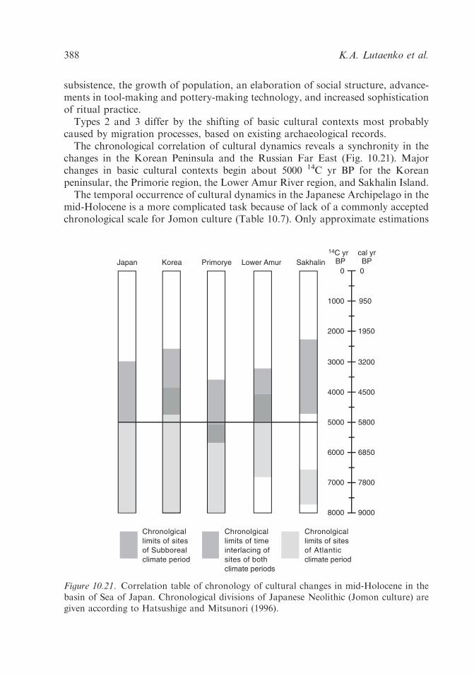
subsistence, the growth of population, an elaboration of social structure, advance-ments in tool-making and pottery-making technology, and increased sophisticationof ritual practice.Types 2 and 3 differ by the shifting of basic cultural contexts most probably
caused by migration processes, based on existing archaeological records.The chronological correlation of cultural dynamics reveals a synchronity in the
changes in the Korean Peninsula and the Russian Far East (Fig. 10.21). Majorchanges in basic cultural contexts begin about 5000 14C yr BP for the Koreanpeninsular, the Primorie region, the Lower Amur River region, and Sakhalin Island.The temporal occurrence of cultural dynamics in the Japanese Archipelago in the
mid-Holocene is a more complicated task because of lack of a commonly acceptedchronological scale for Jomon culture (Table 10.7). Only approximate estimations
Japan Korea Primorye Lower Amur Sakhalin
Chronolgicallimits of sitesof Subborealclimate period
Chronolgicallimits of sites of Atlanticclimate period
Chronolgicallimits of time interlacing ofsites of bothclimate periods
14C yr BP
8000
7000
6000
5000
4000
3000
9000
7800
6850
5800
4500
3200
cal yrBP
2000
1000
1950
950
0 0
Figure 10.21. Correlation table of chronology of cultural changes in mid-Holocene in thebasin of Sea of Japan. Chronological divisions of Japanese Neolithic (Jomon culture) aregiven according to Hatsushige and Mitsunori (1996).
K.A. Lutaenko et al.388
of the amount of time corresponding to observed cultural changes can be currentlyrecognized. As noted above, the beginnings of the changes were connected with theEarly Jomon stage, with the greatest changes during the Middle Jomon stage. EarlyJomon is dated to 7500–5600 14C yr BP in some ‘‘early’’ chronological frameworksand to 5400–4800 14C yr BP in ‘‘later’’ frameworks; correspondingly, most earlyframeworks place Middle Jomon to ca. 5600–4500 14C yr BP and most late ones toca. 4800–4230 14C yr BP. A recent chronology of Jomon sites in the Kanto Plain ofCentral Japan dates the Early stage to 6000–4400 14C yr BP and the Middle stage to5300–3200 14C yr BP (Kuzmin et al., 1998, p. 102).Taking into account the variability in the various chronological scales of Jomon
culture, it may be found that the Early Jomon stage corresponds entirely or par-tially to the interval from ca. 6000 to 5000 14C yr BP, and the beginnings of theMiddle Jomon stage between the middle of the fifth millennium BP and the be-ginnings of 4th millennium BP. Thus, the probable cultural changes observed in theEarly and Middle Jomon stages fall into the interval from ca. 6000 to 5000 14C yrBP and continue to some extent after 5000 14C yr BP (Fig. 10.21).Examining the chronological correlation between climatic-environment changes
and cultural dynamics during the mid-Holocene in the basin of the Sea of Japanleads to the conclusion that the most intensive cultural changes seem to be after theperiod of maximum climatic warming about 5000 14C yr BP. This was the finalstage of maximum warming and the beginnings of a series of significant culturalchanges in all parts of the Japan Sea basin. Cultural events in the mainland part ofthe research area and in northern Sakhalin Island differed from the events whichtook place in the Japanese Archipelago in the mid-Holocene. In the mainland partof the research area, including in the Korean Peninsula, Primorye and the LowerAmur River regions, and in northern Sakhalin Island, cultural changes were con-nected with migration processes. The general direction of the migrations was fromthe continental territories of Eastern Asia (Northeastern China in particular) to theareas bordering the Sea of Japan. The Neolithic cultures of Northeastern Chinaseem to be the sources or origins of population groups which began to move outfrom their nuclear regions about 5000 14C yr BP. After 5000 14C yr BP new pop-ulations, bringing new cultural traditions, appeared in the Korean Peninsula,Primorye, the Lower Amur River region, and in northern Sakhalin Island. Basiccultural contexts changed in all of these regions.What could be the reasons for migrations during certain parts of the mid-
Holocene in Eastern Asia? Assuming that climatic change in Northeastern Chinawas similar to what was occurring in the Japan Sea basin, it is probable thatfavorable environmental and ecological circumstances caused economic and demo-graphic increases during the period of maximum warming in the mid-Holocene.Critical situations could arise when the productive capacity of the landscape incertain areas was pressed by the increasing population. For economies based onfood gathering rather than food production (i.e., agriculture) the movement ofgroups to new territories might be an optimal survival strategy. We are inclined toconnect the appearance of the Zaisanovka Neolithic culture of the Primorye region
Sea of Japan 389

with a movement of population groups and their associated cultural traditions fromneighboring Northeastern China.At present the study of prehistoric migrations in the Far Eastern area and ad-
jacent territories is only in its initial stages. The model outlined here is a firstattempt to link and explain cultural events which took place in the Russian Far Eastand the Korean Peninsula during the mid-Holocene through a combination offactors, including migration and relationships between settlement and environment.Mid-Holocene cultural dynamics of the Japanese Archipelago were apparently
caused by the independent evolution of local populations under the influence ofclimatic and environmental processes. During the period of maximum warming,from ca. 6000 to 5000 14C yr BP, favorable conditions appeared for an increasingrole for marine resources and intensive plant-gathering. Maximum sea levels at5000 14C yr BP greatly shaped the orientation to a marine economy. The in-creasing subsistence productivity resulted in greater stability for this form of sub-sistence, with a resulting growth of population and an elaboration of socialstructure that were reflected in changes in settlement and house patterns. Elab-oration of social structure resulted in increased time and labor resources applied toactivities which were not involved directly in food supplying, such as pottery-making, or ritual practice. The correlation between economic and subsistenceblossoming and stabilization, and the development of more complex social struc-ture and the intensification of pottery-making and some other crafts, has beendemonstrated in a broad range of prehistoric and ancient cultures (Feinmannet al., 1981; Underhill, 1991, 1992; Nelson, 1992; Zhushchikhovskaya, 1994, 2005;etc.). The outstanding development of Middle Jomon ceramic assemblages, in-cluding the production of vessels with highly sophisticated relief designs, took a lotof labor by skilled craftsmen. This labor-intensive activity was facilitated by theeconomic rise that occurred during the end of Early Jomon and the Middle Jomonperiods.An elaboration of ritual practice at this time is reflected in the great increase in
the number and variety of ritual objects that are found; some Middle Jomon burialpractices were also labor intensive. It is interesting to note that the impressiveappearances of labor- and time-intensive activities connected with ritual practice inthe mid-Holocene period are also present in the archaeological records of otherparts of the research area. These include the massive stone constructions or dolmensin the Korean Peninsula, and the sacral places and ceramic vessels with unusualanthropomorphic designs of the Voznesenovskaya culture of the Lower AmurRiver region. It seems likely that the mid-Holocene was characterized by a blos-soming of ritual activities in the prehistoric cultures of the Sea of Japan basin.
Acknowledgments
We would like to thank Dr. D. Sandweiss and Dr. K. Maasch (Institute for Qua-ternary Studies, University of Maine, Orono) for their efforts to organize the
K.A. Lutaenko et al.390

FERCO Conference on Climate and Culture at 3000 yr BC (October 1998). Manycolleagues provided us with useful literature: Prof. K. Taira (Hokkaido Universityof Education, Asahigawa), Prof. Y. Sakaguchi (Tokyo), Dr. M. Akamatsu (His-torical Museum of Hokkaido, Sapporo), Dr. K. Amano (Joetsu University of Ed-ucation, Joetsu), Prof. K. Chinzei (Kyoto University, Kyoto), Dr. Y. Matsushima(Kanagawa Prefectural Museum, Yokohama), Dr. A. Suzuki (Hokkaido Universityof Education, Iwamizawa), S. Fujii (Fujii Laboratory for Geological Environment,Toyama), Dr. K.-Y. Wei (National Taiwan University, Taipei), Dr. H.-I. Yi andDr. D.-H. Shin (Korea Ocean Research & Development Institute, Ansan), Dr. S.Shimoyama (Kyushu University, Fukuoka), Prof. Sarah M. Nelson (DenverState University), Mr. Masahiro Fukuda (University of Tsukuba, Japan), Dr. S.A.Gorbarenko (Pacific Oceanological Institute, FEB RAS, Vladivostok) andDr. N.G. Razjigaeva (Pacific Institute of Geography, FEB RAS, Vladivostok).Part of the English text was improved by Ms. T.N. Koznova (Department ofScientific Information, Institute of Marine Biology, Far East Branch of the RussianAcademy of Sciences, Vladivostok), and by Dr. David G. Anderson. This work wassupported by a grant from the Russian Science Support Foundation to K.Lutaenko, and by grants from the Asia-Pacific Network for Global ChangeResearch (APN)ARCP2006-FP14-Adrianov and from the Russian Academy ofSciences ‘‘Reaktsia morskoy bioty na izmenenie climata i okruzhaushei sredy’’.
References
Afanasiev, V. V. 1992., Coastal evolution of seas of the Far East in the Holocene. In Coast
Evolution in the Conditions of the Uplift of the Ocean Level, edited by N. A. Aybulatov and
S. A. Lukyanova, pp. 166–174. Moscow State University, Moscow. In Russian.
Aikens, C. M., 1995. First in the World: the Jomon Pottery of early Japan. In The Emergence
of Pottery: Technology and Innovation in Ancient Societies, edited by W. K. Barnett and
J. W. Hoopes, pp. 11–22. Smithsonian Institution Press, Washington and London.
Aikens, C. M., and T. Higuchi, 1982. Prehistory of Japan. Academic Press, New York.
Akamatsu, M., 1969. Molluscan assemblages of shell mounds in Hokkaido – with special ref-
erence to the so-called Jomon transgression. Earth Science 23:107–117. In Japanese with
English abstract.
Akamatsu, M., and Y. Kitagawa, 1983. Holocene shell beds in the northern district of the
Ishikari lowland, Hokkaido. The Annual Report of the Historical Museum of Hokkaido
11:35–45. In Japanese with English abstract.
Akamatsu, M., and H. Ushiro, 1992. A note on the aeo-Atlantic stage in the middle age in
Hokkaido and South Sakhalin. In Preliminary Reports on ‘‘Research Project of the Historical
and Cultural Exchange of the North’’ in 1991, pp. 91–108. Historical Museum of Hokkaido,
Sapporo. In Japanese with English abstract.
Akamatsu, M., N. Yamazaki, and T. Arakawa, 1995. Faunal characteristics of Holocene mollu-
scan fossils in Hokkaido – examples of the Ishikari lowland and around the Uchiura Bay.
Bulletin of the Historical Museum of Hokkaido 23:7–18. In Japanese with English abstract.
Alekseev, M. N., and L. V. Golubeva, 1980. On the stratigraphy and paleogeography of the
Upper Pleistocene of South Primorye. Bulletin of the Comission on Studies of the Quaternary
Period 50:96–107. In Russian, title translated.
Sea of Japan 391

Alkin, S. V., 1996. Early Neolithic cultures of northeastern China. In Late Paleolithic–Early
Neolithic, Eastern Asia and Northern America (International Symposium Materials, March
22–25, 1994, Vladivostok, Russia), edited by N. A. Kononenko, pp. 7–10. Institute of His-
tory, Archaeology and Ethnography of the Peoples of the Far East, FEB RAS and Tohoku
Fukushi University, Vladivostok. In Russian, title translated.
Ando, K., 1986. Holocene paleoenvironments and the highest sea-level based on the diatom
assemblages in Minuma lowland, Saitama prefecture. The Quaternary Research (Japan)
25(3):165–176. In Japanese with English abstract.
Andreev, G. I., 1957. The Site Zaisanovka 1 in the Primorye Region. Soviet Archaeology 2:121–
145. In Russian with Franch abstract.
Andreev, G. I., 1960. Some aspects of the cultures of Southern Primorye of III–I mil. BC. The
Materials and Records of the Archaeology of the USSR 86:136–161. In Russian, title translated.
Andreeva, Zh. V., editor, 1987. Valentin-Peresheek–the Settlement of Prehistoric Ore-Miners.
Nauka, Moscow. In Russian, title translated.
Andreeva, Zh. V., editor, 1991. The Neolithic of the Southern Far East: ancient settlement in the
Cave Chertovy Vorota. Nauka, Moscow. In Russian, title translated.
Arimitsu, K., 1962. The Comb Patterned Pottery of Korea. Department of Archaeology Pub-
lication 3. Kyoto University, Kyoto.
Bernard, F. R., Y. Y. Cai, and B. Morton, 1993. Catalogue of the Living Marine Bivalve Mollusks
of China. Hong Kong University Press, Hong Kong.
Borzenkova, I. I., 1990. On the climatic changes in the Late Wurm–Holocene (Last 20 Thousand
Years). Transactions of the State Hydrological Institute (Leningrad) 348:70–78. In Russian,
title translated.
Brodyansky, D. L., 1979. The problem of periodization and chronology of the Neolithic of
Primorye region. In Ancient Cultures of Siberia and the Pacific Basin, edited by R. S.
Vasil’evsky, pp. 110–115. Nauka, Novosibirsk. In Russian, title translated.
Brodyansky, D. L., 1987. Introduction to Far Eastern Archaeology. Far East State University
Press, Vladivostok. In Russian, title translated.
Brodyansky (as Brodianski), D. L., and V. A. Rakov, 1992. Prehistoric aquaculture on the
Western Coast of the Pacific. In Pacific Northeast Asia in Prehistory. Hunter-Fisher-
Gatherers, Farmers, and Sociopolitical Elites, edited by C. M. Aikens and S. N. Rhee,
pp. 27–31. Washingthon State University Press, Pullman.
Brodyansky (as Brodianski), D. L., and V. A. Rakov, 1996. Marine adaptation of population
and producing economy in the Neolithic Age on the Coast of Primorye. Bulletin of the Far
Eastern Branch, Russian Academy of Sciences 1:124–130. In Russian with English abstract.
Burashnikova, T. A., M. V. Muratova, and I. A. Suetova, 1982. Climatic model of the Soviet
Union Territory during the Holocene Optimum. In Evolution of the Environment at the USSR
Territory during Late Pleistocene and Holocene, edited by A. A. Velichko, I. I. Spasskaya, and
N. A. Khotinsky, pp. 245–251. Nauka, Moscow. In Russian.
Chen, C.-H., Y.-C. Lu, and C. T. Shen, 1978. Development of natural environment in
the southern part of Liaoning Province during the last 10,000 years. Scientia Sinica
21(4):516–532.
Cherepanova, M. V., T. A. Grebennikova, A. S. Astakhov, and V. V. Shapovalov, 1988. Stra-
tigraphy and paleogeography of the shelf and continental slope of Southern Sakhalin.
In Coastal Zone of the Far Eastern Seas in the Pleistocene, edited by A. M. Korotky and
V. S. Pushkar, pp. 93–108. USSR Academy of Sciences, Far East Branch, Vladivostok. In
Russian, title translated.
Chinzei, K., 1993. Comments of paleotemperature analysis based on the molluscan species.
Fossils 55:49–51. In Japanese with English abstract.
K.A. Lutaenko et al.392

Chinzei, K., K. Fujioka, F. Kitazato, I. Koizumi, T. Oba, M. Oda, M. Okada, T. Sakai, and
Y. Tanimura, 1987a. Postglacial environmental change of the Pacific Ocean off the coasts of
Central Japan. Marine Micropaleontol 11:273–291.
Chinzei, K., H. Koike, T. Oba, Y. Matsushima, and H. Kitazato, 1987b. Secular changes in the
oxygen isotope ratios of molluscs shells during the Holocene of Central Japan. Palaeoge-
ography, Palaeoclimatolagy, Palaeoecology 61:155–166.
Chinzei, K., and T. Oba, 1986. Oxygene isotope studies of the Deep Sea sediments around Japan.
Recent Progress of Natural Sciences in Japan (Quaternary Research) 11:35–43.
Choe, C. P., 1982. The diffusion route and chronology of Korean plant domestication. Journal of
Asian Studies 41(3):519–529.
Choe, C. P., and M. T. Bale, 2002. Current perspectives on settlement, subsistence, and cul-
tivation in prehistoric Korea. Arctic Anthropology 39:95–121.
Derevyanko, A. P., and V. E. Medvedev, 1995a. The Study of Gasya Site. Nauka, Novosibirsk.
In Russian with English abstract; title translated.
Derevyanko, A. P., and V. E. Medvedev, 1995b. Sacral places on Suchu Island – new type of Far
Eastern archaeological sites. In Survey of the Results of Field and Analytical Researches of
Archaeologists, Ethnologists and Anthropologists of Siberia and Far East in 1993, edited by
A. P. Derevyanko and V. E. Larichev, pp. 228–238. Siberian Branch of the Russian Academy
of Sciences, Novosibirsk. In Russian, title translated.
Derevyanko, A. P., and V. E. Medvedev, 1996. Suchu Island – Unique archaeological site of
the Far East. In Archaeology of Northern Pacific, edited by A. L. Ivliev, N. N. Kradin, and
I. S. Zhushchikhovskaya, pp. 214–221. Dalnauka, Vladivostok. In Russian with English
abstract.
DeVries, T. J., L. Ortlieb, A. Diaz, L. Well, and C. Hillaire-Marcel, 1997. Determining the Early
History of El Nino. Science 276:965–966.
DeVries, T. J., and L. E. Well, 1990. Thermally-anomalous Holocene molluscan assemblages
from Coastal Peru: evidence for paleogeographic, not climatic change. Palaeogeography,
Palaeoclimatology, Palaeoecology 81:11–32.
Dyakov, V. I., 1992. Multi-layered site Rudnaya Pristan’ and the Periodization of the Neolithic
cultures of Primorye Region. Dalnauka, Vladivostok. In Russian, title translated.
Endo, K., M. Kosugi, M. Matsushita, N. Miyaji, R. Hishida, and T. Takano, 1989.
Holocene environmental history in and around the Paleo-Nagareyama Bay, Central
Kanto Plain. The Quaternary Research (Japan) 28(2):61–77. In Japanese with English
abstract.
Evseev, G. A., 1981. Communities of Bivalve Mollusks in Post-Glacial Deposits of Shelf of the Sea
of Japan. Nauka, Moscow. In Russian, title translated.
Feinmann, G. M., S. Upham, and G. Lightfoot, 1981. The production step measure: an ordinal
index of labor impact in ceramic manufacture. American Antiquity 46(1):871–884.
Fuji, N., 1982. Chronostratigraphic subdivision of the postglacial deposits in the Japanese
Islands. Striae 16:24–35.
Fujii, S., and N. Fuji, 1967. Postglacial sea level in the Japanese Islands. Journal of Geosciences,
Osaka City University 10:43–51.
Fujimoto, K., 1990. Reexamination of Late Holocene sea-level changes in Japan. The Science
Reports of the Tohoku University, 7th Series (Geography) 40(2):37–70.
Fujimoto, K., 1993. Late Holocene sea-level changes in Hiyogawa lowland facing Nanao-Nishi
Bay, Noto Peninsula, Central Japan. The Quaternary Research (Japan) 32(1):1–12. In
Japanese with English abstract.
Gohara, Y., 1976. Climatic fluctuations and sea level changes during the latest Pleistocene and
Early Holocene. Pacific Geology 11:87–97.
Sea of Japan 393

Golubeva, L. V., and L. P. Karaulova, 1983. Vegetation and climatostratigraphy of Pleistocene
and Holocene of the USSR Far East South. Transactions of the Geological Institute, USSR
Academy of Sciences 366:1–143. In Russian.
Gorbarenko, S. A., 1991. Stratigraphy of Late Quaternary sediments in Seas of Japan and
Okhotsk and their paleoceanological conditions. In The INQUA International Symposium on
Stratigraphy and Correlation of Quaternary Deposits of the Asian and Pacific Regions, edited
by CCOP Technical Secretariat, pp. 11–24. CCOP (Coordinating Committee for Offshore
Prospecting).
Gorbarenko, S. A., S. G. Pliss, J. R. Southon, M. Kashgarian, N. B. Verkhovskaya, and A. S.
Kundyshev, 1995. Detailed carbonate stratigraphy of the Japan Sea sediments during
last Glaciation – Holocene. Terrestrial, Atmospheric and Oceanic Sciences (Taiwan)
6(1):103–113.
Gorbarenko, S. A., and J. R. Southon, 2000. Detailed Japan sea paleoceanography during the
last 25 kyr: constraints from AMS dating and d 18O of planktonic foraminifera. Palaeo-
geography, Palaeoclimatology, Palaeoecology 156:177–193.
Griffin, J. B., 1965. Ceramic complexity and cultural development. In Ceramics and Man, edited
by F. R. Matson, pp. 104–113. University of Chicago Press, Chicago.
Gvozdeva, I. G., S. A. Gorbarenko, V. A. Rakov, K. A. Lutaenko, E. I. Shornikov, and Yu. A.
Mikishin, 1997. Primorye Paleoenvironment in Middle and Late Holocene Based on the Com-
plex Study of the Shkotovo Outcrop. Pacific Oceanological Institute, Far East Branch of the
Russian Academy of Sciences, Vladivostok. In Russian with English abstract.
Hamada, T., 1977. The Holocene corals of raised reefs of Japan. Memoirs de Bureau Recherche
Geologique et Miniers 89:389–395.
Han, S. J.,D.-H. Shin, H.-I. Yi, and J. H. Chun, 1996. Evidence of high sea-level stands in the
Korean Coast during the Holocene Epoch. In Abstracts of Papers Presented at the 1996
Annual Meeting, International Geological Correlation Program, Project 367 (Late Quaternary
Coastal Records of Rapid Change: Application to Present and Future Conditions), Sydney,
November 4–14, 1996, edited by C. V. Murray-Wallace, P. S. Roy, and K. H. Lenham, p. 31.
Harris, V., 1997. Jomon pottery in ancient Japan. In Pottery in the Making (World Ceramic
Traditions), edited by I. Freestone and D. Gaimster, pp. 20–25. British Museum, London.
Hatsushige, O., and T. Mitsunori, 1996. Nihon Kokogaku Yogo Jikon (Japanese Archaeological
Dictionary). Kashiva Shobo, Tokyo. In Japanese.
Igarashi, Y., 1993. History of environmental change in Hokkaido from the viewpoint of
palynological research. In Biodiversity and Ecology in the Northernmost Japan, edited by
S. Higashi, A. Osawa, and K. Kanagawa, pp. 2–19. Hokkaido University Press, Sapporo.
Igarashi, Y., 1994. Quaternary forest and climate history of Hokkaido, Japan, from marine
sediments. Quaternary Science Reviews 13:335–344.
Igarashi, Y., 1997. Vegetation and climate history in the circum Okhotsk region since the Last
Glacial Maximum. In Cryospheric Studies in Kamchatka I, pp. 29–37. Institute of Low
Temperature Science, Hokkaido University, Sapporo.
Igarashi, Y., 2000. Vegetation history around the Kyogoku mire, southwestern Hokkaido, dur-
ing the last 13,000 years. Japanese Journal of Ecology 50:99–110. In Japanese with English
abstract.
Igarashi, Y., S. G. Hu, M. Okamura, H. Matsuoka, M. Murayama, T. Murata, and N.
Kobayashi, 2001. Dynamics of vegetation and climate during these 50,000 tears along the Sea
of Okhotsk Region, Hokkaido, based on fossil pollen assemblages from bottom sediments of
the Lake Abashiri. In The 16th International Symposium on Okhotsk Sea and Sea Ice, 4–8
February, Mombetsu, Hokkaido, Japan: Abstracts, pp. 228–234. Okhotsk Sea & Cold Ocean
Research Association, Mombetsu.
K.A. Lutaenko et al.394

Igarashi, Y., and T. Igarashi, 1998. Late Holocene vegetation history in South Sakhalin, north-
east Asia. Japanese Journal of Ecology 48:231–244. In Japanese with English abstract.
Igarashi, Y., T. Igarashi, H. Daimaru, O. Yamada, T. Miyagi, K. Matsushita, and K.
Hiramatsu, 1993. Vegetation history of Kenbuchi Basin and Furano Basin in Hokkaido,
North Japan, since 32,000 yrs BP. The Quaternary Research (Japan) 32(2):89–105. In
Japanese with English abstract.
Igarashi, Y., and S. Kumano, 1974. Holocene climatic change in the lowland area of north of
Sapporo, Japan. The Quaternary Research (Japan) 13(2):48–53. In Japanese with English
abstract.
Igarashi, Y., T. Sagayama, T. Higake, and M. Fukuda, 2000. Late Quaternary environmental
change in Central and North Sakhalin, Russia. Journal of Geography 109(2):165–173. In
Japanese with English abstract.
Igarashi, Y., and N. Takahashi, 1985. Origin and vegetational succession of upland bogs in the
Daisetsu Mountains, Central Hokkaido. The Quaternary Research (Japan) 24(2):99–109. In
Japanese with English abstract.
Ikawa-Smith, F., 1980. Current issues in Japanese archaeology. American Scientist 68(2):134–
145.
Iofan, N. A., 1974. The Culture of Ancient Japan. Nauka, Moscow. In Russian, title translated.
Ishikawa, H., and K. Suzuki, editors, 1994. Japanese History: New View (Prehistoric Period).
Shinjin Butsu Oraisha, Tokyo. In Japanese.
Ivankov, V. A., 1996. Change of climate and dynamics of the coast water ichtyocenoses struc-
ture. In Global Changes Studies at the Russian Far East, Abstracts of Workshop, September
21–23, 1996, Vladivostok, pp. 14–15. Dalnauka, Vladivostok.
Jian, Z., B. Li, U. Pflaumann, and P. Wang, 1996. Late Holocene cooling event in the Western
Pacific. Science in China, Series D 39(5):543–550.
Jian, Z., Y. Saito, P. Wang, B. Li, and R. Chen, 1998. Shifts of the Kuroshio axis over the last
20000 years. Chinese Science Bulletin 43(12):1053–1056.
Jones, G. A., and Ya. V. Kuzmin, 1995. Radiocarbon AMS dating of the thermophilous mollusc
shells from Peter the Great Gulf coast. In Complex Studies of the Holocene Sections on Peter
the Great Gulf Coast (Sea of Japan), edited by Ya. V. Kuzmin, pp. 34–38. Bagira-Press,
Moscow. In Russian with English abstract.
Kawana, T., and P. Pirazzoli, 1990. Re-examination on the Holocene emerged shorelines in
Irabu and Shimoji Islands, the South Ryukyus, Japan. The Quaternary Research (Japan)
28(5):419–426.
Khotinsky, N. A., 1977. Holocene of the Northern Eurasia. Nauka, Moscow. In Russian with
English abstract.
Khotinsky, N. A., 1982. Holocene chronological levels: problems of the Holocene paleogeog-
raphy. In Evolution of the Environment at the USSR Territory during Late Pleistocene and
Holocene, edited by A. A. Velichko, I. I. Spasskaya, and N. A. Khotinsky, pp. 142–147.
Nauka, Moscow. In Russian.
Khotinsky, N. A. and S. S. Savina, 1985. Paleoclimatic schemes (of the USSR territory in the
boreal, atlantic and subboreal periods of Holocene. Proceedings of the USSR Academy of
Sciences, Geographical Series 4:18–34. In Russian.
Khudik, V. D., 1991. Taxonomic composition and results of paleoecological analysis of mollusks
from the Neolithic Site Chertovy Vorota. In The Neolithic of the Southern Far East: Ancient
Settlement in the Cave Chertovy Vorota, edited by Zh. V. Andreeva, pp. 212–214. Nauka,
Moscow. In Russian, title translated.
Kidder, J. E., and T. Esaka, 1968. Prehistoric Japanese Arts: Jomon Pottery. Kodansha,
Tokyo.
Sea of Japan 395

Klimanov, V. A., 1989a. Cyclicity and quasiperiodicity of climatic fluctuations in the Holocene.
In Paleoclimates of the Postglacial and Holocene, edited by A. A. Frolova, pp. 29–33. Nauka,
Moscow. In Russian, title translated.
Klimanov, V. A., 1989b. Paleoclimatic reconstructions at the USSR territory in the main thermal
maxima of the Holocene. Transactions of the Institute of Geology and Geophysics, Siberian
Branch of the USSR Academy of Sciences 657:131–136. In Russian, title translated.
Kluiev, N. A., and I. S. Zhushchikhovskaya, 1996. On the main tendencies of modern archae-
ology of primorye region, Russian Far East. The Society of North-Eurasian Studies News-
letter 7:17–21.
Kobayashi, T., 1992a. Regional organization in the Jomon period. Arctic Anthropology 29(1):
82–95.
Kobayashi, T., 1992b. Patterns and levels of social complexity in Jomon Japan. In Pacific
Northeast Asia in Prehistory. Hunter-Fisher-Gatherers, Farmers and Sociopolitical Elites, ed-
ited by M. Aikens and S. N. Rhee, pp. 91–98. Washington State University Press, Pullman.
Kobayashi, T., 2004. Jomon Reflections: Forager Life and Culture in the Prehistoric Japanese
Archipelago, Oxford: Oxbow Books.
Koizumi, I., 1987. Pulses of Tsushima current during the Holocene. The Quaternary Research
(Japan) 26(1):13–25. In Japanese with English abstract.
Koizumi, I., 1989. Holocene pulses of diatom growths in the warm Tsushima current in the
Japan Sea. Diatom Research 4(1):55–68.
Komiyama, T., 1996. Site location from the Middle to Final Jomon period in the Chubu high-
lands, Central Japan. In Archaeology of Northern Pacific, edited by A. L. Ivliev, N. N.
Kradin, and I. S. Zhushchikhovskaya, pp. 347–351. Dalnauka, Vladivostok.
Kong, W.-S. 1994. The vegetational history of Korea during the Holocene period. The Korean
Journal of Quaternary Research 8(1):9–22.
Korotky, A. M., 1994. Fluctuation of the Sea of Japan level and landscapes of coastal zone
(development stages and tendencies). Bulletin of the Far Eastern Branch, Russian Academy of
Sciences 3:29–42. In Russian with English abstracts.
Korotky, A. M., 1998. Development of Muravyev-Amurski Peninsula’s and its nearest terri-
tories’ environment in Quaternary period. Bulletin of the Far Eastern Branch, Russian Acad-
emy of Sciences 1:12–26. In Russian with English abstracts.
Korotky, A. M., T. A. Grebennikova, V. S. Pushkar, N. G. Razjigaeva, V. G. Volkov, L. A.
Ganzey, L. M. Mokhova, V. B. Bazarova, and T. R. Makarova, 1996a. Climatic Changes of
South Far East Area in Late Cenozoic (Miocene-Pleistocene). Russian Academy of Sciences,
Far East Branch, Vladivostok. In Russian with English abstract.
Korotky, A. M., and L. P. Karaulova, 1976. Radiocarbon (C14) control of the Quaternary
stratigraphy of Primorye. In Geomorphology and Quaternary Geology of the Far East, edited
by A. M. Korotky and A. P. Kulakov, pp. 98–111. Far East Science Centre, USSR Academy
of Sciences, Vladivostok. In Russian, title translated.
Korotky, A. M., L. P. Karaulova, and T. S. Troitskaya, 1980. Quaternary deposits of Primorye.
Stratigraphy and paleogeography. Transactions of the Institute of Geology and Geophysics,
Siberian Branch of the USSR Academy of Sciences 429:1–234. In Russian, title translated.
Korotky, A. M., S. P. Pletnev, V. S. Pushkar, T. A. Grebennikova, N. G. Razjigaeva, N. D.
Sakhebgareeva, and L. M. Mokhova, 1988. Development of Natural Environment of the
Southern Far East (Late Pleistocene–Holocene). Nauka, Moscow. In Russian, title translated.
Korotky, A. M., V. S. Pushkar, T. A. Grebennikova, N. G. Razjigaeva, L. P. Karaulova, L. M.
Mokhova, L. A. Ganzey, T. A. Cherepanova, V. B. Bazarova, V. G. Volkov, and N. N.
Kovalyukh, 1997. Marine Terraces and Quaternary History of Sakhalin Island Shelf.
Dalnauka, Vladivostok. In Russian with English abstract.
K.A. Lutaenko et al.396

Korotky, A. M., N. G. Razjigaeva, T. A. Grebennikova, L. A. Ganzey, L. M. Mokhova, and
V. B. Bazarova, 1996c. Landscape types and coastal environments of Kunashiri Island in
Holocene. In Global Changes Studies at the Russian Far East, Abstracts of Workshop, Sep-
tember 21–23, 1996, Vladivostok, pp. 19–20. Dalnauka, Vladivostok.
Korotky, A. M., N. G. Razjigaeva, T. A. Grebennikova, L. A. Ganzey, L. M. Mokhova, V. B.
Bazarova, and L. D. Sulerzhitsky, 1995. Holocene marine terraces of Kunashiri Island,
Kurile Islands. The Quaternary Research (Japan) 34(5):359–375.
Korotky, A. M., N. G. Razjigaeva, T. A. Grebennikova, L. A. Ganzey, L. M. Mokhova, V. B.
Bazarova, and L. D. Sulerzhitsky, 1998. Holocene marine terraces of Kunashir Island.
Geology of the Pacific Ocean 17(1):29–45. In Russian with English abstract.
Korotky, A. M., N. G. Razjigaeva, T. A. Grebennikova, L. A. Ganzey, L. M. Mokhova, V. B.
Bazarova, L. D. Sulerzhitsky, and K. A. Lutaenko, 1999. Holocene deposits and paleoge-
ography of Kunashir Island (Kurile Islands). Geology of the Pacific Ocean 18(1):25–40. In
Russian with English abstract.
Korotky, A. M., N. G. Razjigaeva, T. A. Grebennikova, L. A. Ganzey, L. M. Mokhova, V. B.
Bazarova, L. D. Sulerzhitsky, and K. A. Lutaenko, 2000a. Middle- and Late-Holocene
environments and vegetation history of Kunashir Island, Kurile Islands, Northwestern
Pacific. The Holocene 10(3):311–331.
Korotky, A. M., N. G. Razjigaeva, T. A. Grebennikova, L. M. Mokhova, V. B. Bazarova, L. D.
Sulerzhitskiy, and K. A. Lutaenko, 2000b. Late Pleistocene–Holocene sedimentation and
paleolandscapes of the Kurilka River Basin (Iturup Island, Kuriles). Geology of the Pacific
Ocean 19(5):61–77. In Russian with English abstract.
Korotky, A. M., N. G. Razjigaeva, L. M. Mokhova, L. A. Ganzey, T. A. Grebennikova, and V.
B. Bazarova, 1996b. Coastal dunes–indicators of global cooling, Kunashiri Island, Kuril
Islands. Geology of the Pacific Ocean 15(1):51–59. In Russian with English abstract.
Korotky, A. M., and Yu. E. Vostretsov, 1998. Geographical, environmental and cultural dy-
namics in the Middle Holocene in Peter the Great Bay. In The First Fishers in Peter the Great
Bay. Environment and Ancient Man in Boisman Bay, edited by Yu. E. Vostretsov, pp. 9–29.
Institute of History, Archaeology and Ethnography of the Peoples of the Far East,
Vladivostok. In Russian with English abstract.
Korotky, A. M., V. I. Vysotchin, and I. G. Gvozdeva, 1981. Permafrost of Sikhote-Alin and its
dynamycs in the Late Wurm-Holocene. In Landscape Geophysical Investigations in the Far
East, edited by Sh. Sh. Gasanov and I. I. Krylov, pp. 45–57. USSR Academy of Sciences, Far
East Science Centre, Vladivostok. In Russian, title translated.
Kosugi, M., 1989. Coastline and adjacent environments of the former Tokyo Bay in the
Holocene. Geographical Review of Japan 62-A(5):359–374. In Japanese with English abstract.
Kuzmin, Ya. V., 1995. Paleoenvironment of Peter the Great Gulf in Mid-Holocene. In Complex
Studies of the Holocene Sections on Peter the Great Gulf Coast (Sea of Japan), edited by
Ya. V. Kuzmin, pp. 44–61. Bagira-Press, Moscow. In Russian with English abstract.
Kuzmin, Ya. V., S. V. Alkin, A. Ono, H. Sato, T. Sakaki,S. Matsumoto, K. Orimo, and S. Ito,
1998. Radiocarbon chronology of the Stone Age of Northeast Asia. Pacific Institute of
Geography of the Far East Branch, Russian Academy of Sciences, Vladivostok. In Russian
with English, Chinese, Korean and Japanese abstracts.
Kuzmina, N. N., G. M. Shumova, E. I. Polyakova, and G. N. Nedesheva, 1987. Paleogeograph-
ical reconstructions of the Holocene of North-Western Coast and Shelf of the Sea of Japan.
Proceedings of the USSR Academy of Sciences, Geographical Series 4:78–89. In Russian.
Larichev, V. E., 1978. The Neolithic and Bronze Age of Korea. In Siberia, Central and Eastern
Asia in the Past: The Neolithic and Epoch of the Metal, edited by V. E. Larichev, pp. 9–87.
Nauka, Nauka. In Russian, title translated.
Sea of Japan 397

Liao, X., A. Street-Perrott, and J. F. B. Mitchell, 1994. GCM experiments with different cloud
parameterization: comparisons with paleoclimatic reconstructions for 6000 years B.P. Pal-
aeoclimates, Data and Modelling 1(1):99–123.
Lutaenko, K. A., 1991a. On Mid-Holocene migrations of warm-water mollusks in the Sea of
Japan. Doklady Akademii Nauk SSSR 321(3):596–598. In Russian.
Lutaenko, K. A., 1991b. On the origin of warm-water elements of Malacofauna of Peter the
Great Bay, Sea of Japan. Marine Biology (Vladivostok) 1:12–20. In Russian with English
abstract.
Lutaenko, K. A., 1993. Climatic optimum during the Holocene and the distribution of warm-
water mollusks in the Sea of Japan. Palaeogeography, Palaeoclimatology, Palaeoecology
102:273–281.
Lutaenko, K. A., 1997. The Holocene paleoenvironments in Talmi lagoon, Northwestern part of
the East/Japan Sea as revealed by faunal changes. In International Workshop on Paleocea-
nography and Paleoclimatology, Abstracts, February 20–28, 1997, Ansan, edited by S.-J. Han
and H.-I. Yi, pp. 36–38. KORDI (Korea Ocean Research and Development Institute), Ansan.
Lutaenko, K. A., 2001. The Holocene mollusks of Garolim Bay (Western Coast of Korea):
taphonomic and paleogeographic significance. The Bulletin of the Russian Far East Malaco-
logical Society 5:39–61. In Russian with English abstract.
Maeda, Y., 1978. Holocene transgression in Osaka Bay. Environmental changes in the Osaka
Bay area during the Holocene. Part III. Journal of Geosciences, Osaka City University
21(5):53–63.
Matsushima, Y., 1982a. Radiocarbon ages of the Holocene marine deposits along Kucharo
Lake, Northern Hokkaido. Bulletin of the Kanagawa Prefectural Museum (Natural Science)
13:51–66. In Japanese with English abstract.
Matsushima, Y., 1982b. The Radiocarbon age of the molluscan fossils from the alluvial deposits,
along Pashikuru-Numa, the Pacific Coast of Hokkaido. Bulletin of the Kushiro Museum
9:1–8. In Japanese.
Matsushima, Y., 1984. Shallow marine molluscan assemblages of postglacial period in the
Japanese Islands – its historical and geographical changes induced by the environmental
changes. Bulletin of the Kanagawa Prefectural Museum (Natural Science) 15:37–109. In
Japanese with English and German abstract.
Matsushima, Y., 1989. Holocene marine environmental change in the inner part of Mikawa Bay,
Central Japan. Bulletin of the Kanagawa Prefectural Museum (Natural Science) 18:23–34. In
Japanese with English abstract.
Matsushima, Y., and M. Nara, 1987. Radiocarbon ages of the molluscan shells from the
Holocene marine deposits in the Tanabu Plain, Shimokita Peninsula, Northeast Japan, with
considerations on their related problems. Bulletin of the Kanagawa Prefectural Museum
(Natural Science) 17:57–72. In Japanese with English abstract.
Matsushima, Y., and K. Ohshima, 1974. Littoral molluscan fauna of the Holocene climatic
optimum (5,000–6,000 y BP) in Japan. The Quaternary Research (Japan) 13 (3):135–159.
In Japanese with English abstract.
Matsushima, Y., and J. Yamashiro, 1992. Radiocarbon ages of the molluscan fossils from
the Holocene deposits in Kushiro Moor, Hokkaido. Bulletin of the Kanagawa Prefectural
Museum (Natural Science) 21:37–43. In Japanese with English abstract.
Medvedev, V. E., 1995. On the problem of initial and Early Neolithic of lower Amur River
region. In Survey of the Results of Field and Analythical Researches of Archaeologists, Eth-
nologists and Anthropologists of Siberis and Far East in 1993, edited by A. P. Derevyanko and
V. E. Larichev, pp. 228–238. Siberian Division of Russian Academy of Scences, Novosibirsk.
In Russian, title translated.
K.A. Lutaenko et al.398

Medvedev, V. E., 2003. Academician A.P. Okladnikov and the Neolithic of lower Priamurye
region: the evolution of ideas. In The Problems of Archaeology and Paleoecology of Northern,
Eastern and Central Asia, edited by A. P. Derevyanko, pp. 164–171. Institute of Archaeology
and Ethnography, Siberian Branch of the Russian Academy of Sciences, Novosibirsk.
Mikishin, Yu. A. 1996. Temperature maxima and natural changes of Sakhalin Island in the
Holocene. In Global Changes Studies at the Russian Far East, Abstracts of Workshop,
September 21–23, 1996, Vladivostok, pp. 24. Dalnauka, Vladiovostok.
Mikishin, Yu. A., and I. G. Gvozdeva, 1996. The Natural Evolution in the South-Eastern Part of
Sakhalin Island in Holocene. Far East State University Press, Vladivostok. In Russian with
extended English abstract.
Mikishin, Yu. A., I. G. Gvozdeva, and M. M. Pevzner, 1997. Boreal thermal maximum of the
Holocene in Sakhalin and the new data on the ‘‘Uandi’’ section. In Global Change Studies at
the Far East, Abstracts of Workshop, September 1–4, 1997, Vladivostok, pp. 23–26. Dalnauka,
Vladivostok.
Mikishin, Yu. A., T. I. Petrenko, I. G. Gvozdeva, and G. G. Rasova, 1987. Stratigraphy of the
5m–high terrace of the Tchlia Lake. In Palynology of the East of the USSR, edited by V. A.
Markevich, pp. 94–101. Far East Science Centre, USSR Academy of Sciences, Vladivostok.
In Russian.
Moreva, O. L., and A. N. Popov, 2003. Cultural attribution of sharp-bottomed pottery from site
Boismana-2. In The Problems of Archaeology and Paleoecology of Northern, Eastern and
Central Asia, edited by A. P. Derevyanko pp. 176–179. Institute of Archaeology and
Ethnography, Siberian Branch of the Russian Academy of Sciences, Novosibirsk.
Mylnikova, L. N., 1992. Pottery-Making of Neolithic Population of Lower Amur Region. Thesis/
PhD dissertation. Novosibirsk. In Russian, title translated.
Nakagawa, T., O. Fukuoka, S. Fujii, M. Chiji, and T. Nakamura, 1993b. Fossil shell assem-
blages in the Holocene Takahama shell bed discovered at Takahama-Cho, Western Fukui
Prefecture, Central Japan. Monograph of the Fukui City Museum of Natural History 1:1–113.
In Japanese with English abstract.
Nakagawa, T., O. Fukuoka, S. Fujii, and T. Nakamura, 1993a. Fossil shell assemblages and
14 C–ages on the Holocene shell bed discovered at Takahama-Cho, Western Fukui Prefec-
ture, Central Japan. The Quaternary Research (Japan) 32(2):75–87. In Japanese with English
abstract.
Nakamura, G., 1993. The origins of rice cultuvation: problems associated with finds of rice
and Ishibocho in the Northern Indian subcontinent. Bulletin of the Ancient Orient Museum
14:53–117.
Nelson, S. M., 1975. The subsistence base of Middle Han sites of the Chulmun Period. Asian
Perspectives 18(1):5–14.
Nelson, S. M., 1990. Korean interpretations of Korean archaeology. Asian Perspectives
27(2):185–191.
Nelson, S. M., 1992. The question of agricultural impact on sociopolitical development in pre-
historic Korea. In Pacific Northeast Asia in Prehistory. Hunter-Fisher-Gatherers, Farmers and
Sociopolitical Elites, edited by M. Aikens and S. N. Rhee, pp. 179–184. Washington State
University Press, Pullman.
Nelson, S. M., 1993. The Archaeology of Korea. Cambridge University Press, Cambridge.
Nelson, S. M., 1995. The Archaeology of Northeast China. Routledge, London and New York.
Nishida, Y., 1987. Shell tempered pottery from Elasu, Northeast China. Bulletin of the Depart-
ment of Archaeology, University of Tokyo 6:45–56.
Nishida, M., 1989. Historical View of Jomon Ecology. Tokyo Daigaku Shuppankai, Tokyo. In
Japanese.
Sea of Japan 399

Nishimura, S., 1965a. The zoogeographical aspects of the Japan Sea. Part I. Publications of the
Seto Marine Biological Laboratory 13(1):35–79.
Nishimura, S., 1965b. The zoogeographical aspects of the Japan Sea. Part II. Publications of the
Seto Marine Biological Laboratory 13(2):81–101.
Nishimura, S., 1966. The zoogeographical aspects of the Japan Sea. Part III. Publications of the
Seto Marine Biological Laboratory 13(5):365–384.
Nishimura, S., 1968. The zoogeographical aspects of the Japan Sea. Part IV. Publications of the
Seto Marine Biological Laboratory 15(5):329–352.
Nishimura, S., 1969. The zoogeographical aspects of the Japan Sea. Part V. Publications of the
Seto Marine Biological Laboratory 17(2):67–142.
Nishimura, S., 1983. Okhotsk Sea, Japan Sea, East China Sea. In Ecosystems of the World 26.
Estuaries and Enclosed Seas, edited by B. H. Ketchum, pp. 375–401. Elsevier.
Oba, T., 1997. Migration of the Kuroshio current since the Last Glacial Age based on the oxygen
isotopic ratios of foraminiferal tests in five cores off Central Japan. In International Work-
shop on Paleoceanography and Paleoclimatology, Abstracts, February 20–28, 1997, Ansan,
edited by S.-J. Han and H.-I. Yi, pp. 39–44. KORDI (Korea Ocean Research and Devel-
opment Institute), Ansan.
Ohara, S., and K. Taira, 1974. Molluscan remains from the Taito-Zaki formation. Journal of the
College of Arts and Sciences, Chiba University B-7:43–53+5.
Ohshima, K., S. Yamaguchi, and H. Satoh, 1972. Alluvial shell beds along Kucharo Lake,
Hokkaido. Journal of the Geological Society of Japan 78:129–135. In Japanese with English
abstract.
Okladnikov, A. P., 1970. The Neolithic of Siberia and the Far East. In Stone Age in the USSR
Territory, edited by A. A. Formosov, pp. 172–193. Nauka, Moscow and Leningrad. In
Russian, title translated.
Okladnikov, A. P., 1981. Ancient Art of the Amur River. Aurora Press, Leningrad. In Russian
and English.
Okladnikov, A. P., 1984. The pottery of prehistoric site Kondon, Priamurye. Nauka,
Novosibirsk. In Russian, title translated.
Ota, Y., M. Umitsu, and Y. Matsushima, 1990. Recent Japanese research on relative sea level
changes in the Holocene and related problems – review of studies between 1980 and 1988.
The Quaternary Research (Japan) 29(1):31–48. In Japanese with English abstract.
Pak, I. Z., 1985. Mollusks of Korea. Kim Il Sung University Press, Pyongyang. In Korean, title
translated.
Pak, M. N., 1979. The Essays of Early Korean History. Moscow State University, Moscow. In
Russian, title translated.
Park, Y. A., 1987. Chapter 25. Continental shelf sedimentation. In Geology of Korea, edited by
D. Lee, pp. 406–426. Kyohak-sa Publishing Company, Seoul.
Park, Y. A., and H.-I. Yi, 1995. Late Quaternary climatic changes and sea-level history along the
Korean coast. Journal of Coastal Research Special Issue 17:163–168.
Pearson, R. J., 1976. Japan, Korea and China: the problem of defining continuities. Asian
Perspectives 19(1):176–189.
Pearson, R. J., editor, 1986. Windows on the Japanese Past: Studies in Archaeology and Pre-
history. Center for Japanese Studies, University of Michigan, Ann Arbor.
Pearson, R. J., editor, 1992. Ancient Japan. Smithsonian Institution Press, Washington, DC.
Pirazzoli, P., 1978. High stands of Holocene sea levels in the Northwest Pacific. Quaternary
Research 10(1):1–29.
Pletnev, S. P., 1978. On the stratigraphy and paleogeography of the Late Pleistocene deposits of
underwater Yamato Rise (Sea of Japan). In Paleontology and Stratigraphy of the Cenozoic
K.A. Lutaenko et al.400

Deposits of Japan and Philippine Seas, edited by N. P. Vassilkovsky, pp. 94–102. USSR
Academy of Sciences, Far East Science Centre, Vladivostok. In Russian, title translated.
Pletnev, S. P., 1982. Distribution of planktonic foraminifers in the recent deposits of the Sea of
Japan. In Recent Deposition of Sediments and Quaternary Morpholitogenesis of the Far East,
edited by S. P. Pletnev and V. S. Pushkar, pp. 80–89. USSR Academy of Sciences, Far East
Science Centre, Vladivostok. In Russian, title translated.
Pletnev, S. P. 1985. Stratigraphy of Bottom Deposits and Paleogeography of the Sea of Japan in
Late Quaternary Period (According to Planctonic Foraminifera). USSR Academy of Sciences,
Far East Science Centre, Vladivostok. In Russian, title translated.
Pletnev, S. P., and T. A. Grebennikova, 1991. Paleoceanographic Situation of the Sea of Japan in
Late Quaternary time as evidenced by biostratigraphic data. In Stratigraphy and Correlation
of the Quaternary Deposits of Asia and the Pacific Region, edited by G. I. Khudyakov,
pp. 202–204. Nauka, Moscow. In Russian, title translated.
Pletnev, S. P., T. A. Grebennikova, A. I. Botsul, and V. I. Babanakova, 1987. An estimation of
hydroclimatic conditions of Tatarsky Strait in postglacial time. In Paleogeographical Inves-
tigations in the Far East, edited by A. M. Korotky and V. S. Pushkar, pp. 75–83. USSR
Academy of Sciences, Far East Branch, Vladivostok. In Russian, title translated.
Popov, A. N., T. I. Chikisheva, and E. G. Shpakova, 1997. The Boisman Archaeological Culture
of the Southern Primorye: The Multilayered Site Boisman-2. Institute of Archaeology and
Ethnography, Siberian Branch of the Russian Academy of Sciences Press, Novosibirsk. In
Russian with English abstract.
Punning, J.-M. K. and A. V. Raukas, 1985. Paleogeography of the Late Quaternary time of
Northern Europe. Itogi Nauki I Tekhniki. Seriya Paleogeographiya 2:1–215. In Russian, title
translated.
Pushkar, V. S., 1979. Biostratigraphy of deposits of the Late Anthropogene of the Southern Far
East (based on diatom analysis). Nauka, Moscow. In Russian, title translated.
Rakov, V. A., 1995. Malacofauna of the Early Neolithic shell middens from Peter the Great Gulf
Coast. In Complex Studies of the Holocene Sections on Peter the Great Gulf Coast (Sea of
Japan), edited by Ya. V. Kuzmin, pp. 38–44. Bagira-Press, Moscow. In Russian with English
abstract.
Rakov, V. A., and K. A. Lutaenko, 1997. The Holocene molluscan fauna from shell middens on
the coast of Peter the Great Bay (Sea of Japan): paleoenvironmental and biogeographical
Significance. The Western Society of Malacologists, Annual Report 29:18–23.
Rakov, V. A., A. N. Popov, and K. A. Lutaenko, 1996. The comparative analysis of molluscan
assemblages from the Neolithic sites of the Primorye region and Hokkaido (preliminary
onformation). In Late Paleolithic–Early Neolithic, Eastern Asia and Northern America (In-
ternational Symposium Materials, March 22–25, 1994, Vladivostok, Russia), edited by N. A.
Kononenko, pp. 200–203. Institute of History, Archaeology and Ethnography of the Peoples
of the Far East, FEB RAS and Tohoku Fukushi University, Vladivostok. In Russian with
English abstract.
Rakov, V. A., and Yu. E. Vostretsov, 1998. Mollusks Gathering. In The First Fishers In Peter the
Great Bay. Environment and Ancient Man in Boisman Bay, edited by Yu. E. Vostretsov,
pp. 241–275. Institute of History, Archaeology and Ethnography of the Peoples of the Far
East, Vladivostok. In Russian with English abstract.
Reid, K. C., 1989. The material science perspective on hunter-gatherer pottery. In Pottery
Technology: Ideas and Approaches, edited by G. Bronitsky, pp. 167–180. Boulder Press,
London and San Francisco.
Ryu, J. M., and Y. U. Sin, 1993 Chapter 5. Marine geology. Section 5. Fracture structures and
fluctuation of sea-level surface in Quaternary. In Geology of Korea, edited by R. J. Paek,
Sea of Japan 401
H. G. Kan, G. P. Jon, Y. M. Kim, and Y. H. Kim, pp. 441–450. Foreign Languages Books
Publishing House, Pyongyang.
Sahara, M., 1979. Jomon doki 2 (Jomon pottery 2). In Nihon no genshi bijutsu 1979. Vol. 2.
Sakaguchi, Y., 1982. Climatic variability during the Holocene Epoch in Japan and its causes.
Bulletin of the Department of Geography, University of Tokyo 14:1–27.
Sakaguchi, Y., 1983. Warm and cold stages in the past 7600 years in Japan and their global
correlation–especially on climatic impacts to the global sea level changes and the ancient
Japanese history. Bulletin of the Department of Geography, University of Tokyo 15:1–31.
Sakaguchi, Y., 1987. Japanese prehistoric culture flourished in forest-grassland mixed areas.
Bulletin of the Department of Geography, University of Tokyo 19:1–19.
Sakaguchi, Y., 1989. Some pollen records from Hokkaido and Sakhalin. Bulletin of the Depart-
ment of Geography, University of Tokyo 21:1–17.
Sakaguchi, Y., 1992. Cooling of Hokkaido around 9000 BP caused by permafrost meltwater
burst. Bulletin of the Department of Geography, University of Tokyo 24:1–6.
Sakaguchi, Y., K. Kashima, and A. Matsubara, 1985. Holocene marine deposits in Hokkaido
and their sedimentary environments. Bulletin of the Department of Geography, University of
Tokyo 17:1–17.
Sandweiss, D. H., J. B. Richardson, E. J. Reitz, H. B. Rollins, and K. Maasch, 1996.
Geoarchaeological evidence from Peru for a 5000 years B.P. Onset of El Nino. Science
273:1531–1533.
Sandweiss, D. H., J. B. Richardson, E. J. Reitz, H. B. Rollins, and K. Maasch, 1997. Deter-
mining the early history of El Nino: a response. Science 276:966–967.
Scarlato, O. A., 1981. Bivalve Mollusks of Temperate Latitudes of Western Portion of the Pacific
Ocean. Guide-Books on the Fauna of the USSR Published by the Zoological Institute, USSR
Academy of Sciences 126:1–479. In Russian, title translated.
Shevkomud, I. Y., 1996. On relative chronology of Neolithic complexes with curve-lined
ornament of the lower Amur. In Archaeology of Northern Pacific, edited by A. L. Ivliev,
N. N. Kradin, and I. S. Zhushchikhovskaya, pp. 369–72. Dalnauka, Vladivostok.
Shevkomud, I. Y., 1999. Late Neolithic of north-eastern lower Amur area: the assemblages with
the pottery of comb design and curve-lined design. Thesis/PhD dissertation, Novosibirsk.
Shi, Y., Z. Kong, S. Wang, L. Tang, F. Wang, T. Yao, X. Zhao, P. Zhang, and S. Shi,
1993. Mid-Holocene climates and environments in China. Global and Planetary Changes
7:219–233.
Shi, Y., Z. Kong, S. Wang, L. Tang, F. Wang, T. Yao, X. Zhao, P. Zhang, and S. Shi, 1994.
Climates and environments of the Holocene megathermal maximum in China. Science in
China, Series B 37(4):481–493.
Shimoyama, S., 1989. The Quaternary beds in the Fukuoka plain with special reference to the
magnitude of the Jomon transgression. Science Reports of the Department of Geology, Kyushu
University 16(1):37–58. In Japanese with English abstract.
Shimoyama, S., and T. Shuto, 1978. Quaternary molluscan fossil assemblages from Arato,
Fukuoka city. Science Reports of the Department of Geology, Kyushu University 13(1):47–59.
In Japanese with English abstract.
Shimoyama, S., Y. Sato, and H. Noi, 1986. Holocene deposits and fossil molluscan assemblages
from Itoshima lowland in the Itoshima coastal plain, Kyushu. Science Reports of the
Department of Geology, Kyushu University 14(4):143–162. In Japanese with English abstract.
Shubin, V. O., O. A. Shubina, and S. V Gorbunov, 1982. The Neolithic Culture of Southern
Sakhalin. Regional Museum Press, Yuzhno-Sakhalinsk. In Russian, title translated.
Shubina, O. A., 1987. The Houses of Imtchin Neolithic Culture’s Settlements. Regional Museum
Press, Yuzhno-Sakhalinsk. In Russian, title translated.
K.A. Lutaenko et al.402
Shumova, G. M., 1995. The natural environment of Southeasterm Primorye during the Holocene
climatic optimum (based on cores from the Kievka Bight). In Complex Studies of the
Holocene Sections on Peter the Great Gulf Coast (Sea of Japan), edited by Ya. V. Kuzmin,
pp. 25–34. Bagira-Press, Moscow. In Russian with English abstract.
Shumova, G. M., and V. A. Klimanov, 1989. Vegetation and climate of the postglacial and
Holocene of the Coastal Zone of Middle Primorye. In Paleoclimates of the Postglacial and
Holocene, edited by N. A. Khotinsky, pp. 154–160. Nauka, Moscow. In Russian, title
translated.
Skibo, J. M., M. B. Schiffer, and K. C. Reid, 1989. Organic tempered pottery: an experimental
study. American Antiquty 54:122–146.
Sokhina, E. N., T. D. Boyarskaya, A. P. Okladnikov, V. I. Roslikova, and A. I. Chernyuk, 1978.
Section of Latest Deposits of the Lower Priamurye. Nauka, Moscow. In Russian, title
translated.
Suda, R., 1995. Some aspects of recent research during the transitional period in Tohoku and
Hokkaido, Northern Japan. In The Origin of Ceramics in Eastern Asia, edited by H.
Kajiwara, pp. 105–116. Tohoku Fukushi University, Sendai. In Japanese and English.
Sugiyama, S., 1942. The History of Fiber Technology in Prehistoric Japan: The Origin. Yuzanaku
Press, Tokyo. In Japanese.
Suzuki, K., 1989. Archaeology of Shell Middens. Tokyo Daigaku Shuppankai, Tokyo. In
Japanese.
Svitoch, A. A., T. N. Voskresenskaya, Z. V. Aleshinskaya, N. S. Bolikhovskaya, N. A.
Bolshakov, N. I. Glushankova, V. S. Gunova, O. V. Denisenko, V. P. Stepanov, and G. M.
Shumova, 1988. Latest Deposits and Paleogeography of the Pleistocene of Sakhalin. VINITI
(All-Union Institute of Scientific and Technical Information), Moscow. Unpublished thesis,
available from VINITI as document N 9068-1988. In Russian, title translated.
Taira, K., 1975. Temperature variation of the ‘‘Kuroshio’’ and crustal movements in eastern and
southwestern Asia 7,000 years B.P. Palaeogeography, Palaeoclimatology, Palaeoecology
17:333–338.
Taira, K., 1979. Holocene migrations of the warm-water front and sea-level fluctuations in the
Northwestern Pacific. Palaeogeography, Palaeoclimatology, Palaeoecology 28:197–204.
Taira, K., 1980. Radiocarbon dating of shell middens and Holocene sea-level fluctuations in
Japan. Paleogeography, Palaeoclimatology, Palaeoecology 32:79–87.
Taira, K., 1992. Holocene paleoceanographic changes in Japan. Reports of the Taisetsuzan In-
stitute of Science, Hokkaido University of Education 27:1–7. In Japanese with English abstract.
Taira, K., and K. A. Lutaenko, 1993. Holocene palaeoceanographic changes in the Sea of Japan.
Reports of the Taisetsuzan Institute of Science, Hokkaido University of Education 28:65–70.
In Japanese with English abstract.
Takagi, T., M. Akamatsu, and T. Takahashi, 1990. Holocene molluscan assemblages from the
Northern Ishikari lowland, Hokkaido, Japan. The Annual Report of the Historical Museum of
Hokkaido 18:1–17. In Japanese with English abstract.
Takahashi, R., T. Toizumi, and K. Yasushi, 1997. Current studies of the Jomon archaeology. In
Archaeological Studies of Japan, pp. 105–137. The Japanese Archaeological Association,
Tokyo.
Troitskaya, T. S., 1974. Migration sequence of benthos foraminifera complexes in Holocene
sediments of the Amur Bay (the Sea of Japan). Transactions of the Institute of Geology and
Geophysics, Siberian Branch of the USSR Academy of Sciences 84:30–40. In Russian.
Tsukada, M., 1986. Vegetation in prehistoric Japan: the last 20,000 years. In Windows on the
Japanese Past: Studies in Archeology and Prehistory, edited by R. J. Pearson, pp. 11–56.
Center for Japanese Studies, University of Michigan, Ann Arbor.
Sea of Japan 403

Tzjian, L., 1994. Preliminary studying of the Incised pottery from Eastern Area of Dunbei. In
Ancient Cultures of Southern Siberia and Northeastern China, edited by V. E. Larichev,
pp. 67–82. Nauka, Novosibirsk. In Russian, title translated.
Ujiie, H., 1997. Prominent course changes of the Kuroshio current during the latest Quaternary:
mainly based on the Okinawa Trough Piston Core Analysis. In International Symposium on
Quaternary Environmental Change in the Asia and Western Pacific Region, Program and
Abstracts, October 14–17, 1997, The University of Tokyo, Tokyo, p. 128. The University of
Tokyo, Tokyo.
Umeda, M., and T. Nakagawa, 1993. Fossil-pollen assemblage of the Holocene Takahama shell
bed at Takahama-Cho, western part of Fukui Prefecture, Central Japan. Monograph of the
Fukui City Museum of Natural History 1:141–149. In Japanese with English abstract.
Umitsu, M., 1991. Holocene sea-level changes and coastal evolution in Japan. The Quaternary
Research (Japan) 30(2):187–196.
Underhill, A. P., 1991. Pottery production in Cheifdoms: the Longshan period in Northern
China. World Archaeology 23(1):12–27.
Underhill, A. P., 1992. Regional growth of cultural complexity during the Longshan period of
northeast Asia in Prehistory. In Hunter-Fisher-Gatherers, Farmers and Sociopolitical Elites,
edited by M. Aikens and S. N. Rhee, pp. 173–178. Washington State University Press,
Pullman.
Vasilevsky, A. A., 1992. Neolithic cultures of Sakhalin Island (brief survey). The Archaeology of
Hokkaido (Hokkaido-Koukogaku) 28:115–136.
Vasilevsky, A. A., 1995. The correction of carbon datings and absolute chronology of archae-
ological cultures of Sakhalin Island. Regional Bulletin, Yuzhno-Sakhalinsk (Kraevedchesky
Bulletin) 2:93–110. In Russian, title translated.
Vasilevsky, A. A., 2003. Stone Age of Sakhalin Island. Thesis/PhD dissertation, Novosibirsk.
Vasil’evsky, R. S., E. L. Lavrov, and C. S. Bu 1982. The Cultures of Stone Age of Northern Japan.
Nauka, Novosibirsk. In Russian, title translated.
Velichko, A. A., and V. A. Klimanov, 1990. Climatic zonality of the Northern Hemisphere 5 or
6 thousand years ago. Proceedings of the USSR Academy of Sciences, Geographical Series
5:38–52. In Russian.
Verkhovskaya, N. B., and A. S. Kundyshev, 1993. Southern Primorie environment during
Neolithic and Early Iron Age. Bulletin of the Far Eastern Branch, Russian Academy of Sci-
ences 1:18–26. In Russian with English abstracts.
Verkhovskaya, N. B., and A. S. Kundyshev, 1995. Vegetation of Peter the Great [Bay] Coast
during the optimal phase of the Holocene. In Complex Studies of the Holocene Sections on
Peter the Great Gulf Coast (Sea of Japan), edited by Ya. V. Kuzmin, pp. 8–17. Bagira-Press,
Moscow. In Russian with English abstract.
Vostretsov, Yu. E., editor, 1998. The First Fishermen in Peter the Great Gulf (Man and Nature in
Boisman Bay). Vladivostok: Dal’nauka. In Russian, title translated.
Vostretsov, Yu. E., 2001. The nature and man in Southern Primorye region in Middle Holocene.
Bulletin of the Far Eastern Branch, Russian Academy of Sciences 4:92–112.
Vostretsov, Yu. E., E. I. Gelman, M. Komoto, K. Miyamoto, H. Obata, 2003a. New ceramics
assembalge of Neolithic Site Krounovka 1 in Primorye. In The Problems of Archaeology and
Paleoecology of Northern, Eastern and Central Asia, edited by A. P. Derevyanko, pp. 86–93.
Institute of Archaeology and Ethnography, Siberian Branch of the Russian Academy of
Sciences, Novosibirsk.
Vostretsov, Yu. E., E. A. Sergusheva, M. Komoto, K. Miyamoto, and H. Obata, 2003b. Current
data on early agriculture in Primorye: Neolithic assemblage of Site Krounovka 1. In The
Problems of Archaeology and Paleoecology of Northern, Eastern and Central Asia, edited by
K.A. Lutaenko et al.404

A. P. Derevyanko, pp. 373–378. Institute of Archaeology and Ethnography, Siberian Branch
of the Russian Academy of Sciences, Novosibirsk.
Watanabe, N., 1966. Radiocarbon dates of the Jomon and Yayoi periods in Japan. The Qua-
ternary Research (Japan) 5:158–168.
Wei, K.-Y., M.-Y. Lee, W. Duan, C. Chen, and C. H. Wang, 1998. Palaeoceanographic change
in the northeastern South China Sea during the last 15000 years. Journal of Quaternary
Science 13(1):55–64.
Wei, K.-Y., T.-N. Yang, and C.-Y. Huang, 1997. Glacial–Holocene calcareous nannofossils
and paleoceanography in the Northern South China Sea. Marine Micropaleontology 32:
95–114.
Wells, L. E., and J. S. Noller, 1997. Determining the early history of El Nino. Science 276:966.
Yamada, Y., 1996. The social structure of Jomon period (from mortuary practice of Eastern
Japan). In Archaeology of Northern Pacific, edited by A. L. Ivliev, N. N. Kradin, and I. S.
Zhushchikhovskaya, pp. 342–347. Dalnauka, Vladivostok.
Yamanouchi, S., 1937. The main divisions and subdivisions of Jomon pottery. Prehistoric
Archaeology (Shenshi Kokogaku) 1(1):28–32.
Yamanouchi, S., editor, 1964. Primitive Arts of Japan. Vol. 1. Jomon Pottery. Kodansha, Tokyo.
Yasuda, Y., 1984. Oscillations of climatic and oceanographic conditions since the Last Glacial
Age in Japan. In The Evolution of the East Asian Environment, edited by R. O. Whyte,
pp. 397–413. Hong Kong University Press, Hong Kong.
Yi, H.-I., S.-J. Han, J.-J. Bahk, J.-G. Lee, and J.-H. Chun, 1997. Late Quaternary paleocea-
nographic and paleoclimatic history from the Ulleung, East Sea of Korea (Japan Sea). Ocean
Research 19(3):297–310.
Yi, H.-I., S.-J. Han, and D.-H. Shin, 1996b. Holocene high sea-level stands (climatic optimum)?
Storm-surge deposits? Or are both relared? In The 20th Annual Meeting and International
Conference of the Korean Quaternary Association, Proceedings, Ansan, December 14, 1996,
pp. 27–28. Hanyang University, Ansan.
Yi, H.-I., S.-J. Han, and D.-H. Shin, 1996c. Late Quaternary monsoons and water circulation of
the Northwest Pacific marginal seas (i.e., Yellow Sea, East China Sea, South Sea and East
Sea of Korea). In The 20th Annual Meeting and International Conference of the Korean
Quaternary Association, Proceedings, Ansan, December 14, 1996, pp. 29–32. Hanyang Uni-
versity, Ansan.
Yi, H.-I., S.-J. Han, D.-H. Shin, and J.-H. Chun, 1996a. Late Quaternary evolution and sea-level
changes of the Yellow Sea and East China Sea Basin, Northwest Pacific marginal sea. In
Korea-China International Seminar on Holocene and Late Pleistocene Environments in the
Yellow Sea Basin, Abstracts, November 20–22, 1996, Seoul, pp. 64–66. Seoul National Uni-
versity, Seoul.
Yoneda, M., Ya. V. Kuzmin, M. Morita, A. N. Popov, T. I. Chikisheva, Y. Shibata, and E. G.
Shpakova, 1998. The reconstruction of prehistoric diet after constant isotopes of carbon and
nitrogene in the collagen of the bones from Neolithic cemetery Boismana-2, Primorye region.
The Humanities in Siberia 3:9–13. In Russian, title translated.
Yurasov, G. I., and V. G. Yarichin, 1991. Currents of the Sea of Japan. USSR Academy of
Sciences, Far East Branch, Vladivostok. In Russian, title translated.
Zhang, P., 1995. Climates and environments in mid-Holocene and during the last 2000 years in
China. In China Contribution to Global Change Studies, Report No. 2, edited by D. Ye and
H. Lin, pp. 133–136. Science Press, Beijing.
Zhushchikhovskaya, I. S., 1992. The Neolithic shell-tempered pottery in the sites of the Southern
Far East. Regional Bulletin, Yuzhno-Sakhalinsk (Kraevedchesky Bulletin) 2:150–155. In
Russian, title translated.
Sea of Japan 405

Zhushchikhovskaya, I. S., 1994. Pottery-making of prehistoric cultures of Southern Far East:
paleo-economical characteristics. In The Essays of Archaeology of Prehistoric Epoch of
the Far East, edited by Zh. V. Andreeva, pp. 148–204. Nauka, Moscow. In Russian, title
translated.
Zhushchikhovskaya, I. S. 1997. On early pottery-making of Russian Far East. Asian Perspectives
36(2):159–174.
Zhushchikhovskaya, I. S., 1998. The pottery of Boismana 1 site. In The First Fishers in Peter the
Great Bay. Environment and Ancient Man in Boisman Bay, edited by Yu. E. Vostretsov,
pp. 123–196. Institute of History, Archaeology and Ethnography of the Peoples of the Far
East, Vladivostok. In Russian with English abstract.
Zhushchikhovskaya, I. S., 2005. Prehistoric pottery-making of the Russian Far East, In BAR
International Series 1434. Archaepress, Oxford.
Zhushchikhovskaya, I. S., and V. A. Rakov, 1994. On results of identification of molluscan shells
in the paste of prehistoric Far Eastern pottery. Regional Bulletin, Yuzhno-Sakhalinsk
(Kraevedchesky Bulletin) 4:112–120. In Russian, title translated.
Zhushchikhovskaya, I. S., and O. A. Shubina, 2006. Pottery-making and culture history of
Neolithic Sakhalin. University of Oregon Anthropological Papers 65, pp. 91–128.
K.A. Lutaenko et al.406
Copyright © 2022 FDOKUMEN