LOGGING IN SOUTH WEST OF BANGLADESH - Food ...
160
MAPPING EXERCISE ON WATER- LOGGING IN SOUTH WEST OF BANGLADESH DRAFT FOR CONSULTATION FOOD AND AGRICULTURE ORGANIZATION OF THE UNITED NATIONS March 2015 I
-
Upload
khangminh22 -
Category
Documents
-
view
3 -
download
0
Transcript of LOGGING IN SOUTH WEST OF BANGLADESH - Food ...

MAPPING EXERCISE ON WATER-
LOGGING IN SOUTH WEST OF BANGLADESH
DRAFT FOR CONSULTATION
FOOD AND AGRICULTURE ORGANIZATION OF THE UNITED NATIONS
March 2015
I

Preface
This report presents the results of a study conducted in 2014 into the factors leading to water logging in the South West region of Bangladesh. It is intended to assist the relevant institutions of the Government of Bangladesh address the underlying causes of water logging. Ultimately, this will be for the benefit of local communities, and of local institutions, and will improve their resilience to the threat of recurring and/or long-lasting flooding.
The study is intended not as an end point, but as a starting point for dialogue between the various stakeholders both within and outside government. Following release of this draft report, a number of consultations will be held organized both in Dhaka and in the South West by the study team, to help establish some form of consensus on possible ways forward, and get agreement on the actions needed, the resources required and who should be involved.
The work was carried out by FAO as co-chair of the Bangladesh Food Security Cluster, and is also a contribution towards the Government’s Master Plan for the Agricultural development of the Southern Region of the country.
This preliminary work was funded by DfID, in association with activities conducted by World Food Programme following the water logging which took place in Satkhira, Khulna and Jessore during late 2013.
Mike Robson FAO Representative in Bangladesh
II

Mapping Exercise on Water Logging in Southwest Bangladesh
Table of Contents
Chapter Title Page no.
I INTRODUCTION AND CONTEXT 1
1.1 Statement of the problem 1
1.2 Definition of water logging 2
1.3 Historical context of water logging in SWB-Defining Scope 2
1.4 Previous studies on water logged area 11
1.5 Physical setting 12
1.6 Topography 13
1.7 Soil resources 13
1.8 Natural resource characteristics 14
1.9 Climate and weather 17
1.10 Hydrology 17
2 APPROACHES AND METHODOLOGY 21
2.1 Approaches 21
2.2 Team composition 21
2.3 Reflections on literature review 21
2.4 Selection of Study sites 22
2.5 Data Collection 22
2.6 Data analysis and reporting 23
2.7 Limitations 24
3 WATER LOGGING : CAUSES AND POSSIBLE REMEDIATION 25
III

Chapter Title Page no.
3.1 Current situation 25
3.2 Measurement of water logged area 25
3.3 Causes of water logging 26
3.4 Addressing water logging Problem: engineering interventions
29
3.5 Tidal River Management 29
3.6 Lessons learnt from mitigating water logging through physical intervention
31
4 INSTITUTIONAL RESPONSE TO WATER LOGGING 32
4.1 Organizations involved in water logged area 32
4.1.1 Bangladesh Water Development Board 32
4.1.2 Local Government Engineering Department (LGED) 33
4.1.3 Department of Agriculture Extension 35
4.1.4 Department of Fisheries (DoF) 36
4.1.5 Department of Livestock service 37
4.1.6 Department of Disaster Management (DDM) 37
4.1.7 Bangladesh Agricultural Development Corporation (BADC) 38
4.1.8 National Agricultural Research System (NARS) 38
4.1.9 International Research Center and Universities 39
4.1.10 Important NGOs 40
4.1.11 Local Government 40
4.1.12 Private sector 42
4.2 Institutional response to the problem of water logging Long 43
IV

Chapter Title Page no.
term intervention
4.3 Legal framework for management of water logging 48
5 IMPROVEMENT OF LIVELIHOOD PATTERN 54
5.1 Crop Production system 54
5.2 Livestock Production System in SWB 57
5.3 Aquaculture Production System 58
5.4 Overall cropping system reflecting both rice and shrimp (Case study in Tala Upazila)
61
5.5 Land tenure system and its relationship with shrimp and rice cropping system (Take from Rahman, 2013 )
62
6 STAKEHOLDER ANALYSIS 63
6.1 Introduction 63
6.2 Responses of Stakeholders 66
6.3 Responses of Causes of Water-Logging by different stakeholders
67
7 SOCIAL, DEMOGRAPHIC AND ECONOMIC PROFILES 75
7.1 Social-Demographic Indicators 75
7.2 Distribution of Farmers 76
7.3 Infrastructures and establishments 77
7.4 Energy use in water logged area 78
7.5 Water, Sanitation and Hygiene 78
7.6 Background of water logging in three unions 79
7.7 Gher Farming 80
7.8 Summary of social impact of water-logging 81
V

Chapter Title Page no.
8 COPING WITH WATER-LOGGING-LIVELIHOOD OPTIONS 84
9 CONCLUSIONS AND RECOMMENDATION 91
9.1 Preventing 92
9.2 Coping 93
9.3 Programmatic responsibilities: addressing vulnerabilities and risks of water logging in SWB
95
Annexure-A Public Views Through Media Reporting 105
Annexure b: Literature Review
113
Annexure C. References 136
Annexure C Persons Consulted 144
VI

List of Tables
Serial Tables Page
1.1 Distribution of water logged areas (ha) of 8 selected upazilas under three districts in 2013
5
1.2 Upazila-wise water logged area identified through satellite image analysis 5
1.3 Comparison of water-logging problem in the year of 2003 and 2008 in Kabadak basin
11
1.4 Extent of inundation over the years (1999-2008) at the Kopadak Basin Area derived by analysis of satellite images (Rahman, 2013)
11
1.5 Land type of study areas (Ha) 13
1.6 Soil nutritional status of three districts in SWB 14
3.1 Average size and production of shrimp and prawn in three water logged districts
28
4.1 Project of DOF addressing water logging 37
4.2 List of NGOs involved in SWB 41
4.3 List of Unions in the SWB 42
4.4 List of different projects by BWDB to mitigate water logging problems in southwest region
43
4.5 List of project under LGED 44
4.6 Response from GoB & Other Organizations, 2013 in SWB 46
4.7 An inventory of legal issues and instruments 48
5.1 Percent farm householders having livestock resources in the waterlogged upazilas
57
5.2 Rice and Shrimp based cropping systems according to farm size categories 61
5.3 Land tenure system and its relationships with farm categories 62
6.1 Stakeholders Opinion on Water Logging and Related Issues 64
7.1 Distribution of Farm size in the area 76
VII

Serial Tables Page
7.2 Number of infrastructures and establishments in the area 77
7.3 Sector-wise losses and damages due to water logging, 2013 81
7.4 Comparison of damages due to water logging of different years by assessment made by different authors
82
8.1 List of potential crops and crop varieties 88
VIII

List of Figures
Number Figure Page
1.1 Water Logged in 2008, IWM, 2010 03
1.2 Water logged area as of December 2006 06
1.3 Water logged areas as of November 2009 07
1.4 Water logged area as of November 2013 08
1.5 Water bodies as of April 2014 09
1.6 Map of the catchment area 10
1.7 Salinity in the coastal region in 1973 15
1.8 Salinity in the coastal region in 2009 16
1.9 Maximum and Minimum temperature at three coastal 17
1.10 Mean monthly total (left) rainfall at Khulna and Cumulative mean annual (right) rainfall at three districts during 1948-2011 (BMD data)
17
1.11 Rainfall Pattern (yearly Total and September ) in Khulna and Satkhira during 2000-2014
18
1.12 Catchment areas in SWB 20
3.1 Trend in area waterlogged in three districts 25
3.2 Siltation of Kobadak (above) and Betna rivers (below) Source : IWM, 2010 and IWM 2014
27
3.3 Example of TRM in Kabadak basin 30
5.1 Cropping intensity in the coastal zone 55
5.2 Production trend of Total Aman rice in satkhira 56
5.3 Total Aus Rice in three Water logging districts in SWB 56
5.4 Total Aman Rice in three Water logging districts in SWB 56
5.5 Total Boro Rice Production in three Water logging districts in SWB
57
IX

Number Figure Page
5.6 Yearly production of Shrimp in SWB 60
5.7 Areas dedicated to different systems involving aquaculture (IFPRI, 2012)
60
7.1 Population density in the unions 75
7.2 Distribution of employed male and female (right) population among livelihood groups
76
7.3 Distribution of farmers in Tetulia (left) and Bidyanandakati (right) Union (Source :FGD)
76
7.4 Sanitation facility 78
7.5 Access to electricy 78
7.6 Housing condition 78
X

Abbreviations and Acronyms
ACF Action Contrail Fame AEO Agriculture Extension Office ASA Association for Social Advancement BADC Bangladesh Agriculture Development Corporation BDHS Bangladesh Demographic and Health Survey BWDB Bangladesh Water Development Board BGB Border Guard Bangladesh BRAC Largest NGO in Bangladesh Beel a natural depression, the bottom of which remains wet BBS Bangladesh Bureau of Statistics BDT Bangladeshi taka BUET Bangladesh University of Engineering and Technology(BUET) CA Christian Aid CBHA Community Behavioral Healthcare Association CAFOD Catholic Fund for Overseas Development CDMP Comprehensive Disaster Management Program CEP Coastal Embankment Project CFW Cash-for-Work CFT Cash-for-Training CS Cadastral Survey DPA Disaster Prone Areas DCR Duplicate Carbon Receipt DDM Department of Disaster Management DAE Department of Agricultural Extension DRRO District Relief and Rehabilitation Office DPHE Department of Public Health Engineering DoF Department of Fisheries DoF Department of Livestock DTW Deep Tubewell DFID Department for International Development DPP Development Project Performa ECHO European Community Humanitarian Office (Humanitarian Aid and Civil Protection) EGIS Environment and Geographical Information System (now changed to CEGIS) ECB Emergency Capacity Building Project eGP e-Government Procurement ERF Early Recovery Facility FGD Focus Group Discussion FAO Food and Agriculture Organization of the United Nations GO Government Organization GoB Government of Bangladesh HFSNA Bangladesh Household Food Security and Nutrition Assessment INGO International Non-government Organization IGAs Income generating activities IOM International Organization for Migration IR Islamic Relief IWM Institute of Water Modeling (erstwhile SWMC) JNA Joint Needs Assessment KJDRP Khulna Jessore Drainage Rehabilitation Project KII Key Informants Interview LCS Labour Contracting Societies
XI

LGD Local Government Division LGI local government institution LGED Local Government Engineering Department LNGO Local Non-government Organization MICS Multiple Indicator Cluster Survey NGO Non-government organization NARRI National Alliance for Risk Reduction and Response Initiatives NILG National Institute for Local Government PLW Pregnant and Lactating Women PSF Pond Sand Filter PAP Project Affected People PIO Project Implementation Officer REB Rural Electrification Board RHD Roads and Highways Department RS Revisionary Settlement Survey RWH Rain Water Harvesting RJ Right Jessore SWB South West Bangladesh STW Sallow Tubewell SUS Satkhira Unnayan Sangstha SCF-UK Save the Children - United Kingdom SI Solidarities International SPARRSO Space Research and Remote Sensing Organization SSWRDP Small Scale Water Resources Development Project TRM Tidal River Management UNICEF United Nations International Children Emergency Fund UNODC United Nations Office on Drugs and Crime UNB United News of Bangladesh UN United Nations UP Union Parishad UNDP United Nations Development programme UNFPA United Nations Fund for Population Activities UPHL Union Parishad Helpline USAID United States Agency for International Development UFO Upazilla Fisheries Office UNO Upazilla Nirbahi Officer VGF Vulnerable Group Feeding VGD Vulnerable Group Development WL Water Logging WASH Water, Sanitation and Hygiene WAPDA Water and Power Development Authority WB World Bank WFP World Food Programme WMG Water Management Group WMA Water Management Association WMF Water Management Federation WMC Water Management Committee WHO World Health Organization
XII

Draft for Consultation Chapter 1. INTRODUCTION AND CONTEXT
1.1 Statement of the problem Three coastal districts of the South West Bangladesh (SWB) have been experiencing problems of water-logging since the early 1980s. The term ‘water logging’ in this context means poor drainage of monsoon rain, with standing water persisting for any period up to 6 months after the rains. This can cover tens of thousands of hectares with a devastating effect on livelihoods, and quality of life. Upazilas from Jessore (3), Satkhira (3) and Khulna (2) were affected in the most recent episode during the last months of 2013. The scale of damage can be quite severe, For instance, over 27,000 houses were completely destroyed with another 43,000 houses partially damaged during the 2011 case in Satkhira alone.
The effects of water-logging can be grouped into two categories; (a) immediate loss of life, property and access to essential services (such as water and food) requiring humanitarian assistance, and (b) damage to infrastructure and other assets which underpin livelihoods, health and sanitation, shelters etc. At the homestead level, the direct impact of flood is the loss of shelter, loss of animals and sensitive plants, less access to safe food and water, loss of basic services such as health or education; over the longer term, as water stands and stagnates, risks are to health. The qualitative evidence from data gathering in the three upazilas studied suggests that during waterlogged periods both the poverty and nutrition situation quickly worsens, negative coping strategies (such as the sale of assets) are adopted, that insecurity due to water logging may be a factor in early child marriage, and that spread of disease and social breakdown (as families are forced to live apart in the search for work) combine to aggravate underlying vulnerability.
A number of agencies and programmes have been trying to analyse and address the underlying causes of water logging within their fields of expertise. These include the Bangladesh Water Development Board (BWDB); Local Government Engineering Department (LGED); the Comprehensive Disaster Management Program (CDMP) of the Department of Disaster Management; local-elected bodies such as the Upazila and Union Parishads; the relevant District administration; and a number of NGOs with operations in SWB (such as Shushilan, Uttaran, Agrogoti, Bhumij Foundation, Samadhan, Rupantar, Dhaka Ahsania Mission, BRAC, Grameen Bank, SUS and Paritran). In addition, there are programmes of international NGOs (Oxfam, Islamic Relief, ACF, Solidarities, Christian Aid, World Vision, etc) as well as UN agencies (UNDP, FAO, WFP, UNICEF, etc).
Funds from GoB, and from a number of development partners, have provided humanitarian aid during flooding events, in addition to constructing some physical control structures to regulate water flows and prevent flooding. The International Finance Institutions have funded large scale infrastructure improvement activities, for the coastal zone for river embankments. A number of bilateral donors have funded long term projects and programmes based on livelihoods. Despite all the investments made to resolve the problem, the underlying situation does not seem to have substantially improved. Water-logging recurs regularly, often at a similar time of year and in the same localities in SWB.
One reason for the lack of substantive progress may be that each of the institutions listed tends to work only within its own area of competence. There does not seem to be an explicit commonly-shared
1
Draft for Consultation analysis of the nature of this complex problem, and the possible solutions which could properly accommodate the range of environmental, social and economic considerations needed to address it. In particular, there may have been a tendency to over-emphasize the biophysical aspects of the problem – the water engineering aspects - without always paying sufficient attention to the social or economic dimensions. While physical interventions are considered important, institutional bottleneck in addressing the problem is often overlooked. This report is an effort to remedy this weakness especially focusing the range of potential causes and outlining a holistic approach to address them by the full range of stakeholders.
1.2 Definition of water-logging Some of the key terms are defined below:
Water-logging: Technically this refers to a situation when the level of ground water meets plants’ root zone. In some localities, this may last for at least three months, and may prolong up to 8-9 months or even become perennial. The depth of flooding varies, according to the topography of the area, and can reach up to 3m. Soils become highly reduced due to changes in redox potential and undergo changes in physico-chemical properties thereby supporting certain land usage only. Though such an area would naturally support aquaculture, agriculturally it can also be highly productive (and profitable), depending on the use of certain land management techniques. One of the problems with water logging is to define the limits of water logging – a seasonal drainage problem – as distinct from perennial water bodies in SWB. One way to do this is to compare satellite images at different times of the year/hydrological cycle. Water stagnation: This is a state when water accumulates in an area and stops moving or flowing. Water stays in the place for few hours, days or weeks until it percolates down or evaporates. It may or may not bring about major changes in the physicochemical properties of soil depending on duration of flooding.
Wetland: Wetlands are characterized by having a water table that stands at or near the land surface for a long enough period each year to support specially-adapted aquatic vegetation and other organisms. Wetlands are generally distinguished from other water bodies or landforms based on their water level and on the types of plants that live within them. Technically, a wetland ecosystem arises when inundation by water produces soils dominated by anaerobic processes, which, in turn, forces the biota, particularly rooted plants, to adapt to flooding.
1.3 Historical context of water logging in SWB-Defining scope
The long duration water logging of Beel Dakatia of Polder 25 in the Khulna district and that of Beel Kedaria of Polder 24 in the Jessore district was removed by the implementation of the KJDRP (Khulna Jessore Drainage Rehabilitation Project) spread over eight upazillas of the districts of Khulna (Batiaghata, Daulatpur, Dumuria, and Phultala) and Jessore (Abhaynagar, Keshabpur, Jessore Sadar and Manirampur)
2

Draft for Consultation covering about 100,600 ha area over the period from April 1994-March 2004. There was no water logging exists in Beel Dakatia but prevailing in Polder 24 in the year 2005-06, experienced acute drainage congestion affected by siltation of Teka-Hari-Teligati river due to discontinuation of operation of Tidal River Management-TRM (TRM- described in section 3.5) after Beel Kedaria. During this period siltation started in Betna, Kabadak and Marirchap rivers. In 2008-09 Kobadak river almost lost drainage capacity due to huge sedimentation and large area was inundated in the river basin (Figure below) By this time, the East Beel Khuksia tidal basin was brought under TRM operation in November 2006 to maintain the drainage capacity of Teka-Hari river which improved drainage condition of adjacent area. Again in 2011, sedimentation clogged Betna and Marirchap rivers which caused severe water logging in the Kalaroa, Satkhira Sadar and Tala upazillas. In spite of some preventive measures (partial re-excavation of Kobadak river and inter connected drainage khals) in 2013, the adjacent area of Kobadak basin experienced water logging.
Water Logged in 2008, IWM, 2010
Fig. 1.1. Water logging in Kabadak,2008
3

Draft for Consultation It is evident that in the year 2006 Jessore district was the worst affected where about 19,171 ha area was water logged due to siltation of Teka (Muktessori)-Hari river. After 2006 the drainage condition of Teka-Hari improved but Kobadak river and Upper Bhadra system was experiencing siltation. As a result, in 2009 three unions (Trimohini, Sagardari, Bidyanandakati, Gaurighona) of Keshabpur and two unions (Hariharnagar, Durbadanga) of Manirampur were newly affected or aggravated further. This implies that in spite of improving drainage condition of Teka- Hari river through operation of TRM the overall water logging area of Jessore district increased in 2009 (due to siltation in Kabadak river). However, due to some mitigation measures for Kobadak and Upper Bhadra river systems the water logging condition decreased in 2013. The detail of the catchments in the SWB is shown in figure 1.12. On the other hand, siltation of the Betna, Marirchap, Shalikha, Parulia-Sapmara and also Kobadak rivers are the main causes of water logging in Satkhira district. It is also evident from the analysis that in 2006 only 15,281 ha area was inundated but in 2009 and 2013 more than double areas such as 34,366 ha and 33,470 ha respectively were inundated. It is learnt from the interaction meetings and from analysis of rainfall data that 2011 was the worst condition of drainage congestion, but due to lack of available secondary data (satellite image) the year 2011 has not been included in this analysis. In Khulna district Dumuria and Phultala upazilas are still facing water logging problem due to loss of Hamkura-Joykhali river systems and mal-functioning of Upper Sholmari and internal drainage khals of Polders 25 and 27. So, almost there is no change of water logging condition after 2006. Three unions (Raghunathpur, Rangpur and Rudaghara) of Dumuria upazilla in Beel Dakatia (Polder 25) are still facing water logging problem due to delay drainage. But due to sedimentation of West Salta river and diverting of excess water from Kobadak river of Tala area three unions (Atlia, Maguraghona and Magurkhali) of Dumuria upazila has been facing water logging problem since 2009. Delineation of Water logged area With the technical support of IWM, the water bodies of different specific periods have been identified from the satellite images. The study team has also conducted several FGDs and extensive field visits in the study area. Usually the months of November and December are supposed to be dry (no stagnant water in the fields except in the ponds or permanent water bodies and rivers). On the other hand, in December the farmers/gher owners in the study area start to pump out excess water from their fields to grow Boro cultivation. So, in the images the water bodies of post monsoon season indicates delay drainage or drainage congestion. Based on this analysis, it can be estimated that the proportion of the area of the eight upazilas in SWB affected by severe water logging in 2013 was about 28% (Tables 1.1 and 1.2).
4

Draft for Consultation Table 1.1 Distribution of water logged areas (ha) of 8 selected upazilas under three districts in 2013
Districts Total area of the upazilas affected
Total area of the districts (ha)
Water logged area (ha)
No. of Upazila
Area (ha) % of total affected Upazila
% of total district
Jessore 94,911 260,694 3 15,700 16.5 06
Khulna 51,245 438,900 2 19,023 37.1 04
Satkhira 96,298 381,729 3 33,470 34.8 09
Total 242,454 1,081,327 8 68,194 28.1 07
Table 1.2: Upazila-wise water logged area identified through satellite image analysis
District Upazila Water Logged Area in ha
2006 2009 2013
Jessore
Abhaynagar 4475 4001 2198
Keshabpur 6322 9242 7905
Manirampur 8374 6979 5596
Jessore Total 19172 20222 15700
Satkhira
Kalaroa 1292 3110 3741
Satkhira Sadar 9086 15013 16046
Tala 4904 16244 13683
Satkhira Total 15282 34367 33470
Khulna Dumuria 14370 16524 16813
Phultala 2101 2586 2210
Khulna Total 16470 19110 19023
Grand Total 50924 73698 68194
5

Draft for Consultation
Figure 1.2. Water logged area as of December 2006
6

Draft for Consultation
Figure 1.3. Water logged area as of November 2009
7

Draft for Consultation
Figure 1.4. Water logged area as of November 2013
8

Draft for Consultation
Figure. 1.5 Water bodies as of April 2014
9

Draft for Consultation
Figure 1.6. Map of the catchment area (source: IWM, 2010)
10

Draft for Consultation 1.4 Previous studies on water logged area A large number of studies into water logging in south and southwest Bangladesh have been conducted. For instance, according to Rahman (2003), water-logging has been a regular phenomenon for the hundreds of villages adjacent to the Kopadak River in Jessore and Satkhira district of Bangladesh since 2000. The analysis of satellite images revealed that over the years water-logged area had increased from 865 hectares in 1999 to 19, 467 hectares in 2008 (see table below). According to the local people there were no water logging problems in 1994 at the Kopadak basin area, but this started from 1999. At that time it was in small scale mainly in Jessore district but in the year 2000 the water logged area had increased significantly which was thought to be due to unusual water supply from upstream and heavy rainfall over the south west region of Bangladesh. Study in Biddanandakati revealed that water logging in some parts of Jikargacha and Monirampur was observed since 1985 and its magnitude was gradually increasing. However, during 2012 and 2013 it was not so severe. A comparative picture of severity can be seen in Table 1.3. The same author (Rahman 2013) identified water logged area through satellite image as in Table 1.4. Table 1.3. Comparison of water-logging problem in the year of 2003 and 2008 in Kabadak basin (Rahman, 2013)
Damage/Loss 2003 2008 District Jessore and Satkhira Jessore, Satkhira and Khulna (part) Upazila Jhikargacha, Manirampur,
Keshabpur Jhikargacha, Manirampur, Keshabpur, Kolaroa,Tala and Paikgacha
Unions* 16 55 Affected villages* 73 426 Waterlogged Area* sq. Km
126.87 (12,687 ha) 223.89 (22,389 ha)
Affected People* 101800 845000 [Source: * Participatory Social Survey, Uttaran] Table 1.4: Extent of inundation over the years (1999-2008) at the Kopadak Basin Area derived by analysis of satellite images (Rahman 2013)
Water Logged Extent Year 1999 2000 2003 2006 2008
Water logged area (ha) 865 12,867 12,238 11,723 19,467 The research study by Hassan (2014) detected water-logging area through Landsat imageries from 1972, 1989 and 2014 in Jessore district. A clear tendency of increasing agricultural damage due to water-logging from 1972 to 2014 is observed. The most vulnerable Upazilas in terms of damage are Monirampur, sadar, Keshabpur and Jhikargacha of Jessore district. About 32,830 hectares were identified as waterlogged areas, which is 13% of the total land. From this analysis, it is found that there is an apparent decline of agricultural land between 1972 and 2014. Agriculture land was 218,769 ha in
11

Draft for Consultation 1972, which reduced to 96,515 ha in 1989 and further reduced to 55,184 ha in 2014. The main reasons for this downward trend include population pressure, natural disaster, salinity, and urbanization as key driving forces. On the other hand, water bodies have gradually increased over the same period. Another recent study in Jessore district concludes that water-logging is the result of hydro-morphological changes of Hari-Teka (Muktessori) River (Paul, 2013). However, a severe water-logging problem was reported in the Bhabodaoh area from October 2005 to November 2006 attributed to discontinuation of operation of Beel Kedaria tidal basin for TRM. The inundated area due to drainage congestion was about 18,100 ha in September 2006 as per local officials. 1.5 Physical setting
The SWB falls under lower Ganges River Flood plain (AEZ12) and Ganges Tidal Floodplain (AEZ 130). The region, belongs to coastal zone, the rivers in the Ganges Dependent Area (GDA) take off from Ganges river, flowing in the southwestern direction towards the sea. As the main distributor channels of the Ganges river moved eastwards, most of the rivers in the GDA slowly dried up, the process being accelerated by the upstream withdrawal (source: ICZM & WARPO, 2004). According to Brammer’s description (1999), roughly 80% of the land in Bangladesh is made up of floodplains of various types. He also distinguished floods and flooding; the former one implies abnormal submergence of land causing loss of crops, properties and lives while the latter implies submergence of land by water, such as the floodplain inhabitants expect in normal years. The stagnant beels have become the offtakes of the old distributaries. The moribund zone is a wider alluvial plain intersected by many non-perennial rivers and khals or marshes. Major rivers of the region are Bhairab and Kobadak, the tributaries of the main river Padma, Gorai, Kumar and their tributaries such as Naboganga and Chitra were the perennial rivers offering major drainage of the region. All rivers of the region originated from the river Ichhamoti which is a tributary of the river Padma and it enters Bangladesh near Meherpur. The rivers Naboganga, Chitra, Bhairab, Bhadra and Betna and one branch of Kumar are the tributaries of the Ichhamoti.
Government of Bangladesh undertook a massive program on polderization in early sixties to protect the coastal areas from saline tidal flooding. A series of polder and sub-polders (139) were constructed by BWDB along the coast line with the idea that lands would eventually be free from soil salinity and a significant amount of arable land would be available for production of rice and winter season crops. Water control infrastructures developed in association with the embankments included sluice gates of various sizes and capacities. Operation and maintenance of these control structures was entrusted to the O&M division of the BWDB.
Rural road network has been a major development agenda during last couple of decades. This resulted in growth in the economy and improvement of life of the country. However, the massive road network involving bridges, culverts without always taking adequate account of drainage facilities added to the drainage congestion. Besides LGED, other local agencies are involved in roads, without coordination.
12
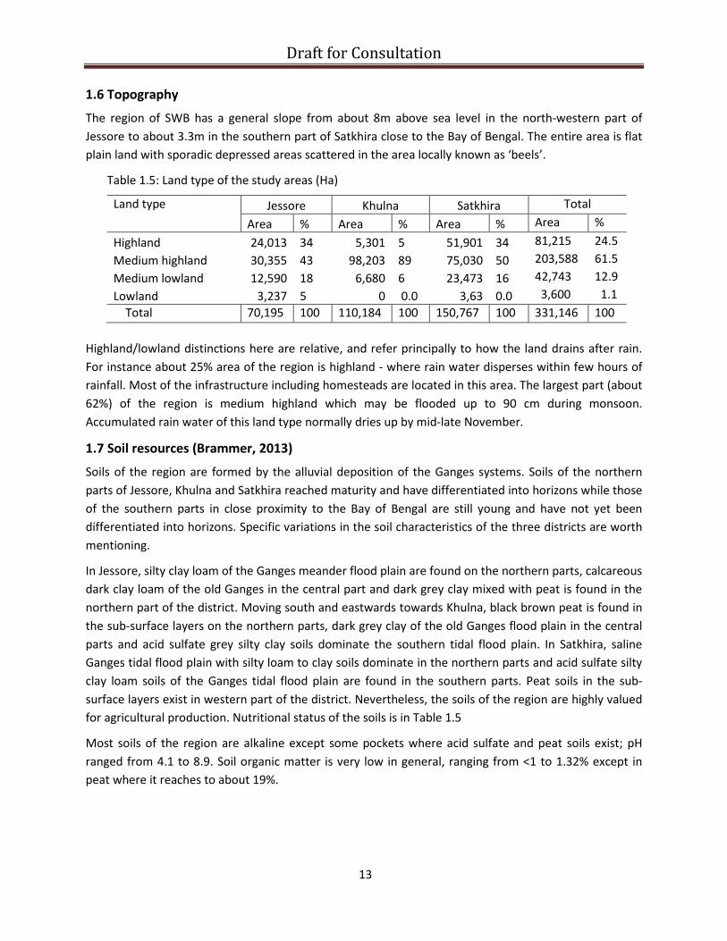
Draft for Consultation 1.6 Topography
The region of SWB has a general slope from about 8m above sea level in the north-western part of Jessore to about 3.3m in the southern part of Satkhira close to the Bay of Bengal. The entire area is flat plain land with sporadic depressed areas scattered in the area locally known as ‘beels’.
Table 1.5: Land type of the study areas (Ha)
Land type Jessore Khulna Satkhira Total Area % Area % Area % Area %
Highland 24,013 34 5,301 5 51,901 34 81,215 24.5 Medium highland 30,355 43 98,203 89 75,030 50 203,588 61.5 Medium lowland 12,590 18 6,680 6 23,473 16 42,743 12.9 Lowland 3,237 5 0 0.0 3,63 0.0 3,600 1.1 Total 70,195 100 110,184 100 150,767 100 331,146 100
Highland/lowland distinctions here are relative, and refer principally to how the land drains after rain. For instance about 25% area of the region is highland - where rain water disperses within few hours of rainfall. Most of the infrastructure including homesteads are located in this area. The largest part (about 62%) of the region is medium highland which may be flooded up to 90 cm during monsoon. Accumulated rain water of this land type normally dries up by mid-late November.
1.7 Soil resources (Brammer, 2013)
Soils of the region are formed by the alluvial deposition of the Ganges systems. Soils of the northern parts of Jessore, Khulna and Satkhira reached maturity and have differentiated into horizons while those of the southern parts in close proximity to the Bay of Bengal are still young and have not yet been differentiated into horizons. Specific variations in the soil characteristics of the three districts are worth mentioning.
In Jessore, silty clay loam of the Ganges meander flood plain are found on the northern parts, calcareous dark clay loam of the old Ganges in the central part and dark grey clay mixed with peat is found in the northern part of the district. Moving south and eastwards towards Khulna, black brown peat is found in the sub-surface layers on the northern parts, dark grey clay of the old Ganges flood plain in the central parts and acid sulfate grey silty clay soils dominate the southern tidal flood plain. In Satkhira, saline Ganges tidal flood plain with silty loam to clay soils dominate in the northern parts and acid sulfate silty clay loam soils of the Ganges tidal flood plain are found in the southern parts. Peat soils in the sub-surface layers exist in western part of the district. Nevertheless, the soils of the region are highly valued for agricultural production. Nutritional status of the soils is in Table 1.5
Most soils of the region are alkaline except some pockets where acid sulfate and peat soils exist; pH ranged from 4.1 to 8.9. Soil organic matter is very low in general, ranging from <1 to 1.32% except in peat where it reaches to about 19%.
13

Draft for Consultation
Table 1.6: Soil nutritional status of three districts in SWB (Source: SRDI)
Parameters Jessore Khulna Satkhira
pH 5.0-8.6 4.1-8.4 4.0-8.9
ECe (dS/m) 0.2-16.0 0.34-32.3 0.31-28.0
OM (%) 0.71-19.0 1.32-6.8 0.9-11.0
Deficiencies N, P, K, Zn N, P, K, Zn N, P, Fe, Mn, Zn
Abundance Ca, S, Mn, Cu Ca, Mg, S, Fe, Mn, Cu, B Ca, Mg, S, Fe, Mn, Cu
1.8 Natural resource characteristics
Soil and water salinity is a key characteristic and limiting factor in the coastal ecosystems. This plays a determining role in land use patterns. At least 30% of Bangladesh’s arable land is in the coastal region and half of it remains either fallow or underused because of these coastal characteristics, particularly soil and water salinity. Levels of salinity vary throughout the year; it starts rising in the month of November and reaches a peak in March-April. This is caused by decreased flow in the river system which permits intrusion of salt water. Salinity then declines rapidly with the onset of monsoon rain. Over a typical year, soil salinity varies from 0.2 to 16 dS/m in Jessore and from 0.3 to 32 dS/m in the Khulna and Satkhira region. The saline front of the SWB coastal region over time is moving to the hinterland, making more normal agricultural land saline. SRDI estimated a 20% increase in the saline area of Bangladesh in 2000 when compared with 1973. (figure 1.7 and 1.8). This map shows the slow expansion of the salinity affected area based on three observations – 1973 and 2009. It seems to show two different changes – in the years to 2000, salinity increased mainly in the westernmost districts and upazilas (Satkira, Khulna and the southernmost part of Jessore), whereas between 2000 and 2009, the main expansion is more central, in the areas in and around Pirojpur.
Soil organic matter (OM), a key indicator of soil fertility, is low in most of SWB in the pockets of peat soil. Data generated by SRDI indicate that the content of OM varies from <1 to 2.5% in the normal
agricultural land to as high as 19% in the peat soils of Khulna and Satkhira (Table 1.6).
Most plant macro- and micro-nutrients are abundant in the coastal soil, which
as a result are relatively fertile although a wide spread deficiency of N, P, K and of some of the key micronutrients (Fe, Mn Zn) as reported by SRDI (Table 1.6). Judicious application of N and P and liberal application of K can boost crop production in the region. Application of S and B should be avoided in the coastal soils, unlike other parts of the country beyond the coast.
14

Draft for Consultation
Figure 1.7 Salinity in the coastal region in 1973
15

Draft for Consultation
Figure 1.8 Salinity in the coastal region in 2009
16

Draft for Consultation
Fig.1.9. Maximum and minimum temperatures at three coastal
10.015.020.025.030.035.040.0
Jan
Feb
Mar
April
May
June July
Aug
Sept
Oct
Nov
Dec
JessoreKhulnaJoydebpur
10.0
15.0
20.0
25.0
30.0
35.0
40.0
Jan
Feb
Mar
April
May
June July
Aug
Sept
Oct
Nov
Dec
1.9 Climate and weather
Temperature
Monthly mean maximum and minimum temperatures of four locations in the coastal region are in Figure 1.9 Mean monthly tempera-tures do not vary significantly between the locations. Unlike other parts of the country, the coastal region in general experiences relatively higher night temperature during the winter months which is above the critical level (10o C) of plant growth. However, southwestern coastal region (Khulna) is hotter, particularly during the summer. The average day temperature during summer is more or less the same (around 33o C) throughout the country. The hottest months are April and May, but the temperature seldom exceeds 35o C as is observed elsewhere in the country.
Rainfall
Monthly total rainfall varies from zero in the months of December-January to slightly below 350 mm during monsoon (June-September) at Khulna (Fig. 1.10). Cumulative annual rainfall at Khulna averaged over 1948 to 2011 is the lowest in SWB and never exceeded 1800 mm (Fig. 1.10B).
B
What seems to emerge from this rainfall data is that viewed over a 60 years’ time frame there has been an increase in the proportion of late monsoon rain in the most recent twenty year period, when compared to previous time periods, particularly in the months of September and October. This slight shift in rainfall pattern – possibly falling onto already saturated land – is one explanation of the phenomenon of water logging compounded by drainage problems due to siltation and obstruction. Rainfall (total and October rain in mm) of last 14 years has been analyzed to find relation with water
Figure 1.10. Mean monthly total (left) rainfall at Khulna and cumulative mean annual (right)
rainfall at three districts during 1948-2011 (BMD data).
- 50
100 150 200 250 300 350 400
Jan
Feb
Mar
April
May
June July
Aug
Sept
Oct
Nov
Dec
Rain
fall,
mm
1948-681969-891990-11
0
500
1000
1500
2000
2500
3000
Jan
Feb
Mar
April
May
June July
Aug
Sept
Oct
Nov
Dec
JessoreKhulnaJoydebpur
17
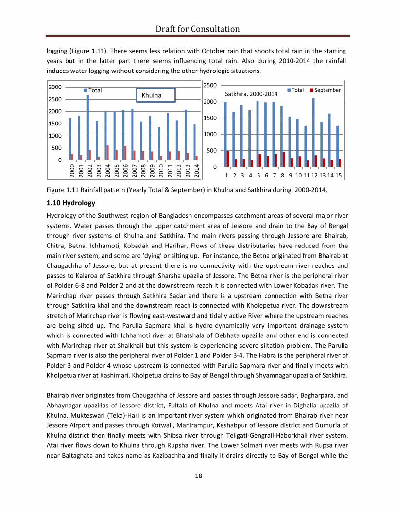
Draft for Consultation logging (Figure 1.11). There seems less relation with October rain that shoots total rain in the starting years but in the latter part there seems influencing total rain. Also during 2010-2014 the rainfall induces water logging without considering the other hydrologic situations.
Figure 1.11 Rainfall pattern (Yearly Total & September) in Khulna and Satkhira during 2000-2014,
1.10 Hydrology
Hydrology of the Southwest region of Bangladesh encompasses catchment areas of several major river systems. Water passes through the upper catchment area of Jessore and drain to the Bay of Bengal through river systems of Khulna and Satkhira. The main rivers passing through Jessore are Bhairab, Chitra, Betna, Ichhamoti, Kobadak and Harihar. Flows of these distributaries have reduced from the main river system, and some are ‘dying’ or silting up. For instance, the Betna originated from Bhairab at Chaugachha of Jessore, but at present there is no connectivity with the upstream river reaches and passes to Kalaroa of Satkhira through Sharsha upazila of Jessore. The Betna river is the peripheral river of Polder 6-8 and Polder 2 and at the downstream reach it is connected with Lower Kobadak river. The Marirchap river passes through Satkhira Sadar and there is a upstream connection with Betna river through Satkhira khal and the downstream reach is connected with Kholepetua river. The downstream stretch of Marirchap river is flowing east-westward and tidally active River where the upstream reaches are being silted up. The Parulia Sapmara khal is hydro-dynamically very important drainage system which is connected with Ichhamoti river at Bhatshala of Debhata upazilla and other end is connected with Marirchap river at Shalkhali but this system is experiencing severe siltation problem. The Parulia Sapmara river is also the peripheral river of Polder 1 and Polder 3-4. The Habra is the peripheral river of Polder 3 and Polder 4 whose upstream is connected with Parulia Sapmara river and finally meets with Kholpetua river at Kashimari. Kholpetua drains to Bay of Bengal through Shyamnagar upazila of Satkhira. Bhairab river originates from Chaugachha of Jessore and passes through Jessore sadar, Bagharpara, and Abhaynagar upazillas of Jessore district, Fultala of Khulna and meets Atai river in Dighalia upazila of Khulna. Mukteswari (Teka)-Hari is an important river system which originated from Bhairab river near Jessore Airport and passes through Kotwali, Manirampur, Keshabpur of Jessore district and Dumuria of Khulna district then finally meets with Shibsa river through Teligati-Gengrail-Haborkhali river system. Atai river flows down to Khulna through Rupsha river. The Lower Solmari river meets with Rupsa river near Baitaghata and takes name as Kazibachha and finally it drains directly to Bay of Bengal while the
0
500
1000
1500
2000
2500
3000
2000
2001
2002
2003
2004
2005
2006
2007
2008
2009
2010
2011
2012
2013
2014
TotalKhulna
0
500
1000
1500
2000
2500
1 2 3 4 5 6 7 8 9 10 11 12 13 14 15
Total SeptemberSatkhira, 2000-2014
18

Draft for Consultation latter through Pausur river. The Upper Bhairab river is branches into two namely Kobadak river and Bhairab river at Taherpur of Chaugachha upazilla of Jessore. The Kobadak river is about 180 km long from Taherpur to Katakhali of Paikgachh and meets with Haria river which is finally connected with Shibsa river. The Kobadak is passes through Chaugachha, Jhikargachha, Manirampur, Keshabpur of Jessore and Tala of Satkhira and Paikgachha of Khulna districts. Drainage of study area takes place through the above rivers along with their connecting channels and khals. The whole river system of the study area can be described under 11 catchment areas and after reviewing the past studies, the problems of the specific catchment and their probable mitigation measures have been suggested accordingly (by a local NGO, Uttaran), based on 11 catchment areas listed below (Figure 1.12).
1. Sholmari-Salta-Lower Bhadra system 2. Hamkura-Bhadra-Joykhali catchmen system 3. Hari-Mukteswari catchment system 4. Upper Bhadra-Buri Bhadra- Hari catchment system 5. Teligati-Ghengrile catchment system 6. Salta-Gunakhali-Haria catchment system 7. Kapotakshi catchment system 8. Salikha cachment system 9. Betna catchment system 10. Marichap- Labonyabati catchment system 11. Shapmara-Goalgashia catchment
Many control structures in the drainage channels have become obsolete after changing of the river course and or blocking of the channel due to siltation.
Objectives of the study
Based on the context set out above, development partners – as well as responding to the 2013 episode of flooding – requested FAO/WFP as co chair of Bangladesh FSC to analyse the causes and possible broad–based interventions which might address waterlogging. At the same time a request was received by FAO from the Ministry of Agriculture to operationalize the Master Plan for the development of agriculture in the Southern region, for which addressing the water-logging constraint was also a critical imperative.
As a result a multidisciplinary team was set up to undertake a study to address the following objectives:
1. Documenting of extent of water logging areas, damage, coping mechanisms, institutional
response to water logging 2. Capturing opinions of all main stakeholder groups towards acceptable long term solutions to
create a picture of the political economy of waterlogging; 3. developing a possible road map for long term solutions to the water logging issues of the
region, which could be both technically feasible and acceptable to the local community as well as to the local and national authorities.
19

Draft for Consultation
Map 1-1: Location of the catchments
Figure 1.12 Catchment areas in SWB (Uttaran, CEGIS, IWM, 2013)
Figure 1.12 Catchment areas in SWB (Source, Uttaran, CEGIS & IWM, 2013)
Betna
Betna
Betna
Kobadak
Kobadak
Kobadak
Hari
Morirchap
Lower Kobadak
20

Draft for Consultation Chapter 2. APPROACHES AND METHODOLOGY
2.1 Approaches
Terms of reference for in-depth studies on the causes and effects of water logging in SWB were prepared following a pilot visit to the sites during April 2014. In addition, lists of stakeholders are drawn up from both in the region and among the key Dhaka-based institutions, with relevant experience on the issues to be addressed. These were then finalized with inputs from an external technical advisory group. The study was based on collecting information from the secondary sources in addition to generation of some information through stakeholder analysis, key informant interview and focus group discussion (FGD).
2.2 Team composition
The multidisciplinary team was made up of the following:
1. Dr. Wais Kabir, Water Management : Team Leader 2. Dr. Sk. Md. Abdus Sattar, Farming systems/agronomist : Agronomist 3. Dr. Md. Ferdous Alam, Agricultural Economist :Socio-Economist 4. Mr. Md. Habibur Rahman Khondakar, Fisheries : Fisheries Specialist 5. Mr. Md. Moshiur Rahman, Civil Engineering : Water Resource Specialist 6. Md. Manirul Islam, Sociology : Sociologist 7. Ms. Hasibun NaharK hanam, Sociology : Gender Specialist 8. Mr. Kazi EmdadulHuq Chowdhury : National Project
Implementation Officer 9. Mr. Sayeed Md. Iftekhar, Statistics : Statistical & Database
Assistant
In addition, Dr. Abdus Sattar Mandal, Senior Advisor, FAO and Dr. Raghib Hasan, climate change specialist contributed in reviewing the study; technical support on water management was provided from FAO regional office in Bangkok by Dr. Puspa Raj Khannal.
2.3 Reflections on literature review
The team reviewed a large number of relevant background documents for the study including local level documentations, reports, scientific articles, workshop proceedings and booklets. The scientific articles studied included engineering, livelihood and ecological studies by academia. Some dissertation researches have been published on environmental and aquaculture subjects. The reports by the local level NGOs, mostly UTTORON (Satkhira based) and development agencies involving engineering, socio-economic and humanitarian issues are also covered.
The Project review section covered performance, feasibility and monitoring of different investments in the region by national agencies or multilateral donors. Project review has been done by Planning Commission of GOB, ADB and CEGIS on water logging interventions. The review reports are important in understanding the water logging issue and associated socio technical aspects.
Assessment reports mostly covered identification of damage, areas affected, relief and assistance needed, magnitude of loss of livelihood etc. The assessments were done by GOB programs, food security cluster and development partners recently. There have been different approaches of damage
21

Draft for Consultation assessments, many quote numbers affected, but it is not always easy to identify how badly affected these numbers are. Some studies assessed extend of water logging incidents of 1980s with the help of remote sensing. The studies also discussed root causes of water logging and suggested remedies.
Study reports included analysis of background, causes, affect and remedy of water logging in the region participated by national and international research partners. Hydrological studies including tidal pattern, salinity dynamics, affect of water management interventions, effectiveness of different structural and non-structural interventions were studied. Different model studies on water logging solutions were made. Tidal River Management approach in different river basin has been analyzed considering socio-economic profile. Institutional performances, strengths and weakness in addressing water logging were analyzed and compared. Studies on profitability of land and water based livelihoods, and comparative analyses of profit margins in rice, fish, and brackish water shrimp were reviewed. Participatory Water Management experiences through different projects have been studied. Investments in climate change activities by different agencies were also analyzed. The recent master plan on agriculture development in the southern Bangladesh including SWB has also been reviewed.
Conference papers and journal articles reviewed in this study focused on water logging aspects in the SWB, and discussed chronological interventions during last 40 years, climate change effects in the SWB, detection of water logged areas through GIS and remote sensing method, causes and effects of water logging, and possible solutions required. Socio-economic impacts of rice and fish farming on productivity and livelihoods were also analyzed. Most of the papers highlighted causes of water logging and there is similarity in identifying the causes and solutions (Details in Annexure B).
Overall, the consensus which emerges from the literature review is that water logging is a result of siltation and made worse by the poor drainage/development of infrastructure; and that competing forms of land use, local politics and influence have hampered efforts to tackle it.
2.4 Selection of study sites
Considering the extent, frequency and magnitude of the water logging problems and the limited time allocated for the work, the team decided to concentrate on the water logging problems affecting four upazilas namely Sadar and Tala upazila (FGD in Tentulia union) of Satkhira district, Abhaynagar (FGD in Payra Union) and Keshabpur upazila (FGD in Bidyanandakati union) of Jessore district. These had each been badly affected by the waterlogging episode at the end of 2013, as documented in the reports of the Food Security Cluster. At the same time, the team continued to interact with different stakeholders in the region, and in Dhaka, throughout the study period, to form the broadest possible picture of causes and impact of water logging.
2.5 Data collection
Primary data collection involved Focus Group Discussion (FGD) and Key Informant Interviews (KII). These were supported by media review, interviews with representatives of stakeholder institutions in Dhaka or Khulna, and with elected members of parliament from the region.
22

Draft for Consultation The team made extended visits to the area on four separate occasions during May-July 2014, to attend meetings with various stakeholders to share ideas about the study, and to obtain information on the intensity of water logging in the areas. In particular, work was conducted with the cooperation of the relevant local administration such as Deputy Commissioners (DC), Upazila Nirbahi Officers (UNOs) and other government officials including officers of the department of agricultural extension, fisheries, livestock, social welfare and women affairs. Visits were also made to the BWDB, LGED, Blue Gold (an important dutch-funded project which is being run in association with DAE) and NGO offices to collect information regarding water logging of the districts under consideration.
Focus group discussion (FGD)
Three FGDs were conducted in Tetulia under Tala upazila of Satkhira, Bidyanandakati union of Keshabpur upazila and Payra union of Abhaynagar upazila under Jessore district. Issues discussed included:
1. People’s perception about water-logging 2. History of water-logging 3. Delineation, duration and extent of water-logging in the locality 4. Causes and effects of water-logging 5. Coping strategy for water-logging 6. Problems of water management in the area 7. Response of various organizations, (GO, NGOs and donors) towards humanitarian, technical and
social aspects of water logging 8. Impacts of water-logging on various aspects of livelihoods, social and environment.
Key Informant Interview
Information were collected from the key personnel such as local administration, government departments, social elite groups, business personnel, professional organizations, local journalists, NGOs, donor-funded project leaders, politicians, women labor and farmers and local service providers of various GO and private organizations (Annexure...). The main issues discussed with them covered causes of water-logging, strategies for adaptation to the problems, limitations of the implementing agencies, particularly on technical, political, social and management issues.
2.6 Data analysis and reporting
The information collected from the various field level sources are qualitative in nature; that from secondary sources included also some quantitative data (including documents obtained from various government offices, NGOs, UN organizations and INGOs). Qualitative data were processed to generate relevant information for the study. Data collected from various sources were triangulated (cross referenced) for consistency.
The processed data are presented in tables, figures and other graphical illustrations. Reporting has been arranged in 9 separate chapters, below.
The outline findings of the study have been presented to a number of stakeholders with an interest in water logging. During September 2014 it was presented in a core group of technical experts, in December 6 the finding was presented in workshop in Khulna where local PMs, State Minister, divisional
23
Draft for Consultation commissioners and district officials attended (Annexure C). During December the presentation was made in the CGIAR workshop held in Dhaka. On February 18, 2014 the report was presented in the Ministry of Agriculture where minister, secretary and heads of departments were present. In addition, the finding was shared with State Minister for Public Administration (she also belongs to the SWB) on... and the Economic Advisor to the Prime Minister on....
2.7 Limitations
The study was conducted from May to September 2014. The duration and timing was not synchronized with the potential peak of water logging in the region (normally late October), although 2014 - with relatively light rainfall - was not a significant year for water logging. Most of the field visits were made in the dry months in May-July, while the period of August/September were dedicated for reporting.
A second limitation is that no original measurements were taken to track patterns of water-logging, and match the ground data with the remote sensing images. This would be needed to establish a full baseline of the water logging situation, and determine whether interventions resulted in overall improvements or not.
Finally, the study relied heavily on individual testimonies, which were often conflicting, as the different interest groups have become gradually more entrenched in their positions. Groups such as NGOs, politicians, administrators engineers, shrimp farmers or those engaged in cropping, all tend to blame each other for the impasse in dealing with water logging. More advanced tools for social analysis may be needed to go deeper into these positions in an effort to determine whether any win-win solutions might be available. As a possible example, the team is already looking into management practices in the aquaculture sector-it may be possible to boost productivity and reduce negative impact on drainage by introducing new approaches to water management by gher operators.
24

Draft for Consultation
Year WL area (ha) % area
2006 50,923 21.0 2009 73,699 30.4 2013 68,193 28.1
Fig. 3.1. Trend in area waterlogged in three districts
0
7000
14000
21000
28000
35000
2006 2009 2013
Area (ha)
JessoreSatkhiraKhulna
Chapter 3. WATER LOGGING: CAUSES AND POSSIBLE REMEDIATION
3.1 Current situation
There is something of a consensus on the causes of waterlogging – if not its solution – which can be seen in the various literature published on the subject over the past 10 years. As a result of impeded drainage, rain water accumulates in the naturally occurring depressed areas called beels and in such other sections of the moribund rivers. In addition, unplanned aquaculture practice through creating obstruction in the drainage channels caused reduced flow. As can be seen from the data, annual variations in the magnitude of the problem are observed depending on the amount of rainfall received during the year. The problem also varies with locations due to differences in the pattern of drainage congestion. A follow up study to be conducted by DCs office, with support from local engineering department, will focus on pinpointing specific sites for drainage congestion, due to problems with road, culvert or bridge infrastructure, or illegal/unplanned construction.
a) The immediate practical impact of water logging includes:
1. Loss of food and other non-food household items, clothing; 2. Poultry, goat and other larger domestic animals die of water borne diseases and snake bite or
are sold at much lower prices due to lack of shelter and fodder; 3. Shortage of pure drinking water; 4. Privacy and security of women and adolescent girls becomes difficult in makeshift houses along
roadside; is cited as one factor encouraging early marriage of girls; 5. Male member of the household spent night at submerged house to protect immovable assets,
may be subjected to snake bite, hooliganism and or robbery (disruption to law and order); 6. Defecation becomes extremely difficult which leaves the environment unhygienic; 7. Health services are unavailable; schools are closed; markets cannot be reached.
b) The longer term impacts of water logging include:
1. Damages to houses, roads, shelters for people and plants, domestic animals and birds
2. Long term disrupted transportation 3. Cost of rebuilding houses and other
infrastructures like school, market, road, 4. Partial or total damage to crops, fisheries,
trees and bio-diversity; loss of one or more productive seasons (with impact for 1-2 years ahead) which needs time to recover and may require significant investment
5. Male members of family may migrate for work – cited as cause of rise in divorce rates
3.2 Measurement of water logged area
Satellite images provided by Bangladesh Space Research and Remote Sensing Organization (SPARRSO) were analyzed to identify water logged area in the study area (Map-1). FAO (2012) estimated 21,715 hectares of land under water logging in three districts in SWB in 2011 water logged event. Optical data of 30m resolution for pre-monsoon
25

Draft for Consultation
26
and post monsoon periods and RADARSET data of 100m resolution for monsoon period were
available for the years 2006, 2009 and 2013. The team analyzed the images to calculate the water
logged areas in the three years which were then validated during the several FGDs conducted in the
study areas. During November and December, the images of areas with water may be considered as
perennial water bodies. Subtracting the areas under ponds and rivers can show water logged areas.
The total area water logged in 8 upazilas of three districts is in Figure 3.1. Out of 242,454 ha total
area under eight upazilas between 50 to 73 thousand hectares or about 21 to 30% of the available
area were water-logged in the different years for which data are available. Again, attempt was made
to identify the permanent water logged area which is commonly seen as water area which were
common between the November/December observation, and the subsequent April (height of the
dry season). The permanent water bodies in the three areas is estimated at about 13,767 ha in three
districts
Drawing a trend in growth of water logged areas would need considerably more time series data,
but what is clear from this preliminary analysis is that:
1. The trend and magnitude of water logging are location-specific with high annual variations. 2. Variations between the locations depend on the local drainage pattern in a particular area. 3. Annual variations depend on the amount of rainfall not only in the area, but also in the
upper catchments.
3.3 Causes of water logging
Siltation in rivers: Siltation in the major river systems of the SWB (Figure 3.2) resulting in drainage
congestion has been identified as one of the primary underlying causes of water logging. As the
river beds have become silted up, they eventually become higher than the water level within the
empoldered areas, which prevents gravity-based drainage from emptying the polders after periods
of excess rainfall. This imbalance is itself the result of the failure of local institutions to assume the
responsibilities for operation and maintenance of infrastructure, including the operation of sluice
gates. If sluices are operated, then there could be a possibility of allowing silt laden water to enter
inside the polders in a controlled way
The figure shows silted section of two rivers (Kobadak and Betna) in the region, based on data
provided by IWM, the Kobadak river experienced sedimentation over a 90 km stretch that results in
a decrease of drainage capacity in 2010. The critical sedimentation took place in Bankara in
Jhikargacha in Jessore district to Sreemontokati in Tala of Satkhira and Katakhali of Bagerhat district.
Similarly, Betna river sedimentation took place in 45 km reach at Muarikhati to outfall meeting point
of Marirchap river in 2010.
Encroachment of river banks: The critically silted up reaches of the major rivers in the study area are being encroached by those seeking to ‘grab’ the land (occupy it without necessarily having legal right), for construction or other land use, which further hampers drainage. Related to this is the practice of local government to lease publicly owned marginal land to landless - in order to keep in government ownership of so-called khas (government owned land-divided into agricultural, non agricultural and water bodies like haor, baor, canals etc.). land along the river banks. However, in practice this land is used for permanent possession through legal actions and causes drainage problems.

Draft for Consultation
27
Figure 3.2. Siltation of Kobadak (above) and Betna rivers (below) Source: IWM, 2010 and IWM 2014
Poorly executed infrastructure: The different
government agencies such as LGED, Project
Implementation Officer (PIO), Roads and Highways
Department (RHD) are constructing bridges and
culverts across the rivers and internal drainage
khals in SWB. Unfortunately, these construction
projects do not always consider the hydrology
of the river basin and conveyance capacity of
the drainage channels. This frequently results
in culverts which are insufficient to cope with
flows, and bridges which narrow stream flows
due to inappropriate design. On the latter
point, institutional issues intrude on the technical design requirements. The width of the bridge
Sedimentation
Sedimentation
Murarikati near
Kolaroa, Satkhira Chapra,
Assasuni,
Satkhira
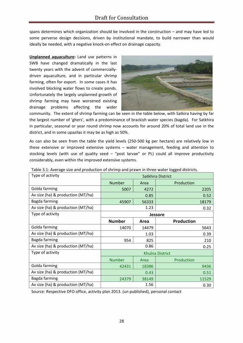
Draft for Consultation spans determines which organization should be involved in the construction – and may have led to some perverse design decisions, driven by institutional mandate, to build narrower than would ideally be needed, with a negative knock-on effect on drainage capacity. Unplanned aquaculture: Land use patterns in SWB have changed dramatically in the last twenty years with the advent of commercially-driven aquaculture, and in particular shrimp farming, often for export. In some cases it has involved blocking water flows to create ponds. Unfortunately the largely unplanned growth of shrimp farming may have worsened existing drainage problems affecting the wider community. The extent of shrimp farming can be seen in the table below, with Satkira having by far the largest number of ‘ghers’, with a predominance of brackish water species (bagda). For Satkhira in particular, seasonal or year round shrimp now accounts for around 20% of total land use in the district, and in some upazilas it may be as high as 50%.
As can also be seen from the table the yield levels (250-500 kg per hectare) are relatively low in these extensive or improved extensive systems – water management, feeding and attention to stocking levels (with use of quality seed – “post larvae” or PL) could all improve productivity considerably, even within the improved extensive systems.
Table 3.1: Average size and production of shrimp and prawn in three water logged districts. Type of activity Satkhira District
Number Area Production Golda farming 5007 4272 2205 Av size (ha) & production (MT/ha) 0.85 0.52 Bagda farming 45907 56333 18179 Av size (ha) & production (MT/ha) 1.23 0.32 Type of activity Jessore
Number Area Production Golda farming 14070 14479 5643 Av size (ha) & production (MT/ha) 1.03 0.39 Bagda farming 954 825 210 Av size (ha) & production (MT/ha) 0.86 0.25 Type of activity Khulna District
Number Area Production Golda farming 42431 18386 9436 Av size (ha) & production (MT/ha) 0.43 0.51 Bagda farming 24379 38149 11529 Av size (ha) & production (MT/ha) 1.56 0.30 Source: Respective DFO office, activity plan 2013. (un published), personal contact
28

Draft for Consultation 3.4 Addressing water logging problem: engineering interventions
Ongoing work to address water-logging includes a series of engineering interventions, with re-excavation of both rivers and canals in Khulna, Jessore and Satkhira districts, to improve the flow of drainage. In some cases these interventions are planned by experts alone; in other cases the communities are also consulted. For instance, the study team found that one NGO is involving local people representatives and local stakeholders in implementing work which seems to ensure accountability and transparency of the work. One project site of Shushilan (a local NGO) funded by World Food Programme (WFP) namely “Food Security Assistance to Water logged Affected People of South West Bangladesh” at Labsa union under Satkhira Sadar Upazilla was visited. The project involves 11 km canal re-excavation work. The selection of site was made through stakeholder consultation and local people were involved in manual earthwork. In case of dispute, problems were solved with the local union chairman.
Interestingly the different agencies involved charge quite different rates for river/canal excavation. For example; manual excavation of river canal has rate of BDT 122 /M3 for BWDB, Tk.119 for LGED, Tk.67 for BADC and BDT 56 for Shusilon (NGO). The rates are fixed based on different specification (initial led and lift etc.) For mechanical excavation of river/canal BWDB maintains a rate of BDT 100, and BDT 220 for dredging. One of the underlying and cross-cutting causes of waterlogging has been a failure to develop sustainable institutions to manage water-related infrastructure across the region, including such tasks as operating of sluice gates and conducting routine maintenance. Regular public budget provision has been missing. Despite numerous project efforts – over more than twenty years - to create and support water management associations, water user groups and similar, participatory approaches to repair and maintain structures in the wider community interest have only seen very limited successes.
3.5 Tidal River Management Tidal River management is widely appreciated as one important solution to the problem of water-logging, being seen as in harmony with nature and a cost effective process of silt management. However, the process experiences some challenges after having success initially, mostly associated with compensation for land acquisition for operation. TRM concept involves using beels to act as tidal storage basins which allow natural tidal flows up and down in the river system. During high tides, the large volume of water flows into the beels and huge sedimentation occurs in the beel area. This sedimentation would have otherwise occurred on the riverbed if the beels were not being utilized for storage. This is in fact a natural water management process with very little human interventions but it needs strong participation and consensus with a great deal of sacrifice by the stakeholders particularly on the part of those earning their livelihood from the land identified to be flooded. Also the process can take some time (3 to 5 years or even more depending on the tidal volume and the area of the beel and the amount of sediment). The implementation of TRM Plan under Khulna-Jessore Rehabilitation Project (KJDRP) through operation of a beel as a tidal basin solved the prolonged drainage congestions from 1998. Beel Bhaina was used as a tidal basin from 1998 to December 2001 (four years) and Beel Kedaria was brought under operation for TRM from January 2002 and continued up to February 2005 (three years). It has
29

Draft for Consultation been seen that these beels functioned very well to maintain the drainage capacity of the Hari River and to keep the area free from water-logging until the closing of these tidal basins. Furthermore, any other potential beel could not be taken up for operation as a tidal basin for TRM after closure of Beel Kedaria Tidal Basin (Paul Alak, 2013). TRM has been considered as a form of Integrated Water Resources Management (IWRM) approach. From satellite imageries of 2002 and 2012, changes in three major land use classes (open water, agricultural land and settlements with homestead vegetation) have been measured. A substantial portion of open water areas have significantly reduced and converted to agricultural lands as well as settlements with homestead vegetation. Development in land use, agriculture, and socio-economy of the area and most of it has been achieved due to implementation of IWRM concept. In last ten years (2002 to 2012), extent of open water in the area has decreased by 70.13%, recovering around 6 thousand hectares of land for cultivation and settlement purposes. A separate analysis has been carried out to observe the changes in water logged areas from 2002 to 2012. Due to effective implementation of IWRM, the capacity of drainage channels have increased and water logging problems in the area have been solved significantly. The implementation of TRM Plan under Khulna-Jessore Rehabilitation Project (KJDRP) in Hari Teka basin through operation of a beel as a tidal basin solved the prolonged drainage congestions from 1998. Beel Bhaina was used as a tidal basin from 1998 to December 2001 (four years) and Beel Kedaria was brought under operation for TRM from January 2002 and continued up to February 2005 (three years), source: Paul A (2013).
Figure 3.3 Example of TRM in Kabadak basin
TRM is considered as a sustainable tool for drainage congestion in the area through deposition of silt in the low lying area (beel) during tides, thus raising the land and clearing the river beds. On the other hand, the dredging or excavation is costly, and needs to be repeated quite frequently. However dredging may be considered sustainable if it is used in association with a sequential TRM process.
TRM is also a relatively slow process. Rates of deposition of silt vary but may be of the order of 20-30 cm per year. Where river beds are higher than the polders, the difference may reach 2-3 m indicating a process of 10 years to reach a new equilibrium, assuming no further accumulation of sediment in the river. Also once completed, a whole new paradigm of water management is needed to ensure that the TRM is not needed again within a short period of time.
The cost of drainage management through TRM and capital dredging was estimated by IWM based on the experience of re-excavation work in beel Khuksia taking into consideration of the cost to be
TRM Process
30

Draft for Consultation incurred in dredging every year with and without TRM. The study shows that the cost of drainage management accompanied by TRM process is significantly less than the dredging alone. Table 3.2 shows an example of comprehensive costing of two different approaches of solving the water logging problem from a case study based on East beel Khuksia in 2006-07, also from SWB.
The main advantage of dredging approach is that it creates less social conflict than TRM. TRM requires significant social mobilization along with well-accepted (transparent) compensation packages for all land users affected. The team encountered members of anti-TRM groups – who protest local political factors, fear of losing the ownership of khas land, and gher owners in fear of losing their investment for fish culture (construction of peripheral dykes and payment of rent (Hari). In many ways, the anti-TRM group seems to be have been actively lobbying against the implementing agency (BWDB) seeking to operate TRM. Among the opponents of TRM are some of the local MPs, Union Parishad Chairman, other local political leaders and some civil service officials.
Based on previous experiences with TRM operation the following issues are considered important:
• Time frame specified in the project document should not be exceeded as happened before. • Compensation has to be delivered within less time following easy process. Landless whose
livelihood depends on cultivating land in the proposed TRM basin must be covered by the compensation mechanism.
• Gher owner who took lease for fish cultivation in the proposed TRM basin and invested money should also be considered for compensation.
3.6 Lessons learnt from mitigating water logging through physical intervention There is a need to consider the following recommendations in devising physical interventions to address long term mitigation of water-logging 1. Dredging of river may not be sustainable unless TRM operation is implemented along with the
dredging activities. So, sequential TRM may be needed as solution sustainable solution of water logging problems through sediment management;
2. Present institutional framework of water management activities including TRM (dredging/excavation rivers/khals) may be reviewed –there seems to be a need for for third party involvement for ensuring accountability, transparency and well accepted option.
3. Restoration of linkage between Upper Bhairab and Mathabhanga rivers for ensuring monsoon flow and reducing the backfilling rate in the dredged channels (Betna, Marirchap, Kobadak, Muktestwari-Teka-Hari-Teligati and Bhairab rivers) as well as enhancing agriculture and aquaculture production;
4. Remove all the illegal infrastructures, widening of unplanned bridges, culverts and addressing other encroachment over the rivers/khals;
5. Delay in implementation of TRM may lead severe sedimentation at the downstream of the rivers, as a result prolong drainage congestion in the Satkhira, Jessore and Khulna districts;
6. Involvement of local stakeholders, Agriculture Extension Officer (AEO), Upazila Fisheries Officer (UFO) and water management organizations through community enterprise in the area are essential and useful during implementation of the recommended measures and operation and maintenance.
31

Draft for Consultation Chapter 4: INSTITUTIONAL RESPONSE TO WATER LOGGING 4.1 Organizations involved in water logged area Local government in South West Bangladesh – as elsewhere in the country - is made up of four administrative tiers – division, district, Upazila (sub-district) and union. With regard to water logging the key technical agencies are the Bangladesh Water Development Board (BWDB) and the Local Government Engineering Department (LGED), which are both responsible for physical interventions to prevent water logging. Other agencies under several ministries, namely, Ministry of Agriculture, Ministry of Fisheries and Livestock, Ministry of Local Government and Rural Development and Ministry of Environment and Forestry, Ministry of Land, Ministry of Road Transport and Bridges, as well as a large number of local, national and international NGOs play a role in coping and in many cases preventing of water-logging. The organizations in the region work in isolation with little or no coordination. This section deals with institutional capacity of the organizations involved with water logging, present activities and legal and policy aspect of the water logging. Formulation of an innovative institutional mechanism to address water logging will be crucial task taking into consideration of coordination and accountability in delivering services. 4.1.1 Bangladesh Water Development Board BWDB is an autonomous organization under the Ministry of Water Resources. The Board has had the responsibility for carrying out flood control, drainage and irrigation projects since 1959. A restructuring of BWDB took place in 1998, further consolidated by the BWDB Act (MoWR, 2000) with a greater focus on decentralization. The board’s work divides into two main types of intervention - structural and non-structural. The former involves construction of water control structures, re-excavation/ de-siltation of water channels and removal of obstacles from the mouths of rivers for improvement of water flows or diversion of water for livelihood/ environmental up-gradation. Non-structural functions include flood and drought forecasting and warning, hydrological survey and investigation, development of forestry and fishery on land available around the Board's infrastructure and construction of roads on embankments in conjunction with relevant government agencies, for the preservation and improvement of the environment as well as for poverty alleviation. A final non-structural area involves the establishment and support of various types of water users' association. From its origins, most of the staff of BWDB have been engineers by training. However, the 1990s saw a push for decentralization in water management, and community participation, requiring BWDB to change its approach. At this point, the board began to engage more with water management organizations rather than the previously state-funded sluice ‘gatekeepers’ (khalashi’s).
32

Draft for Consultation Under a Director General - with five Additional Directors General - BWDB divides the country into 8 zones on the basis of water resources. SWB is under the Additional Director General of Western Zone, which is divided into four further zones namely; North zone, South zone, North Western zone and South Western zone. A chief engineer is in charge of a zone. Each zone is divided into a number of circles. South western zone is divided into four circles - a) Faridpur circle, b) Khulna circle, d) Kushtia circle and d) Jessore circle. A Superintendent engineer is in charge of a circle.
In Khulna circle there are four further divisions as; i. Khulna division-2, ii. Satkhira division-1, iii. Satkhira division-2, and iv. Bagerhat division. Each division is coordinated by an Executive Engineer, and comprise of a Deputy Chief Extension Officer, a Sub-Divisional Engineer, a Deputy Chief Economist, an extension overseer and support staff (MoWR, 2005:10). The area of this study spanned over both Jessore and Khulna circles.
BWDB also has a newly created Water Management division with 212 staff (165 overseer positions) having background in agriculture. The main function of this division is to promote agricultural technology in project sites. There are around, mostly diploma in agriculture assigned in the project sites whose principal responsibility is to organize local water management associations. 4.1.2 Local Government Engineering Department (LGED) LGED is a government department under the Ministry of Local Government. The LGED consists of a head office and three-tiered set up of local offices - regional, district and sub-district (upazila). Regional offices were created nationwide to monitor and supervise the activities of district offices. District offices are set up in each of the sixty-four districts to supervise activities of the upazilas. An Executive Engineer – with 12-13 staff - heads each district office. The 482 upazila offices are each headed by an Upazila Engineer, with around 18 support staff. The district and upazila offices are principal agents for the planning and implementation of LGED projects. Decision-making authority regarding procurement, financial management, etc. below a certain value is largely delegated to them. The Chief Engineer heads the overall head office of LGED in Dhaka, and has Additional Chief Engineers – for maintenance, implementation, urban management, planning, and education - as direct reports. The major functions of LGED can be broadly categorized as follows:
• Rural infrastructure development • Urban infrastructure development • Small scale water resources development
Other than the above, LGED is extensively involved with the rural infrastructure maintenance program throughout the country.
33

Draft for Consultation Coordination with Department of Agricultural Extension (DAE), Department of Fisheries (DoF) and Department of Livestock Services (DLS) is also established, in part because of the significant funding received by LGED from the International Fund for Agricultural Development (IFAD). Linked to infrastructure investment, LGED may also organize the provision of agricultural extension services to sub-project areas through local offices of the DAE, so that the farmers rapidly adopt improved and environmentally-sound agricultural practices, following completion of infrastructure projects. Similarly, LGED cooperates with DoF to provide necessary extension services and training where fisheries opportunities are linked to infrastructure development (LGED, 2012). In addition, LGED signed a memorandum of understanding (MOU) with the Ministry of Land in October 2002 to ensure user rights to water bodies within subproject areas. This MOU helps ensure that the beneficiaries have priority access to these water bodies after paying standard fees to the Ministry of Land (ADB 2007). With regard to local government, LGED is currently supporting training on local small scale water resources development and management at union parishad level, with particular reference to the enhancement of local production and employment, and on participatory operation and maintenance (O&M) through WMCAs (LGED, 2012). Key differences between BWDB and LGED
LGED is a relatively recent entity, which grew rapidly during the 1980s and 1990s under the charismatic leadership of Engg. Qamrul Islam Siddiqui. It is well integrated within the local government system and builds local level roads, culverts and bridges as per demand from the local communities to create physical connectivity with rural growth centres which are also developed by LGED. It also implements small water sector projects, especially irrigation projects of less than 1000 ha. and supports education for disadvantaged children as well. Given the visibility and immediate utility of infrastructures in the vast rural areas, LGED has gained political support and patronage. LGED has grown very quickly as a pro- rural infrastructure agency. It has strong relationships with donors, and a good reputation for delivery of rural infrastructure projects and for community participation, although provisions for operation and maintenance has remained low.
BWDB is a rather more traditional bureaucratic organization, operating with a parallel nationwide hierarchy, not integrated with the local government set up, but based on physical geography (catchment areas). Since major works of BWDB includes complex activities i.e. flood control, river protection and controlling erosion, putting embankment/ polders, and removing drainage congestion, it is perceived as an engineering organization. Although BWDB’s mandate also includes non-structural matters such as participatory water management, training about operation and maintenance of structures, these do not seem particularly well integrated within its manpower structure. While the difficult and in some cases urgent nature of work would have required local beneficiaries engagement, a centrally driven technical approach to planning and operation of physical interventions often with little considerations of socioeconomic context of people’s participation seems to be the major weakness of BWDB operations.
34

Draft for Consultation 4.1.3 Department of Agriculture Extension The Department of Agricultural Extension’s mission is to provide efficient and effective needs-based extension services to all categories of farmer, to enable them to optimize their use of resources, in order to promote sustainable agricultural and socio-economic development towards achieving food and nutrition security for the country. Clearly, water availability (including flooding and drainage) issues have a major bearing on the work of this key department. The organization is unique in Bangladesh among the technical departments of the Government in having a network which reaches right down to union level. DAE is headed by a Director General who is assisted by eight directors (Field services, Horticulture, Training, Plant Protection, Plant quarantine, horticulture, Crops, Planning and project implementation and Admin and finance wings). The director of Field Services Wing supervises the country wide network extension service. The extension service at the field level is organized with 14 regional offices headed by the additional directors, and each district office is headed by one deputy director.
The Upazila Agriculture Officer heads the unit at the upazila level with three technical support staff; agriculture diploma graduates are posted at the union level, as Sub Assistant Agriculture Officers (SAAOs) – typically up to three per union. Much of agricultural extension work depends on project funding for operations in the field (logistics, inputs, other costs of demonstration and outreach activities). For instance, the “Second Crop Diversification Project supported by ADB, is being implemented at different locations across the country including SWB. Satkhira Sadar, Debhata upazila of the Satkhira district, Dumuria and Daulatpur of Khulna, Manirampur, Sarsha, Jhikorgach, Sadar Jessore are included in implementing project activities. The goal of the project is to develop high value crops in the region through demonstration, training and other promotional activities including marketing, and the project provides logistical support for a range of extension activities. A project specifically aimed at providing agricultural support for smallholder in South Western region of Bangladesh is being supported by GOB and the Islamic Development Bank is being implemented in the districts of Barisal, Pirojpur, Borguna, Khulna (although the full area of the present study is not covered by this project). This second project aims to promote agricultural technology through capacity building of the extension agents and farmers. Blue Gold is a collaboration program between the Government of the Netherlands (donor) and the Government of Bangladesh. The program is implemented by the Ministry of Water Resources, through Bangladesh Water Development Board (BWDB, lead agency) and the Department of Agricultural Extension (DAE). Objective is to reduce poverty for 150,000 households living in 160,000 ha area of selected coastal polders by creating a healthy living environment and a sustainable socio-economic development, covering districts of Patuakhali, Khulna and Satkhira
National Agricultural Technology Project (NATP) also has interventions in a few of the upazilas in SWB. The aim of the project is to enhance farm productivity and in-come. The research component covered all of the country while extension component covers 120 uapazilas. There have been eight upazila of Jessore (Sadar, Sarsha, Jhikorgacha, Avoinagar, Bagarpara, Monirampur, Keshobpur, Chougacha), five of Khulna (Rupsa,
35

Draft for Consultation Botiagata, Dumuria, Dacope and Paikgacha) and three Satkhira (Tala, Kolaroa, and Sadar) included in the project. In line with the Master Plan of Agricultural Development in Southern Region of Bangladesh (MoA 2013) as well as a part of climate change resilience endeavors, one major activity of DAE has been the rapid adoption and dissemination of salt and submergence tolerant crop varieties together with supporting input delivery and agricultural machinery supplies to farmers for field demonstration purposes. DAE also maintains one Agriculture Training Institute (ATI) in Daulatpur, Khulna for formal training in diploma in agriculture.
4.1.4 Department of Fisheries (DoF)
DoF is under the Ministry of Fisheries and Livestock. It is headed by a Director General, who is assisted by four Directors and two Principal Scientific Officer (equivalent to Director). There are over 1500 technical officers of different grades, and supporting staff within DoF. There are field staff at division, district and upazila levels, headed respectively by a Deputy Director, a District Fisheries Officer and a Senior/Upazila Fisheries Officer.
Besides these, there are three Fish Inspection and Quality Control stations nationally under DoF, one of which is located in Khulna. DoF district offices maintain five technical staff within the study area. One of the major activities of DoF in the SWB is to popularize scientific cultivation of brackish water as well as fresh water shrimp and other fishes, and provide extension support for rice cum shrimp/fish culture in order to maximize farmer’s profits from scarce land and water resources. Providing legal and administrative support to shrimp industry (and quality control measures) is another main activity of DoF in the south.
Furthermore DoF also comprises of Marine Fisheries Station, Fisheries Training Academy, Fisheries Training and Extension Centers, and Fish Hatcheries. The department has some resource based establishments. A Shrimp Culture Demonstration farm is located in Satkhira. There is a Demonstration farm cum training center at Kaliganj Upazila of Satkhira district. The center is supported by (a) a Regional Fisheries Officer (shrimp) (b) two assistant director (c) Farm manager (d) a hatchery officer (e ) two Assistant farm manger (e) four field assistant /hatchery assistant and number of office staff. There are four service center (shrimp landing stations) constructed at Satkhira, Debhata, Kaliganj and Symnagar Upazila. The centers were rented out to Frozen food factory owners for better post harvest handling and preprocessing.
36

Draft for Consultation Table 4.1 Projects of DOF addressing water logging
Project Cost Crore Taka & Duration
Major activities
FCDI (Flood Control Infrastructure Development and Irrigation) project.
114.88 July 2010 to June 2015
Improvement of borrow pits and other lands of BWDB & Roads, temporary leasing to the community for fisheries and livestock development. Support in technology development through training and demonstration.
Project on Aquaculture and Fisheries Management in Bhabodaha Area, Jessore
9.86 July 2009 to June 2014
Drainage & water supply system improvement, marketing, landing center development, fish stocking in community based water bodies and livelihood improvement in water logged area of Vavodaha.
Fresh Water Prawn Culture project
67.85 July 2010 to June 2015
Improvement of prawn culture in different culture system through training and demonstration.
4.1.5 Department of Livestock services Director General of DLS is sported by 5 wings headed by 4 Director and one Principal namely a) Director, animal health and administration, (b) Director, Extension (c) Director, Research, Training and Evaluation (d) Director, Production and (e) Principal, OTI (officers training institute).
Under Director Extension the Divisional offices, District offices and Upazila livestock offices are functioning. Besides the extension activities there are animal hospitals at district level and in selected upazilas, there are artificial insemination centers, poultry farms and duck farms in selected districts. In districts, DLS is organized either with one district officer and one additional district officer or only one district officer. In Satkhira, district officer is supported by additional officer. In every district there is a district central hospital and some selected Upazilas have animal clinics. In Satkhira there is a clinic at Satkhira and Tala upazila, besides there is a poultry farm and an artificial insemination center at Satkhira. Programs of the DLS involve artificial insemination, conservation of native sheep, institutional enhancement of department, beef fattening etc.
4.1.6 Department of Disaster Management (DDM)
Under the Ministry of Disaster Management and Relief, the agency was set up in November 2012 following enactment of the Disaster Management Act 2012. The Department has the mandate to implement the objectives of the act by reducing the overall vulnerability from different impacts of disasters. DDM is organized with different wings (Administration, Planning and Development, Food for Work, Relief, Monitoring and Information Management, Training and Research, Monitoring and Evaluation and Vulnerable Group Fee). The DDM has been implementing social safety net, humanitarian assistance and risk reduction programs/ projects. The major activities involved with the programs include building cyclone shelters,
37

Draft for Consultation rural road construction, employment opportunity through food for work, bridge and culvert construction etc. 4.1.7. Bangladesh Agricultural Development Corporation (BADC) BADC, an autonomous corporate body under the Ministry of Agriculture, serves to the whole of Bangladesh and has a nationwide network of outlying field offices down to the upazila level and at some places even below that level. It has major mandate of input delivery at an affordable price. It is organized with six divisions including seed, fertilizer and minor irrigation. It has strength of 1700 officers and 5700 staff stationed all over the country. In terms of seed, it has Regional Seed Sale Center, District Seed Sale Center and Upazilla Seed Sale Center. Bangladesh Agriculture Development Corporation (BADC) is involved in canal re-excavation in the water logged area to facilitate irrigation and drainage (Satkhira and Khulna). There has been total 35 km of canals those are re-excavated during 2009-2013.
4.1.8 National Agricultural Research System (NARS) Bangladesh has fairly well developed network of agricultural research and development system. The National Agricultural Research System (NARS) is primarily responsible for development of farm technology in the country. The NARS consists of 12 national research institutions maintain large number of outreach stations in most of the agro-ecological regions including SWB. Moreover, there are several CG centers operating in Bangladesh of which IRRI, CIMMYT, World fish and IFPRI have programs in the SWB. Bangladesh Agricultural Research Council (BARC) coordinates the research programs of NARS including linkages with CG system. NGOs like BRAC have extended its program in the region in expansion of diversified crops. There are three universities, with the potential to undertake R & D in the region, namely Khulna University, Jessore University of Science and Technology and Khulna University of Engineering and Technology.
There are number of stations and sub-stations of NARS in the region, namely, Bangladesh Agriculture Research Institute (BARI), Bangladesh Rice Research Institute (BRRI), Bangladesh Institute of Nuclear Agriculture (BINA), Bangladesh Fisheries Research Institute (BFRI), Bangladesh Jute Research Institute (BJRI), Bangladesh Forest Research Institute (BFRI) and Soil Resources Development Institute (SRDI).
Bangladesh Fisheries Research Institute (BFRI) is an autonomous body under Ministry of Fisheries and Livestock and constitutes a member of NARS. It is organized with five stations including one brackish water research station at Paikgacha with 9 scientific staff (77 acre land) in Khulna district, and another station at Bagerhat for shrimp research. The latter nine scientific staff and equipped with good quality lab facilities. The station is mainly working with cultural management, disease, water quality At Jessore there is a fresh water fisheries research sub-station with four scientific staff.
Bangladesh Agricultural Research Institute (BARI), has one regional station in Jessore comprising 18 scientific staff, and another station in Satkhira with just one scientist.
38

Draft for Consultation Bangladesh Rice Research Institute (BRRI) is an autonomous body under Ministry of Agriculture. BRRI has ten experimental stations including its head quarter at Gazipur. In Satkhira, BRRI maintains one Regional Station. Bangladesh Institute of Nuclear Agriculture (BINA), autonomous body under Ministry of Agriculture maintains 13 substations around the country and among them one station is in Satkhira (Binerpota, adjacent to BARI station). The station also only one scientist.
Bangladesh Forest Research Institute (BFRI) HQ at Chittagong is a government department. It maintains 21 research stations/substations. Shyamnagar in Satkhira district, Dakup in Khulna district and Sharankhola, in Bagerhat district are the establishments in the SWB.
Soil Resources Development Institute (SRDI) is a government organization under the Ministry of Agriculture. Director is the chief executive of the institute. It maintains six Regional Offices, 15 Regional Laboratories, 21 District Offices and 2 research centers. In the SWB there is one Salinity Research and Mnagement Center at Batiaghata, Khulna with four scientific staff, one regional office in Khulna, one in each district offices in Khulna and Jessore having 2/3 scientific staff. Bangladesh Jute Research Institute has one substation in Monirampur upazila of Jessore district, with 24 acres of land having only one scientist.
Many of those in charge of the research establishments opined that the outreach stations are constrained with inadequate operational fund and lab facilities. Integrated program development to address the production, post production, rural non farm sector as well as marketing constraints in the region should be given proper attention. Government has given priority on the agricultural development of south coastal districts. There would seem to be real potential for improved collaboration if a joint research program could be funded in line with the intention of the government to intensify agricultural production in the southern Bangladesh.
4.1.9 International Research Centers and Universities
Khulna University has number of faculty relevant to addressing water logging in the region. Departments of urban and rural planning, environmental science, soil science, fisheries and marine science, social Science, life sciences, business administration are all highly relevant to the problems faced in SWB. Khulna University of Engineering and Technology is also located in the region. Both the institutions have quality teaching and research staff, however funding remains major constraints in undertaking research.
Jessore University of Science and Technology has been developing its research capacity through its different faculties, namely, Faculties of Engineering and Technology, Biological Science and Technology, Applied Science and Technology, Physical Education, Language and Ethical Studies. Again, these could play a role in improving understanding of water logging and its solutions.
CGIAR centers operating in the region are implementing projects towards expansion and testing of climate smart agro-aquaculture systems. IRRI is implementing (Stress Tolerant Rice for Africa and South Asia (STRASA) project focusing on drought, saline and submergence tolerant rice varieties, while
39

Draft for Consultation CIMMYT is promoting conservation agriculture. The World Fish Center has activities in the region with programs associated with Climate Change Agriculture and Food Security, Aquatic Agricultural Systems, Challenge Program on Water and Food, Cereal Systems Initiative for South Asia (CSISA-BD), Enhanced Coastal Fisheries (ECOFISHBD) etc. CSISA BD maintains a hub in Khulna where number of interdisciplinary research (IRRI, CIMMYT and World Fish) and adaptation of technologies are being implemented including development of rice-fish system.
Some kind of virtual Center of Excellence in the region could bring all research, development and education institutions in a more coordinated fashion. Moreover, such a center could play an important role in strengthening the capacity of national partners while bringing international science and technological innovation to bear for the development of agro-aquaculture in the region.
4.1.10 Important NGOs
There are around 30 registered NGOs active in the SWB region. To give a few examples:
Uttoron based at Tala, Satkhira works across the coastal region of southwest Bangladesh. Work is focused on human rights, land rights and agrarian reform, sustainable water management, community based river basin management, adaptation to climate change, sustainable agriculture and food security. It published about 32 publications including water logging and water management. It has 831 staff In addition to full time and part time staff the NGO has currently 320 volunteers,
Shushilon, HQ in Khulna, works towards improve livelihoods of vulnerable communities in Bangladesh with special attention to coast, riverbank, wetlands, and hill tracks Improve education & health condition of vulnerable people, secure human rights and good governance. It has total 284 permanent staff and 1300 volunteers of different backgrounds - Social Science, Engineering and Technology, Health and Sanitation, Fisheries, Agriculture, Law, Finance and Administration. It completed 14 number of researches in the areas of its mandate. It maintains offices all over the country. (Source: web site)
Islamic Relief, Bangladesh is an international NGO, started its operation in Bangladesh in April 1991. At present 297 staff work at Islamic relief across 30 districts. It works with Humanitarian Assistance and Early Recovery (HAER), Disaster Risk Reduction (DRR), Sustainable Livelihoods, Orphan and Child Welfare.
Jagorani Chakra Foundation (JCF), a Jessore based NGO works to develop the situation of poor communities. It works in 32 districts and 149 upazilla in the country. These NGOs are involved in humanitarian assistance, coping and preventions of water logging and have experiences, capacity and logistics. A list of NGOs working in the region is shown below:
4.1.11 Local Government District: The District Councils are constituted with official members and nominated members. Half of the members of District Council are elected by the Chairmen of the relevant union parishads and town Committees in the district. The government appointed the remaining half. The Deputy commissioner of the District is ex-officio chairman of the District council.
40

Draft for Consultation The functions of District Council include construction and maintenance of roads, and bridges, building hospitals, dispensaries, schools and other educational institutions, health facilities and sanitation, tube well for drinking water, rest houses and coordination of activities of Union Parishads within the District. In addition to grant from the government, the District Council is empowered to manage funds based on taxes, rates, fees, tolls, etc. Table 4.2 List of NGOs involved in SWB
Name of NGOs Working area
Jess
ore
Khul
na
Satk
hira
DRR
(Har
dwar
e ac
tiviti
es)
Hea
lth &
Sa
nita
tion
Educ
atio
n
Inco
me
gene
ratin
g
Awar
enes
s
Cred
it
Shushilan • • • ∗ ∗ ∗ ∗ ∗ ∗ Uttaran • • • ∗ ∗ ∗ ∗ ∗ ∗ Jagoroni chakra • • • ∗ ∗ ∗ ∗ Rural reconstruction foundation (RRF) • • • ∗ ∗ ∗ ∗ Satkhira unnayan shongstha • ∗ ∗ ∗ Ideal • ∗ ∗ ∗ Rupantar • • • ∗ ∗ ∗ ∗ ∗ Agrogoti sangstha • ∗ ∗ ∗ ∗ Unnayan • • ∗ ∗ ∗ Polli chetona • ∗ ∗ ∗ ∗ Rishilpi foundation • ∗ ∗ ∗ ∗ ∗ ∗ Somadhan • • ∗ ∗ ∗ Borsha • ∗ ∗ Bangladesh vision • • ∗ ∗ Prodipon • • • ∗ ∗ ∗ ∗ Bachte shekha • • ∗ Usha • ∗ ∗ Peoples Development Community (PDC) • ∗ ∗ ∗ Manob kollan shongstha • ∗ ∗ ∗ ∗ Population Services and Training Centre (PSTC), satkhira
• ∗ ∗ ∗ ∗
Costal Development Organization for Women (CDOW), satkhira
• ∗ ∗
Shodesh, satkhira • ∗ ∗ ∗ Poritran • ∗ IDO • • Nari Unnayan Sangstha • ∗ BRAC • • • ∗ ∗ ∗ ∗ ∗ World vision • • • ∗ ∗ ∗ ∗ ∗ Association for Social Advancement (ASA) • • • ∗ ∗ ∗ ∗ Grameen bank • • • ∗ ∗ ∗ ∗ ∗ Muslim aid • • • ∗ ∗ Action Contre La FAIM (ACF) • ∗ ∗ ∗ Solidarity int. • • • ∗ ∗
41
Draft for Consultation Upazila Parishad: The parishad is chaired by the elected chairman of the upazila and members are elected representatives. Responsibilities include preparation of five year plan, coordination and supervision of development works that are transferred to the parishad by the public agencies, repair and maintenance of roads, implementation of irrigation schemes, awareness building about education, activities related to the development of agriculture and rural development, etc.
Union Parishad: Union Parishads are the smallest rural administrative and local government units. Each Union is made up of nine Wards, each covering one or more villages depending on population. There are 4,550 Unions in Bangladesh – A Union Council consists of a Chairman and twelve members including three member positions exclusively reserved for women. Union Parishads are formed under the Local Government (Union Parishads) Act, 2009. The boundary of each Union is demarcated by the Deputy Commissioner of the District. A Union Council is the body primarily responsible for agricultural, industrial and community development within the local limits of the union.
Major functions involves preparation of a comprehensive Union Plan and inclusion of inter-ward development projects after identification and prioritization, assist and cooperate for the development of primary schools, supervise their functioning and motivate people for spreading literacy, ensure provision of health services, arrange for supply of safe drinking water and promote sanitation programme, construction of inter-ward roads, maintenance of the same, management of small scale irrigation and water resources etc. The chairman and members work full-time and receive honorarium from the government.
Every Union Parishad has a fund known as the Union Fund consisting of:
- taxes, rates, fees and other charges levied by the Union Parishad under The Local Government (Union Parishads) Act 2009;
- rents and profits payable or accruing to the Union Parishad from its own property; Money received by the Union Parishad in the performance of its functions;
- money contributed by individuals or institutions or by any local authority; Receipts accruing from the trusts placed under the management of the Union Parishad;
- Grants made by the Government and other authorities.
Table 4.3 List of Unions in the SWB
District Upazilla with unions in parenthesis Total unions Satkhira Assasuni (11). Kolaroa (12), Satkhira Sadar (14), Kaligang (12),
Devhata (5), Shemnagar (13), and Tala (12) 79 and 2 Municipality Total villages 1436
Khulna Batiaghata (7), Dacope (9), Digholia (6), Dumuria (14), Koira (7), Paikgacha (10), Phultola (4), Rupsa (5), Terokhda (6)
68 and 2 Municipality and one city corporation. Total villages: 1108
Jessore Abhoynagar (8), Bagherpara (9), Chowgacha (11), Sadar (15), Jhikorgacha (11), Keshabpur (9), Monirampur (17), Sarsha (11)
91 and 8 Municipality, Total villages: 1434
42

Draft for Consultation 4.1.12 Private Sectors Different associations and chambers represent private sector activities. Bangladesh Frozen Foods Exporters Association is visible in the SWB. Besides, there are number of country based associations which have members in the region, like Bangladesh Jute Spinners Association, Bangladesh Agro-processors Association, Shrimp Hatchery Association of Bangladesh, Bangladesh Cold Storage Association etc. 4.1.13 Parliamentary Committees One special parliamentary committee on Coastal Area Development (1988-1990) was formed during 4th National Parliament; the committee was established in June 1988 comprising 17 members of parliament representing coastal constituencies. The main mandates were preparation of draft plan for development of coastal areas, recommend possible solutions of identified problems. The committee met eight times and submitted a preliminary report to the parliament (source: Where Land Meets the Sea, A profile of the Coastal zone of Bangladesh, WARPO, UPL, 2004.ed. M. Rafiqul Islam) 4.2 Institutional responses to the problem of water logging Long term interventions
The list of completed, ongoing as well as proposed projects of BWDB from 1994 to mitigate water is shown table 4.3. According to the available information, about BDT 443 Crores (approximately USD 55m) was invested through BWDB from 1994 to 2009 to mitigate the drainage congestion problems and about BDT 800 Crore projects (around USD 100m) are under implementation since 2010. There are also some projects in the pipeline amounting to BDT 748 Crore (USD 92m) with the exception of KJDRP (ADB) all projects are funded by the GOB.
Table 4.4: List of different projects by BWDB to mitigate water logging problems in southwest region
Sl No Name of the Project District
covers Implementing Year
Cost Tk. (crore)
Funding Source Status
1 Khulna Jessore Drainage Rehabilitation Project
Khulna, Jessore 1994-2002 229 ADB Completed
2 Operation & Maintenance in KJDRP area
Khulna, Jessore
2006 to till to date 116 GoB Ongoing
3 Drainage improvement of Kobadak river basin
Khulna, Jessore, Satkhira
2010 to till to date 262 GoB Ongoing
4 Drainage improvement of Polder 34/2
Khulna, Bagerhat 2011 167 GoB Ongoing
5 Drainage improvement of Bhutiar Beel Project
Khulna, Narail
2012 to till to date 287 GoB Ongoing
6 Drainage improvement of Polder 36/1
Khulna, Bagerhat 2013 297 GoB Proposed
43

Draft for Consultation Sl No Name of the Project District
covers Implementing Year
Cost Tk. (crore)
Funding Source Status
7 Drainage improvement of Polder 1,2,6-8 project
Satkhira, Khulna 2013 451 GoB Proposed
8
Re-Excavation of Betna River for mitigation of drainage congestion in Satkhira District
Satkhira, Kolaroa, Tala & Assasuni
2012-2014 14 Climate Change
Trust Fund Completed
Bangladesh Agriculture Development Corporation (BADC) is involved in small scale work on canal re-excavation in the water logged area to facilitate irrigation and drainage. The cost is about BDT 2.7 crore (per km equivalent to BDT 6.7 Lakh) for canal re-excavation works undertaken during 2009-2013.
LGED through its water sector projects implements JICA/ADB funded Small scale Water Resource Development Infrastructure project (SSWRIDP) involving canal digging, putting small embankment and sluice gate so as to facilitate surface water irrigation. The projects/activities within the districts within SWB (Satkhira, Khulna and Jessore) mainly focuses in development of Growth Center, Rural Markets, Union Parishad Complex Bhabans, Roads and bridges, Hydraulic Structures for Irrigation Purposes and Primary School Construction/reconstruction.
Table 4.5 List of Project under LGED Sl.No
Name of project Duration Donor Total Budget (crore Tk)
District of SWB involved
01. Project for Improvement of Rural Road, Hat-Bazar, Bridge/Culver, Infrastructures
July-2008 June-2013
GOB 500
Khulna & Satkhira
02. Emergency 2007Cyclone Recovery and Resort oration project(ECRRP),School
Aug-2008 Dec-2017
World Bank
1952 Khulna & Satkhira
03. Important Rural Infrastructure Development project Roads/Bridge/Culvert/Market/Ghat/Tree plantation
Jan-2010 Dec-2014
GOB 4893 Khulna, Satkhira & Jessore
04. South-west Bangladesh Rural Infrastructure Development project (Roads/Market/ Bazar & GCS)
Jul-2010 Jun-2013
JACA 1481 Khulna & Satkhira
05. Union Infrastructure Development (Khulna, Bagerhat &Satkhira District) Project, Road, Bridge/ Culver &GC-RM
May-2010 Jun-2013
GOB 277 Khulna & Satkhira
06. Construction /Reconstruction of upazila &union Roads Bridge /Culvert project (Transferred from RHD) Upazila/union Road, Bridge/Culver
Jan-2009 Jan-2014
GOB 510 Khulna, Jessore & Satkhira
07. Reconstruction &Repair of Govt. Primary school(2nd phase )
Jul-2006 Jun-2014
GOB 1392 Khulna & Satkhira Satkhira
08. Development of Registered Non-Goct. Primary School (3rd)Phase
Jul-2006 Jun-2013
GOB 916 Khulna & Satkhira
44

Draft for Consultation 09. City Region Development Project ( Road
Construction, Drain, River Dredging and Rehabilitation)
Jul-2011 Dec-2016
ADB, Kfw, SIDA
1396 Khulna
10. Rehabilitation of Aila affected Rural Infrastructure Project (RAILA)
Jan-2011 Jun-2015
GOB 151 Khulna & Satkhira
11. Third Primary Education Development Program School Construction
Jul-2011 Jun-2016
ADB, GOB,IDA, JICA,UNI,USAID etc.
22197 Khulna, Jessore & Satkhira
12. Rural Infrastructure Development Development(Public Priority Rural Communication &Rural Market Development &Rehabilitation)Project part Road, Bridge/Culvert& Rural Market
Jan-2005 Jan2013
GOB 995 Jessore & Satkhira
13. Construction of Large Bridges on Upazila and Union Roads project (Long bridge Upazila and Union Road)
Jan2010 Jan2015
GOB 1406 Jessore & Satkhira
14. Greater Jessore District Infrastructure Development Project Road construction
Mar-2011 Jun-2015
GOB 399 Jessore
15. Rural Employment &Road maintenance Jan-2008 Jan-2013
GOB 943 Satkhira
16. Development of Public priority upazila Road Project Road, Bridge/Culvert
Jan-2004 Dec-2013
GOB 497 Satkhira
17. Maintenance of Rural Infrastructure Rural road and culvert maintenance
Jan-2012 Jun-2013
GOB 625 Satkhira
18. South Western Bangladesh Rural Development project (SWBRDP)-Road, market, small structure
Mar-2010 Dec2015
JICA 1688 Satkhira
NGO responses
National NGOs have also been playing a role in SWB to assist people to cope with water-logging. Some are dealing with climate change programs; others are aimed at infrastructure (house) building, rehabilitation and protection creating a long term resilience. Some NGOs (e.g. Caritas, CARE, World Vision, BRAC and others) are involved in the construction of cyclone and flood shelters. Many focus on pre-disaster awareness and preparedness at household and community level. Lately, they have started to organize programs around the principles of Disaster Risk Reduction (DRR), in a number of DRR groupings, such as the Disaster Forum (initiated by Oxfam), and national and local NGOs in national level consortia such as NAARI or the Muslim Aid Consortium (DESHARI). NGOs also play a role in mobilizing and engaging communities. However, generally there is only limited interactions with local government bodies; and competition between NGOs presents a challenge in aligning efforts to addressing specific challenges in a more integrated manner. Accountability is also an issue.
45
Draft for Consultation A total of 39.51 million USD was allocated for targeted supplementary feeding, cash distribution, food, cash for work, cash for training, cash stipend WASH, cash grant support, housing, livelihood, shelter, women bathing corner, hygiene kit, nutrition, IGA, agricultural inputs and so on in 2011 for SWB relating to water logging response. Inputs for aquaculture, livestock and horticulture constituted the highest allocation. Followed by cash for work, cash for training, targeted supplementary feeding and cash distribution.
In Satkhira, 32 active local NGOs have been identified, while in Jessore and Khulna, only 15 and 14 NGOs respectively appear to be in operation (Table 4.2).
Table 4.6. Response from GoB & Other Organizations, 2013 in SWB (Source: DDM, December 2013) Food Security Organization Locations
(Upazilas) Interventions Type of
Support Quantity Status Budget
(BDT) District Administration Jessore
Keshabpur Water Logging GR Rice * 25 Mt Ongoing -
Bangladesh Water Development Board (BWDB)
Satkhira, Kalaroa, Tala & Assasuni
FCD Project Cash /Food BDT 20 Million / 740 Mt Wheat
Ongoing 20 Million
District Administration Satkhira
Tala, Satkhira Sadar & Kolaroa
Water Logging GR Rice 215 Mt Ongoing -
[Source: D-Form, DDM, November 2013] GR for Gratuitous rice
Income / Livelihood
Organization
Locations (Upazilas)
Interventions
Type of Support
Quantity Status Budget (BDT)
District Admin. Jessore
Keshabpur Water Logging
GR Cash Ongoing
BWDB Satkhira, Kolaroa, Tala & Assasuni
Re-Exc. of Betan River for mitigation of drainage congestion in Satkhira District
Cash for Work
25 Km river and 6.09 Km khals
Ongoing 144.5 Million
Satkhira Sadar, Debhata, Kaligonj & Shyamnagar
Rehab. of damaged embankment & re-exc. of internal khal
Cash/Food BDT 2 Million
Completed 2 Million
Cash/Food BDT 5 Million
Ongoing 5 Million
Cash/Food BDT 13.6 Million
Planned 13.6 Million
Department of
Aboynagar, Monirampur,
Aquaculture and
Fish fingerling
236.49 Mt Completed 32.6 Million
46

Draft for Consultation Agriculture Extension (DAE)
Keshabpur & Jessore Sadar
Fisheries Management project in Bhabadaha Area
Training 70 Batches Completed 1.31 Million
[Source: DDM, December 2013]
Income / Livelihood
Organization
Locations (Upazilas)
Interventions
Type of Support
Quantity Status Budget (BDT)
Department of Agriculture Extension (DAE)
Tala Extension prog. for Tech. of Floating Vegetables, Spices of Satkhira district
Training & Inputs Supply
Ongoing
District Admin Satkhira
Satkhira Sadar
Water Logging
GR Cash Ongoing
Wash
Organization
Locations (Upazilas)
Type of Support Quantity Status
Department of Public Health and Engineering (DPHE)
Satkhira Sadar, Kolaroa & Tala
Deep/ Shallow Tubewell installation
81 Nos. Completed
Latrine set distribution & installation.
131 Nos Competed
Rehabilitation, repairing, raising & disinfection of Tubewell
3778 Nos. Ongoing
Water purification tablet 429,000 No Ongoing
Plastic Jerycan 4500 Nos. Ongoing
Raised latrine installation 75 Nos. Ongoing
Temporary Latrine 12 Nos Ongoing
Homestead disinfection with bleaching
23000 Kg Ongoing
Tubewel installation & platform raising
980 Nos Planned
Community & Home based latrine 911 Nos. Planned Rupsha, Terokhada, Fultala, Digholia, Dumuria, Batiaghata, Dacope, Paikgacha & Koyra
Tubewell kits and parts Hand pump Water tank Jerrycan Bleaching powder
For 80,953 Households
Planned
47

Draft for Consultation Infrastructure
Organization
Locations (Upazilas)
Interventions Type of Support
Quantity Status Budget (BDT)
Bangladesh Water Dev Board
Aboynagar, Monirampur & Keshabpur, Emb., sluice gate, Roads, canals, TRM
Removal of drainage congestion from the beels adjacent to Bhabodaho area under Jessore district (Phase I)
River Excavation
73 Km Completed
1158.6 Million
Keshabpur, Monirampur, Zhikargacha, Chougacha, Paikgacha & Tala
Removal of drainage congestion from Kobadak river basin (Phase I) Re-excavation, Embankments, TRM etc
2615.5 Million
4.3 Legal framework for management of water logging
There are several acts, policies and rules prevailing nationally which have implications both with preventing and coping with water logging in SWB. Some legal frameworks are directly associated with preventing of water logging while others also address coping with consequences. The implementation or manipulation of these legal issues is major area to look into. The overall purpose of these acts, rules and policies are to protect resources, environment, water drainage and supply, ensure livelihood and facilitate better use of resources and management. Lack of coordination among institutions and misinterpretation of the existing rules have contributed to problems in natural water supply and drainage system in SWB.
The tracking and reviewing those will be needed to correctly address the water logging and livelihood improvement. There are several other policies, rules and agreement like “Agriculture land lease, Land leasing to landless”, “Balu Mahal (sand and silt dome ) lease, Fish and Fish Products (Inspection and Quality Control) Rule 1997, Code of conduct for selected segment of the aquaculture industry of Bangladesh, 2011 “ etc. associated with water management and siltation problem in the SWB. Besides, policies and rules related to Water, Environment, Public Health and Fisheries need further study, validation and consultation with respective institutions and local dwellers; which are indirectly related to livelihood, water logging, social conflicts, health and sanitation in the SWB.
Table 4.7: An inventory of legal issues and instruments
Preventing water logging
Legal act/rule/policy
Objectives Provision/Remarks
Bangladesh Water Act, 2013
Integrated development, management, abstraction, distribution, use, protection
National Water Resources Council headed by the PM formed as highest decision making body to make policy. Executive Committee formed headed by the
48

Draft for Consultation
and conservation of water resources.
Minister for Water Resources and WARPO provides secretarial service. Issuance of clearance certificate on water resources development projects. Preferential water use (potable, household, agriculture, aquaculture etc.). Restricted stop/divert/obstruct natural water flow without permission of appropriate authority. Demarcation of water zone (agri water zone, brackish aquaculture zone etc.).
Embankment and Drainage Act, 1952.
To consolidate laws relating to embankment and drainage and to make better provision for the construction, maintenance, management, removal and control of embankments and water courses for better drainage of lands and for their protection from floods, erosion and other damages by water.
Delegates power to the authorized engineer to clear blockage of drainage facilities to protect land. Facilitate improved drainage, erection, protection of embankments, water regulator, canals and other drainage system. Local people are not aware about the act. Not imposing for proper water drainage and supply. Many of the govt. canals, embankments are occupied illegally and causing water congestion can removed by local authority
Bangladesh irrigation and water rate ordinance 1983.
Imposition of water rate for supply, regulation or storage of water for irrigation or drainage
Free passage of water for irrigation and drainage. Land both private and public can be acquired or taken by DC whenever needed for the purpose.
Participatory Water Management Rule 2014. Follow up of BWDB act 2000.
Direct and active participation of local stakeholders in design, implementation, monitoring and maintenance of projects, schemes,
Creation of stakeholder Association/ organization. Clear irrigation channel and remove the obstacle in drainage. Poor monitoring and organization program. Not commensurate with other policies and rules. Not fully implemented at the field level. Unsustainable, and project based approach.
The Bangladesh Environment Conservation Act, 1995 & Environment Protection Rules, 1997
Provision for environmental clearance, protection environmental degradation due to pollution.
Natural water conservation and aquatic animal protection. Water bodies defines as river, canals, pond, beel etc. the classification of water bodies can not be changed. The rule of 1997 set standard for water for fisheries. No direct mention of water congestion or drainage.
Private Fisheries Protection Act,
Protection of private fisheries and the rights of landowners.
Provision to panelize who erects, places, maintains or uses any fixed engine in private waters, or puts,
49

Draft for Consultation 1889 Protection and conservation
of fisheries and water body. therein any matter for the purpose of catching or destroying fish. People are not aware of the act and the act is not enforced. Indiscreet use of private fisheries is one of the main causes of WL
Coping with consequences
Agriculture policy 2013, MoA
Ensure food and nutrition security, employment generation and enhance livelihood through increase crop productivity.
Development of sustainable agricultural development adaptable to climate change. Step to reclaim land from water logging. Technological support for water logged area. Pest and disease management for agro-aquaculture system missing.
The National Fisheries Policy 1998
Enhancement of fisheries production, biodiversity, etc. Details of government policies relevant to fisheries resource conservation, development, aquaculture, market, environment and livelihood improvement issues, export earning and animal protein supply
Conserve fish habitat from damage in FCD/I. Initiatives to be taken for fish/shrimp cum rice culture in depressed areas. Demonstration of cage/pen initiated. Integrated prawn and fish culture along with rice will be encouraged in brackish water bodies. Improved extensive culture will be encouraged. Control measures against negative impact on fisheries resources. The policy is not adopting properly, more acts needs to be enacted & all other organization in SWB should consider the policy for individual development programs.
Bangladesh Agricultural Research Council act 2012
Consolidation of research system (12 institutions under five ministries) under coordination of BARC.
Re-formulation of governing body as highest policy making body. Review and resources allocation for research to be done through BARC. Follow up of rules may help to take integrated R & D program in the SWB through BARC
National Shrimp Policy, 2013, MoFL
Planned increase of production in accordance with economic, social, environmental and climatic consideration.
Entering or drainage of water through public sluice gates in the poldered or un-poldered areas in the shrimp zone. Identification of zoning based on suitability of lands. Limits gher size of 30 acres. Use of authorized opening for shrimp cultivation. Operation may ease water logging.
Prevention and Coping
CHINGRI (Shrimp/prawn) Mohal Management
Identification and declaration of khas (public) shrimp land suitable for shrimp production and leasing for
A national Committee formed with Minister for Land to frame policy related shrimp and prawn cultivation. DC will head district level committee to identify land for shrimp/prawn. No khas land for shrimp/prawn
50

Draft for Consultation Policy, 1992, shrimp farming and control
of shrimp area. zone will not be leased for cropping. DoF role is weak and there are many blame and conflict on land leasing process. The 3 district of SWB is facing the problems with land leasing system.
National Land Use Policy 2001
To reverse trend of non agricultural land use for food production. Zoning of land based on suitability. Conservation agricultural land for productivity and avoid unnecessary misuse of land.
National committee formed to implement the policy with PM as head. Identified land use for different actors and problems related to drainage, however no directives are there. Land users and regulatory institution has poor conception on the policy. Land zone is not declared; shrimp and aquaculture land is not marked in SWB. No follow up. ICZM Policy in 2005 has primarily made zoning but not based on detailed study. Allocation of land for fish, housing, shrimp culture and land zoning.
Integrated minor Irrigation policy, 2014, MoA
For efficient use of surface and subsurface water.
Enhance surface water in the coastal region, conserve rain water, utilizing tidal water utilizing polders, participatory TRM for irrigation and drainage improvement, rehabilitation of canals to improve drainage and bring land under cultivation. Efforts to be made to bring land under cultivation in the area under water logging.
Government Jalmahal management policy 2009 further rule in 2012 under MoL
To lease khas (public) water bodies to real fishers and increase govt. revenue collection including fish conservation, production, and biodiversity protection.
Defined water bodies as the area water remains in certain time of year or throughout the year, closed or open, including ponds, beel, lake, rivers, canal, sea etc. After termination of MoU with leasing arrangement to the youth groups by different ministries, all water bodies leased out will be vested to Ministry of Land. Leasing to youth groups upto 20 acres to be prioritized, beyond this will be vested to committee under DC through discussion and will be given to the fisher group. . No leased water cannot interfere flow of water. Provision made to monitor physical and biological properties. Water bodies under 20 acres to be managed by the com headed by the UNO of upazila. The policy has some dissatisfaction areas for Fishermen’s cooperative societies. Sustainability on project activities and less responsibility of GoB agencies on biological management. Provision of fish migration route and
51
Draft for Consultation
navigable water body, change the nature of land, discourage divisions of Jolmahal may be included .
National Environment Policy, 1995
Protection of the environment & ecosystem for both terrestrial and aquatic. Also have provision for control of pollution & environment degradation.
Protect wet land and aquatic animal along with other partners is not clearly mentioned.
Coastal Zone Policy, 2005, MoWR
Provide general guidance so that the coastal people can pursue their livelihoods under secured conditions in a sustainable manner without impairing the integrity of the natural environment.
Planning will be done under land use policy to control unplanned and indiscriminate use of land resources . Environmentally adopted and socially responsive shrimp farming will be encouraged. In this regard, internationally accepted quality control measures will be introduced. To co-ordinate water related activities under different agencies/ministries, a lead Ministry, MoWR and a lead agency, WARPO is designated. Inter-ministerial Technical Committees and Program Steering Committees, constituted at appropriate level. To ensure overall coordination, the following institutional arrangements will be made: a. The National Council of the lead Ministry will act as higher level coordinating and decision making body for ICZM programs and activities, b. An Inter-Ministerial Steering Committee (SC) will be set up to provide policy guidelines on issues related to the coastal zone. This high level committee will be chaired by the Minister of the lead Ministry and will include representatives (at the Secretary level) of concerned Ministries and agencies. The lead Ministry will act as the Secretariat for this Committee; c. An Inter-Ministerial Technical Committees (TC) will be set up.
National Water Policy, 1998, MoWR
Provide directives to all agencies working with water sector. Water using right for all sector is emphasized.
Planning and managing water resources requires a comprehensive and integrated analysis. BWDB will be involved management of FCDI above 1000 ha and local government will implement below 1000 ha. Participation will be involved with relevant stakeholders. De-silt watercourses to maintain proper drainage. Ownership of 1000 ha or less FCDI will be handed over to local government. Regulatory system
52

Draft for Consultation
for agro-chemicals. Perennial links of water bodies with the rivers will be properly maintained. Brackish aquaculture will be confined to specific zones designated by the government for the purpose. Necessary steps to remove all existing unauthorized encroachments on rivers and watercourses and check further encroachment. Poor coordination among the implementing agencies and the resource is utilizing in an unplanned manner.
The Protection and Conservation of Fish Act 1950
Power to make rules for protection and conservation of fish (including crustacean, frog etc). Protect environment for fisheries, harvesting and marketing
Rule making provisions on prohibition or regulation of erection and use of fixed engines, construction of structures like weir, dams etc. , use or method of operation of any kind and size of mesh, destruction of fishes, prescribe sizes of fishes to be captured etc. Powers to confiscate or seizure, removal of any engine (net, jal).
The Protection and Conservation of Fish rule 1985
Follow up of the Protection and Conservation of Fish Act 1950
No person shall construct bunds, weirs, dams or any structure in or across or over the rivers, canals, beels for any other purpose other than FCD or I. Conservation of wet lands and fish migration facilities need to be addressed which will improve water logging situation in SWB.
53

Draft for Consultation Chapter 5: LIVELIHOOD PATTERNS IN SWB
Land use patterns in the coastal region are quite complex and vary according to the local water and land availability. In such a context, water logging has had a major impact on the possible rural livelihood options. Originally the infrastructure investment in creation of polders reclaimed land for production – usually of rice. With water-logging becoming a common – or in some cases permanent – phenomenon, what has emerged are systems based on a combined form of agriculture-aquaculture production, based mainly on rice and shrimp (both freshwater and brackish-water species). Shrimp in particular has developed significantly during the last 20 years, and it has been a profitable enterprise – some reports suggest benefit to cost ratios of 3:1. However, these benefits have not been felt evenly among the coastal communities. The picture is complicated with landless, small and marginal farmers, co-existing alongside those with the resources to command relatively large (and remunerative) aquaculture systems.
This section describes existing technologies in use, focusing on cropping and aquaculture. Throughout the analysis, production from the livestock sector has been given less attention, partly due to the absence of services at the grass-roots level and partly due to non-availability of required information. At the same time, livestock feeding is a critical issue in water logged conditions. Tala upazila of Satkhira district has been successful in developing milk production by small holders; which is integrated with a small processing plant/collection centre linked to school children milk feeding program having a transport vehicle support from FAO.
5.1 Crop production systems
Coastal agro-ecosystems vary from those elsewhere in the country in three aspects – saline and non saline tidal flooding, soil and water salinity, topography and soil texture. Water logging and or water stagnation is another characteristic which poses a threat to crop production.
Crop diversity, referred here as area covered under non rice crops compared total crop coverage, is higher in Jessore followed by in Satkhira and Khulna. Rice represents just 79% of the cropped area of Jessore; compared to 86% in Satkhira; and 88% in Khulna (Source, based on BBS 2013).
Aman rice (July to December) traditionally dominated the area – representing 42, 56 and 61% of the area under rice in Jessore, Satkhira and Khulna districts, respectively. However, the area under boro rice (January to May) is increasing in Jessore. Among the non-rice crops, oil crops and vegetables cover about 3 to 5% of the all the districts under study. Cropping intensity (C.I) has been studied across the region and ranged from 110-160% in parts of Satkira, found to be low compared to the national average (of around 190%). It may be mentioned that measuring C.I considers crops grown in a given land and fisheries, livestock and other land use is not considered. Clearly the mentioned biophysical constraints are a factor (Figure 5.1).
Depending on local conditions three rice crops may be grown in the coastal zone as follows: 1) Aus rice is grown (typically from April to September) under rainfed conditions, with almost no management except weeding and application of cow dung, and may be either traditional or improved varieties.
54

Draft for Consultation
Figure 5.1 Cropping intensity in the coastal zone
2) Transplanted aman is grown from July to December, also under rainfed conditions, and is more likely to involve improved varieties. 3) Boro rice is irrigated, using also fertilizer, and having been considered a minor crop is now in fact the main rice crop in the country. It is typically grown from January to May.
Fallow- T.Aman (Local)- Fallow cropping pattern covers most of the area (23.8%), which is followed by Fallow- Fallow Boro (HYV) cropping pattern (21.0%). The third and fourth highest cropping patterns are Fallow-T.Aman (Local)- Boro (HYV) and Fallow-T.Aman (HYV)-Boro (HYV) which occupy about 20.2% and 15.2% respectively of the Net Cultivable Area (NCA), Source: Uttoron (2013). Over time, monsoon season aquaculture followed by a crop of boro rice has become the principal production system of the areas affected by water-logging, but significant amounts of aman season rice are still grown in lower regions of SWB and these act as an indicator of the disruption caused by water-logging (figure below, 5.2) which shows a production drop of aman rice in 2007-08, 2009-10 and 2011-12 – linked to the two major cyclonic events, and a water logging episode - in Satkhira. Interestingly, the figures for 2013 only show slightly lower production than the 2008-9 season, suggesting that the disruption due to 2013 water logging was relatively minor when compared with previous episodes.
55

Draft for Consultation
Figure 5.2 Production trend of Total Aman rice in Satkhira
Figures 5.3, 5.4 and 5.5 show the rice crop performances in recent years. The area and production of aus has been erratic during last several years (Fig 5.3) in the region and area under boro remained almost same in the region.
Figure 5.3 Total Aus Rice in three water logging districts in SWB
Figure 5.4 Total Aman Rice in three water logging districts in SWB
0
100000
200000
300000
400000
2006-07 2007-08 2008=09 2009-10 2010-11 2011-12 2012-13 2013-14
Aman Prod. in MT Satkhira
Sidr, Nov. 07 Aila, May, 09 Water-logged
020000400006000080000
100000120000
Area(Ha)
Prod (T) Area(Ha)
Prod (T) Area(Ha)
Prod (T) Area(Ha)
Prod (T) Area(Ha)
Prod (T) Area(Ha)
Prod (T)
2008-2009 2009-2010 2010-2011 2011-2012 2012-2013 2013-2014
Jessore Khulna Satkhira
0
100000
200000
300000
400000
Area(Ha)
Prod(T)
Area(Ha)
Prod(T)
Area(Ha)
Prod(T)
Area(Ha)
Prod(T)
Area(Ha)
Prod(T)
Area(ha)
Prod(T)
2008-2009 2009-2010 2010-2011 2011-2012 2012-2013 2013-2014
Jessore
Khulna
Satkhira
56

Draft for Consultation
Livestock Khulna Satkhira Jessore Mean Cattle 36.3 48.5 57.2 47.3 Goat 20.5 32.8 40.4 31.2 Poultry 64.6 74.7 73.0 70.8 Duck 51.9 53.8 52.2 52.6 Goose 3.4 5.0 5.2 4.4 Table 5.1 Percent farm households having livestock
resources in the waterlogged upazilas.
Figure 5.5 Total Boro Rice Production in three water logging districts in SWB 5.2 Livestock production systems in SWB
Livestock resources in the SWB coastal districts are relatively limited but include
cattle, goat, poultry, duck and goose. Very few or no farmers have buffalo, sheep or pigeon. Women family members usually are responsible for management of the domestic animals and birds. However, percent farm households having heads of larger animals (cattle and goat) are lower in Khulna and Satkhira than in Jessore (Table 5.1). Survey of the female population members of Satkhira indicated concerns over the high mortality rates of calves and baby goats; the reasons are not known to them. Source FGD
Domesticated animals suffer considerably during water logging, particularly when homesteads go under water. Animals and birds die of snake bite; they may become prone to water borne diseases. Having no shelter for the animals, many farmers (>60% farmers) report having sold their animals and birds often at reduced prices. Fodder is scarce or unavailable even at higher prices. Good news is in Satkhira rice is being replaced by high yielding para grass which is being grown commercially for more ia profit (recent TV news, may check with local DLS). Same trend is reported from Jaila Ghosh para where exotic grass is grown on lands previously put under vegetables..
At the scale of livestock keeping reported, earnings may be BDT 6000-8400 annually from selling duck and poultry eggs. Generally productivity is low, and few farmers have training or know how as to how to improve livestock production (through balanced feeding, treatment of disease, management of fertility in the dairy sector, etc).
0100000200000300000400000500000600000700000
Area(Ha)
Prod(T)
Area(Ha)
Prod(T)
Area(Ha)
Prod(T)
Area(Ha)
Prod(T)
Area(Ha)
Prod(T)
Area(Ha)
Prod(T)
2008-2009 2009-2010 2010-2011 2011-2012 2012-2013 2013-2014
Jessore Khulna Satkhira
57

Draft for Consultation *(Livestock density (no. of each category animal per sq. km area in these three districts) will be estimated and compared with estimates for the country).
5.3 Aquaculture production systems
Generally, there has been a major shift in favor of expansion of aquaculture production at the expense of field crop production in SWB. There are three reasons for such changes; firstly, water logging causes a sudden shift in the ecosystems which is more conducive for aquaculture; secondly, there is a growing demand for the aquaculture products in both the local and external markets; and thirdly, much higher economic returns are made from aquaculture compared to those which can be made from crops.
Satkhira, Jessore and Khulna all have flourishing fisheries resources. Among the three districts Khulna and Satkhira have coastal brackish water and marine fisheries resources. Besides, Sundarban is occupying a potion of the district which is rich in fisheries and act as natural nursery ground for both marine and brackish water flora and fauna. All the three districts are surplus in fish production, and supply to other districts (DFO statistics). Major portion of shrimp, prawn and crab produced in the southern part (around 70%) is being exported to international market. It appears from the DoF- FRSS statistics that the water logged areas are gradually coping with agro-aquaculture activities and the production (of what?) is increasing, mainly in fresh water area.
Production takes place in either ponds – usually naturally formed, and may be perennial, and ghers – fields enclosed by an earthen dyke – which may be otherwise used for cropping in the winter months. The structures capture monsoon water, usually to a depth of less than a metre (generally considered too shallow to be optimum for shrimp production). Two types of gher farming are being practiced; one is brackish water-based shrimp (Bagda) farming, and the other is fresh water-based rice + fish/prawn (Golda) farming.
Gher culture began when influential people from the locality - or from outside - came in and took lease of land from the poor farmers and constructed gher for cultivation of fish/prawn or shrimp. This system has been continuing for last few decades since the poor farmers do not have capital to invest in preparation, stocking and water managemenet. In the recent past, some poor farmers started putting their collective efforts to establish larger ghers, locally called Gono gher or Samaj vittik gher and are being managed by their cooperatives.(Some statistics of gono gher no. and area with yield performance with respect to usual ghers will be added).
The six production practices of agro-aquaculture are evident in current aquaculture practices in the ghers of the study sites as stated below:
1. Shrimp+fish followed by Aman+fish+ prawn 2. Shrimp+fish followed by fresh water fish and prawn 3. Boro rice followed by prawn+fish 4. Boro rice followed by fish 5. Carp/Tilapia/Catfish+prawn 6. Carp/Tilapia/Catfish
58

Draft for Consultation Among these, Boro rice followed by fish is the most extensively (72% farmers) practiced package and immediately following this is the Boro followed by prawn+fish in the fresh water agriculture. Monoculture of Carp, Tilapia and Catfish stands in the third position. However, variations in the choices of fish species exist among the districts. Farmers of Jessore usually grow fin fish, while farmers of Satkhira and Khulna prefer to cultivate shrimp and prawn as these are suited for the saline ecosystems.
The size of Gher differs with location and culture system. In salt water shrimp farming the size of gher (farm) is usually larger than fresh water ghers. Earlier, the shrimp ghers were larger in size, but with the introduction of improved and semi-intensive type of farming, the size has reduced due to higher capital needed, (PL, dyke and pond preparation, liming, feed, fertilizer, guard, leasing etc.), The secondary data collected from DoF indicates that productivity is very low both in shrimp and prawn farming.
Some marginal and landless farmers have become small landowners after the successful operation of rice prawn gher farming (Barmon, 2006). In some areas the marginal farmers organize themselves in cooperative system of farming locally known as “Gono Gher (peoples Gher)” or “Samaj vittik Gher (Community Gher)”. In both the system the participation is on share basis, the land, labour and money considered as share and people invest them according to their ability. (gono gher unnecessary repetition as above). The main portion of shrimp, prawn and crab produced in the southern part of the region (around 70%) is being exported to international market. However, unplanned growth of fish and shrimp - through manipulating water management (influencing sluice gate operation, cutting embankment to let brackish water in harming paddy) - is causing social unrest and also how some of those conflicts are resolved with interference from local administration and communities.
It is interesting to note that number of prawn/shrimp based EU licensed processing plants is in operation by the private operators around SWB (42 in number - 50% of total in Bangladesh), and most report that they are operating some way short of full capacity due to shortage of primary raw material.
The boost to aquaculture systems has helped in increasing employment through fisheries market development, several new activities attributed for livelihood development. Locally animal protein intake and nutrition level seem to have improved (any anectdotal evidence, nutrition survey? NFPCSP findings?. Also non-traditional fisheries and value added product export markets are developing. Aquaculture – like cropping - suffered a shock during cyclones Aila and Sidr; however, production of fish did not drop a significant extent during recent years of water logging in Satkhira. In addition, IFPRI (2012) found that higher margin from aquaculture led to significant conversion of rice land to aquaculture during the period 2006-2011. The trend has been evident throughout the country but is more pronounced in the SWB towards rice fish systems.
59

Draft for Consultation
Figure 5.6 Yearly production of shrimp in SWB
Figure 5.7 Areas dedicated to different systems involving aquaculture (IFPRI, 2012) Looking in more detail into the boro-fish system, this is the most extensively practiced fish culture in the non-saline environment of the study area in general. Two separate beneficiaries-- owner of the gher and the farmer (land owner) use the land for their respective production. The Gher owner cultivates fish during May to November and after harvest of fish he/she releases the land for cultivation of boro rice by the farmer. Two types of lease agreements are reached by the two land users. Gher owner takes lease of the land from the land owner for fish cultivation and pays the farmer between BDT 2000 to BDT 18, 000/bigha (equivalent to BDT 12,000 to 118,000/ha) per year as lease money (locally called hari). The amount varies depending on whether the gher owner has to pump the water out of the land at his own cost enabling the farmer to cultivate boro rice, as well as the volume of water to be pumped out. Farmers then grow boro rice during December to April using a high yielding modern variety such as BRRI dhan28. After harvest of boro rice, fish (carp/tilapia) is stocked in monsoon and harvested in November.
Mixed culture of prawn and shrimp is also practiced in the area. Area under this practice is increasing in all the three districts; the rate is much higher in the coastal districts (Khulna & Satkhira) while an opposite trend in yield is observed (Fig.5.4). Farming of shrimp (golda and Bagda) is more in coastal area (Khulna and Satkhira) than in the hinterland (Jessore); the size of farms varies from 0.33 to 1.22 ha. Mean yield of Bagda is 16% higher than that of Golda (table 5.6).
05000
1000015000200002500030000
BAGDA GOLDA Total, Shrimp+ Golda
05000
1000015000200002500030000350004000045000
Area
Ha.
60

Draft for Consultation Many environmentalists and academicians raised their voice against shrimp farming since more than a decade saying that shrimp farming increases soil salinity and has taken toll on biodiversity, particularly of the coastal wetlands, due to collection of snails and PI for shrimp farming. Unplanned construction of shrimp ghers also disrupts natural drainage systems resulting in siltation in the rivers and canals. The latter problems could be solved by adopting some form of land use planning or land zoning, as well as by proper implementation of various rules and regulations adopted by the Government in this regard. However, the pitfalls in these regulations may need to be further reviewed and removed to make it more practical.
While the complete analysis of the relative contribution of these packages to the rural livelihood is yet to be done, the available reports indicate that agricultural income of the renting and the gher farmer was 23 and 9 times higher, respectively, than cultivating deep water aman and aus rice (Barmon et al, 2004). Replacing the local. aman variety with HYV aman and growing fish in the aman crop and vegetables on the gher levees have been shown to increase farm income 6.5 times (for instance at Dacope upazila in Khulna district (IRRI, 2013)). Annual net income from shrimp alone, or followed by boro rice was 2-2.5 times higher than rice cultivation alone (Islam, 2003). 5.4 Overall cropping system reflecting both rice and shrimp (case study in Tala Upazila)
One independent study has been conducted (Rahman 2013) within the study area (Tala upazila of Satkhira district), based on 227 households in the village of which 174 were engaged in rice and shrimp farming (needs restructuring). The sample farmers of 65 randomly selected farmers operated with a land area of 0.02-0.2 ha, 0.2-1.0 ha, 1.0-3.0 ha and >3.0 ha as marginal, small medium and large farmers respectively. Initially, the cropping system for brackish water shrimp extended from December to July, followed by the cropping of aman rice from July to December. Over the course of time the cropping pattern has moved from aman rice-shrimp regime to shrimp boro rice system. Presently, the rice cropping system has developed two types depending on hydrological conditions of rice fields, such as boro in the medium lowland and aman – boro rice in the medium highland. After introduction of shrimp culture in the village under study, the cropping systems changed in the medium low land to the shrimp boro rice rotation. The medium high highland continued to be cultivated under the double rice cropping system. It is considered that the economic return has been one of the major causes of the change to the cropping systems in the medium low land.
Table 5.8: Rice and shrimp based cropping systems according to farm size categories (Rahman 2013)
Cropping System No. of household (no.174)
Marginal Small Medium Large Total
Boro-Aman rice 18 (0.27) 18 (0.62) 3 (1.31) 1 (3.28) 40
Shrimp-Boro rice 33 (0.21) 78 (0.68) 21 (1.38) 2 (3.39) 134
The parenthesis indicates the average operating size in ha by each category of farmers
61

Draft for Consultation 5.5 Land tenure system and its relationship with shrimp and rice cropping systems (taken from Rahman (2013)
Many of the farmers rely heavily on rented land for their cropping activities. There are three types of land tenure systems in the study village (Table 5.9).
The lease system - locally hari - land owner gives his land (leases out) to the tenant (leases in) for a period of 1-3 years, taking a certain amount of money from the tenant based on some conditions with a formal legal agreement. The contract can be renewed again after the previous period has expired.
Mortgage system - locally bondhok- the tenant gives a certain amount of money per unit land (mortgage in) to the land owner (mortgage out) with condition that the tenant will utilize the land until the land owner repays the money
Renting/sharecropping system – locally borga – the tenant takes the land from the landowners under condition that the sharing rate of yield in kind is 50% between a tenant and a landowner in aman rice, while in boro rice 50 % goes to a tenant and each 25% goes to the landowner and to the irrigation provider. Seed, fertilizer, pesticide and labour are borne by the tenant. However, very few cases of sharecropping systems were operated in the village.
Table 5.9: . Land tenure system and its relationship with farm categories
Land tenure system No. of farm categories, n=227
Lease, Hari Marginal Small Medium Large Total
In 37 53 17 0 107
Out 8 54 20 2 84
Both 9 26 3 0 38
Mortgage, bondhok In 6 6 1 0 13
Out 3 6 2 0 11
Rent/sharecropping, borga In 6 1 0 0 7
Out 0 1 3 1 5
Total 69 147 46 3 265
Source: Rahman, Rashedur, Kazua Ando and Shinya Takeda, 2013.
62

Draft for Consultation
saline environment etc. captioned in the items. It has been observed that most of the news items covered occupying drainage canals through lease arrangement by the influential, thus stopping free flow of water. Illegal construction of structures in the water course and river banks by the local people came out as news. Destroying paddy fields by the gher owners particularly the shrimp farmers through allowing brackish water into the crop fields, dis-satisfaction of people over service delivery of the public water management,are also few appeared in the local newspapers. The daily PATRODOOT at Satkhira is the most important in covering water logging issues. Below are some news items in the local and national dailies during the study priod.
Few reports covered news beyond the region but noted as those have relevance to the generic problem of water logging (removing land graber from river). (Details in annexure A)
Summary
Overall, apart from blame game, the key themes to recur during this consultation are the following:
• The processes for funding works to address waterlogging represent a business, many seek to profit from it, and would wish it to continue.
• There is an absence of planning and coordination of efforts; while a conspicuous inter-agency distrust and go alone mind set prevails.
• The main technical agency involved in water-logging (BWDB) seems to have something of a credibility problem, generally due to low performance and poor maintenance of structures.
• The issue of lack of NGO accountability is widely expressed – other than by the NGOs themselves, who seem to portray themselves as accountable to the people.
• The rather more shadowy theme of ‘influential people’ who are benefiting from the status quo to grab land – which worsens the problem of water-logging - is hinted at by a number of respondents.
• People’s participation in decision making process about water-logging interventions is of strategic importance in ensuring cost-effective feasible solutions.
74

Draft for Consultation
Chapter 6: STAKEHOLDER ANALYSIS
6.1 Introduction:
In this study, the stakeholders in water-logging are considered to be those whose actions may cause (however inadvertently) or mitigate the phenomenon of water-logging, and those who are or would be directly or indirectly affected by it (personally, through change of assets, or livelihoods; or officially, through change in responsibilities, or professionally, through loss/ gain of activities). In this way the main stakeholders can be listed as:
• General public in areas prone to water-logging • Farmers, aquaculturists, input dealers, grain traders, food processors • Community leaders – teachers, local politicians • Local representatives – Chairmen of Zila parishad, Upazila Parishad and union Parishads • District administration - Deputy Commissioner, ADC (general), ADC (Revenue), District Relief and
Rehabilitation Officer, Assistant Commissioner from the district administration; • Engineers - of BWDB, LGED and DPHE • Line departments – DAE, DLS and DOF officials, department of womens affairs • NGOs - Sushilan, Uttaran, Muslim Aid, Rupantor, Aggragati, SUS, Paritran, Borsa, Ideal, Swadesh,
Bangladesh Vision. • Researchers – local and national universities; NARS, Institute of Water Modelling and CEGIS • National politicians – MPs, State Minister for Ministry of Fisheries and Livestock; State Minister
Public Administration; Economic Advisor to PM • Media workers- journalists, reporters
Participants in the study were interviewed using a standard checklist, based on the following:
1. Causes and constraints to solve water logging 2. Role of government organizations in addressing water logging 3. What needs to be done to solve water logging 4. Whether the extent of water logging is on the increase and why 5. Sufferings and damages of people during water logging Some of the economically active stakeholders - Crop farmers, fish farmers, fishers, livestock farmers, input suppliers, fish processors etc - were asked to give opinion on the following (Table 6.1): 1. Causes of water logging 2. Types and extent of damages 3. Precautionary measures to reduce damages 4. Coping mechanism 5. Support expected 6. Comments on current activities by GO/NGO on water logging The team conducted KIIs with 45 stakeholders in 14 days. Utmost efforts were made to capture the exact wording and meaning of the opinions. However, the team had to moderate some of the more strongly expressed opinions, while reflecting the intended meaning. The observations put here have intention to design future strategy to address the water- logging with the lessons learnt and strengthening institutional capacity. Tabular presentation of responses is made in Table 6.1.
63

Draft for Consultation
Table 6.1 Stakeholders’ Opinion on Water Logging and Related Issues
Stakeholders Types and extent of Damages
Precautionary Measures to reduce damages
Coping mechanism Support expected Comments on current activities by GO/NGO on water logging
Crop-Farmer 1. Standing crop loss, aus, aman and monsoon vegetable cannot be grown,
1.Croping cycle management
1. Introduction of varieties suitable for the environment. 2. Introduce crop diversification
1. Loans at subsidized rate of interest 2. Availability of input throughout the year without increasing prices in the peak season 3.Farm gate price of the produce should be made higher
1. Training is being provided by both GO and NGO but input supply is inadequate. 2.Quality of marketed seed, insecticide and pesticide is at satisfactory.
Fish -Farmer 1. Inundation of ponds and dykes 2. Fish escapes and cause damage to standing crop. 3. Pond dykes get broken 4. Pond and gher water gets polluted 5. Occurrence of diseases 6. Natural food chain in water is disrupted
1.Encircle pond dykes with net. 2. Dump synthetic/ polythene bags filled with soil on pond dykes 3. Apply lime and salt to improve water quality 4. Provide shelter and extra food to lure to fish.
1. Better water management 2. Elevate/ raise dyke height 3. Stock fish that grows in short duration 4. Introduce gher type of farming 5. Introduce community based management of farming 6. Use of machineries for water management
1. Planned water drainage and supply system in gher areas. 2. Law, regulation, and awareness building for environment friendly farming 3. Training and demonstration for skill development 4. Ensure quality input supply 5. Market chain improvement to get better price at farm gate 5. Credit facilities like in agriculture 6. Subsidized input supply as in agriculture
1.Implementation of law and regulation activities are poor.
2. Unplanned land leasing and policy is not beneficial to the community.
3. Lack of coordination among agencies and departments.
4. NGO activities is supporting aquaculture or fish farming.
5. BWDB, LGED, LGD and nation building agencies are not planning or working together. Negligence in long term planning. Short term programs are not well accepted by local people.
Fisher 1. Fishing area reduced, 2. Natural fish availability turns down 3. Changes in fishing practice 4. Fishing area occupied by muscle man politically
1. Changes in profession, working with ghers and fish farms.
1. Involvement with aquaculture farming, fish marketing. 2.Change fishing profession
1. Keep all canals and rivers open for natural fish, water supply and drainage and fishing rights to fishers. 2. Organize fishers for community resource management and livelihood development. 3. Reduce musclemen’s indulgence in fishing
1. Water leasing system is damaging the water drainage. The river area is occupied and leased out. The land leasing system should be different from other areas of the country as tide water is flowing . 2.NGO are not really working for our development. 3.There is poor coordination between NGO and GO.
64

Draft for Consultation
Stakeholders Types and extent of Damages
Precautionary Measures to reduce damages
Coping mechanism Support expected Comments on current activities by GO/NGO on water logging
Livestock-Producer
1. Sale out livestock’s at lower prices. 2. Different type of diseases appear 3. Shelter becomes unusable 4. Scarcity of animal food
1. Shift livestock in a safer place (difficult to get space). 2. Early vaccination, 3. Sale off the animal before water logging,
1. Dairy rearing in higher lands and water logging free lands. 2. Backyard livestock development. 3.Backyard fodder raising 4. Regular vaccination
1. Shelter facilities development for livestock. 2.Fodder and other animal feed supply 3 Intensive vaccination and treatment facilities 4. Skill and knowledge development 5. Reduce medicine price and veterinary services 6. Introduction of genetically improved variety.
1. Inadequate support, no effective program on vaccination and treatment. Treatment is expensive. 2. Lack of coordination among the agencies
Input supplier
1. Volume of sales reduces. 2.Transportation is difficult
1.Assessment of market & demand commensurate with farm production, 2. Assist farmer for coping with the changed situation
1. Improve market demand with increase production at farm level. 2. Improve quality of raw materials.
1.Ensure quality and certified input supplies from industry and traders 2. No fluctuation of input prices
1. Poor monitoring and inspection though there are acts and rules. 2. Lack of coordination, NGO is not working in this field but private organizations are active.
Fish Processor
1. Reduce as well as contaminated raw material supply, 2.Transportation and ice supply disruption
1.Changes in harvesting period, 2.Awareness building,
1. Increase productivity from the ghers with intensification of farming management, 2. Introduce nontraditional fisheries product, Develop more value added product.
1. Explore new export market for value added and nontraditional products, 2.Government to initiate product development and ensure raw material supply, Financial and technical support to be provided 3. Soft loan for trading
1. Lack of coordination. 2. Several agencies have different rules and difficult to adopt them, There should be one stop regulatory system, 3. Several NGO is against fisheries export and frequently damage image and market with negative propaganda.
65
Draft for Consultation
6.2 Responses of Stakeholders
Among other causes of water logging, stakeholders cited the following:
• unplanned and non-sequential TRM efforts • faulty selection of TRM locations • non-payment of compensation to the owners/users of land under TRM projects (resulting in
delayed or inefficient TRM) • faulty and ineffective earth works • the culture of late start of earth works immediately before monsoon (and partial completion
of the work) • lack of fairness of involved officials and contractors (GOs and NGOs), influencing the
tendering process • faulty placement of roads, culverts and bridges, • unplanned structures for gher farming, • leasing out of non-leasable waterbodies and khas land, • precarious condition of the sluice gates and their ineffective management, • effect of the creation of the Farakka Embankment and the consequent reduced water flow
leading to silting up and poor drainage
According to an expressed opinion of the IFI watch, when a project on water- logging or on water resources management is taken, geophysical characteristics of the region should be taken into consideration properly, otherwise it will fail. The best example is the Khulna Coastal Embankment Rehabilitation Project (KCERP I) whose technical fault was identified by the donor (ADB) as a major cause of its failure and a new project (CERP II) was then taken. Even for TRM implementation, such characteristic should be taken into consideration to help reduce wastage of money. (IFI Watch, Vol. 3, No. 2, 2006).
Specific individual remarks from the FGD participants in SWB:
• In Betna River re-excavation tender, contractors quoted 40% less than the estimated cost by BWDB – what is the cause of this type of variation? – Union Chairman
• A small group of influential people are using the water-logging problem for their benefits . In order to implement TRM successfully and solve water-logging issues, these people should be managed or motivated somehow – FGD, Payra Union
• Development cannot go on smoothly if corruption cannot be controlled – District Council member
• Water Management Associations are the shield / supporter of BWDB - FGD, Payra Union
• Without peoples participation and motivation, TRM has started (this is a mistake) – Union Chairman
• The ‘Bhabodaha Regulator” is being operated in the interest of influential Gher Farmers - Union Chairman
• We are working alone with limted staff and funding - Local BWDB Engineer
66

Draft for Consultation
6.3 Responses on Causes of Water- Logging by different stakeholders
The direct responses and opinions of a number of individuals from six of the main stakeholder groups provide further interesting detail and are presented below. Some of these opinions are strongly worded; many point the finger of blame at others (including allegations of corruption and unethical practice). They are included to illustrate the multi-faceted nature of the problem, but also to illustrate the lack of mutual trust, respect and collaboration among the various stakeholder groups – it seems almost as if each group is blaming all other parties for failing to get to grips with water-logging, apart from themselves. This report does not endorse or necessarily subscribe to the views expressed in this section.
District Administration
The district administration officials (DCs office, and immediate reports) complained about lack of funds for works associated with water-logging, not just at district administration level, but hampering the work of BWDB and LGED; they also complained about the lack of accountability of NGOs. They questioned the technical planning of work carried out by NGOs, and the quality of the work carried out. They recognized the need for compensation packages, to include all land users and not simply land owners; and also identified the operation and management of water infrastructure as an issue. Some of the direct quotes from admnistration were as follows:
“For excavation/ re-excavation of rivers and canals, the contractor of the BWDB dumps the excavated soil/mud on the two banks of the river. The deposited mud/soil/silt gets eroded during monsoon. In fact erosion of a significant portion of the mud/silt soil has already been taken place (observed by the team when physically visited). The works completed so far in Betna River is an example of significant deviation from the technical specification”.
“Some excellent work has been done by one of the NGOs from Khejurdanga R.N. School to Nazrul’s gher, but generally skeptical about the work of the NGOs. However, the Administration, to a large extent, is unaware of what NGOs are doing; a portal is under construction to cluster the NGOs so that the concerned can see who is doing what, which may improve things.”
“NGOs and INGOs including administration are less concerned about mitigation of water logging, but more concerned for providing humanitarian assistances to the victims of water- logging. “
“There are reservations about NGOs. NGOs have to be accountable to GOs. They keep themselves away from GOs. They remain accountable with NGO bureau but not with GOs. They have to be accountable to the administration.”
“BWDB must monitor, supervise and control the contractors. There should be no compromise with the quality of work.”
“The fanciness of NGO project proposals, and maintenance of close contacts, attracts the donors; the donors put less emphasis on the strength of proposal and the weaknesses of the NGOs.”
67

Draft for Consultation
“District administration has issued a letter to BWDB, and Roads & Highways to recover the illegally grabbed land and urged to give efforts to create drainage space along the road sides and excavate link canals so that the drainage congestion problem is solved and water- logging is improved.”
“Mechanism for payment of compensation for loss of livelihood due to TRM needs to be sorted out as soon as possible if TRM is to be implemented - otherwise water- logging solution may be very difficult and costly.”
“Road side canals have been illegally occupied by several agencies and drainage congestion is created.”
“The impact of water-logging is seen in temporay displacement and people are without shelter as they have to leave houses due to inundation; have to face a lot of problems including maintenance of privacy particularly for the women.”
Bangladesh Water Development Board (BWDB)
BWDB staff also complained of inadequacy of fund for water- logging – if funds are allocated to the water board they often come late. They compained of illegal canal digging, and questioned whether contractors bidding 40-50% less than estimated cost could achieve the required quality of excavation or re-excavation works. As a result, the sustainability of completed earth works is compromised. Political interference in the tendering process also affects the effectiveness of the work. Contractors often make subcontracts which makes supervision very difficult. Also, no catchment-wise planning is being undertaken – with several participants commenting that scattered implementation of earthworks will not be an effective means of solving water- logging.
Direct quotes were:
“BWDB’s tendering process has been improved and local leaders and public representatives can not take part in the tender. This may be part of the reason for the leaders and public representative becoming critical of BWDB.”
“NGOs are putting efforts through influential persons, activists and media/ reporters to publicize against BWDB activities so that a negative attitude about BWDB is developed. This is because BWDB is perceived as a competitor of the NGOs for activities related to water- loging. If they can make BWDB unpopular and ineffective, their involvement in water logging related issues will perpetuate. BWDB alone cannot solve the problem of the Southwest Bangladesh. Other GOs and NGOs should also come forward to work for the mitigation of water- logging, together.”
“TRM could be a potential solution to water-logging but due to social problems and resistance, it is difficult to implement. Legal framework is needed to solve the social conflict.”
“Flowing canals are very often manipulated and declared closed and leased out. This should be stopped.”
“The Panni Committee is funded by local NGOs and is reported to be doing advocacy for that NGOs. This goes to some extent against BWDB. This kind of activity should not be continued. Newly developed chars along the river beds are often grabbed by the Panni Committee and used in ways, which add to the problem of water- logging.”
68

Draft for Consultation
“Though generally water-logging is increasing, in some locations previously intervened, the problem no longer exists/”
National political leaders (MPs)
MPs have faced water-logging for a number of years and are very concerned for their constituents. Their opinions may indicate a broader perspective than the locally elected representatives (see below).
Direct quotes were:
“Excavation and re-excavation of canals and rivers is a big task and takes long time. There seems to be a lack of willingness on the part of many to implement sincerely. Political influence affects the normal process. Works start late and thus before implementing the whole work, the monsoon rains start. Contractors seem to have the ability to manipulate the authorities. Thus everything is managed even for partial implementation. When the question of accountability comes, the contractors and the authorities blame each other. We have been seeing that money is spent for the same work time and again but the problem remains unsolved. In addition policies get changed with the change of government and emphasis/commitment changes.”
“BWDB as a GO is implementing all excavation and re-excavation works for water logging. Although implementation of earth work is problematic, they are involved. LGED also has some responsibilities related to water resource management (such as drainage) but it seems that they sometimes divert funds for other uses. BWDB’s work is less effective than LGED, and involves large scale ‘leakages’ (not specified)”
“NGOs do some works including worthwork, but very partially. It seems that they are reluctant to totally solve the problem! And they also may divert funds for other uses.”
“Water- logging plans must be made with participation of local people to ensure ownership.”
“Implementation of excavation works should be overseen / supervised by a small committee comprising personnel of department and public representatives.”
Local Government Engineering Department
Local Government Engineering Department has responsibilities for minor works within the upazilas. They seem to be relatively popular and regarded as effective, particularly in contrast the BWDB.
Direct quotes were:
“BWDB’s water- logging related plan is not technically sound and does not have local level participation in the planning process. Ill designed construction of excavation and re-excavation (is a cause of water-logging). Geophysical characteristics are not considered while taking project. The people of Satkhira have to some extent created the water logging themselves. The Kabodak River has been blocked and made it dead/closed. It now looks like a highway. Earthworks being done by the BWDB are just an eye-wash. It is like a monkey climbing oily bamboo; they keep on doing the same works time and again but never become successful. It is simply mis-utilization of money. This is the fault of the process. Infrastructure like roads, culverts, bridges are not properly placed and designed
69

Draft for Consultation
due to lack of coordination among the agencies. LGED is trying to improve the situation. Many of the water supply systems have been fully or partially occupied by agencies and influential people.”
“Tendering practice and subsequent performance of contracts is critical. LGED provides work with a maximum 5-10% less than the tender amount. Contractor’s works are strongly monitored. If the contractor’s work is not found satisfactory, then the security money is forfeited and the second lowest contractor is employed to continue the work. On the other hand, BWDB’s work approval scenario is different. BWDB accepts tender with even as much as 43% less than the estimated tendered cost. What can be expected out of a tender that is 43% less than the quoted amount?”
“LGED strictly follow the rules and regulations of procurement process where more than 5% less contract value on estimated cost is strongly examined, and sometimes security money is increased from 5% to 20% for factor of safety and also to ensure the quality.”
“There is a suspicion that fake contractors are behind winning bids, and then ‘sell’ the work to a third party with some margin.”
“Satisfactory completion certificates may be given to the contractors as part of some under-table dealing. “
“With regard to NGOs, there is no local accountability. NGO’s outputs are ‘picture based’. They show full completion in black and white but the lapses are not identified by the donors. It is doubtful if NGOs want permanent solution. GOs are often blamed by the NGOs. They often invest money to publicise that GOs works are not satisfactory. They often make use of reporters and journalists to prove the same. If the GOs become successful, their business will be affected.”
“What NGOs do provide is relief and rehabilitation assistances to the victims of disasters including water logging, this part is appreciated. However, frequent complaints are reported about unsatisfactory distribution of relief and rehabilitation materials.”
“The NGOs are not small scale grabbers but large scale grabbers, and this is how their assets grew.”
“With regard to suggested improvements, plans must be technically sound. Local participation needs to be ensured in the planning stage to ensure ownership. Contractors must comply with the technical specification of their earthworks. Corrupt contractors as well as government officers must be punished for their misdoing in the implementation.”
“Tendering must be made more transparent and there should be no hiding or influence by the department or politicians; transfer of hands i.e., sub contracting must not be allowed.”
“Some institutions namely BWDB, Roads & Highways and Zilla Parishad have been enjoying public lands illegally and are using these in their own convenience without showing any regard to interest of the common people. These are obstructing the drainage channel and contributing to create water logging.”
Local representatives
Local representatives include district, upazila parishad and union parishad leaders.
70

Draft for Consultation
Direct quotes were:
“The standard of works completed by the LGED is better than that of BWBD because of local level public participation in their process.”
“Revolutionary improvement could have been made on water- logging with the amount of fund provided by the prime minister for canal digging but unfortunately problem remains as it is.”
“The way GO activities are running, water- logging problem won’t be solved within the coming 50 years.”
“Public representatives, government departments and NGOs have no coordination. Some NGOs are performing well with canal excavation, but generally NGOs and INGOs mainly deserve appreciation for relief and rehabilitation assistances.”
“NGOs are “grabbers of funds - if NGOs receive say Taka 25, spend only Taka 10 for the sufferers and keep rest for themselves”. NGOs keep on expanding their assets and capital at the cost of public and donor’s money. They are not so interested for complete solution of public problem. They want the problem to perpetuate.”
“There is generally a lack of accountability for the NGOs. We do not have any idea about the number and amount of funds received by the NGOs from the donors and their level of utilization. We are in complete dark in this regard.”
“To solve water- logging, a master plan has to be prepared using the expertise of private and public institutions. Public representatives should be involved in the implementation process.”
“The army should be employed on the implementation side.”
“A good coordination system should be established between public representatives, government departments and NGOs.”
“BWDB is the responsible government department for dealing with water resources management. Unfortunately, this organization has failed to achieve the appreciation of the common people because of its poor performance in work implementation. Influencing tendering process, surrendering with the political influence and long term posting of the officials are some reasons for the BWDB’s poor performance.”
“LGED’s work is better. They should be involved in the TRM implementation as well as excavation/ re-excavation works. NGOs have people’s participation, and they can provide good works but they serve their own interest first. Whatever is left after satisfying their interest is used for the purpose for which the fund is taken.”
“NGO are neither accountable to district administration nor to zilla/upazilla/ union parishad. They should be made accountable to at least district administration where their activities have an impact on the wider community (such as in water-logging). Some NGOs are accountable to their governing bodies. But the members of the governing body are either CEO’s relatives, or ‘some retired school teachers’, who can be ignored or accommodated easily.”
71
Draft for Consultation
“Without sufficient feasibility study, polderization in the 60s was introduced, which has ultimately become the devil for water- logging.”
“The contractor(s) very often dispose the excavated silt in the two sides of the river banks which, with any rain, washes back to the river and make excavation meaningless. Money is exhausted but the problem remains.”
“Without fully completing work contractors get the completion certificate and the payment from the BWDB. It is merely a kind of understanding. In spite of the good will of the Prime Minister and her consequent allocation of fund, the excavation works has not been performed properly due to faulty and influencing tendering process.”
“Neither GO nor NGO do any work that remains sustainable in the long run.”
“BWDB excavated Pranshaher khal, Satkhira and constructed a sluice gate. But the gate is placed above the canal bed. As a result the purpose of the sluice gate is not being served and the sluice gate is not functioning properly.”
“The only interest of the BWDB is to earn money. Funds of projects have been misused randomly which should be be properly investigated by the Anti Corruption Commission. Otherwise such happenings will continue.”
“NGOs and donors are concerned with distribution of relief and rehabilitation services only. It appears that the concerned do not want in heart and soul the solution of water logging.
NGOs do not consult with the public representative, they eyewash people, spend a small portion of the funds available and a big portion is kept in their pocket.”
“Water- logging will not be solved with current efforts of the BWDB. It has to be made accountable to parliament for poor performance in solving water- logging issue.”
NGOs
Unsurprisingly, the NGOs perception of their own work differs from the opinions expressed by some of the other groups:
Some of their direct quotes were:
“NGOs have strong participation at the grass root level and are aware of their problems but have little opportunity to let the GOs know.” “There remains very little scope to discuss about these problems at the DC’s coordination meeting because of so many agendas of discussion.” “It was NGOs who first took the initiative to address water- logging in the region. When water- logging appear(ed) in 2011 it is the NGOs who demonstrated with villagers and attracted the attention of the GOs, INGOs and donors who then came forward and declared the situation as a kind of disaster.” “It is the NGOs who are engaged in river and canal excavation and re-excavation. NGOs help develop awareness and can provide link to the government and donors satisfactorily. NGOs are not only
72

Draft for Consultation
working for the solution of water- logging but also providing employment for hundreds of labour. NGOs are providing relief and rehabilitation services to the victims of water- logging and help maintain their food security.” “GO- NGO relationship needs to be improved.” “Peoples awareness is to be developed so that they do not act negatively towards the solution of water- logging (which is TRM).” “The kind of climatic change occurring due to water logging needs to be informed to the people and appropriate technologies developed and introduced in the area.” “Current level of initiatives is not adequate or effective for which water- logging is not being solved. Drainage congestions are therefore increasing day by day, as a result water- logging is increasing as time passes by.” “Plan and its effective implementation are not being made. Thus every year the existing causes are adding to the water- logging.” “Money from GO should be allocated to the NGOs to enable them to be involved in the water-logging issue.” “NGOs should be provided with technical expertise of the GOs.” Public views through media reporting
The media also has been found to be effective in highlighting the causes and effect of water logging and responses by the different actors. The local newspapers in the SWB and national dailies were reviewed during the study period and beyond. Seven news in national dailies were monitored during the period that highlighted news on river management either in SWB or in other parts of the country. Conflict of rice and shrimp farming with water, encroachment of rivers by the influential through illegal construction, eviction of land grabbing by the administration, saving of water from grabbing, leasing of water bodies covered in those items. One TV talk show has been covered during flooding in the northern Bangladesh. This resulted in making the drainage channel squeezed or dead. These are blamed for major drainage congestion in the whole country, which is considered as one of the biggest environmental consequences.
Sixteen news in the local dailies covered. Illegal land grabbing, poor performances of the agencies, conflicts of production systems (shrimp vs paddy), environmental consequences of unplanned saline water based shrimp cultivation, suffereings due to water logging, protest demonstration of locals against alleged leasing of water bodies, elegation against BWDB for not carrying out peoples demand, suffereings of the people due to water logging, success stories of technology adaptions in saline environment etc. captioned in the items. It has been observed that most of the news items covered occupying drainage canals through lease arrangement by the influential, thus stopping free flow of water. Illegal construction of structures in the water course and river banks by the local people came out as news. Destroying paddy fields by the gher owners particularly the shrimp farmers through allowing brackish water into the crop fields, dis-satisfaction of people over service delivery of the public water management,are also few appeared in the local newspapers. The daily
73

Draft for Consultation
PATRODOOT at Satkhira is the most important in covering water logging issues. Below are some news items in the local and national dailies during the study priod.
Few reports covered news beyond the region but noted as those have relevance to the generic problem of water logging (removing land graber from river). (Details in annexure A)
Summary
Overall, apart from blame game, the key themes to recur during this consultation are the following:
• The processes for funding works to address water logging is complex; many seek to profit from it, and would wish it to continue.
• There is an absence of planning and coordination of efforts; while a conspicuous inter-agency distrust and go alone mind set prevails.
• The main technical agency involved in water-logging (BWDB) seems to have something of a credibility problem, generally due to low performance and poor maintenance of structures.
• The issue of lack of NGO accountability is widely expressed – other than by the NGOs themselves, who seem to portray themselves as accountable to the people.
• The rather more shadowy theme of ‘influential people’ who are benefiting from the status quo to grab land – which worsens the problem of water-logging - is hinted at by a number of respondents.
• People’s participation in decision making process about water-logging interventions is of strategic importance in ensuring cost-effective feasible solutions.
74

Draft for Consultation
Chapter 7: SOCIAL, DEMOGRAPHIC AND ECONOMIC PROFILES
Information provided below are mostly based on FGDs conducted in the three unions namely Tentulia of Tala upazilla (Satkhira district), Biddyanandakathi of Keshabpur uapazila and Payra of Abhoynagar upazilla. Some are supplemented by information obtained from the upazilla, district offices and other sources (Source: Population Census Community Series-2011 Zila: Khulna, Jessore and Satkhira (BBS-2011). 7.1 Social-Demographic Indicators Total population and number of households are higher in Bidyanandakati union while Payra union has the lowest population among the three unions selected for study. The population density is the lowest in Payra (about 700 per sq. Km) and highest in Bidyanandakati (about 1050 per sq. Km) in figure 7.1. People belonging to muslim religion constitute 80% in the Tetulia and Bidyanandakati unions; and 60% in the Payra union while the others are Hindu (BBS, 2011). Sex ratio (defined as the number of female population per 100 male) is the lowest in Tentulia. Employment structure shows that male female employmemt are respectively 92.16% and 7.85% in Payra union, 94.92% and 5.08% in Biddyanandakathi and 96.14% and 3.84% in Tentulia union. The literacy rate is highest in Payra union and lowest in Tentulia union.
Figure 7.1 Population densities in the unions Based on these simple measures, Payra stands out on several counts as being significantly more advanced in terms of low population density, high literacy and with a higher proportion of men and women employed in non-farm occupations and salaried jobs. On the contrary, major occupation in other two villages is farming, and education and income level is comparatively low.
75

Draft for Consultation
Figure 7.3: Distribution of farmers in Tentulia (left) and Bidyanandakati (right) Union (Source: FGD)
Figure 7.2 : Distribution of employed male and female (right) population among livelihood groups 7.2 Distribution of farmers
Approximate split of land holdings among the FGD participants collected from two of the unions show the following (Table 7.1):
Table 7.1 Distribution of Farmsize in the area
Landholding size Tetulia Bidyanandakati Landless ( 0.02 ha) 25 5 marginal (>0.02 – 0.06 ha) 15 5 small (>0.06 – 1.00 ha) 30 20 medium (>1.00 – 3.00 ha) 20 35 large farmers (above 3.0 ha) 10 35 Landholdings include several different arrangements, notably sharecropping, mortgaging and leasing of land, as well as owner cultivation. To illustrate the types of arrangements which are in place, where crops are cultivated on a leasing basis, the lease constitutes a 1 -2 years contract.
Rice, jute and sugarcane are cultivated on lease basis. The party bearing irrigation (water) cost receives 25% of the production share. Other costs are shared equally by the tenant and owner. The remainder output (75%) is shared equally by the tenant and owners.
76
25%
15% 30%
20%
10%
LandlessMarginalSmallMediumLarge
5% 5%
20%
35%
35%
LandlessMarginalSmallMediumLarge

Draft for Consultation
In Biddyanandakathi, there are about 65% owner operator, 20% owner cum tenant operator and 15% farmers. In the case of Tentulia, owner operator constitutes 70%, owner cum tenant operator constitutes 10% and tenant operator constitutes 20% who cultivate land on share cropping basis, (amounting to about 5% of total land).
7.3 Infrastructure and establishments The Infrastructure and establishments in the area comprise educational institutions, hospitals, religious buildings, graveyards, road, post office, police station etc. (table 7.1) Besides water supply, sanitation and electricity facilities are also part of infrastructure in the area. Figures 7.5 and 7.6 show the distribution of sanitation and electricity facilities in the unions. The unions have a more than 95% dependency on tube well for water supply and other sources are negligible. The sanitation facility is better in Payra with more than 70% sanitation coverage. In Tentulia, the situation is worst with only 14% sanitation coverage while in Bidyanandakati the coverage is 43%. Electricity access is better in Payra (78%) (Figure 7.5). Access to electricity is poor in Bidyanandakati and Tentulia with only around 35% coverage. From Table 7.2 it can be seen that numbers of different institutions are higher in Bidyanandakati union than in other unions. It is important to note that there is no flood shelter in any of the three unions. If water logging occurs, Biddyanandakathi union is said to suffer most. Number of ponds, Ponds/tanks, pucca road, Kutcha roads, bridges and culverts are more in this union and therefore is likely to be more affected. Based on the latest episode, Tala was the most affected upazilla in terms of educational institutions. Number of students affected in this union is also more as compared to Sadar and Keshabpur. Number of non-functional tube wells is more. In Tala, 75% of the population is affected while it is only 19% in Keshabpur and only 3% in Abhaynagar. Table-7.2: Number of infrastructures and establishments in the area
Infrastructure Union Tetulia Bidyanandakati Payra
Primary School (no.) 19 23 10 High School (no.) 6 14 5 Madrasa (no.) 6 9 2 College (no.) 1 3 2 Mosque (no.) 47 84 34 Temple (no.) 8 13 19 Church (no.) 6 0 0 Family welfare centre (no.) 1 1 1 Community clinic (no.) 3 3 2 Rural market(no.) 11 4 2 Eidgah (no.) 4 4 16 Playground (no.) 2 4 13 Tank/ Pond 4 23 1 Graveyard (no.) No public graveyard in this union Cremation (n0.) 2 5 6 Orphanage (no.) 1 6 2 Settlement (Bhumi) office (no.) 1 1 1
77
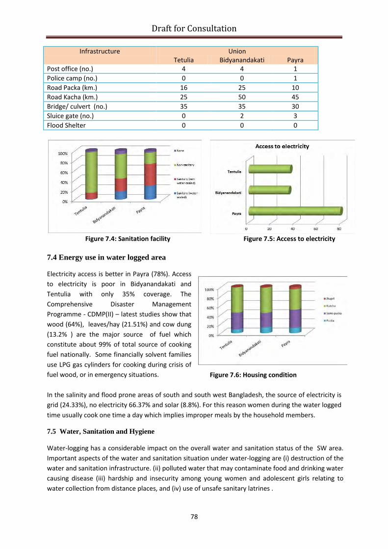
Draft for Consultation
Figure 7.6: Housing condition
Infrastructure Union Tetulia Bidyanandakati Payra
Post office (no.) 4 4 1 Police camp (no.) 0 0 1 Road Packa (km.) 16 25 10 Road Kacha (km.) 25 50 45 Bridge/ culvert (no.) 35 35 30 Sluice gate (no.) 0 2 3 Flood Shelter 0 0 0
Figure 7.4: Sanitation facility Figure 7.5: Access to electricity
7.4 Energy use in water logged area
Electricity access is better in Payra (78%). Access to electricity is poor in Bidyanandakati and Tentulia with only 35% coverage. The Comprehensive Disaster Management Programme - CDMP(II) – latest studies show that wood (64%), leaves/hay (21.51%) and cow dung (13.2% ) are the major source of fuel which constitute about 99% of total source of cooking fuel nationally. Some financially solvent families use LPG gas cylinders for cooking during crisis of fuel wood, or in emergency situations. In the salinity and flood prone areas of south and south west Bangladesh, the source of electricity is grid (24.33%), no electricity 66.37% and solar (8.8%). For this reason women during the water logged time usually cook one time a day which implies improper meals by the household members.
7.5 Water, Sanitation and Hygiene Water-logging has a considerable impact on the overall water and sanitation status of the SW area. Important aspects of the water and sanitation situation under water-logging are (i) destruction of the water and sanitation infrastructure. (ii) polluted water that may contaminate food and drinking water causing disease (iii) hardship and insecurity among young women and adolescent girls relating to water collection from distance places, and (iv) use of unsafe sanitary latrines .
78

Draft for Consultation
Water-logging creates particular problems for women and girls, who bathe in in flood water, often at night. Ensuring private latrines for women and adolescent girls is always a challenge but should be a priority. They may also become victims of snake bites. Women are using ‘’boats ‘’ made from banana tree, plastic, paper and palm trees as toilets after sun set, as there is no private dry space. One consequence of the lack of hygienic bathing facilities for women are an increase in internal infections as a result of bathing in stagnant water. Dalit (local organization for low caste community right) reports that there are over 1,000 completely damaged and approximated 450 partially damaged water sources in four unions of Satkhira, during the waterlogging episode of 2011. However, no baseline information exists and therefore, there is no way to compare the extent of damages (JNA light, 2013). Some families had to purify water either by boiling or by using alum (fitkiri) for drinking purposes.
The need for repair of damaged water sources or ensuring pure drinking water through rain water harvest in line with the national policy for Arsenic mitigation – other options mentioned are pond sand filter, deep tubewell and pipe water supply (WHO, 2003. Arsenic, drinking water and helth risk substitution in arsenic mitigation: discussion paper). The storage of excess monsoon rainwater is the most suitable option of providing safe water for SWB.
Suggestions for areas experiencing extended water logging include: i). elevated latrine options (i.e., mud platform, mini- conodominial sewers, composting toilets, floating latrine platforms with flexible pipes, ii) elevated tubewell options (i.e., head raised, platform raised) and iii). water storage vessels that can float from the tubewell to house.
7.6 Background of water logging specific to the three unions studied
In Tentulia union of Tala upazila, water logging problem initially was started from 1986 and became permanent phenomenon after the flood of 1988. In the year of 2009 and 2011 simultaneous occurrence of water logging and flood created a critical problem in the area. According to the local people, water logging of 2013 has caused almost 80% damage to properties and business in the union. Water logging lasts for 5 months in between July to November in the union. The affected areas include half of Lautara, Terchi, full of Shirashuni, kolapota, Dholabaria, Nowapara, koliya, Deunipara and some part of Tentulia. Besides, lower-middle income people were also heavily affected. There were no work for labourers and many of them went to the cities for rickshaw pulling. A group of lower middle class families became dependent on debts for maintaining their livelihood. The water logging problem in Bidyanandakati union of Keshabpur upazila started primarily in 1996. From the FGD information, it has been found that, the problem is acute since 2010 to 2013. The problem starts from July to November months of each year. Generally the problem is prominent during august-september. 80% area of the union is affected. Among the villages in the union, Mahadebpur (100%), Hizaldanga (100%), Nehalpur (90%) and Boga (90%) are mostly prone to water logging. Farmer, fishermen, poultry firm, daily labourer, Pal (potter), Rishij, Rajbongshi (150 families), masons, blacksmith etc. and people involved in farming and poultry are much affected. In Payra union of Avoinagar upazila the problem started in during 1980-1982 due to silting up of the Bhabadaha and Teka river. As a result, water could not drain properly and monsoon heavy rain water is accumulated in the low lands. Consequently, water logging was present in the area from
79

Draft for Consultation
July to October and later on the problem became permanent. As a result people of payra, kultiya, cholishia, haridaskathi, sundoli, monohorpur suffered which lasted until 2003. Mainly farmers and small businessmen in the area were affected heavily due to water logging. Many middle class families lost all their savings and migrated to big cities to work as laborers. Many Hindu families migrated to india due to economic hardship and lack of work opportunities. Small businessmen, small farmers and middle or lower middle class families are worst victims of water logging. They do not have much financial solvency and could not also get reliefs or financial support from different GOs or NGOs. As a result, they become day laborer in big cities or take loans to survive and ultimately become poorer day by day. Agri. labourers do not have any work during mid July to mid November while farmers are also free during this time. Similarly the table shows the time frame when each of the livelihood groups have no work. The seasonal distribution of economic activities for different livelihood groups in the area shows that farmers do not have any work during August to November as a consequence of the water logging. In general, the distribution of population among different livelihood groups in these unions shows that, agriculture is the most dominant sector with 88% of male and 66% of female population that are employed (According to BBS census 2011). Due to water logging they do not find employment in the area. Some income generating opportunities (eg, grocery, fishing etc) for them should be created so that they can maintain their livelihood. 7.7 Gher Farming
Gher farming is usually done by owner of the ghers. There is no trace of leasing practice in the gher farming. In Tentulia of Tala union about 40-50% of the gher owners are usually outsiders – from outside the district . There are also absentee gher owners. Local farmers are mostly the owners of the smaller ghers. Number of ghers is increasing over time. People reported that number of gher is increasing due to water logging – now there are an estimated 5000 ghers in Tetulia where prior to waterlogging there had only been around 100. In Biddyanandakathi, Gher farming is practised on 90% of the land during flooding, while 30% are permanent, and are used even in years without water-logging. Only 5% of the Ghers are owner-operated and 95% are gher lessee, who make use of their own land as well as leased in land. About 90% gher owners are local. Outsiders operate only 10% of the total ghers in this area. Operators of larger ghers are rich and influential, and usually stay outside the locality, either in Satkhira, Khulna or even Dhaka. Absentee gher operators hire labour to operate their ghers. Small and marginal land owners have little stake in gher operation. The cost of leasing a gher is around BDT 10,000 per bigha (42 decimals) in Tentulia; and BDT 15,000 in Biddayanandakathi. Economics of land conversion from crop to shrimp in water-logged areas The most striking example of conversion of land to aquaculture in Bangladesh is probably the shifting of rice to fish production in the two sides of the Valuka-Mymensingh high way. These areas were very fertile and productive and were never water logged, yet fish production has replaced rice mainly due to economic consideration. In Satkhira waterlogged area, the current land use pattern is boro rice in the dry season and shrimp/ prawn/ white fish in the monsoon. People’s tradition to produce rice is mainly for food (rice)
80

Draft for Consultation
security.. Since, rice is less profitable than shrimp/prawn/fish production, rice land is gradually being converted to shrimp gher. The owners of lands (marginal, small, medium or large crop farmers) in the waterlogged area of Tala, Satkhira, do not have the capacity individually to drain out water from the beels/ floodplains after the fisheries production to make it ready for boro production. These farmers lease out their land to the gher owners in exchange of hari (price of lease). The gher owners get temporary use right of these lands for the period of fish/shrimp production. The arrangement is such that, after fisheries production, gher owners will drain or pump out water for the land owners (lessor of lands) to enable them to cultivate boro rice in the dry season. Extent of hari per unit of land varies with the variation of fish prices. The current hari in Tala, Satkhira is Tk10,000 – Tk. 15,000 /bigha (33 decimals) /fish production cycle. If the land owners invest in boro rice, their Tk 1.00 investment provides a maximum benefit of Tk 1.25-Tk1.40. On the other hand, the same Tk 1.00 investment in shrimp/ prawn/ fish can provide a minimum of Tk1.40 to as high as Tk 3.00 – for instance, in modern variety Boro paddy benefit to cost ration is 1.46 ; whereas for prawn-carp culture in gher it is 1.60; the same calculation for year-round Bagda farming produces a return of 1.79; the highest returns come from Golda (freshwater prawn) at 2.42. Contrary to popular belief, leasing land for shrimp is not by any means a losing concern.! 7.8 Summary of social impact of water-logging From the table 7.3 and 7.4 it is clear that the impact is largest in Satkhira district and specifically in Tala upazila. In the unions, majority of houses are Kutcha (around 40-50%), followed by Semi pucka (28-40%) while around 10% houses are Pucka and 1% is Jhupri (figure 7.6, above). Among these unions worst condition is found in Payra union where Jhupri is around 4%. Besides, due to water logging, the populations living in earthen (Kutcha) houses along with Jhupri are really vulnerable. During water logging period, these houses are at extreme damage risk. These houses were built on raised ground (plinth) one or two feet above the general level. In 2011, total of 27,213 houses were completely destroyed with another 43,090 houses partially damaged (out of total 421,086 HHs in 7 upazila and 23,475 HHs in Municipal area). According to the government, the number of internally displaced HHs now stands around 70,303 which is (16.69%) of total HHs (Office of District Relief and Rehabilitation Officer, DRRO, September 2011). Priority needs are (i) rebuilding or repair of houses (ii) raising ground (plinth) level (iii) improving access to drinking water and sanitation and interest-free agricultural loans. Table 7.3: Sector-Wise Losses and Damages due to water logging, 2013 Affected Sectors Khesobpur Tala Satkhira
Sadar Kalaroa Total
Shelter Fully Damaged Houses (No.)
425 250 2000 - 2675
Partially Damaged Houses (No.)
1075 2510 2364 435 6384
Physical Infrastructure
Damaged Carpeted Roads (Km)
0.7 - 34 - 34.7
Damaged Other Roads 30 30 51 - 111
81

Draft for Consultation
(Km) Partially Damaged Carpeted Roads
0.7 10 26 11 47.7
Partially Damaged Other Roads (Km)
25 35 47 20.5 127.5
Severely Damaged Embankment (Km)
5 2.5 14 - 21.5
Slightly Damaged Embankment (Km)
- 3.5 18 - 21.5
Partially Damaged Embankment (Km)
- - 23 - 23
Livestock Death of Livestock (Cow)
50 - - - 50
Death of Poultry (No.) 4000 - - - 4000 Agriculture Damage of Crops
(Acres) 1721 - 2100 - 3821
Partial Loss of Crops (Acres)
1300 - 1100 233 2633
Fisheries Damage of Shrimp (Nos.)
- - 1200 - 1200
Damaged Fisheries (Nos.)
- - 1125 1850 2975
Water Damaged Tube well (No.)
202 680 50 129 1061
Damaged Ponds (No.) - 200 2070 1752 4022 Education Damaged Educational
Inst (No.) 17 20 8 - 45
Religious Inst Damaged Religious Inst (No.)
55 25 11 - 91
[Source: D-Form, DDM, November 2013] Damages caused by water logging were assessed by number of agencies and researchers. The assessments were made through different techniques and for the purpose of the research objectives, however the area affected by water logging were identified by all. Table 7.4 shows the comparison of different studies. Table 7.4 Comparison of damages by water logging of different years by assessment made different authors Year Source Districts & Upazilla affected No, of people
affected Fully Damaged House (No)
2006 IFI WATCH, December 2006
8 upazilla of Khulna (Dumuria, Phultala, Daulatpur), Jessore (Abhoynagar, Minirampur, Keshabpur, & Satkhira (Tala)
2,87,200 No info
Manirampur, Keshabpur and Abhaynagar Upazila offices and IWM, 2007
Manirampur, Keshabpur and Abhaynagar of Jessore
3,13,045 No info
2008 Assessment Of Water-Logging Extent Using
Jhikargacha, Manirampur,
8,45,000 No info
82
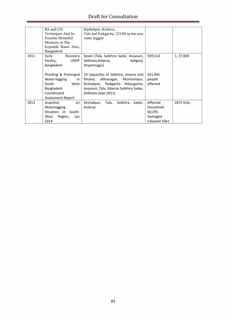
Draft for Consultation
RS and GIS Techniques And Its Possible Remedial Measures at The Kopadak Basin Area, Bangladesh
Keshabpur, Kolaroa, Tala and Paikgacha, 223.89 sq km area water logged
2011 Early Recovery Facility, UNDP Bangladesh Flooding & Prolonged Water-logging in South West Bangladesh Coordinated Assessment Report
Seven (Tala, Satkhira Sadar, Assasuni, Debhata,Kolaroa, Kaliganj, Shyamnagar) 10 Uppazillas of Satkhira, Jessore and Khulna, Abhynagar, Monirampur, Keshabpur, Paikgacha Jhikargacha, Assasuni, Tala, Kalaroa Satkhira Sadar, Debhata (sept 2011)
939,514 921,942 people affected
1, 27,000
2013 Snapshot on Waterlogging Situation in South-West Region, Jan 2014
Keshabpur, Tala, Satkhira Sadar, Kolaroa
Affected household, 60,295. Damaged tubewell 1061
2675 fully
83

Draft for Consultation
Chapter 8: COPING WITH WATER-LOGGING – LIVELIHOOD OPTIONS The potential coping options relating to food production (the main source of livelihood in SW Bangladesh) under water-logging conditions can be divided into several different categories
• Making the most of constraints – large scale shifting to aquaculture-related, or combined rice-fish systems;
• Mitigating the constraints – salt-tolerant varieties, submergence tolerant varieties, mulching to minimize evaporation (in saline conditions), sarjan system
• Optimising resource use - greater use of marginal land (dyke vegetables, vertical gardening), homestead production, floating bed vegetables
• Diversification – moving up the value chain, into processing, non-traditional on-farm activities, off-farm rural income generating activities
This categorization is not exclusive and is purely indicative – further work is needed to document and classify most suitable options for given localities. These coping options will be discussed in turn:
Making the most of constraints - aquaculture opportunities and rice-fish systems
DoF recorded 107 flood plains covering 20,710 ha in the three districts under study in the SWB where 12,604 mt of fish and prawn are produced annually. Besides, 2.834m ha out of 8m ha of paddy fields in the region remain under water for 4-5 months where integrated rice-fish culture is possible.
Similarly, there are about 69,000 ha borrow pits along the embankment constructed by BWDB and R&HD where fish culture is being practiced by farmer groups with the technical assistance from DoF.
Yet, production is not satisfactory due to poor management and reluctance of the lease holder groups in investment. DoF leased in 57 oxbow lakes covering 1978 ha in Satkhira and Jessore to run a project with the intention of handing over to the farmer cooperatives upon phasing out of the project for community based fish production.
There are also scopes for utilizing community water bodies for fish production, even by the poor farmers using the modern technologies like Cage culture and Pen culture. The potential for fish culture in these various types of system/water bodies may be considerable, according to DoF.
Cage culture
84

Draft for Consultation Cage culture: This is one of the modern aquaculture techniques. The cages of different size (depends on water depth, current, turbidity and species to be produced) erected (floated with anchor) in water bodies. Community or individual can manage the cages, it is capital intensive and need permanent or semi permanent water bodies where water remains for more than 6 months and has moderate flow. The canal, dead river, beels and large water bodies are suitable for cage culture. Cage making material, technology and ingredients are usually locally available.
There are possibilities of adopting the technology in water logged areas, but generally cage culture is more suited to water flowing canals and depressions. Also, the venture does not create obstacle to water movement, which acts to mitigate further water-logging. It has the potential to facilitate common use of public water resources. However, initially it needs financial and technological support for the beneficiary groups. However, caution must be taken to maintain proper alignment and distance between pen cages in order to avoid pollution of water. Eventually, microfinance organizations may be able to support, once sufficient scale of demonstration has been achieved. Pen culture in large water bodies, beels, flood plains, dead river, involves a portion of or total water body being sectioned off and controlled by bamboo fence, screens or synthetic nets. Water in the pen and outside may move freely but the stocked fish and other fishes remain trapped inside pen. Regular feeding and care is needed for both fish and pen structure. Guarding is essential, this type of venture needs authorization from DoF and local administration to follow the rules of “Fish Act”, as there is an impact on flow of water and drainage. There are currently 24 pen culture activities in Jessore and Khulna districts, operating with community based management. There are several permanent or seasonal water bodies in both fresh and brackish water areas which may be organized for community based Pen Culture.
Optimizing resource use
One way of optimising resource use is to integrate production systems, so that resources are used to maximize benefit.
• Boro rice and fish (together) • Fish monoculture • Vegetable and fodder cultivation on the gher dyke
Pen Culture
Pen Culture
85

Draft for Consultation Such a system is suitable for fields having soil and water salinity not exceeding 12 and 2 dS/m, respectively and which is flooded up to 60cm. IRRI introduced this technology in Dacope, Khulna and has been adopted by farmers leading to significantly higher farm production, while the additional fodder improves meat, milk and egg production. Their dissemination and adoption present a significant labour
requirement, as well as access to different markets for the different produce.
Floating bed: A second example of working around the constraints are technologies such as floating bed or ‘dhap’ production which turn water-logging into an opportunity. Beds of up to 50 metres length are constructed around a bamboo frame, using water hyacinth or other available organic matter, to a depth of about one meter. These float and can form a base for cultivation. This kind of soil-less cultivation is actually a traditional system which still thrives in low land flooded areas such as Gopalganj, Barisal and Pirojpur districts. Vegetables are the main crops usually grown on these beds. Among other crops, cultivation of Amaranths, Batisak, Spinach, Kangkong and Potato can be quite remunerative. In some cases, farmers use these floating beds to raise vegetable seedlings which can be a profitable business in itself. Care must be taken to minimize or avoid the use of agrochemicals, in the case that waters are also used as an extensive source of fish.
Fish rice and vegitable
86

Draft for Consultation
Burrow pit: There are number of BWDB and R&H borrow pits along coastal districts. Department of fisheries is implementing a project “Integrated Fisheries and Livestock project in Flood Control Drainage and Irrigation (FCDI) project area”, other water bodies public organization and Land ministry were included under a MOU . The water bodies are make available to marginal farmer group on temporary leasing basis and a portion of input and technological support is provided by the project. After completion of the project, the benificeary group would manage the project with respective authorities.
There is about 69000 ha borrow pits and canals produces about 58000 MT fish and prawn in SWB in three districts (DFO, Production plan 2012). The burrow pit and canals of the area are poorly managed and create obstruction in water flow which results water logging in some cases. The resource can be utilised properly with proper planning and infrastructural design which the leaseholder or occupants are not properly utilizing. Coordinated mangement and involvement of public institution may improve the productive use of area. Besides there are many potential areas which were not explored may bring under development program and may be alloted to merginal and poor farmers of the area.
Community based Flood plain Aquaculture: In south west Bangladesh during water logging period (6-7 months) aquaculture can be organized on community based management (in some points being practicing). Here the land owner has shares, labor and fishers may have share according to their participation and for capital formation there are money shares. In community based aquaculture system the infrastructures like dike, water regulator nursing pods etc are common property of the community and managed jointly. The flood plains are managed in two systems like (a) leasing the land from owner and aquaculture done by a person or entrepreneur and (b) organizing the land owners participation on share basis and managed by the community which is known as community based flood plain aquaculture.
In flood plain aquaculture generally mixed species of nursery reared bigger sized fish are stocked. Now valued species fishers are stocked along with carps, small indigenous fishes (SIS) are also grown and arrangement for their propagation are conserved by the community, mainly in small ponds, canals or
Floating Vegetables
87

Draft for Consultation ditches. Feeding and fertilization are done frequently. The aquaculture production in flood plains is gradually escalating in Bangladesh as well as in SWB (in study area)
These technologies refer to situations where, despite the constraints, farmers have developed adaptation options which allow farming to continue. Salt and submergence tolerant crops for the tidal flooded areas are one such example.
Vegetable or fodder in the dykes of gher involves women participation and income. It is being spread in many parts of SW Bangladesh. Adequate training to enhance skill and seed supply will be needed to increase nutrition supply of the women and children. Mitigating the constraint
Potential crops and cropping pattern: BRRI dhan28 is popularly grown in the boro season in SWB, yield of which is reduced if soil salinity exceeds 5-6 dS/m. Similarly in aman season farmers still grow BR11 and some Indian varieties having no tolerance to soil and water salinity. The problem of soil and water salinity is more acute in the boro than in aman season. Depending on the levels of soil salinity in the boro, and submergence in the aman season yield of these varieties may be reduced by 30 to 100 percent.
However, stress tolerant rice varieties with high yield potentials are available in the country. Likewise, a number of high yielding rabi and kharif-I crops are available but none of these have been adopted by farmers of this region. Therefore, much scope exists in increasing farm productivity by replacing the existing low-yielding varieties of crops with the stress tolerant high yielding varieties. A strong and effective extension systems is needed to popularize these varieties in the region is needed. The table below gives a list of these potential crops and varieties with their salient features.
Vegetables through Pitcher irrigation: Suitable technology to grow vegetables in the saline prone area in the SWB where fresh water is scarce. This involves pitcher made of soil (pottery) having few perforation put in the soil within root zone. The jute rope in the perforated holes carries moisture to the root zone of the vegetables in the coastal region. The method is found suitable by SRDI in the soil with salinity of 8-12 ds/m. The method drops the salinity by 2-3 ds/meter (source: Agricultural Technology suitable for southern region, BARC, 2013).
Table 8.1. List of potential crops and crop varieties
Crop Variety Season Yield, t/ha Salient features
Rice BR23 BRRIdhan40 &41 BRRIdhan44
Kharif-II 4.5-5.5 4.0-4.5 4.5-5.5
Best adapted to coastal region Salt tolerant Suitable for non-saline tidal prone areas
Rice Fish in Ghers
Veg/fodder in the dykes
88

Draft for Consultation
BRRIdhan51 BRRIdhan52 BRRIdhan53 BRRIdhan54
4.5 5.0 4.5 4.5
Submergence tolerant for 2 weeks Submergence tolerant for 2 weeks Salt tolerant up to 10 dS/m Salt tolerant up to 10 dS/m
Rice BRRIdhan47 BRRIdhan55 BINAdhan8 BINAdhan10
Rabi 4.5-6.0 7.0 4.5-5.0 5.5-6.0
Salt tolerant up to 14 dS/m Salt tolerant up to 10 dS/m for 3 weeks Salt tolerant up to 10 dS/m Salt tolerant up to 12 dS/m
Jute Atompat-38 BINAdeshipat-2 CVL-1 Kenaf HC 95
Kharif-I 2.8 3.0-3.3 5.16 5.45
Late adventitious rooting after submergence Medium High and Low land, saline tolerant Suitable for coastal saline
Lentil BARI Masur-1 BARI Masur-2 BARI Masur-3 BARI Masur-4
Rabi 1.7-1.8 1.8-1.9 1.9-2.0 1.9-2.0
1000 seed weight 15.4g, Protein 27.88% 1000 seed weight 12.5g, Protein 28.31% 1000 seed weight 23.8g, Protein 25.5% 1000 seed weight 19.84g, Protein 25.8%
Mungbean BARI Mug-2 & 3 BARI Mug-4
Rabi 0.9-1.1 1.2-1.4
Resistant to yellow mosaic virus Cercospora leaf spot
Sharisha (mustard)
BARI Sharisha-14 Rabi 2.5 Disease and pest resistant
Diversification
The trend of nontraditional fisheries product is increasing. As an example, the dried crustacean shell and fish scale export business is new since 2010-2011; they are used for chitosan and collagen production respectively, which are used in different industries like food, medical, agriculture, cosmetic, tobacco etc. Most of the shell and fish scale is being collected from Khulna region, mainly from major shrimp/prawn producing areas. Exports are principally to China annually. Fish skin export has potentialities and gradually developing which is using in leather and fabric industries. Export value is shown in figure 8.1.
Figure 8.1. Non traditional fisheries product Export in million Taka
050
100150200250300350400
2009-10 2010-11 2011-12 2012-13 2013-14
Fish Scale & Shrimp shell Shark Fin& Fish Mows.Dried Fish Dehydrat FishCrab (Live)
89

Draft for Consultation Dried fish and dehydrated fish export has potential market, but currently it is unstable due to trade barriers associated with chemicals. Export of live crab and eel is expanding, around 80% of the crab produced in Bangladesh is supplied from SWB. Availability of live crab in nature is declining; there is a good potentiality for soft shell crab production in shrimp farms of SWB. Quality improvement of dry fish from SWB may capture ethnic international market. Besides there is scope for value added fisheries product and fish skin industry development in SWB which will create job opportunities for both male and female workers.
Crab fattening and Culture: Crabs were mainly caught from shrimp farms which incidentally get in the culture system along with tide water and from coastal waters mainly from mangrove forest. The exporters need catch certificate from Forest department and health certificate from DoF. Among 16 species serrated mud crab, also known as mangrove crab, or Scylla serrata is now the most commercially important species and being exported. Crab lives in same environment as shrimp does, so crab culture or fattening is practiced in patches of shrimp growing areas. Generally, the soft shell crabs and juvenile crabs are stocked in a well protected (bamboo fenced) pond. Crab need shelter for molting and protein enrich food. Crab culture can be initiated in shrimp ponds in cages as by product or in a well protected pond. At present there is no hatchery for crab propagation. Hatchery establishment need same facilities the shrimp hatchery does, on the other hand crab can be propagated in shrimp hatcheries. Soft sell crab has good international market, it can be produced in shrimp ponds in cages and needs intensive care thus requires more labor.
Improving production from livestock resources:
There is a serious dearth of animal feed in the region since farmers do not spare any land for fodder cultivation, not even in the homesteads. Since most lands are converted to fish gher there is no land available for fodder cultivation after the harvest of boro rice. Hay (mostly straw of boro rice) produced on the farm are partly used as animal feed. The potential species of fodder in Dacope are maize and napier grass, the former is cultivated in the field during December to March while the latter is a perennial for growing in the homesteads. Sorghum sudan grass can be another potential species as has been verified in Noakahli region by an NGO under the RFLDC project funded by DANIDA.
It is important to note that in all of these livelihood options that technically feasible alone is not sufficient for the option to benefit livelihoods. Producers must be able to sell at a profit (taking account of costs of production including labour). Markets, distribution systems (including the ‘middlemen’ who are often key to making market work), storage and processing facilities are all as (or more important) than production alone.
Beef fattening: Beef fattening is a profitable enterprise which brings cash to farmers two to three times of the investment within six months. There can be various packages ranging from rearing costly dairy breed with blood lines of Holstein, Sahiwal, Red Sindhi and Friesian to the low cost local breed.
90

Draft for Consultation Chapter 9 CONCLUSIONS AND RECOMMENDATIONS
As many have noted, water logging in SWB is a complex issue. The underlying water and land related issues are complicated by local and national politics, by community groups with opposing views, and by an institutional setting which seems to spawn conflicts of interest, clashes of mandate and an overall reluctance or inability to collaborate. Some may also gain from the status quo. Overlaid on this have been some sincere efforts at development, large scale infrastructure investment and humanitarian assistance; unfortunately some have favored their own short run interest, over "solving" the water-logging problem.
Conflicting interests of different stakeholders have been found in number of areas. Conflict between land based and water based production systems is visible in the region, and tension among the communities creates news in the media. Possession of public land including canals and river and using those for aquaculture practices and putting barrier in free flow of water has further exacerbated the water logging.
Lack of coordination of development activities in the departments under GO and by NGO are common, and results in inefficient service delivery. Better coordination mechanism to ensure accountability in development is widely expressed need by the people of SWB. In addition, integrated development approaches in the region seems to be best option for sustainable economic growth.
The region has distinct land tenure system associated with land and water based production system. Land use tends to go for higher returns (monetary as well as non-monetary nature). In Satkhira waterlogged area, the current land use pattern is boro rice in the dry season and shrimp/ prawn/ white fish in the monsoon. Growing rice is mainly for food security. Since rice is less profitable than shrimp/prawn/fish production at current economic pricing, land usage favours the later.
The study identified knowledge gaps to better understand the life and livelihood of the area for future interventions. The sustainability of aquaculture practice in the region, equity and justice in present land use practice, animal nutrition status, economic use of sediment management, current water management practices for diversified livelihood, possible financing mechanism to participatory water management, quality of investment in the region, private sector engagements in product and service delivery, remunerative non-farm activities, productivity issues of agro-aquaculture system, scoping of degraded land through community approach, region specific public health, housing and learning, need for region specific formal and informal training in the services sector, strength and weaknesses of legal instruments all remain as questions for further exploration.
At the heart of the issue lies the need to reconcile the action needed on a catchment area basis to tackle drainage (and more general water management issues), with the main bureaucratic institutions set up in line with individual administrative rather than hydrological boundaries.
What then is the way forward for the people of SWB in the face of recurring and persistent water logging? New institutional arrangements will take time to come to fruition, and there is no easy route for a form of governance to cover both the landscape and the administrative dimensions. Such issues which cut across ministerial mandates are often referred up to the prime minister’s office for resolution; however, there is already a surfeit of such initiatives and it is unlikely PMO
91
Draft for Consultation would welcome another. The planning commission is responsible for development planning in the country, and many of the initiatives to solve water-logging come across the relevant development desk relating to agriculture and water resources. But the planning commission has only limited operational capacity to manage a programme, although it played such a role with the ECRRP. Another option has been the model of the creation of a regional development authority (such as was used in the Barind area of NW Bangladesh). Again this took some time to realize.
At this point, no elegant solution exists, and it is certainly difficult to propose one based on a modest study like this. The aim for now should be to draw attention to the need, allied with a much improved understanding of the nature of the problem, and allow institutional solutions to develop based on the evidence presented.
As a UN technical agency with a mandate on food security and nutrition FAO and WFP – as co-chairs of the food security cluster in Bangladesh - have insights into a significant part of the problem, that which is associated with availability, access and utilisation of food, all of which are impacted significantly by water-logging. We can draw attention to these issues. We can also highlight other factors, based on the work of the multidisciplinary team working since 2014. We can make suggestions as to how these issues might be addressed. The prominent ones include dissemination of technologies for profitable agriculture suited to local ecologies, livelihood options for the vulnerable households, capacity building for improving natural resource management, and developing a sustainable agriculture- aquaculture production system. Further, promotion of agro-aquaculture system for the development of livelihood, better service delivery through agro-meteorological data interpretation, and implementation of well planned TRM are recommended. But ultimately resolving the problem will come down to the government of Bangladesh, through its various local and national institutions.
One clear overall finding from the study team was that sporadic interventions by different agencies and NGOs to address water logging will not bring desired goal. The integrated development approach (basin wise development model) embedded with strong political commitment both local and national alone will end suffering due to water logging, and at the same time create better opportunity of livelihood.
Our suggestions divide into two main categories - those associated with preventing water logging from occurring (which may take some years to achieve, and may ultimately only be partially successful in some areas)- and suggestions for how to cope with water logging while developing improved livelihood options for the people of SWB.
9.1 Preventing
i) Physical/environmental– improving drainage involves the following major interventions: a) Local initiatives to address encroachment on natural drainage, by enforcement of rules,
mobilising public opinion through advocacy and incentives to restore drainage: The existing legal framework in governance of water resources may be utilized to improve the situation. Public openions have been created through media which resulted in successful interventions
92

Draft for Consultation
by the district administrations in few places. However, the examples may be utilized in the SWB through advocacy.
b) Dredging and TRM, where feasible: A well designed c) Strengthening cross district coordination to ensure integrated solutions to wide area issues d) Rehabilitation and co-management of degraded areas e) Better planning and execution of infrastructure f) Better management of aquaculture to permit drainage
Under the heading of the prevention, the following are areas of recommendation:
1. Local initiatives to improve water drainage system (short and medium term measures) 2. Drainage advocacy 3. Strengthening district institutions to address water logging 4. Tidal River Management 5. Advocacy for cross district coordination, to ensure integrated solutions to wide area issues To address the above, review current legal framework, local level survey of the existing drainage congestions, degraded land, stakeholder consultation and motivation for compensation scheme, develop incentive scheme(s) for removal of blockages, develop comprehensive scheme including agency role for sequential TRM, updating records (for leasing of water bodies, for compensation schemes) will be carried out.
ii) Institutional – “business not as usual” will focus the following major interventions: a) Strengthen district government setup – improve collaboration among agencies b) Coordinate at basin level across multiple disciplines – may require a new institutional set up
(task force, agency etc.)- critical for complex development process, one entity to oversee development plan and implementation
c) Promote innovative farmers’ associations (community organization) for NRM, market access, etc- community based approach to reclaim degraded land or livelihood activities on perennial flooded lands
d) Work to establish a maintenance culture, with local government ownership (and new funding for running costs)- non-functional project based community participation, linking with LG with innovative funding arrangement
9.2 Coping
iii) Promotion of Economic Activities: For a long term solution and a improved livelihood practices the following intervention has been suggested:
a. Create a “centre of excellence” (may be virtual) for adaptive research on issues of the SWB- test based local solutions for climate smart production system and livelihood, NRM, Rural Non farm sector development
b. Guidelines for improved aquaculture-improve yield, allow integrated farming, food safety and good governance
c. Promote integrated production to mitigate climate risk-Promoting resilience with production technologies and diversifying. Addressing climate smart agriculture-floating beds, raised bed,
93

Draft for Consultation
dyke culture, pen culture etc. FAO is pursuing organized aquaculture through linking market involving small and marginal farmers.
d. Study bio-physical and Socioeconomic situations to map for zoning, creation of instruments with incentives instruments to encourage targeted investment
Under the heading of coping the following are the main recommendations:
6. Polder based livelihood improvement schemes/Programmes (traditional crop-aquaculture) 7. Innovative livelihood options in development of SWB (related to food production) –to
include buffalo, small ruminant, floating bed production, bund cultivation, sarjan system, crab and eel production, etc
8. Innovative livelihood options in development of SWB (non food/ for landless) – inclusion of “hard core” vulnerable
9. Develop market chains in SWB 10. Investments to improve housing and shelter 11. WASH improvement
94

Draft for Consultation 9.3 Programmatic responsibilities: addressing vulnerabilities and risks of water logging in SWB Activity Government UN NGO Other (private sector,
university, research, etc.)
PREVENTING: reducing chance of recurrence of water logging
1. Local initiatives to improve water drainage system (short and medium term measures)
Local planning, supervision, execution of programmes and works for improved drainage infrastructure(LGED, BWDB, R & H, LG & administration)
Local level planning with community and authorities for excavation and drainage rehabilitation (WFP)
Local stakeholder involvement in planning and execution
Re-excavation of link canals with rivers
Removing illegal & unplanned structures
Rehabilitation and maintenance of water infrastructure using food for work/conditional cash transfers (UNDP, WFP)
Contracting for specific pieces of work such as rehabilitation of degraded sites
Social organizations’ participation in execution of different activities.
Ensure women’s participation in relevant activities.
Involvement of WMA, WMG in drainage improvement where these exist
Rehabilitation of degraded land through LG participation
Help set up common interest groups for managing rehabilitated natural resources (UNDP, WFP)
Incentive schemes for improved aquaculture practice (DoF, LG)
Design programmes to reduce the environmental impact of aquaculture, linked to incentives to adopt (FAO)
95

Draft for Consultation Activity Government UN NGO Other (private sector,
university, research, etc.)
Assign role for operation and maintenance of assets at Union Parishad or Upazila level
Support initiatives to establish a “maintenance culture” for common infrastructure (FAO, UNDP, WFP
Local awareness building on drainage improvement and importance of common property maintenance
2. Drainage advocacy
Take part in feedback and consultation sessions on the FAO report on water-logging in SWB (eg 6 December, Khulna)
Report finalization, technical papers preparation and development of specific advocacy materials (FAO)
Facilitate consultation and briefings with local administration and elected public representatives, at local level and SWB representatives at national level (FAO, with WFP and UNDP)
Awareness and capacity building of local social and trade organizations
Participation of civil society & Water Management Association and Groups
Undertake survey for sites with drainage blockage (LGED, R & H, BWDB), and produce maps, identifying the river/canal boundaries
Train local authorities to map areas vulnerable to poor drainage/water logging, and use spatial planning tools for infrastructure (?)
Review maps with relevant line departments (including consideration of both drainage and irrigation elements) (?)
SPARSO & IWM support mapping river boundary
Possible engineering consultancy from private sector or via assistance in kind to support survey work
96

Draft for Consultation Activity Government UN NGO Other (private sector,
university, research, etc.)
Extend legal support to in-situ awareness campaign by NGO, civil society
Local advocacy groups promote wider understanding of causes of water logging
Assist in community mobilization
3. Strengthening district institutions to address water logging
Improve vertical coordination among administrative entities (MP, District Council administrator & DC)
Support awareness events at national and local level on waterlogging (FAO, UNDP and WFP)
Improve horizontal collaboration between engineering, line department, police & district administration
Facilitate improved coordination at district level (UNDP)
Provide training and awareness to grass root workers
Create local community platform (CSO) on water -logging issues, grouping NGOs, and other community organisations, as counterpart to local government (also involving WMA)
Adopt policy to limit leasing of rivers/canals, and implement
Support district and upazila administration to streamline land record and leasing systems for TRM (UNDP)
Strengthen monitoring by local authorities (LG)
97

Draft for Consultation Activity Government UN NGO Other (private sector,
university, research, etc.)
Strengthen local disaster management committee
Orient district, upazila officials and Disaster Management Committee (DMC) members on participatory and inclusive water management (UNDP)
4. Tidal River Management (sequential)
Inter-ministerial consultation and planning meeting held at Jessore (November 2014)
Engineering design of schemes (BWDB, LGED)
Fund (structural; non structural) allocation (BWDB + administration)
Selection of implementation partners
Support socioeconomic assessments of basin based schemes - livelihood involved, income flow, investment made, etc to ensure social “implementability” of schemes (FAO, UNDP)
implementation partner in TRM schemes various (roles?)
community platform supports local stakeholders group participation in the process of consultation, targeting of compensation (registration) and participatory monitoring
Local scheme consultation (led by district administration/ elected members)
Registration of those affected (district administration)
Facilitate inclusive and participatory planning for TRM implementation , (UNDP), including arrangements for compensation (?)
Monitoring the impact and reporting Support to monitoring the impact and reporting (FAO, UNDP)
98

Draft for Consultation Activity Government UN NGO Other (private sector,
university, research, etc.)
5. Advocacy for cross district coordination, to ensure integrated solutions to wide area issues
Participation of government in discussions and presentation sessions (GED, MoWR, MoLGRDC, MoA, MoFL, MoEF, PMO), and national institutions/inter-divisional technical departments, including:
Elected MPs from SWB & local officials
Divisional commissioner and other concerned divisional institutions
Advocacy for improved coordination for drainage in SWB, with Khulna Divisional & Dhaka-based institutions, with possible creation of a new geographically based development entity for the Lower Ganges (FAO, UNDP)
Larger national NGOs continue to draw attention to the need at national and local level
Researchers working on delta plan, water engineering, CGIAR, etc conduct technical conferences, prepare reports, etc
Strengthen and activate coordination committees at all level
Support development of South West Water-logging Preparedness Plan with the Department of Disaster Management to improve institutional readiness (UNDP)
99

Draft for Consultation COPING AND RESILIENCE: livelihoods in SWB are improved to address known and unknown future risks by diversifying, improving productivity and addressing specific climate-related threats
Activity Government UN NGO Other (private sector, university, research, etc.)
1. Polder based livelihood improvement schemes/Programs (traditional crop-aquaculture)
Undertake polder by polder planning based on suitability and commonality of interest
Conduct full production suitability analysis/zoning study (FAO)
Facilitate polder by polder planning discussion with union parishad representatives, to highlight and resolve crop-shrimp related conflict (FAO, IRRI, Worldfish)
NARS, CGIAR
SWB platform for adaptive research and development – partnership with universities, NARS and NGOs, beyond questions of productivity - to include social and economic dimensions
Private sector integration to ensure sustainable livelihoods
Research on specific technologies for improved agro-aquaculture (CGIAR, BFRI)
100

Draft for Consultation Local & national DAE, DoF & DLS
participation in training, demonstration. field schools and pilots to create ‘clusters’ covering enhanced “agro-aquaculture”, introduction of new technology and/or machinery, and addressing gender participation; social forestry/ vegetable cultivation in the polder dyke (DAE)
Support pilots for creation of ‘clusters’ for small scale agro-aquaculture (FAO, Worldfish); adoption of other suitable technologies in the crop shrimp)
Prepare examples of adaptation/intensification options drawn from project sites across SWB, in a form of catalogue
implementation partner to take to polder-wide scale, by organizing farmers groups, providing credit facilities to emerging in clusters, etc
Research – such as Worldfish, for instance - may have a number of pilot examples to contribute
Allocate GoB funds to water management bodies within polders
Support to renew previously existing participatory water management institutions (WMAs, WUGs) by involving union parishad
Implementation of polder specific projects to improve livelihood
Support polder-specific crop-aquaculture schemes
101

Draft for Consultation 2. Innovative
livelihood options in development of SWB (related to food production) –to include buffalo, small ruminant, floating bed production, bund cultivation, sarjan system, crab and eel production, etc
Central & local offices of DAE, DoF and DLS
Employment and capacity building of local extension agents to focus on innovative technology options
Co-management/Community Based Management of natural resources
Vegetables in gher dyke
Livelihood development supporting locally familiar enterprises
Develop and run schemes for introduction of adaptation packages, through “exposure days”, FFS and input vouchers
Capacity building and strengthening of DAE, DoF and DLS in SWB (FAO)
Foster partnership with input dealers (FAO)
Follow up on adoption and Monitoring & Evaluation
Motivation, training and help in generating, testing and scaling up particular technology options
Strengthen farmer, producer & input suppliers organization
BARI/DAE partnership to develop innovative technologies for SWB
BLRI, DLS and private sector engagement (such as in promotion of buffalo and small ruminants in SWB)
University, research (BFRI) and private sector in non-traditional aquaculture (crab, eel, etc)
Promoting local trade with new enterprises
102

Draft for Consultation 3. Innovative
livelihood options in development of SWB (non food/ for landless) – inclusion of “hard core” vulnerable
Planning of programmes including Social welfare, Women’s affairs, BRDB, Small cottage industry development board
Local technical departments and LG and administration collaborate in programme implementation
Identify scope and options for alternative livelihoods – to include crafts, artisanal work, trades, etc (UNDP)
Develop methods to identify vulnerable individual/households (WFP)
Develop curricula for ultrapoor (non-agriculture based), supported by grants – WFP with technical support from FAO
Identify beneficiaries for training and scaling up
Microcredit facilities for those without collateral
Community platform to support most vulnerable groups
Private sector investor, bank
Channeling remittances to productive use
4.Develop market chains in SWB
LG participation in market and road infrastructure development
Assurance and quality control of input supply and end product marketing
Identify the important actors in market chains (FAO)
Build awareness of the importance of linkages, and traceability (especially with respect to food safety) – (FAO)
Awareness building and provision of support service
Micro credit for small stakeholders
Private sector both within and outside SWB
Organize and strengthen stakeholders’ associations
Cooperative marketing arrangements
103

Draft for Consultation a. Investments to
improve housing, and shelter and school
Local Housing and Settlement department, Local administration
LGED and Disaster & relief
Technical departments design appropriate housing and shelter for waterlogged areas for people and livestock, and for food storage
Multi storied school as cyclone shelter (already in govt process)
Identify areas where improvement is needed (UNDP)
Assist technical department in implementing the program (UNDP)
Assist technical department in implementing the program with public participation and contribution
SWB platform for adaptive research to draw on experience from other areas in mitigating flood and water logging
b. WASH improvement
DPHED , LGED, LG and local administration will develop programmes to implement
Identify suitable facilities and design (UNDP)
Assist technical department in implementing (UNDP)
Awareness building and microcredit
Ensure civil society and gender participation
104

Draft for Consultation
Annexure A: Public Views Through Media Reporting
TV talk Show
EMBANKMENT CREATED DURING ONE MONSOON DESTROYED IN THE NEXT MONSOON, SOMOY TV, 02 September, 2014
The show includes discusiion of 4-5 eminent persons (Former Chief Engineer, BWDB, development practitioner and journalist) involved in the water management in Bangladesh. The TV program was held when northern districts were affected by severe flooding. The major points of discussions in the show were as follows:
• Major works of BWDB are done during monsoon which is responsible for lower quality job. BWDB has no linkage with the grass root people.
• The financial year of the government does not match with working environment of water management activities. India has changed its financial Year (March to April) and we need to change accordingly to match working environment.
• The flood forecasting system of the country is weak and needs to be strengthened. Presently, BWDB mostly follow top down approach. The Board anly follows donor prescription.
National Newspaper
NINE THOUSAND HECTARE LAND REMAINED FALLOW FOR LAST FIVE YEARS - FISH FARMERS AT STAKE WITH WATER DRAINAGE BY CROP FARMERS IN WATER LOGGED AREA. 23 January, 2015. The daily PROTHOM ALO
This year boro farmers in three upazila of Satkhira district started draining water by 120 pump in 8,930 ha. The water being drained is causing the houses to go under water and ghers are getting wasted. About 20 ghers are affected as water is drained to the canals that further submerge the aquaculture farms. The Deputy Director of Ag. Extension department said the beels in Sadar, Tala and Koloroa Upazila went under water as Betna and Kobodak cannot drain water of monsoon. Around four thousand farmers can not grow boro rice for last five years. Farmers could not grow aman rice during monsoon, so they want to harvest boro rice.
EVICTION OF TURAG RIVER BANK CONTINUING The daily Prothom Alo, 28 August, 2014 and 02 October 2014 The unauthorized establishment in the river bank of TURAG has been evicted for second day and Bangladesh Inland Transport Authority joined with the district administration of Gazipur parti-cipated in the eviction program. The establishments evicted in the list are one spinning mill, pipe industry and Cattle hat. The eviction order was made following a media report on illegal possession of river bank and subsequent high court order.
Annexure page-105
Draft for Consultation
PANIC OF WATER LOGGING OF PEOPLE BY KABADAK RIVER, The daily Inquilab, 22-08-14
Not only this year, in every year, the people adjacent to the Kobadak remain in panic of water logging. Every year, the roads, crops, houses schools are inundated in the both sides of the river, and disaster situation prevails. The river bed all over is silted that causes water logging in the area. Crore of Taka has been spent by BWDB but due to endless corruption of the Board, no benefit came out of these efforts.
The media reporter informed that this year, monsoon rain was less, that caused no water logging until now. But the rivers are flowing above danger level and rain during September-October is usually more. So there is fear of water logging. BWDB informed Bhairab and Muktesswari rivers in Jessor are flowing in full swing and low land of Jessor is already gone under water.
WILL NAVIGATION REGAIN IN DREDGING ALONE? The daily Prothom Alo, 16 August 2014 Rampal river of the Mongla-Ghashiakhali river channel is a protocol water route for the Bagladesh-India business. Losing its navigability, it’s almost dead now. Muddy road is crossed by boat made bridge arranged one after another. The local MP Mr. Taluckder Abdul Khalek said the sediments can not spread but retained in river and bed is raised due to embankment. Without current no flow is there in the river. CHALABEEL IS LEASED BY THE POLITICAL LEADERS, The daily Prothom Alo 17 August 2014. Indiscriminate fishing by bana and suti net has been arranged by local leaders. They leased away the beel in the name of the mosque! The beel is losing its normal breeding ground of fishes and biodiversity-say environmentalists. Chalan beel surrounds most of the areas of Singra Upazilla in Natore. With the advent of rainwater, fishermen became very active in catching fish and other aquatic animals indiscriminately by using banar bandh (flood dyke) and Suti net in different beels. It’s strange that the beel is leased and operational costs for three mosques are collected from that proceed from year to year. Interestingly, the local leaders do not think much about whether it is lawful or not. Fishes, crabs and oysters are becoming extinct. The committee is trying to build awareness for protecting the environment of Chalan beel. Fisheries Officer of Singra Upazilla says, “We warned people to abide by the Fish Law. Even, some of them were punished by the mobile court. We have destroyed suti-net. As the area is vast, all of them could not be brought under law. Upazilla Nirbahi Officer says, “It is prohibited to catch mother-fish in the fish act and net has been burnt, while being used for catching fish. However she said that she is not at all aware about leasing of the beel. SHRIMP INDUSTRY IS BEING COVERED UNDER INSURANCE SCHEME, THE SIZE CAN NOT BE MORE THEN 30 ACRE- The daily Nayadiganta, 18 August 20014 The shrimp insurance is being started to make the industry more profitable. Also to encourage private bank to provide credit to this industry. National Shrimp Policy 2014 also included to limit size of gher to 30 acres. The chapters included in the rule are objectives, implementing area, conservation and capturing in the coastal areas, hatchery, land zoning, quality control, processing, research, extension,
Annexure page-106

Draft for Consultation
dependable data base etc. The rule also discourages shrimp farming in the crop land. All relevant stakeholders will be included under the rule. SAVING RIVERS-NOBODY’S BUSINESS/HEADACHE. 25 th July 2014. The daily Prothom Alo LGRD Minister Syed Ashraful Islam said “Talking on climate change only has become fashion now a days. But nobody care about the death of the rivers.” The minister made such comment in an opinion exchange meeting with district level officers in the Kishoregonj Circuit House.Mr. Ashraf expressed his thoughts that we have to save the rivers first, we have to try to regain the flow of the rivers through river governance. We have to live by using river water. Minister also said that men are cruel to the nature and the nature now taking revenge. He also questioned that if human being does not have sufficient water to survive, what shall be the benefit by building so many roads. Minister says to the government officials that prime minister is creating different organizations in order to build professionalism. Taking advantage of these, minister advised to serve people. LOCAL NEWSPAPER
WATER RESOURCES MINSTER, COMPLAINS OF BWDB’S LACK OF TRANSPARENCY IN REVERSING KABADAKS NAVIGABILITY AND ADDRESSING WATER LOGGING. November 06, 2014m The daily PATRODOOT
In a workshop held in Khulna on 05 November, Mr. Anisul Islam Mahmud, as Chief Guest, stated that BWDB should involve local people in addressing water management activities. The workshop was organized to solve water logging in the region and bring the rivers navigable. The economic advisor to the Prime Minister, State Ministers, Local MPs, Secretaries and senior officers attended the workshop. The workshop came up with number of recommendations.
MEETING OF BETNA RIVER EXCAVATION COMMITTEE, 8 MONITORING COMMITTEES FORMED. The daily Patrodoot, 12 October 2014
Chaired by the DC, Satkhira, the comitee meets with District Council administrator, Mayor, Awami league General Secretary, UP Chairman etc. Executive Engineer, Satkhira BWDB informed that 25 crore Taka under Climate Change Trust fund was under implementation to excavate Betna river in 2012-14 and updated the development works completed. The meeting expressed dissatisfaction over the work and made the river into a 3-4 feet canal. It is sad to see the fund is not properly used. The meeting formed 8 monitoring team without which no payment could be made to the contractors, requested to the BWDB. THE EARTH OF BETNA RIVER EMBANKMENT IS REMOVED BY THE BRICK MANUFACTURERS. NO ONE TO SEE. The daily Patrodoot, 26-09-14
Annexure page-107

Draft for Consultation
The brick manufacturers are taking away the soil of river embankment of Betna river of ten feet height. When protested the manufacturers are threatening the protesters. The earth cutting is taking place in one locality under Satkhira by one brick field. Already, soil of half kilometer embankment has been taken away and remains under threat of flooding in the adjacent villages during tide and high rainfall. If action is not taken the community will go under water. The people who are cutting the earth said they purchased the earth from those who have the Duplicate Carbon Receipt (DCR). When contacted with the sub assistant Engineer of BWDB through phone he replied that the two organizations were given permission to cut the earth but he could not explain the details. The community seeks cooperation from the DC. HUMAN CHAIN IN SHAMBAGOR OF SATKHIRA TO PROTECT PADDY FIELD AGAINST SALINE WATER SHRIMP CULTIVATION, Daily Satkhira News, 05-09-4
Hundreds farmers in the Jadabpur Beel formed human chain in last Thursday. They said some local influentials without considering Shrimp rule putting saline water into gher of 11 Bigha Beel for last ten years and making it impossible to grow rice. Farmers were growing rice in 700 Bigha, but growing shrimp in 400 Bigha in the area causing rice growing not possible. There is no out-drain and making the farmers compelled to give lease for shrimp gher. The shrimp owners are making conspiracy to convert rice field to gher. They demanded to install out-drain and not to allow the canal to get saline water into Beel. The reporter mentioned that the shrimp rule in 2014 if implemented will ease the situation.
THREE VILLAGES OF TALA UPOZILA FLOODED WITH SALINE WATER, The daily Patradoot, 01-08-14
Allegation raised against mysterious role of officials of local Water Management Cooperative Society Ltd. Allegation came when using gate of project 46 in allowing saline water into Jetua, Krishnakati Beel for shrimp culture. The community lodged complains to the local MP. The gates and embankment are established by LGED and maintained by the registered cooperative society. As per rule, the saline water can not be put without permission of LGED but without caring the rule the shrimp farmers are letting water enter into gher.
THE BIG FESTIVAL OF POACHING BETRABOTI RIVER AND HELNA KHAL: LIKELIHOOD OF WATER LOGGING IN SHARSHA AND JHIKORGACHA, The daily Patrodoot, June 09, 2014
The Betraboti river in Sharsha Upazilla of Jessore and the canal Helna are under attack of the poachers. The local influential are capturing Government properties and erecting buildings for housing and offices in those areas. The water way has been blocked by pata (Bamboo screen across river course) and embankments. As a result, the river has been transformed into narrow canal filled with water hyacinth. Local Union Parishad Chairman informed that 1000 acres agricultural land in 26 villages under three unions may go under water in rainy season. Water flow shall be stopped as a result of building such activities in the water courses.
There were good crop harvest in thousands of hectare of land. But today the agricultural farmers are at stake. Water flow of these vibrant rivers has been slowed down through obstructions, the khas land has
Annexure page-108

Draft for Consultation
been utilized to build big building and offices. There is an unhealthy competition to ercect building and permanent structure in the public land. Through removing embankments and patas, several thousand farmers could be benefitted, flow of water can be sustained, and crops could be grown. Employment generation and environmental protection could be augmented. Farmers demanded for open these obstructions (embankments) without further delay.
PROTEST DEMONSTRATION TO STOP CANAL LEASING AND DEMANDING OPENING OF GOVERNMENT CANALS, The daily Satkhira News`02-08-14
Demonstration, procession and submission of memorandum to the UNO of Tala Upozilla was held under the banner of anti-people lease protection committee against canal leasing and demanding opening of the canals in Jalalpur and Magura Unions. Local union Parishad Chairman, political party leaders, Freedom fighter etc. attended in the demonstration.
The protesters demanded to stop leasing of four canals of Magura and Jalalpur unions. Though opportunity has been there to grow crop with the tidal flow of Shalikha River but sactioning of leasing of connecting rivers and canals by the UNO and subsequently subleasing those caused artificial water logging in the area. On the other hand, the lessee created obstruction of the canal by putting dam which stops flowing water. Farmers cannot grow aman rice in thousands of acres as lands are under water in the said unions.
STATE MINISTER ASKED TO CLEAR RIVER. the daily Patradoot, 07-07-14.
Mora Bhodra River flows beside Upazilla Dumuria, but some influentials of the locality built illegal dam and pata on this river which created and aggravated water logging situation. Recent rain water could not be drained out and created flooding in and around BaraBazar Area. State Minister for Fisheries and Livestock visited the areas and directed Upazilla Administration to clear obstruction installed by the poachers. Accordingly, next day, Assistant Commissioner (Land) with the support of local administration and political leader started to clear out pata and dam. Local public representatives and political leaders and others were present on the occasion.
FISHERMAN ASSOCIATION TO IMPLEMENT PRIME MINISTER DIRECTIVES, The Daily Patradoot, 30 -07-14
National Fisherman Society and Bangladesh Small Fisherman Society jointly organized a meeting in the office of the local fishermen Cooperative Society. The meeting emphasized on the directives of Prime Minister to control poachers of water and forest, implement fish protection act, stop illegal ownership of rivers including local small rivers, to ensure Government ownership by eradicating net-pata to prohibit mosquito net and other nets (net type devise to collect shrimp PL), to implement Jol Mohal Policy 2009 etc.
WATER LOGGING IN SATKHIRA, The daily POTODOOT, 17-06-14
Annexure page-109

Draft for Consultation
After a normal rain fall, large areas of Satkhira get flooded. 30 out of 78 unions of the district have been inundated under rain water. Water has invaded homestead and yards. Many people have left their houses. The local people are vigilant throughout night to protect the breakage of embankments.
The general people are scared due to unusual rise of tidal water in the rivers Betna, Morichap and Khelpetua of Ashashuni Upozila. At mid-day, the tidal water from local Ferry Ghat Area overflowed the embankment and entered into locality, but the local people managed to stop the flow by raising the embankment on a voluntary basis. But the Abnormal flow of tidal water disconnected the road connection. Due to disruption of ferry communication, the passengers faced boundless sufferings. Lot of complaints are there from the part of the sufferers on the skeptical roles of BWDB on this dam. They complain financial irregularities in the name of maintenance of the embankment damaged by AILA. The top of this embankment was determined to be raised by 8 feet, but in many places it was raised only by 5-6 feet by the sub-contractors. The use of very low quality geo-bag and its placement in the soil have increased the risk of damage of embankment. Local people are attempting for the protection of embankment. In Shyamnagar, fish ghers was flooded due to breakage of embankments. Abnormal rise of tidal water broke the embankments and flooded more than hundred bighas of fish gher. The water height is increasing tremendously due to lack of proper water drainage system. Villagers are scared that they have to leave their inundated homesteads.
Different villages of Tala Union have been flooded and amon of these beel area has completely been inundated. The greatest hindrances to water drainages are net-pata and non-functional sluice gate.
SCHOOLS UNDER THREAT OF WATR LOGGING, The Daily Potrodoot. 24-07-14
Collegiate School of Ashashuni upazila falls under water logging situation at the very beginning of Rainy Season. At any time, the duplex building may be seriously damaged, local people are apprehending. The students have to cross the water barrier for entering into the classrooms and get wet. President of the School Committee says that all the water run-off from the village gets its way through this school into the beel. The farmers take DCR (Duplicate Carbon Receipt) for canals in the beel areas which is, Government Khas land. They install net-pata which squeezes water drainage area and capacity and thus create water logging situation. Besides, nearby Kopadak river bed has got risen due to siltation. Under the ongoing land filling project of the Government, filling the school field and elevating surrounding areas of the school is a solution that could save two school buildings from collapse.
THE DECISIONS NOT FOLLOWED BY BWDB, The Daily Patrodoot, 18-07-14. There was a decision that BWDB shall demolish the cross dam across the rivers within a week in order to solve the problem of water logging in Satkhira. It will examine the sluice gates near the river and repair those on a priority basis, clear the soil and thus make the sluice gates functional within a week. BWDB of Satkhira is supposed to complete the works within a time frame. The decision was made in a meeting on Water Logging and Future Planning in the conference room District Commissioner of Satkhira, presided over by Deputy Commissioner. Besides another decision was taken that BWDB, Roads and High Ways
Annexure page-110

Draft for Consultation
and Zilla Parishad shall jointly update the poacher list along with lands near river and road and within seven days to the office of DC. As per the list by the related divisions, Mobile Court would be operated for uprooting those illegal establishments. It was also decided that a joint survey team would be formed for determining the boundary of the rivers and the demarcation of the roads of the Division of Roads and Highways, taking the members from Surveyors of district and upazilla administration as well as surveyour from related department. A task force team also to be formed by police, BGB, Anser, representative from BWDB, under the executive magistrate in order to un-install/uproot/remove dams on river, pata and net. But none of those were executed in fact. Eventually, the civil society/people of Satkhira think that the irresponsive behaviour of the authority is ulmately responsible for water logging situation in Satkhira. BWDB and land offices are responsible for water logging. They have converted the rivers into canal. The implementation of Kabadak dredging project without the help of army is not possible. MP of Satkhira-1 says that the low lying areas has gone under water. Betna river has been re-excavated. But removal of obstruction was not done. The rivers and beels which have been leased out are full of innumerable bandh/dam, pata and net which create hindrance for water flow. Local MP expessed his anger and dissatisfaction on the bad performances of BWDB in digging river Betna which was not properly dug with proper depth and width. The soil has been put on the shore of the river which again carried into river by the rain water. VEGETABLE CULTIVATION IN JUTE BAG, The daily Patrodoot, 05-07-14 Too much salinity in the soil and surrounding saline water prevented the vegetable growing in several unions of Shyamnagar. In order to fulfill the family need, the people of Shyamnagar upazila has started to culture vegetable in sac, keeping the culture system out of the influence of salinity. Women are fulfilling the demand of vegetable for their family. Following a time table, they are growing vegetables of different types in baskets/sacs such as pepper, tomato, brinjal, pumpkin, leaves etc. With the help of a NGO, they have started vegetable growing in sacs. Two things are necessary for successful in growing, one is availability sweet water and another is regular care of the vegetable sac. LIVING WITH CONFLICTS, The daily Patrodoot, 13-07-14
Lands for paddy production are facing production deficit every year. Besides natural problems, at present bagda shrimp culture has become major obstacle in cultivating crop production. It is reported that saline water shrimp culture is increasing every year in Tala Upazilla. Such unplanned increase of shrimp production area is responsible for diminishing rate of land area for crop cultivation and losing suitability for crop production. In fact, whole upazilla is being turned into water logged. In many important khals/canals, fish culture is being done by installing net, pata. Though shrimp has played positive role in national economy, common farmers are in danger, their livelihood is at stake. Marginal farmers launched their complaints to the Upazilla Nirbahi Office and made several processions for stopping shrimp culture. Furthermore, there has been division within rich and hard core poor class. Some people turned into millionaire overnight and remaining people are living under poverty level. As per the local people, Year round arrest of saline water decreased the productive quality of the soil. It’s
Annexure page-111

Draft for Consultation
harmful is evident on biodiversity, trees, animals and crops. In 2008, the then Caretaker Government formulated a draft for National Shrimp Culture Regulation which did not see the light. Local Fisheries Officer of Tala Upazilla informed that the rice culture did not decrease due to saline water shrimp cultivation. Rather, fish culture side by side paddy culture is being practiced. Besides, salt tolerant variety of paddy is being cultured.
SEED BED OF 60 BIGHAS OF LAND IS HARMED BY THE SALT WATER OF SHRIMP GHER IN SHYAMNAGAR: The daily Patrodoot, 14-08-2014 From time immemorial, the villagers of some villages in Shyamnagar Upazilla cultivated paddy around one Beel. Suddenly in 2012, some local people started collecting salt water water from river Chuna and poured the water into paddy field, thus started shrimp culture. It hampered the cultivation of other crops in the nearby lands. General public protested against gher to protect agricultural land but they could not ultimately save their land from salinity. Due to gradual salinity intrusion, it became impossible to maintain paddy field by the side of gher. As a result, farmers are bound to lease out lands for shrimp culture. Some people are always conspiring to convert all the agricultural land into shrimp culture. The general farmers complained in the Upazilla Fisheries Office but got no support. Whereas the high court declares through verdict - conversion of agricultural land into shrimp culture by adding salt water is prohibited, a group of people does not abide by the rule. Every season, they increase the area shrimp culture by converting paddy field through adding salt water and thereby destroying hundreds of agricultural land. The poor farmers of the locality are waiting for compensation and justice from the authority. HUNDREDS OF FAMILIES UNDER WATER IN PROTAPNAGAR UNION OF ASHASHUNI AS PUBLIC ROAD CUT BY THE GHER OWNER TO DRAIN WATER, The daily Patrodoot, 18-7-2014
The 150 years old public road was cut that resulted in houses under water. The 200 feet road cut was made to drain water of the gher of one local person. The village is located near the Beel and the road is the only one for communication and during rainy season the village remains under water due to this cut. The land officer complain against this but nothing resulted. The DC office is given complain of this.
Annexure page-112

Draft for Consultation
ANNEXURE B: LITERATURE REVIEW A large number of studies have been undertaken by the development professionals to focus water logging in the region. National and international social and natural resource experts were involved in those studies and came up with diversified views and conclusions. However, results of those studies may not be consistent. The team reviewed relevant documents during the study period. It includes local level documentations, reports, scientific articles, workshop proceedings, booklets etc. The scientific articles studied were engineering, livelihood and ecological studies by the academia. Some dissertation researches have been published on environmental and aquaculture subjects. The reports covered by the local level NGOs, mostly UTTORON (Satkhira based) and UN agencies involves engineering, socio-economic and humanitarian issues are also covered.
The Project review section covered performance, feasibility and monitoring of different investments in the region by national agencies or multilateral donors. The review reports are important in understanding the water logging issue and associated socio technical aspects.
Assessment reports mostly covered identification damages, areas affected, relief and assistance needed, magnitude of loss of livelihood etc. The assessments were done by the UN agencies, food security cluster and development partners.
Study reports included analysis of background, causes, affect and remedy of water logging in the region. Hydrological studies including tidal pattern, salinity dynamics, affect of water management interventions, effectiveness of different structural and non-structural interventions were studied. Different model studies on water logging solutions were made. Tidal River Management approach has been analyzed in different river basin considering socio-economic profile. Institutional performances, strengths and weakness in addressing water logging were analyzed and compared. Profitability of land and water based livelihood, comparison of profit margin in rice, fish, brackish water shrimp were studied by national and international bodies or individuals. Participatory Water Management experiences through different projects have been studies. Investments in climate change activities by different agencies were analyzed through studies. Study was made in developing master plan on agriculture development in the southern Bangladesh including SWB.
Conference papers are mostly on international events on flood control and drainage held at Bangladesh university where number of research papers were presented. Most of the knowledge institutes participated in the conferences. Few papers focused on water logging aspects in the SWB, discussed chronological interventions during last 40 years, climate change affects in the SWB, causes and affects of water logging and possible solutions required.
Journal articles published in national and international periodicals viewed water logging issues in diversified perspectives. Livelihood practices are analysed through studies. Long term detection of water logged areas through GIS and remote sensing method has been made.
Socio-economic affect of rice and fish farming among the community was analysed in the journal papers.
Annexure page-113

Draft for Consultation
PROJECT REVIEW
Planning Commission 2013 report of inter-ministerial committee on water logging in Vobodoho beel and adjacent areas was prepared jointly by members from Ministry of Water Resources, BWDB, DC (Jessor), WARPO, IWM, BWDB (Jessore), Deputy Chief and Planning Commission. Background of the report said that the TRM is an innovative process by the people to remove sedimentation through letting sediment to settle in the beels. This allows salt laden sediments to elevate the beel land. The committee made consultation with the Khulna University, district administration of Jessore, upozilla Chairman of Monirampur and Ovoinagar separately. Also consultation with the local people was made.
The opinions of different stakeholder groups are presented in the report. The non payment of compensation to the affected people in the TRM process of Beel Khukshia (previous attempt) made the people of Beel Kapalia that the same might happen to them again. The shrimp farming, being profitable enterprise, would be affected financially during TRM and for this reason, some group opposed the TRM. The compensation process should be easier so that the owners get it without much delay.
The district administration opined that adequate consultation might be made before implementation of the TRM. He also felt that people of the locality might participate in the TRM implementation through committee and not involving tendering and without contractor. The UP Chairman opined that trust should be built among the community on BWDB. It was observed that community in the locality, divided into two streams in implementation of TRM to remove water logging and local politics was involved with it. Both the pro and anti TRM groups are equally active. Already more then one conflucts occurred, if not addressed, the conflicts of large magnitude may happen.
Although there are differences in opinion in success and effectiveness of TRM, but it is considered as cost effective in removing water logging. There exists negative perception on the activities of BWDB among the people. There is absence of awarness and people's participation in project implementation.
Implementation of TRM in Beel Khukshia could not be completed even more then seven years instead of stipulated three years, remaining the occupied land under control of BWDB, made the people of Beel Kapalia to believe that the same situation may prevail again with them.
Committee recommended for spontaneous bottom up approach for the sustainable development. In the conflicting situation in favour or against, it is advisable not to implement TRM without creating enabling environment. People should be motivated before implementing TRM. In creating awareness, assistance of NGOs can be sought. The BWDB officials should take steps to change the negative attitude through involving people on the BWDB. The people representative, district administration, upozilla administration, local NGOs, civil society may be involved in implementation of the project
Asian Development Bank, 2007 evaluates project (Khulna Jessore Drainage Rehabilitation Project, KJDRP) with total cost as 44.9 million dollars during 1994 to 2003 and BWDB, DAE and DoF implemented the project. The project was spread over eight upazillas of the districts of Khulna (Batiaghata, Daulatpur, Dumuria, and Phultala) and Jessore (Abhaynagar, Keshabpur, Jessore Sadar, and Manirampur) covering about 100,600 ha.
Annexure page-114

Draft for Consultation
Summary of findings stated that the Project was rated as unsuccessful, bordering on partly successful. It was rated as partly relevant, less effective, inefficient, and unlikely sustainable. Continued tension between local stakeholders and the lead Executing Agency from the beginning of the Project due to opposing perspectives on the solutions to drainage congestion problems caused more than three years of delay in project implementation. The findings of the Operations Evaluation Mission revealed continued tension between local stakeholders and the lead Executing Agency, BWDB, from the start of the Project due to diametrically opposed perspectives on the solutions to drainage congestion problems. Lack of appreciation for indigenous knowledge systems and BWDB’s resistance to adopting nonstructural solutions in favor of structural solutions were the main factors contributing to the rift between the local people and BWDB. The Project made progress only after the local people demonstrated an indigenous-knowledge-based “tidal river management” (TRM) approach, which was later found as technically feasible, economically viable, and socially acceptable. design and implementation. The membership in the water management groups had dropped to 15% in 2007 from 37% at the time of project completion as a result of the lack of an active common agenda and program to bind the groups together. The two key livelihood supporting components-agricultural development and fisheries management in polder areas-were poorly resourced, weakly coordinated, and ineffectively implemented, leading to the decision to drop both components from the Project during redesign. Heavy silt deposition in drainage canals and riverbeds caused active rivers to dry up and clogged the regulators with silt deposits. The assumption to generate funds for O&M by annually leasing government-owned land proved unrealistic because the ownerships of these lands were contested by private owners and land available for leasing was grossly inadequate to generate required revenues for O&M by the water management associations formed under the Project.
The evaluation identified a number of issues: (i) the need for a holistic approach because of the complexity, interconnectivity, and interdependence of river systems throughout the southwestern coastal region of Bangladesh; (ii) the institutional culture within BWDB, which is focused on structural engineering solutions despite the merits associated with nonstructural solutions; (iii) lack of local ownership of public goods such as drainage infrastructure; (iv) heavy silt deposition on riverbeds and drainage canals; (v) lack of commitment to and trust in collaboration between BWDB and nongovernment organizations (NGOs) and/or civil society groups; (vi) limited awareness of preconditions for a successful TRM operation; (vii) conflict in resource use between fishpond operators and farmers; (viii) skepticism about the viability of the Bhabodah regulator in light of the appropriateness of rotational TRM; (ix) slow decision-making process in recruiting consultants, NGOs, contractors, and suppliers; and (x) lack of a sustainable O&M mechanism to alleviate drainage congestion. BWDB-CEGIS, May 2014 in monitoring KJDRP focuses on the major objective of the environmental, social and institutional monitoring as a consequence of the changes in the use of available hydro-morphological data and information to analyze the changing pattern of land use, agriculture and ecosystem etc. The water quality parameters were mostly found within the standard range of DoE for irrigation and fishing. Analyzing the image and the soil of the study area, the changes in Land Resources parameter have been observed. The water logged area has been decreased by 70% comparing with the area of 2002. On the other hand, agricultural land and settlement with vegetation has increased by 4.9%
Annexure page-115

Draft for Consultation
and 8.7% respectively comparing to the area of 2002. The soil salinity of the study area has a decreasing trend.
Commendable progress in agricultural sector has been observed in the monitoring study as cropping intensity increased by 58% (164% in 2002 to 222 in 2012). Boro irrigation coverage increased by 34% in the same time and around 16% increase in areas were observed for boro cultivation. Substantial reduction of crop damage was also observed.
The has been drastic increase in culture fish production in the area (2.4 times at Keshobpur and 7.5 times at Manirampur) in last 10 years. Areas of shrimp gher practice increased a lot. Land price in the area has increased tremendously due to removal of water logging..
TRM was scheduled to be implemented in beel Kapalia however due to severe social conflict the process could not be initiated. This issue requires immediate attention as the Hari river is very likely to be silted up without TRM, which might create massive water logging in low lying areas within Hari river system. Lack of proper compensation plan, bitter experiences from TRM in beel Khuksia, conflicts within project affected people, improper management, over extended duration of TRM, political reasons etc. have been identified as the major reasons behind local disputes over TRM.
The study also inferred that TRM should be carried out in the downstream of Hari river for increasing tidal prism and river depth, ensuring transparent and effective compensation for public compliance.
ASSESSMENT REPORTS
FAO 2012 assessed damage caused by heavy rainfall during July and August 2011. This caused severe localised flooding in southern districts of Bangladesh, namely Satkhira, Khulna, Jessore and Cox’s Bazar. In some areas the flood waters receded but lowland parts of some upazila of Jessore and Satkhira Districts remained under water. This had caused displacement of the affected population, disruption of livelihoods, damage to housing and agricultural crops and Transplanted Aman (monsoon-rice crops), and an inability to plant a 2011/2012 boro rice crop properly. First assessments estimated that approximately 65,000 of the worst-affected and extremely poor households were in dire need of assistance. By September 2011, it was estimated that 64,000 households had been assisted by the World Food Programme (WFP) and non-governmental organisations (NGOs), mostly with food and non-food items.
The August 2011 assessment of the flood-affected population of Satkhira District reported that the floodwaters were largely expected to have receded by December 2011. However, a follow-up assessment in December 2013 found that between 40 and 50 percent of the unions in Satkhira Sadar and Tala Upazilas and few unions in Kalaroa and Keshabpur Upazilas of Jessore District, were still inundated with floodwaters. It is now estimated that a total of 49,000 households were still requiring food assistance and some 55,000 households are requiring some form of livelihood recovery assistance.
In the fisheries and livestock sub-sectors, the economic losses were higher than in the crops sub-sector. Economic loss at the time of flooding sustained primarily from the need to sell livestock and poultry, as
Annexure page-116

Draft for Consultation
well as some cases of stock mortality. FAO Follow-up Assessment Mission considers two key sets of recommendations for restoring the livelihoods of vulnerable rural households and rehabilitating marginal farmers. Firstly, support to the vulnerable households in worst-affected areas to restore livelihoods through the rehabilitation of infrastructure and creation of employment opportunities and secondly, support to rehabilitate marginal farmers and other vulnerable groups with rice, vegetables and fisheries production and livestock rearing.
FAO Mission have also has identified following five key areas where support be extended to marginal farmers and landless labourers. This includes Cage fishing, Community enterprise approach (“Daudkandi model”) for community-based floodplain fisheries management in water-logged areas, Expansion and productivity enhancement of boro rice, High-value field crops in the rabi season, Development opportunities of horticulture and agro-forestry, Development opportunities of Livestock rearing.
Food Security Cluster, European Union, UK Aid, 2014 presents the findings of field research conducted in Satkhira District, focused on quantifying and analysing the impact on household economies of annually occurring waterlogging and inundation. Research covered both non-affected and affected areas, allowing a comparative analysis of total impact on livelihoods and food security. Long term inundation prevents the cultivation of most of the crops normally cultivated in the area resulting in very significant economic loss to households and villages in the waterlogged areas. The effects are wide ranging and complex but they include reduced incomes, reduced dietary diversity, seasonal migration etc.
In response, some households, in particular those at the better-off end of the wealth spectrum, have been able to switch focus from agricultural production to aquaculture. Other households, mostly those at the lower end of the wealth spectrum, lack the human, financial and political capital to be able to substantially engage in new opportunities. This is an opportunity for NGOs to support these poorer households through improvements in technical knowledge partnered with access to zero or low interest credit. Advocacy aimed at engaging government and non-government actors for the development of a long term solution to the waterlogging problem is critical.
WFP, 2012, food security assessment was jointly conducted by various members of Food Security Cluster under the leadership of World Food Programme.
Assessment follows the two previous assessments conducted in the rainfall induced waterlogged areas of Satkhira and Jessore in August and December 2011. While relief assistance was triggered by immediate post disaster assessment, the post Aman harvest assessment in December 2011 recommended for livelihood recovery through employment generation interventions like cash for work till the Boro harvest. Following a good Boro harvest in May 2012 throughout the country another needs assessment was planned to assess the recovery levels of the vulnerable communities and their needs.
A total of 14 organizations took the responsibility of conducting primary fieldwork in 14 Unions of 6 Upazila of Satkhira and Jessore Districts. This is perhaps first assessment ever carried out by a cluster and potentially can lead to a better coordination system of humanitarian response.
Annexure page-117

Draft for Consultation
Food Security Cluster, Bangladesh. 2013 has addressed the water logging scenario of Satkhira district. It presents how water logging is influenced by embankments, what humanitarian aids are needed as water logging goes on, what impacts are created on gender by water logging, what are ways forward to deal with water logging. The report concludes by saying that the water logging in Satkhira has received very little attention so far. Humanitarian Coordination Task Team (HCTT) 2013 is based on consolidation of available information regarding water logging in the southwest of Bangladesh. This study provides a synthesized overview of the current situation, an understanding of information gaps. This consolidation paper is based on a secondary data review of currently available UN and NGO reports as well as primary information collected from Union Parishad helpline. The paper presents sector-wise problems, needs, coping strategies, risk factors and information gaps. The sectors covered are food security and nutrition, livelihoods and agriculture, health, water supply, sanitation and hygiene, shelter and education. The report focuses on status and requirement in terms of shelter, food security, livelihood and agriculture, nutrition, education and health. UNDP Bangladesh (2011) focuses the fact that due to perpetual siltation in the rivers and as a consequence of unplanned development interventions on the river system, long-lasting water-logging in the human settlements is taking place in Satkhira resulting in considerable loss and damage to dwelling houses, standing crops, shrimp farms, roads, educational institutions and so on in Tala, Satkhira Sadar, Kolawara, Debhata, Assasuni, Kaliganj upazilas including the Municipal areas of Satkhira district. The floods and prolonged water-logging have caused significant displacement presenting humanitarian challenges in safe water supply, sanitation, shelter and food security. In addition, the 3W data sheet prepared by the ERF Coordinator based in Khulna was consulted to capture the latest position as to Who is doing What and Where and identified the current gaps in five major sectors; namely food and livelihood, non-food, shelter, health and nutrition, as well as WASH. Percentage of current response gaps in food and livelihood, non-food, shelter, health and nutrition and WASH sectors stands at 6%, 80%, 75%, 100% and 46% respectively. It also presents a set of short-term, mid-term and long-term interventions aimed at assisting the LCG-DER to decide upon future courses of action to mitigate the sufferings of the water-logged victims and bring about sustainable solutions in their lives and livelihoods. ACAPS (2011), A joint assessment comprising of several NGOs was made i.e. to provide a shared overview of the situation in all affected areas of the southwest, ii) to identify immediate humanitarian needs and iii) to understand the recovery needs of the affected people. The assessment was aimed to understand both the quantitative as well as qualitative impact of water-logging. These community level assistance revealed immediate food needs as a major priority for affected communities. Shelter condition in the collective centers was extremely crowded, and lack of privacy of the women was identified as a concern. Communities were found to be engaging in detrimental coping strategy in order to cope with loss of income. Some sample coping strategies were : reduced meal size, borrowing money, purchasing food on credit and selling livestock, sale of child labour. Harder-to-reach
Annexure page-118

Draft for Consultation
communities, less likely it was that there as evidence of any distributions at all. Penetration of government food assistance reached furthest into hard to reach areas, but ration sizes were very small. Uttaran and Pani Committee (2011) booklet provides a description of the damages taken place due to water-logging in Tala upazilla, Satkhira. The discussion is supplemented with pictures of the area. Causes of water-logging constitutes an important area of description. It has also sketched the alternative drainage plan to mitigate water-logging in Tala, Satkhira. Ahmed, A.U. (2008) stated that the most threatening hydro-geographical vulnerability have been created by prolonged water logging as observed at Monirampur in Jessore and its adjoining sub districts named Keshobpur, Abhayngar, Dumuria and Tala. The absence of land based production and employment in the areas has led to severe food insecurity. It is likely that the water logging will be exerbated under climate change. Rahman Shahriar, Syed Hafizur Rahman and Md. Waji Ullah (Undated) portrays the water-logging for the hundreds of villages adjacent to the Kobadak River in Jessore and Satkhira district of Bangladesh since 2000. Satellite images were analyzed which revealed that over the years water-logging problem had increased. In 1999, the waterlogged area was about 865 hectares; in 2000, 2003, 2006 and 2008 it was about 12,867, 12,238, 11,723 and 19,467 hectares respectively. Upstream freshwater flow reduction, unplanned and unauthorized structural interventions and regular encroachment at the upstream and downstream of the Kobadak River were the main causes of this unwanted prolonged water-logging. Ecological and social environment has been degrading as the people of the waterlogged area have been experiencing settlement, economic, health and sanitation problem due to four to seven months prolonged water-logging. Alternative drainage routes and Tidal River Management (TRM) techniques were suggested for the long-term possible remedial measures and participatory TRM practice was identified as the best possible long-term remedial option to diminish water-logging problem at the Kobadak Basin Area. STUDY REPORTS
Dewan Camelia (2012) reviewed historical evolution of policies and institutions of community based management in coastal Bangladesh and was led to inform the project “Water Governance and Community based Management”, funded by the Challenge Programme on Water and Food (CPWF). The specific objectives were to understand the different modes and outcomes of water governance in selected polders and the role that communities play in such governance. In this research project several models of community participation including participation fostered by formal agencies such as the BWDB and LGED were looked into. By understanding how policies and institutions have evolved over time, this review helps contextualize research findings and may help influence future research directions.
An organizational comparison of the two main implementing agencies, BWDB and LGED was made. It also looked at BWDB and LGED’s experience of community based management and WMOs through the
Annexure page-119

Draft for Consultation
Small -Scale Water Resources Development Sector Project (SSWRDSP), and the Integrated Planning for Sustainable Water Management (IPSWAM).
Mainuddin Khandaker, Aminur Rahman, Naria Islam, 2011 studied to investigate adaptation requirements and their cost implecations in the context of coastal agriculture in Bangladesh. The study area comprises three districts Khulna, Bagerhat and Satkhira.
The stakeholder consultation was made and farm households were surveyed to generate primary data. The study showed that average annual income and expenditure in three districts. It showed that household income of Satkhira is highest (Tk.161,454) compared to other two districts and similarly savings is highest in Satkhira.
The households income distribution said that 29, 12, and 6 percent households in Bagherhat, Khulna, Satkhira have annual income upto 50,000 BDT. The average size of land holding per household in Satkhira district is 215.5 decimal while in Khulna it is 148.2 decimal and Bagerhat it is 127 decimal. It was reported that roughly 26 percent falls under the category of functionally landless, that is possessing only 0 to 49 decimals. IFPRI (2012) provides a characterization of the diverse and changing nature of rice-fish systems in Bangladesh by combining data from upazilla level survey and result review. In Bangladesh estimates suggests that the country’s potential rice-fish production system encompass between two to three million hectares. Despite three decades of research on biophysical and technical aspects of rice-fish systems, this potential has not been realized fully due to in sufficient attention given to the social, economic and policy dimensions of system improvement. Miah, M.U (2010) studied ten coastal districts including Khulna, Bagerhat and Satkhira with a multi-disciplinary, participatory initiative tool. Water logging areas have significantly increased to 147,917 ha in 2008-09 from 61929 ha in 1975-76. It mentioned that average cropping intensity in the coastal areas has not increased as much as compared to flood plain during 1975-76 to 2005-2006. The average cropping intensity ranges for 155-181% except Bhola and Noakhali districts. But there was a great change in the agriculture lands in other purposes due to climate change. Humanitarian Aid and civil Protection, ACF and SHUSHILON, 2014 studied with general objective to assess Food Security and Livelihood, WaSH and nutrition from 4 Upazilas from Satkhira District affected by 2011 water logging. Programs include identification and treatment of children 6-59 months with moderate and severe undernutrition, supplementary feeding for pregnant and lactating women, blanket feeding for children 6-23 months, cash for work and homestead food production during the identified lean seasons in the area of implementation. The survey stated that the nutrition situation in Satkhira has declined since the previous survey in December 2012. The mean weight-for-height of children overall has significantly dropped since December 2012 (13.8% vs.7.8%), while other anthropometric indicators remain stable. Overall, household spent 62.8% of household income on food, 11.7% on loan repayments, 7.4% on education and 8.2% on health care. The main source of work for households was daily labour with 42.0%. They
Annexure page-120

Draft for Consultation
scored the poorest outcomes when considering all the categories identified in the survey. 75% of households had more than one income source to supplement their income. Overall, 58.2% of households were landless and 19.1% classed as marginalised. Approximately half of households were able to do cropping. As the farm size increases so does the dietary diversity of the household and the income. Brammer 2013 describes physical conditions within individual physiographic regions in Bangladesh’s coastal area based on ground-surveyed information and it reviews possible area-specific mitigation measures to counter predicted rates of sea-level rise in the 21st century. The physical geography of Bangladesh’s coastal area is more diverse and dynamic than is generally recognized. Failure to recognize this has led to serious misconceptions about the potential impacts of a rising sea-level on Bangladesh with global warming. This situation has been aggravated by accounts giving incorrect information on current rates of coastal erosion and land subsidence. Two important conclusions are drawn: the adoption of appropriate measures based on knowledge of the physical geography of potentially- affected areas could significantly reduce the currently-predicted displacement of many millions of people; and the impacts of a slowly-rising sea-level are currently much less than those generated by rapidly increasing population pressure on Bangladesh’s available land and water resources and by exposure to existing environmental hazards, and the latter problems need priority attention. The General Economics Division (2012) reviewed the policy, institutional and financial management arrangements of the agencies involved in climate sensitive activity in Bangladesh. The study sets out evidence and conclusions from these reviews and presents 20 next stage recommendations. The review focused mainly on government financial and policy arrangements as the government is by far the largest funder of climate actions in Bangladesh with around three quarters of government expenditure funded from domestic sources.
The government typically spends around 6 to 7% of its annual combined development and non-development budget on climate sensitive activitiy which equates to an annual sum in the region of US $ 1 billion at current exchange rates. In absolute term, the climate sensitive budget increased between 2009/10 and 2011/12 by 22%. Over the period, the funding of climate sensitive budget has been of the order of 77% from domestic resources and 23% from foregn donor resources. Loan funding increased from 58% to 82% of foreign donor resources between the same period.
There is a wide and complex constituency of interests in climate change that included central ministries, line ministries, local government, NGOs, the private sector and development partners. In the central government alone at least 37 ministries have at least one climate sensitive programs. The highest spending Ministries in respect of climate sensitive activity are local Government Division (22%), Agriculture (19.7%) and Disaster Management and Relief Division (17.5%). In addition to this complex picture in government, the study indentified many NGOs, perhaps in the hundreds that undertake climate sensitive activity.
Annexure page-121

Draft for Consultation
The report further mentioned that the lack of intra-government coordination mechanism is a limitation. The bureaucracy appears to have hindered progress in this regard which points towards a real imperative in developing these coordination mechanism.
It is encouraging to note that the NGOs of Bangladesh have been playing an important role in reducing climate change induced hazards. The coordination between institutions, that is national, regional and local government would appear to be quite limited. The involvement of private sector is at its initial stage and offers a lot of potential opportunities. As regards knowledge management, academic and research bodies and universities should give more efforts towards facilitating generation of information and knowledge related to climate change and its impact.
Uttran 2012 has taken a holistic approach for mitigating the problem with participation of local people. CEGIS has been engaged for strengthening the approach scientifically. In this connection, CEGIS is providing support in catchment delineation, mapping and conducting Initial Environmental Examination (IEE). The study area is divided into 11 catchments.
The major vision of the Initial Environmental Examination (IEE) study of the Southwest River Management Project of Uttaran was to make a Preliminary assessment of the environmental and social consequences of the identified options .
The proposed plan has been generated by using a bottom-up approach during the planning stage. The affected local people were the major decision makers contributing to the plan. All interventions or concepts in the plan have been drawn through a catchment-wise participatory approach.
The geographic area of the water management project of the south-western coastal region comprises of three agro-ecological regions: (i) the High Ganges River Floodplain (AEZ-11), (ii) the Ganges Tidal Floodplain (AEZ-13), and (iii) the Gopalganj-Khulna Beels (AEZ-14)
Based on field investigations it is estimated that around 78.5% of the overall shrimp and prawn farms of the project area comprises rice-cum-shrimp or prawn culture practice. On the other hand, brackish water aquaculture practice is expanding and thus environmental issues are becoming a high concern. Currently, most of the land owners (farmers) are inhibiting shrimp farming as they are deprived of getting paddy due to high soil salinity or proper share from their lands. On the contrary, people have recently changed their mind set to go for more paddy cultivation instead of shrimp farming as it is not environment friendly. So, potential shrimp area needs to be identified properly where in people will go for shrimp cultivation and others areas will be cultivated with paddy or rice–cum-prawn farming.
The shrimp production per unit area is, however, still rather low. The need for increase of the production rate by intensification of the culture methodologies is currently being emphasized. In totality, shrimp and prawn farms along with rice-cum-shrimp and prawn farms contribute about 77.7% which indicates apparent dominance on other fisheries sectors. The study area contains various landforms and ecosystems such as homestead gardens, croplands, fruit and wood tree gardens, urban areas, rural settlements, roadside and embankment vegetation, mangroves, rivers, Khals, ponds, shrimp ghers, beels and depressions.
Annexure page-122

Draft for Consultation
IWM, (2012), studied the upper part of the Kobadak river from Taherpur to Katakhali which is about 75,000 ha. BWDB commissioned the Institute of Water Modelling on May, 2009 to carry out the study titled “Sustainable Drainage and Flood Management of Kobadak River Basin under Jessore and Satkhira Districts.
A comprehensive field survey, FGDs at different locations in the study area, mathematical modelling, economic analysis, social and environmental impact assessment have been carried out in order to identify prevailing problems and to devise measures for rejuvenating the Kobadak river system. Design and costing of drainage plans has been made to find the total project cost and economic analysis. The Kobadak river experienced sedimentation over a 90 km stretch that results in decrease of drainage capacity. The main reason of siltation of the river is decrease of tidal flooding area by human interventions, tidal prism and also decrease of upland freshwater flow during dry season. River sedimentation leads long standing drainage congestion in a large area of the Kobadak river basin. The drainage congestions in the Kobadak river basin will be further deteriorated in future if any drainage improvement measures are not taken.
The main principles of solution of drainage congestions are capital dredging, tidal river management by allowing natural tidal movement into embanked low-lying beel for sediment management, excavation of interconnecting rives and tributaries, construction of dwarf embankment and removal of obstacles in the river.
The substantial decrease of water level reduces drainage congestion significantly, it is seen that the flood free area increases from 42% to 70.6% i.e. about 31%. Dredging is not the sustainable solution since back filling rate is 100% within one dry season as well as restoration of upstream dry season flow would not flush the huge incoming sediment into the river during high tide. Dredged channel would not be sustainable if sediment management is not done by starting the TRM operation.
Involvement of local stakeholders and water management organizations is important during implementation of the recommended measures and in the period of operation & maintenance (O&M).
Alam (Undated) has depicted the scenario of local initiative to deal with siltation problem and consequent management of water logging. It presented the physical characteristics of historical background of water logging in the south western area of Bangladesh and identified the causes of water logging, its consequences in the area and described how local initiatives emerged out of the problem of water logging. Community people identified polders as the main cause of water logging. When water logging problem became acute the community requested the authority to solve the water logging. When the authority paid no attention, the community people came forward to a kind of tidal river management concept to solve the problem. Popular wisdom was reflected in the fact that the resumption of tidal action restored the balance that was lost when the supply of alluvium was cut off from the polder by the embankment. The Tidal River Management (TRM) approach was seen as a technically feasible and attractive mechanism from social and environmental points of view. People started movement and the NGO’s started advocacy programme and as a result the KJDRP has been compelled not only to review the proposed drainage project, but also has agreed on the TRM concept,
Annexure page-123

Draft for Consultation
Pearce Fred. 2014 reports on Bangladesh regarding risk and climate change has shown concern about swamping by rising sea. Bangladesh is one of the countries at most risk from climate change, as it is low-lying and could be swamped by rising seas – particularly if they rise by several metres. Now it seems that the very embankments built to protect its people could be making them more vulnerable to floods. Bangladesh is about to upgrade 600 kilometres of coastal embankments in the Sundarbans delta region in its south-west. British geomorphologist John Pethick said by arguing that coastal defences in the Sundarbans delta are doing more harm than good. In the past 50 years, Bangladesh has built 4000 kilometres of embankments along the coast. About 30 million people live on polders – land enclosed by embankments – or in areas earmarked for poldering. Most of them are fishers or farmers. Many don't own their land, and must move around as shifting tides move the sand bars on which they live. The area's low-lying river deltas are disappearing beneath the waves faster than can be explained by global sea level rise. Conventional thinking points the finger at land subsidence, but Pethick has evidence that the embankments are the problem.
Hashem Ali Fakir (2014) addresses the water logging scenario of Satkhira. The author stressed that the spread of water logging in Tala upazia is the greatest of all districts of the southwest Bangladesh. He has identified few causes for water logging in Satkhira. The causes identified are: geological nature of the area, detachment of the area from Ganges flow, construction of polders, climatic change related disasters, raise of sea bed level, increased intensity of salinity. Some points are also put forward under the heading of Water logging of Tala Upazila and enviroment disasters. The book by Zakir Kibria, 2011 comprises several chapters such as i. Tidal river management as cllimate change adaptation in southwest coastal region, ii. Southwest coastal region on frontlines of climate change, iii. adapting climate changes is a loal process, iv.indigeneous ecological knowledge and practices and adoption, v. Genealogy of emergence of tidal river management, vi. basic requirement for effective and successful tidal river management, and vii. Scaling up and replicating the tidal river management in southwest coastal region for climate change adaptation. Reliefweb 2013 produced a map illustrating satellite-detected areas of standing flood waters and flood affected land over the districts of Satkhira, Khulna, and Jessore, extracted from MODIS Terra data acquired on 11 October 2013. Standing waters seen on the 11 October 2013 appear to cover a slightly larger area than standing water seen on 11 October 2011 and the 21 October 2012. However it is unknown whether the water detected in these images was increasing, peaking, or receding. Water detected in the 2011 and 2012 image may show the waters as they were receding. Both the 2011 and 2013 images were affected by clouds along the coast, to the north, and to the east of the area of interest. Debbie Williams and Najir Ahmed Khan, 2012 study was based on the experiences of field works on a CARE-Bangladesh project. The prawn industry supports a thriving local economy and generates important foreign exchange earnings for the country and many peoples’ livelihoods depend on the prawn industry. Yet prawn farming has had a dramatic effect on the rural landscape; vast areas of low-lying floodplain have been converted into ghers and there is concern that the adverse the
Annexure page-124

Draft for Consultation
environmental effects of gher farming on wetland systems will make it unsustainable. During recent years, integrated gher farming has emerged as a sustainable alternative to intensive monoculture systems. Integrated farming of prawn with rice, fish and vegetables in a modified rice field is spreading particularly among small scale farmers. Integrated gher farming provides a year round supply of crops for family subsistence and sale. Improvements in low costs supplementary feeds and reduced credit costs have make gher farming more accessible to poor farmers. In many gher farming families, women are active in economic activities such as vegetable cultivation and feed preparation. As a result, they are having increasing influence over economic decision making. Despite these advances many challenges remain. Unplanned gher expansion has reduced the beel area and blocked fish migration routes, caused drainage problems and the reduced grazing areas support fewer livestock. The supply of hatchery Golda PL is in short supply and fishing for wild PL in the coastal regions continues to intensify threatening other marine and riverine fish stocks. The equitable distribution of benefits across the community as a whole has resulted in better standards of living for the majority of the population. The depletion of beel area has reduced fish stocks and livestock numbers dramatically. This is superimposed on a general country wide decline in fish and livestock numbers. The economic and nutritional impacts require further investigation. The longer-term effects of this on drainage, fish migration and wetland ecosystems require further research.
Ministry of Agriculture (2012) and FAO in its Master plan for agricultural development in the Southern region covers three hydrological regions namely, South Central (SC), Southwest (SW) and also Southeast (SE) of the coastal zone covered by 14 districts. Under changed circumstances, different formations belonging to the national government, local government, private sector and a wide range of NGOs and civil society organizations have emerged with complementary and competing roles. The plan described the natural resources and management of the region (soil, water, elevation land type, salinity etc.). It mentioned two-thirds of the net cropped areas are under poorly drained condition.
The region lags behind the country in terms of the intensity of agricultural (crop) land use. Land is predominantly single (50%) and double (40%) cropped, the cropping intensity being 159 percent, compared to 176 percent in Bangladesh. Polders, numbering 139, are major interventions in the southern region with protective structures that provide benefits to the production systems and livelihoods. Over the period of time, a lot of changes have occurred.
Absence of coordination among service providers, conflicting demand for natural resources, narrow project approach, absence of accountability of service providers, have been found to be major institutional challenges.
There is good potential to increase coverage and productivity of T. Aus rice in the southern region using improved management practices. The region has potential of growing high value crops using groundwater from the shallow aquifer. Brackish water shrimp farming grew very fast. But the productivity is very low which needs effective thrust for improvement to enhance productivity double, even triple through improved technology and management. While it is necessary to restrict unplanned expansion of shrimp culture in areas where the potential is low, it is also important to promote it in
Annexure page-125

Draft for Consultation
areas where the suitability is high. Total area suitable for cage/pen culture in the region is estimated at 7,900 ha. Major biophysical challenges in identified are a) Poor land use and low productivity, b) Changing of fish migratory routes due to insufficient upstream flow, siltation and pollution c) Water logging in polders d) River bank erosion, siltation and flooding e) Water scarcity for domestic purpose and irrigation in saline area f) Sea level rise due to climate change. The institutional challenges identified are a) Absence of coordination among service providers b) Conflicting demand for natural resources c) Narrow project approach d) Water management organizations have not been developed e) Accountability of service providers absent etc. Based on field study, regional consultations and interaction with various stakeholders, 85 interventions have been identified under 26 programs across 10 components. Total investment need is estimated at 578,026 million taka (57,802.6 crore taka), which is equivalent to US$ 7,225 million (78 Tk equals 1 USD).
UNNAYAN ONNESHAN (The Innovators), 2006 described chronologically the events starting from Coastal Embankment Project which resulted in permanent drainage congestion in 1990 in Beel Dakatia under polder 25. One million people of eight upozillas of Khulna, Jessore and Satkhira districts are victim of water logging for last 35 years. The principal reasons of these miseries are: construction of embankments by donors in wrong design without grasping the special geophysical characteristics of the region; construction of Farakka embankment by India ignoring the consequences of the downstream Bangladesh; illegal or ill designed constructions over the rivers and canals, dying of rivers etc. This has been further exacerbated by corruption of project implementing authorities, political leadership, narrow political gaining, and shrimp cultivation and so on. To solve water logging problem, Khulna Coastal Embankment Rehabilitation (KCERP) Project 1 was approved but people of the locality rejected it due to faulty design. Later (CERP) Project 2 was prepared that included polder no. 24.
The paper provides an account of magnitude of damages, problem of drinking water, extent of suffer due to water borne diseases, sufferings of food crisis. A report of the ADB has in clear terms admitted that both the CEP and the KCERP caused catastrophic drainage congestion in different areas of Khulna and Jessore due to silting in the river channels and outside the polders, and along the sluice gates. Other factors causing water logging are decrease of upland flow, construction of Farakka barrage, construction of east-west direction roads are obstructing the natural drainage and are enhancing drainage problem, apathy of government and local administration, and mismanagement by the BWDB, Toung To Phuc et al 2014 in research of the CGIAR Challenge Program on Water and Food (CPWF) Ganges Basin Development Challenge (GBDC) came up with seven messages to make the region more productive. The coastal polders of Bangladesh are characterized by extremes in terms of both challenges and opportunities. The polders are subjected to flooding during the rainy season; drought and salinity during the dry season, and cyclones. In addition, the impacts of climate change, especially sea level rise, will be most severe in this region. Much of the poverty of the region has been attributed to soil and water salinity and flooding, which constrain agricultural and aqua cultural productivity and cropping system intensification. This document presents seven key evidence based messages. The aims
Annexure page-126

Draft for Consultation
of the messages are to correct misperceptions about water resources’ and the production potential of the coastal zone, and to advocate for changes in resource-use technologies, resource management policies, institutional coordination and governance mechanisms. Messages are 1) Water resources in the coastal zone are rich, but under utilized, 2) There is huge potential for greatly increasing productivity through cropping system intensification and diversification, 3) It is of utmost importance to invest in water management infrastructure-but with a new paradigm and special emphasis on drainage 4) Maintenance of infrastructure is the Achilles heel of water management in the polders of the coastal zone, Maintenance is often deferred due to lack of incentives and funds 5) A transparent and accountable water governance framework is needed for the polders, 6) Enhancing trans-boundary (TB) cooperation on water to ensure adequate trans-boundary flow during the dry season and to mitigate climate change (CC)+ sea level rise (SLR)- induced aggravation of inundation during rainy season are vital for future agriculture and aquaculture production, and 7) Access to data and modern tools in planning, policy analysis, technology targeting and consensus building is needed.
Dewan Camelia, Marie -Charlotte Buisson and Aditi Mukherji, 2014, reviews the extent of success of such participatory water management. Community based Natural Resources Management (CBNRM) has influenced recent water policy in Bangladesh through the Guidelines for Participatory Water Management (GPWM) where community-based organisations are to participate in the management of water resources. It does so by first discussing the changing discourses of participation in Bangladesh’s water policy from social mobilisation to decentralised CBNRM. Bangladesh is used as a case study to draw attention to how the creation of separate water management organisations has been unable to promote inclusive participation. It argues that the current form of decentralisation through a CBNRM framework has not resulted in its stated aims of equitable, efficient, and sustainable management of natural resources; rather it has duplicated existing local government institutions. It questions the current investments into community-based organisations and recommends that the role of local government in water management be formally recognized. This qualitative work was conducted in five BWDB polders and four LGED sub-projects. As externally initiated committees, these WMOs tend to lack both transparency and accountability through their artificial elections, and instead become resources for elites. This model is unable to address underlying conflicts tied to socio-economic inequalities, evidenced by the prevalence of illegal salinity intrusion and the misappropriation of public canals. It has therefore proven unsuccessful in ensuring equitable water management. For participatory water management to be sustainable, effective, and equitable, water policy must recognise the politicised nature of water management and the limitations of CBNRM to reach its aims. For Bangladesh coastal water management, that would include formalizing the role of local governments in local water management and ensuring their access to the permanent maintenance funds, required to address the severe hydrological and socio economic challenges facing the coastal zone of Bangladesh.
Annexure page-127

Draft for Consultation
CONFERENCE PAPER
Mohiuddin Faruk Ahmed, S.M. Mahbubur Rahman and Asif M. Zaman, 2013 deals with present and future trend of salinity distribution in dry season by analyzing the impact of three-intake rivers flow (proposed as in Ganges Barrage Study) and impact of sea level rise and the effects of dredging the Gorai off-take. The eco-hydrological imbalance generates due to lack of freshwater supply from the Ganges River as well as gradual upstream propagation of salinity. The Gorai River is the only source of freshwater to the region but it is currently cutoff from the Ganges River from January to May almost in every year. This in turn has caused detrimental changes in soil and surface water salinity. The spatial and temporal distribution of salinity level and its intrusion length along the estuarine rivers has been determined using measured and simulated salinity data. The simulation of mathematical model was carried out to see the potential effects on river salinity with flow distribution from the Ganges, sea level rise and dredging the Gorai off-take. The results suggest that regular ensured dry season flow can be an effective measure of climate change adaptation. Thus increased salinity intrusion due to sea level rise can defy with ensured dry season flow into the Gorai River.
Nowreen Sara, M. Rashed Jalal and M. Shah Alam Khan, (2013) attempted to review the chronological process of rationalization of the Soth-West coastal polders on the basis of environmental audit along with national priorities and people’s perception. Massive polderization in the region of Bangladesh in 1960s initially showed intended results through protecting the monsoon crop (Aman) from saline water. However, since 1960s these polders have become a source of major environmental concern, including increased salinity. Additionally, the polders have caused gradual reductions in the floodplain storage and a rise in channel beds (due to siltation) which in turn, has resulted in serous water logging. Even with drainage improvement, river training works and tidal river management, the polder did not yield expected results. It is mainly because of the lack of understanding in local hydro-morphological processes, inadequacy in its operation and maintenance and the absence of community participation in the decision-making processes. On the other hand, the functionality of the polders has been assumed to have changed with time and with the change of external factors (e.g. increase in demand and price for shrimp in the international market). On the contrary, anticipating the increase of future storm surge heights and rise of sea level due to climate change impact, authorities see the need to raise the existing polders as well as to build more new ones. Ensuring community participation while doing so would also result in public acceptance of the decisions.
The review included indigenous way of water management before 1960s, advent of water management in 1960s and its effect till 1980s, polder performance during 1980-2000, and change in functionality of southwest polder and rejecting old rehabilitation approach and introducing Tidal River Management.
Rahman Md. Moshiur, Zahirul Haque Khan and Sheikh Nurul Ala, (2013) presented that the Bhutiar beel area was protected by construction of embankment (poldering) from salinity intrusion during dry season and tidal flooding during monsoon season from its two main peripheral rivers, Atharobanki and Chitra. During poldering drainage sluices were constructed at the outfall of the internal drainage channels. Construction of embankment prevented intrusion of silt leaden saline water into the poldered area and started deposition in the river bed from downstream of the sluices. Moreover, siltation
Annexure page-128
Draft for Consultation
accelerated during dry season due to decrease of upland fresh water flow after construction and operation of Farraka Barrage. Salinity intrusion and sedimentation in the river bed was increased in the regional tidal rivers. The crucial problems in the project area are water-logging due to sedimentation in the rivers and scarcity of sweet water during dry season causing reduction of agriculture production and lack of employment opportunities and livelihood activities. The Chitra and Athaarobanki rivers were the main drainage routes of the study area which have been silted up over the decades creating prolonged drainage congestions. Under the present study a comprehensive field survey, FGDs at different locations in the study area, mathematical modelling and economic analysis was carried out in order to identify the causes and magnitude of the provailing problems and to devise interventions to solve the problems by restoring the rivers as active channels. Two options were developed to search for effective sediment and drainage management and developing a cost effective overall sustainable water management plan. Drainage congestion in the study area is characterised by sediment deposition in river bed coming up during high tide which cannot be flashed out during ebb tide due to non-availability of flushing flow from the upstream. Eventually river decreases its drainage capacity and tidal prism that results in drainage congestion. Dredging/excavation is not the sustainable solution since back fulling rate is 100% within one dry season. TRM is a proven and tested method for sediment management. It is suggested to utilize all the available beels in the Chitra and Atharobanki river basins for sediment management by TRM to increase tidal prism and thereby the drainage capacity of the rivers. Model results shows that the Chitra river become tidal and effective drainage route if it is dredged and linked with tidal baisn(s) for sediment management.
The tidal fluctuation/range varies from 0.8m to 1.7m and flow during high tide is about 160 m3/s in the Chitra river. The study results show decrease of about 1.5m water level in the Blutiar beel under the final option. The main principles of solution are capital dredging of silted up reaches of the rivers (Chitra and Atharobanki), tidal river management by allowing natural tidal movement into embanked low-lying beel for sediment deposition during dry season and increase of tidal prism, excavation of tributaries and khals, construction of embankment and regulators and removal of obstacles.
Catharien Terwisscha van Scheltinga and Giasuddin Ahmed Choudhury, (2013) provides details on planning processes in Bangladesh, the preparatory process for the Bangladesh Delta Plan and the key elements foreseen. There are complex issues as run-off from major rivers, rainfall with overland run-off, both contributing to flooding and sea level rise and increase salinity contributing to the matter. The changes in run-off also result in changes in sediment deposition in some and erosive force of the rives in other places. Population growth, livelihoods, economic growth, safety as well as climate change are making it urgent to address these complex matters in an integrated manner. In order to do that, Bangladesh needs a longer term plan for water management and infrastructure in the delta. In 2011 and 2012 discussions between Bangladesh and the Netherlands took place, and a preparatory study for such a longer term integrated and holistic Bangladesh Delta Plan has been undertaken, with Bangladesh and Netherlands’ experts involved.
Nahian Mahin Al, G.M. Tarekul Islam and Sujit Kumar Bala (2013) stated that climate change associated adversity and vulnerability is contextual and gender specific and is magnifying the socially constructed inequalities between men and women where women is always the worst victim due to their
Annexure page-129

Draft for Consultation
gender differentiated roles and lack of access and control over resources. Womens contribution in household and society is often overlooked which further limit their due participation in decision making sphere. Women are attuned to nature and possess critical knowledge on adaptation and mitigation in relation to climate cahge. This study tried to explore the gender dimension of climate change induced vulnerability considering women not only the victim of change but rather an agent of change. It was found that children and women are more vulnerable to climate change induced disaster. Women’s vulnerability had been accessed using a matrix framework and the result showed that among the study areas, women from Koyra upazila of Khulna are the most vulnerable and climate change induced disaster had heen indentified as the major contributing factor for increased vulnerability. The study also explored women’s need in the context of future scenario and came up with suggestion in line to climate change adaptation and mitigation.
Hossain Mollah Md. Awald, Ahmadul Hassan, (2007) stated that Bangladesh is in the frontline to face the impacts of Sea Level Rise. Most of the coastal zone of Bangladesh lies below five meter above Sea Level. With a little rise of sea level a great portion will be subjected to additional inundation. There are about 123 polders along in coastal zone of Bangladesh. The embankment height was estimated using historic Sea Water Levels with return period of 20, 30 or 50 Years. The Sea level rise due to global warming was not understood during the design period of Coastal Polders. This rise will have negative effects on functionality of poldering. Some polder will be overtopped causing massive damage to inside resources. Others will be subjected to slow drainage causing problems in cropping period, communication disruption etc. Proper adjustment in polder structures is to be made from the beginning to address these issues in polder design and maintenance system.
A research study was carried out by HASHEM Maqsud (2007) in the Polder 43/2D in southern part of Bangladesh to assess local views on water logging by applying Participatory Rural Appraisal (PRA) method. Priority of problems varies according to occupation, location of area and gender. People are habituated with Flood Control Drainage (FCD) projects and are willing to participate in the management of the polder. Local influential groups play decision making role in rural water management. Women have their own view on water management. Local view should be given proper attention in water development project planning and implementation.
Hossain Md. Amirual and Kausher AHM. (2007) mentioned that polder-43/2D implemented with objective of promoting productivity of land and water emphasizing structural interventions rather than management and social issues. After implementation, new demands added in the system and water management falls short of expectations. Sustainable water management could be achieved in the polder gradually in combination of structural and non- structural measures in coordination. It might begin with handing over of operation responsibility from central level to the local level and then maintenance responsibility would gradually be incorporated. The process need close monitoring, experimentation, discussion and interaction among the stakeholders.
Process of interaction and discussions among the stakeholders, including government agencies (agriculture, local government, BWDB etc) need to be institutionalized. Conflicts may gradually be resolved if the institutions are established. This has begun with the handing-over of operation
Annexure page-130

Draft for Consultation
responsibility of the main structures. It is apprehended that handing-over of operation responsibilities would not be a big problem, but it would be difficult for maintenance responsibility. There lies the need of experimentation, discussion and interaction among the stakeholders.
Amir Md. Sharif Imam Ibne et al (2013) analysed the problems of severe drainage congestion and water logging in the southwestern Bangladesh and concluded that this has been solved by an innovation concept, Tidal River Management (TRM). The study presented functional sediment management plan to get rid of this problem.
Though TRM is proposed for uniform rising of land inside a beel and maintain of proper drainage capacity of river but due to the lack of technical and social limitations in TRM operation, sedimentation inside the beel was found to be non-uniform. Therefore in this study proposed three socially acceptable sediment management options for the two tidal basins. This was done through discussions and consultations with the focus group of the local stakeholders. And the technical feasibility of these potions was assessed by a cohesive sediment transport model. Besides, economic analysis had also been carried out to select the most suitable option. Comparing all the options through technical, social and economic aspects, option on embankments were considered along both banks of the main channels through the beel and thereby allows sedimentation by gradually cutting the embankment part by part from upstream to downstream.
The models were simulated for a period of four years in this study. However further simulation for a longer period may be carried out to determine the actual required life time of a tidal basin. Furthermore sedimentation volume can be calculated from direct field measurements and can be compared with the simulated result which will also help to clarify the sediment distribution over the entire basin area.
Choudhury SH and Khan ZH (2007) in paper stated large areas of land in the southwest region of the country were poldered in the 1960s to provide flood protection and drainage facilities to bring the areas under cultivation. Since that period, gradual siltation occurred in the tidal channels and the conveyance capacity of the tidal rivers in the region deteriorated over the years. Out of several studies that were carried out to alleviate the situation, one study recommended the concept of the Tidal River Management (TRM), the core objective of which was to increase the conveyance of the tidal river system through storage of water in a beel working as a tidal basin during high tide and release of the water during low tide. The tidal basin can be regarded as a drainage provision that guarantees a minimum tidal flow to keep the river downstream open and alive, as long as the baisin’s capacity to store the tidal prism is not reduced by sedimentation. Since 1997, the TRM concept was first applied to Beel Bhaina for four years and then to another beel, named as Beel Kedaria. TRM was being applied to a third beel named Beelo Khuksia. This paper focuses on the methodology and success and failure stories of the TRM and concludes by suggesting to apply the TRM continuously through one beel or another to improve the drainage and to make the areas free from water-logging as far as possible.
The long term siltation in the rivers of the southwest coastal region, since early 1980s still late 1990s, and the subsequent drainage congestion resulted in suffering to the local people. Many studies and measures were tried to improve the drainage congestion, but could not be very effective. The
Annexure page-131

Draft for Consultation
introduction of TRM appeared to be a technically feasible, environment friendly, socially acceptable effective solution and as has been observed in at least two cases, may alleviate the problem in the long run. The introduction of tidal basin along the Hari River, a nearly-dead river during the dry season, helped to increase the tidal prism and also scouring of the river bed considerably.
Hossain (2010) stated that in the southern, southwestern and the coastal areas of Bangladesh remain submerged for long periods every year, especially during the monsoon season. People in these areas have been coping with submerged/flooded conditions for generations. They have adopted a method of cultivation, locally referred to as floating agriculture, since the time of their forefathers. This system is similar to hydroponics, which is a scientific method whereby the plants are grown in the water and they derive their nutrients from the water instead of from the soil. The production rate is high from this kind of agricultural practice. Floating agriculture is a possible local knowledge based technology which would help in attaining sustainable livelihood security in the vulnerable areas like waterlogged areas in Bangladesh.
JOURNAL ARTICLES
Awal MA (2014) stated riverbed siltation along with back water effect due to sea-level rise and high tide is leading to prolonged water-logging in south-west Bangladesh in recent two to three decades. The consequent losses in agricultural production due to the inundation of about 128 thousand hectare crop land were noticed in Jessore, Satkhira and Khulna districts that directly affects the life and livelihood of about one million people. Continuous climate change would put extra burdens on the social and economic challenges that the poorest already face, emphasizing and increasing their vulnerabilities due to the dependence of their livelihoods on climate sensitive natural resources and their weak social protection structures. For removing water logging effect, plinth rising and elevating the local habitats and physical infrastructures can be considered as an immediate and short-term measure whereas operation of Tidal River Management (TRM) technology might be considered for long-term or permanent solution for raising the low lands or beels. For continuing crop production local people are engaged in floating agriculture, crop production with Sorjan method, and fish cultivation in lowland to utilize the water-logged land around the southern region. They elevate and widen the surroundings of that water- logged land utilized for vegetable and fruit production. The interventions may also be applicable to other agro-climatic regions or countries suffering from the similar problem.
The study Khadim Fahad Khan et al, (2013) has been made in parts of Khulna and Jessore districts of the South West coastal zone of Bangladesh, covering an area of 107,205 ha. Location of the study area as well as the different structural interventions implemented as parts of the Integrated Water Resources Management (IWRM) concept in KJDRP. KJDRP has partially solved the prevailing water log- ging and drainage congestion problems as agricultural, social and economic benefits have been achieved to some extent [16]. People affected by water logging in Jessore currently ranges from 2% - 20%, whereas in Khulna the number is around 10%. However, in some of the areas of South West coastal zone, water logging is still an emi- nent issue. The major purpose of TRM is to get suspended sediment deposits gradually under a controlled system [8] and sediment management is the most challenging aspect of it [15]. It is a tool under IWRM which involves pe- ripheral breaching at a polder to allow tidal in-flow and
Annexure page-132

Draft for Consultation
hence accumulate deposited sediments inside the polders to raise land elevations. This eventually improves river navigability, making the enclosed lands free from water logging. When a cut is made at an appropriate point of embankment, muddy water enters the tidal basin during high tide, depositing a portion of suspended sediments on the basin before flowing back towards the ocean during low tide. Beel Bhaina underwent the first large scale TRM operation from October 1, 1997 to December 31, 2001 and tidal water was allowed to enter the basin from Hari River twice a day (during high tide).
Barmon (2004) in study evaluates the impact of rice prawn gher farming on agricultural income as well as household income in Bangladesh using primary and secondary data. The impact of gher farming on agricultural income was examined by the production cost and total revenue of prawn, fish, paddy and vegetables. The production cost and revenue of local aman were used as the benchmark for the changes in income of the farmers. The gher farming system has changed the cropping patterns dramatically with diverse products like prawn, carp fish, boro paddy, and vegetable in the field where only single crop of paddy was cultivated before the introduction of gher farming. Gher farming system is a profitable enterprise compared to paddy production. As a result, gher farming system has increased agricultural income for owning and renting farmers. The agricultural income of renting farmers from gher farming was about 23 times higher than sharecropper’s agricultural income from local aman, whereas, the agricultural income for owning gher farmers was about nine times higher than owning paddy farmer. The study found a positive impact of gher farming on agricultural income as well as household income in the study area. Barmom et al (2007) in research article stated the rice-prawn gher farming system is an indigenous agricultural system solely developed by farmers since mid 1980s. The findings of the study indicate that the farmer applied comparatively less chemical fertilizers in MV paddy production under the rice-prawn gher farming system compared to MV paddy production. The input cost of chemical fertilizers for MV paddy farming was about six times higher than MV paddy production under the rice-prawn gher farming system. However, per acre MV paddy production of MV paddy farming was almost same to MV paddy production under the rice-prawn gher farming system. The rice-prawn gher farming is a cost-saving technology for MV paddy production.
Barmon et al (2006) study attempts to explain the problems and prospects of shrimp/prawn gher farming system in Bangladesh. The findings indicated that the shrimp-gher farming system has a negative impact on the environment, ecology, land degradation, livestock, and water quality, whereas the rice-prawn gher farming system is friendlier to environments, ecology, and water quality and helps alleviate poverty. The yield of MV paddy production under rice-prawn gher farming system is almost the same as the yield in other parts of Bangladesh where the farmers usually produce only year-round MV paddy. The rice-prawn gher farming system is providing a sufficient amount of rice, fish and vegetables to small, marginal and landless farmers that would not be possible under shrimp farming.
Both exportable shrimp and prawn are being produced in the gher farming system. The rice-prawn gher farming system has significant impacts on land fertility for MV paddy production. The policy makers
Annexure page-133

Draft for Consultation
should thus take necessary steps and implement policy for the development of environmentally and ecologically friendlier rice prawn in Bangladesh.
Mandal G, (2008) in the study revealed that in course of time, the land use pattern has been changing during the study period of 1970 to 2006. The study was conducted in one village of Dumuria upazila of Khulna District. The change has been occurring mainly for shrimp culture. The mixed use of land includes the cultivation of rice and shrimo culture on the same parcel of land which creates an ample scope of work. In general, the area under settlements, ponds, institutions, fisheries and agri-fisheries land have increased. On the otherhand crop agriculture and canal have decreseaed during the same period.
Taufique K.A et al (2014) stated that aquaculture is often held reduce poverty, but robust evidence of this is limited. Aquaculture’s impacts on fish consumption were pro-poor throughout 2000 to 2010. The paper analyzed changes in fish consumption in Bangladesh during the period. Decline in capture fisheries partially offset the pro-poor effects of aquaculture.
Using nationally representative data from Bangladesh, this study analyses changes in fish consumption during the period. Rapid expansion of commercial aquaculture pegged down fish prices, resulting in increased fish consumption by extreme poor and moderate poor consumers and those in rural areas. These outcomes are closely linked to the pro-poor nature of national economic growth during this period.
Economic growth during this period was slightly pro-poor overall, but strongly pro-poor, and pro-rural, during the latter half of the decade, partly due to large increases in real rural incomes. Fish consumption per capita grew sharply over this period – an average increase of 28.6% at the national level. Fish consumption per capita also increased relatively more quickly for the extreme and moderate poor than for non-poor consumers during this latter period, although by a small absolute amount, but non-poor (and urban) households made larger absolute consumption gains. After 2005, average fish prices increased, in line with global peak food prices.
Karim (2014) highlighted aquaculture and non-aquaculture households employed similar coping strategies. Other factors drive the decision to employ (or not) a coping strategy, such as age and education. Aquaculture assets provide food and income security to households post natural disaster, despite large losses. Adaptation strategies are given to reduce the risk inherent in aquaculture.
Cyclone Sidr, in November 2007, caused widespread damage and death among communities in coastal Bangladesh. A range of actions or ‘coping strategies’ were employed by households to ensure that their families had sufficient food and income resources to survive in the months following the cyclone. Coping strategies adopted by the households were categorized into three groups (i) food related, ii) income generated through selling assets, and iii) income generated though borrowing money. Range of coping strategies adopted did not depend statistically on access to aquaculture assets, indicating that neither group (those with aquaculture assets and those without aquaculture assets) was better equipped to cope with the disaster. Aquaculture ponds were, however, important for supplying food and income in the post-disaster period and 78% of households were willing to re-invest in aquaculture despite the risk
Annexure page-134

Draft for Consultation
of stock losses and damage to infrastructure during recurrent disasters. It is concluded that aquaculture ponds are likely to provide a mechanism for coping after a disaster, despite the costs involved in repairing them.
Azad et al (2008) mentioned that coastal aquaculture in Bangladesh mainly consists of two shrimp species (Penaeus monodon and Macrobrachium rosenbergii). More than 0.70 million people are employed throughout the farmed shrimp sector. Although coastal aquaculture contributes significantly in rural employment and economy its importance is overshadowed by negative social and ecological impacts. This paper reviews the key issues, constraints and opportunities of sustainable shrimp farming. In addition the results of two case studies from southwestern coastal areas where the shrimp farming originated and central coastal areas where shrimp especially M. rosenbergii farming sparked in recent years. Lessons learned from the review and case studies are considered in the context of recommendations to encompass a socially equitable and ecologically sound coastal aquaculture.
The article by Sarker B B (2012) has addressed the reasons for the southern region to become waterlogged. Water Master Plan prepared in 1964 introduced a compartmentalized polder or enclosure system in the southwest tidal areas. 37 polders, 1566 kilometers of coastal embankment and 282 sluice gates were constructed in the coastal area with funding from USAID to prevent intrusion of saline water from sea and “recover” more land for cultivation. On completion of the project, paddy production increased, but this was not sustainable. But due to improper management and unplanned establishment of the sluice gate the polder area gets affected by water logging because silt could not be deposited in the tidal plain due to the embankments. Inside the polders, the wetlands subsided due to subsidence and non-deposition of silt and gradually took the shape of lakes. Thousand hectares of land have become waterlogged. The embankment decreased the depth and the area of tidal prism. Salinity of the soil has increased due to capillary action and vast agricultural lands have lost fertility. Many rivers are drying up due to increasing silt on their beds during the dry months, only a very small area of land can be cultivated since huge area remains under water. Change of the entrance of Ganga/Padma river, the death of Mathavanga river, Farakka embankment, declination of land, unplanned structure development, shrimp cultivation, and loss of drainage capacity of rivers in the region were identified as the main reasons for water logging.
Annexure page-135

Draft for Consultation
Annexure C. References
ACAPS (2011), Flooding & prolonged water-logging in Southwest Bangladesh: Coordinated Assessment Report. Emergency Capacity Building Project ECB Alam Asraf-ul- Tutu. (Undated), River Management in Bangladesh: a people's initiative to solve water-logging. Amir Md. Sharif Imam Ibne, M. Shah Alam Khan, Mohammad Masud Kamal Khan, Mohammad Golam Rasul, Fatema Akram.Tidal River Sediment Management- A case study in Southwestern Bangladesh, World Academy of Science, Engineering and Technology, International Journal of Civil, Structural and Construction Engineering, Vol 7 No.3, 2013
Asian Development Bank, 2007, Project Performance Evaluation Report, Khulna-Jessore Drainage Rehabilitation Project (Loan 1289-BAN)
Awal MA (2014), Water logging in south-western coastal region of Bangladesh: local adaptation and policy options, Science Postprint 1(1): e00038. doi: 10.14340/spp. 12A0001 Azad A.K, C. Kwei Lin, Kathe R. Jensen, 2008. Coastal Aquaculture Development in Bangladesh: Un-Sustainable and Sustainable Experiences, Coastal Aquaculture Development in Bangladesh: Un-sustainable and Sustainable Experiences. 12 pages. In: Proceedings of the Fourteenth Biennial Conference of the International Institute of Fisheries Economics & Trade, July 22-25, 2008, Nha Trang, Vietnam: Achieving a Sustainable Future: Managing Aquaculture, Fishing, Trade and Development. Compiled by Ann L. Shriver. International Institute of Fisheries Economics & Trade, Corvallis, Oregon, USA
Barakat Abul, 2005, the share of poor in the water bodies of Bangladesh, Bangladesh Legal Aid and Services Trust.
Barakat Abul, Shafique Zaman and Selim Raihan, 2000. Distribution and Retention of Khas Land in Bnagladesh, Association for Land Reform and Development,
Barakat, A.2013, Land Laws in Bangladesh: A Rights-based Analysis and Suggested Changes Core Learning at a Glance, Human Development Center. Barman, B.K. Kondo, T., and Osanami , F. (2003). Impact of Rice-Prawn Gher Farming on Agriculture and Household Income in Bangladesh: A Case Study, Laboratory of Development Economics, Graduate School of Agriculture. Hokkaido University, Japan.
Barmon B. K, Takumi K and Fumio Osanami 2006, Problems and Prospects of Shrimp and Rice-Prawn Gher Farming System in Bangladesh. Journal of Bangladesh Studies. The Pennsylvania State University, Erie, USA Vol.8, No.2, pp. 61-73
Annexure page-136

Draft for Consultation
Barmon BK, Kondo Takumi and Fumio Osanami (2004), Impact of Rice-Prawn Gher Farming on Agricultural And Household Income In Bangladesh: A Case Study of Khulna District In Japanese Journal of Farm management, Vol.43, No.1, pp-133-136,
Barmon BK, Kondo Takumi and Fumio Osanami (2007), Economic Evaluation of Rice-Prawn Gher Farming System on Soil Fertility for Modern Variety (MV) Paddy Production in Bangladesh. Asia Pacific Journal of Rural Development, Vol 17 No. 1, pp-67-81
Barmon, B.K. Kondo, T., and Osanami, F. (2004). Labor demand for rice-prawn gher farming in Bangladesh: A case study of Khulna District. The Review of Agricultural Economics, Vol. 60, pp. 273-287.
BBS, 2011 Bangladesh Population and Housing Census 2011, Community Report Zila: Satkhira June2012,Bangladesh
Brammer Hugh, Climate Risk Management UK (2013) BWDB-CEGIS, May 2014, Monitoring and Evaluation of the Environmental, Social and Institutional Development of Drinage Improvement of KJDRP under South West Area Integrated Water Resources Planning and Management Project, Final Report,
CARE, 2003, Land Policy and Administration in Bangladesh: A Literature Review Care Rural Livelihoods Programme, Land policy Literature Review Final Catharien Terwisscha van Scheltinga and Giasuddin Ahmed Choudhury, 2013, Water Management of The Future Needs Planning Today: Towards A Bangladesh Delta Plan,. In 4th International Conference on Water and Flood Management, Dhaka, Bangladesh, Volume 2, organized by IWM and BUET
CDMP-II, June2013, Non-farm Livelihood Adaptation Approach and Technologies, in the context of Climate Change vulnerability
Chandra, k.J. Fish Parasitological Study: A Review, (2006), J Agric Rural Dev 4 (1&2), pp 9-18,.
Choudhury Sharif Uzzaman, Zahirul Haque KHAN, 2007- Case Studies For Sustainable Drainage Improvement Under Tidal River Management Inkhuylna Jessore Area. IWM, in International Conference on Water and Flood Management, Dhaka, Bangladesh, Volume 1, organized by IWM and BUET
Climate Change Cell, Department of Environment, 2009, Climate Change, gender and Vulnerable Groups in Bangladesh.
Debbie Williams and Najir Ahmed Khan, GOLDA Project, CARE Bangladesh, 2012 Freshwater prawn farming in gher systems: indigenous technology developed in south-west Bangladesh.
Dewan Camelia, 2012, Literature review: Review of the historical evolution of policies and institutions of community based management in coastal Bangladesh, G3: Water Governance and Community Based Management
Annexure page-137

Draft for Consultation
Dewan Camelia, Marie -Charlotte Buisson and Aditi Mukherji, 2014, The Imposition of Participation? The Case of Participatory Water Management in Coastal Bangladesh, Camelia Dewan, Department of Social Anthropology, University of London, UK, Marie -Charlotte Buisson, IWMI, New Delhi, India, Aditi Mukherji, ICIMOD, Nepal, The Water Alternatives, 7(2): 342-366. 2014 DFO, (2013), Annual work plan of Jessore district.District Fisheries Office, Jessore. Department of Fisheries, Bangladesh.
DFO, (2013). Annual work plan of Khulna district.District Fisheries Office, Khulna. Department of Fisheries.
DFO, (2013). Annual work plan of Satkhira district.District Fisheries Office, Satkhira. Department of Fisheries, Bangladesh.
Dipika Das, Bishawjit Mallick, Joachim Vogt, 2012, Social Process Analysis in Poverty Alleviation Program: A Study of Khas-Land Distribution in Rural Bangladesh. Journal of Bangladesh Institute of Planners ISSN 2075-9363 Vol. 5, pp. 25-36, Bangladesh Institute of Planners,
DMIC, MoDMR, 2014, Snapshot on Waterlogging Situation in South-West Region of Bangladesh.
DoF, (2011). Annual Report 2010, Department of Fisheries, Ministry of Fisheries and Livestock, Bangladesh.
EGIS, 1999, Environmental and Social Impact Assessment of Khulna-Jessore Drainage Rehabilitation Project, Final Report, Dhaka, Ministry of Water Resources.
Emergency Capacity Building Project (ECB), ACAPS, 2011, Flooding & Prolonged Water-logging in South West Bangladesh. Coordinated Assessment Report, Report of findings of multi-sector inter-agency assessment on humanitarian need in the districts of Satkhira, Khulna, Jessore.
FAO, 2012, Rapid Follow up Food Security Assessment, Through Key Informant Interview.
FAO, Dhaka, 2012, (Hassan Md. Tariq, M. A. Baqui, Mumtaz Uddin and Selima Akter Banu), Rapid Follow up Food Security Assessment, Through Key Informant Interview. Flood and Water Logging Affected Areas of Satkhira and Jessore,
Food Security Cluster, Bangladesh. 2013, Water logging in South West of Bangladesh: A case for providing food security assistance to most vulnerable and poorest households. Food Security Cluster, European Union, UK Aid, 2014, Measuring the Impact of Water Logging, on Household Economies, Satkhira, Bangladesh
FRSS, (2013), Fisheries statistical year book of Bangladesh(July 2011- June 2012), Vol, 9. Department of Fisheries. Ministry of Fisheries and Livestock, Bangladesh.
Annexure page-138
Draft for Consultation
FRSS,(2013), Fisheries statistical year book of Bangladesh(July 2011- June 2012), Vol, 29. Department of Fisheries. Ministry of Fisheries and Livestock, Bangladesh.
General Economics Division, Planning Commission, Ministry of Planning, 2012, Public Expenditure for Climate Change, Bangladesh Climate Public Expenditure and Institutional Review.
GOB, BBS, UNICEF (2014), Multiple Indicator Cluster Survey, 2012-2013, Key District Level Findings
Halcorw, 1993, Southwest Area Water Resources Management Project (FAP 4),
Hashem Ali Fakir, 2014, Water logging of Tala upazilla and environment damages, Uttaran (2014). (in Bangla,). HASHEM Maqsud 2007 Assessment of Local Views on Water Logging And Its Solutions In A Polder Project Of Bangladesh. - Urban Development Directorate, Ministry of Housing and Public Works, Sujit Kumar BALA- Institute of Water and Flood Management, BUET, Dhaka.in International Conference on Water and Flood Management, March 2007, Dhaka, Bangladesh, Volume 1, organized by IWM and BUET
Hassan Md. Shareful, Syed Mahmud-ul-islam, 2014.,Detection of Water-logging Areas Based on Passive Remote Sensing Data in Jessore District of Khulna Division, Bangladesh International Journal of Scientific and research Publication, 4(12) Hossain Md. Altaf A A (2010), Soil Resource Development Institute, Ministry of Agriculture, Indigenous technology for adapting to water logging situation for sustainable livelihood security in low lying areas of Bangladesh, In 19th World Congress of Soil Science, Soil Solutions for a Changing World 1 – 6 August 2010, Australia. Published on DVD.
Hossain Md. Amirual and Kausher AHM. (2007) Steps Towards Sustainable Water Management: Case Study of A Coastal Polder in International Conference on Water and Flood Management, Bangladesh, Volume 1, organized by IWM and BUET
Hossain Mollah Md. Awald, Ahmadul Hassan, (2007) Impact of Sea Level Rise On Coastal Polders In Bangladesh -CEGIS, in International Conference on Water and Flood Management, March 2007, Dhaka, Bangladesh, Volume 1, organized by IWM and BUET
Humanitarian aid and civil Protection, ACF and SHUSHILON, 2014, Water, Sanitation and Hygiene, Food Security & Livelihood and Nutrition Survey in Sathkira district. Humanitarian Coordination Task Team (HCTT) 2013. JNA ‘LIGHT’ Data Consolidation: Water logging: Southwest Bangladesh.
IWM, 2007, Final Report, Volume I, Main Report, Monitoring the Performance of East Beel Khuksia and Dredging of Hari River for Drainage Improvement of Bhabodah area.
IWM, 2010, Feasibility Study for Sustainable Drainage and Flood Management of Kobadak Rever Basin Under Jessore and Satkhira Districts, BWDB. Final Report,
Annexure page-139

Draft for Consultation
IWM, 2010, Final Report, Main Report, Feasibility Study and Detailed engineering Design for Long Term Solution of Drainage Problems in the Bhabodah Area.
IWM, 2010, Final Report, Main Report, Feasibility Study for sustainable drainage and flood management of Kobadak river basin under Jessore and Satkhira districts.
IWM, 2011, Final Report, Mathematical Modelling Study for Integrated Water Management Project of Polder 34/2 in Bagerhat.
IWM, 2012, Final Report, Main Report, Engineering Survey, Morphological and Hydrological Study with Mathematical Modelling for Rehabilitation of Bhutiar Beel and Barnal-Salimpur-Kolabashukhali Flood Control & Drainage project in Khulna District.
IWM, 2014, Final Report, Main Report, Feasibility Study for Drainage Improvement of Polder 1, 2, 6-8 & 6-8 (Ext.) by Mathematical Modelling under the Satkhira District.
IWM, 2014, Final Report, Monitoring and Evaluation of the Hydrological and Morphological Conditions of rivers and Drainage Problems of Beels in the KJDRP area for the Planning of Drainage Improvement Measures.
Kamal, M.M. 2010. Fresh Water Prawn Farming in Gher: A Study Based on Monirampur Upazila of Jessore District. http://en.bdfish.org/2010/10/freshwater-prawn-farming-gher-study-monirampur-jessore
Karim Manjurul, Sarah Castine, Alan Brooks, Douglas Bearel Malcolm Beveridge, Michael Phillips, 2014, Asset or liability? Aquaculture in a natural disaster prone area, Ocean and Coastal Management, Vol. 96
Khadim Fahad Khan, Kanak Kanti Kar, Pronab Kumar Halder, Md. Atiqur Rahman, A.K.M. Mostafa Morshed, Integrated Water Resources Management (IWRM) Impacts in South West Coastal Zone of Bangladesh and Fact-Finding on Tidal River Management (TRM), Journal of Water Resource and Protection, 2013, 5, 953-961
Khalequzzaman Md and Zahidul Islam, 2013, Review of the Water Act 2013, Opinion, bdnews24.com
M. R. Islam, S. F. Begum, Y. Yamaguchi and K. Ogawa, 1999, “The Ganges and Brahmaputra rivers in Bangladesh: basin denudation and sedimentation”, Hydrol. Process. 13, 2907±2923.
Mainuddin Khandaker, Aminur Rahman, Naria Islam, 2011. Planning and Costing Agricultur’s adaptation to Climate Change in the Salinity Prone Cropping System of Bangladesh., Bangladesh Center for Advance Studies, Stockholm Environment Institute, Global Climate Adaptation,
Mandal G, 2008, Effecto of Land Use Changes on Livelihood Pattern of Small Farmers, BRAC University Journal Vo.v, No. 2, p 93-99
Miah Md. Moslem Uddin, 2010, Assessing of Long term Impact of Vulnerabilities on Crop Production Due to Climate Change in the Coastal Areas of Bangladesh, Bangladesh Center for Advance Studies,
Annexure page-140

Draft for Consultation
Prepared for national Food Policy Capacity Strengthening Program. http://www.nfpcsp.org/agridrupal/sites/default/files/Muslem_Uddin_Miah-PR10-08.pdf
Ministry of Agriculture, Government of Bangladesh and FAO, 2013, Master Plan for Agricultural Development in Southern Region of Bangladesh,
Ministry of Home Affairs Government of the People’s Republic of Bangladesh, 2012 Combating Human Trafficking Bangladesh, Country Report, , Bangladesh.
Mohiuddin Faruk Ahmed, S.M. Mahbubur Rahman and Asif M. Zaman, 2013, Some Perception of Spatial and Temporal Distribution of Salinity In The Southwest Coastal Region of Bangladesh. In 4th International Conference on Water and Flood Management, Dhaka, Bangladesh, Volume 2, organized by IWM and BUET
Monzur Hossain, 2015, Improving Land Administration and Management in Bangladesh. Report Prepared for the General Economics Division of the Planning Commission for preparing 7th Five Year Plajn, Bangladesh Institute of Development Studies.
Nahian Mahin Al, G.M. Tarekul Islam and Sujit Kumar Bala. 2013 in 4th International Conference on Water and Flood Management, March 2007, Dhaka, Bangladesh, Volume 2, organized by IWM and BUET, Women in A Changing Climate-An Analysis of Gender Dimension of Vulnerability In Coastal Bangladesh.
Nowreen Sara, M. Rashed Jalal and M. Shah Alam Khan, 2013, Chronological Analysis Of Water Management Practices In The South-West Coastal Polders of Bangladesh. in 4th International Conference on Water and Flood Management, Dhaka, Bangladesh, Volume 1, organized by IWM and BUET
Nuruzzaman, M. 2006. Dynamics and Diversity of Shrimp Farming in Bangladesh: Technical Aspects. In Atiq Rahman, A., AHG Quddus, Bob Porkant, and M. Liaqat Ali (eds), Shrimp Farming and Industry: Sustainability, Trade and Livelihoods, A book pulished by Bangladesh Center for Advanced Studies (BCAS) and University Press Ltd. pp 431-460.
Paul Alak, Biswajit Nath, Md. Rana Abbas, 2013), Tidal River Management (TRM) and its implication in disaster management: A geospatial study on Hari-Teka river basin, Jessore, Bangladesh International Journal of Geomatics and Geosciences, Volume 4, No 1, 2013.
Pearce Fred. 2014 Bangladesh's sea walls may make floods worse Magazine issue,.
Planning Commission 2013, on 2nd revision of Removal of water logging in and adjacent area under Jessore District project (Ist phase)
Planning Commission, October 2012, Bangladesh Climate Public Expenditure and Institutional Review (CPEIR), Government of the People’s Republic of Bangladesh.
Rahman Md. Moshiur, Zahirul Haque Khan and Sheikh Nurul Ala, 2013, Rrehabilitation of bhutiar beel flood control and drainage project in khulna district of Bangladesh., in 4th International Conference on Water and Flood Management, Bangladesh, Volume 2, organized by IWM and BUET
Annexure page-141

Draft for Consultation
Rahman Md. Nazibur, Zahirul Hoque Khan, Jalaluddin Md. Abdul HYE, Nasreen MOHAL,2007, Md. Shakil SAHRIOR, IWM, Salim BHUIYAN, BWDB, Assessment of Impact of Sea Level Rise on Coastal Bangladesh Using Mathematical Modelling, in International Conference on Water and Flood Management, Dhaka, Bangladesh, Volume 1, organized by IWM and BUET
Rahman Shahriar, Syed Hafizur Rahman and Md. Waji Ullah (Undated), Assessment of water-logging extent using RS and GIS Techniques and its possible remedial measures at the Kopotaksho basin area, Bangladesh Rahman Shahriar, Syed Hafizur Rahman and Md. Waji Ullah. Assessment of water-logging extent using RS and GIS techniques and its possible remedial measures at the kopotaksho (Kobodak) basin area, Bangladesh, (academia.edu). Rahman, Rashedur, Kazua Ando and Shinya Takeda, 2013. Cost Analysis of the shrimp based cropping system in coastal Bangladesh, in tropical Agri Development 53 (3)
Relief web (2013), Water logging Over Satkhira, Khulna, and Jessore Districts, Bangladesh (as of 29 October 2013). S. S. Biddya Baron Sarker In Article, Coastal Environment, 2012, Physical geography. Why Water Logging in Southwestern Region of Bangladesh? A web based academic blog
Silva de Sanjiv, 2012, G3: Water Governance and Community Based Management, Literature review, The experiences of Water Management, Organizations in Bangladesh, IMMI SMEC, 1998, Final Report, Feasibility Study Report for Overall Drainage Plan of Khulna Jessore Drainage Rehabilitation Project.
SMEC, 2002, Final Project Completion Report of Khulna Jessore Drainage Rehabilitation Project.
Toufique Kazi Ali, Ben Belton, 2014, Is Aquaculture Pro-Poor? Empirical Evidence of Impacts on Fish Consumption in Bangladesh, World Development, Vol.64:609–620
Toung To Phuc, Consultant, IRRI, Elizabeth Humphreys, IRRI, Zahirul Haque Khan, IWM, Andrew Nelson, IRRI, Manoranjan Mondal, IRRI, Marie-Charlotte Buisson IWMI, Pamela George, The WorldFish, May 2014, Messages from the Ganges Basin Development Challenge: Unlocking the Production Potential of the polders of the Coastal Zone of Bangladesh through Water management Investment and Reform,
UFO, (2013), Annual work plan of Avoynagar Upazial. Upazial Fisheries Office, Avoynagar. Department of Fisheries, Bangladesh.
UFO, (2013), Annual work plan of Avoynagar Upazial. Upazial Fisheries Office, Avoynagar. Department of Fisheries.
UFO, (2013), Annual work plan of Keshobpur Upazial. Upazial Fisheries Office, Keshobpur. Department of Fisheries, Bangladesh. UFO, (2013), Annual work plan of Dumuria Upazial. Upazial Fisheries Office, Dumuria. Department of Fisheries, Bangladesh.
Annexure page-142

Draft for Consultation
UFO, (2013), Annual work plan of Monirampur Upazial. Upazial Fisheries Office, Monirampur. Department of Fisheries, Bangladesh.
UFO, (2013), Annual work plan of Satkhira Sadar Upazial. Upazial Fisheries Office, Satkhira sadar. Department of Fisheries.
UFO, (2013), Annual work plan of Tala Upazial. Upazial Fisheries Office, Avoynagar. Department of Fisheries.
UFO, (2013), Annual work plan of Terokhada Upazial. Upazial Fisheries Office, Terokhada. Department of Fisheries, Bangladesh.
UNDP Bangladesh, November 2011, Early Recovery Facility, Water Logging in Satkhira District, An Analysis of Gaps between Needs and Response.
UNNAYAN ONNESHAN (The Innovators), December 2006, The development disaster, Water logging in the Southwest region of Bangladesh. IFI Watch, Bangladesh,
UPHL, LGD, NILG volunteered (WFP, Oxfam, FAO, ACF, UNICEF, Solidarities International, Action Aid Bangladesh), November 2013, JNA “LIGHT’-DATA CONSOLIDATION, Waterlogging, South West Bangladesh.
Uttaran and Pani Committee (2011), Tala Upazillar Water Logging and alternate drainage plan (Jalabaddhota O Bikalpa Niskasion Parikalpana). Dhaka. in Bangla. Uttaran, Paani Committee, CEGIS, IWM, 2012, Peoples Plan of Action for Management of Rivers in Southest Coastal Regions of Bangladesh,
Uttoron, 2013, Peoples Plan of Action for management of rivers in Southwest region of Bangladesh, Study conducted by Uttaran, Pani Committee, CEGIS and IWM
WFP, 2012, Rapid Follow up Food Security Assessment, Flood and water logging affected areas in Satkhira and Jessore District, Analytical write up on the KII prepared by FAO, Other key contributors from Technical Working Group in the preparation of this report: SI, OXFAM, ACF, DAE, BRAC, Action Aid WFP, FAO, Shushilan, December 2011, A Follow Up Rapid Food Security Assessment in Satkhira in the Context of August 2011 Flood and Water logging.
WFP, June, 2012, Rapid Follow up Food Security Assessment, Flood and water logging affected areas in Satkhira and Jessore District, May2012.
Williams, D. and Khan,N.A. Fresh Water Gher Systems: Indigenous technology development in south west Bangladesh. CARE- Bangladesh , Funded through Department of International Development
Zakir Kibria, 2011, Uttaran, Tidal river management: Climate change adaptation and community based river basin management in southwest coastal region of Bangladesh.
Annexure page-143

Draft for Consultation
Annexure D
Persons Consulted During the Study
Stakeholder Contract Person and address Department of Disaster Management
1.Chandra Nath Basak, Joint Secretary, Cell: 01199097311
District Administration
1.Md.Mr Nazmul Ahsan, DC Satkhira, Cell: 01715212277 2.Md.Mostafizur Rahman, DC Jessore Cell:01713411371 3. Mr.Anis Mahmud, DC Khulna Cell: 01713-401010 4.Md. Mohoshin Ali, ADC (General),Satkhira, Cell:01711489786 5.Md. Laskar Tazul Islam, ADC Rev Satkhira Cell: 01715306660 6.Monira Parvin Begum DRRO Satkhira, Cell: 01722771647 7.Mrs Bibi Khadiza, Assistant Commissioner Satkkhira ,Cell: 01777503427. 8.Md. Nuruzzaman, ADC Jessore Cell: 01711733815 9.Mrs Shifat Mehnaz, UNO, Abhaynagar, Jessore, Cell: 01733074035 10.Mohammad Rizibul Ismal, PIO, Abhaynagar, Jessore, Cell: `01715072234 11.Md. Anisur Rahman, Upazilla Senior Fisheries Officer, Abhaynagar, Jessore, Cell: 01716113673 12.A.N.M Tarrikul Islam, UNO, Debhata, Satkhira, Cell: 01712285453 13.Asraful Hoque, PIO, Debhata, Satkhira, Cell: `01712543715 14.Md. Mahfuzur Rahman, PIO, Tala, Satkhira, Cell: `01743372396
BWDB 1.Engr.Abul Kalam Azad, Superintending Engineer, Khulna O&M Circle, BWDB, Cell: 01717227838. 2.Engr. Dipak Kumar Sarker, Superintending Engineer, Jessore O&M Circle, BWDB. 3.Engr. Mashiur Rahman, Executive Engineer, Jessore O&M Division, BWDB, Cell:01554633103 4.Engr. SM Shahidul Islam, Executive Engineer, Satkhira O&M Division-2, BWDB, Cell: 0171404289 5.Gopal ChandraSutradhar, Chief Planning, BWDB, Dhaka, Cell: 01673609144 6.Sarder Sirazul Hoque, Project Director, ECRRP, BWDB Part ,Phone: 9511135 7.Mohir Uddin Biswas, Member, Governing Council, BWDB, Cell: 01977029647
WARPO Eng. Saiful Alam, Director(Planning) Cell: 01552362814 BARI Mr. Md.Atikur Rahman, Scientific Officer, Cell: 01719336348 IWM Mr. Zahirul Haque Khan, Director, Coast, Ports and Estuary Management Division, Cell:
01841930004 Mr. Sheikh Nurul Ala, Senior Specialist and Deputy Team leader, Cell: 01715312010
CEGIS Engr. Md. Waji Ullah, Executive Director, Cell: 01975833006 Mr. Mujibul Huq, Environmental Expert, cell: 01746056997
Politicians Dr Aftabuzzaman, President, Bangladesh Shrimp Farmers Association and ex State minister for MoFL, Itagacha, Satkhira. Mr. Nazrul Islam, President, Bangladesh Awmi Legue, Satkhira district, Satkhira. Mr. Narayan Chandra Chanda, State Minister, Ministry of Fisheries and livestock , GoB Mr Habib Rahman, Secretary, BNP, Satkhira town Branch. Satkhira Mr Adv Mustafa Lutfullah, MP, 105 Satkhira Cell: 01715268075
LGED 1.Mr. Monjur Hossain, Senior Secretary, Local Government Division, Mof LGRD & Cooperatives 2. Mr. Iftekhar Ahmed, Superintending Engineer, Planning Unit, LGED Phone:9127158 3.Mr. Md.Shahidul Haq, PD, PSSWRSP, LGED ,Phone: 9127411 4.Abul Mozur Mohammed Sadeque, Executive Engineer, Planning Unit, LGED 5.Engr. A.S.M Shahedur Rahman Executive Engineer, LGED, Satkhira, Cell:01715053010 6.Md. Delower Hossain Mozumder Executive Engineer, LGED, Khulna, Cell:01711901285. 7.Abu Mohd.Shahriar,Executive Engineer, LGED, Jessore, Cell: 01711175664
Public Representative
Mr. Monsur Ahmed, Administrator, Zila Parishad , Satkhira Cell: 01711898748
Annexure page-144

Draft for Consultation
(Zilla Parishad) Public Representative (Upazilla Chairman)
Mr Asaduzzaman Babu, Upazilla Chairman,Sadar Upazilla, Satkhira,
Mr. Sanat Kumar Ghosh, Upazial Chairman, Tala Upazila, Satkhira
Mr. Abdul Malek, Ex Upazila Chairman, Avoynagar Upazila, Jessore.
Public Representative (UP Chairman)
Miahzan Morol, Chairman, Tetulia Union Council, Tala, Satkhira, Mobile: `01711380421 Biddyananda Kathi Mr. Firoz Alam, Chairman Payra Union Council, Abhaynagar, Jessore, Mobile: `01716406868 Brahma Rajpur union Mr. Khalilur Rahman, Chairman, Biddaynondokati Union Parishod, Keshobpur, Jessore,
INGO/NGO representatives
Mr. Mostafa Nuruzzaman, Director, Shushilan, Cell: 01552112778 Mr Shahidul Islam, Director, Uttaran Ms.Fatima Halim Ahmed, Coordinator, Uttaran, Dhaka,Cell: 01711828305 Mr. Khondoker Azizul Hoque Moni, ED, Ulashi Sreejony Sangha(USS),Cell: 01712294027 Ms. Delowara Begum, Sr.Training Officer, NGO Forum for Public Health,Cell: 01715697177 Dr. Ahsan Uddin Ahmed,ED, Centre for Global Change(CGC), Phone:9142238 Mr.Abdus Sabur Biswas Executive Director, Agrogoti Sangstha01715608864 Mr.A.K.M.Alamgir Chowdhury, Director, Socioconsult Ltd. Cell: 01716056037 Mr.Md. Robiul Islam, District Project Manager, Islamic Relief Bangladesh, Cell:0171798481 Mr.Satchidananda Biswas (Satu) Asst Director, Sushilan, Khulna Cell: 01712334808 Mr Moniruzzaman, District coordinator, Sushilan,Cell:01716590467 Mr. Md. Rezaul Karim ,ED, Samadhan, Cell:01711131250 Mr. Shaikh Firoz Ahmad, Senior Programme Officer,Steps Towards Development, Cell: 01716518087 Mr Syed Hasan Mahnood, Managing Director, Rishis Foundation, Satkhira Mr.Md. Robiul Islam, Islamic Relief, Bangladesh, Shymenagar, Satkhira, 01987009480 Mr. Abdullah Al Mamun, Program Manger, Food Security & Livelihood, ACF, Satkhira.
Consultant Mr. Alamgir Chowdhury, Deputy Team Leader, Blue Gold Program, BWDB, 01711833212 Women affairs Mrs Taramoyee, Dist. Women Affairs Officer, Satkhira, Cell: 01715782786
Ms. Nargis Fatema Zamin, Dist. Women Affairs Officer, Khulna Cell: 01712530465 Ms. Nahid Sultana, Gender Specialist, IFDC, Cell:01762280961 Mr. Md. Babul Miah,Programme Officer, One-Stop Crisis Cell District Sadar Hospital,Satkhira Cell: 01730-781025
Media Mr. M. Shaheen Golder, District Correspondent,The daily Alokito Bangladesh Satkhira, Cell: 01711029824. Mr. Abul Kalam Azad, Editor(Acting), Patradoot, Satkhira, Cell:01711822757 Mr. H.M.Alauddin, Staff Reporter, The daily Purbachal, Cell: 01715855944 President, Press Club, Satkhira. Mr. Subhas Chowdhury, District Correspondent News and Current Affairs, Satkhira Cell: 01711170100 Mr Sindhari, Sneior Reporter, Mr Nazrul Islam Mollick, Executive Editor, Dainik Nawapara, Jessore, Cell: 01712585587
GO departments Mr. Md. Moniruzzaman, Director, BBS, Cell: 0174378015 Mr Abdul Wadud, District Fisheries Officer, Satkhira Mr. Ramjan Ali, District Fisheries Officer, Jessore. District Livestock Officer, Satkhira Deputy Director, DAE Satkhira. Mr.Md. Kamrul Islam, Upazilla Engineer, LGED, Manirapur, Jessore, Mobile: `01712023889 Mr.Kazi Shahnewaz, Upazilla Agriculture Officer, Manirapur, Jessore, Mobile: `01938810633 Mr.Md. Nazmul Haque, Upazilla Senior Fisheries Office, Manirapur, Jessore, Mobile:
Annexure page-145

Draft for Consultation
`01716135032 Dr. Md. Anisur Rahman, Upazilla Livestock Officer, Manirapur, Jessore, Mobile: `01711467870 Mr.Md. Aktaruzzaman, Upazilla Engineer, LGED, Keshobpur, Jessore, Mobile: `01712212681 Mr.Md. Aosafur Rahman, Upazilla Senior Fisheries Office, Keshobpur, Jessore, Mobile: `01 Mr. Sanjay Kumar Das, Upazilla Agriculture Officer, Keshobpur, Jessore, Cell:`01718832120 Mr Prafulla Kumar Sarker, District Fisheries Officer (DFO), Boyra, Khulna Md. Shafikul Islam, Sub Division Engr. BWDB, Keshobpur, Jessore, Mobile: `01734601836 Mr. Boduruzzaman, Upazilla Senior Fisheries Officer, Debhata, Satkhira, Cell: 01712999278 Mr. Amal Kanti Datta, Senior Fisheries Officer, Tala, Satkhira. Mr. Bazlur Rahman, Asstt. Fisheries Officer, Tala, Satkhira. Mr. Mosaddeque, Upazila Krishi Officer, Tala, Satkhira. Mr.Saroj Kumar Mistry, Upazilla Senior Fisheries Officer, Dumuria, Khulna, Mobile: `01714444262 Mr. Golam Mostafa, Senior Upazila Officer, Trokhada, Khulna. Mr.Badal Chandra Biswas, Upazilla Agriculture Officer, Terokhada, Khulna, Mobile: `01718019605
Pani Committee Mr.Mohir Uddin Biswas, Member, Governing Council, BRDB, Pajian Bazar, Keshobpur, Jessore, cell: 01727029647
University Mr.Sujit Kumar Bala professor, BUET,Cell: 01712557271 Mr.Mohammed Ziaul Haider, Professor Economic Discipline, Khulna University, Cell: 01730004131 Dr.Md.Ayaz Hasan Chisty, Professor, Fisheries and Marine Resource Technology Cell: 01730004141 Dr.Md. Saiful Islam ,Professor KUET, Cell: 01918868499 Mr Gawher Nayeem Wahra, Institute of Disaster Management & Vulnerability Studies, DU Cell: 01713005883 Dr Salma Begum, Professor, Environmental Science Discipline KU, Cell:01741577354
DFID Mr.Colum Wilson, Team Leader, Climate Change and Disaster Resilience, Cell: 01713149949 Md.Liakath Ali, Climate Change and Environment Adviser cell: 01713149933
WFP Mr Mahfuz Alam, Head of Sub Office Khulna,Cell:01711892236 Mr.Omar Farook, Sr.Programme Officer Food security Assessment, Cell: 01730705166 Md.Radwon Bhuiyan, Program Associate, Khulna Sub office, Cell: 01730705173 Md.Gias Uddin, Logistics Associate, Khulna Sub –office, Cell: 01755625973
FAO
Dr. Puspa Raj Khanal, Senior Water Resources and Irrigation Expert FAO Regional Office for Asia and the Pacific, [email protected]. Dr.Sridhar Dharmapuri Ph.D, International Food Analysis Expert, Cell: 0173059673 Mazharul Aziz, NPC, GCP/BGD/050/NET, Cell: 017121119259
UNICEF Mohammad Badrul Hassan, Head of Zone Office Khulna Cell:88-41-721310 Mong Yai, Communication for Development Officer, Khulna Division phone: 041-720194
UNDP Ms. Seeta Giri, Project Manager , Early Recovery Facility, Cell: 01714161363. Mr. Mohammed Ezabat Ullah, Field Coordinator, Early Recovery Facility Cell: 01912102388 Mr. Nick Beresford, Deputy Country Director, Cell: 01730020780
Embassy of the Kingdom of the Netherlands
Catharien Terwisscha van Scheltings, Senior Advisor Water and Fod Security,
CDMP-II Mr. Mohammad Abdul Qayyam, NPD, CDMP-II,Cell:01711350158 Mr. Man.B.Thapa, Programme Specialist Local Disaster Risk Reduction Fund, , Cell:01766667799. Mr. Otin Dewan, LDRRF, Management Specialist, Cell:01715053502 Mr. Mohammad Mohiuddin, Country Risk Assessment Analyst, Cell: 01720167948 Mr. Mohammad Mohiuddin, Community Risk Assessment Analyst, UNDP
Civil Society Mr Rezaul Haque, Free lancer consultant, Khulna. Eminent Persons Professor Ainun Nishat, VC, BRAC University
Mr. Moshiur Rahman, Advisor to the Prime Minister, Government of Bangladesh Member of Parliament
Mr. Adv. Mustafa Lutfullah,105, Satkhira 1 Mrs. Ismat Ara Sadique, MP, State Minister, Ministry of Public Administration, GOB
Annexure page-146

Draft for Consultation
Annexure page-147