Linked Data Authority Records for Irish Place Names
22
Linked Data Authority Records for Irish Place Names Catherine Ryan 1,2 , Rebecca Grant 1 , Eoghan ´ O Carrag´ ain 2 , Sandra Collins 1 , Stefan Decker 3 , and Nuno Lopes 1,3,4 1 Digital Repository of Ireland Email: {c.ryan,r.grant,s.collins}@ria.ie 2 National Library of Ireland Email: [email protected] 3 INSIGHT @ NUI Galway, Galway, Ireland Email: [email protected] 4 IBM Research, Smarter Cities Technology Centre, Dublin, Ireland Email: [email protected] Abstract. Linked Data technologies are increasingly being implemented to enhance cataloguing workflows in libraries, archives and museums. We review current best practice in library cataloguing, how Linked Data is used to link collections and provide consistency in indexing, and briefly describe the relationship between Linked Data, library data models and descriptive standards. As an example we look at the Logainm.ie dataset, an online database holding the authoritative hierarchical list of Irish and English language place names in Ireland. This paper describes the process of creating the new Linked Logainm dataset, including the trans- formation of the data from XML to RDF and the generation of links to external geographic datasets like DBpedia and the Faceted Application of Subject Terminology. This dataset was then used to enhance the Na- tional Library of Ireland’s metadata MARCXML metadata records for its Longfield Maps Collection. We also describe the potential benefits of Linked Data for libraries, focusing on the use of the Linked Logainm dataset and its future potential for Irish heritage institutions. Keywords: Linked Data, place names, authority data, metadata, mul- tilingual data, libraries 1 Introduction One of the key roles of a librarian is organising knowledge and the description of resources to allow for their efficient retrieval, sharing and preservation. Over time, librarians have adapted well to changing technologies, increasing amounts of information and the changing needs of users. Also libraries attract diverse user communities, who demand more information sources and engage with in- formation in different ways - through social networks, tagging, sharing or the development of their own applications. These new resources and communities
Transcript of Linked Data Authority Records for Irish Place Names
Linked Data Authority Records for Irish PlaceNames
Catherine Ryan1,2, Rebecca Grant1, Eoghan O Carragain2, Sandra Collins1,Stefan Decker3, and Nuno Lopes1,3,4
1 Digital Repository of IrelandEmail: c.ryan,r.grant,[email protected]
2 National Library of IrelandEmail: [email protected]
3 INSIGHT @ NUI Galway, Galway, IrelandEmail: [email protected]
4 IBM Research, Smarter Cities Technology Centre, Dublin, IrelandEmail: [email protected]
Abstract. Linked Data technologies are increasingly being implementedto enhance cataloguing workflows in libraries, archives and museums. Wereview current best practice in library cataloguing, how Linked Data isused to link collections and provide consistency in indexing, and brieflydescribe the relationship between Linked Data, library data models anddescriptive standards. As an example we look at the Logainm.ie dataset,an online database holding the authoritative hierarchical list of Irishand English language place names in Ireland. This paper describes theprocess of creating the new Linked Logainm dataset, including the trans-formation of the data from XML to RDF and the generation of links toexternal geographic datasets like DBpedia and the Faceted Applicationof Subject Terminology. This dataset was then used to enhance the Na-tional Library of Ireland’s metadata MARCXML metadata records forits Longfield Maps Collection. We also describe the potential benefitsof Linked Data for libraries, focusing on the use of the Linked Logainmdataset and its future potential for Irish heritage institutions.
Keywords: Linked Data, place names, authority data, metadata, mul-tilingual data, libraries
1 Introduction
One of the key roles of a librarian is organising knowledge and the descriptionof resources to allow for their efficient retrieval, sharing and preservation. Overtime, librarians have adapted well to changing technologies, increasing amountsof information and the changing needs of users. Also libraries attract diverseuser communities, who demand more information sources and engage with in-formation in different ways - through social networks, tagging, sharing or thedevelopment of their own applications. These new resources and communities

have led to the development of a number of standards to catalogue the infor-mation necessary for the retrieval, sharing and preservation of resources. Suchstandardised controlled vocabularies, authorities and classification systems areused in libraries, archives and museums to create consistent access points fortheir catalogue records, to organise materials and to improve search results.
Controlled vocabularies provide structured terminologies which represent therelationships between given concepts, and suggest preferred terms. Such vocab-ularies can be used by cataloguers to choose appropriate subject terms for con-cepts such as an event or location which has undergone multiple name changesover time, or an author who uses a pseudonym. Controlled vocabularies canalso be known as authority records, an index of controlled terms compiled andmaintained by an institution.
Authority records or authority files not only capture the preferred headingfor a particular term, but can also include additional contextual information e.g.,birth dates, death dates, titles, etc. Some examples of controlled vocabularies,authorities and classification systems include the Getty Vocabularies,5 Libraryof Congress Authorities,6 and Iconclass.7
One such database providing a controlled multilingual vocabulary of Irishplace names with authoritative contextual information is Logainm.ie.8 The Lo-gainm dataset includes a list of Irish place names, their validated translationsbetween the English and Irish languages, and administrative hierarchy informa-tion (stating in which other place names they are included). Linked Logainmhas created a Linked Data version of Irish place name data held by Logainm.ie,publishing Irish place names data as Linked Data and providing information andsupport to encourage the uptake of the dataset in Irish libraries.
In this paper we describe current cataloguing practices in libraries in Sec-tion 3, give a brief overview of Linked Data principles and technologies in Sec-tion 2, and present how libraries are moving towards Linked Data and begin-ning to incorporate its principles and technologies (particularly in the area ofauthority data), in Section 4. Section 5 describes the process for transformingLogainm’s dataset into the Resource Description Framework (RDF) [24] and thework of linking to existing library subject heading schema available as LinkedData, in this case DBpedia,9 LinkedGeoData,10 Geonames,11 and the FacetedApplication of Subject Terminology (FAST),12 a dataset released by the OnlineComputer Library Centre (OCLC). Finally, Section 6 describes the use of thenewly generated dataset for enhancing a collection of maps, in our example theNational Library of Ireland’s Longfield map collection, and Section 7 presentsthe conclusions and future work.
5 http://www.getty.edu/research/tools/vocabularies/6 http://authorities.loc.gov/7 http://www.iconclass.nl/8 http://www.logainm.ie/9 http://dbpedia.org/
10 http://linkedgeodata.org/11 http://www.geonames.org/12 http://experimental.worldcat.org/fast/

2 Linked Data Preliminaries
Linked Data [5] refers to data published on the Web following a set of principlesdesigned to promote linking between entities on the Web. This allows theseentities to be connected and enriched, and facilitates linking between relatedresources.
The Linked Data realm or Semantic Web operates in a similar way to thetraditional Web, where text, image, video and other documents from all overthe world are published and connected to each other, with clickable Uniform Re-source Locators (URLs) pointing to their locations. By making these documentsavailable and using hyperlinks to make them discoverable, they can be connectedinto a global information space made up of other interconnected documents, orthe “Web of Documents”.
When implementing Linked Data technologies it is the data, rather thandocuments, that can be published to the Web in formats that are semanticallyunderstood by computers. This data can be anything –a person, a place, a sub-ject, a book– and can come from sources including the geographic, governmental,library, medical, scientific, statistical, user-generated, and cross-sector domains.By creating links between diverse datasets, Linked Data breaks down the barriersbetween them, allowing for greater discovery, sharing and reuse of the data. [32]
To enable this linking, each entity (for example a place name or personalname) must be given a unique identifier, generally in the form of a Uniform Re-source Identifier (URI). Having determined these URI identifiers, Linked Datareuses other data models such as the Resource Description Framework (RDF) [24]to represent the data about each entity and specify the links, and their type,between two URIs. Data can then be linked together and connected across aglobal data space to create a “Web of Data”.
Best practices have been developed to facilitate the publication and connec-tion of structured data in the Web of Data. These are known as the Linked DataPrinciples [2]:
– Use URIs as names for things;– Use HTTP URIs so that people can look up those names;– When someone looks up a URI, provide useful information using the Linked
Data standards (RDF, SPARQL);– Include links to other URIs so that people can discover more things.
Semantic Web technologies such as URIs, data models, knowledge represen-tation languages, vocabularies and ontologies are currently being used in sectorsincluding healthcare, government, energy, IT and eTourism to improve search,data integration, content management, and discovery.13 These technologies areproviding similar benefits to cultural institutions such as Europeana [14] and theBBC [27]. The application of Linked Data technologies to diverse datasets hasthe potential to open up and greatly enhance metadata and digitised collectionsgenerated by libraries, archives and museums globally.
13 http://www.w3.org/2001/sw/sweo/public/UseCases/

Enabling Linked Data to share structured data across the Web and acrossdifferent organisations and individuals, concepts and relationships between re-sources must be explicit and defined in a format that is understood by computers.Without such an agreement on structures and vocabularies, words used in differ-ent datasets may be ambiguous and it may not be possible to establish correctrelationships among datasets. Libraries have a long tradition of using vocabu-laries and ontologies to organise knowledge and Linked Data vocabularies offercultural institutions the possibility of expanding research and discovery by link-ing together authority URIs, thereby sharing their data with and integrating datafrom other cultural institutions, publishers, business, social and other datasets.Ontologies created for the Semantic Web, e.g., Friend of a Friend (FOAF),14 useURIs, are based on RDF and are expressed primarily in RDF Schema (RDFS) [8],Web Ontology Language (OWL) [19] and the Simple Knowledge OrganisationSystem (SKOS) [21] which are outlined briefly below.
2.1 URIs
Uniform Resource Identifiers (URIs) are used to provide unique names for re-sources on the Web and sit at the heart of Linked Data and the Semantic Web.One such example is http://dbpedia.org/resource/James_Joyce, the URIfor James Joyce in the DBpedia domain, or namespace. URIs are used to iden-tify resources and express relationships between them. Such resources can beanything existing on the Web as well as “real world objects” such as people andplaces. To ensure stability in the Semantic Web it is important that URIs remainunchanged - that they are persistent. Using a URI instead of a string of text toidentify an entity or resource removes any ambiguity between people or placesthat have the same name. This “things not strings” approach [30] to namingentities also removes the possibility of breaking the link between authorities dueto a misspelling or misplaced or absent punctuation, e.g., currently many librarymanagement systems consider “James Joyce” and “James Joyce.” (with a fullstop) to be different entities.
2.2 Resource Description Framework
RDF [24] is a graph data model developed by the W3C for representing andexchanging information on the Web. RDF makes statements, called “triples”,and they take the form subject, predicate, object, where subject is the entity orresource and object is another resource or value. The predicate is the relationshipbetween them and is defined using predefined vocabularies. Several statementscan be created about the same subject, objects can also act as subjects andlink to other objects and, by combining these statements, a network of triples iscreated, a vast graph spanning out across datasets and the Web. RDF requiresthat URIs are used to name things and relationships and, by doing so, this datacan be understood by computers, is persistent, is unambiguous and can be sharedacross the Web. RDF has also been serialised in XML and other formats.14 http://www.foaf-project.org/

2.3 Knowledge Representation Languages
While RDF is a basic data model which makes statements about resources, itdoes not define the relationships in these statements and the terms used toexpress them. To do this we use what are known as “knowledge representationlanguages”. These are predefined vocabularies which have been developed fromconcepts arising out of RDF and they are used as building blocks for the creationof more complex and specific ontologies on the Web. These languages includeRDFS and OWL. Developed for the Semantic Web, they can, depending on thecapabilities of the software in question, infer relationships between things andresources both within and across datasets automatically, enhancing discovery ina way not previously possible.
RDF Schema RDFS [8] is the most basic knowledge representation languagearising from RDF. While RDFS does not provide an extensive vocabulary ofits own it does provide a basic core type system of classes and properties andindicates how they should (not necessarily must) be used together. These canthen be used to describe the classes and properties of other resources and toexpress richer, more complex element sets or vocabularies on the Web. One suchexample of this is OWL.
Web Ontology Language OWL [19], itself an ontology expressed in RDFS,is more extensive and expressive than RDFS but essentially performs the samefunction, used primarily as a language for creating and expressing more complexontologies on the Web. It is used to describe and define terms within a particulardomain of interest or subject and to describe and define the relationships betweenthem. It can be used to represent almost any concept or domain.
Many ontologies that have been developed use a combination of RDFS andOWL as their base languages. Examples of this include FOAF, the social on-tology for describing people, their activities and the relationships between themwhich is now widespread on the Web.
Another example of an ontology built using RDFS and OWL is SKOS [21],another standard for the organisation of knowledge, specifically vocabularies, onthe Web.
Simple Knowledge Organisation System SKOS [21] is a data model andvocabulary expressed in RDFS, OWL and Dublin Core Terms. It is designed tomake controlled vocabularies such as thesauri, classification schemes, taxonomiesand subject heading systems available on the Web with the ability to expresstheir hierarchical, associative and other relationships.
2.4 The SPARQL Query Language
Information resources described using RDF, and expressed in RDFS, OWL,SKOS and others, are saved to database management systems (DBMS) known

as “triplestores”. These database management systems are similar to relationaldatabases but where relational databases store their information in tables, triple-stores are specifically designed for the retrieval and storage of RDF triples. Asrelational databases use SQL to query tables in the database, so triplestores useSPARQL [18] to query and retrieve information stored in the RDF triple for-mat. David Stuart offers an introduction to SPARQL for librarians in his bookFacilitating Access to the Web of Data, in which he notes that SPARQL, whileit may look complex, is not a programming language and can be learnt with alittle practice [32].
3 Library Standards
This section describes current practices and standards in library cataloguing andrecent changes that have laid the groundwork for Linked Data in libraries.
There are a number of standards used in libraries, archives and museumsto create and encode authority records, including the MARC 21 Format forAuthority Data;15 the International Standard Archival Authority Record ForCorporate Bodies, Persons and Families (ISAAR(CPF))16 and the MetadataAuthority Description Schema (MADS).17
MAchine-Readable Cataloguing (MARC)18 is the data format commonlyused in libraries to allow computers exchange, use and interpret bibliographicinformation. MARC records can be encoded using the MARCXML schema.MARC’s current iteration, MARC21 is considered a barrier to opening up li-brary data due to its complex nature and card-based, document-centric fo-cus [11]. Addressing this, recent changes in the bibliographic landscape, andmore particularly the development of Resource Description and Access (RDA)19
and Functional Requirements for Bibliographic Records (FRBR),20 have laid thegroundwork for Linked Data in libraries.
3.1 Functional Requirements for Bibliographic Records
FRBR is an entity-relationship model that describes the bibliographic universe inrelation to user needs and the variety of media now available. The ability to sharelibrary data and to link with other data on the Web requires that library databe “structured as individual statements that can interact in a meaningful way.”As a model, FRBR describes the structure of bibliographic data, the different
15 http://www.loc.gov/marc/authority/16 http://www.ica.org/10203/standards/isaar-cpf-international-standard-
archival-authority-record-for-corporate-bodies-persons-and-families-
2nd-edition.html17 http://www.loc.gov/standards/mads/18 http://www.loc.gov/marc/19 http://www.rda-jsc.org/rda.html20 http://www.ifla.org/publications/functional-requirements-for-
bibliographic-records

elements and the relationships between them. The bibliographic relationshipsin FRBR have the potential to transform library catalogues from collections ofrecords to a network of navigable relationships, linking data elements (FRBRentities) to each other within the catalogue and externally to datasets on theWeb [10]. An in-depth description of FRBR can be found in [20] and the Libraryof Congress also provides a brief overview [33].
3.2 Resource Description and Access (RDA)
The development of RDA was based on the FRBR framework and its entities,attributes and relationships terminology. Intended to succeed the Anglo Amer-ican Cataloguing Rules (AACR2)21 as a content standard for resources in theevolving bibliographic environment, RDA is a set of guidelines designed for alltypes of resources found in the digital world. As a set of guidelines RDA im-plicitly states which elements are required in a bibliographic description butdoes not set these out in a machine-readable format [12]. RDA was developedby the Dublin Core Metadata Initiative / RDA Task Group (now the Biblio-graphic Metadata Task Group)22 who used FRBR entities (Work, Expression,Person etc.) to define classes and RDA data elements (title, form, name, date ofbirth, etc.) to define properties. RDA value vocabularies23 were also developedto define content such as format and carrier type.
4 Linked Data in Libraries
The current information environment is changing rapidly, with new formats anddata sources now present in most libraries. While some bibliographic datasetsand authority lists are now available as Linked Data, a number of issues inherentto current library data mean that it is not generally connected to or “of the Web”.With the development of new skills, librarians can bring their collections into theWeb of Data, engaging in the structuring and organisation of data and helpingusers to access, use and republish data themselves [32].
In order to implement Linked Data technologies, libraries need to begin fo-cusing on data elements rather than the record, as it is the data elements andvalues which can be defined in ontologies and vocabularies, encoded and sharedacross the Semantic Web [1].
Bibliographic Data In terms of bibliographic data, emerging cataloguing prac-tices are moving closer to integrating library data with the World Wide Web.The FRBR element set has been published online and represented in RDF alongwith the rest of the FRBR family of standards and they are now in the process ofbeing consolidated [28]. RDA value vocabularies were also developed and defined
21 http://www.aacr2.org/22 http://wiki.dublincore.org/index.php/Bibliographic_Metadata_Task_Group23 http://rdvocab.info/

using RDF and include RDA Book Format (12mo, 8vo, etc.) and RDA CarrierType (computer disc, film reel, etc.) among others. The RDA element set andvalue vocabularies have all been published in RDF, resulting in a definition oflibrary cataloguing data that can be shared at the data level, opening up manypossibilities of interaction with the Semantic Web.
Other initiatives such as Bibliographic Framework Initiative (BIBFRAME)24
have been set up to progress the linking of bibliographic data rather than bibli-ographic records. Developed using FRBR concepts and using RDA as a primarycontent type, BIBFRAME aims both to be a model to which different con-tent models can be mapped and, using Linked Data standards, to transformthe MARC format from a flat structure into an RDF-based triples structureof entities and the relationships between them [25]. The BIBFRAME model iscurrently in draft and subject to change. The Online Computer Library Centre(OCLC) has also been working with Linked Data and in 2012 began addingLinked Data to WorldCat.org using Schema.org, a lightweight and cross-domainmarkup vocabulary set up by Google, Yahoo, Microsoft and Yandex that spec-ifies normalised markup for webpages, in a way that reduces ambiguity, andmakes the integration of the data into search engines more efficient.25
Authority Data As the bibliographic landscape is reconceptualised, work hasbeen ongoing on the conversion of existing authority data and value vocabulariesused in libraries to Semantic Web formats. By assigning URIs to authority terms,these terms become suitable for use in the Semantic Web and cover a range ofconcepts including subjects, properties, and real world objects such as peopleand places to which subjects and properties can relate.
The benefits of linking authority data include improved search, the potentialto enhance discovery systems and integrate data from multiple sources, dis-ambiguation and the addition of extra value through the contextualisation ofresources. By encoding classification systems, controlled vocabularies and au-thority records in a machine-readable Linked Data format, these resources arebrought into the networked environment and can continue to improve search anddiscovery systems on the Web. Using both preferred and alternate labels to in-clude alternative spellings and names for people, places and concepts allows theprecision of results to be improved. Systems can be built which reflect the hier-archical nature of vocabularies and the relationships between the entities withinthem. Linking to external datasets allows data to be pulled into online cata-logues automatically, adding valuable contextual information to digital heritagecollections. By facilitating the reuse of data, new and more creative applicationscan also be developed. [34, 9, 17, 16]
24 http://bibframe.org/25 http://schema.org/

4.1 Relevant Datasets
We now describe some of the most important datasets used in the Library do-main.
Library Datasets Using URIs to uniquely identify each term and RDFs, OWLand SKOS for structure, OCLC have published a Linked Data version of theDewey Decimal Classification System,26 and the Faceted Application of SubjectTerminology (FAST), a Linked Data version of the Library of Congress SubjectHeadings. OCLC have also been involved in the creation of the Virtual Interna-tional Authority File (VIAF),27 where national authority files from across theworld have been matched and linked together.
Other authority work includes the publication of the Dublin Core terms,28
the Library of Congress Name Authority File, Library of Congress Genre/Formterms, and the Library of Congress Children’s Subject Headings.29
Geographic Datasets Geographic data forms a substantial portion of theLinked Data landscape. Some of the most relevant data providers and relatedapproaches are LinkedGeoData, GeoLinkedData, Geonames, and DBpedia.
LinkedGeoData [31] consists of a mapping from OpenStreetMap (OSM) datato RDF. The OSM data model contains three types of place names: nodes, ways,and relations. It includes links to DBpedia and GeoNames that are created basedon geographic location, the name, and type of place name. GeoLinkedData [7]contains information specific to the Spanish national scenario and mostly relatesinformation about coastal areas with other Spanish national statistics. The UKOrdnance Survey is the mapping agency for Great Britain and exposes some ofits data as Linked Data [15]. While originally exposing only simple indexes ofplace names (gazetteers), they have now defined custom ontologies to describethe relationships between place names such as topological relations (e.g., borders,spatially contains).
GeoNames is a worldwide geographic database, freely available and also ex-poses its data as Linked Data. DBpedia [6] publishes information extracted fromWikipedia as Linked Data. Although not specifically targeted at geographic data,it includes geospatial entities along with point representations for their locations.
5 Creating Linked Data Authority Records from theLogainm Placenames Database of Ireland
Acknowledging current practice in library cataloguing and the increasing imple-mentation of Linked Data technologies in libraries, the Linked Logainm project
26 http://www.dewey.info/27 http://viaf.org/28 http://dublincore.org/documents/dcmi-terms/29 http://id.loc.gov/

Place Name
spatial:P
Category
Geometry Image
dcterms:isReferencedBy
rdf:type
geo:geometry
logainm:nonValidatedNamefoaf:name
Fig. 1. Initial Schema for representing Logainm place names in RDF
has generated an authoritative linked dataset of Irish place names for use by theNational Library of Ireland, and the broader heritage community both in Irelandand internationally. We will now describe the process undertaken to create theLinked Logainm dataset and its use by the NLI as an authority record.
Logainm.ie is an online database containing just over 100,000 Irish geographicnames, including authoritative Irish language translations and historical vari-ants. Furthermore approximately 50,000 place names include geographic coordi-nates. This dataset is generated by the Placenames Branch of the Departmentof Arts, Heritage and the Gaeltacht, and the database was created and is main-tained in collaboration with Fiontar,30 the Irish language department of DublinCity University. The Logainm dataset is intended as a resource for researchersincluding educators, students and genealogists. As a bilingual authoritative listof place names, it is also used as the basis for cataloguing and key wordingcollections from heritage institutions including museums, archives and librariesnationally and internationally. While Logainm’s complete dataset has been madeavailable by Fiontar on a request basis, the inclusion of Linked Data in their web-site allows immediate access to structured data which can be used by cataloguers,as well as computer scientists and application developers.
We next present a set of requirements for the dataset, based on the LinkedData principles and other requirements specific to Logainm:
Place name identifiers: Each place name is identified by a URI under thenew sub-domain http://data.logainm.ie/. URI identifiers for place namesfollow the pattern http://data.logainm.ie/place/LogainmID, whereLogainmID is the place name identifier from the Logainm dataset.
Names in Irish and English: Data representing the Irish and English namesis retrievable from the respective URI. To represent the different languages,we use XML “language tags” associated with values of the same property(e.g., foaf:name). Another approach would be to use different properties forEnglish and Irish names, as done by the UK Ordnance Survey: “hasOffi-cialName” and “hasOfficialWelshName” for Wales [15]. Furthermore, placenames include the concept of a validated place name to enable the admin-
30 http://www.dcu.ie/fiontar/
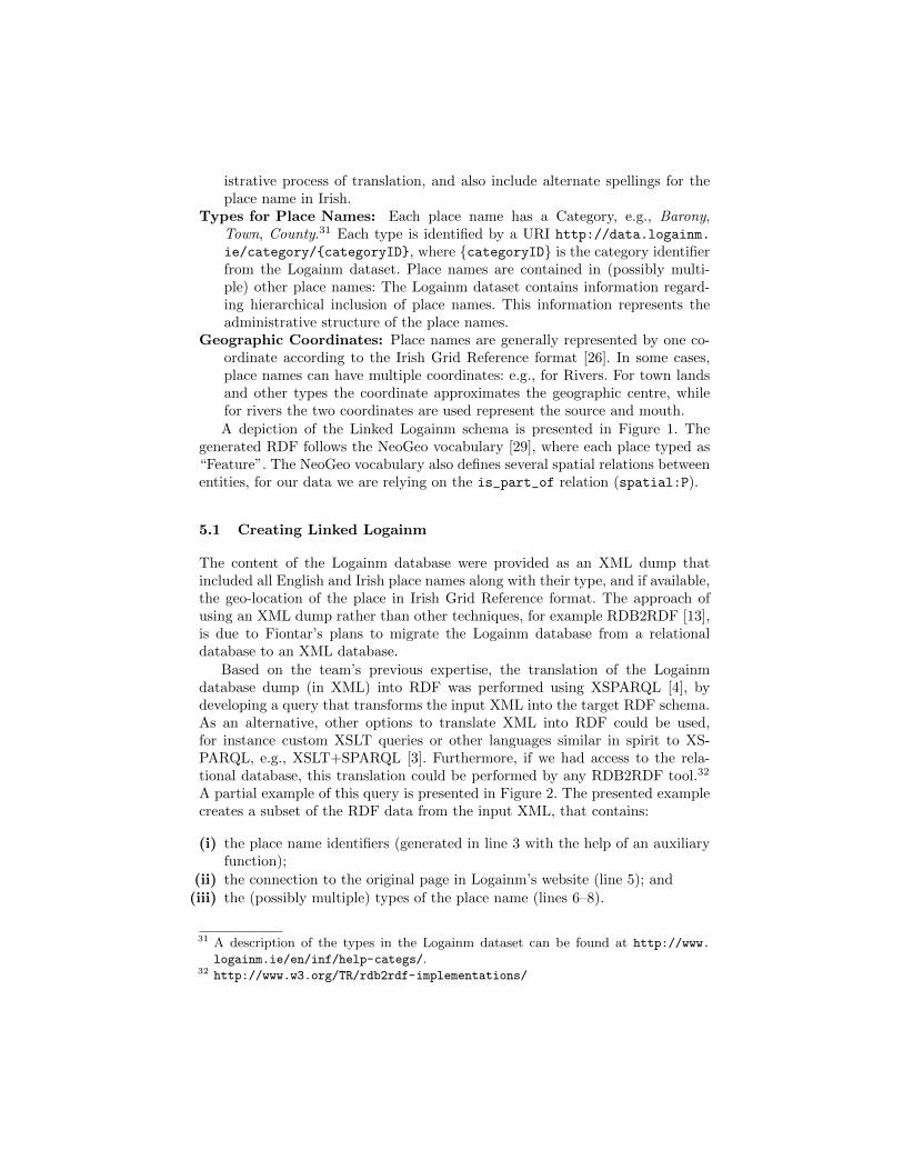
istrative process of translation, and also include alternate spellings for theplace name in Irish.
Types for Place Names: Each place name has a Category, e.g., Barony,Town, County.31 Each type is identified by a URI http://data.logainm.
ie/category/categoryID, where categoryID is the category identifierfrom the Logainm dataset. Place names are contained in (possibly multi-ple) other place names: The Logainm dataset contains information regard-ing hierarchical inclusion of place names. This information represents theadministrative structure of the place names.
Geographic Coordinates: Place names are generally represented by one co-ordinate according to the Irish Grid Reference format [26]. In some cases,place names can have multiple coordinates: e.g., for Rivers. For town landsand other types the coordinate approximates the geographic centre, whilefor rivers the two coordinates are used represent the source and mouth.A depiction of the Linked Logainm schema is presented in Figure 1. The
generated RDF follows the NeoGeo vocabulary [29], where each place typed as“Feature”. The NeoGeo vocabulary also defines several spatial relations betweenentities, for our data we are relying on the is_part_of relation (spatial:P).
5.1 Creating Linked Logainm
The content of the Logainm database were provided as an XML dump thatincluded all English and Irish place names along with their type, and if available,the geo-location of the place in Irish Grid Reference format. The approach ofusing an XML dump rather than other techniques, for example RDB2RDF [13],is due to Fiontar’s plans to migrate the Logainm database from a relationaldatabase to an XML database.
Based on the team’s previous expertise, the translation of the Logainmdatabase dump (in XML) into RDF was performed using XSPARQL [4], bydeveloping a query that transforms the input XML into the target RDF schema.As an alternative, other options to translate XML into RDF could be used,for instance custom XSLT queries or other languages similar in spirit to XS-PARQL, e.g., XSLT+SPARQL [3]. Furthermore, if we had access to the rela-tional database, this translation could be performed by any RDB2RDF tool.32
A partial example of this query is presented in Figure 2. The presented examplecreates a subset of the RDF data from the input XML, that contains:
(i) the place name identifiers (generated in line 3 with the help of an auxiliaryfunction);
(ii) the connection to the original page in Logainm’s website (line 5); and(iii) the (possibly multiple) types of the place name (lines 6–8).
31 A description of the types in the Logainm dataset can be found at http://www.
logainm.ie/en/inf/help-categs/.32 http://www.w3.org/TR/rdb2rdf-implementations/

1 for $place in places/place
2 let $id := fn:data($place/@id)
3 let $URI := local:createURI($id, "place")
4 construct <$URI> a spatial:Feature ;
5 foaf:isPrimaryTopicOf <fn:concat("http://
logainm.ie/",$id,".aspx")> .
6 for $type in $place/type
7 construct <$URI> a < local:createURI(fn:data(
$type/@id), "category") >
8 .
9
Fig. 2. XSPARQL transformation
The target RDF representation contains the information in the original Lo-gainm dataset and also includes the geo-location of the place following the WorldGeodetic System (WGS) coordinates, the reference coordinate system used bythe Global Positioning System (GPS). These coordinates were translated fromthe provided Irish Grid Reference format coordinates and used to aid the deter-mination of links between the Logainm dataset and other Linked Data sourceson the Web.
The Logainm RDF dataset has been deployed in the Logainm website andthe SPARQL endpoint is available at http://data.logainm.ie/sparql/. Theresulting RDF dataset contains approximately 1.3 million triples.
5.2 Linking the datasets
From the relevant sources of Geographic Linked Data, we elected to generatelinks to DBpedia, LinkedGeoData, and Geonames. We used the Silk Link Dis-covery Framework [22] to generate the links between the Logainm RDF datasetand the other target datasets. The Silk framework compares entities from thedifferent datasets according to a pre-defined set of rules and assigns a normalisedvalue (in the interval [0, 1]) to the similarity between entities. The entities withhighest similarity value are considered to be equivalent.
Next we present the set of comparison rules that we devised for establish-ing the links between the datasets. The final rule was based on the followingsimilarity values:
– place name (n);– type of the place name (t);– name of the parent place (p); and– geographic coordinates (g) (if available).
For defining the different similarity values we used the functions and aggregationoperations provided by the Silk framework. For example for comparing the place
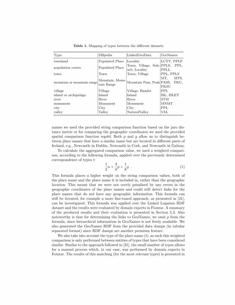
Table 1. Mapping of types between the different datasets
Type DBpedia LinkedGeoData GeoNames
townland Populated Place Locality LCTY, PPLF
population centre Populated PlaceTown, Village, Sub-urb, Locality
PPLS, PPL,PPLL
town Town Town, Village PPL, PPLS
mountain or mountain rangeMountain, Moun-tain Range
Mountain Pass, PeakMT, MTS,PASS, PKU,PKSU
village Village Village, Hamlet PPLisland or archipelago Island Island ISL, ISLETriver River River STMmonument Monument Monument MNMTcity City City PPLvalley Valley NaturalValley VAL
names we used the provided string comparison function based on the jaro dis-tance metric or for comparing the geographic coordinates we used the providedspatial comparison function wgs84. Both p and g allow us to distinguish be-tween place names that have a similar name but are located in different parts ofIreland, e.g., Newcastle in Dublin, Newcastle in Cork, and Newcastle in Galway.
To calculate the aggregated comparison value, we used a weighted compari-son, according to the following formula, applied over the previously determinedcorrespondence of types t:
1
2n +
3
8p +
1
8g . (1)
This formula places a higher weight on the string comparison values, both ofthe place name and the place name it is included in, rather than the geographiclocation. This meant that we were not overly penalised by any errors in thegeographic coordinates of the place names and could still detect links for theplace names that do not have any geographic information. This formula canstill be iterated, for example a more fine-tuned approach, as presented in [31],can be investigated. This formula was applied over the Linked Logainm RDFdataset and the results were evaluated by domain experts in Fiontar. A summaryof the produced results and their evaluation is presented in Section 5.3. Alsonoteworthy is that for determining the links to GeoNames, we omit p from theformula, since hierarchical information in GeoNames is not freely available. Wealso generated the GeoNames RDF from the provided data dumps (in tabularseparated format) since RDF dumps are another premium feature.
We also take into account the type of the place name (t), as such this weightedcomparison is only performed between entities of types that have been consideredsimilar. Similar to the approach followed in [31], the small number of types allowsfor a manual process which, in our case, was performed by domain experts inFointar. The results of this matching (for the most relevant types) is presented in
Table 1. The most problematic types to match were “townland” and “populationcentre”, as these can be mapped to different types in the target datasets. Wehave taken the approach of matching against a more general type (as in thecase of DBpedia) or matching against several types (as in LinkedGeoData andGeoNames).
Linking to the FAST dataset. Given our interest in enhancing library meta-data, we investigated the possibility of linking to existing library subject headingschema available as Linked Data. The Online Computer Library Centre (OCLC)has released the Faceted Application of Subject Terminology (FAST) dataset asLinked Data. FAST is a subject heading vocabulary which is derived from theLibrary of Congress Subject Headings (LCSH), the most widely used subjectvocabulary in the library domain. Although the full LCSH dataset has also beenpublished as Linked Data, the simplified FAST syntax and, in particular, thepresence of GeoNames references in the FAST data made it an easier target formatching with Linked Logainm. However, since FAST in turn contains links tothe Library of Congress Linked Data Service,33 Linked Logainm will also be re-lated to LCSH. We looked at reusing the previously described rules and similarprocess to determine the links, however the FAST data is not structured in sucha way that would make this possible. As an alternative, we have decided to lever-age the links to GeoNames present in FAST and, combined with our own linksto GeoNames, establish an initial set of links from Logainm to FAST. Using thisapproach we matched approximately one third of the Irish geographic entitiespresent in FAST (500 out of 1,400). In order to obtain a complete matchingfrom Logainm to FAST, the datasets were manually linked along with the linkevaluation process (described in the next section). From this manual linking wedetermined approximately 1,000 links to FAST, and for the remaining entitiesno adequate match was found.
5.3 Link Evaluation
From the similarity value that the Silk framework assigns to each link we con-sider only those above 0.95, i.e., the result of Equation (1) is above 0.95.34 Theevaluation of the rules presented in the previous section generated a set of ap-proximately 16,000 links to the different datasets. A breakdown of the numberof links by types and to the different datasets is presented in Table 2. It is note-worthy that the vast majority of links was established for “townlands”, whichwas also the type that was matched to an higher-level type in the target ontolo-gies, and such an approach may introduce errors in the generated links since thematching is being performed against a larger number of entities (all the matchedtype and its subtypes).
33 http://id.loc.gov/34 This specific value was decided by the project partners as an acceptable tradeoff
between the number of generated links and the (possible) link errors introduced bythe automatic process.

Table 2. Number of links between the different datasets
Logainm # Links
Type # Entities DBpedia LinkedGeoData GeoNames Total
townland 61,104 747 4,970 7,024 12,741population centre 2,226 505 1,151 970 2,626town 849 560 688 605 1,853mountain or mountain range 372 63 115 111 289village 142 79 90 10 179island or archipelago 1,087 20 26 120 166river 930 12 4 82 98monument 245 22 36 39 97city 8 8 7 5 20valley 111 1 6 9 16
In order to determine the precision of the links generated between Logainmand the other datasets we manually checked a subset of these links (furtherdetails on the evaluation for each dataset are presented below). The task wasto examine the information provided by each pair of URIs (by accessing theURI with a web browser) and deciding if the suggested matching was correct orincorrect. Since Logainm is a manually curated database, our main focus wasto ensure the correctness of the generated links, thus maintaining the dataset’sreputation of trusted quality data. As such, we are aiming at a higher precisionof the generated links rather than covering all the place names (higher recall).From this manual checking of the links we estimate that the precision of thegenerated set of links is 97%.
Below is a breakdown of the link evaluation per dataset and some of theproblems in the matching:
DBpedia: For DBpedia we manually checked all the generated links, and de-termined a precision of 98%. Some common issues that were encountered inthe generated matching were:
(i) Since Logainm contains more fine-grained information, it can containdifferent entries for “towns”, “population centre”, and “townland” withthe same name. However DBpedia contains only an entry for “town” or“population centre”. For example, Adrigole is a “population centre” anda “townland” in Logainm (with two distinct identifiers, http://data.logainm.ie/place/1412693 and http://data.logainm.ie/place/8649),while in DBpedia Adrigole is only a “village” and both Logainm enti-ties are matched to the same DBpedia entity: http://dbpedia.org/
resource/Adrigole.(ii) Another issue, although less common, is the discrepancy between types
in Logainm and DBpedia. For example, Kentstown is a “townland” inLogainm (http://data.logainm.ie/place/38671), while in DBpediaclassifies it as a “village” (http://dbpedia.org/resource/Kentstown).

One possible solution would be to define relations between the differentdefinitions using SKOS (skos:broader, skos:narrower, etc) and in-clude these mappings in our linking rules
LinkedGeodata: For LinkedGeoData we have checked a random set of 500links from all the generated links (7.5% of all generated links). Within thissubset the precision was of 96%. Also for LinkedGeoData a common sourceof errors were “townlands”, often matching other types in LinkedGeoData.Also the geographic coordinates in between Logainm and LinkedGeoDataare often above the defined offset in our rules (1km), especially for “town-lands”. This suggests that increasing the value of the offset in our rules mayprovide further links to LinkedGeoData but may also increase the numberof incorrect links.
GeoNames: The links to GeoNames provided very accurate results, from thesubset of 500 links (6% of the total generated links) we checked, the precisionwas 99.6%.
FAST: The links to the FAST dataset were manually generated, based onan initial set of approximately 500 links with GeoNames. In this initial setof links, 1.2% were found incorrect, possibly due to errors in the links es-tablished between Logainm and GeoNames. Overall it was not possible todetermine links for approximately 12% of the entities in the FAST dataset toLogainm entities, frequently because no hierarchy nor geographic coordinatesare provided and is thus impossible to distinguish between place names withthe same name across Ireland. Also the FAST database frequently conflates“town”, “townland”, “parish”, and other types. We followed the approachof matching to “town” in Logainm.
A workflow for editing incorrect links was put in place so that any incorrectlinks that may be discovered can be fixed.
6 Applying Linked Logainm to Library Metadata
Our example collection, the Longfield Maps,35 are a collection of 1570 mapsurveys carried out in Ireland between 1770 and 1840. Derived from the mapsthemselves, the existing metadata records include subject headings for coun-ties, baronies, and occasionally parishes. The emphasis on baronies and parishesin this metadata, as well as the presence of minor geographic features in thesurveys, make this collection particularly suitable for linking to the geographicentities found uniquely in the Logainm dataset. The place names stored in themetadata about the maps are in English, preventing any searches for place namesrepresented in the maps to be specified in Irish. We describe ways in which thisproblem may be overcome by relying on Linked Data from the Linked Logainmproject. Our initial approach is to enhance the existing metadata by recordingthe corresponding identifier in the Linked Data version of Logainm.
35 http://catalogue.nli.ie/Collection/vtls000282687
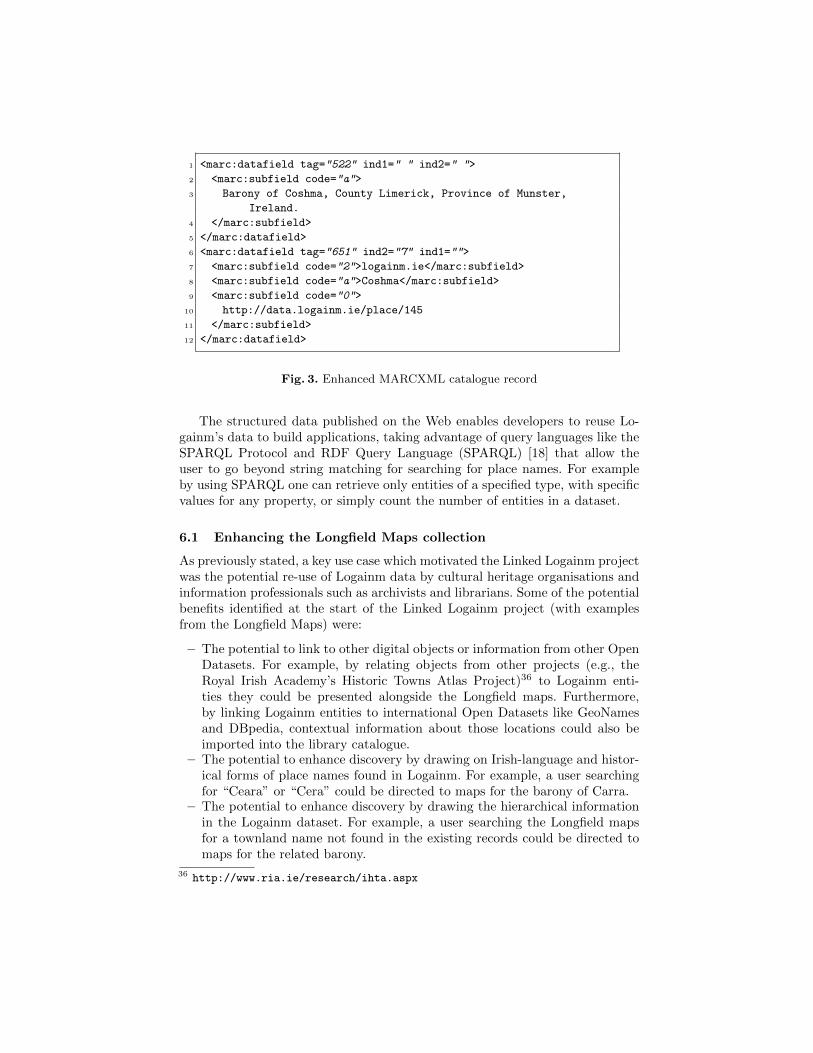
1 <marc:datafield tag="522" ind1=" " ind2=" ">
2 <marc:subfield code="a">
3 Barony of Coshma, County Limerick, Province of Munster,
Ireland.
4 </marc:subfield>
5 </marc:datafield>
6 <marc:datafield tag="651" ind2="7" ind1="">
7 <marc:subfield code="2">logainm.ie</marc:subfield>
8 <marc:subfield code="a">Coshma</marc:subfield>
9 <marc:subfield code="0">
10 http://data.logainm.ie/place/145
11 </marc:subfield>
12 </marc:datafield>
Fig. 3. Enhanced MARCXML catalogue record
The structured data published on the Web enables developers to reuse Lo-gainm’s data to build applications, taking advantage of query languages like theSPARQL Protocol and RDF Query Language (SPARQL) [18] that allow theuser to go beyond string matching for searching for place names. For exampleby using SPARQL one can retrieve only entities of a specified type, with specificvalues for any property, or simply count the number of entities in a dataset.
6.1 Enhancing the Longfield Maps collection
As previously stated, a key use case which motivated the Linked Logainm projectwas the potential re-use of Logainm data by cultural heritage organisations andinformation professionals such as archivists and librarians. Some of the potentialbenefits identified at the start of the Linked Logainm project (with examplesfrom the Longfield Maps) were:
– The potential to link to other digital objects or information from other OpenDatasets. For example, by relating objects from other projects (e.g., theRoyal Irish Academy’s Historic Towns Atlas Project)36 to Logainm enti-ties they could be presented alongside the Longfield maps. Furthermore,by linking Logainm entities to international Open Datasets like GeoNamesand DBpedia, contextual information about those locations could also beimported into the library catalogue.
– The potential to enhance discovery by drawing on Irish-language and histor-ical forms of place names found in Logainm. For example, a user searchingfor “Ceara” or “Cera” could be directed to maps for the barony of Carra.
– The potential to enhance discovery by drawing the hierarchical informationin the Logainm dataset. For example, a user searching the Longfield mapsfor a townland name not found in the existing records could be directed tomaps for the related barony.
36 http://www.ria.ie/research/ihta.aspx

– The potential to use Linked Logainm, along with the linking techniquesdescribed above, as a source against which to clean and normalise legacymetadata during conversion to a standard schema.
Having established the Linked Data URIs for the Logainm dataset, placenames in the National Library’s MARCXML metadata records of the Long-field Maps collection were compared and linked to place names in the Logainmdataset. The MARCXML records contained place names as subdivisions of Top-ical Subject Headings (i.e., the MARC 650 field); however, we decided to useinformation from the Geographic Coverage Note field (i.e., MARC 522 field).Although, this field normally contains free-text, uncontrolled values, in the caseof the Longfield Map records the information had been entered with sufficientconsistency to allow predictable parsing. Most importantly, the information inthis field not only included a place name (n), but also hierarchical informationsuch that the name of the parent place (p) could also be taken into account asper the linking methods described above. We manually checked approximately300 of the 1570 linked records (19%) to determine that the URIs were correctand no errors were found.
In order to show the potential to link to other sources, we have created ademonstrator website that combines information about Irish places from varioussources such as DBpedia (via the established links) and the Longfield Maps butalso other content from Europeana, the Placenames Branch’s digitised archivalrecords, and the Irish Historic Towns Atlas’ Dublin volumes. This demonstratoris available at http://apps.dri.ie/locationLODer.
In terms of enhancing the National Library’s metadata and catalogue, our ini-tial approach is to record the corresponding identifier in the Linked Data versionof Logainm in the bibliographic record. An excerpt of an enhanced record is pre-sented in Figure 3. The URIs was stored in the MARCXML record by adding anew Geographic Name Subject Heading (a MARC 651 field). Standard MARClinking practices were followed as closely as possible: for example the prove-nance of the heading was encoded using the subfield “2” with a second indicatorvalue of 7, while the URI itself was encoded in the Authority Record ControlNumber subfield (subfield “0”). This approach is adequate for maintaining therelationship between the MARCXML record and Linked Logainm; however, it ishoped that as new library encoding standards such as the BIBFRAME initiativeemerge, more standard techniques for relating bibliographic data to Linked Dataresources will be agreed.
6.2 Potential Uses of Linked Logainm
The potential uses of relating bibliographic data to Linked Data include theability to enhance discovery and search. By encoding library vocabularies in amachine-readable format, we bring these advantages into a networked environ-ment and can continue to improve search and discovery systems on the Web. Wecan build systems that reflect the hierarchical nature of vocabularies and therelationships between the entities in them. As a linked bilingual authoritative

database of Irish place names, Logainm offers all the above benefits and uses tolibraries. Each URI in the database contains the authoritative form of the placename as well as any spelling variants and it does this in both Irish and English.The URI for that place name would be stored in the system and would refer-ence both English and Irish versions of that name. A search performed in eitherlanguage or containing a misspelling would then bring up results relating to thecorrect resource leading to more precise search results without loss of recall (thenumber of search results returned).
As it contains information on the counties, baronies, townlands, parishes,and other features of Ireland as well as the relationships between them, Lo-gainm can also act as a knowledge base for hierarchical relationships betweenthese place names and other entities in the database. This could be used insearch and discovery systems for navigation and visualisation of content. Ad-ditionally, as Logainm links to external geographic datasets, information couldbe automatically pulled in to a discovery interface, including images and maps,historical data, census data for the geographic area, related content in other cul-tural institutions and more. This would allow for the display of disparate sourceswhich reference Logainm alongside each other, improving contextualisation andunderstanding of these resources.
Linked Logainm can also be used as a source against which to clean and createconsistency in metadata. Messy metadata is one of the challenges in linkingcollections. Institutions may hold duplicate records, records with variations inthe spelling of personal- and place-names, and typos. These metadata errorscan hamper the effective discovery of content, analysis of data and provisionof quality services to end-users. The use of the Linked Logainm dataset forreconciliation allows the standardisation of Irish geographic place names in bothEnglish and Irish forms in catalogue records. By linking to the Logainm database,the content management system will have access to all the hierarchical andrelated features information stored in Logainm, offering the potential to pull inthis additional information. Linked Logainm also offered authoritative URIs forIrish place names which are linked to other LOD datasets. This allows access todata from external datasets such as Wikipedia and Geonames, which can also bepulled in to provide additional contextual information. Tools that allow users toprocess and clean messy data are becoming available, for instance Open Refine,and it is possible to reuse Linked Data from Open Refine [23] and hence also thenew Linked Logainm dataset.
7 Conclusions and Future Work
In this paper we presented an introduction to Linked Data, authority data andlibraries, and our approach to enhance library records, specifically the NationalLibrary of Ireland’s Longfield Map Collection, with extra authority informationabout the places that are contained in these maps. By using Irish specific Geo-graphic Linked Data, based on Logainm’s data, we presented possible options toalso extend the library’s catalogue to enable searching for place names in Irish.

We also detailed the process of transforming the Logainm dataset into RDFand how to establish the links to other external datasets, namely DBpedia,LinkedGeoData, GeoNames, and the OCLC FAST subject heading schema,along with an initial evaluation of the determined links. Although some issuespresented in this paper are specific to the datasets and the Irish language, forexample the alternate spellings of place names in Irish or the matching of cate-gories between Logainm and the external datasets, the presented methodology,also similar to [31], can be used in other countries with place name translationsin multiple languages. Possible workarounds for these issues could be to rely onannotating the data using SKOS (e.g., using skos:narrower or skos:altLabel)and consider such annotations in the linking rules.
Future Work. Further work can be done in the Silk rules to attempt to obtaina larger number of links. However it should be taken into consideration that theprecision of these links should remain high. Another type of entities whose linkscan be improved are streets, currently a large number of entities in Logainmrefers to street names. Even though streets are present in some of the datasetswe are linking to — DBpedia includes information about the most importantstreets in Dublin and other cities; LinkedGeoData contains streets exported fromOpenStreetMap — our current linking rules do not provide adequate links forstreets. Further work is planned to enhance discovery of the Longfield Mapswith the National Library’s online catalogue. Rather than add to or modifyauthority data stored at the Library management system level at this stage,the planned approach is to index Irish and variant forms of place names foundin Linked Logainm into VuFind, the Library’s discovery interface. This systemhas existing functionality to provide search suggestions based on cross-referencesfound in traditional library authority records (i.e., MARC 4XX authority fields);this functionality will also work for the Linked Logainm forms once correctlyindexed. Furthermore, the National Library is currently evaluating the use ofthe Linked Logainm dataset to help with vocabulary standardisation as partof a conversion of a legacy metadata set which contains approximately 18,000distinct, uncontrolled Irish place names.
Acknowledgements. The work presented in this paper has been funded in partby Science Foundation Ireland under Grants No. SFI/08/CE/I1380 (Lıon-2)and SFI/12/RC/2289. DRI gratefully acknowledges its core funding from HEAPRTLI cycle 5 (NAVR).
References
1. Thomas Baker, Emmanuelle Bermes, Karen Coyle, Gordon Dunsire, Antoine Isaac,Peter Murray, Michael Panzer, Jodi Schneider, Ross Singer, Ed Summers, WilliamWaites, Jeff Young, and ML Zeng. Library linked data incubator group final report.Incubator group report, World Wide Web Consortium, October 2011. URL http:
//www.w3.org/2005/Incubator/lld/XGR-lld-20111025/.

2. Tim Berners-Lee. Linked data design issues, 2006. URL http://www.w3.org/
DesignIssues/LinkedData.3. Diego Berrueta, Jose E. Labra, and Ivan Herman. XSLT+SPARQL : Scripting the
Semantic Web with SPARQL embedded into XSLT stylesheets. In Chris Bizer,Soren Auer, Gunnar Aastrand Grimmes, and Tom Heath, editors, 4th Workshopon Scripting for the Semantic Web, Tenerife, June 2008.
4. Stefan Bischof, Stefan Decker, Thomas Krennwallner, Nuno Lopes, and AxelPolleres. Mapping between RDF and XML with XSPARQL. Journal on DataSemantics, 1:147–185, 2012.
5. Christian Bizer, Tom Heath, and Tim Berners-Lee. Linked Data - The Story SoFar. Int. J. Semantic Web Inf. Syst., 5(3):1–22, 2009.
6. Christian Bizer, Jens Lehmann, Georgi Kobilarov, Soren Auer, Christian Becker,Richard Cyganiak, and Sebastian Hellmann. DBpedia - A crystallization point forthe Web of Data. J. Web Sem., 7(3):154–165, 2009.
7. Luis Manuel Vilches Blazquez, Boris Villazon-Terrazas, Victor Saquicela, Alexan-der de Leon, Oscar Corcho, and Asuncion Gomez-Perez. GeoLinked data andINSPIRE through an application case. In Divyakant Agrawal, Pusheng Zhang,Amr El Abbadi, and Mohamed F. Mokbel, editors, GIS, pages 446–449. ACM,2010.
8. Dan Brickley and R.V. Guha. RDF vocabulary description language 1.0: RDFschema. Technical report, World Wide Web Consortium, February 2004. URLhttp://www.w3.org/TR/rdf-schema/.
9. Gillian Byrne and Lisa Goddard. The strongest link: libraries and linked data.D-Lib Magazine, 16(11/12), November 2010.
10. Karen Coyle. FRBR: the domain model. Library Technology Reports, 46(2):20–25,2010. ISSN 0024-2586 (Print).
11. Karen Coyle. Library data in a modern context. Library Technology Reports, 46(1):5–13, 2010. ISSN 0024-2586 (Print).
12. Karen Coyle. RDA in RDF. Library Technology Reports, 46(2):26–36, 2010.13. Souripriya Das, Seema Sundara, and Richard Cyganiak. R2RML: RDB to RDF
Mapping Language. W3C Recommendation, W3C, September 2012. URL http:
//www.w3.org/TR/2012/REC-r2rml-20120927/.14. Europeana. Europeana data model primer. Technical report, Europeana,
2013. URL http://pro.europeana.eu/documents/900548/770bdb58-c60e-4beb-
a687-874639312ba5.15. John Goodwin, Catherine Dolbear, and Glen Hart. Geographical linked data: The
administrative geography of great britain on the semantic web. Transactions inGIS, 12:19–30, 2008.
16. Alexander Haffner, Jeff Young, and Joachim Neubert. Cluster authority data,September 2011. URL http://www.w3.org/2005/Incubator/lld/wiki/Cluster_
Authority_data.17. Corey A. Harper and Barbara Tillett. Library of congress controlled vocabularies
and their application to the semantic web. Cataloging & Classification Quarterly,43(3/4), 2007.
18. Steve Harris and Andy Seaborne. SPARQL 1.1 Query Language. W3C recommen-dation, W3C, March 2013. URL http://www.w3.org/TR/sparql11-query/.
19. Pascal Hitzler, Markus Krotzsch, Bijan Parsia, Peter F. Patel-Schneider, andSebastian Rudolph. OWL 2 web ontology language primer (second edition).Technical report, World Wide Web Consortium, December 2012. URL http:
//www.w3.org/TR/2012/REC-owl2-primer-20121211/.
20. IFLA Study Group on the Functional Requirements for Bibliographic Records.Functional requirements for bibliographic records: final report, volume 19 of IFLASeries on Bibliographic Control. K.G. Saur Verlag, Munich, 1998. ISBN 3-598-11382-X. URL http://www.ifla.org/files/assets/cataloguing/frbr/frbr_
2008.pdf.21. Antoine Isaac and Ed Summers. SKOS simple knowledge organization system
primer. Technical report, World Wide Web Consortium, August 2009. URL http:
//www.w3.org/TR/skos-primer/.22. Robert Isele, Anja Jentzsch, and Christian Bizer. Silk server - adding missing links
while consuming linked data. In Olaf Hartig, Andreas Harth, and Juan Sequeda,editors, COLD, volume 665 of CEUR Workshop Proceedings. CEUR-WS.org, 2010.
23. Fadi Maali, Richard Cyganiak, and Vassilios Peristeras. Re-using cool URIs: entityreconciliation against LOD hubs. In Proceedings of the Linked Data on the WebWorkshop 2011, volume 813 of CEUR Workshop Proceedings. CEUR-WS.org, 2011.
24. Frank Manola and Eric Miller. RDF Primer. W3C Recommendation, W3C, Febru-ary 2004. URL http://www.w3.org/TR/2004/REC-rdf-primer-20040210/.
25. Eric Miller, Uche Ogbuji, Victoria Mueller, and MacDougall. Bibliographic Frame-work as a web of data: Linked Data model and supporting services. Library ofCongress, 2012. URL http://www.loc.gov/bibframe/pdf/marcld-report-11-
21-2012.pdf.26. Ordnance Survey of Ireland. The Irish Grid – A Description of the Co-ordinate
Reference System used in Ireland. Technical report, Ordnance Survey of Ire-land, 1996. URL http://osi.ie/OSI/media/OSI/Content/Publications/The-
Irish-Grid-A-Description-of-the-Coordinate-Reference-System-Used-in-
Ireland_1.pdf.27. Yves Raimond, Tom Scott, Patrick Sinclair, Libby Miller, Stephen Betts, and
Frances McNamara. Case study: use of semantic web technologies on the BBC websites, January 2012. URL http://www.w3.org/2001/sw/sweo/public/UseCases/
BBC/.28. Pat Riva. FRBR review group initiatives and the world of linked data. JLIS.it, 4
(1):105–117, 2013. ISSN 2038-1026.29. Juan Martın Salas and Andreas Harth. NeoGeo Vocabulary Specification - Madrid
Edition. Public draft, , February 2012. URL http://geovocab.org/doc/neogeo/.30. Amit Singhal. Introducing the knowledge graph: things, not strings, May
2012. URL http://googleblog.blogspot.ie/2012/05/introducing-knowledge-
graph-things-not.html.31. Claus Stadler, Jens Lehmann, Konrad Hoffner, and Soren Auer. Linkedgeodata:
A core for a web of spatial open data. Semantic Web, 3(4):333–354, 2012.32. David Stuart. Facilitating access to the web of data. Facet, London, 2011. ISBN
978-1-85604-745-6.33. Barbara Tillett. What is FRBR?: a conceptual model for the bibliographic uni-
verse. Technicalities, 25(5), 2003. ISSN 0272-0884.34. Daniel Vila-Suero. Library linked data incubator group: use cases. Incubator group
report, World Wide Web Consortium, July 2011. URL http://www.w3.org/2005/
Incubator/lld/wiki/UseCases.