Large-magnitude late Holocene seismic activity in the Pereira-Armenia region, Colombia
12
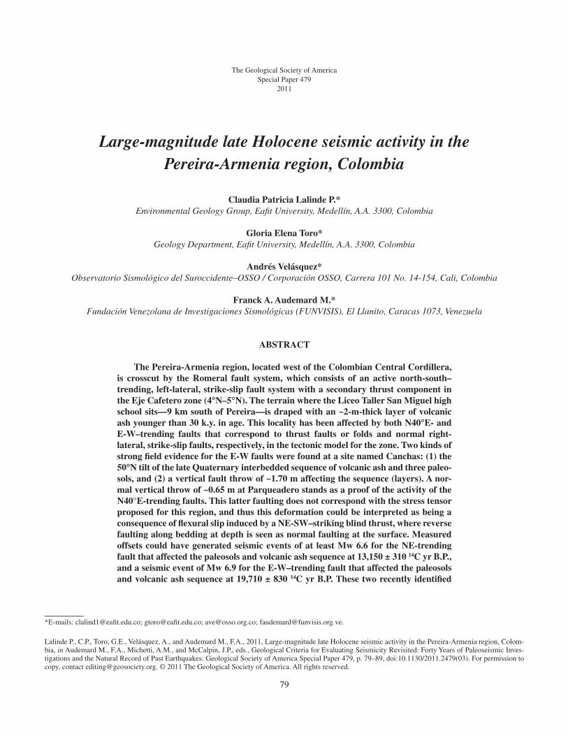
79 The Geological Society of America Special Paper 479 2011 Large-magnitude late Holocene seismic activity in the Pereira-Armenia region, Colombia Claudia Patricia Lalinde P.* Environmental Geology Group, Eafit University, Medellín, A.A. 3300, Colombia Gloria Elena Toro* Geology Department, Eafit University, Medellín, A.A. 3300, Colombia Andrés Velásquez* Observatorio Sismológico del Suroccidente–OSSO / Corporación OSSO, Carrera 101 No. 14-154, Cali, Colombia Franck A. Audemard M.* Fundación Venezolana de Investigaciones Sismológicas (FUNVISIS), El Llanito, Caracas 1073, Venezuela ABSTRACT The Pereira-Armenia region, located west of the Colombian Central Cordillera, is crosscut by the Romeral fault system, which consists of an active north-south– trending, left-lateral, strike-slip fault system with a secondary thrust component in the Eje Cafetero zone (4° °N–5° °N). The terrain where the Liceo Taller San Miguel high school sits—9 km south of Pereira—is draped with an ~2-m-thick layer of volcanic ash younger than 30 k.y. in age. This locality has been affected by both N40° °E- and E-W–trending faults that correspond to thrust faults or folds and normal right- lateral, strike-slip faults, respectively, in the tectonic model for the zone. Two kinds of strong field evidence for the E-W faults were found at a site named Canchas: (1) the 50° °N tilt of the late Quaternary interbedded sequence of volcanic ash and three paleo- sols, and (2) a vertical fault throw of ~1.70 m affecting the sequence (layers). A nor- mal vertical throw of ~0.65 m at Parqueadero stands as a proof of the activity of the N40°E-trending faults. This latter faulting does not correspond with the stress tensor proposed for this region, and thus this deformation could be interpreted as being a consequence of flexural slip induced by a NE-SW–striking blind thrust, where reverse faulting along bedding at depth is seen as normal faulting at the surface. Measured offsets could have generated seismic events of at least Mw 6.6 for the NE-trending fault that affected the paleosols and volcanic ash sequence at 13,150 ± 310 14 C yr B.P., and a seismic event of Mw 6.9 for the E-W–trending fault that affected the paleosols and volcanic ash sequence at 19,710 ± 830 14 C yr B.P. These two recently identified *E-mails: clalind1@eafit.edu.co; gtoro@eafit.edu.co; [email protected]; [email protected]. Lalinde P., C.P., Toro, G.E., Velásquez, A., and Audemard M., F.A., 2011, Large-magnitude late Holocene seismic activity in the Pereira-Armenia region, Colom- bia, in Audemard M., F.A., Michetti, A.M., and McCalpin, J.P., eds., Geological Criteria for Evaluating Seismicity Revisited: Forty Years of Paleoseismic Inves- tigations and the Natural Record of Past Earthquakes: Geological Society of America Special Paper 479, p. 79–89, doi:10.1130/2011.2479(03). For permission to copy, contact [email protected]. © 2011 The Geological Society of America. All rights reserved.
Transcript of Large-magnitude late Holocene seismic activity in the Pereira-Armenia region, Colombia
79
The Geological Society of AmericaSpecial Paper 479
2011
Large-magnitude late Holocene seismic activity in the Pereira-Armenia region, Colombia
Claudia Patricia Lalinde P.*Environmental Geology Group, Eafi t University, Medellín, A.A. 3300, Colombia
Gloria Elena Toro*Geology Department, Eafi t University, Medellín, A.A. 3300, Colombia
Andrés Velásquez*Observatorio Sismológico del Suroccidente–OSSO / Corporación OSSO, Carrera 101 No. 14-154, Cali, Colombia
Franck A. Audemard M.*Fundación Venezolana de Investigaciones Sismológicas (FUNVISIS), El Llanito, Caracas 1073, Venezuela
ABSTRACT
The Pereira-Armenia region, located west of the Colombian Central Cordillera, is crosscut by the Romeral fault system, which consists of an active north-south–trending, left-lateral, strike-slip fault system with a secondary thrust component in the Eje Cafetero zone (4°°N–5°°N). The terrain where the Liceo Taller San Miguel high school sits—9 km south of Pereira—is draped with an ~2-m-thick layer of volcanic ash younger than 30 k.y. in age. This locality has been affected by both N40°°E- and E-W–trending faults that correspond to thrust faults or folds and normal right-lateral, strike-slip faults, respectively, in the tectonic model for the zone. Two kinds of strong fi eld evidence for the E-W faults were found at a site named Canchas: (1) the 50°°N tilt of the late Quaternary interbedded sequence of volcanic ash and three paleo-sols, and (2) a vertical fault throw of ~1.70 m affecting the sequence (layers). A nor-mal vertical throw of ~0.65 m at Parqueadero stands as a proof of the activity of the N40°E-trending faults. This latter faulting does not correspond with the stress tensor proposed for this region, and thus this deformation could be interpreted as being a consequence of fl exural slip induced by a NE-SW–striking blind thrust, where reverse faulting along bedding at depth is seen as normal faulting at the surface. Measured offsets could have generated seismic events of at least Mw 6.6 for the NE-trending fault that affected the paleosols and volcanic ash sequence at 13,150 ± 310 14C yr B.P., and a seismic event of Mw 6.9 for the E-W–trending fault that affected the paleosols and volcanic ash sequence at 19,710 ± 830 14C yr B.P. These two recently identifi ed
*E-mails: clalind1@eafi t.edu.co; gtoro@eafi t.edu.co; [email protected]; [email protected].
Lalinde P., C.P., Toro, G.E., Velásquez, A., and Audemard M., F.A., 2011, Large-magnitude late Holocene seismic activity in the Pereira-Armenia region, Colom-bia, in Audemard M., F.A., Michetti, A.M., and McCalpin, J.P., eds., Geological Criteria for Evaluating Seismicity Revisited: Forty Years of Paleoseismic Inves-tigations and the Natural Record of Past Earthquakes: Geological Society of America Special Paper 479, p. 79–89, doi:10.1130/2011.2479(03). For permission to copy, contact [email protected]. © 2011 The Geological Society of America. All rights reserved.

80 Lalinde P. et al.
INTRODUCTION
Northern South America lies at the junction of the Nazca, Caribbean, and South American plates (Fig. 1). The accumu-lated stress of the plates is released over the Andean block, which includes the Eastern, Central, and Western Cordilleras (Cline et al., 1981; Ego et al., 1996). Holocene intracontinental defor-mation in the Andean block can reactivate older fault systems like the Romeral, which is one of the most important fault systems extending across Colombian territory (Page, 1986).
The Pereira-Armenia region is located west of the Cen-tral Cordillera of Colombia, and it is characterized as a fl uvial fan system (Thouret, 1983). The Romeral fault system, which crosses the Pereira-Armenia fan in a north-south direction, is a left-lateral, strike-slip fault system with a secondary thrust com-ponent. All faults that cross the Pereira-Armenia fan are part of the Romeral fault system. North of 5°N, at present, a maximum NW-SE–oriented horizontal stress (σ
1) is assumed (Guzmán
et al., 1998). According to the deformation model (Silvestre and Smith, 1976 in Yeats et al., 1997; Keller, 1986), the Pereira-Armenia region should display normal faults trending NW, thrust faults trending NE, and right-lateral normal faults trending E-W. The Liceo Taller San Miguel high school is located 9 km south of the city of Pereira, over the upper part of the Pereira-Armenia fan near its apex. In this area, the volcanic ash cover is ~2 m thick and younger than 30 ka (19,710 ± 830 14C yr B.P. and 13,150 ± 310 14C yr B.P.).
Paleoseismic studies in Colombia are needed to comple-ment instrumental records that only cover less than 100 yr and historical records that extend back to the beginning of the six-teenth century. Therefore, the only way of enlarging the seismic record back in time is through the study of paleoseismicity. Our approach is to estimate the maximum seismic event per fault, maximum rupture length, time to the next event, and recurrence interval between equivalent events.
The Pereira-Armenia region became the focus of paleoseis-mic interest in January 1999, when a Mw 6.1 shallow crustal earthquake occurred near the city of Armenia. At that time, the
scientifi c community became aware of the need for a study of intraplate faults and their seismic potential in the Pereira-Armenia region, thus moving beyond the evaluation of the regional seis-mic hazards generated by seismicity of Nazca plate subduction.
For this study, we collected and assessed seismic informa-tion from previous studies in the Pereira-Armenia region. We also studied the volcanic ash sequence that covers the region, going back 50 k.y. Based on the geomorphologic study, fi eldwork, aer-ial photographic interpretation, and the assessment of previous works, we selected different places to study the paleoseismic-ity of the region. One of these places was the Liceo Taller San Miguel, where we mapped two artifi cial exposures made during the building of a school.
Besides the scientifi c interest of the Pereira-Armenia region, important future human settlements and economic developments urgently require a rigorous knowledge of past seismic events in order to reduce uncertainties in seismic hazard assessment.
STUDY AREA
The Pereira-Armenia fan is a torrential volcanic fan, the ori-gin of which is related to the activity of the Ruiz Tolima massif during the past 4.5 m.y., the uprising of the Central Cordillera of Colombia, and movements of the faults that cross the region (Thouret, 1983) (Fig. 1). On the Pereira-Armenia fan surface numerous faults were identifi ed (Fig. 2); anomalous geomor-phologic and topographic features are common, such as folds in its distal part, drainage anomalies, benches, and other anomalies that are diffi cult to explain in relation to the normal evolution of a torrential volcanic fan (e.g., Thouret, 1983; Page, 1986; Guzmán et al., 1998).
A more detailed description of the Pereira-Armenia region shows a very complex fan where 14 geomorphologic units are recognized (Lalinde, 2004). Despite these efforts, the sequence of events that formed the Pereira-Armenia fan and their precise chronology are not well known. More detailed investigation is needed to identify the different volcano-sedimentary events, gain more precise knowledge of their chronology, and interpret their
faults are now named the Tribunas (NE-SW) and the Cestillal (E-W) faults. Up to now, the fault and its seismogenic potential determinations in this region have been based solely on morphologic evidence. The maximum seismic magnitude estimated for this region ranged from Mw 6.2 to Mw 6.6 for seismic sources 35 km away from the site. Seismic magnitudes like the one calculated in this work (Mw 6.9) were previ-ously estimated only for source-site distances greater than 50 km. This work provides fi eld evidence that leads to a better understanding of the seismic activity of this region in the last 30 k.y. and confi rms the occurrence of local Mw >6.5 seismic events in this region. Although volcanic ash drapes and eventually hides the geomorphic evidence of active deformation, it turns out to be a perfect chronometer of a fault’s activity whenever the deformation is revealed, as in this case. After the Armenia event of 1999, it is imperative to examine the seismic hazard assessments of this region in terms of local crustal seismicity.

Large-magnitude late Holocene seismic activity in the Pereira-Armenia region, Colombia 81
paleoseismic information. We interpret the main scarps in the fan as fault movements. Though there is also an erosional com-ponent, based on the available information, it is not possible to resolve this component. By knowing the fan terrace surfaces and their ages, these two components can eventually be separated in the future.
Lalinde (2004) described the Pereira-Armenia fan based on topographic profi les (scale 1:25,000) as follows:
(1) The Pereira-Armenia fan is highest in the northern and middle parts, and its height gradually decreases to the south from the Roble River. This is evident in the N-S profi les B–Bʹ, C–Cʹ, and F–Fʹ (Figs. 3 and 4). In the distal part, the fan shows a fl at surface (Figs. 3 and 4, profi les N–Nʹ, H–Hʹ), with some uplifted blocks that could be the result of erosional and tectonic pro-cesses. These rivers are more incised on the eastern part of the fan than to the west. Depth changes in the river profi les suggest active tectonism and vertical movement associated with E-W faults. West of the fan, there is a series of steps that corresponds to N30°–60°E faults.
(2) The NW profi les show the same evidence in the northern and southern parts of the fan and suggest a division at Cestillal drainage or Barbas River. This change corresponds to the trace of Cestillal fault (Figs. 3 and 4).
(3) The NE profi les confi rm the differences between the north and south parts of the fan (Figs. 3 and 4). As mentioned already, the Pereira-Armenia fan is crossed by numerous faults that belong to the Romeral fault system (Fig. 2) (Thouret, 1983; Page, 1986; Guzmán et al., 1998). Among them, here we report two important faults with evidence of activity at Liceo Taller San Miguel that were not previously defi ned (Figs. 2, 5, and 6). These faults are the Cestillal fault and Tribunas fault.
Cestillal Fault
The Cestillal fault is an EW/50°S normal fault that crosses the Pereira-Armenia fan. In the topographic profi les (Figs. 3 and 4), the northern block appears to be 50 m high; part of this dis-placement could be due to the erosional process. This fault is not
Figure 1. The study zone, Pereira-Armenia fan, located in the western fl ank of the Central Cordillera (C.C.), and a part of the Andean block. Figure is modifi ed from Taboada et al. (2000). The movement vectors are from Freymueller et al. (1993) and Kellogg and Vega (1995).
1.7 cm/yrN
6.4 cm/yr
Nazca plate
Caribbean plate
Santa Marta
Medellín
Bogotá
Cali
Volcanic MassifRuiz Tolima
BuenaventuraVillavicencio
Tunja
South American plate
Cauca
Rive
r
Mag
dale
na R
iver
Rom
era
l fault
syst
em
Ibague F.
C.C.C.W. C.E.
C.W.
C.C.
C.E.
Algecir
as fa
ult
Altam
ira fa
ultYop
al fa
ult
Salin
as fault s
yste
m
Ura
mita
fault
Sta
Marta
– B
ucara
manga fa
ult
Oca fault
Western Cordillera
Central Cordillera
Eastern Cordillera
Thrust fault
Normal fault
Strike-slip fault
Garrapatas fa
ult
Pacific Ocean
Panamá
Caribbean Sea
MaracaiboBasin
Llanos Orientales
Andean block
0.8 cm/yr
Study zonePereira-Armenia fan(see Fig. 2)
4°
Pereira
Armenia
Coiba microplate
8°
6°
10°
12°N
73°W75°W77°W79°W81°W
River
Ocean
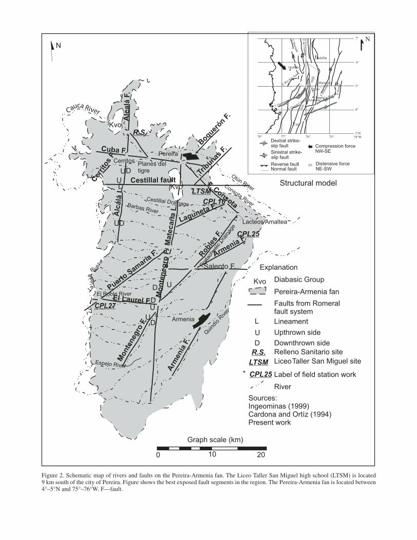
Figure 2. Schematic map of rivers and faults on the Pereira-Armenia fan. The Liceo Taller San Miguel high school (LTSM) is located 9 km south of the city of Pereira. Figure shows the best exposed fault segments in the region. The Pereira-Armenia fan is located between 4°–5°N and 75°–76°W. F—fault.
Graph scale (km)
0 10 20
*
*
*
*
*
Armenia
Qui
ndío
River
Armenia F.
Salento F.
CPL25
Roble
s F.
Por
tach
uelo
Dra
inag
e
CPL10
Mate
cañ
a L
.
Pereira
Puerto S
amaria
F.
Mo
nte
neg
ro F
.
El Roble RiverD U
DU
UD
Barbas River
UD
Cestillal Drainage
Cestillal fault
UD
Boquer
ón F.
Kvo
Kvo
Otún RiverConsota River
F. Consota
Lacteos Amaltea
Alc
alá
L.
Cer
rito
s F.
Cuba F.
R.S.
Laguneta F.
CerritosPlanes deltigre
Monte
negro
F.
Arm
enia
F.
UD
Espejo River
Explanation
Pereira-Armenia fan
Faults from Romeralfault system
U Upthrown side
D Downthrown side
LTSM
LTSMR.S. Relleno Sanitario site
Liceo Taller San Miguel site
Kvo Diabasic Group
Sources:Ingeominas (1999)Cardona and Ortíz (1994)Present work
CPL27
N
Alc
alá
F.
L Lineament
El Laurel F.
Trib
unas F
.
* CPL25 Label of field station work
River
re
i vR aj ei
V aL
Reverse faultNormal fault
Sinistral strike- slip fault
Dextral strike-slip fault Compression force
NW-SE
Distensive forceNE-SW
Cali
ArmeniaIbagué
Manizales
Pereira
Quibdó
Medellín
4°
5°
6°
7°
3°N74°W75°76°77°78°
F. Dagua Calima
F. Garrapatas
F. Río San Ju
an
F. Murindó
F de Uram
ita
F. H
onda
F. Pa
lestin
a
F. Ibagué
N
Structural model
Cauca River
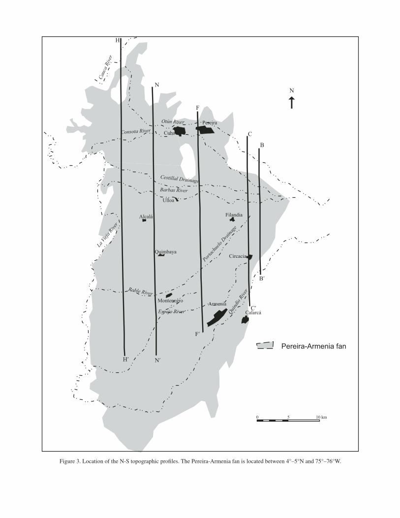
Figure 3. Location of the N-S topographic profi les. The Pereira-Armenia fan is located between 4°–5°N and 75°–76°W.
F
N
B
C
Hʹ Nʹ
Fʹ
Cʹ
Bʹ
Ulloa
Alcalá Filandia
CircaciaQuimbaya
Montenegro Armenia
Calarcá
Cauc
a Ri
ver
Otún River
Consota River
Cestillal Drainage
La Vi
eja R
iver
Roble River
Espejo River Quindío
Rive
r
Portac
huelo
Drai
nage
H
Barbas River
5 10 km0
Pereira
Cuba
N
Pereira-Armenia fan

84
Dis
tanc
e (k
m)
Height (m) 1500
1600
1700
1800
1900
2000
2100
05
1015
2025
Otún River
Consota River
Barbas RiverLacha Drainage
El Chorro Drainage
Roble River
Quindio River
B–B
´ Pro
file
Height (m) 1400
Dis
tanc
e (k
m)
1500
1600
1700
1800
1900
2000
05
1015
2025
30
C–C
´ Pro
file
Otún River
San Pablo Drainage
Consota River
Barbas River
Aguaserena Drainage
Membrillal Drainage
Roble River
Quindío River
Height (m)
Dis
tanc
e (k
m)
1200
1300
1400
1500
1600
1700
010
2030
F–F´
Pro
file
Otún RiverDosquebradas Drainage
Consota River
El Oso Drainage
Cestillal DrainageBarbas River
Roble River
Hojasanchas Drainage
Height (m)
N–N
´ Pro
file
1000
1100
1200
1300
1400
1500
1600
020
4060
Otún RiverConsota River
Cestillal Drainage
Los Angeles Drainage
San Felipe Drainage
Buenavista DrainageQuimbaya Town
Roble River
Espejo River
Dis
tanc
e (k
m)
Height (m)
850
950
1050
1150
1250
1350
1450
010
2030
4050
60
H–H
´ Pro
file
Otún River
Cauca River
Tributary of Otún River
Consota River
Cestillal DrainageBarbas RiverLos Angeles Drainage
San Felipe Drainage
Campoalegre Drainage
Buenavista Drainage
Roble River
Espejo River
Montenegro Town
Dis
tanc
e (k
m)
NS
NS
N
NS
NS
Cestillal fault
S
Figu
re 4
. N-S
topo
grap
hic
profi
les.
The
re a
re a
lot o
f to
pogr
aphi
c an
omal
ies
in th
e Pe
reir
a-A
rmen
ia f
an.
In t
he H
–Hʹ
profi
le,
note
the
top
ogra
phic
ano
mal
y th
at c
or-
resp
onds
to th
e C
estil
lal f
ault.
In
the
othe
r pr
ofi le
s, th
is f
ault
is n
ot c
lear
; thi
s co
uld
be b
ecau
se o
f th
e m
ajor
cov
er o
f vo
lcan
ic a
sh fa
ll an
d pa
leos
ols
or s
ome
Qua
tern
ary
depo
sits
that
are
not
yet
iden
tifi e
d in
the
regi
on.
Large-magnitude late Holocene seismic activity in the Pereira-Armenia region, Colombia 85
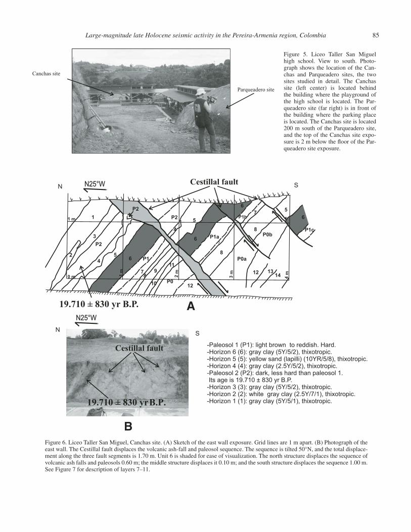
Figure 5. Liceo Taller San Miguel high school. View to south. Photo-graph shows the location of the Can-chas and Parqueadero sites, the two sites studied in detail. The Canchas site (left center) is located behind the building where the playground of the high school is located. The Par-queadero site (far right) is in front of the building where the parking place is located. The Canchas site is located 200 m south of the Parqueadero site, and the top of the Canchas site expo-sure is 2 m below the fl oor of the Par-queadero site exposure.
Canchas site
Parqueadero site
Figure 6. Liceo Taller San Miguel, Canchas site. (A) Sketch of the east wall exposure. Grid lines are 1 m apart. (B) Photograph of the east wall. The Cestillal fault displaces the volcanic ash-fall and paleosol sequence. The sequence is tilted 50°N, and the total displace-ment along the three fault segments is 1.70 m. Unit 6 is shaded for ease of visualization. The north structure displaces the sequence of volcanic ash falls and paleosols 0.60 m; the middle structure displaces it 0.10 m; and the south structure displaces the sequence 1.00 m. See Figure 7 for description of layers 7–11.
Cestillal fault
19.710 ± 830 yr B.P.
2
1
3
P2
4
P2
56 P1
78
9
10
11
P012
P2
4
5
6 P1a7
8
12
P0a
1314
6
P1b7
8P0b
6
5
P1c
1 m
0 m 1 m
2 m
3 m
4 m
Cestillal fault
19.710 ± 830 yr B.P. A
B
S
S
N
N
N25°W
N25°W
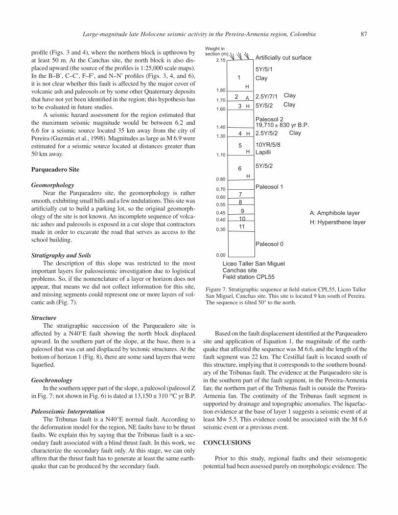
-Paleosol 1 (P1): light brown to reddish. Hard.-Horizon 6 (6): gray clay (5Y/5/2), thixotropic.-Horizon 5 (5): yellow sand (lapilli) (10YR/5/8), thixotropic.-Horizon 4 (4): gray clay (2.5Y/5/2), thixotropic.-Paleosol 2 (P2): dark, less hard than paleosol 1. Its age is 19.710 ± 830 yr B.P. -Horizon 3 (3): gray clay (5Y/5/2), thixotropic.-Horizon 2 (2): white gray clay (2.5Y/7/1), thixotropic.-Horizon 1 (1): gray clay (5Y/5/1), thixotropic.
86 Lalinde P. et al.
clear in aerial photographs, which could be related to volcanic ash draping. The Cestillal fault has not been previously mapped or reported, so there is no information to confi rm that this fault is 35 km long. Evidence of this segment is a change in course of the La Vieja River (Fig. 2), where it changes its direction from N-S to E-W near the mouths of the Barbas and Consota Rivers, and the change in the course of the Cauca River near Cartago city (Fig. 2).
Tribunas Fault
This is a N40°E normal fault that could be a secondary fault related to a blind thrust fault. The Tribunas fault is not very clear in the aerial photographs, but some drainage anomalies exist in the trace of the fault, such as a displacement of the Consota River. This fault occurs in the upper part of the Pereira-Armenia fan.
DESCRIPTION OF LICEO TALLER SAN MIGUEL
The landscape at Liceo Taller San Miguel is rather smooth, exhibiting small hills and undulations. Stream incision is super-fi cial, and in some sites, it is common to fi nd topographic depres-sions near the streams, which in general are oriented N40°–50°E. This land is used for recreational purposes, cattle grazing, and cultivation. Liceo Taller San Miguel is a high school situated on the Pereira-Armenia fan, and it lies 9 km south of the city of Pereira, near the road that links the cities of Pereira and Armenia (Fig. 2). The geographic location of Liceo Taller San Miguel high school is 4°44ʹ56.17ʺN, 75°40ʹ28.56ʺW (WGS84 interna-tional spheroid). During the building of the high school, some artifi cial outcrops were created, which happened to reveal very useful neotectonic information. We selected two specifi c places that showed evidence of recent tectonic activity. These places are the so-called Canchas site and the Parqueadero site. The Canchas site is located ~200 m south of the Parqueadero site, and the roof of the Canchas site is ~2 m below the fl oor of the Parqueadero site. Volcanic ashes cap these sites with a thickness of over 4 m.
Canchas Site
GeomorphologyNear the Canchas site, the landscape is rather smooth,
exhibiting small hills and a few undulations. Stream incision is superfi cial, and in some sites, it is common to fi nd topographic depressions near the streams. This site has human affectation and does not have the complete stratigraphic sequence. The most recent affectation was the artifi cial cut surface created for a bas-ketball court.
Stratigraphy and SoilsAt the Canchas site, the Pereira-Armenia fan is covered by a
sequence of volcanic ashes and paleosols (Fig. 6). We identifi ed two paleosols that represent periods of extended nondeposition of
volcanic ash, or if there were some deposition of volcanic ashes, it was not enough to interrupt soil formation. Between these two pedogenic periods, there are three altered volcanic ash horizons. We consider that the stratigraphic sequence is incomplete due to pre-Columbian human activity, at least before 2500 yr B.P. (Cano, 2004). Because of the artifi cial cut, we do not know what the natural surface looked like.
StructureThe sequence of paleosols and volcanic ashes at Canchas
site is tilted 50°N and displaced or cut by three faults (Fig. 6). The throws of these three faults, from north to south, are 0.60 m, 0.10 m, and 1.00 m, respectively. The minimum cumulative offset of the volcanic ash layer and paleosol in this fault zone sequence is thus 1.70 m. So, the tilt of the sequence could be the result of a seismic event previous to the one that cut it off. However, this normal faulting does not trend as expected from the regional deformation model, which would be produced by a NW-SE–striking maximum horizontal stress, as proposed by Guzmán et al. (1998).
We assume that the displacement of the sequence took place in one seismic event, because if it were the result of two or three different events, we would have found some evidence of that in the layers that were displaced in the fi rst event. The problem is that the sequence is incomplete, so we currently interpret this evi-dence as the result of only one event that displaced the sequence of volcanic ashes and paleosols at the same time. We are assum-ing this because it would be the worst-case scenario in a region where we do not know the seismic potential of faults that cross it. The Armenia earthquake (1999) suggests that the seismic potential of the region is higher than we anticipated. Using the displacement identifi ed at the Canchas site, we have applied the equations for all fault types that relate magnitude and maximum surface displacement, i.e., the equation based on moment magni-tude (M; Wells and Coppersmith, 1994; McCalpin et al., 1996):
M = 6.9 + 0.74(log MD) and log (SRL) = –3.22 + 0.69M, (1)
where M is the moment magnitude, MD is maximum displace-ment in m, and SRL is the surface rupture length in km. We found that the magnitude of the earthquake that affected the sequence was M 6.9, and the length of the fault segment was 35 km.
GeochronologyThe upper (youngest preserved) paleosol was radiocarbon
dated at 19,710 ± 830 yr B.P. (Fig. 6).
Paleoseismic InterpretationWe propose coeval faulting and folding, where normal fault-
ing was produced by moment bending during sequence fold-ing. As mentioned previously, the Pereira-Armenia fan is 25 km wide and is covered by paleosols and volcanic ashes. This means that the Cestillal fault is covered by the same kind of soils along 25 km. An evidence of this fault can be observed in the H–Hʹ
Large-magnitude late Holocene seismic activity in the Pereira-Armenia region, Colombia 87
profi le (Figs. 3 and 4), where the northern block is upthrown by at least 50 m. At the Canchas site, the north block is also dis-placed upward (the source of the profi les is 1:25,000 scale maps). In the B–Bʹ, C–Cʹ, F–Fʹ, and N–Nʹ profi les (Figs. 3, 4, and 6), it is not clear whether this fault is affected by the major cover of volcanic ash and paleosols or by some other Quaternary deposits that have not yet been identifi ed in the region; this hypothesis has to be evaluated in future studies.
A seismic hazard assessment for the region estimated that the maximum seismic magnitude would be between 6.2 and 6.6 for a seismic source located 35 km away from the city of Pereira (Guzmán et al., 1998). Magnitudes as large as M 6.9 were estimated for a seismic source located at distances greater than 50 km away.
Parqueadero Site
GeomorphologyNear the Parqueadero site, the geomorphology is rather
smooth, exhibiting small hills and a few undulations. This site was artifi cially cut to build a parking lot, so the original geomorph-ology of the site is not known. An incomplete sequence of volca-nic ashes and paleosols is exposed in a cut slope that contractors made in order to excavate the road that serves as access to the school building.
Stratigraphy and SoilsThe description of this slope was restricted to the most
important layers for paleoseismic investigation due to logistical problems. So, if the nomenclature of a layer or horizon does not appear, that means we did not collect information for this site, and missing segments could represent one or more layers of vol-canic ash (Fig. 7).
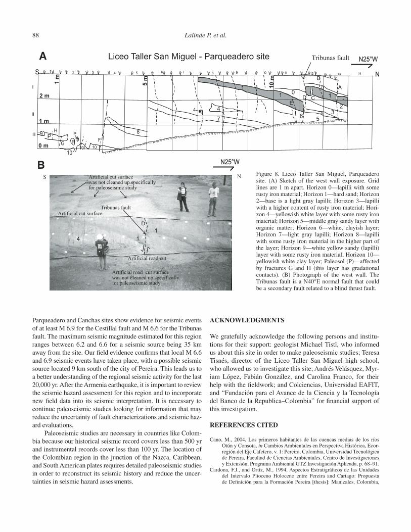
StructureThe stratigraphic succession of the Parqueadero site is
affected by a N40°E fault showing the north block displaced upward. In the southern part of the slope, at the base, there is a paleosol that was cut and displaced by tectonic structures. At the bottom of horizon 1 (Fig. 8), there are some sand layers that were liquefi ed.
GeochronologyIn the southern upper part of the slope, a paleosol (paleosol Z
in Fig. 7; not shown in Fig. 6) is dated at 13,150 ± 310 14C yr B.P.
Paleoseismic InterpretationThe Tribunas fault is a N40°E normal fault. According to
the deformation model for the region, NE faults have to be thrust faults. We explain this by saying that the Tribunas fault is a sec-ondary fault associated with a blind thrust fault. In this work, we characterize the secondary fault only. At this stage, we can only affi rm that the thrust fault has to generate at least the same earth-quake that can be produced by the secondary fault.
Based on the fault displacement identifi ed at the Parqueadero site and application of Equation 1, the magnitude of the earth-quake that affected the sequence was M 6.6, and the length of the fault segment was 22 km. The Cestillal fault is located south of this structure, implying that it corresponds to the southern bound-ary of the Tribunas fault. The evidence at the Parqueadero site is in the southern part of the fault segment, in the Pereira-Armenia fan; the northern part of the Tribunas fault is outside the Pereira-Armenia fan. The continuity of the Tribunas fault segment is supported by drainage and topographic anomalies. The liquefac-tion evidence at the base of layer 1 suggests a seismic event of at least Mw 5.5. This evidence could be associated with the M 6.6 seismic event or a previous event.
CONCLUSIONS
Prior to this study, regional faults and their seismogenic potential had been assessed purely on morphologic evidence. The
Figure 7. Stratigraphic sequence at fi eld station CPL55, Liceo Taller San Miguel, Canchas site. This site is located 9 km south of Pereira. The sequence is tilted 50° to the north.
Liceo Taller San MiguelCanchas siteField station CPL55
A: Amphibole layer
H: Hypersthene layer
3
2
1
Paleosol 2
4
5
6
Paleosol 1
Paleosol 0
7
8
9
10
11
H
H
H
H
H
A
5Y/5/2
Clay
10YR/5/8
Lapilli
2.5Y/7/1
Clay
5Y/5/2 Clay
Clay
5Y/5/1
Artificially cut surface
0.00
0.30
0.45
0.40
0.55
0.60
0.70
0.80
1.10
1.30
1.40
1.60
1.70
1.80
2.15
2.5Y/5/2
19,710 ± 830 yr B.P.
Weight insection (m)
88 Lalinde P. et al.
Parqueadero and Canchas sites show evidence for seismic events of at least M 6.9 for the Cestillal fault and M 6.6 for the Tribunas fault. The maximum seismic magnitude estimated for this region ranges between 6.2 and 6.6 for a seismic source being 35 km away from the site. Our fi eld evidence confi rms that local M 6.6 and 6.9 seismic events have taken place, with a possible seismic source located 9 km south of the city of Pereira. This leads us to a better understanding of the regional seismic activity for the last 20,000 yr. After the Armenia earthquake, it is important to review the seismic hazard assessment for this region and to incorporate new fi eld data into its seismic interpretation. It is necessary to continue paleoseismic studies looking for information that may reduce the uncertainty of fault characterizations and seismic haz-ard evaluations.
Paleoseismic studies are necessary in countries like Colom-bia because our historical seismic record covers less than 500 yr and instrumental records cover less than 100 yr. The location of the Colombian region in the junction of the Nazca, Caribbean, and South American plates requires detailed paleoseismic studies in order to reconstruct its seismic history and reduce the uncer-tainties in seismic hazard assessments.
ACKNOWLEDGMENTS
We gratefully acknowledge the following persons and institu-tions for their support: geologist Michael Tistl, who informed us about this site in order to make paleoseismic studies; Teresa Tisnés, director of the Liceo Taller San Miguel high school, who allowed us to investigate this site; Andrés Velásquez, Myr-iam López, Fabián González, and Carolina Franco, for their help with the fi eldwork; and Colciencias, Universidad EAFIT, and “Fundación para el Avance de la Ciencia y la Tecnología del Banco de la Republica–Colombia” for fi nancial support of this investigation.
REFERENCES CITED
Cano, M., 2004, Los primeros habitantes de las cuencas medias de los ríos Otún y Consota, in Cambios Ambientales en Perspectiva Histórica, Ecor-región del Eje Cafetero, v. 1: Pereira, Colombia, Universidad Tecnológica de Pereira, Facultad de Ciencias Ambientales, Centro de Investigaciones y Extensión, Programa Ambiental GTZ Investigación Aplicada, p. 68–91.
Cardona, F.J., and Ortíz, M., 1994, Aspectos Estratigráfi cos de las Unidades del Intervalo Plioceno Holoceno entre Pereira and Cartago: Propuesta de Defi nición para la Formación Pereira [thesis]: Manizales, Colombia,
1 2 3 4 5S
I
II
IIIIH
G
10
9
10
8
F
6 7 8 9 10
1
4
7
4
11 12 13 14
6
A
DE
5
10
4 3
C
2
11
0
BN
PP
P
1 m
0 m
1 m
2 m
5 m
10 m
Liceo Taller San Miguel - Parqueadero site Tribunas fault
10
N25°W
Tribunas fault
NS Artificial cut surfacewas not cleaned up specificallyfor paleoseismic study
1
1
D
4
Artificial cut surface
Artificial road cut
Artificial road cut surfacewas not cleaned up specificallyfor paleoseismic study
N25°W
A
BFigure 8. Liceo Taller San Miguel, Parqueadero site. (A) Sketch of the west wall exposure. Grid lines are 1 m apart. Horizon 0—lapilli with some rusty iron material; Horizon 1—hard sand; Horizon 2—base is a light gray lapilli; Horizon 3—lapilli with a higher content of rusty iron material; Hori-zon 4—yellowish white layer with some rusty iron material; Horizon 5—middle gray sandy layer with organic matter; Horizon 6—white, clayish layer; Horizon 7—light gray lapilli; Horizon 8—lapilli with some rusty iron material in the higher part of the layer; Horizon 9—white yellow sandy (lapilli) layer with some rusty iron material; Horizon 10—yellowish white clay layer; Paleosol (P)—affected by fractures G and H (this layer has gradational contacts). (B) Photograph of the west wall. The Tribunas fault is a N40°E normal fault that could be a secondary fault related to a blind thrust fault.
Large-magnitude late Holocene seismic activity in the Pereira-Armenia region, Colombia 89
Caldas University–Corporación Autónoma Regional de Risaralda, 124 p., plus annex.
Cline, K.M., Hutchings, L., Page, W.D., and Jaramillo, J.M., 1981, Quaternary tectonics of north west Colombia: Bogotá: Revista Centro de Investig-ación y Desarrollo en Información Geográfi ca del Instituto Geográfi co Agustín Codazzi (CIAF), v. 6, p. 1–3.
Ego, F., Sebrier, M., Lavenu, A., Yepes, H., and Egues, A., 1996, Quaternary state of stress in the northern Andes and the restraining bend model for the Ecuadorian Andes: Physics and Evolution of the Earth’s Interior, v. 1, p. 101–116.
Freymueller, J., Kellogg, J., and Vega, V., 1993, Plate motions in the North Andean region: Journal of Geophysical Research, v. 98, p. 21,853–21,863, doi:10.1029/93JB00520.
Guzmán, J., Franco, G., and Ochoa, M., 1998, Informe Final Evaluación Neo-tectónica. Proyecto para la Mitigación del Riesgo Sísmico de Pereira, Dosquebradas and Santa Rosa de Cabal: Pereira, Carder, 148 p.
Ingeominas, 1999, Informe Técnico Científi co del Terremoto del Quindío (Morales, C., López, E., Mora, H., Monsalve, H., Nieto, A., Gil, F., Oso-rio, J., Escallón, J., Bermúdez, M., Martínez, S., Bermúdez, A., Esquivel, J., Vásquez, L., Espinosa, A., Jiménez, E., and Vergara, H., eds.), v. I: Bogotá, Colombia, 34 p.
Keller, E., 1986, Investigation of active tectonics: Use of surfi cial earth pro-cesses, in Wallace, R., ed., Active Tectonics: Studies in Geophysics: Washington, D.C., National Academy Press, p. 136–147.
Kellogg, J., and Vega, V., 1995, Tectonic development of Panama, Costa Rica and the Colombian Andes, in Mann, P., ed., Geologic and Tectonic Devel-opment of the Caribbean Plate Boundary in South Central America: Geo-logical Society of America Special Paper 295, p. 75–89.
Lalinde, C.P., 2004, Evidencias Paleosismicas en la Región Pereira-Armenia, Colombia [Master’s thesis]: Medellín, Colombia, EAFIT University, 149 p., plus annex.
McCalpin, J.P., Nelson, A.R., Hackett, W.R., Jackson, S.M., Smith, R.P., Carver, G., Weldon, R.J., II, Rockwell, T.K., Obermeier, S.F., and Jibson, R.W., 1996, Paleoseismology: San Diego, California, Academic Press, 588 p.
Page, W., 1986, Geología Sísmica del Noroccidente Colombiano: Medellín, Colombia, Report from Woodward Clyde Consultants to ISA and Inte-gral, 156 p., plus appendix and fi gures.
Taboada A., Rivera, L.A., Fuenzalida, A., Cisternas, A., Philip, H., Bijwaard, H., Olaya, J., and Rivera, C., 2000, Geodynamics of the Northern Andes: Subductions and Intracontinental Deformation (Colombia): Bogotá, Special Publication Asociación de Ingeniería Sísmica (AIS), 28 p., plus fi gures.
Thouret, J.C., 1983, Presentación geológica y geomorfoestructural, in Van der Hammen, T., Pérez, A., and Pinto, P., eds., Estudios de Ecosistemas Tro-pandinos, La Cordillera Central Colombiana, Transecto Parque Los Neva-dos (Introducción y Datos Iniciales), v. I: Berlin, Gebruder Borntraeger, Proyecto Ecoandes y Ecodinámico, p. 48–55.
Wells, D.L., and Coppersmith, K.J., 1994, Empirical relationship among mag-nitude, rupture length, rupture area, and surface displacement: Bulletin of the Seismological Society of America, v. 84, p. 974–1002.
Yeats, R., Sieh, K., and Allen, C., 1997, The Geology of Earthquakes: New York, Oxford University Press, 568 p.
MANUSCRIPT ACCEPTED BY THE SOCIETY 7 DECEMBER 2010
Printed in the USA