Land Use Transition, Livelihoods, and Environmental Services in Montane Mainland Southeast Asia
18
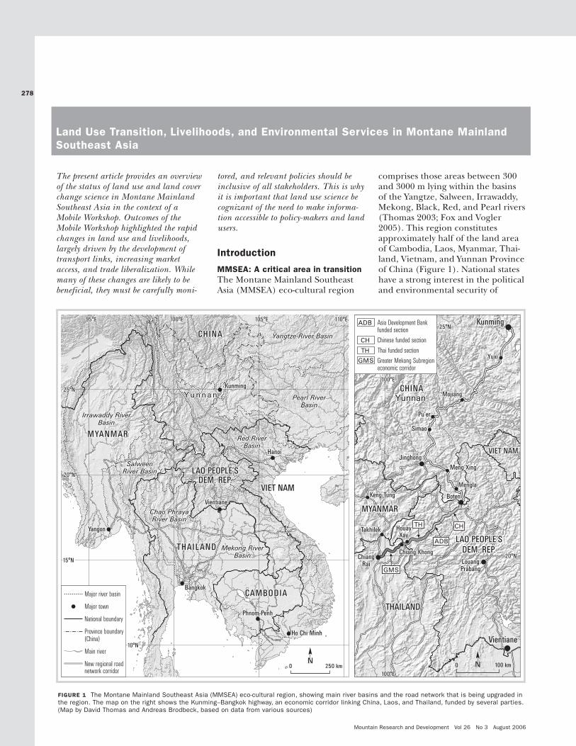
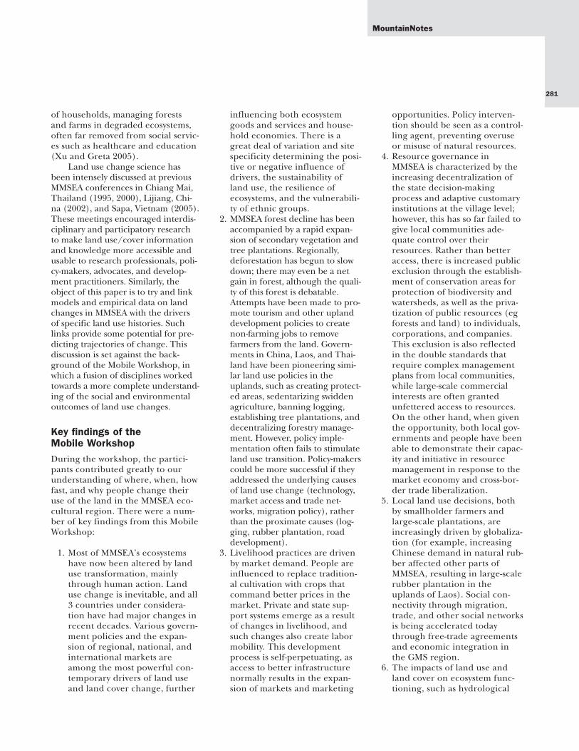
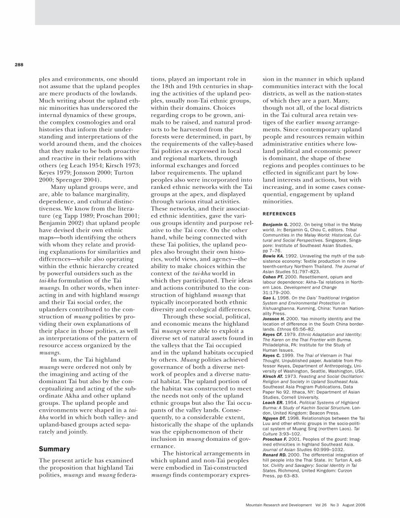
The present article provides an overview of the status of land use and land cover change science in Montane Mainland Southeast Asia in the context of a Mobile Workshop. Outcomes of the Mobile Workshop highlighted the rapid changes in land use and livelihoods, largely driven by the development of transport links, increasing market access, and trade liberalization. While many of these changes are likely to be beneficial, they must be carefully moni- tored, and relevant policies should be inclusive of all stakeholders. This is why it is important that land use science be cognizant of the need to make informa- tion accessible to policy-makers and land users. Introduction MMSEA: A critical area in transition The Montane Mainland Southeast Asia (MMSEA) eco-cultural region comprises those areas between 300 and 3000 m lying within the basins of the Yangtze, Salween, Irrawaddy, Mekong, Black, Red, and Pearl rivers (Thomas 2003; Fox and Vogler 2005). This region constitutes approximately half of the land area of Cambodia, Laos, Myanmar, Thai- land, Vietnam, and Yunnan Province of China (Figure 1). National states have a strong interest in the political and environmental security of 278 Land Use Transition, Livelihoods, and Environmental Services in Montane Mainland Southeast Asia Mountain Research and Development Vol 26 No 3 August 2006 25°N 25°N 10°N 10°N 15°N 15°N 20°N 20°N 95°E 95°E 100°E 100°E 105°E 105°E 110°E 110°E Yunnan Yunnan CHINA CHINA MYANMAR MYANMAR VIET NAM VIET NAM CAMBODIA CAMBODIA LAO PEOPLE’S DEM. REP. LAO PEOPLE’S DEM. REP. THAILAND THAILAND Bangkok Bangkok Phnom Penh Phnom Penh Yangon Yangon Vientiane Vientiane Hanoi Hanoi Ho Chi Minh Ho Chi Minh Kunming Kunming Pearl River Basin Pearl River Basin Yangtze River Basin Yangtze River Basin Irrawaddy River Basin Irrawaddy River Basin Mekong River Basin Mekong River Basin Red River Basin Red River Basin Chao Phraya River Basin Chao Phraya River Basin Salween River Basin Salween River Basin 0 100 km N CHINA CHINA VIET NAM VIET NAM THAILAND THAILAND LAO PEOPLE’S DEM. REP. LAO PEOPLE’S DEM. REP. MYANMAR MYANMAR Yunnan Yunnan Kunming Kunming Yuxi Yuxi Mojiang Mojiang Pu’er Pu’er Simao Simao Jinghong Jinghong Keng Tung Keng Tung Meng Xing Meng Xing Mengla Mengla Boten Boten Takhilek Takhilek Houay Xay Houay Xay Chiang Khong Chiang Khong Louang Prabang Louang Prabang Chiang Rai Chiang Rai Vientiane Vientiane GMS TH ADB CH 25°N 25°N 20°N 20°N 100°E 100°E 100°E 100°E ADB Asia Development Bank funded section CH TH GMS Greater Mekong Subregion economic corridor Chinese funded section Thai funded section 0 250 km N Major river basin Major town National boundary Province boundary (China) Main river New regional road network corridor FIGURE 1 The Montane Mainland Southeast Asia (MMSEA) eco-cultural region, showing main river basins and the road network that is being upgraded in the region. The map on the right shows the Kunming–Bangkok highway, an economic corridor linking China, Laos, and Thailand, funded by several parties. (Map by David Thomas and Andreas Brodbeck, based on data from various sources)
-
Upload
independent -
Category
Documents
-
view
4 -
download
0
Transcript of Land Use Transition, Livelihoods, and Environmental Services in Montane Mainland Southeast Asia
The present article provides an overviewof the status of land use and land coverchange science in Montane MainlandSoutheast Asia in the context of aMobile Workshop. Outcomes of theMobile Workshop highlighted the rapidchanges in land use and livelihoods,largely driven by the development oftransport links, increasing marketaccess, and trade liberalization. Whilemany of these changes are likely to bebeneficial, they must be carefully moni-
tored, and relevant policies should beinclusive of all stakeholders. This is whyit is important that land use science becognizant of the need to make informa-tion accessible to policy-makers and landusers.
Introduction
MMSEA: A critical area in transitionThe Montane Mainland SoutheastAsia (MMSEA) eco-cultural region
comprises those areas between 300and 3000 m lying within the basinsof the Yangtze, Salween, Irrawaddy,Mekong, Black, Red, and Pearl rivers(Thomas 2003; Fox and Vogler2005). This region constitutesapproximately half of the land areaof Cambodia, Laos, Myanmar, Thai-land, Vietnam, and Yunnan Provinceof China (Figure 1). National stateshave a strong interest in the politicaland environmental security of
278
Land Use Transition, Livelihoods, and Environmental Services in Montane MainlandSoutheast Asia
Mountain Research and Development Vol 26 No 3 August 2006
25°N25°N
10°N10°N
15°N15°N
20°N20°N
95°E95°E 100°E100°E 105°E105°E 110°E110°E
YunnanYunnan
CHINACHINA
MYANMARMYANMAR
VIET NAMVIET NAM
CAMBODIACAMBODIA
LAO PEOPLE’SDEM. REP.
LAO PEOPLE’SDEM. REP.
THAILANDTHAILAND
BangkokBangkok
Phnom PenhPhnom Penh
YangonYangon
VientianeVientiane
HanoiHanoi
Ho Chi MinhHo Chi Minh
KunmingKunming
Pearl RiverBasin
Pearl RiverBasin
Yangtze River BasinYangtze River Basin
Irrawaddy RiverBasin
Irrawaddy RiverBasin
Mekong RiverBasin
Mekong RiverBasin
Red RiverBasin
Red RiverBasin
Chao PhrayaRiver Basin
Chao PhrayaRiver Basin
SalweenRiver BasinSalween
River Basin
0 100 kmN
CHINACHINA
VIET NAMVIET NAM
THAILANDTHAILAND
LAO PEOPLE’SDEM. REP.
LAO PEOPLE’SDEM. REP.
MYANMARMYANMAR
YunnanYunnan
KunmingKunming
YuxiYuxi
MojiangMojiang
Pu’erPu’er
SimaoSimao
JinghongJinghong
Keng TungKeng Tung
Meng XingMeng Xing
MenglaMengla
BotenBoten
TakhilekTakhilek HouayXay
HouayXay
Chiang KhongChiang KhongLouangPrabangLouangPrabang
ChiangRai
ChiangRai
VientianeVientiane
GMS
TH
ADB
CH
25°N25°N
20°N20°N
100°E100°E
100°E100°E
ADB Asia Development Bankfunded section
CH
TH
GMS Greater Mekong Subregioneconomic corridor
Chinese funded section
Thai funded section
0 250 kmN
Major river basin
Major town
National boundary
Province boundary(China)
Main river
New regional roadnetwork corridor
FIGURE 1 The Montane Mainland Southeast Asia (MMSEA) eco-cultural region, showing main river basins and the road network that is being upgraded inthe region. The map on the right shows the Kunming–Bangkok highway, an economic corridor linking China, Laos, and Thailand, funded by several parties.(Map by David Thomas and Andreas Brodbeck, based on data from various sources)

279
MMSEA, as the rivers it supportsaffect the lives of more than 600 mil-lion people in the Greater MekongSub-region (GMS)—an area under-going rapid economic growth andregionalization.
The ecological health of the“roof” of southwest China and South-east Asia is rapidly deteriorating: dur-ing the past two decades, theYangtze, Red, Mekong, Tonle Sap,and Chao Phaya rivers have floodedmore frequently, causing some of theworst devastation in recorded history.In addition, development of vastcommunication and transportationinfrastructure along the Mekong andother river systems is having greatimpacts on land use, livelihoods, andenvironmental services.
There is increasing debateabout the need to balance possibleover-exploitation of MMSEA’s natu-ral resources against the sustainabil-ity of the region’s ecosystem servic-es. Rising population and consump-tion will drive competition fordiminishing resources, requiringtrade-offs between ecosystem goodsand services among different stake-holders at different scales. Land usedecision-making in this climate ispolitically and economically driven;therefore, to understand theseissues, it is necessary to identify andquantify the links between changesin land use, ecology, and socioeco-nomics.
From 15–27 January 2005, 60participants from 8 countries partic-ipated in a unique learning process:a ‘mobile workshop’ on land usehistory. This workshop traversed theheart of the MMSEA eco-culturalregion, from Xishuangbanna insouthern Yunnan, overland toLuang Prabang in northern Laos,before flying to Chiang Mai innorthern Thailand. Throughout,participants interacted with localvillagers and officials to learn aboutland use history and decision-mak-ing, in the context of the localimpacts of state policies and emerg-ing market economies. The work-shop had several objectives:
• To better understand the landuse dynamics and drivers ofchange in the transition to mar-ket economies within MMSEA;
• To assess the impacts of develop-ment, particularly road infra-structure, as well as linkagesamong transportation corridors,marketing networks, and tradepolicies;
• To build capacity among youngerresearchers to conduct interdisci-plinary research related to landuse transition; and
• To provide a forum for policydialogue and recommendations.
The workshop focused on 3 majorinterlinked themes: 1) land usechange, 2) local livelihoods/mar-kets and trade, and 3) resource gov-ernance. Accordingly, 3 thematicworking groups were formed toexplore and analyze field work andshare impressions of the impacts ofroad building and trade liberaliza-tion on land use, livelihoods, andgovernance in MMSEA.
Historical land uses and culturalexchanges in MMSEAThe northern parts of Thailand,Laos, Vietnam, and the southernpart of Yunnan, China support 100million people, comprised of morethan 60 different ethnic minorities.These people practice various formsof land use and livelihood activities.In southern Yunnan these practicesinclude swidden agriculture withrice and rubber by the Hani, Jinuo,and Yao peoples; and paddy agricul-ture and homegardens with rice,vegetables, and rubber by the Dai inXishuangbanna. Similarly, in Laos,extensive swidden practices are tra-ditionally conducted by a widediversity of ethnic groups, includingthe Hmong, Yao, Akha, Khmu, andLamet. Meanwhile, lowland agricul-ture has long been a domain of theTai-Kadai ethnolinguistic group,centering on paddy rice cultivation.In northern Thailand, there are thewell-managed watersheds of theKaren and the now highly natural
resource-exploitative practices ofsome of the Hmong.
MMSEA not only providesdiverse ‘niches’ for specific liveli-hoods but also accommodates flexi-ble institutions for resource gover-nance. Relationships between thesecustomary organizations have longaffected both the highlands and thelowland plains. Historically, valley-based polities have played animportant role in organizing thesocial and economic relationshipsamong the lowland inhabitants andthe people living in surroundingmountainous areas (Coward 2002;Chiengthong 2003). The practicesof ‘rights of occupancy and use’ ver-sus ‘rights of domination’ are alsocrucial when trying to understandthe relations between indigenouspeoples and recent migrants.
For more than a millennium, inMMSEA caravans served as marketlinks and created sociocultural net-works among mountain and lowlandcommunities. Until the 19th centurythere were still free movements ofethnic groups across the currentborders of China, Laos, Myanmar,Thailand, and Vietnam. Today, thecaravan trade has been replaced bymodern transportation systems, suchas the proposed Kunming–Bangkokhighway (see Figure 1), and econom-ic corridors have evolved intotransnational highways, riverways,and railway links. These changeshave profound impacts on local landuse, resource management, liveli-hoods, and indigenous cultures.Continuing research in MMSEA andelsewhere suggests that land usedynamics and transitions in the trop-ical uplands need to be analyzed inbroader context of politicaleconomies (Rambo et al 1999; Fox 2002; Xu et al 2005a).
Land use transition: whyshould we care? Transition theoryThe pace and intensity of land cov-er change have increased over thepast 3 centuries—and, more partic-
MountainNotes
Mountain Research and Development Vol 26 No 3 August 2006
ularly, over the last 3 decades—dueto climate change and increasinghuman activities, including migra-tion, land use conversion, and agri-cultural intensification (Lambinand Geist 2006). Land use transi-tions are pervasive at a variety ofspatial and temporal scales; they sig-nificantly affect ecosystem servicesand thus livelihoods, economics,and trade policies. To understandcurrent changes and predict futureones, it is essential to adopt a long-term view of land use history. Forthese reasons it is necessary to con-sider the mechanisms of transitions,both environmental and economic.
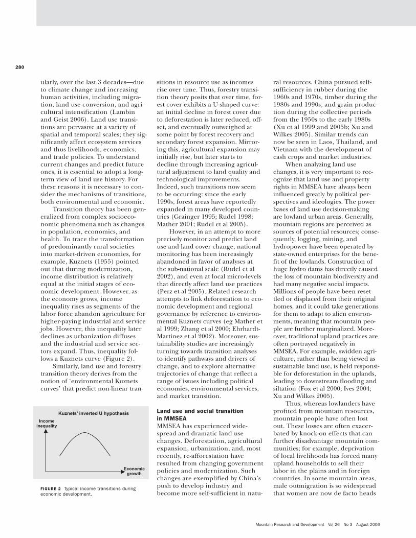
Transition theory has been gen-eralized from complex socioeco-nomic phenomena such as changesin population, economics, andhealth. To trace the transformationof predominantly rural societiesinto market-driven economies, forexample, Kuznets (1955) pointedout that during modernization,income distribution is relativelyequal at the initial stages of eco-nomic development. However, asthe economy grows, incomeinequality rises as segments of thelabor force abandon agriculture forhigher-paying industrial and servicejobs. However, this inequality laterdeclines as urbanization diffusesand the industrial and service sec-tors expand. Thus, inequality fol-lows a Kuznets curve (Figure 2).
Similarly, land use and forestrytransition theory derives from thenotion of ‘environmental Kuznetscurves’ that predict non-linear tran-
sitions in resource use as incomesrise over time. Thus, forestry transi-tion theory posits that over time, for-est cover exhibits a U-shaped curve:an initial decline in forest cover dueto deforestation is later reduced, off-set, and eventually outweighed atsome point by forest recovery andsecondary forest expansion. Mirror-ing this, agricultural expansion mayinitially rise, but later starts todecline through increasing agricul-tural adjustment to land quality andtechnological improvements.Indeed, such transitions now seemto be occurring: since the early1990s, forest areas have reportedlyexpanded in many developed coun-tries (Grainger 1995; Rudel 1998;Mather 2001; Rudel et al 2005).
However, in an attempt to moreprecisely monitor and predict landuse and land cover change, nationalmonitoring has been increasinglyabandoned in favor of analyses atthe sub-national scale (Rudel et al2002), and even at local micro-levelsthat directly affect land use practices(Perz et al 2005). Related researchattempts to link deforestation to eco-nomic development and regionalgovernance by reference to environ-mental Kuznets curves (eg Mather etal 1999; Zhang et al 2000; Ehrhardt-Martinez et al 2002). Moreover, sus-tainability studies are increasinglyturning towards transition analysesto identify pathways and drivers ofchange, and to explore alternativetrajectories of change that reflect arange of issues including politicaleconomies, environmental services,and market transition.
Land use and social transition in MMSEAMMSEA has experienced wide-spread and dramatic land usechanges. Deforestation, agriculturalexpansion, urbanization, and, mostrecently, re-afforestation haveresulted from changing governmentpolicies and modernization. Suchchanges are exemplified by China’spush to develop industry andbecome more self-sufficient in natu-
ral resources. China pursued self-sufficiency in rubber during the1960s and 1970s, timber during the1980s and 1990s, and grain produc-tion during the collective periodsfrom the 1950s to the early 1980s(Xu et al 1999 and 2005b; Xu andWilkes 2005). Similar trends cannow be seen in Laos, Thailand, andVietnam with the development ofcash crops and market industries.
When analyzing land usechanges, it is very important to rec-ognize that land use and propertyrights in MMSEA have always beeninfluenced greatly by political per-spectives and ideologies. The powerbases of land use decision-makingare lowland urban areas. Generally,mountain regions are perceived assources of potential resources; conse-quently, logging, mining, andhydropower have been operated bystate-owned enterprises for the bene-fit of the lowlands. Construction ofhuge hydro dams has directly causedthe loss of mountain biodiversity andhad many negative social impacts.Millions of people have been reset-tled or displaced from their originalhomes, and it could take generationsfor them to adapt to alien environ-ments, meaning that mountain peo-ple are further marginalized. More-over, traditional upland practices areoften portrayed negatively inMMSEA. For example, swidden agri-culture, rather than being viewed assustainable land use, is held responsi-ble for deforestation in the uplands,leading to downstream flooding andsiltation (Fox et al 2000; Ives 2004;Xu and Wilkes 2005).
Thus, whereas lowlanders haveprofited from mountain resources,mountain people have often lostout. These losses are often exacer-bated by knock-on effects that canfurther disadvantage mountain com-munities; for example, deprivationof local livelihoods has forced manyupland households to sell theirlabor in the plains and in foreigncountries. In some mountain areas,male outmigration is so widespreadthat women are now de facto heads
280
FIGURE 2 Typical income transitions duringeconomic development.
281
of households, managing forestsand farms in degraded ecosystems,often far removed from social servic-es such as healthcare and education(Xu and Greta 2005).
Land use change science hasbeen intensely discussed at previousMMSEA conferences in Chiang Mai,Thailand (1995, 2000), Lijiang, Chi-na (2002), and Sapa, Vietnam (2005).These meetings encouraged interdis-ciplinary and participatory researchto make land use/cover informationand knowledge more accessible andusable to research professionals, poli-cy-makers, advocates, and develop-ment practitioners. Similarly, theobject of this paper is to try and linkmodels and empirical data on landchanges in MMSEA with the driversof specific land use histories. Suchlinks provide some potential for pre-dicting trajectories of change. Thisdiscussion is set against the back-ground of the Mobile Workshop, inwhich a fusion of disciplines workedtowards a more complete understand-ing of the social and environmentaloutcomes of land use changes.
Key findings of the Mobile WorkshopDuring the workshop, the partici-pants contributed greatly to ourunderstanding of where, when, howfast, and why people change theiruse of the land in the MMSEA eco-cultural region. There were a num-ber of key findings from this MobileWorkshop:
1. Most of MMSEA’s ecosystemshave now been altered by landuse transformation, mainlythrough human action. Landuse change is inevitable, and all3 countries under considera-tion have had major changes inrecent decades. Various govern-ment policies and the expan-sion of regional, national, andinternational markets areamong the most powerful con-temporary drivers of land useand land cover change, further
influencing both ecosystemgoods and services and house-hold economies. There is agreat deal of variation and sitespecificity determining the posi-tive or negative influence ofdrivers, the sustainability ofland use, the resilience ofecosystems, and the vulnerabili-ty of ethnic groups.
2. MMSEA forest decline has beenaccompanied by a rapid expan-sion of secondary vegetation andtree plantations. Regionally,deforestation has begun to slowdown; there may even be a netgain in forest, although the quali-ty of this forest is debatable.Attempts have been made to pro-mote tourism and other uplanddevelopment policies to createnon-farming jobs to removefarmers from the land. Govern-ments in China, Laos, and Thai-land have been pioneering simi-lar land use policies in theuplands, such as creating protect-ed areas, sedentarizing swiddenagriculture, banning logging,establishing tree plantations, anddecentralizing forestry manage-ment. However, policy imple-mentation often fails to stimulateland use transition. Policy-makerscould be more successful if theyaddressed the underlying causesof land use change (technology,market access and trade net-works, migration policy), ratherthan the proximate causes (log-ging, rubber plantation, roaddevelopment).
3. Livelihood practices are drivenby market demand. People areinfluenced to replace tradition-al cultivation with crops thatcommand better prices in themarket. Private and state sup-port systems emerge as a resultof changes in livelihood, andsuch changes also create labormobility. This developmentprocess is self-perpetuating, asaccess to better infrastructurenormally results in the expan-sion of markets and marketing
opportunities. Policy interven-tion should be seen as a control-ling agent, preventing overuseor misuse of natural resources.
4. Resource governance inMMSEA is characterized by theincreasing decentralization ofthe state decision-makingprocess and adaptive customaryinstitutions at the village level;however, this has so far failed togive local communities ade-quate control over theirresources. Rather than betteraccess, there is increased publicexclusion through the establish-ment of conservation areas forprotection of biodiversity andwatersheds, as well as the priva-tization of public resources (egforests and land) to individuals,corporations, and companies.This exclusion is also reflectedin the double standards thatrequire complex managementplans from local communities,while large-scale commercialinterests are often grantedunfettered access to resources.On the other hand, when giventhe opportunity, both local gov-ernments and people have beenable to demonstrate their capac-ity and initiative in resourcemanagement in response to themarket economy and cross-bor-der trade liberalization.
5. Local land use decisions, bothby smallholder farmers andlarge-scale plantations, areincreasingly driven by globaliza-tion (for example, increasingChinese demand in natural rub-ber affected other parts ofMMSEA, resulting in large-scalerubber plantation in theuplands of Laos). Social con-nectivity through migration,trade, and other social networksis being accelerated todaythrough free-trade agreementsand economic integration inthe GMS region.
6. The impacts of land use andland cover on ecosystem func-tioning, such as hydrological
MountainNotes

Mountain Research and Development Vol 26 No 3 August 2006
cycles and sediment transport,are inversely related to the spa-tial scale. In contrast, theimpacts of land use changes onwater quality parameters maybe relevant at the higher mesoand macro scales. It is alsoimportant to note that theimpact of these land usechanges is temporally variable.While river and lake quality canbe restored in a relatively shorttime, biodiversity will take thou-sands of years to recover.
7. Mobility and flexibility areoften critical to sustainableland use. Long-fallow, rotation-al shifting cultivation is onewell-documented example ofhow mobility and flexibilityunderpin the sustainability ofextensive smallholder systems;if these attributes are lost, suchsystems may collapse. Similarly,policies that support mobilelifestyles and flexible livelihoodstrategies can allow pastures to‘rest’ seasonally and thus curbdegradation.
8. ‘Think globally and act locally’applies to land use policy.Decentralized natural resourcemanagement such as communi-ty forestry, integrated watershedmanagement, good practices ofcustomary institutions, andapplication of traditional eco-logical knowledge can acceler-ate land use transition. Theeffectiveness with which landuse science communicates
results at the grassroots level isof critical importance. Onepowerful tool for involvingactors in sustainable land use isparticipatory land use planning.
9. Land use is at the center oftrade-offs between ecosystemgoods and services. Changes inland use often increase theshare of energy, water, andnutrients devoted to humanneeds, but decrease theresources available for otherecosystem functions. Land usethat balances poverty reductionand environmental conserva-tion is rare. The emerging con-servation paradigm includes theconcept of payment for envi-ronmental services (PES), inwhich local landholders andusers are rewarded for adoptingland use practices that secureecosystem functioning by directpayment from external environ-mental services beneficiaries.
10. For land use transitions, soundknowledge transfer among dif-ferent stakeholders enablesthem to better understand thedynamics of land use/coverchange, its links to ecosystemfunctioning, and the availablepolicy options and interventions.Decentralized institutions andlocal communities are playing anincreasingly important role inmanaging land use transitions.
11. MMSEA forest landscapes arethe result of many generationsof interaction between humans
and ecosystems. Indigenousfarmers manage deforestation insequential agroforestry systemsthat integrate secondary vegeta-tion, which provide not onlydiverse products for local peo-ple, but also habitats for endan-gered species. Recent trendssuggest that most upland areasof MMSEA will eventually see amajor change in land use withconversion from swidden agri-culture to commercial crops anda change in land cover from sec-ondary vegetation to permanentmonocultural agriculture, albeittree crops in many cases. Perma-nent agriculture could result ina tree-dominated land cover (egrubber, fruit trees, tea), or aland cover composed of annuals(eg vegetables, sugarcane,maize, cassava, upland rice). Ineither case, biodiversity wouldprobably decline (Nagata et al1996; Figure 3).
12. Rapid economic growth andurbanization in China have notonly increased demands on for-est resources but also provide anopportunity to move rural farm-ers to non-farm jobs. In thissequence of events, forestswould not decline furtherbecause shortages of agriculturalworkers would prevent furtheragricultural expansion. More-over, rising farm labor prices dis-courage further intensive use ofmarginal lands such as forests.Growing economic power alsoenables government to compen-sate farmers to protect forests inthe headwaters of river basins;however, this can increase tim-ber imports and promote defor-estation in the other parts ofMMSEA (eg Myanmar). Open-ing cross-border trade andregionalization can be a double-edged sword for smallholderfarmers in the MMSEA region.There is increasing opportunityfor upland farmers from South-east Asian countries to sendnon-timber forest products to
282
FIGURE 3 Changes in species diversity with agricultural development.

283
huge Chinese markets, but theyalso have to risk competition inthe temperate fruit market fromChinese farmers; these used tobe ‘niche’ products produced byupland farmers in northernVietnam, Laos, and Thailand.
Managing land use transition:from theory to practiceLand use change science and itspolicy applications include landuse/cover change assessment, andforecasting based on the views ofdifferent stakeholders, includingnon-scientific people. Increasingly,non-state actors such as NGOs andcivil society are shaping governmentpolicies. Successful links betweenland use science and policy requireaction-oriented research thatinvolves all stakeholders. Differentactors’ points of view vary with theirknowledge systems, objectives, andincentives in land use decisions;these different perspectives oftencreate a cultural gap hindering theuse of research findings. In the caseof shifting cultivation, for example,the common perception held bypolicy-makers attributes deforesta-tion to a rapidly growing popula-tion of poor shifting cultivators whoare hungry for new land, whileanother view, often held by scien-tists, blames corporate greed.
Policy-makers must understandland use to address pressing policyissues. Some policies directly affectland use (eg policies that create pro-tected areas) or land-based activitiessuch as agriculture or forestry. Otherpolicies, not intended to affect landuse, can have profound but indirectimpacts. These include trade, sector,and public investment in infrastruc-ture, and macroeconomic policies.For example, China’s soaring rubberdemand (imports rose 550% in the20 years up to 2002) was servicedmainly from Southeast Asia. Thisrubber plantation expansion causeswidespread deforestation and con-version of secondary vegetation intomonocultures in MMSEA.
Although we often focus on thenegative environmental impacts ofincreasing globalization, marketiza-tion and modernization, thesechanges can have positive effects.International migration and theremittance economy provide US$ 43 billion for Eastern, South-east and Pacific Asia (World Bank2005). This external income pro-motes small enterprises in the origi-nal communities, such as family-based tourism, which furtherreduces pressure on uplands inMMSEA. Moreover, labor-intensivetechnological progress such as newirrigation techniques can intensifyuse of existing agricultural areasand increase rural incomes throughdouble cropping or vegetable culti-vation in dry seasons. These increas-es in productivity help reduce landclearing, therefore conserving for-est cover on marginal land.
In rare cases, land use transitionmay help reduce poverty and con-serve nature. Where it is commercial-ly viable, ecotourism is one such‘win–win.’ Matsutake (Tricholoma mat-sutake) collecting is another win–winsituation. Increasing demand forthese mushrooms has encouragedTibetan collectors to shift from log-ging to mushroom harvesting, reviv-ing customary institutions that man-age forest resources and regulateaccess to mushroom habitats (ie oakand pine forest). Another positiveoutcome is the improved manage-ment of traditional agriculture by theHani (Akha) people in Xishuangban-na to incorporate marketable prod-ucts such as rattan and tea in swid-den and natural forest (Xu 2005).
Conclusions
The Mobile Workshop reinforcedthe notion that land use change sci-ence must be more inclusive andhave greater impact on policy andpublic debates. During the course ofthe workshop we saw the effects ofrecent transitions, both positive andnegative, on local communities andecosystems. It was particularly
instructive to view these changesthrough each of the 3 thematicgroups: land use change, liveli-hoods, and governance. Quantifyingchanges is vital (land use change),but we must be cognizant of thesocioeconomic effects of thesechanges on the ground (liveli-hoods), together with a long-termview of the sustainability and equityof such changes (governance).Bringing people together, particu-larly younger researchers fromdiverse disciplines and cultures,helps build a better appreciation ofthe need to have a multi-prongapproach to land use science. Whenviewed holistically, preconceivednotions—such as: swidden agricul-ture is destructive, cash croppingbuilds wealth, more forest gets morewater, or afforestation benefits bio-diversity—were shown to be general-izations that are not applicable inmany systems or communities.
It is also important that weunderstand the power of land usescience and the need to use itresponsibly. Land use is often apolitical decision, and science ispresent as a political voice in landuse decisions at local, national, andinternational levels. Science must bemade accessible to land users andpolicy-makers, and accompanied byan appreciation of specific localviewpoints and knowledge systems.Moreover, there is need for long-term and proactive thinking.Improving forest cover and agricul-tural yields is fine, but this must alsobe matched with increasingly sophis-ticated ecological, marketing, andsocioeconomic analyses, to ensurethe viability and sustainability ofsuch improvements. Finally, landuse science must constantly reassessand review changes: land use transi-tions to improve incomes are highlydesirable but these must be bal-anced against environmental qualityand the sustainability of ecosystemservices. An understanding of thestrengths and limitations of land usescience will enable constructiveinput to responsive policy-making.
MountainNotes
Mountain Research and Development Vol 26 No 3 August 2006
REFERENCES
Chiengthong J. 2003. The politics of ethnicity,indigenous culture and knowledge in Thailand,Vietnam and Lao PDR. In: Kaosa-ard M, Dore J,editors. Social Challenges for the MekongRegion. Bangkok, Thailand: White Lotus, pp147–172.Coward WCE Jr. 2002. Tai Polities and theUplands. Working paper. Kunming, China: Centerfor Biodiversity and Indigenous Knowledge.Ehrhardt-Martinez K, Crenshaw EM, Jenkins JC.2002. Deforestation and the environmentalKuznets curve: A cross-national investigation ofintervening mechanisms. Social Science Quarter-ly 83(1):226–243.Fox J. 2002. Understanding a dynamic land-scape: Land use, land cover, and resourcetenure in Northeastern Cambodia. In: Walsh S,Meyer K, editors. Linking People, Place, and Poli-cy: A GIS Science Approach. Boston, MA: KluwerAcademic Publishers, pp 113–130.Fox J, Truong DM, Rambo AT, Tuyen NP, Cuc LT,Leisz S. 2000. Shifting cultivation: A new oldparadigm for managing tropical forests. Bio-Science 50(6):521–528.Fox J, Vogler JB. 2005. Land-use and land-coverchange in Montane Mainland Southeast Asia.Environmental Management 36:394–403.Grainger A. 1995. The forest transition: An alter-native approach. Area 27:242–251.Ives JD. 2004. Himalayan Perceptions: Environ-mental Change and the Well-being of MountainPeoples. London, United Kingdom: Routledge.Kuznets S. 1955. Economic growth and incomeinequality. American Economic Review 45:1–28.Lambin EF, Geist H. 2006. Land-Use and Land-Cover Change. Local Processes and GlobalImpacts Series. Berlin, Germany: Springer.Mather A. 2001. The transition from deforesta-tion to reforestation in Europe. In: Angelsen A,Kaimowitz D, editors. Agricultural Technologiesand Tropical Deforestation. Wallingford, UnitedKingdom: CABI Publishing, pp 35–52.Mather AS, Needle CL, Fairbairn J. 1999. Envi-ronmental Kuznets curves and forest trends.Geography 84:55–65.Nagata H, Zubaid A, Azarae HI. 1996. The effectof forest disturbance on avian community struc-ture at two lowland forests in peninsularMalaysia. In: Abidin A, Hasan A, Akbar Z, edi-tors. Conservation and Faunal Biodiversity inMalaysia. Bangi, Malaysia: Penerbit UniversitiKebangsaan, pp 93–101.Perz SG, Aramburu C, Bremner J. 2005. Popula-tion, land use and deforestation in the Pan Ama-zon Basin: A comparison of Brazil, Bolivia,Colombia, Ecuador, Peru and Venezuela. Environ-ment, Development and Sustainability 7:23–49.
Rambo AT, Gillogly K, Hutterer KL, editors.1999. Ethnic Diversity and the Control of NaturalResources in Southeast Asia. Michigan Paperson South and Southeast Asia. Ann Arbor, MI:University of Michigan Press.Rudel TK. 1998. Is there a forest transition?Deforestation, reforestation, and development.Rural Sociology 63:533–552. Rudel TK, Bates D, Machinguiashi R. 2002. Atropical forest transition? Agricultural change,out-migration, and secondary forests in theEcuadorian Amazon. Annals of the Association ofAmerican Geographers 92:87–102. Rudel TK, Coomes O, Moran E, Achard F, Angele-sen A, Xu J, Lambin E. 2005. The forestry transi-tion: Towards a global understanding of landcover change. Global Environmental Change15:23–31.Thomas DE. 2003. Montane Mainland South-east Asia: Brief spatial overview. In: Xu J, Mike-sell S, editors. Landscapes of Diversity: Indige-nous Knowledge, Sustainable Livelihoods andResource Governance in Montane MainlandSoutheast Asia. Proceedings of the 3rd Sympo-sium on MMSEA, 25–28 August 2002, Lijiang,P.R. China. Kunming, China: Yunnan Science andTechnology Press, pp 25–40.World Bank. 2005. Global Economic Prospects2006: Economic Implications of Remittances andMigration. Washington, DC: World Bank.Xu JC. 2005. Rattan and tea-based intensifica-tion of shifting cultivation by Hani farmers inSouthwestern China. In: Cairns M, editor. Voicesfrom the Forest: Integrating Indigenous Knowl-edge into Sustainable Farming. Washington, DC:Resources for the Future Press, pp 667–673.Xu JC, Fox J, Xing L, Podger N, Leisz S, Xihui A.1999. Effects of swidden cultivation, populationgrowth, and state policies on land cover in Yun-nan, China. Mountain Research and Develop-ment 19:123–132.Xu JC, Fox J, Zhang P, Fu Y, Yang L, Qian J, LeiszS, Vogler J. 2005a. Land-use / land-coverchange and farmer livelihoods in Xishuangban-na. Environmental Management 35:1–11.Xu JC, Greta R. 2005. Living in the Mountains.In: Terry Jeggle, editor. Know Risk. Geneva,Switzerland: United Nations Inter-agency Secre-tariat of the International Strategy for DisasterReduction, pp 196–199.Xu JC, Ma E, Tashi D, Fu Y, Lu Z, Melick D.2005b. Integrating sacred knowledge for conser-vation: Cultures and landscapes in SouthwestChina. Ecology and Society 10(2):7 [online].http://www.ecologyandsociety.org/vol10/iss2/art7; accessed on 16 March 2006.Xu JC, Wilkes A. 2005. State simplifications ofland use and biodiversity in the uplands of Yun-nan, Eastern Himalayan region. In: Huber U, Bug-
mann H, Reasoner M, editors. Global Changeand Mountain Regions: An Overview of CurrentKnowledge. Dordrecht, The Netherlands:Springer, pp 541–550.Zhang YQ, Uusivuori J, Kuuluvainen J. 2000.Econometric analysis of the causes of forestland use changes in Hainan, China. CanadianJournal of Forest Research 30:1913–1921.
284
Xu JianchuKunming Institute of Botany, Chinese Acade-my of Sciences. Current address: Internation-al Centre for Integrated Mountain Develop-ment, PO Box 3226, Kathmandu, [email protected]
Jeff FoxEast-West Center, 1601 East-West Road,Honolulu, HI 96848, [email protected]
David MelickKunming Institute of Botany,Heilongtan, Kunming,650204, [email protected]
Yayoi FujitaFaculty of Forestry, National University ofLaos, PO Box 4984, Vientiane, [email protected]
Attachai JintrawetFaculty of Agriculture, Chiang Mai University,Chiang Mai 50200, [email protected]
Qian JieCenter for Biodiversity and Indigenous Knowl-edge, 3rd Floor, Building A, Zhonghuandasha,Yanjiadi, Kunming 650034, Yunnan, [email protected]
David ThomasWorld Agroforestry Centre (ICRAF) MMSEA,Chiang Mai Office, PO Box 267, CMU PostOffice, Chiang Mai 50202, [email protected]
Horst Weyerhaeuser World Agroforestry Centre (ICRAF) China, Bei-jing Office, 12 Zhongguancun Nan Dajie,CAAS Mailbox 195, Beijing 100081, [email protected]
The domains of earlier Tai muangs—the social spaces governed by variousTai groups—in the highlands of mon-tane Southeast Asia frequently incorpo-rated both upland valleys and the flank-ing, sloping lands used by various Tai
and non-Tai groups. The articulation ofthe land uses and livelihood activities ofthese two landscapes of the muangsserved to reproduce these Tai polities.The ideas and actions of both the rulingTai groups and the subaltern upland
groups contributed to the construction ofthe highland muangs that typicallyincorporated status differences, ethnicdiversity, and ecological variety. Muangpolities achieved governance of both adiverse network of peoples and a diverse
Tai Valley-based Polities and the Uplands in Montane Southeast Asia
285
natural habitat. Since contemporaryupland peoples and resources remainwithin administrative entities wherelowland political and economic power isdominant, the shape of these regionscontinues to be influenced by lowlandinterests and actions but with conse-quential, and in some cases increasing,engagement by upland minorities.
Prelude
The administrative village of Meng-song is located in Jinghong Countyin the Xishuangbanna DaiAutonomous Prefecture in southernYunnan Province, China. In thesummer of 1999 I visited this villagewith a Chinese colleague who spentmany years conducting fieldworkamong the Akha families, who arethe predominant ethnic group inMengsong. Mengsong farmers areactively engaged in modifying theirupland land use in response to boththe new constraints and unfoldingopportunities arising from the pre-viously erratic but now more stablepolicies of the Chinese government.
In the course of our brief stayin Mengsong, we visited a rattan for-est managed by one of the hamletsand locally known as sangpabawa(Xu et al 1999). The term sang-pabawa appears to be a local corrup-tion of the Dai terms meaning rat-tan forest (paa wai) and the nameof a local earlier Dai official(sangpa). The experience of this rat-tan forest visit caused me to thinkfurther about the connectionsbetween this upland Akha commu-nity and the surrounding lowlandDai groups: why was this parcel ofthe uplands labeled with Dai termi-nology and why was it associatedwith a local Dai officer?
Historically, the Dai had issuedorders to this upland village to pre-serve this rattan habitat and providerattan items as part of the Akha trib-ute to the local Dai rulers, whosemuang domain included this uplandregion (Gao 1998). The Dai rulersderived their authority in the uplandhabitat by virtue of their position in
a regional Dai polity composed of anumber of confederated muangs andknown as Sipsongpanna, along withtheir incorporation into the bureau-cracy of the Chinese court in therole of tusi—an institution thatallowed the Chinese state to employa form of indirect governance usingexisting local power centers.
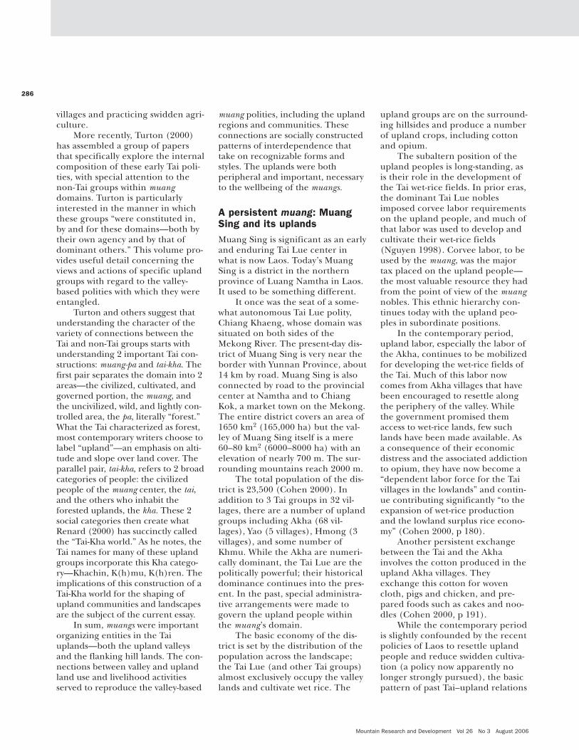
Since Tai muangs have longexisted throughout a large swath ofthe region referred to as MontaneMainland Southeast Asia and con-tinue to exist in various forms in theseveral nation-states of which theyare now a part, it became of interestto me to learn more about themuang–upland connections that areimplied in Mengsong’s rattan forest.The present article is the initialresult. It draws on materials describ-ing Tai muangs as they were organ-ized in the 18th and 19th centuries,as well as materials concerning con-temporary state–upland relations.
Tai valley polities: muangspast and presentThongchai (1994) defines a muangas a governed area. Across theupland and mountainous landscapereaching from the contemporaryregions of northern Laos, Thailand,and Vietnam, as well as southwesternChina and northeastern Myanmar, inthe 18th and 19th centuries therewere scattered Tai muangs, or “princi-palities,” of various sizes (Figure 1).These muangs had complicated—and unsteady—tributary relationswith one another and with non-Taientities, any given muang likelyreceiving tribute from various vassalswhile simultaneously paying tributeto one or more superior entities.
Keyes (1999) has noted 2important characteristics of the pre-modern muang: the rulers were allspeakers of one Tai language oranother and they included peoplewho spoke diverse languages andwere organized in hierarchical rela-tionships. Thus, in addition to deal-ing with other muangs and king-doms, as Wyatt (1984) pointed out,
“There was also another world near-er at hand”—other ethnic groupsoccupying the upland areas, someof whom may have been displacedby the Tai from the valley lands.Turton (2000) recently has suggest-ed that the second portion of thewell-known Lanna Tai phrase usual-ly translated as, “gather vegetablesin baskets, gather kha in muang,”could be rendered as “put non-Taiin Tai domains.” These upland non-Tai—who differed from muang tomuang but included Mon-Khmer,Tibeto-Burman, Karenic, and otherlanguage speakers—typically occu-pied the higher, sloping, and forest-ed lands that flanked the uplandvalleys in which the Tai practicedtheir wet-rice agriculture.
Tai muangs usually endeavoredto bring these people into their eco-nomic, political, and ritual net-works, and the uplanders variouslyacquiesced to, resisted, reshaped, orotherwise dealt with these demandsand opportunities. Within theseprincipalities there were importantinternal connections, exchanges,and rights and responsibilitiesbetween the valley-based polities—usually one or another Tai group—and the upland communities ofKhmu, Karen, and so forth. Leach(1954) described these internalcomplexities in the muangs in theregion of Burma the British calledthe Shan states: along with the Shanwet-rice villagers, there were largenumbers of non-Shan living in hill
MountainNotes
FIGURE 1 Approximate location of Taiprincipalities. (Map by Andreas Brodbeck)
Mountain Research and Development Vol 26 No 3 August 2006
villages and practicing swidden agri-culture.
More recently, Turton (2000)has assembled a group of papersthat specifically explore the internalcomposition of these early Tai poli-ties, with special attention to thenon-Tai groups within muangdomains. Turton is particularlyinterested in the manner in whichthese groups “were constituted in,by and for these domains—both bytheir own agency and by that ofdominant others.” This volume pro-vides useful detail concerning theviews and actions of specific uplandgroups with regard to the valley-based polities with which they wereentangled.
Turton and others suggest thatunderstanding the character of thevariety of connections between theTai and non-Tai groups starts withunderstanding 2 important Tai con-structions: muang-pa and tai-kha. Thefirst pair separates the domain into 2areas—the civilized, cultivated, andgoverned portion, the muang, andthe uncivilized, wild, and lightly con-trolled area, the pa, literally “forest.”What the Tai characterized as forest,most contemporary writers choose tolabel “upland”—an emphasis on alti-tude and slope over land cover. Theparallel pair, tai-kha, refers to 2 broadcategories of people: the civilizedpeople of the muang center, the tai,and the others who inhabit theforested uplands, the kha. These 2social categories then create whatRenard (2000) has succinctly calledthe “Tai-Kha world.” As he notes, theTai names for many of these uplandgroups incorporate this Kha catego-ry—Khachin, K(h)mu, K(h)ren. Theimplications of this construction of aTai-Kha world for the shaping ofupland communities and landscapesare the subject of the current essay.
In sum, muangs were importantorganizing entities in the Taiuplands—both the upland valleysand the flanking hill lands. The con-nections between valley and uplandland use and livelihood activitiesserved to reproduce the valley-based
muang polities, including the uplandregions and communities. Theseconnections are socially constructedpatterns of interdependence thattake on recognizable forms andstyles. The uplands were bothperipheral and important, necessaryto the wellbeing of the muangs.
A persistent muang: MuangSing and its uplandsMuang Sing is significant as an earlyand enduring Tai Lue center inwhat is now Laos. Today’s MuangSing is a district in the northernprovince of Luang Namtha in Laos.It used to be something different.
It once was the seat of a some-what autonomous Tai Lue polity,Chiang Khaeng, whose domain wassituated on both sides of theMekong River. The present-day dis-trict of Muang Sing is very near theborder with Yunnan Province, about14 km by road. Muang Sing is alsoconnected by road to the provincialcenter at Namtha and to ChiangKok, a market town on the Mekong.The entire district covers an area of1650 km2 (165,000 ha) but the val-ley of Muang Sing itself is a mere60–80 km2 (6000–8000 ha) with anelevation of nearly 700 m. The sur-rounding mountains reach 2000 m.
The total population of the dis-trict is 23,500 (Cohen 2000). Inaddition to 3 Tai groups in 32 vil-lages, there are a number of uplandgroups including Akha (68 vil-lages), Yao (5 villages), Hmong (3villages), and some number ofKhmu. While the Akha are numeri-cally dominant, the Tai Lue are thepolitically powerful; their historicaldominance continues into the pres-ent. In the past, special administra-tive arrangements were made togovern the upland people withinthe muang’s domain.
The basic economy of the dis-trict is set by the distribution of thepopulation across the landscape;the Tai Lue (and other Tai groups)almost exclusively occupy the valleylands and cultivate wet rice. The
upland groups are on the surround-ing hillsides and produce a numberof upland crops, including cottonand opium.
The subaltern position of theupland peoples is long-standing, asis their role in the development ofthe Tai wet-rice fields. In prior eras,the dominant Tai Lue noblesimposed corvee labor requirementson the upland people, and much ofthat labor was used to develop andcultivate their wet-rice fields(Nguyen 1998). Corvee labor, to beused by the muang, was the majortax placed on the upland people—the most valuable resource they hadfrom the point of view of the muangnobles. This ethnic hierarchy con-tinues today with the upland peo-ples in subordinate positions.
In the contemporary period,upland labor, especially the labor ofthe Akha, continues to be mobilizedfor developing the wet-rice fields ofthe Tai. Much of this labor nowcomes from Akha villages that havebeen encouraged to resettle alongthe periphery of the valley. Whilethe government promised themaccess to wet-rice lands, few suchlands have been made available. Asa consequence of their economicdistress and the associated addictionto opium, they have now become a“dependent labor force for the Taivillages in the lowlands” and contin-ue contributing significantly “to theexpansion of wet-rice productionand the lowland surplus rice econo-my” (Cohen 2000, p 180).
Another persistent exchangebetween the Tai and the Akhainvolves the cotton produced in theupland Akha villages. Theyexchange this cotton for wovencloth, pigs and chicken, and pre-pared foods such as cakes and noo-dles (Cohen 2000, p 191).
While the contemporary periodis slightly confounded by the recentpolicies of Laos to resettle uplandpeople and reduce swidden cultiva-tion (a policy now apparently nolonger strongly pursued), the basicpattern of past Tai–upland relations
286

287
can be easily discerned in the pres-ent. The uplands are assigned tothe production of low-yielding dry-rice production, cotton for marketexchange, and opium that can beconsumed or exchanged. The Taipolity also maintains the uplandpeople as a regular labor pool foroperating and expanding wet-ricecultivation to the direct benefit ofthe Tai cultivators. A new use of theuplands as a forest reserve is beingexperimented with by the centralgovernment. If followed, this policyalso would likely construct anupland domain that would disad-vantage the upland people and pro-vide benefits to the Tai.
In this region, the Tai conceptu-alized the upland people as a part oftheir muang. The upland people weregiven a place in the administrativestructure, but the system also definedthese people as inferior and margin-al, never as full players in the corearrangements. In this case we seeclearly that the ethnic differencesand hierarchy were mirrored in thedifferent natural assets to which thegroups had access— perhaps theseare simply 2 sides of the same coin.Here, as elsewhere, we see the Taiconstructing a muang dependent onthe exploitation of both lowland andupland people and natural resources,and producing social arrangementsthat restrict the lowland resources tothe Tai and the less productive moun-tain resources to the socially margin-alized upland people.
Uplands and the valley-based muang
The example of Muang Sing illus-trates the ways in whichvalley–upland connections shapethe nature of land use and liveli-hood activities in the upland com-munities—corvee labor, opium andcotton production, and so on. Adescription of the Kingdom ofLuang Prabang during the latterpart of the 19th century also depictsthe close relationship between thismuang and its surrounding uplands.
In Luang Prabang the upland areacontrolled by the muang both pro-duced for and was produced by themuang’s requirements. Smuckarnand Breazeale (1988) write that thelabor, forest produce, and otheragricultural products supplied bythe uplanders significantly added tothe Kingdom’s wealth generatedamong the lowland population.
What the uplanders sold at mar-kets or produced to exchange inmultiple ways with valley-dwellers(Bowie 1992) was, of course, a func-tion of what they could grow, whatthe lowlanders would buy orexchange, and what they could findto take home for their needs andnot try to produce themselves. Inthat manner, the market exchangesthat were possible in the muanghelped produce, or shape, the pat-terns of upland land use. In short,the social organization within, andperhaps between, the muangsallowed the need for upland prod-ucts on the part of the valleydwellers to produce labor and landuses in the upland communitiesthat responded to that demand.
Tai principalities either small,like Muang Sing, or larger, such asLuang Prabang, each produced asurrounding upland zone thathelped meet a variety of the eco-nomic needs of the aristocracy andthe commoners. The look of theupland areas, the daily activities thatoccurred there, and the meaningthat people gave to their lives wereall shaped, in part, by their relation-ship with people in the core placesof the governed areas called muangs.
Muangs, ethnicity, and natural resourcesAs the above examples illustrate,the Tai muangs almost invariablyreached across diverse ethnic iden-tities. Thus one major governingtask was to construct within theirrealm a working pattern of socialand economic relations amongthese multiple cultural groups. Mar-kets and other forms of exchange
were one mechanism for doing thisbut Tai muangs also helped producetheir upland peripheries by arrang-ing the ethnic diversity in theirrealm into hierarchical patternsthat gave the various groups identityand purpose relative to the Taicore. This linkage was oftenexpressed in one ritual form oranother, sometimes played out withgreat pageantry.
Students of ethnicity have sug-gested that ethnic identity has muchto do with the interrelations amonggroups of people and their competi-tion for scarce resources. A group ofpeople with a common relationshipto some valuable resource—eitherhaving or not having access to it, forexample—will develop ideas andexplanations for that resource rela-tionship that provide to them ethnicidentity and distinctiveness. Thissuggests that the mix of ethnicgroups found in the muangs of thismountainous region reflects the his-torical, and continuing, competitionfor scarce natural resources, as wellas the rivalry that may have existedin regions from which people havemigrated. For example, the nearlyexclusive access to upland rice val-leys by the various Tai groups maybe “explained” and “given meaning”in the cultural ideas held by boththe Tai and their upland neigh-bors—cultural ideas that typicallyare taken for granted by those whouse them. Since the processes ofcompetition are themselves subjectto change and alteration—whereasin one era the emphasis may be tim-ber extraction from the uplands, inanother period it may be to con-serve the same areas for tourists,both activities in competition withthe agricultural uses of the localpeople—it follows that ethnic identi-ty may also be altered.
The agency of the upland peoplesWhile this discussion has empha-sized the impact of the Tai valley-based polities on the upland peo-
MountainNotes
Mountain Research and Development Vol 26 No 3 August 2006
ples and environments, one shouldnot assume that the upland peoplesare mere products of the lowlands.Much writing about the upland eth-nic minorities has underscored theinternal dynamics of these groups,the complex cosmologies and oralhistories that inform their under-standing and interpretations of theworld around them, and the choicesthat they make to be both proactiveand reactive in their relations withothers (eg Leach 1954; Kirsch 1973;Keyes 1979; Jonsson 2000; Turton2000; Sprenger 2004).
Many upland groups were, andare, able to balance marginality,dependence, and cultural distinc-tiveness. We know from the litera-ture (eg Tapp 1989; Proschan 2001;Benjamin 2002) that upland peoplehave devised their own ethnicmaps—both identifying the otherswith whom they relate and provid-ing explanations for similarities anddifferences—while also operatingwithin the ethnic hierarchy createdby powerful outsiders such as thetai-kha formulation of the Taimuangs. In other words, when inter-acting in and with highland muangsand their Tai social order, theuplanders contributed to the con-struction of muang polities by pro-viding their own explanations oftheir place in those polities, as wellas interpretations of the pattern ofresource access organized by themuangs.
In sum, the Tai highlandmuangs were ordered not only bythe imagining and acting of thedominant Tai but also by the con-ceptualizing and acting of the sub-ordinate Akha and other uplandgroups. The upland people andenvironments were shaped in a tai-kha world in which both valley- andupland-based groups acted sepa-rately and jointly.
Summary
The present article has examinedthe proposition that highland Taipolities, muangs and muang federa-
tions, played an important role inthe 18th and 19th centuries in shap-ing the activities of the upland peo-ples, usually non-Tai ethnic groups,within their domains. Choicesregarding crops to be grown, ani-mals to be raised, and natural prod-ucts to be harvested from theforests were determined, in part, bythe requirements of the valley-basedTai polities as expressed in localand regional markets, throughinformal exchanges and forcedlabor requirements. The uplandpeoples also were incorporated intoranked ethnic networks with the Taigroups at the apex, and displayedthrough various ritual activities.These networks, and their associat-ed ethnic identities, gave the vari-ous groups identity and purpose rel-ative to the Tai core. On the otherhand, while being connected withthese Tai polities, the upland peo-ples also brought their own histo-ries, world views, and agency—theability to make choices within thecontext of the tai-kha world inwhich they participated. Their ideasand actions contributed to the con-struction of highland muangs thattypically incorporated both ethnicdiversity and ecological differences.
Through these social, political,and economic means the highlandTai muangs were able to exploit adiverse set of natural assets found inthe valleys that the Tai occupiedand in the upland habitats occupiedby others. Muang polities achievedgovernance of both a diverse net-work of peoples and a diverse natu-ral habitat. The upland portion ofthe habitat was constructed to meetthe needs not only of the uplandethnic groups but also the Tai occu-pants of the valley lands. Conse-quently, to a considerable extent,historically the shape of the uplandswas the epiphenomenon of theirinclusion in muang domains of gov-ernance.
The historical arrangements inwhich upland and non-Tai peopleswere embodied in Tai-constructedmuangs finds contemporary expres-
sion in the manner in which uplandcommunities interact with the localdistricts, as well as the nation-statesof which they are a part. Many,though not all, of the local districtsin the Tai cultural area retain ves-tiges of the earlier muang arrange-ments. Since contemporary uplandpeople and resources remain withinadministrative entities where low-land political and economic poweris dominant, the shape of theseregions and peoples continues to beeffected in significant part by low-land interests and actions, but withincreasing, and in some cases conse-quential, engagement by uplandminorities.
REFERENCES
Benjamin G. 2002. On being tribal in the Malayworld. In: Benjamin G, Chou C, editors. TribalCommunities in the Malay World: Historical, Cul-tural and Social Perspectives. Singapore, Singa-pore: Institute of Southeast Asian Studies,pp 7–76.Bowie KA. 1992. Unraveling the myth of the sub-sistence economy: Textile production in nine-teenth-century Northern Thailand. The Journal ofAsian Studies 51:797–823.Cohen PT. 2000. Resettlement, opium andlabour dependence: Akha–Tai relations in North-ern Laos. Development and Change31:179–200.Gao L. 1998. On the Dais’ Traditional IrrigationSystem and Environmental Protection inXishuangbanna. Kunming, China: Yunnan Nation-ality Press.Jonsson H. 2000. Yao minority identity and thelocation of difference in the South China border-lands. Ethnos 65:56–82.Keyes CF. 1979. Ethnic Adaptation and Identity:The Karen on the Thai Frontier with Burma.Philadelphia, PA: Institute for the Study ofHuman Issues.Keyes C. 1999. The Thai of Vietnam in ThaiThought. Unpublished paper. Available from Pro-fessor Keyes, Department of Anthropology, Uni-versity of Washington, Seattle, Washington, USA.Kirsch AT. 1973. Feasting and Social Oscillation:Religion and Society in Upland Southeast Asia.Southeast Asia Program Publications, DataPaper No 92. Ithaca, NY: Department of AsianStudies, Cornell University.Leach ER. 1954. Political Systems of HighlandBurma: A Study of Kachin Social Structure. Lon-don, United Kingdom: Beacon Press.Nguyen DT. 1998. Relationships between the TaiLuu and other ethnic groups in the socio-politi-cal system of Muang Sing (northern Laos). TaiCulture 3:93–102.Proschan F. 2001. Peoples of the gourd: Imag-ined ethnicities in highland Southeast Asia.Journal of Asian Studies 60:999–1032.Renard RD. 2000. The differential integration ofhill people into the Thai State. In: Turton A, edi-tor. Civility and Savagery: Social Identity in TaiStates. Richmond, United Kingdom: CurzonPress, pp 63–83.
288
289
Smuckarn S, Breazeale K. 1988. A Culture inSearch of Survival: The Phuan of Thailand andLaos. Southeast Asia Studies Monograph Series31. New Haven, CT: Yale University.Sprenger G. 2004. Encompassment and its dis-contents: Rmeet and lowland Lao relationships.In: Baumann G, Gingrich A, editors. Grammars ofIdentity/Alterity: A Structural Approach. New York:Berghahn.Tapp N. 1989. Sovereignty and Rebellion: TheWhite Hmong of Northern Thailand. Singa-
pore, Singapore: Oxford University Press.Thongchai W. 1994. Siam Mapped: A History ofthe Geo-body of a Nation. Honolulu, HI: Universi-ty of Hawaii Press.Turton A, editor. 2000. Civility and Savagery:Social Identity in Tai States. Richmond, UnitedKingdom: Curzon Press.Wyatt DK. 1984. Thailand: A Short History. NewHaven, CT: Yale University Press.Xu J, Fox J, Lu X, Podger N, Leisz S, Ai X. 1999.Effects of swidden cultivation, state policies and
customary institutions on land cover in a Hanivillage, Yunnan, China. Mountain Research andDevelopment 19:123–132.
MountainNotes
E. Walter Coward, Jr.Formerly Department of Sociology and AsianStudies, Cornell University, Ithaca, NY, USA;4050 Jordan Lake Drive, Marietta, GA30062, [email protected]
Conditions in Mae Chaem areindicative of many problems andchallenges facing upper tributarywatersheds in northern Thailand.Recent changes in land useinclude the growth of commercialagriculture associated with opiumcrop substitution and decreasedrotational shifting cultivation.Changing land use has led toincreased tensions, as downstreampopulations blame practices in themountains for floods, droughts,sedimentation, and a perceiveddecline in water quality. To helpaddress these issues, the WorldAgroforestry Centre (ICRAF) isworking with local sub-watershedmanagement networks to developways to increase communication,trust, transparency, and accounta-bility among communities and gov-ernment units.
One focus of this work is on theuse of simple, locally managed sci-ence-based methods for monitoringwatershed services. Upper tributarylandscapes are composed of fairlycomplex mosaic patterns of variouscultivated and non-cultivated landuse practices. The net impacts ofthese various configurations onwatershed services are subject toconsiderable speculation and muchdebate, the vast majority of which isbased far more on theory, emotion-al impressions, and/or vested inter-ests than on empirical evidence.Thus, the project has sought to testa set of simple science-based toolsemployed by members of local vil-
lages in the context of their sub-watershed management network, inorder to produce information use-ful for:
1. Feedback on the impacts oflocal land use management onwatershed services;
2. Helping manage watershedservice-related tensions andconflicts among local communi-ties; and
3. Facilitating communication andnegotiations between localupland communities and down-stream communities and thebroader society regarding theimpacts of land use in uppertributary watersheds.
Study sites
The 12 sites in this project werelocated in 4 sub-watersheds (MaeRaek, Mae Kong Kha, Mae Suk, MaeYot) of the nearly 4000 km2 MaeChaem watershed in northern Thai-land’s Chiang Mai Province. MaeChaem is a major sub-basin of thePing River Basin, which is thelargest tributary of the Chao PhrayaRiver system that feeds the famousirrigated agricultural productionsystems of Thailand’s central plainsregion, as well as Bangkok.
Testing the monitoring toolkit
Four basic sets of tools were select-ed for this initial exploration incommunity-based monitoring.
Climate and stream flow The first set of tools focused on dai-ly measurements of basic climaticvariables, including rainfall, maxi-mum and minimum temperatures,and relative humidity, along withweekly indicators of stream flow.Rainfall, temperature, and relativehumidity were measured with sim-ple devices. Simple structures orshelters were made for these instru-ments at a location within or nearthe village settlement area wheredaily readings could be made andrecorded with minimal inconven-ience.
Stream flow was monitored bymeasuring stream depth and sur-face flow velocity. Water depth was asimple weekly measurement at thesame point using an improvisedstaff gauge. Surface velocity was esti-mated using a leaf or foam float anda stop watch to time its travel timealong a 5–10-m measured distance,averaged over a series of at least 5runs. Water temperature was alsomeasured.
Data collected by villagersappear comparable to data collect-ed by more sophisticated tech-niques. Data patterns are compara-ble to official sources at similar ele-vation, and differences amongelevations are similar for bothsources.
Stream water qualityOverall water quality monitoringused a bio-indicator approach basedon work conducted by researchers
Community-based Watershed Monitoring and Management in Northern Thailand
Mountain Research and Development Vol 26 No 3 August 2006
seeking to adapt similar approachesused in the United Kingdom. Back-ground materials and methods aredetailed in handbooks and guidesthat are packaged along with anidentification key and associatedmaterials in a Stream DetectivesPackage, originally published inThai, and now available in Englishfrom the Green World Foundationbased in Bangkok.
Scores assigned to organismscollected at a particular site andtime are aggregated to provide anoverall index of water quality basedon weighted scores of the resulting‘suite’ of species. The index has a10-point scale that can place waterquality into one of the 5 categories.This method requires only simpleequipment, and identification ofspecific organisms is facilitated bylocal knowledge and familiarity withmany of them. An identification keyhelps match the system with localnames and provides a score for dif-ferent groups of organisms, basedon their relative sensitivity or toler-ance to factors contributing to poorwater quality. Earlier trials showedaquatic invertebrates comparedfavorably with other types of bio-
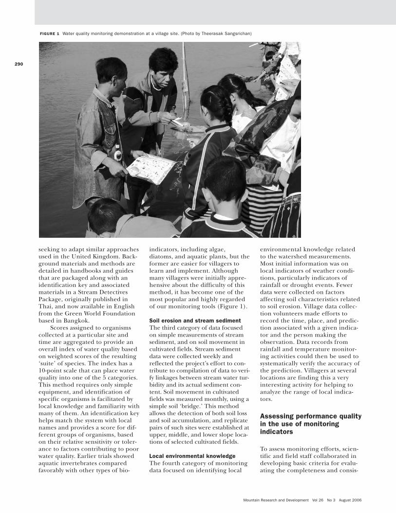
indicators, including algae,diatoms, and aquatic plants, but theformer are easier for villagers tolearn and implement. Althoughmany villagers were initially appre-hensive about the difficulty of thismethod, it has become one of themost popular and highly regardedof our monitoring tools (Figure 1).
Soil erosion and stream sedimentThe third category of data focusedon simple measurements of streamsediment, and on soil movement incultivated fields. Stream sedimentdata were collected weekly andreflected the project’s effort to con-tribute to compilation of data to veri-fy linkages between stream water tur-bidity and its actual sediment con-tent. Soil movement in cultivatedfields was measured monthly, using asimple soil ‘bridge.’ This methodallows the detection of both soil lossand soil accumulation, and replicatepairs of such sites were established atupper, middle, and lower slope loca-tions of selected cultivated fields.
Local environmental knowledgeThe fourth category of monitoringdata focused on identifying local
environmental knowledge relatedto the watershed measurements.Most initial information was onlocal indicators of weather condi-tions, particularly indicators ofrainfall or drought events. Fewerdata were collected on factorsaffecting soil characteristics relatedto soil erosion. Village data collec-tion volunteers made efforts torecord the time, place, and predic-tion associated with a given indica-tor and the person making theobservation. Data records fromrainfall and temperature monitor-ing activities could then be used tosystematically verify the accuracy ofthe prediction. Villagers at severallocations are finding this a veryinteresting activity for helping toanalyze the range of local indica-tors.
Assessing performance qualityin the use of monitoringindicators
To assess monitoring efforts, scien-tific and field staff collaborated indeveloping basic criteria for evalu-ating the completeness and consis-
290
FIGURE 1 Water quality monitoring demonstration at a village site. (Photo by Theerasak Sangsrichan)
291
tency of data records generated byvillage monitor volunteers at eachof the 12 main monitoring sitesover a 30-month period. Whilenone of the sites were able toachieve a complete high qualitydata record, results of these initialpilot efforts conducted by villagevolunteers were quite impressive atmany sites. Village volunteers wereable to explain reasons for a num-ber of the gaps and inconsistenciesin their data records by describingsome of the problems they encoun-tered during the data collectionprocess.
Lessons for further use ofwatershed monitoring toolsParticipating villagers were alsoasked to give their opinions aboutthe different measurements,based on their perceptions of howuseful the data would be for themin the context of their local issuesand watershed management net-work. All villagers agreed on therelevance and utility of collectingtemperature, humidity, rainfall,and water quality data, as well asrelevant information on localknowledge. Opinions were spliton the usefulness of data onstream depth and water tempera-ture.
In addition to opinions aboutthe various types of simple science-based tools, volunteers gave theseadditional suggestions about col-lecting data on watershed services:
• Authority for data collectorsneeds to be derived from rela-tionships with a network or alocal sub-district governmentunit.
• All relevant ethnic groups in thelocal area should be included.
• It is important to have periodicmeetings among data collectorsin various sub-watersheds, inorder to exchange data andinformation.
• Persons providing extension sup-port services must give sufficient
time to training in collecting,interpreting, and using data,building understanding andanswering questions, and helpingpoint out its importance.
• Data collectors should have suffi-cient basic knowledge or abilityto learn quickly.
• An appropriate modest amountof compensation is necessary.
• Activities should be coordinatedwith village headmen to helpthem appreciate the usefulnessand importance of the data.
• The need for data byresearchers, watershed man-agers, or technicians must bematched with the needs of localpeople from the outset in orderto prevent conflicts, as the dataneeds of watershed managersprobably differ from the needsof villagers.
Use of science-based tools,together with local environmentalknowledge in participatory water-shed monitoring and management,is possible, and communities haveseen that knowledge from these 2sources can be combined toincrease their usefulness. But 2issues need careful consideration:
1. Confusion about use and inter-pretation of data from science-based tools; and
2. Study of factors that can helpsupport emergence of theseactivities, considering that vol-unteers must manage their timecarefully.
There will likely be a need for adap-tation to local contexts that mayaffect what data are collected, aswell as the completeness of datarecords. Local monitors also want toexchange knowledge and experi-ence. Thus, future efforts need toemphasize easy tool use and datainterpretation, and ways to supportinformation exchange, in order tofacilitate the widespread use andacceptability of data among vil-lagers, technicians, other stakehold-
ers, and policy decision-makers atvarious levels.
Additional biologicalindicators of environmentalquality
Given the importance of and inter-est in use of biological indicators,among villagers and our colleaguesat governmental and non-govern-mental institutions, additional workin this area was led by Dr PornchaiPreechapanya of the NorthernWatershed Research Center. He andhis staff printed and distributed aHandbook for Inspecting EnvironmentalQuality that catalogs 133 entries ofbiological indicators of water, soil,forest, air, and general environmen-tal quality. Entries cover a range ofindicator organisms, includingaquatic invertebrates, fish, algae,plants, mammals, amphibians, rep-tiles, birds, and insects. Informationincludes local and scientific names,pictures, and details about whatthey can indicate in terms of envi-ronmental quality characteristics.
FURTHER READING
Kanjanavanit O, editor. 2002. Stream DetectivesPackage. Includes: (1) A Handbook for StreamDetectives; (2) A Handbook for Stream DetectiveLeaders; (3) An Identification Guide to StreamInvertebrates; (4) An Identification Guide toFreshwater Fish; (5) An Identification Guide toStream Bank Animals. Bangkok, Thailand: TheGreen World Foundation. Available at:http://www.greenworld.or.th/2_gws.htm;accessed on 9 May 2006.Thomas DE, Preechapanya P, Saipothong P.2004. Developing Science-Based Tools for Partici-patory Watershed Management in Montane Main-land Southeast Asia. Final Report to the Rocke-feller Foundation. Chiang Mai, Thailand: WorldAgroforestry Centre. Also available at:http://www.worldagroforestry.org/sea/th/Documents/RF-2000-GI-086%20ICRAF%20Final%20Report%20LR.pdf; accessed on 9 May 2006.
MountainNotes
Pornwilai Saipothong, Pornchai Preechapa-nya, Thanat Promduang, Nongluck Kaewpoka,David E. ThomasWorld Agroforestry Centre (ICRAF), PO Box267 CMU Post Office, Chiang Mai 50202,[email protected] (P.S.);[email protected] (P.P.); [email protected] (D.T.)

Mountain Research and Development Vol 26 No 3 August 2006
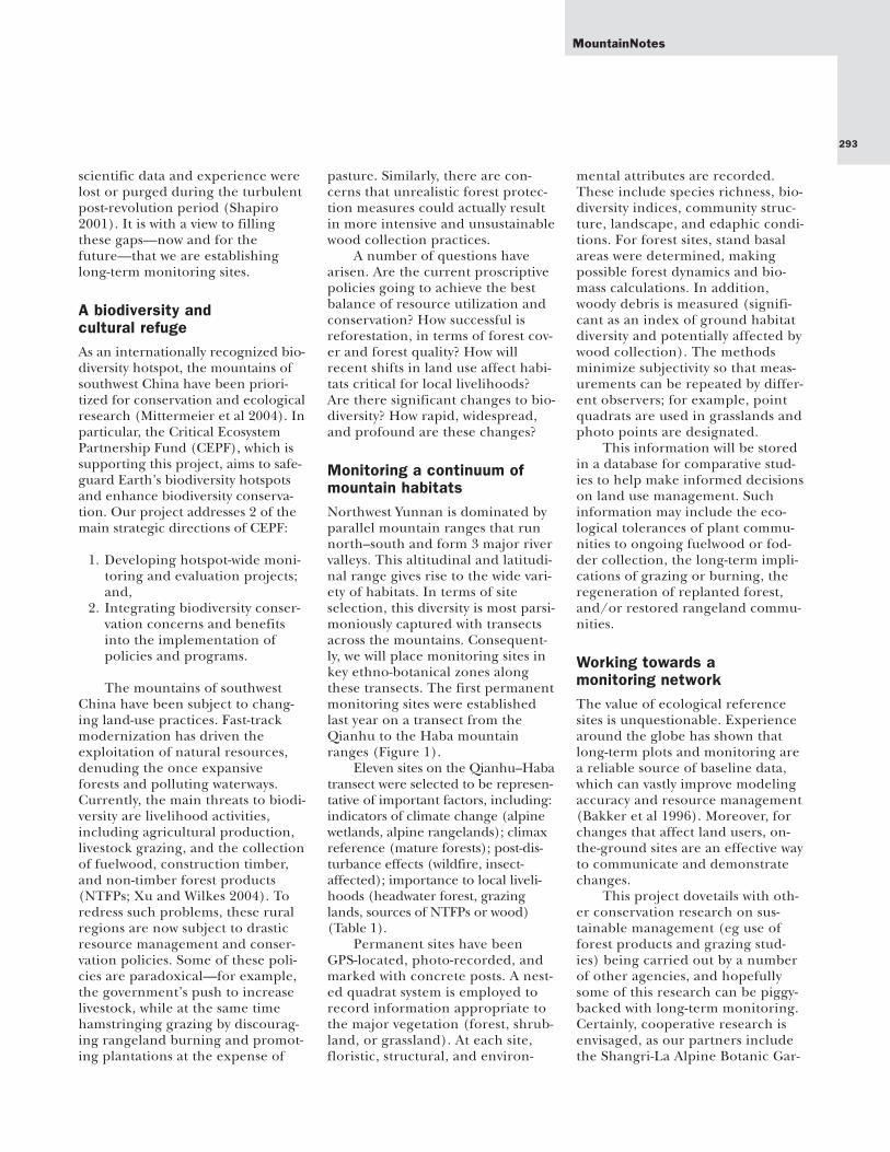
Increasing attention is being paid toland use changes in the mountainenvironments of southwest China.Yet it is essential to develop a net-work of relevant sites for long-termanalysis and comparison. For this
reason an important part of anongoing ethno-ecological projectbeing undertaken by the KunmingInstitute of Botany is the establish-ment of permanent vegetation plotsacross key environmental gradients
in northwest Yunnan. These sitesare envisaged as a model for a net-work of permanent plots that willprovide baseline data to help delin-eate the potential effects of climaticand land-use changes in this region.Northwest Yunnan is important—not only as a biologically and cultur-ally significant area in its own right,but, since it forms the headwaters ofmajor rivers in Southeast Asia (iethe Mekong, Irrawaddy, Salween,and Yangtze), this region hasimmense regional significance as anupstream provider of ecosystemservices (Figure 1).
In response to rapidly increas-ing environmental pressures, Chinahas introduced large-scale regulato-ry land use measures (exemplifiedby logging bans, reforestation proj-ects, and the Sloping Land Conver-sion Program [SLCP] that aim toreplace farms with forests on moun-tain slopes. The scale of theseschemes is mind-boggling—theSLCP is budgeted at over US$ 40 bil-lion, affects more than 15 millionfarmers across 25 provinces, andplans to convert 14.67 million ha ofcropland to forests by 2010. Howev-er, these programs have been criti-cized for their simplistic and mono-lithic approach, particularly in lightof the diversity of landscapes andecosystems affected (Xu et al 2004;Weyerhaeuser et al 2005).
To some extent, shortfalls inChina’s land-use policies areinevitable, because relevantresearch is constrained by a lack offundamental baseline data.Although great strides are beingmade in introducing high-techmanagements tools (eg GIS andremote sensing), most temporalland use modeling is based onimage analysis, which is often super-ficial. The paucity of long-term eco-logical records is especially notablein China, because large amounts of
292
4379
4075
4129
6740
5010
4036
53106246
4595
4285
4023
5596
YulongxueShan
26°N26°N 26°N
27°N 27°N27°N
28°N 28°N
29°N29°N 29°N29°N
99°E99°E
99°E
100°E100°E
100°E
Dulong
Dulong
Jinsha(Yangtze)
Jin
sz
ha
n(Ya
gte)
Jin
sz
ha
n(Ya
gte)
Lao
ncan
g(M
ekng)
Lancan
g(M
ekng
o)
Nu
(Salw
een)
Nu
(Salwn
ee)
Lita
ng
Shuituo
Nm
ai Hka
Xo
ErHai
Js
inha
( Yangtze)
MYA N M A RMYA N M A RY U N N A N
S I C H U A N
T IBETT IBET
LanpingLanping
NinglangNinglang
DeqinDeqin
ZhongdianZhongdianGongshanGongshan
WeixiWeixi
FugongFugong
JianchuanJianchuan
LijiangLijiang
YongshengYongshengHeqingHeqing
Binchuan
YunlongYunlong
EryuanEryuan
LushuiLushui
MatsutakeMonitoring Site
Qianhu Habatransect
-
0 50 kmN
County capitalMain roadOther roadNational boundaryProvince boundaryPrefecture boundaryCounty boundaryStudy area 0 100 km
NN 22°N22°N
26°N26°N
100°E100°E 104°E104°EStudy areaStudy area
Y u n n a nY u n n a n
GuizhouGuizhou
SichuanSichuan
TibetTibet
MYAN-MAR
MYAN-MAR
LAOSLAOS VIETNAMVIETNAM
YunnanProvince
CHINA
BeijingBeijing
LhasaShanghaiShanghai
KunmingKunming
FIGURE 1 Map of northwest Yunnan, showing the parallel mountain ranges and the position of theQianhu–Haba transect. (Map by Andreas Brodbeck)
Establishing Long-term Biodiversity Assessment and Monitoring in Northwest Yunnan,China: A Growing Need for Baseline Information
293
scientific data and experience werelost or purged during the turbulentpost-revolution period (Shapiro2001). It is with a view to fillingthese gaps—now and for thefuture—that we are establishinglong-term monitoring sites.
A biodiversity and cultural refugeAs an internationally recognized bio-diversity hotspot, the mountains ofsouthwest China have been priori-tized for conservation and ecologicalresearch (Mittermeier et al 2004). Inparticular, the Critical EcosystemPartnership Fund (CEPF), which issupporting this project, aims to safe-guard Earth’s biodiversity hotspotsand enhance biodiversity conserva-tion. Our project addresses 2 of themain strategic directions of CEPF:
1. Developing hotspot-wide moni-toring and evaluation projects;and,
2. Integrating biodiversity conser-vation concerns and benefitsinto the implementation ofpolicies and programs.
The mountains of southwestChina have been subject to chang-ing land-use practices. Fast-trackmodernization has driven theexploitation of natural resources,denuding the once expansiveforests and polluting waterways.Currently, the main threats to biodi-versity are livelihood activities,including agricultural production,livestock grazing, and the collectionof fuelwood, construction timber,and non-timber forest products(NTFPs; Xu and Wilkes 2004). Toredress such problems, these ruralregions are now subject to drasticresource management and conser-vation policies. Some of these poli-cies are paradoxical—for example,the government’s push to increaselivestock, while at the same timehamstringing grazing by discourag-ing rangeland burning and promot-ing plantations at the expense of
pasture. Similarly, there are con-cerns that unrealistic forest protec-tion measures could actually resultin more intensive and unsustainablewood collection practices.
A number of questions havearisen. Are the current proscriptivepolicies going to achieve the bestbalance of resource utilization andconservation? How successful isreforestation, in terms of forest cov-er and forest quality? How willrecent shifts in land use affect habi-tats critical for local livelihoods?Are there significant changes to bio-diversity? How rapid, widespread,and profound are these changes?
Monitoring a continuum ofmountain habitatsNorthwest Yunnan is dominated byparallel mountain ranges that runnorth–south and form 3 major rivervalleys. This altitudinal and latitudi-nal range gives rise to the wide vari-ety of habitats. In terms of siteselection, this diversity is most parsi-moniously captured with transectsacross the mountains. Consequent-ly, we will place monitoring sites inkey ethno-botanical zones alongthese transects. The first permanentmonitoring sites were establishedlast year on a transect from theQianhu to the Haba mountainranges (Figure 1).
Eleven sites on the Qianhu–Habatransect were selected to be represen-tative of important factors, including:indicators of climate change (alpinewetlands, alpine rangelands); climaxreference (mature forests); post-dis-turbance effects (wildfire, insect-affected); importance to local liveli-hoods (headwater forest, grazinglands, sources of NTFPs or wood)(Table 1).
Permanent sites have beenGPS-located, photo-recorded, andmarked with concrete posts. A nest-ed quadrat system is employed torecord information appropriate tothe major vegetation (forest, shrub-land, or grassland). At each site,floristic, structural, and environ-
mental attributes are recorded.These include species richness, bio-diversity indices, community struc-ture, landscape, and edaphic condi-tions. For forest sites, stand basalareas were determined, makingpossible forest dynamics and bio-mass calculations. In addition,woody debris is measured (signifi-cant as an index of ground habitatdiversity and potentially affected bywood collection). The methodsminimize subjectivity so that meas-urements can be repeated by differ-ent observers; for example, pointquadrats are used in grasslands andphoto points are designated.
This information will be storedin a database for comparative stud-ies to help make informed decisionson land use management. Suchinformation may include the eco-logical tolerances of plant commu-nities to ongoing fuelwood or fod-der collection, the long-term impli-cations of grazing or burning, theregeneration of replanted forest,and/or restored rangeland commu-nities.
Working towards a monitoring networkThe value of ecological referencesites is unquestionable. Experiencearound the globe has shown thatlong-term plots and monitoring area reliable source of baseline data,which can vastly improve modelingaccuracy and resource management(Bakker et al 1996). Moreover, forchanges that affect land users, on-the-ground sites are an effective wayto communicate and demonstratechanges.
This project dovetails with oth-er conservation research on sus-tainable management (eg use offorest products and grazing stud-ies) being carried out by a numberof other agencies, and hopefullysome of this research can be piggy-backed with long-term monitoring.Certainly, cooperative research isenvisaged, as our partners includethe Shangri-La Alpine Botanic Gar-
MountainNotes

Mountain Research and Development Vol 26 No 3 August 2006
den, Zhongdian; ZhongdianTibetan Research Institute; Centerfor Biodiversity and IndigenousKnowledge (CBIK), Kunming; andWorld Agroforestry Centre, Kun-ming. This work will also comple-ment ongoing alpine assessments inthis region by the Nature Conser-vancy, who are establishing perma-nent plots on mountain summits aspart of a coordinated global moni-toring effort (Pauli et al 2004).
It is envisaged that a permanentplot program will be expanded tocover other ranges at various lati-tudes. While far from complete,these sites will form an invaluableresource in coming years to trackthe effects of climate change andvaried land use. In the long term, wewant a mechanism in place to moni-
tor the status of key ecosystems innorthwest Yunnan, with a view to tar-geting policy changes in land usepractices that reflect local conserva-tion and community developmentneeds.
REFERENCES
Bakker JP, Olff H, Willems JH, Zobel M. 1996.Why do we need permanent plots in the study oflong-term vegetation dynamics? Journal of Vege-tation Science 7:147–156.Mittermeier RA, Robles-Gil P, Hoffman M,Pilgrim JD, Brooks TM, Mittermeier CG, Lam-oreux JL, da Fonseca GAB. 2004. HotspotsRevisited. Earth’s Biologically Richest and MostEndangered Ecoregions. 2nd edition. MexicoCity: Cemex.Pauli H, Gottfried M, Hohenwallner D, Reiter K,Casale R, Grabherr G. 2004. The Gloria FieldManual. Multi-Summit Approach. Luxembourg:Office for Official Publications of the EuropeanCommunities. Downloadable from:www.gloria.ac.at/?a=20Shapiro J. 2001. Mao’s War Against Nature. Poli-
tics and the Environment in Revolutionary China.Cambridge, UK: Cambridge University Press.Weyerhaeuser H, Wilkes A, Kahrl F. 2005. Localimpacts and responses to regional forest con-servation and rehabilitation programmes in Chi-na’s northwest Yunnan Province. AgriculturalSystems 85(3):234–253.Xu J, Wilkes A. 2004. Biodiversity impact analy-sis in northwest Yunnan, southwest China. Biodi-versity and Conservation 13:959–983.Xu ZG, Bennett MT, Tao R, Xu JT. 2004. China’sSloping Land Conversion Programme four yearson: Current situation and pending issues. Inter-national Forestry Review 6:317–326.
294
David Melick, Xuefei Yang, and Yongping YangKunming Institute of Botany,Heilongtan, Kunming 650204, [email protected]@[email protected]
Xu JianchuInternational Centre for Integrated MountainDevelopment, PO Box 3226, Kathmandu,[email protected]
Major aspect Elevation (m) Vegetation type
Width of the zone (km) % of transect
Monitoring plot
East ~4000 Alpine mosaic of lake–grassland–Rhododendronshrub–Abies forest
1.4 3.25 Yes
East 3800–4000 Mosaic of grassland–Abies forest 5.6 4.88 Yes (2)
East 3600–3700 Abies forest 1.5 5.69 Yes
East 3400–3600 Forest mosaic of Abies–Picea–Quercus–Betu-la–bamboo
2.0 6.50 Yes
East 3200–3400 Pinus densata forest 0.8 2.44
Flat ~3200 Mosaic of agriculture–grassland 2.0 3.25
East 3000–3200 Pinus densata forest 3.0 7.32
Flat ~300 Xiaozhongdian River
West 3000–3300 Pinus densata forest 4.0 14.63 Yes (2)
Flat ~3000 Mosaic of agriculture–grassland 2.5 6.50 Yes
Varied 3100–3500 Pinus densata forest 4.0 11.38
West 3500–3600 Forest mosaic of Pinus densata–Quercus pannosa
0.4 1.63
West 3600–3700 Forest mosaic of Quercus pannosa–Abies 0.4 1.63 Yes
West 3700–3900 Rangeland–forest mosaic (Abies–Larix) 1.0 1.63 Yes
West 3900–4000 Alpine mosaic of Rhododendronshrub–grassland
0.4 2.44 Yes
West >4000 Alpine scree 0.4 1.63
TABLE 1 Overview of the major vegetation habitats across the Qianhu–Haba mountain transect.
295
MountainNotes
Professor Jack D. Ives is the founding edi-tor of Mountain Research and Devel-opment. Many MRD readers, and cer-tainly the wider community of mountainspecialists, scholars, and developmentexperts, are familiar with Jack Ives’sinternational reputation as an advocatefor the world’s mountains. His influen-tial career as a renowned teacher, scholar,editor, and public advocate has now beenacknowledged with a very high honor—the award of the Patron’s Medal of theRoyal Geographical Society. MRD hasreceived the official information printedbelow in connection with this award.The MRD editorial staff is proud tohave been entrusted with continuing thework that Jack began in founding MRD,now in its 26th year of publication. Wewould like to take this opportunity tooffer our heartiest congratulations toMRD’s founding editor on the occasionof his receipt of this award!
Patron’s Medal of the RoyalGeographical Society
Her Majesty Queen Elizabeth IIapproved the award of the Patron’sMedal of the Royal GeographicalSociety (RGS) to Professor Jack D.Ives for his mountain and arcticresearch, extensive publishing,teaching, and especially “for hisrole internationally in establishingthe global importance of mountainregions.”
The presentation was made on5 June 2006, at the RGS headquar-ters, Kensington Gore, London, bySir Neil Cossons, OBE, President ofthe Society.
The RGS annually presents twoRoyal Medals of equal rank and dat-ing back to 1831. The Founder’sMedal (HM King William IV, theSociety’s founder) was awarded to
Professor Derek Gregory of the Uni-versity of British Columbia.
In making the presentation, SirNeil referred to Jack’s founding andediting of Mountain Research andDevelopment (1981) and the quarter-ly journal Arctic, Antarctic and AlpineResearch (1968). He went on toemphasize his contributions toensuring the inclusion of Chapter13 in Agenda 21 during the 1992Rio de Janeiro Earth Summit andthe UN dedication of 2002 as TheInternational Year of Mountains,also to his coordination, with BrunoMesserli, of the UNU Himalayanresearch and training mission.
The second edition of Jack’s bookHimalayan Perceptions: EnvironmentalChange and the Well-being of MountainPeoples is due for publication inKathmandu later this summer.
MRD Founding Editor Jack D. Ives Honored by the Royal Geographical Society