Land-use Conflict at Shasta Dam, California
229
THE ROLE OF CRITICAL CARTOGRAPHY IN ENVIRONMENTAL JUSTICE: LAND-USE CONFLICT AT SHASTA DAM, CALIFORNIA A thesis submitted to the faculty of San Francisco State University In partial fulfillment of the requirements for the Degree Master of Arts In Geography by Anne Kathryn McTavish San Francisco, California January, 2010
-
Upload
khangminh22 -
Category
Documents
-
view
1 -
download
0
Transcript of Land-use Conflict at Shasta Dam, California
THE ROLE OF CRITICAL CARTOGRAPHY IN ENVIRONMENTAL JUSTICE: LAND-USE CONFLICT AT SHASTA DAM, CALIFORNIA
A thesis submitted to the faculty of San Francisco State University
In partial fulfillment of the requirements for
the Degree
Master of Arts In
Geography
by
Anne Kathryn McTavish
San Francisco, California
January, 2010
Copyright by Anne Kathryn McTavish
2010
CERTIFICATION OF APPROVAL
I certify that I have read The Role of Critical Cartography in Environmental Justice:
Land-use Conflict at Shasta Dam, California by Anne Kathryn McTavish, and that in my
opinion this work meets the criteria for approving a thesis submitted in partial fulfillment
of the requirements for the degree: Master of Arts in Geography at San Francisco State
University.
____________________________________________________
Nancy Lee Wilkinson Professor of Geography
____________________________________________________
Jerry Davis Professor of Geography

THE ROLE OF CRITICAL CARTOGRAPHY IN ENVIRONMENTAL JUSTICE: LAND-USE CONFLICT AT SHASTA DAM, CALIFORNIA
Anne Kathryn McTavish San Francisco State University
2010
The United States Bureau of Reclamation (USBR) is conducting a feasibility study to
increase the height of Shasta Dam. The Winnemem Wintu Indian Tribe contend that any
increase in the storage capacity of Shasta Lake would inundate their remaining cultural
and historic sites, tribal lands, and current homestead, an act they describe as “cultural
genocide.” Critical Cartography plays a valuable role evaluating the Winnemem Wintu
claim, revealing how the tribe’s claim to land was mapped, then unmapped, over the past
two-hundred years.
I certify that the Abstract is a correct representation of the content of this thesis.
___________________________________________ ________________ Chair, Thesis Committee Date
v
ACKNOWLEDGEMENTS
I have been amazed, delighted, appalled, and humbled as I learned about the
rights, issues, and status of the Winnemem Wintu. The journey has been eye-opening
and life changing. I owe a debt of gratitude to many people who helped me along the
way. I must start with Nancy Lee Wilkinson and Jerry Davis, who shared scholarship
and friendship throughout this process. Barry Nickel, Seth Hiatt, Ellen McElhinny, and
Jesse Cohen helped develop my cartographic knowledge and techniques. The
Winnemem Wintu were generous with their time, research data, and contacts. I would
thank them all, especially Caleen Sisk Franco, leader of the Winnemem Wintu, and Mark
Franco, headman of the tribe, who live on and off the map every day.
As with any project, support came from many sources. I would especially like to
thank my parents, Ray and Rosaleen McTavish, who gave me a life-long love of learning;
Dennis Freedman, LaVonne Jacobson, and Deborah Osterberg and all the librarians who
pointed me in the right direction; Sandra Adams, Anne Anderson, Sally Arney, Jane
Baack, Larry Baack, Erica Brevet-Stott, Erika Bruce, Julie Cassidy, Tony Crea, Gail
DeLalla, Barbara Doyal, Sally Goodman, Sarah Harling, Donita Hohenstein, Katie Hope,
Barbara Ingber, Brian Keaveny, Carol Long, Sharon MacTavish, Gail Manning, Chris
McGee, Fran Phillips, John Poole, Marilyn Trabert, and Alan Wiig, who read my thesis
and gave me feedback along the way.
vi
TABLE OF CONTENTS
List of Tables ………………………………………………………….…………. x
List of Figures ……………………………………………………………………. xi
List of Appendices ……………………………………………………………….. xiii
Frontispiece ………………………………………………………………………. xv
1. Introduction: Purpose and Significance ……………………………………… 1
List of Abbreviations ……………………………………………………. 5
Terminology ……………………………………….……………………. 5
Study Area ………………………………………………………………. 9
2. Theoretical Framework ...…………………………………………………….. 11
3. Methods .……………………………………………………………………… 15
Historic Material ………………………………………………………… 16
Digital Data Sources …………………………………………………….. 19
Paper Maps ……………………………………………………………… 19
Text Descriptions Used to Locate Details on the Map ………..………… 21
Conversations With the Winnemem Wintu …………………...………… 21
4. Putting the Wintu on the Map ………………………………….…………….. 22
Methodology ……………………………………………………………. 25
vii
Wintu Territory Boundaries ………………………………………..……. 25
Kroeber ………………………………………………………………….. 26
DuBois …………………………………………………………………... 30
LaPena, 1978 ..…………………………………………………………... 32
LaPena, 2002 ..…………………………………………………………... 34
Merriam ………………………………………………………………… 35
Powers ………………………………………………………………….. 38
Norel-Putis and the Winnemem Wintu …………………………………. 39
Winnemem Wintu Historical Villages .…………………………………. 41
Tribal Recognition……………………………………………………….. 44
Summary ………………………………………………………………… 45
5. Taking the Wintu off the Map ………………………………………………... 48
Methodology …………………………………………………………….. 49
California Before Statehood …………………………………………….. 49
Squatters and Homesteaders …………………………………………….. 54
Unratified Treaties ………………………………………………………. 57
Railroads ………………………………………………………………… 60
Competition for Land in the McCloud Watershed ……………………… 64

viii
Baird Fish Hatchery ……………………………………………………... 65
Sportsman’s Paradise ……………………………………………………. 71
U.S. Forest Service ……………………………………………………… 76
Allotments ………………………………………………………………. 77
1891: Special Agent Michael Piggott …………………………………… 79
1900: Special Agent William E. Casson ………………………………... 83
1905: Special Agent C. E. Kelsey ……………………………………… 86
1915: Special Agent John Terrell ……………………………………….. 90
1922 – 1928 ……………………………………………………………... 94
1929 – 1937 ……………………………………………………………... 95
Summary ………………………………………………………………… 97
6. Shasta Dam …………………………………………………………………... 100
Methodology ……………………………………………………………. 101
Building Shasta Dam ……………………………………………………. 101
USBR and the Redding Allotments …………….……………………….. 105
Central Valley Project Studies; Problem 23 (CVP Problem 23) ..….…… 106
National Archive Documents from the USBR ………………………….. 107
USBR Letters……………………………………………………………. 109
ix
Central Valley Project Indian Lands Acquisition Act, 55 Stat 612 ……... 112
USBR Transferred Payment for the Allotments to the BIA …………….. 113
USBR Had to Move Graveyards ………………………………………... 114
Were Indian Owners Treated Differently Than White Owners? ……...… 117
New Plans to Increase the Height of Shasta Dam ………………………. 121
Summary………………………………………………………………… 127
7. Putting the Winnemem Wintu Back on the Map ………………..…………... 129
Spiritual Practice ..…………………………………………..…………… 130
Political Action .…………………………………………...…………….. 132
8. Summary of Results, Discussion, and Conclusion …………………………... 134
References ………………………………………………………………………... 139
Appendices ……………………………………………………………………….. 162
x
LIST OF TABLES
Table Page
6.3 The Following Tabulation Lists the Acreage of Various Owners in Shasta Reservoir Area as of December 31, 1943 ……………………….
106
xi
LIST OF FIGURES
Figure Page
1.1 Comparison of Maps Showing the Location of the Wintu in Northern California ………...……………………………………………………...
7
1.2 Study Area ………...……………...…………………………………….. 10
4.1 Okwanuchu ……………………………………………………………... 23
4.2 DuBois’s Map of Wintu Territory ……………..………….……………. 31
4.3 LaPena’s 1978 Map of Wintu Territory ……………...…………………. 33
4.4 LaPena’s 2002 Map of Wintu Territory ……………...…………………. 35
4.5 C. Hart Merriam’s Wintu boundaries ……………..……………………. 37
4.6 Detail of Historic Villages from Research by Curtin and Harrington, Verified by Guilford-Kardell and Drawn on Wiegel’s Map ………..…..
43
5.1 Early Extent of Hispanic Impact ……………………………….……….. 51
5.2 Nine of the Benson Syndicate Fraudulent Surveys Were in the McCloud Watershed ………………………………………………………………..
56
5.3 Detail of Royce’s Map ………….………………………………………. 59
5.4 Detail of Colton’s California Railroad Map …………...…..…………… 62
5.5 Lumber Mill in McCloud, California …………………………..……….. 63
5.6 Ownership of California Land from the Public Domain in 1880 ………. 64
5.7 Wintu Arrayed in War Dance Costume at the Salmon Breeding Station at Baird, on the McCloud River, California …………………….……….
66
5.8 Baird Fish Hatchery …………………………………………………….. 68

xii
5.9 Wintu Man, Charlie Pit, Spearing Salmon on the McCloud River .…….. 69
5.10 Colchoolooloo’s Ranch, Taken About 1882 ..…………………………... 70
5.11. Wheeler’s Place on the McCloud River ………………………………… 72
5.12 Foot Log at Horse Shoe ………………………………………………… 72
5.13 Hearsts’ Wyntoon Estate on the McCloud River ….…………………… 73
5.14 Detail of Forest Service Map Showing Location of Ah-Di-Na ……….... 74
5.15 McCloud River Club ……………………………………………………. 75
6.1 Elevation Model of Shasta Lake and the Surrounding Area ………..…... 103
6.2 Shasta Dam was the Second-Largest Dam in the World at the Time it Was Built ……………………….………………………………………..
104
6.4 Three Sources Were Used to Represent the Allotments the USBR Needed to Acquire in the Shasta Reservoir Area ……………….……….
111
6.5 Shasta Reservoir Area Showing the 72 Allotments the USBR Needed to Acquire for CVP Shasta Dam in Relationship to the Graveyards that Had to be Relocated …...………………………………………………...
116
6.6 Shasta Lake Elevation Fluctuations …………………………………….. 125

xiii
LIST OF APPENDICES
Appendix Page
1 Data sources for digital data ……………………………………….. 170
2 Paper maps, scanned or digital; georeferenced and projected; used for visual reference to create new shapefiles ……………………… 177
3 Text sources used to create shapefiles by locating feature based on combination of downloaded data and georeferenced maps ……….. 182
4 List of 196 Wintu Redding Allotments located on the study map .... 161
5 Wintu Yana Petition ……………………………………………….. 183
6 Hauke to Wilson urging him to spend money for land for Indians ... 194
7 Young to BIA to Purchase Allotments for CVP …………………... 196
8 Herrick to Nash with detailed instructions for USBR regarding procedures to purchase Indian Allotments for CVP. December 7, 1938 ………………………………………………………………... 197
9 Rockwell to Lorenzen regarding CVP purchase money for Keluche. 200
10 Rockwell to Commissioner of Indian Affairs, Chicago Office, regarding check for $46,223 from USBR for 28 Allotments. February 18, 1943 …………………………………………………. 202
11 Calland to County Recorder Regarding Cemetery Relocation ……. 204
12 USBR Map Showing Original Location of Graveyards …………... 208
13 Memo for Welfare: CVPILAA 1941 Section 3 deals with disposition of funds received from sale of lands. April 27, 1943 ….. 209
14 Daiker to Rockwell on how to use the CVPILAA funds deposited to the credit of various Indians related to the sale of Indian Allotments to USBR for CVP. May 31, 1943 …………………………………. 210

xiv
15 Rockwell to Frances Sisk Dixon Hayward regarding use of money from CVP purchases. August 5, 1943 ……………………………... 211
16 Rockwell to Charles Cornish regarding payment for Indian Allotment sold to USBR. August 4, 1943 …………………………. 212
17 Rockwell to Marshall Radcliff regarding payment for Indian Allotment sold to USBR. August 25, 1943 ………………………... 212
18 Rockwell to Mrs. Bertha Edwards regarding payment for Indian Allotment Red 195 sold to USBR. August 4, 1943 ……………….. 213
19 CVP Problem 23 Land Owners map ………………………………. 214
xv
How did we lose our land with its fisheries, its hunting grounds, its acorn forests, its fields of clover, the blossoms of which were pleasant food to us?
-Wintu and Yana Petition to Benjamin Harrison, President of the United State 1889 (Appendix 5)
The interests of many of the Shasta County Indians would be served better if they would leave the county entirely.
-John G. Rockwell, Field Representative in Charge, Sacramento Indian Agency, to the Commissioner of Indian Affairs
1943 (Appendix 10)
1
1. Introduction: Purpose and Significance
The United States Bureau of Reclamation (USBR) is
conducting a feasibility study to increase the height of Shasta Dam.
In October 2005, the USBR initiated environmental compliance
documentation for Shasta Lake Water Resources Investigation
(SLWRI) in order to prepare an Environmental Impact Statement
(EIS) in compliance with the National Environmental Policy Act
(NEPA). The USBR issued a Notice of Intent to inform interested
groups and individuals about the SLWRI. The schedule of scoping
meetings was published with the Notice of Intent. Scoping
allowed agencies, stakeholders, and interested parties to identify
issues of concern (Garcia 2006: p. 1-1). The Winnemem Wintu
put forward that any increase in the storage capacity of Shasta
Lake would inundate their remaining cultural and historical sites,
tribal lands, and current homestead, an act they described as
“cultural genocide” (Martin 2005). Because they were not a
federally recognized Indian tribe, they believe environmental
justice was the most effective platform from which to address their concerns about the
destruction of sacred space that would result from any increase in the maximum-pool
water level of Shasta Lake.
Question: What role can Critical Cartography play in evaluating the Winnemem
Wintu claim of environmental injustice?
For centuries, major funding for collection and distribution of cartographic data
and products was dominated by the state and major map publishers (Harley 2001: p. 59).
Recently, access to the internet and home computers, combined with open-source tools,
accurate location data from affordable Global Positioning System units, and readily
2
available digitized base maps have made it possible for others to make reliable,
verifiable, repeatable maps. Maps are not neutral, scientific documents. Rather, they are
“a specific set of power-knowledge claims” (Crampton et al. 2005: p. 12).
This study is a research-based analysis and interpretation of historical and spatial
data through the framework of Critical Cartography, which delves into the political
aspects of maps, exploring how they exercise power, shape identity, construct
knowledge, and promote social change (Crampton et al. 2005: p. 15). Since the present
circumstances of the Winnemem Wintu are derived from historical conditions, the actions
that put the Winnemem Wintu on and off the map are critiqued to reveal historical
context and tease out attitudes that may have contributed to the present claim of
environmental injustice. Using Critical Cartography to re-examine available historical
maps and documents, I explore the role maps played when a group of people outside the
dominant culture were added to and removed from the map.
There are 562 federally recognized Indian tribes in the United States, but there are
also 332 unrecognized tribes, including 74 in California. The efforts of the Winnemem
Wintu to make officially recognized claims about who they are, to influence land-use
decisions in the area affected by Shasta Dam and Shasta Lake, and to remain in their
historical tribal territory are not unique to this tribe. The research techniques used to
analyze historical maps by georeferencing them, locating text descriptions on the map,
and drawing from multiple sources in order to reconstruct historical events may be
adapted and used by other recognized and unrecognized tribes. Critical cartography
provides a theoretical framework through which historical data may be re-examined with
a fresh eye so that historical errors may be revealed and corrected both on the map and in
the text.
Chapter 2 discusses the framework of Critical Cartography. Maps are more than
neutral, scientific representations of space, they are political documents with the power to
3
alter space. As the ability to make maps becomes ever more available to anyone with a
computer and internet connection, Critical Cartography promotes geographic knowledge
as a means of promoting social change. Despite lack of federal recognition, the
Winnemem Wintu have been a continuous community in the McCloud watershed from
historical times and remain actively engaged spiritually and politically today. On the
basis of Environmental Justice, they oppose the United States Bureau of Reclamation
feasibility plans, currently under investigation, to increase the height of Shasta Dam.
Throughout this study Critical Cartography is used to provide context and frame the
historical and spatial dimensions of the Winnemem Wintu claim of environmental
injustice.
Chapter 3 describes an overview of the methodology used in the analysis for this
study. Maps for this study were derived from many sources, using GIS tools, archival
research, and analysis of available historical maps. This chapter describes the sources
and how they are used in this study. Sources include historic documents, digital data,
paper maps, text descriptions, and conversations with the Winnemem Wintu. Specific
methodological details are described in Chapters 4, 5, and 6 so the methods I use to
analyze historical data may be seen in context with the results.
Chapter 4 discusses how the Winnemem Wintu were put on the map. Specific
methodologies I use in this chapter are to add color to existing maps, create Merriam’s
map based on text description, and georeference Guilford-Kardell’s map of historical
Wintu villages. The motive behind the changes Kroeber made to Powers’s map is
examined. The maps made by subsequent researchers from the University of California
are examined to see if they reinforce Kroeber’s decision or simply carry on his
interpretation.
Chapter 5 follows the chronology of events that took the Winnemem Wintu off
the map. Specific methodologies I use in this chapter are to compile or use maps to show
4
the unratified-treaty reservation, fraudulent Public Land System surveys, the railroad
possessions, and the allotments. This chapter uses letters from the National Archive
Record Administration (National Archive) to examine the impact on the Wintu from the
arrival of American settlers, disposal of the public land, development of resources
associated with the railroads. National Archive letters are used to show that the Bureau
of Indian Affairs (BIA), which was the agency responsible for taking care of the Indians,
was staffed by career employees more focused on the interests and aims of Congress and
their Bureaucracy than on the needs of their wards.
Chapter 6 first describes the roles of the USBR, Congress, and the Bureau of
Indian Affairs (BIA) in acquiring the Wintu allotments in Central Valley Project (CVP)
Shasta Reservoir area from 1938 to 1945 and then examines the Winnemem Wintu
opposition to the USBR feasibility study underway now to increase the height of Shasta
Dam. Specific methodologies in this chapter include using multiple USBR sources to
compile maps to represent the allotments they had to acquire in the CVP Shasta Reservoir
area. USBR and BIA letters from the National Archive are used to examine if and how
the Wintu were compensated for land acquired through the Central Valley Project Indian
Lands Acquisition Act, 55 Stat 612. National Archive letters are used to consider
whether the Wintu compensation for land in Shasta Reservoir was on par with white
owners. I examine the current USBR feasibility study to increase the height of Shasta
Dam and their response to the Winnemem Wintu opposition on the grounds of
environmental injustice by using USBR reports and documents published on-line.
Chapter 7 describes the ongoing efforts of the Winnemem Wintu to maintain their
collective identity and get back on the map. Group identity is actively constructed over
time through spiritual practice and political action (Sokolove et al. 2002: p. 23).
Examples of the Winnemem Wintu efforts to maintain spiritual access to sacred sites on
public and private land, and actions taken to regain federal recognition and oppose USBR

5
plans to increase the height of Shasta Dam, also help nurture and maintain the group
identity.
Chapter 8 concludes the study with a review of how Critical Cartography was
used to evaluate the Winnemem Wintu claim of environmental injustice and some
recommendations for future research.
List of Abbreviations
BIA ………………. Bureau of Indian Affairs or Office of Indian Affairs BLM ……………... Bureau of Land Management CALFED ………… California Federal CalTrans …………. California Transportation Cal-Atlas ………… California Atlas Geospatial Clearinghouse CVP ……………… Central Valley Project CVPILAA ..……… Central Valley Project Indian Lands Acquisition Act EIS ……………….. Environmental Impact Statement EJ ………………… Environmental Justice ESRI ……………... Environmental Systems Research Institute FR ………………... Feasibility Report ft msl …………….. feet mean sea level MDM …………….. Mount Diablo Meridian National Archive .. National Archive and Records Administration NEPA ……………. National Environmental Policy Act PLSS .……………. Public Land Survey System SLWRI …………... Shasta Lake Water Resources Investigation U.S. ……………… United States USBR ……………. United States Bureau of Reclamation
Terminology
The Bureau of Indian Affairs (BIA) was called the Office of Indian Affairs until
1947 (U.S. Department of the Interior Bureau of Indian Affairs 2009). Many documents
cited in this study were written before 1947 but, for consistency, BIA is used when
referring to the agency regardless of the year.
6
I did not italicize native terms, nor did I try to determine the single correct
spelling. I use Indians, Win-tūn, Wintu, and Winnemem Wintu, as standard terms
throughout this study, depending on the level of specificity appropriate for the segment. I
used the term “Indian” rather than “Native American,” “Indigenous People,” or any of
the many other terms one may find in various texts. I took guidance for this choice from
Stephen Pevar’s ACLU handbook, The Rights of Indians and Tribes, in which he
explained his reasons for using “Indian” as his term. “Most Indian organizations and
groups, including the National Congress of American Indians and the American Indian
Movement, use ‘Indian’ in their title. Also, virtually all federal Indian laws, such as the
Indian Reorganization Act, and federal agencies, such as the Bureau of Indian Affairs,
use the term, ‘Indian’” (Pevar 1992: p. 1). When the reference covered a broad
geographic area, as in all of California or the United States, I used the term Indian.
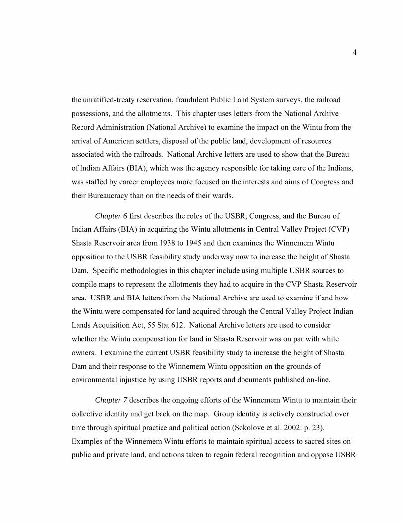
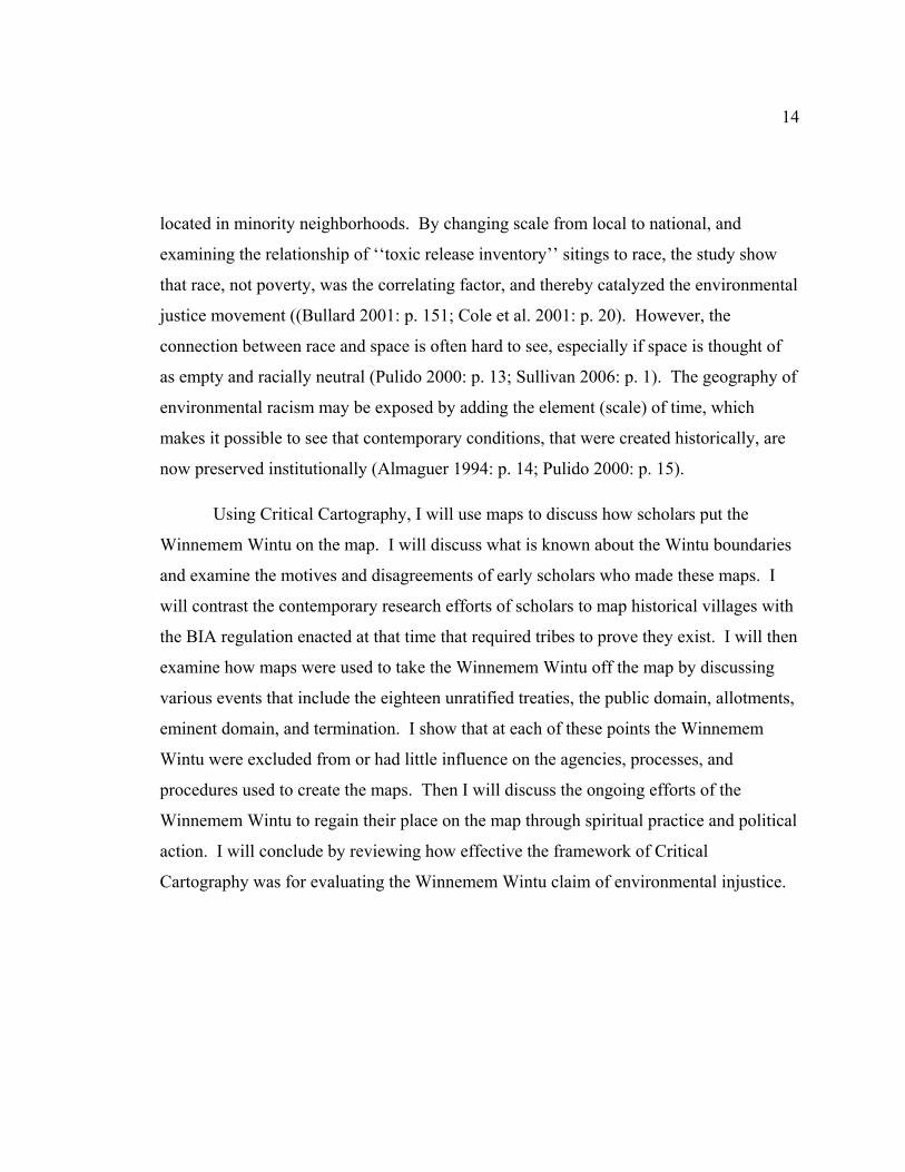
Stephen Powers’s map from 1877 used the term Win-tūn Indians to represent the
group who occupied the Sacramento Valley of Northern California from Mount Shasta in
the north to the Carquinez Strait in the south, following the Sacramento River (Heizer
1978b: p. 2). Figure 1.1 compares various maps that represent the geographic area
inhabited by the Wintu. The Win-tūn on Powers’s map were later subdivided into three
linguistic groups—the Patwin were the southern group, the Nomlaki (Wintun) were in the
middle, and the Wintu were to the north (DuBois 1935: p. 1). When referring to this
entire territory, Mount Shasta to the Carquinez Strait, I use Powers’s spelling, Win-tūn.
The territory of the northern linguistic group, the Wintu, falls within today’s
Shasta, Siskiyou, Tehama, and Trinity counties in Northern California if one accepts
Merriam’s Wintu boundary description. The Wintu were variously called the Wintu
(DuBois 1935; Kroeber 1925; LaPena 1978), Wintoon (Merriam 1955a; Redding 1973),
Northern Wintu (Merriam 1955a), or Waileka (Curtis 1924). When referring to the
whole Wintu area or multiple Wintu tribes, I use the term Wintu.
7
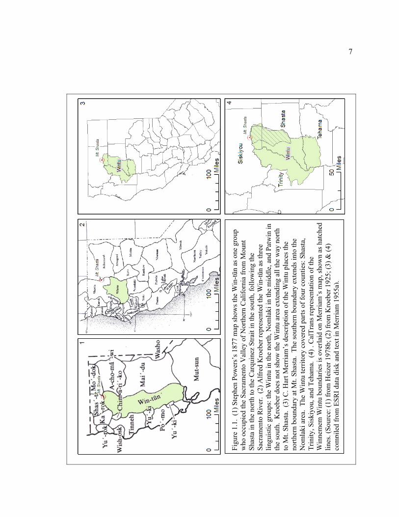
Figu
re 1
.1.
(1) S
teph
en P
ower
s’s 1
877
map
show
s the
Win
-tūn
as o
ne g
roup
w
ho o
ccup
ied
the
Sacr
amen
to V
alle
y of
Nor
ther
n C
alifo
rnia
from
Mou
nt
Shas
ta in
the
north
to th
e C
arqu
inez
Stra
it in
the
sout
h, fo
llow
ing
the
Sacr
amen
to R
iver
. (2
) Alfr
ed K
roeb
er re
pres
ente
d th
e W
in-tū
n as
thre
e lin
guis
tic g
roup
s: th
e W
intu
in th
e no
rth, N
omla
ki in
the
mid
dle,
and
Pat
win
in
the
sout
h. K
roeb
er d
oes n
ot sh
ow th
e W
intu
are
a ex
tend
ing
all t
he w
ay n
orth
to
Mt.
Shas
ta.
(3) C
. Har
t Mer
riam
’s d
escr
iptio
n of
the
Win
tu p
lace
s the
no
rther
n bo
unda
ry a
t Mt.
Shas
ta.
The
sout
hern
bou
ndar
y ex
tend
s int
o th
e N
omla
ki a
rea.
The
Win
tu te
rrito
ry c
over
ed p
arts
of f
our c
ount
ies:
Sha
sta,
Tr
inity
, Sis
kiyo
u, a
nd T
eham
a. (
4) .
Cal
Tran
s rep
rese
ntat
ion
of th
e W
inne
mem
Win
tu b
ound
arie
s is o
verla
id o
n M
erria
m’s
map
, sho
wn
as h
atch
ed
lines
. (So
urce
: (1)
from
Hei
zer 1
978b
; (2)
from
Kro
eber
192
5; (3
) & (4
) co
mpi
led
from
ESR
I dat
a di
sk a
nd te
xt in
Mer
riam
195
5a).
8
The Wintu group was further subdivided into six or nine tribes, depending on the
reference source. This study focuses on one tribe, the Winnemem Wintu. Winnemem
means “middle river people” or “middle water people,” referring to the fact that they
lived on the McCloud River, which lies between the Sacramento and Pit rivers. There
was abundant food, including salmon, acorns, grasshoppers, game, and various plants.
The population along the McCloud River was dense and the villages were clustered close
to each other (DuBois 1935: p. 23). The steep terrain and seasonal scarcity of available
water at higher elevations further concentrated the population along the river. The
Winnemem Wintu have been referred to as Northern Wintoon, Northern Wintun,
Okwanuchu, Wailacca, Baird Indians, Baird Auxiliary, and other variations. Winnemem
has been spelled a variety of ways, including winimem (DuBois 1935), wenem-em or
wenemem (LaPena 1978), or Wineman, Wenemem (Hoveman 2002). They have also
been called the McCloud River Indians, McCloud Wintu, McCloud or M’Cloud Indians
(Heizer et al. 1973b). The tribe refers to itself as Winnemem Wintu, and that is the term I
use throughout this study (Sisk-Franco 2009). In quotations I use the author’s spelling
but added my standard terms in [ ] brackets.
There are 627 applications listed in the Redding Allotment assignments. For this
study I located 196 Wintu allotments found in the study townships. The townships are
shown in Figure 1.2. When referring to a specific allotment, I identify it as Redding
Allotment and the number, for example, Redding Allotment 155 (U.S. Land Office 1889-
1909).
Where there were detailed and reliable sources of information readily available
regarding the Wintu or Winnemem Wintu, I have recommended the resources rather than
quoted extensively from them. I include documents in the appendices that were difficult
to find and key to this study. It was not possible to include all the material in the
appendices but valid research requests may be directed to the Winnemem Wintu for
access to the material.
9
Study Area
The study area has two boundaries. The first focuses on the 196 Wintu allotments
in the townships of the study area. The second narrowed the focus to just the Central
Valley Project (CVP) Shasta Reservoir boundary in order to examine how the United
States Bureau of Reclamation (USBR) acquired the land that was still designated as
allotments at that time. Figure 1.2 shows the Townships where the Redding Allotments
and Historical Indian Villages were located on the map in relationship to the CVP Shasta
Reservoir boundary.

10
Figure 1.2. Study area. Wintu allotments from the Redding Allotment file falling within these townships were located using BLM PLSS files. The CVP Shasta Reservoir boundary was used to narrow the study area when examining how the allotments were acquired by the USBR when Shasta Dam was built. (Source: Compiled from BLM PLSS files; ESRI Data disk; Cal-Atlas GIS data)
11
2. Theoretical framework
“There is nothing so lonely as a fact without a theory to give it a home” (Sutton et al. 1985: p. 151).
In order to understand why the Winnemem Wintu today are
opposed to increasing the height of Shasta Dam on environmental
justice grounds, one must first understand the historical context of
their claims. To start, the historical layers had to be reconstructed.
Existing maps, to the extent they existed or could be found, were
examined to show how the Winnemem Wintu were put the map
and then taken off the map, both literally and metaphorically. In
order to accomplish this goal, this study draws from the theoretical
framework of Critical Cartography.
Mapmaking may be evaluated as science or art. As a
science, mapmaking is expected to be unbiased, repeatable,
accurate, verifiable, and factual (Harley 2001; Harwood 2006;
Thomas 1971). Maps have been used in courts to prove ownership
and in treaties to settle the territorial boundaries of nations
(Short 2001: p. 13; Waldman et al. 1985: p. 73). Yet, they are they not purely and solely
scientific. Maps reflect space, but they are not space. As representative documents,
someone had to select what information to display and what to leave out. Maps are not
neutral transmitters of universal truths or a mirror of the world. They are social
constructions with an agenda and an argument (Short 2001: p. 9-10; Wood et al. 2008: p.
XVI). Because maps reflect the values, imagination, and drive of a culture, Critical
Cartography provides a theoretical framework to link geographic knowledge to power by
examining the assumptions that went into deciding what was included or excluded from
the map (Crampton et al. 2005: p. 11).
12
The scholar first credited with moving the discussion of maps beyond their origin,
accuracy, lineage, and technology was Brian Harley. Harley started his career as a
traditional cartographic scholar, but in the 1980s he began to write that maps were tools
of politics, with power to persuade, conceal, and distort. Harley recognized that, intended
or not, maps often fulfilled several needs at once: administrative, economic development,
and general reference (Harley 2001: p. 39). He considered maps an “invention in the
control of space” that expanded state control of social systems because maps may be used
as graphic inventory of land ownership, values, use, and potential (Harley 2001: p. 55).
Yet at the same time that maps provide an inventory of ownership and value, the
standardization that followed uniformity silenced individuality and uniqueness so that
maps present social spaces that appear empty. He warned that the scientific maps
produced by the state were not neutral but, because the state had an agenda, they were the
products of “a highly partisan intervention” (Crampton et al. 2005: p. 16). Harley further
argued that if analysis was limited to what was shown on historical maps, the picture
would remain incomplete, especially when examining issues related to Indians. At the
heart of colonial land acquisition was dispossession of the Indians. Manipulating place
names on the map further excluded the Indians from the land and its resources,
effectively turning them into outsiders (Harley 2001: p. 181).
David Turnbull further expands the concept of Critical Cartography by describing
“knowledge space,” the standardized and prescribed assemblage of instruments,
knowledge, personnel, and cooperation needed to create national maps. Since this level
of organization was once only possible at the state level, cartography, science, and the
state became integrated. Turnbull also described the visual power of maps that enables
the reader to see patterns that are not otherwise visible because maps can simultaneously
display disparate and heterogeneous locations, events, entities, and phenomena (Turnbull
1996: p. 7). Exposing patterns is important to this Critical Cartography study because the
13
mapping tools and resources available today make it possible to combine multiple
sources of information and mine new insights from historical data.
Critical Cartography provides a framework through which the scientific neutrality
of maps may be examined. The Public Land Survey System (PLSS) detailed the
measurement methods to be followed by surveyors and the processes to be followed in
disposing of land from the public domain. However, John Short, in Representing the
Republic: Mapping the United States, 1600-1900, documented the political power of
these maps. He described various ways the changing technology and industry of
geographic representation played an important role in the development of a national
identity for the American Republic. Throughout the book Short continually turned to the
New York state area to examine the impact of national changes on local areas. In one
example he described the impact of the PLSS on the Oneida Tribe. They were reduced
from “owning” six million acres in central New York in 1784 to controlling thirty-two
acres in 1990 (Short 2001: p. 77). Another example of the political power of maps is
provided by Malcolm Lewis, in Cartographic Encounters. In a case study of the upper
Great Lakes region, Lewis demonstrated how Indian maps, once considered spatially
naive, were essential inputs to Euro-American maps (Lewis 1998).
Critical Cartography promotes cartographic integrity and responsibility, and
advocates social change. In the article, “Beyond the ‘Binaries’: A Methodological
Intervention for Interrogating Maps as Representational Practices,” authors Vincent Del
Casino and Stephen Hanna argued that the researcher must strive to examine the many
historical and spatial references that are part and parcel of any map (Del Casino et al.
2006: p. 37). The classic study that showed how geographical analysis can empower
social movements was Toxic Wastes and Race, published in 1987 (Crampton et al. 2005:
p. 15; United Church of Christ 1987). This study changed focus from examining the
details of local hazardous waste sitings to examining patterns of sitings. At the national
level it became evident that a disproportionate number of the hazardous waste sites were
14
located in minority neighborhoods. By changing scale from local to national, and
examining the relationship of ‘‘toxic release inventory’’ sitings to race, the study show
that race, not poverty, was the correlating factor, and thereby catalyzed the environmental
justice movement ((Bullard 2001: p. 151; Cole et al. 2001: p. 20). However, the
connection between race and space is often hard to see, especially if space is thought of
as empty and racially neutral (Pulido 2000: p. 13; Sullivan 2006: p. 1). The geography of
environmental racism may be exposed by adding the element (scale) of time, which
makes it possible to see that contemporary conditions, that were created historically, are
now preserved institutionally (Almaguer 1994: p. 14; Pulido 2000: p. 15).
Using Critical Cartography, I will use maps to discuss how scholars put the
Winnemem Wintu on the map. I will discuss what is known about the Wintu boundaries
and examine the motives and disagreements of early scholars who made these maps. I
will contrast the contemporary research efforts of scholars to map historical villages with
the BIA regulation enacted at that time that required tribes to prove they exist. I will then
examine how maps were used to take the Winnemem Wintu off the map by discussing
various events that include the eighteen unratified treaties, the public domain, allotments,
eminent domain, and termination. I show that at each of these points the Winnemem
Wintu were excluded from or had little influence on the agencies, processes, and
procedures used to create the maps. Then I will discuss the ongoing efforts of the
Winnemem Wintu to regain their place on the map through spiritual practice and political
action. I will conclude by reviewing how effective the framework of Critical
Cartography was for evaluating the Winnemem Wintu claim of environmental injustice.

15
3. Methods
Many scholars have used Brian Harley’s Critical
Cartography framework to analyze historical maps in order to
derive information about social relations, the progress of civil
society, and the political agenda of the map sponsor (Askevold
2005; Schulten 2007; Short 2001; Turnbull 2000; Wood et al.
2008). But what if there are no historical maps directly relevant to
the subject? As Mark Monmonier wrote in Mapping it Out:
“Effective expository cartography requires reliable sources. Like most intellectual discourse, after all, scholarly maps are at least partly derivative…. The field-oriented social scientist who maps primary observations requires a reliably detailed base map that positions with precision symbols representing routes, site boundaries, orientation, locations, and other spatial phenomena” (Monmonier 1993: p. 121).
With computers, the internet, and Geographic Information
System (GIS) software becoming more accessible, indigenous
people and scholars around the world are reexamining existing maps or creating maps
from historical data (Heasley 2003; Johnson et al. 2005; Pearce 2004). Using
contemporary GIS tools and techniques, I developed a geodatabase to bring together
information layers from existing paper maps, georeferenced historical descriptions, and
GIS data sets, all set to the same projection. Once georeferenced, the various inputs
could be examined together, making it easy to see patterns and spatial relationships.
These patterns made it possible to draw new insights from past events that were not
evident when examining the data sources separately.
16
This chapter provides an overview of the data collected and methods used to store
the material. Additional methodological details will be described in Chapters 4, 5, and 6
so the specific methods I use to analyze historical data may be seen in context with the
results and conclusions.
Historical Material
Historical data were drawn from many sources. Congressional Records, special
reports, testimony, and letters originally came from the Government Printing Office.
Both the Bureau of Reclamation and the Bureau of Indian Affairs are under the
administration of the Department of the Interior; because they are federal agencies, the
National Archive and Records Administration (National Archive) is the major repository
for their retired documents. However, not everything is kept; the National Archive web
site states that “Of all documents and materials created in the course of business
conducted by the United States Federal government, only 1%-3% are so important for
legal or historical reasons that they are kept by us forever” (U.S. National Archives and
Records Administration 2009b). While some National Archive documents may be
accessed through the internet, only about 63% are even described in Archival Record
Catalog (U.S. National Archives and Records Administration 2009a). The USBR
documents, part of Record Group 115, are mainly stored in Denver. The Bureau of
Indian Affairs documents for Northern California Indians, part of Record Group 75, may
be stored in Washington DC or California. I was able to conduct research at the National
Archive in San Bruno, California, but unable to travel to Denver or Washington DC.
Fortunately, the Winnemem Wintu have a personal library of files collected over the
years. They generously made their reference material available to me, greatly reducing
the time and effort needed to acquire documents for research.
In addition to the data provided by the Winnemem Wintu, library collections were
invaluable in the search for information. The Bancroft library at the University of
17
California, Berkeley, holds the collections of Alfred Kroeber, Robert Heizer, and C. Hart
Merriam. These collections include published and unpublished work, which was
particularly important in the case of Merriam’s work. While Heizer and others published
some of Merriam’s work verbatim, or used his documents as source material for other
publications, there is still more material yet to be extracted from Merriam’s files. Also at
UC Berkeley, the Water Resources Center Archive specializes in collecting historical and
contemporary documents related to water, and is a repository for documents from many
water agencies in California. In Redding, the Shasta Historical Society and Shasta Public
Library both have rich collections of locally relevant historical material. The Redding
Museum and Art Center is dedicated to the “collection, preservation, and exhibition of
the prehistory of the original inhabitants of Northern California,” and to that end,
publishes Occasional Papers (Guilford-Kardell 1980: p. i). In Weed, the library at the
College of the Siskiyous also has a rich collection of locally relevant historical material,
including original postcards, maps, documents, and newspapers, carefully collected and
catalogued over the years.
The U.S. Forest Service office in Mount Shasta has an archaeologist on staff, Julie
Cassidy, who collects material and maintains a rich archive that was made available for
this research. Two documents from this office essential to this project included the 1912
Wiegel map used by Guilford Kardell and Dotta to plot historical Indian villages and an
historical plat book. The plat book showed land transfers related to, among other things,
the Central Valley Project and Shasta-Trinity National Forest.
Another source of material important to this study came from the Smithsonian,
which is both a museum complex and research organization. Their web site says “The
Smithsonian archives hold an estimated 50,000 cubic feet of paper documents, seven
million still photographs, and thousands of films and audio recordings” (Smithsonian
Institution 2009). Jeremiah Curtin, John P. Harrington, and C. Hart Merriam were all
affiliated with the Smithsonian.

18
The Indian Claims Commission Act of August 13, 1946, enabled the Indians of
California to file a land claim against the federal government. The Commissioners
considered anthropological testimony indispensable and, as a result, many noted scholars
spent untold hours researching and updating reference material to prepare to testify for
the Indians and the government. Robert Heizer made many of these documents available
to the general public by publishing them through UC Press. For an overview of the
Indian Claims Commission and the precedents that led it, see “Irredeemable America:
The Indians’ Estate and Land Claims” (Sutton et al. 1985). Susan Sanchez, in, "The
Selling of California: the Indians Claims Commission and the Case of the Indians of
California v. the United States," provided detailed information regarding the location of
the Indian Claims Commission records:
“The official records of the Indians of California v. the United States are located in the National Archive in the Washington D.C. annex. They are kept in Record Group 279 under their different docket numbers, primarily 31 and 37. The majority of materials kept in the Archives were the exhibits from both the Native American and government sides. These consist of previously published works by expert witnesses, maps, lists of exhibits, and legal paperwork. … Transcripts of the arguments presented by the expert witnesses for the Indians can be found in the George Wright Collection at the University of Nevada, Reno, although only seven pages of the government’s position are available from this collection” (Sanchez 2003: p. 15).
Despite the many sources consulted for this study, materials found are far from
complete. It is hard to know if historical material that I was unable to find still exists in a
repository to which I did not travel, have access, or know about. Research on Indian
issues is further complicated by efforts to protect sensitive cultural data, which results in
limited access to archaeological data and ethnographic studies. For example, the
California Office of Historic Preservation has twelve information centers throughout the
state to store documents, surveys, reports, ethnographic references, and excavations.
Some information is considered confidential and access is restricted to qualified
19
researchers. The Northeast Information Center in Chico is the repository for material
relevant to the McCloud River and Winnemem Wintu Indian tribe (California State
University 2009).
Digital Data Sources
Well-organized and well-documented public domain GIS data sets are freely
available via the internet and other sources. ESRI (Environmental Systems Research
Institute) provides data disks with the University Site License, a resource made available
to faculty, staff and students and, therefore, available for this study (ESRI ArcMap 9.3.1
2009). These data sources provided spatially consistent base layers that I could build
upon as I georeferenced maps and compiled new data layers. My assumptions,
challenges to interpretation, methods of creating maps from historical description, and
reasons for using or making maps that don’t agree with other sources are described in
more detail throughout the study. The digital files used to create maps were stored in a
geodatabase using ESRI 9.3.1 software (ESRI ArcMap 9.3.1 2009). The list of digital
data sources used in this study are detailed in Appendix 1.
Paper Maps
Paper maps were georeferenced to the study area using a combination of BLM
PLSS files, State or County boundaries, cultural features, mountain peaks, roads, rivers,
or hydrologic basin boundaries. Historic maps of the Wintu area include Stephen
Powers’s 1877 map (Powers et al. 1877) and Charles Royce’s map showing the land
cessions and reservations associated with the eighteen unratified treaties (Royce 1971a).
Margaret Guilford-Kardell used a copy of the 1912 Shasta County map, compiled
and published by C. R. Wiegel, to plot the locations of historical Wintu villages identified
by Curtin and Harrington (Guilford-Kardell 1980; Wiegel 1912). I georeferenced this
20
map in order to create a shapefile of the villages, which could be used as visual
comparison to other GIS layers, including the allotments and Shasta Lake.
Each page in a plat book depicts the land status of one particular township. These
were hand-written documents. Copies of the Master Title Plat pages and the associated
Historical Index are available on-line from the Bureau of Land Management (BLM) web
site (U.S. Department of the Interior). These digitized pages may not show all the details
found in an historical plat book; for example, multiple copies of a plat book may have
existed and margin notes might be entered in one version but not another. In addition to
the digitized BLM pages, I also referred to a bound plat book of the Shasta Reservoir area
kept in the reference files of the U.S. Forest Service in Mount Shasta (Master Title Plat
and Historical Index book for Central Valley Project at Shasta Dam). I georeferenced
both sets of plats for the study area and used these for visual reference, to supplement the
BLM PLSS digital files, when creating the Redding Allotment shapefiles.
The USBR must have produced any number of maps related to the CVP project at
Shasta Dam. Two that I found were important to this study. The first, published in
Central Valley Project Problem Study 23, showed land ownership in Shasta Reservoir
(Appendix 19). I georeferenced it so shapefiles of Indian Allotments could be created
based on visual reference (U.S. Department of the Interior Bureau of Reclamation
1947b). The second map showed where the USBR located graves that had to be moved
because they were located below the high-water level of Shasta Lake.
Additional paper documents created by various agencies, available through
libraries, archives, books, or agencies, included maps for reference in the text which were
also scanned and georeferenced. The list of paper maps and plats sources used in this
study are detailed in Appendix 2.
21
Text Descriptions Used to Locate Details on the Map
For two important references there were no maps available; text was the only
source of spatial information. To compile the Wintu boundaries based on C. Hart
Merriam’s description I used digital data files from Cal-Atlas and ESRI for mountain
peak, city, highway, river, stream, and hydrologic basin data(Cal-Atlas Geospatial
Clearinghouse 2007; ESRI ArcMap 9.3.1 2009).
To compile the Wintu Redding Allotments in the study area I used the BLM
PLSS Township, Section, and Quarter-Quarter files to locate the description given in the
Redding Allotment list of applications (Land Survey Information System 2009; U.S.
Land Office 1889-1909). The list of text sources used in this study are detailed in
Appendix 3.
Conversations with the Winnemem Wintu
The political identity of the Winnemem Wintu is tightly integrated with the
production of space created by sacred ceremonies, political struggles, existing maps, and
their efforts to maintain a position on the map. Through the framework of Critical
Cartography, I explored how Caleen Sisk-Franco, leader of the Winnemem Wintu, and
Mark Franco, headman of the tribe, are active agents in the process of creating the
Winnemem Wintu place on the map. Throughout my research period they made the
Winnemem Wintu library of files available, answered questions, and allowed me to join
the tribe at ceremonies. They were generous with their time and patient with my many
questions. Their insight and comments are included throughout the study (Sisk-Franco
2009).
22
4. Putting the Wintu on the Map
“When white men came the Wintu and Yana owned three fourths of the whole Sacramento Valley from Mount Shasta to the waters of San Francisco Bay, the greatest extent of rich, beautiful, and valuable land in the State of California.”
-Wintu and Yana Petition, 1889
European presence in California was primarily confined to
the coast until the nineteenth century (see Figure 5.1). There were
no early systematic efforts to learn about the Indians in
California and very few ethnographic records of any tribe.
Robert Heizer provided a summary of the limited state-wide
research and attempts to plot the distribution of the all the tribes of
California in Languages, Territories, and Names of California
Indian Tribes (Heizer 1966). On a more local scale, Dorothea
Theodoratus provided a summary of the early research done
regarding the Wintu area, in Native American Cultural Overview, a
document prepared for the Shasta- Trinity National Forest
(Theodoratus Cultural Research 1981: p. 44-46).
The changes for California Indians happened so fast that their territories could
only be inferred by anthropologists based on linguistics in the 1870s, almost thirty years
after most had been moved from their ancestral lands (Cook 1943: p. 3). Estimates of
the California Indian population before contact with Europeans vary greatly from as low
as 150,000 to as high as 310,000. In the Handbook of North American Indians,
Volume 8, Robert Heizer wrote:
“There must have been an incalculable loss of ethnographic fact between 1769 and 1850 due to the population decrease from about 300,000 in 1769 to about 100,000 in 1850. The 1850 population was at least halved in the
23
ensuing 20 years, so that by 1871, when Stephen Powers began to collect the data that appeared in his Tribes of California (1877), there were living only about 16 percent of the Native Californians who were present a century earlier (Heizer 1978a: p. 7).
By the early 1900s, when Alfred Kroeber and C. Hart Merriam were engaged in
their research, the state-wide Indian census reported the population as approximately
20,000, a decline of over 90 percent (Cook 1978: p. 91). Many Indian sources
consulted by researchers were elderly. Even so, they often shared information that
had been passed down from parents or grandparents, but not experienced personally.
Heizer addressed the impact of these changes on material collected by researchers:
“We can suppose, however, that a considerable amount of change did occur and that to some degree the accounts of aboriginal cultures presented in ethnographies published after 1900 are, in fact, a record of changed and acculturated societies. These societies may have been rather different in detail in the early sixteenth century before the European discovery of California or before the catastrophic effect of the gold rush. This situation was specifically noted by Powers in 1872, but its consideration does not enter into the reports of ethnographers such as Kroeber, Barrett, Dixon, and other students of California Indian culture who published their monographs in the University of California scientific series (cf. Heizer 1975). Voegelin's (1956:4) recommendation that ethnographers admit ‘the fact that North American Indian ethnographies be taken as relating in general to a period coincident with the early years of the informants who supplied the data upon which such ethnographies are based’ seems a sound one, but it has thus far not led to any major reassessment of the California ethnographic record through ethnohistorical data” (Heizer 1978b: p. 4).
Drawing lines on the map to represent California Indian territories was largely a
matter of interpretation, whether the work was done in the 1870s or 1920s. The
boundaries varied, depending on the theoretical background of the scholar creating the
map: ecology, archaeology, linguistics, or ethnography. The differences were subjected
to lively debate. Interestingly, the research, descriptions, and debates are between and
24
among the scholars. The Indian tribes being studied, to the extent they did, or do still,
exist, were consulted for reference, but generally were not consulted as expert authorities.
In 1990, Bill Bryson described the inherent challenge of linguistic maps when he wrote
about Europe, an area we are more likely to be familiar with.
“If you drew a map of Europe based on languages it would bear scant resemblance to a conventional map. Switzerland would disappear, becoming part of the surrounding dominions of French, Italian, and German but for a few pockets of Romansh…. German would cover not only its traditional areas of Germany, Austria, and much of Switzerland, but would spill into Belgium, Czechoslovakia, Romania, Hungary, the Soviet Union, and Poland…. Italy, too, would appear on the map not as one language entity but as a whole variety of broadly related but often mutually incomprehensible dialects.… The Soviet Union would dissolve into 149 separate languages” (Bryson 1990: p. 38-39).
Maps representing historical Indian territory usually placed political divisions on
ridgelines, encompassing drainage or watershed boundaries. This makes sense because
ridgelines are readily recognizable and important in an oral tradition. Further, different
drainage basins may represent changes in ecology, implying cultural adaptations that
would have been readily recognizable from one group to another. Since European and
American hunters and explorers would have used rivers for travel, western cartography
uses both water features and ridgelines for boundary lines. Kroeber recognized that
rivers would seldom have been a boundary for Indians. Describing the Sacramento River
as territory boundary of the Win-tūn, Kroeber wrote:
It has been customary to assign the whole east side of the valley to the Yana and Maidu. A civilized person inevitably thinks this way: A narrow overlap across the river which makes the central topographical feature of the map seems arbitrary. We put our counties on one or the other side of the stream: Butte balances against Glenn, Sutter with Colusa, Sacramento with Yolo. But the Indian knew the land with the soles of his feet. He thought of it in terms of its actual surface, of its varying plant and animal population, not as a surveyed chart on which certain structural
25
traits stand out” (Kroeber 1925: p. 352).
Methodology
The version of Powers’s map used in this study is a simplified line-drawing of the
tribal boundaries published in Handbook of North American Indians, Volume 8,
California (Heizer 1978b). The maps by Kroeber (Kroeber 1925), DuBois (DuBois
1935), and LaPena (LaPena 1978, 2002) were copied from the books in which they were
published. I added color to these maps for emphasis or clarification.
Merriam’s map was created based on the text description in Studies of California
Indians (Cal-Atlas Geospatial Clearinghouse 2007; ESRI ArcMap 9.3.1 2009; Merriam
1955b)
Guilford-Kardell’s map of historical Wintu villages was georeferenced and used
to create a shapefile layer of the villages (ESRI ArcMap 9.3.1 2009; Guilford-Kardell
1980)
Wintu Territory Boundaries
When looking for a map of the Winnemem Wintu territory for this study, I
learned the location of the northern border of the Wintu was contested by various
scholars. In order to understand why the north border was contested, first I had to
understand how the boundaries representing the Wintu territory were inferred. Maps
drawn by Kroeber (Kroeber 1925), DuBois (DuBois 1935), and LaPena (LaPena 1978,
2002) attributed the northern-most area of the Sacramento and McCloud Rivers—just
south of Mount Shasta—to the Shasta Indians, specifically a subgroup they called
“Okwanuchu.” However, the map drawn by Stephen Powers (Powers 1877), and the
boundary descriptions given by Norel-Putis (Curtin 1889) and C. Hart Merriam (Merriam
26
1955a), located the northern boundary of the Wintu at Mount Shasta. They considered
the Okwanuchu to be part of the Wintu.
Kroeber
Alfred Kroeber was at the University of California in Berkeley for forty-five
years, from 1901 until his retirement in 1946. He was very influential in the study of
California Indians. He raised funds, encouraged research, and made sure reports were
published. At a time when little scholarly reference material was available, the value of
the publications cannot be overstated. He strived to capture as complete an ethnographic
record as possible while there were still Indians alive with personal memories or first-
hand stories of life before California became an American Territory in 1848 (Heizer
1978a: p. 8-10). It was about 1900 when Kroeber began to collect and edit the
material for Handbook of North American Indians, which was finally published in
1925. As a linguist, Kroeber specialized in delineating the distribution of Indians in
relation to language families. Many researchers contributed to the Handbook. Kroeber
explained in his introduction, “This book is the outcome of 17 years of acquaintance and
occupation with the Indians of California” (Kroeber 1925: p. v).
Neither Kroeber nor any of the contributors to the 1925Handbook were very
knowledgeable about the Win-tūn ethnography. Kroeber was not expert in Win-tūn
languages, nor was he associated with anyone who was. “Wintun [Win-tūn] speech is
very imperfectly known, and its ramifications have been determined only in the rough”
(Kroeber 1925: p. 353). At that time, Roland B. Dixon, who was affiliated with the
American Museum of Natural History, was researching the Shasta Indians. His linguistic
and ethnographic material of the Achumawi, Atsugewi (Dixon 1993), Chimariko (Dixon
1910), Shasta (Dixon 1907), and Yana (Sapir et al. 1910), were important contributions
to the Handbook (Theodoratus Cultural Research 1981: p. 44).

27
Kroeber saw the Win-tūn as valley people who had extended their territory into
the hills. “From the mouth of the Pit north, the Wintun [Wintu], here turned hillsmen
because there is no valley left, had penetrated farther east from the Sacramento” (Kroeber
1925: p. 352). Almost as though he cannot endorse the Wintu presence anywhere east of
the Sacramento River, especially on the Pit River, he wrote that the Wintu, “…uniting
with the Yana on the south side to shut off from the mouth of this lengthy stream the
Achomawi who are so identified with its drainage as to be usually known as the Pit River
Indians” (Kroeber 1925: p. 352). “Pit” was not the Indian term for the river or the tribe.
The Wintu name for the river is “Pui Mem” which means “East Water” (Knudtson 1977:
p. 4). The Pit River Tribe name for the Pit River is “hame jumi” above Fall River
junction and “elmajumi” below the Fall River (Olmsted 1966). Even the early explorers
did not originally refer to it as the Pit River. Being the longest tributary to the
Sacramento River, it was originally known as the Sacramento River and the tributary
from the north was then known as the Little Sacramento. Figure 5.4, Colton’s California
Railroad map, shows the Pit River with two names, Upper Sacramento or Pitt [sic].
Stephen Powers’s 1877 map of the California Indians showed only two languages,
Shasta and Achomawi (Figure 1.1, page 8). Kroeber recognized six Shastan languages,
and considered the Okwanuchu the missing link between the Shasta and Achomawi on
his linguistic distribution map (Figure 4.1). He wrote:
“The reason for the long ignoring of the three languages adjacent to the Shasta is simple: no vocabularies were recorded, the tribes being numerically insignificant, and in one case on the verge of extinction when the white man came to northern California. Now they have dwindled so far – in fact to all practical purposes perished – that when we are hungry for any bits of information that would help to untangle the obscure history of these remnants of what may once have been greater peoples, we must content ourselves with brief, broken vocabularies and some general statements about their speakers obtained from the neighboring nations” (Kroeber 1925: p. 279).
28
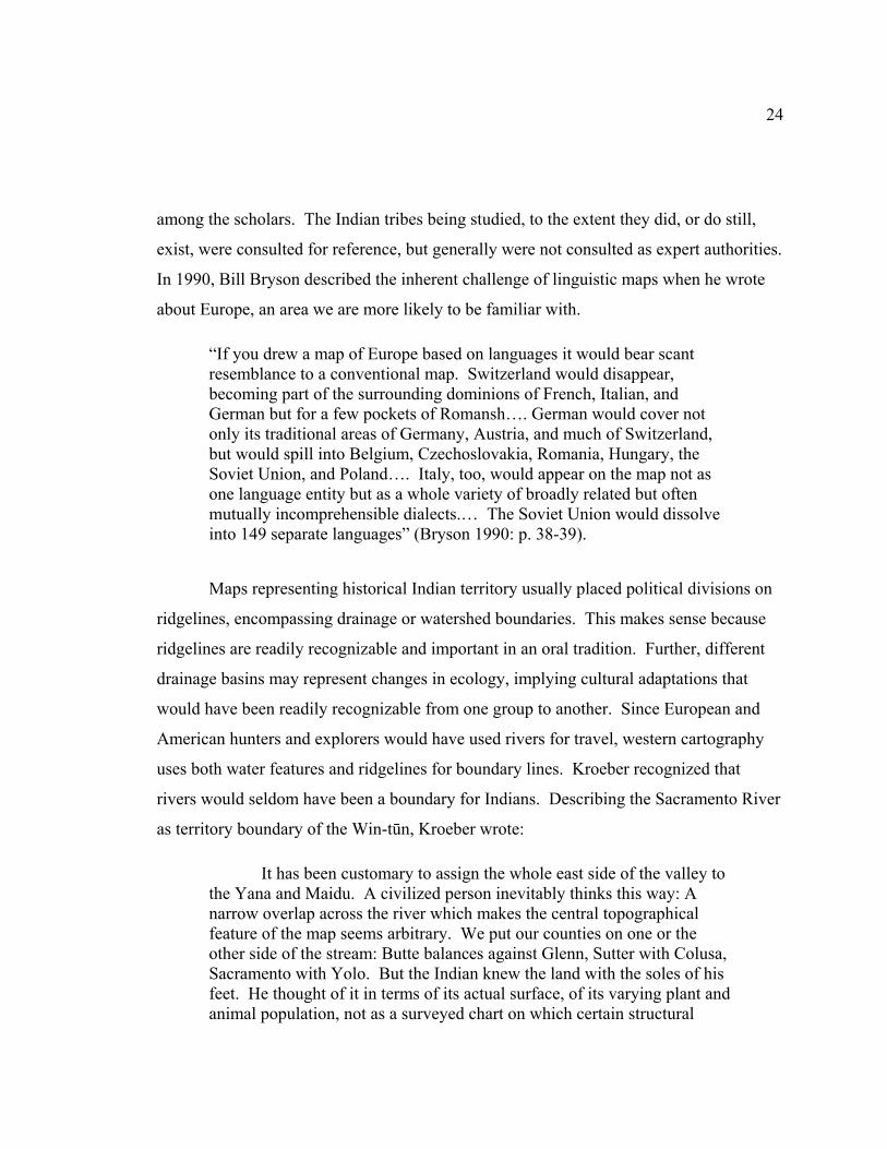
Figure 4.1. Okwanuchu. (1) Kroeber changed the north border of the Wintu from Powers’s map because he considered the extinct Okwanuchu to be part of the Shasta Tribe instead of Wintu. (2) The Okwanuchu a provided a bridge on the map between the Shasta and Achumawi tribes that supported Kroeber’s and Dixon’s recognition that the languages were related (Kroeber 1925). (Source: Kroeber’s 1925 map, color and “Okwanuchu” name added)
Kroeber ignored his own reasoning that watersheds made logical political
boundaries when he explained why early ethnologists separated the Shasta and
Achomawi languages:
“The Shastan habitat falls into two nearly identical halves – a western, the old “Sastean,” in Klamath drainage, and an eastern, the former “Palaihnihan,” in the drainage of the Pit. As the two systems of waters reach the ocean nearly at the Oregon line and at San Francisco, respectively, the outlook and connections of the two areas are obviously far from identical” (Kroeber 1925: p. 280).
“The uppermost 20 or 25 miles of the Sacramento, where it flows a tumbling course through a picturesque wooded canyon, were not occupied by the Wintun [Wintu] but by the Shastan Okwanuchu” (Kroeber 1925: p. 352).
Looking at a map, I believe Kroeber was looking for proof of a connection
between the Shasta and Achomawi language groups. The evidence to support his
Okwanuchu Okwanuchu

29
decision to extend the Shasta territory to include the Okwanuchu was thin and bears
repeating in whole:
“The Okwanuchu held the upper Sacramento from about the vicinity of Salt and Boulder Creeks to the headwaters; also up the McCloud River and Squaw Creek from about their junction up; in other words, the heads of the streams draining south from the giant Mount Shasta. The upper waters of the McCloud were probably not permanently settled; whether Okwanuchu or Achomawi had the better fortified ancient hunting rights there is not certain; the line on the map makes no pretense as to proved exactness. The entire Okwanuchu habitat is a mountain region, cut and broken, but not as rugged as some areas in the northern coast ranges; and very heavily timbered—as usual in California, with conifers.
“The dialect is peculiar. Many words are practically pure Shasta; others are distorted to the very verge of recognizability, or utterly different.
“It is not known whether Okwanuchu is their own name or what the Shasta called them. The Achomawi and Atsugewi knew them as Ikusadewi, or Yeti, from Yet, Mount Shasta.
“There may have been a few dozen or two or three hundred Okwanuchu two generations ago; not more. There is not one now. There are Indians on the upper Sacramento and McCloud to-day [sic]; but they are Wintun [Wintu], who have come in with the American, and their current name, “Shastas,” means nothing more than that they live in Shasta County or near Mount Shasta” (Kroeber 1925: p. 284).
Kroeber anticipated that someday the Karok and Chimariko might also be
included in the Shasta group when he wrote, “It is quite possible that when comparison of
all the Hokan languages shall have progressed farther, these five idioms may appear to
form a single larger group or subfamily.” The Okwanuchu were not the only group to
suffer extinction as a viable society. The Chimariko and others also disappeared
(Theodoratus Cultural Research 1981: p. 55). With the number of available Indians so
reduced, making the research so difficult and spotty, Kroeber wrote, “It is useless to
speculate at the present time when only a small part even of the scanty recorded material
30
on the several languages has found its way into print” (Kroeber 1925: p. 281). This
council to patience did not stop him from drawing firmly-held conclusions regarding the
Okwanuchu. His influence shaped the commonly referenced map of tribal distribution of
the Wintu. Kroeber described Merriam as a “splitter:”
“He did not try to push beyond the family into superstocks or orders, but aimed rather at precision of geographic occurrence of tribes, subtribes, and on down to villages and settlements. This was entirely parallel to his being what used to be called a ‘splitter’ and not a ‘lumper’ in regard to recognition of animal species” (Merriam 1955a).
Based on Kroeber’s writing, it may be safe to assume that he was a linguistic “lumper.”
DuBois
Cora DuBois, working with “generous assistance of Professor Kroeber and the
financial support from the Department of Anthropology at the University of California,”
described the complexity of mapping the boundaries where ethnographic evidence of two
or more groups overlapped. In the introduction to Wintu Ethnography she wrote:
“…many ethnographies are concerned primarily with presenting what may be called type culture. Like all types, they are compilations or averages to which the individual only partly conforms and which have no existence in reality. This is not said in criticism, but merely in recognition of the methods and aims of many social scientists” (DuBois 1935: p. 1).
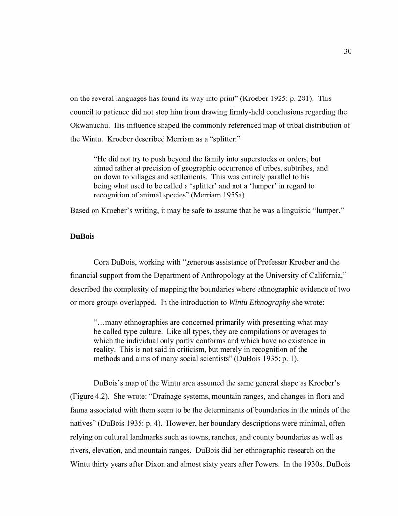
DuBois’s map of the Wintu area assumed the same general shape as Kroeber’s
(Figure 4.2). She wrote: “Drainage systems, mountain ranges, and changes in flora and
fauna associated with them seem to be the determinants of boundaries in the minds of the
natives” (DuBois 1935: p. 4). However, her boundary descriptions were minimal, often
relying on cultural landmarks such as towns, ranches, and county boundaries as well as
rivers, elevation, and mountain ranges. DuBois did her ethnographic research on the
Wintu thirty years after Dixon and almost sixty years after Powers. In the 1930s, DuBois
31
Figure 4.2. DuBois’s Map of Wintu territory. The Okwanuchu were also referred to as Waimuk in this map (DuBois 1935).
relied on conversations with Indian descendents for description of the Okwanuchu, also
referred to as Waimuk. DuBois interviewed EDC Campbell and Joe Campbell, as well as
other Wintu, but she provided no new evidence to support Kroeber’s conclusions.
(Guilford-Kardell 1980: p. 2). Here is DuBois description of the Waimuk or
Okwanuchu:
Waimuk (north inhabitant?) The Waimuk were a people who lived in the narrow valley of the upper McCloud. They have now disappeared with the exception of a few half-bloods. Their territory is generally reputed to have begun at Nosoni creek and extended northward up the valleys of the McCloud and Squaw creek in Siskiyou County, and then broadened out to the east and west. The people living in the village at the juncture of Nosoni creek and the McCloud apparently were very like the McCloud Wintu, but farther north the language changed to a dialect of the Shasta
32
Indians so that the inhabitants at the midpoints between the two areas were supposed to have spoken two languages, their own (or Shastan) and Wintu. I am inclined to identify these so-called Waimuk of the Wintu with the Okwanuchu and to consider them a transition people…” (DuBois 1935: p. 6-8).
LaPena, 1978
Frank LaPena, a Wintu of the Nomtipom tribe, is professor emeritus of Art and
Ethnic Studies and director of Native American Studies at California State University,
Sacramento. He contributed art and cultural insight to many publications, including
“Wintu Sacred Geography of Northern California” (Theodoratus et al. 1994). When the
Smithsonian published the twenty-volume encyclopedia, Handbook of North American
Indians, LaPena wrote the chapter on the Wintu. He based the chapter on DuBois’s work
and credited her with this explanation:
“The following culture sketch is based largely upon her ethnographic observations and personal accounts of Wintu informants. Where documentation is not given it will be understood to come from Du Bois” (LaPena 1978: p. 325).
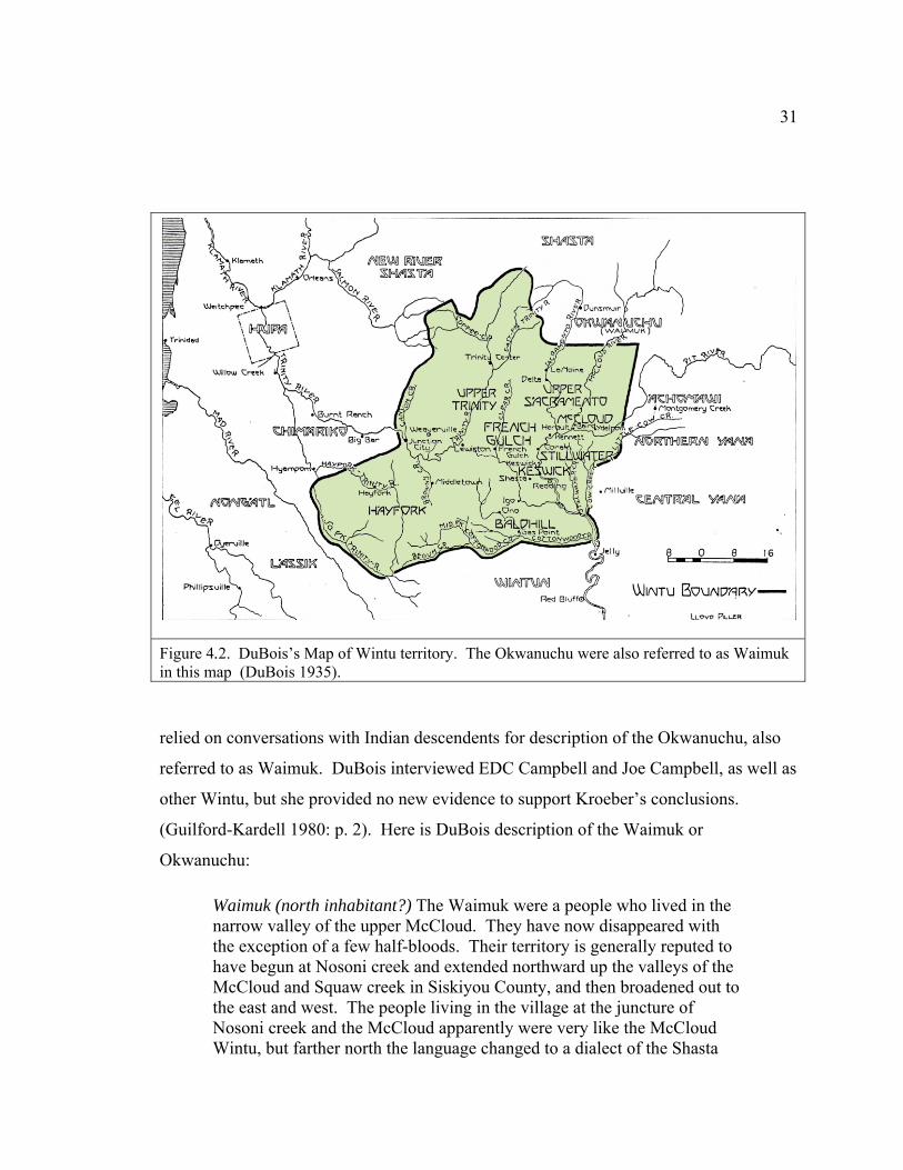
LaPena’s map, as shown in Figure 4.3, was derived from DuBois’s version. He
added county boundaries and the reservoirs, which had been built after her work was
published. Still following Kroeber’s general shape, LaPena’s description of the
boundaries was even briefer than DuBois’s.
“Wintu territory covered parts of what are now Trinity, Shasta, Siskiyou, and Tehama counties. The northern boundaries of the region are the valleys of the upper Trinity River, extending up the Sacramento River to the high divide between the Trinity and Scott rivers, to Black Butte and Mount Shasta, passing a little north of Black Fox Mountain. From the northernmost point north of La Moine the boundary runs south to about six miles south of Cottonwood Creek. On the northeast the frontier with the Achumawi comprised a strip of land several miles wide, east of Squaw
33
Creek, which was a no-man's-land on which both peoples hunted and gathered food” (LaPena 1978: p. 324).
Figure 4.3. LaPena’s 1978 Map of Wintu territory. Published in Handbook of North American Indians, this map was based on DuBois’s map. Reservoirs were added that had been built after her map was completed (LaPena 1978)
LaPena entered three errors in the chapter text regarding this map and its
description. First, even though he used DuBois’s map as the base for his version, he used
34
part of Merriam’s boundary description in the text when he wrote, “The northern
boundaries of the region are the valleys of the upper Trinity River, extending up the
Sacramento River to the high divide between the Trinity and Scott rivers, to Black Butte
and Mount Shasta, passing a little north of Black Fox Mountain.” By this description the
contested Okwanuchu area would be attributed to the Wintu, not the Shasta Indians.
Second, he referred to the “north-people” as “waymak,” using a different spelling than
DuBois (Waimuk) and did not directly address the issue of the Okwanuchu. DuBois
labeled the area both waimuk and Okwanuchu but LaPena left both labels—waymak and
Okwanuchu—off the map, so his version only shows eight of the nine Wintu groups
identified by DuBois and listed in LaPena’s text. Third, the line in the text, “Wintu
territory covered parts of what are now Trinity, Shasta, Siskiyou, and Tehama counties,”
does not apply to the map as drawn. Merriam’s boundaries do, indeed, show the Wintu
territory in parts of the four counties but, by copying Dubois’s version, the boundaries
LaPena represented for the Wintu were contained within Shasta and Trinity counties.
LaPena, 2002
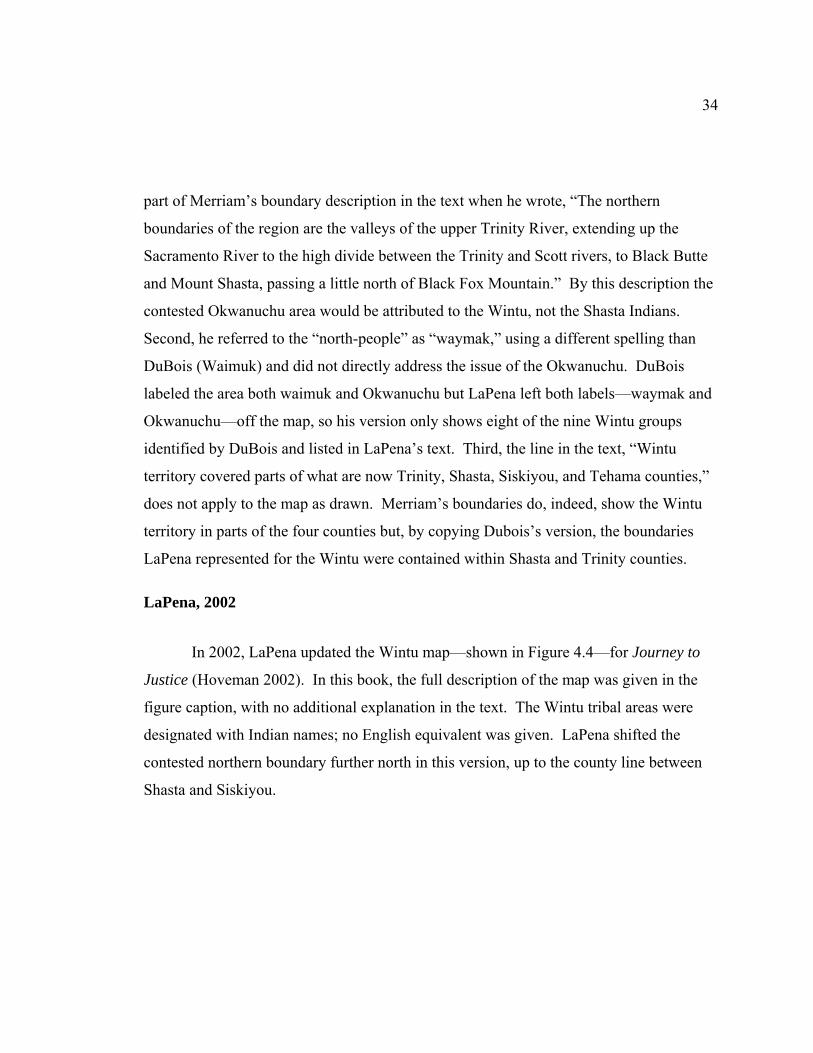
In 2002, LaPena updated the Wintu map—shown in Figure 4.4—for Journey to
Justice (Hoveman 2002). In this book, the full description of the map was given in the
figure caption, with no additional explanation in the text. The Wintu tribal areas were
designated with Indian names; no English equivalent was given. LaPena shifted the
contested northern boundary further north in this version, up to the county line between
Shasta and Siskiyou.
35
Figure 4.4. LaPena’s 2002 Map of Wintu territory. Published in Journey to Justice by Alice Hoveman, it was an updated version of LaPena’s 1978 map. The reservoirs were removed from this version Indian names were shown for the Wintu tribes, with no English translation (LaPena 2002). (Source: Journey to Justice)
Merriam
Another scholar cited as an expert on California Indians is C. Hart Merriam. As
mentioned, Merriam’s work was largely unpublished at the time of his death in 1942.
When the Indian Claims Commission was getting ready to hear testimony for the
California Indians case in the 1950s, anthropological testimony was considered
indispensable. Many noted scholars were called upon to testify for the Indians and the
government (Sanchez 2003: p. 87). When Kroeber and Heizer were preparing maps for
the Indian Claims Commission, they wanted to include Merriam’s work. They enlisted
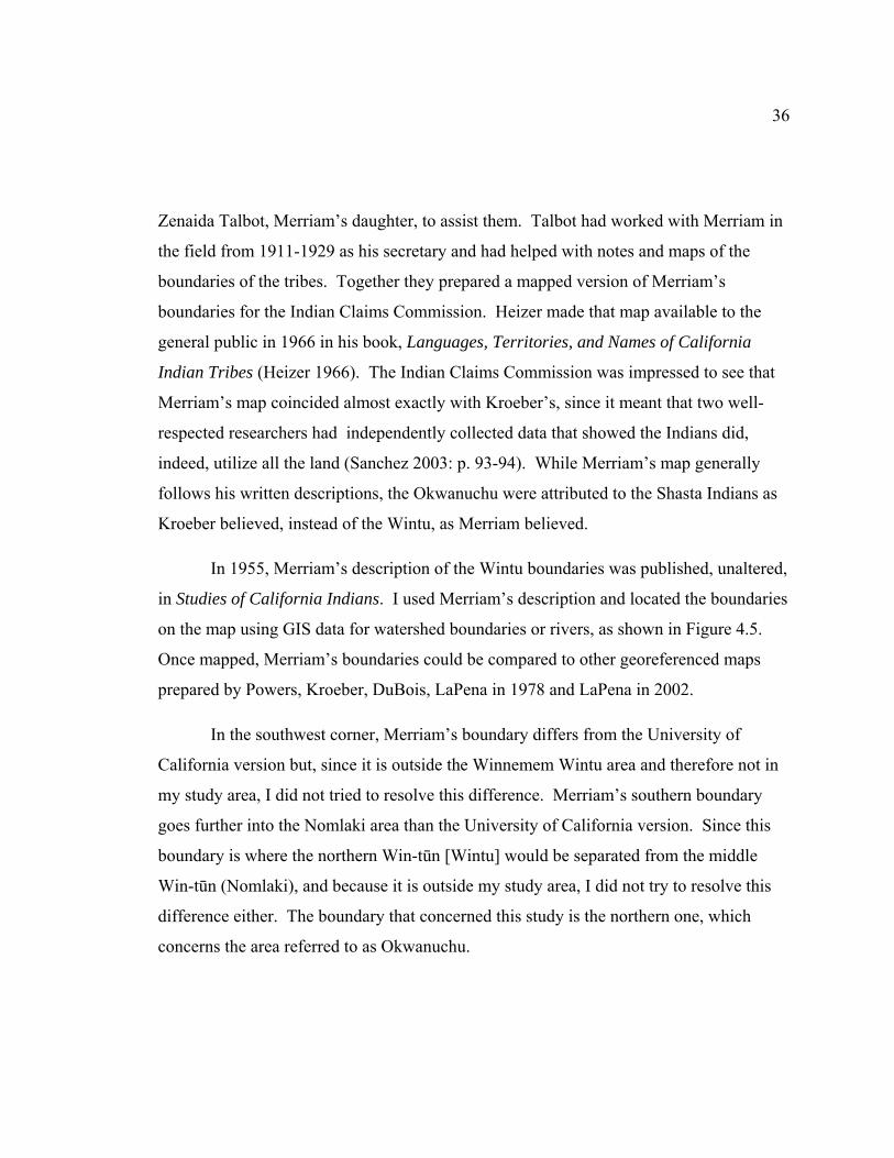
36
Zenaida Talbot, Merriam’s daughter, to assist them. Talbot had worked with Merriam in
the field from 1911-1929 as his secretary and had helped with notes and maps of the
boundaries of the tribes. Together they prepared a mapped version of Merriam’s
boundaries for the Indian Claims Commission. Heizer made that map available to the
general public in 1966 in his book, Languages, Territories, and Names of California
Indian Tribes (Heizer 1966). The Indian Claims Commission was impressed to see that
Merriam’s map coincided almost exactly with Kroeber’s, since it meant that two well-
respected researchers had independently collected data that showed the Indians did,
indeed, utilize all the land (Sanchez 2003: p. 93-94). While Merriam’s map generally
follows his written descriptions, the Okwanuchu were attributed to the Shasta Indians as
Kroeber believed, instead of the Wintu, as Merriam believed.
In 1955, Merriam’s description of the Wintu boundaries was published, unaltered,
in Studies of California Indians. I used Merriam’s description and located the boundaries
on the map using GIS data for watershed boundaries or rivers, as shown in Figure 4.5.
Once mapped, Merriam’s boundaries could be compared to other georeferenced maps
prepared by Powers, Kroeber, DuBois, LaPena in 1978 and LaPena in 2002.
In the southwest corner, Merriam’s boundary differs from the University of
California version but, since it is outside the Winnemem Wintu area and therefore not in
my study area, I did not tried to resolve this difference. Merriam’s southern boundary
goes further into the Nomlaki area than the University of California version. Since this
boundary is where the northern Win-tūn [Wintu] would be separated from the middle
Win-tūn (Nomlaki), and because it is outside my study area, I did not try to resolve this
difference either. The boundary that concerned this study is the northern one, which
concerns the area referred to as Okwanuchu.

37
Figure 4.5. C. Hart Merriam’s Wintu boundaries. These were described in Studies of California Indians, published by the University of California Press, through the efforts of Robert Heizer. Since Merriam had not created a map from this description, I located the boundaries for this study, using rivers and watershed boundaries (Merriam 1955a). (Source: Compiled from Merriam’s text description, Cal-Atlas data and ESRI digital data disks)
38
Powers
By the 1870s, Indian lifestyles had been significantly disrupted, their
populations reduced, and their presence relegated to land not claimed by Americans
(Bancroft et al. 1882; Cook 1976; Heizer 1993; Heizer et al. 1974; Heizer et al. 1971;
Hurtado 1988; Kroeber 1992; Sanchez 2003; Sturtevant 1978; White 1983). Stephen
Powers traveled extensively among the Win-tūn from 1871-1872. In 1875 he
collected Indian artifacts for the Centennial Exhibition held in Philadelphia. Even
though Indian cultural practices did not divide land with the sharp lines found in
western cartographic conventions, Powers surveyed the California Indian tribes and
drew a map, inferring tribal distribution based on language. In 1877 he published his
observations in Tribes of California (Heizer 1978b: p. 4). Powers’s map was drawn
at a scale of 1:1,810,000(Powers et al. 1877).
Kroeber did not speak highly of Powers’s credentials in the Handbook
introduction. But Heizer wrote, “Powers was not only California’s first true ethnologist,
her first anthropological theorist, and her pioneer ethnobotanist, but also the man who
drew the first map showing the distribution of native linguistic stock (as then understood)
and tribal territories” (Momaday 1975: p. 73).
The maps by Powers and Merriam show similar northern boundaries for the
Wintu. Knowing that his view differed from Kroeber’s and others who attributed the
Okwanuchu area to the Shasta Indians instead of the Wintu, Merriam explained that
“Okwanuchu” was a directional word used by the Shasta Indians that meant “south of
here.”
39
Norel-Putis and the Winnemem Wintu
At various times from 1884 through 1889 Jeremiah Curtin, a linguist working for
the Smithsonian, interviewed a number of Wintu, including Norel-Putis, Topiwita, and
Klencladdy. Curtin said that Norel-Putis:
“…possessed mental power of the first quality. All the lore of the Wintu would have been lost had I not met Norel-Putis in the autumn of 1884. He was an ‘old-time Indian’ who spoke no English. He gave me a world of knowledge of their traditions, religion, and myths. He was the only man in the tribe capable of doing this” (Curtin 1940 in Guilford-Kardell 1980: p. 13).
Norel-Putis had broader experiences than many Wintu. He was an honored
person, probably a chief, and well-traveled in the Wintu area. He was reported to have
been 100 when he died on March 12, 1894, so he would have already been an adult
before the Wintu experienced their first contact with whites (Dotta 1980: p. 118). As an
adult, his reports are considered “contemporaneous,” meaning the villages he described
were inhabited all at the same time and in his lifetime (Dotta 1980: p. 128).
In 1888 Norel-Putis and others of the Wintu and Yana tribes asked Curtin to write
a letter for them, which he agreed to do in order to:
“...tell the President what a homeless condition they were in, how the white men drive them from place to place. I told them to find out how many of each tribe were living and draw up a paper stating their condition, and I would try and do something for them in Washington” (Curtin 1940 in Guilford-Kardell 1980: p. 16).
There isn’t a map associated with the Wintu-Yana petition (Appendix 4), but
Norel-Putis described the Win-tūn territory:
“The Wintu people before the Whites came into the land of our fathers owned and inhabited the country extending from Mount Shasta on
40
the north to Carquines [sic] Straits on the south. The western boundary of this country was the mountain range west of the Sacramento valley except in the region between north Yallo Valley and Edgewood where the line went west of the range and the Wintu occupied one-half of the Trinity.
“The Eastern boundary beginning at the south was the Sacramento River to Tehama, from that point northward the Wintu had a strip of country east of the Sacramento following the line of Little Cow Creek and including the triangle of land between the Pit River, Cow Creek and the Sacramento. North of Pit River it extended to the head-waters of Squaw Creek and the McCloud River. Within the above limits no other people but the Wintu lived. For untold generations, from the time the Yapaitu left the earth, they owned all the valley on the right bank of the Sacramento with the foothills and northern uplands as well as the eastern half of Trinity county” (Curtin 1889).
Using the watershed boundary of the Sacramento and McCloud rivers to locate
the north boundary of the Wintu at Mount Shasta, followed the ecological guidelines
described by Kroeber when he wrote that watersheds were most often associated with
political boundaries (Kroeber 1925: p. 352). Since Merriam’s north boundary goes to
Mount Shasta, and is generally the same as the boundary accepted by the Winnemem
Wintu, for the rest of this study I use Merriam’s boundaries when referring to the Wintu.
The Winnemem Wintu and other Wintu tribes still exist and persist in their efforts
to be recognized, to care for their people, and to maintain spiritual and cultural
connections to their land and all creatures that live there, especially the salmon. They
know that Kroeber and Merriam didn’t agree about the affiliation of the extinct
Okwanuchu. Caleen Sisk-Franco, the leader of the Winnemem Wintu, contests the
claims that the area called Okwanuchu was ever anything but Wintu. She asks:
“Where are the artifacts from the other tribes? What other tribe has origin and death stories that directly relate to the waters of Mount Shasta? People were multi-lingual in the area because of trade and marriages. When an Indian marries a person in another tribe they become a member of that tribe, even though they bring their language with them. Some people
41
think the land may have been used seasonally by more than one tribe. Tribes did not share hunting grounds or sacred sites. To go into another tribe’s area without permission was to risk punishment, even war” (Sisk-Franco 2009).
The Winnemem Wintu have practiced spiritual ceremonies on the McCloud
River, at Panther Meadow on Mount Shasta, and various other locations since prehistoric
time. The village sites along the upper McCloud that were studied by Curtin and
Harrington were identified as Wintu villages. The Winnemem Wintu knowledge of their
territory comes from conversations with their elders and with other tribes. In 2003
CalTrans requested a map of the tribal boundaries so their staff would know which tribe
to contact if artifacts were uncovered during road construction. CalTrans consulted with
Mark Franco, headman of the Winnemem Wintu, as they created a shapefile for their data
records. The northern and eastern borders drawn on the CalTrans map were remarkably
similar to the borders described by Merriam. One noteworthy difference was the western
border—on the CalTrans map Highway 5 was referenced, whereas Merriam used the
ridgeline. This change in the western border is culturally appropriate to both the agency
and tribe. The highway was readily accessible and commonly known. Access to the
ridgeline was limited by private property claims. The CalTrans map of Winnemem
Wintu territory was accepted by the Native American Heritage Committee (CalTrans
Winnemem Wintu Territory Designation 2004). For the remainder of this study the
CalTrans boundaries will be used when referring to the Winnemem Wintu tribal area.
Winnemem Wintu Historical Villages
Jeremiah Curtin, in the late nineteenth century, and John P. Harrington, in the
early twentieth century, collected information about various Wintu villages on the
Sacramento and McCloud Rivers, but never published their notes. From 1978 to 1980,
Margaret Guilford-Kardell, working with James Dotta and several Wintu, undertook the
42
massive project of duplicating, collating, and checking the Curtin and Harrington data
against records of archaeological sites from multiple sources, both published and
unpublished. The results were published by the Redding Museum in 1980. The
document made significant ethnographic knowledge regarding the Wintu available to the
broader research community. Figure 4.6 shows a portion of the 239 villages validated by
Kardell and plotted on Wiegel’s 1912 Shasta County map; over 80 were along the
McCloud River. The location details are not shown on this map in order to avoid
vandalisms. The density of the villages reflects the high Wintu population as it existed
prior to the invasion of the whites. Details showing exact location have been left off this
map intentionally to protect the villages from trophy hunters. Guilford-Kardell’s notes
described the anomalies found in the data and the justifications for the adjustments made
as the many sources of data were reconciled (Guilford-Kardell 1980: p. 91).
Ethnographic information was collected from forty-nine Wintu village sites that are now
inundated by Shasta Lake. Archaeological data was collected either before Shasta Dam
was built or after, during dry years when the water-level was very low (Sundahl 2005: p.
E-1). Researchers, with a valid need for more detailed information regarding the villages,
should contact the Winnemem Wintu.
In order to compare how the historical villages are related to the Redding
Allotments examined in this study, I georeferenced Wiegel’s 1912 Shasta County map in
ESRI ArcMap 9.3 against the Public Land Survey System (PLSS) files downloaded from
the Bureau of Land Management (BLM) web site, and data files of rivers extracted from
ESRI data disks. Then I used Wiegel’s map as a visual reference in order to create a
shapefile of the villages located by Guilford-Kardell. The result was a layer that was
generally accurate and could be viewed along with other historical and contemporary
layers. I used this layer as a historical base to depict how the Winnemem Wintu lost
access to land-use and ownership along the McCloud River. By using ESRI ArcMap
software, it was possible to see the villages in comparison with mines, railroad patents,
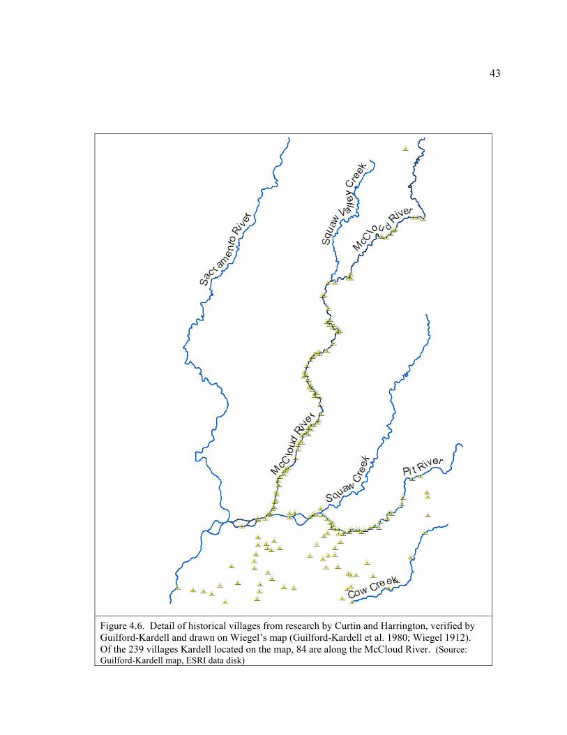
43
Figure 4.6. Detail of historical villages from research by Curtin and Harrington, verified by Guilford-Kardell and drawn on Wiegel’s map (Guilford-Kardell et al. 1980; Wiegel 1912). Of the 239 villages Kardell located on the map, 84 are along the McCloud River. (Source: Guilford-Kardell map, ESRI data disk)
44
historical private land ownership, historical Indian allotments, Shasta-Trinity National
Forest, Shasta Lake, and current parcel ownership. A considerable amount of worthwhile
future research could be done with the data in Guilford-Kardell's paper. For example, if
the tables were redone in a database it would make it possible to search, sort, and select
the data in the tables by any number of criteria, including date, tribe, researcher, or
location (Guilford-Kardell 1979).
In order to compare how the historical villages are related to the Redding
Allotments examined in this study, I georeferenced Wiegel’s 1912 Shasta County map in
ESRI ArcMap 9.3 against the Public Land Survey System (PLSS) files downloaded from
the Bureau of Land Management (BLM) web site, and data files of rivers extracted from
ESRI data disks. Then I used Wiegel’s map as a visual reference in order to create a
shapefile of the villages located by Guilford-Kardell. The result was a layer that was
generally accurate and could be viewed along with other historical and contemporary
layers. I used this layer as a historical base to depict how the Winnemem Wintu lost
access to land-use and ownership along the McCloud River. By using ESRI ArcMap
software, it was possible to see the villages in comparison with mines, railroad patents,
historical private land ownership, historical Indian allotments, Shasta-Trinity National
Forest, Shasta Lake, and current parcel ownership. A considerable amount of worthwhile
future research could be done with the data in Guilford-Kardell's paper. For example, if
the tables were redone in a database it would make it possible to search, sort, and select
the data in the tables by any number of criteria, including date, tribe, researcher, or
location (Guilford-Kardell 1979).
Tribal Recognition
Ironically, just as Guilford-Kardell and Dotta were compiling the work of Curtin
and others that showed how extensive the Winnemem Wintu population had been along
the McCloud River, the Bureau of Indian Affairs was about to delist the tribe.
45
In 1958, forty-one rancherias were terminated in California. When the seventeen
residents of the Redding Rancheria accepted individual title to the land, they
unknowingly relinquished all their rights as Indians under federal law (Hoveman 2002:
p.64). In 1978, coming out of the termination period, the BIA issued “procedures for
establishing that an American Indian group exists as an Indian tribe,” also known as the
Federal Acknowledgement Process. Since the BIA created the process it is a federal
regulation, not a law. Still, for the first time Indians had to prove their tribes were
organized, active, possessed a governing council, and that they had been active
continuously from the time of European contact to the present (later amended to 1900)
(Hoveman 2002: p.68). In the 1980s a class action suit, the Tillie Hardwick case,
reversed all the rancheria terminations. The Redding Rancheria reinstated its tribal
government in 1985. Forced to recognize the Redding Rancheria, the federal government
then withdrew recognition status from all other Wintu (Hoveman 2002: p.69). Two
groups, the Wintu Tribe and Toyon Wintu Center, Inc., and the Nor-Rel-Muk Nation
based in Hayfork, are seeking recognition through the Federal Acknowledgement
Process. The Winnemem Wintu took a different route to regain their recognition—they
filed a lawsuit. As of 2002, only forty-one petitions had been resolved out of 221 groups
who sent letters of intent through the Federal Acknowledgement Process (Hoveman
2002: p.73).
Summary
The maps made to represent the Wintu were inferred from data collected after
their lifestyles had been significantly disrupted, their populations reduced, and their
presence relegated to land not claimed by Americans. The map-makers did not
always agree about where tribal boundaries were located. One such disagreement
concerns the northern boundary of the Wintu. Through the lens of Critical
Cartography, I was able to examine the motives of the mapmakers as one of the analysis
46
criteria to understand why the northern border of the Wintu was contested by various
scholars.
When Kroeber’s Handbook was published in 1925, it represented significant
progress in scholarly efforts to systematically represent all the tribes in California.
Kroeber’s motive for modifying Powers’s 1877 boundaries was to represent the linguistic
connection between the Shasta Indian and Achomawi territories. By attributing the
extinct Okwanuchu to the Shasta Indians, Kroeber created a physical connection on the
map that supported and reinforced Dixon’s recognition of the linguistic links between the
Shasta and Achomawi tribes but disregarded the Wintu cultural beliefs and spiritual sites.
Kroeber and Merriam disagreed strongly on whether the Okwanuchu were part of the
Shasta or Wintu tribe. Kroeber defended his position on the merits of his superior
linguistic scholarship. Merriam defended his position on the merits of the extensive data
acquired through direct conversations with Indians during his many years of fieldwork.
Researchers evaluated the merits of Kroeber’s and Merriam’s northern boundary based
on scholarship, written publications, and maps. Even though it was their historical
territory, the references consulted for this study do not cite Norel-Putis or the Winnemem
Wintu in order to resolve the controversy about whether the northern boundary of the
Wintu went as far as Mount Shasta (DuBois 1935; Hoveman 2002; Sundahl 2005;
Theodoratus Cultural Research 1981).
The motivation for researching the unpublished documents about the historical
Wintu Villages was described by Guilford-Kardell:
“This publication series is dedicated to the dissemination of basic data that might otherwise not be available to historians, anthropologists, the general public, and, especially, to the descendants of the original inhabitants” (Guilford-Kardell 1980: p. i).
47
The motivation of the BIA when they withdrew recognition from all Wintu except
the Redding Rancheria was political. That the BIA withdrew recognition during the same
time period as Guilford-Kardell published her research illustrates the Critical
Cartography concept that maps are made with agendas. It may be worth stating the
obvious: neither the actions of Guilford-Kardell and Dotta to map the historical villages
nor the actions of the BIA to withdraw recognition changed the daily lives of the
Winnemem Wintu. They existed as a tribe before the map was published and despite the
withdrawal of recognition. Taking the implications one step further, however, neither
creating the map nor withdrawing recognition could have happened had the Winnemem
Wintu been anything other than a tribe. In order to explore the historical villages or deny
them recognition, historians and the BIA must acknowledge their existence.
48
5. Taking the Wintu off the map
“From being a people many thousand in number, strong, happy, rich, we have been turned into a people a few hundred in number, a poor weak remnant without land, without money, without education, without credit, looked down upon by men who slew our kindred and possess our ancient home.”
-Wintu and Yana Petition, 1889
Chapter 4 describes putting the Wintu on the map; that is,
establishing the historical geographic location of the Wintu and
Winnemem Wintu. However, chronologically and physically, the
Indians in California were taken off the map long before any
efforts were made to put them on it. After the United States
acquired the Spanish claims to the Pacific Northwest in the
Adams-Onis Treaty of 1819, Hudson’s Bay Company built Fort
Vancouver on the Columbia River in Oregon. From there fur
trappers began regular expeditions into California. The
expeditions into California from Oregon followed ancient Indian
footpaths, which became known to explorers and settlers as the
Siskiyou Trail. The footpaths were there because the Indians of Northern California had
been the intermediaries between two large trade networks—the Pacific Northwest and
Central California. The terrain was rugged and travel hard, but it was the least difficult
land route into California. As the number of expeditions into California by fur trappers
and military survey parties increased, hostilities and epidemics resulted in Indian deaths.
However, Indian societies remained largely intact through this period because their
culture, food sources, and trade networks were still in place (Chase-Dunn et al. 1998;
Cook 1943; Ellison 1974; Knudtson 1977; Sanchez 2003; Theodoratus Cultural Research
1981).
49
Methodology
In this chapter I use maps to represent the expanding European/American
presence in California (Cal-Atlas Geospatial Clearinghouse 2007; ESRI ArcMap 9.3.1
2009; Hurtado 1988; Royce 1971a) and show the Benson Syndicate fraudulent surveys in
the McCloud watershed (Cal-Atlas Geospatial Clearinghouse 2007; ESRI ArcMap 9.3.1
2009; Cranfield 1984). Existing maps are used to represent the unratified treaties,
railroad, and the Ah-Di-Na on the McCloud River.
This chapter uses letters from the National Archive Record Administration to
examine the impact on the Wintu from the arrival of American settlers, disposal of the
public land, development of resources associated with the railroads, and treatment by
BIA agents.
California Before Statehood
Spain tried to maintain full possession of California but didn’t have enough
people in the area to defend against incursions by Russian, English, and American fur
trappers. After the War of Independence from Spain in 1821, the Mexican government
became increasingly concerned by the growing numbers of foreigners, especially
Americans arriving from Oregon, who began to settle in the interior valleys of California.
Many Americans settled as squatters, but some applied for land grants, which were given
in exchange for becoming a Mexican citizen and pledging allegiance. Over 800 Spanish
and Mexican grants were made in California. Two are particularly relevant to this study
(see Figure 5.1).
John Augustus Sutter, a naturalized, German-born, Swiss émigré, was one of the
first and best known Americans to apply for a Mexican land grant from Governor
Alvarado (Starr 2005: p. 56). Rancho Nueva Helvetia, also known as Sutter’s Fort,
50
consisted of 48,000 acres at the junction of the American and Sacramento Rivers. Today
this is where Sacramento, the present capital of California, is located (Robinson 1948: p.
114). By the 1840s Sutter’s Fort had became an important center for information and
supplies. This established a permanent white settlement in the Maidu and Win-tūn
territorial area (Stewart p. 93).
Major Pierson Barton Reading accompanied a trapping party up the Sacramento
River from Sutter’s Fort. While in the north, Reading explored the Trinity and Klamath
river areas. After returning to Sutter’s Fort, Reading became a Mexican citizen in order
to receive a Mexican land grant, the Rancho Bueno Ventura. Reading’s grant consisted
of over 26,000 acres in Wintu territory. It extended three miles along the west side of the
Sacramento River from Cottonwood Creek to Salt Creek and is where today’s city of
Redding is located (Figure 5.1). Reading wrote of having two Indian villages on his land,
each with 150 men, women and children. After gold was discovered on the American
River, Reading prospected successfully on Clear Creek and on the Trinity River in 1848.
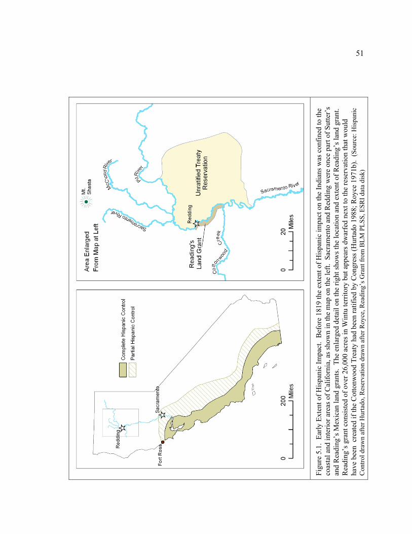
51
Figu
re 5
.1.
Early
Ext
ent o
f His
pani
c Im
pact
. B
efor
e 18
19 th
e ex
tent
of H
ispa
nic
impa
ct o
n th
e In
dian
s was
con
fined
to th
e co
asta
l and
inte
rior a
reas
of C
alifo
rnia
, as s
how
n in
the
map
on
the
left.
Sac
ram
ento
and
Red
ding
wer
e on
ce p
art o
f Sut
ter’
s an
d R
eadi
ng’s
Mex
ican
land
gra
nts.
The
enl
arge
d de
tail
on th
e rig
ht sh
ows t
he lo
catio
n an
d ex
tent
of R
eadi
ng’s
land
gra
nt.
Rea
ding
’s g
rant
con
sist
ed o
f ove
r 26,
000
acre
s in
Win
tu te
rrito
ry b
ut a
ppea
rs d
war
fed
next
to th
e re
serv
atio
n th
at w
ould
ha
ve b
een
cre
ated
if th
e C
otto
nwoo
d Tr
eaty
had
bee
n ra
tifie
d by
Con
gres
s (H
urta
do 1
988;
Roy
ce 1
971b
). ( S
ourc
e: H
ispa
nic
Con
trol d
raw
n af
ter H
urta
do, R
eser
vatio
n dr
awn
afte
r Roy
ce, R
eadi
ng’s
Gra
nt fr
om B
LM P
LSS,
ESR
I dat
a di
sk)
52
With labor from 65 Indian miners, he washed out $80,000 worth of gold in six months
(Theodoratus Cultural Research 1981: p. 48). Both Sutter’s and Reading’s land grants
were well positioned as bases for prospecting and both profited from miners who needed
supplies during the Gold Rush and the settlers who followed (Cook 1943; Ellison 1974;
Hoveman 2002; Knudtson 1977; Sanchez 1993; Sanchez 2003; Starr 2005; U.S.
Department of the Interior Bureau of Reclamation 1947b).
The massive influx of miners during the Gold Rush seriously interrupted the
lifestyles and interaction patterns of the Indians in northern California. Miners drove
Indians off their land, muddied the water so salmon became scarce, and brought in
livestock that ate the grasses and acorns (Theodoratus Cultural Research 1981: p. 48).
After the initial wave of miners passed through, settlers moved in to stay, claimed
territory, and set up homesteads. Much of the Wintu territory was mountainous,
surrounding beautiful, inviting valleys that had flat land and rivers. As settlers claimed
the flat areas first, the Wintu found refuge in the mountainous areas for a period of time
and were among the last tribes to be remain culturally viable. This 1875quote from
Powers summarized the situation:
“Let it be remembered, on the other hand, that after the republic had matured its vast strength and developed its magnificent resources, it poured out hither a hundred thousand of the picked young men of the nation, unencumbered with women and children, armed with the deadliest weapons of modern invention and animated with that fierce energy which the boundless lust for gold inspired in the Americans; pitting them against a race reared in an indolent climate, and in a land where there was scarcely even wood for weapons. They were, one might almost say, blown into the air by the suddenness and the fierceness of the explosion. Never before in history has a people been swept away with such terrible swiftness, or so appalled into utter and unwhispering silence forever and forever, as were the California Indians by those hundred thousand of the best blood of the nation. They were struck dumb; they fled from all the streams, and camped in the inaccessible hills, where the miners would have no temptation to follow them; they crouched in terror under the walls of the garrisoned forts, or gathered round the old
53
pioneers, who had lived among them and now shielded them from the miners as well as they could. If they remained in their villages, and a party of miners came up, they prostrated themselves on the ground and allowed them to trample on their bodies, to show how absolutely was their submission. And well they might. If they complained audibly that the miners muddied the streams so that they could not see to spear salmon, or stole a pack-mule, in less than twenty days there might not be a soul of the tribe living” (Momaday 1975: p. III).
With the Treaty of Guadalupe Hidalgo of May 30, 1848, the United States
Government assumed control of all of present day California, Nevada, Utah, most of
Arizona, the western portions of New Mexico and Colorado, and part of Wyoming. The
Treaty also called for the United States to recognize existing land titles and accept all
people living in the ceded territory as citizens. William Carey Jones, the son-in-law of
Senator Thomas Hart Benton and brother-in-law of John C. Fremont, who were both
proponents of Manifest Destiny, was appointed Confidential Agent of the United States
government because he spoke Spanish and was acquainted with Spanish colonial titles.
Jones’s assignment was to examine the land titles, and also to determine what rights the
Indians held during the Spanish and Mexican regimes (Robinson 1948: p. 91; Starr 2005:
p. 65). Jones’s report was clear and direct. He confirmed that the Indians did indeed
have secure title and right to their lands under the Treaty.
In November, 1848, Zachary Taylor was elected president. Though he was a
slaveholder from Tennessee, he was opposed to the spread of slavery into the territories
because he believed it was very important to hold the nation together. Believing the Gold
Rush had brought enough people to California who would oppose slavery in the territory,
Taylor urged the Californians to draft a constitution for statehood and bypass the
territorial stage of government (Fehrenbacher 2002: p. 329).
In 1849, Bennett Riley, the last of seven military governors of California, issued a
proclamation that invited every free male citizen to vote for a representative to the state
Constitutional Convention. All races, including Indians, participated in this election. On

54
September 3, 1849, the elected representatives at the convention modified Riley’s
Proclamation by inserting “white” before “male” citizen. As a result, Indians, along with
Chinese and African Americans, were excluded from voting. Indians did not regain the
franchise until the Indian Voting Rights Act of 1924 (Ellison 1974; Goodrich 1925;
Sanchez 2003; Starr 2005).
Squatters and Homesteaders
As part of the Compromise of 1850, California was admitted to the Union as a
Free State. John C. Fremont and William Gwin were the first United States Senators
from California. One of the first issues the Senators tackled was how to settle private
land claims. Even though the Treaty of Guadalupe Hidalgo had promised continuous
ownership of existing land grants, this conflicted with the view held by land-hungry
settlers that California should be open to Americans (Robinson 1948: p. 99). The
Americans already in California were eager to secure the title to their land claims and
anticipated that with statehood, the process would be speedy. Through a process called
“preemption,” squatters who settled on government land without permission were given a
preferential right of purchase. The squatters, impatient with the slow government process
and contemptuous of the rights of the inhabitants already in California—be they
Mexican, Indian, or American—organized into armed bands to get what they wanted.
Riots resulted; some of the worst were in Sacramento (Robinson 1948: p. 112). Gwin
sponsored “An Act to Ascertain and Settle the Private Land Claims in the State of
California,” which passed on March 3, 1851, Stat 631. The Act required that existing
land titles had to be registered and affirmed by the Land Commission within a five-year
period. If a claim was not filed with the Land Commission, the land was considered
abandoned. Land from abandoned and rejected claims went back into the public domain
to be surveyed and made open to settlement (Robinson 1948: p. 101; Sanchez 2003: p.
29). Very few claims were presented on behalf of the Indians. Many Spanish and
55
Mexican land grants were not presented either, because people assumed their claims were
already recognized as valid by the Americans through the Treaty of Guadalupe Hidalgo
(Sanchez 2003: p. 29).
Because land in the Public Domain had to be surveyed before the patent would be
issued, surveying was a lucrative business. One company, the Benson Syndicate, secured
contracts to survey townships throughout the west. John Benson was a contract surveyor
backed by a syndicate of lawyers, bankers and other surveyors. They bid low for
contracts and would supply the government with completed plats fabricated from
incomplete and fraudulent notes made up from skeletal surveys. In northern California
there were 115 townships surveyed by the Benson syndicate. Figure 5.2 shows nine of
these townships were in the McCloud watershed (Cranfield 1984: p. 26).
Squatter troubles were not uncommon in California from the 1850s through the 1870s
because so few titles had been confirmed by the Land Commission. Many claims were in
the courts, and many more were waiting for the government survey before a patent could
be issued (Robinson 1948: p. 116). Before any of this was settled, the Homestead Act
was enacted in 1862, allowing any citizen or naturalized alien the right to claim 160
acres, provided they worked the land continuously for five years (Parsons 2003: p. 4.9-2).
With all the complications, it took an average of seventeen years from the time a petition
was filed before the patent was issued (Robinson 1948: p.116). Land claims didn’t drag
on in just the nineteenth century; the Indian Claims Commission operated for thirty-two
years to handle 611 dockets and it left sixty-eight of them unresolved when it closed on
September 30, 1978 (Sutton et al. 1985: p.59).
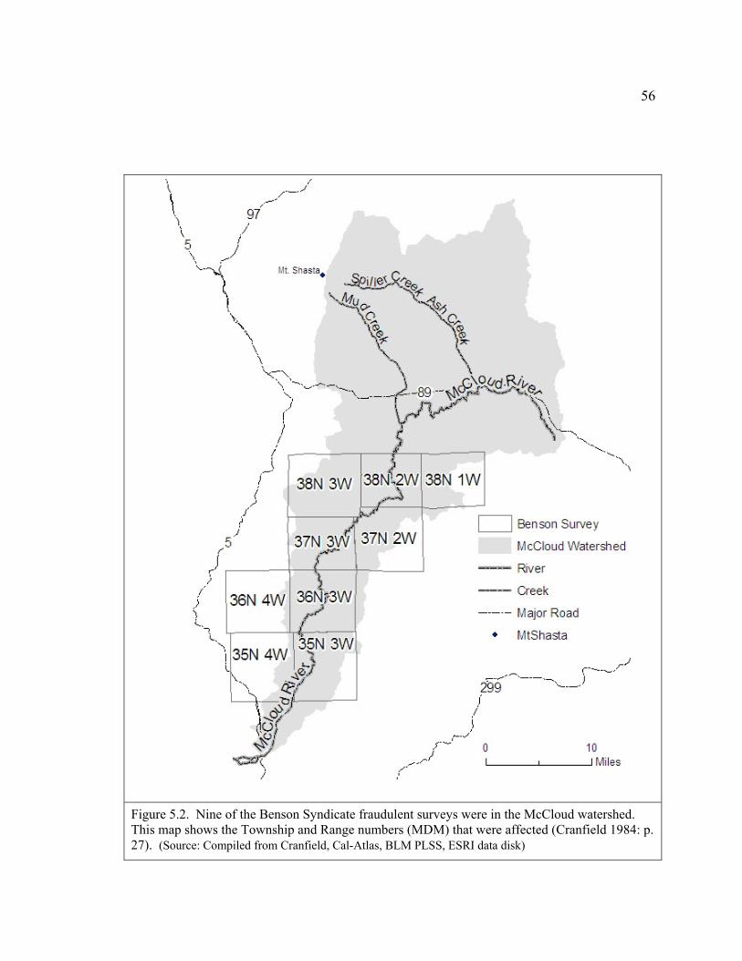
56
Figure 5.2. Nine of the Benson Syndicate fraudulent surveys were in the McCloud watershed. This map shows the Township and Range numbers (MDM) that were affected (Cranfield 1984: p. 27). (Source: Compiled from Cranfield, Cal-Atlas, BLM PLSS, ESRI data disk)
57
Unratified Treaties
In 1851 President Fillmore appointed three commissioners to conduct treaties
with the California Indian Tribes. O.M. Wozencraft, Redick McKee, and George
Barbour arrived in San Francisco in January, 1851, with instructions to quickly conclude
as many treaties as possible. Between March 19, 1851, and January 7, 1852, at various
central meeting places throughout California, they met with 402 tribal heads –
representing 139 tribes or bands of Indians, and entered into eighteen treaties (Ellison
1974: p. 186; Heizer 1972; Robinson 1948: p. 14). The designated reservations would
have added up to 7,488,000 square acres of land, or 7.5% of the total area of the state.
Wozencraft negotiated the treaty that included the Wintu. This treaty of peace
and friendship was signed at Reading’s ranch in Cottonwood on August 16, 1851 (Heizer
1972; Hoveman 2002). By this time many Indians had already been driven to hiding in
the mountains where stealing was their main access to food, and they were learning to
fight to defend themselves. The location of the reservations was chosen with a defensive
rationale:
"They do not lack the nerve and daring of the best Atlantic Indians. Once accustomed to war, their mountain fastnesses will be impregnable. Our policy is . . . to get them down . . . in reservations, along in the foothills, bordering on the plains," with the miners "between them and the Mountains, forming a formidable Cordon, or barrier, through which it would be difficult to take their families unobserved" and where there would be "no place for Concealing Stolen Stock" (Hurtado 1988: p.136).
The eighteen treaties were sent to the United States Senate on June 1, 1852. Most
Californians were opposed to having the government sign treaties with the Indians. The
58
editor of the Los Angeles Star represented their viewpoint when, on March 13, 1852, he
wrote:
“We believe the action of the commissioners to be pregnant with the most disastrous consequences, and we can see no solution of the difficulties that will grow up around us, if the General Government ratify these treaties, except a general and exterminating war.… To place upon our most fertile soil the most degraded race of aborigines upon the North American Continent, to invest them with the rights of sovereignty, and to teach them that they are to be treated as powerful and independent nations, is planting the seeds of future disaster and ruin … we hope that the general government will let us alone—that it will neither undertake to feed, settle or remove Indians amongst whom we in the South reside, and that they will leave everything just as it now exists, except affording us the protection which two or three cavalry companies would give” (Robinson 1948: p.15).
The Americans in California believed the reservations included valuable land that
should be reserved for mining and farming instead of for Indians. Having been admitted
as a Free State, the California Senators held the power to upset the balance in either
direction between the Whigs and Democrats. This position gave Fremont and Gwin the
leverage to persuade Congress to defeat the treaties. Despite President Fillmore’s
recommendation that the treaties be confirmed, Congress not only rejected every one of
the treaties, they also ordered them sealed in a secret file, where they remained for fifty-
three years. The injunction of secrecy was not removed until January 18th, 1905
(Goodrich 1925; Heizer 1972; Hoveman 2002; Sanchez 2003).
Charles Royce prepared state-by-state maps showing the lands ceded by Indians
to the United States. Figure 5.3 shows the boundaries of the territories ceded by the
Indians in Northern California. The areas ceded and land proposed for reservations in the
treaties had nothing to do Indian tribal territories. Area 294 would have been ceded and
reservation 293 would have been created had the Cottonwood treaty been ratified (Royce
1971b). Figure 5.1 (page 49) shows that Reading’s Mexican land grant would have been
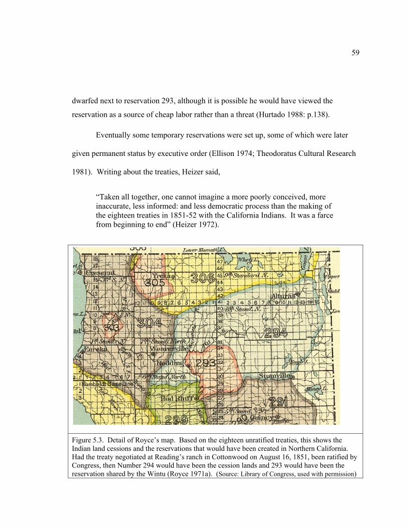
59
dwarfed next to reservation 293, although it is possible he would have viewed the
reservation as a source of cheap labor rather than a threat (Hurtado 1988: p.138).
Eventually some temporary reservations were set up, some of which were later
given permanent status by executive order (Ellison 1974; Theodoratus Cultural Research
1981). Writing about the treaties, Heizer said,
“Taken all together, one cannot imagine a more poorly conceived, more inaccurate, less informed: and less democratic process than the making of the eighteen treaties in 1851-52 with the California Indians. It was a farce from beginning to end” (Heizer 1972).
Figure 5.3. Detail of Royce’s map. Based on the eighteen unratified treaties, this shows the Indian land cessions and the reservations that would have been created in Northern California. Had the treaty negotiated at Reading’s ranch in Cottonwood on August 16, 1851, been ratified by Congress, then Number 294 would have been the cession lands and 293 would have been the reservation shared by the Wintu (Royce 1971a). (Source: Library of Congress, used with permission)

60
Railroads
In 1838 Congress established the Army Corps of Topographical Engineers.
Mapping was intimately connected to military control, investment opportunities,
transportation improvements, and the expanding power of the Federal Government,
which was the source of funding (Short 2001: p. 19). In 1841, the Wilkes Exploring
Expedition passed through Northern California on their way to Sutter’s Fort from Oregon
(Theodoratus Cultural Research 1981: p. 48). John Charles Fremont, who later became
the first United States Senator from California, participated in this, and later, surveys.
(Short 2001: p. 175).
On September 20, 1850, United States Congress passed the first major act
granting lands to subsidize the construction of railroads, 9 Stat. 466. In March 1853,
Congress authorized the Army Corps of Engineers to find the most feasible rail routes
across the United States. The surveyors mapped, analyzed, classified, drew,
photographed and painted the west. Popular illustrated magazines packaged and
distributed stories about the west to an eager audience. The wonders of the American
landscape, combined with science and adventure, made the surveys great publicity
campaigns (Short 2001: p. 174).
The federal government subsidized building the railroad with bonds and land
grants from the public domain. The practice of subsidizing construction had originated in
Ohio in 1802, so that roads could be built from the Atlantic Ocean to the Ohio River.
The states, not private companies, had been the trustees and agents in Ohio (Robinson
1948: p.148). Because building the railroad was viewed as a military necessity, the
general public was not opposed to the cost. The widely held view was that the Pacific
Coast was defenseless and that the warring Indian tribes made the overland route to
California dangerous. The Act of July 1, 1862, known as the Pacific Railroad Bill,
empowered the Union Pacific Railroad Company and the Central Pacific Railroad
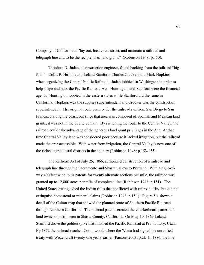
61
Company of California to "lay out, locate, construct, and maintain a railroad and
telegraph line and to be the recipients of land grants” (Robinson 1948: p.150).
Theodore D. Judah, a construction engineer, found backing from the railroad “big
four” – Collis P. Huntington, Leland Stanford, Charles Crocker, and Mark Hopkins –
when organizing the Central Pacific Railroad. Judah lobbied in Washington in order to
help shape and pass the Pacific Railroad Act. Huntington and Stanford were the financial
agents. Huntington lobbied in the eastern states while Stanford did the same in
California. Hopkins was the supplies superintendent and Crocker was the construction
superintendent. The original route planned for the railroad ran from San Diego to San
Francisco along the coast, but since that area was composed of Spanish and Mexican land
grants, it was not in the public domain. By switching the route to the Central Valley, the
railroad could take advantage of the generous land grant privileges in the Act. At that
time Central Valley land was considered poor because it lacked irrigation, but the railroad
made the area accessible. With water from irrigation, the Central Valley is now one of
the richest agricultural districts in the country (Robinson 1948: p.153-155).
The Railroad Act of July 25, 1866, authorized construction of a railroad and
telegraph line through the Sacramento and Shasta valleys to Portland. With a right-of-
way 400 feet wide, plus patents for twenty alternate sections per mile, the railroad was
granted up to 12,800 acres per mile of completed line (Robinson 1948: p.151). The
United States extinguished the Indian titles that conflicted with railroad titles, but did not
extinguish homestead or mineral claims (Robinson 1948: p.151). Figure 5.4 shows a
detail of the Colton map that showed the planned route of Southern Pacific Railroad
through Northern California. The railroad patents created the checkerboard pattern of
land ownership still seen in Shasta County, California. On May 10, 1869 Leland
Stanford drove the golden spike that finished the Pacific Railroad at Promontory, Utah.
By 1872 the railroad reached Cottonwood, where the Wintu had signed the unratified
treaty with Wozencraft twenty-one years earlier (Parsons 2003: p.2). In 1886, the line
62
Figure 5.4. Detail of Colton’s California Railroad map. This shows the section of the planned route from Sacramento to Oregon. Note that Pit River is shown as “Upper Sacramento River or Pitt River.” Dog Creek at the time was one of the locations the Wintu assembled in July to gather salmon for the winter (Colton & Co. n.p., 1876). (Source: Library of Congress, used with permission.)
reached Berryvale in Strawberry Valley, later known as Sisson and today called Mt.
Shasta City. Spur rail lines were laid by logging companies. The first sawmill opened

63
within four months of the railroad connection to Strawberry Valley (Cranfield 1984:
p.25).
Figure 5.5. Lumber Mill in McCloud, California (Eastman 1941).
The arrival of the railroad impacted the Wintu as well, destroying Wintu
transportation corridors, sacred sites, and historical villages. Colton’s 1876 map (Figure
5.4) shows Dog Creek, where as many as 1,500 Wintu assembled each year in July to
gather salmon for the winter. Building the railroad destroyed this site (Hoveman 2002: p.
43). Copper mining and smelting industries also grew, resulting in considerable damage
to the landscape. In 1912 Richard Gregory, Redding Allotment 68, wrote to the BIA
agent to ask permission to sell wood, “… as the pine timber is dying, owing to smelter
smoke [I] would like to dispose of it while I can, and use the proceeds for [sic] to live on”
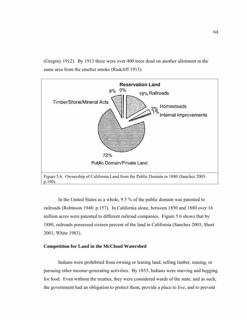
64
(Gregory 1912). By 1913 there were over 400 trees dead on another allotment in the
same area from the smelter smoke (Radcliff 1913).
Figure 5.6. Ownership of California Land from the Public Domain in 1880 (Sanchez 2003: p.160).
In the United States as a whole, 9.5 % of the public domain was patented to
railroads (Robinson 1948: p.157). In California alone, between 1850 and 1880 over 16
million acres were patented to different railroad companies. Figure 5.6 shows that by
1880, railroads possessed sixteen percent of the land in California (Sanchez 2003; Short
2001; White 1983).
Competition for Land in the McCloud Watershed
Indians were prohibited from owning or leasing land, selling timber, mining, or
pursuing other income-generating activities. By 1853, Indians were starving and begging
for food. Even without the treaties, they were considered wards of the state, and as such,
the government had an obligation to protect them, provide a place to live, and to prevent
Reservation Land

65
others from taking the land on which the Indians lived (Thomas 1971). Congress
appointed Edward Beale as the first Indian superintendent for California (Hurtado 1988:
p.141). The administrations of Beale and his successor, Col. Thomas J. Henley, lasted
over a decade and were rife with corruption and incompetency (Hoveman 2002; Sanchez
2003). Cattle for starving Indians wound up with subagents; reservation boundaries were
changed, land was lost to squatters; vouchers were irregular; and the books were
incomplete (Hoveman 2002; Sanchez 2003). It was not until the 1870s and 1880s that
the efforts of humanitarians advocating reform of the living conditions and treatment of
Indians began to make a difference.
Baird Fish Hatchery
In 1872, the Central Pacific Railroad reached Redding. That same year
Livingston Stone was appointed Deputy Fish Commissioner and assigned the task of
setting up a salmon hatchery in California. He arrived in California one month after his
appointment without any clear idea where the best place for the hatchery would be. The
chief engineer of the Pacific Railroad informed Stone that he had seen Indians spearing
fish at the junction of the Pit and McCloud Rivers. Stone headed up to the McCloud
River and, indeed, found several camps of Winnemem Wintu drying salmon. Stone saw
the Winnemem Wintu as the “last of the California Indians to yield to the encroachments
of civilization.” In his report to Commissioner Baird in 1874 Stone wrote:
"...The McCloud River presents an instance of what is becoming increasingly rare, at least in the more accessible parts of the country, namely a region which is just as it was before the white man found it, and with a race of aborigines whose simple habits have not been corrupted by the aggressive influence of communication with the whites" (Heizer et al. 1973b: p.6).
The presence of the Winnemem Wintu did not stop Stone from proceeding with
the hatchery plan. In fact the location chosen was an area sacred to the Winnemem
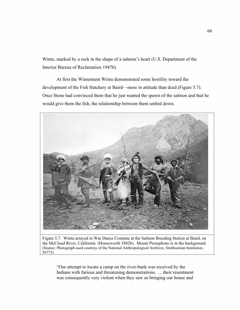
66
Wintu, marked by a rock in the shape of a salmon’s heart (U.S. Department of the
Interior Bureau of Reclamation 1947b).
At first the Winnemem Wintu demonstrated some hostility toward the
development of the Fish Hatchery at Baird—more in attitude than deed (Figure 5.7).
Once Stone had convinced them that he just wanted the spawn of the salmon and that he
would give them the fish, the relationship between them settled down.
Figure 5.7. Wintu arrayed in War Dance Costume at the Salmon Breeding Station at Baird, on the McCloud River, California (Houseworth 1882b). Mount Persephone is in the background. (Source: Photograph used courtesy of the National Anthropological Archives, Smithsonian Institution, 56773)
“Our attempt to locate a camp on the river-bank was received by the Indians with furious and threatening demonstrations. ... their resentment was consequently very violent when they saw us bringing our house and
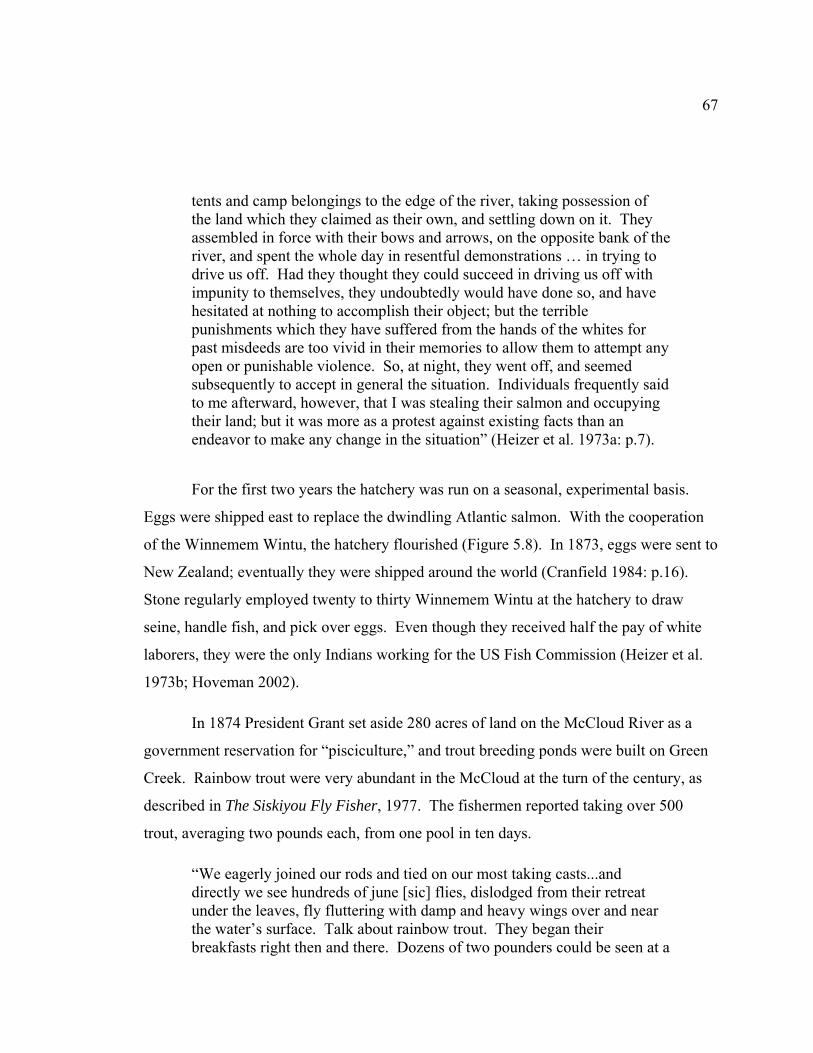
67
tents and camp belongings to the edge of the river, taking possession of the land which they claimed as their own, and settling down on it. They assembled in force with their bows and arrows, on the opposite bank of the river, and spent the whole day in resentful demonstrations … in trying to drive us off. Had they thought they could succeed in driving us off with impunity to themselves, they undoubtedly would have done so, and have hesitated at nothing to accomplish their object; but the terrible punishments which they have suffered from the hands of the whites for past misdeeds are too vivid in their memories to allow them to attempt any open or punishable violence. So, at night, they went off, and seemed subsequently to accept in general the situation. Individuals frequently said to me afterward, however, that I was stealing their salmon and occupying their land; but it was more as a protest against existing facts than an endeavor to make any change in the situation” (Heizer et al. 1973a: p.7).
For the first two years the hatchery was run on a seasonal, experimental basis.
Eggs were shipped east to replace the dwindling Atlantic salmon. With the cooperation
of the Winnemem Wintu, the hatchery flourished (Figure 5.8). In 1873, eggs were sent to
New Zealand; eventually they were shipped around the world (Cranfield 1984: p.16).
Stone regularly employed twenty to thirty Winnemem Wintu at the hatchery to draw
seine, handle fish, and pick over eggs. Even though they received half the pay of white
laborers, they were the only Indians working for the US Fish Commission (Heizer et al.
1973b; Hoveman 2002).
In 1874 President Grant set aside 280 acres of land on the McCloud River as a
government reservation for “pisciculture,” and trout breeding ponds were built on Green
Creek. Rainbow trout were very abundant in the McCloud at the turn of the century, as
described in The Siskiyou Fly Fisher, 1977. The fishermen reported taking over 500
trout, averaging two pounds each, from one pool in ten days.
“We eagerly joined our rods and tied on our most taking casts...and directly we see hundreds of june [sic] flies, dislodged from their retreat under the leaves, fly fluttering with damp and heavy wings over and near the water’s surface. Talk about rainbow trout. They began their breakfasts right then and there. Dozens of two pounders could be seen at a
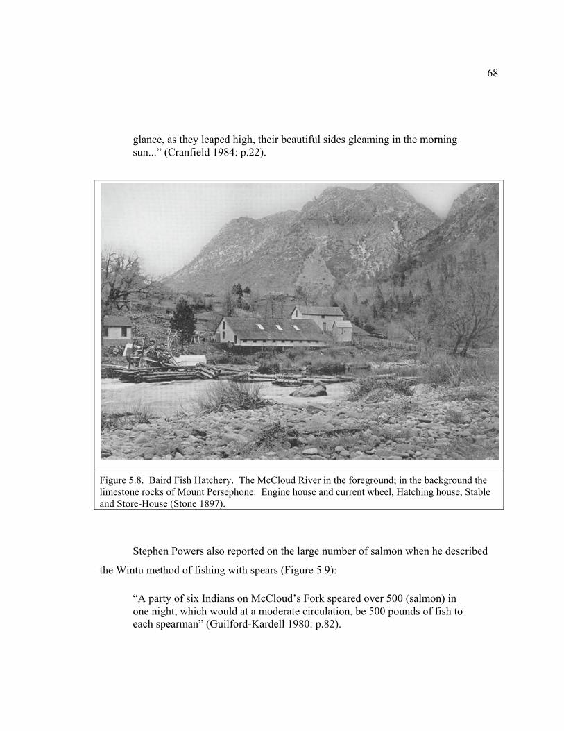
68
glance, as they leaped high, their beautiful sides gleaming in the morning sun...” (Cranfield 1984: p.22).
Figure 5.8. Baird Fish Hatchery. The McCloud River in the foreground; in the background the limestone rocks of Mount Persephone. Engine house and current wheel, Hatching house, Stable and Store-House (Stone 1897).
Stephen Powers also reported on the large number of salmon when he described
the Wintu method of fishing with spears (Figure 5.9):
“A party of six Indians on McCloud’s Fork speared over 500 (salmon) in one night, which would at a moderate circulation, be 500 pounds of fish to each spearman” (Guilford-Kardell 1980: p.82).
69
Figure 5.9. Wintu man, Charlie Pit, spearing salmon on the McCloud River (Houseworth 1882c). Mount Persephone is in the background. (Source: Photograph used courtesy of the National Anthropological Archives, Smithsonian Institution, 43848K)
The influx of settlers to Northern California continued year after year. After the
valleys were settled, homesteaders had to go into the foothills and up the mountains.
Stone considered the presence of soldiers at the hatchery important “on general
principle.” They helped stop the Indians from killing salmon before they spawned, and
also stopped a white man who tore up a corner post on the reservation, another who put
up a fence inside the reservation, and yet another who began cutting timber
indiscriminately. Stone requested the boundaries of the reservation be extended because:
“Settlers are beginning to come to the McCloud River. They take up a claim, burn the Indian rancherias, shoot their horses, plow up their

70
graveyards, and drive the Indians back into the hills, the ultimate result of which must be approximate starvation” (Heizer et al. 1973a).
Figure 5.10. Colchoolooloo’s Ranch, taken about 1882. Group of Indians on the McCloud River (Houseworth 1882a). (Source: Photograph used courtesy of the National Anthropological Archives, Smithsonian Institution, 56773)
Extending the railroad north from Redding toward Oregon along the Sacramento
River in 1883 fouled the water so badly that salmon egg production was reduced by over
90%. The salmon hatchery stopped operations from 1884 through 1887, but the trout
hatchery on Greens Creek was able to remain in operation during those years. After the
railroad construction finished, the salmon runs returned to normal levels for a period. In
1903 the number of eggs taken from salmon was reported as twenty-five million. In
1935, the last year of operations at Baird, only 5,200 eggs were harvested. Ironically,
1940 was reported as the best salmon run in 20 years, but the hatchery was closed and

71
Shasta Dam was already well under construction. By 1945, Baird was inundated by
Shasta Lake (Cranfield 1984: p.17).
Sportsman’s Paradise
In the nineteenth century Northern California was recognized as a sportsman’s
paradise, a reputation it still holds today. Southern’s Inn, McCloud Hotel, Fisherman’s
Paradise, Castle Crag Tavern, Castle Rock Resort, and Castle View Hotel all flourished
in their day. On the McCloud River wealthy San Franciscans established the Bollibokka
Club, Ken-Cam lodge, and Ellery’s Lodge. Wintu Indians Bill Towendolly, John
Sampson, and Joe Campbell, were often hired as hunting and fishing guides (Hoveman
2002; U.S. Department of the Interior Bureau of Reclamation 1947b: p.22). John Muir,
in 1888, described the region as a lush setting:
“The temperature [of the water] is about 45 degrees, and the height of the river above the sea is about 3,000 feet. Asplenium, epilobium, huechera, hazel, dogwood, and alder make a luxurious fringe and setting; and the forest of Douglas spruce (fir) along the banks are the finest I have seen in the Sierra” (Muir 1888: p. 230).
The estates and clubs along the McCloud River are still considered landmarks of a
leisurely life (Cranfield 1984). Brief histories of four of these clubs are as follows:
The Bend—T39N R2W Section 34
In 1883 Justin Sisson began buying land along the McCloud River in an area
known as “The Bend.” He built cottages to rent to tourists who came to fish and hunt. In
1898 Charles S. Wheeler, an attorney from San Francisco bought this property from
Sisson along with land from the Central Pacific Railroad and the U. S. government until
he controlled land in 10 sections. Phoebe Hearst leased part of it until 1936, which is
when William Randolph Hearst finally bought the land. Hearst had a ‘Bavarian
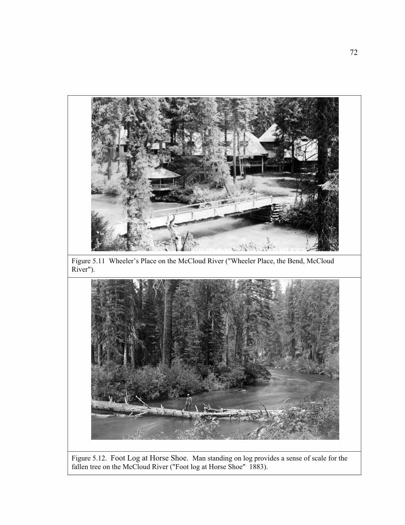
72
Figure 5.11 Wheeler’s Place on the McCloud River ("Wheeler Place, the Bend, McCloud River").
Figure 5.12. Foot Log at Horse Shoe. Man standing on log provides a sense of scale for the fallen tree on the McCloud River ("Foot log at Horse Shoe" 1883).

73
village’ built with guest houses, a swimming pool, movie theater, billiard room, tennis
courts, and a personal airport. In 1984 the Hearst Corporation owned about 41,199 acres
in the McCloud watershed (Cranfield 1984).
Figure 5.13. Hearsts’ Wyntoon Estate on the McCloud River. William Randolph Hearst Sr. walking with his dog from Cinderella House to Fairy House (Stackpole 1935). (Source: TimeLife)
Ah - Di - Na—T38N R2W Section 33
William R. Whittier bought this section of land from the Central Pacific Railroad
over time from 1895 to 1918. The Whittiers built several buildings and a bridge, put in
an orchard, and farmed during the summer. In 1919 William M. Fitzhugh bought this
land and the Wheeler Ranch property. Fitzhugh built trout holding tanks, irrigation
ponds, and a stone cellar. In 1936 Hearst bought this property and built a trail between

74
his land at The Bend and Ah-Di-Na. In 1958 the main road to Ah-Di-Na was built by the
Long Bell Lumber Company. In 1965, the Hearsts traded Ah-Di-Na to the Forest
Figure 5.14. Detail of U.S. Forest Service map showing location of Ah-Di-Na. Between Lake McCloud and The Nature Conservancy’s McCloud River Preserve, approximately 18 miles south of the McCloud Ranger Station on SR 89. Hikers on the Pacific Crest Trail and fly-fishers using the McCloud River enjoy the campground ("Ah-Di-Na: A Short History" 2008). (Source: U.S. Forest Service)
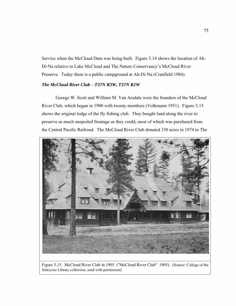
75
Service when the McCloud Dam was being built. Figure 5.14 shows the location of Ah-
Di-Na relative to Lake McCloud and The Nature Conservancy’s McCloud River
Preserve. Today there is a public campground at Ah-Di-Na (Cranfield 1984).
The McCloud River Club—T37N R3W, T37N R2W
George W. Scott and William M. Van Arsdale were the founders of the McCloud
River Club, which began in 1900 with twenty members (Volkmann 1951). Figure 5.15
shows the original lodge of the fly fishing club. They bought land along the river to
preserve as much unspoiled frontage as they could, most of which was purchased from
the Central Pacific Railroad. The McCloud River Club donated 330 acres in 1974 to The
Figure 5.15. McCloud River Club in 1905 ("McCloud River Club" 1905). (Source: College of the Siskiyous Library collection, used with permission)
76
Nature Conservancy and retained the rest for its members. Today, The Nature
Conservancy’s McCloud River Preserve allows up to ten people at a time access to fish
on the river (Cranfield 1984: p.49).
Bollibokka Land Company—T37N R3W, T36N R3W
In 1921 Joseph M. Ough sold land to the Bollibokka Country Club. This Club
was located in the section of the McCloud River just above the current high-water level
of Shasta Lake. In 1946 Southern Pacific Railroad sold more land to Bollibokka but
maintained the right-of-way to build a road (Cranfield 1984: p.50). In 2007 Westlands
Water District bought Bollibokka for $35 million “to clear an obstacle for expanding
Shasta Reservoir” (Grossi 2007)
U.S. Forest Service
The Shasta Forest Reserve was established on October 3, 1905, by proclamation
of President Theodore Roosevelt. In 1907, when the National Forest System was
established, the reserve became the Shasta National Forest (Sundahl 1995: p.1). At the
time it only affected about twenty sections of land within the northeastern portion of the
McCloud Watershed because land was either in private ownership or outside of the forest
boundary. When Shasta Dam was completed, the National Park Service managed the
shoreline of Shasta Lake. However, in 1948, Public Law 449 transferred administrative
responsibility to the Shasta National Forest (Sundahl 2005).
From the beginning, the U.S. Forest Service had more than timber management
problems to deal with. Nationwide, millions of acres of forest land had deteriorated as a
result of overgrazing (Frome 1984). In California, in the 1940s, Ranger John Gillman
reported that about 7,000 head of cattle were grazing on land near Squaw Creek, the Pit
77
River, and McCloud River. Indians throughout California, including the Wintu,
complained to little avail. Randolph, the Indian Agent in Redding, sent a copy of the
trespass warning to the Wintu so they could post it (Radcliff 1912a). When the U.S.
Forest Service acquired Shasta National Forest, it established regulations to limit grazing,
which resulted in bitter disputes with the stockmen. Some of the animals grazed on land
allotted to the Indians, but neither the U.S. Forest Service nor cattlemen were concerned
with trespass. The disputes were about carrying capacity for grazing animals (Sundahl
1995: p.5). Overuse was not restricted to grazing. All saleable timber had been removed
and open-hearth smelting processes in Kennett had denuded the west side of the
Sacramento River near Little Squaw Creek. “Mining, grazing, and logging activities
were all practiced with apparently but a single purpose – profit” (Sundahl 1995: p.15).
Allotments
From 1846 to 1884, Indians could not acquire land because they were not citizens.
Even immigrants could become naturalized citizens and take up land, but this was not an
option for Indians. Jeremiah Curtin reported in 1889 that the conditions for the Wintu
were such that “There was not a spot of land where they could build a hut without danger
of being ordered away from it” (Theodoratus Cultural Research 1981: p.75). Moved by
their plight, Curtin transcribed the Wintu and Yana petition and delivered it personally to
President Harrison in May, 1890 (Hoveman 2002). (Appendix 4)
President Harrison forwarded the letter from the Wintu and Yana leaders to the
Office of the Commissioner of Indian Affairs. Since the Wintu and Yana petition came
from the President, the response of the Department of the Interior was immediate. The
Office of Indian Affairs (BIA) instructed Indian Inspector A. M. Tinker, who was then in
California, to investigate. Tinker reported back after he visited these Indians:
“…they are quiet, industrious and good working people, doing all they can to improve their condition and secure permanent homes for themselves
78
and their families.” He also reported “to all appearances are worthy of aid from the Government; that they have been self supporting for a long time, - not receiving any aid whatever from the Government; that they do not want to remove to a reservation and settle thereon; but that seeing the public lands disappearing rapidly, they desire to take allotments of land in severalty, and ask that an Agent of the Government be sent among them to aid in selecting and locating lands for their future homes” (Bell 1892b).
The General Allotment Act of February 8, 1887, 24 Stat. 388, generally known as
the Dawes Act, is also referred to as the Indian General Allotment Act, the Committee on
Indian Affairs Act, and the Severalty Act (Dawes Act 1887). Under pressure from
influential social reformers, Congress struggled for two decades to develop a new Indian
policy. Congress wanted to identify more land for white settlement, to reduce the cost of
treaty obligations to tribes, and to satisfy the reformers. The reformers wanted more
education, less abuse, and less poverty for the Indians. Both Congress and the reformers
believed the best approach was to assimilate Indians into mainstream American society.
The Dawes Act is best known for reducing the size of reservations by making allotments
to individual Indians in severalty parcels (homesteads), varying in size from 40 to 320
acres. The remaining reservation acreage, considered “surplus” to Indian needs, went
back into the public domain and was then made available to white homesteaders. Less
known is that Clauses Four and Five of the Dawes Act provided a means for providing
allotments to landless Indians (Goodrich 1925; Sutton 2003; Thomas 1971).
In 1906 C. E. Kelsey, a special agent for Indian Affairs, reported that 2,058
allotments had been made in California with 261 canceled, leaving 1,797 outstanding.
The majority of these allotments were in Lassen, Modoc, Plumas, Shasta, and Siskiyou
counties (Robinson 1948: p.18; Theodoratus Cultural Research 1981: p.45).
Obtaining an allotment must have felt like a step forward for the Indians. Finally,
there would be a piece of paper that proved ownership, represented stability, and
promised protection from the harassment of settlers. But getting an allotment was not the
79
same as getting a reservation. The allotments were made in trust for twenty-five years, to
be transferred to the Indian holder at the end of that time if they were considered
competent. Allotments were lost in a variety of ways. As Kelsey reported, a large
number were canceled. If an Indian died before the trust period of twenty-five years was
up, the laws of the state controlled the disposition of the land, usually meaning the claim
went to probate court (Sutton 2003: p.12). In 1906 the Burke Act shortened the trust
period for “any Indian allottee who is competent and capable of managing his or her
affairs.” Other Acts extended the trust period. Stockmen, interested in rangeland for
cattle and sheep, used Indian allotments with and without permission. Some Indians sold
their land and wound up landless again. By looking at how some of the Special Agents
dealt with the Indians regarding allotments, one can see how attitudes toward the Indians
shifted over the years.
1891: Special Agent Michael Piggott
On May 23, 1891, the BIA appointed Michael Piggott, a “one-legged ex-soldier”
from Quincy, Illinois, as Special Agent in California to give special attention to the
Wintu and Yana allotments (Bell 1892b). T. J. Morgan, Commissioner of the BIA in
Washington D.C., informed Piggott that Tinker had already reported on the tribes’
interest in securing allotments:
“… the old men of these Indians are anxious to locate their lands in the vicinity of where they have always lived; that the young men are willing to take lands wherever they can be found in that section of the country for the allotment; that they can locate in many places 20 or 30 acres of fertile land on which they will be able to make a living; that it is very probable that there is sufficient land in the territory over which these Indians are scattered suitable to make allotments.”(Morgain 1891c)
Morgan’s letter includes detailed instructions about how to proceed. Allotments
are to be 80 acres, “unless the lands allotted, or any legal subdivision thereof, are only
80
valuable for grazing purposes, then such lands shall be allotted in double quantities.” In
no case were the allotments to be less than 40 acres, “the smallest legal subdivision of the
public survey.” Piggott was advised:
“you will also be careful not to allot any lands to any Indian applicant until you have further ascertained … that there is no prior, valid adverse right to the lands applied for, or in other words, that the lands applied for are subject to allotment” (Morgain 1891c).
In another early letter to Piggott, Bell, Acting Commissioner at the BIA in
Washington D.C., wrote:
“When allotments shall have been made to these Indians they can I hope be assisted in procuring farming implements, seeds, &c. as their circumstances may require, out of appropriations already made and available for aiding Indians ‘who have taken lands in severalty’ under the General Allotment Act [24 Stat.388]” (Bell 1890).
Since the goal of the allotments was to make the Indians “self-sustaining citizens
by farming and stock raising in the country occupied by them,” equipment to accomplish
this was expected to be part of the provision (Bell 1892b). Yet, when Piggott wrote for
farm implements, clarification on who was qualified under the General Allotment Act,
survey assistance, and additional forms, he received a testy response from Bell. Neither
the Yana nor Piggott could see how the Indians could establish homes on the allotments
without assistance, but Bell wrote:
“You should urge the Yana Indians to accept the generosity of the Government in its efforts to locate them on the public lands for the reason that all unoccupied lands are fast being taken up, and there will soon be none for that purpose.”(Wintu library Piggott 1891)
While Bell recognized that it would be important for the Indians to have some
place of their own, he was insensitive to their poverty, their need for immediate

81
assistance, and the challenges to farming in California. Bell could not see why they
needed help getting started, “The Indians can certainly remove to the lands allotted to
them and build thereon some kind of an improvement as a home, and at the same time
continue their daily manual labor among the whites for support.” Bell did not anticipate
the complexity of probate when he wrote that the land would become more valuable over
time and “may prove to be a good estate to the allottee or his heirs.” (Wintu library
Piggott 1891)
Piggott found the Public Land Survey in the area to be “unreliable.” With only
one leg, he found it difficult to “climb the hills in search of section lines and quarters,”
and asked for authorization to hire an assistant. Bell turned this request down and told
him that if a survey was needed he was to submit an estimate of the costs first. Bell
instructed Piggott:
“A careful perusal of your general instructions and the enclosures thereof will furnish you much information in regard to the work planned for you in that section of the country, and save this office some unnecessary labor, and give relief to the extent of the already crowded condition of official correspondence” (Wintu library Piggott 1891).
Several letters refer to whites moving into Indian Allotments. From Washington,
the instructions to Piggott were to ask them to leave and notify the office if they refused
to do so. The letters do not give the outcome (Morgain 1891a, 1891b; Wintu library
Piggott 1892a, 1892b). In 1892, Piggott requested that:
“certain lands in California be withdrawn from sale and entry by the General Land Office for the period of 6 or 8 months, in order that the Indians located thereon may have time and opportunity to make applications for allotment of the same for themselves and families under existing laws, and the rules and regulations of the Department pertaining to allotments, such recommendation being made for the reason that professional land grabbers have appeared upon the same and are busily
82
engaged in their avocation” (Bell 1892a).
On October 4, 1892 the General Land Office did as Piggott requested and put a
six month freeze on filings so that the Indians could make their applications.
In 1892, Piggott informed Washington that the Register at the Redding Land
Office would not process allotments for “half-breeds” or Indian women married to white
men. Indeed, this was a grey area at the time. By the Act of August 9, 1888 (26 Stat.
392), Congress had declared that if an Indian woman married a citizen of the United
States, she became a United States citizen and forfeited her tribal membership. Children
of this marriage were also considered United States citizens. This Act did not apply to
marriages entered into before 1888, so Piggott was instructed to continue giving
allotments to married Indian women and “half-breeds” until otherwise instructed (Wintu
library Piggott 1892c).
By the time Piggott resigned his assignment as Special Allotting Agent in 1893,
he had made 993 allotments in California, Oregon and Nevada. He gave this reason for
his resignation:
“Perhaps it would be proper for me to state why my resignation was sent in. I was first appointed by Commissioner Oberly who knew me for years and that I have always been a Republican. The Department records will show that I am a one-legged soldier and was selected by the Indian Bureau for the position I now hold without political influence. I have for many years been strongly opposed to politicians using men in my position for political capital. If the present administration desires my place of a political friend, I want the record to show that I resigned, was not removed” (Bell 1893).
These correspondences indicated that Piggott talked to the Indians as well as
government officials. They reflect the efforts of one who tried to be fair within the
constraints of the law and his instructions. Piggott’s resignation implies he had to stand
83
his ground against political pressure. His resources were limited, and the geographic area
he served was large. He did his best even though hampered by one leg, winter weather,
difficult terrain, and bureaucrats in Washington who were more concerned with budgets
than Indian living conditions.
1900: Special Agent William E. Casson
The letters of Special Allotting Agent William E. Casson reflect a different
attitude toward the Indians. In 1900 Casson reported about the Wintu and Yana
allotments to the United States Land Office regarding the:
“advisability of securing an appropriation from Congress, for the purpose of buying farming implements, wagons, horses, harness, cows, seeds, fruit trees etc., and to purchase rations for the old, helpless and blind” (Casson 1900).
Casson heard repeatedly from the Indians that both Jeremiah Curtin and Special
Agent Piggott had promised the land and the assistance they would need to get started
with farming. “These Indians have been very anxious to have your department buy them
horses, plows, harness, wagons, seeds, mowers and cows” (Casson 1900). Most
emphatically, Casson recommended against sending farm implements and animals.
“I cannot see my way clear to recommend to your office that they be furnished horses, cows, harness, wagons etc., for the reason that the few white people who live in the country cannot make a living by farming and the stage stations nearly all over the country have to haul baled hay from the Railroad which is shipped in from other places.”
“This is not a farming country and if these Indians were furnished horses and cows they would be starved to death the first winter.”
“In conclusion I have the honor to recommend that no supplies, teams, harness, wagons or cows etc. be furnished, for the reason before given, as they have no use to them” (Casson 1900).
84
Even though he was not willing to supply animals, farm equipment, or starter
seed, Casson held to the view that the land allotted to the Indians should be for
subsistence farming. Any land that had extractive value, such as mines or timber, Casson
did not consider appropriate for allotments.
“The lands were allotted from the plats in the U.S. Land Office and not visited for the purpose of ascertaining the character or suitability for homes, for Indians. The greater part of these allotments are in mineral country, and I have visited allotments which have large deposits of copper and gold. In one case an Indian and his family were allotted a section of land which is mountainous and has never lived on it, and upon which prior to the allotment a man had located some quartz claims, he did his work on them annually, as required by the mining laws, he is a poor man and did what he could, but did not patent his mine for lack of means to do so; He only discovered a short time ago that the lands, on which he had located were allotted and patented to Indians. In this case the Indians and white man were both injured by the easy method employed by the Special Agent” (Casson 1900).
He was unable to see the Indians as marginalized or excluded from society,
denied most jobs, and impoverished. Since the McCloud River area was already
considered a “sportsman’s paradise,” Casson may have seen hunting and fishing by
Indians as recreational, instead of traditional means of procuring food.
“A very small percentage of these people raise gardens and they live as a rule, by working, for white people, around mines chopping wood etc.”
“It is said they are not overly industrious and will only work a few days at a time. There are exceptions and some very good, steady men who work as well as white men. There are others among them who are young and strong, who prefer to hunt and fish” (Casson 1900).
Casson wrote that he had a hard time locating individual Indians for a variety of
reasons. The missing survey marks and activity of white individuals and businesses
made it hard to tell where the allotments were located. Often the Indians were working
85
somewhere else, since it was not possible to survive by farming only. All of these issues
had been described by Piggott when he held the role of Special Allotting Agent. Casson,
however, was not sympathetic to the Indians situation, nor did he seem to be aware of the
work done by Piggott.
“I think not one third of these Indians live upon the lands but they live, in log houses, in groups. On one day, I met and talked with eighteen Indians not one of whom knew the corners to his lands.”
“There is a great deal of activity in the country, in mining, projected power ditches, electric roads and oil wells, and some of same probably cross allotments and I would respectfully recommend that these people be furnished a surveyor to begin work among them next Spring as soon as the weather will permit, to survey their lands for them, the Indians will assist in doing this work. This will place them in a position to protect themselves against white people who might otherwise take advantage of them” (Casson 1900).
Casson delivered forty-four of the 126 allotment patents he was carrying to
distribute. While he had no trouble assessing the land and reporting how inappropriate it
was for the Indians, regarding his efforts to deliver the remaining eighty-two patents, he
wrote:
“There are many of the allottees numbered 1 to 526 that I have been unable to locate, as they do not reside upon or near their lands at this time; but I expect to find some of them soon and deliver their patents to them. I am trying to locate them by correspondence, as the expense would be too great to look them up personally” (Casson 1900).
Without their patent in hand, the Indians had no visible proof that the allotted land
was theirs. White people didn’t need to wait for the patent to take possession and
occupancy of land. For the Indians, without access to law and with no power to disagree
with a white person, it may have been too dangerous to live on the allotted land in
advance of the patent. Even with the patent, the land was often too difficult to live on
86
due to steep terrain or lack of water. Unable to imagine why owning a part of their
ancestral territory would matter to them if it wasn’t productive for American-style
farming, Casson wrote:
“The Indians say they do not care to relinquish lands and take new allotments for the reason that no better lands than they have can be found and that they prefer to keep what they have” (Casson 1900).
Casson prepared a tabulation of the Indian Allotments in which he described
improvements, settlement, general remarks, and action taken or proposed for the status of
the allotment (Casson 1903). The table is rich in detail and would warrant further study
but is beyond the scope of this study.
1905: Special Agent C. E. Kelsey
In 1905, after the injunction of secrecy for the unratified eighteen treaties was
lifted, C. E. Kelsey was appointed Special Indian Agent to make recommendations
regarding the California Indians. By then the allotment system was recognized as a
failure. The survey of 1906 conducted by Kelsey was meant to enumerate the number of
landless Indian people and to estimate their needs for land. Much to everyone’s surprise,
Kelsey’s count showed there were at least 20,000 Indians still living in California. The
report also described the effect of displacement on the landless tribes and bands. From
1906 through 1937, Congress continued to appropriate money for land and necessities for
the homeless Indians (Hoveman 2002; Sanchez 2003).
After the U.S. Forest Service was established, after the forest service was
acquired, it was no longer possible to acquire private title to public land. People who
wanted to purchase land sometimes wrote to the Indian Agents for information. The
Agents wrote back and recommended contacting various Indians to see if they wanted to
sell their land (White 1983). On one occasion in 1907, Kelsey, as the representative
87
agent, became very involved in the efforts of George Armstrong to purchase two Redding
Allotments from Wintu Indians: allotment 382 from Ida Pitt and allotment 383 from
Aleck McKenzie. Kelsey explained the situation to the Commissioner:
“It appears that Mr. Armstrong, together with Johnie [sic] Baker, Josie Baker, William Baker, Charles Baker, and Horace White, have discovered that these Indian allotments were valuable as mining property, and have located and filed mining claims thereon. Mr. Armstrong requests that he be advised whether they could purchase other lands and exchange them with the Indians, or in what way they could secure full title to these lands”(Kelsey 1907a).
Kelsey was advised to investigate and make a report to see if it is possible to let
Armstrong “secure full title under the Act of March 1, 1907 (Regulations for the
Conveyance of Lands of Noncompetent Indians 1907) and the regulations for the
conveyance of lands of noncompetent Indians.” A copy of the regulations was sent to
Armstrong for his convenience (Kelsey 1907a).
Kelsey informed Armstrong that there were actually three Wintu allotments
together. The third was Redding Allotment 381, for James McKenzie, who was about
twenty years old at the time. Ida Pitt was seventeen and Aleck McKenzie was about
fifteen. The three allotments were at the confluence of the McCloud River and Squaw
Valley Creek, with mostly canyon walls and little flat land. While Kelsey did not
consider the land appropriate for agriculture, he did say it was very wild and picturesque
with some timber, including Douglas fir (Pseudotsuga mucronata), yellow pine (Pinus
ponderosa), and sugar pine (Pinus lambertiana). Kelsey estimated the value of the land
and timber at five dollars per acre. However, he said its chief value was the location:
“The natural setting is very beautiful and it is as yet untouched by civilization. A club of wealthy people in San Francisco have built a club house on the McCloud River about a mile and a half above the confluence of the streams, on a flat at the mouth of Claiburn [Claiborne] Creek. The club house alone cost over $40,000. A road has been built from the club
88
house to the railroad station at McCloud, a lumbering town to the north. The club has bought up all the land for ten miles or more up the McCloud River, their holdings exceeding ten thousand acres. I do not know the cost of the land, but it must be considerably in excess of the cost of the club house. They own section 27 and three quarters of section 22. The other land surrounding it is in the Shasta National Forest. These holdings were acquired by the club before the establishment of the National Forest. They would have tried to get the land covered by the allotments if the title had been other than an Indian title. The club people have bought up the entire country as far as possible in order to prevent timber cutting, fires, etc., and to keep it in its primitive wildness. The McCloud River canyon is becoming a fad among those who have means to pay for exclusiveness.”
“Another club has been organized to build a house a couple miles below the Indian allotments. Mrs. Hearst, Sr., has a fine villa a few miles up the McCloud River. Sites on this stream, especially the exceptional sites, such as these allotments occupy, are likely to be in demand” (Kelsey 1907b).
According to Kelsey, Horace White was a prospector who had discovered a ledge
loaded with copper. The Bakers were friends with both White and Armstrong.
Armstrong knew that sometimes Indian allotments were cancelled. White believed a
mine would never be developed because he expected the McCloud River Club to buy it
from them immediately, in order to prevent a smelter from being located on the river.
The plan was to get the land at a low price and sell for a profit. Even though he could see
the scheme, Kelsey still saw the land as worthless to the Indians because it was unfit for
agricultural purposes. He recommend that the land be sold so the money could be
invested in more suitable land for the allottees (Kelsey 1907b). The Acting
Commissioner wrote back:
“The office considers from your report that this is a special case where it appears that those Indian allottees are noncompetent within the purview of the law, because of the fact that Charley Pitt, their ignorant paternal grandfather or great-grandfather selected allotments # 381, #382, and #383 for them without regard to their future welfare and interests, and by reason of the barrenness of their allotments these minors are poverty-stricken, and
89
being ignorant are unable, if they would, to either embark in some gainful industrial pursuit or develop their allotments” (Kelsey 1908a).
Kelsey was instructed to sell the allotments as soon as he took care of a few
details; he had to get a guardian for the minor Indians appointed by the court, secure
reports on the lands proposed to be purchased in replacement, and get the consent of the
allottees through their guardians for the purchase of the new land (Kelsey 1908a).
Before Kelsey could carry out these instructions, the McCloud River Club “had a
partial survey made and alleged that the government survey is grossly defective and that
the plat is wrong.” According to Kelsey, this posed a new obstacle to selling the land:
“It therefore seems absolutely necessary to have a determination of the line before we can sell the allotments… It is undeniable that many surveys in California, especially in difficult territory, were partially or wholly fraudulent… It may be that some work was done and the rest guessed at.” (Kelsey 1908b)
Kelsey’s concern was that it would cost better than $2,000 to do a legitimate
survey and, if the costs were taken from the proceeds of the Indian allotments, the sale
would leave nothing for the minor allottees. The correspondence on this matter ends in
1908 when Kelsey was advised that no resurvey was authorized. However, in 1914 Ida
McKenzie petitioned to sell the 160 acres in Redding Allotment 382 for $500, which was
valued only as grazing land (Kelsey 1914).
While Kelsey believed that the allotments the Indians had received were, in the
most part, uninhabitable, he was acutely aware that “there is not a scrap of land available
to give the Indians in place of the unprofitable allotments.” He also reported other
reasons that made it difficult to buy land for the Indians:
“I have found in my five years experience in buying land for Indians that few white people will sell land to or for an Indian. Few white people in

90
the mountains will listen to an Indian when he wants to talk of buying land. They will not sell to an Indian except at an exorbitant price, and the Indian gets desperate very soon and pays the exorbitant price, if he is able.” (Kelsey 1910)
1915: Special Agent John Terrell
In 1915, John Terrell became Special Agent and had , $10,000 of Indian
Appropriation Act money available to purchase land for homeless Indians. When Terrell
arrived in California he was advised by Horace Wilson, the local Supervisor, that nothing
had been committed from the fund. Terrell’s report to Cato Sells, Commissioner of
Indian Affairs, described Terrell’s initial efforts to educate himself about efforts to buy
land. Wilson sent Terrell to meet with Mr. W. C. Randolph, Indian Clerk, who lived in
Redding. Randolph took Terrell to meet local Indians. Considering the future
importance of the Redding Rancheria, Terrell’s description is noteworthy:
“The few Indians who reside in Redding could hardly come within the merits of the provisions of the Act. They are of different tribes, degree of blood, of different social conditions and cannot in hardly any sense be considered a ‘band’ of Indians” (Wintu library Terrell 1915b).
Next they went to Happy Valley, about ten miles south of Redding. Randolph
introduced Terrell to Tom Miller and C. W. Bolles, ranch owners who had some land
they were willing to sell for $10 per acre. Terrell reported the land was rough,
unimproved, and needed irrigation. Terrell observed in his report:
“The Indians come in the fruit gathering season to get work, very much as the negros [sic] in the South, leaving their city homes, go to the cotton fields during the gathering of the cotton” (Wintu library Terrell 1915b).
Then they went to Baird, on the McCloud River. Randolph and Perrin C.
Radcliff, the Wintu Interpreter at Baird who owned Redding Allotment 50, had been in
91
touch with each other several times. It was difficult for the Winnemem Wintu to travel to
Redding to see the Indian Clerk, Randolph. In 1912, Radcliff asked Randolph if he
would “come up here which would be great help to the Indians up this way” (Radcliff
1912b). In his role as Interpreter, Radcliff wrote frequently to Randolph regarding Wintu
issues, describing problems with survey marks, trespass, trees dying from the smelter
smoke, shortages of money, and homelessness.
Randolph and Terrell wanted to meet with Mr. D. P. Doak, who had bought
sections of land from the railroad, because Terrell wanted to see if any of this land would
be suitable for the Wintu (Wintu library Terrell 1915b).
“At Baird I saw several of the full blood Indians who reside there. We spent almost the entire day looking over various tracts of land along the McCloud River above the Government Fishery Reserve. I have in mind that it might be feasible and possible to purchase some land along this river in the vicinity of the Government Fishery” (Wintu library Terrell 1915b).
Doak was not interested in selling his land to the Agents. From the beginning of
his appointment Terrell encountered the same problem as Kelsey: it was hard to get white
people to sell land for Indian use. The reluctance of white people to sell was not solely
the result of hesitation to have Indians located nearby; the government bid the lowest
amount and it could take longer than eight months before the seller would receive
payment (Meritt 1915). At the meeting with Terrell, Doak already anticipated there
would be a dam built, although Doak did not foresee Shasta Dam would eventually
become the federally funded Central Valley Project:
“[Doak] was associated with a number of gentlemen owning land on the Pit and McCloud rivers … which had been bought largely with the view in the near future of building a very large dam for the development of a great power and water supply for the Cities of Sacramento and San Francisco, as well as other intervening cities and towns; and, that instead of selling any of their lands would desire to add to their holdings by
92
purchase in the near future of the Indian allotments in the vicinity of their proposed dam.”
“Mr. Doak has been generous to say that there will be no disposition to disturb these Indians in their present little homes on his lands, further than they may be forced to in the development of the water power.”
It now occurs to me that likely their interests may be held obeyance [sic] pending the probable material change of their present location should the proposed dam be built. In view of the fact Mr. Doak and his associates will desire to deal with the Government for the purchase of the few Indian allotments in the vicinity of the proposed dam, feel confident that at the proper time through the assistance of these people the future interests of the Indians will be protected” (Wintu library Terrell 1915a).
At Terrell’s request, Radcliff put together a list of landless Wintu. Randolph
wrote to Radcliff to let him know Terrell “does not intend to buy any land for the
McCloud River Indians, as they are already pretty well landed” (Radcliff 1916). Radcliff
wrote again to Terrell to say that he was surprised and disappointed to find that Terrell
was not actively looking for land for a permanent village (Wintu library Terrell 1916).
Terrell wrote back that he had stopped in Redding to discuss the situation with Randolph,
who did not see that there was any immediate or serious need for “land among your
people.” Terrell went on to write:
“By reason of the advanced age of most of them would suppose their greater need during the winter will be food and clothing. I would suggest that in event of these absolute necessities of life for these old people that you advise with Mr. Randolph. I hope to reach your country as early in the spring as the weather will permit” (Terrell 1916).
This intentional lack of efforts by the Agents to find a village or view the
Winnemem Wintu as a living community left the tribe vulnerable to further
fragmentation as time went on. The records show the Agents from this period, as well as
93
earlier agents, provided assistance to those who wrote to inquire about purchasing Indian
allotments. In 1916, Horace Wilson responded to a letter that asked about an upcoming
auction sale of Indian allotments:
“…the Indian lands which are advertised, bids to be opened May 24, 1916, to which you evidently refer, are to be sold by this office… A complete list of the lands for sale by this office is inclosed [sic] herewith as well as other information which may be useful to bidders” (Wilson 1916).
John Terrell’s interactions on behalf of the Indians were with white people, in
particular those with significant land holdings and power. Advice from Randolph,
combined with the general perception of the Wintu as migrant labor, did not incline
Terrell to put their interests as his first priority, nor was he interested in spending much
time with them. His belief that abeyance was the best course of action regarding
purchase of land for the Winnemem Wintu reflected how far removed he was from
understanding their culture, the economic conditions that had made them migrant
workers, or the many years the homeless Indians had already been waiting to secure land
despite repeated promises by the government. There were homeless Wintu, but the
homeless would stay where they were not being run off. Often the homeless lived on the
allotments of other Indians and sometimes on land owned by white people. The only
reason Randolph considerd the Wintu “pretty well landed,” was because the homeless
Wintu continued to live in communal fashion on the allotments near Baird Fish Hatchery.
Randolph’s attitude accepts tribal living but does not formally acknowledge it. If the
Agents had bought land for a village, the act of purchasing land for the Wintu and the
spatial nature of a village would have established the beginning of a tribal relationship
with the BIA. Instead, the letters indicate both Wilson and Randolph did not make the
Wintu a priority. Indeed, Wilson was more concerned to make sure that the BIA
managed the sale of allotments than find replacement land for the allottees. While the
agents wrote to people who inquired about land, there are no letters in the National
94
Archive files to suggest the allottee was simultaneously consulted regarding the potential
sale. Available land was rapidly disappearing from Shasta County. The effects of this
failure to secure land and create a village for the Winnemem Wintu were compounded
over time.
1922 – 1928
The Bureau of Indian Affairs correspondence files found at the National Archive
continue to refer to money that Congress made available to secure lands for homeless
Indians. In 1922 Snyder Act funds were used to establish the Redding Rancheria.
Thirty-one acres along Clear Creek, south of Redding, were bought to establish a colony
for homeless Pit River, Yana and Wintu Indians (Hoveman 2002; Sanchez 2003). Still,
as before, the Indian Agents were more likely to offer assistance to those interested in
buying Indian allotments than finding replacement land for the Indians. In 1926 Field
Clerk W. S. Kreigh replied to a person looking for land and listed available tracts for sale,
including:
“Indian allotment of Robert Gregory. It is not now for sale. It may be sold later and then you may have a chance at it, if you so desire” (Wintu library Kreigh 1926).
In 1928 Kreigh was helpful again when he replied to another letter that had asked
for information about allotments 49, Rosie Smithson; 165, Charles Bennett; 166 William
Bennett; 202, William Stone; 203, Maggie Stone; and 375, Kittie McKenzie:
“You do not state what you desire one of these tracts for. None of them are agricultural. You should see them before bidding” (Kreigh 1928).
In 1924, in gratitude for their service during World War I, the federal government
granted Indians citizenship and the right to vote. Equally as important, in 1926 they were
granted the right to sue. This would give the Winnemem Wintu, along with other
95
California Indians, a chance to get back on the map. Their struggle moved into the
legislature and courtroom.
1929 – 1937
By the 1930s, the Sacramento Agency envisioned itself as primarily responsible
to clustered groups such as rancherias, reservations, and schools. The Agency treated
Indians who had allotments, or were unallotted, or were identified as non-wards, as
individuals and sought to relinquish responsibility for them as soon as possible. Title for
some allotments had been converted from trust to fee patent but there were a number of
Redding Allotments still held in trust and managed by the BIA these. L. A. Dorrington,
the Superintendent in Sacramento, California, was not able to see the people under his
jurisdiction as vibrant tribal communities. As though they were names from history, he
listed the Northern California tribes in this letter to the Commissioner of Indian Affairs:
“Kindly be advised that the matter of tribes among the Indians of California is quite difficult to ascertain for the reason that years ago, during the gold rush days, the Indians were moved about considerably by the soldiers…. Further, it is believed the Indians of the various tribes under this jurisdiction have intermarried with members of other tribes to a larger extent probably than any other place in the United States. However, generally speaking the Indians found in the northern part of California in that portion formerly under the Roseburg School are Pitt River, Klamath, Karuck, Salmon River, Shasta, Hoopa, Wylackie, and Wintoon [Wintu]. Also the Nosa or Yana band” (Dorrington 1929).
Peter Johnson of La Moine, California tried to buy Redding Allotment 375, Kitty
McKenzie’s 80 acres. There were six heirs to the allotment and they were not all in
agreement to sell. It was in this same letter that Dorrington summarized the heirs’
disagreement and concluded:
“It is true that the amount bid would make but little for each heir, but the land is not worth more, has no future, and is doing them no good.
96
However, as it appears that the majority of the heirs do not care to sell, it is recommended that Mr. Johnson’s deposit of $37.50 be returned to him” (Dorrington 1929).
The Great Depression was very hard on the Indians. O. H. Lipps, the Bureau of
Indian Affairs Superintendent in Sacramento in 1934, received so many requests for
assistance that he wrote a form letter “To the California Indians Residing within the
Jurisdiction of The Sacramento Indian Agency.” People were asking for support and
hoped that there might be money from the United States Court of Claims, the Indian
Reorganization Act, or any source of subsistence relief. Lipps’ letter explained:
“The only funds this Agency has for helping Indians is a comparatively small amount for the relief of the old, indigent and helpless ward Indians, and for urgent medical service for ward Indians… The amount available is not sufficient to provide the relief such Indians really need and should have, so we are compelled to spread it out in small amounts in order to give a little assistance to as many as possible. So far we have been unable to secure funds to assist the many able-bodied Indians who may be in need of continuous direct relief during the coming winter by reason of unemployment” (Wintu library Lipps 1934).
At the same time, Lipps brought the situation to the attention of both the Indian
Affairs office and the Federal Relief Administration in Washington. In 1935 more
funding for lands and homes for homeless Indians was appropriated.
“The requirements that lands purchased under this program [Indian Reorganization Act, July 18, 1934] must be ‘submarginal’ in character have been greatly liberalized to meet the needs and requirements of the Indian population, and it is now possible to include in our purchase projects limited areas of better class lands, the maximum price to be paid being placed at $20.00 per acre and the maximum average being placed at from $9.00 to $10.00 per acre. This liberalization will enable us to purchase some areas which will afford subsistence home sites, garden plots, and areas upon which winter food can be raised for stock” (Lipps 1935).
97
The government rules, regulations, and policies that required “submarginal” land
be purchased for Indians reflected the submarginal status of the Indians. Land had
always been difficult to purchase. By adding the “submarginal” requirement, the
government further limited the purchase options. This mandate expressed racism, by
deeming Indians unworthy of prime land, and environmental injustice, by condemning
them to the hardships associated with submarginal land. Even with “liberalization,”
which allowed the agency to include “limited areas of better class lands,” no concern for
social equity or economic opportunity for the Indians influenced the BIA choices.
Summary
Wendy Nelson Espeland discussed the paradoxical role bureaucracies play in both
maintaining and limiting democracy in “Bureaucratizing Democracy, Democratizing
Bureaucracy.” The social leveling associated with mass democracy requires regulation,
legal systems, and political representation. Bureaucracies provide the “elaborate and
durable forms of administration” needed to implement and manage these goals.
However, within the bureaucracy, authority becomes vested in those who have
credentials proving their expertise, such as diplomas and certificates. This creates a sense
of technical superiority and often makes internal decision-making processes inaccessible
to outsiders. Over time bureaucracies may change from “efficient administrative
apparatuses” into “powerful organizations devoted to perpetuating themselves” (Espeland
2000: p. 1080).
The early letters between Piggott and the Commissioner in Washington reflected
efforts to efficiently carry out the goal of getting land for the homeless Indians. The
bureaucracy balanced the will of the President, the laws of Congress (Dawes Act and
PLSS), and the rules of the agency (appointment, budget, paperwork). The letters
implied changes in the bureaucracy as subsequent agents become experts in Indian issues
and decisions were made internally. The Indians were increasingly moved outside the
98
decision-making processes. Each period of interaction with the BIA Agents further
fragmented the Winnemem Wintu and reduced their future opportunities. Piggott appears
to have made every effort to secure allotments. But, given the poor condition of the land,
shortage of water, and lack of start-up farm equipment, animals, or seed, most Indians
could not make a subsistence living from agriculture on the allotments. Because so much
land had already been patented to the railroads, the allotments were discontinuous, which
fragmented the Winnemem Wintu and made it difficult to maintain a tribal relationship
with the BIA agents. Agent efforts to secure replacement land were often half-hearted,
underfunded, or blocked by private owners. Agents frequently supported the efforts of
interested buyers to purchase allotment land because they believed the land was useless
to the Indians. By the 1930s, the agents viewed work related to non-ward Indians,
inherited allotments, and requests for assistance as tasks they hoped to soon be done with.
The Sacramento Agency considered the strategic issues of education, health care, and the
effectiveness of groups living on reservations or rancherias to be their important work.
The more the Winnemem Wintu were not clustered by the BIA—be that as non-
ward Indians, unallotted Indians, or heirs of allotments—the more vulnerable they
became to future loss. The allotments were important to the Winnemem Wintu. They
may not have been right on the McCloud River but at least they were located in
traditional territory. However, the allotments made it difficult for the Wintu to remain a
strong and recognized cultural unit. Separating the tribe into allotments was
disempowering because, although they are still communal in culture, they were forced
into an individual posture by the government agencies. Since the allotments near the
Baird Fish Hatchery provided a home base, the Wintu maintained cultural identity and
tribal unity better than other tribes faced with the fragmenting effects of homelessness
and allotments. The fragmentation impacted the perception of the agents and influenced
how they dealt with the Wintu. As time went by, the agents stopped seeing them as a
cohesive tribal unit and dealt with them on an individual basis. Caleen Sisk-Franco said
99
“my granny thought the Baird Fish Hatchery was on our reservation.” With six Redding
Allotments near the Baird Fishery Reservation, the Winnemem Wintu considered the area
home. The land used by the Baird Fish Hatchery was a “reservation,” meaning it was
held by the federal government. The Baird Reservation, combined with the allotments,
functioned as a village for the Winnemem Wintu. People traveled for work as
opportunities dictated, whether picking produce, building roads, working at the hatchery,
or serving in the military. No matter how long they were away, they could always go
home to Baird, once again to take up residence or participate in a ceremony (Sisk-Franco
2009). While the Winnemem Wintu had found their own ways of clustering, the BIA did
not recognize their cluster as a rancheria or reservation.
100
6. Shasta Dam
“All this land has been taken from us to the last acre; we have never received any value for it, not a single dollar nor even one kind word.”
-Wintu and Yana Petition, 1889
Discovery, claim, and conquest defined the nature of the
conflict between Americans and Indians through the nineteenth
century as sovereignty and law passed from the Indians to the
United States. Indians were made wards of the state, their lands
were taken, and, for many years, they had no property rights,
voting rights, or access to the legal system for protection or
redress. Racism was open, exclusion was complete, and survival
was limited. By the twentieth century in California, Indians who
had survived the arrival of the Americans, found places to live, and
secured means of income—however tenuous—were adjusting to
the dominant culture. Those who lived on or owned allotments in
the 1930s may have thought that the worst of the conflict was over.
With the authorization to build Shasta Dam, the Winnemem
Wintu, who had never settled a treaty with the federal government and were involved in
the Indian Claims Commission court case for compensation for the reservations that were
never made, were about to face a new form of removal. The new technique was eminent
domain and the agency was the United States Bureau of Reclamation (USBR). Eminent
domain is the power of the government to undertake massive projects for civic good and
appropriate whatever property is needed for public use. Of course, along with the
authority, the USBR had the funding to pay for the land they acquired. Examining how
the Indian Allotments were acquired will reveal how racism, once open and expressed by
individuals, became institutionalized. The actions to acquire the Shasta Reservoir land
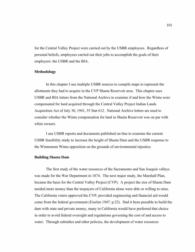
101
for the Central Valley Project were carried out by the USBR employees. Regardless of
personal beliefs, employees carried out their jobs to accomplish the goals of their
employers: the USBR and the BIA.
Methodology
In this chapter I use multiple USBR sources to compile maps to represent the
allotments they had to acquire in the CVP Shasta Reservoir area. This chapter uses
USBR and BIA letters from the National Archive to examine if and how the Wintu were
compensated for land acquired through the Central Valley Project Indian Lands
Acquisition Act of July 30, 1941, 55 Stat 612. National Archive letters are used to
consider whether the Wintu compensation for land in Shasta Reservoir was on par with
white owners.
I use USBR reports and documents published on-line to examine the current
USBR feasibility study to increase the height of Shasta Dam and the USBR response to
the Winnemem Wintu opposition on the grounds of environmental injustice.
Building Shasta Dam
The first study of the water resources of the Sacramento and San Joaquin valleys
was made for the War Department in 1874. The next major study, the Marshall Plan,
became the basis for the Central Valley Project (CVP). A project the size of Shasta Dam
needed more money than the taxpayers of California alone were able or willing to raise.
The California voters approved the CVP, provided engineering and financial aid would
come from the federal government (Eiselen 1947: p.22). Had it been possible to build the
dam with state and private money, many in California would have preferred that choice
in order to avoid federal oversight and regulations governing the cost of and access to
water. Through subsidies and other policies, the development of water resources
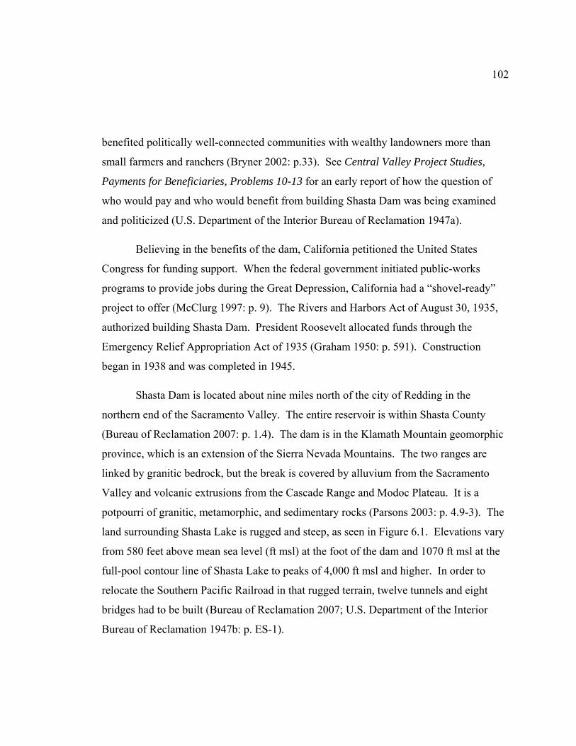
102
benefited politically well-connected communities with wealthy landowners more than
small farmers and ranchers (Bryner 2002: p.33). See Central Valley Project Studies,
Payments for Beneficiaries, Problems 10-13 for an early report of how the question of
who would pay and who would benefit from building Shasta Dam was being examined
and politicized (U.S. Department of the Interior Bureau of Reclamation 1947a).
Believing in the benefits of the dam, California petitioned the United States
Congress for funding support. When the federal government initiated public-works
programs to provide jobs during the Great Depression, California had a “shovel-ready”
project to offer (McClurg 1997: p. 9). The Rivers and Harbors Act of August 30, 1935,
authorized building Shasta Dam. President Roosevelt allocated funds through the
Emergency Relief Appropriation Act of 1935 (Graham 1950: p. 591). Construction
began in 1938 and was completed in 1945.
Shasta Dam is located about nine miles north of the city of Redding in the
northern end of the Sacramento Valley. The entire reservoir is within Shasta County
(Bureau of Reclamation 2007: p. 1.4). The dam is in the Klamath Mountain geomorphic
province, which is an extension of the Sierra Nevada Mountains. The two ranges are
linked by granitic bedrock, but the break is covered by alluvium from the Sacramento
Valley and volcanic extrusions from the Cascade Range and Modoc Plateau. It is a
potpourri of granitic, metamorphic, and sedimentary rocks (Parsons 2003: p. 4.9-3). The
land surrounding Shasta Lake is rugged and steep, as seen in Figure 6.1. Elevations vary
from 580 feet above mean sea level (ft msl) at the foot of the dam and 1070 ft msl at the
full-pool contour line of Shasta Lake to peaks of 4,000 ft msl and higher. In order to
relocate the Southern Pacific Railroad in that rugged terrain, twelve tunnels and eight
bridges had to be built (Bureau of Reclamation 2007; U.S. Department of the Interior
Bureau of Reclamation 1947b: p. ES-1).

103
Figure 6.1. Elevation Model of Shasta Lake and the Surrounding Area. Mount Shasta is seen in the background (Bowen 2009). (Source: image used with permission, courtesy of Dr. William A. Bowen, California Geographical Survey. http://geogdata.csun.edu)
Over six million cubic yards of concrete were used to bring the dam to its current
height of 602 feet, which is 533 feet above streambed (Pacific Constructors Inc. 1945:
p.138). Figure 6.2 shows how Shasta Dam compares in size with other masonry dams in
the United States. The impoundment created by Shasta Dam collects runoff from Squaw
Creek and the Sacramento, McCloud, and Pit Rivers (U.S. Department of the Interior
Bureau of Reclamation 2006: p. 1-2).
The dam site may be a logical engineering solution but was selected without
regard to Indian traditions or values. When Shasta Dam was completed, it created the
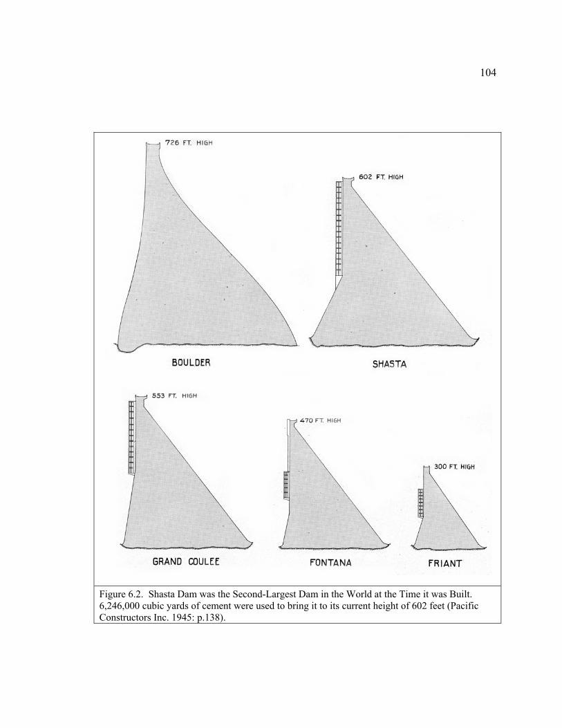
104
Figure 6.2. Shasta Dam was the Second-Largest Dam in the World at the Time it was Built. 6,246,000 cubic yards of cement were used to bring it to its current height of 602 feet (Pacific Constructors Inc. 1945: p.138).
105
largest man-made lake in North America, covering traditional Winnemem Wintu
ancestral villages, homesteads, cemeteries, and sacred sites (Clark 2005; Franco 2007). It
submerged most of the habitable terrain, including the Baird Fish Hatchery, Kennett,
Copper City, and the Pit River Railroad. It blocked the salmon run that used to fill the
rivers. What was once the lower reach of the McCloud River became part of Shasta
Lake, with over twenty miles of the McCloud flooded at high water (Cranfield 1984:
p.46; Sundahl 1995: p.13).
USBR and the Redding Allotments
Among the many tasks required in order to build Shasta Dam, the USBR had to
acquire the Redding Allotments and move the graveyards that were below the
impoundment level of Shasta Lake. Of the 196 Wintu Redding Allotments I located on
the map for this study, 157 were in the Shasta Reservoir area. However, no single source
was ever found that documented which allotments the USBR acquired, how much was
paid, or when the transactions were completed. The details regarding these transactions
were difficult reconstruct. Perhaps because the transactions stretched out over a number
of years; or required a Congressional Act to complete them; or involved multiple
agencies; the transaction records were scattered rather than kept together. In order to
piece together which allotments the USBR needed to acquire for Shasta Reservoir, four
different USBR sources were used. The first source was Central Valley Project Studies:
Recreational Administration, Problem 23 (CVP Problem 23) (U.S. Department of the
Interior Bureau of Reclamation 1947b). The second source was a set of documents from
the National Archive that was prepared by USBR for the Winnemem Wintu in 2006
(CVP Shasta Dam 2006a, 2006b). The third source was the letter from Supervising
Engineer Young to Nash, which listed three allotments the USBR needed to purchase
(Young 1938). The fourth source was the USBR map of the twenty-six graveyards that
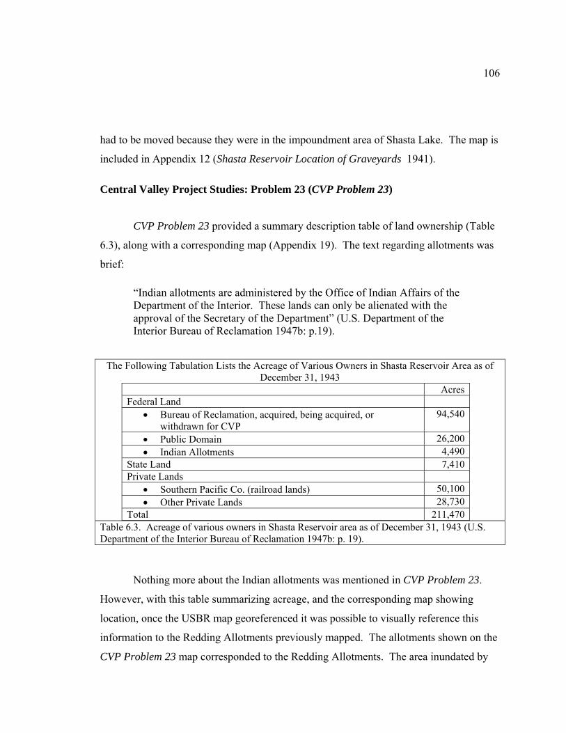
106
had to be moved because they were in the impoundment area of Shasta Lake. The map is
included in Appendix 12 (Shasta Reservoir Location of Graveyards 1941).
Central Valley Project Studies: Problem 23 (CVP Problem 23)
CVP Problem 23 provided a summary description table of land ownership (Table
6.3), along with a corresponding map (Appendix 19). The text regarding allotments was
brief:
“Indian allotments are administered by the Office of Indian Affairs of the Department of the Interior. These lands can only be alienated with the approval of the Secretary of the Department” (U.S. Department of the Interior Bureau of Reclamation 1947b: p.19).
The Following Tabulation Lists the Acreage of Various Owners in Shasta Reservoir Area as of December 31, 1943
AcresFederal Land
• Bureau of Reclamation, acquired, being acquired, or withdrawn for CVP
94,540
• Public Domain 26,200• Indian Allotments 4,490
State Land 7,410Private Lands
• Southern Pacific Co. (railroad lands) 50,100• Other Private Lands 28,730
Total 211,470
Table 6.3. Acreage of various owners in Shasta Reservoir area as of December 31, 1943 (U.S. Department of the Interior Bureau of Reclamation 1947b: p. 19).
Nothing more about the Indian allotments was mentioned in CVP Problem 23.
However, with this table summarizing acreage, and the corresponding map showing
location, once the USBR map georeferenced it was possible to visually reference this
information to the Redding Allotments previously mapped. The allotments shown on the
CVP Problem 23 map corresponded to the Redding Allotments. The area inundated by
107
Shasta Lake was not categorized by ownership on the CVP Problem 23 map, so it was
not possible to tell the status of those Redding Allotments from this map.
National Archive Documents from the USBR
The second source used to determine which allotments the USBR acquired came
from the National Archive records. These records were researched and duplicated by
staff of the USBR for the Winnemem Wintu in 2006. The commitment to do this search
and review the acquisition of the allotments, shown here in bold text, was found in the
Environmental Scoping Report prepared for the Shasta Lake Water Resources
Investigation:
“The FR/EIS [Feasibility Report / Environmental Impact Statement] needs to adequately address compliance with the Central Valley Project Indian Land Acquisition Act (CVPILAA, 55Stat 612), regarding the acquisition of tribal lands for the original Shasta Dam construction and for any potential new construction.”
“The FR/EIS [Feasibility Report / Environmental Impact Statement] will assess existing and future (without project) conditions in the study area. However, it will not study or address the sufficiency of compliance with the CVPILAA under the original construction of Shasta Dam. Reclamation is conducting a document search of its Shasta records, separate from the feasibility study, to review the acquisition of allotted Indian trust land for the original construction of Shasta Dam [emphasis added]” (Garcia 2006: p.3-8).
Not knowing whether or not this research had been done, in March, 2009, I talked
to Patricia Rivera, Native American Affairs Program Manager, USBR Mid-Pacific
Region, Sacramento, regarding my search for information about what allotments had
been acquired by the USBR to build Shasta Dam. She replied by email:
“The information you are asking for has been provided to the Winnemem. A document search was conducted by the Mid-Pacific Region and all information retrieved was copied and sent to the Winnemem (letter dated
108
May 9, 2007). As noted in our letter to Mark Franco none of the documents provided were or are maintained as a system of records or created in the course of business by Reclamation, rather the documents were preserved and made available from the National Archive and Records Administration (National Archive). For your information, the records that were made available from National Archive have been returned with no other information within the Mid-Pacific Region. I would recommend that the documents and information you are requesting would be best retrieved directly from Mr. Franco since he has all information that we provided on the issue of concern” (Rivera 2009).
I contacted the Winnemem Wintu and obtained copies of the files. The USBR
organized the documents into two binders when they sent them to the Winnemem Wintu.
The binders were described as follows:
“Winnemem Wintu Research 2006. United States Bureau of Reclamation. Other Contracts. Land acquired by the United States that was once Indian Allotments turned Fee Patent, or land purchased in Fee by individuals of Indian Descent. Acquired pursuant to the Reclamation Act of June 17, 1902” (CVP Shasta Dam 2006b).
“Winnemem Wintu Research 2006. United States Bureau of Reclamation. 55 Stat 612 Contracts. Land acquired by the United States that was held in trust for the Indians by the Federal Government. Acquired pursuant to Public Law 198-77, Chapter 334. 55 Stat. dated July 30, 1941” (CVP Shasta Dam 2006a).
No map was included with the files, but the documents included names or
allotment numbers that corresponded to the Redding Allotments. The complete list of
allotments for this study is in Appendix 4.
There were fifty-one files in two binders from the USBR that referred to forty-
three unique allotments. Two allotments had two files: 204 and 285. Thirty-one of the
forty-three allotments were held in trust. Of the twelve allotments that were held in fee
patent, one (allotment 285) was owned by the Hemingways, described as a white family.
109
Another six files held in Fee Patent referred to town sites in Copper City that were not
allotments.
USBR Letters
The third source, which is included in Appendix 7, is a copy of the letter Walker
Young, USBR Supervising Engineer, wrote to the BIA in 1938, asking for approval to
purchase Redding Allotments 48, 49, and 204 (Young 1938). Roy Nash, Superintendent
of the Sacramento BIA Agency, contacted the Commissioner of Indian Affairs for
instructions on how to best handle the sales (Nash 1938). Nash informed the
Commissioner that the USBR was required to secure land purchase contracts to meet the
requirements of the General Accounting Office as proof of purchase for any land
purchased. Nash noted:
“As the contract would not be binding if signed by the Indians without being approved by the Department, we are sending one of the blank contract forms with request that we be given complete instructions as to how they should be filled out before submitting to the Indians for signature” (Herrick 1938).
The response from John Herrick, Assistant to the Commissioner, was detailed and
administratively daunting. Herrick’s whole letter is included in Appendix 8. In addition
to all the paperwork required, Herrick wrote:
“It should also be mentioned that the deeds will have to be submitted first to this Office with other papers pertaining to the sale for the approval of the Secretary of the Interior. When they are approved and delivered to the Bureau of Reclamation, that Bureau will undoubtedly refer the deeds to the Department of Justice for its opinion as to the sufficiency of title; and the consideration, therefore, will probably not be paid until the title has been accepted and the deeds recorded in the local County records by the Bureau of Reclamation or the United States Attorney for that jurisdiction” (Wintu library BIA CVP 66798 1939c).

110
Three USBR sources were used to compile the map in Figure 6.4 the CVP
Problem 23 map, the USBR files from the National Archive, and Young’s letter. These
combined sources show there were seventy-two unique allotments to be purchased by the
USBR. Copper City was the location of the town site parcels included in the National
Archive files. The seventy-two allotments represent about 9,500 acres the USBR needed
to acquire, instead of the 4,490 acres listed in Table 6.1 from CVP Problem 23. The
acreage of the town sites in Copper City were not included in the calculation of 9,500
acres because these were not allotments.
The BIA record of allotments must have been well documented. No matter what
year, author, or agency, each time an allotment was referenced in correspondence, the
location description, allotment number, and allottee name are consistent. The Special
Agents and Bureau Supervisors may not have known how to locate the allottees, whether
they were alive, had any descendents, or even if they spent time living on their
allotments, but they never lost track of the land. So, it was somewhat of a surprise to find
that the National Archive files for allotments 43, 193, 202, 204, 286, and 318 sent by the
USBR to the Winnemem Wintu were marked “no records found.” Since finding
information in National Archive files may be time consuming and require going through
more than one record group, it appears the effort in 2006 was less than thorough. For
example, even though the National Archive file for Redding Allotment 204 was marked
“no records found,” the San Bruno National Archive records of BIA correspondence
contain letters from the USBR that show Redding Allotment 204 was the first completed
purchase. Nash wrote the cover letter on June 9, 1939, and carefully listed all the
required documents, attached in duplicate, including the all-important notarized signature
from Jimmie Mitchell, the sole heir. Nash also wrote that the USBR was “quite anxious
to secure title to this particular piece immediately, as the realignment of the railroad is
across the edge of this property” (Wintu library BIA CVP 66798 1939b). Processing the
paperwork to complete the sale of Redding Allotment 204 did not go as quickly as the
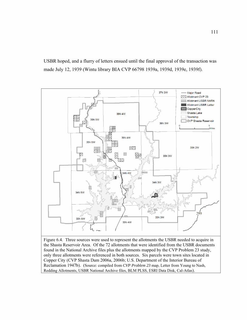
111
USBR hoped, and a flurry of letters ensued until the final approval of the transaction was
made July 12, 1939 (Wintu library BIA CVP 66798 1939a, 1939d, 1939e, 1939f).
Figure 6.4. Three sources were used to represent the allotments the USBR needed to acquire in the Shasta Reservoir Area. Of the 72 allotments that were identified from the USBR documents found in the National Archive files plus the allotments mapped by the CVP Problem 23 study, only three allotments were referenced in both sources. Six parcels were town sites located in Copper City (CVP Shasta Dam 2006a, 2006b; U.S. Department of the Interior Bureau of Reclamation 1947b). (Source: compiled from CVP Problem 23 map, Letter from Young to Nash, Redding Allotments, USBR National Archive files, BLM PLSS, ESRI Data Disk, Cal-Atlas).

112
On May 7, 2009, I spoke to Patricia Rivera about the National Archive files and
told her they seemed incomplete. She responded they were historical, had been moved
several times, and these were all they could find. Even though incomplete, I was able to
make use of the files to review and analyze them through the Critical Cartography
theoretical framework.
Central Valley Project Indian Lands Acquisition Act, 55 Stat 612
How much time and resources the USBR dedicated to acquiring title for the
Indian Allotments from 1938 through 1941 isn’t known. Each allotment case was
unique. Determining the ownership and probate status, finding all the heirs, and
completing the document search must have been time-consuming. Acquiring all the
allotment titles was far from completed in 1941. Faced with the realization that lack of
titles to the allotments might actually hold up progress on the project, the USBR turned to
Congress for assistance. H. R. 4261 was read in 1941 with this introduction:
“Mr. Speaker, this bill is one that takes on the characteristics of an emergency. The dam is being constructed and is almost ready for use. Title to some of the land is held by the Indian Bureau. We are very, very anxious that the trade may be made, and that is all that the bill provides. The Secretary of the Interior who is the head of the Indian Bureau and also the head of the Bureau of Reclamation will make the trade with the Indians and give them land outside the project and fix the value of the land in the drainage area of the Friant Dam. This is all the bill amounts to in the last analysis and I do hope the gentleman will allow the bill to go through at this time” (Wintu library CVPILAA 1941: p.6191).
The Central Valley Project Indian Lands Acquisition Act of July 30, 1941, 55 Stat
612, gave the USBR “all the right, title, and interest of the Indians in and to the tribal and
allotted lands within the area embraced by the Central Valley project.” The funds were to
be deposited with “the superintendent of the appropriate Indian Agency.” Section 3
addressed how the funds were to be used:

113
“Funds deposited to the credit of allottees, their heirs, or devisees may be used, in the discretion of the Secretary of the Interior, for the acquisition of other lands and improvements, or the relocation of existing improvements or construction of new improvements on the lands so acquired for the allottees or heirs whose lands and improvements are acquired under the provisions of this Act. Lands so acquired shall be held in the same status as those from which the funds were derived, and shall be nontaxable until otherwise provided by Congress” (Central Valley Project Indian Lands Acquisition Act 1941).
Perhaps those involved at the time envisioned a smooth hand-off from one bureau
to another within the Department of the Interior, but the actual result was that neither the
USBR nor the BIA were later invested in transferring the allotment land to new locations.
The Winnemem Wintu had no power to influence the interpretation of the CVP Indian
Lands Acquisition Act directive then, nor have they been able to persuade the USBR and
BIA to carefully review the record of transactions so incomplete work may be finished
today.
USBR Transferred Payment for the Allotments to the BIA
One cannot tell exactly what happened to the transaction records related to the
Redding Allotments when the USBR received news the CVP Indian Lands Acquisition
Act had been passed. While some paperwork to purchase allotments may have been
completed, the Act effectively completed all the remaining allotment land acquisition as
far as the USBR was concerned. In order to close the files on the allotments, all that
remained for the USBR was to document the record to show the allotments were acquired
through the CVP Indian Lands Acquisition Act and send the money to the Bureau of
Indian Affairs.
When the USBR created the map of land ownership for the CVP Problem 23
study in 1940s, the allotments referenced were, for the most part, not the ones referenced
by the National Archive files. Letters from the USBR and the BIA reveal another two
114
allotments acquired for Shasta Reservoir. These discrepancies lead to questions
regarding quality checks: who made sure the transactions were completed? The records
reviewed for this study show that the USBR needed to acquire at least seventy-two
Redding Allotments in the Shasta Reservoir area, yet the check from the USBR, received
by the BIA, was for only twenty-eight parcels. The CVP Indian Lands Acquisition Act
was passed for the benefit of the USBR. However, the USBR in 1943 did not advocate
for the Indians and urge the BIA to find replacement land instead of distributing money.
The National Archive documents requested by the USBR in 2006 were to fulfill a
commitment made in the Environmental Scoping Report to review the records, but it
appears the extent of the “review” was to send the incomplete files to the Winnemem
Wintu.
Given the inconsistencies in the USBR sources referenced for this study and the
incomplete search of the files at National Archive, there can be no confidence that the
USBR ever carefully accounted for all the allotments they acquired in the Shasta
Reservoir area when Shasta Dam was built. Sending a check for twenty-eight allotments
to the BIA when there were at least seventy-two allotments involved would mean that the
USBR did not finish paying for the land they acquired for Shasta Reservoir. Record-
keeping discrepancies on this scale, which indicate accounting errors, deserve more
attention from the USBR than the effort they put into finding and reviewing the National
Archive files for the Winnemem Wintu in 2006.
USBR Had to Move Graveyards
There were twenty-six burial sites located in the area below the impoundment
level of Shasta Lake. The remains had to be moved to a new cemetery, in accordance
with CVP Indian Lands Acquisition Act, Section 4:
As to any Indian cemetery lands required for the project, the Secretary of the Interior is authorized, in his discretion, in lieu of requiring payment
115
therefore, to establish cemeteries on other lands that he may select and acquire for the purpose, and to remove bodies, markers, and other appurtenances of [sic] the new sites. All costs incurred in connection with any such relocation shall be paid from moneys appropriated for the project. All right, title, and interest of the Indians in the lands within any cemetery so relocated shall terminate and the grant of title under this Act take effect as of the date the Secretary of the Interior authorizes the relocation. Sites of the relocated cemeteries shall be held in trust by the United States for the appropriate tribe, or family, as the case may be, and shall be nontaxable (Central Valley Project Indian Lands Acquisition Act 1941).
The USBR map showing the location of the graveyards may be seen in Appendix
12 (Shasta Reservoir Location of Graveyards 1941). The map was georeferenced so a
shapefile of the graveyard locations could be added to the study map. The graveyards
were all located in the Shasta Lake impoundment area. There was no information about
acquiring any allotments located near the graveyards on the CVP Problem 23 map nor
were they included in the National Archive files sent to the Winnemem Wintu by USBR.
However, R. S. Calland, District Engineer, USBR, referenced an “appraisal report for
Unit No. 6-S, Shasta Reservoir, appraised June 22, 1939” when he wrote to the
Commissioner on February 18, 1942 regarding the allotments:
“A considerable area of the lands involved have actually been taken for construction purposes. Clearing is in progress on practically all of the area. The Indians involved are frequently inquiring if the purchase price for their lands has been made available for their use.”
“None of the trust patents are of record in Shasta County. Practically all of the allotments are now held in trust for heirs of the original allottees. There are no papers in the probate of any of the estates of record in Shasta County. It is believed that acquisition of the lands should be accomplished in accord with the Act of July 30, 1941” (Calland 1942)
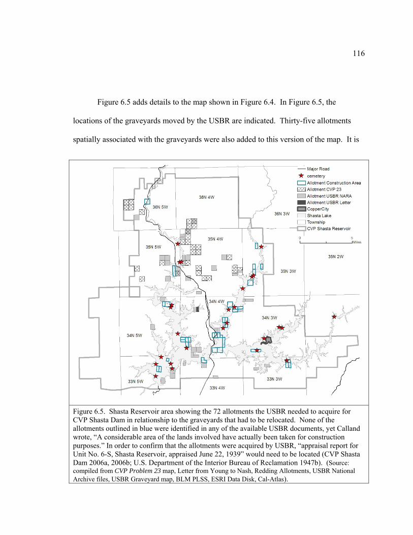
116
Figure 6.5 adds details to the map shown in Figure 6.4. In Figure 6.5, the
locations of the graveyards moved by the USBR are indicated. Thirty-five allotments
spatially associated with the graveyards were also added to this version of the map. It is
Figure 6.5. Shasta Reservoir area showing the 72 allotments the USBR needed to acquire for CVP Shasta Dam in relationship to the graveyards that had to be relocated. None of the allotments outlined in blue were identified in any of the available USBR documents, yet Calland wrote, “A considerable area of the lands involved have actually been taken for construction purposes.” In order to confirm that the allotments were acquired by USBR, “appraisal report for Unit No. 6-S, Shasta Reservoir, appraised June 22, 1939” would need to be located (CVP Shasta Dam 2006a, 2006b; U.S. Department of the Interior Bureau of Reclamation 1947b). (Source: compiled from CVP Problem 23 map, Letter from Young to Nash, Redding Allotments, USBR National Archive files, USBR Graveyard map, BLM PLSS, ESRI Data Disk, Cal-Atlas).
117
likely that at least some of the allotments in the Shasta Lake impoundment area, where
Calland wrote that construction had already begun, were also acquired by the USBR.
However, without the appraisal report this assumption cannot be confirmed. Calland sent
a detailed report to the Shasta County recorder regarding the 301 remains from the
graveyards had been reinterred in two side-by-side cemeteries. (Appendix 18). Most of
the 118 whites were moved to the Central Valley Cemetery. All of the 183 Indians were
moved to the adjoining United States Shasta Reservoir Indian Cemetery (Calland 1941).
Were Indian Owners Treated Differently than White Owners?
The BIA may have provided the detailed instructions about what was required to
purchase the allotments, but the USBR did the work of acquiring the land in Shasta
Reservoir. Two of the files provided by USBR from National Archive are for land
owned by the Hemingways. These purchases are clearly marked as belonging to a white
family but may have been included because the land had once been Redding Allotment
154. It is tempting to examine the chain of ownership of each allotment, but the focus of
this study is not to discover how the Wintu lost possession of every allotment. This study
only examines how the allotments still in Wintu possession were acquired by the USBR
for CVP Shasta Dam. Since the USBR included the Hemingway files in the documents
they sent to the Wintu, they provided a comparison of how these white owners were
treated relative to the Wintu. The two files appear to refer to the same property and, if
that is true, it appears the Hemingways were paid twice, $200 and $2,300 for 0.11 acres.
When the USBR did not send the money promptly, the Hemingways’ lawyer contacted
the USBR for payment. Not only was payment sent, but a letter of apology from the
USBR accompanied the check. The Hemingways had the right to deal directly with the
USBR. The Wintu were represented by the BIA. Before the CVP Indian Lands
Acquisition Act was passed by Congress, the USBR needed to contact the Wintu to make
the purchase offer and secure signatures. After the CVP Indian Lands Acquisition Act
118
was passed, the USBR only needed to process paperwork. Any questions the Wintu had
about the status of payment for the land were directed to the BIA, even though that
agency generally had no information to report. One Wintu in particular, Herbert
Keluche, heir to Redding Allotment 155, was very anxious to receive any money he
might be entitled to and wrote repeatedly for information. On February 15, 1943,
Rockwell wrote this regarding Keluche’s inquiries (Appendix 9):
“We are now in receipt of a check from the Bureau of Reclamation covering purchase of all the allotments under the Shasta Dam. The check was received this morning. Previously, we had written not less than 24 letters to Mr. Keluche over a period of a year and a half explaining that the money had not been received and that when it had been, he would receive his proportionate share. But seemingly our letters were to no avail, because we received letter after letter from him in addition to having letters referred to us that he had written to various Governors and other public officials, including The President of the United States. Mr. Keluche insisted that the money was here and that the other heirs had received theirs – he wanted his” (Superintendent 1943b).
When the BIA received the check from the USBR for twenty-eight allotments,
Rockwell needed guidance from the Commissioner of Indian Affairs before the money
could be distributed (Appendix 10).
“A check amounting to $46,225 has just been received from the Bureau of Reclamation in settlement for 28 parcels of Indian land purchased by them in connection with the Central Valley Project (Shasta Dam).”
“We have given thought to the use of these funds for a possible rehabilitation program for the people in the Shasta area. It is our feeling that such a program would stand little chance of being even partly successful. The interests of many of the Shasta County Indians would be served better if they would leave the county entirely.”
“The entire matter of the sale of these Indian allotments to the Bureau of Reclamation and payment for these has dragged on interminably. The Indians are anxious to get their money. Will you
119
please be good enough to wire your decision regarding these funds” (Rockwell 1943).
The response from Fred Daiker, the Commissioner, straddled the fence and did
not tell Rockwell which course of action to take (Appendix 14). Daiker’s analysis of the
CVP Indian Lands Acquisition Act of July 30, 1941 (55 Stat. 612) concluded that it
superseded prior instructions and, while the money was expected to be used to purchase
other lands, it was not required. Therefore “each case must therefore be considered on its
own merits”(Wintu library BIA CVP 66798 1943).
There is nothing in Rockwell’s letter to clarify which twenty-eight parcels were
covered by the check. More details may yet exist because Rockwell wrote, “Amounts
due approximately 175 heirs and allottees from this sale range from 33¢ to $2,000.”
What I did find in the National Archive files in San Bruno are a series of letters that show
how Rockwell chose to proceed after Daiker’s response. Letters apparently were sent to
inform the Indians the money for the allotments had been placed in their accounts.
Unfortunately, no versions of these letters were included in the National Archive
chronological file of the letters sent by the Superintendent.
A flurry of small checks were distributed in August and September, 1943. Some,
as in Appendix 16 to Charles Cornish, acknowledge the enclosed check was for the sale
of “certain Indian allotments to the Bureau of Reclamation.” Most, as in Appendix 17,
simply said, “This check represents all the money to the credit of your account in this
office at the present time” (Superintendent 1943-June, 1943-October). However, the
letter to Mrs. Frances Sisk Dixon Hayward, as seen in Appendix 18, shed light on what
the instructions from Chicago may have been:
“When Mr. Goldstein interviewed you on May 22, 1942, you stated that you wished to add a bathroom to your home and to purchase bonds. We think this is a very wise way to spend the money you have on deposit here. If you are still of the same opinion, I would suggest that you make
120
arrangements with a lumber company to purchase the necessary lumber and bathroom fixtures. When these materials are delivered you should sign the bill and state on the face of it that you want us to pay it from funds you have to your credit. When the lumber company sends the bill to this office payment will be made immediately” (Superintendent 1943a).
In the same letter Mrs. Hayward requested disbursement of funds for four other
people. Rockwell replied that each person had to make their own application. If the
allotment was in probate, as it was for Bertha Edwards for Redding Allotment 195
(Appendix 18), the money could not be distributed until the inheritance was settled
(Superintendent 1943-February, 1943-June). One interesting point about this note is that
the Redding Allotment 195 was yet another of the 157 allotments in the Shasta Reservoir
area, but it was neither identified on the CVP Problem Study 23 map nor listed in the files
the USBR had copied from National Archive.
Even while distributing money to the Wintu he could locate, there was at least a
brief time when Rockwell hoped that some land might be acquired to replace the land lost
to the Shasta Reservoir:
“We are at the present time trying to survey the public domain allotment situation and get valuations on the allotments in order to study the whole question of exchange with Forestry, looking toward blocking where possible. I am convinced that a lot of these public domain allotments have no rehabilitation possibilities and that they should be disposed of in some manner. We can exchange and block—that would be good. If we can’t some other method should be employed. I believe that the Indian office is ready to go along with us on the matter now” (Superintendent 1943c).
How much effort was put into the negotiation between Bureau of Indian Affairs
and the U.S. Forest Service is not known. What is known is no exchange with the U.S.
Forest Service happened.
121
The Wintu were not treated the same as white people regarding the sale of the
allotments. The USBR had to follow the BIA rules and standards to complete the
transactions to buy the allotments, and then pass the money to the BIA rather than
directly to the Indians. The BIA would then put the money into the appropriate account.
The BIA followed specific guidelines for distribution of the money and each request from
an Indian had to have merit (such as to be used for house repairs or to buy bonds). The
BIA had to receive a request before any money would be distributed. The request had to
come directly from the recipient, not a friend or relative acting on his or her behalf. If the
estate was in probate, the money would be tied up until that was settled. The dynamics of
this paternal level of management reflect Espeland’s description that Bureaucracies were
transformed from “efficient administrative apparatuses” into “powerful organizations
devoted to perpetuating themselves” (Espeland 2000: p. 1080). Rockwell may have been
frustrated to receive twenty-four letters from Keluche in eighteen months, but that would
average about one letter in three weeks. Rockwell may have considered Keluche’s
efforts to seek resolution by contacting departments other than the BIA a waste of
everyone’s time, but Rockwell expressed no sympathy for the length of time Keluche and
others had to wait for payment. It was not until August of 1943, six months after
receiving the check from the USBR, that the BIA was ready to begin disbursing the
money to the Indians.
Accounting for the money the BIA did receive from the USBR would require a
great deal more research. Given the issues with probate and the difficulty of finding all
the heirs it seems unlikely all the money was distributed. What happened to the balance?
Answering that question would be worthy of future research.
New Plans to Increase the Height of Shasta Dam
When the USBR was founded as the Reclamation Service in 1902, its mission
was to reclaim arid lands in the west by making water available for farming. Money for
122
the Reclamation Fund was raised from the sale of public lands to settlers. The fund was
to be replenished from the sale of water to users, who were intended to be family farmers,
not large landowners (Espeland 2000: p.1085). Before the 1930s, over 90 percent of the
farms within federal reclamation projects were 160 acres or smaller (Pisani 2003: p.402).
As the number of small farms declined, sale of water and power to private utilities and
cities became the main source of revenue for the USBR. Floyd Dominy, Commissioner
of the USBR from 1959 to 1969, recognized that:
"To a very real degree the term 'reclamation' no longer signifies simply the reclaiming of arid lands. Today's meaning of reclamation is the reclaiming and expansion of the economy of the West and through it that of the Nation" (Pisani 2003: p.404-405).
Until the 1970s the USBR was primarily staffed and administered by engineers
who had been hired for their technical expertise designing, building, and operating big
dams and complex water projects. It is not surprising that the USBR became an insular
organization, dedicated to its own ends, and powerful enough to see projects through
from concept to funding to completion (Espeland 2000: p.1084).
Then, in 1969, the National Environmental Policy Act was passed. It was
intended to make federal agencies responsive to a broader base of constituents and make
the agencies consider the environmental consequences of proposed projects. In 1976, the
USBR reluctantly prepared its first Environmental Impact Statement (EIS) for Orme Dam
in Arizona. The engineers who wrote it described the economic benefits of the dam but
did not describe the unique habitat that would be destroyed, or mention the Yavapai tribe
that would be forced to relocate (Espeland 2000: p. 1090).
When the EIS was formally presented, the public reaction was overwhelmingly
negative. The USBR had failed to anticipate the public perception that the engineers'
analyses of the cultural issues was outside of their area of technical expertise. The
123
authority of bureaucrats resides in their technical expertise, so the agency’s credibility
was damaged by the disastrous reaction to the EIS. The USBR needed to restore the
public’s confidence and produce a procedurally scrupulous EIS. As a result, the USBR
adapted rational decision-making models, drawn from cognitive psychology and
economics, to help evaluate and weigh diverse kinds of information for the purpose of
undertaking an EIS. The goal was to “inform and involve the public in ways that would
assure that decision-makers understood and incorporated the public's views in the
planning process, to build credibility for the study, and to help facilitate consensus about
what to do.” Most important to the USBR, the models provided “well-established, public,
defensible procedures that could be easily reproduced and defended if their credibility
was challenged” (Espeland 2000: p.1090-1092).
The conflict regarding Orme Dam became moot when Secretary of the Interior,
James Watt, selected an alternative project in 1981. The Orme Dam EIS did provide a
broader base of constituents an opportunity to participate in the decision-making process.
However, the Yavapai were critical of the new USBR public-participation framework
because it was not necessarily neutral. Being included in discussion does not always
translate into decision-making power. The USBR technical experts still controlled the
terms of participation, determined what facts were relevant, and set the schedule for input
and discussion (Espeland 2000: p.1103). Further, while the National Environmental
Policy Act does require sufficient documentation to prove that the agency is in
compliance with the requirements of the EIS, the act did not require agencies to select the
superior alternative. The USBR has had over thirty years since Orme Dam to master the
procedures associated with producing a defensible report and recommendation.
In 2000, the USBR initiated a study to evaluate the potential of increasing the
storage capacity at Shasta Lake. The authority to do this study comes from Public Law
96-375 and the CALFED Bay-Delta Authorization Act, Public Law 108-361 (Bureau of
Reclamation 2007: p. ES-1). The mission statement is published on their web site:
124
“To develop an implementable plan primarily involving the enlargement of Shasta Dam and Reservoir to promote increased survival of anadromous fish populations in the upper Sacramento River; increased water supply reliability; and to the extent possible through meeting these objectives, include features to benefit other identified ecosystem, flood control, and water resources needs” (U.S. Department of the Interior 2009).
The final Feasibility Report (FR) and Environmental Impact Statement (EIS) was
scheduled to be completed in 2010 (Bureau of Reclamation 2007). The plans proposed
raising Shasta Dam either of two alternative heights: 6.5 feet or 18.5 feet. Since dams
don’t create water, the amount they store depends on annual rainfall. However, raising
Shasta Dam to 6.5 feet would increase capacity by 290,000 acre-feet and at 18.5 feet the
water storage capacity would increase by 640,000 acre-feet (Montgomery Watson Harza
2006: p. 2.2). An acre-foot is 325,853 gallons – roughly the amount of water used
annually by a family of four (Lucas et al. 2007).
MBK Engineers prepared a technical report to assess the potential flood control
benefit if Shasta Dam were to be enlarged. Major floods occurred in the Shasta Dam
watershed in 1940, 1956, 1965, 1970, 1974, 1986, and 1997 (MBK Engineers 2004: p. 3).
MBK used data from sixteen flood years (1952, 1955, 1958, 1964, 1967, 1969, 1970,
1974, 1978, 1980, 1981, 1983, 1986, 1995, 1997, and 1998) to model water storage levels
for the enlarged dam configurations. The study relied upon a CALSIM model, which
operates on a monthly basis. “The subtraction of the estimated starting storage from the
top-of-conservation storage yielded a volume of incidental flood storage available for
each of the historic events” (MBK Engineers 2004: p. 8). “The results show that raising
Shasta would have added significant incidental flood storage (greater than 200,000 acre-
feet) in 3 of the 13 years” (MBK Engineers 2004: p. 9). Another technical report, this
one by North State Resources, described the cyclic nature of water elevations at Shasta
Lake. Droughts lower the water level. Shasta Dam operates at optimum conditions
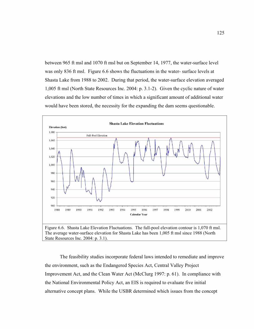
125
between 965 ft msl and 1070 ft msl but on September 14, 1977, the water-surface level
was only 836 ft msl. Figure 6.6 shows the fluctuations in the water- surface levels at
Shasta Lake from 1988 to 2002. During that period, the water-surface elevation averaged
1,005 ft msl (North State Resources Inc. 2004: p. 3.1-2). Given the cyclic nature of water
elevations and the low number of times in which a significant amount of additional water
would have been stored, the necessity for the expanding the dam seems questionable.
Figure 6.6. Shasta Lake Elevation Fluctuations. The full-pool elevation contour is 1,070 ft msl. The average water-surface elevation for Shasta Lake has been 1,005 ft msl since 1988 (North State Resources Inc. 2004: p. 3.1).
The feasibility studies incorporate federal laws intended to remediate and improve
the environment, such as the Endangered Species Act, Central Valley Project
Improvement Act, and the Clean Water Act (McClurg 1997: p. 61). In compliance with
the National Environmental Policy Act, an EIS is required to evaluate five initial
alternative concept plans. While the USBR determined which issues from the concept
126
plans would be addressed in the environmental documentation, scoping allows any
interested parties to bring forward additional cultural, environmental, and economic
issues to be included in the evaluation process (Garcia 2006: p. 1.1). Decision makers
then analyze the scoping comments for insight on what the public believes should also be
considered as part of the feasibility study. The USBR convened public scoping meetings
in Sacramento, Fresno, Los Angeles, Concord, Dunsmuir, Redding, and Red Bluff in
2005. Over 200 comments were received from a variety of individuals and groups,
including the Winnemem Wintu. It was not until this scoping period, approximately five
years into the funding and feasibility study, that the Winnemem Wintu were able to voice
their environmental justice concerns. The Shasta Lake Water Resources Investigation
report described why Environmental Justice is part of the NEPA process:
“The FR/EIS needs to include a full discussion of Executive Order 12898 (Environmental Justice in minority and low-income populations).”
“As required under NEPA and in keeping with Executive Order 12898, the EIS will describe the measures taken by Reclamation to: 1) fully analyze the environmental effects of the proposed Federal action on minority communities, e.g. Indian Tribes, and low-income populations, and 2) present opportunities for affected communities to provide input into the NEPA process” (Garcia 2006: p.3-4).
In April 2005, Mark Franco and Gary Mulcahy of the Winnemem Wintu met with
representatives of the CALFED(California Federal) Environmental Justice Subcommittee
of the Bay-Delta Public Advisory Committee, referred to here as the Subcommittee.
CALFED is a collaboration of twenty-five local, state, and federal agencies. Bay-Delta
consists of the San Francisco Bay and Sacramento-San Joaquin River Delta (Bureau of
Reclamation 2007: p. 1-11). The Winnemem Wintu requested a government-to-
government relationship with the United States but that request was not granted because
the tribe is not currently recognized by the federal government. As environmental justice
stakeholders, the Winnemem Wintu submitted a resolution:
127
“to suspend and remove any further consideration of the proposed enlargement of Shasta Dam from the CALFED project until such time when the Bureau of Reclamation, the Central Valley Project (CVP) implementation agent for the Department of Interior, fulfills the obligations to the Winnemem Wintu Tribe set out in the CVP – Indian Lands Acquisition Act (55 Stat 612)” (Clark 2005: p. 2).
The tone of the Subcommittee report was sympathetic to the Winnemem Wintu.
The Subcommittee unanimously supported the resolution and agreed to make reasonable
efforts to get it on the agenda of the Bay-Delta Public Advisory Committee.
“The recommendation requests an action that may be beyond the purview of CALFED to address, yet the decision by the Winnemem to raise its concerns through the EJ Subcommittee reflects favorably on the collaborative, open and transparent nature of the CALFED process” (Clark 2005).
In 1981, the Yavapai were less than satisfied with the USBR public-participation
framework used at Orme Dam. In 2005, the environmental justice platform available to
the Winnemem Wintu through the hearing at the Subcommittee was welcoming but
without power to implement recommendations. Their level of authority was to make
recommendations: The extent that these recommendations have has been incorporated is
unknown at this time (2009) because the Feasibility Report and EIS have not been
published at the time of this writing.
Summary
Even though both the USBR and the BIA are agencies under the Department of
the Interior, they do not share a common mission, staff, or offices. Hindered by the
onerous details required to complete each allotment purchase, the USBR had only
partially completed these transactions when Congress passed the CVP Indian Lands
Acquisition Act, 55 Stat 612. This act required the USBR to pay for the allotments, but
128
required the BIA to receive and distribute the money. Even though the USBR maintains
they were not the agency responsible for completion of the allotment transactions in the
1940s, the details reviewed in this study suggest, at least, record-keeping discrepancies
that deserve thorough investigation and detailed response from the USBR.
In Chapter 2, describing the theoretical framework of Critical Cartography, I
noted that the historical conditions of environmental racism may be exposed by adding
the element, or scale of time (Almaguer 1994; Pulido 2000). Since the USBR has drawn
a temporal boundary around the issues to be considered in the current FR/EIS related to
SLWRI, they have effectively limited the Winnemem Wintu issues that may be displayed
on the map. By choosing to display details only found in the contemporary scale, the
increase in the size of Shasta Lake appears small in proportion to the existing high water
level. By excluding the dam building period, 1938-1945, the USBR excluded the issues
raised by the Winnemem Wintu at the CALFED Subcommittee meeting. It was during
the dam building period, 1938-1945, that the Winnemem Wintu lost 90% of their sacred
space, were not compensated for allotments, and were dispersed from their ancestral
home on the McCloud River. The Winnemem Wintu have been petitioning the federal
government to complete the commitments made in CVP Indian Lands Acquisition Act
for nearly seventy years. The temporal boundary drawn by the USBR around
contemporary issues is an illustration of institutionalized power perpetuating the
environmental injustice by denying the relationship of present actions to historical
conditions.
129
7. Putting the Winnemem Wintu back on the map
“I told my people Don’t you fight, live in peace. There is room for all in this big country. I was mistaken. We agreed to leave the whites in peace, but the whites would not leave us in this land which we held to be ours since it belonged to our fathers and in justice it is ours yet for no man has bought it from us.”
-Wintu and Yana Petition, 1889
The Winnemem Wintu lost ownership of the land in their
historical territory through various means, some of which have
been described earlier in this study. Despite the individual posture
imposed by the allotments on a tribal community, and the loss of
everyday contact with each other after the Shasta Dam diaspora,
the Winnemem Wintu continued to maintain an active relationship
to the land in their historical territory through spiritual practice and
political action. The efforts needed to maintain this connection, in
turn, helped maintain and continued to reinforce their shared
cultural identity. In this chapter I will explore how the Winnemem
Wintu use identity to maintain internal cohesion as a tribe and
how they create and manage their tribal relationship with government agencies and other
organizations. In an article about another tribe that experienced termination, “Managing
Place and Identity: the Marin Coast Miwok Experience,” authors Jennifer Sokolove,
Sally Fairfax, and Breena Holland wrote, “the ability of a group of people to make
officially recognizable claims about who they are,” depends on group cultural identity
that is “actively constructed over time through political work” (Sokolove et al. 2002: p.
23).
130
Spiritual Practice
One way in which the Winnemem Wintu continued to construct their identity is
through spiritual practice. Congress extended first amendment religious freedom to
Indians with the Indian Civil Rights Act of 1968 and the American Indian Religious
Freedom Act of 1978 (Michaelsen 1985: p. 51-53). However, since Indian religious
experience and worship are not separated from day-to-day life, the pervasive quality of
Indian religious experience often arouses suspicion of fraud when protection of sacred
sites or spiritual practice is invoked (Michaelsen 1985: p. 62). In Native American
Cultural Overview, Theodoratus wrote:
“Federal land management policies and their burdensome, often ethnocentric interpretations, sometimes serve to polarize the assessment of Indian claims as unusual and illogical” (Theodoratus Cultural Research 1981: p. 21).
Nevertheless, California Indians prevailed and sometimes acquired access to use
lands they had lost. Florence Jones was the medicine woman and spiritual leader for the
Winnemem Wintu in 1978. Jones used the ancient prayer grounds near Shasta Lake and
wanted to put up a permanent structure to use as protection from bears. It took the
intercession of the Native American Heritage Commission before the U.S. Forest Service
responded by conducting a study to evaluate the environmental and social impacts “if
Flora continues to gather herbs and practice her ancient healing arts at the site” (Sanders
1979). As part of the requirements of the American Indian Religious Freedoms Act, the
U.S. Forest Service conducted a cultural inventory of religious places on federal
lands. The study resulted in archaeological documentation of places significant to the
Winnemem Wintu. The study also clearly showed that topography is essential for the
maintenance of Wintu identity and cultural continuity. The subjective spirit world
and the objective physical world together give vision and meaning to life, making
131
the world both symbolic and real. Myth and its embodiment in geographical
reflections enhance the Wintu sense of consciousness. Geographical formations
remind Wintu that a great range of possibilities exists, and that one must be open
to reality to be enlightened about the world (Theodoratus et al. 1994).
Generally, Indians learned to be guarded about the location of sacred sites
because of the appeal they have to a variety of non-Indian groups. The Winnemem
Wintu are no exception, but Panther Meadows on Mount Shasta became very public
when they participated in a successful cooperative effort to stop plans to build a ski
resort there. This $21 million project was to accommodate 5,000 skiers a day with seven
lifts and three lodges (Beggs et al. 2003: p. 44) The U.S. Forest Service completed the
EIS in 1990, found it to be in compliance with the multiple-use classification of the
mountain, and approved the project. Opposition to the ski resort united diverse groups
such as Save Mount Shasta, the Native Coalition for Cultural Restoration of Mount
Shasta, two nonprofit Indian tribes and various other organizations. Using the 1966
National Historic Preservation Act, they succeeded in getting the U.S. Forest Service to
reverse the decision in 1998 (Huntsinger et al. 2000: p. 551). The U.S. Forest Service
found “Contemporary Indian uses of Mount Shasta are clearly rooted deeply in traditional
values and beliefs. The spiritual and secular activities being practiced today on Mount
Shasta are consistent with historic Native American activities” (Theodoratus et al. 1991:
p. 10 in Huntsinger et al. 2000: p. 551).
Cultural conflict continued in various forms after the U.S. Forest Service
withdrew the permit for the ski resort. Panther Meadows is an alpine wildflower meadow
that attracts environmentalists, hikers, rock climbers and New Age spiritual pilgrims. To
provide visual and physical separation from the path and to protect the spring, U.S. Forest
Service built a U-shaped rock wall now surrounds it on three sides.
132
Political Action
Political experience gained in defending and re-inscribing spiritual practices on
their land also enabled the Winnemem Wintu to undertake political action in response to
the most recent proposal to raise the height of Shasta Dam. Indian spirituality and
worship require communication with the spirits at their location, which makes destruction
of a sacred site a culturally cataclysmic event (Gordon 1985: p. 1449). Most sites sacred
to the Winnemem Wintu were destroyed when Shasta Lake inundated their historical
villages. Increasing the height of Shasta Dam would destroy the remaining important
sacred sites on the McCloud River; this mobilized the Winnemem Wintu to organize
resistance to the USBR plans (Clark 2005: p. Attachment 1, Page 4).
In September 2004 the Winnemem Wintu conducted a War Dance at Shasta Dam.
The USBR initially denied the Winnemem Wintu an access permit but yielded in the face
of public pressure and publicity. At the ceremony they were joined by environmental
groups and other Indian nations. The press coverage included television, radio, and
newspapers. As tourists, visitors, guests, and supporters came and went, the Winnemem
Wintu danced, prayed, and sang around the sacred fire non-stop for four days (Cummings
2005: p. 8). The media coverage was invaluable. As important, though, was the effect
performing the war dance had on the Winnemem Wintu as a tribe. The physical
endurance needed to perform the ceremony for four days, combined with the symbolism
of participating in an ancestral event for the first time in over 100 years, was exhilarating.
One dancer said, “Something really important happened there. We now know that we
have the power and strength to carry on. I don’t know if the war dance will change the
world, but it certainly has changed us” (Cummings 2005: p. 9).
Whether or not the federal government recognizes that the Winnemem Wintu are
a tribe, they must actively nurture and maintain their identity. When the Winnemem
Wintu went to Congress to petition for federal recognition; or to the CALFED
133
Subcommittee meeting to ask, yet again, that the USBR complete the commitments of the
CVP Indian Lands Acquisition Act; or to Shasta Dam to perform the war dance to stop
the USBR from increasing the height of the dam; these actions indirectly, and powerfully,
reinforced their identity.
134
8. Summary of Results, Discussion, and Conclusion
“Should you our high chief be unable to obtain this justice which would be of small cost to the American Nation but precious to our people then we beg you to inform us so we may see our position and know at last that for us there is neither justice nor equality in this white man’s Republic.”
-Wintu and Yana Petition, 1889
Maps are accepted as scientific documents and are
expected to be unbiased, repeatable, accurate, verifiable, and
factual. Those who use readily-available GIS digital data in
order to compile contemporary maps tend to asume that base
layers conform to this scientific standard yet it is clear that
what is mapped or unmapped reflects political biases and
historical errors. Recent advances in mapping software and
computer technology made it possible for this study to create
maps from historical documents in order to re-examine the
social and power relationships that caused the Winnemem
Wintu to be put on and then taken off the map, both literally
and metaphorically. In this chapter I review how Critical Cartography provides a
framework in order to look beyond the science of maps and explore their political
power to conceal, as well as to reveal.
Maps are neutral, unbiased scientific representations of space. The very
science of maps is a component mechanism of state control of social systems
because maps may be used as graphic inventory of land ownership, values, use, and
potential. The federal government underwrote the great surveys that laid out
transportation routes, cataloged resources, and excluded the Indian Nations from
the map. In the process, the federal authority to create and validate maps grew
135
along with the authority to zone land, distribute land from the public domain,
determine qualifications for ownership, and levy taxes. The Public Land Survey
created both the graphic representation of the land and the inventory of land as
ownership of parcels passed into private ownership. Even though the Winnemem
Wintu have been a continuous community in the McCloud watershed from
prehistoric times, from the Gold Rush through Statehood, maps were used to make
their historical territory available to incoming American claims and ambitions. The
cession and reservation boundaries associated with the unratified treaties were laid
out for the convenience of the negotiating agents, not based on tribal territory. The
Public Land Survey was used to patent land to railroad companies, homesteaders,
miners, and other interests. Each map contained partial truths and each
interpretation contributed to mapping the Winnemem Wintu out of legal existence.
Critical Cartography links geographic knowledge with power. The eighteen
treaties negotiated with California Indians were filed under an injunction of secrecy
so the boundaries of the proposed reservations were not available to the public or
Indians for over fifty years. Kroeber redrew Powers’s boundary of the Wintu in
order to provide a spatial connection on the map between the Shasta Indians and the
Achomawi to support Dixon’s linguistic connection between those tribes. Kroeber
and Heizer presented a version of Merriam’s tribal boundaries to the Indian Claims
Commission that favored Kroeber’s interpretation that the Okwanuchu were Shasta
Indians, not Wintu. The Land Claims Commission had the power to recognize or
extinguish private land claims in California. By defining the temporal scale to
exclude past Central Valley Project (CVP) actions from consideration in the
Feasibility Report/Environmental Impact Statement (FR/EIS) underway now for
Shasta Lake Water Resources Investigation (SLWRI), the USBR is exercising the
power of its agency to minimize Winnemem Wintu opposition to the proposal. The
136
Winnemem Wintus’ historical presence on their land was less important to the state
than the authority of the map.
The visual power of maps enables us to see patterns that are not otherwise
visible because maps can simultaneously display disparate and heterogeneous
locations, events, entities, and phenomena. When the Redding Allotments are
displayed against hillshade, it is evident the locations were inappropriate for
subsistence farming. However, the allotments provided food sources the Wintu
valued, such as acorns, which was not evident to the BIA agents. Reading’s land
grant would have been dwarfed by the reservation created by the Cottonwood Treaty.
The railroad opened up Northern California to business and tourists but fragmented the
land available for allotments because a checkerboard pattern of ownership had been
imposed on the land. The mountainous terrain around the McCloud River provided
attractive sporting retreats for the rich but made poor choices for subsistence allotments.
Using a map to display and contrast the density of the historical Indian villages with the
scattering of allotments is insightful. The terrain is very steep, and the flat paper does not
adequately convey how inaccessible and inhospitable some of the allotments were; they
satisfied neither the Bureau of Indian Affairs intention that the allotments would be used
for sustainable farming nor the Winnemem Wintu intention that the land would provide a
reservation for their tribal continuity.
Critical Cartography provides a framework to analyze historical maps in
order to derive information about social relationships. By exploring the attitudes
and efforts of the Indian agents to secure land for homeless Indians, it was possible
to follow the fragmentation of the Winnemem Wintu spatially and politically. The
BIA decisions that denied them equipment, a village, replacement land, and drove them
into the roles of migrant worker all had spatial components. Examining how and why
the map changed over time exposes the power relationships between the
Winnemem Wintu and the agencies they deal with.

137
Critical Cartography promotes cartographic integrity, responsibility, and
advocates social change. By working with CalTrans to define their area of political
and spiritual responsibility, the Winnemem Wintu re-established their presence on
the map and defined themselves as active agents to the CalTrans agency. As
software continues to evolve and mapmaking tools become more accessible to the
general public, the Winnemem Wintu will make their own maps instead of relying
on agencies or researchers. The Winnemem Wintu are actively engaged with a
diverse community of support that includes researchers, film makers, writers,
reporters, politicians, and non-profit agencies. The Winnemem Wintu empower
these supporters by providing background data and are enriched by receiving new
data from the supporters. This cycle enables the Winnemem Wintu to continually
improve and update the background data they make available to their supporters.
Critical Cartography assumes that maps make reality as much as they represent it
(Crampton et al. 2005). The issues faced by the Winnemem Wintu come into sharp focus
when maps reveal the spatial relationships of various historical events. For the
Winnemem Wintu, opposing plans to increase the height of Shasta Dam is inextricably
interwoven with their efforts for cultural and spiritual survival as they work to protect
sacred space on land that the United States legal system defines as owned by others.
Without a tribal territory, they must work very hard to maintain cultural and tribal
identity, and to pass on tribal knowledge to new generations. The historical documents
regarding the Winnemem Wintu were generally found to be in the literary mode of letters
and lists. Representing the information cartographically, and using a series of maps to
examine changes over time, enhanced and clarified the data. Critical Cartography did
reveal that the USBR acquired significantly more allotments from the Wintu when CVP
Shasta Dam was built than previously understood. From the incomplete documentation
they made available to the Winnemem Wintu in 2006, there is no reason to believe they
did pay for all the allotments by passing appropriate payment to the BIA. When the
138
Central Valley Project Indian Lands Acquisition Act (CVPILAA) was read to Congress it
was introduced as a time extension so that acquiring the allotments would not hold up
completion of CVP Shasta. The USBR representative implied to Congress that
replacement land would be found for the Indians. Once the CVPILAA was passed, the
BIA had to assume follow-up responsibility for the USBR regarding compensation for
land acquired under the provisions of the CVPILAA. The Sacramento BIA Agency was
given discretion to act on a case-by-case basis regarding the money received from the
USBR, and chose to distribute money, thereby terminating their relationship with many
individual Wintu. Even though the USBR and BIA are both bureaus of the Department
of the Interior, each has a separate mission. The nature of this agency structure
compounds the difficulty experienced by the Winnemem Wintu, rather than facilitating
problem resolution, because each agency may deny responsibility for what the other
agency did, or did not, do. Since the current mission of SLWRI regarding the FR/EIS to
increase the height of Shasta Dam is, “to develop an implementable plan,” it is in the
interest of the USBR to exclude the Winnemem Wintu concerns that the CVPILAA was
not completed. However, this exclusion is exactly the foundation for the Winnemem
Wintu claim of environmental injustice.
There are many opportunities for future research, especially concerning the
Redding Allotments and the Central Valley Indian Lands Acquisition Act. Publishing the
result of research efforts through libraries, historical societies, and professional groups
such as the Indiginous Mapping Network help make research material available to other
researchers. For the Winnemem Wintu, regaining their place on the map represents more
than space; it also represents recognition and the return of their identity, authority, and
legitimacy.
139
References
"Ah-Di-Na: A Short History." 2008. McCloud, CA: McCloud Ranger Station - Shasta-Trinity National Forest. [On-line]: http://www.fs.fed.us/r5/shastatrinity/documents/st-main/maps/rogs/mccloud/ah-di-na.pdf [November 1, 2009].
Almaguer, Tomás. 1994. Racial Fault Lines: The Historical Origins of White Supremacy
in California. Berkeley: University of California Press. Askevold, Ruth. 2005. "Interpreting Historical Maps to Reconstruct Past Landscapes in
the Santa Clara Valley." Master of Arts in Geography, San Francisco State University, San Francisco. [On-line]: http://www.sfei.org/HEP/HEPreports.htm [March 2009].
Bancroft, Hubert Howe, William Nemos, Henry Lebbeus Oak, Frances Fuller Victor, and
Alfred Bates. 1882. History of the Pacific States of North America, Vol. XIX. San Francisco: A.L. Bancroft.
Beggs, Marjorie, and Christopher McLeod. 2003. The Sacred Land Reader. La Honda,
CA: Earth Island Institute. [On-line]: http://www.sacredland.org/PDFs/SLReader.pdf [May 13, 2007].
Bell, R. 1890. "Bell Letter to Secretary of the Interior Regarding Wintu Yana Petition."
Winnemem Wintu Library, Redding: Record Group 75, Bureau of Indian Affairs, California, Sacramento Agency. National Archives and Records Administration. [December 2007].
———. 1892a. "Bell Letter to Piggott Freezing General Allotments So Indians Could
Get Their Claims Processed." Winnemem Wintu Library, Redding: Record Group 75, Bureau of Indian Affairs, California, Sacramento Agency. National Archives and Records Administration. [December 2007].
———. 1892b. "Bell Letter to Secretary of the Interior Recommending Piggott as
Special Agent." Winnemem Wintu Library, Redding: Record Group 75, Bureau of Indian Affairs, California, Sacramento Agency. National Archives and Records Administration. [December 2007].
———. 1893. "Bell letter to Secretary of Interior regarding Piggott's resignation."
Winnemem Wintu Library, Redding: Record Group 75, Bureau of Indian Affairs,

140
California, Sacramento Agency. National Archives and Records Administration. [December 2007].
Bowen, William A. 2009. "Shasta Lake." Northridge: California Geographical Survey.
[On-line]: http://geogdata.csun.edu/. Bryner, Gary C. 2002. "Assessing Claims of Environmental Justice: Conceptual
Frameworks." In Justice and Natural Resources: Concepts, Strategies, and Applications, edited by K. M. Mutz, G. C. Bryner and D. S. Kenney. p. 31-55. Washington, DC: Island Press.
Bryson, Bill. 1990. The Mother Tongue: English and How It Got That Way. New York:
W. Morrow. Bullard, Robert D. 2001. "Environmental Justice in the 21st Century: Race Still Matters."
Phylon 49 (3/4):151-171. [On-line]: http://links.jstor.org/sici?sici=0031-8906%28200123%2F24%2949%3A3%2F4%3C151%3AEJIT2C%3E2.0.CO%3B2-G [May 12, 2007].
Bureau of Reclamation, Mid-Pacific Region. 2007. "Shasta Lake Water Resources
Investigation: Plan Formulation Report." U.S. Department of the Interior, Bureau of Reclamation, Mid-Pacific Region. [On-line]: http://www.usbr.gov/mp/slwri/docs/plan_form_rpt_12-2007.pdf [November 1, 2009].
Cal-Atlas Geospatial Clearinghouse. 2007. [On-line]: http://www.atlas.ca.gov/. California State University, Chico. 2009. Northeast Information Center [On-line]:
http://www.csuchico.edu/neic/services.shtml [May 2009]. Calland, R. S. 1941. "Calland to County Recorder Regarding Cemetery Relocation."
Central Valley Project Records, Record Group 75, Bureau of Indian Affairs, California, Sacramento Agency. National Archives and Records Administration--Pacific Region (San Francisco): San Bruno.
———. 1942. "Calland to Commissioner Regarding Right of Way Purchases, Shasta
Reservoir, Indian Allotments, Kennett Division, CVP." Winnemem Wintu Library, Redding: Shasta Dam record group 115 land acquisition. Correspondence between Reclamation and BIA file code 2-440 and MP-420. Information pertaining to CVPILAA 55 Stat 612 Act of July 30, 1941. National Archives and Records Administration: Denver, Colorado.
http://links.jstor.org/sici?sici=0031-8906%28200123%2F24%2949%3A3%2F4%3C151%3AEJIT2C%3E2.0.CO%3B2-G�
http://links.jstor.org/sici?sici=0031-8906%28200123%2F24%2949%3A3%2F4%3C151%3AEJIT2C%3E2.0.CO%3B2-G�
141
CalTrans Winnemem Wintu Territory Designation. 2004. Map. Winnemem Wintu
Library, Redding. [December 2007]. Casson, William E. 1900. Report On Wintu And Yana Condition, Lands, and the
Advisability of Securing an Appropriation from Congress to Buy Farming Implements. Washington DC.
———. 1903. "4th Section Allotments in Redding, California, Winnemem Area." 55 Stat. 612. 1941. Central Valley Project Indian Lands Acquisition Act. July 30, 1941
[S. 1120] | [Public Law 198] 55 Stat. 612. FIRST SESSION, 1941-1942. [On-line]: http://digital.library.okstate.edu/kappler/Vol6/html_files/v6p0140.html [November 18, 2008].
Chase-Dunn, Christopher K., and Kelly M. Mann. 1998. The Wintu & Their Neighbors:
A Very Small World-system in Northern California: University of Arizona Press. Clark, Henry. 2005. "Environmental Justice Subcommittee Report to Bay-Delta Public
Advisory Committee: Winnemem Wintu and Shasta Lake Enlargement." Sacramento: California Bay-Delta Authority. [On-line]: http://calwater.ca.gov/CBDA/AgendaItems_6-8-05/BDPAC_Meeting_6-8-2005_Agenda_Item_5D.pdf [May 11, 2008].
Cole, Luke W., and Sheila R. Foster. 2001. From the Ground Up: Environmental Racism
and the Rise of the Environmental Justice Movement, Critical America. New York: New York University Press.
Colton & Co. n.p., 1876. Map of California to Accompany Printed Agreement of S. O.
Houghton as to the Rights of the Southern Pacific R.R. Co. of California to Government Lands Under Acts of Congress Passed July 27, 1866 and March 3, 1871 Made Before the Committee of the Judiciary of the Senate and House of Reps. in May 1876. Map. Southern Pacific Railroad Company Library of Congress Geography and Map Division Washington, D.C. 20540-4650 USA.[On-line]: http://memory.loc.gov/cgi-bin/query/D?gmd:51:./temp/~ammem_Td43:: [January 23, 2009].
Cook, Sherburne Friend. 1943. The Conflict Between the California Indian and White
Civilization. Berkeley and Los Angeles: University of California Press.
142
———. 1976. The Population of the California Indians, 1769-1970. Berkeley: University of California Press.
———. 1978. "Historical Demography." In Handbook of North American Indians,
Volume 8, California, edited by William C. Sturtevant General Editor and Robert F. Heizer Volume Editor. p. 91-98. Washington, D.C.: Smithsonian Institution.
Crampton, Jeremy W., and John Krygier. 2005. "An Introduction to Critical
Cartography." ACME: An International E-Journal for Critical Geographies 4:11-13. [On-line]: http://www.acme-journal.org/vol4/JWCJK.pdf [Feb 11, 2008].
Cranfield, Charles. 1984. "A Land Use History of the McCloud River Region,
California." Mount Shasta City, California: The Nature Conservancy and Humboldt State University.
Cummings, Claire Hope. 2005. "Hu’p Chonas (War Dance)." In News from Native
California, edited by P. Jan Sturmann. [On-line]: http://www.heydaybooks.com/news/issues/v18n3toc.html [August 20, 2007].
Curtin, Jeremiah. 1889. "Wintu and Yana Petition to Great Chief Benjamin Harrison,
President of the United States." Washington, DC: Office of Indian Affairs. Curtis, Edward S. 1924. "The Wintun." In The North American Indian: Being a Series of
Volumes Picturing and Describing The Indians of the United States, The Dominion of Canada, and Alaska, edited by F. W. Hodge. p. 73-96. New York: Johnson Reprint Corporation.
CVP Shasta Dam. 2006a. "Land Acquired by the United States That Was Held in Trust
for the Indians by the Federal Government." Winnemem Wintu Library, Redding: Shasta Dam record group 115 land acquisition. Correspondence between Reclamation and BIA file code 2-440 and MP-420. Information pertaining to CVPILAA 55 Stat 612 Act of July 30, 1941. National Archives and Records Administration: Denver, Colorado.
———. 2006b. "Land Acquired by the United States That Was Once Indian Allotments
Turned Fee Patent, or Land Purchased in Fee by Individuals of Indian Descent." Winnemem Wintu Library, Redding: Shasta Dam record group 115 land acquisition. Correspondence between Reclamation and BIA file code 2-440 and MP-420. Information pertaining to CVPILAA 55 Stat 612 Act of July 30, 1941. National Archives and Records Administration: Denver, Colorado.
143
24 Stat. 388. 1887. Dawes Act. Del Casino, Vincent J., and Stephen P. Hanna. 2006. "Beyond the “Binaries”: A
Methodological Intervention for Interrogating Maps as Representational Practices." ACME: An International E-Journal for Critical Geographies 4 (1):34–56. [On-line]: http://www.acme-journal.org/vol4/VDCSPH.pdf [November 1, 2009].
Dixon, Roland Burrage. 1907. The Shasta. New York: The Knickerbocker Press. ———. 1910. The Chimariko Indians and Language. Berkeley: The University Press. ———. 1993. Achomawi and Atsugewi tales. Berkeley, CA: California Indian Library
Collections [distributor]. Dorrington, L. A. 1929. "Dorrington letter to Indian Affairs regarding types of Indian
tribes in Northern CA." Winnemem Wintu Library, Redding: Record Group 75, Bureau of Indian Affairs, California, Sacramento Agency. National Archives and Records Administration. [December 2007].
Dotta, James. 1980. "Some Elements of Wintu Social Organization as Suggested by
Curtin's 1884-1889 Notes." In Papers on Wintu Ethnography: 239 Wintu Villages in Shasta County Circa 1850, edited by M. Guilford-Kardell. p. 118-129. Redding, CA: Occasional Papers of the Redding Museum and Art Center, No. 1.
DuBois, Cora. 1935. "Wintu Ethnography." In American Archaeology and Ethnology,
edited by A. L. Kroeber, R. H. Lowie and R. L. Olson. Berkeley: University of California Press. Reprinted by permission of The Regents of the University of California.
Eastman, Jervie Henry. 1941. "Lumber Mills, McCloud, California." University of
California, Davis: Eastman's Originals Collection, Department of Special Collections, General Library. [On-line]: http://content.cdlib.org/ark:/13030/tf9b69p1cd/?docId=tf9b69p1cd&query=mccloud&brand=calisphere&layout=printable-details [November 1, 2009].
Eiselen, Elizabeth. 1947. "The Central Valley Project: 1947." Economic Geography 23
(1):22-31. [On-line]: http://links.jstor.org/sici?sici=0013-0095%28194701%2923%3A1%3C22%3ATCVP1%3E2.0.CO%3B2-O [July 25, 2007].
144
Ellison, William Henry. 1974. The Federal Indian Policy in California, 1846-1860. Reprinted in Saratoga: R and E Research Associates. Original edition, Thesis, 1913, Berkeley: University of California.
Espeland, Wendy Nelson. 2000. "Bureaucratizing Democracy, Democratizing
Bureaucracy." Law & Social Inquiry 25 (4):1077-1109. [On-line]: http://links.jstor.org/sici?sici=0897-6546%28200023%2925%3A4%3C1077%3ABDDB%3E2.0.CO%3B2-U [May 29, 2007].
ESRI ArcMap 9.3.1. ESRI, Redlands, CA, USA. Fehrenbacher, Don E. 2002. "Slavery and Territorial Expansion." In Slavery and
Emancipation, edited by R. Halpern and E. Dal Lago. p. 326-343. Malden, MA: Blackwell Readers in American Social and Cultural History.
"Foot log at Horse Shoe." 1883. University of California, Berkeley: Bancroft Library.
[On-line]: http://content.cdlib.org/ark:/13030/tf7c600998/?docId=tf7c600998&query=mccloud&brand=calisphere&layout=printable-details [November 1, 2009].
Franco, Mark. 2007. Winnemem Issues and the Journey to Justice [On-line]:
http://www.winnememwintu.us/Documents/Winnemem%20Issues%20and%20the%20Journey%20to%20Justice.pdf [March 4, 2007].
Frome, Michael. 1984. The Forest Service. 2nd ed, Westview Library of Federal
Departments, Agencies, and Systems. Boulder, Colo.: Westview Press. Published in Cooperation with the College of Forestry, Wildlife, and Range Sciences, University of Idaho.
Garcia, Donna. 2006. "Environmental Scoping Report for the Shasta Lake Water
Resources Investigation." U.S. Department of the Interior Bureau of Reclamation, Mid-Pacific Region. [On-line]: http://www.usbr.gov/mp/slwri/docs/env_scoping_rpt02-16-06.pdf [March 4, 2007].
Goodrich, C. S. 1925. "Legal Status of the California Indian." California Law Review
14:157. [On-line]: http://www.jstor.org/stable/3475569 [May 7, 2008]. Gordon, Sarah B. 1985. "Indian Religious Freedom and Governmental Development of
Public Lands." The Yale Law Journal 94 (6):1447-1471. [On-line]:
145
http://links.jstor.org/sici?sici=0044-0094%28198505%2994%3A6%3C1447%3AIRFAGD%3E2.0.CO%3B2-D [March 4, 2007].
Graham, Leland O. 1950. "The Central Valley Project: Resource Development of a
Natural Basin." California Law Review 38 (4):588-637. [On-line]: http://links.jstor.org/sici?sici=0008-1221%28195010%2938%3A4%3C588%3ATCVPRD%3E2.0.CO%3B2-Y [March 4, 2007].
Gregory, Richard. 1912. "Gregory Letter to Indian Allotment Agent for Permission for do
things on His Allotment." Red #50, Redcliff, Paren C. Box 29. Cases 43-50. Land Transaction Case Records, 1950-1958. Record Group 75, Bureau of Indian Affairs, California, Sacramento Agency. National Archives and Records Administration--Pacific Region (San Francisco): San Bruno.
Grossi, Mark. 2007. "Water District Buys Fish Club: Westlands' Purchase of NorCal
Property Could Ease Dam Expansion." The Fresno Bee, February 2, 2007 [On-line]: http://0-web.lexis-nexis.com.opac.sfsu.edu/universe/document?_m=776c77520dd3dbfc1273b7e56f5d71fd&_docnum=8&wchp=dGLbVtz-zSkVA&_md5=dc8f81cea31153c152492859a907a273 [April 20, 2007].
Guilford-Kardell, Margaret. 1979. "Inventory Introduction (notecard)." ———. 1980. "Papers on Wintu Ethnography: 239 Wintu Villages in Shasta County
Circa 1850." Redding Museum and Art Center, Redding, CA: Occasional Papers of the Redding Musuem No. 1.
Guilford-Kardell, Margaret, and James Dotta. 1980. "Some Pre-Contact Shasta County
Wintu Site Locations: A Correlation of the Previously Unpublished Notes of Jeremiah Curtin and J. P. Harrington with Later Published, Recorded, and Unrecorded Data on the Dawpom, Winemem, Puidalpom, and Waimuk areas of Wintu Population.". P. O. Box 990427, Redding, CA 96099: Occasional Papers of the Redding Musuem. [January 2009].
Harley, J. B. 2001. The New Nature of Maps: Essays in the History of Cartography.
Baltimore, Md.: Johns Hopkins University Press; published in cooperation with the Center for American Places.
146
Harwood, Jeremy. 2006. To the Ends of the Earth: 100 Maps That Changed the World. Cincinnati, OH: F and W Publications: Marshall Editions.
Heasley, Lynne. 2003. "Shifting Boundaries on a Wisconsin Landscape: Can GIS Help
Historians Tell a Complicated Story?" Human Ecology 31 (2):183-213. [On-line]: http://www.jstor.org/stable/4603467 [November 1, 2009].
Heizer, Robert Fleming. 1966. Languages, Territories, and Names of California Indian
Tribes. Berkeley: University of California Press. ———. 1972. The Eighteen Unratified Treaties of 1851-1852 Between the California
Indians and the United States Government. Berkeley, CA: Archaeological Research Facility, Dept. of Anthropology, University of California.
———. 1978a. "History of Research." In Handbook of North American Indians, Volume
8, California, edited by William C. Sturtevant General Editor and Robert F. Heizer Volume Editor. p. 6-14. Washington, D.C.: Smithsonian Institution.
———. 1978b. "Introduction." In Handbook of North American Indians, Volume 8,
California, edited by William C. Sturtevant General Editor and Robert F. Heizer Volume Editor. p. 1-5. Washington, D.C.: Smithsonian Institution.
———. 1993. The Destruction of California Indians: a Collection of Documents from
the Period 1847 to 1865 in Which Are Described Some of the Things That Happened to Some of the Indians of California. Lincoln: University of Nebraska Press.
Heizer, Robert Fleming, Herbert. R. Harvey, and Nona C. Willoughby. 1974. Indians of
California; a Collection of Maps on Tribal Distribution, California Indians. New York: Garland Pub.
Heizer, Robert Fleming, Alexander Smith Taylor, and Livingston Stone. 1973a. Notes on
the McCloud River Wintu : and selected excerpts from Alexander S. Taylor's Indianology of California. Berkeley: Archaeological Research Facility Dept. of Anthropology University of California.
———. 1973b. Notes on the McCloud River Wintu: and Selected Excerpts from
Alexander S. Taylor's Indianology of California. Berkeley: Archaeological Research Facility Dept. of Anthropology University of California.
147
Heizer, Robert Fleming, and Mary Anne Whipple. 1971. The California Indians: a Source Book. 2d ed. Berkeley: University of California Press.
Herrick, John. 1938. "Herrick to Nash with Detailed Instructions for USBR Regarding
Procedures to Purchase Indian Allotments for CVP. December 7, 1938." Winnemem Wintu Library, Redding: File No 66798, 1938, 310. BIA CVP. Record Group 75, Bureau of Indian Affairs, California, Sacramento Agency. National Archives and Records Administration. [December 2007].
Houseworth, Thomas. 1882a. "Men and Boys in Partial Native Dress with Gun and Bow
and Arrows outside Colchoolooloo's Ranch." Alaska-Yukon-Pacific Exposition, 1899: Smithsonian Institution National Anthropological Archives. [On-line]: http://sirismm.si.edu/naa/24/california/01518100.jpg [November 1, 2009].
———. 1882b. "Men in Partial War Dance Costume with Face Paint and Holding Bow
and Arrow; One with Elkskin Arrow-Proof Armor." Alaska-Yukon-Pacific Exposition, 1899: Smithsonian Institution National Anthropological Archives. [On-line]: http://sirismm.si.edu/naa/24/california/01519500.jpg [November 1, 2009].
———. 1882c. "Men Spearing Salmon in River, Structures in Background." Alaska-
Yukon-Pacific Exposition, 1899: Smithsonian Institution National Anthropological Archives. [On-line]: http://sirismm.si.edu/naa/24/california/01517300.jpg [November 1, 2009].
Hoveman, Alice R. 2002. Journey to Justice: The Wintu People and the Salmon.
Redding: Turtle Bay Exploration Park. Huntsinger, Lynn, and Maria Fernandez-Gimenez. 2000. "Spiritual Pilgrims at Mount
Shasta, California." Geographical Review 90 (4):536-558. [On-line]: http://links.jstor.org/sici?sici=0016-7428%28200010%2990%3A4%3C536%3ASPAMSC%3E2.0.CO%3B2-7 [May 13, 2007].
Hurtado, Albert L. 1988. Indian Survival on the California Frontier, Yale Western
Americana Series. New Haven: Yale University Press. Johnson, Jay T., Renee P. Louis, and Albertus H. Pramono. 2005. "Facing the Future:
Encouraging Critical Cartographic Literacies in Indigenous Communities." ACME 4 (2). [On-line]: http://www.acme-journal.org/vol4/JJRLAP.pdf [February 11, 2008].
148
Kelsey, C. E. 1907a. "Indian Affairs to Kelsey Regarding Allotments 382 and 383."
Winnemem Wintu Library, Redding: Record Group 75, Bureau of Indian Affairs, California, Sacramento Agency. National Archives and Records Administration. [December 2007].
———. 1907b. "Kelsey Letter to Commissioner of Indian Affairs re Allotments 382 and
383." Winnemem Wintu Library, Redding: Record Group 75, Bureau of Indian Affairs, California, Sacramento Agency. National Archives and Records Administration. [Dec 2007].
———. 1908a. "Commissioner Letter to Kelsey Regarding Indian Allotments 382 and
383." Winnemem Wintu Library, Redding: Record Group 75, Bureau of Indian Affairs, California, Sacramento Agency. National Archives and Records Administration. [December 2007].
———. 1908b. "Kelsey Letter to Commissioner Regarding Allotments 382 and 383."
Winnemem Wintu Library, Redding: Record Group 75, Bureau of Indian Affairs, California, Sacramento Agency. National Archives and Records Administration. [December 2007].
———. 1910. "Kelsey Letter to Commissioner Regarding Northern California
Allotments Applications for Patents in Fee." Winnemem Wintu Library, Redding: Record Group 75, Bureau of Indian Affairs, California, Sacramento Agency. National Archives and Records Administration. [December 2007].
———. 1914. "McKenzie Petition to Sell Allotment 382 24aug1914." Winnemem Wintu
Library, Redding: Record Group 75, Bureau of Indian Affairs, California, Sacramento Agency. National Archives and Records Administration. [December 2007].
Knudtson, Peter M. 1977. The Wintun Indians of California and Their Neighbors. Happy
Camp, Calif.: Naturegraph Publishers. Kreigh. 1928. Kreigh Letter to Koons Responding to Inquiry About sale of Allotments 49,
Rosie Smithson; 165, Charles Bennett; 166 William Bennett; 202, William Stone; 203, Maggie Stone; and 375, Kittie McKenzie.
Kroeber, Alfred Louis. 1925. Handbook of the Indians of California. Berkeley: California
Book Company.
149
Kroeber, Karl. 1992. "American Indian Persistence and Resurgence." boundary 2 19 (3):1-25. [On-line]: http://links.jstor.org/sici?sici=0190-3659%28199223%2919%3A3%3C1%3AAIPAR%3E2.0.CO%3B2-A [July 29, 2007].
Land Survey Information System. 2009. [On-line]:
http://www.geocommunicator.gov/LSIS6/map.jsp [November 1, 2009]. LaPena, Frank. 1978. "Wintu." In Handbook of North American Indians, Volume 8,
California, edited by William C. Sturtevant General Editor and Robert F. Heizer Volume Editor. p. 324-340. Washington, D.C.: Smithsonian Institution.
———. 2002. "Wintu Tribal Territory." In Journey to Justice: The Wintu People and the
Salmon, edited by A. R. Hoveman. Redding, CA: Turtle Bay Exploration Park. Lewis, G. Malcolm. 1998. Cartographic Encounters: Perspectives on Native American
Mapmaking and Map Use, The Kenneth Nebenzahl, Jr., Lectures in the History of Cartography. Chicago: University of Chicago Press.
Lipps, O. H. 1935. "Lipps Letter from Zimmerman Regarding Appropriations for Land
Purchases for Homeless Indians ". Winnemem Wintu Library, Redding: Record Group 75, Bureau of Indian Affairs, California, Sacramento Agency. National Archives and Records Administration. [December 2007].
Lucas, Greg, and Tom Stienstra. 2007. "Land Sale Fuels Fear of Higher Dam at Shasta."
San Francisco Chronicle, January 28, 2007 [On-line]: http://www.sfgate.com/cgi-bin/article.cgi?f=/c/a/2007/01/28/MNG1UNQDNH1.DTL&hw=land+sale+fuels+fear+of+higher+dam+at+shasta&sn=001&sc=1000 [January 11, 2009].
Martin, Glen. 2005. "Shasta Lake: Tribe Sees Dam Plan as Cultural Genocide: Raising
Lake Level Would Drown Sites Sacred to the Winnemem Wintu." San Francisco Chronicle, p B 2. [On-line]: http://www.sfgate.com/cgi-bin/article.cgi?f=/c/a/2005/02/27/BAGSOBHKJI1.DTL [March 4, 2007].
Master Title Plat and Historical Index book for Central Valley Project at Shasta Dam.
On file at the Shasta Lake District office of the Shasta-Trinity National Forest. MBK Engineers. 2004. Shasta Lake Water Resources Investigation: Technical Report,
Assessment of Potential of Shasta Dam Reoperation for Flood Control and Water Supply Improvement. Sacramento: U.S. Department of the Interior Bureau of Reclamation, Mid-Pacific Region.
150
"McCloud River Club." 1905. Weed: College of the Siskiyous Library. McClurg, Sue. 1997. "Sacramento-San Joaquin River Basin Study." Western Water
Policy Review Advisory Commission. [On-line]: https://repository.unm.edu/dspace/handle/1928/2796 [March 4, 2007].
Meritt, E. B. 1915. "Merritt letter to Secretary of Interior regarding purchase of lands for
California Indians." Winnemem Wintu Library, Redding: Record Group 75, Bureau of Indian Affairs, California, Sacramento Agency. National Archives and Records Administration. [December 2007].
Merriam, C. Hart. 1955a. "Tribes of Wintoon Stock." In Studies of California Indians,
edited by Staff of the Department of Anthropology of the University of California. p. 3-25. Berkeley and Los Angeles: University of California Press.
———. 1955b. Studies of California Indians. Edited by Staff of the Department of
Anthropology of the University of California. Berkeley: University of California Press.
Michaelsen, Robert S. 1985. "American Indian Religious Freedom Litigation: Promise
and Perils." Journal of Law and Religion 3 (1):47-76. [On-line]: http://links.jstor.org/sici?sici=0748-0814%281985%293%3A1%3C47%3AAIRFLP%3E2.0.CO%3B2-H [March 4, 2007].
Momaday, N. Scott. 1975. "Preface." In Californian Indian Characteristics and
Centennial Mission to the Indians of Western Nevada and California. p. i-v. Berkeley: The Friends of the Bancroft Library.
Monmonier, Mark S. 1993. Mapping It Out: Expository Cartography for the Humanities
and Social Sciences. Chicago: University of Chicago Press. Montgomery Watson Harza. 2006. Environmental Scoping Report for the Shasta Lake
Water Resources Investigation: A Study. Sacramento, Calif.: U.S. Department of the Interior Bureau of Reclamation, Mid-Pacific Region.
Morgain, T. J. 1891a. "Morgain Letter to Piggott Regarding Brandstette Taking
Possession of Indian Allotment." Winnemem Wintu Library, Redding: Record Group 75, Bureau of Indian Affairs, California, Sacramento Agency. National Archives and Records Administration. [December 2007].
151
———. 1891b. "Morgain Letter to Piggott Regarding T29 R6W S8 Mary Hayes."
Winnemem Wintu Library, Redding: Record Group 75, Bureau of Indian Affairs, California, Sacramento Agency. National Archives and Records Administration. [December 2007].
———. 1891c. "Morgain letter to Piggott with Appointment Instructions." Winnemem
Wintu Library, Redding: Record Group 75, Bureau of Indian Affairs, California, Sacramento Agency. National Archives and Records Administration. [December 2007].
Muir, John. 1888. Picturesque California: the Rocky Mountains and the Pacific Slope:
California, Oregon, Nevada, Washington, Alaska, Montana, Idaho, Arizona, Colorado, Utah, Wyoming. New York: J. Dewing.
Nash, Roy. 1938. "CVP Letters Nash to Commissioner for instructions." Winnemem
Wintu Library, Redding: File No 66798, 1938, 310. Record Group 75, Bureau of Indian Affairs, California, Sacramento Agency. National Archives and Records Administration. [December 2007].
North State Resources Inc. 2004. Shasta Lake Water Resources Investigation: Technical
Report, Volume 1. Natural Resource Characterization. Sacramento, Calif.: U.S. Department of the Interior Bureau of Reclamation, Mid-Pacific Region.
Olmsted, D. L. 1966. "Achumawi Dictionary." In University of California Publications in
Linguistics. Berkeley: University of California Press. Pacific Constructors Inc. 1945. Shasta Dam and Its Builders. San Francisco: Pacific
Constructors. Parsons. 2003. "Goat Ranch Quarry Draft EIR; Cultural Resources." [On-line]:
http://www.co.shasta.ca.us/Departments/Resourcemgmt/drm/Goat%20Ranch%20EIR/Chapter%204/4.09%20Cultural.pdf [January 2009].
Pearce, Margaret W. 2004. "Encroachment by Word, Axis, and Tree: Mapping
Techniques from the Colonization of New England." Cartographic Perspectives 48:24-38. [On-line]: http://www.nacis.org/documents_upload/CP48web.pdf [June 11, 2007].
152
Pevar, Stephen L. 1992. The Rights of Indians and Tribes: The Basic ACLU Guide to Indian and Tribal Rights. 2d ed. Carbondale, IL: Southern Illinois University Press.
Pisani, Donald J. 2003. "Federal Reclamation and the American West in the Twentieth
Century." Agricultural History 77 (3):391-419. [On-line]: http://links.jstor.org/sici?sici=0002-1482%28200322%2977%3A3%3C391%3AFRATAW%3E2.0.CO%3B2-H [August 30, 2007].
Powers, Stephen. 1877. "Tribes of California." In Contributions to North American
Ethnology, Vol. 3, edited by J. W. Powell. p. 229-242, 518-533. Washington, D.C.: Department of the Interior. U. S. Geographical and Geological Survey of the Rocky Mountain Region. J. W. Powell, in Charge.
Powers, Stephen, Julius Bien, and H. Lindenkohl. 1877. Map Showing the Distribution of
the Indian tribes in California: To Illustrate Report of Stephen Powers. Map. Washington, D.C.: Geographical and Geological Survey of the Rocky Mountain Region (U.S.).
Pulido, Laura. 2000. "Rethinking Environmental Racism: White Privilege and Urban
Development in Southern California." Annals of the Association of American Geographers 90 (1):12-40. [On-line]: http://links.jstor.org/sici?sici=0004-5608%28200003%2990%3A1%3C12%3ARERWPA%3E2.0.CO%3B2-%23 [August 15, 2007].
Radcliff, Perrin C. 1912a. "Radcliffe and Randloph (Indian Land Agent) Letters
Regarding Trespasses on Indian Allotments at Baird." Red #50, Redcliff, Paren C. Box 29. Cases 43-50. Land Transaction Case Records, 1950-1958. Record Group 75, Bureau of Indian Affairs, California, Sacramento Agency. National Archives and Records Administration--Pacific Region (San Francisco): San Bruno.
———. 1912b. "Radcliffe and Randolph (Indian Land Agent) Letters regarding Agent
Support for Indians at Baird." Red #50, Redcliff, Paren C. Box 29. Cases 43-50. Land Transaction Case Records, 1950-1958. Record Group 75, Bureau of Indian Affairs, California, Sacramento Agency. National Archives and Records Administration--Pacific Region (San Francisco): San Bruno.
———. 1913. "Radcliffe and Randolph (Indian Land Agent) Letters Regarding Smelter
Smoke Damage on Tom Young Allotment." Red #50, Redcliff, Paren C. Box 29. Cases 43-50. Land Transaction Case Records, 1950-1958. Record Group 75,

153
Bureau of Indian Affairs, California, Sacramento Agency. National Archives and Records Administration--Pacific Region (San Francisco): San Bruno.
———. 1916. "Radcliff Letters to Terrell and Randolph Regarding Purchase of Land for
Indians at Baird." Red #50, Redcliff, Paren C. Box 29. Cases 43-50. Land Transaction Case Records, 1950-1958. Record Group 75, Bureau of Indian Affairs, California, Sacramento Agency. National Archives and Records Administration--Pacific Region (San Francisco): San Bruno.
Redding, B. B. 1973. "Wintun Salmon Taking." In Reprints of various papers of
California Archaeology, Ethnography, and Indian History, edited by R. F. Heizer. p. 50. Berkeley: University of California Department of Anthropology Original edition, The Californian, a Western Monthly Magazine, November 1881.
34 Stat. 1. 1907. Regulations for the Conveyance of Lands of Noncompetent Indians.
March 1, 1907. Rivera, Patricia. 2009. Email and Conversation regarding Winnemem Wintu Research
2006. Sacramento, May 2009. Robinson, William Wilcox. 1948. Land in California. Berkeley: University of California
Press. Rockwell, John. 1943. "CVP Letters Rockwell Indian Letter may 1943." Winnemem
Wintu Library, Redding: File No 66798, 1938, 310. Record Group 75, Bureau of Indian Affairs, California, Sacramento Agency. National Archives and Records Administration. [December 2007].
Royce, Charles C. 1971a. Indian Land Cessions in the United States: Compiled by
Charles C. Royce, California 1. Map. New York: Reprint edition by Arno Press Inc. Smithsonian Institution. Bureau of American Ethnology. Eighteenth annual report ... 1896-'97. pt. 2, p. 521-997, 67 maps (part double). 30 cm. Library of Congress Geography and Map Division Washington, D.C. 20540-4650 USA [On-line]: http://lcweb2.loc.gov/cgi-bin/query/r?ammem/gmd:@field(NUMBER+@band(g3701em+gct00002)) [January 21, 2009].
———. 1971b. Indian Land Cessions in the United States: Compiled by Charles C.
Royce, with introduction by Cyrus Thomas., The First American Frontier. New York: Reprint edition by Arno Press Inc.
154
Sanchez, R. 1993. "The Land Act of 1851 as the Handmaiden of Manifest Destiny." In Recovering the U.S. Hispanic Literary Heritage, Volume V, edited by Kenya Dworkin y Mendez and A. Lugo-Ortiz. p. 171-184.
Sanchez, Susan Lynn. 2003. "The Selling of California: The Indians Claims Commission
and the Case of the Indians of California v. the United States." Ph. D. in History, University of California, Riverside, Riverside. [On-line]: In Dissertations & Theses: Full Text [database on-line]; available from http://www.proquest.com (publication number AAT 3096778) [January 20, 2009].
Sanders, Garth. 1979. "Two Kinds of Bears Plague Wintus' Medicine Woman." Record
Searchlight, May 3, 1979 [December 2008]. Sapir, Edward, and Roland Burrage Dixon. 1910. Yana texts. Berkeley: The University
press. Schulten, Susan. 2007. "Mapping American History." In Maps: Finding Our Place in the
World, edited by J. R. Akerman and R. W. Karrow. p. 159-205. Chicago: University of Chicago Press, Co-published with The Field Museum, in association with The Newberry Library.
Shasta Reservoir Location of Graveyards. 1941. Map. Central Valley Project Records,
Record Group 75, Bureau of Indian Affairs, California, Sacramento Agency. National Archives and Records Administration--Pacific Region (San Francisco): San Bruno.
Short, John R. 2001. Representing the Republic: Mapping the United States, 1600-1900.
London: Reaktion. Sisk-Franco, Caleen. 2009. Wintu Boundaries. Redding, April 11, 2009. Smithsonian Institution, Research. 2009. [On-line]: http://www.si.edu/research/ [May
2009]. Sokolove, Jennifer, Sally K. Fairfax, and Breena Holland. 2002. "Managing Place and
Identity: The Marin Coast Miwok Experience." Geographical Review 92 (1):23-44. [On-line]: http://www.jstor.org/stable/4140949 [November 1, 2009].
Stackpole, Peter. 1935. "William R. Hearst, Sr." Time Life. [On-line]:
http://www.life.com/image/50442863 [November 1, 2009].
155
Starr, Kevin. 2005. California: A History. New York: Modern Library. Stewart, Omar. "Indian Claims Commission Nos. 31-37, Defendant's Exhibit No. 163.
Ecology of Indians of California." Stone, Livingston 1897. "Baird Station. The McCloud River in the foreground; in the
background the limestone rocks of Mount Persephone. Engine house and current wheel, Hatching house, Stable and Store-House." Bulletin of the United States Fish Commission, vol. 16, 1896. Government Printing Office, Washington, DC: Freshwater and Marine Image Bank, source of scanned image. [On-line]: http://content.lib.washington.edu/u?/fishimages,39938 [November 1, 2009].
Sturtevant, William C. 1978. Handbook of North American Indians. Washington D.C.:
Smithsonian Institution : For sale by the Supt. of Docs., U.S. G.P.O. Sullivan, Shannon. 2006. Revealing Whiteness: The Unconscious Habits of Racial
Privilege, American Philosophy. Bloomington: Indiana University Press. Sundahl, Elaine. 1995. "Shasta Lake Ranger District, Glimpses of the Past." Internal
Forest Service document Shasta Lake District office of the Shasta-Trinity National Forest.
———. 2005. "History of the McCloud Arm Watershed." In McCloud Arm Watershed
Analysis. p. Appendix E, E1-E4. Shasta Lake Ranger District of the Shasta-Trinity National Forest: US Forest Service.
Superintendent, Sacramento Agency. 1943a. "Rockwell to Frances Sisk Dixon Hayward
regarding use of money from CVP purchases. August 5, 1943." Box 39 June (2) 1943 - October 1943. Chronological File. Letters Sent By the Superintendent 1923-1945. Record Group 75, Bureau of Indian Affairs, California, Sacramento Agency. National Archives and Records Administration--Pacific Region (San Francisco): San Bruno.
———. 1943b. "Rockwell to Lorenzen regarding CVP purchase of Keluche Allotment.
February 15, 1943." Box 38 February 1943 - June (1) 1943. Chronological File. Letters Sent By the Superintendent 1923-1945. Record Group 75, Bureau of Indian Affairs, California, Sacramento Agency. National Archives and Records Administration--Pacific Region (San Francisco): San Bruno.
———. 1943c. "Rockwell to Peteler, Updates on a few places in the Sacramento
Jurisdiction.": Box 38 February 1943 - June (1) 1943. Chronological File. Letters
156
Sent By the Superintendent 1923-1945. Record Group 75, Bureau of Indian Affairs, California, Sacramento Agency. National Archives and Records Administration--Pacific Region (San Francisco): San Bruno.
———. 1943-February, 1943-June. "Rockwell to Bertha Edwards regarding payment for
Indian Allotment Red 195 sold to USBR. August 4, 1943." Box 38 February 1943 - June (1) 1943. Chronological File. Letters Sent By the Superintendent 1923-1945. Record Group 75, Bureau of Indian Affairs, California, Sacramento Agency. National Archives and Records Administration--Pacific Region (San Francisco): San Bruno.
———. 1943-June, 1943-October. "Letters distributing money from sale of Indian
Allotments to USBR for CVP." Box 39 June (2) 1943 - October 1943. Chronological File. Letters Sent By the Superintendent 1923-1945. Record Group 75, Bureau of Indian Affairs, California, Sacramento Agency. National Archives and Records Administration--Pacific Region (San Francisco): San Bruno.
Sutton, Imre. 2003. "American Indian Territoriality: An Online Research Guide." CSU
Fullerton, Geography Dept. [On-line]: http://thorpe.ou.edu/treatises/AITExtra.pdf [January 21, 2009].
Sutton, Imre, and Ralph L. Beals. 1985. Irredeemable America: the Indians' estate and
land claims. Albuquerque: University of New Mexico Press. Terrell, John J. 1916. "Terrell Letter to Radcliff Regarding Purchase of Land for Baird
Indians." Winnemem Wintu Library, Redding: Record Group 75, Bureau of Indian Affairs, California, Sacramento Agency. National Archives and Records Administration. [December 2007].
Theodoratus Cultural Research, Dorothea Theodoratus, Principal Investigator. 1981.
"Native American Cultural Overview." Redding: USDA Forest Service, Shasta-Trinity National Forest.
Theodoratus, Dorothea, and N. H. Evans. 1991. "Statement of Findings: Native American
Interview and Data Collection Study of Mt. Shasta, California, Contract No. 53-9A28-I-1N100.". Redding: U.S. Department of Agriculture, Shasta-Trinity National Forest.
Theodoratus, Dorothea, and Frank LaPena. 1994. "Wintu Sacred Geography of Northern
California." In Sacred Sites, Sacred Places, edited by D. Carmichael. London; New York: Routledge.
157
Thomas, Cyrus. 1971. "Indian Land Cessions in the United States, Introduction." In The
First American Frontier. New York: Arno Press. Turnbull, David. 1996. "Cartography and Science in Early Modern Europe: Mapping the
Construction of Knowledge Spaces." Imago Mundi 48:5-24. [On-line]: http://www.jstor.org/stable/1151257 [November 1, 2009].
———. 2000. Masons, Tricksters and Cartographers: Comparative Studies in the
Sociology of Scientific and Indigenous Knowledge. Amsterdam: Harwood Academic.
U.S. Department of the Interior Bureau of Indian Affairs. 2009. BIA [On-line]:
http://www.bia.gov/WhoWeAre/BIA/index.htm [November 1, 2009]. U.S. Department of the Interior, Bureau of Land Management. California Automated
Land Records Management Improvement Project [On-line]: http://www.blm.gov/ca/forms/mtp/index.html [May 15, 2009].
U.S. Department of the Interior Bureau of Reclamation. 1947a. "Central Valley Project
Studies: Payments for Beneficiaries, Problems 10-13." Washington, D.C.: U.S. Department of the Interior Bureau of Reclamation.
———. 1947b. "Central Valley Project Studies: Recreational Administration, Problem
23." Washington, D.C.: U.S. Department of the Interior Bureau of Reclamation. ———. 2006. Shasta Lake Water Resources Investigation, California: Plan Formulation
Report. Sacramento, Calif.: U.S. Department of the Interior Bureau of Reclamation, Mid-Pacific Region.
U.S. Department of the Interior, Bureau of Reclamation, Mid-Pacific Region,. 2009.
Shasta Lake Water Resources Investigation Mission Statement [On-line]: http://www.usbr.gov/mp/slwri/.
U.S. Land Office. 1889-1909. "Old Record Redding Allotment Applications and
Disposition of Patents for Same. Kept for Reference Only. EKU." Record Group: 75-BIA. Subgroup: Sacramento Area Office. Series: Coded Correspondence. Box: 168. Folder: File Code 380, Old Allotment Lists. National Archives and Records Administration--Pacific Region (San Francisco): San Bruno.
158
U.S. National Archives and Records Administration. 2009a. "About ARC." [On-line]: http://www.archives.gov/research/arc/about-arc.html#percentage [May 2009].
———. 2009b. "About the National Archives." [On-line]:
http://www.archives.gov/about/ [May 2009]. United Church of Christ, Commission for Racial Justice. 1987. Toxic Wastes and Race in
the United States: A National Report on the Racial and Socio-Economic Characteristics of Communities with Hazardous Waste Sites. New York, N.Y.: Public Data Access: Inquiries to the Commission.
Volkmann, Daniel G. 1951. Fifty Years of the McCloud River Club. San Francisco:
Privately Printed by Westgate Press, Oakland, CA. Waldman, Carl, and maps and illustrations by Molly Braun. 1985. Atlas of the North
American Indian. New York, N.Y: Facts on File. "Wheeler Place, the Bend, McCloud River." Collection of the College of the Siskiyous,
Weed, CA. White, C. Albert. 1983. A History of the Rectangular Survey System. Washington, D.C.:
U.S. Dept. of the Interior Bureau of Land Management. Wiegel, C. R. 1912. Map of the County of Shasta, California. Compiled from U. S.
Geological and U. S. Land Surveys, Official and Private Surveys, etc. Map. San Francisco: W. B. Walkup and Son, Map Publishers.
Wilson, Horace G. 1916. "Wilson Letter to JW Chenneville Regarding Allotments
18apr1916." Winnemem Wintu Library, Redding: Record Group 75, Bureau of Indian Affairs, California, Sacramento Agency. National Archives and Records Administration. [December 2007].
Wintu library BIA CVP 66798. 1939a. "CVP Letters BIA purchase approval 1939."
Wintu Library, Redding: File No 66798, 1938, 310. Record Group 75, Bureau of Indian Affairs, California, Sacramento Agency. National Archives and Records Administration. [December 2007].
———. 1939b. "CVP Letters Nash first sales 1939." Wintu Library, Redding: File No
66798, 1938, 310. Record Group 75, Bureau of Indian Affairs, California, Sacramento Agency. National Archives and Records Administration. [December 2007].
159
———. 1939c. "CVP Letters Nash from Commissioner Zimmerman with instructions on
how to fill out forms ". Wintu Library, Redding: File No 66798, 1938, 310. Record Group 75, Bureau of Indian Affairs, California, Sacramento Agency. National Archives and Records Administration. [December 2007].
———. 1939d. "CVP Letters Page to Commissioner re Ada Stone purchase." Wintu
Library, Redding: File No 66798, 1938, 310. Record Group 75, Bureau of Indian Affairs, California, Sacramento Agency. National Archives and Records Administration. [December 2007].
———. 1939e. "CVP Letters Stewart to Nash 1939." Wintu Library, Redding: File No
66798, 1938, 310. Record Group 75, Bureau of Indian Affairs, California, Sacramento Agency. National Archives and Records Administration. [December 2007].
———. 1939f. "CVP Letters Zimmerman to Page 1939." Wintu Library, Redding: File
No 66798, 1938, 310. Record Group 75, Bureau of Indian Affairs, California, Sacramento Agency. National Archives and Records Administration. [December 2007].
———. 1943. "CVP Letters Daiker to Rockwell on how to use the funds deposited to the
credit of various Indians related to the sale of CVP land." Winnemem Wintu Library, Redding: File No 66798, 1938, 310. Record Group 75, Bureau of Indian Affairs, California, Sacramento Agency. National Archives and Records Administration. [December 2007].
Wintu library CVPILAA. 1941. "HR re Central Valley Indian land original format."
Winnemem Wintu Library, Redding. [December 2007]. Wintu library Kreigh. 1926. "Kreigh letter to Doran responding to inquiry about lands for
sale in T34N R4W." Department of the Interior communication. [December 2007].
Wintu library Lipps. 1934. "Lipps letter "to the California Indians Residing Within the
Jurisdiction of The Sacramento Indian Agency" regarding requets for assistance 12oct1934." [December 2007].
Wintu library Piggott. 1891. "Bell Letter to Piggott Regarding Request for Horses,
Wagons, Plows and Farming Utensils." Winnemem Wintu Library, Redding:
160
Record Group 75, Bureau of Indian Affairs, California, Sacramento Agency. National Archives and Records Administration. [December 2007].
———. 1892a. "Morgan Letter to Piggott Regarding Abandoned Homestead Henry
Wallace has Applied for as Indian Allotment but a white Person has now Contested the Application." Winnemem Wintu Library, Redding: Record Group 75, Bureau of Indian Affairs, California, Sacramento Agency. National Archives and Records Administration. [December 2007].
———. 1892b. "Morgan Letter to Piggott Regarding Brandstette being evicted from
Indian Allotment." Winnemem Wintu Library, Redding: Record Group 75, Bureau of Indian Affairs, California, Sacramento Agency. National Archives and Records Administration. [December 2007].
———. 1892c. "Morgan Letter to Piggott Regarding Eligibility of Half-breeds and
Indian Women Married to White Men to Receive Allotments." Winnemem Wintu Library, Redding: Record Group 75, Bureau of Indian Affairs, California, Sacramento Agency. National Archives and Records Administration. [December 2007].
Wintu library Terrell. 1915a. "Terrell Letter to Commissioner Regarding Attempts to Buy
Land for Baird Indians." Winnemem Wintu Library, Redding: Record Group 75, Bureau of Indian Affairs, California, Sacramento Agency. National Archives and Records Administration. [December 2007].
———. 1915b. "Terrell Letter to Sells." Winnemem Wintu Library, Redding: Record
Group 75, Bureau of Indian Affairs, California, Sacramento Agency. National Archives and Records Administration. [December 2007].
———. 1916. "Radcliff Letter to Terrell Regarding Land for Permanent Village for
Baird Indians." Winnemem Wintu Library, Redding: Record Group 75, Bureau of Indian Affairs, California, Sacramento Agency. National Archives and Records Administration. [December 2007].
Wood, Denis, and John Fels. 2008. The Natures of Maps: Cartographic Constructions of
the Natural World: University of Chicago Press. Young, Walker R. 1938. "Young to BIA requesting purchase of Indian Allotments for
CVP. October 12, 1938." Winnemem Wintu Library, Redding: File No 66798, 1938, 310. BIA-CVP. Record Group 75, Bureau of Indian Affairs, California, Sacramento Agency. National Archives and Records Administration.
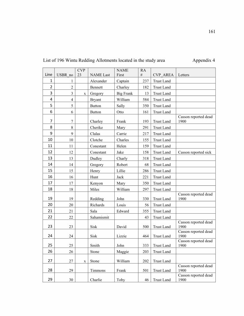
161
List of 196 Wintu Redding Allotments located in the study area Appendix 4
Line USBR_no CVP 23 NAME Last
NAME First
RA # CVP_AREA Letters
1 1 Alexander Captain 237 Trust Land 2 2 Bennett Charley 182 Trust Land 3 3 x Gregory Big Frank 13 Trust Land 4 4 Bryant William 584 Trust Land 5 5 Button Sally 350 Trust Land 6 6 Button Otto 161 Trust Land
7 7 Charley Frank 193 Trust Land Casson reported dead 1900
8 8 Cherike Mary 291 Trust Land 9 9 Clalas Carrie 217 Trust Land
10 10 Clotche Charles 155 Trust Land 11 11 Conestant Helen 159 Trust Land 12 12 Conestant Jake 158 Trust Land Casson reported sick 13 13 Dudley Charly 318 Trust Land 14 14 Gregory Robert 68 Trust Land 15 15 Henry Lillie 286 Trust Land 16 16 Hunt Jack 221 Trust Land 17 17 Kenyon Mary 350 Trust Land 18 18 Miles William 297 Trust Land
19 19 Redding John 330 Trust Land Casson reported dead 1900
20 20 Richards Louis 56 Trust Land 21 21 Sala Edward 355 Trust Land 22 22 Sahamismit 43 Trust Land
23 23 Sisk David 500 Trust Land Casson reported dead 1900
24 24 Sisk Lizzie 464 Trust Land Casson reported dead 1900
25 25 Smith John 333 Trust Land Casson reported dead 1900
26 26 Stone Maggie 203 Trust Land
27 27 x Stone William 202 Trust Land
28 29 Timmons Frank 501 Trust Land Casson reported dead 1900
29 30 Charlie Toby 46 Trust Land Casson reported dead 1900
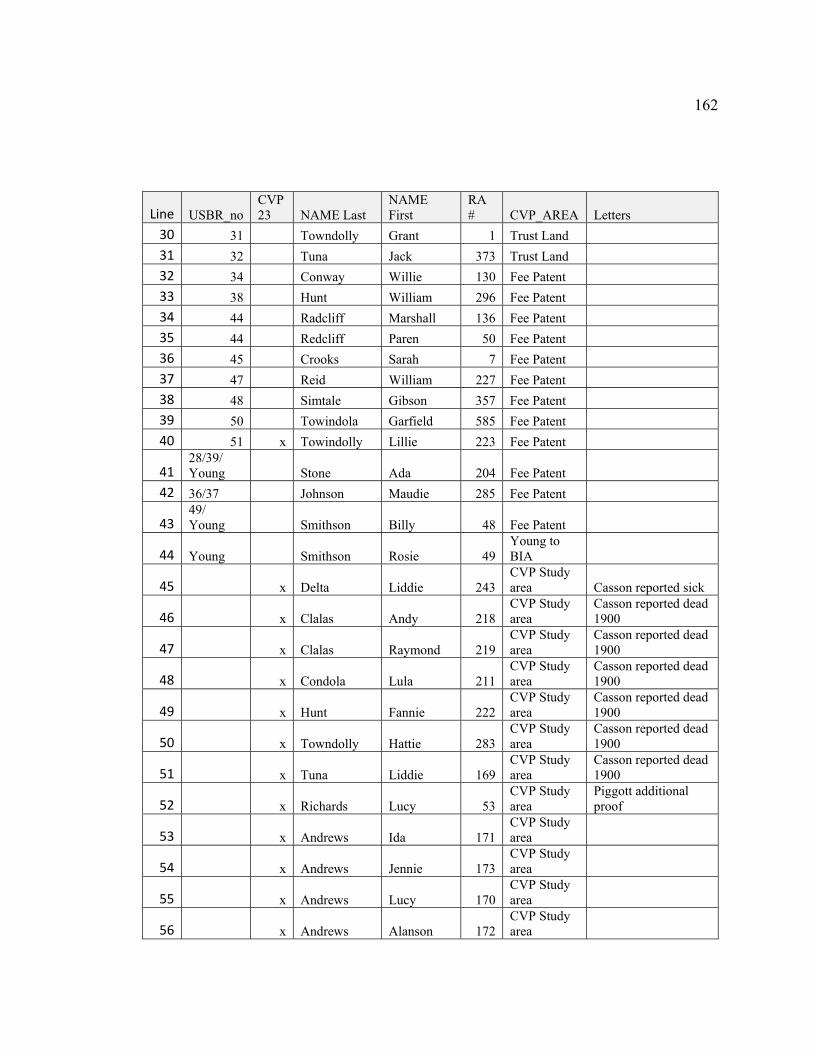
162
Line USBR_no CVP 23 NAME Last
NAME First
RA # CVP_AREA Letters
30 31 Towndolly Grant 1 Trust Land 31 32 Tuna Jack 373 Trust Land 32 34 Conway Willie 130 Fee Patent 33 38 Hunt William 296 Fee Patent 34 44 Radcliff Marshall 136 Fee Patent 35 44 Redcliff Paren 50 Fee Patent 36 45 Crooks Sarah 7 Fee Patent 37 47 Reid William 227 Fee Patent 38 48 Simtale Gibson 357 Fee Patent 39 50 Towindola Garfield 585 Fee Patent 40 51 x Towindolly Lillie 223 Fee Patent
41 28/39/ Young Stone Ada 204 Fee Patent
42 36/37 Johnson Maudie 285 Fee Patent
43 49/ Young Smithson Billy 48 Fee Patent
44 Young Smithson Rosie 49 Young to BIA
45 x Delta Liddie 243 CVP Study area Casson reported sick
46 x Clalas Andy 218 CVP Study area
Casson reported dead 1900
47 x Clalas Raymond 219 CVP Study area
Casson reported dead 1900
48 x Condola Lula 211 CVP Study area
Casson reported dead 1900
49 x Hunt Fannie 222 CVP Study area
Casson reported dead 1900
50 x Towndolly Hattie 283 CVP Study area
Casson reported dead 1900
51 x Tuna Liddie 169 CVP Study area
Casson reported dead 1900
52 x Richards Lucy 53 CVP Study area
Piggott additional proof
53 x Andrews Ida 171 CVP Study area
54 x Andrews Jennie 173 CVP Study area
55 x Andrews Lucy 170 CVP Study area
56 x Andrews Alanson 172 CVP Study area
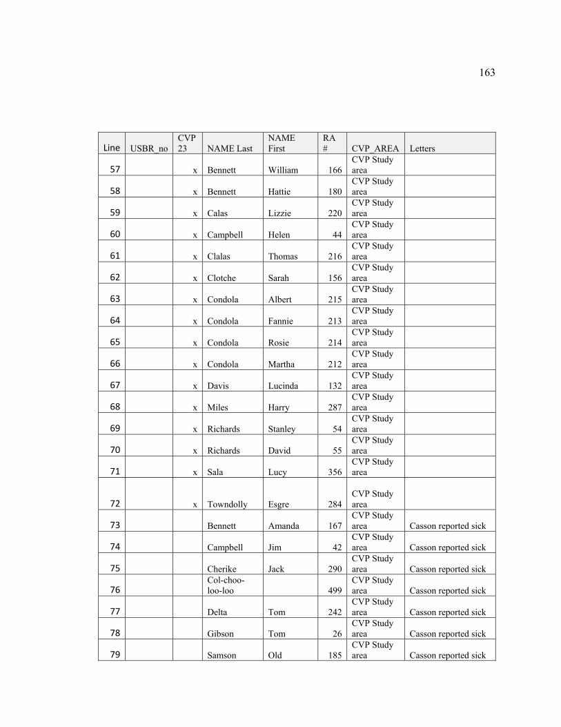
163
Line USBR_no CVP 23 NAME Last
NAME First
RA # CVP_AREA Letters
57 x Bennett William 166 CVP Study area
58 x Bennett Hattie 180 CVP Study area
59 x Calas Lizzie 220 CVP Study area
60 x Campbell Helen 44 CVP Study area
61 x Clalas Thomas 216 CVP Study area
62 x Clotche Sarah 156 CVP Study area
63 x Condola Albert 215 CVP Study area
64 x Condola Fannie 213 CVP Study area
65 x Condola Rosie 214 CVP Study area
66 x Condola Martha 212 CVP Study area
67 x Davis Lucinda 132 CVP Study area
68 x Miles Harry 287 CVP Study area
69 x Richards Stanley 54 CVP Study area
70 x Richards David 55 CVP Study area
71 x Sala Lucy 356 CVP Study area
72 x Towndolly Esgre 284
CVP Study area
73 Bennett Amanda 167 CVP Study area Casson reported sick
74 Campbell Jim 42 CVP Study area Casson reported sick
75 Cherike Jack 290 CVP Study area Casson reported sick
76 Col-choo-loo-loo 499
CVP Study area Casson reported sick
77 Delta Tom 242 CVP Study area Casson reported sick
78 Gibson Tom 26 CVP Study area Casson reported sick
79 Samson Old 185 CVP Study area Casson reported sick

164
Line USBR_no CVP 23 NAME Last
NAME First
RA # CVP_AREA Letters
80 Alexander Unis 241 CVP Study area
Casson reported dead 1900
81 Button Bettie 163 CVP Study area
Casson reported dead 1900
82 Charlie Theodore 45 CVP Study area
Casson reported dead 1900
83 Conestant Littie 160 CVP Study area
Casson reported dead 1900
84 Davis Ida 133 CVP Study area
Casson reported dead 1900
85 Green Sarah 235 CVP Study area
Casson reported dead 1900
86 Gregory Lizzie 65 CVP Study area
Casson reported dead 1900
87 Jim Doctor 288 CVP Study area
Casson reported dead 1900
88 Luchet William 231 CVP Study area
Casson reported dead 1900
89 Phillips Kitty 233 CVP Study area
Casson reported dead 1900
90 Sallie Sedem 14 CVP Study area
Casson reported dead 1900
91 Samson Emma 184 CVP Study area
Casson reported dead 1900
92 Silverthorn Jane 328 CVP Study area
Casson reported dead 1900
93 Tuna Tom 168 CVP Study area
Casson reported dead 1900
94 Waituluma Luli 47 CVP Study area
Casson reported dead 1900
95 Walker Beecher 229 CVP Study area
Casson reported dead 1900
96 Walker Charley 5 CVP Study area
Casson reported dead 1900
97 Tuna John 9 CVP Study area
Piggott correcting allotment
98 Yuptei Nom 377 CVP Study area
Piggott correcting allotment
99 Sunshine William 51 CVP Study area
Piggott correcting allotment; Casson dead 1900
100 Alexander Edward 239 CVP Study area
101 Alexander Mary 238 CVP Study area
102 Alexander Maurice 240 CVP Study area
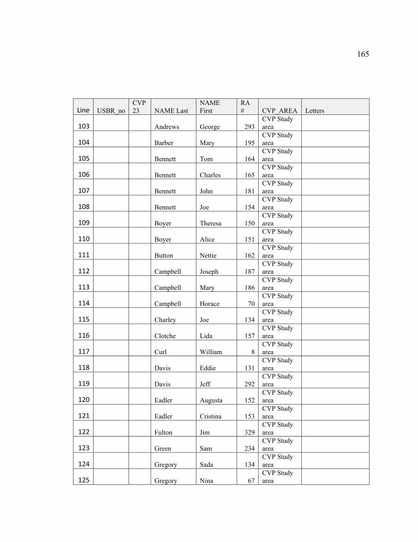
165
Line USBR_no CVP 23 NAME Last
NAME First
RA # CVP_AREA Letters
103 Andrews George 293 CVP Study area
104 Barber Mary 195 CVP Study area
105 Bennett Tom 164 CVP Study area
106 Bennett Charles 165 CVP Study area
107 Bennett John 181 CVP Study area
108 Bennett Joe 154 CVP Study area
109 Boyer Theresa 150 CVP Study area
110 Boyer Alice 151 CVP Study area
111 Button Nettie 162 CVP Study area
112 Campbell Joseph 187 CVP Study area
113 Campbell Mary 186 CVP Study area
114 Campbell Horace 70 CVP Study area
115 Charley Joe 134 CVP Study area
116 Clotche Lida 157 CVP Study area
117 Curl William 8 CVP Study area
118 Davis Eddie 131 CVP Study area
119 Davis Jeff 292 CVP Study area
120 Eadler Augusta 152 CVP Study area
121 Eadler Cristina 153 CVP Study area
122 Fulton Jim 329 CVP Study area
123 Green Sam 234 CVP Study area
124 Gregory Sada 134 CVP Study area
125 Gregory Nina 67 CVP Study area
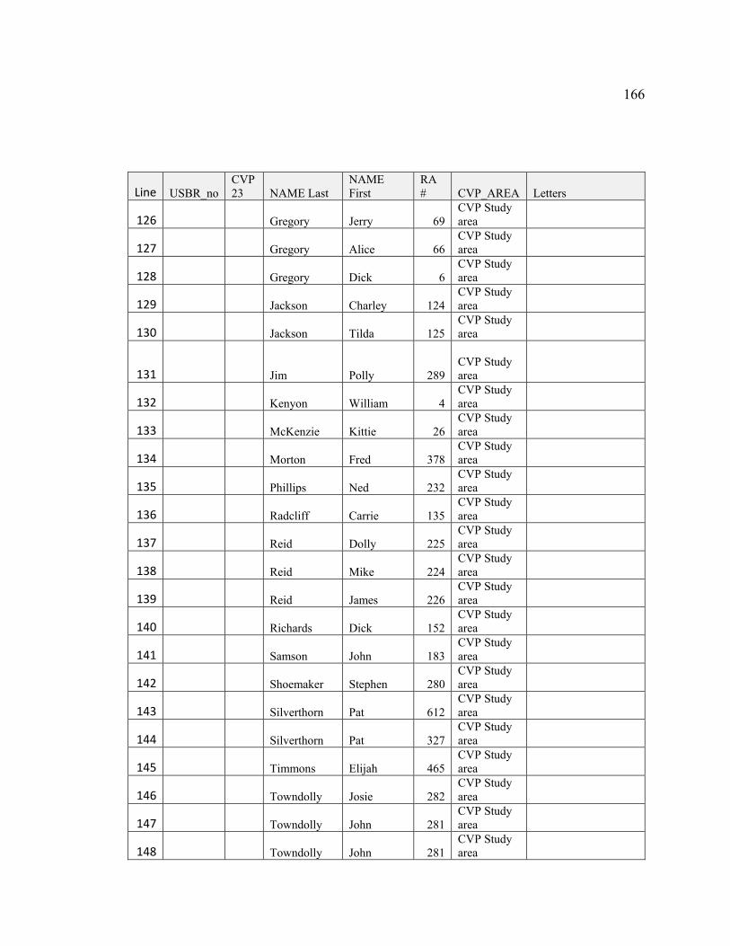
166
Line USBR_no CVP 23 NAME Last
NAME First
RA # CVP_AREA Letters
126 Gregory Jerry 69 CVP Study area
127 Gregory Alice 66 CVP Study area
128 Gregory Dick 6 CVP Study area
129 Jackson Charley 124 CVP Study area
130 Jackson Tilda 125 CVP Study area
131 Jim Polly 289
CVP Study area
132 Kenyon William 4 CVP Study area
133 McKenzie Kittie 26 CVP Study area
134 Morton Fred 378 CVP Study area
135 Phillips Ned 232 CVP Study area
136 Radcliff Carrie 135 CVP Study area
137 Reid Dolly 225 CVP Study area
138 Reid Mike 224 CVP Study area
139 Reid James 226 CVP Study area
140 Richards Dick 152 CVP Study area
141 Samson John 183 CVP Study area
142 Shoemaker Stephen 280 CVP Study area
143 Silverthorn Pat 612 CVP Study area
144 Silverthorn Pat 327 CVP Study area
145 Timmons Elijah 465 CVP Study area
146 Towndolly Josie 282 CVP Study area
147 Towndolly John 281 CVP Study area
148 Towndolly John 281 CVP Study area
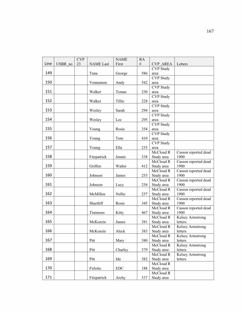
167
Line USBR_no CVP 23 NAME Last
NAME First
RA # CVP_AREA Letters
149 Tuna George 586 CVP Study area
150 Vennamon Andy 542 CVP Study area
151 Walker Tomas 230 CVP Study area
152 Walker Tillie 228 CVP Study area
153 Wesley Sarah 294 CVP Study area
154 Wesley Lee 295 CVP Study area
155 Young Rosie 354 CVP Study area
156 Young Tom 410 CVP Study area
157 Young Ella 235 CVP Study area
158 Fitzpatrick Jennie 338 McCloud R Study area
Casson reported dead 1900
159 Griffen Walter 412 McCloud R Study area
Casson reported dead 1900
160 Johnson James 253 McCloud R Study area
Casson reported dead 1900
161 Johnson Lucy 254 McCloud R Study area
Casson reported dead 1900
162 McMillen Nellie 257 McCloud R Study area
Casson reported dead 1900
163 Shurtliff Rosie 345 McCloud R Study area
Casson reported dead 1900
164 Timmons Kitty 467 McCloud R Study area
Casson reported dead 1900
165 McKenzie James 381 McCloud R Study area
Kelsey Armstrong letters
166 McKenzie Aleck 383 McCloud R Study area
Kelsey Armstrong letters
167 Pitt Mary 380 McCloud R Study area
Kelsey Armstrong letters
168 Pitt Charley 379 McCloud R Study area
Kelsey Armstrong letters
169 Pitt Ida 382 McCloud R Study area
Kelsey Armstrong letters
170 Firlotte EDC 188 McCloud R Study area
171 Fitzpatrick Archy 337 McCloud R Study area
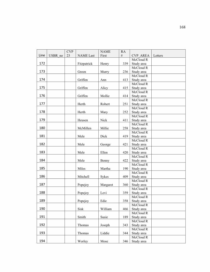
168
Line USBR_no CVP 23 NAME Last
NAME First
RA # CVP_AREA Letters
172 Fitzpatrick Henry 339 McCloud R Study area
173 Green Murry 236 McCloud R Study area
174 Griffen Ann 413 McCloud R Study area
175 Griffen Alicy 415 McCloud R Study area
176 Griffen Mollie 414 McCloud R Study area
177 Herth Robert 251 McCloud R Study area
178 Herth Mary 252 McCloud R Study area
179 Heusen Nick 411 McCloud R Study area
180 McMillen Millie 258 McCloud R Study area
181 Mele Dick 419 McCloud R Study area
182 Mele George 421 McCloud R Study area
183 Mele Ellen 420 McCloud R Study area
184 Mele Benny 422 McCloud R Study area
185 Miles Martha 190 McCloud R Study area
186 Mitchell Sykes 409 McCloud R Study area
187 Popejoy Margaret 360 McCloud R Study area
188 Popejoy Levi 359 McCloud R Study area
189 Popejoy Edie 358 McCloud R Study area
190 Sisk William 466 McCloud R Study area
191 Smith Susie 189 McCloud R Study area
192 Thomas Joseph 343 McCloud R Study area
193 Thomas Liddie 344 McCloud R Study area
194 Worley Mose 346 McCloud R Study area

169
Line USBR_no CVP 23 NAME Last
NAME First
RA # CVP_AREA Letters
195 Worley Jane 347 McCloud R Study area
196 Young Aleck 353 McCloud R Study area
USBR_no: Reference to the files in the two books sent by USBR to the Winnemem
Wintu after researching the National Archive in Denver
CVP23 Reference to the allotments identified from the map in CVP Problem Study 23.
NAME_Last Last name of the Winnemem Wintu who received the original allotment.
NAME _First First name of the Winnemem Wintu who received the original allotment.
Red_No Redding Allotment number
CVP_Area Trust Land: USBR identified this allotment as held in trust. Fee Patent: USBR identified this allotment as fee patent. USBR Letter: Young to BIA: Not identified on CVP 23 map or included in files from USBR but included in letter written by USBR Young to BIA in 1938. CVP_Area: Allotment within the CVP Reservoir area. McCloud R Study Area: Allotment outside the CVP Reservoir area but within the McCloud River Township study area.
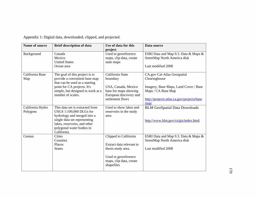
170
Appendix 1: Digital data, downloaded, clipped, and projected.
Name of source Brief description of data Use of data for this
project
Data source
Background Canada
Mexico
United States
Ocean area
Used to georeference
maps, clip data, create
state maps
ESRI Data and Map 9.3. Data & Maps &
StreetMap North America disk
Last modified 2008
California Base
Map
The goal of this project is to
provide a convenient base map
that can be used as a starting
point for CA projects. It's
simple, but designed to work at a
number of scales.
California State
boundary
USA, Canada, Mexico
base for maps showing
European discovery and
settlement flows
CA.gov Cal-Atlas Geospatial
Clearinghouse
Imagery, Base Maps, Land Cover / Base
Maps / CA Base Map
http://projects.atlas.ca.gov/projects/base
map/
California Hydro
Polygons
This data set is extracted from
USGS 1:100,000 DLGs for
hydrology and merged into a
single data set representing
lakes, reservoirs, and other
polygonal water bodies in
California.
Used to show lakes and
reservoirs in the study
area
BLM GeoSpatial Data Downloads
http://www.blm.gov/ca/gis/index.html
Census Cities
Counties
Places
States
Clipped to California
Extract data relevant to
thesis study area.
Used to georeference
maps, clip data, create
shapefiles
ESRI Data and Map 9.3. Data & Maps &
StreetMap North America disk
Last modified 2008
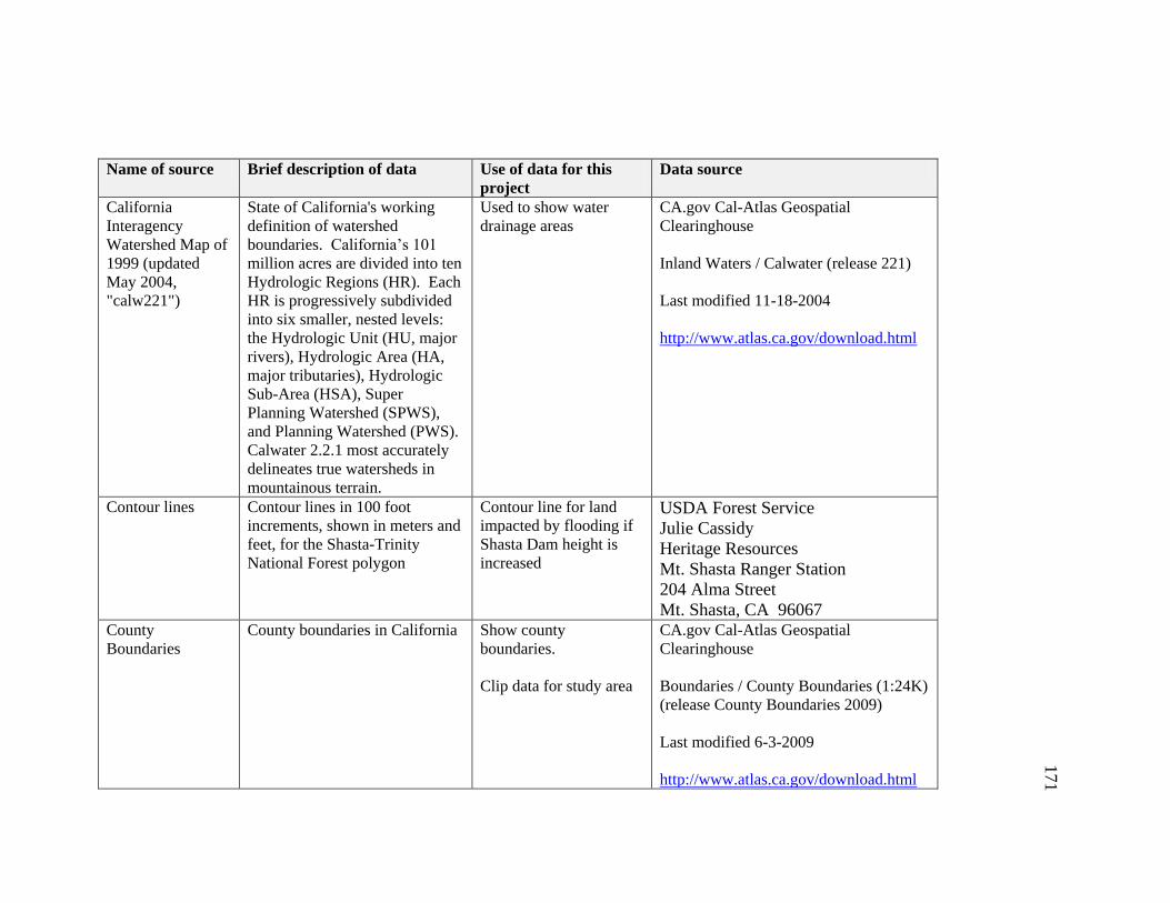
171
Name of source Brief description of data Use of data for this
project
Data source
California
Interagency
Watershed Map of
1999 (updated
May 2004,
"calw221")
State of California's working
definition of watershed
boundaries. California’s 101
million acres are divided into ten
Hydrologic Regions (HR). Each
HR is progressively subdivided
into six smaller, nested levels:
the Hydrologic Unit (HU, major
rivers), Hydrologic Area (HA,
major tributaries), Hydrologic
Sub-Area (HSA), Super
Planning Watershed (SPWS),
and Planning Watershed (PWS).
Calwater 2.2.1 most accurately
delineates true watersheds in
mountainous terrain.
Used to show water
drainage areas
CA.gov Cal-Atlas Geospatial
Clearinghouse
Inland Waters / Calwater (release 221)
Last modified 11-18-2004
http://www.atlas.ca.gov/download.html
Contour lines Contour lines in 100 foot
increments, shown in meters and
feet, for the Shasta-Trinity
National Forest polygon
Contour line for land
impacted by flooding if
Shasta Dam height is
increased
USDA Forest Service
Julie Cassidy
Heritage Resources
Mt. Shasta Ranger Station
204 Alma Street
Mt. Shasta, CA 96067 County
Boundaries
County boundaries in California Show county
boundaries.
Clip data for study area
CA.gov Cal-Atlas Geospatial
Clearinghouse
Boundaries / County Boundaries (1:24K)
(release County Boundaries 2009)
Last modified 6-3-2009
http://www.atlas.ca.gov/download.html
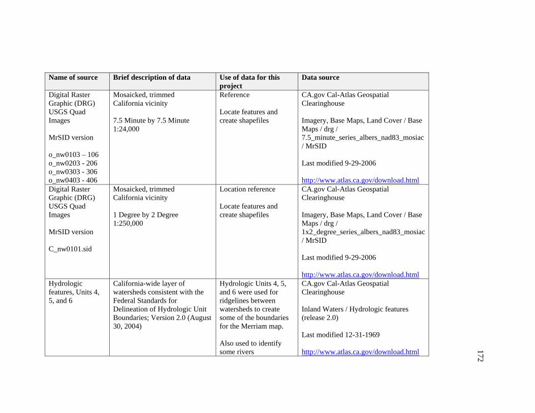
172
Name of source Brief description of data Use of data for this
project
Data source
Digital Raster
Graphic (DRG)
USGS Quad
Images
MrSID version
o_nw0103 – 106
o_nw0203 - 206
o_nw0303 - 306
o_nw0403 - 406
Mosaicked, trimmed
California vicinity
7.5 Minute by 7.5 Minute
1:24,000
Reference
Locate features and
create shapefiles
CA.gov Cal-Atlas Geospatial
Clearinghouse
Imagery, Base Maps, Land Cover / Base
Maps / drg /
7.5_minute_series_albers_nad83_mosiac
/ MrSID
Last modified 9-29-2006
http://www.atlas.ca.gov/download.html
Digital Raster
Graphic (DRG)
USGS Quad
Images
MrSID version
C_nw0101.sid
Mosaicked, trimmed
California vicinity
1 Degree by 2 Degree
1:250,000
Location reference
Locate features and
create shapefiles
CA.gov Cal-Atlas Geospatial
Clearinghouse
Imagery, Base Maps, Land Cover / Base
Maps / drg /
1x2_degree_series_albers_nad83_mosiac
/ MrSID
Last modified 9-29-2006
http://www.atlas.ca.gov/download.html
Hydrologic
features, Units 4,
5, and 6
California-wide layer of
watersheds consistent with the
Federal Standards for
Delineation of Hydrologic Unit
Boundaries; Version 2.0 (August
30, 2004)
Hydrologic Units 4, 5,
and 6 were used for
ridgelines between
watersheds to create
some of the boundaries
for the Merriam map.
Also used to identify
some rivers
CA.gov Cal-Atlas Geospatial
Clearinghouse
Inland Waters / Hydrologic features
(release 2.0)
Last modified 12-31-1969
http://www.atlas.ca.gov/download.html
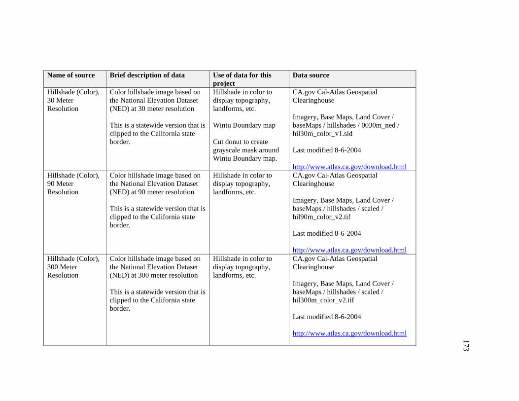
173
Name of source Brief description of data Use of data for this
project
Data source
Hillshade (Color),
30 Meter
Resolution
Color hillshade image based on
the National Elevation Dataset
(NED) at 30 meter resolution
This is a statewide version that is
clipped to the California state
border.
Hillshade in color to
display topography,
landforms, etc.
Wintu Boundary map
Cut donut to create
grayscale mask around
Wintu Boundary map.
CA.gov Cal-Atlas Geospatial
Clearinghouse
Imagery, Base Maps, Land Cover /
baseMaps / hillshades / 0030m_ned /
hil30m_color_v1.sid
Last modified 8-6-2004
http://www.atlas.ca.gov/download.html
Hillshade (Color),
90 Meter
Resolution
Color hillshade image based on
the National Elevation Dataset
(NED) at 90 meter resolution
This is a statewide version that is
clipped to the California state
border.
Hillshade in color to
display topography,
landforms, etc.
CA.gov Cal-Atlas Geospatial
Clearinghouse
Imagery, Base Maps, Land Cover /
baseMaps / hillshades / scaled /
hil90m_color_v2.tif
Last modified 8-6-2004
http://www.atlas.ca.gov/download.html
Hillshade (Color),
300 Meter
Resolution
Color hillshade image based on
the National Elevation Dataset
(NED) at 300 meter resolution
This is a statewide version that is
clipped to the California state
border.
Hillshade in color to
display topography,
landforms, etc.
CA.gov Cal-Atlas Geospatial
Clearinghouse
Imagery, Base Maps, Land Cover /
baseMaps / hillshades / scaled /
hil300m_color_v2.tif
Last modified 8-6-2004
http://www.atlas.ca.gov/download.html
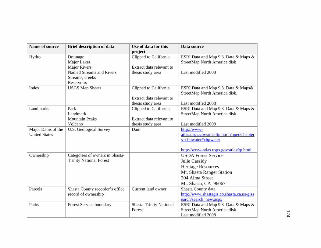
174
Name of source Brief description of data Use of data for this
project
Data source
Hydro Drainage
Major Lakes
Major Rivers
Named Streams and Rivers
Streams, creeks
Reservoirs
Clipped to California
Extract data relevant to
thesis study area
ESRI Data and Map 9.3. Data & Maps &
StreetMap North America disk
Last modified 2008
Index USGS Map Sheets Clipped to California
Extract data relevant to
thesis study area
ESRI Data and Map 9.3. Data & Maps&
StreetMap North America disk.
Last modified 2008
Landmarks Park
Landmark
Mountain Peaks
Volcano
Clipped to California
Extract data relevant to
thesis study area
ESRI Data and Map 9.3 Data & Maps &
StreetMap North America disk
Last modified 2008
Major Dams of the
United States
U.S. Geological Survey Dam http://www-
atlas.usgs.gov/atlasftp.html?openChapter
s=chpwater#chpwater
http://www-atlas.usgs.gov/atlasftp.html
Ownership Categories of owners in Shasta-
Trinity National Forest
USDA Forest Service
Julie Cassidy
Heritage Resources
Mt. Shasta Ranger Station
204 Alma Street
Mt. Shasta, CA 96067 Parcels Shasta County recorder’s office
record of ownership
Current land owner Shasta County data
http://www.shastagis.co.shasta.ca.us/giss
earch/search_new.aspx
Parks Forest Service boundary Shasta-Trinity National
Forest
ESRI Data and Map 9.3 Data & Maps &
StreetMap North America disk
Last modified 2008

175
Name of source Brief description of data Use of data for this
project
Data source
Public Land
Survey
Downloaded as six files, two
each for Township, section, and
quarter-quarter section: one from
BLM GCDB (Geographic
Coordinate Data Base Project)
Source Data and the other from
Forest Service and Alternate
Source Data
This was used to locate
and create shapefile
layers for Indian
Allotments, Baird Fish
Hatchery, and some of
the historic land owners
in the McCloud River
area.
Some townships were
not divided into sections
and some sections were
not divided into quarter-
quarters; If needed, I cut
polygons to make
smaller units.
These layers were also
used to help
georeference Plat
documents and Wiegel
map.
These files may be downloaded from
several sources, I used:
http://www.geocommunicator.gov/LSIS
6/map.jsp
Another source:
http://www.blm.gov/ca/gis/index.html
Transportation Highways
Clipped to California.
Extracted data relevant
to thesis study area
ESRI Data and Map 9.3. Data & Maps&
StreetMap North America disk.
Last modified 2008
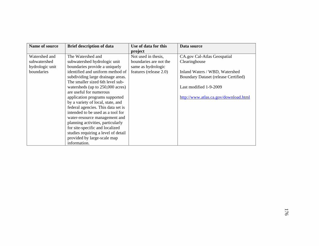
176
Name of source Brief description of data Use of data for this
project
Data source
Watershed and
subwatershed
hydrologic unit
boundaries
The Watershed and
subwatershed hydrologic unit
boundaries provide a uniquely
identified and uniform method of
subdividing large drainage areas.
The smaller sized 6th level sub-
watersheds (up to 250,000 acres)
are useful for numerous
application programs supported
by a variety of local, state, and
federal agencies. This data set is
intended to be used as a tool for
water-resource management and
planning activities, particularly
for site-specific and localized
studies requiring a level of detail
provided by large-scale map
information.
Not used in thesis,
boundaries are not the
same as hydrologic
features (release 2.0)
CA.gov Cal-Atlas Geospatial
Clearinghouse
Inland Waters / WBD, Watershed
Boundary Dataset (release Certified)
Last modified 1-9-2009
http://www.atlas.ca.gov/download.html
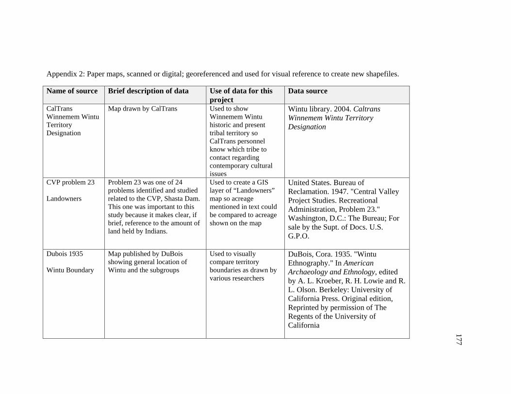
177
Appendix 2: Paper maps, scanned or digital; georeferenced and used for visual reference to create new shapefiles.
Name of source Brief description of data Use of data for this project
Data source
CalTrans Winnemem Wintu Territory Designation
Map drawn by CalTrans Used to show Winnemem Wintu historic and present tribal territory so CalTrans personnel know which tribe to contact regarding contemporary cultural issues
Wintu library. 2004. Caltrans Winnemem Wintu Territory Designation
CVP problem 23 Landowners
Problem 23 was one of 24 problems identified and studied related to the CVP, Shasta Dam. This one was important to this study because it makes clear, if brief, reference to the amount of land held by Indians.
Used to create a GIS layer of “Landowners” map so acreage mentioned in text could be compared to acreage shown on the map
United States. Bureau of Reclamation. 1947. "Central Valley Project Studies. Recreational Administration, Problem 23." Washington, D.C.: The Bureau; For sale by the Supt. of Docs. U.S. G.P.O.
Dubois 1935 Wintu Boundary
Map published by DuBois showing general location of Wintu and the subgroups
Used to visually compare territory boundaries as drawn by various researchers
DuBois, Cora. 1935. "Wintu Ethnography." In American Archaeology and Ethnology, edited by A. L. Kroeber, R. H. Lowie and R. L. Olson. Berkeley: University of California Press. Original edition, Reprinted by permission of The Regents of the University of California

178
Name of source Brief description of data Use of data for this project
Data source
Guilford-Kardell / Wiegel
Guilford Kardell located Curtin and Harrington records of historic Indian villages on Wiegel, C. R. 1912. Map of the County of Shasta, California. Compiled from U. S. Geological and U. S. Land Surveys, Official and Private Surveys, etc.
Used to create layer of historic villages.
Guilford-Kardell, Margaret, and James Dotta. 1980. "Some Pre-Contact Shasta County Wintu Site Locations: A Correlation of the Previously Unpublished Notes of Jeremiah Curtin and J. P. Harrington with Later Published, Recorded, and Unrecorded Data on the Dawpom, Winemem, Puidalpom, and Waimuk Areas of Wintu Population." P. O. Box 990427, Redding, CA 96099: Occasional Papers of the Redding Museum
Kroeber 1925 Used to visually compare territory boundaries as drawn by various researchers.
Kroeber, Alfred Louis. 1925. Handbook of the Indians of California. Berkeley: California Book Company
Kroeber 1966 Merriam 1966
Indian territory boundaries of Kroeber and Merriam, redone by Heizer for the Indian Claims Commission
Used to visually compare territory boundaries as drawn by various researchers.
Heizer, Robert Fleming. 1966. Languages, Territories, and Names of California Indian Tribes. Berkeley: University of California Press
LaPena 1978
Used to visually compare territory boundaries as drawn by various researchers.
LaPena, Frank. 1978. "Wintu." In Handbook of North American Indians, Volume 8, California, edited by William C. Sturtevant General Editor and Robert F. Heizer Volume Editor. 324-340. Washington, D.C.: Smithsonian Institution
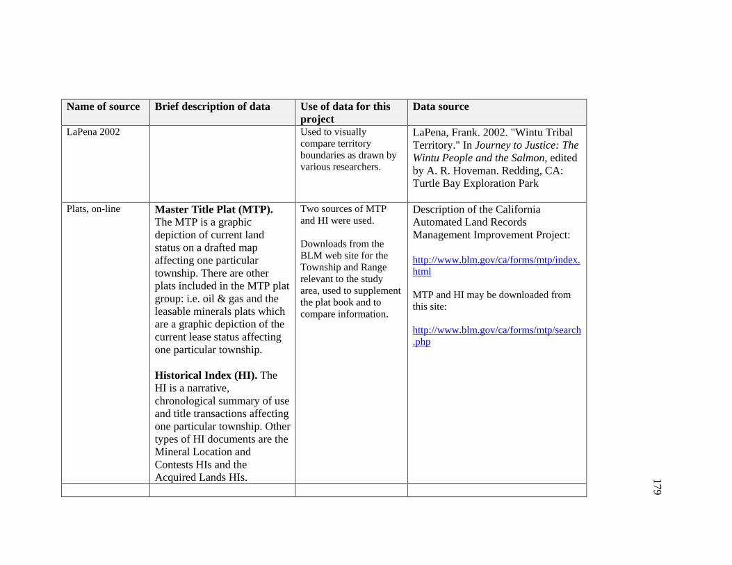
179
Name of source Brief description of data Use of data for this project
Data source
LaPena 2002
Used to visually compare territory boundaries as drawn by various researchers.
LaPena, Frank. 2002. "Wintu Tribal Territory." In Journey to Justice: The Wintu People and the Salmon, edited by A. R. Hoveman. Redding, CA: Turtle Bay Exploration Park
Plats, on-line
Master Title Plat (MTP). The MTP is a graphic depiction of current land status on a drafted map affecting one particular township. There are other plats included in the MTP plat group: i.e. oil & gas and the leasable minerals plats which are a graphic depiction of the current lease status affecting one particular township.
Historical Index (HI). The HI is a narrative, chronological summary of use and title transactions affecting one particular township. Other types of HI documents are the Mineral Location and Contests HIs and the Acquired Lands HIs.
Two sources of MTP and HI were used. Downloads from the BLM web site for the Township and Range relevant to the study area, used to supplement the plat book and to compare information.
Description of the California Automated Land Records Management Improvement Project: http://www.blm.gov/ca/forms/mtp/index.html MTP and HI may be downloaded from this site: http://www.blm.gov/ca/forms/mtp/search.php
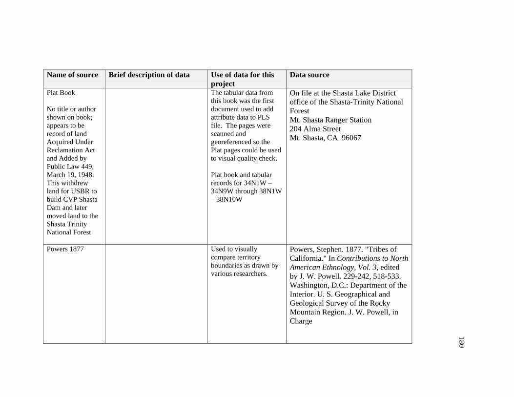
180
Name of source Brief description of data Use of data for this project
Data source
Plat Book No title or author shown on book; appears to be record of land Acquired Under Reclamation Act and Added by Public Law 449, March 19, 1948. This withdrew land for USBR to build CVP Shasta Dam and later moved land to the Shasta Trinity National Forest
The tabular data from this book was the first document used to add attribute data to PLS file. The pages were scanned and georeferenced so the Plat pages could be used to visual quality check. Plat book and tabular records for 34N1W – 34N9W through 38N1W – 38N10W
On file at the Shasta Lake District office of the Shasta-Trinity National Forest Mt. Shasta Ranger Station 204 Alma Street Mt. Shasta, CA 96067
Powers 1877 Used to visually compare territory boundaries as drawn by various researchers.
Powers, Stephen. 1877. "Tribes of California." In Contributions to North American Ethnology, Vol. 3, edited by J. W. Powell. 229-242, 518-533. Washington, D.C.: Department of the Interior. U. S. Geographical and Geological Survey of the Rocky Mountain Region. J. W. Powell, in Charge

181
Name of source Brief description of data Use of data for this project
Data source
Royce Show Indian Land Cessions in the United States
Show the location of the eighteen unratified treaties in California and create a shapefile of the boundaries for the Cottonwood Treaty.
Royce, Charles C. 1971. Indian Land Cessions in the United States, Comp. By Charles C. Royce, with Introduction by Cyrus Thomas. California 1. Smithsonian Institution. Bureau of American Ethnology. Eighteenth annual report ... 1896-'97. pt. 2, p. 521-997, 67 maps (part double). 30 cm. Library of Congress Geography and Map Division Washington, D.C. 20540-4650 USA [On-line]: http://lcweb2.loc.gov/cgi-bin/query/r?ammem/gmd:@field(NUMBER+@band(g3701em+gct00002)
Shasta Reservoir Location of Graveyards
CVP map. K1824C, June 11, 1941, Rev 3-4-43 Associated text files with description of area, people contacted, efforts made to verify location of existing graves
Cemeteries identified by USBR. Scanned map was georeferenced and used as a visual to locate graveyards so a shapefile could be created.
NARA, San Bruno
USBR Map showing land ownership
Used PLSS files to locate township, section, a quarter-quarter section Created separate data layer for each ownership type.
CVP project 24 records
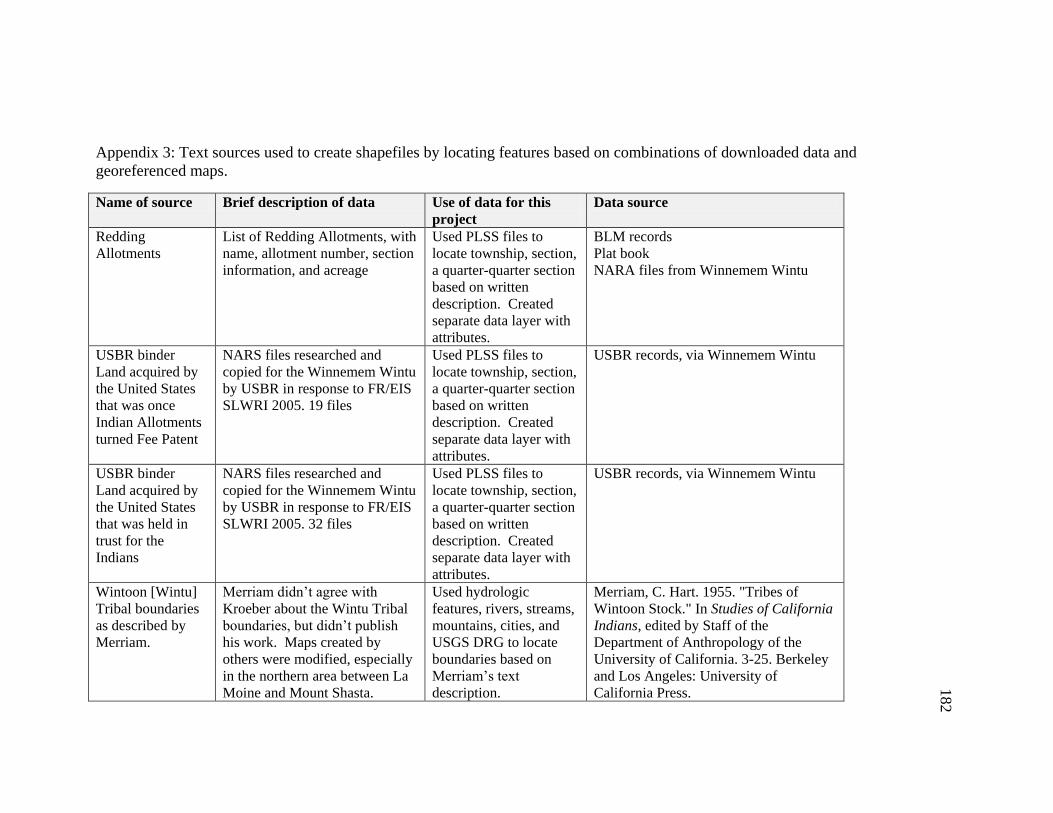
182
Appendix 3: Text sources used to create shapefiles by locating features based on combinations of downloaded data and
georeferenced maps.
Name of source Brief description of data Use of data for this
project
Data source
Redding
Allotments
List of Redding Allotments, with
name, allotment number, section
information, and acreage
Used PLSS files to
locate township, section,
a quarter-quarter section
based on written
description. Created
separate data layer with
attributes.
BLM records
Plat book
NARA files from Winnemem Wintu
USBR binder
Land acquired by
the United States
that was once
Indian Allotments
turned Fee Patent
NARS files researched and
copied for the Winnemem Wintu
by USBR in response to FR/EIS
SLWRI 2005. 19 files
Used PLSS files to
locate township, section,
a quarter-quarter section
based on written
description. Created
separate data layer with
attributes.
USBR records, via Winnemem Wintu
USBR binder
Land acquired by
the United States
that was held in
trust for the
Indians
NARS files researched and
copied for the Winnemem Wintu
by USBR in response to FR/EIS
SLWRI 2005. 32 files
Used PLSS files to
locate township, section,
a quarter-quarter section
based on written
description. Created
separate data layer with
attributes.
USBR records, via Winnemem Wintu
Wintoon [Wintu]
Tribal boundaries
as described by
Merriam.
Merriam didn’t agree with
Kroeber about the Wintu Tribal
boundaries, but didn’t publish
his work. Maps created by
others were modified, especially
in the northern area between La
Moine and Mount Shasta.
Used hydrologic
features, rivers, streams,
mountains, cities, and
USGS DRG to locate
boundaries based on
Merriam’s text
description.
Merriam, C. Hart. 1955. "Tribes of
Wintoon Stock." In Studies of California
Indians, edited by Staff of the
Department of Anthropology of the
University of California. 3-25. Berkeley
and Los Angeles: University of
California Press.
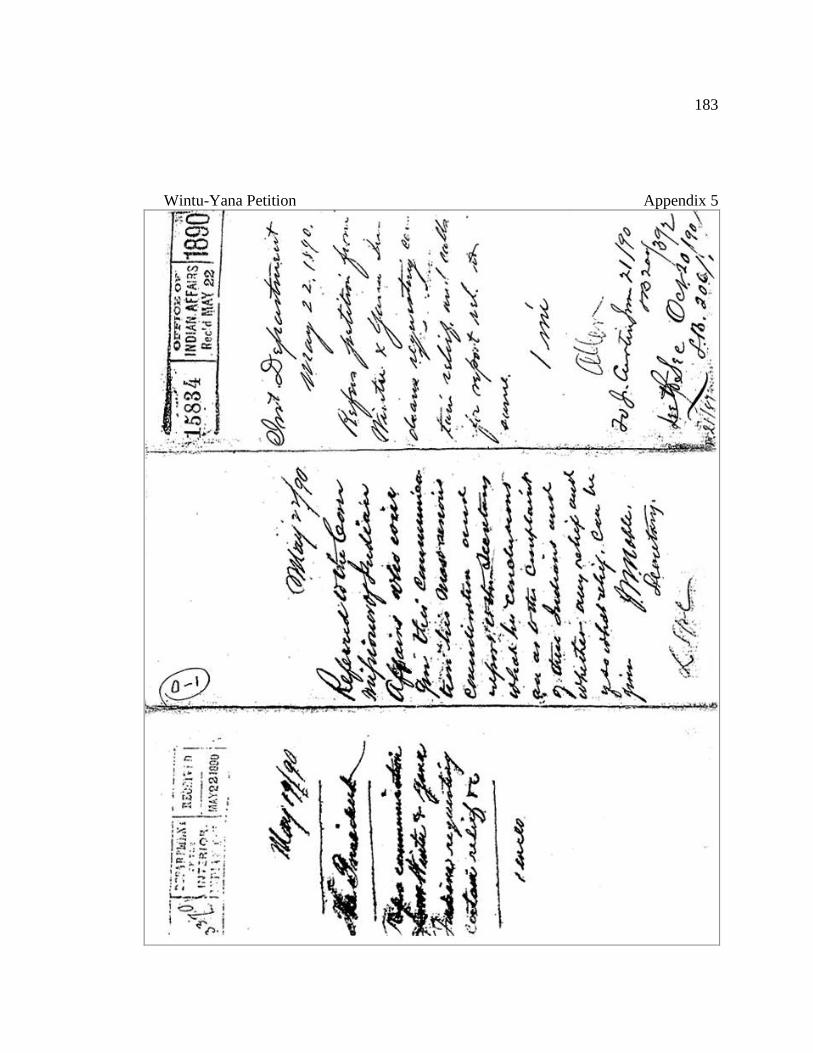
183
Wintu-Yana Petition Appendix 5
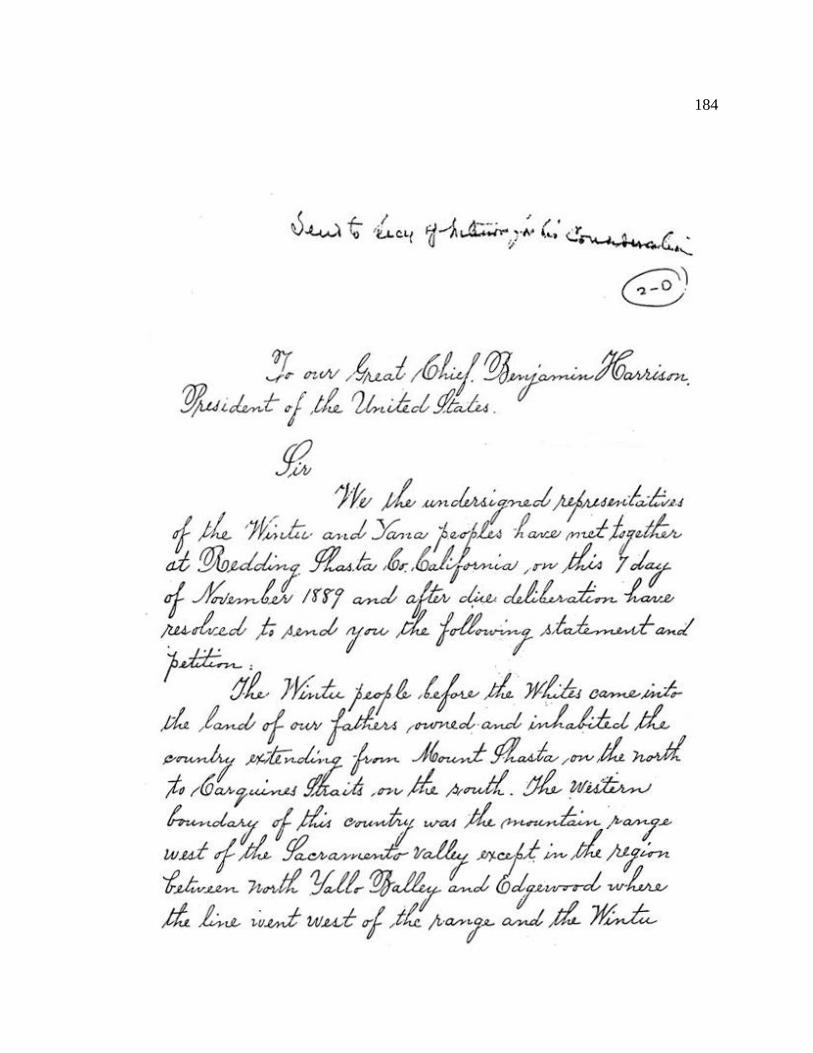
184
185
186
187

188
189
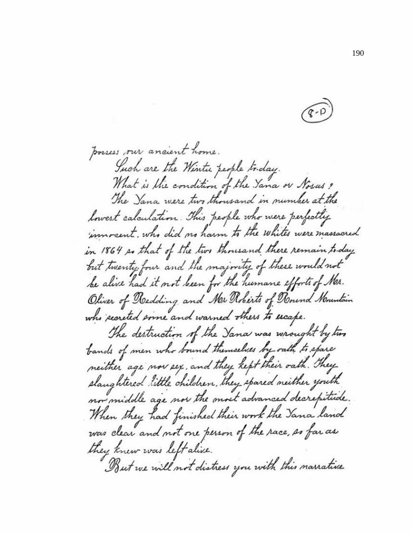
190

191

192
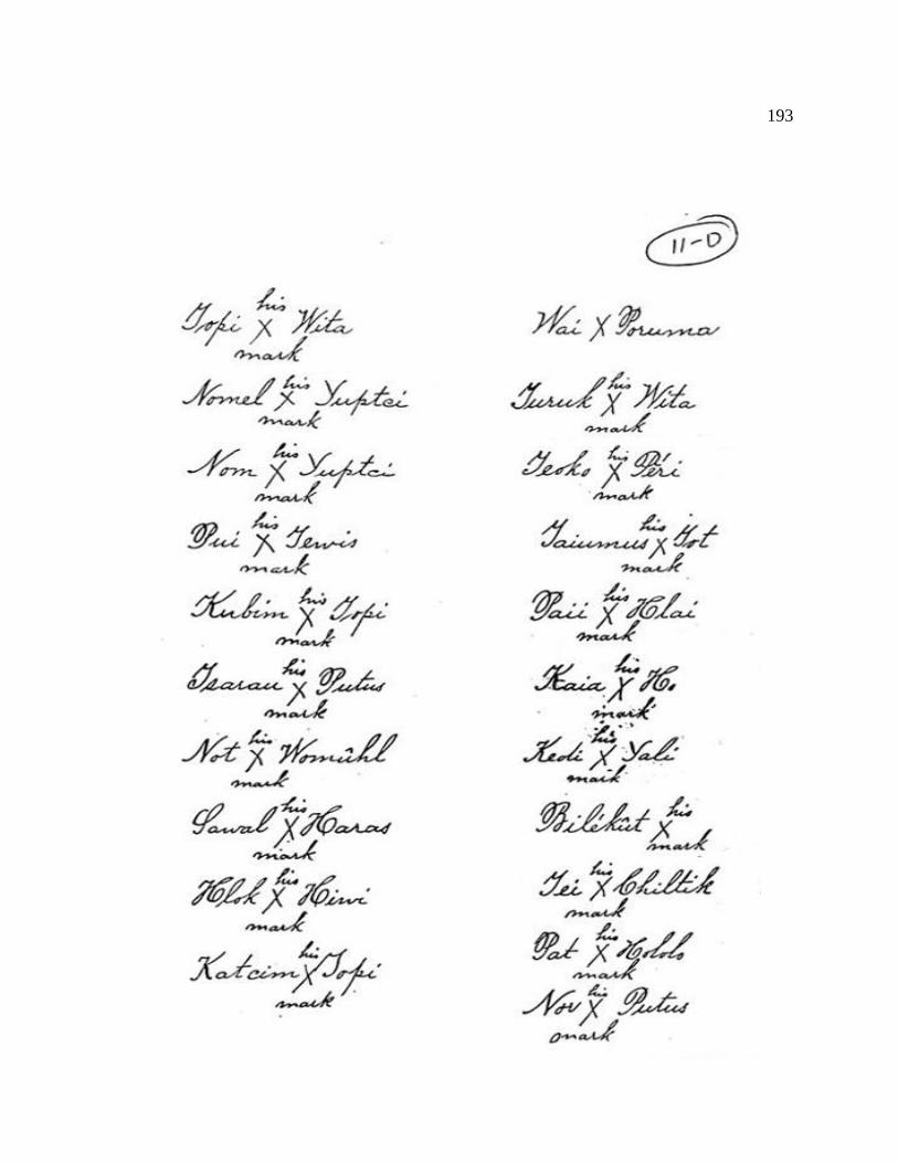
193
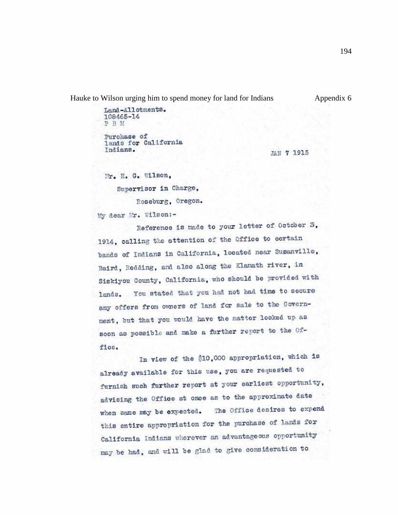
194
Hauke to Wilson urging him to spend money for land for Indians Appendix 6
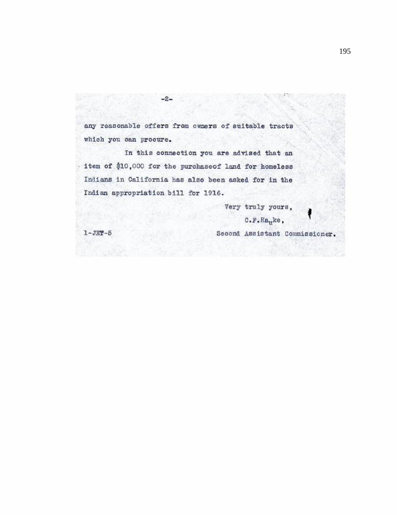
195

196
Young to BIA to Purchase Allotments for CVP Appendix 7
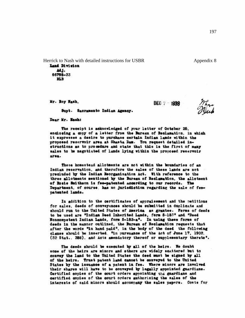
197
Herrick to Nash with detailed instructions for USBR Appendix 8
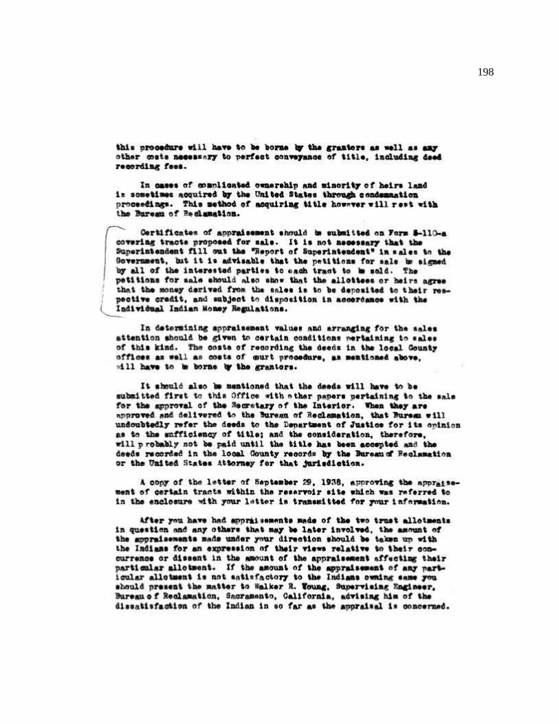
198
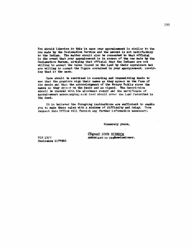
199

200
Rockwell to Lorenzen regarding CVP purchase money for Keluche Appendix 9
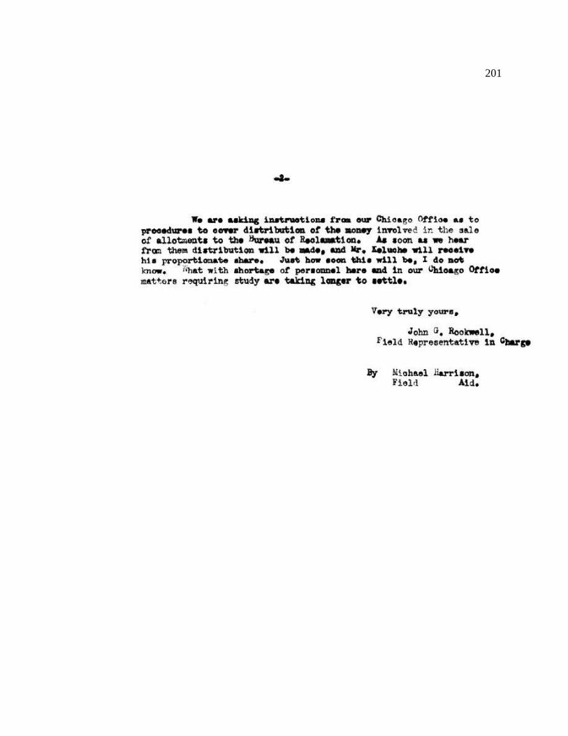
201

202
Rockwell to Commissioner of Indian Affairs, Appendix 10
203

204
Calland to County Recorder Regarding Cemetery Relocation Appendix 11
205
206
207
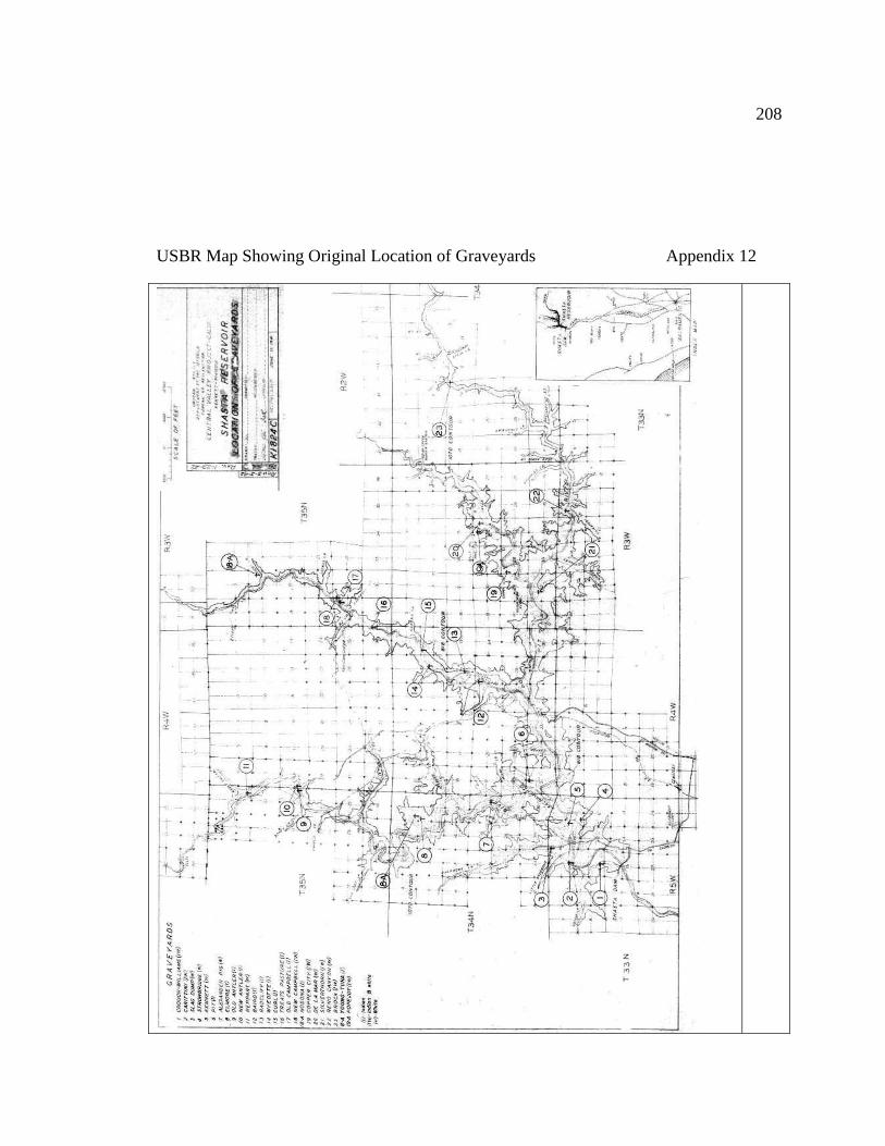
208
USBR Map Showing Original Location of Graveyards Appendix 12
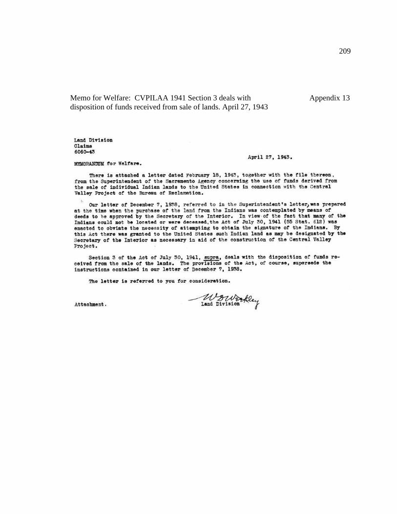
209
Memo for Welfare: CVPILAA 1941 Section 3 deals with Appendix 13
disposition of funds received from sale of lands. April 27, 1943

210
Daiker to Rockwell on how to use the CVPILAA funds Appendix 14
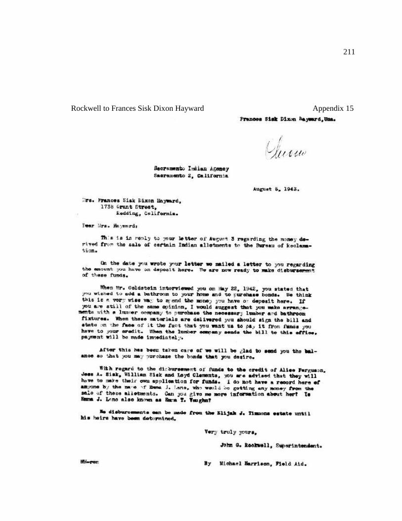
211
Rockwell to Frances Sisk Dixon Hayward Appendix 15
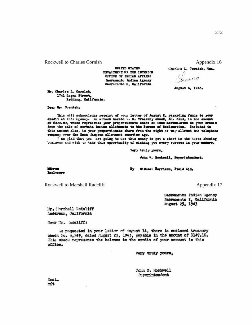
212
Rockwell to Charles Cornish Appendix 16
Rockwell to Marshall Radcliff Appendix 17
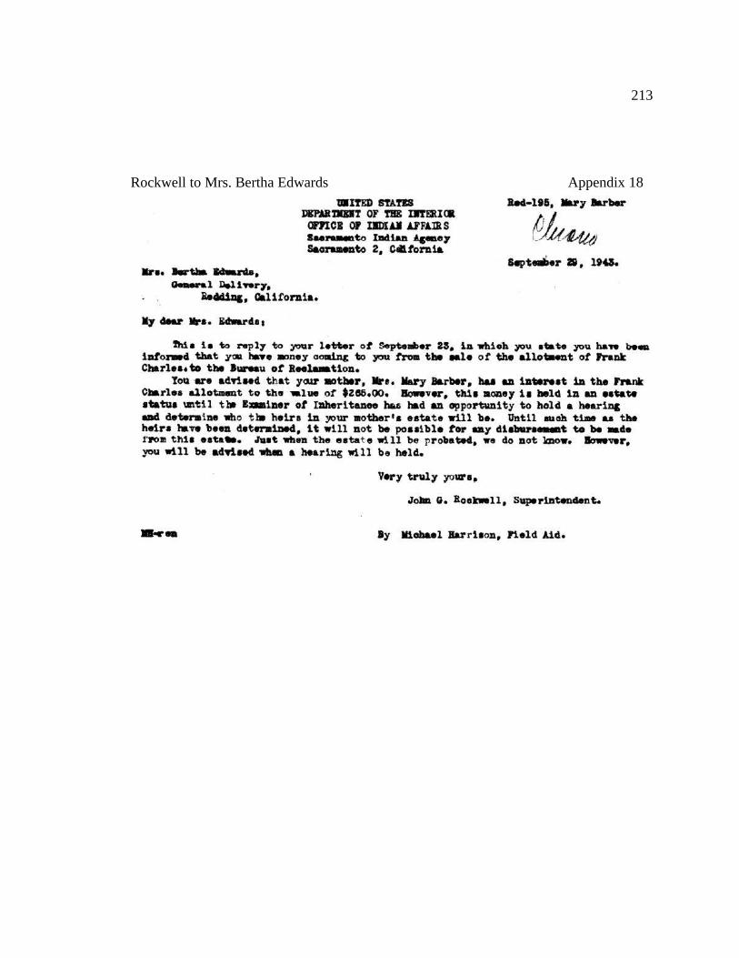
213
Rockwell to Mrs. Bertha Edwards Appendix 18
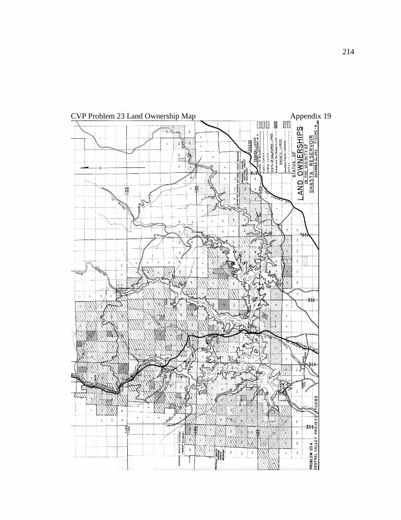
214
CVP Problem 23 Land Ownership Map Appendix 19