Los objetos de adorno en «piedras verdes» de la Península ...

EDICIÓN A CARGO DE DIPUTACIÓN DE CÁCERES- SEDPGYM
Foto portada: CASTILLETE DE MAMPOSTERIA DEL POZO CALLE
Minas de Logrosán. Fotografia de Paqui Piñas
PATRIMONIO GEOLÓGICO Y MINERO: DE LA INVESTIGACIÓN A LA DIFUSIÓN
LIBRO DE RESÚMENES DEL XV CONGRESO INTERNACIONAL
SOBRE PATRIMONIO GEOLÓGICO Y MINERO
XIX SESIÓN CIENTÍFICA DE LA SEDPGYM
Congreso en memoria de Vicente Sos Baynat y Craig Merideth
LOGROSÁN (CÁCERES, EXTREMADURA, ESPAÑA)
2014
EDITOR : JOSEP M. MATA – PERELLÓ

XV CONGRESO INTERNACIONAL SOBRE PATRIMONIO GEOLÓGICO Y MINERO. XIX SESIÓN CIENTÍFICA DE LA SEDPGYM. LOGROSÁN (CÁCERES), 25 – 28 DE SEPTIEMBRE DEL 2014. ISBN 978 – 84 – 693 – 1674 - 4
2

XV CONGRESO INTERNACIONAL SOBRE PATRIMONIO GEOLÓGICO Y MINERO. XIX SESIÓN CIENTÍFICA DE LA SEDPGYM. LOGROSÁN (CÁCERES), 25 – 28 DE SEPTIEMBRE DEL 2014. ISBN 978 – 84 – 693 – 1674 - 4
3
PATRIMONIO GEOLÓGICO Y MINERO: DE LA INVESTIGACIÓN A LA DIFUSIÓN
LIBRO DE RESÚMENES DEL
XV CONGRESO INTERNACIONAL SOBRE
PATRIMONIO GEOLÓGICO Y MINERO
XIX SESIÓN CIENTÍFICA DE LA
SEDPGYM
Congreso en memoria de
Vicente Sos Baynat y Craig Merideth
LOGROSÁN (CÁCERES, EXTREMADURA, ESPAÑA)
25 – 28 DE SEPTIEMBRE, 2014
Organizan
AYUNTAMIENTO DE LOGROSÁN
Sociedad Española para la Defensa del Patrimonio Geológico y Minero (SEDPGYM)
Colaboran
GOBIERNO DE EXTREMADURA DIPUTACIÓN DE CÁCERES
RED ELÉCTRICA DE ESPAÑA GEOPARQUE VILLUERCAS-IBORES-JARA
UNIVERSIDAD DE EXTREMADURA IGME
SENDERO INTERNACIONAL DE LOS APALACHES APRODERVI
AGEX TECMINSA, S.L.
EGEOMAPPING, S.L., ARQUEOPRO
Editor:
Josep María Mata-Perelló
Logrosán
2014

XV CONGRESO INTERNACIONAL SOBRE PATRIMONIO GEOLÓGICO Y MINERO. XIX SESIÓN CIENTÍFICA DE LA SEDPGYM. LOGROSÁN (CÁCERES), 25 – 28 DE SEPTIEMBRE DEL 2014. ISBN 978 – 84 – 693 – 1674 - 4
4
COMITÉ ORGANIZADOR
Presidente
Mark A. Hunt Ortiz, SEDPGYM
Vicepresidente
María Isabel Villa Naharro, Alcaldesa de la Villa de Logrosán
Tesorero
Mariano Ayarzagüena Sanz, SEDPGYM
Vocales
María Pilar Amaré Tafalla, SEDPGYM
Ester Boixereu, IGME, SEDPGYM
Mª Paz Dorado Martínez, Minas de Logrosán
David Duque Espino, Universidad de Extremadura
Francisco J. Fernández Amo, TECMINSA, S.L.
Juan Gil Montes, AGEX, Geoparque Villuercas-Ibores-Jara
Javier López Caballero, APRODERVI
Magín Murillo Fernández, AGEX, Geoparque Villuercas-Ibores-Jara
Ignacio Pavón Soldevila, Universidad de Extremadura
Francisca Piñas Encinar, Minas de Logrosán
Eduardo Rebollada Casado, SEDPGYM, AGEX, Geoparque Villuercas-Ibores-Jara
Alonso Rodríguez Díaz, Universidad de Extremadura
COMITÉ CIENTÍFICO
Presidente
Josep Mª Mata-Perelló, UPM, SEDPGYM
Vocales
Pura Alfonso Abella, UPC, SEDPGYM
José Manuel Brandão, SEDPGYM
Margarida Genera Monells, GENCAT, SEDPGYM
Francisco Guillén Mondéjar, U. de Murcia, SEDPGYM
Katia Hueso Kortekaas, Salinas de Interior, SEDPGYM
Luis Mansilla Plaza, UCLM, SEDPGYM
Ignacio Montero Ruiz, CSIC
David Parcerisa Doucastella, UPC, SEDPGYM
Fernando Pedrazuela González, Junta de Castilla y León, SEDPGYM
Andrés Pocoví Juan, U. de Zaragoza, SEDPGYM
Octavio Puche Riart, UPM, SEDPGYM
Kamal Tarquisti el Khalifi, U. de Tetuán, SEDPGYM
Editor: Josep María Mata-Perelló. Septiembre de 2014 Universidad Politécnica de Madrid, Departamento de Ingeniería Geológica. Ríos Rosas 21, 28003 – Madrid
Universitat Politècnica de Catalunya. Museu de Geologia de la UPC. Bases de Manresa 61 – 73. 08240 -
Manresa
ISBN 978 – 84 – 693 – 1674 - 4
© Autores y editores.
Los resúmenes que a continuación se exponen, han sido enviados a la organización del XV
CONGRESO INTERNACIONAL SOBRE PATRIMONIO GEOLÓGICO Y MINERO. XIX
SESIÓN CIENTÍFICA DE LA SEDPGYM (Logrosán, Cáceres, Extremadura, España, 25 - 28
de Septiembre de 2014). Corresponden a los originales entregados por los autores, de cuyo
texto, contenido y opiniones son responsables. Las únicas modificaciones que se han realizado
son de ajuste de formato de aquellos artículos que no respetaran las normas de edición.

XV CONGRESO INTERNACIONAL SOBRE PATRIMONIO GEOLÓGICO Y MINERO. XIX SESIÓN CIENTÍFICA DE LA SEDPGYM. LOGROSÁN (CÁCERES), 25 – 28 DE SEPTIEMBRE DEL 2014. ISBN 978 – 84 – 693 – 1674 - 4
5
I. NOTA DEL EDITOR
El presente volumen recoge los resúmenes de los trabajos que se van a presentar
durante el desarrollo del XV CONGRESO INTERNACIONAL SOBRE PATRIMONIO
GEOLÓGICO Y MINERO. XIX SESIÓN CIENTÍFICA DE LA SEDPGYM. Éste se va a
desarrollar en la población cacereña de Logrosán del 25 al 28 de septiembre del año 2014.
Ante todo, queremos manifestar nuestro agradecimiento a todos los autores que se han
interesado por contribuir con sus trabajos con este Congreso. Salvo contadísimas excepciones,
se han presentado dentro de los plazos estipulados. Con ello se nos ha facilitado nuestro trabajo
enormemente.
Hemos incluído en este libro tanto los resúmenes de las ponencias, como las de las
comunicaciones y murales. Así, en primer lugar están situados los resúmenes de las ponencias
y luego las de las comunicaciones y murales.
Por otra parte, nos ratificamos en lo que hemos dicho en otros libros editados: nosotros
hemos transcrito los originales entregados por los autores, de cuyo texto, ortografía, sintaxis
contenido y opiniones son responsables. Las únicas modificaciones que se han realizado son de
ajuste de formato de aquellos artículos que no respetaran las normas de edición.
En fin, queremos agradecer la buena disposición de todas las personas autoras de los
trabajos. Al mismo tiempo, deseamos que el Congreso sea un éxito perdurable en la memoria.
Josep M. Mata - Perelló
Septiembre del 2014

XV CONGRESO INTERNACIONAL SOBRE PATRIMONIO GEOLÓGICO Y MINERO. XIX SESIÓN CIENTÍFICA DE LA SEDPGYM. LOGROSÁN (CÁCERES), 25 – 28 DE SEPTIEMBRE DEL 2014. ISBN 978 – 84 – 693 – 1674 - 4
6

XV CONGRESO INTERNACIONAL SOBRE PATRIMONIO GEOLÓGICO Y MINERO. XIX SESIÓN CIENTÍFICA DE LA SEDPGYM. LOGROSÁN (CÁCERES), 25 – 28 DE SEPTIEMBRE DEL 2014. ISBN 978 – 84 – 693 – 1674 - 4
7
II. TABLA DE CONTENIDO
III. PONENCIAS
pp. 09 – 28
IV. COMUNICACIONES
pp. 29 – 104
IVa. COMUNICACIONES SOBRE PATRIMONIO GEOLÓGICO
pp. 35 – 40
IVb. COMUNICACIONES SOBRE PATRIMONIO MINERO
pp. 41 – 54
IVc. COMUNICACIONES SOBRE ARQUEOLOGÍA E HISTORIA DE
LA MINERÍA
pp. 55 - 86
IVd. PROTECCIÓN Y VALORIZACIÓN DEL PATRIMONIO
GEOLÓGICO Y MINERO
pp. 87 – 96
IVe. VALORES DIDÁCTICOS DEL PATRIMONIO GEOLÓGICO Y
MINERO
pp. 97 – 102
IVf. VARIA
pp. 103 – 104
XV CONGRESO INTERNACIONAL SOBRE PATRIMONIO GEOLÓGICO Y MINERO. XIX SESIÓN CIENTÍFICA DE LA SEDPGYM. LOGROSÁN (CÁCERES), 25 – 28 DE SEPTIEMBRE DEL 2014. ISBN 978 – 84 – 693 – 1674 - 4
8
V. MURALES
pp. 105 – 150
Va. MURALES SOBRE PATRIMONIO GEOLÓGICO
pp. 109 – 128
Vb. MURALES SOBRE PATRIMONIO MINERO
pp. 129 – 150
VI.ADENDA.COMUNICACIONES ADICIONALES
pp. 151 – 160
VI. ÍNDICES
pp. 161 - 170
VIa. ÍNDICE DE AUTORES
pp. 163 - 168
VIb. ÍNDICE GENERAL
pp. 169 - 170

XV CONGRESO INTERNACIONAL SOBRE PATRIMONIO GEOLÓGICO Y MINERO. XIX SESIÓN CIENTÍFICA DE LA SEDPGYM. LOGROSÁN (CÁCERES), 25 – 28 DE SEPTIEMBRE DEL 2014. ISBN 978 – 84 – 693 – 1674 - 4
9
III. PONENCIAS
pp. 09 – 28
EL PATRIMONIO GEOLÓGICO Y MINERO EN EXTREMADURA. LA
ADMINISTRACIÓN COMO GARANTE DE SU INVESTIGACIÓN,
CONSERVACIÓN Y DIFUSIÓN
CARLOS ALCALDE ……………………………………………………………………...… 11
DISCOVERING BRONZE AGE TIN: THE POTENTIAL OF TIN ISOTOPES
BIANCA NESSEL, GERHARD BRÜGMANN, ERNST PERNICKA …...……………….. 13
LA PRIMERA MINERÍA Y METALURGIA DEL ESTAÑO EN LA PENÍNSULA
IBÉRICA
JOÃO FONTE, ELIN FIGUEIREDO, BEATRIZ COMENDADOR REY, AARON
LACKINGER, CRISTINA FERNÁNDEZ FERNÁNDEZ,
EMMANUELLE MEUNIER …………………………………………………………… 15
DR. VICENTE SOS BAYNAT Y DR. CRAIG MERIDETH. DOS VISIONES SOBRE EL
CERRO DE SAN CRISTÓBAL.
EL PROFESOR DR. DON VICENTE SOS BAYNAT.
ALEJANDRO SOS.M.D. …………………………………………..…………...…………… 17
CRAIG MERIDETH AND EL CERRO DE SAN CRISTÓBAL
PHIL ANDREWS ……………………………………………………..……….…………… 19
LA EXPLOTACIÓN PROTOHISTÓRICA DEL ESTAÑO EN EL CERRO DE SAN
CRISTÓBAL DE LOGROSÁN (CÁCERES)
ALONSO RODRÍGUEZ DÍAZ …………………………………………………...………… 21
LA FOSFORITA DE LOGROSÁN.
ESTER BOIXEREU ………………………………………………………………………… 23
EL PATRIMONIO GEOLÓGICO-MINERO DEL GEOPARQUE VILLUERCAS-
IBORES-JARA.
EDUARDO REBOLLADA Y FRANCISCO JAVIER FERNÁNDEZ AMO ……………. 25
EL GEOPARQUE Y SU IMPACTO MÚLTIPLE EN EL ÁREA DE INFLUENCIA
JOSÉ M. BARRERA MARTÍN-MERÁS ………………………………………….….……. 27

XV CONGRESO INTERNACIONAL SOBRE PATRIMONIO GEOLÓGICO Y MINERO. XIX SESIÓN CIENTÍFICA DE LA SEDPGYM. LOGROSÁN (CÁCERES), 25 – 28 DE SEPTIEMBRE DEL 2014. ISBN 978 – 84 – 693 – 1674 - 4
10

XV CONGRESO INTERNACIONAL SOBRE PATRIMONIO GEOLÓGICO Y MINERO. XIX SESIÓN CIENTÍFICA DE LA SEDPGYM. LOGROSÁN (CÁCERES), 25 – 28 DE SEPTIEMBRE DEL 2014. ISBN 978 – 84 – 693 – 1674 - 4
11
EL PATRIMONIO GEOLÓGICO Y MINERO EN EXTREMADURA. LA
ADMINISTRACIÓN COMO GARANTE DE SU INVESTIGACIÓN,
CONSERVACIÓN Y DIFUSIÓN
GEOLOGICAL AND MINING HERITAGE IN EXTREMADURA. THE
ADMINISTRATION AS A GUARANTOR OF ITS RESEARCH, PRESERVATION
AND SPREADING
CARLOS ALCALDE Paseo de Roma, s/n, 06800 Mérida, España
JEFE DE LA SECCIÓN DE RECURSOS MINERALES Y ENERGÉTICOS, DIRECCIÓN GENERAL DE
INDUSTRIA Y ENERGÍA, GOBIERNO DE EXTREMADURA, ESPAÑA
RESUMEN:
Las características geológicas de Extremadura han permitido la génesis de un gran número de
indicios minerales, tanto metálicos como de rocas ornamentales y aguas minerales, que han sido
explotados a lo largo de la historia y que han dejado un importante legado. Los tartesios, los distintos
pueblos celtibéricos, los romanos, visigodos, árabes, etc., han aprovechado los ricos yacimientos de
hierro, cobre, plomo, cinc, oro, plata, wolframio, estaño, mármol, aguas minerales, etc., de la región,
como así atestiguan los textos históricos y los restos que podemos ver en la región.
La administración autonómica es consciente que ese rico legado minero, además de ser
considerado como recurso cultural y científico, puede convertirse en fuente de nuevos recursos
turísticos, y, por tanto, de desarrollo rural, económico y sociocultural de una zona.
Por ello, como primer paso, la Administración minera regional, actual Dirección General de
Industria y Energía, como órgano competente en el fomento y ordenación de la investigación y
explotación de los recursos minerales de la región, en convenio con el Instituto Geológico y Minero de
España, realizó en el periodo 2006-2010, la investigación y catalogación del patrimonio histórico
minero de Extremadura, el estudio de la evolución histórica de la minería en la región y su difusión a
través del portal http://sigeo.gobex.es, constituyendo la base para su puesta en valor y su conservación.
Como segundo paso, la Administración cultural, actual Consejería de Educación y Cultura, ha
declarado alguno de esos yacimientos, como Lugares de Interés Etnológico, por ejemplo, la mina
Abundancia y el poblado minero en Aldea Moret, Cáceres.
Por otro lado, la Administración ambiental de Extremadura, actual Dirección General de Medio
Ambiente, en el ámbito del patrimonio geológico y del minero, pero en su vertiente natural, ha
elaborado el inventario del Patrimonio Geológico de Extremadura, en el año 2005, y ha recuperado y
puesto en valor algunas antiguas explotaciones mineras: Mina La Jayona (Fuente del Arco, Badajoz),
Mina La Pastora (Aliseda, Cáceres) y declarado alguno de esos lugares como Monumento Natural.
Por último, destacar la labor de la Administración local, Diputaciones provinciales y
Ayuntamientos, en la tarea de fomento y desarrollo de proyectos turísticos y culturales, basados en el
patrimonio geológico y minero: Geoparque Villuercas-Ibores-Jara (Cáceres), Mina Costanaza
(Logrosán, Cáceres), Mina La Pastora (Aliseda, Cáceres), Mina Abundancia (Cáceres), Minas de Santa
Marta de los Barros (Badajoz), y diversos museos geológicos y mineros en varias localidades de
Extremadura.
Palabras clave: Patrimonio Minero, Patrimonio Geológico, Extremadura

XV CONGRESO INTERNACIONAL SOBRE PATRIMONIO GEOLÓGICO Y MINERO. XIX SESIÓN CIENTÍFICA DE LA SEDPGYM. LOGROSÁN (CÁCERES), 25 – 28 DE SEPTIEMBRE DEL 2014. ISBN 978 – 84 – 693 – 1674 - 4
12
ABSTRACT:
The geological characteristics of Extremadura have allowed the genesis of a large number of
mineral deposits, both metallic and of ornamental rocks and mineral water sprigs, which have been
exploited throughout history and have left an important related heritage.
Tartessians, Celtiberians, Romans, Visigoths, Arabs, etc., exploited the mineral deposits of iron, copper,
lead, zinc, gold, silver, tungsten, tin, marble, mineral water, etc, as is recorded in the historical texts and
documented by the remains that can be seen in the Extremadura region.
The Regional Administration is aware that this rich mining heritage, besides being recognized
as a cultural and scientific resource, may become an important factor of tourism interest, and therefore,
of rural, economic and socio-cultural development of an area.
Therefore, as a first step, the Regional mining administration (currently Dirección General de
Industria y Energía), as the competent body in the development and management of research and
exploitation of mineral resources in the Region, together with the Geological and Mining Institute of
Spain, conducted in the period 2006-2010, the research and catalogue of the historic mining heritage of
Extremadura, the study of the historical development of mining in the region and its diffusion through
the web site http://sigeo.gobex.es, constituting the basis for its public valorization and conservation.
As a second step, the Cultural administration (Consejería de Educación y Cultura) has declared
some of those Sites of Ethnological Interest, as is the case of Abundancia Mine and Aldea Moret
mining village, in Cáceres.
Simultaneously, the Environmental administration of Extremadura (Dirección General de
Medio Ambiente), focusing in the natural aspects of the Geological and Mining Heritage, carried out in
2005 the inventory of the Geological Heritage of Extremadura, and recovered and open to the public
some old mining exploitations: La Jayona Mine (Fuente del Arco, Badajoz), La Pastora Mine (Aliseda,
Cáceres), and declared some of these sites as Natural Monument.
Finally, the work done by local institutions, provincial councils (Diputaciones provinciales) and
town halls in the task of promoting and developing tourism and cultural projects based on the
geological and mining heritage must be pointed out: Geopark Villuercas-Ibores-Jara (Cáceres),
Costanaza Mine (Logrosán, Cáceres), La Pastora Mine (Aliseda, Cáceres), Abundancia Mine (Cáceres),
Santa Marta de los Barros Mines (Badajoz), and various geological and mining museums in different
locations in Extremadura.
Key words: Mining Heritage, Geological Heritage, Extremadura
XV CONGRESO INTERNACIONAL SOBRE PATRIMONIO GEOLÓGICO Y MINERO. XIX SESIÓN CIENTÍFICA DE LA SEDPGYM. LOGROSÁN (CÁCERES), 25 – 28 DE SEPTIEMBRE DEL 2014. ISBN 978 – 84 – 693 – 1674 - 4
13
DISCOVERING BRONZE AGE TIN: THE POTENTIAL OF TIN
ISOTOPES
DESCUBRIENDO EL ESTAÑO DE LA EDAD DEL BRONCE: LAS POSIBILIDADES
DE LOS ISÓTOPOS DE ESTAÑO
BIANCA NESSEL1, GERHARD BRÜGMANN
2, ERNST PERNICKA
2.
1: Institut für Geowissenschaften, Universität Heidelberg, 69120 Heidelberg, Germany
2: Curt-Engelhorn-Zentrum Archäometrie gGmbH, 68159 Mannheim, Germany
ABSTRACT:
Since the 19th century archaeologists are searching for the origin of bronze: a Cu-Sn alloy which
occurred during the early third millennium B.C., and an eponym for an epoch lasting more than two
thousand years. While great progress has been made concerning the provenance of copper the origin of
tin remains as one of the knottiest problems in archaeology, specifically with regard to the third and
second millennium BC.
In spite of much investigation and speculation, the provenance of tin in the Bronze Age and the origin
of the bronze technology still remain unknown. It seems that tin bronze was first produced and used in
regions of Anatolia or Mesopotamia where no significant tin deposits are known. In addition, early
objects of tin bronze are found in regions that are separated by long distances from each other. This
suggests the presence of a complex network of a far-ranging tin trade and opens up another set of
problems: Where was this alloy invented and how was the technology distributed? Since it is spread all
over the ancient world within a relatively short time span the question arises, whether it was invented
several times at different locations.
Apart from the difficulties to find tin deposits and production sites that were exploited in prehistoric
times by applying traditional textual, geological and archaeological evidence, even geochemical
approaches proved to be problematic, if one attempts to associate potential ore sources with
archaeological artefacts. For example, the Pb isotopic composition of Cu artifacts proved to be a
reliable tool to relate them to a specific Cu ore province. However, due to the low Pb content in tin
minerals this isotope system cannot deliver a fingerprint of the tin source in Cu-Sn alloys. Therefore,
our multi-disciplinary research project at the Curt-Engelhorn-Center for Archeometry at Mannheim and
the Faculty of Chemistry and und Geosciences at the University of Heidelberg, funded by an Advanced
Grant of the European Research Council (ERC) has the overall goal to establish the Sn isotopic
composition of tin ores and tin and bronze artefacts as a reliable technique to determine the provenance
of tin in the Bronze Age of the Old World. Variations in the Sn isotopic composition can occur when
natural chemical-physical processes involved in the formation of granites and of tin deposits, such as
diffusion, evaporation, melting, hydrothermal circulation, mineral precipitation fractionate isotopes
with different masses. The ERC project will focus on the investigation of tin ore deposits in Europe, the
Near East, and Central Asia as well as on the Early Bronze Age tin bronzes found in these regions. We
also investigate the mechanisms that lead to fractionation of tin isotopes. These results will have an
important impact on our understanding of the nature of geological tin deposits and may have major
implications for the authentication of antiquities made of bronze.
We will investigate the variability of tin isotope ratios in geological tin deposits in order to distinguish
them and to possibly associate Bronze Age metal artefacts with them. The spread of the bronze
metallurgy from the eastern Mediterranean to central Europe will be studied by the analysis of tin
isotopes in Early Bronze Age metal artefacts from southeastern Europe and their comparison with those
of contemporary ones from the Mediterranean. The major objective is to answer the question in which
way and by which route the bronze technology was transmitted from the Mediterranean to central
Europe: either via the Balkan Peninsula or via sea trade with the British Isles. This involves also the
question of possible multiple innovation or a single discovery that spread out over the entire Old World
from a single root in Eurasia.

XV CONGRESO INTERNACIONAL SOBRE PATRIMONIO GEOLÓGICO Y MINERO. XIX SESIÓN CIENTÍFICA DE LA SEDPGYM. LOGROSÁN (CÁCERES), 25 – 28 DE SEPTIEMBRE DEL 2014. ISBN 978 – 84 – 693 – 1674 - 4
14
The ERC project is multi-disciplinary by necessity and the results need to be put into the archaeological
context. The impact will be a major advance in our understanding of the earliest complex societies with
craft specialization and the formation of cities and empires. Such complex societies are much more
dependent on the supply of raw material from distant regions, such as tin metal.
KEY WORDS: Bronze Age, Sn isotopic composition, Cu-Sn alloy, Sn deposits
RESUMEN:
Desde el siglo XIX los arqueólogos están intentando descubrir el origen del bronce, una aleación de
cobre (Cu) y estaño (Sn) que aparece a principios del III milenio a.C., epónimo de una época de más de
dos mil años de duración. Mientras que se han hecho grandes progresos en relación con la procedencia
del cobre, la procedencia del estaño y el origen de la tecnología del bronce continúan siendo uno de los
grandes enigmas arqueológicos sin resolver, especialmente respecto a III y II milenios a.C. Parece que
el bronce fue producido y utilizado inicialmente en regiones de Anatolia y Mesopotamia en las que no
se conocen depósitos de estaño significativos. Además, los primeros objetos de bronce se han
descubierto en áreas separadas por grandes distancias. Estas circunstancias sugieren la existencia de una
red compleja de intercambio de largo alcance y plantean una serie de cuestiones:¿dónde se inventó el
bronce y como se expandió su tecnología?. Puesto que se extendió a lo largo de todo el mundo antiguo
en un periodo de tiempo relativamente corto, se plantea la posibilidad de un posible descubrimiento
reiterado en distintos sitios independientemente.
Además de la dificultad de localizar depósitos de estaño y sitios de producción prehistóricos mediante
las técnicas tradicionales -evidencias textuales, geológicas y arqueológicas-, anteriores aproximaciones
desde la geoquímica, como los isótopos de plomo, se mostraron ineficaces para la determinación de la
huella isotópica del Sn en el bronce a la hora de asociar potenciales fuentes de Sn con artefactos
arqueológicos.
Así, el Proyecto de Investigación multidisciplinar que se presenta, financiado por una ERC Advanced
Grant, tiene el objetivo global de determinar la composición isotópica de Sn de los depósitos minerales
de Sn y de los objetos arqueológicos de Sn y Cu-Sn, como una técnica fiable para establecer la
procedencia del Sn en el mundo antiguo en la Edad del Bronce. Variaciones en la composición
isotópica del Sn pueden darse por fraccionamiento de los isótopos de diferentes masas debido a
procesos naturales físico-químicos durante la formación de los granitos y de los depósitos de Sn, por lo
que se investigarán los mecanismos de fraccionamiento de los isótopos de Sn y la variabilidad de sus
proporciones en los depósitos. Los resultados tendrán una importante incidencia en el conocimiento
geológico de los depósitos de estaño y pueden tener una relevancia decisiva en relación con la
autenticidad de antigüedades realizadas en bronce.
El Proyecto se centrará en la investigación de los depósitos minerales de Sn de Europa, Oriente
Próximo y Asia Central, para poder distinguirlos isotópicamente, así como en los objetos de bronce la
Edad del Bronce documentados en estas regiones, con los que serán relacionados isotópicamente. La
difusión de la metalurgia del bronce desde el Mediterráneo oriental hasta Europa central se estudiará a
través del análisis de isótopos de Sn de objetos metálicos de la Edad del Bronce inicial del sureste de
Europa y de su comparación con objetos contemporáneos del Mediterráneo. Uno de los mayores
objetivos es responder a la pregunta de cómo y por qué ruta la tecnología del bronce fue transmitida
desde el Mediterráneo a Europa central, ya sea a través de los Balcanes, o por vía marítima con las
Islas Británicas.
El Proyecto es necesariamente multidisciplinar y los resultados han de situarse en su contexto
arqueológico. Se espera que esos resultados representen un gran avance para el conocimiento de las
tempranas sociedades complejas con especialización artesanal y para la formación de las ciudades e
imperios. Esas sociedades complejas son mucho más dependientes del suministro de materia prima de
regiones lejanas, como sería el caso del estaño metálico.
PALABRAS CLAVE: Edad del Bronce, composición isotópica Sn, aleación Cu-Sn, depósitos
minerales de estaño

XV CONGRESO INTERNACIONAL SOBRE PATRIMONIO GEOLÓGICO Y MINERO. XIX SESIÓN CIENTÍFICA DE LA SEDPGYM. LOGROSÁN (CÁCERES), 25 – 28 DE SEPTIEMBRE DEL 2014. ISBN 978 – 84 – 693 – 1674 - 4
15
LA PRIMERA MINERÍA Y METALURGIA DEL ESTAÑO EN LA
PENÍNSULA IBÉRICA
THE FIRST MINING AND METALLURGY OF TIN IN THE IBERIAN PENINSULA
JOÃO FONTE
Incipit/CSIC, Santiago de Compostela, España, [email protected]
ELIN FIGUEIREDO
CENIMAT/I3N, Faculdade de Ciências e Tecnologia, Universidade Nova de Lisboa, Portugal
BEATRIZ COMENDADOR REY, AARON LACKINGER, CRISTINA FERNÁNDEZ
FERNÁNDEZ
GEEAT, Faculdade de Historia, Universidade de Vigo, España
EMMANUELLE MEUNIER
CNRS-TRACES-UMR5608, Université Toulouse II - Le Mirail, Francia
RESUMEN:
La Península Ibérica, y más concretamente el noroeste ibérico, constituye una de las regiones
más ricas en minerales de estaño – cassiterita- del territorio Europeo. La fuerte actividad minera ligada
al wolframio en la primera mitad del siglo XX, dada la coincidencia de estas mineralizaciones con las
de estaño, propició el ocultamiento o destrucción de posibles evidencias de minería antigua. Sin
embargo, son recurrentes los relatos y documentos escritos sobre evidencias más antiguas de
explotación, anteriores a la “reapertura” de muchos de estos enclaves mineros.
En el presente trabajo presentaremos un estado de la cuestión de las posibles vías de
investigación abiertas para el estudio de la minería y la metalurgia del estaño Ibérico. Algunas de estas
líneas de trabajo han sido exploradas en investigaciones recientes efectuadas por miembros del Grupo
Cassiteros. Abordamos cuestiones relacionadas con paisajes mineros y posibles circuitos de intercambio
de bienes, la existencia/ausencia de materiales metalúrgicos relacionados con la producción de estaño
en yacimientos arqueológicos, el hallazgo de materiales/artefactos antiguos en minas “reabiertas” en el
siglo XX, así como una pequeña introducción a la cuestión del estaño en la economía reciente (siglo
XX), dando énfasis a la importancia que este metal pudo tener en la economía antigua y reciente del
Noroeste Peninsular. Al mismo tiempo, presentamos una propuesta sobre las posibilidades de
valorización de estos recursos, tanto en el ámbito de la historiografía de la pre y protohistoria europea,
como en el ámbito patrimonial.
Palabras clave: Estaño; NW Península Ibérica; Bronce; Pre y Protohistoria
Agradecimentos: Los estudios y resultados presentados contaron con el apoyo de los trabajos
efectuados por los investigadores del Grupo Cassiteros (Early Tin Group: http://cassiteros.com), así
como del apoyo financiero (en Portugal) de la Fundação Portuguesa para a Ciência e Tecnologia en el
ámbito de becas individuales SFRH/BPD/97360/2013 y SRFH/BD/65143/2009 y del proyecto
estratégico PEst-C/CTM/LA0025/2013/2014 concedido al CENIMAT/I3N, y (en España) de la
Universidade de Vigo/Deputación de Ourense para el “Proyecto de intervención arqueológica en el
monte Urdiñeira y su entorno (Ayuntamientos de Riós y A Gudiña, Ourense)” 2009-INOU-04 y “Alto
Támega: Acciones en el Paisaje Patrimonial” 2013/CITI/131H/647/INOU13-02.
ABSTRACT:
The Iberian Peninsula, namely the North-western Iberian area, is one of the richest regions in
tin ores – cassiterite – in the European territory. However, the strong mining activity linked to tungsten
in the first half of the twentieth century, and the coincidence of these mineralizations with tin ones, led

XV CONGRESO INTERNACIONAL SOBRE PATRIMONIO GEOLÓGICO Y MINERO. XIX SESIÓN CIENTÍFICA DE LA SEDPGYM. LOGROSÁN (CÁCERES), 25 – 28 DE SEPTIEMBRE DEL 2014. ISBN 978 – 84 – 693 – 1674 - 4
16
to the covering or destruction of possible evidences of ancient mining works. Nevertheless, in written
documents related to many of these recent mining sites, there are frequent reports about earlier local
evidence of mining exploitations, leading to the frequent expression of "reopening of the mine".
In this work we present a state of the art of the possible pathways of investigation open for the
study of mining and metallurgy of Iberian tin. Some of these lines have been explored in recent research
conducted by the members of the Cassiteros Group. We address issues related to mining landscapes and
possible circuits of goods exchange, the existence/absence of metallurgical materials related with tin
production in archaeological sites, the finding of ancient materials/artefacts in "reopened" mines in the
twentieth century and a brief introduction to the issue of tin in the recent economy (XX century),
emphasizing the importance that this metal may have played in ancient and recent North-western
Iberian economy. At the same time, we present a proposal on the potential use of these resources, both
in terms of the historiography of European pre and proto-history, as in the heritage sector.
Key words: Tin; NW Iberian Peninsula; Bronze; Pre-Proto-history.
Acknowledgments: The studies and results presented were supported by the work done by
researchers of the Cassiteros Group (Early Tin Group: http://cassiteros.com) and financial support (in
Portugal) from the Fundação Portuguesa para a Ciência e Tecnologia with individual scholarships
SFRH/BPD/97360/2013 and SRFH/BD/65143/2009 and the PEst-C/CTM/LA0025/2013/2014 strategic
project awarded to CENIMAT/I3N, and (in Spain) of Universidade de Vigo/Deputación de Ourense
“Proyecto de intervención arqueológica en el monte Urdiñeira y su entorno (Ayuntamientos de Riós y
A Gudiña, Ourense)” INOU-2009-04 and “Alto Támega: Acciones en el Paisaje Patrimonial”
2013/CITI/131H/647/INOU13-02.

XV CONGRESO INTERNACIONAL SOBRE PATRIMONIO GEOLÓGICO Y MINERO. XIX SESIÓN CIENTÍFICA DE LA SEDPGYM. LOGROSÁN (CÁCERES), 25 – 28 DE SEPTIEMBRE DEL 2014. ISBN 978 – 84 – 693 – 1674 - 4
17
EL PROFESOR DR. DON VICENTE SOS BAYNAT
THE PROFESSOR DR. DON VICENTE SOS BAYNAT
ALEJANDRO SOS.M.D. [email protected]
RESUMEN
Mi presentacion es el resultado de haberseme pedido que diserte acerca de las muchas
contribuciones que hizo mi padre, Prof. Dr.Don Vicente Sos Baynat, al estudio del batolito
granitico de Logrosan, la llamada Sierra de San Cristobal, y sus alrededores. Los estudios a que
me refiero en mi disertacion comprenden el estudio geologico de la Sierra. Mas adelante, su
descripcion de hallazgos arqueologicos, en la misma Sierra,1977, sirvieron para promover en
tiempos mas recientes estudios sobre el pasado lejano de la misma, desde un punto de vista
humano.
I. Geologia, Mineralogia, y Mineralogenia de la Sierra de San Cristobal, Logrosan
(Caceres).1963/1967.
Es un trabajo muy completo. En el mismo describe el resultado de sus estudios sobre
San Cristobal. Analiza la 1.Fisiografia: comarca, morfologia( montanas, rios, batolito
granitico.2.La Geologia. Los terrenos y sus clases. Formaciones estratigraficas. Relaciones
entre el cambrico y el Silurico. Terrenos terciarios. Terrenos Cuaternarios. Formaciones
estratigraficas metamorficas, y sus caracteres. 3. La Sierra de San Cristobal.Su
entorno,Tectonica de la Sierra.Granitos.. Filones cuarciferos. Filones neumatoliticos,
Turmaliniferos, Arseniferos, Estanniferos. Filones Hidrotermales. Los Manantiales. 4. La
Mineralogia: Feldespatos, Micas, Cuarzos. Minerales Plutonicos. Neumatoliticos: turmalina,
mispiquel, casiterita y sus maclas.Genesis y Paragenesis.Otros. 5. Tabla Paragenetica. 6.
Tectonica. 7. Orogenia .8.Conclusiones generales.
II. Los Hallazgos Prehistoricos de Logrosan (Caceres). 1977.
Es un trabajo comprensivo sobre las estructuras arqueologicas que fueron apareciendo,
o en los lavados de las arenas y del material excavado, o de algun hallazgo que tuvo lugar en
superficie. Establece que los objetos de piedra posiblemente pertenecen al eneolitico, y se pasa
al calcolitico, y a plena edad de Bronce.Cronologicamente unos 2000 anos anteriores a la Era
Presente.Encuentra pesos de bronce, moldes de fundicion, y otros objetos, incluido un
interesante Idolo de bronce. Aventura su idea de que esta primitiva industria minera, mineria
del estano, debia estar "alimentada" por el comercio con Tartessos, y alli, hasta las margenes
del Guadalquivir, debia marchar la produccion Estannifera de Logrosan.
Escritos muy posteriores, del Dr. Meredith, y de otros, han avalado este comercio de
tipo minero.

XV CONGRESO INTERNACIONAL SOBRE PATRIMONIO GEOLÓGICO Y MINERO. XIX SESIÓN CIENTÍFICA DE LA SEDPGYM. LOGROSÁN (CÁCERES), 25 – 28 DE SEPTIEMBRE DEL 2014. ISBN 978 – 84 – 693 – 1674 - 4
18

XV CONGRESO INTERNACIONAL SOBRE PATRIMONIO GEOLÓGICO Y MINERO. XIX SESIÓN CIENTÍFICA DE LA SEDPGYM. LOGROSÁN (CÁCERES), 25 – 28 DE SEPTIEMBRE DEL 2014. ISBN 978 – 84 – 693 – 1674 - 4
19
CRAIG MERIDETH AND EL CERRO DE SAN CRISTÓBAL
CRAIG MERIDETH Y EL CERRO DE SAN CRISTÓBAL
PHIL ANDREWS
Wessex Archaeology Ltd
Wessex Archaeology, Portway House, Old Sarum Park, Salisbury SP4 6EB, United Kingdom
p.andrews@ wessexarch.co.uk
EARLY MINES RESEARCH GROUP
ABSTRACT:
Craig Merideth first visited el Cerro de San Cristóbal in the early 1990s during his survey for tin mining and
smelting sites in central western Iberia. This survey was the subject of his PhD research, carried out whilst at the
Institute of Archaeology, University College London, and subsequently published in 1998. Specifically interested
in evidence for Bronze Age tin exploitation, he highlighted the potential significance of this important site, which
had been identified earlier by Sos Baynat.
After completing his PhD, Craig Merideth began further investigations at el Cerro de San Cristóbal, initially
carrying out survey work and mapping the remains on the western part of the hill, and subsequently undertaking
excavations in this area between 1998 and 2002. The investigations involved a small team from the UK and
collaboration with Alonso Rodriguez Diaz and Ignacio Pavon Soldevilla at the Department of Prehistoric Studies,
Universidad de Extramadura, Caceres.
The initial survey showed the western half of the hill to be covered with Late Bronze Age pottery (dating to c
800–600BC; Bronce Final–Orientalizante Pleno y Reciente) and a large number of stone tools used for the mining
and crushing of ore. In contrast, the eastern half of the hill appeared to have only medieval and later remains,
apparently unassociated with mining and metalworking. It was clear from the surface that there had been
disturbance to archaeological deposits from mining activity in the 1950s and 1960s, though excavation showed
relatively little damage to prehistoric remains at shallow depth below.
Several Late Bronze Age oval structures were defined by lines of stones, and floors and hearths survived in some.
In one example the floor sealed a quartz vein which had been removed to a depth of almost 1m, presumably to
extract cassiterite. Other quartz veins showed similar evidence for working, probably during the later Bronze Age.
Metalworking evidence included parts of two large crucibles, a mould, at least 30 fragments of copper ingots and
several bronze weapons, some of which had been cut up ready for re-melting. Analysis has suggested the
possibility that crushed cassiterite (rather than tin metal) was added directly to the molten copper in the crucible,
though concentrated cassiterite is also likely to have been taken off site for use in bronze production elsewhere.
El Cerro de San Cristóbal is unique in Spain for the evidence it provides for Bronze Age tin production, and the
results of the 1998 excavation were published soon after in 2001. Craig Merideth’s untimely death in 2005
occurred before the 2000–2 work had been prepared, but it is anticipated that this will be completed following the
Congress in Logrosán and published in conjunction with the excavations undertaken in 2013 by Mark Hunt and
his team. This will provide an appropriate tribute to Craig Merideth’s interest in Iberian archaeometallurgy (which
began with Beno Rothenberg at Rio Tinto in 1979) and especially his work at el Cerro de San Cristóbal.
Key words: Tin, Bronze Age, Mining, Metalworking.
RESUMEN:
Craig Merideth visitó por primera vez el Cerro de San Cristóbal a principios de la década de 1990 durante la
realización de las prospecciones que realizada de yacimientos mineros y metalúrgicos de estaño. Este estudio
arqueológico constituyó su tesis doctoral en el Instituto de Arqueología, University College London, publicada en
1998. Especialmente interesado en la explotación del estaño en la Edad del Bronce, señaló la potencial relevancia
de este importante yacimiento, que Sos Baynat había identificado previamente.

XV CONGRESO INTERNACIONAL SOBRE PATRIMONIO GEOLÓGICO Y MINERO. XIX SESIÓN CIENTÍFICA DE LA SEDPGYM. LOGROSÁN (CÁCERES), 25 – 28 DE SEPTIEMBRE DEL 2014. ISBN 978 – 84 – 693 – 1674 - 4
20
Tras finalizar su tesis doctoral, Craig Merideth continuó con la investigación en el Cerro de San Cristóbal,
primero mediante la realización de prospecciones y la planimetría de los restos de la parte occidental del Cerro y,
posteriormente, realizando excavaciones entre 1998 y 2002. Los trabajos fueron realizados por un reducido equipo
británico, con la colaboración de Alonso Rodriguez Diaz e Ignacio Pavon Soldevilla, del Departamento de
Prehistoria, Universidad de Extremadura. Las prospecciones iniciales en la mitad occidental del Cerro
documentaron abundante cerámica del Bronce Final (datada aprox. entre el 800-600 a.C.; Bronce Final-Periodos
Orientalizantes Pleno y Reciente) y numerosos útiles de piedra usados en la minería y machacado del mineral. Por
el contrario, parecía que en la mitad oriental del Cerro solo existían restos medievales y posteriores, sin relación
aparente con minería-metalurgia.
La revisión superficial dejó claro que los niveles arqueológicos habían sido afectados por la actividad minera
desarrollada en las décadas de 1950-1960, aunque la excavación mostró una afección relativamente reducida a los
restos prehistóricos, localizados a escasa profundidad.
Varias estructuras ovales de la Edad del Bronce estaban definidas por alineaciones de piedras, conservándose en
alguna niveles de suelos y hogares. En un caso, el nivel de suelo sellaba una veta de cuarzo, explotada hasta una
profundidad de 1 m, presumiblemente para la extracción de la casiterita. Otra veta de cuarzo mostró similares
evidencias de explotación, seguramente durante un momento posterior de la Edad del Bronce.
Los elementos metalúrgicos recuperados incluían fragmentos de dos grandes crisoles, un molde, al menos 30
fragmentos de lingotes de cobre y diversas armas de bronce, algunas de las que habían sido cortadas para su
refundición. Los análisis realizados sugieren que la casiterita machacada (más que estaño metálico) era añadida
directamente en el crisol al cobre fundido, aunque probablemente también casiterita concentrada fuera sacada del
yacimiento para su uso en la producción de cobre en otros sitios.
El Cerro de San Cristóbal es un yacimiento único en España por la evidencia que proporciona de la producción de
bronce en la Edad del Bronce. Los resultados de la campaña de 1998 fueron publicados en 2001, pero la
inesperada muerte de Craig Merideth en 2005 se produjo antes de que el trabajo realizado entre 2000-2 estuviese
preparado. Ahora, tras el congreso de Logrosán, se pretende finalizarlo en conjunto con los resultados de las
excavaciones realizadas en 2013 bajo la dirección de Mark Hunt. Esto supondría el tributo más adecuado al
trabajo desarrollado por Craig Merideth sobre la arqueo-metalurgia ibérica (que empezó en 1979 con Beno
Rothenberg en Rio Tinto) y, especialmente, sus investigaciones en el Cerro de San Cristóbal.
Palabras clave: Estaño, Edad del Bronce, Minería, Metalurgia
Craig Merideth, a la derecha, durante las excavaciones del Cerro de San Cristóbal

XV CONGRESO INTERNACIONAL SOBRE PATRIMONIO GEOLÓGICO Y MINERO. XIX SESIÓN CIENTÍFICA DE LA SEDPGYM. LOGROSÁN (CÁCERES), 25 – 28 DE SEPTIEMBRE DEL 2014. ISBN 978 – 84 – 693 – 1674 - 4
21
LA EXPLOTACIÓN PROTOHISTÓRICA DEL ESTAÑO EN EL CERRO
DE SAN CRISTÓBAL DE LOGROSÁN (CÁCERES)
THE PROTOHISTORIC TIN EXPLOITATION IN THE CERRO DE SAN
CRISTÓBAL (LOGROSÁN, CÁCERES)
ALONSO RODRÍGUEZ DÍAZ Área de Prehistoria, Dep.de Historia, Universidad de Extremadura, 10.005 Cáceres (España)
G. I. PRETAGU, UEX
RESUMEN:
En esta comunicación se sintetizarán los resultados obtenidos en los estudios arqueológicos y
arqueomineros desarrollados en el Cerro de San Cristóbal (Logrosán, Cáceres) entre 1998 y 2002.
Dichos trabajos, promovidos por el Dr. Craig Merideth hasta su repentino fallecimiento en 2005,
permitieron identificar un asentamiento minero-metalúrgico especializado en la explotación de la
casiterita en época protohistórica. A pesar de las severas alteraciones provocadas por las explotaciones
de los años cincuenta del siglo XX, se documentaron trazas de labores antiguas, restos de cabañas de
planta oval y abundante material arqueológico de diversa naturaleza (cerámicas, piezas líticas y
metálicas, etc.). A partir de todo ello se ha llegado a proponer la probable “cadena operativa” del
beneficio de la casiterita en este lugar durante el tránsito Bronce Final-Orientalizante (siglos IX/VIII-
VII/VI a.C.). La gestión e integración del mineral en las relaciones Tajo-Guadiana y en los circuitos
atlántico-mediterráneos confluyentes en el Suroeste ibérico parecen justificar, entre otras razones, la
pronta imbricación del actual territorio extremeño en Tartessos.
Por último, se avanzarán también los resultados de las últimas actuaciones realizadas en 2013
en San Cristóbal, encaminadas, por un lado, a profundizar en el conocimiento de su ocupación
prohistórica y de otras de cronología posterior (medieval y moderna); y, por otro, a potenciar su valor
patrimonial tras su declaración como “geositio” dentro del Geoparque “Villuercas-Ibores-Jara”.
Palabras clave: Casiterita, Minería, Metalurgia, Tartessos, Geoparque Villuercas-Ibores-Jara.
ABSTRACT:
In this paper the results obtained by the archaeological and archaeo-mining studies carried out
in the Cerro de San Cristóbal (Logrosán, Cáceres) between 1998 and 2002 are presented. These works,
promoted by Dr. Craig Merideth until his sudden death in 2005, allowed to identify a Protohistoric
mining-metallurgical settlement specialized in the exploitation of cassiterite. Despite severe impact of
the mining exploitation of the 20th century, in the 1950 decade, remains of old mining works and oval
huts were documented, together with abundant archaeological related material of diverse type (hand
made pottery, lithic and metal objects, etc.). From all that data, an hypothetical "operational chain" for
the use of cassiterite in this site during the transition of the Late Bronze Age/Orientalizing period
(9th/8
th-7
th/6
th centuries BC) has been proposed. The management and integration of the tin mineral in
the Tagus-Guadiana relationships and jn the Atlantic-Mediterranean trade networks coinciding in the
South-Western Iberia seem to justify, among other reasons, the early interaction of the current
Extremadura territory with Tartessos.
Finally, the preliminary results of the recent archaeological work, carried out in 2013 in Cerro
de San Cristóbal will be summarized. This campaign was aimed, firstly, to obtain a deeper knowledge

XV CONGRESO INTERNACIONAL SOBRE PATRIMONIO GEOLÓGICO Y MINERO. XIX SESIÓN CIENTÍFICA DE LA SEDPGYM. LOGROSÁN (CÁCERES), 25 – 28 DE SEPTIEMBRE DEL 2014. ISBN 978 – 84 – 693 – 1674 - 4
22
on the Protohistoric site and on other identified settlements of later chronology (Medieval and Modern)
and, also, to increase its patrimonial values after the declaration of the Cerro de San Cristóbal as a
Geosite within the “Villuercas-Ibores-Jara” Geopark.
Key words: Cassiterite, Mining, Metallurgy, Tartessos, Villuercas-Ibores-Jara Geopark.

XV CONGRESO INTERNACIONAL SOBRE PATRIMONIO GEOLÓGICO Y MINERO. XIX SESIÓN CIENTÍFICA DE LA SEDPGYM. LOGROSÁN (CÁCERES), 25 – 28 DE SEPTIEMBRE DEL 2014. ISBN 978 – 84 – 693 – 1674 - 4
23
LA FOSFORITA DE LOGROSÁN
THE PHOSPHORITE OF LOGROSAN
ESTER BOIXEREU VILA [email protected]
Dirección de Investigación en Recursos Geológicos. Instituto Geológico y Minero de España.
Ríos Rosas, 23 28003 MADRID
Sociedad española para la defensa del patrimonio geológico y minero. (SEDGYM)
RESUMEN:
La localidad cacereña de Logrosán cuenta con una importante tradición minera debida principalmente a
la explotación de fosforita, si bien a lo largo de la historia también se beneficiaron otras sustancias,
tales como cobre, estaño, wolframio y oro.
Desde el punto de vista geológico, se puede considerar que la mineralización de fosforita de Mina
Costanaza está relacionada con el emplazamiento del stock granítico tardivarisco del cerro de San
Cristóbal que desarrolla una aureola metamórfica en las pizarras y grauvacas del Complejo Esquisto
Grauváquico (Precámbrico Superior). El yacimiento es de tipo filoniano extrabatolítico, compuesto por
un sistema de varios filones paralelos de direccion NE-SW de morfología arrosariada. La paragénesis es
de cuarzo- apatito (fosforita), con abundante anquerita.
La presencia de fosforita en Logrosán es conocida desde el siglo XVIII. Ejemplares de fosforita
procedentes de Logrosán formaban parte de las más importantes colecciones minerales europeas. Las
muestras con las que Proust definió por primera vez el fluorapatito en 1781, procedían de este paraje,
por lo que se considera localidad tipo.
El desarrollo de la industria de fertilizantes en Europa durante el siglo XIX, demandaba materias primas
fosfatadas. En esa época, se conocían muy pocos yacimientos de minerales fosfatados en el mundo, por
lo que el yacimiento de Logrosán cobró gran interés. Durante todo el siglo XIX, el yacimiento de
Logrosán fue objeto de numerosos estudios e intentos de aprovechamiento tanto por parte de empresas
extranjeras, principalmente inglesas, como españolas. En esa época esta localidad fue escenario en que
desarrollaron sus trabajos de investigación geólogos e ingenieros de gran relevancia, como Daubeny,
Widdrington, Le Play, Choffat, Naranjo, de Prado, Egozcue y Mallada.
Lamentablemente, las redes viarias extremeñas eran muy precarias y las dificultades en el transporte,
encarecían el producto, por lo que la explotación industrial de las minas no se inició hasta 1907. Con el
fin de explotar los minerales con una ley inferior al 60%, se instaló una fábrica de superfosfatos junto a
las minas. Las labores permanecieron activas hasta el año 1946. De ellas calculamos que se extrajeron
en total poco más de 200.000 t de mineral, correspondiendo toda la producción al filón La Costanaza.
En este trabajo se pretende sintetizar la trayectoria histórica de la actividad minera de la fosforita,
incluyendo una breve descripción de sus características geológicas y de la génesis del yacimiento
PALABRAS CLAVE: Logrosán, patrimonio histórico-minero, filones extrabatolíticos, fosforita.
ABSTRACT
Logrosan, a small town in the province of Caceres, has a long mining tradition, not only with
phosphorite but also with tin, copper, tungsten and gold.
The phosphorite minarelisation of the mine La Costanaza is related to the granitic stock of San

XV CONGRESO INTERNACIONAL SOBRE PATRIMONIO GEOLÓGICO Y MINERO. XIX SESIÓN CIENTÍFICA DE LA SEDPGYM. LOGROSÁN (CÁCERES), 25 – 28 DE SEPTIEMBRE DEL 2014. ISBN 978 – 84 – 693 – 1674 - 4
24
Cristobal’s Hill where it takes the shape of a metamorphic circle of shale and wackes in the Complejo
Esquisto Grauváquico (late Precambirc). The ore deposit is of an extra-batolitic vein type, made by a
system of various paralell veins running NE-SW for several kilometers. The paragenetic associtation is
quartz-apatite (phospohorite), with abundant ankerite.
The existence of phosphorite in Logrosán is known since the 18th century. In 1781, Proust definded
fluorapatite from samples taken from this site, thus Logrosan in considered the phosphorite type
locality.
With the development of the fertilizer insdutry in the 19th century, a great demand of of phosphatated
minerals ensued. Therefore, even if a number of studies and exploitation attemps were carried out, the
actual exploitation did not start until 1907. A superphosphate plant was was set up near the mine.
Mining went on until 1946 and the overall production of mineral is estimated at over 200.00 t.
In this paper, the author traces the history of the phosphorite mining activity, summarizes its geologic
features and concludes with an inventory of the mineral heritage preserved.
KEY WORDS: Logrosán, historical- mining heritage, extrabatolithic veins, phosphorite.

XV CONGRESO INTERNACIONAL SOBRE PATRIMONIO GEOLÓGICO Y MINERO. XIX SESIÓN CIENTÍFICA DE LA SEDPGYM. LOGROSÁN (CÁCERES), 25 – 28 DE SEPTIEMBRE DEL 2014. ISBN 978 – 84 – 693 – 1674 - 4
25
EL PATRIMONIO GEOLÓGICO - MINERO DEL GEOPARQUE
VILLUERCAS IBORES JARA (PROVINCIA DE CÁCERES, ESPAÑA)
GEOMINING HERITAGE IN VILLUERCAS IBORES JARA GEOPARK (CÁCERES
PROVINCE, SPAIN)
F J FERNÁNDEZ-AMO
Técnicas Mineras Santa Marta, S.L.
E REBOLLADA CASADO
Asociación Geológica de Extremadura. [email protected]
RESUMEN:
El Geoparque Villuercas Ibores Jara atesora un patrimonio geominero de gran interés. La oferta
geoturística alcanza casi el medio centenar de geositios, repartidos a lo largo y ancho del geoparque. El
patrimonio geominero inventariado se remonta a épocas prerromanas, tal y como demuestran los
estudios arqueológicos llevados a cabo.
Existen catalogados más de 80 lugares con antiguas labores mineras. Entre todos ellos destacan
los siguientes: las minas de fósforo (Mina Costanaza) y estaño-wolframio (Mina Santa María) de
Logrosán; la mina de plomo-zinc-cobre (Mina Marialina) de Peraleda de San Román; la mina de
plomo-zinc (Mina San Roque) de Aldeacentenera; la mina de cobre (Mina Los Gallegos) de Alía; y la
mina de plomo-zinc-cobre (Mina San Benito) de Castañar de Ibor. A estos potenciales geositios hay que
añadir las instalaciones para el tratamiento del hierro (ferrerías) y las caleras (cuyo mejor ejemplo es el
horno de cal de la localidad de La Calera, Alía).
En la actualidad, uno de los geositios de mayor afluencia de visitantes es la Mina Costanaza, en
Logrosán. Esta mina es un referente para el desarrollo de futuros proyectos turísticos geomineros en el
Geoparque.
Palabras clave: geositios, minería, geoparque, Extremadura.
ABSTRACT:
Villuercas Ibores Jara Geopark has a geo-mining heritage of great interest. Today, there are
almost fifty geosites, throughout the Geopark. This heritage dates before pre-Roman times, like has
been demonstrated by archaeological studies.
There are over 80 locations listed with old mine workings. The most important mining
resources are: phosphorus (Costanaza Mine) and tin-tungsten (Santa María Mine) of Logrosán, lead-
zinc-copper (Marialina Mine) of Peraleda San Román, lead-zinc (San Roque Mine) of Aldeacentenera,
copper (Los Gallegos Mine) of Alia, and lead-zinc-copper (San Benito Mine) of Castañar de Ibor.
There must be added iron foundries and lime kilns (like the lime kiln in La Calera town, in Alía).
Today, one of the geosite with more visitors is the Costanaza Mine, in Logrosán. This mine is a
reference for the development of future geotourism projects in the Villuercas Ibores Jara Geopark.

XV CONGRESO INTERNACIONAL SOBRE PATRIMONIO GEOLÓGICO Y MINERO. XIX SESIÓN CIENTÍFICA DE LA SEDPGYM. LOGROSÁN (CÁCERES), 25 – 28 DE SEPTIEMBRE DEL 2014. ISBN 978 – 84 – 693 – 1674 - 4
26
Key words: geosites, mining, geopark, Extremadura.
Mapa con los principales geositios mineros en el Geoparque Villuercas

XV CONGRESO INTERNACIONAL SOBRE PATRIMONIO GEOLÓGICO Y MINERO. XIX SESIÓN CIENTÍFICA DE LA SEDPGYM. LOGROSÁN (CÁCERES), 25 – 28 DE SEPTIEMBRE DEL 2014. ISBN 978 – 84 – 693 – 1674 - 4
27
EL GEOPARQUE Y SU IMPACTO MÚLTIPLE EN EL ÁREA DE
INFLUENCIA
THE GEOPARK’S MULTIPLE IMPACT IN ITS SURROUNDING AREA.
JOSÉ M. BARRERA MARTÍN-MERÁS. Diputación de Cáceres. c/ Amargura,1. 10003 Cáceres
DIRECTOR DEL GEOPARQUE VILLUERCAS-IBORES-JARA.
RESUMEN:
Los geoparques surgieron en Europa en el año 2000 y ya en 2004 tenían tal repercusión a escala
mundial que la propia UNESCO auspició la creación de la Red Global de Geoparques. Hoy en día, esta
iniciativa está representada en más de un centenar de territorios entre los que Villuercas-Ibores-Jara
tiene el privilegio de encontrarse. Los esfuerzos de los geoparques en los campos de la conservación, de
la investigación, de la educación, del desarrollo sostenible y del geoturismo o de la cooperación para el
crecimiento o la adquisición de capacidades a escala mundial son motivos para que la Red Global y la
UNESCO trabajen juntos en la generación del nuevo Programa Internacional de Ciencias de la Tierra y
de los Geoparques. Éste permitirá el reconocimiento individual como Geoparques Globales de la
UNESCO.
Estos esfuerzos se verifican igualmente en el Geoparque de Villuercas-Ibores-Jara. Sabida era
su importancia como contexto geológico de relevancia internacional debido en primer lugar a la
geomorfología apalachense, sin que fuera menor la importancia de sus yacimientos paleontológicos del
Neoproterozoico y del Paleozoico, la Cueva de Castañar o las históricas explotaciones mineras. Pero la
investigación ha seguido generando argumentos que complementan el patrimonio y que ponen de
relieve nuevos lugares de importancia geológica en el mismo territorio. El mapa de geosítios del
Geoparque ofrece ahora una muestra extraordinaria de geodiversidad sobre la que el equipo educativo y
científico ha elaborado criterios de interpretación y unidades didácticas que facilitan su explotación por
las empresas turísticas y por los centros educativos.
El geoparque se mueve, a los tres años de su reconocimiento, por la senda inequívoca de
conservación y desarrollo sostenible que caracteriza a los proyectos patrimoniales. Su impacto es
observable en diferentes niveles, con los ritmos heterogéneos propios de proyectos en vías de
consolidación. Se verifican trabajos notables de los ayuntamientos, de los centros educativos, de las
empresas y de los medios con los que la inversión pública va dotando al geoparque. El número de
visitantes ha aumentado constituyendo ya una entrada estadística en el observatorio de turismo de
Extremadura.
Palabras clave….. geoparque, UNESCO, educación, geoturismo.
ABSTRACT:
The geoparks emerged in Europe in 2000 and by 2004 had such a global impact that UNESCO
itself sponsored the creation of the Global Geoparks Network. Today, this initiative is represented in
more than one hundred territories among which Villuercas-Ibores-Jara has the privilege of be included.
The geoparks efforts in the fields of conservation, research, education, sustainable development,
geotourism and cooperation for growth and worldwide capacity building are reasons for the Global
Geoparks Network and UNESCO to work together to generate a new International Geosciences and

XV CONGRESO INTERNACIONAL SOBRE PATRIMONIO GEOLÓGICO Y MINERO. XIX SESIÓN CIENTÍFICA DE LA SEDPGYM. LOGROSÁN (CÁCERES), 25 – 28 DE SEPTIEMBRE DEL 2014. ISBN 978 – 84 – 693 – 1674 - 4
28
Geoparks Programme. This will allow a recognition as UNESCO Global Geopark for each individual
geopark.
These efforts are also verified in the Villuercas-Ibores-Jara Geopark. Known was his
importance as geological context of international significance due primarily to the Appalachian
geomorphology. Similar interest have their Neoproterozoic and Paleozoic paleontological deposits, the
Castañar de Ibor Cave and its historical mining. But research has continued to generate arguments that
complement the heritage and highlights new places of geological importance in the same territory. The
map of the Geopark geological sites now offers an extraordinary display of geodiversity on which the
educational and scientific team has developed criteria for interpretation and teaching units that facilitate
their exploitation by tourism enterprises and schools.
The Geopark is moving forward, three years after its recognition, by the unequivocal path of
conservation and sustainable development that characterizes the social heritage projects. Its impact is
observable at different levels, with the heterogeneous rhythms that own the projects under
consolidation. Remarkable work of municipalities, schools, businesses and public investments are
verified. The number of visitors has increased and nowadays it constitutes a new statistical entry in the
Extremadura tourism observatory.
Key words… geopark, UNESCO, education, geoturism.

XV CONGRESO INTERNACIONAL SOBRE PATRIMONIO GEOLÓGICO Y MINERO. XIX SESIÓN CIENTÍFICA DE LA SEDPGYM. LOGROSÁN (CÁCERES), 25 – 28 DE SEPTIEMBRE DEL 2014. ISBN 978 – 84 – 693 – 1674 - 4
29
IV. COMUNICACIONES
pp. 29 – 104
IVa. COMUNICACIONES SOBRE PATRIMONIO GEOLÓGICO
pp. 35 – 40
“ROSMANINHAL, TERRA DO OURO”- ETNOMINEROLOGIA E PATRIMÓNIO
GEOLÓGICO: UMA EXPERIÊNCIA MUSEOLÓGICA PARTICIPATIVA NO
GEOPARK NATURTEJO, PORTUGAL
EDDY CHAMBINO, C.N. CARVALHO, JOANA RODRIGUES ........................................ 35
EL ALABASTRO: SIGNO DE IDENTIDAD DE SARRAL, TARRAGONA P. ALFONSO, M. GARCIA-VALLES,V. TORRAS,
J.M. MATA PERELLÓ ………..…… 37
DOCUMENTAL SOBRE EL PATRIMONIO GEOLÓGICO DEL ESTRECHO DE
BOLVONEGRO (MORATALLA, MURCIA) F. GUILLÉN-MONDÉJAR Y A. DEL RAMO JIMÉNEZ ………………………………… 39
IVb. COMUNICACIONES SOBRE PATRIMONIO MINERO
pp. 41 – 54
LAS MINAS DE MERCURIO DE ALMADENEJOS, UN PATRIMONIO MINERO EN
PELIGRO
ÁNGEL HERNÁNDEZ SOBRINO, EMILIANO ALMANSA RODRÍGUEZ, MARÍA
SILVESTRE MADRID …………………………………………………………………….. 41
EL PAISAJE MINERO DEL VAL DE ARIÑO (TERUEL): RECUPERACION
SOSTENIBLE FINALIZADA LA ACTIVIDAD EXTRACTIVA
ANTONIO PIZARRO LOSILLA …………………………………………………………… 43

XV CONGRESO INTERNACIONAL SOBRE PATRIMONIO GEOLÓGICO Y MINERO. XIX SESIÓN CIENTÍFICA DE LA SEDPGYM. LOGROSÁN (CÁCERES), 25 – 28 DE SEPTIEMBRE DEL 2014. ISBN 978 – 84 – 693 – 1674 - 4
30
EL PATRIMONIO DE LA MINERÍA SUBTERRÁNEA DE CARBÓN DE LA CUENCA
DEL GUADIATO
V.A. CANO GÓMEZ, M.C. GARCÍA RUÍZ, A. MOYANO SEVILLANO, M. MUÑOZ
LÓPEZ Y M. RUÍZ GALLARDO ……………………………………...…………………… 45
EL INVENTARIO DEL PATRIMONIO MINERO TANGIBLE. FICHAS PARA LA
CONSULTA DE LOS LIPM (LUGARES DE INTERÉS DEL PATRIMONIO MINERO)
JOSEP MARIA MATA – PERELLÓ, FERRAN CLIMENT COSTA, JOAN VINYES
SABATA y CRISTINA RUBIO ……………………………………………………….……. 47
LA FUENTE DE TRONCOSO, ORIGEN DEL BALNEARIO DE MONDARIZ: UN
PATRIMONIO CULTURAL Y MINERO ABANDONADO A SU SUERTE
ENRIQUE ORCHE, MARÍA PILAR AMARÉ, MARÍA PILAR ORCHE ………….…… 49
PROPUESTA DE EVALUACIÓN INICIAL DE RIESGOS LABORALES EN LOS
PARQUES MINEROS Y LAS MINAS MUSEALIZADAS
ENRIQUE ORCHE, MARÍA PILAR ORCHE …………………………………………….. 51
A CIELO ABIERTO: UNA RUTA PARA EL DESARROLLO DEL ENCLAVE
MINERO DE THARSIS- (HUELVA) PATRICIA CHAPELA CABRERA -------------------------------------------------------- -------------- 53
IVc. COMUNICACIONES SOBRE ARQUEOLOGÍA E HISTORIA DE
LA MINERÍA
pp. 55 - 86
ARQUEOLOGIA
LA PRODUCCIÓN MINERO-METALURGICA EN EL VALLE DEL GUADIAMAR
(SEVILLA)
FERNANDO AMORES, ENRIQUE GARCÍA VARGAS, PABLO GARRIDO GONZÁLEZ,
MARK A. HUNT ORTIZ, JACOBO VÁZQUEZ PAZ,
JESÚS RODRÍGUEZ MELLADO …………………………………………………………. 55
IDENTIFICACIÓN DE ANTIGUAS LABORES MINERAS ROMANAS EN EL
NOROESTE PENINSULAR CON TECNOLOGÍA LiDAR DE ALTA RESOLUCIÓN
J. FERNÁNDEZ-LOZANO Y G. GUTIÉRREZ-ALONSO ……………………………….. 57
EVIDENCIAS DE MINERÍA HIDRÁULICA ROMANA EN LA SIERRA DE PIAS
(VALONGO, PORTUGAL)
ROBERTO MATÍAS RODRÍGUEZ , JOÃO FONTE, ALEXANDRE LIMA AUGUSTO
MONTEIRO, VÍTOR GANDRA, JOÃO MOUTINHO, JOSÉ SILVA,
PEDRO AGUIAR ......................................................................................................................59

XV CONGRESO INTERNACIONAL SOBRE PATRIMONIO GEOLÓGICO Y MINERO. XIX SESIÓN CIENTÍFICA DE LA SEDPGYM. LOGROSÁN (CÁCERES), 25 – 28 DE SEPTIEMBRE DEL 2014. ISBN 978 – 84 – 693 – 1674 - 4
31
MINERÍA AURÍFERA ROMANA EN EL CAMPO FILONIANO LUCILLO-
VILLALIBRE. SIERRA DEL TELENO (LEÓN-ESPAÑA)
R. MATÍAS RODRÍGUEZ , S. GONZÁLEZ NISTAL ……………………………………. 61
DELIMITACIÓN DE UN NUEVO Y EXTENSO YACIMIENTO AURÍFERO
PRIMARIO EN LA SIERRA DEL TELENO (LEÓN-ESPAÑA) SIGUIENDO LAS
EVIDENCIAS DE MINERÍA ROMANA R. MATÍAS RODRÍGUEZ, S. GONZÁLEZ NISTAL ………………………………..……. 63
SISTEMAS DE INFORMACIÓN GEOGRÁFICA Y BASES DE DATOS PARA EL
CONOCIMIENTO DE LA MINERÍA Y LA METALURGIA DEL BRONCE, EL ORO
Y LA PLATA EN EL ORIENTALIZANTE EXTREMEÑO
J. Mª. MURILLO GONZÁLEZ …………………………………………………………….. 65
MINERÍA HISTÓRICA Y PREHISTÓRICA EN ILLA DEN COLOM (MAHÓN,
MENORCA)
BARTOMEU LLULL ESTARELLAS, LAURA PERELLÓ MATEO, MARK A. HUNT
ORTIZ …………………………………………………………………………...……………67
LAS EXPLOTACIONES ROMANAS DE ORO EN ALL DE CERDANYA ALBERT RAMOS, P. ALFONSO, MANUEL VILADEVALL .............................................. 69
LAS CANTERAS ANTIGUAS DE MÁRMOL DE ALMADÉN DE LA PLATA
(GEOPARQUE SIERRA NORTE DE SEVILLA, ESPAÑA): UNA APROXIMACIÓN
DIACRÓNICA E INTEGRADA RUTH TAYLOR ………………………………………….…………………….……………. 71
MINERÍA HISTÓRICA EN PERALEDA DE SAN ROMÁN (CÁCERES) S DE LA LLAVE MUÑOZ, A ESCOBAR REQUENA ………………………….………….73
HISTORIA DE LA MINERÍA
CENTENARIO DE UNA EXPLOTACIÓN HULLERA QUE AÚN RESPIRA: El POZO
SOTÓN (SAN MARTÍN DEL REY AURELIO, ASTURIAS)
P. FANDOS RODRÍGUEZ …………………………………………………..…………….. 75
EL TESORO DE LOS LAGOS MILIARIOS ASTURIANOS. CENSO DE LAGUNAS
RELACIONADAS CON ANTIGUAS MINERÍAS EN LAS SIERRAS DE ASTURIAS:
ARAMO, CUERA, FANFARAÓN, OUROSO, SUEVE, ETC.
P. FANDOS RODRÍGUEZ ………………………………………………………………… 77
CAVERNAS CACEREÑAS QUE PUDIERON HABER SIDO ANTIGUAS MINAS.
INVENTARIO INICIAL EN LA PROVINCIA DE CÁCERES DESDE LA
PERSPECTIVA DE LAS "CAVERMINAS"
P. FANDOS RODRÍGUEZ ................................................................................................... 79

XV CONGRESO INTERNACIONAL SOBRE PATRIMONIO GEOLÓGICO Y MINERO. XIX SESIÓN CIENTÍFICA DE LA SEDPGYM. LOGROSÁN (CÁCERES), 25 – 28 DE SEPTIEMBRE DEL 2014. ISBN 978 – 84 – 693 – 1674 - 4
32
MINAS DE “CARVÃO DE PEDRA” DE VALVERDE E CABEÇO DO VEADO
(PORTUGAL): INTERMITÊNCIA E PERSISTÊNCIA
JOSÉ M. BRANDÃO ……………………………………………………………………….. 81
DIEGO DE LARRAÑAGA, UN INGENIERO DE MINAS QUE CAMBIO LA
EXPLOTACIÓN MINERA EN LAS MINAS DE ALMADÉN (CIUDAD REAL) L. MANSILLA y A. GALLEGO-PRECIADOS ALGORA ……………………...………….. 83
POLÉMICA CIENTÍFICO-TECNOLÓGICA Y CONFLICTOS EN EL SIGLO XIX A
CAUSA DE UN PROYECTO DE LEY QUE RESERVABA AL ESTADO LAS MINAS
DE FOSFORITA DE LOGROSÁN, Y CUALESQUIERA OTRAS DEL REINO
J. PASTOR VILLEGAS, J. D. PASTOR VALLE, J. F. PASTOR VALLE,
Á. PÍRIZ MOTA ……………………………………………………………………………. 85
IVd. PROTECCIÓN Y VALORIZACIÓN DEL PATRIMONIO
GEOLÓGICO Y MINERO
pp. 87 - 96
EL USO DE LA FOTOGRAMETRÍA ENFOCADO HACIA LA DOCUMENTACIÓN Y
PRESERVACIÓN DE YACIMIENTOS ARQUEOLÓGICOS EN FORMACIONES
GEOLÓGICAS. EL ABRIGO DE LA CALDERITA, LA ZARZA (BADAJOZ).
JUAN DIEGO CARMONA BARRERO, MARCO ANTONIO AZA LOZANO ………...…. 87
MINING HERITAGE VALORIZATION WITHIN TOURIST CONTEXTS (TWO
CASES OF THE SOUTHEAST OF SPAIN)
DANIEL CARMONA ZUBIRI , RAÚL TRAVÉ MOLERO .................................................. 89
EL PATRIMONIO MINERO DE SAN NICOLAS DE VALLE DE LA SERENA:
INVESTIGACIÓN, AGRESIONES Y DESPROTECCIÓN ANTONIO D. LÓPEZ RODRÍGUEZ, JUAN JOSÉ MINAYA CABALLERO ……...……. 91
UNA PROPUESTA DE GESTIÓN PARA LA CONSERVACIÓN Y PUESTA EN
VALOR DEL PATRIMONIO FERROVIARIO EN LA CUENCA DEL GUADIATO
P. ALLEPUZ GARCÍA, M.C. GARCÍA RUÍZ, F.VICENTE MARTINEZ ………………. 93
SITUACIÓN DEL TURISMO MINERO Y ESPELEOLÓGICO EN EXTREMADURA
(ESPAÑA)
F J FERNÁNDEZ-AMO, P MUÑOZ BARCO, E REBOLLADA CASADO ……........….. 95

XV CONGRESO INTERNACIONAL SOBRE PATRIMONIO GEOLÓGICO Y MINERO. XIX SESIÓN CIENTÍFICA DE LA SEDPGYM. LOGROSÁN (CÁCERES), 25 – 28 DE SEPTIEMBRE DEL 2014. ISBN 978 – 84 – 693 – 1674 - 4
33
IVe. VALORES DIDÁCTICOS DEL PATRIMONIO GEOLÓGICO Y
MINERO
pp. 97 - 102
MODELADO TRIDIMENSIONAL DE LA ACADEMIA DE MINAS DE ALMADÉN
PARA LA REALIZACIÓN DE VISITAS VIRTUALES Y SISTEMAS INTERACTIVOS
L. MANSILLA, C.SÁNCHEZ, J.ALBUSAC ………………………………..……………… 97
MIRA Y OBSERVA… NUESTRO ENTORNO COMO RECURSO DIDÁCTICO JULIANA PARRAS ARMENTEROS …………………………………………………….. 99
USO DEL LÁSER ESCÁNER SOBRE MINERALES: MÉTODO Y POSIBILIDADES
L F MARTÍNEZ CORRALES, E REBOLLADA CASADO, J J DE SANJOSÉ BLASCO Y A
DOMÍNGUEZ ÁLVAREZ ………………………………………………………………… 101
IVf. VARIA
pp. 103 - 104
EL SENDERO INTERNACIONAL DE LOS APALACHES, EL SENDERO MÁS
LARGO DEL MUNDO, UNIÓN DE PUEBLOS Y CULTURAS A AMBOS LADOS DEL
OCÉANO ATLÁNTICO
R. HERNANDEZ …………………………………………………………………………. 103

XV CONGRESO INTERNACIONAL SOBRE PATRIMONIO GEOLÓGICO Y MINERO. XIX SESIÓN CIENTÍFICA DE LA SEDPGYM. LOGROSÁN (CÁCERES), 25 – 28 DE SEPTIEMBRE DEL 2014. ISBN 978 – 84 – 693 – 1674 - 4
34

XV CONGRESO INTERNACIONAL SOBRE PATRIMONIO GEOLÓGICO Y MINERO. XIX SESIÓN CIENTÍFICA DE LA SEDPGYM. LOGROSÁN (CÁCERES), 25 – 28 DE SEPTIEMBRE DEL 2014. ISBN 978 – 84 – 693 – 1674 - 4
35
“ROSMANINHAL, TERRA DO OURO”-
ETNOMINEROLOGIA E PATRIMÓNIO GEOLÓGICO: UMA
EXPERIÊNCIA MUSEOLÓGICA PARTICIPATIVA NO GEOPARK
NATURTEJO, PORTUGAL
“ROSMANINHAL, LAND OF GOLD” –
ETHNOMINERALOGY AND GEOLOGICAL HERITAGE: A MUSEOLOGICAL
PARTICIPATIVE EXPERIENCE AT NATURTEJO GLOBAL GEOPARK,
PORTUGAL
1,2
EDDY CHAMBINO, 2,3
C.N. CARVALHO, 2,4,*
JOANA RODRIGUES
1 Mestre em Antropologia. Patrimónios e Identidades. Centro Cultural Raiano, Idanha-a-Nova. 2Geopark Naturtejo
da Meseta Meridional – Geoparque Europeu e Global sob os auspícios da UNESCO. 3Geólogo. Serviço de
Geologia da Câmara Municipal de Idanha-a-Nova. 4 Mestre em Património Geológico e Geoconservação..
Naturtejo, E.I.M.
RESUMO:
De fato são de variadas ordens os fatores que contribuem para uma identidade de paisagem
onde o ouro assume uma especial relevância. Comecemos por referir e salientar que a pré-história e a
história nos aportam curiosas fontes (materiais e documentais) alusivas à exploração dos recursos
minerais desta região do Rosmaninhal. O rio Tejo (aurifer Tagus de Estrabão) que circunscreve um dos
limites a Sul da povoação congrega por si mesmo todo esse referencial histórico, literário e lendário
ligado ao ouro.
Das exaustivas campanhas auríferas romanas ao longo dos depósitos aluviais deste histórico rio,
incluindo os seus afluentes Erges, Aravil e Ponsul, ficaram os densos vestígios das lavagens, as
denominadas conheiras, conhais, gorroeiras ou gorroais, valiosas enquanto património geomineiro,
histórico e cultural da região. Pelas vias factuais supra mencionadas, de índole diversificada, conclui-se
que entre os populares se tenha divulgado um conhecimento preciso e detalhado sobre a localização
destes lugares mineiros, assim como uma profusa circulação de histórias sobre achados de pepitas de
ouro, de variadas dimensões e formas, ao longo de várias décadas.
A fama do ouro de Rosmaninhal despoletou também algumas migrações de prospectores de
regiões tão longínquas quanto a Noruega, e de garimpeiros ambulantes que se deslocavam de Penha
Garcia e da vizinha Extremadura para estes territórios, permanecendo na região por longas jornadas a
garimpar junto das linhas de água. Tal como os seus negociantes – os ourives – que frequentemente se
deslocavam até à localidade para fazer os seus negócios de compra e venda de ouro, onde incluía este
ouro nativo.
São deveras notáveis estes testemunhos e motivo suficientemente válido para que se tenha
desenvolvido todo um corpus lendário em torno do ouro, seus achados e lugares. Ou seja, casos
diversos de pessoas que com frequência sonharam com a existência de “minas/tesouros” subterrâneas
onde estavam enterrados tesouros, potes, panelas, arcas, repletas de ouro. Deste modo e partindo destas
amplas dimensões onde o ouro assume especial destaque, procura-se neste trabalho, a partir de
abordagens multidisciplinares (Geologia, Antropologia, Museologia), partilhar uma experiência
participativa em torno de um projeto expositivo museológico, com o objectivo da salvaguarda e
valorização no futuro deste património imaterial.
Palavras-Chave: Ouro, Etnomineralogia, Património Geológico, Rosmaninhal (Beira
Interior, Portugal), Geopark Naturtejo

XV CONGRESO INTERNACIONAL SOBRE PATRIMONIO GEOLÓGICO Y MINERO. XIX SESIÓN CIENTÍFICA DE LA SEDPGYM. LOGROSÁN (CÁCERES), 25 – 28 DE SEPTIEMBRE DEL 2014. ISBN 978 – 84 – 693 – 1674 - 4
36
ABSTRACT:
It is not surprising that several factors at different scales contribute for an identity of the
landscape where the gold assumes a special relevance. We shall start to refer and highlight that Pre-
history and History come up with interesting evidences (both material and documental) related with the
exploration of mineral resources in the region of Rosmaninhal. The Tejo river (aurifer Tagus as named
by Strabo), defining the southern village’s boundaries, is the historical, literary and legendary
referential related to gold.
From the gold extensive campaigns of the Romans across the aluvial deposits of this historical
river, including its tributaries Erges, Aravil and Ponsul, remained the vast tailing piles, called locally as
conheiras, conhais, gorroeiras or gorroais, which are quite important as geomining, historic and cultural
heritage from the region. From the above mentioned diversified facts it is concluded that among locals a
precise and comprehensive knowledge about these mining areas, as well as the common notion of
stories about different weight and shape gold nugget findings has been circulated for several decades.
The reputation of the gold from Rosmaninhal also triggered some migrations of prospectors
from areas as far as Norway, and gold panners coming from Penha Garcia and neighboring
Extremadura to these lands, staying for long periods panning in the streams. Like their buyers – the
goldsmiths – that frequently came to the village to sell and buy gold, including this native gold.
These living testimonies are remarkable and the motif sufficiently valid for developing a whole
corpus of legends for the gold, its findings and places. In other words, several cases of people that
frequently dreamed with the existence of underground “mines/treasures” where pots and chests full of
gold have been buried.
In this way and starting from these broad dimensions where gold assumes special emphasis, in
this work we propose under multidisciplinary approaches (Geology, Anthropology, Museology), to
share a participative experience that is being developed under an exhibition for a museum project, with
the aim of rescuing and valuing this intangible heritage for the future.
Key-words: Gold, Ethnomineralogy, Geological Heritage, Rosmaninhal (Beira Interior,
Portugal), Naturtejo Geopark
Fig. 1 – “Aqui tem muito ouro, camarada!” José Manuel Seborro, 90 anos.

XV CONGRESO INTERNACIONAL SOBRE PATRIMONIO GEOLÓGICO Y MINERO. XIX SESIÓN CIENTÍFICA DE LA SEDPGYM. LOGROSÁN (CÁCERES), 25 – 28 DE SEPTIEMBRE DEL 2014. ISBN 978 – 84 – 693 – 1674 - 4
37
EL ALABASTRO: SIGNO DE IDENTIDAD DE SARRAL, TARRAGONA
ALABASTER: AN IDENTITY SYMBOL OF SARRAL, TARRAGONA
P. ALFONSO1, M. GARCIA-VALLES
2,V. TORRAS
1, J.M. MATA PERELLÓ
3
1 Dep. Enginyeria Minera i Recursos Naturals, Universitat Politècnica de Catalunya. Av. De les Bases de
Manresa, 61-73, 08242 Manresa. [email protected], [email protected]
2 Dep.Cristal·lografia, Mineralogia i Dipòsits Minerals, Universitat de Barcelona, c/ Martí i Franquès s/n. 08028
Barcelona. [email protected]
3 Dep. de Ingeniería Geológica, Universidad Politécnica de Madrid (UPM). Escuela Técnica Superior de
Ingenieros de Madrid. Ríos Rosas 21, Madrid 28003. [email protected]
RESUMEN:
En las inmediaciones de la población de Sarral, comarca de la Conca de Barberà, se localizan
las canteras del Alabastro de Sarral, las cuales desde un punto de vista de patrimonio geológico tienen
un doble interés, ya que además de ser fuente del alabastro son una geozona paleontológica importante.
Las actividades que giraban en torno al alabastro constituyeron el principal motor de desarrollo
para las poblaciones de Sarral y Pira. Aquí se explotaba y se procesaba para la confección de obras de
artesanía. Con él se han construido gran cantidad de monumentos a lo largo de la historia, como el
retablo mayor de la iglesia del Monasterio de Poblet (Ortí, 2005; Garganté, 2006). En el caso de otros
monumentos la atribución de su origen a Sarral o a otras poblaciones como Beuda, ubicada a unos 150
Km al noreste de Sarral, está en discusión.
En la actualidad todavía existen talleres donde se trabaja este material. No obstante éste procede
mayoritariamente del área de Fuentes de Jiloca, siendo nula su extracción en la Conca de Barberà. El
gran valor patrimonial de este recurso ha dado pie a la creación del museo del alabastro en la ciudad de
Sarral. En este museo se presentan tanto piezas realizadas con el alabastro de la región como la
maquinaria con la que artesanalmente se trabaja el alabastro.
En este trabajo estudiamos el alabastro de la Conca de Barberà para valorar si todavía
Se presentan cantidades y calidades suficientes como para reabrir su explotación. También se
determinó su composición isotópica (δ34S y δ
18O).
Estas canteras presentan yeso alabastrino, de morfología nodular con intercalaciones de yeso
laminar y núcleos de lutitas. Este alabastro es de una pureza bastante elevada, de él se pueden extraer
piezas de una gran blancura así como otras con veteado de color marrón o verdoso, debido
principalmente a su contenido en estos casos de dolomita, calcita y clorita.
Los valores de δ34S de los yesos de la conca de Barbera se encuentran entre +14.2 y +15.5 ‰
mientras que los de Beuda presentan valores alrededor de +21‰. Por lo tanto, la determinación de la
composición isotópica del azufre que constituye el alabastro de una obra resultaría una técnica útil para
discernir entre estos posibles orígenes.
Los afloramientos del alabastro de Sarral indican que su explotación todavía podría resultar de
interés económico y de esta manera contribuir a mantener la gran riqueza patrimonial que le confiere a
esta comarca.
Palabras clave. Alabastro, Conca de Barberà, isótopos
XV CONGRESO INTERNACIONAL SOBRE PATRIMONIO GEOLÓGICO Y MINERO. XIX SESIÓN CIENTÍFICA DE LA SEDPGYM. LOGROSÁN (CÁCERES), 25 – 28 DE SEPTIEMBRE DEL 2014. ISBN 978 – 84 – 693 – 1674 - 4
38
ABSTRACT:
In the vicinity of the town of Sarral, located in the Conca de Barbera region, important alabaster
quarries are located. These quarries are also an important geological heritage site because of its
paleontological richness. In this town alabaster was extracted and processed for making craft works
Activities around the alabaster were the driving force for the development of Sarral and Pira
populations. Many monuments throughout history around Catalonia were made of the alabaster of
Sarral, such as the altarpiece of the church of the Monastery of Poblet (Orti, 2005; Garganté, 2006). The
origin of alabaster of monuments is not always clear, some of them were attributed to that of Sarral or
from the locality of Beuda, located 150 Km northeast of Sarral. The great heritage value of this resource
has led to the creation of the museum of the alabaster in the town of Sarral.
At present there still exist workshops where this material is processed. However all the
alabaster used here comes from other areas, mainly from Fuentes de Jiloca. The great heritage value of
this resource has led to the creation of the museum of the alabaster in the town of Sarral. In this
museum both alabaster pieces made in the region as the machinery that handmade alabaster works are
presented.
In this work we study the Alabaster Conca de Barbera to assess whether still
Adequate quantity and quality to reopen its operation are presented. Isotopic composition (δ34S
and d18O) was also determined
The alabaster of Sarral has a high degree of purity, from which pieces of great whiteness can be
obtained ; in other cases it has brown or greenish zones, that are mainly due to its content in dolomite,
calcite and chlorite.
δ34
S values of gypsum from the Conca de Barbera outcrops are between +14.2 and +15.5 ‰
while that of Beuda has values around + 21 ‰. Therefore, the determination of the isotopic
composition of sulfur in the alabaster of a monument is an useful technique to distinguish between these
two possible sources.
Outcrops of Alabaster from Sarral suggest that it could still be of economic interest and thus
help maintain the rich heritage that it gives to this region.
Key words. Alabaster, Conca de Barberà, isotopes
BIBLIOGRAFÍA
Ortí, M. 2005. El alabastro en la Edad Media y la Edad Moderna. El caso de Sarral (Tarragona). De Re
Metallica, 5, 45-61.
Garganté. M. 2006. Arquitectura religiosa del segle XVIII a la Segarra i l’Urgell condicionants, artífexs
i pràctica constructiva. Estudis, 35. Pagès Editors, SL, 661 pp.

XV CONGRESO INTERNACIONAL SOBRE PATRIMONIO GEOLÓGICO Y MINERO. XIX SESIÓN CIENTÍFICA DE LA SEDPGYM. LOGROSÁN (CÁCERES), 25 – 28 DE SEPTIEMBRE DEL 2014. ISBN 978 – 84 – 693 – 1674 - 4
39
DOCUMENTAL SOBRE EL PATRIMONIO GEOLÓGICO DEL
ESTRECHO DE BOLVONEGRO (MORATALLA, MURCIA)
DOCUMENTARY FILM ON THE GEOLOGICAL HERITAGE STRAIT OF BOLVONEGRO (MORATALLA, MURCIA)
F. GUILLÉN-MONDÉJAR Y A. DEL RAMO JIMÉNEZ
Grupo de investigación de Geología. Departamento de Química Agrícola, Geología y Edafología. Facultad de
Química. Universidad de Murcia. Campus de Espinardo. 30100 Murcia (España). [email protected].
RESUMEN:
La Fundación Integra viene colaborando, desde el 2005, con el grupo de investigación de
Geología de la Universidad de Murcia para introducir información sobre la Geodiversidad en el Canal
de Naturaleza del Portal de Internet Región de Murcia Digital. Gracias a ello el patrimonio geológico y
la geología en general de esta región del sureste español está siendo conocida por toda la sociedad, pues
es uno de los canales de internet más visitados. Tras el documental sobre el patrimonio geológico de
Aledo, en el año 2013 se realizó otro cortometraje sobre el Estrecho de Bolvonegro, un lugar de interés
geológico catalogado como tal en un proyecto de investigación financiado por el Ayuntamiento de
Moratalla. Dentro de su diversidad geológica, las geoformas son muy llamativas al ser un estrecho y
sinuoso desfiladero de paredes verticales, entre las que se encajan los ríos Alhárabe y Benamor, y se
unen para crear el río Moratalla. En su lecho son abundantes las pozas, cascadas, pilancones, erosiones
diferenciales, etc., sobre los materiales detrítico-carbonatados del Mioceno inferior-medio. Bolvonegro
acaba, bruscamente, en un cortado generado por una falla normal de gran salto, posiblemente asociada
al accidente tectónico de Yecla-Jumilla. La vertiente paleontológica también es interesante por la
calidad y rareza de los fósiles aquí presentes. Son numerosos los icnofósiles en los estratos margo-
arenosos, entre los que destacan Zoophycus y especialmente Palaeodictyon, muy escasos en esta región,
además, han sido localizados algunos restos de vertebrados.
Pero el mayor interés geológico del estrecho de Bolvonegro, radica en sus aspectos
sedimentológicos. Contiene numerosas y muy bien conservadas estructuras sedimentarias originadas
por la acción del oleaje sobre las arenas que cubrían una plataforma marina a causa de las grandes
tormentas y/o terremotos. Estratificaciones cruzadas de bajo ángulo (hummucky cross stratification),
asociadas a cuerpos arenosos de sección plano convexa o biconvexa y superficies alabeadas, que son
interpretados como depósitos originados por grandes tormentas (hummocky). Hay estratos afectados por
procesos de deslizamiento (slump), depositos canalizados con base erosiva, laminación convolucionada
por escapes de fluidos (volcanes de fango), estructuras de carga, así como rizaduras (ripples) sobre los
hummocky. Esta zona, también tiene un gran interés por su biodiversidad, era uno de los pocos lugares
de Murcia donde todavía se podían encontrar nutrias, años atrás, pero es frecuente poder ver aves
acuáticas, anfibios y reptiles.
Finalmente, a todo este patrimonio natural se le añade la existencia de un importante
yacimiento arqueológico con asentamientos humanos desde el eneolítico hasta mediados del siglo IV
a.C., el poblado ibérico de los Molinicos. En la siguiente dirección web está descrito este Lugar de
Interés geológico y el documental:
http://www.regmurcia.com/servlet/s.Sl?sit=c,365,m,108&r=ReP-26735-DETALLE_REPORTAJES
Palabras clave. Patrimonio geológico, Estrecho de Bolvonegro, Documental.

XV CONGRESO INTERNACIONAL SOBRE PATRIMONIO GEOLÓGICO Y MINERO. XIX SESIÓN CIENTÍFICA DE LA SEDPGYM. LOGROSÁN (CÁCERES), 25 – 28 DE SEPTIEMBRE DEL 2014. ISBN 978 – 84 – 693 – 1674 - 4
40
ABSTRACT:
Bolvonegro's Strait, in the field of the geological heritage, stands out for his sedimentological,
stratigraphic and geomorphologic aspects. This geological diversity offers a few scientific and didactic
uses that grant to this natural site an interest at least regionally. In addition, it is a very interesting site,
for his archaeological, ecological and landscape contents. In the following web direction there is
described this site of geological Interest and the documentary film.
Key words: Geological heritage, Estrecho de Bolvonegro, Documentary film

XV CONGRESO INTERNACIONAL SOBRE PATRIMONIO GEOLÓGICO Y MINERO. XIX SESIÓN CIENTÍFICA DE LA SEDPGYM. LOGROSÁN (CÁCERES), 25 – 28 DE SEPTIEMBRE DEL 2014. ISBN 978 – 84 – 693 – 1674 - 4
41
LAS MINAS DE MERCURIO DE ALMADENEJOS, UN PATRIMONIO
MINERO EN PELIGRO
THE ALMADENEJOS MERCURY MINES, A MINING HERITAGE AT RISK
ÁNGEL HERNÁNDEZ SOBRINO
EMILIANO ALMANSA RODRÍGUEZ
MARÍA SILVESTRE MADRID
ESCUELA DE INGENIERÍA MINERA E INDUSTRIAL DE ALMADÉN
RESUMEN:
El distrito minero de mercurio de Almadenejos se encuentra situado a unos 10 kilómetros al
este de Almadén y la enorme importancia de este último, nombrado a finales de junio de 2012
Patrimonio Mundial por la UNESCO (Hernández, 2012), ha ensombrecido históricamente y más aun en
la actualidad, la identidad e interés de este maravilloso enclave minero abandonado e injustamente
maltratado. Nuestra comunicación describe su identidad y significado, así como el estado en que se
encuentra, desvelando cuál es la verdadera dimensión de su patrimonio industrial y minero (Hernández
et al., 2005).
El gran valor que tiene Almadenejos es que mientras en Almadén las antiguas instalaciones han
sido sustituidas en la mayoría de los casos por otras más avanzadas tecnológicamente debido a que su
mina ha estado en funcionamiento hasta el inicio del siglo XXI, lo que ha significado la desaparición
por obsolescencia de muchos de sus hornos, edificios y máquinas, en Almadenejos se conserva, a duras
penas eso sí, la tecnología usada en el siglo XVIII: cercos de piedra y ladrillo, puertas de acceso a la
localidad y a las instalaciones, hornos de aludeles, un magnífico baritel, etc. (Almansa, 2012).
Es necesario decir también que ese mundo laboral tan hermético, tan lejano y tan conmovedor
que evoca una atmósfera de espacio congelado en el tiempo realmente turbadora, se rompe
repentinamente ante la presencia destructora y surrealista de animales domésticos deteriorando unas
instalaciones únicas de enorme interés cultural y patrimonial, cuyo rescate, de no poner en breve manos
al asunto, resultará cada día más difícil. Y lo más lamentable, si cabe, es que cuando se ha realizado
alguna rehabilitación patrimonial no se ha respetado el estilo ni las proporciones debidas, convirtiendo
así lo restaurado en un completo adefesio, indigno del carácter auténtico de este espacio de trabajo.
Hasta el momento actual, ni la empresa pública Minas de Almadén ni el ayuntamiento de
Almadenejos ni la Junta de Comunidades de Castilla-La Mancha, a la que el gobierno de España ha
transferido las competencias en materia cultural, han tomado ninguna medida de protección, de modo
que la destrucción de aquel patrimonio avanza de día en día y cada vez que lo visitamos podemos
constatar nuevas agresiones al mismo. Desde este foro queremos hacer un llamamiento para que el
patrimonio minero-metalúrgico de Almadenejos sea protegido, restaurado y conservado para la
posteridad.
Palabras clave: minería, mercurio, Almadenejos, patrimonio, destrucción.
ABSTRACT:
The Almadenejos mercury mining district is located about 10 kilometers east of Almaden and
the enormous importance of the latter, named in late June 2012 as World Heritage by UNESCO
(Hernández, 2012), has historically overshadowed and even more at present, the identity and interest of
this wonderful mining site and unjustly abandoned abused. Our paper describes the identity and
meaning as well as the state you are in, revealing what the true extent of its industrial and mining
heritage (Hernández et al., 2005).
The great value of Almadenejos is that while in Almaden old facilities have been replaced in

XV CONGRESO INTERNACIONAL SOBRE PATRIMONIO GEOLÓGICO Y MINERO. XIX SESIÓN CIENTÍFICA DE LA SEDPGYM. LOGROSÁN (CÁCERES), 25 – 28 DE SEPTIEMBRE DEL 2014. ISBN 978 – 84 – 693 – 1674 - 4
42
most cases by other more technologically advanced because their mine has been in operation until the
beginning of XXI century, which has meant the disappearance obsolescence of many of its furnaces,
buildings and machines, Almadenejos is preserved, barely though, the technology used in the eighteenth
century stone fences and brick gateways to the town and facilities, aludeles furnaces, a magnificent
baritel, etc. (Almansa, 2012).
We must also say that as tight labor market, so distant and so touching that evokes an
atmosphere of disturbing actually frozen in time space, suddenly breaks at the destructive and surreal
presence of pets deteriorating unique facilities of huge cultural and assets whose redemption, not to put
the matter shortly hands, it will become increasingly difficult. And most unfortunate, if anything, is that
when there has been any heritage restoration has not been respected the style nor the proper
proportions, turning it into a complete restored eyesore unworthy of the true nature of this workspace.
To date, neither the public company Minas de Almaden, Almadenejos City Hall or the Regional
Government of Castilla-La Mancha, which the government of Spain has transferred competence in
cultural matters, have taken any measures to protect, so that the destruction of that heritage advancing
day by day and every time we visit we find new attacks to it. From this forum we want to appeal to the
mining-metallurgical Almadenejos heritage is protected, restored and preserved for posterity.
Key words: mining, mercury, Almadenejos, heritage, destruction.
BIBLIOGRAFÍA
Almansa Rodríguez, E. 2012. “El Real sitio de Almadenejos en Ciudad Real (siglos XVIII-
XIX) en un contexto minero-metalúrgico”. Tesis doctoral, Universidad de Córdoba. Disponible
en http://hdl.handle.net/10396/7336.
Hernández Sobrino, A. 2012. “Almadén, patrimonio minero mundial”. Disponible en
www.mipuebloalmaden.blogspot.com.
Hernández Sobrino, A. et al. 2005. “Inventario del patrimonio industrial de Almadenejos.
Memoria de resultados”. Consejería de Cultura. Junta de Comunidades de Castilla-La Mancha.

XV CONGRESO INTERNACIONAL SOBRE PATRIMONIO GEOLÓGICO Y MINERO. XIX SESIÓN CIENTÍFICA DE LA SEDPGYM. LOGROSÁN (CÁCERES), 25 – 28 DE SEPTIEMBRE DEL 2014. ISBN 978 – 84 – 693 – 1674 - 4
43
EL PAISAJE MINERO DEL VAL DE ARIÑO (TERUEL):
RECUPERACION SOSTENIBLE FINALIZADA LA ACTIVIDAD
EXTRACTIVA
THE MINING SCENERY OF VAL OF ARIÑO (TERUEL): FINISHED
SUSTAINABLE RECOVERY THE EXTRACTIVE ACTIVITY
ANTONIO PIZARRO LOSILLA Vicepresidente SEDPYM. [email protected]
RESUMEN
La explotación del carbón en la provincia de Teruel, ha sido una actividad generadora de riqueza
durante un periodo importante de nuestra historia más reciente, las reservas de este combustible en el
subsuelo han sido muy importantes, los orígenes de la minería comienza hacia el siglo XVI, es a finales
del XIX cuando comienza la extracción dentro de un orden industrial.
Atendiendo a los diferentes estudios realizados en toda la provincia aragonesa, según el autor que
atendamos, el Distrito Minero de Teruel hay estudiadas cuatro grandes cuencas, con delimitación de
calidades y horizontes geológicos, que a su vez podíamos dividir en diferentes zonas o subcuencas.
Así en la denominada Cuenca Oliete Norte o también conocida como Cuenca Andorra-Alloza-Ariño, se
encuentra el conocido como Val de Ariño, valle que se encuentra situado en el flanco meridional de la
Sierra de Arcos, al norte de la provincia de Teruel, que discurre entre las localidades de Andorra y
Ariño, atravesando terrenos de Alloza, en una dirección Este-Oeste.
Este territorio ha estado plagado de minas, tanto de interior, como a cielo abierto, de aquí que el carbón
ha grabado su impronta en el paisaje, restos de minas y las restauraciones realizadas, dibujan
escenografías que contrastan vivamente con los decorados agrarios del entorno y nos regalan
fascinantes vertientes policromas donde no falta ningún color, se trata de un paisaje antrópico, como
resultado de la actividad humana; y que si atendemos al Convenio Europeo del Paisaje (CEP) que existe
desde el año 2000, que entró en vigor en 2004 y ratificado en 2008 por 29 países de los 46 miembros
del Consejo de Europa y 6 países mas.
Su propósito general es establecer un marco para la protección, gestión y planificación de los paisajes
europeos, mediante estrategias que animen a la implicación del público en general, las instituciones,
autoridades y agentes locales, regionales, nacionales e internacionales en procesos de toma de
decisiones públicas.
De aquí la importancia de dar a conocer este paisaje del Val de Ariño, de vital importancia para el
futuro de la zona, que el carbón que siga siendo una prima materia de primer orden, si antes lo fue
utilizándose en el sector primario (industrial) ahora lo siga siendo en el sector terciario (servicios,
turismo, investigación, etc); por todo ello la posibilidad de observar este paisaje es posible al estar
integrado todo el recorrido por las zonas restauradas dentro del Parque Minero de la Comarca de
Andorra “MWINAS”.
Palabras clave: Paisaje minero, restauración sostenible, escenografía.
ABSTRACT
The development of the coal in the province of Teruel, has been a generating wealth activity during an
important period of our most recent history, the reservations(reserves) of this fuel in the subsoil have
been very important, the origins of the mining it begins about the XVIth century, it is at the end of the
XIXth when the extraction begins inside an industrial order.
According to different studies in the province aragonesa, according to the author that we address, the
mining district of Teruel have studied four large basins, with delimitation of qualities and geological
horizons, which, in turn, we could divide into different zones or sub-basins.
Thus in the so-called Oliete North basin or also known as basin Andorra-Alloza-Ariño, is known as the

XV CONGRESO INTERNACIONAL SOBRE PATRIMONIO GEOLÓGICO Y MINERO. XIX SESIÓN CIENTÍFICA DE LA SEDPGYM. LOGROSÁN (CÁCERES), 25 – 28 DE SEPTIEMBRE DEL 2014. ISBN 978 – 84 – 693 – 1674 - 4
44
Val de Ariño, Valley which is located on the southern flank of the Sierra de Arcos, to the North of the
province of Teruel, which runs between the towns of Andorra and Ariño, Alloza grounds, in an East-
West direction through.
This territory has been infested with mines, so much with interior, as opencast, from here that the coal
has recorded its stamp(imprint) in the scenery, remains of mines and the realized restorations, they draw
sceneries(scenography) that contrast vividly with the agrarian sets of the environment and give us
fascinating polychrome slopes where no color is missing, it is a question of a scenery antrópico, as
turned out from the human activity; and that if we attend on the European Agreement of the Scenery
(CEP) that exists from the year 2000, which came into force in 2004 and ratified in 2008 by 29
countries of 46 members of the European Council and 6 more countries.
Its general intention is to establish a frame for the protection, management and planning of the
European sceneries, by means of strategies that they cheer up to the implication of the public in general,
the institutions, authorities and public local, regional, national and international agents in decision
making processes.
From here the importance of announcing this scenery of Val de Ariño, of vital importance for the future
of the area, that the coal that keeps on being a prime matter of the first order, if earlier it was used in the
primary sector (industrialist) now continues(follows) it being in the service industries (services,
tourism, investigation, etc); for all this the possibility of observing this scenery is possible after the
whole trip is integrated(repaid) by the areas restored inside the Mining Park of the Region of Andorra
“MWINAS“.
Key words: mining landscape, sustainable restoration, scenography.

XV CONGRESO INTERNACIONAL SOBRE PATRIMONIO GEOLÓGICO Y MINERO. XIX SESIÓN CIENTÍFICA DE LA SEDPGYM. LOGROSÁN (CÁCERES), 25 – 28 DE SEPTIEMBRE DEL 2014. ISBN 978 – 84 – 693 – 1674 - 4
45
EL PATRIMONIO DE LA MINERÍA SUBTERRÁNEA DE CARBÓN
DE LA CUENCA DEL GUADIATO
THE MINING HERITAGE OF THE COAL UNDERGROUND OF
GUADIATO'S MINING AREA
V.A. CANO GÓMEZ, M.C. GARCÍA RUÍZ, A. MOYANO SEVILLANO,
M. MUÑOZ LÓPEZ Y M. RUÍZ GALLARDO
Comisión de Patrimonio Minero del Ilustre Colegio Oficial de Ingenieros Técnicos de Minas y
de Grado de la Provincia de Córdoba
[email protected]; [email protected]; [email protected];
[email protected]; [email protected]
RESUMEN
Durante los más de dos siglos de minería del carbón en la Comarca del Guadiato (ss. XIX y
XX) se explotaron tanto las hullas grasas de los términos de Peñarroya-Pueblonuevo, Belmez,
Villanueva Del Rey y Espiel como las hullas antracitosas del término de Fuente Obejuna.
La Comisión de Patrimonio Minero del Ilustre Colegio Oficial de Ingenieros Técnicos de
Minas de la provincia de Córdoba está realizando trabajos de localización, análisis e
inventariado de los últimos testimonios de aquella actividad extractiva, referida a explotaciones
subterráneas de carbón y al patrimonio minero de la comarca, generado por dicha actividad,
desde sus comienzos hasta el año 2005, fecha de cierre de la última mina de interior. Uno de
los objetivos que se persiguen es el de elaborar un catálogo exhaustivo que permita conocer,
proteger y difundir dicho patrimonio.
La comarca del Guadiato se encuentra en la parte noroccidental de la provincia de Córdoba y
limita al Norte con el valle de Los Pedroches, al Sur con el valle medio del Guadalquivir, al
Este con el Alto Guadalquivir, y al Oeste con las provincias de Sevilla y Badajoz. Tiene una
longitud de 80 km y una anchura de 4 km y toma su nombre del rio Guadiato, que atraviesa la
Cuenca de Noroeste a Suroeste.
La historia minera de la cuenca surgió como consecuencia de la necesidad de disponer de
combustible en la mina de Almadén y como alternativa al consumo de madera se inicia la
búsqueda del carbón de zonas cercanas. En el año 1788, se descubre una veta de carbón en
Espiel y, a partir de ahí se inicia la explotación masiva e ininterrumpida de carbón en la
Cuenca. A continuación se indican algunos pozos que hemos considerado de mayor interés,
bien por su relevancia, porque haya ocurrido algún hecho significativo o simplemente por su
estado o situación.
PALABRAS CLAVE
Minería, carbón, patrimonio, Guadiato

XV CONGRESO INTERNACIONAL SOBRE PATRIMONIO GEOLÓGICO Y MINERO. XIX SESIÓN CIENTÍFICA DE LA SEDPGYM. LOGROSÁN (CÁCERES), 25 – 28 DE SEPTIEMBRE DEL 2014. ISBN 978 – 84 – 693 – 1674 - 4
46
ABSTRACT
Coal has been exploited for more than two centuries (19th and 20th) in the Guadiato region,
from bituminous coal within the municipal boundaries of Peñarroya-Pueblonuevo, Belmez and
Espiel, to anthracite coal within the municipal boundary of Fuente Obejuna.
The Comisión de Patrimonio Minero (Mining Heritage Comission) has located, analyzed and
inventoried the latest evidences of that extractive activity, referred to underground coal mining
activities since the 19th century up to 2005, when the last underground mine was closed in the
area, in order to develop a catalogue that allows to know, protect and spread its heritage.
The Guadiato region lies in northwestern Córdoba and is bordered to the north by the
Pedroches valley, to the south by the Guadalquivir valley, to the east by the Alto Guadalquivir
region, and to the west by the provinces of Seville and Badajoz. The region is 80 kilometers
long and 4 kilometers wide, and takes its name from the river Guadiato, which crosses the
basin from northwest to southwest.
The mining history of the basin arose from the need for fuel in the nearby mine of Almaden
(Ciudad Real) and the use of charcoal as an alternative to wood. In 1788, a coal seam in Espiel
is discovered and, from there, continuous coal mining take place in the Guadiato basin. Some
of these wells have been considered of interest, due to their relevance, because a significant
event has occurred or simply by their status or situation.
KEY WORDS
Mining, coal, Heritage, Guadiato
BIBLIOGRAFÍA Libros
AA.VV. Centenario Peñarroya-España (1881-1981). Sociedad Minera y Metalúrgica de Peñarroya. Madrid: 1984.
JIMÉNEZ HERNANDO, J.M., 1961 - 2011.- 50 años de travesía minera. ENCASUR
Actas de congresos DAZA, A. et al. Ruta de los Castilletes de Minas de la Cuenca del Guadiato: Aurora, Belmez, Lucas Mallada,
Cabeza de Vaca, San José, Cervantes y Espiel. En Simposio sobre Patrimonio Geológico y Minero IV, Sesión
Científica de la SEDPGM. Belmez: 1999, Tomo I, 307-316.
DAZA SÁNCHEZ, A. et al. Diez castilletes de minas de carbón de Belmez. En Actas de la III Sesión Científica
de la SEDPGYM. Actuación sobre el patrimonio minero-metalúrgico. Huelva: Collectanea, 42, 2000.
Informes, Tesis y Trabajos inéditos
CABALLERO, E, Minería enterrada, Inédito.
Archivos del Ayuntamiento de Belmez, de la Empresa Carbonídera del Sur, Encasur, S.A. y Centro de
Documentación Histórica del Colegio Oficial de Ingenieros Técnicos de Minas de la provincia de Córdoba.
Páginas web
INVENTARIO DE PATRIMONIO INDUSTRIAL DE BELMEZ. Fundación de Patrimonio Industrial de
Andalucía. Memoria, Inventario y Rutas. http://www.fupia.es/archivos/patrimonioindustrialbelmez.pdf,
http://www.fupia.es/archivos/memoriabelmez.pdf y http://www.fupia.es/archivos/rutasbelmez.pdf, [Consulta 15
de julio de 2014]
MINAS DE SIERRA MORENA: La cuenca del Alto Guadiato: Belmez y Peñarroya-
Pueblonuevo.http://www.minasdesierramorena.es/guia-de-campo/conjuntos-mineros/penarroya-pueblonuevo/
[Consulta 15 de julio de 2014]
SANCHÍS, J. M.: Belmez 1915, Salvados por sus lámparas.
http://issuu.com/malacate/docs/belmezr/1, [Consulta 15 de julio de 2014]
RUTA DE LOS CASTILLETES,
http://patrimoniobelmezano.blogspot.com.es/search/label/ruta%20de%20los%20castilletes [Consulta 15 de julio
de 2014]

XV CONGRESO INTERNACIONAL SOBRE PATRIMONIO GEOLÓGICO Y MINERO. XIX SESIÓN CIENTÍFICA DE LA SEDPGYM. LOGROSÁN (CÁCERES), 25 – 28 DE SEPTIEMBRE DEL 2014. ISBN 978 – 84 – 693 – 1674 - 4
47
EL INVENTARIO DEL PATRIMONIO MINERO TANGIBLE. FICHAS
PARA LA CONSULTA DE LOS LIPM (LUGARES DE INTERÉS DEL
PATRIMONIO MINERO)
TANGIBLE MINING HERITAGE INVENTORY. DATASHEETS TO CONSULT
MiHS (MINING HERITAGE SITES)
JOSEP MARIA MATA – PERELLÓ (1, 2. 3
), FERRAN CLIMENT COSTA (1, 2, 4
), JOAN VINYES
SABATA (1) y CRISTINA RUBIO (
1)
(1) GEOPARC DE LA CATALUNYA CENTRAL, [email protected], [email protected],
[email protected], [email protected]
(2) SEDPGYM, Sociedad española para la Defensa del Patrimonio Geológico y Minero
(3) ESCUELA POLITÉCNICA SUPERIOR DE INGENIEROS DE MINAS DE MARID. Departamento de
Ingeniería Geológica. Rios Rosas 21, 29003 – Madrid
(4) GEOSEI
RESUMEN
En esta comunicación, vamos a presentar una propuesta de inventariar el Patrimonio
Minero Tangible, de una forma global. Se trata de una iniciativa surgida desde el Geoparc de la
Catalunya Central, que ha contado con la colaboración de diversas entidades y colectivos
científicos.
El objetivo principal es que se convierta en una herramienta susceptible de inventariar
todo el Patrimonio Minero, en cualquiera de las formas en que éste se presente. Para ello,
partimos de la base de que la minería es la explotación de los recursos geológicos. Por ello,
hemos considerado diferentes elementos mineros, incluso muchos que a menudo no son
considerados como tales; aunque a nuestro entender sí que lo son. Este es el caso de elementos
tan dispares como las tejeras, caleras, yeseras; junto a los tradicionales castilletes, ferrerías; y
junto a elementos como las adoberas, neveras, pozos… y otros muchos.
Así, en la confección de estas fichas, hemos intentado ser lo más exhaustivos posible,
para ir incorporando tanto los elementos relacionados con las explotaciones mineras (minería
subterránea, a cielo abierto, por sondeos,..), como los relacionados con las industrias de
transformación (fábricas mineras, cementeras, fargas, tejeras,…). Hemos incluido también los
elementos de transporte de los materiales mineros: teleféricos, viales, ferrocarriles, puertos.
Esta base de datos pretende ser una herramienta que facilite un conocimiento más
exhaustivo del patrimonio minero y geominero y por tanto contribuir a su mejor gestión. No
sólo será útil para territorios como los Geoparques, los Parques Nacionales, los Parques
Naturales y otras zonas que ya tienen la función de administrar éste patrimonio, sino también
para las diferentes administraciones ya que admite muchas escalas de trabajo.
Asimismo, hemos considerado al propio Patrimonio Geológico y Minero, como un
elemento minero; puesto que en este caso se trata de aprovechar ese patrimonio para el disfrute
del ocio y del intelecto; por ejemplo. Sería el caso de una mina en la que antaño se extraían
minerales de plomo (por ejemplo) y que ahora se dedica al mineroturismo, al geoturismo o a
otras actividades, continuando (eso sí) siendo una mina, con los requisitos de seguridad minera
necesarios.

XV CONGRESO INTERNACIONAL SOBRE PATRIMONIO GEOLÓGICO Y MINERO. XIX SESIÓN CIENTÍFICA DE LA SEDPGYM. LOGROSÁN (CÁCERES), 25 – 28 DE SEPTIEMBRE DEL 2014. ISBN 978 – 84 – 693 – 1674 - 4
48
Se trata de un proyecto que queremos desarrollar a fondo, con un ámbito de aplicación
universal y que se ha empezado a probar de momento en países como Bolivia, Colombia,
Ecuador, España, Méjico, Portugal y Venezuela, de los cuales se han introducido tesauros en
esta fase experimental.
En cualquier caso, una de las ideas fundamentales, es el conocimiento, catalogación y
valoración del Patrimonio Minero, de una zona determinada, para su posible uso, en los
diferentes aspectos de la geoconservación Y también para el conocimiento del riesgo que
pueden tener algunas de las explotaciones antiguas o actuales.
Palabras Clave: Inventario, Patrimonio Minero, LIPM (Lugares de Interés del
Patrimonio Minero), Fichas, Geoparque, Geoconservación
ABSTRACT
The aim of this communication is to show the project carried out to make an inventory
of tangible mining heritage, which could include any elements and could be useful for any
area. Therefore, datasheets are as exhaustive as possible.
This inventory can also be of a great value to minimize the risks that abandoned mining
elements might cause.
Keywords: Mining Heritage Inventory, MiHS (Mining Heritage Sites) Index. Geopark,
Geoconservation
_________________________________________________________
PORTADA DE LA DE LA APLICACIÓN WEB DEL INVENTARIO

XV CONGRESO INTERNACIONAL SOBRE PATRIMONIO GEOLÓGICO Y MINERO. XIX SESIÓN CIENTÍFICA DE LA SEDPGYM. LOGROSÁN (CÁCERES), 25 – 28 DE SEPTIEMBRE DEL 2014. ISBN 978 – 84 – 693 – 1674 - 4
49
LA FUENTE DE TRONCOSO, ORIGEN DEL BALNEARIO DE
MONDARIZ: UN PATRIMONIO CULTURAL Y MINERO
ABANDONADO A SU SUERTE
TRONCOSO FOUNTAIN, ORIGIN OF THE HEALTH RESORT OF MONDARIZ: A
CULTURAL AND MINING HERITAGE LEFT TO ITS FATE
ENRIQUE ORCHE
Valencia, 7, Vigo (Pontevedra), 36203 España
MARÍA PILAR AMARÉ
Valencia, 7, Vigo (Pontevedra), 36203 España
MARÍA PILAR ORCHE
Junta de Andalucía
RESUMEN:
La fuente de Troncoso es un manantial de agua minero medicinal, declarada de utilidad pública
en 1873 que, desde esta fecha, proporciona beneficios terapéuticos a sus agüistas. La surgencia es
conocida desde 1772 aunque, posiblemente, sus aguas hayan sido utilizadas desde mucho antes, tal vez
desde época romana, si bien no hay evidencias arqueológicas que lo demuestren.
Troncoso fue la primera fuente de agua mineral “descubierta” en Mondariz (Pontevedra), en
1862. Posteriormente, en 1872 se “·redescubrió” otro manantial, Gándara, conocido desde 1848, cuya
agua era de composición similar a la de Troncoso.
Ambas surgencias fueron adquiridas por la familia Peinador con la idea de construir el que sería
Balneario de Mondariz. Lamentablemente, esta familia de empresarios no pudo contar con Troncoso
para integrarla en el nuevo balneario debido a que el Ayuntamiento de Mondariz pleiteó por su
propiedad durante treinta y tres años aunque, finalmente, la Justicia se lo entregó a los Peinador. En
consecuencia, la creación del balneario se basó fundamentalmente en las aguas de Gándara aunque
Troncoso, inmerso en un interminable pleito, que sumió la fuente en un estado de semiabandono, seguía
recibiendo agüistas y proporcionando grandes cantidades de agua para embotellar y enviar al extranjero.
Una vez concedida definitivamente la propiedad a los Peinador, rápidamente modernizaron las
instalaciones de Troncoso. El afamado arquitecto pontevedrés Antonio Palacios, coautor del Palacio de
Comunicaciones de Madrid, diseñó y construyó el pabellón que se conserva hasta hoy.
Sin embargo, en la actualidad la fuente se halla en muy mal estado, ante la pasividad tanto de
sus propietarios como del Ayuntamiento. Teniendo en cuenta que las aguas minerales de la fuente de
Troncoso constituyen un recurso minero y habida cuenta de sus valores terapéuticos, hidrogeológicos,
mineros, arquitectónicos, históricos, culturales y etnográficos, de indudable trascendencia para el
desarrollo de la localidad de Mondariz, la fuente constituye un patrimonio minero poco frecuente, que
es necesario rehabilitar y conservar, devolviéndole su pasado esplendor, para que los agüistas que se
acerquen a beneficiarse de sus aguas, disfruten tanto de la fuente como de la paz y del encanto del
entorno.
Palabras clave: Aguas minerales, balneario, Mondariz, Patrimonio, Troncoso
ABSTRACT:
Troncoso Fountain is a spring of mining-medicinal groundwater, declared of public interest in
1873, which since then supplies therapeutic benefits to its users. The spring is known since 1772,

XV CONGRESO INTERNACIONAL SOBRE PATRIMONIO GEOLÓGICO Y MINERO. XIX SESIÓN CIENTÍFICA DE LA SEDPGYM. LOGROSÁN (CÁCERES), 25 – 28 DE SEPTIEMBRE DEL 2014. ISBN 978 – 84 – 693 – 1674 - 4
50
although, its water has probably been used before this date, maybe since Roman times, though there is
no archaeological evidence of this.
Troncoso was the first source of mineral water "discovered" in Mondariz (Pontevedra, Spain),
in 1862. Afterwards, in 1872 another spring, Gandara, was "rediscovered". It was known since 1848
and its water has a chemical composition similar to the one that pours of Troncoso.
Both were purchased by Peinador Family in the intention of building the future health resort Mondariz.
Regretabbly, this family of entrepreneurs could not include Troncoso in the project, because Mondariz
City Council litigated for its property during thirty three years, although it finally remained in
Peinadors' hands. Therefore, the health resort creation was based on the groundwater of Gandara,
although Troncoso, in the middle of the litigation, that left the fountain in a state close to neglect, kept
on receiving users and providing huge amounts of mineral water for bottling and shipping abroad.
Once the property was given for good to the Peinador Family, the facilities of Troncoso were
fast modernized. The famous architect born in the province of Pontevedra, Antonio Palacios, designed
and built the pavilion that has been preserved to date.
Nevertheless, nowadays the fountain is in very bad conditions, while the owners and the City
Council remain entirely passive. Taking into account that mineral water from Troncoso fountain is a
mining resource and its therapeutical, hidrogeological, mining, architectonic, historical, cultural and
ethnographical values, of unquestionable importance for the city of Mondariz, we can conclude that it is
a very uncommon mining heritage, which is necessary to rehabilitate and preserve, returning it to its
former splendour, in order to allow the users to benefit from its water, as well as to enjoy the fountain
and the peace and charm of the environment.
Key words: Health resort, heritage, mineral water, Mondariz, Troncoso.
BIBLIOGRAFÍA:
Alonso, L., Lindoso, E., Vilar, M. 2011. Mondariz: a Belle Époque viva no tempo. En: Alon-so, L.,
Lindoso, E., Vilar, M. (Eds.) O lecer das augas. Historia dos balnearios de Galicia, 1700-1936.
Balnearios de Galicia/Cámara Oficial Mineira de Galicia, 396-437.
Anónimo. 1918. Mondariz. El último temporal de nieve. Mondariz, 29, 13.
Castillo, M.J. 1992. Historia del Balneario de Mondariz hasta 1936. Tesis de Doctorado. Universidad
Complutense. Madrid.
Freire, A., García, J.M., Solano, J. Castillo, M.J. 1998. Mondariz, un agua con historia. La pasión de
una burbuja. Mondariz-Balneario, 158 pp.
Pérez, Y. 2005. El balneario de Mondariz. La creación de un lugar (1873-1931). Tesis de Doctorado.
Universidad de Santiago de Compostela.
Pérez, Y. 2008. Buvette. Fundación Mondariz Balneario, 288 pp.
Rubio, P.M. 1853. Tratado completo de las fuentes minerales de España. Madrid, 481.
Schultz, G. 1835. Descripción geognóstica del reino de Galicia. Madrid, 44.

XV CONGRESO INTERNACIONAL SOBRE PATRIMONIO GEOLÓGICO Y MINERO. XIX SESIÓN CIENTÍFICA DE LA SEDPGYM. LOGROSÁN (CÁCERES), 25 – 28 DE SEPTIEMBRE DEL 2014. ISBN 978 – 84 – 693 – 1674 - 4
51
PROPUESTA DE EVALUACIÓN INICIAL DE RIESGOS LABORALES
EN LOS PARQUES MINEROS Y LAS MINAS MUSEALIZADAS
PROPOSAL OF INITIAL ASSESSMENT OF THE RISKS RELATED TO WORKING
CONDITIONS IN MINING PARKS AND MUSEUM-LIKE MINES
ENRIQUE ORCHE
Sociedad Española para la Defensa del Patrimonio Geológico y Minero
MARÍA PILAR ORCHE Junta de Andalucía
RESUMEN:
Los parques mineros y minas musealizadas son lugares visitados por el público que desea
conocer cómo se trabajaba en la minería y en qué ambientes desarrollaban su actividad los mineros.
Para atenderlos adecuadamente es necesaria la presencia de trabajadores que mantengan las
instalaciones y guíen a los visitantes por ellas. Estos centros de trabajo están afectados por la Ley
31/1995, de 8 de noviembre, de Prevención de Riesgos Laborales, el Reglamento de los Servicios de
Prevención, aprobado por Real Decreto 39/1997, de 17 de enero, y otras disposiciones de desarrollo;
por tanto, es necesario efectuar la evaluación de los riesgos que se pueden presentar en ellos.
Debido a la carencia de legislación específica de estos centros, las distintas Comunidades
Autónomas intervienen en ellos con su propio criterio sin que el Estado haya fijado una normativa
básica común.
Sobre la base del principio de la aplicación analógica de las normas, se presenta un modelo de
evaluación inicial de riesgos relativos a las condiciones de trabajo, considerando, entre otras, la
legislación minera, la relativa a los espectáculos o la referente a la edificación, adaptadas a estos
espacios de ocio.
Con él se pretende llamar la atención sobre la complejidad y diversidad que pueden tener las
condiciones de trabajo en estas instalaciones y, por ello, la acuciante necesidad de que se establezca un
marco regulatorio a nivel nacional para estos centros. Téngase presente que, en 2010, existían
veintisiete minas parcialmente rehabilitadas más otros cincuenta y cinco espacios mineros musealizados
que no implicaban directamente a las labores. En conjunto, recibían unos dos millones de visitantes al
año.
El cuestionario que se propone es una referencia limitada al espacio disponible, por lo que no es
exhaustivo. Su propósito es servir de guía para llevar a cabo la evaluación inicial de riesgos de las
condiciones de trabajo, y habrá de ser complementado en cada caso particular, de acuerdo con sus
características.
Palabras clave: Condiciones de trabajo, minas, parque minero, riesgos laborales.
ABSTRACT:
Mining parks and museum-like mines are places visited by public who want to know how is
life, work and environment at mines. In order to handle these people properly, the presence of workers
who take care of the maintenance of the facilities and guide them through the space, is needed. In

XV CONGRESO INTERNACIONAL SOBRE PATRIMONIO GEOLÓGICO Y MINERO. XIX SESIÓN CIENTÍFICA DE LA SEDPGYM. LOGROSÁN (CÁCERES), 25 – 28 DE SEPTIEMBRE DEL 2014. ISBN 978 – 84 – 693 – 1674 - 4
52
Spain, these work centers are under the fulfillment of the Law of Labour Risk Prevention (Ley
31/1995, de 8 de noviembre, de Prevención de Riesgos Laborales) and the Regulation of Prevention
Services (Real Decreto 39/1997, de 17 de enero, por el que se aprueba el Reglamento de los Servicios
de Prevención), as well as other legal provisions that develop both rules. Therefore, an assessment of
the risks involved in these places is required.
Due to the lack of specific legislation related to these work centres, each Autonomous Region
supervise them with its own criteria, without a common basic rule for all the Spanish State. Following
the principle of analogical application of the regulations, a model of initial assessment of the risks
related to working conditions, considering mining legislation, the one concerning with spectacles or the
one regarding with building construction, adapted to these leisure centres, is presented.
With this paper, authors want to attract attention to the complexity and diversity of working
conditions in these centres and, therefore, the urgent need of a national regulatory framework for them.
It should be noted that in 2010 in Spain there were twenty seven mines partially rehabilitated, as well as
other fifty five mining sites transformed into museums that did not directly affect mining works.
Altogether, they received more than two million visitors a year.
The questionnaire proposed is not exhaustive, because it has been adapted to the available space. Its aim
is being a guide to carry out the initial assessment of the risks related to working conditions, and will
have to be complemented in each particular case study.
Key words: Labour risks, mines, mining park, working conditions.
BIBLIOGRAFÍA:
AMARÉ, M.P.; ORCHE, E. (2012) Espacios expositivos mineros y minas musealizadas españolas. XII
Congreso Internacional sobre Patrimonio Geológico y Minero. Boltaña (Huesca). Págs. 539-562.
Dirección General de Energía y Minas del Gobierno de Aragón (1999). Guía para la identificación,
evaluación y prevención de riesgos laborales en minería.
Instituto Nacional de Seguridad e Higiene en el Trabajo (sin fecha). Evaluación de riesgos
laborales.http://www.insht.es/InshtWeb/Contenidos/Documentacion/TextosOnline/Guias_ Ev_
Riesgos/Ficheros/Evaluacion_riesgos.pdf.
Laboratorio Oficial Madariaga (2009). Guía para el establecimiento de criterios en materia de
seguridad y salud para proyectos de adecuación a uso turístico de explotaciones mineras subterráneas.
XV CONGRESO INTERNACIONAL SOBRE PATRIMONIO GEOLÓGICO Y MINERO. XIX SESIÓN CIENTÍFICA DE LA SEDPGYM. LOGROSÁN (CÁCERES), 25 – 28 DE SEPTIEMBRE DEL 2014. ISBN 978 – 84 – 693 – 1674 - 4
53
A CIELO ABIERTO: UNA RUTA PARA EL DESARROLLO DEL
ENCLAVE MINERO DE THARSIS- (HUELVA)
A CIELO ABIERTO: A WAY FOR DEVELOPMENT OF THE MINING
SETTLEMENT OF THARSIS (HUELVA)
P CHAPELA 2, Plaza de los Hermanos Costaleros, 21001 Huelva, Spain
A CIELO ABIERTO, SPAIN: www.espacioacieloabierto.com
RESUMEN:
En pleno corazón de la comarca del Andévalo occidental, en la provincia de Huelva, se sitúa un
enclave minero de máxima relevancia histórica: Tharsis. Una entidad local menor, dependiente
administrativamente del municipio del Alosno, que ha sido uno de los centros exportadores de pirita
más importantes del mundo a finales del siglo XIX y principios del siglo XX.
La geolocalización de este enclave en el suroeste peninsular le ha conferido rasgos de
perificidad, salvados por la importancia del subsuelo y la riqueza mineralógica que ofrece su
composición, ya que se encuentra en el centro neurálgico de la Faja Pirítica Ibérica (FPI), la masa del
sulfuros más importante del mundo. El origen de su población se debe a la presencia de los ricos
metales que alberga en sus tripas, quedando rezagadas actividades como la agricultura, debido a la baja
calidad agrológica de los suelos y a una difícil orografía.
El revulsivo que supuso la llegada de inversores y de tecnología británica diseñó un hábitat de
origen colonial, impregnado de aspectos constructivos, culturales, sociales y naturales provenientes de
una sociedad industrializada más allá del Océano Atlántico, propiciando un sincretismo cultural.
La acción minera cesó en el año 2002, quedando el espacio en un letargo económico y social
que sigue latente. En la última década, la incapacidad de crear un modelo de desarrollo desprendido del
modelo primario exportador -como antaño- ha mermado las opciones de crecimiento, sumiendo la
sociedad minera en un halo de nostalgia compartida por quienes trabajaron y murieron en la mina. Al
mismo tiempo, el monocultivo minero ha transformado el espacio, que desde una óptica benévola, nos
permite disfrutar de un paisaje de estética impactante. La tierra, horadada desde el III milenio a.C.,
posee un pasado histórico que permite el desarrollo de actividades culturales ligadas a la importancia de
este territorio en la configuración del espacio comarcal y de la propia capitalidad.
A Cielo Abierto se constituye en una herramienta que presta su voz para contar la historia de
este enclave, transmitir sus valores y reconstruir lo sucedido a través del diseño de rutas que permitan
una conexión con otro tiempo. Se trata de una iniciativa que pone en valor bienes tangibles e
intangibles, que se inserta en la matriz social y económica del territorio, e impulsa sinergias positivas en
torno a las actividades culturales, permitiendo el conocimiento de este lugar. Desde su creación
mantiene un vínculo umbilical con el pasado, presente y futuro de esta tierra y sus gentes, provocando
sensaciones y emociones, tratando de cumplir las expectativas a través de una interpretación del
Patrimonio que va más allá de la narración datada, convirtiendo a nuestros visitantes en los verdaderos
protagonista de la Historia.
Palabras clave. Tharsis, ruta, patrimonio, desarrollo local, turismo.
ABSTRACT
Tharsis, a mining settlement with high historical relevance, is in the heart of Western Andévalo,

XV CONGRESO INTERNACIONAL SOBRE PATRIMONIO GEOLÓGICO Y MINERO. XIX SESIÓN CIENTÍFICA DE LA SEDPGYM. LOGROSÁN (CÁCERES), 25 – 28 DE SEPTIEMBRE DEL 2014. ISBN 978 – 84 – 693 – 1674 - 4
54
in the Province of Huelva. It is a small town administratively dependent of the Council of Alosno, and it
has been one of the most important exporting centres of pyrite in the world during the end of XIXth
century and rising of XXth.
The position of this settlement in Southwestern Peninsula has made it peripheral, which was
balanced out by its high mining richness, because Tharsis is in the centre of the Iberian Pyrite Belt (Faja
Pirítica Ibérica, FPI), the most important mass of sulphide in the world. In fact, the origin of the town is
the result of the richness undersoil in metals, avoiding activities as farming, because of the low quality
of its soils and a dificult orography.
The arriving of British investments and technology was a wake-up call. It designed a colonial
habitat, imbuing Tharsis with building, cultural and social characteristics from an industrial society
across the sea, and promoting a cultural syncretism.
The mining activity finished in 2002, leaving this land in an economic and social lethargy
which remains nowadays. During last decade, the disability to create a model of development different
of the previous primary products exporting has decreased the chances of growth, sinking the mining
society in a halo of nostalgia, shared by the people who worked and died in the mine. At the same time,
the mining monoculture has changed the space, allowing us to enjoy a landscape with impressive
aesthetic. The land, perforated since the III millennium b.C., has a historical past which allows the
development of cultural activities linked with the important role of this territory in the configuration of
the region and the capital status of Huelva itself.
A Cielo Abierto is a tool which provides its voice to tell the history of Tharsis, restoring it and
transmiting its values by the design of routes which allow the connection with other time. It is an
entrepreneurship inserted in the social and economic structure of the territory, which rises in value
tangible and intangible goods, and improves positive synergies around the cultural activities, allowing
the knowledge of this place. Since its establishment, A Cielo Abierto keeps an umbilical link with the
past, present and future of this land and its people, arousing feelings and emotions, trying to accomplish
the hopes with an interpretation of heritage beyond the dated story, and turning our visitors in the real
leading roles of History.
Key words: Tharsis, route, heritage, local development, tourism.

XV CONGRESO INTERNACIONAL SOBRE PATRIMONIO GEOLÓGICO Y MINERO. XIX SESIÓN CIENTÍFICA DE LA SEDPGYM. LOGROSÁN (CÁCERES), 25 – 28 DE SEPTIEMBRE DEL 2014. ISBN 978 – 84 – 693 – 1674 - 4
55
LA PRODUCCIÓN MINERO-METALURGICA EN EL VALLE DEL
GUADIAMAR (SEVILLA)
MINING AND METALLURGICAL PRODUCTION IN THE GUADIAMAR VALLEY
(SEVILLA)
FERNANDO AMORES, ENRIQUE GARCÍA VARGAS, PABLO GARRIDO
GONZÁLEZ, MARK A. HUNT ORTIZ, JACOBO VÁZQUEZ PAZ, JESÚS
RODRÍGUEZ MELLADO
Departamento de Prehistoria y Arqueología, Universidad de Sevilla
C/ María de Padilla, s/n. Sevilla-41004
[email protected]; [email protected]; [email protected]; [email protected];
[email protected]; [email protected]
RESUMEN:
Desde el año 2010 se está llevando a cabo el Proyecto General de Investigación “Los paisajes
del Guadiamar. Reconstrucción histórica y valorización arqueológica”, centrado en el valle del río
Guadiamar, en la zona central-oeste de la provincia de Sevilla. El proyecto está financiado por la
Fundación Focus-Abengoa, es dirigido por el Dr. E. García Vargas y coordinado por el Dr. F. Amores,
del Departamento de Prehistoria y Arqueología da la Universidad de Sevilla.
Una de las características del Valle del Guadiamar es la existencia próxima, en las primeras
estribaciones de la Sierra Morena que conforman la cabecera norte del valle, de importantes recursos
minerales metálicos, destacando los depósitos minerales de Aznalcóllar, con evidencias de explotación
minera desde la prehistoria.
En el contexto de este Proyecto, entre cuyos objetivos se encuentra el estudio y la
caracterización de la tecnología minero-metalúrgica desde la prehistoria a época contemporánea, entre
octubre 2012 y febrero 2013 se realizó la prospección arqueológica intensiva, con metodología off-site,
de un territorio de 1.283 hectáreas, repartidas en dos grandes zonas en los términos de Sanlúcar la
Mayor (Zona Oeste/Cortijo de Chichina) y de Olivares (Zona Este/Cerro de la Cabeza).
La implementación de la metodología off-site se materializó por un equipo de prospección de carácter
pluridisciplinar, incluyendo especialistas en arqueometalurgia, lo que ha redundado en los
excepcionales resultados de la prospección en relación con la transformación de los recursos minerales
metálicos y la constatación de la importancia de la producción metálica en la evolución histórica de los
paisajes en el ámbito del valle del Guadiamar.
Como resultado de la prospección se han documentado un total de 67 yacimientos
arqueológicos. De ellos, 32 yacimientos, una concentración que se puede clasificar de excepcional y
con cronologías que van desde el Calcolítico a época medieval, con concentraciones en épocas
Orientalizante y Romana, contenían restos relacionados con la actividad minero-metalúrgica (mineral,
restos de hornos, escorias…).
En esta comunicación se exponen los resultados de la prospección off-site, centrados en la
caracterización arqueométrica y tecnológica de los restos minero-metalúrgicos y su distribución
cronológica y espacial.
Palabras clave: Valle del Guadiamar, prospección arqueológica off-site, minería histórica,
arqueometalurgia, arqueometría

XV CONGRESO INTERNACIONAL SOBRE PATRIMONIO GEOLÓGICO Y MINERO. XIX SESIÓN CIENTÍFICA DE LA SEDPGYM. LOGROSÁN (CÁCERES), 25 – 28 DE SEPTIEMBRE DEL 2014. ISBN 978 – 84 – 693 – 1674 - 4
56
ABSTRACT:
Since 2010 the General Research Project “Los paisajes del Guadiamar. Reconstrucción
histórica y valorización arqueológica” is taking place, focused on the valley of the Guadiamar river, in
the Central-Western zone of the province of Seville (Spain). The Project is funded by the Focus-
Abengoa Foundation and is directed by Dr. E. García Vargas and coordinated by Dr. F. Amores,
Department of Prehistory and Archaeology, University of Seville.
One of the features of the Guadiamar Valley is the nearby location, in the foothills of the Sierra
Morena, of important metallic mineral resources, including the Aznalcóllar deposits, exploited since
Prehistory.
Within this Project, of which one of the objectives is the study and characterization of the
mining-metallurgical technology from Prehistory to modern times, between October 2012 and February
2013 an intensive off-site archaeological survey was carried out in an large area of 1.283 hectares,
divided into two main zones in the municipalities of Sanlúcar la Mayor (West Zone/Cortijo de
Chichina) and Olivares (East Zone/Cerro de la Cabeza).
The off site survey was carried out by a multidisciplinary team, including archaeo-metallurgical
specialists, which resulted in exceptional results in relation with mineral processing and in the
documentation of the importance of metal production in the historical evolution of the Gadiamar
Valley.
During the survey a total of 67 archaeological sites were identified, of which 32 contained
elements related with mining-metallurgical activities (mineral, furnace fragments, slags…), an
exceptional concentration with chronologies ranging from Chalcolithic to Medieval times, with main
groupings in the Orientalizing and Roman periods.
In this paper the results of the off-site archaeological survey are presented, focusing on the
analytical and technological characterization of the mining-metallurgical remains, and their
chronological and geographical distribution.
Keywords: Guadiamar Valley, off-site archaeological survey, historic mining, archaeometallurgy,
archaeometry
Prospección arqueológica 2012-2013 en el Valle del Guadiamar (Sevilla)
(2012-2013 Archaeological survey in the Guadiamar Valley, Seville province, Spain)

XV CONGRESO INTERNACIONAL SOBRE PATRIMONIO GEOLÓGICO Y MINERO. XIX SESIÓN CIENTÍFICA DE LA SEDPGYM. LOGROSÁN (CÁCERES), 25 – 28 DE SEPTIEMBRE DEL 2014. ISBN 978 – 84 – 693 – 1674 - 4
57
IDENTIFICACIÓN DE ANTIGUAS LABORES MINERAS ROMANAS
EN EL NOROESTE PENINSULAR CON TECNOLOGÍA LiDAR DE
ALTA RESOLUCIÓN
HIGH RESOLUTION LiDAR TECHNOLOGY TO UNREVEAL ANCIENT ROMAN
GOLD MINING IN NORTHWEST SPAIN
J. FERNÁNDEZ-LOZANO Y G. GUTIÉRREZ-ALONSO UNIVERSIDAD DE SALAMANCA-DEPARTAMENTO DE GEOLOGÍA. FACULTAD DE CIENCIAS
GEOLÓGICAS.
[email protected] y [email protected]
RESUMEN:
La técnica LiDAR basada en el escaneado de la superficie terrestre permite la obtención de modelos
digitales del terreno de alta resolución. Esta tecnología ha sido ampliamente utilizada en los últimos
años en trabajos de arqueología para la caracterización de elementos del patrimonio como estructuras y
edificios antiguos, siendo especialmente eficaz en zonas con intensa vegetación o de difícil acceso,
donde las labores de prospección se complican. Entre sus principales ventajas en comparación con otros
métodos tradicionales de exploración arqueológica, destaca la posibilidad de controlar parámetros como
la altura y el ángulo de incidencia de la luz para mejorar la visualización de los datos, facilitando la
interpretación de la información obtenida. En este trabajo presentamos una cartografía que integra
LiDAR y fotografía aérea para la identificación del entramado minero romano en el noroeste
Peninsular. La presencia de importantes yacimientos de oro propició una intensiva labor extractiva
durante el primer siglo b.C. A pesar de que gran parte de las labores se concentraron en la zona leonesa
de Las Médulas y las Omañas, cabe destacar la presencia de importantes yacimientos a lo largo de los
valles del río Duerna y Eria. En este estudio presentamos los resultados obtenidos que completan los
trabajos realizados previamente a lo largo del río Eria (Valdería), aportando nueva información sobre la
distribución de obras hidráulicas y la geometría de las principales explotaciones antiguas romanas.
Palabras clave: minería del oro, LiDAR, explotación minera romana, noroeste peninsular
ABSTRAC:
Based on the scanning of the Earth's surface, LiDAR technology allows the compilation of high
resolution digital terrain models. This technique has been widely used in recent years in archeological
works to characterize heritage features and ancient human-made structures and buildings. It is
particularly effective in areas with dense vegetation or difficult to access, where traditional surveying is
intricated. Unlike other traditional methods in archeology, LiDAR enables to control parameters such as
height and angle of light incidence, enhancing data visualization and aiming for the interpretation of
obtained information. In this work we presented a detailed mapping that integrates LiDAR and aerial
photography for the identification of Roman mining works in northwest Spain. The presence of
significant gold deposits led to an intensive extractive labor during the first century bC. Although much
of the present-day work was focused on the León area of Omañas and Las Médulas, it is important to
remark the presence also of large deposits along the nearby valleys of the Duerna and Eria rivers. In this
study we present the results of a detailed digital mapping that completes the previous work along the
Eria (Valdería) river, providing new insights into the distribution of a complex hydraulic system and the
geometry of the main ancient Roman gold mines.
Keywords: gold mining, LiDAR, mining, Romans mining, NW Spain

XV CONGRESO INTERNACIONAL SOBRE PATRIMONIO GEOLÓGICO Y MINERO. XIX SESIÓN CIENTÍFICA DE LA SEDPGYM. LOGROSÁN (CÁCERES), 25 – 28 DE SEPTIEMBRE DEL 2014. ISBN 978 – 84 – 693 – 1674 - 4
58
Fig.1. a) Panorámica de zona de explotación minera romana (marcas blancas) sobre terrazas del
Cuaternario en un tramo de la cabecera del río Eria (León). B) Modelo tridimensional obtenido de la
integración de datos LiDAR de alta resolución y ortofotografía aérea. El modelo digital del terreno
muestra con mayor precisión las marcas de explotación en forma de embudo y zanjas realizadas en los
limos y arcillas de la terraza cuaternaria.

XV CONGRESO INTERNACIONAL SOBRE PATRIMONIO GEOLÓGICO Y MINERO. XIX SESIÓN CIENTÍFICA DE LA SEDPGYM. LOGROSÁN (CÁCERES), 25 – 28 DE SEPTIEMBRE DEL 2014. ISBN 978 – 84 – 693 – 1674 - 4
59
EVIDENCIAS DE MINERÍA HIDRÁULICA ROMANA EN LA SIERRA
DE PIAS (VALONGO, PORTUGAL)
EVIDENCE OF ROMAN HYDRAULIC MINING IN THE PIAS MOUNTAIN
(VALONGO, PORTUGAL)
ROBERTO MATÍAS RODRÍGUEZ
Fundación Cultura Minera, [email protected]
JOÃO FONTE
Instituto de Ciencias del Patrimonio (Incipit), Consejo Superior de Investigaciones Cientificas
(CSIC), [email protected]
ALEXANDRE LIMA
Departamento de Geociências, Ambiente e Ordenamento do Território, Faculdade de Ciências
da Universidade do Porto (FCUP), [email protected]
AUGUSTO MONTEIRO, VÍTOR GANDRA, JOÃO MOUTINHO, JOSÉ SILVA,
PEDRO AGUIAR
Alto Relevo – Clube de Montanhismo (ARCM), [email protected]
RESUMEN:
Recientes investigaciones en el importante área de minería aurífera romana de Valongo (Norte
de Portugal) muestran la existencia de una extensa zona de explotación minera para oro realizada
mediante técnicas hidráulicas en la margen izquierda del río Ferreira, afluente del río Sousa, ambos
inseridos en la bacía hidrográfica del río Duero. La localización y reconstrucción topográfica de un
canal de abastecimiento de agua con todas las características de los habitualmente empleados para la
minería aurífera romana en otras explotaciones del Noroeste Peninsular ha permitido localizar un sector
de explotación minera desconocido hasta la fecha.
El área de minería aurífera romana de Valongo se caracteriza por la profusión de labores
mineras subterráneas que conforman uno de los principales conjuntos de trabajos romanos de este tipo.
Destacan los numerosos pozos verticales y galerías de gran longitud que dan acceso a un impresionante
entramado de filones de mineral aurífero, todavía no suficientemente conocido, pero que se adivina de
una gran envergadura. La existencia de una explotación hidráulica en el entorno de estas
mineralizaciones constituye una prueba importante de la existencia de oro libre en las zonas de
alteración del yacimiento primario principal.
La exploración de este depósito secundario con unos 300 metros de largo por unos 100 metros
en su punto más ancho, ha aprovechado un área de coluviones (los bloques redondeados son muy raros,
por lo que no parece tratarse de un aluvión) con más de 500 metros de largo. Las muestras tomadas
después de batear casi medio metro cúbico de coluviones demuestran que se tratan de partículas de
alrededor de medio milímetro de oro puro o casi (por el color, ya que aún no se han realizado análisis
químicos), en forma de hoja, demostrando de nuevo que no se trata de oro aluvial, ya que no tienen la
característica forma redondeada del transporte.
La combinación de estos dos tipos de minería en contexto primario y secundario, asociados a
distintas formas de poblamiento y a otras estructuras mineras que serán debidamente discutidas, pone
de manifiesto la importancia y complejidad de esta zona minera antigua, que empezamos ahora a
conocer en mayor profundidad y detalle.
Palabras clave: minería romana, oro, hidráulica, Valongo.

XV CONGRESO INTERNACIONAL SOBRE PATRIMONIO GEOLÓGICO Y MINERO. XIX SESIÓN CIENTÍFICA DE LA SEDPGYM. LOGROSÁN (CÁCERES), 25 – 28 DE SEPTIEMBRE DEL 2014. ISBN 978 – 84 – 693 – 1674 - 4
60
ABSTRACT:
Recent research in the important Roman gold mining area of Valongo (Northern Portugal) show
the existence of a large gold mining area by hydraulic techniques on the left bank of river Ferreira,
tributary of the Sousa river, both inserted in the Douro hydrographic basin. The location and
topographic reconstruction of a water channel with all the characteristics commonly used for Roman
gold mining in Northwest Iberia allowed to locate a mining sector unknown to date.
The Valongo Roman gold mining area is characterized by the abundance of underground mine
works that make it one of the large Roman sites of this type. Numerous vertical shafts and adits of great
length are remarkable, giving access to an impressive network of gold ore veins, not yet sufficiently
known, but they seem to be of major dimension. The existence of a hydraulic operating in the vicinity
of these mineralizations is an important proof of the existence of free gold in the main alteration areas
of the primary deposit.
The exploitation of this secondary deposit with about 300 meters long by 100 meters at its
widest point, has used an area of colluvium (rounded blocks are very rare, so it does not appear to be an
alluvial deposit) with over 500 meters long. Samples taken after panning nearly half a cubic meter of
colluvium demonstrate that the particles are around half a millimetre of pure gold or nearly (by the
colour, because it has not yet been conducted chemical analysis), in flake form, showing again that is
not alluvial gold because it does not have the rounded shape characteristic of transport.
The combination of these two types of mining in primary and secondary context, associated
with different forms of settlement and other mining structures that will be duly discussed, highlights the
importance and complexity of this ancient mining area, which we now began to know in more depth
and detail.
Key words: roman mining, gold, hydraulic, Valongo.

XV CONGRESO INTERNACIONAL SOBRE PATRIMONIO GEOLÓGICO Y MINERO. XIX SESIÓN CIENTÍFICA DE LA SEDPGYM. LOGROSÁN (CÁCERES), 25 – 28 DE SEPTIEMBRE DEL 2014. ISBN 978 – 84 – 693 – 1674 - 4
61
DELIMITACIÓN DE UN NUEVO Y EXTENSO YACIMIENTO
AURÍFERO PRIMARIO EN LA SIERRA DEL TELENO (LEÓN-
ESPAÑA) SIGUIENDO LAS EVIDENCIAS DE MINERÍA ROMANA
DELIMITATION OF A NEW AND WIDE GOLD PRIMARY OREBODY IN THE
TELENO SIERRA (LEÓN-SPAIN) FOLLOWING EVIDENCES OF ROMAN WORKS.
R. MATÍAS RODRÍGUEZ (1)
S. GONZÁLEZ NISTAL (2)
(1) FUNDACIÓN CULTURA MINERA [email protected]
(2) GEÓLOGO CONSULTOR [email protected]
RESUMEN:
En la vertiente sur de la Sierra del Teleno, se encuentra un impresionante conjunto de
canales y depósitos que sirvieron para la explotación de lo que hasta ahora era considerado
como un yacimiento aurífero secundario, constituido esencialmente por depósitos coluviales.
El análisis en profundidad de los trabajos mineros romanos muestra que, además de depósitos
coluviales, en un área de 4,5 km de extensión E-O se explotaron también depósitos eluviales
procedentes de la alteración in situ de yacimientos primarios, que fueron asimismo objeto de
aprovechamiento minero.
Este afortunado hallazgo cambia el modelo clásico de formación de los yacimientos de
oro del Teleno, concebido en un principio como una alteración mecánica de paleoplaceres
consolidados, para dar paso a un modelo genético basado en la actividad hidrotermal y el
control litológico y estructural del emplazamiento de los filones de cuarzo aurífero, más
coherente con el resto de mineralizaciones primarias de oro del entorno.
Palabras clave: minería romana, Teleno, yacimientos primarios oro
ABSTRACT:
In the southern part of the Teleno Sierra, there is an impressive set of channels and
deposits which served the exploitation, which was considered to be a huge secondary gold
deposit, mainly composed of colluvial deposits. Detailed analysis of roman mining works
shows that apart from colluvial deposits, in an area of 4.5 Km of extension following East-
West direction, also eluvial deposits were exploited, coming from in situ alteration of primary
deposits, which on their part were target of extraction.
This lucky discovery changes the classic model of the Teleno gold deposit formation,
originally explained as mechanic alteration of consolidated paleoplacers, which allows to
change to a model based on hydrothermal activity, lithologically and structurally controlled by
the emplacement of gold quartz veins, which is more coherent with other primary gold
mineralizations in the area.
Key words: roman mining, Teleno, primary gold deposits
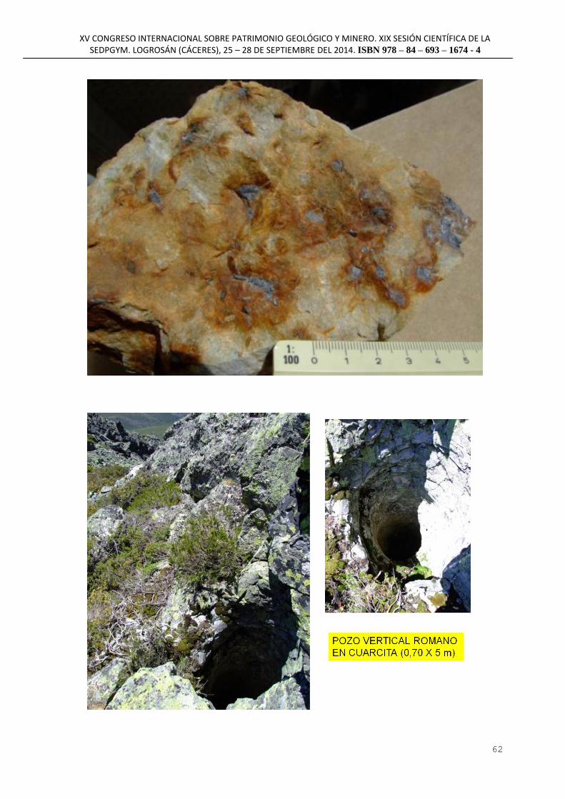
XV CONGRESO INTERNACIONAL SOBRE PATRIMONIO GEOLÓGICO Y MINERO. XIX SESIÓN CIENTÍFICA DE LA SEDPGYM. LOGROSÁN (CÁCERES), 25 – 28 DE SEPTIEMBRE DEL 2014. ISBN 978 – 84 – 693 – 1674 - 4
62

XV CONGRESO INTERNACIONAL SOBRE PATRIMONIO GEOLÓGICO Y MINERO. XIX SESIÓN CIENTÍFICA DE LA SEDPGYM. LOGROSÁN (CÁCERES), 25 – 28 DE SEPTIEMBRE DEL 2014. ISBN 978 – 84 – 693 – 1674 - 4
63
MINERÍA AURÍFERA ROMANA EN EL CAMPO FILONIANO
LUCILLO-VILLALIBRE. SIERRA DEL TELENO (LEÓN-ESPAÑA)
ROMAN GOLD MINING IN THE LUCILLO-VILLALIBRE VEINS SYSTEM.
TELENO SIERRA (LEÓN-SPAIN)
R. MATÍAS RODRÍGUEZ (1)
S. GONZÁLEZ NISTAL (2)
(1) FUNDACIÓN CULTURA MINERA [email protected]
(2) GEÓLOGO CONSULTOR [email protected]
RESUMEN:
La exploración sistemática de los indicios primarios de oro de la Sierra del Teleno ha puesto de
manifiesto la existencia de un área de 1,5 x 1,5 km intensamente explotada en época romana, entre las
localidades de Lucillo y Villalibre. Los principales trabajos mineros se concentran en el paraje de Los
Cabuercos y consisten en amplias zanjas superficiales abiertas directamente siguiendo las direcciones
de los filones. En los casos en donde se alcanzaron niveles más profundos, se han llegado a formar
lagunas tras la colmatación de los corredores de desagüe, las cuales permanecen llenas de agua buena
parte del año.
La mineralización está compuesta principalmente por filones de cuarzo acompañados de sulfuros
(arsenopirita y pirita) parcialmente oxidados en superficie y oro libre. Estructuralmente las vetas están
relacionadas con las charnelas de pliegues anticlinales y sus fracturas conjugadas, encajadas en las
pizarras y areniscas de la Serie de Los Cabos.
La recuperación del oro se realizaba mediante la molienda fina del mineral de cuarzo en morteros de
cuarcita, tanto individuales como múltiples, de los que se han localizado diversos restos.
Palabras clave: minería romana, Teleno, yacimientos primarios oro
ABSTRACT:
Systematic exploration of primary gold occurrences in the Teleno Sierra has revealed an area of 1.5 *
1.5 Km, intensely exploited in roman age, between Lucillo and Villalibre. Main former works,
concentrated in the Los Cabuercos zone, consist in a wide surface channel system following vein
directions. In the cases where exploitation reached deeper levels, lagoons were formed as a result of
filling evacuation corridors, which remain flooded the main time of the year.
Mineralization is mainly composed of quartz veins with sulphides (arsenopyrite, pyrite), partially
oxidized at surface, and free gold. Structurally veins are related to hinges in anticline folds as well as
conjugated fractures, hosted in slates and sandstones of the Los Cabos Series.
Gold recovery has been performed by fine crushing and grinding quartz mineralized fragments in
quartzite ¨morteros¨ (mortars), both individuals and multiple, some of which were partially recovered.
Key words: roman mining, Teleno, primary gold deposits

XV CONGRESO INTERNACIONAL SOBRE PATRIMONIO GEOLÓGICO Y MINERO. XIX SESIÓN CIENTÍFICA DE LA SEDPGYM. LOGROSÁN (CÁCERES), 25 – 28 DE SEPTIEMBRE DEL 2014. ISBN 978 – 84 – 693 – 1674 - 4
64

XV CONGRESO INTERNACIONAL SOBRE PATRIMONIO GEOLÓGICO Y MINERO. XIX SESIÓN CIENTÍFICA DE LA SEDPGYM. LOGROSÁN (CÁCERES), 25 – 28 DE SEPTIEMBRE DEL 2014. ISBN 978 – 84 – 693 – 1674 - 4
65
SISTEMAS DE INFORMACIÓN GEOGRÁFICA Y BASES DE DATOS
PARA EL CONOCIMIENTO DE LA MINERÍA Y LA METALURGIA
DEL BRONCE, EL ORO Y LA PLATA EN EL ORIENTALIZANTE
EXTREMEÑO
GEOGRAPHIC INFORMATION SYSTEMS AND DATABASES FOR KNOWLEDGE
OF MINING AND METALLURGY OF BRONZE, GOLD AND SILVER DURING THE
ORIENTALIZING PERIOD IN EXTREMADURA
J. Mª. MURILLO GONZÁLEZ Laboratorio de Prehistoria, Facultad de Filosofía y Letras de la UEX, Campus Universitario s/n. 10071 Cáceres,
España
PERSONAL DOCENTE E INVESTIGADOR DEL DEPARTAMENTO DE HISTORIA, UNIVERSIDAD DE
EXTREMADURA
RESUMEN:
Los objetos arqueológicos fabricados en bronce, oro y plata han despertado tradicionalmente un
especial interés entre quienes han profundizado en el conocimiento del Período Orientalizante en suelo
extremeño. Debido a su excepcionalidad y a su indudable valor económico e incluso artístico, estos
objetos se han valorado de distintas maneras, bien en relación con el mundo de las creencias y la
simbología, bien como elementos de prestigio de las élites sociales y económicas de la época.
No debe perderse de vista que estos elementos son en realidad productos finales de distintas
cadenas operativas integradas en una realidad antropológica y cultural mucho más amplia, las cuales
tienen en común que comienzan con la obtención de materias primas y finalizan con las piezas
terminadas.
La labor del arqueólogo consiste en extraer la máxima información posible de los objetos y de
su contexto arqueológico, con la finalidad de aumentar el conocimiento del pasado y generar nuevas
hipótesis de trabajo que, a su vez, contribuirán a facilitar esta misma labor a otros investigadores.
Desde una óptica enmarcada en la Arqueología del Territorio-Paisaje, presentamos como
aportación a este evento la exploración de algunas de las múltiples posibilidades de aplicación de las
nuevas tecnologías de la información para el mejor conocimiento de cuestiones tales como: la
procedencia de los minerales, las distintas técnicas metalúrgicas, o las redes de distribución de materias
primas y productos acabados.
Palabras clave: Período Orientalizante, Extremadura, Minería, Metalurgia, Bronce, Oro, Plata,
Sistemas de Información Geográfica (SIG), Bases de Datos.
ABSTRACT:
The archaeologic objects made in bronce, gold and silver have traditionally aroused special
interest among researchers that have studied the Orientalizing Period in Extremadura. Because of its
uniqueness and its economic and even artistic value, most of these materials have been identified as
elements of prestige of the social and economic elite, either related to the beliefs and religious cults of
the time.
Do not forget that these objects are actually product of different operating chains, integrated

XV CONGRESO INTERNACIONAL SOBRE PATRIMONIO GEOLÓGICO Y MINERO. XIX SESIÓN CIENTÍFICA DE LA SEDPGYM. LOGROSÁN (CÁCERES), 25 – 28 DE SEPTIEMBRE DEL 2014. ISBN 978 – 84 – 693 – 1674 - 4
66
into a full cultural reality, that begin with the search of raw materials and ending with finished products.
The work of the archaeologist is to extract the maximum possible information from the objects and their
contexts, in order to increase the understanding of the past times and generate new hypotheses.
We present some examples from a perspective framed by the Landscape-Spatial Archaeology,
useful to show how the new information technologies can help us to know more about the origin of the
minerals, different metallurgical techniques and sharing networks of raw materials and finished
products.
Key words: Orientalizing Period, Extremadura, Mining, Metallurgy, Bronze, Gold, Silver,
Geographic Information Systems (GIS), Databases.

XV CONGRESO INTERNACIONAL SOBRE PATRIMONIO GEOLÓGICO Y MINERO. XIX SESIÓN CIENTÍFICA DE LA SEDPGYM. LOGROSÁN (CÁCERES), 25 – 28 DE SEPTIEMBRE DEL 2014. ISBN 978 – 84 – 693 – 1674 - 4
67
MINERÍA HISTÓRICA Y PREHISTÓRICA EN ILLA DEN COLOM
(MAHÓN, MENORCA)
HISTORIC AND PREHISTORIC MINING IN ILLA DEN COLOM (MAHON,
MINORCA)
BARTOMEU LLULL ESTARELLAS*, LAURA PERELLÓ MATEO*, MARK A.
HUNT ORTIZ** *ArqueoUIB. Grupo de investigación de Cultura Material y Gestión de Patrimonio Arqueológico (Universitat de
les Illes Balears)
[email protected], [email protected]
** Arqueo-Pro, Estudio de Arqueología y Patrimonio Histórico; Grupo de Investigación ATLAS. Departamento
de Prehistoria y Arqueología (Universidad de Sevilla)
RESUMEN:
Illa den Colom (Mahón, Menorca), es una pequeña isla, con una superficie de 582.706 m²,
situada al este de Menorca, dentro del Parque Natural de s’Albufera des Grau. Geológicamente, está
formada por materiales detríticos del Carbonífero, en concreto en turbiditas fácies Culm, conteniendo
dos mineralizaciones importantes: una en el nordeste de la isla, Sa Mitja Lluna, y otra, la mina
Blendífera, en el sur, delante de los islotes de Es Bou y Sa Vaca. Esta última se explotó en época
contemporánea y es la conocida por los vecinos de Es Grau, aunque no llegó a ser una explotación muy
importante en términos industriales. En esta mina se explotaron principalmente minerales primarios de
zinc (blenda) y aún pueden verse las labores en galería y restos de las infraestructuras destinadas a los
trabajos minero-metalúrgico y sus escombreras.
Más al noroeste de Illa den Colom, en Sa Mitja Lluna, se ha documentado la que por el
momento es la única explotación de cobre prehistórica conocida en las Islas Baleares. Los materiales
recuperados de los sondeos arqueológicos realizados y las dataciones radiocarbónicas obtenidas
confirman que fue durante la Edad del Bronce el periodo de su explotación, si bien no se puede
descartar, por el momento, que se hubiera explotado en otras cronologías. En este trabajo se presentaran
las novedades de la campaña de excavaciones de junio de 2014 en esta zona de Illa den Colom. Se
presentarán los materiales recuperados, nuevos análisis de minerales y un frente de explotación cada
vez mejor definido.
Palabras clave: Menorca; Illa den Colom; Edad del Bronce, Minería Histórica; Mineral de cobre;
Mineral de zinc
ABSTRACT:
Illa den Colom (Mahon, Minorca), is a small island with an area of 582,706 m², located to the
east of Minorca, within the Albufera des Grau Natural Park. Geologically, the island is formed by
Carboniferous detrital material, specifically turbidities of the Culm, containing two significant
mineralizations: one of them in the north-east of the island, in Sa Mitja Lluna area, and the other one,
Blendífera mine, in the southern part, in front of the Es Bou and Sa Vaca islets. The Blendífera mine
was exploited in modern times and is the one known by Es Grau local people, although it was not a
very important exploitation in industrial terms. In this mine primary zinc sulphide ore (blenda) were
mined and the mining galleries and related metallurgical installations remains, together with
mineral/rock heaps can still be seen.
In Sa Mitja Lluna has been documented the only prehistoric copper mine known to date in the

XV CONGRESO INTERNACIONAL SOBRE PATRIMONIO GEOLÓGICO Y MINERO. XIX SESIÓN CIENTÍFICA DE LA SEDPGYM. LOGROSÁN (CÁCERES), 25 – 28 DE SEPTIEMBRE DEL 2014. ISBN 978 – 84 – 693 – 1674 - 4
68
Balearic Islands. The artifacts recovered in the recent archaeological excavations carried out and the
radiocarbon dates obtained confirmed that was exploited during the Bronze Age, although other phases
of exploitation can not yet be ruled out. In this paper, the results of the June 2014 excavation campaign
are presented: recovered materials, new mineral analysis and a proposal of a better defined mining
exploitation front.
Key words: Minorca; Illa den Colom; Bronze Age; Historical Mining; Copper ore; Zinc ore

XV CONGRESO INTERNACIONAL SOBRE PATRIMONIO GEOLÓGICO Y MINERO. XIX SESIÓN CIENTÍFICA DE LA SEDPGYM. LOGROSÁN (CÁCERES), 25 – 28 DE SEPTIEMBRE DEL 2014. ISBN 978 – 84 – 693 – 1674 - 4
69
LAS EXPLOTACIONES ROMANAS DE ORO EN ALL DE CERDANYA
ROMAN GOLD MINING FROM “ALL DE CERDANYA”
ALBERT RAMOS1,2
, P. ALFONSO1, MANUEL VILADEVALL
2
1. Dep. de Enginyeria Minera i Recursos Naturals, Universitat Politècnica de Catalunya. Av. De les Bases de
Manresa, 61-73, 08242 Manresa. [email protected], [email protected], 2. Dep. de Cristal·lografia, Mineralogia I Dipòsits Minerals, Universitat de Barcelona, Av. Martí i Franquès s/n.
08028 Barcelona. [email protected]
RESUMEN:
Existe controversia sobre el origen de las cárcavas (Bad lands) ubicadas en los alrededores de
All de Cerdanya. En esta comarca nace el río Segre, famoso por la riqueza aurífera de sus sedimentos
debido a que sus aguas y las de sus afluentes lavan los materiales paleozoicos de la cordillera pirenaica,
ricos en concentraciones anómalas de oro. Esto posibilita el que ciertos sedimentos que rellenan la
cuenca de la Cerdanya sean ricos en oro. Además, diversos estudios arqueológicos indican varias zonas
de esta comarca como posibles explotaciones de oro romanas o anteriores. También se debe valarar la
existencia de diversos hallazgos arqueológicos de asentamientos romanos próximos y a la similitud de
ciertas morfologías presentes en la zona de All de Cerdanya con estructuras dejadas por antiguas
explotaciones romanas en Rumanía, como canales propios de la explotación hidráulica.
Mediante el presente estudio se pretende demostrar si estas morfologías son de origen natural,
debido a la erosión, o forman parte de los restos de antiguas explotaciones romanas de oro. En este
trabajo se ha realizado un estudio de campo y la determinación de las leyes de oro de estos materiales.
Estas cárcavas se encuentran en sedimentos aluviales miocenos de la fosa de la Cerdanya, los
cuales contienen cantos de litologías muy diversas, a menudo de los materiales paleozoicos de las
elevaciones circundantes. El análisis de los concentrados de estos sedimentos revela una abundancia en
algunos minerales pesados, principalmente magnetita, circón y barita, sin embargo, aunque se encuentra
algún grano, presentan un contenido en oro muy bajo. El análisis de un concentrado en minerales
pesados dio una ley de 0.1 g/t de oro. Por lo tanto, se interpreta que esta debió ser la causa de que se
abandonaran las primeras labores realizadas en esta zona.
Las estructuras que forman las cárcavas en este sector son muy visibles y claramente
antrópicas, pero todavía no se ha podido datar de qué época son, ya sea romanas o anteriores. Aun así,
la morfología y estructuras halladas son similares a los de explotaciones romanas presentes en otras
localidades.
Palabras clave. Cárcavas, Oro, Cedanya, Minería romana
ABSTRACT:
There is controversy about the origin of Bad Lands located in the surroundings of All de
Cerdanya. In this region the Segre river rise; it is rich in gold, waters from this rives and its tributaries
leachate the Pyrenean mountain range, partly, comprising Paleozoic rocks with anomalous
concentrations of gold. This enables that certain sediments that fill the basin of Cerdanya could be rich
in gold. In addition, certain archaeological studies indicate several areas of this region as possible
exploitations of gold from Roman or earlier times. We also have to take into account the various
archaeological findings of next Roman settlements and the similarity of certain morphologies of
structures present in the area of All de Cerdanya left by ancient Roman farms in Romania, as channels

XV CONGRESO INTERNACIONAL SOBRE PATRIMONIO GEOLÓGICO Y MINERO. XIX SESIÓN CIENTÍFICA DE LA SEDPGYM. LOGROSÁN (CÁCERES), 25 – 28 DE SEPTIEMBRE DEL 2014. ISBN 978 – 84 – 693 – 1674 - 4
70
of hydraulic exploitation.
The aim of this study is to contribute to demonstrate whether these morphologies are naturally
occurring due to erosion, or are part of the remains of ancient Roman gold mining. In this work a field
study and determination of gold grades of these materials were carried out.
These Bad land structures are found in Miocene alluvial sediments of the Cerdanya trench,
which contain clasts of a variety of lithologies from the Paleozoic rocks of the surrounding elevations.
Analysis of this sediment concentrates reveals abundance in heavy minerals, mainly magnetite, zircon
and barite, however, although some gold grains were observed, it occurs in low content. Analysis of a
heavy mineral concentrate gave a tenor of 0.1 g / t Au. Therefore, it is interpreted that this should be the
cause of the first work done in this area were abandoned.
The structures that form the Bad lands in this sector are highly visible and clearly
anthropogenic, but has not yet been able to date on what time are either Roman or earlier. However, the
morphology and structures found are similar to those of Roman farms present in other locations.
Key words. Bad lands, Gold, La Cerdanya, de Barberà, Roman mining

XV CONGRESO INTERNACIONAL SOBRE PATRIMONIO GEOLÓGICO Y MINERO. XIX SESIÓN CIENTÍFICA DE LA SEDPGYM. LOGROSÁN (CÁCERES), 25 – 28 DE SEPTIEMBRE DEL 2014. ISBN 978 – 84 – 693 – 1674 - 4
71
LAS CANTERAS ANTIGUAS DE MÁRMOL DE ALMADÉN DE LA
PLATA (GEOPARQUE SIERRA NORTE DE SEVILLA, ESPAÑA): UNA
APROXIMACIÓN DIACRÓNICA E INTEGRADA
THE ANCIENT MARBLE QUARRIES OF ALMADÉN DE LA PLATA (SIERRA
NORTE DE SEVILLA GEOPARK, SPAIN): A DIACHRONIC AND INTEGRATED
APPROACH
Ruth TAYLOR
Universidad de Sevilla, [email protected]
RESUMEN
A pesar del impacto de las actividades extractivas recientes en los afloramientos de mármol del término
municipal de Almadén de la Plata, hoy día integrado en el Geoparque Sierra Norte de Sevilla, se
conservan todavía en varias localizaciones las huellas de explotaciones antiguas, cuya cronología ha
sido propuesta como romana desde hace varias décadas. Una fase productiva especialmente intensa en
los siglos I-III d.C ha sido confirmada mediante la identificación, apoyada por análisis arqueométricos,
de los mármoles de Almadén en muy numerosas piezas arqueológicas, distribuidas a gran escala. Los
estudios arqueológicos de estas piezas y de sus contextos de hallazgo han permitido proponer diversas
inferencias sobre las características de la explotación, comercio y uso de los mármoles de esta área
fuente en época romana. Sin embargo, estas reconstrucciones históricas han descuidado casi por
completo la información proporcionada por el estudio directo del registro arqueológico de la zona.
Para paliar esta situación, estudios recientes han planteado la necesidad de realizar nuevos trabajos de
campo en distintos parajes de la localidad con el objetivo de profundizar en la documentación de los
elementos empíricos pertenecientes a las zonas susceptibles de explotación en épocas antiguas y
proporcionar un contexto adecuado para la integración de las canteras históricas dentro de un marco de
análisis más amplio constituido por diversos parámetros (geología, territorio, arqueología,
arqueometría). Estos trabajos han llevado a una serie de resultados específicos que conforman la base
de una Tesis Doctoral centrada sobre la fase de cronología romana en las canteras de Almadén de la
Plata, y a una serie de resultados de interés más general.
En esta contribución hacemos hincapié en dos temas que contribuyen a una reconstrucción más
detallada de la cantería histórica en los afloramientos de mármol de nuestra zona de estudio, y que
constituyen además una aportación transferible a otros entornos en los cuales las características del
asentamiento humano y del aprovechamiento de los recursos geológico-mineros se consideran de
interés desde una perspectiva arqueológica y patrimonial. Primero, la visión diacrónica, es decir la
constatación directa o documental de varias fases de explotación a lo largo del tiempo, permite valorar
positivamente el interés suscitado por un recurso geológico singular, como es el mármol, en diversos
contextos cronológicos y culturales. Tiene además importantes implicaciones metodológicas para la
asignación cronológica de las evidencias de cantería antigua identificadas sobre el terreno. Segundo, la
integración de la información proporcionada por el estudio directo de las evidencias de explotación
antigua dentro de un contexto más amplio permite indagar sobre la complementariedad funcional entre
distintos tipos de evidencias: canteras y zonas de trabajo, asentamientos, sectores de apoyo (producción
agrícola y metalúrgica), elementos logísticos y sistemas de organización y control. Juntos, la visión
diacrónica y el estudio arqueológico integrado de los sistemas complejos creados en torno a las canteras
antiguas permiten un conocimiento más completo de estos contextos productivos, y proporcionan
nuevas posibilidades de análisis, presentación y puesta en valor de este patrimonio histórico-
arqueológico y geológico-minero.
Palabras claves: Arqueología, Canteras, Mármol, Metodología, Análisis multidisciplinar

XV CONGRESO INTERNACIONAL SOBRE PATRIMONIO GEOLÓGICO Y MINERO. XIX SESIÓN CIENTÍFICA DE LA SEDPGYM. LOGROSÁN (CÁCERES), 25 – 28 DE SEPTIEMBRE DEL 2014. ISBN 978 – 84 – 693 – 1674 - 4
72
ABSTRACT
Despite the impact of recent quarrying on the marble outcrops of Almadén de la Plata, located within
the Sierra Norte de Sevilla Geopark, traces of ancient working are still visible at a number of locations
and have generally been accepted as Roman. A particularly intensive phase of quarrying in the 1st
to 3rd
centuries AD has been confirmed on the basis of the identification of marbles from Almadén in
numerous and widely-distributed archaeological objects. The archaeological study of these materials
and their contexts has enabled the formulation of diverse inferences on the characteristics of the
exploitation, trade and use of these marbles in Roman times. However, these historical reconstructions
have overlooked almost completely the information provided by the direct study of the archaeological
record of the area.
Recent studies have addressed the need for new fieldwork in order to advance in the documentation of
the empirical evidence belonging to the ancient quarry areas themselves and to provide a suitable
context for the integration of the study of historical quarries within a broader framework constituted by
diverse parametres of analysis (geology, territory, archaeology, archaeometry). These studies have led
to a series of specific results that constitute the basis of a PhD centered on the Roman phase of
exploitation of the quarries of Almadén de la Plata, as well as a series of results of more general
interest.
In this contribution we shall focus on two themes that help to shape a more detailed reconstruction of
the historical quarrying in the marble outcrops of our study area and that also are transferable to the
study of other settings in which the characteristics of human settlement and use of geological resources
are of interest from an archaeological and heritage perspective. First, a diachronic analysis based on
both direct and documentary evidence enables the reconstruction of various phases of quarrying, and
thus reinforces the interest of a particular geological resource, as is marble, in very diverse
chronological and cultural contexts over time. The existence of several phases of exploitation also
raises important methodological issues for the correct dating of the archaeological traces identified in
the field. Second, the integration of the information provided by the direct study of the ancient quarry
areas within a broader context enables us to explore the functional relationships between different types
of evidence, for example, quarries and work areas, settlements, supporting sectors (agricultural and
metallurgical production), logistical elements and systems of organisation and control.
Together the diachronic perspective and the integrated multidisciplinary study of the complex stystems
surrounding the ancient quarries enable a more complete understanding of these productive contexts
and therefore provide new possibilities for the study, presentation and dissemination of this type of
historical, archaeological and geological heritage.
Keywords: Archaeology, Quarries, Marble, Methodology, Multidisciplinary analysis

XV CONGRESO INTERNACIONAL SOBRE PATRIMONIO GEOLÓGICO Y MINERO. XIX SESIÓN CIENTÍFICA DE LA SEDPGYM. LOGROSÁN (CÁCERES), 25 – 28 DE SEPTIEMBRE DEL 2014. ISBN 978 – 84 – 693 – 1674 - 4
73
MINERÍA HISTÓRICA EN PERALEDA DE SAN ROMÁN (CÁCERES)
HISTORIC MINING IN PERALEDA DE SAN ROMAN (CÁCERES)
S DE LA LLAVE MUÑOZ [email protected] / [email protected]
ARQUEÓLOGO, INVESTIGADOR, SPAIN
A ESCOBAR REQUENA [email protected]
ARQUEÓLOGA, INVESTIGADORA, SPAIN
RESUMEN:
Las minas ubicadas cerca de la población de Peraleda de San Román (Cáceres), más conocidas
entre aficionados y estudiosos de la mineralogía como Marialina, era un punto de extracción,
fundamentalmente, de plomo y cobre. La riqueza minera de las antiguas minas de Marialina es
conocida desde tiempos antiguos. Pese a tener referencias documentales que aluden a su explotación
intermitente entre los siglos XVI y XVIII, destaca el periodo comprendido entre la segunda mitad del
siglo XIX y primer cuarto del XX. La mayor parte de los vestigios minero-metalúrgicos pertenecen a
este último periodo.
Las antiguas minas de Peraleda de San Román constituyen un interesante ejemplo de
Patrimonio Industrial que se encuentra abocado a su desaparición si no median actuaciones inmediatas.
Situadas en un paraje de monte bajo, en las cercanías del rio Gualija y a escasos km de citada localidad,
pudieran llegar a convertirse en un interesante foco de atracción turística y cultural. Además, al interés
del antiguo complejo minero y metalúrgico se añade que en las escombreras pueden reconocerse
minerales como azurita, malaquita, galena, calcopirita y algunos micros de piromorfitas, hecho que
debe ser considerado como interesante en cuanto a su recuperación e incorporación a itinerarios
turísticos.
Palabras clave: Minas, Comarca de la Jara Cacereña, Metales, Cobre, Plomo, Antigua Tierra de
Talavera de la Reina, Geoparque Villuercas-Ibores-Jara, Patrimonio minero.
ABSTRACT:
The mining site located near Peraleda de San Román (Cáceres), known among researchers and
amateurs as Marialina, was mainly a copper and lead extraction point. The mining wealth in this
compound is known since ancient times. Though we possess documentary evidence of its intermittent
exploitation between the 16th and 18th centuries, the second half of the 19th century and first quarter of
the 20th century stand out. Most part of the remains found belong to this period.
The ancient mining site of Peraleda de San Roman is and interesting example of Industrial
Heritage headed towards is disappearance if immediate actions are not taken. Thanks to its location on
low forest, near Guadalija river and quite close to the village itself, they could become an interesting
center of touristic and cultural attraction. In addition to the heritage and cultural interest of the
compound, we add the possibility of finding some minerals as azurite, malachite, galena, chalcopyrite
and some micros of pyromorphite, a fact that must be considered as a strong point in favor of its
recovery and its integration in touristic routes.

XV CONGRESO INTERNACIONAL SOBRE PATRIMONIO GEOLÓGICO Y MINERO. XIX SESIÓN CIENTÍFICA DE LA SEDPGYM. LOGROSÁN (CÁCERES), 25 – 28 DE SEPTIEMBRE DEL 2014. ISBN 978 – 84 – 693 – 1674 - 4
74
Key words: Mine, Jara Cacereña region, Metals, Copper, Lead, Ancient land of Talavera de la Reina,
Villuercas-Ibores-Jara Geopark, Mining heritage.
Alzado del lavadero de las minas Marialina

XV CONGRESO INTERNACIONAL SOBRE PATRIMONIO GEOLÓGICO Y MINERO. XIX SESIÓN CIENTÍFICA DE LA SEDPGYM. LOGROSÁN (CÁCERES), 25 – 28 DE SEPTIEMBRE DEL 2014. ISBN 978 – 84 – 693 – 1674 - 4
75
CENTENARIO DE UNA EXPLOTACIÓN HULLERA QUE AÚN
RESPIRA: El POZO SOTÓN (SAN MARTÍN DEL REY AURELIO,
ASTURIAS)
CENTENARY OF A PIT STILL ALIVE: SOTON SHAFT (SAN MARTIN DEL REY
AURELIO, ASTURIAS)
P. FANDOS RODRÍGUEZ [email protected]
RESUMEN
El pozo Sotón (San Martín del Rey Aurelio, Asturias), recientemente catalogada BIC, es el único pozo
carbonero que ha alcanzado en España el siglo de edad y aún respira.
Hasta la publicación del libro "Dejaron h(u)ella" (Fandos Rodríguez e Iglesias Rodríguez, 2004), la
fecha de inicio permanecía en la oscuridad que propicia la falta de historiografía. En los años en que fui
geólogo de la hullera (1982-1992) mantuve una permanente atención por localizar las fechas de sus
orígenes, pudiendo deducir, finalmente, que sería hacia octubre de 1914 cuando Duro Felguera iniciaba
la profundización del hoy abuelo del carbón español. Por desgracia, un siglo después, el aniversario
sólo llevará cirios fúnebres, estando prevista su clausura a finales del presente ejercicio.
La historiografía del pozo Sotón en absoluto guarda relación con la importancia industrial y social que
ha tenido. Aparte de cuatro datos que se repiten aquí y allá, tan solo conocemos la historia publicada en
el citado "Dejaron h(u)ella" (libro que por mor de sus incorrecciones políticas algunos han considerado
maldito), y la visión geográfico-arquitectónica aportada por Suárez Antuña en "Paisaje y patrimonio. El
pozo Sotón" (2012), libro donde se prescinde de cualquier referencia sobre el anterior.
Siendo el centenario del pozo Sotón un buen motivo para la historiarlo, en lo que sigue sintetizamos una
visión global del mismo, atendiendo a capítulos imprescindibles como son la geología, ingeniería,
economía y sociología, en especial el muy sensible capítulo de los accidentes, recogiendo el centenar de
víctimas que ha costado.
PALABRAS CLAVE: Pozo Sotón, centenario, historia, Asturias
ABSTRACT
Sotón shaft (San Martín del Rey Aurelio, Asturias), recently cataloged BIC, is the only coal pit in Spain
that has reached the century old and still is breathing.
Until the publication of the book "Dejaron h(u)ella" (Fandos Rodríguez e Iglesias Rodríguez, 2004),
(Fandos Iglesias Rodríguez and Rodríguez, 2004), the start date remained in darkness.
In the years when I worked in Sotón as a coal geologist (1982-1992), I kept a permanent care in locate
dates to deduce its origins. Finally I deduced that Duro Felguera began deepening the grandfather of
Spanish coal around October 1914 (Fandos and Iglesias, 2004: 188).
Unfortunately, a century later, the anniversary only will light funeral candles, as the close is expected to
later this year.
The historiography of Sotón shaft does not fit with its industrial and social importance. Besides the four
data repeated here and there, the only story published is the above mentioned "Dejaron h(u)ella"

XV CONGRESO INTERNACIONAL SOBRE PATRIMONIO GEOLÓGICO Y MINERO. XIX SESIÓN CIENTÍFICA DE LA SEDPGYM. LOGROSÁN (CÁCERES), 25 – 28 DE SEPTIEMBRE DEL 2014. ISBN 978 – 84 – 693 – 1674 - 4
76
(damned book for the sake of their political incorrectness), and the geographical and architectural vision
provided by Suarez Antuña "Paisaje y patrimonio. El pozo Sotón" (2012), with any reference to the
previous book.
Being the centenary of Sotón shaft a good reason for his global history, in what follows we summarize
an overview, based on essential chapters such as geology, engineering, economics and sociology,
especially the very sensitive chapter of accidents, collecting the hundred of victims that cost.
KEYWORDS: Sotón shaft, centenary, history, Asturias.

XV CONGRESO INTERNACIONAL SOBRE PATRIMONIO GEOLÓGICO Y MINERO. XIX SESIÓN CIENTÍFICA DE LA SEDPGYM. LOGROSÁN (CÁCERES), 25 – 28 DE SEPTIEMBRE DEL 2014. ISBN 978 – 84 – 693 – 1674 - 4
77
EL TESORO DE LOS LAGOS MILIARIOS ASTURIANOS. CENSO DE
LAGUNAS RELACIONADAS CON ANTIGUAS MINERÍAS EN LAS
SIERRAS DE ASTURIAS: ARAMO, CUERA, FANFARAÓN, OUROSO,
SUEVE, ETC.
THE TREASURE OF THE ASTURIAN MILESTONE LAKES. CENSUS OF
LAGOONS IN CONNECTION WITH OLD MINING IN MOUNTAIN RIDGES OF
ASTURIAS: ARAMO, CUERA, FANFARAÓN, OUROSO, SUEVE, ETC.
P. FANDOS RODRÍGUEZ [email protected]
RESUMEN
Al igual que la minería moderna suele dejar huellas en forma de lagunas, es muy probable que la
minería antigua, dado el conocido uso que se hacía de hidro y piroclastias, haya dejado aún más charcas
o lagos. En este sentido, es posible que los rosarios de lagunas que jalonan las crestas de muchas sierras
asturianas, que reciben en la toponimia los nombres de "chaos", "chana", "chagüezos", etc., pudieran
haber sido obras humanas y no relictos de pasadas glaciaciones.
Un factor determinante en la catalogación de lagunas artificiales es la interdistancia a la que se sitúan,
siendo frecuentes las separaciones del orden de una milla romana o sus múltiplos (de ahí el nombre que
proponemos de "lagunas miliarias"). Otros criterios son el formato casi estándar (excavaciones
circulares, a modo de dolinas, con unos 20 o 30 m de diámetro), la relación inteligente de cotas y, muy
especialmente, el contexto minero del entorno, caso por ejemplo de las lagunas próximas a las
conocidas minas romanas de las sierras de Fanfaraón, Ouroso, etc.
En el trabajo (dedicado a la memoria de Mario Roso de Luna quien hace un siglo vislumbró el "tesoro"
que encierran los lagos asturianos) se plantea la antropogénesis como una de las derivadas de la teoría
de las "caverminas" que venimos defendiendo en los últimos congresos de SEDPGYM y que obliga a
ampliar el concepto de paisaje minero hasta dimensiones crono-espaciales que apenas se vislumbran.
PALABRAS CLAVE: Lagunas, sierras, arqueo-minería, Asturias.
ABSTRACT
As modern mining often leave traces in the form of gaps, it is likely that the old mining has left more
ponds or lakes, specially given the use of hydro and piroclastic methods. In this regard, it may be that
the rows of lakes and lagoons that dot the ridges of many Asturian mountains (which carry names as
"chaos", "chana", "chagüezos" etc), may have been human works instead or relicts of past glaciations.
A determining factor in the cataloging of artificial lagoons is the spacing at which they are located, with
frequent separations of the order of a Roman mile or multiples (hence the name suggest the "milestones
gaps"). Other criteria are the almost standard format (circular excavations, by way of sinkholes, with
about 20 to 30 m in diameter), the smart relationship in its altitudes above sea level, and, especially, the
mining environment context, for example if the next lagoons known Roman mines Fanfaraón saws,
Ouroso, etc..

XV CONGRESO INTERNACIONAL SOBRE PATRIMONIO GEOLÓGICO Y MINERO. XIX SESIÓN CIENTÍFICA DE LA SEDPGYM. LOGROSÁN (CÁCERES), 25 – 28 DE SEPTIEMBRE DEL 2014. ISBN 978 – 84 – 693 – 1674 - 4
78
This work (dedicated to the memory of Mario Roso de Luna, who envisioned a century ago the
"treasure" that enclose Asturian lakes) raises the mand-made lakes as a derivative of the "caverminas"
theory which we have been defending along last years. If it will be correct, it will force to expand the
concept of mining landscape to a chrono-spatial dimensions that barely glimpsed.
KEYWORDS: Lagoons, archaeo-mining, Asturias.

XV CONGRESO INTERNACIONAL SOBRE PATRIMONIO GEOLÓGICO Y MINERO. XIX SESIÓN CIENTÍFICA DE LA SEDPGYM. LOGROSÁN (CÁCERES), 25 – 28 DE SEPTIEMBRE DEL 2014. ISBN 978 – 84 – 693 – 1674 - 4
79
CAVERNAS CACEREÑAS QUE PUDIERON HABER SIDO ANTIGUAS
MINAS. INVENTARIO INICIAL EN LA PROVINCIA DE CÁCERES
DESDE LA PERSPECTIVA DE LAS "CAVERMINAS"
CAVERNS OF CÁCERES (SPAIN) THAT COULD HAVE BEEN OLD MINES.
INITIAL INVENTORY IN CÁCERES SHIRE FROM THE PERSPECTIVE OF
"CAVERMINAS".
P. FANDOS RODRÍGUEZ [email protected]
RESUMEN
Cuando en 1896 se publicaba el "Catálogo geográfico y geológico de las cavidades naturales y minas
primordiales de España", obra de Minas Gabriel Puig y Larraz, eran 14 las cuevas recopiladas en la
provincia de Cáceres. La obra era una continuación de la "Noticia sobre cavernas y minas primordiales
de España" que Casiano de Prado había publicado en 1864. Ambos ingenieros de Minas reconocían que
muchas cavernas (sobre las "de los Moros") eran artificiales y algunas habían sido en realidad minas en
tiempos remotos.
Más de un siglo después, una posible catalogación de las cavernas cacereñas multiplicaría por diez
aquellas 14 cuevas. Sin embargo, la concepción de las que pudieron haber tenido un origen minero ha
ido perdiendo terreno a favor de la acrítica globalización del fenómeno kárstico. Podríamos decir que el
karst ha eclipsado al clast. Sirva como ejemplo la cueva llamada en el s XIX "Mina de la Meancera" (en
Nuñomoral), perdida hoy entre las muchas cuevas y abrigos de aquellas serranías, donde las poderosas
webs citan pinturas rupestres, petroglifos y un amplio repertorio de utensilios que eclipsan la génesis
minera.
Tras haber sido presentada en los últimos congresos de SEDPGYM la teoría de las "caverminas"
(Fandos Rodríguez, 2010, 2011 y 2013), creemos posible reconocer en muchas de las cuevas de la
provincia de Cáceres los criterios fundamentales para su posible catalogación como cavernas debidas a
la mano del hombre.
Los paisajes de 'caverminas' obligan a un replanteo no sólo geo-histórico sino también estético-
ecológico, asegurando que "la mina es bella".
PALABRAS CLAVE: Cáceres, catalogación, cavernas, minería antigua.
ABSTRACT
When in 1896 Gabriel Puig y Larraz (1851-1917) published its "Catálogo geográfico y geológico de las
cavidades naturales y minas primordiales de España", there were 14 the caves named in the province
of Cáceres. That work was a continuation of the "Noticia sobre cavernas y minas primordiales de
España" that Casiano de Prado had published in 1864. Both mining engineers recognized that many
caves (especially those called "Moorish") were artificial and some were real mines in ancient times.
More than a century later, a possible cataloging of the Caceres' caves could have multiplied tenfold
those former 14 caves. However, the mining aim about their real origin has been losing ground in favor
of uncritical globalization of karstic phenomenon. We could say that karst win clast. One example is the

XV CONGRESO INTERNACIONAL SOBRE PATRIMONIO GEOLÓGICO Y MINERO. XIX SESIÓN CIENTÍFICA DE LA SEDPGYM. LOGROSÁN (CÁCERES), 25 – 28 DE SEPTIEMBRE DEL 2014. ISBN 978 – 84 – 693 – 1674 - 4
80
cave called in s XIX "Meancera Mine" (in Nuñomoral), now lost among the many caves and shelters of
those hills, with powerful websites mentioning cave paintings, petroglyphs and a wide range of tools
that eclipse mining genesis.
Having been presented in recent conferences of SEDPGYM, the theory named "caverminas" (Fandos
Rodríguez, 2010, 2011 and 2013), we can recognize in many of the caves of Cáceres the main criteria
for classification as possible caverns due to the hand of man.
The man-made landscapes not only require a geo-historical rethinking but aesthetic- ecological, in aim
that "mine is fine."
KEYWORDS: Cáceres, cataloging, caves, ancient mining.

XV CONGRESO INTERNACIONAL SOBRE PATRIMONIO GEOLÓGICO Y MINERO. XIX SESIÓN CIENTÍFICA DE LA SEDPGYM. LOGROSÁN (CÁCERES), 25 – 28 DE SEPTIEMBRE DEL 2014. ISBN 978 – 84 – 693 – 1674 - 4
81
MINAS DE “CARVÃO DE PEDRA” DE VALVERDE E CABEÇO DO
VEADO (PORTUGAL): INTERMITÊNCIA E PERSISTÊNCIA
MINAS DE “CARBÓN DE PIEDRA” DE VALVERDE E CABEÇO DO VEADO
(PORTUGAL): INTERMITENCIA Y PERSISTENCIA
COAL MINES OF VALVERDE AND CABEÇO DO VEADO (PORTUGAL):
INTERMITTENCY AND PERSISTENCE
JOSÉ M. BRANDÃO
CENTRO DE ESTUDOS DE HISTÓRIA E FILOSOFIA DA CIÊNCIA, Universidade. de Évora / Rede HetSci,
Portugal. [email protected]
RESUMO:
Situadas no extremo sul da “bacia carbonífera” do Vale do Lena, entre as vilas de Mendiga e
Alcanede, as minas de ferro e carvão de Cabeço do Veado e carvão de Valverde, tiveram uma história
marcada por sucessivas mudanças de concessionário e tentativas mal sucedidas de exploração industrial
alternando com longos períodos de abandono ou atividade reduzida, mesmo depois da sua integração no
Couto Mineiro do Lena, em 1929.
O capitão Carlos Ribeiro, engenheiro do Estado, ali enviado em meados de 1854 para o
reconhecimento oficial dos jazigos, confirmou as ocorrências registadas na Câmara Municipal por
Raymundo Lacerda, oficial do exército e “proprietário” de Lisboa, presumindo a sua continuidade em
profundidade, chamando no entanto a atenção para a presença frequente de pirites de ferro que, em sua
opinião, poderiam “restringir as applicações industriaes do carvão”. Contudo o maior dos entraves que
encontrava à exploração destes jazigos do “período Oolítico” (Jurássico Superior) era o do transporte do
carvão até aos lugares de consumo, fazendo depender o sucesso da sua exloração da abertura, para sul,
de um imbricado sistema de canais fluviais (nunca construído) que asseguraria uma comunicação barata
com o rio Tejo, por onde as barcaças carregadas desceriam até Lisboa.
Embora muitas esperanças se tenham depositado nestas minas, nunca foram atingidos valores
de produção expressivos, nem mesmo durante as duas Guerras mundiais, quando a atividade do Couto
Mineiro se intensificou. Contudo, embora intermitentes, os trabalhos, que chegaram a atingir uma
profundidade de ca. de 180m, foram sendo repetidamente retomados, até meados de 1954, na vã
esperança de se virem a encontrar camadas que pudessem garantir uma exploração rentável, produzindo
carvões de fácil aceitação no mercado. Nada afinal, que as sondagens de 1941 do Instituto Português de
Combustíveis, não deixassem compreender…
Palavras-chave: Minas; carvão; Couto Mineiro do Lena; Porto de Mós; Portugal.
RESUMEN:
Situado en el extremo sur de la "cuenca carbonífera" del valle del río Lena, entre los pueblos de
Mendiga y Alcanede, las minas de hierro y carbón de Cabeço do Veado y carbón de Valverde, tuvieran
una historia marcada por sucesivos cambios de concesionario y intentos fallidos de explotación
industrial, alternando con largos periodos de abandono o reducción de actividad, incluso después de su
integración en el “Coto Minero do Lena”, en 1929.
El capitán Carlos Ribeiro, ingeniero del Gobierno, allí enviado a mediados de 1854 para el
reconocimiento oficial de los depósitos, confirmó las descubiertas registradas en el Ayuntamiento por
Raymundo Lacerda, oficial del ejército y "propietario" de Lisboa, suponiendo su continuidad en

XV CONGRESO INTERNACIONAL SOBRE PATRIMONIO GEOLÓGICO Y MINERO. XIX SESIÓN CIENTÍFICA DE LA SEDPGYM. LOGROSÁN (CÁCERES), 25 – 28 DE SEPTIEMBRE DEL 2014. ISBN 978 – 84 – 693 – 1674 - 4
82
profundidad, pero llamando la atención a la frecuente presencia de pirita de hierro que, en su opinión,
podría disminuir las aplicaciones industriales del carbón. Pero el mayor obstáculo que encontraba la
explotación de estos depósitos del "período Oolitico" (Jurásico Superior) era el transporte del
combustible a los lugares de consumo, vinculando el éxito de la empresa de la apertura hacia el Sur, de
un entrelazado sistema de canales fluviales (jamás construido) que garantizaría una comunicación
barata con el Tajo, donde las barcazas cargadas descenderían hasta Lisboa.
Aunque muchas esperanzas hayan sido depositadas en estas minas, jamás se han alcanzado
valores de producción expresivos, incluso durante las dos guerras mundiales, cuando la actividad del
Coto Minero se intensificó. Los trabajos que lograran a alcanzar una profundidad aproximada de 180m,
fueron siendo restablecidos de una forma persistente hasta mediados de 1954, con la vana esperanza de
encontrar capas que pudieran garantizar una exploración rentable, produciendo carbones de fácil
aceptación en el mercado. Nada por supuesto, que los sondeos realizados en el perímetro, en 1941, por
el Instituto Portugués de Combustibles, no dejasen comprender…
Palabras-clave: Minas; carbón; Coto Minero do Lena; Portugal.
ABSTRACT
Situated on the southern part of the "coal basin" of the Lena valley, between the villages of
Mendiga and Alcanede, the mines of “iron and coal” of Cabeço do Veado and coal of Valverde, had a
history marked by successive changes of dealership and unsuccessful attempts of exploitation
alternating with long periods of abandonment or reduced activity even after its integration in Couto
Mineiro do Lena (Lena’s coal-field), in 1929.
The captain Carlos Ribeiro, the state engineer sent there in mid-1854 for official recognition of
deposits, confirmed the occurrences recorded at City Council by Raymundo Lacerda, army officer and
"owner" of Lisbon, assuming its continuity at depth, but calling attention to the frequent presence of
iron pyrites which, in his opinion, could restrict industrial applications of that coal. However the biggest
obstacles he encountered to the exploitation of these deposits from the "Oolitic period" (Upper Jurassic)
was the transportation of the coal to the places of consumption, conditioning the mining success to the
opening to the south, of an interwoven system of canals (never built) which could ensure a cheap
connection with the Tagus river, where loaded barges could descend easily to Lisbon.
Although many hopes have been deposited in these mines, an expressive production was never
achieved, even during the two World Wars, when the activity was intense. However, these intermittent
works, that came to reach a depth of approx. 180m, were repeatedly being resumed till mid-1954, in the
vain hope of coming to find layers that could guarantee a profitable operation, producing coals easily
acceptable in the market. Nothing at all, which drillings by the Portuguese Institute for Fuels in 1941,
not left guessing…
Keywords: mines; coal; Lena’s coal-field; Portugal.

XV CONGRESO INTERNACIONAL SOBRE PATRIMONIO GEOLÓGICO Y MINERO. XIX SESIÓN CIENTÍFICA DE LA SEDPGYM. LOGROSÁN (CÁCERES), 25 – 28 DE SEPTIEMBRE DEL 2014. ISBN 978 – 84 – 693 – 1674 - 4
83
DIEGO DE LARRAÑAGA, UN INGENIERO DE MINAS QUE CAMBIO
LA EXPLOTACIÓN MINERA EN LAS MINAS DE ALMADÉN (CIUDAD
REAL)
DIEGO DE LARRAÑAGA, A MINING ENGINEER THAT I CHANGE THE MINING
EXPLOITATION INTO THE MINES OF ALMADÉN (CIUDAD REAL)
L. MANSILLA (1) y A. GALLEGO-PRECIADOS ALGORA (2)
(1) UNIVERSIDAD DE CASTILLA LA MANCHA-ESCUELA DE INGENIERIA MINERA E INDUSTRIAL
DE ALMADEN.
(2) CONSEJERÍA DE EDUCACIÓN Y CULTURA DE CASTILLA LA MANCHA-COLEGIO DE
EDUCACIÓN PRIMARIA HIJOS DE OBREROS DE ALMADÉN.
RESUMEN:
La explotación minera en Almadén es conocida desde tiempos inmemoriales, romanos, árabes y
luego más tardes los reinos cristianos dan buen testimonio de su existencia. El descubrimiento del
método de amalgamación en frio, conocido como método de patio, hizo que las minas de Almadén
tuvieran una proyección internacional de grandes proporciones, haciendo que el mercurio de sus minas
fuera un valor clave para la obtención de la plata y el oro de las minas americanas a lo largo del tiempo.
Esta necesidad de mercurio hizo que los métodos de explotación minera y la metalurgia de las
minas almadenenses fueran un centro clave para la puesta en marcha de nuevos métodos en la minería
española, convirtiendo a éstas en un centro de experimentación al que llegaron gentes de todos los
confines de Europa y América.
Uno de los ingenieros claves en el desarrollo tecnológico de las minas de Almadén fue Diego
de Larrañaga, que tras su formación en la Escuela de Minas de Almadén y sus viajes por el centro de
Europa va a introducir un cambio en la tecnología de explotación minera sin precedentes en estas
minas, convirtiendo a la mampostería y el ladrillo en elementos fundamentales del sostenimiento de sus
galerías, conformando unos espacios de grandes dimensiones en el interior de la mina unidos por arcos
de varios metros de espesor y más de diez metros de luz, que ofrecen una arquitectura de entibación sin
precedentes en la minería española como se puede observar en el bien conservado baritel de San Andrés
del Parque Minero de Almadén.
Este año se cumplen doscientos años de la muerte de Diego de Larrañaga y esta comunicación
no solo pretende mostrar los valores del ingeniero de minas y su implicación en los cambios
tecnológicos de la mina de Almadén en el siglo XIX, sino que también queremos presentar al hombre
comprometido con la sociedad en la que le toco vivir, en momentos difíciles como fue la Guerra de la
Independencia, menos conocidos pero que nos demuestran la figura real de este ingeniero y que con
esta comunicación pretendemos que pueda servir de homenaje.
Palabras clave: Almadén, minería, explotación minera, metalurgia, mercurio.
ABSTRACT:
The mining exploitation in Almadén is known from immemorial, Roman, Arabic times and
then the Christian kingdoms testify later. The discovery of the method of amalgamation in col, known
as method of court, this made Almaden mines were known internationally, what caused the mercury

XV CONGRESO INTERNACIONAL SOBRE PATRIMONIO GEOLÓGICO Y MINERO. XIX SESIÓN CIENTÍFICA DE LA SEDPGYM. LOGROSÁN (CÁCERES), 25 – 28 DE SEPTIEMBRE DEL 2014. ISBN 978 – 84 – 693 – 1674 - 4
84
mines were a key value for silver and gold in the American mines along the time.
The need for mercury allowed the mining methods and metallurgical mines of Almaden to
become an important place for the implementation of new methods of Spanish mining, transforming
them in a center of experimentation reached by people from all corners of the world.
One of the key engineers in the technological development of the mines of Mine was Diego de
Larrañaga, who studied at the school of mines of Almaden and traveled central Europe for changes in
mining technology without precedents in these mines, turning to the masonry and the brick in
fundamental elements of the maintenance of his galleries, creating large spaces inside the mine arches
joined by several meters wide and ten meters of light, offering a single architecture support in the
Spanish mining as seen in the well-preserved San Andrés Baritel Miner Park Almadén.
Diego de Larrañaga died two hundred years ago and this communication not only it tries to
show the values of the mining engineer and his implication in the technological changes of the mine of
Almadén in the 19th century and we want to present the man involved in the society in which he lived,
as in times of War of Independence, showing us how the figure of the engineer who want to highlight
with this presentation
Key words: Mine, mining industry, mining exploitation, metallurgy, mercury.

XV CONGRESO INTERNACIONAL SOBRE PATRIMONIO GEOLÓGICO Y MINERO. XIX SESIÓN CIENTÍFICA DE LA SEDPGYM. LOGROSÁN (CÁCERES), 25 – 28 DE SEPTIEMBRE DEL 2014. ISBN 978 – 84 – 693 – 1674 - 4
85
POLÉMICA CIENTÍFICO-TECNOLÓGICA Y CONFLICTOS EN EL
SIGLO XIX A CAUSA DE UN PROYECTO DE LEY QUE RESERVABA
AL ESTADO LAS MINAS DE FOSFORITA DE LOGROSÁN, Y
CUALESQUIERA OTRAS DEL REINO
SCIENTIFIC-TECHNOLOGICAL CONTROVERSY AND CONFLICTS IN THE
NINETEENTH-CENTURY, BECAUSE OF A BILL RESERVING TO THE STATE
THE LOGROSÁN´MINING PHOSPHORITE, AND ANY OTHER OF THE REIGN
J. PASTOR VILLEGAS1*, J. D. PASTOR VALLE
2, J. F. PASTOR VALLE
1, Á. PÍRIZ
MOTA3
1Grupo de Investigación Materiales Porosos y Contaminación Ambiental, Universidad de Extremadura
2Ingeniero civil
3Ingeniero de Caminos, Canales y Puertos
RESUMEN
Antes de 1857, la fosforita de la villa de Logrosán (Cáceres) se menciona en diferentes publicaciones.
En ese año, el potencial minero-industrial de la roca para la fabricación de fertilizantes fosfatados era
más o menos conocido. Reinando Isabel II, Claudio Antonio Moyano y Samaniego (ministro de
Fomento) pronunció un discurso en el Congreso de los Diputados el día 12 de junio de 1857, antes de la
presentación del “Proyecto de ley para que se reserven al Estado las minas de fosforita de Logrosán, y
cualesquiera otras del mismo mineral que existan en todo el reino”. De tal discurso y del documento
parlamentario subsiguiente derivó una interesante polémica científico-tecnológica entre Ramón Torres
Muñoz de Luna (Doctor en ciencias físico-químicas y matemáticas, catedrático de Química en la
Universidad Central, etcétera), comisionado en Logrosán, y Casiano del Prado y Vallo (un importante
geólogo e ingeniero de minas, Inspector general del Cuerpo de Ingenieros de Minas, etcétera); ambos
son autores de publicaciones sobre la fosforita de Logrosán.
Asimismo, la pretendida nacionalización causó la oposición de propietarios de canteras de caliza
fosfatada en la villa; uno de ellos fue Mario de Luna Arribas (vecino de Logrosán), hijo de Julián de
Luna y de la Peña (un ilustre extremeño liberal que había adquirido algunas canteras en el año 1840).
Años después, el polígrafo Mario Roso de Luna (Logrosán, 1872 - Madrid, 1931), nieto de Luna y de la
Peña, escribió también sobre la fosforita de Logrosán; mencionó de interés uno de los trabajos de
Torres Muñoz de Luna, pero no trató de la polémica científico-tecnológica ni de los largos litigios que
surgieron después entre propietarios de las canteras. En nuestra opinión, tal polémica y las
reclamaciones de particulares motivaron el abandono del proyecto de ley, y retrasaron el comienzo de la
explotación; después, hubo largos litigios que dificultaron también la explotación de los yacimientos.
Palabras clave: Logrosán, polémica sobre la fosforita, Ramón Torres Muñoz de Luna, Casiano del
Prado y Vallo, Mario de Luna Arribas, Julián de Luna y de la Peña, Mario Roso de Luna.
ABSTRACT
Before 1857, the phosphorite of the town of Logrosán (Cáceres) is mentioned in different publications.
In that year, the mining-industrial potential of rock phosphate fertilizer manufacturing was more or less
known. During Isabel II´s reign, Claudio Antonio Moyano y Samaniego (Public works´Minister) gave a
speech in the Spanish parliament on June 12th, 1857, before the presentation of the "bill reserving to the

XV CONGRESO INTERNACIONAL SOBRE PATRIMONIO GEOLÓGICO Y MINERO. XIX SESIÓN CIENTÍFICA DE LA SEDPGYM. LOGROSÁN (CÁCERES), 25 – 28 DE SEPTIEMBRE DEL 2014. ISBN 978 – 84 – 693 – 1674 - 4
86
State the Logrosán´s mining phosphorite, and any other of the same mineral that exist throughout the
reign". In this speech, and the following parliamentary document, derived an interesting scientific and
technological controversy between Ramon Torres Muñoz de Luna (Doctor of physico-chemical and
mathematical science, professor of chemistry at the Central University, etc.), commissioned in
Logrosán, and Casiano del Prado y Vallo (an important geologist and mining engineer, Inspector
General Corps of Mining Engineers, etc.); both are authors of publications about phosphorite of
Logrosán.
Also, the proposed nationalization was ground for opposition quarry owners of phosphatic limestone in
the town; one of them was Mario de Luna Arribas (neighbor Logrosán), son of Julian Luna y de la Peña
(an illustrious liberal from Extremadura that acquired the phosphatic limestone in 1840). A few years
later, the polygraph Mario Roso de Luna (Logrosán, 1872 - Madrid, 1931), grandson of the Luna y de la
Peña, also wrote about the phosphorite of Logrosán; he mentioned one of the works of Torres Muñoz de
Luna, however, he didn’t mention nothing about the scientific and technological controversy or
litigation that arose long after among owners of the quarries. In our opinion, the scientific and
technological controversy and claims led to the abandonment of the bill and delayed the start of the
exploitation; later, there were long private litigation that also hampered the development of deposits.
Key words: Logrosán, phosphorite controversy, Ramón Torres Muñoz de Luna, Casiano del Prado y
Vallo, Mario de Luna Arribas, Julián de Luna y de la Peña, Mario Roso de Luna.

XV CONGRESO INTERNACIONAL SOBRE PATRIMONIO GEOLÓGICO Y MINERO. XIX SESIÓN CIENTÍFICA DE LA SEDPGYM. LOGROSÁN (CÁCERES), 25 – 28 DE SEPTIEMBRE DEL 2014. ISBN 978 – 84 – 693 – 1674 - 4
87
EL USO DE LA FOTOGRAMETRÍA ENFOCADO HACIA LA
DOCUMENTACIÓN Y PRESERVACIÓN DE YACIMIENTOS
ARQUEOLÓGICOS EN FORMACIONES GEOLÓGICAS. EL ABRIGO
DE LA CALDERITA, LA ZARZA (BADAJOZ).
USE OF FOCUSED TOWARDS PHOTOGRAMMETRY DOCUMENTATION AND
PRESERVATION OF ARCHAEOLOGICAL SITES IN GEOLOGICAL
FORMATIONS. THE ARCHAEOLOGICAL SITE OF “LA CALDERITA”, LA
ZARZA (BADAJOZ)
JUAN DIEGO CARMONA BARRERO [email protected]
MARCO ANTONIO AZA LOZANO
Field School Alange. Escuela de Documentación Gráfica del Patrimonio.
Fieldschoolalange.com
RESUMEN
La generalización del uso de la fotografía digital y la aparición de software libre específico –
VisualSFM- destinado al tratamiento de imágenes con fines fotogramétricos ha revolucionado los
tradicionales sistemas de documentación tanto en el campo de la arquitectura como en el de la
arqueología. Gracias a estos nuevos sistemas se ha popularizado la fotogrametría de bajo coste, término
que sin embargo no tiene porqué asociarse a una baja calidad métrica del modelo obtenido.
Si bien en un principio la fotogrametría se ha utilizado para documentar mediante fotografía aérea
grandes extensiones del territorio, durante los últimos años se ha volcado su uso hacia el registro de
edificios o restos de ellos. Poco a poco la fotogrametría llega a otros campos en los que también tiene
cabida. Entre otros destaca en el campo de la geología con la obtención de modelos virtuales de
cavidades naturales que alojan a su vez restos arqueológicos de interés. En esta línea de trabajo
presentamos esta comunicación. Se ha procedido a obtener un modelo tridimensional del conjunto de
arte rupestre de la Calderita en La Zarza (Badajoz), registrando información suficiente para volver a
generar un modelo tridimensional de idénticas características en caso de destrucción del mismo.
Tras la realización del modelo fotogramétrico se presenta el yacimiento en diferentes soportes visuales
que permiten el acceso al modelo virtual desde cualquier ordenador. Así mismo se ha trabajado con un
software, también libre, para aumentar la nitidez de las pinturas existentes e incluso la localización de
algunas que ya no son visibles para el ojo humano.
Palabras Clave:
Fotogrametría, Pinturas Rupestres, Calderita, La Zarza, Motor gráfico.
ANSTRACT
The generalized use of digital photography and the emergence of specific free software for treating
images with photogrammetric purposes -VisualSFM- has revolutionized the traditional systems of
documentation in the fields of architecture and archeology. Thanks to these new systems has become
popular photogrammetry low cost. This is a term that has not however why associated with a lower
quality metric of the obtained model.
While it initially photogrammetry has been used aerial photography to document large tracts of territory
in recent years has turned its use to the register of buildings or remnants of them. Gradually
photogrammetry reaches other fields that also fit. Among other highlights in the field of geology with
obtaining virtual models of natural cavities with archaeological interest. In this work we proceeded to

XV CONGRESO INTERNACIONAL SOBRE PATRIMONIO GEOLÓGICO Y MINERO. XIX SESIÓN CIENTÍFICA DE LA SEDPGYM. LOGROSÁN (CÁCERES), 25 – 28 DE SEPTIEMBRE DEL 2014. ISBN 978 – 84 – 693 – 1674 - 4
88
obtain a three-dimensional model of the whole rock art La Calderita near to La Zarza (Badajoz),
recording enough to rebuild a three-dimensional model with identical characteristics in case of
destruction of the information.
Following the completion of the site photogrammetric model is presented in different visual aids that
allow access to the virtual model from any computer. Also has worked with software, also free, to
sharpen existing paintings and even the location of some that are no longer visible to the human eye.
Keywords:
Photogrammetry, cave paintings, Calderita, La Zarza, Graphics Engine.

XV CONGRESO INTERNACIONAL SOBRE PATRIMONIO GEOLÓGICO Y MINERO. XIX SESIÓN CIENTÍFICA DE LA SEDPGYM. LOGROSÁN (CÁCERES), 25 – 28 DE SEPTIEMBRE DEL 2014. ISBN 978 – 84 – 693 – 1674 - 4
89
MINING HERITAGE VALORIZATION WITHIN TOURIST CONTEXTS
(TWO CASES OF THE SOUTHEAST OF SPAIN)
PUESTA EN VALOR DEL PATRIMONIO MINERO EN CONTEXTOS TURÍSTICOS
(DOS CASOS DEL SUDESTE ESPAÑOL)
DANIEL CARMONA ZUBIRI
RAÚL TRAVÉ MOLERO
UNIVERSIDAD MIGUEL HERNÁNDEZ DE ELCHE (SPAIN)
RESUMEN:
Portmán y Las Minas (Carmona Zubiri, 2007) son dos antiguas explotaciones mineras en el surest
español. Ambas son pequeñas pedanías de los municipios de La Unión (Murcia) y Hellín (Castilla-La
Mancha). Aunque históricamente pertenecen a la misma área cultural, establecida como una región
administrativa única en otros tiempos (Murcia), hoy en día están localizadas en diferentes Comunidades
Autónomas. Como en muchos otros casos de antiguas explotaciones mineras ambas comparten una
enorme huella ecológica y un gran impacto social y demográfico.
En esta comunicación compararemos algunos de los procesos sociales relacionados en cómo la idea de
Patrimonio Cultural y las prácticas alrededor de él participan en la configuración de diferentes discursos
sobre el desarrollo y la identidad social como parte de la construcción socio-cultural de hegemonía
(Gramsci, 1975). Nuestra hipótesis inicial es que esta construcción de hegemonía es un proceso
dialógico donde cada uno de los agentes sociales juega un papel significativo. Hemos estudiado como
los discursos hegemónicos se construyen en un proceso dialógico, en el cual los agentes sociales están
implicados y sus posibilidades de influencia están relacionadas con su capital social.
Metodológicamente, hemos considerado Portmán y Las Minas como campos sociales (Bourdieu), o lo
que es lo mismo, como espacios donde algunos agentes sociales luchan por diferentes tipos de capital
social. Estos agentes sociales, quienes quiera que sean (institucionales, residentes y agentes privados)
tienen sus intereses particulares. Nuestro análisis se centra en la manera en que estos agentes y sus
intereses tratan de articular unos discursos en los que la identidad social, el desarrollo y el Patrimonio
Cultural minero están relacionados unos con otros.
Hemos pretendido también estudiar en profundidad las relaciones de esos discursos alrededor del
Patrimonio minero con el contexto turístico y sus consecuencias urbanísticas. Por lo tanto, hemos
relacionado los discursos con sus posibilidades de desarrollo económico (y social) que cristalizaron en
el consenso de que el crecimiento urbanístico de carácter especulativo era la base para atraer al turismo
y por tanto la base para el desarrollo.
KEY WORDS: Portmán, Las Minas, Patrimonio Cultural, Discursos, Hegemonía.
ABSTRACT:
Portmán and Las Minas (Carmona Zubiri, 2007) are two former mining exploitations in the south-east
of Spain. Both are small districts in the municipalities of La Unión (Murcia) and Hellín (Castilla-La

XV CONGRESO INTERNACIONAL SOBRE PATRIMONIO GEOLÓGICO Y MINERO. XIX SESIÓN CIENTÍFICA DE LA SEDPGYM. LOGROSÁN (CÁCERES), 25 – 28 DE SEPTIEMBRE DEL 2014. ISBN 978 – 84 – 693 – 1674 - 4
90
Mancha). Although historically they belonged to the same cultural area conformed as an ancient and
unique administrative region (Murcia), nowadays they are located in different Autonomous Regions. As
many others cases of former mining exploitations, both share an enormous carbon footprint and a huge
social and demographic impact.
In this paper we are going to compare some of the social processes involved in how the idea of Cultural
Heritage, and the practices around it, are participating in the configuration of different discourses about
development and social identity as a part of the socio-cultural construction process of hegemony
(Gramsci, 1975). Our initial hypothesis is that this construction is a dialogical process where every one
of the social agents performs a significant role. We have studied how hegemonic discourses are
constructed in a dialogical process where social agents are involved and their possibilities of influence
are related within his social capital.
Methodologically, we have considered Portmán and Las Minas as social fields (Bourdieu), that is to
say, spaces where some social agents struggle for different kinds of social capital. These social agents,
whoever they are (institutional, resident and private agents) have their own particular interests. Our
analysis is focused on the way the agents and their interest are marking the articulation of discourses
where social identity, development and the mining Cultural Heritage are related to each other.
We have also aimed to study in deep into the relationship of these discourses around the mining
Heritage with the tourist context and its urban consequences. Therefore, we have linked the discourses
with its possibilities of economic (and social) development, which have merged into the consensus that
the speculative urban growth was the base for attracting tourism, so the base for development.
KEY WORDS: Portmán, Las Minas, Cultural Heritage, Discourses, Hegemony.
REFERENCES/BIBLIOGRAFÍA
Carmona Zubiri, D. 2007.Las Minas de Hellín. Instituto de Estudios Albacetenses. Albacete.
Gramsci, A. 1975.Quaderni del Carcere. I-IV. Einaudi, Torino.
Bourdieu, P. 2008.El sentido práctico. Siglo XXI, Madrid.
-1979.La distinción. Taurus.
-2002.Campo de poder, campo intelectual. Editorial Montressor, Buenos Aires.

XV CONGRESO INTERNACIONAL SOBRE PATRIMONIO GEOLÓGICO Y MINERO. XIX SESIÓN CIENTÍFICA DE LA SEDPGYM. LOGROSÁN (CÁCERES), 25 – 28 DE SEPTIEMBRE DEL 2014. ISBN 978 – 84 – 693 – 1674 - 4
91
EL PATRIMONIO MINERO DE SAN NICOLAS DE VALLE DE LA
SERENA: INVESTIGACIÓN, AGRESIONES Y DESPROTECCIÓN
THE MINING PATRIMONY OF SAN NICOLAS OF VALLE DE LA SERENA:
INVESTIGATION, AGRESSIONS AND UNPROTECTION.
ANTONIO D. LÓPEZ RODRÍGUEZ Historiador. Miembro de la Asociación ADEPA Valle S.
JUAN JOSÉ MINAYA CABALLERO Presidente de la Asociación ADEPA Valle S.
RESUMEN:
El presente trabajo tiene un doble objetivo. En primer lugar se ofrecerá un breve recorrido histórico por
la minería en Valle de La Serena, que se centrará en la descripción del principal enclave de su término
municipal como fueron las minas de wolframio del Grupo San Nicolás. Y en segundo lugar se expondrá
el proceso que desde el presente viene involucrando a distintos colectivos de la zona por proteger y dar
a conocer dicha historia. Sin duda esta última fase reivindicativa forma parte de la propia historia
minera de la mina y de su interrelación con la población de Valle de La Serena.
La minería en un entorno rural eminentemente agro-ganadero es una anomalía. Sin embargo la comarca
de La Serena gracias a su variada riqueza metalífera ha sido objeto de varias fiebres mineras a lo largo
de los siglos. Por ejemplo, el boom del wolframio, que nos ocupa, tuvo un relevante precedente en el
tiempo. La minería del plomo argentífero en el campo filoniano de Castuera que se desarrolló de
manera vertiginosa durante el último tercio del siglo XIX y primera década del XX tuvo su continuidad
en las minas de wolframio del término de Valle de La Serena. Nuevamente con intervención de capital
y mano de obra cualificada extranjera se pusieron en marcha los primeros trabajos en los Cerros
“Martín Pérez” y “Barbero”. Aunque también hubo presencia autóctona precisamente procedente de la
zona de Castuera, que puso en explotación los recursos de otra zona de rica mineralización del término
de Valle de La Serena como era la zona de “Arrocampos”.
El Grupo Minero San Nicolás quedó abandonado en la década de 1990, comenzando desde entonces el
proceso de degradación. En 2009 El IGME, en colaboración la Junta de Extremadura, lo incluye en el
catálogo de las minas a proteger y conservar, dentro del Estudio del Patrimonio Minero de
Extremadura. En 2010 desde la Asociación, ADEPA Valle S., redactamos el proyecto El Patrimonio
Minero en Valle de la Serena, con el que se pretendía inventariar todo el rico patrimonio generado,
recuperar su historia y presentar la solicitud de incoación del expediente BIC, sirviendo así de base a
una futura puesta en valor. Fruto de este trabajo es el libro que presentamos HISTORIA Y
PATRIMONIO MINERO EN VALLE DE LA SERENA. La singularidad de las Minas de San Nicolás.
Desafortunadamente mientras realizábamos el trabajo de investigación, el valioso patrimonio de San
Nicolás ha sufrido tres brutales agresiones: desguace y robo de hierros en 2011, daños generales entre
2012 y 2013, derribo de las cubiertas de cinco casas y robo de hierro en 2014. Todo esto nos ha llevado
a presentar continuas denuncias y a acelerar la presentación de la solicitud para la declaración BIC y lo
hemos hecho con el respaldo de muchas asociaciones e instituciones, a las que estamos agradecidos,
entre ellas la SEDPGYM y AGEX. Pero no hemos hecho nada más que entrar en un largo conflicto
del que es necesario dar explicaciones, para buscar soluciones.

XV CONGRESO INTERNACIONAL SOBRE PATRIMONIO GEOLÓGICO Y MINERO. XIX SESIÓN CIENTÍFICA DE LA SEDPGYM. LOGROSÁN (CÁCERES), 25 – 28 DE SEPTIEMBRE DEL 2014. ISBN 978 – 84 – 693 – 1674 - 4
92
Palabras claves:
Declaración BIC, minas de wolframio, inventario, Grupo Minero de San Nicolás.
ABSTRACT:
This present project has got a double objective. Firstly, a brief historical itinerary throughout the Valle
de La Serena mining will be offered and it will get focused on the description of the main site or its
municipality, we are talking about the wolfram mines of the San Nicolas Group. And secondly, we will
present the actual process in which several groups of the area are involved in their attempt to protect
and show that history. Undoubtedly, this last demanding phase is part of the mining history together
with the mine itself and that of its interrelation with the population of Valle de La Serena.
Mining is considered to be an anomaly within a mainly agrorural setting. However, La Serena region
has experienced several mining rushes throughout the centuries due to its varied metalliferous mining
wealth. For example, the wolfram boom we are dealing with had a relevant precedent over the time: the
argentiferous lead mining bed of Castuera. This mining activity developed quickly during the last third
of the XIX century and the first decade of the XX century and continued in the wolfram mines within
the municipality of Valle de La Serena. Again, the first works in the Hills of “Martín Pérez” and
“Barbero” started thanks to foreign finance and qualified manpower. However, there were also people
from the area, precisely from Castuera, who exploited the resources of another rich mineral area within
the municipality of Valle de La Serena, the so-called “Arrocampos” area.
The San Nicolás Mining Group was abandoned in the 1990 decade, starting then its degrading process.
In 2009 El IGME, together with the Junta de Extremadura, includes this mine in the catalogue of those
to be protected and preserved within the Estudio del Patrimonio Minero de Extremadura . In 2010,
from the ADEPA Valle S. Association , the project El Patrimonio Minero en Valle de la Serena was
elaborated. The aim of this project was to inventory the whole rich generated patrimony, to recover its
history and to apply for the opening of the BIC file turning out to be the basis for giving the mine a later
value. The result of this project is the book we are presenting now HISTORIA Y PATRIMONIO
MINERO EN VALLE DE LA SERENA. La singularidad de las Minas de San Nicolás.
Unfortunately, as we were developing this investigation project, the valuable patrimony of San Nicolas
has undergone three brutal aggressions: the dismantling and robbery of iron items in 2011, general
damages between 2012 and 2013, the demolition of the roof of five houses and the robbery of iron
items in 2014. For all that we have been filing continuous complaints and we have tried to quicken the
application process for the BIC declaration. We have done this with the support of lots of associations
and institutions to which we are thankful, the SEDPGYM and AGEEX among others. However, we
have just started a long conflict about which many explanations must be given in order to look for
solutions.
Key words:
BIC declaration, wolfram mines, inventory, San Nicolás Mining Group,

XV CONGRESO INTERNACIONAL SOBRE PATRIMONIO GEOLÓGICO Y MINERO. XIX SESIÓN CIENTÍFICA DE LA SEDPGYM. LOGROSÁN (CÁCERES), 25 – 28 DE SEPTIEMBRE DEL 2014. ISBN 978 – 84 – 693 – 1674 - 4
93
UNA PROPUESTA DE GESTIÓN PARA LA CONSERVACIÓN Y
PUESTA EN VALOR DEL PATRIMONIO FERROVIARIO EN LA
CUENCA DEL GUADIATO
A MANAGEMENT PROPOSAL FOR THE CONSERVATION AND VALORIZATION
OF THE RAILWAY HERITAGE OF
GUADIATO'S MINING AREA
P. ALLEPUZ GARCÍA, M.C. GARCÍA RUÍZ, F.VICENTE MARTINEZ
[email protected]; [email protected];
RESUMEN
La configuración de un sistema de gestión viable requiere la implicación de agentes sociales y
económicos, públicos y privados, relacionados con los bienes a gestionar, así como el
establecimiento de líneas de colaboración a muy diferentes niveles. En este sentido, la
Fundación Cuenca del Guadiato ha planteado un modelo viable para la conservación y la
gestión del patrimonio ferroviario ligado a la actividad minera e industrial de la Comarca del
Guadiato.
En Andalucía nos encontramos en un contexto caracterizado por una gran riqueza patrimonial
que contrasta, sin embargo, con la infrautilización de sus potencialidades culturales,
económicas y sociales, con una fuerte dependencia de los presupuestos públicos y con un peso
específico muy limitado del sector privado. Por tanto, uno de los retos consiste en desarrollar
una nueva forma de gestión que se adapte mejor a lo que la sociedad demanda actualmente del
patrimonio, esto es, una gestión llevada a cabo por una entidad sin ánimo de lucro donde se
agrupan entes públicos, entidades como la Universidad, el Colegio de Ingenieros Técnicos de
Minas y la SEDPGYM y personas de reputada solvencia técnica, con una proyección comarcal.
Aunque la metodología de planificación de los proyectos culturales de gestión debe ser común
a todos ellos, en función del tipo de proyecto que propongamos (un centro de visitantes, un
itinerario interpretativo, una mina museo, un concurso fotográfico o gastronómico, etc.), las
actuaciones necesarias serán distintas, así como imprescindible la participación de los
profesionales adecuados (museólogos, intérpretes del patrimonio, gestores culturales,
antropólogos, ingenieros, arquitectos, etcétera). En estos momentos nos centraremos en la
gestión del patrimonio ferroviario que ha sido cedido a la Fundación o está en trámite de
cesión, en la formalización documental, inventariado, traslado, limpieza y adecuación de los
elementos, en la gestión del lugar donde se depositarán y en la financiación de todo ello.
Una de las tareas más complejas de la gestión será la de idear y poner en marcha los medios de
obtener recursos para nuestros proyectos y ello requiere relacionar objetivos con formas de
financiación, identificar patrocinadores potenciales y planificar actividades de financiación
para conseguir los objetivos. .
PALABRAS CLAVE
Gestión, conservación, patrimonio ferroviario, Guadiato

XV CONGRESO INTERNACIONAL SOBRE PATRIMONIO GEOLÓGICO Y MINERO. XIX SESIÓN CIENTÍFICA DE LA SEDPGYM. LOGROSÁN (CÁCERES), 25 – 28 DE SEPTIEMBRE DEL 2014. ISBN 978 – 84 – 693 – 1674 - 4
94
ABSTRACT
Setting a viable management system requires the involvement of social and economic agents,
both public and private, related to the manageable goods, as well as the establishment of
different levels of collaboration. In this sense, the Fundación Cuenca del Guadiato has
designed a viable model for conservating and managing the railway heritage linked to the
mining and industrial activity in the Guadiato’s area.
Andalusian context is characterized by a rich heritage that, however, contrasts with the
underutilization of their cultural, economic and social potential, mainly because of the heavy
reliance on public budgets and the limited influence of the private sector. Therefore, one of the
challenges is to develop a new form of management that fulfills what society is currently
demanding from heritage: a non-profit organization run by public entities, universities,
professional colleges of mining engineering, heritage protection societies and other people with
reputed technical capacity.
Depending on the type of project to propose (a visitor center, an interpretive itinerary, a mine
museum, a photographic or culinary competition, etc.), the necessary actions will be different,
even though the planning methodology must be common to all of them. Just as essential is the
participation of appropriate professionals (curators, heritage interpreters, cultural managers,
anthropologists, engineers, architects, etc.). At this moment we will focus on the management
of goods recently donated to the Foundation -documents about inventory, transportation and
cleaning of the material-, management of the place where they will be deposited; and
financing.
One of the most complex tasks will be to devise and implement ways of obtaining resources
for our projects. It will require to relate objectives and forms of financing, identifying potential
sponsors and planning funding activities to achieve those objectives.
KEY WORDS
Management, conservation, railway Heritage, Guadiato

XV CONGRESO INTERNACIONAL SOBRE PATRIMONIO GEOLÓGICO Y MINERO. XIX SESIÓN CIENTÍFICA DE LA SEDPGYM. LOGROSÁN (CÁCERES), 25 – 28 DE SEPTIEMBRE DEL 2014. ISBN 978 – 84 – 693 – 1674 - 4
95
SITUACIÓN DEL TURISMO MINERO Y ESPELEOLÓGICO EN
EXTREMADURA (ESPAÑA)
STATE OF THE ART OF CAVE AND MINE TOURISM IN EXTREMADURA
(SPAIN)
F J FERNÁNDEZ-AMO
Técnicas Mineras Santa Marta, S.L.
P MUÑOZ BARCO
Dirección General de Medio Ambiente
E REBOLLADA CASADO
Asociación Geológica de Extremadura
RESUMEN:
En Extremadura existen cinco lugares en donde se desarrolla un turismo activo de tipo
espeleológico: Mina La Jayona (Fuente del Arco), Cueva de Castañar (Castañar de Ibor),
Cuevas de Fuentes de León, Mina Costanaza (Logrosán) y Mina Pastora (Aliseda). Además,
están en proyecto la adecuación turística en las Minas de Santa Marta de los Barros y la Mina
Monchi (Burguillos del Cerro).
Actualmente, el espeleoturismo en Extremadura alcanza la cifra de 35.000 visitantes
anuales, cantidad que sigue aumentando. Por ello resulta imprescindible poner en marcha
nuevos proyectos de este tipo y mejorar la calidad de los ofertados en la actualidad.
Palabras clave: espeleología, cuevas, minas, turismo, Extremadura.
ABSTRACT:
There are five spelologic sites where an active tourism is given in Extremadura: La
Jayona Mine (Fuente del Arco), Castañar Cave (Castañar de Ibor), Fuentes de León Caves,
Costanaza Mine (Logrosán) and Pastora Mine (Aliseda). Therefore, are two projects in relation
with touristic conversion: Santa Marta Mines and Monchi Mine (Burguillos del Cerro).
Nowadays, the caving in Extremadura has reached 35.000 visitors last year, and it
continues growing. Then it is essential to implement these new projects and improve the
quality of the others ones offered today.
Key words: caving, caves, mines, tourism, Extremadura.

XV CONGRESO INTERNACIONAL SOBRE PATRIMONIO GEOLÓGICO Y MINERO. XIX SESIÓN CIENTÍFICA DE LA SEDPGYM. LOGROSÁN (CÁCERES), 25 – 28 DE SEPTIEMBRE DEL 2014. ISBN 978 – 84 – 693 – 1674 - 4
96
Mapa de los lugares con turismo espeleológico y espeleominero en Extremadura

XV CONGRESO INTERNACIONAL SOBRE PATRIMONIO GEOLÓGICO Y MINERO. XIX SESIÓN CIENTÍFICA DE LA SEDPGYM. LOGROSÁN (CÁCERES), 25 – 28 DE SEPTIEMBRE DEL 2014. ISBN 978 – 84 – 693 – 1674 - 4
97
MODELADO TRIDIMENSIONAL DE LA ACADEMIA DE MINAS DE
ALMADÉN PARA LA REALIZACIÓN DE VISITAS VIRTUALES Y
SISTEMAS INTERACTIVOS
SHAPED THREE-DIMENSIONAL OF THE ACADEMY OF MINES OF ALMADÉN
FOR THE ACCOMPLISHMENT OF VIRTUAL VISITS AND INTERACTIVE
SYSTEMS
L. MANSILLA, C.SÁNCHEZ, J.ALBUSAC
UNIVERSIDAD DE CASTILLA LA MANCHA-ESCUELA DE INGENIERÍA MINERA E INDUSTRIAL DE
ALMADÉN.
RESUMEN:
La informática nos permite hoy día disponer de una herramienta muy importante para la puesta
en valor del patrimonio minero, sobre todo de aquellos lugares y edificios que ya han desaparecido o
que han sufrido grandes transformaciones a lo largo del tiempo que han modificado su aspecto y
fisonomía.
Desde la Escuela de Ingeniería Minera e Industrial de Almadén llevamos a cabo desde hace
dos años un trabajo interdisciplinar entre varias áreas de conocimiento como informática, explotación
de minas, investigación minera, proyectos, etc., que tienen como objetivo fundamental la recuperación
del patrimonio minero industrial a través de la virtualización de elementos patrimoniales desaparecidos
o que han sufrido cambios importantes, permitiendo con ello rescatar para la memoria colectiva
aquellos lugares tal y como eran cuando se confeccionaron.
Un ejemplo claro de este proyecto ha sido el modelado tridimensional de la Casa Academia de
Minas de Almadén para la realización de una visita virtual a la misma, acompañado de una página web,
que nos ha permitido dar a conocer sus características históricas, morfológicas y artísticas, así como su
importancia a lo largo de la historia de la ciudad de Almadén. El proceso del modelado tridimensional y
de creación de visita virtual se ha realizado con la herramienta informática Blender.
El proyecto se ha dividido en dos grandes apartados. En primer lugar, un proceso de
investigación, que nos ha servido para conocer el edificio en su contexto, a través de documentación
gráfica y escrita. Esta primera etapa nos ha permitido afrontar la segunda fase del proyecto, la parte
técnica, es decir, la realización del modelado tridimensional, visita virtual y página web.
Palabras claves: Almadén, Casa Academia, blender, minería, patrimonio minero.
ABSTRACT:
Computer science is a very important tool for the putting in value of the mining heritage today,
especially those places and buildings that have disappeared or that have suffered big transformations
throughout the time that his aspect and physiognomy have modified.
XV CONGRESO INTERNACIONAL SOBRE PATRIMONIO GEOLÓGICO Y MINERO. XIX SESIÓN CIENTÍFICA DE LA SEDPGYM. LOGROSÁN (CÁCERES), 25 – 28 DE SEPTIEMBRE DEL 2014. ISBN 978 – 84 – 693 – 1674 - 4
98
School Almadén Mining and Industrial Engineering is working on an interdisciplinary project
with multiple area as computer science, exploitation of mines, mining investigation, projects, etc. with
the main objective to recover the industrial mining heritage. Our main objective is the recovery of the
industrial mining heritage through virtualization assets missing or have undergone major changes. This
work will allow revisiting old places as they were when they were created for the collective memory
A clear example of this project has been shaped three-dimensional of the House Academy of
Mines of Almadén for the accomplishment of a virtual visit to the same one, accompanied of a web
page, which has allowed us to give to know his historical, morphologic and artistic characteristics, as
well as his importance along the history of the city of Almadén. The process of shaped three-
dimensional and of creation of virtual visit it has been realized by the computer tool Blender.
The project has been split in two parts. First, a process of investigation, which has served us to
know the building in his context, across graphical and written documentation. This first stage has
allowed us to confront the second phase of the project, the technical part, the accomplishment of shaped
three-dimensional, virtual visit and web page.
Key words: Mine, House Academy, blender, mining industry, mining patrimony.

XV CONGRESO INTERNACIONAL SOBRE PATRIMONIO GEOLÓGICO Y MINERO. XIX SESIÓN CIENTÍFICA DE LA SEDPGYM. LOGROSÁN (CÁCERES), 25 – 28 DE SEPTIEMBRE DEL 2014. ISBN 978 – 84 – 693 – 1674 - 4
99
MIRA Y OBSERVA… NUESTRO ENTORNO COMO RECURSO
DIDÁCTICO
LOOK AND OBSERVE…OUR ENVIRONMENT AS A DIDATIC RESOURCE
JULIANA PARRAS ARMENTEROS
Facultad de Educación de Ciudad Real. UCLM. Ronda de Calatrava, s/n, c.p: 13071. Ciudad Real (España).
RESUMEN:
La propuesta didáctica que se presenta se lleva a cabo en la Facultad de Educación de Ciudad
Real (UCLM), para los estudiantes de 4º curso del grado de Educación Primaria, en la asignatura “El
medio natural II: biología, geología y su didáctica”.
Los objetivos que se pretenden alcanzar son: (a) utilizar el entorno como recurso didáctico, (b)
fomentar la curiosidad científica por el medio donde viven los alumnos y (c) realizar materiales
didácticos de apoyo a la docencia. Estos objetivos responden a las tareas que tendrán que realizar los
estudiantes en un futuro próximo como docentes.
Esta actividad se presenta al inicio de la asignatura, proponiéndoles que tomen fotografías de su
entorno más próximo relacionadas con distintos aspectos geológicos.
A lo largo del cuatrimestre se analizan las imágenes obtenidas por los estudiantes
relacionándolas con los contenidos que se están impartiendo en el aula. Las fotografías hacen hincapié
en distintos ámbitos de la Geología: diferentes tipos de rocas (figura 1), en la actividad minera de la
provincia, en los procesos de meteorización física, química y biológica de las rocas, riesgos geológicos
y en los materiales pétreos que se hallan en museos de diferente índole.
La realización de esta actividad ha despertado en los estudiantes un mayor interés por las
Ciencias de la Tierra, dejando de ver a esta ciencia como algo “abstracto”, para considerarla como una
ciencia relacionada con ellos o su entorno, además de considerar las posibilidades que tiene el medio
como recurso didáctico.
Palabras clave:
Propuesta didáctica, medio, enseñanza de la geología.
ABSTRACT:
This didactic resource have been carried out at the Faculty of Education of Ciudad Real (UCLM)
to 4th year students of Primary Education degree in the subject "Natural Environment II: Biology,
Geology and Didactics".
The objectives of this activity are: (a) Use the environment as a teaching resource, (b) Promote
scientific curiosity about the environment in this students (c) Produce didatic materials for teaching.
This work has been presented at the beginning of the course. The teacher proposed to the
students to take photographs related to different geological aspects.

XV CONGRESO INTERNACIONAL SOBRE PATRIMONIO GEOLÓGICO Y MINERO. XIX SESIÓN CIENTÍFICA DE LA SEDPGYM. LOGROSÁN (CÁCERES), 25 – 28 DE SEPTIEMBRE DEL 2014. ISBN 978 – 84 – 693 – 1674 - 4
100
During the semester, the students discussed in the classroom about the pictures that they have
obtained. The photographs emphasized different areas of geology: rock types, the mining activity in the
province, the processes of physical, chemical and biological weathering of rocks and stone materials
that are in different museums.
The activity increased in students a greater interest in Earth Science, and changed their idea
about this subject showing it less abstract and closer to them.
KEY WORDS:
Didatic resource, environment, teaching of geology
Figura 1.
Iglesia San Agustín (Almagro, Ciudad Real). Rocas sedimentarias (areniscas y calizas) y rocas
volcánicas.

XV CONGRESO INTERNACIONAL SOBRE PATRIMONIO GEOLÓGICO Y MINERO. XIX SESIÓN CIENTÍFICA DE LA SEDPGYM. LOGROSÁN (CÁCERES), 25 – 28 DE SEPTIEMBRE DEL 2014. ISBN 978 – 84 – 693 – 1674 - 4
101
USO DEL LÁSER ESCÁNER SOBRE MINERALES: MÉTODO Y
POSIBILIDADES
UTILIZATION OF LASER SCANNING TECHNOLOGY IN MINERALS: METHOD
AND POSSIBLITIES
L F MARTÍNEZ CORRALES
Universidad de Extremadura
E REBOLLADA CASADO
Asociación Geológica de Extremadura
J J DE SANJOSÉ BLASCO
Universidad de Extremadura
A DOMÍNGUEZ ÁLVAREZ
Universidad de Extremadura
RESUMEN:
Con el avance de las nuevas tecnologías se abre un abanico muy amplio para el estudio e
investigación en muchas ramas de la ciencia. En la última década ha habido un creciente interés por la
recreación tridimensional en campos como la medicina, industria, patrimonio, etc. Una de las técnicas
de mayor proyección es la recreación 3D mediante láser escáner.
Los minerales cristalizados y masivos nos ofrecen unas propiedades físicas y químicas muy
buenas para someter a prueba al láser escáner y conocer su alcance y limitaciones en el escaneo de
pequeños objetos.
En este trabajo se presentan los resultados obtenidos mediante el manejo del láser escáner
existente en el Centro Universitario de Mérida, sobre algunos excelentes ejemplares de minerales
pertenecientes a museos y colecciones: propiedades que caracterizan a cada mineral escaneado, estudio
y manejo del láser escáner de pequeños objetos, manejo del software necesario para el escaneo de las
piezas y análisis de los resultados obtenidos y modelos tridimensionales de las muestras.
La técnica del modelado tridimensional será muy útil para el estudio de los ejemplares
existentes en las colecciones públicas y privadas de minerales.
Palabras clave: escaneado, láser, modelado 3D, mineralogía.
ABSTRACT:
With the progress of new technologies a very wide range for the study and research in many
scientific specialties is opened. In the last decade there has been a growing interest in three-dimensional
recreation in several topics, like medicine, industry, heritage, etc. One of the mean projection
techniques is the 3D recreation by laser scanning.
The minerals crystallized and massive offer us good physical and chemical properties to test the
laser scanner device and know their scope and limitations in the scanning of small objects.

XV CONGRESO INTERNACIONAL SOBRE PATRIMONIO GEOLÓGICO Y MINERO. XIX SESIÓN CIENTÍFICA DE LA SEDPGYM. LOGROSÁN (CÁCERES), 25 – 28 DE SEPTIEMBRE DEL 2014. ISBN 978 – 84 – 693 – 1674 - 4
102
In this paper the results obtained by managing existing laser scanner at the University Center of
Merida in some minerals are studied: properties that characterize each mineral scanned, study and
management of laser scanner for small objects, management of necessary software for scanning mineral
specimens and for analyzing the obtained results and three-dimensional models for the samples
scanned.
The laser scanning technique will be interesting to the study of minerals existing in public and
private collections.
Keywords: scanning, laser, 3D modeling, mineralogy.
Toma de datos sobre ejemplar de ortosa escaneado con láser escáner

XV CONGRESO INTERNACIONAL SOBRE PATRIMONIO GEOLÓGICO Y MINERO. XIX SESIÓN CIENTÍFICA DE LA SEDPGYM. LOGROSÁN (CÁCERES), 25 – 28 DE SEPTIEMBRE DEL 2014. ISBN 978 – 84 – 693 – 1674 - 4
103
EL SENDERO INTERNACIONAL DE LOS APALACHES, EL SENDERO
MÁS LARGO DEL MUNDO, UNIÓN DE PUEBLOS Y CULTURAS A
AMBOS LADOS DEL OCÉANO ATLÁNTICO
THE INTERNATIONAL APPALACHIAN TRAIL, THE LONGEST TRAIL ON
EARTH, UNION OF PEOPLE AND CULTURES AT BOTH SIDES OF THE
ATLANTIC OCEAN
R. HERNANDEZ
PRESIDENTA DEL SENDERO INTERNACIONAL DE LOS APALACHES ESPAÑA
RESUMEN:
Las montañas de los Apalaches se formaron hace más de 400 millones de años durante la Era
Paleozoica, cuando las placas terrestres chocaron para formar el super-continente Pangea. Restos de
esta cordillera se encuentran en la zona este de América del Norte, Groenlandia, Europa occidental y el
noroeste de África.
La apertura del Océano Atlántico y la creación de los continentes que conocemos actualmente,
dejaron restos de esta cadena montañosa en el este de Estados Unidos, el este de Canadá, Groenlandia,
Escandinavia, las Islas Británicas, Bretaña, la Península Ibérica, y la cordillera del Atlas de Marruecos y
Argelia.
La misión del Sendero Internacional de los Apalaches es crear, desarrollar y mantener un
sendero de largo recorrido que se extienda más allá de las fronteras geográficas de las regiones que
formaron parte de las montañas Apalaches originadas hace más de 400 millones de años en el super-
continente Pangea.
Además de conectar gentes y lugares, nuestro fin es promover el patrimonio natural y cultural,
la salud y el deporte, respetando el medio ambiente, el compañerismo y la comprensión, la cooperación
transfronteriza y el desarrollo económico y rural a través de un hábito natural y recreativo como es el
senderismo.
Palabras clave. Apalaches, Paleozoico, Pangea, Senderismo, Patrimonio Cultural, Desarrollo
económico.
ABSTRACT:
The Appalachian Mountains were formed more than 400 Million years ago during the
Paleozoic Era, when the earth’s plates collided to form the supercontinent Pangea. They straddled the
central part of that continent in what is today eastern North America, eastern Greenland, Western
Europe, and northwest Africa.
When today’s continents separated to form the Atlantic Ocean, remnants of the Appalachians
ended up in the eastern United States, eastern Canada, Greenland, Scandinavia, the British Isles,
Brittany, the Iberian Peninsula, and the Atlas Mountains of Morocco and Algeria.
XV CONGRESO INTERNACIONAL SOBRE PATRIMONIO GEOLÓGICO Y MINERO. XIX SESIÓN CIENTÍFICA DE LA SEDPGYM. LOGROSÁN (CÁCERES), 25 – 28 DE SEPTIEMBRE DEL 2014. ISBN 978 – 84 – 693 – 1674 - 4
104
The mission of the International Appalachian Trail is to establish a long-distance walking trail
that extends beyond borders to all geographic regions once connected by the “Appalachian Mountain”
range, formed more than 400 million years ago on the super-continent Pangea.
In addition to connecting people and places, the goal is to promote natural and cultural heritage,
health and fitness, environmental stewardship, fellowship and understanding, cross-border cooperation,
and rural economic development through eco-recreation
Key words: Appalachian, Palozoic, Pangea, Hiking, Cultural Heritage, Economic
Development.
XV CONGRESO INTERNACIONAL SOBRE PATRIMONIO GEOLÓGICO Y MINERO. XIX SESIÓN CIENTÍFICA DE LA SEDPGYM. LOGROSÁN (CÁCERES), 25 – 28 DE SEPTIEMBRE DEL 2014. ISBN 978 – 84 – 693 – 1674 - 4
105
V. MURALES / POSTERS / AFICHES
pp. 105 – 150
Va. MURALES SOBRE PATRIMONIO GEOLÓGICO
pp. 109 – 128
ANÁLISIS DE TRES CASOS PRÁCTICOS DE PRESERVACIÓN DE PATRIMONIO
PALEONTOLÓGICO EN MINAS DE TERUEL. PROPUESTA DE BUENAS
PRÁCTICAS.
MANUEL A. JUNCAL ROSALES, JOSÉ MARÍA LANAJA DEL BUSTO, LUIS MIGUEL
SENDER PALOMAR, UXUE VILLANUEVA AMADOZ, JOSÉ BIENVENIDO DIEZ
FERRER. ………………………………………………….....…………………………….. 109
TÉCNICAS MINERAS APLICADAS EN LA RECUPERACIÓN DE PATRIMONIO
PALEONTOLÓGICO. CASO PRÁCTICO: RABANERA DEL PINAR.
M. A. JUNCAL, J.M. LANAJA DEL BUSTO, Fidel TORCIDA-BALDOR , L.M. SENDER,
J. B. DIEZ …………………………………………………………………………….……. 111
DATOS PARA EL CONOCIMIENTO DEL PATRIMONIO GEOLÓGICO DE LA
COMARCA ARAGONESA DEL BAIX CINCA / BAJO CINCA (HUESCA y
ZARAGOZA)
J. M. MATA PERELLÒ, J. SANZ BALAGUÉ, F.CLIMENT COSTA y J. VILALTELLA
FARRÀS ……………….…………………………………………………………………… 113
DATOS PARA EL CONOCIMIENTO DEL PATRIMONIO GEOLÓGICO DE LA
COMARCA ARAGONESA DE LA JACETÁNIA / CHACETANIA (HUESCA -
ZARAGOZA)
J. VILALTELLA FARRÀS, J. S. PUIG ORIOL, J. M. MATA PERELLÒ y J. SANZ
BALAGUÉ ………………………………………………………………………………….. 115
DIFUSIÓN DEL PATRIMONIO GEOLÓGICO-MINERO DE ESPAÑA A TRAVÉS DE
LA SERIE GEOGUÍAS GEMM (1): LOGROSÁ
E CHICHARRO, J.Á. LÓPEZ GARCÍA, R. OYARZUN, C. VILLASECA,
E. BOIXEREU ………………………………………………………………….………….. 117

XV CONGRESO INTERNACIONAL SOBRE PATRIMONIO GEOLÓGICO Y MINERO. XIX SESIÓN CIENTÍFICA DE LA SEDPGYM. LOGROSÁN (CÁCERES), 25 – 28 DE SEPTIEMBRE DEL 2014. ISBN 978 – 84 – 693 – 1674 - 4
106
LOWER CRETACEOUS DINOSAUR TRACKS FROM THE SEASHORE AREAS OF
CASCAIS AND SINTRA (WEST PORTUGAL): ITS IMPORTANT CONTRIBUTION
FOR TOURISTIC ROUTES ENHANCED BY THE GEOLOGICAL HERITAGE
V F SANTOS, F BARROSO-BARCENILLA, P M CALLAPEZ, D CASTANERA, C A
CUPETO & N P C RODRIGUES …………………………………………………………. 119
TWENTY YEARS CHASING DINOSAURS AT GALINHA TRACKSITE
(PORTUGAL)
V F SANTOS, J M ALHO, N L RAZZOLINI, D CASTANERA, J REIS, B RIBEIRO, E
MALAFAIA & N P C RODRIGUES .................................................................................... 121
SESIMBRA GEOCIRCUITO DESESIMBRA – UMA INICIATIVA MUNICIPAL
PARA DIVULGAÇÃO E VALORIZAÇÃO DO PATRIMÓNIO GEOLÓGICO LOCAL A PÓLVORA, P S CAETANO & V F SANTOS ................................................................... 123
MARAVILLAS GEOLOGICAS DE CASTELLON: EXPOSICIÓN
J. VICENTE CARDONA GAVALDÀ ……………..………………………………………. 125
PATRIMONIO GEOLÓGICO DE LA COMARCA DE HUÉSCAR (GRANADA)
J.F. ROSILLO MARTÍNEZ , F. GUILLÉN-MONDÉJAR, A. ALÍAS LINARES, L.
ARRUFAT MILÁN Y A. SÁNCHEZ NAVARRO ………………………………………… 127
Vb. MURALES SOBRE PATRIMONIO MINERO
pp. 129 – 150
DATOS PARA EL CONOCIMIENTO DEL PATRIMONIO MINERO DE LA
COMARCA VALENCIANA DEL ALT MAESTRAT (CASTELLÓN / CASTELLÓ)
J. M. MATA PERELLÒ, V. CARDONA GAVALDÀ, P. ALFONSO ABELLA, F.CLIMENT
COSTA, D. PARCERISAS DOUCASTELLA, F. BRAVO BASTIDA y J. VILALTELLA
FARRÀS ……………………………………………………………………………………. 129
DATOS PARA EL CONOCIMIENTO DEL PATRIMONIO MINERO DE LA
COMARCA VALENCIANA DEL BAIX MAESTRAT (CASTELLÓN / CASTELLÓ)
J. VILALTELLA FARRÀS, F. BRAVO BASTIDA, J. M. MATA PERELLÒ, V. CARDONA
GAVALDÀ, P. ALFONSO ABELLA, F.CLIMENT COSTA y D. PARCERISAS
DOUCASTELLA …………………………………………………………………..……….. 131
DATOS PARA EL CONOCIMIENTO DEL PATRIMONIO MINERO DE LA
COMARCA NATURAL VALENCIANA DE LA TINENÇA DE BENIFASSÀ
(CASTELLÓN / CASTELLÓ)

XV CONGRESO INTERNACIONAL SOBRE PATRIMONIO GEOLÓGICO Y MINERO. XIX SESIÓN CIENTÍFICA DE LA SEDPGYM. LOGROSÁN (CÁCERES), 25 – 28 DE SEPTIEMBRE DEL 2014. ISBN 978 – 84 – 693 – 1674 - 4
107
J. VILALTELLA FARRÀS, F. BRAVO BASTIDA, J. M. MATA PERELLÒ), V. CARDONA
GAVALDA, P. ALFONSO ABELLA, F.CLIMENT COSTA y D. PARCERISAS
DOUCASTELLA …………………………………………………………………………… 133
DATOS PARA EL CONOCIMIENTO DEL PATRIMONIO MINERO DE LA
COMARCA VALENCIANA DE ELS PORTS (CASTELLÓN / CASTELLÓ)
J.S. PUIG ORIOL, J. VILALTELLA FARRÀS, F. BRAVO BASTIDA, J. M. MATA
PERELLÒ , V. CARDONA GAVALDÀ, P. ALFONSO ABELLA y D. PARCERISAS
DOUCASTELLA ………………………………………………………………………….. 135
DATOS PARA EL CONOCIMIENTO DEL PATRIMONIO MINERO DE LA
COMARCA VALENCIANA DEL CAMP DE MORVEDRE (VALÉNCIA /
VALÈNCIA)
J.S. PUIG ORIOL, J. VILALTELLA FARRÀS, J. M. MATA PERELLÒ, V. CARDONA
GAVALDÀ, P. ALFONSO ABELLA, y D. PARCERISAS DOUCASTELLA ................... 137
DATOS PARA EL CONOCIMIENTO DEL PATRIMONIO MINERO DE LA
COMARCA CATALANA DEL PRIORAT (REGIÓ DE REUS - TARRAGONA)
J. M. MATA PERELLÒ, J. SANZ BALAGUÉ, F. BRAVO BASTIDA, F.CLIMENT COSTA
y J. VILALTELLA FARRÀS ……………………………...……………………………….. 139
UNA APROXIMACIÓN HACIA EL ESTABLECIMIENTO DE LOS CARGADEROS
DE MINERAL DE RANDE (REDONDELA) COMO ELEMENTO DE INTERÉS
SOCIAL Y MINERO EN LA RÍA DE VIGO
POZO I., RIAL G. , PÉREZ-REY I.
& GONZÁLEZ J. …………...……………………… 141
RESTAURACIÓN Y PRESERVACIÓN DE SITIOS MINEROS CONTAMINADOS DE
GRAN VALOR CIENTÍFICO E HISTÓRICO: ¿UN TEMA CONFLICTIVO?
J.A. LÓPEZ GARCÍA, R. OYARZUN, S. LÓPEZ ANDRÉS,
J.I. MANTECA MARTÍNEZ …………………..………………………………………….. 143
DIFUSIÓN DEL PATRIMONIO GEOLÓGICO-MINERO DE ESPAÑA A TRAVÉS DE
LA SERIE GEOGUÍAS GEMM (2): ALMADÉN, LA UNIÓN, MAZARRÓN,
RODALQUILAR
R. OYARZUN, J.A. LÓPEZ GARCÍA, J. LILLO, P. HIGUERAS, P. CUBAS …….……145
LA MINERÍA Y EL PATRIMONIO MINERO EN EL GEOPARC DE LA
CATALUNYA CENTRAL
FERRAN CLIMENT COSTA, JOSEP MARIA MATA – PERELLÓ, JOAN VINYES
SABATA y CRISTINA RUBIO ………………...………………………………………….. 147
TÉCNICAS GEOMÁTICAS Y MULTIMEDIA APLICADAS A LA CONSERVACIÓN
Y DIFUSIÓN DEL PATRIMONIO. CASO DE ESTUDIO: MINA COSTANAZA
(LOGROSÁN, EXTREMADURA)
M.A RUIZ TEJADA, M CRIADO VALDÉS, F.I RODRÍGUEZ LÓPEZ ……………….. 149

XV CONGRESO INTERNACIONAL SOBRE PATRIMONIO GEOLÓGICO Y MINERO. XIX SESIÓN CIENTÍFICA DE LA SEDPGYM. LOGROSÁN (CÁCERES), 25 – 28 DE SEPTIEMBRE DEL 2014. ISBN 978 – 84 – 693 – 1674 - 4
108

XV CONGRESO INTERNACIONAL SOBRE PATRIMONIO GEOLÓGICO Y MINERO. XIX SESIÓN CIENTÍFICA DE LA SEDPGYM. LOGROSÁN (CÁCERES), 25 – 28 DE SEPTIEMBRE DEL 2014. ISBN 978 – 84 – 693 – 1674 - 4
109
ANÁLISIS DE TRES CASOS PRÁCTICOS DE PRESERVACIÓN DE
PATRIMONIO PALEONTOLÓGICO EN MINAS DE TERUEL.
PROPUESTA DE BUENAS PRÁCTICAS
ANALYSIS OF THREE PRACTICAL CASES OF PALEONTOLOGICAL HERITAGE
PRESERVATION IN MINES OF TERUEL. PROPOSAL TO GOOD PRACTICES.
MANUEL A. JUNCAL ROSALES1, JOSÉ MARÍA LANAJA DEL BUSTO
2, LUIS MIGUEL
SENDER PALOMAR3, UXUE VILLANUEVA AMADOZ
4, JOSÉ BIENVENIDO DIEZ
FERRER5.
1 Departamento de Geociencias Marinas y Ordenación del Territorio, Universidade de Vigo, Campus
Lagoas-Marcosende. 36310 Vigo (Pontevedra, España). [email protected],
2 Dpto. Ingeniería de los Recursos Naturales y Medio Ambiente. Universidad de Vigo. Campus Lagoas-
Marcosende, 36200, Vigo (Pontevedra, España). Universidade de Vigo, 36310. [email protected].
3 Museo Paleontológico Egidio Feruglio, Trelew, 9100, Argentina. [email protected]
4 ERNO, Universidad Nacional Autónoma de México, 83000, Hermosillo (Sonora, México).
5 Departamento de Geociencias Marinas y Ordenación del Territorio, Universidade de Vigo, Campus
Lagoas-Marcosende. 36310 Vigo (Pontevedra, España). Universidade de Vigo, 36310.
RESUMEN
En el presente trabajo se intenta contribuir a la normalización y coordinación entre las
labores mineras y la conservación y protección del patrimonio paleontológico presente en este
tipo de explotaciones.
Para ello, se hace una propuesta de protocolo de buenas prácticas que pueda ser
utilizada para la preservación del patrimonio paleontológico y mejora de la rentabilidad
socioeconómica en las excavaciones mineras con el propósito de facilitar una cohabitación
pacífica y de beneficio mutuo entre ambas partes.
Palabras clave: Explotaciones mineras, patrimonio paleontológico, impacto socio-económico,
Ariño, Estercuel, Galve, provincia de Teruel, España.
ABSTRACT
In the present paper is attempted to contribute to the standardization and coordination
of mining practices in the conservation and protection of the paleontological heritage present in
this kind of mining development.
To do this, a proposal of protocol of good practices is made in order to be used for the
preservation of paleontological heritage and improving the socio-economic profitability in

XV CONGRESO INTERNACIONAL SOBRE PATRIMONIO GEOLÓGICO Y MINERO. XIX SESIÓN CIENTÍFICA DE LA SEDPGYM. LOGROSÁN (CÁCERES), 25 – 28 DE SEPTIEMBRE DEL 2014. ISBN 978 – 84 – 693 – 1674 - 4
110
mining excavations in order to facilitate a peaceful coexistence and mutual benefit between
them.
Keywords: Mining development, paleontological heritage, socio-economic impact, Ariño,
Estercuel, Galve, Teruel province, Spain.

XV CONGRESO INTERNACIONAL SOBRE PATRIMONIO GEOLÓGICO Y MINERO. XIX SESIÓN CIENTÍFICA DE LA SEDPGYM. LOGROSÁN (CÁCERES), 25 – 28 DE SEPTIEMBRE DEL 2014. ISBN 978 – 84 – 693 – 1674 - 4
111
TÉCNICAS MINERAS APLICADAS EN LA RECUPERACIÓN DE
PATRIMONIO PALEONTOLÓGICO. CASO PRÁCTICO: RABANERA
DEL PINAR
MINING TECHNIQUES APPLIED IN THE RECOVERY OF PALEONTOLOGICAL
HERITAGE. PRACTICAL CASE: RABANERA DEL PINAR
M. A. JUNCAL
1, J.M. LANAJA DEL BUSTO
2, Fidel TORCIDA-BALDOR
3,
L.M. SENDER4, J. B. DIEZ
5
1 Departamento de Geociencias Marinas y Ordenación del Territorio, Universidade de Vigo, Campus
Lagoas-Marcosende. 36310 Vigo (Pontevedra, España). [email protected]
2 Dpto. Ingeniería de los Recursos Naturales y Medio Ambiente. Universidad de Vigo. Campus Lagoas-
Marcosende, 36200, Vigo (Pontevedra, España). Universidade de Vigo, 36310. [email protected].
3 Colectivo Arqueológico-Paleontológico Salense, C.A.S, Museo de Dinosaurios de Salas de los
Infantes. Pza. Jesús Aparicio, 9. 09600 Salas de los Infantes (Burgos, España).
4 Museo Paleontológico Egidio Feruglio, Trelew, 9100, Argentina. [email protected]
5 Departamento de Geociencias Marinas y Ordenación del Territorio, Universidade de Vigo, Campus
Lagoas-Marcosende. 36310 Vigo (Pontevedra, España). Universidade de Vigo, 36310.
RESUMEN
Las excavaciones de medio y gran tamaño en paleontología se podrían beneficiar de
los conocimientos técnicos de los Ingenieros de Minas aportando inestimables conocimientos
prácticos para mejorar las condiciones de trabajo, seguridad y planificación de la excavación,
así como la experiencia precisa para adecuar la maquinaria y herramientas de trabajo a un
material singular y frágil, que dista mucho de lo que podría ser una explotación minera clásica
En este trabajo se presentan los resultados del estudio de una recuperación de material
paleontoógico (benetitales cretácicas) en el yacimiento de Rabanera del Pinar (Burgos).
Palabras clave: Explotaciones mineras, patrimonio paleontológico, benetitales, Salas
de los Infantes, Burgos.
ABSTRACT
Excavations of medium and large size in paleontology could benefit from the
expertise of Mining Engineers providing invaluable practical knowledge to improve working
conditions, safety and planning of excavation and experience needed to adapt the machinery
and tools working to an unique and fragile material, which is far from what could be a classic
mining exploitation.
The results of the recovery of paleontological material (cretaceous bennettitales) in the
deposit of Rabanera del Pinar (Burgos) are presented in this paper.

XV CONGRESO INTERNACIONAL SOBRE PATRIMONIO GEOLÓGICO Y MINERO. XIX SESIÓN CIENTÍFICA DE LA SEDPGYM. LOGROSÁN (CÁCERES), 25 – 28 DE SEPTIEMBRE DEL 2014. ISBN 978 – 84 – 693 – 1674 - 4
112
Keywords: Mining operations, palaeontological heritage, bennettitales, Salas de los
Infantes, Burgos.

XV CONGRESO INTERNACIONAL SOBRE PATRIMONIO GEOLÓGICO Y MINERO. XIX SESIÓN CIENTÍFICA DE LA SEDPGYM. LOGROSÁN (CÁCERES), 25 – 28 DE SEPTIEMBRE DEL 2014. ISBN 978 – 84 – 693 – 1674 - 4
113
DATOS PARA EL CONOCIMIENTO DEL PATRIMONIO GEOLÓGICO
DE LA COMARCA ARAGONESA DEL BAIX CINCA / BAJO CINCA
(HUESCA y ZARAGOZA)
DATA ON GEOLOGICAL HERITAGE KNOWLEDGE OF THE ARAGON COUNTY
OF BAJO CINCA / BAIX CINCA (HUESCA AND ZARAGOZA)
J. M. MATA PERELLÒ (1,3)
, J. SANZ BALAGUÉ(2)
, F.CLIMENT COSTA (4)
y J.
VILALTELLA FARRÀS (3)
(1) Departamento de Ingeniería Geológica, Universidad Politécnica de Madrid (UPM). Escuela Técnica
Superior de Ingenieros de Madrid. Ríos Rosas 21, Madrid 28003. [email protected]
(2) Museu de Geologia de la UPC, “Valentí Masachs”, Bases de Manresa 61 – 73; 08242 – MANRESA
(3) SEDPGYM, Sociedad Española para la Defensa del Patrimonio Geológico y Minero
(4) GEOSEI [email protected]
RESUMEN
Con este trabajo, reemprendemos las comunicaciones dedicadas a las tierras
aragonesas, tras casi dos años de interrupción. Así, en esta ocasión, nos vamos a centrar en la
comarca aragonesa del Baix Cinca / Bajo Cinca. Se trata de una comarca situada a caballo de
las provincias de Huesca y de Zaragoza. Extendiéndose en torno a su capital, la ciudad de
Fraga.
Pues bien, en este trabajo nos queremos centrar en el Patrimonio Geológico de esta
comarca. Cabe decir que trata de una comarca situada en el extremo oriental de las tierras
aragonesas, siendo limítrofe con Catalunya. Esta demarcación se halla rodeada por las
comarcas también aragonesas del Bajo Aragón – Caspe, Monegros y Cinca Medio. También es
limítrofe con las comarcas catalanas del Segrià y en menor medida con la de la Ribera d´Ebre.
Geológicamente, la comarca del Baix Cinca / Bajo Cinca, se halla totalmente situada en
la Depresión Geológica del Ebro. Así, los materiales que constituyen el subsuelo comarcal,
son eminentemente cenozoicos. Fundamentalmente pertenecen al Oligoceno y al Mioceno; con
niveles calcolutíticos, calcáreos y ocasionalmente lignitíferos. A menudo, estos materiales se
hallan recubiertos por los también cenozoicos del Pleistoceno y del Holoceno, eminentemente
de carácter detrítico.
En este contexto, dentro de esta comarca, hemos definido (tras los estudios de campo y
de gabinete), hemos definido ocho elementos del Patrimonio Geológico, que iremos viendo a
lo largo de este trabajo. Entre ellos destacan varias confluencias fluviales, ya que no hay que
olvidar que en esta comarca se halla el mayor conjunto de confluencias fluviales de toda la
Península Ibérica, la de los ríos Alcanadre, Cinca, Segre, Ebro, Matarranya y Algars. En
conjunto, constituye un gran Patrimonio Geológico. FOTOGRAFIA 1.
Además, se irán viendo otros elementos importantes del Patrimonio Geológico, como
es el caso de: acantilados, afloramientos de lignitos, ejemplos de riesgo geológico,
paleomeandros, paleocanales y diversos pliegues que se distribuyen por toda la comarca.

XV CONGRESO INTERNACIONAL SOBRE PATRIMONIO GEOLÓGICO Y MINERO. XIX SESIÓN CIENTÍFICA DE LA SEDPGYM. LOGROSÁN (CÁCERES), 25 – 28 DE SEPTIEMBRE DEL 2014. ISBN 978 – 84 – 693 – 1674 - 4
114
FOTOGRAFIA 1. Confluencia de los ríos Segre-Cinca con el Ebro, en Mequinenza
Palabras y frases claves. Baix Cinca / Bajo Cinca, Depresión Geológica del Ebro,
Patrimonio Geológico, Aragón, Huesca, Zaragoza
ABSTRACT
This article focuses on mining heritage in the Aragonese region of Baix Cinca / Bajo
Cinca (Huesca and Zaragoza).
This region is located within the Ebro Depression Geological between outcrops of
Cenozoic materials, primarily from the Oligocene and Miocene; and fluvial sediments of
Pleistocene and Holocene
Within this region there are many elements of geological heritage, which will be seen in
this communication.
Key words and phrases: Baix Cinca / Bajo Cinca, Ebro Depression Geological. Huesca,
Zaragoza, Aragón

XV CONGRESO INTERNACIONAL SOBRE PATRIMONIO GEOLÓGICO Y MINERO. XIX SESIÓN CIENTÍFICA DE LA SEDPGYM. LOGROSÁN (CÁCERES), 25 – 28 DE SEPTIEMBRE DEL 2014. ISBN 978 – 84 – 693 – 1674 - 4
115
DATOS PARA EL CONOCIMIENTO DEL PATRIMONIO GEOLÓGICO
DE LA COMARCA ARAGONESA DE LA JACETÁNIA / CHACETANIA
(HUESCA - ZARAGOZA)
DATA ON GEOLOGICAL HERITAGE KNOWLEDGE OF THE ARAGON COUNTY
OF JACETANIA / CHACETANIA (HUESCA AND ZARAGOZA)
J. VILALTELLA FARRÀS (1)
, J. S. PUIG ORIOL (2)
J. M. MATA PERELLÒ (1,3)
y J.
SANZ BALAGUÉ (4)
(1) SEDPGYM, Sociedad Española para la Defensa del Patrimonio Geológico y Minero
(2) SIGMADOT. Soc. Inter. Mineria Geologia Ordenament del territorio i desenvalupament
(3) Departamento de Ingeniería Geológica, Universidad Politécnica de Madrid (UPM). Escuela Técnica
Superior de Ingenieros de Madrid. Ríos Rosas 21, Madrid 28003. [email protected],
(4) Museu de Geologia “Valentí Masachs” de la UPC. Bases de Manresa 61 – 73; 08242 – MANRESA
RESUMEN
Con este trabajo, nos dedicaremos a comentar el Patrimonio Geológico de la comarca
altoaragonesa de la Jacetánia / Chacetania1. Así pues, nos centraremos en los diecinueve
elementos, en los distintos LIG que hemos reconocido al estudiar la minería y el Patrimonio
Minero de la comarca. Sin embargo, cabe decir que el objetivo fundamental del trabajo era el
reconocimiento de los aspectos mineros; pero de pasada, también se han reconocido diversos
aspectos geológicos; aunque reconocemos que sería necesario un estudio más profundo; siendo
este que ahora presentamos un avance.
La comarca de la Jacetánia / Chacetania, es una de las más septentrionales de Aragón;
concretamente la situada más al NW de toda la comunidad, Así, por el Norte limita con el
departamento francés del Bearn. Por el Sur limita con la comarca zaragozana de las Cinco
Villas. Por el SE lo hace con la Hoya de Huesca / a Plana de Uesca; mientras que por el Este
limita con la comarca oscense del Alto Gállego. Por otra parte, cabe decir que esta comarca se
reparte entre dos provincias aragonesas: la de Huesca y la de Zaragoza, situándose la capital en
Jaca / Chaca, su capital histórica.
La superficie de la comarca de la Jacetánia, se halla totalmente situada dentro de una de
las tres unidades geológicas que constituyen el subsuelo de Aragón. Así, toda la comarca se
ubica dentro del Sistema Pirenaico. Así, cabe decir que los sectores más septentrionales se
ubican dentro de la denominada Zona Axial, mientras que los sectores más meridionales se
sitúan dentro de las unidades prepirinaicas, o del Pirineo Meridional. El límite entre los dos
sectores lo podríamos situar en torno a los valles de Anso, Hecho y Aisa. Por lo que concierne
a la Zona Axial, abundan los afloramientos de los materiales paleozoicos, mientras que en los
sectores situados dentro del Pirineo Meridional, abundan los materiales mesozoicos y
cenozoicos.
En este contexto, dentro de esta comarca, hemos definido (tras los estudios de campo y
de gabinete), hemos definido diecinueve elementos del Patrimonio Geológico, que iremos
viendo a lo largo de este trabajo. Entre ellos destacan varias hoces fluviales; asimismo, cabe
1 CHACETANIA es el nombre en idioma aragonés de la JACETÁNIA

XV CONGRESO INTERNACIONAL SOBRE PATRIMONIO GEOLÓGICO Y MINERO. XIX SESIÓN CIENTÍFICA DE LA SEDPGYM. LOGROSÁN (CÁCERES), 25 – 28 DE SEPTIEMBRE DEL 2014. ISBN 978 – 84 – 693 – 1674 - 4
116
destacar diversos valles glaciares pirenaicos, estructuras sedimentarias, estructuras tectónicas.
FOTOGRAFIA 1. Así, en el trabajo, se irán viendo estos diecinueve elementos Patrimonio
Geológico de la comarca.
FOTOGRAFIA 1. Los pliegues de la SIERRA DEL SASO, junto a la FOZ DE SIGÜES
Palabras y frases claves: Jacetánia / Chacetania, Pirineos, Patrimonio Geológico,
Aragón, Huesca, Zaragoza
ABSTRACT
This article focuses on mining heritage in the Aragonese region of Jacetánia /
Chacetania (Huesca and Zaragoza). This region is located in the area between the Ebro Basin
Geological and Pyrenean System. The former abounds with outcrops of Cenozoic materials
from the Eocene and Oligocene periods; and the second one with Mesozoic Cretaceous
materials.
Within this region there are many elements of geological heritage, which will be seen in
this communication.
Key words and phrases: Jacetánia / Chacetania, Ebro Depression Geological, Pyrenean
System, Huesca, Zaragoza, Aragón

XV CONGRESO INTERNACIONAL SOBRE PATRIMONIO GEOLÓGICO Y MINERO. XIX SESIÓN CIENTÍFICA DE LA SEDPGYM. LOGROSÁN (CÁCERES), 25 – 28 DE SEPTIEMBRE DEL 2014. ISBN 978 – 84 – 693 – 1674 - 4
117
DIFUSIÓN DEL PATRIMONIO GEOLÓGICO-MINERO DE ESPAÑA A
TRAVÉS DE LA SERIE GEOGUÍAS GEMM (1): LOGROSÁN
GEOLOGICAL-MINING PATRIMONY OF SPAIN DISSEMINATION THROUGH
GEMM GEOGUIDE SERIES (1): LOGROSÁN
E CHICHARRO1, J.Á. LÓPEZ GARCÍA
1, R. OYARZUN
1, C. VILLASECA
2, E. BOIXEREU
3
1 DEPARTAMENTO DE CRISTALOGRAFÍA Y MINERALOGÍA, FACULTAD DE CIENCIAS
GEOLÓGICAS, UNIVERSIDAD COMPLUTENSE DE MADRID
2 DEPARTAMENTO DE PETROLOGÍA Y GEOQUÍMICA, FACULTAD DE GEOLOGÍA, UNIVERSIDAD
COMPLUTENSE DE MADRID
3 INSTITUTO GEOLÓGICO Y MINERO DE ESPAÑA, MADRID
RESUMEN:
Una de las labores del GEMM (Grupo de Estudios en Minería & Medioambiente) es la
de difusión del conocimiento en yacimientos minerales, minería y medioambiente, para lo cual
tiene diversas secciones desde donde se pueden bajar documentos, on-line de manera gratuita,
y entre las que destacan las de Libros y Manuales y la Serie de Geoguías. El objetivo de esta
última ha sido divulgar de manera simple y directa las principales características geológicas,
mineras, históricas y en algunos casos ambientales de una serie de conocidos distritos mineros
de España (por orden alfabético): Almadén, La Unión, Logrosán, Mazarrón y Rodalquilar. Las
geoguías se pueden bajar en formato PDF de la página:
www.aulados.net/GEMM/Geoguias/index_geoguias.html
La más reciente (2014) de las geoguías es la de Logrosán. En ella se explica la geología
del granite de Logrosán y de los yacimientos minerales de Sn-(W) y P asociados al mismo. Se
realiza además una aproximación histórica y patrimonial del distrito minero de Logrosán.
Palabras clave: Geoguía, Yacimientos de estaño, Yacimientos de fósforo, Granito, Logrosán
ABSTRACT:
One of the tasks of the GEMM (Group of Mining & Environment Studies) is the
dissemination of knowledge about ore deposits, mining and environment. Diverse sections
allowing free downloading of documentation, standing out Books, Manuals and the Geoguide
Series, are available for this purpose. The Geoguide Series has as main objective the simple
and direct dissemination of the main geological, mining, historical characteristics and, if
needed, environmental cases about a series of well-known mining Spanish district
(alphabetically): Almadén, La Unión, Logrosán, Mazarrón y Rodalquilar. The geoguides are
available to download in PDF format from the web:

XV CONGRESO INTERNACIONAL SOBRE PATRIMONIO GEOLÓGICO Y MINERO. XIX SESIÓN CIENTÍFICA DE LA SEDPGYM. LOGROSÁN (CÁCERES), 25 – 28 DE SEPTIEMBRE DEL 2014. ISBN 978 – 84 – 693 – 1674 - 4
118
www.aulados.net/GEMM/Geoguias/index_geoguias.html
The latest geoguide (2014) is the one of Logrosán. An explanation of the Logrosán
granite geology and Sn-(W) and P ore deposits associated to this granite can be found on it. An
historical and patrimonial description of the Logrosán mining district is also presented.
Key words: Geoguide, Tin ore deposit, Phosphorous ore deposit, Granite, Logrosán

XV CONGRESO INTERNACIONAL SOBRE PATRIMONIO GEOLÓGICO Y MINERO. XIX SESIÓN CIENTÍFICA DE LA SEDPGYM. LOGROSÁN (CÁCERES), 25 – 28 DE SEPTIEMBRE DEL 2014. ISBN 978 – 84 – 693 – 1674 - 4
119
LOWER CRETACEOUS DINOSAUR TRACKS FROM THE SEASHORE
AREAS OF CASCAIS AND SINTRA (WEST PORTUGAL): ITS
IMPORTANT CONTRIBUTION FOR TOURISTIC ROUTES
ENHANCED BY THE GEOLOGICAL HERITAGE
HUELLAS DE DINOSAURIOS DEL CRETÁCICO INFERIOR DE LA ZONA
COSTERA DE CASCAIS Y SINTRA (OESTE DE PORTUGAL): SU DESTACADA
CONTRIBUCIÓN A LAS RUTAS TURÍSTICAS ENRIQUECIDAS POR EL
PATRIMONIO GEOLÓGICO
V F SANTOS1,2
, F BARROSO-BARCENILLA3,4
, P M CALLAPEZ2,5
, D CASTANERA6,
C A CUPETO7 & N P C RODRIGUES
1
1Museu Nacional de História Natural e da Ciência – Universidade de Lisboa, Rua da Escola Politécnica, 58, 1250-
102 Lisboa, Portugal. [email protected], [email protected] 2Centro de Investigação da Terra e do Espaço da Universidade de Coimbra – CITEUC, Avenida Dr. Dias da Silva,
3000-134 Coimbra, Portugal 3Departamento de Paleontología, Facultad de Ciencias Geológicas, Universidad Complutense de Madrid, 28040
Madrid, Spain. [email protected] 4Grupo de Investigación IberCreta, Universidad de Alcalá de Henares, 28871 Alcalá de Henares, Spain
5Departamento de Ciências da Terra da Universidade de Coimbra, Largo Marquês de Pombal, 3001-401 Coimbra,
Portugal. [email protected] 6Grupo Aragosaurus-IUCA, Paleontología, Facultad de Ciencias, Universidad de Zaragoza, Calle Pedro Cerbuna,
12, 50009 Zaragoza, Spain. [email protected] 7Departamento de Geociências da Universidade de Évora, Rua Romão Ramalho, 59, 7000-671 Évora, Portugal.
ABSTRACT:
It is a well-known and proved fact that dinosaur tracksites have a huge potential for touristic and
educational purposes. This capability to attract people for hidden aspects of Earth's history and life of the past is
even more emphasized when these occurrences appear in touristic areas with seasonal activities. In these
circumstances, an accurate geoconservation followed by the implementation of field strategies destined to reveal
these sites to the general public, may result in the creation of new and attractive touristic offers with
socioeconomic relevance.
This is the case of Parede beach, a famous touristic area located about 20 km from Lisboa, near Cascais,
where one of the few dinosaur tracksites known from the Lower Cretaceous of Portugal can be observed. An
overview of the nearly horizontal track level situated in front of the “Terrace Bar Xana” at Parede beach puts in
evidence a main sequence of footprints interpreted as a sauropod trackway. The stratal surface is irregular and
reveals that the sediment was trampled by dinosaurs. It should be stated that sauropod tracks from the Lower
Cretaceous of Portugal have been previously known only at Praia Grande, near Sintra, not far away from Lisboa.
Here, the dinosaur tracks are preserved in a vertical track level, but the uppermost part of the cliff shows signs of
rockfall instabilities. Unfortunately, what is more troubling in this tracksite is the poor geotechnical condition of
the slab with dinosaur tracks, which compromises the security of visitors and discourages any work in the outcrop.
The Cascais and Sintra seashore areas are among the most searched touristic destinies in the country,
visited by many thousands of people looking for beach holidays. They are very appreciated by their outstanding
seaside landscapes, plenty of sandy beaches and a large shoreline of vertical cliffs cut in Lower Cretaceous
carbonate units of the Lusitanian Basin. Both tracksites are exposed near the recent seashore, but about 110
million years ago, the dinosaurs passed through at a quite different environment of littoral plain with carbonated
sandy shoals and tidal lagoons. This area belonged to the proximal sector of a Tethyan carbonate platform, with a
much more south geographical position and warm climate than today.
Therefore, alongside their scientific importance, these sites are plenty of educational and cultural
relevance, since dinosaur tracksites have been considered crucial places for the non-formal teaching of Geology,
in general, and Palaeontology, in particular. They offer the more consistent way of learning Earth Sciences:

XV CONGRESO INTERNACIONAL SOBRE PATRIMONIO GEOLÓGICO Y MINERO. XIX SESIÓN CIENTÍFICA DE LA SEDPGYM. LOGROSÁN (CÁCERES), 25 – 28 DE SEPTIEMBRE DEL 2014. ISBN 978 – 84 – 693 – 1674 - 4
120
learning in situ. Additionally, the Parede tracksite has an excellent accessibility that allows everyone to get close
to the tracks. Indeed, it is essential to the geoconservation strategies to allow geological heritage to be available to
the general public. So, it is important to consider the potential of dinosaur tracksites as a key factor to the
promotion, protection and conservation of the natural heritage for the future generations.
Keywords: dinosaur tracks, Lower Cretaceous, geological heritage, Cascais and Sintra, Portugal.
RESUMEN:
Es un hecho bien conocido y probado que los yacimientos con huellas de dinosaurios tienen un enorme
potencial turístico y educativo. Esta capacidad para atraer a las personas hacia determinados aspectos de la
historia de la Tierra y de la vida es aún más elevada cuando estos afloramientos aparecen en zonas turísticas con
actividades estacionales. En estas circunstancias, una cuidadosa geoconservación, seguida por el desarrollo de
estrategias destinadas a mostrar estos sitios al público en general, puede favorecer la creación de nuevas y
atractivas ofertas turísticas con relevancia socioeconómica.
Este es el caso de la playa de Parede, una famosa zona turística situada a unos 20 km de Lisboa, cerca de
Cascais, donde se puede observar uno de los pocos yacimientos conocidos con huellas de dinosaurios del
Cretácico Inferior de Portugal. Una vista general del nivel casi horizontal situado enfrente de la “Terraza Bar
Xana”, en la playa, muestra una secuencia principal de huellas interpretadas como una pista de saurópodos. La
superficie estratigráfica es irregular y revela que el sedimento fue pisoteado por dinosaurios. Cabe señalar que con
anterioridad, las huellas de saurópodos del Cretácico Inferior de Portugal se conocían únicamente en Praia
Grande, cerca de Sintra, no muy lejos de Lisboa. Aquí, las huellas de dinosaurios aparecen en un nivel vertical,
pero la parte superior del acantilado presenta señales de inestabilidad, con desprendimientos de rocas. Lo más
preocupante de este yacimiento es la mala condición geotécnica de la losa con huellas de dinosaurios, lo que
compromete la seguridad de los visitantes y desaconseja cualquier trabajo en el mismo.
Las zonas costeras de Cascais y Sintra se encuentran entre los destinos turísticos más demandados del
país, visitados por muchos miles de personas que buscan unas vacaciones en la playa. Son muy apreciadas por sus
extraordinarios paisajes litorales, con una gran línea de costa con abundantes playas arenosas y acantilados
constituidos por unidades carbonatadas del Cretácico Inferior de la Cuenca Lusitánica. Ambos yacimientos se
encuentran cerca de la orilla del mar actual, pero hace unos 110 millones de años los dinosaurios pasaron allí por
un ambiente muy diferente de llanura litoral con bancos de arenas carbonatadas y lagunas mareales. Esta zona
pertenecía al sector proximal de una plataforma carbonatada del Tetis, con una posición geográfica mucho más al
sur y un clima más cálido que en la actualidad.
Además de su importancia científica, estos sitios muestran una gran relevancia educativa y cultural, ya
que los yacimientos con huellas de dinosaurios se consideran lugares fundamentales para la enseñanza informal de
Geología, en general, y Paleontología, en particular. Ofrecen la forma más coherente de aprendizaje de las
Ciencias de la Tierra: el aprendizaje in situ. Además, el yacimiento de Parede presenta una excelente accesibilidad
que permite a todos acercarse a las huellas. De hecho, es esencial para las estrategias de geoconservación permitir
que el patrimonio geológico esté disponible para el público en general. Así, es importante tener en cuenta el
potencial de los yacimientos con huellas de dinosaurios como un factor clave para la promoción, protección y
conservación del patrimonio natural para las futuras generaciones.
Palabras clave: huellas de dinosaurios, Cretácico Inferior, patrimonio geológico, Cascais y Sintra,
Portugal.
ACKNOWLEDGEMENTS: Research projects CGL2011-25894 and CGL2012-35199 (Spain).

XV CONGRESO INTERNACIONAL SOBRE PATRIMONIO GEOLÓGICO Y MINERO. XIX SESIÓN CIENTÍFICA DE LA SEDPGYM. LOGROSÁN (CÁCERES), 25 – 28 DE SEPTIEMBRE DEL 2014. ISBN 978 – 84 – 693 – 1674 - 4
121
TWENTY YEARS CHASING DINOSAURS AT GALINHA TRACKSITE
(PORTUGAL)
VEINTE AÑOS PERSIGUIENDO A LOS DINOSAURIOS EN EL YACIMIENTO DE
GALINHA (PORTUGAL)
V F SANTOS1,2
, J M ALHO3, N L RAZZOLINI
4, D CASTANERA
5, J REIS
1, B
RIBEIRO1, E MALAFAIA
1 & N P C RODRIGUES
1
1Museu Nacional de História Natural e da Ciência – Universidade de Lisboa, Rua da Escola Politécnica, 58, 1250-
102 Lisboa, Portugal. [email protected], [email protected], [email protected],
[email protected], [email protected] 2Centro de Investigação da Terra e do Espaço da Universidade de Coimbra – CITEUC, Avenida Dr. Dias da Silva,
3000-134 Coimbra, Portugal 3Estrada de Fátima, 1150A, 2490-053 Atouguia, Ourém, Portugal. [email protected]
4Institut Català de Paleontologia Miquel Crusafont, Barcelona, Spain. [email protected]
5Grupo Aragosaurus-IUCA, Paleontología, Facultad de Ciencias, Universidad de Zaragoza, Calle Pedro Cerbuna,
12, 50009 Zaragoza, Spain. [email protected]
ABSTRACT:
In 1994, João Carvalho unexpectedly found long sauropod trackways on a limestone quarry at Bairro
(Ourém – Torres Novas, Portugal), within PNSAC – Parque Natural das Serras de Aire e Candeeiros (Serra de
Aire e Candeeiros Natural Park). Galopim de Carvalho (who was the Director of the former Museu Nacional de
História Natural) well aware of the importance of that finding, initiated a campaign for its protection. In
consequence, in 1996, an agreement was established between the Portuguese Government and Rui Galinha, the
former responsible of the quarry that also provided its namesake. This allowed it to be officially classified as a
Natural Monument receiving the name Monumento Natural das Pegadas de Dinossáurios de O
Novas (Ourém Torres Novas Dinosaur Tracks Natural Monument) and is under the management of the current
Instituto da Conservação da Natureza e das Florestas.
Thenceforward, this geosite has been the subject of several scientific studies due to the collaborative
efforts of palaeontologists from different institutions leading to the production of a substantial scientific
background that justifies the claims for its scientific and educational relevance. Through all this time, there was
also a concern in enhancing public’s palaeontological heritage awareness. Notwithstanding, Galinha tracksite is
still an emblematic research topic as there is only a low number of tracksites from its age (Middle Jurassic)
worldwide and as well for the peculiar morphology of the tracks. In 2008, a 3D laser scanner (LiDAR) was
undertaken thanks to the joined effort of the Institut Català de Paleontologia "Miquel Crusafont" (Barcelona,
Spain) and the University of Manchester (United Kingdom). From these data together with recently obtained
photogrammetric models it is expected to get a 3D model of the Galinha tracksite that will provide a much more
precise view of the manus/pes anatomy and the locomotion of the giant sauropods that produced the Galinha
trackways. Thus, beside the enhancement and addition of new scientific knowledge it will be also possible to
virtually guarantee the protection and the everlasting preservation of the Galinha tracksite. Nevertheless, these
new data has not yet been included in outreach actions or educational activities. In fact, by now, there is much
more new information that the one available at the tracksite. Unfortunately, the opportunity to upgrade it, making
it available to the general public, was not even taken into account. The PNSAC keeps providing new major
findings: a Middle Jurassic dinosaur tracksite at Vale de Meios (Santarém), and a recently found quarry with a
diverse fauna of exceptionally preserved echinoderm fossils on a big surface slab at Cabeço da Ladeira (Porto de
Mós), a glimpse of a beach where dinosaurs had passed 170 million years ago (Pereira et al., 2014).
All these geosites yield different kind of fossils that reveal aspects of the fauna and environments from
the Middle Jurassic of the Lusitanian Basin. Due to its importance, these sites require a requalification to improve
its geoconservation status assuring its preservation in situ and its inclusion in natural heritage’s routes.
Keywords: sauropod trackways, Middle Jurassic, geoconservation, Galinha tracksite, Portugal.

XV CONGRESO INTERNACIONAL SOBRE PATRIMONIO GEOLÓGICO Y MINERO. XIX SESIÓN CIENTÍFICA DE LA SEDPGYM. LOGROSÁN (CÁCERES), 25 – 28 DE SEPTIEMBRE DEL 2014. ISBN 978 – 84 – 693 – 1674 - 4
122
RESUMEN:
En 1994, João Carvalho encontró de una forma inesperada unos impresionantes rastros de saurópodos en
una cantera de calizas en Bairro (Ourém – Torres Novas, Portugal) dentro de PNSAC – Parque Natural das
Serras de Aire e Candeeiros. Galopim de Carvalho (antiguo director del Museu Nacional de História Natural)
reconoció la importancia del descubrimiento e inició una campaña para la protección del yacimiento. Como
consecuencia, en 1996, se estableció un acuerdo entre el Gobierno Portugués y Rui Galinha, el antiguo
responsable de la cantera y del cual deriva el nombre del yacimiento. Esto permitió clasificar oficialmente el
yacimiento como un Monumento Natural, recibiendo el nombre de Monumento Natural das Pegadas de
Dinossáurios de , encontrándose bajo la dirección del actual Instituto da Conservação da
Natureza e das Florestas.
Desde entonces, este geositio ha sido objeto de diversos estudios científicos gracias a la colaboración de
paleontólogos de distintas instituciones, permitiendo la producción de un sustancial background científico, que
justifica su relevancia científicia y educativa. A lo largo de todo este tiempo, hubo también trabajos para realzar su
conocimiento público como parte del patrimonio paleontológico. No obstante, el yacimiento de Galinha continúa
siendo un tema de investigación emblemático, ya que hay pocos yacimientos de su edad (Jurásico Medio) en el
mundo y también por la peculiar morfología de sus huellas. En 2008, se realizó un escáner laser de 3D (LiDAR)
gracias al esfuerzo conjunto del Institut Català de Paleontologia "Miquel Crusafont" (Barcelona, España) y de la
Universidad de Manchester (Inglaterra). De estos datos, junto de los obtenidos recientemente de modelos
fotogramétricos, se espera obtener un modelo 3D de todo el yacimiento que permitirá tener un punto de vista más
preciso de la anatomía de los pies y de las manos y del modo de locomoción de los gigantescos saurópodos que
produjeron los rastros de Galinha. Así, además de realzar y añadir nuevo conocimiento científico, será posible
garantizar la protección y conservación de forma virtual de un modo perpetuo en el tiempo. Sin embargo, estos
nuevos datos no han sido incluidos en acciones de divulgación o actividades educacionales. De hecho, ahora hay
mucho más información de la que está disponible únicamente en el yacimiento. Desafortunadamente, la
oportunidad de actualizar la información, haciéndola disponible para el público en general no se ha tenido en
cuenta. En el PNSAC se han realizado interesantes y nuevos descubrimientos, como otro yacimiento de icnitas del
Jurásico Medio en Vale de Meios (Santarém) y un reciente hallazgo encontrado en una cantera que muestra una
fauna diversa de equinodermos fósiles excepcionalmente bien conservados en una gran superficie en Cabeço da
Ladeira (Porto de Mós), que supone un vistazo a una playa por la que pasaron los dinosaurios hace 170 millones
de años (Pereira et al., 2014).
Todos estos geositios proporcionan distintos tipos de fósiles que revelan aspectos sobre la fauna y los
ambientes del Jurásico Medio de la Cuenca Lusitánica. Debido a su importancia, estos yacimientos requieren una
recalificación que mejore su geoconservación, asegurando su conservación in situ y su inclusión en rutas de
patrimonio natural.
Palabras clave: Rastros de saurópodos, Jurásico Medio, geoconservación, yacimiento de Galinha,
Portugal.
REFERENCES: Pereira, B., Machado, S., Carvalho, J., Mergulhão, L., Pereira, P., Duarte, M. and Anacleto, J. 2014.
Equinodermes do Cabeço da Ladeira: um caso de preservação do património geológico. Livro de
Resumos do IX Congresso Nacional de Geologia / 2º Congresso de Geologia dos Países de Língua
Portuguesa, 18 a 24 de Julho de 2014, Porto, Portugal, p. 207.

XV CONGRESO INTERNACIONAL SOBRE PATRIMONIO GEOLÓGICO Y MINERO. XIX SESIÓN CIENTÍFICA DE LA SEDPGYM. LOGROSÁN (CÁCERES), 25 – 28 DE SEPTIEMBRE DEL 2014. ISBN 978 – 84 – 693 – 1674 - 4
123
GEOCIRCUITO DE SESIMBRA – UMA INICIATIVA MUNICIPAL
PARA DIVULGAÇÃO E VALORIZAÇÃO DO PATRIMÓNIO
GEOLÓGICO LOCAL
SESIMBRA GEOCIRCUIT – A MUNICIPAL INICIATIVE FOR DISSEMINATION
AND ENHANCEMENT OF THE LOCAL GEOLOGICAL HERITAGE
A PÓLVORA
1, P S CAETANO
2 & V F SANTOS
3,4
1Divisão de Cultura e Bibliotecas, Câmara Municipal de Sesimbra, Portugal. [email protected]
2Departamento de Ciências da Terra / CICEGE, Faculdade de Ciências e Tecnologia, Universidade Nova de
Lisboa, 2829-516 Caparica, Portugal. [email protected] 3Museu Nacional de História Natural e da Ciência – Universidade de Lisboa, Rua da Escola Politécnica, 58, 1250-
102 Lisboa, Portugal. [email protected] 4Centro de Investigação da Terra e do Espaço da Universidade de Coimbra – CITEUC, Avenida Dr. Dias da Silva,
3000-134 Coimbra, Portugal
RESUMO:
Um dos aspectos mais admiráveis da riqueza natural da região da Arrábida, na qual se insere grande parte
do concelho de Sesimbra, é a sua geodiversidade. Com efeito, em Sesimbra são abundantes os locais com elevado
interesse geológico e geomorfológico, geossítios, manifestado quer pelo excepcional valor científico de alguns,
quer pelo interesse didáctico e cultural de outros. Alguns destes geossítios usufruem já de estatuto de protecção na
medida em que se encontram em áreas classificadas da Rede Nacional de Áreas Protegidas (Parque Natural da
Arrábida), alguns até com classificação de Monumento Natural. Outros estão abrangidos por instrumentos de
gestão territorial (POOC Sintra-Sado) ou em áreas sujeitas a condicionantes de ocupação do solo (Rede Natura
2000). Outros, porém, não gozam de qualquer estatuto de protecção.
Considerando a notável variedade, quantidade e riqueza do património natural/geológico da região e o
potencial do mesmo em termos científicos, pedagógicos e turísticos, considerou-se fundamental proceder à sua
valorização e divulgação. Assim, com a coordenação da Divisão de Cultura e Bibliotecas da Câmara Municipal de
Sesimbra e com o apoio científico da Faculdade de Ciências e Tecnologia da Universidade Nova de Lisboa e do
Museu Nacional de História Natural e da Ciência, foi implementado o GEOcircuito de Sesimbra (www.cm-
sesimbra.pt/geocircuito), um projecto amplo de inventariação, caracterização, interpretação e divulgação do
património geológico de Sesimbra. A página internet desenvolvida divulga os geossítios, agrupados por paisagem,
sítio e afloramento. Cada local é acompanhado por uma breve descrição e são indicados os tipos e graus de
interesse (científico, didáctico e cultural), a existência de estatuto de protecção, o grau de vulnerabilidade a
fenómenos naturais e à acção antrópica e a indicação do tipo de acessibilidade. É também disponibilizado um
mapa interactivo do GEOcircuito que indica outros geossítios, como grutas, lapas e outras cavidades cársicas, o
Espaço Interpretativo da Lagoa Pequena, uma das mais importantes zonas de circulação e nidificação de aves da
Europa, a Lapa do Fumo e a Roça do Casal do Meio, duas estações arqueológicas classificadas como imóveis de
interesse público.
Da lista de geossítios inventariados é importante realçar que três deles se encontram classificados como
Monumento Natural desde 1997. São as já muito conhecidas jazidas de pegadas de dinossáurios da Pedra da Mua,
Lagosteiros e Pedreira do Avelino, tendo esta última sido objecto de intervenção museológica em 2012, com
melhoria de acessos, permitindo a visita a pessoas com mobilidade reduzida, e instalação no terreno de uma
plataforma para observação e painéis interpretativos bilingues que permitem a visita autónoma de públicos muito
diversificados: população local, estudantes e professores, turistas, etc. Outros sítios incluídos no GEOcircuito
estão integrados em três percursos pedestres (pequenas rotas PR1-SSB, PR2-SSB e PR3-SSB) certificados pela
Federação de Campismo e Montanhismo de Portugal com diversos materiais produzidos (folhetos) e instalados no
terreno (painéis interpretativos). Em 2013, o GEOcircuito de Sesimbra recebeu uma menção honrosa, no Dia
Nacional do Património Geológico e Dia Mundial da Terra, pela sua participação no Prémio Geoconservação
2013, atribuído pelo grupo português da Associação Europeia para a Conservação do Património Geológico.
Palavras-chave: geodiversidade, património geológico, geoconservação, Sesimbra, Portugal.

XV CONGRESO INTERNACIONAL SOBRE PATRIMONIO GEOLÓGICO Y MINERO. XIX SESIÓN CIENTÍFICA DE LA SEDPGYM. LOGROSÁN (CÁCERES), 25 – 28 DE SEPTIEMBRE DEL 2014. ISBN 978 – 84 – 693 – 1674 - 4
124
ABSTRACT:
Geodiversity in Serra da Arrábida, mainly in Sesimbra region, is one of the most outstanding aspects of
its natural heritage. There are abundant geosites with high geological and geomorphological significance, some
with exceptional scientific value, and others with educational and cultural interests. Some of these geosites have a
protected status because they are within the Arrábida Natural Park that belongs to the National Network of
Protected Areas. Some of them are even Natural Monuments. Others are under Land Management Instruments
(POOC Sintra-Sado) or belong to areas subjected to land use constraints (Natura 2000). However, some of these
sites do not have any protection status.
Considering the remarkable variety, quantity and richness of the Arrábida’s natural/geological heritage
and its scientific, educational and touristic potential, it was considered essential to promote and enhance this
heritage. Hence, the Sesimbra GEOcircuit was implemented with the coordination of the Divisão de Cultura e
Bibliotecas (Câmara Municipal de Sesimbra) and the scientific support of the Faculdade de Ciências e Tecnologia
(Universidade Nova de Lisboa) and the Museu Nacional de História Natural e da Ciência (Universidade de
Lisboa). This project catalogs, characterizes, interprets and promote the geological heritage of Sesimbra. These
informations are available in the GEOcircuit webpage (www.cm-sesimbra.pt/geocircuito), where the geosites are
organized into three categories: landscape, site and outcrop. Each geosite displays a brief scientific description, its
level of scientific, educational and cultural interests, the protected status, the level of vulnerability to natural
phenomena and anthropogenic action, and the type of accessibility. It provides the GEOcircuit interactive map,
which also indicates other places of interest as caves and other karst cavities, as well as one of the most important
traffic area and breeding sites for birds in Europe (Espaço Interpretativo da Lagoa Pequena), and two
archaeological sites classified as properties of public interest: Lapa do Fumo and Roça do Casal do Meio.
It is important to note that Pedra da Mua, Lagosteiros and Avelino dinosaur tracksites, included in
GEOcircuit, are classified as Natural Monument since 1997. Avelino tracksite was subject to a museological
intervention in 2012, improving its accessibility, allowing the visit to people with reduced mobility. It was also
created a platform to observe the dinosaur track level and bilingual interpretive panels that allow autonomous
public visits. Other sites included in the GEOcircuit are integrated into three walking routes (PR1-SSB, PR2-SSB
and PR3-SSB) certified by the Federação de Campismo e Montanhismo de Portugal. In the 2013 National Day of
the Geological Heritage and World’s Earth Day, the GEOcircuit received an honourable mention for their
participation in the Geoconservation Prize 2013, awarded by the Portuguese Group of the European Association
for the Conservation of Geological Heritage.
Keywords: geodiversity, geological heritage, geoconservation, Sesimbra, Portugal.
XV CONGRESO INTERNACIONAL SOBRE PATRIMONIO GEOLÓGICO Y MINERO. XIX SESIÓN CIENTÍFICA DE LA SEDPGYM. LOGROSÁN (CÁCERES), 25 – 28 DE SEPTIEMBRE DEL 2014. ISBN 978 – 84 – 693 – 1674 - 4
125
MARAVILLAS GEOLOGICAS DE CASTELLON:
EXPOSICIÓN
GEOLOGICAL WONDERS OF CASTELLÓN: EXPOSURE
J. VICENTE CARDONA GAVALDÀ Vocal de SEDPGYM. [email protected]
RESUMEN
La provincia de Castellón es la segunda provincia más montañosa de España y una de las que posee
mayor diversidad y riqueza natural, geológica, ambiental, ecológica y paisajística. Pero es poco
conocida por estas características.
La razón de su notable geodiversidad, su relieve tan irregular y su diversidad climática, está en su
compleja historia geológica a lo largo de los últimos 450 millones de años.
Geología, clima y tiempo generan y modelan la superficie terrestre, el relieve, sobre el que se asientan
los ecosistemas con las plantas y los animales. A su vez todos los factores citados determinan los
paisajes.
Cuanto mas complejos sean la historia geológica y el relieve, mayor será la diversidad geológica,
ambiental, ecológica y paisajística
Rocas, minerales, montañas, sierras, cerros, depresiones, planas, ríos, ramblas, barrancos, valles, costas,
marjales, islas volcánicas, plantas, bosques, matorrales, animales, humanos, etc., todos con sus
componentes y con su gran diversidad son el resultado. Por tanto son y somos el legado de la Historia
de la Tierra.
El objetivo de esta exposición es dar a conocer y divulgar los valores naturales geológicos de nuestro
territorio. Son rincones, lugares o puntos, que sorprenden por su singularidad, por su morfología,
belleza, excelencia, originalidad, cromatismo, por lo que aportan a la ciencia, etc. Un buen numero de
ellos, podrían calificarse como autenticas Maravillas o Monumentos naturales.
Presentamos aquí, una pequeña selección o muestra fotográfica de este legado de Lugares de Interés
de nuestra provincia. Algunos forman parte o constituyen la base (biotopo) de ecosistemas singulares y
están protegidos por la Red de Parques Naturales.
Otro objetivo, para nosotros muy importante, es reivindicar esa ciencia casi desconocida que es la
geología. Ciencia fundamental para la humanidad, pero en España, poco divulgada, poco enseñada y
más bien menospreciada.
La Tierra, es el soporte de nuestro hábitat, de nuestras infraestructuras, también el de los animales y
vegetales, es el origen de nuestros recursos naturales, etc. Por tanto sin este soporte geológico no
existirían seres vivos y por tanto, tampoco los humanos. No olvidemos, pues, que la base del
Patrimonio Natural es el Patrimonio Geológico.
El Patrimonio Natural, el Patrimonio Geológico y los Paisajes son un excelente valor y recurso
científico, cultural, educativo, económico, recreativo y turístico. Merece la pena conocerlos y
disfrutarlos
PALABRAS CLAVE: Geología, Castellón, Geodiversidad

XV CONGRESO INTERNACIONAL SOBRE PATRIMONIO GEOLÓGICO Y MINERO. XIX SESIÓN CIENTÍFICA DE LA SEDPGYM. LOGROSÁN (CÁCERES), 25 – 28 DE SEPTIEMBRE DEL 2014. ISBN 978 – 84 – 693 – 1674 - 4
126
ABSTRACT
The province of Castellón is the second most mountainous province in Spain, and one that has
more diversity and natural, geological, environmental, ecological and landscape. But it is little
known by these characteristics.
The reason for its remarkable geodiversity, its relief as irregular and climatic diversity, is in its
complex geological history over the last 450 million years.
Geology, climate and weather modeling generate and land area, relief, on which are based
ecosystem with plants and animals. In turn all the above factors determine the landscape.
The more complex they are the geological history and the relief, the greater the geological,
environmental, ecological and landscape diversity
Rocks, minerals, mountains, hills, ridges, depressions, flat, rivers, ravines, canyons, valleys,
coastlines, marshes, volcanic islands, plants, forests, bushes, animals, humans, etc., all of its
components, and its great diversity is the result. Therefore we are and the legacy of Earth
history.
The aim of this exhibition is to present and disseminate geological natural values of our
territory. They are corners, places or points that impress with their uniqueness, their
morphology, beauty, excellence, originality, chromaticism, so bring science, etc. A good
number of them could be described as authentic or Monument Wonders.
We present here a small selection or photographic sample of this legacy sights of our province.
Some are part of or constitute the base (biotope) of unique ecosystems and are protected by the
Network of National Parks.
Another goal for us very important, is to claim that science is almost unknown geology. Basic
science for humanity, but in Spain, little known, little taught and rather despised.
The Earth is supported by our habitat, our infrastructure, also of animals and plants, is the
source of our natural resources, etc. So without this geological support living beings would not
exist and therefore not human. Do not forget, then, that the base of the Natural Heritage is the
Geological Heritage.
The Natural Heritage, Geological Heritage and Landscapes are an excellent value and
scientific, cultural, educational, economic, recreational and tourism resource. Worth to know
and enjoy.
KEYWORDS: Geology, Castellón, Geodiversity

XV CONGRESO INTERNACIONAL SOBRE PATRIMONIO GEOLÓGICO Y MINERO. XIX SESIÓN CIENTÍFICA DE LA SEDPGYM. LOGROSÁN (CÁCERES), 25 – 28 DE SEPTIEMBRE DEL 2014. ISBN 978 – 84 – 693 – 1674 - 4
127
PATRIMONIO GEOLÓGICO DE LA COMARCA DE HUÉSCAR
(GRANADA)
GEOLOGICAL HERITAGE OF THE DISTRICT OF HUÉSCAR (GRANADA)
J.F. ROSILLO MARTÍNEZ (1)
, F. GUILLÉN-MONDÉJAR (*)
, A. ALÍAS LINARES(*)
, L.
ARRUFAT MILÁN(*)
Y A. SÁNCHEZ NAVARRO(**)
(*)Grupo de investigación de Geología, (**) Grupo de investigación Ciencia y Tecnología de Suelos.
Departamento de Química Agrícola, Geología y Edafología. Facultad de Química. Universidad de Murcia.
Campus de Espinardo. 30100 Murcia (España).
RESUMEN:
La Comarca de Huéscar, localizada en la parte nororiental de la provincia de Granada, agrupa
una gran diversidad geológica, albergando una amplia variedad de litologías, estructuras geológicas,
yacimientos minerales, geoformas, suelos, etc. que le dan un gran potencial de uso desde el punto de
vista educativo y turístico. Pese a lo anterior, hay un gran desconocimiento y muy poca divulgación del
patrimonio geológico entre los habitantes de esta comarca que favorece la falta de cultura geológica y la
no utilización de este recurso geológico en el desarrollo rural.
Por tanto, es necesario y urgente una investigación que plantee como objetivo general elaborar
un inventario y promover la divulgación del patrimonio geológico de la Comarca de Huéscar, que
contribuya a dinamizar la enseñanza de la geología y el geoturismo en sus municipios, propiciando una
nueva alternativa de desarrollo social y económico más acorde con la realidad social actual y
considerando los principios del desarrollo sostenible.
En este trabajo se hace la primera propuesta de lugares de interés del patrimonio geológico de
la Comarca de Huéscar. Se pretende que sirva como punto de partida para realizar un inventario con
mayor detalle y un catálogo más completo, ligado a proyectos educativos, turísticos y de conservación
de la naturaleza en los municipios. En definitiva que sea el germen que motive la investigación,
conocimiento social, conservación y uso de la Geodiversidad de la Comarca de Huéscar.
Palabras clave. Patrimonio geológico, Enseñanza, Geoturismo, Desarrollo sostenible.
ABSTRACT:
The Comarca de Huéscar, located in the north-eastern part of the province of Granada, where
he has conducted this research, has a great geological diversity, hosting a wide variety of landforms,
rock formations, geological structures and rock layers and minerals, which give it great potential for the
development of these resources from the point of view of education and tourism.
According to the above mentioned and to the disclosure that has had little geological heritage in
this region, this research general objective is to develop an inventory and promote the dissemination of
geological heritage of the Comarca de Huéscar, to help boost education geology and geotourism in the
different villages as a new alternative social and economic development more in keeping with current
social reality and considering the principles of sustainable development.

XV CONGRESO INTERNACIONAL SOBRE PATRIMONIO GEOLÓGICO Y MINERO. XIX SESIÓN CIENTÍFICA DE LA SEDPGYM. LOGROSÁN (CÁCERES), 25 – 28 DE SEPTIEMBRE DEL 2014. ISBN 978 – 84 – 693 – 1674 - 4
128
Identifying the deficit extension of geological heritage in the area, this project seeks to cover
the acknowledge as a first purpose using a more detailed inventory and a more complete catalogue,
linked educational projects in the municipalities, getting them to motivate research knowledge and
technologies in the field of geology and has its application in environmental politics.
Key words: Geological heritage, Education, Geotourism, Sustainable development

XV CONGRESO INTERNACIONAL SOBRE PATRIMONIO GEOLÓGICO Y MINERO. XIX SESIÓN CIENTÍFICA DE LA SEDPGYM. LOGROSÁN (CÁCERES), 25 – 28 DE SEPTIEMBRE DEL 2014. ISBN 978 – 84 – 693 – 1674 - 4
129
DATOS PARA EL CONOCIMIENTO DEL PATRIMONIO MINERO DE
LA COMARCA VALENCIANA DEL ALT MAESTRAT (CASTELLÓN /
CASTELLÓ)
DATA ON MINING HERITAGE KNOWLEDGE OF THE VALENCIAN COUNTY OF
ALT MAESTRAT (CASTELLÓN / CASTELLÓ)
J. M. MATA PERELLÒ (1,3)
, V. CARDONA GAVALDÀ (3)
, P. ALFONSO ABELLA (2,3)
,
F.CLIMENT COSTA (2,4)
, D. PARCERISAS DOUCASTELLA (2,3)
F. BRAVO
BASTIDA (3)
y J. VILALTELLA FARRÀS (3)
(1) Departamento de Ingeniería Geológica, Universidad Politécnica de Madrid (UPM). Escuela Técnica
Superior de Ingenieros de Madrid. Ríos Rosas 21, Madrid 28003. [email protected]
(2) Departament d´Enginyeria Minera i Recursos Naturals de la UPC. Bases de Manresa 61 – 73; 08242 –
MANRESA, [email protected] [email protected]
(3) SEDPGYM, Sociedad Española para la Defensa del Patrimonio Geológico y Minero
(4) GEOSEI [email protected]
RESUMEN
En esta comunicación, nos centraremos en el Patrimonio Minero de la comarca
valenciana del Alt Maestrat. Se trata de una comarca situada casi en el extremo septentrional
de la Comunidad Valenciana. Esta comarca se sitúa en torno a la población de Albocàsser, su
capital. Esta comarca se halla rodeada por las comarcas de: Els Ports, Baix Maestrat, Plana
Alta y Alcalatén, todas castellonenses. Asimismo, también limita con la comarca turolense del
Maestrazgo.
Geológicamente, esta comarca se halla totalmente situada dentro del Sistema Ibérico;
ubicándose plenamente en el denominado muntanyam de Castelló (RIBA, O et altri, 1976).
Así, predominan claramente los materiales mesozoicos del Cretácico.
Dentro de esta comarca existen interesantes elementos del Patrimonio Minero de la
Comunidad Valenciana, aunque las actividades mineras no han gozado de gran desarrollo, en
su mayor parte. Estos elementos se relacionan fundamentalmente con los afloramientos de los
materiales arcillosos y calcolutíticos mesozoicos del Cretácico. Así, se distribuyen diversas
tejeras (rajolars), por distintos lugares de la comarca: Albocàsser, Ares del Maestrat, Benassal,
Cati, Culla, La Font d´en Segures, Tirig, Vilafranca y Vilar de Canes. Aunque en pocos casos
su estado de conservación no es muy óptimo. FOTOGRAFÍA 1.
Al mismo tiempo, existen otros elementos del Patrimonio Minero, relacionados con la
minería metálica dedicada al beneficio de los minerales de hierro. Esta minería, bien
desarrollada en Culla y en la Torre d´en Besora, ha dado lugar a un interesante patrimonio que
actualmente se utiliza con finalidades turísticas.
Otro elemento minero a considerar, es el relacionado con el aprovechamiento de las
aguas termales, como ocurre en la Fuente d´En Segures, en donde se han aprovechado las
aguas termales, dando lugar a un Patrimonio Minero Termal.

XV CONGRESO INTERNACIONAL SOBRE PATRIMONIO GEOLÓGICO Y MINERO. XIX SESIÓN CIENTÍFICA DE LA SEDPGYM. LOGROSÁN (CÁCERES), 25 – 28 DE SEPTIEMBRE DEL 2014. ISBN 978 – 84 – 693 – 1674 - 4
130
FOTOGRAFIA 1. Un aspecto de la boca del horno de la TEULERIA DEL COLL DE LA FONT
DE L´HORA. COLL D´IVOL. Benassal
Palabras y frases claves: Alt Maestrat, Sistema Ibérico, Patrimonio Minero, Tejeras,
Minería del Hierro, Comunidad Valenciana
ABSTRACT
This article focuses on mining heritage in the Valencian region of Alt Maestrat
(Castellón), which is located entirely within the Iberian System, surrounded by Mesozoic
materials, mainly from the Cretaceous. (RIBA, O et altri, 1976).
Although mining activities have never been relevant in the region, it preserves several
elements of its mining heritage, which are mainly related to brickworks and ironworks.
Key words and phrases: Alt Maestrat, Iberian System, Mining Heritage, Brickworks,
Ironworks, Valencian Community
Cita bibliográfica:
RIBA, O. et altri (1976).- Geografia Física dels Països Catalans, Edit. Ketres, 254 pàgines.
Barcelona.
XV CONGRESO INTERNACIONAL SOBRE PATRIMONIO GEOLÓGICO Y MINERO. XIX SESIÓN CIENTÍFICA DE LA SEDPGYM. LOGROSÁN (CÁCERES), 25 – 28 DE SEPTIEMBRE DEL 2014. ISBN 978 – 84 – 693 – 1674 - 4
131
DATOS PARA EL CONOCIMIENTO DEL PATRIMONIO MINERO DE
LA COMARCA VALENCIANA DEL BAIX MAESTRAT (CASTELLÓN /
CASTELLÓ)
DATA ON MINING HERITAGE KNOWLEDGE OF THE VALENCIAN COUNTY OF
BAIX MAESTRAT (CASTELLÓN / CASTELLÓ)
J. VILALTELLA FARRÀS (1)
, F. BRAVO BASTIDA (1)
, J. M. MATA PERELLÒ (1,2)
, V.
CARDONA GAVALDÀ (1)
, P. ALFONSO ABELLA (1,3)
, F.CLIMENT COSTA (1,4)
y D.
PARCERISAS DOUCASTELLA (1,3)
(1) SEDPGYM, Sociedad Española para la Defensa del Patrimonio Geológico y Minero.
(2) Departamento de Ingeniería Geológica, Universidad Politécnica de Madrid (UPM). Escuela Técnica
Superior de Ingenieros de Madrid. Ríos Rosas 21, Madrid 28003. [email protected],
(3) Departament d´Enginyeria Minera i Recursos Naturals de la UPC. Bases de Manresa 61 – 73; 08242 –
MANRESA, [email protected], [email protected],
(4) GEOSEI [email protected],
RESUMEN
En esta comunicación, nos centraremos en el Patrimonio Minero de la comarca
valenciana del Baix Maestrat, una comarca situada en el extremo septentrional y oriental de
Castellón. Se articula en torno a la población de Vinaròs, su actual capital. Esta comarca se
halla rodeada por las comarcas castellonenses de: Els Ports, Alt Maestrat, y la Plana Alta.
También limita con la comarca turolense del Matarranya y con la comarca catalana del
Montsià. Sin embargo, en este trabajo, no veremos el conjunto de la comarca, ya que
trataremos la subcomarca de la Tinença de Benifassà en otro trabajo.
Geológicamente, el Baix Maestrat, se ubica dentro del Sistema Ibérico. Distinguiéndose
tres sectores: un sector septentrional situado dentro de Els Ports (dentro de la denominada zona
de enlace), en donde predominan los afloramientos de los materiales mesozoicos carbonatados
del Cretácico. Un sector intermedio, correspondiente a depresiones, en donde predominan los
sedimentos terrígenos miocénicos. Y un sector litoral (en donde se halla la Serra d´Irta), en
donde predominan los sedimentos mesozoicos del Jurásico y del cretácico, de carácter
carbonatado.
En esta comarca existen diversos elementos del Patrimonio Minero, aunque las
actividades mineras no han gozado de gran desarrollo, en su mayor parte. Estos elementos se
relacionan fundamentalmente con los afloramientos de los materiales arcillosos y
calcolutíticos, fundamentalmente del Mioceno. Así, se distribuyen diversas tejeras (rajolars),
por distintos lugares de la comarca: Alcalá de Xivert, Benicarló, Cervera del Maestrat, Rossell,
Sant Mateu y Traiguera. Aunque en pocos casos su estado de conservación no es muy óptimo.
FOTOGRAFIA 1.
Al mismo tiempo, existen otros elementos del Patrimonio Minero, relacionados con los
afloramientos de rocas carbonatadas, como los Hornos de Cal (Forns de Cal) de Benicaró y de
Vinaròs. También existen otros elementos del Patrimonio Minero, relacionados con la minería
metálica del hierro, en las cercanías de Rossell.

XV CONGRESO INTERNACIONAL SOBRE PATRIMONIO GEOLÓGICO Y MINERO. XIX SESIÓN CIENTÍFICA DE LA SEDPGYM. LOGROSÁN (CÁCERES), 25 – 28 DE SEPTIEMBRE DEL 2014. ISBN 978 – 84 – 693 – 1674 - 4
132
FOTOGRAFIA 1. Un aspecto de la TEULERIA DE ALCALÀ DE XIVERT
Palabras y frases claves. Baix Maestrat, Sistema Ibérico, Patrimonio Minero, Tejeras,
Hornos de Cal, Minería del Hierro, Comunidad Valenciana
ABSTRACT
This article focuses on mining heritage in the Valencian region of Baix Maeatrat
(Castellón), which is located entirely within the Iberian System, surrounded by Mesozoic
materials, mainly from the Cretaceous. (RIBA, O et altri, 1976).
Within this region there are many elements of the mining heritage of Valencia, although
mining activities have never been more important. These elements are mainly related to
brickworks and ironworks.
Key words and phrases: Baix Maestrat, Iberian System, Mining Heritage, Brickworks,
Ironworks, Lime Kilns, Valencian Community
Cita bibliográfica:
RIBA, O. et altri (1976).- Geografia Física dels Països Catalans, Edit. Ketres, 254 pàgines.
Barcelona.

XV CONGRESO INTERNACIONAL SOBRE PATRIMONIO GEOLÓGICO Y MINERO. XIX SESIÓN CIENTÍFICA DE LA SEDPGYM. LOGROSÁN (CÁCERES), 25 – 28 DE SEPTIEMBRE DEL 2014. ISBN 978 – 84 – 693 – 1674 - 4
133
DATOS PARA EL CONOCIMIENTO DEL PATRIMONIO MINERO DE
LA COMARCA NATURAL VALENCIANA DE LA TINENÇA DE
BENIFASSÀ (CASTELLÓN / CASTELLÓ)
DATA ON MINING HERITAGE KNOWLEDGE OF THE VALENCIAN COUNTY OF
TINENÇA OF BENIFASSÀ (CASTELLÓN / CASTELLÓ)
J. VILALTELLA FARRÀS (1)
, F. BRAVO BASTIDA (1)
, J. M. MATA PERELLÒ (1,2)
, V.
CARDONA GAVALDÀ (1)
, P. ALFONSO ABELLA (1,3)
, F.CLIMENT COSTA (1,4)
y D.
PARCERISAS DOUCASTELLA (1,3)
(1) SEDPGYM, Sociedad Española para la Defensa del Patrimonio Geológico y Minero.
(2) Departamento de Ingeniería Geológica, Universidad Politécnica de Madrid (UPM). Escuela Técnica
Superior de Ingenieros de Madrid. Ríos Rosas 21, Madrid 28003. [email protected],
(3) Departament d´Enginyeria Minera i Recursos Naturals de la UPC. Bases de Manresa 61 – 73; 08242 –
MANRESA, [email protected], [email protected],
(4) GEOSEI [email protected],
RESUMEN
En esta comunicación nos vamos a centrar en la comarca natural de la Tinença de
Benifassà. Se trata de una comarca natural (BEUT, 1934), situada actualmente en la comarca
del Baix Maestrat, según la propuesta oficial de Demarcaciones Territoriales Homologadas
(DTH) de la Generalitat Valenciana del 1987. Pues bien, nos queremos centrar en el
Patrimonio Minero de esta comarca natural. Se sitúa en el extremo septentrional de Castellón.
La comarca se articula en torno a la población de la Pobla de Benifassà. Se halla rodeada por
las comarcas de: Els Ports, Baix Maestrat (en la que oficialmente se ubica), ambas
castellonenses. Asimismo, también limita con la comarca turolense del Matarranya y con la
comarca catalana del Montsià.
Geológicamente, la Tinença de Benifassà, se sitúa dentro del Sistema Ibérico; en la
denominada zona de enlace entre el Sistema Ibérico i el Sistema Mediterráneo (o Catalànides),
según RIBA et altri (1976). En este sector predominan los afloramientos de los materiales
mesozoicos carbonatados del Jurásico Superior y del Cretácico.
Dentro de esta comarca existen diversos elementos del Patrimonio Minero, aunque las
actividades mineras no han gozado de gran desarrollo, en su mayor parte, salvo las
expectativas generadas por la minería del carbón en el municipio de Castell de Cabrees. Estos
elementos se relacionan fundamentalmente con los afloramientos de los materiales arcillosos y
calcolutíticos, fundamentalmente del Cretácico. Así, se distribuyen diversas tejeras (teuleries),
por distintos lugares de la comarca: Ballestar, Fredes y en la Pobla de Benifassà. Aunque en
pocos casos su estado de conservación no puede ser considerado como óptimo. FOTOGRAFIA
1. Al mismo tiempo, existen otros elementos importantes del Patrimonio Minero, relacionados
con los afloramientos de rocas carbonatadas. Así, hay diferentes Hornos de Cal (Forns de Cal),
en Ballestar y en Coratxar. Otro apartado importante es el relacionado con la mencionada
minería del carbón, en Castell de Cabres. Y finalmente, cabe decir que existen otros elementos
del Patrimonio Minero, relacionados con la minería metálica dedicada al beneficio de los
minerales de hierro, como ocurre en Ballestar.

XV CONGRESO INTERNACIONAL SOBRE PATRIMONIO GEOLÓGICO Y MINERO. XIX SESIÓN CIENTÍFICA DE LA SEDPGYM. LOGROSÁN (CÁCERES), 25 – 28 DE SEPTIEMBRE DEL 2014. ISBN 978 – 84 – 693 – 1674 - 4
134
FOTOGRAFIA 1. Un aspecto de la TEULERIA DE SINFORES. La Pobla de Benifassà
Palabras y frases claves: Tinença de Benifassà, Sistema Ibérico, Patrimonio Minero,
Tejeras, Hornos de Cal, Minería del Hierro, Minería del Carbón, Comunidad Valenciana
ABSTRACT
This article focuses on mining heritage in the Valencian region of Tinença of Benifassà
(Castellón), which is located entirely within the Iberian System, surrounded by Mesozoic
materials, mainly from the Cretaceous. (RIBA, O et altri, 1976).
Within this region there are many elements of the mining heritage of Valencia, although
mining activities have never been more important. These elements are mainly related to
brickworks and both coal and iron mines.
Key words and phrases: Tinença of Benifassà, Iberian System, Mining Heritage, Brickworks,
Lime Kilns, Coal and Iron mining, Valencian Community
Citas bibliográficas:
BEUT i BELENGUER, E (1934). – Comarques Naturals del Regne de València. Inédit. València
RIBA, O. et altri (1976).- Geografia Física dels Països Catalans, Edit. Ketres, 254 pàgines. Barcelona.

XV CONGRESO INTERNACIONAL SOBRE PATRIMONIO GEOLÓGICO Y MINERO. XIX SESIÓN CIENTÍFICA DE LA SEDPGYM. LOGROSÁN (CÁCERES), 25 – 28 DE SEPTIEMBRE DEL 2014. ISBN 978 – 84 – 693 – 1674 - 4
135
DATOS PARA EL CONOCIMIENTO DEL PATRIMONIO MINERO DE
LA COMARCA VALENCIANA DE ELS PORTS (CASTELLÓN /
CASTELLÓ)
DATA ON MINING HERITAGE KNOWLEDGE OF THE VALENCIAN COUNTY OF
ELS PORTS (CASTELLÓN / CASTELLÓ)
J.S. PUIG ORIOL (1)
, J. VILALTELLA FARRÀS (2)
, F. BRAVO BASTIDA (2)
, J. M.
MATA PERELLÒ (2,3)
, V. CARDONA GAVALDÀ (2)
, P. ALFONSO ABELLA (2,4)
y D.
PARCERISAS DOUCASTELLA (2,4)
(1) SIGMADOT. Soc. Inter. de Mineria i Geologia per ´Ordenament Territorial i el Desenvolupament
(2) SEDPGYM, Sociedad Española para la Defensa del Patrimonio Geológico y Minero
(3) Departamento de Ingeniería Geológica, Universidad Politécnica de Madrid (UPM). Escuela Técnica
Superior de Ingenieros de Madrid. Ríos Rosas 21, Madrid 28003. [email protected]
(4) Departament d´Enginyeria Minera i Recursos Naturals de la UPC. Bases de Manresa 61 – 73; 08242 –
MANRESA, [email protected], [email protected]
RESUMEN
En este trabajo nos vamos a centrar en la comarca castellonense de Els Ports. Se trata
de una comarca histórica y natural, aunque no con los límites que tiene en la actualidad. Esta
comarca se articula en torno a la población de Morella, su capital indiscutible. Pues bien, en
este trabajo nos centraremos en el Patrimonio Minero de esta comarca. Cabe decir que trata de
una comarca situada en el extremo septentrional de la Comunidad Valenciana y de las tierras
castellonenses. Esta demarcación se halla rodeada por las comarcas de: Baix Maestrat (y
también por la comarca natural de la Tinença de Benifassà, incluida en ella) y por el Alt ambas
castellonenses. Asimismo, también limita con las comarcas turolenses del Mestrazgo y del
Matarranya.
Geológicamente, la comarca de Els Ports, se halla totalmente situada dentro del Sistema
Ibérico; y más concretamente dentro de la denominada zona de enlace entre el Sistema Ibérico
i el Sistema Mediterráneo (o Catalànides), de acuerdo con RIBA et altri (1976). En este sector
predominan los afloramientos de los materiales mesozoicos carbonatados del Jurásico Superior
y del Cretácico.
Dentro de esta comarca existen interesantes diversos elementos del Patrimonio Minero
de la Comunidad Valenciana, aunque las actividades mineras no han gozado de gran
desarrollo. Muchos de los elementos patrimoniales elementos se relacionan fundamentalmente
con los afloramientos de los materiales arcillosos y calcolutíticos, fundamentalmente del
Cretácico. Así, se distribuyen diversas tejeras (teuleries), por distintos lugares de la comarca:
Forcall, Herbeset, Morella, Portell de Morella, Sorita, Todolella i Vallibona. Aunque en pocos
casos su estado de conservación no puede ser considerado como óptimo, salvo en la tejera
restaurada de Forcall. FOTOGRAFIA 1.
Al mismo tiempo, existen otros elementos importantes del Patrimonio Minero,
relacionados con los afloramientos de rocas carbonatadas. Así, hay diferentes Hornos de Cal
(Forns de Cal), en Vallibona. Por otra parte, no ha habido minería metálica ni minería de
materiales energéticos, como sucede en algunas comarcas vecinas.

XV CONGRESO INTERNACIONAL SOBRE PATRIMONIO GEOLÓGICO Y MINERO. XIX SESIÓN CIENTÍFICA DE LA SEDPGYM. LOGROSÁN (CÁCERES), 25 – 28 DE SEPTIEMBRE DEL 2014. ISBN 978 – 84 – 693 – 1674 - 4
136
FOTOGRAFIA 1. Un aspecto de la TEULERIA DE FORCALL, recientemente restaurada
Palabras y frases claves. Els Ports, Sistema Ibérico, Patrimonio Minero, Tejeras,
Hornos de Cal, Comunidad Valenciana
ABSTRACT
This article focuses on mining heritage in the Valencian region of Els Ports (Castellón)
which is located entirely within the Iberian System, surrounded by Mesozoic materials, mainly
from the Cretaceous. (RIBA, O et altri, 1976).
Within this region there are many elements of the mining heritage of Valencia, although
mining activities have never been more important. These elements are mainly related to
brickworks, and ironworks.
Key words and phrases: Els Ports, Iberian System, Mining Heritage, Brickworks, Lime
Kilns, Valencian Community
Cita bibliográfica:
RIBA, O. et altri (1976).- Geografia Física dels Països Catalans, Edit. Ketres, 254 pàgines.
Barcelona.

XV CONGRESO INTERNACIONAL SOBRE PATRIMONIO GEOLÓGICO Y MINERO. XIX SESIÓN CIENTÍFICA DE LA SEDPGYM. LOGROSÁN (CÁCERES), 25 – 28 DE SEPTIEMBRE DEL 2014. ISBN 978 – 84 – 693 – 1674 - 4
137
DATOS PARA EL CONOCIMIENTO DEL PATRIMONIO MINERO DE
LA COMARCA VALENCIANA DEL CAMP DE MORVEDRE
(VALÉNCIA / VALÈNCIA)
DATA ON MINING HERITAGE KNOWLEDGE OF THE VALENCIAN COUNTY OF
EL CAMP DE MORVEDRE (VALÉNCIA / VALÈNCIA)
J.S. PUIG ORIOL (1)
, J. VILALTELLA FARRÀS (2)
, J. M. MATA PERELLÒ (2,3)
, V.
CARDONA GAVALDÀ (2)
, P. ALFONSO ABELLA (2,4)
, y D. PARCERISAS
DOUCASTELLA (2,4)
(1) SIGMADOT. Soc. Inter. de Mineria i Geologia per ´Ordenament Territorial i el Desenvolupament
(2) SEDPGYM, Sociedad Española para la Defensa del Patrimonio Geológico y Minero
(3) Departamento de Ingeniería Geológica, Universidad Politécnica de Madrid (UPM). Escuela Técnica
Superior de Ingenieros de Madrid. Ríos Rosas 21, Madrid 28003. [email protected]
(4) Departament d´Enginyeria Minera i Recursos Naturals de la UPC. Bases de Manresa 61 – 73; 08242 –
MANRESA, [email protected], [email protected]
RESUMEN
En esta ocasión, dentro de la serie de trabajos dedicados a las comarcas de la
Comunidad Valenciana, nos vamos a centrar en la comarca valenciana del Camp de Morvedre.
Se trata de una comarca histórica y natural, que se articula en torno a la población de Sagunt /
Sagunto (también conocida como Morvedre), su capital indiscutible. Pues bien, nos
centraremos en el Patrimonio Minero de esta comarca. Cabe decir que trata de una comarca
situada en el extremo septentrional de la provincia de Valencia. Esta demarcación se halla
rodeada por las comarcas valencianas del Camp de Turia; y por las castellonenses del Alt
Palància / Alto Paláncia y Plana Baixa. Asimismo, también limita con el Mar Mediterráneo
Geológicamente, la comarca del Camp de Morvedre, se halla totalmente situada dentro
del Sistema Ibérico; y más concretamente dentro de los denominados serrats triàsics, de
acuerdo con RIBA et altri (1976). En este sector predominan los afloramientos de los
materiales mesozoicos del Triásico y del Jurásico.
Pues bien en esta comarca no existen muchos elementos del Patrimonio Minero Así,
cabe decir que las actividades mineras no han gozado de gran desarrollo. Asimismo esta es una
de las comarcas más pequeñas de la Comunidad Valenciana.
Algunos de los escasos elementos patrimoniales elementos se relacionan
fundamentalmente con el aprovechamiento de los materiales arcillosos mesozoicos. Así existen
tejeras y cerámicas en Algímia de Alfara y en Sagunt / Sagunto, muy poco importantes. Sin
embargo, cabe mencionar, no obstante, los escasos restos del pasado siderúrgico del Puerto de
Sagunto, en el que se aprovechaban los óxidos de hierro extraídos en la comarca aragonesa del
Jiloca, en Ojos Negros. FOTOGRAFÍA 1. Son dignos de resaltar los restos de la importante
industria cementera, situada igualmente en Puerto de Sagunto. Así como los Baños Árabes de
Torres – Torres, o la Nevera de Algímia de Alfara. No hay que olvidar que la minería es el
aprovechamiento de los materiales geológicos, como el agua o el hielo, por ejemplo

XV CONGRESO INTERNACIONAL SOBRE PATRIMONIO GEOLÓGICO Y MINERO. XIX SESIÓN CIENTÍFICA DE LA SEDPGYM. LOGROSÁN (CÁCERES), 25 – 28 DE SEPTIEMBRE DEL 2014. ISBN 978 – 84 – 693 – 1674 - 4
138
FOTOGRAFIA 1. Restos de la antigua estación del FERROCARRIL MINERO DE SIERRA
MENERA. Port de Sagunt / Puerto de Sagunto
Palabras y frases claves. Campo de Morvedre, Sistema Ibérico, Patrimonio Minero,
Tejeras, Establecimientos Siderúrgicos, Cementeras, Baños Árabes, Comunidad Valenciana
ABSTRACT
This article focuses on mining heritage in the Valencian region of Camp of Morvedre
(Valéncia), which it is located entirely within the Iberian System, surrounded by Mesozoic
materials, mainly from the Triassic and Jurassic.(RIBA,O et altri, 1976).
Within this region there are many elements of the mining heritage of Valencia, although
mining activities have never been more important. These elements are mainly related to
brickworks, and ironworks
Key words and phrases: Camp de Morvedret, Iberian System, Mining Heritage, Brickworks,
Ironworks, Valencian Community
Cita bibliográfica:
RIBA, O. et altri (1976).- Geografia Física dels Països Catalans, Edit. Ketres, 254 pàgines.
Barcelona.

XV CONGRESO INTERNACIONAL SOBRE PATRIMONIO GEOLÓGICO Y MINERO. XIX SESIÓN CIENTÍFICA DE LA SEDPGYM. LOGROSÁN (CÁCERES), 25 – 28 DE SEPTIEMBRE DEL 2014. ISBN 978 – 84 – 693 – 1674 - 4
139
DATOS PARA EL CONOCIMIENTO DEL PATRIMONIO MINERO DE
LA COMARCA CATALANA DEL PRIORAT (REGIÓ DE REUS -
TARRAGONA)
DATA ON GEOLOGICAL HERITAGE KNOWLEDGE OF THE CATALONIA
COUNTY OF PRIORAT (REUS AND TARRAGONA)
J. M. MATA PERELLÒ (1,3)
, J. SANZ BALAGUÉ (2)
, F. BRAVO BASTIDA (3)
,
F.CLIMENT COSTA (4)
y J. VILALTELLA FARRÀS (3)
(1) Departamento de Ingeniería Geológica, Universidad Politécnica de Madrid (UPM). Escuela Técnica
Superior de Ingenieros de Madrid. Ríos Rosas 21, Madrid 28003. [email protected]
(2) Museu de Geologia de la UPC, “Valentí Masachs”, Bases de Manresa 61 – 73; 08242 – MANRESA
(3) SEDPGYM, Sociedad Española para la Defensa del Patrimonio Geológico y Minero
(4) GEOSEI [email protected]
RESUMEN
Con este trabajo, nos dedicaremos a comentar el Patrimonio Minero de la comarca
catalana del Priorat. Así pues, nos veremos distintos LIPM (Lugares de Interés del Patrimonio
Minero) situados en esta comarca.
El Priorat se sitúa dentro de la denominada Región de Reus – Tarragona (en la
provincia de Tarragona). Se halla casi totalmente rodeada de diferentes comarcas de este
mismo territorio. Así, hacía el Este y el NE limita con el Baix Camp y con la Conca de
Barberà. Hacia el Oeste limita con la Ribera d´Ebre (de la Región de Tortosa) y hacia el Norte
con les Garrigues (de la Región de Lleida). Finalmente, cabe indicar que esta comarca gravita
totalmente en torno a la población de Falset, su capital.
La comarca del Priorat, se halla totalmente situada dentro del Sistema Mediterráneo (o
Catalànides). Sin embargo, dentro de esta unidad geológica, la comarca se ubica entre la Rama
Externa, la Rama Interna i la Depresión de Mora, que se sitúa en el extremo más occidental
(RIBA et altri, 1976). Así, en la comarca predominan los materiales paleozoicos del
Carbonífero y los mesozoicos del Triásico y del Cretácico. Por otra parte, los territorios
situados dentro de la Depresión de Mora, predominan los sedimentos cenozoicos del Eoceno.
Dentro de este contexto, cabe mencionar que en la comarca del Priorat ha habido una
importantísima actividad minera a lo largo de los últimos siglos; aunque las actividades
mineras se remontan a la Edad del Hierro (GENERA, 2012). Dentro de estas actividades
mineras se ha generado un importante Patrimonio Minero.
En este trabajo, no obstante, nos ceñiremos a la minería del Pb y del Zn. Así, dentro de
este apartado, se ha generado un importante Patrimonio Minero, del que iremos hablando a lo
largo de este trabajo. En efecto, este patrimonio goza de una considerable importancia:
FOTOGRAFIA 1. Así, en el trabajo, se irán viendo los diferentes elementos Patrimonio
Minero de la comarca.

XV CONGRESO INTERNACIONAL SOBRE PATRIMONIO GEOLÓGICO Y MINERO. XIX SESIÓN CIENTÍFICA DE LA SEDPGYM. LOGROSÁN (CÁCERES), 25 – 28 DE SEPTIEMBRE DEL 2014. ISBN 978 – 84 – 693 – 1674 - 4
140
FOTOGRAFIA 1. Restos de madera del PATRIMONIO MINERO DE LA MINA LAGARTO, de
Bellmunt del Priorat
Palabras y frases claves:
Priorat, Sistema Mediterráneo (Catalánides), Patrimonio Minero, Castalunya, Reus,
Tarragona
ABSTRACT
This article focuses on mining heritage of the Catalan region of Priorat (Tarragona).
This important mining region is located inside the Mediterranean System (or Catalánides)
between outcrops of Paleozoic rocks (Carboniferous) and Mesozoic (Triassic). In this
communication we discuss the mining heritage of this region. This heritage is fundamentally
related to the mining of lead
Key words and phrases: Priorat, Mediterranean System, Mining Heritage, Mining of
lead, Catalonia
Citas bibliográficas:
GENERA, M. (2012).- El poblamiento de época romana en la Cuenca Minera del Priorat. Actas Vii
Congreso Internacional sobre Minería y Metalurgia en el Sudoeste Europeo. P. 121. Utrillas
RIBA, O. et altri (1976).- Geografia Física dels Països Catalans, Edit. Ketres, 254 pàgines. Barcelona.

XV CONGRESO INTERNACIONAL SOBRE PATRIMONIO GEOLÓGICO Y MINERO. XIX SESIÓN CIENTÍFICA DE LA SEDPGYM. LOGROSÁN (CÁCERES), 25 – 28 DE SEPTIEMBRE DEL 2014. ISBN 978 – 84 – 693 – 1674 - 4
141
UNA APROXIMACIÓN HACIA EL ESTABLECIMIENTO DE LOS
CARGADEROS DE MINERAL DE RANDE (REDONDELA) COMO
ELEMENTO DE INTERÉS SOCIAL Y MINERO EN LA RÍA DE VIGO
AN APPROACH TOWARDS THE STABLISHMENT OF TWO MINERAL
LOADING BAYS IN RANDE (REDONDELA) AS AN ELEMENT OF SOCIAL AND
MINING INTEREST IN THE VIGO BAY
POZO I.1, RIAL G.
1, PÉREZ-REY I.
1 & GONZÁLEZ J.
1
1ETSE de Minas de Vigo. Universidade de Vigo (España)
[email protected], [email protected]
RESUMEN:
En el último del tercio del siglo XX, en contraposición al cierre de explotaciones mineras,
surgió un compromiso social que trata de salvaguardar los elementos mineros propios de actividades del
pasado. Tras la finalización de la actividad minera, todos los recursos empleados –como son las
infraestructuras y la maquinaria– representan un importante patrimonio, que necesita ser protegido y
conservado a objeto de facilitar su transmisión y valorización. La valoración turística de patrimonio
minero sin uso es una oportunidad clave para el desarrollo de las zonas que, a consecuencia de la difícil
situación económica, necesitan la puesta en valor de elementos hasta el momento abandonados.
El objetivo fundamental de este artículo se centra en la identificación y valorización de un
elemento del patrimonio minero industrial –antiguos cargaderos de mineral de Rande– ubicado en la ría
de Vigo (Pontevedra).
Encuadrado dentro de los procesos de industrialización de finales del s. XIX y principios del s.
XX en Europa, la necesidad de materia prima del tejido empresarial siderometalúrgico suscita un
crecimiento en la producción de la minería metálica, provocando un aumento del tráfico comercial de
minerales de hierro que no fue ajeno a los ojos de las compañías mineras que actuaban sobre los
yacimientos gallegos. El Puerto de Vigo fue el punto de partida, ya desde el año 1903, del largo proceso
de exportación de minerales metálicos procedentes de las sierras orientales gallegas a otros puntos de la
geografía mundial, llegando a existir tráfico de materiales hasta la mitad de los años 70, en donde la
crisis energética mundial y la alta competencia de otros países hicieron mella en la anteriormente
prolífica actividad de las empresas dedicadas al comercio y extracción de los minerales.
Las instalaciones se encuentran actualmente abandonadas siendo el estado de conservación de
las mismas razonable, hecho que evidencia su posibilidad de recuperación. Así, la puesta en valor y
protección de los cargaderos como recurso de interés supondría un nuevo enfoque dentro de las
actividades turísticas y culturales desarrolladas en la zona –principalmente hosteleras, de veraneo e
industriales–, suponiendo este enclave un elemento innovador dentro de las opciones de recreo
disponibles. Esto ocurre de manera similar en los cargaderos de mineral de Ribadeo (Lugo), que
constituyen un estupendo mirador sobre la ría del Eo.
La recuperación y protección supondría un claro aporte hacia el desarrollo socio-económico de
la ensenada de San Simón, situada en la ría de Vigo así como la creación de estrategias de recuperación
ambiental.
El hecho de establecer y proteger los cargaderos de mineral de Rande como elemento de interés
minero-industrial evitaría el olvido de una parte histórica y social sumamente importante dentro del
entorno de la ría de Vigo y aportaría un gran avance dentro del contexto de conservación del patrimonio
minero.

XV CONGRESO INTERNACIONAL SOBRE PATRIMONIO GEOLÓGICO Y MINERO. XIX SESIÓN CIENTÍFICA DE LA SEDPGYM. LOGROSÁN (CÁCERES), 25 – 28 DE SEPTIEMBRE DEL 2014. ISBN 978 – 84 – 693 – 1674 - 4
142
Palabras clave. Cargadero, mineral, Ría de Vigo, hierro, turismo.
ABSTRACT:
During the last third of the twentieth Century, in contrast to the extended mine closure, a social
commitment arise with the aim of preserving antique mining element. After the finalization of the
mining activities, all the used heritage -as are the infrastructures or machinery- represent an important
value which should be protected and conserved with the objective to possibilities the transmission and
recognition. The valuation of unused mining heritage as a tourism element is an opportunity to the
development of some areas, as a result of the difficult economic situation, they need enhancement of
elements up now abandoned.
The main objective of this poster is focused on the identification and recovery of an element of
industrial mining heritage -old loading bay of Rande - located in the Vigo Bay (Pontevedra).
Framed within the industrialization of the late s. XIX and early s. XX in Europe, the industry of
iron and steel need a large amount of raw materials, to promote growth in the production on metallic
mining causing an increase of iron ore trading that was no stranger to the eyes of the mining companies
that acted on the Galician deposits. The Port of Vigo was the starting point, and since 1903, the long
process of export of metal ores from the eastern Galician hills to other parts of the world geography.
This traffic of materials disappeared into to the mid-70s, where the global energy crisis and high
competition from other countries deteriorate the previously prolific activity of trading and mineral
extraction companies.
The facilities are currently abandoned being the conservation status of these reasonable, fact
which shows the possibility of recovery. Therefore, the enhancement and protection of the loading as a
resource of interest would be a new approach in tourism and cultural activities in the area -mainly
hostelry, resort and industrial- assuming this enclave an innovative element within the recreational
options available. This occurs similarly in the ore loading of Ribadeo (Lugo), which constitute a great
viewpoint over the Eo Bay.
The recovery and protection would be a clear contribution to the socio-economic development
of San Simón bight, located in the estuary of Vigo and the creation of strategies for environmental
recovery.
The fact establish and protect mineral loading Rande as part of mining-industrial interest avoid
forgetting a very important historical and social part within the environment of the Vigo Bay and bring
a breakthrough in the context of mining heritage conservation.
Key words: loading bays, ore, Vigo Bay, iron, tourism.

XV CONGRESO INTERNACIONAL SOBRE PATRIMONIO GEOLÓGICO Y MINERO. XIX SESIÓN CIENTÍFICA DE LA SEDPGYM. LOGROSÁN (CÁCERES), 25 – 28 DE SEPTIEMBRE DEL 2014. ISBN 978 – 84 – 693 – 1674 - 4
143
RESTAURACIÓN Y PRESERVACIÓN DE SITIOS MINEROS
CONTAMINADOS DE GRAN VALOR CIENTÍFICO E HISTÓRICO:
¿UN TEMA CONFLICTIVO?
RESTORATION AND PRESERVATION OF POLLUTED MINING SITES OF GREAT
SCIENTIFIC AND HISTORICAL VALUE: A CONFLICTIVE ISSUE?
J.A. LÓPEZ GARCÍA1, R. OYARZUN
1, S. LÓPEZ ANDRÉS
1, J.I. MANTECA
MARTÍNEZ2
RESUMEN:
Deberían las minas abandonadas tener derecho a algún tipo de protección oficial bajo el
“paraguas” de la conservación geológica? Siempre que tengan suficiente valor educativo y
científico, la respuesta es afirmativa, y sugerimos que se les debe conceder la protección a
nivel de la de sitios de patrimonio geológico. Las labores mineras permiten obtener una visión
más completa de las características geológicas de una zona o región, tales como unidades de
roca, fallas, minerales, etc.
Proponemos que si mina abandonada o distrito tiene el suficiente valor geológico, no sólo el
sitio de la mina, sino también todo el bloque geológico debería recibir protección oficial. En
este sentido, la Sierra de Cartagena, que contiene el distrito de Cartagena-La Unión, es un
activo geológico valioso, donde se escribió un capítulo importante de la evolución tectónica y
magmática alpina en el SE de España.
Palabras clave: Minas abandonadas, patrimonio geológico, Cartagena – La Unión.
ABSTRACT:
Should abandoned mine sites be eligible for some official protection under the umbrella of
geoconservation? Providing they have enough educational and scientific value, the answer is
affirmative, and we suggest that they should be granted protection at the level of geoheritage
sites. Mining unveils the geology, thus allowing a more comprehensive vision of geological
features such as rock units, faults, minerals, etc.
We propose that if an abandoned mine site or district has enough geological value, not only the
mining site but also the whole geologic block hosting the ore deposits should also be protected.
In this respect, the Sierra de Cartagena, hosting the Cartagena–La Unión district, is a valuable

XV CONGRESO INTERNACIONAL SOBRE PATRIMONIO GEOLÓGICO Y MINERO. XIX SESIÓN CIENTÍFICA DE LA SEDPGYM. LOGROSÁN (CÁCERES), 25 – 28 DE SEPTIEMBRE DEL 2014. ISBN 978 – 84 – 693 – 1674 - 4
144
geological asset where an important chapter of the Alpine and late Alpine geologic history of
SE Spain is written.
Keywords: Abandoned mining sites, geological heritage, Cartagena – La Unión.

XV CONGRESO INTERNACIONAL SOBRE PATRIMONIO GEOLÓGICO Y MINERO. XIX SESIÓN CIENTÍFICA DE LA SEDPGYM. LOGROSÁN (CÁCERES), 25 – 28 DE SEPTIEMBRE DEL 2014. ISBN 978 – 84 – 693 – 1674 - 4
145
DIFUSIÓN DEL PATRIMONIO GEOLÓGICO-MINERO DE ESPAÑA A
TRAVÉS DE LA SERIE GEOGUÍAS GEMM (2): ALMADÉN, LA UNIÓN,
MAZARRÓN, RODALQUILAR
SHOWING THE GEOLOGICAL AND HISTORICAL MINING HERITAGE OF
SPAIN THROUGH THE GEMM GEOGUIDE SERIES (2): ALMADÉN, LA UNIÓN,
MAZARRÓN, RODALQUILAR
R. OYARZUN1, J.A. LÓPEZ GARCÍA
1, J. LILLO
2, P. HIGUERAS
3, P. CUBAS
4
1 DEPARTAMENTO DE CRISTALOGRAFÍA Y MINERALOGÍA, FACULTAD DE CIENCIAS
GEOLÓGICAS, UNIVERSIDAD COMPLUTENSE DE MADRID
2 ESCUELA SUPERIOR DE CIENCIAS EXPERIMENTALES Y TECNOLOGÍA, UNIVERSIDAD REY JUAN
CARLOS,TULIPÁN s/n, 28933 MÓSTOLES, MADRID
3 INSTITUTO GEOLÓGICO Y MINERO DE ESPAÑA, MADRID
4 INSTITUTO DE GEOLOGÍA APLICADA & DEPARTAMENTO DE INGENIERÍA GEOLÓGICA Y
MINERA. E.I.M.I.ALMADÉN, UNIVERSIDAD DE CASTILLA-LA MANCHA, PLAZA MANUEL MECA 1,
E-13400 ALMADÉN (CIUDAD REAL)
RESUMEN:
Una de las labores del GEMM (Grupo de Estudios en Minería & Medioambiente) es la de difusión del
conocimiento en yacimientos minerales, minería y medioambiente, para lo cual tiene diversas secciones
desde donde se pueden bajar documentos, on-line de manera gratuita, y entre las que destacan las de
Libros y Manuales y la Serie de Geoguías. El objetivo de esta última ha sido divulgar de manera simple
y directa las principales características geológicas, mineras, históricas y en algunos casos ambientales
de una serie de conocidos distritos mineros de España (por orden alfabético): Almadén, La Unión,
Logrosán, Mazarrón y Rodalquilar. Las geoguías se pueden bajar en formato PDF de la página:
www.aulados.net/GEMM/Geoguias/index_geoguias.html
Palabras clave:
Geoguías, GEMM, Patrimonio Geológico y Minero, Almadén, La Unión, Mazarrón, Rodalquilar
ABSTRACT:
One of the tasks of the GEMM (Group of Mining & Environmental Studies) is the dissemination of
knowledge on ore deposits, mining and the environment. The GEMM offers free downloading of
documentation, standing out Books, Manuals and the Geoguide Series. The main goal of the Geoguide
Series is the direct and easy dissemination of the main geological, mining, historical characteristics and,
if needed, environmental isues regarding a series of well-known mining Spanish districts: Almadén, La
XV CONGRESO INTERNACIONAL SOBRE PATRIMONIO GEOLÓGICO Y MINERO. XIX SESIÓN CIENTÍFICA DE LA SEDPGYM. LOGROSÁN (CÁCERES), 25 – 28 DE SEPTIEMBRE DEL 2014. ISBN 978 – 84 – 693 – 1674 - 4
146
Unión, Logrosán, Mazarrón y Rodalquilar. The geoguides are ready to download in PDF format from
the website:
www.aulados.net/GEMM/Geoguias/index_geoguias.html
Keywords:
Geoguides, GEMM, Geological and Historical Mining Heritage

XV CONGRESO INTERNACIONAL SOBRE PATRIMONIO GEOLÓGICO Y MINERO. XIX SESIÓN CIENTÍFICA DE LA SEDPGYM. LOGROSÁN (CÁCERES), 25 – 28 DE SEPTIEMBRE DEL 2014. ISBN 978 – 84 – 693 – 1674 - 4
147
LA MINERÍA Y EL PATRIMONIO MINERO EN EL GEOPARC DE LA
CATALUNYA CENTRAL
MINING AND MINING HERITAGE IN THE GEOPARK OF CENTRAL
CATALONIA
FERRAN CLIMENT COSTA (
1, 2, 3), JOSEP MARIA MATA – PERELLÓ (
1, 2. 4), JOAN VINYES
SABATA (1) y CRISTINA RUBIO (
1)
(5) GEOPARC DE LA CATALUNYA CENTRAL, [email protected], [email protected],
[email protected], [email protected] (6) SEDPGYM, Sociedad española para la Defensa del Patrimonio Geológico y Minero
(7) GEOSEI (8) ESCUELA POLITÉCNICA SUPERIOR DE INGENIEROS DE MINAS DE MARID. Departamento de
Ingeniería Geológica. Rios Rosas 21, 29003 – Madrid
RESUMEN
En esta presentación se va a describir la minería y del patrimonio minero del Geoparc de la
Catalunya Central, el parque geológico y minero de la Catalunya Central que des de hace dos años forma parte
de la Red de Geoparques Europeos.
Efectivamente, en la zona situada dentro del geoparque se han desarrollado un gran número de
actividades mineras a lo largo de la historia y en algunos casos, muy importantes, se siguen desarrollando en la
actualidad en plena actividad.
Así, ha habido minería relacionada con la explotación de nitratos, utilizados para la fabricación de la
pólvora, especialmente en Manresa. También ha habido minera relacionada con la explotación de minerales
arcillosos, de la que ha resultado un importante conjunto de tejeras, como la de Avinyó (ver FIGURA 1), así
como con la explotación de rocas carbonatadas para cales y cementos, que han dado lugar a diversos hornos de
cal, como los de Artés, junto con la minería dedicada al aprovechamiento del yeso (que han generado diversos
hornos de yeso, como los del conjunto de Les Guixeres de Súria. Igualmente ha habido minería del carbón en tres
cuencas mineras (MATA 1991), quedando algunas minas bien visibles, como una de las de Castelltallat. Es muy
posible que haya habido minería calcolitica del cobre: hay yacimientos y restos arqueológicos muy próximos, en
Riner, a 8 Km del Geoparque.
Cabe destacar que en la actualidad la minería dedicada al beneficio de las sales sódico – potásicas (en
diversos lugares como Balsareny, Cardona, Sallent o Súria), aun muy activa, pero tiene un legado patrimonial
importante, como diversos castilletes, ferrocarriles mineros, … Asimismo, sigue habiendo una importante
actividad minera dedicada a la extracción de rocas ornamentales, y es muy activa la minería dedicada al
aprovechamiento de los áridos.
Por otra parte ha habido otras actividades mineras (a menudo no consideradas como tales), aunque lo son,
ya que se dedican al aprovechamiento de los georecursos. Se trata de la minería de aprovechamiento del agua
subterránea; así, hay innumerables minas de agua, como la situada cerca de Santa Maria d´Oló, y también de
aprovechamiento del hielo o de la nieve, en diversos pozos de hielo, como el de Horta d´Avinyó.
Todas estas actividades mineras han generado una gran cantidad de elementos del patrimonio minero y
configuran un mosaico complejo que ayuda a describir el paisaje y la historia del territorio.
En estos momentos, dentro del Geoparc hay muchos de estos elementos inventariados y catalogados; sin
embargo, aún no lo están todos y esta es una de las labores urgentes a desarrollar lo más pronto posible.
Palabras Clave: Geoparc de la Catalunya Central, Minería, Patrimonio Minero, Tejeras, Hornos de Cal,
Hornos de Yeso, Castilletes, Ferrocarriles Mineros, Minas de Agua, Pozos de Hielo, Geoconservación.

XV CONGRESO INTERNACIONAL SOBRE PATRIMONIO GEOLÓGICO Y MINERO. XIX SESIÓN CIENTÍFICA DE LA SEDPGYM. LOGROSÁN (CÁCERES), 25 – 28 DE SEPTIEMBRE DEL 2014. ISBN 978 – 84 – 693 – 1674 - 4
148
ABSTRACT The aim of this communication is to describe the mining activities and mining heritage, generated
throughout centuries within the Geoparc de la Catalunya Central.
Many old mining activities such as those related with clay, lime, gypsum, coal, coper and also water
and ice (mines of water and ice wells), together with very important active mining activities (especially significant
is the potassium and halite production, but also ornamental rocks and aggregates are important) has produced a
huge amount of mining heritage elements that configure a complex mining mosaic that helps to define the
landscape and the history of the territory.
Most of the elements of the mining heritage are inventoried and catalogued but many are not yet
included. This work is one of the most urgent to be done in the near future.
Keywords: Central Catalonia Geopark, Mining, mining heritage, Tile furnace, Lime Kilns, Gypsum
furnaces, Headgear, Mining railroads, Mines of water, Ice wells. Geoconsercation
_________________________________________________________
REFERENCIA BIBLIOGRÁFICA
MATA-PERELLÓ,J.M. (1991).- Els Minerals de Catalunya. Arxius de la Secció de Ciències de
l´Institut d´Estudis Catalans, vol.47, 545 pag. Barcelona
FIGURA 1
Teuleria (tejera) de Can barraquer. Avinyò, Geoparc de la Catalunya Central
Brickworks of Can Barrquer, Avinyó, Geopark Catalonia Central

XV CONGRESO INTERNACIONAL SOBRE PATRIMONIO GEOLÓGICO Y MINERO. XIX SESIÓN CIENTÍFICA DE LA SEDPGYM. LOGROSÁN (CÁCERES), 25 – 28 DE SEPTIEMBRE DEL 2014. ISBN 978 – 84 – 693 – 1674 - 4
149
TÉCNICAS GEOMÁTICAS Y MULTIMEDIA APLICADAS A LA
CONSERVACIÓN Y DIFUSIÓN DEL PATRIMONIO.
CASO DE ESTUDIO: MINA COSTANAZA (LOGROSÁN,
EXTREMADURA)
GEOMATIC AND MULTIMEDIA TECHNIQUES APPLIED TO THE
CONSERVATION AND DISSEMINATION OF HERITAGE.
CASE STUDY: COSTANAZA MINE (LOGROSAN, EXTREMADURA)
M.A RUIZ TEJADA, M CRIADO VALDÉS, F.I RODRÍGUEZ LÓPEZ
Arrastraría, 21, Madrid, España
[email protected]; [email protected];
[email protected] eGeoMapping S.L., España
RESUMEN:
Los elementos constructivos que conforman el Patrimonio Arqueológico están siempre
sujetos a procesos de análisis y documentación con la finalidad de asegurar su preservación a
lo largo del tiempo. Por este motivo es necesario conocer con detalle la correcta
georreferenciación, geometría e imagen del objeto patrimonial a estudiar.
Desde una visión multidisciplinar e innovadora que nos ofrecen las nuevas tecnologías
de musealización y documentación patrimonial, la Geomática aporta nuevos datos de
evaluación mediante la implementación de técnicas emergentes y en pleno desarrollo tales
como el láser escáner 3D, la fotogrametría de objeto cercano, la fotogrametría ortogonal y
oblicua mediante equipo de vuelo UAV y las técnicas panorámicas multimedia. La conjunción
de todas estas técnicas permite un registro métrico y visual que garantiza su conservación y
difusión en cualquier medio digital.
En este póster se presentan los trabajos realizados en la Mina de Costanaza, en
Logrosán, donde se emplearon conjuntamente todas las anteriores técnicas no destructivas,
demostrando todas ellas ser óptimas para la documentación patrimonial. Al resultado métrico
se ha añadido la información visual para la difusión y conocimiento del patrimonio,
respondiendo así a la demanda cada vez mayor que plantean las tecnologías de la accesibilidad
para colectivos de personas con discapacidad.
Los resultados han aportado interesantes conclusiones sobre la metodología
implementada para realizar todos estos trabajos en entornos reducidos como lo es una mina. La
georreferenciación a diferentes niveles, la toma de imágenes en condiciones visuales poco
óptimas y las conjunción de cámaras tanto métricas como no, han sido algunos de los aspectos
principales que han dado como resultado la creación de un protocolo de trabajo específico para
elementos patrimoniales subterráneos.
Palabras clave: Láser Escáner 3D, UAV, Fotogrametría, Multimedia, Patrimonio Cultural.

XV CONGRESO INTERNACIONAL SOBRE PATRIMONIO GEOLÓGICO Y MINERO. XIX SESIÓN CIENTÍFICA DE LA SEDPGYM. LOGROSÁN (CÁCERES), 25 – 28 DE SEPTIEMBRE DEL 2014. ISBN 978 – 84 – 693 – 1674 - 4
150
ABSTRACT:
The constructive elements that shape the archaeological heritage, are always subject to
analysis and documentation processes in order to assuring his preservation throughout the time.
For this motive it is necessary to know closely his correct georeference, geometry and image of
the heritage object to studying.
From the multidisciplinary and innovative vision that the new technologies of
museological and heritage documentation offer us, Geomatics provides new evaluation data by
means of emergent and full development technologies implementation such as the 3D laser
scanner, the nearby object photogrammetry, the orthogonal and oblique photogrammetry by
means of UAV equipment of flight and the panoramic multimedia technologies. The
conjunction of all these technologies allows a metric and visual record that guarantees his
conservation and diffusion in any digital way.
This poster present the works realized in Costanaza Mine in Logrosán, where all the
previous not destructive technologies are used together, demonstrating, all of them, to be
optimal for the heritage documentation. Visual information is added to the metric result for the
diffusion and heritage knowledge, answering this way to the increasing demand that the
technologies of the accessibility allow for groups of persons with disabilities.
The results have provided interesting conclusions on the methodology implemented to
realize all these works in reduced environments like a mine. Georeferencing at different levels,
the capture of images in slightly ideal visual conditions and the combination of cameras both
metric as not, have been some of the principal aspects that have given as resulted the creation
of a specific work protocol for heritage underground assets.
KeyWords: 3D Laser Scanner, UAV, Photogrammetry, Multimedia, Cultural Heritage.

XV CONGRESO INTERNACIONAL SOBRE PATRIMONIO GEOLÓGICO Y MINERO. XIX SESIÓN CIENTÍFICA DE LA SEDPGYM. LOGROSÁN (CÁCERES), 25 – 28 DE SEPTIEMBRE DEL 2014. ISBN 978 – 84 – 693 – 1674 - 4
151
VI.ADENDA.COMUNICACIONES ADICIONALES
pp. 151 – 160
CREACIÓN DE UN NUEVO RECORRIDO GEOTURÍSTICO EN LA ANTIGUA
EXPLOTACIÓN MINERA DE CERRO DEL HIERRO, GEOPARQUE-PARQUE
NATURAL SIERRA NORTE DE SEVILLA (ESPAÑA)
R. PÉREZ DE GUZMÁN PUYA , A. GIL TOJA y P. ORCHE AMARÉ ………..…….…. 153
RESULTADOS PRELIMINARES DEL INVENTARIO DE ELEMENTOS MINERO-
INDUSTRIALES DEL GEOPARQUE-PARQUE NATURAL SIERRA NORTE DE
SEVILLA (ESPAÑA)
P. ORCHE AMARÉ, A. GIL TOJA y R. PÉREZ DE GUZMÁN PUYA ………....…...… 155
CONTROL TECTÓNICO EN LA FORMACIÓN DEL ENDOKARST DE EL
CALERIZO (CÁCERES, ESPAÑA): EL CASO DE LA CUEVA DE MALTRAVIESO E REBOLLADA CASADO y F. J. FERNÁNDEZ-AMO .................................................... 157
ESTADO DE CONOCIMIENTO SOBRE LAS MARMITAS DE GIGANTE EN
EXTREMADURA (ESPAÑA) Y PROPUESTA DE CATALOGACIÓN COMO
GEOSITIOS
P. MUÑOZ BARCO, Mª. T. DE TENA REY, J. J. CUBERO SAN MIGUEL, J. Mª.
PAJARES OLMO, E. REBOLLADA CASADO ………………………………………….. 159

XV CONGRESO INTERNACIONAL SOBRE PATRIMONIO GEOLÓGICO Y MINERO. XIX SESIÓN CIENTÍFICA DE LA SEDPGYM. LOGROSÁN (CÁCERES), 25 – 28 DE SEPTIEMBRE DEL 2014. ISBN 978 – 84 – 693 – 1674 - 4
152

XV CONGRESO INTERNACIONAL SOBRE PATRIMONIO GEOLÓGICO Y MINERO. XIX SESIÓN CIENTÍFICA DE LA SEDPGYM. LOGROSÁN (CÁCERES), 25 – 28 DE SEPTIEMBRE DEL 2014. ISBN 978 – 84 – 693 – 1674 - 4
153
CREACIÓN DE UN NUEVO RECORRIDO GEOTURÍSTICO EN LA
ANTIGUA EXPLOTACIÓN MINERA DE CERRO DEL HIERRO,
GEOPARQUE-PARQUE NATURAL SIERRA NORTE DE SEVILLA
(ESPAÑA)
CREATION A NEW GEOTURISTIC PATH IN CERRO DEL HIERRO ANCIENT
MINES, SIERRA NORTE DE SEVILLA GEOPARK-NATURAL PARK (SPAIN)
PÉREZ DE GUZMÁN PUYA, R. (1)
,GIL TOJA, A. (2)
y ORCHE AMARÉ, P. (3)
(1) Parque Natural Sierra Norte de Sevilla - Junta de Andalucía
Edif. Admin. Los Bermejales. Avenida de Grecia, s/n. 41071 Sevilla (España)
rafael.perez.ext@ juntadeandalucia.es
(2) Parque Natural Sierra Norte de Sevilla - Junta de Andalucía
Edif. Admin. Los Bermejales. Avenida de Grecia, s/n. 41071 Sevilla (España)
(3) Departamento de Minas de Sevilla - Junta de Andalucía; SEDPGYM
Edif. Admin. Los Bermejales. Avenida de Grecia, s/n. 41071 Sevilla (España)
RESUMEN:
El antiguo complejo minero de Cerro del Hierro, situado al norte de la provincia de Sevilla, está
constituido por varias zonas de aprovechamiento de minerales de hierro, que se explotaron entre finales
del siglo XIX hasta mediados-finales del siglo XX. El proceso continuado de extracción durante cerca
de un centenar de años ha generado un valioso patrimonio histórico minero, ha dejado al descubierto un
impresionante paisaje kárstico de gran belleza e interés científico y didáctico y ha generado unos
ecosistemas particulares.
Parte de esta antigua mina se encuentra integrada en el Monumento Natural Cerro del Hierro,
declarado como tal en 2003. Además, este enclave se ubica en el Parque Natural Sierra Norte de
Sevilla, uno de los mayores espacios naturales protegidos de Andalucía y que desde 2011 también es
Geoparque. Este espacio minero resulta de gran interés geológico, cultural, paisajístico y ecológico y
permite el desarrollo de actividades de ocio, tales como la escalada, el senderismo, la espeleología o la
observación de aves. Por ello, atrae a un gran número de visitantes durante todas las épocas del año.
Dadas las características del Cerro del Hierro, con la existencia de múltiples cortas y
terraplenes, producidos por la explotación minera, y de desniveles y huecos, generados por la acción
kárstica continuada, gran parte de los itinerarios de uso público existentes presentan importantes riesgos
para los visitantes. Por esta razón, el Geoparque-Parque Natural está trabajando en la creación de un
nuevo recorrido geoturístico, que amplíe la oferta de actividades relacionadas con el patrimonio
geológico-minero del Geoparque.
En este trabajo se da a conocer el trazado de una ruta alternativa a la originalmente
acondicionada para uso público, la cual ha tenido que cerrarse en varios tramos, como consecuencia
fundamentalmente de hundimientos y desprendimientos de roca. El trayecto que se propone pretende,
por una parte, evitar riesgos a los senderistas y, por otra, incluir nuevos elementos interesantes desde el
punto de vista geológico-minero. En el momento actual se está en la fase de diseño, habiéndose
XV CONGRESO INTERNACIONAL SOBRE PATRIMONIO GEOLÓGICO Y MINERO. XIX SESIÓN CIENTÍFICA DE LA SEDPGYM. LOGROSÁN (CÁCERES), 25 – 28 DE SEPTIEMBRE DEL 2014. ISBN 978 – 84 – 693 – 1674 - 4
154
planteado un itinerario circular de dificultad baja, que incluso contará con tramos habilitados para
personas con movilidad reducida. En una fase posterior se ejecutarán diversas obras para la puesta en
seguridad de aquellos puntos comprometidos y sus diversos tramos se dotarán con elementos
interpretativos.
Palabras clave: Patrimonio minero, paleokarst, geoturismo, sendero, Geoparque
ABSTRACT:
The ancient mining complex of Cerro del Hierro, located in the north of the province of Seville
(Spain), comprises several areas of exploitation of iron ore, which were exploded from the late
nineteenth century until the mid-late twentieth century. The continuous extraction process for about a
hundred years has generated a valuable mining historical heritage, has revealed a stunning karstic
landscape, very interesting from the scientific and didactic point of view, and has created a particular
ecological site.
A part of this ancient mine is included in Cerro del Hierro Natural Monument, declared as such
in 2003. Besides, this enclave is placed inside Sierra Norte de Sevilla Natural Park, one of the largest
protected natural areas in Andalusia, which since 2011 is also a Geopark. This mining site is of great
geological, cultural, landscape and environmental interest, and allows to develop outdoors activities,
such as climbing, hiking, caving or bird-watching. Due to all of this, attracts Therefore, it attracts a
large number of visitors all year rounds.
Due to the characteristics of Cerro del Hierro, with the existence of multiple open-pits and
embankments, produced by mining operations, and slopes and holes generated by the continuous karstic
action, many of the existing public use pathways present significant risks for visitors. For this reason,
the Natural Park-Geopark is working to create a new geotouristic path, to enlarge the offer of activities
related to geological-mining heritage of the Geopark.
In this paper is presented the new layout of a route alternative to the originally conditioned for
public use, which has been closed in several sections, basically due to subsidence and landslides. The
proposed layout pretends, on the one hand, to avoid risks for hikers and, on the other hand, to include
new elements that are interesting from a geological-mining point of view. At the present time it is in the
design phase, in which has been planned a circular itinerary of low difficulty, that will even have some
sections fitted for people with limited mobility. At a later stage, some works will be carried out in
problematic points, in order to guarantee users' safety, and all the sections will be provided with
interpretative elements.
Key words: Mining Heritage, palaeo-karstic landscape, geotourism, path, geopark

XV CONGRESO INTERNACIONAL SOBRE PATRIMONIO GEOLÓGICO Y MINERO. XIX SESIÓN CIENTÍFICA DE LA SEDPGYM. LOGROSÁN (CÁCERES), 25 – 28 DE SEPTIEMBRE DEL 2014. ISBN 978 – 84 – 693 – 1674 - 4
155
RESULTADOS PRELIMINARES DEL INVENTARIO DE ELEMENTOS
MINERO-INDUSTRIALES DEL GEOPARQUE-PARQUE NATURAL
SIERRA NORTE DE SEVILLA (ESPAÑA)
PRELIMINARY RESULTS OF THE INVENTORY OF MINING-INDUSTRIAL
ELEMENTS OF SIERRA NORTE DE SEVILLA GEOPARK-NATURAL PARK
(SPAIN)
ORCHE AMARÉ, P. (1)
, GIL TOJA, A. (2)
y PÉREZ DE GUZMÁN PUYA, R. (3)
,
(1) Departamento de Minas de Sevilla - Junta de Andalucía; SEDPGYM
Edif. Admin. Los Bermejales. Avenida de Grecia, s/n. 41071 Sevilla (España)
(2) Parque Natural Sierra Norte de Sevilla - Junta de Andalucía
Edif. Admin. Los Bermejales. Avenida de Grecia, s/n. 41071 Sevilla (España)
(3) Parque Natural Sierra Norte de Sevilla - Junta de Andalucía
Edif. Admin. Los Bermejales. Avenida de Grecia, s/n. 41071 Sevilla (España)
rafael.perez.ext@ juntadeandalucia.es
RESUMEN
En septiembre de 2011 se aprobó la incorporación del Parque Natural Sierra Norte de Sevilla a
la Red de Geoparques Europeos. Uno de los argumentos esenciales de la candidatura presentada fue la
existencia dentro de su perímetro de vestigios de una antigua y variada actividad extractiva y de
cantería, con múltiples explotaciones mineras históricas y recientes.
Los georrecursos del Geoparque han sido catalogados, en el marco de la Estrategia Andaluza de
Gestión Integrada de la Geodiversidad, y se ha levantado una ficha de cada Lugar de Interés Geológico,
para su utilización en el desarrollo sostenible del Geoparque. Sin embargo, la información sobre las
explotaciones mineras que a lo largo de los siglos han beneficiado los recursos geológicos del
Geoparque, así como las instalaciones y servicios asociados a ellas, se encuentra dispersa en varios
inventarios realizados en diferentes momentos y por distintas entidades.
Con la intención de recopilar toda esta información, se está llevando a cabo un inventario de
elementos minero-industriales. Tras un estudio previo de la documentación disponible, se ha obtenido
un listado preliminar de más de 100 explotaciones mineras de diversa índole. A continuación, se ha
elaborado una ficha de inventario, dividida en cuatro bloques (identificación, descripción, valoración y
anexos), con la que se pretende conocer la localización y características fundamentales de los elementos
inventariados; digitalizar la información obtenida; conocer la incidencia sobre el medio ambiente y los
riesgos para la seguridad y salud; priorizar las actuaciones a emprender; diseñar medidas correctoras y
estimar el coste de las mismas; y detectar elementos de interés patrimonial, al objeto de promover su
estudio de detalle y su puesta en valor, así como su protección mediante su inclusión en la ordenación
del parque natural. En el momento actual se está acometiendo el trabajo de campo, que será largo,
debido a la gran extensión del Geoparque, superior a las 175.000 hectáreas, y a que, además de los
elementos identificados inicialmente, a buen seguro que sobre el terreno se encontrarán más.
En los trabajos de reconocimiento y registro de elementos minero-industriales está colaborando
activamente el Grupo de Minería del Geoparque, un equipo multidisciplinar constituido a finales del
pasado año, con el objetivo de darle soporte técnico y científico en asuntos geológico-mineros.

XV CONGRESO INTERNACIONAL SOBRE PATRIMONIO GEOLÓGICO Y MINERO. XIX SESIÓN CIENTÍFICA DE LA SEDPGYM. LOGROSÁN (CÁCERES), 25 – 28 DE SEPTIEMBRE DEL 2014. ISBN 978 – 84 – 693 – 1674 - 4
156
Palabras clave: Inventario, geoparque, mina, cantera, Sevilla.
ABSTRACT
In September 2011 Sierra Norte de Sevilla Natural Park became a member of the European
Geoparks Network. One of the main arguments of the candidature put forward was the presence inside
its perimeter of relicts of ancient and varied mining activity and stonework, represented by a wide range
of historical and recent mines.
Geopark's georesources have been catalogued, in the framework of the Andalusian Strategy for
Geodiversity Integrated Management, and an information sheet of each geosite has been done, in order
to use all of them for the sustainable development of the Geopark. Nevertheless, data about mines that
have worked geological resources of the Geopark, as well as the facilities and services linked to them,
is dispersed in several inventories done in different moments and by different entities.
With the purpose of compiling all this information, an inventory of mining-industrial elements
is being carried out. After studying available documents, a preliminary list with more than a hundred
mines has been obtained. Next, an information sheet, divided in four subjects (identification,
description, valuation and annexes), has been developed. With this document, Geopark wants to know
the localization and main characteristics of the elements included; to digitize the obtained data; to know
the environmental incidence and risks for safety and health; to prioritize the actions required; to design
corrective measures and to estimate their costs; and to detect elements with heritage interest, in order to
promote their detailed study and to carry out actions of valuing this heritage, as well as to protect them
by means of including them in the management planning of the natural park. At the present moment,
field work is being carried out. It will take a long time, due to the area of the Geopark, higher than
175.000 hectares, and the possibility of finding new elements on the field.
In reconnaissance and record of mining-industrial elements works is actively collaborating the
Geopark Mining Group, a multidisciplinary team made up at the end of the last year, to supply technical
and scientific support in geological-mining affairs.
Key words: Inventory, geopark, mine, quarry, Seville.

XV CONGRESO INTERNACIONAL SOBRE PATRIMONIO GEOLÓGICO Y MINERO. XIX SESIÓN CIENTÍFICA DE LA SEDPGYM. LOGROSÁN (CÁCERES), 25 – 28 DE SEPTIEMBRE DEL 2014. ISBN 978 – 84 – 693 – 1674 - 4
157
CONTROL TECTÓNICO EN LA FORMACIÓN DEL ENDOKARST DE
EL CALERIZO (CÁCERES, ESPAÑA): EL CASO DE LA CUEVA DE
MALTRAVIESO
TECTONIC CONTROL OF ENDOKARST FORMATION IN EL CALERIZO
(CÁCERES, SPAIN): THE CASE OF MALTRAVIESO CAVE.
E REBOLLADA CASADO
Asociación Geológica de Extremadura
F. J. FERNÁNDEZ-AMO
RESUMEN
El Calerizo de Cáceres toma su nombre del substrato calizo presente en la ciudad de Cáceres y
su entorno inmediato. Las rocas carbonatadas del Paleozoico superior han constituido el soporte
geotécnico de la ciudad, además de un suministrador de agua subterránea y de materiales para la
minería (fosfatos y cal).
Las cuevas presentes en El Calerizo son escasas y están en su fase final de denudación. Se
formaron por carstificación asociada a determinadas zonas de debilidad geo-estructural. El caso mejor
estudiado ha sido el de la Cueva de Maltravieso, la de mayor desarrollo conocido. La mayoría de estas
cuevas están catalogadas por sus restos arqueológicos y culturales (grabados, pinturas, restos fósiles
vertebrados y humanos, herramientas de homínidos, etc.).
En este trabajo se pretende dar importancia al patrimonio geológico que contienen, y que sin
duda incrementa su valor patrimonial, al permitir comprender mejor el origen de estas cavidades, tan
importantes para la historia de Extremadura.
Palabras clave: carst, tectónica, Maltravieso, Cáceres.
ABSTRACT
The name of El Calerizo is caused by limestone substrate in Cáceres village and immediately
surroundings. Carbonate rocks from Upper Palaeozoic have been geotechnical, hidrogeological and
mining (phosphates and lime) support.
There are a few caves in Cáceres, all of them in a senile geomorphological phase. Karstification
is the main phenomena in their genesis, by geo-structural control. The main cave studied is Maltravieso,
actually the large known cave in Cáceres. Most of caves are included in archaeological and cultural
catalogues by existing grabs, paintings, human and animal fossils, hominid tools…)
This paper is intended to give importance to the geological heritage all the caves contain, and
that certainly increases its geological heritage value by allowing a better understand the origin of these
cavities, so important to the history of Extremadura.
Key-words: karst, tectonic, Maltravieso, Cáceres.

XV CONGRESO INTERNACIONAL SOBRE PATRIMONIO GEOLÓGICO Y MINERO. XIX SESIÓN CIENTÍFICA DE LA SEDPGYM. LOGROSÁN (CÁCERES), 25 – 28 DE SEPTIEMBRE DEL 2014. ISBN 978 – 84 – 693 – 1674 - 4
158
Mapa de situación de las cuevas de El Calerizo de Cáceres

XV CONGRESO INTERNACIONAL SOBRE PATRIMONIO GEOLÓGICO Y MINERO. XIX SESIÓN CIENTÍFICA DE LA SEDPGYM. LOGROSÁN (CÁCERES), 25 – 28 DE SEPTIEMBRE DEL 2014. ISBN 978 – 84 – 693 – 1674 - 4
159
ESTADO DE CONOCIMIENTO SOBRE LAS MARMITAS DE GIGANTE
EN EXTREMADURA (ESPAÑA) Y PROPUESTA DE CATALOGACIÓN
COMO GEOSITIOS
REVIEW ABOUT POTHOLES IN EXTREMADURA (SPAIN) AND PROPOSE OF
GEOSITES
P MUÑOZ BARCO Dirección General de Medio Ambiente
Mª T DE TENA REY
J J CUBERO SAN MIGUEL
J Mª PAJARES OLMO
E REBOLLADA CASADO
RESUMEN:
Es escasa la bibliografía referida a las marmitas de gigante en Extremadura, las formas fluviales
más fácilmente reconocibles en los cauces rocosos.
Se ha elaborado el primer catálogo de marmitas de gigante extremeño, que incluye mesoformas
de dimensiones superiores al metro. Las marmitas reconocidas se han formado sobre diferentes tipos de
rocas en el Cratón Ibérico, y están repartidas por las provincias de Badajoz y Cáceres.
Hasta la fecha tan sólo las marmitas de Los Pilones (Jerte) están catalogadas como puntos de
interés geológico. En este trabajo se propone su estudio pormenorizado con vistas a su inclusión en los
inventarios del patrimonio geológico de todas las marmitas inventariadas en el presente trabajo.
Palabras clave: pilancones, catálogo, inventario, patrimonio.
ABSTRACT:
The bibliography about potholes (the most recognizable river forms in rocky channels) in
Extremadura is poor.
The first list of potholes in Extremadura has been made. It includes meso-forms (great and
middle dimensions) forms on several rocks of the Iberic Craton, and are spread over Cáceres and
Badajoz provinces.
Nowadays, only Los Pilones potholes, in Jerte, are catalogued as a geosite. The autors propose
its detailed studying for including the whole group of potholes in geosite catalogue, as an example of
erosive fluvial morphology in channels of different bedrocks.
Key words: potholes, catalogue, list, heritage.

XV CONGRESO INTERNACIONAL SOBRE PATRIMONIO GEOLÓGICO Y MINERO. XIX SESIÓN CIENTÍFICA DE LA SEDPGYM. LOGROSÁN (CÁCERES), 25 – 28 DE SEPTIEMBRE DEL 2014. ISBN 978 – 84 – 693 – 1674 - 4
160
Mapa con la situación de las principales marmitas de gigante sobre el mapa geológico de síntesis de Extremadura

XV CONGRESO INTERNACIONAL SOBRE PATRIMONIO GEOLÓGICO Y MINERO. XIX SESIÓN CIENTÍFICA DE LA SEDPGYM. LOGROSÁN (CÁCERES), 25 – 28 DE SEPTIEMBRE DEL 2014. ISBN 978 – 84 – 693 – 1674 - 4
161
VII. ÍNDICES
VIIa. ÍNDICE DE LAS PERSONAS AUTORAS DE LOS TRABAJOS
163 - 168
VIIb. ÍNDICE GENERAL
169 – 170
XV CONGRESO INTERNACIONAL SOBRE PATRIMONIO GEOLÓGICO Y MINERO. XIX SESIÓN CIENTÍFICA DE LA SEDPGYM. LOGROSÁN (CÁCERES), 25 – 28 DE SEPTIEMBRE DEL 2014. ISBN 978 – 84 – 693 – 1674 - 4
162

XV CONGRESO INTERNACIONAL SOBRE PATRIMONIO GEOLÓGICO Y MINERO. XIX SESIÓN CIENTÍFICA DE LA SEDPGYM. LOGROSÁN (CÁCERES), 25 – 28 DE SEPTIEMBRE DEL 2014. ISBN 978 – 84 – 693 – 1674 - 4
163
VIa. ÍNDICE DE LAS PERSONAS AUTORAS DE LOS TRABAJOS
163 - 168
A continuación, indicaremos las páginas en donde se inician los trabajos presentados por
todos los autores y autoras, firmantes de los mencionados trabajos. Éstos iran por orden alfabético
alfacreciente.
RELACIÓN DE LAS PERSONAS
AUTORAS DE LOS TRABAJOS
PÁGINA DE INICIO DE LOS
TRABAJOS
A
AGUIAR, P. 59
ALBUSAC, J. 97
ALCALDE, C. 11
ALFONSO ABELLA, P 37, 69, 129, 131, 133, 135, 137
ALÍAS LINARES, A. 127
ALHO, J. M. 121
ALMANSA RODRÍGUEZ, E 41
ALLEPUZ GARCÍA, P. 93
AMARÉ, P. 49
AMORES, F 55
ANDREWS, P. 19
ARRUFAT MILÁN, F., 127
AZA LOZANO, M.A. 87

XV CONGRESO INTERNACIONAL SOBRE PATRIMONIO GEOLÓGICO Y MINERO. XIX SESIÓN CIENTÍFICA DE LA SEDPGYM. LOGROSÁN (CÁCERES), 25 – 28 DE SEPTIEMBRE DEL 2014. ISBN 978 – 84 – 693 – 1674 - 4
164
B
BARRERA MARTÍN-MERÁS, J. M. 27
BARROSO-BARCENILLA, F. 119
BOIXEREU, ESTER 23, 117
BRANDÃO, J. M 81
BRAVO BASTIDA, F 129, 131, 133, 135, 139
BRÜGMANN, G. 13
C
CAETANO, P. S. 123
CALLAPEZ, P. M. 119
CANO GÓMEZ, V.A. 45
CARDONA GAVALDÀ, J. V. 125, 129, 131, 133, 135, 137
CARMONA BARRERO, J.D. 87
CARMONA ZUBIRI, D. 89
CARVALHO, C.N. 35
CASTANERA, D. 119, 121
CLIMENT COSTA, F 47, 113, 129, 131, 133, 139, 147
COMENDADOR REY, B. 15
CRIADO VALDÉS, M. 149
CUBAS, P. 145
CUBERO SAN MIGUEL, J. J. 159
CUPETO, C. A. 119
CH
CHAPELA, P. 54
CHAMBINO, E. 35
CHICHARRO, E. 117
D
DE LA LLAVE MUÑOZ, S. 73
DE SANJOSÉ BLASCO, J.J 101
DE TENA REY, Mª. T. 159
DEL RAMO JIMÉNEZ, A 39
DIEZ FERRER. J. B. 109, 111
DOMÍNGUEZ ÁLVAREZ, A. 101

XV CONGRESO INTERNACIONAL SOBRE PATRIMONIO GEOLÓGICO Y MINERO. XIX SESIÓN CIENTÍFICA DE LA SEDPGYM. LOGROSÁN (CÁCERES), 25 – 28 DE SEPTIEMBRE DEL 2014. ISBN 978 – 84 – 693 – 1674 - 4
165
E
ESCOBAR REQUENA, A. 73
F
FANDOS RODRÍGUEZ, P 75 77, 79
FERNÁNDEZ AMO, F. J. 25, 95, 159
FERNÁNDEZ FERNÁNDEZ, C. 15
FERNÁNDEZ-LOZANO, J. 57
FIGUEIREDO, E. 15
FONTE, J. 15, 59
G
GALLEGO-PRECIADOS ALGORA, A 83
GANDRA, VÍTOR 59
GARCÍA RUÍZ, M.C. 45, 93
GARCÍA – VALLÉS, M. 69
GARCIA-VARGAS, E. 55
GARRIDO GONZÁLEZ, P 55
GIL TOJA, A. 153, 155
GONZÁLEZ J. 141
GONZÁLEZ NISTAL, S. 61, 63
GUILLÉN-MONDÉJAR, F 39, 127
GUTIÉRREZ-ALONSO,G 57
H
HERNÁNDEZ SOBRINO, A 41
HIGUERAS, P. 145
HUNT ORTIZ, M. A., 55, 67
J
JUNCAL ROSALES, M.A. 109, 111
L
LACKINGER, AARON 15

XV CONGRESO INTERNACIONAL SOBRE PATRIMONIO GEOLÓGICO Y MINERO. XIX SESIÓN CIENTÍFICA DE LA SEDPGYM. LOGROSÁN (CÁCERES), 25 – 28 DE SEPTIEMBRE DEL 2014. ISBN 978 – 84 – 693 – 1674 - 4
166
LANAJA DEL BUSTO, J. M. 109, 111
LILLO, J. 145
LIMA, A. 59
LÓPEZ ANDRÉS, S. 143
LÓPEZ GARCÍA, J.Á. 117, 143, 145
LÓPEZ RODRÍGUEZ, A. D. 93
LL
LLULL ESTARELLAS, B. 67
M
MALAFAIA, E. 121
MANSILLA, L 83, 97
MANTECA MARTÍNEZ, J. I. 143
MARTÍNEZ CORRALES, L.F. 101
MATA – PERELLÓ, J. M. 5, 37, 47, 113, 115, 129, 131, 133,137, 139,
147
MATÍAS RODRÍGUEZ, R 59, 61, 63
MEUNIER, EMMANUELLE 15
MINAYA CABALLERO, J. J. 93
MONTEIRO, AUGUSTO, 59
MOUTINHO, JOÃO 59
MOYANO SEVILLANO, A 45
MUÑOZ BARCO, P. 95, 159
MUÑOZ LÓPEZ, M. 45
MURILLO GONZÁLEZ, J. M. 65
N
NESSEL, B. 13
O
ORCHE, E. 49, 51
ORCHE, P 49, 51, 153, 155
OYARZUN, R. 117, 143, 145
P
PAJARES OLMO, J. Mª. 159
XV CONGRESO INTERNACIONAL SOBRE PATRIMONIO GEOLÓGICO Y MINERO. XIX SESIÓN CIENTÍFICA DE LA SEDPGYM. LOGROSÁN (CÁCERES), 25 – 28 DE SEPTIEMBRE DEL 2014. ISBN 978 – 84 – 693 – 1674 - 4
167
PARCERISAS DOUCASTELLA, D. 129, 131, 133, 135, 137
PARRAS ARMENTEROS, J. 99
PASTOR VILLEGAS, J 85
PASTOR VALLE, J.D. 85
PASTOR VALLE, J.F. 85
PERELLÓ MATEO, L 67
PÉREZ DE GUZMÁN PUYA, A 153, 155
PÉREZ-REY I. 141
PERNICKA, E. 13
PÍRIZ MOTA, A 85
PIZARRO LOSILLA, A. 43
PÓLVORA, A. 123
POZO L. 141
PUIG ORIOL J.S. 115, 135, 137
R
RAMOS, A. 69
RAZZOLINI, N. L. 121
REBOLLEDA, E. 25, 95, 101, 155, 159
REIS, J. 121
RIAL G. 141
RIBEIRO, B. 121
RODRIGUES, J. 35
RODRIGUES, N.P.C. 119, 121
RODRÍGUEZ DÍAZ, A. 21
RODRÍGUEZ LÓPEZ, F. I. 149
RODRÍGUEZ MELLADO, J. 55
ROSILLO MARTÍNEZ, J. F. 127
RUBIO, C. 47, 147
RUÍZ GALLARDO, M. 45
RUIZ TEJADA, M. A. 149
S
SÁNCHEZ, C. 97
SÁNCHEZ NAVARRO, A. 127
SANTOS, V.F. 119, 121, 123
SANZ BALAGUÉ, J. 113, 115, 139
SENDER PALOMAR, L.M. 109, 111
SILVA, JOSE, 59
SILVESTRE MADRID, M 41
SOS, A. 17

XV CONGRESO INTERNACIONAL SOBRE PATRIMONIO GEOLÓGICO Y MINERO. XIX SESIÓN CIENTÍFICA DE LA SEDPGYM. LOGROSÁN (CÁCERES), 25 – 28 DE SEPTIEMBRE DEL 2014. ISBN 978 – 84 – 693 – 1674 - 4
168
T
TAYLOR, R. 71
TORRAS, V 37
TRAVÉ MOLERO, R. 89
TORCIDA-BALDOR, F. 111
V
VÁZQUEZ PAZ, J. 55
VICENTE MARTINEZ, F. 93
VILADEVALL, M. 69
VILALTELLA FARRÀS, JAUME 113, 115, 129, 131, 133, 135, 137, 139
VILLANUEVA AMADOZ, U. 109
VILLASECA, C. 117
VINYES SABATA, J 47, 147

XV CONGRESO INTERNACIONAL SOBRE PATRIMONIO GEOLÓGICO Y MINERO. XIX SESIÓN CIENTÍFICA DE LA SEDPGYM. LOGROSÁN (CÁCERES), 25 – 28 DE SEPTIEMBRE DEL 2014. ISBN 978 – 84 – 693 – 1674 - 4
169
VIb. ÍNDICE GENERAL
169 – 170
TEMAS PÁGINA DE INICIO
I. NOTA DEL EDITOR 5
II. TABLA DE CONTENIDO 7
III. PONENCIAS 9
IV. COMUNICACIONES 29
V. MURALES 105
VI. ADENDA 151
VII. ÍNDICES 161

XV CONGRESO INTERNACIONAL SOBRE PATRIMONIO GEOLÓGICO Y MINERO. XIX SESIÓN CIENTÍFICA DE LA SEDPGYM. LOGROSÁN (CÁCERES), 25 – 28 DE SEPTIEMBRE DEL 2014. ISBN 978 – 84 – 693 – 1674 - 4
170
Copyright © 2022 FDOKUMEN