La Manga del Mar Menor. A posible utopia. - UPCommons
6
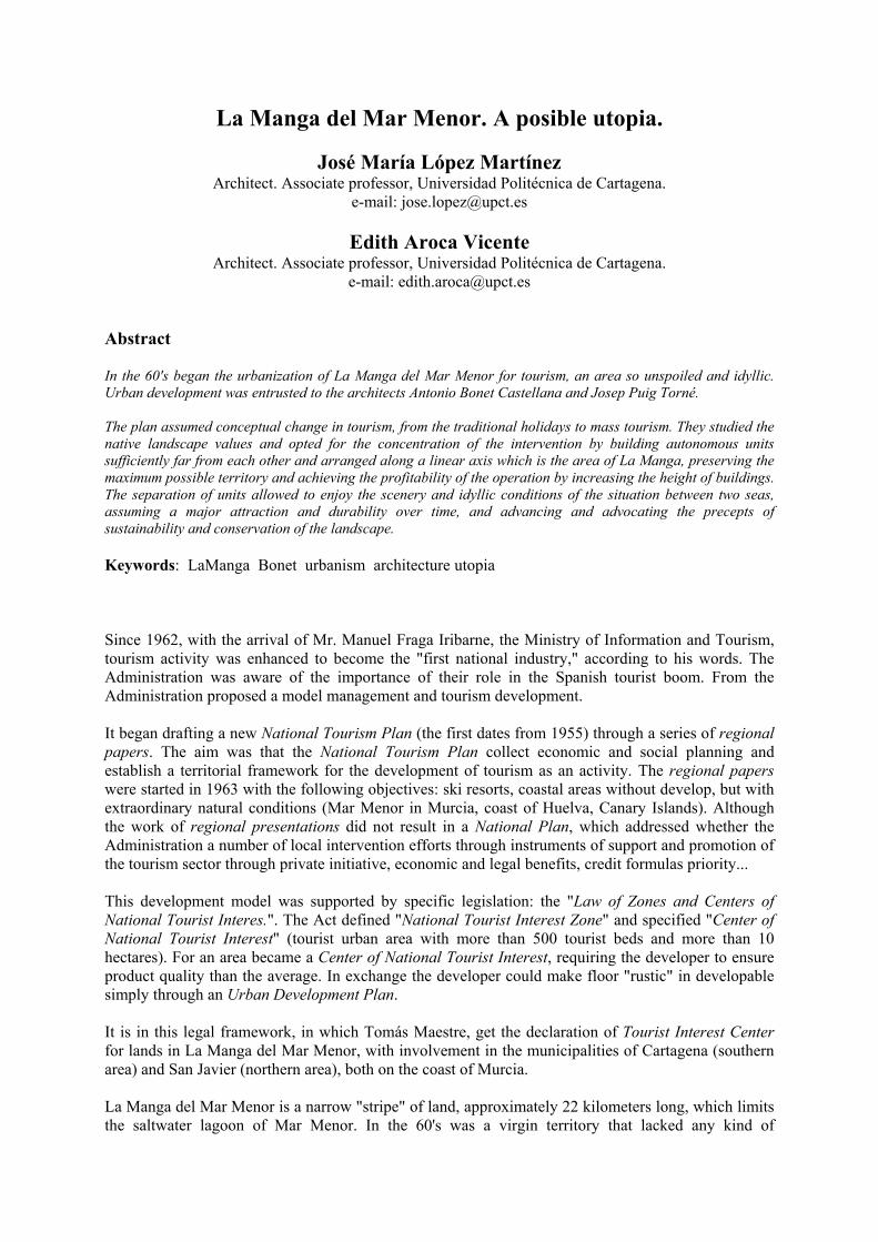
La Manga del Mar Menor. A posible utopia. José María López Martínez Architect. Associate professor, Universidad Politécnica de Cartagena. e-mail: [email protected] Edith Aroca Vicente Architect. Associate professor, Universidad Politécnica de Cartagena. e-mail: [email protected] Abstract In the 60's began the urbanization of La Manga del Mar Menor for tourism, an area so unspoiled and idyllic. Urban development was entrusted to the architects Antonio Bonet Castellana and Josep Puig Torné. The plan assumed conceptual change in tourism, from the traditional holidays to mass tourism. They studied the native landscape values and opted for the concentration of the intervention by building autonomous units sufficiently far from each other and arranged along a linear axis which is the area of La Manga, preserving the maximum possible territory and achieving the profitability of the operation by increasing the height of buildings. The separation of units allowed to enjoy the scenery and idyllic conditions of the situation between two seas, assuming a major attraction and durability over time, and advancing and advocating the precepts of sustainability and conservation of the landscape. Keywords: LaManga Bonet urbanism architecture utopia Since 1962, with the arrival of Mr. Manuel Fraga Iribarne, the Ministry of Information and Tourism, tourism activity was enhanced to become the "first national industry," according to his words. The Administration was aware of the importance of their role in the Spanish tourist boom. From the Administration proposed a model management and tourism development. It began drafting a new National Tourism Plan (the first dates from 1955) through a series of regional papers. The aim was that the National Tourism Plan collect economic and social planning and establish a territorial framework for the development of tourism as an activity. The regional papers were started in 1963 with the following objectives: ski resorts, coastal areas without develop, but with extraordinary natural conditions (Mar Menor in Murcia, coast of Huelva, Canary Islands). Although the work of regional presentations did not result in a National Plan, which addressed whether the Administration a number of local intervention efforts through instruments of support and promotion of the tourism sector through private initiative, economic and legal benefits, credit formulas priority... This development model was supported by specific legislation: the "Law of Zones and Centers of National Tourist Interes.". The Act defined "National Tourist Interest Zone" and specified "Center of National Tourist Interest" (tourist urban area with more than 500 tourist beds and more than 10 hectares). For an area became a Center of National Tourist Interest, requiring the developer to ensure product quality than the average. In exchange the developer could make floor "rustic" in developable simply through an Urban Development Plan. It is in this legal framework, in which Tomás Maestre, get the declaration of Tourist Interest Center for lands in La Manga del Mar Menor, with involvement in the municipalities of Cartagena (southern area) and San Javier (northern area), both on the coast of Murcia. La Manga del Mar Menor is a narrow "stripe" of land, approximately 22 kilometers long, which limits the saltwater lagoon of Mar Menor. In the 60's was a virgin territory that lacked any kind of
-
Upload
khangminh22 -
Category
Documents
-
view
1 -
download
0
Transcript of La Manga del Mar Menor. A posible utopia. - UPCommons
La Manga del Mar Menor. A posible utopia.
José María López Martínez Architect. Associate professor, Universidad Politécnica de Cartagena.
e-mail: [email protected]
Edith Aroca Vicente Architect. Associate professor, Universidad Politécnica de Cartagena.
e-mail: [email protected] Abstract In the 60's began the urbanization of La Manga del Mar Menor for tourism, an area so unspoiled and idyllic. Urban development was entrusted to the architects Antonio Bonet Castellana and Josep Puig Torné. The plan assumed conceptual change in tourism, from the traditional holidays to mass tourism. They studied the native landscape values and opted for the concentration of the intervention by building autonomous units sufficiently far from each other and arranged along a linear axis which is the area of La Manga, preserving the maximum possible territory and achieving the profitability of the operation by increasing the height of buildings. The separation of units allowed to enjoy the scenery and idyllic conditions of the situation between two seas, assuming a major attraction and durability over time, and advancing and advocating the precepts of sustainability and conservation of the landscape. Keywords: LaManga Bonet urbanism architecture utopia Since 1962, with the arrival of Mr. Manuel Fraga Iribarne, the Ministry of Information and Tourism, tourism activity was enhanced to become the "first national industry," according to his words. The Administration was aware of the importance of their role in the Spanish tourist boom. From the Administration proposed a model management and tourism development. It began drafting a new National Tourism Plan (the first dates from 1955) through a series of regional papers. The aim was that the National Tourism Plan collect economic and social planning and establish a territorial framework for the development of tourism as an activity. The regional papers were started in 1963 with the following objectives: ski resorts, coastal areas without develop, but with extraordinary natural conditions (Mar Menor in Murcia, coast of Huelva, Canary Islands). Although the work of regional presentations did not result in a National Plan, which addressed whether the Administration a number of local intervention efforts through instruments of support and promotion of the tourism sector through private initiative, economic and legal benefits, credit formulas priority... This development model was supported by specific legislation: the "Law of Zones and Centers of National Tourist Interes.". The Act defined "National Tourist Interest Zone" and specified "Center of National Tourist Interest" (tourist urban area with more than 500 tourist beds and more than 10 hectares). For an area became a Center of National Tourist Interest, requiring the developer to ensure product quality than the average. In exchange the developer could make floor "rustic" in developable simply through an Urban Development Plan. It is in this legal framework, in which Tomás Maestre, get the declaration of Tourist Interest Center for lands in La Manga del Mar Menor, with involvement in the municipalities of Cartagena (southern area) and San Javier (northern area), both on the coast of Murcia. La Manga del Mar Menor is a narrow "stripe" of land, approximately 22 kilometers long, which limits the saltwater lagoon of Mar Menor. In the 60's was a virgin territory that lacked any kind of

infrastructure and belonged to a few owners, the largest of them Tomás Maestre. To get the statement of touristic sites in the area and aware of the superior quality it needed in the urban and architectural plans, hired the architects Antonio Bonet Castellana and Josep Puig Torné. Figure 1: La Manga urban plan. Model. figure 2: La Manga urban plan. Model. Tourist Interest Centers (TIC) declared in Murcia in the area of La Manga del Mar Menor were: Designation TIC date ha beds million ptas. Hacienda de La Manga de Cartagena 23.07.1966 88 ha 16,920 2,200 Hacienda de La Manga de San Javier 26.12.1968 280 ha 36,400 8,980 Playa Honda (La Manga) 19.01.1967 54.86 ha 4,500 295.6 Hacienda Dos Mares (La Manga) 06.02.1969 61 ha 1,900 47 Source: Chamber o Commerce of Cartagena (1973), p. 527 The urban model of La Manga del Mar Menor. In 1961, Antonio Bonet and Josep Puig Torné are commissioned to make urban planning of La Manga del Mar Menor. The first ideas and plans respond to the experience gained in the study of Le Corbusier and CIAM IV in which Bonet attends along with Jose Luis Sert as GATCPAC delegates. As said in Bonet "New Details of Architecture and Urbanism" (1949): "The future will be planning in three dimensions, where the buildings are not in the traditional sense of the word, but as fragments of city whose architectural elements shall consist of a series of structures systematized". In paragraph 29 of the "Athens Charter" can be read: "The high buildings, located far away from each other, they must release the ground in favor of large green areas", "but it is also necessary that these buildings are located at great distances from each other because otherwise its height, far from being an improvement, would only aggravate the current malaise”. The initial ordering of La Manga remember the Buenos Aires Plan of Le Corbusier, 1929, and is a step between the settlement of Punta Ballena (1945) and the Buenos Aires Plan (1956) and Montjuïc Plan and the Ribera Plan (Barcelona, 1964). figure 3: La Manga urban plan. Preliminary draft. figure 4: La Manga urban plan. Model. The project took on conceptual change in tourism at the time: the “traditional holidays”' to “mass tourism”, and picked up the urban experience of the Modern Movement. The arrangement proposed the construction of tourist units and repeated systematized sufficiently far apart and arranged
strategically throughout the linear axis which is the territory of La Manga. The different cores were connected by an axial path implemented directly on the shaft. The initial plan figures, according to the “flyers promoting” from the developer, were as follows:
- 1 highway 32 m wide with four vials of movement - 1 heliport - 1 bullring - 12 cores established tourist attraction - 2 fishing villages: “El Estacio” and “El Pedrucho” - 26 hotels - 32,000 inhabitants as planned initial population - 288.80 hectares of urban area
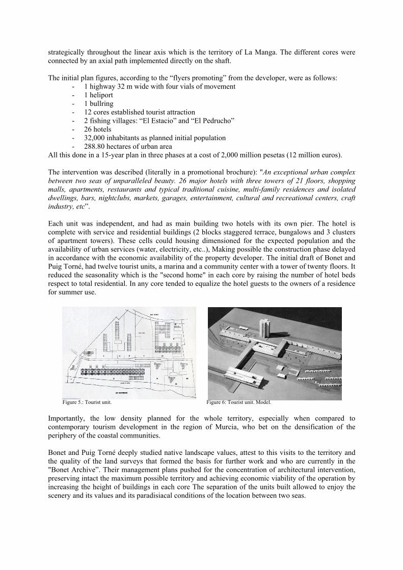
All this done in a 15-year plan in three phases at a cost of 2,000 million pesetas (12 million euros). The intervention was described (literally in a promotional brochure): "An exceptional urban complex between two seas of unparalleled beauty. 26 major hotels with three towers of 21 floors, shopping malls, apartments, restaurants and typical traditional cuisine, multi-family residences and isolated dwellings, bars, nightclubs, markets, garages, entertainment, cultural and recreational centers, craft industry, etc”. Each unit was independent, and had as main building two hotels with its own pier. The hotel is complete with service and residential buildings (2 blocks staggered terrace, bungalows and 3 clusters of apartment towers). These cells could housing dimensioned for the expected population and the availability of urban services (water, electricity, etc..), Making possible the construction phase delayed in accordance with the economic availability of the property developer. The initial draft of Bonet and Puig Torné, had twelve tourist units, a marina and a community center with a tower of twenty floors. It reduced the seasonality which is the "second home" in each core by raising the number of hotel beds respect to total residential. In any core tended to equalize the hotel guests to the owners of a residence for summer use. Figure 5.: Tourist unit. Figure 6: Tourist unit. Model. Importantly, the low density planned for the whole territory, especially when compared to contemporary tourism development in the region of Murcia, who bet on the densification of the periphery of the coastal communities. Bonet and Puig Torné deeply studied native landscape values, attest to this visits to the territory and the quality of the land surveys that formed the basis for further work and who are currently in the "Bonet Archive”. Their management plans pushed for the concentration of architectural intervention, preserving intact the maximum possible territory and achieving economic viability of the operation by increasing the height of buildings in each core The separation of the units built allowed to enjoy the scenery and its values and its paradisiacal conditions of the location between two seas.
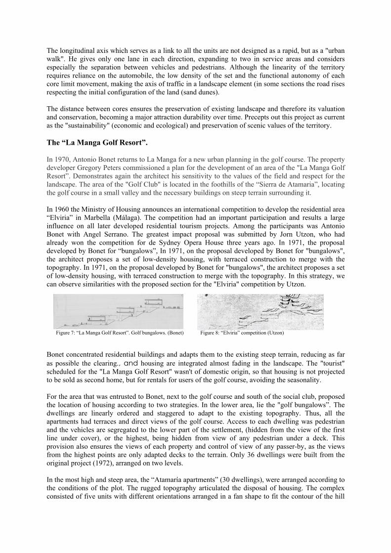
The longitudinal axis which serves as a link to all the units are not designed as a rapid, but as a "urban walk". He gives only one lane in each direction, expanding to two in service areas and considers especially the separation between vehicles and pedestrians. Although the linearity of the territory requires reliance on the automobile, the low density of the set and the functional autonomy of each core limit movement, making the axis of traffic in a landscape element (in some sections the road rises respecting the initial configuration of the land (sand dunes). The distance between cores ensures the preservation of existing landscape and therefore its valuation and conservation, becoming a major attraction durability over time. Precepts out this project as current as the "sustainability" (economic and ecological) and preservation of scenic values of the territory. The “La Manga Golf Resort”. In 1970, Antonio Bonet returns to La Manga for a new urban planning in the golf course. The property developer Gregory Peters commissioned a plan for the development of an area of the "La Manga Golf Resort”. Demonstrates again the architect his sensitivity to the values of the field and respect for the landscape. The area of the "Golf Club" is located in the foothills of the “Sierra de Atamaria”, locating the golf course in a small valley and the necessary buildings on steep terrain surrounding it. In 1960 the Ministry of Housing announces an international competition to develop the residential area “Elviria” in Marbella (Málaga). The competition had an important participation and results a large influence on all later developed residential tourism projects. Among the participants was Antonio Bonet with Angel Serrano. The greatest impact proposal was submitted by Jorn Utzon, who had already won the competition for de Sydney Opera House three years ago. In 1971, the proposal developed by Bonet for “bungalows”, In 1971, on the proposal developed by Bonet for "bungalows", the architect proposes a set of low-density housing, with terraced construction to merge with the topography. In 1971, on the proposal developed by Bonet for "bungalows", the architect proposes a set of low-density housing, with terraced construction to merge with the topography. In this strategy, we can observe similarities with the proposed section for the "Elviria" competition by Utzon. Figure 7: “La Manga Golf Resort”. Golf bungalows. (Bonet) Figure 8: “Elviria” competition (Utzon) Bonet concentrated residential buildings and adapts them to the existing steep terrain, reducing as far as possible the clearing., and housing are integrated almost fading in the landscape. The "tourist" scheduled for the "La Manga Golf Resort" wasn't of domestic origin, so that housing is not projected to be sold as second home, but for rentals for users of the golf course, avoiding the seasonality. For the area that was entrusted to Bonet, next to the golf course and south of the social club, proposed the location of housing according to two strategies. In the lower area, lie the "golf bungalows”. The dwellings are linearly ordered and staggered to adapt to the existing topography. Thus, all the apartments had terraces and direct views of the golf course. Access to each dwelling was pedestrian and the vehicles are segregated to the lower part of the settlement, (hidden from the view of the first line under cover), or the highest, being hidden from view of any pedestrian under a deck. This provision also ensures the views of each property and control of view of any passer-by, as the views from the highest points are only adapted decks to the terrain. Only 36 dwellings were built from the original project (1972), arranged on two levels. In the most high and steep area, the “Atamaría apartments” (30 dwellings), were arranged according to the conditions of the plot. The rugged topography articulated the disposal of housing. The complex consisted of five units with different orientations arranged in a fan shape to fit the contour of the hill
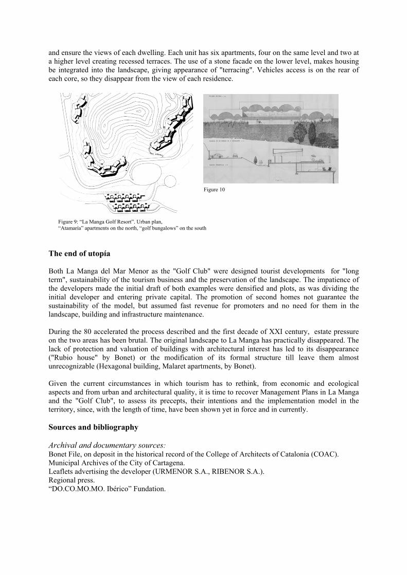
and ensure the views of each dwelling. Each unit has six apartments, four on the same level and two at a higher level creating recessed terraces. The use of a stone facade on the lower level, makes housing be integrated into the landscape, giving appearance of "terracing". Vehicles access is on the rear of each core, so they disappear from the view of each residence. Figure 10 Figure 9: “La Manga Golf Resort”. Urban plan, “Atamaría” apartments on the north, “golf bungalows” on the south The end of utopía Both La Manga del Mar Menor as the "Golf Club" were designed tourist developments for "long term", sustainability of the tourism business and the preservation of the landscape. The impatience of the developers made the initial draft of both examples were densified and plots, as was dividing the initial developer and entering private capital. The promotion of second homes not guarantee the sustainability of the model, but assumed fast revenue for promoters and no need for them in the landscape, building and infrastructure maintenance. During the 80 accelerated the process described and the first decade of XXI century, estate pressure on the two areas has been brutal. The original landscape to La Manga has practically disappeared. The lack of protection and valuation of buildings with architectural interest has led to its disappearance ("Rubio house" by Bonet) or the modification of its formal structure till leave them almost unrecognizable (Hexagonal building, Malaret apartments, by Bonet). Given the current circumstances in which tourism has to rethink, from economic and ecological aspects and from urban and architectural quality, it is time to recover Management Plans in La Manga and the "Golf Club", to assess its precepts, their intentions and the implementation model in the territory, since, with the length of time, have been shown yet in force and in currently. Sources and bibliography Archival and documentary sources: Bonet File, on deposit in the historical record of the College of Architects of Catalonia (COAC). Municipal Archives of the City of Cartagena. Leaflets advertising the developer (URMENOR S.A., RIBENOR S.A.). Regional press. “DO.CO.MO.MO. Ibérico” Fundation.
Bibliography:
Alvarez, F.; Roig, J. (eds.): “Antonio Bonet Castellana. 1913-1989” Colegio Oficial de Arquitectos de Cataluña. Ministerio de Fomento. Barcelona, 1996
Branchini, S.; Falcón, L.: “La democratización del hedonismo. Topografías turísticas en España” Catálogos de Arquitectura, nº18 Colegio Oficial de Arquitectos de Murcia. Murcia, 2006
Cámara Oficial de Comercio, Industria y Navegación de Cartagena: “La comercialización en el contexto del desarrollo económico del área de Cartagena” Cartagena, 1973
Cánovas, A.; Amman, A.: “Monólogos” Catálogos de Arquitectura, nº1 Colegio Oficial de Arquitectos de Murcia. Murcia, 1997.
Delgado, M.: “Elogio del turista” Catálogos de Arquitectura, nº18 Colegio Oficial de Arquitectos de Murcia. Murcia, 2006.
Galiana Martín, L.; Barrado Timón, D.: “Los centros de interés turístico nacional y el despegue del turismo de masas en España” Investigaciones Geográficas, nº39, 2006 (p. 73-93)
López-Morell, M.A.; Pedreño Cánovas, A.; Baños Páez, P.: “Génesis y trayectorias del desarrollo turístico del entorno del Mar Menor” Communication in the Eighth Congress of the AEHE. Session B-15 "Economic History of Tourism"
Mesalles, F; Tous, J. (eds.): “La arquitectura del sol / Sundland architecture” (p. 220-249) Colegio Oficial de Arquitectos de Cataluña. Barcelona, 2002
Ministerio de Obras Públicas y Urbanismo: “Ordenación territorial de la zona del Mar Menor y su entorno” Centro de Estudios de Ordenación del Territorio y Medio Ambiente. Madrid, 1985
Palacios, F.: “Desarrollo turístico de la Región de Murcia” Catálogos de Arquitectura, nº18 Colegio Oficial de Arquitectos de Murcia. Murcia, 2006.
Parra, J.; Palomares, M.; Sabater, G.: “Sombras en la duna. Bonet frente al paisaje de La Manga” Arqui_MU (digital edition) Murcia, 2011.