Consumer Involvement in Brand Positioning - International ...
Upload
insight-centreCategory
view
7download
0
Knowledge-Based Multi-Criteria Optimization toSupport Indoor Positioning
Alessandra Mileo1, Torsten Schaub2, Davide Merico1, and Roberto Bisiani1
1 NOMADIS, University of Milan-Bicocca, Italy
2 University of Potsdam, Germany
Abstract
Indoor position estimation constitutes a central task in home-basedassisted living environments. Such environments often rely on a hetero-geneous collection of low-cost sensors whose diversity and lack of pre-cision has to be compensated by advanced techniques for localizationand tracking. Although there are well established quantitative meth-ods in robotics and neighboring fields for addressing these problems,they lack advanced knowledge representation and reasoning capacities.Such capabilities are not only useful in dealing with heterogeneous andlacking information but moreover they allow for a better inclusion ofsemantic information and more general homecare and patient-relatedknowledge. We address this problem and investigate how state-of-the-art localization and tracking methods can be combined with answerset programming, as a popular knowledge representation and reason-ing formalism. We report upon a case-study and provide a first exper-imental evaluation of knowledge-based position estimation.
1 Introduction and Motivations
The continuous progress of computing and communication technology isleading towards the realization of living environments pervaded by a highnumber of invisible devices affecting and improving all aspects of our lives.A crucial issue in these scenarios is to know the physical location of users,since it represents the basis for context-aware and user-centered systems.The problem of indoor position estimation includes two aspects: localizationand tracking.
Localization (also referred to as position estimation) is commonly ad-dressed by acquiring the distance from three or more points of known po-sitions and then applying trilateration. The distance can be computed bymeasuring variations of signal intensity or by timing the latency from trans-mission to reception. The precision of positioning systems varies from a fewmeters in 2D to a few decimeters in 3D. Given the low cost of infrastructureand their flexibility, localization system based on Wireless Sensor Networks(WSN) are a good starting point for tackling the localization problem inhome environments. However, when data are noisy and incomplete due to
Proceedings of the 17th International RCRA workshop (RCRA 2010):Experimental Evaluation of Algorithms for Solving Problems with Combinatorial Explosion: Pre-liminary ReportBologna, Italy, June 10–11, 2010

delays, breakdowns, errors in transmission, and alike, their lack of precisionin position estimation needs to be supported and compensated.
Tracking is more concerned with how the position of moving objectschanges in time; it takes into account knowledge about previous positionsand a model of movement to estimate the expected (more plausible) position.
Different estimation methods can be used to tackle the problem of nodelocalization, such as Maximum Likelihood, Maximum A Posteriori, LeastSquares, Moving Average filter, Kalman filter, and Particle filter [7, 12, 11].Although many of these algorithm give good results in terms of accuracyand precision, only Particle Filters (PFs) can be easily extended to deal withthe problem of target tracking [8]. Therefore, PFs are the most popularand commonly used methods for tackling the problem of tracking devisingmotion models to update the particle statuses. For this reason, we considerin our preliminary experimental evaluation results of PFs as representativeof a wider calss of similar but less effective techniques.
Particle Filters discretize the probability distribution function of the po-sition of the mobile object instead of controlling the whole position space.Unlike Kalman Filters, they do not approximate the probabilities using onlygaussian distributions, thus we have to impose less conditions to be able toapply the algorithm. The possible positions of the mobile object are rep-resented as a set of particles, each of which has an associated weight. Thedistribution of these particles in space gives the most likely positions. Prob-abilistic approaches to tracking such as PF strongly depend on the specificsensors used and they are mainly based on quantitative cost functions forcomputing weights. One of the main limitations of these methods is the dif-ficulty to identify within the same model the right global cost function com-bining heterogeneous sensor data with other criteria like movement, speed,and alike. Another aspect is that the introduction of new sensor informationis not straightforward and requires a lot of customization to properly extendthe model.
In order to address these limitations, we propose an alternative and inno-vative approach to support indoor localization and tracking. Our solution isbased on Answer Set Programming (ASP), a declarative logic programmingframework, combining a compact, flexible, and expressive modeling languagewith high computational performance. The knowledge representation andreasoning capacities of ASP provide us with the following advantages:
• a knowledge-based level of multi-sensor fusion for position estimation,
• definition of qualitative criteria to combine sensor data and common-sense knowledge for tracking, and
• easy customization and extensibility of existing solutions in a moreflexible way whenever new technology or new sensor-data becomesavailable.
2

The main advantage of using ASP is to deal with incomplete information,stemming from faulty or diverging sensors, and thus to improve the scala-bility of the whole system. ASP does not only deal with missing sensor databut moreover it allows us to exploit semantic information for distinguishingthe most plausible among varied sensor data.
Our approach is based on a low-cost and energy-aware localization in-frastructure. The data collected by each specific type of sensor is processedby traditional algorithms for feature extraction and aggregation.
For validating our approach we collected a considerable amount of sen-sor data by appeal to a simulation tool generating large sets of sensor datareflecting entire days of a person’s household activities, matching real sen-sors installed in our lab. On top of the aggregation phase, a further levelof knowledge-based sensor fusion is in charge of combining heterogeneoussensor data to associate it to specific properties or semantic information.The ASP based reasoning process follows the common generate and testmethodology in (i) generating the space of possible positions according tosemantic data aggregation criteria and (ii) exploring the search space by ap-plying efficient solving techniques to compensate for the lack of informationand to enforce constraint satisfaction and optimization.
The simulation environment and properties of generated data are de-scribed in Section 2. Section 3 introduces the ASP formalism and investi-gates our modeling and reasoning strategies, while preliminary results arepresented in Section 4. A short discussion follows in Section 5.
2 Data Simulation
To position an object or a device, the basic step is to use a reference pointto determine the distance and angle between the device and the referencepoint itself. To do so we use the Receiver Signal Strength Indicator (RSSI),based on the degradation of radio signal while traveling in a space.
In addition to RSSI, we use Passive Infrared (PIR) and Range Finders(RF). PIR is used to catch the movements of a person (or object) that has adifferent temperature with respect to the surroundings while RF uses sonarto provide the distance of an object from the sensor.
In order to generate RSSI, RF, PIR, and environmental sensor data,we implemented an agent-based data-generation tool using the RecursivePorous Agent Simulation Toolkit (Repast Simphony or Repast)1.
Following a taxonomy of selected Agent-Based Modeling Tools illus-trated in [9], we choose to design and implement our data generation toolusing Repast because it turned out to be the best combination of ease ofmodel development and modeling power. Exploiting the Repast features,
1http://repast.sourceforge.net/
3

we are able to efficiently generate large data sets simulating days of thehousehold activities of a person and corresponding sensor values.
The simulation scenario is represented by a Repast model that describesthree grid-based projections and one network-based projection. The threeN ×M grid projections are used to define (i) the floor plan (walls, roomsand areas), (ii) the position of localization sensors and (iii) the position ofenvironmental sensors together with the way they propagate to adjacentcells. The network-based projection defines two undirected weighted graphshaving FloorCell agents as nodes. The first graph is mainly used for themovement of the Person agent computed using Dijkstra’s shortest path al-gorithm where weights are also used to avoid movements across wall cells.
The second grid projection is mainly used during the RSSI-data genera-tion to verify if a direct line-of-sight between the person and the localizationsensors exists. This information is useful in order to better simulate theRSSI propagation model. For this, the weights of graph in the second gridprojection are computed without considering walls. The line-of-sight infor-mation is computed comparing the results of the shortest path algorithmobtained using the two graphs. These results differ only if there is a wallbetween the localization sensor and the person.
The simulation scenario is specified in an XML-based scenario-definitionfile2. This scenario file is used to dynamically populate projections duringthe initialization phase of the Repast simulator, and it defines the followingaspects of the simulation context:
environment: according to what specified in this file, a FloorCell agentcan be a wall, part of a room-area or a passage (a cell connecting twoareas of different rooms); the division of the environment into roomsand areas is specified so that an area can be associated to one roomand a room can contain different (disjoint3) areas;
localization sensors: in addition to the sensor position on the grid and itsorientation, the definition specifies the behavior of the passive-infraredand movement sensors in terms of cells covered;
environmental sensors: during the data-generation phase, these sensorscan read the temperature, humidity and brightness values;
light and heat sources: these elements define the properties of the ob-jects that are used to manage and propagate the state of light andheat throughout the simulation scenario using a controlled floodingalgorithm [6, 13]; the position and the initial status of windows andlight switches is also defined.
2Note that Repast can load the required initialization data in several ways (e.g. usingagent definitions directly stored in a relational database or in text files).
3The spatial inclusion of areas A1, . . . , An in a room R is such thatSn
i=1 Ai ⊂ R.
4

Figure 1: Repast S Displays for Simulation
Floor Plan Sensors Plan
In addition, we provide an XML file containing a detailed list of actionswe want the agent Person to perform. The actual version of the simulationtool include three types of elementary actions: going to a specific position inthe grid, changing the state of lights and opening/closing doors and windows.
The data-generation is driven by two different event schedulers that areused to: (i) simulate the behaviour of the person and generate accordingRSSI, PIR, and RF sensor data, (ii) simulate light, temperature, and hu-midity evolution during the day.
During every simulation tick, the LocalizationSensor agents compute theRSSI, PIR, and RF considering the position of the agent Person in the floorplan. The measurement computation takes into account the model of everysensor: the radio propagation model for RSSI values and the presence ofthe person in a cell covered by the sensor for PIR and RF. Environmen-talSensor agents generate temperature, humidity and light measurementsperiodically examining the state of the associated EnvironmentCell agent.All measurements are stored in a relational database.
The DayManager and HeatManager agents are used to manage the evo-lution of daylight and external temperature and humidity during the data-generation. Using the schedule we mentioned before, they modify the stateof LightSources and HeatSources objects, which in turn modify the state ofthe associated LightCells and HeatCells objects.
Figure 1 shows the Repast toolkit executing different projection displays:the left side shows the main projection, walls (squares) and the person (dot);the right side gives the projection of sensor data, showing the light sources
5
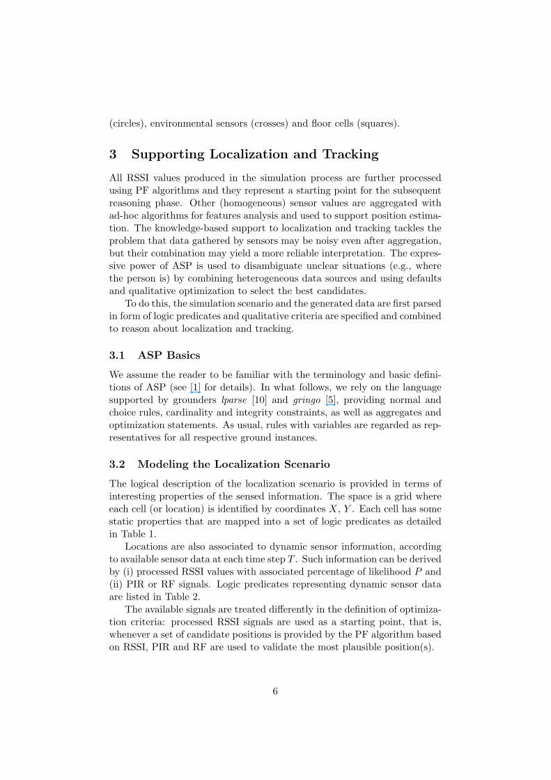
(circles), environmental sensors (crosses) and floor cells (squares).
3 Supporting Localization and Tracking
All RSSI values produced in the simulation process are further processedusing PF algorithms and they represent a starting point for the subsequentreasoning phase. Other (homogeneous) sensor values are aggregated withad-hoc algorithms for features analysis and used to support position estima-tion. The knowledge-based support to localization and tracking tackles theproblem that data gathered by sensors may be noisy even after aggregation,but their combination may yield a more reliable interpretation. The expres-sive power of ASP is used to disambiguate unclear situations (e.g., wherethe person is) by combining heterogeneous data sources and using defaultsand qualitative optimization to select the best candidates.
To do this, the simulation scenario and the generated data are first parsedin form of logic predicates and qualitative criteria are specified and combinedto reason about localization and tracking.
3.1 ASP Basics
We assume the reader to be familiar with the terminology and basic defini-tions of ASP (see [1] for details). In what follows, we rely on the languagesupported by grounders lparse [10] and gringo [5], providing normal andchoice rules, cardinality and integrity constraints, as well as aggregates andoptimization statements. As usual, rules with variables are regarded as rep-resentatives for all respective ground instances.
3.2 Modeling the Localization Scenario
The logical description of the localization scenario is provided in terms ofinteresting properties of the sensed information. The space is a grid whereeach cell (or location) is identified by coordinates X, Y . Each cell has somestatic properties that are mapped into a set of logic predicates as detailedin Table 1.
Locations are also associated to dynamic sensor information, accordingto available sensor data at each time step T . Such information can be derivedby (i) processed RSSI values with associated percentage of likelihood P and(ii) PIR or RF signals. Logic predicates representing dynamic sensor dataare listed in Table 2.
The available signals are treated differently in the definition of optimiza-tion criteria: processed RSSI signals are used as a starting point, that is,whenever a set of candidate positions is provided by the PF algorithm basedon RSSI, PIR and RF are used to validate the most plausible position(s).
6
Predicate Descriptioncell(X,Y,Room,Area) association of a cell to an area of a roompassage(X,Y,R1,A1,R2,A2) association of a cell to a passagewall(X,Y) description of a cell as part of a wallloc(X,Y) a location L is described by two coordinatesinvalid(loc(X,Y)) specification of invalid cellsdataExpected(pir,loc(X,Y)) locations covered by PIR sensorsdataExpected(rf,loc(X,Y)) locations covered by RF sensors
Table 1: Logic Predicates representing static properties of cells
Predicate Descriptionsensed(rssi,P,L,T) processed RSSI signal with likelihood P re-
ceived at time T for location Lsensed(pir,L,T) PIR signal received at time T for location Lsensed(rf,L,T) RF signal received at time T for location L
Table 2: Logic Predicates representing sensor data collected at each timestep
At any time step, a location becomes a candidate position when a pro-cessed RSSI, PIR or RF signal has been received for that location and thelocation is valid (e.g. it is not a wall). This allows us to immediately re-duce the space of solutions to the positions for which at least one signal isavailable. The corresponding ASP code is as follows:
location(L,T) :- sensed(rssi,P,L,T).location(L,T) :- sensed(S,L,T).location(L) :- location(L,T), not invalid(L).
Besides the information about received sensor data at a given time stepT for a location L, we also describe two additional dynamic properties for alocalization and tracking problem: the distance measure between two con-sequent admissible moves and the support for a location as a candidateposition at a give time step.
Distance between two locations l1 = loc(x1, y1) and l2 = loc(x2, x2) isrepresented by the propositional variable dist(l1, l2, d) that is true forwhere
d = |x1 − x2|+ |y1 − y2|
Support for a location L is the number of sensor data collected at locationL at a given time T and it is represented by predicate support(L, N, T )where
N = |{sensed(S, L, T )}| where S ∈ dataExpected(S, L)
7

Discrete time is in seconds and sensor data are opportunely aggregatedand provided when values change beyond a given threshold.
Earlier in this section we mentioned that filtered candidate positionsobtained by PF by processing RSSI signals represent starting points to es-timate the actual position. Our reasoning process is flexible enough to dealwith noisy and even missing sensor values. Since we reduce the set of pos-sible solutions to the ones for which results of PF are availabe, when thisinformation is missing tracking the person on the grid becomes more diffi-cult and the solution space can be huge, since the model of movement mayproduce a higher number of possibilities. This happens not only in caseof malfunctioning sensors, but also when the PF cannot provide acceptablecandidate positions for several sequential time steps. In this case, the qual-itative analysis of the available information can still help, as detailed in thenext subsection.
3.3 Multi-Criteria Optimization
The interpretation of heterogeneous sensor data used to support localizationand tracking is based on the definition of properties of sensed informationthat can be meaningful according to available sensor data. In our solu-tion, we identified three properties which combination can originate severaloptimization criteria.
Best PF property considers positions with the highest likelihood P , thatare provided as a result of the PF algorithm; unfortunately it is notalways true that the higher the likelihood obtained by the PF, thecloser the candidate position is to the real one; for this reason we de-fine additional criteria to validate positions; when results of PF arenot available, a different reward function is used, which is closely re-lated to the notion of support for a location L defined in the previoussubsection: the higher the support for L, the better L is as a candidateposition.
Best Coherence maximizes the value of the coherence property, whichidentifies a percentage indicating how many of the sensor signals ex-pected from a given location L are effectively captured for that locationat time T ; this property is represented by predicate coherence(L, C, T );if no additional sensor signals (excluded results of Particle Filter) areexpected for a location L, its coherence C will always be 100% for alltime step; in the same way, C is 0 at time T if we expect at least oneadditional sensor value for a location L and we do not have any ofthem; otherwise, we have that, for a location L,
C = (100 ∗M)/N
where M = |{dataExpected(S, L}| and N is the support.
8
Best Move property identifies the best location at any time step T asthe location L for which the distance between L and the location attime step T −1 is minimum; the associated property is represented bypredicate bestMove(L, T ).
When new sensor information is introduced, we can easily re-define orextend the list of properties. An example can be the introduction of environ-mental data in the definition of coherence: to take such data into account,we just have to introduce it in the notion of support.
Once we have the list of properties, they can be combined into optimiza-tion criteria. The preference relation between two criteria is defined by theirnumbering such as Ci is preferred to Cj (Ci >pref Cj) when i > j.
In our prototype, we identified four criteria Ci, i = 1..4, combiningproperties on sensor information as follows:
C1 is satisfied for a location L at time T when L satisfies both the bestmove and the best coherence property;
C2 is satisfied for a location L at time T when L verifies the best coherenceproperty;
C3 is satisfied for a location L at time T when L verifies the best moveproperty;
C4 is satisfied for a location L at time T when at least one of the predicatesin Table 2 is true on L at time T , and L has the highest likelyhood orthe highest support; this is the weakest criterion and it is applied onlywhen no better solution can be found by applying the other criteria.
This ordering is motivated by the fact that we want to obtain the solutionsatisfying all criteria as the best option, but if it does not exist, we preferto give up the movement model and consider coherence as more reliable4.Alternative combinations are also possible and this can be useful to comparethem in order to understand which property seems to be stronger or whichsensor data appears to be more reliable.
In order to implement optimization on ordered criteria, we introducethe concept of best value B for a criterion Ci at time T , BCi(T ). The bestvalue is determined in two different ways according to the fact that (a) wehave L as a candidate position at time T as a result of Particle Filter or(b) no candidate position is produced by Particle Filter at time T but wehave other sensed data supporting a location L as a candidate position. Thedefinition is as follows:
a) BCi(T ) = max{P : sensed(rssi, P, L, T ), ∃/ BCj (T ) with Cj < Ci}4Note that this is one of the possible choices. We can change the ordering between
criteria to see how reliable our sensors are.
9
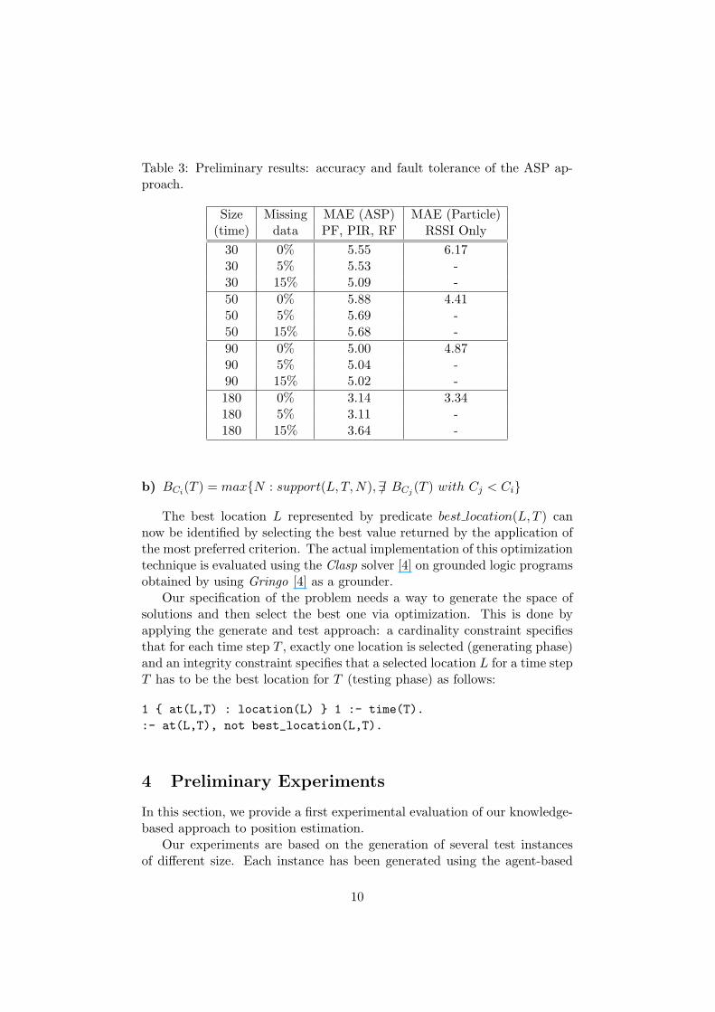
Table 3: Preliminary results: accuracy and fault tolerance of the ASP ap-proach.
Size Missing MAE (ASP) MAE (Particle)(time) data PF, PIR, RF RSSI Only
30 0% 5.55 6.1730 5% 5.53 -30 15% 5.09 -50 0% 5.88 4.4150 5% 5.69 -50 15% 5.68 -90 0% 5.00 4.8790 5% 5.04 -90 15% 5.02 -180 0% 3.14 3.34180 5% 3.11 -180 15% 3.64 -
b) BCi(T ) = max{N : support(L, T, N),∃/ BCj (T ) with Cj < Ci}
The best location L represented by predicate best location(L, T ) cannow be identified by selecting the best value returned by the application ofthe most preferred criterion. The actual implementation of this optimizationtechnique is evaluated using the Clasp solver [4] on grounded logic programsobtained by using Gringo [4] as a grounder.
Our specification of the problem needs a way to generate the space ofsolutions and then select the best one via optimization. This is done byapplying the generate and test approach: a cardinality constraint specifiesthat for each time step T , exactly one location is selected (generating phase)and an integrity constraint specifies that a selected location L for a time stepT has to be the best location for T (testing phase) as follows:
1 { at(L,T) : location(L) } 1 :- time(T).:- at(L,T), not best_location(L,T).
4 Preliminary Experiments
In this section, we provide a first experimental evaluation of our knowledge-based approach to position estimation.
Our experiments are based on the generation of several test instancesof different size. Each instance has been generated using the agent-based
10
simulation toolkit Repast Simphony. According to the size of the instancewe want to generate, we simulate movements of a person across one ormore rooms of the house through one or more midpoints. Repast appliesa simple shortest-path algorithm for simulation, based on the map of theenvironment and realistic motion model. The instance size is determined bythe number of time steps which corresponds to the number of moves, giventhat each move is associated to a new time step. In our analysis, we makethe assumption that the number of sensors (thus the amount of sensor datareceived at each time step) is fixed according to a given sampling rate, and itis linear in the number of rooms and doors in the environment (we considerputting four to six sensors per room plus one sensor for each passage). Forthis reason, we did not consider the amount of data produced by sensors ateach time step as a factor that may impact performance.
We focus our attention on the following aspects of our approach:
• the overall accuracy of results (Mean Absolute Error);
• the fault tolerance expressed as the impact of missing data on theaccuracy;
• the effectiveness of optimization criteria in filtering results.
We determine the overall accuracy of our results via the Mean AbsoluteError (MAE), proposed in [2] for measuring the accuracy of localization withrespect to the true ground position. MAE is very similar to the commonRoot Mean Square and consists of computing the residual error betweenthe estimated and actual node positions for every node in the network, sumthem and average the result, as shown in the following equation:
MAE =∑n
i=1
√(xi − xi)2 + (yi − yi)2
n
where (xi, yi) are the coordinates of the target’s estimated positions and(xi, yi) the true ground ones. Note that in our simulation environment, thedimension of each cell is 20cm, which means that an MAE of 5 indicates anaverage error of one meter which is fully acceptable.
We compare the MAE indexes obtained through Particle Filters (PF)based on the RSSI signals only, with the MAE index obtained by ASPcombining results of PF based on RSSI signals with Range Finder (RF) andPassive Infrared (PIR) measurements.
If we observe the first row of each instance (with no missing data), wesee that the introduction of additional (noisy) sensor data gives us an MAEthat is slightly higher with the ASP-enhanced approach or very close (asin the last instance). The only real exception is the MAE of the smallestinstance of size 30. This can be explained by the fact that the PF algorithmre-allocates the particles used for position estimation at each time step; as
11
a consequence, it is common that on small instances the particles are still abit sparse and the precision of the algorithm is lower.
For a similar reason, MAE index slightly decreases as size rises: onbigger instances, particles tends to converge on the more plausible positions,resulting in higher accuracy. This increased accuracy propagates on ASPresults, since the ASP approach itself uses PF results as a starting point,and it is not furher affected by the size of the instance in terms of MAE.
Another aspect we took into account is how the accuracy can be affectedby missing data. A lack of data can either be caused by sensors not properlytransmitting or by a too sparse set of particles, so that the PF algorithmcannot provide candidate positions. Considering missing data scenarios isinteresting in view of the fact that we want our approach to be robust andable to provide candidate solutions even in case of malfunctioning sensorsor weak PF results.
The second column in Table 3 indicates the amount of sensor data weremoved from the input given to ASP. We observe that in general we ob-tain lower MAE values by removing data, probably due to the fact that ourknowledge-based approach makes it possible to estimate a position by usingthe model of movement or additional domain-related knowledge to reducethe search space and propose plausible estimations even when the PF algo-rithm is not able to provide some. Another consideration is that removingdata could also remove noise, thus giving better global results.
If we consider the last instance in Table 3, we notice that removing 5% ofPF data gives us an initial reduction of MAE, which then increases when weget to removing 15% of PF data. In further analysis it would be interestingto estimate a threshold telling us how far we can go in removing data beforeMAE starts to increase. Intuitively, it depends on how many different kindsof sensor signals we have, and how noisy are the data they produce: thehigher the number of sensors or the noise, the higher the threshold, whileif we have lots of reliable sensor data, we would expect this threshold to belower.
Although we need more tests to validate our intuitions, the main ideais that if we have a higher number of sensors, missing data can be bettercompensated by the knowledge-based approach, as long as the noisiness ofdata does not grow significantly with the number of sensors. Time stepswith no data do not determine a redistribution of the particles as in thePF algorithm: in our approach, the position in a time step for which nodata have been collected, are guessed according to the knowledge-basedoptimization criteria applied to tracking in previous and following time steps.Preliminary tests show that this approach makes accuracy robust againstincomplete information, but we need more accurate tests to support thisstatement. One may argue that if data are not available for several timesteps, the combinatorial explosion of possible solutions can make the searchprocess inefficient. Even in this case, optimization criteria can help selecting
12
the best candidate positions in the search space.The effectiveness of our approach can be validated by observing that
changing the order of criteria could help evaluating the reliability of sensordata or the soundness of the properties we defined according to commonsenseknowledge. As an example, we found out that values provided by PIR andRF sensors are very reliable, thus if we switch criteria C2 and C3 givinghigher preference to the movement model than the coherence property, theMAE increases.
In addition, our approach makes it easier to add new domain-knowledgein form of constraints or optimization measures, which can be used tostrengthen the choice of some candidate positions over others going beyondwhat sensor data tells us.
A more general, though very important issue, is the trade-off betweenflexibility and accuracy of the model. In order to investigate this aspect, weshould make further experiments on how additional sensor data as well asnew criteria or different optimizations may affect accuracy.
5 Discussion
We presented a hybrid approach to indoor position estimation by combiningand extending quasi-standard quantitative methods in a knowledge-basedyet qualitative framework. To this end, we took advantage of the knowledgerepresentation and reasoning capacities of ASP for providing a rich modelcombining various disconnected sensor models with further semantic infor-mation, like a movement model and sensor dependencies. The resulting ASPencoding combines the available heterogeneous sensor data in a transparentand easily modifiable way and offers an impressive robustness in dealingwith noisy and (partially) absent sensor data, as indicated by our prelimi-nary experiments. Although we have not discussed the encoding in detail,it allows for easy customization and extensibility. All in all, the elaborationtolerance of the high-level ASP specification makes the major difference ofour approach to potential alternatives, and it seems hard to envisage in apurely quantitative settings.
This preliminary work is only a starting point. Future work will haveto address more extensive and systematic experiments in various simulatedas well as real scenarios. More sensor and semantic information needs to betaken into account in order to evaluate the true scalability of our approach.Finally, our current implementation accumulates data in hourly intervals.We plan to refine this to use the incremental ASP solver iClingo [3] in orderto provide a much more fine-grained approach to localization and tracking,eventually aiming at real-time conditions.
13
References
[1] C. Baral. Knowledge Representation, Reasoning and Declarative Prob-lem Solving. Cambridge University Press, 2003.
[2] M. Broxton, J. Lifton, and J. A. Paradiso. Localization on the pushpincomputing sensor network using spectral graph drawing and mesh re-laxation. SIGMOBILE Mobile Computer and Communication Review,10, 2006.
[3] M. Gebser, R. Kaminski, B. Kaufmann, M. Ostrowski, T. Schaub, andS. Thiele. Engineering an incremental ASP solver. In M. Garcia de laBanda and E. Pontelli, editors, Proceedings of the Twenty-fourth Inter-national Conference on Logic Programming (ICLP’08), volume 5366,pages 190–205, 2008.
[4] M. Gebser, B. Kaufmann, A. Neumann, and T. Schaub. clasp: Aconflict-driven answer set solver. In Ninth International Conferenceon Logic Programming and Nonmonotonic Reasoning, pages 260–265.Springer-Verlag, 2007.
[5] M. Gebser, T. Schaub, and S. Thiele. Gringo : A new grounder foranswer set programming. In LPNMR, pages 266–271, 2007.
[6] Hedetniemi, Hedetniemi, and Liestman. A survey of gossiping andbroadcasting in communication networks. NETWORKS: Networks: AnInternational Journal, 18, 1988.
[7] R. E. Kalman. A new approach to linear filtering and prediction prob-lems. Transactions of the ASME Journal of Basic Engineering, (82(Series D)):35–45, 1960.
[8] E. F. Nakamura, A. A. F. Loureiro, and A. C. Frery. Information fu-sion for wireless sensor networks: Methods, models, and classifications.ACM Comput. Surv., 39(3):9, 2007.
[9] M. J. North and C. M. Macal. Managing Business Complexity: Discov-ering Strategic Solutions with Agent-Based Modeling and Simulation.Oxford University Press, Inc., New York, NY, USA, 2007.
[10] T. Syrjanen. Lparse 1.0 user’s manual.http://www.tcs.hut.fi/Software/smodels/lparse.ps.gz.
[11] S. Thrun, W. Burgard, and D. Fox. Probabilistic robotics. MIT Press,2005.
[12] S. Thrun, D. Fox, W. Burgard, and F. Dallaert. Robust monte carlolocalization for mobile robots. Artificial Intelligence, 128(1-2):99–141,2001.
14

[13] R. Verdone, D. Dardari, G. Mazzini, and A. Conti. Wireless Sensorand Actuator Networks: Technologies, Analysis and Design. AcademicPress, 2008.
15
Copyright © 2022 FDOKUMEN