Kelainai. A Phrygian City between East and West
11
Presses universitaires de Franche-Comté http://presses-ufc.univ-fcomte.fr À la confluence de l’Histoire, de la Géographie, de l’Archéologie et des langues anciennes, cet ouvrage présente un point sur les recherches récentes entreprises en Anatolie, une région du monde exceptionnelle, carrefour de grandes civilisations et de sociétés variées. Il souligne en outre la vigueur des échanges culturels sur la longue durée. At the meeting of History, Geography, Archaeology and ancient languages, this book presents recent researches undertaken in Anatolia, an exceptional area located at the crossroads of great civilizations and various societies. Indeed, it underlines the vigour of cultural exchanges over a long time span. Hadrien Bru est Maître de Conférences en Histoire Ancienne à l’Université de Franche-Comté (Institut des Sciences et Techniques de l’Antiquité). Guy Labarre est Professeur d’Histoire Grecque à l’Université de Franche-Comté (Institut des Sciences et Techniques de l’Antiquité). L’Anatolie des peuples, des cités et des cultures – Hadrien Bru et Guy Labarre (éds) L’ Anatolie des peuples, des cités et des cultures (ii e millénaire av. J.-C. – v e siècle ap. J.-C.) Colloque international de Besançon - 26-27 novembre 2010 Volume 2. Approches locales et régionales édité par Hadrien Bru et Guy Labarre Presses universitaires de Franche-Comté Prix : euros les volumes ISBN ---- -:HSMIOI=[\Y\XZ:
Transcript of Kelainai. A Phrygian City between East and West

Pre
ss
es
un
ive
rsit
air
es
de
Fra
nc
he
-Co
mté
htt
p:/
/pre
sses
-ufc
.un
iv-f
com
te.f
r
À l
a co
n#ue
nce
de l
’His
toir
e, d
e la
Géo
grap
hie,
de
l’Arc
héol
ogie
et
des
lan
gues
anc
ienn
es,
cet
ouvr
age
prés
ente
un
poin
t su
r le
s re
cher
ches
réc
ente
s en
trep
rise
s en
Ana
tolie
, une
rég
ion
du m
onde
ex
cept
ionn
elle
, ca
rref
our
de g
rand
es c
ivili
sati
ons
et d
e so
ciét
és
vari
ées.
Il s
oulig
ne e
n ou
tre
la v
igue
ur d
es é
chan
ges
cultu
rels
sur
la
long
ue d
urée
.
At
the
mee
ting
of H
isto
ry, G
eogr
aphy
, Arc
haeo
logy
and
anc
ient
la
ngua
ges,
this
boo
k pr
esen
ts r
ecen
t re
sear
ches
und
erta
ken
in
Ana
tolia
, an
exc
epti
onal
are
a lo
cate
d at
the
cro
ssro
ads
of g
reat
ci
viliz
atio
ns a
nd v
ario
us s
ocie
ties
. Ind
eed,
it u
nder
lines
the
vig
our
of c
ultu
ral e
xcha
nges
ove
r a lo
ng ti
me
span
.
Had
rien
Bru
est
Maî
tre
de C
onfé
renc
es e
n H
isto
ire
Anc
ienn
e à
l’Uni
vers
ité
de
Fran
che-
Com
té (I
nsti
tut d
es S
cien
ces e
t Tec
hniq
ues d
e l’A
ntiq
uité
).G
uy L
abar
re e
st P
rofe
sseu
r d’H
isto
ire
Gre
cque
à l’
Uni
vers
ité
de F
ranc
he-C
omté
(I
nsti
tut d
es S
cien
ces e
t Tec
hniq
ues d
e l’A
ntiq
uité
).
L’Anatolie des peuples, des cités et des cultures – Hadrien Bru et Guy Labarre (éds)
L’A
nato
lie d
es p
eupl
es,
des c
ités e
t des
cul
ture
s(i
ie mill
énai
re av
. J.-C
. – v
e sièc
le ap
. J.-C
.)
Co
llo
qu
e in
tern
atio
na
l d
e B
esa
nç
on
- 26
-27
no
vem
bre
2010
Vol
ume
2.
App
roch
es lo
cale
s et r
égio
nale
s éd
ité p
ar
Had
rien
Bru
et G
uy L
aba
rre
Pre
sse
s u
niv
ers
ita
ire
s d
e F
ran
ch
e-C
om
té
Pri
x :
eu
ros
les
v
olu
me
s
ISB
N
--
-
-
-:HSMIOI=[\Y\XZ:

e mountainous region of the Maeander source ( g. 1) was favorable for settle-ments since the earliest times because of its great abundance of water and optimal loca-tion at the crossroads that joins Phrygia with Ionia, Lydia, Cappadocia, Pisidia and Pamphylia. e name of the city “Kelainai” is "rst mentioned by Herodotus (VII, 26-27) and its history is strongly connected with the Achaemenid Kings1. e story of the arrival
* Eidgenössische Technische Hochschule Zürich ** Ludwig-Maximilians Universität München*** CNRS, Bordeaux – UMR 5607 Ausonius e general location of the city has been detected in the 19th century, nevertheless there was no systematical archaeological research on the site until 2008 a survey project of University of Munich (LMU) and CNRS/University of Bordeaux was initiated. is paper gives a short overview on the "rst results of this project; detailed information is given on http://www-ausonius.u-bordeaux3.fr/axes/Kelainai/Home_de.html.
Kelainai. A Phrygian City between East and West
A. von KIENLIN*
L. SUMMERER**
A. IVANTCHIK***
L’Anatolie des peuples, des cités et des cultures 221
Figure . The Lake Aulotrene.

A. von Kienlin - L. Summerer - A. Ivantchik
222 L’Anatolie des peuples, des cités et des cultures
of Xerxes’s army in Kelainai during the campaign against Greece in 480 BC is told with the following words2: „When they had crossed the river Halys and entered Phrygia, they marched through that country to Celaenae, where rises the source of the river Maeander and of another river no smaller, which is called Cataractes; it rises right in the market-place of Celaenae and issues into the Maeander. e skin of Marsyas the Silenus also hangs there; the Phrygian story tells that it was Dayed oF him and hung up by Apollo.“ (transl. A.D. Godley)
Xenophon (Anab. I, 2,7-9) describes Kelainai as the place where Cyrus the Younger mustered his mercenaries in 401 BC3: „From this place he marched three stages, twenty parasangs in all, to Kelainai, a populous city of Phrygia, large and prosperous. Here Cyrus owned a palace and a large park full of wild beasts, which he used to hunt on horseback, whenever he wished to give himself or his horses exercise. rough the midst of the park Dows the river Meander, the sources of which are within the palace buildings, and it Dows through the city of Kelainai. e great King also had a palace at Kelainai, a strong palace, on the sources of another river, the Marsyas, at the foot of the acropolis. is river also Dows through the city, discharging himself from the Meander, and is "ve-and-twenty feet broad. Here is the place, where Apollo is said to have Dayed Marsyas, when he had conquered him in contest of skill. He hung up the skin of the conquered man, in the cavern where the spring wells forth, and hence the name of the river, Marsyas. It was on this site that Xerxes, as tradition tells, built his very palace, as well as the citadel of Kelainai itself, on his retreat from Hellas, a\er he lost his famous battle.“ (transl. H.G. Dakyns)
e author of the Hellenica Oxyrhynchia (P.Oxy. 842, Fr. B, 12, 3-4) reports that in 394 when Agesilaus IInd reached the Meander on his march through Phrygia he consulted an oracle to determine whether he should attack Kelainai. Receiving a negative omen he went back to the valley of Ephesos.
From these sources we understand that Kelainai was an outstanding and strongly forti"ed place in Southern Phrygia in the 5th and 4th centuries BC. It was well known as the stage of several historical events and mythological accounts. It was the only Royal Achae-menid residence in Anatolia known so far. Despite of its historical importance Kelainai was never investigated systematically by archaeologists4. Following on the preceding research work on the Tatarlı tomb which was concluded with an exhibition in Istanbul in 20105, the University of Munich and the Ausonius-Institute Bordeaux has launched a systematic research programme in 2008. e aim of the project is to survey all available material for the reconstruction of the history of Kelainai.
Topography and history
Kelainai, as mentioned above, is situated at the sources of the Meander, which runs from the western central Anatolia towards the Ionian coast, on a distance of around 500 km. Despite of its location at the border between Phrygia and Lydia, it is clearly de"ned being a Phrygian city in the written sources. e voyagers of the 19th century such
On the Persian army in Kelainai see Summerer 2011, 33-54. A detailed interpretation of Xenophon’s texts on Kelainai: Tuplin 2011, 71-92. On the other hand inscriptions had been searched and published since the 19th century, important publi-cations were Chamonard – Legrand 1893, Buckler – Calder 1939, MAMA VI. More recently Drew-Bear – Eck 1976, Drew-Bear 1978, Christol – Drew-Bear 1987 and 1992, Corsten – Drew-Bear 1992. On the basis of coins from Apameia, Nollé 2006 gave a "rst insight in the history of the city. Summerer – von Kienlin 2010.

Kelainai. A Phrygian City between East and West
L’Anatolie des peuples, des cités et des cultures 223
as F.V.J. Arundell, G. Hirschfeld, D.G. Hogarth, G. Weber and W.M. Ramsay6 have already recognised the location of the city in vicinity of the modern town Dinar7.
Several architectural remains of the Hellenistic and Roman periods can be found spread all over the modern city, but only a few structures are still standing in situ. Surface "nds such as pottery8, roof tiles, arrowheads9 are dense especially on the hills surrounding the modern city. Even if the centre of the modern city seems to have almost the same posi-tion as the Hellenistic agora10, Dinar extends towards West, along the modern main route to the North-West, and South. ese routes do surely not cover the ancient ones. However, we can assume that their orientations hardy diFer: along the Meander valley to Lydia and the Ionian Coast, and towards South to Pisidia and Lycia. A third important modern road leading into the city from the North-East crosses the mountains at North-East of Dinar. In contrary to the others, this road follows the natural topography and so may, at least partly, have the same course as the ancient road11. is must have been the well known route between Kelainai and Gordion, passing by the Campus Metropolitanus and Metropolis (Tatarlı)12.
e source of the Marsyas mentioned by the ancient authors probably lies nearby the North-Eastern road and those of the Meander in a green valley east of Dinar, where the hunting garden of Cyrus the Younger described by Xenophon was probably situated13. In a larger scale it is evident why the city is situated at this place : the earliest city was founded on the foothills which frame the Meander valley on the North-East14. Surrounding the city the foothills provide an optimal protection and leave only a narrow pass route towards the North-East. For its outstanding natural position at the gates to inner Anatolia it was a halting place for many armies15 and an interregional market place.
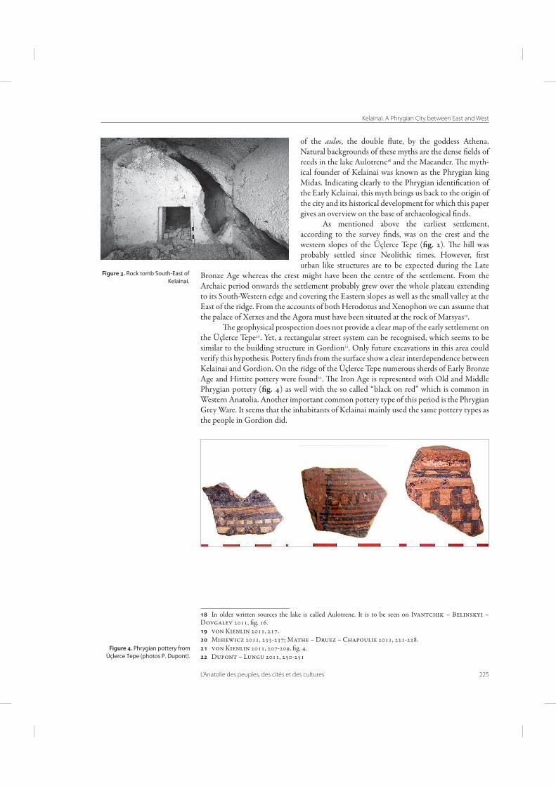
e extension of the ancient city to the North and East can be determined by several necropoleis ( g. 2). Burial areas are spread on hill slopes around the main settlement hill that called Üçlerce Tepe in common parlance. e necropoleis mainly consist of rock tombs ( g. 3) and tumuli from all periods. e tomb chambers of the tumuli were o\en built by carving in the bedrock. e rock cut tombs usually consist of a dromos, an ante chamber and the tomb chamber. ey are usually furnished by klinai and have either vaulted or gabled roofs.
For a better understanding of the ancient topography a hydrological research on the natural water system was needed, for the ancient authors o\en refer to the water courses describing the city. As we know from Xenophon, the hunting garden of Cyrus was situated at the sources of the Meander. According to the "rst results of investigations the hydrolog-ical environment and waterways did not change essentially since Antiquity, even if slight displacements of the riverbeds may have happened. One of the most striking features of
eir reports: Arundell 1828 and 1834; Hirschfeld 1875; Hogarth 1888; Weber 1892; Ramsay 1890 and 1897. Barat 2011, 117-133. For an overview on the pottery "nds in Kelainai see Dupont – Lungu 2011, 249-276. Summerer 2011, 37, "g. 2. von Kienlin 2011, 210-211. Several architectural pieces of a Stoa and 2 inscriptions mentioning agoranomoi were found nearby the modern municipality. Possibly the ancient agora continued being the urban center throughout the centuries. Remains of this road were recently found, cf. Ivantchik-Belinskiy-Dovgalev 2011, 142 and "g. 8. Müller 1997. On the identi"cation of the sources of Maeander and Marsyas: Sementchenko 2011, 63-70 with further literature. Ivantchik – Belinskiy – Dovgalev 2011, 137-139, "g. 1, 2. Besides the above mentioned expedition of Xerxes the armies Cyrus the Younger (Xenophon, Anab., 1,2,7f ), Alexander the Great (Arrian, Anab., 1,29,1; Curtius, 3,1) and the Roman Consul Cn. Manlius Vulso (Livy, 38, 13) also halted in Kelainai.

A. von Kienlin - L. Summerer - A. Ivantchik
224 L’Anatolie des peuples, des cités et des cultures
the physical environment is the ground water system : both the Maeander and the Marsyas have their origin in the lake Aulotrene ( g. 1), 3 km East of Kelainai16. e water of the lake disappeared in several caverns along the east side of a mountain range, which separated the lake from the Maeander valley. e water Dew through perforated Triassic limestone, along the surface of a thick compact layer of Miocene schist and reappeared again on the other side of the ridge. e strong water pressure of the Marsyas source led Herodotus to call it “katarrektes”, that said waterfalls. is general water system persisted until a few decades ago, but a dam around the Autotrene-lake canalized the water on another way. Nowadays the huge cave of the former Marsyas-source is still visible, although somehow hidden by the “Suçıkan Hotel” which was built in the 1960s. According to Xenophon, the skin of Marsyas was exposed in this cave.
At one of these water entry caverns called “Subatan” in common parlance (i.e. water hollow) a round shaped hill or island with a small rectangular building inside could be detected by geophysical prospection. is "ts well to an ancient report about a particular Phrygian tradition to sacri"ce to the river gods at the lake Aulotrene: calling the name of either Marsyas or Maeandros meat was thrown into the water which reappeared hours later in the right source on the other side of the mountain17. is is the only one example among many others how the local myths were woven in cultic life of the city. e most famous myth, of course, is the contest of Marsyas and Apollo and, connected to this, the invention
Ivantchik – Belinskyi – Dovgalev 2011, 150, "g. 16; 171-175. Maximius Tyrius, 2.8. cf. Zwingmann 2011, 97.
Figure . Hypothetic Locations on the axial photo of Dinar.
Kelainai. A Phrygian City between East and West
L’Anatolie des peuples, des cités et des cultures 225
of the aulos, the double Dute, by the goddess Athena. Natural backgrounds of these myths are the dense "elds of reeds in the lake Aulotrene18 and the Maeander. e myth-ical founder of Kelainai was known as the Phrygian king Midas. Indicating clearly to the Phrygian identi"cation of the Early Kelainai, this myth brings us back to the origin of the city and its historical development for which this paper gives an overview on the base of archaeological "nds.
As mentioned above the earliest settlement, according to the survey "nds, was on the crest and the western slopes of the Üçlerce Tepe ( g. 2). e hill was probably settled since Neolithic times. However, "rst urban like structures are to be expected during the Late
Bronze Age whereas the crest might have been the centre of the settlement. From the Archaic period onwards the settlement probably grew over the whole plateau extending to its South-Western edge and covering the Eastern slopes as well as the small valley at the East of the ridge. From the accounts of both Herodotus and Xenophon we can assume that the palace of Xerxes and the Agora must have been situated at the rock of Marsyas19.
e geophysical prospection does not provide a clear map of the early settlement on the Üçlerce Tepe20. Yet, a rectangular street system can be recognised, which seems to be similar to the building structure in Gordion21. Only future excavations in this area could verify this hypothesis. Pottery "nds from the surface show a clear interdependence between Kelainai and Gordion. On the ridge of the Üçlerce Tepe numerous sherds of Early Bronze Age and Hittite pottery were found22. e Iron Age is represented with Old and Middle Phrygian pottery ( g. 4) as well with the so called “black on red” which is common in Western Anatolia. Another important common pottery type of this period is the Phrygian Grey Ware. It seems that the inhabitants of Kelainai mainly used the same pottery types as the people in Gordion did.
In older written sources the lake is called Aulotrene. It is to be seen on Ivantchik – Belinskyi – Dovgalev 2011, "g. 16. von Kienlin 2011, 217. Misiewicz 2011, 233-237; Mathe – Druez – Chapoulie 2011, 221-228. von Kienlin 2011, 207-209, "g. 4. Dupont – Lungu 2011, 250-251
Figure . Rock tomb South-East of Kelainai.
Figure . Phrygian pottery from Üçlerce Tepe (photos P. Dupont).

A. von Kienlin - L. Summerer - A. Ivantchik
226 L’Anatolie des peuples, des cités et des cultures
e geographical location of Kelainai was the major factor that contributed to the increase of trade and commercial activities. It imported pottery from both East and West. e Protogeometric pottery sherds provide evidence that the trade contacts with Ionia did exist in the 9th century BC at latest. Some examples of the so called Fikellura amphoriskoi that surely came from Miletos suggest a particular link with Miletos and a trading route along the Meander valley. e harbour of Miletos might have been provided a sea trade with the Greek islands and Greece, as some "nds with archaic amphoras from Chios, Knidos and Rhodos as well as with Corinthian and Attic pottery show ( g. 5). A silver Milesian coin of Late Archaic period found in Kelainai also indicates trade and commercial activi-rade and commercial activi-ties with Miletos ( g. 6). Finds with electron coins23 and abundant ceramics known as Lydian pottery24 suggest a close relationship with Lydia. Striking is a Lydian inscription on a limestone stele that we have found in 2009 in Kelainai ( g. 7). Its preservation condition is poor nevertheless it is clear that it is written using the Lydian alphabet and in Lydian language25. e hypothetical reconstruction and translation of the text fragments allow an interpretation both as a dedication and a funerary inscription. In any case it was erected in the property of a Lydian family resident in Kelainai. From this evidence we can conclude that in the 6th century Kelainai was under the rule of the Lydian Kingdom and a certain number of Lydians was resident in the city or at least landowners. e most famous of them was Pytheos, who was, according to Herodotus, the richest man of his time, a\er the Achaemenid Great King26.
When Cyrus of Persia defeated Croesus of Lydia, Kelainai fell under Persian rule and became a residence of Achaemenids. A hoard "nd with silver coins, so called sigloi27 ( g. 8), arrowheads and the rich "nds with the sherds of “Achaemenid” cups28 provide archaeological evidence for the presence of Persians in Kelainai. e Persian kings obvi- e Persian kings obvi-ously choosed Kelainai as residence and military basis in Asia Minor because of its stra-tegic location at the juncture between East and West. Xerxes started his expedition against Greece there. Later Cyrus the Younger based in Kelainai with his army on the eve of the struggle with his brother29.
In 333 B.C. Alexander the Great marched into Kelainai during his expedition through Asia Minor and le\ there one of his best generals, Antigonos as satrap of Phrygia. is was the opening move in the manoeuvre for succession that culminated in 301 in the events that led to the battle of Ipsos30, in which the coalition of Antigonos’ enemies including Seleukos I was victorious. His son Antiochos Soter (324-261 BC) renamed Kelainai a\er his mother Apama. e image of the Hellenistic city is clearer since there are remains of
Cahill 2010, 429, Kat. 25. Further Lydian coins : Summerer 2011, 35 note 15. Dupont – Lungu 2011, 252. e inscription will be published by I. Ivantchik and I. X. Adiego in the Proceedings of the Conference in Bordeaux 2010. Summerer 2011, 34-35. It is not quite sure, if Pytheos was really resident of Kelainai or just had posses- It is not quite sure, if Pytheos was really resident of Kelainai or just had posses-sions there. Carradice 1998, 65-81. Dupont – Lungu 2011, 252. Tuplin 2011, 72-92. Plutarch, Dem. 28-29; Appian, Syr. 55.
Figure . Archaic Greek pottery from Üçlerce Tepe (photos P. Dupont).
Figure . Milesian coin, probably from the Northern necropolis (photo E. Zakharov).
Figure . Achaemenid coin (Siglos), found nearby Üçlerce Tepe.
Kelainai. A Phrygian City between East and West
L’Anatolie des peuples, des cités et des cultures 227
Figure . Limestone stele with Lydian inscription, transcription
(I. Adiago).
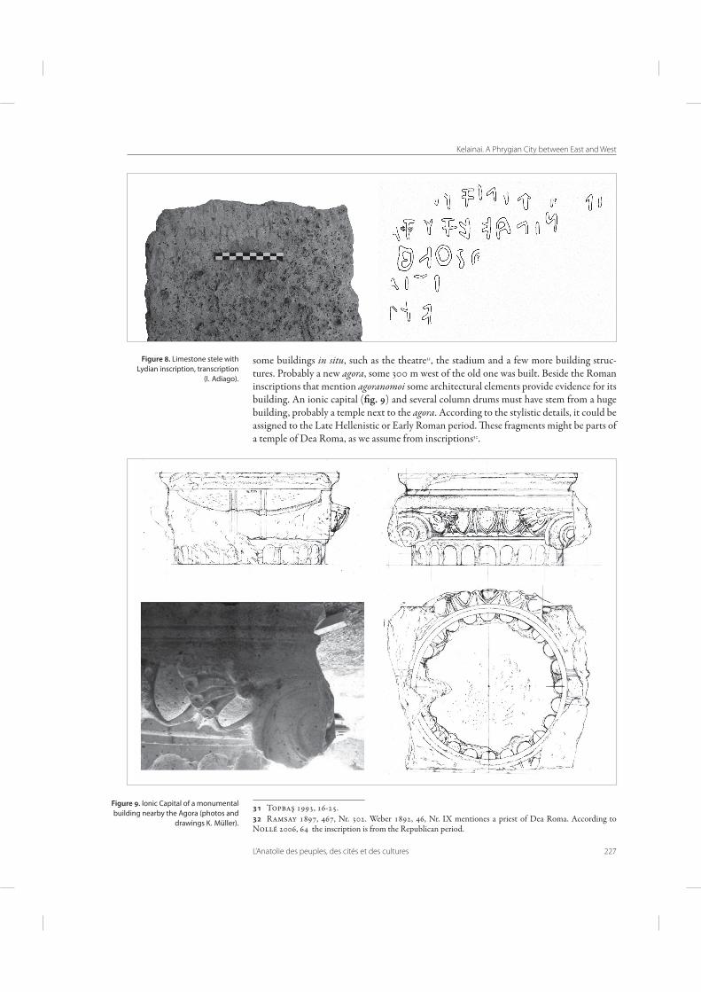
Figure . Ionic Capital of a monumental building nearby the Agora (photos and
drawings K. Müller).
some buildings in situ, such as the theatre31, the stadium and a few more building struc-tures. Probably a new agora, some 300 m west of the old one was built. Beside the Roman inscriptions that mention agoranomoi some architectural elements provide evidence for its building. An ionic capital ( g. 9) and several column drums must have stem from a huge building, probably a temple next to the agora. According to the stylistic details, it could be assigned to the Late Hellenistic or Early Roman period. ese fragments might be parts of a temple of Dea Roma, as we assume from inscriptions32.
Topbaş 1993, 16-25. Ramsay 1897, 467, Nr. 302. Weber 1892, 46, Nr. IX mentiones a priest of Dea Roma. According to Nollé 2006, 64 the inscription is from the Republican period.

A. von Kienlin - L. Summerer - A. Ivantchik
228 L’Anatolie des peuples, des cités et des cultures
Figure . Doric stoa, probably of the Hellenistic Agora (drawing K. Müller).
Figure . Aphrodisias, Sebasteion.

Kelainai. A Phrygian City between East and West
L’Anatolie des peuples, des cités et des cultures 229
A second building which can be assigned to the Agora is a monumental stoa, of which several fragments were found during road construction works in the centre of Dinar. Its architecture is remarkable for the doric style columns are combined with ionic bases ( g. 10). is composite of doric order with ionic elements is a well-known phenom-enon of Hellenistic architecture. In Kelainai it also occurs at the proskenion of the theater. Quite similar bases, dating some decades later, are to be found at the Southern stoa of the Sebasteion of Aphrodisias ( g. 11). e most famous parallel, however, is the Hiera Stoa in Priene33. is suggests that there was an exchange of architectural styles among the cities located along the Maeander river which then rayed also to the neighbouring regions. is interrelationship we can also conclude from the motif of a Meander pattern that appear on the reverse of coins of the cities located in the river valley. is common feature points to a strong identi"cation of those cities with the Maeander.
In the Roman period Kelainai/Apameia continued being important and prosperous. However, a certain degree of decline is recognisable during the Byzantine period. e variety of pottery becomes increasingly poorer which points to a break up of the trading connections of Kelainai. Nevertheless, some monumental buildings were built in the city such as the church of the 5th/6th century on a hill top above the ancient town34. e latest byzantine coins found in Kelainai/Apameia date to the reign of Nicephorus III (1078–1081). Due to its important geographical location35 the settlement was never completely given up and its earliest name Kelainai perhaps persisted with some transformations as Gelene and Geyikler36 during the Selchuk and Ottoman periods until the 20th century, when the name of the city turned to Dinar.
Bibliography
Arundell, F.V.J., A Visit to the Seven Churches of Asia. London, 1828, 102-114, 237-243.
- Discoveries in Asia Minor. London, 1834, I, 172-227.
Barat, C., « L’apport des récits de voyageurs à la connaissance du territoire et du site de Kelainai–Apamée Kibotos », in: Summerer – Ivantchik – v. Kienlin 2011, 117-133.
Belke, K., Mersich, N. Phrygien und Pisidien. Tabula Imperii Byzantini 7, Wien, 1990, 188-189.
Buckler, W.H., Calder, W.M. Monuments and Documents !om Phrygia and Caria. МАМА VI, London, 1939, XIV-XV, 64-88, 145-148.
Carradice, I.A. 1998, « e Dinar Hoard of Persian Sigloi », in: Studies in Greek Numismatics in Memory of Martin Jessop Price, ed. by R. Ashton, S. Hurter in association with G. Le Rider, R. Bland. London, 1998, 65-81, pl. 17-20.
Cahill, N. (ed.), %e Lydians and their World, Istanbul, 2010.
Chamonard, J., Legrand, P.-E., « Inscriptions de Phrygie », BCH 17, 1893, 241-293.
Christol, M., Drew-Bear, T., Un castellum romain près d’Apamée de Phrygie, TAM, Ergänzungsbd. 12, Wien, 1987.
Corsten, T., Drew-Bear, T. « Sur deux inscriptions d’Eumeneia et d’Apameia en Phrygie », EpAnat 20, 1992, 135-142.
Drew-Bear, T., Nouvelles inscriptions de Phrygie. Studia Amstelodamensia ad epigraphicam, ius antiquum et papyrologi-Studia Amstelodamensia ad epigraphicam, ius antiquum et papyrologi-cam pertinenta, 16, Zutphen, 1978.
Drew-Bear, T., Eck, W., « Kaiser-, Militär- und Steinbruchinschri\en aus Phrygien », Chiron 6, 1976, 289-318.
Dupont, P., Lungu, V., « Kelainai 2008 : les trouvailles céramiques. Présentation préliminaire », in : Summerer – Ivantchik – von Kienlin 2011, 249-276.
Hirschfeld, G., « Kelainai – Apameia Kibotos », AbhBerlin 1875, 1-26.
Hogarth, D.G., « Notes upon a Visit to Celaenae – Apamea », JHS 9, 1888, 343-349.
Ivantchik, A., von Kienlin, A., Summerer, L. (éd.), « Recherches à Kélainai – Apamée Kibôtos en 2008-2009. Rapport préliminaire », Anatolia Antiqua 18, 2010, 109-140.
Ivantchik, A., Belinskiy, A. Dovgalev, A., « Prospections sur le territoire d’Apamée et élaboration du SIG
Wiegand – Schrader 1904, 110-112. Arundell 1828. A "rst paper with a schematic plan of the church was published by Ramsay 1897, 396-483, 667-676. e results of a recent research on the church will be published by V. Sedov in the 2nd Kelainai Volume. Belke – Mersich 1990. Weber 1892.

A. von Kienlin - L. Summerer - A. Ivantchik
230 L’Anatolie des peuples, des cités et des cultures
Kelainai–Apamée Kibotos (2008-2010) », in : Summerer - Ivantchik - von Kienlin 2011, 137-178.
Ivantchik, A., von Kienlin, A., Summerer, L., Üyümez, M., « 2008 Kelainai – Apameia Kibotos çalışmaları », 31. Araştırma Sonuçları Toplantısı 27.
von Kienlin, A., « Topographie und Stadtbebauung in Kelainai », in: Summerer - Ivantchik - von Kienlin 2011, 205-220.
Müller, D., Topographischer Bildkommentar zu den Historien Herodots. Kleinasien und angrenzende Gebiete mit Südost-thrakien und Zypern. Tübingen, 1997, s.v. Kelainai, 129-148.
MathÉ, V. – Druez, M. – Chapoulie, R., « Prospection géophysique sur le site archéologique de Kelainai–Apamée Kibotos en 2008 : premiers résultats », in : Summerer - Ivantchik - von Kienlin 2011, 221-228.
Misiewicz, K., « Geophysical Surveys of the Sites Close to Dinar in 2008 and 2009. Preliminary Results », in: Summe-rer - Ivantchik - von Kienlin 2011, 229-248.
Nollé, J., « Beiträge zur kleinasiatischen Münzkunde und Geschichte 4-5 », Gephyra 3, 2006, 49-131.
Ramsay, W.M., %e Historical Geography of Asia Minor. London, 1890, 403-404.
- Cities and Bishoprics of Phrygia, being an essay of the local history of Phrygia !om the earliest times to the Turkish conquest. Vol. I. Part II. West and West-Central Phrygia. Oxford, 1897, 396-483, 667-676.
Sementchenko, L., « Sources of Maeander and Marsyas in Classical Texts », in: Summerer – Ivantchik – von Kienlin 2011, 63-70.
Summerer, L., Ivantchik, A., von Kienlin, A. (ed.), Kélainai – Apamée Kibôtos : Développement urbain dans le contexte anatolien, Kelainai I. Actes du colloque international. Bordeaux, 2011.
Summerer, L., von Kienlin, A. (ed.), Tatarlı. %e Return of Colours, Istanbul, 2010.
Summerer, L., « Persische Arme in Kelainai », in: Summerer – Ivantchik – von Kienlin 2011, 33-54.
Topbaş, A., « Un sarcophage d’Apamée de Phrygie », RA, 1987, N° 2, 361-374.
- « Dinar Tiyatro kazısı », Müze kurtarma kazıları sonuçları, Ankara 1993, 16-25.
Tuplin, Chr., « Xenophon at Celaenae: Palaces, Rivers and Myths », in: Summerer – Ivantchik – von Kienlin 2011, 71-92.
Weber, G., Dinair (Gueïkler) – Célènes – Apamée Cibotos, Besançon, 1892.
Wiegand, . – Schrader, H., Priene, Berlin, 1904.
Zwingmann, N., « Erinnerungslandscha\en und Identitäten in einer kulturellen Kontaktzone: Mythen und Denkmaler in Kelainai–Apameia Kibotos », in: Summerer – Ivantchik – von Kienlin 2011, 93-116.