kegy_20303_e-text.pdf - CIET
20
1. Details of Module and its structure Module Detail Subject Name Geography Course Name Geography 02 (Class XI, Semester - 2) Module Name/Title Drainage – Part 3 Module Id kegy_20303 Pre-requisites Knowledge about The Peninsular Drainage System Objectives After going through this lesson, the learners will be able to understand the following: Indian drainage system Stages of rivers Evolution of Peninsular rivers River system of peninsular rivers- North flowing rivers West flowing rivers East flowing rivers Keywords Non-perennial, Water Divide, Rift Valley, Western Ghats 2. Development Team Role Name Affiliation National MOOC Coordinator Prof. Amarendra P. Behera CIET, NCERT, New Delhi Program Coordinator Dr. Rejaul Karim Barbhuiya CIET, NCERT, New Delhi Course Coordinator (CC) / PI Prof. Tannu Malik DESS, NCERT New Delhi Course Co-Coordinator / Co-PI Dr. Nidhi Gusain CIET, NCERT, New Delhi Subject Matter Expert (SME) Ms. Kulwant Kaur Tagore International School, Eok, New Delhi Review Team Prof. B.S Butola School of Social Sciences, JNU, New Delhi Technical Team Mr. Shobit Saxena Ms. Khushboo Sharma CIET, NCERT, New Delhi CIET, NCERT, New Delhi
-
Upload
khangminh22 -
Category
Documents
-
view
1 -
download
0
Transcript of kegy_20303_e-text.pdf - CIET
1. Details of Module and its structure
Module Detail
Subject Name Geography
Course Name Geography 02 (Class XI, Semester - 2)
Module Name/Title Drainage – Part 3
Module Id kegy_20303
Pre-requisites Knowledge about The Peninsular Drainage System
Objectives After going through this lesson, the learners will be able to
understand the following:
Indian drainage system
Stages of rivers
Evolution of Peninsular rivers
River system of peninsular rivers-
North flowing rivers
West flowing rivers
East flowing rivers
Keywords Non-perennial, Water Divide, Rift Valley, Western Ghats
2. Development Team
Role Name Affiliation
National MOOC Coordinator Prof. Amarendra P. Behera CIET, NCERT, New Delhi
Program Coordinator Dr. Rejaul Karim Barbhuiya CIET, NCERT, New Delhi
Course Coordinator (CC) / PI Prof. Tannu Malik DESS, NCERT New Delhi
Course Co-Coordinator / Co-PI Dr. Nidhi Gusain CIET, NCERT, New Delhi
Subject Matter Expert (SME) Ms. Kulwant Kaur Tagore International School,
Eok, New Delhi
Review Team Prof. B.S Butola School of Social Sciences,
JNU, New Delhi
Technical Team Mr. Shobit Saxena
Ms. Khushboo Sharma
CIET, NCERT, New Delhi
CIET, NCERT, New Delhi
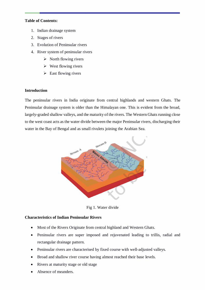
Table of Contents:
1. Indian drainage system
2. Stages of rivers
3. Evolution of Peninsular rivers
4. River system of peninsular rivers
North flowing rivers
West flowing rivers
East flowing rivers
Introduction
The peninsular rivers in India originate from central highlands and western Ghats. The
Peninsular drainage system is older than the Himalayan one. This is evident from the broad,
largely-graded shallow valleys, and the maturity of the rivers. The Western Ghats running close
to the west coast acts as the water divide between the major Peninsular rivers, discharging their
water in the Bay of Bengal and as small rivulets joining the Arabian Sea.
Fig 1. Water divide
Characteristics of Indian Peninsular Rivers
Most of the Rivers Originate from central highland and Western Ghats.
Peninsular rivers are super imposed and rejuvenated leading to trillis, radial and
rectangular drainage pattern.
Peninsular rivers are characterised by fixed course with well-adjusted valleys.
Broad and shallow river course having almost reached their base levels.
Rivers at maturity stage or old stage
Absence of meanders.
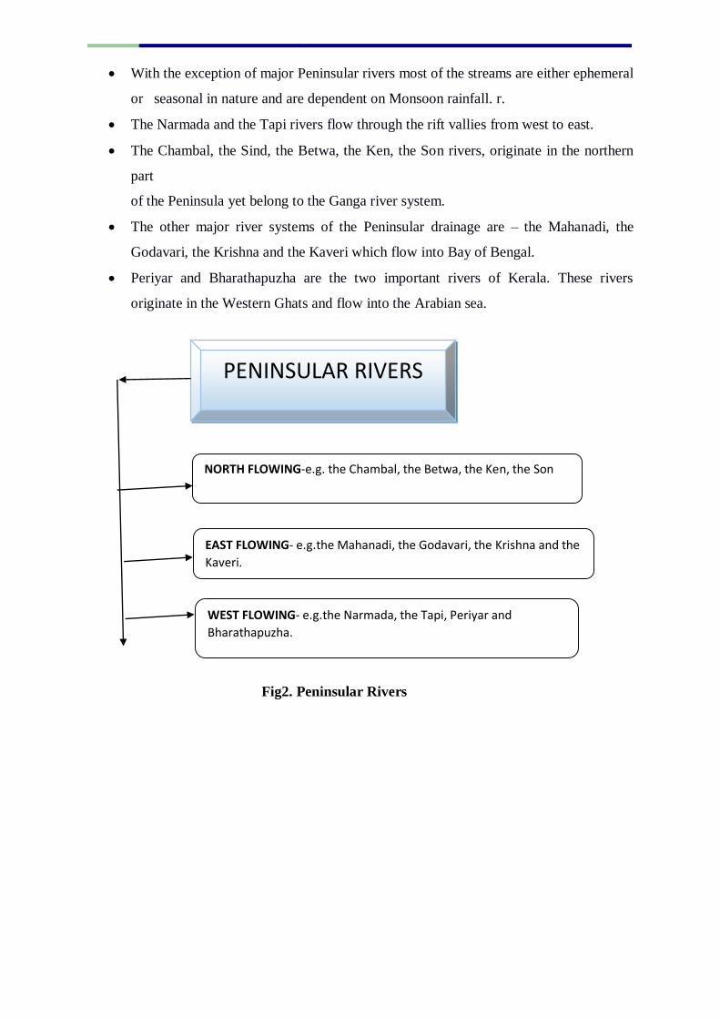
With the exception of major Peninsular rivers most of the streams are either ephemeral
or seasonal in nature and are dependent on Monsoon rainfall. r.
The Narmada and the Tapi rivers flow through the rift vallies from west to east.
The Chambal, the Sind, the Betwa, the Ken, the Son rivers, originate in the northern
part
of the Peninsula yet belong to the Ganga river system.
The other major river systems of the Peninsular drainage are – the Mahanadi, the
Godavari, the Krishna and the Kaveri which flow into Bay of Bengal.
Periyar and Bharathapuzha are the two important rivers of Kerala. These rivers
originate in the Western Ghats and flow into the Arabian sea.
Fig2. Peninsular Rivers
PENINSULAR RIVERS
NORTH FLOWING-e.g. the Chambal, the Betwa, the Ken, the Son
EAST FLOWING- e.g.the Mahanadi, the Godavari, the Krishna and the
Kaveri.
WEST FLOWING- e.g.the Narmada, the Tapi, Periyar and
Bharathapuzha.
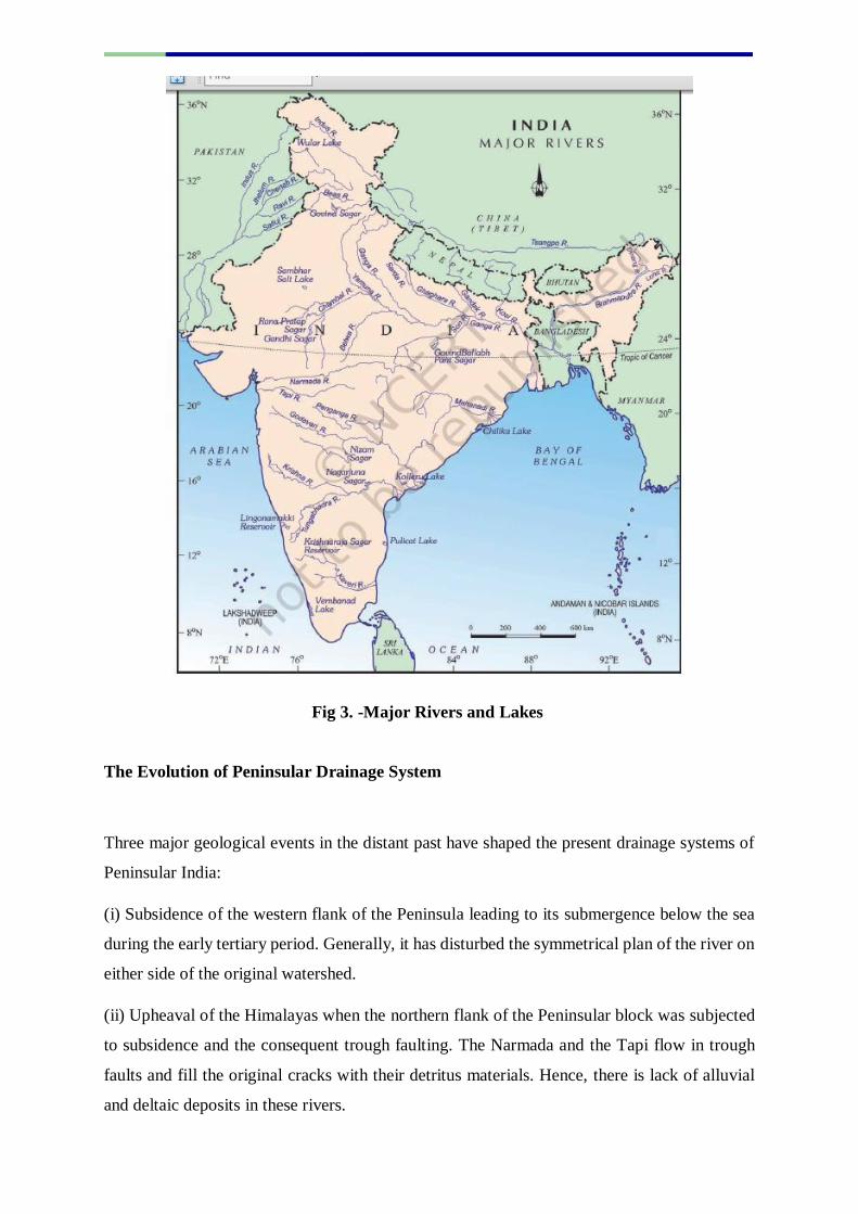
Fig 3. -Major Rivers and Lakes
The Evolution of Peninsular Drainage System
Three major geological events in the distant past have shaped the present drainage systems of
Peninsular India:
(i) Subsidence of the western flank of the Peninsula leading to its submergence below the sea
during the early tertiary period. Generally, it has disturbed the symmetrical plan of the river on
either side of the original watershed.
(ii) Upheaval of the Himalayas when the northern flank of the Peninsular block was subjected
to subsidence and the consequent trough faulting. The Narmada and the Tapi flow in trough
faults and fill the original cracks with their detritus materials. Hence, there is lack of alluvial
and deltaic deposits in these rivers.
(iii) Slight tilting of the Peninsular block from northwest to the southeastern direction gave
orientation to the entire drainage system towards the Bay of Bengal during the same period.
River Systems of the Peninsular Drainage
There are a large number of river systems in the Peninsular drainage.
A brief account of the major Peninsular river systems is given below:
North Flowing Rivers
The Betwa or Betravati is a river in Northern India. It is a tributary of the Yamuna,
which t rises in the Vindhya Range (Raisen) just to the north
of Hoshangabad in Madhya Pradesh and flows towards north-east through Madhya
Pradesh and Orchha in Uttar Pradesh. Nearly half of its course, which is not navigable,
runs over the Malwa Plateau. The confluence of the Betwa and the Yamuna rivers is in
District Hamirpur in Uttar Pradesh, very close to Orchha.
Large part of the catchment of the river falls under semi-arid climatic regions, therefore
it has huge fluctuations in the volume of water across seasons. Constructions of
Damssuch as Rajghat dam, Matatila Dam, Parichha Dam, Dhurwara Dam have
contributed in the generation of hydroelectricity and maintaining the flow of water
across seasons, which has contributed in moerating the economy an environment in the
ctchment to some extent.
The perennial Chambal originates at Janapav, south of Mhow town, near Manpur Indore, on
the south slope of the Vindhya Range in Madhya Pradesh. The Chambal and its tributaries
drain the Malwa region of northwestern Madhya Pradesh, while its tributary, the Banas, which
rises in the Aravalli Range, drains southeastern Rajasthan. It ends a confluence of five rivers,
including the Chambal, Kwari, Yamuna, Sind, Pahuj, at Pachnadanear Bhareh in Uttar
Pradesh, at the border of Bhind and Etawah districts. The Chambal River is used
for hydropower generation at Gandhi Sagar dam, Rana Pratap Sagar dam and Jawahar
Sagar Dam and for annual irrigation of 5668.01 square kilometres in the command areas of
the right main canal and the left main canals of the Kota Barrage.
The Ken River originates near the village Ahirgawan on the north-west slopes
of Barner Range in District Katni ct and travels a distance of 427 km, before merging
with the Yamuna at Chilla village, district Banda in Uttar Pradesh. It receives water

from its own tributaries such as Bawas, Dewar, Kaith and Baink on the left bank, and
Kopra and Bearma of the right.
Son River of central India is the second largest of the Ganga southern tributaries
after Yamuna River. The Son originates near Amarkantak in District
Anuppurf Madhya Pradesh just east of the headwater of the Narmada River, and flows
north-northwest through Shahdol district in Madhya Pradesh before turning sharply
eastward where it encounters the southwest-northeast-Kaimur Range. The Son parallels
the Kaimur hills, flowing east-northeast through Uttar
Pradesh, Jharkhand and Bihar states to join the Ganga just west of Patna. Its chief
tributaries are the Rihand, Kanhar and the North Koel.
The first anicut on the Son was built in 1873–74 at Dehri. The Indrapuri Barrage was
constructed, 8 kilometres (5 mi) upstream, and commissioned in 1968. The Bansagar
Dam in Madhya Pradesh was commissioned in 2008.
Fig4. Rivers Originating from Central Highland and Flowing North
Source-
https://hi.wikipedia.org/wiki/%E0%A4%9A%E0%A4%BF%E0%A4%A4%E0%A5%8D%E
0%A4%B0:Yamunarivermap.jpg
East Flowing Peninsular Rivers
The Mahanadi is a major river in East Central India. The word Mahanadi is a
compound of the Sanskrit words maha ("great") and nadi ("river"). It originates
from the eastern slopes of Amarkantak Plateau near Sihawa in Districk Raipur f
Chhattisgarh and runs through Odisha covering a distance of 851 km to discharge
its water into the Bay of Bengal. It drains an area of around 141,600 square
kilometres nearly Fifty-three per cent of the drainage basin of this river lies in
Madhya Pradesh and Chhattisgarh, while 47 per cent lies in Odisha. The Mahanadi
was notorious for its devastating floodsthus it was called 'the sorrow of Orissa'.
However, the contruction of Multipurpose Hirakud Dam has altered the situation to
a great extent. Mahanadi is also known for the Hirakud Dam. . Some pat
Mahanadi is navigable in its lower course in Odisha. Today a network of canals,
barrages and check dams keep the river well in control.
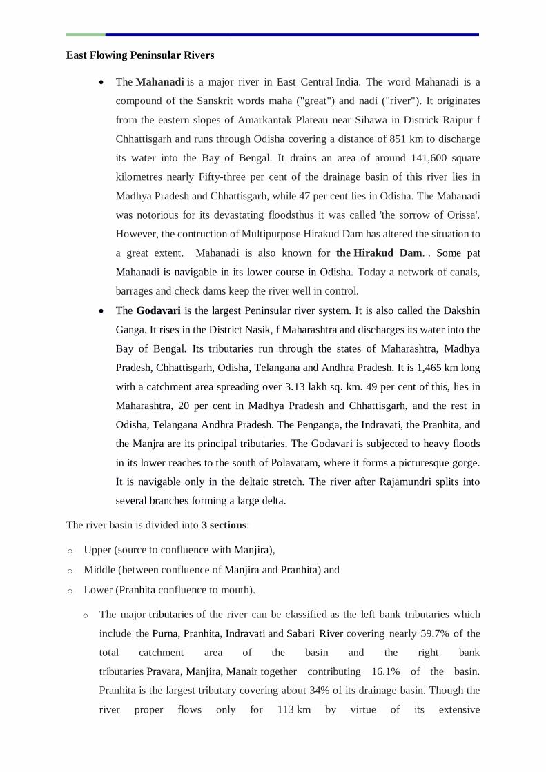
The Godavari is the largest Peninsular river system. It is also called the Dakshin
Ganga. It rises in the District Nasik, f Maharashtra and discharges its water into the
Bay of Bengal. Its tributaries run through the states of Maharashtra, Madhya
Pradesh, Chhattisgarh, Odisha, Telangana and Andhra Pradesh. It is 1,465 km long
with a catchment area spreading over 3.13 lakh sq. km. 49 per cent of this, lies in
Maharashtra, 20 per cent in Madhya Pradesh and Chhattisgarh, and the rest in
Odisha, Telangana Andhra Pradesh. The Penganga, the Indravati, the Pranhita, and
the Manjra are its principal tributaries. The Godavari is subjected to heavy floods
in its lower reaches to the south of Polavaram, where it forms a picturesque gorge.
It is navigable only in the deltaic stretch. The river after Rajamundri splits into
several branches forming a large delta.
The river basin is divided into 3 sections:
o Upper (source to confluence with Manjira),
o Middle (between confluence of Manjira and Pranhita) and
o Lower (Pranhita confluence to mouth).
o The major tributaries of the river can be classified as the left bank tributaries which
include the Purna, Pranhita, Indravati and Sabari River covering nearly 59.7% of the
total catchment area of the basin and the right bank
tributaries Pravara, Manjira, Manair together contributing 16.1% of the basin.
Pranhita is the largest tributary covering about 34% of its drainage basin. Though the
river proper flows only for 113 km by virtue of its extensive
tributaries Wardha, Wainganga, Penganga, the sub-basin drains entire
f Vidharba region as well as the southern slopes of the Satpura Ranges. Indravati is the
2nd largest tributary, known as the "lifeline" of
the Kalahandi, Nabarangapur of Odisha & Bastar districts from Chhattisgarh. Due to
their enormous sub-basins both Indravati and Pranhita are considered rivers in their
own right. Manjira is the longest tributary and holds the Nizam
Sagar reservoir. Purna is a prime river in the water scarce Marathwada region,
Maharashtra.
Fig 5. Godavari drainage basin
Source:
https://en.wikipedia.org/wiki/File:Generalized_Geological_Map_of_Godavari_Drainage_Bas
in.jpg
Dams nn Godavari River and its Tributaries
Gangapur Dam, is an earthfill dam on Godavari river near Nashik in Maharashtra.
Jayakwadi Dam-It is located on Godavari river at the site of Village Jayakwadi
in Paithan taluka, district Aurangabad, Maharashtra. Jayakwadi is one of the largest earthen
dams in Asia. There are total 27 water gates for the dam. Jayakwadi Dam is also called as
Nathsagar Dam. Ghatghar Dam refers to two associated gravity dams built using roller-
compacted concrete, used first time in India. They are situated in village Ghatghar in district
Ahmednagar Maharashtra.
The Sri Rama Sagar Project also known as the Pochampadu Project is an Indian flood-flow
project on the Godavari. The Project is located in District Nizamabad, 3 km away
from National Highway 44. It has been described by The Hindu as a "lifeline for a large part
of Telangana". Sriramsagar is an irrigation project across river Godavari in Telangana to serve
irrigational needs in Karimnagar, Warangal, Adilabad, Nalgonda, and Khammam districts.
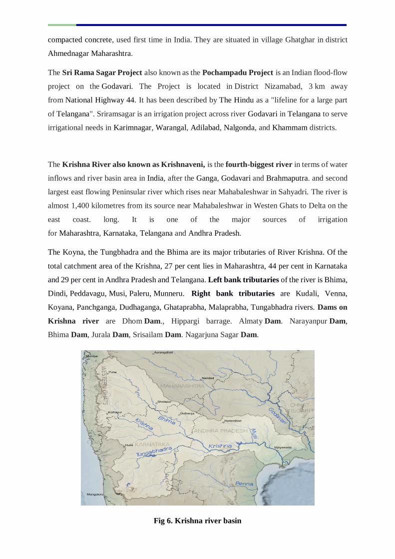
The Krishna River also known as Krishnaveni, is the fourth-biggest river in terms of water
inflows and river basin area in India, after the Ganga, Godavari and Brahmaputra. and second
largest east flowing Peninsular river which rises near Mahabaleshwar in Sahyadri. The river is
almost 1,400 kilometres from its source near Mahabaleshwar in Westen Ghats to Delta on the
east coast. long. It is one of the major sources of irrigation
for Maharashtra, Karnataka, Telangana and Andhra Pradesh.
The Koyna, the Tungbhadra and the Bhima are its major tributaries of River Krishna. Of the
total catchment area of the Krishna, 27 per cent lies in Maharashtra, 44 per cent in Karnataka
and 29 per cent in Andhra Pradesh and Telangana. Left bank tributaries of the river is Bhima,
Dindi, Peddavagu, Musi, Paleru, Munneru. Right bank tributaries are Kudali, Venna,
Koyana, Panchganga, Dudhaganga, Ghataprabha, Malaprabha, Tungabhadra rivers. Dams on
Krishna river are Dhom Dam., Hippargi barrage. Almaty Dam. Narayanpur Dam,
Bhima Dam, Jurala Dam, Srisailam Dam. Nagarjuna Sagar Dam.
Fig 6. Krishna river basin

Source-https://commons.wikimedia.org/wiki/File:Krishna_River_basin_map.svg
The Kaveri river is the third largest river – after Godavari and Krishna – in
South India and the largest in Tamil Nadu which, on its course, bisects the state into
North and South. The Kaveri is sacred to the people of South India and is worshipped
as a goddess. The Kaveri is also one of the seven holy rivers of India. The Kaveri rises
in Brahmagiri hills (1,341m) of istrict Kogadu, Karnataka. Its length is 800 km and it
drains an area of 81155 sq km. with many tributaries including Harangi, Hemavati,
Shimsha, Arkavathy on left bank. Tributaries on right bank are Lakshmana Tirtha,
Kabini, Bhavani, Noyyal, Amravati, MoyarSince the upper catchment area receives
rainfall during the southwest monsoon season (summer) and the lower part during the
northeast monsoon season (winter), the river carries water throughout the year with
comparatively less fluctuation than the other Peninsular rivers. About 3 per cent of the
Kaveri basin falls in Kerala, 41 per cent in Karnataka and 56 per cent in Tamil Nadu.
The Kaveri basin is estimated to be 81,155 square kilometres spread three states and
a Union Territory: Tamil Nadu, 63,856 square kilometres; Karnataka, 14,273 square
kilometres; Kerala, 2,866 square kilometres, and Puducherry, 160 square kilometres.
The hydroelectric plant built in 1902 on the left of Sivanasamudra Falls on the Kaveri.
It wasthe first hydroelectric plant in Asia. The Krishna Raja Sagara Dam and the
Mettur Damare constructed on river kaveri which creates Stanley Reservoir.
Hogenakal falls popularly known as "Niagara of India" and Shivanasamudra are
beautiful waterfalls on the Kaveri river.
Fig 7- Kaveri river
Source-
https://hi.wikipedia.org/wiki/%E0%A4%9A%E0%A4%BF%E0%A4%A4%E0%A5%8D%E
0%A4%B0:River_Cauvery_EN.png
West Flowing Peninsular Rivers
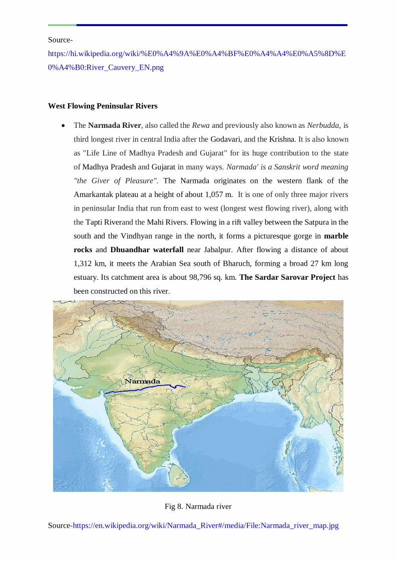
The Narmada River, also called the Rewa and previously also known as Nerbudda, is
third longest river in central India after the Godavari, and the Krishna. It is also known
as "Life Line of Madhya Pradesh and Gujarat" for its huge contribution to the state
of Madhya Pradesh and Gujarat in many ways. Narmada' is a Sanskrit word meaning
"the Giver of Pleasure". The Narmada originates on the western flank of the
Amarkantak plateau at a height of about 1,057 m. It is one of only three major rivers
in peninsular India that run from east to west (longest west flowing river), along with
the Tapti Riverand the Mahi Rivers. Flowing in a rift valley between the Satpura in the
south and the Vindhyan range in the north, it forms a picturesque gorge in marble
rocks and Dhuandhar waterfall near Jabalpur. After flowing a distance of about
1,312 km, it meets the Arabian Sea south of Bharuch, forming a broad 27 km long
estuary. Its catchment area is about 98,796 sq. km. The Sardar Sarovar Project has
been constructed on this river.
Fig 8. Narmada river
Source-https://en.wikipedia.org/wiki/Narmada_River#/media/File:Narmada_river_map.jpg

The Tapi also known as Tapti is the other important westward flowing river of Central
India in between the Godavari and Narmada basins.It originates from Multai in district
Betul, Madhya Pradesh and flows. westwards over a length of 724 km. covering an
area of 65145 sq.km. before draining through the Gulf of Khambhat into the Arabian
Sea. Nearly 79 per cent of its basin lies in Maharashtra, 15 per cent in Madhya Pradesh
and the remaining 6 per cent in Gujarat. The construction of the Ukai Dam brought its
waters under control and provides hydroelectric power,
The Luni is also known as the Lavanavari or Lavanavati, which means "salt river"
in Sanskrit, due high salinity of its water.Luni is the largest river system of Rajasthan,
west of Aravali. It originates near Pushkar in two branches, i.e. the Saraswati and the
Sabarmati, which join with each other at Govindgarh. From here, the river comes out
of Aravali and is known as Luni. It flows towards the west till Telwara and then takes
a southwest direction and enters the Thar Desert to join the Rann of Kuchchh. The
entire river system is ephemeral. The rivers flowing towards the Arabian sea have short
courses.
Traversing a total of 495 km, The Luni River has a basin of 37,363 sq. km, which
includes all or part of the Ajmer, Barmer, Jalore, Jodhpur, Nagaur, Pali, and Sirohi
districts of Rajasthan and the Banaskantha and Patan districts of northern Gujarat.
Its major tributaries are the Sukri, Mithri, Bandi, Khari, Jawai, Guhiya and Sagi from
the left, and the Jojari from the right. In spite of the high salinity, it is a major river in
the region and serves as a primary source of irrigation. The Luni is not saline until it
reaches Balotra, where high salt content in the soil impacts the river.
Fig 9-Luni_River
Source-https://en.wikipedia.org/wiki/Luni_River#/media/File:Sarasvati-ancient-
river.jpg
Smaller Rivers Flowing Towards the West
The rivers flowing towards the Arabian sea have short courses.
Some important west flowing rivers of Gujarat
The Shetruniji is one such river which rises near Dalkahwa in northeast of the Gir
Hills, in district Amreli. Its course begins east-northeast along a lineament which runs
parallel to the Narmada Fault, passes north of Palitana's hills, Shatrunjaya, then in a
southeasterly direction past Talaja Hill, through a peninsula, before reaching the Gulf
of Cambay,
Bhadar River is a river in the Saurashtra peninsula, in the Western Indian state
of Gujarat. The Bhadra originates near Aniali village in district Rajkot. It flows south
from its origin through Jasdan, then turns south-west and generally west until it empties
into the Arabian Sea near Porbandar.
The Dhadhar rises near Ghantar village in Pavagarh Hill in district Panchmahal.
Dhadhar River is a river in western India, Gujarat with its maximum length of 142
km.
Sabarmati and Mahi are the two famous rivers of Gujarat. The Sabarmati river is
one of the major west-flowing rivers in India. It originates in the Aravalli Range of
district Udaipur, of Rajasthan and meets the Gulf of Khambhat of Arabian Sea after
travelling 371 km. in a south-westerly direction across Rajasthan and Gujarat. There
are several reservoirs on Sabarmati and its tributaries. The Dharoi dam is located on
the main river. Hathmati dam, Harnav dam and Guhai dam are located on the tributaries
meeting the main river upstream of Ahmedabad while Meshvo reservoir, Meshvo pick-
up weir, Mazam dam and Watrak dam are located on tributaries meeting downstream.
The Mahi is another important river in western India. It rises in Madhya Pradesh and, after
flowing through the Vagad region of Rajasthan, enters Gujarat and flows into the Arabian Sea.
It is one of the many west-flowing rivers in India, along with Tapi, Sabarmati, Luni
Rivers (Endorheic river) and the Narmada River. Banswara Dam, Kadana Dam, Wanakbori
dam are constructed on river Mahi.
Some important west flowing rivers of Maharashtra
The Vaitarna rises from the Trimbak hills in Nasik district at an elevation of 670 m.
The Kalinadi rises from Belgaum district and falls in the Karwar Bay.
The source of Bedti river lies in Hubli Dharwar and traverses a course of 161 km.
Important west flowing rivers of Karnataka.
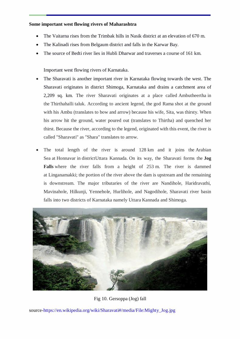
The Sharavati is another important river in Karnataka flowing towards the west. The
Sharavati originates in district Shimoga, Karnataka and drains a catchment area of
2,209 sq. km. The river Sharavati originates at a place called Ambutheertha in
the Thirthahalli taluk. According to ancient legend, the god Rama shot at the ground
with his Ambu (translates to bow and arrow) because his wife, Sita, was thirsty. When
his arrow hit the ground, water poured out (translates to Thirtha) and quenched her
thirst. Because the river, according to the legend, originated with this event, the river is
called "Sharavati" as "Shara" translates to arrow.
The total length of the river is around 128 km and it joins the Arabian
Sea at Honnavar in districtUttara Kannada. On its way, the Sharavati forms the Jog
Falls where the river falls from a height of 253 m. The river is dammed
at Linganamakki; the portion of the river above the dam is upstream and the remaining
is downstream. The major tributaries of the river are Nandihole, Haridravathi,
Mavinahole, Hilkunji, Yennehole, Hurlihole, and Nagodihole, Sharavati river basin
falls into two districts of Karnataka namely Uttara Kannada and Shimoga.
Fig 10. Gersoppa (Jog) fall
source-https://en.wikipedia.org/wiki/Sharavati#/media/File:Mighty_Jog.jpg
Important rivers of Goa
Goa has two important rivers which can be mentioned here. One is Mandovi and the other
is Zuari.Mandovi also known as Mahadayi or Mhadei river, is described as the lifeline of
the Indian state of Goa. The Mandovi and the Zuari are the two main rivers in the state of Goa.
Mandovi joins with the Zuari at a common creek at Cabo Aguada both flush out into the
Arabian Sea, forming the Mormugao harbour. The river has a length of 77 kilometres, 29
kilometres in Karnataka and 52 kilometres in Goa. It originates from a cluster of 30 springs
at Bhimgad in the Western Ghats in district Belagavi, Karnataka.Dudhsagar and Varapoha
are two important falls on this river. The river is also known as the Gomati in a few places. The
Mandovi enters Goa from the north via the Sattari Taluka and from district Uttara
Kannada, Karnataka near the Castle Rock Railway. Station. The Mandovi flows
through Belagavi, Uttara Kannada in Karnataka and Cumbarjua, Divar and Chorão in Goa,
eventually pouring into the Arabian Sea. The river Mapusa is a tributary of the Mandovi.
Zuariis the largest river in the state of Goa. . It is a tidal river which originates at Hemad-
Barshem in the Western Ghats. The Zuari and Mandovi Rivers form an estuarine system.
Important rivers of Kerala
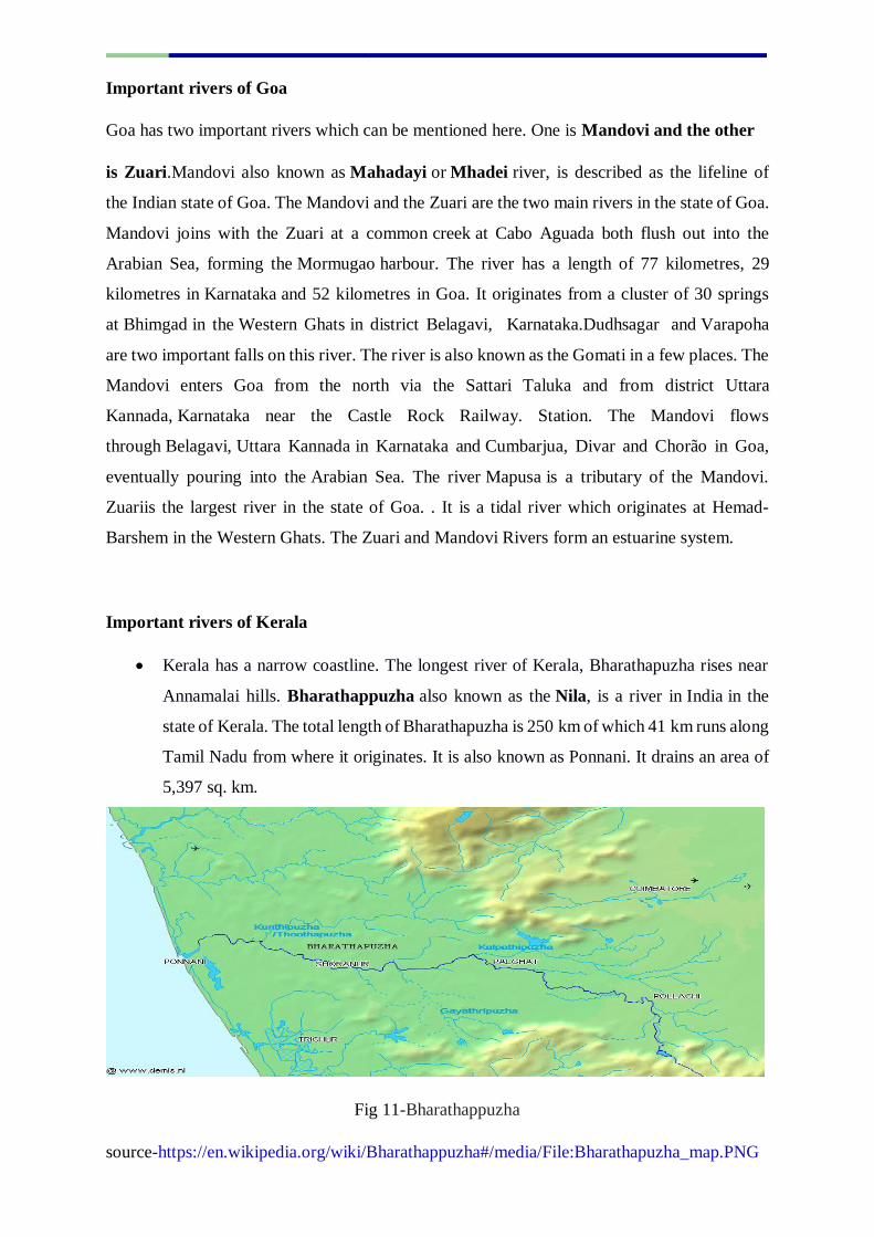
Kerala has a narrow coastline. The longest river of Kerala, Bharathapuzha rises near
Annamalai hills. Bharathappuzha also known as the Nila, is a river in India in the
state of Kerala. The total length of Bharathapuzha is 250 km of which 41 km runs along
Tamil Nadu from where it originates. It is also known as Ponnani. It drains an area of
5,397 sq. km.
Fig 11-Bharathappuzha
source-https://en.wikipedia.org/wiki/Bharathappuzha#/media/File:Bharathapuzha_map.PNG
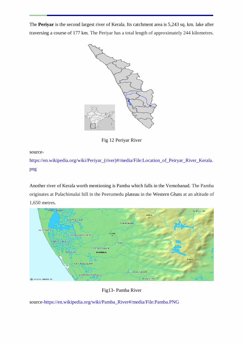
The Periyar is the second largest river of Kerala. Its catchment area is 5,243 sq. km. lake after
traversing a course of 177 km. The Periyar has a total length of approximately 244 kilometres.
Fig 12 Periyar River
source-
https://en.wikipedia.org/wiki/Periyar_(river)#/media/File:Location_of_Peiryar_River_Kerala.
png
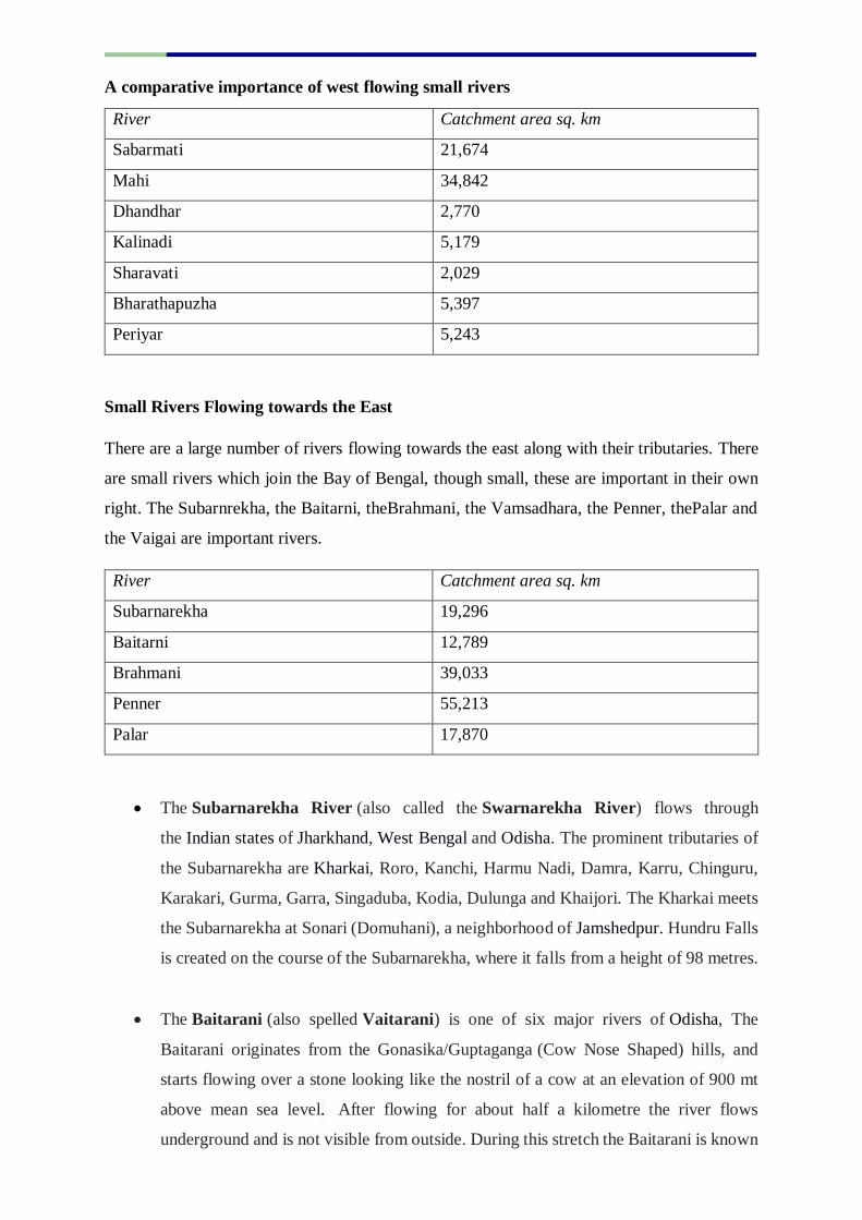
Another river of Kerala worth mentioning is Pamba which falls in the Vemobanad. The Pamba
originates at Pulachimalai hill in the Peerumedu plateau in the Western Ghats at an altitude of
1,650 metres.
Fig13- Pamba River
source-https://en.wikipedia.org/wiki/Pamba_River#/media/File:Pamba.PNG
A comparative importance of west flowing small rivers
River Catchment area sq. km
Sabarmati 21,674
Mahi 34,842
Dhandhar 2,770
Kalinadi 5,179
Sharavati 2,029
Bharathapuzha 5,397
Periyar 5,243
Small Rivers Flowing towards the East
There are a large number of rivers flowing towards the east along with their tributaries. There
are small rivers which join the Bay of Bengal, though small, these are important in their own
right. The Subarnrekha, the Baitarni, theBrahmani, the Vamsadhara, the Penner, thePalar and
the Vaigai are important rivers.
River Catchment area sq. km
Subarnarekha 19,296
Baitarni 12,789
Brahmani 39,033
Penner 55,213
Palar 17,870
The Subarnarekha River (also called the Swarnarekha River) flows through
the Indian states of Jharkhand, West Bengal and Odisha. The prominent tributaries of
the Subarnarekha are Kharkai, Roro, Kanchi, Harmu Nadi, Damra, Karru, Chinguru,
Karakari, Gurma, Garra, Singaduba, Kodia, Dulunga and Khaijori. The Kharkai meets
the Subarnarekha at Sonari (Domuhani), a neighborhood of Jamshedpur. Hundru Falls
is created on the course of the Subarnarekha, where it falls from a height of 98 metres.
The Baitarani (also spelled Vaitarani) is one of six major rivers of Odisha, The
Baitarani originates from the Gonasika/Guptaganga (Cow Nose Shaped) hills, and
starts flowing over a stone looking like the nostril of a cow at an elevation of 900 mt
above mean sea level. After flowing for about half a kilometre the river flows
underground and is not visible from outside. During this stretch the Baitarani is known
by the name Guptaganga or the Gupta Baitarani, in Gonasika of Keonjhar district in
Odisha before it resurfaces and flows about 360 km before reaching the Bay of Bengal
but only after foming a Delta. rahmani is a major seasonal river in the Odisha, in
Eastern India. The Brahmani is formed by the confluence of the Sankhand South
Koel rivers near the major industrial town of Rourkela, together with the
river Baitarani, it forms a large delta before emptying into the Bay of Bengal at
Dhamra. At about 480 kilometres long, the Brahmani is the second longest river in
Orissa after the Mahanadi.
Fig 14- Brahmani_River
source- https://en.wikipedia.org/wiki/Brahmani_River#/media/File:Mahanadi.jpg
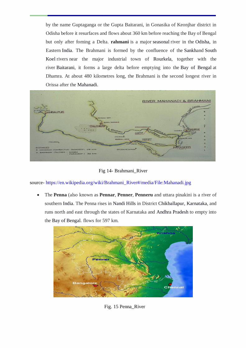
The Penna (also known as Pennar, Penner, Penneru and uttara pinakini is a river of
southern India. The Penna rises in Nandi Hills in District Chikballapur, Karnataka, and
runs north and east through the states of Karnataka and Andhra Pradesh to empty into
the Bay of Bengal. flows for 597 km.
Fig. 15 Penna_River
Source-
https://en.wikipedia.org/wiki/Penna_River#/media/File:Penner_Penna_river_south_Andhra_
Pradesh.jpg
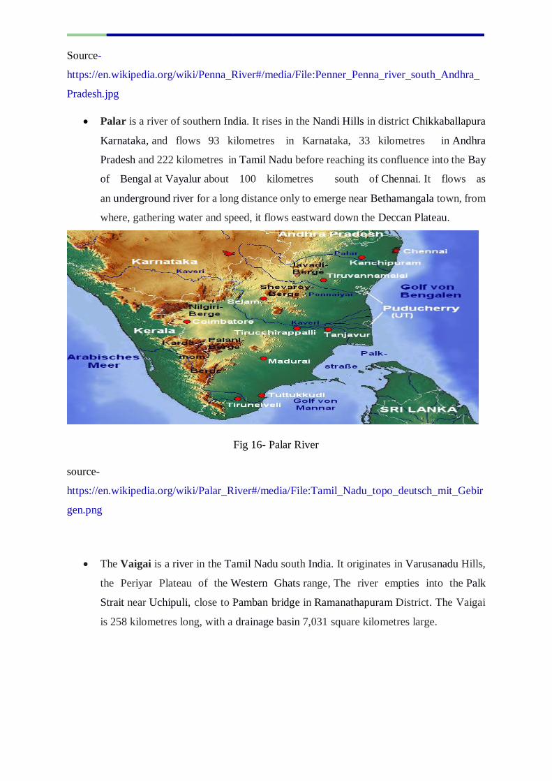
Palar is a river of southern India. It rises in the Nandi Hills in district Chikkaballapura
Karnataka, and flows 93 kilometres in Karnataka, 33 kilometres in Andhra
Pradesh and 222 kilometres in Tamil Nadu before reaching its confluence into the Bay
of Bengal at Vayalur about 100 kilometres south of Chennai. It flows as
an underground river for a long distance only to emerge near Bethamangala town, from
where, gathering water and speed, it flows eastward down the Deccan Plateau.
Fig 16- Palar River
source-
https://en.wikipedia.org/wiki/Palar_River#/media/File:Tamil_Nadu_topo_deutsch_mit_Gebir
gen.png
The Vaigai is a river in the Tamil Nadu south India. It originates in Varusanadu Hills,
the Periyar Plateau of the Western Ghats range, The river empties into the Palk
Strait near Uchipuli, close to Pamban bridge in Ramanathapuram District. The Vaigai
is 258 kilometres long, with a drainage basin 7,031 square kilometres large.
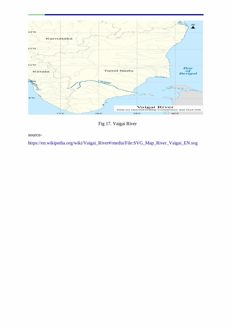
Fig 17. Vaigai River
source-
https://en.wikipedia.org/wiki/Vaigai_River#/media/File:SVG_Map_River_Vaigai_EN.svg