JeppView for Windows - CODING
135
List of pages in this Trip Kit Trip Kit Index Airport Information For EHAM Terminal Charts For EHAM Revision Letter For Cycle 18-2021 Change Notices Notebook Trip Kit Index Printed on 12 Sep 2021 Page 1 (c) JEPPESEN SANDERSON, INC., 2021, ALL RIGHTS RESERVED j e p JEPPESEN JeppView for Windows
-
Upload
khangminh22 -
Category
Documents
-
view
1 -
download
0
Transcript of JeppView for Windows - CODING

List of pages in this Trip Kit
Trip Kit IndexAirport Information For EHAMTerminal Charts For EHAMRevision Letter For Cycle 18-2021Change NoticesNotebook
Trip Kit IndexPrinted on 12 Sep 2021Page 1(c) JEPPESEN SANDERSON, INC., 2021, ALL RIGHTS RESERVED
jep=JEPPESEN
JeppView for Windows

General Information
Location: AMSTERDAM NLDICAO/IATA: EHAM / AMSLat/Long: N52° 18.48', E004° 45.85'Elevation: -11 ft
Airport Use: PublicDaylight Savings: ObservedUTC Conversion: -1:00 = UTCMagnetic Variation: 2.0° E
Fuel Types: Jet, Jet A-1Repair Types: Major Airframe, Major EngineCustoms: YesAirport Type: IFRLanding Fee: YesControl Tower: YesJet Start Unit: NoLLWS Alert: NoBeacon: NoTraffic Pattern Altitude: 1000 ft (1011 ft AGL)
Sunrise: 0510 ZSunset: 1805 Z
Runway Information
Runway: 04Length x Width: 6627 ft x 148 ftSurface Type: asphaltTDZ-Elev: -13 ftLighting: Edge, ALS
Runway: 06Length x Width: 11283 ft x 148 ftSurface Type: asphaltTDZ-Elev: -12 ftLighting: Edge, ALS, Centerline, TDZDisplaced Threshold: 801 ft
Runway: 09Length x Width: 11329 ft x 148 ftSurface Type: asphaltTDZ-Elev: -12 ftLighting: Edge, CenterlineDisplaced Threshold: 295 ft
Runway: 18CLength x Width: 10827 ft x 148 ftSurface Type: asphaltTDZ-Elev: -12 ft
Lighting: Edge, ALS, Centerline, TDZ
Runway: 18LLength x Width: 11155 ft x 148 ftSurface Type: asphaltTDZ-Elev: -12 ftLighting: Edge, CenterlineDisplaced Threshold: 1887 ft
Runway: 18RLength x Width: 12467 ft x 197 ftSurface Type: asphaltTDZ-Elev: -13 ftLighting: Edge, ALS, Centerline, TDZDisplaced Threshold: 886 ft
Runway: 22Length x Width: 6627 ft x 148 ftSurface Type: asphaltTDZ-Elev: -12 ftLighting: Edge, ALS
Runway: 24Length x Width: 11283 ft x 148 ftSurface Type: asphaltTDZ-Elev: -12 ftLighting: Edge, Centerline
Runway: 27Length x Width: 11329 ft x 148 ftSurface Type: asphaltTDZ-Elev: -12 ftLighting: Edge, ALS, Centerline, TDZ
Runway: 36CLength x Width: 10827 ft x 148 ftSurface Type: asphaltTDZ-Elev: -12 ftLighting: Edge, ALS, Centerline, TDZDisplaced Threshold: 1477 ft
Runway: 36LLength x Width: 12467 ft x 197 ftSurface Type: asphaltTDZ-Elev: -12 ftLighting: Edge, Centerline
Runway: 36RLength x Width: 11155 ft x 148 ftSurface Type: asphaltTDZ-Elev: -11 ftLighting: Edge, ALS, Centerline, TDZ
Communication Information
ATIS: 122.205 Departure ServiceATIS: 132.980 Arrival ServiceSchiphol Tower: 118.280 VHF-DFSchiphol Tower: 118.105 VHF-DFSchiphol Tower: 119.230 VHF-DFSchiphol Tower: 135.110 VHF-DFSchiphol Ground: 121.560Schiphol Ground: 121.590Schiphol Ground: 121.905Schiphol Ground: 121.805Schiphol Ground: 121.705Schiphol Planner Ground: 121.655Schiphol Clearance Delivery: 121.980Schiphol Approach: 131.155Schiphol Approach: 118.080Schiphol Approach: 119.055Schiphol Approach: 121.205Schiphol Arrival: 126.680Schiphol Arrival: 118.405Schiphol Departure: 121.205Schiphol Departure: 119.055Schiphol Departure: 118.080Atc Operational Information: 131.355
General Information
Location: AMSTERDAM NLDICAO/IATA: EHAM / AMSLat/Long: N52° 18.48', E004° 45.85'Elevation: -11 ft
Airport Use: PublicDaylight Savings: ObservedUTC Conversion: -1:00 = UTCMagnetic Variation: 2.0° E
Fuel Types: Jet, Jet A-1Repair Types: Major Airframe, Major EngineCustoms: YesAirport Type: IFRLanding Fee: YesControl Tower: YesJet Start Unit: NoLLWS Alert: NoBeacon: NoTraffic Pattern Altitude: 1000 ft (1011 ft AGL)
Sunrise: 0510 ZSunset: 1805 Z
Runway Information
Runway: 04Length x Width: 6627 ft x 148 ftSurface Type: asphaltTDZ-Elev: -13 ftLighting: Edge, ALS
Runway: 06Length x Width: 11283 ft x 148 ftSurface Type: asphaltTDZ-Elev: -12 ftLighting: Edge, ALS, Centerline, TDZDisplaced Threshold: 801 ft
Runway: 09Length x Width: 11329 ft x 148 ftSurface Type: asphaltTDZ-Elev: -12 ftLighting: Edge, CenterlineDisplaced Threshold: 295 ft
Runway: 18CLength x Width: 10827 ft x 148 ftSurface Type: asphaltTDZ-Elev: -12 ft
Airport Information For EHAMPrinted on 12 Sep 2021Page 1(c) JEPPESEN SANDERSON, INC., 2021, ALL RIGHTS RESERVED
jep=JEPPESEN
JeppView for Windows

General Information
Location: AMSTERDAM NLDICAO/IATA: EHAM / AMSLat/Long: N52° 18.48', E004° 45.85'Elevation: -11 ft
Airport Use: PublicDaylight Savings: ObservedUTC Conversion: -1:00 = UTCMagnetic Variation: 2.0° E
Fuel Types: Jet, Jet A-1Repair Types: Major Airframe, Major EngineCustoms: YesAirport Type: IFRLanding Fee: YesControl Tower: YesJet Start Unit: NoLLWS Alert: NoBeacon: NoTraffic Pattern Altitude: 1000 ft (1011 ft AGL)
Sunrise: 0510 ZSunset: 1805 Z
Runway Information
Runway: 04Length x Width: 6627 ft x 148 ftSurface Type: asphaltTDZ-Elev: -13 ftLighting: Edge, ALS
Runway: 06Length x Width: 11283 ft x 148 ftSurface Type: asphaltTDZ-Elev: -12 ftLighting: Edge, ALS, Centerline, TDZDisplaced Threshold: 801 ft
Runway: 09Length x Width: 11329 ft x 148 ftSurface Type: asphaltTDZ-Elev: -12 ftLighting: Edge, CenterlineDisplaced Threshold: 295 ft
Runway: 18CLength x Width: 10827 ft x 148 ftSurface Type: asphaltTDZ-Elev: -12 ft
Lighting: Edge, ALS, Centerline, TDZ
Runway: 18LLength x Width: 11155 ft x 148 ftSurface Type: asphaltTDZ-Elev: -12 ftLighting: Edge, CenterlineDisplaced Threshold: 1887 ft
Runway: 18RLength x Width: 12467 ft x 197 ftSurface Type: asphaltTDZ-Elev: -13 ftLighting: Edge, ALS, Centerline, TDZDisplaced Threshold: 886 ft
Runway: 22Length x Width: 6627 ft x 148 ftSurface Type: asphaltTDZ-Elev: -12 ftLighting: Edge, ALS
Runway: 24Length x Width: 11283 ft x 148 ftSurface Type: asphaltTDZ-Elev: -12 ftLighting: Edge, Centerline
Runway: 27Length x Width: 11329 ft x 148 ftSurface Type: asphaltTDZ-Elev: -12 ftLighting: Edge, ALS, Centerline, TDZ
Runway: 36CLength x Width: 10827 ft x 148 ftSurface Type: asphaltTDZ-Elev: -12 ftLighting: Edge, ALS, Centerline, TDZDisplaced Threshold: 1477 ft
Runway: 36LLength x Width: 12467 ft x 197 ftSurface Type: asphaltTDZ-Elev: -12 ftLighting: Edge, Centerline
Runway: 36RLength x Width: 11155 ft x 148 ftSurface Type: asphaltTDZ-Elev: -11 ftLighting: Edge, ALS, Centerline, TDZ
Communication Information
ATIS: 122.205 Departure ServiceATIS: 132.980 Arrival ServiceSchiphol Tower: 118.280 VHF-DFSchiphol Tower: 118.105 VHF-DFSchiphol Tower: 119.230 VHF-DFSchiphol Tower: 135.110 VHF-DFSchiphol Ground: 121.560Schiphol Ground: 121.590Schiphol Ground: 121.905Schiphol Ground: 121.805Schiphol Ground: 121.705Schiphol Planner Ground: 121.655Schiphol Clearance Delivery: 121.980Schiphol Approach: 131.155Schiphol Approach: 118.080Schiphol Approach: 119.055Schiphol Approach: 121.205Schiphol Arrival: 126.680Schiphol Arrival: 118.405Schiphol Departure: 121.205Schiphol Departure: 119.055Schiphol Departure: 118.080Atc Operational Information: 131.355
Lighting: Edge, ALS, Centerline, TDZ
Runway: 18LLength x Width: 11155 ft x 148 ftSurface Type: asphaltTDZ-Elev: -12 ftLighting: Edge, CenterlineDisplaced Threshold: 1887 ft
Runway: 18RLength x Width: 12467 ft x 197 ftSurface Type: asphaltTDZ-Elev: -13 ftLighting: Edge, ALS, Centerline, TDZDisplaced Threshold: 886 ft
Runway: 22Length x Width: 6627 ft x 148 ftSurface Type: asphaltTDZ-Elev: -12 ftLighting: Edge, ALS
Runway: 24Length x Width: 11283 ft x 148 ftSurface Type: asphaltTDZ-Elev: -12 ftLighting: Edge, Centerline
Runway: 27Length x Width: 11329 ft x 148 ftSurface Type: asphaltTDZ-Elev: -12 ftLighting: Edge, ALS, Centerline, TDZ
Runway: 36CLength x Width: 10827 ft x 148 ftSurface Type: asphaltTDZ-Elev: -12 ftLighting: Edge, ALS, Centerline, TDZDisplaced Threshold: 1477 ft
Runway: 36LLength x Width: 12467 ft x 197 ftSurface Type: asphaltTDZ-Elev: -12 ftLighting: Edge, Centerline
Runway: 36RLength x Width: 11155 ft x 148 ftSurface Type: asphaltTDZ-Elev: -11 ftLighting: Edge, ALS, Centerline, TDZ
Airport Information For EHAMPrinted on 12 Sep 2021Page 2(c) JEPPESEN SANDERSON, INC., 2021, ALL RIGHTS RESERVED
jep=JEPPESEN
JeppView for Windows

General Information
Location: AMSTERDAM NLDICAO/IATA: EHAM / AMSLat/Long: N52° 18.48', E004° 45.85'Elevation: -11 ft
Airport Use: PublicDaylight Savings: ObservedUTC Conversion: -1:00 = UTCMagnetic Variation: 2.0° E
Fuel Types: Jet, Jet A-1Repair Types: Major Airframe, Major EngineCustoms: YesAirport Type: IFRLanding Fee: YesControl Tower: YesJet Start Unit: NoLLWS Alert: NoBeacon: NoTraffic Pattern Altitude: 1000 ft (1011 ft AGL)
Sunrise: 0510 ZSunset: 1805 Z
Runway Information
Runway: 04Length x Width: 6627 ft x 148 ftSurface Type: asphaltTDZ-Elev: -13 ftLighting: Edge, ALS
Runway: 06Length x Width: 11283 ft x 148 ftSurface Type: asphaltTDZ-Elev: -12 ftLighting: Edge, ALS, Centerline, TDZDisplaced Threshold: 801 ft
Runway: 09Length x Width: 11329 ft x 148 ftSurface Type: asphaltTDZ-Elev: -12 ftLighting: Edge, CenterlineDisplaced Threshold: 295 ft
Runway: 18CLength x Width: 10827 ft x 148 ftSurface Type: asphaltTDZ-Elev: -12 ft
Lighting: Edge, ALS, Centerline, TDZ
Runway: 18LLength x Width: 11155 ft x 148 ftSurface Type: asphaltTDZ-Elev: -12 ftLighting: Edge, CenterlineDisplaced Threshold: 1887 ft
Runway: 18RLength x Width: 12467 ft x 197 ftSurface Type: asphaltTDZ-Elev: -13 ftLighting: Edge, ALS, Centerline, TDZDisplaced Threshold: 886 ft
Runway: 22Length x Width: 6627 ft x 148 ftSurface Type: asphaltTDZ-Elev: -12 ftLighting: Edge, ALS
Runway: 24Length x Width: 11283 ft x 148 ftSurface Type: asphaltTDZ-Elev: -12 ftLighting: Edge, Centerline
Runway: 27Length x Width: 11329 ft x 148 ftSurface Type: asphaltTDZ-Elev: -12 ftLighting: Edge, ALS, Centerline, TDZ
Runway: 36CLength x Width: 10827 ft x 148 ftSurface Type: asphaltTDZ-Elev: -12 ftLighting: Edge, ALS, Centerline, TDZDisplaced Threshold: 1477 ft
Runway: 36LLength x Width: 12467 ft x 197 ftSurface Type: asphaltTDZ-Elev: -12 ftLighting: Edge, Centerline
Runway: 36RLength x Width: 11155 ft x 148 ftSurface Type: asphaltTDZ-Elev: -11 ftLighting: Edge, ALS, Centerline, TDZ
Communication Information
ATIS: 122.205 Departure ServiceATIS: 132.980 Arrival ServiceSchiphol Tower: 118.280 VHF-DFSchiphol Tower: 118.105 VHF-DFSchiphol Tower: 119.230 VHF-DFSchiphol Tower: 135.110 VHF-DFSchiphol Ground: 121.560Schiphol Ground: 121.590Schiphol Ground: 121.905Schiphol Ground: 121.805Schiphol Ground: 121.705Schiphol Planner Ground: 121.655Schiphol Clearance Delivery: 121.980Schiphol Approach: 131.155Schiphol Approach: 118.080Schiphol Approach: 119.055Schiphol Approach: 121.205Schiphol Arrival: 126.680Schiphol Arrival: 118.405Schiphol Departure: 121.205Schiphol Departure: 119.055Schiphol Departure: 118.080Atc Operational Information: 131.355
Airport Information For EHAMPrinted on 12 Sep 2021Page 3(c) JEPPESEN SANDERSON, INC., 2021, ALL RIGHTS RESERVED
jep=JEPPESEN
JeppView for Windows

AMSTERDAM, NETHERLANDSEHAM/AMSSCHIPHOL .AIRPORT.BRIEFING.
+ JEPPESEN
1.1. ATISD-ATIS Arrival 132.980D-ATIS Departure 122.205
1.2. NOISE ABATEMENT PROCEDURES1.2.1. GENERAL
All procedures have proved to be highly efficient in respect of noise abatementand ACFT shall adhere to these, except for safety reasons or when otherwiseinstructed by ATC.
1.2.2. ACFT CLASSIFIED ACCORDING TO ICAO ANNEX 16Take-off and landing are not allowed for Chapter 2 ACFT.Chapter 3 ACFT for which the margin of the sum of the three certification noiselevels, relative to the sum of the three applicable ICAO Annex 16 Chapter 3 cer-tification noise limits, is less than 10 EPNdB the following applies:- New operations are not allowed.- For ACFT equipped with engines with bypass ratio smaller or equal 3, take-off
and landing is not allowed between 1800-0800LT.- For propeller-driven ACFT and ACFT equipped with engines with bypass ratio
greater than 3, it is not allowed to plan take-off between 2300-0700LT.
1.2.3. PREFERENTIAL RWY SYSTEM
1.2.3.1. GENERALThe RWYs in use will be selected by ATC according to a preferential RWY system.The preferential sequence is subject to noise load developments and may there-fore change in any given period. Deviations from the preferential sequence forselecting RWYs in use can be made by ATC:- When approach facilities on the selected RWY are not suitable for operations
in the prevailing weather.- When crosswind components do not meet the given limits for any RWY
combination.- When estimated surface friction on RWYs is below certain standards.- When heavy showers are observed or wind shear is reported in the vicinity of
the APT.The use of a non-preferential RWY for take-off and landing is not permittedunless specifically requested for safety reasons by the pilot.However, if a pilot decides that a different landing RWY should be used forsafety reasons, ATC will assign that RWY (air traffic or other conditionspermitting).
1.2.3.2. WIND CRITERIAIn selecting the RWY combination to be used from the preferential RWY system,LVNL (Luchtverkeersleiding Nederland) also applies wind speed criteria.In applying these wind criteria, gusts below 10 KT shall not be taken into account.Accepting a RWY is a pilot's decision. If a pilot, prompted by safety concerns,requests another RWY for landing, this request will be granted when possible. Inthat case, the pilot must submit a written report (the operator is responsible forproper reporting procedures).
10-1P6 AUG 21 .Eff.12.Aug.
1. GENERAL
| JEPPESEN, 2005, 2021. ALL RIGHTS RESERVED.
Printed from JeppView for Windows 5.3.0.0 on 12 Sep 2021; Terminal chart data cycle 18-2021; Notice: After 16 Sep 2021, 0000Z, this chart may no longer be valid

AMSTERDAM, NETHERLANDSEHAM/AMSSCHIPHOL .AIRPORT.BRIEFING.
+ JEPPESEN
1.3. LOW VISIBILITY PROCEDURESThe ATC low visibility operations are categorised in four phases (A, B, C and D),that are based on RVR values and ceiling. Phase A is a reduced visibility proce-dure; phases B, C and D are Low Visibility Procedures.
If a ground surveillance system and/or the RWY stop bars are out of service,additional restrictions apply.
Phase A, B, C and D:Reduced visibility has only impact on departing traffic, therefore the announce-ment is only broadcasted on the Departure ATIS.Pilots should not request start-up permission unless the RVR values for the take-off RWY are above the take-off limits for the flight. Pilots should be informedabout the RVR minima that apply of their flights, so that they can readily respondto requests about these minima.During reduced and low visibility procedures all RWY exits, entries and crossings(except RWY 04/22) are safeguarded by switchable or fixed stop bars. Crossing ofactivated stop bars is prohibited. Traffic may proceed only after ATC clearanceand when the stop bar lights are switched off.During reduced and Low Visibility Procedures, the standard taxiroutes betweenSchiphol-Center and Schiphol-East are as follows:- from Schiphol-Center to Schiphol-East taxi via TWY E4 and G2.- from Schiphol-East to Schiphol-Center taxi via TWY G5 and E1.
Phase B, C and D:During Low Visibility Procedures additional separation on final is applied toensure the ILS signal integrity. During Low Visibility Procedures only standard push-backs are allowed.
Phase C and D:Taxi guidance based on ground surveillance information will be provided (sharedpilot/ATC responsibility for routing and avoidance of inadvertent RWY entry).Incoming ACFT shall be guided by a Follow-me car on TWY A1A, A1B, A1C, A2,A3 and adjacent ACFT stands.On the TWYs East of RWY 18L/36R (except TWY E4 and TWY N1) ACFT shall betowed or guided by a Follow-me car.Therefore the availability of the K-apron for parking and departure operationswill depend on the availability of a tow truck or a Follow-me car.
Phase D:If the RVR values drop below 200m and the ground surveillance infrastructure hasdegraded to an unacceptable level, the APT will ultimately be closed for all traf-fic (ATIS/RTF: "SCHIPHOL below operational limits").
Phase Conditions Procedures
A RVR less or equal 1500m and/or ceiling less or equal 300’
'Reduced visibility has only impact on ground operations regarding departing traffic (stopbars activated and intersection take-offs are not allowed, except for take-offs from RWY 24 intersection TWY S6 or S8 at ATC discretion).
B RVR less 550m and/or ceiling less 200’
RWY use will be restricted.
C RVR less 350m RWY use will be restricted.D RVR less 200m Only one RWY with ILS CAT III will be available
for landing and one RWY for departure.
10-1P16 AUG 21 .Eff.12.Aug.
1. GENERAL
| JEPPESEN, 2005, 2021. ALL RIGHTS RESERVED.
Printed from JeppView for Windows 5.3.0.0 on 12 Sep 2021; Terminal chart data cycle 18-2021; Notice: After 16 Sep 2021, 0000Z, this chart may no longer be valid

AMSTERDAM, NETHERLANDSEHAM/AMSSCHIPHOL .AIRPORT.BRIEFING.
+ JEPPESEN
1.4. SURFACE MOVEMENT GUIDANCE AND CONTROL SYSTEM1.4.1. OPERATION OF MODE S TRANSPONDER WHEN ACFT IS ON GROUND
ACFT operators should ensure that the Mode S transponders are able to operatewhen the ACFT is on the ground according to ICAO specifications. The ACFT ident (MAX 7 characters) should be entered before the transponder isactivated.Pilots shall select the assigned Mode A (squawk) code and activate the Mode Stransponder:- from request of push-back or taxi whichever is earlier;- after landing, continuously until the ACFT is fully parked on stand. The transponder shall be deactivated immediately after parking.Activation of the Mode S transponder means selecting AUTO Mode, ON, XPNDR,or equivalent according to specific installation.Selection of the STAND-BY Mode will NOT activate the Mode S transponder. Depending on the hardware configuration, selecting ON could overrule therequired suppression of SSR replies and Mode S all-call replies when the trans-ponder is on the ground.To ensure that the performance of systems based on SSR frequencies (includingairborne TCAS units and SSR radars) is not compromised, TCAS should not beselected before receiving the clearance to line up. For arriving ACFT, TCAS should be deselected as soon as possible after vacatingthe RWY.
1.5. TAXI PROCEDURES1.5.1. GENERAL
Based on principle of cockpit over centerline for all ACFT types, except B777-300,A340-600 and A380. For those ACFT oversteering is required.Oversteering required for ACFT with wingspan of 118’/36m or more when taxiingon:- TWY E4 to G2 and vice versa;- TWY G2 RIGHT to G and vice versa; - TWY G5 LEFT to G and vice versa.For wingspan restrictions refer to 10-9 charts.Avoid holding on the upslope between TWY A19 and A20 to prevent backwardmovement of the ACFT.When facing East on TWY A12, avoid turning LEFT onto TWY A to avoid jet blaston ACFT stand E77.Caution: TWY S7W shall only be used for crossing RWY 06/24.
10-1P27 MAY 21 .Eff.20.May.
1. GENERAL
| JEPPESEN, 2005, 2019. ALL RIGHTS RESERVED.
Printed from JeppView for Windows 5.3.0.0 on 12 Sep 2021; Terminal chart data cycle 18-2021; Notice: After 16 Sep 2021, 0000Z, this chart may no longer be valid

AMSTERDAM, NETHERLANDSEHAM/AMSSCHIPHOL .AIRPORT.BRIEFING.
+ JEPPESEN
1.5.2. A380 PROCEDURESTaxi only with thrust on inner engines.Use of RWY 04/22 prohibited due to insufficient RWY width.Landings shall be made with coupled Autopilot or Flight Director Mode to ensureMAX track accuracy to RWY CL.Use of TWY R between stands R77 and TWY B MAX wingspan 226'/69m, accessonly under guidance.Use of TWYs A (between TWYs A1A and A3), A1 thru A10, A14 thru A17, E3, E5(East of RWY 18L/36R), G, G1, G2, G3, G4 and G5 prohibited.Use of TWY A13 abeam ACFT stands numbered lower than E18 and of TWY A19Cabeam ACFT stands numbered lower than G9 prohibited.Use of TWY Q with thrust on outer engines limited to MAX ground idle power dueto bridge over highway.Arriving A380 for ACFT stand E18 will be positioned on remote holding positionP3 and towed onto ACFT stand E18.Remote de-icing spots P14 and P16 only are available for A380 due to requiredwingspan clearance when exiting the de-icing spot towards TWY A.Engine run-up area not accessible due to wingspan restriction.A380 equipped with brake-to-vacate system are advised to select the followingexits, unless instructed otherwise.
Pilots shall vacate the exit TWY completely onto the TWY parallel to the RWY assoon as practicable.
1.6. PARKING INFORMATION1.6.1. GENERAL
At all parking stands except A41 thru A55 and G71 nose-in parking and push-ba ckprocedures are applicable.All parking stands are outside of ATC service area.Guidance at ACFT stands by Visual Docking Guidance System or marshaller ismandatory. Pilots shall not enter the ACFT stand and stop before the red ATCservice boundary, until the Visual Docking Guidance System is activated or a mar-shaller has signalled to proceed. On proceeding onto the designated ACFT stand,pilots shall be aware not to cause excessive jet blast at adjacent ACFT stands.Self-docking procedure (w/o marshaller or Visual Docking Guidance System)available for all ACFT stands on A-apron and ACFT stands B16, B20, B24, B28,B32 and B36, except during low visibility phase C and D.Stop ACFT when yellow STOP marking is in line with pilots eye view at an angleof 90^ to the lead-in line.Marshaller guidance is required for ACFT docking at the G-apron, J-apron (exceptP10, P12, P14 and P16 in case of de-icing), R-apron and Y-apron.Caution: Pilots of ACFT with black livery shall request Marshaller assistance
when docking and shall not use the Visual Docking Guidance System dueto the risk of inaccurate display information.
Caution: Compass deviations, caused by underground train may occur when anACFT is parked at the stands of the E-Pier, in the area between the E- and F-Pier, or when following the TWYs in the vicinity of the E-Pier.
LANDING RWY EXIT TWY LANDING RWY EXIT TWY
06 S4 24 S109 N1 27 N418C W7 36C W318R V2 36R E2
10-1P37 MAY 21 .Eff.20.May.
1. GENERAL
| JEPPESEN, 2005, 2021. ALL RIGHTS RESERVED.
Printed from JeppView for Windows 5.3.0.0 on 12 Sep 2021; Terminal chart data cycle 18-2021; Notice: After 16 Sep 2021, 0000Z, this chart may no longer be valid

AMSTERDAM, NETHERLANDSEHAM/AMSSCHIPHOL .AIRPORT.BRIEFING.
+ JEPPESEN
In order to prevent dazzling the marshaller or the push-back crew, pilots arerequested when reaching or leaving the parking position on the apron, to switch-off their landing lights and, when equipped with both a conventional red anti-collision light and a sequenced white strobe light system, to switch-off the lattersystem as well.
1.6.2. J-APRON AND K-APRON PROCEDURESJ-apron and K-apron are not controlled by ATC.
1.6.3. PUSH-PULL / PUSH-BACK PROCEDURESStands E8, E18, G3, G5, G7, G73 and G76: B757 and larger push-pull.Stands D2 and D4: B767 and larger push-back via TWY A5 next to C11.Stands D3, D5, E2 and E4: Push-back into TWY A10.Stands D7, D43 and E6: B757 and larger push-back into TWY A10.Stands E3, E5, E7, E9, F2, F4 and F6: B757 and larger push-pull on TWY A16. OtherACFT push-back into TWY A14.Stands E20, E22 and E24: Push-back on TWY A12.Stand F3: Push-back on TWY A opposite stand G9.Stand G3: ACFT with MAX wingspan 118'/36m push-back on TWY A19N.Stand G4: B767 and larger push-pull.Stands H1 and H2: Push-back on TWY A19N.S-apron: Push-back direction will be instructed by ATC.
1.6.4. USE OF APUThe use of Auxiliary Power Units (APU) and Ground Power Units (GPU) is strictlycontrolled at all ACFT stands where (fixed) 400 Hz power units are available.These 400 Hz power units shall be used to reduce environmental and noise burden.For cooling and heating purposes, Pre-Conditioned Air units (PCA) shall be used.At all other ACFT stands, flight crew are urgently requested not to use the APU.The APU should be shut down as soon as practicable following Actual In-BlockTime (AIBT) but not later than 5 minutes after parking brakes set and notrestarted until 10 minutes prior to Actual Off-Block Time (AOBT) in order tostart the engines.
Exceptions without PPR:- Outside temperature below -5^C or above +25^C (according to METAR).
Exceptions with PPR from Airside Operations office required:- When it is necessary to use an APU to diagnose and /or rectify ACFT faults.- When 400 Hz power units and/or PCA units are not operative or not available.
1.7. OTHER INFORMATION1.7.1. RNAV EQUIPMENT
For RNAV equipment within Schiphol TMAs refer to ATC pages Netherlands.
1.7.2. GENERALBirds. RVR reported for RWY in use at TDZ, MID and Rollout, identified by A, B and C.All RWYs with anti-skid layer.
1.7.3. JETBLAST HAZARDCaution: Jetblast hazard exists, when the following RWY combinations in use:
- Departure RWY 18L and departure RWY 24; ATC will time departuresfrom RWY 24 to avoid jetblast on RWY 18L.
- Departure RWY 18L (E5) and departure or landing RWY 09 or 27; ATCwill time departures from RWY 18L to avoid jetblast on RWY 09 or27.
- Departure RWY 24 and landing RWY 36R; AT C will time departuresfrom RWY 24 to avoid jetblast on RWY 36R.
10-1P47 MAY 21 .Eff.20.May.
1. GENERAL
| JEPPESEN, 2005, 2021. ALL RIGHTS RESERVED.
Printed from JeppView for Windows 5.3.0.0 on 12 Sep 2021; Terminal chart data cycle 18-2021; Notice: After 16 Sep 2021, 0000Z, this chart may no longer be valid

AMSTERDAM, NETHERLANDSEHAM/AMSSCHIPHOL .AIRPORT.BRIEFING.
+ JEPPESEN
Pilots are to use the minimum power necessary when maneuvering on the TWYsystem. This is of particular importance at locations where jet blast can affectadjacent ACFT stands such as:- TWY A when turning left onto TWY S6 for line-up RWY 24 of code E and F
ACFT.- TWY A when turning left onto TWY S7E for line-up RWY 24, or crossing
RWY 24.- TWY A9C when taxiing out on TWY A9C.- TWY A10 when turning right onto TWY A13.- TWY A12 after push-back, when turning right onto TWY A13.- TWY A16 when turning right onto TWY A.- ACFT stands D3, E18, E20 and E22 when docking.- When taxiing out on TWY A14 to TWY A or B avoid turning LEFT onto TWY A16
due to jet blast on stands E17 and E19.
2.1. LOST COMMUNICATIONS2.1.1. GENERAL
- Select transponder code 7600.- If possible call Amsterdam ACC Supervisor on telephone number:
+31 (0)20 406 3999.Note: Use telephone connection to mitigate COM failure only. All telephone
calls will be automatically recorded.- If telephone connection is disconnected prematurely (before read-back), revert
to general communication failure procedure (see Emergency pages / StateRules and Procedures - Europe / Netherlands).
In addition, for arriving flights, the following communication failure proceduresapply.
2.1.2. INBOUND CLEARANCE NOT RECEIVEDProceed according the current flight plan to the appropriate holding fix (SUGOL,RIVER, ARTIP).Maintain the last cleared and acknowledged flight level.After arrival over the fix, intercept the holding pattern.Commence descent to FL 70 at or as near as possible to the ETO over the holdingfix.After reaching FL 70 leave the holding fix and carry out instrument approach pro-cedure to the received and acknowledged RWY, or to the main RWY accordingATIS.
2.1.3. INBOUND CLEARANCE RECEIVED
2.1.3.1. TRAFFIC VIA STANDARD ARRIVAL ROUTEProceed according the current flight plan to the appropriate holding fix (SUGOL,RIVER, ARTIP).Maintain the last cleared and acknowledged flight level.After arrival over the fix, intercept the holding pattern.Commence descent to FL 70 at the EAT last received and acknowledged.When no EAT has been received and acknowledged, commence descent to FL 70 ator as near as possible to the ETO over the holding fix.After reaching FL 70 leave the holding fix and carry out instrument approach pro-cedure to the assigned RWY, or to the main landing RWY according ATIS.
2. ARRIVAL
10-1P57 MAY 21 .Eff.20.May.
1. GENERAL
| JEPPESEN, 2005, 2020. ALL RIGHTS RESERVED.
Printed from JeppView for Windows 5.3.0.0 on 12 Sep 2021; Terminal chart data cycle 18-2021; Notice: After 16 Sep 2021, 0000Z, this chart may no longer be valid

AMSTERDAM, NETHERLANDSEHAM/AMSSCHIPHOL .AIRPORT.BRIEFING.
+ JEPPESEN
2.1.3.2. TRAFFIC VIA EELDE 1B, NORKU 2B AND REKKEN 2B ARRIVALProceed to NARSO.Maintain the last cleared and acknowledged flight level.After arrival over NARSO, intercept the holding pattern.Commence descent to FL 70 at the Expected Further Clearance Time (EFCT) lastreceived and acknowledged.When no EFCT has been received and acknowledged, commence descent to FL 70 ator as near as possible to the ETO over NARSO.After reaching FL 70 leave NARSO and intercept R-070 SPL inbound ARTIP.Without delay at ARTIP, carry out instrument approach procedure to the assignedRWY, or to the main RWY according ATIS.
2.1.3.3. TRAFFIC OUTSIDE STANDARD ARRIVAL ROUTEProceed to VOR 'SPL' along the route specified in the inbound clearance.Maintain the last cleared and acknowledged flight level.After arrival over VOR 'SPL' intercept the holding pattern to the received andacknowledged RWY, or to the main landing RWY according ATIS.In the holding descent to FL 70, if applicable.After reaching FL 70, leave the holding and carry out instrument approach proce-dure to the assigned RWY.
2.1.3.4. TRAFFIC ON AN RNAV TRANSITION DURING NIGHT 2230-0630LTWith clearance for approach, execute the cleared approach.Without clearance for approach:- Proceed to NARIX (ARTIP 3C transition) or NIRSI (ARTIP/RIVER/SUGOL 5B
transition) or SOKSI (ARTIP/RIVER/SUGOL 3A transition) to VOR 'SPL'.- Maintain the last cleared and acknowledged flight level.- After arrival over VOR 'SPL', intercept the holding pattern to the received and
acknowledged RWY.- In the holding descend to FL 70.- After reaching FL 70, carry out instrument approach procedure to the RWY
concerned.
2.1.3.5. TRAFFIC ON AN RNAV TRANSITION DURING DAY 0630-2230LTWith clearance for approach execute the cleared approach.Without clearance for approach:- Proceed to VOR 'SPL' to cross VOR 'SPL' at FL 70.- After arrival over VOR SPL intercept the holding pattern, if applicable.- Carry out an instrument approach procedure to the RWY concerned.
2.1.3.6. TRAFFIC VECTORED TO FINAL APPROACHProceed to the final approach beacon or Intermediate Fix (IF) of the assignedlanding RWY.Maintain last received and acknowledged level.When arriving over the final approach beacon or IF start outbound turn, descendto 2000’ and intercept final approach.
2.1.4. MISSED APPROACH PROCEDURE DURING COMMUNICATION FAILURE
2.1.4.1. MISSED APPROACH FOR ILS AND LOC RWY 06Track 056^ and climb to 3000’. When passing 2000’ start a right turn to VOR 'SPL'and cross VOR 'SPL' at 3000'. After VOR 'SPL' descend to 2000' and execute theIAP again.
2.1.4.2. MISSED APPROACH FOR RNAV NIGHT ILS RWY 06Track 056^ and climb to 3000'. When passing 2000' start a right turn to VOR 'SPL'and cross VOR 'SPL' at 3000'. After VOR 'SPL' descend to 2000' and execute theIAP again as depictetd on ILS or LOC RWY 06 (refer to chart 11-1).
10-1P66 AUG 21 .Eff.12.Aug.
2. ARRIVAL
| JEPPESEN, 2005, 2021. ALL RIGHTS RESERVED.
Printed from JeppView for Windows 5.3.0.0 on 12 Sep 2021; Terminal chart data cycle 18-2021; Notice: After 16 Sep 2021, 0000Z, this chart may no longer be valid

AMSTERDAM, NETHERLANDSEHAM/AMSSCHIPHOL .AIRPORT.BRIEFING.
+ JEPPESEN
2.1.4.3. MISSED APPROACH FOR ILS AND LOC RWY 18CTrack 182^ and climb to 3000’. At 2000' start a left turn to AM12~ and crossAM12~ at 3000'. After AM12~ descend to 2000' and execute the IAP again.
2.1.4.4. MISSED APPROACH FOR RNAV NIGHT ILS RWY 18CTrack 182^ and climb to 3000'. At 2000' turn left and join the IAP from AM12~ asdepicted on ILS or LOC RWY 18C (refer to chart 11-3).
2.1.4.5. MISSED APPROACH FOR ILS AND LOC RWY 18RTurn right (MAX 220 KT) as soon as practicable but not below 500' to AM 624. Donot overshoot R-240 SPL. Climb to 3000'. At AM624 continue to AM24~ and crossAM24~ at 3000'. After AM24~, descend to 2000' and execute the IAP again.
2.1.4.6. MISSED APPROACH FOR RNAV NIGHT ILS RWY 18RTurn right (MAX 220 KT) as soon as practicable but not below 500' to AM624.Do not overshoot R-240 SPL. Climb to 3000', turn right and join the IAP fromAM24~. As depicted on ILS or LOC RWY 18R (refer to chart 11-5).
2.1.4.7. MISSED APPROACH FOR ILS AND LOC RWY 22Turn left to 159^ as soon as practicable but not below 400’ and climb to 3000’. At2000’ start a left climbing turn to DME ' PAM' so as to cross DME 'PAM' at 3000’and proceed with the IAP from DME 'PAM'.
2.1.4.8. MISSED APPROACH FOR COPTER ILS AND COPTER LOC RWY 22Turn left to 159^ as soon as practicable but not below 400’ and climb to 3000’. At2000’ start a left climbing turn to DME 'PAM' so as to cross DME 'PAM' at 3000’and execute procedure ILS or LOC RWY 22 (refer to chart 11-7).
2.1.4.9. MISSED APPROACH FOR ILS AND LOC RWY 27 Track 266^ and climb to 3000’. When passing 2000’ start a right turn to AM26~and cross AM26~ at 3000'. After AM26~ descend to 2000' and execute the IAPagain.
2.1.4.10.MISSED APPROACH FOR ILS AND LOC RWY 36CTrack 002^ and climb to 3000’. When passing 2000' start a left turn to AM28~ andcross AM28~ at 3000'. After AM28~ descend to 2000' and execute the IAP again.
2.1.4.11.MISSED APPROACH FOR ILS AND LOC RWY 36RTrack 002^ and climb to 1500'. When 1500' is reached start a right turn toAM16~, climb to cross AM16~ at 3000'. After AM16~ descend to 2000' and exe-cute the IAP again.
2.1.4.12.MISSED APPROACH DURING VISUAL APPROACHFor all RWYs except RWY 04: Execute the published missed approach in case ofcommunication failure for that RWY.
2.1.4.13.MISSED APPROACH WHILE CIRCLING TO LAND (DIFFERENT FROM ICAO DOC. 8168, PANS-OPS)For all RWYs except RWY 04: Complete the turn to the intended landing RWY.Intercept the track of the intended landing RWY and execute the published missedapproach in case of communication failure for that RWY.For RWY 04: Maintain RWY track and climb to 2000’.
2.2. APPROACH PROCEDURES2.2.1. GENERAL
Between IAFs and interception of final the navigation is based on RADAR VEC-TORS provided by ATC, except in case of RNAV approaches.
10-1P76 AUG 21 .Eff.12.Aug.
2. ARRIVAL
| JEPPESEN, 2005, 2021. ALL RIGHTS RESERVED.
Printed from JeppView for Windows 5.3.0.0 on 12 Sep 2021; Terminal chart data cycle 18-2021; Notice: After 16 Sep 2021, 0000Z, this chart may no longer be valid

AMSTERDAM, NETHERLANDSEHAM/AMSSCHIPHOL .AIRPORT.BRIEFING.
+ JEPPESEN
2.2.2. TRANSFER TO SCHIPHOL APPROACHWhile being transferred from AMSTERDAM Radar to SCHIPHOL Approach, initialcontact shall be restricted to SCHIPHOL Approach and Callsign only in order toavoid channel congestion. In specific situations, AMSTERDAM Radar may requestpilots to report additional information to SCHIPHOL Approach in the initialcontact.
2.2.3. TRANSFER TO SCHIPHOL ARRIVALWhile being transferred from SCHIPHOL Approach t o SCHIPHOL Arrival, initialcontact shall be restricted to SCHIPHOL Arrival and Callsign only in order to avoidfrequency congestion.
2.2.4. MISSED APPROACH PROCEDURE
2.2.4.1. STRAIGHT IN APPROACHThe RWYs are used according to a preferential RWY system. This system allowssimultaneous use of several RWY combinations, therefore it is important that incase of a missed APCH, pilots inform ATC immediately and are prepared toreceive amended missed APCH instructions. When no instructions are received,adhere strictly to the published missed APCH procedures.
2.2.4.2. DURING VISUAL APPROACHFor all RWYs except RWY 04: Execute the published missed approach for thatRWY.For RWY 04: Maintain RWY track and climb to 2000’.
2.2.4.3. WHILE CIRCLING TO LAND (DIFFERENT FROM ICAO DOC. 8168, PANS-OPS)For all RWYs except RWY 04: Complete the turn to the intended landing RWY,intercept the RWY track and execute the published missed approach for that RWY.For RWY 04: Maintain RWY track and climb to 2000’.
2.2.5. RNAV PROCEDURES
2.2.5.1. DURING NIGHTThe RNAV transition procedures to RWY 06, 18C or 18R must be executed by alljet ACFT at NIGHT.The transitions provide lateral guidance only, ATC will issue the clearance forfurther descent below FL 70 and the instruction to reduce speed below 250 KT.For RWY 06 the descent from transition level or from 4000' AMSL or above beginsat SOKSI. For RWY 18C or 18R the descent between FL 70 - FL 55 begins at NIRSI.At ATC initiative a transition for RWY 18R via NARIX from FL 60 or above may beavailable. For RWY 18C the NIRSI 2D is the primary approach (RNP 1 + RF leg and RNP APCHrequired) for noise abatement purposes. If unable, contact ATC and expectNIRSI 2E approach to ILS RWY 18C.The example of ATC instruction "Cleared for SOKSI 2A Approach RWY 06" isclearance to fly the published route and ILS apch to the relevant RWY.In case separation from other traffic is no issue ATC may use the words "atpilot's discretion" in their descent or speed instructions. In this case the pilot isfree to optimise the vertical and/or speed profile.ACFT with a cruising altitude below FL 70 and/or a cruising speed of less than 250 KT are exempted from the procedure. As a rule, these ACFT will be offered anILS approach beginning at 3000'.Flights departing from ROTTERDAM or LELYSTAD inbound SCHIPHOL are alsoexempted from flying transitions.
10-1P86 AUG 21 .Eff.12.Aug.
2. ARRIVAL
| JEPPESEN, 2005, 2021. ALL RIGHTS RESERVED.
Printed from JeppView for Windows 5.3.0.0 on 12 Sep 2021; Terminal chart data cycle 18-2021; Notice: After 16 Sep 2021, 0000Z, this chart may no longer be valid

AMSTERDAM, NETHERLANDSEHAM/AMSSCHIPHOL .AIRPORT.BRIEFING.
+ JEPPESEN
2.2.5.2. DURING DAYNavigation in the initial and intermediate approach segment is primarily based onradar vectors by ATC. For RWY 36R an RNAV transition providing a lateral pathfrom ARTIP or INBAM to the FAP is available. The use of the RNAV transition isat ATC discretion.On initiative of ATC, ACFT with assigned landing RWY 36R may be instructed tofollow an RNAV transition onto the final approach, enabling subsequent intercep-tion of ILS RWY 36R.The transition provides a pre-defined lateral RNAV route starting at ARTIP. AtATC discretion, ACFT may be instructed to proceed directly to INBAM and startthe transition from here.Clearances and constraints:- Altitudes will be instructed by ATC.- The following speed limits must be adhered to:
a. ARTIP: MAX 250 KT;b. AM665: MAX 220 KT;c. AM668: MAX 180 KT.
- ATC may instruct additional speed limitations.- For the ILS approach to RWY 36R a separate clearance will be issued.
2.2.5.3. ACFT REQUIREMENTS FOR TMA RNAV PROCEDURESIn order to enable their pilots to accept the TMA RNAV procedures, operatorsmust be approved for RNAV1 operations by their State of registry.ACFT that are not equipped or approved for TMA RNAV procedures are onlyallowed inbound Schiphol by exemption. Pilots of these ACFT shall inform ATC byuse of the phrase "UNABLE RNAV" if instructed to fly an RNAV procedure. TheseACFT will be guided by radar vectors or will be rerouted via conventional naviga-tion aids.
2.2.6. TRANSFER TO SCHIPHOL TOWERWhile being transferred from SCHIPHOL Approach/Arrival to SCHIPHOL Tower,initial contact shall consist of SCHIPHOL Tower, Callsign and RWY.
2.3. SPEED RESTRICTIONS (JET ACFT DURING DAY)- MAX 250 KT below FL 100 unless otherwise instructed by ATC.- ATC will initiate speed reductions below 250 KT.- After IAF holding maintain speed 220 KT until further notice.- When established on final approach: maintain 160 KT until 4NM before THR.- Speed greater than 220 KT accurate within 10 KT.
Speed smaller than 220 KT accurate within 5 KT.
10-1P96 AUG 21 .Eff.12.Aug.
2. ARRIVAL
| JEPPESEN, 2005, 2021. ALL RIGHTS RESERVED.
Printed from JeppView for Windows 5.3.0.0 on 12 Sep 2021; Terminal chart data cycle 18-2021; Notice: After 16 Sep 2021, 0000Z, this chart may no longer be valid

AMSTERDAM, NETHERLANDSEHAM/AMSSCHIPHOL .AIRPORT.BRIEFING.
+ JEPPESEN
2.4. NOISE ABATEMENT PROCEDURES2.4.1. GENERAL
Between 2230-0630LT for RWY 06 and RWY 18R RNAV low-noise procedures, Con-tinuous Descent Approach (CDA), for jet ACFT will be used, otherwise ACFT willbe radar vectored towards interception of final leg at 3000'.Executing a CDA implies that after NIRSI, NARIX or SOKSI a continuouslydescending flight path without level segments is to be flown in a low power andlow drag configuration. A flight path is considered continuously descending whenthere is no level segment. A segment is considered level if the altitude loss isless than 50' over a distance of 2.5NM.Using a reduced flaps landing procedure is recommended. However, use of thisprocedure is subject to captain's decision and safety prevails at all times.- Intercept ILS (or for non-precision approaches follow a descent path after
interception of final leg) using minimum flap settings with landing gearretracted which will NOT be lower than 5.2% (3^).
- Select gear down after passing 2000'.- Postpone the selection of the minimum certified landing flap setting until
passing 1200'.ACFT executing a visual approach shall additionally intercept the final leg avoid-ing populated areas as much as possible.
2.4.2. USE OF RWYsThe most frequently used RWYs are 06, 18R, 36R, 18C, 36C and 27.Outside peak hours and during the NIGHT period a combination of 1 departureRWY and 1 landing RWY will be assigned. During outbound peak hours a combina-tion of 2 departure RWYs and 1 landing RWY may be in use. During inbound peakhours a combination of 1 departure RWY and 2 landing RWYs may be in use.RWYs 18L and 36L are not available for arrivals.From 2230-0630LT RWYs 04/22, 09/27, 18C, 24 and 36R are not available forarrivals.Deviations from the restrictions for arrivals on RWYs 18C, 36R, 09/27 and 24shall be made if no other RWY is available or usable or for rescue or reliefoperations.Assignment of RWYs in use is based on the Preferential RWY System.Propeller driven ACFT may be assigned a different take-off and landing RWY.The attention of pilots on final of RWY 04 or 22 is drawn to the size and textureof the parallel TWY which, under certain weather conditions, is more conspiciousthan the RWY.
2.4.3. REVERSE THRUSTBetween 2130-0630LT: After landing, the use of idle reverse thrust is advised onall RWYs except RWY 04/22, safety permitting. To achieve the highest possibleRWY capacity, RWY occupancy times are to be reduced to a minimum.
2.5. CAT II/III OPERATIONSRWYs 06, 18C/R, 27, 36C/R are approved for CAT II/III operations, special air-crew and ACFT certification required.
10-1P1024 JAN 20 .Eff.30.Jan.
2. ARRIVAL
| JEPPESEN, 2005, 2017. ALL RIGHTS RESERVED.
Printed from JeppView for Windows 5.3.0.0 on 12 Sep 2021; Terminal chart data cycle 18-2021; Notice: After 16 Sep 2021, 0000Z, this chart may no longer be valid

AMSTERDAM, NETHERLANDSEHAM/AMSSCHIPHOL .AIRPORT.BRIEFING.
+ JEPPESEN
2.6. MINIMUM FUEL PROCEDURES2.6.1. PILOT AND ATC PROCEDURES
- Pilots shall advise "minimum fuel" to ATC when the ACFT fuel supply hasreached a state where the flight is committed to land at a specific APT and noadditional delay can be accepted.
- ATC shall use this as advisory information which indicates that an emergencysituation is possible, should any undue delay occur. The minimum fuel advisoryimplies no emergency situation and priority handling will not be provided.
- Amsterdam ACC will provide an Expected Approach Time (EAT) or advise "nodelay". No delay means that the anticipated delay before or at the initialapproach fix is not more than 2 minutes.
- On request SCHIPHOL Approach can provide the approximate distance totouchdown.
Note: Only when the pilot declares an emergency, radio call prefixed by MAY-DAY (3x) for distress or PAN PAN (3x) for urgency, priority handling willbe provided. Calls such as "low on fuel" have no status in the AmsterdamFIR.
2.7. TAXI PROCEDURES2.7.1. GENERAL
Pilot of arriving ACFT vacating the landing RWY shall contact SCHIPHOL Groundimmediately.
Routing instructions via North: Taxi via TWY A and Northside of APT.Routing instructions via South: Taxi via TWY Q.Some RWY crossings are safeguarded under all visibility conditions.At these positions crossing of activated stop bars is also prohibited. Traffic mayproceed only after ATC clearance and when the stop bar lights are switched off.ACFT shall follow the main taxilines and adhere to the route-indications for theapron and the stand. ACFT may only leave the TWY centerline after visual contactwith the marshaller or the activated Visual Docking Guidance System has beenestablished.In order to reduce the environmental burden, arriving ACFT equipped with 3 or 4engines should taxi from the landing RWY to the gate with one engine switched-off. Pilots may deviate from this restriction, if the procedure is considered anunsafe operation or would hinder the normal operation of the ACFT.
2.7.2. REMOTE HOLDING POSITIONPilots of ACFT with a wingspan of 118’/36m or less shall be prepared to hold onremote holding position P20 or P21 after landing. In case of suspected misalign-ment on P20 or P21 ATC shall be notified immediately.
2.7.3. J-APRON PROCEDURESATC instructs pilots entering the J-Apron at TWY A20 to contact Apron Control121.880 and follow the marshaller to allocated ACFT stand.
RWYs Frequency
06/24 121.70504/22, 09/27, 18L/36R 121.805
18C/36C 121.90518R 121.560
10-1P1124 JAN 20 .Eff.30.Jan.
2. ARRIVAL
| JEPPESEN, 2005, 2019. ALL RIGHTS RESERVED.
Printed from JeppView for Windows 5.3.0.0 on 12 Sep 2021; Terminal chart data cycle 18-2021; Notice: After 16 Sep 2021, 0000Z, this chart may no longer be valid

AMSTERDAM, NETHERLANDSEHAM/AMSSCHIPHOL .AIRPORT.BRIEFING.
+ JEPPESEN
2.7.4. K-APRON PROCEDURES
Entering K-apronPilots shall enter K-apron via intermediate holding position GL.1. At intermediate holding position GL contact Schiphol Amsterdam General Avi-
ation on 121.930 for ACFT stand allocation.2. Self parking on all ACFT stands, nose in parking is mandatory. Contact ground
handler if assistance is required.3. A 180^ turn using ACFT thrust is prohibited on all ACFT stands, ACFT will be
turned by tow truck.
2.8. OTHER INFORMATIONWhile being transferred to Amsterdam ACC, initial contact shall be restricted toAMSTERDAM Radar and Callsign only in order to avoid channel congestion.
3.1. APT COLLABORATIVE DECISION MAKING (A-CDM)3.1.1. GENERAL
A-CDM at Schiphol APT is a joint initiative between the ACFT operators, groundhandlers, ATC and the APT. The key aims of A-CDM are to facilitate the sharingof operational processes and data to allow better informed decisions to be made.A-CDM facilitates the optimal handling of turn-around processes at the APT.TOBT represents the time that the ground handler and flight crew estimate anACFT will be ready, with all ground handling activities finished, all doors closed,the boarding bridge and handling equipment removed.TSAT represents the time at which flight crew can reasonably expect start-upapproval from ATC. It takes into account TOBT, CTOT (if applicable), variabletaxi times (including de-icing, if applicable), current local traffic situation, airtraffic flow management restrictions, applicable SID, and wake turbulence. Push-back truck availability is based on TSAT.
3.1.2. PROCEDURESThe ground handler sets an accurate TOBT. If an earlier departure is anticipatedor TOBT can no longer be met; the flight crew shall contact the ground handler assoon as possible to update TOBT.Flight crew shall report ready on the SCHIPHOL Planner channel when:1. all handling processes are finished (doors closed, en route clearance received,
etc.), if required the push-back truck connected, the ACFT lifted, the pilotready for immediate push-back, and
2. within TSAT window (TSAT {5 minutes).This report shall include ACFT identification, parking position, ATIS informationand the "READY" message. Failing to comply will result in an inaccurate push-back and RWY planning, which may result in a loss of total usable RWY capacity.TSAT is displayed on most contact stands via VDGS or should be requested fromthe ground handler if no display is available. In case TSAT has expired, the flightcrew shall contact ground handler to update TOBT. TSAT expiry can result inextensive delay.At push-back stands SCHIPHOL Planner will give instructions to contact SCHIPHOLGround for start-up, push-back and taxi instructions.At taxi-out stands SCHIPHOL Planner will give start-up approval and instructionsto contact SCHIPHOL Ground for taxi instructions.When instructed by SCHIPHOL Planner, the flight crew shall directly contactSCHIPHOL Ground and immediately comply with start-up, push-back and taxi per-mission, since ATC planning of outbound traffic (involving enroute clearance andco-ordination with adjacent ACCs) is based on the start-up time. Any delay inthis departure sequence shall be reported to ATC immediately.
3. DEPARTURE
10-1P1212 JUN 20 .Eff.18.Jun.
2. ARRIVAL
| JEPPESEN, 2005, 2019. ALL RIGHTS RESERVED.
Printed from JeppView for Windows 5.3.0.0 on 12 Sep 2021; Terminal chart data cycle 18-2021; Notice: After 16 Sep 2021, 0000Z, this chart may no longer be valid

AMSTERDAM, NETHERLANDSEHAM/AMSSCHIPHOL .AIRPORT.BRIEFING.
+ JEPPESEN
Before ready to push back, the flight crew must request permission to start oneor more engines only. This request shall be made on the SCHIPHOL Planner chan-nel, the permission for start-up does not include permission for push-back. Push-back shall only be initiated after receiving the push-back clearance fromSCHIPHOL Ground.With A-CDM every flight is RFI (Request For Improvement) continuously fromEOBT-2 hours until TSAT -10 minutes. In case of a CTOT however, flight crew mayadditionally request SCHIPHOL Planner to send a "READY" message for a possibleCTOT improvement. Flight crew may only request SCHIPHOL Planner to send a"READY" message under the following conditions:- Flight has CTOT;- Clocktime is at or after TOBT and before TSAT window;- Flight crew is fully ready;- Ground process is fully completed (including de-icing); and if applicable- Push-back truck is attached and ready for immediate push-back.VFR flights and flights with status HEAD and HOSP are exempted from reportingready within TSAT window. The flight crew of these flights shall report ready onthe SCHIPHOL Planner channel, as soon as they are fully ready.J-apron and K-apron are not under ATC ground control.At K-apron pilots shall report to SCHIPHOL Ground at the apron exits GD.
3.2. LOST COMMUNICATIONS- Select transponder code 7600.- If possible call Amsterdam ACC Supervisor on telephone number:
+31 (0)20 406 3999.Note: Use telephone connection to mitigate COM failure only. All telephone
calls will be automatically recorded.- If telephone connection is disconnected prematurely (before read-back), revert
to general communication failure procedure (see Emergency pages / StateRules and Procedures - Europe / Netherlands).
3.3. DE-ICING3.3.1. REMOTE HOLDING
- Available on P-holding between TWYs A12 and A13 at positions P1 thru P3,PA, PB, PC and PD. Either P1 available or PA and PB. Either P3 available or PCand PD.
- Available on R-apron adjacent to TWY R at positions P20 and P21.- Enter via TWY R.- Available on R-apron adjacent to TWY Q and TWY R at positions:
- P22- enter via TWY A or TWY Q and P23;- P23- enter via TWY A or TWY Q, exit via P22.
- Available on TWY VS East of holding RWY 36L at positions P6 and P7.Note: At the end of the combined lead-in line of remote holding position P20 and
P21, pilots shall turn 180 degrees LEFT for P20 and 180 degrees RIGHT forP21 to hold nose out at the designated stop position.
3.3.2. DE-ICINGThe Central De-icing Facility (CDF) is located at the J-apron and includes de-icingpositions P10, P12, P14 and P16.Special communication procedure will be used during de-icing procedure.TWY A between A19 and A20 is used as holding position for de-icing operationson the J-apron. Avoid holding on the upslope between A19 and A20 to preventunintentional backward movement of the ACFT. High power settings may causejet blast damage. Advise ATC if unable to comply with taxi clearances. On TWY A20 pilots shall use minimum breakaway thrust when turning RIGHT ontoP10, P12, P14 and P16 to avoid jet blast hazard at adjacent ACFT stands.
10-1P1312 JUN 20 .Eff.18.Jun.
3. DEPARTURE
| JEPPESEN, 2005, 2020. ALL RIGHTS RESERVED.
Printed from JeppView for Windows 5.3.0.0 on 12 Sep 2021; Terminal chart data cycle 18-2021; Notice: After 16 Sep 2021, 0000Z, this chart may no longer be valid

AMSTERDAM, NETHERLANDSEHAM/AMSSCHIPHOL .AIRPORT.BRIEFING.
+ JEPPESEN
3.3.2.1. DE-ICING PROCEDURES- Contact Snowdesk for de-icing request. For planning purposes, additional
request should be made on initial contact. Snowdesk will assign the CDF or,exceptionally, de-icing at the gate.
- Request ATC clearance from 20 minutes before TOBT or 35 minutes beforeCTOT.
- Monitor Snowdesk as well as SCHIPHOL Planner for any changes in de-icingplanning until the ready call to SCHIPHOL Planner is made.
- For de-icing at the CDF:- when fully ready and within TSAT window (TSAT {5 minutes), report
"ready" to SCHIPHOL Planner.- For de-icing at the gate:
- when all doors closed, report "ready" to Snowdesk regardless of TSAT win-dow. When de-icing is completed and within TSAT window (TSAT {5 minutes), report "ready" to SCHIPHOL Planner.
- Contact SCHIPHOL Ground for taxi instructions to the CDF.- The CDF is not controlled by ATC; pilots at the CDF shall maintain separation
from other ACFT at their own discretion. Padcontrol is responsible forsequencing and spot assignment only.
- When signboards are available, continue with signboard procedure.- When signboards are U/S, continue with the voice only procedure.Note: Monitor SCHIPHOL Ground at all times.
3.3.2.2. COMMUNICATION CHANNELS
Iceman see electronic signboard.
3.3.2.3. ADDITIONAL REMARKS- KLM de-icing customers will be instructed by Snowdesk.- All de-icing request and cancellations must be made by the flight crew to
Snowdesk.- If additional treatment is needed, report this as special requirement to Snow-
desk and Iceman.- Tactile checks must be performed at the gate or on the parking stand.- Technical de-icing (landing gear, brakes, inside LE- or TE-flaps, under wing,
engine inlets, fan blades and sensors/static ports/pilot probes) requires de-icing at the gate or on the parking stand, supervised by an ACFT MaintenanceTechnician (AMT). The ACFT operator is responsible for providing an AMT. Incase regular de-icing is still required, this will be performed at the remotepositions.
3.4. START-UP, PUSH-BACK AND TAXI PROCEDURES3.4.1. CLEARANCE DELIVERY AND START-UP
Enroute clearance is issued by means of datalink Departure Clearance (DCL).Only request the clearance from SCHIPHOL Delivery via RTF if the planned flightis below FL 60, or no SID is used for departure or the flight is unable to receivethe clearance via datalink.
Snowdesk 121.305SCHIPHOL Planner 121.655SCHIPHOL Ground 121.905Padcontrol 121.605Gatedesk 131.775
10-1P142 JUL 21 .Eff.15.Jul.
3. DEPARTURE
| JEPPESEN, 2005, 2020. ALL RIGHTS RESERVED.
Printed from JeppView for Windows 5.3.0.0 on 12 Sep 2021; Terminal chart data cycle 18-2021; Notice: After 16 Sep 2021, 0000Z, this chart may no longer be valid

AMSTERDAM, NETHERLANDSEHAM/AMSSCHIPHOL .AIRPORT.BRIEFING.
+ JEPPESEN
Enroute clearance shall be requested to SCHIPHOL Delivery MAX 20 minutes priorto Estimated Off-Block Time (EOBT) or 35 minutes prior to CTOT. If RWY 36L isused, clearance shall be requested MAX 30 minutes prior to EOBT or 45 minutesprior to CTOT.When using the DCL service pilots shall maintain a listening watch on the chan-nels published for clearance delivery.After enroute clearance is obtained and read back via RTF or confirmed via data-link, pilot shall immediately (without ATC instruction) select and monitorSCHIPHOL Planner.Pilot shall report ready on SCHIPHOL Planner channel. Ready means all handlingprocesses are finished (doors closed, enroute clearance received, etc.),(ifrequired) push-back truck connected, ACFT lifted, pilot ready for immediatepush-back and within TSAT window (TSAT {5 minutes). Report shall include:- ACFT identification;- Stand position;- ATIS information;- Report ready.At push-back stands SCHIPHOL Planner will give instructions to contact SCHIPHOLGround for start-up, push-back and taxi instructions. At taxi-out standsSCHIPHOL Planner will give start-up approval and instructions to contactSCHIPHOL Ground for taxi instructions.When instructed by SCHIPHOL Planner the pilot shall contact SCHIPHOL Groundand immediately comply with start-up, push-back and taxi permission, since ATCplanning of outbound traffic is based on the start-up time. Any delay in thisdeparture sequence shall be reported to ATC immediately.Note: J-apron and K-apron are not under ATC ground control. At K-apron exit GD
pilots shall report to SCHIPHOL Ground.Note: Before ready to push-back the pilot may request on SCHIPHOL Planner the
permission to start one or more engines only. Permission for start-up doesnot include permission for push-back.Push-back shall only be initiated after receiving push-back clearance fromSCHIPHOL Ground.
3.4.2. PUSH-BACK AND TAXIINGStart-up, push-back and taxi instructions will be provided by SCHIPHOL Ground.Standard push-back directions from the stands, except on the K-, M- and S-apron,are in force.Flight crew shall read back to ATC complete push-back clearance to ATC as wellas to the push-back crew.To expedite traffic flow, instructions can be given for an "alternative push-back". ACFT will then be pushed via t he shortest way to the centerline in thedirection opposite to a standard push- back. Pilots should ask for start-up andpush-back permission only after checking that the ground crew is ready. The anti-collision light must be switched ON just before push-back.Performing a power-back using reverse thrust is not allowed.The flight crew is part of the communication chain between the ground controllerand truck driver.Therefore the use of a ground engineer with an intercom connection is recom-mended. When no intercom connection with a ground engineer is possible, pilotshall inform SCHIPHOL Ground.
10-1P152 JUL 21 .Eff.15.Jul.
3. DEPARTURE
| JEPPESEN, 2005, 2021. ALL RIGHTS RESERVED.
Printed from JeppView for Windows 5.3.0.0 on 12 Sep 2021; Terminal chart data cycle 18-2021; Notice: After 16 Sep 2021, 0000Z, this chart may no longer be valid

AMSTERDAM, NETHERLANDSEHAM/AMSSCHIPHOL .AIRPORT.BRIEFING.
+ JEPPESEN
Upon receiving start-up and push-back clearance from SCHIPHOL Ground, ACFTshall move within 1 minute in order to ensure conflict free ground operations andMAX usage of ground capacity. If the 1 minute window is expired, push-back per-mission will automatically expire and shall be requested again. Upon completionof push-back procedure, flight crew must wait for the "ALL CLEAR" signal on theTWY before requesting a taxi clearance. Ground handlers are instructed to give"ALL CLEAR" signal distinctly. During hours of darkness, illuminated wands willbe used. After taxi instructions have been obtained, departing ACFT shall takethe shortest way to the main taxi route.Pilots may expect instructions to change ground control channel.Pilots shall not change channel without ATC instructions.Some RWY crossings are safeguarded under all visibility conditions.At these positions crossing of activated stop bars is also prohibited. Traffic mayproceed only after ATC clearance and when the stop bar lights are switched off.ATC will consider every ACFT at the holding position as able to commence line-upand take-off roll immediately after departure clearance is issued. Pilots not ableto comply shall advise SCHIPHOL Ground as early as possible but ultimatelybefore transfer to SCHIPHOL Tower.Due to blast problems:If engine ground clearance is more than 16'/5m engine number 2 must not be usedat breakaway power at the gate and shall run IDLE until normal taxi speed hasbeen reached.Routing instructions via North: Taxi via TWY B and Northside of APT.Routing instructions via South: Taxi via TWYs A and Q.
3.4.3. J-APRON PROCEDURESContact SCHIPHOL Planner for start-up approval.If parked at ACFT stand P10, P12, P14 or P16 and facing TWY A, contactSCHIPHOL Ground for taxi clearance. In all other situations, including ACFTparked at ACFT stand J80 thru J87, contact Apron Control 121.880 to repositionthe ACFT near the ATC service boundary on TWY A20.Hold at the ATC service boundary on TWY A20 and contact SCHIPHOL Ground121.905 for taxi instructions.Taxiing only allowed after the "ALL CLEAR" signal from the push-back crew andclearance from SCHIPHOL Ground have been obtained.
3.4.4. K-APRON PROCEDURES
General- K-apron is not controlled by ATC.- Taxiing is only allowed after the "ALL CLEAR" signal from the ground crew.- Taxiing from ACFT stand must commence within one minute after approval by
Schiphol Amsterdam General Aviation.- When leaving ACFT stands K20 thru K28 and K35 thru K38 low power settings
is required to avoid possible jet blast on adjacent aprons and service roads.- Exiting the K-apron via intermediate holding position GL is prohibited.
Leaving K-apronPilots shall leave K-apron via intermediate holding position GD.1. IFR flights contact Schiphol Planner for start-up approval.2. Contact Schiphol Amsterdam General Aviation on 121.930 to obtain approval
to taxi to intermediate holding position GD.3. Hold at intermediate holding position GD and contact SCHIPHOL Ground on
121.805 for further taxi instructions.
10-1P167 MAY 21 .Eff.20.May.
3. DEPARTURE
| JEPPESEN, 2018, 2021. ALL RIGHTS RESERVED.
Printed from JeppView for Windows 5.3.0.0 on 12 Sep 2021; Terminal chart data cycle 18-2021; Notice: After 16 Sep 2021, 0000Z, this chart may no longer be valid

AMSTERDAM, NETHERLANDSEHAM/AMSSCHIPHOL .AIRPORT.BRIEFING.
+ JEPPESEN
3.4.5. G-APRON - PUSH AND HOLD PROCEDURE ACFT STAND G71
GENERALIn order to optimise gate utilization, ACFT with a MAX wingspan of 118’/36mand MAX length of 148’/45m ready for start-up may be pushed onto ACFT standG71 when available. This can either be initiated by the APT authority or onrequest of the ground handling company.
PROCEDUREPush-back:
- ACFT is being pushed onto ACFT stand G71; transponder and enginesswitched off.
On stand:- Flight crew holds brakes; no chocks required.- Red anti-collision lights remain switched on to ensure ground crew stays
clear of the ACFT stand.- Flight crew receives "ALL CLEAR" signal from ground crew.- Engines remain switched off; no prior approval required to use the APU.
Taxi-out:- Engine start-up on stand only after start-up approval from ATC.- Cross-bleed start is prohibited.- Flight crew receives ATC instruction to taxi-out.
3.5. NOISE ABATEMENT PROCEDURES3.5.1. GENERAL
The Standard Instrument Departure routes as shown on Amsterdam SID chartsavoid residential areas as much as possible and must be considered as minimumnoise routes.The use of noise abatement take-off and climb procedure NADP 2 is recommendedfor all jet ACFT. If for operational reasons compliance with NADP 2 is not possi-ble, NADP 1 may be used.Operators are requested to inform the APT authority on the details of theirdeparture procedure by sending copies of the relevant pages of the ACFT operat-ing manual to:
Amsterdam Airport SchipholCorporate DevelopmentStakeholder Strategy & DevelopmentP.O. Box 7501, 1118 ZG Schiphol Airport;The NetherlandsEmail: [email protected]
3.5.2. USE OF RWYsThe most frequently used RWYs are 36L, 24, 36C, 18L, 18C and 09.Outside peak hours and during the NIGHT period a combination of 1 departureRWY and 1 landing RWY will be assigned. During outbound peak hours a combina-tion of 2 departure RWYs and 1 landing RWY may be in use. During inbound peakhours a combination of 1 departure RWY and 2 landing RWYs may be in use.RWYs 18R and 36R are not available for departures.From 2230-0630LT RWYs 04/22, 09/27, 18L and 36C are not available fordepartures.Assignment of RWYs in use is based on the Preferential RWY System.Propeller driven ACFT may be assigned a different take-off and landing RWY.
10-1P177 MAY 21 .Eff.20.May.
3. DEPARTURE
| JEPPESEN, 2018. ALL RIGHTS RESERVED.
Printed from JeppView for Windows 5.3.0.0 on 12 Sep 2021; Terminal chart data cycle 18-2021; Notice: After 16 Sep 2021, 0000Z, this chart may no longer be valid

AMSTERDAM, NETHERLANDSEHAM/AMSSCHIPHOL .AIRPORT.BRIEFING.
+ JEPPESEN
3.6. RWY OPERATIONS3.6.1. GENERAL
RWY 18C take-off: Do not confuse RWY 18C with TWY D situated East ofRWY18C.
3.6.2. INTERSECTION TAKE-OFFSIn principle all jet ACFT must use the full RWY length available for noise abate-ment reasons. Flights from S-apron departing from RWY 24 will be assignedintersection take-off TWY S8.ATC may assign an intersection take-off to any ACFT for operational reasons(e.g. sequencing due to lack of holding area or to avoid jet blast in intersectingRWYs).
3.7. OTHER INFORMATIONDeparting flights with destination ROTTERDAM or LELYSTAD are exempted fromflying SIDs within the Schiphol TMA.
10-1P1829 MAY 20
3. DEPARTURE
| JEPPESEN, 2020. ALL RIGHTS RESERVED.
Printed from JeppView for Windows 5.3.0.0 on 12 Sep 2021; Terminal chart data cycle 18-2021; Notice: After 16 Sep 2021, 0000Z, this chart may no longer be valid

SPL VOR DMESCHIPHOL
SPIJKERBOOR
SPY DME
PAM DMEPAMPUS
D20
D30
D10
D20
D10 D10
D20
D30
D30
AMSTERDAMSchiphol
COMMS
LOST
COMMSLOST COMMSLOST COMMSLOST LOST
COMMS
LOST
COMMS COMMSLOST COMMSLOST COMMSLOST
EH(P)-26
EH(P)-26A
EH(P)-25
2000
1700
2000
2000
2000
3000
TL
TL
1
1
1
1
1
11
1234
FL60
2
TL
EHAM/AMS.RADAR.MINIMUM.ALTITUDES.10-1R
JEPPESEN
SCHIPHOLAMSTERDAM, NETHERLANDS
1020
3040
500
515
2535
455
*AMSTERDAM Radar
6 AUG 21 .Eff.12.Aug.
Alt Set: hPa Trans level: By ATC Trans alt: 30001. Chart only to be used for cross-checking of altitudes while underRADAR control.2. Aeronautical data and Minimum vectoring altitudes only withinrelevant CTR and TMA.
118.805120.555127.780
Chart revised. | JEPPESEN, 2016, 2021. ALL RIGHTS RESERVED.
Apt Elev
-11
1 1200Final Approach vectoring area (FAVA):Descent clearance to FAVA will only be issuedwhen aircraft is established on final appraochtrack or on an intercept of 30^ or less.
2 Temperature correction CTR 1: at or below-15^C the Minimum vectoring altitude shouldread 1800, at or below -20^C the Minimumvectoring altitude should read 1900.
Execute communication failure procedureof last assigned approach.
52-00
52-30
04-30 05-00
CHANGES:
Printed from JeppView for Windows 5.3.0.0 on 12 Sep 2021; Terminal chart data cycle 18-2021; Notice: After 16 Sep 2021, 0000Z, this chart may no longer be valid

108.
4 SP
LSP
LD
SCH
IPH
OL
COMMS
LOST
COMMS
LOST
LOST
COMMS
LOST
COMMS
LOST
COMMS
EMDEN
EDW
E
DEELEN
EHDL
GRONIN
GEN
Eeld
eEHGG
DEN H
ELDER
De K
ooy
EHKD
LELYSTAD
EHLE
LEEUW
ARDEN
EHLW
DEVENTER
Teuge
EHTE
NETHER
LANDS
GERMANY
310^
357^
1700
2300
SPLVOR
FL1
00
FL7
0
FL1
00
FL1
80
FL2
80
FL2
00
FL2
60
FL2
00
EELD
E
E E L
112.4
EEL
D
NO
VEN
224^
MA
X 2
50 K
TM
HA
FL7
0
ARTIP
NA
RSO
175^
NO
RKU
SO
NSA
RO
BIS
OSKUR
273^
REKKEN
R K
ND
306^
REKK
EN 2
A
355^
(IA
F)
JET
ON
LY:
REKKEN 2B
NORK
U
2A, 2B
11
13
NORK
U 2
A
EELDE 1B
EELD
E 1A
17
JEPPESEN
Alt
Set
: hP
a
1
Refe
r to
10-
1P p
ages
.
2. N
avig
atio
n in
the
ini
tial
and
inte
rmed
iate
app
roac
his
pri
mar
ily
base
d on
RAD
AR
vect
ors
prov
ided
by
ATC
.
Tran
s le
vel:
By
ATC
1.
RN
AV 1
req
uire
d.
NORKU 2B
REKKEN 2B
01020304050 10
or a
s in
stru
cted
by A
TC
Add
itio
nall
y A
TC m
ay r
eque
st s
peci
fic
spee
ds f
orac
cura
te s
paci
ng.
Com
ply
wit
h an
y le
vel
or s
peed
adju
stm
ent
as s
oon
as p
ossi
ble
wit
hin
oper
atio
nal
requ
irem
ents
. If
a l
evel
or
spee
d ch
ange
for
airc
raft
per
form
ance
rea
sons
or
wea
ther
con
diti
ons
is n
eces
sary
, ad
vise
ATC
.
1
.Eff.12.Aug.
(116
.8)
RKN
2JE
T O
NLY
: at
or
belo
w F
L260
at
15N
M b
efor
eEE
L VO
R
2
6 A
UG
21
27
39
12
43
252^
307^
35
1627
3^
17
072^
175^
MA
X 2
20 K
TM
HA
FL2
00
.RNAV.STAR.
D-A
TIS
132.
980
Apt
Ele
v
-11
23
2
355^
1010
BY A
TC
BY A
TC
BY A
TC
NO
RKU 2
B:
EEL
VO
R, t
o N
OVEN
, to
ART
IP,
MA
X 2
50 K
T,be
twee
n FL
100
and
FL70
.
EEL
VO
R, t
o N
ARS
O,
to A
RTIP
, M
AX 2
50 K
T,be
twee
n FL
100
and
FL70
.
NO
RKU,
betw
een
FL28
0 an
d FL
200,
to S
ON
SA,
to N
ARS
O,
at o
r ab
ove
FL20
0,to
ART
IP,
MA
X 2
50 K
T, b
etw
een
FL10
0an
d FL
70.
NO
RKU,
betw
een
FL28
0 an
d FL
200,
to S
ON
SA,
to R
OBIS
, to
OSK
UR,
to
ART
IP,
MA
X 2
50 K
T, b
etw
een
FL10
0 an
d FL
70.
RKN
DM
E, a
t or
bel
ow F
L180
, to
OSK
UR,
to A
RTIP
, M
AX 2
50 K
T, b
etw
een
FL10
0an
d FL
70.
RKN
DM
E, a
t or
bel
ow F
L180
, to
SO
NSA
,to
NA
RSO
, to
ART
IP,
MA
X 2
50 K
T, b
etw
een
FL10
0 an
d FL
70.
17
24
22
25
15
16
17
23
05-00
05-30
06-00
06-30
07-00
52-30
53-00
53-30
UNLE
SS O
THERW
ISE INSTRUCTED
MA
X 2
50 K
T B
ELO
W F
L100
MA
X 2
50 K
T A
T IA
F
.SPEED
:FO
R J
ET A
IRCRA
FT:
CHA
NG
ES:
EHAM/A
MS
10-2
EELD
E 1A
[EEL1
A]
NORK
U 2
A [NORK
2A]
REKK
EN 2
A [RK
N2A
]NORK
U 2
B [NORK
2B]
REKK
EN 2
B [RKN2B
]
SCH
IPHO
LAMST
ERDAM, NET
HER
LANDS
Cle
ara
nce lim
it is A
RTIP
.
ACTUA
L DESCENT C
LEA
RA
NCE W
ILL
BE A
SDIR
ECTED B
Y A
TC.
| J
EPPE
SEN
, 20
17,
2021
. A
LL R
IGHTS
RES
ERVED
.
RNAV A
RRIV
ALS
Proc
edur
es r
evis
ed.
STA
R
EELD
E 1
A
RO
UTIN
G
NO
RKU 2
A
EELD
E 1B
[EEL1
B]
REKKEN 2
A
EELD
E 1
B
NO
RKU 2
B
REKKEN 2
B
Printed from JeppView for Windows 5.3.0.0 on 12 Sep 2021; Terminal chart data cycle 18-2021; Notice: After 16 Sep 2021, 0000Z, this chart may no longer be valid

108.
4 SP
LSP
LD
SCH
IPH
OL
COMMS
COMMS
LOST
COMMS
LOST
LOST
COMMS
COMMS
LOST
LOST
NET
HER
LANDS
BELG
IUM
ANTW
ERP
Deurn
eEBAW
KLEIN
E-BROGEL
EBBL
WEELDE
EBW
E
WEERT
Budel
EHBD
EIN
DHOVEN
EHEH
GIL
ZE-RIJEN
EHGR
ROTTERDAM
EHRD
WOENSDRECHT
EHW
O
310^
357^
1700
2300
SPL VORFL2
40
FL2
40
FL7
0
FL1
00
FL7
0
FL1
00
DENUT
MA
X F
L250
MH
A F
L70
RIV
ER
PESER
304^
PESE
R 3A
337^HELE
N
358^29HELEN 2A
13
041^
15
11
(IA
F)
JET
only
:
or a
s in
stru
cted
by
ATC
JEPPESEN
Alt
Set
: hP
a
Refe
r to
10-
1P p
ages
.
2. N
avig
atio
n in
the
ini
tial
and
inte
rmed
iate
app
roac
his
pri
mar
ily
base
d on
RAD
AR
vect
ors
prov
ided
by
ATC
.
Tran
s le
vel:
By
ATC
1.
RN
AV 1
req
uire
d.
1020304050 0515253545 5
1
1
Add
itio
nall
y A
TC m
ay r
eque
st s
peci
fic
spee
ds f
orac
cura
te s
paci
ng.
Com
ply
wit
h an
y le
vel
or s
peed
adju
stm
ent
as s
oon
as p
ossi
ble
wit
hin
oper
atio
nal
requ
irem
ents
. If
a l
evel
or
spee
d ch
ange
for
airc
raft
per
form
ance
rea
sons
or
wea
ther
con
diti
ons
is n
eces
sary
, ad
vise
ATC
.
.Eff.12.Aug.
-11
Apt
Ele
v
29DENUT 3A
358^
YENZO
056^
22
6 A
UG
21
DO
FM
U
HA
MZA
D-A
TIS
132.
980
.RNAV.STAR.
221^
1234
DEN
UT,
at
or b
elow
FL2
40,
to Y
ENZO
,to
RIV
ER,
MA
X 2
50 K
T, b
etw
een
FL10
0an
d FL
70.
HEL
EN,
at o
r be
low
FL2
40,
to H
AM
ZA,
to R
IVER
, M
AX 2
50 K
T, b
etw
een
FL10
0an
d FL
70.
PESE
R, a
t or
bel
ow F
L70,
to
DO
FMU,
to R
IVER
, M
AX 2
50 K
T, b
etw
een
FL10
0an
d FL
70.
22
19
20
22
14
17
24
51-30
52-00
03-30
04-00
04-30
05-00
05-30
06-00
UNLE
SS O
THERW
ISE INSTRUCTED
MA
X 2
50 K
T A
T IA
F
MA
X 2
50 K
T B
ELO
W F
L100
FO
R J
ET A
IRCRA
FT:
.SPEED
:
CHA
NG
ES:
EHAM/A
MS
DEN
UT
3A [DEN
U3A
]HELEN
2A [HELE2
A]
PESER
3A [PE
SE3A
]
Cle
ara
nce lim
it is R
IVER
AMST
ERDAM, NET
HER
LANDS
SCH
IPH
OL
10-2
A
ACTUA
L DESCENT C
LEA
RA
NCE W
ILL
BE A
SDIR
ECTED B
Y A
TC.
| J
EPPE
SEN
, 20
17,
2021
. A
LL R
IGHTS
RES
ERVED
.Pr
oced
ures
rev
ised
and
ren
umbe
red.
RNAV A
RRIV
ALS
STA
R
DENUT 3
A
HELE
N 2
A
RO
UTIN
G
PESER 3
A
Printed from JeppView for Windows 5.3.0.0 on 12 Sep 2021; Terminal chart data cycle 18-2021; Notice: After 16 Sep 2021, 0000Z, this chart may no longer be valid

108.
4 SP
LSP
LD
SCH
IPH
OL
COMMS
LOST
COMMS
LOST
LOST
COMMS
LOST
COMMS
LOST
COMMS
310^
357^
1700
2300
SPL VOR
FL2
30
FL2
30
FL2
30
FL7
0FL1
00
FL1
00
LAM
SO
ETPO
S
119^
LAM
SO 2
A
110^
290^
MA
X F
L250
MH
A F
L70
099^
MO
LIX
LUTEX
119^
MOLIX 2
A
RO
BVI
REDFA
SULU
T
059^
REDFA
1A
076^
21
21
18
17
13
SUG
OL
(IA
F)
JET
only
:
or a
s in
stru
cted
by
ATC
Refe
r to
10-
1P p
ages
.
1
Add
itio
nall
y A
TC m
ay r
eque
st s
peci
fic
spee
ds f
or a
ccur
ate
spac
ing.
Com
ply
wit
h an
y le
vel
or s
peed
adj
ustm
ent
as
soon
as
poss
ible
wit
hin
oper
atio
nal
re-
quir
emen
ts.
If a
lev
el o
r sp
eed
chan
ge
for
airc
raft
per
form
ance
rea
sons
or
wea
ther
con
diti
ons
is n
eces
sary
, ad
vise
A
TC.
1
Alt
Set
: hP
a
2. N
avig
atio
n in
the
ini
tial
and
inte
rmed
iate
app
roac
his
pri
mar
ily
base
d on
RAD
AR
vect
ors
prov
ided
by
ATC
.
Tran
s le
vel:
By
ATC
1.
RN
AV 1
req
uire
d.
-11
Apt
Ele
vD
-ATI
S
132.
980
1020304050 0515253545 5
JEPPESEN
.Eff.12.Aug.
6 A
UG
21
40
7
.RNAV.STAR.
1234
LAM
SO,
at o
r be
low
FL2
30,
to E
TPO
S,to
SUG
OL,
MA
X 2
50 K
T, b
etw
een
FL10
0an
d FL
70.
MO
LIX,
at o
r be
low
FL2
30,
to L
UTE
X,
to R
OBVI,
to
SUG
OL,
MA
X 2
50 K
T,be
twee
n FL
100
and
FL70
.
RED
FA,
at o
r be
low
FL2
30,
to S
ULU
T,to
SUG
OL,
MA
X 2
50 K
T, b
etw
een
FL10
0an
d FL
70.
16
14
17
24
15
14
15
52-00
52-30
53-00
02-30
03-00
03-30
04-00
04-30
05-00
UNLE
SS O
THERW
ISE INSTRUCTED
MA
X 2
50 K
T A
T IA
F
.SPEED
:FO
R J
ET A
IRCRA
FT:
MA
X 2
50 K
T B
ELO
W F
L100
AMST
ERDAM, NET
HER
LANDS
LAMSO
2A [LA
MS2
A]
MOLIX 2
A [MOLI2A
]RE
DFA
1A [RE
DF1
A]
Cle
ara
nce lim
it is S
UG
OL.
ACTUA
L DESCENT C
LEA
RA
NCE W
ILL
BE A
S D
IRECTED B
Y A
TC.
STA
R
LAM
SO
2A
MO
LIX 2
A
RO
UTIN
G
REDFA
1A
CHA
NG
ES:
EHAM/A
MS
10-2
BSC
HIP
HO
L
| J
EPPE
SEN
, 20
17,
2021
. A
LL R
IGHTS
RES
ERVED
.
RNAV A
RRIV
ALS
Proc
edur
es r
evis
ed.
Printed from JeppView for Windows 5.3.0.0 on 12 Sep 2021; Terminal chart data cycle 18-2021; Notice: After 16 Sep 2021, 0000Z, this chart may no longer be valid

108.4 SPLSPLDSCHIPHOL
COMMS
COMMSLOST COMMSLOST
LOST
COMMSCOMMS
LOST LOST
DEN HELDERDe KooyEHKD
310^
357^
1700
2300
SPL VOR
FL70FL100
FL100
FL250TOPPA
MONIL169^
ROBVI
173^
110^
290^
MAX FL250MHA FL70
SUGOL(IAF)
JET only:
or as instructed by ATC
39
11
7
010
2030
4050
10
| JEPPESEN, 2016, 2021. ALL RIGHTS RESERVED.Procedure revised.
2. Navigation in the initial and intermediate approach is primarily based on RADAR vectors provided by ATC.
Apt Elev
-11D-ATIS
Alt Set: hPa
EHAM/AMSSCHIPHOL 10-2C
AMSTERDAM, NETHERLANDS
1
Trans level: By ATC
.Eff.12.Aug.
JEPPESEN
6 AUG 21
132.980 1. RNAV 1 required.
Refer to 10-1P pages.
1Additionally ATC may request specific speeds foraccurate spacing. Comply with any level or speedadjustment as soon as possible within operationalrequirements. If a level or speed change foraircraft performance reasons or weather conditionsis necessary, advise ATC.
.RNAV.STAR.
673
TOPPA, at or below FL250, to MONIL, to ROBVI, MAX 250 KT, to SUGOL MAX 250 KT, between FL100and FL70.
14
17
24
14
15 16
52-30
53-00
03-30 04-00 04-30 05-00
UNLESS OTHERWISE INSTRUCTEDMAX 250 KT AT IAF
FOR JET AIRCRAFT: MAX 250 KT BELOW FL100.SPEED:
MAX 250KT
CHANGES:
ROUTING
Clearance limit is SUGOL
ACTUAL DESCENT CLEARANCE WILL BE ASDIRECTED BY ATC.
TOPPA 2A RNAV ARRIVAL[TOPA2A]
Printed from JeppView for Windows 5.3.0.0 on 12 Sep 2021; Terminal chart data cycle 18-2021; Notice: After 16 Sep 2021, 0000Z, this chart may no longer be valid

EHAM/AMS AMSTERDAM, NETHERLANDSSCHIPHOL
SIDs are minimum noise routings.
| JEPPESEN, 2003, 2021. ALL RIGHTS RESERVED.
JEPPESEN
Remain on Tower frequency until passing 2000', then contact SCHIPHOL Departure and report altitude in order to verify SSR mode C by ATC.When changing frequency from SCHIPHOL Tower to SCHIPHOLDeparture, initial contact shall consist of SCHIPHOL Departure, callsign, actual altitude, SID and additional instructions, e.g. altitude restric-tions. If a flight is cleared on a heading for initial departure, the heading shall be used instead of the SID.
.Eff.12.Aug.
When changing channel from SCHIPHOL Departure to Amsterdam ACC,initial contact shall consist of AMSTERDAM Radar and callsign only.When a speed or heading has been assigned, this information shall beincluded in the initial call.
6 AUG 21 10-3
Instructions containing deviations from SIDs (e.g. a specific heading or temporary altitude restrictions) may be added to take-off or enroute clearance, especially for propeller-driven aircraft.
If unable to comply with crossing conditions inform SCHIPHOL Delivery before take-off.
Perform turns in due time and at 25^ bank angle.
.RNAV.SID.
DEPARTURE INSTRUCTIONS
If FMS navigation is used pilots should connect FMS as early as possible.The AM waypoints shall not be used in RTF procedures.
CHANGES: Departure instructions revised; chart reindexed.
Printed from JeppView for Windows 5.3.0.0 on 12 Sep 2021; Terminal chart data cycle 18-2021; Notice: After 16 Sep 2021, 0000Z, this chart may no longer be valid

COMMSLOST COMMSLOST LOST
COMMSLOST COMMSLOST
COMMS
310^357^
1700
2300
SPL VOR
FL95
ANDIK
108.4 SPLSPLDSCHIPHOL
AM~37 AM~24091^ANDIK 3E 03
8^
AM~19
AM~2~090^ 05
3^
D3.1 SPL
182^
ANDIK 3F
ANDIK 3E
ANDIK 3F
4.0% V/V (fpm) 304 405 608 810 1013 1215
Gnd speed-KT 75 100 150 200 250 300
5
6
013^
040^
9ANDIK 3
F
JEPPESEN
FOR ROUTE CONTINUATION AFTER ANDIKREFER TO CHART 10-3X5
ANDIK 3E [ANDI3E], ANDIK 3F [ANDI3F]
AMSTERDAM, NETHERLANDS10-3B
EHAM/AMSSCHIPHOL
1
1
| JEPPESEN, 2017, 2021. ALL RIGHTS RESERVED.
.Eff.12.Aug.6 AUG 21
Trans alt: 3000
2. Remain on TWR frequency until passing 2000,then contact SCHIPHOL Departure.
3. For departure instructions refer to 10-3.-11
Apt Elev
119.055SCHIPHOL Departure (R) 1. RNAV 1 required.
Refer to 10-1P pages.
AM~47
3
This SID requires a minimum climb gradient of4.0% up to 1000.
On 040^ track to AM~19, to AM~2~, to AM~43, to ANDIK.
.RNAV.SID.
013^
PAMDPAMPUS
(117.8) PAM
AM~43(ANDIK 3F only)
On 182^ track to AM~37, to AM~47, MAX 220 KT, to AM~24, to PAM DME, to ANDIK.
3
25 f
rom
PA
M D
ME
20 f
rom
AM
~43
05
1015
205
25
683
17
24
52-30
05-00
.SPEED: MAX 250 KT BELOW FL100UNLESS OTHERWISE INSTRUCTED
MAX220 KT
04
SID
18L
ROUTINGRWY
Initial climb clearance FL60
Early autopilot connection might result in turninitiation below 500. If applicable, continue
WARNING RWY 18L
turning below 500.on track 183^ beyond D3.1 SPL to prevent
Via Z-733
CHANGES: Procedures revised & renumbered; chart reindexed.
RNAV DEPARTURES
Printed from JeppView for Windows 5.3.0.0 on 12 Sep 2021; Terminal chart data cycle 18-2021; Notice: After 16 Sep 2021, 0000Z, this chart may no longer be valid

108.4 SPLSPLDSCHIPHOL
COMMSLOST COMMSLOST LOST
COMMSLOST COMMSLOST
COMMS
310^
357^
1700
2300
MSA SPL VOR
500
500
FL95
085^AM~52
053^
ANDIK
220^
AM~23 AM~27
024^
ANDIK 2N
7ANDIK 3G
6
10
013^
NOT TO SCALE
FOR ROUTE CONTINUATION AFTER ANDIKREFER TO CHART 10-3X5
ANDIK 3G [ANDI3G]ANDIK 2N [ANDI2N]
JEPPESENAMSTERDAM, NETHERLANDS10-3D
EHAM/AMSSCHIPHOL
05
1015
205
| JEPPESEN, 2017, 2021. ALL RIGHTS RESERVED.
.Eff.12.Aug.6 AUG 21
Trans alt: 3000
3. For departure instructions refer to 10-3.
1. RNAV 1 required.Apt Elev
-11SCHIPHOL Departure (R)
119.055 2. Remain on TWR frequency until passing 2000, then contactSCHIPHOL Departure.
.RNAV.SID.
RNAV DEPARTURES
This SID requires a minimum climb gradient of3.8% up to 1000.
013^
Climb on 085^ track, at or above 500 turn LEFT, direct to AM~52, to AM~43,to ANDIK.
091^
PAMDPAMPUS
(117.8) PAM
Refer to 10-1P pages.
AM~43(ANDIK 2N only)
Climb on 220^ track, at or above 500 turn LEFT, direct to AM~23, MAX 220 KT,to AM~27, to PAM DME, to ANDIK.
25 f
rom
PA
M D
ME
20 f
rom
AM
~43
708
17
17
24
24
52-30
05-00
MAX 220 KT
UNLESS OTHERWISE INSTRUCTEDMAX 250 KT BELOW FL100.SPEED:
09
22
ANDIK 2N
ANDIK 3G
SID ROUTINGRWY
75 100 150 200 250 300Gnd speed-KT
289 385 577 770 962 1155
ANDIK 2N
Initial climb clearance FL60
3.8% V/V(fpm)
Via Z-733
CHANGES: Procedures revised & renumbered.
Printed from JeppView for Windows 5.3.0.0 on 12 Sep 2021; Terminal chart data cycle 18-2021; Notice: After 16 Sep 2021, 0000Z, this chart may no longer be valid

108.4 SPLSPLDSCHIPHOL
COMMSLOST COMMSLOST
LOST
COMMSLOST COMMSLOST
COMMS
310^
357^
1700
2300
SPL VOR FL95
AM~14
AM~21
316^
AND
IK 2T
ANDIK
AM~2~090^
AM~43
053^
DSPIJKERBOOR
S P Y
11
9ANDIK 3
R
ANDIK 2T:
20
8
050^
1
Jet aircraft only between 0630-2230LT.
2
1 2 Only jet aircraft between 2230-0630LT.
On 057^ track to AM~14, to AM~2~, to AM~43, to ANDIK.
FOR ROUTE CONTINUATION AFTER ANDIKREFER TO CHART 10-3X5
JEPPESEN
Trans alt: 3000
EHAM/AMSSCHIPHOL
AMSTERDAM, NETHERLANDS10-3E
510
1520
2530
350
5
057^
061^
| JEPPESEN, 2017, 2021. ALL RIGHTS RESERVED.
.Eff.12.Aug.
4.6% V/V (fpm) 349 466 699 932 1165 1397
Gnd speed-KT 75 100 150 200 250 300
ANDIK 2T
This SID requires a minimum climb gradient of4.6% up to 1900. If unable, report to ATC.
6 AUG 21
3. For departure instructions refer to 10-3.
2. Remain on TWR frequency until passing 2000, then contactSCHIPHOL Departure.
SCHIPHOL Departure (R)
119.055Apt Elev
-11
ANDIK 3R [ANDI3R], ANDIK 2T [ANDI2T]
.RNAV.SID.
RNAV DEPARTURES(RWY 06)
Refer to 10-1P pages.
013^
(113.3) SPY
19
On 057^ track to AM~14, MAX 220 KT, to AM~21, to SPY DME, to ANDIK.
2
708
1. RNAV 1 required.
17
2452-30
04-30
05-00
MAX 220 KT
UNLESS OTHERWISE INSTRUCTEDMAX 250 KT BELOW FL100.SPEED:
ANDIK 2T
ANDIK 3R
SID ROUTING
Initial climb clearance FL60
Via Z-733
CHANGES: Procedures revised & renumbered.
Printed from JeppView for Windows 5.3.0.0 on 12 Sep 2021; Terminal chart data cycle 18-2021; Notice: After 16 Sep 2021, 0000Z, this chart may no longer be valid

108.
4 SP
LSP
LD
SCH
IPH
OL
COMMS
LOST
COMMS
LOST
LOST
COMMS
LOST
COMMS
LOST
COMMS
310^
357^
1700
2300
SPL
VO
RFL9
5
FOR
ROUTE
CONTINUATION A
FTER
ANDIK
REFER
TO C
HART
10-3X
5
AM
~~5
AM
~26
ANDIK
117^
237^
AM
~~8
038^
13
DPA
MPU
S
P A
M013^
1
237^
AM
~95
AM
125
AM
157 A
M~~8
1.2
119^2.
4
2.31.3
NO
T T
O S
CA
LE
6.7%
V/V
(fp
m)
509
678
1018
1357
1696
2035
Gnd
spe
ed-K
T75
100
150
200
250
3001
ANDIK 2
S [ANDI2S], [AND2S
Y]
JEPPESEN
05101520 525
1
.Eff.12.Aug.
6 A
UG
21
unti
l pa
ssin
g 20
00,
then
co
ntac
t SC
HIP
HO
L D
epar
ture
.
Tran
s al
t: 3
000
2. R
emai
n on
TW
R fr
eque
ncy
3. F
or d
epar
ture
ins
truc
tion
sre
fer
to 1
0-3.
1. R
NA
V 1
req
uire
d.
119.
055
SCHIP
HO
L D
epar
ture
(R)
Apt
Ele
v
-11
Refe
r to
10-
1P p
ages
.
4
(117
.8)
PAM
25Th
is S
ID r
equi
res
a m
inim
um c
lim
b gr
adie
nt o
f[A
ND
2SY]:
6.7
% u
p to
390
.
APP
ROVAL FO
R RN
P 1
OPE
RATIONS RE
QUIRED
[AN
DI2
S]:
[AN
D2S
Y]
:On
237^
tra
ck t
o A
M~~
5, 1
17^
trac
kto
AM
~~8,
MA
X 2
20 K
T, t
o A
M~2
6,to
PA
M D
ME,
to
AN
DIK
.O
n 23
7^ t
rack
to
AM
~95,
tur
n LE
FTto
AM
125,
tur
n LE
FT t
o A
M15
7,M
AX 2
20 K
T, t
o A
M~~
8, t
o A
M~2
6,to
PA
M D
ME,
to
AN
DIK
.
708
RNP
1, R
F & G
NSS R
EQUIRED
17
24
52-30 04
-30
05-00
05-30
MA
X 2
20 K
T
MA
X 2
20 K
T
UNLE
SS O
THERW
ISE INSTRUCTED
MA
X 2
20 K
T
.SPEED
:M
AX 2
50 K
T B
ELO
W F
L100
RO
UTIN
G
Init
ial
clim
b cl
eara
nce
FL6
0
Alt
ern
ate
route
to e
nhance n
ois
e a
bate
ment
EHAM/A
MS
AMST
ERDAM, NET
HER
LANDS
10-3
FSC
HIP
HO
L
| J
EPPE
SEN
, 20
17,
2021
. A
LL R
IGHTS
RES
ERVED
.
in t
urn
Via
Z-7
33
CHA
NG
ES:
Proc
edur
es r
evis
ed &
ren
umbe
red.
RNAV D
EPART
URE
(RWY 2
4)
.RNAV.SID.
Printed from JeppView for Windows 5.3.0.0 on 12 Sep 2021; Terminal chart data cycle 18-2021; Notice: After 16 Sep 2021, 0000Z, this chart may no longer be valid

COMMS
LOST
COMMS
LOST
LOST
COMMS
LOST
COMMS
LOST
COMMS
310^
357^
1700
2300
SPLVOR
500
FL6
5
040^
AM
~6~
IVLU
T
NYKER
093^
ARNEM
AM
~37
091^
ARNEM
4E
ARNEM
3F
ARNEM
4E
ARNEM
3F
4.0%
V/V
(fp
m)
304
405
608
810
1013
1215
Gnd
spe
ed-K
T75
100
150
200
250
300
to I
VLU
T, t
o N
YKER
, to
ARN
EM.
ARN
EM 4
E [ARN
E4E], ARN
EM 3
F [ARN
E3F]
108.
4 SP
LSP
LD
SCHIP
HO
L
ARNEM
3F
13
15
182^
D3.
1 SP
L
10
FOR
ROUTE
CONTINUATION A
FTER
ARN
EMRE
FER
TO C
HART
10-3X
6
th
en c
onta
ct S
CHIP
HO
L D
epar
ture
.
JEPPESEN
Tran
s al
t: 3
000
EHAM/AMSSCHIPHOL
AMSTERDAM, NETHERLANDS10-3G
05
1015
205
25
NO
T T
O S
CA
LE
| JEPPESEN, 2017, 2021. ALL RIGHTS RESERVED.
.Eff.12.Aug.6 AUG 21
2. R
emai
n on
TW
R fr
eque
ncy
unti
l pa
ssin
g 20
00,
3. F
or d
epar
ture
ins
truc
tion
s re
fer
to 1
0-3.
1. R
NA
V 1
req
uire
d.A
pt E
lev
-11
SCHIP
HO
L D
epar
ture
(R)
119.
055
RNAV D
EPART
URE
S
.RNAV.SID.
This
SID
req
uire
s a
min
imum
cli
mb
grad
ient
of
4.0%
up
to 1
000.
Refe
r to
10-
1P p
ages
.
104^
2211
0^
Cli
mb
on 0
40^
trac
k, a
t or
abo
ve 5
00 t
urn
RIG
HT,
dir
ect
to A
M~6
~, M
AX 2
20 K
T,
AM
~47
3 On
182^
tra
ck t
o A
M~3
7, t
o A
M~4
7, M
AX 2
20 K
T, t
o IV
LUT,
to
NYKER
, to
ARN
EM.
708
17
24
05-00
05-30
52-20
MA
X 2
20 K
T
MA
X 2
20 K
T
MA
X 2
20 K
T
UNLE
SS O
THERW
ISE INSTRUCTED
.SPEED
:M
AX 2
50 K
T B
ELO
W F
L100
04
SID
18L
RO
UTIN
GRW
Y
Init
ial
clim
b cl
eara
nce
FL6
0
Earl
y au
topi
lot
conn
ecti
on m
ight
res
ult
in t
urn
init
iati
on b
elow
500
. If
app
lica
ble,
con
tinu
e
WA
RNIN
G R
WY 1
8L
on t
rack
183
^ be
yond
D3.
1 SP
L to
pre
vent
tur
ning
be
low
500
.
Perm
issi
on f
or V
FR f
ligh
tsw
itho
ut A
TC c
lear
ance
beyo
nd N
YKER
in t
urn
CHANGES: Procedures revised & renumbered.
Printed from JeppView for Windows 5.3.0.0 on 12 Sep 2021; Terminal chart data cycle 18-2021; Notice: After 16 Sep 2021, 0000Z, this chart may no longer be valid

108.
4 SP
LSP
LD
SCH
IPH
OL
COMMS
LOST
COMMS
LOST
LOST
COMMS
LOST
COMMS
LOST
COMMS
310^
357^
1700
2300
SPLVOR
500
FL6
5
AM
~55
AM
~42
112^
IVLU
T
NYKER
093^
ARNEM
265^
AM
~56
AM
~32
135^
072^
220^
AM
~23
ARNEM
3N
ARNEM
4G
ARNEM
3P
ARNEM
3N
ARN
EM 4
G [ARN
E4G]
ARN
EM 3
N [ARN
E3N]
ARN
EM 3
P [ARN
E3P]
9ARN
EM 3P
19
10
NO
T T
O S
CA
LE
085^
ARNEM
3N
11A
RNEM
4G
1 6
JEPPESEN
FOR
ROUTE
CONTINUATION A
FTER
ARN
EMRE
FER
TO C
HART
10-3X
6
This
SID
req
uire
s a
min
imum
cli
mb
grad
ient
of
3.8%
up
to 1
000.
05101520 525
6 A
UG
21
.Eff.12.Aug.
RNAV D
EPART
URE
S
Tran
s al
t: 3
000
1. R
NA
V 1
req
uire
d.2.
Rem
ain
on T
WR
freq
uenc
y un
til
pass
ing
2000
, th
en
cont
act
SCH
IPH
OL
Dep
artu
re.
3. F
or d
epar
ture
ins
truc
tion
sre
fer
to 1
0-3.
119.
055
SCHIP
HO
L D
epar
ture
(R)
Apt
Ele
v
-11
Refe
r to
10-
1P p
ages
.
091 ^
2211
0^
104^
On
085^
tra
ck t
o A
M~5
5, t
o A
M~4
2, t
o IV
LUT,
to
NYKER
, to
ARN
EM.
209^
5
4
AM
~75
Cli
mb
on 2
20^
trac
k, a
t or
abo
ve 5
00 t
urn
LEFT
, di
rect
to
AM
~23,
MA
X 2
20 K
T, t
o IV
LUT,
to
NYKER
, to
ARN
EM.
Cli
mb
on 2
65^
trac
k, a
t or
abo
ve 5
00 t
urn
RIG
HT,
dir
ect
to A
M~5
6, t
o A
M~3
2, M
AX 2
20 K
T, t
o A
M~7
5,to
IVLU
T, t
o N
YKER
, to
ARN
EM.
1234
20
17
24
52-00
52-30 04-30
05-00
05-30
MA
X 2
20 K
TM
AX 2
20 K
T
.SPEED
:M
AX 2
50 K
T B
ELO
W F
L100
UNLE
SS O
THERW
ISE INSTRUCTED
Gnd
spe
ed-K
T
09
22
SID
RO
UTIN
GRW
Y
2775
100
150
200
250
300
289
385
577
770
962
1155
3.8%
V/V
(fpm
)
EHAM/A
MS
SCH
IPH
OL
AMST
ERDAM, NET
HER
LANDS
10-3
H
Perm
issi
on f
or V
FR f
ligh
tsw
itho
ut A
TC c
lear
ance
beyo
nd N
YKER
| J
EPPE
SEN
, 20
17,
2021
. A
LL R
IGHTS
RES
ERVED
.
.RNAV.SID.
CHA
NG
ES:
Proc
edur
es r
evis
ed &
ren
umbe
red.
Init
ial
clim
b cl
eara
nce
FL6
0
Printed from JeppView for Windows 5.3.0.0 on 12 Sep 2021; Terminal chart data cycle 18-2021; Notice: After 16 Sep 2021, 0000Z, this chart may no longer be valid

COMMS
LOST
COMMS
LOST
LOST
COMMS
LOST
COMMS
LOST
COMMS
108.
4 SP
LSC
HIP
HO
L
SPL
D
LELYSTAD
EHLE
310^
357^
1700
2300
SPL VOR
500
FL6
5
AM
~18
IVLU
T
NYKER
093^
ARNEM
AM
~36
AM
~17
071^
ARNEM
3T
12
ARNEM
3R
057^
10
ARNEM
3T
1 2
1Je
t ai
rcra
ft o
nly
betw
een
0630
-223
0LT.
Onl
y je
t ai
rcra
ft b
etw
een
2230
-063
0LT.
2
JEPPESEN
FOR
ROUTE
CONTINUATION A
FTER
ARN
EMRE
FER
TO C
HART
10-3X
6
ARN
EM 3
R [ARN
E3R]
ARN
EM 3
T [ARN
E3T]
05101520 525
NO
T T
O S
CA
LE
6 A
UG
21
.Eff.12.Aug.
Refe
r to
10-
1P p
ages
.
RNAV D
EPART
URE
S(RWY 0
6)
Tran
s al
t: 3
000
1. R
NA
V 1
req
uire
d.2.
Rem
ain
on T
WR
freq
uenc
y un
til
pass
ing
2000
, th
en
cont
act
SCH
IPH
OL
Dep
artu
re.
3. F
or d
epar
ture
ins
truc
tion
sre
fer
to 1
0-3.
119.
055
SCHIP
HO
L D
epar
ture
(R)
Apt
Ele
v
-11
104^
22
110^
Cli
mb
on 0
57^
trac
k, a
t or
abo
ve 5
00 t
urn
RIG
HT,
dir
ect
to A
M~1
8, t
o IV
LUT,
to N
YKER
, to
ARN
EM.
Cli
mb
on 0
57^
trac
k, a
t or
abo
ve 5
00 t
urn
6RI
GH
T, d
irec
t to
AM
~36,
MA
X 2
20 K
T,to
AM
~17,
to
IVLU
T, t
o N
YKER
, to
ARN
EM.
1234
17
140^
19
20
17
24
52-00
52-30
05-00
05-30
MA
X 2
20 K
T
.SPEED
:M
AX 2
50 K
T B
ELO
W F
L100
UNLE
SS O
THERW
ISE INSTRUCTED
SID
ARNEM
3R
RO
UTIN
G
Init
ial
clim
b cl
eara
nce
FL6
0
EHAM/A
MS
AMST
ERDAM, NET
HER
LANDS
SCHIP
HO
L10
-3J
| J
EPPE
SEN
, 20
17,
2021
. A
LL R
IGHTS
RES
ERVED
.
Perm
issi
on f
or V
FR f
ligh
tsw
itho
ut A
TC c
lear
ance
beyo
nd N
YKER
CHA
NG
ES:
Proc
edur
es r
evis
ed &
ren
umbe
red.
.RNAV.SID.
Printed from JeppView for Windows 5.3.0.0 on 12 Sep 2021; Terminal chart data cycle 18-2021; Notice: After 16 Sep 2021, 0000Z, this chart may no longer be valid

108.
4 SP
LSP
LD
SCH
IPH
OL
COMMS
LOST
COMMS
LOST
LOST
COMMS
LOST
COMMS
LOST
COMMS
310^
357^
1700
2300
SPL
VOR
FL6
5A
RNEM
IVLU
T
071^
093^
237^
15
10
NO
T T
O S
CA
LE
JEPPESEN
FOR
ROUTE
CONTINUATION A
FTER
ARN
EMRE
FER
TO C
HART
10-3X
6
05101520 525
1ARN
EM 3
S [ARN
E3S], [ARN
3SY]
1
237^
AM
~95
AM
125
AM
157 A
M~~8
1.2
1
6.7%
V/V
(fp
m)
509
678
1018
1357
1696
2035
Gnd
spe
ed-K
T75
100
150
200
250
300
119^2.
4
2.3
1.3
NO
T T
O S
CA
LE
NYKER
6 A
UG
21
.Eff.12.Aug.
Refe
r to
10-
1P p
ages
.
Tran
s al
t: 3
000
Apt
Ele
v
-11
119.
055
SCHIP
HO
L D
epar
ture
(R)
1. R
NA
V 1
req
uire
d.2.
Rem
ain
on T
WR
freq
uenc
y un
til
pass
ing
2000
, th
en c
onta
ct S
CH
IPH
OL
Dep
artu
re.
3. F
or d
epar
ture
ins
truc
tion
s re
fer
to 1
0-3.
RNAV D
EPART
URE
(RWY 2
4)
[ARN
E3S]
:
[ARN
3SY]
:
This
SID
req
uire
s a
min
imum
cli
mb
grad
ient
of
[ARN
3SY]:
6.7
% u
p to
390
.
APP
ROVAL FO
R RN
P 1
OPE
RATIONS
REQUIRED
AM
~~5
117^ A
M~~8
AM
~26
422
110^
On
237^
tra
ck t
o A
M~~
5, 1
17^
trac
kto
AM
~~8,
MA
X 2
20 K
T, t
o A
M~2
6,to
IVLU
T, t
o N
YKER
, to
ARN
EM.
On
237^
tra
ck t
o A
M~9
5, t
urn
LEFT
to A
M12
5, t
urn
LEFT
to
AM
157,
MA
X22
0 KT,
to
AM
~~8,
to
AM
~26,
to
IVLU
T,to
NYKER
, to
ARN
EM.
1234
RNP
1, R
F & G
NSS R
EQUIRED
19
20
17
24
52-00
05-00
05-30
MA
X 2
20 K
T
.SPEED
:M
AX 2
50 K
T B
ELO
W F
L100
UNLE
SS O
THERW
ISE INSTRUCTED
MA
X 2
20 K
T
MA
X 2
20 K
T
EHAM/A
MS
SCH
IPH
OL
10-3
KAMST
ERDAM, NET
HER
LANDS
RO
UTIN
G
Alt
ern
ate
route
to e
nhance n
ois
e a
bate
ment
| J
EPPE
SEN
, 20
17,
2021
. A
LL R
IGHTS
RES
ERVED
.
Perm
issi
on f
or V
FR f
ligh
tsw
itho
ut A
TC c
lear
ance
beyo
nd N
YKER
in t
urn
.RNAV.SID.
Init
ial
clim
b cl
eara
nce
FL6
0
CHA
NG
ES:
Proc
edur
e re
vise
d &
ren
umbe
red.
Printed from JeppView for Windows 5.3.0.0 on 12 Sep 2021; Terminal chart data cycle 18-2021; Notice: After 16 Sep 2021, 0000Z, this chart may no longer be valid

108.
4 SP
LSP
LD
SCH
IPH
OL
COMMS
LOST
COMMS
LOST
LOST
COMMS
LOST
COMMS
LOST
COMMS
LELYSTAD
EHLE
310^
357^
1700
2300
SPLVOR
AM
~12
AM
~87
AM
~88
ARNEM
110^
002^
AM
~13 ARNEM 2Z
Jet
airc
raft
onl
y be
twee
n 06
30-2
230L
T.O
nly
jet
airc
raft
bet
wee
n 22
30-0
630L
T.1 2
1 2
DSP
IJKER
BO
OR
S P
Y
NO
T T
O S
CA
LE
028^
4
084^
5
092 ^
JEPPESEN
FOR
ROUTE
CONTINUATION A
FTER
ARN
EMRE
FER
TO C
HART
10-3X
6
05101520 525
ARN
EM 2
V [ARN
E2V]
ARN
EM 2
Z [ARN
E2Z]
.Eff.12.Aug. 5.
0% V
/V (
fpm
)38
050
676
010
1312
6615
19
Gnd
spe
ed-K
T75
100
150
200
250
300
ARNEM
2V
This
SID
req
uire
s a
min
imum
cli
mb
grad
ient
of
5.0%
up
to 1
900.
If
unab
le,
repo
rt t
o A
TC.
6 A
UG
21
Tran
s al
t: 3
000
Apt
Ele
v
-11
11
9.05
5
SCHIP
HO
L D
epar
ture
(R)
1. R
NA
V 1
req
uire
d.2.
Rem
ain
on T
WR
freq
uenc
y un
til
pass
ing
2000
, th
en
cont
act
SCH
IPH
OL
Dep
artu
re.
3. F
or d
epar
ture
ins
truc
tion
sre
fer
to 1
0-3.
RNAV D
EPART
URE
S(RWY 3
6L)
Refe
r to
10-
1P p
ages
.
(ARN
EM 2
V o
nly)
ARNEM
2V
143^
DPA
MPU
S
P A
M(1
17.8
) PA
M
(ARN
EM 2
V o
nly)
39
(113
.3)
SPY
143^
ARNEM
2V
ARNEM
2Z
On
002^
tra
ck t
o A
M~1
2, t
o A
M~8
7,to
AM
~88,
to
PAM
DM
E, t
o A
RNEM
.
5
1234
13 from THR
4
11
Cli
mb
on 0
02^
trac
k to
at
or a
bove
500
,00
2^ t
rack
to
AM
~13,
to
SPY D
ME,
to P
AM
DM
E, t
o A
RNEM
.
19
20
17
24
52-00
52-30
05-00
05-30
UNLE
SS O
THERW
ISE INSTRUCTED
MA
X 2
50 K
T B
ELO
W F
L100
.SPEED
:
RO
UTIN
GSID
EHAM/A
MS
SCH
IPH
OL
10-3
LAMST
ERDAM, NET
HER
LANDS
| J
EPPE
SEN
, 20
17,
2021
. A
LL R
IGHTS
RES
ERVED
.CHA
NG
ES:
Proc
edur
es r
evis
ed &
ren
umbe
red.
.RNAV.SID.
FL6
0In
itia
l cl
imb
clea
ranc
e
Printed from JeppView for Windows 5.3.0.0 on 12 Sep 2021; Terminal chart data cycle 18-2021; Notice: After 16 Sep 2021, 0000Z, this chart may no longer be valid

108.
4 SP
LSP
LD
SCH
IPH
OL
COMMS
LOST
COMMS
LOST
LOST
COMMS
LOST
COMMS
LOST
COMMS
310^
357^
1700
2300
SPL
VOR
500
FL9
5
2500
AM
~19
001^BERGI 2F
BERG
I
182^
AM
~29
AM
~~9
AM
~28
327^
DSP
IJKER
BO
OR
S P
Y
040^
12
24
10
FOR
ROUTE
CONTINUATION A
FTER
BER
GI
REFER
TO C
HART
10-3X
4
BERG
I 4E
[BERG
4E]
BERG
I 2F [BERG
2F]
JEPPESEN
05101520 525
10
281^
.Eff.12.Aug.
5.7%
V/V
(fp
m)
433
577
866
1154
1443
1732
Gnd
spe
ed-K
T75
100
150
200
250
300
BERG
I 2F
This
SID
req
uire
s a
min
imum
cli
mb
grad
ient
of
5.7%
up
to 1
900.
If
unab
le,
repo
rt t
o A
TC.
6 A
UG
21
Tran
s al
t: 3
000
1. R
NA
V 1
req
uire
d.2.
Rem
ain
on T
WR
freq
uenc
y un
til
pass
ing
2000
, th
en
cont
act
SCH
IPH
OL
Dep
artu
re.
3. F
or d
epar
ture
ins
truc
tion
sre
fer
to 1
0-3.
Apt
Ele
v
-11
12
1.20
5
SCHIP
HO
L D
epar
ture
(R)
RNAV D
EPART
URE
S
Refe
r to
10-
1P p
ages
.
BERGI 4E
353^
Cli
mb
on 1
82^
trac
k, a
t or
abo
ve 5
00tu
rn L
EFT,
dir
ect
to A
M~2
9, M
AX
220
KT,
to
AM
~~9,
at
or a
bove
250
0,to
AM
~28,
to
BER
GI.
(113
.3)
SPY
303^
22
On
040^
tra
ck t
o A
M~1
9, t
o SP
YD
ME,
to
BER
GI.
708
17
24
52-30
04-30
05-00
05-30
.SPEED
:M
AX 2
50 K
T B
ELO
W F
L100
UNLE
SS O
THERW
ISE INSTRUCTED
MA
X 2
20 K
T
04
SID
18L
RO
UTIN
GRW
Y
BERG
I 2F
BERG
I 4E
Init
ial
clim
b cl
eara
nce
FL6
0
EHAM/A
MS
AMST
ERDAM, NET
HER
LANDS
SCH
IPH
OL
10-3
L1
| J
EPPE
SEN
, 20
17,
2021
. A
LL R
IGHTS
RES
ERVED
.
Via
M-9
0
.RNAV.SID.
CHA
NG
ES:
Proc
edur
es r
evis
ed &
ren
umbe
red.
Printed from JeppView for Windows 5.3.0.0 on 12 Sep 2021; Terminal chart data cycle 18-2021; Notice: After 16 Sep 2021, 0000Z, this chart may no longer be valid

COMMS
LOST
COMMS
LOST
LOST
COMMS
LOST
COMMS
LOST
COMMS
108.
4 SP
LSC
HIP
HO
L
SPL
D
310^
357^
1700
2300
SPL
VO
R
500
500
FL9
5
2500
AM
~63
AM
~41
282^
BERG
I 2G
265^
AM
~58
085^A
M~53
AM
~94
AM
~22
BERG
I 2P 12
220^
7BE
RGI 3
N
14
26
7
05101520 525
FOR
ROUTE
CONTINUATION A
FTER
BER
GI
REFER
TO C
HART
10-3X
4
JEPPESEN
BERG
I 2G
[BE
RG2G
]BE
RGI 3N
[BE
RG3N
]BE
RGI 2P
[BE
RG2P
]
BERG
I.Eff.12.Aug.
5.0%
V/V
(fp
m)
380
506
760
1013
1266
1519
Gnd
spe
ed-K
T75
100
150
200
250
300
BERG
I 3N
This
SID
req
uire
s a
min
imum
cli
mb
grad
ient
of
5.0%
up
to 1
900.
If
unab
le,
repo
rt t
o A
TC.
6 A
UG
21
Tran
s al
t: 3
000
RNAV D
EPART
URE
S
2. R
emai
n on
TW
R fr
eque
ncy
unti
l pa
ssin
g 20
00,
then
co
ntac
t SC
HIP
HO
L D
epar
ture
.3.
For
dep
artu
re i
nstr
ucti
ons
refe
r to
10-
3.
1. R
NA
V 1
req
uire
d.A
pt E
lev
-11
121.
205
SCHIP
HO
L D
epar
ture
(R)
Refe
r to
10-
1P p
ages
.
353^
On
220^
tra
ck t
o A
M~6
3, M
AX
220
KT,
to
AM
~41,
to
BER
GI.
314^
337^
303^
Cli
mb
on 0
85^
trac
k, a
t or
abo
ve50
0 tu
rn L
EFT,
dir
ect
to A
M~5
3,M
AX 2
20 K
T, t
o A
M~9
4, a
t or
abo
ve25
00,
to A
M~2
2, t
o BER
GI.
9
Cli
mb
on 2
65^
trac
k, a
t or
abo
ve50
0 tu
rn R
IGH
T, d
irec
t to
AM
~58,
to A
M~4
1, t
o BER
GI.
708
266^
17
24
52-30
04-30
05-00
MA
X 2
20 K
T
MA
X 2
20 K
T
MA
X 2
20 K
T
.SPEED
:M
AX 2
50 K
T B
ELO
W F
L100
UNLE
SS O
THERW
ISE INSTRUCTED
EHAM/A
MS
AMST
ERDAM, NET
HER
LANDS
SCHIP
HO
L10
-3M
09
22
SID
RO
UTIN
GRW
Y
27
BERG
I 2P
BERG
I 3N
BERG
I 2G
Init
ial
clim
b cl
eara
nce
FL6
0
| J
EPPE
SEN
, 20
17,
2021
. A
LL R
IGHTS
RES
ERVED
.
in t
urn
Via
M-9
0
.RNAV.SID.
CHA
NG
ES:
Proc
edur
es r
evis
ed &
ren
umbe
red.
Printed from JeppView for Windows 5.3.0.0 on 12 Sep 2021; Terminal chart data cycle 18-2021; Notice: After 16 Sep 2021, 0000Z, this chart may no longer be valid

108.
4 SP
LSP
LD
SCH
IPH
OL
COMMS
LOST
COMMS
LOST
LOST
COMMS
LOST
COMMS
LOST
COMMS
LELYSTAD
EHLE
310^
357^
1700
2300
SPL
VO
RFL9
5
2500
AM
~~1
AM
~51
223^
AM
~~9
AM
~28
327^
AM
~14
AM
~94
315^
BERG
I 3R
AM
~22
BERG
I 2S
7
057^
237^
JEPPESEN
FOR
ROUTE
CONTINUATION A
FTER
BER
GI
REFER
TO C
HART
10-3X
4
BERG
I 3R
[BE
RG3R
]BE
RGI 2S
[BE
RG2S
]
05101520 525
BERG
I
.Eff.12.Aug.
4.6%
V/V
(fp
m)
349
466
699
932
1165
1397
Gnd
spe
ed-K
T75
100
150
200
250
300
BERG
I 3R
This
SID
req
uire
s a
min
imum
cli
mb
grad
ient
of
4.6%
up
to 1
900.
If
unab
le,
repo
rt t
o A
TC.
6 A
UG
21
RNAV D
EPART
URE
S
Tran
s al
t: 3
000
1. R
NA
V 1
req
uire
d.2.
Rem
ain
on T
WR
freq
uenc
y un
til
pass
ing
2000
, th
en
cont
act
SCH
IPH
OL
Dep
artu
re.
3. F
or d
epar
ture
ins
truc
tion
sre
fer
to 1
0-3.
Apt
Ele
v
-11
121.
205
SCHIP
HO
L D
epar
ture
(R)
Refe
r to
10-
1P p
ages
.
11
337^
14
303^
On
057^
tra
ck t
o A
M~1
4, M
AX 2
20 K
T,to
AM
~94,
to
AM
~22,
to
BER
GI.
3
250^
4
10
353^24
On
237^
tra
ck t
o A
M~~
1, t
o A
M~5
1,to
AM
~~9,
at
or a
bove
250
0, t
oA
M~2
8, t
o BER
GI.
708
17
24
52-30
04-30
05-00
05-30
MA
X 2
20 K
T
UNLE
SS O
THERW
ISE INSTRUCTED
MA
X 2
50 K
T B
ELO
W F
L100
.SPEED
:
EHAM/A
MS
AMST
ERDAM, NET
HER
LANDS
SCH
IPH
OL
10-3
N
24
06
SID
RO
UTIN
GRW
Y
BERG
I 3R
BERG
I 2S
Init
ial
clim
b cl
eara
nce
FL6
0
| J
EPPE
SEN
, 20
17,
2021
. A
LL R
IGHTS
RES
ERVED
.
Via
M-9
0
.RNAV.SID.
CHA
NG
ES:
Proc
edur
es r
evis
ed &
ren
umbe
red.
Printed from JeppView for Windows 5.3.0.0 on 12 Sep 2021; Terminal chart data cycle 18-2021; Notice: After 16 Sep 2021, 0000Z, this chart may no longer be valid

108.4 SPLSPLDSCHIPHOL
COMMSLOST COMMSLOST LOST
COMMSLOST COMMSLOST
COMMS
310^357^ 2300
1700
SPL VOR
FL95
2500
002^
AM~15
BERG
I 2Z
LEVKI
AM~94313^
AM~34
Jet aircraft only between 0630-2230LT. Only jet aircraft between 2230-0630LT.
1
2
1 2
FOR ROUTE CONTINUATION AFTER BERGIREFER TO CHART 10-3X4
BERGI 5V [BERG5V]BERGI 2Z [BERG2Z]
3
4
BERG
I 5V
16
17
JEPPESENAMSTERDAM, NETHERLANDSEHAM/AMSSCHIPHOL 10-3P
05
1015
205
25
| JEPPESEN, 2017, 2021. ALL RIGHTS RESERVED.
BERGI
.Eff.12.Aug.
(RWY 36L)
6 AUG 21 .RNAV.SID.
RNAV DEPARTURES
Trans alt: 30001. RNAV 1 required.2. Remain on TWR frequency until passing 2000, then contact
SCHIPHOL Departure.3. For departure instructions refer to 10-3.
-11Apt ElevSCHIPHOL Departure (R)
121.205
Refer to 10-1P pages.
314^
329^
On 002^ track to LEVKI, to AM~94, at or above 2500, to AM~34, to BERGI.
(BERGI 5V only)
303^
587
16 f
rom
THR
Climb on 002^ track to at or above 500, 002^ track to AM~15, to BERGI.
17
52-30
04-30
UNLESS OTHERWISE INSTRUCTED.SPEED: MAX 250 KT BELOW FL100
BERGI 5V
BERGI 2Z
SID ROUTING
Initial climb clearance FL60
Via M-90
CHANGES: Procedures revised & renumbered.
Printed from JeppView for Windows 5.3.0.0 on 12 Sep 2021; Terminal chart data cycle 18-2021; Notice: After 16 Sep 2021, 0000Z, this chart may no longer be valid

108.4 SPLSPLDSCHIPHOL
COMMSLOST COMMSLOST LOST
COMMSLOST COMMSLOST
COMMS
310^
357^
1700
2300
SPL VOR
500
FL95
AM~49301^
SPIJKERBOOR
S P YD
029^
BETUS
050^
AM~8~
182^
18
FOR ROUTE CONTINUATION AFTER ANDIKREFER TO CHART 10-3X5
JEPPESEN AMSTERDAM, NETHERLANDSEHAM/AMSSCHIPHOL 10-3Q
510
1520
2530
350
5
BETUS 5Y [BETU5Y]
ANDIK
| JEPPESEN, 2017, 2021. ALL RIGHTS RESERVED.
.Eff.12.Aug.6 AUG 21 .RNAV.SID.Trans alt: 30001. RNAV 1 required.
3. For departure instructions refer to 10-3.
Apt Elev
-11SCHIPHOL Departure (R)
121.205 SCHIPHOL Departure.2. Remain on TWR frequency until passing 2000, then contact
RNAV DEPARTURE(RWY 18C)
Refer to 10-1P pages.
(113.3) SPY
14
5
Climb on 182^ track via AM~8~ to at or above 500, turn RIGHT, 301^ track to AM~49, MAX 220 KT,to SPY DME, to BETUS, to ANDIK.
708
17
2452-30
04-30 05-00
MAX 220 KT
UNLESS OTHERWISE INSTRUCTED.SPEED: MAX 250 KT BELOW FL100
ROUTING
Initial climb clearance FL60
Via Z-733
CHANGES: Procedures revised & renumbered.
Printed from JeppView for Windows 5.3.0.0 on 12 Sep 2021; Terminal chart data cycle 18-2021; Notice: After 16 Sep 2021, 0000Z, this chart may no longer be valid

108.
4 SP
LD
SCHIP
HO
L
S P
L
COMMS
LOST
COMMS
LOST
LOST
COMMS
LOST
COMMS
LOST
COMMS
230031
0^
1700
357^
SPL VOR
500
2500
EHAM/AMSSCHIPHOL
AMSTERDAM, NETHERLANDS10-3Q1
JEPPESEN
DEN
AG 6
X [DEN
A6X
]
AM
~8~
AM
~51
AM
~~9
DENA
G
IDRID
05
1015
205
25
4
26
182^
.Eff.12.Aug.
NO
T T
OSCA
LE
| JEPPESEN, 2017, 2021. ALL RIGHTS RESERVED.
6 AUG 21 .RNAV.SID.
Tran
s al
t: 3
000
1. R
NA
V 1
req
uire
d.2.
Rem
ain
on T
WR
freq
uenc
y un
til
pass
ing
2000
, th
en c
onta
ct S
CHIP
HO
L D
epar
ture
.3.
For
dep
artu
re i
nstr
ucti
ons
refe
r to
10-
3.
Apt
Ele
v
-11
SCHIP
HO
L D
epar
ture
(R)
121.
205
Refe
r to
10-
1P p
ages
.
250^
16
On
182^
tra
ck v
ia A
M~8
~ to
at
or a
bove
500
, tu
rn R
IGH
T, d
irec
t to
AM
~51,
to A
M~~
9,at
or
abov
e 25
00,
to D
ENA
G,
to I
DRI
D.
587
249^
14
17
04-00
04-30
52-10
UNLE
SS O
THERW
ISE INSTRUCTED
MA
X 2
50 K
T B
ELO
W F
L100
.SPEED
:
RO
UTIN
G
FL6
0In
itia
l cl
imb
clea
ranc
e
CHANGES: Procedures revised & renumbered.
RNAV D
EPART
URE
(RWY 1
8C)
Printed from JeppView for Windows 5.3.0.0 on 12 Sep 2021; Terminal chart data cycle 18-2021; Notice: After 16 Sep 2021, 0000Z, this chart may no longer be valid

108.
4 SP
LD
S P
LSC
HIP
HO
LCOMMS
LOST
COMMS
LOST
LOST
COMMS
LOST
COMMS
LOST
COMMS
DEVENTER
Teuge
EHTE
310^
357^
230017
00
SPLVOR
FL6
5
FL6
5
EHAM/AMSSCHIPHOL
AMSTERDAM, NETHERLANDS10-3Q2
JEPPESEN
FOR
ROUTE
CONTINUATION A
FTER
EDUPO
& A
RNEM
REFER
TO C
HART
10-3X
6
On
182^
tra
ck t
o A
M~4
6, t
o A
M~2
6, t
o IV
LUT,
to
LUN
IX,
to R
END
I, t
o ED
UPO
.
On
182^
tra
ck t
o A
M~4
6, t
o A
M~2
6, t
o IV
LUT,
to
NYKER
, to
ELP
AT,
to
ARN
EM.
EDUPO
3X [ED
UP3
X]
ELPA
T 3X
[ELPA
3X]
AM
~46
AM
~26
117^
IVLU
T
071^
LUNIX
124^
RENDI
EDUPO
129^
NYKER
093^
ELP
AT
ARNEM
510
1520
2530
3540
450
5
15
10 14
5
8
EDUPO
3X
ELPAT 3
X
182^
6
| JEPPESEN, 2017, 2021. ALL RIGHTS RESERVED.
.Eff.12.Aug.6 AUG 21 .RNAV.SID.
Tran
s al
t: 3
000
1. R
NA
V 1
req
uire
d.2.
Rem
ain
on T
WR
freq
uenc
y un
til
pass
ing
2000
, th
en c
onta
ctSC
HIP
HO
L D
epar
ture
.3.
For
dep
artu
re i
nstr
ucti
ons
refe
r to
10-
3.
SCHIP
HO
L D
epar
ture
(R)
119.
055
Apt
Ele
v
-11
Refe
r to
10-
1P p
ages
.
110^
17
5
1234
18
22
17
24
22
52-00
05-00
05-30
06-00
UNLE
SS O
THERW
ISE INSTRUCTED
MA
X 2
50 K
T B
ELO
W F
L100
.SPEED:
SID
EDUPO
3X
RO
UTIN
G
ELP
AT 3
X
Perm
issi
on f
or V
FR f
ligh
tsw
itho
ut A
TC c
lear
ance
beyo
nd N
YKER
Perm
issi
on f
or V
FR f
ligh
tsw
itho
ut A
TC c
lear
ance
RNAV D
EPART
URE
S(RWY 1
8C)
Init
ial
clim
b cl
eara
nce
FL6
0
CHANGES: Procedures revised & renumbered.
Printed from JeppView for Windows 5.3.0.0 on 12 Sep 2021; Terminal chart data cycle 18-2021; Notice: After 16 Sep 2021, 0000Z, this chart may no longer be valid

108.
4 SP
LD
SCHIP
HO
L
S P
L
COMMS
LOST
COMMS
LOST
LOST
COMMS
LOST
COMMS
LOST
COMMS
310^
357^
2300
1700
SPL VOR
500
EHAM/AMSSCHIPHOL
AMSTERDAM, NETHERLANDS10-3Q3
JEPPESEN
SCHIP
HO
L D
epar
ture
(R)
121.
205
Apt
Ele
v
-11
IDRID 2
N [IDRI2N
]
085^
AM
~53
AM
~94
314^
AM
~9~
270^
211^
VO
LLA
IDRID
231^
31
NO
T T
O S
CA
LE
14
3
5
7
05
1015
205
25
| JEPPESEN, 2017, 2021. ALL RIGHTS RESERVED.
.Eff.12.Aug.
5.0%
V/V
(fp
m)
380
506
760
1013
1266
1519
Gnd
spe
ed-K
T75
100
150
200
250
300
This
SID
req
uire
s a
min
imum
cli
mb
grad
ient
of
5.0%
up
to 1
900.
If
unab
le,
repo
rt t
o A
TC.
6 AUG 21 .RNAV.SID.
Tran
s al
t: 3
000
1. R
NA
V 1
req
uire
d.2.
Rem
ain
on T
WR
freq
uenc
y un
til
pass
ing
2000
, th
en c
onta
ct S
CHIP
HO
L D
epar
ture
.3.
For
dep
artu
re i
nstr
ucti
ons
refe
r to
10-
3.
Refe
r to
10-
1P p
ages
.
BA
HSI
241^
Cli
mb
on 0
85^
trac
k, a
t or
abo
ve 5
00 t
urn
LEFT
, di
rect
to
AM
~53,
MA
X 2
20 K
T, t
o A
M~9
4,to
AM
~9~,
to
BA
HSI
, to
VO
LLA
, to
ID
RID
.
587
14
17
52-30
04-00
04-30
UNLE
SS O
THERW
ISE INSTRUCTED
.SPEED
:M
AX 2
50 K
T B
ELO
W F
L100
MA
X 2
20 K
T
MA
X 2
20 K
T
RO
UTIN
G
in t
urn
CHANGES: Procedures revised & renumbered.
RNAV D
EPART
URE
(RWY 0
9)
FL6
0In
itia
l cl
imb
clea
ranc
e
Printed from JeppView for Windows 5.3.0.0 on 12 Sep 2021; Terminal chart data cycle 18-2021; Notice: After 16 Sep 2021, 0000Z, this chart may no longer be valid

108.
4 SP
LD
SCH
IPH
OL
S P
L
DEVENTER
Teuge
EHTE
COMMS
LOST
COMMS
LOST
LOST
COMMS
LOST
COMMS
LOST
COMMS
LELYSTAD
EHLE
1700 23
00
SPL
VOR
357^
310^
500
FL6
5
EHAM/A
MS
SCH
IPHO
L10
-3Q
4JEPPESEN
FOR
ROUTE
CONTINUATION A
FTER
EDUPO
REFER
TO C
HART
10-3X
6
IVLU
T 4W
[IV
LU4W
]002^
RIK
OR
AM
~81
AM
~82
088^
143^
IVLU
T
RENDI
124^
EDUPO
129^
5
7
19
8
05101520 525
AMST
ERDAM, NET
HER
LANDS
.Eff.12.Aug.
5.4%
V/V
(fp
m)
410
547
820
1094
1367
1641
Gnd
spe
ed-K
T75
100
150
200
250
300
6 A
UG
21
044^
8
Cli
mb
on 0
02^
trac
k, a
t or
abo
ve 5
00 t
urn
RIG
HT,
If u
nabl
e, r
epor
t to
ATC
.
(117
.8)
PAM
PAM
PUS
PAM
D
130^
This
SID
req
uire
s a
min
imum
cli
mb
grad
ient
of
5.4%
up
to 1
900.
dire
ct t
o RI
KO
R, t
o A
M~8
1, t
o A
M~8
2, t
o PA
M D
ME,
to
IVLU
T, t
o RE
ND
I, t
o ED
UPO
.
Refe
r to
10-
1P p
ages
.
1234
4
.RNAV.SID.
1234
unti
l pa
ssin
g 20
00,
then
co
ntac
t SC
HIP
HO
L D
epar
ture
.
Tran
s al
t: 3
000
2. R
emai
n on
TW
R fr
eque
ncy
3. F
or d
epar
ture
ins
truc
tion
sre
fer
to 1
0-3.
1. R
NA
V 1
req
uire
d.
119.
055
SCHIP
HO
L D
epar
ture
(R)
Apt
Ele
v
-11
19
20
22
17
24
22
52-00
05-00
05-30
06-00
UNLE
SS O
THERW
ISE INSTRUCTED
MA
X 2
50 K
T B
ELO
W F
L100
.SPEED
:
Perm
issi
on f
or V
FR f
ligh
tsw
itho
ut A
TC c
lear
ance |
JEP
PESE
N,
2018
, 20
21.
ALL
RIG
HTS
RES
ERVED
.
RO
UTIN
G
FL6
0In
itia
l cl
imb
clea
ranc
e
(RWY 3
6C)
RNAV D
EPART
URE
CHA
NG
ES:
Proc
edur
e re
vise
d an
d re
num
bere
d.
Printed from JeppView for Windows 5.3.0.0 on 12 Sep 2021; Terminal chart data cycle 18-2021; Notice: After 16 Sep 2021, 0000Z, this chart may no longer be valid

108.4 SPLD
SCHIPHOL
S P L
COMMSLOST COMMSLOST LOST
COMMSLOST COMMSLOST
COMMS
310^
357^
2300
1700
SPL VOR
500 182^
AM~73
17
1234
WOODY
KUDAD
KUDAD 2E [KUDA2E]
LEKKO
NOT TO SCALE
FOR ROUTE CONTINUATION AFTER KUDADREFER TO CHART 10-3X7
Refer to 10-1P pages.
05
1015
205
25
Climb on 182^ track, at or above 500 turn LEFT, direct to AM~73, to LEKKO, to KUDAD, to WOODY. | JEPPESEN, 2018, 2021. ALL RIGHTS RESERVED.
EHAM/AMSSCHIPHOL
AMSTERDAM, NETHERLANDS10-3Q5
JEPPESEN
.Eff.12.Aug.6 AUG 21
17
SCHIPHOL Departure (R)
119.055Apt Elev
-11
Trans alt: 30001.2. 3.
RNAV 1 required.Remain on TWR frequency until passing 2000, then contact SCHIPHOL Departure.For departure instructions refer to 10-3.
183^
204^
17
.RNAV.SID.
19
17 24
20
52-00
05-00
UNLESS OTHERWISE INSTRUCTEDMAX 250 KT BELOW FL100.SPEED:
ROUTING
Initial climb clearance FL60
(RWY 18L)
CHANGES: Procedure revised and renumbered.
RNAV DEPARTURE
Printed from JeppView for Windows 5.3.0.0 on 12 Sep 2021; Terminal chart data cycle 18-2021; Notice: After 16 Sep 2021, 0000Z, this chart may no longer be valid

108.4 SPLD
SCHIPHOL
S P L
COMMSLOST COMMSLOST LOST
COMMSLOST COMMSLOST
COMMS
310^
357^
2300
1700
SPL VOR
500
040^
AM~36
AM~72
LEKKO
1 4
6
1234
KUDAD
KUDAD 2F [KUDA2F]
NOT TO SCALE
This SID requires a minimum climb gradient of4.0% up to 1000.
4.0% V/V (fpm) 304 405 608 810 1013 1215
Gnd speed-KT 75 100 150 200 250 300
FOR ROUTE CONTINUATION AFTER KUDADREFER TO CHART 10-3X7
Refer to 10-1P pages.
05
1015
205
25
to KUDAD, to WOODY. | JEPPESEN, 2018, 2021. ALL RIGHTS RESERVED.
AMSTERDAM, NETHERLANDSEHAM/AMSSCHIPHOL 10-3Q6
JEPPESEN
.Eff.12.Aug.6 AUG 21
Trans alt: 30001.2. 3.
RNAV 1 required.Remain on TWR frequency until passing 2000, then contact SCHIPHOL Departure.For departure instructions refer to 10-3.
Apt Elev
-11SCHIPHOL Departure (R)
119.055
179^
17
17
WOODY
204^
Climb on 040^ track, at or above 500 turn RIGHT, direct to AM~36, MAX 220 KT, to AM~72, to LEKKO,
.RNAV.SID.
in turn
19
17 24
20
52-00
05-00
UNLESS OTHERWISE INSTRUCTED
MAX 220 KT
MAX 250 KT BELOW FL100.SPEED:
MAX 220 KT
Initial climb clearance FL60ROUTING
(RWY 04)RNAV DEPARTURE
CHANGES: Procedure revised and renumbered.
Printed from JeppView for Windows 5.3.0.0 on 12 Sep 2021; Terminal chart data cycle 18-2021; Notice: After 16 Sep 2021, 0000Z, this chart may no longer be valid

108.4 SPLD
SCHIPHOL
S P L
COMMSLOST COMMSLOST LOST
COMMSLOST COMMSLOST
COMMS
310^357^
23001700
SPL VOR
500
50022
0^
AM~64AM~36
AM~72
AM~73
KUDA
D 2
G
KUDA
D 2
N
14
17
6
085^
2
1234
KUDAD 2G [KUDA2G]KUDAD 2N [KUDA2N]
WOODY
KUDAD
NOT TO SCALE
LEKKO
FOR ROUTE CONTINUATION AFTER KUDADREFER TO CHART 10-3X7
Refer to 10-1P pages.
EHAM/AMSSCHIPHOL
AMSTERDAM, NETHERLANDSJEPPESEN
10-3Q7 .Eff.12.Aug.6 AUG 21
KUDAD 2N
KUDAD 2G
05
1015
205
25
| JEPPESEN, 2018, 2021. ALL RIGHTS RESERVED.
119.055SCHIPHOL Departure (R) Apt Elev
-11RNAV 1 required.Remain on TWR frequency until passing 2000, then contact SCHIPHOL Departure.For departure instructions refer to 10-3.
Trans alt: 30001.2. 3.
This SID requires a minimum climb gradient of3.8% up to 1000.
3.8% V/V (fpm) 289 385 577 770 962 1154
Gnd speed-KT 75 100 150 200 250 300
to AM~72, to LEKKO, to KUDAD, to WOODY. Climb on 085^ track, at or above 500 turn RIGHT, direct to AM~36, MAX 220 KT,
179^
204^
162^
183^
17
17
.RNAV.SID.
1
1
in turn
204^
Climb on 220^ track, at or above 500 turn LEFT, direct to AM~64, MAX 220 KT,to AM~73, to LEKKO, to KUDAD, to WOODY.
19
17
24
20
52-00
05-00
UNLESS OTHERWISE INSTRUCTED
MAX 220 KTMAX 220 KT
.SPEED:MAX 250 KT BELOW FL100
MAX 220 KT
KUDAD 2N
22
09
SID ROUTINGRWY
Initial climb clearance FL60
(RWYS 09, 22)RNAV DEPARTURES
CHANGES: Procedures revised and renumbered.
Printed from JeppView for Windows 5.3.0.0 on 12 Sep 2021; Terminal chart data cycle 18-2021; Notice: After 16 Sep 2021, 0000Z, this chart may no longer be valid
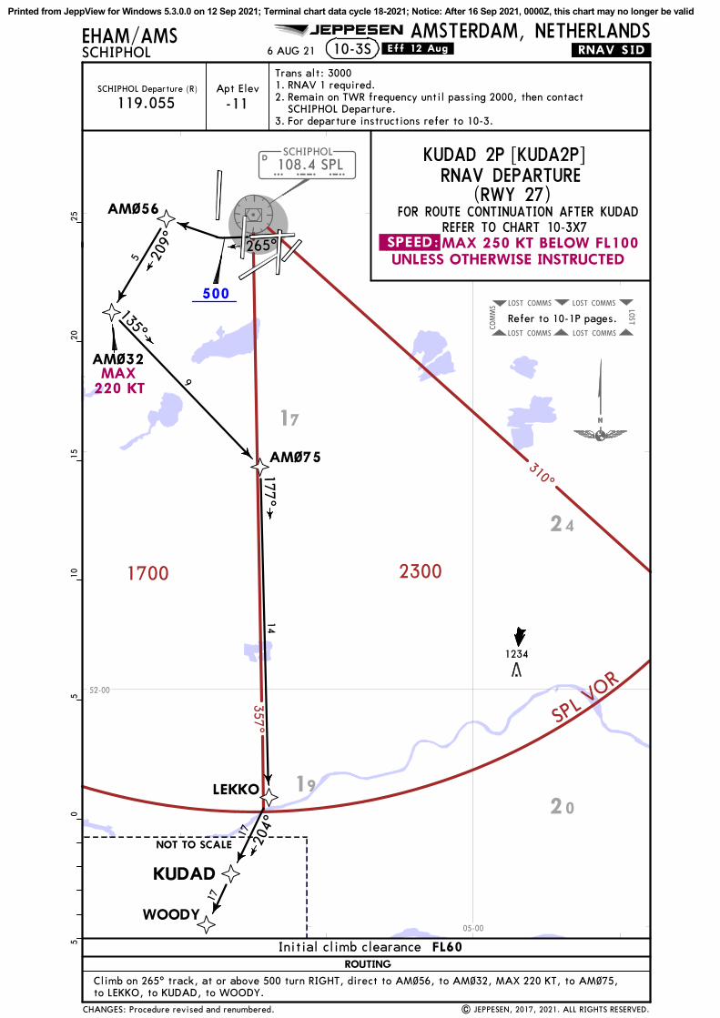
108.4 SPLD
SCHIPHOL
S P L
COMMSLOST COMMSLOST LOST
COMMSLOST COMMSLOST
COMMS
310^357^
23001700
SPL VOR
500
LEKKO
AM~56
AM~32
AM~75
135^
5
9
14
1234
WOODY
KUDAD
Refer to 10-1P pages.
to LEKKO, to KUDAD, to WOODY.
| JEPPESEN, 2017, 2021. ALL RIGHTS RESERVED.
05
1015
205
25
EHAM/AMSSCHIPHOL
AMSTERDAM, NETHERLANDS10-3S
JEPPESEN
.Eff.12.Aug.6 AUG 21
265^
17
17
Climb on 265^ track, at or above 500 turn RIGHT, direct to AM~56, to AM~32, MAX 220 KT, to AM~75,
177^
209^
204^
Trans alt: 30001.2. 3.
RNAV 1 required.Remain on TWR frequency until passing 2000, then contact SCHIPHOL Departure.For departure instructions refer to 10-3.
FOR ROUTE CONTINUATION AFTER KUDADREFER TO CHART 10-3X7
KUDAD 2P [KUDA2P]
Apt Elev
-11SCHIPHOL Departure (R)
119.055
.RNAV.SID.
19
20
17
24
52-00
05-00
MAX220 KT
UNLESS OTHERWISE INSTRUCTED.SPEED:MAX 250 KT BELOW FL100
ROUTING
Initial climb clearance FL60
CHANGES: Procedure revised and renumbered.
NOT TO SCALE
(RWY 27)RNAV DEPARTURE
Printed from JeppView for Windows 5.3.0.0 on 12 Sep 2021; Terminal chart data cycle 18-2021; Notice: After 16 Sep 2021, 0000Z, this chart may no longer be valid

108.4 SPLD
SCHIPHOL
S P L
COMMSLOST COMMSLOST LOST
COMMSLOST COMMSLOST
COMMS
2300
310^
1700
VORLPS
357^
500 FOR ROUTE CONTINUATION AFTER KUDAD REFER TO CHART 10-3X7
057^
AM~36
AM~72
AM~38
KUDAD 2T
7
10
14KUDA
D 2
R
1234
LEKKO
WOODY
KUDAD
NOT TO SCALE
(RWY 06)
Refer to 10-1P pages.
1 Jet aircraft only between 0630-2230LT.
| JEPPESEN, 2017, 2021. ALL RIGHTS RESERVED.
05
1015
205
25
EHAM/AMSSCHIPHOL
AMSTERDAM, NETHERLANDS10-3T
JEPPESEN
.Eff.12.Aug.
KUDAD 2T
1
2
Only jet aircraft between 2230-0630LT.2
Trans alt: 30001.2. 3.
RNAV 1 required.Remain on TWR frequency until passing 2000, then contact SCHIPHOL Departure.For departure instructions refer to 10-3.
Apt Elev
-11SCHIPHOL Departure (R)
119.055
RNAV DEPARTURES
KUDAD 2R [KUDA2R]KUDAD 2T [KUDA2T]
204^
6 AUG 21
140^
179^
6 204^
17
17
Climb on 057^ track, at or above 500 turn RIGHT, direct to AM~36, MAX 220 KT,to AM~72, to LEKKO, to KUDAD, to WOODY.
to AM~38, to LEKKO, to KUDAD, to WOODY. Climb on 057^ track, at or above 500 turn RIGHT, direct to AM~36, MAX 220 KT,
(KUDAD 2R only)
.RNAV.SID.
19
17
24
20
52-00
05-00
UNLESS OTHERWISE INSTRUCTED
MAX 220 KT
MAX 250 KT BELOW FL100.SPEED:
SID ROUTING
CHANGES: Procedures revised and renumbered.
KUDAD 2R
Initial climb clearance FL60
Printed from JeppView for Windows 5.3.0.0 on 12 Sep 2021; Terminal chart data cycle 18-2021; Notice: After 16 Sep 2021, 0000Z, this chart may no longer be valid

108.4 SPLD
SCHIPHOL
S P L
COMMSLOST COMMSLOST LOST
COMMSLOST COMMSLOST
COMMS COMMSLOST COMMSLOST LO
ST
COMMSLOST COMMSLOST
COMMS
310^
357^
1700
2300
SPL VOR LEKKO
AM~~5
AM~~3
237^
1
237^AM~95
AM125
AM156
1.2
6.7% V/V (fpm) 509 678 1018 1357 1696 2035
Gnd speed-KT 75 100 150 200 250 300
AM~~3
153^
4.5
1.3
1.2
1
735
WOODY
KUDAD
NOT TO SCALE
NOT TO SCALE
This SID requires a minimum climb gradient of6.7% up to 390.
Refer to 10-1P pages.
4
AM~~4
165^
11
150^
EHAM/AMSSCHIPHOL
AMSTERDAM, NETHERLANDS10-3T1
JEPPESEN
1| JEPPESEN, 2017, 2021. ALL RIGHTS RESERVED.
05
1015
205
25
to WOODY.[KUDA3S]: On 237^ track to AM~~5, 150^ track to AM~~3, MAX 220 KT, to AM~~4, to LEKKO, to KUDAD,
[KUD3SY]: On 237^ track to AM~95, turn LEFT to AM125, turn LEFT to AM156, MAX 220 KT, to AM~~3,
RNAV 1 required.Remain on TWR frequency until passing 2000, then contact SCHIPHOL Departure.For departure instructions refer to 10-3.
Trans alt: 30001.2. 3.
Apt Elev
-11SCHIPHOL Departure (R)
119.055
.RNAV.SID.
APPROVAL FOR RNP 1 OPERATIONS REQUIRED
17
17
204^
(RWY 24)FOR ROUTE CONTINUATION AFTER KUDAD REFER TO CHART 10-3X7
RNP 1, RF & GNSS REQUIRED
[KUDA3S], [KUD3SY]KUDAD 3S RNAV DEPARTURE
13 AUG 21
to AM~~4, to LEKKO, to KUDAD, to WOODY.
19
17
24
52-00
05-00MAX 220 KT
MAX 220 KT
MAX220 KT
MAX 250 KT BELOW FL100.SPEED:UNLESS OTHERWISE INSTRUCTED
Alternate routeto enhance noise abatement
KUD3SY
ROUTING
Initial climb clearance FL60
in turn
CHANGES: Speed restriction at AM~~3 withdrawn on alternate route.
Printed from JeppView for Windows 5.3.0.0 on 12 Sep 2021; Terminal chart data cycle 18-2021; Notice: After 16 Sep 2021, 0000Z, this chart may no longer be valid

108.4 SPLD
SCHIPHOL
S P L
COMMSLOST COMMSLOST LOST
COMMSLOST COMMSLOST
COMMS
2300
1700MSA SPL VOR
357^ 310^
FOR ROUTE CONTINUATION AFTER KUDAD REFER TO CHART 10-3X7
KUDAD 2V [KUDA2V], KUDAD 2Z [KUDA2Z]
002^
KUDA
D 2
Z
092^
AM~72
LEKKO
AM~13
AM~45
AM~36
614
5
17
NOT TO SCALE
204^
179^
AM~84 KUDA
D 2
V
587
WOODY
KUDAD
(RWY 36L)
Refer to 10-1P pages.
17
17
168^169^
(113.3) SPYSPIJKERBOOR
SPYD
5
179^
(KUDAD 2V only)
EHAM/AMSSCHIPHOL
AMSTERDAM, NETHERLANDS10-3T2
JEPPESEN
Jet aircraft only between 0630-2230LT. Only jet aircraft between 2230-0630LT.
2
1 2
05
1015
205
25
| JEPPESEN, 2017, 2021. ALL RIGHTS RESERVED.
1KUDAD 2V On 002^ track to AM~84, 168^ track to AM~45, MAX 220 KT, to AM~36, to AM~72,
to LEKKO, to KUDAD, to WOODY.
5.0% V/V (fpm) 380 506 760 1013 1266 1519
Gnd speed-KT 75 100 150 200 250 300
KUDAD 2V
If unable, report to ATC.
This SID requires a minimum climb gradient of5.0% up to 1900.
Apt Elev
-11SCHIPHOL Departure (R)
119.055
Trans alt: 30001.2. 3.
RNAV 1 required.Remain on TWR frequency until passing 2000, then contact SCHIPHOL Departure.For departure instructions refer to 10-3.
.RNAV.SID.
RNAV DEPARTURES
(KUDAD 2V only)
13 f
rom
THR
Climb on 002^ track to at or above 500, 002^ track to AM~13, to SPY DME, to AM~72,to LEKKO, to KUDAD, to WOODY.
13 AUG 21
17
24
52-30
04-30
05-00
MAX 220 KT
MAX220 KT
.SPEED: MAX 250 KT BELOW FL100 UNLESS OTHERWISE INSTRUCTED
in turn
KUDAD 2Z
SID ROUTING
Initial climb clearance FL60
CHANGES: None.
Printed from JeppView for Windows 5.3.0.0 on 12 Sep 2021; Terminal chart data cycle 18-2021; Notice: After 16 Sep 2021, 0000Z, this chart may no longer be valid

ROTTERDAMEHRD
108.4 SPLDSCHIPHOL
S P L1
1
COMMSLOST COMMSLOST LOST
COMMSLOST COMMSLOST
COMMS
310^
357^
1700
2300
SPL VOR
AM~46
182^
FOR ROUTE CONTINUATION AFTER LARAS REFER TO CHART 10-3X7
AM~74
161^
LEKKO
LARAS
204^
3
6
15
669
WOODY
Refer to 10-1P pages.
05
1015
205
25
On 182^ track to AM~46, to AM~74, to LEKKO, to LARAS, to WOODY.| JEPPESEN, 2017, 2021. ALL RIGHTS RESERVED.
EHAM/AMSSCHIPHOL
AMSTERDAM, NETHERLANDS10-3T3
JEPPESEN
.Eff.12.Aug.6 AUG 21 .RNAV.SID.
Trans alt: 30001.2. 3.
RNAV 1 required.Remain on TWR frequency until passing 2000,then contact SCHIPHOL Departure.For departure instructions refer to 10-3.
29
177^
NOT TOSCALE
Apt Elev
-11SCHIPHOL Departure (R)
119.055
LARAS 2X RNAV DEPARTURE
19
17
52-00
04-30
UNLESS OTHERWISE INSTRUCTEDMAX 250 KT BELOW FL100.SPEED:
ROUTING
FL60Initial climb clearance
(RWY 18C)
CHANGES: Procedure revised and renumbered.
[LARA2X]
Printed from JeppView for Windows 5.3.0.0 on 12 Sep 2021; Terminal chart data cycle 18-2021; Notice: After 16 Sep 2021, 0000Z, this chart may no longer be valid

108.4 SPLD
SCHIPHOL
S P L
COMMSLOST COMMSLOST
LOST
COMMSLOST COMMSLOST
COMMS
310^
357^
1700
SPL VOR
2300
500
500
FL65
FOR ROUTE CONTINUATION AFTER LOPIKREFER TO CHART 10-3X8
LOPIK 2F
4.0% V/V (fpm) 304 405 608 810 1013 1215
Gnd speed-KT 75 100 150 200 250 300
040^
AM~61
OGINA
LOPIK
182^
AM~29LO
PIK
4E
AM~5~
117^
FOR TRAFFIC WITH DESTINATION EHBK VIA AIRWAY T-605AND FOR TRAFFIC WITH DESTINATION EHBD & EHEH
LOPIK
2F
4
10
16
10
4.0% up to 1000.
1234
FOR TRAFFIC VIA AIRWAY N-852
in turn
This SID requires a minimum climb gradient of
Refer to 10-1P pages.
LOPIK 2F
| JEPPESEN, 2017, 2021. ALL RIGHTS RESERVED.
05
1015
205
25
EHAM/AMSSCHIPHOL
AMSTERDAM, NETHERLANDS10-3T4
JEPPESEN
.Eff.12.Aug.6 AUG 21
Climb on 182^ track, at or above 500 turn LEFT, direct to AM~29, to AM~5~,to LOPIK.
Trans alt: 30001.2. 3.
RNAV 1 required.Remain on TWR frequency until passing 2000, then contact SCHIPHOL Departure.For departure instructions refer to 10-3.
.RNAV.SID.
LOPIK 2F [LOPI2F]LOPIK 4E [LOPI4E]
119.055SCHIPHOL Departure (R) Apt Elev
-11
140^
163^
148^
Climb on 040^ track, at or above 500 turn RIGHT, direct to AM~61, MAX 220 KT,to OGINA, to LOPIK.
17
24
20
52-0005-00
.SPEED:MAX 250 KT BELOW FL100UNLESS OTHERWISE INSTRUCTED
MAX 220 KT
MAX220 KT
Permission for VFR flightswithout ATC clearance
beyond LOPIK
04
SID
LOPIK 4E 18L
ROUTINGRWY
Initial climb clearance FL60
CHANGES: Procedures revised and renumbered.
RNAV DEPARTURES(RWYS 04, 18L)
Printed from JeppView for Windows 5.3.0.0 on 12 Sep 2021; Terminal chart data cycle 18-2021; Notice: After 16 Sep 2021, 0000Z, this chart may no longer be valid
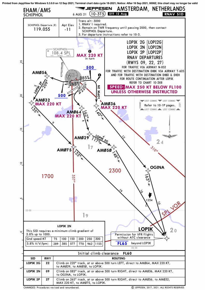
108.4 SPLD
SCHIPHOL
S P L
COMMSLOST COMMSLOST
LOST
COMMSLOST COMMSLOST
COMMS
310^
357^
17002300
SPL V
OR
500
500
FL65
FOR ROUTE CONTINUATION AFTER LOPIKREFER TO CHART 10-3X8
LOPIK 2N [LOPI2N]
AM~64
AM~29
AM~5~
117^
LOPIK
AM~36
OGINA
AM~56
AM~32
135^
133^
FOR TRAFFIC WITH DESTINATION EHBK VIA AIRWAY T-605 AND FOR TRAFFIC WITH DESTINATION EHBD & EHEH
162^
140^
085^
265^22
0^
9
LOPI
K 2
P
LOPIK 2G
LOPIK
2N
16
10
4
148^12
1
1
4
1234
FOR TRAFFIC VIA AIRWAY N-852
in turn
EHAM/AMSSCHIPHOL
AMSTERDAM, NETHERLANDS10-3T5
JEPPESEN
.Eff.12.Aug.6 AUG 21 .RNAV.SID.0
510
1520
525
to OGINA, to LOPIK.
| JEPPESEN, 2017, 2021. ALL RIGHTS RESERVED.
Climb on 220^ track, at or above 500 turn LEFT, direct to AM~64, MAX 220 KT,to AM~29, to AM~5~, to LOPIK.
Climb on 085^ track, at or above 500 turn RIGHT, direct to AM~36, MAX 220 KT,
MAX 220 KT, to AM~75, to LOPIK.Climb on 265^ track, at or above 500 turn RIGHT, direct to AM~56, to AM~32,
LOPIK 2G
LOPIK 2N
Apt Elev
-11SCHIPHOL Departure (R)
119.055
Trans alt: 30001.2. 3.
RNAV 1 required.Remain on TWR frequency until passing 2000, then contactSCHIPHOL Departure.For departure instructions refer to 10-3.
LOPIK 2G [LOPI2G]
LOPIK 2N
This SID requires a minimum climb gradient of3.8% up to 1000.
163^
209^
AM~75
19
5
Refer to 10-1P pages.
19
20
1724
52-00
05-00
.SPEED:MAX 250 KT BELOW FL100UNLESS OTHERWISE INSTRUCTED
MAX 220 KT
MAX 220 KT
MAX 220 KT
MAX 220 KT
Permission for VFR flightswithout ATC clearance
beyond LOPIK
27
09
22
SID ROUTINGRWY
Initial climb clearance FL60
CHANGES: Procedures revised and renumbered.
LOPIK 2P
RNAV DEPARTURES(RWYS 09, 22, 27)
LOPIK 2P [LOPI2P]
289 385 577 770 962 1155
75 100 150 200 250 300Gnd speed-KT
3.8% V/V(fpm)
Printed from JeppView for Windows 5.3.0.0 on 12 Sep 2021; Terminal chart data cycle 18-2021; Notice: After 16 Sep 2021, 0000Z, this chart may no longer be valid

108.4 SPLSPLDSCHIPHOL COMMSLOST COMMSLOST LO
ST
COMMSLOST COMMSLOST
COMMS
310^
357^
1700
2300
SPL VOR
500
FL65
LOPIK
OGINA
AM~36140^
163^
10
057^
1234
FOR TRAFFIC VIA AIRWAY N-852
12
05
1015
205
25
| JEPPESEN, 2017, 2021. ALL RIGHTS RESERVED.
Climb on 057^ track, at or above 500 turn RIGHT, direct to AM~36, MAX 220 KT, to OGINA, to LOPIK.
JEPPESENEHAM/AMSSCHIPHOL
AMSTERDAM, NETHERLANDS10-3T6 .Eff.12.Aug.6 AUG 21 .RNAV.SID.
SCHIPHOL Departure (R)
119.055Apt Elev
-11RNAV 1 required.Remain on TWR frequency until passing 2000, then contactSCHIPHOL Departure.For departure instructions refer to 10-3.
Trans alt: 30001.2. 3.
FOR ROUTE CONTINUATION AFTER LOPIK REFER TO CHART 10-3X8AND FOR TRAFFIC WITH DESTINATION EHBD & EHEH
FOR TRAFFIC WITH DESTINATION EHBK VIA AIRWAY T-605
LOPIK 2R RNAV DEPARTURE [LOPI2R]
Refer to 10-1P pages.
19 20
17 24
52-00
05-00
MAX 220 KT
.SPEED:MAX 250 KT BELOW FL100 UNLESS OTHERWISE INSTRUCTED
Permission for VFR flightswithout ATC clearance
beyond LOPIK
ROUTING
CHANGES: Procedure revised and renumbered.
Initial climb clearance FL60
(RWY 06)
Printed from JeppView for Windows 5.3.0.0 on 12 Sep 2021; Terminal chart data cycle 18-2021; Notice: After 16 Sep 2021, 0000Z, this chart may no longer be valid

108.4 SPLD
SCHIPHOL
SPL
COMMSLOST COMMSLOST LOST
COMMSLOST COMMSLOST
COMMS
310^
357^
2300
1700
SPL VOR
FL65
AM~~8
117^
FOR ROUTE CONTINUATION AFTER LOPIKREFER TO CHART 10-3X8
FOR TRAFFIC WITH DESTINATION EHBK VIA AIRWAY T-605 AND FOR TRAFFIC WITH DESTINATION EHBD & EHEH
237^
AM~~5
6
AM~5~
16
1
1
237^AM~95
AM125AM157
1.2
6.7% V/V (fpm) 509 678 1018 1357 1696 2035
Gnd speed-KT 75 100 150 200 250 300AM~~8
1.3
2.3
2.4119^
NOT TO SCALE
1234
LOPIK
FOR TRAFFIC VIA AIRWAY N-852
APPROVAL FOR RNP 1 OPERATIONSREQUIRED
05
1015
205
25
[LOPI3S]: On 237^ track to AM~~5, 117^ track to AM~~8, MAX 220 KT, to AM~5~, to LOPIK.
1| JEPPESEN, 2017, 2021. ALL RIGHTS RESERVED.
EHAM/AMSSCHIPHOL
AMSTERDAM, NETHERLANDS10-3T7
JEPPESEN
.Eff.12.Aug.6 AUG 21
Apt Elev
-11SCHIPHOL Departure (R)
119.055
Trans alt: 30001.2. 3.
RNAV 1 required.Remain on TWR frequency until passing 2000, then contactSCHIPHOL Departure.For departure instructions refer to 10-3.
.RNAV.SID.
148^
[LOP3SY]: On 237^ track to AM~95, turn LEFT to AM125, turn LEFT to AM157, MAX 220 KT, to AM~~8,to AM~5~, to LOPIK.
This SID requires a minimum climb gradient of6.7% up to 390.
Refer to 10-1P pages.
LOPIK 3S RNAV DEPARTURE
RNP 1, RF & GNSS REQUIRED
19
20
17
24
52-00
05-00
.SPEED:MAX 250 KT BELOW FL100UNLESS OTHERWISE INSTRUCTED
MAX 220 KT
MAX 220 KT
MAX 220 KT
Alternate routeto enhance noise abatement
ROUTING
Initial climb clearance FL60
Permission for VFR flightswithout ATC clearance
beyond LOPIK
in turn
CHANGES: Procedure revised and renumbered.
(RWY 24)
LOP3SY
[LOPI3S], [LOP3SY]
Printed from JeppView for Windows 5.3.0.0 on 12 Sep 2021; Terminal chart data cycle 18-2021; Notice: After 16 Sep 2021, 0000Z, this chart may no longer be valid

108.4 SPLSPLDSCHIPHOL
COMMSLOST COMMSLOST LOST
COMMSLOST COMMSLOST
COMMS
310^
357^
2300
1700
SPL
VO
R
FL65
FOR ROUTE CONTINUATION AFTER LOPIKREFER TO CHART 10-3X8
LOPIK 4V [LOPI4V], LOPIK 2Z [LOPI2Z]
FOR TRAFFIC WITH DESTINATION EHBK VIA AIRWAY T-605 AND FOR TRAFFIC WITH DESTINATION EHBD & EHEH
AM~45
AM~36
002^
LOPIK
2Z
LOPIK
AM~84
OGINA
AM~13
168^
5
LOPIK
4V
140^
12
10
28
1234
FOR TRAFFIC VIA AIRWAY N-852
in turn
5.0% V/V (fpm) 380 506 760 1013 1266 1519
Gnd speed-KT 75 100 150 200 250 300
LOPIK 4VThis SID requires a minimum climb gradient of5.0% up to 1900. If unable, report to ATC.
Jet aircraft only between 0630-2230LT.Only jet aircraft between 2230-0630LT.
12
| JEPPESEN, 2017, 2021. ALL RIGHTS RESERVED.
1
2
On 002^ track to AM~84, 168^ track to AM~45, MAX 220 KT, to AM~36, to OGINA, to LOPIK.LOPIK 4V
510
1520
2530
3540
450
5
JEPPESENEHAM/AMSSCHIPHOL
AMSTERDAM, NETHERLANDS10-3T8 .Eff.12.Aug.6 AUG 21
Apt Elev
-11SCHIPHOL Departure (R)
119.055RNAV 1 required.Remain on TWR frequency until passing 2000, then contactSCHIPHOL Departure.For departure instructions refer to 10-3.
Trans alt: 30001.2. 3.
(113.3) SPYSPIJKERBOOR
SPYD
163^
169^
5
092^
13 f
rom
THR
(LOPIK 4V only)
163^
(LOPIK 4V only)
.RNAV.SID.
Refer to 10-1P pages.
Climb on 002^ track to at or above 500, 002^ track to AM~13, to SPY DME, to LOPIK.
20
17
24
52-00
52-30
05-00
.SPEED:MAX 250 KT BELOW FL100UNLESS OTHERWISE INSTRUCTED
MAX220 KT
MAX 220 KT
Permission for VFR flightswithout ATC clearance
beyond LOPIK
SID ROUTING
FL60Initial climb clearance
LOPIK 2Z
CHANGES: Procedures revised and renumbered.
(RWY 36L)RNAV DEPARTURES
Printed from JeppView for Windows 5.3.0.0 on 12 Sep 2021; Terminal chart data cycle 18-2021; Notice: After 16 Sep 2021, 0000Z, this chart may no longer be valid

108.4 SPLD
SCHIPHOL
S P L
COMMSLOST COMMSLOST LOST
COMMSLOST COMMSLOST
COMMS
310^
357^
2300
1700
SPL VOR
500
FL95
FL65
10-3UEHAM/AMSSCHIPHOL
AMSTERDAM, NETHERLANDS
Apt Elev
-11SCHIPHOL Departure (R)
FOR ROUTE CONTINUATION AFTER ANDIKREFER TO CHART 10-3X5
JEPPESEN
FOR ROUTE CONTINUATION AFTER ARNEMREFER TO CHART 10-3X6
119.055
NOPSU 3W [NOPS3W]NYKER 5W [NYKE5W]
RIKOR
AM~44
NOPSU
050^
AM~81
AM~82088^ 143^
NYKER110^
ARNEM
7
NOT TO SCALE
ANDIK
6
5
05
1015
205
25
NO
PSU 3
W
NYKER 5W
355^
587
| JEPPESEN, 2017, 2021. ALL RIGHTS RESERVED.
1
1
.Eff.12.Aug.6 AUG 21
002^
(117.8) PAMPAMPUS
PAMD
17
22
RNAV 1 requiredRemain on TWR frequency until passing 2000, then contactSCHIPHOL Departure.For departure instructions refer to 10-3.
Trans alt: 30001.2. 3.
(113.3) SPYSPIJKERBOOR
SPYD
5
15
044^4
5.4% V/V (fpm) 410 547 820 1094 1367 1641
Gnd speed-KT 75 100 150 200 250 300
These SIDs require a minimum climb gradient of5.4% up to 1900. If unable, report to ATC.
1
Climb on 002^ track, at or above 500 turn RIGHT, direct to RIKOR, to AM~44, to SPY DME,to NOPSU, to ANDIK.
Climb on 002^ track, at or above 500 turn RIGHT, direct to RIKOR, to AM~81, to AM~82,to PAM DME, to NYKER, to ARNEM.
.RNAV.SID.
Refer to 10-1P pages.
(NYKER 5W only)
17
24
52-30
05-00
UNLESS OTHERWISE INSTRUCTEDMAX 250 KT BELOW FL100.SPEED:
SID
NOPSU 3W
ROUTING
NYKER 5W
Initial climb clearance FL60
Permission for VFR flightswithout ATC clearance
beyond NYKER
Via Z-733
CHANGES: Procedures revised and renumbered.
RWY 36C RNAV DEPARTURES
Printed from JeppView for Windows 5.3.0.0 on 12 Sep 2021; Terminal chart data cycle 18-2021; Notice: After 16 Sep 2021, 0000Z, this chart may no longer be valid

108.4 SPLD
SCHIPHOL
S P L
COMMSLOST COMMSLOST LOST
COMMSLOST COMMSLOST
COMMS
310^
357^
1700
2300
SPL
VOR
500
FL65
EHAM/AMSSCHIPHOL
AMSTERDAM, NETHERLANDS10-3V
FOR TRAFFIC WITH DESTINATION EHBK VIA AIRWAY T-605 ANDFOR TRAFFIC WITH DESTINATION EHBD & EHEH
FOR ROUTE CONTINUATION AFTER OGINA REFER TO CHART 10-3X8
to OGINA, to LOPIK.
JEPPESEN
OGINA 4W [OGIN4W]
002^
AM~7~
AM~36
OGINA
LOPIK
510
1520
2530
3540
450
5
3
7
140^
163^10
12
1234
| JEPPESEN, 2017, 2021. ALL RIGHTS RESERVED.
RIKOR
FOR TRAFFIC VIA AIRWAY N-852
.Eff.12.Aug.
5.4% V/V (fpm) 410 547 820 1094 1367 1641
Gnd speed-KT 75 100 150 200 250 300
This SID requires a minimum climb gradient of5.4% up to 1900. If unable, report to ATC.
6 AUG 21 .RNAV.SID.
RNAV 1 required.Remain on TWR frequency until passing 2000, then contactSCHIPHOL Departure.For departure instructions refer to 10-3.
Trans alt: 30001.2. 3.
Apt Elev
-11SCHIPHOL Departure (R)
119.055
Climb on 002^ track, at or above 500 turn RIGHT, direct to RIKOR, to AM~70, MAX 220 KT, to AM~36,
102^
179^
Refer to 10-1P pages.
19
20
17
24
52-00
52-30
04-30
05-00
MAX 220 KT
MAX 250 KT BELOW FL100 UNLESS OTHERWISE INSTRUCTED.SPEED:
ROUTING
Permission for VFR flightswithout ATC clearance
beyond LOPIK
Initial climb clearance FL60
CHANGES: Procedure revised and renumbered.
(RWY 36C)RNAV DEPARTURE
Printed from JeppView for Windows 5.3.0.0 on 12 Sep 2021; Terminal chart data cycle 18-2021; Notice: After 16 Sep 2021, 0000Z, this chart may no longer be valid

COMMS
LOST
COMMS
LOST
LOST
COMMS
LOST
COMMS
LOST
COMMS
310^
357^
1700
2300
SPL VOR
500
FL6
5
RENDI 2F
RENDI 2E
EHAM/AMSSCHIPHOL
RENDI 2F
4.0%
V/V
(fp
m)
304
405
608
810
1013
1215
Gnd
spe
ed-K
T75
100
150
200
250
300
AM
~37
IVLU
T09
1^RENDI 2E
LUNIX
124^
RENDI
EDUPO
129^
040^
AM
~6~
RENDI 2E
[RE
ND2E
], R
ENDI 2F
[RE
ND2F
]
Apt
Ele
v
-11
SCH
IPH
OL
Dep
artu
re (
R)
119.
055
182^10
8.4
SPL
DSC
HIP
HO
L
S P
L
13
RENDI 2F
15
This
SID
req
uire
s a
min
imum
cli
mb
grad
ient
of 4.0%
up
to 1
000.
05
1015
205
25
NO
T T
O S
CA
LE
5
8
14
FOR
ROUTE
CONTINUATION A
FTER
EDUPO
REFER
TO C
HART
10-3X
6
JEPPESEN
10-3V1AMSTERDAM, NETHERLANDS
| JEPPESEN, 2017, 2021. ALL RIGHTS RESERVED.
.Eff.12.Aug.6 AUG 21
1. R
NA
V 1
req
uire
d.2.
Rem
ain
on T
WR
freq
uenc
y un
til
pass
ing
2000
, th
en c
onta
ctSC
HIP
HO
L D
epar
ture
.3.
For
dep
artu
re i
nstr
ucti
ons
refe
r to
10-
3.
Tran
s al
t: 3
000
AM
~47
On
182^
tra
ck t
o A
M~3
7, t
o A
M~4
7, M
AX 2
20 K
T, t
o IV
LUT,
to
LUN
IX,
to R
END
I, t
o ED
UPO
.
.RNAV.SID.
Cli
mb
on 0
40^
trac
k, a
t or
abo
ve 5
00 t
urn
RIG
HT,
dir
ect
to A
M~6
~, M
AX 2
20 K
T, t
o IV
LUT,
to L
UN
IX,
to R
END
I, t
o ED
UPO
.
Refe
r to
10-
1P p
ages
.68
3
104^
3
D3.
1 SP
L
Earl
y au
topi
lot
conn
ecti
on m
ight
res
ult
in t
urn
init
iati
on b
elow
500
. If
app
lica
ble,
con
tinu
eon
tra
ck 1
83^
beyo
nd D
3.1
SPL
to p
reve
nttu
rnin
g be
low
500
.
WA
RNIN
G R
WY 1
8L
17
24
05-00
05-30
52-10
.SPEED
:M
AX 2
50 K
T B
ELO
W F
L100
UNLE
SS O
THERW
ISE INSTRUCTED
MA
X 2
20 K
T
MA
X 2
20 K
T
MA
X 2
20 K
T
04
SID
18L
RO
UTIN
GRW
Y
Init
ial
clim
b cl
eara
nce
FL6
0
Perm
issi
on f
or V
FR f
ligh
tsw
itho
ut A
TC c
lear
ance
in t
urn
CHANGES: Procedures renumbered & revised.
(RWYS 04
, 18
L)
RNAV D
EPART
URE
S
Printed from JeppView for Windows 5.3.0.0 on 12 Sep 2021; Terminal chart data cycle 18-2021; Notice: After 16 Sep 2021, 0000Z, this chart may no longer be valid

108.
4 SP
LSP
LD
SCHIP
HO
L
COMMS
LOST
COMMS
LOST
LOST
COMMS
LOST
COMMS
LOST
COMMS
310^
357^
1700
2300
MSA
SPL
VO
R
500
FL6
5
220^
AM
~23
IVLU
T
LUNIX
124^
RENDI
EDUPO
129^
AM
~55
AM
~42
112^
RENDI 2N
RENDI 2G
RENDI 2P
On
085^
tra
ck t
o A
M~5
5, t
o A
M~4
2, t
o IV
LUT,
to
LUN
IX,
to R
END
I, t
o ED
UPO
.
RENDI 2N
FOR
ROUTE
CONTINUATION A
FTER
EDUPO
REFER
TO C
HART
10-3X
6
Apt
Ele
v
-11
SCH
IPH
OL
Dep
artu
re (
R)
119.
055
RENDI 2G
[RE
ND2G
], R
ENDI 2N
[RE
ND2N
]
265^
AM
~56
AM
~32
135^
072^
9REND
I 2P
RENDI 2N
085^
4
13
14
5
8
JEPPESEN
NO
T T
O S
CA
LERENDI 2G
16
19
05
1015
205
25
AMSTERDAM, NETHERLANDS10-3V2
EHAM/AMSSCHIPHOL
| JEPPESEN, 2016, 2021. ALL RIGHTS RESERVED.
.Eff.12.Aug.6 AUG 21
AM
~75
This
SID
req
uire
s a
min
imum
cli
mb
grad
ient
of 3.8%
up
to 1
000.
3.8%
V/V
(fp
m)
289
385
577
770
962
1154
Gnd
spe
ed-K
T75
100
150
200
250
300
Cli
mb
on 2
20^
trac
k, a
t or
abo
ve 5
00 t
urn
LEFT
, di
rect
to
AM
~23,
MA
X 2
20 K
T, t
o IV
LUT,
to L
UN
IX,
to R
END
I, t
o ED
UPO
.
Tran
s al
t: 3
000
1. R
NA
V 1
req
uire
d.2.
Rem
ain
on T
WR
freq
uenc
y un
til
pass
ing
2000
, th
en c
onta
ctSC
HIP
HO
L D
epar
ture
.3.
For
dep
artu
re i
nstr
ucti
ons
refe
r to
10-
3.
.RNAV.SID.
104^
104^
091^
Cli
mb
on 2
65^
trac
k, a
t or
abo
ve 5
00 t
urn
RIG
HT,
dir
ect
to A
M~5
6, t
o A
M~3
2, M
AX 2
20 K
T,to
AM
~75,
to
IVLU
T, t
o LU
NIX
, to
REN
DI,
to
EDUPO
.
209^
5
Refe
r to
10-
1P p
ages
.
683
17
24
05-00
52-10
.SPEED
:M
AX 2
50 K
T B
ELO
W F
L100
UNLE
SS O
THERW
ISE INSTRUCTED
MA
X220 K
T
MA
X220 K
T
MA
X 2
20 K
T
09
22
SID
RO
UTIN
GRW
Y
27
Init
ial
clim
b cl
eara
nce
FL6
0
RENDI 2P
[RE
ND2P
]
Perm
issi
on f
or V
FR f
ligh
tsw
itho
ut A
TC c
lear
ance
in t
urn
RNAV D
EPART
URE
S
(RWYS 09
, 22
, 27
)
CHANGES: Procedures renumbered & revised.
Printed from JeppView for Windows 5.3.0.0 on 12 Sep 2021; Terminal chart data cycle 18-2021; Notice: After 16 Sep 2021, 0000Z, this chart may no longer be valid

108.
4 SP
LD
SCHIP
HO
L
S P
L
COMMS
LOST
COMMS
LOST
LOST
COMMS
LOST
COMMS
LOST
COMMS
310^
357^
2300
1700
SPL VOR
500
FL6
5
Jet
airc
raft
onl
y be
twee
n 06
30-2
230L
T.O
nly
jet
airc
raft
bet
wee
n 22
30-0
630L
T.
RENDI 2T
EHAM/AMSSCHIPHOL
AMSTERDAM, NETHERLANDS
1 2
12
JEPPESEN
10-3V3
057^
AM
~18
IVLU
T
RENDI 2R
LUNIX
124^
EDUPO
129^
AM
~36
AM
~17
071^
RENDI 2R
[RE
ND2R
], R
ENDI 2T
[RE
ND2T
]
Apt
Ele
v
-11
SCH
IPH
OL
Dep
artu
re (
R)
119.
055
NO
T T
O S
CA
LE
FOR
ROUTE
CONTINUATION A
FTER
EDUPO
REFER
TO C
HART
10-3X
6
RENDI
8
5
14
12
5
17
683
05
1015
205
25
| JEPPESEN, 2017, 2021. ALL RIGHTS RESERVED.
.Eff.12.Aug.6 AUG 21
Refe
r to
10-
1P p
ages
.
Tran
s al
t: 3
000
1. R
NA
V 1
req
uire
d.2.
Rem
ain
on T
WR
freq
uenc
y un
til
pass
ing
2000
, th
en c
onta
ctSC
HIP
HO
L D
epar
ture
.3.
For
dep
artu
re i
nstr
ucti
ons
refe
r to
10-
3.
.RNAV.SID.
RENDI 2T
104^ 14
0^
Cli
mb
on 0
57^
trac
k, a
t or
abo
ve 5
00 t
urn
RIG
HT,
dir
ect
to A
M~1
8, t
o IV
LUT,
to
LUN
IX,
to R
END
I, t
o ED
UPO
.
Cli
mb
on 0
57^
trac
k, a
t or
abo
ve 5
00 t
urn
RIG
HT,
dir
ect
to A
M~3
6, M
AX 2
20 K
T,to
AM
~17,
to
IVLU
T, t
o LU
NIX
, to
REN
DI,
to
EDUPO
.
17
24
05-00
05-30
52-10
.SPEED
:M
AX 2
50 K
T B
ELO
W F
L100
UNLE
SS O
THERW
ISE INSTRUCTED
MA
X 2
20 K
T
MA
X220 K
T
SID
RENDI 2R
RO
UTIN
G
Init
ial
clim
b cl
eara
nce
FL6
0
Perm
issi
on f
or V
FR f
ligh
tsw
itho
ut A
TC c
lear
ance
in t
urn
RNAV D
EPART
URE
S
(RWY 0
6)
CHANGES: Procedures renumbered & revised.
Printed from JeppView for Windows 5.3.0.0 on 12 Sep 2021; Terminal chart data cycle 18-2021; Notice: After 16 Sep 2021, 0000Z, this chart may no longer be valid
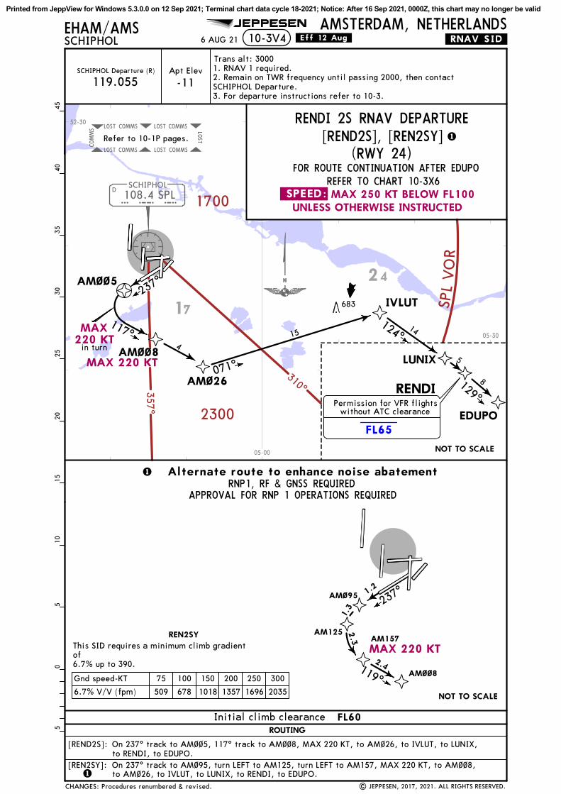
108.4 SPLD
SCHIPHOL
S P L
COMMSLOST COMMSLOST LOST
COMMSLOST COMMSLOST
COMMS
2300
310^
1700
357 ^
SPL
VO
RFL65
EHAM/AMSSCHIPHOL
AMSTERDAM, NETHERLANDSJEPPESEN
10-3V4
Apt Elev
-11SCHIPHOL Departure (R)
119.055
FOR ROUTE CONTINUATION AFTER EDUPOREFER TO CHART 10-3X6
AM~~5
AM~~8
AM~26
IVLUT
071^ LUNIX
124^
RENDI
EDUPO
129^
510
1520
2530
3540
450
5
415
117^ 14
5
8
1
1
This SID requires a minimum climb gradientof6.7% up to 390.
237^AM~95
AM125AM157
1.2
6.7% V/V (fpm) 509 678 1018 1357 1696 2035
Gnd speed-KT 75 100 150 200 250 300
1.3
2.3
2.4AM~~8119^
NOT TO SCALE
1
| JEPPESEN, 2017, 2021. ALL RIGHTS RESERVED.
NOT TO SCALE
.Eff.12.Aug.6 AUG 21
1. RNAV 1 required.2. Remain on TWR frequency until passing 2000, then contactSCHIPHOL Departure.3. For departure instructions refer to 10-3.
Refer to 10-1P pages.
Trans alt: 3000
(RWY 24)
RENDI 2S RNAV DEPARTURE[REND2S], [REN2SY]
On 237^ track to AM~~5, 117^ track to AM~~8, MAX 220 KT, to AM~26, to IVLUT, to LUNIX,to RENDI, to EDUPO.On 237^ track to AM~95, turn LEFT to AM125, turn LEFT to AM157, MAX 220 KT, to AM~~8,to AM~26, to IVLUT, to LUNIX, to RENDI, to EDUPO.
683
[REND2S]:
[REN2SY]:
.RNAV.SID.
RNP1, RF & GNSS REQUIREDAPPROVAL FOR RNP 1 OPERATIONS REQUIRED
17
24
52-30
05-00
05-30
.SPEED: MAX 250 KT BELOW FL100UNLESS OTHERWISE INSTRUCTED
MAX220 KT
MAX 220 KT
MAX 220 KT
REN2SY
ROUTING
Initial climb clearance FL60
Permission for VFR flightswithout ATC clearance
in turn
Alternate route to enhance noise abatement
CHANGES: Procedures renumbered & revised.
237^
Printed from JeppView for Windows 5.3.0.0 on 12 Sep 2021; Terminal chart data cycle 18-2021; Notice: After 16 Sep 2021, 0000Z, this chart may no longer be valid

108.4 SPLD
SCHIPHOL
S P L
LELYSTADEHLE
COMMSLOST COMMSLOST LOST
COMMSLOST COMMSLOST
COMMS
310^
357^
1700
2300
SPL VOR
FL65
EHAM/AMSSCHIPHOL
AMSTERDAM, NETHERLANDSJEPPESEN
Jet aircraft only between 0630-2230LT. Only jet aircraft between 2230-0630LT.1 2
1
2
10-3V5
Apt Elev
-11SCHIPHOL Departure (R)
119.055
FOR ROUTE CONTINUATION AFTER EDUPOREFER TO CHART 10-3X6
IVLUT
LUNIX
124^
RENDI
EDUPO
129^
130^
002^ D
PAMPUS
P A M
510
1520
2530
3540
450
5
14
5
8
NOT TO SCALE
| JEPPESEN, 2017, 2021. ALL RIGHTS RESERVED.
.Eff.12.Aug.
5.0% V/V (fpm) 380 506 760 1013 1266 1519
Gnd speed-KT 75 100 150 200 250 300
RENDI 2VThis SID requires a minimum climb gradient of5.0% up to 1900. If unable, report to ATC.
6 AUG 21
AM~12
AM~87 AM~88
RNAV DEPARTURES(RWY 36L)
.RNAV.SID.
AM~13
SPIJKERBOOR
SPYD
Refer to 10-1P pages.
Trans alt: 30001. RNAV 1 required.2. Remain on TWR frequency until passing 2000, then contactSCHIPHOL Departure.3. For departure instructions refer to 10-3.
092^
143^
028^
084^5
4
(RENDI 2V only)
(RENDI 2Vonly)
5
11
4
RENDI 2V
RENDI 2Z
143^
On 002^ track to AM~12, to AM~87, to AM~88, to PAM DME, to IVLUT, to LUNIX, to RENDI,to EDUPO.
RENDI 2V
RENDI 2Z
RENDI 2V [REND2V]RENDI 2Z [REND2Z]
1234
13 f
r om
THR
8
(113.3) SPY
(117.8) PAM
Climb on 002^ track to at or above 500, 002^ track to AM~13, to SPY DME, to PAM DME,to IVLUT, to LUNIX, to RENDI, to EDUPO.
19
17
24
52-00
52-30
05-00
05-30
.SPEED: MAX 250 KT BELOW FL100UNLESS OTHERWISE INSTRUCTED
ROUTINGSID
Initial climb clearance FL60
Permission for VFR flightswithout ATC clearance
CHANGES: Procedures renumbered & revised.
Printed from JeppView for Windows 5.3.0.0 on 12 Sep 2021; Terminal chart data cycle 18-2021; Notice: After 16 Sep 2021, 0000Z, this chart may no longer be valid
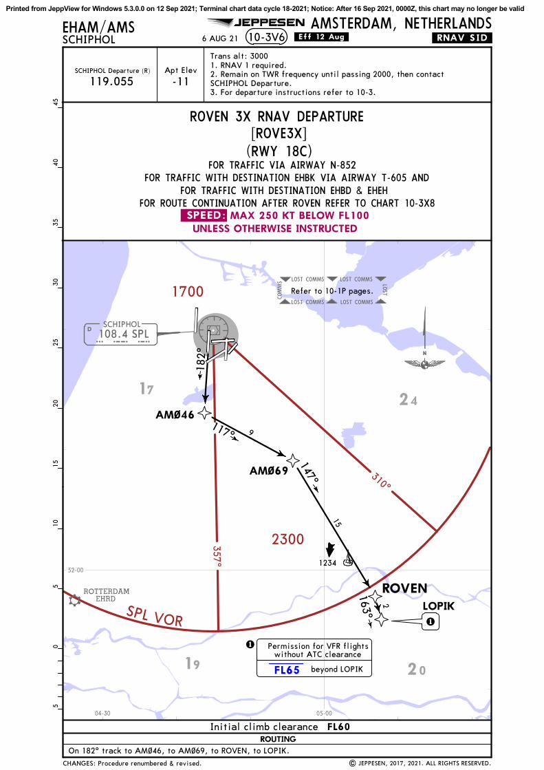
108.4 SPLDSCHIPHOL
S P L
COMMSLOST COMMSLOST LOST
COMMSLOST COMMSLOST
COMMS
ROTTERDAMEHRD
310^
357^
1700
2300
SPL VOR
FL65
10-3V6EHAM/AMSSCHIPHOL
AMSTERDAM, NETHERLANDS
Apt Elev
-11SCHIPHOL Departure (R)
FOR TRAFFIC WITH DESTINATION EHBK VIA AIRWAY T-605 ANDFOR TRAFFIC WITH DESTINATION EHBD & EHEH
FOR ROUTE CONTINUATION AFTER ROVEN REFER TO CHART 10-3X8
JEPPESEN
119.055
On 182^ track to AM~46, to AM~69, to ROVEN, to LOPIK.
AM~46
AM~69
117^
ROVENLOPIK
Trans alt: 3000
9
15
2
182^
1
1
| JEPPESEN, 2017, 2021. ALL RIGHTS RESERVED.
.Eff.12.Aug.
FOR TRAFFIC VIA AIRWAY N-852
6 AUG 21
Refer to 10-1P pages.
.RNAV.SID.
ROVEN 3X RNAV DEPARTURE
1. RNAV 1 required.2. Remain on TWR frequency until passing 2000, then contactSCHIPHOL Departure.3. For departure instructions refer to 10-3.
147^
163^
510
1520
2530
3540
450
5
1234
19 20
1724
52-00
04-30 05-00
UNLESS OTHERWISE INSTRUCTEDMAX 250 KT BELOW FL100.SPEED:
ROUTING
Initial climb clearance FL60
Permission for VFR flightswithout ATC clearance
beyond LOPIK
CHANGES: Procedure renumbered & revised.
[ROVE3X](RWY 18C)
Printed from JeppView for Windows 5.3.0.0 on 12 Sep 2021; Terminal chart data cycle 18-2021; Notice: After 16 Sep 2021, 0000Z, this chart may no longer be valid
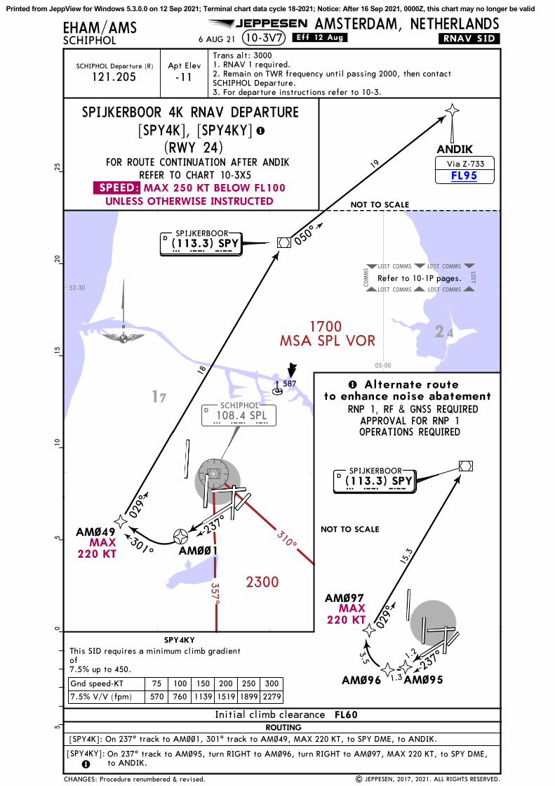
108.4 SPLD
SCHIPHOL
S P L
COMMSLOST COMMSLOST LOST
COMMSLOST COMMSLOST
COMMS
310^
357^
2300
1700MSA SPL VOR
FL95
EHAM/AMSSCHIPHOL
AMSTERDAM, NETHERLANDS10-3V7
REFER TO CHART 10-3X5
JEPPESEN
FOR ROUTE CONTINUATION AFTER ANDIK
1
AM~97
AM~95AM~96
1
237^
029^
This SID requires a minimum climb gradientof7.5% up to 450.
7.5% V/V (fpm) 570 760 1139 1519 1899 2279
Gnd speed-KT 75 100 150 200 250 300
15.3
3.5
1.3
1.2
Apt Elev
-11SCHIPHOL Departure (R)
121.205
AM~~1
ANDIK
050^
AM~49301^
029^
237^
18
Trans alt: 3000
NOT TO SCALE
05
1015
205
25
1
NOT TO SCALE
D S P YSPIJKERBOOR
| JEPPESEN, 2017, 2021. ALL RIGHTS RESERVED.
.Eff.12.Aug.6 AUG 21
Refer to 10-1P pages.
.RNAV.SID.
1. RNAV 1 required.2. Remain on TWR frequency until passing 2000, then contactSCHIPHOL Departure.3. For departure instructions refer to 10-3.
[SPY4K], [SPY4KY]SPIJKERBOOR 4K RNAV DEPARTURE
19
On 237^ track to AM~~1, 301^ track to AM~49, MAX 220 KT, to SPY DME, to ANDIK.
On 237^ track to AM~95, turn RIGHT to AM~96, turn RIGHT to AM~97, MAX 220 KT, to SPY DME,to ANDIK.
[SPY4K]:
[SPY4KY]:
587
RNP 1, RF & GNSS REQUIREDAPPROVAL FOR RNP 1OPERATIONS REQUIRED
(113.3) SPY
D S P YSPIJKERBOOR
(113.3) SPY
17
24
52-30
05-00
UNLESS OTHERWISE INSTRUCTEDMAX 250 KT BELOW FL100.SPEED:
MAX220 KT
MAX220 KT
ROUTING
Initial climb clearance FL60
SPY4KY
Alternate routeto enhance noise abatement
Via Z-733
(RWY 24)
CHANGES: Procedure renumbered & revised.
Printed from JeppView for Windows 5.3.0.0 on 12 Sep 2021; Terminal chart data cycle 18-2021; Notice: After 16 Sep 2021, 0000Z, this chart may no longer be valid
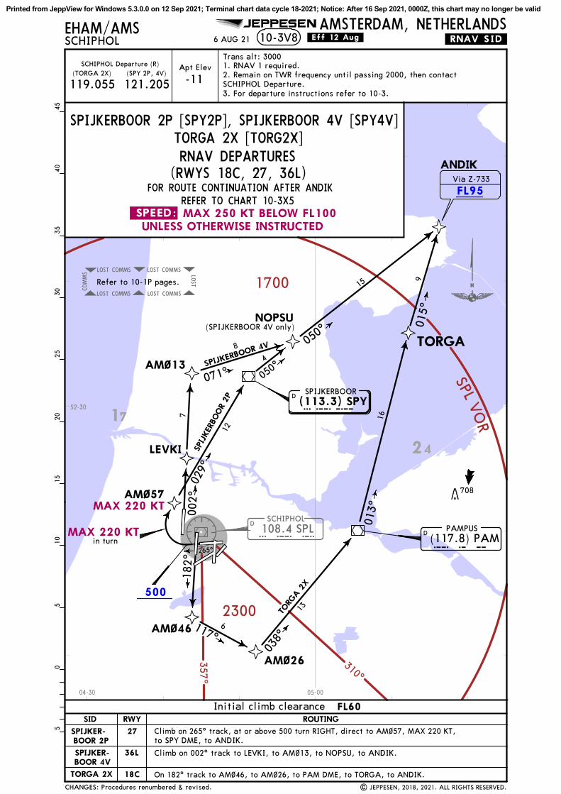
108.4 SPLD
SCHIPHOL
S P L
COMMSLOST COMMSLOST LOST
COMMSLOST COMMSLOST
COMMS
310^
357^
2300
1700
SPL VO
R
500
FL95
265^
AM~57
ANDIK
050^
002^
AM~13
NOPSU
071^
AM~46
AM~26
117^
038^
TORGA
013^
Apt Elev
-11
REFER TO CHART 10-3X5
(TORGA 2X)SCHIPHOL Departure (R)
FOR ROUTE CONTINUATION AFTER ANDIK
(SPY 2P, 4V)
119.055 121.205
SPIJKERBOOR 2P [SPY2P], SPIJKERBOOR 4V [SPY4V]TORGA 2X [TORG2X]
029^
8
DPAMPUS
P A M
SPIJKERBOOR
182^
6
13TORG
A 2
X
SPIJ
KER
BOOR
2P
JEPPESEN AMSTERDAM, NETHERLANDSEHAM/AMSSCHIPHOL
Trans alt: 30005
1015
2025
3035
4045
05
SPYD
10-3V8 .Eff.12.Aug.
LEVKI
Climb on 002^ track to LEVKI, to AM~13, to NOPSU, to ANDIK.
| JEPPESEN, 2018, 2021. ALL RIGHTS RESERVED.
SPIJKERBOOR 4V
6 AUG 21
On 182^ track to AM~46, to AM~26, to PAM DME, to TORGA, to ANDIK.
Climb on 265^ track, at or above 500 turn RIGHT, direct to AM~57, MAX 220 KT,to SPY DME, to ANDIK.
16
901
5^
050^
15
4
12
7
(SPIJKERBOOR 4V only)
Refer to 10-1P pages.
1. RNAV 1 required.2. Remain on TWR frequency until passing 2000, then contactSCHIPHOL Departure.3. For departure instructions refer to 10-3.
.RNAV.SID.
708
(117.8) PAM
(113.3) SPY
17
24
52-30
04-30 05-00
MAX 220 KT
MAX 220 KT
.SPEED: MAX 250 KT BELOW FL100UNLESS OTHERWISE INSTRUCTED
36L
SID ROUTINGRWY
27
18CTORGA 2X
SPIJKER-BOOR 2P
SPIJKER-BOOR 4V
Initial climb clearance FL60
in turn
Via Z-733
CHANGES: Procedures renumbered & revised.
RNAV DEPARTURES(RWYS 18C, 27, 36L)
Printed from JeppView for Windows 5.3.0.0 on 12 Sep 2021; Terminal chart data cycle 18-2021; Notice: After 16 Sep 2021, 0000Z, this chart may no longer be valid

108.
4 SP
LD
SCHIP
HO
L
S P
L
COMMS
LOST
COMMS
LOST
LOST
COMMS
LOST
COMMS
LOST
COMMS
310^
357^
1700
2300
SPL VO
R
2500
500
EHAM/AMSSCHIPHOL
AMSTERDAM, NETHERLANDS
Apt
Ele
v
-11
SCHIP
HO
L D
epar
ture
(R)
JEPPESEN
10-3V9
121.
205
VALK
O 5
E [VALK
5E], V
ALK
O 3
G [VALK
3G]
AM
~62
AM
~~9
VALK
O 3
G
VA
LKO
182^
AM
~29
Tran
s al
t: 3
000
220^
7
28
NO
T T
O S
CA
LE
05
1015
205
25
.Eff.12.Aug.
IDRID
6 AUG 21
281^
250^
250^
14
VALKO 5E
10
Cli
mb
on 1
82^
trac
k, a
t or
abo
ve 5
00 t
urn
LEFT
, di
rect
to
AM
~29,
MA
X 2
20 K
T, t
o A
M~~
9, a
t or
abo
ve 2
500,
to
VA
LKO
, to
ID
RID
.
.RNAV.SID.
| JEPPESEN, 2018, 2021. ALL RIGHTS RESERVED.
Refe
r to
10-
1P p
ages
.
1. R
NA
V 1
req
uire
d.2.
Rem
ain
on T
WR
freq
uenc
y un
til
pass
ing
2000
,th
en c
onta
ct S
CHIP
HO
L D
epar
ture
.3.
For
dep
artu
re i
nstr
ucti
ons
refe
r to
10-
3.
567
249^
On
220^
tra
ck t
o A
M~6
2, t
o A
M~~
9, a
t or
abo
ve 2
500,
to
VA
LKO
,to
ID
RID
.
14
17
24
14
52-00
04-00
04-00
04-30
05-00
.SPEED
:M
AX 2
50 K
T B
ELO
W F
L100
UNLE
SS O
THERW
ISE INSTRUCTED
MA
X 2
20 K
T
22
SID
RO
UTIN
GRW
Y
18L
VA
LKO
5E
VA
LKO
3G
Init
ial
clim
b cl
eara
nce
FL6
0
CHANGES: Procedures renumbered & revised.
RNAV D
EPART
URE
S(RWYS
18L, 2
2)
Printed from JeppView for Windows 5.3.0.0 on 12 Sep 2021; Terminal chart data cycle 18-2021; Notice: After 16 Sep 2021, 0000Z, this chart may no longer be valid

COMMS
LOST
COMMS
LOST
LOST
COMMS
LOST
COMMS
LOST
COMMS
108.
4 SP
LSC
HIP
HO
L
SPL
D
ROTTERDAM
EHRD
2300
310^
1700
VO
RLPS
357^
500
2500
JEPPESEN
Apt
Ele
v
-11
SCHIP
HO
L D
epar
ture
(R)
121.
205
VALK
O 5
M [VALK
5M], V
ALK
O 3
S [VALK
3S]
Tran
s al
t: 3
000
EHAM/AMSSCHIPHOL
AMSTERDAM, NETHERLANDS.Eff.12.Aug.10-3V106 AUG 21
AM
~~1
AM
~51
223^
AM
~~9
250^
VA
LKO
249^
IDRID
085^
AM
~3~
AM
~25
213^
AM
~4~
238^
264^
in t
urn
237^
14
28
4
3
VALK
O 5
M
VA
LKO
3S
23
12
4
On
237^
tra
ck t
o A
M~~
1, t
o A
M~5
1, t
o A
M~~
9, a
t or
abo
ve 2
500,
to
VA
LKO
, to
ID
RID
.
Cli
mb
on 0
85^
trac
k, a
t or
abo
ve 5
00 t
urn
RIG
HT,
dir
ect
to A
M~3
~, M
AX 2
20 K
T,to
AM
~25,
to
AM
~4~,
to
VA
LKO
, to
ID
RID
.
Refe
r to
10-
1P p
ages
.1. R
NA
V 1
req
uire
d.2.
Rem
ain
on T
WR
freq
uenc
y un
til
pass
ing
2000
,th
en c
onta
ct S
CHIP
HO
L D
epar
ture
.3.
For
dep
artu
re i
nstr
ucti
ons
refe
r to
10-
3.
| JEPPESEN, 2018, 2021. ALL RIGHTS RESERVED.
.RNAV.SID.5
1015
2025
3035
4045
05
817
22
19
14
17
52-00
03-30
04-00
04-30
05-00
.SPEED
:M
AX 2
50 K
T B
ELO
W F
L100
UNLE
SS O
THERW
ISE INSTRUCTED
MA
X 2
20 K
T
MA
X220 K
T
SID
RO
UTIN
GRW
Y
24
09
VA
LKO
5M
VA
LKO
3S
Init
ial
clim
b cl
eara
nce
FL6
0
RNAV D
EPART
URE
S
CHANGES: Procedures renumbered & revised.
(RWYS 09
, 24
)
Printed from JeppView for Windows 5.3.0.0 on 12 Sep 2021; Terminal chart data cycle 18-2021; Notice: After 16 Sep 2021, 0000Z, this chart may no longer be valid

108.
4 SP
LD
SCHIP
HO
L
S P
L
COMMS
LOST
COMMS
LOST
LOST
COMMS
LOST
COMMS
LOST
COMMS
310^
357^
1700
2300
SPL VOR
EHAM/AMSSCHIPHOL
AMSTERDAM, NETHERLANDSJEPPESEN
.SID.EHAM/AMSSCHIPHOL
AMSTERDAM, NETHERLANDS
040^
10-3WJEPPESEN
SCHIP
HO
L D
epar
ture
(R)
121.
205
Apt
Ele
v
-11
AM
~94
315^
AM
~9~
270^
211^
VO
LLA
14
3
5
AM
~59
05
1015
205
25
.Eff.12.Aug.
31
231^
NO
T T
O S
CA
LE
IDRID
| JEPPESEN, 2018, 2021. ALL RIGHTS RESERVED.
This
SID
req
uire
s a
min
imum
cli
mb
grad
ient
of
5.7%
up
to 1
900.
If
unab
le,
repo
rt t
o A
TC.
6 AUG 21
BA
HSI
5.7%
V/V
(fp
m)
433
577
866
1154
1443
1732
Gnd
spe
ed-K
T75
100
150
200
250
300
On
040^
tra
ck t
o A
M~5
9, M
AX 2
20 K
T, t
o A
M~9
4, t
o A
M~9
~, t
o BA
HSI
, to
VO
LLA
, to
ID
RID
.
241^
10
Refe
r to
10-
1P p
ages
.
Tran
s al
t: 3
000
VOLLA 2
F RN
AV D
EPART
URE
[VOLA
2F]
.RNAV.SID.
1. R
NA
V 1
req
uire
d.2.
Rem
ain
on T
WR
freq
uenc
y un
til
pass
ing
2000
,th
en c
onta
ct S
CHIP
HO
L D
epar
ture
.3.
For
dep
artu
re i
nstr
ucti
ons
refe
r to
10-
3.
587
14
17
52-30
04-00
04-30
05-00
UNLE
SS O
THERW
ISE INSTRUCTED
MA
X 2
50 K
T B
ELO
W F
L100
.SPEED:
MA
X 2
20 K
T
RO
UTIN
G
FL6
0In
itia
l cl
imb
clea
ranc
e
(RWY 0
4)
CHANGES: Procedure renumbered & revised.
Printed from JeppView for Windows 5.3.0.0 on 12 Sep 2021; Terminal chart data cycle 18-2021; Notice: After 16 Sep 2021, 0000Z, this chart may no longer be valid

SPL
SCHIP
HO
L10
8.4
SPL
SPL
D
COMMS
LOST
COMMS
LOST
LOSTCOMMS
LOST
COMMS
LOST
COMMS
310^
357^
2300
1700
SPLVOR
500
265^
AM
~58
AM
~14
AM
~94
315^
VOLLA 2R
AM
~9~
270^
211^
SCHIP
HO
L D
epar
ture
(R)
Apt
Ele
v
-11
121.
205
19VO
LLA
2P
14
JEPPESEN AMSTERDAM, NETHERLANDS10-3X
EHAM/AMSSCHIPHOL
3
5
11
057^
Cli
mb
on 2
65^
trac
k, a
t or
abo
ve 5
00 t
urn
RIG
HT,
dir
ect
to A
M~5
8, t
o VO
LLA
, to
ID
RID
.
05
1015
205
25
.Eff.12.Aug.
VO
LLA 231^
31
IDRID
NO
T T
O S
CA
LE
4.6%
V/V
(fp
m)
349
466
699
932
1165
1397
Gnd
spe
ed-K
T75
100
150
200
250
300
VO
LLA
2R
| JEPPESEN, 2018, 2021. ALL RIGHTS RESERVED.
This
SID
req
uire
s a
min
imiu
m c
lim
b gr
adie
nt o
f4.
6% u
p to
190
0. I
f un
able
, re
port
to
ATC
.
6 AUG 21
BA
HSI
241^
On
057^
tra
ck t
o A
M~1
4, M
AX 2
20 K
T, t
o A
M~9
4, t
o A
M~9
0, t
o BA
HSI
, to
VO
LLA
, to
ID
RID
.
266^
.RNAV.SID.
Refe
r to
10-
1P p
ages
.
VOLLA 2
P [VOLA
2P]
VOLLA 2
R [VOLA
2R]
Tran
s al
t: 3
000
1. R
NA
V 1
req
uire
d.2.
Rem
ain
on T
WR
freq
uenc
y un
til
pass
ing
2000
,th
en c
onta
ct S
CHIP
HO
L D
epar
ture
.3.
For
dep
artu
re i
nstr
ucti
ons
refe
r to
10-
3.
RNAV D
EPART
URE
S(RWYS 06
, 27
)
587
14
17
52-30
04-00
04-30
.SPEED
:M
AX 2
50 K
T B
ELO
W F
L100
UNLE
SS O
THERW
ISE INSTRUCTED
MA
X 2
20 K
T
06
VO
LLA
2R
27
VO
LLA
2P
SID
RO
UTIN
GRW
Y
Init
ial
clim
b cl
eara
nce
FL6
0
CHANGES: Procedures renumbered & revised.
Printed from JeppView for Windows 5.3.0.0 on 12 Sep 2021; Terminal chart data cycle 18-2021; Notice: After 16 Sep 2021, 0000Z, this chart may no longer be valid

108.
4 SP
LSP
LD
SCHIP
HO
L
COMMS
LOST
COMMS
LOST
LOST
COMMS
LOST
COMMS
LOST
COMMS
310^
357^
2300
1700
SPLVOR
002^AM
~15
VOLLA 2Z
AM
~~6
269^
AM
~16
LEVKI
AM
~94
313^
AM
~9~
270^
211^
Jet
airc
raft
onl
y be
twee
n 06
30-2
230L
T.
1 2
1O
nly
jet
airc
raft
bet
wee
n 22
30-0
630L
T.2
On
002^
tra
ck t
o LE
VKI,
to
AM
~94,
to
AM
~9~,
to
BA
HSI
, to
VO
LLA
, to
ID
RID
.
SCHIP
HO
L D
epar
ture
(R)
Apt
Ele
v
-11
VOLLA 3
V [VOLA
3V]
VOLLA 2
Z [VOLA
2Z]
121.
205
7
11
3
3
5
3
13
JEPPESEN AMSTERDAM, NETHERLANDSEHAM/AMSSCHIPHOL 10-3X1
510
1520
2530
3540
450
5
.Eff.12.Aug.
VO
LLA 23
1^
31
IDRID
NO
T T
O S
CA
LE
| JEPPESEN, 2018, 2021. ALL RIGHTS RESERVED.
6 AUG 21
BA
HSI
(VO
LLA
3V o
nly)
(VO
LLA
2Z
only
)
VO
LLA
3V
241^
241^
201^
.RNAV.SID.
Refe
r to
10-
1P p
ages
.
Tran
s al
t: 3
000
1. R
NA
V 1
req
uire
d.2.
Rem
ain
on T
WR
freq
uenc
y un
til
pass
ing
2000
,th
en c
onta
ct S
CHIP
HO
L D
epar
ture
.3.
For
dep
artu
re i
nstr
ucti
ons
refe
r to
10-
3.
RNAV D
EPART
URE
S(RWY 3
6L)
683
16 from THR
Cli
mb
on 0
02^
trac
k to
at
or a
bove
500
, 00
2^ t
rack
to
AM
~15,
to
AM
~~6,
to
AM
~16,
to V
OLL
A,
to I
DRI
D.
14
17
24
52-30
04-00
04-30
05-00
.SPEED
:M
AX 2
50 K
T B
ELO
W F
L100
UNLE
SS O
THERW
ISE INSTRUCTED
VO
LLA
3V
VO
LLA
2Z
SID
RO
UTIN
G
Init
ial
clim
b cl
eara
nce
FL6
0
CHANGES: Procedures renumbered & revised.
Printed from JeppView for Windows 5.3.0.0 on 12 Sep 2021; Terminal chart data cycle 18-2021; Notice: After 16 Sep 2021, 0000Z, this chart may no longer be valid

108.4 SPLD
SCHIPHOL
S P L
COMMSLOST COMMSLOST LOST
COMMSLOST COMMSLOST
COMMS
310^
357^
1700
2300
MSA SPL VOR
2500
500
FL95
AM~8~
AM~51
AM~28
327^
WISPA
BERGI
Apt Elev
-11SCHIPHOL Departure (R)
121.205
182^
Trans alt: 3000
JEPPESENEHAM/AMSSCHIPHOL
AMSTERDAM, NETHERLANDS10-3X2
05
1015
205
25
AM~~9
10
19
| JEPPESEN, 2017, 2021. ALL RIGHTS RESERVED.
FOR ROUTE CONTINUATION AFTER WISPAREFER TO CHART 10-3X4
.Eff.12.Aug.6 AUG 21
Climb on 182^ track to AM~8~, 182^ track, at or above 500 turn RIGHT, direct to AM~51, to AM~~9,at or above 2500, to AM~28, to WISPA, to BERGI.
Refer to 10-1P pages.
1. RNAV 1 required.2. Remain on TWR frequency until passing 2000,then contact SCHIPHOL Departure.3. For departure instructions refer to 10-3.
WISPA 3X RNAV DEPARTURE[WISP3X]
250^
353^
4
5
.RNAV.SID.
587
17
52-30
04-30
UNLESS OTHERWISE INSTRUCTEDMAX 250 KT BELOW FL100.SPEED:
ROUTING
Via M-90
CHANGES: Procedure renumbered & revised.
(RWY 18C)
FL60Initial climb clearance
Printed from JeppView for Windows 5.3.0.0 on 12 Sep 2021; Terminal chart data cycle 18-2021; Notice: After 16 Sep 2021, 0000Z, this chart may no longer be valid

108.4 SPLD
SCHIPHOL
S P L
COMMSLOST COMMSLOST LOST
COMMSLOST COMMSLOST
COMMS
ROTTERDAMEHRD
310^
357^
1700
2300
SPL VOR
500
Apt Elev
-11SCHIPHOL Departure (R)
FOR ROUTE CONTINUATION AFTER WOODY REFER TO CHART 10-3X7
119.055
RIKOR AM~7~
AM~36
AM~72
LEKKO
WOODY
JEPPESEN
Trans alt: 3000
AMSTERDAM, NETHERLANDSEHAM/AMSSCHIPHOL 10-3X3
002^
102^7
14
510
1520
2530
3540
450
5
NOT TO SCALE
| JEPPESEN, 2017, 2021. ALL RIGHTS RESERVED.
.Eff.12.Aug.
Refer to 10-1P pages.
5.4% V/V (fpm) 410 547 820 1094 1367 1641
Gnd speed-KT 75 100 150 200 250 300
This SID requires a minimum climb gradient of5.4% up to 1900. If unable, report to ATC.
6 AUG 21
3
179^
6
35
Climb on 002^ track, at or above 500 turn RIGHT, direct to RIKOR, to AM~7~, MAX 220 KT, to AM~36,to AM~72, to LEKKO, to WOODY.
.RNAV.SID.
1. RNAV 1 required.2. Remain on TWR frequency until passing 2000, then contactSCHIPHOL Departure.3. For departure instructions refer to 10-3.
WOODY 3W RNAV DEPARTURE[WOOD3W]
204^
1234
19
20
17
24
52-00
52-30
04-30
05-00
.SPEED: MAX 250 KT BELOW FL100 UNLESS OTHERWISE INSTRUCTED
MAX 220 KT
ROUTING
Initial climb clearance FL60
CHANGES: Procedure renumbered & revised.
(RWY 36C)
Printed from JeppView for Windows 5.3.0.0 on 12 Sep 2021; Terminal chart data cycle 18-2021; Notice: After 16 Sep 2021, 0000Z, this chart may no longer be valid

108.4 SPLD
SCHIPHOL
S P L
COMMSLOST COMMSLOST LOST
COMMSLOST COMMSLOST
COMMS
DEN HELDERDe KooyEHKD
2300
310^
1700
LPS VOR
357^
FL95
ODASI
LEGBA
BERGI
WISPA
Apt Elev
-11SCHIPHOL Departure (R)
121.205
353^346^
5
20
27
JEPPESEN AMSTERDAM, NETHERLANDS10-3X4
EHAM/AMSSCHIPHOL
010
2030
4050
10
643
.Eff.12.Aug.
| JEPPESEN, 2017, 2021. ALL RIGHTS RESERVED.
Refer to 10-1P pages.
6 AUG 21
Trans alt: 30001. Continue to climb above FL60 after ATC clearance only.2. For departure instructions refer to 10-3.
.SID.
M90
1417
24
14 15 16
52-30
53-00
53-30
04-00 04-30 05-00
.SPEED: MAX 250 KT BELOW FL100 UNLESS OTHERWISE INSTRUCTEDCONTINUATION AFTER BERGI & WISPA
CHANGES: Waypoint symbols changed to RNAV, bearing from WISPA to BERGI.
Printed from JeppView for Windows 5.3.0.0 on 12 Sep 2021; Terminal chart data cycle 18-2021; Notice: After 16 Sep 2021, 0000Z, this chart may no longer be valid

108.
4 SP
LD
SCH
IPH
OL
S P
L
EDDG
EMDEN
EDW
E
GRONIN
GEN
Eeld
eEHGG
DE K
OOY
EHKD
LELYSTAD
EHLE
LEEUW
ARDEN
EHLW
DEVENTER
Teuge
EHTE
DIE
PHOLZ
ETND
WIT
TMUNDHAFEN
ETNT
NETHERLANDSGERMANY
MUENSTER/
OSNABRUECK
COMMS
LOST
COMMS
LOST
LOST
COMMS
LOST
COMMS
LOST
COMMS
310^
357^
1700
2300
SPL VOR
FL6
5
FL9
5
FL6
5
FL9
5FL9
5
FL6
5
FL9
5
SCHIP
HO
LD
epar
ture
(R)
119.
055
121.
205
KEKIX
ANDIK
UNEXO
KO
NO
M
AG
ISU
007^5 4 05
0^
030^
GRO
NY
32
49
Apt
Ele
v
-11
1437
78
.Eff.12.Aug.
JEPPESEN
01020304050 10
6 A
UG
21
BEDUM
112.
4 EE
LEE
LDE
EEL
D
DO
BA
K
051^
24
22
079^
20
Tran
s al
t: 3
000
1. C
onti
nue
to c
lim
b ab
ove
FL60
aft
er A
TC c
lear
ance
onl
y.2.
For
dep
artu
re i
nstr
ucti
ons
refe
r to
10-
3.
Refe
r to
10-
1P p
ages
.
Z733
Z708
N87
3
N87
3
N873
M105
M125
17
24
22
25
27
15
16
17
23
22
52-30
53-00
53-30
04-30
05-00
05-30
06-00
06-30
07-00
07-30
08-00
.SPEED
:M
AX 2
50 K
T B
ELO
W F
L100
UNLE
SS O
THERW
ISE INSTRUCTED
Perm
issi
on f
or V
FR f
ligh
tsw
itho
ut A
TC c
lear
ance
Perm
issi
on f
or V
FR f
ligh
tsw
itho
ut A
TC c
lear
ance
beyo
nd K
EKIX
MO
N-F
RI 0
900-
1700
LT
beyo
nd K
EKIX
beyo
nd K
EKIX
MO
N-F
RI 0
900-
1700
LT
beyo
nd K
EKIX
FRI
1700
LT-S
UN
240
0LT
& H
OL
beyo
nd K
EKIX
EHAM/A
MS
SCHIP
HO
LAMST
ERDAM, NET
HER
LANDS
10-3
X5
CONTINUATION A
FTER
ANDIK
| J
EPPE
SEN
, 20
17,
2021
. A
LL R
IGHTS
RES
ERVED
.
Perm
issi
on f
or V
FR f
ligh
tsw
itho
ut A
TC c
lear
ance
beyo
nd U
NEX
OM
ON
-FRI
090
0-17
00LT
beyo
nd U
NEX
OFR
I 17
00LT
-SUN
240
0LT
& H
OL
Via
Z-7
08 Via
N-8
73
Via
Z-7
08
Via
Z-7
33
.SID.
CHA
NG
ES:
Mul
tipl
e w
aypo
int
sym
bols
cha
nged
to
RNA
V.
Printed from JeppView for Windows 5.3.0.0 on 12 Sep 2021; Terminal chart data cycle 18-2021; Notice: After 16 Sep 2021, 0000Z, this chart may no longer be valid

108.
4 SP
LD
SCHIP
HO
L
S P
L
NIE
DERRHEIN
EDLV
LELYSTAD
EHLE
DEVENTER
Teuge
EHTE
VOLKEL
EHVK
NET
HER
LANDS
GER
MANY
COMMS
LOST
COMMS
LOST
LOST
COMMS
LOST
COMMS
LOST
COMMS
310^
357^
1700
2300
SPL VOR
FL2
50
FL2
50
FL6
5
FL6
5
FL2
10
OLD
OD
AM
OSU
DEPA
D
NA
PRO
EDUPO
RENDI
LUNIX
IVLU
T
NYKER
ELP
AT
ARNEM
SO
NEB
124^
129^
098^
102^
14
5
8
11
8
12
26
10
Apt
Ele
v
-11
SCHIP
HO
L D
epar
ture
(R)
119.
055
JEPPESEN AMSTERDAM, NETHERLANDS10-3X6
EHAM/AMSSCHIPHOL
010
2030
4050
10
1234
.Eff.12.Aug.
| JEPPESEN, 2017, 2021. ALL RIGHTS RESERVED.
6 AUG 21
TEBRO
17
5
110^
121^
23
Tran
s al
t: 3
000
1. C
onti
nue
to c
lim
b ab
ove
FL60
aft
er A
TC c
lear
ance
onl
y.2.
For
dep
artu
re i
nstr
ucti
ons
refe
r to
10-
3.
Refe
r to
10-
1P p
ages
.
.SID.
Z739
L620
L620
T196
19
18
22
37
17
24
22
25
52-00
52-30
05-00
05-30
06-00
06-30
07-00
.SPEED
:M
AX 2
50 K
T B
ELO
W F
L100
UNLE
SS O
THERW
ISE INSTRUCTED
Perm
issi
on f
or V
FR f
ligh
tsw
itho
ut A
TC c
lear
ance
beyo
nd N
YKER
CONTINUATION A
FTER
ARN
EM, ED
UPO
ELPA
T, IVLU
T, N
YKER
& R
ENDI
Perm
issi
on f
or V
FR f
ligh
tsw
itho
ut A
TC c
lear
ance
Requ
este
d FL
abov
e FL
245
Requ
este
d FL
abov
e FL
245
CHANGES: Waypoint symbols changed to RNAV.
Printed from JeppView for Windows 5.3.0.0 on 12 Sep 2021; Terminal chart data cycle 18-2021; Notice: After 16 Sep 2021, 0000Z, this chart may no longer be valid

51-30
52-00
04-00 04-30
108.4 SPLD
SCHIPHOL
S P L
ANTWERPDeurneEBAW
ROTTERDAMEHRD
WOENSDRECHTEHWO
NETHER
LANDS
BELG
IUM
COMMSLOST COMMSLOST
LOST
COMMSLOST COMMSLOST
COMMS
310^
357^
17002300
SPLVOR
FL260
LEKKO
WOODY
Apt Elev
-11SCHIPHOL Departure (R)
119.055
LARAS
AMSTERDAM, NETHERLANDS10-3X7
EHAM/AMSSCHIPHOL
117.4 NIKNIKDNICKY
R025
10
6
6
11
204^
710
.Eff.12.Aug.
KUDAD
17
JEPPESEN
1020
3040
500
515
2535
455
| JEPPESEN, 2017, 2021. ALL RIGHTS RESERVED.
D10.0 NIK
Refer to 10-1P pages.
6 AUG 21
Trans alt: 30001. Continue to climb above FL60 after ATCclearance only.2. For departure instructions refer to 10-3.
.SID.
N872
22
19
1417
.SPEED: MAX 250 KT BELOW FL100UNLESS OTHERWISE INSTRUCTED
CONTINUATION AFTER KUDAD, LARAS & WOODY
Requested FLabove FL245
CHANGES: Waypoint symbols changed to RNAV.
Printed from JeppView for Windows 5.3.0.0 on 12 Sep 2021; Terminal chart data cycle 18-2021; Notice: After 16 Sep 2021, 0000Z, this chart may no longer be valid

108.4 SPLD
SCHIPHOL
S P L
COMMSLOST COMMSLOST
LOST
COMMSLOST COMMSLOST
COMMS
NETHERLANDS
BELGIUM
WEERTBudelEHBD
EINDHOVENEHEH
GILZE-RIJENEHGR
VOLKELEHVK
310^
357^
1700 2300
SPL
VO
R
FL250
FL65
OGINA
LUTOM
ROVEN
LOPIK
VELED
Apt Elev
-11SCHIPHOL Departure (R)
119.055
163^
159^
8
2
34
8
FL7
0 O
NLY
AMSTERDAM, NETHERLANDS10-3X8
EHAM/AMSSCHIPHOL
.Eff.12.Aug.
JEPPESEN
1020
3040
500
515
2535
455
| JEPPESEN, 2017, 2021. ALL RIGHTS RESERVED.
Refer to 10-1P pages.
6 AUG 21
TOTNA
EHOJI
SOPVI
OSGOS
Trans alt: 30001. Continue to climb above FL60 after ATCclearance only.2. For departure instructions refer to 10-3.
1234
.SID.
T605N
852
P57
19
20
17
24
51-30
52-00
05-00 05-30
.SPEED: MAX 250 KT BELOW FL100UNLESS OTHERWISE INSTRUCTED
CONTINUATION AFTER LOPIK, OGINA & ROVEN
Requested FLabove FL245
Permission for VFR flightswithout ATC clearance
beyond LOPIK
NOT TO SCALE
15
15
123^
171^
23
4
CHANGES: Waypoint symbols changed to RNAV.
Printed from JeppView for Windows 5.3.0.0 on 12 Sep 2021; Terminal chart data cycle 18-2021; Notice: After 16 Sep 2021, 0000Z, this chart may no longer be valid

10-8JEPPESENEHAM/AMS
11 SEP 20
AMSTERDAM, NETHERLANDSSCHIPHOL
FREIGHTII & III
A-APR
ON
FREIGHT I
A65
A64
A63
A62
A61
A75
A74
A73
A72
A71
MAX wingspan:
A84
A83
A82
A81
226'/69m118'/36m95'/29m
On the A-apron following applies:
NOT TO SCALE
- Nose-in parking and push-back procedures are applicable at all aircraft stands.- Self-docking procedures are applicable, except during low visibility phase C and D.
B-APRON renamed to A-APRON. Stand A85 deleted. | JEPPESEN, 2019, 2020. ALL RIGHTS RESERVED.
Work in progress takes place for several years on part of the A-apron. This chart shows the intermediate situation expected to be applicable January 2021 when aircraft stands A81 - A84 are available for operational use.The actual time will be promulgated by NOTAM.
CHANGES:
REFER ALSO TO LATEST NOTAMS
CONSTRUCTION WORKS ON APRON A
A4
C14 C16C18
A2
B27
A51
A52A53
A54
A55
B94
B95
B23B16
B20
A4W
A
A1C
C12B17
C8
C10A4E
A35
A31
A56
B31
B35
B91
B92
B93
B24
S4
A
B
A3
A3
2
3
3
2
1
1
1
1
1
1
B13
B15
B28
B32
B36
A32
A33
A34A1B
A1A
3
3
A46
A45
A44
A43
A42
A41
A2
3
RWY 0
6/24
LEGEND
A2 Taxiway
C8 Parking positionCompulsory taxi routing
Blast fence
ATC boundary
1
32
the push-back truck)RIGHT turn (as seen fromthe push-back truck)
A35
A65
LEFT turn (as seen from
Standard push-back directions:
B-PIER
Printed from JeppView for Windows 5.3.0.0 on 12 Sep 2021; Terminal chart data cycle 18-2021; Notice: After 16 Sep 2021, 0000Z, this chart may no longer be valid

JEPPESENEHAM/AMS AMSTERDAM, NETHERLANDSSCHIPHOL
Twy V is closed.Rwy 18R/36L is closed.
Twy Q is closed.Twy A is closed between Twy Z and Twy A24.
Attention is advised for the following:
Z
Z2
Z1
A27
W9
A25
A
W8B
Y-APRON
P5
Y73+
Y71+
Z
V
Y
RWY 3
6C/ 1
8C
Y
Z
V W5
LEGEND
TaxiwayA, W11
Compulsory taxi routing
10-8A
Twy B is closed between Twy Z and Twy A25.
Z
RWY 3
6C/1
8C
LEGEND
TaxiwayRampU
Y
U
J
Y
B A
C
D
NOT TO SCALE
NOT TO SCALE
NOT TO SCALE
Twy Z is closed between Twy A/B and entry Twy W11.
Rwy 18C/36C entries/exits Twy W9, Twy W10 and Twy W12 are closed.
For full length take-off Rwy 36C and full length landings Rwy 18C use Twy W11. Taxi to/fromSchiphol-Centre via Twy Y and Twy Z.The bend Twy Z to Twy W11 (vice versa) is not equipped with twy centre line lights.For an intersection take-off RWY 36C via W8 the TORA is 8514' (2595m).
23 APR 2123 APR 21
| JEPPESEN, 2020, 2021. ALL RIGHTS RESERVED.
15 MAR 21 - 26 APR 21
Chart reindexed. Phase schedule.
- in the bend Twy Y to Twy Z (vice versa) the nosewheel must follow the centre line.- the bend is not equipped with twy centre line lights, twy edge lights only.- do not mistake Twy W5 for Twy Z when taxiing Twy Y to Twy Z.
CAUTION:
CAUTION:- for full length take-off Rwy 36Cvia Twy W11, when taxiingfrom Schiphol-Centre, turn right at Twy A21.- For intersection take-off Rwy 36C via Twy W7 or Twy W8, when taxiing from Schiphol-Centre, turn leftat Twy A21.
CHANGES:
REFER ALSO TO LATEST NOTAMS
CONSTRUCTION WORKS NEW TWY - PHASE 5
ATC boundary
Y71+ Push-pull
Blast fence
W11
11
2
1
2
Printed from JeppView for Windows 5.3.0.0 on 12 Sep 2021; Terminal chart data cycle 18-2021; Notice: After 16 Sep 2021, 0000Z, this chart may no longer be valid

JEPPESENEHAM/AMS AMSTERDAM, NETHERLANDSSCHIPHOL
Twy V is closed.Rwy 18R/36L is closed.
Twy Y is closed.Twy A is closed between Twy A24 and Twy Q.
Attention is advised for the following:
Z
A27
W9
A25
A
W8B
Y-APRON
P5
Y73+
Y71+
Y
RWY 3
6C/ 1
8C
Y
W5
LEGEND
TaxiwayA, W11
Compulsory taxi routing
10-8B
Z
RWY 3
6C/1
8C
Q
RWY 3
6C/1
8C
W5
W4
W3
W2
W1
C
D
Y
LEGEND
TaxiwayC, W5
Compulsory taxi routing
LEGEND
TaxiwayRampU
Y
J
Y
U
C
D
AB
Z
Q
MAX wingspan:200'/61m.Access limited totowed Acft only.
NOT TO SCALE
NOT TO SCALE
NOT TO SCALE
Twy Z is closed between Twy W5 and entry Twy W11.
Rwy 18C/36C entries/exits Twy W9, Twy W10 and Twy W12 are closed.
A24
Twy B is closed between Twy A25 and Twy Z.
| JEPPESEN, 2020, 2021. ALL RIGHTS RESERVED.
For full length take-off Rwy 36C and full length landings Rwy 18C use Twy W11.Taxi to/from Schiphol-Centre via Twy Z.For intersection take-off via Twy W8 Rwy 36C: TORA 8514'(2595m), no Twy centerline on route from Twy A via Twy A25 to Twy W8.Obstacles present in runway strip Rwy 18C/36C, in area 295'(90m) - 492'(150m) left of centre line Rwy 18C, from rwy end Rwy 18C to 984'(300m) before rwy end Rwy 18C.
23 APR 2123 APR 21
26 APR 21 - 03 MAY 21
Chart reindexed. Phase schedule.CHANGES:
REFER ALSO TO LATEST NOTAMS
CONSTRUCTION WORKS NEW TWY - PHASE 6
ATC boundary
Y71+ Push-pull
Blast fence
1
W11
1
Printed from JeppView for Windows 5.3.0.0 on 12 Sep 2021; Terminal chart data cycle 18-2021; Notice: After 16 Sep 2021, 0000Z, this chart may no longer be valid

JEPPESENEHAM/AMS AMSTERDAM, NETHERLANDSSCHIPHOL10-8C23 APR 2123 APR 2123 APR 21
Attention is advised for the following:For full length take-off Rwy 36C and full length landings Rwy 18C use Twy W11.Taxi to/from Schiphol-Centre via Twy Z.Obstacles present in runway strip Rwy 18C/36C, in area 295'(90m) - 492'(150m) leftof centre line Rwy 18C, from rwy end Rwy 18C to 984'(300m) before rwy end Rwy 18C.
Z
A27
W9
A25
W8B
Y-APRON
P5
Y73+
Y71+
Z
RWY 3
6C/1
8C
Q
LEGEND
TaxiwayA, W11
Compulsory taxi routing
MAX wingspan:200'/61m.Access limited totowed Acft only.
NOT TO SCALE
ARW
Y 3
6C/1
8C
LEGEND
TaxiwayRampU
Y
Z
Q
A
D
CYV
U
J
Y
B
RWY 3
6L/1
8R
NOT TO SCALE
Twy Z is closed between Twy W5 and entry Twy W11.Twy B is closed between Twy A25 and Twy Z.Rwy 18C/36C entries/exits Twy W9, Twy W10 and Twy W12 are closed.
Rwy 18C/36C is closed.Twy Z is closed.
Twy B is closed between Twy A24 and Twy Z.
LEGEND
TaxiwayRampU
Y
U
J
Y
YV
C
D
RWY 3
6L/1
8R
NOT TO SCALE
W11
A27
W9
W8B
Y-APRON
P5
Y73+
Y71+
Z
LEGEND
TaxiwayMAX wingspan:200'/61m.Access limited totowed Acft only.
Twy Q is closed.
Twy A is closed between Twy A24 and Twy Z.
31 MAY 21- 21 JUN 2021
A24
A24
NOT TO SCALE
03 MAY 21- 31 MAY 2021
Chart reindexed. Phase 7 & 8 renumbered and rescheduled. | JEPPESEN, 2020, 2021. ALL RIGHTS RESERVED.CHANGES:
REFER ALSO TO LATEST NOTAMS
CONSTRUCTION WORKS NEW TWY - PHASE 7 & 8
ATC boundaryY71+ Push-pull
Blast fence
1
ATC boundaryY71+ Push-pull
Blast fence
1
PHASE 7
W11
1
1
PHASE 8
Printed from JeppView for Windows 5.3.0.0 on 12 Sep 2021; Terminal chart data cycle 18-2021; Notice: After 16 Sep 2021, 0000Z, this chart may no longer be valid

JEPPESENEHAM/AMS AMSTERDAM, NETHERLANDSSCHIPHOL10-8D6 AUG 21 .Eff.12.Aug.
New temporary chart. | JEPPESEN, 2021. ALL RIGHTS RESERVED.
approach and visual approach charts in EHAM AD 2.24:When VOR/DME SCHIPHOL (SPL) is unavailable, the following applies to the instrument departure,
In case holdings and course reversals are based on VOR/DME SCHIPHOL (SPL), a waypoint at thislocation may be used instead.In case the MSA is based on VOR/DME SCHIPHOL (SPL), EHAM's ARP or a waypoint at this locationmay be used instead.VOR/DME PAMPUS (PAM) will remain available with declination 2^E (2020).
Specifically, for (11-5) ILS OR LOC RWY 18R, (11-5A) CAT II/III ILS RWY 18R, (11-6) RNAV NIGHT ILS RWY 18R (INITIAL APCH), (11-6A), RNAV NIGHT ILS RWY 18R (FINAL), (12-6) RNP RWY 18R,
the following applies:
In the warining box and missed approach description the line 'Do not overshoot SPL R-240' shall read 'Do not overshoot PAM R-259 or SPL R-240' as shown below.
SCHIPHOL
108.4 SPLSPLD
AM624
300^ MAX 220 KT
683'
499'
436'
567'479'
587'
447'
2000'MANDATORY
PAMD
WARNING:
DO NOT
OVERSHOOT
PAMPUS117.8 PAM
WARNING:
DO NOT
OVERSHOOT
1. Missed approach:
At AM624 track 300^.
Inform ATC immediately.
Do not overshoot PAM R-259 or SPLR-240.Turn right as soon as practicable but not below 500' to AM624, MAX 220 KT.
Climb to and cross AM624 at 2000'.
2. Missed approach in case of communication failure:
Turn right as soon as practicable but not below 500' to AM624, MAX 220 KT.Do not overshoot PAM R-259 or SPLR-240.Climb to 3000'. At AM624 continue to AM24~ and cross AM24~ at 3000'.After AM24~, descent to 2000' and execute the instrument approach procedure again.
AM24~
317^137^
240^ 259^
(12-7) RNAV NIGHT RNP RWY 18R (INITIAL APCH), (12-7A) RNAV NIGHT RNP RWY 18R (FINAL),
MAX 220KTMHA FL 70
CHANGES:
REFER ALSO TO LATEST NOTAMS
VOR/DME SCHIPHOL (SPL) unserviceable during maintenance.
Printed from JeppView for Windows 5.3.0.0 on 12 Sep 2021; Terminal chart data cycle 18-2021; Notice: After 16 Sep 2021, 0000Z, this chart may no longer be valid

RUN-UPAREA
CAUTION: Do notmistake highwayfor runway.
LANDING RWY04/2206/2409/27
18L/36R18C/36C
18R
GL
P6
P7
V V
V
VS
VS
VS
V4 VNVE
BN9
1
LEGEND
H4
TaxiwayHangar
W1
GG5
G
G
G5
G4
G4
G
G3
G2 G1
G2
RampDA9
2
G
Apt Elev
SCHIPHOL DeliveryGround Tower
DeparturePlanner
1
V1
V2
V3
V4
V
V
P7
P6
52-19.9
52-19.8
52-19.7
04-42.9 04-43.1
04-4304-42.8 04-43.2
D-ATIS Departure ACARS:
DCL
For AIRPORT BRIEFING refer to 10-1P pages
ARP
36R002^
18L182^
18C182^
22220^
06057^
24237^
27266^
6627'
2020
m
Elev-11'
11,28
3'3439
m
S4S5
N2
E4
E2
E1
Elev-12'
3400
m11
,155
'
Elev-12'
Elev-12'
Elev-11'
Elev-14'
Elev
Elev
-13'
-12'
H5
H10
H12
A8A7
A6A5
A4
A9
A12
H14
E
VOR
E5
H4
S6
M
D
A
B
BAA10
A11
A
E3
B
E6
040^
04
E5
E4
E3
E4
N1
K
3453m
A15
A14A16
N3
-11'
SCHIPH
OL
10-9(B
ELOW
SEA LEV
EL)N
52 18.5 E004 45.9
5
VOR
EHAM/A
MS
6
6
18R182^
Elev-13'
Elev-12'
36L002^
3800
m12
,467
'
ControlTower-West
VK
VL
VK
H11
Y
Y2Y1
Y
C1
C
Q
S2
S2
A26A27
Z
Z
-12'ElevZ2
Z1
10,827
'
S
A1C
TERMINAL
P4
P5
09086^
3300
m
W6
S3
Elev-12'
Control
R
W5
W3
S1
BA
R
11,329'N4
A17A18
G
H
Tower-Center
VM
Y
Y
C2D
C
C3
D
CD
W5
W12
W10
W9
W2
W4
G
N5
A24
A25
A
W7
W8
A20
J
A22
B
A21
B
H73
| JEPPESEN
, 2002, 2021. ALL RIG
HTS RESERV
ED.
Feet
Meters
0
0
1000
1000
2000 3000 4000 5000
1500500
JEPPESEN
GD
(For information only, not to be construed as ATC instructions.)
36C002^
HOT SPOTS
A9C
ATC Operational Information
5
FOR DETAILSSEE 10-9B
FOR DETAILSSEE 10-9C
FORDETAILSSEE 10-9C
CAUTION:
ES7W
S8
S
U
FOR DETAILSSEE 10-9C
131.355 121.980 121.655
SCHIPHOL TowerLANDING RWY
04/2206/2409/27
18L/36R18C/36C18R/36L
122.205
Remote holdingposition
121.560 121.805121.705 121.905
FREQUENCY121.805121.705121.805121.805121.905121.560
119.055 121.205
FREQUENCY119.230135.110119.230119.230118.105118.280
2
A1A
A1B
A
A4W
A4E
A2
A3
"
M
FOR DETAILSSEE 10-9C
"
!
!
!
Towing only.
78
0
8
9
S
M
S
3
NO ENTRY to Twy W6 from Twys A, B & D.
NO ENTRY to Twy G3 from Twy G.
119.230 118.280118.105 135.110
CH
AN
GES:
OPERATIONAL NOTES:
MAX wingspan for entry apron via Twy G2 171'/52m.
Pilot of arriving Acft vacating the landing Rwy shall contact SCHIPHOL Ground immediately.
52-17 52-17
52-18 52-18
52-19 52-19
52-20 52-20
52-21 52-21
52-22 52-22
04-43
04-43
04-44
04-44
04-45
04-45
04-46
04-46
04-47
04-47
04-48
04-48
04-49
04-49
04-43
04-43
Pilots are strongly requested after having obtained & read back the enroute clearance to switch w/o ATC instructions to SCHIPHOL Planner.
Information about expected Rwy combination related to SIDs, during peak hours, is broadcasted on this freq (131.355).
Turn-around area avbl. with a width of 246'/75m and reinforced Rwy shoulders with same strengthas related Rwy pavement. Code E & F Acft mayuse differential braking and asymmetric power to make a 180^ turn if necessary.
MAX wingspan for vacating Rwy 04 or entering Rwy 22 via Twy G1 102'/31m .
Do not confuse RWY 36C with TWY B situated east of RWY 36C.
%
&'
$
$
%
&
'
D
CAUTION: Do not confuse Rwy 18C with Twy D situated east of Rwy 18C. CAUTION: When taxiing on N2 to beginning Rwy 18L do not turn RIGHTonto Rwy 09. Be sure to have a clearance before crossing Rwy 09/27. CAUTION: After landing do not cross red lights indicating displacedRwy end 36R. No lights available beyond displaced Rwy end 36R. CAUTION: Twy G1 is located directly opposite apron exit GD.Hold short of Rwy 22 unless instructed otherwise by Tower.
4
4 When vacating RWY 27 N3 for TWY A, take the first left turnon N3 to cross TWY B.
.Eff.12.Aug.
NO ENTRY to Twy N9 from Twys A & B.
NO ENTRY to Twy E1 from Twys A, A8 & B.
9
Taxiing from Twys W9 & W10 towards Twy A northbound is not possible.
6 AUG
21
02^E
Mag var. Rw
ys bearings.
A13
AMSTERD
AM, N
ETHERLA
NDS
2
0
7
3
A3
A2
ATC boundaryCompulsorytaxi routing
#
#
W11
HS
HS
HS
HS
HS
HS
HS
HS
Printed from JeppView for Windows 5.3.0.0 on 12 Sep 2021; Terminal chart data cycle 18-2021; Notice: After 16 Sep 2021, 0000Z, this chart may no longer be valid

(30m) (15m)
(50m)
(50m)
(30m) (15m)
(30m) (15m)
(30m) (15m)
(30m) (15m)
(30m) (15m)
(60m) (15m)
(60m) (15m)
EHAM/AMS
(60m) (15m)
(60m) (15m)
JEPPESEN
| JEPPESEN, 1998, 2021. ALL RIGHTS RESERVED.
.Eff.12.Aug.6 AUG 21
New AOM concept.
RL & CL
Low Visibility Take-off
TAKE-OFF
1
1
.Std/State.
R/V500mR300mR200mTDZ
Mid
Rollout
R125mR125mR125m
TDZ
Mid
Rollout
R150mR150mR150m
HIRL & CL(spacing 15m or less)
& relevant RVR
RL & CL &relevant RVR
RL or CLRL & RCLM
NA
RL or RCLM RL or CL
DAY NIGHTDAY NIGHT DAY NIGHT
R/V400m
Adequate Vis Ref
RWY 06, 18C, 18R, 27, 36C, 36R: RVR 75m with approved lateral guidance system or HUD/HUDLS.
SCHIPHOL
18C36C
18L36R
0422
0624
0927
RVRRVR
RVRRVR
RVRRVR
RVRRVR
148'
148'
148'
148'
148'
45m
45m
45m
45m
45m
10-9A
9756' 2974m
9401' 2865m
10,378' 3163m
8220' 2505m
9350' 2850m 8280' 2524m
RVRRVR 5776' 1761m
AMSTERDAM, NETHERLANDS
HIRL CLHIRL CL
HIRL CLPAPI (3.0^)HIRL CL
-
0
63195m10,490'
CHANGES:
RWY 06:
RWY
ADDITIONAL RUNWAY INFORMATION
ThresholdLANDING BEYOND
USABLE LENGTHS
WIDTHTAKE-OFFGlide SlopeMIRLMIRL MIALS PAPI-L (3.0^)
MIALS
11,283' (3439m)8517' (2596m)
From rwy headtwy S1 int
4
RWY 09:8
TAKE-OFF RUN AVAILABLERWY 18C: RWY 36C:
-
HIRL CLHIRL CL
18R36L RVR
RVR 197'60m
3211m
`
HIRL CLHIRL CL
HIRL CLHIRL CL
3530m11,581' 10,535' NA
RWY 24:
HIALS-II TDZ PAPI-L(3.0^)
3363m11,033'
10,732' (3271m)10,079' (3072m)
8796' (2681m)7802' (2378m)6857' (2090m)
11,266' (3434m)7874' (2400m)6171' (1881m)
From rwy headtwy N4 inttwy N3 int
NA
$ NA#
# 9268'/2825m available in case of emergency.$
^NA
^ Full Rwy length available in case of emergency.
TAKE-OFF RUN AVAILABLERWY 18L:
11,155' (3400m)9252' (2820m)8471' (2582m)6936' (2114m)
TAKE-OFF RUN AVAILABLERWY 36L:From rwy head
twy V3 inttwy V2 inttwy V1 int
12,467' (3800m)10,653' (3247m)
9016' (2748m)7047' (2148m)
`
For normal operations LDA 9268'/2825m.Do not cross red lights indicating displacedRwy end.
4
6 TAKE-OFF RUN AVAILABLE
HIALS-II TDZ PAPI-L(3.0^)
HST-S3, S4, S6
7
7 HST-N9
HIALS-II TDZ PAPI-L(3.0^) !
! HST- E1, E2
HIALS-II TDZ PAPI-L(3.0^) '(
' HST- W6, W7, W8
( HST- W3, W4
HIALS-II TDZ PAPI-L(3.0^) =
= HST- V1, V2 (CAUTION: V3 is not a HST)
HIALS-II TDZ PAPI-L(3.0^) 8
0 TAKE-OFF RUN AVAILABLEHST-N2, N3, N4
6263'1909m
From rwy headtwy S8 inttwy S6 inttwy S5 inttwy S4 inttwy S3 int
11,270' (3435m)10,715' (3266m)10,646' (3245m)10,516' (3205m)
8566' (2611m)6499' (1981m)
From rwy headtwy W11 inttwy W12 inttwy W9 inttwy W8 inttwy W7 int
10,827' (3300m)10,817' (3297m)10,007' (3050m)10,007' (3050m)
8842' (2695m)6991' (2131m)
From twy W1 inttwy W2 inttwy W3 inttwy W4 inttwy W5 int
From rwy headtwy E5 int
twy E4 int west sidetwy E2 int
9porous friction course overlay
9
"
"
porous friction course overlay
) porous frictioncourse overlay
)
~
~ porous friction course overlay
5
5 porous friction course overlay
&
&
From rwy headtwy G2 int
RWY 22:TAKE-OFF RUN AVAILABLE3
6611' (2015m)5623' (1714m)
3
Line-up for take-off rwy 24 via Rwy 18L/36R prohibited.
Prohibited (landing and take-off) for ACFT with a MTOM exceeding 600.000 kg due to insufficient load bearing capacity of related runway and taxiway bridges.
%
%
%
%
%
PAPI-L(3.0^)
1 porous friction course overlay
21
2 Prohibited for code letter F ACFT.
Printed from JeppView for Windows 5.3.0.0 on 12 Sep 2021; Terminal chart data cycle 18-2021; Notice: After 16 Sep 2021, 0000Z, this chart may no longer be valid

FREIGHTII & III
AMSTERD
AM, N
ETHERLA
NDS
SCH
IPHO
L
CHA
NG
ES:
EHAM/A
MS
10-9B
A-APR
ON
TERMINAL
FREIGHT I
H1H2
H3H4
H5H6
H7H-P
IER
E1
MAX wingspan:
A65
A64
A63
A62
A61
A13
A13
A
D2
| JEPPESEN
, 1998, 2021. ALL RIG
HTS RESERV
ED.
JEPPESEN
Caution: Compass deviations, caused by underground train may occur in the vicinity of the E- and F-pier.
S
S7E
S7W
Remote holdingposition
A
7
7
A75
A74
A73
A72
A71
226'/69mgreater than 213'/65m
213`/65m200'/61m171'/52m131'/40m118'/36m95'/29m
04-46.1 04-46.2 04-46.3 04-46.4 04-46.5 04-46.604-45.804-45.704-45.6
04-45.504-45.404-45.304-45.2
04-45.2 04-45.3 04-45.4 04-45.5 04-45.6
52-18.2
52-18.4
52-18.5
52-18.952-18.9
52-18.8
52-18.7
52-18.5
52-18.4
52-18.3
52-18.2
52-18.1
52-17.952-17.9
52-19.0
52-18.0
04-46.052-18.0
Caution: When vacating RWY 27 N3 for TWY A,take the first left turn on N3 to cross TWY B.
7 MA
Y 21
.Eff.20.May.
NO ENTRY to twy E1 from twys A, A8 & B.
Stand A56 w
ithdrawn. Restriction note. Tw
y A1C
wingspan restriction.
04-45.9
04-45.7 04-45.8 04-45.9 04-46.1 04-46.2 04-46.3 04-46.4 04-46.5 04-46.604-46.0
52-19.0
3
3 33
3
3
3
2
2
9
9
ControlTower-Center
Compulsory taxi routing
the push-back truck)
A5 Taxiway
G2+ Push-pull
RWY 09/27
A15A16
A17A18
E18
F8F9
F3
F5
G6
G8
G71
F7G9
A19C
G76
G79
A14
D88 D90 D93 D94 D95D92
E19
E72+ E75+ E77G73
E24+
E22+
G2+
E17+
B
A
B
A
A17
A16A14
B
A
N4N3
N9
N2
E5
E4
E3A11
G-A
PRO
N
H-APR
ON
E-APRON
D-APRON
A19C
A4
C14 C16C18
A2
B27
A51
A52A53
A54
A55
B94
B95
B23
B16
B20
S3
AA4W
AB
A1C
RIGHT turn (as seen from
the push-back truck)D16
C5 Blast fence
LEGEND
Parking position
D42
A8
C5 A8
A5
D3
A7
C13
C11C9
C7
C12B17
E1
AA6
C6
C8
C10A4E
A35
A31
A12
A13
P3
P2
P1
A12
B
RWY 0
6/24
A5S6
LEFT turn (as seen from Straight backwards
A6
Standard push-back directions:
B
D5
D41D
D D D D D47 49 53 55
D43
E2
A10
A10
A B
A9
D7 44 52 56
A9C
DD
D12
D14 D16 D18 D22 D24 D26 D28
D31D27D23D10
B31
B35
B91
B92
B93
B24
S4
A
B
A3
A3
S57
8
7
4
4
7
7
1
1
1
1
1
HN
7 7
E6
E4
E2
4
5
D4
E8
D4
G7
G5G4
F6
F4
E9
E7
E5
E3
PA
PB
PC
PD
C15
1
1
B15
B28
B32
B36
E20+
G3
A8
B
A32
A33
A34
7
7
1
HOT SPOT
D48 54
D
D25 D29
S7ES7W
S8
S7
See 10-9 fordescription.
B
7
A1B
A1A
8
8
A46
A45
A44
A43
A42
A41
A2
8
A19WA19E
D5751
A19W A19E
ATC boundary
NO
ENTR
Y
12345678
F2
ARP
RWY 1
8L/3
6R
RWY 0
6/24
P-HOLDING
G-P
IER
B-PIER
C-PIER
D-PIER
E-PI
ER
F-P
IER
HS
HS
Printed from JeppView for Windows 5.3.0.0 on 12 Sep 2021; Terminal chart data cycle 18-2021; Notice: After 16 Sep 2021, 0000Z, this chart may no longer be valid

R80
FREIG
HT V
I
FREIG
HT V
Stan
dard
pus
h-ba
ck d
irec
tion
:
3
Rem
ote
hold
ing
posi
tion
8M
AX w
ings
pan
for
vaca
ting
rw
y 04
or
ente
ring
rw
y 22
via
Twy
G1
102'
/31m
.
S96
S94
S92
S90
S87
S84
S82
S79
S
S77
S74
S72
S3
S2
AMST
ERDAM, NET
HER
LANDS
SCH
IPH
OL
10-9
CEH
AM/A
MS
JEPPESEN
| J
EPPE
SEN
199
8, 2
021.
ALL
RIG
HTS
RES
ERVED
.
FREIG
HT
Acc
ess
to R
71,
R73
lim
ited
to
tow
ed a
cft
only
.!
GG
3
G2
$N
O E
NTR
Y t
o Tw
y G
3 fr
om T
wy
G.
$
RWY
04/2
2
04-45.4
04-45.9
52-17.7
52-17.6
FREIG
HT
S64
S65
S66
S68
S69
S2
S
S67
S
52-17.5
52-17.6
04-45.1
04-45.3
04-45.5
C
C2
U31
U32U33
U30
U29 U28
U25
U26U27 U24 U22
U23
U21
U20
U18 U
16U17
U13U14
U15
U12 U11
U10
C3
213'
/65m
. w
ings
pan:
D 52-19.4
52-19.5
04-44.8
04-44.6
Q
Z
Z2
Z1
W10
A27
Z
W12
A26
W9
J80
A20
RWY 36C/18C
A22
A24
A25
A
W7
W8
B
B
Y-A
PRO
N
A
A
Y71
+
Y73
+
J81
J82
J83
J84
J85
J86
J87+
A20
MA
X w
ings
pan:
LEG
END
Park
ing
posi
tion
J80
Taxi
way
A,
W12
Com
puls
ory
taxi
rou
ting
Hol
ding
pos
itio
nZ1
De-
icin
g ar
ea
200'
/61m
.A
cces
s li
mit
ed t
oto
wed
Acf
t on
ly.
04-44.5
52-18.7
52-18.8
52-18.7
52-18.6
52-18.2
52-18.3
52-18.4
04-44.4
04-44.3
04-44.2
04-44.1
04-43.9
04-43.8
04-44.1
04-44.2
04-44.4
04-44.6
04-44.7
52-18.8
04-44.8
04-44.7
04-44.6
52-17.6
52-17.8
04-48.5
52-18.6
52-18.8
04-48.4
04-48.3
52-18.6
52-18.7
RWY
04/2
2
GM
93M
92 M91
M89
M88
M87
M85
M84
M83
M81
G4
M-A
PRO
N52
-18.3
52-18.3
04-47.7
04-47.8
04-47.5
04-47.5
RWY
04/2
2
M74
M77M
79
G
G5
M73
M65
M63
M62 M61
M-A
PRO
N
M75
M66M
67M
69M
70M71
M78
M-A
PRO
N 04-47.4
04-47.6
52-17.9
52-18.2
04-47.2
52-17.8
52-17.8
04-45.1
04-44.8
04-47.5
04-47.6
04-47.8
52-18.5
52-18.6
04-47.9
04-45.6
52-17.7
52-17.5
52-17.7
52-17.9
52-18.0
04-44.0
213'
/65m
.22
5'/6
8.5m
.26
2'/8
0m.
04-48.0
04-48.0
52-18.0
04-45.0
04-45.0
04-46.0
04-46.0
04-45.0
7 M
AY 2
1.Eff.20.May.
52-18.1
52-17.9
52-17.8
04-44.8
52-18.0
52-17.9
Taxi
ing
from
Tw
ys W
9 &
W10
tow
ards
Tw
y A
nort
hbou
nd i
s no
t po
ssib
le.
Con
stru
ctio
n ar
ea a
dded
. Tw
ys W
9 &
W10
not
e ad
ded.
P21
3
P14
P13
P12
P11
P10
P15
P16
M53
M55M
57M
5952-17.7
04-44.9
52-18.1
04-45.7
04-48.2
CHA
NG
ES:
R72+
R74
R77
R81
R82
P23
RWY
06/2
4
S1
R
LEG
END
R-A
PRO
NRI
GH
T tu
rn(a
s se
en f
rom
the
push
-bac
k tr
uck)
R86
Park
ing
posi
tion
K38
Taxi
way
G,
S2
Bla
st f
ence
Com
puls
ory
taxi
rou
ting
ATC
bou
ndar
y/Re
port
ing
poin
tG
D
R72+
Push
-pul
l
1
1
HO
T SP
OT
See
10-9
for
desc
ript
ion.
P20
2M
AX w
ings
pan
118'
/36m
.
2
R73
R71
G1
Bey
ond
this
poi
ntst
ate
poli
ce a
cft
only
HA
NG
AR 1
K41
HA
NG
AR 2
K42H
ANG
AR 3
K15
K43
K44
K40
K11
K12K13
K-
APRO
N
GL
K25
K24
K23
K22
K21
K20
K26K
27
K71
K72
K73
K75
K74
K76
K77
K78
K35
K36
K37
K38
G K14
K16
GD
HA
NG
AR 4
HA
NG
AR 3
2
RWY
04/2
2
K28
KB
KA
4
4
5
5
6
8
Tow
ing
only
7
479
'/24
m
717
1'/5
2m
514
4'/4
4m s
tart
ing
from
abe
am K
366M
AX w
ings
pan:
144'
/44m
RWY
06/2
4
8G
A T
ML
S-A
PRO
N
P22
MA
X w
ings
pan
213'
/65m
.
MA
X w
ings
pan
betw
een
stan
d R7
7 an
d Tw
y B 2
26'/
69m
.
#M
AX w
ings
pan:
131'
/40m
#
HA
NG
AR 5
S-A
PRO
N
S-A
PRO
N
RWY
06/2
4
U-A
PRO
N
!
MA
X!
J-A
PRO
N
0
J87+
Push
-pul
l
Stan
dard
pus
h-ba
ck d
irec
tion
s:LE
GEN
D
the
push
-bac
k tr
uck)
J83
LEFT
tur
n (a
s se
en f
rom
the
push
-bac
k tr
uck)
P10
RIG
HT
turn
(as
see
n fr
om
ATC
bou
ndar
y
G2+
Push
-pul
l
514
4'/4
4mM
AX w
ings
pan:
5
HA
NG
AR 1
0
9
MA
X w
ings
pan:
171'
/52m
9
HA
NG
AR 1
1HA
NG
AR 1
2
HA
NG
AR 7
3
211
8'/3
6m
"22
6'/6
9m
Bla
st f
ence!
!
%
%
& &
&
1
MA
X w
ings
pan:
'
' '
!
P4
W11
P5
0
2"
HS
HS
Printed from JeppView for Windows 5.3.0.0 on 12 Sep 2021; Terminal chart data cycle 18-2021; Notice: After 16 Sep 2021, 0000Z, this chart may no longer be valid

AMSTERDAM, NETHERLANDSSCHIPHOL10-9D
EHAM/AMS
INS COORDINATESSTAND No.STAND No. COORDINATES COORDINATES
JEPPESEN
D57
D88D90, D92
D93 thru D95E2
E3
E4E5
E6, E7E8 E9, E17
E18E19, E20
E24
E75, E77
F2F3
F5
F6F7F8F9G2
G3G4G5G6G7
G8G9
G71, G73G76, G79H1 thru H3
H4 thru H7
J80 thru J82J83, J84
J85J86, J87
K11 thru K15
K16K20, K21
K22 thru K28K35
K36, K37K38
K40 thru K43K44K71
K72K73 thru K78M61 thru M65
M66M67 thru M74
M75
M77 thru M79N52 18.6 E004 46.4
N52 18.7 E004 46.2N52 18.7 E004 46.3N52 18.7 E004 46.4N52 18.6 E004 45.9
N52 18.7 E004 45.9
N52 18.6 E004 46.0N52 18.7 E004 45.9N52 18.7 E004 46.0N52 18.7 E004 46.1
N52 18.8 E004 46.0
N52 18.7 E004 46.1N52 18.8 E004 46.1N52 18.8 E004 46.2N52 18.9 E004 46.2
N52 18.7 E004 45.4N52 18.7 E004 45.8N52 18.7 E004 45.7
N52 18.8 E004 45.7
N52 18.8 E004 45.8N52 18.8 E004 45.6N52 18.8 E004 45.8N52 18.8 E004 45.7N52 18.7 E004 45.5
N52 18.7 E004 45.4N52 18.7 E004 45.5N52 18.7 E004 45.4N52 18.8 E004 45.5N52 18.8 E004 45.4
N52 18.8 E004 45.5N52 18.8 E004 45.4N52 18.7 E004 45.2N52 18.8 E004 45.2N52 18.6 E004 45.3
N52 18.6 E004 45.2N52 18.8 E004 44.9N52 18.7 E004 44.9N52 18.7 E004 44.8N52 18.6 E004 44.8
N52 18.7 E004 48.2N52 18.7 E004 48.3N52 18.6 E004 48.2N52 18.7 E004 48.3N52 18.6 E004 48.3
N52 18.7 E004 48.3N52 18.7 E004 48.4N52 18.7 E004 48.5N52 18.8 E004 48.4N52 18.6 E004 48.4
N52 18.6 E004 48.5N52 18.7 E004 48.5N52 18.0 E004 47.3
N52 18.1 E004 47.3N52 18.1 E004 47.4
N52 18.1 E004 47.5N52 18.2 E004 47.5
A31A32, A33A34, A35
A41A42 thru 45
A46
A51 thru A53A54, A55
A61
A62 thru A64
A65A71
A72 thru A75
B17
B20 B23 B24B27
B28
B31, B32B35B36
B91, B92
B93 thru B95
C6C7C8
C9
C10C11C12C13
C14
C15C16, C18
D7, D10
D12 thru D16
D18, D22D23D24D25
D26
D27D28
D29, D31D41
D43
D44D47D48
D49 thru D51
D52
D53D54D55D56
N52 17.9 E004 45.2N52 18.0 E004 45.2N52 18.0 E004 45.1N52 18.0 E004 45.3N52 18.0 E004 45.2
N52 18.1 E004 45.2N52 18.0 E004 45.3N52 18.1 E004 45.3N52 18.0 E004 45.4
N52 18.1 E004 45.4
N52 18.1 E004 45.3N52 18.0 E004 45.4N52 18.1 E004 45.4N52 18.3 E004 45.7
N52 18.3 E004 45.8
N52 18.2 E004 45.7 N52 18.3 E004 45.8N52 18.2 E004 45.7N52 18.2 E004 45.8
N52 18.2 E004 45.7
N52 18.2 E004 45.8N52 18.2 E004 45.9 N52 18.2 E004 45.8N52 18.1 E004 45.7
N52 18.2 E004 45.6
N52 18.4 E004 45.9N52 18.3 E004 45.9N52 18.4 E004 46.0N52 18.3 E004 45.9
N52 18.3 E004 46.0
N52 18.3 E004 45.9N52 18.3 E004 46.1N52 18.3 E004 46.0N52 18.3 E004 46.1
N52 18.3 E004 46.0
N52 18.3 E004 46.1N52 18.3 E004 46.0N52 18.5 E004 46.0N52 18.5 E004 46.1
N52 18.4 E004 46.2
N52 18.4 E004 46.3N52 18.5 E004 46.3N52 18.4 E004 46.3N52 18.5 E004 46.3
N52 18.4 E004 46.4
N52 18.5 E004 46.3N52 18.4 E004 46.4N52 18.5 E004 46.4N52 18.6 E004 46.1
N52 18.6 E004 46.2
N52 18.5 E004 46.3N52 18.6 E004 46.2N52 18.5 E004 46.3N52 18.6 E004 46.3
N52 18.5 E004 46.3
N52 18.6 E004 46.3N52 18.5 E004 46.4N52 18.6 E004 46.4N52 18.5 E004 46.4
| JEPPESEN 2019, 2021. ALL RIGHTS RESERVED.
N52 17.9 E004 47.2N52 17.9 E004 47.3
M53 thru M57M59
E72 N52 18.7 E004 46.3
E22B15, B16
C5
D2 thru D5
F4 N52 18.7 E004 45.8
7 MAY 21 .Eff.20.May.
Stand A56 withdrawn.
M81 N52 18.3 E004 47.6CHANGES:
Printed from JeppView for Windows 5.3.0.0 on 12 Sep 2021; Terminal chart data cycle 18-2021; Notice: After 16 Sep 2021, 0000Z, this chart may no longer be valid

AMSTERDAM, NETHERLANDSSCHIPHOL10-9E
EHAM/AMS
INS COORDINATESSTAND No.STAND No. COORDINATES COORDINATES
JEPPESEN
N52 18.4 E004 47.8 N52 18.8 E004 46.5 N52 18.9 E004 46.5
N52 18.9 E004 46.4 N52 18.1 E004 44.1
N52 18.2 E004 44.1N52 19.7 E004 43.1N52 19.8 E004 43.0
N52 18.8 E004.44.6N52 18.7 E004 44.6
N52 18.6 E004 44.6N52 17.8 E004 45.0N52 17.7 E004 44.5
N52 17.7 E004 44.6N52 17.8 E004 44.7
N52 17.8 E004 44.8
N52 17.6 E004 45.6N52 17.7 E004 45.6
M93P1, PA, PB
P2
P3, PC, PDP4
P5P6 thru P6BP7 thru P7B
P10P11 thru P14
P15, P16P20, P21
R71 thru R73
R74, R77R80
R81, R82
S72S74
N52 17.6 E004 45.4
N52 17.8 E004 45.9N52 17.8 E004 46.0
N52 17.8 E004 46.1N52 17.9 E004 46.1N52 19.2 E004 44.7
N52 19.4 E004 44.8N52 19.5 E004 44.8
N52 19.4 E004 44.7N52 19.5 E004 44.7N52 19.5 E004 44.8
N52 19.6 E004 44.8N52 19.6 E004 44.7
N52 19.7 E004 44.7N52 18.3 E004 44.7N52 18.4 E004 44.7
| JEPPESEN 2019, 2020. ALL RIGHTS RESERVED.
M83 thru M89M91, M92
N52 18.3 E004 47.7N52 18.3 E004 47.8
S69
S87 S90, S92
S94S96
U20U21 U22
U23 thru U27U28
U29, U30U31, U32
U33Y71Y73
S77, S79 N52 17.7 E004 45.7S82 N52 17.7 E004 45.8
N52 17.4 E004 45.0S64N52 17.5 E004 45.1
N52 17.5 E004 45.2N52 17.5 E004 45.3
S67S68
N52 17.7 E004 45.9S84
S65, S66
U10, U11N52 19.3 E004 44.7U12 thru U17N52 19.4 E004 44.7U18
None.
7 MAY 21 .Eff.20.May.
CHANGES:
Printed from JeppView for Windows 5.3.0.0 on 12 Sep 2021; Terminal chart data cycle 18-2021; Notice: After 16 Sep 2021, 0000Z, this chart may no longer be valid

B7371
2
3
5
4
EHAM/AMS
| JEPPESEN, 1999, 2019. ALL RIGHTS RESERVED.
- the green pair of lights at the bottom of the display are blinking.- the aircraft type is shown (blinking) on the information area on top of the display.
JEPPESEN
3 MAY 19
AMSTERDAM, NETHERLANDSSCHIPHOL10-9F
CHANGES:
VISUAL DOCKING GUIDANCE SYSTEM (SAFEDOCK)
A. SYSTEM DESCRIPTION
E. DISPLAY INFORMATION TEXT
ERR
WAIT
TOO/FAR
CHOCK/ONChocks are in place.
B737
OK
STOP
TEST/WAIT
The aircraft has reached the stopping point or the docking procedure is notcarried out correctly.
The chosen type of aircraft during the closing-in is changed by the operator.When the correct type is displayed the parking can be continued.
Parking is correct.
The topline on the display has one or two information line(s). Depending on the number ofavailable information lines, the information will either be shown on both lines or will beshown intermittent in two groups. The following information can be expected:
C. CENTERLINE GUIDANCECenterline guidance is obtained by means of (a) red arrow(s) pointing at the vertical greencenterline bar. The aircraft is on the centerline when at the same time on both the leftand the right side of the centerline bar a red arrow appears. If the position of nose gear ison the left (or right) side of the centerline the arrow appears on the left (or right) side ofthe centerline. If the deviation gets extreme a double arrow will appear.
1. Vertical green bar indicating the centerline.
5. Green or yellow closing rate information lights.
3. Display information (see para E).
The system consists of a display unit in front of the parking position and a laser unitunderneath it. Due to the digital display presentation, both pilots get the correct alignmentinformation as well as the closing-rate and stop information.
4. One pair of blinking green lights indicating "the system isready for use".
2. Red arrow(s) pointing towards the centerline bar indicating thedeviation from the centerline. When on centerline, two redtriangles will appear.
When the system is activated the lasersystem carries out a self-test before the typeof aircraft appears on the display.
The stoppoint has been overshot by more than 3'/1m: Ask groundcrew ifpush-back is necessary.
(as an example)The expected type of aircraft is shown.
B. ACTIVATED SYSTEM
D. CLOSING-RATE AND STOP INFORMATION
"STOP".
"STOP".
1. 2. 3. 4. 5. 6. 7. 8. 9.
HOLD BRAKEShold brakes until "CHOCK ON" appears.
If a system fault occurs the display will show "ERR" together with "STOP".The aircraft has to be parked by means of either marshalling or a tractor.
For each type of aircraft a stoppoint has been assigned within the system. Closing rateinformation is given over the last 56'/17m by means of green (first 46'/14m) and yellow(last 10'/3m) lights. As soon as the reset area is activated the bottom pair of green lightswill show "steady". At the same time the green centerline bar appears on the display. Thelights will move from the bottom side of the display upwards in the direction of the stoppingposition. When the stop-area is activated the azimuth-guidance arrows will be replaced bythe word In order to complement the green and yellow bars, a countdown of the distance to the stopline in meters is added in the screen. It will start from 49'/15m and countdown in steps of3'/1m to 1m. From the last meter, 0.8m and 0.5m will be shown followed by
The system is operated by an employee of a handling company, who also keeps a safetywatch during the docking. The pilot shall check that the correct aircraft type is shown onthe system display and shall not enter the aircraft stand until:
Chart reindexed.
Printed from JeppView for Windows 5.3.0.0 on 12 Sep 2021; Terminal chart data cycle 18-2021; Notice: After 16 Sep 2021, 0000Z, this chart may no longer be valid

EHAM/AMS
| JEPPESEN, 1998, 2019. ALL RIGHTS RESERVED.
Centerline guidance isobtained by means of anilluminated bar in frontof an aircraft symbol.The aircraft is on center-line when bar and symboloverlap each other.The center line guidancehas to be observed fromthe left seat.
The system is operated by an employee of a handling company,who also keeps a safety watch during the docking. If not,pilots should not enter the aircraft stand and stop before the red boundary line,until the system is activated or a marshaller has signalled clerance to proceed.
JEPPESEN
3 MAY 19
VISUAL DOCKING GUIDANCE SYSTEM (SAFEGATE)
AMSTERDAM, NETHERLANDSSCHIPHOL10-9G
CHANGES:
(following information can be expected)1.2.3.
4.
5.
6.
7. ERR
WAIT
SBU
STOP/SHORT
TOO/FARCHOCK/ON
Parking is correctChocks are in place.
push-back is necessary.
The stopsign is given manually. Taxi very carefully.If one or more sensors are missed during taxi-in, this information is given together
The type of aircraft during closing-in is changed. When the correct type isdisplayed the parking can be continued.
0 and 9. The STOP-sign will be shown as well. The aircraft has to be parked
E. DISPLAY INFORMATION TEXT
by means of either marshalling or a tractor.
If a system fault occurs the display will show this together with a number between
with the normal STOP-signal as soon as the chosen stop-sensor is activated.
The system is operated by an operator; no closing-rate information available.
OK !
C. CENTERLINE GUIDANCE
TURN LEFT ON CENTERLINE TURN RIGHT
A. SYSTEM DESCRIPTIONThe system consists of a display unit in front of the parking position and a number ofsensors in the apron surface.as well as the closing-rate and stop information.
b. Display indicating: STOP.
h. Green illuminated centerline bar.
i. Pair of green lights = Dock is ready for parking.
c. Two pairs of red stop information lights.
d. Pair of green lights indicating the "stop"-bar.
a. Display information (Explanation given under para E).
On the display the left-hand pilot gets the correct alignment
e. Three pairs of yellow closing-rate information lights.
f. Nine pairs of green closing-rate information lights.
g. Yellow illuminated aircraft symbol.
D. CLOSING-RATE AND STOP INFORMATIONFor each type of aircraft a stoppoint has been assigned within the system. Closing-rate
"STOP"When the stop-sensor is activated the word and four red lights will be shown.the bottom pair of green lights and the type of aircraft indication at the top will show "steady".
information is given over the last 40'/12m by means of nine pairs of green and three pairs ofyellow lights. As soon as the reset loop (48'/14.5m in front of the stoppoint) is activated
The stoppoint has been overshot by more than 3'/1m: ask groundcrew if
B. ACTIVATED SYSTEM
- the bottom pair of green lights are blinking
- the stopbarlights are shown
2. The pilot should be aware that the correct type of aircraft is shown before using thesystem.
- the aircraft type is shown (blinking) on the upper information block
1. Do not use the system until:
Chart reindexed.
Printed from JeppView for Windows 5.3.0.0 on 12 Sep 2021; Terminal chart data cycle 18-2021; Notice: After 16 Sep 2021, 0000Z, this chart may no longer be valid

EHAM/AMS
| JEPPESEN, 1998, 2019. ALL RIGHTS RESERVED.
JEPPESEN
3 MAY 19
AMSTERDAM, NETHERLANDSSCHIPHOL10-9H
VISUAL DOCKING GUIDANCE SYSTEM (AGNIS/PAPA)
A. SYSTEM DESCRIPTION
YELLOWTAXI-LINE
GREENRED RED
INFORMATIONSYSTEM
STOP
AZIMUTHGUIDANCE
UNIT
B. AZIMUTH INFORMATION (AGNIS)The azimuth guidance information is given by means of green and red bars shown on the
unit in front of the yellow aircraft stand taxi-line.
RED GREEN GREEN GREEN GREEN RED
LEFT of centerline.Turn towards GREEN.
(RIGHT)
Aircraft on centerline. RIGHT of centerline.Turn towards GREEN.
(LEFT)
C. STOP INFORMATION (PAPA)
CHANGES:
STOP
ALLTYPES
STOP
OTHERTYPES
146
STOP
OTHERTYPES
B757
B767-200L1011-100TU154
A310A321MD80
YAK42
EXAMPLE 1 EXAMPLE 2 EXAMPLE 3
D. EMERGENCY STOPThe Docking guidance system installed has an emergency stop-sign and two red
lights placed on top in the center and on the upper corners of the PAPA-board. When
"STOP" is shown and the red lights are lit intermittent, the aircraft has to stopthe word
immediately. The emergency stop-sign is activated by the supervising operator.
The system consists of an Azimuth guidance unit (AGNIS) and the stop informationsystem (PAPA).
Stop information is given by the PAPA-board positioned on the right or left side of theAGNIS unit.
The system is calibrated for usefrom the left-hand cockpit seat.Be aware that read-out from theright-hand seat may result inincorrect parking.
E. ACTIVATED SYSTEMThe system is operated by an employee of a handling company, who also keeps a safety
watch during the docking.
Pilots shall not enter the aircraft stand until the system is activated.
Chart reindexed.
Printed from JeppView for Windows 5.3.0.0 on 12 Sep 2021; Terminal chart data cycle 18-2021; Notice: After 16 Sep 2021, 0000Z, this chart may no longer be valid

CHANGES:
STRAIGHT-IN RWY
10-9Y
DA(H) / MDA(H) RVR (ALS/ALS out)
EHAM/AMSAMSTERDAM, NETHERLANDS
SCHIPHOL
06
22
27
18C
18R
36C
36R
| JEPPESEN, 2003, 2021. ALL RIGHTS RESERVED.
JEPPESEN
.Eff.12.Aug.
24 2
22
1 Ceiling 900'.
6 AUG 21
04
.EASA.AIR.OPS.
09
186' (200')540' (554')503' (517')503' (517')580' (594')
ILSLOC
RNP (LPV)RNP (LNAV/VNAV)
RNP (LNAV)
89' (100')189' (200')410' (421')258' (269')289' (300')450' (461')
88' (100')188' (200')690' (702')201' (213')242' (254')670' (682')
201' (213')362' (374')720' (732')
89' (100')198' (209')430' (441')222' (233')299' (310')470' (481')
- / 6.0 km- / 6.0 km- / 6.0 km
CAT 2 ILSILS
LOCRNP (LPV CAT I)
RNP (LNAV/VNAV)RNP (LNAV)
CAT 2 ILSILS
LOCRNP (LPV CAT I)
RNP (LNAV/VNAV)RNP (LNAV)
RNP (LPV CAT I)RNP (LNAV/VNAV)
RNP (LNAV)
CAT 2 ILSILS
LOCRNP (LPV CAT I)
RNP (LNAV/VNAV)RNP (LNAV)
RA 100' - R300mR500m / R1000mR800m / R1000mR600m / R1000mR600m / R1000m
R1000m / R1000m
CAT 2 ILSILS
LOC
88' (100')188' (200')440' (452')
CAT 2 ILSILS
LOC
88' (100')188' (200')320' (332')
RNP (LPV CAT I)RNP (LNAV/VNAV)
RNP (LNAV)
200' (213')364' (377')390' (403')
RNP (LPV CAT I)RNP (LNAV/VNAV)
RNP (LNAV)
201' (213')345' (357')540' (552')
CAT 2 ILSILS
LOCRNP (LPV CAT I)
RNP (LNAV/VNAV)RNP (LNAV)
87' (100')187' (200')690' (703')200' (213')293' (306')700' (713')
265' (277')264' (276')520' (532')
RNP (LNAV/VNAV)RNP (LNAV)
201' (213')335' (347')400' (412')
RNP (LNAV/VNAV)RNP (LNAV)
RNP (LPV CAT I)
RNP (LPV CAT I)
Minimums.
1
1
1
- / 3600m- / 3600m- / 3600m
R500m / R1000mR1000m / R1000mR550m / R1000mR600m / R1000m
R1000m / R1000m
RA 101' - R300m
RA 100' - R300mR500m / R1000m
R1000m / R1000mR550m / R1000mR750m / R1000m
R1000m / R1000m
R600m / R1000mR1000m / R1000mR800m / R1000mR800m / R1000m
R1000m / R1000m
RA 100' - R300mR500m / R1000m
R1000m / R1000mR600m / R1000mR600m / R1000m
R1000m / R1000m
RA 100' - R300mR500m / R1000mR800m / R1000mR550m / R1000mR750m / R1000mR800m / R1000m
RA 102' - R300mR550m / R1000mR800m / R1000mR550m / R1000mR750m / R1000m
R1000m / R1000m
COPTER
1
1
1
- / 3600m- / 3600m- / 3600m
Ceiling 1100'.2
Printed from JeppView for Windows 5.3.0.0 on 12 Sep 2021; Terminal chart data cycle 18-2021; Notice: After 16 Sep 2021, 0000Z, this chart may no longer be valid

CHANGES:
10-9Y1EHAM/AMS
AMSTERDAM, NETHERLANDSSCHIPHOL
1
4
4
0!
JEPPESEN
7
8
1
.Eff.12.Aug.
9
5
6
56
2
2
6 AUG 21
3
3
.EASA.AIR.OPS.
!
Nil FacilitiesDAY
Nil FacilitiesNIGHT
R150m R200m R250m R/V800m
RL or FATOlights & RCLM &
RVR info
RL or FATOlights & RCLM
LVP must be in Force0
| JEPPESEN, 2019, 2021. ALL RIGHTS RESERVED.Circling minimums.
9
78
MDA(H)CIRCLE-TO-LAND VIS630' (641') V1000m
TAKE-OFF RWY 04, 06, 09, 18L/C, 22, 24, 27, 36L/C/R
To rwy 22: Do not mistake rwy 24 for rwy 22.
Without Low Visibility Take-off approval 400m are stipulated.Or rejected take-off distance whichever is the greater.
After RNP (LNAV) 18C: 670'(682').After RNP (LNAV) 24: 720'(732').
To rwy 24: Do not confuse rwy 24 with rwy 22 or rwy 27.To rwy 18L and 36L not permitted except in case of emergency.
COPTER
After RNP 04, RNP 09: Ceiling 900', VIS 3600mand after RNP 24: Ceiling 1100', VIS 6.0 km.
After LOC 18C: 690'(702').After LOC 18R: 690'(703').After RNP (LNAV) 18R: 700'(713').
Printed from JeppView for Windows 5.3.0.0 on 12 Sep 2021; Terminal chart data cycle 18-2021; Notice: After 16 Sep 2021, 0000Z, this chart may no longer be valid

JEPPESEN
FOR BRIEFING STRIP INFORMATION AND NOTESSEE FINAL APPROACH CHARTS
BRIE
FIN
G S
TRIP
EHAM/AMS
TM
.Eff.12.Aug.6 AUG 21
SCHIPHOLAMSTERDAM, NETHERLANDS
310^357^2300
1700
MSA SPL VOR
New chart. | JEPPESEN, 2021. ALL RIGHTS RESERVED.
05
510
SCHIPHOL108.4 SPLDS P L
AM665
AM667AM668
MAX 220 KT
INBAM
NOT TO SCALE
ARTIP 2
X
TRANS
ITIO
N
MAX 180 KT
MAX 250 KT
RNAV TRANSITIONTO Rwy 36R
RNAV 1 required.
394'
1234'
495'
502'
446'
469'
683'
499'
436'
567'479'
587'
417'
447'
522'
SCHIPHOL Approach (R) GroundSCHIPHOL TowerSCHIPHOL Arrival (APP/R)D-ATIS Arrival
119.055 121.205 121.705119.230 118.105 135.110118.405 126.680
For ILS approach Rwy 36R a separate clearance will be issued. During the transition, descend to or maintain a level as instructed by ATC.The published MAX speeds are mandatory ATC may instruct lower speeds.ACFT unable to keep 160 KT until 4 NM final shall report this, when cleared for ARTIP 2X Transition.
MIMFL70FL100MAX
(IF)
AM669D8.2 ABA
11-0A1
2000'
D6.2 ABAD8.7 SPL
AM636
132.980
52-00
52-10
52-20
52-30
04-40 04-50 05-00 05-10
CHANGES:
FOR FINAL APPROACH SEE 11-10
002^
10.1
209^9.5
269^4.0
332^3.0
ARTIP(IAF)
229^15
.0
via AM669
ILS DME
002^ 111.95 ABAA B A
Printed from JeppView for Windows 5.3.0.0 on 12 Sep 2021; Terminal chart data cycle 18-2021; Notice: After 16 Sep 2021, 0000Z, this chart may no longer be valid

MISSED APCH:
BRIE
FIN
G S
TRIP
TM
SCHIPHOLAMSTERDAM, NETHERLANDS
LOC
056^DA(H)
189'(200')
Apt Elev -11'
Rwy -11'
Gnd speed-Kts2000'
056^on
11-1
PAPI
ILS
FULL
70 90 100 120 140 160
EHAM/AMS
KAG
110.55
Alt Set: hPa Rwy Elev: 0 hPa Trans level: By ATC Trans alt: 3000'
ILS LOC (GS out)
A
B
C
D
MaxKts100
135
180
205
05
510
FinalApch Crs
SCHIPHOL Approach (R) GroundSCHIPHOL TowerSCHIPHOL Arrival (APP/R)D-ATIS Arrival
HIALS-II
| JEPPESEN, 2003, 2021. ALL RIGHTS RESERVED.
JEPPESEN
CIRCLE-TO-LAND3
410'(421')ALS outALS out
To rwy 18L and 36L not permitted, except in case of emergency.
Climb on track 056^ to 2000'. Inform ATCimmediately.
PAN
S O
PS
DA(H) 189'(200')
ILS or LOC Rwy 06
119.055 121.205 121.705135.110 119.230 118.105
CDFADA/MDA(H)
TDZ or CL out
1
118.405 126.680
2000'(2011')
6 AUG 21 .Eff.12.Aug.
310^357^1700
MSA SPL VOR
2300
SCHIPHOL108.4 SPLSPLD
AM1~2
AM1~1
AM1~3
AM11~
AM6~9
AM616
THR~6
D6.2 KAG
D4.0 KAG
D0.0 KAG
D6.1 SPL
D8.2 SPLOSROND9.4 KAGD11.3 SPL
282^
236^
146^
106^
4.2
9.6
3.2
2.2
134.0 to VOR
282^
102^
MDA(H)
V1500mV1600mV2400mV3600m(911')
(901')
(801')
(641')630'790'890'900'
R550m R550m R1200m R1300mR2000m
R1500m
R750m when a Flight Director or Autopilot or HUD to DA is not used.
.Std/State.
VNAV DA(H) in lieu of MDA(H)depends on operator policy.1 2
3
AM6~9
2000' 056^
1.5
TCH 50'
AM11~
THR~6
0
AM6~9D6.2 KAGD8.2 SPL
OSROND9.4 KAGD11.3 SPL
800'
D0.0 KAG
52-10
52-20
04-20 04-30 04-40 04-50
ILS DME
K A G056^ 110.55 KAG
1.7
STRAIGHT-IN LANDING
AM616D4.0 KAGD6.1 SPL
240^
060^
HOLDING FIX
MHA 2000
ATC discretion.
SPY DME
2
MAX 160KT
MAX 160KT
Procedre revised. New AOM concept.
410'446'
469'
499'
Navigation in the initial andintermediate apch segment isprimarily based on radarvectors provided by ATC.
2
MAX 220KT
MAX 220KT
132.980
1. DME and RNAV 1 required. 2.Simultaneous apchs on rwy 09, 18C, 18R, 27 or 36Rmay be executed. 3. When established on final approach maintain 160 KT until 4 NMbefore threshold. 4. ILS DME reads zero at rwy 06 threshold.
SPIJKERBOOR
SPYD(113.3) SPY
2.2
MDA
4.0
MAX 220KTMHA FL 70
MAX 220KTFL 70
LOC
(GS out)
372 478 531 637 743 849
CHANGES:
(BELOW SEA LEVEL)
ALTITUDE
KAG DME 3.0 2.0675'
1.0355'
5.01630'
3.00^
056^
ARTIP (IAF)
056^
249^32.0
111^
31.0(IAF)SUGOL
RIVER (IAF)
041^
1
Rwy -11'
(IF)
1310'
MAP at THR~6/D0.0 KAG
995'
GS
2
Printed from JeppView for Windows 5.3.0.0 on 12 Sep 2021; Terminal chart data cycle 18-2021; Notice: After 16 Sep 2021, 0000Z, this chart may no longer be valid

BRIE
FIN
G S
TRIP
TM
SCHIPHOLAMSTERDAM, NETHERLANDS
LOC
056^
EHAM/AMS
KAG
110.55
Alt Set: hPa Rwy Elev: 0 hPa Trans level: By ATC Trans alt: 3000'
11-1A 06
Gnd speed-Kts2000'
056^onPAPI
70 90 100 120 140 160
DA(H)89'(100')
CAT II ILS
ABCD
05
510
FinalApch Crs
SCHIPHOL Approach (R) GroundSCHIPHOL TowerSCHIPHOL Arrival (APP/R)D-ATIS Arrival
RA 100'
HIALS-II
| JEPPESEN, 2003, 2021. ALL RIGHTS RESERVED.
MISSED APCH:
JEPPESEN
Refer toMinimums
Climb on track 056^ to 2000'. Inform ATCimmediately.
CAT IIIA ILS
50'DH
PAN
S O
PS119.055 121.205
Apt Elev -11'
Rwy -11'
CAT II/III ILS Rwy 06
121.705118.405 126.680 135.110 119.230 118.105
CAT IIIB ILS
CAT IIIB, IIIA & II ILS
2000'(2011')
6 AUG 21 .Eff.12.Aug.
SCHIPHOL108.4 SPLSPLD
AM1~2
AM1~1
AM1~3
AM11~
AM6~9
AM616
THR~6
D6.2 KAG
D4.0 KAG
D0.0 KAG
D6.1 SPL
D8.2 SPL
OSROND9.4 KAGD11.3 SPL
282^
236^
146^
106^
4.2
9.6
3.2
2.2
282^
310^357^1700
MSA SPL VOR
2300
ILS DME
K A G056^ 110.55 KAG
2000' 056^
1.5
TCH 50'
AM11~
0
AM6~9D6.2 KAGD8.2 SPL
OSROND9.4 KAGD11.3 SPL
1.7
.Std/State. STRAIGHT-IN LANDING
R300mR200mR75m
AM6~9
AM616D4.0 KAGD6.1 SPL
MAX 160KT
MAX 160KT
Procedure revised. New AOM concept.
52-10
52-20
04-20 04-30 04-40 04-50
410'446'
469'
499'
567'479'
DME andRNAV 1 required.
Navigation in the initial andintermediate apch segment isprimarily based on radarvectors provided by ATC.
240^
060^
HOLDING FIX
MHA 2000
ATC discretion.
SPY DME
2MAX 220KT
MAX 220KT
1. Special Aircrew & Acft Certification Required. 2. Simultaneous apchs on rwy 09, 18C, 18R, 27 or 36R may be executed. 3. When established on final approach maintain160 KT until 4 NM before threshold. 4. ILS DME reads zero at rwy 06 threshold.
132.980
34.0 to VOR 1
CAT D without autoland: R350m.1
1
SPYSPIJKERBOOR
D(113.3) SPY
2.2 4.0
MAX 220KTFL 70
MAX 220KTMHA FL 70
CHANGES:
(BELOW SEA LEVEL)
372 478 531 637 743 8493.00^GS
056^
ART
IP(I
AF)
056^
249^32.0
111^
31.0
(IAF)SUGOL
RIVER (IAF)
041^
(IF)
Rwy -11'
1310'
1
2
Printed from JeppView for Windows 5.3.0.0 on 12 Sep 2021; Terminal chart data cycle 18-2021; Notice: After 16 Sep 2021, 0000Z, this chart may no longer be valid

EH(R
)-55
B
CO
NTI
NUO
US
DES
CEN
T PA
TH
ART
IP 3
A
TRANSI
TION
Dur
ing
the
tran
siti
on,
desc
end
to o
rm
aint
ain
a le
vel
as i
nstr
ucte
d by
ATC
.
11-2SCHIPHOL
LOC
056^
Refer to
chart 11-2A
DA(H)
chart 11-2ARefer to
AMSTERDAM, NETHERLANDS
KAG
110.55
ILS
-11'Rwy
Apt Elev -11'
Alt Set: hPa Rwy Elev: 0 hPa Trans level: By ATC Trans alt: 3000'
EHAM/AMS
MSA
SPL VOR
04-40
04-50
CHANGES:
RNAV NIGHT
SCHIPHOL Approach (R) GroundSCHIPHOL TowerSCHIPHOL Arrival (APP/R)D-ATIS Arrival
D6.
2 KA
G
108.4
SPL
D S P
L
| JEPPESEN, 2003, 2021. ALL RIGHTS RESERVED.
RIVER
AM
614
AM
6~6
SOKSI
355^
111^
114^
9.2
16.6
4.0
4000
'
SUGOL
3A T
RA
NSI
TION
RIVER
3A TRANSIT
ION
AM
6~5
AM
61~
AM
613
AM
612
183^5.75.5
024^
9.2
069^
5.6
268^
11.3
2.4
090^
52-00
52-10
52-20
52-30
04-20
04-30
AM
611
FL 7
0
LEG
ENDD11
.1 S
PLD
9.2
KA
G
237^
15.1
268^
20.5
FinalApch Crs
05
510
1520
BRIE
FIN
G S
TRIP
TM
JEPPESEN
ILS
DM
E
K A
G056^
110.5
5 K
AG
056^
1.5
05-00
05-10
ILS Rwy 06
2900
'
119.055 121.205SU
GO
L121.705118.405 126.680 135.110 119.230 118.105
MA
X 2
50 K
T
MA
X 2
20 K
T
NO
T TO
SC
ALE
MA
X 2
50 K
TN
OT
TO
SCA
LE
FL 1
00
FL 1
00
FL 1
00
2300
MA
X
250
KT
PAMPU
S11
7.8
PAM
D P A
MSC
HIPHOL
6 AUG 21 .Eff.12.Aug.
183^
310^357^
1700
AM
6~9
D8.
2 SP
L
410'
505'
489'
522'
446'
469'
683'
499'
436'
450'
567'
479'
587'
450'
417'
450'
447'
450'
522'
469'
Note added. Bearings. Waypoints renamed.
1. DME and RNAV 1 required.
AM
11~
2000
'
2. When established on final approach maintain 160 KT until 4 NM before threshold.
132.980
(SUGOL, RIVER & ARTIP TRANSITIONS to SOKSI 2A APCH Rwy 06)
Whe
n cl
eare
d fo
r SO
KSI
2A
Apc
h Rw
y 06
:Con
tinu
e vi
a th
e tr
ansi
tion
.Es
tabl
ish
a co
ntin
uous
des
cent
pat
h.Th
e m
inim
um a
ltit
udes
sha
ll b
e re
spec
ted.
The
publ
ishe
d sp
eeds
are
man
dato
ry.
Exec
ute
ILS
apch
rw
y 06
.
ATC m
ay d
evia
te f
rom
the t
ransit
ions
by R
ADA
R V
ECTO
RS.
Rejo
inin
g t
he t
ransit
ion m
ay t
ake
pla
ce a
t SO
KSI.
1
1
(BELOW SEA LEVEL)
(IA
F)
056^
(IF)
(IA
F)
ART
IP
INIT
IAL
APPRO
ACH
FO
R F
INA
L A
PCH S
EE 1
1-2
A
(IA
F)
PAN
S O
PS
MA
ND
ATO
RY
MA
ND
ATO
RY
MA
ND
ATO
RY
Printed from JeppView for Windows 5.3.0.0 on 12 Sep 2021; Terminal chart data cycle 18-2021; Notice: After 16 Sep 2021, 0000Z, this chart may no longer be valid

BRIE
FIN
G S
TRIP
TM
SCHIPHOL
AMSTERDAM, NETHERLANDSEHAM/AMS
Alt Set: hPa Rwy Elev: 0 hPa Trans level: By ATC Trans alt: 3000'
LOCKAG
110.55 056^
ILSDA(H)
189'(200')
Apt Elev
Rwy -11'
-11'
MISSED APCH:
3
52-20
05
056^
-11'
Gnd speed-Kts 70 90 100 120 140 160
056^2000'
on
5
FinalApch Crs
HIALS-II
SCHIPHOL Approach (R) GroundSCHIPHOL TowerSCHIPHOL Arrival (APP/R)D-ATIS Arrival
D4.0 KAG
D6.2 KAG
SCHIPHOL108.4 SPLDS P L
| JEPPESEN, 2003, 2021. ALL RIGHTS RESERVED.
JEPPESEN
2000'(2011')
3
To rwy 18L and 36L not permitted, except in case of emergency.
11-2A
Climb on track 056^ to 2000'. Inform ATC immediately.
RNAVNIGHT
Refer toMinimums
ILS DME
K A G056^ 110.55 KAG
PAN
S O
PS
04-30 04-40 04-50 05-00
3.00^ 372 478 531 637 743 849GS
Rwy
CAT I/II/III ILS Rwy 06
119.055 121.205 121.705118.405 126.680 135.110 119.230 118.105
2
2
CAT IIIB, IIIA & II ILS
RVR 750m when a Flight Director or Autopilot or HUD to DA is not used.
CAT II ILSCAT IIIA ILSCAT IIIB ILS
DA(H) (100')RA 100'
89'
ABCD
.Eff.12.Aug.6 AUG 21
310^357^2300
1700
MSA SPL VOR
AM6~9
D8.2 SPL
AM616
D6.1 SPL
D6.2 KAGAM6~9
D8.2 SPL
AM616
AM6~9
STRAIGHT-IN LANDING
R75m R200m R300m
R550m R550m R1200m
50'DH
.Std/State.
.Std/State.
Note added. Bearings. Waypoints renamed. New AOM concept.
469'
499'
436'567'479'
MAX 160KT
MAX 160KTGS 1310'
D4.0 KAG/D6.1 SPL
132.980
CAT D without autoland: R350m.1
1
CHANGES:
(BELOW SEA LEVEL)
056^
056^
2000'
2.2 4.0
A
B
C
D
FULL MDA(H)
630'790'
V3600mV2400mV1600mV1500m(641')
(801')
(901')
(911')
PAPI
890'900'
FOR INITIALAPPROACH SEE 11-2
MaxKts100
135
180
205
ALS out
CIRCLE-TO-LAND
DA(H)189'(200')
TCH 50'
TDZ or CL out
STRAIGHT-IN LANDINGCAT I ILS
1. DME and RNAV 1 required. 2. CAT II/III ILS: Special Aircrew & Acft Certification Required. 3. When established on final approach maintain 160 KT until 4 NM beforethreshold. 4. ILS DME reads zero at rwy 06 threshold.
Printed from JeppView for Windows 5.3.0.0 on 12 Sep 2021; Terminal chart data cycle 18-2021; Notice: After 16 Sep 2021, 0000Z, this chart may no longer be valid

BRIE
FIN
G S
TRIP
TM
SCHIPHOLAMSTERDAM, NETHERLANDS
LOC
182^DA(H)
188'(200')
Apt Elev -11'
Rwy -12'
ALS out
Gnd speed-Kts
11-3
109.5
ILS
FULL
70 90 100 120 140 160
EHAM/AMS
ILS LOC (GS out)
372 478 531 637 743 849
CHANGES:
(BELOW SEA LEVEL)
A
B
C
D
MaxKts MDA(H)
100
135
180
205
(641')
(901')
(911')
630'
890'900'
(801')790'
FinalApch Crs
05
510
1520
MISSED APCH:
Alt Set: hPa Rwy Elev: 0 hPa Trans level: By ATC Trans alt: 3000'
SCHIPHOL Approach (R) GroundSCHIPHOL TowerSCHIPHOL Arrival (APP/R)D-ATIS Arrival
LOC
(GS out) ALTITUDE
2.0 3.0 5.01.01630'355' 675'
ZWA
ZWA DME
| JEPPESEN, 2003, 2021. ALL RIGHTS RESERVED.
JEPPESEN
3.00^ 182^on
CIRCLE-TO-LAND3
ALS outDA(H)188'(200') 690'(702')
MSASPL VOR
PAN
S O
PS
ILS or LOC Rwy 18C
119.055 121.205
PAPI2000'
HIALS-II
Climb on track 182^ to 2000'. Inform ATC immediately.
118.405 126.680 121.905118.105 119.230 135.110
310^357^
DA/MDA(H)
CDFA
TDZ or CL out
1
17002300
(2012')
6 AUG 21 .Eff.12.Aug.
SCHIPHOL108.4 SPLSPLD
047^
002^
272^232^2.2
3.2
6.2
6.5
995'
ALINA
D13.9 SPL
AM122
AM121
AM12~
34.0 to VOR
.Std/State. STRAIGHT-IN LANDING
R550m R550mR1500m
R1200mR2400m
To rwy 18L and 36L not permitted, except in case of emergency.R750m when a Flight Director or Autopilot or HUD to DA is not used. VNAV DA(H) in lieu of MDA(H)
depends on operator policy.1 2
3
2
MHA 2000
AM63~D6.2 ZWA
AM626D4.0 ZWA
MAP at THR18C/D0.0 ZWA
D6.1 SPL
D14.0 ZWA
SIDNID9.4 ZWAD9.3 SPL
D4.0 SPL
2000'182^
TCH 50'
THR18CD0.0 ZWA
4.6
3000'
0
ALINA
D13.9 SPLD14.0 ZWA
THR18CD0.0 ZWA
AM626D4.0 ZWAD4.0 SPL
D6.1 SPLD6.2 ZWAAM63~
047^
ILS DME
182^ 109.5 ZWAZ W A
MAX 220KTMHA FL 70
V1500mV1600mV2400mV3600m
52-20
52-30
04-20 04-30 04-40 04-50 05-00 05-10
1. DME and RNAV 1 required.
499'436'
451'567'479'
587'417'
417'447'
450' 522'
Navigation in the initial andintermediate apch segment isprimarily based on radarvectors provided by ATC.
AM63~
ILS DME reads zero at rwy 18C thresh.
MAX 220KT
MAX 220KT
MAX 220KT
2000'
MAX 160KT
MAX 160KT
132.980
2. Simultaneous apchs on rwy 06, 18R, 22, 27 or 36R maybe executed. 3. When established on final apch maintain 160 KT until 4 NM before THR.
GS
D9.3 SPL
SIDNID9.4 ZWA
1000'
182^
MAX 220KT
SPY(113.3) SPYDSPIJKERBOOR
240^
060^
ATC discretion.
1310'
MAX 220KT
182^
4.0MDA
2.2 3.2
FL 70
SUG
OL
111^
31.0
(IA
F)
32.0
249^
ARTIP
(IAF)
041^1RIVER (IAF)
1
Rwy -12'
3
3 ATC discretion.
22
182^
Procedure revised. New AOM concept.
182^
Printed from JeppView for Windows 5.3.0.0 on 12 Sep 2021; Terminal chart data cycle 18-2021; Notice: After 16 Sep 2021, 0000Z, this chart may no longer be valid

BRIE
FIN
G S
TRIP
TM
SCHIPHOLAMSTERDAM, NETHERLANDS
LOC
182^109.5
EHAM/AMS
FinalApch Crs
05
510
1520
11-3A
Gnd speed-Kts 70 90 100 120 140 160
CAT II ILS
Trans level: By ATC Trans alt: 3000'Rwy Elev: 0 hPaAlt Set: hPa
MISSED APCH:
SCHIPHOL Approach (R) GroundSCHIPHOL TowerSCHIPHOL Arrival (APP/R)D-ATIS Arrival
ZWA
| JEPPESEN, 2003, 2021. ALL RIGHTS RESERVED.
JEPPESEN
on 182^PAPI2000'
HIALS-II
Refer toMinimums
CAT IIIA ILS
50'DH DA(H) 88'(100')
ABCD
RA 101'
PAN
S O
PS
CAT II/III ILS Rwy 18C
119.055 121.205
Apt Elev -11'
Rwy -12'
Climb on track 182^ to 2000'. Inform ATC immediately.
118.405 126.680 121.905118.105 119.230 135.110CAT IIIB, IIIA
& II ILS
CAT IIIB ILS
2300
2000'(2022')
.Eff.12.Aug.6 AUG 21
SCHIPHOL108.4 SPLSPLD
047^
002^
272^232^2.2
3.2
6.2
6.5
ALINA
D13.9 SPL
AM122
AM121
AM12~
34.0 to VOR
AM63~D6.2 ZWA
AM626D4.0 ZWA
D6.1 SPL
D14.0 ZWA
SIDNID9.4 ZWAD9.3 SPL
D4.0 SPL
047^
ILS DME
182^ 109.5 ZWAZ W A
MAX 220KTMHA FL 70
52-20
52-30
04-20 04-30 04-40 04-50 05-00 05-10
STRAIGHT-IN LANDING
R75m R200m R300m
AM63~
310^357^1700
MSA SPL VOR
499'
451'567'479'
587'
417'
447'
450' 522'
DME and RNAV 1 required.
Procedure revised. New AOM concept.
.Std/State.
MAX 220KT
MAX 220KT
MAX 160KT
1. Special Aircrew & Aircraft Certification Required. 2. Simultaneous apchs on rwy 06, 18R, 22, 27 or 36R may be executed. 3. When established on final apch maintain160 KT until 4 NM before threshold. 4. ILS DME reads zero at rwy 18C threshold.
132.980
2000'182^
TCH 50'
4.6
3000'
0
ALINA
D13.9 SPLD14.0 ZWA
AM626D4.0 ZWAD4.0 SPL
D6.1 SPLD6.2 ZWAAM63~
MAX 220KT
MAX 160KT
D9.3 SPL
SIDNID9.4 ZWA
182^
MAX 220KT
SPY(113.3) SPYDSPIJKERBOOR
240^
060^
ATC discretion.
Navigation in the initial andintermediate apch segment isprimarily based on radarvectors provided by ATC.
CAT D without autoland: R350m.1
1310'
1
MAX 220KT
182^
4.0 2.2 3.2
FL 70
MHA 2000
CHANGES:
(BELOW SEA LEVEL)
372 478 531 637 743 8493.00^GS
SUG
OL
111^
31.0
(IA
F)
32.0
249^
ARTIP
(IAF)
041^1
RIVER (IAF)
1
22
182^
3 ATC discretion.
Rwy -12'
3
182^
Printed from JeppView for Windows 5.3.0.0 on 12 Sep 2021; Terminal chart data cycle 18-2021; Notice: After 16 Sep 2021, 0000Z, this chart may no longer be valid

11-4SCHIPHOL
LOC
182^
Refer tochart 11-4A
DA(H)
chart 11-4ARefer to
AMSTERDAM, NETHERLANDS
ZWA
109.5
ILS
-12'Rwy
Apt Elev -11'
Alt Set: hPa Rwy Elev: 0 hPa Trans level: By ATC Trans alt: 3000'
EHAM/AMS
SCHIPHOL Approach (R) GroundSCHIPHOL TowerSCHIPHOL Arrival (APP/R)
MSA
CHANGES:
RNAV NIGHT
FinalApch Crs
05
510
1520
BRIE
FIN
G S
TRIP
TM
D-ATIS Arrival
SUG
OL
AM
6~8
AM
6~7
AM
6~6
NIR
SI 024^
111^
089^
131^
16.6
10.7
4.9
4.0
3400
'
SUGOL
5B T
RANSI
TIO
N
LEG
END
CO
NTI
NUO
US
DES
CEN
T PA
TH
NO
TTO
SCA
LE
RIVER
AM
6~5
355^9.2
23.6
JEPPESEN
ILS
DM
E
Z W
A182^
109.5
ZW
A
ILS Rwy 18C
119.055 121.205 118.405 126.680 121.905118.105 119.230 135.110
MA
X 2
50 K
T
MA
X 2
20 K
T
MA
X 2
50 K
T
FL 1
00
FL 1
00
FL 7
0
2300
FL 5
5
AM
625
D9.
3 ZW
A
3.3
162^
3.1
182^
AM
6~1
6.2 FL
70
AM
6~2
AM
6~3
6.1 FL
70
6.3179^
291^
28.4
ARTI
P 5
B
TRANSI
TION
52-10
52-20
52-30
52-40
04-00
04-30
04-40
04-50
05-00
05-10
SCHIPHOL
108.4
SPL
SPL
D
024^
RIVER
5B TRANSIT
ION
269^
(SUGOL, RIVER & ARTIP TRANSITIONS to NIRSI 2E APCH to Rwy 18C)
6 AUG 21 .Eff.12.Aug.
AM
63~
D6.
2 ZW
A
D4.
0 ZW
AA
M626
| JEPPESEN, 2020, 2021. ALL RIGHTS RESERVED.
310^357^
1700SPL VOR
Note added. Bearings. Waypoints renamed.
410'
446'
499'
436'
451'
450'
567'
479'
587'
450'
450'
447'
450'
522'
469'
400' M
AX 1
60KT
132.980
1. DME & RNAV 1 required. 2. ILS DME reads zero at rwy 18C threshold.3. When established on final apch maintain 160 KT until 4 NM before threshold.
ATC m
ay d
evia
te f
rom
the t
ransit
ions b
yRA
DA
R V
ECTO
RS.
Rejo
inin
g t
he t
ransit
ion m
ay t
ake p
lace a
tNIR
SI.
Dur
ing
the
tran
siti
on,
desc
end
to o
rm
aint
ain
a le
vel
as i
nstr
ucte
d by
ATC
.
MA
X 2
50 K
T
NO
T TO
SC
ALE
FL 1
00
Whe
n cl
eare
d fo
r N
IRSI
2E
Apc
h Rw
y 18
C:
Con
tinu
e vi
a th
e tr
ansi
tion
.Sw
itch
to
QN
H a
t N
IRSI
.Es
tabl
ish
a co
ntin
uous
des
cend
ing
flig
ht p
ath.
The
min
imum
alt
itud
es s
hall
be
resp
ecte
d.Th
e pu
blis
hed
spee
ds a
re m
anda
tory
.
(BELOW SEA LEVEL)
(IA
F)
182^
(IF)
(IA
F)
PAN
S O
PS
INIT
IAL
APPRO
ACH
FO
R F
INA
L A
PCH S
EE 1
1-4
A
MA
XM
IN(I
AF)
ART
IPM
AN
DA
TORY
MA
ND
ATO
RY
MA
ND
ATO
RY
Printed from JeppView for Windows 5.3.0.0 on 12 Sep 2021; Terminal chart data cycle 18-2021; Notice: After 16 Sep 2021, 0000Z, this chart may no longer be valid

SCHIPHOL108.4 SPLSPLD
182^
ILS DME
Z W A182^ 109.5 ZWA
SCHIPHOLEHAM/AMS AMSTERDAM, NETHERLANDS
CAT I/II/III ILS Rwy 18C11-4A RNAVNIGHT
SCHIPHOL Approach (R) GroundSCHIPHOL TowerSCHIPHOL Arrival (APP/R)D-ATIS Arrival
119.055 121.205 118.405 126.680 121.905118.105 119.230 135.110
2000'(2012')
LOCZWA
109.5DA(H)
188'(200')
Apt Elev
Rwy -12'
-11'
182^ (BELOW SEA LEVEL)
FinalApch Crs
Refer toMinimums
CAT IIIB, IIIA& II ILS
3
372 478 531 637 743 849
DA(H) 88'(100')
ABCD
Gnd speed-Kts 70 90 100 120 140 160
3
RA 101'
A
B
C
D
FULL ALS out MDA(H)MaxKts100
135
180
205
CIRCLE-TO-LAND
630'790'
V3600mV2400mV1600mV1500m(641')
(801')
(901')
(911')
890'900'
3.00^
DA(H)188'(200')
To rwy 18L and 36L not permitted, except in case of emergency.
CAT IIIA ILS
50'DH
CAT II ILS
PAPI
HIALS-II
GS
2
2
TDZ or CL out
CAT IIIB ILS
RVR 750m when a Flight Director or Autopilot or HUD to DA is not used.
Alt Set: hPa Rwy Elev: 0 hPa Trans level: By ATC Trans alt: 3000'
2300
JEPPESEN
MISSED APCH:BRIE
FIN
G S
TRIP
TM
Climb on track 182^ to 2000'. Inform ATC immediately.
2000'
52-20
04-30 04-40 04-50 05-00
05
5
CAT I ILS
CAT I ILS
182^on
PAN
S O
PS
.Eff.12.Aug.6 AUG 21
AM63~D6.2 ZWA
D4.0 ZWAAM626
AM63~
310^357^
1700
MSA SPL VOR
R75m R200m R300m
STRAIGHT-IN LANDING
STRAIGHT-IN LANDING
R550m R550m R1200m
| JEPPESEN, 2020, 2021. ALL RIGHTS RESERVED.
.Std/State.
.Std/State.
Note added. Bearings. Waypoints renamed. New AOM concept.
499'
436'
567'479'
587'417'
410' 417'
417'
440'447'
MAX 160KT
1. DME and RNAV 1 required. 2. When established on final apch maintain160 KT until 4 NM before threshold. 3. ILS DME reads zero at rwy 18C threshold.
132.980
-12'Rwy
AM63~
AM626MAX 160KT
182^
D6.2 ZWA
GS 1310'
D4.0 ZWA
CAT D without autoland: R350m.1
1
182^
FOR INITIALAPPROACH SEE 11-4
CHANGES:
2000'
2.24.0
TCH 50'
Printed from JeppView for Windows 5.3.0.0 on 12 Sep 2021; Terminal chart data cycle 18-2021; Notice: After 16 Sep 2021, 0000Z, this chart may no longer be valid

BRIE
FIN
G S
TRIP
TM
SCHIPHOLAMSTERDAM, NETHERLANDS
LOC
182^DA(H)
187'(200')
Apt Elev -11'
Rwy -13'
ALS out
Gnd speed-Kts
11-5
110.1
ILS
ALS outFULL
70 90 100 120 140 160
EHAM/AMS
MISSED APCH:
VPB
Alt Set: hPa Rwy Elev: 0 hPa Trans level: By ATC Trans alt: 3000'
ILS LOC (GS out)
372 478 531 637 743 849
CHANGES:
(BELOW SEA LEVEL)
A
B
C
D
MaxKts MDA(H)
100
135
180
205
FinalApch Crs
05
510
1520
SCHIPHOL Approach (R) GroundSCHIPHOL TowerSCHIPHOL Arrival (APP/R)D-ATIS Arrival
| JEPPESEN, 2003, 2021. ALL RIGHTS RESERVED.
JEPPESEN
3.00^ PAPI
HIALS-II
RTCIRCLE-TO-LAND3
DA(H)187' (200')
PAN
S O
PS
ILS or LOC Rwy 18R
119.055 121.205 118.405 126.680 121.560118.280 119.230 118.105
MIM500'
DA/MDA(H) 690' (703')CDFA
TDZ or CL out
1
2000'(2013')
below 500' to AM624 and do not overshoot R-240 SPL. Climb to andcross AM624 at 2000'. At AM624 track 300^. Inform ATC immediately.
AM624
1. DME & RNAV 1 required. 2. Simultaneous apchs on rwy 06, 18C, 22, 27 or 36R may be executed. 3. When established on ILS maintain 160 KT until D4.0 VPB or as directed. 4. ILS DME reads zero at rwy 18R threshold.
Turn RIGHT (MAX 220 KT) as soon as practicable but not
MAX220 KT
6 AUG 21 .Eff.12.Aug.
SCHIPHOL108.4 SPLSPLD
AM241
PEVOSD9.4 VPBD11.1 SPL
DIBRUD14.7 SPL
AM242
AM24~
AM624THR18RD0.0 VPB
AM621D6.2 VPB
AM622D4.0 VPBD5.8 SPL
D7.9 SPL
300^
132^092^
002^
317^9.1
6.0
3.22.2
3.6
182^
2000'182^
TCH 50'
THR18RD0.0 VPB
3.2
317^137^
34.0 to VOR
MAX 220 KT
AM621
310^357^
1700
MSA SPL VOR
2300
STRAIGHT-IN LANDING.Std/State.
PEVOSD9.4 VPBD11.1 SPL
AM621D6.2 VPBD7.9 SPL
D4.0 VPBD5.8 SPL
AM622
1000'
V1500mV1600mV2400mV3600m(911')
(901')
(801')
(641')630'790'890'900'
R550m R550m R1200mR1500m
R2400m
To rwy 18L and 36L not permitted, except in case of emergency.R750m when a Flight Director or Autopilot or HUD to DA is not used. VNAV DA(H) in lieu of MDA(H)
depends on operator policy.1 2
3
MAP at THR18R/D0.0 VPB
2
Departures on rwy 24 may be executedsimultaneously. Due to these departuresstrict adherence to the missed approachprocedure is required.
ILS DME
V P B182^ 110.1 VPB
52-20
52-30
04-20 04-30 04-40 04-50 05-00
683'
499'
436'
567'479'
587'
447'
450'522'
Navigation in the initial andintermediate apch segment isprimarily based on radarvectors provided by ATC.
D13.0 VPB
2000'MANDATORY
MAX 160KT
MAX 160KT
132.980
ATC discretion.
SPIJKERBOOR
SPYD(113.3) SPY
MAX 220KT
MAX 220KT
240^
060^
GS
MAX 220KT
1310'
WARNING:
DO NOT
OVERSHOOT 240
^MAX 220KT
2.2MDA
4.0
MAX 220KTMHA FL 70
05-10
MHA 2000
FL 70
5.02.01.0(GS out)
3.0990'355' 670' 1630'ALTITUDE
VPB DMELOC
(IF)
182^
Rwy -13'
ARTIP
(IAF)249^
32.0
SUG
OL
(IA
F)
31.0
111^
041^
RIVER (IAF)1
1
Procedure revised. New AOM concept.
Printed from JeppView for Windows 5.3.0.0 on 12 Sep 2021; Terminal chart data cycle 18-2021; Notice: After 16 Sep 2021, 0000Z, this chart may no longer be valid

BRIE
FIN
G S
TRIP
TM
SCHIPHOLAMSTERDAM, NETHERLANDS
LOC
182^
EHAM/AMS11-5A
Gnd speed-Kts 70 90 100 120 140 160
DA(H) 87'(100')
ABCD
RA 100'
VPB
MISSED APCH:
Alt Set: hPa Rwy Elev: 0 hPa Trans level: By ATC Trans alt: 3000'
05
510
15
FinalApch Crs
| JEPPESEN, 2003, 2021. ALL RIGHTS RESERVED.
JEPPESEN
SCHIPHOL Approach (R) GroundSCHIPHOL TowerSCHIPHOL Arrival (APP/R)D-ATIS Arrival
MSASPL VOR
Refer toMinimums
CAT IIIA ILS
50'DH
CAT II ILS
PAN
S O
PS
CAT II/III ILS Rwy 18R
119.055 121.205
Apt Elev -11'
Rwy -13'
118.405 126.680 121.560118.280 119.230 118.105
310^357^
1700
2300CAT IIIB, IIIA
& II ILS
CAT IIIB ILS
2000'(2013')
Departures on rwy 24 may be executedsimultaneously. Due to these departuresstrict adherence to the missed approachprocedure is required.
110.1
PAPI
HIALS-II
RT
MIM500' AM624
MAX220 KT
below 500' to AM624 and do not overshoot R-240 SPL. Climb to andcross AM624 at 2000'. At AM624 track 300^. Inform ATC immediately.
Turn RIGHT (MAX 220 KT) as soon as practicable but not
.Eff.12.Aug.6 AUG 21
SCHIPHOL108.4 SPLSPLD
AM241
PEVOSD9.4 VPBD11.1 SPL
DIBRU
AM242
AM24~
AM624
AM621D6.2 VPB
AM622D4.0 VPBD5.8 SPL
D7.9 SPL
300^
132^
092^
002^
317^9.1
6.0
3.22.2
3.6
182^
317^137^
34.0 to VOR
240^
MAX 220 KT
ILS DME
V P B182^ 110.1 VPB
52-20
52-30
04-20 04-30 04-40 04-50 05-00
683'
499'436'
567'479'
587'447'
450'522'
Procedure revised. New AOM concept.
.Std/State.
R75m R200m R300m
STRAIGHT-IN LANDING
Navigation in the initial andintermediate apch segment isprimarily based on radarvectors provided by ATC.
AM621
D14.7 SPLD13.0 VPB
2000'MANDATORY
MAX 160KT
WARNING:
DO NOT
OVERSHOOT
132.980
1. DME and RNAV 1 required.2. Simultaneous apchs on rwy 06, 18C, 22, 27 or 36R may be executed. 3. When established on final apch maintain 160 KT until 4 NM before threshold.4. ILS DME reads zero at rwy 18R threshold.
CAT D without autoland: R350m.1
1
2000'182^
TCH 50'
3.2
PEVOSD9.4 VPBD11.1 SPL
AM621D6.2 VPBD7.9 SPL
D4.0 VPBD5.8 SPL
AM622
MAX 160KTMAX 220KT
1310'
SPIJKERBOOR
SPYD(113.3) SPY
240^
060^
ATC discretion
MAX 220KT
MAX 220KT
MAX 220KT
MAX 220KT
MAX 220KTMHA FL 70
05-10
2.24.0
MHA 2000
FL 70
CHANGES:
(BELOW SEA LEVEL)
372 478 531 637 743 8493.00^GS
(IF)
182^
ARTIP
(IAF)249^
32.0
SUG
OL
(IA
F)
31.0
111^
041^
RIVER (IAF)
11
Rwy -13'
Printed from JeppView for Windows 5.3.0.0 on 12 Sep 2021; Terminal chart data cycle 18-2021; Notice: After 16 Sep 2021, 0000Z, this chart may no longer be valid

11-6SCHIPHOL
LOC
182^
Refer tochart 11-6A
DA(H)
chart 11-6ARefer to
AMSTERDAM, NETHERLANDS
VPB
110.1
ILS
-13'Rwy
Apt Elev -11'
Alt Set: hPa Rwy Elev: 0 hPa Trans level: By ATC Trans alt: 3000'
EHAM/AMS
SCHIPHOL Approach (R) GroundSCHIPHOL TowerSCHIPHOL Arrival (APP/R)
AM
6~1
232^
5.06.2 04
-50AM
6~4
4000
'
MSA
SPL VOR
AM
621
CHANGES:
RNAV NIGHT
FinalApch Crs
05
510
1520
BRIE
FIN
G S
TRIP
TM
D-ATIS Arrival
D7.
9 SP
LFL 7
0
SUG
OL
AM
6~8A
M6~
7
AM
6~2
AM
6~3
AM
6~6
NIR
SI
024^
111^
179^
089^
131^
16.6
10.7
4.9
4.0
6.1
6.3
3400
'FL 7
0
52-30
52-40
04-30
04-40
SUGOL
5B T
RANSI
TIO
N
LEG
END
CO
NTI
NUO
US
DES
CEN
T PA
TH
SCHIPHOL
108.4
SPL
D S P
LD5.
8 SP
L
4.6
| JEPPESEN, 2003, 2021. ALL RIGHTS RESERVED.
NO
TTO
SCA
LE
RIVER
AM
6~5 355^
9.2
23.6
52-10
52-20
04-00
RIVER
5B TRANSIT
ION
ARTI
P 3C
TRANSI
TION
AM
6~~
291^
293^
28.4
8.2
6.3
FL 7
0
05-00
05-10
NA
RIX
FL 6
0
JEPPESEN
ILS
DM
E
V P
B182^
110.1
VPB
ILS Rwy 18R
119.055 121.205 118.405 126.680 121.560118.280 119.230 118.105
MA
X 2
50 K
T
MA
X 2
20 K
T
MA
X 2
20 K
TMA
X 2
50 K
T
MA
X 2
50 K
T
ARTI
P 5
B
TRANSI
TION
FL 1
00
FL 1
00
FL 7
0
2300
FL 5
5
024^
269^
(SUGOL, RIVER & ARTIP TRANSITIONS to NARIX 2C or NIRSI 3B APCH to Rwy 18R)
6 AUG 21 .Eff.12.Aug.
Bearings. Waypoints renamed.
310^
357^
D6.
2 VPB
D4.
0 VPB
AM
622
410'
446'
436'
451'
450'
567'
479'
587'
450'
417'
450'
447'
450'
522'
469'
400'
232^
132.980
1. DME and RNAV 1 required. 2. ILS DME reads zero at rwy 18R threshold. 3. When established on final apch maintain 160 KT until 4 NM before threshold.
D10
.8 V
PB
1700
288^
15.1
(IA
F)
ART
IP
ATC m
ay d
evia
te f
rom
the t
ransit
ions b
yRA
DA
R V
ECTO
RS.
Rejo
inin
g t
he t
ransit
ion m
ay t
ake p
lace a
tNIR
SI.
MA
X 2
50 K
T
NO
T TO
SC
ALE
FL 1
00M
AN
DA
TORY
Apc
h Rw
y 18
R:
Dur
ing
the
tran
siti
on,
desc
end
to o
r m
aint
ain
a le
vel
as i
nstr
ucte
d by
ATC
.W
hen
clea
red
for
NA
RIX 2
C o
r N
IRSI
3B
Con
tinu
e vi
a th
e tr
ansi
tion
.Sw
itch
to
QN
H a
t N
IRSI
/ N
ARI
X.
Esta
blis
h a
cont
inuo
us d
esce
ndin
g fl
ight
pat
h.Th
e m
inim
um a
ltit
udes
sha
ll b
e re
spec
ted.
The
publ
ishe
d sp
eeds
are
man
dato
ry.
Exec
ute
ILS
apch
rw
y 18
R.
(BELOW SEA LEVEL)
(IA
F)
182^
(IF)
(IA
F)
PAN
S O
PS
INIT
IAL
APPRO
ACH
FO
R F
INA
L A
PCH S
EE 1
1-6
A
MA
XM
IN
MA
ND
ATO
RY
MA
ND
ATO
RY
Printed from JeppView for Windows 5.3.0.0 on 12 Sep 2021; Terminal chart data cycle 18-2021; Notice: After 16 Sep 2021, 0000Z, this chart may no longer be valid

WARNING:
DO NOT
OVERSHOOT
BRIE
FIN
G S
TRIP
TM
SCHIPHOLAMSTERDAM, NETHERLANDSEHAM/AMS
SCHIPHOL Approach (R) GroundSCHIPHOL TowerSCHIPHOL Arrival (APP/R)
240^
2000'
MISSED APCH:
52-20
(2013')
LOCVPB
110.1DA(H)
187'(200')
Apt Elev
Rwy -13'
-11'
182^
372 478 531 637 743 849
DA(H) 87'(100')
ABCD
Gnd speed-Kts 70 90 100 120 140 160
3
RA 100'
-13'
05
5
ILS DME
V P B182^ 110.1 VPB
CHANGES:
(BELOW SEA LEVEL)
A
B
C
D
FULL ALS out MDA(H)MaxKts100
135
180
205
CIRCLE-TO-LAND
FinalApch Crs
D-ATIS Arrival
AM621
Alt Set: hPa Rwy Elev: 0 hPa Trans level: By ATC Trans alt: 3000'
SCHIPHOL108.4 SPLDS P L
D5.8 SPL
D7.9 SPL
| JEPPESEN, 2003, 2021. ALL RIGHTS RESERVED.
JEPPESEN
11-6A
04-30 04-40 04-50 05-00
3.00^
DA(H)187'(200')
RNAVNIGHT
Refer toMinimums
CAT IIIA ILS
50'DH
CAT II ILS
PAN
S O
PS
CAT I/II/III ILS Rwy 18R
119.055 121.205 118.405 126.680 121.560118.280 119.230 118.105
GS
TDZ or CL out
CAT IIIB ILS
CAT IIIB, IIIA& II ILS
CAT I ILS
CAT I ILS
cross AM624 at 2000'. At AM624 track 300^. Inform ATC immediately.below 500' to AM624 and do not overshoot R-240 SPL. Climb to and
300^MAX
220 KT
Departures on rwy 24 may beexecuted simultaneously. Due to these departures strictadherence to the missedapproach procedure is required.
MANDATORY
AM624
2000'
PAPI
HIALS-II
RT
MIM500' AM624MAX
220 KT
Turn RIGHT (MAX 220 KT) as soon as practicable but not
.Eff.12.Aug.6 AUG 21
D6.2 VPB
AM622D4.0 VPB
310^357^2300
1700
MSA SPL VOR
AM621
R75m R200m R300m
2R550m R550m R1200m
2 RVR 750m when a Flight Director or Autopilot or HUD to DA is not used.To rwy 18L and 36L not permitted, except in case of emergency.3
630'790'
V3600mV2400mV1600mV1500m(641')
(801')
(901')
(911')
890'900'
STRAIGHT-IN LANDING
STRAIGHT-IN LANDING
.Std/State.
.Std/State.
499'
436'
567'479'
587'
417'
447'
MAX 160KT
1. DME and RNAV 1 required. 2. When established on final apch maintain 160 KT until4 NM before threshold. 3. ILS DME reads zero at rwy 18R threshold.
132.980
Rwy
AM621
AM622MAX 160KT
182^
D7.9 SPLD6.2 VPB
GS 1310'
MAX 220KT
CAT D without autoland: R350m.1
1
D4.0 VPB/D5.8 SPL
FOR INITIALAPPROACH SEE 11-6
182^
Note added. Bearings. Waypoints renamed. New AOM concept.
2000'
2.24.0
TCH 50'
Printed from JeppView for Windows 5.3.0.0 on 12 Sep 2021; Terminal chart data cycle 18-2021; Notice: After 16 Sep 2021, 0000Z, this chart may no longer be valid

SCHIPHOL108.4 SPLDS P L
52-20
52-30
04-30 04-40 04-50 05-00 05-10 05-20
ALS out
Gnd speed-Kts
ALS out
70 90 100 120 140 160372 478 531 637 743 849
MAP at AM652/D1.2 SCH
PAN
S O
PS
MISSED APCH:
BRIE
FIN
G S
TRIP
TM
SCHIPHOLAMSTERDAM, NETHERLANDS
LOC
220^DA(H)
Apt Elev -11'
Rwy -14'
11-7
Alt Set: hPa Rwy Elev: 0 hPa Trans level: By ATC Trans alt: 3000'
109.15
ILSSCH
EHAM/AMS
FinalApch Crs
SCHIPHOL Approach (R) GroundSCHIPHOL TowerSCHIPHOL Arrival (APP/R)D-ATIS Arrival0
55
1015
LANSU
Turn LEFT on track 159^ as soon as practicable but
| JEPPESEN, 2003, 2021. ALL RIGHTS RESERVED.
JEPPESEN
159^
LT
400'MIALS
PAPI3.00^
not below 400' and climb to 2000'. Inform ATC immediately.
ILS DME
S C H220^ 109.15 SCH
ILS or LOC Rwy 22
119.055 121.205 118.405 126.680 121.805119.230 118.105 135.110
2300
FULL
CDFA
3000'(3014')
6 AUG 21 .Eff.12.Aug.
240^060
^
HOLDING FIXMHA 2000
SPY DME
1
1 ATC discretion.
AM181
AM18~
268^ DP A MPAMPUS
310^357^1700
MSA SPL VOR
MAX 220 KTFL 70
088^
FL 70MAX 220 KT
088^
022^
316^
251^
220^
700'
AM65~
TCH 46'
.Std/State.To rwy 18L and 36L not
permitted, except in caseof emergency.
1
(901')
(801')
(641')630'
790'
890'
132.980
469'
683'
708'
499'
436'451' 708'
567'479'
587'
417'
450' 522'
VNAV DA(H) in lieu of MDA(H) depends on operator policy.1
RNAV 1 required.(IF)
1. DME required. 2. CAUTION: Do not confuse rwy 22 with rwy 24 or with twy situatedleft of rwy 22. 3. Simultaneous apchs on rwy 18C or 18R may be executed. 4. Strictadherence to the missed apch proc is essential. 5. When established on final approach maintain 160 KT until 4 NM before THR. 6. ILS DME reads zero at rwy 22 threshold.
SPIJKERBOOR
SPYD
12.6
7.1
3.43.2
GS
MAX 220 KT
MAX 220 KT
Navigation in the initial and intermediateapproach segment is primarily based on radarvectors provided by ATC.
(113.3) SPY
(117.8) PAM
ATIS freq withdrawn. Procedure revised. Circling mnms.
MDA
(IA
F)
(IA
F)
(IAF)
SUG
OL
RIVER
220^ ART
IP
159^
SCHD12.3
D9.3 SCH
AM649
AM65~
D13.0 SPL
D10.0 SPL
D4.0 SCH
D1.2 SCHAM652
111^
31.0
041^
249^
-14'
ILS LOC (GS out)
DA(H)
CHANGES:
A
B
C
D
MaxKts MDA(H)
CIRCLE-TO-LAND
100
135
180
205
V2400m
V3600m(911')900'
V1500m
V1600mR1200m
SCH DME
1310' 1630'675' 990'2.0 3.0 4.0 5.0
1945'6.0 7.0
2265'8.0
2585'9.0
2900'
(BELOW SEA LEVEL)
D8.0 SCHD8.7 SPL
186'(200')
D5.0 SPL
AM651
540'(554')
R2100m R2400m
Rwy
DA/MDA(H)
ALTITUDE
LOC(GS out)
D1.2 SCHAM652
D4.0 SCHAM651
D5.0 SPL
LANSUD8.0 SCH
AM65~D9.3 SCH
AM649D12.3 SCH
2585'1310'420'
3000'
1.22.8 4.0 1.3 3.0
STRAIGHT-IN LANDING
R1500m
R750m
D10.0 SPLD8.7 SPL
D13.0 SPL
186'(200')
32.0 to VOR
34.0
to V
OR
Printed from JeppView for Windows 5.3.0.0 on 12 Sep 2021; Terminal chart data cycle 18-2021; Notice: After 16 Sep 2021, 0000Z, this chart may no longer be valid

MISSED APCH:
BRIE
FIN
G S
TRIP
TM
SCHIPHOLAMSTERDAM, NETHERLANDS
LOC
266^DA(H)
188'(200')
Apt Elev -11'
Rwy -12'
ALS out
Gnd speed-Kts3000'
266^on
11-8
PAPI
1
111.55
ILS
ALS outFULL
70 90 100 120 140 160
52-20
04-30 04-40 04-50 05-00 05-10
05-20
EHAM/AMS
Alt Set: hPa Rwy Elev: 0 hPa Trans level: By ATC Trans alt: 3000'
ILS LOC (GS out)
372 478 531 637 743 849
CHANGES:
(BELOW SEA LEVEL)
A
B
C
D
MaxKts MDA(H)
CIRCLE-TO-LAND
100
135
180
205
FinalApch CrsBVB
HIALS-II
BVBAM64~
AM639
52-1005
510
15
AM64~
AM639
SCHIPHOL Approach (R) GroundSCHIPHOL TowerSCHIPHOL Arrival (APP/R)D-ATIS Arrival
D5.8 SPL
D7.9 SPL
D5.8 SPL
SCHIPHOL108.4 SPLD
| JEPPESEN, 2001, 2021. ALL RIGHTS RESERVED.
JEPPESEN
3.00^
R2100mR1400mR1200m
440'(452')DA(H)188'(200')
Climb on track 266^ to 3000'. Inform ATC immediately.
PAN
S O
PS
ILS or LOC Rwy 27
119.055 121.205
SPL
MAX 160 KT
118.405 126.680 121.805119.230 118.105 135.110
D9.4 BVB
266^
2300
TDZ or CL out
1
CDFADA/MDA(H)
2000'(2012')
6 AUG 21 .Eff.12.Aug.
TIDVO(IF)
220^04
0^
.Std/State.To rwy 18L and 36L not
permitted, except in caseof emergency.
Do not mistake Rwy 24 for Rwy 22.
(901')
(801')
(641')630'790'890'
R1500mR550m R550m
2
2
R750m when a Flight Director or Autopilot or HUD to DA is not used.VNAV DA(H) in lieu of MDA(H) depends on operator policy.
132.980
BVBD7.9 SPL
D11.1 SPL
D11.1 SPL
AM262
RNAV 1 required.
AM261AM26~
D0.0 BVB
040^
086^ 176^
217^
5.7
8.5
3.2
2.2
FL 70MAX 220 KT
GS
MAP at THR27/D0.0 BVB
310^357^
1700
MSA SPL VOR
MAX 220 KT
MAX 220 KT
1ATC discretion.
1. DME required. 2. WARNING: When average surface wind velocity exceeds 30 KT, moderate turbulence can be expected on final approach from approx D3.0 BVB to D1.0 BVB. 3. Simultaneous apchs on rwy 06, 18C, 18R or 36R may be executed. 4. When established on final approach maintain 160 KT until 4 NM before THR. 5. ILS DME reads zero at rwy 27 THR.
410'446'
469'
683'
708'
436'451' 708'567'
479'587'
417'447'
450' 522'
Navigation in the initial and intermediateapproach segment is primarily based on radarvectors provided by ATC.
SPIJKERBOOR
SPYD
AM639
MAX 160 KT
MAX 220 KT.
240^060
^
HOLDING FIXMHA 2000
SPY DME
1
(113.3) SPY
ATIS freq withdrawn. Procedure revised. Circling mnms.
249^
111^
266^
041^
32.0
31.0
(IA
F)
(IA
F)A
RTIP
SUG
OL
FL 70
FL 70
34.0
FL 70
-12'
2000'1310'
4.0 2.2 3.20
(IA
F)
RIVER
266^
266^ 111.55 BVB
D4.0
(GS out)LOC 1.0
355'2.0675'
3.01630'
BVB DME
ALTITUDE
D4.0
BVBD6.2
ILS DME
5.0
Rwy
BVB
BVB
TIDVO
TCH 50'
995'
MAX 220 KTMHA FL 70
STRAIGHT-IN LANDING
V2400mV3600m(911')900'
V1500mV1600m
D6.2
THR27D0.0 BVB
D9.4 BVB
THR27
900'MDA
Printed from JeppView for Windows 5.3.0.0 on 12 Sep 2021; Terminal chart data cycle 18-2021; Notice: After 16 Sep 2021, 0000Z, this chart may no longer be valid

11-8AJEPPESEN
6 AUG 21 .Eff.12.Aug.
MISSED APCH:
BRIE
FIN
G S
TRIP
TM
SCHIPHOLAMSTERDAM, NETHERLANDS
LOC
266^
Apt Elev -11'
Rwy -12'
Gnd speed-Kts3000'
266^onPAPI
111.55
70 90 100 120 140 160
EHAM/AMS
Alt Set: hPa Rwy Elev: 0 hPa Trans level: By ATC Trans alt: 3000'
372 478 531 637 743 849
CHANGES:
(BELOW SEA LEVEL)
FinalApch CrsBVB
HIALS-II
BVBAM64~
AM639
05
510
15
AM64~
AM639
SCHIPHOL Approach (R) GroundSCHIPHOL TowerSCHIPHOL Arrival (APP/R)D-ATIS Arrival
D5.8 SPL
D7.9 SPL
D5.8 SPL
SCHIPHOL108.4 SPLD
| JEPPESEN, 2001, 2021. ALL RIGHTS RESERVED.
3.00^
Climb on track 266^ to 3000'. Inform ATC
PAN
S O
PS119.055 121.205
SPL
MAX 160 KT
118.405 126.680 121.805119.230 118.105 135.110
D9.4 BVB
266^
2300
2000'(2012')
TIDVO(IF)
220^04
0^
132.980
ATIS freq withdrawn. Procedure revised. New AOM concept.
BVBD7.9 SPL
D11.1 SPL
D11.1 SPL
AM262
RNAV 1 required.
AM261AM26~
040^
086^ 176^
217^
5.7
8.5
3.2
2.2
FL 70MAX 220 KT
GS
310^357^
1700
MSA SPL VOR
MAX 220 KT
MAX 220 KT
1ATC discretion.
1. DME required. 2. WARNING: When average surface wind velocity exceeds 30 KT, moderate turbulence can be expected on final approach from approx D3.0 BVB to D1.0 BVB. 3. Simultaneous apchs on rwy 06, 18C, 18R or 36R may be executed. 4. When established on final approach maintain 160 KT until 4 NM before THR. 5. ILS DME reads zero at rwy 27 THR.
410'446'
469'
683'
708'
436'451' 708'567'
479'
587'417'
447'
450' 522'
CAT II/III ILS Rwy 27
DA(H)88'(100')RA 100'
CAT IIIA ILS
50'DH
CAT II ILSCAT IIIB ILS
R75m 1
CAT D without autoland: R350m.1
STRAIGHT-IN LANDING.Std/State.
R200m R300m
CAT IIIB, IIIA& II ILSRefer to
Minimums
SPIJKERBOOR
SPYD
MAX 160 KT
Navigation in the initial and intermediateapproach segment is primarily based on radarvectors provided by ATC.
AM639
240^060
^
HOLDING FIXMHA 2000
SPY DME
1
(113.3) SPY
immediately. MAX 220 KT.
52-10
52-20
04-30 04-40 04-50 05-00 05-10
05-20
249^
111^
266^
041^
32.0
31.0
(IA
F)
(IA
F)A
RTIP
SUG
OL
34.0
-12'
2000'1310'
4.0 2.2 3.20
(IA
F)
RIVER
266^
266^ 111.55 BVB
D4.0
D4.0
BVBD6.2
ILS DME
Rwy
BVB
BVB
TIDVO
TCH 50'
MAX 220 KTMHA FL 70
D6.2
D9.4 BVB
Printed from JeppView for Windows 5.3.0.0 on 12 Sep 2021; Terminal chart data cycle 18-2021; Notice: After 16 Sep 2021, 0000Z, this chart may no longer be valid

002^
-12'
002^
MISSED APCH:
BRIE
FIN
G S
TRIP
TM
SCHIPHOLAMSTERDAM, NETHERLANDS
LOC
002^DA(H)
188'(200')
Apt Elev -11'
Rwy -12'
ALS out
Gnd speed-Kts2000'
002^on
11-9
PAPI
1
Alt Set: hPa Rwy Elev: 0 hPa Trans level: By ATC Trans alt: 3000'
108.75
ILS
ALS outFULL
70 90 100 120 140 160
EHAM/AMS
AM633
AM632
SCHIPHOL108.4 SPLDS P L
52-10
52-20
04-30 04-50 05-00 05-10
D4.0AM633
D6.2AM632
ILS LOC (GS out)
CHANGES:
(BELOW SEA LEVEL)
A
B
C
D
MaxKts MDA(H)
CIRCLE-TO-LAND
100
135
180
205
FinalApch Crs
05
510
1520
HIALS-II
SCHIPHOL Approach (R) GroundSCHIPHOL TowerSCHIPHOL Arrival (APP/R)D-ATIS Arrival
D5.6 SPL
D7.8 SPL
D7.8 SPL
D5.6 SPL
PAN
S O
PS
MSA
MSA
MSA
D4.0
D6.2
ILS DME
002^ 108.75 MSA
MSA
MSA
M S AOLGAX
OLGAXD9.4 MSA
| JEPPESEN, 2003, 2021. ALL RIGHTS RESERVED.
JEPPESEN
3.00^
R1200m
DA(H)188'(200') 320'(332')
Climb on track 002^ to 2000'. Inform ATC immediately.
Rwy
ILS or LOC Rwy 36C
119.055 121.205
372 531478 637 743 849
118.405 126.680 121.905
MSAD12.4
3.0
D12.4
D14.1 SPL
D14.1 SPLMSA
(IF)
During parallel approachesto RWY 36C and 36Rexpect ILS GP intercept toRWY 36C at 4000' (12.4 MSA).
118.105 119.230 135.110
2300
TDZ or CL out
1
2
CDFADA/MDA(H)
(2012')2000'
MAX 220 KTMHA FL 70
6 AUG 21 .Eff.12.Aug.
AM281AM282
BOVCONOT TOSCALE
AM28~
2000'
D11.0 SPL
D0.0 MSATHR36C
R1500mR550m R550m R800m
To rwy 18L and 36L notpermitted, except in case
of emergency.
.Std/State.
(901')
(801')
(641')630'790'890'
MAP at THR36C/D0.0 MSA
AM632
THR36CD0.0 MSA
D17.0 MSAD18.6 SPL
D11.0 SPLD9.4 MSA
182^
227^
002^052^2.3
7.0
7.6
4.6
092^3.3
R750m when a Flight Director or Autopilot or HUD to DA is not used.
VNAV DA(H) in lieu of MDA(H) depends on operator policy.
2
ATIS freq withdrawn. Procedure revised. Circling minimums.
ATC discretion.
SPIJKERBOOR
SPYD
RNAV 1 required.
MAX 220 KTFL 70
GS
310^357^1700
MSA SPL VOR
132.980
MAX 220 KT
MAX 220 KT
MAX 160 KT
MAX 160 KT
489'
522'
410' 446'
469' 683'
499' 436'
451'567'479'
587'417'
447'
Navigation in the initial and intermediate apch segment is primarily based on radarvectors provided by ATC.
MAX 220 KT
240^060
^
HOLDING FIXMHA 2000
SPY DME
1
DME required.
1. Simultaneous apchs rwy 36R may be executed. 2. When established on final approach maintain 160 KT until 4 NM before THR. 3. ILS DME reads zero at rwy 36C threshold.
MAX 220 KT.
(113.3) SPY
227^
047^
(IA
F)
(IA
F)
(IAF)
SUG
OL
RIVER
002^
ART
IP5.0 2.0 1.0LOC
(GS out)
3.0355'675'1630'
2.2
ALTITUDE
4.01310'
111^
31.0249
^32.0
041^
MSA DME
3.2
TCH 50'
002^
002^4000'
995'
STRAIGHT-IN LANDING
V2400mV3600m(911')900'
V1500mV1600m
3
32
MDA700'
1
34.0
to V
OR
2
1
Printed from JeppView for Windows 5.3.0.0 on 12 Sep 2021; Terminal chart data cycle 18-2021; Notice: After 16 Sep 2021, 0000Z, this chart may no longer be valid

SCHIPHOLAMSTERDAM, NETHERLANDSEHAM/AMS
11-9A
DA(H)88'(100')RA 100'
JEPPESEN
CAT IIIA ILS
50'DH
CAT II ILS
CAT II/III ILS Rwy 36C
CAT IIIB ILS
R75m
.Eff.12.Aug.6 AUG 21
002^
-12'
002^
MISSED APCH:
BRIE
FIN
G S
TRIP
TM LOC
002^
Apt Elev -11'
Rwy -12'
Gnd speed-Kts 2000'002^onPAPI
Alt Set: hPa Rwy Elev: 0 hPa Trans level: By ATC Trans alt: 3000'
108.75
70 90 100 120 140 160
AM633
AM632
SCHIPHOL108.4 SPLDS P L
D4.0AM633
D6.2AM632
CHANGES:
(BELOW SEA LEVEL)
FinalApch Crs
05
510
1520
HIALS-II
SCHIPHOL Approach (R) GroundSCHIPHOL TowerSCHIPHOL Arrival (APP/R)D-ATIS Arrival
D5.6 SPL
D7.8 SPL
D7.8 SPL
D5.6 SPL
PAN
S O
PS
MSA
MSA
MSA
D4.0
D6.2
ILS DME
002^ 108.75 MSA
MSA
MSA
M S AOLGAX
OLGAXD9.4 MSA
| JEPPESEN, 2003, 2021. ALL RIGHTS RESERVED.
3.00^
Climb on track 002^ to 2000'. Inform ATC immediately.
Rwy
119.055 121.205
372 531478 637 743 849
118.405 126.680 121.905
MSAD12.4
3.0
D12.4
D14.1 SPL
D14.1 SPLMSA
(IF)
During parallel approachesto RWY 36C and 36Rexpect ILS GP intercept toRWY 36C at 4000' (12.4 MSA).
118.105 119.230 135.110
2300
(2012')2000'
MAX 220 KTMHA FL 70
AM281AM282
BOVCONOT TOSCALE
AM28~
2000'
D11.0 SPL
AM632
D17.0 MSAD18.6 SPL
D11.0 SPLD9.4 MSA
182^
227^
002^052^2.3
7.0
7.6
4.6
092^3.3
ATC discretion.
SPIJKERBOOR
SPYD
RNAV 1 required.
MAX 220 KTFL 70
GS
310^357^1700
MSA SPL VOR
132.980
MAX 220 KT
MAX 220 KT
MAX 160 KT
MAX 160 KT
489'
522'
410' 446'
469'683'
499' 436'
451'567'479'
587'
417'447'
R200m R300m1
CAT D without autoland: R350m.1
STRAIGHT-IN LANDING.Std/State.
CAT IIIB, IIIA& II ILSRefer to
Minimums
Navigation in the initial and intermediate apch segment is primarily based on radarvectors provided by ATC.
ATIS freq withdrawn. Procedure revised. New AOM concept.
240^060
^
HOLDING FIXMHA 2000
SPY DME
1
1. Simultaneous apchs rwy 36R may be executed. 2. When established on final approach maintain 160 KT until 4 NM before THR. 3. ILS DME reads zero at rwy 36C threshold.
DME required.
MAX 220 KT.
MAX 220 KT
227^
047^
(113.3) SPY
52-10
52-20
04-30
04-40
04-50 05-00 05-10
(IA
F)
(IA
F)
(IAF)
SUG
OL
RIVER
002^
ART
IP
2.2 4.01310'
111^
31.0249
^32.0
041^
3.2
TCH 50'
002^
002^4000' 1
3
32
1
34.0
to V
OR
2
Printed from JeppView for Windows 5.3.0.0 on 12 Sep 2021; Terminal chart data cycle 18-2021; Notice: After 16 Sep 2021, 0000Z, this chart may no longer be valid

BRIE
FIN
G S
TRIP
TM
SCHIPHOLAMSTERDAM, NETHERLANDS
LOC
002^DA(H)
Apt Elev -11'
Rwy -11'
ALS out
Gnd speed-Kts
3
111.95
ILS
ALS outFULL
70 90 100 120 140 160
EHAM/AMS
MISSED APCH:
Alt Set: hPa Rwy Elev: 0 hPa Trans level: By ATC Trans alt: 3000'
ILS LOC (GS out)
372 478 531 637 743 849
CHANGES:
(BELOW SEA LEVEL)
A
B
C
D
MaxKts
CIRCLE-TO-LAND
100
135
180
205
FinalApch CrsABA
SCHIPHOL Approach (R) GroundSCHIPHOL TowerSCHIPHOL Arrival (APP/R)D-ATIS Arrival
| JEPPESEN, 2003, 2021. ALL RIGHTS RESERVED.
JEPPESEN
3.00^ PAPI
HIALS-II
002^on
430'(441')DA(H)
208'(219')
Simultaneous apchs on rwy 06, 18C, 18R, 27 or 36C may be executed.
PAN
S O
PS
Refer toMinimums
B: 227'(238')D:198'(209')A: 217'(228')C:
ILS or LOC Rwy 36R
119.055 121.205
1500'
118.405 126.680 121.805119.230 118.105 135.110
TDZ or CL out
CDFADA/MDA(H)
11-10
2000'(2011')
6 AUG 21 .Eff.12.Aug.
AM162
AM161
AM16~
THR36R
AM635D4.0 ABAD6.5 SPL
AM636D6.2 ABAD8.7 SPL
SCHIPHOL108.4 SPLSPLD
137^
317^
AM637
AM163
NEWCOD9.4 ABAD11.8 SPL
(IF)
KAROFD19.5 SPLD17.0 ABA
NOT TO SCALE
002^
272^
182^
137^
MAX 220 KT
2000'8.6
7.1
3.2
2.2
7.6
312^
310^357^1700
MSA SPL VOR
2300AM636
AM637MAP at THR36R/D0.0 ABA
002^
ILS DME reads zero at rwy 36R threshold.
34.0
V1500mV1600mV2400mV3600m(911')
(901')
(801')
(641')630'790'890'900'
MDA(H)
ALTITUDE
8.0 2585'7.0 2265'
ABA DME
5.0 1630'3.02.01.0
675'355'
LOC (GS out)
995'
0
2000'002^
TCH 50'
THR36R
700'
D0.0 ABA
3.2
NEWCOD9.4 ABAD11.8 SPL
3000'
AM636D6.2 ABAD8.7 SPL
AM635D4.0 ABAD6.5 SPL
At AM637 continue to AM163 climbing to 2000'. Inform ATCimmediately.
To rwy 18L and 36L not permitted, except in case of emergency.R750m when a Flight Director or Autopilot or HUD to DA is not used. VNAV DA(H) in lieu of MDA(H)
depends on operator policy.1 2
3
R550m R550m R1200m R1400mR1500m
R2100m1
Procedure revised.
STRAIGHT-IN LANDING.Std/State.
2
52-10
52-20
52-30
04-2004-30 04-50 05-00
002^
05
510
1520
240^
MHA 2000
SPY DME
1
060^
505' 489'
522'
410'
446'
469'
683'
499'
436'
479'587'
417'
450' 522'DME andRNAV 1 required.
1500'MAX
MANDATORY
Navigation in the initial andintermediate apch segment isprimarily based on radarvectors provided by ATC.
MAX 220 KT
ATCdiscretion.
MAX 160KT
MAX 160KT
002^
Do not overshoot the initial altitude of 1500'.
Climb on track 002^ to AM637 to 1500'.
MAX 220KT
MAX 220KT
7.9
5.0
GS
When established on finalapproach maintain 160 KTuntil 4 NM before threshold.
132.980
SPIJKERBOOR
SPYD(113.3) SPY
D0.0 ABA
4.0MDA
2.2
MAX 220KTMHA FL 70
FL 70
ILS DME
002^ 111.95 ABAA B A
111^
31.0
(IA
F)SU
GO
L ARTIP
249^32.0 (IA
F)
041^
RIVER(IAF)
Rwy -11'
1310'
05-10
1 1ATC discretion.
HOLDING FIX
1
Printed from JeppView for Windows 5.3.0.0 on 12 Sep 2021; Terminal chart data cycle 18-2021; Notice: After 16 Sep 2021, 0000Z, this chart may no longer be valid

AM162
AM161
AM16~
THR36R
AM635D4.0 ABAD6.5 SPL
AM636D6.2 ABAD8.7 SPL
SCHIPHOL108.4 SPLSPLD
137^
317^
AM637
AM163
NEWCOD9.4 ABAD11.8 SPL
(IF)
KAROFD19.5 SPLD17.0 ABA
NOT TO SCALE
002^
272^
182^
137^
MAX 220 KT
8.6
7.1
3.2
2.2
7.6
312^
D0.0 ABA
002^
ILS DME reads zero at rwy 36R threshold.
MAX 220 KTMHA FL 70
34.0
0
2000'002^
TCH 50'
3.2
NEWCOD9.4 ABAD11.8 SPL
3000'AM636D6.2 ABAD8.7 SPL
AM635D4.0 ABAD6.5 SPL
002^
BRIE
FIN
G S
TRIP
TM
SCHIPHOL
LOC
002^111.95
EHAM/AMS
MISSED APCH:
Alt Set: hPa Rwy Elev: 0 hPa Trans level: By ATC Trans alt: 3000'
DA(H)89'(100')RA 102'
Gnd speed-Kts 70 90 100 120 140 160
FinalApch CrsABA
SCHIPHOL Approach (R) GroundSCHIPHOL TowerSCHIPHOL Arrival (APP/R)D-ATIS Arrival
JEPPESEN
PAPI
HIALS-II
1500'002^on
| JEPPESEN, 2003, 2021. ALL RIGHTS RESERVED.
Refer toMinimums
CAT IIIA ILS
50'DH
CAT II ILS
PAN
S O
PS
CAT II/III ILS Rwy 36R
372 478 531 637 743 849
Apt Elev -11'
Rwy -11'
119.055 121.205 118.405 126.680 121.805119.230 118.105 135.110CAT IIIB, IIIA
& II ILS
CAT IIIB ILS
2000'(2011')
.Eff.12.Aug.6 AUG 21
Do not overshoot the initial altitude of 1500'At AM637 continue to AM163 climbing to 2000'. Inform ATCimmediately.
310^357^1700
MSA SPL VOR
2300
STRAIGHT-IN LANDING.Std/State.
R300mR200mR75m
AM637
05
510
1520
AM636
240^
HOLDING FIX
MHA 2000
SPY DME
1
060^
52-10
52-20
52-30
04-20 04-30 04-50 05-00
05-10
505' 489'
522'
410'446'
469'
683'
499'436'
479'
587'417'
450' 522'
Procedure revised. New AOM concept.
DME andRNAV 1 required.
MAX 220 KT
MANDATORY2000'
1500'MAX
002^
Climb on track 002^ to AM637 to 1500'.
Simultaneous apchs on rwy 06, 18C, 18R, 27 or 36C may be executed.
MAX 160 KT
MAX 160 KT
MAX 220 KT
MAX 220 KT
5.0
7.9
Navigation in the initial andintermediate apch segment isprimarily based on radarvectors provided by ATC.
When established on finalapproach maintain 160 KTuntil 4 NM before threshold.
132.980
CAT D without autoland: R350m.1
1
SPIJKERBOOR
SPYD(113.3) SPY
4.02.2
FL 70
ILS DME
002^ 111.95 ABAA B A
111^
31.0
(IA
F)SU
GO
L ARTIP
249^32.0 (IA
F)
041^
RIVER(IAF)
Rwy -11'
1310'
1
1ATC discretion.
CHANGES:
(BELOW SEA LEVEL)
3.00^GS
AMSTERDAM, NETHERLANDS11-10A
Printed from JeppView for Windows 5.3.0.0 on 12 Sep 2021; Terminal chart data cycle 18-2021; Notice: After 16 Sep 2021, 0000Z, this chart may no longer be valid

SCHIPHOL108.4 SPLDS P L
(IF)
52-20
52-30
04-30 04-40 04-50 05-00 05-10 05-20
220^
TCH 46'
ALS out
Gnd speed-Kts
1
1
ALS out
70 90 100 120 140 160
372 478 531 637 743 849
MAP at D1.2 SCH/AM652
MISSED APCH:
BRIE
FIN
G S
TRIP
TM
SCHIPHOLAMSTERDAM, NETHERLANDS
LOC
220^DA(H)
Alt Set: hPa Rwy Elev: 0 hPa Trans level: By ATC Trans alt: 3000'
109.15
ILSSCH
EHAM/AMS
FinalApch Crs
SCHIPHOL Approach (R) GroundSCHIPHOL TowerSCHIPHOL Arrival (APP/R)D-ATIS Arrival0
55
1015
Turn LEFT on track 159^ as soon as practicable but
JEPPESEN
159^
LT
400'MIALS
PAPI3.00^
not below 400' and climb to 2000'. Inform ATC immediately.
COPTER
D
AM4~9
NIDOP
NOT TO SCALE
DEN HELDER115.55 HDR
186'(200')
ILS DME
S C H220^ 109.15 SCH
COPTER
COPTER
11-11
FULL
20 H D R
100
MaxKts
PAN
S O
PS
| JEPPESEN, 2011, 2021. ALL RIGHTS RESERVED.
ILS or LOC Rwy 22
Apt Elev
Rwy -14'
-11'
119.055 121.205
MANDATORY
118.405 126.680 121.805119.230 118.105 135.110
2300MANDATORY
2000'(2014')
.Eff.12.Aug.6 AUG 21
310^357^1700
MSA SPL VOR
Bearings. Waypoints name. Circle-to-land minimus.
R600m R1000m R1000m
AM661
1. DME and RNAV 1 required. 2. CAUTION: Do not confuse rwy 22 with rwy 24or with twy situated left of rwy 22. 3. Simultaneous apchs on rwy 18C or 18R may beexecuted. Strict adherence to the missed apch proc is essential. 4. When rwy 22 is notavailable, execute a circling procedure to rwy 27 unless otherwise instructed by ATC.5. ILS DME reads zero at rwy 22 threshold.
683'
708'
499'
708'567'
479' 587'
417'
447'
450' 522'
469'
MANDATORY2000'
MANDATORY2000'
.Std/State.
GS
132.980
220^
176^
159^
AM41~
1.22.1
2000'
6.2
ILS LOC (GS out)
DA(H)
CHANGES:
MDA(H)
CIRCLE-TO-LAND
(641')630' V1000m
SCH DME
AM41~
2.8
(BELOW SEA LEVEL)
186'(200')
D4.0 SCH
540'(554')
To rwy 18L and 36L not permitted, except in case of emergency.
7.4
153^11.2
153^9.9
(GS out)
LOC
ALTITUDE
1310'
Rwy -14'
MDA(H)
MAX 220 KT
D12.3 SCH
AM661D6.1 SCH
AM651D5.0 SPL
AM652D1.2 SCH
D12.3 SCHAM661
6.1 SCH
AM651D4.0 SCHD5.0 SPL
STRAIGHT-IN LANDING
AM652D1.2 SCH
1630'675' 990'2.0 3.0 5.0
1945'6.0
MDA900'
Printed from JeppView for Windows 5.3.0.0 on 12 Sep 2021; Terminal chart data cycle 18-2021; Notice: After 16 Sep 2021, 0000Z, this chart may no longer be valid

JEPPESEN
TM
2000'
3.2
12-1AMSTERDAM, NETHERLANDSEHAM/AMS JEPPESEN
PAN
S O
PS
Gnd speed-Kts3.00^
70 90 100 120 140 160372 478 531 637 743 849
SCHIPHOL
MISSED APCH:
Apt Elev -11'
Rwy -13'
Rwy Elev: 0 hPa Trans level: By ATC Trans alt: 3000'
SCHIPHOL Approach (R) GroundSCHIPHOL TowerSCHIPHOL Arrival (APP/R)D-ATIS Arrival
119.055 121.205 121.805
2300
MISSED APCH WITH COMM FAILURE:
040^ 2000'(2013')DA(H)AM2~4
FinalApch Crs
EGNOS
E04ACh 63580
05
510
RNP Rwy 04
LPV CAT I
Refer toMinimums
NELFE
040^
AM2~4
6.29.4
[RW~4]
TCH 50'
0
THR~4
A
B
C
D
MDA(H)
CIRCLE-TO-LAND
MaxKtsALS out
(911')
(901')
(801')
(641')
LPV CAT IDA(H)
212'(225')B:A: (213')200'
231'(244')D:C: (233')220'
LNAV/VNAVDA(H)
376'(389')B:A: (377')364'
423'(436')D:C: (409')396'
630'790'890'900'
To rwy 18L and 36L notpermitted, except in case
of emergency.
LNAV
CDFADA/MDA(H)390'(403')
ALS out
800'
Alt Set: hPaRNP Apch
PAPI
100
135
180
205
BRIE
FIN
G S
TRIP
TM
Inform ATC immediately.
Refer toMissed Apch
above
1. Navigation in the initial and intermediate approach segment is primarily based onradar vectors provided by ATC. 2. Execution of the complete procedure via SPL VOR atATC discretion or in case of COMM failure. 3. LNAV approach at ATC discretion only.
118.405 126.680
6 AUG 21 .Eff.12.Aug.
132.980
.Std/State. STRAIGHT-IN LANDINGMAP at THR~4
VNAV DA(H) in lieu of MDA(H) depends on operator policy.1
SCHIPHOL108.4 SPLSPLD
SPIJKERBOOR
SPYD
AM2~1
AM2~2
AM2~3
NELFE
AM2~4
THR~4[RW~4]
240^
060^
HOLDING FIXMHA 2000
ATC discretion.
SPY DME
1
MISSEDAPCH FIX
AM2~5MAX 220 KT
13.1
040^
Track 040^ to AM2~5 and climb to 2000'.
Track 040^ and climb to 3000'. When passing 2000'
355^
310^
220^
175^
350^
040^
040^
111^
31.0
249^
32.0
041^
34.0
10.3
4.2
3.4
2.2
ALS out
.CEILING.REQUIRED.
900'- V3600m 900'- V3600m 900'- V3600m
| JEPPESEN, 2021. ALL RIGHTS RESERVED.New procedure.
LNAV/VNAV: Minimum temperature -15^C.
RNAV 1 required.
CAUTION: Rwy 04 only SALS available.
MAX 220 KTMHA FL 70
RECOMMENDEDALTITUDES
ALTITUDE
5.0 1630'4.0 1310'3.0 990'2.0 680'1.0 360'
DIST to THR~4
52-10
52-20
04-30 04-40 04-50
05-00
SALS
(IF)
MAX 220 KTFL 70
310^357^
1700
MSA SPL VOR
410'446'
469'
479'
2000'MANDATORY
MAX 220 KT
MAX 220 KT
900'-V3600m
900'-V3600m
900'-V3600m
900'-V3600m
1
(113.3) SPY
EGNOS
Ch 63580 E04A
Glide Path Angle
119.230 118.105 135.110
start a RIGHT turn to AM2~1 and cross AM2~1 at 3000'. After AM2~1 descent to 2000'and execute the IAP again.
6.2
MDA
CHANGES:
(BELOW SEA LEVEL)
Rwy -13'
RIVER (IAF)
SUGOL (IAF)
ARTIP
(IAF)
1
175^
Printed from JeppView for Windows 5.3.0.0 on 12 Sep 2021; Terminal chart data cycle 18-2021; Notice: After 16 Sep 2021, 0000Z, this chart may no longer be valid

SCHIPHOL108.4 SPLSPLD
AM1~1
EGNOS
Ch 52285 E06A
OSRON(IF)
AM6~9
THR~6
AM1~4
AM1~5
041^
31.0
111^
AM1~2
2000'
3.2
12-2AMSTERDAM, NETHERLANDSEHAM/AMS JEPPESEN
PAN
S O
PS
Gnd speed-Kts3.00^
70 90 100 120 140 160372 478 531 637 743 849
SCHIPHOL
MISSED APCH:
Apt Elev -11'
Rwy -11'
Rwy Elev: 0 hPa Trans level: By ATC Trans alt: 3000'
SCHIPHOL Approach (R) GroundSCHIPHOL TowerSCHIPHOL Arrival (APP/R)D-ATIS Arrival
119.055 121.205 121.705118.105 135.110 119.230
2300
MISSED APCH WITH COMM FAILURE:
056^ 2000'(2011')DA(H)AM6~9
FinalApch Crs
EGNOS
E06ACh 52285
05
510
RNP Rwy 06
LPV CAT I
Refer toMinimums
AM1~3
OSRON
056^
AM6~9
6.29.4
[RW~6]
TCH 50'
0
THR~6
A
B
C
D
ALS out MDA(H)
CIRCLE-TO-LAND
MaxKts
V1500mV1600mV2400mV3600m
ALS out
(911')
(901')
(801')
(641')
LPV CAT IDA(H)
270'(281')B:A: (269')258'
289'(300')D:C: (289')278'
LNAV/VNAVDA(H)
291'(302')B:A: (300')289'
316'(327')D:C: (304')293'
630'790'890'900'
To rwy 18L and 36L notpermitted, except in case
of emergency.
2
LNAVCDFA
DA/MDA(H)450'(461')
ALS out
52-20
04-30 04-40 04-50 05-00
[RW~6]
800'
LNAV/VNAV: Minimum temperature -15^C.
282^
236^
146^
106^
9.6
3.2
2.2
4.2
Alt Set: hPaRNP Apch
102^
282^
MAX 220 KTMHA FL 70
7.9
056^
PAPI
HIALS-II
SPIJKERBOOR
SPYD
240^
060^
HOLDING FIXMHA 2000
056^
2
1
R1300m
4.5
100
135
180
205
1
1
BRIE
FIN
G S
TRIP
TM
Inform ATC immediately.Climb on track 056^ to AM1~5 and climb to 2000'.
Climb on track 056^ to AM1~4 and climb to 3000'.At AM1~4 or 2000', whichever comes later, turn RIGHT to track 282^ to SPL VOR andcross SPL VOR at 3000'. After SPL VOR descend to 2000' and execute IAP again.
2000'
Refer toMissed Apch
above
ATC discretion.
SPY DME
1
MAX 220 KT
MAX 220 KT
MAX 220 KT
1. Navigation in the initial and intermediate approach segment is primarily based onradar vectors provided by ATC. 2. Execution of the complete procedure via SPL VOR atATC discretion or in case of COMM failure. 3. LNAV approach at ATC discretion only.
| JEPPESEN, 2019, 2021. ALL RIGHTS RESERVED.
118.405 126.680
6 AUG 21 .Eff.12.Aug.
132.980
R600m
R1400mR650m R650m
R600m
R1400m
R1500m
R750m
R800m
R1500m
R1500m R2200m
TDZ CL outor
.Std/State. STRAIGHT-IN LANDING
RNAV 1 required.
MAP at THR~6
VNAV DA(H) in lieu of MDA(H) depends on operator policy.With TDZ & CL & HUD:
3
3
ALTITUDE 1630' 1310' 680'
DIST to THR~6 5.0 4.0 3.0 2.0990'
1.0360'
FL 70
When established on final approachmaintain 160 KT until 4 NM before THR.
R750m when a Flight Director or Autopilot or HUD to DA is not used.CAT A: R650m, CAT BC: R700m.
499'
436'
567'
479'587'
310^357^
1700
MSA SPL VOR
MAX 220 KT
ATIS freq withdrawn. Procedure. Notes. Circling minimums.
(113.3) SPY
Glide Path Angle
34.0 to VOR
6.2
MDA
1
22
ART
IP(I
AF)
32.0
249^
RIVER
SUG
OL
(IA
F)
CHANGES:
(BELOW SEA LEVEL)
Rwy -11'
(IAF)
MANDATORY
Printed from JeppView for Windows 5.3.0.0 on 12 Sep 2021; Terminal chart data cycle 18-2021; Notice: After 16 Sep 2021, 0000Z, this chart may no longer be valid

2000'
3.2
12-3AMSTERDAM, NETHERLANDSEHAM/AMS JEPPESEN
PAN
S O
PS
Gnd speed-Kts3.00^
70 90 100 120 140 160372 478 531 637 743 849
SCHIPHOL
MISSED APCH:
Apt Elev -11'
Rwy -12'
Rwy Elev: 0 hPa Trans level: By ATC Trans alt: 3000'
SCHIPHOL Approach (R) GroundSCHIPHOL TowerSCHIPHOL Arrival (APP/R)D-ATIS Arrival
119.055 121.205 121.805
2300
MISSED APCH WITH COMM FAILURE:
085^ 2000'(2012')DA(H)AM223
FinalApch Crs
EGNOS
E09ACh 91930
05
510
RNP Rwy 09
LPV CAT I
Refer toMinimums
IFTAZ
085^
AM223
6.29.4
[RW~9]
TCH 50'
0
THR~9
A
B
C
D
MDA(H)
CIRCLE-TO-LAND
MaxKts
(911')
(901')
(801')
(641')
LPV CAT I
DA(H)
213'(225')B:A: (213')201'
232'(244')D:C: (233')221'
LNAV/VNAV
DA(H)
357'(369')B:A: (357')345'
403'(415')D:C: (388')376'
630'790'890'900'
To rwy 18L and 36L notpermitted, except in case
of emergency.
LNAV
CDFADA/MDA(H)540'(552')
800'
Alt Set: hPaRNP Apch
100
135
180
205
BRIE
FIN
G S
TRIP
TM
Inform ATC immediately.
ALTITUDE 1630' 1310' 680'DIST to THR~9 5.0 4.0 3.0 2.0
990'
Refer toMissed Apch
above
1. Navigation in the initial and intermediate approach segment is primarily based onradar vectors provided by ATC. 2. Execution of the complete procedure via SPL VOR atATC discretion or in case of COMM failure. 3. LNAV approach at ATC discretion only.
118.405 126.680
6 AUG 21 .Eff.12.Aug.
132.980
.Std/State. STRAIGHT-IN LANDINGMAP at THR~9
VNAV DA(H) in lieu of MDA(H) depends on operator policy.1
IFTAZ
Track 085^ and climb to 3000'. Reaching 2000' start a LEFT turn to AM22~ and cross AM22~ at 3000'. After AM22~ descent to 2000'
LNAV/VNAV: Minimum temperature -15^C.
RNAV 1 required.
When established on final approach maintain 160 KT until 4NM before THR.
AM223
AM222
AM221
THR~9[RW~9]
SCHIPHOL108.4 SPLSPLD
AM22~
240^
060^
HOLDING FIXMHA 2000
ATC discretion. SPY DME
1
310^
130^
SPIJKERBOOR
SPYD
MAX 220 KTMHA FL 70
AM224
NOT TO SCALE
111^ 249^
041^
34.0
2000'MANDATORYMAX 220 KT
31.0
EGNOS
Ch 91930 E09A
(IF) 085^
135^2.3
3.3
175^
265^6.8
310^ 5.8
MAX 220 KTFL 70
1.0360'
085^13.1
PAPI
New procedure. | JEPPESEN, 2021. ALL RIGHTS RESERVED.
469'
499'436'
567'
479'
587'417'
310^357^
1700
MSA SPL VOR
.CEILING.REQUIRED.
900'- V3600m 900'- V3600m 900'- V3600m
MAX 220 KT
900'-V3600m
900'-V3600m
900'-V3600m
900'-V3600m
1
(113.3) SPY
Glide Path Angle
119.230 118.105 135.110
and execute the IAP again.
Track 085^ to AM224 and climb to 2000'.
52-20
04-30 04-40 04-50
05-00
6.2
MDA
1
CAUTION: Rwy 09 no ALS available.
MAX 220 KT
CHANGES:
(BELOW SEA LEVEL)
Rwy -12'
RIVER (IAF)
SUGOL (IAF)
ART
IP(I
AF)
32.0
Printed from JeppView for Windows 5.3.0.0 on 12 Sep 2021; Terminal chart data cycle 18-2021; Notice: After 16 Sep 2021, 0000Z, this chart may no longer be valid

THR18C
SCHIPHOL108.4 SPLSPLD
AM12~
AM121AM122
AM123
(IF)
SIDNI
AM63~
232^
272^
002^
047^
2.23.2
6.2
6.5
111^
31.0
13.2
182^
MISSEDAPCH FIX
52-20
52-30
04-30
04-50 05-00
12-4AMSTERDAM, NETHERLANDSEHAM/AMS JEPPESEN
PAN
S O
PS
Gnd speed-Kts3.00^
70 90 100 120 140 160372 478 531 637 743 849
SCHIPHOL
MISSED APCH:
Apt Elev -11'
Rwy -12'
Rwy Elev: 0 hPa Trans level: By ATC Trans alt: 3000'
SCHIPHOL Approach (R) GroundSCHIPHOL TowerSCHIPHOL Arrival (APP/R)D-ATIS Arrival
119.055 121.205 121.905118.105 135.110 119.230
2300
MISSED APCH WITH COMM FAILURE:
182^ 2000'(2012')DA(H)AM63~Final
Apch CrsEGNOS
E18ACh 64251
05
510
LPV CAT I
Refer toMinimums
DA(H)
213'(225')B:A: (213')201'
232'(244')D:C: (233')221'
DA(H)
248'(260')B:A: (254')242'
293'(305')D:C: (279')267'
CDFADA/MDA(H)670'(682')
LNAV/VNAV: Minimum temperature -15^C.
Alt Set: hPaRNP Apch
RNP Rwy 18C
AM63~
2000'182^
3.2
TCH 50'
SIDNI
THR18C
9.46.20
[RW18C]
047^
[RW18C]
Ch 64251 E18AEGNOS
182^
A
B
C
D
ALS out MDA(H)
CIRCLE-TO-LAND
MaxKts
V1500m
V1600m
V2400m
V3600m
ALS out
(911')
(901')
(801')
(641')
LPV CAT I LNAV/VNAV
630'790'890'900'
To rwy 18L and 36L notpermitted, except in case
of emergency.
2
LNAV
ALS out
1With TDZ & CL & HUD: CAT ABC: RVR 600m, CAT D: RVR 700m.
240^
060^
HOLDING FIXMHA 2000
SPIJKERBOOR
SPYD
R1300m
1000'
100
135
180
205
BRIE
FIN
G S
TRIP
TM
Inform ATC immediately.
PAPI
HIALS-IIRefer to
Missed Apchabove
4
4 or higher straight-in minimums.
ALTITUDE 680' 1310' 1630'
DIST to THR18C 2.0 3.0 4.0 5.0990'
MANDATORY2000'
ATC discretion.
SPY DME
1
1
MAX 220 KT
MAX 220 KT
MAX 220 KTMAX 220 KTMHA FL 70
1. Navigation in the initial and intermediate approach segment is primarily based onradar vectors provided by ATC. 2. Execution of the complete procedure via SPL VOR atATC discretion or in case of COMM failure. 3. LNAV approach at ATC discretion only.
| JEPPESEN, 2019, 2021. ALL RIGHTS RESERVED.
118.405 126.680
6 AUG 21 .Eff.12.Aug.
132.980
MAP at THR18C
ALINA
182^4.6
NOT TOSCALE
.Std/State. STRAIGHT-IN LANDING
CL outorTDZ
R1500m
R2400mR1400m
R1300m2
R1200m1R550m R550m R750m
RNAV 1 required.
VNAV DA(H) in lieu of MDA(H) depends on operator policy.3
3
When established on final approach maintain 160 KT until 4NM before THR.
R750m when a Flight Director or Autopilot or HUD to DA is not used.
436'
567'479'
587'417'
417'440'
447'
450' 522'469'
310^357^
1700
MSA SPL VOR
Track 182^ to AM123 and climb to 2000'.
Track 182^ and climb to 3000'. At 2000' starta LEFT turn to AM12~ and cross AM12~ at 3000'. After AM12~ descend to 2000'and execute the IAP again.
FL 70
MAX 220 KT
ATIS freq withdrawn. Procedure. Notes. Circling minimums.
(113.3) SPY
360'1.0
Glide Path Angle
041^34.0
6.2
MDA
3
3
ART
IP(I
AF)
(IA
F)SU
GO
L
249^
32.0
RIVER (IAF)
CHANGES:
(BELOW SEA LEVEL)
Rwy -12'
22
44
Printed from JeppView for Windows 5.3.0.0 on 12 Sep 2021; Terminal chart data cycle 18-2021; Notice: After 16 Sep 2021, 0000Z, this chart may no longer be valid

SUG
OL
AM
6~6024
^
111^
16.6
10.7
SUGOL
5B T
RANSI
TIO
N
NO
TTO
SCA
LE
RIVER
AM
6~5
355^9.2
23.6
MA
X 2
50 K
T
MA
X 2
20 K
T
MA
X 2
50 K
T
FL 1
00
FL 1
00
FL 7
0FL
55
NIR
SI
ART
IPM
AN
DA
TORY
MA
ND
ATO
RY
MA
ND
ATO
RYFL
100
MA
X 2
50 K
T
AM
6~1
AM
6~2
AM
6~3
291^
28.4
FL 7
0FL
70
6.1
6.2
269^
AM
6~7 AM
126
AM
128
AM
13~
AM
63~
THR18C
2000
'
089^
126^
4.9
2.8
3400
'
182^
12-5SCHIPHOL
182^ chart 12-5ARefer to
AMSTERDAM, NETHERLANDS
-12'Rwy
Apt Elev -11'
Alt Set: hPa Rwy Elev: 0 hPa Trans level: By ATC Trans alt: 3000'
EHAM/AMS
SCHIPHOL Approach (R) GroundSCHIPHOL TowerSCHIPHOL Arrival (APP/R)
CHANGES:
RNAV NIGHT
FinalApch Crs
05
510
1520
BRIE
FIN
G S
TRIP
TM
D-ATIS Arrival
LEG
END
CO
NTI
NUO
US
DES
CEN
T PA
TH
JEPPESEN
119.055 121.205 118.405 126.680 121.905
RNP Rwy 18C
E18ACh 64251
EGNOS
NO
T TO
SCA
LE
[RW
18C]
2300
52-10
52-20
52-30
52-40
04-00
04-30
04-40
05-00
05-10
ARTI
P 5
BTR
ANSI
TION
Ch 6
4251 E
18A
EGN
OS
1. CAUTION: Do not confuse rwy 18C with rwy 18R. 2. CAUTION: RF segment ends atFAF. 3. LNAV/VNAV: Minimum temperature -15^C. 4. LNAV approach at ATCdiscretion only. 5. When established o final approach maintain 160 KT until 4 NMbefore threshold.
SCHIPHOL
108.4
SPL
SPL
D
LPV CAT I
RIVER
5BTRA
NSITION024
^
179^6.3
3.3 2.7
1.8
AM63~
2000' (2012')
(SUGOL, RIVER & ARTIP TRANSITIONS to NIRSI 2D APCH to Rwy 18C)
132.980
| JEPPESEN, 2020, 2021. ALL RIGHTS RESERVED.
436'
451'
450'
567'
479'
587'
417'
450'
450'
443'
450'
522'
469'
400'
310^357^
1700
MSA SPL VOR
1. RNP Apch. 2. RNP 1 required. 3. RF required.
(SM
A 1
000)
118.105 135.110 119.230
20 AUG 21
Final apch chart reference note changed.
ATC m
ay d
evia
te f
rom
the t
ransit
ions b
yRA
DA
R V
ECTO
RS.
Rejo
inin
g t
he t
ransit
ion m
ay t
ake p
lace a
tNIR
SI.
Dur
ing
the
tran
siti
on,
desc
end
to o
rm
aint
ain
a le
vel
as i
nstr
ucte
d by
ATC
.W
hen
clea
red
for
NIR
SI 2
D A
pch
Rwy
18C:
Con
tinu
e vi
a th
e tr
ansi
tion
.St
rict
adh
eren
ce t
o th
e pr
escr
ibed
rou
te i
sm
anda
tory
unl
ess
ATC
ins
truc
ts t
o de
viat
e.Sw
itch
to
QN
H a
t N
IRSI
.Es
tabl
ish
a co
ntin
uous
des
cend
ing
flig
ht p
ath
wit
hout
lev
el s
egm
ents
.Th
e m
inim
um a
ltit
udes
sha
ll b
e re
spec
ted.
The
publ
ishe
d sp
eeds
are
man
dato
ry.
Exec
ute
RNP
apch
rw
y 18
C.
If u
nabl
e, c
onta
ctA
TC a
nd e
xpec
t N
IRSI
2E
appr
oach
to
ILS
Rwy
18C.
(IA
F)
(IA
F)
MA
XM
IN
(IA
F)(I
F)
(BELOW SEA LEVEL)
PAN
S O
PS
INIT
IAL
APPRO
ACH
FO
R F
INA
L A
PCH S
EE 1
2-5
A
1
1
1
DA(H)
Printed from JeppView for Windows 5.3.0.0 on 12 Sep 2021; Terminal chart data cycle 18-2021; Notice: After 16 Sep 2021, 0000Z, this chart may no longer be valid

SCHIPHOLEHAM/AMS AMSTERDAM, NETHERLANDS
12-5A RNAVNIGHT
SCHIPHOL Approach (R) GroundSCHIPHOL TowerSCHIPHOL Arrival (APP/R)D-ATIS Arrival
119.055 121.205 118.405 126.680 121.905118.105 119.230135.110
PAPI
HIALS-II
Alt Set: hPa Rwy Elev: 0 hPa Trans level: By ATC Trans alt: 3000'
310^357^
1700
2300
JEPPESEN
BRIE
FIN
G S
TRIP
TM
MSASPL VOR
05
5
THR18C[RW18C]
AM63~
Ch 64251 E18AEGNOS
182^
RNP Rwy 18C
Apt Elev -11'AM63~Final
Apch CrsEGNOS
Ch 64251E18A 182^ 2000'(2012')
DA(H)-12'Rwy
MISSED APCH:
MISSED APCH WITH COMM FAILURE:
Track 182^ to AM123 and climb to 2000'.
1. CAUTION: Do not confuse rwy 18C with rwy 18R. 2. CAUTION: RF segment ends atFAF. 3. LNAV/VNAV: Minimum temperature -15^C. 4. LNAV approach at ATCdiscretion only. 5. When established o final approach maintain 160 KT until 4 NMbefore threshold.
6.26.2
TCH 50'
0
AM63~
THR18C182^
Gnd speed-Kts3.00^
70 90 100 120 140 160372 478 531 637 743 849
MaxKts
100
135
180
205
630'
900'
(641')
(911')
V1500m
V1600m
V2400m
V3600m
790'890'
(801')
(901')
4
1
DA(H)
201'(213')
670'(682')
LNAVLNAV/VNAV
DA/MDA(H)
CDFA
2000'
A:213'(225')B:221'(233')C:232'(244')D:
LPV CAT I
TDZ or CL out
1
2
R1200m
R1300m
DA(H)
242'(254')A:248'(260')B:267'(279')C:293'(305')D:
R1300m
R1400m
4
2
182^
FOR INITIALAPPROACH SEE 12-5
SCHIPHOL108.4 SPLSPLD
LPV CAT I
Refer toMinimums
[RW18C]
Refer toMissed Apch
above
or higher straight-in minimums.
To rwy 18L and 36L notpermitted, except in case
of emergency.
AM123
MANDATORY2000'
13.2
182^
13. 2
MISSEDAPCH FIX
52-20
04-30
04-40 04-50 05-00
PAN
S O
PS
132.980
and join the instrument approach procedure from AM12~ as depicted on
MAP at THR18C
MDA
MAX 220 KT
RNP Rwy 18C (refer to chart 12-4).
.Std/State.
R1500m
R2400m
R550m R550m R750m
VNAV DA(H) in lieu of MDA(H) depends on operator policy.With TDZ & CL & HUD:
3
3
Inform ATC immediately.Track 182^and climb to 3000'. At 2000' turn LEFT
499'
436'
567'479'
587'417'
410'417'447'
R750m when a Flight Director or Autopilot or HUD to DA is not used.CAT ABC: R600m, CAT D: R700m.
| JEPPESEN, 2020, 2021. ALL RIGHTS RESERVED.
1. RNP Apch. 2. RNP 1 required. 3. RF required.
Glide Path Angle
20 AUG 21
None.CHANGES:
(BELOW SEA LEVEL)
Rwy -12'
A
B
C
D
ALS out MDA(H)
CIRCLE-TO-LAND
ALS out ALS out
STRAIGHT-IN LANDING
Printed from JeppView for Windows 5.3.0.0 on 12 Sep 2021; Terminal chart data cycle 18-2021; Notice: After 16 Sep 2021, 0000Z, this chart may no longer be valid

240^
12-6AMSTERDAM, NETHERLANDSEHAM/AMS JEPPESEN
PAN
S O
PS
Gnd speed-Kts3.00^
70 90 100 120 140 160372 478 531 637 743 849
SCHIPHOL
MISSED APCH:
Apt Elev -11'
Rwy -13'
Rwy Elev: 0 hPa Trans level: By ATC Trans alt: 3000'
SCHIPHOL Approach (R) GroundSCHIPHOL TowerSCHIPHOL Arrival (APP/R)D-ATIS Arrival
119.055 121.205 121.560
2300
MISSED APCH WITH COMM FAILURE:
182^ 2000'(2013')DA(H)AM621Final
Apch CrsEGNOS
E18BCh 43721
05
510
LPV CAT I
Refer toMinimums
DA(H)
212'(225')B:A: (213')200'
231'(244')D:C: (233')220'
DA(H)
304'(317')B:A: (306')293'
320'(333')D:C: (324')311' CDFA
DA/MDA(H)700'(713')
Alt Set: hPaRNP Apch
RNP Rwy 18R
AM6212000'182^
3.2
TCH 50'
PEVOS
THR18R
9.46.20
[RW18R]
A
B
C
D
ALS out MDA(H)
CIRCLE-TO-LAND
MaxKts
V1500m
V1600m
V2400m
V3600m
ALS out
(911')
(901')
(801')
(641')
LPV CAT I LNAV/VNAV
630'790'890'900'
To rwy 18L and 36L notpermitted, except in case
of emergency.
2
LNAV
ALS out
1
R1300m
1000'
100
135
180
205
BRIE
FIN
G S
TRIP
TM
PAPI
HIALS-IIRefer to
Missed Apchabove
4
4 or higher straight-in minimums.
1. Navigation in the initial and intermediate approach segment is primarily based onradar vectors provided by ATC. 2. Execution of the complete procedure via SPL VOR atATC discretion or in case of COMM failure. 3. LNAV approach at ATC discretion only.
118.405 126.680
6 AUG 21 .Eff.12.Aug.
132.980
MAP at THR18R
.Std/State. STRAIGHT-IN LANDING
CL outorTDZ
R1500m
R2400mR1500m
R1400m2R1200m
1R550m R550m
R750m
AM621
SCHIPHOL108.4 SPLSPLD
AM24~
AM624
AM242AM241
240^
060^
HOLDING FIXMHA 2000
ATC discretion.
SPY DME
2
2
MAX 220 KTMHA FL 70
THR18R[RW18R]
182^
092^ 132^
002^
317^
300^
NOT TO SCALE
DIBRU
182^
6.0
3.22.2
3.6
9.1
SPIJKERBOOR
SPYD
LNAV/VNAV: Minimum temperature -15^C.
Ch 43721 E18BEGNOS
When established on final approachmaintain 160KT until 4NM before THR.
RNAV 1 required.
At MAP or 500', whichever comes later, turn RIGHT
AM624 at 2000'. At AM624 track 300^. Inform ATC immediately.At MAP or 500', whichever comes later,
At AM624 continue to AM24~ and cross AM24~ at 3000'. After AM24~ descent to 2000'
VNAV DA(H) in lieu of MDA(H) depends on operator policy.3
3
R800m
With TDZ & CL & HUD: R700m.R750m when a Flight Director or Autopilot or HUD to DA is not used.
137^
ALTITUDE
DIST to THR18R
1310' 1630'1.0 2.0 3.0 4.0 5.0
990'680'360'
52-20
52-30
04-30 04-40 04-50 05-00
WARNING: Do not overshoot SPL R-240due to departures RWY 24.
FL 70MAX 220 KT
MAX 220 KT
2000'MANDATORY
310^357^
1700
MSA SPL VOR
499'
436'567'
479'
587'
417'447'
450' 522'
469'
New procedure. | JEPPESEN, 2021. ALL RIGHTS RESERVED.
31.0
041^34.0
111^
MAX 220 KT
MAX 220 KT
MAX 220 KT
1
1
1No turn before MAP.
Glide Path Angle
(113.3) SPY(IF)
to AM624 (MAX 220 KT. Do not overshoot SPL R-240.). Climb to and cross
turn RIGHT to AM624 (MAX 220KT. Do not overshoot SPL R-240.). Climb to 3000'.
118.280 119.230 118.105
and execute the IAP again.
PEVOS
6.2
MDA
CHANGES:
(BELOW SEA LEVEL)
Rwy -13'
32.0
ART
IP(I
AF)
SUG
OL
(IA
F)
RIVER (IAF)3
3
249^
4
4
Printed from JeppView for Windows 5.3.0.0 on 12 Sep 2021; Terminal chart data cycle 18-2021; Notice: After 16 Sep 2021, 0000Z, this chart may no longer be valid

SUG
OL
AM
6~6024
^
111^
16.6
10.7
SUGOL
5B T
RANSI
TIO
N
NO
TTO
SCA
LE
RIVER
AM
6~5
355^9.2
23.6
MA
X 2
50 K
T
MA
X 2
20 K
T
MA
X 2
50 K
T
FL 1
00
FL 1
00
FL 7
0FL
55
NIR
SI
ART
IPM
AN
DA
TORY
MA
ND
ATO
RY
MA
ND
ATO
RYFL
100
MA
X 2
50 K
T
AM
6~1
AM
6~2
AM
6~3
291^
28.4
FL 7
0FL
70
6.1
6.2
269^
AM
6~7 THR18R
2000
'
089^
131^
4.9
3.2
182^
12-7SCHIPHOL
182^ chart 12-7ARefer to
AMSTERDAM, NETHERLANDS
-13'Rwy
Apt Elev -11'
Alt Set: hPa Rwy Elev: 0 hPa Trans level: By ATC Trans alt: 3000'
EHAM/AMS
SCHIPHOL Approach (R) GroundSCHIPHOL TowerSCHIPHOL Arrival (APP/R)
CHANGES:
RNAV NIGHT
FinalApch Crs
05
510
1520
BRIE
FIN
G S
TRIP
TM
D-ATIS Arrival
LEG
END
CO
NTI
NUO
US
DES
CEN
T PA
TH
JEPPESEN
119.055 121.205 118.405 126.680 121.905
| JEPPESEN, 2021. ALL RIGHTS RESERVED.
RNP Rwy 18R
E18BCh 43721
EGNOS
NO
T TO
SCA
LE
[RW
18R]
2300
52-10
52-20
52-30
52-40
04-00
04-30
04-40
05-00
05-10
ARTI
P 5
BTR
ANSI
TION
Ch 4
3721 E
18B
EGN
OS
SCHIPHOL
108.4
SPL
SPL
D
LPV CAT I
RIVER
5BTRA
NSITION024
^
179^6.3
AM621
2000' (2013')
(SUGOL, RIVER & ARTIP TRANSITIONS to NIRSI 1R APCH to Rwy 18R)
.Eff.12.Aug.
132.980
New procedure.
6 AUG 21
1. RNP Apch. 2. RF required. 3. RNP 1 required. 4. RNAV 1 required.
3.1 1.4
0.9
AM
621
AM
137
AM
135
AM
133
3400
'
310^357^
1700
MSA SPL VOR
269^
1
1
1
(SM
A 9
00)
118.105 135.110 119.230
1. CAUTION: Do not confuse Rwy 18R with Rwy 18C. 2. LNAV/VNAV: Minimumtemperature -15^C. 3. LNAV approach at ATC discretion only. 4. When established on final approach maintain 160 KT until 4 NM before threshold.
499'
436'
451'
450'
567'
479'
587'
417'
450'
417'
450'
440'
447'
450'
522'
469'
400'
1
ATC m
ay d
evia
te f
rom
the t
ransit
ions b
yRA
DA
R V
ECTO
RS.
Rejo
inin
g t
he t
ransit
ion m
ay t
ake p
lace a
tNIR
SI.
Dur
ing
the
tran
siti
on,
desc
end
to o
rm
aint
ain
a le
vel
as i
nstr
ucte
d by
ATC
.W
hen
clea
red
for
NIR
SI 1
R A
pch
Rwy
18R:
Con
tinu
e vi
a th
e tr
ansi
tion
.Sw
itch
to
QN
H a
t N
IRSI
.Es
tabl
ish
a co
ntin
uous
des
cend
ing
flig
ht p
ath
wit
hout
lev
el s
egm
ents
.Th
e m
inim
um a
ltit
udes
sha
ll b
e re
spec
ted.
The
publ
ishe
d sp
eeds
are
man
dato
ry.
(IA
F)
(IA
F)
MA
XM
IN
(IA
F)
(IF)
(BELOW SEA LEVEL)
PAN
S O
PS
INIT
IAL
APPRO
ACH
FO
R F
INA
L A
PCH S
EE 1
2-7
ADA(H)
Printed from JeppView for Windows 5.3.0.0 on 12 Sep 2021; Terminal chart data cycle 18-2021; Notice: After 16 Sep 2021, 0000Z, this chart may no longer be valid

240^
SCHIPHOLEHAM/AMS AMSTERDAM, NETHERLANDS
12-7A RNAVNIGHT
SCHIPHOL Approach (R) GroundSCHIPHOL TowerSCHIPHOL Arrival (APP/R)D-ATIS Arrival
119.055 121.205 118.405 126.680 121.905118.105 119.230135.110
PAPI
HIALS-II
Alt Set: hPa Rwy Elev: 0 hPa Trans level: By ATC Trans alt: 3000'
2300
JEPPESEN
BRIE
FIN
G S
TRIP
TM
| JEPPESEN, 2021. ALL RIGHTS RESERVED.
05
5
AM621
Ch 43721 E18BEGNOS
182^
RNP Rwy 18R
Apt Elev -11'AM621Final
Apch CrsEGNOS
Ch 43721E18B 182^ 2000'(2013')
DA(H)-13'Rwy
MISSED APCH:
MISSED APCH WITH COMM FAILURE:
6.26.2
TCH 50'
0
AM621
THR18R182^
Gnd speed-Kts3.00^
70 90 100 120 140 160372 478 531 637 743 849
MaxKts
100
135
180
205
630'
900'
(641')
(911')
V1500m
V1600m
V2400m
V3600m
790'
890'
(801')
(901')
4
1
DA(H)
200'(213')
700'(713)
LNAVLNAV/VNAV
DA/MDA(H)
CDFA
2000'
A:212'(225')B:220'(233')C:231'(244')D:
LPV CAT I
TDZ or CL out
1
2
R1200m
R1300m
DA(H)
293'(306')A:304'(317')B:311'(324')C:320'(333')D:
R1400m
R1500m
4
2
FOR INITIALAPPROACH SEE 12-7
SCHIPHOL108.4 SPLSPLD
LPV CAT I
Refer toMinimums
[RW18R]
Refer toMissed Apch
above
To rwy 18L and 36L notpermitted, except in case
of emergency.
PAN
S O
PS
.Eff.12.Aug.
132.980
MAP at THR18R
.Std/State.
R1500m
R2400m
R550m R550m
R750m
VNAV DA(H) in lieu of MDA(H) depends on operator policy.With TDZ & CL & HUD:
3
3
300^THR18R[RW18R]
ALTITUDE 1310' 1630'DIST to THR18R 1.0 2.0 3.0 4.0 5.0
990'680'360'
AM624
At MAP or 500', whichever comes later, turn RIGHT
At MAP or 500', whichever comes later,
turn RIGHT and join the instrument approach procedure from AM24~ as depictedon RNP Rwy 18R (refer to chart 12-6).
turn RIGHT to AM624, MAX 220KT. Do not overshoot SPL R-240. Climb to 3000',
WARNING: Do not overshoot SPL R-240due to departures RWY 24.
2000'
MAX 220 KTMANDATORY
New procedure.
52-20
04-30 04-40 04-50 05-00
6 AUG 21
R750m when a Flight Director or Autopilot or HUD to DA is not used.
to AM624, MAX 220KT. Do not overshoot SPL R-240. Climb to and
immediately.cross AM624 at 2000'. At AM624 track 300^. Inform ATC
or higher straight-in minimums
499'
436'
567'479'
587'
417'417'447'
1. RNP Apch. 2. RF required. 3. RNP 1 required. 4. RNAV 1 required.
310^357^
1700
MSA SPL VOR
R800m
Glide Path Angle
R700m.
1. CAUTION: Do not confuse rwy 18R with rwy 18C. 2. LNAV/VNAV: Minimum temperature -15^C. 3. LNAV approach at ATC discretion only. 4. When established on final approach maintain 160 KT until 4 NM before threshold.
No turn before MAP.1
1
1
MDA
CHANGES:
(BELOW SEA LEVEL)
Rwy -13'
A
B
C
D
ALS out MDA(H)
CIRCLE-TO-LAND
ALS out ALS out
STRAIGHT-IN LANDING
Printed from JeppView for Windows 5.3.0.0 on 12 Sep 2021; Terminal chart data cycle 18-2021; Notice: After 16 Sep 2021, 0000Z, this chart may no longer be valid

AM661
2000'220^
6.2 3.5
12-8AMSTERDAM, NETHERLANDS
MaxKts
100
135
180
205
DA(H) 503'(517')
1
EHAM/AMS
TCH 50'
JEPPESEN
PAN
S O
PS
BLUSY
THR22
DA(H) 503'(517') 580'(594')
LNAVLNAV/VNAV
Gnd speed-Kts3.00^
70 90 100 120 140 160372 478 531 637 743 849
9.76.20
[RW22]
Refer toMissed Apch
above
CDFA
SCHIPHOL
MISSED APCH:
Apt Elev -11'
Rwy -14'
Alt Set: hPa Rwy Elev: 0 hPa Trans level: By ATC Trans alt: 3000'
SCHIPHOL Approach (R) GroundSCHIPHOL TowerSCHIPHOL Arrival (APP/R)D-ATIS Arrival
119.055 121.205 121.805119.230 118.105 135.110
2300
NOT TOSCALE
below 400' and climb to 2000'. Inform ATC immediately.MISSED APCH WITH COMM FAILURE: Turn LEFT to AM675 as soon as practicablebut not below 400' and climb to 3000'. At 2000' start a LEFT climbing turn to PAM VOR,so as to cross it at 3000' and proceed with IAP from PAM VOR.
AGOGO
AM672
AMEGASCHIPHOL108.4 SPLSPLD
PAMPUS
PAMD
220^ 2000'(2014')DA(H)
503'(517')
AM661Final
Apch CrsEGNOS
E22ACh 95197
MIALS
PAPI
AM675
2000'
BLUSY
088^
268^
THR22[RW22]
3000'MAX 220 KT
AM671
3.2
3.2
125^
299^
2
3000'MAX 220 KT
175^265^
1.81.83 MAX 190 KT
MAX 190 KTMAX 190 KT
AM661
(IF)
EGNOS
Ch 95197 E22A
MAX 220 KT
LNAV/VNAV: Minimum temperature -15^C.
52-20
52-30
05-00 05-10
31.0111^
34.0041^
4.6
003^
05
510
220^
Turn LEFT to AM675 as soon as practicable but not
MAX 220 KT
FL 70
| JEPPESEN, 2018, 2021. ALL RIGHTS RESERVED.
RNP Rwy 22BRIE
FIN
G S
TRIP
TM LPV
LPV
118.405 126.680
MAX 220 KT
6 AUG 21 .Eff.12.Aug.
MAP at THR22
132.980
240^
060^
HOLDING FIXMHA 2000
SPY DME
1
1ATC discretion.
SPIJKERBOOR
SPYD
900'
MDA
RNAV 1 required.
R1500m
R2300m R2400m
R1500m
R2400m
R1500m
R1900m R2400mR1900m
V1500m
V1600m
V2400m
V3600m(911')
(901')
(801')
(641')630'
790'
890'
900'
DA/MDA(H)
.Std/State.To rwy 18L and 36L not
permitted, except in caseof emergency.
VNAV DA(H) in lieu of MDA(H) depends on operator policy.
1
STRAIGHT-IN LANDING
RNP Apch
CAUTION: Rwy 22 only SALS available.
FL 70
Execution of the complete procedure via SPLat ATC discretion or in case of COM failure.
MAX 190 KT
499'
436'451'567'
479'
587'
417'
447'
469'
310^357^
1700
MSA SPL VOR
(113.3) SPY
Chart re-indexed. ATIS freq withdrawn. Procedure. Circling minimums.
Glide Path Angle
(117.8) PAM
2
3
12.6 088^
CHANGES:
A
B
C
D
ALS out MDA(H)
CIRCLE-TO-LAND
ALS outALS out
Rwy -14'
(BELOW SEA LEVEL)
32.0
249^
ART
IP(I
AF)
SUG
OL
(IA
F)
RIVER (IAF)
1. CAUTION: Do not confuse rwy 22 with rwy 24 or with twy situated left of rwy 22. 2. Simultaneous apchs on rwy 18C or 18R may be executed. 3. Strict adherence tomissed approach procedure is essential. 4. LNAV approach at ATC discretion only.
MANDATORY
ALTITUDE 1310'
DIST to THR22 2.0 3.0 4.0 5.0
MAX 185 KT
1630'680' 990'
MAX 185 KT
Printed from JeppView for Windows 5.3.0.0 on 12 Sep 2021; Terminal chart data cycle 18-2021; Notice: After 16 Sep 2021, 0000Z, this chart may no longer be valid

SCHIPHOL108.4 SPLSPLD
(IF)
ARWINAM143
THR24[RW24]
AM14~
AM141
AM142
192^
012^
111^
31.0
041^
34.0
240^
060^
HOLDING FIXMHA 2000
MISSEDAPCH FIX
AM144237^
012^
057^
147^
187^7.7
4.3
3.2
2.2
13.0
Ch 92375 E24AEGNOS
52-20
04-30
04-40 04-50 05-00
SPIJKERBOOR
SPYD
LNAV/VNAV: Minimum temperature -15^C.
12-9AMSTERDAM, NETHERLANDSEHAM/AMS JEPPESEN
PAN
S O
PS
Gnd speed-Kts3.00^
70 90 100 120 140 160372 478 531 637 743 849
SCHIPHOL
MISSED APCH:
Apt Elev -11'
Rwy -12'
Rwy Elev: 0 hPa Trans level: By ATC Trans alt: 3000'
SCHIPHOL Approach (R) GroundSCHIPHOL TowerSCHIPHOL Arrival (APP/R)D-ATIS Arrival
119.055 121.205 121.705118.105 135.110 119.230
2300
MISSED APCH WITH COMM FAILURE:
237^ 2000'(2012')DA(H)AM143Final
Apch CrsEGNOS
E24ACh 92375
05
510
LPV CAT I
Refer toMinimums
A
B
C
D
MDA(H)
CIRCLE-TO-LAND
MaxKts
(911')
(901')
(801')
(641')
LPV CAT IDA(H)
213'(225')B:A: (213')201'
232'(244')D:C: (233')221'
LNAV/VNAVDA(H)
374'(386')B:A: (374')362'
420'(432')D:C: (405')393'
630'790'890'900'
To rwy 18L and 36L notpermitted, except in case
of emergency.
LNAVCDFA
DA/MDA(H)720'(732')
Alt Set: hPaRNP Apch
AM143
2000'237^
3.2
TCH 50'
ARWIN
THR24
9.46.20
1000'
PAPI
RNP Rwy 24
[RW24]
237^
100
135
180
205
BRIE
FIN
G S
TRIP
TM
Inform ATC immediately.
CAUTION: Do not confuse RWY 24 with RWY 22 or RWY 27.
SPY DME
Refer toMissed Apch
above
.CEILING.REQUIRED.
1
1
3 or higher straight-in minimums.LACFT: DA(H) 236' (248').
31100'-
1100'-
1100'-
1100'-
ATC discretion.11
CAUTION: Rwy 24 no ALS available.
1100'- 1100'- 1100'-
MAX 220 KT
MAX 220 KT
MAX 220 KTMANDATORY
2000'
MAX 220 KTMHA FL 70
1. Navigation in the initial and intermediate approach segment is primarily based onradar vectors provided by ATC. 2. Execution of the complete procedure via SPL VORat ATC discretion or in case of COMM failure. 3. LNAV approach at ATC discretion only.
| JEPPESEN, 2019, 2021. ALL RIGHTS RESERVED.
118.405 126.680
6 AUG 21 .Eff.12.Aug.
MAP at THR24
VNAV DA(H) in lieu of MDA(H) depends on operator policy.2
.Std/State.
2
Track 237^ and climb to 3000'. At 2000' starta RIGHT turn to AM14~ and cross AM14~ at 3000'. After AM14~ descend to 2000' andexecute the IAP again. No turn before MAP.
RNAV 1 required.
STRAIGHT-IN LANDING
132.980
When established on final approachmaintain 160KT until 4NM before THR.
479'
499'
436'
567'
479'
587'
417'447'
450' 522'
Track 237^ to AM144 and climb to 2000'.
237^
FL 70
V6000mV6000mV6000m
V6000m
V6000m
V6000m
V6000m
WARNING: Between 4.3 NM and 1.9 NMbefore threshold expectmoderate turbulenceon final approach when average wind velocityexceeds 30 KT.
310^357^
1700
MSA SPL VOR
MAX 220 KT
ALTITUDE
DIST to THR24
1310' 1630'1.0 2.0 3.0 4.0 5.0
990'680'360'
(113.3) SPY
Glide Path Angle
Chart re-indexed. ATIS freq withdrawn. Bearings. Circling minimums.
6.2
MDA
(IA
F)SU
GO
L
ART
IP(I
AF)
249^32.0
(IAF)
RIVER
CHANGES:
(BELOW SEA LEVEL)
Rwy -12'
Printed from JeppView for Windows 5.3.0.0 on 12 Sep 2021; Terminal chart data cycle 18-2021; Notice: After 16 Sep 2021, 0000Z, this chart may no longer be valid

Apt Elev -11'
Rwy -12'266^ 2000'(2012')
DA(H)AM639Final
Apch CrsEGNOS
E27ACh 81244
LPV CAT I
Refer toMinimums
MISSED APCH:
Rwy Elev: 0 hPa Trans level: By ATC Trans alt: 3000'
MISSED APCH WITH COMM FAILURE:
Alt Set: hPaRNP Apch
BRIE
FIN
G S
TRIP
TM
2300
AMSTERDAM, NETHERLANDSEHAM/AMS JEPPESEN
SCHIPHOLSCHIPHOL Approach (R) GroundSCHIPHOL TowerSCHIPHOL Arrival (APP/R)D-ATIS Arrival
119.055 121.205 121.805119.230 118.105 135.110118.405 126.680
6 AUG 21 .Eff.12.Aug.12-10
132.980
RNP Rwy 270
55
10
Gnd speed-Kts3.00^
70 90 100 120 140 160372 478 531 637 743 849
277'(289')B:A: (277')265'
296'(308')D:C: (297')285'
276'(288')B:A: (276')264'
323'(335')D:C: (307')295' DA/
MDA(H)520'(532')
DA(H) DA(H) CDFA
A
B
C
D
ALS out MDA(H)
CIRCLE-TO-LAND
MaxKts100
135
180
205
ALS out
LPV CAT I LNAV/VNAV To rwy 18L and 36L notpermitted, except in case
of emergency.
LNAV
ALS out
1
R1300m
PAN
S O
PS R2400m
PAPI
HIALS-IIRefer to
Missed Apchabove
2000'
3.2
TIDVO
266^
AM639
6.2 9.4
TCH 50'
0
THR27
SCHIPHOL108.4 SPLSPLD AM26~
AM261
AM262
AM639
TIDVO(IF)
MAX 220 KT
086^
040^
176^
217^
266^AM263
MAX 220 KT
3000'MANDATORY
266^2.
2
3.2
8.5
5.7
19.7
240^
060^
HOLDING FIXMHA 2000
ATC discretion.
SPY DME
1
1
SPYSPIJKERBOOR
D
THR27
041^
34.0
immediately.Track 266^ and climb to 3000'. When passing 2000'
start a RIGHT turn to AM26~ and cross AM26~ at 3000'. After AM26~ descent to 2000'
Track 266^ to AM263 and climb to 3000'. Inform ATC
040^ 22
0^
MAX 220 KTMHA FL 70
MAP at THR27
1000'
TDZ CL outor
STRAIGHT-IN LANDING.Std/State.
V1500mV1600mV2400mV3600m(911')
(901')
(801')
(641')630'790'890'900'
1
R800m
R1300m
R1400m
R1500m
2
R1700m
R1500mR600m
R750m
R600m
1R650m R650mR1400m
1R700m R700m
3
2With TDZ & CL & HUD:CAT A: R600m, CAT B: R650m, CAT C: R700m. 3VNAV DA(H) in lieu of MDA(H) depends on operator policy.
52-20
04-40 04-50 05-00 05-10
RNAV 1 required.
New procedure. | JEPPESEN, 2021. ALL RIGHTS RESERVED.
Ch 81244 E27AEGNOS
111^
31.0
R750m when a Flight Director or Autopilot or HUD to DA is not used.
[RW27]
ALTITUDE
DIST to THR27
1310' 1630'1.0 2.0 3.0 4.0 5.0
990'680'360'
[RW27]
FL 70
WARNING: Between 2.8 NM and 0.8 NMbefore threshold expectmoderate turbulenceon final approach when average wind velocityexceeds 30 KT.
1. Navigation in the initial and intermediate approach segment is primarily based onradar vectors provided by ATC. 2. Execution of the complete procedure via SPL VOR atATC discretion or in case of COMM failure. 3. LNAV/VNAV:Minimum temperature -15^C.
When established on final approach maintain 160 KT until 4 NM before THR.
LNAV apch at ATC discretion only.
NOT TO SCALE
310^357^
1700
MSA SPL VOR
683'
499'
436'
567'479'
587'
MAX 220 KT
MAX 220 KT
and execute the IAP again.
(113.3) SPY
Glide Path Angle
6.2
MDA
(BELOW SEA LEVEL)
CHANGES:
Rwy -12'
(IAF)RIVER
ARTIP
(IAF)
32.0
249^
SUG
OL
(IAF)
Printed from JeppView for Windows 5.3.0.0 on 12 Sep 2021; Terminal chart data cycle 18-2021; Notice: After 16 Sep 2021, 0000Z, this chart may no longer be valid

Apt Elev -11'
Rwy -12'002^ 2000'(2012')
DA(H)AM632Final
Apch CrsEGNOS
E36BCh 87630
LPV CAT I
Refer toMinimums
MISSED APCH:
Rwy Elev: 0 hPa Trans level: By ATC Trans alt: 3000'
MISSED APCH WITH COMM FAILURE:
Alt Set: hPaRNP Apch
BRIE
FIN
G S
TRIP
TM
1. Navigation in the initial and intermediate approach segment is primarily based onradar vectors provided by ATC. 2. Execution of the complete procedure via SPL VORat ATC discretion or in case of COMM failure.
2300
AMSTERDAM, NETHERLANDSEHAM/AMS JEPPESEN
SCHIPHOLSCHIPHOL Approach (R) GroundSCHIPHOL TowerSCHIPHOL Arrival (APP/R)D-ATIS Arrival
119.055 121.205 121.905118.105 119.230 135.110118.405 126.680
6 AUG 21 .Eff.12.Aug.12-11
132.980
Gnd speed-Kts3.00^
70 90 100 120 140 160372 478 531 637 743 849
213'(225')B:A: (213')201'
232'(244')D:C: (233')221'
347'(359')B:A: (347')335'
394'(406')D:C: (378')366' DA/
MDA(H)400'(412')
DA(H) DA(H) CDFA
A
B
C
D
ALS out MDA(H)
CIRCLE-TO-LAND
MaxKts100
135
180
205
ALS out
LPV CAT I LNAV/VNAV To rwy 18L and 36L notpermitted, except in case
of emergency.
LNAV
ALS out
1
PAN
S O
PS
R1500m
PAPI
HIALS-IIRefer to
Missed Apchabove
immediately.Track 002^ and climb to 3000'. When passing 2000'
start a LEFT turn to AM28~ and cross AM28~ at 3000'. After AM28~ descent to 2000'
Track 002^ to AM283 and climb to 2000'. Inform ATC
ALTITUDE 1310'1630'
DIST to THR36C 1.02.03.04.05.0990' 680' 360'
TDZ CL outor
STRAIGHT-IN LANDING.Std/State.
V1500mV1600mV2400mV3600m(911')
(901')
(801')
(641')630'790'890'900'R1200m
R1500m
R1900m
R1200m
R900m
1R550m R550mR1200m
R1300m
2
2 VNAV DA(H) in lieu of MDA(H) depends on operator policy.New procedure. | JEPPESEN, 2021. ALL RIGHTS RESERVED.
RNP Rwy 36C
MAX 220 KTMHA FL 70 240
^060
^
HOLDING FIXMHA 2000
ATC discretion.
SPY DME
2
Ch 87630 E36BEGNOS
2000'
3.2
OLGAX
002^
AM632
6.29.4
TCH 50'
0
THR36C
700'
[RW36C]
MAP at THR36C
R1000m R1700mR1900m
310^357^
1700
MSA SPL VOR
R750m when a Flight Director or Autopilot or HUD to DA is not used.
MAX 220 KT
AM283
OLGAX05
510
1520
SCHIPHOL108.4 SPLSPLD
AM632
AM282AM281
AM28~
THR36C[RW36C]
MAX 220 KT
(IF)
227^
7.6
7.0
182^
092^3.3
052^2.
3
BOVCONOT TO SCALE7.
6
MAX 220 KT
002^
227^
047^
MAX 220 KT
2000'MANDATORY
NOT TOSCALE
MAX 220 KTFL 70
249^32.0
111^
31.0
041^
34.0
to V
OR
RNAV 1 required.
When established on final approach maintain 160 KT until 4 NM before THR.
LNAV apch at ATC discretion only.
LNAV/VNAV: Minimum temperature -15^C.
002^
Glide Path Angle
52-10
52-20
04-20 04-30 04-40 05-00 05-10
002^
13.1
522' 502'
410'446'
469'
683'
436'
479'
and execute the IAP again.
SPIJKERBOORDSPY(113.3) SPY
In case of missed apchexpedite climb to 2000'.
6.2
MDA
(BELOW SEA LEVEL)
CHANGES:
Rwy -12'
ARTIP
(IAF)
SUGOL (IAF)
(IAF)RIVER
2
1
1
1
Printed from JeppView for Windows 5.3.0.0 on 12 Sep 2021; Terminal chart data cycle 18-2021; Notice: After 16 Sep 2021, 0000Z, this chart may no longer be valid

240^
060^
HOLDING FIXMHA 2000
Ch 71139 E36AEGNOS
SCHIPHOL108.4 SPLSPLD
SPIJKERBOOR
SPYD
(IF)
NEWCO
2000'
AM636
THR36R[RW36R]
AM162
AM16~
AM161
317^
137^
AM637
312^ 272^
182^
137^00
2^
5.0
2.2
3.2
7.1
8.6
002^
NOT TO SCALE
AM163
002^
7.9
AM637
002^
5.0
MISSED APCH FIX
AMSTERDAM, NETHERLANDSEHAM/AMS JEPPESEN
Gnd speed-Kts3.00^
70 90 100 120 140 160372 478 531 637 743 849
SCHIPHOL
MISSED APCH:
Apt Elev -11'
Rwy -11'
Rwy Elev: 0 hPa Trans level: By ATC Trans alt: 3000'
SCHIPHOL Approach (R) GroundSCHIPHOL TowerSCHIPHOL Arrival (APP/R)D-ATIS Arrival119.055 121.205 121.805
2300
MISSED APCH WITH COMM FAILURE:
002^ 2000'(2011')DA(H)AM636
FinalApch Crs
EGNOS
E36ACh 71139
05
510
LPV CAT I
Refer toMinimums
Alt Set: hPaRNP Apch
RNP Rwy 36R
Climb on track 002^ to 1500'. When 1500' is
2000'
3.2
NEWCO
002^
AM636
6.29.4
TCH 50'
0
THR36R
700'
[RW36R]
234'(245')B:A: (233')222'
253'(264')D:C: (254')243'
311'(322')B:A: (310')299'
357'(368')D:C: (341')330' DA/
MDA(H)470'(481')
DA(H) DA(H) CDFA
A
B
C
D
ALS out MDA(H)
CIRCLE-TO-LAND
MaxKts100
135
180
205
ALS out
LPV CAT I LNAV/VNAV To rwy 18L and 36L notpermitted, except in case
of emergency.
2
LNAV
ALS out
1
R1200m
52-10
52-20
04-40 05-00
PAN
S O
PS118.105 135.110 119.230
31.0
111^
041^
34.0
R2300m
BRIE
FIN
G S
TRIP
TM
ATC discretion.
SPY DME
continue to AM163 climbing to 2000'. Inform ATC immediately.
reached start a RIGHT turn to AM16~, climb to cross AM16~ at 3000'. After AM16~descend to 2000' and execute IAP again.
1500'
PAPI
HIALS-IIRefer to
Missed Apchabove
1
1
MAX 220 KT
MAX 220 KT
MAX 220 KT
2000'MANDATORY
MAX 220 KTMHA FL 70 MAX
| JEPPESEN, 2019, 2021. ALL RIGHTS RESERVED.
118.405 126.680
1. Navigation in the initial and intermediate approach segment is primarily based onradar vectors provided by ATC. 2. Execution of the complete procedure via SPL VORat ATC discretion or in case of COMM failure.
6 AUG 21 .Eff.12.Aug.12-12
002^7.6KAROF
132.980
RNAV 1 required.
1
1
R1300m
R1000m
2 R1400m
R1500m
R1600m
R1700mR1500m
R1500m
.Std/State. STRAIGHT-IN LANDING
TDZ CL outor
3
3 VNAV DA(H) in lieu of MDA(H) depends on operator policy.
V1500mV1600mV2400mV3600m(911')
(901')
(801')
(641')630'790'890'900'
MAP at THR36R
R550m R550m
R600mR600m
R750m
R800m
R900m
LNAV/VNAV: Minimum temperature -15^C.
When established on final approachmaintain 160KT until 4NM before THR.
FL 70
ALTITUDE 1310'1630'
DIST to THR36R 1.02.03.04.05.0990' 680' 360'
R750m when a Flight Director or Autopilot or HUD to DA is not used.With TDZ & CL & HUD: R700m.
310^357^
1700
MSA SPL VOR
410' 446'
469'
499'
436'
MAX 220 KT
MAX 220 KT
MAX 1500'
(113.3) SPY
Glide Path Angle
Chart re-indexed. ATIS freq withdrawn. Procedure. Circling minimums.
Track 002^ to AM637 and climb to 1500'. At AM637
6.2
MDA
(BELOW SEA LEVEL)
Rwy -11'
(IA
F)SU
GO
L
249^32.0
ARTIP (IAF)
RIVER
(IA
F)
CHANGES:
22
Printed from JeppView for Windows 5.3.0.0 on 12 Sep 2021; Terminal chart data cycle 18-2021; Notice: After 16 Sep 2021, 0000Z, this chart may no longer be valid

Chart changes since cycle 17-2021
ADD = added chart, REV = revised chart, DEL = deleted chart.ACT PROCEDURE IDENT INDEX REV DATE EFF DATE
AMSTERDAM, (SCHIPHOL - EHAM)
Chart changes since cycle 17-2021
ADD = added chart, REV = revised chart, DEL = deleted chart.ACT PROCEDURE IDENT INDEX REV DATE EFF DATE
AMSTERDAM, (SCHIPHOL - EHAM)
Revision Letter For Cycle 18-2021Printed on 12 Sep 2021Page 1(c) JEPPESEN SANDERSON, INC., 2021, ALL RIGHTS RESERVED
jep=JEPPESEN
JeppView for Windows

TERMINAL CHART CHANGE NOTICES
Chart Change Notices for Airport EHAM
Type: TerminalEffectivity: TemporaryBegin Date: 20200911End Date: Until Further Notice
Construction works on apron A (based on SUP 004-20). Refer to temp chart 10-8 and latest NOTAMs.
Type: TerminalEffectivity: TemporaryBegin Date: 20210812End Date: 20211130
Temporary chart amendments based on SUP 007-21 AIRAC, EFF 12 AUG 21. Refer to temp chart 10-8D and latest NOTAMs.
Type: TerminalEffectivity: TemporaryBegin Date: 20210423End Date: 20210621
Construction works new taxiway (based on SUP 005-21). Refer to temp charts 10-8A thru 10-8C and latest NOTAMs.
Type: TerminalEffectivity: TemporaryBegin Date: ImmediatelyEnd Date: 20210929
(11-1A) CAT II/III ILS Rwy 06: for CAT C DA(H) changed to 97' (108') and RA changed to 108', for CAT D DA(H) changed to 111' (122') and RA changed to 127'.
Type: TerminalEffectivity: TemporaryBegin Date: 20210812End Date: 20211130
(11-5) ILS or LOC Rwy 18R, (11-5A) CAT II/III ILS Rwy 18R, (11-6) RNAV NIGHT ILS Rwy 18R (INITIAL APCH), (11-6A) RNAV NIGHT ILS Rwy 18R (FINAL), (12-6) RNP Rwy 18R, (12-7) RNAV NIGHT RNP Rwy 18R (INITIAL APCH), (12-7A) RNAV NIGHT RNP 18R (FINAL) missed apch text/notes amended (based on SUP 007-21 AIRAC, EFF 12 AUG 21). Refer to temp chart 10-8D and latest NOTAMs.
Terminal Chart Change NoticesPage 1 - Printed on 12 Sep 2021Notice: After 16 Sep 2021, 0000Z, this data may no longer be valid(c) JEPPESEN SANDERSON, INC., 2021, ALL RIGHTS RESERVED
jep=JEPPESEN
JeppView for Windows