Jamaica Bay Ethnographic Overview and Assessment
193
Jamaica Bay Ethnographic Overview and Assessment William Kornblum Kristen Van Hooreweghe Prepared under cooperative agreement with Graduate Center, City University of New York Northeast Region Ethnography Program, National Park Service, Boston, MA December 2010
-
Upload
khangminh22 -
Category
Documents
-
view
0 -
download
0
Transcript of Jamaica Bay Ethnographic Overview and Assessment

Jamaica Bay Ethnographic Overview and Assessment
William KornblumKristen Van Hooreweghe
Prepared under cooperative agreement with Graduate Center, City University of New York
Northeast Region Ethnography Program, National Park Service, Boston, MA
December 2010

ExEcutivE Summary
This is an ethnographic inventory and assessment of the populations and com-
munities residing in the watershed formed by the Jamaica Bay estuary. It is intended to
assist managers and planners of Gateway National Recreation Area to better understand
changes in uses of Jamaica Bay resources since the National Recreation Area was created
by Congress in 1972. The findings and analysis are also for use wherever appropriate to
inform the on-going Gateway General Management Plan (GMP/EIS). The study applies
basic social scientific methods to analyze major dimensions of change over the past forty
years of Jamaica Bay’s history. These methods include demographic analysis of 1970-
2008 Census data for the urban region defined as the area encompassed by the Jamaica
Bay estuary (see Chapter 3). Ethnohistorical methods are applied (especially in Chapter
2) to analysis of changes in the settlement patterns of populations in and around the bay.
Ethnographic data derived from participation at numerous meetings, public events, and
park locations, and in-depth interviews of key informants from selected Jamaica Bay
user groups are supplemented with data and extensive materials available on relevant
web sites. For selected populations, the report provides first-hand accounts of changing
uses of Jamaica Bay resources. The last chapter of the study discusses the implications
of study findings for Gateway’s planning and public outreach.
An ethnohistorical overview of the Jamaica Bay watershed reviews the sig-
nificant periods and environmental consequences of Jamaica Bay settlement from the
time of first European contact, through the present. The analysis reveals a number of
significant legacies and historical themes that could become interpretive resources for
Gateway. These include the Moses era legacies of environmental preservation on the
one hand, and local expropriation on the other. Closely related are the legacies of a
distinctive religious ecology and strong traditions of citizen activism, including activists
devoted primarily to the bay’s natural resource. Since Gateway’s creation, the popula-
tions and local culture has been most influenced by the drug epidemic of the 1980s, the
disasters of 9/11 and of November 12, 2003, and by rapid population change due to im-
migration especially over the past twenty years.
A number of demographic changes and trends stand out in importance.
The effects of large-scale immigration into the New York and New Jersey metropolitan
area have brought new cultural groups into the communities and neighborhoods, while
geographic mobility and aging have diminished the populations of residents from Irish,
Italian, Jewish and African-American backgrounds in the communities and neighbor-
iii

hoods around Jamaica Bay.
Between 1970 and 1980 the Jamaica Bay watershed area lost over 7% of its total
population. The region did not return to or surpass its 1970 population totals until rapid
population growth (largely accounted for by increases in immigrant settlement) in the
area occurred between 1990 and 2000. In that period the watershed’s population ex-
panded by almost 170,000 persons, an average of 1% each year for a total change of 10%
in the decade. After 2000, and especially after 9/11, population growth in the watershed
slowed to about 0.35 per year, or approximately 3.5% for the decade.
Between 1980 and 2008, the White-Non Hispanic population of the Jamaica Bay
Watershed lost 313,000 persons, a decline of 37%. In the past thirty years the White non-
Hispanic population of the watershed declined from almost 50% in 1980, to an estimated
26.5% in 2008. In the same period, the population of Hispanics increased from 11.4% to
16.5%, while Black, non-Hispanics increased their population proportion from 36.8%
to 44.9%. And although they remain relatively small, at 8.7% in 2008, the Asian/Pacific
population is expanding rapidy in numbers and use of Jamaica Bay resources.
While the area’s population is significantly more educated than it was in the early
1970s, poverty has almost doubled from 8.5% in 1970 to 17.5% in 2008. Poverty increas-
es with distance from the Bay and is highest in Central Brooklyn, which has been true
over the past forty years, although increases in inequality are most marked over the past
twenty years.
Immigration into the Jamaica Bay watershed region since the 1970s has bought
new cultural groups into the communities whose ranks continue to grow as the popula-
tions of older white-ethnic neighborhoods continues to decline. There are exceptions
to this revealed in the demographic analysis as well. Residents of the neighborhoods
adjacent to Gateway areas of Jamaica Bay maintain vital local neighborhood affiliations
with close attachments to the Bay. The report provides an overview of the history and
present influences of the older Bay neighborhoods, which have a strong local culture
that has been strengthened by the experience of twin disasters. But throughout the adja-
cent neighborhoods there are also signs of cultural change that the report describes.
Measured by the strength of historical and spiritual attachments to Jamaica Bay
resources, the report identifies a number of populations for more thorough cultural as-
sessment. These are the diverse group of baymen, boating families, naturalists, and local
environmental activists, who constitute the “people of the bay” in that they have long-
iv

standing attachments to the specific resources of Jamaica Bay. Commercial baymen,
invariably termed a “dying breed,” are found to be clinging to a historic way of life in the
face of what they perceive as an inconsistent and confusing regulatory regime. Local en-
vironmental activists have played a major role on Jamaica Bay task forces and advisory
boards and continue to do so. Their efforts are increasingly focused on mitigating ad-
verse consequences of sewage effluent and storm water runoff. Local boating clubs and
innumerable family boating groups help maintain a local recreational boating industry
that sustains an historically continuous way of life on the Bay.
Attachments to the Bay by cultural groups that make use of Bay resources for
religious purposes emerge from the distinctive religious ecology of the watershed area,
although not all denominations make specific demands on Gateway’s Jamaica Bay re-
sources. Changes in the uses of Jamaica Bay by local Jewish populations are the result
of population change and changing perceptions of Bay resources. Some neighborhoods
like Canarsie have lost congregations, while others, like those of the Rockaways have
gained in orthodox congregations. Increases in the religious presence along the Bay of
Hindu congregations and practitioners of various forms of Santeria and other religions
with African origins are also among the consequences of recent immigration, and espe-
cially the growth of Guyanese and South Asian Hindu populations, as well as Haitians
and West Indians, many of whom are both Christian and practitioners of Santeria or
related faiths. Gateway managers and leaders of the local Hindu congregations are de-
veloping lines of communication and understandings that are documented in Chapter
5, along with areas where relations remain problematic for Park personnel and Hindu
religious groups. The study provides detailed descriptions of how these religions mo-
tivate their adherents to come to the bay’s shores and marshes for particular religious
rituals. It also finds, however, that none have specific spiritual or ritual attachments to
particular places, sites, or other resources unique to Jamaica Bay.
The study’s concluding chapter discusses some of the implications of the report’s
findings for Gateway planning and management. The story of Barren Island and other
aspects of the Bay’s ethnohistory, as presented in the study, can provide new interpre-
tive resources for Gateway to consider developing. So can the intimate knowledge of the
Bay by its remaining baymen and by families who have lived on the Bay for generations.
The strength and variety of religious congregations in the watershed area offers the pos-
sibility of public engagement around issues of environmental responsibility, especially
v

through discussion of how the different religious resolve issues of religion and environ-
mental awareness.
vi

tablE of contEntS
Chapter One: Introduction and Background.................................................................1
The Study Region: The Jamaica Bay Catchment Area.................................................2
The Ethnographic Overview and Assessment Study...................................................3
Study Objectives.........................................................................................................5
Specific Objectives......................................................................................................7
Research Methods......................................................................................................9
Ethno-Historical Methods.......................................................................................9
Demograhic Analysis.............................................................................................11
Ethnographic Method............................................................................................15
Chapter Two: Jamaica Bay: Populations and Communities..........................................21
Jamaica Bay’s Resources: Historic Periods and Turning Points.................................22
Recreational Versus Commercial Fishing..................................................................28
1920-1972: The Moses Era: Legacies of Industrialization and Protection.................30
The Legacy of Community Solidarity and Defended Neighborhoods.......................31
The Legacy of Jamaica Bay as a Cherished Fishery....................................................35
The Legacy of Private and Public Housing Neighborhoods Around the Bay....................36
A Legacy of Strong Religous Congregations........................................................................38
A Legacy of Environmental Action and Wetland Protection..............................................40
The Legacy of Citizen Activism...........................................................................................42
From Gateway into the New Century: Cultural Groups and
Jamaica Bay Resources.............................................................................................43
9/11 and Airline Disaster in the Rockaway Local Culture..........................................44
In-Migration of Immigrant Groups to Watershed Communities...............................47
Assessment: Gateway’s Inheritance of Cultural Attachments
In and Around Jamaica Bay.......................................................................................47
A Mosaic of Uses and Attachments............................................................................48
Cultural and Spiritual Connections to Gateway Resources.......................................51
vii
Chapter Three: Changing Demography of the Jamaica Bay Watershed........................53
Overall Population Growth and Changes in Population Composition......................53
Foreign Born............................................................................................................61
Educational Attainment...........................................................................................64
Ethnicity and Change in the Neighborhoods Bordering on Gateway Boundaries........ .................................................................................................................................69
Canarsie................................................................................................................71
East New York and Spring Creek...........................................................................72
Mill Basin and Bergen Beach.................................................................................73
Gerritsen Beach and Sheepshead Bay....................................................................74
Howard Beach (Hamilton Beach, Ramblersville, Old Howard Beach)..................76
Ozone Park............................................................................................................78
Rockaway Peninsula (Neponsit Belle Harbor, Arverne,
Rockaway, Rockaway Park, and Hammels)............................................................79
Broad Channel.....................................................................................................82
Conclusion: Change in Continuity in the Jamaica Bay
Watershed Communities..........................................................................................83
Chapter Four: People of the Bay: A Vanishing Culture?................................................85
Jamaica Bay Livelihoods...........................................................................................85
Jamaica Bay Livelihoods After 1972..........................................................................89
Jamaica Bay Recreation............................................................................................95
Contemporary Jamaica Bay Recreation....................................................................99
Protective Attachments to Jamaica Bay...................................................................105
Contemporary Protectors of Jamaica Bay...............................................................108
Conclusion.............................................................................................................115
Chapter Five: Religious Congregations, Ritual Uses of Jamaica Bay Resources..........117
A Changing Religious Ecology.................................................................................118
viii

Hinduism in Jamaica Bay........................................................................................118
Hindu Spirituality...................................................................................................119
Indentured Servitude in the Caribbean...................................................................121
Indo-Caribbean Migration......................................................................................122
Hindu Rituals in the Jamaica Bay Catchment Area.................................................123
The Spiritual Significance of Water..........................................................................123
The Jamaica Bay Puja..............................................................................................125
Changes in Indo-Caribbean Uses of Jamaica Bay....................................................128
Anticipated Changes in Indo-Caribbean Uses of Jamaica Bay.................................130
Suggestions and Recommendations.........................................................................131
Hindu Festivals and Religious Holidays...................................................................134
Jewish Ritual Uses of Jamaica Bay Resources...........................................................136
The Reform Movement...........................................................................................138
The Conservative Movement in Judaism.................................................................138
Reconstructionist Judaism......................................................................................138
Orthodox Judaism..................................................................................................139
Eruvim: Creating Religious Space in Secular Communities.....................................141
Jewish Holidays and Outdoor Ritual Observance....................................................145
Tashlikh...............................................................................................................146
Hoshana Rabbah.................................................................................................146
Passover...............................................................................................................147
Lag B’omer..........................................................................................................147
Birkat HaChama, The Blessing on the Sun...........................................................148
Congregations, Informal Prayer Groups, Official Permits.......................................149
Santeria and Related Religious Practices.................................................................149
Holy Books..........................................................................................................150
ix
Assessment: Religious Tradition and Attachments to Resources.............................152
Chapter Six Changing Populations, Changing Use of Jamaica Bay Resources............155
NPS and Gateway in Jamaica Bay............................................................................155
New Populations, Persistent Challenges..................................................................156
What is the settlement history of black people in and around Jamaiza Bay?...........157
Religous Claims on Gateway Resources and Environmental Awareness.................160
Orthodox Judaism: Present and Apart....................................................................161
Hinduism and Resource Sustainability....................................................................163
African Religious Practices and Environmental Engagement..................................164
People of the Bay, in the “Land of No.”...................................................................165
Appendix A................................................................................................................169
References.................................................................................................................175
x

liSt of figurES
Figure 1.1 Jamaica Bay PUMA (Census) Map........................................................13
Figure 1.2 Digital Map of Jamaica Bay Watershed Census Tracts..........................13
Figure 2.1 Jamaica Bay Maps from 1910................................................................25
Figure 2.2 Map of Hawtree Creek, Queens............................................................27
Figure 3.1 Jamaica Bay Watershed Population Change 1970-2008.........................55
Figure 3.2 Race and Ethnicity in Jamaica Bay Watershed 1980 and 2008...............57
Figure 3.3 North East Regional Racial Demographics 1990 – 2008........................57
Figure 3.4 New York City Metropolitan Area Racial Demographics 1990 – 2008....... .............................................................................................................58
Figure 3.5 Kings and Queens Counties Racial Demographics 2000.......................58
Figure 3.6 Jamaica Bay Watershed Racial Demographics 1980..............................59
Figure 3.7 Jamaica Bay Watershed Racial Demographics 2008..............................60
Figure 3.8 Jamaica Bay Watershed Native Born Population 1970-2008..................61
Figure 3.9 Map of Growth in Jamaica Bay Foreign-born Population 2000-2008....62
Figure 3.10 Percent of Non-Citizens in Jamaica Bay Watershed 1970, 1990, and 2008.
..............................................................................................................63
Figure 3.11 Percent of Jamaica Bay Watershed Under 16 1970-2008.......................67
liSt of tablES
Table 3.1 Percent Native/Foreign Born in Jamaica Bay Watershed 1970 – 2008....54
Table 3.2 Race/Ethnicity in Jamaica Bay Watershed 1970-2008...........................56
Table 3.3 Jamaica Bay Watershed Native/Foreign Born Population 1970-2008....60
Table 3.4 Educational Attainment for Persons 25 years+ in
Jamaica Bay Watershed..........................................................................64
Table 3.5 Percent with College Degree by Neighborhood in Jamaica Bay Watershed 1970, 2008...........................................................................64
xi
Table 3.6 Adult Educational Attainment, New York City Boroughs and Watershed 2008....................................................................................65
Table 3.7 Age Distribution of Jamaica Bay Watershed 1970-2008........................66
Table 3.8 Jamaica Bay Watershed Employment Status 1970-2008........................68
Table 3.9 Percent Below Poverty Level in Jamaica Bay Watershed 1970-2008..........
..............................................................................................................68
Table 3.10 Watershed Ancestry Groups With Doubling
of Population 1990-2008.......................................................................70
Table 3.10a Watershed Ancestry Groups Losing
Significant Populations 1990-2008........................................................70
xii
chaptEr onE
introduction and background
Gateway National Recreation Area was established in October, 1972, “in order to
preserve and protect for the use and enjoyment of present and future generations an area
possessing outstanding natural and recreational features” within the greater New York
Harbor region (86 § 1308). The enabling legislation permitted hunting, fishing, shellfish-
ing, trapping and the taking of specimens on the lands and waters inside the recreation
area in accordance with federal and state laws, subject to any designated zones or time
periods during which these activities may not be permitted for reasons of public safety,
administration, fish and wildlife management, or public use and enjoyment.
The chapters of this research study present an ethnographic assessment and in-
ventory of how people in the communities adjacent to the Jamaica Bay/Breezy Point
Unit of Gateway NRA perceive and use park resources, and especially the resources of
Jamaica Bay. The federal holdings managed by the National Park Service at Gateway Na-
tional Recreation Area include approximately 10,870 acres of water and 5,500 of non-
contiguous acres running from the eastern boundary of Jacob Riis Park to the western-
most point of the Rockaway peninsula and from Plumb Beach to the shoreline of John
F. Kennedy International Airport, including lands generally located between the Belt
Parkway and Jamaica Bay as well as all the islands, marshes, hassocks, submerged lands
and waters in Jamaica Bay (see map). Ten percent of the total land is comprised of ocean
and bay beaches, many of these secluded.
In the 1970s, the park carried out numerous research and management studies as
it began to manage the recreation area. A General Management Plan (GMP) was com-
pleted in August, 1979, to guide overall park management and development for approxi-
mately 20 years. Specific objectives identified in the GMP included “to provide for and
otherwise accommodate the rich cultural and ethnic diversity of the region and take
sensitive account of the varying lifestyles of the people” (p. 2). This GMP has remained
in place since that time. In 2008, the park initiated the process for developing a new
GMP. In the Northeast region, every effort is made to assure that all park cultural re-
source information is current and up to date in preparation for a GMP. In this case, the
park has carried out several special ethnographic projects but does not have an ethno-
graphic overview and assessment. This Ethnographic Overview and Assessment study
will provide new information about park resources important to park-associated com-
munities and groups for the GMP, as well as contribute information about park-associ-
1

ated groups useful for the public participation process of the GMP/EIS project. Similar
projects at other park units will be carried out in subsequent years.
Gateway’s Jamaica Bay unit includes the following areas:
• Floyd Bennett Field/Bergen Beach/Plumb Beach: containing about 2340 acres
of open space and the former naval facilities at Floyd Bennett Field, as well
as shore lands (beaches, salt marshes) at Plumb Beach, Dead Horse Bay and
Bergen Beach.
• Jamaica Bay North Shore: including the existing parklands at Canarsie, Frank
Charles and Hamilton Beach Parks, undeveloped lands at Spring Creek Park,
and the former landfill sites at Pennsylvania and Fountain Avenues.
• Jamaica Bay Wildlife Refuge: containing lands, marshlands, inland ponds and
island habitats of the Jamaica Bay Wildlife Refuge, which is managed to ensure
the perpetuation of significant wildlife species, habitats and nesting areas
within the bay. Some areas are fully protected while others are available for
use-by-reservation, while bay waters are available for use by boaters, fishermen
and bait gatherers. The enclave community of Broad Channel lies just south of
the refuge. Total land and landlocked water in this area is approximately 12000
acres.
• Breezy Point: located on the western end of the Rockaway Peninsula, this area
of more than 1500 acres includes 4.75 miles of ocean beaches (such as Jacob
Riis Park, West Beach and the Tip), bird nesting areas on Breezy Point, and the
lands and facilities of the Fort Tilden military complex (including the beach and
a wooded area). Two enclave communities lie within the area and combine to
form the Breezy Point Cooperative: Roxbury and Breezy Point.
The Study Region: The Jamaica Bay Catchment Area
Gateway’s Jamaica Bay Unit lies within the New York City Boroughs of Brook-
lyn and Queens and attracts visitors and users from throughout this region, as well as
other locales within the city (Manhattan and the Bronx) and the greater New York area
(Nassau, Rockland, Westchester and Suffolk counties), and beyond. The six Brooklyn
communities adjacent to the park are Gerritsen Beach, Canarsie, Bergen Beach, Mill
Basin, East New York and part of Sheepshead Bay. The communities adjacent to the
2

park in Queens are Ozone Park; Spring Creek; Howard Beach, comprised of Hamilton
Beach, Ramblersville, and Old Howard Beach; and the Rockaways, including Neponsit,
Belle Harbor, Arverne, Rockaway, Rockaway Park and Hammels. Brief descriptions of
the histories and populations of these communities were provided in the 1979 GMP (
pp. 69-70). This study significantly updates these profiles with extensive demographic,
historical, and ethnographic data.
Jamaica Bay itself extends in every direction well beyond the federal boundaries
of Gateway’s management area. This is especially true if one includes the myriad water-
ways and marshes of the Jamaica bay estuary. In consequence, to fulfill is mission of pro-
tecting Jamaica Bay’s natural resources, the Park Service must coordinate its efforts with
numerous agencies of state and local government tht also have responsibilities for the
Jamaica Bay environment. The bay also exerts a continuing influence over the ecology
of human along its shores. The urban communities surrounding the bay were bounded
historically by channels, creeks, and wetlands. Today many of these are entirely filled
and run through culverts, and all those which remain as open water are urbanized by
channeling and bulkheading. (See the Gaia Institute’s analysis at www.gaiainstituteny.
org/ ). Nonetheless, the estuarine waterways along the Belt Parkway continue to define
neighborhood and community boundaries there and throughout southern Brooklyn
and Queens.
The Ethnographic Overview and Assessment Study
The ethnographic overview and assessment study is programmed when park
resources are known or thought to be culturally and historically associated with park
neighbors, a contemporary ethnic group or groups, or entire communities located in
or near a park. In the Northeast Region, such studies are commonly programmed in
advance of Park Service General Management Plans ( GMPs), in order to provide cur-
rent information about park-associated communities to the planning process. In the
ethnographic overview and assessment study, the primary research emphasis is on the
collection, evaluation and analysis of pre-existing data and literature of all types, includ-
ing demographic, ethnohistorical and ethnographic studies and archival sources that
document the associations with, and traditional uses of, resources in the park or sur-
rounding area by park-associated groups. Depending on the availability of pre-existing
data, a secondary research emphasis is placed on the collection of information through
3

ethnographic and oral history interviews.
The term ‘park resources’ includes all forms and types of naturally occurring and
human-modified or constructed geographical features, landscapes, ecosystems, species
of plants, fish and animals, places, structures and objects. The ethnographic overview
and assessment study focuses on those resources that have traditional and ongoing sig-
nificance or importance to peoples and groups and develops understanding of the peo-
ple who have formed such attachments and the nature of the connections themselves.
This information is used to inform park management and interpretation, and to assist
park managers to consult with the appropriate peoples and groups when particular re-
sources are the subject of management considerations and decision-making.
The ethnographic overview study uses anthropological and sociological meth-
ods to identify and describe the park neighbors, park residents, ethnic groups, or oth-
ers with historical and cultural ties and associations with, or special knowledge of, park
resources, including former residents and their descendants who remain attached to
the area despite having relocated. Through this type of research project, the park learns
which people(s) have traditional cultural practices, values, histories and identities as-
sociated with park resources, and it develops specific information and understanding
about the meanings and importance of park resources to these people and groups.
The NPS Ethnography Program was developed to document relationships be-
tween park resources and park-associated peoples and groups, which are defined in NPS
Policies as those who 1) ascribe cultural importance to a National Park or the natural
and cultural resources within the park; 2) whose associations precede the establishment
of the park and have endured for at least two generations (approximately 40 years); and
3) whose attachments to places and resources are understood through their traditional
practices, values, beliefs and identity as a coherent group or people.
Park-associated communities and groups can be identified as coherent social
groupings and communities (that is, with shared sociocultural traditions, values, beliefs
and identity), and are distinguished from other categories of park users such as visitors,
constituents, interest groups and members of the general public due to the nature of the
group and the basis of their attachment to the park. Thus, they are differentiated from
self-selected groups such as user groups or recreational users like bikers and model air-
plane enthusiasts. These peoples or groups may include park neighbors, kinship units
(such as members of extended family groups), Native Americans, ethnic and religious
4
groups that have traditional uses and associations with park places and resources arising
from the sociocultural patterns and practices of their communities.
The Jamaica Bay Unit of Gateway NRA lies within the New York City boroughs
of Brooklyn and Queens, an area that continuously undergoes relatively rapid and in-
tense population and demographic changes. Therefore, this study departs slightly from
the strict NPS definition of the Ethnographic Overview and Assessment study type in
that, in addition to community, neighborhood and ethnic groups with traditional as-
sociations with the park area, it also documents the rise of newer immigrant groups that
have not been present long enough to establish longer-term associations, or may not
even perceive or be aware that that the park and its resources are available for cultural
and recreational uses. For example, some religious groups, such as Hindu and other re-
ligious practitioners from Asia and the Caribbean regions, do not have multi-genera-
tional associations with the park but have adopted uses of park sites and resources that
are important in their traditional cultural practices.
Study Objectives
1. Ethnohistoric Context of the Jamaica Bay Catchment Area
To better understand continuities and change in the populations and cultures of
the park-associated communities and neighborhoods, the research develops in summa-
ry form the salient ethnohistorical information about the Jamaica Bay catchment area.
For example, park planning studies conducted in the 1970s provided brief descriptions
and histories of nearby Brooklyn communities, which reached three main conclusions:
1. All share a long and close relationship with the waters of Jamaica Bay since
proximity to the water was the primary reason for their initial settlement.
2. The relative racial homogeneity of the communities of the residential
neighborhoods that are immediately adjacent to the park.
3. Communities beyond those immediately adjacent to the park but within the
catchment area tended to have more residents who were minorities and live in
lowe income neighborhoods. They typically have more difficulties of access to
Gateway’s Jamaica Bay resources and less knowledge of their uses.
While the research for this study will focus on contemporary park connec-
tions that have continuity with earlier patterns of association, it is necessary to ground
such discussions in the context of the historical, social and demographic patterns out of
5

which they emerged. This information will help frame the description and analysis of
continuity in patterns of traditional use and association, as well as inform discussions of
newer populations and groups that have important spatial and other connections to the
park (or the lack thereof).
2. Demographic Characteristics of the Jamaica Bay Catchment Area
As mentioned previously, the study region has undergone significant changes in
population during the 37 years since the park was established. While some communities
continue to demonstrate similar population characteristics throughout this period, most
have undergone some degree of transition as populations have aged and newer ethnic
groups have entered the neighborhoods. This portion of the study develops information
about changes and trends in demographic characteristics of park-associated communi-
ties and neighborhoods for the period 1970-2008, corresponding with the time period
since the park was established. The information is presented for the appropriate com-
munity districts and, within those, specific communities and neighborhoods, depending
on the availability of data.
The research documents the cultural and natural resources in the Jamaica Bay
Unit that long-term park neighbors and other local users define as having cultural sig-
nificance and value, or use in culturally distinctive ways. Such uses may involve recre-
ation, subsistence and religious uses of cultural and natural resources (including open
land and water spaces); plants, fish and wildlife; certain places and sites that are viewed
as appropriate for certain kinds of cultural practices; and other uses that have been cus-
tomarily practiced by members of local communities and neighborhoods such as those
mentioned in the park’s enabling legislation (hunting, fishing, shellfishing, trapping and
the taking of specimens). Some communities (such as those on the Rockaways) have been
more associated with the beach areas, while others (those surrounding the bay) were al-
ways more boat-oriented, including a number of boating clubs with long traditions and
current – sometimes multi-generational - membership with diverse geographical and
socioeconomic characteristics. This study examines the extent to which these patterns
continue. Some park resources and areas have been historically associated with certain
communities and groups --- the research documents the extent to which such “territo-
rial” patterns and a sense of “ownership” of certain places are continuing in the contem-
porary period, and explores the basis of these associations. In other cases, patterns of
traditional use have changed and may no longer be evidenced; such is the case with Riis
6
Park in which many of the beach bays that were formerly associated with particular so-
cial groups are now used by the general public. Alternatively, in some communities, new
forms of association have been established, such as the “Eco-Watchers” organization of
Broad Channel, to help enhance the bay and maintain traditional uses of its resources.
The importance of Jamaica Bay to a perception and need for environmental preserva-
tion in some communities is another topic of interest for this project.
3. Newer groups are now using certain park areas.
The research documents new patterns of use that can be related to cultural prac-
tices of certain groups. For example, newer in-migrants have changed the pattern of use
of Canarsie Pier and adjacent beaches, which in the past was more exclusively associated
with Italian and Jewish residents (the use of Canarsie Pier, for example, for religious
observances on the holidays of Rosh Hashanah ). As new ethnic groups have taken up
residence in nearby communities, certain park areas are subject to culturally patterned
uses; for example, some evidence indicates that newer Russian immigrants are using
the woods in Ft. Tilden for hunting mushrooms and informal picnics. An Ethnographic
Needs Assessment conducted in 1995 revealed that the park, particularly its beach and
waterfront areas, is used by various culturally distinct groups including Korean Bud-
dhists, several Christian groups, Hasidim and other Jews, Guyanese Tamil Hindus,
Paleros and Santeros for cerebrating religious holidays, healing ceremonies, baptisms,
memorials, making offerings to their respective deities, and collecting medicinal plants,
some of which may be used for religious purposes --- which has developed after the park
was established in 1972.
As the ethnic composition of surrounding communities and neighborhoods un-
dergoes change, it is possible that newer park neighbors are not making use of the park
due to various cultural reasons, or other structural factors, of which the park is unaware.
Another goal of the research is to develop information about such groups to assist the
park in developing appropriate and culturally informed procedures for reaching out to
these communities and groups.
Specific Objectives
• Provide demographic, cultural and historical characteristics of the communities
and neighborhoods from which traditional users (and others with uses related
to their cultural practices) of the park are drawn.
7
• Identify and describe the park sites and resources that are being used by these
groups, including how, when, and why.
• Document the values and significance that traditional users from these
communities and neighborhoods place on the park’s sites and resources for
these uses.
• Describe the nature and significance of the continuity and longevity of
association with the park of these park-associated neighborhoods and
communities.
• Provide information about the perceptions of the park and the effects of park
management on the traditional practices and uses of these communities and
groups.
Research Team. The research for this ethnographic overview and inventory was
conducted between November 2009 and November 2010 under the auspices of The Cen-
ter for Urban Research, Graduate Center, City University of New York and coordinated
by the Center’s Executive Director, Dr. John Mollenkopf. The Principle Investigator
(P.I.) was Dr. William Kornblum, Professor of Sociology and Environmental Psychology
and Chair, Center for Urban Research at the Graduate Center. The study’s Co-PI was
Kristen Van Hooreweghe, Doctoral Candidate, Graduate Center. Demographic data
bases for the study, based on mergers of numerous U.S. Census files for the 1970- 2008
Census tapes, were compiled by Dr. Joseph Pierera of the Center for Social Research.
Interactive demographic maps of population change in the study area were produced by
Steven Romalowski, Center for Urban Research.
William Kornblum, sociologist and ethnographer, served as a member of the
original Gateway Master Planning Team in the early 1970s and was responsible for com-
piling much of the socio-economic analysis in early Gateway planning studies . Since the
mid-1970s He has continued to conduct research on issues of community ecology, race
and ethnic relations, and park uses, including numerous scholarly papers and articles
dealing with the human ecology of the Jamaica Bay area (see for example Kornblum et
al 1974; Kornblum and Beshers 1983; Kornblum 2002). A resident of the nearby Long
Beach, N.Y. since 1974, Kornblum has been sailing the waters of Jamaica Bay most sum-
mers since the early 1980s. The U.S. Civil Rights Commission cited his research and that
of colleagues at the Center for Urban Research in its 1999 analysis of racial violence in
8
the Jamaica Bay area:
The Howard Beach stampede of a black man to his deathon a busy highway, the Central Park “wilding” attack byblack youths on a white woman investment banker, and theBensonhurst murder of a black man by a gang of Italianyouth (and an assault on Latino youth in the same area afew days later) occurred almost simultaneously, and persuadedmost New Yorkers that race relations were on adownward curve. John H. Mollenkopf, “Political Inequality,”in Dual City: Restructuring New York, ed. John H. Mollenkopfand Manuel Castells (New York: Russell Sage Foundation,1991), p. 350. For background on the Howard Beachand Bensonhurst attacks, see William Kornblum and JamesBeshers, “White Ethnicity: Ecological Dimensions,” in PowerCulture and Place: Essays on New York City, ed. John H.Mollenkopf (New York: Russell Sage Foundation, 1988), pp.201-21.
Kristen Van Hooreweghe is a Doctoral Candidate in Sociology at the Graduate
Center, City University of New York where she is completing a doctoral dissertation on
the development of environmental awareness in the communities surrounding Jamaica
Bay. She has had extensive training in ethnographic methods and completed a Masters
degree in Environmental Sociology before coming to the Graduate Center. She was re-
sponsible for much of the original field research and ethnographic data collection that
appears in this research.
Research Methods
The research applies a combination of literature and archival review, use of sec-
ondary data, and informal, key informant interviewing within the park-associated com-
munities and neighborhoods. Ethnographic research was carried out with members of
park-associated communities and neighborhoods to document their knowledge, his-
tory and associations with the park area and its resources.
Ethno-Historical MethodsWhen Gateway legislation was passed in 1972, there was relatively little histori-
cal background available in published books and papers. While primary sources were
extensive, in records of land transfers, deeds, municipal minutes, health records, spe-
cial studies, and newspaper archives, they were scattered and often difficult to access.
As part of its planning process, the Park Service commissioned historical studies that
9
inventoried existing Jamaica Bay resources and began to provide a central location for
on-going research about the Bay and its communities.(Bearss Hiiggins 1976). Many of
these are referenced and analyzed in Gateway planning documents from the period, and
from studies commissioned by the Park Service after the Park became more established
during the 1980s. Over the past four decades there have been enormous changes in the
availability of historical materials about the Bay and its settlement histories, just as there
have been equally far-reaching changes in the ways history itself is conceived and con-
ducted as a discipline. The social history and environmental history approaches have
changed historians’ orientation to their sources and to the issues they understand as
relevant (Gutman, 1973, 1977; Cronin, 1983). Environmental history shifts attention to
how humans have encountered and altered the natural world and how, in turn, nature
has shaped human settlements and institutions. Social history challenges “top down”
emphasis on the actions of recognized leaders, and along with related approaches in
anthropology and sociology, place the lives and influences of unsung people at the grass
roots of society in the foreground of the analysis. Social movements and social groups
that alter the meaning and availability or resources in an estuarine system like Jamai-
ca Bay thus become as important in the analysis as the actions of powerful actors like
Robert Moses, which provides us with a more balanced view of historical processes.
The expansion of universities and mass higher education during the same period has
brought more scholars to the field, many with intense interest in social and environmen-
tal approaches to local and regional history. In consequence, their efforts over the past
decades have produced far more knowledge about Jamaica Bay and urban estuaries like
it than was available to researchers before. Most important of all, the rise of the Internet
and the World Wide Web has democratized the pursuit of history and the range of his-
torical materials that are now readily available.
This study draws on a knowledge base available in Jamaica Bay’s digital envi-
ronment that did not exist and was not imagined in 1972. Dedicated local historians and
environmental activists contribute to so many web sites and blogs that park managers
cannot possibly keep up with them all. The research presented here draws on and calls
attention to many of them, especially those most relevant to a population and resource-
based view of the Bay’s ethno-history.
The term ethno-history adapts the perspectives and methods of social and en-
vironmental approaches to history, and is also closely related to the field of ethnogra-
10

phy in the social sciences (Feierman, 2001; MacDonaniter 04). Ethnography is a branch
of anthropology dealing with the scientific description of individual cultures. It is also
a methodological approach in the social sciences in which researchers observe groups
and individuals in action. They draw on these experiences and conversations as data.
The ethnographer’s goal is to describe groups and their cultures as its members perceive
it and as they explain its history, its norms and its values. The ethno-history of Jamaica
Bay presented in this report, in the following chapter and in selected sections of subse-
quent chapters, draws on the extensive literature about the bay’s peoples and cultures,
much of it available in published books and articles, and much also available in numer-
ous web sites and blogs. An exhaustive compilation of the profusion of materials about
the bay that appear on the Internet, or in the literature, was beyond the scope of our
resources. Our effort has been to draw on what appear to be the best published accounts
and analysis and to collect first hand accounts of important turning points in the way the
different groups and cultures have used resources of Jamaica Bay over time. Chapter 2
– is an overview of the rich ethno-history of Jamaica Bay, which highlights its historical
phases, and the turning points of settlement and development that have most influenced
the use of bay resources. The present phase of Gateway’s population and community
history is marked by dramatic increases in the proportion of foreign born residents of
the watershed area, a subject which is developed further in the demographic analysis
presented in Chapter 3.
Demographic AnalysisDemography is the study of population growth and change. Demographic data
about the size and composition of populations are essential to most planning efforts, and
certainly to park planning where questions of who lives within the areas served by parks
are critical for decisions about facilities and programs. Gateway’s first General Manage-
ment Plan drew on extensive demographic analysis about populations in areas of New
York City that would be within reasonable access of Jamaica Bay and other units of the
new National Recreation Area. The new master planning effort for Gateway will also
draw on similar demographic knowledge. In consequence, this ethnographic inventory
includes a detailed analysis of the population history of the Jamaica Bay Watershed area
from 1970 to 2008 (see Chapter 3).
What is the appropriate area of the city for demographic analysis of the popula-
tions that use the resources of Jamaica Bay? The Park serves national, regional, and local
11

visitors. Like any urban park, however, Gateway’s Jamaica Bay Unit receives the great-
est number of visitors from communities and neighborhoods within easy reach by foot,
bike, car or bus. . For the purposes of this ethnographic inventory that “easy reach” can
be defined as a twenty minute to half-hour car or bus ride to one or another Gateway fa-
cility or park area in and around Jamaica Bay. This definition of the catchment area also
roughly coincides with the actual Jamaica Bay watershed area, as defined by bio-ecolo-
gists who have been working on issues of environmental restoration and preservation
for Jamaica Bay. [ two or three sentences on this an fn] ,
In this report we will often use the term Jamaica Bay catchment area or Wa-
tershed to refer to the populations residing in communities of Brooklyn, Queens, and
southwestern Nassau County that are within the defined watershed. Jamaica Bay re-
fers to the open waters of the region, from the Marine Parkway Bridge on the West, to
the Eastern edges of the Bay behind JFK International Airport on the East, and from
the Belt Parkway perimeter on the North, to the Rockaway Peninsular on the South.
The larger estuarine system, which forms the entire Jamaica Bay Watershed, includes
all the remaining creeks and marshes that drain into the open waters of Jamaica Bay.
New York City re-organized it’s planning capacities in 1975 by creating 59 Com-
munity Districts where representatives of the community could address local planning
issues and participate in the community development process. The scope and authority
of the Boards in environmental review was increased in the New York City Charter re-
vision of 1989. Each Community District has a paid manager and a Community Board
composed of up to fifty members who “reside in, have a business, professional or other
significant interest in that community“ and who are appointed Board Membership by
the Borough President (50%) and the local representative to the City Council (50%). In
addition to the voting Board Members, non-members can serve on committees of the
Board.
All the city’s Boards have recreation and open space committees, in addition to
other committees that may address environmental issues. Since its creation, the local
Community Boards have been the most active public entities engaged in monitoring and
reviewing Gateway policies and plans. As noted earlier, the Community Districts are
also basic reporting units for charting demographic and social change in geographic ar-
eas of the city. Since 2000, the U.S. Bureau of the Census has fielded the monthly Ameri-
can Community Survey – which collects annual data to chart change in local geographic
12

areas known as Public Use Micro Areas (PUMAS(). For New York City the PUMAS have
been drawn to approximate the boundaries of the city’s Community Districts (the map
at this url includes PUMA and Community District boundaries: (http://www.nyc.gov/
html/dcp/pdf/lucds/puma_maps.pdf ). For demographic analysis of population change
in the Jamaica Bay Watershed, we have mapped census data from 1970 -2008 (the latter
aggregating ACS data between 2006 and 2008) to conform with the existing boundaries
of relevant PUMAS.
Figure 1.1: Jamaica Bay Watershed PUMAs are shown in the Brooklyn/Queens PUMA map (Source: Data US Census, Map Center For Urban Research).
Figure 1.2: Digital Map of Census Tracts in the Jamaica Bay Watershed, by Racial and Ethnic Groups. This map can be enlarged on the screen to examine specific communities and neighborhoods within the Watershed, Race is the variable presented in this map, but others present additional variables, see appendix I. (Source: Data US Census 2000, Map Center For Urban Research).
13
Detailed ecological data for the block or census tract level is only available for
decennial census data, which are not available for 2010 analysis at this writing. Fortu-
nately we have been able to create a Watershed data set with PUMA level data from the
American Community Survey Census sample aggregated from 2006-2008, which pro-
vides good estimates of trends likely to be confirmed in the 2010 numbers. This is also
an example of how the American Community Survey can be used for demographic and
planning purposes to understand continuity and change in time spans shorter than the
decade. “The American Community Survey (ACS) is the cornerstone of the U.S. Census
Bureau’s effort to keep pace with the nation’s ever-increasing demands for timely and
relevant data about population and housing characteristics.
The new survey provides current demographic, social, economic, and housing information about America’s communities every year—information that until now was only available once a decade. Implementation of the ACS is viewed by many as the single most important change in the way detailed decennial census information is collected since 1940, when the Census Bureau introduced statistical sampling as a way to collect ‘‘long-form’’ data from a sample of households. (U.S. Census, ACS, 2010 http://www.census.gov/acs/www/Downloads/survey_methodology/acs_design_methodology_foreword.pdf )
Use of the 2008 ACS data in comparison is combined with another data base
constructed from 1970,l 1980 and 2000 Census tapes. This data base construction was
never a simple matter of selecting variables and running tables. Problems of data for-
mats, changing definitions of key variables like race and ethnicity, confidentiality lim-
its, and available of tapes had to be addressed before the full 1970-2008 series could
be analyzed. See Chapter 3 for the detailed results, but the patterns of growth, decline,
in and out-migration in the communities constituting the watershed area point to the
remarkable speed at which the city’s population can change. And the data also show
continuities in bay populations, especially in those neighborhoods where residents have
the strongest attachments to the bay’s natural resources.
In discussing the changing demography of neighborhoods and communities
along the Bay’s shores, we often use 2000 Census data because it provides the latest avail-
able tract level data. It can show important trends between 1970 and 2000, which can
point to likely directions of continuing change in the 2010 Census. This more detailed
spatial analysis of local neighborhoods is facilitated by the series of digital maps that
14

allow one to zoom in on particular areas of the Watershed. In Figure 1.2, for example,
one can zoom into Canarsie, for example, and see how a community which was almost
entirely of European Italian and Jewish background in 1970 (and thus largely white)
, had changed to a heterogeneous population by race and ethnicity in 2000. The 2008
data, although at a somewhat larger geographic scale, will show the change has only ac-
celerated since 2000.
Ethnographic MethodTo understand the consequences of rapid population change for culturally-based
uses of Jamaica Bay resources, we have spoken to people in the communities who are
well informed about the area and its issues. We conducted several hours’ worth of in-
depth participant observations at planning meetings, neighborhood events, Park visits,
religious services, and at community residents’ homes to obtain a general sense of what
it is like to live, work, and play around the Bay. Of the people we spoke with, many are
residents of different Watershed communities who have been active in its congregations,
its planning boards, its environmental groups, its community action committees, and
similar community and regional entities that are concerned with the bay’s resources.
Others are people whom we have heard speak at public events and forums and whom
we have engaged in more informal conversations. Ethnographer Kristen Van Hoorewe-
ghe took the lead in this phase of the research. For over two years she has been attend-
ing Community Board meetings, specifically Brooklyn Community Boards 18 and 5 and
Queens’ Community Boards 10 and 14, and conducting informal ethnographic inter-
views with people who are knowledgeable about Jamaica Bay issues, including commu-
nity leaders, Park Service employees, and regular Park visitors. In her work for this study
she has narrowed her inquiry especially to what knowledgeable people tell her about
aspects of bay resources or Park Service policies that may have impacts on uses of Ja-
maica Bay resources. In her formal and informal interviews she has employed a research
protocol to guide the discussion about historical and contemporary uses of the Bay, as
well as the significance of these uses for the Park-associated communities. The use of
formal surveys or questionnaires is specifically barred to researchers working with the
Park Service, unless they apply for special clearance from the Office of Management and
Budget. The purpose of this restriction is to protect the public from unnecessary paper
work and invasions of privacy. All interviewers for the ethnographic assessment were
trained in methods of protecting privacy and in obtaining informed consent.
15

The ethnographic interviews took place either in a key informant’s home, a place
of business, or at a religious institution. Interviews lasted at least one hour, however,
most ran several hours, with an average length of 2.5 hours per interview. We selected
individuals based on the nature of their relationship to Jamaica Bay (e.g., earning live-
lihood from the Bay, long-time community activist, religious devotee, etc), their role
within their own community (e.g., temple president, civic association leaders, Commu-
nity Board chairs), and on recommendations from Park employees.
A research protocol was used as a rough guide for the interviews. The protocol
was designed to elicit key informants’ input on a particular group or community’s his-
torical (where appropriate) and contemporary uses of Jamaica Bay, as well as the sig-
nificance of these uses for a group’s cultural, religious, or ethnic identity. The interviews
also gauged the ways, if any, a group’s use of the Bay or other Park resources changed,
the reason for that change, and any anticipated changes in the group’s make-up or struc-
ture that might impact future uses of the Bay. Interviewees were asked specifically about
the relationship between their group’s use of the Bay and the policies of the National
Park Service. Although the protocol guided the interview, key informants were given
the freedom to expand on aspects of a question or to add information that might not fit
neatly into any of the questions on the protocol. Participants with a particular area of
expertise (e.g., Hindu spirituality or Jamaica Bay history) were asked to expand on these
topics. Moreover, key informants were encouraged to share their own personal stories
of the Bay, especially in instances where those experiences might be similar to others’
within their community.
In addition to formal interviews, there were countless hours spent in the field
conducting “field interviews” with others in and around the Bay and/or participant
observations. Field interviews involve informal interviews or conversations with com-
munity members or Park visitors. Generally, field interviews could last anywhere from
5 minutes (e.g., “Catch anything?”) to a half hour or more, depending on the circum-
stances and activity. Field interviews did not strictly adhere to the interview protocol,
but the goal was to find out how a person or group used the Bay or other Park resources,
how these uses have changed over time, and why they were important to a particular
individual or group, or some combination thereof.
Participant observations involve observing people in their natural environments
and daily lives to understand the perspectives of the Jamaica Bay communities and their
16
way of life. Furthermore, participant observations facilitate a better understanding of
the social, cultural, and physical context of the Jamaica Bay area. Participant obser-
vations were conducted at Community Board meetings, National Park Service Open
House meetings, Jamaica Bay Task Force meetings, other community planning meetings,
beach clean-ups, and regular Park visits. Participant observation also involves review of
print materials from the community. Therefore, local newspapers (e.g., Brooklyn Eagle,
Rockaway Wave), organizational newsletters, blogs, and books about local communities
were also consulted.
Interview notes, field notes, and secondary print sources (e.g., blogs, articles,
media, etc) were analyzed for patterns in resource usage, its importance, and the way
uses have changed. In writing the report, the goal was to let the experiences and per-
spectives of the communities shine through. Therefore, where possible, direct quotes or
paraphrased quotes were used and participant experiences guided the structure of the
report. For example, participant responses about current recreational activities (e.g.,
swimming, boating, open-space recreation) determined the types of activities included
in the Jamaica Bay recreation section.
Throughout the study we have attempted to remain neutral on controversial is-
sues of resource management and use. It must be said, however, that ethnographic stud-
ies that seek to understand how people from different groups and cultures perceive and
interpret their experiences do tend to read as if the researchers side with their infor-
mants in controversial matters. If we include passages in which respondents are critical
of the Park Service, it is not the role of the ethnographer to automatically include the
views of Gateway representatives or federal policy makers. But this does not mean the
authors themselves accept the perceptions and opinions of their informants as objec-
tive fact. Wherever possible, therefore, we have attempted to provide demographic and
historical background that readers can use to assess for themselves the choices we have
made in identifying cultural groups and in devoting time to listen to accounts of how bay
resources are used (and not used). Ethnographic data, historical accounts and analysis,
demographic tables and charts are used throughout the following chapters of this study
and are not concentrated exclusively in specific chapters. On the other hand, where
we discuss specific cultural groups and their uses of Jamaica Bay resources, we include
more of the ethnographic materials and findings than in chapters based on historical
and demographic analysis.
17

The report’s concluding chapter, Chapter 6, summarizes the main findings of
the study, with emphasis on continuities and change in the populations of the watershed
area, and changing uses of Jamaica Bay’s resources. Among other subjects, we address
the need for continuing research on Gateway’s publics. It was not this study’s mandate
to recommend policies or programs to Park Service. The study does reveal a number
of possible initiatives that the Service could consider at its Jamaica Bay unit that would
build on its successes to date. Among these are some that draw on the emerging resources
of the Internet and the on-line communities it engenders. The chapter also devotes spe-
cial attention to populations that remain under-represented among park user groups,
despite proximity to the Bay. This subject raises again the important difference between
the resources of Jamaica Bay and the resources of Gateway in Jamaica Bay.
In choosing to analyze population and cultural change within the Watershed cre-
ated by the Jamaica Bay estuary, we have followed a lead created by recent ecological and
biological studies of the Bay and its environmental issues. In 2005 the Jamaica Bay Task
Force was successful in developing a Jamaica Bay Watershed Protection Plan, chaired
by Co-chair: Doug Adamo, National Park Service and co-chaired by Brad Sewell of the
, Natural Resources Defense Council. The Task Force also included at least two Jamaica
Bay ecological activists on its advisory committee. We have used the definition of the
Watershed area developed by this task force in developing indicators of demographic
and cultural change from 1970- the present. Significantly, the Watershed Protection
Plan this task force concluded that Jamaica Bay and its advocates face the challenge of
“inadequate planning and outreach.” These challenges, the task force noted, “cannot
continue to be responded to on an ad hoc basis. More than twenty-five governmental
agencies have jurisdictional responsibilities in Jamaica Bay and while they often con-
fer on specific projects, their overall programs lack coordination… Finally, and most
significantly, Jamaica Bay suffers from a lack of identity outside of a committed core of
advocates and users.” The task force further observed that:
Jamaica Bay’s beauty and opportunities are largely unknown to the New York City’s residents as a whole. Limited and poor quality access to the bay has prevented even local residents from enjoying this resource and from advocating for its protection and restoration. A much greater political constituency for Jamaica Bay must be created. Otherwise, it will be difficult, if not impossible, to attract necessary public funding and to ensure that government decision makers consistently consider the bay’s protection to be a priority.(Jamaica Bay Watershed Protection Plan, June 29, 2006 http://www.
18

vanalen.org/gateway/sitebrief_downloadables/Primary_Sources/09_Planning_for_Jamaica_Bays_Future_JBWPPAC_2006.pdf )
Rapid change in the composition of the populations in communities of the Wa-
tershed only increase the challenge of raising awareness of the Bay and its resources.
While there is no single best approach to building the needed political constituency, one
direction of effort would involve building greater awareness about the bay within the
neighborhoods on its waterways. By taking the larger Watershed area as the geographic
region for analysis, researchers call attention to a far larger population than that liv-
ing immediately adjacent to the open waters of the bay. We have followed their lead in
using the Watershed as the basis of the research presented here, especially that which
charts demographic and cultural change. On the eastern edges of the bay, “behind” JFK
International Airport, “ for example, there is little sign of environmental restoration or
protection of wetlands and live tributaries that drain into the bay. But everywhere along
the bay’s tributaries there is the need to build greater awareness among residents that
they live on or very near waterways that are part of the Jamaica Bay estuary. Greater
knowledge of the changing demography and cultures of the populations of the Water-
shed is essential to this effort at building public environmental awareness. The conclud-
ing chapter develops these points in more detail, drawing on the findings of the ethno-
graphic assessment and inventory.
19


chaptEr two
Jamaica bay: populationS and communitiES
From a strictly bio-ecological viewpoint, Jamaica Bay is merely one of hundreds
of wetlands and bay estuaries along the continent’s low and gently sloping Atlantic coast.
The bay itself is formed by the Rockaways, a sand peninsula, where, at its eastern tip, its
waters merge into the ebb or flood of the Atlantic Ocean and the Hudson. There is noth-
ing in its natural environment or its geomorphology alone that would make it stand out
or mark it as worthy of special protection. It is the history of its changing role in the
development of the New York metropolis, its emergence in the Gilded Age as a highly
urbanized and polluted estuary, and finally, in the second half of the Twentieth Cen-
tury, the creation of the Jamaica Bay Wildlife refuge and JFK International Airport, that
brought Jamaica Bay into the consciousness of environmentally concerned writers and
citizens in the region and beyond. The thematic thread that connects each phase of the
Bay’s history is how it fitfully came to symbolize the change from wanton exploitation of
land and water resources to a new ethic of environmental understanding and restoration
of its complex ecosystem. Today Jamaica Bay stands out among the nation’s protected
areas as the only such estuary in the United States that hosts both a world famous jetport
and a world famous wildlife refuge. Gateway’s Jamaica Bay Wildlife Refuge is deservedly
famous as the only wildlife area in the United States, and perhaps the world, that is ac-
cessible by subway. As the National Park Service embarks on a new phase of its planning
and stewardship for Jamaica’s Bay’s future, the question of how its resources have been
conceived and exploited over the critical periods of its history remains highly relevant.
According to National Park Service guidelines for its ethnographic program:
The term ‘park resources’ includes all forms and types of naturally-occurring and human-modified or constructed geographical features, landscapes, ecosystems, species of plants, fish and animals, places, structures and objects. The ethnographic overview and assessment study focuses on those resources that have traditional and ongoing significance or importance to peoples and groups and develops understanding of the people who have formed such attachments and the nature of the connections themselves.
This chapter offers an overview of the nature and variety of attachments that people
in the communities have with the Bay and its resources. While a detailed history of
each Jamaica Bay community is beyond the scope of this report, the chapter will re-
view changing characteristics of the communities as human settlements with differing
relationships to Jamaica Bay resources. In this regard it is helpful to review the essenti-
21
periods of development in and around Jamaica Bay. The uses different cultural groups
make of Jamaica Bay is directly related to their cultures and to the history of their
settlement in the communities along its shores.
Jamaica Bay’s Resources: Historic Periods and Turning Points
For centuries between the last glacial period, about twelve thousand years ago, to
the early 1600s, Jamaica Bay was settled on its northern shores by the Canarsie people,
and on the Rockways by the Rechquaakie (“people of the sandy places”), from whom
the contemporary spelling and pronunciation of the peninsula originates. Both people
were of the Lenape branch of the great Algonquin Indian civilization which dominated
much of this part of North America in the aboriginal period and at the time of first con-
tact with European explorers. Early explorers from Verrazano (1524) to Hudson (1603)
left accounts of their encounters with the Canarsie people. (Pritchard 2002). Although
the major Canarsie settlements were set back from the shores of Jamaica Bay itself, the
Indians made extensive use of the Bay’s rich shellfish beds and its innumerable habi-
tats for edible species of fish, animals and plants. Middens composed of discarded oys-
ter shells were notable features of the bay’s shoreline when Europeans first wrote ac-
counts of the area. While the Canarsie were expert hunters and gatherers of Jamaica
Bay’s abundant natural resources, they were also extremely successful agriculturalists.
According to a recent history of the city’s aboriginal period, “There was once a great
cornfield in Brooklyn. The breadbasket of the Canarsie, it stretched for several miles
across the southeast corner of Brooklyn from Ralph Avenue in the west to the water in
the east and north. (Pritchard, 2002, p. 106).”
As in so many regions of the U.S., much of the legacy of the Native Americans
in the Jamaica Bay Watershed region is retained in place names. Historian Evan T.
Pritchard also notes, for example, that the Rockaway claimed much of modern Queens
and had their center of settlement in what is now the town of East Rockaway in Nassau
County. “The old Rockaway Trail is now called Jamaica Avenue. The name Jamaica may
derive from Yau-may-ko, the old Algonquin word for “Place of the Beaver (Pritchard
2002, p.107).
From 1635, when Dutch settlers began to establish villages in land “purchased”
from the Canarsie, which they named Bruckelen (after the Indian term, “Broken Land”),
to the death of the last known Canarsie Indian in 1830, the watershed region experi-
22

enced a transition from Indian to Dutch and English agrarian settlement. This period
is marked by the steady weakening of the Indian communities through disease and out-
ward migration toward Eastern Long Island or coastal New Jersey. The Watershed area
retained its rural character during this transition, but the first industrial settlements also
began appearing along the Bay. In 1845 an important offal rendering and fish-oil indus-
try began developing on Barren Island (now Floyd Bennett Field) and by 1884 there
were about 500 workers employed there, many of whom lived with their families on the
island’s famously odoriferous squatter settlements. Although the rendering industry
gave Barren Island its early identity as an industrial place, hence the name Dead Horse
Bay, for the cove on the island’s western shores, the original Gateway naturalist, John
Tanacredi writes that “Jamaica Bay was essentially an undisturbed wilderness until the
late 1800’s ranking with Great South Bay and Chesapeake Bay in the production of oys-
ters, finfish, and other seafood.” (Tanacredi 1995, p.16). The Bay was a famous supplier
of shellfish to the oyster vendors and restaurateurs of the central city, who depended
on steady supplies of fattened oysters for their stalls and eating places. The celebrated
diarist of the New York’s post-Civil War period, George Templeton Strong, remembered
Brooklyn as a series of villages surrounded by farms. “a place as nonurban as he could
imagine.” (Stilgoe, 1988).
Railroad construction beginning in the 1880s set in motion the next period of the
Bay’s history, where industrialization and the development of tourism and recreation
compete for development space around the bay Jamaica bay historian, Kevin Olsen, who
is compiling a substantial archive of original sources of the Bay’s history, includes this
Image 2.1 A New York Oyster StallMuseum of the City of New York
23
description of 1881 train service across the Bay in his collection of primary sources:
Jamaica Bay was crossed on a trestle just over four miles in length. The crossing featured draw-bridges over three of the principal channels. (History of Queens County, with illustrations, Portraits& Sketches of Prominent Families and Individuals. New York: W.W. Munsell &Co.; 1882. pp. 193-257.) There was a stop at Broad Channel. Upon reaching the Rockaway Peninsula the tracks turned west and ran for approximately another one and a half miles. There were five station stops at the various Rockaway Peninsula, Hammel’s and Eldert’s, Holland’s Station, Seaside Station, Neptune, and the Rockaway Beach Hotel.(Rapid Transit to the Sea, 1881 Official Railway Guide page 79)
From the early 1880s to the first decades of the Twentieth Century, during the so-
called Gilded Age, the development of hotels, amusement parks, fishing stations, and va-
cation communities competes for space with industrial development in and around the
Bay. Railroad companies vigorously promoted tourism to Coney Island and the resorts
of the Rockaways. “Visitors were promised surf bathing and ‘as pleasant promenading
as can be asked for.’ On the bay side of the peninsula there were opportunities for ‘still
water bathing,’ boating, and fishing.”(Rapid Transit to the Sea, 1881 Official Railway
Guide page 79, courtesy of Kevin Olsen). Hotels of all sizes and quality sprang up in
the area, including three which were situated inside the Bay itself on the Raunt. Resorts
and small amusement parks appeared in Broad Channel, Bergen Beach,and Canarsie,
where by 1900 New Yorkers were flocking in droves during the “dog days” of summer.
As Canarsie became a summer haven for urban residents, it quickly lost its former rural
character. Since it could not compete successfully with either Coney Island or commer-
cial development on the Rockaways, especially due to its inferior transportation access,
Canarsie’s Golden City Amusement Park, constructed in 1903 went out of business. The
area began to deteriorate, experiencing the opposite of a Gilded Age. It’s summer re-
sorts closed and Canarsie became a refuge for poor and homeless squatters. All of these
changes contributed to a stereotyped image of Canarsie as a place at the city’s very bot-
tom, almost off the map.
24

Figure 2-1: Jamaica Bay, Detailed Map,1910 (Courtesy of the New York Public Libraryhttp://digitalgallery.nypl.org/nypldigital/dgkeysearchdetail.cfm?trg=1&strucID=1860556&imageID=1692356&word=jamaica%20bay%20and%20rockaway%20inlet&s=1¬word=&d=&c=&f=&k=0&lWord=&lField=&sScope=&sLevel=&sLabel=&total=2&num=0&imgs=20&pNum=&pos=1. Available from the New York Public Library’s Digital Gallery at the above URL, this map and others in the collection allow one to examine detailed land use patterns along the Bay shores.
By the end of the first decade of the Twentieth Century, the northern shore of
Jamaica Bay, at Canarsie, Began Beach, and on Barren Island, was being developed es-
25

pecially for recreation and tourism. The amusement park at Bergan Beach was thriving.
Earlier, “in the 1890s, developers Percy Williams and Thomas Adams Jr. expanded the
Bergen House into a resort. In 1905, Williams added an amusement park to the island.
The resort and amusement park, accessible by the Flatbush Avenue streetcar, featured a
casino, roller-skating rink, boardwalk, and Vaudeville Theater” (Olsen 2010). As shown
in Fig . 2-1, however, most of the channels and marshes remained intact. The two more
detailed views of the 1911 nautical chart featuring Canarsie, Bergan Beach, and Barren
Island in the other, show that Bergan Beach was still a marsh an island, accessible by one
road over the marsh. The wetlands on Barren Island had only fill areas in two places
and also remained an island in a maze of tidal channels. The odors from the try works
in Dead Horse Bay were said to present a serious obstacle to the development of pri-
vate property in Bergan Beach, and in Brownsville village, above Canarsie (Burrows and
Wallace, 1999) . The era of large-scale land fill and channeling was about to begin.
Evidence about development in the settlements and cultures of bay communi-
ties is available as never before through data bases and internet web searches and in
historical studies commissioned by the Park Service (eg. Black 1981). These materials
permit detailed analysis of changes in the bay, physical, cultural, biological characteris-
tics. Historical ethnography, as noted in Chapter 1, is a method of using these materials
to present the history our mindsets, our ways of understanding and acting on the world.
(Comanof and Comanoff, Kornblum) Compare these two written statements about Ja-
maica Bay, for example. They each describe the area around what is now Hawtree Ba-
sin.. Centuries apart, they represent two quite different understandings of Jamaica Bay
resources. The first is a deed recorded in Jamaica town in 1684. The second is a factual
statement about the early Twentieth Century activities of William Howard, after whom
Howard Beach is named.
Peter Stringham of Jamaica for and in consideration of 5 acres of meadow in the further East Neck have exchanged granted bargained and made over unto Daniell Denton Senr. of Jamaica a parcell of meadow at the neck called the Haw tree within the bounds of Jamaica and bounded on the front with the hither causee and to run from the end of the causee to Theodorus Polhemus fence and so westerly as the fence runs to the Haw tree great creake and bounded with the great creeke and northerly by a ditch that runs betwixt Francis Combes his meadow, and Peter Stringhams and from that ditch where it emptys itself into a small creeke to run northward to the creeke neare the boyling spring in John Hunts meadows the great haw tree creeke being the west bounds from North to South.
26
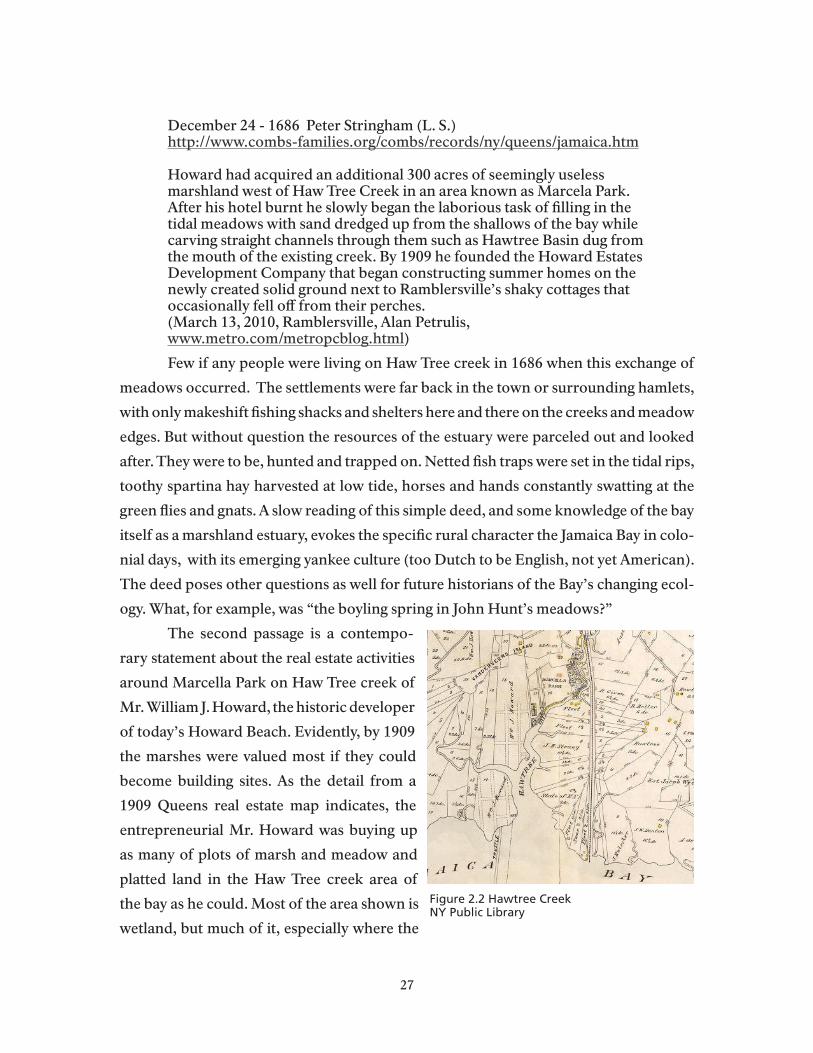
December 24 - 1686 Peter Stringham (L. S.) http://www.combs-families.org/combs/records/ny/queens/jamaica.htm
Howard had acquired an additional 300 acres of seemingly useless marshland west of Haw Tree Creek in an area known as Marcela Park. After his hotel burnt he slowly began the laborious task of filling in the tidal meadows with sand dredged up from the shallows of the bay while carving straight channels through them such as Hawtree Basin dug from the mouth of the existing creek. By 1909 he founded the Howard Estates Development Company that began constructing summer homes on the newly created solid ground next to Ramblersville’s shaky cottages that occasionally fell off from their perches.(March 13, 2010, Ramblersville, Alan Petrulis, www.metro.com/metropcblog.html)
Few if any people were living on Haw Tree creek in 1686 when this exchange of
meadows occurred. The settlements were far back in the town or surrounding hamlets,
with only makeshift fishing shacks and shelters here and there on the creeks and meadow
edges. But without question the resources of the estuary were parceled out and looked
after. They were to be, hunted and trapped on. Netted fish traps were set in the tidal rips,
toothy spartina hay harvested at low tide, horses and hands constantly swatting at the
green flies and gnats. A slow reading of this simple deed, and some knowledge of the bay
itself as a marshland estuary, evokes the specific rural character the Jamaica Bay in colo-
nial days, with its emerging yankee culture (too Dutch to be English, not yet American).
The deed poses other questions as well for future historians of the Bay’s changing ecol-
ogy. What, for example, was “the boyling spring in John Hunt’s meadows?”
The second passage is a contempo-
rary statement about the real estate activities
around Marcella Park on Haw Tree creek of
Mr. William J. Howard, the historic developer
of today’s Howard Beach. Evidently, by 1909
the marshes were valued most if they could
become building sites. As the detail from a
1909 Queens real estate map indicates, the
entrepreneurial Mr. Howard was buying up
as many of plots of marsh and meadow and
platted land in the Haw Tree creek area of
the bay as he could. Most of the area shown is
wetland, but much of it, especially where the
Figure 2.2 Hawtree CreekNY Public Library
27

platted grid begins to appear, will soon be filled. In a few more decades Haw Tree Creek
would become Haw Creek Basin
Hawtree Creek was no bucolic salt meadow by the time Howard began accelerat-
ing its urbanization. The classic post card from the creek’s Ramblersville settlement at
the turn of the century captures well the bungalow, fishing shack ecology of the older
creek settlements. A glance at contemporary (see the photos available, for example at
(http://www.bridgeandtunnelclub.com/bigmap/queens/howardbeach/hawtreebasin/
index.htm) land uses along modern Hawtree Basin shows that some of these structures
remain, and although the bridge over the basin (constructed in 1962) helped encour-
age construction of larger and more substantial housing, the older turn-of-the century
original ecology of the Ramblersville and Hamilton Beach neighborhoods remains vis-
ible, as it does in parts of the eastern Bay like Meadowmere Park.
Recreational Versus Commercial FishingFor the Jamaica Bay estuary, the three or four decades of the Gilded Age saw
the bay’s fisheries (especially recreational fishing) thriving even while development of
tourism and commercial recreation soared on Rockaway Peninsula as rail service im-
Image 2.2 Hawtree Creek (Source http://www.panoramio.com/photo/9878766)
28

proved.
But public opinion had long favored the recreational anglers. The previous summer an unidentified party of “some Rockaway Boys” raided the commercial fishing camps and burned several hundred yards of nets. (Fishing in Jamaica Bay, NYT, June 23, 1890 page 8) In March while the bill was first being debated over 15,000 signatures supporting it had been collected from Rockaway Beach and nearby communities. It was estimated that the value of the hotels, boat liveries, tackle shops, and other infrastructure supporting recreational fishing exceeded $200,000. (Jamaica Bay Fishermen, NYT, March 12, 1890, page 1) A local banker at Far Rockaway was known as a supporter of the commercial fishermen but changed his views after depositors began withdrawing their funds in protest. (Fishing in Jamaica Bay, NYT, June 23, 1890, page 8.) Observers noted that the fishing in the bay had improved since the net law went into effect. (It makes the Seine Men Angry, NYT, July 28, 1890 page 8)
In truth, urban development was severely underming the bay’s ecosystems. “In
1904, Jamaica Bay was the largest single source of oysters in New York State. The oyster
beds of Jamaica Bay were leased by the state. The bay produced between 500,000 and
1,000,000 bushels annually. “( Ollsen 2010; Stiles, George, W., Sewage Polluted Oysters
as a Cause of Typhoid and Other Gastrointestinal Disturbances, US Dept of Agriculture,
Bureau of Chemistry - Bulletin Number 156, Washington, Government Printing Office,
1912.) As population pressures increased along the bay shores of South Shore Long is-
land, tensions also increased for people in the oyster fishery, as the accompanying ex-
pert from a New York Times article at the turn of the Century:
I
Image 2.3: How the Oyster “De Luxe” is Gathered (New York Times, December 25, 1898)
29

Image 2.4: Jamaica Bay Comic (Hendrick 2006)
Untreated sewage from Flatbush was piped down into the bay, as was sewage
runoff from homes in the Rockaways. Oyster beds became visibly polluted; lawsuits and
outbreaks of typhus and other illnesses followed soon after. The state officially closed
the entire bay for oyster harvesting in 1921 and ended its history as a legendary pro-
ducer of shellfish. The next historical period of changes along the Bay’s shores would
impose a strong governmental hand on development of the regional infrastructure that
would also encourage even more rapid urbanization of the communities nestled in its
creeks and former meadows.
1920-1972: The Moses Era: Legacies of Industrialization and ProtectionProposals to transform Jamaica Bay into a major Atlantic coast port facility by
the U.S. Army Corps of Engineers had been developed at the end of the 19th century.
In the 1920s, however, a number of ambitious development projects began to alter the
physical characteristics of the Bay. Parks Commissioner Robert Moses and his allies in
city and state government pushed ahead plans to fill in Barren Island for the construc-
tion of Floyd Bennett Field, and to channel and fill creeks and marshes along the Bay’s
northern perimeter for the creation of the Belt Parkway and the Marine Park Bridge.
These were merely a few of hundreds of such projects throughout the metropolitan re-
gion that used landfill, household garbage, construction wastes, and dredging spoils, to
create airports, prisons (Rikers Island in particular, parkways, and much more. Nor is
the near craze for filling wetlands to create urban parks and related uses unique to this
30
period of the city’s history. Benjamin Miller’s indispensible history of the uses and poli-
tics of urban garbage over the past two hundred years of New York’s history, Fat of the
Land (Miller, 2000), notes that in the late nineteenth century Olmsted himself had used
over a hundred thousand cubic yards of refuse to fill in land along the Hudson to build
Riverside Park. In Jamaica Bay, excitement about building for the “Air Age,” would over-
come any local or wider protests over destruction of wetland resources or the eviction
of powerless local residents on Barren Island . Miller writes that:
After Pearl Harbor, parkways were no longer a national priority. The War Production Board wanted airports, however, as much as Mayor LaGuardia did. Following the money trail, as always, Moses began to expand Floyd Bennett Field on Barren Island with more refuse so that it could be sold to the Navy. With the proceeds, he bought (marsh)land to build a new airport at the opposite end of Jamaica Bay, then filled it too with garbage. While he was at it, he added more refuse fill to the Marine Park adjacent to Barren Island and began planning landfill parks near the new Idlewild Airport.(Miller 2000, p.204)
Floyd Bennett eventually lost out in the competition between Newark and La-
Guardia airports, remaining a military facility until it was eventually ceded to the Park
Service with the Creation of Gateway N.R.A.. The Robert Moses period of large scale
landfill and extensive urban development in and around the Bay helped create many of
the social and cultural characteristics of the Bay communities that persist into the pres-
ent.
The Legacy of Community Solidarity and Defended NeighborhoodsResidents of the Rockaways and other communities along the Bay’s edges expe-
rienced evictions due to the Moses plans that are still the subject of much local resent-
ment. They also developed, as we shall see presently for some of the neighborhoods,
intense local loyalties and high levels of commitment to public service, especially in the
uniformed services. This was partly the result of experiences of the World Wars where
generations served their country with pride and sacrifice. But there was also a more
critical, proactive influence among residents of Bay communities who were being evict-
ed from fishing shacks and more substantial homes around the Bay’s islands as public
works and residential development increased. Memories of the evictions help sustain
continuing feelings of distrust of government authorities (see the cover photo of a popu-
lar pictorial history of Jamaica Bay below) So do memories of “urban renewal” which
31

resulted in the razing of many blocks of Rockaway’s beloved bungalows. In the minority
neighborhoods on the eastern Rockaways, however, African Americans also sustained
sporadic opposition to Moses’s many relocation efforts. Much more about this history
and its living influences is available in Between Ocean and City: The Transformation of
Rockaway,New York neighborhoods of the Rockaways (Kaplan and Kaplan 2003).
Image 2.5. “With his belongings in tow, a man watches as homes on Ruffle Bar are burned. Parks commissioner Robert Moses ordered several islands evacuated in the early 1950s to create the park now known as the Jamaica Bay Wildlife Refuge. (Courtesy Ed Clarity and Dan Mundy)” This haunting photo is on the cover of an excellent collection of historical photos in widespread circulation, especially locally. (Jamaica Bay, Images of America Series, Daniel M. Hendrick, 2006)
In Canarsie, Bergen Basin, Gerritsen Beach, and Howard Beach, as in the neigh-
borhoods of the eastern Rockaways during this period, the incorporation of what had
once been relatively isolated and fiercely independent “villages” into the controlling in-
stitutions of the larger city often caused conflict with authorities. In 1934, for example,
there was a rancorous dispute between volunteer fire fighters and their families in Ger-
ritsen Beach with officials of the New York City Fire Department. The latter had seized
the volunteer’s equipment in an effort to impose their procedures and rules. (http://
www.gerritsenmemories.com/hist_stor/vollies062934.htm).
As newcomers began purchasing property in homes in the Bay communities, the
fear of policies that would bring new populations, and racial minorities in particular,
into the area, furthered a commonly held opinion that local institutions and ways of
life needed to be defended against a variety of external threats. As the minority popula-
tions of Central Brooklyn and East New York expanded into the white neighborhoods
32

to the south, racial tensions in neighborhoods along the Belt Parkway and those along
Woodhaven Boulevard also increased over the period. The history of racial tensions in
the bay communities is often traced to notorious incidents in Howard Beach and Broad
Channel that occurred in the 1970s, but traditions of neighborhood defense that would
help explain these events were established decades earlier. Nor were perceived threats
to local neighborhood cohesion limited to the Irish and Italian American enclaves along
the Bay. Jonathan Reider’s historical and ethnographic study, Canarsie: The Jews and
Italians of Brooklyn against liberalism (1987) is a celebrated account of , among oth-
er subjects, the Jewish congregations of Canarsie reactions to the growing presence of
non-white residents in their neighborhoods. David Frum’s review of the book shows
how relevant the study of Canarsie, a local Jamaica Bay community, was to interpreta-
tions of national politics at the time:
… anthropologist Jonathan Rieder spent two years living not in New Guinea or up the Amazon but in a place that his academic colleagues probably found even more exotic: the lower-middle-class neighborhood adjacent to New York’s Kennedy Airport. There Rieder witnessed close-up the destruction of Roosevelt’s coalition by voter revulsion against crime, welfare and casual disorder. (David Frum Wall Street Journal, quoted at http://www.amazon.com/Canarsie-Italians-Brooklyn-Against-Liberalism/dp/0674093615/ref=sr_1_2?ie=UTF8&s=books&qid=1289665989&sr=1-2)
The eviction in 1936 of the entire community on Barren Island is an earlier but
singular Jamaica Bay episode of the Moses era. This chapter of Jamaica Bay’s history
remains relatively under-explored in the literature yet is an important instance in which
the community in question was racially and ethnically integrated where regardless of
race or creed, everyone experienced the equality of poverty. From this perspective alone,
it would seem to stand with the removal of Irish and African American settlers of Sen-
eca Village for the construction of Central Park, as another example of removal of the
powerless to create valuable public places (http://www.learn.columbia.edu/seneca_vil-
lage/).
The story of the Barren Island community also introduces Miss Jane Shaw, a
principal and the only teacher of the island’s school children for nineteen years, A vocal
yet almost saintly heroine of the Bay and the city’s poor, she remains largely unknown.
This is perhaps because to understand her importance is to visit, at least in the imagina-
tion, one of the more hellish places of the city’s industrial underbelly.
33

Image 2.6: Barreling Barren Island Oil
For much of the nineteenth century Barren Island was the city’s offal depot and
grease factory. A source of enormous profits for its operators and their political allies,
it was also the malodorous home to an impoverished population of African-Americans,
Irish, Italian, and Polish men women and children. Children picked over mountains of
garbage while their parents labored in the try works. With a population close to fifteen
hundred during its peak years during the twenties and early thirties, historian Benjamin
Miller writes that “None of the physical details of the manufactories or of the materials
they processes were unique, but in their aggregate, they may well have made on Barren
Island, the largest, most odorous accumulation of offal, garbage, and alienated labor in
the history of the world.”
During the heyday of the fish oil, fertilizer and refuse disposal industries, a modest volume of ship traffic focused on Barren Island. The garbage and horse rendering establishments depended on the daily arrivals of scows from New York. From early May to mid-November, the menhaden season, thirty steamers moved back and forth between the bunker fish schools in the Atlantic and the fish oil plants on the island. Other vessels carried away fertilizers, fish oil and other products. Beginning in 1906, the island was a stop on two ferry routes, one originating at Canarsie and terminating at Rockaway Beach and the other running from Sheepshead Bay to Rockaway Point.(Black, 1981, p.30)
By the time Robert Moses was exerting his power over Jamaica Bay, the popula-
34

tion on Barren island had become predominantly composed of households with couples
and children, rather than single men (Black 1981). A former resident of Barren Island
remembered the community and its one-room school as its history was coming to an
end: Robert Moses, moved the people out of Barren Island. What he did was move only half of them out. We lived at 49 Main Street which was about the eviction line, and we moved farther east to #3 Main Street. So between 1936 and 1939 there were about 30 families still on Barren Island. Our school --P.S.120 (I remember 2 teachers, the principal, Miss Shaw, and another teacher named Miss Contillo) -- was torn down in or about 1936 when the west half of the island was evicted. Our church was left and used by the remaining people. After P.S. 120 was torn down we had to walk to Flatbush Ave to catch the bus that took us to P.S. 207 or 208. (Cited in Boyle, 2010 from citynoise.org, 10th Aug 2007)
Miss Shaw made sure that all her children received real educations, and when
Robert Moses announced that the community would be razed to allow for the marine
Park Bridge approaches, “she fought to buy enough time for her charges to finish the
school year; despite the odds of going against the famously ruthless parks commissioner,
she succeeded. “(Miller, 2000, p.88) This was perhaps the first instance of community-
level protest and citizen activism in Jamaica Bay, but it would hardly be the last.
The Legacy of Jamaica Bay as a Cherished FisheryEven as so many marshes and creeks of the Bay were being lined by rip rap or
seawalls, or dumped on and filled to create Floyd Bennett Field, the Belt Parkway, and
Idlewild/JFK airport, for example, a lively recreational fishing industry continued to
sustain hundreds of households in and around the Bay during the decades of the Moses
era. This was not true, as noted earlier, of commercial fishing, and especially of shell-
fishing. Moses did take the lead in constructing treatment facilities that would reduce
the direct inflow of fecal bacteria into the Bay. Unfortunately, he and his planners were
instrumental in building the four major treatment plants along the shores of Jamaica Bay
that continue to load the estuary with more nitrogen from treated waste than it’s eco-
systems can adequately assimilate, a situation to which we must return elsewhere in this
report.(Jamaica Bay Task Force Report, 2008). In consequence, the commercial shell-
fishing industry has never become re-established in the Bay, but recreational fishing has
continued to be a passionate pursuit for people growing up along the creeks and chan-
nels in many of the Bay neighborhoods. The recreational fishing industry, and family
35

boating in the Bay and nearby waters, continue to be vital aspects of the Bay’s particular
culture. There are endless examples of this fact available in the blogs that appear on the
Web. The following example captures the way those who operate recreational fishing
business contribute to the remarkable attachments non-residents of the area can form
to the Bay’s natural resources. Even extremely limited experiences on the Bay, like the
one offered here, remain alive in vivid adult memories of fishing and poking around in
the mud flats at Broad Channel and other original Bay settlements.
I grew up in the northeast corner of New Jersey, and my maternal grandparents lived in Glendale, Queens. I have a vivid memory of a special weekend I spent with my grandparents (without my parents or sisters!) when I was about 8 (late 1950s). We went to Broad Channel for the day, and my grandfather took me clamming. We had to wear sneakers, but when we felt a clam underfoot, I would duck underwater to grab it. We took home the clams we found, and my grandfather opened them at the kitchen sink. Mostly my grandmother sat on some wooden steps leading down to the water as I jumped around and paddled in the water. I remember thinking it was strange seeing her in a bathing suit. Thinking back now, it looked like an old, rather run-down dock, but it lives in my mind as a wonderful, bright summer day. www.nypl.org/blog/author/33
The Legacy of Private and Public Housing Neighborhoods Around the BayJamaica Bay is ringed by marshlands, landfills, parkways, airports, and, in many
places, publically subsidized housing projects. Starret City just north of Gateway’s Penn-
sylvania Avenue landfill is a middle income project, while Hammels and Arvern homes
Image 2.7 Broad ChannelNew York Public Library
36

on the Rockaways, are venerable New York City Housing Authority neighborhoods,
which, along with housing projects in Canarsie and many other Watershed neighbor-
hoods, are also a legacy of the Moses era. They are at once a vital source of affordable
housing in the city, and a continuing source of inter-racial tensions and misunderstand-
ings. Often associated with “public welfare” and thus attacked by enemies of public sec-
tor investment, their emergence as a response to housing emergencies before and espe-
cially after World War II is often forgotten.
The twenty year period from 1940 -1960 brought extremely rapid housing de-
velopment to the communities along Jamaica Bay. Housing developers like William
Howard, after whom the Howard Beach community is named, established precedents
early in the Twentieth Century for later residential growth, and in some cases, as in that
of the old Ramblersville neighborhood of Howard Beach, the location of rail stations
significantly supported housing growth well before the two World Wars. The Second
World War and the sudden de-mobilization of thousands of military personnel after
1945 created emergency housing shortages. Queens and Long Island went through an
historic suburban building boom. At Howard Beach the pressure for development led
the marshland west of Cross Bay Blvd to be filled in. New private homes were built on 50
and 60 x 100 lots in the neighborhood that came to be known as New Howard Beach. A
bit later, in the 1950s, vacant land north of New Howard Beach became the site of new
housing, including red-bricked two-story garden style cooperative apartments, and a
few six-story co-op and condo apartment buildings. This pattern of investment by de-
velopers in tracts of single-family homes or garden apartments was ubiquitous in the
Watershed region. In Canarsie and the Rockaways, however, the housing emergency was
more typically addressed by the building of temporary housing for returning service
personnel and their families, and by the acceleration of plans, most often put in place
Image 2.8 Quonset Hut
37

by Commissioner Robert Mose s, to replace those structures with permanent public
housing apartments. For the Bay’s communities, the most famous example of this post-
war housing emergency is the Quonset hut settlement in Canarsie (photo taken from
NYCHA Journal Spring 2009). As this recent on-line comment in the Canarsie Courier
indicates, local residents remain fascinated by this period of rapid growth and change in
their communities.
Image 2.9 Assemblyman Alan Maisel was kind enough to loan us this photo of Canarsie, circa 1953. Of particular note is the pier itself, which, at the time, was referred to as “Play Pier.” Note the area to the north of the pier - where BayView Houses is currently located - and you will see quonset huts that were installed as emergency housing units for U.S. Army servicemen and their families as they returned from fighting in World War II. The huts were being torn down as families found more permanent housing all over the city. Canarsie itself also experienced a building boom at the time, with elements of Seaview Village quickly being filled with new housing.(http://www.canarsiecourier.com/news/2006-07-13/OtherNews/040.html)
A Legacy of Strong Religous CongregationsDuring the Post War building boom in Southern Queens and Brooklyn, new
churches and synagogues were organized by parishioners in Canarsie, the neighbor-
hoods of Mill Basin, Howard Beach and other rapidly growing neighborhoods within
the Watershed area. Newcomers also expanded the ranks of longstanding congrega-
tions in the region. The congregational religious ecology of the watershed – largely com-
posed of Roman Chatholic, Protestant (especially African American and West Indian
churches) and Jewish, reached its peak during the 1940s and 50s, and was largely intact
when Gateway was created. (That ecology is changing rapidly at present, as we will see
in further detail in Chapter 5)
The oldest standing churches in Queens and Brooklyn are the early Dutch Re-
formed churches and the Quaker Meeting house in Flushing, Queens, the oldest con-
38
tinuously operating church in New York City. The Rockaways also host a number of
the Old Dutch Reformed and earlier Presbyterian churches, like the First Presbyterian
Church, built originally by the widow of railroad magnate, Russell Sage, now on the na-
tional historic register. But some of the most venerable Roman Catholic congregations,
as opposed to church buildings, are found on the Rockaways. St. Mary Star of the Sea,
was established there in 1855, and its current church dates back to the early 1920s. The
St. Rose of Lima congregation was founded in 1870. The congregations of Breezy Point
that form today’s Blessed Trinity Parish -- the Churches of St. Genevieve, St. Thomas
More & St. Edmund in Roxbury, Rockaway Point, and Breezy Point – are historically
integral to their pre-war neighborhoods. The St Francis De Sales congregation in Belle
Harbor dates to the turn of the twentieth century and remains one of the largest and
most active of the watershed’s many Roman Catholic churches. It was the emotional
and spiritual center on the Rockaways during the disasters of 9/11 and the crash in Belle
Harbor of Flight 587 two months later (see more on the influence of these events on lo-
cal culture below).
Post War Canarsie came to be known as a community with a large Jewish popula-
tion. The Jewish population of Canarsie, and other enclaves along the northern shores of
Jamaica Bay, began to grow rapidly during the 1920’s, along with the Italian population.
In Canarsie most Italian –Americans went to mass at the Holy Family Church,. Within a
few years of accelerating Jewish settlement, the congregations of three temples experi-
enced rapid growth: Ahavas Achim Anshe Canarsie (originally established in 1908) on
Glenwood Road and East 95th Street, the Kevelson Synagogue on Avenue L and East
96th Street, and the A.A.A. Sfard on East 94th. By the 1970s there were at least five more
Jewish synagogues (Reider 1987; http://www.oldcanarsie.com/religious_buildings.htm
) . In Howard Beach, as in the Rockaways, Jewish and Roman Catholic houses of wor-
ship were the most rapidly growing congregations during the Post World War II period
and up to the early 1970s.
African American and West Indian populations of central Brooklyn and the Ja-
maica Queens were experiencing rapid growth of their home-owning middle classes
during the Post War period. They were also joining white families in moving into the
hundreds of NYCHA apartments in Canarsie and the Rockaways, where they tended to
form small congregations with local pastors, sometimes in store-front churches, some-
times joining older white congregations (as in the Rockway First Presbyterian Church).
39
Some Churches like the Allen A.M.E. Church of Jamaica were building larger congre-
gations. By the mid-seventies the Allen Church had recruited a new leader who would
become one of the nation’s pioneers in forming the mega-church movement. The Pas-
tor, Reverend Floyd Flake built the Allen Church into a congregation that attracts mem-
bers from a number of Jamaica Bay communities with African American and West In-
dian populations, including Far Rockaway, Innwood, and Jamaica. The church, now the
Greater Allen A.M.E. Cathedral of New York in Jamaica,. Queens claims over 20,000
members and is active in a variety of commercial development efforts in the communities
it serves. Reverend Flake also became a major political force in the Watershed area while
he represented voters in the 100the Congressional District, which includes numerous
Watershed communities from Woodhaven around the airport, and Jamaica out to the
Nassau County border. Reverend Flake joined Congresswoman Shirley Chisholm (who
represented Central Brooklyn communities in Congress from 1969-1982) as influential
representatives from the Watershed area during Gateway’s early years. Rep. Chisholm’s
background was more secular that Rep. Flake, but like him her base of support came
from many staunch church goers in the neighborhoods she served.
A Legacy of Environmental Action and Wetland ProtectionIn his monumental study of Moses’ long career, historian Robert Caro is care-
ful to establish that the “Power Broker” was never motivated by urban development
as a single and sovereign mission (Caro, 1974). While he was devoted to automobility
and to the construction of parkways that would bring the middle class masses to his
new park and beach destinations, he was also a believer in environmental preservation.
Jones Beach State Park, his first and most acclaimed public work, also gave him the op-
portunity to take a major role in preserving the interior wetlands of Hempstead Bay in
Suffolk and Nassau county. He soon applied this model of combined development and
preservation to his plans for parkway and park development in and around Jamaica Bay.
Marine Park, Riis Park, the Beach Channel Drive, the Shore (or Belt) Parkway, and the
Marine Park Bridge create the contemporary human ecology of Jamaica Bay.
Mayor Wagner eased Robert Moses out of power in 1960, but he never shied
away from controversy about the bays and beaches of Long island. Strenuously opposed
to the transfer of so much of his former Jamaica Bay empire to federal ownership and
management, he said publically on many occasions that he did not think the Park Ser-
vice could manage urban parks or deal well with city people and their politics. This was
40

partially a reprise of a position he had taken when he unsuccessfully opposed the cre-
ation of Fire Island National Seashore a decade earlier. An irony that borders on the
tautological is that Gateway, a visionary national recreation area in the marshes under
the incoming jumbo jets, would not exist without the park and transportation infra-
structure Moses had created in Jamaica Bay and the Rockaways by the early 1970s.
In his 1969 Pulitzer Prize winning book, So Human An Animal, internationally
acclaimed microbiologist Rene Dubos brought Jamaica Bay to early prominence among
environmental activists. His book helped mobilize the political support that eventually
produced Gateway’s enabling legislation. In a 1970 interview Dubos summarized his
perception of the Bay during the last years of the Moses era:
I think the Jamaica Bay adventure—and it is an adventure—is probably the most complete and unexpected success story of the whole ecological movement in the United States at the present time. That is the reason why I’ve taken such a strong position on it. Jamaica Bay was used for many years—perhaps fifty, I’m not certain—as a dumping ground for New York City. It was a gigantic dump. The bay is about one-half covered by the garbage of New York City. That sounds awful, and it is. There is no doubt that it has completely spoiled the waters of the bay. It is one of the most polluted environments in New York City. Progressively, the junk . . . the garbage, settled down and formed a series of islands in the bay. Artificial islands completely made by garbage. Then there was an employee of the Park Department: A new man named Herbert Johnson took the position and decided that something should be done about that area. Instead of just doing only what he was supposed to do, he took it upon himself to collect seeds of different kinds of plants and trees: Pines, bayberries and all sorts of vegetation. He actually planted the seeds with his own hands. He planted the trees, the bayberries, the grasses. And soon, what was once just a dump has become a tremendous, collection of different plants which are growing successfully in the bay area. Once the plants began to grow, they attracted birds. All kinds of birds. Tremendous flocks returned to the area. And not just ordinary birds like ducks, but also many birds—such as the Snowy Egret—which had disappeared from the New York region. So there we are with a situation that appeared to be one of the worst examples of degradation of the environment in a large city. Through the persistence and initiative of a state employee a miracle has occurred: The creation of a beautiful, ecologically interesting and—apparently—very vigorous bird sanctuary.(Allen Richards - November/December 1970, )http://www.motherearthnews.com/Nature-Community/1970-11-01/The-Plowboy-Interview.aspx?page=2
It is true that the wildlife Refuge was created as a physical place with extremely
41
well planned habitats through the inspired work of Herbert Johnson, a park mainte-
nance foreman who was also an avid birder. But Mr. Johnson worked for Robert Moses
and historians accept the fact that Moses himself was responsible for directing that the
refuge be built. That decision has never placed Moses in the pantheon of environmen-
tal pioneers, his legacies are far too ambiguous for that, but in this period, and, largely
thanks to Moses environmental concerns, Jamaica Bay became a national symbol of
environmental restoration. On the other hand, his hauteur and unbridled disdain for
places like Broad Channel are evident in this passage from his 1938 report to the Mayor,
The Future of Jamaica Bay.
Its wide skies, its long water reaches and low, grassy and mysterious-seeming islands make Cross Bay Boulevard (despite the shacks and hot dog stands which already too much disfigure it) as an avenue into a strange corner of primitive romance of a kind one would hardly expect to come upon between Ozone Park and the Rockaways. (quoted in Kaplan and Kaplan 2003, p.79)
The Legacy of Citizen ActivismThere is a direct line of Jamaica Bay citizen activists that runs steadily through
the Twentieth Centuryt and into the present – from Jane Shaw of Barren Island to Herb
Johnson of the Refuge, to Sam Holmes and Tom Fox of the community gardens on
Floyd Bennett Field, to the Mundys of Broad Channel, and to the many activists citizen
groups, like the Rockaway Waterfront Alliance (http://rwalliance.org/about/), working
to improve access to the Bay’s waterfront and its natural resources. The list must also
include people who never lived along the bay but who devoted large blocks of time to
working as Gateway Citizens under the leadership of Marian Heiskell first Chairman of
the Gateway Citizens Committee and the Gateway Advisory Board, and Kim Norton,
Stanley Tankell, and Sheldon Pollock of the Regional Plan Association, all of whom were
instrumental in Gateway’s creation. Citizen involvement in the Park’s development may
have waned after federal management became well established, but as the park contin-
ued to host increasing numbers of environmentally concerned visitor groups, its profile
as a conservation presence in the Watershed area increased, especially in the critical
activates of local community boards and innumerable civic voluntary associations in
the bay communities. We will see presently that the transition from citizen involvement
to stakeholder presence on formal oversight committees represents one of the most im-
portant changes in Gateway’s social and political environment since park creation in the
42
early seventies.
These legacies of citizen activism, environmental protection, intense solidarities
of community, neighborhood and congregation, and the deep attachment to the bay’s
aquatic resources among generations of Jamaica Bay families, were important aspects
of the local culture that presented itself to federal managers and park planners when
Gateway was being created in the early 1970s as one of the nation’s first two urban units
of the National Park Service (the other being San Francisco’s Gold Gate National Rec-
reation Area). Even a brief review of the history of the Bay communities since the early
seventies suggests that much of what has occurred since 1973 is strongly influenced by
these living legacies of earlier periods of Jamaica Bay settlement.
From Gateway into the New Century: Cultural Groups and Jamaica Bay
ResourcesWhen considering the most significant events over the past forty years of Gate-
way’s existence, especially those that have influenced life in and around the Bay, local
historians, journalists, and social scientists point to these changes in particular:
• The drug epidemic and urban blight of the 1980s
• The terrorist bombing of 9/11 and its impact on Jamaica Bay communities
• Rapid population change, especially the large scale in-migration of immigrant
households
The crack/cocaine epidemic of the 1980s heightened existing tensions between
whites and non-whites in the Bay communities as levels of inter-personal violence in-
creased along with fears and distrust of outsiders. This difficult period of the city’s his-
tory (also coinciding with the AIDS epidemic) was experienced in particularly acute
fashion in more economically impoverished of the Watershed region. Some communi-
ties lost large segments of their middle class populations, and as we shall see in the more
detailed demongraphic analysis of change in the communities, this was particularly true
in Bedford Stuyvesant, Brownsville and Ocean Hill, as well as in parts of the Rockaways
and South Jamaica. This was also a period of sustained “white flight” from neighbor-
hoods like Canarsie, and Arverne on the Rockaways, and others perceived as dangerous
or potentially unstable, to more suburban places on Long Island (often along the South
Shore of Long Island) As the influx of new immigrant groups into the region accelerated
43
through the period, it is not surprising that many of the housing vacancies in the Wa-
tershed region’s neighborhoods were being filled by families of immigrant origins (see
especially Chapter 3 of this report).
9/11 and Airline Disaster in the Rockaway Local CultureNo events have had more immediate and continuing impact on the communi-
ties and ways of life in and around Jamaica Bay than the terrorist attack on the World
Trade Towers and the crash on Rockaway Peninsula in Belle Harbor of American Air-
lines Flight 587. As Melanie P. Hildebrant writes of 9/11 in her study of “double trauma
in Belle Harbor” (Hildebrant 2005):
On that day residents stood along the seawall facing Jamaica Bay, watching helplessly as the twin towers burned in the distance. Off-duty firefighters from Rockaway grabbed their gear, said good-bye to their children, and rushed to downtown Manhattan. By day’s end, over seventy people from this remote seaside community in southern Queens had died in the terrorist attack on the World Trade Center. Among the dead were firefighters whose families had lived in Rockaway for generations. Others were employees of Cantor Fitzgerald, a financial services firm that lost nearly half its workforce; many of them lived in the Rockaway neighborhoods of Belle Harbor and Breezy Point The sound of church bells and bagpipes marked the days and weeks following the Sepember 11 attacks. Dozens of funerals and memorial services were held, many at the St. Francis de Sales Church, a Catholic church located in the de facto town center of Belle Harbor.
Two months later, while the community remained in a state of shocked mourn-
ing, American Airlines Flight 587, with 260 passengers bound for the Dominican Re-
public, crashed in Belle Harbor According to Hildebrant’s interviews with Rockaway
residents who experienced the events, many “would assert that the trauma of a plane
nose diving into their backyards was worse.” (Hildebrant, 2005, p. 107). All aboard the
aircraft were killed, along with five residents of the neighborhood.
The details and the immediate experiences of people in Belle Harbor and sur-
rounding neighborhoods before, during, and after both crashes are compiled by for-
mer Rockaway Wave reporter Kevin Boyle, in Breaking the Waves, Rockaway Rises...
and Rises Again (Boyle, 2002). His gathering of recollections of the two disasters as they
were felt and lived by people from the neighborhoods, and especially by members of
the uniformed fire and police services, is both extremely moving and equally revealing
of the strengths of family friendships and strong church affiliations that mark many of
the neighborhoods around the Bay, not only those on the eastern Rockaway peninsula.
44

Boyle points out that the Rockaways are special in this regard: “There are more than 500
firefighters who live on the Rockaway peninsula, and hundreds more if you count retired
guys. Rockaway also has a good number of police officers and emergency responders of
all stripes. They’ve all got stories to tell – great, heroic, inspirational, hair-raising tales.”
(Boyle, 2002, p. ix). So do their wives and children.
Maureen Edwards is at her kitchen sink, rinsing the bowls the kids used for their morning cereal. Something catches her eye out the window. She screams when she sees the fiery plane falling like a huge flaming arrow … diving … where is it going to hit?
Jamaica Bay neighborhoods along Bay are under the JFK flight paths. Had the
wind been coming from another direction American Flight 587 could have come down
in Howard Beach, or on the eastern border of the Bay, Innwood or Jamaica, as did East-
ern Flight 66 on June 24, 1975. But the Airbus 3 bound for the Dominican Republic
crashed into Belle Harbor where one of the neighbors who was at the crash site was Fire
chief Pete Hayden, who only two months earlier had been in charge of the North Tower
Command/ Operations Post:
For the first time in weeks, Fire Chief Pete Hayden had a day off from leading the department’s task force at the World Trade Center. ‘’I saw heavy smoke behind the left wing,’’ Chief Hayden said. He watched the wing come off, then other sections, possibly the tail. ‘’She started to corkscrew, and then the last several hundred feet, she went straight down,’’ he said. He ran nine short blocks to the crash, followed by dozens of other firefighters who live along the peninsula, heard the crash and went to work.” JIM DWYER and JANNY SCOTTPublished: November 13, 2001(http://query.nytimes.com/gst/fullpage.html?res=9500E5DF1138F930A25752C1A9679C8B63&sec=&spon=&pagewanted=all)
People anywhere in the world can hear Chief Hayden describe the Bell Har-
bor crash and watch documentary newscasts that bring the view into the burning
streets of Belle Harbor after the crash (see for example, (http://www.youtube.com/
watch?v=AFmVUok05E4). In the Rockaways and other Bay communities, the impact
of the event is even more alive largely because of the losses and heroism neighbors ex-
perienced. Lingering health and compensation claims for first responders and issues
of how to memorialize the two events remain open more than seven years later. As a
consequence of the double trauma, the local culture of the Rockaways and other bay
neighborhoods draws on an inexhaustible collective memory of tales from the two di-
45

sasters. Many are of personal tragedy, but others speak of resilience and defiance, as in
the example of Michael Moran, brother of firefighter John Moran who perished at the
Trade Towers. At a nationally televised concert and memorial, “John’s younger brother
and fellow firefighter, delivered to Osama bin Laden … a taunt so profane and yet so
eloquent, full of Irish anger and grief. (http://www.irishtribute.com/tributes/view.adp@
d=236920&t=238027&p=1.html).
When Flight 587 crashed in Belle Harbor it set off emergency responses through-
out the metropolitan region. The Empire State Building was evacuated, all commercial
flights were grounded, fighter jets were deployed over the city’s airspace, authorities
rushed to determine if the event was another terrorist attack. In the Rockaways, “The
crash of flight 587 was a dramatic confirmation of a long-standing concern among
Rockaway residents. As one resident said, ‘We’ve always known that it wasn’t a matter
of if a plane would crash in Rockaway, but when.’” (Hildebrandt, 2005, p.119). In the
aftermath of two disasters, residents reported to ethnographer Hildebrandt that a num-
ber of local community organizations, especially the churches and the local newspaper,
the Rockaway Wave, “helped fill the voids created by the two disasters.” The Wave, for
example, “offered families the chance to place a full or half-page ad, free of charge, in
tribute to lost loved one. Several families tok advantage of this opportunity and were
grateful to The Wave for making the space available”(Hildebrandt, 2005, p.122).
On the bay itself, the events of September and November 2003 have necessarily
resulted in increased surveillance of boat traffic passing east of the Marine Park Bridge.
Bayman Larry Seaman and his son found their fishing activities on the Bay suddenly
under unprecedented suspicion as new buoys marked the edges of the airport, helicop-
ters flew overhead, and Coast Guard vessels frequently stopped his vessel. “All of which
is fine, the Seamans say, except for the fact that they are now in the absurd position of
being treated as suspects by people with whom they have been on a first-name basis for
years. ‘It’s not the regular guys,’ Says Seaman Jr. ‘It’s the command structure; they’re just
so gun-shy about everything.’” (quoted in Gibberd, 2007, p.5). It is likely that New York
State regulations on catch limits for commercial and recreational fishing, and manda-
tory salt water license regulations that began in 2010 have had more lasting impact on
uses of Jamaica Bay for fishing and boating than have responses to terrorism, a subject
to which we return in Chapter 4.
Heroic responses to terrorism in the Bay communities, and the experiences of
46
neighbors helping each other deal with trauma, have strengthened the solidarity and lo-
cal cultures of the older neighborhoods along the bay’s shores. At the same time, howev-
er, the continued arrival of new families above the Belt Parkway, but also into the neigh-
borhoods at the water’s edges, is bringing rapid change to the watershed’s population
and to the cultural uses that people make of Jamaica Bay resources.
In-Migration of Immigrant Groups to Watershed CommunitiesIn the four decades since Gateway assumed responsibility for protecting the re-
sources of Jamaica Bay, and also for making them accessible for recreational opportuni-
ties, the demographic composition of the Watershed’s population has changed appre-
ciably in all of the communities surrounding the Bay. In 1980, the White non-Hispanic
population of the watershed constituted about 50% of its population. Today it is reduced
to about one quarter of the total. Much of the loss has been made up for by increases in
populations of West Indian, Caribbean, and Asian origins. The next chapter of this study
provides more detailed analysis of these changes and their implications for the uses that
new cultural groups are making of Jamaica Bay resources. These changes are traced at
the level of the entire Watershed, and for individual communities of the region.
Assessment: Gateway’s inheritance of cultural attachments in and around
Jamaica BayAn overview of the cultural history of Jamaica Bay Watershed communities
shows that before it opened as a federal park in 1973, the resources in Jamaica Bay were
already:
• A cherished recreational fishery, now diminished (see chapter 4)
• A diminished but active commercial fishery – eels, bait, crabs – now endangered at best, almost extinct except as a part-time occupation or a dream in many minds (see chapter 4).
• A lively family boating environment -- the waterways and natural areas hosted an active boating life independent of fishing. The boating uses of Jamaica Bay continue but are somewhat diminished by economic conditions and changing population characteristics (see chapter 4).
• Endowed with an active naturalist constituency -- the refuge and other sites along the Bay were the “habitat” for birders and other environmentally concerned citizens who formed an early and avid local constituency for environmental preservation and use. Gateway’s resources are to varying degrees, and throughout its units, defined by groups who were on the property “using the resources”
47
before the park opened. Floyd Bennett was habitat for birders, for example, well before the park existed. The forested area on Floyd Bennett Field known as the North Forty was a term used primarily by birders and other naturalists. Their re-definition of the value of this wooded area became itself an element in the eventual defeat of aviation advocates, who were still active at Gateway’s inception.
These are among the outstanding aspects of the social and cultural environ-
ment that Gateway inherited when it began managing its Jamaica Bay resources. But
Gateway’s management is necessarily influenced by the jurisdictions and policies of a
myriad of agencies state, local, and federal. In this regard, a significant accomplishment
the Park can claim is its leadership in coordinating the increasing knowledge base about
the Bay’s resources. Another is the National Park Service in Jamaica Bay has helped pro-
mote more coordination among responsible stakeholders in addressing Jamaica Bay re-
source issues. This is a subject to which we return in Chapter 5 as it relates to the cultural
and community uses of park resources.
A Mosaic of Uses and AttachmentsIn 1976, during its extensive outreach to community groups and user groups,
Gateway’s NPS planning staff produced a film, narrated by Yankee-Hall-of-Fame short-
stop, Phil Rizzuto, who was an early supporter of Gateway, especially on Staten Island.
The film documented the very diverse array of park users it was serving even as it was
establishing its management of the resources Congress had put under its management.
Along with systematic analysis of park uses that were conducted at the time, the film
documents park use throughout Jamaica Bay, from Plum Beach and Canarsie Pier to the
Refuge and fishing spots on the bridges along Woodhaven Boulevard, to Riis Park and
Beach Channel to Floyd Bennett Field (Kornblum et al, 1974). Since so much of the area
had been surplus military property for two decades or more, there were many areas of
the bay shore and wetlands that had become urban wilderness where junked and sto-
len cars and other waste was being illegally dumped. In the first two years of Gateway’s
operation of the Jamaica Bay Unit, about 400 automobile hulks were extracted from the
wetlands on either side of the Belt Parkway. Today the park’s bay and beach resources
serve as a regular gathering place and temporary base of operation for an astounding-
ly wide range of formal and informal groups -- sports, cultural, recreational, who feel
strong attachments to one or another of its resources. Many of these groups -- among
them are model aviators, cricket teams, soccer players, campers, kayakers, community
48

gardeners, bikers, sailors, beach clubbers, pitch and put golfers, softball players, history
buffs, birders and naturalists -- have longstanding relationships with Gateway and its
resources in and around Jamaica Bay.
No matter what their particular sport or activity, people who spend precious
discretionary free time pursuing a passion become intensely attached to the places as-
sociated with their efforts and rewards. If one sails out of the Barren Island Marina on
Dead Horse Bay for a generation or more, for example, the docks and surrounding bay
become “home waters,” a safe haven in any weather. If one spends the waning years of
youthful vigor perfecting a batting technique on Floyd Bennett Field’s cricket pitch, that
place becomes a fount of memories, as exemplified in Joseph O’Neill’s best-selling novel
Netherland , which for one reviewer “ is at once an immigrant’s imagined community,
an emblem of foreignness, and, most poignantly, a dream of America” (Wood, 2008). But
this conception of place attachment, based on associations with recreational passions,
is elusive, especially since, as in cricket and other sports played on fields at Floyd Ben-
nett, there are other venues where leagues convene, and it is the game and the connec-
tions formed on teams that form the deepest social attachments rather than the places
themselves. One teams’ home “field of dreams” is another’s venue for an away game.
Similar qualification applies to participants in ethnic festivals that have often taken place
at Gateway.
Image 2.10 Pow Wow Festival at Floyd Bennett Field, Summer 2010 Photo Alex Rhea
49
Native Americans have been using Floyd Bennett Field every summer for nearly
15 years to host their POWWOW festival. The festival draws thousands of people, both
participants and observers, from throughout North and South America. Vendors sell
Native American crafts, such as silver jewelry and wooden bows, and authentic foods
are available, e.g., buffalo burgers and venison stew. In addition to food and crafts, the
festival serves as a site for music, dancing, and prayers and a place to reinforce their cul-
tural traditions. Similarly, local Guyanese populations have hosted Curry Duck festivals
at Floyd Bennett Field and at Jacob Riis Park. The Curry Duck festivals draw upwards of
30,000 to 40,000 people (Park permits allowed only 1500 people) from all over the coun-
try to eat, dance, and reconnect with old friends and old traditions. However, problems
in the past with the size of the festival, parking, and garbage have led the Park Service to
cancel the event in 2007 and 2009, to the chagrin of many in the Guyanese community.
Despite the official cancellation of the event, many Guyanese continued to show up at
Floyd Bennett Field to celebrate their ethnic heritage and reconnect with their home-
land. This Guyanese connection to Gateway is also related to their uses of Jamaica Bay
for religious ritual, as described at more length in Chapter 5.
That a Gateway resource like Floyd Bennett field has been used for ethnic festi-
vals in the past is not evidence of longstanding and profound cultural attachment by the
sponsoring groups to the resource itself. Nor is the fact that untold thousands of couples
or individuals have stopped at the Plum Beach parking lot off the Belt Parkway for in-
timate purposes evidence that the specific site of their passions is particularly relevant
or culturally significant. What matters most in these examples, is the convenience of the
sites, rather than their historical and cultural meaning.
Floyd Bennett Field is also home to 300 acres of garden plots and nearly 600 com-
munity gardeners of diverse racial, ethnic, and socioeconomic status. Although this use
of the resource does not pre-date Gateway’s creation, it does pre-date the first General
Management Plan and, in fact, inspired some of its emphasis on an ecological village at
Floyd Bennett. The gardeners no doubt form extremely strong attachments to the plots
and to the garden as an institution. A 1996 report “The Gateway Gardens: A Resource
for a Diverse Urban Population at Gateway National Recreation Area in New York City,”
describes the importance of the Gateway Gardens as a cultural resource. Community
gardeners have either recently come from, or else trace their origins to, a number of dif-
ferent countries throughout the world. Gardening allows people to recreate and recon-
50

nect with ethnic culinary traditions by cultivating foods that are important symbols of
identity, family, and community. Food production provides an opportunity for people to
reconnect with their homeland as well as important persons and memories from their
past. In addition to cultural and ethnic traditions, gardeners also cite the importance
of interacting with diverse populations, access to open space, and the opportunity to
connect with nature and to develop gardening knowledge as valuable features of their
gardening experience (Parish 1996). The diversity of the Gateway Gardeners is exactly
the result one would hope for in extending access to these Gateway resources. But that
same diversity argues against a cultural explanation for these attachments. Clearly some
gardeners are motivated by the desire to grow the foods they associate with an ethnic
culture, others want to grow food whose origins they know and trust, others wish to
associate with other like-minded community gardeners in an effort to “green the city,”
while others may hold all of these values and others as well. In all cases, attachment to
the garden plots by Gateway gardeners is deeply felt and deserves its own analysis as the
Gateway planning process proceeds.
Cultural and Spiritual Connections to Gateway ResourcesGroups and communities that have longstanding and profound cultural attach-
ments to the resources Gateway manages in and around Jamaica Bay are particularly
those who spend much of their lives out on the Bay or its wetland edges. The groups
which can be considered among the “People of the Bay” for this ethnographic inven-
tory, are those men and women who are out in the resource all the time- as a way of life.
They also tend to raise their families in ways that are intimately connected to the Bay’s
resources and pass detailed information about the Bay and its ecosystems from one gen-
eration to the next. We will provide evidence in Chapter 4 of the various groups that
constitute the “people of the bay,” and show how changes in population and Gateway
management alter their uses of the resources.
Groups (often convened as congregations) that have a religious attachment to
the Bay’s resources, including those of longstanding and those who are of more recent
arrival, are the second main category of users of Gateway resources in an around Ja-
maica Bay which are further studied in this ethnographic survey (see Chapter 5). There
is nothing as culturally significant in Jamaica Bay as the sacred Indian sites of the Black
Hills or Canyon de Chelly, but culturally defined groups were making use of Jamaica
Bay resources well before the Park was established. This is particularly true of Jewish
51

congregations who live within walking distance of the Bay and its ocean shores and who
arrive to celebrate particular rituals associated with devout religious practices that occur
on the Jewish High Holy days and on other religious occasions during the year. More
recently there are representatives of newer immigrant groups, Hindu religious congre-
gations in particular, and followers of various forms of Santeria and other derivations
from Youroba religious practices. Since the disasters of 9/11 and November 12, 2003
in the Rockaways, there have also been increased uses of the ocean and bay beaches
to commemorate these tragic events and to remember lost loved ones. We document
these uses in greater detail and explain their origins in religious ritual more thoroughly
in Chapter 5. National Park Service guidelines for conducting ethnographic inventories
are outlined in Service management policies, such as the passage below, that define what
the Service understands as “traditionally associated peoples:”
Traditionally associated peoples generally differ as a group from other park visitors in that they typically assign significance to ethnographic resources— places closely linked with their own sense of purpose, existence as a community, and development as ethnically distinctive peoples. These places may be in urban or rural parks, and may support ceremonial activities or represent birthplaces of significant individuals, group origin sites, migration routes, or harvesting or collecting places. While these places have historic attributes that are of great importance to the group, they may not necessarily have a direct association with the reason the park was established, or be appropriate as a topic of general public interest.(NPS Management Policies 2006, Section 5.3.5.3)
The demographic analysis of changing populations in the communities around
Jamaica Bay, which follows in the next chapter, also charts some of the ways demograph-
ic change has been affecting the religious and cultural institutions of the communities in
which people have been traditionally associated with Park resources.
52
chaptEr thrEE
changing dEmography of thE Jamaica bay watErShEd
Immigration and population mobility have changed the communities surround-
ing Jamaica Bay in ways that were not anticipated when Gateway National Recreation
Area was created by Congress in 1972. The effects of large-scale immigration into the
New York and New Jersey metropolitan area have brought new cultural groups into the
communities and neighborhoods, while geographic mobility and aging have diminished
the populations of Irish, Italian, Jewish and African-American backgrounds in the com-
munities and neighborhoods around Jamaica Bay. None of the quite dramatic demo-
graphic changes that are analyzed in this chapter significantly alter the mission of the
National Park Service for Gateway’s Jamaica Bay Unit. The goals of bringing National
Park Service protection to the Bay’s resources, while extending Park Service-quality rec-
reation opportunities to urban populations, remain as cogent as ever, if not more so. As
the population of the Jamaica Bay Watershed grows and changes, new cultural groups
discover Jamaica Bay’s resources and present new challenges for the Service at Gateway.
In consequence, this chapter addresses questions about what population groups now
live in the Jamaica Bay area, how these population have been changing since Gateway
was created in the 1970s, and what cultural groups are making use of the resources of
Jamaica Bay.
Overall Population Growth and Changes in Population CompositionBetween 1970 and 2008, the Watershed area of Jamaica Bay gained an estimated
170,000 residents, an increase of only 9% in forty years. This increase, however, was su-
perior to that of the city as a whole, which grew by only about 5% in the same period,
one of the smallest increases in the nation Between 1990-2000 immigration largely ac-
counted for the second greatest growth spike in U.S. population history (13.2%), second
only to Post WWII Baby Boom. The Western states grew the fastest of any region, but
all states gained population for the first time during 20th century. After 2001 there was
a dramatic decrease in immigration into the U.S., which began to increase again later
in the decade, as will be evident in figures aggregated from the Census for years 2006
to 2008. Today growth continues to be concentrated in urban areas and despite growth
in non-coastal counties, 53% of Americans continue to live along the Pacific or Atlantic
coastlines.
53
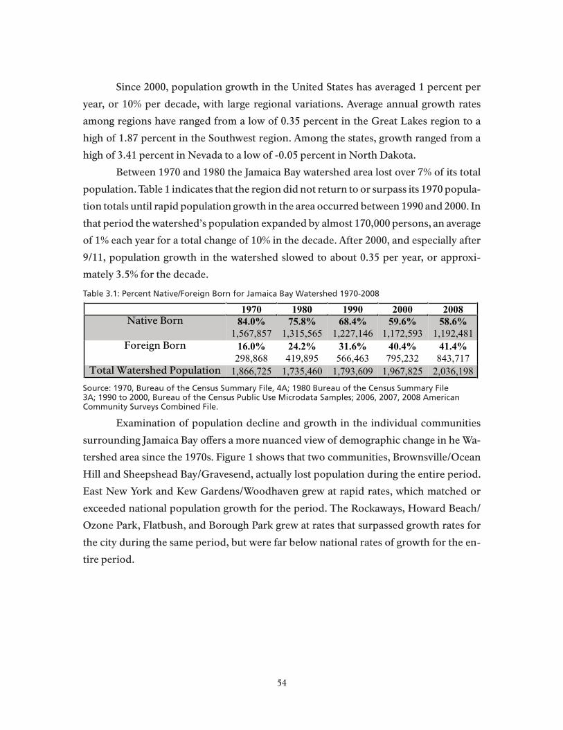
Since 2000, population growth in the United States has averaged 1 percent per
year, or 10% per decade, with large regional variations. Average annual growth rates
among regions have ranged from a low of 0.35 percent in the Great Lakes region to a
high of 1.87 percent in the Southwest region. Among the states, growth ranged from a
high of 3.41 percent in Nevada to a low of -0.05 percent in North Dakota.
Between 1970 and 1980 the Jamaica Bay watershed area lost over 7% of its total
population. Table 1 indicates that the region did not return to or surpass its 1970 popula-
tion totals until rapid population growth in the area occurred between 1990 and 2000. In
that period the watershed’s population expanded by almost 170,000 persons, an average
of 1% each year for a total change of 10% in the decade. After 2000, and especially after
9/11, population growth in the watershed slowed to about 0.35 per year, or approxi-
mately 3.5% for the decade.
Table 3.1: Percent Native/Foreign Born for Jamaica Bay Watershed 1970-2008
Source: 1970, Bureau of the Census Summary File, 4A; 1980 Bureau of the Census Summary File 3A; 1990 to 2000, Bureau of the Census Public Use Microdata Samples; 2006, 2007, 2008 American Community Surveys Combined File.
Examination of population decline and growth in the individual communities
surrounding Jamaica Bay offers a more nuanced view of demographic change in he Wa-
tershed area since the 1970s. Figure 1 shows that two communities, Brownsville/Ocean
Hill and Sheepshead Bay/Gravesend, actually lost population during the entire period.
East New York and Kew Gardens/Woodhaven grew at rapid rates, which matched or
exceeded national population growth for the period. The Rockaways, Howard Beach/
Ozone Park, Flatbush, and Borough Park grew at rates that surpassed growth rates for
the city during the same period, but were far below national rates of growth for the en-
tire period.
1970 1980 1990 2000 2008
Native Born 84.0%
1,567,857
75.8%
1,315,565
68.4%
1,227,146
59.6%
1,172,593
58.6%
1,192,481
Foreign Born 16.0%
298,868
24.2%
419,895
31.6%
566,463
40.4%
795,232
41.4%
843,717
Total Watershed Population 1,866,725 1,735,460 1,793,609 1,967,825 2,036,198
54

Almost all the population growth in the Watershed region and within specific
community areas is accounted for by the arrival of new population groups through di-
rect addition of immigrants, or through the migration of immigrant groups from within
the metropolitan region. Changes in the coding of race and ethnic identies in the U.S.
Census between 1970 and 1980 make it inappropriate to include 1970 figures in the time
series because categories provided in 1970 Summary File 4A were White, Negro and
Other. Hispanics were identified in a separate question that asks if the respondent was
Spanish Speaking. It is not possible; therefore, to separate race and Hispanic ethnicity as
is possible for the 1980 Census and those since.
Figure 3.1 Jamaica Bay Watershed Population Change 1970-2008Source: 1970, Bureau of the Census Summary File, 4A; 1980 Bureau of the Census Summary File 3A; 1990 to 2000, Bureau of the Census Public Use Microdata Samples; 2006, 2007, 2008 American Community Surveys Combined File.
55

Between 1980 and 2008, the latest year for which we have census estimates (based
on the American Community Survey, U.S. Bureau of the Census), the White-Non-His-
panic population of the Jamaica Bay Watershed declined by over 313,000 persons, a de-
cline of 37%. In the past thirty years it appears that the White non-Hispanic population
of the watershed declined from almost 50% in 1980, to an estimated 26.5% in 2008. In the
same period, as shown in Figure 2, the population of Hispanics increased from 11.4% to
16.5%, while Black, non-Hispanics increased their population proportion from 36.8%
to 44.9%. And although they remain relatively small, at 8.7% in 2008, the Asian/Pacific,
non-Hispanic population, and the East Asians (heavily represented in the Other, non-
Hispanic category in Fig. 2) experienced the greatest proportional growth rates.
Race/Ethnicity 1970 1980 1990 2000 2008
White, non-Hispanic 1,369,9241
49.1%
852,674
37.3%
669,291
27.5%
541,119
26.5%
539,180Black, non-Hispanic 433,587
136.9%
640,682
43.5%
780,714
44.9%
883,091
44.9%
914,767
Asian & Pacific Island, non-Hispanic
2.2%
37,7342
4.6%
83,134
7.0%
137,896
8.7%
177,547
Other, non-Hispanic 15,6431
0.6%
10,363
0.5%
8,625
5.5%
108,929
3.4%
69,021Latino 145,493
111.5%
200,104
14.0%
251,845
15.1%
296,790
16.5%
335,683
Total Watershed Population
1,866,725 1,735,460 1,793,609 1,967,825 2,036,198
Table 3.2: Race/Ethnicity Jamaica Bay Watershed 1970-2008Source: 1970, Bureau of the Census Summary File, 4A; 1980 Bureau of the Census Summary File 3A; 1990 to 2000, Bureau of the Census Public Use Microdata Samples; 2006, 2007, 2008 American Community Surveys Combined File.
1. Does not add to 100% because Hispanics can be of any race. Racial categories provided in 1970 Summary File 4A were White, Negro, and Other. Hispanics were identified in a separate question that asks if a person was Spanish speaking.2. In 1980, the Asian and Pacific Islander category also included American Indians, Eskimos, etc.
56
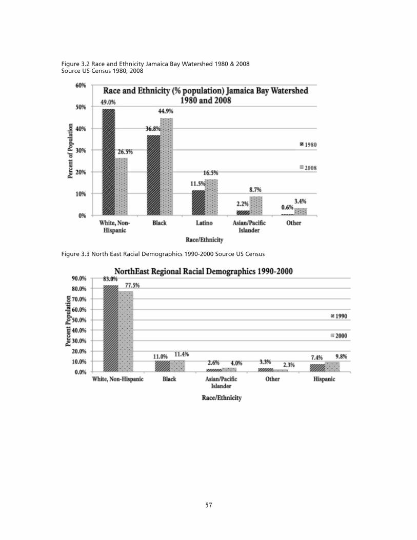
Figure 3.2 Race and Ethnicity Jamaica Bay Watershed 1980 & 2008Source US Census 1980, 2008
Figure 3.3 North East Racial Demographics 1990-2000 Source US Census
57
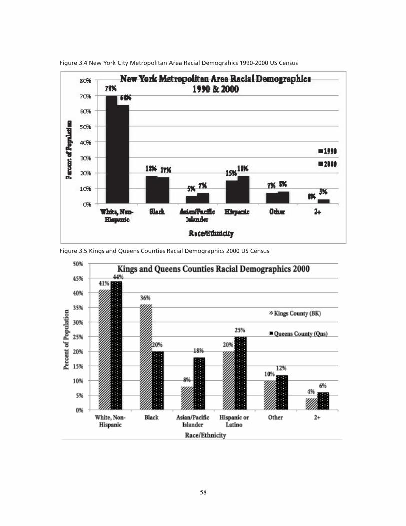
Figure 3.4 New York City Metropolitan Area Racial Demograhics 1990-2000 US Census
Figure 3.5 Kings and Queens Counties Racial Demographics 2000 US Census
58

Figures 3-5 permit one to compare recent population growth and changes in
population composition in the Jamaica Bay Watershed, to similar trends in the larger
city and the New York Metropolitan region. They demonstrate that the pace of racial
and ethnic change in the Watershed far outstrips that of either the surrounding Bor-
oughs or the city as a whole. The Watershed area is becoming home to a diverse, major-
ity-minority population faster than is true of Brooklyn, Queens, or the entire city. This
new aspect of the Watershed’s population composition is shown in more detail for each
of the Jamaica Bay PUMAS in Figures 6 and 7, which offer a comparison for each Ja-
maica Bay PUMA on race and ethnic variables between 1980 and 2008.
Figure 3.6 Jamaica Bay Watershed Racial Demographics 1980 US Census
59
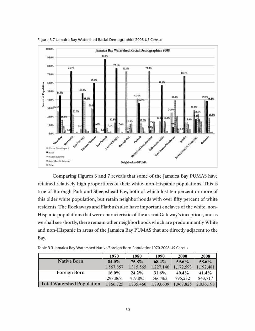
Figure 3.7 Jamaica Bay Watershed Racial Demographics 2008 US Census
Comparing Figures 6 and 7 reveals that some of the Jamaica Bay PUMAS have
retained relatively high proportions of their white, non-Hispanic populations. This is
true of Borough Park and Sheepshead Bay, both of which lost ten percent or more of
this older white population, but retain neighborhoods with over fifty percent of white
residents. The Rockaways and Flatbush also have important enclaves of the white, non-
Hispanic populations that were characteristic of the area at Gateway’s inception , and as
we shall see shortly, there remain other neighborhoods which are predominantly White
and non-Hispanic in areas of the Jamaica Bay PUMAS that are directly adjacent to the
Bay.
Table 3.3 Jamaica Bay Watershed Native/Foreign Born Population1970-2008 US Census
1970 1980 1990 2000 2008
Native Born 84.0%
1,567,857
75.8%
1,315,565
68.4%
1,227,146
59.6%
1,172,593
58.6%
1,192,481
Foreign Born 16.0%
298,868
24.2%
419,895
31.6%
566,463
40.4%
795,232
41.4%
843,717
Total Watershed Population 1,866,725 1,735,460 1,793,609 1,967,825 2,036,198
60

Figure 3.8 Jamaica Bay Watershed Native Born Population 1970 & 2008 US Census
Foreign bornThe foreign born, both immigrants and naturalized citizens, as noted earlier,
account for much of the demographic transformation of the Jamaica Bay Watershed
catchment area.
61

Figure 3.9 Growth in Jamaica Bay Foreign Born Population 2000-2008 Center For Urban Research
Table 3 (see above) shows that throughout the Jamaica Bay communities the per-
cent of native born residents declined from over 80% in the 1970s to below 60% by 2008.
The Rockaways, where the percent native born declined from 86% in 1970 to 75% (see
detailed tables, appended) is not an exception to this trend, but, along with Brownsville/
Ocean Hill among the Jamaica Bay communities, it is a community area where the in-mi-
gration of new immigrant groups is less important in determining population composi-
tion than are population aging and replacement by households of roughly similar ethnic
and racial characteristics. Figure 9 graphically compares the growth of the foreign born
populations in each of the Jamaica Bay PUMAS. In this spatial mapping of growth in the
foreign born population of the Watershed area, the greatest increases are visible in those
community areas (PUMAS) adjacent to the Bay itself, with the relative exception of the
Rockaways.
62
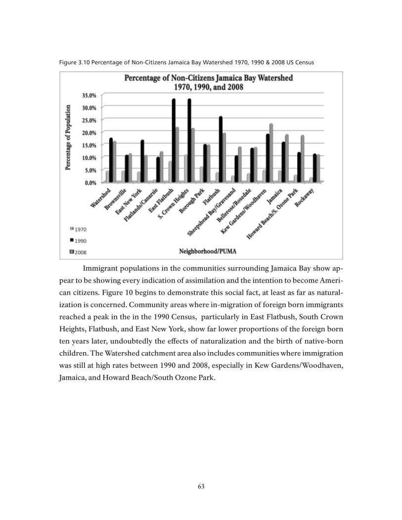
Figure 3.10 Percentage of Non-Citizens Jamaica Bay Watershed 1970, 1990 & 2008 US Census
Immigrant populations in the communities surrounding Jamaica Bay show ap-
pear to be showing every indication of assimilation and the intention to become Ameri-
can citizens. Figure 10 begins to demonstrate this social fact, at least as far as natural-
ization is concerned. Community areas where in-migration of foreign born immigrants
reached a peak in the in the 1990 Census, particularly in East Flatbush, South Crown
Heights, Flatbush, and East New York, show far lower proportions of the foreign born
ten years later, undoubtedly the effects of naturalization and the birth of native-born
children. The Watershed catchment area also includes communities where immigration
was still at high rates between 1990 and 2008, especially in Kew Gardens/Woodhaven,
Jamaica, and Howard Beach/South Ozone Park.
63

Table 3.4: Educational Attainment for Persons 25 years + in Jamaica Bay Watershed 1970-2008Source US Census
Table 3.5: % with College Degree by Neighborhood in Jamaica Bay Watershed 1970, 2008
Educational Attainment Educational attainment for the Watershed catchment area is another outstand-
ing aspect of demographic change since the 1970s. When Gateway came in to existence
there were far fewer area residents who had completed college or gone beyond in their
educations than there are today. Educational attainment, as measured by the proportion
of adult populations who have reached various educational levels, is roughly three times
higher than it was in 1970. This advance is relative among the Jamaica Bay communities,
Educational Attainment 1970 1980 1990 2000 2008
Less than HS 31.0%
578,233
23.5%
408,516
20.0%
358,831
17.3%
340,432
20.0%
256,608
HS Graduate 18.6%
347,839
21.5%
373,291
19.8%
354,992
18.3%
360,034
34.0%
435,726
Some College 4.7%
88,449
8.0%
138,117
14.0%
251,657
14.7%
290,159
22.6%
291,165BA Degree + 7.8%
85,676
11.9%
125,123
15.4%
175,643
19.2%
234,259
23.5%
301,478
Total Population >25 1,100,187 1,045,047 1,141,123 1,225,214 1,284977
Neighborhood 1970 2008
Entire Watershed N/A 23.5%
Brownsville 1.4% 10.1%
East New York 2.7% 13.7%
Flatlands/Canarsie 7.8% 28.4%
East Flatbush 7.3% 18.7%
South Crown Heights 9.4% 20.3%
Borough Park 7.7% 24.9%
Flatbush 14.6% 30.2%
Sheepshead Bay 9.5% 36.2%
Bellerose/Rosedale 8.3% 28.8%
Woodhaven/Kew Gardens 7.8% 24.3%
Jamaica 6.7% 18.2%
Howard Beach/S. Ozone Park 5.1% 16.9%
Rockaway 9.7% 25.3%
64
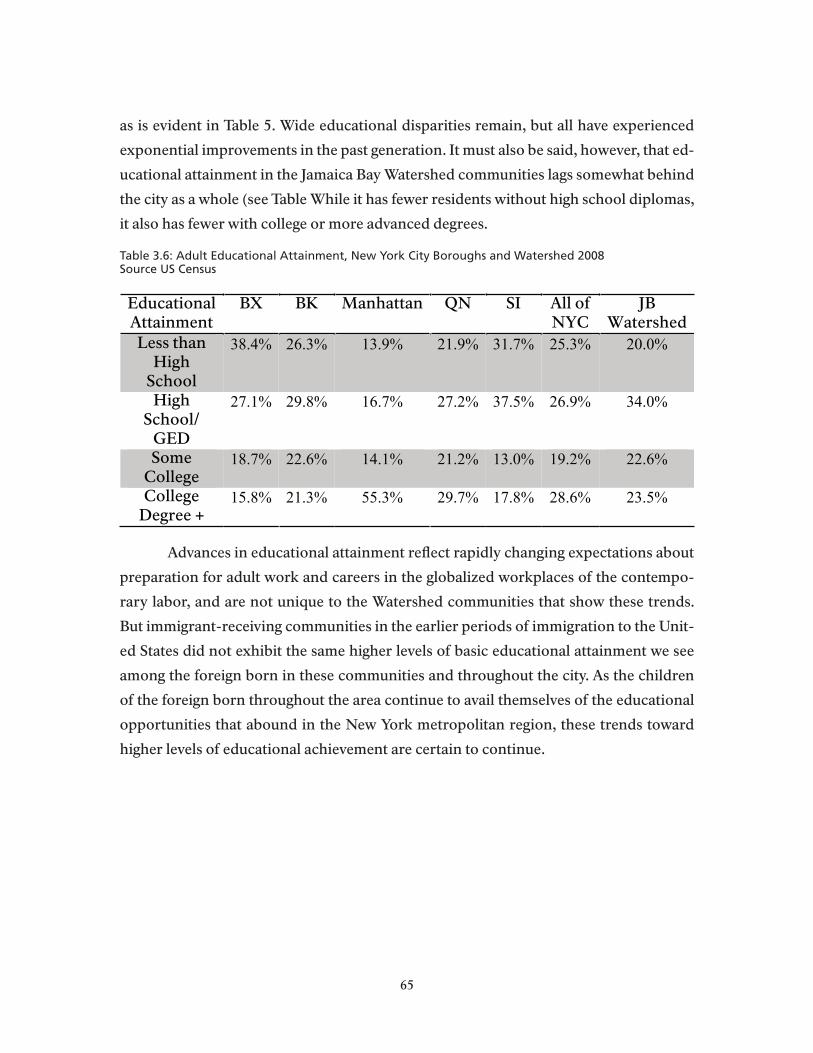
as is evident in Table 5. Wide educational disparities remain, but all have experienced
exponential improvements in the past generation. It must also be said, however, that ed-
ucational attainment in the Jamaica Bay Watershed communities lags somewhat behind
the city as a whole (see Table While it has fewer residents without high school diplomas,
it also has fewer with college or more advanced degrees.
Table 3.6: Adult Educational Attainment, New York City Boroughs and Watershed 2008Source US Census
Advances in educational attainment reflect rapidly changing expectations about
preparation for adult work and careers in the globalized workplaces of the contempo-
rary labor, and are not unique to the Watershed communities that show these trends.
But immigrant-receiving communities in the earlier periods of immigration to the Unit-
ed States did not exhibit the same higher levels of basic educational attainment we see
among the foreign born in these communities and throughout the city. As the children
of the foreign born throughout the area continue to avail themselves of the educational
opportunities that abound in the New York metropolitan region, these trends toward
higher levels of educational achievement are certain to continue.
Table 6: Adult Educational Attainment, New York City Boroughs and Watershed 2008
EducationalAttainment
BX BK Manhattan QN SI All of NYC
JBWatershed
Less than High
School
38.4% 26.3% 13.9% 21.9% 31.7% 25.3% 20.0%
HighSchool/
GED
27.1% 29.8% 16.7% 27.2% 37.5% 26.9% 34.0%
SomeCollege
18.7% 22.6% 14.1% 21.2% 13.0% 19.2% 22.6%
CollegeDegree +
15.8% 21.3% 55.3% 29.7% 17.8% 28.6% 23.5%
65

Table 3.7: Age Distribution of Jamaica Bay Watershed 1970 – 2008Source US Census
Census figures on the age distribution of Jamaica Bay watershed area residents
over the past forty years show remarkable stability when one considers the fact that
much of the actual change in the population we have been discussing is due to the effects
of aging among residents of area households. The proportion of persons over the age
of 65, for example, in 1970 was 11.6% and in 2008 was essentially unchanged at 11.8%.
Offsetting demographic effects, however, creates this seeming stability, as the older set-
tlers, largely of white, European origins, are replaced by families of more recent im-
migrant origins, often with young children. Figure 11, allows one to examine these ef-
fects in the specific Jamaica Bay communities where they are occurring, as measured
by changes in the proportion of persons in households who are below the age of 16. In
Brownsville/Ocean Hill, we see that the population of school age children declines quite
sharply after the 1970s, but remains higher than most others throughout the entire pe-
Table 7: Age Distribution of Jamaica Bay Watershed 1970 – 2008 (US Census)
Age 1970 1980 1990 2000 2008
Total Population
of Watershed
1,872,119 1,735,460 1,793,609 1,967,825 2,036,198
Under 4 years 8.0% 7.3% 7.5% 7.4% 7.6%
148,891 126,720 134,541 145,685 154,607
5-13 years 15.4% 13.4% 13.0% 14.2% 12.6%
287,630 232,044 233,345 279,563 256,586
14-17 years 6.9% 7.2% 5.7% 6.1% 6.3%
130,008 125,276 102,294 120,199 127,551
18-24 years 11.0% 11.9% 10.2% 10.0% 10.4%
205,393 206,373 182,306 197,494 212,478
25-34 years 12.0% 15.5% 16.9% 13.9% 12.2%
224,263 268,264 302,624 273,922 249,295
35-64 years 35.2% 32.5% 34.1% 36.9% 39.1%
658,293 563,947 612,172 726,945 795,227
65 years + 11.6% 12.3% 12.6% 11.4% 11.8%
217,641 212,836 226,327 224,017 240,454
66

riod. In Borough Park, where large families among the orthodox Jewish population are
the norm, and newcomers also have a disproportionate number of families with young
children, we see a net increase in the proportion of school-age children over the period.
The Rockaways and Woodhaven/Kew Gardens are examples in the watershed region of
communities where apparent stability represents the offsetting effects of population ag-
ing and in-migration of families with school-age children.
Figure 3.11 Percentage of Jamaica Bay Watershed Under 16 1970-2008 US Census
Employment and household economic status figures for the Watershed area also
appear somewhat anomalous. Tables 8 and 9, show that while there were relatively more
people employed in the labor force in 2008, compared to 1970, the proportion of per-
sons living in households earning below the poverty level has doubled (from 8.5% in
1970 to 17.5% in 2008). Given the effects of the severe recession that began in 2008, it is
almost certain that the poverty rates will be higher when results of the 2010 census are
available. In Table 10, the differences in economic well-being among the residents of
different watershed communities is quite evident. This table does not include figures for
the 1970 census because it is quite difficult to recreate PUMA boundaries for that census
period, so that while we do include 1970 poverty estimates for the entire watershed area,
it is more accurate to begin the series for PUMAS with 1980 data, as is done in Table 10.
The more detailed figures in Table 10 demonstrate that poverty rates differ quite mark-
67
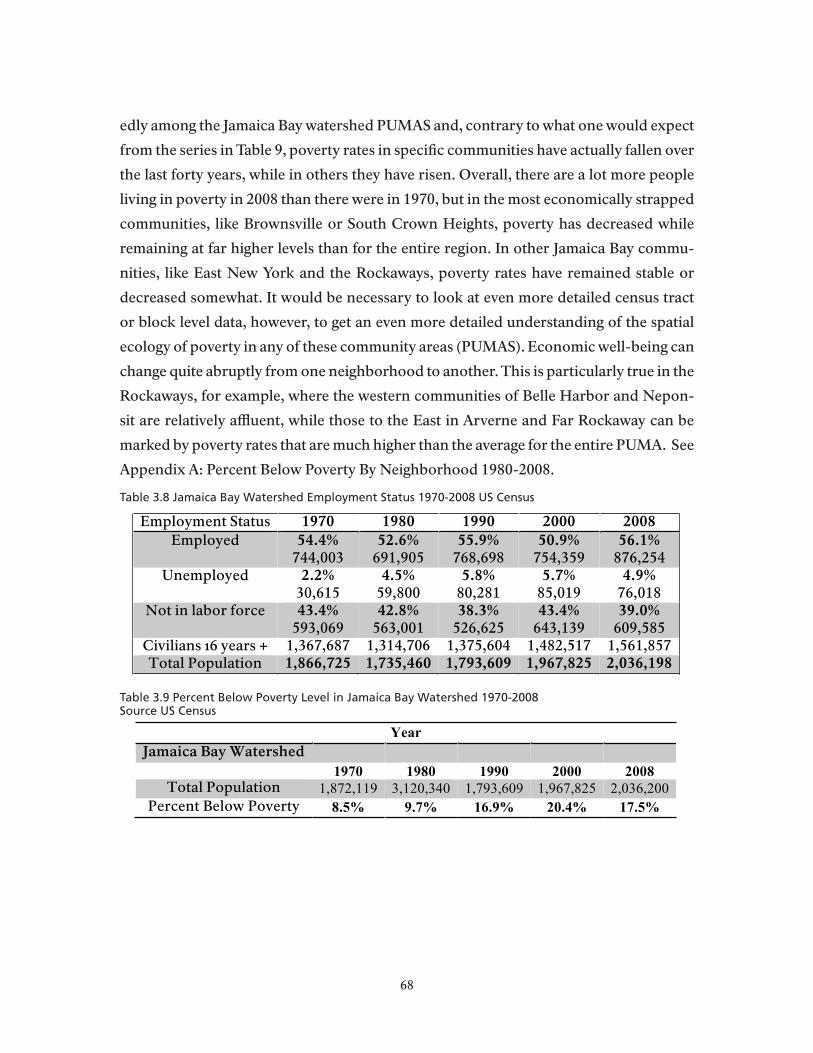
edly among the Jamaica Bay watershed PUMAS and, contrary to what one would expect
from the series in Table 9, poverty rates in specific communities have actually fallen over
the last forty years, while in others they have risen. Overall, there are a lot more people
living in poverty in 2008 than there were in 1970, but in the most economically strapped
communities, like Brownsville or South Crown Heights, poverty has decreased while
remaining at far higher levels than for the entire region. In other Jamaica Bay commu-
nities, like East New York and the Rockaways, poverty rates have remained stable or
decreased somewhat. It would be necessary to look at even more detailed census tract
or block level data, however, to get an even more detailed understanding of the spatial
ecology of poverty in any of these community areas (PUMAS). Economic well-being can
change quite abruptly from one neighborhood to another. This is particularly true in the
Rockaways, for example, where the western communities of Belle Harbor and Nepon-
sit are relatively affluent, while those to the East in Arverne and Far Rockaway can be
marked by poverty rates that are much higher than the average for the entire PUMA. See
Appendix A: Percent Below Poverty By Neighborhood 1980-2008.
Table 3.8 Jamaica Bay Watershed Employment Status 1970-2008 US Census
Table 3.9 Percent Below Poverty Level in Jamaica Bay Watershed 1970-2008Source US Census
Employment Status 1970 1980 1990 2000 2008Employed 54.4%
744,00352.6%691,905
55.9%768,698
50.9%754,359
56.1%876,254
Unemployed 2.2%30,615
4.5%59,800
5.8%80,281
5.7%85,019
4.9%76,018
Not in labor force 43.4%593,069
42.8%563,001
38.3%526,625
43.4%643,139
39.0%609,585
Civilians 16 years + 1,367,687 1,314,706 1,375,604 1,482,517 1,561,857Total Population 1,866,725 1,735,460 1,793,609 1,967,825 2,036,198
Year
Jamaica Bay Watershed1970 1980 1990 2000 2008
Total Population 1,872,119 3,120,340 1,793,609 1,967,825 2,036,200
Percent Below Poverty 8.5% 9.7% 16.9% 20.4% 17.5%
68

Ethnicity and Change in the Neighborhoods Bordering on Gateway
BoundariesSubstantial increases in the populations of people coming from the Caribbean
islands, from Central and South America, and from Asia are transforming the commu-
nities in the Watershed area into areas of first immigrant settlement. We saw earlier that
by 2008, about forty percent of residents in the area were immigrants, either foreign-
born naturalized citizens (24.%), or foreign-born immigrants who were not yet citizens
(16%), and that the areas of most rapid growth of the foreign born are in the Commu-
nity Districts immediately adjacent to Jamaica Bay. The more detailed series of digital
maps, compiled at the census tract level within PUMAS, show in even more detail that
the neighborhoods directly adjacent to Jamaica Bay, notably Howard Beach, Canarsie,
Starrett City and those of south Jamaica, are losing their older populations of people of
European ethnicity and gaining households from the West Indies, Central and South
America, and Asia.
Table 10 provides more recent census estimates about which national-origin
groups are gaining and losing population in the Watershed. It is certain from this break-
down that groups practicing religious rituals in and around the waters of Jamaica Bay,
notably Hindu practitioners of Guyanese and East Asian descent, people of African ori-
gins who follow various forms of Youraba-based religious rituals – especially Haitians,
Nigerians, Dominicans and other Caribbean groups, and Jewish populations, whose
numbers are continually supplemented by immigration from countries of the former
Soviet Union and the Middle East, are those whose religious rituals are most closely as-
sociated with the ceremonial uses of Bay resources.
The digital maps appended to this chapter also indicate that there remain sig-
nificant populations of people who trace their origins to the waves of immigration that
settled around Jamaica Bay earlier in the twentieth century and which dominated the
Watershed’s population when Gateway was created in the early 1970s. Gerrittsen and
Bergen Beaches, Hamilton Beach, Broad Channel, and Meadowmere Park retain to
varying degrees their character as largely white enclaves where residential populations
of European ethnic origins live along the water’s edge and often maintain fishing boats
that ply the waters of Jamaica Bay.
69
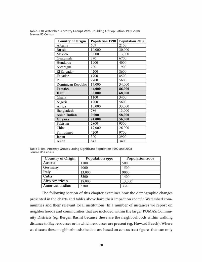
Table 3.10 Watershed Ancestry Groups With Doubling Of Popluation 1990-2008Source US Census
Table 3.10a. Ancestry Groups Losing Significant Population 1990 and 2008Source US Census
The following section of this chapter examines how the demographic changes
presented in the charts and tables above have their impact on specific Watershed com-
munities and their relevant local institutions. In a number of instances we report on
neighborhoods and communities that are included within the larger PUMAS/Commu-
nity Districts (eg. Bergen Basin) because these are the neighborhoods within walking
distance to Bay resources or in which resources are present (eg. Howard Beach). Where
we discuss these neighborhoods the data are based on census tract figures that can only
Country of Origin Population 1990 Population 2008
Albania 609 2100
Russia 10,000 30,000
Mexico 3,000 13,000
Guatemala 370 6700
Honduras 1900 4000
Nicaragua 700 1900
El Salvador 4200 8600
Ecuador 1700 8500
Peru 2700 5600
Dominican Republic 17,000 34,000
Jamaica 44,000 86,000
Haiti 38,000 68,000
Ghana 1100 3400
Nigeria 1200 5600
Africa 10,000 33,000
Bangladesh 786 13,000
Asian Indian 9,000 58,000
Guyana 24,000 56,000
Pakistan 2800 9500
China 17,000 26,000
Philippines 4200 9700
Japan 300 2900
Asian 847 3400
Country of Origin Population 1990 Population 2008Austria 1100 500
Germany 4000 1500
Italy 13,000 9000
Cuba 3300 1400
Afro American 18,000 13,000
American Indian 3700 334
70

be reported on for the 2000 census and will not be available for 2010 for at least another
year while the 2010 census is cleaned, analyzed, and tapes made available for public use.
Appendix [TBD] includes a series of interactive digital maps of the racial and ethnic
change at the census tract level (from the 2000 Census) that provide spatial confirmation
of the trends discussed above. These maps allow the viewer to zoom in on specific areas
of the Watershed to examine the spatial distribution of racial and ethnic populations as
defined in the Census categories at the census tract level.
Canarsie: In the 1970s, Canarsie was a predominately Jewish and Italian-Ameri-
can lower middle-income residential neighborhood with a small, but growing, commer-
cial and industrial center (NPS GMP 1979). It’s minority population lived in integrated
public housing projects that, as noted in Chapter 2, were built to accommodate returning
military personnel and their families after World War II. Although a once thriving fish-
ing community and waterfront resort, the Canarsie waterfront suffered from economic
disinvestment and the blight associated with pollution and garbage from nearby Penn-
sylvania and Flatlands Avenue landfills. According to the 1979 GMP, the population of
Canarsie in 1970 was 84.4%White, 14.9% Black, and .6% Other non-White (NPS 1979:
69). By 2008 the community was 29.8White, 59.7% non-Hispanic Black, 6.8% Hispanic,
and 2.6% Asian.
Since the 1970s, Canarsie has witnessed significant social and demographic tran-
sition. The NYC DEP closed the Pennsylvania and Flatland Avenue landfills and trans-
ferred them to the NPS in the early-mid 1980s. Currently, the landfills are undergoing
transition to parkland. The neighborhood continues to be a largely residential neigh-
borhood, with commercial and industrial development concentrated along the main
thoroughfare of Rockaway Parkway.
The neighborhood has a significant foreign-born population (37%), with many
hailing from the Caribbean. Twenty-two percent of the foreign-born population in Ca-
narsie is Jamaican, 17.3% Haitian, and 7.5% are Guyanese. Demographic change in the
community has had perhaps its strongest impact on the Jewish population and its local
institutions, as clearly stated in this 2004 article by Schlomo Greenwald in the Canarsie
Courier (http://www.canarsiecourier.com/news/2004-12-23/Religion/093.html)
Canarsie is one of the oldest Jewish communities in New York. Jews began populating the area before World War II when only three synagogues existed. In the 1950s, the neighborhood started to grow, with many Jewish refugees who survived the Holocaust. In no time
71

there were eight Orthodox synagogues, two non-Orthodox temples, several yeshivas, and at least five smaller shtiebles (Orthodox, but more informal, synagogues.)
“There were at least 15 shuls,” said Rabbi Jacob Jungreis, “and they were all jammed pack. You couldn’t get a seat.” Rabbi Jungreis comes from a family that once was considered something of a dynasty in Canarsie. He, his father and his brother each had a synagogue in the community — all of which were associated with their yeshiva, Ateres Yisroel. The three synagogues have since closed, and the yeshiva, which was once bustling with students from the area, now relies on students bused in from other neighborhoods to fill its classrooms.
Canarsie’s primary waterfront access is from Canarsie Pier, which jets out into
Jamaica Bay at the end of Rockaway Parkway. The Pier consists of a large parking lot,
benches and tables lining the edge of the pier, and a picnic area that is adjacent to the
pier and the beach. Visitors use Canarsie Pier for fishing, picnicking, and passive recre-
ation, such as sitting on the beach. Additionally, information from a NPS Ethnographic
Needs Assessment (1995), participant observations, and anecdotal evidence suggests
that nearby Jewish populations, particularly Conservative and Orthodox groups, occa-
sionally use Canarsie Pier and surrounding beaches for religious ceremonies, particu-
larly in the fall during the High Holiday period from Rosh Hashanah to Yom Kippur.
Given Canarsie’s changing neighborhood dynamic – particularly the declining Jewish
population – it is not surprising that our interviews and observations indicate that use
of the area by Jewish congregations has declined and that there appear to be more uses
made of the area by Santeria practitioners.
East New York and Spring Creek: From the 1920s to the early 1960s, East New York
was a predominately blue-collar, residential neighborhood of Irish, Italian, and Jewish
populations. According to the NPS Environmental Impact Assessment (1976), Spring
Creek had a population of 15,282 (the second highest in the Brooklyn portion of the
catchment area behind Sheepshead Bay), of which 68.3% were White, 30.1% were
Black, and .9% “Other.” Similar to other urban centers during the 1960s and 1970s,
East New York suffered from economic disinvestment, racist real estate practices, and
rapid White flight from the neighborhood as increasing numbers of Blacks and Latinos
moved in. As a result, the neighborhood experienced overcrowding, high crime rates,
high unemployment, and widespread social unrest and instability.
The collective efforts of local churches, community groups, homeowner associa-
72

tions, and activist groups during the late 1970s and 1980s brought improvements to the
neighborhood, most notably the construction and rehabilitation of its housing stock.
Local congregations facilitated the development of over a thousand Nehemiah Houses,
a set of pre-fabricated two-story row houses. Despite the housing improvements, over-
crowding continued to be a problem and drugs and violence permeated neighborhood
streets. In 1991, the neighborhood had the highest homicide rate of any precinct in the
city. Since the 1990s, local activists and community organizations have built extensive
community gardens, bringing fresh produce to a traditionally underserved population.
Additionally, community-policing programs have reduced crime and drug-use in the
neighborhood.
Today, the neighborhood continues to be a predominately poor, minority com-
munity, with 29% of the population living below the poverty level. Almost thirty percent
of the population in East New York is foreign-born, many from the Dominican Republic
(23%), Jamaica (15%), Guyana (10.5%), Haiti (4.2%), and Trinidad and Tobago (8.3%),
as well as Latin American countries. According to Census 2000, the census tracts clos-
est to Jamaica Bay are now 25% White, 62% Black, 2.6% Asian, 7.1% “Other,” and 16.7%
Hispanic.
Although in close proximity to Jamaica Bay and Gateway National Recreation
Area, the Belt Parkway, former landfills, and city buildings impede direct access to Ja-
maica Bay and GNRA for the East New York and Spring Creek neighborhoods.
Mill Basin and Bergen Beach: Early in the 20th century, Mill Basin served as an indus-
trial center. The tidal action of the basin was used to grind grain and operate mills. A lack
of transportation to connect Mill Basin with the rest of Brooklyn led to its demise as an
industrial center. Instead, after World War II, large companies, among them Atlantic,
Gulf, and Pacific, sold their property and the area became primarily residential.
In the 1970s, Mill Basin and Bergen Beach were white (Eastern European, Irish,
and Italian), middle-income residential neighborhoods, with a significant portion of the
population owning their own boats and docks (NPS 1979: 70). In 1970, the racial demo-
graphics for both Mill Basin and Bergen Beach were 99.3% White, .3% Black and .3%
“Other non-White” (NPS 1979: 69).
In 1990, the census tracts immediately adjacent to Jamaica Bay continued to be
predominately White (97%), with only .2% Black, 2.2% Asian, and 2.7% Hispanic. From
1990 to 2000, the adjacent census tracts in Mill Basin and Bergen Beach experienced
73
population growth of 8.6% (the fourth highest rate of growth in the catchment area).
According to Census 2000, residents in the adjacent Mill Basin and Bergen Beach census
tracts remained 91% White, with a growing Black population (4.6%), and Hispanic pop-
ulation (6.8%). The two neighborhoods have large Italian-American and Jewish popula-
tions as well as a smaller Irish population in Mill Basin. Anecdotal evidence suggests that
members of Mill Basin’s Jewish population (1.5% of the neighborhood’s foreign-born
population is from Israel) might also use the nearby Bay for religious ceremonies similar
to those taking place at Canarsie Pier.
Mill Basin is known as an upper-middle class neighborhood with large homes,
waterfront property, and good schools. The presence of over 200 private docks, the Ber-
gen Beach Yacht Club, and the Mill Basin Marina indicate the popularity of boating in
the neighborhood. In addition to it bulk headed, waterfront properties, the neighbor-
hood is known for attracting new residents because of its schools, particularly PS 312
and 236, both of which rank in the top 3 percent of city schools. Commercial develop-
ment is concentrated along Ralph Avenue and Avenues N, T, and U, with Kings Plaza
Shopping Center located on the neighborhood’s edge of Flatbush Avenue and Avenue
U.
Bergen Beach and Floyd Bennett Field, particularly Dead Horse Bay and the
northeast beach (closest to the boat launch and camping facilities), are occasional sites
for religious ceremonies. Specifically, Santeros, Tamil Hindus, and “Voodoo Practitio-
ners” use Bergen Beach for animal or non-animal offerings and healing ceremonies.
While Hassidic Jews, Paleros, Santeros, and “Voodoo Practitioners” have been known
to use Floyd Bennett Field for animal or non-animal offerings, harvesting and gathering,
and for other religious celebrations.
Gerritsen Beach and Sheepshead Bay: Gerritsen Beach is a relatively isolated com-
munity surrounded by Shell Bank Creek and Gerritsen Creek on the sides and Plumb
Beach to the South. In the 1970s, Gerritsen Beach was a predominately White, Irish
and Italian American, middle-income residential community characterized by densely
packed summer bungalows that had been converted to year round housing (NPS 1979:
70). According to the 1970 Census, Gerritsen Beach was 99.5% White, .1% Black, and
.3% Other, non-White (NPS 1979: 69). Sheepshead Bay was 99.2% White, .3% Black, and
.4% Other, non-White (NPS 1979: 69).
In 1990, Gerritsen Beach had a White population of 97.6%, with no notable Black
74
population, a growing Asian population (1.8%), and an increasing Hispanic population
(3.6%). From 1990 to 2000, Gerritsen Beach grew by 3.3% (one of the lowest rates of
growth in the catchment area, second only to Howard Beach). Today, Gerritsen Beach
continues to be predominately Irish, and many express a sense of community in the
neighborhood and “ownership” over the natural resources, particularly the creek. Ger-
ritsen Beach is home to Kiddie Beach, a private beach for members of the Property Own-
ers Association. At a recent Gerritsen Beach boat race, community members stated that
Gerritsen Beach was one of the “best kept secrets in New York” and that they “wanted
to keep it that way.”
Sheepshead Bay was once a thriving fishing community with fishing boats lining
Emmons Avenue adjacent to numerous bait and fish shops. Although the charter fishing
fleet continues to operate, at reduced numbers, from Sheepshead Bay, the commercial
fishing industry has largely declined, as has recreational fishing other than on the head
boats. One bait shop remains to service the community, which is now largely a middle-
class residential community..
The Sheepshead Bay census tracts adjacent to Jamaica Bay remained primarily
White (91.9%) in 1990; however, the Black population grew to 3.9%, the Asian to 2.8%,
and the Hispanic population to 5.3%. From 1990 to 2000, Sheepshead Bay’s total popu-
lation grew by 5.0%. In 2000, the White population in the census tracts adjacent to Ja-
maica Bay had declined to 84.5%, with the Black population rising to 5.3%, the Asian to
6%, and the Hispanic population to 6.8%.
There are a number of immigrant communities in Sheepshead Bay, with 58% of
the population being foreign-born. While Russians predominate in the neighborhood
(21% of the foreign-born population in 2000), a number of Orthodox Jews, and Italians
live in the area, and there is a bourgeoning Asian community around Avenue U.
Earlier studies indicate that Santeros, Tamil Hindus, and “Voodoo practitioners”
used Plumb Beach for animal or non-animal offerings and healing ceremonies. Addi-
tionally, Plumb Beach was once a popular site for homosexual activity. A March 2010
article in the NY Post reported that the Park Police arrested a number of individuals for
illicit sexual activity at the Beach, indicating the continued use of the site for these pur-
poses. Interviews with Gateway staff and with local residents indicate that religious uses
of Plum Beach may continue intermittently but appear to have declined over the past
twenty years.
75

Howard Beach (Hamilton Beach, Ramblersville, Old Howard Beach): Within the larg-
er Howard Beach/Ozone Park community area, Howard Beach was once a thriving fish-
ing and boating community and, during the 1950s and 1960s, one of the most rapidly
growing neighborhoods in Queens (NPS 1979: 69). In the 1970s, the neighborhood was
predominately White, with a large Italian, Irish, and Jewish population.
In 1990, 95.3% of the population was White, with 1.1% Black, 2.1% Asian, and
5.9% Hispanic. The total population of the census tracts nearest Jamaica Bay grew 2.5%
between 1990 and 2000, the lowest growth rate of any community within the catchment
area. Today Howard Beach continues to be a predominately White (92.5%), largely Ital-
ian (46%) residential community, with a small, but growing minority population. In
2000, 1.0% of the population was Black, but 2.8% of the population was Asian and the
Hispanic population had increased 70% to 9.8% of the population.
The main commercial thoroughfare of Cross Bay Boulevard separates Howard
Beach from the smaller neighborhoods of Old Howard Beach, Hamilton Beach and
Ramblersville. These early bay settlement areas are nestled between Shellbank Basin
and John F. Kennedy Airport, with a series of canals and creeks cutting through the mid-
dle. Wooden boardwalks connect the houses, many of which are small bungalows built
on stilts with docks and small boats.
Frank M. Charles Memorial Park borders Jamaica Bay and sits at the southern
tip of Howard Beach. The park contains five tennis courts, three baseball fields, a hand-
ball and basketball court, a bocce court, a playground, and some benches and picnicking
facilities. Primarily near-by residents, many of which are Italian, use the park as a space
for recreation and relaxation. Bocce is traditionally an Italian recreational activity that
serves to reinforce ethnic identities. On a warm summer weekday, 50 to 75 people typi-
cally frequent the park and avail themselves of various park facilities.
Just over the footbridge that crosses a small canal, Hamilton Beach Park consists
of a small playground, a baseball field, and some beach access. The park runs up against
the A-train subway trestle that crosses the Bay and people use the park beach for subsis-
tence fishing.
The North Channel Bridge, also known as the Joseph P. Addabbo Memorial
Bridge, runs south from Howard Beach, over the Grassy Bay portion of Jamaica Bay,
to Broad Channel. People park on either side of the bridge (although only the south-
ern edge has official parking) to fish, either from the bridge, or down below the bridge.
76
Conversations with NPS rangers and people fishing from the bridge indicate that most
of them fish for subsistence. A recent New York Times article described the fishing prac-
tices of a group of Bengali immigrants who fish spearing for subsistence from the North
Channel Bridge parking lot. Locally, spearing is commonly used as a baitfish. However,
this group prefers to stir-fry the small fish in curry and other spices, enjoying it with
rice. When asked about eating a baitfish, one man stated, “We like it. This is like, you
know, our culture.” A Dominican fisher described his process of pan roasting the fish
he catches – mainly blue fish – in a wine sauce with herbs before eating. In addition to
fishing, people stop-off in the southern parking lot for picturesque views of the Bay and
to watch planes take off from nearby JFK airport.
The North Channel Bridge is also a popular site for Tamil Hindu religious cer-
emonies. Water plays an important part in the Hindu faith, symbolizing purity, the giver
of life, and the destroyer of evil. Water is essential for attaining purity and avoiding pol-
lution, both physically and spiritually. Physical and spiritual purity allow the individual
to focus on worship.
There are over 50,000 Indo-Caribbean in New York City, most coming from Guy-
ana, Trinidad and Tobago, and Jamaica. Indo-Caribbean Hindus began migrating in large
numbers to the United States in the 1970s and 1980s to escape political strife in Guyana
and after the collapse of the oil industry in Trinidad. Liberty Avenue in Richmond Hill,
roughly 8 miles from Jamaica Bay, is known as “Little Guyana” and is the center of the
Guyanese Hindu community in New York. According to Census 2000, 36% of Richmond
Hill’s foreign-born (zip code 11418) are Guyanese and 7.6% are from India.
The local Hindu population has worshiped at the North Channel Bridge for
at least two decades. Use of the Bay is especially important in Hindu birth, wedding,
and funeral ceremonies. Hindus make offerings to deceased souls for 10 days following
death, citing their belief that because humans come from the elements of earth, it is nec-
essary, in death, to return to the earth. As such, placing ashes in the water is an important
component of their cultural beliefs.
During regular Hindu prayer services, known as pujas, individuals make offer-
ings to the beach and to the water because they are living beings that deserve respect.
Offerings placed in the water include rice, cloth, flowers, fruits, statues, and other de-
sirables; each object contains symbolic significance, e.g., flowers offered symbolize the
good things to blossom. Puja residuals often wash up on the shore underneath the bridge
77
and on the beach of Frank M. Charles Memorial Park. Initial research indicates that
members of surrounding communities, local fishers, and environmental groups have
expressed concern and responded unfavorably to the remnants of the ceremonies and,
at times, to the people and the ceremonies themselves, resulting in user conflict over this
space. The Chair of Community Board 10 feels that cultural education about the Park’s
regulations would balance the concerns of local citizens and ensures that the Hindu
community could exercise their religious rights (Personal communication March 2010).
NPS employees are working with nearby Hindu communities to educate them about the
prohibitions against leaving materials behind in national parks and about the ecologi-
cal effects of such materials on the Bay. A sign stating “Leave No Trace” and describing
National Park sanitation policies sits at the base of the North Channel Bridge.
Conversations with community members and NPS rangers indicate that the
Hindu community is struggling to reconcile the interpretation of religious doctrine with
the laws and regulations of their new homeland as well as with a growing environmental
awareness. There is disagreement within the Hindu community over the need to leave
puja offerings behind. A few Hindu leaders, who are working closely with the NPS, argue
that there is no need to leave puja materials behind and point to scripture as the basis for
their argument. Others in the community do not feel this is an accurate interpretation
of scripture and are leery of breaking with tradition and rebuking authority. We discuss
these issues in greater detail in Chapter 5 of this report.
Ozone Park: Ozone Park and South Ozone Park developed in the early 1900s as Italian,
Irish, and German working-class neighborhoods. In 1990, the census tracts nearest Ja-
maica Bay were 89.9% White, 1.5% Black, 3.9% Asian, and 12.6% Hispanic. From 1990 to
2000, the census tracts nearest Jamaica Bay experienced population growth of 28%, the
second highest rate of growth in the catchment area. In 2000, the census tracts nearest
Jamaica Bay had changed to 60% White, 3.0% Black, 11.3% Asian, and 28.7% Hispanic
(an increase of 191%). In the adjacent census tracts, 40% of the population is foreign-
born, with 27% of that population coming from Guyana and 10% of that population
coming from the Dominican Republic. A significant Italian presence remains in Ozone
Park and there are a number of Italian-American businesses along 101st Avenue, a main
commercial thoroughfare.
South Ozone Park is primarily a residential neighborhood with the exception
of the Aqueduct Race Track and nearby John F. Kennedy Airport. In 1990, the census
78

tracts nearest Jamaica Bay were 57% White, 26.1% Black, 7.5% Asian, 8.5% “Other,” and
22.1% Hispanic. From 1990 to 2000, the total population in the census tracts adjacent
to Jamaica Bay grew by 27%, the third highest growth rate in the catchment area. Since
1990, the adjacent census tracts changed significantly, with a White population of 28.2%,
a Black population of 24%, an Asian population of 14.6%, a population of 17.7% claim-
ing “Other,” and a Hispanic population of 25.6%. South Ozone Park is also home to a
large foreign-born population (38%), of which 35.4% are Guyanese, 9.7% Jamaica, 6.1%
Dominican, and 4.6% Haitian.
The Airport provides a number of residents with jobs but also serves as a major
source of air pollution. In 1949, 80,000 airplanes used JFK each day; in 2007, the num-
ber of planes neared 300,000 per day. Local organizations have been working with the
Port Authority of NY/NJ to alleviate noise pollution, and residents were happy to see
the supersonic Concorde retired in 2003. Additionally, local environmental groups have
pressured the Port Authority to address water pollution in the Bay, arguing that de-icing
materials and petrol-chemicals from JFK contribute to marshland loss.
Rockaway Peninsula (Neponsit Belle Harbor, Arverne, Rockaway, Rockaway Park,
and Hammels: The Eastern portion of the peninsula, comprised of Edgemere, Far
Rockaway, Arverne, and the Hammels, most vividly reflects the area’s recent struggles
with urban renewal and development. The area is home to at least 5 public housing proj-
ects, including Hammels Houses, Redfern Houses, Beach 41st Houses, Carlton Manor,
and the Ocean Bay Apartments, previously known as the Edgemere Houses and the
Arverne Houses. The Edgemere Houses are notorious for having one of the highest ho-
micide rates in the city’s housing projects. In 1990, the census tracts nearest Jamaica
Bay in Eastern Rockaway were 37.8% White, 51% Black, 1.9% Asian, 8.9% “Other,” and
17.9% Hispanic.
Over the past ten years, a flurry of development has occurred on the Eastern
edge of the peninsula. The city and private companies have built or started construc-
tion on thousands of multi-family condominiums and high-rise apartment complexes.
Nonetheless, Rockaway development continues to stall and a local official has deemed
Rockaway the “ground zero” of the recent foreclosure crisis. A number of unsold hous-
ing units are increasingly being used to house the formerly homeless so developers can
recover part of their lost investment.
According to the latest census tract data (2000), the tracts nearest Jamaica Bay in
79

Eastern Rockaway are 57% Black, 19% Hispanic, 2.0% Asian, 9.0% “Other,” and 26.0%
White. The Far Rockaway and Edgemere communities have a large and diverse foreign-
born population (at 32%), of which 19% are Jamaican, 12% are Guyanese, 9.3% are Sal-
vadorian, 6.3% are Guatemalan, 5.8% are Haitian, 5.7% are Dominican, 3.8% are Ukrai-
nian, 3.6% are Russian, 1.7% are Polish, and, .7% are Israeli.
In Far Rockaway, near the towns of Lawrence and Inwood, is a large Haredi Jew-
ish population. Haredi Judaism is an umbrella term that describes “Ultra-Orthodox”
Jews. The Jewish population of Far Rockaway participates in several Jewish religious
practices involving Jamaica Bay resources, which are described in much more detail by
religious leaders from the area in Chapter 5.
The Western Rockaway Peninsula is made up of the neighborhoods of Belle
Harbor, Neponsit, Rockaway Park, and Breezy Point. The NPS 1979 GMP described
Belle Harbor and Neponsit as upper-middle class, predominantly Jewish settlements,
with some of the most desirable housing in Queens and a large, elderly, institutional-
ized population living in well-maintained homes for the aged (pg. 69). The Neponsit
Property Owner’s Association works hard to maintain the tight-knit feel of the commu-
nity, in part by securing a ban on street parking in the neighborhood from May through
October. The consequence of the street-parking ban is an exclusive and semi-private
beach for local residents. Nearby Breezy Point is an enclave community consisting of a
gated year-round cooperative. The area is popularly referred to as the “Irish Riviera,”
with over 60% of the population claiming Irish ancestry. However, Italian and German
families were also represented in the community from its earliest founding, and in the
Roxbury neighborhood people of German origins were among the first settlers.
In 1990, the Western Rockaways were 95% White, 3.0% Black, 1.3% Asian, and
3.3% Hispanic. From 1990 to 2000, the Western Rockaway population grew 4.6%, the
third lowest in the catchment area. The area is now 92% White, 2.7% Black, 2.0% Asian,
and 5.8% Hispanic. Roughly 12% of the Western Rockaways are foreign-born, of which
18.5% are Irish, 9.3% are Polish, 7.5% are Israeli, 7.0% are Filipino, 4.5% are Russian, and
3.8% are Italian.
The Breezy Point tip is part of the Gateway National Recreation Area. Local pop-
ulations use the area for fishing – either for subsistence or for small-scale commercial
purposes. The Breezy Point tip is also a nesting site for the endangered Piping Plover.
Many local residents disagree with National Park Service policies forbidding recre-
80
ational activities that pose a threat to the endangered Piping Plover, such as the use of
off-road vehicles.
There are two private beach clubs on the Western edge of the Rockaway Pen-
insula, the Breezy Point Surf Club and the Silver Gull beach club. Over the past year,
the beach clubs were forced to open their doors to public visitors who can purchase a
day-pass, for $60-$150 for adults. Although the Breezy Point Cooperative and the two
beach clubs are not officially part of the Park, residents have expressed strong senti-
ments about the natural resources of Breezy Point and western Rockaway, as well as
the Park Service’s management of these areas. During a recent NPS GMP Open House,
residents of Breezy Point and beach club members described the sense of community
here and their personal attachment to these spaces. Many feared that the Park Service’s
new GMP would require closing the two beach clubs, stating that it would be “a sin”
and an “emotional loss” if the clubs were closed. A few of those in attendance expressed
concern that the beach clubs are the last remaining piece of “Americana” and should be
saved as a bastion of “truly” American culture.
The Western edge of the Rockaway Peninsula is also home to GNRA’s Jacob Riis
Park and Ft. Tilden. Jacob Riis Park is known as “the people’s park” because of the di-
verse crowds that frequent the beach. A series of jetties and wood pilings divides the
beach into 14 Bays. William Kornblum’s 1975 study of Riis Park described the informal
segregation of the beach and the distinct character of the different Bays. Bays 1 and 2
were known as gay beaches and Bays 5 and 6 as a Black American meeting place with
music and parties (Low et al. 2000). A 2000 Rapid Ethnographic Assessment Procedure
(REAP) by Low et al. found that Bay 1 retained the association as a gay, adult beach with
people of diverse racial, ethnic, and socio-economic backgrounds.
In Bays 5 and 6, there are an increasing number of Latino and Caribbean people
taking advantage of the nearby barbequing and picnicking areas. Many use this site for
meeting family and friends, cooking traditional foods, and reinforcing their sense of cul-
tural identity and attachment to their homeland through their interactions with mem-
bers of their social group. Recent observations indicate that this area is quite crowded
and that people arrive early on weekends to secure a spot. The limited amount of shade
and the prohibition against personal grills creates user conflict over the space.
Bay 14 marks the boundary between Jacob Riis Park and Ft. Tilden beach. Bay
14 is informally associated with members of the Bay Ridge community in Brooklyn. The
81

Bay is further from the center of activity and is often used by groups of young white
adults for drinking as well as sunbathing and swimming. Patrons of Bay 14 cited the lack
of facilities – bathrooms, showers, food, or lifeguards – as their primary complaint about
the area.
A 1995 Ethnographic Needs Assessment found that religious groups – notably
Christians, Paleros, Santeros, Tamil Hindus, and “Voodoo Practitioners” – use Riis Park,
Ft. Tilden, and the Breezy Point tip for baptisms, healing and other religious ceremo-
nies, some of which include animal or non-animal offerings. Our observations and in-
terviews indicate that these practices are increasing along the Rockaway beaches, but
appear to be less common within the boundaries of Gateway N.R.A. See chapter 5 for
more about these uses.
Broad Channel: Broad Channel is the only inhabited island in Jamaica Bay and remains
a relatively isolated, boating and fishing oriented community. Broad Channel is a pre-
dominately Irish, middle-class neighborhood and like the Western neighborhoods of
the Rockaways, is home to a significant number of New York City firefighters, police
offers, and civil service employees. As noted earlier, Channelites, as they are commonly
known, have long-term relationships with the Bay and have been a vocal constituency
in shaping Park policies. In fact, there is a general sense of “ownership” over the natural
resources. Traditional cultural practices among residents of Broad Channel include bait
digging within the Bay, commercial and recreational fishing, and picnicking on interior
island beaches. Broad Channel is also home to Eco-Watchers, an environmental interest
group that addresses marshland loss in the Bay and is active on a number of Jamaica Bay
environmental committees.
Creation of Gateway N.R.A. and subsequent negotiations with the City of New
York allowed homeowners in Broad Channel, who formerly paid ground rent to the
City, to gain deeds to the property on which their homes are built. This change has per-
mitted the growth of a more active real estate market on the island than existed before
the creation of the GNRA. In consequence, the population of Broad Channel is experi-
encing demographic changes that promise to alter the traditional culture of the island
neighborhood. In 1990, Broad Channel was 99% White, .08% Black, and 1.6% Hispanic.
From 1990 to 2000, Broad Channel’s population grew 5.9%. According to the latest Cen-
sus data, Broad Channel is now 97.3% White and 4.9% Hispanic. The detailed census
tract data that will become available after the 2010 Census is published will no doubt
82
show additional heterogeneity by ethnicity and socio-economic status in this island
community.
Orthodox Jews, Korean Buddhists, Santeros, and “Voodoo Practitioners” oc-
casionally use the two ponds at the Refuge for religious ceremonies that include ani-
mal or non-animal offerings. Recent conversations with NPS rangers also indicate that
large numbers (in the hundreds) of nearby Jewish residents walk to the Refuge on reli-
gious holidays for relaxation and to enjoy the open space. Our field observations and
interviews strongly suggest that most recently some of those who would have come to
shoreline places within Gateway for their rituals, are tending to make use of Rockaway
beaches administered not by the Park Service but by the City of New York but also part
of the Bay estuary.
Conclusion: Change in Continuity in the Jamaica Bay Watershed
CommunitiesThe outstanding finding presented in this chapter is the fact that immigration
into the region since the 1970s has bought new cultural groups into the communities
whose ranks continue to grow as the populations of older white-ethnic neighborhoods
continues to decline. There are exceptions to this revealed in the demographic analysis
as well. Residents of some of the older Bay enclaves like Belle Harbor, Neponsit, the
Breezy Point Cooperative Community, and Gerritson Beach, still maintain vital local
neighborhood affiliations, as we shall see in the next two chapters. But in others, nota-
bly Broad Channel, Howard Beach, Canarsie, and other neighborhoods along the Bay’s
Eastern perimeter, the signs of population change, either due to the arrival of new cul-
tural groups or to the effects of rising property values are unmistakable.
As in many communities and urban regions throughout the United States, the
previous decades have brought greater inequalities of wealth and income to the Jamai-
ca Bay Watershed region. The demographic analysis presented so far has shown that
despite rising educational levels in the Watershed communities, there has also been a
marked increase in the proportion of residents living below the official poverty level. Af-
rican American neighborhoods of Brownsville, East New York, Ocean Hill, and Crown
Heights were poorer than others served by Gateway when the park system was first cre-
ated. But census time series data shows that there has been a continuing out-migration of
more middle class households and in most of these neighborhoods either an increase in
poverty rates or a continuation of relatively high poverty rates during the entire period.
83

More affluent African American neighborhoods in Jamaica and Rosedale, which border
on the Bay’s Eastern shores, have experienced increasing proportions of middleclass
households with levels of education and income that do not differ from non-minor-
ity middle class neighborhoods and community areas in the Watershed region. But the
overall increase in poverty levels, which include disproportionate numbers of families
with young children, continues to present a significant challenge to park personnel at
Gateway as they attempt to reach less advantaged population groups in the catchment
area.
In the communities of Ozone Park, Canarsie, and East New York, that are among
those receiving the greatest influx of immigrants, the cultural groups that have so far
made the most use of Gateway resources for essential cultural and religious rituals are
people of Guyanese-Hindu background, people from the Indian sub-continent, who are
also Hindu religious practitioners, and people of African and Carribbean origins, many
of whom practice various forms of Santoria religious rites that derive from Youruba ori-
gins in West Africa and were brought to the New World by slaves and their descendants.
These groups, along with many new and older Jewish Congregations, are most likely to
make occasional or regular use of Jamaica Bay resources for religious purposes, a sub-
ject which is analyzed in greater depth in Chapter 5 of this report.
People of the Bay, who maintain profoundly cultural and historic attachments to
the resources of the estuary, are the subject of this report’s next chapter. The observa-
tions and interviews we compiled with their help, point to a variety of ways in which
their uses of the Bay have changed in the past forty years. Far from being a homogeneous
group, they nonetheless comprise the population that continues to make the most in-
tense use of Bay resources. And from their ranks originate the most active participants
in efforts to restore the Bay’s endangered resources.
84

chaptEr four pEoplE of thE bay: a vaniShing culturE?
“I am a part of this Bay as much as the ducks, geese, and plovers.” – Larry Seaman
Jr. (2010)
Larry Seaman Jr. embodies a challenge that has faced Gateway since its inception
– the need to balance natural resource management with the concerns and demands
of an urban population. Gateway’s challenge is unique, in some ways, because of the
lengthy history of, and deep attachments among, the people living along Jamaica Bay.
This section of the ethnographic overview and assessment documents the “ongoing sig-
nificance or importance” of Gateway’s natural and cultural resources stemming from
people’s traditional use of Gateway’s resources and their identity as a coherent group or
people around this resource use (SOW pg 3).
The Jamaica Bay communities have, in their own ways, established a certain way
of life oriented towards Jamaica Bay and its creeks, marshes, and islands, thereby dis-
tinguishing these communities from more casual users of Gateway’s natural and cul-
tural resources. This way of life is steeped in traditional uses and generational attach-
ments to the Bay and its resources. As Mr. Daniel Mundy Sr., of Broad Channel, states,
“The town has been part of the Bay and the Bay has been part of the town for over 100
years now” (Mundy Sr. 2010). The following section focuses on the various manifes-
tations of this Jamaica Bay “way of life,” first discussing livelihood, then recreational,
and finally, protective attachments to the Bay. Local communities have participated in
fishing, boating, birding, swimming, trapping/hunting, nature observation, open-space
resource use, opposition to Bay pollution, and habitat restoration for generations. Far
from being mutually exclusive, these categories often blend together; for example, long-
time recreators might find themselves in new roles as Jamaica Bay protectors. Conse-
quently, the Jamaica Bay way of life is dynamic, maintaining some deep and traditional
attachments to the Bay, while incorporating, and adjusting to, the ebb and flow of urban
living. Therefore, the Park and local communities should come together to develop a re-
lationship that recognizes residents’ traditional relationships to the Bay while adapting
to the changing nature of these attachments.
Jamaica Bay Livelihoods
“O shad, O shad, ketched every day, Right down into Jamaica Bay. It is good for the father, It is good for the son, And it is good to be ate by
85
every one” Captain Jack 18821 BK Eagle
Jamaica Bay’s waters and shores have long served – in varied forms and with
varied success – as a source of livelihood for communities along the Bay. Black (1981)
argues that despite the abundance, variety, and quality of fin and shellfish in Jamaica
Bay, prior to 1865, the bulk of the population along the shores engaged in farming as a
livelihood, with fishing and hunting supplementing their incomes. In 1840, only 60 men
in the village of Flatlands earned their living from Jamaica Bay (Black 1981). However,
after the Civil War, and with improved transportation to and from Jamaica Bay, the
area took on increasing importance for fishing, boating, recreation, and vacationing, all
of which provided employment for those living along Jamaica Bay’s shores.
Despite the rise in commercial fishing after the Civil War, Black (1981) notes
the difficulty in determining the number of people engaged in fin-fishing for their
livelihood, but remarks that local fishermen sold their catches to nearby restaurants
and hotels and to wholesale and retail fish dealers in Canarsie and at the Fulton Fish
Market in Manhattan (Black 1981: pg. 62). A Brooklyn Eagle article quotes a long-time
Canarsie fisherman boasting, “ Why, I have caught as many as 298 fish of an aggregate
weight of 3,000 pounds in a single day from the good boat Skeeter,” noting that it took
“two wagon loads to carry all the fish away” (BK Eagle 1882). Estimates from 1888 claim
$10,000 worth of bluefish shipped from Canarsie each year (BK Eagle 1888).
In addition to fin fishing, oystering and clamming were common liveli-
hood sources in Jamaica Bay, but the size and value of the industry is also difficult to
determine. Generally, two types of people worked the shellfish beds, poor baymen
and those with significant capital to invest in the industry (Black 1981). Black (1981)
cites an 1882 report from Rockaway that claims 100,000 bushels of oysters annually
were taken from Jamaica Bay, worth $400,000, with 800 planters and shippers and
400 other men employed in the industry. However, a 1904 state report claims 350,000
bushels of oysters were produced yearly, with a value of only $301,800, and 150 men
engaged in oystering. By 1916, a different report claims 750,000 to 1,000,000 bushels of
oysters were planted annually, with an investment of half a million dollars and a total
of 1500 persons employed in oystering and clamming in the Bay (Black 1981). Initially,
oystering was more popular than clamming, however, because of inconsistencies in
1 In 2010, the NY State Department of Environmental Conservation (DEC) prohibited the tak-ing and possession of American shad because of declining populations in New York waters.
86

oyster harvesting, many oyster planters turned to the Bay’s prolific clam beds for their
living. A Brooklyn Eagle article describes the Jamaica Bay clammer:
The true clammer is a hale, hearty fellow. He is a good friend and bad enemy. He makes no pretensions to dress, his only object being to keep warm. He loves his family, and next to these his flat bottomed skiff boat, which carries him about the bay…The man who catches clams for a living is, during a part of the year, the richest man in the little hamlet where he resides. During the season, he can make from $3 to $10 per day. His hours of work are about the same in number as those of a bank president, as he can ply his trade only while the tide is out and flats exposed…He knows little of what is going on in the outside world and cares less…[But] He knows all about his fellow workmen on the bay, what their catches average, how disposed of and the price obtained. He knows also the depth of water in every part of the bay, the currents, the moment the tides turn, and what is most important of all to him, where the largest and best clams grow. Brooklyn Eagle, October 14, 1900.
As Jamaica Bay became a popular fishing and recreational spot, hotels, bait
shops, and boat rental facilities opened to serve the growing crowds. James Remsen’s
Seaside Hotel in Rockaway opened in the late 1850s. The hotel was known for its fine
accommodations and its capacity to house 300 guests. In Canarsie, the Diamond Point
Hotel and Pier on East 92nd Street catered to growing summer crowds (Hendrick 2006).
By 1893 four fishing stations existed along Jamaica Bay at Goose Creek, the Raunt,
Broad Channel, and Beach Channel and local stores rented at least 250 rowboats to
amateur fisherman on the weekends (BK Eagle 1893; Hendrick 2006).
After the turn of the century, Jamaica Bay’s commercial fishing industry declined
precipitously when pollution from nearby sewage outfalls contaminated Jamaica Bay’s
oyster beds. During the Spring of 1912, a thorough investigation of Jamaica Bay and estuaries was made and taken for bacteriological analysis. As a result of this investigation, the “floating” or “Drinking” of oysters in Jamaica Bay is now forbidden. This practice is also forbidden in Indian Creek and Canarsie Creek. NY Times 1914.
Health officials linked Jamaica Bay oysters to several cases of typhoid, leading the
city to permanently close Jamaica Bay to oystering in 1921.
New York Times Jan. 30, 1921
87
Despite the closing of shellfish beds, commercial fin fishing and recreational
fishing continued. In 1927, police estimated nearly 5,000 people fishing from Cross Bay
Boulevard and Beach Channel Drive (NY Times 1927). In 1929, the chairman of the
fishery committee for the Rockaway Beach Board of Trade convinced the US Bureau
of Fisheries that Jamaica Bay was healthy enough to receive shipments of tomcods and
other young fish for restocking Jamaica Bay (NY Times 1929).
Although pollution caused fishing to decline, Jamaica Bay retained its popular-
ity as one of the best fishing spots along the Eastern seaboard well into the 20th century.
Consequently, Jamaica Bay continued to serve as a livelihood source for local communi-
ties into the 1950s and 1960s, although to a lesser degree than in the heydays of the late
1800s and early 1900s. Mr. Jim Ash, formerly of Howard Beach, and Mr. Larry Seaman
Jr., of Meadowmere, both recall ‘Mary’s Bait Barge,’ run by a coarse woman affection-
ately known as “Killi Mary” who trolled the waters of Jamaica Bay on her barge, har-
vesting killi and other bait fish. When anchored, her barge sat off Floyd Bennett Field,
where she would sell bait, tackle, and sodas to fishermen who came past.
Mr. Jim Ash, Mr. Larry Seaman Jr., and Mr. Daniel Mundy Sr. also recall earning
money as kids by trapping and fishing along Jamaica Bay. Mr. Ash remembers the article
that prompted his trapping endeavors. A Brooklyn Eagle headline read “Yikes, Tallyho,
There are Muskrats!” After the article ran, he and his father bought traps and how-to
books, trapping muskrats and mink in the marshes along Jamaica Bay. Both Mr. Ash
and Mr. Seaman recall the times when Sears & Roebucks would come to the different
neighborhoods along the Bay to buy pelts from the “farm boys.” Mr. Ash, as opposed
to selling his pelts to the companies, took them directly to the fur district in Manhat-
tan. Despite eliminating the middleman, Mr. Ash barely broke even selling pelts, but
continued to trap because he loved being on the marshes. Rather than muskrats and
mink, Mr. Mundy Sr. caught killis to sell as bait, making fifty-cents a quart. Mr. Mundy
Sr. also had a regular eel route. He was especially busy during the Christian season of
Lent when families did not eat meat on Fridays. During this time, he would take a bright
light and spend all of Wednesday and Thursday nights on the mud flats of Jamaica Bay
spearing eels. The following morning, he would skin and clean the eels, selling them
at three pounds for $1.00. His catch served as the Friday evening meal for many in the
Broad Channel community (Mundy Sr. 2010).
88
Jamaica Bay Livelihoods After 1972Off of Rockaway Parkway in Queens, behind a crowded International House of
Pancakes, lies a small creek-side village, with roads so narrow only one car passes at a
time. On some days, as in early November 2010, the tide rises high enough to fill the tiny
streets with knee-high water, making navigation through the neighborhood difficult.
Tucked away around a corner, on a dock jutting out into Hook Creek, a windswept man
in a blue plaid shirt, jeans, and work boots sits on a stump carefully mending mesh wire
eel traps. “I have to make all new traps,” he says, “since the water quality has improved,
shipworms have returned, burrowing into, and rotting out, all of my wooden traps.
Look, you can see, it’s like a honeycomb,” he says, as he snaps a piece of wood over his
knee. He demonstrates how the mesh traps, roughly two milk crates in size, work with
a little trap door where the eel slides in. “Do you want to see the eels I caught today?”
he says, as we lean on hands and knees over the edge of the dock. He turns the wooden
handles of what looks like a trap door. As he opens the lid, hundreds of small, greenish
eels writhe around in a heap. Then, the “catch of the day;” he empties a knapsack on
the back of his truck. An eel, probably 20 to 24 inches long and 3 or 4 inches thick, flops
onto the truck bed. “What are you going to do with it?” “Skin it and eat it,” he says with
a grin. (Conversation with Larry Seaman Jr. November 2010.)
Larry Seaman Jr., age 67, has been catching eels in Jamaica Bay since the late
1950s. “The same as his father. The same as his grandfather. The same as his great grand-
father” (Seaman 2000 qtd in LeDuff). His brother, Mr. Bob Seaman, age 60, a Vietnam
veteran, returned to the water when he was unable to find work after the war. He now
runs the small bait shed adjacent to their house and estimates that he sells only 50 pieces
of bait per day and some tackle. Larry Seaman Jr.’s wife, Lois, who died of cancer in
1998, once ran the bait shed. Mr. Seaman recalls that he “worked for her,” a strong
woman of German heritage, who encouraged him to collect eels on days when weather
or other unpleasantries diminished his enthusiasm for the job. Mr. Seaman Jr.’s son,
Larry Seaman III, age 35, also catches eels and occasionally works as a duck-hunting
guide in Nassau County and upstate in the Catskills. The elder Seaman wishes his son
would look for work elsewhere and is worried that he could jeopardize his prospects for
doing so if he gets arrested for eeling on the Bay. Larry Seaman III refuses to leave the
water, “I love being out on the Bay. It is in my blood” (Seaman III, 2010). The younger
Seaman also appreciates the opportunity to work with his father. “I wouldn’t give it up
89

for anything. I love it, and I love working with him, you know? There’s not too many
people who get to work with their fathers” (Seaman III, qtd in Gibberd 2007: pg. 1).
On a good day, the Seamans collect 100 – 200 pounds of eels, averaging about one
pound per pot. The Seamans sell their eels primarily to the Delaware Valley Fish Com-
pany, a leading exporter of eels, as well as to local bait shops and to a few party boats.
Throughout the course of the afternoon, several recreational fishermen also casually
stop by to purchase eels from Mr. Seaman directly. Mr. Seaman lifts the lid of his dock
tank, putting a few pounds of furiously squirming eels and some water into a plastic bag.
His customer takes out some money, handing Mr. Seaman roughly $30, who returns $10
to the man. After some back and forth, Mr. Seaman tells him not to worry about it. Ap-
preciative, the man heads off with his bag of writhing eels for an afternoon of fishing.
Mr. Seaman Jr. explains how his life has changed since the establishment of Gate-
way in 1972. He recalls the clamorous meetings at Floyd Bennett Field in the early 1970s
when hundreds of local residents came to voice their opinions about the pending Park
policies. Of most immediate importance to him and his family were the restrictions on
commercial fishing and eeling. Mr. Seaman recounts his verbal agreement with Gate-
way leadership, specifically Mr. Marc Koenings, allowing the Seaman family to continue
eeling in the Bay. Mr. Dan Mundy Sr., without prompting, also recalls this agreement
whereby the Seaman family would be “grandfathered in” to eel, as long as they were
alive and passed the occupation from generation to generation (Mundy Sr. 2010). Mr.
Seaman regrets that he did not push the Park Service to put this agreement in writing at
the time, saying, “They promised us one thing, and now they are going against it,” noting
that he “foolishly expected them to keep their word” (Seaman Jr. 2010).
The first twenty years after the Park opened were fine, Mr. Seaman says. He and
his family were on a first name basis with Park Police and they allowed him to place and
collect his eel pots without trouble. Larry Seaman III recalls the early relationship with
Park personnel, stating, “We were like close friends.” The younger Seaman goes on to
describe how, as a young boy, his father would pull adjacent to the Park Police boat to
chat with those on board while Larry III would cross from his father’s boat to the Park
Police boat to play. Then, in the early 1990s, Mr. Seaman Jr. thinks there was a change in
the Park administration, which led to a change in Park policy toward the Seamans and
their way of life on the Bay. One of the most noticeable changes, Seaman says, is the rate
of Park personnel turnover. “Just as we would get to a point of a working relationship
90

with someone, they’d yank ‘em,” replacing them with a new person, unfamiliar with the
Seamans and their agreement with the Park (Seaman Jr. 2010). Now, the Seamans say,
they are forced to eel while “looking over their shoulders” and are made to feel “like
criminals, drug dealers, or smugglers” (Seaman Jr. and III 2010). Mr. Seaman Jr. de-
scribes several instances where Park Police boarded his boat threatening to fine him,
confiscate his equipment, and arrest him for fishing in federal waters. A 2000 NY Times
article quotes him, “I guess they must have figured I’d be dead by now. But just for the
record, I ain’t dead” (Seaman Jr. 2000 qtd in LeDuff).
In addition to the verbal agreement, Mr. Seaman Jr. says the Park’s policy against
taking horseshoe crabs, which he uses as bait, has significant consequences for his liveli-
hood. He has tried using clams as bait, but says that he would do just as well leaving the
traps empty as he does using clams. He explains the state permitting system for horse-
shoe crabs. There is a quota, usually around 250,000 crabs per year that can be taken
from state waters. After that quota has been reached, the state prohibits taking any more
crabs. Mr. Seaman Jr. has a couple of problems with this permitting system. First, he
says, it gets warmer earlier along Long Island, and so people along Long Island are able
to harvest earlier, and thus take more of the allotted supply before the “West-enders” get
their shot. Secondly, he says, the high price of conch drives a “gold rush” for horseshoe
crabs. Along Long Island people harvest horseshoe crabs, not for their own immediate
use, but to make “a couple hundred dollars quick,” selling them for $1/piece to people in
Virginia and elsewhere for conch fishing. Finally, he says, the “scientific establishment”
grossly underestimates the number of horseshoe crabs and the impact that watermen
would have on their numbers. “You go down to Barren Island or back behind the Statue
of Liberty on a full moon and look along them beaches there, and there’s more crabs
than you can imagine. Twenty thousand or more piled on top of each other. It’s unbe-
lievable. But we don’t have no voice. We don’t have a college education, we didn’t study
marine biology, so what do we know?” (Seaman Jr. qtd in Gibberd 2007: pg. 4).
September 11, 2001, also affected the Seamans’ livelihood, with increased secu-
rity around JFK Airport impacting their access to eels. Mr. Seaman recalls the Port Au-
thority boarding his boat, telling him the Coast Guard was waiting for him on shore.
When they took him to shore, the Coast Guard arrested him for “breaching a security
zone,” holding him for eight hours at JFK and threatening him with a $50,000 fine or five
years in jail, before eventually letting him go. Larry Seaman III is unhappy with the Port
91
Authority’s post-9/11 prohibition against duck hunting in Nassau County, though he
concedes that the restrictions are easing. The Seamans recognize the need for increased
security, but think the situation is a bit “absurd,” given their longstanding relationship
with the Port Authority. Furthermore, the Seamans feel it would be beneficial for the
airport to have “guys like them” out on the water; their familiarity with the Bay makes
them more likely to notice suspicious activity.
According to the Seamans, besides living in the “Land of No,” under the restric-
tions of Gateway and the Port Authority, economic and demographic change has also
impacted their livelihood. Larry Seaman Jr. explains that several of his usual customers,
such as Kettle of Fish on Cross Bay Boulevard, have closed, making it more difficult to
unload his catch. Similarly, the number of party boats has also declined because of high
operation costs and waning numbers on the boats. He notes that Sheepshead Bay has a
handful of party boats, but explains that this is Joe Maco’s territory and so he does not
sell to them. Demographic change in surrounding neighborhoods has also impacted
sales. Mr. Seaman Jr. says that there are fewer Italian Americans in the neighborhoods
near Jamaica Bay, citing the increasing Indo-Caribbean population in Richmond Hill
as an example of demographic change (See Chapter 5). Although the growing Asian
population drives demand for eels, Mr. Seaman Jr. has been unable to establish amicable
relationships with this group and so does not exploit that market niche.
Today, because of environmental regulations, economic, and demographic
change, there are few people making their livelihood directly from Jamaica Bay. A 1996
New York Times article reported that only five commercial fishermen remained, the
Kirchners (who also trapped muskrats) and the Seamans, all of whom live in Meadow-
mere, Queens. Seaman Jr. estimates that in the 1960s and 1970s, the Bay supported at
least ten eelers, whereas now there are only a handful of people, his family included,
who earn their livelihoods from the Bay. He mentions an older gentleman, named John,
roughly 82 or 83, who eels on occasion as well as fishing for striped bass. Other “young-
er fellas,” maybe three or four, catch and sell bunker as bait, while another, “Greg,” age
50, pots crabs. All of these men, he mentions, ply their trade well before dawn, so as
to avoid receiving summons. Mr. Seaman also notes that in addition to these few “le-
gitimate” baymen, there are several “part-timers” who supplement their income, either
directly by selling fish to bait shops, or indirectly by consuming fish from Jamaica Bay.
Field interviews with other community members in Meadowmere, and with fishermen
92
at the North Channel Bridge and at Canarsie Pier support this, indicating that there are
still significant numbers fishing for subsistence.
Even though the Seamans are one of the last remaining baymen, they too have
altered their uses of Jamaica Bay. They eel far less, resulting in significant income loss.
Larry Seaman III estimates that they have lost as much as 50 to 75% of their income be-
cause they do not eel as much as they did in the past. Although Mr. Seaman Jr. describes
eeling as his “first love,” he worries about the consequences of getting caught, the fines
and legal troubles, and he resents the way authorities make him feel like a “second-class
citizen” when “all we want to do is work” (Seaman Jr. 2010). Increasingly, the Semans
have been shifting their momentum to Freeport, Long Island, especially during the sum-
mer when Jamaica Bay fills with recreational boaters and anglers, to catch green crabs,
selling them to bait shops and Long Island party boats. Previously, the Seamans would
discontinue their work in Freeport in September, when the kids would go back to school,
and return to Jamaica Bay to collect eel pots. Now, water temperatures stay warm later
into the year and so the good eeling does not begin until mid-October. November is a
particularly good time of year because the eels fatten up before burrowing in the mud
for the winter and because eel demand rises with the holiday season.
Mr. Seaman Jr. anticipates that with increasing regulations, economic, and
demographic change, their way of life on the water will likely be lost once they stop
eeling. Mr. Seaman Jr. argues, “They preserve everything else in the Park, but not the
working watermen, who are as much of an asset as everything else” (Seaman Jr. 2010).
They point to their knowledge of the Bay, e.g., their familiarity with snow geese and
black duck migration patterns, and their Good Samaritan acts, e.g., saving stranded
kayakers, as reasons for preserving local watermen. The Seamans also believe that they
can come to an amicable agreement with the Park and Port Authority, emphasizing,
“all I want to do is work. I don’t want nothing from them” (Seaman Jr. 2010). Larry
Seaman III describes his friends who go to work every day hating their jobs. Smiling,
he says, unlike them, he “loves his life, wakin’ up and doing what I do,” adding, “I don’t
want some bureaucrat telling me what I can do, and making me do a job I hate” (Larry
Seaman III 2010).
Ultimately, the Seamans think that the Park and working watermen can establish
a relationship that would be a win-win situation for everyone. Most immediately, the
Seamans would like to see a formal written letter from the Park acknowledging their
93
verbal agreement allowing them to eel. This way, they say, they can eel without fear of
being arrested or fined, saving both themselves and the Park Police a great deal of hassle.
The Seamans are not looking to keep the Bay to themselves and suggest a permitting
system that would allow watermen to work and the Park to monitor commercial fishing
and eeling in the Bay. Mr. Seaman Jr. also proposes a permit for taking horseshoe crabs,
which would help curb the “gold rush” for crabs. Furthermore, the Seamans argue, it
is “common sense for us to police ourselves. We are not out there to rape and pillage.
We’re conservationists too,” citing the example of lobstermen voluntarily adopting a
“V-notch” system to indicate female crabs with eggs. Neither do the Seamans want to
chase out birders or others using the Bay, noting that they have a right to watch the birds
and recreate too. Larry Seaman III suggests a compromise in the permitting process
that would prohibit commercial fishing and eeling on the weekends, leaving this time
for the “special interest groups” (Seaman III 2010).
In addition to the “legitimate” fisherman or working bayman, there remain
several small industries – similar to those of the late 19th and early 20th centuries – that
serve as a livelihood source for local populations. For example, several bait shops
remain along the Bay. The bait shop at the Beach Channel Marina on Beach 59th street
in Far Rockaway serves boaters as well as nearby anglers, many from the Hammel and
Red Fern Houses, who fish for subsistence. The Cross Bay Bait and Tackle shop also
serves local anglers in Howard Beach, many of who fish from the nearby North Channel
Bridge. Similarly, the Beach Channel Marina, the Sunset Marina in Broad Channel,
the Gateway Marina in Brooklyn, and the Gerritsen Beach Marina employ community
members as well as selling refreshments and providing storage and maintenance services
to Jamaica Bay boaters. Several party boats run out of Jamaica Bay, taking people
for a day of fishing either on the Bay or in the waters beyond Rockaway Inle. Local
charter boats include Captain John McMurray of One More Cast Charters, Captain
Ralph Burdis of Island Charters, and Captains Frank Crescitelli and Dino Torino of Fin
Chaser Charters.
Traditional livelihoods, such as oystering, clamming, and eeling have declined
throughout the Bay because of industrial pollution and new regulations. However, the
Bay continues to sustain a smaller community of individuals who earn their livelihoods
around the water. Livelihoods have shifted away resource extraction, such as fishing
and hunting, and industrialization, e.g., Barren Island offal factories, and turned back
94
toward livelihoods oriented around recreational uses of the Bay, harkening back to
Jamaica Bay’s resort-era of the early 1900s. As water quality improves and the popularity
of water recreation rises, traditional boating and fishing shops will likely return as well as
a rise in businesses that cater to contemporary recreational activities, such as kayaking,
paddle boarding, and wind-surfing shops. Furthermore, with improved water quality
and changing neighborhood demographics, it is likely that more people will try their
hand at supplementing their diets, or their incomes, from the waters of Jamaica Bay.
Consequently, although some examples of traditional livelihoods persist along the Bay,
albeit in slightly altered form, new opportunities for earning one’s livelihood from the
Bay continue to arise.
Jamaica Bay Recreation
A pleasant ride of fifteen or twenty minutes through cultivated land and thriving hamlets, and the terminus of the line was reached, at the Bay View House, Canarsie. In front of this hotel, facing Jamaica Bay, were a number of rustic shelters, with settees and a table beneath their welcome shade, where quite a throng of people, of both sexes and all ages, were enjoying the delicious breeze which swept in from the sea, and ruffled the surface of the bay…Here upon comfortable seats the visitor can watch the ever changing panorama on the bay. A perfect fleet of yachts designed for fishing parties lay snugly at anchor last evening, and a myriad of smaller boats dotted the water round the shore. There were not less than two or three hundred boats riding gracefully at anchor, forming a very pretty site. In the daytime, however, nearly all of these are out during the Summer, for Canarsie is a great place for fishermen. – Brooklyn Eagle July 27, 1882.
Scenic views, fishing, and boating are some of the primary recreational activi-
ties that have drawn crowds to Jamaica Bay since the middle of the 19th century, when
declining work hours throughout the country and increased transportation to and from
the Bay brought larger numbers of recreational visitors as well as yearlong residents.
An 1882 description of Canarsie shows the popularity of Jamaica Bay’s resources for
attracting people to the area. “A delightful breeze was blowing, and the air was stimulat-
ing and refreshing…Others lingered on the hotel plaza and opened their lungs for the
breeze, which was like the balm of Gilead to the tired and weary emigrant from the ‘land
of bricks and mortar’” (BK Eagle 1882). Similarly, an 1896 NY Times article arguing for
the benefits of a Bay-side resort over an ocean-side resort states, “Nothing has been said
as yet about the nature of the bay’s attractions. The most important one is healthfulness.
95
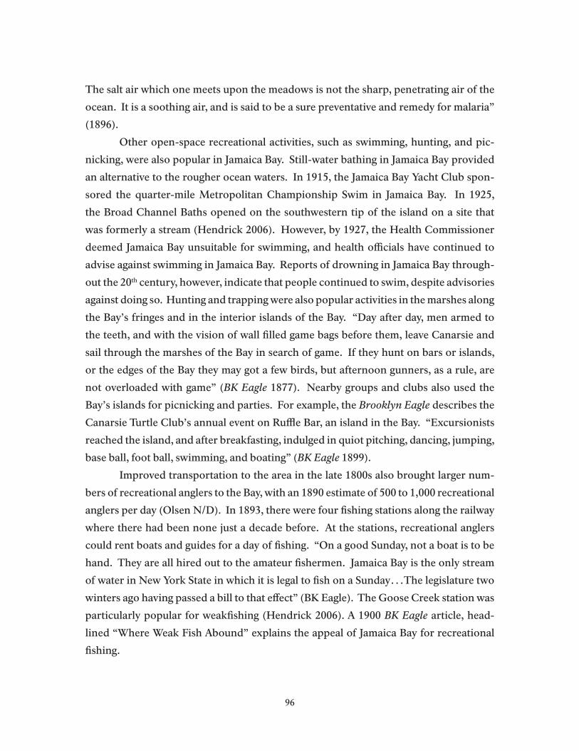
The salt air which one meets upon the meadows is not the sharp, penetrating air of the
ocean. It is a soothing air, and is said to be a sure preventative and remedy for malaria”
(1896).
Other open-space recreational activities, such as swimming, hunting, and pic-
nicking, were also popular in Jamaica Bay. Still-water bathing in Jamaica Bay provided
an alternative to the rougher ocean waters. In 1915, the Jamaica Bay Yacht Club spon-
sored the quarter-mile Metropolitan Championship Swim in Jamaica Bay. In 1925,
the Broad Channel Baths opened on the southwestern tip of the island on a site that
was formerly a stream (Hendrick 2006). However, by 1927, the Health Commissioner
deemed Jamaica Bay unsuitable for swimming, and health officials have continued to
advise against swimming in Jamaica Bay. Reports of drowning in Jamaica Bay through-
out the 20th century, however, indicate that people continued to swim, despite advisories
against doing so. Hunting and trapping were also popular activities in the marshes along
the Bay’s fringes and in the interior islands of the Bay. “Day after day, men armed to
the teeth, and with the vision of wall filled game bags before them, leave Canarsie and
sail through the marshes of the Bay in search of game. If they hunt on bars or islands,
or the edges of the Bay they may got a few birds, but afternoon gunners, as a rule, are
not overloaded with game” (BK Eagle 1877). Nearby groups and clubs also used the
Bay’s islands for picnicking and parties. For example, the Brooklyn Eagle describes the
Canarsie Turtle Club’s annual event on Ruffle Bar, an island in the Bay. “Excursionists
reached the island, and after breakfasting, indulged in quiot pitching, dancing, jumping,
base ball, foot ball, swimming, and boating” (BK Eagle 1899).
Improved transportation to the area in the late 1800s also brought larger num-
bers of recreational anglers to the Bay, with an 1890 estimate of 500 to 1,000 recreational
anglers per day (Olsen N/D). In 1893, there were four fishing stations along the railway
where there had been none just a decade before. At the stations, recreational anglers
could rent boats and guides for a day of fishing. “On a good Sunday, not a boat is to be
hand. They are all hired out to the amateur fishermen. Jamaica Bay is the only stream
of water in New York State in which it is legal to fish on a Sunday…The legislature two
winters ago having passed a bill to that effect” (BK Eagle). The Goose Creek station was
particularly popular for weakfishing (Hendrick 2006). A 1900 BK Eagle article, head-
lined “Where Weak Fish Abound” explains the appeal of Jamaica Bay for recreational
fishing.
96

Once a week fisherman always the same, and thus it is that each season of angling sees many old time faces, hardened and seamed in sport, gather at the favorite runways. Jamaica Bay offers inducements not possessed by more open water of NY Bay. Boats are cheaper, bait is cheaper and probabilities of success are greater…From any of these places [fishing stations] a roomy and flat bottomed boat, the only kind used on the bay, can be hired for an afternoon or the whole day at a uniform price of 50 cents for week days and 75 cents for Sundays. For $1.50 extra, the novice can secure the services of a bayman, who will row the boat, bait the hook, prepare the chum and proceed to a spot where fish are caught, and will in a general way, impart information which couldn’t be had any other way practically for forty times the money.
Although many likely relied on the weakfish, fluke, blackfish, flounder, and
striped bass to supplement their diets, it is equally likely that many engaged in fishing for
the pure joy of being out on the water. An 1893 Brooklyn Eagle article observes, “There
must be something in fishing which makes men good natured, for quarrels and fighting
are never heard of on the bay.” Another Brooklyn angler captured his sentiments about
the Bay with a poem:
When care and noise oppress me,And politics make me sick, To the woods I go like a bumblebee and whittle me a bit of stick.And when I have it whittled fine, on the end I ties a string,And then this lovely fishing line in Jamaica Bay I fling.Then the fool-fish come to meet their fate, when the bay is soft and calm.And gobble me bait so clane and so nate – Shure I always fish with calm. Brooklyn Eagle June 1, 1902.
Along with fishing, boating has been a long-time recreational activity in Jamaica
Bay. Yachting was especially popular, and during the late 1800s, several yacht clubs
dominated the sport in Jamaica Bay, hosting organized races throughout the season
(Hendrick 2006; Olsen n/d). Jamaica Bay’s depth, its placidness, and its proximity to
New York City and several nearby hotels made the Bay a popular regatta site. “The
present yachting season on Jamaica Bay has been unusually active, and the interest in
aquatic contests bids fair to hold out until cold weather puts a stop to the sport. New
boats are being continually added to the fleet on the bay, and almost every week there
are interesting sweepstake contests or match races” (NY Times 1888). The article goes
on to note that an upcoming race will likely draw large crowds and be one of the major
events of the Canarsie season. In the 1900s, motorboats, which could be rented for $3
per day, became increasingly popular among the yacht clubs, the oystermen, and the
97
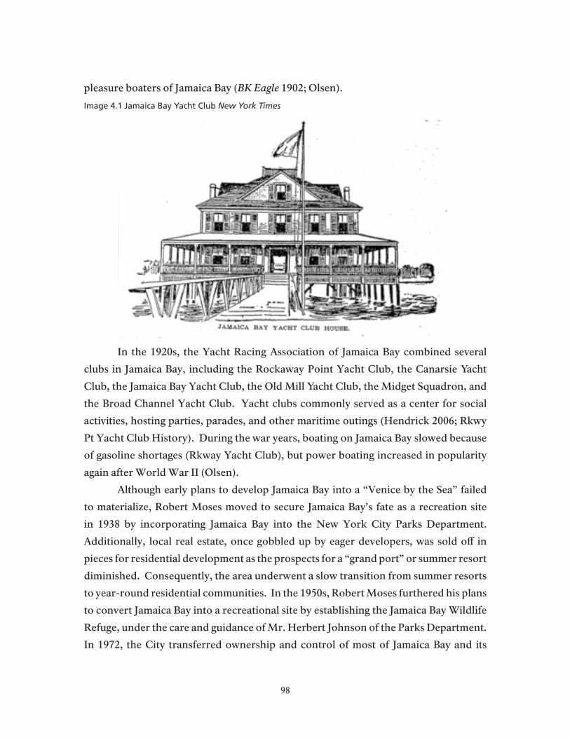
pleasure boaters of Jamaica Bay (BK Eagle 1902; Olsen).
Image 4.1 Jamaica Bay Yacht Club New York Times
In the 1920s, the Yacht Racing Association of Jamaica Bay combined several
clubs in Jamaica Bay, including the Rockaway Point Yacht Club, the Canarsie Yacht
Club, the Jamaica Bay Yacht Club, the Old Mill Yacht Club, the Midget Squadron, and
the Broad Channel Yacht Club. Yacht clubs commonly served as a center for social
activities, hosting parties, parades, and other maritime outings (Hendrick 2006; Rkwy
Pt Yacht Club History). During the war years, boating on Jamaica Bay slowed because
of gasoline shortages (Rkway Yacht Club), but power boating increased in popularity
again after World War II (Olsen).
Although early plans to develop Jamaica Bay into a “Venice by the Sea” failed
to materialize, Robert Moses moved to secure Jamaica Bay’s fate as a recreation site
in 1938 by incorporating Jamaica Bay into the New York City Parks Department.
Additionally, local real estate, once gobbled up by eager developers, was sold off in
pieces for residential development as the prospects for a “grand port” or summer resort
diminished. Consequently, the area underwent a slow transition from summer resorts
to year-round residential communities. In the 1950s, Robert Moses furthered his plans
to convert Jamaica Bay into a recreational site by establishing the Jamaica Bay Wildlife
Refuge, under the care and guidance of Mr. Herbert Johnson of the Parks Department.
In 1972, the City transferred ownership and control of most of Jamaica Bay and its
98

interior islands to the National Park Service in an effort to bring the National Park
experience to urban residents (Kornblum 2002).
Contemporary Jamaica Bay Recreation Recreation, including open space activities, scenic views, fishing, and boating,
in and along the Bay has played an important role in developing attachments to the Bay
and in creating a way of life oriented to the water. Ms. Barbara Toborg, of the Broad
Channel Historical Society, says, “It is a nice place to raise kids because they can play
in the streets and because they have boating, they have swimming. Some people have
been here for generations – 3 and 4 generations of Tupperdys, Otts, of Mundys; there
are some families that go back a lot” (Toborg 2010). The long-time associations with
the area are a point of pride and sometimes jokes. “I’ve only been here for fifty years,
so I’m not an old-timer yet” teases one long-time resident (relayed by Mundy Jr. 2010).
Mr. Dan Mundy Jr., President of the Broad Channel Civic Association, notes that new-
comers are increasingly drawn to the area because of the Bay and its surroundings2. He
believes that access to water recreation, coupled with affordability, is a driving factor
in most residents’ decision to live around Jamaica Bay (Mundy Jr. 2010). Mr. and Mrs.
Toborg’s experience moving to Broad Channel in 1985 supports Mr. Mundy Jr.’s hunch.
“We could afford it. We had to move out of our apt in Middle Village. Barbara knew the
school crossing guard, who was from Broad Channel. This house came on the market.
She brought us an ad from the Wave. We knew the Refuge. We had gone to the Refuge
before. Broad Channel always looked seedy and dingy. It [their house] was on the side
street and it was a double wide. We looked out the back and saw this [open marsh grass].
We didn’t look at another house. We’ve never regretted it either” (Mr. Toborg 2010). Mr.
Mundy Sr. describes how many in Broad Channel entertain their “inland and upland
friends” with backyard barbeques and sightseeing trips around the Bay, showing non-
Channelites the charms of island living – the houses, marshes, and the birds.
Since the establishment of the Jamaica Bay Wildlife Refuge in the 1950s, bird
enthusiasts have frequented the site to catch a glimpse of migrating flocks or for views
2 Residents of Broad Channel paid ground rent to the City until 1980. Many feared the City would kick them off the island. Mr. Dan Mundy Jr. says, “When I was a kid before bed, my mother would tell us ‘say a prayer that we don’t get kicked out of here’ because [Mayor] Lindsay was trying to kick us out…So the houses were worth little because they didn’t own the land and could be kicked off at any time.” Once the City sold the land to the Broad Channel community, housing values increased, prompting some families to leave, allowing newer people to move to Broad Channel (Mundy Jr. 2010).
99
of the Manhattan skyline. Mr. Jim Ash, formerly of Howard Beach, recalls foreign
tourists hurriedly traveling to see birds at the Refuge after landing at JFK and before
catching their connecting flight. He also recalls his own enthrallment with the Refuge.
As an adolescent boy, his aunt gave him a Peterson’s Guide to Birding. “Most birders,”
he says, “can tell you a story of their ‘hook bird,’ the bird that really got them into
birding.” He recalls seeing his “hook bird” at the Refuge, a glossy ibis, noting that it
had been “only three years after the ibis began appearing in New York City.” Mr. Ash
adds that birding “offered me everything that hunting and trapping on the Bay had
provided, but without the killing…Birding allowed me to engage with nature in an in-
depth fashion” (Ash 2010). After seeing his “hook bird,” Mr. Ash went to the Refuge
almost daily before moving to Long Island in the early 1990s. Ms. Barbara Toborg also
conveys the importance of the Refuge to local communities for bird watching and for
other open space opportunities. Many, like her and her husband, visit the Refuge just
to be outside. Mr. Fred Toborg quips, “I don’t consider myself a bird watcher. More of
a bird ‘looker-at-er.’ We don’t take it so seriously that we have to keep lists and check
them [bird sightings] off.” Ms. Toborg continues, “I think we’re more generalists – just
being out in nature, all the stuff. [We] appreciate it [the Refuge] as part of a larger being
outside; we want to enjoy all of the outdoors, not just the birds.” In addition to using
the Refuge for open space recreation, Ms. Toborg says that several Broad Channel
folks have worked at the Refuge, either as employees or as volunteers. Additionally,
she explains that the community utilizes the Refuge as a meeting space and for cultural
events, such as painting, photography, haiku or poetry readings, lecture series, and
thus, as a source of entertainment.
Swimming and visits to the inner islands of the Bay also continue to be important
open space activities for local communities. Several people report that local kids swim
in the Bay throughout the summer. Ms. Toborg describes one local swimming spot for
kids, equipped with a diving board, over the sluiceway off Cross Bay Boulevard. She
observes that people swim despite the advisories against it, noting that some people do
not know about Combined Sewer Overflows (CSOs), while others, particularly local
mothers, discourage their kids from swimming after rainfalls. Others continue to take
their boats out to the islands dotting Jamaica Bay. Mr. Mundy Jr. describes his neighbor
who goes out to the islands several times per week. “My neighbor over here goes out
3 or 4 times per week. He has a little boat, only goes 5mph; he likes it that way…A lot
100

of times he goes out there and looks at things that have washed up after the storms,
different wrecks and stuff. People definitely enjoy walking around the perimeter of
the islands” (Mundy Jr. 2010). Mr. Mundy Sr. describes visits to the islands as a “very
important traditional use of the Bay. It is almost a religious thing that everybody has to
go out there [parts of Little Egg Marsh and Ruffle Bar] during the summer and stop by
the island and take a walk along the edge, or if it’s the weekend, to meet other people
and bring a picnic lunch, sit on a blanket for the afternoon and let the kids run around
and swim, and spend an afternoon out there” (Mundy Sr. 2010).
Besides swimming and picnicking, recreational and subsistence fin fishing –
both hook and line and spear fishing – and crabbing continue to be important activities
to people of all ages throughout the Bay. “Brian,” a middle-aged gentleman from
Meadowmere Park, says that although he thinks there is little, if any, commercial fishing
left in the Bay, most members of the small community continues to fish and crab for fun.
He describes a pleasant afternoon on his boat catching a few crabs, having a “crab boil”
and some beers right up on the beach. A leery, younger acquaintance squirms at Brian’s
story, saying he fishes primarily for fluke and striped bass, but that he surely would not
eat anything he catches (Field Interviews 2010). Anglers at Canarsie Pier and along
North Channel Bridge, when asked about consuming fish from contaminated waters,
say that pollution matters little when there are “empty bellies” (Field Interviews 2009).
Mr. Mundy Jr. enjoys spear fishing and says there are others like him, most notably
“old-timers” in Rockaway who spearfish from the jetties and have been doing so for 50
to 60 years. Killi catching has long been an activity for kids living around the Bay. A
community member posted a message on a Howard Beach website, saying, “I was born
in the Beach in 1946…I love to hear about how it was back then when we all used to
go ‘killying in the creek” with a milk bottle filled with bread and tied on a heavy string.
We then used the killis for bait to catch blue-clawed crabs. Those were the days!” The
practice continues today in Broad Channel, according to Ms. Barbara Toborg, who says
that on days of extremely high tides or storm events, local children wade in the streets
to catch the tiny baitfish.
Boating, in various forms, continues to be one of the most common and enjoyed
water recreation activities in the Bay. Today, there are several yacht clubs that continue
to host regattas on Jamaica Bay as well as parties, brunches, sailing lessons, fishing and
kayaking tournaments, and beach clean-ups. Several yacht clubs have member websites
101
that facilitate information sharing on boating and fishing. Contemporary yacht clubs
include, but may not be limited to, the Deep Creek Yacht Club, the Rockaway Point
Yacht Club, the Midget Squadron, the Belle Harbor Yacht Club, the Old Mill Yacht
Club, and the North Channel Yacht Club, Riley’s Yacht Club in Hamilton Beach, and
the Howard Beach Motor Boating Club. Besides the yacht clubs, the Sebago Canoe
Club, of Paedergat Basin Park in Brooklyn, is a group of local kayakers, sailors, rowers,
canoeists, and flat-bottom racers who consider the waters of Jamaica Bay “home.” The
Sebago Canoe Club has a long history out on the water, dating back to 1933, as this entry
from its web site confirms:
The SEBAGO CANOE CLUB is in Paerdegat Basin Park in Brooklyn, New York, a short paddle from the 16,000 acre expanse of Jamaica Bay. The Bay is part of Gateway National Recreational Area and has miles of open water with salt marshes, islands, beaches, and a famous wildlife refuge. It is common for boaters to see Oystercatchers and Black Skimmers flying over the water while Snowy Egrets and Great Blue Herons patrol the shoreline. Sebago, founded in 1933, is one of the oldest canoe clubs in the Northeast and our clubhouse stands on an acre of land that was once a summer encampment of the Canarsie Indians. Our canoe club was originally based on Lake Sebago in Harriman State Park where we continue to maintain rustic cabin facilities as part of the American Canoe Association camp. Sebago Canoe Club is open year round to its membership and by appointment to those interested in membership. We welcome anyone interested in the wide range of paddlesports. Contact our Membership Chair for more information.(http://www.sebagocanoeclub.org/his.html)
Sebago members were active supporters of Gateway at its inception. They testi-
fied on many occasions at public meetings in favor of the Park Service mission to protect
and enhance Jamaica Bay resources and continue to do so. The club – with over 220
members – is an example of a longstanding Jamaica Bay association that continues to
introduce new generations of local residents and people from more distant communi-
ties to the bay’s environment. It teaches skills that are essential to close involvement with
bay resources and its members continually participate in clean-up and environmental
monitoring efforts. The club’s leaders are out on the bay all the time and are examples of
bay people with profound cultural attachments to the bay’s resources.
Community members also recreate on Jamaica Bay from their private boats.
One individual, a former board member of the Old Mill Yacht Club, fondly remembers
taking his kids out on Jamaica Bay, “building” flotillas with roughly five or so other
boats, spending the entire day swimming, fishing, grilling, and eating out on the Bay
102

with family and friends. Mr. Mundy Sr. chronicles his adolescence in terms of how
far he could go out alone on his boat. At age seven or eight, he says, you had to learn
how to swim right away to protect yourself and to “alleviate parents of worry if you fall
overboard.” Between the ages of seven and nine, Mr. Mundy Sr. recalls, is when every
young boy in Broad Channel wants a boat to go out in the Bay. At first, he says, “you
only row half way up the canal, making sure you didn’t go past so and so’s house. A
year or two later, you could go further to the end of the canal, but not past the end…In
your pre-teen years, if you were lucky, you got a small motor for the boat and you would
motor back and forth. Finally, as a teenager, you could go out of the canal and out into
the Bay and motor into the Bay. You had a little more freedom.” He remarks that such
experiences are important for children who grow up in the neighborhood because they
establish strong connections to the Bay and to the water at a young age (Mundy Sr.
2010).
Mr. Mundy Sr. recalls local concern that their way of life around the Bay, their
weekly (and some daily) boat rides, their picnics with friends and family, their favorite
fishing spots, would be seriously altered if not eliminated by the establishment of a
national park. Mr. Mundy Sr. explains the general sentiment of local populations. “This
is our territory. We were here first.” At a rowdy planning meeting at Floyd Bennett
Field, where it seemed as though locals could riot at any moment, Mr. Mundy Sr. and
other community leaders convinced the Park to switch its momentum away from a
plan focused solely on wildlife preservation to a management system that conceded
“traditional uses of the bay, as experienced at that time, should not be diminished in
any way” (Mundy Sr. 2010). Although Ms. Toborg says there may be some lingering
resentment about the establishment of the Park, this has largely waned, as community
members continue to engage in most of their traditional activities.
Mr. Mundy Jr. says that one of the most noticeable changes on the Bay is the
decreased number of people earning their livelihoods directly from the water, noting
the elimination of commercial fishing and the declining number of party or charter
boats. Beyond that, the Mundys state that some of the most significant changes in the
community’s use of the Bay stem from technological changes, such as the increased
popularity, and ownership of, motorboats. Mr. Mundy Jr. remembers when rowing out
to picnic or walk along the inner islands of the Bay was a much larger accomplishment,
given the physical exertion necessary for the task, but today, people can motor out there
103

easily. The Mundys do not believe using motorboats to reach the islands diminishes
the special importance people attribute to this activity, but the newer boats do change
the way, and perhaps the numbers, of people engaging in this tradition. Mr. Mundy
Sr. admits there has been some contention between those using the inner islands for
picnicking and walking and Park Police who attempt to prohibit people from using
these spaces. He says that people will not “give in” on their use of the islands, and he
has, on occasion, had to settle disagreements by showing Park Police the regulations
allowing traditional uses. Additionally, personal watercraft, such as jet skis, kayaking,
wind-surfing, and paddle boating, have also increased in popularity. Mr. Mundy Jr.
recognizes the regulations on the use of motorized personal watercraft, but says that
many who use them are confused because the Park does not regularly enforce the bans
against them. Finally, Mr. Mundy Sr. notes the increased use of the Bay for educational
purposes and the increased role of local community members in resource management
(See below).
“People down here are very traditional in that they love the Bay and don’t want
to see too many changes” (Mundy Sr. 2010). As the President of the Broad Channel
Civic Association, Mr. Mundy Jr. does not anticipate significant demographic changes
in the area because the zoning restricts development for one to two family houses, and
therefore, there are no large multiple dwellings. Noting the transition to individual
ownership of the land, he says there been a “bit of an uptick,” in the numbers living in
Broad Channel, but cites the economic incentives to keeping family sizes small. Ms.
Barbara Toborg cites individual home ownership as reason to challenge the idea that
Broad Channel remains strictly “Irish or Italian blue-collar community,” describing
the influx of a few non-European groups and the “gamut of occupations,” such as
teaching, banking, website development, as well as the more traditional civil service
occupations. Mr. Mundy Jr. estimates whereas previously there may have been 90 to
95% of the community working in the civil service sector, the number has declined to
roughly 60 or 65%.
Besides demographic changes, the popularity of water recreation continues to
increase and the appeal of being on the water extends throughout the year. Mr. Mundy
Jr. says it is difficult to predict the changes in water recreation, citing the influx and
popularity of kayaking as an example. He describes the appeal of coming home from
work and dropping a kayak in the Bay on a calm afternoon or early evening, even in the
104

winter. Finally, the Toborgs, the Mundys, and community members (at Task Force
and Community Board meetings) express concern about, and anticipate changes from,
global climate change. Ms. Toborg says that people are increasingly concerned about
“how climate change will affect the level of the bay, with increased storms and wave
action eroding marshes.”
Ideally, community members would like the Park to continue recognizing their
traditional uses of the Bay and the importance of water recreation for their way of life.
They recognize the need to balance environmental management and enforcement at the
same time allowing people the freedom to participate in the various activities that make
living near the Bay a special place. One way to develop this relationship more fully,
Mr. Mundy Jr. suggests, would be through continued outreach and communication
with the communities surrounding and using the Bay and its creeks, marshes, and
islands. For example, he suggests implementing more “real time” and “streamlined”
communication strategies, pointing to the Department of Buildings real-time website
as an example. That way, Mr. Mundy Jr. says, “if we see something, instead of getting
worked up about it, we could go on the website and see if they [the Park] are taking
care of it,” continuing that such a system would be “a more streamline way for back and
forth of information” (Mundy Jr. 2010).
Swimming, boating, fishing, picnicking, and birding offer opportunities, not only
for people to engage the water, but to spend time with friends and family, generating
memories and encouraging attachments to a way of life around the Bay. Recreational
activities continue to shape and influence a way of life for Jamaica Bay communities
oriented to the water.
Protective Attachments to Jamaica BayJamaica Bay communities have long worked to protect their way of life around
the Bay and its creeks, marshes, and islands. Local citizens have organized to oppose the
industrialization of the Bay, to improve water quality, to restore and maintain biodiver-
sity, and to ensure that the Bay’s natural resources are sustained for future generations.
Opposition to pollution dates back to at least 1875, when local fishermen com-
plained of industrial discharge and strong odors from Barren Island offal rendering fa-
cilities. In 1881, “Fishermen threatened to organize an expedition to go to the island and
burn down the factories unless the pouring of waste oil and tar into the bay was stopped.
They said they would rather go to jail for that than to allow the Barren Island people
105
to starve them to death by depriving them of their means of making a living.” A local
fishermen, Captain Miller, continued, “upon fish, oysters and clams in some parts of the
bay, it [the tar sludge] is so thick that if you try to eat them you can taste the tar, and in
cooking crabs you can smell the tar” (BK Eagle 1881).
As populations increased along the Bay and inland, local residents became in-
creasingly concerned about sewage in Jamaica Bay. For example, in 1891, eighty citi-
zens of Flatlands petitioned the Board of Health to prevent the construction of a sewer
outlet 1,300 feet long and 4x51/2 feet across the marshland to Mill Creek. The petition
estimated that roughly 1.5 tons of sewage would be dumped daily into the Creek, not-
ing, “its current is utterly insufficient to carry off the sewage proposed to be thrown
into it from Flatbush,” fearing “sewage would be thrown up in solid masses upon the
marshes of Jamaica Bay and seriously endanger the health of people in Flatlands” (BK
Eagle 1891). Following construction of the sewer trunk, locals sued the city for damages
to oyster beds; James A. Bailey was awarded $8676 in damages, but the City was able
to postpone payments while attempting to remedy the problem. Eventually, in 1915, a
judge determined that pollution of tidal waters was “lawful pollution” and therefore,
oystermen could not sue the City for damages from polluted oyster beds.
In 1938, Parks Commissioner Robert Moses actively opposed the Department of
Sanitation’s plans to dump ashes and refuse in Jamaica Bay. Following suit, the Howard
Beach Association, Inc., rallied 200 protesters against the proposal, arguing that the plan
would “seriously impair the tremendously expensive improvements for park, parkway,
and recreational facilities built within the past few years in that area” (NY Times 1938).
In a letter to the Department of Sanitation, Robert Moses wrote: “I have no desire to get
into an extended argument on the subject, but it must be as clear as crystal that the old
scheme to make Jamaica Bay entirely an industrial section is just plain bunk…I am even
hopeful that the waters will be sufficiently purified to encourage swimming, fishing, and
boating on a large scale” (NY Times 1938).
In 1968, mounting traffic delays at local airports, especially at John F. Kennedy
Airport (JFK), prompted Port Authority officials to propose expanding runways across
Jamaica Bay to ease air traffic delays. The Sierra Club spoke out against the runway ex-
pansion, stating that the plan should be considered “ecological insanity” and offering
their services to stop the project “with every means at [its] disposal” (Bryant 1968). Sim-
ilarly, the President Emeritus of the National Audubon Society said, “Jamaica Bay can
106

and must be saved. For what good will all the enlargements of our airport and city be,
if we destroy all this great area of natural beauty and the life it sustains?” (Buchheister
1969). Hundreds of local conservationists and nearby residents organized a flotilla in
Jamaica Bay to protest the airport’s expansion. “About 75 vessels moved close to the
newest runway, once marshland and now used by huge jets that land and take off every
few minutes. The protest, organized by the Parks Council,…included frequent bleats
from the boats’ horns. From the marinas along the shore, other boats joined the flo-
tilla as it cruised the bay” (NY Times 1970). Mr. Jim Ash remembers the JFK expansion
project as a “large controversy” that had the “birders up in arms.” He recalls the media,
particularly the Mirror and the Journal American, extensively covering the issue. Even-
tually, he says, “the Port Authority ‘cried uncle’ because of all the bad publicity,” paying
for a new Refuge building, tractors, and other tools to “shut the birders up.”
Image 4.2 Locals Protest JFK Expansion New York Times
107

Contemporary Protectors of Jamaica BayThe basis for local environmental concern stems from continued engagement
with the Bay, either while recreating, earning a living, or observing daily life in and
around their neighborhoods. Mr. Mundy Sr. explains that in Broad Channel, “[There
is] always a connection to the Bay. It is 24/7. You can’t go anywhere in Broad Channel
without seeing the Bay. You’re passing right through the Bay. It is a constant reminder.”
Similarly, his son claims, “There’s no way you could have the sense of pulse of what’s
going on in the bay, as you do with people who live like this, who are in and out there
everyday. What I can tell you is what I see out there and what’s happening” (Dan Mundy
Jr. 2010). Consequently, the Mundys point out, local stakeholders have largely spear-
headed awareness of, and responses to, environmental issues in Jamaica Bay, particu-
larly poor water quality and marshland loss.
The confluence of national environmental regulations, the transfer of the Bay to
the National Park Service, and local efforts to protect and restore the Bay have brought
significant improvements in environmental quality since the early 1970s. Mr. Dan Mun-
dy Jr. points to improved water quality and increasing numbers of species as reason for
having a more positive outlook about the Bay’s future than he has in years past. Mr.
Mundy Sr. believes that part of this improvement stems from increasing community
support and participation in restoration projects that protect the infrastructure and re-
sources of Broad Channel. Mr. Mundy Jr. says both long time residents and newer com-
munity members recognize the importance of environmental quality and many work to
protect the Bay because they believe that open space is increasingly “one of the rarest
commodities.” Consequently, local residents have established several organizations and
participated in several committees to advance the restoration of Jamaica Bay. In 1984,
citizen stakeholders organized the Jamaica Bay Task Force (JBTF) to facilitate the incor-
poration of citizen input in the Park Service decision-making process (NPS 2003). The
Task Force continues to meet quarterly to provide their input to the NPS on the current
status of the bay and options for improving the bay’s quality. More recently, local com-
munity members have served as citizen advisors on the Department of Environmental
Protection’s Jamaica Bay Watershed Protection Plan reviewing panel reports and mak-
ing suggestions to improve the accuracy and likely success of the plan.
Mr. Mundy Sr. recalls his early efforts in the 1990s to draw attention to deterio-
rating marshes. Mr. Mundy and several fishermen and boaters who frequent the bay
108

began noticing deterioration of the Bay’s marshlands and documenting the loss with
photographic evidence. At the same time, the younger Mundy explains, a 1993 federal
mandate prohibited the City’s practice of dumping treated sewage sludge 100 miles out
in the ocean. After the mandate went into effect, the DEP changed protocol for process-
ing wastewater, which resulted in the release of high levels of nitrogen to the Bay, causing
declining oxygen levels and increased marsh loss, according to the Mundys. “How do I
know?” Mr. Mundy Jr. asks rhetorically, “well before when you were out in a boat, say,
it took seven turns to go through the marsh, and then you realize that the whole front
end of it is gone, and you’re like ‘Didn’t I make a sharp turn here before? Am I imagin-
ing something here? And then you notice it’s [the marsh] breaking through over here.
So you are acutely aware of the marshes disappearing” (Mundy Jr. 2010). As kids, he
continues, “there was a big stone out there that was half way to the end of the marsh.
Now it is entirely exposed…How can you deny the spike in marsh loss with the nitrogen
jump?” Consequently, Mr. Mundy Sr. started an environmental group, the “Eco-Watch-
ers,” to investigate the links between wastewater treatment plants and marshland loss.
After contacting city and state environmental agencies, elected officials, the media, and
the Park Service and the Army Corps of Engineers, the Eco-Watchers drew sufficient
attention to the problem to warrant action on behalf of local and federal agencies. The
Eco-Watchers have taken the lead in lobbying and securing funds for marsh restoration
projects as well as providing input in the planning process, crucial for a project’s suc-
cess. For example, the Eco-Watchers successfully lobbied for a $9 million allotment to
restore Yellow Bar marsh; the final project is awaiting approval from the Army Corps of
Engineers. Most recently, years of work with the DEP, the DEC, and the NPS culminated
in a 2010 agreement wherein the City would invest an additional $100 million dollars
in technology to reduce nitrogen loading by 50%, as well as investing $15 million in
marshland restoration.
Local communities often go beyond advocating and fundraising, participating
directly in environmental restoration projects. Mr. Mundy Jr. recalls filling his boat with
“tens of thousands” of grass plugs, transporting them to Big Egg Marsh, and dragging
them from the boat to the marsh for planting. Later, when Mr. Mundy Jr. noticed
debris had blown on the restoration site, he went into the Bay and pushed the debris off
to “give the marsh a chance.” He goes on to explain other, small, but important ways
the community contributes to restoration projects, such as identifying and contacting
109

companies for dredge work and finding local mechanics to repair machinery necessary
for the job. Mr. Mundy Jr. explains, “In these times of economic hardship, it is something
that is necessary for projects to work…[we] volunteer our time and efforts as captain,
boatman, gas and everything to get them out there because maybe the project wouldn’t
happen otherwise.” Currently, Mr. Mundy Jr. has partnered with State University of
New York – Stoneybrook to build an artificial oyster reef that would help promote
oyster colonization, improve water quality, and encourage habitat revitalization.
The American Littoral Society, the Rockaway Waterfront Alliance, the Fresh
Creek Nature Association, and Gerritsen Beach Cares are a few of the other groups who
organize beach and marsh clean-ups. Ms. Toborg estimates that one woman, on her
own volition, has put in 93 volunteer hours along the East end of the Wildlife Refuge,
“starting at the subway trestle and working back to the parking lot. We estimated that
she picked up about 3,000 lbs of debris. She’s driven to clean-up and she won’t stop
until it’s done. She’s in Germany right now or else she’d be there cleaning on a sunny
day.” In addition to her work at the Refuge, this woman spends most Saturdays with
another woman, a Far Rockaway resident, picking up garbage from Norton Basin. On
one particular day, the Rockaway Waterfront Alliance (RWA) joined them.
Today was a great day, RWA kids and teachers came out to do a beach cleanup event. They were joined by two people from Brooklyn and two people from Manhattan. A family from Beach 56 Street and one resident from Rockaway Park came out to help as well. We collected more than 25 bags of debris, a bicycle, a car wheel and a huge pile of garden refuge, and a pile of cement waste and chunks of tar-top. We started to take down one of the three piles of buldozed junk. The group circled the bay up to the sandspit, and took a little time out to study the fish and other fauna. (Norton Stewardship Group www.nbesg-wise.org)
The Norton Stewardship group couples their garbage pick-up with the removal
of invasive species, allowing native species to thrive, thereby facilitating natural habitat
restoration.
Doris worked the waterside and I took on the section around the electrical pole. Much crabgrass (90%), it grows really tall, at the base you grab the root and try to get some of that out. It is really funny how these type of plants seem to send a message to the roots, you shake and pull it and then let it go. When you try again in about fifteen minutes a lot of root just seems to have unstuck itself and it comes right out. There were clouds, but no rain, and we got a lot done. As I went out on Sunday, I just caught the park sanitation dumping the lot in the truck. That makes it nice for the rest of the week and it will not encourage dumping as was
110

done last week.(Norton Stewardship Group www.nbesg-wise.org)
Organized clean-ups have been one way that local communities raise awareness
of Jamaica Bay’s environmental troubles and promote participation in habitat clean up
and restoration. Local Indo-Caribbean leaders encouraged their congregations to par-
ticipate in a recent American Littoral Society clean up, taking advantage of the oppor-
tunity to introduce several school-aged children to the intricacies of the Bay’s ecology.
The Mundys are strong supporters of this type of educational outreach and Mr. Mundy
Sr. recognizes the need to explore educational opportunities more fully so as to engage
younger generations in protecting the Bay. He already speaks at near-by schools about the
Bay’s ecology and its biological importance, but encourages, and anticipates, expanded
educational outreach in the future. Consequently, both Mundys suggest developing
an educational facility where kids can learn about the Bay’s natural resources before
going into the “natural laboratory,” seeing real-life examples in Jamaica Bay’s waters
and marshes.
Information sharing, particularly through a strong web presence, is important
for educating local communities about the causes and consequences of the Bay’s
environmental problems and about opportunities to participate in the environmental
planning process. The Jamaica Bay Treebranch listserv, the Jamaica Bay Research and
Management Information Network, and community blogs (e.g., Queens Crap, Gerritsen
Beach.net) are but a few examples. As a result, many local residents feel more equipped
to participate in environmental planning because of their improved knowledge on the
subject, and many have subsequently come to expect inclusion and involvement in
the process of environmental management. Consequently, when local individuals or
groups sense they are being excluded from the process, they feel resentment or a lack of
gratitude about their efforts to improve the Bay. Mr. Mundy Jr. says “There are groups
around the bay that just by virtue of the amount of energy they put into the bay [you’d
think] that the Park would reach out to stakeholders for plans for the Bay in general.”
Furthermore, Mr. Mundy Sr. believes that the web would be helpful in establishing a
coalition of groups around Jamaica Bay to pressure officials into continued restoration
and protection of Jamaica Bay’s natural resources.
Even with several environmental groups working to protect the Bay, local resi-
dents are concerned that inadequate funding may undermine Jamaica Bay’s restoration.
111
The Eco-watchers and the Norton Basin Stewardship Group have both successfully ap-
plied for grant money to restore the Bay’s ecology. The Eco-Watchers received $100,000
in grant money, allocating $20,000 for an educational exhibit and $80,000 toward oyster
restoration projects. Similarly, the US Fish and Wildlife Service sponsored the Norton
Basin Stewardship Group’s restoration of marshlands and uplands into a Migratory
Bird Sanctuary. Local groups recognize the benefits of, and increasing need for, col-
laboration among funding sources, citing collaboration among academics, corporate
sponsors, the Park Service, and non-governmental organizations on oyster restoration
projects as an example. However, local groups are concerned that the economic reces-
sion and city and state budgetary crises will make it even more difficult to secure the
necessary funding for restoration projects.
Sustained funding for restoration projects is especially important given the an-
ticipated consequences of global climate change. Residents are increasingly observing,
and concerned about, the strength and frequency of storms and rising sea levels. The
Eco-Watchers often spearhead discussion on global climate change at local civic as-
sociation meetings and many in attendance express their concern about the threats to
their way of life on the Bay and for their immediate safety in the event of a severe storm
(Toborg 2010).
Given the federal government’s role in establishing and enforcing the nation’s en-
vironmental regulations, community members look to the National Park Service to take
the lead on restoration efforts throughout the Bay. Furthermore, many local residents
expect the federal government to be more financially capable of funding environmen-
tal projects than the city or state. Although this may be a common assumption among
residents, most of the individuals involved in restoration efforts believe that Gateway is
underfunded relative to other national parks and can appreciate their efforts given these
financial constraints. But, in spite of budgetary constraints, local groups feel there are
areas within the Park that need improvement, particularly the North Channel Bridge
and the Wildlife Refuge.
Members of surrounding communities, local anglers, and environmental groups
have expressed concern and responded unfavorably to the remnants of Hindu and San-
teria ceremonies, primarily at the North Channel Bridge, but also Plumb Beach (See
Chapter 5). The Chair of Community Board 10 feels that cultural education about the
Park’s regulations would balance the concerns of local citizens and ensure that the
112

Indo-Caribbean Hindu community could exercise their religious rights (Personal com-
munication March 2010). Others feel that the Park needs to engage in a more aggressive
clean-up effort at the bridge and needs to start enforcing fines when education is not
working (Toborg 2010; Mundy Jr. 2010). Ms. Barbara Toborg points out that the issue is
often raised at civic association meetings and that the Park is slow to clean-up the entire
Cross Bay area, but especially the bridge. Mr. Don Riepe of the American Littoral So-
ciety suggests dispatching rangers or park police late at night or in early morning hours
to issue “courtesy” warnings, noting that sometimes simply having an authority figure
present is enough to deter leaving materials (Landor 2008).
The Refuge’s reputation as the “jewel” of Gateway leads many community mem-
bers to have high expectations about its maintenance. Recently, community members
have become increasingly disappointed with the Park’s efforts to manage the Wildlife
Refuge, noting how unkempt paths and overgrown invasives detract from the Refuge
experience. Mr. Jim Ash says “The Refuge was established – and the Park assumed –
quite a bit of management to make outstanding views without people having to go off
the path and trample the vegetation. The Refuge was managed to create optimum vis-
ibility without disturbance. Eventually, this maintenance fell by the wayside and was
not maintained. Some of the views were obstructed. Initially the Park brought Johnson
on as a consultant, but eventually he was embittered and left.” Both Mr. Ash and Mr.
Don Riepe attribute the problem to the Park Service’s designation of resource manage-
ment to maintenance personnel. At a recent Jamaica Bay Task Force meeting, Mr. Riepe
says maintenance managers “want something to look managed and therefore they mow
because it looks managed” (JBTF October 2010). Mr. Riepe has recently organized a
group, “Friends of Jamaica Bay Wildlife Refuge,” to make recommendations for improv-
ing Refuge upkeep. A recent newsletter made several suggestions for the Refuge, in-
cluding, the removal of invasive species, the installation of bird feeders, the cessation of
grassland mowing (because it reduces habitats and biodiversity), and the development
of the South Pond with a boardwalk and bird blinds (FJBWR vol. 1). Additionally, Mr.
Riepe believes that a “good cadre of about 100 active volunteers” is essential given the
level of upkeep necessary to maintain the Refuge (JBTF October 2010).
Ideally, individuals and groups who view themselves as “protectors of the Bay”
would like to develop a relationship with the Park that acknowledges and respects resi-
dents’ understandings of the Bay and incorporates citizen input and perspectives as part
113
of its institutional approach to managing the area. Most of those involved with restora-
tion efforts in the Bay express the need for improved communication between the Park
and local communities, arguing that this suggestion is especially warranted given the
improvements in communication technology. Mr. Mundy Jr. points to the efficiency
of several city agencies who use technology to facilitate citizen outreach, such as the
Buildings Department and the Police Department. He suggests a system similar to New
York’s “311 hotline” where Park users could report complaints or make observations
and receive a confirmation number to follow-up on the Park’s progress in addressing
the issue, where warranted. Mr. Mundy Sr. recommends the Park designate a commu-
nity liaison to attend local meetings, including community board and civic association
meetings, to update the public on the positive accomplishments and progress in the res-
toration process, as well as providing an opportunity for local community members to
“blow off steam and have a voice.” A community liaison would be in the position to
bring people’s feedback to the Park, serving as a more direct channel to the authorities
that effect change.
Local groups believe that improved communication is especially warranted giv-
en the difficulty of navigating a daunting federal bureaucracy. Community members
often consider the Park’s bureaucracy an impediment to environmental restoration and
community resource management, believing they have made “valuable suggestions” for
improvement, only to find that the Park will not allow or facilitate the project, citing a
myriad of rules and regulations against taking action (Ash 2010; Mundy Sr. 2010; Mundy
Jr. 2010; Field Interviews 2010). Furthermore, community members express concern
that the planning process will be marred in bureaucracy, resulting in changes or devel-
opment of areas without community input. Mr. Mundy Jr. worries that the final plan
will not fully incorporate community input because of a gap between the initial stages of
public comment and the final plan. He suggests incorporating public review throughout
the process as well as improving communication with the public to facilitate opportuni-
ties for additional community input.
Jamaica Bay has a long history of people working to protect the areas where they
live, work, and play. These “protectors of the Bay” have emotional attachments to the
area as well as a material interest in the Bay’s environmental restoration, having invested
time, energy, and money into environmental renewal. Therefore, community members
expect that the Park will develop strong community partnerships that acknowledge and
114
respect their efforts. The numbers concerned about the Bay and working to restore it
will likely increase with growing environmental awareness, with rising popularity of wa-
ter-based recreation, and as information about the Jamaica Bay situation proliferates.
Consequently, the Park has an opportunity to benefit from the passion of local commu-
nity members to sustain Jamaica Bay both materially and socially.
Conclusion The Jamaica Bay way of life is steeped in socio-cultural traditions built around
people’s working, recreating, and protective relationships to the Bay, which date back to
the earliest settlements in the area. These relationships, however, have also been modi-
fied because of new generations, new technology, and new forms of management. The
longevity of these modified socio-cultural traditions, rather than diminishing in ongo-
ing significance or importance, are likely to expand, as the traditions are passed to new
generations and as new demographic groups participate in working, recreating, and
protecting the Bay. The new faces and new dimensions of the Jamaica Bay “way of life”
provide new possibilities to ensure that the people of the Bay are not a vanishing culture,
just a slightly different one.
115


chaptEr fivE
rEligiouS congrEgationS, ritual uSES of Jamaica bay rESourcES
This chapter inventories and assesses the way religious congregations in the Wa-
tershed have traditionally used resources of Jamaica Bay. It also explores how these uses
are changing as the communities which sustained older congregations are experienc-
ing demographic shifts. Special attention is given to newer population groups that are
encountering Park Service management of Jamaica Bay Resources as they attach their
own religious significance to bay resources. Members of Hindu congregations are a par-
ticularly important group in this regard, as are practitioners of various forms of Santeria
or derivations from African (particularly Yoruba http://www.photius.com/religion/yo-
ruba.html) religious beliefs and rituals.
When Gateway began managing the resources of Jamaica Bay in the early 1970s,
there was a distinct religious ecology around the bay composed primarily of Roman
Catholic. Jewish and Protestant congregations. This ecology is changing in ways that
has direct impact on uses of the bay. The term religious ecology refers to the spatial or-
ganization of religious practice in the congregations of residential populations (Orsi,
1999; Stark and Glock, 2008) ) Neighborhood churches serve families and households
who seek to be within walking distance of their religious institutions. Larger regional
churches and synagogues depend on membership that extends over multiple neighbor-
hoods and communities. The Allen A.M.E. Church, discussed in Chapter 2, is an exam-
ple of an important regional congregation and church in the Watershed. The Catholic
Churches of Breezy Point and Broad Channel (St. Virgilius), which have played critical
roles in maintaining the cohesion and culture of these village enclaves for generations,
are examples of neighborhood congregations in the Watershed’s religious ecology. St.
Francis De Sales in Belle Harbor, which became the lead institution in response to disas-
ter in western Rockaway, serves a larger community and regional congregation. Jewish
congregations, which are among those that have had specific ritual uses of bay resources
in the past, also range from large congregations in well-established synagogues, to small
groups of worshippers who meet in private homes. In this chapter we trace important
changes in the religious ecology of the Watershed as these have had impact, especially,
on Jamaica Bay resources under Gateway management. In other words, the chapter fo-
cuses primarily on religious groups have sought permits from Gateway’s Jamaica Bay
managers, or where their practitioners have been appearing in more ad hoc fashion to
117

perform religious rites in and around the bay.
A Changing Religious Ecology Demographic inventory and analysis in Chapter 3 showed that since the 1970s
there have been significant declines in the homogeneity of older white ethnic neigh-
borhoods surrounding the Bay, especially in Canarsie, Howard Beach, Ozone Park, and
East New York. Even in western Rockaway, where the older religious ecology of Roman
Catholic and Jewish congregations continues to thrive or at least hold its own, there
have been increases in population diversity, bringing in more foreign born and Span-
ish speaking populations. But the most dramatic religious hanges at the local level over
the past decade or two appear to have occurred in Canarsie, Borough Park, and Ozone
Park, where again and out-migration have reduced older Jewish congregations. (cite the
article in CanarsieNewcomers in these communities tend to be of Hispanic or Guyanese
and East Asian origins In Borough Park as in the eastern Rockaways, there have been
important shifts from more liberal to more orthodox Jewish congregations. The Jewish
congregations of Canarsie have been disappearing, while the very orthodox congrega-
tions of Borough Park have been experiencing almost exponential growth. When reli-
gious groups seek permits for use of public lands and facilities in and around Jamaica
Bay, or when congregants simply appear along the shores of Jamaica Bay to engage in
religious rituals, it is helpful for park managers to be able to situate these practices in the
larger religious ecology of the region. Since the religious culture of the new and quite
large Hindu population of the Watershed results in new demands on Gateway resources
at Jamaica Bay, we turn our attention first to the origins and exercise of their attach-
ments to the bay.
Hinduism in Jamaica BayHinduism is one of the oldest religions and the world’s third largest religion,
with 14% of the world’s population adhering to the faith. The following information
provides context for understanding the situation of Indo-Caribbean Hindus who have
migrated to New York City and who practice their faith along the shores of Jamaica Bay.
This section first provides background on Hindu spirituality before detailing the his-
tory of Hindu migration to the Caribbean region and then to New York City. Finally,
this section discusses the specific experiences of Indo-Caribbean Hindus, particularly
Indo-Guyanese, in and around the Jamaica Bay Catchment Area. For a more in-depth
118

discussion of general Hindu beliefs and traditions, see Flood 1996; Fowler 1997; What
is Hinduism? 2007.
Hindu SpiritualityUnlike Judeo-Christian religions, Hindus do not believe in any specific starting
point or date of origin for their religion; there is no fixed moment of creation or final cat-
astrophic destruction (Chapple 1993). “I am both its origin and dissolution” (Bhaarad
Gita). Some have argued that an Aryan invasion in 1500 BCE brought the practice of
Hinduism to India, but religious scholars and anthropologists are increasingly rejecting
this argument, citing archaeological and DNA evidence to the contrary. Archaeological
evidence traces the presence of Vedic rituals, commonly used in Hindu practices, to the
Indus Valley Culture of 3500 to 1800 BCE. Thus, some contemporary Hindu scholars
(Frawley 1991) argue that Hinduism originated out of the Indus Civilization, who mi-
grated in 2000 BCE after the Sarasvati River dried up, to North and Central India, along
the Ganges River.
Hindu written tradition first appeared around 600 to 300 BCE (What is Hindu-
ism? 2007). There is no single Hindu text, but rather a collection of Hindu scriptures, of
which the primary authority is the Vedas. The Vedas pay homage to the elemental forces
of earth, water, fire, and air and impart the message that all Reality is the embodiment
and source of the three ultimate values of truth, goodness and beauty (Chapple 1993).
The Upanishads are the most widely known part of Vedas, which provide the general
philosophical foundations of the faith. Another key spiritual text, Agamas, provides the
specific details of worship, e.g., yogas, mantras, and temple building. The secondary
scriptures are known as assmirti, with the most important known as the Itihasas, which
detail Hindu dramas and history, specifically Ramayana and Mahabharata, the most
popular of which is the Bhaarad Gita. Finally, the Puranes contain sacred history and
mythology.
Hinduism has no single religious authority, such as a prophet, and is viewed
as a “family of many different faiths that share essential practices and characteristics”
(What is Hinduism? 2007: xi). Hinduism’s diversity often leads to its misclassification as
a polytheistic faith (belief in many gods). Yet, Hindu belief is more correctly classified
as henotheism, which accepts the existence of one god, the one Supreme Being, without
denying the existence of many gods or alternative forms of the Supreme Being. Each de-
nomination identifies a primary deity, which devotees believe is synonymous with Brah-
119
man or the One Supreme Being. Today, the four major denominations of Hinduism or
lineages are Vaishnavism, Sivaism, Shaktism, and Smartism (What is Hinduism? 2007).
Most urban Hindus practice either Vaishnavaism, where Lord Vishnu is the ultimate
deity, or Sivaism, where Shiva is the ultimate deity. The Indo-Caribbean population of
New York, generally, practices Sivaism, where Shiva serves as a “super god” in the faith
(Veerapan 2010). Outside of one’s main deity, devotees select their own Ishta Devata
or a god or goddess who appeals to an individual’s needs or sensibilities. Hindu gods
and goddesses are similar to Christian angels. Naidoo Veerapan, of the Federation of
Hindu Mandirs, likens a person’s Ishta Devata to a “main guest of honor.” A person’s
Ishta Devata normally takes a prominent place in the home alter and will be larger or
more grand than the other pictures and statues in the home. Mr. Veerapan explains that
the Isha Devata choice is a personal choice and is not of concern to other Hindus and,
therefore, is not a source of conflict between Hindus (Veerapan 2010). Popular Indo-
Caribbean gods include Durga (Mother Kali is also a form of Durga), Lord Ram, Mother
Ganga, Lord Ganesh, Lakshimi, Hanuman, and Krishna, who is popular among current
generations (Veerapan 2010).
Despite one’s denomination or Ishta Devata, God or Brahman is both transcen-
dent, beyond the human physical plane, and immanent, or inherent in everything. God
is a pervasive reality that animates the universe and exists in everything, guiding the evo-
lutionary processes of Earth. Each denomination or lineage holds four essential be-
liefs in karma, reincarnation, the all-pervasive Divinity, and dharma (What is Hinduism?
2007).
Karma is the belief in the universal principle of cause and effect; for every ac-
tion there is an equal reaction. Karma is the totality of one’s actions, where one earns
rewards and punishments. Reincarnation is the belief in the cycle of birth, death, and
re-birth. Hindus believe in the immortal soul that exists beyond death of the physical
body. The belief in reincarnation eliminates the fear of death for devotees. The current
life is but one step in the long, spiritual journey to moksha or oneness with God, which
is likened to “a river returning to its source, the sea, and becoming one with it” (What is
Hinduism? 2007: xix). Reincarnation ceases when karma is resolved, that is, when God
is realized and liberation attained. Hindu belief in the all-pervasive Divinity is hailed
in the sacred texts of the Upanishads. God is pure consciousness, existing everywhere
in time and space and of infinite intelligence and power. Dharma is the mode of con-
120
duct most conducive to spiritual advancement; it is the guide for piety and ethical prac-
tice (What is Hinduism? 2007). Therefore, Hindus strive to lead productive, ethical lives,
aspiring to make spiritual progress, while pursuing their family and professional goals
(Naidu 2010; Veerapan 2010; What is Hinduism? 2007).
The Hindu belief in God’s immanence and their traditional relationship with
the riverbanks of India has led Hindus to revere natural features and resources, viewing
them as possessing individual spirits or jiva (Chapple 1993; Kinsley 1991). The same
forces responsible for the composition of the universe are also present in the human
body. Thus all things with form (saguna) are seen as extensions of a universal con-
sciousness or ultimate Reality; there is no separation between humans and non-humans
(Chapple 1993). Hindu sacred scripture provides the basis for these beliefs, detailing
how nature serves as the sustaining force of life on earth. The Vedas evoke mercy for the
elemental forces of nature, and the Regveda begins with an invocation to Agni, the fire
god, followed by a discussion on the importance of seasonal change (Bai 1998).
Indentured Servitude in the CaribbeanFrom 1838 to 1917, nearly 400,000 Indians were transported from India to the
European colonies of British Guiana (now Guyana) and Trinidad as indentured laborers
on sugar plantations (Jayawardena 1963; Bacchus 2010; Naidu 2007). Most of the Indi-
ans transported were Hindus (83.6%), primarily of lower castes (roughly one-third were
“untouchables”) and primarily from the North Indian provinces of Uttar Pradesh and
Bihar, with a minority coming from the Southern province of Tamil Naidu (Jayawardena
1963). Roughly 240,000 were sent to Guyana and 140,000 sent to Trinidad. While some
were able to secure their return to India as part of their labor contracts, many (roughly
two-thirds) were forced to stay in the Caribbean and went on to become farmers, entre-
preneurs, and professionals (e.g., teachers) (Jayawardena 1963; Melwani 1995; Naidu
2007).
Unlike India where the caste system continued to hold sway, in the Caribbean,
the caste system lost significance for organizing social life. Once Indians left their home-
land to cross the kala pani or the “dark waters” of the ocean, they were considered “im-
pure” or “contaminated” and lost their caste status (Bacchus 2010; Naidu 2007). Close
proximity to members of different castes on the boat, and the poor conditions, both on
the boats and on the plantations, led to the development of a common “Hindu” identity
vis-à-vis their oppressors, and the declining significance of caste in Indo-Caribbean cul-
121
ture (Bacchus 2010; Naidu 2007). In Guyana, after the end of slavery, the Afro-Guyanese
migrated to urban areas and the newly arrived Indians found themselves at the bottom
of the social hierarchy, with Anglo, African, Portuguese, and then Indians; thus caste
struggle gave way to a new racial hierarchy (Bacchus 2010). Originally, Hindi was the
common language among Indian indentured laborers, but many adopted English to in-
crease their chances of mobility in Guyanese society, eventually forming a “creolized” or
“transcultural” West Indian or Indo-Caribbean identity (Bacchus 2010; Naidu 2007).
Although Hindus were allowed to practice their religion in their new land1, Hin-
dus relied primarily on their memory of Hindu texts and rituals to guide their religious
practices, with some assistance from the few Brahmins present. Consequently, many
adapted their faith to the circumstances of their new countries. For example, many Hin-
dus worshiped in Christian spaces and some adapted the Christian Virgin Mary statue
to represent the Hindu deity of Kali Ma and suspended performance of pujas (religious
rites) during the Christian season of Lent (Naidu 2007). Originally in Guyana, there was
a lack of Hindu temples and many Hindus began worshiping in their homes, which was
significant for preserving Hindu religious identity, and is a practice that continues today
among many Indo-Guyanese Hindus.
Indo-Caribbean MigrationLarge waves of Indo-Caribbean migration to the United States, England, and
Canada occurred in the late 1970s and early 1980s because of economic and political
pressures in the Caribbean. Initially, England and Canada were easier to migrate to than
the United States. Some, like Dr. DhanPaul Narine of Ozone Park, studied abroad to
extend their education, coming to the United States in the 1980s, while others joined
the U.S. Army to become citizens after serving (Bacchus 2010). Migration continues to
this day and local leaders expect the number of Indo-Caribbean Hindus in the Jamaica
Bay Catchment area to grow in the coming decades, both from younger generations es-
tablishing families near their social and familial networks and with in-migration from
Guyana and other Caribbean countries (Veerapan 2010)
Although Indo-Caribbean Hindus settled throughout the five boroughs, many
Guyanese migrants settled in Queens, in areas where Asian Indians previously predomi-
nated. The Indo-Guyanese began to establish their own social networks, creating a space 1 Plantation owners thought that Eastern Indians would return to India after their servitude (mandatory 5 years). Therefore, they allowed Hindus to practice their religion because it was not perceived as threatening to mainstream social and religious customs.
122

for themselves, and paving the way for others to come from the Caribbean. The Rich-
mond Hill neighborhood of Queens, nicknamed “Little Guyana,” is one of the largest
and most commonly known settlements for Indo-Caribbeans. Of Richmond Hill’s for-
eign-born population, 19.2% are from the Caribbean (US Census 2000). Liberty Avenue
serves as the central thoroughfare of the neighborhood, with a number of stores stock-
ing traditional Indian items. In addition to an already existing Asian Indian population,
Queens, and Richmond Hill in particular, offered Indo-Caribbean migrants affordable
housing relative to other areas in New York City and close proximity to local airports, an
important feature for a neighborhood with people coming to and from their homeland
(Bacchus 2010; Veerapan 2010).
There is some tension between Indo-Caribbean and Asian Indian groups about
which possesses the more “authentic Hindu identity” (Bacchus 2010). Many Indo-Guy-
anese women frequent the shops of Liberty Avenue to shop for Indian clothes. Shop
owners tend to perceive these women as more “authentic” because of their purchases.
However, most Indo-Guyanese need to purchase these items because they do not have a
friend or relative in India to send clothes or other traditional items to the U.S. (Bauchhus
2010). Many Guyanese Hindus follow religious doctrine more stringently to compen-
sate for their distance from India and their lack of personal connections to the country.
Melawani (1995) asserts that despite Indo-Guyanese Hindus being “twice removed”
from India (once to Guyana and once to NYC), the community is more “diehard and
staunch in its Hindu beliefs than Indians from the motherland.” Key informants explain
that older community members and recent migrants are more likely to hold stricter re-
ligious beliefs and to be more adamant about following traditional religious rites and
practices, such as leaving puja items in the water (Bacchus 2010; Doobay 2010).
Hindu Rituals in the Jamaica Bay Catchment Area
“To understand Indo-Guyanese religious identity, you need to understand the links between India and water and how this translates into Guyana and the U.S.” (Nazreen Bacchus 2010).
The Spiritual Significance of WaterIn India, some of the most sacred geographical features are rivers, and the Ganges
River is considered the most sacred. The Ganges flows from the Himalayan Mountains
to the Bay of Bengal and is nearly 1600 miles long. Vedic philosophy, which influences
123
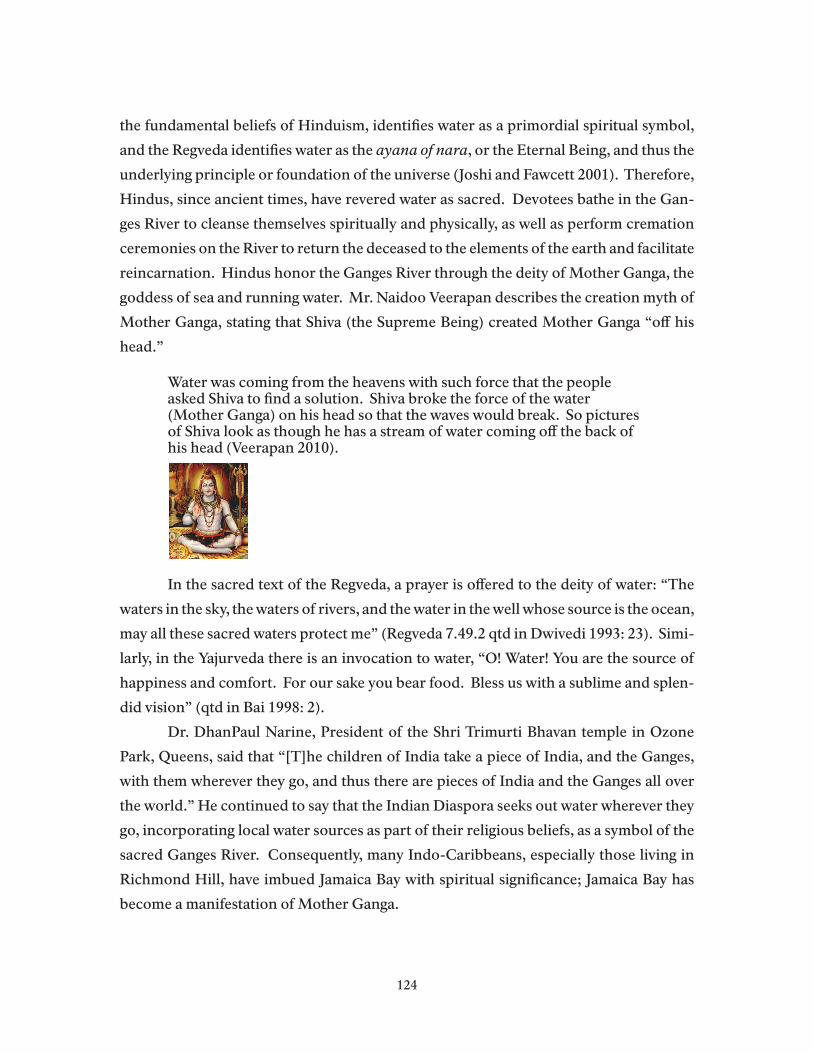
the fundamental beliefs of Hinduism, identifies water as a primordial spiritual symbol,
and the Regveda identifies water as the ayana of nara, or the Eternal Being, and thus the
underlying principle or foundation of the universe (Joshi and Fawcett 2001). Therefore,
Hindus, since ancient times, have revered water as sacred. Devotees bathe in the Gan-
ges River to cleanse themselves spiritually and physically, as well as perform cremation
ceremonies on the River to return the deceased to the elements of the earth and facilitate
reincarnation. Hindus honor the Ganges River through the deity of Mother Ganga, the
goddess of sea and running water. Mr. Naidoo Veerapan describes the creation myth of
Mother Ganga, stating that Shiva (the Supreme Being) created Mother Ganga “off his
head.”
Water was coming from the heavens with such force that the people asked Shiva to find a solution. Shiva broke the force of the water (Mother Ganga) on his head so that the waves would break. So pictures of Shiva look as though he has a stream of water coming off the back of his head (Veerapan 2010).
In the sacred text of the Regveda, a prayer is offered to the deity of water: “The
waters in the sky, the waters of rivers, and the water in the well whose source is the ocean,
may all these sacred waters protect me” (Regveda 7.49.2 qtd in Dwivedi 1993: 23). Simi-
larly, in the Yajurveda there is an invocation to water, “O! Water! You are the source of
happiness and comfort. For our sake you bear food. Bless us with a sublime and splen-
did vision” (qtd in Bai 1998: 2).
Dr. DhanPaul Narine, President of the Shri Trimurti Bhavan temple in Ozone
Park, Queens, said that “[T]he children of India take a piece of India, and the Ganges,
with them wherever they go, and thus there are pieces of India and the Ganges all over
the world.” He continued to say that the Indian Diaspora seeks out water wherever they
go, incorporating local water sources as part of their religious beliefs, as a symbol of the
sacred Ganges River. Consequently, many Indo-Caribbeans, especially those living in
Richmond Hill, have imbued Jamaica Bay with spiritual significance; Jamaica Bay has
become a manifestation of Mother Ganga.
124

Water serves as the bearer of life and a means for attaining purity, both spiritually
and physically. Mr. Veerapan describes the importance of water for Hindus. “Water is a
cleaner, giver of life, a sustainer of plants; we can’t exist without water. It is vital for life,
for everything. The ocean is the mother of all” (Veerapan 2010). Devotees do not pray
to the water as a physical entity, or an idol, but rather believe that coming into contact
with the sacredness of water, as a source of life and spirituality, is important for liberat-
ing devotees from impurity (Joshi and Fawcett 2001; Narine 2010). Therefore, Hindus
not only pay homage to Mother Ganaga for her inherent spiritual qualities, e.g., by cel-
ebrating holidays in honor of the goddess, they incorporate water as a central feature of
most religious rituals and practices because of its life-giving and cleansing properties.
Dr. DhanPaul Narine says Hindus detest pollution…Pollution is everywhere, and their lives are
touched by it. Yet Hindus also have a spiritual obsession with purity. When the Indo-Guyanese come to New York City, everything needs to be pure. Coming to New York City [and to Jamaica Bay] allows people to escape the pollution of Delhi and the Ganges, because the people have a pure Ganges in their mind (Narine 2010).
Joshi and Fawcett (2001) support this sentiment, noting that the central con-
cern of Hindu ritualism is the manipulation and maintenance of purity and impurity.
Through religious rituals, particularly the puja, Hindus increase purity by coming into
contact with things of pure status, such as water. When devotees make an offering to
Mother Ganga, the Mother blesses them with more purity and devotees come closer
to spiritual oneness with the Eternal Self (Joshi and Fawcett 2001; Narine 2010). Simi-
larly, Hindus attempt to distance oneself from impure objects (Joshi and Fawcett 2001;
Narine 2010). Dr. DhanPaul Narine remarked on the difficulty of balancing purity and
pollution in modern society. “It is hard to balance purity and pollution. How do you
reconcile purity with dead bodies and feces in the Ganges? How do you reconcile the
dirty streets of Delhi with the need for purity?” (Narine 2010)
The Jamaica Bay PujaAccording to Naidoo Veerapan, the Indo-Caribbean community knows of few
places in New York to perform their religious rituals, or pujas, so they frequent the shores
of Jamaica Bay, particularly the North Channel Bridge in Queens, which is roughly eight
miles from Richmond Hill. Mr. Veerapan explains that devotees visit Jamaica Bay to
place their offerings in the water, which carries offerings to the gods. He believes that
125

most people come to Jamaica Bay by car, carpool, or in some instances, such as holidays
or rites of passage, cabs. Increasingly, devotees go to places around Jamaica Bay that are
rumored to be lax in authority and are increasingly going at odd hours (e.g., 2:00am) to
avoid enforcement. Although no one could give an exact number of devotees using Ja-
maica Bay at a particular time, John Zuzworsky, a former NPS employee, estimates that,
at one time, roughly 100-200 people could be seen making offerings along the shores of
the North Channel Bridge. Mr. Veerapan estimates that if the Indo-Caribbean com-
munity knew they could go freely to Jamaica Bay to perform their pujas, without harass-
ment or penalty, that 50,000 – 60,000 families, and thus roughly 150,000 people, would
utilize Jamaica Bay for their rituals throughout the year.
Devotees visit Jamaica Bay to perform religious rites or pujas. Pujas are the most
popular form of worship. According to sacred scripture, devotees should perform pu-
jas on a daily basis, or for important religious functions and holidays (Melwani 1995).
However, the Indo-Caribbean population deviates from the traditional practice of daily
pujas, instead, performing pujas once a year for thanksgiving or in special instances,
such as ceremonies commemorating life milestones, to improve one’s karma, or for spe-
cial holidays and festivals (Bacchus 2010; Doobay 2010; Narine 2010; Veerapan 2010).
Devotees may perform pujas directly on the beach, or, as is more common, in their
homes or temple, later bringing offerings to the beach to consecrate them in water and
offer them to the gods (Doobay 2010; Naidu 2010; Veerapan 2010).
Pujas are a time for devotees, through sincerity, concentration, and devotion, to
awaken their eternal spirit within, working to connect with the Supreme Being (Melwani
1995). Pujas serve as a means of adoration and thanksgiving, penance and confession,
spiritual contemplation, and as a means for making special requests. During the puja,
devotees chant a mantra, a god or goddesses’ name, or a special invocation to bring the
statue of the deity, or murti, alive. Devotees distinguish this practice from idol worship
because the gods and goddesses are manifest or incarnate, conscious beings, temporar-
ily taking on the physical plane in the form of the murtis. During the process, the gods
become aware of the thoughts and feelings of the devotees, and thus concentration is
integral for devotees. The puja is a time to make connections between this world and
the inner worlds of the gods and goddesses (Narine 2010; Veerapan 2010; What is Hin-
duism? 2007).
Although there are regional and denominational differences, pujas involve a gen-
126

eral sequence of events or procedures (Melwani 1995; What is Hinduism? 2007). First,
devotees invoke God by chanting mantras and prayers. Lord Ganesh, the remover of all
obstacles, is of particular importance to Indo-Caribbean devotees. If you do not invite
Lord Ganesh to the puja, then the other deities will not come (Veerapan 2010). Once the
deity (or deities) is believed to have arrived, a seat is offered to the god or goddess, as well
as an offering of water. Then, devotees wash the feet of the deity, as a mark of reverence,
love, and self-surrender. After washing the deity’s feet, the devotees then bath the murti
with water and sprinkle it with perfumes while chanting. Devotees then offer the deity
clothes. Many Indo-Caribbeans offer the deities expensive saris, up to $200 a piece, be-
cause they only want to offer the best to the gods and goddesses (Doobay 2010). After
the devotees offer clothes, they also offer other items that they think would be pleasing to
the gods, including pushpam (flowers), phalam (fruit, particularly coconuts), gandham
(sandal paste), dhupam (incense), nalvedyam (foods, e.g., rice), and jalam (water), while
chanting sacred verses, prayers, and hymns (Melwani 1995; Narine 2010; What is Hindu-
ism? 2007). Finally, the puja ends with an offering of aarati or the sacred flame, which
is burned in a kund, or small vessel. After use, the kund is taken home and washed for
next time. Fire is an essential element of the puja because the smoke serves as a medium
for bringing the faithful’s offerings to the deities (Bacchus 2010; Doobay 2010; Melwani
1995; Veerapan 2010).
All of the key informants suggested that it would be nearly impossible to predict
when individuals or families choose to do their yearly pujas. However, they all said that
the number of people performing pujas increases in the summer because of the pleasant
weather and because of the social nature of the event. Thus, Naidoo Veerapan explains
that community leaders (himself included) have invitations every Saturday for people
who want to perform their pujas. Dr. DhanPaul Narine explained that given the large
size of the community, pujas could happen as frequently as everyday.
In addition to a yearly puja of thanksgiving, devotees also make offerings at partic-
ular rites of passage or life milestones, known as samskaras. Although there are regional
and devotional variations in the number of samskaras, Mr. Veerapan notes the impor-
tance of a head shaving ritual, known as mundan, for children, usually between one and
three years of age. During the mundan, the child’s head is shaved to cleanse them of any
impurities and to signify freedom from the past. The hair is then placed in the water, as
an offering to the gods. In addition to the mundan, all of the key informants mentioned
127

the importance of cremation ceremonies and the need to sprinkle the deceased’s ashes
into flowing water for a swifter and more complete release of the soul. By offering ashes,
devotees ensure the return of the deceased to nature and the five elements, as well as the
soul’s safe passage to a higher world (Narine 2010; Melwani 1995; Veerapan 2010). After
a loved one has died, families typically commemorate the death, on the same day each
year, by going to Jamaica Bay and making offerings (Narine 2010).
As part of the puja, Indo-Caribbean Hindus leave their offerings in Jamaica Bay,
believing that the sea with take the offerings to the gods and that the powerful Mother
Ganga will absorb or degrade all that is offered (Bacchus 2010; Doobay 2010; Narine
2010; Veerapan 2010). However, because of the Bay’s circulation patterns, much of the
offerings end up washing back onto the beaches and marshes. Commonly found items
along the shores of the North Channel Bridge include coconuts, statues (murtis) and
pictures, flowers, garlands, saris, bamboo poles and flags, candles and incense, and alu-
minum trays. Devotees do not throw these items in the garbage because to do so would
be sacrilegious; these are offerings to the gods, not litter or garbage (Doobay 2010; Veer-
apan 2010). An elderly woman, in response to suggestions to remove puja items from the
water, said, “well if we don’t place the items in the water, it must be a sin. Then what will
we do? It said in the scripture that we should place these puja items into the water and so
it must be a sin if we do not do that” (Doobay 2010). Furthermore, Ms. Kamini Doobay
believes that because the sacred texts specify placing offerings in the water, that none
of the pandits, or priests, would tell their constituents to stop doing the pujas. Conse-
quently, Ms. Doobay suggests the need to update scriptural interpretation as well as a
need to find a common ground where devotees are free to practice their beliefs while not
harming the environment (Doobay 2010).
Changes in Indo-Caribbean Uses of Jamaica Bay Over the past twenty years, NPS officials have visited local temples to inform
community members of the Park’s rules and regulations, have established programs to
collect remnants of religious offerings for charities, and entered into an informal verbal
agreement with the Hindu community to allow only biodegradable items in the water2
(Krause 2009; Zuzworsky 2009). Despite these efforts, Hindu offerings continue to wash
2 The recycling/charitable donations program has gone by the wayside. In a newspaper article, Brian Feeney, NPS spokesman, said this approach “didn’t work out” (Landor 2008). Park of-ficials have also gone back to disallowing biodegradable materials in the water, citing negative ecosystem impacts (Krause 2009).
128
up along the shores of Jamaica Bay, particularly at the North Channel Bridge. In 2008,
two articles in local Queens’ newspapers drew attention to the issue, “Beach Trashed
During Religious Ceremony” and “Debris from Hindu rituals on Jamaica Bay shore-
line irks community.” The articles detail the opinions of some local community mem-
bers and elected officials. Representative Anthony Weiner (D-Queens and Brooklyn) is
quoted, “[E]ven if the activity is permitted, leaving behind trash cannot be. We cannot
have a situation where people are leaving behind ceremonial pines…leaving shrines of
their garbage” (Landor 2008).
In response to the negative press in the local papers, Mr. Parry Ramgarib from
the Federation of Shiva Mandirs and Dr. DhanPaul Narine met with Park officials to
organize a clean-up of the North Channel Bridge as well as publishing an article “This
Dumping Must Stop” in their local newspaper The West Indian. In addition to orga-
nizing several beach clean-ups, The Federation of Hindu Mandirs and the USA Pandit
Parishoners, along with leadership from the Shri Tamurti Brahvan temple, have taken
action to educate devotees about the ecological consequences of puja offerings. Conse-
quently, Dr. DhanPaul Narine and Mr. Naidoo Veerapan believe that religious remnants
on the shores of Jamaica Bay have declined as a result of these efforts (Narine 2010;
Veerapan 2010).
The Indo-Caribbean community is increasingly aware of the Park’s rules and
regulations and of Jamaica Bay’s ecological sensitivity. This increasing awareness, com-
bined with some intimidation from local community members, has led many Indo-Ca-
ribbean Hindus to alter their practices, such as seeking other places to perform their
pujas (Naidu 2010; Veerapan 2010; Zuzworsky 2009). As opposed to leaving puja items
in the water, Indo-Caribbean leaders are recommending that devotees touch the offer-
ings in the water (some say seven times) to consecrate the items and then take them
home to give to charity or to bury in their yards. While some have complied with these
requests, others continue to perform pujas as before because they can get away with it,
while others have been sneaking to Jamaica Bay at night, when enforcement is down,
to place puja offerings in the water or bury puja items in the sand. Key informants also
indicated that some community members have started performing pujas at home or
have quit performing pujas altogether because of the rules against placing offerings in
the water (Narine 2010; Veerapan 2010). Community leaders did not feel, however, that
these changes had negative spiritual impacts for devotees. Finally, because they were
129

told not to litter and because of the threat of fines, Indo-Caribbean Hindus have sought
out other places to perform their pujas. Many devotees have started to go to Rockaway
Beach in Queens because of its close proximity to their neighborhood and because it is
rumored that the city authorities (as opposed to the Federal government) are more le-
nient (Doobay 2010; Narine 2010; Veerapan 2010; Zuzworsky 2009). Additionally, Mr.
Veerapan notes, “[P]eople don’t want to be a spectacle to other non-Hindus who are at
the beach” and Rockaway Beach, beyond lax authority, offers more space for devotees to
perform pujas without receiving the obyia, or evil eye (Bacchus 2010; Veerapan 2010).
Anticipated Changes in Indo-Caribbean Uses of Jamaica Bay Community leaders expect the Indo-Caribbean, particularly the Indo-Guyanese
population, to increase and to spread beyond the Richmond Hill and Ozone Park neigh-
borhoods. As people from the initial waves of Indo-Caribbean migration (1970s to 2001)
become established in New York, they create spaces and opportunities for others living
in the Caribbean to migrate to the area. Furthermore, established social and familial
networks also attract many second generation Indo-Caribbeans to settle in the area as
they start new families. Mr. Veerapan observes that this process is already underway.
“Previously the neighborhoods were dominated with non-immigrants and now there
is a large number of Guyanese or Indo-Caribbean populations. Therefore the issue of
puja worship within the Park and city will grow with the population” (Veerapan 2010).
Similarly, Nazreen Bacchus notes that Queens Village has become increasingly popular
among the Indo-Guyanese community.
Community leaders recognize the need to work closely with National Park and
City of New York officials to find an acceptable solution to the issue of puja worship
along the city’s shorelines. Community leaders have met with representatives of May-
or Michael Bloomberg’s office and requested beach designations for puja worship at
Rockaway Beach in Queens, a location in the Bronx, and one in Manhattan (Veerapan
2010). Mr. Veerapan said that the community did not request designated spaces along
Jamaica Bay because they did not want to interfere with the preservation of wildlife.
Consequently, one possible change could be the significant decline of the Indo-Carib-
bean community from the immediate Jamaica Bay landscape with a corresponding rise
in their presence along the waterfront in other areas of the city.
The Indo-Caribbean community’s future use of Jamaica Bay will be conditioned
by changes in the community’s population and their evolving relationship with the Na-
130
tional Park Service and the City of New York Parks Department. On the one hand, pop-
ulation changes will likely yield an increase in the number of Indo-Caribbean Hindus
seeking to fulfill their religious obligations along the city’s waterfront. With the influx
of new migrants and an aging population, it is likely that there will be an increase in
the number of individuals who adhere to strict religious interpretations and are more
adamant about leaving their puja items in the city’s waters. On the other hand, many
Indo-Caribbeans have already begun to alter their behavior along Jamaica Bay, either by
removing their puja items, coming at odd times, or abandoning Jamaica Bay altogether.
All of the key informants indicated that the community enjoys Jamaica Bay, stating that
it is not their intention or their wish to deliberately litter or abuse the Bay. Rather, much
of the community is uneducated about the rules and conflicted by the need to adhere to
ancient, sacred tradition and contemporary environmental laws.
Suggestions and Recommendations The overall consensus among key informants was that the relationship between
the National Park Service and the Indo-Caribbean Hindu community must continue to
evolve so that devotees can practice their faith without intimidation and without violat-
ing environmental laws. Key informants suggested a combination of fines and educa-
tion, but stressed the need for collaboration with community leaders so that it did not
appear as a top down process, devoid of community input. Dr. DhanPaul emphasized
the need for constant dialogue with the Park Service, so as to establish a sense that they
are “one community” with the Park.
Park Service and community efforts to reduce the amount of puja items on Ja-
maica Bay’s waterfront have been met with mixed results. Mr. Naidoo Veerapan and
Dr. DhanPaul Narine both mention the positive responses from community members
after National Park Service officials gave presentations during temple visits. However,
Ms. Kamini Doobay notes that many responded negatively to her initial newsletters and
blog postings about the issue, saying that she was “trying to change the religion.” Dr.
DhanPaul Narine believes that while 99% of the other pandits and temple leaders might
agree with the approach advocated by the Federation of Shiva Mandirs and the USA
Pandits Parishoners, many are simply paying lip-serve and do not enforce or carry out
these practices within their own temples because there has been no deterrents in the
past. Therefore, Dr. DhanPaul Narine suggests education for some of the local Indo-
Caribbean Hindu priests so that they discourage their congregations from leaving puja
131

items in the water. He explains that some pandits have never been to Jamaica Bay, and
are unaware of the situation, while others participated in clean-ups many years ago, and
so believe their responsibility has been absolved. Although information about ecologi-
cal issues can come from the National Park Service, some of the education needs to be
done among Hindu leaders because the issue is one of scriptural interpretation.
Several informants suggest that imposing fines, or threatening to impose hefty
fines, would deter people from leaving puja items in Jamaica Bay (Doobay 2010; Naido
2010). However, others thought that this would simply result in devotees coming at night
and/or going to other locations, such as Rockaway Beach, without actually educating the
community about the ecological consequences of puja offerings (Zuzworsky 2009).
Despite their views on fines, all of the key informants suggest extending outreach
and education programs, with the Park and the Mandirs (congregations) reinforcing one
another on the rules and regulations of acceptable puja practices. For example, Ms. Ka-
mini Doobay notes that many community members do not know what is biodegradable
and what is not, and Mr. Naidoo Veerapan observes that many community members are
confused as to why they cannot put biodegradable items in Jamaica Bay, citing conflict-
ing messages from their pandits and Park rangers or Park police. Therefore, he suggests
the need for spelling out the dos and don’ts of puja practices. Dr. DhanPaul Narine
supports this, stating that because this is a large first generation immigrant community,
there is no authoritative literature available to guide their actions so that they can ad-
dress their Hindu beliefs and protect ecological systems. Consequently, Dr. DhanPaul
Narine suggests developing a brochure to specifically address the Jamaica Bay issue. He
said the brochure could be in English, but that it would need to address Hindu cultural
issues, as well as quoting the Federation of Hindu Mandirs, and noting that the Federa-
tion and the Park agree on certain issues/practices and then listing the practices. Dr.
Narine also thought this brochure might provide cultural education to local non-Hindu
communities.
In addition to brochures, community leaders suggest developing other media,
such as television, radio, and web resources. Dr. DhanPaul Narine suggests free instruc-
tional DVDs for community members, as well as placing relevant materials on the NPS
and the temples’ websites. Outside of producing educational materials, community lead-
ers suggest that National Park Service officials continue to come as guests to the temples
to discuss the Jamaica Bay issue (Doobay 2010; Narine 2010; Veerapan 2010). For exam-
132

ple, Dr. DhanPaul Narine suggests that Park officials bring items from the beach, either
Hindu offerings or natural features, to show how they have been destroyed as a result of
the activities on the shorelines. Alternatively, the Park could bring bags of garbage so
people could see how much of the offerings end up in the garbage. Dr. DhanPaul Narine
also suggests holding a ceremony at the North Channel Bridge pavilion to show devo-
tees how they can make offerings to the gods without leaving the items on the beach.
Besides educational materials and outreach, Dr. DhanPaul Narine suggests that
the National Park Service hire a couple of people from within the Indo-Caribbean com-
munity. In doing so, the Park ensures that when people come to do offerings at Jamaica
Bay, they encounter someone who is familiar with Hindu culture and practices and who
can effectively explain the rules in regulations in ways that are understandable for com-
munity members. Dr. Narine and Mr. Veerapan also recommend that the Park provide
positive feedback to the community, where appropriate, because this will reinforce the
idea that people’s individual actions can make a difference and that they are doing the
“right” thing.
Community leaders would like the National Park Service to designate a space
where the community can offer their cremation ashes. Dr. Dhan Paul Narine says that
they were in conversation with Park employees last year about designating a space for
cremation ceremonies. However, the Park disapproved of the community offering flow-
ers and rice with the ashes, and so they left the conversation at that. Dr. Narine states
that they would not deposit the ashes of the entire person, but would rather offer a sym-
bolic portion within Park rules.
Finally, community leaders continually stress that the National Park Service and
the community must collaborate. Mr. Veerapan feels that if the Park fails to actively
and continually involve the community in their education and enforcement, then there
may be backlash against the Park’s efforts. If the Park does not partner with community
leaders, then Mr. Verrapan worries that some people may be more likely to go against
the Park Service’s rules and regulations as a way of showing the gods their dedication.
Consequently, community leaders believe that collaboration and continual education
and outreach (every two or three months) will be the most effective way for ensuring
that the Hindu community can practice their ancient traditions without fear or discom-
fort (Doobay 2010; Naidoo 2010; Veerapan 2010; Zuzworsky 2009).
133
Hindu Festivals and Religious Holidays
The following material is drawn from Hinduism Today and the Shri Trimurti Bhavan website and supplemented by discussions with key informants.
Mahasivaratri – February/MarchThis holiday marks Siva’s great night and it occurs on the fourteenth day of the dark half of Aquarius (February/March). Devotees fast all day in preparation to worship Lord Siva from evening until dawn. The devotees bathe Siva with water, milk, honey, and saf-fron water while chanting the Sri Rudram, a Vedic hymn to Siva or by reciting his name 1,008 times. Devotees break the fast after the last puja is finished at dawn with offerings. The following day is a day of festivities and the contemplation of endlessness/begin-ninglessness.
Holi – February/MarchThis holiday is also known as Phagwai (look up) and the devotees splash friends with bright colored waters and paints. The holiday occurs on the full moon day of Aquarius (February/March) and several days preceding. Many start bonfires to burn effigies of demons and visit friends and exchange presents. It is a celebration of spring as well as a commemoration of the infant Krishna’s killing of the demoness Putana. This holiday is very popular to the devotees of Krishna. The holiday represents the triumph of good over evil, a new agricultural season, and a renewal of relationships.
Ram Navami – March/April Celebrates the birth of Lord Rama, the 7th incarnation of Vishnu, who was born on nava-mi, or the 9th lunar day or tithi (March/April). Devotees engage in a non-stop recitation of the Ramayana, the epic story of Ram’s life. In the evening crowds attend the Ramalila, a dramatic performance of Rama’s deeds. Devotees may also fast or eat only fruit for the nine days before or after navami and many contribute to temples or to charity. Lord Rama is not only an incarnation of God, but also the ideal man, one who exemplified the virtues of reverence, obedience and duty.
Raksha Bandham – July/AugustThis holiday takes place during the full moon of Karkata or Cancer (July/August). Dur-ing this holiday, sisters tie Rakhi, or a ribbon, around their brother’s wrist, who in return present their sisters with clothing, cash, or jewelry and become obligated for the safety of their sister. Rakhi may be given to anyone chosen or anyone who may symbolize the relationship of a brother. There are three knots tied, which represent protection in thought, word, and deed. The holiday is also celebrated as Naradi Purmnma “coconut full moon” when coconuts are offered to Varina, the God of the Sea, by throwing coco-nuts in the ocean. The holiday dates back to Vedic times when children began the years’ study.
Guru Purnima – JulyThis holiday occurs on the full moon day of July with garlands, gifts and devotion to show love and gratitude for the wisdom throughout the year. It is an opportunity to re-new one’s commitment. The traditional form of worship is a pada puja, which involves a ceremonial bath of your guru’s feet with water, milk, honey, and sandalwood paste, as well as an offering of 108 gold coins. The holiday is also known as Vyasa Puja to honor
134

the Sage Vyas, a codifier of the Vedas sacred scriptures. For this purpose, there are offer-ings of lime and rice. It is a day for reading religious books and remembrance of gurus through whom God grants grace and enlightenment.
Krishna Janmas (July/August)This holiday commemorates Lord Krishna, the 8th incarnation of Vishnu, who was born on the 8th lunar day of the dark half of Cancer (July/August). On the preceding day, dev-otees fast until midnight, at the time Krishna was born 5,000 years ago, they break the fast. At the temple celebration, at midnight, the priest places a baby Krishna in a hanging crib. There are also hanging pots of sweets, curd, and butter, which are hung near devo-tees homes in recognition of Krishna’s love for these items. Festivities continue on the following day with pujas, storytelling, and theatre depicting major Krishna events.
Ganesha Chaturthi – August/September This holiday is celebrated by all Hindu sects and is considered a day of solidarity and unity among Hindus. The holiday occurs on the 4th lunar day of Leo (August/Septem-ber) and commemorates the birthday of Lord Ganesha, the elephant-headed God of Wisdom and Lord of Obstacles. Devotees often make clay images of Ganesha and deco-rate the images. At the end of the day (or seven to ten days later), the images are cer-emoniously immersed in the ocean or stream to signify the creation of Ganehsa from the Earth and the return and dissolution in the ocean of universal consciousness. Lord Ganesha removes obstacles and ensures smooth progress in all ventures throughout the year.
Navaratri aka Durga Puja – August/September This festival of 9 nights honors the Goddess and begins on the first lunar day of the bright half moon of Virgo (August/September). There are three days each devoted to: Durga (symbolizing valor), Lakshimi (symbolizing wealth), and Savasrati ( knowledge). During this holiday, devotees create an image of the goddess, which is worshiped for ten days, and then immersed in the sea. It is a day to give one’s tools a rest. Day ten marks the vijaya dasami, which marks the commencement of learning. There are a number of regional differences in the celebration of this holiday. Navratri festivals are customar-ily performed at the temple and then the items are taken to the beach and placed in the water.
Diwali – October/NovemberDiwali is the festival of lights on the 14th lunar day of Libra (October/November) with related festivities on adjacent days, including the five days around the new moon. Di-waili is the most celebrated Hindu festival in the world. One explanation behind the holiday is that it commemorates the day when Lord Rama returned to Ayodhyn after spending fourteen years in exile, though many reasons for the day are cited. Diwali is also a celebration of renewal as the New Year commences. Devotees take special baths in the morning and don new clothes; they clean, paint, and decorate their houses. The goddess Lakshimi is invoked to bring prosperity in the New Year and the day designates the beginning of a new fiscal year. The holiday is considered a time of renewal of fam-ily bonds and forgiveness. The holiday holds official status as national holidays in nine countries, including Guyana and Trinidad.
135

Jewish Ritual Uses of Jamaica Bay ResourcesWriting of Jamaica Bay and South Shore Staten Island at mid-Twentieth Century,
Joseph Mitchell draws on the experience of his informant and friend, the Shellfish Pro-
tector, Andrew E. Zimmer. Given his line of work, Mr. Zimmer, had observed a great
variety of collectors and gatherers who came to poke around the edges of the bays. Most
non-birder or non-fishermen who visited the marshes and mud flats at different times
of the year were of immigrant Italian other European backgrounds, seekers of edible
plants. Zimmer’s and Mitchell’s only example of religiously motivated visits involved
Jewish gatherers on a religious mission:
In September or October, the rabbis and elders come. On Hoshanna Rabbah, the seventh day of the Festival of Succoth, an ancient fertility rite is still observed in a number of orthodox synagogues in the city. The worshippers who take part in the rite are given bunches of willow twigs; each bunch has seven twigs and each twig has seven leaves. After marching in procession seven times around the altar, chanting a litany, the worshipers shake the bunches or strike them against the altar until the leaves fall to the floor. The twigs must be cut from willows that grow beside water, the buds on the ends of the twigs must be unblemished, and the leaves must be green and flawless. (Mitchell, 1951)
Joseph Mitchell might be surprised to learn that during the High Holiday season
in the Jewish neighborhoods of the Watershed area, there are even more of these willows
being held up in prayer, in more Brooklyn family sukkah and synagogues, shuls, and
sthiebles, then there were sixty years ago. Even though the proportion of Jewish New
Yorkers who are of foreign birth is far lower than in Mitchell’s secularizing city, there has
been a resurgence of Orthodox Judaism and Jewish religious observance more generally
in Brooklyn and Queens over the past decades. Today the majority of families and con-
gregations appear to be using willows and branches for their ritual huts and for the cer-
emonies that are from purveyors within the community who can attest to their level of
quality and purity. Perhaps paradoxically, as the Jewish population of the area becomes
more orthodox, there are fewer willows or branches cut by rabbis along the edges of Ja-
maica Bay. There are religious and “habitat” explanations for why this particular Jewish
religious use of bay resources is in decline, if it is still practiced at all.
If willows or branches were taken from the bay, Rabbi Tomsky of Belle Harbor’s
orthodox Congregation Ohab Zedek explained to us, their use in ritual could be suspect.
Jewish law, Rabbi Tomsky said, prohibits the use of anything stolen or taken without
136

permission, so that willows taken along the bay might have in effect been stolen or taken
without permission. In consequence, Rabbi Tomsky’s congregation, and other ortho-
dox ones in the area, will only use willows whose origins they are certain of. They can
be donated from the backyard of a congregant, perhaps, or simply purchased from a
kosher supplier who specialized in a full line of certified merchandise that will relieve
any possible anxiety about provenance.
The contrast between the pastoral image of rabbis and elders collecting willows
and branches for the sukkah in the bay’s marshes, with going on line to an orthodox
purveyor of willows, attests to cultural changes in the nature of New York’s Jewish or-
thodoxy, and changes in the way the edges of the bay are perceived as well. The post-war
rabbis Mitchell and Zimmer observed were gathering reeds and willows from what must
have seemed to them to still be a wilderness edge of the city (although, as we have seen,
every inch of the bay was spoken for). In 2010 it is much more difficult to find a conve-
nient place to walk out on a marsh, find willow shoots or small trees, and clip the pre-
ferred shoots. The demand is greater and the certain supply no longer easily obtained in
the bay, not at least under circumstances that pass ritual muster.
Groups of Jewish families often use Gateway’s public areas around Jamaica Bay
just as other families and households do. Orthodox Jewish groups may be identifiable
as Jews in public because men are wearing yarmulkes (skull caps) and married women
cover their own hair with wigs and scarves. More orthodox members of local Hassidic
congregations are even more identifiable by their distinctive dress. But visible appear-
ances hardly reveal further important divisions of belief and practice that help explain
who appears in outdoor religious observance.
The greatest number of American Jews may belong to a synagogue congregation,
especially when their children are of school age and receiving religious instruction, but
they are not necessarily observant except on the High Holy Days between Rosh Hasha-
nah (New Year) and Yom Kippur (Day of Atonement) which occur in September or early
October. The more orthodox the congregation, the more stringent its members’ adher-
ence to religious calendar and to the rules of Kashrus (kosher) in the home and in public.
In almost all the communities surrounding Jamaica Bay, there are Jewish congregations
of every description, which requires a brief overview of the major segments of the large
Jewish community.
Ashkenazi Jews are those who trace their origins to Europe and Russia, while
137
Sephardic Jews trace their origins and particular liturgy to Portugal and Spain. This re-
mains an important ethnic and ritual distinction for synagogues in the New York Metro-
politan region, although aging congregations are a particular problem for the Sephardic
congregations of the Watershed. Aside from this ethnic division, another and more im-
portant one for understanding the Watershed’s Jewish congregations involves the major
denominations. These are divisions based in important differences in ritual and prac-
tice, as is true with Christian denominations.
The Reform Movement
The Reform movement is America’s largest Jewish denomination, “with many
members group--and many of its members proudly connect to the “Reform” part, ap-
preciating their denomination’s historical emphasis on prophetic Judaism and social ac-
tion, personal choice in ritual matters, and embrace of patrilineal descent (considering
as Jewish children whose fathers are Jewish and mothers are not, in contrast to tradi-
tional Jewish law, which considers only those with Jewish mothers or acceptable conver-
sions to be Jewish). At the same time, the Reform movement has in recent years begun to
embrace traditional observances it shunned a generation ago, signaling a new affinity for
Jewish ritual among many Reform Jews. In 1999, the movement issued a set of guidelines
known as The Pittsburgh Platform, which encourages Reform Jews to study Hebrew and
Torah, observe Shabbat, and recognize the importance of mitzvot (commandments).
The Conservative Movement in Judaism
The Conservative movement “represents a shrinking proportion of the Jewish
population, though it is also seeing rising synagogue attendance rates and increasingly
strong educational institutions. The range of observance within the movement is wide,
and many observers have commented on the wide gap between the observance level of
Conservative clergy and laypeople.”
Reconstructionist JudaismReconstructionist Judaism like Reform congregations stresses personal choice
in rituals, is “ the smallest and newest of the major denominational groups, has seen
increased growth in recent years, and has benefited from the fact that its members have
made an active choice to be affiliated with the movement; because of the denomination’s
small size and youth, most congregational members do not attend “by default”--because
they have longstanding connections to the movement or because it is the only available
138

synagogue option--but because Reconstructionist Judaism speaks to them.”
Orthodox Judaism
Orthodox Judaism the most rapidly growing segment of the Jewish population of
the Watershed area, has “attracted growing members of non-Orthodox Jews to its ranks.
Orthodox communities are increasingly vibrant and well-educated, and ritual obser-
vance has become increasingly stringent and conservative. At the same time, Orthodoxy
has become more withdrawn from and wary of the broader secular culture. At the same
time, feminists and other liberal-minded Orthodox Jews have challenged this shift to the
right; their synagogues, schools, and other institutions ensure lively diversity and debate
within the Orthodox world.” (www.myjewishlearning.com).
These four movements are the “major” denominations. Within orthodox Juda-
ism, however, there are many Hasidic congregations, each with its particular history,
almost all of them represented in Borough Park and the Rockaways today. Within or-
thodox Judaism there is also a trend toward small, independent shuls or congregations
known as stiebles or minyan. Rabbi Dr. Louis Jacobs explains how the Hasidic congre-
gations of eastern Europe came to settle in Borough Park and other American cities after
WWII. Note as well his comment on the origin of the stieble congregations:
Each Zaddik (or Rebbe, as he was called, to distinguish him from the traditional Rav, the town rabbi) had his own court to which his devoted followers journeyed periodically, especially to be with the Zaddik on the great festive occasions of the year. There were often fierce rivalries between the different dynasties, and occasionally, struggle for the succession in the dynasty itself. When Mordecai of Chernobil died in 1837, each of his eight sons founded a new dynasty, as did his son-in-law. It was far from unusual for a Hasid to ask another Hasid: “To whom do you journey?” meaning to which Zaddik do you owe allegiance?
While some Hasidim settled in the land of Israel in 1777 and a very few settled in western Europe, the vast majority remained in Eastern Europe, where, before World War II, hundreds of Hasidic dynasties flourished. The pattern was for the Rebbe to reside in a small town with his followers meeting for prayer, study, and companionship in a small conventicle, the stiebel. These small meetinghouses were found everywhere in the villages and in the larger towns. The dynasties were known by the name of the town in which the Rebbe resided.
After the Holocaust and the resulting destruction of the great European communities, the Rebbes who survived created a new home for themselves in the state of Israel and the USA, taking care to preserve the name of the European centers at which they and their ancestors held
139
court. The Hasidic master who held court in Boston was the exception in that he became known as the Bostoner Rebbe. The best-known and most influential Hasidic dynasties on the contemporary scene are those of Belz, Ger, Satmar, and Lubavitch. (Rabbi Dr. Louis Jacobs http://www.myjewishlearning.com/history/Modern_History/Early_Modern/Hasidism.shtml
Borough Park, which is often cited as the largest single orthodox Jewish commu-
nity in the United States, is home to congregations representing almost all the existing
Hasidic dynasties, as well as some which are less ultra-orthodox. The community is also
represented by a number of Jewish social welfare agencies that represent the needs of
the community’s orthodox residents. When elected officials and governmental repre-
sentatives wish to get anything important done in the Jewish neighborhoods of Borough
Park and Crown Heights, they are most effective when they can convene leaders of the
organized congregations and agencies, as in this example of a recent meeting to discuss
details of how the 2010 U.S. Census would be best administered in the deeply religious
community:
The meeting was attended by over 50 community leaders including: Rabbi Yechezkel Pikus, Executive Director, Council of Jewish Oranizations of Flatbush; Rabbi Yechiel Kaufman, Executive Director, Boro Park Jewish Community Council; Rabbi Chaim Israel of Southern Brooklyn Community Organization; Rabbi David Moskovits, President, Endowment for Democracy in Eastern Europe; Rabbi Shaul Rosen, President, A Time; Rabbi Gershon Tannenbaum, Spiritual Leader, B’nai Israel of Linden Heights. As well as representatives from Bikur Cholim D’Borough Park, Yad Ephraim, Masbia Soup Kitchen, Human Care Services, Nachas Health & Family Network, Boro Park Shomrim & Touro College, who Senator Parker collectively ordained The Boro Park Census Count Committeehttp://www.vosizneias.com/51213/2010/03/14/brooklyn-ny-senator-parker-meets-with-borough-park-jewish-commumnity-over-census-count
As noted earlier, growth of orthodox congregations in Borough Park stands in
vivid contrast with the decline of the Jewish population and its institutions in Canarsie,
one of the oldest Jewish communities in New York. Schlomo Greenwald, in a review of
Canarsie’s Jewish history, writes “Jews began populating the area before World War II
when only three synagogues existed. In the 1950s, the neighborhood started to grow,
with many Jewish refugees who survived the Holocaust. In no time there were eight Or-
thodox synagogues, two non-Orthodox temples, several yeshivas, and at least five small-
er shtiebles (Orthodox, but more informal, synagogues.)
140

“There were at least 15 shuls,” said Rabbi Jacob Jungreis, “and they were all jammed pack. You couldn’t get a seat.” Rabbi Jungreis comes from a family that once was considered something of a dynasty in Canarsie. He, his father and his brother each had a synagogue in the community — all of which were associated with their yeshiva, Ateres Yisroel. The three synagogues have since closed, and the yeshiva, which was once bustling with students from the area, now relies on students bused in from other neighborhoods to fill its classrooms. (Greenwald 2004)
Rabbi Rakowitz, for over 35 years the leader of Canarsie’s Sephardic Jewish
Center, explained this decline to writer Greenwald in familiar terms: “As the houses in
Canarsie became more valuable in the 1970s and 1980s, many Jews sold their homes,
but not to other Jews. Older Jews died or relocated and younger Jewish families did not
replace them as happened years ago. Invariably, fewer Jews populated the neighborhood
chiefly because young Jewish couples were less likely to move to or remain in Canarsie,
even if one of them grew up here.(Greenwald 2004). But as shown in the demographic
analysis in Chapter 3, this decline is by no means uniform throughout the watershed
area. Jewish congregations in Far Rockaway, Lawrence and Cederhurst are growing
steadily, especially in orthodox membership. Orthodox congregations in Belle Harbor
and Howard Beach are holding their members, as is true in Belle Harbor, and Mill Basin.
As orthodox congregations grow in some parts of the watershed area, the issue of delim-
iting a religious space known as an eruv (eruvim, plural form) becomes one of the most
important ways religious practice makes demands on local resources and the authorities
who manage them.
Eruvim: Creating Religious Space in Secular Communities
During the late 1970s and into the next decade, residents of the Rockaways en-
gaged in a debate over religious and secular space then ended up in court and resulted in
one of the first legal precedents about an issue that embroils many communities where
orthodox congregations request to be allowed to install an eruv around the perimeter of
their community. Eventually the lawsuit which was brought by group of Rockaway resis-
dents against the proposed eruv was defeated in court. The Rockaway eruv controversy
still stands as one of the first of a long line of cases about whether the creation of such a
symbolic space is a violation of the constitutional separation of church and state.
An eruv is an unbroken physical delineation of a district in which Orthodox Jews
141
on Saturdays may carry or wheel things, which they would be forbidden to do on the
sabbath except in their homes. Because the Sabbath is a day of rest, activities like car-
rying, cooking or traveling are proscribed. An eruv creates a symbolic boundary that
designates an entire residential area and the synagogues within it as “one domain,” or
a shared space. The most recent effort to surround a part of the city with an eruv has
occurred in midtown and lower Manhattan where, according to Rabbi Sarna of Con-
gregation of Congregation Adereth El, on East 29th Street, “It domesticates the space,
makes it like one home, where everyone is a family.” (Chan 2007) The Eruv satisfies most
orthodox rabbis and enables Jewish communities to enjoy the Sabbath (Shabbat) with
greater ease. It also allows disabled or incapacitated people who depend on crutches,
canes, walkers or wheelchairs and parents of toddlers who must be wheeled in baby car-
riages or strollers, freedom of movement on the Sabbath. Absent an eruv, these activities
are considered “carrying” and are thus impermissible. In order to satisfy Jewish law, the
eruv must be at least forty inches high, roofless, and continuous (without gaps). Tradi-
tionally, an eruv would follow the natural features of a city. Today, in creating an eruv, a
local government usually allows the Orthodox community to string wires along utility
poles to fill the gaps where creek beds or freeway sound walls do not already establish
a usable boundary. Constructed eruvim rely on the use of public property such as util-
ity poles and power lines, as they surround both private premises and public streets.
Another requirement of an eruv is that its boundaries bear a resemblance to a string of
doorways. (University of Maryland Law Journal 2009)
The Belle Harbor eruv case of the early 1980s was widely reported on in the lo-
cal and national press at the time, and exposed a simmering controversy among Jewish
residents of the Rockaways, somewhat divided between orthodox supporters and some
more liberal opponents, as this account of the controversy notes: … when four Orthodox congregations created the eruv in the Rockaways earlier this year, after city agencies had given them permission to use the lampposts and raise the sea walls, a local resident challenged the move in a class-action suit in State Supreme Court in Jamaica.
The resident, Joseph M. Smith, said the eruv (pronounced AY-ruv) violated the constitutional ban on governmental actions that helped to establish religion. The suit argued that ‘’enclosing’’ the area ‘’by this religious device would create a religious aura in and have a metaphysical impact on the area.’’
142

Justice Aaron F. Goldstein last week rejected this view, in what the lawyers in the case said could be the first court ruling on the issue of the eruv’s constitutionality.
‘’The actions of the city agencies did not establish religion but were a valid accommodation to religious practice,’’ the justice held, adding that the United States Supreme Court had mandated ‘’accommodation for religious practices.’’(Fried, 1985)
Mr. Smith a retired physical education professor at Brooklyn College, was him-
self Jewish and claimed that hundreds of Jewish residents of the area who were not Or-
thodox had joined hundreds of non-Jewish residents in the class-action suit. For their
part, Orthodox leaders said 450 families would benefit from the eruv.
Virginia Waters, an assistant city corporation counsel, said the eruv marked the
area bounded by Beach 116th Street, Beach 149th Street, Beach Channel Drive and the
boardwalk and sea walls. The area includes the communities of Belle Harbor, Rockaway
Park and Neponsit. In his ruling, Justice Aaron F. Goldstein also wrote that:
The city had allowed the nylon cord to be strung along 63 lampposts about 20 feet above ground. It had also permitted the height of 15 sea walls to be increased to about 40 inches.
Justice Goldstein noted that under Jewish law an object had to be at least that high to serve as part of an eruv. The city built the sea walls years ago to prevent flooding and erosion of property bordering Rockaway Beach.
Justice Goldstein said the sponsoring congregations had paid the $18,000 cost of creating the eruv, including the work on the sea walls.
Rejecting the argument that the eruv was a wall that enclosed and separated the area, Justice Goldstein said, ‘’The eruv is a virtually invisible boundary line indistinguishable from the utility poles and telephone wires in the area.’’
‘’The actions of the city agencies did not establish religion but were a valid accommodation to religious practice,’’ the justice held, adding that the United States Supreme Court had mandated ‘’accommodation for religious practices.’’(Fried, 1985).
There are over thirty eruvim in the five boroughs at present, and they help pro-
mote a far livelier public presence of orthodox families and congregations in public on
the Sabbath than would otherwise be possible. The subject of eruvim, however, remains
a controversial topic on the Rockaways, as it is in Borough Park and elsewhere in the city
143

today. Although these issues do not directly affect Gateway management at the moment,
they have in the past and could well do so again, although with the decline of the Jewish
population in Canarsie that is somewhat less likely than it was in Gateway’s first decades
of operation. Rabbi Tomsky, spiritual leader of Belle Harbor’s orthodox Congregation
Ohab Zedek, spoke to us about the excellent cooperation and support by city park man-
agers on the Rockaways, especially in maintaining the sea wall segments of their eruv,
but he appeared to have little contact with Gateway management. His predecessor in
leadership of the congregation had much more dealings with the Park Service when
the original eruv plans were being developed. Gateway’s first superintendents, Joseph
Antosca and Herb Olsen, had been part of the early discussion of the Rockaway eruv,
when there was the possibility that the string boundary would extend past Beach 149th
Street along the Boardwalk at Riis Park. A rabbi from one of the local reform congrega-
tions sounded a different note however. This religious leader mentioned that many in
the congregation continued to oppose the eruv because it attracts more orthodox jew-
ish home buyers to the community, potentially creating more of the type of inter-group
conflict that has more recently divided neighbors on the Western Rockaways and the
Five Towns. This recent commentary published in the Wave by a rockaway resident ex-
emplifies the controversy as it is occurring in the extreme southeastern quadrant of the
watershed area:
A few months ago, I was in Cedarhurst early in the morning to shop at the bookstore (how I wish there was a bookstore in Rockaway). When I got there, the Nassau cops had a few cars in front of the store. I went in. One of the young clerks was from Far Rockaway and knew me from previous visits. She told me that they found a note on the door that warned them that the store would be destroyed by fire if they continued to open on Saturdays. The note was unsigned, but the store manager t the time told me that they had lots of problems with the Orthodox Jewish community that has all but taken over the shopping areas in Lawrence and Cedarhurst. ( Schwach , 2007)
Intergroup conflict continues from time to time in Lawrence where controver-
sies have centered on the election of orthodox members of the local school board, for
example, but in nearby Far Rockaway there is an extensive eruv embracing a multi-syna-
gogue area that has generated far less controversy than did the eruv of the western pen-
insula over three decades ago. In Borough Park there is also an extensive and carefully
maintained eruv in place, but it too has been the subject of controversy.
Differing interpretations of Jewish law surrounded the erection of an eruv in
144
Borough Park in the late 1950s. This was an example of conflict among orthodox rab-
bis, not between orthodox and more reform minded Jews. As recent Jewish immigrants,
mostly Hasidim, from Poland and Hungary began to expand their presence; they also
brought their own traditions and religious customs to Borough Park. The eruv, which
was used to network Orthodox families in many places of Eastern Europe for a long
time, was originally challenged by the older Jewish community. Earlier settlers, mainly
orthodox Lithuanian Jews, who settled in Borough Park beginning around 1910, saw it
as a move toward religious liberalism. As the Hasidic population grew, reaching roughly
85% in 2000., the eruv was finally constructed in 1999-2000 over 225 blocks in Bor-
ough Park (Barnes, 2000). Numerous orthodox Jewish web sites with active blogging
in Borough Park attest to the continuing controversial nature of this particular eruv,
and to the different rabbinical interpretations of its validity (http://www.theyeshivaworld.
com/coffeeroom/topic/eruv-in-brooklyn ). Wherever eruvim are proposed or constructed
there is likely to be some continuing controversy. In the most recent example, the lower
Manhattan eruv mentioned above, the religious boundary markers go south to Houston
Street and do not extend into the Lower East Side – one of the historic centers of Jewish
life in America — because some Orthodox rabbis there do not believe that Manhattan’s
traffic patterns and street layout allow for valid eruvs (Chan, 2007).
Jewish Holidays and Outdoor Ritual ObservanceThere are a number of holidays over the Jewish religious calendar that brings
congregants outdoors for religious ceremony. Increasingly these practices as they are car-
ried out among people in the watershed communities are taking place at ocean beaches
rather than at the Bay, although some still occur at Canarsie Pier and elsewhere along the
northern perimeter of Jamaica Bay. Rabbi Tomsky of Belle Harbor’s Ohab Zedek, ex-
plained that in addition to the Hosana Raba ritiual on the seveth day of Sukot, discussed
above, one must include Taschlikh, Passover, Lag Bomer, and Birhat Hama, all of which
bring congregants to the edge of water for prayer. The rabbi also mentioned that some
couples seek to have weddings on the beach. This is a common practice among many
different religious congregations in the watershed area, and one that usually occurs at
city-managed beaches on the Rockaways or at Riis Park where wedding parties come by
automobile to the ocean.
145
Tashlikh: On the afternoon of the first day of the Jewish New Year, Rosh Hashanah,
“the theological message of the morning services is reinforced in a concrete way during
the Tashlikh ceremony, during which individuals symbolically cast away their personal
sins by throwing breadcrumbs into a flowing body of water. This action is accompanied
by the recitation of biblical verses that evoke the human capacity for repentance and
the beneficence of Divine forgiveness through the metaphor of casting sins into depths.
Jews proceed to a body of running water, preferably one containing fish, and symboli-
cally cast off (tashlikh) their sins. The ceremony includes reading the source passage for
the practice, the last verses from the prophet Micah (7:19), “He will take us back in love;
He will cover up our iniquities. You will cast all their sins into the depths of the sea.”
(http://www.myjewishlearning.com/holidays/Jewish_Holidays/Rosh_Hashanah/In_the_Com-
munity/Tashlikh.shtml )
Rabbi Allan Blaine, of Belle Harbor’s Temple Beth-El and the peninsula’s most
authoritative voice on Jewish observance on the peninsula (due to his many decades
of spiritual leadership) told us that on Tashlikh his congregants gather on the ocean at
Beach 135th Street where they delight in greeting each other as well as old friends who
may have returned to the neighborhood for the High Holy Days. On this occasion the
gathering may number well over two hundred people. Similar gatherings occur on south
shore ocean beaches from Coney Island and Brighten Beach, through Long Beach,
wherever it is convenient for congregations to gather at the water’s edge. Congregants
from Canarsie pier also still gather at Canarsie Pier to perform Tashlikh prayers, but the
gatherings are smaller than they were when Gateway was first established.
Hoshana Rabbah: As noted earlier, this is the Jewish holiday when willow branches that
used to be cut along Jamaica Bay are used in religious rituals in the synagogues. Part of
the festival holiday of Sukkot, this is known as the day of the final sealing of judgment,
which began on Rosh Hashannah. “During Sukkot the world is judged for water and for
the blessings of the fruit and crops. The seventh day of the festival is the final sealing and
since human life depends on water, Hoshanna Rabbah is somewhat similar to Yom Kip-
pur. Hence there are additional prayers and quests for repentance as on Yom Kippur. In
the morning services of Hoshanna Rabbah, the congregation marches around the bima
(alter) seven times, after which comes the beating of the aravah, willow branch. The ara-
vahs are beaten against the floor five times. No blessing is recited over the beating of the
aravah since it was merely a custom.” http://www.ou.org/chagim/sukkot/hoshana.htm
146
Passover: Of all the Jewish holidays, Pesach (Passover), in the early spring, is the one
most commonly observed, even by otherwise non-observant Jews. According to the 1990
National Jewish Population Survey (NJPS 1990), more than 80% of Jews have attended a
Pesach Seder, the ritual meal celebrating escape from Egyptian bondage. The Passover
Seder, is should be noted, was also the Last Supper. Rabbi Tomsky explained to us that
on the eve of Pesach (Passover), members of the congregation in Belle Harbor gather
in the temple’s parking lot to rid them of everything containing yeast (Levin) that has
been scrupulously cleansed from their homes. Jewish custom instructs its practitioners
that “After the cleaning is completed, the morning before the seder, a formal search of
the house for chametz is undertaken, and any remaining chametz is burned (http://www.
jewfaq.org/holidaya.htm ) At congregation Ohab Zedek, Rabbi Tomsky explained that in
the past this waste was burned in a bonfire, but now for safety reasons it is disposed of
through additional services of the New York City sanitation department. Some other
congregations of the watershed area may continue to burn their Levin, while in other
cases there are web sites that offer advice for how to dispose of the materials, including
selling it on a special web site so that it is not wasted.
Lag B’omer: Another spring holiday, usually occurring in May but reckoned accord-
ing to the Jewish calendar, this is also an occasion for outdoor worship and the use of
bonfires.
--The name of this Jewish observance refers to the 33rd day of the counting of the Omer. An “omer” refers to a sheaf of barley or wheat. In the book of Leviticus, it is written that God commanded people to make an offering of a sheaf of barley on each of the 50 days between Passover and Shavuot. The day number was announced after the evening service, and in time this ceremony came to be known as the “counting of the Omer”.
The reason why the 33rd day of this period was singled out may have something to do with an ancient pagan festival that was celebrated at the same time. Another story claims that a plague attacked Rabbi Akiba’s students in the second century CE suddenly stopped on this day. Many Jewish people also mark this date by remembering the death of Rabbi Shimon bar Yochai, who was one of Rabbi Akiva’s students. In any case, this observance represents a break in the season between Passover and Shavuot.( http://www.timeanddate.com/holidays/us/lag-b-omer)
Since lighting bonfires in public places, including the ocean and bay beaches of
the Jamaica Bay and the Rockaway Peninsula require permits, in the post 9/11 period it
147

appears that there are fewer such bonfire rituals in the watershed area than there were
three or four decades ago.
Birkat HaChama, The Blessing on the Sun: This holiday occurs infrequently, the last
time in April 2007, but when it does it is the occasion for outdoor prayer throughout the
Jewish world. According to Rabbinic Law the blessing of the sun must occur every 28
years, at the very time at which the sun will be in the same place, and at the same time of
day on the same day of the week, as when it was first “hung” by the Creator. This solar
cycle has been observed in Jewish tradition for thousands of years (http://www.israelna-
tionalnews.com/News/News.aspx/130602 ). Like many public religious rituals, it has been
the occasion for embarrassing incidents as the authorities and members of the wider
public sought to understand what appeared to them as a foreign and perhaps threaten-
ing gathering. Such incidents do also serve as learning opportunities on both sides of the
religious boundaries, as this 1897 episode from the Jewish history of settlement in New
York City indicates:
“Orthodox Hebrews in every part of the world celebrated yesterday what is familiarly known among them as ‘the new sun.’ ... The celebration in New York was spoiled for some hundreds of people by the interference of two park policemen with a gathering in Tompkins Square, the arrest there of Rabbi Wechsler, and the flight of Rabbi Klein.
“Rabbi Wechsler and Rabbi Klein, who are the heads of large east side congregations, decided to call their people to meet in Tompkins Square. Nobody was in charge of the services, and nobody thought of obtaining a permit for holding a public meeting, as required by city ordinance. The Hebrews gathered by hundreds. ... By 8 o’clock the square and the sidewalks around it were crowded. Rabbi Wechsler arrived about that time, and was astonished to see Rabbi Klein running away at full speed. This last phenomenon was explained a moment later by the appearance of Park Policeman Foley, puzzled and excited.
“The celebration is rather a complicated matter to explain to anybody. Rabbi Klein’s knowledge of English is slight, while Foley’s faculties of comprehension of matters outside of police and park regulations and local events are not acute.
“The attempt of a foreign citizen to explain to an American Irishman an astronomical situation and a tradition of the Talmud was a dismal failure.(New York Times 1897 cited at http://www.israelnationalnews.com/News/News.aspx/130602)
148

Congregations, Informal Prayer Groups, Official Permits. The episode in Tomkins square park more than 113 years ago is still extremely
relevant to situations facing park managers at Gateway and elsewhere when religiously
motivated groups appear suddenly on park places and facilities. While it would be al-
most inconceivable today for this much misunderstanding to be directed against Jewish
worshippers, failure to obtain appropriate permits still occurs. This is especially true of
religions whose practitioners are more recently established in the city, as we saw in the
case of the Hindu populations of the watershed area. Lack of well defined congregations
that have corporate identities and official religious leader tends also to be true of all the
practitioners of the various forms of Youraba and other religious of African origin. Like
the Jews at the turn of the twentieth century, followers of Santeria and other related Af-
rican rites are not well understood, nor do their adherents always understand the rules
of use of public space.
Santeria and Related Religious Practices Gateway personnel frequently find remains of chickens and other animal sacri-
fice offerings at Plum Beach, Cross Bay Boulevard, Floyd Bennett Field, and other small
beach and marsh locations along the perimeter of Jamaica Bay. If they infrequently en-
counter the people who may leave these ritual remains in or near the water, it is partly
because their religious activities are most often performed at night. While they may be
confused with the remnants of Hindu practice, in fact these are often traces of religious
rituals of the Santeria and related faiths. “Santeria (The way of the Saints) is a this writ-
ing the most widespread branch of the African religious tradition in the Watershed area.
It is an Afro-Caribbean religion based on Yoruba beliefs and traditions, with some Ro-
man Catholic elements added. The religion is also known as La Regla Lucumi and the
Rule of Osha.” ( http://www.bbc.co.uk/religion/religions/santeria/history/growth.shtml ).
Carribbean people of African slave descent, both of African American, English (Jamai-
can, Trinidadian, etc.) Spanish (Dominican, Puerto Rican, Cuban) and French (Haiti)
colonial backgrounds, may be practitioners of one of the derivations of original Youraba
religious beliefs and practice.
Santeria is known as a ‘syncretic’ religion because it combines elements of a num-
ber of religions, especially Christianity and Yoruba religion. Today it has grown beyond
its Yoruba and Catholic origins to become a religion in its own right, although as prac-
ticed in the Jamaica Bay watershed, it remains somewhat unknown to the general public.
149

As a set of religious practices that derive from a common African religion, it nonetheless
has many variants and no central organization, although there are organizations like the
National African Religion Conference which ordain priests (with no exclusive control
over the vast range of variations in practice) and provide other services to adherents
(http://www.narcworld.com/events.html).
The religion is often practiced in private, in homes and small gathering places. As
in Hinduism, many of the religious celebrations and practices require access to flowing
water and other natural features that are found around Jamaica Bay. People who follow
particular Santeria practices may also be equally involved in Catholic or other religious
congregations. The Roman Catholic element in Santeria is most obvious in the way Ori-
shas are associated with Catholic Saints such as:
Saint Barbara [Shangó], who embodies justice and strength, and is associated with lightning and fire Our Lady of Charity [Ochún] - the Yoruba goddess of the river, associated with water, yellow, sweets, money, and love Saint Lazarus [Babalú-Ayé] - who is associated with the sick Followers of Santeria are often (nominal) Roman Catholics as well. Catholic symbols are sometimes used in Santeria rituals.
Holy Books: Santeria has no scriptures and is passed on by word-of-mouth. Some es-
timates go as high as a hundred million Santeria believers worldwide (Cros Sandoval ,
1996Curry, 1991). From time to time city beat reporters are assigned to do stories about
Santeria, which invariably note that the religion is gaining adherents whose origins are
not African or immigrant:
Once dismissed as a ghetto religion practiced only by the Caribbean poor and uneducated, Santeria has a growing following among middle-class professionals, including white, black and Asian Americans.
There are police officers in New York who pray to Obatala, the father of all deities, or orishas, before they slip on their gun belts.
There are lawyers and professors, civil servants and musicians whose homes are filled with altars laden with flowers, rum, cake and cigars to keep the gods happy and helpful. Many dress in white to symbolize purity.(Lizette Alvarez, After Years of Secrecy, Santeria Is Suddenly Much More Popular. And Public, New York Times 27/01/1997)
150
Mary Curry, whose doctoral dissertation on Yoruba religious deities and out-
door observance, Making the gods in New York: the Yoruba Religion in the Black Com-
munity (1991) is one of the best available sources on the religion and its practitioners
in New York City, observes that its followers believe in a number of spirits, or Orishas.
The religion emphasizes building relationships between human beings and the Orishas,
who are powerful, but mortal, spirits. An Orisha is a manifestation of Olodumare (God),
similar in some senses to the concept of angels in some Christian belief systems. Follow-
ers believe that these spirits will give them help in life, if they carry out the appropriate
rituals, and enable them to achieve the destiny that God planned for them before they
were born. Initiates can perceive Orishas in the physical universe, and the whole com-
munity can share in their presence when they possess a priest during some rituals.
Variants of the Yoruba religion (Akan, Candomble, Ifa Orisha, Santeria Voodoo,
Yoruba ) have complicated histories that are inter-twined with that of slavery and with
the continuing African diaspora to the Western Hemisphere. As shown in Chapter 3 of
this study, the most rapidly growing population segment of the Watershed area is from
the Carribbean, and there is a growing influx of recent immigrants directly from Africa.
At this writing there are over 1.2 million people of African descent living in the Water-
shed, comprising over 60% of its population. It is extremely likely; therefore, practitio-
ners of Santeria and related religions of Yoruba origin will continue to present them-
selves in public places in the coming decade.
Accommodating these practices in public places is not an easy task for park man-
agers as any Internet search using the terms “Yoruba religious practices, public space”
will quickly reveal in news reports of hundreds of conflits and incidents in cities through-
out the United States. The U.S. Constitution ensures protection of religious freedoms.
But opponents of animal sacrifice believe that the practice represents cruelty. Others
object to finding remains disposed of in commercial trash bins, or in parks. Pichardo’s
Church of the Lukumi Babalu Aye in Hialeah, Florida was at the center of a landmark
1993 case that went to the United States Supreme Court. Most police officials and ani-
mal-rights activists have come to concede that the resulting decision affirmed sacrifice
as a legal practice. The ruling largely has been regarded as a sanction of animal sacrifice.
http://www.northeasttimes.com/2002/0821/animals.html
In the Hialeah case of 1993, Justice Kennedy in his decision said:The Santeria faith teaches that every individual has a destiny from God, a destiny fulfilled with the aid and energy of the orishas.The
151
basis of the Santeria religion is the nurture of a personal relation with the orishas, and one of the principal forms of devotion is an animal sacrifice. According to Santeria teaching, the orishas are powerful but not immortal. They depend for survival on the sacrifice.
Assessment: Religious Tradition and Attachments to ResourcesIn each case of religious practice considered in this chapter, the nature of the re-
ligious attachment is to a convenient place with flowing water. In no case is a particular
place in Jamaica Bay unique from a religious viewpoint as “the place we must go, and
where our ancestors have gone before us.” People who could have claimed that depth of
spiritual attachment vanished early in the Bay’s settlement history; the locations of their
sacred places are largely unknown. But this does not diminish the religious importance
of Gateway resources for people of more recent settlement histories in the Jamaica Bay
Watershed.
Religious motivations to use places along the water result in a variety of issues as
we have seen in the case of each of the religions. And the use of resources in each case
creates different priorities for park managers.
The Hindu population is large and quickly establishing itself near Jamaica Bay,
so that a number of locations, and especially Cross Bay Boulevard and Broad Channel,
are quite popular for ritual uses. This study reviews some of the on-going contacts and
outreach Gateway staff is making with the relevant congregations. We have provided
additional contacts and viewpoints from Hindu leaders and local scholars that can help
enhance lines of cooperation and communication.
The Jewish population of the Jamaica Bay Watershed area is still large and ex-
tremely active even if there are declining numbers and aging congregations in some
neighborhoods. The history of issues like the nearby eruv and the uses of natural re-
sources like willows from the bay shores offers insight into the changing nature of Jewish
religious practice and cultures in the Watershed. At present, however, there is not a great
Jewish religious presence in the public areas Gateway administers in Jamaica Bay.
African religious practices, those derived from Yoruba spititual traditions as in-
troducted through slavery into the New World were no doubt present throughout the
colonial settlement history of Jamaica Bay. Blacks living on Barren Island when it was
considered a putrid place, beyond lands end, were likely familiar with Saint Barbara and
other Orishas. It is a religion with a history in the area that deserves to be brought out of
the closet and there are ample signs that this process is beginning (http://www.religious-
152

tolerance.org/santeri1.htm ). Gateway could help stimulate this development, a subject to
which we return in the next and final chapter.
153


chaptEr Six
changing populationS, changing uSE of Jamaica bay rESourcES
A much greater political constituency for Jamaica Bay must be created. Otherwise, it will be difficult, if not impossible, to attract necessary public funding and to ensure that government decision makers consistently consider the bay’s protection to be a priority.(Jamaica Bay Watershed Protection Plan, June 29, 2006)
This ethnographic inventory and assessment has revealed a number of impor-
tant changes in the relationship of cultural groups in the Jamaica Bay watershed area
to the bay’s resources. First and foremost is the finding that over the past forty years of
Gateway management there has been a significant increase in the racial and ethnic di-
versity of the population most accessible to Gateway’s Jamaica Bay unit. A second find-
ing is that many of the historic legacies of development around the Bay and throughout
the watershed continue to exert powerful influences on who uses and who does not use
its resources. A third result of the analysis is that newer populations are using the shores
of Jamaica Bay for religious gatherings and ritual purposes that present continuing new
challenges to Gateway management, while more established religious groups appear to
be making less use of Jamaica Bay resources than was true earlier in Gateway’s history.
In this chapter we return to these findings to discuss some of their implications for Gate-
way’s management of Jamaica Bay resources.
NPS and Gateway in Jamaica BayPeople we have spoken to for this inventory and assessment have offered many
suggestions for how Gateway can respond to their needs. This does not mean the au-
thors themselves agree with these comments. Also, there are numerous reports available
about Gateway’s success and problems in meeting its mission at Jamaica Bay and at its
other locations. This report is not intended to present another analysis of the Park’s
achievements and failures. Nor would it be helpful to suggest programs and strategies
that depend on scarce public funds or significant increases in staff that are not likely to
occur in a period of possible retrenchment. On the other hand, we do frame suggestions
for addressing the challenges posed by changes in the watershed’s population over the
past decades in ways that can address the consensus that constituency building is a high
priority for Gateway at Jamaica Bay and elsewhere.
155
New Populations, Persistent ChallengesDemographic analysis of the Jamaica Bay Watershed (Chapter 3) showed that
over 60 percent of the population is now composed of non-whites, primarily of Hispan-
ic and Carribbean origins. African American populations in Brownsville (in particular)
declined during the 1980s, but in Central Brooklyn remain l an extremely important
segment of the black population. Although the neighborhoods directly adjacent to Ja-
maica Bay have remained largely white of Irish, Italian, and Jewish backgrounds, as was
true in the early 1970s, these enclaves are becoming ever more a minority presence in the
larger Watershed population. These are relatively new demographic changes, especially
as regards the influx of foreign-born residents from Guyana who are Hindu practitio-
ners, and steady increases in Haitian and other practitioners of one or another of the
Yoruba-based African religious traditions including Santeria. It is also true that earlier
in Gateway’s history there were concerted efforts to enlist the support and participation
of representatives of more of the Central Brooklyn neighborhoods and communities.
Given the scale of population change in the Watershed since Gateway was created, and
given the increasing presence of religious practitioners from newer population groups,
renewed efforts to engage with representatives of these new populations can help ad-
dress the consensus that Gateway would benefit from more constituency building.
Earlier in Gateway’s history, outreach efforts to the minority neighborhoods and
populations of Central Brooklyn and Far Rockaway centered on school programsem-
plouyment programs like Job Corps and Youth Conservation Corps, and engagement
with local business leaders who might become engaged with the Park Service through
small business contracts. In a new era of Gateway planning and revival of its advocacy
groups, more emphasis could be placed on the way interpretive initiatives and programs
can help build new constituencies.
Review of the history of settlement and cultures in and around Jamaica Bay
points to a number of areas where there needs to be more historical research, including
oral histories, and more use of local historical materials in interpreting Jamaica Bay’s
changing resources. New historical and interpretive initiatives could directly and indi-
rectly address the legacy of racial tensions and violence around the Bay and provide
more common ground for inter-group understanding in the region. Additional inter-
pretation and programs about the history of the Barren Island settlement is a good ex-
ample of how this approach might be implemented at Gateway.
156

What is the settlement history of black people in and around Jamaiza Bay?This report would suggest that there is a lot more to be done by local historians,
ethnogaphers, educators, and community activists in developing knowledge about the
region’s racial settlement history and presenting its relevant aspects to younger people
who visit gateweay and attend schools in the Watershed area where the history is most
salient. This is a subject of wide interest not only to members of the older and newer
racial populations in the Watershed, but to the general public as well. It also would fur-
ther connect interpretive efforts at Gateway with successful projects like the Weeksville
Heritage Center in Central Brooklyn.
Largely a dream at the time Gateway was assuming management of Jamaica Bay
resources, the idea of developing the early African American free slave settlement at
Weeksville as a restored historical site has made enormous strides and is becoming a
major cultural presence for area residents, as this recent web statement indicates:
In October 2009, Weeksville began on-site construction of a new 19,000 square foot Education and Cultural Arts Building (expected to receive LEED Gold Certification), set to open in early 2012. With this new building comes an unprecedented opportunity for expanded research, education and programming. The new building will house a performance space, exhibition space, education and workshop rooms, a Resource Center, and media lab. The expansive grounds will be landscaped to reflect 19th century agricultural features.(http://www.weeksvillesociety.org/?page_id=37 )
The Weeksville Heritage Center (WHC) “documents and preserves the history
of the free and intentional 19th century African American community of Weeksville.”
Just eleven years after the abolition of slavery in New York, “James Weeks, a free African
American, purchased land on the edge of the settled areas of Brooklyn and . This pur-
chase marked the establishment of Weeksville, a village of free African Americans – la-
borers, laundresses, craftsmen, doctors, entrepreneurs and professionals – who worked
and thrived in New York throughout the 19th and early 20th centuries. A vibrant and
self-sufficient community, Weeksville’s residents established schools, an orphanage, an
elderly home, churches, benevolent associations, newspapers, and participated in anti-
slavery activities.”
The Barren Island community, as we have seen earlier, was also home to African
Americans, although this history is not yet well documented or understood. In the fol-
lowing exchange, a New York Times reporter, Daniel Schneider (2009), answers a reader
157
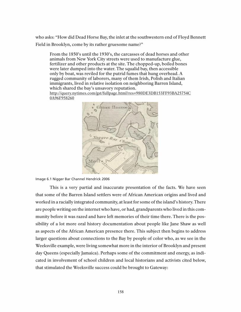
who asks: “How did Dead Horse Bay, the inlet at the southwestern end of Floyd Bennett
Field in Brooklyn, come by its rather gruesome name?”
From the 1850’s until the 1930’s, the carcasses of dead horses and other animals from New York City streets were used to manufacture glue, fertilizer and other products at the site. The chopped-up, boiled bones were later dumped into the water. The squalid bay, then accessible only by boat, was reviled for the putrid fumes that hung overhead. A rugged community of laborers, many of them Irish, Polish and Italian immigrants, lived in relative isolation on neighboring Barren Island, which shared the bay’s unsavory reputation.http://query.nytimes.com/gst/fullpage.html?res=980DE3DB153FF93BA25754C0A96F958260
Image 6.1 Nigger Bar Channel Hendrick 2006
This is a very partial and inaccurate presentation of the facts. We have seen
that some of the Barren Island settlers were of African American origins and lived and
worked in a racially integrated community, at least for some of the island’s history. There
are people writing on the internet who have, or had, grandparents who lived in this com-
munity before it was razed and have left memories of their time there. There is the pos-
sibility of a lot more oral history documentation about people like Jane Shaw as well
as aspects of the African American presence there. This subject then begins to address
larger questions about connections to the Bay by people of color who, as we see in the
Weeksville example, were living somewhat more in the interior of Brooklyn and present
day Queens (especially Jamaica). Perhaps some of the commitment and energy, as indi-
cated in involvement of school children and local historians and activists cited below,
that stimulated the Weeksville success could be brought to Gateway:
158

Shortly following their discovery, the historic houses were threatened due to urban renewal plans. Joan Maynard, the first Executive Director of the early “Weeksville Society,” led community members and youth groups in a sustained fight to save the houses. Using the archaeological evidence they uncovered, students from PS 243, activists, historians, and archaeologists testified before the New York City Landmarks Commission to save the historic Hunterfly Road houses from demolition. They were granted landmark status in 1971, thereby preserving the legacy of Weeksville. In 2005, all three houses were fully restored and opened to the public for the first time in the history of the organization.
The Web has made it far easier for people to trace their family histories and to
become involved in local historical projects like Weeksville, (and, potentially one like it
about Barren Island and other Jamaica Bay settlements), as these unsolicited responses
blogs on the Weeksville site exemplify:
Kandee Cooks says: August 27, 2009 at 10:20 amMy maternal great-grandfather (Moses P. Cobb) purchased a home in Weeksville in the 1800’s. He was born a slave in 1856 in Kinston, NC. He became his neighborhood’s first black policeman in 1892. So, I know all about Weeksville. http://brooklynrail.org/2003/10/local/lets-make-a-landmark-bed-stuys-weeksville-becomes-a-tourist-attraction
Dominic Rickert says: October 13, 2010 at 10:54 pm Interesting, my father and family grew up in one of those houses. Not only an African American neighborhood as my grandparents were a biracial couple.
Some aspects of the settlement history of Jamaica Bay are well known and well
documented, and deserve further study and documentation, like the razing of bay bun-
galows during the Moses period. This history and its background demands a greater
presence in the eventual interpretation of Jamaica Bay’s history at Gateway. And so does
the lesser-known history of African American settlement in and around the Bay. For ex-
ample, the widely acclaimed pictoral history (Hendrick 2009) of Jamaica Bay includes a
detail of a 1901 City of New York map of Jamaica Bay showing near present day Innwood
on the eastern edge of the Bay that there was a place called “Nigger Point.” The editor
explains that, “The names of places around the bay were often determined by their char-
acteristics of inhabitants. Historians say this point, located in today’s Inwood, probably
either had dark sands or was home to African Amerians after the Civil War” (Hendrick
2006 p39). The reader is left to wonder which explanation to choose. In the 1911 nauti-
cal chart introduced in this report’s Chapter 2, a detailed view of the same area ten years
159

later shows similarly racial naming of bay fea-
tures in Far Rockaway near Innwood, but not
all the same names appear in this chart as in
the 1901 document. In a map online (see at left)
showing contemporary Orthodox residents of
the Bayswater neighborhoods of Far Rockaway
the boundaries of the eruv on that part of the
Peninsula, the Bay nomenclature has been ren-
dered more politically correct, as it is in cur-
rent nautical charts of the Bay. But the origins
of the naming remains a mystery that demands
further research.( 2006 map at http://www.yiwb.
org/ERUV%20Grayscale7-9-06.pdf ) Very little
material is yet available, about the history of the Innwood community, and while there
appears to be a lot of related material available from Jamaica historical sources, it does
not appear that any of this has been put together in a thorough history of African Ameri-
can racial settlement in the Watershed.
As these examples suggest, there remains a lot of research and development to be
done, much of it by local scholars and history enthusiasts, to enable Gateway and other
cultural institutions of the area to use history as a means of outreach to the populations
hungry to learn more about their relationship to the city and to the resources of the
Jamaica Bay estuary. This dimension of the Watershed’s history has great potential for
correcting current assumptions about who the people of the bay were and are today. The
broader study of settlement by ethnic, racial, and religious groups in the Watershed can
also yield to lines of outreach to area religious groups.
Religous Claims on Gateway Resources and Environmental AwarenessWhat bearing does the use of Gateway and broader Jamaica Bay resources for
religious ceremonies have on environmental awareness of the Bay and its restoration
needs? From the analysis of ritual uses of Jamaica Bay resources, it would seem that the
answer is “very little.” There are exceptions, however. The twin disasters of 9/11 and
American Airlines Flight 587 have brought Catholic congregations along the Peninsula
outdoors along the Bay for commemorative visits and meditation of the waters and the
city where so many local people sacrificed their safety and their lives. The question re-
160
Image 6.2 Far Rockaway Eruv

mains as to how the Park Service might enhance its environmental mission in Jamai-
ca Bay by drawing on the religious motivations that groups have to use bay resources.
Granted, as we have shown in Chapter 5, this is a tricky area for any public agency to take
on. Still, it is a useful subject for further thought and creative action.
For Jewish residents of the Watershed we have shown that there appears to be
diminishing involvement with Jamaica Bay resources by religiously motivated groups,
although like any other population in the area, Jewish residents engage in all the activi-
ties, environmental, recreational, and cultural, that bring other people to Gateway and
Jamaica Bay. There may be a Polish Yacht Club on a barge at the Barren Island Marina,
but there is no lack of Jewish boat owners at the marina, as years of experience there can
testify. As an organized presence around the Bay, however, Jewish congregations appear
to be largely indifferent to issues of ecosystem restoration unless these have direct bear-
ing on local eruvim or related matters.
As orthodox Jews increase their presence in the Watershed, however, the subject
of religion and environrmetal concern takes on new relevance. The eruv boundaries
shown above enclose nine Jewish institutions, and permit orthodox families to circu-
late within its perimeter. But these boundaries do not extend to the ocean, as do those
of the Belle Harbor eruv discussed in Chapter 5. The eruvim are intended, in general,
to allow some “carrying” on the Sabbath, and are not directly concerned with opening
possibilities for contact with natural resources of the bay or ocean. Then in what ways
are religious Jews engaged with the natural resources of the Jamaica Bay Estuary? The
question quickly becomes Talmudic, but in ways that deserve further exploration in an
urban region where Judaism and the Jewish experience are powerful influences on re-
gional culture.
Orthodox Judaism: Present and ApartOrthodox Judaism has its own divisions and differences in what is considered
appropriate behavior according to sacred scriptures. Those Jewish residents of the re-
gion who are considered the “ultra orthodox” or “haredi,” primarily those of Borough
Park Hasidic congregations, or others in Far Rockaway and Lawrence:
Haredi Judaism is the most theologically conservative form of Judaism. Haredi Judaism is often translated as ultra-orthodox Judaism, although Haredi Jews themselves object to this translation. They simply refer to themselves as Jews, and they consider more liberal forms of Judaism to be unauthentic.
161
According to Haredi Jews, authentic Jews believe God wrote the Torah, strictly observe Jewish Law (halacha), and refuse to modify Judaism to meet contemporary needs. The word Haredi derives from the Hebrew word for fear (harada) and can be interpreted as “one who trembles in awe of God” (Isaiah 66:2,5).http://judaism.about.com/od/denominationsofjudaism/a/haredi.htm
Living apart in a world of Torah study, prayer, and family, without television and
the Internet, how is the natural world perceived? Does it matter that one lives on the
edge of Jamaica Bay? Samuel Heilman, an eminent sociologist of American Judaism,
suggests that “nature” in the popular environmental sense of the word is not likely to
be a concern. He writes that in haredi communities, “…science takes second place to
the demands of religion as interpreted from the inerrant text by the authoritative moral
guides--the Torah scholars. Hence, for example, the real world does not show us God’s
glory or messages--as Darwin once explained in his reflections on the religious signifi-
cance of his findings--but, rather, faith and a dependence on its authorized interpreters
tells us what we may understand and how we may use the real world,”(Heilman 2007,
p.19) This past winter, for example, a record number of eruvs were breached by winter
storms, causing hardship to orthodox families and prompting a reflective article in the
New York Times with this comment by another important Jewish scholar:
“Eruv is one of the only Jewish practices that forces the Jew and the Jewish community to confront the broader world,” said Rabbi Adam Mintz of the Manhattan congregation Kehilat Rayim Ahuvim, who is writing a doctoral dissertation and book about the eruvim in North America. “This symbolic boundary around the neighborhood requires interaction with the broader community, whether it’s asking permission, renting space, putting up strings and poles in front of someone’s apartment.” (Friedman, 2010)
By no means do all orthodox Jews turn their back on nature. Beyond the forced
contact with managers of public space and others that the eruv requires,, there are worlds
of spiritual variation and connection to nature. . This commentary from Judaism and:
Ecology A theology of Creation, would be a good starting point for more develeoment of
real intellectual connections between Jewish groups, especially students of all ages, and
Jamaica Bay Resources:
The endeavor to formulate a systematic environmental ethic is quite new to Judaism. For most of Jewish history, our sacred texts—from Hebrew Scriptures to Talmud to medieval philosophical, legal and mystical literature—have dealt with ecological issues incidentally, as they arose.
162
Ecology was not a discrete area of inquiry; it was, instead, an integral part of the weave of relationships between God, humanity in general (and Israel in particular), and the rest of the natural world. Furthermore, Jewish positions on environmental issues have never been monolithic. In this, they reflect the multivocal nature of our tradition’s texts and worldview. Still, contemporary scholars seeking a normative Jewish perspective on questions central to earth ethics can find much of interest in what is known as “the account of creation” (ma’aseh b’reishit) set forth in the first two chapters of Genesis and subsequent generations of commentaries on these texts. For the most part, Jewish teachers have resisted the tendency to read the Torah in a static, literalist manner. The Genesis narrative describes an ongoing process, for as the Jewish liturgy affirms, God renews the work of creation daily. Humans occupy a unique niche in this dynamic picture of God’s world. We are both a part of nature and apart from it. (Fink, 2004)
Hinduism and Resource Sustainability If separation and symbolic enclosure are themes in Jewish relations to Jamaica
Bay resources, sustainability must be the question facing Gateway and its Hindu con-
stituants. The growing presence of Hindu practitioners in the Watershed region has re-
sulted in controversies at the Cross Bay Boulevard North Channel Bridge especially. Our
chief finding in this regard was that key members of the largest community of Hindu
practitioners, the Indo-Carribbeans, have been developing lines of communiation and
knowledge of the resource issues and Park Service procedures. Consequently, commu-
nity leaders believe that collaboration and continual education and outreach (every two
or three months) will be the most effective way for ensuring that the Hindu community
can practice their ancient traditions without fear or discomfort (Doobay 2010; Naidoo
2010; Veerapan 2010; Zuzworsky 2009). As we noted in Chapter 5:
The overall consensus among key informants was that the relationship between the National Park Service and the Indo-Caribbean Hindu community must continue to evolve so that devotees can practice their faith without intimidation and without violating environmental laws. Key informants suggested a combination of fines and education, but stressed the need for collaboration with community leaders so that it did not appear as a top down process, devoid of community input. Dr. DhanPaul emphasized the need for constant dialogue with the Park Service, so as to establish a sense that they are “one community” with the Park.
What do different leaders and officials of agencies including the Park Service re-
ally understand by dialogue? Can dialogue dwell more on the needs of an ecosystem
than on the needs of a particular religious group? How does modern Hinduism confront
163
matters of environmental quality and sustainability? The majority of Hindu practitio-
ners are not East Asians, but Hindu Indians and others are also a growing segment of
the regional population. Thus it is worthwhile to go beyond the problem that one side
sees trash piled in the sand or floating in a shallow cove , where the other sees the rem-
nants of sacred rites that will disappear in the infinity of the natural world. (Nor is it
helpful, in the long run, that more Hindu worshippers seem to be moving their activities
to the ocean beaches of the Rockaways.) To consider how the problem poses itself for
the people involved, within their ethical-religious system, face the issues posed by their
use of Jamaica Bay resources is worthwhile, but to do so requires creative approaches to
creating occasions and programs where the issues can be fully considered. In just two
ecologically relevant quotations from Hindu texts, the non-Hindu reader can begin to
see that there is much collaborative thinking to do:
O Earth, O Mother, dispose my lotIn gracious fashion that I be at ease.In harmony with all the powers of HeavenSet me, O Poet, in grace and good fortune!– Atharva Veda, “Hymn to the Earth”
Everything in the universe belongs to the Lord.Therefore take only what you need, that is set aside for you.Do not take anything else, for you know to whom it belongs.– Isa Upanishad(http://www.tufts.edu/chaplaincy/Gen_PDF_Basic/hinduism.pdf)
African Religious Practices and Environmental Engagement
A growing population of current and potential religious practitioners, the prac-
titioners of Yoruba religious traditions in the Watershed area don’t have much direct,
formal contact at Gateway, nor do they seem to have sought it as of this writing. Engage-
ment would appear to be the thematic issue where uses of Jamaica Bay resources are
concerned. As in the other cases of spiritual connection to Jamaica Bay resoures, it is not
clear how particular places or environments are understood in any broader sense than
that they provide the basic flowing water and privacy to conduct ceremonies. How then
are the “resources” of Jamqaica Bay understood, perceived, experienced? These lead,
again, to basic questions of what we get out of nature, how we connect it, if we do, to our
spiritual lives, and how, if at all, it requires us to be stewards of earth’s resources. And in
the case of the religions of African orgins, how they are practiced is also a rich reflection
of the great African diaspora. But there is no light or reflection when the practices and
164
their histories are hushed. In fact, one objective of broader discussions would be to fur-
ther explore the many elements of Santeria and other African traditions in the Ameri-
cas that directly link the worshipper to nature and natural resources, with emphasis on
what responsibilities for stewardship these entail::
The orishas of Santeria embody elements of nature. Changó is the mighty clap of thunder in rainstorm; Ochún is the sinuous grace of river water and freeflowing streams; Yemayá is the majestic maternal energy of the ocean; Ogun the solitude and strength of the ironmaking forest-dweller. For those who honor and cultivate these ancestral spirits, their aché (essential sacred energy; vital power) is concentrated in stones. Otanes. These lithic representations of the divinities’ presence and power are collected from places associated with the natural element of each. Ochún’s otanes come from riverbottoms and the banks of freshwater tributaries; those of Ochossi, the hunter king, come from inside the forest; the ritual stones of Changó are meteorites (thunderstones) or from the mountainous places where his energy is said to be strongest(http://ctl.du.edu/spirituals/Religion/otanes.cfm)
A good entry into the entire range of issues raised by interpreting the African ori-
gins of cultures om the Watershed are would be though partnerships with local colleges
and the Weeksville Cultural Heritage Center and the Jamaica Public Library.
People of the Bay, in the “Land of No.” All the ethnographic and historical analysis in Chapter 4, People of the Bay, sug-
gests that the Park Service at Gateway needs to place a high priority on making it clearer
what its resource policies are and how they are intended to address the dual and of-
ten conflicting NPS mandate to “preserve and protect the resources of Jamaica Bay for
present and future generations…” Clearly the new General Management Plan and ac-
companying environmental analysis will have to address this issue as a matter of highest
priority.
One way to ensure awareness and understanding of the Park’s rules and regula-
tions would be to create a “Rules and Regulations” tab on the Gateway website where this
information can be consolidated. Currently, information about rules and regulations,
permitting, and policies are spread over several categories and several pages, making it
difficult for Park visitors and Park communities to understand the rules and regulations
(Jet skiing is one such example). It would also be helpful to place these rules and regula-
tions in their social and ecological context, relaying to visitors and community members
165

how these policies advance Gateway’s mission and the visitor experience.
As Chapter 4 argues, the “people of the bay,” are those men, women and fami-
lies who form especially strong attachments to Jamaica Bay and its creeks, marshes, and
islands. Baymen like the Seamen, father and son, are at the top of a hierarchy of knowl-
edge and experience on Jamaica Bay and it is for this reason that we devote considerable
attention to their particular environmental world view. Like the baymen of other Long
Island estuaries, they pursue what writers, journalists and social scientists continually
describe as a “vanishing’ occupation. The most celebrated of these accounts is Men’s
Lives: The Surfmen and Baymen of the South Fork(1986), Peter Matthiessen’s portrayal
of a disappearing way of life of the Long Island fishermen “whose voices--humorous,
bitter and bewildered--are as clear as the threatened beauty of their once quiet shore.”
Larry Seaman Jr. exemplifies this occupation as it is practiced on Jamaica Bay. Unlike
recreational users of the Bay, and those who form deep attachments out of a desire to
protect the Bay’s resources, the baymen are necessarily out on the waters in all kinds of
weather and over a longer season than most others. Most importantly, they constitute
an invaluable Jamaica Bay resource themselves due to their profound knowledge of the
estuary. As Ben Gibberd writes of Seaman:
For him this world is as familiar as Midtown’s streets are to a cabdriver, and probably more so. He knows not only the contours of every marsh and inlet in Jamaica Bay from Hook Creek (the tiny inlet his house is on) to the Marine Parkway Bridge nearly 9 miles to the west, but also the contours that lie beneath the water. “I know every bump and dip,” he says. “I could draw a map of it as good as the Geodesic survey they do.”
Critics of the this literature point to its tendency to sentimentalize the baymen’s
work to the possible detriment of the more complex issues of resource management
in ecologically endangered estuaries (Lang, 1995). But further research and outreach
could inform the Park about how to capitalize on the positive attributes of their deep at-
tachments to the Bay to inspire environmental protection (See the Environmental Pro-
tection Agency’s 2002 Publication Community Culture and the Environment A Guide
to Understanding a Sense of Place). Tapping into this sense of place could go a long way
in developing community relations by demonstrating that the Park acknowledges, un-
derstands, and respects locals’ relationships to Jamaica Bay. Further research, however,
should be careful to explore best practices for capitalizing on this sense of place without
being exclusionary to other groups or generations. Along these lines, it would be ben-
166
eficial to include cultural education/awareness of the other racial, ethnic, and religious
groups who are increasingly using Jamaica Bay and its resources. Ideally, local commu-
nities’ sense of place would also incorporate a sense of community, which acknowledges
the diversity of an urban Park. Possibilities include development of brochures, “meet
and greets,” devoting part of the Herbert Johnson Lecture Series to cultural and social
aspects of the Park, or interpretive exhibits. Including young people, especially adoles-
cents and teenagers, will be another challenge to developing a sustainable constituency
with the “people of the bay.” Currently, this community is dominated by older genera-
tions. It is in the Park’s interest to develop a younger, local constituency interested in
preserving and protecting the social and natural resources of Jamaica Bay. Possibilities
include youth-directed projects to document their family’s history and connection to
Jamaica Bay, oral history projects that span multiple generations (including pre-Gate-
way generations), teen-oriented nature programs, mentorship programs, or social net-
working opportunities directed toward teen usage of Gateway (Gateway’s blog on Jacob
Riis, albeit more oriented towards children, is a good example).
167

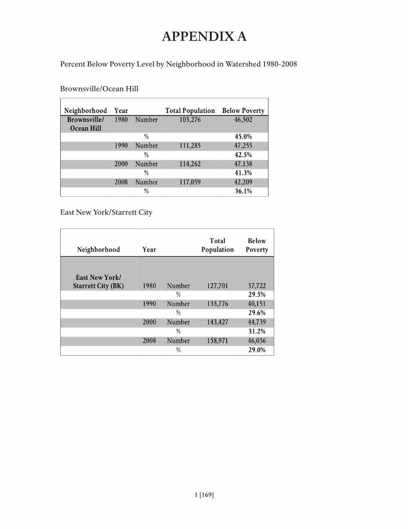
appEndix a
Percent Below Poverty Level by Neighborhood in Watershed 1980-2008
Brownsville/Ocean Hill
East New York/Starrett City
1 [169]
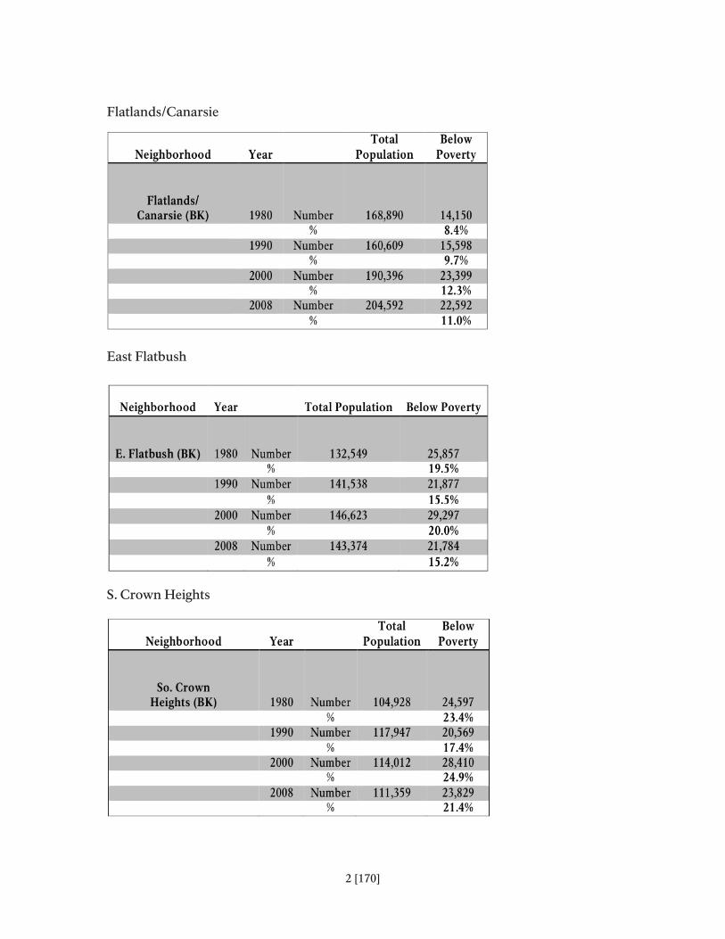
Flatlands/Canarsie
East Flatbush
S. Crown Heights
2 [170]

Borough Park
Flatbush
Sheepshead Bay/Gravesand
3 [171]

Bellerose/Rosedale
Kew Gardens/Woodhaven
Jamaica
4 [172]

Howard Beach/S. Ozone Park
Rockaway
5 [173]


rEfErEncES
Ammerman, Nancy2010 The Challenges of Pluralism: Locating Religion in a World of Diversity. Social Compass 57 (2):154-167.
Bai, Kusuma, K. 1998 Nature and Hindu Festivals: An Environmental Perspective. Itihas 24:1- 12.
Bhaarad Gita.
Bacchus, Nazrene 2010 Unpublished Dissertation
Barnes, Julien, E. 2000 Symbolic Line Divides Jews In Borough Park; A Debate Over Strictures For Sabbath Observance, New York Times, June 2.
Black, Frederick R. 1981 Jamaica Bay: A History. U.S. Department of Interior, Gateway National Recreation Area. Cultural Resource Management Study No. 3.
Boyle, Kevin 2002 Breaking theWaves: Rockaway Rises …and Rises Again. Scotts Valley, CA: Rising Star Press.
Bryant, Nelson1968 Wood, Field and Stream; Sierra Club Joins Protest of the Paving of Jamaica Bay to Expand Airport, New York Times, Apr. 30:56.
Brooklyn Eagle
1881 Action Taken by the Flatlands Health Board. Fishermen Threatening to Burn Factories. February 6.
1882 The Day at Canarsie. July 3.
1882 Canarsie: An Evening Visit to this Well Known Resort. July 27. 1891 Fear A Sewer: Petition of Flatlands People for Protection. July 31.
Buchsbaum, Ralph, Mildred Buchsbaum, John Pearse, and Vicki Pearse1987 Animals Without Backbones, 3rd Edition. Chicago: University of Chicago Press.
Buchheister, Carl 1969 Jamaica Bay’s Wildlife. New York Times, July 28:30.
175

Chan, Sewell2007 A Translucent Wire in the Sky. New York Times, June 15.
Chapple, Christopher, K. 1993 Hindu Environmentalism: Traditional and Contemporary Resources. The Bucknell Review 37:113-123.
Christman, Henry M., ed. 1963 Walt Whitman’s New York, From Manhattan to Montauk. New York: New Amsterdam Books.
Comaroff, John L. 1992 Ethnography and the Historical Imagination. Boulder, CO: Westview Press.
Cronon, William C. 1983 Changes in the land: Indians, colonists, and the ecology of New England. New York: Hill and Wang.
Cros Sandoval, Mercedes 2006 Worldview, the Orichas and Santería. Gainesville, FL: University Press of Florida.
Curry, Mary1991 Making the gods in New York: the Yoruba Religion in the Black Community Ph.D. Dissertation, Department of Sociology, Gradutate Center, CUNY.
Dwivedi, O.P. 1993 Human Responsibility and the Environment: A Hindu Perspective. Hindu-Christian Studies Bulletin 6:19-26.
Elliot, Dolores Z. 2009 100th Anniversary of the Rockaway Point Yacht Club. http://www.rockawaypointyachtclub.com, Accessed November 2010.
Feierman, Steven 2001 The Comaroffs and the Practice of Historical Ethnography. Interventions: The International Journal of Postcolonial Studies. March 3(1):24.
Fink, Daniel B. 2010 Forum on Religion and Ecology. Yale School of Forestry, http://fore.research.yale.edu/religion/judaism/ Accessed November 2010.
176
Flood, Gavin1996 An Introduction to Hinduism. Cambridge: Cambridge University Press.
Fowler, Jeaneane 1997 Hinduism Beliefs and Practices. Brighton, UK: Sussex Academic Press.
Frawley, David 1991 Gods, Sages and Kings: Vedic Secrets of Ancient Civilization. Salt Lake City, UT: Morson Publishing.
Fried, Joseph P 1985 Court Permits Sabbath Area Defined by Cords, In Queens. New York Times, July 14, Sunday, Late City Final Edition.
Friends of Jamaica Bay Wildlife Refuge. 2010. Newsletter, Vol. 1. http://www.alsnyc.org/FOJB.htm, Accessed November 2010.
Gibberd, Ben2007 New York Waters: Profiles from the Edge. Guilford, CT: The Globe Pequot Press.
Greenwald, Shlomo2004 Jewish Community Shrinking, But Surviving. Canarsie Courier, Dec 23. http://www.google.com/search?source=ig&hl=en&rlz=1G1SNNSCEN US405&q=Shlomo+Greenwald%2C+canarsie&aq=f&oq Accessed November 2010.
Gusfield, Joseph 1975 Community, A Critical Response. New York: Harper Publishing Company.
Gutman, Herbert, and Gregory Kealey, eds. 1973 Many pasts: Readings in American Social History. Englewood Cliffs, NJ: Prentice-Hall.
Gutman, Herbert G.1977 Work, Culture, and Society in Industrializing America: Essays in American Working-class and Social History. Oxford: Basil Blackwell.
Hendrick, Daniel M. 2006 Images of America: Jamaica Bay. Charlston, SC: Arcadia Press.
Heilman, Samuel C. 2007 Jews and Fundamentalism. Journal of Ecumenical Studies. Winter 42(1).
177

Hildebrandt, Melanie D. “Double Trauma in Belle Harbor: The Aftermath of September 11 and November 12 in the Rockaways,” in Foner, Nancy (ed.), Wounded City , The Social Impact of 9/11 (New York: Russell Sage Foundation, 2005) pps 106-132.
Hinduism Today, eds. 2007 What is Hinduism? Modern Adventures into a Profound Global Faith. Himalayan Academy.
Howard Beach Neighborhood Website www.howardbeach.com
Irving, Washington1928 [1848] Knickerbocker’s History of New York, Anne Carroll Moore, ed. New York: Fredericka Unger Publishing Company.
Jayawardena, Chandra 1963 Conflict and Solidarity in a Guianese Plantation. London: University of London, Athlone Press.
Joshi, Deepa and B. Fawcett 2001 Water, Hindu Mythology and an Unequal Social Order in India. Paper presented at the Second Conference of the International Water History Association, Bergen, NJ.
Kaplan, Lawrence, and Carol P Kaplan 2003 Between Ocean and City, The Transformation of Rockaway. New York: Columbia University Press.
Kinsley, David 1991 Reflections on Ecological Themes in Hinduism. Journal of Dharma 16:229-245.
Kornblum, William 1976 Gateway, The First Season: Special Study. National Park Service, Denver Planning Center.
1983 Racial and Cultural Groups on the Beach. Ethnic Groups 5:109-24.
2002 At Sea in the City: New York from the Water’s Edge. Chapel Hill, NC: Algonquin Books.
Kornblum, William, and James Beshers 1988 White Ethnicity: Ecological Dimensions. In Power Culture and Place: Essays on New York City. John H. Mollenkopf, ed. Pp. 201-21. New York: Russel Sage Foundation.
178

Landor, Lee 2008 Gateway, Volunteers Forced To Clean Litter Left on Shores After Rituals. Queens Chronicle, November 20.
LeDuff, Charlie 2000 Jamaica Bay Journal; Despite a Warning, Reeling in the Eels. The New York Times, November 12.
Lucev, Emil R. Sr.2007 The Rockaways, Postcard History Series. Charlston SC: Arcadia Press.
Marshall, Paule1989 Brown Girl, Brownstones. New York: Feminist Press.
MacDonald, Fraser 2004 On the Value of Historical Ethnography. Journal of Scottish Historical Studies, September 24 (2):159-165.
Melwani, Lavina 1995 What are over 200,000 Guyanese Hindus Doing in New York State? Far from their Grandfather’s India, a Determined Community. Hinduism Today, August.
Miller, Benjamin 2000 Fat of the Land: Garbage of New York, The Last Two Hundred Years. New York: Four Walls, Eight Windows.
Mitchell, Joseph 1992 The Bottom of the Harbor. In Up In The Old Hotel Pp 465-488. New York: Pantheon.
Mollenkopf, John H. 1991 Political Inequality. In Dual City: Restructuring New York. John H. Mollenkopf and Manuel Castells, eds. New York: Russell Sage Foundation.
Naidu, Janet 2007 Retention and Transculturation of Hinduism in the Caribbean. Guyana Journal March.
Nash, Roderick, ed. 1976 The American Environment, 2nd Edition. Reading, MA: Addison- Wesley.
179
National Park Service 1976 Gateway, Statement for Management and Environmental Assessment. Washington, D.C.: U.S. Department of Interior.
2003. The Evolving Legacy of Jamaica Bay. Washington, D.C.: U.S. Department of Interior.
2006 Jamaica Bay Watershed Protection Plan. June 29. Washington, D.C.: U.S. Department of Interior.
Nochur, Aditya2006 Hinduism’s Key Concepts and Beliefs. Religion, Ecology, and the Environment. March 2.
Norton Basin Edgemere Stewardship Group www.nbesg.org
Olsen, KevinN.d. Environmental History of Jamaica Bay.
Orsi, Robert A., ed.1999 Gods of the City: Religion and the American Urban Landscape. Bloomington, Indiana: University of Indiana Press.
Pritchard, Evan T. 2002 Native New Yorkers: The Legacy of the Algonquin People of New York. San Francisco: Council Oaks Books.
Schwach, Howard2007 More People Have Died In The Name Of Religion, Issue Commentary. The Wave, Aug 10 http://www.rockawave.com/news/2007-08-10/Edito rial/014.html.
Shorto, Russell 2004 The Island at the Center of the World. New York: Doubleday.
Shri Trimurti Bhavan http://shritrimurtibhavan.org/
Stark, Rodney, and Charles Y. Glock2008 New Denominationalism. Review of Religious Research 50:33-42.
Stilgoe, John R. 1988 Borderlands, Origins of the American Suburb 1820-1939. New Haven, CT: Yale University Press.
Tanacredi, John T. 1995 Gateway, A Visitor’s Companion. Mechanicsburg, PA: Stackpole Books.
180

Walton, Terry, ed. 2008 Harbor voices: New York Harbor Tugs, Ferries, People, Places, and More. Peekskill, NY: Sea History Press, National Maritime Historical Society.
181