ITEM 3 - HIGP
78
State of Hawaii COMMISSION ON WATER RESOURCE MANAGEMENT Department of Land and Natural Resources Honolulu, Hawaii June 2,1993 ChaiIperson and Members Commission on Water Resource Management State of Hawaii Honolulu, Hawaii Gentlemen: Waialua Sugar Company Voluntary Reduction of Pennitted Water Use in the Waialua Aquifer System, Waialua Ground Water Management Area Waialua. Oahu Background: Present authorized uses of ground water in the Waialua Aquifer System of the Waialua Ground Water Management Area (GWMA) total 43.114 mgd. The sustainable yield for the Waialua Aquifer System (formerly called the Waialua Subarea) was originally 60 mgd when the Board of Land and Natural Resources adopted the sustainable yield in July 1981. The Commission on Water Resource Management, in October 1991, accepted an updated table of sustainable yields for Oahu. Under the updated table, the sustainable yield for the Waialua Aquifer System was reduced from 60 mgd to 40 mgd. The new sustainable yield was formally adopted by the Commission on March 17, 1993. Authorized uses now exceed the sustainable yield by 3.114 mgd. The Commission staff has reviewed the authorized uses versus the actual uses in the entire Waialua GWMA. Allocations in the Waialua Aquifer System are as follows: Waialua Sugar Company Honolulu BWS Private Users Total 39.940 mgd 2.730 mgd 0.444 mgd 43.114 mgd Preliminary review of Waialua Sugar Company's pumpage data indicates that they have used less than 30 mgd of their 40 mgd allocation over the last five years (see attached graph). Water use by the Honolulu BWS and private users has not changed significantly. Waialua Sugar Company calculated their irrigation requirements using the same methodology that Oahu Sugar Company used to determine their irrigation requirements in the Pearl Harbor area. Irrigation requirements were calculated for dry years (1983 - 1986) and wet years (1988 - 1991). Pumping required was calculated to be about 46 to 48 mgd for dry years and about 3S to 36 mgd for wet years. Waialua Sugar Company has reviewed their water use over the past 20 years and, based on historical water use, conversion to drip irrigation, and other factoIS, has voluntarily reduced its permitted water use in the Waialua Aquifer System from 39.9 mgd to 36.0 mgd effective June 1, 1993. This voluntary reduction reduces the allocations in the W8ialua Aquifer System to 39.174 mgd, which is less than the sustainable yield of 40 mgd, and allows an additional 0.826 mgd to be allocated. . . In voluntarily reducing its allocation, Waialua Sugar Company states that they "want to be on record that sugar production is highly upon water; without adequate water, yields will suffer. We cannot afford to snort oUrselves of water. As we understand, we can exceed the permitted use during dry periods as may be required- (See attached letter). ITEM 3
-
Upload
khangminh22 -
Category
Documents
-
view
0 -
download
0
Transcript of ITEM 3 - HIGP

State of Hawaii COMMISSION ON WATER RESOURCE MANAGEMENT
Department of Land and Natural Resources Honolulu, Hawaii
June 2,1993
ChaiIperson and Members Commission on Water Resource Management State of Hawaii Honolulu, Hawaii
Gentlemen:
Waialua Sugar Company Voluntary Reduction of Pennitted Water Use in the
Waialua Aquifer System, Waialua Ground Water Management Area Waialua. Oahu
Background: Present authorized uses of ground water in the Waialua Aquifer System of the Waialua Ground Water Management Area (GWMA) total 43.114 mgd. The sustainable yield for the Waialua Aquifer System (formerly called the Waialua Subarea) was originally 60 mgd when the Board of Land and Natural Resources adopted the sustainable yield in July 1981. The Commission on Water Resource Management, in October 1991, accepted an updated table of sustainable yields for Oahu. Under the updated table, the sustainable yield for the Waialua Aquifer System was reduced from 60 mgd to 40 mgd. The new sustainable yield was formally adopted by the Commission on March 17, 1993. Authorized uses now exceed the sustainable yield by 3.114 mgd.
The Commission staff has reviewed the authorized uses versus the actual uses in the entire Waialua GWMA. Allocations in the Waialua Aquifer System are as follows:
Waialua Sugar Company
Honolulu BWS
Private Users
Total
39.940 mgd
2.730 mgd
0.444 mgd
43.114 mgd
Preliminary review of Waialua Sugar Company's pumpage data indicates that they have used less than 30 mgd of their 40 mgd allocation over the last five years (see attached graph). Water use by the Honolulu BWS and private users has not changed significantly.
Waialua Sugar Company calculated their irrigation requirements using the same methodology that Oahu Sugar Company used to determine their irrigation requirements in the Pearl Harbor area. Irrigation requirements were calculated for dry years (1983 - 1986) and wet years (1988 - 1991). Pumping required was calculated to be about 46 to 48 mgd for dry years and about 3S to 36 mgd for wet years.
Waialua Sugar Company has reviewed their water use over the past 20 years and, based on historical water use, conversion to drip irrigation, and other factoIS, has voluntarily reduced its permitted water use in the Waialua Aquifer System from 39.9 mgd to 36.0 mgd effective June 1, 1993. This voluntary reduction reduces the allocations in the W8ialua Aquifer System to 39.174 mgd, which is less than the sustainable yield of 40 mgd, and allows an additional 0.826 mgd to be allocated. . .
In voluntarily reducing its allocation, Waialua Sugar Company states that they "want to be on record that sugar production is highly de~dent upon water; without adequate water, yields will suffer. We cannot afford to snort oUrselves of water. As we understand, we can exceed the permitted use during dry periods as may be required- (See attached letter).
ITEM 3

o o Chairperson and Members Commission on Water Resource Management June 2, 1993
RECOMMENPATlON:
That the Commission accept Waialua Sugar Company's voluntary reduction of permitted use in the Waialua Aquifer System, from 39.940 to 36.0 mgd. The 3.94 mgd reduction will be taken from sources in the Waialua Aquifer System presently being determined by Waialua Sugar Company. Staff will be workirig -With them to detertninE!"lll~ source-by-source reductions and will bring the results to. the ~~J.QI! f.9!_appro~ ....... __ _
Respectfully submitted,
Attach.
APPROVED FOR SUBMITfAL
r,~L--.~ KErrn W. AHUE, Chairperson
2

-0 Ol E
WAIALUA AQUIFER SYSTEM wsco. Use Vs. Allocation
80 I~ J. 1 .1 : : : : : : I : : ': : : :
··--·--·······Jr····~·····················~··········· .••• 1\ •••• ~ ••••••••••••••• -••• -•• ~ ••••••••••••••••••••• ; ••••••••••••••••••••• ; ••••••••• II • • I ,'I' • • • f : : l I: : : : " ' , '" ',I. . . . ,: I: "I' ,,.: : : :
: " • : " ' :,', I ,'" : : : : ~ ............... LrL'··~·············J1JL .... ~ .. ~,4J.-r.···l·rld···~······················~·····················t·····················t········· • '~'l • 'l'\~ • 1.111 \ J"" • , • , : I \: ' \' ,,\ :, ~ U I III \ I : : II : : • I I. I r l . I I I \1 II • • , • : J 'I : I \:, , I"~ I : : , : :
l······:y······ ! ... + i····;·······t···Ti-r·····1····!r··r·l~··f;· ···········~···t···1.-!i\-w--U-P--'-3-9-. 9-4-0-m--g-d----, II j\' l' , '" ,I , I,
· ,t' ' ,\' ~ 1 ' ,. , ,:, I : : ;1' 40 : I: t \ J I I :1 I , , , I : I I : j
• ,. I f\ 'I' I II " • I • • " I , ,I , ., I " I I' . I, .. • 11 41 8 d : I: I 'I I I :1 'I I': I I I II 4 I : I I II : • mg .J! . " I I " I I " I I , , I • I •
~O--i:····:··· ·······~-1_··r ~~···r ·····'·ii·······,;1 ··i·····~··r:·~:··~\·· ·~~.···r··~·· .... ~ ..... L' ...... ;. : ,I I:', ' :' I I ': , +-"""'JI~ .... ~,,~-:~+--'I(II, .. I-·(-U-.-: ",~,~' : I II I:' , , I I ,I: l' I: I I I I : ' '" I ," : I :: II I: I I : ' : I I II: 'I t:, I , I : J l, II \ :1 "I r~·r······1~·······~·i"·{······}··i······i·J·········c··1·····"t·,i"······~···:·······,·~··:····~····~··f ... :.~ ... , .... J ••• : •••• ~.~. :,1 I II I: I \ I I ~ I, j,J: I I , :~ , I: • ,~ !t I I :, ~ I II ,: I ,: : (~ : I : I I I ~ II I I ~ : I " I ~ I, :1 ' 1 , : )' : , : I I I l ... I J I : I 'I I ~ I 1Jl-••••• -~ •••••••• ~~., ••••••• J.J ••••••• JJ~ ••••••••• J,~········~········,··,········,·s·····-·~··· ·········tl·······~··-r······'4a·······~ , I , I : . : I~ : lin : , , 'I I ,: ~ : I I, H ,
\ :, : ,J , I I~ \ , \ :J IV • I 't , : 1 I I: 'Ii ~ I I
• • • • • • • 0 1• • I' . , . . I
1111111111111 illilmil i111111111111"'lllIi 11111111111"11111111"11111111111111111"'"111"1111111111111111111111111111111111111111111111111111111111111111111111111
60
50
20
10
1/80 1/82 1/84. 1/86 1/88 1/90 1/92 months
monthly use 12-mon mov ave
"
o
o

'!'Valalua Sugar Company, Inc.
P. O. Box 665
Waialua. Hawaii 96791-0665 o
May 12, 1993
r·1I : 53 Ms. Rae Loui Deputy Director state Water Commission P. O. Box 62}. Honolulu, Hawaii 96809
Dear Ms. Loui:
We have had several meetings over the past months to discuss Waialua Sugar Company's permitted water use from the Waialua aquifer. Waialua Sugar has a permitted use of 39.9 million gallons per day. When you add the permitted use of the City water Department, you have a combined use which is higher than the sustainable yield.
Waialua Sugar Company Board of Water Supply
Total Sustainable Yield Over Permitted Use
39.9 ~ 43.1
40.0 (3.1)
We have reviewed our water use over the past 20 years and while we have peaked at times over our permitted use, it appears we could reduce the permitted use given recent historical water use, conversion to drip irrigation and other factors.
Before going further, we want to be on record that sugar production is highly dependent upon water; without adequate water, yields will suffer. We cannot afford to short ourselves of water. As we understand, we can exceed the permitted use during dry periods as may be required.
Based on the above discussions and research into this matter, Waialua Sugar Company is voluntarily reducing its permitted water use in the Waialua acquifer from our current 39.9 million gallons per day to 36.0 million gallons per day effective June 1/93.
cc: M. Agader J. A. Russell G. yim
Sincerely,
~~~. Michael F. O'Brien President Dole Food Hawaii
. I . I'

+-, ..
ITEM 1
ITEM 1
ITEM 3
o o MINlITES OF THE MAY 19. 1993 MEETING
Unanimously approved as submitted (Cox/Nakata).
OLD BUSINESSIREPORTS
Ms. Loui reported on two follow up items:
1) Guidelines for modification of the water use permits
Staff finds that Administrative Rules 171-23 are clear regarding changes that require modification. Therefore, it was felt that guidelines are not necessary.
2) Guidelines for Emergency permits
Still being worked on. Eventually, amendments to the Administrative Rules will be made to more clearly address emergency permits.
WAIALUA SUGAR COMPANY, VOLQNfARY BEDUCI10N OF PERMITIED WATER USE IN THE WAIALUA GROUND WATER MANAGEMENT AREA. WAIALUA, OAHU
Mr. Sakoda submitted amended recommendations for the Commission review and action (see attached).
Mr. Cox had the following questions:
1) Are the statements regarding "dry years and ·wet years" correct for that area and time?
Rainfall data provided by Climate Center was utilized, it was jointly determined that these were wet and dry years based on actual rainfall information.
2) In terms of the water level in the aquifer, what has happened during the periods noted?
The water level data for the Waialua Aquifer is not that good. No problems have been expressed. USGS is drilling in that area to get more data.
3) What length of time is being discussed in Waialua Sugar Company's (Waialua Sugar) statement: "We cannot afford to short ourselves of water. As we understand, we can exceed the permitted use during dry periods as may be required.·
No specifics have been set, it would be on a case by case basis.
Mr. Nakata asked:
1) Why was there a discrepancy in the amount of pumpage?
Mr. Sakoda replied that Waialua Sugar was still in the process of converting from furrow to drip. During that time, fields lie fallow longer than normal.
2) What percentage of the acreage was under drip irrigation?
- 2 -

•
!
ITEM 4
o o Milton Agadar, Waialua Sugar Irrigation Superintendent stated that approximately 90% is fed by drip irrigation from the Waialua Aquifer.
Mr. Martin provided testimony (see Commission file) urging the Commission to review all data presently available and consider imposing further allocation reductions. He also felt specific quantitative guidelines and protocols for administering dry period extractions need to be part of the State Water Resource Protection Plan and water use permit conditions.
Mr. Cox commented that unless more information was available he would be uncomfortable in trying set a time for the dry period because it would vary considerably from aquifer to aquifer. Mr. Sakoda agreed that a generalized guideline would be difficult to make because every situation would be different.
In regards to the word ·voluntary·, Mrs. Black suggested -agreement- because if there is no water, how could it be a -voluntary reduction-. Mr. Sakoda stated that it is voluntary because the Water Code provides that a water user can voluntarily give up or reduce their allocation without going through the public hearing process.
Mr. Ing asked how the data was obtained for the graph and if all the active pumps were metered. Mr. Sakoda said data was submitted monthly by Waialua Sugar. Mr. Agadar responded that all the pumps are metered.
Mr. Ing asked why the 12-month moving average of pumping was used and if this was an industry practice. In Hawaii, 12-month moving averages have been used by the water industry.
Unanimously approved as amended (CoxlNakata).
HOUSING FINANCE AND DEVELOPMENT CORPORATION. APPLICATION FOR A WELL CONSTRucnON PERMIT. KEOPU-HFDC WELL 1 (WELL NO. 39S7-03). NORTH KONA. HAW All
The following items were discussed:
I) The nearby Haseko Well is not being pumped but is proposed to be pumped at 700 gallons per minute.
2) This well would be required to follow the CWRM's pump test protocol, which is a seven day test. The best data possible will be obtained for input into the Groundwater Model currently being developed jointly by USGS/CWRM.
3) If the HFDC wells interfere with the Haseko well, the Hawaii County BWS would not award the full amount of water commitments to the wells.
4) There have been mixed results of the testing of the high level wells. Some have stabilized quickly while others have not.
Mr. Martin expressed concerns regarding ceded lands, the effects on other wells due to a first come-first serve process, and requirements for a water license.
Mr. Tam said public lands are set aside by executive order for county and other state department uses. Setting aside or transferring water to a sub-agency of the state for public purposes is not a transfer to a private entity. Therefore, the use by the counties of state lands for providing municipal water supply does not require a license under the Land Board or the Commission.
Unanimously approved (Cox/Nakata).
- 3 -

March 17, 1993
State of Hawaii Department of Land P. O. Box 621 Honolulu, HI 96809
and Natural Resources
Attention: Mr. Rae Loui
Dear Mr. Loui:
o
Further to your letter of September 18, 1992 requesting a water shortage plan for Well No. 3704-01 at the Royal Paniolo Ranch; we submit the following:
We are currently pumping approximately 322,500 gallons per day of non-potable, brackish water. The water is used primarily to maintain pastures in good health for just such a water emergency.
Approximately 60% of the water is used to maintain pastures, 35% to irrigate crops, and 5% to water livestock.
In case of a water shortage we would be able to maintain our pastures at 50% of current usage for approximately 6 months and our crops at 75% of current usage for approximately 6 months; however, our livestock is currently at minimum usage as there is virtually no waste.
We could reduce water usage by 38% for 6 months in case of a temporary water shortage in the Waialua Ground water Management Area.
Sincerely,
ROYAL PANIOLO RANCH
(!AU Chris Cook Ranch Hand
CCIls
P.O. Box 30668 Honolulu, Hawaii 96820 Phone: (808) Fax: (808)
--------------------------------------------------------------------------------------.----

JOHN WAIHEE
GOVERNOR OF HAWAII
Mr. Ivy O. Jackson Jackson Companies P.O. Box 30668 Honolulu, HI 96820
Dear Mr. Jackson:
o o
STATE OF HAWAII DEPARTMENT OF LAND AND NATURAL RESOURCES
COMMISSION ON WATER RESOURCE MANAGEMENT
P. O. BOX 621
HONOLULU. HAWAII 96809
SEP 18 1992
Transfer Request for Meadow Gold Dairy Water Use Permit, Waialua Ground Water Management Area. Oahu
Your request dated August 4, 1992 for the transfer of a Water Use Permit for Well
WILLIAM W. PATY
CHAIRPERSON
JOHN C. LEWIN. M.D. MICHAEL J. CHUN. Ph.D.
ROBERT S. NAKATA
RICHARD H. COX. P.E. GUY K. FUJIMURA
RAE M. LOUI. P.E.
DEPUTY
No. 3704-01 from Meadow Gold Dairy to Rocking J. Ranch, Inc. dba Royal Paniolo Ranch, for the same quantity (0.430 mgd), place, and purpose of use is approved, subject to the following condition:
A water shortage plan shall be submitted, as required by Hawaii Administrative Rules, Section 13-171-42(c). Your water shortage plan should describe how Paniolo Ranch will reduce its ground water use in the event the Commission declares a temporary water shortage in the Waialua Ground Water Management Area.
If you have any questions, please contact Ed Sakoda at
Sincerely,
Deputy Director
RH:ko
----------------------------------" ... -.. ~'" .. --.

o .J! JACKSON COMPANIES
August 4, 1992
State of Hawaii Dept. of Land & Natural Resources Commission on Water Resource Management P. O. Box 621 Honolulu, Hawaii 96806 Attention: Rae M. Loui, Deputy Director Reference: Water Use Permit for Well 3704-01 Gentlemen:
o RECF'VED
92 Ate 7 An: I I
I am in receipt of your letter dated July 30, 1992 concerning the Water Use Permit for Well 3704-01. I would like to advise yOU that we have maintained the exact same water quantity, place of usage and purpose of use as Meadow Gold Dairy has. We have not altered from this since transfer was made. Furthermore, we are aware that we are required to keep monthly water use records. We would respectfully like to request that we be granted transfer of the Water Use Permit for Well 3704-01. Please have the new permittee recorded as Rocking J Ranch, Inc. dba Royal Paniolo Ranch with mailing address being P. O. Box 30668, Honolulu, HI 96820.
We look forward to receiving approval for this Permit transfer and I will be happy to assist YOU in any questions yOU may have concerning this matter. Sincerely, Rocking J Ranch, Inc. dba
~a~~h ~Jacaon Executive Assistant to the President EJJ: I OJ: ij
P.O. Box 30668 Honolulu. Hawaii 96820 Phone: (808) Fax: (808)
------------------------------------------------------------------ .----

TO:
o REGULATION BRANCH
Commission on Water Resource Management
__ ->----..! ________ DATE:_----li1£f-f,~1~-- FILE IN: ____________ _
{ INIT:
E. SAKODA K. Oshiro
S. Samuels __ R. Hardy
Q. T. Than
R. LOU! S. Kokubun G. MATSUMOTO Y. SHIROMA
PLEASE:
See Me Call Review & Comment
,__ Take Action __ Investigate & Report
Draft Reply __ Acknowledge Receipt __ Type Draft __ Type Final __ Xerox __ copies
FOR YOUR:
Approval Signature Information
REMARKS:

o

JOHN WAIHEE
GOVERNOR OF HAWAII
Mr. Chris Cooke Paniolo Ranch
o o
STATE OF HAWAII DEPARTMENT OF LAND AND NATURAL RESOURCES
COMMISSION ON WATER RESOURCE MANAGEMENT
P. O. BOX 621
HONOLULU. HAWAII 96809
JUL 30 1992
61-676 Kamehameha Hwy. Haleiwa, HI 96712
Dear Mr. Cooke:
Transfer of Meadow Gold Dairy Water Use Permit for Well 3704-01 to Paniolo Ranch
WILLIAM W. PATY
CHAIRPERSON
JOHN C. LEWIN. M.D. MICHAEL J. CHUN. Ph.D.
ROBERT S. NAKATA RICHARD H. COX. P.E.
GUY K. FUJIMURA
RAE M. LOUI. P.E.
DEPUTY
On November 26, 1991 staff of the Commission on Water Resource Management (CWRM) field checked Meadow Gold Dairies' registered water use and 'found that Paniolo Ranch is now using Well 3704-01. Meadow Gold Dairies had a 0.431 million gallon per day water use permit from the CWRM, as required by law, since it was using water from the Waialua Water Management Area.
Under §13-171-25, HAR, a water use permit may be transferred in whole or in part from one permittee to another if 1) the place, quantity, and purpose of the use remain the same, and 2) the CWRM is informed of the transfer within ninety days. Failure to meet these conditions constitutes a ground for revocation of the permit.
If you wish to retain the water use permit, please notify the CWRM, in writing, of this transfer within ninety (90) days from receipt of this letter. Indicate the place, quantity, and purpose of your water use and be aware that you are required to keep monthly water use records to be submitted to the CWRM.
If you have any questions, please contact Ed Sakoda at
RH:ko c: ElainJ Brown, Bishop Estate
Sincerely,
RAE M. LOUI Deputy Director

STATE OF HAWAII o DEPARTMENT OF LAND AND NATURAL RESOURCES COMMISSION ON WATER RESOURCE MANAGEMENT
P.O. Box 621 HONOLULU, HAWAII 96809
FIELD MEMORANDUM
DECLARANT (FILE REF.): I Paniolo Ranch DATE: Nov. 26, 1991
PRESENf: M. Ohye and Chris Cooke
LOCATION: TMK: 6-1-05:16
SOURCE(S): Well No. 3704-01
USE(S): Livestock and Irrigation of Pasture
FIELD NOTES: paniolo Ranch is located at 61-676 Kam Hwy., on the same land, formerly occupied by Meadow Gold Dairies. The lease was acquired in April 1991. Well 3704-01 is located across 61-427 Kam Hwy. A 10,000± gallon capacity steel tank is located just makai of the well. Water is pumped to the tank with a 20 H.P. vertical turbine, then gravity fed through a series of PVC pipes to the pasture and troughs. The well is pumped once every four days. Chris Cooke did not know the size of land area, but he mentioned that the Ranch will expand and will be using more water in the future. I observed about 20 horses and 9 water troughs.
r.' ,
"

• o FIELD lNSPECTION INFORMATION CHECKLIST (Ver 4/3/91)
PART I: USE OF WATER Declarant's File Reference: -?A: \-,h 0 LO R.,A.~L\-\ 1. Tax Map Key where the water is used: ~-_I_-OS :~. Does the declarant own
this land? \...\0 If not, who does? ·~\L.::7.t-\D.p .(..:7-rA:I~
2. What is the water used for? L\\J~~Dt.~ A:...1.D t~C.It::JA,.t\oJ G~ -PA&'lLl~e::;:. If for irrigation, how many acres are being inigated by crop type? _______ _
If for livestock, how many and what kind? 'lD :Ao ~ ~8;. - PLA~J '"(0 C+f'A.lt> If for drinking, at how many houses? ______ by how many people?
3. Is the quantity of water use being measured? tJo If yes, document the location of the measurement point and method of measurement; also get use records if these were not submitted previously.
4. If this person takes from a multi-user pipe or ditch system: How is the water taken from the system? ________________ _ What is the capacity for taking (gpm)? _________________ _ How often is it taken (used)? ___________ -----------
PART II: WATER SOURCE Source #: -=?"1 04- -0 \
1. Where does the water come from I what kind of source is this? ~
Types of sources include: 1) Wells (drilled, dug, tunnel) 2) Diversions (ditch, pipe, pump, or livestock from a stream, spring, swamp, pond) 3) Multi-source systems. (Declared use cannot be traced to a single well or diversion) NOTE: If a multi-user system: take from pipe or ditch (need to determine whether this is a multi-source or single-source system before the data can be input to the computer 4) Instream (i.e., crops planted along water edge)
I
2. Show the source location on maps, determine latitude and longitude, and document the nature of source development by measqrements, sketches, and photographs. How is the water taken? /[.0 U. f'. Uo€;L"1\L.N\..- -(u"-.Bu-le What is the capacity for taking (gpm)? --~-~--:-~:----:---=-_r_-----How often is it taken (used)? Qhjt...~ 'f."~~'< ~LUZ ... .DA-.c:,.
3. Tax Map Key at the source: ~ __ I _- D!S :~. Determine declarant's relation to source. Does the declarant:
1) Operate and maintain the source? '(E;~ If not, who does? _________ _ 2) Own the land at the source? ~ If not, who does? __________ _ 3) Use the water from this source? '>i~ If not, who does? _________ _ 4) Own the land where the water is being used? ~ 5) None of the above? If so, why did they file? ' __________ _
4. Does anyone else also use water from this source? Jo If yes, is their use included in this user's declaration? Who are the other users? Did they file? _____ _
DATE: _~~=o....::...~~. -...:rt:...=b-",:,:--1--,QC(_,_

",-.. . ~
\ • , . . ,
• , , • ,
-'., • .. • • \ • • • ,
• • , • <;.
v 0 , 1\"1 M V )f
• \ • \ . • • • \0 • • , .
~'" "~ • .!~'.I.)
\ ~'. "1-.1-· .. _ ... : ... : ,\ \.-:-~
\ '
f\
~I
// - Ct=IP04. '601)
Q-L )f
., ~ =-~/' G':J ~e"'"" ~":="~J,j :/~7 ':I:"H-J..i dq¥v,t;;" d ,
: <:)/ :J1f';'; ~1fI so ..
, '" .-.. '
... '

tHN WAIHEE
RNOA OF HAWAII
.-fr. Eric R mussen
.
o '.
STATE OF HAWAII DEPARTMENT OF LAND AND NATURAL RESOURCES
COMMISSION ON WATER RESOURCE MANAGEMENT
P. O. BOX 621
HONOLULU, HAWAII 98809
September 20, 1991
.feadow Go D' ies T'A,4IQ\..o ~,...~xt 1-676 Kame eha Hwy .. )('.ciarant file r erence: .1EAD GL AIRY
Co ---I ~ 5: /4 ---m~ai Dedrihlnt:
Oahu, Zone 6, Tax Key Field Verification of Declared Water Source and Use
o WILLIAM W. PATY
CHAIRPERSON
JOHN C. LEWIN. M.O. MICHAEL J. CHUN. Ph.D.
ROBERT S. NAICATA RICHARD H. COX
GUY K. FUJIMURA
MANABU TAGOMORI
c.O DEPUTY -(/) ::u ron rn -0
() · r;:,o.-- rn -"'0 .c:. ..,s:::.. rf\ ... 0 -d'J
Field crews for the Commission on Water Resource Management are preparhig to, verify the registered water sources and declared water uses in your area beginning October 1, 1991. We would appreciate your taking a few minutes to complete the information below to help us contact you to schedule a field visit.
Who should we contact to arrange for a field inspection of your water source and water use, and how can we contact them? -.
Name(s): BA~\?Ag.A -:::::fOR-baN Phone No. (Days): c..~7- 0 .ct-"+'2.... Phone No. (Evenings): _____ _ Good time to call: -----------------------------------------------------
Please complete this form and return it to us soon as possible using the enclosed stamped envelope. If you have any questions regarding the field verification of declared water source and use, please contact the COnmllssion staff at
YS:ln Ene.
t ~-_.t:) M ~U TAGOM01I Depu
:.J • . .
s

•
JOHN WAIHEE
GOVEANOq OF HAWAII
o o
STATE OF HAWAII DEPARTMENT OF LAND AND NATURAL RESOURCES
COMMISSION ON WATER RESOURCE MANAGEMENT
P. O. BOX 621
HONOLULU. HAWAII 96809
April 18, 1990
WilliAM W. PATY
CHAIRPeRSON
JOHN C. LEWIN. M.O. MICHAEl J. CHUN. Ph.D.
ROBERT S. NAKATA RICHARD H. COX
GUY K. FUJIMURA
MANABU TAGOMORI
DEPUTy
Mr. Eric Rasmussen File Reference: MEAD GLD DAIRY Farm Manager Meadow Gold Dairies 61-676 Kamehameha Hwy. Haleiwa, HI 96712
Dear Mr. Rasmussen:
Notice to Declarants of Water Use
Enclosed is a copy of amended recommendations regarding declarations of water use which were adopted by the Commission on Water Resource Management at its special meeting on February 28, 1990. These recommendations replace the earlier staff recommendations which were a part of the submittal mailed to all declarants last December.
There is now a 180 day deadline in effect to amend declarations which describe instream uses (Category 2), no existing use (Category 3), or which are incomplete (Category 4). This deadline does not affect declarations which have been accepted as being reasonably complete and describing an actual existing use (Category 1). The commission staff will verify the Category 1 uses and conduct other activities necessary to issue certificates of water use.
Our records currently show that your declarations have been placed in Categories 1 and 3. Category 3 refers to unused existing sources, proposed future uses, or claims for water rights. The commission staff has described your actual existing use (Category 1) as follows:
Water from one pumped well with a 20 HP motor is used for dairy farm and . watering livestock.
If you have not already done so, please write to confmn whether this summary is accurate, advise us of any changes which. should be made, and provide additional information. The enclosed sheet dated -March 21 (Enclosure #2) describes what is required and how to amend your declarations. When ·you write to us, cle3!ly indicate that it is regard to file reference MEAD GW DAIRY, Oahu, which has been assigned to you.

o Form 8810-1
: , r ': ~':!,~ \/ 2 3 j~ i 0: 4 5 ) ... .' • II' j
STATE OF HAWAII COMMISSION ON WATER RESOURCE MANAGEMENf
DEPARTMENT OF LAND AND NATURAl RESOURCES . i: ',1 (J \. J ,\T F R ~ DIVISION OF WATER RESOURCE MANAGEMENT ~_,1 ,J :j, ',' _.,.ui:;·iEtH
REGISTRATION OF WELL AND
DECLARATION OF WATER use
INSTRucnONS: Please type or print. "information Is not available or not applcable, Indicate as NlA. Fin GUt as oompfe,e'l' as pos n, and file form WIth the DMttIon of Water RHOIM'C8 Management, P.O. Box 373, Honolulu, Hawall~. Phon. 548</g~ or for assIstMCe.
BAlTERY OF WELLS: For a battery of wells, on the sutface, In a tunnel, or In a shaft, submh a registration form for each well togethnr with a single map or plot plan showing layout of wells.
t i' 1
STATE WELL NO.: :n04=o';r;.. ISLAND: --.l0..w;ai!L.\hA..l:uL.-__ WELL NAME OR DESIGNATION: _~l1..:;f:>r:...:..w.:....:\..:::Ci~LO:::::..-.,....'R~A:-:...:..I-i:;.;(...::..:;l.i~V=...::;;Jl%;..;;\...~~~ ______ ~_ SOURCE OR STATION NAME (For a ban!y of wens): _________ """'-_________ _
B. OWNER OF WELL SITE Firm name: Kamehameha Seh/Bishop f.state
-;;;.;;...:;;....;:.¥-____ ~~~ M.M\M~ontact person: Elaine Brown
Address: P.o. Box 3466 Honolulu, Hi,.
Zlp:_~~_ Zip: 96801 Phone:
C. WELL LOCATION Tax Map Key: 161-005-016 Town, Place, District: _Kawailoa. v.!a~alua
Attach USGS "Quad" map (scale 1 :24,000), tax map, or other map showing the well location.
D. WELL DATA For Drll ... We"s, subml .M-bu,.. drawing, drfller's log, and pump te .. resufts, and complete ftems below. j
For Tunnels end Sherts, submit conMrudlon drawings, plot plan, or sketch map.
Ground elevation (Mean sea rev.t): 32ft. Year drilled or constructed: _olu9z..;5w1i--___ _ Reference point (Used to II'IHMII'e depth to water): Well contractor: __ .1iG:..I.l..:..ouY:..se~r,---_______ _
Elevation: N Q P e ft. Description: __________ _ Casing diameter: _...L1..,:2:..-"""'-______ in.
Solid casing depth (Below ground): 1t. Perforated casing depth (BelOw ground): ft. Total depth of well: ft.
Depth to water (Below reference pok1t): ft. Maximum recorded chloride: - ppm Minimum recorded chloride: ppm Maximum chloride In 1987: ppm Minimum chloride In 1987: _____ ppm
E. INSTALLED PUMP DATA 1988 chloride level: 102 ppm
Pump type: !Xl Vertical shaft 0 Submersible 0 Centrifugal 0 Other (apeelly): ______ ,
Power: 0 Diesel, _ HP 0 Gas, _ HP ~ Electric, ..£..Q... HP 0 Other (specify): _____ _ Pump capacity: gallons per minute Pump Installation contractor: _'!P~'J::S~ • .-£P~e:..:l:..:l~6t!........!C::..!o~.~ _______ ......... ---. ______ _
. . . (continued over)
----------------------------,----------------------------------------.. For Official Use Only: Date received: __ ~ Date accepted: 0 • "
Field checked by: J!Ls Date: jl-'Z(,_q f Latitude: 2, '?J1 ~4- HydrologiC Unit: _. Comments: __________ Longitude: .§$~ 04' 4Z ,. State Well No.: ~-'04-0 I
Referencel: HawaII Revised Statutes, Chapter 174C.
HawaII Administrative Rules, Chapters 13-16710 13-171.

• o F. DeCLARATION OF WATER USE
NOTE: The purpose 01 lhe Declaration 01 Waler tJse is 10 oblain lnformallon necessary for lhe management 01 lhe Slale'& water reIOlJr<:e4. The Oeclaralion does nol confer a legal right 10 waler or lis use.
Water use data are recorded: 0 Daily 0 Weekly 0 Monthly GI Other (Descrlbe): ---E..e..c..o..r.. d e d 00 ¥- e Ii r 1 yes t j mat e s
Method Of measurement: 0 Flow Meter 0 Orifice [i Other (Dea.crl:le): ~stimate based on pump capaci ty
and hours pumped. "
Quantity of Use (Rapolt melered or estimated monlhly waler use from lhe well described on the reverse side of Ihis form, for Ihe calendar years 1Q83 Ihrough 1Q87. For a battery of wells which are nol Individually metered, but which are connected 10 a single meter or olher measllring device. repotllolal use from lhe ballery.):
WATER USE, IN GALLONS X 1000
1983 1984 1985 j986 . 1987 Januarv 1':l. 7hU ;? ':l.R7 1:? -::!~7 ., 'J J, 1"11"1 ,,.., I." "
Februarv 12"432 11 ·189 11~188 11 "200 11 :200 March 13~764 12.388 12,890 12 .• .000 12.000
AmI! .13 320 11'.988 -11.322 12,000 12,000
Mav 13 764 12.390 12.889 12.400 12~400
June 13--,,320 11.988 11.664 12,000 12,000
Julv 13_11.764 i2.388 12.555 12.400 12.400 Aunllj:l,t 1~ 7114 12 ~88 12 0'), . 12 400 12 400 Seotember 1~ ~'() " oRR '11 .088 '. l2000 12 000 ~tnhAr 13_.364 12.388 12.220 12.400 12.400 II. r 13.320 11.988 12.474 ·'···l·~ .• OO 0 12.000 0 1, 764 12 ~88 12 ')')1) . 124_00 12 400 ANNUAL 161 660 145.858 146.185 145.6 00 145.600
Minimum day's use: ~ 2 9 .600 gallons Maximum day's use: 450.000 Typical times of usage: 24 hours per day.
gallons
Tvpe of Use (Che<;k all <:aIegory boxes Ihat apply and provide addilionalinformllion aa Indlc:ated.):
QJltuXUY
o Municipal (Includinp resorts. hf:Ite., bus!nessas)
o Domestic (syslems serving 25 people or kiss)
o Irrigation
(J Industrial
o Milijary
l!J Other
AQdijional InfQrmgtion
Number of service connections: __________ _
Acres Irri~ed: ____ ._------.....------Crop(s): U Sugar 0 Pineapple
o Other (specify): Non-Crop: 0 Landsc;:ape ----..O-r-:G::-o"':':If~C::-o-u-rs-e-----
o Other (s,R.eclfy): Method: 0 Drip U Furro-w---.O ........ S.,...p-r-ln-kl-e-r ----
o Mill o Cooling 0 Manufacturing D Other (sp~cify): ___________ _
, Specify (livesiock. aquacullunl, etc.): D Air y Far m / L i v est 0 c k
I declare that the c;ontents of the above Declaration of Water- Use are, to the best of my knowledge and belief, tl1.le, correct, and complete.
Water User's $ignature: Date: \ , --------
Printec;i Name: 1!;x;; C '&13 s,mJl5sen - Farm Manager Firm or THle (Well Operator, etc.): M,""'e..._a ... 4 .... O...;.;w-.-..;G;..;:o;.,.;1:;.,;d;;..,-=D;;,.;:a;.,;i;.,;r;....;i;;.,e;o..;s=---..-_______ _

+
Form 8810-1
···~O! ,. " .'
, ~,
'.; .. :', . .
'.' ~:.,.' ' .. :
o
' .. I ..
STATE OF HAWAII COMMISSION ON WATER RESOURCE MANAGEMENT
DEPARTMENT OF LAND AND NATURAl RESOURCES.:.. ,i\ r' 23 D,v,sION OF WATER RESOURCE MANAGEMENT -
t~ :0' I! C; I • "I U
REGISTRATION OF WELL i/ ()I l'J:'I'II=q ~
AND , I.) ;..! ~:. , .. i , •• :~t'"" J /' , .. :. I.i, 1 'I "
DECLARATION OF WATER USE t i
INSTRUCTIONS: Please type or print. "information Is not available or not appficable, Indicate as NlA. Fill out as completely as pos n. and IlIe lorm wtth the DMslon.o/ Water Fieeoll'C8 Management, P.O. Box 373. Honolulu, Hawaii 0680e. Phone 5048-3048 or for assistance.
BATTERY OF WELLS: For a baIIery 0/ wells. on the surface, In a tunnel. or In a shaft. submh a registration fotn'l lor ead! well together wtth a single map or plot plan showing layout 0/ wells.
H t ,t t •
A. WEll OPERATOR \.
Firm name: Meadow Gol d D~.rie8 Contact person: Er i C Ba emu e 6 et? Address: 61-676 Kame HW'~.
Haleiwa, Hi. \ Zip: .2..6712 Phone: \
\ C. WEll lOCATION
Tax Map Key: I "I ~OC~ ... 014 Town, Plac Attach USGS "Quad" map (scale 1 :24,000). tax •
/ /
ISLANO: . fu~
, t ,i /
D. WEll DATA if' For Drilled W.II., submll "II-bull· drawlnt, driller's log. , pump test lis. and comptet. nerns beloW. For Tunnel. and Shaft., .ubInIt COIIIINdlon drawlnts, CIt plan, or .ketch lip.
Ground elevation (Mean .. a level): --1- n. Yea drilled or constructed: _____ ........ __ Reference point (Used to measure depth to ~e,): Well
Elevation: / ' ft. Description: /
/ Casing . meter: in. Solid casi depth (aelow ground): ft.
Depth to water (Below reference ~'): ___ ft. Perforated sing depth (Below ground): _ .... ft. Total depth 0 well: _ ft.
Minimum ChIO~ Ih 19l17: ppm
\ .
o Centrifugal 0 Oth~ (speclfy): ________ _
O Electric. _ HP O,,ptf'ler (1If*IIY): __ _ '\
Maximum recorded chloride: oof-/_' ___ ppm Minimum recorded chloride: / ppm Maximum chloride In 1987;/ ppm
./ E. INSTALLED PUMP DAVA
Pump type: 0 Vertic shaft 0 Submersible Power: 0 Diesel, HP 0 Gas, _ HP Pump capacity: gallons per minute
Pump insta"a~iOn{ ntractor: ------------'---""'----~r:__------_:_ There ~s no paper work or data on this well at t e farm or office. Non of tEe wo;ke~s know of the location or condition of this well .
. . . (continued over)
For Official Use Only: Date received: ___ Date accept8d: __ _ Field checked by: ___ Date: Latitude: ____ _ HydrologiC Unit: __ _ Comments: ___________ Longitude: _-'--' __ _ State Well No.: __ _
A.'.rence.: Hawaii Revised Statutes. Chapter 174C. Hawaii Administrative Rules. Chapters 13-16710 13-171.

>
'-~ '.'
'.
':-r
t· .. ... 0 ....
"
,t '.'
"-'. :~: ..
F. DECLARATION OF WATER USE
NOTE: The purpose of the Declaration of WlII.er Use is to obtaln informatioll necessary for the filat'lagertlel'll of the S'"e's wI'er resources. The Declaration does no! confer a legal right to water or its use,
Water use data are reoorded: 0 Daily 0 Weekly 0 Monthly o Other (Describe): _. _____ .......... ___ ................. _____ _
Method of measurement: 0 Flow Meter 0 Orifice o Other (Descrbe): __ ....... __ ....... _""'-'........-;. ...... ___ ..... ' ... ' __ _
Quantity of Use (Report metered or .tlmated monthly water use from Ihe well described on Ihe reverse side 6f this 10l'1'li. for 'he calendar years 1983 Ihrough 1D87. For a battery of wells which .. e nOl individually metered. but whlcl'l ate oonnected 10 a single meter or olher measuring device, report Iolal use trom the battery.):
WATER USE, IN GALLONS X 1000
I 1983 1984 1985 1986 1981 Januarv i
! february March I -Aoril i
I May J
I June ! Julv :
Auoust I
I .SeDtember October November December
,ANNUAL
Minimum day's use: _______ gallons Maximum day's use: ____ "'--_ gallons Typical times of usage: ________________ .....-________________ _
Type of Use (Check all category boxes that apply and provide addllionalinformlll.ion as Indicated.):
Category
o Municipal (Includln9 resorts, hotels. businesses)
o Domestic (systems serving 25 people or less)
o Irrigation
o Industrial
o Military
o Other
Addttlonal Information
Number of service connections: _ ....... _______ _
Acres IrriQ!ted: , 'I •
Crop(s): U Sugar 0 Pineapple o Other (specify): ---'.-.Cl'l"""·~-:e~ ___ --
Non-Crop: 0 Landscape Gon Course o Other (sAE!clfy): ~_"""",,,~"""" ______ _ Method: 0 Dnp U Furrow tl Sprinkler
o Cooling 0 Manufactunng CJ Mill o Other (specify): _______ -'-_________ _
Specify (livestOCk, aquaOllltura, etc.): ______________ _
I declare that the contents of the above Declaration of Water· Use are, to the best of My knowledge and belief, tru~ :~
Water User's Signature: ~ ~~ Date: rd,/f;i Printed Name: Eric Rasmussen Firm or Title (Well Operator, etc.): Meadow Gold Da ir i e s

',. ~ .' '
S.tate of Hawaii BECEIVED COMMISSION ON WATER RESOURCE MANAGEMENT
Department ot Land and Natural R~pqr,c"1:1 . Division of Water and Land Devel~meAf ~ A 7 • 56
For the Month of (check one): l!7Well
March ., 19-2.!..
or OStream Diversion Works
Owner Rova1 Panio10 Ranch District Kawai loa ,Waialua Island Oahu
-I I , • ~For WeUs t:5nty~ I Well or I Water Use i Chloride Water Level •
Well or Diversion I Diversion (in million Min. Max. (in tt. above Name* Nuinber(s) gallons) '(ppm) (ppm) . sea level)
3704-01 4.75 IF
. . , : -
--
-
-
'If Well or Diversion Name 1s a battery ot wel1s or stream diversion works list all well or diversion numbers for that source. ~'( _ b ffo
• • • • • • • • • • • • • • • • * * • • • • • • • • • • • • • • • • • * • * • • •
Title Hand
-------------------

I ' o o S.tate ot Hawaii HECEIVEO
COMMISSION ON WATER RESOURCE MANAGEMENT Department of Land and Natural RE\fp'U'p,-s 9
Division of Water and Land Devel~~flr . A 7: 56
MONTHLY WATER USE REPORT DlV. OF WATER & AN rv' (J
For the Month ot March , 19..1!.. (check one): QgWell or OStream Diversion Works
Owner Royal Panio1e Ranch District Kawai1oa, waialua. Island Oahu ------I . I . {For WeUs Only~
I • I Well or I Water Use Chloride Water Level I i
Well or Diversion I Diversion (in million Min. Max. (in ft. above Name· Nuinber(s) gallons) '(ppm) (ppm) . sea level)
3704-01 4.75 F
. . I
: -I I
---
-.. ,
,It Well or Diversion Name Is a battery ot wells or stream diversion works, Hst all well or diversion numbers for that source. b I _ b 7<0
• • • • • • • • • • • • • • • • • • • * * • • • • * • * • • • • • * • • • • • • * ubmltted by (print) Chris Cook
-----------------Title Hand
tgnature ~. t:~ Date 9-PZt
&~'\~ J,·H~~.J)~ ..tr Q.. ~ t~ Page --'- ot L-

o o State of !!awaU
t:El'A.R~ OF u..-m AND ~ATC'RAl. RESOURCES IllrtsiOll of 'Rater and Land Dnelapmmt
Soaolubl, Hawaii
September 11, 1981
C::.a1..-::an and ~~l:er. Soard of Lmd cd ~&n:.nl ResC".1:'ces State cf aaYaii !!caolulu. !!&waii
Centrecea:
C~I1CD .,f Groc:d ':Vatu' W!thc!rawals me! Cses. Waialua GrOU!1d 'Nater Cout:'Ol A:ea. Oahu
'n1e Waialua GroWld Water COQt:'Ol Area was ~eslptec! br ee 3care! of La:sd ane! Satunl ltesources OD Febn:a:y 27, 1981 UDder author.ty of Chapter P7, EP.S. &cd C1apter 1. sa of Title 13, Ac1:zI!D1strat1ve Rules mtitled "!tu!es !or ~. Coctol of Grow:e! ~.ter Cse 1n the State cf E!awC!·. ':'~ :epL.-c~nt's :'i'.:!~:::r: rr:cedess ;:rc":'i~e !or water users to ac!a:. :t:ei: e::s::::i '/fater :lSes Y!~:: 3 :r..:etj-~a7 ~er.od whic!l eDced Jl!!1t t. 1:81 anc! allows ~. 3carc no ~a7s ::l ce~.., ::. ~ec!anc! ~St'. ~ :ece-"'t::.c!ed "r"'~C1~CI1 cf ::::al m::.ual. 1";"e:~i! !~7. ~~ :"._:;.:1
~y Wi~C1Wals !::r !:1d!-r.c~ '""l.a a:c/cr wei: !e~c.s ~s ~!:I!!.i.:!lC ;.: :!:. attachee:t. "Cer'...!!eaC!oa of Gro~d "Nater 'Xlt!:d..""2wals inC Cses. ~aiL::a ~:C1:c! Water Coct=ol Area". for th. 7la1alt:a. Mola:le1a. ~~ X."a1!ca SI:!::a:eas. A c:cz:;=ar.soQ of tl:e recocatac!.ed q~C!ty !cr c.r""'::caC!cc l::.~ ~e sl:st.3i::a!)le r.eld adcpted ~f ~. Soed en July :t, 19811s ta!)ulated l:elcw:
Sustalabl. Reccm=eccl.ed Subarea Y~.ld ~=!c!l C.r.::1.!cat!ora (::~d)
Waialua 60 51.512 Moiculeia ::0 i.753 ltawelloa 10 5.3&0
n. :ellW.!liJ:1l r-ound w.ter supplies car c. wit!!d::sw!1 ~y cb~i:ll per=1ts frc::l C:e Socci of Land and Nacu..-al ResolOrcu.
!ECO~AnON:
'nat :!i. Boed ce~" ~. u:1s~1 "If1t!:lc!...~wals a:c. :;ses !;r uc!l 'lI'ell tabulated OD Oe atttceci "Cer.i.dcat!Ol1 c:! GroWlci ';Yater ?f!=~aw3.1s uoe! Cses. ';Va1alua G:aw:d ';Vatu Ccnt:ol Arta- ated September l!. :'Ul, JI:~lec:::: &::.y spedal CCD.~t!O:1S and appl!cable !aws. :u!es m~ re~:ccs.
attach.
ilespec:-my su~cl::.:i.
f&t~~~ !lOBERT '!'. C!!'t'CX Ma!1.aiU-C!:ief !ni"..:eer
~bottNlIo...," YnG' IIfMIII,III_ It N ...... "'11Ie1O on
qf,. /(1 ~I
C8

• o
Sialo vr IIl1wllii "I::I'AllnU:N'r 0.' '.ANII ANII NA·I111tAI. ItUUIlItCI:;S
SOl'lclnbcr II. 1'111
Cmrnt'Il:Al'IUN 0.' GItOUNU WATliit WITIIII/lt\WAI-S ANU liSES W .. illlull GI"UUIKI WnIUI' (:UIlIl"U1 A .... ::.
IlECLAIU:O I~XllnIN(i USt: I'1lF.SEIlVE/I US&; S-yr.Avo
50ur,-'O Wilh-Tullli Cupacily drllw:.1
I'ller/Source SIDlo Well Nu. Wello; UIIO (1111."11) (IIIL"" \!1i4!
'1AIAI.lIA Subaroa
'~lIinlu3 Su,.r Col.
rUIIII' I ~407-H. IS. 11&. 5 Arr. '.U 2.33 ACr • . 14. Il-
I'ump 2 "07-'1 Ie II. t Alfr./ 10.0 4.37 A~.' .... 10 IklllI. 1JonI.
l'ulIIl' 2A Ut7-07. 11 Iu 14 5 A~r./ 7.U 4.45 A~rr.' lJuIlI. IJucII.
rUIIII' 3 35-5-1' 10 20 20 Alfr., 7.u 3. " A~.,
/Jull. /JUN.
I'ump 7 Ut7-U. 12. 4 A'lr.' 5.5 l.'3 Arr., '1. 11 1JonI. UoIa.
rump I 35OI-n. H 2 A(r./ :1.0 1.GG A~.' PoIII. /JuII.
I'ulnp I '''-12 I Arr. 0.7:; o. " Arr.
rUlllp 10 '_-11 Ie 12 12 Altr. 12.0 G.1i2 A;r.
rUllli'
n J404-U 1 Air., 15.0 I.U A~.' 1Jo1II. 1JuIII.
llill rump' Ut7-tf Iu II. I A~ • 10.0 4.n AV· ... 17 ••• 11
1' .. "'1' z.I S'02-11 1 Altr. 4.50 2.5. Arr.
rUIIIfI 2S un .. 1 1 A'lr. 4.50 3.1' AV·
ru"", :!, un-u 1 Asrr· 4.50 2." Aer •
Sublulol (\111111Iu. Su~ar Co.) 70 ''I.7S U.3I
Ilvllrd or '''olor SUI'eIZ
'''uial". Well. S4OS-01. n 2 .'un. 4.32 I. ;3 .Mw,.
I'rivule UliUn
l\:lwll~ruehl. lIuwani lIDI-lf I '\ltf. 0.18U U.II!i1 A,r. I\"WIIIMhl, I\cn.:o '411G-'J 1 A.:r. Nat. nuw Nu tI",,, A,r. I\ullihiro, 5hizuo 'fOl-OI. )11'-'2 2 A.:r. Nat. nuw Nfl d"l .. A,r.
ClL'f"lIIic: rrollUrtil!' l4OS-IJ. M 2 Mun. 2:U'G N •• d"l" 11un.
I'ulyncsilln SI ...... c:. UUG-OI I 011,. U.144 V.IH C)th.
S"I.I"I"I ,rrlvate Ulio:n) ., 2.34 U.:!02
·1·errAI •• '''ailliu. :;ubarua ." 9&.41 !iO.lU .
·"ur A&;r./llul •. UIIC •• specific quantltlc:s f41r UUl:h UIIC ... C 10 be prorJlh:d whcn u.l ... iUvnal in(urRluliun lK.'\.'Onac. available.
C9
WIIIIIJru~I:" Muim\llll Tvl,.1
Ullily Annuul (1III."d, (n'IO
'.0 8$0.45
10.0 1.595.05·
7.0 1.3011.19 3JS.3/i
t.O 1,113.91 ".42
S.S 1,3G1.75
GS.to
:1.0 GOS.90·
1.75 5'.4
I:!.O 2.~JG.:l0
IS.O 2.992.27 157.11
10.0 I.G~!I.!l5
4.5u '41.10
4.50 1,131.50
4.5U 1.007.40
".75 I7.G5I.70
4.32 Gll.4S
D.IIIU 21.17 No dill" 3G.5 No d;lIa 13.0
2.UI' 365.0 D.144 S2.SG
2.l4 548.23
!IG.41 II.BaIl.311
Averar_ Oail, (~d)
2.32
4.31-
l.511 0.8U
l.052 '.101
3.75 0.11
.. ,,-1.11
I.U 1.111 0.02
4.1l
2.51
l.lI
2.71
41.21
1.13
0.051 O. I 0.2 .. 0 0.144
1.502
51.112
--------------------------------------

-' o
IIt;CI.AIlf.1I !f!1~TiN(i us .. :
1"olul 1I »0: rl Sou rce St.le WollI Nu. ',"el15 Ulle
AIOKULElA Subarea
\'Iuialu. Su!::.r Co.
Pump 5 U11-". 1110 II. II I A.:r.
I'ump II ""-13 1 A.:r.1 lluln.
Sublulal (Wuilu. Su.:ar Co.) I
rriv.llc l'sera
vA rill)' - Uill i"Clllllll 3412-02 • llu ...
/Air h ..... -e - K.\.'I'u .'t. nlt-02 1 Ulll.
alnkulcia AsllOC. 3401-11 J I""" •
al"kuld. lIumc:»t.:llds ~10-01 1 Allr.1 Uutn.
~II-" • AoJr./ 'lulu •
.4411-. 1 AI:',
,)211-01 1 Arr./ 1)0111.
,~1O-02 1 A .. .,..I Oo'D.
Subtotal (Private Us.,a) I
TOTAL - r.lukuleia Subarea 17
KAWAILOA Subarea
Waialua Su,ar Co.
'ump t l'05-tI lit ... OIto".1I I Ai', "U
Private User
-../ Aleuclow Cold Farm n""1 I 'nd.
TOTAL - KawaUoa Subarea 10
·For Arr./l>onI. uses •• pvelna quanlillea; ror each use are to be proraled when additional inform.lion becolIIC!s uvailllble.
Sour.:\: Cal'u.:il),
(n.!!d)
1.5
1.5
lU.O
U.7:!u
O.DIIG
Nu dul ..
Nut. lI"w
L51:1
Nut. Ovw
1.5
I.S
5.311
15.311
14.'
O.G4I
It.Gta
cto
S-),r.An Wilh-
draw .. 1 (ml!'d)
2.S!i
'.Sl
l.UI
N .. " .. ,"
e.U'1
iii" dlfl ..
I.!i
1.5
I.J
No dutu
No dutu
2.UI
5.191
5.53
0.430
5.96
o
PItI::St:KVliIJ us!:: Withdrewal
as.llimul" Tulal Avcrace Oilil), Ann",,1 lJuily
Us. 'Ult:'d) 'HlI! I (lM!d)
Ap. 7.0 nO.7S 2.55
ACr.1 1.5 153. JfI o.n
lIul1l. 4U.15 0.11
1.5 1.124.21 2.01
lJuna. U.720 20.01 D.tS5
ou,. D.UI' G.f7 ' •• 11
DonI. -0- -1- -I-
ACr.1 0.5 .12.5· O.S· 1Juat.
ACr.1 1.5 liH.SU· I.S-"" .... Tu be Huled -0- -I-
ACr ./ I.S 31'.25 1. IS DoIa. 73.00 1.2'
Ai.".1 I.S :an.zs 1.'5 1Joaa. 73.00 '.2'
5.lul 0
t.lGl.fS ;];,
Il.toe ~ 2.7U.n 7lu
Ap. 1t.0 2."1.45 S.53
Ind. O.G4I 151.15 '.430
U.&4I 2.175.4U 5.110

.. STATE OF HAWAII lIS DEPA~ENT OF L.AND AND NATURAL. RESOUJlllllfS
P. O. BOX 621
HONOLULU. HAWAII Sl6.0Sl
FIELD MEMORANDUM
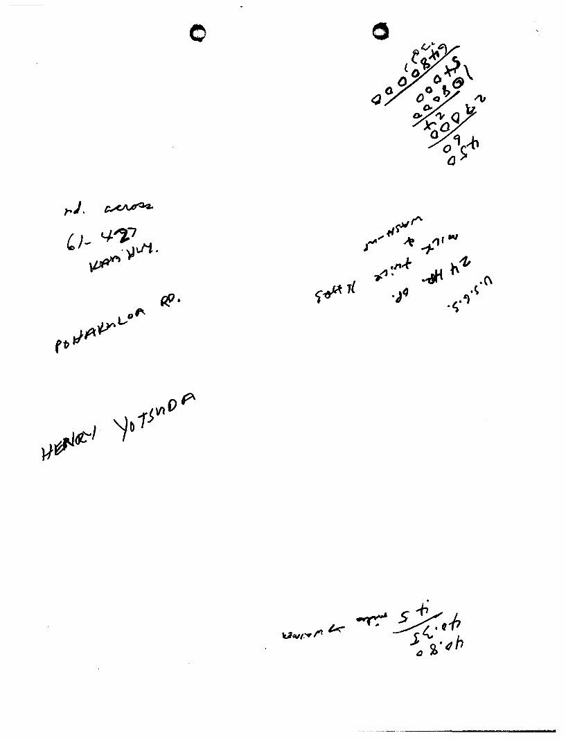
WELL(S) NO.-..:~""",1.:;;.D...:..4....:.-Q..::;..;....1 ___________ DATE~j~~___&..,4:,""""c lL..&q..:.:::~;.:..,_
LOCATION v~ Urf ~0'1?'7 (pl- 4'2-1 ~ Ifw-vt. S U BJ ECT Fld.A.. td¥ffl- of- I¢'fdd.
PRESENT k.,-v. llwY1:j yo~ of ~ G~ ~I:t?i MY &'Y4 NX. of DoWt..'-D
FIELD NOTES WeM '% C:¥.e.d fuv ~ 6~ fWrwv.J.. M iz ~
OVL CL- ~ kt1 k+wx ~ ~ vtr&L ~ 6/ -42-1 ~ '*4,
~V'1 ;<7 ~~ z4.- ~~ - ~ ~ h.ri~ ~ ~ ~ ~A-<.'e:r
~ """ e'4' -r ~ "lt7b'VM iCJ-v\4 ~e, (II.dV\.- z.1-trp -r ~ ~~ ~ ~4.
page o.f __ _

GEORGE R. ARIYOSHI GOVERNOR OF HAWAII
o o
STATE OF HAWAII
DEPARTMENT OF LAND AND NATURAL RESOURCES DIVISION OF WATER AND LAND DEVEL.OPMENT
Meadow Gold Dairies - flawaii P.O. Box 1880 Honolulu, Hawaii 96'805
Gentlemen:
P. O. BOX 373 HONOLULU. HAWAII 8&808
April 10, 1981
Waialua Ground Water Control Area
DIVISIONS: CONSERVATION AND
RESOURCES ENFORCEMENT CONVEYANCES FISH AND GAME FORESTRY LAND MANAGEMENT STATE PARKS WATER AND LAND DEVELOPMENT
We acknowledge receipt on :MEmOS 24 ' 1981, your Declaration of Existing Water Withdrawal and Use in the Waialua Ground Water Control Area. Our staff will review the data and may contact you for a field inspection of your welles) before certification of your declared water use is made by the Board of Land and Natural Resources.
We appreciate your early filing of the declaration of existing water use.
ES:dh
'",,.,.------------------
Very truly yours,
ROBERT T. CHUCK Manager-Chief Engineer
o
U<vf.vl'I k .. ~ $.P a c;,·"h

, ~- - State of Hawaii
nOrtment of Land and Natural ReQrcRs
DECLARATION OF EXISTING WATER WITHDRAWAL AND USE Honolulu and Waialua Ground Water Control Areas
Ins rrllction s: This form must be properly completed, signed, and submitted for each individual well or connected battery ofweLZs on or before June 4, 1981, in accordance with Regulation 9 of the Department. Submit the form with any attachments to Department of Land arl~ Natural Resources, P.O. Box 373, Honolulu, Hawaii 96809.
p. 0,'80)<. ,g&o 1. WATER USER: Name J'FJEAj)ow Civ)..;:) J)Alt<.ll:..$ * HAWAII Mailing address HONOL.-UL-.l~' 1(",:30,.('
Phone: "37 - .502..4: 2. WATER USER'S jgJ WELL CJ CONNECTED BATTERY OF WELLS:
User's Well Name and Location hf\Ef\Z,OW fiz>u> ft.)kM.S -I-f-AL.'&/w /.l j ,
Tax Map Key: 6 -/ - o..r
User's Well No. (s)
3 70Ll - 0 J
Pump or natural flow capacity (gpm.)
3. BENEFICIAL USE OF WATER:
Capacity determined by flowmeter, nameplate, orifice, etc. (specify)
P~~RJ\I\A"l c..f:. CL.AR.,IJ E.
Year pump inst. /modified
19,["7 ! /"}77
(a) Major Use: DMunicipal OAgriculture DMilitary Dlndustrial -----------------onomestic ~other j)t'j/0Y (specify) (specify) (b) Minor Uses: I f?-.R\Sf.\jE; 'PIISJuH .. WJ7ff. 73'M,..J rwrJon: (specify) , (c) For Agriculture Use list crop (s) , total acreage
irrigated , and attach map showing acreage irrigated by the well source.
4. BENEFICIALLY USED WATER WITHDRAWALS: (a) All figures given in (b) are records of: QMetered flow ONameplate pump 'capacity
DOrifice aWeir C/i?JOther (specify) ?a/)..FoR..MA-r->CE: c., .. w .. vj;.
(b) Records available .(in million. gallons per day, three decimal places):
Year Monthly Month 1975 1976 1977 1978 1979 1980 Average 1/ 7::'
Jan. J~J,t 00 O()c> J~Jj.O () "I) 0 1:J..f<L.r; .7 0 0 N; o~ ,}g& J:J.J...r..r 0"0 II. 070 ";'00 , , I 3, N, <;, ":"~ 7 "(2-
Feb. II ">-00 0.00 )/6=-0 0 ~o 11,-33 l) '" v 0 11,78:1;.,J'4.f " ::&I/() 000 JoJ" <>,"12 {''''''> . J:1. Q<./-I ').!.. )'-/' 0
Mar. I;J. doo 000 J~#.'DOODD p .. ...r~...r 7 0 0 /.::.o~u ?8" j,;).J..rJ DOO J ... ;:)7;) I...L 00 13 I ... ') :~<.!.7 ,'l-2C
A pro I~ 0 <)0 0,)0 /~t)oi7 0,.);) /:2.. J4l1 ODt> J';>' i..J..I.L 180 /;.. IJO DO CJ J.r .. ..r~DOO /.:2 7L1.LJ. v,3o .'f2<;'
May /~t.J.7>e> 00 () )~~~ODO· p..rJ-l..[ 70.0 JS ou'1 '} 8'(, J::; ... vli 000 /k"'70<.100 /3 /'-9 .:~ '"':-! LJZC: June' /~ t? 'i> 0 E>OC; j:::' () 000 D ~ I~/""') <::>00 1.2. ~.J" I,pO J;J. /"0 vIJ6 ,.r..r.r~ 0:>0 I;;) ,/~.', .. 1',:;:7"- .-
~-
July I J- 1/-7>0 DOt> 1:;'<.Jo,~ CDO / ~.,J'd. .1700 1,3 o~ 9?k. 1:2 "-vV' 0 <>0 /. <:>7°"'::>0 ;.:3,/4:1 -.',1 ~7 '12;-A ug. I;) VDI7 <) 00 /:J.l.t4ooo0 J .).;..[ -LV-7 0 f) 130 -.uL, '12(. IJ..r$Jooc> 16. 070 .i.!.'!)i> 1.3 '';'9':'~ "_·~/. lfZ'" Sep. I~ :J"Or;) P Q I.;L /<.1./.000 /.2.,,~~, /J'o );;1 IJ-c DOt> jJ'J;J> DI>O I~ 7""'""' ,/-S'c".!fZ'
... /::,,0[)0000
Oct. I'¥ .Loo <> OC> I> /::> dO{)~C'O I';;, ,[U..(700 /~ o~<,I.,'1'S£' I;'~.:r u DO 11.01°t.J.°17 13 /~'i'.:::",,? dZ,' Nov. I':;'· D 00 DOO I~ oPi) .);;:7 J":;. /,:.L./ 090 ;:>(,.:lJ/'i<,{. I:>' 1 oJ' 0 ,00 () /.r...r-:f--, O~\..-:" I J '7 ,lL.ij' ,t,3 () Ill.
,
Dec. I .... ..t-vO o;:>D 1::>-J-L'Oo 00 /) /~"J'u,t; 7 0 0 /3 oJf~ 9S(' 1:"..rS..J' <:Ii> D 14 CY'h? 1./ coc .. /3 /':~9.,3 l.!...,,, ·ff.. S ....
Yr. total 1/1.'- 660'OOd '/jO~ jJ/.77'1;~oo )..r-3:r~fi( /9 .... /1,<78' "5?, co 0 J8~%!l:dM f~/iZ I "'-'-LtD 0 04>1:
o. Ave I;;" Ii:." 1-"7 / ;l.::l.D <> 0 fn) 1.:1.,30 9' ~:J-..T '::-:199 "Ie. '~.3)$ 7..rO !.r, <1 II, '~c>o .M (~year average: 1.{'7,O,,"3.&8 'YZsmgd, hlghest day use .,f'JI?,i,LOO mgd on ,19.
(c) For AgricultureUse o1,ly: description of withdrawal schedule (include times of day and days of week: A R <H.lN;j) -rtf E CLoc..k 7 "J/7yS' pef<.. kJ C:EK.
'7
5. WELL DESCRIPTION: On t..1J.e at!ached sheet, m,qke corrections or additions thereon i."'1 red pencil as llecessa.rj" ar.d retul'n with Declaration forH'.. If. information is readily available L"'l another form. ") ou may subntit it in lieu of the corre:,..-:ted sheet.
Declaration: Under pp.nalties provided in Regulation 9 of the Department of Land and Natural Resol1rces, the undersigned d~clru-e and certify thllt this declaration has been examined. including accompanying statements. and to the best or our knowledge and cellef, it is true, correct, and cl.implete.
WatCl" User:. M E:.~D <)w GOLD J)A I~( ES- ttl
(print)
Lnndowner of Well Site: M"6A-';'.::'vJ §lOI-"/) tl\r./. tV\S
(print)
-:-:~_--: ______ . _______ Date: ___________ _
(signature)
.4..d;....~(l,d~L.::::..!:::::3:::~i::!~:..l.. ___ Date: __ 3 __ -_(_q_-.......;~_I ___ _
For Official Use: Last day to certify ________ ---- Date certified --------------------------Amount certified ---------------------WELL(S) No. ________________________ ___

o o - '~,
~

- - o o WELL INFORMATION SHEET
Instructions: The following information is currently on file at the Department of Land and Natural Resources, Division of Water and Land Development. If there are any changes, please make the necessary corrections and return to the Department of Land and Natural Resources, P.O. Box 373, Honolulu, Hawaii 96809.
Well Number: ~704-ol
Name or Location: Meadow Gold Sh
Owner or User: Meadow <::told
Year drilled: 19S<o --~~~-------------------------------------------------------
Driller: <=,Iover
Ground Surface Elevation in feet referenced to mean sea level: 32 --~~-------------
Casing Diameter in inches: 12. --------------------------------------------------Total depth of well in feet: ~G:>
--~----------------------------------------------
Casing depth in feet:
Major Use:
o Municipal
o Irrigation
m Industrial
o Domestic
o Unused
o Sealed
o Observation
o Disposal
o Lost
CJ Recharge
o Other (specify) -------------
Static Water Level in feet: Z.CP --~=-----------------------------------------------
Chloride content of water in milligrams/liter:
Installed pump capacity in million gallons per day:
Average annual draft in million gallons per day:
«

o
~ 2 : 9 'rJ ~~ HVVJ I 8
Q"""'t l '='t::!'\ '=\ '\
~iV' >1:3 .. J ~-J d
o . "'--
•

GEORGE R. ARIYOSHI GOVER_
o o
STATE OF HAWAII DEPARTMENT OF LAND AND NATURAL RESOURCES
P. O. lOX 121
HONOLULU. HAWAII M80I
March 16, 1981
Meadow Gold Farm 61-676 Kamehameha Highway Haleiwa, Oahu, Hawaii 96712
DIVISIONS: CONSERVATION AND
IIESOURCES ENFOACEMENT CONVEYANCES "'SN AND GAME _IITRY lAND MANAGEMENT STATE PAAIIS WATER AND L.lHO DEV1!LO .... ENT
On February 27, 1981, the Board of Land and Natural Resources designated the Honolulu and Waialua Districts as the Honolulu Ground Water Control Area and the Waialua Ground Water Control A~ea. By this action, the Department of Land and Natural Resources is now responsible for regulating all uses of ground water in these areas.
If you are currently using ground water from any well or spring source, you are required to declare such water use to the Department of Land and Natural Resources if you wish to continue your present use. Specifically, you must fill out, sign, and return the enclosed Declaration of Existing Water Withdrawal and Use form to the Department by June 4, 1981, in accordance with Regulation 9 of the Department of Land and Natural Resources.
According to our records, you have I well(s) located on your property (Tax Map Key ). please complete the enclosed form and return it as soon as possible to: Department of Land and Natural Resources, P.O. Box 373, Honolulu, Hawaii 96809.
If you have any questions or need help in filling out the form, please call the Division of Water and Land Development at Thank you for your cooperation.
Very truly yours,
~;'ONO £L Chairman of the Board
Enc.

o o WELL INFORMATION SHEET
Instructions: The following information is currently on file at the Department of Land and Natural Resources t Division of Water and Land Development. If there are any changes, please make the necessary corrections and return to the Department of Land and Natural Resources. P.O. Box 373, Honolulu, Hawaii 96809.
Well Number: ~~~7~~~~-~O~I ____________________________________________ ___
Name or Location: Meadow @otd 5h
Owner or User: Meadow gold
Year drilled: 19'5<o --~~~-------------------------------------------------------
Driller: GIQ\ler
Ground Surface Elevation in feet referenced to mean sea level: 32 --~~------------
Casing Diameter in inches: iZ. --------------------------------------------------Total depth of well in feet: __ ...;~;....;G:>~ ____________________________ _
Casing depth in feet:
Major Use:
o Municipal
c:J Ii-rigation
ltJ Industrial
o Domestic
.0 Unused
D Sealed
o Observation
CJ Disposal
o Lost
o Recharge
CJ Other (specify) -----------Static Water Level in feet: ~.CP
--~~-----------------------------------------
Chloride content of water in milligrams/liter:
Installed pump capacity in million gallons per day:
Average annual draft in million gallons per day:

l~N'fH;) 01 l;)lrlnS
o
o
• • . ~ i \,.
• ~ •
\ ,,-
........ ~ .. '7 ..

•
" HA t i "VA ~. ';' ~, \A.-4,4, 4VL/.~·M
l/va~a~ .. 1Pc.~ ,'e,'<'
04
o
K A
WeI(
',.
/ . , ~ .. :
~"'P:' .. f!,,) ~ ..
. ' ,-., ~: ... :,: ,
'EP' "'~';~'''H si .. ,,~-
w A I L
03
Np. :3104 -Cl/

\ "" , ) o~ . ~ " ,.....,. -~., .. .' ..... o:'-(~.jfo"":~.· ~ ..
.,rr~A •. ,,';- 0" '. io. ,t.. )
• ~ .'
WATER USE PERMIT NO. 056
This report has been prepared in accordance with 13-171-22(b) of the Hawaii Revised Statutes
requiring a 20-year review of issued water use permits to determine permit compliance.
Following is a summary of permit information, site characteristics, methodology, findings, and
recommendations for this State permit file.
Permit Information
Water User:
Landowner of Source:
Permitted Withdrawal Rate:
Water Management Area:
Island:
Aquifer Sector/System:
System Sustainable Yield:
Water Type:
Original CWRM Date:
Standard Conditions:
Special Conditions:
Water Source
State Well Number(s):
Well Name:
Water Source TMK Number(s):
State Land Use Classification(s):
County Zoning Classification(s):
Geographical Coordinates:
End Use
End Use TMK Number(s):
State Land Use Classification(s):
County Zoning Classification(s):
Beneficial Use Explanation:
Kamehameha Schools 567 S. King St., Suite 200 Honolulu, HI 96813
Kamehameha Schools 567 S. King St., Suite 200 H()flolulu, HI 96813
\,0.430 tlJgd (Based upon a 12-month moving average)
Kawailoa
Oahu
N orth/Kawailoa
~ 2ff~~ Brackish
September 11 th, 1981
N/A
N/A
3704-01
Meadow Gold SH
1 st Division, 6-1-005:016
Agriculture
AG-l
Latitude 21 0 37' 21.9" North Longitude 1580 04' 39.1" West
1st Division, 6-1-005:014, 6-1-005:016
Agriculture
AG-l
Use for livestock and irrigation of pasture land
1 BROWN AND CALDWELL Summary Report for Water Use Permit No. 056
----------______________ t1 ___ "._.. ...

o o
Background Information
Water Use Permit 056 was approved during the September 11 th, 1981 Commission on Water
Resource Management meeting. There are no water use or salinity records on file for State Well
No. 3704-01. During the research phase of this project, the file for State Well No. 3704-01 could
not be located. As such, certain permit information, including the standard and special
conditions associated with WUP 056, are not available. A complete list of all standard and
special conditions is given in the permit file.
Field Investigation Information
Contact:
Site Address:
Kaeo Duarte
Paniolo Ranch
Haleiwa, HI 96712
Brown and Caldwell conducted a field investigation on September 5th, 2008 from 11:00 a.m. until
12:00 p.m. with an associate of Mr. Kaeo Duarte. During this time, type of water usage was
verified, GPS coordinates of well head(s) were recorded, flow meter installation and functionality
were documented, and property TMK information was verified. The wellhead, its related
appurtenances, and water usage area were visually inspected to assess compliance with permit
conditions. Visual inspection of water loss/waste was limited to outdoor areas within the usage
boundary. Reference the TMK and GIS maps in the permit file for a visual representation of the
site.
Summary of Findings for Water Use Permit No. 056
State Well No. 3704-01 is located on TMK parcel 6-1-005:016 at 21 0 37' 21.9" N, 1580 04' 39.1"
W, with a real time accuracy of ±16-feet. The well is dug and is approximately 8-feet in
diameter. Water is drawn via a pump that is mounted above the well and is conveyed from the
well head to the Kawailoa Ranch, which is located along Kamehameha Highway to the west of
the well head. The ranch is located on TMK parcel 6-1-005:004 and is not listed as a permitted
end use location in the Commission's database. Reference the Appendix for photographs of the
previously described system components.
Since no conditions could be located during the research phase of this project, it is difficult to
ascertain the extent of permit compliance. However, the following are a list of standard
condition(s) that the permittee could be in non-compliance with:
2 BROWN AND CALDWELL Summary Reportfor Water Use Permit No. 056
_=11 _

o o (10) .An approved flowmeter must be installed to measure monthly withdrawals and a month record of
withdrawals, salinity, temperature, and pumping times must be kept and reported to the Commission on Water Resource Management on forms provided by the Commission on a monthly basis.
(12) A permit may be transferred, in whole or in part, from the permittee to another, if:
a. The conditions of use of the permit, including, but not limited to, place, quantity, and purpose of use, remain the same; and
b. The Commission is informed of the transfer within ninety days.
Failure to inform the department of the transfer invalidates the transfer and constitutes a ground for revocation of the permit. A transfer, which involves a change in any condition of the permit, including a change in use covered in HRS § 174C-57, is also invalid and constitutes a ground for revocation.
Before any action is taken, conditions for this permit should be located. It is worth noting,
however, that regardless of whether or not the permittee is in compliance with their conditions,
non-reporting of water use is a direct violation of the reporting requirements set forth in the State
Water Code.
Recommendations
• Address the following discrepancies between the Commission's electronic database and
actual field investigation findings:
o
o
o
Permittee and landowner names and addresses
Change permittee contact to Kaeo Duarte at
TMK parcel information
o State land use and county zoning classifications.
• Address potential violation of Standard Condition (10) regarding non-reporting of water
use and salinity levels.
• Address potential violation of Standard Condition (12) regarding use of water from the
State Well No. 3704-01 well battery without having transferred this water use permit
from Waialua Sugar to Kamehameha Schools.
• Address use of water on non-permitted TMK parcel
3 BROWN AND CALDWELL Summary Reportfor Water Use Permit No. 056
4_' •• I _

o
20-Year Water Use Permit Review Water Use Permit No. 056
APPENDIX
Field Investigation Photographs
4 BROWN AND CALDWELL Summary Reportfor Water Use Permit No. 056

o o
Figure 1 - State Well No. 3704-01
Figure 2 - Pump/motor for State Well No. 3704-01
5 BROWN AND CALDWELL Summary &portfor Water Use Permit No. 056
------..:.----__________________ t'f .... _~'1..,...,_ilIIIII

o o
Figure 3- Pump controls
Figure 4 - Distribution line to Kawailoa Ranch
6 BROWN AND CALDWELL Summary Report for Water Use Permit No. 056

o
Figure 5 - Typical end use location (fMK parcel 6-1-005:014)
7 BROWN AND CALDWELL Summary Report for Water Use Permit No. 056

It 0 Water Use Permit Survey
(Please complete one survey fotm for each WUP)
WUP Number: 056 Well Number(s): __ 37_0_4_-_0_1 _______________ _
Contact Information (of the perSOD who will be present at site visit):
Na~:Kaeo Duarte Phone (for phone interview):_5_ ______ _ Fax:, _ 7_4_--'_--'--_____ _
Email: kaduarte@ksbe .edu Best time to reach for phone interview:_' --=1.::.1.,:..:.=.0.=.0_' .=,a..:... m= •. ...c... ______________________ _
Property Information (of the water use/wen lecation): Address: N/A, Please ,inquire to - 567 S. King St., Suite 200
City: Honol yl y Zip:_9 .... 6"'81....,3"-_________ _
Well Location TMK (list all if multiple wells present):---:.;6_-...... 1_-0"...0,..,5.,---: ...,0::-::1,...,6,.----=-=--=-________________ _ Water Use TMK Oist all if used on multiple lots): ___ 6_-1_-_0_0_5_:_0_14_~ ,_0_1_6 ______________ _
Water UselWell Information: Is the water source currently in use? Yes No o If no, please explain: ___________________________________ _
What are you currently using the water for? (example: "Usc for 4S acres of diversified agriculture and 3 rcsidenccs"): _________ _
Cattle and horses
Is a flow meter installed and working properly? Yes No o If no, please explain: ___________________________________ _
Do you submit monthly water use reports to the State? Yes 0 No IX] If no. please explain: User is a lessee'who ;is currently going through re-negotiation; facility was broken and is being repaired.
Field Investigations:
A representative from Brown and Caldwell will be visiting wells in your area over the next several months between the times of 9:00 am and 5:00 pm. Each site investigation will take approximately 1-2 hours. Please indicate up to three potential days of the week and availability times for an on-site inspection of the well location and verification of water use compliance. The permit hoIdel' must provide Brown and Caldwell with at least five (5) working days notice of the need to reschedule.
Option#!
Option #2
Option #3
Date (M-F):_-..LLM ___ _
Date (M-F): __ T ___ _ Date (M-F):_--D.W ___ _
Time: 9:00am
Time: 9:00am
Time: 9:00am
lXI ~ lX1
12:00pm 0 12:00pm 0 12:00pm 0
3;oopm 0 3:00pm 0 3:00pm 0
Once this survey is returned. a Brown and Caldwell representative will be contacting you to conduct a phone interview and finalize the exact date and time of your field investigation. Please faxlmail completed surveys by December 12th, 2007 and direct any questions related to this survey to Mr. Milo Smith of Brown and Caldwell at:
1099 Alakea Street, Suite #2400 Honolulu, m 96813 Tel: (808) Fax: (808) 533J0226 [email protected]
For Official Usc Only
Received: t-A.j z.. J ="'t> Information Updated: t.--\ .I 12/ 0 '"0 Phone Interview Complete: C\ / '? 10 "b N~u: ____________________________________________________________________ __
-- --

o o Phone Interview
WUP Number:_---'O::::......"'"::>~..:;.I0 ___ _ Well Number(s): -=::"{ ol.-.-l, - 0 I
Contact Name: Kn..eD b-':>Q.,+e Attempt #1: Dateffime: o..L<?f~ ("L,~~
Attempt #2: Dateffime:,_.;..\"'-.J---'l"-A...;...... ________ _
Well Location TMK(s): b - \ - -':::>->S'. cllb
Phone Number:
Result: '\2<(l\.(l\r-i2-Q Result: r-' I A
Water Use TMK(s): _________________________________ _
Water Source Address:, ___________________________________ _
City: ____________________ _ Zip Code: _____________ _
Currently using water source?
Notes/Comments:_-:-_--;::~---_:_-___;--------------------------V~ ~, co.~ c\ \ao,-s.e ~>
Yes ~ No o
How often is the water source being used? Daily B Weekly 0 Monthly o Notes/Comments: _____________________________________ _
How long have you been using this water source?:_--'tW=.J.I...:.;e. ______________________ _
Has there been any rezoning of the water source/water use properties?
Have you reported the rezoning to the State?
Yes 0 Yes 0
No
No f3 o N/A ~
If no, explain: ______________________________________ _
Scheduled field investigation day/time: C\.Le::::;,/~ @ \ ,'.'::::>::::> 0 rr- '
Notes (Special directions, site conditions, potential hazards, general notes, etc.): _______________ _
Comments To Make:
• Although we prefer that you do not change your scheduled field investigation time, if you require a reschedule, you must provide Brown and Caldwell with at least five (5) working days notice of the need to reschedule.
• A representative from Brown & Caldwell will be making a reminder phone call to you sometime during the week prior to your scheduled field investigation.
• It is very important that you provide access to the site at the day and time agreed upon. Due to a very tight schedule, if you fail to provide access at the agreed upon time and/or do not reschedule with at least a five (5) working day notice, a makeup date will not be allowed.
• If for some reason you don't know where your well head is located, it would be a good idea to locate it prior to your field investigation to help make the visit go quickly and smoothly.
Interviewed By: 1'--\. ~ Date: .:'-1 "j! C> <J;,
---------------------------------------........ ~ ......... -

o Field Investigation Checklist
WUP Number: __ O.::::-":?.....::::...<.o ____ _ Well Number(s): ~/oy - 0 ,
Water Source
Well Location TMK(s): b ~ \ - 00":::::, 0 \ ~
Well Head GPS Coordinates: Latitude: 2 \" ?,' Z- \ C\'< "-.J Longitude \v:ybQ
01.-\' ~,,\, \" vv
wellType:-'bo...<.,..;;;...;>'-:~n---------------------------------"(=--\.\1.o~~+) Currently using water source? Yes No o Notes/Comments: _____________________________________ _
Is there a flow meter installed? Is the flow meter operational
Yes Yes
o o
No No
Notes/Comments: _____________________________________ _
Water Use Water Use TMK(s): h ~ \ - 00"::>'. 0 ,........ <0 ~ \ - ==:201 I.e.
I
Is the water being used within the permitted boundaries? Yes 0 No If no, explain ______________________________________ _
\..J,c.,e" 01'""\ -C"\O n -ve..r<Y'" ~ T r-r"'\ 'C-~ \.
Is there any observed wasting of water or water loss? If no, explain
Are the permit conditions being complied with? If no, explain:
Other
Photographs of:
t-JJA - L..or-C\..Irt-r .s
Water Source Water Meter
.~
Yes
Yes
(}.I:..I(A:' \C, '0 \.e.
0
0
Usage Area Pump/Motor
No
No 0
General Notes/Comments: __________________________________ _
Investigated By:, __ ~ __ ,~ __ • _________ _ Date: o../?/o"'6 Time: \ \ • r'o? O.rr,.
_z -

o o Standard Conditions List
1. The water described in this water use permit may only be taken from the location described and used for the reasonable beneficial use described at the location described above. Reasonable beneficial uses means "the use of water in such a quantity as is necessary for economic and efficient utilization, which is both reasonable and consistent with State and County land use plans and the public interest." (HRS § 174C-3)
2. The right to use ground water is a shared use right.
3. The water use must at all times meet the requirements set forth in HRS § 174C-49(a), which means that it:
a. Can be accommodated with the available water source; b. Is a reasonable-beneficial use as defined in HRS § 174C-3; c. Will not interfere with any existing legal use of water; d. Is consistent with the public interest; e. Is consistent with State and County general plans and land use designations; f. Is consistent with County land use plans and policies; and g. Will not interfere with the rights of the Department of Hawaiian Home
Lands as provided in Section 221 of the Hawaiian Homes Commission Act and HRS § 174C-101(a).
4. The ground-water use here must not interfere with surface or other ground-water rights or reservations.
5. The ground-water use here must not interfere with interim or permanent instteam flow standards. If it does, then:
a. A separate water use permit for surface water must be obtained in the case an area is also designated as a surface water management area;
b. The interim or permanent instteam flow standard, as applicable, must be amended.
6. The water use authorized here is subject to the requirements of the Hawaiian Homes Commission Act, as amended, if applicable.
7. The water use permit application and submittal, as amended, approved by the Commission at its <Insert Date>meeting are incorporated into this permit by reference.
8. Any modification of the permit terms, conditions, or uses may only be made with the express written consent of the Commission.
Variations of Standard Condition (8) are as follows: 1. Modification of any permit condition shall be approved by the Commission.
Modification of any permit condition without notification may result in the revocation of the water use permit.
-..... -

o
9. This permit may be modified by the Commission and the amount of water initially granted to the permittee may be reduced if the Commission determines it is necessary to:
a. Protect the water sources (quantity or quality); b. Meet other legal obligations including other correlative rights; c. Insure adequate conservation measures; d. Require efficiency of water uses; e. Reserve water for future uses, provided that all legal existing uses of water as
of June, 1987 shall be protected; f. Meet legal obligations to the Department of Hawaiian Home Lands, if
applicable; or g. Carry out such other necessary and proper exercise of the State's and the
Commission's police powers under law as may be required.
Prior to any reduction, the Commission shall give notice of its proposed action to the permittee and provide the permittee an opportunity to be heard
10. An approved flowmeter(s) must be installed to measure monthly withdrawals and a monthly record of withdrawals, salinity, temperature, and pumping times must be kept and reported to the Commission on Water Resource Management on forms provided by the Commission on a monthly basis (attached).
Variations of Standard Condition (10) are as follows: 1. The applicant shall keep monthly pump age estimates to be submitted
annually to the Commission. 11. An approved flowmeter(s) need not be installed to measure monthly
withdrawals and a monthly record of withdrawals, salinity, temperature, and pumping times must be kept and reported to the Commission on Water Resource Management on forms provided by the Commission on a yearly basis (attached).
1ll. An approved flowmeter(s) must be installed to measure withdrawals and a monthly record of withdrawals, water-levels, salinity, and temperature must be kept and reported to the Commission on a monthly basis in accordance with the Commission's September 16, 1992 action on reporting requirements.
1V. Approved flowmeters must be installed to measure monthly withdrawals and a monthly record of withdrawals must be kept and reported to the Commission on Water Resource Management on a monthly basis.
v. An approved flowmeter(s) must be installed to measure monthly withdrawals and a monthly record of withdrawals, salinity, temperature, and pumping times must be kept and reported to the Commission on Water Resource Management on forms provided by the Commission on a quarterly /yearly basis (attached).
Vl. An approved flowmeter shall be installed to measure water withdrawls Vll. An approved flowmeter(s) must be installed to measure withdrawals; and a
record of the withdrawals must be kept and reported to the Deparment of
------------------------------------------------..................... .

o Land and Natural Resources, Division of Water and Land Development, P.O. Box 373, Honolulu, HI 96809, on a monthly basis.
Vlll. Although not stated as a condition of the permit § 13-168-7 HAR requires you to keep a record of your monthly total pumpage, water level, salinity, and water temperature. This information must be submitted to the Commission on a regular monthly basis using the enclosed water use report form.
IX. An approved flowmeter shall be installed and the withdrawal from Well 1851-73 shall be recorded and reported to DLNR on a monthly basis by the owner and/or operator of the well.
x. The withdrawals from these wells shall be recorded and reported to the DLNR on a monthly basis by the BWS.
Xl. The applicant shall provide and maintain an approved meter or other appropriate device or means for measuring and reporting water usage on a monthly basis.
xu. The applicant shall provide and maintain an approved meter or other appropriate device or means for measuring and reporting total water usage. Water usage shall be measured on a monthly basis and reported to the Commission.
Xlll. The applicant shall provide and maintain an approved meter or other appropriate device or means for measuring and reporting total water usage. Water usage shall be measured on a monthly basis and reported to the Commission along with water level and salinity measurements.
11. This permit shall be subject to the Commission's periodic review of the <Aquifer> Aquifer System's sustainable yield. The amount of water authorized by this permit may be reduced by the Commission if the sustainable yield of the <Aquifer> Aquifer System, or relevant modified aquiferes), is reduced.
12. A permit may be transferred, in whole or in part, from the permittee to another, if: a. The conditions of use of the permit, including, but not limited to, place,
quantity, and purpose of use, remain the same; and b. The Commission is informed of the transfer within ninety days.
Failure to inform the department of the transfer invalidates the transfer and constitutes a ground for revocation of the permit. A transfer, which involves a change in any condition of the permit, including a change in use covered in HRS § 174C-57, is also invalid and constitutes a ground for revocation.
13. The uses(s) authorized by law and by this permit do not constitute ownership rights.
14. The permittee shall request modification of the permit as necessary to comply with all applicable laws, rules, and ordinances that will affect the permittee's water use.
15. The permittee understands that under HRS § 17 4C-58( 4), that partial or total nonuse, for reasons other than conservations, of the water allowed by this permit for a period of four (4) continuous years or more may result in a permanent revocation as to the amount of water not in use. The Commission and the permittee may enter

o into a written agreement that, for reasons satisfactory to the Commission, any period of nonuse may not apply towards the four-year period. Any period of nonuse which is caused by a declaration of water shortage pursuant to section HRS § 174C-62 shall not apply towards the four-year period or forfeiture.
16. The permittee shall prepare and submit a water shortage plan within 30 days of the issuance of this permit as required by HAR § 13-171-42(c). The permittee's water shortage plan shall identify what the permittee is willing to do should the Commission declare a water shortage in the <Aquifer>Ground-Water Management Area.
17. The water use permit shall be subject to the Commission's establishment of instream standards and policies relating to the Stream Protection and Management (SP AM) program, as well as legislative mandates to protect stream resources.
18. The permittee understands that any willful violation of any of the above conditions or any provisions ofHRS § 174C or HAR § 13-171 may result in the suspension or revocation of this permit.
19. Special conditions in the attached cover transmittal letter or attached exhibits are incorporated herein by reference.
20. If the ground-water source does not presendy exist, the new well shall be completed, i.e. able to withdraw water for the proposed use on a regular basis, within twentyfour (24) months from the date the water use permit is approved.
Variations of Standard Condition (20) are as follows: 1. The permit may be revoked if work is not started within six months of the
date of issuance or if work is suspended or abandoned for six months. The work proposed in the permit application shall be completed within two years from the date of permit issuance.
21. This permit may not be transferred or the use rights granted by this permit sold or in any other way alienated. Pursuant to HRS § 174C-59 and the requirements of Chapter 174C, the Commission on Water Resource Management has the authority to allow the transfer of the permit and the use rights granted by this permit in a manner consistent with HRS § 17 4C-59. Any such transfer shall only occur with the Commission's prior express written approval. Any sale, assignment, lease, alienation, or other transfer of any interest in this permit shall be void.
22. The water use permit granted shall be an interim water use permit, pursuant to HRS § 174C-50. The final determination of the water use quantity shall be made within five (5) years of the filing of the application to continue the existing use.
23. The water use permit shall be issued only after agricultural review.
24. That scheduled adjustments to Oahu Sugar Co. permitted use shall be initiated upon discontinuance of agricultural uses.
.....,.. -
o
25. The issuance of this permit was approved by the Commission on Water Resource Management at its meeting on <Insert Date>.
26. The permit shall be subject to the review by the Attorney General.
27. The permit holder may be required to relinquish this permit at any time or specified time after issuance to the Board of Land and Natural Resources in accordance with Chapter 166 of Tide 13.
28. The applicant shall obtain the necessary land acquisition documents from the Hawaii Housing Authority.
==: = -.

o Special Conditions List
1. Should an alternate permanent source of water be found for this use, then the Commission reserves the right to revoke this permit, after a hearing.
2. In the event that the tax map key at the location of the water use is changed, the permittee shall notify the Commission in writing of the tax map key change within thirty (30) days after the permittee receives notice of the tax map key change.
3. The applicant shall contact the Environmental Management Division, State Department of Health, at S86-4304, concerning "GUIDELINES APPLICABLE TO GOLF COURSES IN HAW AU" date <Insert Date & Version #>.
4. Standard Condition lOis emphasized, to report consumption on a regular basis.
S. The applicant may continue this existing use of ground water within the limits approved by the Commission, and the actual issuance of the interim permit shall not be a reason to interrupt this existing use.
6. This interim water use permit shall cease to become interim and shall be subject to HRS § 174C-SS upon administrative review of the quantity within five (S) years, provided that all conditions of the use (including the review of the quantity which shall not be greater than the amount initially granted) remain the same. Enforcement of the allocation limit shall be stayed pending staffs review and issuance of a permanent water use permit.
7. As-built drawings of the well and pump, and a complete pumping test record shall be submitted within sixty (60) days.
8. In the event the pump tests show that aquifer boundary conditions do not support the requested withdrawals, the Commission reserves the right to amend this permit, after a hearing, to a level that is supported by the pump tests.
9. The existing use may be continued within the levels approved by the Commission, and the actual issuance of the permit document shall not be a reason to interrupt the approved level of use.
10. The filing of an application by Kukui, Inc. for a new or modified water use permit for the Kualapuu Aquifer in excess of 2.0 mgd (total system withdrawal) shall be just cause for re-consideration of this interim permit by the Commission
11. Upon completion of a new transmission line for the transport of water use by Well #17, the permit shall be modified to reduce the allocation amount by the additional 79,220 gallons per day allocated for use of the Molokai Irrigation System.
12. Within six (6) months from the date of approval of a water use permit for the well, the applicant shall conduct a feasibility study and submit a report describing
.... -

o alternative sources of nonpotable water for irrigation uses at the resort area. It is suggested that the developer consider use of dual lines in the subdivisions so that effluent may be used in the existing reuse system. Another consideration is the development of brackish water wells in the Kaluakoi Aquifer system for mixing with the effluent generated at the resort.
13. Within six (6) months from the date of approval of a water use permit for the well, the application shall evaluate the filter back discharges into Kakaako Gulch to determine if excessive preventable waste is occurring and identify possible measures to eliminate or reduce such waste. The evaluation shall be conducted in cooperation with the Commission staff and staff of the Department of Health's Safe Drinking Water Branch, which regulates the drinking water system.
14. Within six (6) months from the date of approval of a water use permit for the well, the applicant shall 1) implement a leakage control and detection system and compete repairs to prevent such leakage and 2) implement use of xeriscaping and low-flow fixtures.
15. Action on the future use portion of the water use permit application for Well #17 (Well No. 0901-01) is deferred pending the establishment of existing uses in the aquifer. Kukui Inc.'s application for uses in excess of those uses existing on July 15, 1992 will be considered "new" uses and will be taken up by the Commission as soon as other existing use applications have been decided. In the interim,
a. The Commission shall recognize that there is disagreement between the applicant's staff calculations of reasonable-beneficial existing use
b. The Applicant will have the burden of proof to show within six (6) months reasonable-beneficial existing use calculations that support the applicant's request as opposed to staff's calculations.
c. The Commission's enforcement of the approved existing use allocation will be suspended for six (6) months.
16. The permittee shall submit a notice of intent and written request to continue the use at least ninety (90) days prior to the expiration of the interim five-year permit.
17. The Commission shall delegate to Maui Department of Water Supply the authority to allocate the use of water for municipal purposes, as provided in §174C-48(b).
18. Maui Department of Water Supply shall be exempt from the requirements for permit modifications, as provided in§174C-57(c).
19. The permittee must meter water use and monitor chloride concentrations on a monthly basis and submit monthly reports of water use and chloride concentrations to the Commission.
20. Standard Condition 16 is waived for saltwater wells.
21. The permit will be revoked if (1) stream monitoring shows that pumping the well reduces stream flow, or (2) the electromagnetic resistivity survey indicates that the

o well was drilled into a dike compartment, unless the applicant submits a petition for an amendment to the interim instream flow standard with the well completion report. However, no use of the water may be made without a Pump Installation Permit, which cannot be issued during consideration of the amendment of the interim instream flow standard.
22. The applicant shall present the results of the electromagnetic resistivity survey, pump tests, and stream monitoring to a community meeting as well as to the Commission.
23. A final determination of water use quantity shall be made within five (5) years of the filing date of the application «Insert Date» to continue existing use.
24. The applicant shall implement, by December 31, 1995, a biological and hydraulic monitoring program for a minimum 2-year period that: 1) documents the existing operating procedure, 2) seeks to identify the impacts of all operating alternatives on Waikolu Stream, and 3) seeks to identify the effectiveness of weir modifications (Dam No.1). This program shall incorporate the three new wells, Wells #4-6 (Well Nos. 0855-06, -05, &-04, respectively), which may be pumped within the approved limits, for monitoring and testing purposes only. Further, semi-annual reports summarizing data and preliminary findings shall be submitted to the Commission. It is suggested that the Department of Agriculture work with the State Division of Aquatic Resources and other affected agencies to prepare the monitoring program in light of the difficult technical questions raised by this application. A particular concern is the coordination of this monitoring program with the ongoing National Park Service study by Anne Brasher. A draft of this plan shall be submitted to the Commission staff within ninety (90) days for technical review and comment. Results of the monitoring program shall be used to make recommendations to the Commission on any additional use of the wells, and shall be made readily available to all interested parties.
25. That the Commission approves the well construction permit for the KamiloloaWaiola Well (Well No. 0759-01), subject to the standard well construction conditions and the special conditions for the pumping well for the aquifer tests.
26. That the Commission authorizes the Chairperson to approve and issue a pump installation permit upon acceptance of adequate pump test result, subject to the standard pump installation conditions.
27. Should the well be used for back-up domestic supply, applicant is advised to contact DOH or otherwise ensure safe drinking water quality is maintained.
28. The applicant shall follow the agreed monitoring plan.
29. If pesticides used by the applicant are found in ground or surface water and can be traced to the applicant's use, the CWRM may revoke the permit immediately upon such finding.
-, .-

o o 30. Issuance of the interim permit shall be withheld until the reservation of water for
DHHL is set by rule. Applicant may continue this existing use within the approved limits.
31. The applicant shall submit well modification and pump installation permit applications for administrative approval by chairperson prior to beginning any work required to complete well.
32. Should any stream flow impacts result from use, petition to amend interim instream flow standards shall be submitted.
33. Should any dewatering result from use, pumping shall cease immediately.
34. Shall submit accurate schematic diagram of distribution system for the battery of 5 wells.
35. Shall be subject to a 6-month independent audit & monitoring.
36. Final pump capacity shall be determined from pump test results & approved administratively by signature of chair.
37. The permittee shall seek and submit to the Commission within ninety (90) days written confirmation from the Department of Land Utilization of the nonconforming use.
38. Pumping shall cease immediately if the chloride reports show that the brackish water developed in the well exceeds 1,000 mg/l of chloride, unless a variance from the chloride limit has been granted. The authority to approve future variance requests is delegated to the chairperson.
39. The duration of the interim permit shall be: a. To July 1, 2006, or b. Until treated wastewater is available and acceptable for use, or c. Until such time that a significant change in permitted, actual, or projected
uses or water supply occurs.
40. Action on any interim permit may be initiated by the Commission or any permittee upon letter request or pursuant to §174C-S7 Haw. Rev. Stat. (Modification of permit terms).
41. This permit is approved under the assumption that wastewater will become available for reuse as an alternative supply source.
42. Require adherence to the chloride sampling protocol and the submittal of weekly chloride data. The authority to approve variances from the weekly reporting requirement is delegated to the Chairperson.
43. Require adherence to the Conservation Conditions.
,- -

o o
44. In the event a water shortage is declared by the Commission, permittees in the <Insert Aquifer Sytem> shall comply with the <Insert Aquifer System> water shortage plan adopted by the Commission.
45. The permittee shall contact the Department of Health, Clean Water Branch and obtain the necessary discharge permit(s).
46. Permit shall be interim and replaces existing WUP for 2051-07 & 11.
47. Applicant shall submit an acceptable archaeological inventory survey report to DHP. If historic sites affected, a plan to mitigate these affects must be accepted by DHP and completed by applicant.
48. Should the well be used for back-up domestic supply, applicant is advised to contact DOH or otherwise ensure safe drinking water quality is maintained.
49. (The permittee) may report monthly pump age on yearly basis.
50. Prior to issuance of any permits, must submit filing fee for after-the-fact pump installation permit.
51. The term of this permit shall be twenty years from the date of issuance of the permit with a five-year Board review to determine compliance with the provisions of the permit.
52. The amount of water to be withdrawn under this permit shall be 0.19 mgd, averaged annually, for irrigation use. This permitted use of 0.19 mgd when added to a preserved use of 0.27 mgd amounts to a total of 0.46 mgd, averaged annually, which may be withdrawn from well 1646-01.
53. The use authorized by the permit must not interfered substantially and materially with existing individual household uses and existing uses.
54. The use of this well shall be subject to the shortage and emergency powers of the Board of Land and Natural Resources (BLNR).
55. This permit may be suspended or revoked, in accordance with Chapter 166.
56. The permit holder may be required to relinquish this permit to BLNR, in accordance with Chapter 166
57. The withdrawal from Well 1646-10 shall be recorded and reported to DLNR on a monthly basis by the permittee.
58. In the event that emergency water use occurs, the permittee shall notify the Commission in writing within one (1) day of pumping, to in form the Commission as to the nature of the emergency and the expected duration of the emergency. A water

o o use report shall also be filed pursuant to Standard Condition 10 and Administrative Rule 13-168-7.
59. Note DOH's requirements related to non-potable water systems (attached to original permit).
60. Standard Condition 16 requiring the submittal of a water shortage plan is waived.
61. All non-potable spigots and piping shall be clearly labeled as "DO NOT DRINK, NON-POTABLE" to prevent direct human consumption.
62. Standard Condition lOis modified. Due to the inability to take water level measurements, the requirement to measure monthly water levels is waived. In addition, as long as the U.S. Geological Survey is collecting and analyzing the chloride content of the well water, the requirement for the permittee to measure and report chlorides is also waived.
63. Well elevation components must be surveyed by a licensed surveyor and this information must be submitted to commission prior to issuance of permanent permit.
64. The permittee shall obtain approvals from the Department of Health and the U.S. Environmental Protection Agency prior to use of the water.
65. This water use permit, WUP No. <Insert #>, shall supersede WUP No. <Insert #>.
66. WUP No. <Insert #> is revoked
67. Standard Condition 17 is waived.
68. Standard Condition 22 for interim water use permits shall not apply.
69. To supplement our records, we request that you provide a map of the Galbraith Est. lands west of Wahiawa (2100 ac+-) and the associated TMK's for use area.
70. Deferred action on portion requested for golf course irrigation pending further refinement of irrigation requirement and a feasibility study for utilization of surface water sources, including Wahiawa Reservoir.
71. Written justification be provided for any 'cushion' of 0.5 mgd.
72. The water use permit shall be an interim permit. The duration of the interim permit shall be until treated wastewater is available and acceptable for use. The permittee shall continue discussions with Honolulu Board of Water Supply regarding the use of reclaimed water.
73. The permittee is put on notice that this is a qualified approval in that this permit may be modified or revoked prior to the expiration of the interim permit if the
_ ..... , -

o o Commission decides that the use of additional basal ground water for dust control and landscape irrigation is not reasonable-beneficial use.
74. The permittee encouraged to use drought-tolerant landscaping to conserve water.
75. Should the applicant provide written evidence that the county DHCD approves a 201E exemption for the elderly affordable housing project then the applicant may modify a corresponding portion of their existing aquacultural use to be used by the exemption approved project within the Commission approved water use permit limits under recommendation 5.
76. The applicant shall obtain a water lease/permit from Land Division prior to actual use of the well water.
77. Require the permittee to sign a contract by May 14, 1998 with the City Department of Wastewater Management to buy and use 0.400 mgd ofR-1 water for a corresponding reduction in allocation for Well Nos. 1900-02, 17 to 20, and 1901-03.
78. Standard Condition 9 is waived.
79. Standard Condition 10 is modified to exempt the permittee from monthly measurements of salinity and temperature.
80. Standard Condition lOis waived.
81. Applicant must seek a determination from BLNR and Land Mgt Divas to whether water license required. If required, license must be obtained prior to issuance of permit. If not, permit will be issued w / out further action.
82. Commission defers action on use in excess of 452,000 gpd pending additional info from BWS and further staff analysis.
83. The permit shall be subject to the Commission's sustainable yield review by December 1990.
84. The Commission shall delegate to the Honolulu Board of Water Supply the authority to allocate the use of water for municipal purposes, in accordance with §174C-48(b) HRS.
85. Honolulu Board of Water Supply shall be exempt from the requirements of permit modifications as provided in §174C-57.
86. BWS must participate in discussions, to be coordinated by Commission Staff, regarding a monitoring program to address impacts to Kaneohe Bay water quality, prior to any action on applications for future municipal uses.
87. A pump installation permit application must be made and approved prior to the installation of a permanent pump.
-----------------------------------------------------------------

o
88. The water withdrawn shall be 0.7 mgd for municipal use.
89. The installed pump capacity of the well shall not be more than 700 gpm or 1.01 mgd.
90. The term of permit shall automatically expire twelve months from the date of Issuance.
91. The Honolulu Board of Water Supply may continue to submit monthly water data on their own form, provided that the data are submitted in a format that is acceptable to the Commission staff.
92. Standard Condition 7 shall not apply.
93. Standard Condition 22 shall not apply.
94. Standard Condition lOis modified to exempt the permittee from monthly measurements of salinity and temperature.
95. This permit shall be subject to conditions providing for stream restoration if the Commission determines that additional water should be returned to the streams.
96. HECO 1· mgd for industrial use
97. Campbell Estate 1 mgd for municipal use through BWS, by separate agreement with HECO
98. BWS 1 mgd for municipal use.
99. The permit shall be subject to the Commission's sustainable yield review by <Insert Date>.
100. The applicant shall obtain the current version of the Department of Health's Guidelines Applicable to Golf Courses in Hawaii. Where relevant and viable, items of the guidelines should be implemented and sustained appropriately. To obtain the current version, contact the Safe Drinking Water Branch, Environmental Management Division at (Honolulu).
101. The future use portion of the application shall be deferred until existing uses in the Koolauloa area are established.
102. The water to be withdrawn under this permit shall be a total of 0.03 mgd (0.02 mgd preserved plus an additional 0.01 mgd permitted use), averaged annually, for domestic and irrigation use
103. Existing well 1851-09 shall be properly sealed by a licensed drilling contractor. A well modification permit application, eQ.closed, shall be submitted to the Department for approval of the well sealing. A filing fee for sealing the well will not be required.
J_W_ _

o o
104. The permittee is required to test the source using a certified private laboratory and submit the test results to the Commission within three (3) months. The Commission will then forward the results to the Department of Health for their review. The Department of Health recommends that the well be routinely tested for microbiological and chemical parameters thereafter.
105. The permittee is required to submit a completed Registration of Well and Declaration of Water use by <Insert Date>.
106. The permitee shall contact the Department of Health for a written determination on the status of their water system and comply with any Department of Health requirements for monitoring and testing.
107. In the event that the original spring source decontaminates, the new well authorized will be shut down.
108. That within each aquifer the total permitted use shall not exceed the sustainable yield.
109. That any water available for allocation shall be for in-district use.
110. That scheduled reductions to Oahu Sugar Co. permitted use shall be initiated upon final termination of an Osco lease or sub-lease, whichever occurs later.
111. That permits for water use issued in accordance with the proposed schedule shall be interim permits subject to review and adjustment by 1995.
112. That the permit shall be an interim permit for a new use which is afforded to existing users as specified in §13-171-20.
113. That the original allocation of 0.200 mgd shall be taken to hearing for possible revocation at a later date to complete the transfer of the water use permit entirely to Well No. 3407-02. This revocation would reduce the current allocation afforded to the Kunihiro Well (Well No. 3406-06) to zero.
114. This allocation incorporates the unspecified domestic needs of the applicant and therefore necessitates a single meter be installed at the well.
115. Should any impacts to nearby wells or streams be established by the use of this well, the applicant shall address these issues to the satisfaction of the Commission.
116. If an economically feasible nonpotable source is identified, the applicant shall convert to the alternative nonpotable source.
117. The permit shall be subject to the Chairperson's approval of a water use plan recommending possible measures to prevent or minimize saltwater contamination and establish courses of action to follow should the aquifer become to saline to use.
--------------------------------------------------------------------------------------......

o o
118. Permittee shall provide the necessary end-use information on the 10th residence to allow regulation of the use under Chapter 174C.
119. Standard Conditions 10 & 18 shall not apply.
120. Standard Condition 10 is modified to exempt the permittee from the requirement to install a flowmeter. Salt water withdrawals may instead be estimated based on pumping capacity and run time.
121. The applicant shall review the existing year long period of pump age and stramflow data and provide analysis on ground and surface water interaction. Deadline is January 25, 1994.
122. The water use permit for Well Nos. 2301-27 to -32 for 0.75 mgd (WUP No. 419) shall be revoked upon issuance of a pump installation permit for the well.
123. The permittee shall use mulching to decrease evaporative losses and manage irrigation scheduling to minimize water demand.
124. The permittee shall submit a detailed agricultural plan to support any future water use permit application for increased agricultural use at this parcel.
125. If not already obtained, the permittee shall seek and obtain any necessary permits from the Department of Health for the proposed discharge to Malaekahana Stream.
126. Standard Condition 10 is modified to waive the requirement for installing a water meter on Well Nos. 2358-21, 22, and 29. The permittee shall install a water meter on Well No. 2358-26 to measure total monthly flow through the discharge line. This quantity should then be assumed to be the rate of natural flow from the other three wells for monthly reporting purposes.
127. The permit shall be effective upon submittal of documentation by Navy that it has met the DOH requirements for a public system.
128. This WUP shall be subject to Army's application for a WUP to reduce the permitted use of the Army's Schofield Shaft (2901-02 to 04, 10) by 0.208 mgd to a new total of 5.648 mgd. The Army's application shall be submitted within 60 days after the approval of this WUP or this WUP shall be void. Approval of the modification request shall be obtained from the CWRM prior to use of Well No. 3100-02 and issuance of this WUP.
129. Navy shall submit an after-the-fact PIPA, and approval of the permit shall be obtained prior to use of the well.
130. The well shall not be used for drinking water purposes unless it is properly tested and treated.
.- --

o o 131. This permit is approved subject to reclaimed water becoming a practical alternative
and provided that the Department of Health approves the reuse application.
132. Should any opae ula be recovered in the well water, the permittee shall notify the Division of Aquatic Resources and provide specimens to the Division of Aquatic Resources for analysis.
133. If a single meter at the well is used, the Commission shall allow an additional 1,000 gallons per day to the water use permit amount for the domestic needs of two residences, although a pennit for individual domestic consumption is not required. Otherwise, the applicant must provide a meter to separately measure the irrigation consumption.
134. This permit is approved under the requirement that conversion to either: 1) treated wastewater becoming available for reuse as an alternative supply source, provided that Department of Health concerns over the use of treated effluent over the potable water aquifer have been addressed; and/or 2) other nonpotable source becoming available will occur in a timely manner.
135. These permits shall be subject to a review of actual use within four years for possible modification of the pennitted amount.
136. The permit shall be reviewed in two (2) years for possible additional revocation due to nonuse.
137. The allocation is based on the projects listed in Exhibit 5 (of Item 10 of the May 20, 1998 Staff Submittal), except for the Queen's Beach GC (fMK 139-11-2,3), Lot 9 (fMK 139-17-51), and Varsity Place (fMK 128-24-35).
138. Kamehameha Schools Bishop Estate/Honolulu Board of Water Supply shall transfer the water use pennit within ninety (90) days of the effective date of the transfer of the pump station to the Honolulu Board of Water Supply, pursuant to §174C-59 Hawaii Revised Statutes.
139. The pennittee shall ensure that the water is recycled by either directing it into the Waiahole Ditch for use by downstream farmers (subject to the approval of the Agribusiness Development Corporation's Board) or into Waikele Farm's existing irrigation system.
140. The permittee shall file a completed application to modify WUP No. 758 to reduce the allocation by 0.100 mgd within 60 days. If a completed water use pennit modification application is not received within 60 days from this submittal's date, then the subject water use pennit application (WUPA No. 767) shall be deemed denied without prejudice without the need for another hearing.
141. The water withdrawn shall be for municipal use. No improvements to the existing sources are required as the existing source capacities are greater than the increase.
---------------------------------------------------------

o o 142. Water license must be determined through LM.
143. Proposed other uses will be considered at a later date.

______ ... ___________________ ._.'" -"""~"~'""jI4~>4,,.,..~ ... ~ ... , ... , _________________ _

04 ,.~'"
~. If /!J/6),op Kalil'-
A r
~.,
6 - I - 05
SUIJECT TO CHANGE

.. 4
o o
State of Hawaii COMMISSION ON WATER RESOURCE MANAGEMENT
Department of Land and Natural Resources Honolulu, Hawaii
June 2, 1993
Chairperson and Members Commission on Water Resource Management State of Hawaii Honolulu, Hawaii
Gentlemen:
Waialua Sugar Company Voluntary Reduction of Pennitted Water Use in the
Waialua Aquifer System, Waialua Ground Water Management Area Waialua. Oahu --
Background: Present authorized uses of ground water in the Waialua Aquifer System of the Waialua Ground Water Management Area (GWMA) total 43.114 mgd. The sustainable yield for the Waialua Aquifer System (formerly called the Waialua Subarea) was originally 60 mgd when the Board of Land and Natural Resources adopted the sustainable yield in July 1981. The Commission on Water Resource Management, in October 1991, accepted an updated table of sustainable yields for Oahu. Under the updated table, the sustainable yield for the Waialua Aquifer System was reduced from 60 mgd to 40 mgd. The new sustainable yield was formally adopted by the Commission on March 17, 1993. Authorized uses now exceed the sustainable yield by 3.114 mgd.
The Commission staff has reviewed the authorized uses versus the actual uses in the entire Waialua GWMA. Allocations in the Waialua Aquifer System are as follows:
Waialua Sugar Company
Honolulu BWS
Private Users
Total
39.940 mgd
2.730 mgd
0.444 mgd
43.114 mgd
Preliminary review of Waialua Sugar Company's pump age data indicates that they have used less than 30 mgd of their 40 mgd allocation over the last five years (see attached graph). Water use by the Honolulu BWS and private users has not changed significantly.
Waialua Sugar Company calculated their irrigation requirements using the same methodology that Oahu Sugar Company used to determine their irrigation requirements in the Pearl Harbor area. Inigation requirements were calculated for dry years (1983 - 1986) and wet years (1988 - 1991). Pumping required was calculated to be about 46 to 48 mgd for dry years and about 3S to 36 mgd for wet years.
Waialua Sugar Company has reviewed their water use over the past 20 years and. based on historical water use, conversion to drip irrigation, and other factors, has voluntarily reduced its permitted water use in the Waialua Aquifer System from 39.9 mgd to 36.0 mgd effective June 1, 1993. nus voluntary reduction reduces the allocations in the Waialua Aquifer System to 39.174 mgd, which is less than the sustainable yield of 40 mgd, and allows an additional 0.826 mgd to be allocated.
In voluntarily reducing its allocation, Waialua Sugar Company states that they "want to be on record that sugar production is highly dependent upon water; without adequate water, yields will suffer. We cannot afford to snort ourselves of water. & we understand, we can exceed the permitted use during dry periods as may be required- (See attached letter).
ITEM 3

o o Chairperson and Members Commission on Water Resource Management June 2,1993
RECOMMENDATION:
That the Commission accept Waialua Sugar Company's voluntary reduction of pennitted use in the Waialua Aquifer System, from 39.940 to 36.0 mgd. The 3.94 mgd reduction will be taken from sources in the Waialua Aquifer System presently being detennined by Waialua Sugar Company. Staff will be working with them to detennine the source-by-source reductions and will bring the results to the Commission for approval
Respectfully submitted,
Attach.
APPROVED FOR SUBMmAL
tt~lr-·~ KEITII W. AHUE, Chairperson
2

~alalua Sugar Company, Inc.
·P. O. Box 665
Waialua. Hawaii 96791-0665
o May 12, 1993
r·1I : 53 Ms. Rae Loui Deputy Director state Water Commission P. O. Box 62). Honolulu, Hawaii 96809
Dear Ms. Loui:
We have had several meetings over the past months to discuss Waialua Sugar Company's permitted water use from the Waialua aquifer. Waialua Sugar has a permitted use of 39.9 million gallons per day. When you add the permitted use of the city Water Department, you have a combined use which is higher than the sustainable yield.
Waialua Sugar Company Board of Water Supply
Total Sustainable yield Over Permitted Use
39.9 ~ 43.1
40.0 (3.1)
We have reviewed our water use over the past 20 years and while we have peaked at times over our permitted use, it appears we could reduce the permitted use given recent historical water use, conversion to drip irrigation and other factors.
Before going further, we want to be on record that sugar production is highly dependent upon water; without adequate water, yields will suffer. We cannot afford to short ourselves of water. As we understand, we can exceed the permitted use during dry periods as may be required.
Based on the above discussions and research into this matter, waialua Sugar Company is voluntarily reducing its permitted water use in the Waialua acquifer from our current 39.9 million gallons per day to 36.0 million gallons per day effective June 1/93.
cc: M. Agader J. A. Russell G. yim
Sincerely,
~~:::::: Michael F. O'Brien President Dole Food Hawaii
. , . I

State of Hawaii COMMISSION ON WATER RESOURCE MANAGEMENT Department of Land and Natural Resources MONTHLY GROUND WATER USE REPORT
Name: Pati DeSoto
Company: Kawailoa Ranch
Address: 61-676 Kamehameha Highway
Haleiwa HI 96712
Telephone No.: ..:;.63.::...:7:-.-4..;.:2=:;2:....;4 ______ _
Report Month:
Fax No.: ----------------------Year: ----------------------
For Official Use Only:
INSTRUCTIONS: Please TYPE or PRINT CLEARLY. Complete this form to report total monthly ground water use, and, if required, other information from each of your well sources. For electronic submissions: Complete and digitally sign (checkbox) this form, then send file via e-mail to: [email protected] For hardcopy submissions: Complete, print and sign this form, then send printed report via mail to: Commission on Water Resource Management, P.O. Box 621, Honolulu, HI 96809. For fax submissions, send to For assistance: Please contact the Ground Water Regulation Branch at
*
3704-01 "Paniolo Ranch Well"
Flow meter, electrical consumption, weir or flume, not metered (estimated). Measurement should be taken while pump is NOT running just prior to a pumping cycle; If measurement is taken while pump is running, please indicate so.
Other comments or additional information (e.g., date and method of chloride measurement, how pumpage amounts are estimated, etc.):
Submitted by (print):
For electronic submissions:
D By checking this box, I understand and affirm that the information provided herein is accurate and true to the best of their knowledge.
For hardcopy submissions:
Title:
Date:
Signature: Date:
---------------------------------
~~~~~~--~~---------------By signing here, I understand and affirm that the information provided herein is accurate and true to the best of their knowledge.
GWUR-MON FORM (08/03/2010)

o o Neal 0 Fujii IOlNRIStateHiUS
08/15/201102:18 PM
To Charley F Ice/OlNRIStateHiUS@StateHiUS, Roy HardylDlNRlStateHiUS@StateHiUS
cc lenore N Ohye/DlNRIStateHiUS@StateHiUS
bcc
Subject
----- Forwarded by Neal D Fujii/DlNRIStateHiUS on 08/15/2011 02:17 PM -----
From: Neal D Fujii/DlNRIStateHiUS To: Charley F Ice/DlNRIStateHiUS@StateHiUS Date: 08105/2011 08:54 AM Subject: RE: Water Use Permit No. 056, Kawailoa, Oahu ------------------No problem, Charley.
Welcome back. Hope you had a good trip.
To fill you in on what I'm doing, we are trying to collect water use data from the North Oahu aquifer sector. Mainly to help BWS with their North Shore Water Use and Development Plan. I told lenore that I would start contacting the WUP holders who are not reporting and get after them. Well, its a little more complicated, since there are all kinds of issues and inconsistencies as shown by the 20-year WUP review.
I'm aware that you are going after the Waialua WUP folks for possible revocation due to allocation hitting SY.
Instead of sending out a bunch of form letters, I am trying to call the WUP holders first to get up to date information. I figure the letters we may eventually send should cover as many things that we feel are priority. For example, besides simply asking for their monthly water use reports, we can ask them to transfer their permits to the current owner if this has changed. So, phone calls and e-mails first, but letters if we need to. Working on Mokuleia, and Kawailoa aquifer systems.
Neal
Charley F Ice---08/05/2011 08:35:10 AM---(Excellent! Mahalo!)
From: To: Date: Subject:
Charley F Ice/DlNRIStateHiUS Neal D Fujii/DlNRIStateHiUS@StateHiUS 08/05/2011 08:35 AM RE: Water Use Permit No. 056, Kawailoa, Oahu
(Excellent! Mahalo!)
Neal D Fujii/DlNR/StateHiUS
Neal D Fujii/OlNRIStateHiUS
08/04/2011 08:59 AM To Kalani Fronda <[email protected]>
cc Charley.F.lce@hawaiLgov, Thomas Kaeo Duarte <[email protected]>, Roy .Hardy@hawaiLgov, [email protected]
Subject RE: Water Use Permit No. 056, Kawai/oa, Oahu~

o
Aloha Kalani,
Thanks for your prompt reply.
We would like to bring Commission records up to date and since Paniolo Ranch is no longer the water user, the Water Use Permit needs to be transferred to Kawailoa Ranch (as water user and lessee) and Kamehameha Schools (as landowner). The form to request transfer WUP is online at http://hawaii.gov/dlnr/cwrm/forms/RTWUP.pdf.
Upon approval, we will issue an new permit to the correct permittee and landowner. WUP transfers are ministerial and do not need to be brought before the full Commission.
As a reminder, the State Water Code requires all well operator/owners to record and send their metered water u;;:1 to the Commission on a monthly basis. There have been no water use reports from Paniolo
Ranc~twell No. 3704-01) for over 20 years now. \NU?-Sb
Let me know if you have any questions about this procedure.
Mahalo,
Neal Fujii State Drought and Water Conservation Coordinator Commission on Water Resource Management Hawaii Department of Land and Natural Resources P.O. Box 621 Honolulu, HI 96809
fax
[email protected] http://hawaii.gov/dlnr/droughtl
From: Kalani Fronda <[email protected]>
To: <[email protected]>, Thomas Kaeo Duarte <[email protected]>
Cc: <Charley. F .lce@hawaiLgov>, <Roy. [email protected]>
Date: 08/04/2011 08:05 AM
Subject: RE: Water Use Permit No. 056, Kawailoa, Oahu
Mahalo Kaeo. Aloha Neal. The lessee who is responsible for Well No. 3704-01 is Kawailoa Ranch Company and
the contact information is Pati DeSoto @ (KawaiioaRanch@aol,com).
let me know if you need additional information. Mahalo.
me ka 'oja'j'o,

o Roy Hardy IDLNRIStateHiUS
08/15/201101:11 PM
o To Neal 0 Fujii/DLNRIStateHiUS@StateHiUS, Susan S
Hoagbin/DLNRIStateHiUS@StateHiUS cc Charley F Ice/DLNRIStateHiUS@StateHiUS, Lenore N
OhyelDLNRIStateHiUS@StateHiUS bcc
Subject Re: Water use reporting in North Sector, Oahu~
Thanks for your research Neal. Charley and Susan, plz follow up as suggested below in blue. Neal, question for you about former Waialua Wells.
Neal 0 Fujii---OBI1S/2011 11: 14:07 AM---Lenore, I've pretty much finished up getting after the delinquent...
From: To: Cc: Date: Subject:
Lenore,
Neal 0 Fujii/DLNRIStateHiUS Lenore N Ohye/DLNRIStateHiUS@StateHiUS Roy Hardy/DLNRIStateHiUS@StateHiUS, Charley F Ice/DLNRIStateHiUS@StateHiUS 08115/2011 11:14 AM Water use reporting in North Sector, Oahu
I've pretty much finished up getting after the delinquent water use reports - mostly through telephone calls. Findings are shown in the Excel spreadsheets you created.
I recommend the following follow-up actions by Regulation Branch:
Mokuleia • Send compliance letters (registered mail) to Hamamoto (WUP 766), Kaala Ranch (WUP 679), and
DOE (WUP 606). Draft letters in G:\WORK\REGULATE\_GW Temp\Mokuleia Aquifer. I did not speak to these folks. drafts look good, thanks Neal. Susan, plz finalize.
• Call Susan Smith from Stanhope Farms to transferWUP. Charley, email link to WUP form if possible.
Kawailoa • Contact Kamehameha Schools on WUP transfer from Paniolo Ranch to Kawailoa Ranch or
Kamehameha Schools. Charley, email link to WUP form if possible • Contact Hiipaka, LLC on WUP transfer from Attractions Hawaii to Hiipaka, LLC.Charley, email link to
WUP form if possible
• Waialua Sugar • There are many WUP with Waialua Sugar shown as the applicant. Has anyone contacted them (Dole)
to get their long-term plans for all of their wells? Their wells are spread across several aquifer systems and many are probably unused. Waialua Sugar/Dole should provide a comprehensive plan on their disposition of all these wells. Neal, do we have a listing of the current landowners at the source? If different then more transfer request emails/letters need to go out too.
Wahiawa • Send compliance letter to Larry Jefts asking for monthly water use reports (instead of annual). Draft
letter in same directory as above. draft looks good, Susan, plz finalize.
The draft letters were adopted from those sent by Charley to the Waialua WUP holders.
Thanks, Neal
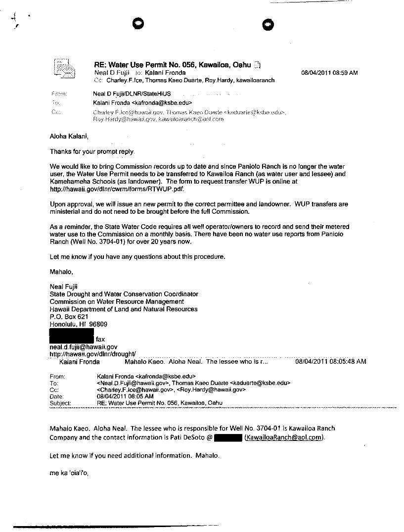
o
RE: Water Use Permit No. 056, Kawailoa, Oahu Neal D Fujii to: Kalani Fronda
o
Charley.F.lce, Thomas Kaeo Duarte, Roy.Hardy, kawailoaranch
From Neal D F.uji,ilDLNRIStateHiUS To Kalani Fronda <[email protected]>
Thomas Kaeo Duarte
Aloha Kalani,
Thanks for your prompt reply.
08/04/2011 08:59 AM
We would like to bring Commission records up to date and since Paniolo Ranch is no longer the water user, the Water Use Permit needs to be transferred to Kawailoa Ranch (as water user and lessee) and Kamehameha Schools (as landowner). The form to request transfer WUP is online at http://hawaii.gov/dlnr/cwrm/forms/RTWUP.pdf.
Upon approval, we will issue an new permit to the correct permittee and landowner. WUP transfers are ministerial and do not need to be brought before the full Commission.
As a reminder, the State Water Code requires all well operator/owners to record and send their metered water use to the Commission on a monthly basis. There have been no water use reports from Paniolo Ranch (Well No. 3704-01) for over 20 years now.
Let me know if you have any questions about this procedure.
Mahalo,
Neal Fujii State Drought and Water Conservation Coordinator Commission on Water Resource Management Hawaii Department of Land and Natural Resources P.O. Box 621 Honolulu, HI 96809
fax
[email protected] http://hawaii.gov/dlnr/droughtl
Kalani Fronda Mahalo Kaeo. Aloha Neal. The lessee who is r. ..
From: To: Cc: Date: Subject:
Kalani Fronda <[email protected]> <[email protected]>, Thomas Kaeo Duarte <[email protected]> <Charley.F .lce@hawaiLgov>, <[email protected]> 08/04/201108:05 AM RE: Water Use Permit No. 056, Kawailoa, Oahu
08/04/2011 08:05:48 AM
Mahalo Kaeo. Aloha Neal. The lessee who is responsible for Well No. 3704-01 is Kawai/oa Ranch Company and the contact information is Pati DeSoto @ (KawaiioaRanch@ao/'com).
let me know if you need additional information. Mahalo.
me ka 'oia'j'o,

- . .f o o
Kalani Fronda Mr. Kalani Fronda, CCIM I Senior Land Asset Manager I Kamehameha Schools - Endowment Group -Land Assets Division - Oahu/Neighbor Islands Department Ofc: (808) I Fax: (808) I 24-hr Call Center: (808) I Website: www.ksbe.edu I North Shore Plan Website: www.ksbe.edulnsplan
***DISCLAIMER*** The views described herein are the views of the author, and do not represent the views or opinions of Kamehameha Schools, nor is there any approval or authorization of this material, express or implied, by the Kamehameha Schools.
From: [email protected] [mailto:[email protected]] Sent: Thursday, August 04, 2011 8:03 AM To: Thomas Kaeo Duarte Cc: [email protected]; Kalani Fronda; [email protected] Subject: RE: Water Use Permit No. 056, Kawailoa, Oahu
Thanks Kaeo. I will follow up with Kalani.
Neal
'From: Thomas Kaeo Duarte <[email protected]>
To: <NeaJ.D.Fujii@hawaiLgov>
Cc: <Charley.F.lce@hawaiLgov>, <[email protected]>, Kalani Fronda <[email protected]>
Date: 08/03/2011 05:17PM
Subject: RE: Water Use Permit No. 056, Kawailoa, Oahu
Aloha Neal, I am cc'ing Kalani Fronda who is the land asset manager for that area. He can get you the contact info
for the user, Kawailoa Ranch I believe.
Thanks,
Kaeo
From: [email protected] [mailto:[email protected]] Sent: Wednesday, August 03, 2011 4: 18 PM To: Thomas Kaeo Duarte Cc: [email protected]; [email protected] Subject: Water Use Permit No. 056, Kawailoa, Oahu
Hi Kaeo,
We are contacting water use permit holders in the Oahu North Shore area to let them know they are required to send monthly water use reports to the Commission.

o o
Paniolo Ranch is listed as the permit holder for WUP No. 056 (Well No. 3704-01). Land owner is Kamehameha Schools. We do not have current point of contact information for Paniolo Ranch. Could you send me pOint of contact information on who/where to send our letter to?
Thanks,
Neal Fujii State Drought and Water Conservation Coordinator Commission on Water Resource Management Hawaii Department of Land and Natural Resources P.O. Box 621 Honolulu, HI 96809
fax
[email protected] http://hawaii.gov/dlnr/droughtl
This message is the property of Kamehameha Schools and any attachments are confidential to the intended recipient at the e-mail address to which it has been addressed. If you are not the intended recipient, you may not copy, forward, disclose or use any part ofthis message or its attachments. If you received this transmission in error please notify the sender immediately by e-mail or contact Kamehameha Schools at and then delete this message from your system.
This message is the property of Kamehameha Schools and any attachments are confidential to the intended recipient at the e-mail address to which it has been addressed. If you are not the intended recipient, you may not copy, forward, disclose or use any part of this message or its attachments. If you received this transmission in error please notify the sender immediately by e-mail or contact Kamehameha Schools at and then delete this message from your system.

o
Oceanic Properties, Inc. 401 K3.:makee Street Honolulu J l~:lvnlii 96814
. ,-- .... -..... ,.. ..
, ' .. .. . :~ .'
January:' 14 ~ 1974
Subject: Amount of water pumped from our well in 1973.
Gen t 1 emen :
I
Under the tenns of our lease we are required to submit to you an estimate of the amount of water pumped from our well each year.
Our estimated usage for 1973 was 131,400,000 gals.
A new pump was installed in April; hm-.Jever, our performance ct:H't \'Ia.8 not received until O~tober. Also our clock to rc.'.~iGt{n· the numher of hours in opc::t'dtion is not working. Our estimate, therefore, was Cf) tablisbed as follows:
2 .. 31 X ~!. Pressure Gauge Reading
71.61 31. No. of Feet between center of pressure gao
and surface of the \·,ater 102. 61 EquivalE~nt to perform .. '1nce ,chart reading of
400 5a1s. per ruin. or 24,000 gal$. per hr.
Estim<3.ted 15 hours per day that the p,.,..... -as in operation for 365 days (5,1+7.5 hrs. X 2/+,000 gal&. per hr.).
Sincerely yours, HEADOH GOLD DAIRIES- HAWAII» LTD.
Carl H. Heier, Hanager HcadovJ Gold Farms, Hawaii
. cc : U. S. D::::pt. of the Interior v/ Geoloiji.cal Survey
t1r. D. A. ShimloDs, Vice P4'csidcnt MrMldm-.r Gold liairies--H£h;.;di, Ltd.