IOTC REGIONAL OBSERVER SCHEME (ROS) Observer ...
142
IOTC REGIONAL OBSERVER SCHEME (ROS) Observer Manual (Version 1.2 2015)
-
Upload
khangminh22 -
Category
Documents
-
view
0 -
download
0
Transcript of IOTC REGIONAL OBSERVER SCHEME (ROS) Observer ...

IOTC
REGIONAL OBSERVER SCHEME
(ROS)
Observer Manual
(Version 1.2 2015)

Page 2 of 142
Table of Contents
I. INTRODUCTION ................................................................................................................................................. 6 II. DEVELOPMENT OF REGIONAL OBSERVER SCHEMES ........................................................................................... 6 III. RATIONALE FOR THE IOTC-REGIONAL OBSERVER SCHEME ........................................................................ 7
PART A: IOTC, REGIONAL DYNAMICS, COUNTRIES, FISHERIES AND SPECIES................................ 9
I. BACKGROUND TO IOTC, STRUCTURE, MEMBERS AND DYNAMICS .................................................................. 10 A. Establishment ............................................................................................................................................. 10 B. IOTC Membership ..................................................................................................................................... 10 C. Organisational structure of the IOTC ........................................................................................................ 11
IV. GEOGRAPHY AND POLITICAL DIMENSION OF THE INDIAN OCEAN REGION ................................................. 12 V. THE MAIN SPECIES UNDER IOTC MANAGEMENT ............................................................................................. 12 VII. CONSERVATION AND MANAGEMENT MEASURES (CMMS) RELEVANT TO SCIENTIFIC OBSERVERS ............. 13
D. General ...................................................................................................................................................... 13 E. Sharks ........................................................................................................................................................ 13 F. Seabirds ..................................................................................................................................................... 14 G. Turtles ........................................................................................................................................................ 15 H. Cetaceans ................................................................................................................................................... 15
VIII. IOTC FISHERIES AND OPERATIONAL CHARACTERISTICS ........................................................................... 15 A. Purse Seine Fishery ................................................................................................................................... 16
Background and vessel ..................................................................................................................................................... 16 Industrial tuna purse-seine gear ........................................................................................................................................ 17 Target Species .................................................................................................................................................................. 17 Purse Seine Operations ..................................................................................................................................................... 17
B. Pelagic Longline Fishery ........................................................................................................................... 22 Background and vessels ................................................................................................................................................... 22 Pelagic longline gear components .................................................................................................................................... 23 Target Species .................................................................................................................................................................. 24 Longline operations .......................................................................................................................................................... 26 Seabird bycatch ................................................................................................................................................................ 27
C. Pelagic Gillnet Fishery .............................................................................................................................. 30 D. Pole and Line ............................................................................................................................................. 33
Target Species .................................................................................................................................................................. 33 Pole and Line Operations ................................................................................................................................................. 33
PART B : OBSERVER BASICS, PROTOCOLS, LOGISTICS, SAMPLING ................................................. 36
I. CPC RESPONSIBILITIES ................................................................................................................................... 37 II. OTHER OBSERVER SCHEMES IN THE REGION ................................................................................................... 37 III. DATA COLLECTION AND SUBMISSION OF DATA TO THE IOTC ................................................................... 38 IV. DEFINING “THE OBSERVER” ....................................................................................................................... 38 V. QUALIFICATIONS AND PREREQUISITES ............................................................................................................ 38 VI. OBSERVER CODE OF CONDUCT AND PROTOCOLS ....................................................................................... 39 A. CODE OF CONDUCT ......................................................................................................................................... 39 VII. OBSERVER DEPLOYMENT LOGISTICS.......................................................................................................... 40 A. REQUEST FOR AN OBSERVER .......................................................................................................................... 40 A. OBSERVERS ON STANDBY ............................................................................................................................... 41 B. OBSERVER CHECKLISTS .................................................................................................................................. 41 C. RECOMMENDED HEALTH & SAFETY EQUIPMENT ISSUE .................................................................................. 41 D. PROFESSIONAL EQUIPMENT TO UNDERTAKE THE TASKS ALLOCATED TO THEM SHOULD INCLUDE .................. 42 E. OBSERVER BRIEFING ....................................................................................................................................... 42 F. DEPLOYMENT ................................................................................................................................................. 42 G. OBSERVER RETURN - DEBRIEFING .................................................................................................................. 42 VIII. OBSERVER REPORTING ............................................................................................................................... 42
A. Deployment Report .................................................................................................................................... 43 B. Five-day Status Reports ............................................................................................................................. 43 C. Preliminary Trip Summary Report ............................................................................................................ 43 D. Trip report ................................................................................................................................................. 43

Page 3 of 142
IX. SAMPLING STRATEGIES .............................................................................................................................. 44 E. Trip selection ............................................................................................................................................. 44 F. Total catch estimation ................................................................................................................................ 44 G. Sampling for species and size composition ................................................................................................ 44
Sampling procedures ........................................................................................................................................................ 44 H. Biological sub-sampling ............................................................................................................................ 45 I. Sampling Equipment .................................................................................................................................. 46
Length measurement equipment required for tuna vessels ............................................................................................... 46 Data recording .................................................................................................................................................................. 46
J. Species identification ................................................................................................................................. 47 All species groups ............................................................................................................................................................ 47 Tuna ................................................................................................................................................................................. 47 Billfish .............................................................................................................................................................................. 47 Sharks and rays................................................................................................................................................................. 47 Marine turtles ................................................................................................................................................................... 48 Seabirds ............................................................................................................................................................................ 48 Marine mammals .............................................................................................................................................................. 48 Electronic species identification methods......................................................................................................................... 48
K. Measurements ............................................................................................................................................ 48 Methods used ................................................................................................................................................................... 48 Length measurements ....................................................................................................................................................... 49
L. Additional Biological sampling ................................................................................................................. 52 Sex determination ............................................................................................................................................................. 52 Maturity ............................................................................................................................................................................ 54
M. Best practice bycatch handling methods for successful live release .......................................................... 54 Sharks and rays................................................................................................................................................................. 54 Marine turtles ................................................................................................................................................................... 59 Seabirds ............................................................................................................................................................................ 60
N. Tagged Animals ......................................................................................................................................... 61
PART C: DATA FIELD DESCRIPTIONS ....................................................................................................... 63
I. OVERVIEW ...................................................................................................................................................... 64 FISHERY ............................................................................................................................................................ 65
II. DATA COLLECTION AND REPORTING REQUIREMENTS ...................................................................................... 66 A. General ...................................................................................................................................................... 66
Trip Information ............................................................................................................................................................... 66 B. Form 1 - GEN ............................................................................................................................................ 66
Vessel information ........................................................................................................................................................... 66 Observer and Deployment Details .................................................................................................................................... 67 Vessel electronic equipment ............................................................................................................................................. 70 Catch transhipped summary ............................................................................................................................................. 71 Catch onboard at disembarkation summary ...................................................................................................................... 72 Waste management (MARPOL Agreement Annex 5) ..................................................................................................... 72
C. Form 2-LL .................................................................................................................................................. 72 Branchline details ............................................................................................................................................................. 73 Tori line details................................................................................................................................................................. 74
D. Form 4-LL .................................................................................................................................................. 74 Hauling Operation ............................................................................................................................................................ 77 Weather observations ....................................................................................................................................................... 78 Tag details ........................................................................................................................................................................ 79 Catch details ..................................................................................................................................................................... 79 Biological sample ............................................................................................................................................................. 81
E. Form 2-GIL ................................................................................................................................................ 81 Gillnet details ................................................................................................................................................................... 82 Net specifications ............................................................................................................................................................. 82
F. Form 4-GIL ................................................................................................................................................ 82 Setting operation .............................................................................................................................................................. 83 Hauling operation ............................................................................................................................................................. 83 Weather observations ....................................................................................................................................................... 84 Tag details ........................................................................................................................................................................ 85 Catch details ..................................................................................................................................................................... 85 Biological sample ............................................................................................................................................................. 87
Page 4 of 142
G. Form 2-PS .................................................................................................................................................. 87 Purse seine details ............................................................................................................................................................ 88
H. Form 3-GEN .............................................................................................................................................. 88 I. Form 4-PS .................................................................................................................................................. 89
Weather observations ....................................................................................................................................................... 91 Catch details ..................................................................................................................................................................... 92 Biological sample ............................................................................................................................................................. 93 Tag details ........................................................................................................................................................................ 93
A. Form 2-PL ................................................................................................................................................. 94 A. Form 4-PL ................................................................................................................................................. 94
Weather observations ....................................................................................................................................................... 96 Tag details ........................................................................................................................................................................ 97 Catch details ..................................................................................................................................................................... 97 Biological sample ............................................................................................................................................................. 98
B. Form 5-GEN .............................................................................................................................................. 99 C. Form 6-GEN .............................................................................................................................................. 99
III. IOTC DATA CODES ................................................................................................................................... 100 A. Species Codes .......................................................................................................................................... 100 B. Vessel and gear codes .............................................................................................................................. 107 C. Activity codes ........................................................................................................................................... 111 D. Operation codes ....................................................................................................................................... 112 E. Catch codes .............................................................................................................................................. 114
APPENDIX 1 ........................................................................................................................................................... 120 IX. APPENDIX II PRE-SEA SAFETY CHECKLIST............................................................................................... 135 X. APPENDIX III REPORTING ............................................................................................................................. 138 XI. APPENDIX IV OBSERVER TRAINING ......................................................................................................... 140
Page 5 of 142
List of Abbreviations
BCM Bait Casting Machine
CMM IOTC Conservation and Management Measure
COPEC Contrôleurs des Pêches
CPCs Contracting Parties and Cooperating Non-Contracting Parties
CPUE Catch per Unit Effort
CSW Chilled Sea Water
DWFN Distant Water Fishing Nations
EPIRB Emergency Position Indicating Radio Beacon
EEZ Exclusive Economic Zone
FAO Food and Agriculture Organisation of the United Nations
GMDSS Global Maritime Distress and Safety System
GRT Gross Registered Tons
GT Gross Tonnage
HF High Frequency (radio)
IOTC Indian Ocean Tuna Commission
IOC Indian Ocean Commission
IMO International Maritime Organisation
IUU Illegal, Unreported and Unregulated (fishing activity)
LME Large Marine Ecosystem
LOA Length Overall (of the ship)
LSTLVs Large Scale Tuna Longline Vessels
MF Medium Frequency (radio)
MoU Memorandum of Understanding
OBSPEC Observateurs des Pêches
RFMO Regional Fisheries Management Organisation
ROP Regional Observer Programme (transhipment observers)
ROS Regional Observer Scheme (scientific observers)
SART Search and Rescue Transponder
SOLAS International Convention for the Safety of Life at Sea, 1974
SIOFA South Indian Ocean Fisheries Agreement
SWIOFC South West Indian Ocean Fishery Commission
TAAF Terres Australes et Antarctiques Françaises
UNCLOS United Nations Convention on Law of the Sea 1982
VHF Very High Frequency (radio)
VMS Vessel Monitoring System
Page 6 of 142
I. Introduction
This manual has been prepared for the Indian Ocean Tuna Commission (IOTC) Regional Observer
Scheme (ROS), as outlined in Resolution 11/041 (or any subsequent superseding Resolution). The manual
will constitute an integral part of the training documentation issued to observers during preparation, and
will also be a tool used for reference purposes when they are in the field. Notwithstanding this, observers
should be familiar with IOTC Resolution 11/04 On a Regional Observer Scheme and all the Conservation
and Management Measures (CMMs) linked to this Resolution.
The ROS manual provides reference material along with instructions detailing observer tasks, including
observational requirements; sampling protocols; data entry protocols; and reporting procedures for
observers deployed in the longline, purse seine, pole-and-line, and gillnet fisheries operating in the IOTC
area of competence2. This manual should be considered a ‘live’ document that will change as the Scheme
evolves through the incorporation of new recommendations from the Scientific Committee, based on the
advice of the Working Parties and observers returning from the field.
II. Development of regional observer schemes
The development of modern day observer schemes is identified in the United Nations Convention on the
Law of the Sea of 10 December 1982, Part 5, Articles 61 to 65 as contributing to the conservation and
management of marine living resources. The 1982 Convention laid the foundation for a new era in
international fisheries law that was followed by several major agreements that were drawn up to enhance
the legal status of the management and conservation of marine living recourses, the most important of
these were:
The 1993 Compliance Agreement;
The 1995 The FAO Code of Conduct for Responsible Fisheries;
The 1995 United Nations Fish Stocks Agreement.
These three instruments complement and mutually reinforce each other, highlighting the pivotal role of
Regional Fisheries Management Organisations (RFMOs) in establishing a responsible international
fisheries regime to promote and enhance data-collection and the exchange of data for assessing high seas
resource potentials and developing profiles of all target and non-target stocks. Within these agreements,
the framework was set for meaningful advances in fisheries management and establishing observer
schemes for monitoring, control and surveillance and scientific data collection.
Worldwide, scientific observer schemes are used in fisheries management to provide ‘independent’
baseline information on fisheries. This is particularly important in the case of RFMOs managing highly
migratory species and where member states comprise distant water fleets as well as domestic fleets which
include artisanal fisheries (exploiting coastal waters, within 200nm of the shore). Regional observer
schemes perform a valuable role in verifying catch and effort data collected through logbooks, but they
also provide more detailed scientific information that is not captured in logbooks. This information
contributes towards the assessment of stocks for management and conservation.
The Indian Ocean differs from the other oceans in that artisanal fisheries catch more than the industrial
fisheries (69% of IOTC species are caught by artisanal fleets3). Artisanal fisheries are generally smaller-
scale operations by vessels that operate within the EEZ, characterised by the use of gillnets, troll lines and
pole-and-line gears, whereas industrial fisheries conduct larger scale operations and may operate
offshore. Their importance, in terms of contribution to total tuna catches, has increased substantially in
recent years with artisanal craft are ranging over progressively larger areas and catching larger quantities
of tuna and tuna-like species. The artisanal component is the most challenging to monitor and so this part
1 http://iotc.org/cmm/resolution-1104-regional-observer-scheme
2 http://iotc.org/about-iotc/competence 3 IOTC Nominal catch database (average 2010-2014)
Page 7 of 142
of the scheme will be progressively initiated though the use of field samplers4. The IOTC ROS will
comprise separate “industrial” and “artisanal” elements as the difference in the nature of the fleets means
they require their own particular set of protocols. The distinction between the industrial and artisanal
components is drawn in paragraph 2 of Resolution 11/04, where industrial vessels that require an onboard
observer are classified as vessels ≥24 m overall length as well as vessels under 24 m if they fish outside
their EEZ. While industrial vessels require onboard observer coverage, artisanal vessels may be observed
at landing sites, as stated paragraph 4 of Resolution 11/04:
“The number of artisanal fishing vessels landings shall also be monitored at the landing place by field
samplers5. The indicative level of the coverage of the artisanal fishing vessels should progressively
increase towards 5% of the total levels of vessel activity (i.e. total number of vessel trips or total number
of vessels active)”.
At this time, this ROS manual only covers the industrial, at-sea, component of the observe scheme.
III. Rationale for the IOTC-Regional Observer Scheme
Taking into account the objectives of the agreements above and in terms of its mission as an
intergovernmental organisation under Article XIV of the FAO constitution, the mandate of the IOTC is to
manage tuna and tuna-like species in the Indian Ocean and adjacent seas. In order to achieve these
objectives, the Commission has identified the following functions and responsibilities, in accordance with
the principles expressed in the relevant provisions of the United Nations Convention on the Law of the
Sea:
to keep under review the conditions and trends of the stocks;
to gather, analyse and disseminate scientific information, catch and effort statistics and other data
relevant to the conservation and management of the stocks and fisheries based on the stocks
covered by the IOTC Agreement;
to encourage, recommend, and coordinate research and development activities in respect of the
stocks and fisheries covered by this Agreement, and such other activities as the Commission may
decide appropriate, including activities connected with transfer of technology, training and
enhancement, having due regard to the need to ensure the equitable participation of Members of
the Commission in the fisheries and the special interests and needs of members in the region that
are developing countries;
to adopt, on the basis of scientific evidence, conservation and management measures to ensure
the conservation of the stocks covered by this Agreement and to promote the objective of their
optimum utilisation throughout the Area;
to keep under review the economic and social aspects of the fisheries based on the stocks covered
by this Agreement bearing in mind, in particular, the interests of developing coastal states.
The aim of the IOTC ROS is to “collect verified catch data and other scientific data related to the
fisheries for tuna and tuna-like species in the IOTC area of competence6”. This will provide independent,
reliable, verified and accurate information on catch, effort, fishing practices and the fate of non-target
species for a sample of all types of vessel operating within the IOTC area of competence. This
information is essential to fisheries managers, research organisations and environmental agencies for
stock assessments and the responsible management and conservation of living marine resources. The
IOTC Regional Observer Scheme was adopted in Resolution 11/04 to support the Commission in meeting
these obligations and functions.
5 Field sampler: a person who collects information on land during the unloading of fishing vessels. Field sampling
programmes can be used for quantifying catch, retained bycatch, collecting tag returns, etc. 6 Paragraph 1 of IOTC Resolution 11/04 On a regional observer scheme.

Page 8 of 142

Page 9 of 142
PART A: IOTC, REGIONAL DYNAMICS, COUNTRIES, FISHERIES AND SPECIES
Page 10 of 142
I. Background to IOTC, structure, members and dynamics
A. Establishment
The IOTC is an intergovernmental organisation that was established by the FAO Council in Rome in
1993 and came into force in 1996. The objective of the Commission is to promote cooperation among its
Members with a view to ensuring, through appropriate management, the conservation and optimum
utilisation of stocks covered by the IOTC Agreement and encouraging sustainable development of
fisheries based on such stocks.
B. IOTC Membership
The Commission is open to any Indian Ocean coastal countries and to countries or regional economic
integration organisations which are members of the UN or one of its specialised agencies and are fishing
for tunas or tuna-like species in the Indian Ocean. Currently (October 2015), there are 32 Contracting
Parties, (Tables 1 & 2) and five Cooperating Non-Contracting Parties, collectively termed CPCs.
Table 1. IOTC Contracting Parties (Members: 2015)
Contracting Party Fisheries Management Authority
Australia Australian Fisheries Management Authority
Belize Ministry of Agriculture and Fishery
China Bureau of Fisheries Management
Comoros Direction Nationale des Ressources
Eritrea Ministry of Fisheries
European Union Community Fisheries Control Agency
France Ministry of Agriculture and Fisheries
Guinea Ministre de la Pêche et de l’Aquaculture
India Ministry of Agriculture
Indonesia Ministry of Ocean and Fisheries
Iran, Islamic Republic of Ministry of Agriculture
Japan Ministry of Agriculture, Forestry and Fisheries
Kenya Department of Fisheries
Korea, Republic of Ministry of Oceans and Fisheries
Madagascar Ministry of Agriculture and Fisheries
Malaysia Federal Department of Fisheries
Maldives Ministry of Fisheries and Agriculture
Mauritius Ministry of Agro-Industry and Fisheries
Mozambique National Fisheries Administration
Oman, Sultanate of Ministry of Agriculture and Fisheries
Pakistan Ministry of Food, Agriculture and Livestock
Philippines Bureau of Fisheries and Aquatic Resources
Seychelles Seychelles Fisheries Authority
Sierra Leone Ministry of Marine Resources and Fisheries
Somalia Ministry of Fisheries and Marine Resources
Sri Lanka Ministry of Fisheries and Aquatic Resources Development
Page 11 of 142
Sudan Ministry of Animal Resources
Tanzania Ministry of Natural Resources and Tourism
Thailand Department of Fisheries
United Kingdom Department of Food and Rural Affairs
Vanuatu Department of Fisheries
Yemen Ministry of Fish Wealth
Table 2. IOTC Cooperating Non-Contracting Parties (CNCP)
CNCP Fisheries Management Authority
Bangladesh Ministry of Fisheries and Livestock
Djibouti Ministry of Agriculture
Liberia Bureau of National Fisheries
Senegal Ministry of Agriculture
South Africa Marine and Coastal Management
C. Organisational structure of the IOTC
The IOTC comprises a Commission, the primary decision making body, Sub-commissions (formed as
necessary), supported by a Scientific Committee, Compliance Committee, Standing Committee on
Administration and Finance, Technical Committee on Allocation Criteria, and a number of subsidiary
specialist Working Parties7. The Commission is the only body authorised to take decisions that are
binding on Members. It is the responsibility of Members to ensure that action is taken under their national
legislation to implement Conservation and Management Measures (CMMs), which become binding on it.
Recommendations adopted by the Commission concerning conservation and management of the stocks
for furthering the objectives of the IOTC Agreement, are not binding and are acceded to on a voluntary
basis by Members. The Members of the Commission are also expected to cooperate in the exchange of
information regarding any fishing for stocks covered by the Agreement by nationals of any State or
entity, which is not a Member of the Commission.
A permanent Secretariat provides the administrative support for the Commission and its subsidiary
bodies. The IOTC Secretariat consists of the Executive Secretary, appointed by the Director-General of
the FAO with the approval of the Commission, and staff appointed by him/her to support the
Commission in the implementation of policies through administration activities, data management,
capacity building, scientific and other support activities as requested by the Commission, the Scientific
Committee and the Working Parties.
7 Seven Working Party meetings were held in 2015
Page 12 of 142
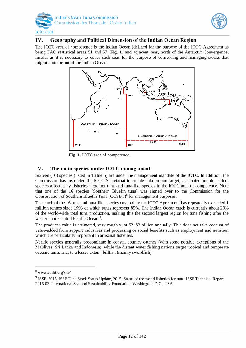
IV. Geography and Political Dimension of the Indian Ocean Region
The IOTC area of competence is the Indian Ocean (defined for the purpose of the IOTC Agreement as
being FAO statistical areas 51 and 57; Fig. 1) and adjacent seas, north of the Antarctic Convergence,
insofar as it is necessary to cover such seas for the purpose of conserving and managing stocks that
migrate into or out of the Indian Ocean.
Fig. 1. IOTC area of competence.
V. The main species under IOTC management
Sixteen (16) species (listed in Table 5) are under the management mandate of the IOTC. In addition, the
Commission has instructed the IOTC Secretariat to collate data on non-target, associated and dependent
species affected by fisheries targeting tuna and tuna-like species in the IOTC area of competence. Note
that one of the 16 species (Southern Bluefin tuna) was signed over to the Commission for the
Conservation of Southern Bluefin Tuna (CCSBT)8 for management purposes.
The catch of the 16 tuna and tuna-like species covered by the IOTC Agreement has repeatedly exceeded 1
million tonnes since 1993 of which tunas represent 85%. The Indian Ocean catch is currently about 20%
of the world-wide total tuna production, making this the second largest region for tuna fishing after the
western and Central Pacific Ocean.9.
The producer value is estimated, very roughly, at $2–$3 billion annually. This does not take account of
value-added from support industries and processing or social benefits such as employment and nutrition
which are particularly important in artisanal fisheries.
Neritic species generally predominate in coastal country catches (with some notable exceptions of the
Maldives, Sri Lanka and Indonesia), while the distant water fishing nations target tropical and temperate
oceanic tunas and, to a lesser extent, billfish (mainly swordfish).
8 www.ccsbt.org/site/
9 ISSF. 2015. ISSF Tuna Stock Status Update, 2015: Status of the world fisheries for tuna. ISSF Technical Report
2015-03. International Seafood Sustainability Foundation, Washington, D.C., USA.

Page 13 of 142
VII. Conservation and Management Measures (CMMs) relevant to scientific
observers
The full compendium of IOTC CMMs can be downloaded from the website at: http://www.iotc.org/cmms
and may be subject to change by the IOTC at future meetings of the Commission. Observers should be
familiar with the Resolutions outlined below.
D. General
Resolution 11/04 On a Regional Observer Scheme
IOTC Resolution 11/04 provides the foundations of the IOTC Regional Observer Scheme and covers the
requirements which are binding on all CPCs.
Resolution 12/02 Data confidentiality policy and procedures
All observer data collected and reported to the IOTC Secretariat is subject to the data confidentiality
policy and procedures outlined in Resolution 12/02:
“Observer data grouped by 1° longitude by 1° latitude for surface fisheries and by 5° longitude by 5°
latitude for longline, stratified by month and by fishing nation are considered to be in the public domain,
provided that the activities /catch of no individual vessel can be identified within a time/area stratum”
E. Sharks
• IOTC Resolution 05/05 Concerning the conservation of sharks caught in association with
fisheries managed by IOTC
“CPCs shall require their vessels to not have onboard fins that total more than 5 % of the weight of
sharks onboard, up to the first point of landing. CPCs that currently do not require fins and carcasses to
be offloaded together at the point of first landing shall take the necessary measures to ensure compliance
with the 5 % ratio through certification, monitoring by an observer, or other appropriate measures”.
Resolution 13/06 On a scientific and management framework on the conservation of shark
species caught in association with IOTC managed fisheries
Paragraph 4: CPCs shall require fishing vessels flying their flag and on the IOTC Record of Authorised
Vessels or authorised to fish for tuna and tuna-like species managed by the IOTC on the high seas to
promptly release unharmed, to the extent practicable, of oceanic whitetip sharks when brought alongside
for taking onboard the vessel. However, CPCs should encourage their fishers to release this species if
recognised on the line before bringing them onboard the vessels.
Paragraph 5. CPCs shall encourage their fishers to record incidental catches as well as live releases of
oceanic whitetip sharks. These data shall be kept at the IOTC Secretariat.
Paragraph 7. Scientific observers shall be allowed to collect biological samples (vertebrae, tissues,
reproductive tracts, stomachs, skin samples, spiral valves, jaws, whole and skeletonised specimens for
taxonomic works and museum collections) from oceanic whitetip sharks taken in the IOTC area of
competence that are dead at haulback, provided that the samples are a part of a research project
approved by the IOTC Scientific Committee (SC)/the IOTC Working Party on Ecosystems and Bycatch
(WPEB). In order to obtain the approval, a detailed document outlining the purpose of the work, number
of samples intended to be collected and the spatio-temporal distribution of the sampling effect must be
Page 14 of 142
included in the proposal. Annual progress of the work and a final report on completion shall be presented
to the SC/WPEB.
Resolution 13/05 On the conservation of whale sharks (Rhinocodon typus)
Paragraph 3: CPCs shall require that, in the event that a whale shark is unintentionally encircled in the
purse seine net, the master of the vessel shall:
a) take all reasonable steps to ensure its safe release, while taking into consideration the safety of the
crew. These steps shall follow the best practice guidelines for the safe release and handling of whale
sharks developed by the IOTC Scientific Committee;
b) report the incident to the relevant authority of the flag State, with the following information:
i. the number of individuals;
ii. a short description of the interaction, including details of how and why the interaction
occurred, if possible;
iii. the location of the encirclement;
iv. the steps taken to ensure safe release;
v. an assessment of the life status of the animal on release, including whether the whale shark
was released alive but subsequently died.
Paragraph 7: CPCs shall report the information and data collected under paragraph 3(b) and paragraph
4 through logbooks, or when an observer is onboard through observer programs, and provide to the
IOTC Secretariat by 30 June of the following year and according to the timelines specified in Resolution
10/02 [superseded by Resolution 15/02] (or any subsequent revision).
Resolution 12/09 On the conservation of thresher sharks (family Alopiidea) caught in association
with fisheries in the IOTC area of competence
Paragraph 2: Fishing Vessels flying the flag of an IOTC Member or Cooperating Non-Contracting Party
(CPCs) are prohibited from retaining on board, transhipping, landing, storing, selling or offering for sale
any part or whole carcass of thresher sharks of all the species of the family Alopiidae, with the exception
of paragraph 7.
Paragraph 7: Scientific observers shall be allowed to collect biological samples (vertebrae, tissues,
reproductive tracts, stomachs, skin samples, spiral valves, jaws, whole and skeletonised specimens for
taxonomic works and museum collections) from thresher sharks that are dead at haulback, provided that
the samples are part of the research project approved by the IOTC Scientific Committee (or IOTC
Working Party on Ecosystems and Bycatch (WPEB)). In order to obtain the approval, a detailed
document outlining the purpose of the work, number and type of samples intended to be collected and the
spatio-temporal distribution of the sampling work must be included in the proposal. Annual progress of
the work and a final report on completion of the project shall be presented to the IOTC WPEB and the
IOTC Scientific Committee.
F. Seabirds
Resolution 12/06 On reducing the incidental bycatch of seabirds in longline fisheries
Paragraph 1: CPCs shall record data on seabird incidental bycatch by species, notably through scientific observers in accordance with Resolution 11/04 and report these annually. Observers shall to the extent
possible take photographs of seabirds caught by fishing vessels and transmit them to national seabird
experts or to the IOTC Secretariat, for confirmation of identification.
Page 15 of 142
G. Turtles
Resolution 12/04 On the conservation of marine turtles
Paragraph 3: CPCs shall collect (including through logbooks and observer programs) and provide to the
IOTC Secretariat no later than 30 June of the following year in accordance with Resolution 10/02 (or
any subsequent revision), all data on their vessels’ interactions with marine turtles. The data shall
include the level of logbook or observer coverage and an estimation of total mortality of marine turtles
incidentally caught in their fisheries.
Paragraph 6: CPCs shall require fishermen on vessels targeting species covered by the IOTC Agreement
to bring aboard, if practicable, any captured marine turtle that is comatose or inactive as soon as
possible and foster its recovery, including aiding in its resuscitation, before safely returning it to the
water. CPCs shall ensure that fishermen are aware of and use proper mitigation, identification, handling
and de-hooking techniques and keep on board all necessary equipment for the release of marine turtles,
in accordance with handling guidelines in the IOTC Marine Turtle Identification Cards.
H. Cetaceans
Resolution 13/04 On the conservation of cetaceans
Paragraph 2: Contracting Parties and Cooperating Non-Contracting Parties (collectively, CPCs) shall
prohibit their flagged vessels from intentionally setting a purse seine net around a cetacean in the IOTC
area of competence, if the animal is sighted prior to the commencement of the set.
Paragraph 3: CPCs shall require that, in the event that a cetacean is unintentionally encircled in a purse
seine net, the master of the vessels shall:
a) take all reasonable steps to ensure the safe release of the cetacean, while taking into
consideration the safety of the crew. These steps shall include following the best practice
guidelines for the safe release and handling of cetaceans developed by the IOTC Scientific
Committee;
b) report the incident to the relevant authority of the flag State, with the following information:
i. the species (if known);
ii. the number of individuals;
iii. a short description of the interaction, including details of how and why the interaction
occurred,if possible;
iv. the location of the encirclement;
v. the steps taken to ensure safe release;
vi. an assessment of the life status of the animal on release, including whether the cetacean was
released alive but subsequently died.
Paragraph 4: CPCs using other gear types fishing for tuna and tuna-like species associated with
cetaceans shall report all interactions with cetaceans to the relevant authority of the flag State and
include all the information outlined in paragraph 3b(i–vi).
Paragraph 7: CPCs shall report the information and data collected under paragraph 3(b) and paragraph
4, through logbooks, or when an observer is onboard through observer programs, and provide to the
IOTC Secretariat by 30 June of the following year and according to the timelines specified in Resolution
10/02 (or any subsequent revision).
VIII. IOTC Fisheries and Operational Characteristics
IOTC fisheries are categorised on the basis of geographical, scientific, technical and economic
characteristics. These are defined by using the following criteria:
Page 16 of 142
Type of fishing craft involved and type of fishing gear/s used: fishing crafts are usually classified
according to their shape and size; the type of gear used is related, in most cases, to the type of
vessel and its size.
Gear configuration, fishing mode and target species: fishing gears are usually configured in
different ways depending on the type of species targeted.
Type of operation: these are related to the scale of the fishing operations and can be broadly
classified as:
Industrial/ semi-industrial (vessel ≥24m overall length or fishing beyond EEZ)
Artisanal (vessels <24m fishing within EEZ).
Four main fisheries (defined by gear type) are described here:
A Purse-seine
B Longline
C Gillnet
D Pole and Line
A. Purse Seine Fishery
Background and vessel
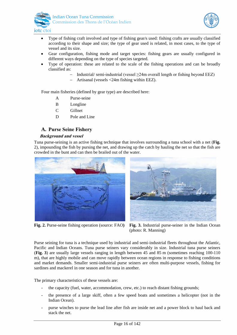
Tuna purse-seining is an active fishing technique that involves surrounding a tuna school with a net (Fig.
2), impounding the fish by pursing the net, and drawing up the catch by hauling the net so that the fish are
crowded in the bunt and can then be brailed out of the water.
Fig. 2. Purse-seine fishing operation (source: FAO) Fig. 3. Industrial purse-seiner in the Indian Ocean
(photo: R. Manning)
Purse seining for tuna is a technique used by industrial and semi-industrial fleets throughout the Atlantic,
Pacific and Indian Oceans. Tuna purse seiners vary considerably in size. Industrial tuna purse seiners
(Fig. 3) are usually large vessels ranging in length between 45 and 85 m (sometimes reaching 100-110
m), that are highly mobile and can move rapidly between ocean regions in response to fishing conditions
and market demands. Smaller semi-industrial purse seiners are often multi-purpose vessels, fishing for
sardines and mackerel in one season and for tuna in another.
The primary characteristics of these vessels are:
- the capacity (fuel, water, accommodation, crew, etc.) to reach distant fishing grounds;
- the presence of a large skiff, often a few speed boats and sometimes a helicopter (not in the
Indian Ocean).
- purse winches to purse the lead line after fish are inside net and a power block to haul back and
stack the net.
Page 17 of 142
- the facility to efficiently freeze fish in brine tanks (or wells) at -20 °C, each with a capacity of 20
to 40 metric tonnes (total 800 to 2000 metric tonnes).
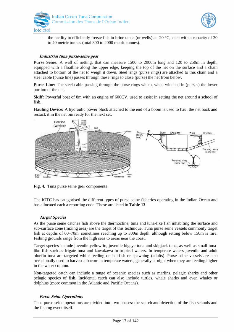
Industrial tuna purse-seine gear
Purse Seine: A wall of netting, that can measure 1500 to 2000m long and 120 to 250m in depth,
equipped with a floatline along the upper edge, keeping the top of the net on the surface and a chain
attached to bottom of the net to weigh it down. Steel rings (purse rings) are attached to this chain and a
steel cable (purse line) passes through these rings to close (purse) the net from below.
Purse Line: The steel cable passing through the purse rings which, when winched in (purses) the lower
portion of the net.
Skiff: Powerful boat of 8m with an engine of 600CV, used to assist in setting the net around a school of
fish.
Hauling Device: A hydraulic power block attached to the end of a boom is used to haul the net back and
restack it in the net bin ready for the next set.
Fig. 4. Tuna purse seine gear components
The IOTC has categorised the different types of purse seine fisheries operating in the Indian Ocean and
has allocated each a reporting code. These are listed in Table 13.
Target Species
As the purse seine catches fish above the thermocline, tuna and tuna-like fish inhabiting the surface and
sub-surface zone (mixing area) are the target of this technique. Tuna purse seine vessels commonly target
fish at depths of 60–70m, sometimes reaching up to 300m depth, although setting below 150m is rare.
Fishing grounds range from the high seas to areas near the coast.
Target species include juvenile yellowfin, juvenile bigeye tuna and skipjack tuna, as well as small tuna-
like fish such as frigate tuna and kawakawa in tropical waters. In temperate waters juvenile and adult
bluefin tuna are targeted while feeding on baitfish or spawning (adults). Purse seine vessels are also
occasionally used to harvest albacore in temperate waters, generally at night when they are feeding higher
in the water column.
Non-targeted catch can include a range of oceanic species such as marlins, pelagic sharks and other
pelagic species of fish. Incidental catch can also include turtles, whale sharks and even whales or
dolphins (more common in the Atlantic and Pacific Oceans).
Purse Seine Operations
Tuna purse seine operations are divided into two phases: the search and detection of the fish schools and
the fishing event itself.
Page 18 of 142
Search and Detection
The search for tuna schools by the industrial tuna purse seiners can be either direct or indirect. The
indirect search for tuna schools involves evaluating a range of environmental parameters and factors that
influence the spatial and temporal distribution of tuna and abundance. These include:
Water temperature
Depth of the thermocline
Water oxygen content
Water colour and transparency
Amount of total suspended matter
Presence of chlorophyll and macrophytes
Currents.
The combination of these parameter values are used by skippers to decide on the fishing location in order
to maximise the chance of finding schools of tuna.
Methods used to directly search for and detect of tuna schools include:
The use of acoustic sonar and depth sounders to detect shoals of fish in the immediate vicinity of
the vessel. These are used to assess the school before setting the net.
Aerial searching for schools of tuna, using helicopters and fixed wing aircraft (not used in the
Indian Ocean)
Searching for seabirds associated with tuna
o Bird radar - Purse seine vessel also are equipped with high frequency and long range
radars that can detect concentrations of feeding seabirds and, in certain conditions, can
detect the agitation on the sea the surface from feeding fish.
o Binoculars - Spotters equipped with powerful binoculars (20X) are positioned in the
crow’s nest to search for indicators of fish in the immediate vicinity of the vessel.
Searching for schools of dolphins that are associated with tuna (not used in the Indian Ocean).
Locating or deploying fish aggregation devices (FADs)
Fish Aggregating Devices
Many open ocean species associate with objects drifting on the surface, such as logs or branches causing
the aggregation of otherwise sparsely distributed schools. This is advantageous for purse seine fishing
operations as the schools, are more easily spotted, more stable and swim at a reduced speed, making them
comparatively easy to catch. Consequently, fishing around floating objects is generally associated with a
higher successful haul than targeting free swimming schools. Natural floating objects (LOG) have always
been a component of the habitat of tropical tunas, and the use of these in fishing operations has developed
over time. Initially reflectors and radio beacons were attached to logs to improve long range detection,
and gradually purpose built fish aggregating devices (FADs) were developed10
. These artificial
constructions are now commonly used as part of purse seine fishing operations. FADs and LOGs are
often attached to radio or satellite buoys, and some have sonar fish detection devices attached which
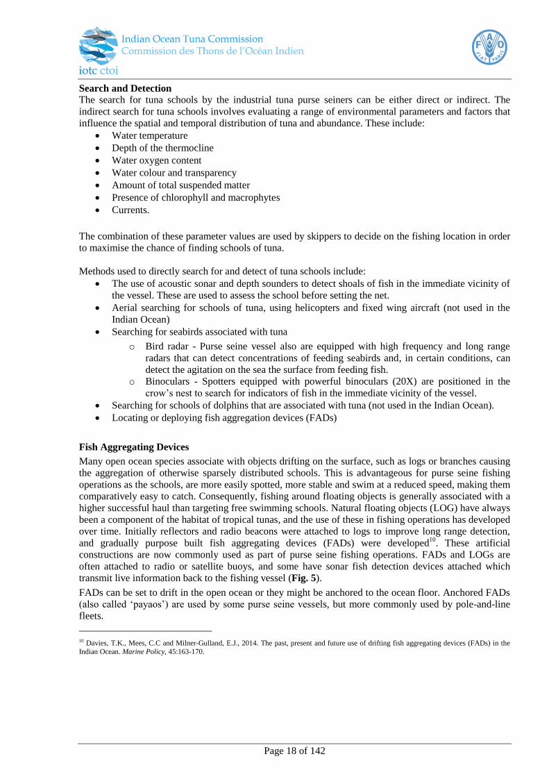
transmit live information back to the fishing vessel (Fig. 5).
FADs can be set to drift in the open ocean or they might be anchored to the ocean floor. Anchored FADs
(also called ‘payaos’) are used by some purse seine vessels, but more commonly used by pole-and-line
fleets.
10 Davies, T.K., Mees, C.C and Milner-Gulland, E.J., 2014. The past, present and future use of drifting fish aggregating devices (FADs) in the
Indian Ocean. Marine Policy, 45:163-170.
Page 19 of 142
Fig. 5. Fish Aggregating Device (FAD) with radio buoy (photo: R. Manning)
Fishing set
Each fishing operation undertaken by a purse seiner, from the deployment of the net to its recovery
onboard (ready for a new shooting), is called a "set" or “event”.
Sequence of a set
1. Detection: The fishing vessel detects a school of tuna.
2. Shooting: Once the presence of a tuna school is confirmed by the sonar, the fishing vessel circles
until its port side is facing the school (most of the tuna purse seiners have deck arrangement for
operating from the port side). The skiff is then deployed with the end of the seine attached to its
rear.
3. Circling: The skiff then encircles the school at maximum speed with the net feeding out astern.
Usually, the entire net is set and the fish are encircled within 4 to 8 minutes.
4. Pursing: Once the encirclement is complete, the extremity of the net that was attached to the
skiff is transferred aboard the purse seiner and the two extremities of the purse line cable are
hauled in with the winch as quickly as possible in order to close the bottom of the net (this is
called "pursing" because it is similar to pulling the draw string of an old-fashioned purse). It is
worth observing that until the purse seine is closed the tunas can still dive below the net or the
purse seine vessel and escape. The pursing may take around 15 to 20 minutes for large purse
seines.
5. Hauling: The net is then pulled aboard the purse seiner with a hydraulic power block which is
attached to the end of the boom and hanging above the deck. Under the power block, the net is
stacked on the stern of the boat by fishermen in such a way that it will come smoothly off the
stern at the beginning of the next set. As a whole, this operation will, take around an hour, if there
are no incidents, depending on the size of the net and quantity of catch.
6. Brailing: When most of the purse seine has been retrieved, the tunas have been grouped within a
restricted area along the portside of the vessel. Then the fish are harvested from the purse seine
using a large scoop-net called the "brailer" (brailing operation); several tonnes of fish are taken
on board at a time. The duration of this operation will obviously depend upon the quantity of fish
in the net. The tunas are sent through trays and tubes arranged in the deck down to fish-wells. In
the fish-wells, fish are usually stored in refrigerated brine at 0°C, but in larger vessels tuna are
preserved in wells with brine at temperatures of -18°C or below. In the more artisanal purse
seiners, tuna are generally kept in iced seawater.
FAD with radio beacon Manning

Page 20 of 142
Fig 6. Purse-seine setting sequence
A sorting bin, commonly known as a hopper, is often used to sort the catch before it is directed into wells
for storage. The hopper typically holds the capacity of the vessel’s brail of fish, which are loaded in the
hopper one by one as the crew sorts through the catch. The crew can remove unwanted bycatch, mutilated
or damaged catch, and other bycatch at this stage. A door or hatch is actuated with a hydraulic control and
allows the catch to be dumped into the loading hatch of the vessel in a controlled manner. Since the hoper
stalls the loading of the catch unto the wells, this is a good point for observers to evaluate catch
composition for their reporting.
If a hopper is not used, the brails are emptied directly into the loading hatch of the wet deck. This makes
it difficult to assess the type and amount of bycatch species in each brail.
1- The presence of a tuna school is confirmed by the
sonar.
2- The skiff is deployed with the net.
3- The skiff encircles the school at maximum speed.
4- Once the encirclement is finished, the skiff
transfers the net cables to the purse seiner who
purses the bottom of the net.
5- The net is hauled and the fish brailed aboard.
6- After brailing the fish aboard and storing the net
and the skiff, the vessel is ready to re-start
searching / fishing.
Page 21 of 142
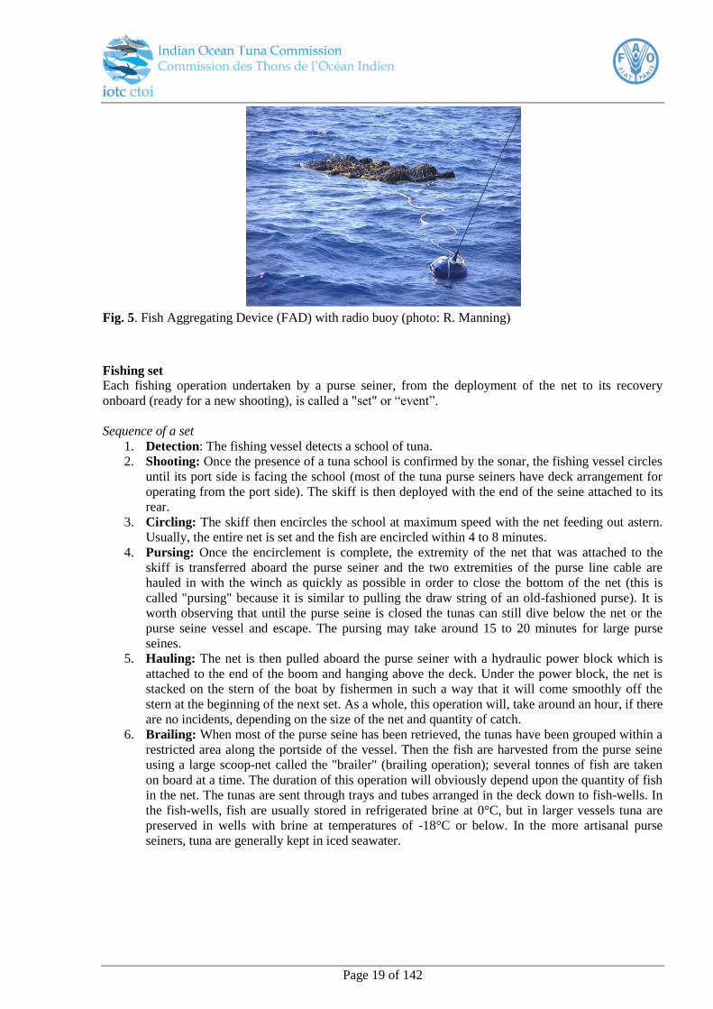
Fig 7. Fishing gear11
11
Source: ISSF Observer Training Guidebook. Photo: SPC
Page 22 of 142
B. Pelagic Longline Fishery
Background and vessels
Longlining is a passive fishing technique that makes use of lines with baited hooks to attract and catch
fish. Pelagic longline systems are not anchored and typically drift with the ocean currents.
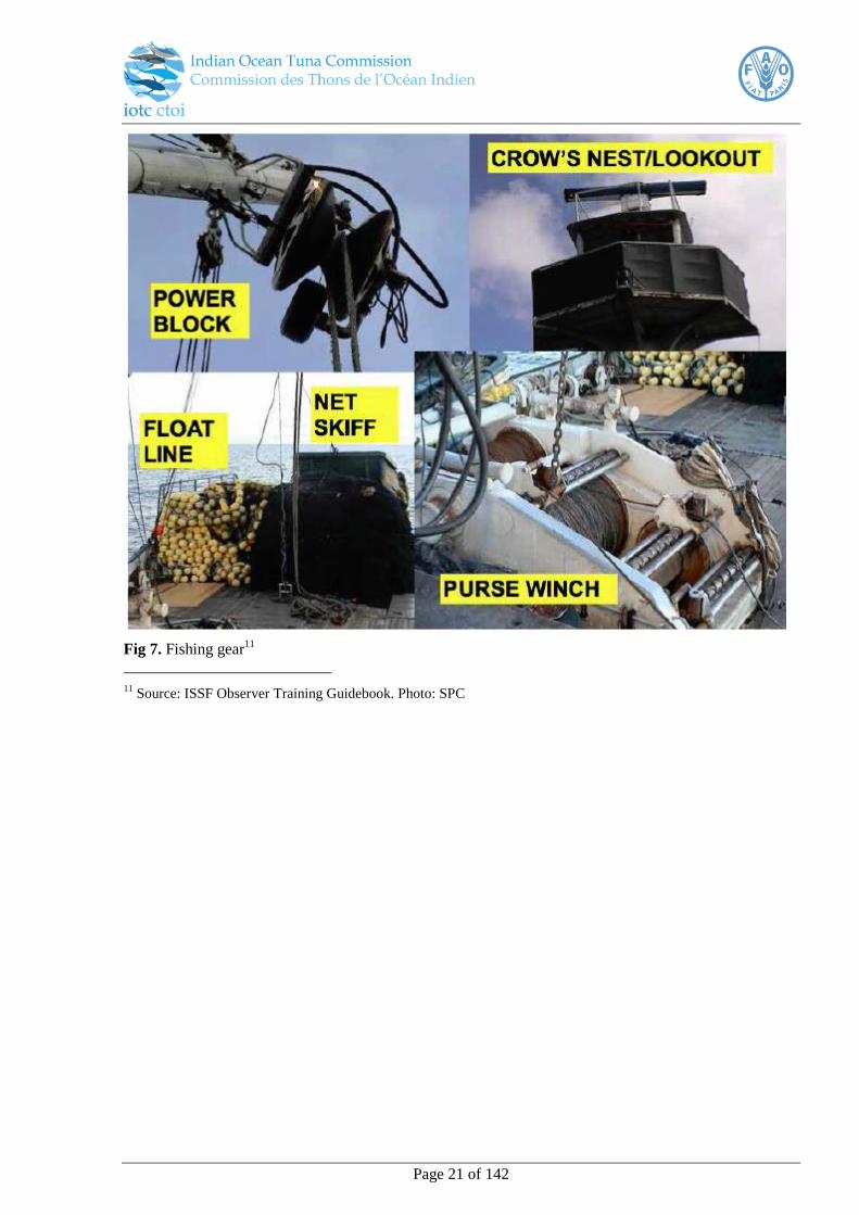
Large Scale Tuna Longline Vessels (LSTLV), also classified as industrial tuna longline vessels, are
usually large vessels with lengths ranging between 30 and 70 m. The primary characteristics of these
vessels are:
the capacity (fuel, water, accommodation, crew, etc.) to reach distant fishing
grounds and operate on the high seas in extreme conditions, for months at a
time without having to return to port.
facilities to efficiently freeze and store high quality fish at low temperatures for
the entire time that they are at sea
The IOTC has nine recognised categories of longline fisheries, summarised in Table 16.
Fig 8. Large Scale Tuna Longline Vessel (LSTLV)12
A drifting longline (pelagic longline) consists of a mainline that is held near the surface or at a certain
depth by regularly spaced buoys or float (Fig 9). Branch lines (also known as droppers, snoods or
ganglions) with baited hooks are suspended from the main line at regular intervals along its length. The
entire line can extend from 20 to over 120km.
12
photo: R. Manning
Large Scale Tuna Longline Vessel (LSTLV) (Manning)
Page 23 of 142
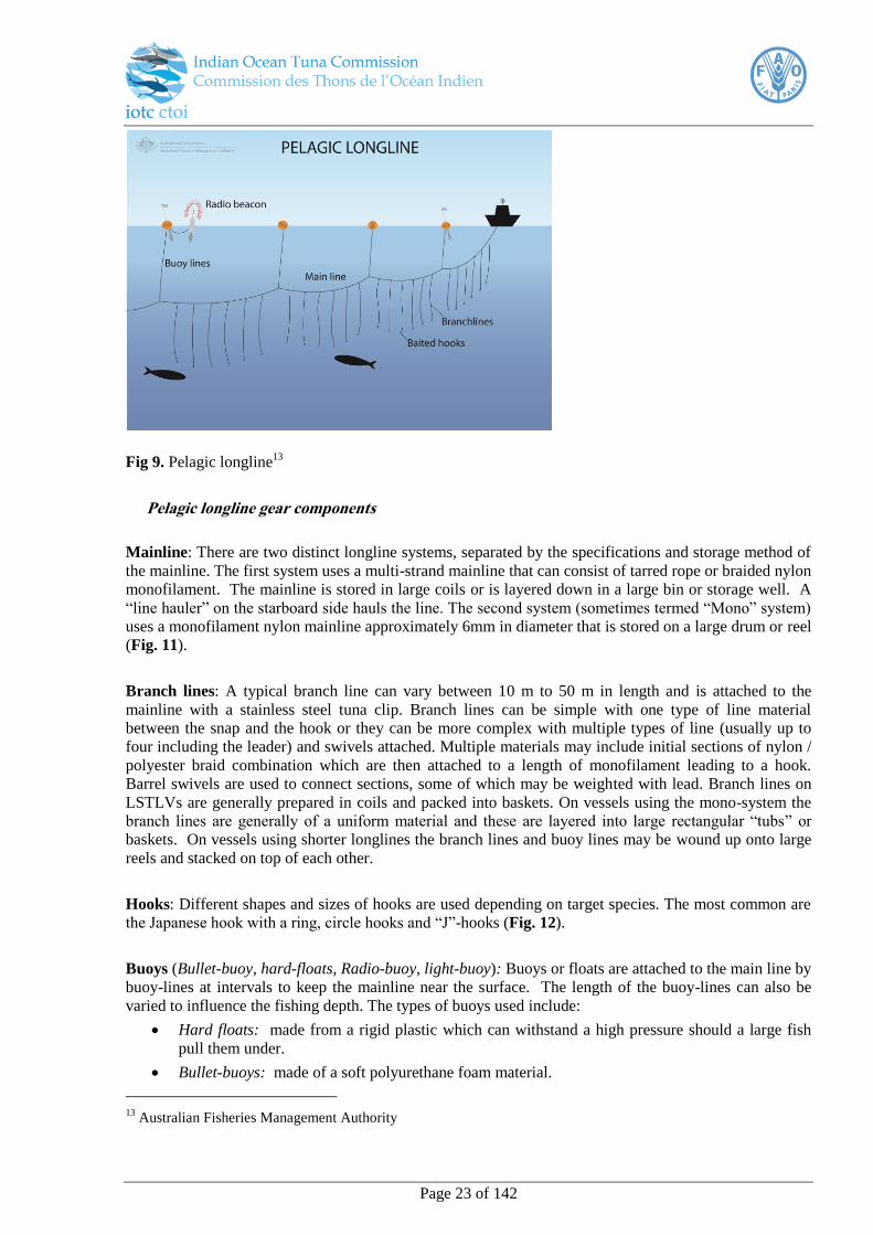
Fig 9. Pelagic longline13
Pelagic longline gear components
Mainline: There are two distinct longline systems, separated by the specifications and storage method of
the mainline. The first system uses a multi-strand mainline that can consist of tarred rope or braided nylon
monofilament. The mainline is stored in large coils or is layered down in a large bin or storage well. A
“line hauler” on the starboard side hauls the line. The second system (sometimes termed “Mono” system)
uses a monofilament nylon mainline approximately 6mm in diameter that is stored on a large drum or reel
(Fig. 11).
Branch lines: A typical branch line can vary between 10 m to 50 m in length and is attached to the
mainline with a stainless steel tuna clip. Branch lines can be simple with one type of line material
between the snap and the hook or they can be more complex with multiple types of line (usually up to
four including the leader) and swivels attached. Multiple materials may include initial sections of nylon /
polyester braid combination which are then attached to a length of monofilament leading to a hook.
Barrel swivels are used to connect sections, some of which may be weighted with lead. Branch lines on
LSTLVs are generally prepared in coils and packed into baskets. On vessels using the mono-system the
branch lines are generally of a uniform material and these are layered into large rectangular “tubs” or
baskets. On vessels using shorter longlines the branch lines and buoy lines may be wound up onto large
reels and stacked on top of each other.
Hooks: Different shapes and sizes of hooks are used depending on target species. The most common are
the Japanese hook with a ring, circle hooks and “J”-hooks (Fig. 12).
Buoys (Bullet-buoy, hard-floats, Radio-buoy, light-buoy): Buoys or floats are attached to the main line by
buoy-lines at intervals to keep the mainline near the surface. The length of the buoy-lines can also be
varied to influence the fishing depth. The types of buoys used include:
Hard floats: made from a rigid plastic which can withstand a high pressure should a large fish
pull them under.
Bullet-buoys: made of a soft polyurethane foam material.
13
Australian Fisheries Management Authority
Page 24 of 142
Various “Marker-buoys,” GPS beacons, radio buoys, light buoys and radar reflectors
(highflyers) which are used individually or in combinations to mark the location of the fishing
gear and are attached at fixed intervals along the line. These also assist in locating the end of the
line if it is accidentally broken.
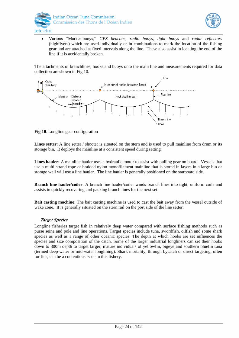
The attachments of branchlines, hooks and buoys onto the main line and measurements required for data
collection are shown in Fig 10.
Fig 10. Longline gear configuration
Lines setter: A line setter / shooter is situated on the stern and is used to pull mainline from drum or its
storage bin. It deploys the mainline at a consistent speed during setting.
Lines hauler: A mainline hauler uses a hydraulic motor to assist with pulling gear on board. Vessels that
use a multi-strand rope or braided nylon monofilament mainline that is stored in layers in a large bin or
storage well will use a line hauler. The line hauler is generally positioned on the starboard side.
Branch line hauler/coiler: A branch line hauler/coiler winds branch lines into tight, uniform coils and
assists in quickly recovering and packing branch lines for the next set.
Bait casting machine: The bait casting machine is used to cast the bait away from the vessel outside of
wake zone. It is generally situated on the stern rail on the port side of the line setter.
Target Species
Longline fisheries target fish in relatively deep water compared with surface fishing methods such as
purse seine and pole and line operations. Target species include tuna, swordfish, oilfish and some shark
species as well as a range of other oceanic species. The depth at which hooks are set influences the
species and size composition of the catch. Some of the larger industrial longliners can set their hooks
down to 300m depth to target larger, mature individuals of yellowfin, bigeye and southern bluefin tuna
(termed deep-water or mid-water longlining). Shark mortality, through bycatch or direct targeting, often
for fins, can be a contentious issue in this fishery.
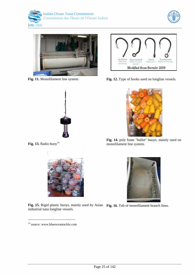
Page 25 of 142
Fig. 11. Monofilament line system.
Fig. 12. Type of hooks used on longline vessels.
Fig. 13. Radio buoy14
Fig. 14. poly foam "bullet" buoys, mainly used on
monofilament line system.
Fig. 15. Rigid plastic buoys, mainly used by Asian
industrial tuna longline vessels.
Fig. 16. Tub of monofilament branch lines.
14
source: www.blueoceantackle.com

Page 26 of 142
Fig. 17. Line setter
Fig. 18. Line hauler
Fig. 19. Branchline coiler
Longline operations
Various methods are available to Fishing Masters to determine the position of thermoclines and “fronts”
between warm and cool water, where lines should be set. Fisheries information systems can provide
vessels with satellite information on sea-surface temperature (SST), phytoplankton densities or sea
height. In addition onboard echo sounders and temperature recorders are used to detect fish and
determine the positions to set lines. Longliners from some companies may also work together and share
information to follow schools of fish.
On a larger industrial longliner a typical set will consist of 200 or more units or "baskets" (4 to 15 branch
lines in a basket) setting a total of about 3000 hooks on a line. Branch lines are attached to the main line
while setting the line and a buoy is then attached at intervals between baskets or a fixed number of branch
lines. The composition of the branch lines in each basket can vary with respect to their position to the
buoy. A radio buoy is attached after every (approximately) 20 baskets set. The rate at which branch lines
and buoy lines are attached to the mainline, and therefore the spacing, is controlled from the wheelhouse
by a synchronous series of “beeps.” By modifying the line setter speed and therefore the length of
mainline between float lines, the vessel speed, and by adjusting the length of the branch-lines, the depth
at which hooks are set in the water column can be regulated.
Each hook is baited just before leaving the vessel. Common bait species used are horse mackerel,
milkfish or squid. The vessel steams at between 9.5 knots and 11.5 knots. The longline is paid out from
the aft storage wells on the upper deck through a series of PVC pipes and a hydraulic line feeder, situated
on the lower deck amidships, at a rate of about 450 m per minute (27 km per hour). On average between
2500 and 3000 hooks are set over a total distance of about 100 km, taking about five or six hours to
complete each set. At least five crew members are required for the setting. After the last radio buoy is set
the line is left to “soak” for a predetermined time of 3 to 4 hours “soak time” before the start of the
hauling operation.
Page 27 of 142
Hauling longlines usually takes at least a full day (11 hours or more) depending on the number of hooks
set and the catch rate. The last radio buoy set is usually the first to be hauled on board. It is located with
the help of the radio direction finder or by radar, and is hauled on board and detached from the mainline.
The mainline is threaded over roller guides and through the hydraulic mainline hauler. A crew member
controls the speed of recovery. Line-hauling is conducted at a slower speed than setting, and is
influenced by the sea state and the rate of fish capture. On average the vessel steams along the mainline
at an average speed of about 6 knots, with the line retrieved over the starboard side at a rate of between
150 and 250 m per minute. The mainline coils under its own tension from the hauler onto a conveyor belt
which carries it across the deck from starboard to port side. Tangles in the mainline are removed as it
moves along on the conveyor belt.
Branch lines are unclipped off the mainline as they come over the side of the vessel or after they go
through the line hauler. The snoods are coiled, either by hand or with an automatic coiler, and are tied off
around the hook with a loop of the line near the clip, then packed back into baskets ready for setting.
These bundles or baskets and the buoys are placed at intervals onto a conveyor belt on the port side of the
vessel. This takes them to the crew member who is packing the mainline into the aft wells and they are
then stacked at the stern ready for the next set.
Hooked fish are brought alongside, gaffed and hauled aboard by the crew. All large tuna, billfish and
sharks are landed using gaffs and harpoons hooks attached to bamboo poles, targeting the mouth or head
of the fish to minimise damage to the trunk.
Target species are handled with great care to preserve the high quality demanded by the Japanese
markets. The fish are meticulously cleaned to remove any traces of blood or viscera and then weighed
prior to freezing. To preserve the quality of the fish, tuna are rapidly frozen in blast freezers (-55°C to -
65°C) immediately after processing. After blast freezing they are transferred to the hold storage (-40o C
to -50°C). Hold capacity is determined by vessel size but for an average sized industrial LSTLV there is
capacity of approximately 200 mt of catch. Longliners will unload their catch in port or at sea to
refrigerated carrier vessels.
Seabird bycatch
The IOTC and its CPCs aims to achieve zero bycatch of seabirds for its fisheries, especially threatened
albatrosses and petrel species in longline fisheries. Resolution 12/06 was established specifically to
reduce the incidental bycatch of seabirds in longline fisheries. This resolution notes that scientific
observers shall record data on seabird incidental bycatch by species which CPCs are to report annually.
Observers are required to take photographs of seabirds caught by fishing vessels and transmit them to
national seabird experts or to the IOTC Secretariat ([email protected]) for confirmation of
identification.
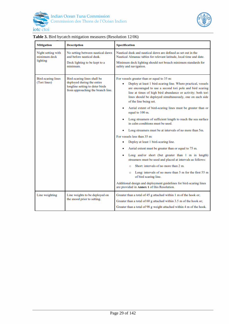
Resolution 12/06 requires CPCs to ensure that all longline vessels use at least two of the three mitigation
measures in Table 3; (i) night setting, (ii) bird scaring lines or (iii) weighted branchlines; conforming to
the minimum technical standards specified, where vessels operate in areas south of 25°South. These
measures should also be considered for implementation in other areas, as appropriate, consistent with
scientific advice. These requirements are consistent among all five tuna RFMOs for areas overlapping
with albatross and petrel distributions. In addition to helping reduce the catch of seabirds, these
techniques can also help minimize bait loss and ensure that baited hooks are available to the target
species.
(i) Interactions with seabirds can be minimised by setting gear at night as many seabirds do not
feed at that time. Night setting involves starting to set gear after nautical dusk and finishing
setting before nautical dawn. Deck lighting should be kept to a minimum, using only as much
Page 28 of 142
lighting as is needed to comply with navigational rules and best practices for safety. Note that if
a setting extends into nautical twilight or daylight hours, this set is not considered to be night
set; only if all hooks are set at night is the set considered a night set.
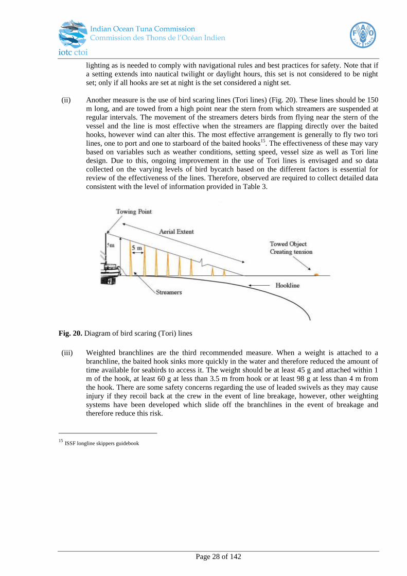
(ii) Another measure is the use of bird scaring lines (Tori lines) (Fig. 20). These lines should be 150
m long, and are towed from a high point near the stern from which streamers are suspended at
regular intervals. The movement of the streamers deters birds from flying near the stern of the
vessel and the line is most effective when the streamers are flapping directly over the baited
hooks, however wind can alter this. The most effective arrangement is generally to fly two tori
lines, one to port and one to starboard of the baited hooks15
. The effectiveness of these may vary
based on variables such as weather conditions, setting speed, vessel size as well as Tori line
design. Due to this, ongoing improvement in the use of Tori lines is envisaged and so data
collected on the varying levels of bird bycatch based on the different factors is essential for
review of the effectiveness of the lines. Therefore, observed are required to collect detailed data
consistent with the level of information provided in Table 3.
Fig. 20. Diagram of bird scaring (Tori) lines
(iii) Weighted branchlines are the third recommended measure. When a weight is attached to a
branchline, the baited hook sinks more quickly in the water and therefore reduced the amount of
time available for seabirds to access it. The weight should be at least 45 g and attached within 1
m of the hook, at least 60 g at less than 3.5 m from hook or at least 98 g at less than 4 m from
the hook. There are some safety concerns regarding the use of leaded swivels as they may cause
injury if they recoil back at the crew in the event of line breakage, however, other weighting
systems have been developed which slide off the branchlines in the event of breakage and
therefore reduce this risk.
15
ISSF longline skippers guidebook
Page 29 of 142
Table 3. Bird bycatch mitigation measures (Resolution 12/06)
Page 30 of 142
C. Pelagic Gillnet Fishery
Gillnets consist of a series of net panels that are suspended in the water column. It is a passive method of
fishing that does not use bait. Gillnets can be broadly classified into several categories:
set nets,
trammel nets and
drift nets
A trammel net consists of three layers of net. A slack, small mesh, inner panel of netting is sandwiched
between two outer layers of netting, which are taught and have a larger mesh size. The inner panel may
be made of twisted or monofilament nylon, whilst the outer panels are generally made of twisted nylon
filament.
Both trammel and other gillnets entangle fish in three different ways. The fish may become wedged, held
by the mesh around the body; gilled, caught by the gills; and tangled, held by teeth, spines or other
protrusions without necessarily penetrating the mesh. The mesh size of gillnets can be highly effective at
selecting or regulating the size of fish caught. Fish that are smaller than the mesh of the net are able to
pass through the net unhindered, while those which are too large to push their heads through the meshes
as far as their gills, are also less likely to be caught. Trammel nets also entangle fish in bags or pockets of
netting. This occurs when fish swim through one of the outer panels, hit the inner panel, and are carried
through to the other outer panel, which creates a bag or pocket, thereby trapping the fish. Trammel nets
are therefore less selective in the size of fish caught.
Gillnets and trammel nets are widely used all over the world, particularly in artisanal fisheries, both in
inland waters and in the marine environment. Drift nets were used extensively on the high seas by a
number of countries in the 1980s to target tuna, however they were also associated with high incidental
capture of marine mammals and turtles. The use of drift nets longer than 2.5 kilometres on the high seas
was banned by the United Nations in 1991. In 1993 the United Nations banned gillnets in international
waters but their use is still permitted at the discretion of coastal states within their exclusive economic
zone. The IOTC had 2812 vessels registered to fish with gillnets in 2014. The IOTC categorises gillnet
fisheries as industrial, semi-industrial or artisanal (Table 16) based on the location and scale of the
operation.
Gillnets generally comprise a series of panels with a weighted "footrope" attached along the bottom, and
a "headline" along the top, to which floats are attached. Panels of net are commercially available in
“skeins” and a vessel can easily store a large number these on onboard to make up nets while at sea to
replace lost or damaged nets. The headline (float line) is buoyed using solid foam, oval or cylindrical
buoys. The footrope is weighed using lead weights or an integrated lead core rope. By modifying the
balance of floats to the weighted footrope, the overall buoyancy of the net, and therefore its position in
the water column, can be regulated. Some gillnets are designed to float at or near the surface (used for
pelagic fish such as tuna) while others are set sub-surface and others still are made to stand at the bottom
(used for demersal species) (Fig. 21). In shallow water, set nets and trammel nets are generally anchored
to the seabed and the anchor lines determine the vertical orientation, while at sea, one end of the net may
remain attached to the vessel. Drift nets are set on or just below the surface and are not anchored so they
can drift with the currents. A number of gillnet panels can be made up into a single net and several nets
can be connected into a continuous net. Driftnets used on the high seas can extend up to 60 km.
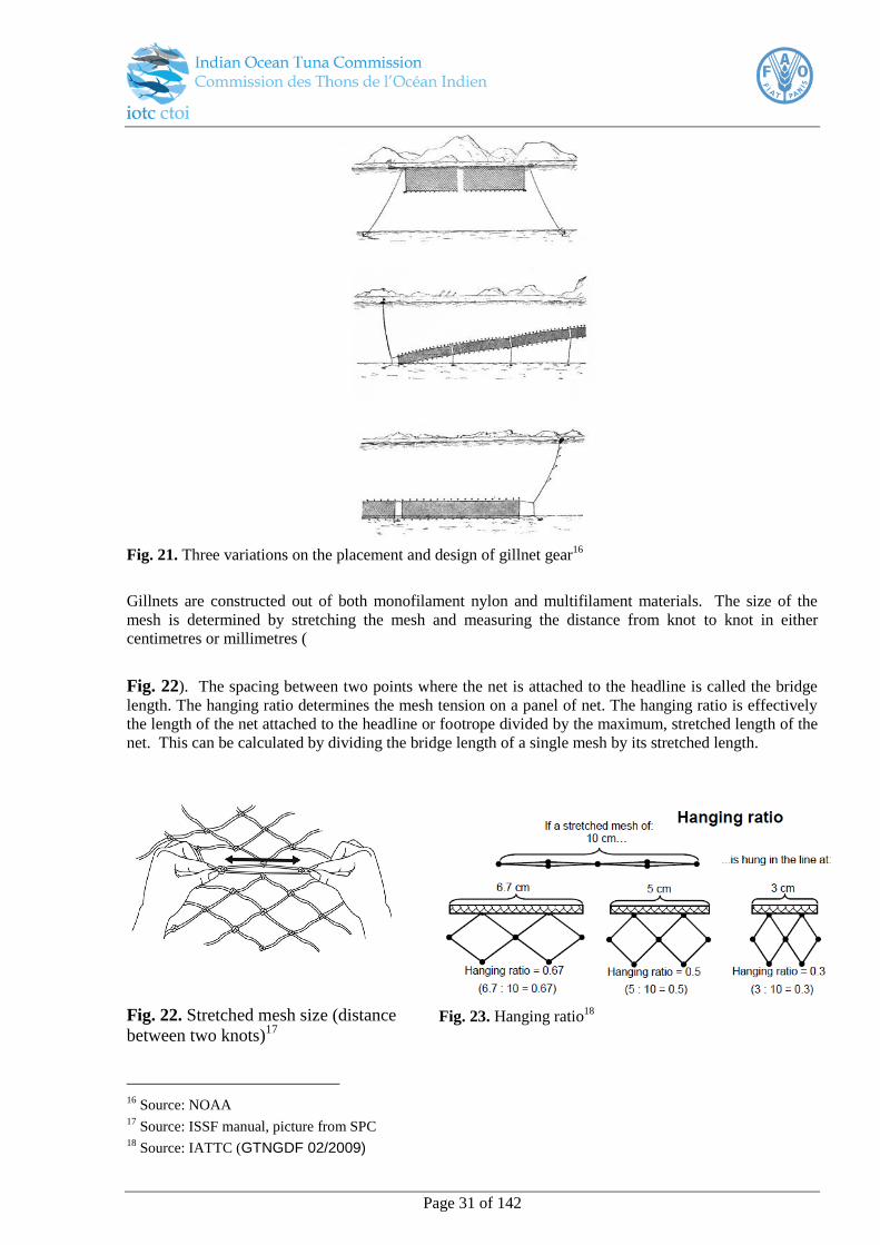
Page 31 of 142
Fig. 21. Three variations on the placement and design of gillnet gear16
Gillnets are constructed out of both monofilament nylon and multifilament materials. The size of the
mesh is determined by stretching the mesh and measuring the distance from knot to knot in either
centimetres or millimetres (
Fig. 22). The spacing between two points where the net is attached to the headline is called the bridge
length. The hanging ratio determines the mesh tension on a panel of net. The hanging ratio is effectively
the length of the net attached to the headline or footrope divided by the maximum, stretched length of the
net. This can be calculated by dividing the bridge length of a single mesh by its stretched length.
Fig. 22. Stretched mesh size (distance
between two knots)17
Fig. 23. Hanging ratio18
16
Source: NOAA 17
Source: ISSF manual, picture from SPC 18
Source: IATTC (GTNGDF 02/2009)
Three variations in the placement and design of gillnet gear (courtesy NOAA)

Page 32 of 142
On small boats, gillnets are handled by hand while hydraulic net haulers and/or net drums are used on
larger vessels to handle and store nets. To determine catch per unit effort observers will be required to
record a range of data fields that include information on the specifications of the net/s, the setting strategy
as well as vessel parameters. Nets can also be set in a range of configurations such as pulled straight, in a
semi-circle or v-shape as well as many others. These are described in Table 24.
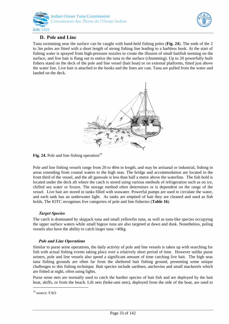
Page 33 of 142
D. Pole and Line
Tuna swimming near the surface can be caught with hand-held fishing poles (Fig. 24). The ends of the 2
to 3m poles are fitted with a short length of strong fishing line leading to a barbless hook. At the start of
fishing water is sprayed from high-pressure nozzles to create the illusion of small baitfish teeming on the
surface, and live bait is flung out to entice the tuna to the surface (chumming). Up to 20 powerfully built
fishers stand on the deck of the pole and line vessel (bait boat) or on external platforms, fitted just above
the water line. Live bait is attached to the hooks and the lines are cast. Tuna are pulled from the water and
landed on the deck.
Fig. 24. Pole and line fishing operation19
Pole and line fishing vessels range from 20 to 40m in length, and may be artisanal or industrial, fishing in
areas extending from coastal waters to the high seas. The bridge and accommodation are located in the
front third of the vessel, and the aft gunwale is less than half a metre above the waterline. The fish hold is
located under the deck aft where the catch is stored using various methods of refrigeration such as on ice,
chilled sea water or frozen. The storage method often determines or is dependent on the range of the
vessel. Live bait are stored in tanks filled with seawater. Powerful pumps are used to circulate the water,
and each tank has an underwater light. As tanks are emptied of bait they are cleaned and used as fish
holds. The IOTC recognises five categories of pole and line fisheries (Table 16).
Target Species
The catch is dominated by skipjack tuna and small yellowfin tuna, as well as tuna-like species occupying
the upper surface waters while small bigeye tuna are also targeted at dawn and dusk. Nonetheless, poling
vessels also have the ability to catch larger tuna >40kg.
Pole and Line Operations
Similar to purse seine operations, the daily activity of pole and line vessels is taken up with searching for
fish with actual fishing events taking place over a relatively short period of time. However unlike purse
seiners, pole and line vessels also spend a significant amount of time catching live bait. The high seas
tuna fishing grounds are often far from the sheltered bait fishing ground, presenting some unique
challenges to this fishing technique. Bait species include sardines, anchovies and small mackerels which
are fished at night, often using lights.
Purse seine nets are normally used to catch the hardier species of bait fish and are deployed by the bait
boat, skiffs, or from the beach. Lift nets (boke-ami nets), deployed from the side of the boat, are used to
19
source: FAO
Schematic diagram of pole and line operation (FAO)
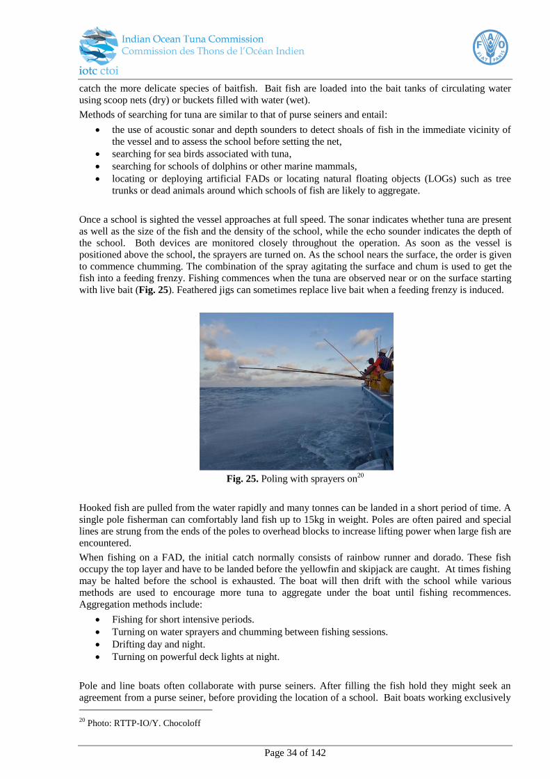
Page 34 of 142
catch the more delicate species of baitfish. Bait fish are loaded into the bait tanks of circulating water
using scoop nets (dry) or buckets filled with water (wet).
Methods of searching for tuna are similar to that of purse seiners and entail:
the use of acoustic sonar and depth sounders to detect shoals of fish in the immediate vicinity of
the vessel and to assess the school before setting the net,
searching for sea birds associated with tuna,
searching for schools of dolphins or other marine mammals,
locating or deploying artificial FADs or locating natural floating objects (LOGs) such as tree
trunks or dead animals around which schools of fish are likely to aggregate.
Once a school is sighted the vessel approaches at full speed. The sonar indicates whether tuna are present
as well as the size of the fish and the density of the school, while the echo sounder indicates the depth of
the school. Both devices are monitored closely throughout the operation. As soon as the vessel is
positioned above the school, the sprayers are turned on. As the school nears the surface, the order is given
to commence chumming. The combination of the spray agitating the surface and chum is used to get the
fish into a feeding frenzy. Fishing commences when the tuna are observed near or on the surface starting
with live bait (Fig. 25). Feathered jigs can sometimes replace live bait when a feeding frenzy is induced.
Fig. 25. Poling with sprayers on20
Hooked fish are pulled from the water rapidly and many tonnes can be landed in a short period of time. A
single pole fisherman can comfortably land fish up to 15kg in weight. Poles are often paired and special
lines are strung from the ends of the poles to overhead blocks to increase lifting power when large fish are
encountered.
When fishing on a FAD, the initial catch normally consists of rainbow runner and dorado. These fish
occupy the top layer and have to be landed before the yellowfin and skipjack are caught. At times fishing
may be halted before the school is exhausted. The boat will then drift with the school while various
methods are used to encourage more tuna to aggregate under the boat until fishing recommences.
Aggregation methods include:
Fishing for short intensive periods.
Turning on water sprayers and chumming between fishing sessions.
Drifting day and night.
Turning on powerful deck lights at night.
Pole and line boats often collaborate with purse seiners. After filling the fish hold they might seek an
agreement from a purse seiner, before providing the location of a school. Bait boats working exclusively
20
Photo: RTTP-IO/Y. Chocoloff
Poling with sprayers on (RTTP_IOTC Ivan Chocoloff)

Page 35 of 142
for a purse seiner do not land their own catch and are paid by the purse seine fishing company. They drift
with a school of associated tuna until it is large enough to be commercially viable and also deploy FADs
on behalf of purse seiners.
The communication between groups of vessels working together can cover hundreds of miles, with the
purse seiners providing valuable meteorological information to the smaller and more vulnerable pole and
line vessels.

Page 36 of 142
PART B : OBSERVER BASICS, PROTOCOLS, LOGISTICS, SAMPLING

Page 37 of 142
I. CPC responsibilities
Resolution 11/04 states that CPCs will be responsible for obtaining qualified national or international
observers to achieve at least 5% required coverage of the number of operations/sets for each gear type
onboard their flagged vessels.
Paragraph 5 states that CPCs shall:
Have the primary responsibility to obtain qualified observers. Each CPC may choose to use either
deployed national or non-national of the flag State of the vessel on which they are deployed;
Endeavour that the minimum level of coverage is met and that the observed vessels are a
representative sample of the gear types active in their fleet;
Take all necessary measures to ensure that observers are able to carry out their duties in a
competent and safe manner;
Endeavour to ensure that the observers alternate vessels between their assignments. Observers are
not to perform duties, other than those described in paragraphs 10 and 11 below;
Ensure that the vessel on which an observer is placed shall provide suitable food and lodging
during the observer’s deployment at the same level as the officers, where possible. Vessel masters
shall ensure that all necessary cooperation is extended to observers in order for them to carry out
their duties safely including providing access, as required, to the retained catch, and catch which
is intended to be discarded.
Where a CPC chooses to deploy international observers onboard its vessels, it is recommended that a
Memorandum of Understanding (MoU) be established either with the flag state providing the observers
or where applicable directly with the controlling organisation providing the observers services. The terms
and conditions of the MoU will primarily establish the terms and conditions covering the logistics for the
deployment of the observer onboard the CPC registered vessels, expected minimum safety conditions,
pre-sea safety checks and the onboard working protocol for the observer.
II. Other Observer Schemes in the region
A number of RFMOs have schemes or are developing schemes within and bordering the IOTC area of
competence. Most of these involve species that are not managed by the IOTC or are restricted to specific
fisheries. These schemes are expected to contribute to the development of observer capacity in the Indian
Ocean region.
Schemes in the region that have been developed under the framework of other RFMOs include:
The Convention for the Conservation of Southern Bluefin Tuna, (CCSBT). This convention
applies only when parties are fishing for southern bluefin tuna (SBT), rather than applying to
fishing within a specified geographic area. The range of these tuna covers parts of the Indian,
Atlantic and Pacific Oceans and overlaps areas of competence of the IOTC, CCAMLR and
WCPFC
The Commission for the Conservation of Antarctic Marine Living Resources (CCAMLR)
convention area extends south of the 45ºS latitude in the western Indian Ocean region and south
of the 55ºS Latitude in the eastern Indian Ocean Region corresponding with the southern limits of
the IOTC area of competence.
Observer capacity has also been improved in the region through projects which have involved observer
training such as the South West Indian Ocean Fisheries Project (SWIOFP), the Fisheries Regional
Monitoring Programme of the Indian Ocean Commission, Observateurs des Pêches (OBSPEC) and
Contrôleur des Pêches (COPEC).
Page 38 of 142
III. Data Collection and Submission of Data to the IOTC
To fulfil its objectives in the management of fish stocks, the IOTC requires aggregated data to be
submitted to the IOTC Secretariat for each vessel operating in the IOTC area of competence. This
includes information on nominal catches, catch and effort and length frequency data as specified in
Resolutions 15/01 and 15/02. In addition to these, Resolution 11/04 on a Regional Observer Scheme was
established by the Commission to require each CPC to record and report more detailed scientific observer
data in addition to these logbook data. Paragraphs 10 of the Resolution outlines the specific data
collection requirements.
Para 10.
Observers shall:
a) Record and report fishing activities, verify positions of the vessel;
b) Observe and estimate catches as far as possible with a view to identifying catch composition and
monitoring discards, by-catches and size frequency;
c) Record the gear type, mesh size and attachments employed by the master;
d) Collect information to enable cross-checking of logbooks entries, (species composition and
quantities, live and processed weight and location); and
e) Carry out such scientific work (for example, collecting samples), as requested by the IOTC
Scientific Committee.
IV. Defining “the Observer”
Scientific (fisheries) observers are independent specialists, deployed onboard commercial fishing vessels
in accordance with a mandated regional fisheries observer scheme. Within this mandate observers can be
used to supply unbiased data and report on technical, scientific, regulatory and economic aspects
pertaining to the operational side of the fishing industry.
Scientific observers working on fishing vessels during normal operations are in a position to verify and
record accurate, in situ data on the location, catch composition and gear configuration of fishing
operations, and are usually the only independent source of this information. Scientific observers are not
employed in an enforcement role, as their main purpose is to collect accurate data to support effective
management of the marine resources, which is to the long-term advantage of the fishing industry.
However, as this takes place alongside the standard data collection protocols, the presence of the observer
onboard inherently allows recording the level of compliance within the fishery.
An individual is only considered an IOTC recognised observer when employed by a service provider
approved by the CPC to provide observer services. CPCs will provide a list of observers to the IOTC
Secretariat and each observer will be allocated an IOTC registration number that must be included on
reported data. This will lead to the development of a regional pool of observers trained according to
IOTC standards who may be called upon by other flag states.
V. Qualifications and prerequisites
Scientific observers working at sea are in a unique position, as they are not affiliated with the vessel
personnel and are required to work alone often for long periods without direct supervision or assistance
from their controlling organisation. To be successful in this environment, they require a high level of
integrity and personal self-motivation and will need appropriate academic qualifications and training to
optimally accomplish the detailed tasks and responsibilities assigned to them.

Page 39 of 142
Minimum health and education standards should apply as prerequisites to prior employment and training
of observers. Mandatory certification, to be included in the observers training phase and prior to
deployment onboard a vessel will include:
A “Certificate of Medical Fitness” This form must comply to IMO (STCW-F) standards to ensure
that the observer is able to endure normal conditions of life at sea and that their health status will
not endanger the health and safety of the other people aboard;
In-date Certificate for Survival Techniques and Occupational Health and Safety at Sea, (STCW95
compliant);
Evidence of proficiency in literacy and numeric competency in the languages of the national
project.
In addition observers are required to:
Have sufficient knowledge and experience to identify species and collect information on different
fishing gear configurations;
Have satisfactory knowledge of the IOTC conservation and management measures;
Have the ability to observe and accurately record data collected under the scheme;
Have the ability to collect biological samples; and
Not be an employee of a fishing vessel company involved in the observed fishery.
CPCs must ensure that their observers are trained and their certificates of fitness and safety and survival
training meet the requirements of all domestic and foreign vessels on which they may be deployed. Once
observers have completed training and are certified competent (consistent with the requirements detailed
in section V), they will need to keep coordinators informed of all their contact details. Only once this is
complete will the CPC will send the details (name, nationality and details of all medical and training
certificates) of the observer to the IOTC Secretariat to register him/her as an IOTC observer.
VI. Observer Code of Conduct and Protocols
A. Code of Conduct
Observers are required to conform to an internationally recognised code of conduct to become certified.
This requires that:
1) Observers may not participate in any activity which would cause a reasonable person to question the
impartiality or objectivity with which the Regional Observer Scheme is administered.
Observers may not have a direct financial interest in the observed fishery, other than the
provision of observer services. This includes, but is not limited to, vessels or shore-side facilities
involved in the catching or processing of the fishery products, companies selling supplies or
services to those vessels or shore-side facilities or companies purchasing raw or processed
products from these vessels or shore-side facilities. The interests of a spouse or minor child are
considered those of the observer.
Observers may not solicit or accept, directly or indirectly, any gratuity, gift, favour,
entertainment, loan or anything of monetary value from anyone who conducts activities that are
regulated by IOTC, or who has interests that may be substantially affected by the performance or
non-performance of the observers’ official duties.
Observers may not solicit or accept employment as a crew member or an employee of the vessel
in any fishery while employed as an observer.
Observers may not serve as observers on any vessel owned or operated by a person who
previously employed the observer in any capacity.
A person may not serve as an observer in a fishery during the 3 consecutive months following the
last day of his/her employment as a paid crew member or employee in that fishery.
Page 40 of 142
2) Observers may not participate in any activity which could impair the observer’s ability to perform
his/her duties. This includes, but is not limited to:
Engaging in drinking of alcoholic beverages while on duty
Engaging in the use or distribution of illegal substances
Becoming physically or emotionally involved with vessel personnel
3) Observers may not participate in any activity which could adversely affect the efficient
accomplishment of the Scheme’s mission.
Observers must refrain from engaging in any illegal actions according to the laws and regulations
of the flag State that exercises jurisdiction over the vessel to which the observer is assigned.
Observers must avoid any behaviour that could adversely affect the confidence of the public in
the integrity of observers, the IOTC Regional Observer Scheme or the IOTC.
Observers must record all scientific data accurately and honestly.
If the observer chooses to report any suspected violations of regulations relevant to conservation
of marine resources or their environment that they observe, it must be done honestly.
Observers must preserve the confidentiality of the collected data and observations made on board
the fishing vessels, in accordance with Resolution 12/02, and shall treat as confidential all
information with respect to the fishing operations of the vessel on which they are deployed.
4) Observer involvement in vessel operations
Observers shall respect the hierarchy and general rules of behaviour which apply to all vessel
personnel, provided such rules do not interfere with the duties of the observer under this scheme.
In all aspects involving vessel operations and safety at sea the observer will fall under the
authority of the Captain.
Scientific observers will have no authority to advise or direct any of the vessel operational
activities or have any authority over any of the vessel personnel.
Scientific observers should have access to all operational areas of the vessel necessary to
complete their work including the bridge, navigation and communication equipment. However,
the observer should attempt to secure co-operation with officers to ensure that their work does not
interfere with normal fishing and operational activities.
VII. Observer Deployment Logistics
A. Request for an Observer
A CPC requesting an observer should advise the observer’s controlling organisation at least three weeks
in advance of the vessel’s estimated time of departure whenever possible. This is considered the
minimum period required to arrange travel logistics and for observers to take care of personal matters and
suitably prepare themselves. Request for observers should contain the following information:
Vessel Name
Vessel type
Vessel operator
Port and date of departure
Port and estimated date of return
Area of intended operation
Target species
Copy of the vessels safety certificate
Copy of the vessel P&I insurance cover
Within the request period an MoU should be established with the vessel operator. The MoU will stipulate
the terms and conditions for the observer’s deployment and status onboard in terms of the IOTC
Page 41 of 142
Resolution. In addition it will provide a copy of the pre-sea safety checklist and the minimum
requirements before embarkation, as per Appendix II.
A. Observers on Standby
When an observer request is received the observer will be advised and put on “Standby Status”.
Observers must confirm their availability and keep the controlling organisation informed of all their
contact details.
It is accepted that the date and possibly the port of departure may have to be revised following the initial
request, so a final confirmation of the port, date and time of departure must be sent within five days of the
pending trip. In exceptional cases, full deployment may be arranged within five working days.
B. Observer Checklists
Following a CPC request, Observers will also be briefed on the specific data collection protocols and
biological requirements for the trip and will be issued with the necessary forms and equipment to fulfil
their tasks. Given that individuals may be required to travel large distances to meet their vessel and
facilities may be limited, it is recommended that observers be prepared to travel with all essential items
required for a trip. A provisional checklist includes:
Passport
Cash (reasonable amount to cover taxi, etc.)
Credit card
Letter of Introduction
Copy of the MoU
Language Phrase Book(s)
Mobile / Cell Phone
Electronic database where applicable
Safety Equipment issue
C. Recommended Health & Safety equipment issue
Immersion suit;
Personal Floatation Device; (A minimum safety requirement for the vessel will be to supply the
observer with a SOLAS approved Life Jacket);
Strobe light;
Signal mirror;
Personal Emergency Position Indicating Radio Beacon (406 MHz EPIRB, preferably with
integral GPS navigation receiver); and
Dry bag to store gear and serve as an emergency “grab bag” onboard.
Taking into consideration the working environment onboard fishing vessels, operational health and safety
gear for the observer should include inter alia:
Safety helmet
Waterproof boots with steel-cap toe and ankle protection
Waterproof clothing
Working gloves (sufficient to last a trip)
Working Personal Floatation Device (This could be the same as issued above)
Sun protection cream
Suitable dark glasses
Page 42 of 142
D. Professional Equipment to undertake the tasks allocated to them should
include
IOTC species identification guides and other supplementary materials
Observer Manual
Data collection forms and trip reporting templates
Laptop computer
Camera
Sampling Equipment
Measuring board, callipers and tape to record length measurements
Scales to weigh samples
Waterproof paper or waterproof slates for on-deck recordings
Knife and forceps
E. Observer briefing
Prior to being deployed observers will be given a formal briefing. The process will include ensuring that
all items on the check-lists are in place and observers will sign for issued equipment. The objectives of
the trip and any special sampling requirements will be discussed in detail. The observer will also be
advised on the reporting requirements for the trip. The following documentation should be provided:
Briefing notes outlining their assignments for the trip
Travel itinerary and any necessary travel documents to enter the country and access the port
where the vessel is docked. These will include inter alia contact name and numbers of the vessel
agents and owner
Depending on their contractual arrangements with their controlling organisation, the observer
may be required to sign a contract for the deployment period
Copy of the pre-sea safety check list
Copy of the MoU with the vessel operators
F. Deployment
Prior to embarking onboard a vessel, the observer will undertake a pre-sea safety inspection of the vessel,
as per Appendix II. The object of this inspection is to confirm that all the required safety equipment is
present onboard. The results of this inspection, together with a deployment report must be sent to their
controlling agency within 24 hours of boarding. Should the minimum requirements of the checklist not be
met the observer may not embark until they have contacted and been given authorisation to continue by
their controlling organisation. If for any reason an observer refuses to board a full report detailing these
reason are to be sent to their controlling agency within 12 hours, and sooner if possible.
Once the vessel has left port, observers will be required to send an “embarkation report” back to their
controlling organisation within 24-hours (Appendix III).
G. Observer Return - Debriefing
At the end of the trip the observer will be required to attend a formal debriefing. This process will
include returning the issued equipment and presenting all the data collected during the trip. The
observer’s coordinator will be expected to conduct a preliminary review of the data and run routine error
checks. The observer will present a preliminary version of the electronic trip report for discussion. This
will provide the opportunity for the observer to discuss and explain missing, unusual or unexpected data.
VIII. Observer Reporting
The observer will be required to submit a series of reports to the controlling organisation at
predetermined times throughout each trip (Appendix III). These include:
Deployment Report (within 24-hours of the vessel sailing)
Five-day status report
Page 43 of 142
Preliminary trip summary report and full set of data forms
Final electronic trip report
A. Deployment Report
Within 24 hours of the vessel sailing the observer must send a deployment report to their controlling
organisation. The content will include confirmation of the contact details of the vessel and serves to set
up and confirm the line of communication between the observer and their controlling organisation. This
report includes the outcome of the pre-sea inspection as details of flights and logistics prior to boarding.
If a report is not received within 24 hours of the due date, the observer coordinator will contact the vessel
operator to send a message to the vessel to remind the observer of his/her obligation in this respect. If a
report is not received within a further 24 hours it will be assumed that there is no means of formal
communication with the vessel and the vessel operators will be contacted to make arrangements either to
establish these or request the immediate return of the observer. Taking into consideration that a
breakdown in communication may also indicate an emergency situation with the vessel, emergency
search and rescue operations may be initiated.
B. Five-day Status Reports
Throughout deployment observers will be required to send status reports to their controlling agency on
specific dates. The monthly schedule for these will be the 1st, 6
th, 11
th, 16
th, 21
st and 26
th days of the month
to report on the preceding five days. The report will provide a summary of fishing operations, catch and
sampling undertaken during the period covered. Following a similar procedure to the deployment report,
should a report not be received by the time the next report is due the observer coordinator will start the
process to establish contact via the vessels operators. In situations where reports have previously been
regularly received it may be deemed that there is a problem with the observer’s well-being and
appropriate action may be necessary.
C. Preliminary Trip Summary Report
At the conclusion of the trip, prior to disembarking, the observer must prepare a brief summary report of
the trip. The report should include details of sampling, summaries of catches and processing, interactions
with protected and threatened species and any notable incidences with respect to the vessel operations or
weather. The observer will be expected to give a copy to the vessel Captain or Fishing Master and they
will be advised to forward any comments they might have directly to the observer’s controlling agency
within a specific time period (to be defined by the controlling agency). This summary report will also
form the basis for the observer debriefing.
D. Trip report
The post-trip reporting requirements are outlined in Resolution 11/04:
Para.11 The observer shall, within 30 days of completion of each trip, provide a report to the
CPCs of the vessel. The CPCs shall send within 150 days the report, which is
recommended to be provided with 1°x1° format to the Executive Secretary, who shall
make the report available to the Scientific Committee upon request. In a case where the
vessel is fishing in the EEZ of a coastal state, the report shall equally be submitted to that
Coastal State.
Para.12 The confidentiality rules set out in the resolution 98/02 [superseded by resolution 12/02]
Data confidentiality policy and procedures for fine-scale data shall apply.
Following the debriefing observers will submit the final electronic trip report, all data collection forms
and any photos to their controlling organisation. Within 30 days of the completion of the trip, the data
will be provided to the CPC flag state of the vessel and within 150 days, the data required for reporting to
the IOTC (see ‘part C: Data field Descriptions’ for details) will be submitted to the IOTC Secretariat.
Page 44 of 142
Observers are encouraged to keep detailed notebooks throughout their trips and record additional
information that is not routinely captured by the data forms into the comments sections of the data
collection forms under the relevant headings. Photographs and diagrams are important and observers are
encouraged to include these where relevant with detailed labelling so that the photos can be linked to the
appropriate data fields. The report also provides the observer with the opportunity to comment on the
sampling methods. The information required for reporting may be submitted in any format provided it is
electronic and covers all of the data reporting fields specified in Part C of this manual ‘Data field
descriptions’, consistent with the data reporting templates.
IX. Sampling Strategies
E. Trip selection
Resolution 11/04 states that at least 5% of the number of operations/sets for each gear type and fleet must
be sampled. When selecting which fishing trips to place observers on, these should be stratified wherever
possible based on vessel size/type, spatial location of fishing operations, temporal variation in fishing
operations and any other distinguishing factors between fishing trips of a fleet so that the sample is
representative of the fleet.
F. Total catch estimation
To be successful as an observer, the estimation of sizeable quantities of fish is an important skill to learn.
There are three ways to estimate a set’s total catch21
:
1. Weigh the entire catch (feasible if the catch is small)
2. Use the vessel estimate
3. Record the catch weight of samples and raise these, or take numbers and length measurement for
conversion.
The first option is generally unavailable, and the second option introduces the possibility of bias, given
the source of the data. The third option is independent, but is an approximation and requires careful
observation to achieve better accuracy which will increase with the experience of the observer. Examples
of this approach might be brail capacity x brail tally = total catch weight (where brail tally is the record of
how full each brail was) or recording the total number of fish and taking their length measurements to
convert to weight later. For those fish where length measurements could not be taken, a sample weight
might be used, e.g. average weight of fish x total number of fish = total catch weight.
G. Sampling for species and size composition
Sampling procedures
Resolution 11/04 states that at least 5% of the number of operations/sets for each gear type and fleet must
be sampled, however, specific sampling strategies are generally determined by the operational nature of
the fishery and the feasibility of different levels of coverage. These will differ between surface fisheries
where large quantities of fish are caught and processed within a few hours and longline fisheries where
catches can be spread out over many hours during a day. Whatever type of within-set sampling takes
place must be well documented as well as whether the reported data have been raised to the total catch or
not.
21
ISSFguidebooks.org/observer
Page 45 of 142
Longline fisheries
The nature of the longline fishing operations results in fish being targeted at greater depths and spread out
over a large geographical range. Larger adult fish from small shoals are targeted and catches show a
greater variance in size and possible species composition. However, the catch rate is generally low which
makes it possible to sample a high percentage of the catch. For this reason, for longliners the species and
the length are generally recorded for all of the catch, for all sets during a trip; or for long trips, this may
be reduced to two out of every three sets during a trip. When the catch rate is higher, the species
composition is usually more uniform so a smaller proportion of the fish can therefore be measured. A
fairly systematic sampling approach such as every nth fish can be employed at this time. As this is fairly
rare, the overall proportion of the catch measured should still be high (80% to 100%).
Surface fisheries
Surface fisheries such as purse-seiners and poling boats tend to target smaller, schooling fish and catch
these in greater numbers over a shorter time period, within a fixed location. As the catch is often more
homogenous in size and species composition, relatively smaller samples of the catch can be identified to
species level and measured as part of a stratified sampling approach. Considering these factors the
following rules of thumb can be used to take an appropriate sized sample:
For stratified sampling with a single species from a single school, each sample should consist of
at least 50 fish for large fish (≥15 kg) and at least 100 units for smaller fish (<15 kg). If a mode is
not clearly discernible for length frequencies at this sample size, an additional sample should be
taken if time allows.
When mixed species are caught and catches potentially include fish from a number of different
schools, the sample size should be increased to at least 100 fish for larger fish and up to 200 units
for smaller fish.
When sampling large seiners the sampling procedure should be repeated a number of times while the fish
are being worked away and samples should be taken from different stocker ponds or wells. The reason for
this is that catches may have been manually pre-sorted by crew by species and/or size. Even if this is not
the case, then fish of different sizes and different species tend to separate within the net naturally so a
single sample from the top or bottom of the net, or one well or brine tank could be biased towards either
larger or smaller fish or a particular species.
In situations where catches are truly highly mixed and distinguishing between species is not necessary for
commercial reasons and so the catch is not sorted, larger samples should be taken to accurately monitor
catches. Identifying a relatively larger proportional sample of the catch less frequently can help improve
estimates of total species and size composition of fish caught. The greater the variability in species and
size composition, the greater the sample size required.
The methods used to select these fish can also vary. Samples are often taken via “grab” or “spill”
sampling. “Grab sampling” is when an observer pulls by hand a selected number of fish from a pile.
Because of the subconscious human tendency to select larger individuals, “spill sampling” is an
alternative sampling strategy that may be used. Spill sampling is when the fish are tipped from a
receptacle into a bin to avoid hand selection of individual fish and reduce potential bias.
Sampling bycatch
As providing information on bycatch is a key requirement of observers, all bycatch interactions should be
recorded as far as possible, whether retained or discarded.
H. Biological sub-sampling
Page 46 of 142
Biological sub-sampling is where the observer collects detailed biological information on a smaller
proportion of the catch, such as sex, maturity stage, takes otolith and/or genetic samples. Potential
methods to use for this might be systematic random sampling, such as selecting every nth fish from the
original sample taken. Catches are also monitored for the recapture of tagged fish and so these fish may
be selected for biological sub-sampling.
Potential methods used for selecting these individuals may be:
Fixed number of each species
Of the random sample taken, the fish are identified to species level. Once the main species have been
determined, a fixed number of fish of each species are measured to obtain a size frequency distribution
for each species. An advantage of using this method is that all species should be evenly sampled,
however, the main species may be under-sampled so priority species, such as bycatch may be selected
prior to the trip.
Mixed species sampling
Of the random sample, a small random subsample is taken and biological information extracted. The
advantage with this strategy is that the main species will be well sampled while a disadvantage is that the
minor species component of the catch may be under sampled.
Priority species
Particular species may be selected by the observer scheme managers prior to the trip taking place based
on specific research projects, or species targeted for stock assessment or review at a regional level. These
may be selected purposefully from the random sample. This may also include certain bycatch species.
I. Sampling Equipment
The only specialised sampling equipment required for tuna sampling are tools used to measure length,
although specialised core-drills may be used if otoliths are collected. A good sharp knife can be used for
most dissections, however on most tuna vessels especially longliners only the crew are allowed to handle
and processes the fish.
Length measurement equipment required for tuna vessels
Lengths can be taken using large callipers (1.5 m) made out of hard wood, brass, aluminium or plastic.
These give the most accurate measurement and are good for measuring small and medium size tuna.
Small fish can also be measured on a measuring board. The most versatile means of measuring large tuna
and the larger billfish is with a flexible tape.
Data recording
Observers are required to collect a vast amount of information covering a broad spectrum of data
categories that include: vessel data, trip logistics, fishing activities and catch. In addition to this is
specific biological sampling of key species and recording the impact of the fishing activities on other
marine fauna. To capture and record this information accurately, observers are required to complete a
series of data collection forms. The forms are based on the IOTC minimum data collection requirements
while the data reporting templates are based on the IOTC minimum data reporting requirements. There
are also a number of ‘recommended’ fields for inclusion where the observer has sufficient time. These are
all covered in detail in Part C of this manual ‘data field descriptions’.
To facilitate the data capture process, observers must use FAO and IOTC data codes when completing the
data forms. The FAO and IOTC codes will in most cases correspond, however where no applicable FAO
Page 47 of 142
codes currently exist, the IOTC has defined unique codes. Where a code does not adequately describe the
information to be captured in a data field the observers should instead record the full details.
IOTC and FAO 3-alpha codes should be used to identify retained and discarded species. If a species
cannot be positively identified or a FAO or IOTC code is not available, the observer should record it
either by its species name or the common name. If the observer cannot identify the species it must be
recorded as unknown “UNK” and given a reference number. The same reference number should be used
throughout the trip for that species. Where possible the observer should retain a sample and / or take a
photograph of the unidentified organism. The observer trip report must provide a list of the “UNK”
reference numbers together with a description and accompanying photographs or sample label numbers
for each of the unidentified organisms. The IOTC has also developed codes to cover aggregations of a
number of species when a breakdown of catches cannot be defined to the species level. Where it is not
possible to obtain a sample or take a photograph, one of these codes for the higher taxonomic level should
be used to identify the species group.
J. Species identification
It is the observer’s responsibility to record all species that interact with the fishing gear, whether they are
target species or bycatch, retained or discarded. There are a number of recommended resources available
to assist with species identification. These include:
All species groups
IOTC species identification guides. E-copies are available at: www.iotc.org/science/species-
identification-cards or hard copies can be obtained on request from the IOTC Secretariat.22
Tuna
FAO guide www.fao.org/docrep/009/ac478e/ac478e00.htm
ISSF guide – chapter 3 p38
www.dropbox.com/s/lxjbcilpqhqge8d/ISSF%20Purse%20Seine%20Observer%20Guidebook%20
English%20v1_01.pdf?dl=1
Billfish
www.fao.org/docrep/009/ac480e/ac480e00.HTM
Sharks and rays
Deep Sea Cartilaginous Fishes of the Indian Ocean Vol. 1 and 2 Identification Guide to the Deep-
Sea Cartilaginous Fishes of the Indian Ocean (FAO Fish Finder)
www.fao.org/docrep/019/i3477e/i3477e.pdf
www.fao.org/documents/card/en/c/956b9ba7-4c93-4722-a928-28b283febd96/
www.fao.org/documents/card/en/c/42d8a473-21d8-48cd-83d7-9b7be0b1797f/
Onboard guide for the identification of pelagic sharks and rays of the western Indian Ocean
(Smart Fish, FAO, COI)
www.iotc.org/sites/default/files/documents/2014/11/FAO_Onboard_Identification_Pelagic_Guid
e_Part_1.pdf.
www.iotc.org/sites/default/files/documents/2014/11/FAO_Onboard_Identification_Pelagic_Guid
e_Part_2.pdf.
22

Page 48 of 142
www.iotc.org/sites/default/files/documents/2014/11/FAO_Onboard_Identification_Pelagic_Guid
e_Part_3.pdf.
www.iotc.org/sites/default/files/documents/2014/11/FAO_Onboard_Identification_Pelagic_Guid
e_Part_4.pdf.
www.iotc.org/sites/default/files/documents/2014/11/FAO_Onboard_Identification_Pelagic_Guid
e_Part_5.pdf.
Marine turtles
NOAA marine turtle identification guide
www.sefsc.noaa.gov/turtles/FO_Species_ID_Photography_Safety.pdf
www.sefsc.noaa.gov/species/turtles/observers.htm#presentations
ISSF guide – chapter 3 p69
www.dropbox.com/s/lxjbcilpqhqge8d/ISSF%20Purse%20Seine%20Observer%20Guidebook%20
English%20v1_01.pdf?dl=1
Seabirds
http://bmis.wcpfc.int/docs/links/AFMA_2013_Seabird-ID-Guide-2013.pdf
www.fpir.noaa.gov/SFD/SFD_seabird_guide.html
www.acap.aq/en/resources/acap-species2
Video on bird scaring line deployment http://youtu.be/9WG6drHNcrk
Marine mammals
www.fao.org/docrep/009/t0725e/t0725e00.htm
Electronic species identification methods
Other sources of information on species ID include
iSpot, the online community of species identification experts to assist with identification based on
uploaded photos www.ispotnature.org/communities/global
The FAO iSharkFin electronic species identification guide based on photos of shark fins
www.fao.org/fishery/ipoa-sharks/iSharkFin/en
K. Measurements
Methods used
The methods used for measuring or estimating weights and lengths should be recorded for each entry in
the comments sections of the forms. For weights it should be documented whether they are measured
using spring scales, electronic (Marel) scales, estimated from captain records, visually estimated by the
observer or any other method used, which should be described. The type of length measurement taken
should also be described, i.e., whether calipers, tape measure, visual estimation or other methods are
used. In all cases fish should be measured on a horizontal flat surface. Fish which have a crushed or
broken snout or tail or are not frozen in a straight position should not be measured. If it is not possible to
take the recommended length measurement due to damage, an alternative measurement could be taken.
Where possible, multiple measurements should be recorded for the same specimen so that conversion
factors between length types and between weight types can be derived.

Page 49 of 142
Length measurements
It must be noted whether measurements taken are flat (calipers) or curved (i.e. with tape measure). A
number of alternative units of measurement are available which should generally be used when the
recommended measurements cannot be taken due to factors such as processing and depredation. A
number of length measurements, including the recommended measurement, should be taken where
possible so that length to length conversion equations can be derived.
Tuna
Tuna (Fig. 26) are generally measured for “upper jaw fork length” (UJFL) from the tip of the upper or top
jaw to the fork of the tail. This is best measured as a straight line using calipers. In situations where the
fish are too large for the available equipment or the tails have been cut off for production purposes then
the “pre-dorsal length” (LD1) from the tip of the upper jaw to the insertion of the first dorsal spine can be
taken. It is important to note down clearly exactly which measurements have been taken.
Fig. 26. Common length measurements used for tuna and tuna-like species
Billfish
Billfish (Fig. 27) are preferably measured from the tip of the lower jaw to the fork of the tail, (LJFL).
The length of most billfish make it impractical to use callipers or a measuring board and the preferred
measurements are taken with a flexible tape pulled over the contours of the body. On some commercial
vessels it may not be possible to take the LJFL length as the fish are first dressed by the crew.
Alternative measurements that can be taken in these situations are:
Eye-fork length (EFL) length from posterior edge of the eye socket to the fork of the tail.
Pectoral-fork length (PFL) length from the most anterior insertion of the pectoral fin to the fork of
the tail.
Pectoral-dorsal length (PDL) length from the most anterior insertion of the pectoral fin to the most
anterior insertion of the second dorsal fin.
Pectoral-anal length (PAL) length from the anterior insertion of the pectoral fin to the posterior rim
of the anal sphincter.
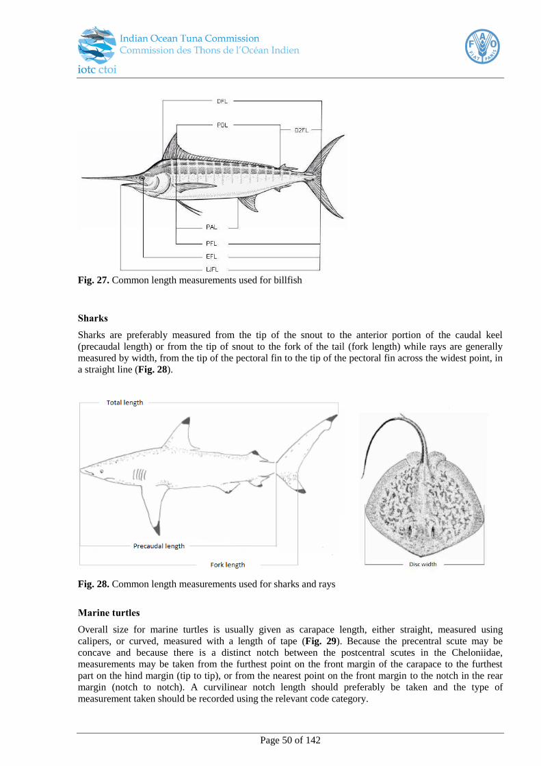
Page 50 of 142
Fig. 27. Common length measurements used for billfish
Sharks
Sharks are preferably measured from the tip of the snout to the anterior portion of the caudal keel
(precaudal length) or from the tip of snout to the fork of the tail (fork length) while rays are generally
measured by width, from the tip of the pectoral fin to the tip of the pectoral fin across the widest point, in
a straight line (Fig. 28).
Fig. 28. Common length measurements used for sharks and rays
Marine turtles
Overall size for marine turtles is usually given as carapace length, either straight, measured using
calipers, or curved, measured with a length of tape (Fig. 29). Because the precentral scute may be
concave and because there is a distinct notch between the postcentral scutes in the Cheloniidae,
measurements may be taken from the furthest point on the front margin of the carapace to the furthest
part on the hind margin (tip to tip), or from the nearest point on the front margin to the notch in the rear
margin (notch to notch). A curvilinear notch length should preferably be taken and the type of
measurement taken should be recorded using the relevant code category.

Page 51 of 142
Fig. 29. Common length measurements used for turtles
23
Birds
Length measurements for birds are generally made by laying the bird on its back and flattening out the
head and neck gently and measuring a straight line between the tip of the bill and the tip of the tail. Other
length measurements used include wing length (tip to the longest primary feathers), tail length, head
length, tarsus (upper margin of the beak or bill) length and culmen length (Fig. 30).24
23
Source: www.fao.org 24
Rasmussen PC and Anderton JC (2005). Birds of South Asia. The Ripley Guide. Volume 2. Washington DC & Barcelona: Smithsonian
Institution & Lynx Edicions. pp. 18–19.

Page 52 of 142
Fig. 30. Common length measurements used for birds (total, wing, tail, tarsus and culmen lengths)
25
Size-class intervals
Lengths are recorded in 1 cm interval length classes, rounded to the lower centimetre. As an example,
40.1 to 40.9 cm is recorded as 40 cm and therefore a measurement of 39.9 cm is recorded as 39 cm.
L. Additional Biological sampling
Recording interactions with non-target species, including threatened and endangered species, will be both
fishery and vessel specific. Such data will be recorded from directly observed events. The sampling
strategies and procedures for environmental monitoring will also be determined on the priority of the data
requirements determined by the scheme.
Sex determination
When specified in the sampling programme the sex of the fish may also be required. On large purse-
seiners the tuna caught are often juveniles and the fish are frozen whole and it is unlikely that sexing of
the tuna will be required. However, on tuna longliners where most fish caught are adults, these can be
determined by first taking the length measurements and then checking the gonads for sex while the crew
are dressing the fish. Length provide an initial indication of sex as male and female billfish have
significantly different growth rates, resulting in smaller males which rarely weigh more than 100kg.
Tuna and billfish
Tuna and billfish gonads are found in the ventral part of the body cavity. Ovaries are usually tubular,
pink/red/orange or grey, and granular, while testes are flat, white/grey/pink and their ventral edges
25
Source: www.archive.org/stream/dievgelhandbuc01reic#page/65/mode/1up Die Vogel : Handbuch der Systematischen Ornithologie. Volume
1
Page 53 of 142
frequently have a wave-like outline. The male gonads in billfish have many nodules present on the
external surface, while in tuna the testes are usually flatter and thinner with more fatty or connective
tissue apparent. Cross sections of male gonads have a characteristic rectangular/triangular shape, are
solid, and when sexually ripe, milt can be seen and the lumen is visible at the base or to one side of the
gonad (Fig. 31). In contrast, the female gonads have a smooth external appearance with a rough surface,
and the cross section has a characteristic oval shape with a lumen (opening) visible in the middle (Fig.
32).
Fig. 31. Cross section (left) and whole (right) views of male swordfish gonads (US National Marine
Fisheries Service, Southeast Fisheries Science Centre).
Fig. 32. Cross section (left) and whole (right) views of female swordfish gonads (US National Marine
Fisheries Service, Southeast Fisheries Science Centre). NB: Most tuna and swordfish >100 kg are female.
Sharks
The sex of sharks can be determined by the presence or absence of a pair of claspers on the pelvic fins.
Claspers are very prominent in mature males, more subtle in juvenile males and completely absent in
females (Fig. 33).
Page 54 of 142
Fig. 33. Sex determination in sharks. Location of the pelvic fins (top) and ventral view of the pelvic fins
(bottom).
Maturity
Maturity can be assessed through visual examination of the gonads and assigned a maturity stage form 1
to 5 (Table 4), however, the visual assessment of ovaries to determine maturity stage is felt to be an
imprecise indicator of reproductive condition (West, 1990) so the use of histological and/or chemical
methods is recommended. Whichever method is used should be fully documented.
Table 4. Maturity stages used for visual examination of large pelagic gonads
M. Best practice bycatch handling methods for successful live release
The handling of catch and bycatch is the responsibility of the crew and not the observer. Nevertheless, it
is a good idea for the observer to understand the best practice handling techniques for sampling purposes.
Sharks and rays

Page 55 of 142
For large sharks that become hooked or entangled in longline gear, long-handled line cutters and
dehookers should be used while the animal is still in the water, however, if the shark is relatively small it
may be brought onboard carefully. Dehookers, bolt and line cutters can then be used to remove a hook,
disentangle and animal or cut a leader if the hook is too deeply embedded.
Sometimes sharks will spin and roll themselves in a purse seine net, though they may otherwise still be
unharmed. As the net is reeled in, the crew should look ahead to try to spot entangled sharks as early as
possible. If a shark is lifted up in the net toward the power block, this becomes a dangerous situation for
both the shark and the crew. If an entangled shark is seen, the crew should reduce the speed of the net reel
(thus reducing tension in the net), and then attempt to carefully remove the animal, using knives or
clippers if necessary to cut the net.
There are three ways to properly handle a small shark:
1. One hand on the dorsal (top) fin and the other holding the body from below
2. Both hands holding the body
3. One hand on the pectoral (side) fin and the other holding the tail. To release the shark, the head should
be pointed down towards the water and the shark then dropped in (Fig. 34a).
For a medium-sized shark, one or two people should hold the dorsal and pectoral fins, with the other
person holding the tail. To release the animal, the crew should drop (not throw) the shark over the side
(Fig. 34b).
(a) (b)
Fig. 34. Proper handling of (a) small sharks (b) medium sized sharks26
Because a stingray’s spine is located at the base of its tail, it is best to avoid the rear of the animal and
grasp it near the head to avoid injury from its spine (Fig. 35). This also applies to small manta rays which
can be safely carried with a person holding each wing.
26
Poisson et al. 2012
Page 56 of 142
Fig. 35. Sting rays should be held by the body away from the person to avoid injury from its spine
27.
For large sharks, rays, and other large fish (e.g., moonfish), the crew can attempt to release them directly
from the brailer, if feasible, by tipping one edge of it into the ocean. Alternatively, the animal can be
returned to the sea using a piece of net, plastic tarp, or canvas that can be lifted by the vessel’s crane. The
material should be ready on deck before brailing, and when a large animal is encountered, it can be
placed on the material, which is then hooked up to the crane and lifted over board.
During purse seine operations, large sharks, rays, and other large fish (e.g., moonfish) can be released
directly from the brailer, if feasible, by tipping one edge of it into the ocean. Alternatively, the animal can
be returned to the sea using a piece of net or tarpauline on the deck that is then lifted by the crane and
released over the side (Fig. 36).
(a) (b)
Fig. 36. Methods for releasing manta rays (a) directly from the brail (b) using tarpaulin and crane28
.
Where sharks cannot be released immediately, they should be kept cool with a wet towel draped lightly
over the head and with a fish in the mouth to prevent bites or a hose to allow it to breathe (Fig. 37).
Sharks should not be held by the tail or gills and should not be stepped on, handled with a gaff or other
sharp object or thrown on the ground as all of these can severely damage the internal organs (Fig. 38).
27
Poisson et al. 2012 28
Poisson et al. 2012
Page 57 of 142
Fig. 37. Keep sharks cool, prevent bites and allow them to breathe
29
Fig. 38. Practices that can severely damage the internal organs of sharks30
Resolution 13/05 requires that vessels should not intentionally set a purse seine net around a whale shark
in the IOTC area of competence, if it is sighted prior to the commencement of the set. If an incident does
occur, all reasonable steps must be taken to ensure its safe release, while taking into consideration the
safety of the crew. If an observer is onboard, they must record details of the interaction, including:
the number of individuals;
a short description of the interaction, including details of how and why the interaction occurred,
if possible;
the location of the encirclement;
the steps taken to ensure safe release;
an assessment of the condition of the animal on release, including whether the whale shark was
released alive but subsequently died.
Caution must be taken to ensure that the whale shark is not further harmed during the release process. As
illustrated in the gallery, there are two safe release methods and their application depends on the position
of the whale and tunas in the net. If the whale shark is at the surface and separated from the tunas, the
29
Poisson et al. 2012 30
Poisson et al. 2012
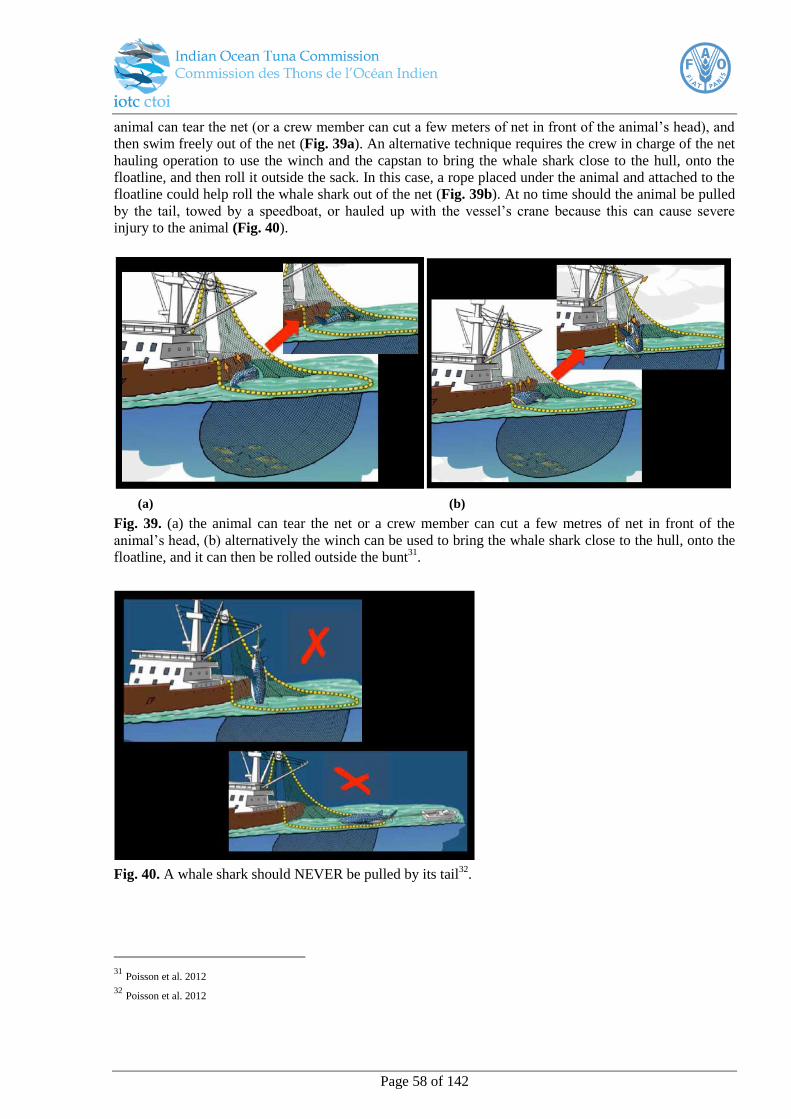
Page 58 of 142
animal can tear the net (or a crew member can cut a few meters of net in front of the animal’s head), and
then swim freely out of the net (Fig. 39a). An alternative technique requires the crew in charge of the net
hauling operation to use the winch and the capstan to bring the whale shark close to the hull, onto the
floatline, and then roll it outside the sack. In this case, a rope placed under the animal and attached to the
floatline could help roll the whale shark out of the net (Fig. 39b). At no time should the animal be pulled
by the tail, towed by a speedboat, or hauled up with the vessel’s crane because this can cause severe
injury to the animal (Fig. 40).
(a) (b)
Fig. 39. (a) the animal can tear the net or a crew member can cut a few metres of net in front of the
animal’s head, (b) alternatively the winch can be used to bring the whale shark close to the hull, onto the
floatline, and it can then be rolled outside the bunt31
.
Fig. 40. A whale shark should NEVER be pulled by its tail32
.
31
Poisson et al. 2012 32
Poisson et al. 2012
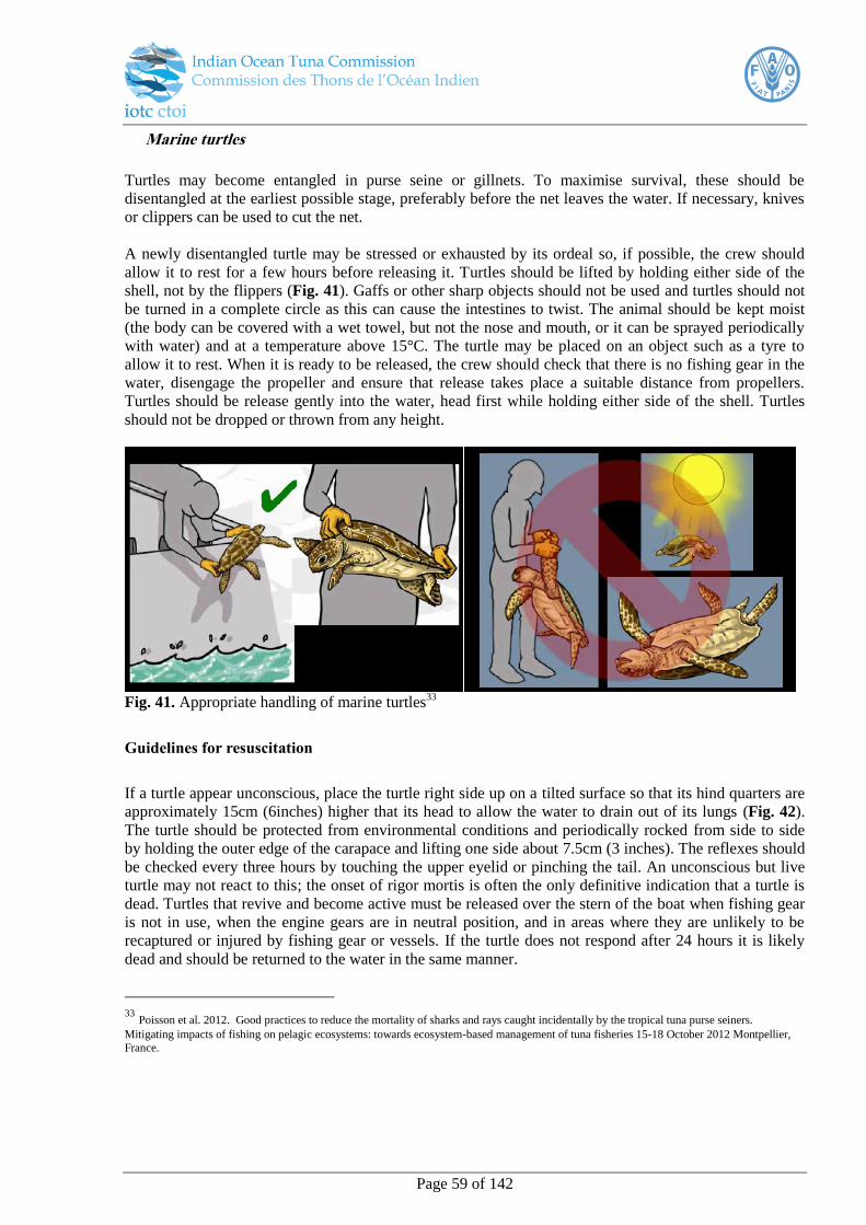
Page 59 of 142
Marine turtles
Turtles may become entangled in purse seine or gillnets. To maximise survival, these should be
disentangled at the earliest possible stage, preferably before the net leaves the water. If necessary, knives
or clippers can be used to cut the net.
A newly disentangled turtle may be stressed or exhausted by its ordeal so, if possible, the crew should
allow it to rest for a few hours before releasing it. Turtles should be lifted by holding either side of the
shell, not by the flippers (Fig. 41). Gaffs or other sharp objects should not be used and turtles should not
be turned in a complete circle as this can cause the intestines to twist. The animal should be kept moist
(the body can be covered with a wet towel, but not the nose and mouth, or it can be sprayed periodically
with water) and at a temperature above 15°C. The turtle may be placed on an object such as a tyre to
allow it to rest. When it is ready to be released, the crew should check that there is no fishing gear in the
water, disengage the propeller and ensure that release takes place a suitable distance from propellers.
Turtles should be release gently into the water, head first while holding either side of the shell. Turtles
should not be dropped or thrown from any height.
Fig. 41. Appropriate handling of marine turtles
33
Guidelines for resuscitation
If a turtle appear unconscious, place the turtle right side up on a tilted surface so that its hind quarters are
approximately 15cm (6inches) higher that its head to allow the water to drain out of its lungs (Fig. 42).
The turtle should be protected from environmental conditions and periodically rocked from side to side
by holding the outer edge of the carapace and lifting one side about 7.5cm (3 inches). The reflexes should
be checked every three hours by touching the upper eyelid or pinching the tail. An unconscious but live
turtle may not react to this; the onset of rigor mortis is often the only definitive indication that a turtle is
dead. Turtles that revive and become active must be released over the stern of the boat when fishing gear
is not in use, when the engine gears are in neutral position, and in areas where they are unlikely to be
recaptured or injured by fishing gear or vessels. If the turtle does not respond after 24 hours it is likely
dead and should be returned to the water in the same manner.
33
Poisson et al. 2012. Good practices to reduce the mortality of sharks and rays caught incidentally by the tropical tuna purse seiners.
Mitigating impacts of fishing on pelagic ecosystems: towards ecosystem-based management of tuna fisheries 15-18 October 2012 Montpellier,
France.
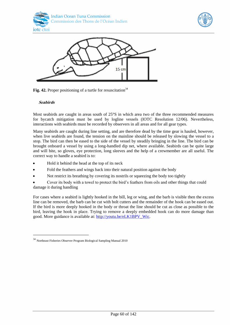
Page 60 of 142
Fig. 42. Proper positioning of a turtle for resuscitation34
Seabirds
Most seabirds are caught in areas south of 25°S in which area two of the three recommended measures
for bycatch mitigation must be used by logline vessels (IOTC Resolution 12/06). Nevertheless,
interactions with seabirds must be recorded by observers in all areas and for all gear types.
Many seabirds are caught during line setting, and are therefore dead by the time gear is hauled, however,
when live seabirds are found, the tension on the mainline should be released by slowing the vessel to a
stop. The bird can then be eased to the side of the vessel by steadily bringing in the line. The bird can be
brought onboard a vessel by using a long-handled dip net, where available. Seabirds can be quite large
and will bite, so gloves, eye protection, long sleeves and the help of a crewmember are all useful. The
correct way to handle a seabird is to:
Hold it behind the head at the top of its neck
Fold the feathers and wings back into their natural position against the body
Not restrict its breathing by covering its nostrils or squeezing the body too tightly
Cover its body with a towel to protect the bird’s feathers from oils and other things that could
damage it during handling
For cases where a seabird is lightly hooked in the bill, leg or wing, and the barb is visible then the excess
line can be removed, the barb can be cut with bolt cutters and the remainder of the hook can be eased out.
If the bird is more deeply hooked in the body or throat the line should be cut as close as possible to the
bird, leaving the hook in place. Trying to remove a deeply embedded hook can do more damage than
good. More guidance is available at: http://youtu.be/eLK1BPV_Wic.
34
Northeast Fisheries Observer Program Biological Sampling Manual 2010
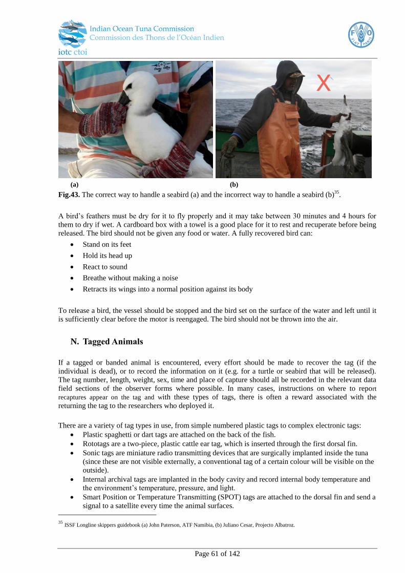
Page 61 of 142
(a) (b)
Fig.43. The correct way to handle a seabird (a) and the incorrect way to handle a seabird (b)35
.
A bird’s feathers must be dry for it to fly properly and it may take between 30 minutes and 4 hours for
them to dry if wet. A cardboard box with a towel is a good place for it to rest and recuperate before being
released. The bird should not be given any food or water. A fully recovered bird can:
Stand on its feet
Hold its head up
React to sound
Breathe without making a noise
Retracts its wings into a normal position against its body
To release a bird, the vessel should be stopped and the bird set on the surface of the water and left until it
is sufficiently clear before the motor is reengaged. The bird should not be thrown into the air.
N. Tagged Animals
If a tagged or banded animal is encountered, every effort should be made to recover the tag (if the
individual is dead), or to record the information on it (e.g. for a turtle or seabird that will be released).
The tag number, length, weight, sex, time and place of capture should all be recorded in the relevant data
field sections of the observer forms where possible. In many cases, instructions on where to report
recaptures appear on the tag and with these types of tags, there is often a reward associated with the
returning the tag to the researchers who deployed it.
There are a variety of tag types in use, from simple numbered plastic tags to complex electronic tags:
Plastic spaghetti or dart tags are attached on the back of the fish.
Rototags are a two-piece, plastic cattle ear tag, which is inserted through the first dorsal fin.
Sonic tags are miniature radio transmitting devices that are surgically implanted inside the tuna
(since these are not visible externally, a conventional tag of a certain colour will be visible on the
outside).
Internal archival tags are implanted in the body cavity and record internal body temperature and
the environment’s temperature, pressure, and light.
Smart Position or Temperature Transmitting (SPOT) tags are attached to the dorsal fin and send a
signal to a satellite every time the animal surfaces.
35
ISSF Longline skippers guidebook (a) John Paterson, ATF Namibia, (b) Juliano Cesar, Projecto Albatroz.

Page 62 of 142
Pop-up Satellite Archival Tags (PSAT) are inserted with an anchor and a tether into the dorsal
musculature, recording temperature, pressure, and light, and they detach from the animal on a
pre-programmed date.

Page 63 of 142
PART C: Data field descriptions
Page 64 of 142
I. Overview
This section details the minimum data collection and reporting fields. The description of the data fields in
this section will assist the observer to understand the exact nature of the minimum information to be
collected for the controlling organisation and to be reported to the IOTC Secretariat as well as when the
observer wishes to record additional information. If the appropriate category is not available in the code
tables, then a category should be added, bearing in mind that they should be clearly defined and mutually
exclusive where possible.
Data can be reported to the IOTC Secretariat in one of the following formats:
i.) any non-proprietary electronic format (e.g., csv, xml, txt, doc, etc.); or
ii.) in an electronic format36
that can be easily exported and processed into standard spreadsheet,
database or statistical software (e.g., xls, dbase, mdb, etc.)
as long as the required data (data fields indicated in the data reporting templates and described below) are
provided, at the specified resolution. This might be, for example, a csv export file, or an excel file as per
the trip report template. The data field descriptions found below are consistent with those in the data
collection forms and in the trip report templates.
36
As per SC14 (para. 102)

Page 65 of 142
Observer data collection forms and reporting templates by fishery
FISHERY DATA
COLLECTION
FORMS
USAGE DATA
REPORTING
TEMPLATES
Longline
Form Gen-1 Trip form completed once per trip TripLL
Form LL-2
Form LL-4 Operational form completed for each
operational set
OpLL
Catch LL
Form Gen-5 Operational per occurrence completed
as required for each event N/A
Form Gen-6
Purse Seine
Form Gen-1
Trip form completed once per trip TripPS
Form PS-2
Form Gen-3 Daily activities form N/A
Form PS-4 Operational form completed for each
operational set
OpPS
BioPS
Form Gen-5
Operational per occurrence completed
as required for each event N/A
Form Gen-6
Pole and Line
Form Gen-1 Trip form completed once per trip TripPL
Form PL-2
Form Gen-3 Daily activities form N/A
Form PL-4 Operational form completed for each
fishing operation/event
OpPL
CatchPL
Form Gen-5 Operational per occurrence completed
as required for each event N/A
Form Gen-6
Gillnet
Form Gen-1 Trip form completed once per trip TripGN
Form Gill-2
Form Gill-4 Operational form completed for each
operational set
OpGN
CatchGN
Form Gen-5 Operational per occurrence completed
as required for each event N/A
Form Gen-6
Page 66 of 142
II. Data collection and reporting requirements
A. General
Trip Information
For data reporting purposes, a trip number should be provided as a unique identifier for the trip so all
information can be grouped by trip. This should begin with the three-digit country code of the vessel flag,
the two digit code of the main gear followed by 6 numerical digits. e.g. MOZLL000001.
At the start of the trip the time zone the vessel is using should be recorded (±GMT). Keep accurate track
and record when time zones or the vessel times are altered. On some vessels they maintain the time zone
of their flag state and all logbook times are recoded for this time zone.
Likewise, the units the vessel is using for geographical coordinates should be noted (e.g. (d)dd.dddd°,
(D)DD°mm.mm or (D)DD°MM'ss") and all locations recorded under these units so they may be
converted later as appropriate.
B. Form 1 - GEN
Data field Description
Man
dat
ory
rep
ort
ing
37
Man
dat
ory
coll
ecti
on
38
Rec
om
men
ded
Vessel information Vessel name Record the vessel full name, including any numbers. For example
“Fukuseki Maru No.5”. X
Vessel type This records the type of vessel (Table 13). For example a European type industrial purse seiner (PSEU). In most cases a
vessel is purpose-built and can only fish in a single sector using the
specific gear for which it was designed, however, some vessels
have the ability to fish in more than one sector by changing their
gear and it is therefore important to also record the main gear.
X
Main gear Main gear type/s (if more than one type of fishing gear is used) for
the observed trip, e.g. drifting longline (up to 1800 hooks), LLFR
(Table 16).
X
National
registration
number
This is the number issued by country in which the vessel is
registered. X
Vessel IOTC
number
Record the vessel IOTC number as per the IOTC Record of
Authorized Vessels. Check the Certificate of Registry that should
be issued by the flag state to confirm that the name displayed
corresponds to this and relevant safety certificates (should there be
any discrepancies note these in the comments section).
X
Port of registration The name and geographical coordinates (specify units; preferably
±(d)dd.dddd°) corresponding to the port of registration of the
vessel (also called home port), as per the vessel documents
X
Licensed target
species
Vessels will generally target a narrow range or aggregation of
species and specified by the licences or permit conditions under
which authority the vessel is operating (Table 5).
X
37
Consistent with IOTC trip report template 38
Consistent with IOTC data collection forms
Page 67 of 142
Data field Description
Man
dat
ory
rep
ort
ing
37
Man
dat
ory
coll
ecti
on
38
Rec
om
men
ded
IMO or Lloyd’s
number
The IMO number refers to the number allocated to the vessel if it
is registered to the International Maritime Organisation of the
United Nations.
X
Port of departure If the fishing vessel departed from port the name of the port and
geographical coordinates corresponding to the port; if the vessel
started a new trip at sea following a transhipment just record ‘at-
sea’ plus the geographical coordinates corresponding to the
location the trip started.
X
Date / time vessel
sailed
The date (YYYY-MM-DD) and time (hh:mm) the fishing vessel
started the trip that is being observed, i.e. the date in which the
fishing vessels sailed back to the fishing grounds from port or a
transhipment location.
X
Date / time vessel
returned to port
The date (YYYY-MM-DD) and time (hh:mm) the fishing vessel
ended the trip that is being observed, i.e. the date in which the
fishing vessel arrived back in port or to a transhipment location.
Where an observer disembarks before the vessel returns to its
home port at the end of the trip then the observer can request the
vessel ETA from the captain but this must be clearly reflected.
X
Port of return If the fishing vessel arrived in port record the name of the port or
geographical coordinates corresponding to the port; if the vessel
arrived at a transhipment location just record ‘at-sea’ plus the
geographical coordinates corresponding to the location the
transhipment started. If the observer disembarks before the vessel
returns then the observer can request the information from the
captain and record this.
X
Observer and Deployment Details
Observer name Name of the scientific observer(s) that collected the data onboard
the fishing vessel. The observer must print first and family names
in full.
X
Observer
nationality
Record nationality as it appears in passport. X
Observer IOTC
registration
number
National agencies will submit a list of their observers to the IOTC
Secretariat and each observer will then be allocated an IOTC
registration number that must be used on all observer data
submissions.
X
Employer Record the full name and address of the observer controlling
organisation and/ or national fisheries organisation responsible for
managing deployment Include postal and physical addresses and
relevant telephone numbers and email addresses.
X
Date / time
embarkation
Record the date and time that the observer embarks onboard the
vessel (DD:MM:YYYY:hh:mm). It is important to record the
vessel’s time and note the time zone (±GMT) that the vessel is
using.
X
Location of
embarkation
Record the port and country where the observer embarks. Note: if
the observer embarks via a port launch within port limits, this is
still recorded as a port embarkation. If the observer embarks at
sea outside port limits via a vessel transfer, record “at sea” and
record the position in Latitude and Longitude (specify units;
preferably ±(d)dd.dddd°).
X
Date / time
disembarkation
Record the date and time that the observer disembarks from the
vessel (DD:MM:YYYY:hh:mm). The observer’s embarkation and
disembarkation may not coincide with the vessel trip information.
X

Page 68 of 142
Data field Description
Man
dat
ory
rep
ort
ing
37
Man
dat
ory
coll
ecti
on
38
Rec
om
men
ded
Location of
disembarkation
Record the port and country where the observer disembarks. Note:
if the observer disembarks via a port launch within port limits then
this is still recorded as a port disembarkation. If the observer
disembarks at sea outside port limits via a vessel transfer, record
“at sea” and record the position in Latitude and Longitude (specify
units; preferably ±(d)dd.dddd°).
X
Contact person(s) Record full name, contact telephone and fax numbers and email of
the contact person from the observer’s controlling organisation.
X
Observer trip information
The vessel fishing details recorded must coincide with those while the observer was onboard. Note: it is quite
possible that the vessel trip information will differ as an observer may embark after a vessel trip has commenced
and the vessel has already been engaged in fishing. Similarly the vessel may continue to fish after the observer
has disembarked. Any additional information or anomalous data not captured in the trip report should be noted in
the ‘comments’ section (e.g. if the vessel does not return to port but tranships catch at sea).
Total number of
fishing
operations/sets
Record the total number of all fishing sets/events that took place
during the trip for target species (not including operations for bait
species)
X
Total number of
operations/sets
observed
The total number of fishing events monitored by the observer (this
number must be equal to the number of operation numbers
provided for the trip)
X
Details of sampling
strategy
If not all of the sets that took place during the time the observer
was onboard were monitored, describe the rationale and procedure
used for sampling sets (e.g. the first two of every three sets were
fully sampled). If 100% of sets were sampled, this is N/A.
X
Total days spent in
fishing area
Record the number of days the vessel is in the fishing area while
the observer was onboard. Note this does not include transit time
even if the area being transited is within the fishing area.
X
Total days
transiting to fishing
areas
Record the number of days the vessel spent steaming or transiting
to fishing areas while the observer was onboard. X
Dates searching Record the dates the vessel was engaged in actively searching for
fish. X
Dates active
fishing
Record the dates the vessel actively fished (when the vessel had
gear in the water). For some fishing events this may be for only a
few hours of the day. Alternatively a single fishing event/set may
span part of two days.
X
Number of days
lost
The total number of days where a vessel was unable to fish dues to
factors such as adverse weather conditions, mechanical failure or
other unforeseen events
X
Reasons for time
lost
Record the reasons a vessel was unable to fish: (i) adverse weather
conditions, (ii) mechanical breakdown or inoperative gear or
processing plants that prevented the vessel from either steaming,
using any of its gear or being able to process fish or (iii)
unforeseen events (specify).
X
Vessel Owner and Personnel
In some instances a vessel may be chartered by an organisation or operator that will conduct the fishing
operations on licences or permits from several other entities or nationalities. These occur specifically in joint
ventures between vessel owners and agents and permit holders from other national states.
Registered vessel
owner
Record in full the owner’s name, nationality and contact details.
These can be obtained or cross-checked on the vessel registration
X
Page 69 of 142
Data field Description
Man
dat
ory
rep
ort
ing
37
Man
dat
ory
coll
ecti
on
38
Rec
om
men
ded
forms.
Charterer /
operator
Where the vessel has been chartered and is operated and managed
by a company other than the owner, record operator’s full name
(company or individual as appropriate), nationality and contact
details.
X
Fishing Master
name
Record the full name of the Fishing Master. X
Fishing Master
nationality
Record the nationality of the Fishing Master. X
Skipper Record the full name of the skipper. Note in some instances the
fishing master and skipper may be the same person.
X
Skipper nationality Record the nationality of the skipper X
Number of crew Record the number of crew. This should be cross checked against
the vessel’s crew list. Also check the maximum crew compliment
on the vessel’s safety certificate.
X
Vessel specific details
Records details of the vessel specifications, and operational capabilities. Where data field are not relevant to a
specific vessel these field must record “n/a to this vessel”. If there are details about the vessel that are not
captured on these forms and that impact on the vessel’s operational ability or items that the observer would like to
report on, these must be included in the comments section.
Flag Name of country in which vessel is registered. Note this may not
be the same as the nationality from which the vessel originates. X
International radio
call sign (IRCS)
This is the number allocated to the vessel by the International
Telecommunications Union. This should be displayed prominently
on the vessel’s side or superstructure. Where a vessel does not
have an IRCS it should display the characters allocated to its Flag
State by the International Telecommunications Union (ITU)
followed by the licence or registration number that the Flag State
has allocated to the vessel.
X
Gross tonnage
(GRT or GT)
Overall internal volume of the ship (GT), as per the IMO
International Convention on Tonnage Measurement of Ships. X
Length overall
(LOA)
Record the maximum length of a vessel's hull measured parallel to
the waterline, in metres. X
Fish storage
capacity
Record the capacity of a vessel to store its catch (hold or volume
capacity in cubic meters). Depending on the type of vessel and
method of fishing and catch preservation, this can be recorded by
volume and / or weight. Normally volume is converted to weight.
Larger fish that are frozen and packed loose take up a high volume
relative to their weight. In this instance the volume of the hold
may be the limiting factor to determine a vessel’s maximum
tonnage. Smaller fish packed directly into a hold with ice, CSW or
RSW will have a lower volume to weight ratio.
X
Refrigeration
methods(s)
Record the method/s used by the vessel to cool and preserve catch
(e.g. blast freezing). X
Fish Storage
Method(s)
Record the method used by the vessel to store catch. Note: a
method to preserve fish may involve several processes, e.g. a fish
may first be cooled in a blast freezer at a specific temperature for a
time before being transferred to a holding facility for storage at a
different temperature. At the same time other species may be
placed directly into a freezer hold with no intermediate blast
freezing process. Vessels undertaking shorter trips may keep the
X

Page 70 of 142
Data field Description
Man
dat
ory
rep
ort
ing
37
Man
dat
ory
coll
ecti
on
38
Rec
om
men
ded
fish fresh on ice or in RSW.
Blast freezer
capacity
The volume of catch that can be blast frozen prior to storage,
expressed in cubic metres X
Hull material Record the hull material; steel, wood or glass-reinforced plastic
(GRP) also known as fibre glass. X
Main engine Make/
Power
Record the make and power of the main engines. X
Vessel range (days
at sea)
Record the range of the vessel either in average time at sea or
cruising distance. This is not directly related to the tonnage of fuel
carried. However, if a figure for the range cannot be obtained,
request information on the tonnage of fuel carried and the average
cruising distance per ton of fuel. This is not an accurate reflection
on the range of the vessel as fuel is used to run auxiliary motors for
processing and fish preservation. Information on this would then
also be sought.
X
Vessel phone, fax
and email
A vessel may have several contact numbers and email addresses
depending on the satellite communications systems installed
onboard. These should all be recorded, taking note of the ocean
region code.
X
Vessel
cruising/maximum
speed
Record the vessel’s average operational cruising and maximum
speed capabilities in knots. X
Vessel electronic equipment
The presence, absence and functionality of the electronic equipment onboard can have a significant
effect on a vessel’s ability to detect and catch fish, and thus the catch per unit effort. Details of this
equipment must be noted, including the make and model and a record must be kept of the frequency of
gear usage in the ‘comments’ section. Additional comments or details on equipment should also be
included.
Position fixing
equipment
Record presence/absence of position fixing equipment X
Record model and make and if the vessel has one or more GPS
units in operation. Note a GPS may be an independent unit or
linked or incorporated into track plotters and acoustic systems.
X
Vessel Monitoring
Systems (VMS)
Record if the vessel has a VMS installed
X
If present, describe if it has security seals in place and whether it is
operational. Note the make and model X
Radars Record presence/absence X
Radars Record power and frequency range of the radar systems in place.
Vessels targeting surface fish often have high frequency radars to
search for seabird activity or activity on the sea surface. These are
usually not used for normal navigation purposes. Note the make
and model.
X
Track plotters Record presence/absence of plotters X
Record make and model. Note if linked to an external GPS or have
GPS built in X
Acoustic
equipment
Record presence/absence of acoustic equipment X
Record the make and the model of the acoustic depth sounder. X
Record if the vessel has an acoustic sonar onboard and note its
make, model, power and frequency range. X
Page 71 of 142
Data field Description
Man
dat
ory
rep
ort
ing
37
Man
dat
ory
coll
ecti
on
38
Rec
om
men
ded
Record if the vessel has an acoustic doppler current meter, the
make and model. This is important to ascertain the current speed
X
Expendable
bathythermographs
(XBT)
Record if the vessel has onboard and deploys expendable
bathythermographs XTBs. These are usually mounted on the
bridge wings and are used periodically to determine the depth of
the thermocline. Note the make and model.
X
Communications
equipment
Record presence/absence X
Radios Record the number of VHF, HF radios onboard, make and model
and the power and frequency range. A vessel will often have
several radios. VHF is used for short-range communications
between vessels at sea or port communications. VHF also includes
“Digital Selective Calling” (DSC) to alert other boats, ships, and
shore stations with a single button press in an emergency situation.
High Frequency (HF) radio frequencies range between 3 and 30
MHz and are used for long distance communication. These
systems include radiotelephone and radiotelex (narrow-band direct
printing) equipment, with calls initiated by digital selective calling
(DSC). Worldwide broadcasts of maritime safety information are
also made on HF narrow-band direct printing channels. Radios are
also an integral part of the safety equipment onboard and are also
specified if the vessel conforms to the GMDSS requirements.
However, vessels under 300 gross tonnage (GT) are not subject to
GMDSS requirements.
X
Satellite
communication
systems
These systems provide ship/shore, ship/ship and shore/ship
telephone, telex and high-speed data services, including a distress
priority telephone and telex service to and from rescue
coordination centres. Satellite systems operated by the Inmarsat,
overseen by IMSO, International Mobile Satellite Organization are
also important elements of the GMDSS. The types of Inmarsat
ship earth station terminals recognized by the GMDSS are:
Inmarsat B, C and F77. Record the make and model.
X
Services
Sea Surface
Temperature (SST)
Record if the vessel has a SST gauge on the bridge and or if the
vessel has access to SST charts (most likely to be associated to
Fisheries Information Services systems. Note the make and model.
X
Weather facsimile Record if the vessel has a weather facsimile. Weather information
may also be received from Fisheries Information Services systems.
Note the make and model.
X
Fisheries
information
services
Vessels may receive real-time information on some oceanographic
features that will provide them with information on SST,
phytoplankton densities or sea height. Note the make and model.
X
Catch transhipped summary
The observer must record a summary of the total catch retained by the vessel during time they are onboard.
Should any of the fish products be transhipped to a carrier vessel or another fishing vessel the weight of each
species must be recorded. Similarly they must also record the details of any fish products that may be transhipped
from another fishing vessel to their vessel during the trip.
Species/weight
transhipped at sea
Record the species, weight and product code of all fish products
observed being transhipped to either a carrier vessel or another
fishing vessel during the trip. Record if all or part of the catch or
processed catch is transhipped at sea to another vessel. Where
possible check if a transhipment declaration has been completed by
X
Page 72 of 142
Data field Description
Man
dat
ory
rep
ort
ing
37
Man
dat
ory
coll
ecti
on
38
Rec
om
men
ded
the vessel and obtain a copy.
Carrier / Fishing
Vessel details
Record the name and registration number of the vessels to which
fish are transhipped or from which fish are received. Where
possible record the vessels IOTC registration number. This can be
requested from the Fishing Master and should also be recorded on
the declaration form if it is filled in. Also note the call sign
displayed.
X
Catch onboard at disembarkation summary
Total processed
weight of fish
onboard at
disembarkation
Record the total weight of product that is onboard the vessel at the
time of observer disembarkation. Note this can be calculated from
the sum of the product produced during the observed trip, less any
product transhipped off the vessel or include any product received
from another vessel. If any product was onboard prior to the time
the observer embarked this should also be noted.
X
Species/Processing
code
Record a breakdown of the product onboard by species and
product code using the IOTC/FAO codes (Table 30). Where a
specific code is not available or only an aggregation of species is
available record as much detail as possible and include this
description in the ‘comments’ section.
X
Waste management (MARPOL Agreement Annex 5)39
Waste category Record the category of the waste, organic, inorganic-burnable,
(plastic) or un-burnable, (glass or metal).
X
Storage/Disposal
method
Record how the waste was disposed of; for example, incinerated,
stored in sacks or disposed of overboard.
X
C. Form 2-LL
Longline gear, setting and hauling specifications
This section is designed to capture detailed specifications of the different components of the longline gear
used by the vessel. Detailed descriptions of any unique aspects of the gear should also be recorded in the
‘comments’ section. If not all sets/operations were observed, the rationale and process for sampling of
sets, and remarks on lost gear such as floats, buoys and sections of line should also be noted here.
Data field Description
Man
dat
ory
rep
ort
ing
Man
dat
ory
coll
ecti
on
Rec
om
men
ded
Longline Type Record the type of longline used, according to the IOTC
categories (Table 16). X
Mainline length Record the total operational length of the mainline in
kilometres. This information can be obtained from the
Captain or Fishing Master.
X
Mainline material Record the material the mainline is made out of, e.g.
monofilament, braided monofilament or tarred rope (Table
X
39
Reporting of this information is now optional as per SC14 (para. 103)

Page 73 of 142
Data field Description
Man
dat
ory
rep
ort
ing
Man
dat
ory
coll
ecti
on
Rec
om
men
ded
18).
Mainline diameter Use callipers to measure the diameter of the mainline in
millimetres.
X
Line setter Record if the vessel has a line setter fitted. X
Note the make and model. Record the range of setting
speeds (m/s). Note if the line setter is operational, or not
used for any reason. When the equipment is only used for
part of the trip, provide reasons.
X
Line hauler Record if the vessel has a line hauler fitted. X
Record the make and model of the equipment used to haul in
the mainline. Also describe the means of transfer and
packing of the line into the line storage bin.
X
Branch line storage Record if the branch lines are prepared in coils and packed
into baskets, or layers out in tubs, or coiled up onto reels.
X
Shark lines Record if shark lines are used and, if so, note the length of
shark lines onboard the vessel (in metres).
X
Length of floatlines Record the length of the floatlines onboard the vessel (in
metres).
X
Bait casting machine Record if the vessel is fitted with a bait casting machine. X
Record the make and model. Note if it is operational and
how often it is used (always, often, rarely, never). X
Method of stunning fish Record the method used to stun fish during hauling, e.g.
percussive stunning, carbon dioxide narcosis, spiking or
electrocution (Table 29).
X
Bait hooked twice Record how often the hook was laced through the bait twice
(always, often, rarely, never). This is thought to reduce turtle
mortality.
X
Depredation mitigation
device used
Record if any depredation devices are used and describe the
type, e.g. "spiders" or "socks". X
Branchline details
Branchlines are generally made up of several sections which are composed of different materials (e.g. monofilament
and wire on the last section that is attached to the hook) and with different lengths and diameters. There may be up
to four sections of branchline, including the leader section. Different branchline configurations may also be used
during the set, so more than one set-up may be described. Observers should keep a record of each specification. It
will not be possible to measure this at the time of setting so observers will have to get this information during the
hauling operations or when the branch lines are being made up. Branchline material Record the branchline material for each of the four sections
where section 1 is that closest to the mainline and section 4
is the leader; note that wire trace may be sheathed by a
plastic or nylon coating (Table 18).
X
Branchline diameter (mm) Record the diameter (in millimetres) of the branchline for
each of the four sections where section 1 is that closest to
the mainline and section 4 is the leader.
X
Page 74 of 142
Data field Description
Man
dat
ory
rep
ort
ing
Man
dat
ory
coll
ecti
on
Rec
om
men
ded
Branchline length (m) Record the length of the branchline (in metres) for each of
the four sections where section 1 is that closest to the
mainline and section 4 is the leader.
X
Tori line details
Record the bird scaring measures used which are unlikely to change throughout the course of a trip.
These data fields correspond to those mitigation measures listed in IOTC Resolution 12/06 (Table 3).
Tori line length Record the total length of the tori line in metres (not
including streamers) X
Streamer type Indicate the type of streamers which are used with the tori
line (e.g. paired or single) X
Streamer line length Record the length of individual streamer lines in metres
(minimum and maximum where lengths vary). X
No. streamers per line Record the number of streamers that are attached to a single
tori line X
Attached height Record the height in metres that the tori line is attached
above the water level. X
Distance between streamers Record the distance between streamers in metres. X
Streamers reach surface if
no wind or swell
Record whether the streamers are long enough to touch the
surface of the water in calm conditions. X
Towed objects Record the total number and type of towed objects used to
mitigate against bird bycatch. X
Diagram Sketch a diagram containing the key features as in the Fig. 1
in Resolution 12/06 (below). X
D. Form 4-LL
This form is designed to capture all the information required for every set/operation. Pelagic longlines
can vary in length depending on the conditions and the area where lines are being deployed. The length
of the line directly determines the time required to set the line. An 80 nautical mile line may take more
than ten-hours to set. In general a fixed ratio of line buoys or floats to radio and dhan buoys is
maintained together with a fixed number of branch lines attached a intervals between the line buoys. The
observer can therefore calculate most of the spacing between buoys and line length by recording the time
interval and the rate the line is set from the line setter speed or vessel speed. It is important to note any
variability in the sequence of events and especially if there are any interruptions that might affect this.
Data field Description
Man
dat
ory
rep
ort
ing
Man
dat
ory
coll
ecti
on
Rec
om
men
ded
Setting Operation
Set number For each line set a unique number is allocated. Set numbers
should be consecutive from the start of the first line set to
the last line set of the observed trip. This should be a four
digit numerical code beginning 0001.
X
Page 75 of 142
Set start date Record the date at the start of line setting (YYYY-MM-DD).
Note that longline vessels often set lines at the night and the
setting operation may continue beyond midnight and into the
following day.
X
Set start time Record the start time of the setting operation (hh:mm). This
is the time when the first dhan buoy and / or radio buoy is
deployed.
X
Set start location Record the position in latitude and longitude for the start of
the setting operation (specify units; preferably ±(d)dd.dddd°)
to at least a resolution of 1° by 1°.
X
End Setting time Record the time that the last dhan buoy and / or radio buoy
is deployed. X
End Setting date Record the date at the end of line setting (YYYY-MM-DD). X
End Setting Position Record the position in latitude and longitude where the last
buoys are deployed. As above it is very important to note
the latitude N (north) or S (south), especially when the
vessel is working on or near the equator. At this point re-
check these especially if the vessel crossed the equator.
X
Setting speed Record the vessel’s average setting speed in knots. It will
take several hours to set the line. Record the speed from the
GPS several times during the operation and take the average.
X
Line setter speed Record the speed setting of the line setter (metres/second).
The line setter speed together with time interval can be used
to determine the spacing between branch lines and buoys on
the main line.
X
Clip on time The cue to the crew to clip on a branch line or buoy is an
audible “beep.” The timing of this is usually controlled by
the Fishing Master on the bridge. Record the average time
interval in seconds between the “beeps” The average time
between branch lines and buoys should be recorded.
X
Length of mainline set Record the total length of the mainline set. This information
can be obtained from the Fishing Master and be calculated
by taking the total time to set the line and the average line
setter speed. Where a line setter is not used then the vessels
speed in knots can be converted to m/s and then use the total
setting time to calculate the line length. (note; 1 nm = 1852
m) Take into account any interruption times. The observers
should compare the information given by the Fishing Master
to their own calculations.
X
Total number of hooks set Record the total number of hooks set. This information can
be obtained from the Fishing Master. Also if hooks are
stored in baskets or tubs these can be counted at the end of
the setting operation and multiplied by the average number
of hooks stored in each. The total length of line set and
spacing can also be used to determine the number of hooks
set. The observer should use these means to cross check
information given to them by the vessel personal.
X
Total number of floats set Record the total number of floats/buoys deployed during the
set. This can be determined by counting the number of
buoys in their holders before the start of setting and then
again after setting. The Fishing Master will also be able to
provide these figures.
X
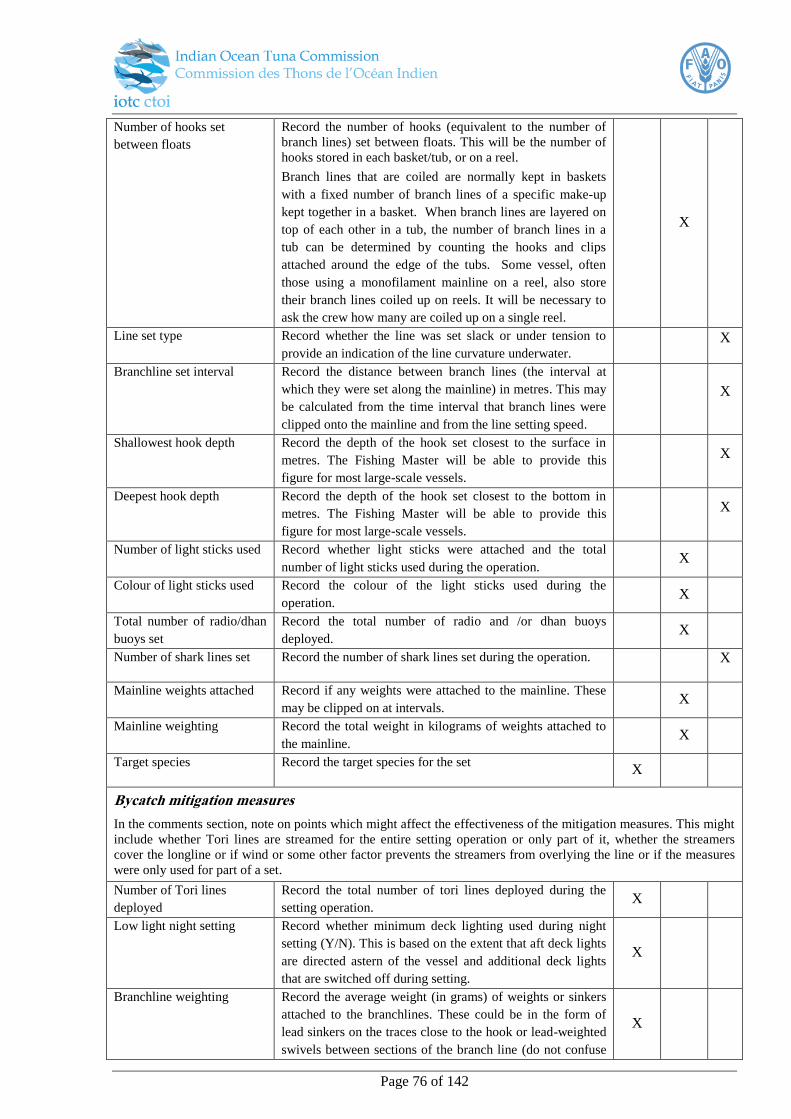
Page 76 of 142
Number of hooks set
between floats
Record the number of hooks (equivalent to the number of
branch lines) set between floats. This will be the number of
hooks stored in each basket/tub, or on a reel.
Branch lines that are coiled are normally kept in baskets
with a fixed number of branch lines of a specific make-up
kept together in a basket. When branch lines are layered on
top of each other in a tub, the number of branch lines in a
tub can be determined by counting the hooks and clips
attached around the edge of the tubs. Some vessel, often
those using a monofilament mainline on a reel, also store
their branch lines coiled up on reels. It will be necessary to
ask the crew how many are coiled up on a single reel.
X
Line set type Record whether the line was set slack or under tension to
provide an indication of the line curvature underwater.
X
Branchline set interval Record the distance between branch lines (the interval at
which they were set along the mainline) in metres. This may
be calculated from the time interval that branch lines were
clipped onto the mainline and from the line setting speed.
X
Shallowest hook depth Record the depth of the hook set closest to the surface in
metres. The Fishing Master will be able to provide this
figure for most large-scale vessels.
X
Deepest hook depth Record the depth of the hook set closest to the bottom in
metres. The Fishing Master will be able to provide this
figure for most large-scale vessels.
X
Number of light sticks used Record whether light sticks were attached and the total
number of light sticks used during the operation. X
Colour of light sticks used Record the colour of the light sticks used during the
operation. X
Total number of radio/dhan
buoys set
Record the total number of radio and /or dhan buoys
deployed. X
Number of shark lines set Record the number of shark lines set during the operation.
X
Mainline weights attached Record if any weights were attached to the mainline. These
may be clipped on at intervals. X
Mainline weighting Record the total weight in kilograms of weights attached to
the mainline. X
Target species Record the target species for the set X
Bycatch mitigation measures
In the comments section, note on points which might affect the effectiveness of the mitigation measures. This might
include whether Tori lines are streamed for the entire setting operation or only part of it, whether the streamers
cover the longline or if wind or some other factor prevents the streamers from overlying the line or if the measures
were only used for part of a set.
Number of Tori lines
deployed
Record the total number of tori lines deployed during the
setting operation. X
Low light night setting Record whether minimum deck lighting used during night
setting (Y/N). This is based on the extent that aft deck lights
are directed astern of the vessel and additional deck lights
that are switched off during setting.
X
Branchline weighting Record the average weight (in grams) of weights or sinkers
attached to the branchlines. These could be in the form of
lead sinkers on the traces close to the hook or lead-weighted
swivels between sections of the branch line (do not confuse
X
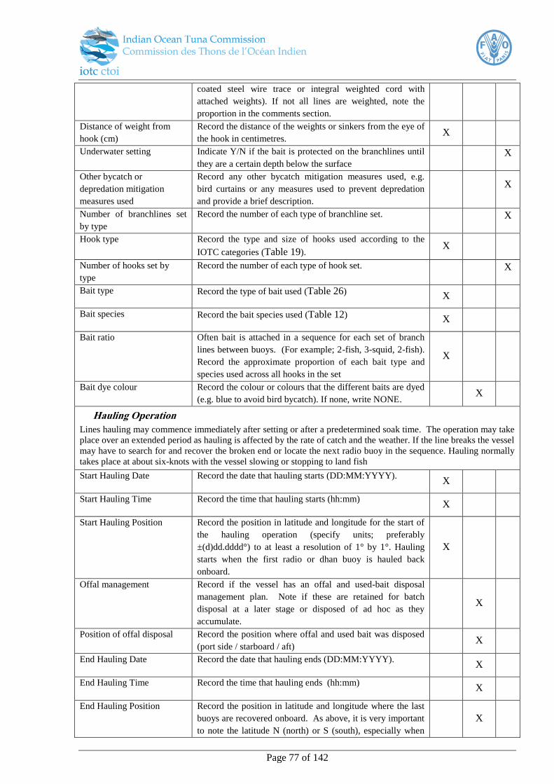
Page 77 of 142
coated steel wire trace or integral weighted cord with
attached weights). If not all lines are weighted, note the
proportion in the comments section.
Distance of weight from
hook (cm)
Record the distance of the weights or sinkers from the eye of
the hook in centimetres. X
Underwater setting Indicate Y/N if the bait is protected on the branchlines until
they are a certain depth below the surface
X
Other bycatch or
depredation mitigation
measures used
Record any other bycatch mitigation measures used, e.g.
bird curtains or any measures used to prevent depredation
and provide a brief description.
X
Number of branchlines set
by type
Record the number of each type of branchline set. X
Hook type Record the type and size of hooks used according to the
IOTC categories (Table 19). X
Number of hooks set by
type
Record the number of each type of hook set. X
Bait type Record the type of bait used (Table 26) X
Bait species Record the bait species used (Table 12) X
Bait ratio Often bait is attached in a sequence for each set of branch
lines between buoys. (For example; 2-fish, 3-squid, 2-fish).
Record the approximate proportion of each bait type and
species used across all hooks in the set
X
Bait dye colour Record the colour or colours that the different baits are dyed
(e.g. blue to avoid bird bycatch). If none, write NONE. X
Hauling Operation
Lines hauling may commence immediately after setting or after a predetermined soak time. The operation may take
place over an extended period as hauling is affected by the rate of catch and the weather. If the line breaks the vessel
may have to search for and recover the broken end or locate the next radio buoy in the sequence. Hauling normally
takes place at about six-knots with the vessel slowing or stopping to land fish
Start Hauling Date Record the date that hauling starts (DD:MM:YYYY). X
Start Hauling Time Record the time that hauling starts (hh:mm) X
Start Hauling Position Record the position in latitude and longitude for the start of
the hauling operation (specify units; preferably
±(d)dd.dddd°) to at least a resolution of 1° by 1°. Hauling
starts when the first radio or dhan buoy is hauled back
onboard.
X
Offal management Record if the vessel has an offal and used-bait disposal
management plan. Note if these are retained for batch
disposal at a later stage or disposed of ad hoc as they
accumulate.
X
Position of offal disposal Record the position where offal and used bait was disposed
(port side / starboard / aft) X
End Hauling Date Record the date that hauling ends (DD:MM:YYYY). X
End Hauling Time Record the time that hauling ends (hh:mm) X
End Hauling Position Record the position in latitude and longitude where the last
buoys are recovered onboard. As above, it is very important
to note the latitude N (north) or S (south), especially when
X
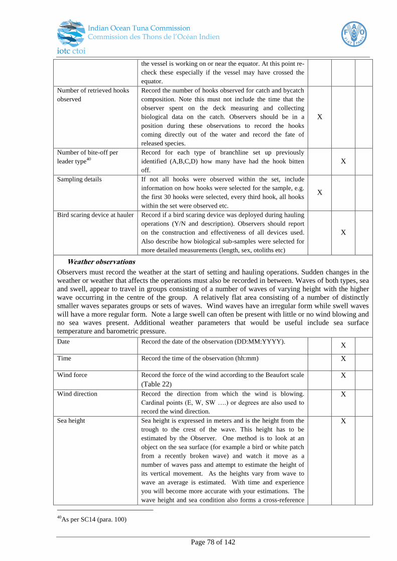
Page 78 of 142
the vessel is working on or near the equator. At this point re-
check these especially if the vessel may have crossed the
equator.
Number of retrieved hooks
observed
Record the number of hooks observed for catch and bycatch
composition. Note this must not include the time that the
observer spent on the deck measuring and collecting
biological data on the catch. Observers should be in a
position during these observations to record the hooks
coming directly out of the water and record the fate of
released species.
X
Number of bite-off per
leader type40
Record for each type of branchline set up previously
identified (A,B,C,D) how many have had the hook bitten
off.
X
Sampling details If not all hooks were observed within the set, include
information on how hooks were selected for the sample, e.g.
the first 30 hooks were selected, every third hook, all hooks
within the set were observed etc.
X
Bird scaring device at hauler Record if a bird scaring device was deployed during hauling
operations (Y/N and description). Observers should report
on the construction and effectiveness of all devices used.
Also describe how biological sub-samples were selected for
more detailed measurements (length, sex, otoliths etc)
X
Weather observations
Observers must record the weather at the start of setting and hauling operations. Sudden changes in the
weather or weather that affects the operations must also be recorded in between. Waves of both types, sea
and swell, appear to travel in groups consisting of a number of waves of varying height with the higher
wave occurring in the centre of the group. A relatively flat area consisting of a number of distinctly
smaller waves separates groups or sets of waves. Wind waves have an irregular form while swell waves
will have a more regular form. Note a large swell can often be present with little or no wind blowing and
no sea waves present. Additional weather parameters that would be useful include sea surface
temperature and barometric pressure.
Date Record the date of the observation (DD:MM:YYYY). X
Time Record the time of the observation (hh:mm) X
Wind force Record the force of the wind according to the Beaufort scale
(Table 22)
X
Wind direction Record the direction from which the wind is blowing.
Cardinal points (E, W, SW ….) or degrees are also used to
record the wind direction.
X
Sea height Sea height is expressed in meters and is the height from the
trough to the crest of the wave. This height has to be
estimated by the Observer. One method is to look at an
object on the sea surface (for example a bird or white patch
from a recently broken wave) and watch it move as a
number of waves pass and attempt to estimate the height of
its vertical movement. As the heights vary from wave to
wave an average is estimated. With time and experience
you will become more accurate with your estimations. The
wave height and sea condition also forms a cross-reference
X
40
As per SC14 (para. 100)

Page 79 of 142
to estimating wind strength.
Sea direction The sea direction is expressed as the direction from which
the sea is coming. Cardinal points (E, W, SW ….) or degrees
are also used to record the direction of the sea. Sea waves
are generated locally by the prevailing wind and move in the
same direction as the surface wind.
X
Swell height Swell direction and height is estimated in the same way as
determining sea height and direction. However a swell will
never break or have a “white cap” and has no relation to the
prevailing wind.
X
Swell direction Swell waves have been generated elsewhere and have
travelled out of the area where they were generated and have
no relation to the prevailing wind direction. In many cases
the swell direction will be different from that of the
prevailing sea. If two wave forms are observed and their
movement is in the direction of the surface wind, the system,
which has the longer distance between crests and a more
regular form, is considered to be the swell.
X
Tag details
Specimen ID Note the specimen ID number to link this individual to the
catch information. X
Tag release Indicate Y/N whether this individual was re-released with a
tag attached X
Tag recovery Indicated Y/N whether a tag was recovered from this
individual X
Tag number Provide the tag number X
Tag type Record the type of tag used (Table 37) X
Tag finder Record the name and contact details of the person who
recovered the tag X
Catch details
The observer must record the catch hauled for every hook observed, line-by-line. All catch information must be
recorded with the corresponding IOTC trip number and operation number so that it can be linked to the effort
information collected. While it is not mandatory to report both weight pre and post-processing where it occurs, one
form of weight measurement must be recorded. Note that with tagged specimens, full details must be provided for
all data fields as far as possible.
Specimen ID This is a unique numeric ID which increases sequentially to
identify an individual. X
Species code If a species cannot be positively identified or a FAO code is
not available (Table 5 - Table 11), the observer should
record the species name or the common name known. If the
observer cannot identify the species it must recorded as
unknown “UNK” and given a reference number in the
‘Comments’ column. The same reference number should be
used throughout the trip for that species. Where possible the
observer should retain a sample and / or take a photograph
of the unidentified organism. This is especially important
when organisms are cut off in the water.
The observer trip report must provide a description and
accompanying photographs of each of the unidentified
organisms in the “Comments” column.
X

Page 80 of 142
Fate For each specimen record an IOTC fate code which includes
whether it was retained or discarded and the reason, e.g.
“Discarded – too small” (Table 35).
X
Weight 1 (pre-processing) Record the weight in kilograms of the unprocessed, round,
whole, live weight of the specimen. X
Weight code 2 (post
processing)
Record the product code for each species according to the
IOTC processing codes (Table 30). X
Weight 2 (post-processing) Record the raw weight measurement in kilograms (kg)
corresponding to the specified product type X
Scar Record the type of scar present on the specimen based on the
IOTC categories. This might be no scar, an unknown scar, a
tag scar, cookie-cutter shark, shark/killer whale or some
other identifiable scar type which can be specified (Table
32).
X
Depredation If the predator was observed and identified, record the
species code. If no depredation was directly observed,
indicate "Not observed". Note that species observed in the
area may not necessary be associated with depredation
unless directly observed. Take note of any associated
evidence of depredation such as oil slicks and feeding birds
that may associate marine mammals with depredation.
Similarly for shark and squid damage the species may be
difficult to determine.
X
Predator ID reliability
Note the likely accuracy and reliability of the species
identified as associated with depredation (good/fair/poor) X
Hooking location Record the geographical coordinates of the point at which
the catch was hauled or the bycatch interaction took place (1
by 1 degrees)
X
Hook type (for bycatch) For bycatch species, record the type of hook the individual
was hauled on, where possible (Table 19)
X
Bait (for bycatch) For bycatch species, record the bait for the hook the
individual was hauled on, where possible (Table 12) X
Leader type (for bycatch) For bycatch species, record the leader type the individual
was hauled, where possible (Table 18)
X
Comments Include any comments such as possible reasons for
incidental capture. Note whether this was accidental due to
the animal’s presence in the area or as a result of the animal
actively interacting with the catch or fishing gear.
X
De-hooker/line cutter (for
bycatch)
Record if a particular de-hooking or line cutting device was
used to extract the hook from the bycatch X
Photo ID (usually for
bycatch)
Note the photo code so that it can be linked back to the
specimen for onshore examination. X
Condition (for discards) Record the condition of the individual at the time of release
(according to the categories for condition, e.g. alive –
injured, distressed)
X
Release details (for
discards)
Provide details such as whether the release took place before
or after landing, and with or without resuscitation.
X
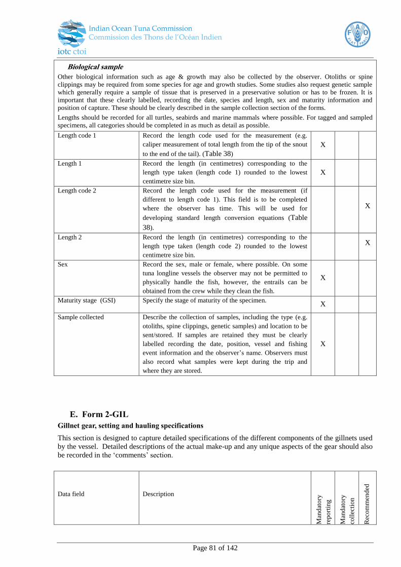
Page 81 of 142
Biological sample
Other biological information such as age & growth may also be collected by the observer. Otoliths or spine
clippings may be required from some species for age and growth studies. Some studies also request genetic sample
which generally require a sample of tissue that is preserved in a preservative solution or has to be frozen. It is
important that these clearly labelled, recording the date, species and length, sex and maturity information and
position of capture. These should be clearly described in the sample collection section of the forms.
Lengths should be recorded for all turtles, seabirds and marine mammals where possible. For tagged and sampled
specimens, all categories should be completed in as much as detail as possible.
Length code 1 Record the length code used for the measurement (e.g.
caliper measurement of total length from the tip of the snout
to the end of the tail). (Table 38)
X
Length 1 Record the length (in centimetres) corresponding to the
length type taken (length code 1) rounded to the lowest
centimetre size bin.
X
Length code 2 Record the length code used for the measurement (if
different to length code 1). This field is to be completed
where the observer has time. This will be used for
developing standard length conversion equations (Table
38).
X
Length 2 Record the length (in centimetres) corresponding to the
length type taken (length code 2) rounded to the lowest
centimetre size bin.
X
Sex Record the sex, male or female, where possible. On some
tuna longline vessels the observer may not be permitted to
physically handle the fish, however, the entrails can be
obtained from the crew while they clean the fish.
X
Maturity stage (GSI) Specify the stage of maturity of the specimen. X
Sample collected Describe the collection of samples, including the type (e.g.
otoliths, spine clippings, genetic samples) and location to be
sent/stored. If samples are retained they must be clearly
labelled recording the date, position, vessel and fishing
event information and the observer’s name. Observers must
also record what samples were kept during the trip and
where they are stored.
X
E. Form 2-GIL
Gillnet gear, setting and hauling specifications
This section is designed to capture detailed specifications of the different components of the gillnets used
by the vessel. Detailed descriptions of the actual make-up and any unique aspects of the gear should also
be recorded in the ‘comments’ section.
Data field Description
Man
dat
ory
rep
ort
ing
Man
dat
ory
coll
ecti
on
Rec
om
men
ded

Page 82 of 142
Data field Description
Man
dat
ory
rep
ort
ing
Man
dat
ory
coll
ecti
on
Rec
om
men
ded
Gillnet details
Total number of nets
onboard
Record the number of nets which are held onboard the
vessel X
Net drum/hauler Record if a net hauler is present or absent. A net drum may
also be used that both hauls and on which the net is stored. X
Document the make and model of the net hauler X
Float type Record the type of buoyancy aid that is attached to the net
(e.g. polystyrene/ plastic) X
Sinker type Record the type of weight attached to sink net (e.g. lead or
cement) X
Individual sinker weight Record the average weight of each sinker in grams. X
Net specifications
More than one net may be held onboard the vessel. Record the details below for each net stored onboard (in the
appropriate column). Any other important information relevant to the gear used should be recorded in the comments
section. Information such as lost gear or if the vessel has skeins of net in storage and makes up additional nets
during a voyage to replace lost or damaged nets which should also be recorded.
Total number of net panels Record the number of panels making up the net. X
Net material Record the material the net is made of (multifilament or
monofilament) X
Net length Several panels can be connected to make up a total length of
a net. The total length of a net can be calculated by the
panel length (in metres) multiplied by number of panels used
in the net.
X
Net depth Record the total depth or height of the net (in metres) X
Stretched mesh size(s) (mm) Record the stretched length, knot to knot of the mesh in mm.
Observers should measure at least 10 mesh lengths from the
main body of the net and record the average and range.
Note different nets may have different mesh sizes. Provide
the range if different mesh sizes are used within a single net.
X
Total number of nets Record the total number of nets onboard the vessel X
F. Form 4-GIL
This form is designed to capture all the information required for every set/operation of gillnets.
Any additional information worth noting concerning the summary of the fishing operations should be
captured in the comments section. This might include notes on the set up and deployment of gear,
methods to attract fish, or interactions with other gear types, e.g. deployment in conjunction with longline
gear.
Data field Description
Man
dat
ory
rep
ort
ing
Man
dat
ory
coll
ecti
on
Rec
om
men
ded
Page 83 of 142
Data field Description
Man
dat
ory
rep
ort
ing
Man
dat
ory
coll
ecti
on
Rec
om
men
ded
Setting operation
Set number For each net set a unique number is allocated. Set numbers
should be consecutive from the start of the first net set to the
last net set of the observed trip. This should be a four digit
numerical code beginning 0001.
X
Set start date Record the date at the start of net setting (YYYY-MM-DD).
Note that vessels often set nets at dusk. X
Set start time Record the start time of the setting operation (hh:mm). This
is the time that a net panel first enters the water. X
Set start location Record the position in latitude and longitude for the start of
the setting operation (specify units; preferably ±(d)dd.dddd°)
to at least a resolution of 1° by 1°.
X
Setting speed Record the speed of the vessel during setting (in knots). X
Set end date Record the date at the end of net setting (YYYY-MM-DD). X
Set end time Record the end time of the setting operation (hh:mm). This
is the time that the last net panel has entered the water. X
Set end location Record the position in latitude and longitude for the end of
the setting operation to at least a resolution of 1° by 1°
(specify units; preferably ±(d)dd.dddd°).
X
Net type Record which net type is used (based on the specifications
detailed by the observer in form 2-GIL) X
Set type Record how the net is set, e.g. if it is anchored (attached to
the boat), left drifting or actively used to encircle the target
school (Table 27).
X
Vertical set Record the level the net is set at vertically in the water
column (Table 23) X
Hanging ratio The ratio between the length of the float line and the length
of the stretched mesh hanging on the float line (Fig. 23). X
Net configuration Record the spatial configuration in which the net was set
(Table 24) X
Number of weights used Record the total number of weights that are used to hang the
net during this setting operation X
Number of floats used Record the total number of floats used to support the net
during setting X
Hauling operation
Haul start date Record the date at the start of net hauling (YYYY-MM-
DD). Note that vessels often haul nets in the early morning
after a night soak period.
X
Haul start time Record the start time of the hauling operation (hh:mm).
This is the time that a net panel first leaves the water. X
Haul start location Record the position in latitude and longitude for the start of
the hauling operation to at least a resolution of 1° by 1°
(specify units; preferably ±(d)dd.dddd°).
X
Haul end date Record the date at the end of net hauling (YYYY-MM-DD). X
Haul end time Record the end time of the hauling operation (hh:mm). This X
Page 84 of 142
Data field Description
Man
dat
ory
rep
ort
ing
Man
dat
ory
coll
ecti
on
Rec
om
men
ded
is the time that the last net panel leaves the water.
Haul end location Record the position in latitude and longitude for the end of
the hauling operation (specify units; preferably
±(d)dd.dddd°) to at least a resolution of 1° by 1°.
X
Number of net panels
retrieved
The total number of net panels retrieved at haul X
Number of net panels
observed
The total number of hauled net panels that are observed X
Sampling details Indicate whether the entire haul was observed, or if a sample
was taken. Describe the process (e.g. random/stratified
sample of panels observed). Describe if subsampling took
place for collecting the different levels of biological
information (e.g. otoliths, length measurements)
X
Weather observations
Observers must record the weather at the start of setting and hauling operations. Sudden changes in the
weather or weather that affects the operations must also be recorded in between. Waves of both types, sea
and swell, appear to travel in groups consisting of a number of waves of varying height with the higher
wave occurring in the centre of the group. A relatively flat area consisting of a number of distinctly
smaller waves separates groups or sets of waves. Wind waves have an irregular form while swell waves
will have a more regular form. Note a large swell can often be present with little or no wind blowing and
no sea waves present. Additional weather parameters that would be useful include sea surface
temperature and barometric pressure.
Date Record the date of the observation (DD:MM:YYYY). X
Time Record the time of the observation (hh:mm)
X
Wind force Record the force of the wind according to the Beaufort scale
(Table 22)
X
Wind direction Record the direction from which the wind is blowing.
Cardinal points (E, W, SW ….) or degrees are also used to
record the wind direction.
X
Sea height Sea height is expressed in meters and is the height from the
trough to the crest of the wave. This height has to be
estimated by the Observer. One method is to look at an
object on the sea surface (for example a bird or white patch
from a recently broken wave) and watch it move as a
number of waves pass and attempt to estimate the height of
its vertical movement. As the heights vary from wave to
wave an average is estimated. With time and experience
you will become more accurate with your estimations. The
wave height and sea condition also forms a cross-reference
to estimating wind strength.
X
Sea direction The sea direction is expressed as the direction from which
the sea is coming. Cardinal points (E, W, SW ….) or degrees
are also used to record the direction of the sea. Sea waves
X
Page 85 of 142
are generated locally by the prevailing wind and move in the
same direction as the surface wind.
Swell height Swell direction and height is estimated in the same way as
determining sea height and direction. However a swell will
never break or have a “white cap” and has no relation to the
prevailing wind.
X
Swell direction Swell waves have been generated elsewhere and have
travelled out of the area where they were generated and have
no relation to the prevailing wind direction. In many cases
the swell direction will be different from that of the
prevailing sea. If two wave forms are observed and their
movement is in the direction of the surface wind, the system,
which has the longer distance between crests and a more
regular form, is considered to be the swell.
X
Tag details
Specimen ID Note the specimen ID number to link this individual to the
catch information. X
Tag release Indicate Y/N whether this individual was re-released with a
tag attached X
Tag recovery Indicated Y/N whether a tag was recovered from this
individual X
Tag number Provide the tag number X
Tag type Record the type of tag used (Table 37) X
Tag finder Record the name and contact details of the person who
recovered the tag X
Catch details
The observer must record the catch disentangled from the net for every panel observed, fish-by-fish where possible.
If this is not possible in certain circumstances, such as with a particularly high catch rate, then a combined catch
weight by species can instead be given. If so, this should be noted in the ‘specimen ID’ data field. All catch
information must be recorded with the corresponding IOTC trip number and operation number so that it can be
linked to the effort information collected. While it is not mandatory to report both weight pre and post-processing
where it occurs, one form of weight measurement must be recorded. Note that with tagged specimens, full details
must be provided for all data fields as far as possible.
Specimen ID This is a unique numeric ID which increases sequentially to
identify an individual. X
Species If a species cannot be positively identified or a FAO code is
not available (Table 5 - Table 11), the observer should
record the species name or the common name known. If the
observer cannot identify the species it must recorded as
unknown “UNK” and given a reference number in the
‘Comments’ column. The same reference number should be
used throughout the trip for that species. Where possible the
observer should retain a sample and / or take a photograph
of the unidentified organism. This is especially important
when organisms are cut off in the water.
The observer trip report must provide a description and
accompanying photographs of each of the unidentified
organisms in the “Comments” column.
X
Page 86 of 142
Fate For each specimen record an IOTC fate code which includes
whether it was retained or discarded and the reason, e.g.
“Discarded – too small” (Table 35).
X
Weight code Record the product code for each species according to the
IOTC processing codes (Table 30). X
Weight Record the raw weight measurement in kilograms (kg)
corresponding to the specified product type X
Net material Where possible, the material of the panel in which the
individual is caught should be specified (Table 17)
X
Mesh size Where possible, the size of mesh (mm) of the panel in which
the individual is gilled/entangled should be specified (Fig.
22).
X
Method of capture Where possible, the way in which the individual interacted
with the gillnet should be specified (e.g. whether it was
gilled or entangled).
X
Scar Record the type of scar present on the specimen based on the
IOTC categories (Table 32). This might be no scar, an
unknown scar, a tag scar, cookie-cutter shark, shark/killer
whale or some other identifiable scar type which can be
specified.
X
Depredation If the predator was observed and identified, record the
species code. If no depredation was directly observed,
indicate "Not observed". Note that species observed in the
area may not necessary be associated with depredation
unless directly observed. Take note of any associated
evidence of depredation such as oil slicks and feeding birds
that may associate marine mammals with depredation.
Similarly for shark and squid damage the species may be
difficult to determine.
X
Predator ID reliability
Note the likely accuracy and reliability of the species
identified as associated with depredation (good/fair/poor)
X
Comments Include any comments such as possible reasons for
incidental capture. Note whether this was accidental due to
the animal’s presence in the area or as a result of the animal
actively interacting with the catch or fishing gear.
X
Photo ID (usually for
discards)
Note the photo code so that it can be linked back to the
specimen for onshore examination. X
Condition (for discards) Record the condition of the individual at the time of release
(according to the categories for condition, e.g. alive –
injured, distressed)
X
Release details (for
discards)
Provide details such as whether the release took place before
or after landing, and with or without resuscitation. X

Page 87 of 142
Biological sample
Other biological information such as age & growth may also be collected by the observer. Otoliths or spine
clippings may be required from some species for age and growth studies. Some studies also request genetic sample
which generally require a sample of tissue that is preserved in a preservative solution or has to be frozen. It is
important that these clearly labelled, recording the date, species and length, sex and maturity information and
position of capture. These should be clearly described in the sample collection section of the forms.
Lengths should be recorded for all turtles, seabirds and marine mammals where possible. For tagged and sampled
specimens, all categories should be completed in as much as detail as possible.
Length code 1 Record the length code used for the measurement (e.g.
caliper measurement of total length from the tip of the snout
to the end of the tail).
X
Length 1 Record the length (in centimetres) corresponding to the
length type taken (length code 1) rounded to the lowest
centimetre size bin.
X
Length code 2 Record the length code used for the measurement (different
to length code 1). This field is to be completed where the
observer has time. This will be used for developing standard
length conversion equations.
X
Length 2 Record the length (in centimetres) corresponding to the
length type taken (length code 2) rounded to the lowest
centimetre size bin.
X
Sex Record the sex, male or female, where possible. On some
tuna longline vessels the observer may not be permitted to
physically handle the fish, however, the entrails can be
obtained from the crew while they clean the fish.
X
Maturity stage (GSI) Specify the stage of maturity of the specimen. X
Sample collected Describe the collection of samples, including the type (e.g.
otoliths, spine clippings, genetic samples) and location to be
sent/stored. If samples are retained they must be clearly
labelled recording the date, position, vessel and fishing
event information and the observer’s name. Observers must
also record what samples were kept during the trip and
where they are stored.
X
G. Form 2-PS
This form is designed to capture detailed specifications of the different components of the purse seine
gear used by the vessel. Detailed descriptions of the actual make-up and any unique aspects of the gear
should also be recorded in the ‘comments’ section. Any additional information worth noting concerning
the gear such as loss of sections of net or the presence of an escape panel) should also be recorded here.
Data field Description
Man
dat
ory
rep
ort
ing
Man
dat
ory
coll
ecti
on
Rec
om
men
ded
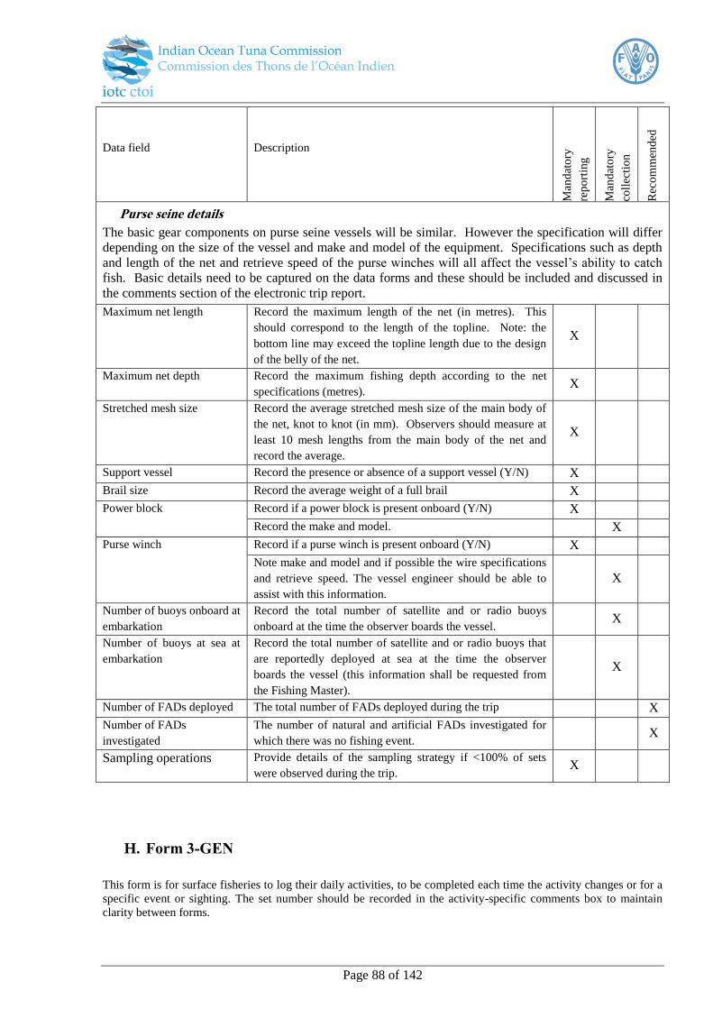
Page 88 of 142
Data field Description
Man
dat
ory
rep
ort
ing
Man
dat
ory
coll
ecti
on
Rec
om
men
ded
Purse seine details
The basic gear components on purse seine vessels will be similar. However the specification will differ
depending on the size of the vessel and make and model of the equipment. Specifications such as depth
and length of the net and retrieve speed of the purse winches will all affect the vessel’s ability to catch
fish. Basic details need to be captured on the data forms and these should be included and discussed in
the comments section of the electronic trip report.
Maximum net length Record the maximum length of the net (in metres). This
should correspond to the length of the topline. Note: the
bottom line may exceed the topline length due to the design
of the belly of the net.
X
Maximum net depth Record the maximum fishing depth according to the net
specifications (metres). X
Stretched mesh size Record the average stretched mesh size of the main body of
the net, knot to knot (in mm). Observers should measure at
least 10 mesh lengths from the main body of the net and
record the average.
X
Support vessel Record the presence or absence of a support vessel (Y/N) X
Brail size Record the average weight of a full brail X
Power block Record if a power block is present onboard (Y/N) X
Record the make and model. X
Purse winch Record if a purse winch is present onboard (Y/N) X
Note make and model and if possible the wire specifications
and retrieve speed. The vessel engineer should be able to
assist with this information.
X
Number of buoys onboard at
embarkation
Record the total number of satellite and or radio buoys
onboard at the time the observer boards the vessel. X
Number of buoys at sea at
embarkation
Record the total number of satellite and or radio buoys that
are reportedly deployed at sea at the time the observer
boards the vessel (this information shall be requested from
the Fishing Master).
X
Number of FADs deployed The total number of FADs deployed during the trip X
Number of FADs
investigated
The number of natural and artificial FADs investigated for
which there was no fishing event. X
Sampling operations Provide details of the sampling strategy if <100% of sets
were observed during the trip. X
H. Form 3-GEN
This form is for surface fisheries to log their daily activities, to be completed each time the activity changes or for a
specific event or sighting. The set number should be recorded in the activity-specific comments box to maintain
clarity between forms.

Page 89 of 142
Data field Description
Man
dat
ory
rep
ort
ing
Man
dat
ory
coll
ecti
on
Rec
om
men
ded
Date Record the date at the start of the activity (YYYY-MM-
DD).
X
Time Record the time of the activity starts (hh:mm). X
Position (Latitude /
Longitude)
Record the position latitude and longitude at of the start of
the activity, noting whether the latitude is North or South of
the equator (specify units; preferably ±(d)dd.dddd°).
X
Activity code Record one code for every activity change throughout the
day (Table 20). If it seems that two different codes could be
used, record only the most important one and note the other
in comments column.
X
School association School sightings should be recorded as well as if they were
free or associated to a FAD, natural LOG, animal, feeding
on baitfish or unassociated.
X
School detection Record how the investigated school of object was found
based on the code categories. If more than one method was
used, use code that shows what first made vessel change
course
X
Object Record the FAD or payao or buoy number here X
Object and school sightings Keep note of the number floating or anchored objects and
free schools (including those that were detected and not
fished) observed throughout the day. Try to note if the
objects have fish with them or not. This can be an
approximate but realistic count kept through tally strokes.
X
Comments Record and comment on the day activities, including
exceptional sightings. This would include sightings of
marine mammals and turtles.
X
I. Form 4-PS
This form is designed to capture all the information required for every set/operation for purse seiners. The
comments section should contain any additional information worth noting concerning the summary of the
fishing operations such as unusual set up and deployment of gear, or whether the vessel is working in
conjunction with pole and line vessels.
Data field Description
Man
dat
ory
rep
ort
ing
Man
dat
ory
coll
ecti
on
Rec
om
men
ded
Set/operation number Each time the net is deployed a unique number is allocated
for the setting operation. Set numbers should be consecutive
from the start of the first set to the last set of the observed
trip. This should be a four digit numerical code beginning
0001. The vessel log may follow a different sequence.
X
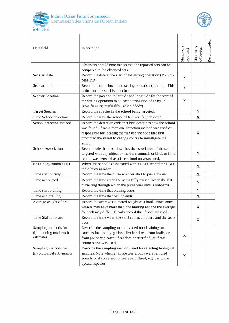
Page 90 of 142
Data field Description
Man
dat
ory
rep
ort
ing
Man
dat
ory
coll
ecti
on
Rec
om
men
ded
Observers should note this so that the reported sets can be
compared to the observed sets.
Set start date Record the date at the start of the setting operation (YYYY-
MM-DD). X
Set start time Record the start time of the setting operation (hh:mm). This
is the time the skiff is launched. X
Set start location Record the position in latitude and longitude for the start of
the setting operation to at least a resolution of 1° by 1°
(specify units; preferably ±(d)dd.dddd°).
X
Target Species Record the species in the school being targeted. X
Time School detection Record the time the school of fish was first detected. X
School detection method Record the detection code that best describes how the school
was found. If more than one detection method was used or
responsible for locating the fish use the code that first
prompted the vessel to change course to investigate the
school.
X
School Association Record code that best describes the association of the school
targeted with any object or marine mammals or birds or if he
school was detected as a free school un-associated.
X
FAD buoy number / ID Where the school is associated with a FAD, record the FAD
radio buoy number. X
Time start pursing Record the time the purse winches start to purse the net. X
Time net pursed Record the time when the net is fully pursed (when the last
purse ring through which the purse wire runs is onboard). X
Time start brailing Record the time that brailing starts. X
Time end brailing Record the time that bailing ends X
Average weight of brail Record the average estimated weight of a brail. Note some
vessels may have more than one brailing net and the average
for each may differ. Clearly record this if both are used.
X
Time Skiff onboard Record the time when the skiff comes on board and the set is
over. X
Sampling methods for
(i) obtaining total catch
estimates
Describe the sampling methods used for obtaining total
catch estimates, e.g. grab/spill/other direct from brails, or
from pre-sorted catch, if random or stratified, or if total
enumeration was used.
X
Sampling methods for
(ii) biological sub-sample
Describe the sampling methods used for selecting biological
samples. Note whether all species groups were sampled
equally or if some groups were prioritised, e.g. particular
bycatch species.
X
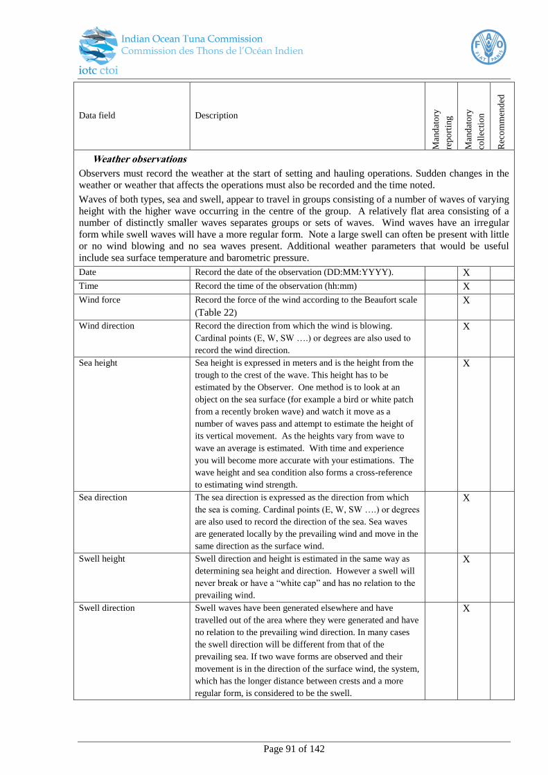
Page 91 of 142
Data field Description
Man
dat
ory
rep
ort
ing
Man
dat
ory
coll
ecti
on
Rec
om
men
ded
Weather observations
Observers must record the weather at the start of setting and hauling operations. Sudden changes in the
weather or weather that affects the operations must also be recorded and the time noted.
Waves of both types, sea and swell, appear to travel in groups consisting of a number of waves of varying
height with the higher wave occurring in the centre of the group. A relatively flat area consisting of a
number of distinctly smaller waves separates groups or sets of waves. Wind waves have an irregular
form while swell waves will have a more regular form. Note a large swell can often be present with little
or no wind blowing and no sea waves present. Additional weather parameters that would be useful
include sea surface temperature and barometric pressure.
Date Record the date of the observation (DD:MM:YYYY). X
Time Record the time of the observation (hh:mm) X
Wind force Record the force of the wind according to the Beaufort scale
(Table 22)
X
Wind direction Record the direction from which the wind is blowing.
Cardinal points (E, W, SW ….) or degrees are also used to
record the wind direction.
X
Sea height Sea height is expressed in meters and is the height from the
trough to the crest of the wave. This height has to be
estimated by the Observer. One method is to look at an
object on the sea surface (for example a bird or white patch
from a recently broken wave) and watch it move as a
number of waves pass and attempt to estimate the height of
its vertical movement. As the heights vary from wave to
wave an average is estimated. With time and experience
you will become more accurate with your estimations. The
wave height and sea condition also forms a cross-reference
to estimating wind strength.
X
Sea direction The sea direction is expressed as the direction from which
the sea is coming. Cardinal points (E, W, SW ….) or degrees
are also used to record the direction of the sea. Sea waves
are generated locally by the prevailing wind and move in the
same direction as the surface wind.
X
Swell height Swell direction and height is estimated in the same way as
determining sea height and direction. However a swell will
never break or have a “white cap” and has no relation to the
prevailing wind.
X
Swell direction Swell waves have been generated elsewhere and have
travelled out of the area where they were generated and have
no relation to the prevailing wind direction. In many cases
the swell direction will be different from that of the
prevailing sea. If two wave forms are observed and their
movement is in the direction of the surface wind, the system,
which has the longer distance between crests and a more
regular form, is considered to be the swell.
X

Page 92 of 142
Data field Description
Man
dat
ory
rep
ort
ing
Man
dat
ory
coll
ecti
on
Rec
om
men
ded
Catch details
Record all catches in this section as well as the methods of sampling and estimation/extrapolation used to get the
total estimates.
Specimen ID This is a unique numeric ID which increases sequentially to
identify an individual. X
Species code Record the species using the IOTC three figure alpha codes.
If a species cannot be positively identified or a FAO code is
not available, the observer should record the species name or
the common name known. If the observer cannot identify
the species it must recorded as unknown “UNK” and given a
reference number in the ‘Comments’ column. The same
reference number should be used throughout the trip for that
species. Where possible the observer should retain a sample
and / or take a photograph of the unidentified organism.
This is especially important when organisms are cut off in
the water.
The observer trip report must provide a description and
accompanying photographs of each of the unidentified
organisms in the “Comments” column.
X
Fate Record an IOTC fate code which includes whether it was
retained or discarded and the reason, e.g. “Discarded – too
small” (Table 35).
X
Number Record the number of individuals of the recorded weight. X
Weight code Record the product code according to the IOTC processing
codes (Table 30).
X
Weight Record the raw weight measurement in kilograms (kg)
corresponding to the specified product type
X
Well Record which well in which this part of the catch was
deposited.
X
Sampling Record the type of sampling undertaken for this row of data.
This might be ‘total enumeration’ where all individuals have
been recorded, ‘sample extrapolated’ where a sample has
been taken and the information recorded in this row has
already been extrapolated. Alternatively it may be
‘unextrapolated sample’ where a sample has been taken but
no raising has yet been applied.
X
Sampling coverage This provides the percentage of the sample taken from the
total catch. For ‘sample extrapolated’ catches, the raising
has already been undertaken based on this percentage,
whereas for ‘unextrapolated sample’ the raising has yet to be
undertaken and will be based on the number provided in this
field. For ‘total enumeration’, this will always be 100%.
X
Condition (for discards) For discards, record the condition of the individual at the
time of release (according to the categories for condition,
e.g. alive – injured, distressed)
X
Release details (for For discards, provide any relevant details, such as whether X
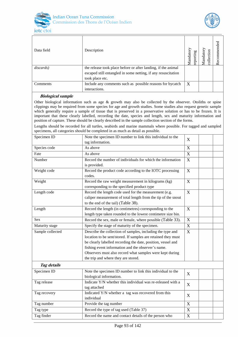
Page 93 of 142
Data field Description
Man
dat
ory
rep
ort
ing
Man
dat
ory
coll
ecti
on
Rec
om
men
ded
discards) the release took place before or after landing, if the animal
escaped still entangled in some netting, if any resuscitation
took place etc.
Comments Include any comments such as possible reasons for bycatch
interactions.
X
Biological sample
Other biological information such as age & growth may also be collected by the observer. Otoliths or spine
clippings may be required from some species for age and growth studies. Some studies also request genetic sample
which generally require a sample of tissue that is preserved in a preservative solution or has to be frozen. It is
important that these clearly labelled, recording the date, species and length, sex and maturity information and
position of capture. These should be clearly described in the sample collection section of the forms.
Lengths should be recorded for all turtles, seabirds and marine mammals where possible. For tagged and sampled
specimens, all categories should be completed in as much as detail as possible.
Specimen ID Note the specimen ID number to link this individual to the
tag information. X
Species code As above X
Fate As above X
Number Record the number of individuals for which the information
is provided.
X
Weight code Record the product code according to the IOTC processing
codes.
X
Weight Record the raw weight measurement in kilograms (kg)
corresponding to the specified product type
X
Length code Record the length code used for the measurement (e.g.
caliper measurement of total length from the tip of the snout
to the end of the tail) (Table 38).
X
Length Record the length (in centimetres) corresponding to the
length type taken rounded to the lowest centimetre size bin.
X
Sex Record the sex, male or female, where possible (Table 33). X
Maturity stage Specify the stage of maturity of the specimen. X
Sample collected Describe the collection of samples, including the type and
location to be sent/stored. If samples are retained they must
be clearly labelled recording the date, position, vessel and
fishing event information and the observer’s name.
Observers must also record what samples were kept during
the trip and where they are stored.
X
Tag details
Specimen ID Note the specimen ID number to link this individual to the
biological information. X
Tag release Indicate Y/N whether this individual was re-released with a
tag attached X
Tag recovery Indicated Y/N whether a tag was recovered from this
individual X
Tag number Provide the tag number X
Tag type Record the type of tag used (Table 37) X
Tag finder Record the name and contact details of the person who X
Page 94 of 142
Data field Description
Man
dat
ory
rep
ort
ing
Man
dat
ory
coll
ecti
on
Rec
om
men
ded
recovered the tag
A. Form 2-PL
This form is designed to capture detailed specifications of the different components of the pole and line
gear used by the vessel. Detailed descriptions of the actual make-up and any unique aspects of the gear,
as well as any gear that is lost during the course of the trip should also be recorded in the ‘comments’
section.
Data field Description
Man
dat
ory
rep
ort
ing
Man
dat
ory
coll
ecti
on
Rec
om
men
ded
Maximum number of
operational poles
(automatic)
The maximum number of automatic poles that can be
operated from the baitboat, considering the size of the boat
and the crew available.
X
Maximum number of
operational poles (manual)
The maximum number of manual poles that can be operated
from the baitboat, considering the size of the boat and the
crew available.
X
Total volume of bait tanks The total volume of the tanks used to keep the live bait, in
cubic metres (m3).
X
Total quantity of bait used
during trip
The total quantity (in kg) or bait used throughout the course
of the entire trip (for all fishing events) X
Total time spent bait fishing The number of hours spent fishing for bait during the course
of the trip X
Number of FADs deployed Record the total number of FADs deployed during the trip X
Number of FADs
investigated
Record the total number of natural and artificial FADs
investigated for which there was no fishing event X
A. Form 4-PL
This form is designed to capture details of each fishing event. Note that a fishing event is defined as poling activity
which is separated from the previous poling activity by a period of at least 10 minutes if the same school is targeted
more than once. Any additional information worth noting concerning the summary of the fishing operation should
be recorded in the comments box. This might include comments on the set up and deployment of gear such as
varying methods of chumming or collaborations with other pole and line or purse seine vessels etc.
Data field Description
Man
dat
ory
rep
ort
ing
Man
dat
ory
coll
ecti
on
Rec
om
men
ded

Page 95 of 142
Fishing event/operation
number
Each time the vessel activates its sprayers, starts chumming
and actively catching fish, record this event with a unique
event number. Event numbers should be consecutive from
the start of the observed trip to the end of the trip. This
should be a four digit numerical code beginning 0001. (If
the vessel does not catch fish then scrap the event number
and record this under daily activity. This will then form part
of the time of the vessel was searching for fish).
X
Fishing operation start date Record the date at the start of the fishing operation (YYYY-
MM-DD). X
Fishing operation start
location
Record the position in latitude and longitude for the start of
the fishing operation to at least a resolution of 1° by 1°
(specify units; preferably ±(d)dd.dddd°).
X
Target Species Record the species in the school being targeted (Table 5). X
Time School detection Record the time the school of fish was first detected. X
School Detection Record the detection code that best describes how the school
was found. If more than one detection method was used or
responsible for locating the fish use the code that first
prompted the vessel to change course to investigate the
school.
X
Association type Record code that best describes the association of the school
targeted with any object or marine mammals or birds or if
the school was detected as a free school un-associated
(Table 28).
X
Time start fishing Record the time of the first activity (spray / chumming /
poling) that starts. This may not coincide exactly with the
time the first fish is caught, however, if no fish are caught
then this will not be recorded as an event and the time will
be recorded as part of the daily activity instead.
X
Time end fishing Record the time when fishing activity stops and the vessel
starts a new activity, i.e. searching or steaming. X
Type of lures used If the vessel uses lures or jiggers in place of bait record the
type and make and hook type. X
Number of manual poles
used
Number of manual poles used during the peak of the activity X
Number of automatic poles
used
Number of automatic poles used during the peak of the
activity X
Bait used Y/N whether any bait was used during the fishing event X
Bait type Indicate whether this is live or chopped up, frozen etc (Table
26) X
Bait species Record the species of bait used (Table 12) X
Weight of bait used Record the total quantity of bait used in the poling operation
(in kg) X
Number of hooks lost Total number of hooks lost during the poling operation X
Number of lines observed Total number of lines monitored by the observer during the
poling operation X

Page 96 of 142
Type of synthetic lure If synthetic lures were used during the operation record the
type X
Hook type Record the code corresponding to the type of hooks used
(Table 19) X
Hook number Record the total number of hooks used in the poling
operation X
Sampling details Indicate whether the entire fishing operation was observed,
or if a sample was taken. Describe the process (e.g. random
sample of lines observed). Describe if subsampling took
place for collecting the different levels of biological
information (e.g. length measurements)
X
Weather observations
Observers must record the weather at the start of setting and hauling operations. Sudden changes in the
weather or weather that affects the operations must also be recorded in between. Waves of both types, sea
and swell, appear to travel in groups consisting of a number of waves of varying height with the higher
wave occurring in the centre of the group. A relatively flat area consisting of a number of distinctly
smaller waves separates groups or sets of waves. Wind waves have an irregular form while swell waves
will have a more regular form. Note a large swell can often be present with little or no wind blowing and
no sea waves present. Additional weather parameters that would be useful include sea surface
temperature and barometric pressure.
Date Record the date of the observation (DD:MM:YYYY). X
Time Record the time of the observation (hh:mm)
X
Wind force Record the force of the wind according to the Beaufort scale
(Table 22)
X
Wind direction Record the direction from which the wind is blowing.
Cardinal points (E, W, SW ….) or degrees are also used to
record the wind direction.
X
Sea height Sea height is expressed in meters and is the height from the
trough to the crest of the wave. This height has to be
estimated by the Observer. One method is to look at an
object on the sea surface (for example a bird or white patch
from a recently broken wave) and watch it move as a
number of waves pass and attempt to estimate the height of
its vertical movement. As the heights vary from wave to
wave an average is estimated. With time and experience
you will become more accurate with your estimations. The
wave height and sea condition also forms a cross-reference
to estimating wind strength.
X
Sea direction The sea direction is expressed as the direction from which
the sea is coming. Cardinal points (E, W, SW ….) or degrees
are also used to record the direction of the sea. Sea waves
are generated locally by the prevailing wind and move in the
same direction as the surface wind.
X
Swell height Swell direction and height is estimated in the same way as
determining sea height and direction. However a swell will
never break or have a “white cap” and has no relation to the
prevailing wind.
X
Swell direction Swell waves have been generated elsewhere and have
travelled out of the area where they were generated and have
no relation to the prevailing wind direction. In many cases
X
Page 97 of 142
the swell direction will be different from that of the
prevailing sea. If two wave forms are observed and their
movement is in the direction of the surface wind, the system,
which has the longer distance between crests and a more
regular form, is considered to be the swell.
Tag details
Specimen ID Note the specimen ID number to link this individual to the
catch information. X
Tag release Indicate Y/N whether this individual was re-released with a
tag attached X
Tag recovery Indicated Y/N whether a tag was recovered from this
individual X
Tag number Provide the tag number X
Tag type Record the type of tag used (Table 37) X
Tag finder Record the name and contact details of the person who
recovered the tag X
Catch details
The observer must record the catch hauled for every hook observed, line-by-line where possible. If this is not
possible in certain circumstances, such as with a particularly high catch rate, then a combined catch weight by
species can instead be given. If so, this should be noted in the ‘specimen ID’ data field. All catch information must
be recorded with the corresponding IOTC trip number and operation number so that it can be linked to the effort
information collected. While it is not mandatory to report both weight pre and post-processing where it occurs, one
form of weight measurement must be recorded. Note that with tagged specimens, full details must be provided for
all data fields as far as possible.
Specimen ID This is a unique numeric ID which increases sequentially to
identify an individual. X
Species code If a species cannot be positively identified or a FAO code is
not available (Table 5 - Table 11), the observer should
record the species name or the common name known. If the
observer cannot identify the species it must recorded as
unknown “UNK” and given a reference number in the
‘Comments’ column. The same reference number should be
used throughout the trip for that species. Where possible the
observer should retain a sample and / or take a photograph
of the unidentified organism. This is especially important
when organisms are cut off in the water.
The observer trip report must provide a description and
accompanying photographs of each of the unidentified
organisms in the “Comments” column.
X
Fate For each specimen record an IOTC fate code which includes
whether it was retained or discarded and the reason, e.g.
“Discarded – too small” (Table 35).
X
Weight 1 (pre-processing) Record the weight in kilograms of the unprocessed, round,
whole, live weight of the specimen. X
Weight code 2 (post
processing)
Record the product code for each species according to the
IOTC processing codes (Table 30). X
Weight 2 (post-processing) Record the raw weight measurement in kilograms (kg)
corresponding to the specified product type X
Scar Record the type of scar present on the specimen based on the
IOTC categories. This might be no scar, an unknown scar, a
tag scar, cookie-cutter shark, shark/killer whale or some
X
Page 98 of 142
other identifiable scar type which can be specified (Table
32).
Hooking location Record the geographical coordinates of the point at which
the catch was hauled or the bycatch interaction took place (1
by 1 degrees)
X
Hook type (for bycatch) For bycatch species, record the type of hook the individual
was hauled on, where possible (Table 19) X
Bait (for bycatch) For bycatch species, record the bait for the hook the
individual was hauled on, where possible (Table 12)
X
Leader type (for bycatch) For bycatch species, record the leader type the individual
was hauled, where possible (Table 18)
X
Comments Include any comments such as possible reasons for
incidental capture. Note whether this was accidental due to
the animal’s presence in the area or as a result of the animal
actively interacting with the catch or fishing gear.
X
De-hooker/line cutter (for
bycatch)
Record if a particular de-hooking or line cutting device was
used to extract the hook from the bycatch X
Photo ID (usually for
bycatch)
Note the photo code so that it can be linked back to the
specimen for onshore examination. X
Condition (for discards) Record the condition of the individual at the time of release
(according to the categories for condition, e.g. alive –
injured, distressed)
X
Release details (for
discards)
Provide details such as whether the release took place before
or after landing, and with or without resuscitation. X
Biological sample
Other biological information such as age & growth may also be collected by the observer. Otoliths or spine
clippings may be required from some species for age and growth studies. Some studies also request genetic sample
which generally require a sample of tissue that is preserved in a preservative solution or has to be frozen. It is
important that these clearly labelled, recording the date, species and length, sex and maturity information and
position of capture. These should be clearly described in the sample collection section of the forms.
Lengths should be recorded for all turtles, seabirds and marine mammals where possible. For tagged and sampled
specimens, all categories should be completed in as much as detail as possible.
Length code 1 Record the length code used for the measurement (e.g.
caliper measurement of total length from the tip of the snout
to the end of the tail). (Table 38)
X
Length 1 Record the length (in centimetres) corresponding to the
length type taken (length code 1) rounded to the lowest
centimetre size bin.
X
Length code 2 Record the length code used for the measurement (if
different to length code 1). This field is to be completed
where the observer has time. This will be used for
developing standard length conversion equations (Table
38).
X
Length 2 Record the length (in centimetres) corresponding to the
length type taken (length code 2) rounded to the lowest
centimetre size bin .
X
Sex Record the sex, male or female, where possible. On some
tuna longline vessels the observer may not be permitted to
physically handle the fish, however, the entrails can be
obtained from the crew while they clean the fish.
X
Maturity stage (GSI) Specify the stage of maturity of the specimen. X
Page 99 of 142
Sample collected Describe the collection of samples, including the type (e.g.
otoliths, spine clippings, genetic samples) and location to be
sent/stored. If samples are retained they must be clearly
labelled recording the date, position, vessel and fishing
event information and the observer’s name. Observers must
also record what samples were kept during the trip and
where they are stored.
X
B. Form 5-GEN
This form is designed to capture information on vessels that are sighted by the observer during the trip.
Data field Description
Man
dat
ory
rep
ort
ing
Man
dat
ory
coll
ecti
on
Rec
om
men
ded
Date Record the date of the sighting X
Time Record the time when first sighting or detecting the vessel. X
Number of vessels If there was more than one vessel sighted, record the total
number of vessels. X
Position Record your position in latitude and longitude. Where
possible also record the actual position of the vessel sighted.
This is possible to determine on some radar and integrated
track plotters. Be clear on the form which position is being
recorded.
X
Relative position
(direction/distance)
Record the distance (range) and compass bearing of the
vessel from your position. X
Vessel details Record the name, flag and call sign of the vessel. Note how
the information was obtained: if the call sign and name were
visible on the vessel and recorded from these observations
and or if communications were established with the vessel
and the details were obtained directly from the vessel
personnel. Record the activity of the vessel when it was
sighted, fishing, steaming, drifting etc. or if this cannot be
determined. Provide a short description of the vessel and
note any outstanding descriptive features that are visible,
radar towers, antenna and vessel colour(s).
X
Photo taken Record if photographs were taken (Y/N). If possible take
photographs of the vessels sighted and attempt to capture
details of the bridge and antenna array, hull showing any
dents or structural features and of fishing gear or equipment
visible.
X
C. Form 6-GEN
This form is designed to capture information on all transhipments that take place during the trip. Most
commonly this will entail transhipping processed catch to a carrier vessel or another fishing vessel. If a
transhipment of fish or fish products takes place to another vessel, (carrier or fishing vessel) or is received
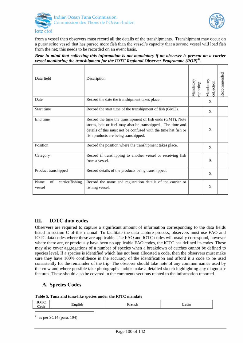
Page 100 of 142
from a vessel then observers must record all the details of the transhipments. Transhipment may occur on
a purse seine vessel that has pursed more fish than the vessel’s capacity that a second vessel will load fish
from the net; this needs to be recorded on an event basis.
Bear in mind that collecting this information is not mandatory if an observer is present on a carrier
vessel monitoring the transhipment for the IOTC Regional Observer Programme (ROP)41
.
Data field Description
Man
dat
ory
rep
ort
ing
Man
dat
ory
coll
ecti
on
Rec
om
men
ded
Date Record the date the transhipment takes place. X
Start time Record the start time of the transhipment of fish (GMT). X
End time Record the time the transhipment of fish ends (GMT). Note
stores, bait or fuel may also be transhipped. The time and
details of this must not be confused with the time hat fish or
fish products are being transhipped.
X
Position Record the position where the transhipment takes place. X
Category Record if transhipping to another vessel or receiving fish
from a vessel.
X
Product transhipped Record details of the products being transhipped. X
Name of carrier/fishing
vessel
Record the name and registration details of the carrier or
fishing vessel.
X
III. IOTC data codes
Observers are required to capture a significant amount of information corresponding to the data fields
listed in section C of this manual. To facilitate the data capture process, observers must use FAO and
IOTC data codes where these are applicable. The FAO and IOTC codes will usually correspond, however
where there are, or previously have been no applicable FAO codes, the IOTC has defined its codes. These
may also cover aggregations of a number of species when a breakdown of catches cannot be defined to
species level. If a species is identified which has not been allocated a code, then the observers must make
sure they have 100% confidence in the accuracy of the identification and afford it a code to be used
consistently for the remainder of the trip. The observer should take note of any common names used by
the crew and where possible take photographs and/or make a detailed sketch highlighting any diagnostic
features. These should also be covered in the comments sections related to the information reported.
A. Species Codes
Table 5. Tuna and tuna-like species under the IOTC mandate
IOTC
Code English French Latin
41
as per SC14 (para. 104)

Page 101 of 142
YFT Yellowfin tuna Albacore Thunnus albacares
BET Bigeye tuna Patudo; Thon obèse Thunnus obesus
SKJ Skipjack tuna Listao Katsuwonus pelamis
ALB Albacore Germon Thunnus alalunga
SBF Southern bluefin tuna Thon rouge du Sud Thunnus maccoyii
SWO Swordfish Espadon Xiphias gladius
BLM Black Marlin Makaire noir Makaira indica
BUM Blue Marlin Makaire bleu Makaira nigricans
MLS Striped marlin Marlin rayé Tetrapturus audax
SFA Indo-Pacific sailfish Voilier indo-pacifique Istiophorus platypterus
LOT Longtail tuna Thon mignon Thunnus tonggol
KAW Kawakawa Thonine orientale Euthynnus affinis
FRI Frigate tuna Auxide Auxis thazard
BLT Bullet tuna Bonitou Auxis rochei
COM Narrow-barred Spanish mackerel Thazard rayé indo-pacifique Scomberomorus commerson
GUT Indo-Pacific king mackerel Thazard ponctué indo-pacifique Scomberomorus guttatus
Table 6. Other bony fish species that may be caught incidentally in IOTC fisheries
IOTC
Code English French Latin
BAU Australian bonito Bonite bagnard Sarda australis
BAR Barracudas Brochets de mer Sphyraena spp
ESCL Black escolar Escolier noir Lepidocybium flavobrunneum
MAA Blue mackerel Maquereau tacheté Scomber australasicus
BUK Butterfly kingfish Thon papillon Gasterochisma melampus
DOL Common dolphinfish Coryphène commune Coryphaena hippurus
DOT Dogtooth tuna Bonite à gros yeux Gymnosarda unicolor
DBM Double-lined mackerel Thazard-kusara Grammatorcynus bilineatus
AMB Greater amberjack Sériole couronnée Seriola dumerili
RAG Indian mackerel Maquereau des Indes Rastrelliger kanagurta
KAK Kanadi kingfish Thazard kanadi Scomberomorus plurilineatus
KOS Korean seerfish Thazard coréen Scomberomorus koreanus
SPF Longbill spearfish Makaire à rostre Tetrapturus pfluegeri
OIL Oilfish Rouvet Ruvettus pretiosus
LAG Opah Opah Lampris guttatus
SAP Pacific saury Saurie Cololabis saira
BRA Pomfrets nei Castagnoles Brama spp
CFW Pompano dolphinfish Dorade Coryphaena equiselis
RRU Rainbow runner Comète saumon Elagatis bipinnulata
SSP Short-billed spearfish Makaire à rostre court Tetrapturus angustirostris
STS Streaked seerfish Thazard cirrus Scomberomorus lineolatus
BIP Striped bonito Bonite orientale Sarda orientalis
WAH Wahoo Thazard bâtard Acanthocybium solandri
MZZ Other bony fishes NEI Autres poissons osseux nca Osteichthyes
Table 7. Species of sharks that are commonly caught in IOTC fisheries
Code English French Latin
ALS Silvertip shark Requin pointe blanche Carcharhinus albimarginatus
ALV Thresher Shark Renard Alopias vulpinus
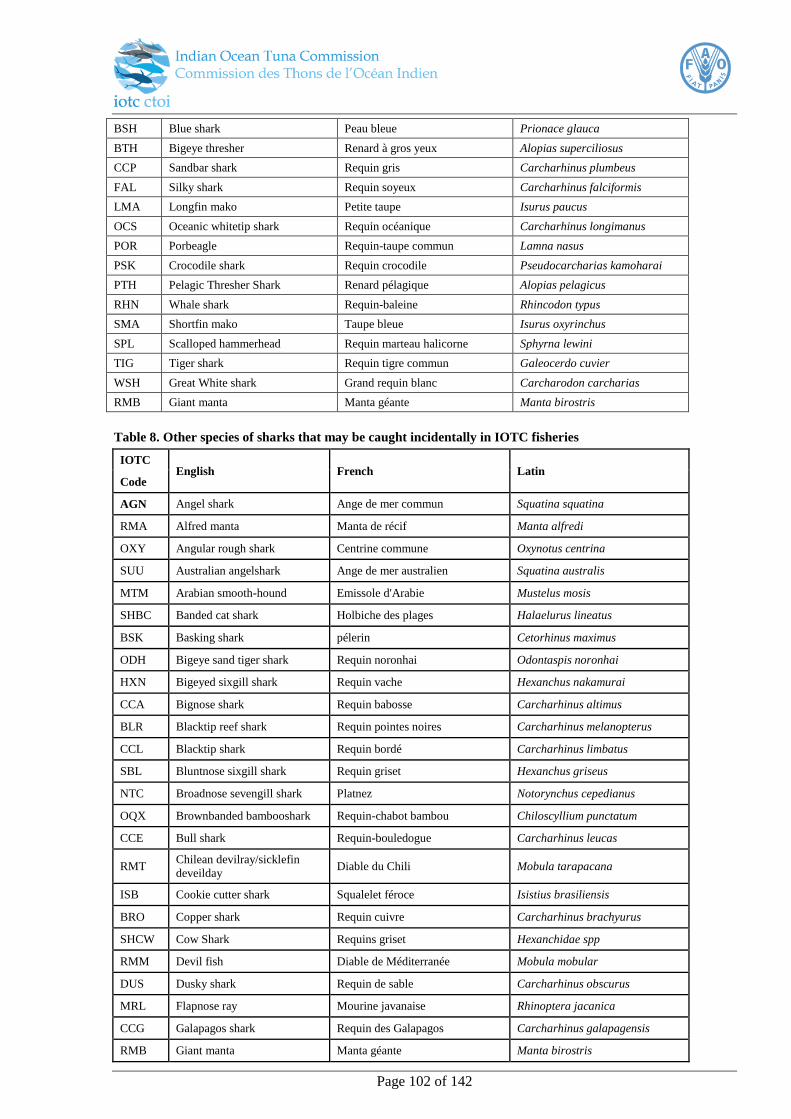
Page 102 of 142
BSH Blue shark Peau bleue Prionace glauca
BTH Bigeye thresher Renard à gros yeux Alopias superciliosus
CCP Sandbar shark Requin gris Carcharhinus plumbeus
FAL Silky shark Requin soyeux Carcharhinus falciformis
LMA Longfin mako Petite taupe Isurus paucus
OCS Oceanic whitetip shark Requin océanique Carcharhinus longimanus
POR Porbeagle Requin-taupe commun Lamna nasus
PSK Crocodile shark Requin crocodile Pseudocarcharias kamoharai
PTH Pelagic Thresher Shark Renard pélagique Alopias pelagicus
RHN Whale shark Requin-baleine Rhincodon typus
SMA Shortfin mako Taupe bleue Isurus oxyrinchus
SPL Scalloped hammerhead Requin marteau halicorne Sphyrna lewini
TIG Tiger shark Requin tigre commun Galeocerdo cuvier
WSH Great White shark Grand requin blanc Carcharodon carcharias
RMB Giant manta Manta géante Manta birostris
Table 8. Other species of sharks that may be caught incidentally in IOTC fisheries
IOTC English French Latin
Code
AGN Angel shark Ange de mer commun Squatina squatina
RMA Alfred manta Manta de récif Manta alfredi
OXY Angular rough shark Centrine commune Oxynotus centrina
SUU Australian angelshark Ange de mer australien Squatina australis
MTM Arabian smooth-hound Emissole d'Arabie Mustelus mosis
SHBC Banded cat shark Holbiche des plages Halaelurus lineatus
BSK Basking shark pélerin Cetorhinus maximus
ODH Bigeye sand tiger shark Requin noronhai Odontaspis noronhai
HXN Bigeyed sixgill shark Requin vache Hexanchus nakamurai
CCA Bignose shark Requin babosse Carcharhinus altimus
BLR Blacktip reef shark Requin pointes noires Carcharhinus melanopterus
CCL Blacktip shark Requin bordé Carcharhinus limbatus
SBL Bluntnose sixgill shark Requin griset Hexanchus griseus
NTC Broadnose sevengill shark Platnez Notorynchus cepedianus
OQX Brownbanded bambooshark Requin-chabot bambou Chiloscyllium punctatum
CCE Bull shark Requin-bouledogue Carcharhinus leucas
RMT Chilean devilray/sicklefin
deveilday Diable du Chili Mobula tarapacana
ISB Cookie cutter shark Squalelet féroce Isistius brasiliensis
BRO Copper shark Requin cuivre Carcharhinus brachyurus
SHCW Cow Shark Requins griset Hexanchidae spp
RMM Devil fish Diable de Méditerranée Mobula mobular
DUS Dusky shark Requin de sable Carcharhinus obscurus
MRL Flapnose ray Mourine javanaise Rhinoptera jacanica
CCG Galapagos shark Requin des Galapagos Carcharhinus galapagensis
RMB Giant manta Manta géante Manta birostris
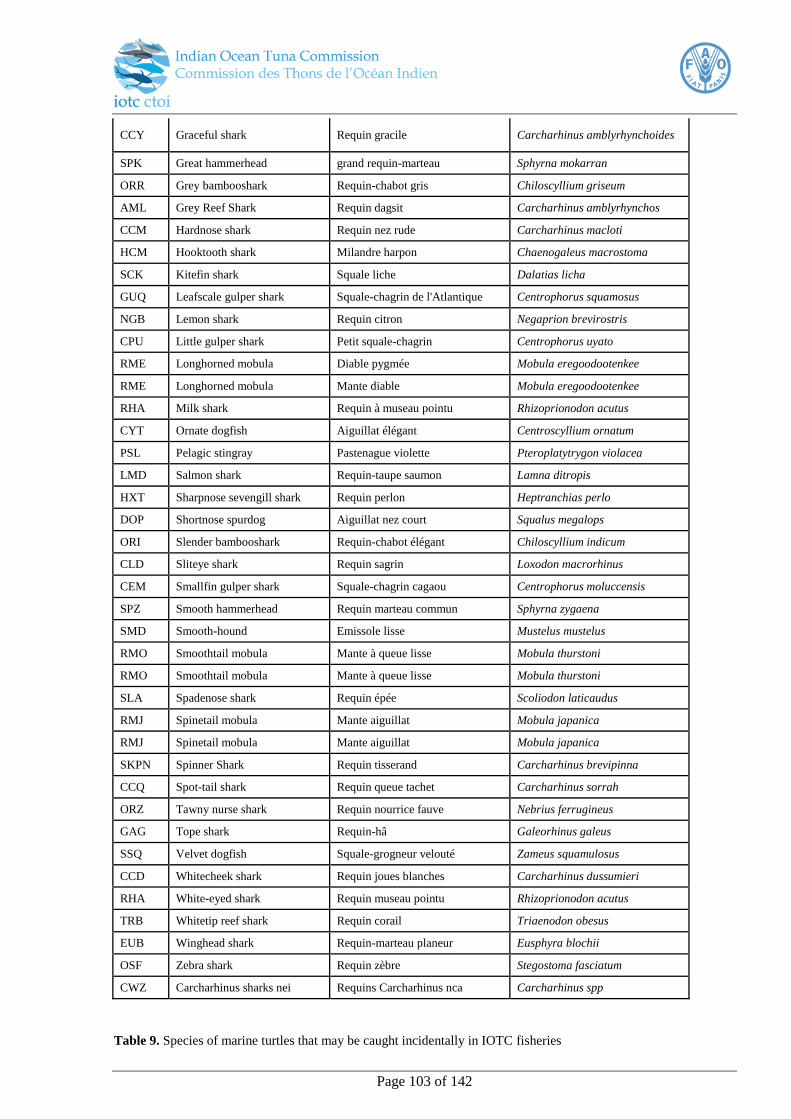
Page 103 of 142
CCY Graceful shark Requin gracile Carcharhinus amblyrhynchoides
SPK Great hammerhead grand requin-marteau Sphyrna mokarran
ORR Grey bambooshark Requin-chabot gris Chiloscyllium griseum
AML Grey Reef Shark Requin dagsit Carcharhinus amblyrhynchos
CCM Hardnose shark Requin nez rude Carcharhinus macloti
HCM Hooktooth shark Milandre harpon Chaenogaleus macrostoma
SCK Kitefin shark Squale liche Dalatias licha
GUQ Leafscale gulper shark Squale-chagrin de l'Atlantique Centrophorus squamosus
NGB Lemon shark Requin citron Negaprion brevirostris
CPU Little gulper shark Petit squale-chagrin Centrophorus uyato
RME Longhorned mobula Diable pygmée Mobula eregoodootenkee
RME Longhorned mobula Mante diable Mobula eregoodootenkee
RHA Milk shark Requin à museau pointu Rhizoprionodon acutus
CYT Ornate dogfish Aiguillat élégant Centroscyllium ornatum
PSL Pelagic stingray Pastenague violette Pteroplatytrygon violacea
LMD Salmon shark Requin-taupe saumon Lamna ditropis
HXT Sharpnose sevengill shark Requin perlon Heptranchias perlo
DOP Shortnose spurdog Aiguillat nez court Squalus megalops
ORI Slender bambooshark Requin-chabot élégant Chiloscyllium indicum
CLD Sliteye shark Requin sagrin Loxodon macrorhinus
CEM Smallfin gulper shark Squale-chagrin cagaou Centrophorus moluccensis
SPZ Smooth hammerhead Requin marteau commun Sphyrna zygaena
SMD Smooth-hound Emissole lisse Mustelus mustelus
RMO Smoothtail mobula Mante à queue lisse Mobula thurstoni
RMO Smoothtail mobula Mante à queue lisse Mobula thurstoni
SLA Spadenose shark Requin épée Scoliodon laticaudus
RMJ Spinetail mobula Mante aiguillat Mobula japanica
RMJ Spinetail mobula Mante aiguillat Mobula japanica
SKPN Spinner Shark Requin tisserand Carcharhinus brevipinna
CCQ Spot-tail shark Requin queue tachet Carcharhinus sorrah
ORZ Tawny nurse shark Requin nourrice fauve Nebrius ferrugineus
GAG Tope shark Requin-hâ Galeorhinus galeus
SSQ Velvet dogfish Squale-grogneur velouté Zameus squamulosus
CCD Whitecheek shark Requin joues blanches Carcharhinus dussumieri
RHA White-eyed shark Requin museau pointu Rhizoprionodon acutus
TRB Whitetip reef shark Requin corail Triaenodon obesus
EUB Winghead shark Requin-marteau planeur Eusphyra blochii
OSF Zebra shark Requin zèbre Stegostoma fasciatum
CWZ Carcharhinus sharks nei Requins Carcharhinus nca Carcharhinus spp
Table 9. Species of marine turtles that may be caught incidentally in IOTC fisheries

Page 104 of 142
IOTC
Code English French Latin
FBT Flatback turtle Tortue plate Natator depressus
TUG Green turtle Tortue verte Chelonia mydas
TTH Hawksbill turtle Tortue caret Eretmochelys imbricata
DKK Leatherback turtle Tortue luth Dermochelys coriacea
TTL Loggerhead turtle Caouane Caretta caretta
LKV Olive ridley turtle Tortue olivâtre Lepidochelys olivacea
Table 10. Species of seabirds that may be caught incidentally by IOTC fisheries
IOTC English French Latin
Code
DAM Amsterdam Albatross Albatros d'Amsterdam Diomedea amsterdamensis
DQS Antipodean Albatross Albatros des Antipodes Diomedea antipodensis
DCR Atlantic Yellow-nosed
Albatross Albatros atlantique à nez jaune Thalassarche chlororhynchos
DIM Black-browed Albatross Albatros à sourcils noirs Thalassarche melanophrys
DIB Buller's Albatross Albatros de Buller Thalassarche bulleri
TQW Campbell Albatross Albatros de l'île Campbell Thalassarche impavida
MWE Cape Gannet Fou du Cap Morus capensis
DAC Cape/Pintado petrel Damier du cap Daption capense
DER Chatham Albatross Albatros des Chatham Thalassarche eremite
PDM Great-winged petrel Pétrel noir Pterodroma macroptera
PCF Flesh-footed shearwater Puffin à pieds pâles Puffinus carneipes
DIC Grey-headed Albatross Albatros à tête grise Thalassarche chrysostoma
TQH Indian Yellow-nosed Albatross Albatros indien à nez jaune Thalassarche carteri
PCI Grey petrel Pétrel gris Procellaria cinerea
PHE Light-mantled Albatross Albatros fuligineux Phoebetria palpebrata
MAH Northern Giant Petrel Pétrel de Hall Macronectes halli
DIQ Northern Royal Albatross Albatros royal du nord Diomedea sanfordi
DKS Salvin's Albatross Albatros de Salvin Thalassarche salvini
PFT Short-tailed Shearwater Puffin à bec grêle Puffinus tenuirostris
DCU Shy Albatross Albatros timide Thalassarche cauta
PHU Sooty Albatross Albatros brun Phoebetria fusca
PFG Sooty Shearwater Puffin fuligineux Puffinus griseus
MAI Southern Giant Petrel Pétrel géant Macronectes giganteus
DIP Southern Royal Albatross Albatros royal Diomedea epomophora
DBN Tristan Albatross Albatros de Tristan Diomedea dabbenena
DIX Wandering Albatross Albatros hurleur Diomedea exulans

Page 105 of 142
PCW Westland Petrel Pétrel de Westland Procellaria westlandica
TWD White-capped Albatross Albatros à cape blanche Thalassarche steadi
PRO White-chinned Petrel Puffin à menton blanc Procellaria aequinoctialis
Table 11. Species of sea mammals that occur within the IOTC Area of Competence
IOTC
Code Species English name Species French name Species scientific name
BDW Andrews' beaked whale Baleine à bec de Bowdoin Mesoplodon bowdoini
BAW Arnoux's beaked whale Berardien d'Arnoux Berardius arnuxii
BBW Blainville's beaked whale Baleine à bec de Blainville Mesoplodon densirostris
BLW Blue whale Rorqual bleu Balaenoptera musculus
DBO Bottlenose dolphin Grand dauphin Tursiops truncatus
BRW Bryde's whale Rorqual de Bryde Balaenoptera edeni
CMD Commerson's dolphin Dauphin de Commerson Cephalorhynchus commersonii
DCO Common dolphin Dauphin commun Delphinus delphis
BCW Cuvier's beaked whale Ziphius Ziphius cavirostris
DDU Dusky dolphin Dauphin sombre Lagenorhynchus obscurus
DWW Dwarf sperm whale Cachalot nain Kogia simus
FAW False killer whale Faux-orque Pseudorca crassidens
FIW Fin whale Rorqual commun Balaenoptera physalus
PFI Finless porpoise Marsouin aptère Neophocaena phocaenoides
FRD Fraser's dolphin Dauphin de Fraser Lagenodelphis hosei
TGW Ginkgo-toothed beaked whale Baleine à bec de Nishiwaki Mesoplodon ginkgodens
BYW Gray's beaked whale Baleine à bec de Gray Mesoplodon grayi
BHW Hector's beaked whale Baleine à bec d'Hector Mesoplodon hectori
HRD Hourglass dolphin Dauphin crucigére Lagenorhynchus cruciger
HUW Humpback whale Baleine à bosse Megaptera novaeangliae
DHI Indo-Pacific hump-backed
dolphin
Dauphin à bosse de
l'Indopacifique
Sousa chinensis
IRD Irrawaddy dolphin Orcelle Orcaella brevirostris
KIW Killer whale Orque Orcinus orca
PIW Long-finned pilot whale Globicéphale commun Globicephala melas
BNW Longman's beaked whale Baleine à bec de Longman Mesoplodon pacificus
MIW Minke whale Petit rorqual Balaenoptera acutorostrata
DPN Pantropical spotted dolphin Dauphin tacheté pantropical Stenella attenuata
KPW Pygmy killer whale Orque pygmée Feresa attenuata
CPM Pygmy right whale Baleine pygmée Caperea marginata
PYW Pygmy sperm whale Cachalot pygmée Kogia breviceps
DRR Risso's dolphin Grampus Grampus griseus
RTD Rough-toothed dolphin Sténo Steno bredanensis
BSW Sherpherd's beaked whale Tasmacète Tasmacetus shepherdi
SHW Short-finned pilot whale Globicéphale tropical Globicephala macrorhynchus
SRW Southern bottlenose whale Hyperoodon austral Hyperoodon planifrons
EUA Southern right whale Baleine australe Eubalaena australis
RSW Southern right whale dolphin Dauphin aptère austral Lissodelphis peronii
SPP Spectacled porpoise Marsouin de Lahille Australophocaena dioptrica
SPW Sperm whale Cachalot Physeter catodon

Page 106 of 142
DSI Spinner dolphin Dauphin longirostre Stenella longirostris
TSW Strap-toothed whale Baleine à bec de Layard Mesoplodon layardii
DST Striped dolphin Dauphin bleu et blanc Stenella coeruleoalba
Table 12. Bait species
IOTC
code Species English name Species French name Latin name
SQU Various squids nei Calmars, encornets nca Loliginidae, Ommastrephidae
CLP Herrings, sardines nei Harengs, sardines nca Clupeidae
MAX Mackerels nei Maquereaux nca Scombridae
RSA Japanese scad Comète japonaise Decapterus maruadsi
BSH Blue shark Peau bleue Prionace glauca
SAX Sauries nei Balaous, bananes de mer nca Scomberesocidae
JAX Jack and horse mackerels nei Chinchards noirs nca Trachurus spp
RAG Indian mackerel Maquereau des Indes Rastrelliger kanagurta
MSB River sardine Mesobola brevianalis
CHP South American pilchard Pilchard sudaméricain Sardinops sagax
OMZ Squids nei Encornets nca Ommastrephidae
MIL Milkfish Chano Chanos chanos
BSR Brazilian sardinella Sardinelle de Brésil Sardinella brasiliensis
ENR Anchovies nei Anchois nca Engraulis spp
JAN Japanese anchovy Anchois japonais Engraulis japonicus
SRH Silver-stripe round herring Hareng gracile Spratelloides gracilis
PIL European pilchard(=Sardine) Sardine commune Sardina pilchardus
JAA Blue jack mackerel Chinchard du large Trachurus picturatus
SAA Round sardinella Allache Sardinella aurita
SAE Madeiran sardinella Grande allache Sardinella maderensis
MAC Atlantic mackerel Maquereau commun Scomber scombrus
CJX Fusiliers nei Fusiliers nca Caesionidae
APO Cardinal fishes, etc. nei Apogonidés nca Apogonidae
SPD Delicate round herring Hareng rond Spratelloides delicatulus
SIL Silversides (sand smelts) nei Athérinidés nca Atherinidae
BOG Bogue Bogue Boops boops
BOC Boarfish Sanglier Capros aper
SNS Longspine snipefish Bécasse de mer Macroramphosus scolopax
MAS Chub mackerel Maquereau espagnol Scomber japonicus
MSD Mackerel scad Comète maquereau Decapterus macarellus
BIS Bigeye scad Sélar coulisou Selar crumenophthalmus
SAP Pacific saury Balaou du Japon Cololabis saira
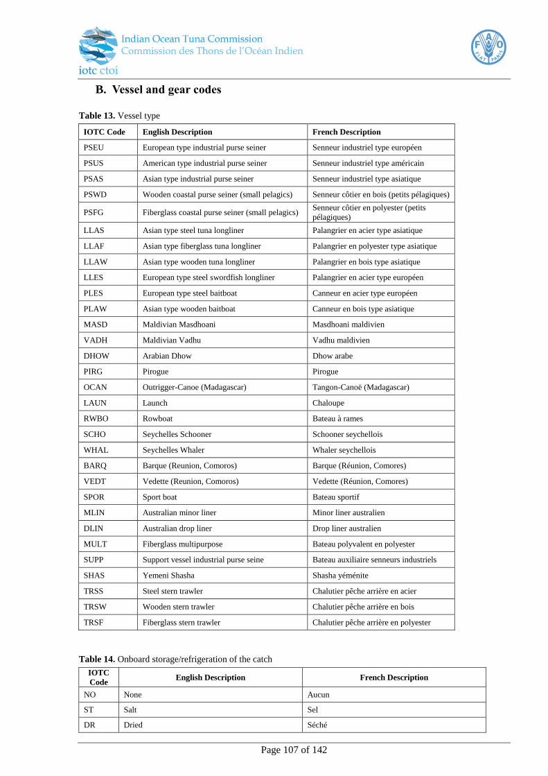
Page 107 of 142
B. Vessel and gear codes
Table 13. Vessel type
IOTC Code English Description French Description
PSEU European type industrial purse seiner Senneur industriel type européen
PSUS American type industrial purse seiner Senneur industriel type américain
PSAS Asian type industrial purse seiner Senneur industriel type asiatique
PSWD Wooden coastal purse seiner (small pelagics) Senneur côtier en bois (petits pélagiques)
PSFG Fiberglass coastal purse seiner (small pelagics) Senneur côtier en polyester (petits
pélagiques)
LLAS Asian type steel tuna longliner Palangrier en acier type asiatique
LLAF Asian type fiberglass tuna longliner Palangrier en polyester type asiatique
LLAW Asian type wooden tuna longliner Palangrier en bois type asiatique
LLES European type steel swordfish longliner Palangrier en acier type européen
PLES European type steel baitboat Canneur en acier type européen
PLAW Asian type wooden baitboat Canneur en bois type asiatique
MASD Maldivian Masdhoani Masdhoani maldivien
VADH Maldivian Vadhu Vadhu maldivien
DHOW Arabian Dhow Dhow arabe
PIRG Pirogue Pirogue
OCAN Outrigger-Canoe (Madagascar) Tangon-Canoë (Madagascar)
LAUN Launch Chaloupe
RWBO Rowboat Bateau à rames
SCHO Seychelles Schooner Schooner seychellois
WHAL Seychelles Whaler Whaler seychellois
BARQ Barque (Reunion, Comoros) Barque (Réunion, Comores)
VEDT Vedette (Reunion, Comoros) Vedette (Réunion, Comores)
SPOR Sport boat Bateau sportif
MLIN Australian minor liner Minor liner australien
DLIN Australian drop liner Drop liner australien
MULT Fiberglass multipurpose Bateau polyvalent en polyester
SUPP Support vessel industrial purse seine Bateau auxiliaire senneurs industriels
SHAS Yemeni Shasha Shasha yéménite
TRSS Steel stern trawler Chalutier pêche arrière en acier
TRSW Wooden stern trawler Chalutier pêche arrière en bois
TRSF Fiberglass stern trawler Chalutier pêche arrière en polyester
Table 14. Onboard storage/refrigeration of the catch
IOTC
Code English Description French Description
NO None Aucun
ST Salt Sel
DR Dried Séché
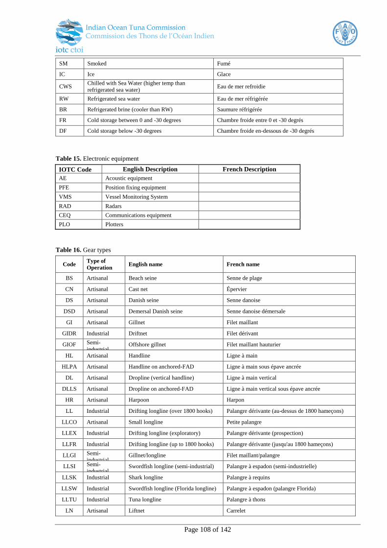
Page 108 of 142
SM Smoked Fumé
IC Ice Glace
CWS Chilled with Sea Water (higher temp than
refrigerated sea water) Eau de mer refroidie
RW Refrigerated sea water Eau de mer réfrigérée
BR Refrigerated brine (cooler than RW) Saumure réfrigérée
FR Cold storage between 0 and -30 degrees Chambre froide entre 0 et -30 degrés
DF Cold storage below -30 degrees Chambre froide en-dessous de -30 degrés
Table 15. Electronic equipment
IOTC Code English Description French Description
AE Acoustic equipment
PFE Position fixing equipment
VMS Vessel Monitoring System
RAD Radars
CEQ Communications equipment
PLO Plotters
Table 16. Gear types
Code Type of
Operation English name French name
BS Artisanal Beach seine Senne de plage
CN Artisanal Cast net Épervier
DS Artisanal Danish seine Senne danoise
DSD Artisanal Demersal Danish seine Senne danoise démersale
GI Artisanal Gillnet Filet maillant
GIDR Industrial Driftnet Filet dérivant
GIOF Semi-
industrial Offshore gillnet Filet maillant hauturier
HL Artisanal Handline Ligne à main
HLPA Artisanal Handline on anchored-FAD Ligne à main sous épave ancrée
DL Artisanal Dropline (vertical handline) Ligne à main vertical
DLLS Artisanal Dropline on anchored-FAD Ligne à main vertical sous épave ancrée
HR Artisanal Harpoon Harpon
LL Industrial Drifting longline (over 1800 hooks) Palangre dérivante (au-dessus de 1800 hameçons)
LLCO Artisanal Small longline Petite palangre
LLEX Industrial Drifting longline (exploratory) Palangre dérivante (prospection)
LLFR Industrial Drifting longline (up to 1800 hooks) Palangre dérivante (jusqu'au 1800 hameçons)
LLGI Semi-
industrial Gillnet/longline Filet maillant/palangre
LLSI Semi-
industrial Swordfish longline (semi-industrial) Palangre à espadon (semi-industrielle)
LLSK Industrial Shark longline Palangre à requins
LLSW Industrial Swordfish longline (Florida longline) Palangre à espadon (palangre Florida)
LLTU Industrial Tuna longline Palangre à thons
LN Artisanal Liftnet Carrelet

Page 109 of 142
LNPA Artisanal Liftnet on anchored-FAD Carrelet sous épave ancrée
PL Artisanal Pole and line Pêche à la Canne
PLIN Industrial Industrial pole and line Pêche à la canne industriel
PLPA Artisanal Pole-and-line on anchored-FAD Pêche à la canne sous épave ancrée
PLFS Artisanal Free-school pole-and-line Pêche à la canne banc libres à thons
PLDF Artisanal Dolphin associated school pole-and-
line Pêche à la canne à thons associés avec des dauphins
PLME Artisanal Pole and line (mechanized boats) Pêche à la canne (bateaux motorisés)
PLNM Artisanal Pole and line (non-mechanized boats) Pêche à la canne (bateaux non-motorisés)
PLOF Semi-
industrial Offshore pole and line Pêche à la canne (bateaux hauturiers)
PS Industrial Tuna purse seine Senne tournante industrielle à thons
PSFS Industrial Free-school tuna purse seine Senne tournante banc libres à thons
PSLS Industrial Log-school tuna purse seine Senne tournante à thons sous épave
PSSA Semi-
industrial Coastal purse seine on anchored-FAD Senne tournante côtière sous épave ancrée
PSSF Semi-
industrial Free-school coastal purse seine Senne tournante côtière banc libres à thons
PSRN Artisanal Ringnet Filet tournant
PSRP Artisanal Ringnet with anchored-FAD Filet tournant sous épave ancrée
PSSP Industrial Support vessel industrial purse seiner Bateau auxiliaire, senneur industriel
PSSS Semi-
industrial Small purse seines Petites sennes tournantes
SN Artisanal Setnet Filet calé
SP Artisanal Sport fishing Pêche sportive
TL Artisanal Trolling Pêche à la traine
TLME Artisanal Trolling (mechanized boats) Pêche à la traine (bateaux motorisés)
TLNM Artisanal Trolling (non-mechanized boats) Pêche à la traine (bateaux non-motorisés)
TP Artisanal Trap Madragues
TR Semi-
industrial Trawl Chaluts
Table 17. Gillnet material
Code English Description French Description
MO Monofilament Monofilament
MU Multifilament Multifilament
Table 18. Line material types42
Code English Description French Description
MNL Monofilament line Ligne monofilament
GLW Galvanized wire Câble galvanisé
SSW Stainless steel wire Câble en acier inoxydable
TR3 3 strand tarred rope (red or black) Cordage goudronné à trois torons
(rouge ou noir)
BRL Braided line Cordage tressé
42
www.spc.int/DigitalLibrary/Doc/FAME/Manuals/Beverly_09_LLTerminalGear.pdf
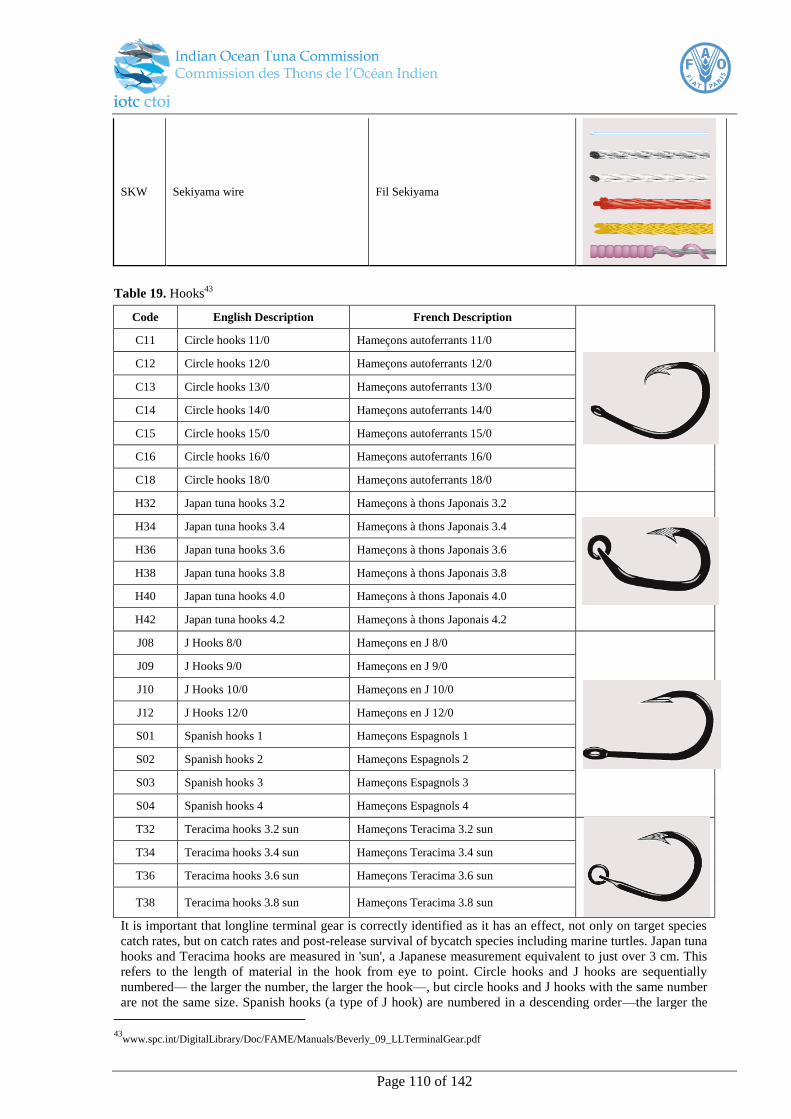
Page 110 of 142
SKW Sekiyama wire Fil Sekiyama
Table 19. Hooks43
Code English Description French Description
C11 Circle hooks 11/0 Hameçons autoferrants 11/0
C12 Circle hooks 12/0 Hameçons autoferrants 12/0
C13 Circle hooks 13/0 Hameçons autoferrants 13/0
C14 Circle hooks 14/0 Hameçons autoferrants 14/0
C15 Circle hooks 15/0 Hameçons autoferrants 15/0
C16 Circle hooks 16/0 Hameçons autoferrants 16/0
C18 Circle hooks 18/0 Hameçons autoferrants 18/0
H32 Japan tuna hooks 3.2 Hameçons à thons Japonais 3.2
H34 Japan tuna hooks 3.4 Hameçons à thons Japonais 3.4
H36 Japan tuna hooks 3.6 Hameçons à thons Japonais 3.6
H38 Japan tuna hooks 3.8 Hameçons à thons Japonais 3.8
H40 Japan tuna hooks 4.0 Hameçons à thons Japonais 4.0
H42 Japan tuna hooks 4.2 Hameçons à thons Japonais 4.2
J08 J Hooks 8/0 Hameçons en J 8/0
J09 J Hooks 9/0 Hameçons en J 9/0
J10 J Hooks 10/0 Hameçons en J 10/0
J12 J Hooks 12/0 Hameçons en J 12/0
S01 Spanish hooks 1 Hameçons Espagnols 1
S02 Spanish hooks 2 Hameçons Espagnols 2
S03 Spanish hooks 3 Hameçons Espagnols 3
S04 Spanish hooks 4 Hameçons Espagnols 4
T32 Teracima hooks 3.2 sun Hameçons Teracima 3.2 sun
T34 Teracima hooks 3.4 sun Hameçons Teracima 3.4 sun
T36 Teracima hooks 3.6 sun Hameçons Teracima 3.6 sun
T38 Teracima hooks 3.8 sun Hameçons Teracima 3.8 sun
It is important that longline terminal gear is correctly identified as it has an effect, not only on target species
catch rates, but on catch rates and post-release survival of bycatch species including marine turtles. Japan tuna
hooks and Teracima hooks are measured in 'sun', a Japanese measurement equivalent to just over 3 cm. This
refers to the length of material in the hook from eye to point. Circle hooks and J hooks are sequentially
numbered— the larger the number, the larger the hook—, but circle hooks and J hooks with the same number
are not the same size. Spanish hooks (a type of J hook) are numbered in a descending order—the larger the
43
www.spc.int/DigitalLibrary/Doc/FAME/Manuals/Beverly_09_LLTerminalGear.pdf

Page 111 of 142
hook, the smaller the number.
Hook identification44
C. Activity codes
Table 20. Surface Fisheries Activity Codes
Code Activity
PO In port (for refuelling, loading goods, dropping or taking crew & scientists)
BA Anchored for bait fishing or searching for bait (during the day or during the night) or drifting at night with
lights to attract bait
BF Bait fishing at night or during the day (the net is set or launched)
SD Steaming during the day
SN Steaming at night
SS Searching with a school associated with the vessel
SE Searching for tuna schools, logs or FADs
CH Chasing a tuna school (chumming can be part of this activity)
FI Fishing target species
DR Drifting (reason not specified)
DS Drifting during the day with a tuna school
DL Drifting during the day near a log or a FAD
DG Drifting or steaming at night with lights to gather tuna and/or with an associated school
DW Drifting because of bad weather
DT Drifting or at anchor or in port because of engine or other mechanical problems
NC Net cleaning set
DF Deploy - raft, FAD, payao
RF Retrieve - raft, FAD, payao
DB Deploy radio buoy/beacon
RB Retrieve radio buoy/beacon
TR Transhipping or bunkering
44 www.spc.int/DigitalLibrary/Doc/FAME/Manuals/Beverly_09_LLTerminalGear.pdf
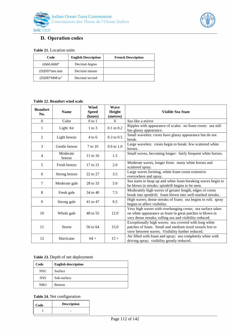
Page 112 of 142
D. Operation codes
Table 21. Location units
Code English Description French Description
(d)dd.dddd° Decimal degree
(D)DD°mm.mm Decimal minute
(D)DD°MM'ss" Decimal second
Table 22. Beaufort wind scale
Beaufort
No. Name
Wind
Speed
(knots)
Wave
Height
(metres)
Visible Sea State
0 Calm 0 to 1 0 Sea like a mirror
1 Light Air 1 to 3 0.1 to 0.2 Ripples with appearance of scales: no foam crests: sea still
has glassy appearance.
2 Light breeze 4 to 6 0.3 to 0.5 Small wavelets: crests have glassy appearance but do not
break.
3 Gentle breeze 7 to 10 0.6 to 1.0 Large wavelets: crests begin to break: few scattered white
horses.
4 Moderate
breeze 11 to 16 1.5
Small waves, becoming longer: fairly frequent white horses.
5 Fresh breeze 17 to 21 2.0 Moderate waves, longer form: many white horses and
scattered spray.
6 Strong breeze 22 to 27 3.5 Large waves forming, white foam crests extensive
everywhere and spray.
7 Moderate gale 28 to 33 5.0 Sea starts to heap up and white foam breaking waves begin to
be blown in streaks: spindrift begins to be seen.
8 Fresh gale 34 to 40 7.5 Moderately high waves of greater length, edges of crests
break into spindrift: foam blown into well-marked streaks.
9 Strong gale 41 to 47 9.5 High waves; dense streaks of foam; sea begins to roll; spray
begins to affect visibility.
10 Whole gale 48 to 55 12.0
Very high waves with overhanging crests; sea surface takes
on white appearance as foam in great patches is blown in
very dense streaks; rolling sea and visibility reduced.
11 Storm 56 to 64 15.0
Exceptionally high waves; sea covered with long white
patches of foam. Small and medium sized vessels lost to
view between waves. Visibility further reduced.
12 Hurricane 64 + 15 + Air filled with foam and spray; sea completely white with
driving spray; visibility greatly reduced.
Table 23. Depth of net deployment
Code English description
NSU Surface
NSS Sub-surface
NBO Bottom
Table 24. Net configuration
Code Description
1 -

Page 113 of 142
2 )
3 O
4 Π
5 N
6 V
Table 25. Surface fisheries school sighting codes
Code English description
SV Seen from vessel
SH Seen from helicopter
MB Marked with beacon
BR Bird radar
AS Acoustic – sonar / depth sounder
IV Info. from other vessel
FAD FAD
OTH Other (specify)
Table 26. Bait type
Code English description
BLI Live bait
FRC Frozen/chopped
THC Thawed/chopped
FRW Frozen/whole
THW Thawed/whole
BOT Other
Table 27. Net setting strategy
Code English description
NAN Net anchored (i.e. remains attached to boat)
NDR Net is left drifting
GEN Encircling
Table 28. School association45
Code English description French Description
FSU Unassociated (free school)* Banc libre
FSB feeding on baitfish (free school)
LS Drifting log, debris, dead animal Epave naturelle, cadavre d'animal
DFAD Drifting rafts, FAD Radeau artificiel (Dispositif Concentrateur de Poissons) dérivant
AFAD Anchored raft/payao Radeau artificiel (Dispositif Concentrateur de Poissons) ancré
LW Live whale Baleine vivante
45
http://iss-foundation.org/2012/04/19/fad-free-defined/
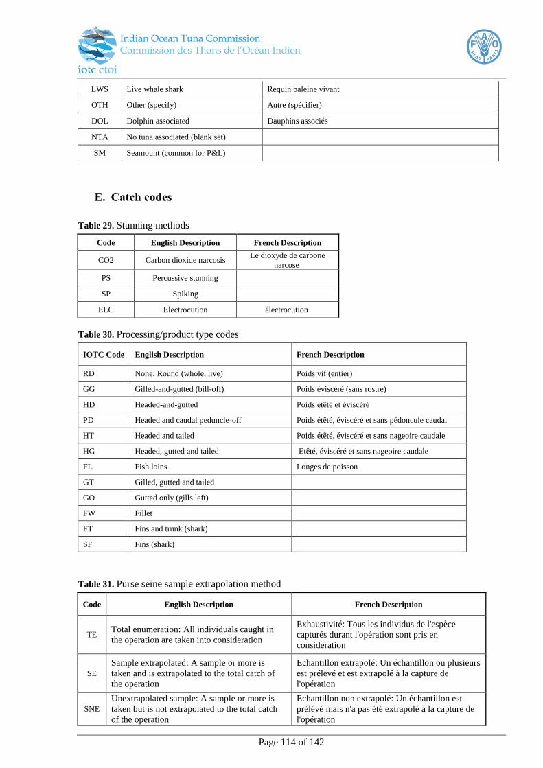
Page 114 of 142
LWS Live whale shark Requin baleine vivant
OTH Other (specify) Autre (spécifier)
DOL Dolphin associated Dauphins associés
NTA No tuna associated (blank set)
SM Seamount (common for P&L)
E. Catch codes
Table 29. Stunning methods
Code English Description French Description
CO2 Carbon dioxide narcosis Le dioxyde de carbone
narcose
PS Percussive stunning
SP Spiking
ELC Electrocution électrocution
Table 30. Processing/product type codes
IOTC Code English Description French Description
RD None; Round (whole, live) Poids vif (entier)
GG Gilled-and-gutted (bill-off) Poids éviscéré (sans rostre)
HD Headed-and-gutted Poids étêté et éviscéré
PD Headed and caudal peduncle-off Poids étêté, éviscéré et sans pédoncule caudal
HT Headed and tailed Poids étêté, éviscéré et sans nageoire caudale
HG Headed, gutted and tailed Etêté, éviscéré et sans nageoire caudale
FL Fish loins Longes de poisson
GT Gilled, gutted and tailed
GO Gutted only (gills left)
FW Fillet
FT Fins and trunk (shark)
SF Fins (shark)
Table 31. Purse seine sample extrapolation method
Code English Description French Description
TE Total enumeration: All individuals caught in
the operation are taken into consideration
Exhaustivité: Tous les individus de l'espèce
capturés durant l'opération sont pris en
consideration
SE
Sample extrapolated: A sample or more is
taken and is extrapolated to the total catch of
the operation
Echantillon extrapolé: Un échantillon ou plusieurs
est prélevé et est extrapolé à la capture de
l'opération
SNE
Unextrapolated sample: A sample or more is
taken but is not extrapolated to the total catch
of the operation
Echantillon non extrapolé: Un échantillon est
prélévé mais n'a pas été extrapolé à la capture de
l'opération
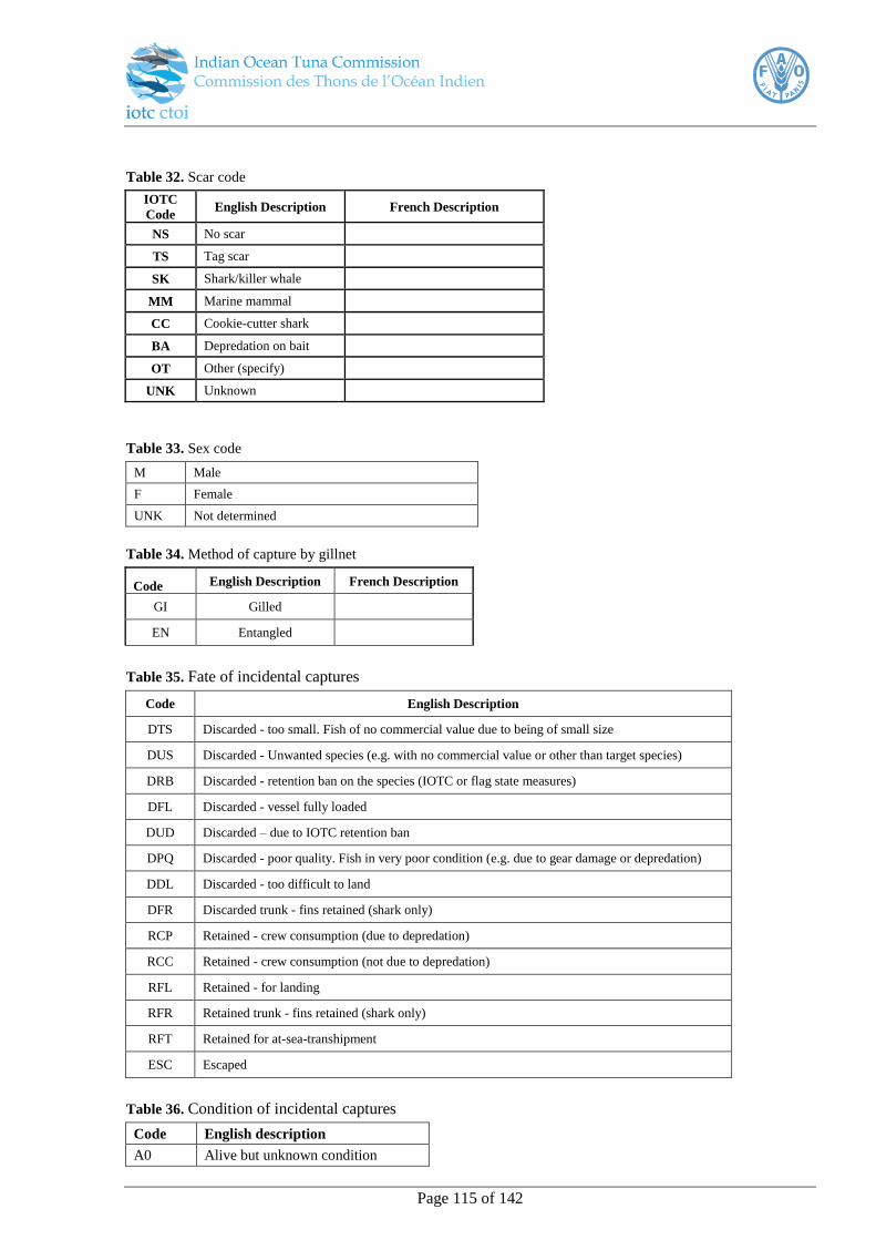
Page 115 of 142
Table 32. Scar code
IOTC
Code English Description French Description
NS No scar
TS Tag scar
SK Shark/killer whale
MM Marine mammal
CC Cookie-cutter shark
BA Depredation on bait
OT Other (specify)
UNK Unknown
Table 33. Sex code
M Male
F Female
UNK Not determined
Table 34. Method of capture by gillnet
Code English Description French Description
GI Gilled
EN Entangled
Table 35. Fate of incidental captures
Code English Description
DTS Discarded - too small. Fish of no commercial value due to being of small size
DUS Discarded - Unwanted species (e.g. with no commercial value or other than target species)
DRB Discarded - retention ban on the species (IOTC or flag state measures)
DFL Discarded - vessel fully loaded
DUD Discarded – due to IOTC retention ban
DPQ Discarded - poor quality. Fish in very poor condition (e.g. due to gear damage or depredation)
DDL Discarded - too difficult to land
DFR Discarded trunk - fins retained (shark only)
RCP Retained - crew consumption (due to depredation)
RCC Retained - crew consumption (not due to depredation)
RFL Retained - for landing
RFR Retained trunk - fins retained (shark only)
RFT Retained for at-sea-transhipment
ESC Escaped
Table 36. Condition of incidental captures
Code English description
A0 Alive but unknown condition

Page 116 of 142
A1 Alive - active, healthy
A2 Alive - injured, distressed
A3 Alive - very weak, dying
D Dead
U Condition unknown
Table 37. Tag codes
Code English description
TC Conventional (plastic spaghetti or dart tags are attached on the back of the fish)
TR Rototags (a two-piece, plastic cattle ear tag, which is inserted through the first dorsal
fin)
TS
Sonic tags (miniature radio transmitting devices that are surgically implanted inside
the tuna. Since these are not visible externally, a conventional tag of a certain colour
will be visible on the outside).
TP
Pop-up tags (Pop-up Satellite Archival Tags are inserted with an anchor and a tether
into the dorsal musculature, recording temperature, pressure, and light, and they
detach from the animal on a pre-programmed date).
TI
Internal archival tags (internal archival tags are implanted in the body cavity and
record internal body temperature and the environment’s temperature, pressure, and
light).
TT Smart Position or Temperature Transmitting tags are attached to the dorsal fin and
send a signal to a satellite every time the animal surfaces
TO Other (specify)
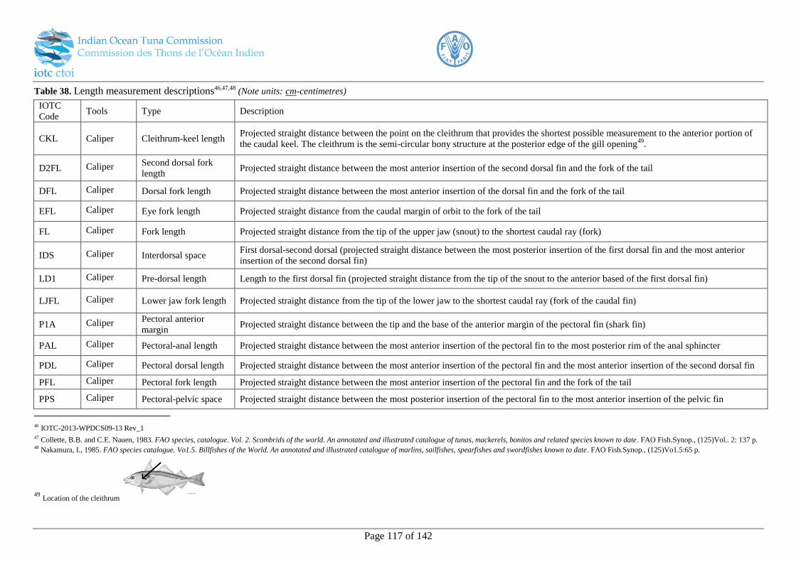
Page 117 of 142
Table 38. Length measurement descriptions46,47,48 (Note units: cm-centimetres)
IOTC
Code Tools Type Description
CKL Caliper Cleithrum-keel length Projected straight distance between the point on the cleithrum that provides the shortest possible measurement to the anterior portion of
the caudal keel. The cleithrum is the semi-circular bony structure at the posterior edge of the gill opening49
.
D2FL Caliper Second dorsal fork
length Projected straight distance between the most anterior insertion of the second dorsal fin and the fork of the tail
DFL Caliper Dorsal fork length Projected straight distance between the most anterior insertion of the dorsal fin and the fork of the tail
EFL Caliper Eye fork length Projected straight distance from the caudal margin of orbit to the fork of the tail
FL Caliper Fork length Projected straight distance from the tip of the upper jaw (snout) to the shortest caudal ray (fork)
IDS Caliper Interdorsal space First dorsal-second dorsal (projected straight distance between the most posterior insertion of the first dorsal fin and the most anterior
insertion of the second dorsal fin)
LD1 Caliper Pre-dorsal length Length to the first dorsal fin (projected straight distance from the tip of the snout to the anterior based of the first dorsal fin)
LJFL Caliper Lower jaw fork length Projected straight distance from the tip of the lower jaw to the shortest caudal ray (fork of the caudal fin)
P1A Caliper Pectoral anterior
margin Projected straight distance between the tip and the base of the anterior margin of the pectoral fin (shark fin)
PAL Caliper Pectoral-anal length Projected straight distance between the most anterior insertion of the pectoral fin to the most posterior rim of the anal sphincter
PDL Caliper Pectoral dorsal length Projected straight distance between the most anterior insertion of the pectoral fin and the most anterior insertion of the second dorsal fin
PFL Caliper Pectoral fork length Projected straight distance between the most anterior insertion of the pectoral fin and the fork of the tail
PPS Caliper Pectoral-pelvic space Projected straight distance between the most posterior insertion of the pectoral fin to the most anterior insertion of the pelvic fin
46 IOTC-2013-WPDCS09-13 Rev_1 47 Collette, B.B. and C.E. Nauen, 1983. FAO species, catalogue. Vol. 2. Scombrids of the world. An annotated and illustrated catalogue of tunas, mackerels, bonitos and related species known to date. FAO Fish.Synop., (125)Vol.. 2: 137 p. 48 Nakamura, I., 1985. FAO species catalogue. Vo1.5. Billfishes of the World. An annotated and illustrated catalogue of marlins, sailfishes, spearfishes and swordfishes known to date. FAO Fish.Synop., (125)Vo1.5:65 p.
49 Location of the cleithrum

Page 118 of 142
TL Caliper Total length (relaxed) Projected straight distance from the most forward point of the head to the tip of the tail when the tail is left in the ‘natural position’
(unsqueezed)
CKLT Tape
measure
Curved cleithrum keel
length
Projected curved body distance between the point on the cleithrum that provides the shortest possible measurement to the anterior portion
of the caudal keel. The cleithrum is the semi-circular bony structure at the posterior edge of the gill opening.
D2FLT Tape
measure Curved second dorsal
fork length Projected curved body distance between the most anterior insertion of the second dorsal fin and the fork of the tail
DFLT Tape
measure Curved dorsal fork
length Projected curved body distance between the most anterior insertion of the dorsal fin and the fork of the tail
EFLT Tape
measure Curved eye fork length Projected curved body distance from the caudal margin of orbit to the fork of the tail along the contour of the body in a line that runs
along the top of the pectoral fin and the top of the caudal keel
FLT Tape
measure Curved fork length Projected curved body distance from the tip of the upper jaw (snout) to the shortest caudal ray (fork)
IDST Tape
measure Curved interdorsal
space
Projected curved body distance between the most posterior insertion of the first dorsal fin and the most anterior insertion of the second
dorsal fin
LD1T Tape
measure Curved pre-dorsal
length Projected curved body distance from the tip of the snout to the anterior base of the first dorsal fin
LJFLT Tape
measure Curved lower jaw fork
length Projected curved body distance from the tip of the lower jaw to the shortest caudal ray (fork of the caudal fin)
P1AT Tape
measure Curved pectoral
anterior margin Projected curved body distance between the tip and the base of the anterior margin of the pectoral fin (shark fin)
PALT Tape
measure Curved pectoral anal
length Projected curved body distance between the most anterior insertion of the pectoral fin to the most posterior rim of the anal sphincter
PDLT Tape
measure Curved pectoral dorsal
length
Projected curved body distance between the most anterior insertion of the pectoral fin and the most anterior insertion of the second dorsal
fin
PFLT Tape
measure Curved pectoral fork
length Projected curved body distance between the most anterior insertion of the pectoral fin and the fork of the tail
PPST Tape
measure Curved pectoral pelvic
space Projected curved body distance between the most posterior insertion of the pectoral fin to the most anterior insertion of the pelvic fin
TLT Tape
measure Total length (relaxed) Projected curved body from the most forward point of the head to the tip of the tail when the tail is left in the ‘natural position’
(unsqueezed)
PCL Caliper Precaudal Length Projected straight distance from the most forward point of the head to the anterior portion of the caudal keel (sharks).
PCLT Tape
measure Precaudal Length Projected straight distance from the most forward point of the head to the anterior portion of the caudal keel (sharks).
TWT Tape
measure Total width Total disc width (for skates and rays)
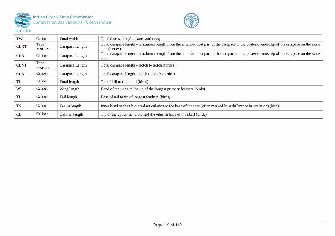
Page 119 of 142
TW Caliper Total width Total disc width (for skates and rays)
CLXT Tape
measure Carapace Length
Total carapace length – maximum length from the anterior-most part of the carapace to the posterior-most tip of the carapace on the same
side (turtles)
CLX Caliper Carapace Length Total carapace length – maximum length from the anterior-most part of the carapace to the posterior-most tip of the carapace on the same
side
CLNT Tape
measure Carapace Length Total carapace length – notch to notch (turtles)
CLN Caliper Carapace Length Total carapace length - notch to notch (turtles)
TL Caliper Total length Tip of bill to tip of tail (birds)
WL Caliper Wing length Bend of the wing to the tip of the longest primary feathers (birds)
TI Caliper Tail length Base of tail to tip of longest feathers (birds)
TS Caliper Tarsus length Inner bend of the tibiotarsal articulation to the base of the toes (often marked by a difference in scalation) (birds)
CL Caliper Culmen length Tip of the upper mandible and the other at base of the skull (birds)
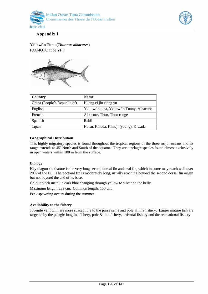
Page 120 of 142
Appendix 1
Yellowfin Tuna (Thunnus albacares)
FAO-IOTC code YFT
Country Name
China (People’s Republic of) Huang ci jin ciang yu
English Yellowfin tuna, Yellowfin Tunny, Albacore,
French Albacore, Thon, Thon rouge
Spanish Rabil
Japan Hatsu, Kihada, Kimeji (young), Kiwada
Geographical Distribution
This highly migratory species is found throughout the tropical regions of the three major oceans and its
range extends to 45o North and South of the equator. They are a pelagic species found almost exclusively
in open waters within 100 m from the surface.
Biology
Key diagnostic feature is the very long second dorsal fin and anal fin, which in some may reach well over
20% of the FL. The pectoral fin is moderately long, usually reaching beyond the second dorsal fin origin
but not beyond the end of its base.
Colour:black metallic dark blue changing through yellow to silver on the belly.
Maximum length: 239 cm. Common length: 150 cm.
Peak spawning occurs during the summer.
Availability to the fishery
Juvenile yellowfin are more susceptible to the purse seine and pole & line fishery. Larger mature fish are
targeted by the pelagic longline fishery, pole & line fishery, artisanal fishery and the recreational fishery.
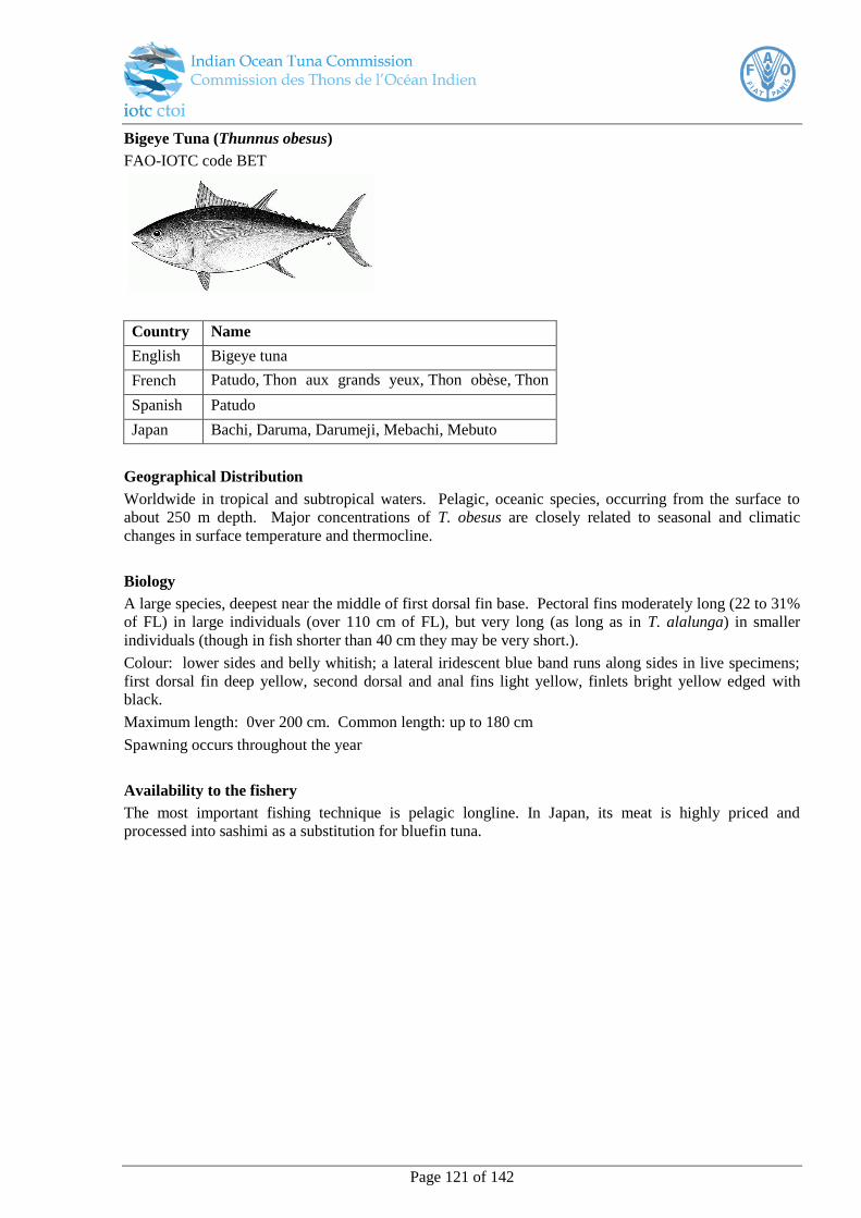
Page 121 of 142
Bigeye Tuna (Thunnus obesus)
FAO-IOTC code BET
Country Name
English Bigeye tuna
French Patudo, Thon aux grands yeux, Thon obèse, Thon
ventru Spanish Patudo
Japan Bachi, Daruma, Darumeji, Mebachi, Mebuto
Geographical Distribution
Worldwide in tropical and subtropical waters. Pelagic, oceanic species, occurring from the surface to
about 250 m depth. Major concentrations of T. obesus are closely related to seasonal and climatic
changes in surface temperature and thermocline.
Biology
A large species, deepest near the middle of first dorsal fin base. Pectoral fins moderately long (22 to 31%
of FL) in large individuals (over 110 cm of FL), but very long (as long as in T. alalunga) in smaller
individuals (though in fish shorter than 40 cm they may be very short.).
Colour: lower sides and belly whitish; a lateral iridescent blue band runs along sides in live specimens;
first dorsal fin deep yellow, second dorsal and anal fins light yellow, finlets bright yellow edged with
black.
Maximum length: 0ver 200 cm. Common length: up to 180 cm
Spawning occurs throughout the year
Availability to the fishery
The most important fishing technique is pelagic longline. In Japan, its meat is highly priced and
processed into sashimi as a substitution for bluefin tuna.
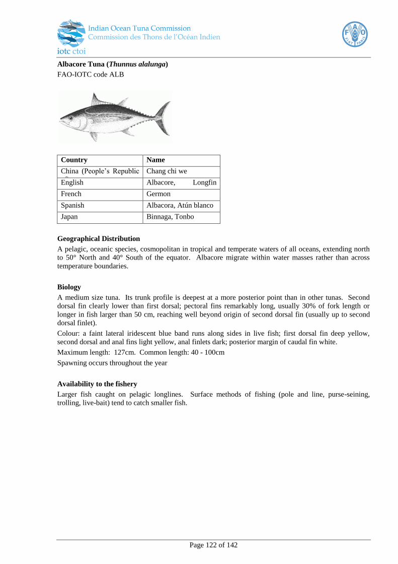
Page 122 of 142
Albacore Tuna (Thunnus alalunga)
FAO-IOTC code ALB
Country Name
China (People’s Republic
of)
Chang chi we
English Albacore, Longfin
tunny French Germon
Spanish Albacora, Atún blanco
Japan Binnaga, Tonbo
Geographical Distribution
A pelagic, oceanic species, cosmopolitan in tropical and temperate waters of all oceans, extending north
to 50° North and 40° South of the equator. Albacore migrate within water masses rather than across
temperature boundaries.
Biology
A medium size tuna. Its trunk profile is deepest at a more posterior point than in other tunas. Second
dorsal fin clearly lower than first dorsal; pectoral fins remarkably long, usually 30% of fork length or
longer in fish larger than 50 cm, reaching well beyond origin of second dorsal fin (usually up to second
dorsal finlet).
Colour: a faint lateral iridescent blue band runs along sides in live fish; first dorsal fin deep yellow,
second dorsal and anal fins light yellow, anal finlets dark; posterior margin of caudal fin white.
Maximum length: 127cm. Common length: 40 - 100cm
Spawning occurs throughout the year
Availability to the fishery
Larger fish caught on pelagic longlines. Surface methods of fishing (pole and line, purse-seining,
trolling, live-bait) tend to catch smaller fish.
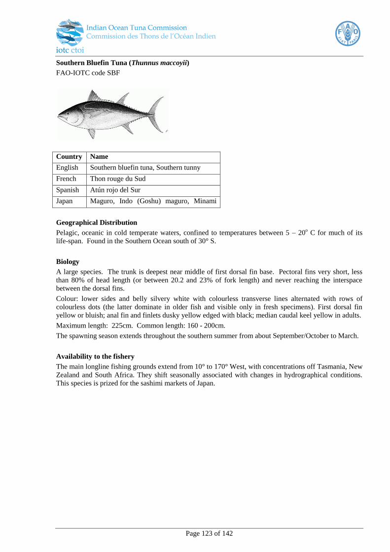
Page 123 of 142
Southern Bluefin Tuna (Thunnus maccoyii)
FAO-IOTC code SBF
Country Name
English Southern bluefin tuna, Southern tunny
French Thon rouge du Sud
Spanish Atún rojo del Sur
Japan Maguro, Indo (Goshu) maguro, Minami
maguro
Geographical Distribution
Pelagic, oceanic in cold temperate waters, confined to temperatures between 5 – 20o C for much of its
life-span. Found in the Southern Ocean south of 30° S.
Biology
A large species. The trunk is deepest near middle of first dorsal fin base. Pectoral fins very short, less
than 80% of head length (or between 20.2 and 23% of fork length) and never reaching the interspace
between the dorsal fins.
Colour: lower sides and belly silvery white with colourless transverse lines alternated with rows of
colourless dots (the latter dominate in older fish and visible only in fresh specimens). First dorsal fin
yellow or bluish; anal fin and finlets dusky yellow edged with black; median caudal keel yellow in adults.
Maximum length: 225cm. Common length: 160 - 200cm.
The spawning season extends throughout the southern summer from about September/October to March.
Availability to the fishery
The main longline fishing grounds extend from 10° to 170° West, with concentrations off Tasmania, New
Zealand and South Africa. They shift seasonally associated with changes in hydrographical conditions.
This species is prized for the sashimi markets of Japan.
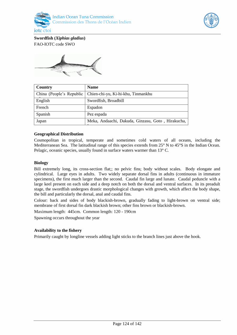
Page 124 of 142
Swordfish (Xiphias gladius)
FAO-IOTC code SWO
Country Name
China (People’s Republic
of)
Chien-chi-yu, Ki-hi-khu, Tinmankhu
English Swordfish, Broadbill
French Espadon
Spanish Pez espada
Japan Meka, Andaachi, Dakuda, Ginzasu, Goto , Hirakucha,
Izasu
Geographical Distribution
Cosmopolitan in tropical, temperate and sometimes cold waters of all oceans, including the
Mediterranean Sea. The latitudinal range of this species extends from 25° N to 45°S in the Indian Ocean.
Pelagic, oceanic species, usually found in surface waters warmer than 13° C.
Biology
Bill extremely long, its cross-section flat;; no pelvic fins; body without scales. Body elongate and
cylindrical. Large eyes in adults. Two widely separate dorsal fins in adults (continuous in immature
specimens), the first much larger than the second. Caudal fin large and lunate. Caudal peduncle with a
large keel present on each side and a deep notch on both the dorsal and ventral surfaces. In its preadult
stage, the swordfish undergoes drastic morphological changes with growth, which affect the body shape,
the bill and particularly the dorsal, anal and caudal fins.
Colour: back and sides of body blackish-brown, gradually fading to light-brown on ventral side;
membrane of first dorsal fin dark blackish brown; other fins brown or blackish-brown.
Maximum length: 445cm. Common length: 120 - 190cm
Spawning occurs throughout the year
Availability to the fishery
Primarily caught by longline vessels adding light sticks to the branch lines just above the hook.

Page 125 of 142
Skipjack Tuna (Katsuwonus pelamis)
FAO-IOTC code SKJ
Country Name
China (People’s Republic
of)
Then chien
English Skipjack, Striped tuna, Bonito, Lesser tunny
French Listao
Spanish Listado
Japan Hongatsuo, Katsuo, Katsuwo, Katuwo,
Magatsuwo,
Geographical Distribution
Pelagic, oceanic species. Aggregations of this species tend to be associated with convergences,
boundaries between cold and warm water masses. Depth distribution ranges from the surface to about
260 m during the day, but is limited to near surface waters at night.
Biology
The back is dark purplish blue, lower sides and belly silvery, with 4 to six very conspicuous longitudinal
dark bands which in live specimens may appear as continuous lines of dark blotches.
Maximum length: 108 cm. Common length: 80 cm.
Skipjack tuna spawn in batches throughout the year in equatorial waters, and from spring to early fall in
subtropical waters, with the spawning season becoming shorter as distance from the equator increases.
Availability to the fishery
Skipjack tuna is taken at the surface, mostly with purse seines and pole-and-line gear but also incidentally
by longlines. Other (artisanal) gear include gillnets, traps, harpoons and beach seines. Skipjack make up
about 40% of the world’s total tuna catch and has replaced yellowfin as the dominant tuna species.

Page 126 of 142
Longtail Tuna (Thunnus tonggol)
FAO-IOTC code LOT
Country Name
English Longtail
tuna, French Thon mignon
Spanish Atún tongol
Japan Koshinaga
Geographical Distribution
Indo-West Pacific Ocean from Japan south through the Philippines to Papua New Guinea, New Britain,
the northern three quarters of Australia (Twofold Bay, New South Wales to Freemantle, Western
Australia), west through the East Indies to both coasts of India, southern Arabian Peninsula, the Red Sea
and the Somalia coast.
Biology
A small species. The trunk deepest near middle of first dorsal fin base. Second dorsal fin higher than
first dorsal; pectoral fins short to moderately long, 22 to 31% of fork length in smaller specimens (under
60 cm fork length) and 16 to 22% in larger individuals.
Colour: lower sides and belly silvery white with colourless elongate oval spots arranged in horizontally
oriented rows; dorsal, pectoral and pelvic fins blackish, tip of second dorsal and anal fins washed with
yellow; anal fin silvery; dorsal and anal liver finlets yellow with greyish margins; caudal fin blackish,
with streaks of yellowish green.
Maximum length: 130cm. Common length: 40 - 70cm.
Spawning occurs throughout the year.
Note: Juveniles of this species, bluefin tuna, yellowfin tuna and bigeye tuna are very similar.
Availability to the fishery
Fishing gear includes trolls, driftnets, and longlines.
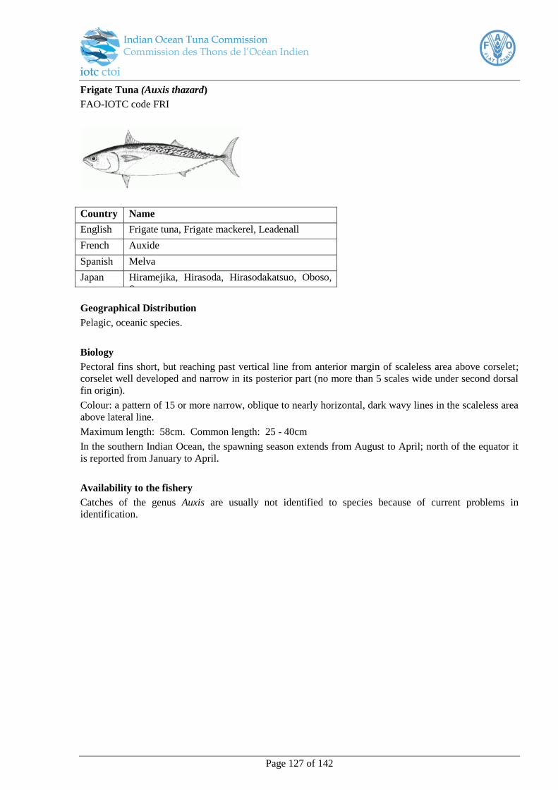
Page 127 of 142
Frigate Tuna (Auxis thazard)
FAO-IOTC code FRI
Country Name
English Frigate tuna, Frigate mackerel, Leadenall
French Auxide
Spanish Melva
Japan Hiramejika, Hirasoda, Hirasodakatsuo, Oboso,
Suma
Geographical Distribution
Pelagic, oceanic species.
Biology
Pectoral fins short, but reaching past vertical line from anterior margin of scaleless area above corselet;
corselet well developed and narrow in its posterior part (no more than 5 scales wide under second dorsal
fin origin).
Colour: a pattern of 15 or more narrow, oblique to nearly horizontal, dark wavy lines in the scaleless area
above lateral line.
Maximum length: 58cm. Common length: 25 - 40cm
In the southern Indian Ocean, the spawning season extends from August to April; north of the equator it
is reported from January to April.
Availability to the fishery
Catches of the genus Auxis are usually not identified to species because of current problems in
identification.

Page 128 of 142
Bullet Tuna (Auxis rochei)
FAO-IOTC code BLT
Country Name
English Bullet tuna, Bullet mackerel
French Bonitou
Spanish Melva
Japan Chiboh, Dainanpo, Magatsuwo, Manba, Mandara,
Soda
Geographical Distribution
Pelagic, oceanic species
Biology
Pectoral fins short, not reaching vertical line from anterior margin of scaleless area above corselet;
corselet well developed in its posterior part (more than 6 scales wide, usually 10 to 15) under second
dorsal fin origin).
Colour: a pattern of 15 or more fairly broad, nearly vertical dark bars in the scaleless area. Maximum
length: 50cm.
Common length: 15 - 25cm.
Spawning occurs throughout the year
Availability to the fishery
Catches of the genus Auxis are usually not identified to species because of current problems in
identification.
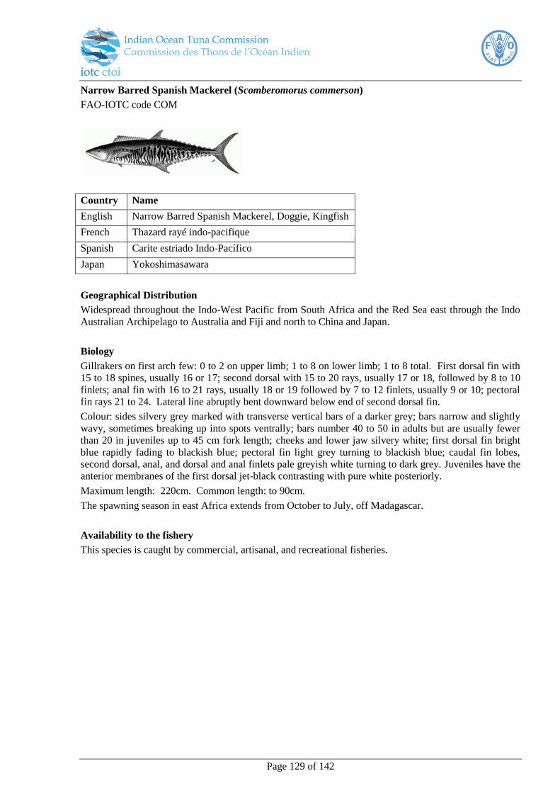
Page 129 of 142
Narrow Barred Spanish Mackerel (Scomberomorus commerson)
FAO-IOTC code COM
Country Name
English Narrow Barred Spanish Mackerel, Doggie, Kingfish
French Thazard rayé indo-pacifique
Spanish Carite estriado Indo-Pacífico
Japan Yokoshimasawara
Geographical Distribution
Widespread throughout the Indo-West Pacific from South Africa and the Red Sea east through the Indo
Australian Archipelago to Australia and Fiji and north to China and Japan.
Biology
Gillrakers on first arch few: 0 to 2 on upper limb; 1 to 8 on lower limb; 1 to 8 total. First dorsal fin with
15 to 18 spines, usually 16 or 17; second dorsal with 15 to 20 rays, usually 17 or 18, followed by 8 to 10
finlets; anal fin with 16 to 21 rays, usually 18 or 19 followed by 7 to 12 finlets, usually 9 or 10; pectoral
fin rays 21 to 24. Lateral line abruptly bent downward below end of second dorsal fin.
Colour: sides silvery grey marked with transverse vertical bars of a darker grey; bars narrow and slightly
wavy, sometimes breaking up into spots ventrally; bars number 40 to 50 in adults but are usually fewer
than 20 in juveniles up to 45 cm fork length; cheeks and lower jaw silvery white; first dorsal fin bright
blue rapidly fading to blackish blue; pectoral fin light grey turning to blackish blue; caudal fin lobes,
second dorsal, anal, and dorsal and anal finlets pale greyish white turning to dark grey. Juveniles have the
anterior membranes of the first dorsal jet-black contrasting with pure white posteriorly.
Maximum length: 220cm. Common length: to 90cm.
The spawning season in east Africa extends from October to July, off Madagascar.
Availability to the fishery
This species is caught by commercial, artisanal, and recreational fisheries.

Page 130 of 142
Indo-Pacific King Mackerel (Scomberomorus guttatus)
FAO-IOTC code GUT
Country Name
English Indo-Pacific King Mackerel, Spotted Spanish
mackerel French Thazard ponctué indo-pacifique
Spanish Carite del Indo-Pacífico
Japan Taiwansawara
Geographical Distribution
Along the shores of continental Indo-West Pacific from Wakasa Bay, Sea of Japan and Hong Kong south
to the Gulf of Thailand and west to the Gulf lying between the Arabian peninsula and Iran.
Biology
Depth of body less than in S. koreanus. Gillrakers on first arch moderate: 1 or 2 on upper limb; 7 to 12
on lower limb; 8 to 14 total. First dorsal fin with 15 to 18 spines, usually 16 or more; second dorsal with
18 to 24 rays, usually 20 to 22, followed by 7 to 10 finlets; anal fin with 19 to 23 rays; followed by 7 to
10 finlets, usually 8; pectoral fin rays few, 20 to 23, modally 21. Lateral line with many fine auxiliary
branches extending dorsally and ventrally in anterior third, gradually curving down toward caudal
peduncle.
Colour: sides silvery white with several longitudinal rows of round dark brownish spots (smaller than eye
diameter) scattered in about 3 irregular rows along lateral line. First dorsal fin membrane black up to the
8th spine, white posteriorly, with the distal margin black; pectoral, second dorsal and caudal fins dark
brown; pelvic and anal fins silvery white.
Maximum length: 76cm. Common length: 48 - 52cm.
Spawning occurs from April to July around Rameswaram Island between India and Sri Lanka.
Availability to the fishery
Caught by commercial and artisanal fisheries. Sold fresh or salted.
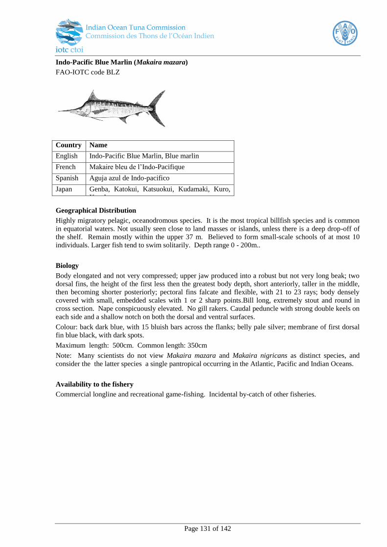
Page 131 of 142
Indo-Pacific Blue Marlin (Makaira mazara)
FAO-IOTC code BLZ
Country Name
English Indo-Pacific Blue Marlin, Blue marlin
French Makaire bleu de l’Indo-Pacifique
Spanish Aguja azul de Indo-pacifico
Japan Genba, Katokui, Katsuokui, Kudamaki, Kuro,
Kuroka,
Geographical Distribution
Highly migratory pelagic, oceanodromous species. It is the most tropical billfish species and is common
in equatorial waters. Not usually seen close to land masses or islands, unless there is a deep drop-off of
the shelf. Remain mostly within the upper 37 m. Believed to form small-scale schools of at most 10
individuals. Larger fish tend to swim solitarily. Depth range 0 - 200m..
Biology
Body elongated and not very compressed; upper jaw produced into a robust but not very long beak; two
dorsal fins, the height of the first less then the greatest body depth, short anteriorly, taller in the middle,
then becoming shorter posteriorly; pectoral fins falcate and flexible, with 21 to 23 rays; body densely
covered with small, embedded scales with 1 or 2 sharp points.Bill long, extremely stout and round in
cross section. Nape conspicuously elevated. No gill rakers. Caudal peduncle with strong double keels on
each side and a shallow notch on both the dorsal and ventral surfaces.
Colour: back dark blue, with 15 bluish bars across the flanks; belly pale silver; membrane of first dorsal
fin blue black, with dark spots.
Maximum length: 500cm. Common length: 350cm
Note: Many scientists do not view Makaira mazara and Makaira nigricans as distinct species, and
consider the the latter species a single pantropical occurring in the Atlantic, Pacific and Indian Oceans.
Availability to the fishery
Commercial longline and recreational game-fishing. Incidental by-catch of other fisheries.

Page 132 of 142
Black Marlin (Makaira indica)
FAO-IOTC code BLM
Country Name
China (People’s Republic
of)
Kyau-shit-á, Lih-ch’ih-Ch’i-yü;
English Black Marlin
French Makaire noir
Spanish Aguja negra
Japan Genba, Katahari, Shiro, Shiroka, Shirokajiki,
Shirokawa
Geographical Distribution
The black marlin is distributed throughout the tropical and subtropical waters of the Pacific and Indian
oceans where the main population and the spawning grounds occur, but it also occasionally enters
temperate waters to 45°S in the Indian Ocean. This is a pelagic and oceanic species that is usually found
in surface waters at temperatures ranging from 15° to 30°C. Often in nearshore waters close to land
masses, islands, and coral reef areas. M. indica usually occurs nearer to the surface than most other
billfishes (except the sailfish).
Biology
Body not very compressed; nape highly elevated; height of anterior lobe of first dorsal fin smaller than
greatest body depth; second dorsal fin slightly forward of second anal fin; pectoral fins rigid, not
adpressible against sides of body. . Caudal peduncle fairly scaled.
Maximum length: greater than 448cm. Common length: 170cm.
Availability to the fishery
The commercial catch of Makaira indica is taken mostly by surface longlining.

Page 133 of 142
Striped marlin (Tetrapturus audax)
FAO-IOTC code MLS
Country Name
China (People’s Republic
of)
Chi zuo fo yii, Hung ju chi yii, Hung ju ting
pan English Striped marlin
French Marlin rayé
Spanish Marlin rayado
Japan Achinoiyo, Achinoiyu, Achinuigu, Akinoio,
Akinoiyo
Geographical Distribution
T. audax occurs mainly in the tropical, subtropical and temperate waters of the Pacific and Indian oceans.
As far south as 45°S in the south-western Indian Ocean and 35°S in the south eastern Indian Ocean. A
pelagic and oceanic species, which is abundant in the western Arabian Sea.
Biology
Body elongate and fairly compressed. Bill stout and long,round in cross section; nape fairly elevated.
Two dorsal fins, the first with 37 to 42 rays, usually with a pointed anterior lobe, higher than body depth
anteriorly. Second dorsal fin with 5 or 6 rays, its position slightly backward in respect to the second anal
fin. Two anal fins, the first with 13 to 18 rays, the second with 5 or 6 rays. Caudal peduncle well
compressed (laterally) and slightly depressed (dorsoventrally), with a pair of keels on each side and a
shallow notch on both, the dorsal and ventral surfaces. Anus situated just in front of first anal fin origin.
Lateral line single and obvious, curving above base of pectoral fin and then continuing in a straight line
toward the caudal fin base.
Colour: body blue-black dorsally and silvery white ventrally, with about 15 rows of cobalt-coloured
stripes, each consisting of round dots and/or narrow bands. First dorsal fin dark blue; other fins usually
dark brown, sometimes tinged with dark blue; bases of first and second anal fins tinged with silvery
white.
Maximum length: exceeding 350cm. Common length: 290cm.
Availability to the fishery
The commercial catch of T. audax is taken mostly by surface longlining, while harpooning may account
for up to 1% of the total catch in recent years.
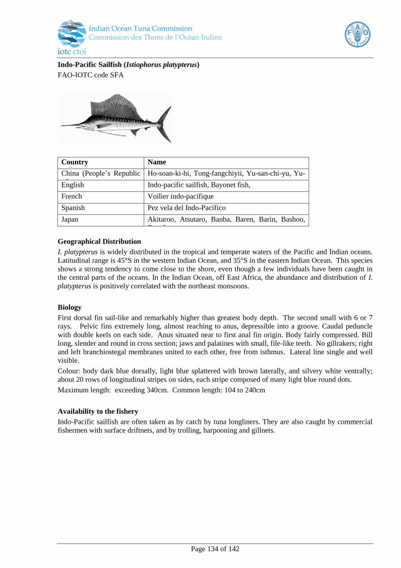
Page 134 of 142
Indo-Pacific Sailfish (Istiophorus platypterus)
FAO-IOTC code SFA
Country Name
China (People’s Republic
of)
Ho-soan-ki-hi, Tong-fangchiyii, Yu-san-chi-yu, Yu-
san-yu English Indo-pacific sailfish, Bayonet fish,
French Voilier indo-pacifique
Spanish Pez vela del Indo-Pacífico
Japan Akitaroo, Atsutaro, Banba, Baren, Barin, Bashoo,
Byoobu
Geographical Distribution
I. platypterus is widely distributed in the tropical and temperate waters of the Pacific and Indian oceans.
Latitudinal range is 45°S in the western Indian Ocean, and 35°S in the eastern Indian Ocean. This species
shows a strong tendency to come close to the shore, even though a few individuals have been caught in
the central parts of the oceans. In the Indian Ocean, off East Africa, the abundance and distribution of I.
platypterus is positively correlated with the northeast monsoons.
Biology
First dorsal fin sail-like and remarkably higher than greatest body depth. The second small with 6 or 7
rays. Pelvic fins extremely long, almost reaching to anus, depressible into a groove. Caudal peduncle
with double keels on each side. Anus situated near to first anal fin origin. Body fairly compressed. Bill
long, slender and round in cross section; jaws and palatines with small, file-like teeth. No gillrakers; right
and left branchiostegal membranes united to each other, free from isthmus. Lateral line single and well
visible.
Colour: body dark blue dorsally, light blue splattered with brown laterally, and silvery white ventrally;
about 20 rows of longitudinal stripes on sides, each stripe composed of many light blue round dots.
Maximum length: exceeding 340cm. Common length: 104 to 240cm
Availability to the fishery
Indo-Pacific sailfish are often taken as by catch by tuna longliners. They are also caught by commercial
fishermen with surface driftnets, and by trolling, harpooning and gillnets.
Page 135 of 142
IX. Appendix II Pre-Sea Safety Checklist
Pre-Sea Safety Inspection Checklist
Observer Date Signature Vessel Agent Date Signature
Port / Position
Vessel Details:
Vessel Name
Captain Name/Fishing Master
Call Sign
Flag
Size GRT
LOA
Vessels Compliment
Vessel contact Number
Telephone
Fax
Inmarsat (A/C/M) & No.
Vessel Owners / Charterers
Name
Telephone
Fax
Mobile
Safety Equipment:
Safety Certificate In-date
(Y/N) Issuing Authority
Flares: Location If checked No. / Exp Date
First Aid Materials:
Location Name of Medical Officer
Life Rafts
Type Number Capacity Hydrostatic release Y /
N Date Next Service Due
Life Jackets
Type
Inflatable/Packed
Number
onboard
Location
Cabin /Muster Station/ Both
SOLAS Approved
Yes/ No
Fire Extinguishers
Positioned in main corridor’s (Y/N) Charge seals intact (Y/N)
Positioned on bridge (Y/N) Charge seals intact (Y/N)
Immersion Suits (only required by vessels operation south of 30o S)
Type Number
onboard Location SOLAS Approved

Page 136 of 142
Cabin /Muster Station/ Both Yes/ No
GMDSS
Radio
Equipment
HF
Operational
yes or no
MF
Operational
yes or no
VHF
Operational
yes or no
INMARSAT
Operational
yes or no
NAVTEX
Operational
yes or no
EPIRB
Type /
Manufacturer Number of units on board Location
Release method
manual / float free
SART's
Type /
Manufacturer Number of units on board Location
Release method
manual / float free
Accommodation:
Vessel Emergency Evacuation and Muster Stations Lists – Displayed (Y/N)
Cabin - Single or Sharing
General Comments:
MINIMUM SAFETY REQUIREMENTS
The following items that will be checked as part of the “Pre-Sea Inspection” will be considered as the
minimum compulsory requirements. Should any of these items not comply the Observer will not be
permitted to embark onboard the vessel.
Safety Certificate (Safety Management Certificate)
The vessel must have onboard a current and valid Safety Certificate that does not expire for a period of
at least four months from the date of embarkation of the observer.
Check that including the observer onboard that the full compliment does not exceed the limit for the
number shown on the safety certificate.
Life Rafts
The Life rafts must have the capacity to accommodate the full crew compliment including the observer.
Life Rafts must be within their serviceable date, which must cover the expected maximum duration of
observer deployment.
All Life Rafts must be fitted with a Hydrostatic Release mechanism.
Life Jackets
There must be a total number of life jackets onboard, readily available at the emergency muster
stations, to accommodate each of the compliment onboard the vessel.
All Life Jackets must comply with IMO – SOLAS LSA standards.
Immersion Suits

Page 137 of 142
Page 138 of 142
X. Appendix III Reporting
Observer Deployment Report
(To be submitted within 24-hours of the vessels departure from port)
Date
Observer
Vessel Name / Call sign
Company
Captain / Fishing Master
Vessel Contact Details Number
Deployment Details
Briefing Date
Contract “Start Date”
Flight No.s
(Observers must retain their flight boarding passes)
Departure date from
Departure time from
Landing date at destination
Landing time at destination
Safety Inspection completed (yes /no)
Boarding date
Sailing Date
Sailing Time
Port of departure
Comment
Page 139 of 142
Observer Five-Day Status Report Format
Vessel Name / Call sign
Observer
Date / Report Period
Location at time of report
No. sets sampled in period
Number and / or weight per species retained or discarded
(Increase number rows as required)
Species Retained
Released
Number and / or weight per species sampled
(Increase number rows as required)
Species Retained
Released
Streamer Line measured Yes / No
Seabird Marine mammal
interactions
(Give brief details)
IUU vessels sighted or detected
(Give details, date / time / position)
Lost gear recovered
(Give details)
General Comments (comment on any items considered important for immediate attention)
Electronic trip report and data collection forms
Observer data collection forms and the electronic trip reporting template can be found at:
www.iotc.org/science/regional-observer-scheme-science
Page 140 of 142
XI. Appendix IV Observer training
Recruitment
Candidates for observer training should be assessed and ideally have the following specific skills and
work experience prior to being accepted for observer training;
Numeric, literacy and logic skills
Ability to work alone
Physical fitness
Capacity to live in potentially hostile environments, and ability to maintain standards of conduct
Preferably at sea experience
Compulsory pre-requisite training for observers prior to them being registered as IOTC observers
to include:
1 Basic Sea Survival, Familiarization and Personal Safety and Social Responsibility Training
(STCW95 A-VI/1-1; A-VI/1-4 & A-Vl/1 IMO requirements) includes instruction on:
Introduction to safety and survival;
Emergency situations;
Evacuation;
Survival craft and rescue boats;
Personal life saving appliances;
Survival at sea
Prepare observers to react in emergency situations where there is an imminent danger to flooding,
fire or having to abandoning the vessel at sea.
2 Fitness to Work at Sea
Prior to deployment all observers are required to have an in-date high seas medical certificate as
well as inoculations required for tetanus, yellow fever and typhoid, depending on the ports of
embarkation and disembarkation.
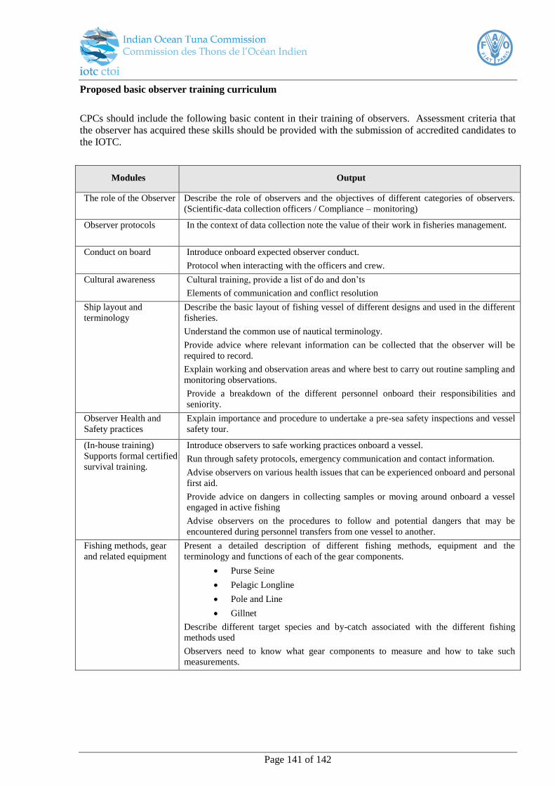
Page 141 of 142
Proposed basic observer training curriculum
CPCs should include the following basic content in their training of observers. Assessment criteria that
the observer has acquired these skills should be provided with the submission of accredited candidates to
the IOTC.
Modules Output
The role of the Observer Describe the role of observers and the objectives of different categories of observers.
(Scientific-data collection officers / Compliance – monitoring)
Observer protocols In the context of data collection note the value of their work in fisheries management.
Conduct on board Introduce onboard expected observer conduct.
Protocol when interacting with the officers and crew.
Cultural awareness Cultural training, provide a list of do and don’ts
Elements of communication and conflict resolution
Ship layout and
terminology
Describe the basic layout of fishing vessel of different designs and used in the different
fisheries.
Understand the common use of nautical terminology.
Provide advice where relevant information can be collected that the observer will be
required to record.
Explain working and observation areas and where best to carry out routine sampling and
monitoring observations.
Provide a breakdown of the different personnel onboard their responsibilities and
seniority.
Observer Health and
Safety practices
Explain importance and procedure to undertake a pre-sea safety inspections and vessel
safety tour.
(In-house training)
Supports formal certified
survival training.
Introduce observers to safe working practices onboard a vessel.
Run through safety protocols, emergency communication and contact information.
Advise observers on various health issues that can be experienced onboard and personal
first aid.
Provide advice on dangers in collecting samples or moving around onboard a vessel
engaged in active fishing
Advise observers on the procedures to follow and potential dangers that may be
encountered during personnel transfers from one vessel to another.
Fishing methods, gear
and related equipment
Present a detailed description of different fishing methods, equipment and the
terminology and functions of each of the gear components.
Purse Seine
Pelagic Longline
Pole and Line
Gillnet
Describe different target species and by-catch associated with the different fishing
methods used
Observers need to know what gear components to measure and how to take such
measurements.
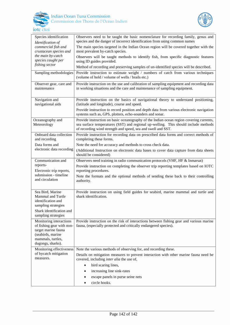
Page 142 of 142
Species identification
Identification of
commercial fish and
crustacean species and
the main by-catch
species caught per
fishing sector
Observers need to be taught the basic nomenclature for recording family, genus and
species and the danger of incorrect identification from using common names
The main species targeted in the Indian Ocean region will be covered together with the
most prevalent by-catch species.
Observers will be taught methods to identify fish, from specific diagnostic features
using ID guides provided.
Method of recording and preserving samples of un-identified species will be described.
Sampling methodologies Provide instruction to estimate weight / numbers of catch from various techniques
(volume of hold / volume of wells / brails etc.)
Observer gear, care and
maintenance
Provide instruction on the use and calibration of sampling equipment and recording data
in working situations and the care and maintenance of sampling equipment.
Navigation and
navigational aids
Provide instruction on the basics of navigational theory to understand positioning,
(latitude and longitude), course and speed.
Provide instruction to record position and depth data from various electronic navigation
systems such as, GPS, plotters, echo-sounders and sonar.
Oceanography and
Meteorology
Provide instruction on basic oceanography of the Indian ocean region covering currents,
sea surface temperatures (SST) and regional up-welling. This should include methods
of recording wind strength and speed, sea and swell and SST.
Onboard data collection
and recording
Data forms and
electronic data recording
Provide instruction for recording data on prescribed data forms and correct methods of
completing these forms.
Note the need for accuracy and methods to cross check data.
(Additional Instruction on electronic data bases to cover data capture from data sheets
should be considered)
Communication and
reports-
Electronic trip reports,
submission - timeline
and circulation
Observers need training in radio communication protocols (VHF, HF & Inmarsat)
Provide instruction on completing the observer trip reporting templates based on IOTC
reporting procedures.
Note the formats and the optional methods of sending these back to their controlling
authority.
Sea Bird, Marine
Mammal and Turtle
identification and
sampling strategies
Shark identification and
sampling strategies
Provide instruction on using field guides for seabird, marine mammal and turtle and
shark identification.
Monitoring interactions
of fishing gear with non-
target marine fauna
(seabirds, marine
mammals, turtles,
dugongs, sharks).
Provide instruction on the risk of interactions between fishing gear and various marine
fauna, (especially protected and critically endangered species).
Monitoring effectiveness
of bycatch mitigation
measures.
Note the various methods of observing for, and recording these.
Details on mitigation measures to prevent interaction with other marine fauna need be
covered, including inter alia the use of,
bird scaring lines,
increasing line sink-rates
escape panels in purse seine nets
circle hooks.