The Oman Gharif mixed paleoflora: a useful tool for testing Permian Pangea reconstructions

Geological Society of Americ;1 Special Paper 288
1994
Introduction: Project Pangea and workshop recommendations
George D. Klein
New Jersey Marine Sciences Consortium, Building #22. Fort Hancock, New Jersey 07732
Benoit Beauchamp
Institute of Sedimentary and Petroleum. Geology, Geological Survey of Canada, 3303 33rd Street NW, Calgary,
Alberta, T2L 2A7, Canada
With contributions by:
AymonBaud
Musee Geologique, UN/L-BFSH 2, CH-10/5 Lausanne, Switzerland
Boris I. Chuvashov
Institute of Geology and Geochemistry, Academy of Sciences, Uralian Branch, Pochtovyi per 7, 62009 Cateriniburg, Russia
Oscar R. Lopez-Gamundi
Frontier Exploration-South America, Texaco, 4800 Fourace Place, Bellaire, Texas 77401-2324
Judith T. Parrish
Department of Geosciences, Gould-Simpson Building 77, University of Arizona, Tucson, Arizona 85721
Charles A. Ross
Geostrat Consultants, 600 Highland Drive, Bellingham, Washington 98225-6410
Peter A. Scholle
Department of Geological Sciences, Heroy Building, Southern Methodist University, Dallas, Texas 75275
Christopher R. Scotese
Department of Geology, University of Texas at Arlington, P.O. Boz 19049. Arlington, Texas 76019
W. Lynn Watoey
Kansas Geological Survey, 1930 Constam Avenue, Lawrence, Kansas 66047-2598
PREAMBLE
A major number of problems concerning the nature and consequences of natural or anthropogenic environmental change can be solved only by the geological sciences. Many of these problems require separation of first-order driving mechanisms from background processes. Long-term as well as shortterm variations during geological time in the numerical
magnitudes of different environmental parameters are not weU
understood, however. The maximum and minimum rates of environmental change that occurred during geological time also remain unknown, and their global as well as local scale and consequences are poorly understood.
To address these problems and correlate them to current environmental concerns, an intensive study of the sedimentary record is mandatory because that record is the only source from which critical data can be obtained. Additional data are needed to calibrate the sedimentary record in terms of first
order processes characteristic of Earth as a planet. These include both mantle-driven processes (intrinsic) that drive plate
tectonics, including the assembly and breakup of supercontinents, and solar-driven processes (extrinsic) that influence
long-term and short-term climatic changes, such as advance and retreat of continental glaciers, changes in upweUing cycles, changes in monsoonal climate patterns, and desertification. Study of the sedimentary record involves examining the preservation of both intrinsicaUy controlled and extrinsically controlled depositional events during Earth's history. Expressed in another way, the sedimentary record can be viewed as a strip-chart recording of the intrinsic and extrinsic record of Earth history.
Among the most spectacular manifestations of concurrent intrinsic and extrinsic changes are the assembly of the supercontinent Pangea during late Paleozoic and early Mesozoic Lime and its subsequent breakup and dispersal during latest Triassic and earliest to middle Jurassic time that led to the present-day disposition of continents. Thus studies of Pangea's sedimentary record to determine long-term and short-term magnitudes of environmental changes must involve multidisciplinary aspects of geodynamics and climate modeling. This
Klein, G. D., and Beauchamp, B., 1994, Introduction: Project Pangea and workshop recommendations, in Klein, G. D .• ed., Pangea: Paleoclimate. Tectonics, and Sedimentation During Accretion, Zenith, and Breakup of a Supercontinent: Boulder, Colorado. Geological Society of America Special Paper 288.
2 G. D. Klein and B. Beauchamp
volume focuses on the current state of the art of research about these changes during tbe evolution of Pangea.
Many major resources are known to occur within the stratigraphic record represented by the 145-m.y. record of Pangea. These include extensi-ve source beds and reservoirs of petroleum and natural gas, coal, evaporites including potaSh, and phosphate deposits. Their occurrences appear to be controlled in part by the mantle-driven tectonic history of Pangea, whereas other occurrences can be attributed to solar-driven climatic change and associated changes in oceanic circulation and upwemng. An intensive study of the sedimentary rock record of Pangea wiiJ improve prediction of occurrences of these resources and establishment of their origin.
This volume focuses on the sedimentary record associated with the evolution of the supercontinent Pangea. The chapters represent state-of-the-art research summaries of wbat is known and what work is expected in the future relevant to the changing role of paleoclimate on the sedimentary record during the accretion, zenith, and breakup of a supercontinent. These papers were presented during an international workshop held in Lawrence, Kansas, in May 1992 to define the research direction of Project Pangea, the second research effort of the Global Sedimentary Geology Program (GSGP) of the International Union of Geological Sciences (lUGS).
Project Pangea focuses on the most recent time of supercontinent accretion and dispersal when continents merged toward a geoid low, and much of Pangea's climate appeared to be disposed in an icehouse mode. The accretion and dispersal of Pangea are the most recent examples of a recurring longterm global cyclic phenomenon. The 145-m.y. interval of Pangeas' s history, however. was characterized by considerable climatic variability that belies the broad-scale icehouse climate suggested for tjmes of supercominent development Consequently, Pangea's sedimentary record represents an ideal interval during Earth history from which to evaluate the processes and magnitude of environmental variability and develop a predictive rationale for evaluating current global environmental concerns. Study of Pangeas's sedimentary record is justified further as a baseline for study of intrinsic and extrinsic processes and effects associated with Precambrian supercontinents and of the history of continental growth and evolution because that record can present maximum and mjnimum values of the qualitative and quantitative variability of climatic-driven processes on the sedimentary record.
RESEARCH PROBLEMS
The following research problems were identified as potential salient components in Project Pangea during prelimjnary planning prior to the Project Pangea Workshop held in Lawrence, Kansas. from May 23 through 28, 1992. These initial problem sets included:
I. What is the causal connection between large-scale global climatic change, such as the icehouse-greenhouse
change and the history of flux of C02 from the mantle? To what extent is that climatic change providing a signal of intrinsic, mantle-driven processes influencing climatic change both for the long term and the short term?
2. What is the record of variation of oxygen, sulphur, strontium, and carbon isotopic composition of seawater during Pennsylvanian, Permian, Triassic, and Jurassic time? How does this record constrain paleoclimatic models calibrated from the sedimentary record?
3. What was the role of astronomical forcing factors (Milankovitch orbital parameters) in driving solar-driven climatic change, and how complete is the record of such deposition that is preserved in cyclic sequence such as the famous cyclothems of the Pennsylvanian or the lacustrine cycles of the Triassic? Is this forcing dominant or subordinate? What is their record of preservation of forcing factors in both cyclic and noncyclic stratigraphic sequences? What short-term, intrinsically forced, tectonic processes can mimic, mask, or override the preservation record of astronomical forcing?
4. What mechanism controls relative changes in sea level that existed at time scales ranging from glacial (tens of thousands of years), to intermediate (one to I 0 million years). to changes in seafloor spreading rates (tens of millions of years)? To what extent are these changes representative of convergence and separation of intrinsic and extrinsic forcing factors?
5. What does widespread occurrence of Permo-Triassic evaporites indicate about global climatic change during development of the supercontinent Pangea? How did storage of large quantities of salt in Permo-Triassic basins modify oceanic chemistry? To what extent did such evaporation develop a more brackjsh global ocean, and to what extent did such a chemical change contribute to late Permian extinctions?
6. What are the structure, strength, and effect of both intrinsically forced and extrinsically forced climatic change on the preservation, life history, and evolution of terrestrial and marine flora and fauna? What are the consequences of climatic changes on the distribution, deposition, and preservation of petroleum and metalliferous source beds? How did these climatic changes influence the distribution of warm- and coldclimate coals? Of evaporites? Of phosphates? What specific combmation of intrinsic and/or extrinsic processes favored the deposition and preservation of glacial sedimentary facies? How did these changes influence the history of sea level during the accretion, zenith, and dispersal of Pangea?
7. What combination of intrinsic and extrinsic forcing factors influenced the variability of Permo-Triassic reef facies? How did these forcing factors influence the temporal distribution and evolutionary history of the reef facies? What was the rate of change in evolution and facies sryle of these reefs, and how can they be compared to different Holocene reef communities?
8. What are the combined or separated intrinsic and extrinsic forcing factors that produced profound biological changes during the Permo-Triassic? What were the driving
lmroduction 3
forces that caused rapid change (collapse?) of existing ecosystems? Were the causes extraterrestrial or mantle driven?
9. How do changing continental paleoposition, paleoclimates, and sea-level change influence the evolutionary record of continental flora and fauna during the accretion, zenith, and dispersal of Pangea? How did changing paleogeography influence paleobiogeography during the history of Pangea? What were the dynamics of floral and faunal replacement and the evolution of terrestrial ecosystems? How did these changes in terrrestrial life history interface with changes in marine Life history? What do associated paleobiogeographic changes indicate about the magnitude and rate of climatic change?
WORKSHOP ACTIVITIES
An international workshop, from May 23 through 28,
1992. was held to organize the research effort for Project Pangea, which is the second project sponsored by the GSGP, a commission of the JUGS. The goal of the workshop was to recommend international and multidisciplinary research objectives within the framework of Project Pangea.
Principal objectives for Project Pangea are to (I) understand global processes, their magnitude and temporal variations during the time of accretion, zenith, and breakup of the supercontinent Pangea; (2) examine the global sedimentary record and variability from the base of the Pennsylvanian (Middle Carboniferous) through the Middle Jurassic; (3) determine the cause and nature of climate variability during Pangea's existence; and (4) determine the causes of PermoTriassic and Triassic-Jurassic extinctions. However, during the workshop it became clear that the major objective for Project Pangea that is expected to lead to new, significant, and different results is paleoclimate modeling and geological verifica
tion of such models.
The Project Pangea workshop itself was organized into an opening plenary session of invited papers, a special plenary session on Paleoclimate Modeling, and breakout sessions by the working groups who formulated recommendations for research as well as hosted sessions of short contributed papers.
The opening plenary session on Sunday, May 24, 1992,
consisted of the following invited talks:
George D. KJein, U.S.A.-Project Pangea: Goals and developments; tectonic-climatic discrimination of cyclic deposition.
John J. Veevers, Australia-Pangea: Evolution of a supercontinent and its consequences for Earth's paleoclimate and sedimentary environments.
Thomas J. Crowley, U.S.A.-Pangean paleoclimates. George T. Moore, D. N. Hayashida, C. A. Ross. and S. R.
Jacobson. U.S.A.-The paleoclimate of Pangea during its formation (Late Permian) and disintegration (Late Jurassic).
Jane Francis, UK-Paleoclimates of Pangea (geological evidence).
Martin A. Perlmuuer and M.D. Matthews, U.S.A.--Olobal cy-
clostratigraphy: Depositional response to climate change and basin evolution.
Ethan L. Grossman, U.S.A.-The stable isotope record during the evolution of Pangea: Progress and prospects.
John J. Veevers and S. E. Shaw, Australia-Turning point in Pangean environmental history at or about the Permian/ Triassic boundary.
Sarah Fowell, U.S.A.-Late Triassic palynoflora! evolutions and climate cyclicity, eastern North America.
Benoit Beauchamp, Canada-Carboniferous to Triassic tectono-climatic evolution of northern Pangea.
Erik Flugcl, Germany-Pangean shelf carbonates: Controls of Permian and Triassic reef and platform development.
Aymon Baud, Switzerland-Late Permian to Late Triassic of the Tethys: Existing problems, new facts, and theories�a review.
To assist in developing synergism between sedimentary geology and paleoclimate modeling, a separate special plenary session dealt with paleoclimate modeling and model-geological observations and comparisons. Organized by Dr. Bette Ouo-Bleisner and Mark Chandler, both of the U.S.A., this session not only included the following presentations but also brought together the paleoclimate modeling community with the sedimentary geological community for the ftrst time.
Chris R. Scotese and Jan Golonka, U.S.A-Phanerozoic paleogeographic maps.
Malcolm I. Ross, C. R. Scotese, A. J. Boucot, Chen Xu, and Anne Raymond, U.S.A.-Late Carboniferous climatic simulation using a simple parametric climate model.
John E. Kutzbach and A. M. Ziegler, U.S.A-Numerical simulation of the climate of Pangea-Late Carboniferous climatic simulation using a simple parametric climate model.
Eric D. Gyllenhaal and A. M. Ziegler, U.S.A-Comparisons of lithologic and paleobotanical data with predictions of atmospheric general circulation models: Examples from the Late Permian.
Starley L. Thompson, David Pollard, W. W. Hay, and Kevin Wilson, U.S.A.-Simulations of Triassic climate using a global circulation climate model.
Peter J. Fawcett and Eric J Barron, U.S.A.-The climatic evolution of India and Australia from the Late Permian to Jurassic: A comparison of climate model results with the geologic record.
Bruce W. Sellwood, P. Valdes, and G. Price, UK-Climate modeling in the Jurassic: GCM predictions in comparison with the geological data base.
Mark Chandler, U.S.A.-Pangean climate of the early Jurassic: GCM simulations, the paleoclimate record climate feedbacks, and increased heat transport.
Robert J. Oglesby, U.S.A.-M� the effects of orbital insolation changes on pre-Pleistocene climates and sedimentary cycles.
4 G. D. Klein and B. Beauchamp
Thomas R. Worsley, T. L. Moore, C. R. Scotese, and Carmen M. Fraticelli, U.S.A.-Phanerozoic paleoceanography and global climate.
The final closing plenary session on May 27 consisted of presentations of recommendations from each working group for future research activities within Project Pangea. These are summarized in the sections that follow.
WORKSHOP RECOMMENDATIONS
Project 1-'angea was originally organized into five working groups, but it became clear during the workshop that the working group structure needed some revision and reorganization. Principal recommendations of the new working groups (by name) are summarized below.
Working group 1: Paleoclimate (Judith T. Parrish, U.S.A. chair)
The scientific rationale for pursuing modeling studies of paleoclimate is twofold. For climatologists, such studies provide opportunities for testing the sensitivity of climate models to changing, realistic boundary conditions. Pangea represented an extreme paleogeography with an associated possible extreme climate regime. Successful simulation of this extreme climate would demonstrate robustness of the climate models. For geologists, modeling studies enhance understanding of the effects of climate on the geological record, especially sedimentation, diagenesis, evolution, extinction, and biogeography. Climatic models also may provide a global framework within which the relatively scattered data on paleoclimate might be interpreted.
WG-1 participants observed that first-order agreement was achieved when comparing the results of all climate models that were applied to Pangea. Thus, future work should focus on climate forcing and response. Three general and overlapping recommendations of areas of future research were offered: (I) specific studies of critical paleoclimatic processes, (2) model-model comparisons, and (3) data and model-data comparisons. Although geological participation is critical for the third recommendations, cooperation with other working groups is needed in all these areas of research.
Critical paleoclimatic processes. WG-1 recommended that whenever possible, the climate modeling research community should target critical climatic processes for treatment with sensitivity tests. Sensitivity tests are successive model runs in which one or two variables are changed. The test permits analysis of model behavior and helps identify processes that are particularly important for climate, given certain starting conditions (such as paleogeography). Critical climatic processes already identified as appropriate for such treatment are (I) ocean heat transport/sea surface temperature (OHT/ SST). (2) orbital variability, (3) C02, (4) paleogeography, es-
pecially topography and sea level, and (5) ice. Currently, OHT/SST are either computed or specified but in both cases are artificially constrained.
WG-1 recommended minimizing the constraints as well as conducting sensitivity tests. Model results already suggest that climate may be very sensitive to topography, and thus WG-1 recommended that WG-2 emphasize determining not only the distribution of highlands but also their altitudes and topographic profiles.
The most complete climate models are those that couple the oceans and atmosphere. Creating coupled ocean-atmosphere models is currently a major effort in climatology, but such models are still relatively undeveloped. Nevertheless, WG-1 foresees the possibility that such models will become available during the Lifetime of Project Pangea, and thus recommended as a long-term goal the creation of paleogeographic models of paleobathymetry that will permit effective study of deep-ocean circulation.
Model-model comparisons. WG-1 recommended that, when presenting results in published papers, climate modelers specifically address differences among various models because these differences are important for interpreting the geological record. Geologists are not equipped by training to interpret differences in model results and thus depend on expertise of climate modelers to make those interpretations. To facilitate comparisons, WG-1 recommended that whenever possible, the modeling community use some boundary conditions in common. Specifically, WG-1 recommended using common values of (I) percent change in solar constant, (2) rotation rates, (3) for the present, C02 values from the Berner curve, (4) seasonal, rather than perpetual, models, and (5) va.lues for orbital parameters, that is, eccentricity = 0 and perihelion = 0. Additionally, WG-1 recommended that climate modelers address both interannual variability and long-term planetary averages. A long-term goal of WG-1 is to produce a document comparing model results and discussing the implications of model results from interpretation of paleoclimates.
Data and model-data comparisons. WG-1 strongly supported efforts withjo WG-3 to gain participation of experts on various paleoclimate indicators to facilitate compilation of data in a manner exploiting the full potential of the geological record. WG-1 supports ongoing efforts to calibrate sedimentological and paleontological indicators using modem climate. Additional, WG-1 recommended collection of data in such a manner as to capture the full range of variability of each modeled interval to more effectively tie the geological record into model runs that examine climatic maxima and minima with respect to, for instance, orbital parameters and sea level.
WG-1 identified three major problems worthy of particular attention and requiring geological data. These problems (and some of the required data) are: (I) strong winter cooling and extreme seasonality of temperature in the Sou�emisphere (paleobotanical and other biotic data. sedimentary evidence of freezing. soil isotopes, moisture estimates); (2} C02 (proxy data

Introduction 5
for C02-for example, isotopes in paleosols and marine organic carbon); and (3) tropical and polar sea surface temperatures (isotopes, Sr/Ca paleothermometer). Because, for example, coals are not precise rainfall indicators but rather indicate water table levels, WG-1 advised that both modelers and geologists must be critical in interpretations of moisture balance in their models and that model outputs must be compared with appropriate data.
WG- I also discussed targeting specific time slices. WG-1 concluded that their model studies should focus on time slices proposed by WG-2 and WG-3 be.cause their criteria for chosing time slices are the same criteria WG-1 would use, namely data availability. Modeling studies are still experimental, so much studies require the best data available for distinguishing among results of various sensitivity tests.
WG-1 observed that the number of modeling studies of Pangea indicates that these intervals present problems that are inherently of interest to modelers. Geological expertise is essential to these studies for identifying important aspects of the problem of Pangean climates.
Working group 2: Plate tectonics and paleogeography (Christopher R. Scotese, U.S.A. chair)
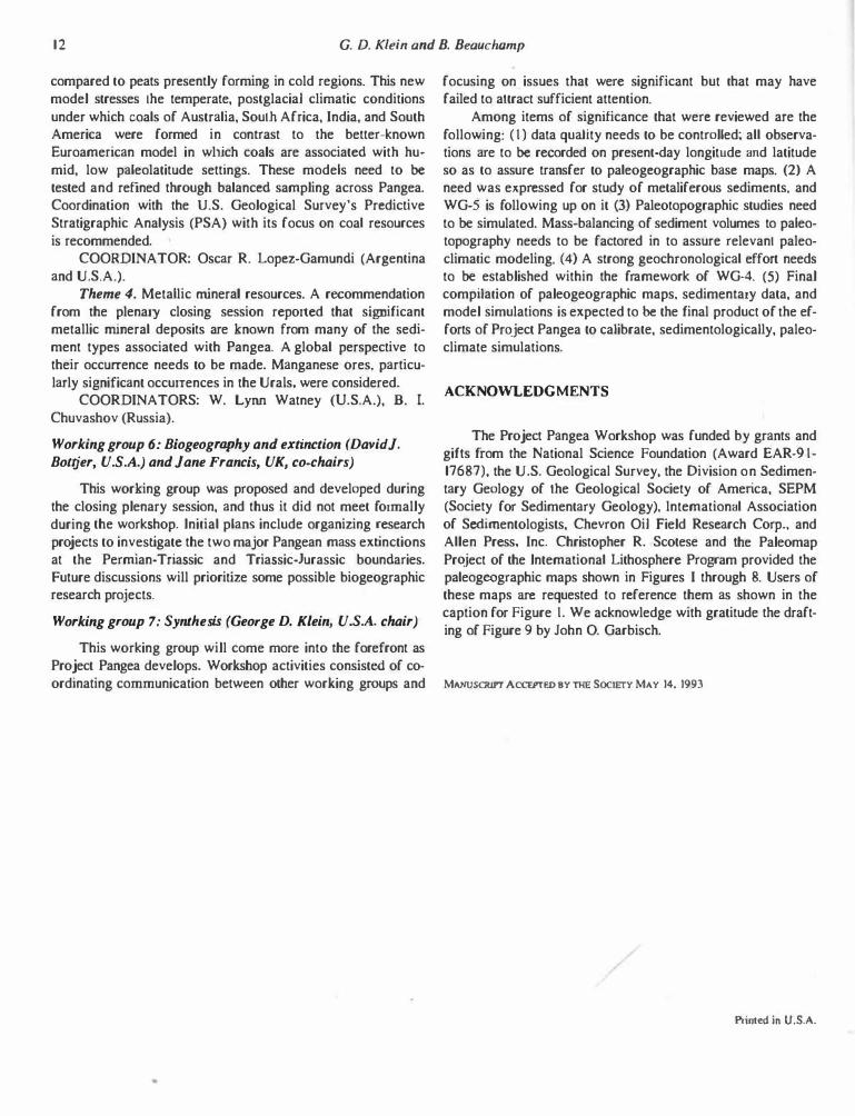
The principal goal of WG-2 is to produce large-scale paleogeographic maps illustrating the distribution of mountains, land, shallow oceans, and deep ocean basins for five time intervals during the history of Pangea-namely, the latest Carboniferous to earliest Permian (Stephanian-Autunian), Late Permian (Kazanian), earliest Triassic (Scythian), Late Triassic (Kantian), and early Jurassic (Pliensbachian). Preliminary versions of these maps would be distributed to other working groups and would serve as base maps on which biogeographic, oceanographic, economic, sedimentological, and paleoclimatic data could be com-
piled. Besides the five detailed paleogeographic maps, WG-2 will produce approximately 15 plate tectonic base maps (one for each stage from the Late Carboniferous through the Middle Jurassic). Figures I through 8 show paleogeographic base maps for use by Project Pangea scientists.
Final versions of these maps would show the distribution of mountains, land, and sea as weU as active plate boundaries and major structural features, major lithofacies, significant accessory lithofacies (reefs, coal, evaporites), important paleogeographic features (lakes, major rivers, impact sites). pojjtical boundaries and modem geographic features for reference, and an index map providing sources of information displayed on the maps. All this information would be compiled on a set of present-day base maps (Mercator projection, I: I 0,000,000) and then digitized and replotted on re.constructed base maps at the preferred publication scale of I :20,000,000.
WG-2 formed nine regional panels (Table 1) to compile the information for these maps. Panel coordinators will compile the paleogeographic information for each time slice. The Paleomap Project, University of Texas at Arlington, will provide the present-day base maps, coordinate digital compilation of the paleogeography, and produce the final reconstructions.
Working group 3: Global synchroneity of the sedimentary record (Benoit Beauchamp, Caru.ula, and P. A. SchoUe, U.S.A, co-chairs)
WG-3 proposed two major recommendations: Recommendation 1. To scrutinize in great detail the sedi
mentary record of three time slices during the history of Pangea. These time slices are Moscovian (305-315 Ma), Kazanian (264-269 Ma), and Carnian (220-228 Ma). The goal in analyzing these time slices is to compile an inventory of the
Figure I. Paleogeographic map, Late Carboniferous (Westphalian), 306 Ma. (When citing this map, please cite it as follows: Scotese. C. R., 1994. Late Carboniferous paleogeographic map. in Klein, G. D., ed., Pangea: Paleoclimate, Tectonics, and Sedimentation During Accretion. Zenith, and Brealcup of a Supercontinent: Boulder, Colorado, Geological Society of America Special Paper 288.)

6 G. D. Klein and B. Beauchamp
Figure 2. Paleogeographic map, Early Permian (Artinskian), 277 Ma. (When citing this map, please cite it as follows: Scotese, C. R .. 1994, Early Pennian paleogeographic map, in Klein, G. D .• ecJ., Pangea: Paleoclimate, Tectonics, and Sedimentation During Accretion, Zenith, and Breakup of a Supercontinent: Boulder, Colorado, Geological Society of America Special Paper 288.)
Figure 3. Paleogeographic map, Late Pennian (Kazanian), 255 Ma. (When citing this map, please cite it as follows: Scotese, C. R., 1994, Late Pennian paleogeographic map, in Klein, G. D., ed., Pangea: Paleoclimate. Tectonics, and Sedimentation During Accretion, Zenith, and Breakup of a Supercontinent: Boulder, Colorado. Geological Society of America Special Paper 288.)
total spectrum of marine and nonmarine climate-sensitive facies in order to reconstruct the global paleoclimatic-environ
mental setting for each time scale and to provide a standardized set of data to other specialists, especially climate modelers and paleo geographers.
Data to be compiled by WG-3 will comprise both published and newly acquired data. Data collection, where possible, will be completed in digital format, through expen systems and questionnaires. A basic set of background information will accompany each data entry. This basic informa-
tion will provide stratigraphic data, geographic data (present longitude and latitude, volume), detailed lithofacies and thick
ness, tectonic setting, vertical and lateral variability (eustatic,
tectonics, or climatic changes), and fossil content. Specific climatic indicators to be catalogued include: Exposure-related features. Calcrete (pedogenic and
nonpedogenic), paleosols, karst, bauxites and related deposits, red beds.
Glacial deposits. Terrestrial (all typeS), marine, glendonites. Eolian deposits. Sand seas (dune deposits), eolian dust.
Introduction 7
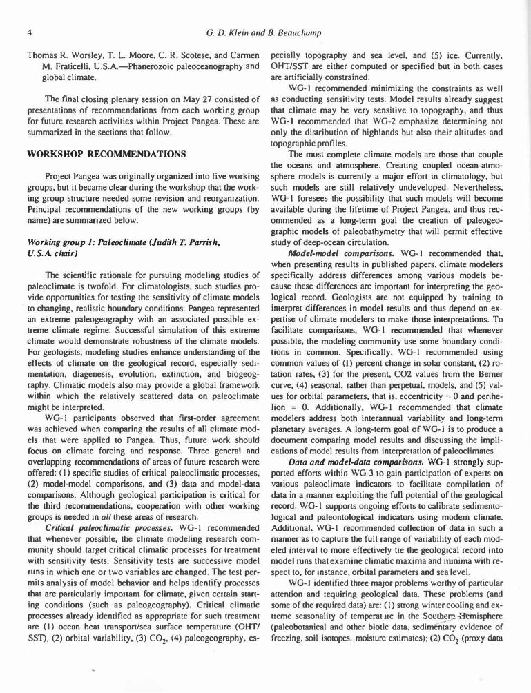
Figure 4. Paleogeographic map, Early Triassic (lnduan), 242 Ma. (When citing this map, please cite it as follows: Scotese, C. R .. 1994. Early Triassic paleogeographic map. in Klein, G. D., ed .. Pangea: Paleoclimate, Tectonics, and Sedimentation During Accretion, Zenith, and Breakup of a Supercontinent: Boulder, Colorado. Geological Society of America Special Paper 288.)
Figure 5. Paleogeographic map. Late Triassic (Norian). 216 Ma. (When citing this map, please cite it as follows: Scotese, C. R., 1994, Late Triassic paleogeographic map, in Klein. G. D .. ed .. Pangea: Paleoclimate. Tectonics, and Sedimentation During Accretion, Zenith, and Breakup of a Supercontinent: Boulder. Colorado, Geological Sociery of America Special Paper 288.)
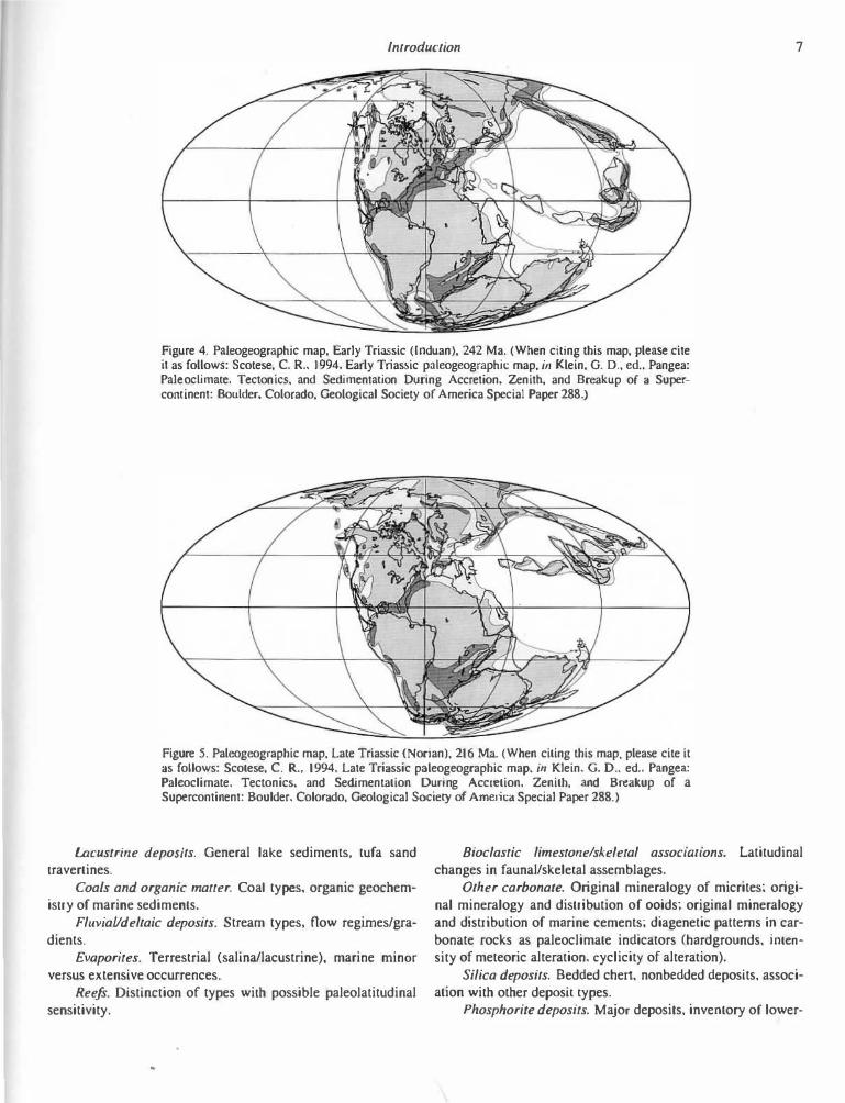
Lacustrine deposits. General lake sediments, tufa sand travertines.
Coals and organic matter. Coal types. organic geochemistry of marine sediments.
Fluvial/deltaic deposits. Stream types, flow regimes/gradients.
Evaporites. Terrestrial (salina/lacustrine), marine minor
versus extensive occurrences. Reefs. Distinction of types with possible paleolatitudinal
sensitivity.
Bioclastic limestone/skeletal assocwuons. Latitudinal changes in faunal/skeletal assemblages.
Other carbonate. Original mineralogy of micrites; original mineralogy and distribution of ooids; original mineralogy and distribution of marine cements; diagenetic patterns in carbonate rocks as paleoclimate indicators (hardgrounds, inten
sity of meteoric alteration. cyclicity of alteration).
Silica deposits. Bedded chert, nonbedded deposits, association with other deposit types.
Phosphorite deposits. Major deposits, inventory of lower-

8 G. D. Klein and B. Beauchamp
Figure 6. Paleogeographic map, Early Jurassic (Pliensbachian), 195 Ma. (When citing this map, please cite it as follows: Scotese, C. R., 1994, Early Jurassic paleogeographic map. in Klein, G. D .. ed., Pangea: Paleoclimate, Tectonics, and Sedimentation During Accretion. Zenith, and Breakup of a Supercontinent: Boulder. Colorado, Geological Society of America Special Paper 288.)
Figure 7. Paleogeographic map, Middle Jurassic (Callovian), 166 Ma. (When citing this map, please cite it as follows: Scotese, C. R., 1994, Middle Jurassic paleogeographic map, in Klein. G. D., eeL, Pangea: Paleoclimate. Tectonics, and Sedimentation During Accretion, Zenith. and Breakup of a Supercontine nt: Boulder. Colorado, Geological Society of America Special Paper 288.)
concentration deposits, identification of upwelling zones. Iron-bearing mineral deposits. Glauconite, chamosite,
oolitic ironstone. Shales. Clay mineralogy, distinction of primary versus
diagenetic assemblages. Isotope geochemistry. Oxygen and carbon on brachio
pods; other oxygen and carbon studies (whole rock, phosphates, water), sulfur on carbonates and evaporites, strontium, stratigraphic (secular) versus regional/climatic variations.
Paleobiogeography, pa/eocology, paleocommunities. Nonmarine (plants, tetrapods, and other vertebrates, trace fos-
sils), marine (biogeographic patterns of marine organisms; trace fossils fburrowslboringsJ; determination of paleo-oxygenation levels [laminae/bioturbation patterns}).
Recommendation 2. To examine the global sedimentary record of a long-ranging interval of Pangea's history to establish links between such seemingly unrelated. yet often synchronous, aspects of the geological record as climatic evolution, sequence boundaries, biogeography, tectonic shifts, and extraterrestrial impacts. This part of Project Pangea will examine Pangea as a highly interactive and dynamic system characterized by Long periods of stability in the atmosphere,
Introduction 9
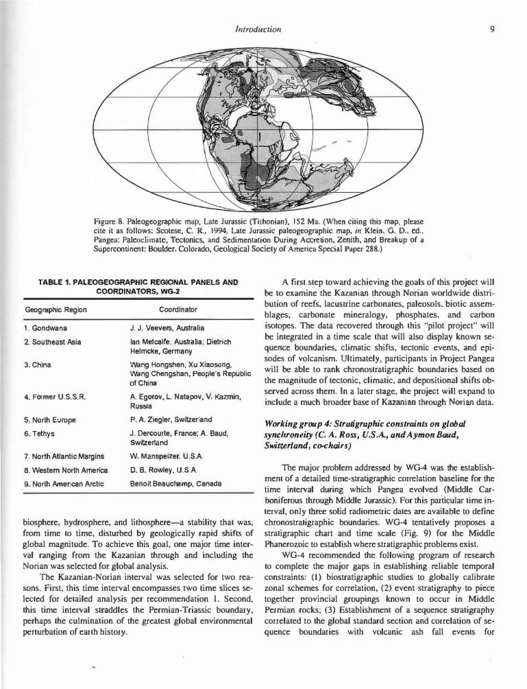
Figure 8. Paleogeographic map, Late Jurassic (Tithonian), 152 Ma. (When citing this map, please cite it as follows: Scotese, C. R., 1994, Late Jurassic paleogeographic map, in Klein, G. D., ed., Pangea: Paleoclimate, Tectonics, and Sedimentation During Accretion, Zenith, and Breakup of a Supercontinent: Boulder, Colorado, Geological Society of America Special Paper 288.)
TABLE 1. PALEOGEOGRAPHIC REGIONAL PANELS AND
COORDINATORS, WG-2
Geographic Region
1. Gondwana
2. Southeast Asia
3. China
4. Former U.S.S.R.
5. North Europe
6. Tethys
7. North Atlantic Margins
8. Western North America
9. North American Arctic
Coordinator
J. J. Veevers, Australia
lan Metcalfe, Australia; Dietrich Helmcke, Germany
Wang Hongshen, Xu Xiaosong, Wang Chengshan, People's Republic of China
A. Egorov, L. Natapov, V. Kazmin, Russia
P. A. Ziegler, Switzerland
J. Dercourte, France; A. Baud, Switzerland
W. Manspeizer, U.S.A.
D. B. Rowley, U.S.A.
Benoit Beauchamp, Canada
biosphere, hydrosphere, and lithosphere-a stability that was, from time to time, disturbed by geologically rapid shifts of global magnitude. To achieve this goal, one major time interval ranging from the Kazanian through and including the Norian was selected for global analysis.
The Kazanian-Norian interval was selected for two reasons. First, this time interval encompasses two time slices selected for detailed analysis per recommendation I. Second,
this Lime interval straddles the Permian-Triassic boundary, perhaps the culmination of the greatest global environmental perturbation of earth history.
A first step toward achieving the goals of this project will be to examine the Kazanian through Norian worldwide distribution of reefs, lacustrine carbonates, paleosols, biotic assemblages, carbonate mineralogy, phosphates, and carbon isotopes. The data recovered through this "pilot project" will
be integrated in a time scale that will also display known sequence boundaries, climatic shifts, tectonic events, and episodes of volcanism. Ultimately, participants in Project Pangea will be able to rank chronostratigraphic boundaries based on the magnitude of tectonic, climatic, and depositional shifts observed across them. ln a later stage, the project will expand to include a much broader base of Kazanian through Norian data.
Working group 4: Stratigraphic constraints on global syn�llroneity (C. A. Ross, U.S.A., and Aymon Baud, Switzerland, co-chairs)
The major problem addressed by WG-4 was the establishment of a detailed time-stratigraphic correlation baseline for the time interval during which Pangea evolved (Middle Carboniferous through Middle Jurassic). For this particular time interval, only three solid radiometric dates are available to define chronostratigraphic boundaries. WG-4 tentatively proposes a stratigraphic chart and time scale (Fig. 9) for the Middle Phanerozoic to establish where stratigraphic problems exist.
WG-4 recommended the following program of research to complete the major gaps in establishing reliable temporal constraints: (I) biostratigraphic studies to globally calibrate zonal schemes for correlation, (2) event stratigraphy to piece together provincial groupings known to occur in Middle Permian rocks; (3) Establishment of a sequence stratigraphy correlated to the global standard section and correlation of sequence boundaries with volcanic ash fall events for

10 G. D. Klein and B. Beauchamp
PANGEA TIME SCALE WG 3 C. ROSS, A BAUD, M. MENNING
Approximate -Num. Eastern Europe Tethys S. W. North America ageMa ageM.a w E
u ·-C'-l C'-l � ..... :::::::1 ......,
u ·-C'-l C'-l � ·t::
�
� � ·
� 0
Q.c
-
C'-l ::s 0 �
] 0
� u
Late 150
f= 160 �· Middle � no � t: rl§O t:
-190 Early := b; � t: 208 �0
Late f= no f= � �0
Middle t: � Early t:
*251±2 25o � Late 1-�60
.. � Top of � � no KitlmQit � reversed 1-polarity uo superchron � Early 1-2'90 � *295±5-1-Late 3oo
E 3io Middle � 1-120 � Early 1-13o
Begiruainf of t: Glacial ion "'"' . Go-..1... 340 In nuwiVIQ
152
157
165 171
179 186 194
201
212
220
228
•234
241 246
£.!uf}.ian Platfonn ( a a&UIQS thai are not Tatarian us�folfor )(aZait� global utuman '-correloJion) �ungunan 275- - - - -
Artinskian 283 287 Sakmarian
Asselian
300 Gzelian 305 Kasimovian
Moscovian 315
Bashkirian 320±10
Serphukovian
- - - 333±11 -
Oxfordian Callovian Bathonian
Bajocian
Aalenian
Toarcian Pliensbachian
Sinemurian
Hettangian Khaet•an Norian
Carnian
Ladinian Anisian
.. Scythian" Olenekian Induan
�hamian Cbanghslnglan 255 Dzhulfian Wuchia ingian 259 Mid ian 264 Maokou Murgabian
269 Kuber2and1an '""'Bolorlan 273
Chihsia Artinskian
Sakmarian
Asselian Maping
Stephanian
D Westphalian c B A
c B
Namurian A - - - - ---
- - - - - - -
------
� - - ? - ? - ? - -Ochoan
G dal . Capilanian ua uptan . an
Calhedralian Leonardian . L 275
Hess!BD E
-
Wolfcampian
Vi!!! I ian .Missourian Desmoinesian Atokan 1 Morrowan Chesterian
"- - - - - - -
Note: Line thickness is used only to highlight significant boundaries
* radiometric ages (tie points), all others are based on geologic inference.
Figure 9. Tentative Project Pangea Time Scale prepared by C. A. Ross, A. Baud, and M Menning on behalf of WG-3 (drafted by John 0. Garbisch). Asterisks indicate radiometric ages (tie poi.nts); all other ages are based on geologic inference.
-Num. -a ageMa o.e;
150 �j � gu
�� 160 f=. � TIO 1--f= � rrso � � 1"90 VI � � '2oo � � �0 1--� �0 � v � �0 � � �c 1--� IV � �0 ,_ � b � ill t-no 1--I= t-'2&o i= IT � '29o F
1--300
1-�0 -1- I !Jio � � �0 � .....__
� 340

lmroduction I I
geochronological calibration; (4) a systematic program of radiometric dating to tie in with recommendations 1 and 3; (5) a program of paleomagnetic stratigraphy to tie in with recommendations I, 3, and 4; and (6) an overall interdisciplinary chronostratigraphic approach combining all correlation techniques so that the mid-Phanerozoic time scale represented by the evolution of Pangea is adequately constrained as a baseHne for paleoclimatic and paleographic studies.
In addition, WG-4 recommended a detailed analysis, integrating a variety of data emerging from WG-1, 2, and 3, to address the issue of the nature of the timing and causes of extinction.
Working group 5: Resources (W. L Watney, U.S.A, B I. Chuvashov, Russia, Oscar R. Lopez-Gamundi, Argentina and U.S.A.)
WG-5 recognized that its activities are Likely to overlap with other working groups. Thus it will focus on the same time slices as proposed by WG-2 and WG-4. WG-5 chose to investigate characteristics of important resources associated with Pangea and to improve the precision and accuracy of information on controlling processes, including climate, that are suited for simulation modeling and improving resource prediction.
WG-5's objectives included one that was short term-to constrain understanding of known resources (i.e., inventory and location-and one that was long term-to provide more refined process parameters for use in increasingly refined models. including climate, stratigraphic, and sedimentological simulations.
Knowing more about the details of selected resources, including their occurrence in space and time, may eventually pride other diagnostic characteristics of climate unknown to us today. For instance, known characteristics and distributional patterns of lacustrine source rocks in rift basins may further establish links to Larger-scale climate and paleogeographic factors that are currently being modeled.
Certain thematic projects related to resource inventories and prediction are recommended. They include:
Theme I. PaleocHmatic controls on the spatial and tempora.l occurrence of suboxic and anoxic sediments:
Project A: Phosphorites. Lnventory phosphorite occurrences in Carboniferous and Permian. Investigate relationship between (I) maximum phosphorite deposition and occurrences leading to climax event, (2) changes in ocean circulation and upwelling systems during the formation of Pangea, and (3) glacio-eustatic control of phosphate events. Case studies would include the Permian Phosphoria rock complex of the Rocky Mountains, North America, and Late Carboniferous to Early Permian phosphorites in Cis-Uralalian region of Russia.
COORDINATORS: Jorg Trappe (Germany). Boris L Chuvashov (Russia).
Project B: Black shales (source rocks). Inventory occurrences in the Westphalian and Stephanian because of longer
trend of black shales in Euro-American. The entire Permian organic-rich, high-latitude shales from Gondwana also are excellent candidates for inventory. The goal would be to investigate (I) the origin and nature (temporal and spatial distribution) of black shales and relationship of formation and character to glacio-eustasy, (2) stratigraphic correlation of black shales over Pangea (in progress), and (3) independent, interdisciplinary means to evaluate accumulation rates, sources of organic matter, modes of preservation of organic matter, and contribution and nature of organic productivity. Case studies include the organic-rich algal shales from high paleolatitudinal sites in Gondwana (Early Permian to early Late Permian) and evaluation of black shales from low paleolatitudes of Euroamerica that contain terrestrial organic matter and considerable ranges in total organic carbon and constituent organic and inorganic compounds, and the use of these shales as keys to correlate individual eustatic events over widespread areas of Pangea.
COORDINATORS: Oscar R. Lopez-Gamundi (Argentina and U.S.A.), W. Lynn Watney (U.S.A.).
Project C: Occurrence of source rocks and possibly source-reservoir systems associated with Triassic-Jurassic rifting related to breakup of Pangea. This project would focus on Triassic-Jurassic rocks of eastern North America, Greenland, and the North Sea that were related to tectonic-structural evolution and paleoclimate and on nonmarine grabens containing synrift lacustrine source rocks in portions of Gondwana related to the Paleo-Pacific margins that were related to a global transtensional event.
COORDINATORS: Marty Perlmutter, Warren Manspeizer (both of the U.S.A).
Theme 2. PaleocHmatic controls on the spatial and temporal occurrences of potential hydrocarbon reservoirs. This theme would focus on the occurrence and types of carbonate rocks that may serve as hydrocarbon reservoirs in strategic time intervals and sites in Pangea. Time intervals suggested included the Westphalian and Moscovian.
The approach to be taken includes (1) short-term inventory of occurrences; (2) establishment of multiscale facies architecture of carbonate buildups and surrounding strata, eva.luation of influence of paleotectonic setting, paleoclimate, and glacio-eustasy, and characterization of unusual occurrences of key relationships critical to cHmate assessment (such as climatic occurrences of reefs; and (3) possible integration through quantitative modeling for improved prediction.
Case studies include the carbonates deposited along the Paleo-Tethyan shelves during the Permian, possibly late Carboniferous.
COORDINATOR: W. Lynn Watney. Marty Perlmutter (both from U.S.A.).
Theme 3. Paleoclimatic controls on the spatial and temporal occurrence of low-latitude versus high-latitude coals. Based on compilation of coal beds and related facies to date, it is advised that a � localities of temperate coals be selected and compared With Tethyan coals. Temperate coals should be
12 G. D. Klein and B. Beauchamp
compared to peats presently forming in cold regions. This new model stresses Lhe temperate, postglacial climatic conditions under which coaJs of AustraJia, South Africa, India, and South America were formed in contrast to Lhe better-known Euroamerican model in wlllch coaJs are associated with humid, low paleolatitude settings. These models need to be tested and refined through baJanced sampling across Pangea. Coordination with the U.S. Geological Survey's Predictive Stratigraphic AnaJysis (PSA) with its focus on coaJ resources is recommended.
COORDINATOR: Oscar R. Lopez-Gamundi (Argentina and U.S.A.).
Theme 4. Metallic rnineraJ resources. A recommendation from the plenary closing session reported that significant metallic rnineraJ deposits are known from many of the sediment types associated with Pangea. A globaJ perspective to their occurrence needs to be made. Manganese ores, particularly significant occurrences in the UraJs, were considered.
COORDINATORS: W. Lynn Watney (U.S.A.), B. I. Chuvashov (Russia).
Working group 6: Biogeography and extinction (David}. Bottjer, U.S.A.) and Jane Francis, UK, co-chairs)
This working group was proposed and developed during the closing plenary session, and thus it did not meet formally during the workshop. lnitiaJ plans include organizing research projects to investigate the two major Pangean mass extinctions at the Permian-Triassic and Triassic-Jurassic boundaries. Future discussions will prioritize some possible biogeographic research projects.
Working group 7: Synthesis (George D. Klein, U.S.A. chair)
This working group will come more into the forefront as Project Pangea develops. Workshop activities consisted of coordinating communication between other working groups and
focusing on issues Lhat were significant but that may have failed to attract sufficient attention.
Among items of significance that were reviewed are the following: ( I) data quality needs to be controlled; aJJ observations are to be recorded on present-day longitude and latitude so as to assure transfer to paJeogeographic base maps. (2) A need was expressed for study of metaliferous sediments, and WG-5 is following up on it (3) Paleotopographic studies need to be simulated. Mass-balancing of sediment volumes to paleotopography needs to be factored in to assure relevant paleoclimatic modeling. (4) A strong geochronologicaJ effort needs to be established within the framework of WG-4. (5) Final compilation of paleogeographic maps. sedimentary data, and model simulations is expected to be the final product of Lhe efforts of Project Pangea to calibrate, sedimentologically, paleoclimate simulations.
ACKNOWLEDGMENTS
The Project Pangea Workshop was funded by grants and gifts from the National Science Foundation (Award EAR-9 I-17687), the U.S. Geologica] Survey, the Division on Sedimentary Geology of the Geologica] Society of America, SEPM (Society for Sedimentary Geology). lntemationaJ Association of Sedirnentologists, Chevron Oil Field Research Corp .. and AJJen Press, Inc. Christopher R. Scotese and the Paleomap Project of the lntemationaJ Lithosphere Program provided the paJeogeographic maps shown in Figures I through 8. Users of these maps are requested to reference them as shown in the caption for Figure I. We acknowledge with gratitude the drafting of Figure 9 by John 0. Garbisch.
MANUSCRIPT ACCEPTED BY THE SOCIETY MAY 14. 1993
Printed in U.S.A.
Copyright © 2022 FDOKUMEN