Internship Report - Studentportalen - Uppsala universitet
30
1 Internship Report Community-based Implementation and Compliance of MEAs – Biodiversity related issues in linkage to climate variability (CICMEA) 2.0 IUCN-the World Conservation Centre, Bangladesh Country Office Md. Tarikul Islam Supervisor: Dr. Haseeb Md Irfanullah (IUCN Bangladesh) This document is a requirement of Masters Program in Sustainable Development, Uppsala University, Sweden
-
Upload
khangminh22 -
Category
Documents
-
view
1 -
download
0
Transcript of Internship Report - Studentportalen - Uppsala universitet
1
Internship Report
Community-based Implementation and Compliance of MEAs – Biodiversity related issues in linkage to climate variability (CICMEA) 2.0
IUCN-the World Conservation Centre, Bangladesh Country Office
Md. Tarikul Islam
Supervisor: Dr. Haseeb Md Irfanullah (IUCN Bangladesh)
This document is a requirement of Masters Program in Sustainable Development, Uppsala University, Sweden
2
Acknowledgement
If anyone notices about the internship, then the first image would be-searching-sending documents
to the different organizations- selection criteria-carry out different task-and completion the
agreement. From the cradle to grave, the whole thing is also a time consuming matter with new
locations. But as a professional or student it is also severe fun working with diverse company or
organization. Because, the practical attachment with the organization brings glorious combination
with the education in the university. Eventually, I also support because this is an authentic ladder for
the next job future. Hence, my intention made me do the internship at IUCN Bangladesh Country
Office with great pleasure. The climate change issue and species conservation with local adaptation
was highly alarming to me that I felt intrinsic pressure to work for it in Bangladesh. Thus the
background of my internship aroused for IUCN,B.
In order to complete the internship, I had to go through the above all process. In this case I am really
grateful and fortunate for the contribution of Prof. Veijo Pohjola, PhD. As an intern coordinator, his
severe efforts like preparing proposal letter and sending it to IUCN,B gave me wider opportunity to
get the internship. I am also thanking Prof. Brita Svensson, PhD for her administrative willing to
make the intern easier. It won’t be worthy until I acknowledge about the short training on PRA and
supporting documents from Gloria Gallardo, PhD, CEMUS before I join at IUCN,B. Her vibrant but
short training at CEMUS functioned well during field work in Bangladesh.
I am impressed by the stuff at IUCN,B. Probably, the best working atmosphere is to be had at IUCN,B
as an international organization. I am grateful to the former Country Representative Mr. Ainun
Nishat, PhD, (Senior Advisor, Climate Change, IUCN Asia). Because his quick selection on my
internship gave me chance to do the internship during my application. I am also grateful to Prof. Niaz
Ahmed Khan, PhD for his consent on doing internship as a new Representative at that time. I must
thank my supervisor Haseeb Md. Irfanullah, PhD, (program officer, species conservation unit) whose
especial contribution to tag me on the CICMEAs project. I am really lucky to have him as a supervisor.
Nevertheless, I am also thanking Mr. Mahbubur Rahman Masum, Communications & HR Officer of
IUCN,B for his efficient communication with me and maintaining all the administrative functions at
there. For the project to implement and getting guidance in diversified fields all thanks should go to
Mr. Md. Ahsanul Wahed, Consultant, CICMEA 2.0. I am also thanking all other stuff of IUCN,B for
their warm cooperation during my intern. Last but not the least; other special thanks should go to
the people of Durgapur Union as participants of CICMEA 2.0 to draw the resource based maps and
helped us in many ways.
3
Contents
Heading
Name Page 1. Introduction 3 1.1. Background 3 1.2. Rationale 5 2. Goal and Objectives 7 2.1. Goal 7 2.2. Objective 7 2.3. Expected outputs 8
3. Project Approach and Methodology 8 3.1. Approach 8 3.1.1. Building on the knowledge gathered in CICMEA 8 3.1.2. Participatory 8 3.1.3. Focusing on biodiversity, climate variability and traditional knowledge 8 3.1.4. Involving local government institutions and CBOs 8 3.2. Major activities 9 3.3. Methodology 9 3.3.1 Steps towards Data Collection 9 3.3.1.1. Facilitator and Participants: Knowing Each Other 10 3.3.1.2. Breaking the Ice 10 3.3.1.3. MEAs and Other Issues 10 3.3.1.4. Group Work 1: Seasonal calendar 11 3.3.1.5. Group Work 2: Problem Identification & Ranking, and Solutions Recognition 12 3.3.1.6. Group Work 3: Transect Walk 13 3.3.1.7. Group Work 4: Opportunity Mapping 14 3.3.1.8. Closing Session 15 3.3.1.9. Next Step 15
4. Results 15 4.1. Sensitization 1 15 4.2. Local Workshop 16
5. Discussion 19
6. Conclusion 22
7. References 22
Table
Name Page Table 1. Suggestions for strengthening implementation of MEAs at community 6 level as recommended under CICMEA project Table 2. Traditional six bangle seasons (top row), Bangla calendar months 11 (middle row) and corresponding months of international calendar (bottom row) Table 3. A sample of disaster calendar 11
4
1. Introduction
Contemporarily, global climate change is one the biggest challenge that the living beings are facing.
The sharp fluctuation in the seasonal variability, species extinction, temperature rise, ice melting in
the Antarctica, disturbances among environmental factors in certain spatial region, change in the
ecosystem are some considered patterns of this shift (Walther et al. 2002; Parmesan & Yohe 2003;
Root et al. 2003; Parmesan 2006). Hence, the ultimate impacts are on the human being who has
contributed a lot to change the environment by his anthropogenic behavior. The direct impact of
anthropogenic behavior is well documented at every continent. Even at Antarctica, which is out of
human habitat is also responding by ice melting (Anisimov et al 2001). Hence the need of adaptation
is also important for the survival of many species including human being. In this case local adaptation
and indigenous knowledge can mitigate the cost of climate change to some extent.
Thus the local adaptations by the people, resource identification and knowledge building through
drawing maps are thought to be prepared in advance in rural areas with poor livelihood. Further
modification of Participatory Rural Appraisal (PRA) and Focused Group Discussion (FGD) and their
subsequent modifications also gave significant output to complete this project. Finally the maps were
thought to be resource to confess the climate change in micro scale in that locality as some shared
resources.
1.1. Background
During 2008 in Bangladesh, IUCN (International Union for Conservation of Nature), Bangladesh
Country Office (IUCNB), with the partner United Nations Environment Programme (UNEP) and United
Nations University (UNU) implemented a project. Popularly the project entitle was ‘Community-
based Implementation and Compliance of MEAs-Biodiversity related issues in linkage to climate
variability’ or CICMEA. The ultimate outcome was thought to improve the role of communities in
functional implementation of MEAs. The initiative reviewed, assessed and validated the role of
communities and community-based knowledge in effective implementation of CBO with specific
focus on issues of ABS and practices in conservation and sustainable use of biodiversity and
adaptation to climate change (IUCN Bangladesh, 2009).
The initiative at the beginning, appraised the role of community identified in MEA-related national
documents, namely the National Biodiversity and Action Plan (NBSAP) ant the National Adaptation
Programme of Action (NAPA), and identified the opportunities to improve communities’ participation
in implementing these strategies and action plans. Through consultations in different biological zones
5
of the country, an attempt was made to understand communities, perception of biodiversity
conservation and adaptation, and to register the existing capacities and knowledge embedded within
the local communities along with the gaps and limitations deterring sustainable environmental
management in Bangladesh. The information gathered from these consultations was utilized to
develop printed communication materials to enhance awareness among the local communities and
stakeholders at the grassroots level on their role in biodiversity conservation and adaptation.
Communities in the local consultations identified changes in the local climate and biodiversity, and
traditional or local approaches to climate change adaptation and conservation measures. A key
observation was that weather patterns are no longer as predictable as people felt they were in the
past. This has had impacts on livelihoods dependent on agriculture as farmers have not been able to
predict optimal times to plant and harvest various crops, and have suffered losses through adverse
weather conditions. They also noted lower agricultural productivity as a result of phenomena such as
salinity intrusion, erosion, water-logging and abnormal rainfall. Communities reported on various
ways in which they were acting to safeguard livelihoods, through advance and mixed cropping,
traditional practice and collective action. With regard to changes in biodiversity, the majority of
observations related to agro-biodiversity, and reductions in the numbers of local varieties and fish
species.
For further validation of the importance of community involvement in conservation and adaptation,
five case studies were conducted on best practices, local traditional knowledge and resource use
modality as well as adaption actions at the local level. All these studies have recommended some
useful research and practical actions on the ground for biodiversity conservation and/or climate
change and variability adaptation. Traditional knowledge and practices, and community involvement
have been found in the centre of all the studies. In addition, these accounts also put forward some
thoughtful-provoking questions that need to be considered while setting priority actions under the
CBD and UNFCCC (IUCN, UNEP, UNU, 2009).
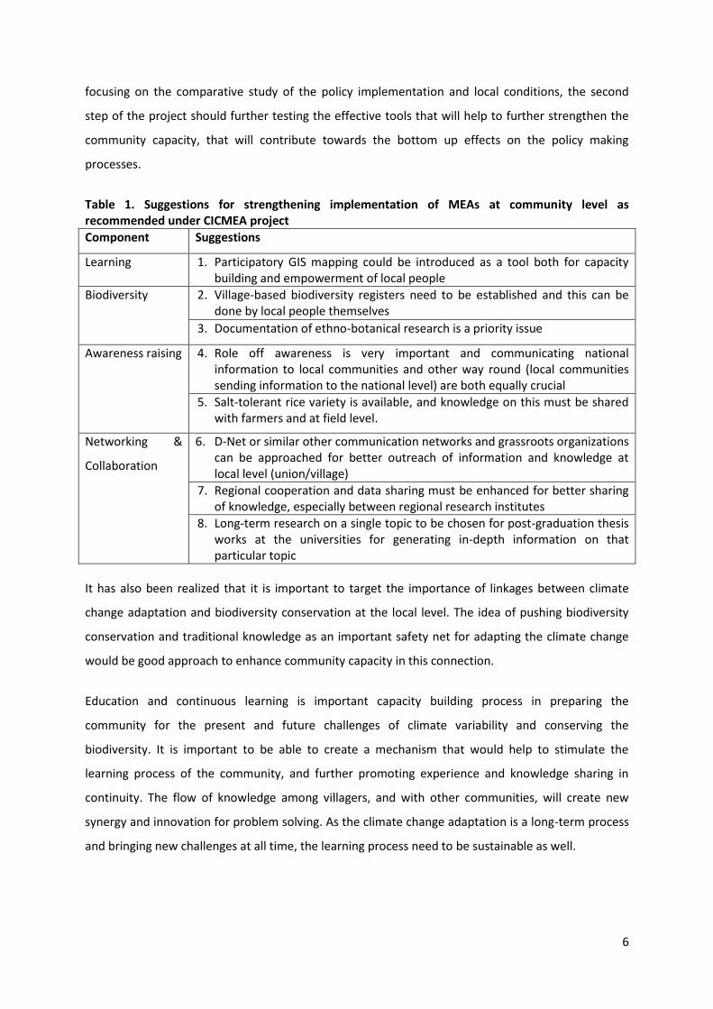
The CICMEA project further highlighted a few specific suggestions that would further strengthen the
community role in MEAs implementation (Table 1).
1.2. Rationale
Bangladesh has prepared comprehensive national documents for the implementation of UNFCCC and
CBD. The first phase of the CICMEA project has provided general understanding on the current status
of MEAs linkage to the local community, the existing gaps, challenges, and opportunities, instead of
6
focusing on the comparative study of the policy implementation and local conditions, the second
step of the project should further testing the effective tools that will help to further strengthen the
community capacity, that will contribute towards the bottom up effects on the policy making
processes.
Table 1. Suggestions for strengthening implementation of MEAs at community level as recommended under CICMEA project
Component Suggestions
Learning 1. Participatory GIS mapping could be introduced as a tool both for capacity building and empowerment of local people
Biodiversity 2. Village-based biodiversity registers need to be established and this can be done by local people themselves
3. Documentation of ethno-botanical research is a priority issue
Awareness raising 4. Role off awareness is very important and communicating national information to local communities and other way round (local communities sending information to the national level) are both equally crucial
5. Salt-tolerant rice variety is available, and knowledge on this must be shared with farmers and at field level.
Networking &
Collaboration
6. D-Net or similar other communication networks and grassroots organizations can be approached for better outreach of information and knowledge at local level (union/village)
7. Regional cooperation and data sharing must be enhanced for better sharing of knowledge, especially between regional research institutes
8. Long-term research on a single topic to be chosen for post-graduation thesis works at the universities for generating in-depth information on that particular topic
It has also been realized that it is important to target the importance of linkages between climate
change adaptation and biodiversity conservation at the local level. The idea of pushing biodiversity
conservation and traditional knowledge as an important safety net for adapting the climate change
would be good approach to enhance community capacity in this connection.
Education and continuous learning is important capacity building process in preparing the
community for the present and future challenges of climate variability and conserving the
biodiversity. It is important to be able to create a mechanism that would help to stimulate the
learning process of the community, and further promoting experience and knowledge sharing in
continuity. The flow of knowledge among villagers, and with other communities, will create new
synergy and innovation for problem solving. As the climate change adaptation is a long-term process
and bringing new challenges at all time, the learning process need to be sustainable as well.
7
As the community level, one good learning process is the participatory mapping, where the local
resident will explore their localities. They will be able to collect information, identity problems, and
discover the local capacity and exploring possible solutions for the local problems. Many community
show strong interest in exploring their own locality, willing to share and wish to learn more from
others. It is also a tool to strengthen the communication and knowledge flow in the local area. With
this learning tool, it will also help empowered the local community.
On top of that, the map created during the participatory mapping is a useful tool. The problem and
interest of each individual, communities, groups, are different, and it is difficult to meet every needs.
A holistic approach/ tool that able to provide answer to most of the question asked will be necessary.
A map can be practical tools to adjoin various sector and interest, like agriculture, facilities,
education, and disaster preparation etc., for the community. As most of the substances, eg. tree,
house, river, forest, paddy field, bridge etc., comprising spatial dimension, they can be plotted on the
map. The map will also help the community visualize their own resources, capacity, problems and
possible solutions.
The documentation of local plant species was raised as one priority in the CICMEA project. By
creating biodiversity database, it can be a reference and record of the Biodiversity database and
Access to Benefit Sharing (ABS). While documenting the traditional/indigenous knowledge with it
spatial reference not only help providing the opportunity for experience sharing, by combining the
information with other dataset, it can help to find the answer on why the knowledge is developed
and maintain within certain community.
Against this backdrop the 2nd phase of CICMEA, as CICMEA 2.0, is proposed by IUCN Bangladesh with
following goal and specific objectives.
2. Goal and Objectives
2.1. Goal
To ameliorate the role of communities in effective implementation of multilateral environmental
agreements (MEAs) and relevant national strategies and action plans on biodiversity conservation
and climate change.
2.2. Objectives
1. Strengthen the linkages of communities and MEAs
2. Enhance the capacity of community in implementing MEAs
3. Stimulating and promoting community sustainable learning process
8
4. Strengthen the feedback of local opinion and knowledge to the macro-policy-making
2.3. Expected Outputs
1. Methodology developed incorporating community participatory mapping.
2. Thematic community maps for each union prepared.
3. Union Parishad (Local Unitary Administration of Government Bangladesh) used the maps
as planning, management and negotiation tools for biodiversity and disaster
management.
4. Process and outputs properly documented.
5. Generated knowledge and methodology disseminated.
3. Project Approach and Methodology
3.1. Approach
3.1.1 Building on the knowledge gathered in CICMEA
The knowledge gathered under CICMEA will be the basis of CICMEA 2.0. Capacity building of the
selected communities as visualized in this phase will principally be built on the assessments of the
previous phase. The communities will be selected for this phase from the communities involved in the
CICMEA consultations and other IUCN activities.
3.1.2. Participatory
The initiative expects multi-stakeholder participation. Along with local community in general, it
anticipates local government institutions, local development NGOs, local school children and teachers
and university researchers to be involved in different project activities. Data collection, documentation
and development of maps as communication and management tools will be conducted on a
participatory basis. This multi-stakeholder approach will not only improve the interaction among the
stakeholders, but also facilitate crossing between local know-how with advanced technology.
3.1.3. Focusing on biodiversity, climate variability and traditional knowledge
The initiative will concentrate in three main areas, namely i) biodiversity including agriculture, ii)
climate variability including disaster and iii) traditional and indigenous knowledge. Data collection,
arrangement and utilization should be according to these focus areas.
3.1.4. Involving local government institutions and CBOs
Leaders of concerned Union Porishod (UP) and existing CBOs should be actively involved in the
learning process and implementation process. If possible the exercise will be considered as a UP-led
9
activity. Involvement of Ups and CBO representation will not only strengthen the participatory aspect
of the initiative, but also enhance environmental governance in general at local level.
3.2. Major activities
Following major activities will be undertaken in the current phase of CICMEA
1. Selecting of suitable sites (See Site selection criteria with maps, Annex 1)
2. Sensitizing local communities, including local leaders, of selected sites with project purposes.
3. Developing methodology for data collection
4. Organizing participatory data collection workshops
5. Building training manual for data collection (Flash Card Process)
6. Conducting follow-up meetings with UP for utilizing the maps in decision-making/ negotiation.
7. Patronizing national symposium for experience sharing.
8. Disseminating information through web pages and video.
3.3. Methodology
Against the background of the project, a methodology for data collection has been prepared for
smooth information compilation. This methodology considered the Japanese method of participatory
data collection called ‘Jimotogaku’ (See Annex 2). An activity plan and deliverables are also given at
Annex 3 and 4.
Purposes of the data collection
1) To clarify the process of data collection to find out actual situation of the locality.
2) To make the process easier to the facilitator and the informants.
3) To avoid constraints during facilitation of the activity
3.3.1. Steps towards data collection
A number of steps are proposed to follow to collect data from the participants in a workshop. After
getting familiar with the participants, the facilitator will help them open up through general
discussion on different issues of the locality. Then everybody will participate in developing a seasonal
calendar as the first group work. This will be followed by problem identification and ranking. The
group then go for a transect walk. Finally, the participants will be split into three groups to generate
three maps focusing on biodiversity, climate variability/change and traditional knowledge and
depicting past, present and possible future scenarios. Other details for arranging a data collection
workshop is given in Annex 5.
10
3.3.1.1. Facilitator and Participant: Knowing Each Other
Time: 10 minutes
Activities: At the beginning of the data collection, the facilitator will introduce him/herself and briefly
say why the meeting/ exercise is being carried out. Then facilitator will get familiar with the
participants/ informants: name, address, occupation(s), role (s) in the society, etc.
3.3.1.2. Breaking the Ice
Time: 10 minutes
Purposes: this session will give the
Facilitator points to talk about in later sessions;
Participants will have increased confidence on the facilitator; and
Participants will be open in sharing their views and feelings
Activities: The facilitator will ask the participants about their occupations and other role in the
society. S/he will then ask them some general questions to know the basic structure of socio-
economic dynamics and environmental issues. Some topics are given below.
Occupations
Weather changes
Agriculture
Fisheries
Forests resources
Recent disasters
NGO activities
Education etc
This session may run as a question-answer-discussion mode. Facilitator should engage all participants
so that they become open from the very beginning of the exercise.
3.3.1.3. MEAs and Other Issues
Time: 10 minutes
Purposes: Enhance the understanding of participants on MEAs and global processes, and also about
the forthcoming exercise.
Materials used: Communications materials produced under the CICMEA 1st phase could be given to
the participants and also used to explain those.
11
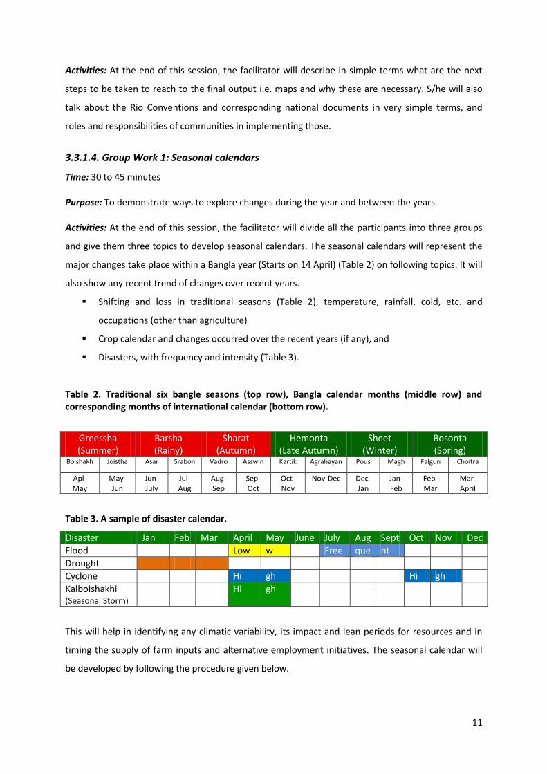
Activities: At the end of this session, the facilitator will describe in simple terms what are the next
steps to be taken to reach to the final output i.e. maps and why these are necessary. S/he will also
talk about the Rio Conventions and corresponding national documents in very simple terms, and
roles and responsibilities of communities in implementing those.
3.3.1.4. Group Work 1: Seasonal calendars
Time: 30 to 45 minutes
Purpose: To demonstrate ways to explore changes during the year and between the years.
Activities: At the end of this session, the facilitator will divide all the participants into three groups
and give them three topics to develop seasonal calendars. The seasonal calendars will represent the
major changes take place within a Bangla year (Starts on 14 April) (Table 2) on following topics. It will
also show any recent trend of changes over recent years.
Shifting and loss in traditional seasons (Table 2), temperature, rainfall, cold, etc. and
occupations (other than agriculture)
Crop calendar and changes occurred over the recent years (if any), and
Disasters, with frequency and intensity (Table 3).
Table 2. Traditional six bangle seasons (top row), Bangla calendar months (middle row) and corresponding months of international calendar (bottom row).
Greessha (Summer)
Barsha (Rainy)
Sharat (Autumn)
Hemonta (Late Autumn)
Sheet (Winter)
Bosonta (Spring)
Boishakh Joistha Asar Srabon Vadro Asswin Kartik Agrahayan Pous Magh Falgun Choitra
Apl- May
May-Jun
Jun-July
Jul-Aug
Aug-Sep
Sep-Oct
Oct-Nov
Nov-Dec Dec-Jan
Jan-Feb
Feb-Mar
Mar-April
Table 3. A sample of disaster calendar.
Disaster Jan Feb Mar April May June July Aug Sept Oct Nov Dec
Flood Low w Free que nt
Drought
Cyclone Hi gh Hi gh
Kalboishakhi (Seasonal Storm)
Hi gh
This will help in identifying any climatic variability, its impact and lean periods for resources and in
timing the supply of farm inputs and alternative employment initiatives. The seasonal calendar will
be developed by following the procedure given below.
12
i) Each group will select a leader or key informant and select their subjects to prepare a
table/diagram.
ii) The group leader or key informant will discuss with the rest of the members and illustrate
their findings on the calendar by the help of facilitator.
iii) After the completion of diagram (20-30 minutes), the group will be asked to present its
‘findings’/ calendar to the groups.
iv) After the group presentations, the participants will be asked to reflect on the advantages,
disadvantages and the analytical potentials of seasonal calendars.
v) Calendars will be finalized accordingly.
3.3.1.5. Group Work 2: Problem Identification & Ranking, and Solutions Recognition
Time: 20-30 minutes
Purpose: To identify the priority problems of the community regarding climate variability and
biodiversity degradation, and identify possible solutions.
Activities: Based on the seasonal calendar, the facilitator will invite the group to identify major
problems due to 1) changes in weather/climate and 2) biodiversity loss. The problems will then be
ranked. The whole exercise will be done on a paper in front of all. This tool is used to involve people
in prioritizing their needs and type of development initiative suited to local needs. At the end of
problem ranking facilitator will ask for their suggestion to overcome these problems. Facilitator will
give emphasis on existing traditional/indigenous knowledge and practices to solve the problems in
terms of
Approach(es) taken
Physical interventions
Tools used
Rule and regulations imposed etc.
Problem ranking will be done by following the below mentioned procedure:
1. A leader will be selected from the participants
2. Problems will be furnished on brown sheet after a discussion by the facilitator.
3. Each participant will be asked to prioritize the problems by giving sores to the problems
putting marbles or seeds.
4. After scoring, a sum up result will be displayed by the facilitator.
5. The participants will ask for identifying possible solutions to the top five problems occur due
to climate variability and biodiversity degradation.
13
6. The suggestion from local people will be documented by the facilitator and displayed.
3.3.1.6. Group Work 3: Transect Walk
Time: 60 minutes (5 mins for introduction, 20 mins for task, 20-30 mins for evaluation)
Purposes:
To demonstrate the importance f gathering and analyzing local information.
To build rapport with local people
To substantiate and support the diagrammed facts
To identify locations of the problem and opportunities for development/ interventions
Activities: All the participants will be divided into three groups (Different from Group Work 1) to go
for a transect walk in their area (Ward/village). This is a systematic walk with villagers through the
Ward/ village observing, listening to villagers’ descriptions, asking relevant questions, discussing
ideas, identifying different zones, local technologies, introduced technologies, seeking problems,
solutions and finally, diagramming/ mapping the transect walk and its findings.
Three groups will look into all the things in three different time periods. 1) Past (should have elderly
persons in this group), 2) Present and 3) Future. This activity will help in mapping climate variability/
change, disaster and biodiversity related issues in the next activity with focus on traditional
knowledge and practices.
1. Each group will choose its leader
2. The route for transect walk shall be identified by the group
3. The transect walk could be from one end to the other of the Ward of in short-cut road that
can cover the maximum area of the ward
4. The subject of the inquiry shall be very specific (climate variability, disasters, biodiversity
loss) and precisely defined to the group and provide them time to plan their transect walk.
So that the groups will be able to compare findings on their return
5. The group shall return by an agreed time to prepare a map by drawing their findings
6. (facilitator could develop a historical transect from present findings through a discussion with
participants where biodiversity issues could be emphasized)
14
3.3.1.7. Group Work 4: Opportunity Mapping
Time: 60 minutes
Purposes:
To identify the accessible resources
To find out the importance and opportunities to regenerate resources
To compare past and present resource availability
To practice mapping and modeling on a first hand basis
Activities: After the transect walk, the facilitator will give them a brief idea how the information
gathered from the walk can be put into several maps (Annex 3). S/he will explain how useful tools
the maps can be for designing village plans by the local people. People can draw maps of their village
or ward and locate the services, facilities, infrastructure and natural resources according to
availability and access to different groups, thus facilitating the identification of needs, problems and
solutions.
Participants will then be asked to draw ‘opportunity maps’ based on mouza (village) map on a brown
paper. After this group work, facilitator can compare the status of climate change, disaster and
biodiversity with the past and enable to find out peoples’ suggestions to solve the problems,
especially with traditional knowledge and practices. The procedure of resources mapping is given
below.
i) Three groups will sketch separate maps on paper (based on mouza map) with the help from
the facilitator
ii) Group 1 will be accompanied by elderly participants. This group will provide information on
Past situation. It will include infrastructure (as land marks to get perception of position),
agricultural land, forest land, wetland etc. by drawing icons/ pictures on the map.
iii) Group 2 will provide information on Present status of infrastructure (as land marks),
agricultural land, forest, wetland etc by drawing icons/ pictures on the map. The group will
furnish problems due to climate change and biodiversity degeneration.
iv) Group 3 will find out the opportunities of resource generation by consulting with Group 1
and 2 and furnished them in Future/Planning map with special emphasis on traditional
knowledge and practices.
v) All the three maps will be presented and will be finalized after getting feedback from other
two groups.
15
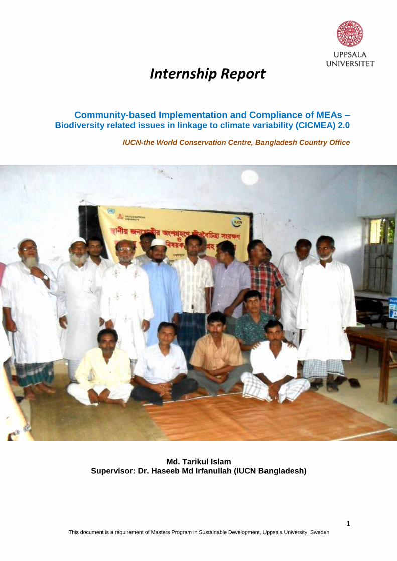
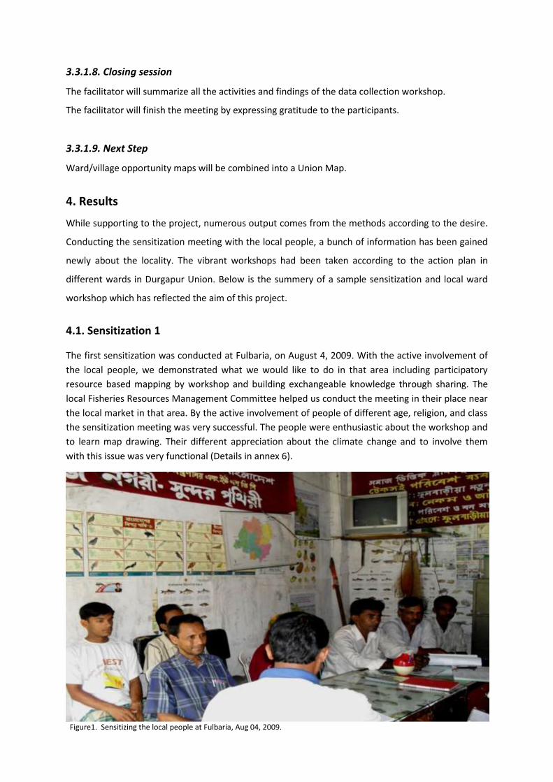
Figure1. Sensitizing the local people at Fulbaria, Aug 04, 2009.
3.3.1.8. Closing session
The facilitator will summarize all the activities and findings of the data collection workshop.
The facilitator will finish the meeting by expressing gratitude to the participants.
3.3.1.9. Next Step
Ward/village opportunity maps will be combined into a Union Map.
4. Results
While supporting to the project, numerous output comes from the methods according to the desire.
Conducting the sensitization meeting with the local people, a bunch of information has been gained
newly about the locality. The vibrant workshops had been taken according to the action plan in
different wards in Durgapur Union. Below is the summery of a sample sensitization and local ward
workshop which has reflected the aim of this project.
4.1. Sensitization 1
The first sensitization was conducted at Fulbaria, on August 4, 2009. With the active involvement of
the local people, we demonstrated what we would like to do in that area including participatory
resource based mapping by workshop and building exchangeable knowledge through sharing. The
local Fisheries Resources Management Committee helped us conduct the meeting in their place near
the local market in that area. By the active involvement of people of different age, religion, and class
the sensitization meeting was very successful. The people were enthusiastic about the workshop and
to learn map drawing. Their different appreciation about the climate change and to involve them
with this issue was very functional (Details in annex 6).
16
4.2 Local Workshop
The details description has been given here for Local Workshop 1. This is considered here as a result/
output from the project which is a product of the facilitators.
Workshop Report 1
Ward no. 8 (Durgapur, Chakoil and Delgaon Villages)
Durgapur Union, Kapasia, Gazipur August 11, 2009, Tuesday, 10:45-17:30 hrs
1. Introduction
This workshop was held among the people of three villages (Durgapur, Chakoil and Delgaon) of Durgapur Union at Kapasia Thana in Gazipur District of Bangladesh. Targeted area, being at the north east direction, was about hundred kilometers far away from Dhaka city, the capital of Bangladesh. Primarily, the workshop emphasized to know about the agricultural biodiversity, fisheries stock, and perception of participants with the linkage to climatic variability and preparation of resource based map through identification of problems. The total number of participants was 17 from different socio-economic groups of that locality. The ultimate objective of the workshop was identifying the problems regarding to local resources and state of resources by creating maps as a consequences of past, present and future. It also included the perception of the local people about the biodiversity consequences linked with climatic variability and sustainable adaptation through using traditional knowledge by their active participation. Finally, it was also predicted that this group would be able to know how to make a safeguard of the local resources for future climatic impact through participating, and sharing and drawing resource based map. Initially, the participants were involved asking about their perception and depletion of natural resources linked with climate change.
2. Preparing Group
As the stakeholders came from three different villages having diversification in their occupation, they were splited into three homogenous groups having heterogeneous ideas, origin and occupation (See annex 7.1 for details).
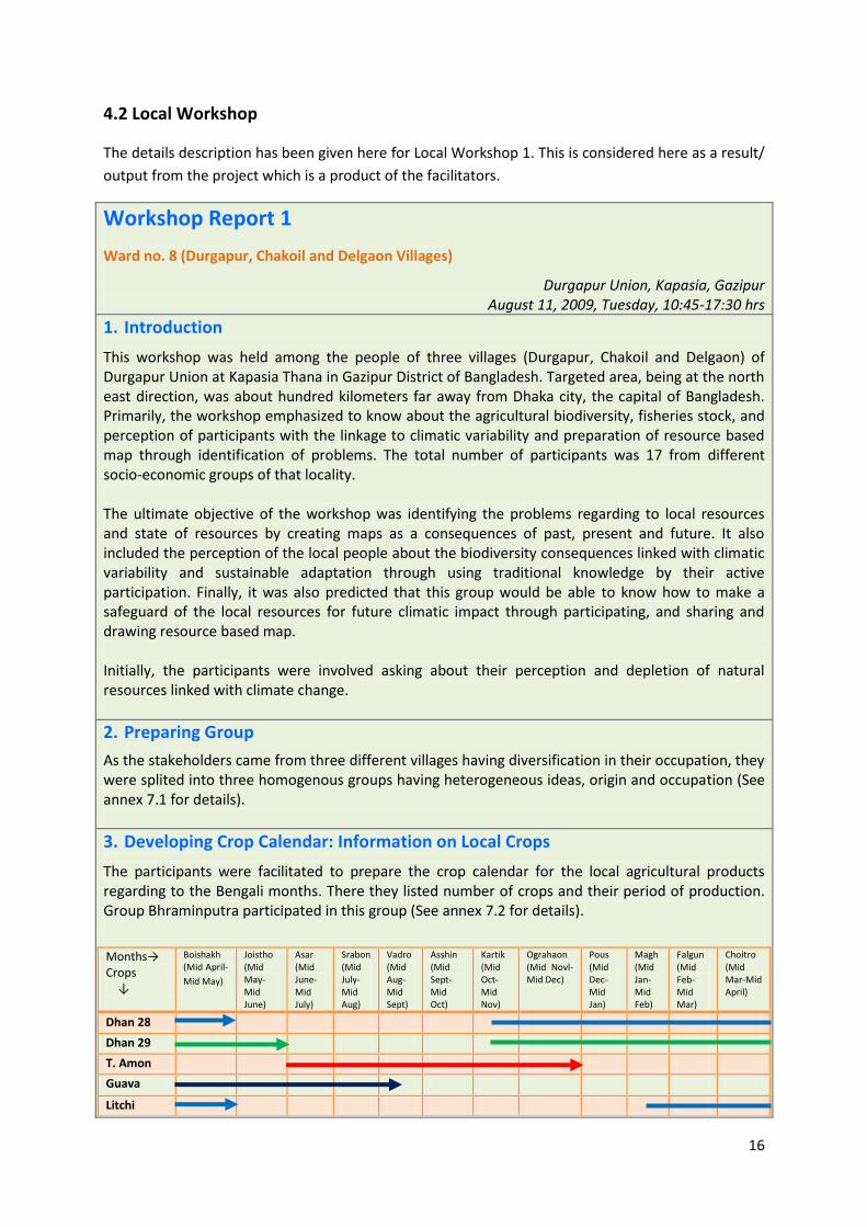
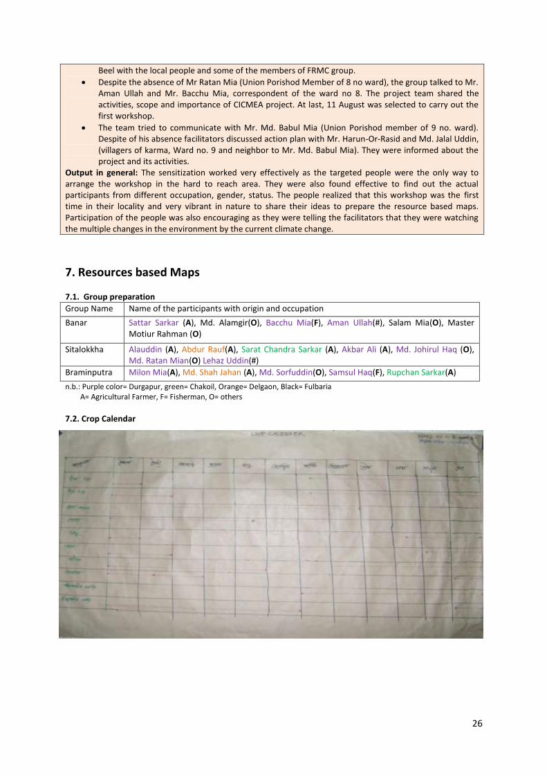
3. Developing Crop Calendar: Information on Local Crops
The participants were facilitated to prepare the crop calendar for the local agricultural products regarding to the Bengali months. There they listed number of crops and their period of production. Group Bhraminputra participated in this group (See annex 7.2 for details).
Months→ Crops ↓
Boishakh (Mid April-
Mid May)
Joistho (Mid May-Mid June)
Asar (Mid June-Mid July)
Srabon (Mid July-Mid Aug)
Vadro (Mid Aug-Mid Sept)
Asshin (Mid Sept-Mid Oct)
Kartik (Mid Oct-Mid Nov)
Ograhaon (Mid Novl-Mid Dec)
Pous (Mid Dec-Mid Jan)
Magh (Mid Jan-Mid Feb)
Falgun (Mid Feb-Mid Mar)
Choitro (Mid Mar-Mid April)
Dhan 28
Dhan 29
T. Amon
Guava
Litchi
17
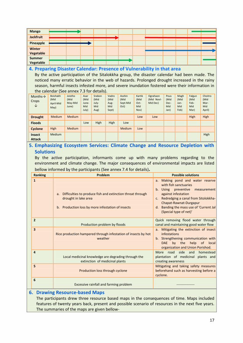
Mango
Jackfruit
Pineapple
Winter Vegetable
Summer Vegetable
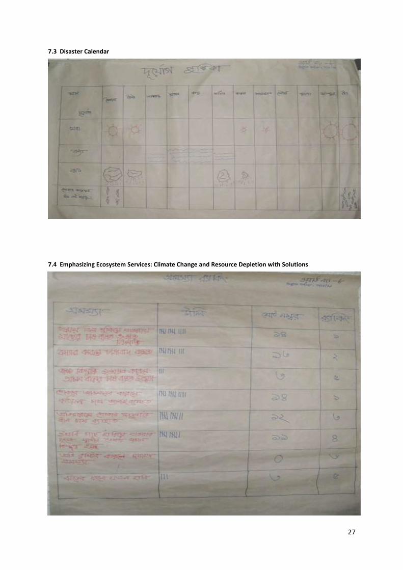
4. Preparing Disaster Calendar: Presence of Vulnerability in that area By the active participation of the Sitalokkha group, the disaster calendar had been made. The noticed many erratic behavior in the web of hazards. Prolonged drought increased in the rainy season, harmful insects infested more, and severe inundation fostered were their information in the calendar (See annex 7.3 for details).
Months→ Crops ↓
Boishakh (Mid
April-Mid
May)
Joistho (Mid May-Mid June)
Asar (Mid June-Mid July)
Srabon (Mid July-Mid Aug)
Vadro (Mid Aug-Mid Sept)
Asshin (Mid Sept-Mid Oct)
Kartik (Mid Oct-Mid Nov)
Ograhaon (Mid Novl-Mid Dec)
Pous (Mid Dec-Mid Jan)
Magh (Mid Jan-Mid Feb)
Falgun (Mid Feb-Mid Mar)
Choitro (Mid Mar-Mid April)
Drought Medium Medium Low Low High High
Floods Low High High Low
Cyclone High Medium Medium Low
Insect Attack
Medium High
5. Emphasizing Ecosystem Services: Climate Change and Resource Depletion with Solutions By the active participation, informants come up with many problems regarding to the environment and climate change. The major consequences of environmental impacts are listed
bellow informed by the participants (See annex 7.4 for details). Ranking Problem Possible solutions
1
a. Difficulties to produce fish and extinction threat through drought in lake area
b. Production loss by more infestation of insects
a. Making pond and water reserve with fish sanctuaries
b. Using preventive measurement against infestation
c. Redredging a canal from Sitolokkha-Chapat-Rawnat-Durgapur
d. Banding the mass use of ‘Current Jal (Special type of net)’
2 Production problem by floods
Quick removing flood water through canal and maintaining good water flow
3 Rice production hampered through infestation of insects by hot
weather
a. Mitigating the extinction of insect infestations
b. Strengthening communication with DAE by the help of local organization and Union Porishod.
4 Local medicinal knowledge are degrading through the
extinction of medicinal plants
More road side and homestead plantation of medicinal plants and creating awareness
5 Production loss through cyclone
Mitigating and taking safety measures beforehand such as harvesting before a cyclone.
6 Excessive rainfall and farming problem
----------------
6. Drawing Resource-based Maps The participants drew three resource based maps in the consequences of time. Maps included features of twenty years back, present and possible scenario of resources in the next five years. The summaries of the maps are given bellow-
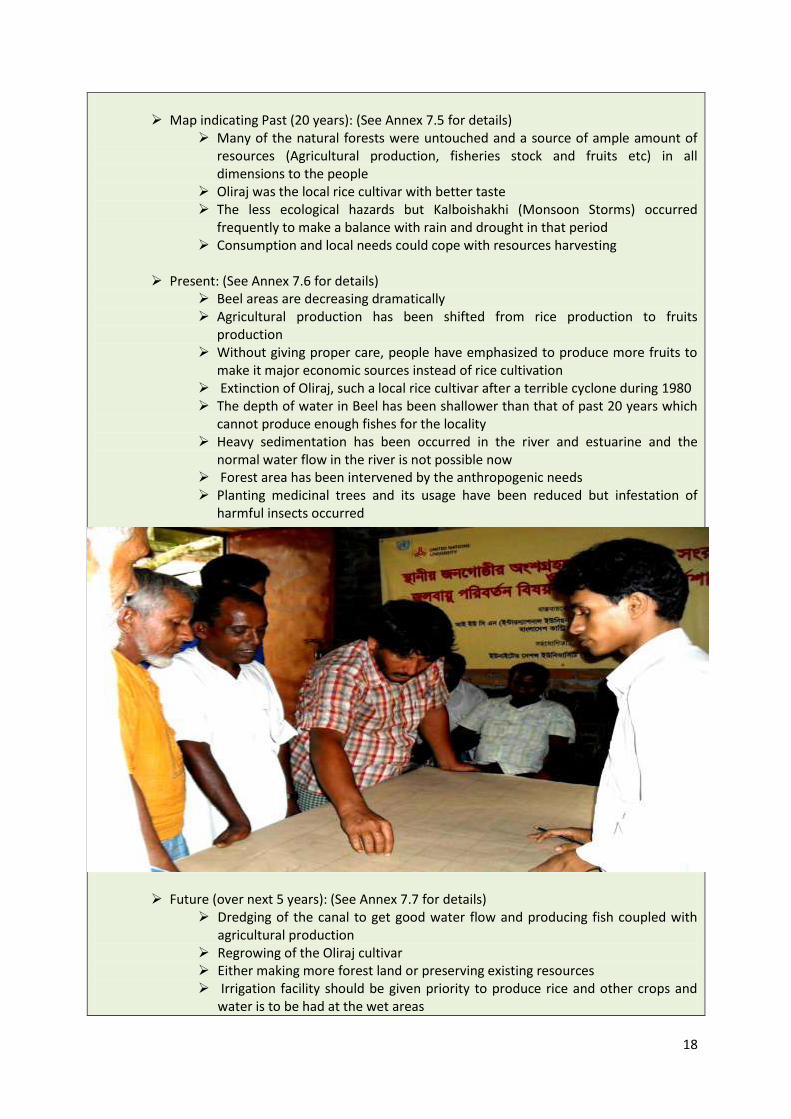
18
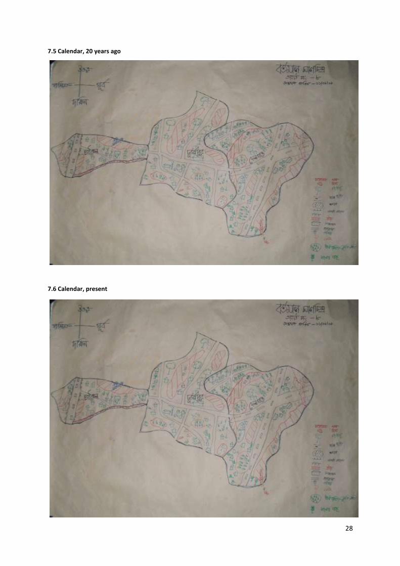
Map indicating Past (20 years): (See Annex 7.5 for details)
Many of the natural forests were untouched and a source of ample amount of resources (Agricultural production, fisheries stock and fruits etc) in all dimensions to the people
Oliraj was the local rice cultivar with better taste The less ecological hazards but Kalboishakhi (Monsoon Storms) occurred
frequently to make a balance with rain and drought in that period Consumption and local needs could cope with resources harvesting
Present: (See Annex 7.6 for details)
Beel areas are decreasing dramatically Agricultural production has been shifted from rice production to fruits
production Without giving proper care, people have emphasized to produce more fruits to
make it major economic sources instead of rice cultivation Extinction of Oliraj, such a local rice cultivar after a terrible cyclone during 1980 The depth of water in Beel has been shallower than that of past 20 years which
cannot produce enough fishes for the locality Heavy sedimentation has been occurred in the river and estuarine and the
normal water flow in the river is not possible now Forest area has been intervened by the anthropogenic needs Planting medicinal trees and its usage have been reduced but infestation of
harmful insects occurred
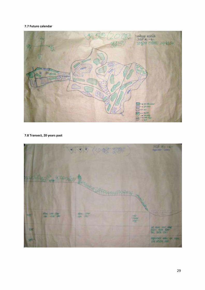
Future (over next 5 years): (See Annex 7.7 for details)
Dredging of the canal to get good water flow and producing fish coupled with agricultural production
Regrowing of the Oliraj cultivar Either making more forest land or preserving existing resources Irrigation facility should be given priority to produce rice and other crops and
water is to be had at the wet areas
19
It was also considered to keeping sanctuaries for fish species in certain beel areas.
Argument was given to plant more medicinal trees
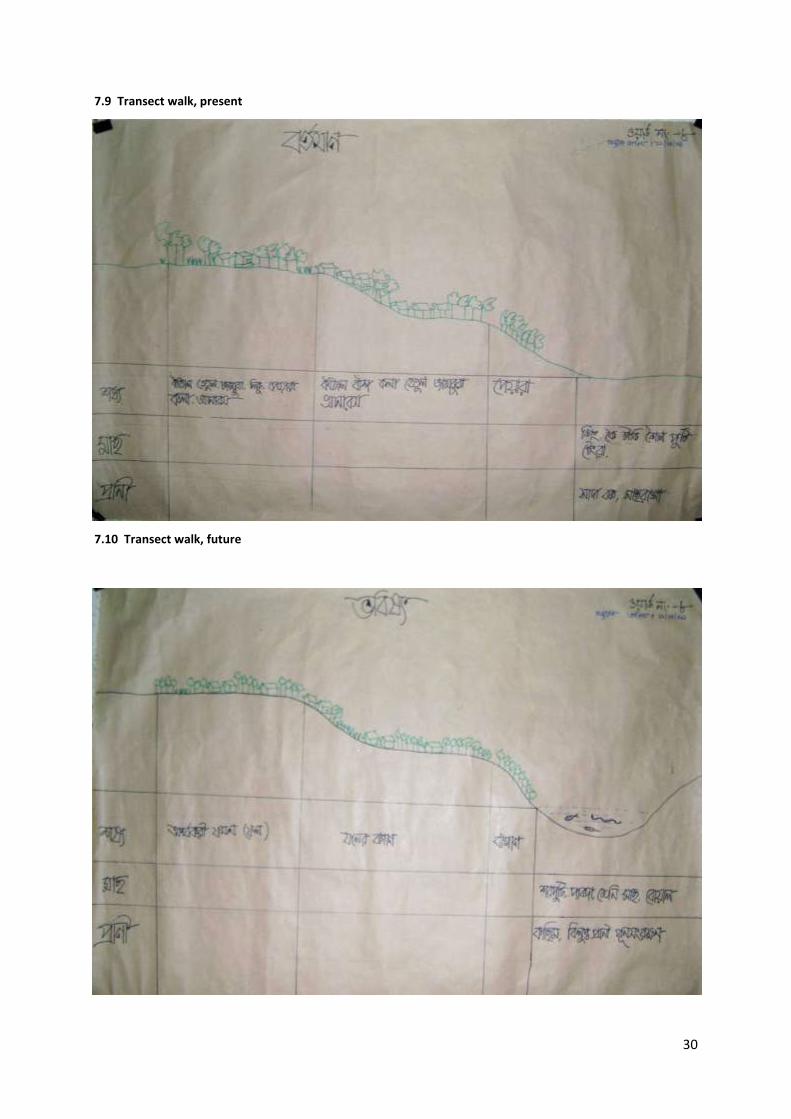
7. Transect Walk: A Tale of Local Biodiversity In a walk of 30 minutes, a group of 10 went to see about the local resources in practical. The output is as follows. (See Annex for 7.8, 7.9, 7.10 for details)
Many flora (Aquatic weeds, medicinal plants) and fauna (Gecko Lizards, Tortoise, Stark, Snakes, local fish species such as Pabda, Puti, Vetki, Sing, Koi etc) has been depleted from the locality
More number of homestead areas instead of forest trees Beel areas are full of harmful weeds and have been substituted fisheries habitat
8. Level of Awareness among the Participants People felt first time environment related program in that ward Some NGOs (BRAC, ASA, Grameen Bank) work for socioeconomic development through
microcredit noticed by the participants People never created such resource based maps regarding to past, present and future Although people could not identify why current climate is behaving violently against
resources, their perception indicated negative change on the environment People approached that government correspondent at Upazila Level has few services to
them and does not reach to them
9. Lessons Learnt and Future Challenge People always tried to justify what they would get in terms of economic benefit from this
climate change related activities and were less responsive at the beginning Involving inactive participants just through individual discussion let them participate
actively when other group was drawing map For little time at last people felt fatigue due to taking excess time than desired and
wanted to leave. This could be removed by sketching map in advance and let them easy to draw the map
Little positive impact was found to create occupation map, which can be discarded to save time for the next workshop.
5. Discussion
As an observer, we got a lot of information from the program. The power relations, social class
system, gender issue, enthusiasm for climate change etc are core among them.
Enthusiasm to give opinion about climate change:
When the observer first arrived to talk about the climate change and what are their evidences the
people found at that locality, a huge interest has been seen among the people. This curiosity is
related with the socio-economical context of Bangladesh. The main economy of Bangladesh is
dependent on the traditional agriculture (63% of population, CIA-World Factbook). So, any
disturbance or natural disasters on the land affect the agrarian life in Bangladesh. Being open and
sharing information among the farmers are also long term and popular tradition in Bangladesh. So,
any climate change and its frequent occurrences are a matter of discussion among the people at
20
present from urban to rural and rural to urban life. Loosing capital and resources as a cost of climate
change thus has made the people of that locality to show deep attention on the naked eye of the
observers. As an observer, I have also found the ecstasy of the people only just expressing the
opinion about the issue although they are depriving from this environmental change. The changes in
that area were mentioned by participants were the declination of water depth in the Nolee Beel, less
agricultural production, deforestation, few fish production, replacement of forest areas into
agricultural production, extinction of medicinal plants, composition changes in both terrestrial and
aquatic environment etc.
Power relations among the people while drawing the maps:
It is more likely that economics in Bangladesh regulate some kind of relative power status among the
people. As diversified composition of people participated in the workshop and sensitization meeting,
there could be significantly different contribution. Instead, aiming to draw resource based maps;
people participated equally leaving power relations. During the sensitization, we tried to invite
people getting a favor from member (Ward Representative for local Government) just to select the
participants. According to the power relations in Bangladesh, some people have dominance over
others in terms of economics, social status, education, occupations. In the case of drawing maps, we
did not observe any such activities although they were from different groups. The people those were
invited to draw map, were fishermen, ward representative, agricultural farmer, religious person,
teacher, and others. For instance, we can indicate about the Ratan Mian, member, ward no.: 8. He
invited participants for the first workshop but he did not show any dominant behavior in the
workshop in terms of drawing or participation.
Engaging people, more benefit
As an observer, I also found that the more engagement in a system, the more successful a program
is. Participatory and its derivatives betokens about the engagement of the participants. So,
marginalized participants cannot get chance to propagate information for any activity. In case of both
sensitization and workshop, it was found that less participatory people could also deliver same like
the active participants. For example, one of the older aged participants in the workshop was sleeping
for the first two hours. When, I tried to give him priority and involving him to draw maps, later I
found that vigorous information came for certain parts of the maps. At last, it was found that that
piece of information provided by the former less active participants was very essential for the maps.
Description and demonstration while transect walk
People were very active telling about their localities in terms of climate change. Their demonstrations were very obvious. In the past, people saw many of the natural resources which are now unavailable. Rapid climate changes, drought present in Noli Beel, floral and faunal species escape from its aquatic environment were their practical evidences. Many of the medicinal plants have been replaced by agricultural land and dilemma to prepare herbal medicine is becoming impossible in that locality. For a certain time while the observer requested the participants to show how climate change was impacting the areas, they came out with numerous evidences.
21
Gender issues
A good composition in the participants in terms of gender is a critical issue for PRA. But in the
workshops, it has been experienced that male participants were major. The potential contribution of
the female participants did not work properly due to their absence. By tradition and religion, rural
women in Bangladesh are not so open. So, their presence in drawing such map could ameliorate
more. But in most such cases, their absence deprived the gender issue in Bangladesh. For example,
there was only one woman participant in workshop number 2. She drew most of the resources on
the map for present being bold.
Changes in mind, changes in maps
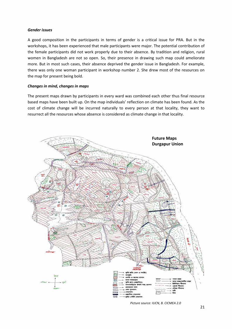
The present maps drawn by participants in every ward was combined each other thus final resource
based maps have been built up. On the map individuals’ reflection on climate has been found. As the
cost of climate change will be incurred naturally to every person at that locality, they want to
resurrect all the resources whose absence is considered as climate change in that locality.
Future Maps Durgapur Union
Picture source: IUCN, B. CICMEA 2.0
22
6. Conclusion
Global temperature and sea level rise will bring worse condition in terms of livelihood, survival and
other issues for such a poor country like Bangladesh. In this case, peoples’ participation in adaptation
for the climate change can mitigate their cost to face the aggravating scenario. Hence the necessity
to modeling the solution for climate change increased both locally and internationally. This paper
thus betokens a very preliminary approach to vanguard the negative impact of climate change.
Resource based maps drawing and increasing awareness by identifying what the affected people
have, may lead people better conditions. The people of Kapasia, facing a lot of climate change
related people thus become first in this case of adaptation process.
7. Reference:
Anisimov O, Fitzharris B, Hagen JO, Jefferies R, Marchant H, et al. 2001. Polar Regions (Arctic and Antarctic). See IPCC 2001a, pp. 801–47 Caldeira K,Wickett ME. 2003. Anthropogenic carbon and ocean pH. Nature 425:365 CIA, Central Intelligence Agency. World Factbook, Bangladesh
IUCN Bangladesh, 2009. Final report: Community-based Implementation and Compliance of MEAs- Biodiversity related issues in linkage to climate change variability. IUCN Country Office, Dhaka, Bangladesh IUCN, UNEP, UNU, 2009. Biodiversity conservation and response to climate variability at community level. IUCN, UNEP, UNU, Dhaka, Bangladesh. Parmesan, C. & Yohe, G. 2003 A globally coherent fingerprint of climate change impacts across natural systems. Nature 421, 37–42. (doi:10.1038/nature01286) Parmesan, C. 2006 Ecological and evolutionary responses to recent climate change. Annu. Rev. Ecol. Evol. Syst. 37, 637–669. (doi:10.1146/annurev.ecolsys.37.091305.110100) Root, T. L., Price, J. T., Hall, K. R., Schneider, S. H., Rosenzweig, C. & Pounds, J. A. 2003 Fingerprints of global warming on wild animals and plants. Nature 421, 57–60. (doi:10.1038/nature01333) Walther,G. R., Post, E., Convey, P.,Menzel, A., Parmesan, C., Beebee, T. J. C., Fromentin, J.M., Hoegh-Guldberg, O. & Bairlein, F. 2002 Ecological responses to recent climate change. Nature 416, 389–395. (doi:10.1038/416389a)
23
Annex
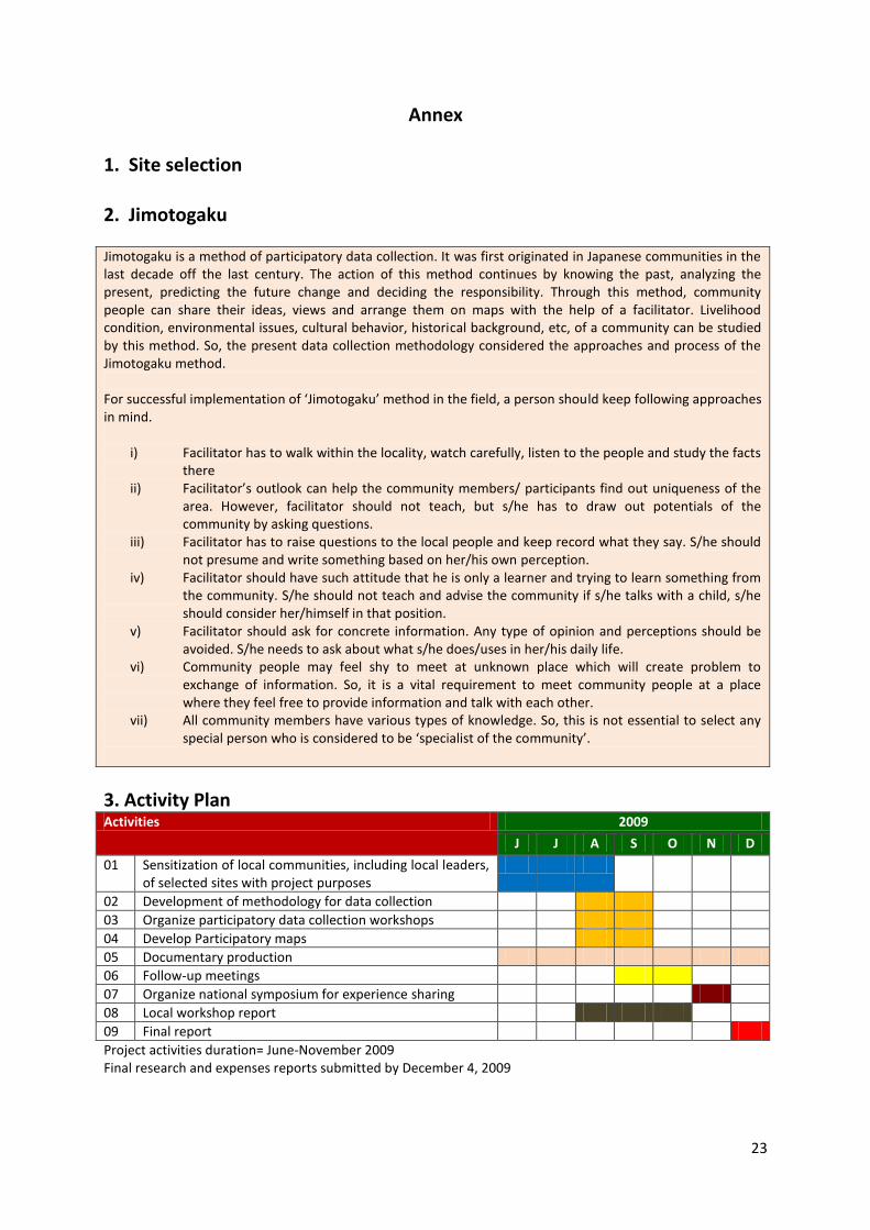
1. Site selection 2. Jimotogaku Jimotogaku is a method of participatory data collection. It was first originated in Japanese communities in the last decade off the last century. The action of this method continues by knowing the past, analyzing the present, predicting the future change and deciding the responsibility. Through this method, community people can share their ideas, views and arrange them on maps with the help of a facilitator. Livelihood condition, environmental issues, cultural behavior, historical background, etc, of a community can be studied by this method. So, the present data collection methodology considered the approaches and process of the Jimotogaku method. For successful implementation of ‘Jimotogaku’ method in the field, a person should keep following approaches in mind.
i) Facilitator has to walk within the locality, watch carefully, listen to the people and study the facts there
ii) Facilitator’s outlook can help the community members/ participants find out uniqueness of the area. However, facilitator should not teach, but s/he has to draw out potentials of the community by asking questions.
iii) Facilitator has to raise questions to the local people and keep record what they say. S/he should not presume and write something based on her/his own perception.
iv) Facilitator should have such attitude that he is only a learner and trying to learn something from the community. S/he should not teach and advise the community if s/he talks with a child, s/he should consider her/himself in that position.
v) Facilitator should ask for concrete information. Any type of opinion and perceptions should be avoided. S/he needs to ask about what s/he does/uses in her/his daily life.
vi) Community people may feel shy to meet at unknown place which will create problem to exchange of information. So, it is a vital requirement to meet community people at a place where they feel free to provide information and talk with each other.
vii) All community members have various types of knowledge. So, this is not essential to select any special person who is considered to be ‘specialist of the community’.
3. Activity Plan Activities 2009
J J A S O N D
01 Sensitization of local communities, including local leaders, of selected sites with project purposes
02 Development of methodology for data collection
03 Organize participatory data collection workshops
04 Develop Participatory maps
05 Documentary production
06 Follow-up meetings
07 Organize national symposium for experience sharing
08 Local workshop report
09 Final report
Project activities duration= June-November 2009 Final research and expenses reports submitted by December 4, 2009
24
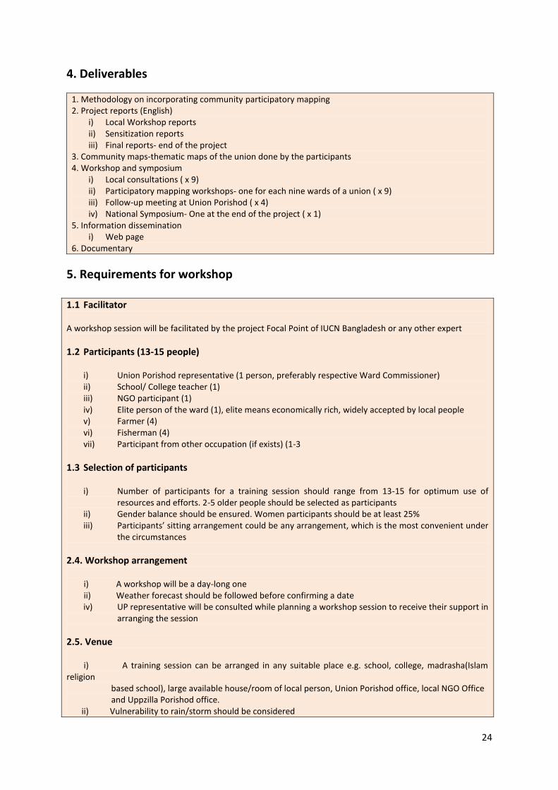
4. Deliverables
1. Methodology on incorporating community participatory mapping 2. Project reports (English)
i) Local Workshop reports ii) Sensitization reports iii) Final reports- end of the project
3. Community maps-thematic maps of the union done by the participants 4. Workshop and symposium
i) Local consultations ( x 9) ii) Participatory mapping workshops- one for each nine wards of a union ( x 9) iii) Follow-up meeting at Union Porishod ( x 4) iv) National Symposium- One at the end of the project ( x 1)
5. Information dissemination i) Web page
6. Documentary
5. Requirements for workshop 1.1 Facilitator A workshop session will be facilitated by the project Focal Point of IUCN Bangladesh or any other expert
1.2 Participants (13-15 people)
i) Union Porishod representative (1 person, preferably respective Ward Commissioner) ii) School/ College teacher (1) iii) NGO participant (1) iv) Elite person of the ward (1), elite means economically rich, widely accepted by local people v) Farmer (4) vi) Fisherman (4) vii) Participant from other occupation (if exists) (1-3
1.3 Selection of participants i) Number of participants for a training session should range from 13-15 for optimum use of
resources and efforts. 2-5 older people should be selected as participants ii) Gender balance should be ensured. Women participants should be at least 25% iii) Participants’ sitting arrangement could be any arrangement, which is the most convenient under
the circumstances
2.4. Workshop arrangement i) A workshop will be a day-long one ii) Weather forecast should be followed before confirming a date
iv) UP representative will be consulted while planning a workshop session to receive their support in arranging the session
2.5. Venue i) A training session can be arranged in any suitable place e.g. school, college, madrasha(Islam religion based school), large available house/room of local person, Union Porishod office, local NGO Office and Uppzilla Porishod office. ii) Vulnerability to rain/storm should be considered
25
iii) Proper light, aeration and cleanness should be considered iv) Sitting arrangement should be on the floor. So, floor should be covered by mat/terpal (covering materials). It will be helpful for drawing. v) Consultation should be done or permission should be obtained from the concern person or authority to use a venue. vi) The place should be near to the community.
2.6 Logistics For successful deliberation, following materials are required: i) Brown sheets to draw maps viii) Marbels /seeds ii) Pencils, sharpners ix) Pens iii) Erasers x) Chalks iv) Sign pens/ Markers xi) Allowance sheet v) Scales xii) Attendance-sheet vi) Cards / paper and envelopes xiii) CICMEA Brochures vii) Candle/ charger light xiv) CICMEA poster
2.7. Refreshment Some refreshment should be provided to the participants during/ after a session, especially if it exceeds lunch time
2.8. Travel allowance In addition to refreshment, token travel allowances may also bi given to the participants.
2.9. Reporting An ‘Activity Report’ will be prepared by the FP on a workshop session following a prescribed format.
6. Sensitization Reports
Field visit
Venue: Fulbaria, Durgapur Union, Kapasia, Gazipur. Date: 04.08.2009 Purpose of the field visit: In order to make the people know in advance about the program and activities, the facilitators went to FRMC (Fisheries Resources Management Committee) group first. The idea behind to talk to them first as they knew most of the locations and ward members in Durgapur Union and could help us reach to them. In past, this group was active to implement another project of IUCN. To make a vibrant image of the program in advance and a way that the ward members would take some of the responsibilities in their area, this field visit was carried out. Lastly, it was also imperative to talk to the ward members and others to invite the targeted participants for the workshop. Activities: The activities of the facilitators included several discussions and visiting some of the places in Durgapur Union. Activities are given bellow for the day—
In presence of the president, secretary and other members of FRMC, the facilitators first described about the project and its work plan.
The FRMC group was also asked about the past project activities and the effectiveness of the project.
They were also appreciated in a cross discussion as they showed potentiality to implement the project in their locality.
After discussion the team visited parts of Noli Beel and shared the problems and opportunities of Noli
26
Beel with the local people and some of the members of FRMC group.
Despite the absence of Mr Ratan Mia (Union Porishod Member of 8 no ward), the group talked to Mr. Aman Ullah and Mr. Bacchu Mia, correspondent of the ward no 8. The project team shared the activities, scope and importance of CICMEA project. At last, 11 August was selected to carry out the first workshop.
The team tried to communicate with Mr. Md. Babul Mia (Union Porishod member of 9 no. ward). Despite of his absence facilitators discussed action plan with Mr. Harun-Or-Rasid and Md. Jalal Uddin, (villagers of karma, Ward no. 9 and neighbor to Mr. Md. Babul Mia). They were informed about the project and its activities.
Output in general: The sensitization worked very effectively as the targeted people were the only way to arrange the workshop in the hard to reach area. They were also found effective to find out the actual participants from different occupation, gender, status. The people realized that this workshop was the first time in their locality and very vibrant in nature to share their ideas to prepare the resource based maps. Participation of the people was also encouraging as they were telling the facilitators that they were watching the multiple changes in the environment by the current climate change.
7. Resources based Maps 7.1. Group preparation
Group Name Name of the participants with origin and occupation
Banar Sattar Sarkar (A), Md. Alamgir(O), Bacchu Mia(F), Aman Ullah(#), Salam Mia(O), Master Motiur Rahman (O)
Sitalokkha Alauddin (A), Abdur Rauf(A), Sarat Chandra Sarkar (A), Akbar Ali (A), Md. Johirul Haq (O), Md. Ratan Mian(O) Lehaz Uddin(#)
Braminputra Milon Mia(A), Md. Shah Jahan (A), Md. Sorfuddin(O), Samsul Haq(F), Rupchan Sarkar(A)
n.b.: Purple color= Durgapur, green= Chakoil, Orange= Delgaon, Black= Fulbaria A= Agricultural Farmer, F= Fisherman, O= others
7.2. Crop Calendar
27
7.3 Disaster Calendar
7.4 Emphasizing Ecosystem Services: Climate Change and Resource Depletion with Solutions
28
7.5 Calendar, 20 years ago
7.6 Calendar, present
29
7.7 Future calendar
7.8 Transect, 20 years past
30
7.9 Transect walk, present
7.10 Transect walk, future