Resent Estimation of Hydrologic Cycle Components in Gaza Strip Catchment
Upload
tu-dortmundCategory
view
0download
0
Applied Research Institute-Jerusalem (ARIJ)P.O. Box 860, Caritas St.Bethlehem, Palestine
www.arij.org
Research Paper:
GIS Applications
“International Community Flagship Project:Linking Gaza Strip and the West Bank through the Arc”
Prepared By:Ahmad El-Atrash & Issa Zboun

THE ARC PLAN
Submitted To:The Fourth National GIS Symposium in Saudi Arabia
January 31, 2009
1. Abstract
The paper at hand gives an overview of one of the latest plans
that contemplate the building of a viable Palestinian state, by
linking both the Gaza Strip and the West Bank through a boulevard-
transportation system known as the Arc. The paper provides a
critical view of the Arc Plan from a Palestinian planning
perspective, using an in-depth mapping approach of Geographic
Information Systems & Remote Sensing and thorough study of relevant
archived research. The results of this study show the negative
impacts of favouring political tendencies over rational social,
economical, and environmental ones that usually leads to
sustainable solutions.
2. Background and Motive
1

INTERNATIONAL COMMUNITY FLAGSHIP PROJECT: LINKING GAZA STRIP AND THE WEST BANK
The Occupied Palestinian Territory (OPT) is composed of two
entities; the West Bank and the Gaza Strip. Linking these has
always been perceived as an inevitable necessity in building a
viable Palestinian state. However, achieving this has always been
impeded by the Israeli's under the pretext that a link would
threaten its national security. To achieve a compromise between the
two parties (i.e. Israel and Palestine), the international
community took the responsibility of formulating different
proposals for the linking of the two entities as an indispensable
character in building a viable Palestinian state in the foreseeable
future.
Construction of a secure transportation link between Gaza Strip
and the West Bank has been adopted by the international community
as a “flagship project” during the last decade, mainly to prove
that a viable two-state solution is feasible and enjoys a consensus
vision. On the ground, the near total severance of links between
the Gaza Strip and the West Bank makes such "flagship project" a
matter of irony, where all the plans that have been brokered by the
international community and state members of the Quartet are
considered worthless as they are confronted by the Israeli
“Creeping Apartheid” (Yiftachel, 2005) policy and the de facto
2

THE ARC PLAN
physical domination in and around the OPT. Gaza Strip stands today
as the biggest prison on earth, as Gaza with its 1.5 million (PCBS,
2008) inhabitants is totally besieged and the movement of people
and goods through the border terminals are conditioned to a prior
Israeli permission. Knocking on the situation in Gaza, in his trip
leading a UN investigation into a 2006 Israeli bombing that killed
19 Palestinian civilians in Gaza, the Nobel Peace laureate and
vocal anti-apartheid campaigner in South Africa archbishop Desmond
Tutu denounced the international community for what he called "its
silence and complicity" over the situation in Gaza and called
Israel's blockade of the Gaza Strip an "abomination" (BBC, 2008).
The Israeli Governments find an independent and viable
Palestinian state very hard to contemplate on the ground. On one
hand, since the Israeli occupation of the OPT in 1967, Israel
coerced to undermine any real action toward a comprehensive peace
in the occupied territory by creating a de facto physical separation
of the Gaza Strip and the West Bank. On the other hand, what are
referred to as the intellectual strip of the Israeli politics
society re-proposed the status quo ante-1967 where the Egyptians
and the Jordanians had political control over the Gaza Strip and
the West Bank, respectively.
3

INTERNATIONAL COMMUNITY FLAGSHIP PROJECT: LINKING GAZA STRIP AND THE WEST BANK
Increasingly, the international community during the last couple
of years has proposed several plans such as the five months study
conducted in 2006 and entitled: “AE Services for the Transportation
Feasibility for Linking the West Bank & Gaza Strip” that was
undertaken at the bequest of USAID and supported by the World Bank.
The study’s findings were virtually guided by an Israeli political
agenda rather than equitable interests of both parties (El-Atrash,
2007); therefore, it was rejected by the Palestinians. Another
plan entitled “The Arc Plan: A Formal Structure for a Palestinian
State” was introduced by the RAND corporation in 2005, to insure
the lawful right of the Palestinian people to live, work, and move
freely in a contiguous geographic area and, as well as to satisfy
Israeli security interests. In recent retrospect, the latter (i.e.
the Arc Plan) is considered more comprehensive than the other
presented plans.
However, the researchers would argue that while the introduced
international “flagship projects” are welcomed as they solidify the
Palestinian stance of resistance against the Israeli occupation in
the OPT, they are still not fully satisfactory and neglect in
absolute terms the ABC's of logical regional planning, where the
economical, social, environmental and cultural interests should
4

THE ARC PLAN
dominate political interests, not the contrary. Herein, is a
critical perspective of the “Arc Plan,” prelude by a descriptive
analysis to provide a context to the reader.
3. Definition of the Arc Plan
An American corporation called RAND introduced after a two year
study and US $2 million cost, a set of recommendations serving as a
blueprint for a "viable, independent and self-reliant Palestinian State" (Rand,
2005) that includes development projects to improve the quality of
life for Palestinians in the anticipated Palestinian state.
The study introduced “The Arc Plan”, which is a high-speed
train and fiber-optic network linking main Palestinian communities
in every Palestinian Governorate in the West Bank to each other and
with the Gaza Strip. The Arc Plan is a 140 mile corridor (i.e. 225
km), which would include a rail line, highway, aqueduct and an
energy network, of which 137 km of the railway crosses through the
West Bank; half of this runs through areas “A&B” that fall under
Palestinian jurisdiction, while the remaining half runs over area
“C” that falls under Israeli jurisdiction (ARIJ GIS-Database,
2009).
5

INTERNATIONAL COMMUNITY FLAGSHIP PROJECT: LINKING GAZA STRIP AND THE WEST BANK
3.1. Research Methodology
The adopted research methodology in this paper-study is built
through deliberations on the available data sources in the forms of
literature reviews, published reports, and mapping interpretations
using the state-art-technology of Geographic Information Systems
(GIS).
Acknowledging discrepancies is very important when planning in
an occupied territory like the OPT. The contemporary architecture
and urban theories developed many interesting approaches to the
problem of coping with such conditions. Increasingly, one could
notice a shift on interest from complexity and contradiction
(Venturi, 1966), to interests in accumulation of elements (Rowe and
Koetter, 1978).
In our example, using the GIS as an analytical planning tool
provided the researchers with the needed flexibility to embark on
an in-depth research, where different geographic layers are
considered to set the base for research that generated pejorative
experiencing of landscape.
3.2. Underlining Assumptions
6

THE ARC PLAN
In the broad sense, the plan is the first international practical
initiative that supports the lawful right of the Palestinian people
to live, work, and move freely in a contiguous geographic area
(West Bank and Gaza). However, the plan does not address, in detail
issues of Israeli settlements, Jerusalem and state borders. Thus,
the underlining assumptions of the Plan are not clear as they have
not been dictated in the crash course of the study. However,
following is a scant overview of the main conservations on the Plan
that were substantially investigated using GIS.
3.3. Israeli Settlements
As for Israeli settlements, the Arc Plan ignores them as it
penetrates major Israeli settlements like Ma'ale Adumim in
Jerusalem and Itamar in Nablus. Such a proposal maybe interpreted
by the Palestinians as a de facto recognition of these settlements
and a consolidation for Palestinian subjugation to the Israelis, as
illustrated in Sharon’s 1991 “Seven Star Settlement Plan,” that
outlawed the dismantling of major Israeli settlements including
Ma’ale Adumim (See Map 1).
Following the 2005-Disengagment Plan (much more redeployment)
from Gaza, the Israeli settlement expansionist program is now
7

INTERNATIONAL COMMUNITY FLAGSHIP PROJECT: LINKING GAZA STRIP AND THE WEST BANK
concentrated in the West Bank, undermining the Palestinians’ vision
to establish a state of their own.
Today the number of Israeli settlers in the West Bank (including
occupied East Jerusalem) exceeds 500 thousands, as the number
counted was 240 thousands in 1993. In 1993 at the time when the
Oslo Accord was signed, there were 186 Israeli settlements in the
occupied Palestinian territory (including East Jerusalem), since
then 13 new settlements were added, which makes the number of
Israeli settlements today 199 (ARIJ GIS-Database, 2009).
3.4. State Borders and Right of Return
In June 2002, the Israeli Government unilaterally embarked on its
Separation Plan that expropriates about 40% of the total West Bank
area (i.e. 5,661 km2). Almost one-third of expropriated area is
located between the Wall and Green Line “Western Segregation Zone.”
The other two-thirds of the confiscated area are the de-facto
created “Eastern Segregation Zone” on the eastern side of the West
Bank, which was created without walls or fences, but through its
control of access points along the Jordan Valley and the shores of
the Dead Sea (ARIJ GIS-Database, 2009) (See Map (1) in annex).
However, the researchers would argue that the spoken motive for
8

THE ARC PLAN
building the Wall on behalf of the Israelis (i.e. purported for
security reasons) is fallacious and entails other tacit dimensions
of Jewish geo-demography dominance, which is considerably, affects
the rightful social development of the Palestinian communities.
On the political level, the Palestinians feel that the Arc Plan
will consequently redraw the West Bank eastern borders with Jordan,
as it runs in parallel with the unilateral Israeli declared Eastern
Segregation Zone.
In general, the plan neglects development of territorial lands on
the western side of the West Bank and directs Palestinian
development to the east; presumably to accommodate the return of
refugees to new Palestinian cities away from the Green Line and
consequently away from the western Segregation Wall, which
constitutes the de facto border of Israel.
The plan dedicated a full chapter entitled “Sociopolitical
Challenges” to address the issue of refugee absorption in
Palestine. In this chapter, the planners of the Arc accentuated on
that the return of Palestinian refugees to their homes inside 1948
is neither sensible nor pragmatic, and the return should only be
limited inside the [will be] Palestinian state. Thus, the Plan
simply indulges into a rhetoric rather than scientific statement of
9

INTERNATIONAL COMMUNITY FLAGSHIP PROJECT: LINKING GAZA STRIP AND THE WEST BANK
argument. By, refuting the right to return of Palestinians to their
homelands and confiscated properties inside today-Israel, the plan
contribute to what Mick Dumper (2008) call the “Constructive
Ambiguity” that framed the Israeli de facto policies since its
occupation of the OPT. Therefore, a big and denouncing question
mark is raised, as the Plan proposes tacitly to refute the
international humanitarian law and the pertinent United Nations
General Assembly Resolution (UNGA) 194 of 1949, as the base for
reconciliation between the Israelis and Palestinians.
3.5. Ecological Landscape
Palestinian environmentalists perceive the current path of the
Arc as ruinous to the Palestinian landscape and a waste of the
Palestinian natural reserves along the eastern West Bank terrains.
For instance, the Nature Reserve area (See Map 1) that overlooks
the eastern side of Hebron and Bethlehem Governorates is not even
identified in the Plan and the Arc trajectory goes by it, thus
undermining the sustainability of the area, which is the home of
rare species and dozens of flora and fauna (Issac et. al., 2007).
10

THE ARC PLAN
This contributes to the
developed theory of
“agoraphobia; the fear of
space” (Hanafi, 2004) that was
developed by the Palestinian
sociologists Sari Hanafi,
where he outlines that the
crux of the Israeli colonial
politics relays on not only
the division of territory but
its abolition. The Israelis
strategically abolish the Palestinian landscape by its
concretization with illegal exclusive Jewish settlements, such as
Har Homa Settlement that was built on Jabel Abu Ghneim south of
Bethlehem (See Photo 1).
3.6. Economy of Travel
The plan, as it stands, limits the opportunities and alternatives
of Palestinians who wish to commute from the north to the south, or
vice versa, creating a land transport development dilemma. The plan
suggests rebuilding the airport in Gaza to be the only air
11
Photo 1: Concretization of JabelAbuGhneimSource:
ARIJDatabase
(2007)
INTERNATIONAL COMMUNITY FLAGSHIP PROJECT: LINKING GAZA STRIP AND THE WEST BANK
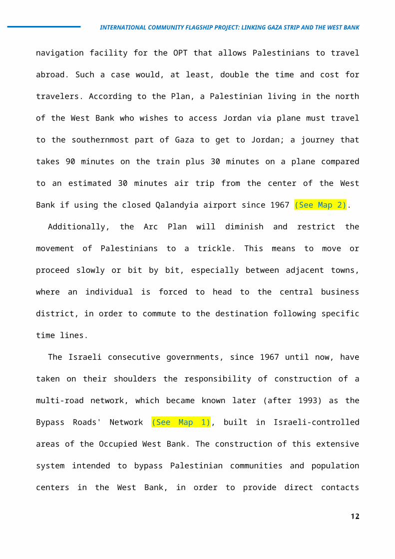
navigation facility for the OPT that allows Palestinians to travel
abroad. Such a case would, at least, double the time and cost for
travelers. According to the Plan, a Palestinian living in the north
of the West Bank who wishes to access Jordan via plane must travel
to the southernmost part of Gaza to get to Jordan; a journey that
takes 90 minutes on the train plus 30 minutes on a plane compared
to an estimated 30 minutes air trip from the center of the West
Bank if using the closed Qalandyia airport since 1967 (See Map 2).
Additionally, the Arc Plan will diminish and restrict the
movement of Palestinians to a trickle. This means to move or
proceed slowly or bit by bit, especially between adjacent towns,
where an individual is forced to head to the central business
district, in order to commute to the destination following specific
time lines.
The Israeli consecutive governments, since 1967 until now, have
taken on their shoulders the responsibility of construction of a
multi-road network, which became known later (after 1993) as the
Bypass Roads' Network (See Map 1), built in Israeli-controlled
areas of the Occupied West Bank. The construction of this extensive
system intended to bypass Palestinian communities and population
centers in the West Bank, in order to provide direct contacts
12

THE ARC PLAN
between the Israeli controlled areas in the Occupied West Bank
(including settlements and military bases, which are deemed to be
illegal under international laws and United Nations' Security
Council and General Assembly resolutions) and Israel. Moreover,
according to B'Tselem (an Israeli human rights' organization), this
transportation grid was not only developed to maintain an “internal
fabric of life” (B’Tselem, 2002) for the West-Bank Israeli
settlers, but also to ban the Palestinian traffic flow from passing
through or by the Israeli settlements in the West Bank and
certainly to stifle Palestinian urban development in the OPT.
3.6.1. Case Study on Israeli Restrictions: Hebron-Ramallah
Trip
During the first 20 years (1967-1987) of the Israeli Occupation
of the West Bank, traveling between the Hebron and Ramallah
Governorates used to be a traditional trip for Palestinians,
especially for merchants, students and employees, who traveled the
road on a daily bases. This was when the Palestinians were allowed
to go through the center-life city of all the Palestinians, which
is the Jerusalem City, as the trip (50 km) used to take 1 hour and
15 minutes. With the eruption of the First Palestinian Intifada, back
in 1987, and with the imposing more Israeli restrictions on the
13

INTERNATIONAL COMMUNITY FLAGSHIP PROJECT: LINKING GAZA STRIP AND THE WEST BANK
Palestinian people in the OPT, all the rules have changed. These
include the entire Palestinian transportation system and the
Palestinians’ access to the Occupied City of Jerusalem.
Consequently, the Hebron-Ramallah trip that used to take 75 minutes
has turned to double the time (2 hours and 30 minutes = 150
minutes) and, of course, with new roads to drive on.
From that time on, the existing road-network system has become an
inadequate means to travel between the northern and southern parts
of the West Bank, where access through the Jerusalem City is denied
for most of the Palestinians. The Occupied City of Jerusalem, as
the center of religious, social, commercial and political life for
all of the Palestinians, and as the only connector of Palestinian
cities and towns of the West Bank, was the first target of the
Israeli imposed restrictions. In 1993, just prior to the signing of
the Oslo Accords, the Israeli Government at that time launched an
organized campaign to isolate the City of Jerusalem. That was and
is still to the present day by restricting the movement of
Palestinians to the City; by establishing checkpoints and physical
barriers around the City's entrances; and by hindering access to
places of worship, employment, education, institutions, and
families. This Israeli attempt to seize and isolate the Jerusalem
14

THE ARC PLAN
City was perceived by the Palestinian people, living under
Occupation, as a calculated step by the Israelis to extricate the
City from the heart of the Palestinian people, as the capital of
their future State of Palestine. That was and is still to tip the
City’s demographic and geographic balances to the favor of the
Israeli residents.
Another dramatic alteration on the traveling road between Hebron
and Ramallah happened with the eruption of the Second Palestinian
Intifada in September 2000, when the Israeli Army started to
establish checkpoints on the Palestinian roads (currently estimated
at 500 checkpoints throughout the OPT). As a result of these
additional restrictions on the Palestinian movement, the Hebron-
Ramallah trip (only 50 km) that used to take 75 minutes during the
first 20 years (1967-1987) of the Israeli Occupation of the
Palestinian Territory, and then used to take 150 minutes (1987-
2000), it takes now 180 to 240 minutes (this is 3 to 4 hours).
Imagine that a student, a patient, a merchant or otherwise, who
needs to make this trip, he/she will need to spend 6 to 8 hours
just to reach his/her destination, and imagine if that person needs
to make this trip (for whatever reason) on a daily basis. It is
important to mention that the time consumed to complete this trip
15

INTERNATIONAL COMMUNITY FLAGSHIP PROJECT: LINKING GAZA STRIP AND THE WEST BANK
reached its peak in 2003, where it took Palestinians, who traveled
either in their private cars or public transportation, 4½ to 5½
hours (this is 5 full hours in average). The UN Office for the
Coordination of Humanitarian Affairs (OCHA), located in the OPT,
estimated that 15-20% of Palestinians’ daily work time is lost on
account of internal closures.
In view of the above, the Israeli restrictions and abusive
actions against the freedom of movement of the Palestinian people
living under the Israeli Occupation have created a case of non-
stopping pressures on the used roads and vehicles, making the rates
of depreciation and operation costs of vehicles to escalate
progressively during the last few years. For the present case, the
increase in length between the old traveling road and the new one
between Hebron and Ramallah is 35 km per single trip (see Map 1).
It is noteworthy to mention that every liter of diesel in the West
Bank costs $US 1, and the average diesel consumption of public
transport taxis (7 passengers; 2000 CC) reaches 1/6 liter/km. By
taking these facts into consideration, a trip from Hebron to
Ramallah will need an additional cost of $US 25.2 per month (to the
monthly average of $US 97 spent on transportation means and
telecommunications). Such an increase constitutes 26% of the
16

THE ARC PLAN
monthly average spent in favor of transportation means and
telecommunications per family (PCBS, 2004).
To clarify the nexus between the Israeli abusive actions of
physical barriers and environmental degradation, one may employ
empirical formulas to quantify amounts of accrued damages. For
instance, the increase in the amounts of black smoke (soot)
released due to the increase in the road network between the Hebron
and Ramallah Governorates calculated 1.01 tons per annum1.
1 Amount of pollutants was estimated by using the Australian Ministry of Environment empirical formula (Amount of pollutants = pollutant factor difference in distance in kilometers) (NPI, 2003), where the pollutant factor of diesel working vehicle = 0.000494 kg/km, difference in distance/year = 22,000 km, and number of vehicles working on the trip from Hebron to Ramallah = 100.
17

INTERNATIONAL COMMUNITY FLAGSHIP PROJECT: LINKING GAZA STRIP AND THE WEST BANK
18
THE ARC PLAN
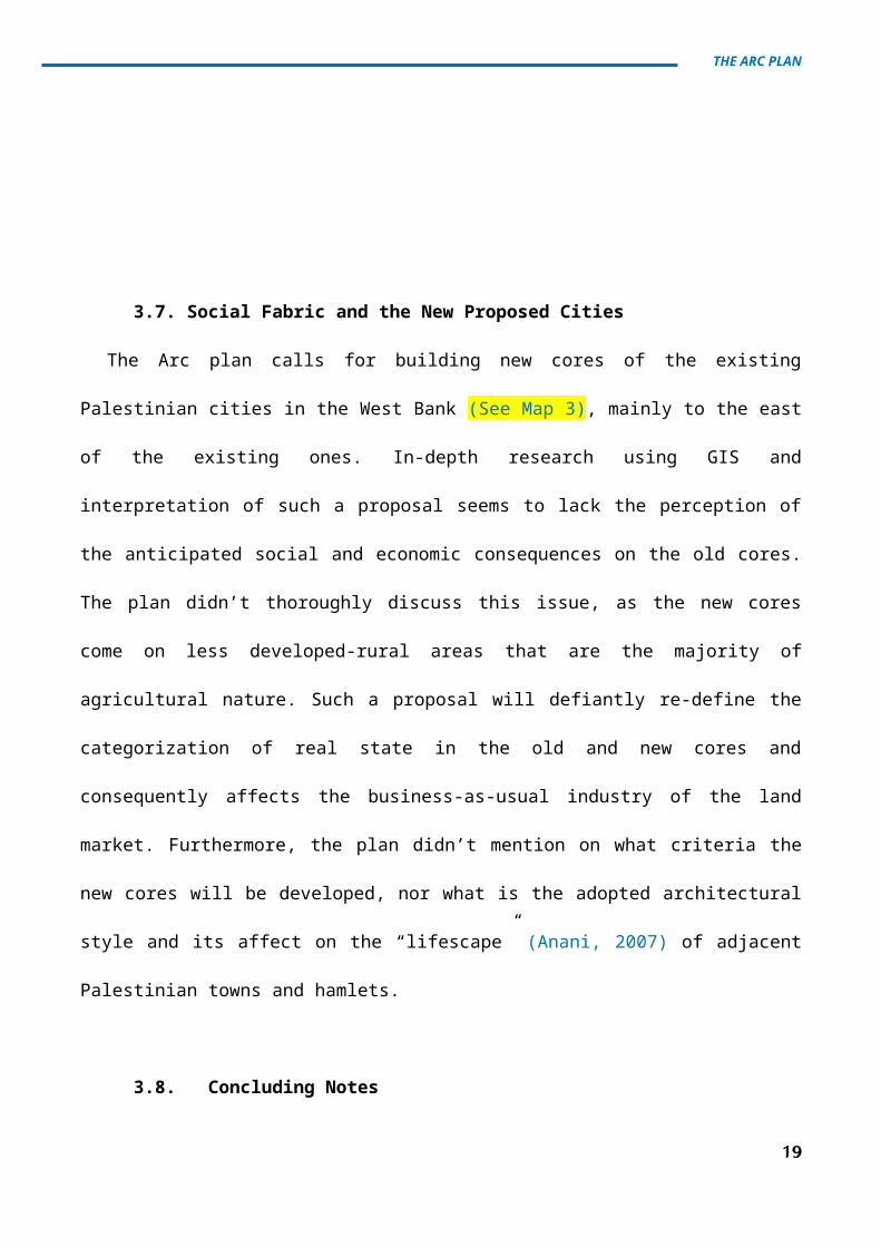
3.7. Social Fabric and the New Proposed Cities
The Arc plan calls for building new cores of the existing
Palestinian cities in the West Bank (See Map 3), mainly to the east
of the existing ones. In-depth research using GIS and
interpretation of such a proposal seems to lack the perception of
the anticipated social and economic consequences on the old cores.
The plan didn’t thoroughly discuss this issue, as the new cores
come on less developed-rural areas that are the majority of
agricultural nature. Such a proposal will defiantly re-define the
categorization of real state in the old and new cores and
consequently affects the business-as-usual industry of the land
market. Furthermore, the plan didn’t mention on what criteria the
new cores will be developed, nor what is the adopted architectural
style and its affect on the “lifescape” (Anani, 2007) of adjacent
Palestinian towns and hamlets.
3.8. Concluding Notes
19

INTERNATIONAL COMMUNITY FLAGSHIP PROJECT: LINKING GAZA STRIP AND THE WEST BANK
The obvious question at this stage would be; why spend such a
hefty budget on studies to assess new alternatives to link the Gaza
Strip and the West Bank, when the obvious and most feasible choice
(regarding time as well as economic considerations) is at hand; the
renovation and upgrading of the existing and proven best functional
route.
To conclude, economic development and physical security are both
indispensable if the peace process is to continue and progressively
bring benefits that are ever more tangible to Israeli and
Palestinian residents. Furthermore, agreements signed between the
Palestinian Liberation Organization and Israeli Government resolved
the issue of an established route between the Gaza Strip and West
Bank. This did function for some time before Israel shunned its
internationally recognized legal responsibilities under the pretext
of security.
The bottom line is that the Arc Plan may be a base for further
deliberation in the future of the Palestinian state, only when the
Israeli occupation is ended.
Finally, the capacity for GIS to clearly articulate spatial
phenomena and accept user input is vital to the on-going democratic
management of the Palestinian cities. That being said, geospatial
20

THE ARC PLAN
technologies are just tools, not answers. The GIS doesn’t in itself
solve wicked problems, but make the process of working them
smoother (Barton, 2008). One of the strengths of the computer is
its ability to rapidly generate a series of options for humans to
assess. If all the factors combine to generate a set of likely
outcomes, the spatial decision-making process becomes more
transparent and sustainable.
21

INTERNATIONAL COMMUNITY FLAGSHIP PROJECT: LINKING GAZA STRIP AND THE WEST BANK
4. References
o Anani, Yazid (2007), Palestinian Landscape Values in Turmoil.
o Applied Research Institute – Jerusalem (ARIJ), GIS Database,
(2008).
o Bankson P. (2008). “The Devil is in the Details.” The Land of the
Free.
<http://www.thelandofthefree.net/conservativeopinion/2007/08
/31/the-devil-is-in-the-details/>.
o Barton, J., Plume, J. (2008). Working Toward Urban Sustainability for Inner-city Development. Sharjah Urban Planning Symposium X: Capital Cities, Wicked Problems: Best Practices in Planning and Policy Response Mechanisms, United Arab of Emirates.
o British Broadcasting Corporation (BBC) (2008). “Tutu: Gaza
blockade abomination.”
<http://news.bbc.co.uk/2/hi/middle_east/7425082.stm>.
o Dumper M. (2008). “Constructive Ambiguities? Jerusalem, International Law
and the Peace process.” Jerusalem Quarterly.
o El-Atrash A. (2008). Article: “Critiquing the Proposed Arc Plan – In
Arabic.” The Palestinian Engineering Magazine – No. (53).
o Hanafi S. 2004. “Targeting space through bio-politics: The Israeli colonial
project.” Palestine Report, VOL 10 NO 32.
o Issac J. et. al. 2007. “Status of the Environment in the Occupied Palestinian
Territory.” ARIJ Publications. ISBN 978-9950-304-00-0.
22

THE ARC PLAN
o Rowe C., Koetter F. (1978). “Collage City.” Cambridge, the MIT
Press.
o Suisman D. et. al. 2005. “The Arc: A Formal Structure for a Palestinian
State.” Rand Corporation.
<http://www.rand.org/pubs/monographs/MG327-1> &
<http://www.suisman.co / >.
o Venturi R. (1966). “Complexity and Contradiction in Architecture.” New
York, Museum of Modern Art.
o Yiftachel O. 2005. “Neither Two States nor One: The Disengagement and
“Creeping Apartheid” in Israel/Palestine”. The Arab World Geographer,
Toronto, Canada.
Map 2: Proposed Transportation Terminals – The Arc
23

INTERNATIONAL COMMUNITY FLAGSHIP PROJECT: LINKING GAZA STRIP AND THE WEST BANK
Source: Rand, 2005
Map 2: Proposed New Cities (White Dots) – The Arc
24

THE ARC PLAN
Source: Rand, 2005
25
Copyright © 2022 FDOKUMEN