Integrating conservation, restoration and land-use planning in islands—An illustrative case study...
11
Please cite this article in press as: Lagabrielle, E., et al., Integrating conservation, restoration and land-use planning in islands—An illustrative case study in Réunion Island (Western Indian Ocean). Landscape Urban Plan. (2011), doi:10.1016/j.landurbplan.2011.02.004 ARTICLE IN PRESS G Model LAND-1976; No. of Pages 11 Landscape and Urban Planning xxx (2011) xxx–xxx Contents lists available at ScienceDirect Landscape and Urban Planning journal homepage: www.elsevier.com/locate/landurbplan Integrating conservation, restoration and land-use planning in islands—An illustrative case study in Réunion Island (Western Indian Ocean) Erwann Lagabrielle a,b,c,∗ , Mathieu Rouget d,e , Thomas Le Bourgeois c,j , Karine Payet c,e,f , Laurent Durieux g , Stéphane Baret h , Joël Dupont i , Dominique Strasberg c a Nelson Mandela Metropolitan University, Saasveld Campus, Private Bag X6531, George 6530, South Africa b Institute for Research and Development (IRD), UMR 128 ESPACE-DEV, IRD Réunion, BP 50172, 97492 Sainte-Clothilde Cedex, France c UMR PVBMT, CIRAD, Université de la Réunion, 7 chemin de l’IRAT, Ligne Paradis 97410, Saint-Pierre, France d South African National Biodiversity Institute, Private Bag X101, Pretoria 0001, South Africa e Department of Plant Science, University of Pretoria, Pretoria 0002, South Africa f Department of Conservation Ecology and Entomology, Stellenbosch University, Private Bag X1, Matieland 7602, South Africa g Institute for Research and Development (IRD), UMR 128 ESPACE-DEV, IRD Brésil, CP 7091 – Lago Sul, 71619, 970 Brasilia (DF), Brazil h Parc national de La Réunion, 112 rue Sainte Marie, 97400 Saint-Denis, France i Société Réunionnaise d’Etude et de Protection de l’Environnement, 30 rue des Deux-Canons, 97490 Sainte-Clothilde, France j UMR AMAP, CIRAD, TA A51/PS2, boulevard de la Lironde, 34730 Montpellier Cedex 5, France article info Article history: Received 21 April 2010 Received in revised form 24 January 2011 Accepted 5 February 2011 Available online xxx Keywords: Biodiversity GIS Cost optimisation Corridors Protected areas Invasion abstract This paper describes an operational protocol for integrating conservation and restoration with land-use planning in islands. Conservation challenges are intensified in insular systems due to higher ecosystem vulnerability, limited spatial options, low data availability, rapid land-use change and, globally, short- term vision planning. Our operational planning protocol integrates ecological and socio-economic factors to identify the best spatial options for conserving and restoring biodiversity, inside and outside extant reserves, while minimising future land-use conflicts. Conservation and restoration targets are formulated for species, habitats and ecological processes that support biodiversity. An optimal network of priority sites is selected to achieve those targets across the landscape. The prioritisation process integrates a Con- servation Costs Index to optimise conservation and restoration investments. We discuss the outcomes of the planning protocol in terms of site prioritisation, stakeholders’ participation and general implica- tions for spatial planning in insular systems. As with many islands, the study area of Réunion Island has experienced rapid urban and agricultural expansion, which threatens its unique biodiversity. Forty three per cent of the island is currently protected in a National Park but only half of this reserve network con- tributes to the achievement of targets. An additional 21% of land should be conserved mainly to ensure the persistence of ecological connections between the marine, terrestrial and freshwater realms. Finally we emphasize that our method doesn’t substitute the land-use planning debate but is aimed to better prepare the conservation sector for negotiating future land-use allocation with other socio-economic sectors in islands. © 2011 Elsevier B.V. All rights reserved. 1. Introduction Spatial planning in islands must carefully balance ecosystem persistence requirements with insular development. Over the last century, insular ecosystems have become some of the most ∗ Corresponding author at: Nelson Mandela Metropolitan University, Saasveld Campus, Private Bag X6531, George 6530, South Africa. Tel.: +00 262 262 29 99 01. E-mail addresses: [email protected], [email protected] (E. Lagabrielle), [email protected] (M. Rouget), thomas.le [email protected] (T. Le Bourgeois), [email protected] (K. Payet), [email protected] (L. Durieux), [email protected] (S. Baret), [email protected] (J. Dupont), [email protected] (D. Strasberg). restricted and threatened in the world (Mueller-Dombois and Loope, 1990). For instance, more than 60% of documented verte- brate extinctions have occurred on islands (Diamond, 1989; Case et al., 1992). Islands ecosystems are particularly rich in endemic species, and contribute disproportionately to global biodiversity (Stattersfield and Capper, 2000). Conservation and restoration in islands is a major challenge since 10 of the 34 terrestrial biodi- versity hotspots listed by Conservation International are wholly comprised of islands (Mittermeier et al., 2005; Cook et al., 2006). To address this challenge, we developed and tested a spatial planning protocol to optimise conservation and restoration investments in the landscape while minimising potential conflicts with other land- uses in islands.Confounding ecological and anthropogenic factors 0169-2046/$ – see front matter © 2011 Elsevier B.V. All rights reserved. doi:10.1016/j.landurbplan.2011.02.004
-
Upload
univ-reunion -
Category
Documents
-
view
3 -
download
0
Transcript of Integrating conservation, restoration and land-use planning in islands—An illustrative case study...

G
L
Ii
ELa
b
c
d
e
f
g
h
i
j
a
ARRAA
KBGCCPI
1
pl
C
LLsD
0d
ARTICLE IN PRESSModel
AND-1976; No. of Pages 11
Landscape and Urban Planning xxx (2011) xxx–xxx
Contents lists available at ScienceDirect
Landscape and Urban Planning
journa l homepage: www.e lsev ier .com/ locate / landurbplan
ntegrating conservation, restoration and land-use planning in islands—Anllustrative case study in Réunion Island (Western Indian Ocean)
rwann Lagabriellea,b,c,∗, Mathieu Rougetd,e, Thomas Le Bourgeoisc,j, Karine Payetc,e,f,aurent Durieuxg, Stéphane Bareth, Joël Dupont i, Dominique Strasbergc
Nelson Mandela Metropolitan University, Saasveld Campus, Private Bag X6531, George 6530, South AfricaInstitute for Research and Development (IRD), UMR 128 ESPACE-DEV, IRD Réunion, BP 50172, 97492 Sainte-Clothilde Cedex, FranceUMR PVBMT, CIRAD, Université de la Réunion, 7 chemin de l’IRAT, Ligne Paradis 97410, Saint-Pierre, FranceSouth African National Biodiversity Institute, Private Bag X101, Pretoria 0001, South AfricaDepartment of Plant Science, University of Pretoria, Pretoria 0002, South AfricaDepartment of Conservation Ecology and Entomology, Stellenbosch University, Private Bag X1, Matieland 7602, South AfricaInstitute for Research and Development (IRD), UMR 128 ESPACE-DEV, IRD Brésil, CP 7091 – Lago Sul, 71619, 970 Brasilia (DF), BrazilParc national de La Réunion, 112 rue Sainte Marie, 97400 Saint-Denis, FranceSociété Réunionnaise d’Etude et de Protection de l’Environnement, 30 rue des Deux-Canons, 97490 Sainte-Clothilde, FranceUMR AMAP, CIRAD, TA A51/PS2, boulevard de la Lironde, 34730 Montpellier Cedex 5, France
r t i c l e i n f o
rticle history:eceived 21 April 2010eceived in revised form 24 January 2011ccepted 5 February 2011vailable online xxx
eywords:iodiversityISost optimisationorridorsrotected areasnvasion
a b s t r a c t
This paper describes an operational protocol for integrating conservation and restoration with land-useplanning in islands. Conservation challenges are intensified in insular systems due to higher ecosystemvulnerability, limited spatial options, low data availability, rapid land-use change and, globally, short-term vision planning. Our operational planning protocol integrates ecological and socio-economic factorsto identify the best spatial options for conserving and restoring biodiversity, inside and outside extantreserves, while minimising future land-use conflicts. Conservation and restoration targets are formulatedfor species, habitats and ecological processes that support biodiversity. An optimal network of prioritysites is selected to achieve those targets across the landscape. The prioritisation process integrates a Con-servation Costs Index to optimise conservation and restoration investments. We discuss the outcomesof the planning protocol in terms of site prioritisation, stakeholders’ participation and general implica-tions for spatial planning in insular systems. As with many islands, the study area of Réunion Island has
experienced rapid urban and agricultural expansion, which threatens its unique biodiversity. Forty threeper cent of the island is currently protected in a National Park but only half of this reserve network con-tributes to the achievement of targets. An additional 21% of land should be conserved mainly to ensurethe persistence of ecological connections between the marine, terrestrial and freshwater realms. Finallywe emphasize that our method doesn’t substitute the land-use planning debate but is aimed to betterprepare the conservation sector for negotiating future land-use allocation with other socio-economic sectors in islands.. Introduction
Please cite this article in press as: Lagabrielle, E., et al., Integrating consercase study in Réunion Island (Western Indian Ocean). Landscape Urban Pla
Spatial planning in islands must carefully balance ecosystemersistence requirements with insular development. Over the
ast century, insular ecosystems have become some of the most
∗ Corresponding author at: Nelson Mandela Metropolitan University, Saasveldampus, Private Bag X6531, George 6530, South Africa. Tel.: +00 262 262 29 99 01.
E-mail addresses: [email protected], [email protected] (E.agabrielle), [email protected] (M. Rouget), thomas.le [email protected] (T.e Bourgeois), [email protected] (K. Payet), [email protected] (L. Durieux),[email protected] (S. Baret), [email protected] (J.upont), [email protected] (D. Strasberg).
169-2046/$ – see front matter © 2011 Elsevier B.V. All rights reserved.oi:10.1016/j.landurbplan.2011.02.004
© 2011 Elsevier B.V. All rights reserved.
restricted and threatened in the world (Mueller-Dombois andLoope, 1990). For instance, more than 60% of documented verte-brate extinctions have occurred on islands (Diamond, 1989; Caseet al., 1992). Islands ecosystems are particularly rich in endemicspecies, and contribute disproportionately to global biodiversity(Stattersfield and Capper, 2000). Conservation and restoration inislands is a major challenge since 10 of the 34 terrestrial biodi-versity hotspots listed by Conservation International are wholly
vation, restoration and land-use planning in islands—An illustrativen. (2011), doi:10.1016/j.landurbplan.2011.02.004
comprised of islands (Mittermeier et al., 2005; Cook et al., 2006). Toaddress this challenge, we developed and tested a spatial planningprotocol to optimise conservation and restoration investments inthe landscape while minimising potential conflicts with other land-uses in islands.Confounding ecological and anthropogenic factors
ING
L
2 nd Urb
hipn1(t(mpc
betispits
(aaanpwsacamr(
2R
tt3bg
ccpr1nh
2aoibttatt
ARTICLEModel
AND-1976; No. of Pages 11
E. Lagabrielle et al. / Landscape a
ave been cited to explain unprecedented rate of biodiversity lossn islands. This includes the rarity of spatial options for biodiversityersistence (Simberloff, 1995; Whittaker et al., 2001), a higher vul-erability of ecosystems to invasions (Mueller-Dombois and Loope,990; Fritts and Rodda, 1998), and higher rates of land conversionCudihhy and Stone, 1990). Poor spatial planning in insular ecosys-ems has led to disastrous, rapid and irreversible biodiversity lossDolisca et al., 2007). In addition, several factors hinder the imple-
entation of conservation actions in insular regions, i.e. poverty,oor knowledge and data, and, overall, insufficiently integratedonservation strategies.
Conservation plans initiated in insular regions often focused oniodiversity only and ignored socio-economic factors that guideffective conservation (Veech, 2003). This often resulted in unsus-ainable conservation strategies due to conflicts between islanders’nterests and conservation (Novy-Hildesley, 2001). For instance,uch conflicts hindered conservation implementation in the Gala-agos (Grenier, 2000) and in New-Zealand (Young, 2004). Although
slands share common social and ecological traits with continen-al areas, many conservation challenges are intensified in insularystems.
Following systematic conservation planning principlesBalmford, 2003; Margules and Pressey, 2000), our protocolims to identify ex ante the best spatial options for conservingnd restoring a representative sample of biodiversity featuresnd ecosystem processes inside and outside an extant reservesetwork, while minimising conflicts with other land uses. Afterresenting conservation challenges in Réunion Island (Section 2),e describe the planning protocol (Section 3): mapping habitats,
pecies and biodiversity processes (Section 4), setting conservationnd restoration targets (Section 5), identifying priority sites foronservation and restoration (Section 6). Outcomes of the plansre analysed in Section 7. Finally, we propose implementationechanisms toward a better integration of conservation and
estoration issues within land-use planning in Réunion IslandSection 8), and more generally in insular regions (Section 9).
. Conservation and land-use planning challenges inéunion Island
Réunion Island (2512 km2) is a small French island located inhe Indian Ocean, 200 km South-West of Mauritius and 700 km tohe East of Madagascar (Fig. 1). Its steep volcanic relief reaches070 m in the centre of the island. A third of its areas is still coveredy native vegetation ranging from lowland rainforest to subalpinerassland (Strasberg et al., 2005).
The island has long been recognised as a global priority foronservation owing to its high concentration of endemic taxa, espe-ially of plants. Forty six per cent of the 843 species of vascularlants species in Réunion Island are endemic to the Mascareneegion that is comprised of Mauritius and Rodrigues Island (Cadet,980; Conservatoire Botanique National de Mascarin, 2008). Réu-ion Island is comprised in a terrestrial and a marine biodiversityotspot (Roberts et al., 2002; Mittermeier et al., 2005).
At present, more than 80% of the 802,000 inhabitants (INSEE,009) live on the coastal fringe where most of the socio-economicctivities are concentrated. Population has been increasing at ratef 1.5% per year since 2000 and is predicted to reach 1 millionnhabitants in 2030 (INSEE, 2009). European Development Fundsoosted the economy of the island since the 1990’s. Concomi-
Please cite this article in press as: Lagabrielle, E., et al., Integrating consercase study in Réunion Island (Western Indian Ocean). Landscape Urban Pla
antly, urban areas expanded by 189% over the period from 1989o 2002 (Durieux et al., 2008) and available land became a rarend coveted resource. Below 1000 m, landscapes are now expectedo fulfil multiple functions (i.e. urbanisation, agriculture produc-ion and ecosystem conservation) and this causes conflicts among
PRESSan Planning xxx (2011) xxx–xxx
stakeholders about their planning and management (van der Valk,2002).
Since the European occupation of the island (in 1665), lowlandhabitats (<1000 m) are almost fully transformed, except on harshslopes and ravines (Gigord et al., 1999) (Fig. 1). As with other insu-lar regions, biodiversity in Réunion is facing escalating threats thathave already led to the extinction of 30 of 45 vertebrate species(Mourer-Chauvire et al., 1999). Habitat degradation by invasivealien species is an important threat to its endemic biodiversity(MacDonald et al., 1991; Baret et al., 2006). Ecosystem conversionsby urbanisation and agriculture (mainly sugar cane and market gar-dening) are destroying remnant pristine vegetation patches in thelowlands, while forestry and native forest clearing for cattle breed-ing are major threats to biodiversity in the uplands (Strasberg et al.,2005). Since the creation of a National Park in 2007, 43% of the areaof the island is protected (Table 1). However, the reserve network isbiased toward the uplands: the mean altitude of reserves is 1306 mversus 873 m for the whole island. With very few protected areasin the lowlands, the persistence of biodiversity in Réunion Islanddepends heavily on the successful integration of conservation andrestoration strategies with land-use planning.
Future challenges for land-use planning in Réunion Islandfurther include the control of urban sprawl and the protectionof agricultural land from conversion by urbanisation. A regionaldevelopment plan (“Schémad’AménagementRégional”: hereafterreferred to as SAR) rules the allocation of land uses for the wholeisland. The SAR developed in 1995 was under revision at the time ofthis analysis. Therefore, our objective was to produce conservationand restoration recommendations that could inform the SAR revi-sion process. In addition there was a demand from the National Parkauthorities to identify priority areas for conservation and restora-tion inside the National Park boundaries.
3. Planning protocol overview
Our conservation and restoration planning protocol is basedon systematic conservation planning principles (Margules andPressey, 2000). As a first step, the conservation and land-use chal-lenges were assessed and the institutional demand for spatialplanning was identified during preparatory meetings with stake-holders from the urban, agriculture and conservation sector andscientists (Section 2). As a second step, we gathered spatial data onbiodiversity for three different types of biodiversity features, i.e. (1)pristine habitats, (2) endemic species and (3) spatial componentsof ecological and evolutionary processes (Section 4). Conservationand restoration targets were formulated for those features (Sec-tion 5). After assessing the level of target achievement in existingconservation areas (i.e. a “gap analysis”), we identified additionalpriority areas to meet targets while minimising costs associatedwith conservation implementation, management, restoration andcurrent and future land-use trends (Section 6). This was done usinga site selection algorithm embedded in MARXAN software (Ball andPossingham, 2000). The site selection process follows eight stages(Table 3) that achieve incremental conservation and restorationtargets into a spatial network of priority sites (see Section 7). Finally,we identified implementation mechanisms to better integrate con-servation and restoration opportunities with land-use planning,inside and outside the existing reserve system (Section 8.4). Theresults of the site selection process plus the implementation rec-ommendations constitute what we refer to as the “conservation
vation, restoration and land-use planning in islands—An illustrativen. (2011), doi:10.1016/j.landurbplan.2011.02.004
and restoration plan”.The plan was developed through a participatory process. An
advisory team of 10 professionals, constituted mainly of scien-tists (i.e., geographer, anthropologist, agronomist, modeller andecologist), but also staff of the National Park authorities were

ARTICLE IN PRESSG Model
LAND-1976; No. of Pages 11
E. Lagabrielle et al. / Landscape and Urban Planning xxx (2011) xxx–xxx 3
Fig. 1. Habitat transformation and reserves distribution in Réunion Island (from Strasberg et al., 2005).
Table 1Protected areas categories in Réunion Island (terrestrial only). Spatial overlaps occur between protected areas.
IUCN category type Protected areas category Area (km2) (% of island’s area)
Type I Biological forest reserve 278 11.0Type II Core area of the National Park (including cultivated and inhabited areas) 1048 41.7Type IV Nature reserve 38 1.5
Biotope reserve 20 0.8Biological reserve of the National Forest Office 76 3.0
onser
ctiopeoae
Sites of the Conservatoire du Littoral (coastal c
Total
onsulted during workshops and individual interviews. Institu-ions involved in the land-use planning debate on the island werenformed of the on-going conservation planning process through-ut regular meetings and presentations. The strategy for the
Please cite this article in press as: Lagabrielle, E., et al., Integrating consercase study in Réunion Island (Western Indian Ocean). Landscape Urban Pla
articipation of stakeholders is specifically discussed in Lagabriellet al. (2010): they concluded that the participatory developmentf land-use simulation models should be promoted to explorelternative scenarios for biodiversity conservation with stakehold-rs. They also showed that this participatory planning approach
vation agency) 8 0.3
1071 42.6
should be gradual and sequential to fit into public decision-makingprocesses.
4. Mapping biodiversity
vation, restoration and land-use planning in islands—An illustrativen. (2011), doi:10.1016/j.landurbplan.2011.02.004
4.1. Habitats
In areas where available data on biodiversity are poor or limited,a coarse-filter approach to mapping biodiversity is recommended

ING
L
4 nd Urb
(s
etwa
tatwRwgai
cdaswecoa
4
stepdsddo
eatw(pr
4
wsaiieolCm(t2
ARTICLEModel
AND-1976; No. of Pages 11
E. Lagabrielle et al. / Landscape a
Margules and Pressey, 2000). To this purpose, habitats act as goodurrogates for overall biodiversity (Lombard et al., 2003).
To develop the habitat map in Réunion Island we integratedxpert judgements with remote sensing data and GIS analysis. Pris-ine habitats were extracted from Strasberg et al. (2005). Theseere modeled using slope, altitude and rainfall data combined with
erial photography analysis (Strasberg et al., 2005).As we aimed to develop a habitat map compatible with conven-
ional land-use products, we combined GIS data on urbanisationnd agriculture by collaborating with institutions involved inhe land-use planning debate. The GIS layer on urban areasas provided by the Regional Urban Planning Agency (AGO-AH). GIS layers on agriculture (cane, other crops and pastures)ere validated by the Regional Agriculture Council (ChambreRé-
ionaled’Agriculture). We integrated those GIS datasets followingset of rules defined with the participants, with urban areas super-
mposing all other features.We mapped a system of 44 habitat classes, including 21 pristine
lasses (Fig. 1). Habitat classes, their current and past extent, areetailed in Appendix A. Each habitat class – including urban andgricultural areas – was attributed a transformation status by con-ervation experts (Table 2). The transformation status categoriesere derived from Strasberg et al. (2005) and Baret et al. (2006):
xtant (i.e. pristine), invaded (pristine remnants but alien speciesovering more than 50% of the under storey and more than 90%f the canopy), restorable (secondary vegetation and agriculturalreas) and irreversibly transformed (urban areas).
.2. Species
Due to time and budgetary limitations, we only used existingpecies datasets. We concentrated our data collection effort onhreatened species. Unsurprisingly, these were distributed almostxclusively in lowlands where habitat transformation is the mostrominent in Réunion Island. The combination of distributionalata on threatened species with data on pristine habitats in reserveelection is an efficient and satisfactory approach to overall bio-iversity representation (Payet et al., 2010). Payet et al. (2010)eveloped their study in Réunion Island using the dataset devel-ped for this conservation and restoration plan.
We collected GIS layers on 25 indigenous species, includingight endemic plants, the breeding areas of five oceanic bird speciesnd the distribution areas of nine endemic forest birds, two rep-iles and one bat species (Appendix B). The threat status of speciesas assigned according to the IUCN Red List of Threatened Species
IUCN, 2006). The species data are representative of conservationriorities in the lowlands, although biased toward iconic bird andeptile species.
.3. Ecological and evolutionary processes
Biodiversity in insular regions is sustained and generated by aide array of ecological processes (such as movements of endemic
pecies) and evolutionary processes (such as speciation processeslong altitudinal gradients) (Whittaker et al., 2001). Identify-ng, mapping and protecting areas supporting such processes aremportant to guarantee the persistence and long-term evolution ofcosystems. This can be achieved by complementing the networkf protected areas by large-scale corridors that represent key eco-ogical linkages between marine, freshwater and terrestrial realms.
Please cite this article in press as: Lagabrielle, E., et al., Integrating consercase study in Réunion Island (Western Indian Ocean). Landscape Urban Pla
orridors are aimed to capture the environmental gradients andaintain landscape connectivity across spatial and temporal scale
Rouget et al., 2006). They facilitate biota movement and main-ain evolutionary processes such as geographic speciation (Moritz,002).
PRESSan Planning xxx (2011) xxx–xxx
We used the recently developed map of Spatial Components ofBiodiversity Processes (SCBPs) developed by Lagabrielle et al. (2009)in Réunion Island. SCBPs are landscape features supporting keybiodiversity processes, such a bird migration, plant dispersal andgeographic speciation, along environmental gradients or ecologicalinterfaces (Rouget et al., 2006). Lagabrielle et al. (2009) proposed amethod to identify those biodiversity processes and delineate a net-work of conservation corridors maximising their protection whileminimising current and future threats.
SCBPs were mapped as surface elements aligned along lin-ear environmental interfaces or gradients. These comprisedoceanic–terrestrial interfaces, riverine corridors, macrohabitatinterfaces, topographic unit boundaries, and lowland–upland gra-dients. The mapping method involved consultation of experts, GISanalysis and an extensive literature review. The transformationstatus of SCBPs ranked from extant in pristine habitats, throughrestorable in crop or secondary vegetation, to irreversibly trans-formed in urban areas.
A regional network of 23 large-scale natural corridors linkingsea-level areas to the island summits were designed to encompassa maximum amount of SCBPs and pristine habitats while avoidingareas incompatibles with the maintenance of ecological connectiv-ity (Lagabrielle et al., 2009).
5. Formulating conservation and restoration targets
Formulating conservation and restoration targets for biodiver-sity features is a necessary step toward prioritizing actions (Desmetand Cowling, 2004). A conservation (or restoration) target is aquantitative estimate of the minimum portion of each biodiversityfeature that needs to be represented in the conservation (or restora-tion) protected area network to ensure their long-term persistence(Pressey et al., 2003).
Targets for habitats were expressed as a percentage of their indi-vidual original area, i.e. before human transformation. Targets werecalculated on original rather than current extents because habitatsare typically unequally affected by anthropogenic impacts (Desmetand Cowling, 2004). Targets were then formulated into hectaresrequired per habitat type.
Habitat targets were obtained by summing a baseline target of20% and an adjustment target comprised between 0% and 30%. Thiscomposite approach, mixing a fixed and a variable target, is advo-cated by Rondini and Chiozza (2010). The baseline target of 20% isin line with international conservation agreements (Convention onBiological Diversity). The adjustment target is driven by local data onthe ecological heterogeneity and natural rarity of habitats types. Foreach habitat type, the adjustment target was calculated as the sumof the following variables (with values scaled from 0 to 10): speciesrichness, endemic species richness and environmental heterogene-ity. Species richness data were extracted from a previous study byStrasberg et al. (2005). The calculation of the environmental hetero-geneity was based on the following parameters: soil type diversity(data from Raunet, 1991) and coefficient of variation of altitude,slope and precipitation. Final habitat targets (baseline + adjustmenttarget) in Réunion rank from 24% to 45%. Given their uniquenessin the region, the entire current extent of untransformed wetlandsand lava flows habitats was targeted (Fig. 2). When the conservationtarget exceeded the pristine extent of a given habitat, the conser-vation target was truncated to that extent and the remaining areabecame the restoration target. Only six pristine habitats ended with
vation, restoration and land-use planning in islands—An illustrativen. (2011), doi:10.1016/j.landurbplan.2011.02.004
a restoration target: five lowland habitats almost fully transformedby urbanisation or agriculture and the subalpine Sophora thickethabitat recently transformed by cattle farming in the uplands.
Conservation targets for species were defined as a fraction ofdistributional area or number of distributional sites. Targets were

ARTICLE IN PRESSG Model
LAND-1976; No. of Pages 11
E. Lagabrielle et al. / Landscape and Urban Planning xxx (2011) xxx–xxx 5
Table 2Categories of habitat transformation in Réunion Island.
Transformation status Description Reference Area (as % of total)*
PristineExtant 26.9
Pristine Not invaded or presence of some alien plant individuals in anintact canopy and understorey (alien species <1%)
Strasberg et al. (2005)Baret et al. (2006)
7.7
Lightly invaded Canopy intact (native species cover >90%) but understoreyinvaded (10–90%)
Strasberg et al. (2005)Baret et al. (2006)
19.3
Invaded 25.3Moderately invaded Canopy and understorey invaded
(Native species cover between 50% and 90% in the canopy)Strasberg et al. (2005)Baret et al. (2006)
12.8
Highly invaded Canopy and understorey invaded(Native species cover between 10% and 50% in the canopy)
Strasberg et al. (2005)Baret et al. (2006)
12.5
TransformedRestorable 36.3
Secondary vegetation No native species Lagabrielle et al. (2009) 17.7Cultivated Crops including forestry Lagabrielle et al. (2009) 18.6
Irreversibly transformed Urban areas Urban Planning Agency ofRéunion Island (AGORAH)
9.9
* The transformation status of 1.6% of the island’s areas remains unknown.
éunio
sSe(apoe
ast
6r
6
cspec
Fig. 2. Conservation and restoration targets for pristine habitat in R
et according to species status in the IUCN Red List of Threatenedpecies (IUCN, 2006): 100% for species seriously on the verge ofxtinction (number of species = 7) or threatened with extinctionn = 4), 80% for vulnerable (n = 2), 60% for near threatened (n = 1)nd 40% for least concern species (n = 11, including two speciesrotected by ministerial decree). Given the low availability of datan species, those targets were arbitrary decided with conservationxperts.
All extant and restorable sections of SCBPs and corridors werettributed a 100% conservation or restoration target given. Thosepatial features are required to maintain functional ecosystems onhe island (Lagabrielle et al., 2009).
. Identifying spatial priorities for conservation andestoration
.1. Site selection process
The site selection process is aimed at identifying priority sites for
Please cite this article in press as: Lagabrielle, E., et al., Integrating consercase study in Réunion Island (Western Indian Ocean). Landscape Urban Pla
onservation and restoration, inside and outside the extant reserveystem. This protocol integrates previous systematic conservationlanning procedures proposed by Cowling et al. (2003) and Rougett al. (2006), appended with a systematic restoration planning pro-edure. A spatial algorithm is used to optimise the site selection
n Island, expressed as a percentage of the total area of each habitat.
process. The eight stages of the site selection process are describedin Table 3.
6.2. Conservation and restoration costs
As conservation resources are limited, conservation and restora-tion costs need to be assessed and optimally allocated (Naidoo andRicketts, 2006). To assess those costs, we developed a Conservation(and restoration) Costs Index (CCI). The CCI is calculated by sum-ming the following cost components: conservation implementationcost (the cost of implementing additional reserves), conservationmanagement cost (the cost of managing protected areas), restorationmanagement cost (the cost of managing habitat restoration, in addi-tion to conservation management cost) and transformation pressurecost (the cost of trying to prevent future probable habitat transfor-mation or destruction by land conversion or invasive species). TheCCI variables are detailed in Table 4. CCI variables and overall val-ues were linearly rescaled from 0 to 100 to facilitate cost analysis,data combination and integration into MARXAN software.
vation, restoration and land-use planning in islands—An illustrativen. (2011), doi:10.1016/j.landurbplan.2011.02.004
To calculate the transformation pressure cost, the outcomes ofthree predictive models were combined, i.e. on urbanisation, agri-cultural and plant invasion potentials. Urbanisation probabilitieswere derived from non-linear regression analysis on 12 factorsexplaining urban sprawl observed from 1989 to 2002 (Thinon

ARTICLE IN PRESSG Model
LAND-1976; No. of Pages 11
6 E. Lagabrielle et al. / Landscape and Urban Planning xxx (2011) xxx–xxx
Table 3Stages of the site prioritisation process for conservation and restoration planning. The irreplaceability value is the frequency of site selection along successive runs of MARXAN.
Stage Objective
Conservation1 Integrating extant SCBPsa outside reserves2 Integrating sites of high irreplaceability (>0.8) to achieve conservation targets for habitats, plants and vertebrates inside existing reserves3 Integrating sites of high irreplaceability (>0.8) to achieve conservation targets for habitats, plants and vertebrates outside existing reserves4 Integrating lowland–upland corridors outside existing reserves
Restoration5 Integrating restorable sections of SCBPs outside existing reserves6 Integrating restorable sites of high irreplaceability (>0.8) to achieve restoration targets for habitats inside existing reserves7 Integrating restorable sites of high irreplaceability (>0.8) to achieve restoration targets for habitats outside exiting reserves8 Integrating restorable sites selected in stages 2, 3 and 4
a SCBPs = spatial components of biodiversity processes. This includes oceanic–terrestrial interfaces, riverine corridors, macrohabitat interfaces, topographic unit boundaries,and lowland–upland gradients.
Table 4Components of the Conservation Costs Index (CCI). Values range between 0 and 100.
Cost component Rationale
Implementation Reserve implementation costs depend on land’s ownership: public land is cheaper than private land. We considered that land pricewere homogeneous in private land
Conservation management Conservation management costs are the investments required to manage protected areas. In insular regions the control of alien plants isa major conservation management cost (Baret et al., 2006). This cost is minimum in pristine habitats and maximum in invaded habitats.Other management costs were assumed homogeneous across the landscape: control of poaching activities, maintenance of hiking trails,etc.
Restoration management Once conserved and managed, the restoration of existing transformed ecosystems involves massive investments. Restoration costincreases with the level of transformation of ecosystems. This cost is null in pristine habitats and maximum in irreversibly transformed
futurequireshe occ
eSapFepT(atmoa
6
tsC
mTcif(
tn
-
habitatsTransformation pressure The transformation pressure is the probability of
Dealing with a high transformation probability reothers) to resist to the transformation pressure. T
t al., 2007) and calibrated using population projection for 2030.uitability map for agriculture (sugar cane and pastures, whichre the dominant agricultural activities in Réunion Island) wererovided by the Chambre Régionale d’Agriculture de La Réunion.uture potential extents of invasive plants were mapped by Barett al. (2006) using Climatic Envelope Modelling. We summed theotential extent of the 20 most invasive species for this analysis.he transformation pressure probabilities vary from ‘not probable’score = 0) to ‘highly probable’ (100). We derived the mean scoremong the three equally weighted factors (urbanisation, agricul-ure and alien plants) as the final transformation pressure cost. The
ean score method was preferred to the highest-score methodwing to the high intensity and density of transformation pressurescross the planning domain (saturation effect).
.3. Identifying optimal sites for conservation and restoration
To select sites that optimally achieve conservation and restora-ion targets in the landscape we used the conservation planningoftware MARXAN (Ball and Possingham, 2000), and its interfaceLUZ (Smith, 2004) in Arcview 3.2 (ESRI, Redlands, California).
MARXAN software is designed with the use of stochastic opti-isation routines (simulated annealing, Kirkpatrick et al., 1983).
he algorithm attempts to identify a near-optimal reserve system,alled solution, which best achieves conservation targets while min-mising a set of costs (Possingham et al., 2000). Planning unitsrequently integrated within solutions are the most irreplaceableMARXAN sensu).
In our case study, the optimisation process aimed to minimizehe following three variables when selecting the additional reserveetwork:
Please cite this article in press as: Lagabrielle, E., et al., Integrating consercase study in Réunion Island (Western Indian Ocean). Landscape Urban Pla
The “fine” (also called Species Penalty Factor in MARXAN) to bepaid if a conservation or restoration target wasn’t achieved. Weheuristically attributed to this parameter a prohibitive penaltyvalue of 10 million per absent or under-represented biodiversity
ecosystem transformation by urbanisation, agriculture and invasive plants.investments (communication, fencing, negotiation and juridical fees among
urrence probability vary from ‘not probable’ (score = 0) to ‘highly probable’ (100)
feature. Thus we ensured that each solution adequately repre-sented all biodiversity features targeted in the plan.
- Second, the average value of the Conservation Costs Index (CCI)within each planning unit. Thus, we ensured that low-cost plan-ning units were preferred to high-cost planning units.
- Third, the Boundary Length Modifier (BLM) which is the over-all cost associated with reserve boundaries. Increasing the BLMpromotes the compactness of the reserve network identified. TheBLM is the sum of all reserve boundaries costs across the planningregion. In the model, boundaries costs can be weighted accord-ing to the type of reserve boundaries. For instance a boundarywith a dense urban areas (less preferable) should inherits a higherweighting factors than a boundary with secondary vegetation(more preferable). In practice, BLM and CCI are highly correlated(i.e. a high surface cost is associated with a high boundary cost).For this reason, and in order to avoid double accounting, bound-aries costs weights were set as constant all over the planningregion. Thus, the BLM was used as an independant control knob toadjust the overall compacteness of the reserve network, withoutconsidering the type of reserve boundaries.
For the purpose of the analysis, the planning domain was dividedinto hexagonal cells of 10 ha. Hexagonal cells are equidistant andhave six adjacent cells when square cells only have four. The hexag-onal net was then intersected with the boundaries of the extantstatutory reserves, SCBPs and municipalities. The resulting layer isthe best compromise between data processing constraints, spatialresolution of input data and compatibility with current land-useplanning maps.
7. Results
vation, restoration and land-use planning in islands—An illustrativen. (2011), doi:10.1016/j.landurbplan.2011.02.004
7.1. Priority sites
Extant reserves cover 43% of the area of the island (Fig. 3).Only 50% of the area of this extant reserve system contributes to
ARTICLE IN PRESSG Model
LAND-1976; No. of Pages 11
E. Lagabrielle et al. / Landscape and Urban Planning xxx (2011) xxx–xxx 7
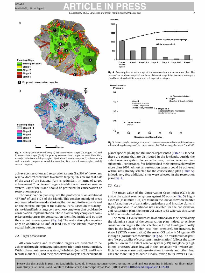
Fig. 3. Priority areas selected along a) the conservation stages (i.e. stages 1–4) andb) restoration stages (5–8). Six priority conservation complexes were identified,nac
aroasr
4roscptoc
7
aWt
Fig. 4. Area required at each stage of the conservation and restoration plan. Thecurve of the total area required reaches a plateau at stage 5 since restoration targetscould be achieved within zones selected in previous stages.
sure (i.e. probability of ecosystem transformation) follows the same
amely 1) the Leeward dry complex, 2) windward humid complex, 3) submountainnd mountain complex, 4) subalpine complex, 5) active volcano complex, and 6)oastal complex.
chieve conservation and restoration targets (i.e. 50% of the extanteserve doesn’t contribute to achieve targets). This means that halff the area of the National Park is redundant in terms of targetchievement. To achieve all targets, in addition to the extant reserveystem, 21% of the island should be protected for conservation orestoration purpose.
The conservation plan requires the protection of an additional37 km2 of land (17% of the island). This consists mainly of areasepresented in the corridors linking the lowlands to the uplands andn the external margin of the National Park. Based on this analy-is, we identified six large conservation complexes that could guideonservation implementation. Those biodiversity complexes com-rise priority areas for conservation identified inside and outsidehe current reserve system (Fig. 3a). The restoration plan requiresnly an additional 88 km2 of land (4% of the island), mainly foroastal habitats restoration.
.2. Target achievement
Please cite this article in press as: Lagabrielle, E., et al., Integrating consercase study in Réunion Island (Western Indian Ocean). Landscape Urban Pla
All conservation and restoration targets are predicted to bechieved through the integrated conservation and restoration plan.ithin the extant reserves system, 14 habitats (out of 21) and 9 ver-
ebrates (out of 17) had their conservation targets achieved but all
Fig. 5. Mean transformation pressure and conservation costs index in additional areasselected along the stages of the conservation plan. Values range between 0 and 100.
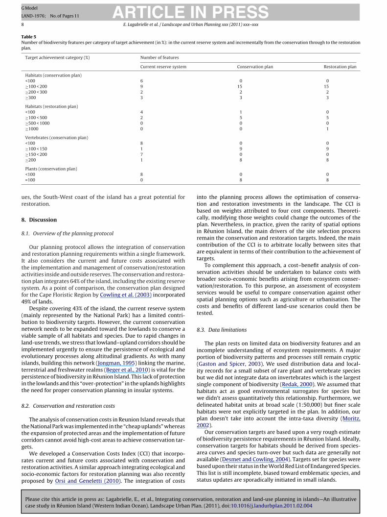
plants species (n = 8) are still under-represented (Table 5). Indeed,these are plants that are distributed in the lowlands, outside theextant reserves system. For some features, over-achievement wassubstantial. For instance, five habitats had their targets achieved bymore than 200%. Almost all restoration targets could be achievedwithin sites already selected for the conservation plan (Table 5).Indeed, very few additional sites were selected in the restorationplan (Fig. 4).
7.3. Costs
The mean value of the Conservation Costs Index (CCI) is 26inside the extant reserve system against 65 outside (Fig. 5). High-est costs (maximum = 93) are found in the lowlands where habitattransformation by urbanisation, agriculture and invasive plants ishighly probable. In additional sites selected for the conservationand restoration plan, the mean CCI value is 63 whereas this valueis 70 in non-selected sites.
The mean CCI value increases in additional areas selected alongthe planning stages of the conservation plan. Indeed to achieveconservation targets, the site selection is forced to integrate costlysites in the lowlands (high-cost, high pressure). For instance, instage 1 (SCBPs conservation) the mean CCI value is 54 against 66in stage 4 (corridors conservation) (Fig. 5). The transformation pres-
vation, restoration and land-use planning in islands—An illustrativen. (2011), doi:10.1016/j.landurbplan.2011.02.004
pattern: low in the extant reserve system (=19) and globally highin non-protected areas located in the lowlands (=41) where con-flicts between conservation/restoration interests and other landuses are more likely to occur. Finally, owing to its lower CCI val-
ARTICLE IN PRESSG Model
LAND-1976; No. of Pages 11
8 E. Lagabrielle et al. / Landscape and Urban Planning xxx (2011) xxx–xxx
Table 5Number of biodiversity features per category of target achievement (in %): in the current reserve system and incrementally from the conservation through to the restorationplan.
Target achievement category (%) Number of features
Current reserve system Conservation plan Restoration plan
Habitats (conservation plan)<100 6 0 0≥100 < 200 9 15 15≥200 < 300 2 2 2≥300 3 3 3
Habitats (restoration plan)<100 4 1 0≥100 < 500 2 5 5≥500 < 1000 0 0 0≥1000 0 0 1
Vertebrates (conservation plan)<100 8 0 0≥100 < 150 1 9 9≥150 < 200 7 0 0≥200 1 8 8
ur
8
8
aItatsf4
(bnvlieitpit
8
ttcg
rrsp
Plants (conservation plan)<100 8=100 0
es, the South-West coast of the island has a great potential forestoration.
. Discussion
.1. Overview of the planning protocol
Our planning protocol allows the integration of conservationnd restoration planning requirements within a single framework.t also considers the current and future costs associated withhe implementation and management of conservation/restorationctivities inside and outside reserves. The conservation and restora-ion plan integrates 64% of the island, including the existing reserveystem. As a point of comparison, the conservation plan designedor the Cape Floristic Region by Cowling et al. (2003) incorporated9% of lands.
Despite covering 43% of the island, the current reserve systemmainly represented by the National Park) has a limited contri-ution to biodiversity targets. However, the current conservationetwork needs to be expanded toward the lowlands to conserve aiable sample of all habitats and species. Due to rapid changes inand-use trends, we stress that lowland–upland corridors should bemplemented urgently to ensure the persistence of ecological andvolutionary processes along altitudinal gradients. As with manyslands, building this network (Jongman, 1995) linking the marine,errestrial and freshwater realms (Beger et al., 2010) is vital for theersistence of biodiversity in Réunion Island. This lack of protection
n the lowlands and this “over-protection” in the uplands highlightshe need for proper conservation planning in insular systems.
.2. Conservation and restoration costs
The analysis of conservation costs in Reunion Island reveals thathe National Park was implemented in the “cheap uplands” whereashe expansion of protected areas and the implementation of futureorridors cannot avoid high-cost areas to achieve conservation tar-ets.
Please cite this article in press as: Lagabrielle, E., et al., Integrating consercase study in Réunion Island (Western Indian Ocean). Landscape Urban Pla
We developed a Conservation Costs Index (CCI) that incorpo-ates current and future costs associated with conservation andestoration activities. A similar approach integrating ecological andocio-economic factors for restoration planning was also recentlyroposed by Orsi and Geneletti (2010). The integration of costs
0 08 8
into the planning process allows the optimisation of conserva-tion and restoration investments in the landscape. The CCI isbased on weights attributed to four cost components. Theoreti-cally, modifying those weights could change the outcomes of theplan. Nevertheless, in practice, given the rarity of spatial optionsin Réunion Island, the main drivers of the site selection processremain the conservation and restoration targets. Indeed, the maincontribution of the CCI is to arbitrate locally between sites thatare equivalent in terms of their contribution to the achievement oftargets.
To complement this approach, a cost–benefit analysis of con-servation activities should be undertaken to balance costs withbroader socio-economic benefits arising from ecosystem conser-vation/restoration. To this purpose, an assessment of ecosystemservices would be useful to compare conservation against otherspatial planning options such as agriculture or urbanisation. Thecosts and benefits of different land-use scenarios could then betested.
8.3. Data limitations
The plan rests on limited data on biodiversity features and anincomplete understanding of ecosystem requirements. A majorportion of biodiversity patterns and processes still remain cryptic(Gaston and Spicer, 2003). We used distribution data and local-ity records for a small subset of rare plant and vertebrate speciesbut we did not integrate data on invertebrates which is the largestsingle component of biodiversity (Redak, 2000). We assumed thathabitats act as good environmental surrogates for species butwe didn’t assess quantitatively this relationship. Furthermore, wedelineated habitat units at broad scale (1:50,000) but finer scalehabitats were not explicitly targeted in the plan. In addition, ourplan doesn’t take into account the intra-taxa diversity (Moritz,2002).
Our conservation targets are based upon a very rough estimateof biodiversity persistence requirements in Réunion Island. Ideally,conservation targets for habitats should be derived from species-
vation, restoration and land-use planning in islands—An illustrativen. (2011), doi:10.1016/j.landurbplan.2011.02.004
area curves and species turn-over but such data are generally notavailable (Desmet and Cowling, 2004). Targets set for species werebased upon their status in the World Red List of Endangered Species.This list is still incomplete, biased toward emblematic species, andstatus updates are sporadically initiated in small islands.

ING
L
nd Urb
8
smatPsTmP(Nteb
uw(imIl
hsmltcPscmp
8
e2vsodnpptstas
sacpa(uF
s
ARTICLEModel
AND-1976; No. of Pages 11
E. Lagabrielle et al. / Landscape a
.4. Implementation strategies
Three complementary management and implementationtrategies should be undertaken in Réunion Island: (1) focusinganagement interventions inside the National Park on priority
reas identified in the plan, (2) expanding the existing reserve sys-em in large low-cost areas located on the margin of the Nationalark, and (3) focusing investment on a subset of high-cost areasupporting key biodiversity features and processes in the lowlands.o this purpose, an efficient solution would be to focus invest-ents on conservation corridors linking the terrestrial National
ark to the marine realm and more particularly the Marine ReserveFig. 1). The implementation of the first strategy depends on theational Park authorities but the two others depend directly on
he willingness of stakeholders to protect biodiversity outsidextant reserves. We propose some implementation mechanismselow.
Expanding the boundaries of the National Park seems currentlynrealistic. Rather we suggest integrating conservation measuresithin the management plan of the Voluntary Stewardship Zone
“Zone de LibreAdhésion”) that surrounds the National Park. Munic-palities are the members of this zone, which is ruled by a common
anagement charter. Membership is renegotiated every 10 years.n return, municipalities must develop and implement sustainableand-use plans, compatible with biodiversity conservation.
The implementation of corridors will require the integration ofeterogeneous land management regimes from the seashore to theummits (Lagabrielle et al., 2009). The implementation of corridoranagement measures across the landscape should be based on
and care and stewardship programmes through financial incen-ives and training initiatives dedicated to private owners. Suchorridors could provide linkages between the Terrestrial Nationalark and the Marine Natural Reserve on the west coast (Fig. 1). Weuggest the implementation of “Inter-realms Corridors” and thereation of “Inter-realms Corridors Management Committees” toainstream corridors conservation within land management and
lanning (Beger et al., 2010; Lagabrielle et al., 2009).
.5. Experts and stakeholders participation
In the real world, the ‘information-implementation’ processxpected by conservation scientists rarely happens (Cowling,005). Building and maintaining the continuum between conser-ation and land-use planning is not a trivial task, it requires atakeholder involvement strategy (Knight et al., 2006). The devel-pment of the conservation and restoration plan involved vigorousebate among participants. Some participants argued that the plan-ing process was a waste of time as they already knew where theriority areas for conservation were. For them, the priority wasn’t tolan but more to negotiate and implement interventions in zoneshey already identified. Other participants argued that biodiver-ity conservation couldn’t be entirely considered by quantitativeargets. Those participants were also reluctant to use a cost-basedpproach to conservation planning as they felt it would excludeocial issues.
Nevertheless, our plan structured arguments for conservationtakeholders and made them spatially explicit. This is useful todvocate for biodiversity conservation, and to negotiate land allo-ation with other activity sectors such as agriculture. To thisurpose, conservation planning products were presented withinwide array of public arenas, including regional administrations
Please cite this article in press as: Lagabrielle, E., et al., Integrating consercase study in Réunion Island (Western Indian Ocean). Landscape Urban Pla
Regional Scientific Council, Departmental Office of Sensible Nat-ral Sites) and protected areas management institutions (Nationalorest Office, Coastal Conservation Agency).
Despite an invitation to join the conservation planning process,takeholders from the urban sector did not participate to the devel-
PRESSan Planning xxx (2011) xxx–xxx 9
opment of the conservation plan. One possible explanation is thatconservation planners were not perceived as neutral holders ofscientific knowledge but rather as competing stakeholders in theland-use planning debate. In addition, other issues are consideredmore important than conservation in the land-use planning debate,in particular the conflict between the agricultural and the urbansector.
9. Lessons learnt and tips for future applications of theprotocol in islands
Our conservation and restoration planning protocol allows theintegration of ecological and socio-economic variables within asingle spatial planning framework. It provides spatially explicitguidelines for planning conservation and restoration actions insideand outside an existing reserve system. Our study demonstratesthe applicability of this approach in Reunion Island. We believe it isapplicable in other insular systems. Other socio-economic variablessuch as social acceptability and the economic value of ecosystemgoods and services could easily be integrated in the proposed pro-tocol.
Conservation planning in insular regions must be based uponlow-cost and easily accessible data. This data should be represen-tative of biodiversity patterns and processes and have good spatialcoverage. To this purpose, developing a basic map of habitats con-stitutes an efficient solution, before gathering any other biologicaldata.
Past conservation efforts in islands often focused on low-costzones, i.e. areas without major socio-economic stakes. Conse-quently, current reserve networks in islands are often biasedtoward the upland, whereas coastal biodiversity features and pro-cesses are not adequately protected. The disconnection amongterrestrial, freshwater and marine realms has become an impor-tant threat to the persistence of insular ecosystems. Our methodhelps finding optimal socio-economic and ecological solutions formaintaining those inter-realms linkages across the landscape. Nev-ertheless complex conservation planning tools such as MARXANare not mandatory to develop a conservation plan.
Building a conservation plan requires a homogeneous under-standing of coupled ecological and social systems, while acknowl-edging the complexity of such systems and the limitations of ourknowledge. By many aspects, islands depend directly on biodiver-sity for developing sustainable development strategies. It fostersthe role of residents in setting conservation planning prioritiesand participating fully in the development of their islands. Cross-sectoral approaches and involvement of stakeholders are, morethan elsewhere, a key component of effective conservation plan-ning in islands.
We consider that our systematic protocol should inform land-use planning but it will never substitute for the land-use planningdebate. We believe more in “participation-oriented” approachesrather than pure “GIS product-oriented” procedures to mainstreamconservation and restoration issues within land-use planning.Future improvements of the planning protocol should focus on theparticipation of stakeholders and methods to better-fit conserva-tion planning into existing public decision-making processes
Acknowledgements
This research was part of the project APIC-BIO, funded by the
vation, restoration and land-use planning in islands—An illustrativen. (2011), doi:10.1016/j.landurbplan.2011.02.004
CIRAD, the Regional Council of Réunion and the European Union(INTERREG 3B, FEDER). APIC-BIO involved the following institu-tions: CIRAD, University of Réunion Island, South African NationalBiodiversity Institute, Parc National de la Réunion and Centre ofExcellence for Invasion Biology. Erwann Lagabrielle acknowledges
ING
L
1 nd Urb
tRtVM((R
TC
TS
ARTICLEModel
AND-1976; No. of Pages 11
0 E. Lagabrielle et al. / Landscape a
he African Coelacanth Ecosystem Programme and the Nationalesearch Foundation of South Africa for co-funding this work. Wehank the following persons who also contributed to this study:
Please cite this article in press as: Lagabrielle, E., et al., Integrating consercase study in Réunion Island (Western Indian Ocean). Landscape Urban Pla
incent Boullet (Conservatoire Botanique de Mascarin), Jean-ichel Probst (Association Nature et Patrimoine), Marc Salamolard
Société d’Etudes Ornithologiques de La Réunion), Mathieu Le CorreUniversité de La Réunion), Jean-Michel Sarrailh (CIRAD) and Ericivière (CIRAD).
able A1urrent and initial area of pristine habitats in Réunion Island. Species richness is for vascu
Habitat classes Current area (km2) Initial
Erica mountain thicket 9 22Pandanus mountain humid thicket 41 41Subalpine grassland (dry or wet) 3 3Subalpine heath land 153 159Subalpine shrub land on lapillis 8 8Acacia heterophylla forest 50 105Leeward mountain rainforest 89 159Leeward submountain rainforest 35 185Pandanus humid thicket 20 29Windward mountain rainforest 220 259Coastal habitats 3 14Lava flows 95 97Lowland rainforest 75 492Lowland open woodland 5 187Semi dry forest 35 487Subalpine Sophora thicket 2 12Submountain mesic forest 34 61Wetlands 7 8Windward submountain rainforest 108 174
able A2pecies targeted in the conservation plan.
Species Scientific name Endemisma
BirdsPuffinus lherminieri BCircus maillardi BPseudobulweria aterrima BCollocalia francica B, M, RoHypsipetes borbonicus BPterodroma baraui BSaxicola tectes BTerpsiphone bourbonnensis BZosterops borbonicus BZosterops olivaceus BCoracina newtoni BPhaeton lepturus WPuffinus pacificus 0Phedina borbonica W
ReptilesPhelsuma borbonica BPhelsuma (ornata) inexpectata B
MammalsMormopterus acetabulosus 0
PlantsCarissa spinarum L. B, M, RoChamaesyce viridula (Cordem. ex Radcl.-Sm.) BDelosperma napiforme (N.E. Br.) Schwantes BDombeya populnea (Cav.) Baker B, MGastonia cutispongia Lam. BHernandia mascarenensis (Meisn.) Kubitzki B, MObetia ficifolia (Poir.) Gaudich. B, M, RoPemphis acidula J.R. Forst. et G. Forst. 0
a B = Réunion (“Bourbon”), M = Maurice, Ro = Rodrigue, W = West Indian Ocean (includinb CR = seriously on the verge of extinction, EN = threatened of extinction, VU = vulnerab
PRESSan Planning xxx (2011) xxx–xxx
Appendix A.
See Table A1
vation, restoration and land-use planning in islands—An illustrativen. (2011), doi:10.1016/j.landurbplan.2011.02.004
Appendix B.
See Table A2
lar plants (from Strasberg et al., 2005).
area (km2) Species richness Endemic species richness
90 3892 3634 7130 2530 596 41
144 67142 41
92 38165 67
35 753 19
127 2941 15
126 3011 798 3326 2
166 58
IUCN WorldRed list statusb IUCN regional statusb Target (%)
LC – 40EN – 100CR – 100NT – 60LC – 40EN – 100LC – 40LC – 40LC – 40LC – 40EN – 100LC – 40LC – 40LC – 100
– – 100– – 100
VU – 80
– CR 100– EN 100– VU 80– CR 100– CR 100EN CR 100– CR 100– CR 100
g Madagascar), 0 = Other.le, NT = near threatened, LC = least concern.
ING
L
nd Urb
R
B
B
B
B
C
C
C
C
C
C
C
D
D
D
D
F
G
G
G
I
I
J
K
K
L
L
ARTICLEModel
AND-1976; No. of Pages 11
E. Lagabrielle et al. / Landscape a
eferences
all, I.R., Possingham, H.P., 2000. MARXAN (V1.8.2): Marine Reserve Design UsingSpatially Explicit Annealing, A Manual.
almford, A., 2003. Conservation planning in the real world: South Africa is showingthe way. Trends Ecol. Evol. 18 (9), 435–438.
aret, S., Rouget, M., Richardson, D.M., Lavergne, C., Egoh, D., Dupont, J., et al.,2006. Current distribution and potential extent of the most invasive alienspecies on La Réunion (Indian Ocean Mascarene islands). Austral. Ecol. 31,747–758.
eger, M., Grantham, H.S., Pressey, R.L., Wilson, K.A., Peterson, E.L., Dorfman, D.,Mumby, P.J., Lourival, R., Brumbaugh, D.R., Possingham, H.P., 2010. Conservationplanning for connectivity across marine, freshwater, and terrestrial realms. Biol.Conserv. 143 (3), 565–575.
adet, T., 1980. La végétation de l’île de La Réunion, étude phytoécologique etphytosociologique (Vegetation of Réunion Island, phytoecological and phytoso-ciologicalstudy). Ph.D. thesis, Université d’Aix Marseille, France (in French).
ase, T.J., Bolger, D.L., Richman, A.D., 1992. Reptilian extinctions: the last ten thou-sand years. In: Fiedler, P.L., Jain, S.K. (Eds.), Conservation Biology: The Theoryand Practice of Nature Conservation, Preservation, and Management. Chapmanand Hall, New York, USA, pp. 91–125.
onservatoire Botanique National de Mascarin, 2008. Version électronique del’Index de la flore vasculaire de la Réunion (Trachéophytes): statuts, men-aces et protections (Electronic version of the vascularflora Index of RéunionIsland (Tracheophytes): status, threats and protections). [On line] URL:http://flore.cbnm.org. Last access date: 21 April 2010 (in French).
ook, J.A., Dawson, N.G., MacDonald, S.O., 2006. Conservation of highly fragmentedsystems: the north temperate Alexander Archipelago. Biol. Conserv. 133, 1–15.
owling, R.M., 2005. Maintaining the research-implementation continuum inconservation. Soc. Conserv. Biol. Newsl. 12 (4), 1–19 [online] URL: www.conbio.org/Publications/Newsletter/Archives/2005-9a-November/v12n4.rtf, Lastaccess date: 21 April 2010.
owling, R.M., Pressey, R.L., Rouget, M., Lombard, A.T., 2003. A conservation planfor a global biodiversity hotspot – the Cape Floristic Region, South Africa. Biol.Conserv. 112 (1–2), 191–216.
udihhy, L.W., Stone, C.P., 1990. Alteration of native Hawaiian vegetation, effectsof human, their activities and introductions. In: Cooperative National ParkResources Studies Unit , University of Hawaii at Manoa, Honolulu, USA.
esmet, P., Cowling, R.M., 2004. Using the species-area relationship to set baselinetargets for conservation. Ecol. Soc. 9 (2), 102–124.
iamond, J.M., 1989. The present, past and future of human caused extinctions.Philos Trans. R. Soc. B 325, 469–477.
olisca, F., McDaniel, J.M., Teeter, L.D., Jolly, C.M., 2007. Land tenure, populationpressure, and deforestation in Haiti: the case of Forêt des Pins Reserve. J. Forest.Econ. 13, 277–289.
urieux, L., Lagabrielle, E., Andrew, N., 2008. A method for monitoring building con-struction in urban sprawl areas using object-based analysis of Spot 5 images andexisting GIS data. ISPRS J. Photogramm. 63, 399–408.
ritts, T.H., Rodda, G.H., 1998. The role of introduced species in the degradation ofisland ecosystems. Annu. Rev. Ecol. Syst. 29, 113–140.
aston, K.J., Spicer, J.I., 2003. Biodiversity An introduction. Blackwell Science, Oxford,UK.
igord, L., Picot, F., Shykoff, J., 1999. Effects of habitat fragmentation on Dombeya acu-tangula (Sterculiaceae), a native tree on La Réunion (Indian Ocean). Biol. Conserv.88, 43–51.
renier, C., 2000. Conservation Contre Nature (Conservation Against Nature), IRDed. Collection Latitudes 23, Paris, France (in French).
NSEE, 2009. Recensement général de la population francaise (General census of theFrench population). [online] URL: www.insee.fr. Last access date: 21 April 2010,(in French).
UCN, 2006. IUCN Red List of Threatened Species. IUCN, Gland, Switzerland andCambridge, UK. [On line] URL: www.iucnredlist.org. Last access date: 21 April2010.
ongman, R.H.G., 1995. Nature conservation planning in Europe: developing ecolog-ical networks. Landsc. Urban Plan. 32, 169–183.
irkpatrick, S., Gelatt, C., Vecchi, M., 1983. Optimisation by simulated annealing.Science 220, 671–680.
night, A.T., Cowling, R.M., Campbell, B.M., 2006. An operationnal model for imple-menting conservation action. Conserv. Biol. 20 (2), 408–419.
agabrielle, E., Botta, A., Daré, W., David, D., Aubert, A., Fabricius, C., 2010. Modellingwith stakeholders to integrate biodiversity conservation into land-use planning
Please cite this article in press as: Lagabrielle, E., et al., Integrating consercase study in Réunion Island (Western Indian Ocean). Landscape Urban Pla
– lessons learnt in Réunion Island (Western Indian Ocean). Environ. Modell.Softw., doi:10.1016/j.envsoft.2010.01.011.
agabrielle, E., Rouget, M., Durieux, L., Payet, K., Wistebaar, T., Baret, S., et al., 2009.Identifying and mapping biodiversity processes for conservation planning inislands. A case study in Réunion Island (Western Indian Ocean). Biol. Conserv.142 (7), 1523–1535.
PRESSan Planning xxx (2011) xxx–xxx 11
Lombard, A.T., Cowling, R.M., Pressey, R.L., Rebelo, A.G., 2003. Effectiveness of landclasses as surrogates for species in conservation planning for the Cape FloristicRegion. Biol. Conserv. 112 (1–2), 45–62.
MacDonald, I.A.W., Thébaud, C., Strahm, W.A., Strasberg, D., 1991. Effects of alieninvasions on native vegetation remnants on La Réunion (Mascarenes IslandsIndianOcean). Environ. Conserv. 18 (1), 51–61.
Margules, C.R., Pressey, R.L., 2000. Systematic conservation planning. Nature 405,243–253.
Moritz, C., 2002. Strategies to protect biological diversity and the evolutionary pro-cesses that sustain it. Syst. Biol. 5, 238–254.
Mittermeier, R.A., da Fonseca, G.A.B., Hoffman, M., Pilgrim, J., Brooks, T., Gill, P.R.,et al., 2005. Hotspots revisited: Earth’s biologically richest and most endangeredterrestrial ecoregions. In: CEMEX, Conservation International , Washington DC,USA.
Mourer-Chauvire, C., Bour, R., Ribes, S., Moutou, F., 1999. The avifauna of RéunionIsland (Mascarene Islands) at the time of arrival of the first Europeans. AvianPaleontology at the Closes of the 20th Century. Washington, DC, USA, 4-7 June1996. Smithsonian Contributions to Paleobiology.
Mueller-Dombois, D., Loope, L.L., 1990. Some unique ecological aspects of oceanicisland ecosystems. Monog. Syst. Botan. 32, 21–28.
Naidoo, R., Ricketts, T.H., 2006. Mapping the economic costs and benefits of conser-vation. PLoS Biol. 4 (11), e360, doi:10.1371/journal.pbio.0040360.
Novy-Hildesley, J.W., 2001. Incentive Measures for Conservation of Biodiversity andSustainability: A Case Study of the Galapagos Islands. UNEP/WWF, USA [On line]URL: http://www.cbd.int/doc/case-studies/inc/cs-inc-ec-galapagos-en.pdf, Lastaccess date: 21 April 2010.
Orsi, F., Geneletti, D., 2010. Identifying priority areas for forest landscape restora-tion in Chiapas (Mexico): an operational approach combining ecological andsocioeconomic criteria. Landsc. Urban Plan. 94 (1), 20–30.
Payet, K., Rouget, M., Lagabrielle, E., Esler, K.J., 2010. Measuring the effective-ness of regional biodiversity surrogates at representing local biodiversity: areal-world case study in Réunion Island (Indian Ocean). Austral. Ecol. 35,121–133.
Possingham, H.P., Ball, I.R., Andelman, S., 2000. Mathematical methods for iden-tifying representative reserve networks. In: Ferson, S., Burgman, M. (Eds.),Quantitative Methods for Conservation Biology. Springer–Verlag, New York,USA, pp. 291–305.
Pressey, R.L., Cowling, R.M., Rouget, M., 2003. Formulating conservation targets forbiodiversity pattern and process in the Cape Floristic Region, South Africa. Biol.Conserv. 112 (1–2), 99–127.
Raunet, M., 1991. Le milieu physique et les sols de l’île de la Réunion (Physical Envi-ronment and Soils of Réunion Island). CIRAD, Montpellier, France (in French).
Redak, R.A., 2000. Arthropods and multispecies habitat conservation plans: are wemissing something? Environ. Manage. 26 (1), 97–107.
Roberts, C.M., Mcclean, C.J., Veron, J.E.N., Hawkins, J.P., Allen, G.R., Mcallister, D.E.,et al., 2002. Marine biodiversity hotspots and conservation priorities for tropicalreefs. Science 295 (5558), 1280–1284.
Rondini, C., Chiozza, F., 2010. Quantitative methods for defining percentage areatargets for habitat types in conservation planning. Biol. Conserv. 143 (7),1646–1653.
Rouget, M., Cowling, R.M., Lombard, A.T., Knight, A.T., Kerley, G.I.H., 2006. Designinglarge-scale conservation corridors for pattern and process. Conserv. Biol. 20 (2),549–561.
Simberloff, D., 1995. Why do introduced species appear to devastate islands morethan mainland areas? Pac. Sci. 18, 130–137.
Smith, R.J., 2004. Conservation Land-Use Zoning (CLUZ) Software.Stattersfield, A., Capper, D., 2000. Threatened Birds of the World. Birdlife Interna-
tional, Cambridge, UK.Strasberg, D., Rouget, M., Richardson, D.M., Baret, S., Dupont, J., Cowling, R.M., 2005.
An assessment of habitat diversity, transformation and threats to biodiversityon Réunion Island (Mascarene Islands, Indian Ocean) as a basis for conservationplanning. Biodivers. Conserv. 14 (12), 3015–3032.
Thinon, P., Martignac, C., Metzger, P., Cheylan, J.-P., 2007. Analyse géographique etmodélisation des dynamiques d’urbanisation à La Réunion (Geographicanalysisand modelling of urbandynamics in Réunion Island). Cybergeo 389. [On line]URL: http://www.cybergeo.eu/index8692.html. Last access date: 21 April 2010,(in French).
van der Valk, A., 2002. The Dutch planning experience. Landsc. Urban Plan. 58 (2),201–210.
Veech, J.A., 2003. Incorporating socio economic factors into the analysis of biodiver-sity hotspots. Appl. Geogr. 23, 73–78.
vation, restoration and land-use planning in islands—An illustrativen. (2011), doi:10.1016/j.landurbplan.2011.02.004
Whittaker, R.J., Willis, K.J., Field, R., 2001. Scale and species richness:toward a general, hierarchical theory of species diversity. J. Biogeogr. 28,453–470.
Young, D., 2004. Our Islands, Our Selves: A History of Conservation in New Zealand.Otago University Press, in association with the Department of Conservation andthe Ministry for Culture and Heritage, Dunedin, New Zealand.