
Integrated City Making Report - London School of Economics
196
URBAN AGE INDIA MUMBAI DELHI KOLKATA BANGALORE LONDON NEW YORK BERLIN JOHANNESBURG Detailed Report INTEGRATED CITY MAKING Governance, planning and transport
-
Upload
khangminh22 -
Category
Documents
-
view
0 -
download
0
Transcript of Integrated City Making Report - London School of Economics

URBAN AGE INDIA
MUMBAIDELHI
KOLKATABANGALORE
LONDONNEW YORK
BERLINJOHANNESBURG
Detailed Report
INTEGRATED CITY MAKINGGovernance, planning and transport


leftThe extensive use of street space for multiple activities is common in most Indian cities and has great implications for the movement of people and goods. Chirodeep Chaudhuri
coverMumbai’s dense urban fabric with JJ flyoverChirodeep Chaudhuri
Urban Age is a worldwide investigation into the future of cities.
Organised by the Cities Programme at the London School of Economics and Political
Science and the Alfred Herrhausen Society, the International Forum of Deutsche Bank.
ISBN 978-0-85328-304-1
Urban Age Programme The London School of Economics
and Political Science Houghton Street
London WC2A 2AE United Kingdom
T +44 (0)20 7955 7706 [email protected]
www.urban-age.net
Alfred Herrhausen Society Deutsche Bank
Unter den Linden 13/15 10117 Berlin
Germany
T +49 (0)30 3407 4201 [email protected]
www.alfred-herrhausen-gesellschaft.de
Detailed ReportINTEGRATED CITY MAKING

Urban Age would like to thank the key stakeholders and experts in Mumbai, Delhi, Kolkata, Bangalore, London, Berlin, New York and Johannesburg who contributed their ideas and time to this report (see list on page A-1).
The summary report is available at www.urban-age.net.
Research DirectorPhilipp Rode
Research Team Julie WagnerRichard BrownRit ChandraJayaraj SundaresanChristos KonstantinouNatznet TesfayPriya Shankar
Supported byStephanie KotinCaroline KihatoSilke UrschelMiguel KanaiNirija ShuklaDolan ChatterjeeMariana LeguiaMiranda Iossifidis
Mapping and data research Kay KitazawaRichard Simpson
AdvisersTony Travers, LSERicky Burdett, LSEAndy Altman, Brookings InstitutionBruce Katz, Brookings Institution
London, July 2008
ACKNOWLEDGEMENTS
Integrated City Making is a report by the Urban Age Programme at the London School of Economics and Political Science (LSE). Urban Age is a joint initiative of LSE and Deutsche Bank’s Alfred Herrhausen Society investigating the future of cities.The research for this report was prepared from November 2006 to February 2008 and represents the annual Urban Age research focus 2007, part of the Urban Age India investigation.
This report is intended as a basis for discussion. While every effort has been made to ensure the accuracy of the material in this report, the authors and/ or the Urban Age Programme will not be liable for any loss or damage incurred through the use of this report.
Published by the Urban Age Programme, London School of Economics and Political Science, 2008.

TABLE Of CONTENTS
1 INTRODUCTION 1.1 Urban India and city growth
1.2 The Urban Age
1.3 Summaryoffindings
1.4 Methodology
2 URBAN INDIA CHALLENGES 2.1 Introduction
2.2 Planning
2.3 Transport
2.4 Urban governance
2.5 Infrastructure
2.6 Housing
2.7 Migration
2.8 Environment
2.9 Inequality
3 CITIES COMpARED 3.1 Introduction
3.2 City structure and society
3.3 Urban governance
3.4 Urban challenges
3.5 City visions
Annex - constitutional foundations of governance systems
4 INTEGRATED CITY MAKING 4.1 Introduction
4.2 Dimensions of integration
4.3 The rationale for greater integration
4.4 Impediments to integration
4.5 Integrated policies for spatial development
4.6 Integrated governance
4.7 Integrated planning
5 IMpLICATIONS fOR pOLICY 5.1 Introduction
5.2 Strategic planning
5.3 Management and governance
LIST Of INTERvIEWS
BIBLIOGRApHY
GLOSSARY
DATA SOURCES
1-21-3
1-3
1-3
1-5
2-22-4
2-5
2-21
2-33
2-38
2-39
2-42
2-43
2-47
3-23-4
3-5
3-21
3-39
3-49
3-53
4-24-4
4-4
4-5
4-11
4-19
4-23
4-30
5-25-3
5-3
5-7
A-1
A-2
A-5
A-6

1-1 INTEGRATED CITY MAKING

INTRODUCTION 1-2
INTRODUCTION1
leftMumbai’s Chatrapati Shivaji TerminusChirodeep Chaudhuri

1-3 INTEGRATED CITY MAKING
URbAN INDIA AND CITY GROwTh1.1
In 2007, the majority of this planet’s residents lived in cities: for the first time, our world became a predominantly urban one. The cities of India, the largest democracy and one of the fastest-growing countries in the world, are at the forefront of this change. This report addresses how Indian cities are responding to this rapid pace of growth, and how civic governments are using transport and land-use planning to manage its impacts.
India’s experiences raise wider issues too: issues of slum development, of overloaded infrastructure, of environmental sustainability. The growth of the world’s cities – often unplanned, sometimes chaotic – challenges policy makers and planners in every continent. What will our urban future be? How can infrastructure – from mass transit to drainage systems – cope with unprecedented growth rates? How can cities realise the goals of sustainability – allowing for growth and prosperity today, without mortgaging the prospects of future generations? Can social justice and cohesion be achieved, or is polarisation intrinsic to the modern urban condition?
Integrated City Making sets out the findings of the Urban Age’s 2007 research programme on the integration of transport and land-use planning in Mumbai, Kolkata, Delhi and Bangalore. These four cities have a population of almost 35 million people (nearly 78 million including wider metropolitan regions, and Delhi’s National Capital Region), and an economy valued at nearly $360 billion within their agglomerations.
The report compares the four Indian cities with four other Urban Age cities – London, New York, Berlin and Johannesburg – to draw out similarities and differences, and implications that might inform policy development in cities at all stages of their development cycle. A summary report is also available.
ThE URbAN AGE1.2
The Urban Age is an international programme of research projects and conferences investigating the future of cities. The programme, a joint initiative of the London School of Economics and Political Science, and Deutsche Bank’s Alfred Herrhausen Society, takes an explicitly inter-disciplinary approach to considering the future
of cities, and aims to develop and foster dialogue between academics, politicians, policy makers and those responsible for shaping and managing our cities from day to day.
Beginning in New York in 2005, and travelling to Shanghai, London, Johannesburg, Mexico City and Berlin, the Urban Age has explored – through international and interdisciplinary conferences, through data analysis, and through interviews with leading urban experts and city managers – the problems facing some of the world’s most important cities (both those that have relatively stable populations, and those that are experiencing or dealing with the aftermath of exponential growth).
In 2007, the Urban Age entered a new phase, and focused more closely on one set of cities and on one set of challenges. During this year, our research focused on India, and on the challenges of urban planning and governance against a backdrop of rapid growth. Members of the Urban Age team conducted interviews with more than 50 experts from every level of Indian government and from civil society, and the process culminated in a conference in November 2007.
In 2008, the Urban Age will focus on the cities of South America, and on the issues of inequality, violence, mobility and the public-private relationship in cities. In following years, the programme will extend to Istanbul in 2009, and will then finish in Berlin in 2010.
sUMMARY Of fINDINGs1.3
The growth of Indian cities was explosive in the last decades of the twentieth century, largely driven by people moving from the countryside to work in rapidly industrialising cities. This growth has slowed in recent years, but has left the cities with intense strains on infrastructure. Roads that were not designed for cars are choked with traffic, with consequences that include increased local pollution, reduced economic efficiency, and a contribution to the global challenge of climate change. Drainage and sewage systems are also overloaded, leading to considerable fatality rates from floods and disease (especially as weather patterns change as a result of global warming).
Today, the Indian cities studied by the Urban Age programme occupy the cusp between the globalised world economy and the dislocations that follow in its wake: leading IT industries sit alongside low levels of literacy, new

INTRODUCTION 1-4
condominium developments overlook informal slum developments. Residential densities vary, but tend to be highest in the poorest areas: in Greater Mumbai, more than fifty per cent of the population lives in slums occupying eight per cent of land.
Cities are rising up India’s political agenda. Recent constitutional reforms seek to codify and standardise patterns of urban governance that in many cases have been handed down from colonial times. Each of the cities studied by the Urban Age is seeking to use land-use and transport planning to secure a more integrated and efficient form of urban development, but all face systemic and behavioural challenges:
Rapid urban growth has overtaken the •planning process, resulting in reactive and often outdated plans;
Enforcement is weak and the planning •profession is seen as lacking capacity, leading to loss of credibility;
Land-use and transport planning are •conducted as separate exercises, leading to new development without transport, and transport infrastructure that fails to further cities’ long term visions and
Responsibility for land-use and transport •planning is fragmented between different agencies and different tiers of government, despite recent constitutional changes aimed at rationalising local government structures.
Discussions with experts, both from India and from other Urban Age cities, identify some implications for future policy development. These include:
Make sure that plans balance ambition and •realism, and combine a long-term view with the ability to respond to changing circumstances;
Rationalise governance structures, creating a •single transport authority and, where possible, integrating this with land-use planning;
Make sure that integration of land-use and •transport planning is led from the top of organisations, and accorded political as well as managerial priority;
Ensure implementation through balancing •enforcement and negotiation;
Create incentives for better integration •through funding and political systems; and
Use urban design as the glue for creating •better buildings, better neighbourhoods and better cities.
Through harnessing the dynamism of urban development in India, city leaders can make a difference. With organisational reform, and the creation of new governance structures that recognise cities’ role, they can put their cities at the forefront of sustainable growth.
0
5
10
15
20
25
BerlinJohannesburgLondon
New York
Bangalore
Kolkata
Delhi
Mumbai
2020201020001990198019701960195019401930192019101900
Popu
latio
nm
illio
ns
DelhiMumbai
Bangalore
New York
Kolkata
London
JohannesburgBerlin
Population over time in selected Urban Age cities
Cities across the world are growing following occasional decline in the mid-20th century. All figures refer to the administrative area of each city. The dotted lines represent projections.Sources: Multiple sources. A complete list is attached at the back of this document.

1-5 INTEGRATED CITY MAKING
The following research methods were applied and are introduced below:
1. Stakeholder interviews
2. Collection of data and material
3. Information processing and effective information design
stakeholder Interviews1.4.1
Identifying the key aspects of governance and the integration of spatial planning and transport required the selection of a range of key actors to interview. As each city has unique governance and planning systems, the type of actors interviewed also needed to vary. Listed below is an initial categorisation of the types of key stakeholders and actors that were considered for each city.
Political leaders
Municipal, local government and state •government
Political parties •
Spatial planning actors
Responsibilities in land use planning (range of •responsibilities include: setting and regulating density/zoning, building control, regulatory affairs, and urban design)
METhODOlOGY1.4
The Urban Age research programme sought to uncover the integration of different geographic and sectoral planning systems found in the eight selected cities.
The research exercise was designed to expose the range of systems and mechanisms that are facilitating, if not advancing, integrative planning and plan implementation. Accurately capturing these dynamic systems required: (a) interviewing planners, politicians and others involved in the planning process; (b) reviewing key data, reports and management systems; and (c) analysing data to assess the effectiveness of these specific planning systems and mechanisms. The Urban Age research team has adopted the following process for this investigation:
Learn what Urban Age cities believe to be the 1. top urban challenges confronting their city and to what extent their current planning systems are reconciling these challenges through integrative planning/plan implementation.
Understand how various cities have organised 2. themselves to create integrated planning/plan implementation, learning from specific case studies.
Identify the range of specific planning 3. mechanisms (tools) that are advancing integrated planning and plan implementation.
belowSoweto, Township in Johannesburg.Urban Age

INTRODUCTION 1-6
Environmental/sustainable development •advocates
Other actors linked to planning functions or
activities
Agencies and influential external groups •linked to advancing social goals (education, job training, women’s empowerment)
Key citizen groups, citizen boards •
Key academics/universities •
Influential developers or banks •
Specific urban experts •
Key journalists and editors •
Recognising that the list of actors with a formal/informal role in spatial development could be very lengthy, it was important to prioritise interviewees into three groups:
Group A comprises those who are central to urban development, and are most likely to be from governmental or quasi-governmental agencies, at the city, state or federal level. It was important for the research to include people representing a range of interest groups, and people with authority over a range of issues, given our emphasis on integrative planning.
Group B includes actors who are important in addressing planning issues but do not have such a central role as those agencies/organisations in Group A.
Group C comprises planning actors with more narrow interests (focused on a specific issue, geography, or authority) but who still have an impact on the overall system. Group C could, for example include private citizens engaged in planning.
Responsibilities in transport planning (range •of responsibilities include: public transport planning, street planning, public space planning, and traffic planning)
Transport operation actors
National, regional rail operators, city public •transport (heavy rail, bus), and roads
Housing (planning, implementation) actors
Public corporations specific to distinct •geographic areas (such as the downtown core) and/or that have specific purview over segments of the population (such as low income groups)
Private housing corporations •
Not-for-profit housing corporations •
Economic development/business
development actors
Economic Development agencies (public) •
Chamber of Commerce •
Quasi-governmental agencies (such as •Development Corporations), non-profits (such as some Empowerment Zones)
Confederations of key industries •
Development and infrastructure banks •
Environmental actors
Environmental agencies (city, state, federal •levels) that have authority over water resources, land management, environmental protection
aboveBlackfriars Bridge and the City of LondonPhilipp Rode

1-7 INTEGRATED CITY MAKING
Collection of data and material1.4.2
In addition to stakeholder interviews, it was important to gather key data and materials that further informed Urban Age of governance structures, planning systems and plan implementation. While specific data to be collected was identified during the interviews, the types of information to be gathered included:
The plans mentioned in the interviews •that: (a) are identified as influential guides for future urban decision making, and/or (b) articulate integrative planning/plan implementation;
Zoning maps and zoning regulations/ •ordinances for areas that are seeking to exhibit integrated development (e.g. multi-use zones, zones that encourage development but in a sustainable way);
Materials (maps, policies, regulations, •instructions) that clearly outline the specific planning mechanisms (tools) that are advancing integrated planning and/or development;
Materials (maps, plans, policies, zoning, •photos, illustrations) from a particular area of the city anticipating or experiencing growth and where this city believes it has done its best to ensure integrative planning and plan implementation;
Overview of planning mechanisms regulating •the built environment, e.g. density, mixed-use, design codes and zoning; and
Overview on planning mechanism regulating •the integration of land-use and transport, e.g. density levels along public transport corridors, street design requirements and activity distribution in relations to metropolitan transport strategies.
Information processing and 1.4.3 effective information design
The following information based on a range of different sources required enhanced processing by the Urban Age research team:
General overview of planning agencies from •the national to the local level including key departments, planning objectives, tools, powers and current policy objective;
Mapping of administrative boundaries •including a table of the area, population and number of elected officials for each level;
Overview on key powers regarding transport, •land-use and urban design decisions by geographic scale, population numbers and administrative boundaries;
Organisational chart of agencies that •visibly identify which agencies are working collaboratively and on which subjects;
Organisational chart of key powers within •urban development. Any agency spending or controlling a significant budget needs to be included; and
A list of committees, working groups, •commissions, etc that have been established to help advance integrative planning and plan implementation. This list needs to include: name of group, participants by organisation and interest, areas of responsibility, decisions they make, and examples of how they advanced integrative thinking.
rightMumbai’s average population density of more than 27,300 people per km² is coupled with a compact, mixed-use urban environment. It is among the densest cities in the world.Bruno Moser

INTRODUCTION 1-8

2-1 INTEGRATED CITY MAKING

URBAN INDIA CHALLENGES 2-2
URBAN INDIA CHALLENGES2
leftView of Crawford MarketChirodeep Chaudhuri

2-3 INTEGRATED CITY MAKING
CHAPTER 2 - URBAN INDIA CHALLENGESTABLE OF CONTENTS
2.1 INTRODUCTION 2-4
2.2 PLANNING 2-5
2.2.1 Pace of change 2-5
2.2.2 Implementation 2-7
2.2.3 Planning capacity and enforcement 2-8
2.2.4 Integrated planning 2-8
2.2.5 City shaping 2-15
2.2.6 Planning as politics 2-19
2.3 TRANSPORT 2-21
2.3.1 City design and transport 2-21
2.3.2 Walking and cycling 2-23
2.3.3 Public transport 2-25
2.3.4 Motorisation 2-29
2.4 URBAN GOvERNANCE 2-33
2.4.1 Multiplicity of agencies 2-33
2.4.2 Democratic dilemmas 2-35
2.4.3 Struggle with Indian tradition 2-36
2.4.4 Urbanfinanceandfunding 2-37
2.5 INFRASTRUCTURE 2-38
2.6 HOUSING 2-39
2.7 MIGRATION 2-42
2.8 ENvIRONMENT 2-43
2.9 INEqUALITY 2-47
BOXES
ThedifficultiesoflinkingthecorecitytoitsregionNavi Mumbai 2-10
The limits of private planningGurgaon, Delhi 2-12
Strategic decision making for strategic sitesEastern Waterfront, Mumbai 2-16
DefiningdetailsatthemetropolitanscaleThe Delhi Masterplan 2-18
The cost of going undergroundthe Delhi Metro Rail project 2-28
The real cost of roadsBandra-Worli Sea Link, Mumbai 2-30
Expanding into the wetlandsKolkata’s New Town s 2-45

URBAN INDIA CHALLENGES 2-4
INTRODUCTION2.1
This chapter sets out the key challenges facing Indian cities, as identified (unprompted) by stakeholders interviewed by the Urban Age programme. The programme undertook more than 50 interviews with key stakeholders and experts in Mumbai, Delhi, Kolkata and Bangalore in March and April of 2007. Interviewees were asked to state the top three challenges facing their city. Following initial analysis, eight categories emerged: planning, governance, transport, infrastructure, migration, housing, inequality and the environment. The figure below provides
47%‘Planning’
41%‘Transport’
32%‘Governance’
24%‘Infrastructure’
growth overtakes planning, outdated plans and laws, weak enforcement, implementation de�cit, insu�cient planning skills, shortage of professional planners, land use and transport synchronisation, in�ation of plans and strategy documents, master plan hypocrisy, inability to address informal developments
12%‘Inequality’
18%‘Housing’
12%‘Environment’
18%‘Migration’
lack of ownership, coordination gaps, non-accountability, con�icting assignments, in�ation of agencies, central vs. local agencies, con�icting executive and political power, struggle for inclusive visions
lack of street space, �yovers and ring roads bias, political neglect of walking, public transport overcrowding, low service quality, ine�cient bus operations, under-utilized suburban rail, car growth choking the city
income disparities, a�ordabil-ity of services, urban poor
stress on power and water infrastructure, drainage and sewage system
continous growth of urban populations, city size, unchecked population �ows, �oating population
substandard housing, housing shortage, a�ordable housing
fresh water, pollution, climate change, waste
Urban India: Key Challenges
Stakeholders in Mumbai, Delhi, Kolkata and Bangalore were asked about the three biggest challenges their city is currently facing. The diagram shows the percentage of interviewees that referred to each key challenge. Planning, transport and governance stand out as key themes.Source: Urban Age research
an overview of these eight key challenges ranked according to the frequency that interview partners mentioned them. The subsequent sections of this chapter offer a more detailed analysis of each category. There was surprising level of consistency in the problems identified by the four cities. The differences between Mumbai, Delhi, Kolkata and Bangalore were only marginal and it is for this reason that they were grouped in the overview below and are referred to as ‘Urban India’ (which is not to deny the diversity of Indian cities).
belowMany of Mumbai’s dense neighbourhoods accomodate complex mixtures of living and working, connected to the rest of the city by their location alongside commuter railwaysChirodeep Chaudhuri

2-5 INTEGRATED CITY MAKING
Pace of change2.2.1
The speed at which cities change and grow influences the ability of governments to steer urban development and to offer guidance for future spatial configurations. India includes many of the fastest growing cities in the world accompanied by major economic and social transformations. Consequently, growth overtakes planning in many instances1 and developments have caught planners and policy makers off guard.2 The results have been haphazard and mushrooming spatial configurations particularly
PLANNING2.2
Based on the stakeholder interviews, ‘planning’ emerges as the most dominant key challenge in the four Indian cities. By and large, interviewees referred to the capability of government to foresee, guide and manage spatial development particularly regarding issues of housing, transport and urban infrastructure. As such, the planning challenge is a problem relating to process rather
K. Jai Raj, former Commissioner, 1 Bangalore Mahanagara Palike, April 2007
A V S Namboodiri, Editor, Deccan 2 Herald, April 2007
Tapas Kumar Bhattacharyya, 3 Chair, Centre for Human Settlement Planning, Jadavpur University, March 2007
Urban India: Planning Challenges
Categorisation of planning challenges that were identified based on stakeholder interviews in Mumbai, Delhi, Kolkata and BangaloreSource: Urban Age research
Pace of change Growth overtakes planningOutdated plans and lawsReactive planningIncremental implementation
Implementation Colonial legacyWeak enforcementImplementation deficitPlanning agencies disconnected from implementation agenciesStrong theory but weak practice
Planning capacity Skills shortage in town planningInsufficient planning skillsDiffusion of professional planningConsultancy services fill the voidLack of reliable data
City shaping Lacking land use and transport synchronisationLimited capacity for policy evaluationMismatch of urban governance with urban growthInflation of plans and strategy documentsUncoordinated revisions
Integrated planning Inability to address informal developmentsStruggle to embrace mixed usePrescribing details without addressing urban designInsufficient participation and communicationMasterplan hypocrisyInsufficient tools for dynamic citiesInflexible and lengthy review periodsLack of strategic vision and future-oriented thinking
Planning as politics Confrontation of professional planners and elected officialsArbitrary planning assumptionsPlanning being seen as a universal toolStruggle to measure planning success
than content. Interviewees also argued that problems arose due to the cities lacking capacity to structure their spatial organisation strategically.
Planning is also closely related to the governance challenge, which will be discussed in a separate chapter. The table below summarises the different aspects of the planning challenge including the specific problems that were identified beneath each of them.
driven by a huge influx of population.3 This sharp increase in population is considered the most difficult condition for planning:
This [massive population increase] jeopardised the
implementation of planning because it encouraged
a kind of development, which was not desirable, not
rational, not credible and could not be compared to
the type of development we are accustomed. So,
under such situations, the current or present land-
use planning situations have been arrived at.
T. Bhattacharya, Chair, Center for Human Settlement Planning, Jadavpur University, Kolkata

URBAN INDIA CHALLENGES 2-6
plan - 15 years back India didn’t have an IT [industry]
at all! I was sitting in one of the conversations in
Chennai where CMDA is the planning agency. And
the master planners there were basically cribbing,
saying that people are developing whatever they
want. They are not looking at the CDP. The Chennai
CDP is a ‘92 document. They can’t expect people to
wait and follow that!
P.V.Ravi,ChiefExecutiveOfficer,InfrastructureandDevelopmentCorporation Karnataka Ltd, Bangalore
As a result, planning has become a reactive exercise and has lost its appeal as a practice that includes a long-term vision and its capacity to shape urban development. Today, planning in India lacks the critical commitment of politicians and professionals in the field.7 Large parts of society have become so cynical about planning that it is increasingly difficult to find support for proactive approaches aiming to set trends in urban development.8 Therefore, the dominating practice is incremental implementation, which has greatly diminished opportunities for holistic development.9
As a result of this lag in response time, for clearance or redevelopment, many infrastructural developments, above all transport projects, are obsolete even before they are put into operation. This problem is amplified by the dearth of planning and management skills in government, which are crucial for the public sector’s contribution to urban development.4 For similar reasons, cities operate with outdated laws and plans. Above all, the ‘Rent Control Act’ and the ‘Urban Land Ceiling Act’ (which restricts single ownership of larger parcels of land) are regarded as legal hindrances to more sustainable urban growth.5 City-wide plans, such as Master plans and City Development Plans (CDP), are usually antiquated due to long review periods and court challenges.6
No, the CDP is revised once in 10 years and
typically gets delayed in city after city for about
fourorfiveyearsbecauseofthecourtcasesthat
comeupwhenthecity’sCDPisnotified.Soifyou
have a 15 [year] interval for the city development
P R Baviskar, CEO, Kolkata 4 Metropolitan Development Agency, March 2007
Gautam Adhikari, Editorial 5 Advisor & Editorial Page Editor, Times of India, March 2007
P.V. Ravi, MD and CEO, 6 Infrastructure and Development Corporation Karnataka Limited, April 2007
K. Jagmohan, Senior Leader, 7 Bharatiya Janata Party, March 2007
Uma Adusumilli, Chief Planner, 8 Mumbai Metropolitan Region Development Authority, March 2007
Gautam Adhikari, Editorial 9 Advisor & Editorial Page Editor, Times of India, March 2007
belowMumbai is among the most rapidly growing mega cities in the world. Between 1961 and 2001 the core city’s population grew from 4 to almost 12 million. Chirodeep Chaudhuri

2-7 INTEGRATED CITY MAKING
They not only don’t have the permission, they have
alreadybuiltuptothe32ndfloor!Buttheyare
reasonablyconfidentthatonceyoubuilditandyou
have sold it and you have enough of a constituency,
you can get somebody to sanction it.
Gautam Adhikari, Editor, Daily News and Analysis, Mumbai
In actuality, planning remains a paper exercise that bears little if any relation to what is happening at ground level.12 In some instances, master plans are not even released to avoid the confrontations inherent in implementation.13
In recent years, implementation has only taken place as a result of legal action brought by citizen groups.14
The general implementation deficit is further a result of how civic agencies have been set up and how they are related to each other. Experts point out that on the one hand, many agencies work on an ad-hoc schedule, reacting to events rather than planning ahead.15 Furthermore, planning agencies are disconnected from implementation agencies who often do not even see the plans and if so, lack a sense of urgency in dealing with them.16
So we have a different system, which does the
planning, and we have a different system, which
does the execution. So, I think unless, there is a
sense of merging these into one, unless actually
the city owns both the planning process and the
implementation of it, we will never get a solution
which is going to be done.
P.V.Ravi,ChiefExecutiveOfficer,InfrastructureandDevelopmentCorporation Karnataka Ltd, Bangalore
Civic agencies also struggle with a dual role and often opt for an “either or” approach. In the case of Mumbai, the Regional Development Agency (MMRDA) has changed its focus from planning to implementation, severely compromising its role as a planner for the entire region.17 Without mechanisms to monitor and update plans, some experts argue that implementation is destined to fail from the onset.18
Finally, experts refer to a far-reaching phenomenon in India that is often summarised as “strong theory but weak practice”.
India has always been strong on theory. When it
comestoimplementinginpracticeineveryfield
across the board, there are problems. That’s
thecentraldifficultyofIndia.…Whenitcomesto
There is no thinking. Everything is done much like
everything else is done in India, incrementally.
Tackle the problem when it arises or push it down
the road for the next man to handle. Advanced
planning and a proactive system of urban growth
doesn’t exist and where it did - where it does
actually - it has crumbled.
Gautam Adhikari, Editor, Daily News and Analysis, Mumbai
Implementation and enforcement 2.2.2
In all four case study cities, the mechanisms for implementing and enforcing spatial planning are regarded as insufficiently effective. India’s colonial legacy was the segregation of areas for the British from those designated for native residents. While the former were well planned and managed, the latter were left to develop arbitrarily, severely compromising building quality and services.10 Too slowly, it seems, has the country’s planning system transitioned from planning colonial settlements of the British to engaging with the dynamic developments of Indian urbanisation.
Within the current planning approach, weak enforcement is frequently referred to as the single most pressing issue. A wide gap between the law and action taken on the ground prevails in most Indian cities. It continues to remain a core challenge on two fronts: first, regarding the regularisation of existing unauthorised colonies and land-uses and second, the reduction of future illegal developments.11 Neither task can be addressed without looking at the complex relationship between land markets and the provision of affordable housing.
So this is a fearful challenge in all our cities and it’s
because there are so many market forces at work.
The peculiarity of the land market has exacerbated
this whole situation, combined with the inability of
parastatals or the city government to redress the
need for affordable housing for different classes of
the people adequately.
Lakshmi Venkatachalam, Principal Secretary, Urban Development, Government of Karnataka, Bangalore
However, illegal developments are not only the domain of those that have no other choice; they have also become a strategic instrument for the real estate market:
Gautam Adhikari, Editorial 10 Advisor & Editorial Page Editor, Times of India, March 2007
Lakshmi Venkatachalam, 11 Principal Secretary, Department of Urban Development, Government of Karnataka, April 2007
D. M. Sukthankar, Former 12 Municipal Commissioner, Brihanmumbai Municipal Corporation, April 2007
S. K. Chaudhary, Executive 13 Director and Regional Chief, HUDCO, March 2007
R. A. Rajeev, Addl. 14 Municipal Commissioner (City), Brihanmumbai Municipal Corporation, April 2007
K. Jai Raj, former Commissioner, 15 Bangalore Mahanagara Palike, April 2007
P.V. Ravi, MD and CEO, 16 Infrastructure and Development Corporation Karnataka Limited, April 2007
Sanjay Ubale, Secretary, 17 Special Projects, Government of Maharashtra, April 2007
Uma Adusumilli, Chief Planner, 18 Mumbai Metropolitan Region Development Authority, March 2007

URBAN INDIA CHALLENGES 2-8
Finally, the lack of reliable data continues to be a major drawback for any significant planning effort. Household surveys are not conducted often enough and existing data is not organised in one consistent database.24
Integrated planning2.2.4
Linking the strategies of different planning sectors is considered crucial for the future development of Indian cities. It is for that reason that this study is focusing on integrated strategies in several case study cities.
Above all, it is a lack of land-use and transport synchronisation that many Indian experts have identified as the most important component of integrated planning which has not been dealt with in a sufficient manner. However, awareness about its necessity has significantly risen particularly at the national level.25
We have just woken up to the enormity of this issue
of integrated land-use and transportation planning.
…TheCentralgovernmentisveryconcerned
about this issue and they came out with the
National Urban Transport policy last year and the
state governments started looking at this in a much
bigger way than previously. This re-oriented the
whole approach to urban transport and we realised
we need a better coordinating mechanism to look
at this type of relationship.
Lakshmi Venkatachalam, Principal Secretary, Urban Development, Government of Karnataka, Bangalore
In the context of rapidly expanding cities, the integration of transport and land-use is primarily a question of coordination and sequence when new land is being developed. The extreme density levels and severe overcrowding found in most Indian cities suggest that mechanisms for city expansion are insufficient. The city is not well integrated with its hinterland.26 Where new land is developed, access to the city centre is often poor, while transport infrastructure fails to cater to those populations that rely most on public transport. This two-fold dysfunction can be seen as a direct consequence of India’s disjointed planning praxis.
If you look at any city development plan, in India, all
these are land-use plans. So they locate various
allocations of lands. And say this is a commercial
implementation, it just doesn’t work because there
are too many variables that nobody looked into and
weakness of the governance structure.
Gautam Adhikari, Editor, Daily News and Analysis, Mumbai
Planning capacity2.2.3
A big impediment for spatial planning in Urban India is capacity. For most urban local bodies (ULBs) below the metropolitan level, the capacity for project preparation, appraisal, monitoring and implementation is extremely limited. Even within the metropolitan region of Mumbai, private sector interviewees expressed concern that all except for the Greater Mumbai municipality are poorly staffed and suffer from severe limitations in terms of planning and projecting their futures.19
With only about 3,000 professional planners, India suffers from a skills shortage in town planning. Per year, only about 400 graduate from the country’s nine schools.20 Beyond the sheer numbers of planners, insufficient planning skills create a further set of problems. Investments in technically qualified planning experts able to work for government at the state and city levels are inadequate and the challenge of more integrated planning requiring cross-disciplinary skills is not properly addressed. State of the art planning practice does not find its way into most planning offices in Indian cities.21
Partially as a result of the above, there is a diffusion of professional planning which pushes the profession aside 22 and increasingly relies on consultancy services to fill the void. In particular, transport planning tends to take the lead for determining spatial development, leaving transport consultants with the crucial task of determining the overall structural change of a city.23
So MMRDA is in the process of working on a land-
use plan for the region and ideally in any city in the
world, a land-use plan is prepared and then it is
followed by a transportation plan. It is exactly the
reverse here. And it has its own set of problems
because of all of this. We have a transportation
plan based on scenarios and now MMRDA is trying
to prepare a land-use plan based on our scenarios,
which is exactly the opposite of how it should be.
Senior Transport Planning Expert, Mumbai
Vikas Sharma, Principal 19 Transport Planner, PTV Asia Pacific, April 2007
Swathi Ramanathan, Co-Founder 20 and Director, Janaagraha Centre for Citizenship and Democracy, April 2007
Ramesh Ramanathan, Co-21 Founder and Director, Janaagraha Centre for Citizenship and Democracy, April 2007
K.R.Veerendra Nath, Joint 22 Director of Town Planning, Bangalore Metropolitan Region Development Authority, April 2007
Vikas Sharma, Principal 23 Transport Planner, PTV Asia Pacific, April 2007
Vikas Sharma, Principal 24 Transport Planner, PTV Asia Pacific, April 2007
Lakshmi Venkatachalam, 25 Principal Secretary, Department of Urban Development, Government of Karnataka, April 2007
Sanjay Ubale, Secretary, 26 Special Projects, Government of Maharashtra, April 2007

2-9 INTEGRATED CITY MAKING
the essential infrastructure was lacking - water
supply, drainage, electricity and most important,
transport. Now we have taken the Metro there and
50% of the problem is solved.
SeniorTransportOfficial,Delhi
While the lack of transport provision for the developments above resulted in potential residents simply not being interested in moving to those areas, the same shortcomings have more serious consequences for former slum or pavement dwellers who have no choice, but are relocated by government intervention.
A large number of people were moved to the
Mahul area. Now they have no linkages to come
totheBandra-KurlaComplexes.…Thesepeople
have been dumped over there and there is a big
resistance and also resentment among these
people that they have not been connected with the
city.
Sanjay Ubale, Secretary Special Projects, Government of Maharashtra, Mumbai
Experts usually point out that the fragmented remits of government departments at different administrative levels are to blame for this major failure putting the economic base of many relocated dwellers at risk.
This tie up between mass transport and planning
settlements for the lower income groups has not
been very close because the railways comes under
the central government and bus system under state
government and the city actually is not involved with
either. So there is a big issue of coordination and
planning.
Subir Hari Singh, Principal Secretary, Housing Department, Government of Karnataka, Bangalore
Transport plans are often simply overlaid on city development plans that have already fixed land-uses,30 a system that is particularly vulnerable to any future changes of the spatial plan itself.31 In addition, this approach deprives transport planning of its potential to shape development by identifying the most transport-efficient spatial development patterns. As a consequence, many Indian planners are seeking to reverse the sequence: transport infrastructure provision has been put at the centre of attention and is widely
space, this is residential, this is the governmental
space. But, there is no linkage to where actually
people live, where they work and how do they get
there. So the entire transport infrastructure is a
couple of pages in any city development plan.
P.V.Ravi,ChiefExecutiveOfficer,InfrastructureandDevelopmentCorporation Karnataka Ltd, Bangalore
In most cases, land-use planning is conducted in isolation, leaving transport for a later stage. Even in areas that already have transport systems, new residents further increase overcrowding on trains and buses. In Mumbai, the rail operator Western Rail was not even informed about major housing developments let alone able to address major increases in passenger demands.27
The population in this area has increased a lot.
In the last eight years the number of passengers
has almost doubled. But when this was being
developed, the city authorities never told us about
the new housing plans and, most importantly, did
not leave any land for new railway stations.
Senior Transport Expert, Mumbai
On the other hand, new housing and commercial development has taken place in areas that are completely lacking in transport infrastructure. This can be seen in deserted new towns such as Navi Mumbai28 or Dwarka in Delhi.29 To date, even the development of government owned land is often not backed by infrastructure provision and simply relies on someone else to deal with city access.
Where the government owns some land we take
that land over and create the housing there, then
hopefully the transport system comes up.
Subir Hari Singh, Principal Secretary, Housing Department, Government of Karnataka, Bangalore
Accessibilitytoofficesandworkplaceshas
become really terrible. Shifting governmental
officestoSaltLake,VidhanNagarhasnothelped
because the government did not set up proper
transportation systems to service that work place.
SeniorOfficial,Kolkata
We were planning a huge residential complex called
Dwarka. But nothing was moving. There were no
takers, nobody wanted to go there, mainly because
Pranay Prabhakar, Chief Public 27 Relations Officer, Western Railways, April 2007
Sanjay Ubale, Secretary, 28 Special Projects, Government of Maharashtra, April 2007
Senior Transport Official, Delhi, 29 March 2007
P.V. Ravi, MD and CEO, 30 Infrastructure and Development Corporation Karnataka Limited, April 2007
S. Sriraman, Walchand 31 Hirachand Professor of Transport Economics, University of Mumbai, April 2007

URBAN INDIA CHALLENGES 2-10
Box 2.1
THE DIFFICULTIES OF LINKING THE CORE CITY TO ITS REGIONNAvI MUMBAI
Navi Mumbai is a planned new town designed to decongest Mumbai. Though the population is now growing, property speculation in central Mumbai and a delay in providing infrastructure hampered its success. Today, about a third of Mumbai’s population lives on the southern finger of the island but more than two thirds of the jobs are located here. Until recently, attempts of decentralising employment hubs by shifting jobs from the historic centre to more accessible areas of the region failed. Navi Mumbai, which was established in 1972 and spreads over 344 km² on the eastern side of Thane Creek, was designed to tackle these problems, but progress has been slow.
In 2001, the population of Navi Mumbai was about 700,000 which is almost double that of 1991. Though this is a dramatic increase, the city in parts remains a ghost city and its vast amount of housing and office buildings are only slowly filling-up. Two reasons for the struggle of Navi Mumbai are often identified. The first relates to real estate speculation where ultimately developers were more interested in developing South Mumbai with its chronic shortage of office space promising far higher returns. The second is linked to the lack of new bridges over Thane creek connecting Navi Mumbai with the core city. Although the Thane Creek Bridge was opened in 1973, it was not until 2004 that Navi Mumbai was linked to Mumbai City by its suburban rail system. More improvements are underway and include a 6-lane, dual rail track trans-harbour link between Sewri in Mumbai and Nhava in Navi Mumbai to be completed 2018.
Navi Mumbai has been developed largely by the City and Industrial Development Corporation (CIDCO) which was incorporated in 1970 with the sole mandate of planning, developing and maintaining the town of Navi Mumbai. On 17 December 1991 Navi Mumbai Municipal Corporation (NMMC) was constituted by the State Government and was handed the developed nodes of Navi Mumbai. Local self-government (as per the 74th constitutional ammendment) started functioning from 1 January 1992. The Municipal Corporation is headed by a Municipal Commissioner and an elected Mayor and 64 corporators - one elected from each of the wards. However, CIDCO, as a Planning Authority has a right on the open plots in the nodes under NMMC. By the end of the 1990s, private participation in development was allowed in Navi Mumbai. CIDCO now provides the basic infrastructure such as roads, water, electricity and the nodes are now developed largely by private builders according to the CIDCO plan.

2-11 INTEGRATED CITY MAKING
While a greater recognition of the transport component for urban planning is clearly desirable, reversing the sequence of sectoral plans also has its downsides. One problem is that cities’ plans are essentially prepared by transport consultants with limited commitment to the overall form of the city.34 Furthermore, allowing transport to dictate urban development deters inefficient urban design responses to movement patterns like one-directional commuting in the morning and evening peaks.35
Over the last decades, zoning policies segregating different land-uses have fed the growth of traffic in Indian cities. The booming IT industries in Bangalore have been characterised particularly by spatial developments resulting in excessive mobility needs.
InBangaloretodaythetrafficscenarioisverybad
andasoftwareengineeralmostspendsfiveto
six hours on the road because the industries and
residential areas are far apart. They have to pass
through the city so they will be on the road for
almost two and a half hours each way.
SeniorPlanningOfficial,Bangalore
regarded as tool for spatial development to follow at a later stage.32
Earlier our entire effort used to be to plan for
the land and the transport network came later.
Now we are looking at it differently; we are saying
thatweputthetransportnetworkfirstandthen
gointothemicrodetailstofindoutwhatkindof
land development is possible. So that’s something
which now is taking place. Transport linkages are
becoming almost a precursor to land development
today.
Sanjay Ubale, Secretary Special Projects, Government of Maharashtra, Mumbai
This changed sequence has also altered funding mechanisms, by enabling cities to recover infrastructure development costs by capturing land value gains.33
When we started looking at larger metropolitan
region we realised that the requirement for
transport infrastructure, the funding requirement
for the infrastructure is so high that the State
would be never be in a position to raise that kind
ofresources.…Wearenowworkingwithvarious
consultants to see how we capture the incremental
values and put that back into infrastructure
development.
Sanjay Ubale, Secretary Special Projects, Government of Maharashtra, Mumbai
Sanjay Ubale, Secretary, 32 Special Projects, Government of Maharashtra, April 2007
Sanjay Ubale, Secretary, 33 Special Projects, Government of Maharashtra, April 2007
Vikas Sharma, Principal 34 Transport Planner, PTV Asia Pacific, April 2007
Sanjay Ubale, Secretary, 35 Special Projects, Government of Maharashtra, April 2007
belowGurgaon, south-west of Delhi, is a typical example of fragmented, market-driven urban development. The city’s shopping malls have introduced an entirely new urban landscape primarily based on consumerism and little public life.Philipp Rode
URBAN INDIA CHALLENGES 2-12
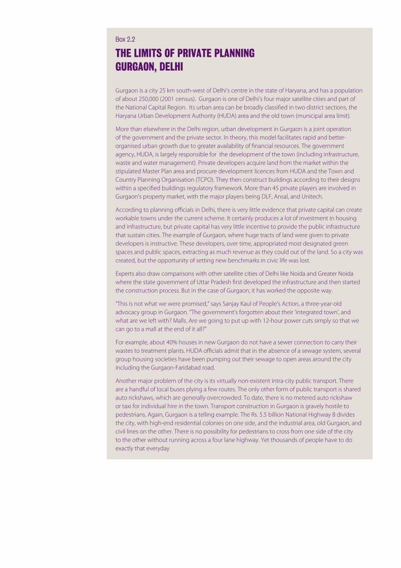
Box 2.2
THE LIMITS OF PRIvATE PLANNINGGURGAON, DELHI
Gurgaon is a city 25 km south-west of Delhi’s centre in the state of Haryana, and has a population of about 250,000 (2001 census). Gurgaon is one of Delhi’s four major satellite cities and part of the National Capital Region. Its urban area can be broadly classified in two district sections, the Haryana Urban Development Authority (HUDA) area and the old town (municipal area limit).
More than elsewhere in the Delhi region, urban development in Gurgaon is a joint operation of the government and the private sector. In theory, this model facilitates rapid and better-organised urban growth due to greater availability of financial resources. The government agency, HUDA, is largely responsible for the development of the town (including infrastructure, waste and water management). Private developers acquire land from the market within the stipulated Master Plan area and procure development licences from HUDA and the Town and Country Planning Organisation (TCPO). They then construct buildings according to their designs within a specified buildings regulatory framework. More than 45 private players are involved in Gurgaon’s property market, with the major players being DLF, Ansal, and Unitech.
According to planning officials in Delhi, there is very little evidence that private capital can create workable towns under the current scheme. It certainly produces a lot of investment in housing and infrastructure, but private capital has very little incentive to provide the public infrastructure that sustain cities. The example of Gurgaon, where huge tracts of land were given to private developers is instructive. These developers, over time, appropriated most designated green spaces and public spaces, extracting as much revenue as they could out of the land. So a city was created, but the opportunity of setting new benchmarks in civic life was lost.
Experts also draw comparisons with other satellite cities of Delhi like Noida and Greater Noida where the state government of Uttar Pradesh first developed the infrastructure and then started the construction process. But in the case of Gurgaon, it has worked the opposite way.
“This is not what we were promised,” says Sanjay Kaul of People’s Action, a three-year-old advocacy group in Gurgaon. “The government’s forgotten about their ‘integrated town’, and what are we left with? Malls. Are we going to put up with 12-hour power cuts simply so that we can go to a mall at the end of it all?”
For example, about 40% houses in new Gurgaon do not have a sewer connection to carry their wastes to treatment plants. HUDA officials admit that in the absence of a sewage system, several group housing societies have been pumping out their sewage to open areas around the city including the Gurgaon-Faridabad road.
Another major problem of the city is its virtually non-existent intra-city public transport. There are a handful of local buses plying a few routes. The only other form of public transport is shared auto rickshaws, which are generally overcrowded. To date, there is no metered auto rickshaw or taxi for individual hire in the town. Transport construction in Gurgaon is gravely hostile to pedestrians. Again, Gurgaon is a telling example. The Rs. 5.5 billion National Highway 8 divides the city, with high-end residential colonies on one side, and the industrial area, old Gurgaon, and civil lines on the other. There is no possibility for pedestrians to cross from one side of the city to the other without running across a four lane highway. Yet thousands of people have to do exactly that everyday

2-13 INTEGRATED CITY MAKING
We were looking in terms of giving higher FARs to
see that they are better able to connect the people
with the public modes of transport. But it’s still
not something, which has taken roots where every
single decision will now be taken based on land and
transport planning and it’s still in its very early days.
Sanjay Ubale, Secretary Special Projects, Government of Maharashtra, Mumbai
But then, the extent of exploitation of the land is
limited because of the other severe restrictions
on ground coverage and the FAR. Unless these
arerelaxed,youwillnotfindthisintensification
taking place. Unfortunately, even in the new Master
Plan (that has been now published), this is not
happening; there is general reluctance with the city
planners, particularly with the architects, and the
NGOstoresistthisdensification.
SeniorTransportOfficial,Delhi
In many areas of Delhi, urban sprawl has led to the country’s highest car ownership levels, while making public transport provision less economical.
So, any transport system will have a real natural
handicap here because the density is not high like in
like New York, or even Shanghai. Delhi it’s a spread
out city. Most of the buildings are single or two-
storied buildings, three-storied buildings. So, we
anticipate this is a problem for the city.
SeniorTransportOfficial,Delhi
Experts acknowledge that a clear break from the past is needed, in order to enhance integration.38 But they also acknowledge that the enormous changes the country is going through make organisational reform difficult. During the 1990s, economic liberalisation and democratic decentralisation alone were already pushing the reform agenda far beyond capacity limits.39 Today, development pressures are so high, that systemic coordination is almost impossible to achieve.40 In theory, mechanisms for integrated land-use and transport planning are in place; even supported by law. In addition, the speed of change has limited capacity for policy evaluation.
The mismatch of urban governance with urban growth further hinders more integrated development. Having outgrown their administrative area, cities rely heavily on
Again, the limited perspective of isolated planning practice of separate departments aggravated these problems. In the case of Bangalore’s Electronic City, the Industry Department was only dealing with the requirements of new IT companies and did not consider the needs of future employees for housing or the requirements of transport infrastructure provision.36 One unexpected consequence of transport congestion is that residents are choosing to move closer to where they work.37
For India’s urban poor, the segregation of workplaces and housing often equals the segregation of rich and poor of the city. They rely on easy access to wealthier areas best offered by physical proximity. Unfortunately, sectoral planning often reduces the latter, unaware of its social and transport related consequences.
The poor in India can live only if they are near the
rich; both need each other. The maid will come
from either a slum cluster, the person who will
iron your clothes will come from that segment of
society. So, you can’t segregate people and throw
out one section.
Pankaj Vohra, Political Editor, Hindustan Times, Delhi
A typical example of existing land-use and transport coordination of urban planning in Indian cities is density controls linked to street width. The latter is used as a proxy for accessibility levels of motorised surface transport. In most cities, floor area ratios (FARs) are generally adjusted accordingly. However, this approach has led to a strong bias of granting higher density levels mainly based on the capacity of private car access, ignoring accessibility levels achieved by public transport systems such as bus rapid transit or urban rail systems. It further ignores pedestrian and public transport affinity of higher density levels.
So even if the metro etc. is there, you cannot
prevent someone from coming in his/her own
car. Then, you have parking problems and other
related things. This is why; the prime consideration
is the road. Hence, the road width becomes very
important.
P.R.Baviskar,ChiefExecutiveOfficer,KolkataMetropolitanDevelopment Agency, Kolkata
K.R.Veerendra Nath, Joint 36 Director of Town Planning, Bangalore Metropolitan Region Development Authority, April 2007
Subir Hari Singh, Metropolitan 37 Commissioner, Bangalore Metropolitan Region Development Authority, April 2007
Sanjay Ubale, Secretary, 38 Special Projects, Government of Maharashtra, April 2007
A. K. Jain, Commissioner, Delhi 39 Development Authority, March 2007
Lakshmi Venkatachalam, 40 Principal Secretary, Department of Urban Development, Government of Karnataka, April 2007
rightMumbai’s fringe, where increasingly multi-storey buildings are replacing the formerly low-rise structure of the city.Bruno Moser

URBAN INDIA CHALLENGES 2-14

2-15 INTEGRATED CITY MAKING
the 30,000 km² large National Capital Region (NCR) was too ambitious. Satellite cities including Alwar, Ghaziabad, Hapur, Meerut, Sonipat, Rohtak and Noida were intended to de-congest Delhi. However, bureaucratic complexity and a lack of political will to deal with settlements that are up to 100 km apart from each other compromised coordinated planning. The result is that Delhi is increasingly overpopulated.42
A final blow to integrated planning is the inflation of plans and strategy documents. The sheer number of different visions, concepts, plans and strategies put forward by various government departments at different levels makes it difficult to rely on any of them and often makes them obsolete even before being published. The experience of one expert in Kolkata is symptomatic of a wider problem in strategic planning.
I was told that another plan had been prepared by
the CMDA (or the KMDA as they are known today).
I got a copy of that plan and it was again just a
physical plan with nothing that this Perspective Plan
was talking about. It did not have the dimensions
needed for city development. So I asked, “Which
plan is the government going to follow?” I got the
answer - none! They said that they were making
another plan called the Mega City Plan! So, this is
the chaos in the planning process. We have seen
three different planning exercises between 1990
-1997.
A. K. Ghosh, Director, Centre for Environment and Development, Kolkata
Attempts for greater integration of land-use and transport are also undermined by uncoordinated revisions to plans. Considering the current dynamics of population growth and economic change in Indian cities, revisions become the norm and even if integration is achieved in the first issue of a plan, it is progressively weakened by subsequent modifications. Too often, these isolated updates only take into consideration the one critical factor that initially led to the alteration, thereby reducing strategic coherence.43
City shaping2.2.5
Experts also questioned whether Indian land-use and transport planning was actually capable of shaping urban development.44 Three factors
development decisions beyond these boundaries. Consequently, municipalities within the greater metropolitan region struggle to plan and regulate development, which often leads to less integrated and synchronised developments.
What propels this expansion is the fact that a
lot of the development has, in fact, taken place
in the outskirts, but it was not being properly
regulated. It is far too much for the small towns and
municipalities to grapple with.
Lakshmi Venkatachalam, Principal Secretary, Urban Development, Government of Karnataka, Bangalore
In the case of Mumbai, interviewees shared that planning for the metropolitan level is not taken to a more detailed scale on the municipal level. The Mumbai Municipal Corporation does not even have a planning department, let alone a transport department, regardless of the fact that it is amongst the richest and best-equipped cities in India.41 Still, metropolitan wide planning has always been seen as having a strong Mumbai bias.
And whatever planning efforts till date have been,
they have been in terms of intensifying Mumbai,
decongesting Mumbai, creating alternatives for
Mumbai and all of that thinking has been Mumbai-
centric. So we decided to have scenarios that were
Mumbai-centric.
Vikas Sharma, Senior Planner, LEA Associates, Mumbai
Furthermore, the role of local bodies in relation to city-wide development authorities needs to be clarified. In the case of Delhi, experts point out that responsibilities are not defined clearly enough.
The Delhi Development Authority (DDA) prepares
a colony, and they say okay now it is all ready for
transfer, now the local body takes it over. The local
body complains to the DDA that they didn’t plan for
many things, the roads are bad, the sewage system
is substandard, and they refuse to take it over.
Then for the next 20 years, the battle keeps going
on, and the same thing is happening in most cities.
Rakesh Mehta, Principal Secretary, Energy, Government of Delhi
In Delhi, coordination efforts with the wider metropolitan region stalled following the recognition that creating a coherent strategy for
Uma Adusumilli, Chief Planner, 41 Mumbai Metropolitan Region Development Authority, March 2007
Pankaj Vohra, Political Editor, 42 Hindustan Times, March 2007
Uma Adusumilli, Chief Planner, 43 Mumbai Metropolitan Region Development Authority, March 2007
Ramesh Ramanathan, Co-44 Founder and Director, Janaagraha Centre for Citizenship and Democracy, April 2007

URBAN INDIA CHALLENGES 2-16
Box 2.3
STRATEGIC DECISION MAKING FOR STRATIGIC SITESEASTERN WATERFRONT, MUMBAI
In recent years, Mumbai’s Eastern Waterfront, which is currently home to the city’s port, has received increasing attention as a possible site for regeneration. The future of this 720 ha large area along the Thane Creek has been at the centre of a fierce debate between different key decision makers in Mumbai. The city would like to see the site being opened to Mumbai’s residents, possibly as a large waterfront park with additional housing and commercial facilities while the Mumbai Port Trust, a national agency operating largely independent from local development strategies, emphasises the strategic importance of the site for the continuation of its port activities. The Port Trust owns the largest chunk of the land which contains the docks of the Mumbai Port, almost 100 km of railroads, warehouses, oil storage facilities and houses for Port Trust employees, as well as large tracts of unused land.
The Eastern Waterfront is particularly valuable being well connected to all the major hubs in the city, such as the business district of Nariman Point, inner-city markets and housing and the erstwhile industrial lands of Parel and Lalbaugh. Planners and urban experts contend that integrated development of the waterfront could transform Mumbai - new rail corridors, an alternate waterfront, badly needed open space, and employment nodes. According to Mehrotra (2007), “the waterfront offers the potential for public access [as well as]… the potential for connectivity using water transport [which] could offer the much-needed transformation of mobility within the region.” Furthermore, given its geographical location, it can easily become integrated into Mumbai city. Development of the waterfront is also expected to stabilise real estate prices.
Realising the importance of the waterfront, the State government set up a task force in 2002. In June 2004, the Mumbai Metropolitan Regional Development Authority (MMRDA) commissioned the Urban Development Research Institute (UDRI), along with the Kamala Raheja Vidhyanidhi Institute (KRVI), to develop a vision plan. Their report called for a change in land use but stressed the need to ensure development that would address the open space and housing requirement of the masses. In March 2006, the Mumbai Port Trust decided to frame a policy for the use of its land. It also recommended a separate perspective plan for the waterfront area.
Evidently, there is no lack of precedents for waterfront regeneration of old port land and it would suit Mumbai’s aspiration to join the group of cities that successfully transformed areas of their industrial past into buzzing centres of urban life. But there are also more careful voices including the Port Trust reminding the city that industrial production and shipping is not over yet. In fact, the port could continue playing a critical role for the entire metropolitan region with this centrally located facilities being a major asset.

2-17 INTEGRATED CITY MAKING
was borrowed from the US in the 1950s and 60s. They struggle to embrace mixed use, feed demand for transport and traffic congestion,47 and are regarded as suppressing economic growth and self-employment potentials.48
Planning, as we have envisaged it, may not work. A
paradigm shift is needed. Earlier, we had single-use
zoning with a lot of emphasis on the government
playing a big role in physical development. Now we
are shifting to mixed-use and there is a realisation
of the need for more localised, more participatory
and more interactive land-management.
A. K. Jain, Commissioner, Planning, Delhi Development Authority
By promoting zoning, plans are out of sync with the reality of highly intertwined residential and business activities to an extent that a large majority is left outside the law. In Delhi, the ‘sealing drive’ was a result of the Supreme Court’s demand for greater compliance with the law. The resulting resistance and demonstrations put the problem at the top of the political agenda.49
Cottage industries which were operating from
housing areas and residential areas, for years
together –making fans or knitting needles;
Jagmohan’s plan was to move them from the
undermine the effectiveness of plans. First, violations of planning regulations are the norm, with about 70% to 90% of the built environment being inconsistent with masterplans and therefore illegal. Governments are constantly dealing with the political pressures emerging from these violations. Second, plans lack credibility. Often the result of purely technocratic exercises, plans do not consider holistic dynamics of urban development. And third, plans are not flexible enough to interact effectively with the fast-changing environments of Indian cities.
The first general point can also be summarised as the current planning system’s inability to address informal developments. Particularly traditional master planning struggles to engage with fine grain dynamics on the ground with regards both to existing illegal settlements and to future developments of this kind.45 In recent years, Delhi has been particularly pragmatic about informal settlements by at least recognising their existence in its new masterplan. However, the strain of ‘legitimising illegitimate things’ continues and is far from being solved in a systematic manner.46
Nowadays, the credibility of many masterplans is further questioned by the planning paradigm on which they rely. In many Indian cities, these plans still suffer from single land-use zoning that
Rakesh Mehta, Chief Secretary, 45 Government of National Capital Territory of Delhi, March 2007
Pankaj Vohra, Political Editor, 46 Hindustan Times, March 2007
Pankaj Vohra, Political Editor, 47 Hindustan Times, March 2007
A. K. Jain, Commissioner, Delhi 48 Development Authority, March 2007
A. K. Jain, Commissioner, Delhi 49 Development Authority, March 2007
belowMore than half of Greater Mumbai is un-built land with about 35% of its surface covered by forests and coastal wetlands. The net population density of the city is pushed to more than 50,000 person per km². Rajesh Vora

URBAN INDIA CHALLENGES 2-18
Box 2.4
DEFINING DETAILS AT THE METROPOLITAN SCALE THE DELHI MASTER PLAN
OverviewThe Master Plan for Delhi 2021 is the statutory planning document for Delhi. Recognising that previous editions of the Master Plan lacked enforceability, the MPD-2021 seeks to accommodate existing realities on the ground, to enhance public participation in local level plan-making, and to introduce performance-oriented planning.
However, the integrative elements incorporated in the plan are restricted to mixed use activity in residential colonies preferential to area’s profitability and priority for internal roads. These modifications are meant to foster a higher density of development along rail corridors, and an integrated relationship between the bus, rail and metro systems to provide for seamless multimodal transport. But, there is no explicit mention of integrated transport and land use development for the other parts of the city.
Essentially, the MPD-2021 still follows the tradition of regulating building design at the metropolitan scale rather than concentrating on comprehensive, strategic issues with the details of specific design delegated to local planning and negotiation.
HousingThe MPD-2021 takes cognisance of the fact that there is shortage of housing stock and has based its conclusion on the projected population of 23 million in the city by 2021. The 400,000 new housing units needed will be accommodated by (a) encouraging vertical growth, (b) unlocking 22,000 hectares for group housing as opposed to individual housing, and (c) a shift to the satellite towns. Vertical growth will address the shortage of land as properties, whether residential, commercial or educational, will now be permitted to grow vertically. In addition, the MPD-2021 encourages the pooling of properties so that Delhiites can construct multi-storied collective housing complexes. The MPD-2021 also stipulates that a minimum of 55% of new housing areas should cater to people belonging to lower income strata.
In an effort to facilitate this new construction and redevelopment, the plan enhanced Floor Area Ratio (FAR) and approved private participation in mega construction projects and high-rise building activity in the city.
Mixed Land UseThe plan has advocated a “mixed land use” policy that authorises commercial establishments on 2,183 streets and has also regularised 1,500 illegal colonies on private and public land. For colonies guilty of encroaching on public land, it proposes a graded penalty scheme. However, critics complain that this sets a bad precedent and signals to the people that it is worthwhile to be dishonest and evade taxes.
EconomyThe MPD-2021 in its preliminary section does establish that growth within the working population over the next two decades will be mainly in the services sector. But there is little in the master plan to suggest how growth in the sector and specific services can be facilitated in an orderly manner.
TransportThe Delhi Master Plan envisages that the future transport system shall consist of a mix of rail and road based systems, non-motorised transport and private modes. The MPD-2021 has recommended the establishment of a unified Metropolitan Transportation Authority for the development of an integrated system, which may be framed in that context.
Also, to achieve spatial balance, development should take place according to new corridors of mass movement. In this context the MPD-2021 has recommended high density redevelopment of land along Metro corridors and intensification of existing land uses based on site conditions. It is proposed that comprehensive redevelopment schemes of the influence area of MRTS stations be prepared.

2-19 INTEGRATED CITY MAKING
But it is not only the geographic coverage in relation to the level of details that is criticised but the ambitious time frame master planning tends to come along with. Particularly the inflexibility and lengthy review periods conflict with the need for a state-of-the-art planning response.
Themasterplanasaconceptistooinflexible.A
fixedmasterplanfortwentyyears?Noway.We
need a master vision rather than a master plan.
The society in the city is growing and becoming
veryaffluent.People’srequirementsareconstantly
changing - they need more power, water - a plan
fortwentyyearscannotreflectthechanging
requirements.
Sheila Dikshit, Chief Minister, Delhi
At the same time however, several interviewees criticised the lack of strategic vision and future-oriented thinking. To establish a coherent strategic document for the entire city is a task of great significance and needs to be coupled with progressive planning to accommodate dynamic city development.
In the last 15-20 years, what were the policy guys
doing? They should have come out with a Master
Plan. After all it’s a blueprint, which shows what will
be the future of the city. There’s no thinking.
Pankaj Vohra, Political Editor, Hindustan Times, Delhi
Wehavetoplan,buttheinflexibilityintheplanning
process needs to be removed. Plans should be
rethought every two years. We need shorter review
periods.Weneedveryflexibleplansbecausethings
are changing so quickly. What took ten months to
complete three years ago, can today be done in
10days.…Anurbanblueprintneedstobemade.
There just are not enough people thinking about
what should be done. We need future-oriented
thinking.
Sheila Dikshit, Chief Minister, Delhi
Planning as politics2.2.6
The dynamics of the interaction between politics and planning have been studied to a great extent and are ultimately determined by very specific local planning cultures.54 In the Indian context, experts identified an ideological confrontation of professional planners and elected officials.
residential area and send them to suburbs of Delhi,
where there was no infrastructure. There were
mass agitations on the road, people got hurt, and
people died of shock.
Pankaj Vohra, Political Editor, Hindustan Times, Delhi
Current master planning is further regarded as prescribing details without addressing urban design. Rather than laying out key principles, they include specifications for individual streets.50 At the same time, experts criticise the extent to which architectural quality and design is ignored within the current process.
In India, you don’t have any concept for
development for master planning at an urban
design level. We don’t have any competitions etc.
T. Bhattacharya, Chair, Center for Human Settlement Planning, Jadavpur University, Kolkata
Insufficient participation and communication are seen as undermining the legitimacy of plans, which tend to be written for a professional audience rather than the general public.51
Shaping the city also suffers from a degree of master plan hypocrisy, where a clearly structured approach is set up by democratically elected policy makers with formal requirements for review and public discussion, but results in plans that are incapable of implementation, owing to their discrepancy with on-the-ground reality.52
Many experts even challenged the general idea of a master plan and regard it as an insufficient tool for dynamic cities. Masterplans are based on the assumption that it is feasible to dictate the details of spatial development in cities, when this may not actually be the case. Moreover, masterplans fail to recognise variation within a city such as Delhi, which is in reality an amalgamation of at least six distinct spatial configurations with their own complexities and physical logic.53
Well, fortunately, I have been involved at the
stage of the formulation of the Master Plan since
I was Municipal Commissioner here. I had direct
interaction with many of the people who were
planning all this. The big question is whether Master
Planning is a good way to plan for urban growth,
considering the dynamism of the city itself? That’s a
big question.
Rakesh Mehta, Principal Secretary, Energy, Government of Delhi
Shreekant Gupta, Professor of 50 Environmental Economics, Delhi School of Economics, March 2007
Shreekant Gupta, Professor of 51 Environmental Economics, Delhi School of Economics, March 2007
K. Jagmohan, Senior Leader, 52 Bharatiya Janata Party, March 2007
Rakesh Mehta, Chief Secretary, 53 Government of National Capital Territory of Delhi, March 2007
Friedmann, J. (2005) “Planning 54 Cultures in Transition.”

URBAN INDIA CHALLENGES 2-20
K. Jai Raj, former Commissioner, 55 Bangalore Mahanagara Palike, April 2007
Vikas Sharma, Principal 56 Transport Planner, PTV Asia Pacific, April 2007
Uma Adusumilli, Chief Planner, 57 Mumbai Metropolitan Region Development Authority, March 2007
The latter put equity, housing for the poor and development first, without considering how spatial planning can help to achieve these.55
Simultaneously, the politicisation of planning has led to arbitrary planning assumptions.56 In Mumbai, the critical planning parameters for the city’s 2031 strategy were set down by the State Government. Basic factors such as the number of future residents, the composition of the housing and labour market, as well as the degree of formal and informal production, were generated by political goals rather than sound projections. Consequently, according to several interviewees, politically motivated visions become the basis for long-term strategic infrastructure development; creating the risk that infrastructure does not meet future needs.
Often, political priorities lead to planning being seen as a universal solution to problems, rather than understanding its limitations.
And if we are looking at physical planning, it has its
own limitations. It can’t eradicate poverty of the
nation. Many other things need to happen in the
country. And in Mumbai, particularly we have the
tendency to misuse the instruments of development
control, which are an essential part of planned
development, to achieve 100 things in addition to
the planned development.
SeniorPlanningOfficial,Mumbai
Some experts argue that discussions on planning in India are too focused on methodology, while the real issue is a lack of respect for planning and plan implementation. Politicians very often simply do not welcome the way that planning interferes with market driven developments.57 The general struggle to measure planning success makes it even more difficult to make a clear case for its benefits and wider appreciation amongst elected officials.
In Mumbai, they say that only 10% of the plan has
beenrealised.Whatdotheydefineasplanand
whatdotheydefineas10%isverydifficultto
comprehend. There is a tendency of measuring the
success of plan by only comparing the lands, which
are reserved for certain activities.
SeniorPlanningOfficial,Mumbai
aboveChandivali in Mumbai is one of the large-scale rehousing project developed by the State of Maharashtra. It has been criticised for limited provision of any kind of transport access.Philipp Rode
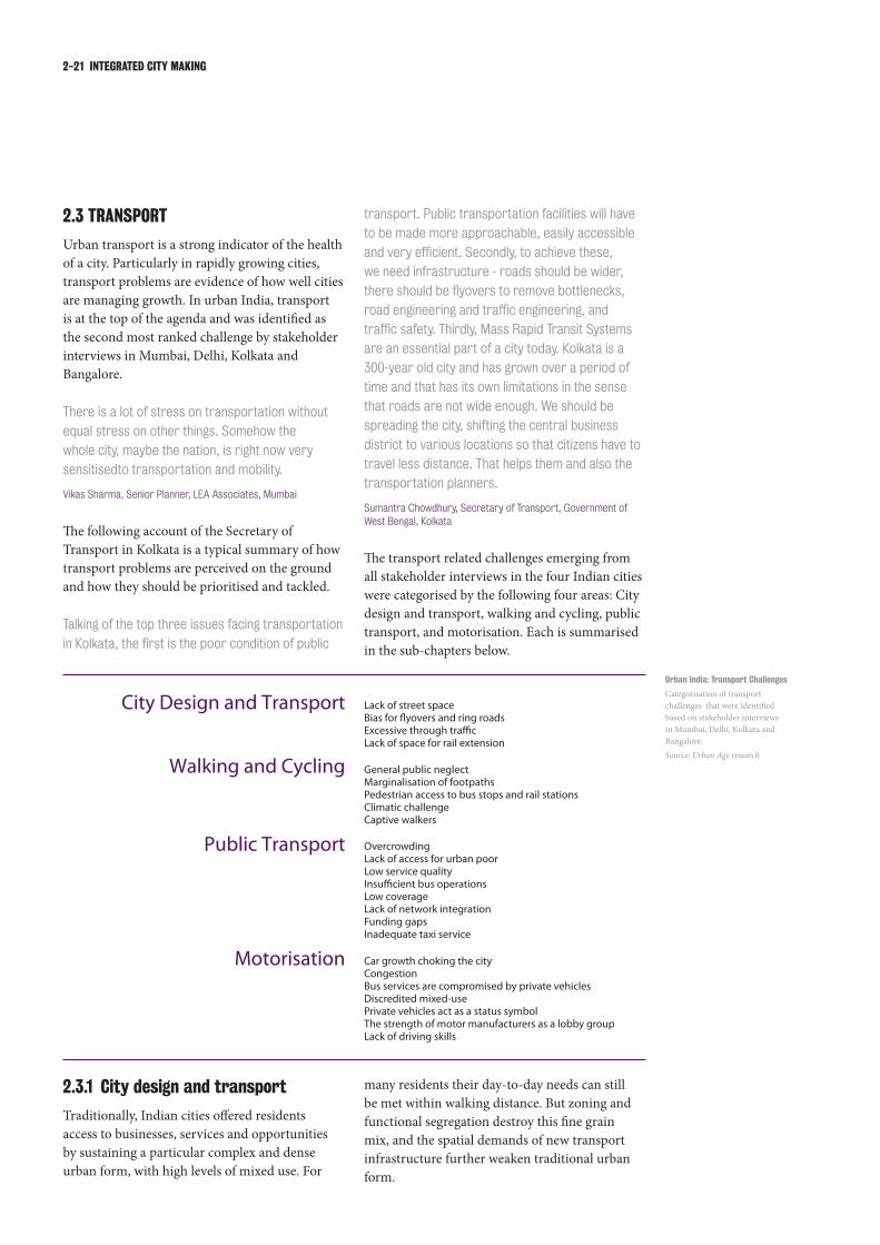
2-21 INTEGRATED CITY MAKING
Urban India: Transport Challenges
Categorisation of transport challenges that were identified based on stakeholder interviews in Mumbai, Delhi, Kolkata and BangaloreSource: Urban Age research
City Design and Transport Lack of street spaceBias for flyovers and ring roadsExcessive through trafficLack of space for rail extension
Walking and Cycling General public neglectMarginalisation of footpathsPedestrian access to bus stops and rail stationsClimatic challengeCaptive walkers
Public Transport OvercrowdingLack of access for urban poorLow service qualityInsufficient bus operationsLow coverageLack of network integrationFunding gapsInadequate taxi service
Motorisation Car growth choking the cityCongestionBus services are compromised by private vehiclesDiscredited mixed-usePrivate vehicles act as a status symbolThe strength of motor manufacturers as a lobby groupLack of driving skills
City design and transport2.3.1
Traditionally, Indian cities offered residents access to businesses, services and opportunities by sustaining a particular complex and dense urban form, with high levels of mixed use. For
TRANSPORT 2.3
Urban transport is a strong indicator of the health of a city. Particularly in rapidly growing cities, transport problems are evidence of how well cities are managing growth. In urban India, transport is at the top of the agenda and was identified as the second most ranked challenge by stakeholder interviews in Mumbai, Delhi, Kolkata and Bangalore.
There is a lot of stress on transportation without
equal stress on other things. Somehow the
whole city, maybe the nation, is right now very
sensitisedto transportation and mobility.
Vikas Sharma, Senior Planner, LEA Associates, Mumbai
The following account of the Secretary of Transport in Kolkata is a typical summary of how transport problems are perceived on the ground and how they should be prioritised and tackled.
Talking of the top three issues facing transportation
inKolkata,thefirstisthepoorconditionofpublic
transport. Public transportation facilities will have
to be made more approachable, easily accessible
andveryefficient.Secondly,toachievethese,
we need infrastructure - roads should be wider,
thereshouldbeflyoverstoremovebottlenecks,
roadengineeringandtrafficengineering,and
trafficsafety.Thirdly,MassRapidTransitSystems
are an essential part of a city today. Kolkata is a
300-year old city and has grown over a period of
time and that has its own limitations in the sense
that roads are not wide enough. We should be
spreading the city, shifting the central business
district to various locations so that citizens have to
travel less distance. That helps them and also the
transportation planners.
Sumantra Chowdhury, Secretary of Transport, Government of West Bengal, Kolkata
The transport related challenges emerging from all stakeholder interviews in the four Indian cities were categorised by the following four areas: City design and transport, walking and cycling, public transport, and motorisation. Each is summarised in the sub-chapters below.
many residents their day-to-day needs can still be met within walking distance. But zoning and functional segregation destroy this fine grain mix, and the spatial demands of new transport infrastructure further weaken traditional urban form.

URBAN INDIA CHALLENGES 2-22
aboveOnly eleven per cent of Mumbai’s surface is covered by roads and construction of new high-rise towers and flyovers is creating a rapid transformation of the city’s historical grain.Chirodeep Chaudhuri
You would have noticed that in almost every major
thoroughfare in Kolkata parking is allowed on the
street,whichisactuallychokingthetraffic.
Senior Newspaper Editor, Kolkata
The physical restructuring of cities for increasing mobility has a strong bias for flyovers and ring roads. Experts identify fragmented responsibilities as a factor influencing this preference.
Only roads were within the State’s ambit. So the
Statealwayslookedupontrafficsolutionsinthe
formofmoreroads.…TheStateGovernment
and the local bodies have largely concentrated on
the creation of roads rather than other modes of
transport. In a large city like Mumbai, the railways
network is probably more effective than roads
alone because roads essentially promote private
modes of transport.
Sanjay Ubale, Secretary Special Projects, Government of Maharashtra, Mumbai
For example, there is something called
Maharashtra State Road Development Corporation.
It has a jurisdiction of the entire State including
rural roads. But suddenly they are told to build
theflyoversinMumbai.Sotheywouldcommission
some studies - feasibility studies and environmental
studies and viability studies and techno-economic
studies. And the thing is that the Corporation alone
cannot visualise the impact of this particular thing.
SeniorPlanningOfficial,Mumbai
It is in reference to the older parts of Indian cities, that local experts frequently identify the lack of street space as a central issue.58 In Mumbai, the city’s streets cover only about 11% of its surface59 and in Kolkata even less than 7%60 compared to 21% in Delhi and 22% in New York City.61 The already limited street space is further poorly managed and sub-optimally used.62
It is this concern about the lack of space for movement and resulting traffic congestion that has translated into strict density controls.63 However, not only is planning often failing to implement the desired lower density levels even in new areas64 but it tends to ignore alternative ways of addressing congestion. It also turns a blind eye to some of the most significant causes of congestion, such as the steep increase in private vehicles. Demand management, public transport upgrading and the re-distribution of existing street space for different means of transport are rarely implemented.
Street space is further reduced by parked vehicles, with scarce public space being given up often at no cost. In the city of Kolkata, 70% of buildings do not have any parking facilities, transferring the price of motorisation to the general public by even further reducing the amount of available street space.65
We don’t charge vehicles for parking on the roads
in the city. So people have all the incentives to buy
more cars even if they don’t have places to park.
R. A. Rajeev, Additional Municipal Commissioner, Brihanmumbai Municipal Corporation, Mumbai
Dinesh Rai, former Vice-58 Chairman, Delhi Development Authority, March 2007
Pucher, J; Korattyswaroopam, 59 N; Ittyerah, N. (2004) “The Crisis of Public Transport in India: Overwhelming Needs But Limited Resources.” Journal of Public Transportation.
Tapas Kumar Bhattacharyya, 60 Chair, Centre for Human Settlement Planning, Jadavpur University, March 2007
Litman, T. (2005) Transportation 61 Land Valuation: Evaluating Policies and Practices That Affect the Amount of Land Devoted to Transportation Facilities.
Ravindra Kumar, Editor and 62 Managing Director, The Statesman, March 2007
Ravindra Kumar, Editor and 63 Managing Director, The Statesman, March 2007
Tapas Kumar Bhattacharyya, 64 Chair, Centre for Human Settlement Planning, Jadavpur University, March 2007
Sumantra Chowdhury, Addl. 65 Chief Secretary of Transportation Planning, Government of West Bengal, March 2007

2-23 INTEGRATED CITY MAKING
A different type of conflict of competing transport and city space interests has emerged on the current site of Mumbai’s port. The future of this large, linear area along the eastern waterfront has been the centre of a fierce debate between different key decision makers. The city would like to see the site being opened to Mumbai’s residents, possibly as a large waterfront park with additional housing and commercial facilities. Evidently, there is no lack of precedents for waterfront regeneration of old port land and it would suit Mumbai’s aspiration to join the group of cities that successfully transformed areas of their industrial past into buzzing centres of urban life. But there are also more careful voices reminding the city that industrial production and shipping are not over yet. In fact, the port could continue playing a critical role for the entire metropolitan region with its centrally located facilities being a major asset.
Walking and cycling2.3.2
Experts and political leaders in all four Indian cities repeatedly referred to the frustrating situation for movement in the cities by foot or bicycle. There appears to be a general political neglect of walking that so far has made any potential improvements impossible. This is even more surprising considering the large portions of urban residents that rely solely on non-motorised form of travel: in Mumbai, 55% of people walk to work.
Pedestrians are treated very, very shabbily in this
city. It’s a surprise that in a communist government,
the pedestrian is treated very shabbily. Here the
poor pedestrians suffer, unless they form a political
procession, in which case they claim right of way.
So in order to claim right away the pedestrians
have to be part of an organised mass movement.
Senior Newspaper Editor, Kolkata
More specifically, it is the marginalisation of footpaths that poses the most eminent challenge to pedestrians. The focus on road space for vehicular movement has led to a hazardous compromise for those walking in the city.
We are also very concerned that footpaths are
beinggraduallymarginalised.It’squitedifficultfor
pedestrianstohavefreemovement…Wewere
Buildingtheflyoversspoilstheentireurbanform.
In my personal view, one should not try to build
flyoverswithinthecity.It’sabigawkwardstructure
andwillbringthetrafficfromoutsideintothecity.
SeniorPlanningOfficial,Bangalore
At the same time, it is clearly recognised that this road building agenda mainly serves the purpose of enabling increased car use rather than improving surface transport more holistically.
It’s easy to introduce an additional 3,000 to
4,000 buses on the road, and that’s something
I am focussing on. This is again not being done
because most of the facilities that are coming up
areflyoversetc.,whicharecontributingtomore
vehicular movement rather than more people
movement.
S. Sriraman, Professor of Transport Economics, Mumbai University, Mumbai
Of late, many local communities are challenging flyover projects, fearing their aesthetic impact and a possible loss in street business activity.66 Also, public perception of flyovers genuinely having a positive impact on traffic flows is fading since they are always one step behind the pressures of increasing vehicular traffic.67
Excessive through traffic adds to congestion. In Bangalore, up to 70% of traffic, on major highway corridors leading to the city, simply passes through its urban core.68 Conventional strategies lead to the creation of ring roads that, themselves, radically alter the city’s form by becoming the prime location for industries, shopping malls and new residential areas, all highly dependent on access by private car.69
The friction between city design and transport is not exclusively linked to road building and capacity. In Mumbai, there is severe competition between lands being made available for building developments as opposed to rail infrastructure. The resulting lack of space for rail extension has been summarised by a representative of Mumbai’s Western Railways.
So even if you want to expand, there is little space
because just next to tracks, now there are multi-
storeyed buildings.
Senior Transport Expert, Mumbai
A V S Namboodiri, Editor, 66 Deccan Herald, April 2007
Pankaj Vohra, Political Editor, 67 Hindustan Times, March 2007
K.R.Veerendra Nath, Joint 68 Director of Town Planning, Bangalore Metropolitan Region Development Authority, April 2007
Pankaj Vohra, Political Editor, 69 Hindustan Times, March 2007

URBAN INDIA CHALLENGES 2-24
city’s streets without compromising pedestrian movement. However, the city currently counts around 300,000 people hawking along its streets.70
In this city, the problems of pedestrians have not
been addressed even though citizen organisations/
civic organisations have made noises about it.
The problem is related with the problem of street
vendors or hawkers on the roads and this city
has more hawkers on the road than it can ever
accommodate. The problem is as serious as the
problem of slums. In-migration is very high and
people, if they don’t get any work, they adopt the
business of street vending. And since it’s a very
vibrant city, everybody earns a good livelihood out
of street vending or hawking on the road. That has
become a big and very complicated problem.
R. A. Rajeev, Additional Municipal Commissioner, Brihanmumbai Municipal Corporation, Mumbai
In Mumbai, what has happened is that many of them
also happen to be street hawkers, peddlers of
just only thinking of the motorable roads, and might
be forgetting the pedestrian’s plight. And if it was a
clearplanningbody,theywouldhavedefinitelykept
in mind that the plight of the pedestrians is one of
the important factors. That should be our planning.
Bikash Ranjan Bhattacharya, Mayor, Kolkata Municipal Corporation, Kolkata
Because the pedestrians have no say in the matter.
We have no power to get rid of the hawkers and the
parking people. So we have to risk walking on the
roads and getting hit by cars. We are going to lodge
a Public Interest Litigation with the courts to ensure
that every road has a clear pedestrian pathway.
S. Sriraman, Professor of Transport Economics, Mumbai University, Mumbai
The issue of hawking in public space and along walkways dedicated to pedestrians is a challenge in many developing world cities. An investigation in Bangalore has shown that up to 25,000 street vendors could be accommodated on the
belowLabour intensive transport remains a common feature in Indian cities. Often it exposes workers to the dangers of heavy vehicular traffic.Rajesh Vora
R. A. Rajeev, Addl. 70 Municipal Commissioner (City), Brihanmumbai Municipal Corporation, April 2007

2-25 INTEGRATED CITY MAKING
Non-motorised travel and in particular cycling also face a climatic challenge in many Indian cities. Both, extreme heat and severe rainfall is common throughout the year and severely compromises the attractiveness of walking and cycling.
Motorised transportation system has taken off. You
cannot revert back. You can’t force people to go
bycycle.…So,inEuropeancountriesandAmerica
the weather permits cycling. It’s very hot here.
H. B. Mukunda, Director, Town Planning, Government of Karnataka, Bangalore
Further, cautious comments regarding the overall positive character of walking include the following. The extraordinary high level of people walking to work is also regarded by some experts as an indicator of problems. Captive walkers may not be walking by choice, but because they are unable to afford or access public transport.
Public transport2.3.3
Public transport provision in most Indian cities suffers from problems that include severe levels of overcrowding, lack of access for urban poor, low service quality, a lack of integration and funding gaps.
By far the most visible challenge facing public transport systems in the four Indian cities is the level of overcrowding. One of the most extreme examples is certainly Mumbai’s suburban rails system. During peak hour, 9-car trains designed to hold 1,700 passengers travel with up to 5,000 commuters, with 16 standing passengers sharing one m². A side effect of overcrowding is rail-related accidents, which kill more than
various kinds, sometimes beggars. Whatever little
sidewalks you had have been taken out. So when
the sidewalk is taken out, the street automatically
becomes half the normal size.
Gautam Adhikari, Editor, Daily News and Analysis, Mumbai
The effects of neglecting infrastructure for walking have further become a pressing issue for public transport accessibility when pedestrian access to bus stops and rail stations is undermined.
There are a good 50% of the people walking to the
stations. But pedestrian facilities are going out. So
asaresultofthispeoplearefindingverydifficultto
have access to public transport.
S. Sriraman, Professor of Transport Economics, Mumbai University, Mumbai
Nobody is saying that we are going to provide a
bus stop within 500m or that nobody should walk
more than 10 minutes from his house to reach a bus
stop to be able to take public transport. Nobody
is saying that. The entire city planning and urban
planning is done based on cars, based on metro.
SeniorOfficial,Delhi
Absent pedestrian safety is further amongst the most serious consequences of the issues outlined above. On Mumbai’s streets, about 13 people are killed each day.71
Walkingisfine,butwalkingistotallyunsafe.I
would love to walk, but provided I don’t fear that
somebody will come and hit me from the back.
S. K. Chaudhary, Executive Director and Regional Chief, HUDCO, West Bengal, Kolkata
aboveStreet scene in central Mumbai with pedestrians and traffic mixing underneath JJ Flyover.Philipp Rode

URBAN INDIA CHALLENGES 2-26
4,500 people per year in Mumbai alone. It is also overcrowding that makes the system very unattractive for office workers who increasingly favour private cars even if it takes significantly longer.72
The public transport system in Mumbai, which was
traditionally very strong, it is now breaking down.
And especially in the past 25 - 30 years, there has
been very little attention to improve the system in
a big way.
S. Sriraman, Professor of Transport Economics, Mumbai University, Mumbai
At the same time, public transport is struggling to offer mobility for all and there is a continuous lack of access for urban poor. Low wage earners easily spend almost 30% of their income on transport73even though operators are heavily subsidised to offer low fares. In Mumbai, only about Rs. 0.07 to 0.08 is charged per km on the suburban rail system.74
Many experts further emphasised the low service quality of public transport. Systems are very unreliable and particularly buses do not run on a fixed schedule. Together these issues accelerate the shift toward private transport modes.
Well, there is a debate but we don’t have a very
good public transport service. Everybody is not
inclinedtouseitanditisnotveryreliable.…We
have to create the environment where the public
transport is more attractive.
Dinesh Rai, former Vice-Chairman, Delhi Development Authority, Government of India, Delhi
Nobody is able to depend on public transportation.
Thereisnofixedtimewhenthebuswillcome,there
isnofixedtimewhenthetrainwillgo,soeverything
is a problem.
SeniorGovernmentOfficial,Kolkata
The city should provide enough public transport so
that people will not be forced to use their personal
transport.…Butnow,personaltransportisa
requirement.Ifyouwanttoreachyourofficein
time, personal transport is a must.
A.V.S. Namboodiri, Editor, Deccan Herald, Bangalore
To a large extent, inefficient bus operations are created by business models not incentivising smooth operation. Drivers and conductors are paid a very small salary and essentially work on a commission basis. Their objective is to get the maximum number of people travelling from point A to point B in the fastest possible time.
So there are no such things as bus schedules.
That is why you have races between buses,
travelling on the same route, many times with fatal
consequences. There are designated bus stops but
you just need to put your hand out and a bus will
stopforyouanywhereeveninthemiddleoftraffic.
Senior Newspaper Editor, Kolkata
The recently opened metro lines in Delhi, which have not yet developed to a full citywide system, suffer from low coverage and offer mobility only to a fraction of urban residents. At the same time, Delhi’s suburban rail is under-used: a network of 245 km does not even carry 2% of all commuters.75
But unfortunately, the whole railway system carries
hardly 2% of the commuters. And today the Metro
system carries hardly 5% of the commuters. Of
course, when the whole Metro is over, the 365 km,
weexpectourshareofcommutertrafficwillgo
from present 5% to about 25%.
SeniorTransportOfficial,Delhi
Throughout India, public transport systems are not integrated with each other. This lack of network integration leads to inefficient ticketing, lacking synchronisation of schedules and routes as well as unrecognisable branding. In Delhi, 3,000 buses are run directly by the Delhi Transport Corporation and another 5,000 buses by private operators. Common ticketing and branding does not exist.76 Similar shortcomings were referred to in Mumbai.
How many cities in the West have such sort of a
multi-modal ticketing system? We have been talking
about it for the past 20 years.
S. Sriraman, Professor of Transport Economics, Mumbai University, Mumbai
Mumbai Metropolitan Region 71 Development Authority (MMRDA) (2007), Integrated Public Transport Planning / Comprehensive Transportation Study.
Sanjay Ubale, Secretary, 72 Special Projects, Government of Maharashtra, April 2007
K.R.Veerendra Nath, Joint 73 Director of Town Planning, Bangalore Metropolitan Region Development Authority, April 2007
Pranay Prabhakar, Chief Public 74 Relations Officer, Western Railways, April 2007
Senior Transport Official, Delhi, 75 March 2007
Senior Transport Official Delhi, 76 March 2007

2-27 INTEGRATED CITY MAKING
A challenge for public transport systems throughout the world are the funding gaps between their construction and operating costs and fare-box revenues. In most cases, not only capital investments but also operations require state subsidy. Ambitious infrastructure programmes such as Kolkata’s metro were stopped after implementation of just one line77 while other cities with the significant exception of Delhi (with its new metro - see Box 3.1) have not had significant public transport infrastructure investments for decades. Current financial arrangements do not create a framework that encourages governments to invest in public transport infrastructure and operation.
Anything that has got to do with public transport
of whatever form is basically a loss as far the
government is concerned. Governments view
public transport as a drain on their resources
rather than as a necessary mode of transport that
needs to be provided.
Rakesh Mehta, Principal Secretary, Energy, Government of Delhi
I’m going back to the public transport scenario
where public transport systems have not been
allowed to grow according to what is required. We
do not have any major railway investments in the
last 30 years except for one branch line, which is
known as the Harbour Line.
S. Sriraman, Professor of Transport Economics, Mumbai University, Mumbai
A final concern, which prevails in all four Indian cities and has impeded the overall success of their public transport, is the inadequate taxi service. Taxis could offer a real alternative to private cars, but they fail to deliver equivalent comfort.78 The quality of individual cars as well as the lack of air conditioning is amongst the most relevant points.
We don’t have good taxis, we have only non-AC
taxis. So those people who travel in air conditioned
atmosphere, they feel that they can’t travel in taxis.
R. A. Rajeev, Additional Municipal Commissioner, Brihanmumbai Municipal Corporation, Mumbai
Ravindra Kumar, Editor and 77 Managing Director, The Statesman, March 2007
Sanjay Ubale, Secretary, 78 Special Projects, Government of Maharashtra, April 2007
belowMore than 900 trains arrive daily at Mumbai’s Churchgate Station, the city terminus of Western Railways.Rajesh Vora

URBAN INDIA CHALLENGES 2-28
Box 2.5
THE COST OF GOING UNDERGROUNDDELHI METRO RAIL PROJECT
The Delhi Metro is a rapid transit system in the National Capital Territory of Delhi operated by the Delhi Metro Rail Corporation Limited. The Delhi Metropolitan Rail was first proposed in 1960 by the Delhi Master Plan. For the implementation of this Project, the Metro Railway (Construction of Works) Act, 1978 was enacted, and the Delhi Metro Rail Company (DMRC) was set up on March 5, 1995 (as a 50:50 partnership basis between the Government of India (GOI) and the Government of Delhi (GNCTD) to build and operate the system). The Delhi Metro was opened on December 24, 2002. It became the second underground rapid transit system in India, after the one in Kolkata.
A network of 245 km (designed to meet the projected transport demand for 2021) will be built in four phases. The cost of the entire network is around Rs 330 billion as of April 2001 (at the time of the preparation of the master plan). The project is being financed by way of equity contributions from the GOI and GNCTD, a soft loan from Japan’s Overseas Economic Cooperation Fund (OECF), property development revenue and certain dedicated levies and taxes. According to the DMRC, now about 30% of their revenue is from real estate development around the stations. Still, critics frequently refer to the enormous subsidies required. Mohan calculates that ‘the cost of capital alone accounts for a subsidy of Rs. 35,000 per passenger per year. This is more than the per capita income (Rs 28,000 per year) of India and more than 60% of the estimated per capita income of Delhi (Rs. 56,000 per year).’ [Mohan, 2007]
When all the four phases are completed by 2021, Delhi’s is expected to carry 10.8 million people per day. Phase I of the network comprises 65.11 km of route length with 13.01 km underground and 52.10 km surface/elevated. Currently only carrying a small percentage of the city’s commuters, the project is however attracting former road users and is stimulating economic development in proximity to stations. Upon completion of the entire network it is expected that the share of commuter traffic will go from present to about 25%.

2-29 INTEGRATED CITY MAKING
Delhi is reaching saturation point in terms of private
vehicles.
SeniorOfficial,Delhi
We have almost 17% growth rate in vehicle
purchase year on year. So that’s a huge growth
rate.Thepresenttrafficjamsandcongestionon
highways; if this continues, then we will have to
leave the city.
P.V.Ravi,ChiefExecutiveOfficer,InfrastructureandDevelopmentCorporation Karnataka Ltd, Bangalore
In Mumbai, the city’s streets cover only about 11% of its surface.80 And while the number of vehicles multiplied 37 times over the last 50 years, the length of the Mumbai’s road network only doubled.81 In addition to vehicular movement, the increasing parking stress puts many inner city areas at risk.
There is no designated car parking and all the
designated car parking areas have been converted
into unauthorised use. The roads are already
becoming narrow because of the sudden increase
intrafficandifthewidthoftheusablespaceisalso
being reduced drastically due to parking on one
side,thearealeftforroadtrafficisveryminimal.
SeniorPlanningOfficial,Bangalore
If you go to any of these retail outlets, the
shopkeeper has four vehicles, which he has parked,
all over the place. We woke up too late to the
problem, let’s face it.
Lakshmi Venkatachalam, Principal Secretary, Urban Development, Government of Karnataka, Bangalore
As a result of this mismatch between vehicular traffic and the limited space available, congestion levels are on the rise. As noted before, Bangalore has suffered an increase in commuting times that have now reached unacceptable levels particularly for the city’s IT specialists.
InBangaloretodaythetrafficscenarioisverybad
andasoftwareengineeralmostspendsfivetosix
hours on the road.
SeniorPlanningOfficial,Bangalore
Also, with increasing traffic on existing streets, bus services are compromised by private vehicles. Interview partners in Bangalore pointed out that
In addition, interview partners pointed out that there are severe problems with licensing taxis both with regards to the overall number of vehicles, as in Mumbai, as well as in relation to the kind of vehicles that are granted licences, as in Kolkata.
This city has got 58,000 taxis. The city can do much
better with even 50 percent of the numbers. And
not a single taxi fellow has a place to park. They all
park on the roads.
R. A. Rajeev, Additional Municipal Commissioner, Brihanmumbai Municipal Corporation, Mumbai
TheyhavemanagedtofindthebiggestoftheIndian
vehicles in License Act to be the public taxi. Smaller
cars have not managed to get clearance from
thePublicVehiclesDepartment…becauseofthe
pressure of the unions in Hindustan Motors, which
makes the Ambassador car, which is based in West
Bengal. So you have these huge big monstrosities
clogging the city.
Newspaper Editor, Kolkata
Motorisation2.3.4
With a total of 6 million cars - just above the number of cars produced by Germany in a single year - car ownership in India is still relatively low. However, the country is already the 11th largest car producer in the world with an annual output of 1.3 million.
Car ownership is almost exclusively an urban phenomenon and Indian cities are under severe pressure to accommodate increasing numbers. With 1.5 million vehicles, sprawling Delhi has by far the country’s largest vehicle fleet - more than Mumbai, Kolkata, Bangalore and Chennai combined - and the highest growth (17% per year) occurs in Bangalore, where about 1,500 vehicles are added each day.79 None of these cities is able to accommodate this growth, Mumbai’s and Kolkata’s dense urban environments prove particularly vulnerable to the flood of vehicles. Experts in all four cities warn that the car growth is choking the city.
The major problem of Kolkata is the increasing
number of private cars. There is no regulation on
the number of vehicles that can be bought, or that
can ply on Kolkata roads etc.
SeniorOfficial,Kolkata
K.R.Veerendra Nath, Joint 79 Director of Town Planning, Bangalore Metropolitan Region Development Authority, April 2007
Pucher, J; Korattyswaroopam, 80 N; Ittyerah, N. (2004) “The Crisis of Public Transport in India: Overwhelming Needs But Limited Resources.” Journal of Public Transportation.
Litman, T. (2005) Transportation 81 Land Valuation: Evaluating Policies and Practices That Affect the Amount of Land Devoted to Transportation Facilities.

URBAN INDIA CHALLENGES 2-30
Box 2.6
THE REAL COST OF ROADSBANDRA-WORLI SEA LINK, MUMBAI
The Bandra Worli Sea-Link is the first segment currently under construction of a proposed ring road, framing south Mumbai - the city’s urban core. Given Mumbai’s unusual geography as an entirely built-up island city, this road will largely run over water. This first 5.6 km segment of the West Island Freeway system boasts an 8 lane bridge, promoted as a new landmark for Mumbai and built for exclusive use of fast-moving vehicles, limiting access to four wheelers and above. The link is meant primarily to provide an alternative to the Mahim Causeway route that is presently the only connection between the Island-city and the Western and Central suburbs.
The Sea-Link is a powerful reflection of Mumbai’s inequality, a US$350 million transport project catering only for those 2% of the city’s population currently having access to private cars. It is deliberately not designed for mass transport and in one hour will serve just about the same amount of people as two trains arriving at and leaving from Mumbai’s Churchgate Station. Only recently, political pressure has opened the debate about possibly including two dedicated lanes for buses.
Ring roads, of course, have long been a classic response of transport engineers aiming to improve driving in cities while easing congestion in urban streets. But besides the general flaw of urban motorways (that they tend simply to increase car use rather than ease congestion) the adoption of related strategies for the case of Mumbai would have demanded an even more holistic approach. However, the project has been planned and commissioned by the Maharashtra State Road Development Corporation (MSRDC) and since only streets were within the State’s ambit, transport solutions were only thought of in the form of more roads.
More holistic reflections on international experiences with urban highway projects, implications for parking, land use and the overall form of the cities were eclipsed by a ‘pragmatic’ solution to increase travel speeds for motorists between important nodes of economic activity. Simply fencing the city’s urban island by a series of off-shore highways certainly fails to answer the question about the sheer impossibility for Mumbai’s urban grid to accommodate even higher numbers of cars, let alone additional parking spaces. According to the WS Atkins Report (1994), tests with transport models showed that the effect of major new roads in the Island city such as the West Island Expressway (Bandra-Worli Sea Link) and the East Island Expressway (Vashi Sewri Sealink) would be to attract considerable additional traffic to South Island destinations and would only shift the bottlenecks around and have little impact on overall system capacity.
The ultimate measure of success for the Sea Link project will be whether or not it will be able to achieve any traffic reduction on existing urban streets. The experience of other cities almost certainly suggests that in a few years they will be back to the same congestion levels as today unless they too become part of a more integrated strategy and are re-designed to prioritise public transport and non-motorised travel.

2-31 INTEGRATED CITY MAKING
Government’s attempts to address the challenges of motorisation are complicated by the strength of motor manufacturers as a lobby group. India’s car manufacturers have clear interest in further expanding the markets for private cars and advocate for the corresponding policies.
In fact the automobile lobby has been keen on
trying to promote the highway system.
S. Sriraman, Professor of Transport Economics, Mumbai University, Mumbai
But just let me add to that. I think what’s also
happening is that there is a whole amount of
pressure coming from the motor vehicle group.
Most infrastructure projects address private
modes. Nobody makes a case for public transport.
P.V.Ravi,ChiefExecutiveOfficer,InfrastructureandDevelopmentCorporation Karnataka Ltd, Bangalore
There is any number of companies that would
like to promote more cars in Delhi so they would
naturally not like to have any public policy debate
on issues, which don’t really interest them. Car
ownership is seen as a status symbol.
Rakesh Mehta, Principal Secretary, Energy, Government of Delhi, Delhi
With the introduction of mass motorisation, the lack of driving skills and a general absence of a culture of cooperation when driving was finally seen as further challenge to urban transport. Often, licences are acquired without any theoretical training and corruption is widespread.
There is hardly any theoretical training. Theoretical
training, for driving of any kind, is really, in my view
at least, more training in urban living; they teach
you how to respect the pedestrian, most of what
they teach you is defensive driving.
Gautam Adhikari, Editor, Daily News and Analysis, Mumbai
even the successful introduction of new buses had limited effects due to operation constraints when sharing road space with an ever-increasing vehicular fleet.82 The lack of dedicated bus lanes severely contradicts the common objective of increasing overall mobility and in fact reduces the amount of people being moved through the city.
You don’t have dedicated lanes for the buses even
though a bus transports at least 60 to 80 people at
a time. But the problem now is that the bus drivers
have to compete with private vehicles.
A.V.S. Namboodiri, Editor, Deccan Herald, Bangalore
Increasing motorisation has also been identified as the crucial component that has discredited mixed-use - the very strategy that could in fact help to reduce the overall need to travel - as streets lack space for parking.
Mixed-usemeansthatyoucanstayonthefirstfloor
and you can do commercial activity of the shop
onthegroundfloor.Inalltheoldareas,thatwas
the concept. Previously transport was not a big
problem. People used to come by foot or by cycle.
But now due to cars, parking is a big issue. So now,
mixed land-use is linked to the width of the street.
The old areas of the cities like Chandni Chowk were
all mixed land-use, but then there were no cars.
Dinesh Rai, former Vice-Chairman, Delhi Development Authority, Government of India, Delhi
But cars are about more than mobility; private vehicles act as a status symbol. This is an important factor in India’s current development trends and poses a particular challenge to policy makers tackling the negative externalities of car use.
Many people over the last 10-15 years have moved
from lower income group to a higher income level,
so personal transport is also a matter of prestige.
Many want to buy a car or scooter as a matter of
personal prestige.
A.V.S. Namboodiri, Editor, Deccan Herald, Bangalore
The sad thing is, more and more multi-car owning
families add to the pressure. Don’t believe this
entire clap trap about middle class, it’s the rich who
are getting richer.
Senior Newspaper Editor, Kolkata
H. B. Mukunda, Director of 82 Town Planning, State Institute for Urban Development, April 2007
rightNot even 2% of Mumbai’s residents use private cars to get to work. Their vehicles already occupy most of the city’s road space.Chirodeep Chaudhuri

URBAN INDIA CHALLENGES 2-32

2-33 INTEGRATED CITY MAKING
Multiplicity of agencies2.4.1
We need to reduce the multiplicity of authorities.
We need to change laws, bye-laws etc. Cities
require a government that is not national. We need
city-states. Cities need a different treatment.
Sheila Dikshit, Chief Minister, Delhi
A major problem is that the complex institutional superstructure designed to govern Indian cities has led to a lack of ownership, transparency and accountability. As the CEO of the KIDC observes,
General to almost any Indian city - is the issue
of who owns the city? I think there is no real
ownership, if we can call it that. There is a
multiplicityofagencies.…Thereishugemultiplicity
of governance functions, different kinds of bodies;
elected, bureaucratic and service agencies. It
makes chaos of what has to be done in the city.
P.V.Ravi,ChiefExecutiveOfficer,KarnatakaInfrastructureandDevelopment Corporation Ltd, Bangalore
URBAN GOvERNANCE2.4
The Human Development Report (2003) describes governance as “the exercise of power or authority - political, economic, administrative or otherwise - to manage a country’s resources and affairs. It comprises the mechanisms, processes and institutions, through which citizens and groups articulate their interests, exercise their legal rights, meet their obligations and mediate their differences”.
Several issues of urban governance are central in the Indian context. These include decentralisation, integration of the poor and marginalised, environmental sustainability, mobilisation of municipal finance, transparency
Urban India: Governance Challenges
Categorisation of governance challenges that were identified based on stakeholder interviews in Mumbai, Delhi, Kolkata and BangaloreSource: Urban Age research
Multiplicity of agencies Lack of ownershipCoordination gapsConflict of interestsMultiplication of agencies
Democratic dilemmas Excessive and non-representative participationStruggle for inclusive visionsCorruption and vested interestsSymbolic projects
Struggle with Indian tradition The rural biasConflicting executive and political powers
Urban finance and funding
and civic engagement, better municipal management, and capacity building. In the context of Indian cities, governance challenges were summarised as follows.
Thekeychallengesare,firstly,goodgovernance.
I think good governance covers everything. It
includes a good government, law and order,
corruption-free society and proper development
plans. In a city, people should be free to move
wherever they want to without any fear. They
should get delivery of the services at the proper
price without interruption
S. K. Chaudhary, Executive Director and Regional Chief, HUDCO, West Bengal, Kolkata
This confusion can be seen in the national capital Delhi. While Delhi benefits from a relatively focused policy on urban development, India’s national government remains in charge of most functions within the city. This weakens engagement between national government and local stakeholders, such as the municipality and public.
In Delhi, unfortunately there are far too many
agencies for planning. We have the Delhi
Development Authority, and then we have the
municipalities - the Municipal Corporation of Delhi,
the New Delhi Municipal Corporation. These are the
three main agencies today. And outside Delhi state,
we have the National Capital Regional Planning
Board. Delhi state is the real city. Beyond it are the
other states like Haryana, Uttar Pradesh etc. But
there is one agency called the NCR, National Capital
Region Development Authority, which is now trying
to coordinate that also. Nothing is moving really.
Institutional finance and tapping the capital marketsMaking public agencies accountable and financially independent

URBAN INDIA CHALLENGES 2-34
ensure they are not going to somebody else? That’s
a very big problem.
Rakesh Mehta, Principal Secretary, Energy, Government of Delhi
These problems of coordination, as well as confusion about the precise role of an agency, undermine accountability.
I would guess one is that the focus on civic
infrastructure is extreme - as the most important
problem of the city - and the institutions
responsible for providing these facilities are
too many right now. And they have institutional
structures; some of them have elected people and
some don’t. And some of them exist on paper. I see
the problem of coordination as a minor problem,
but the problem of institutional non-accountability is
because of this multiplicity and because the citizens
[are] not getting access to the right institution. One
doesn’t any more know which is the right institution.
Roles are not clear anymore.
SeniorPlanningOfficial,Mumbai
In addition to the issues outlined above, another problem that many development agencies in metropolitan India have suffered is conflict of interests. Some commentators consider that the Delhi Development Authority’s dual role as city planner and city developer has led it to stretch its resources into developing urban projects that often get embroiled in disputes and delays. These problems have led to a dilution of the DDA’s effectiveness as an enforcer of city planning. The impact of this can be most clearly seen in the recurring controversies regarding the removal of non-conforming land-uses and regularising master plan violations. Similar sentiments have been expressed about the Bangalore Development Authority.
If we have to describe what went wrong with
planning in the Bangalore context, I would say
that it was the fact that we combined in the
Bangalore Development Authority, the functions of
a planner and a public developer for the Bangalore
Metropolitan Area.
Lakshmi Venkatachalam, Principal Secretary, Urban Development, Government of Karnataka, Bangalore
The multiplication of agencies further adds to the set of core governance challenges, as does tension between central and local agencies.
The railway’s planning is totally independent of the
city planning.
SeniorTransportOfficial,Delhi
This lack of ownership leads to coordination gaps since no one (sometimes even the agencies themselves) is sure of who is exactly responsible for what aspect in a project, or in a city. Jurisdiction over roads in Delhi changes almost as often as the names of the different stretches. And given that each municipal agency or local/national government department works independently, improvements on one stretch are often not replicated in stretches under different jurisdictions.
Such problems are not restricted only to these established urban centres but are also being acutely felt by cities undergoing a boom in development. In Bangalore, the global IT hub in India, the perception is that
In urban governance, there are many agencies and
no coordination among them. One agency takes up
one work, while the other agency will never know
about it at all. There is a lack of understanding
between various agencies.
SeniorPlanningOfficial,Bangalore
Another example given is related to housing projects for the urban poor.
There was a lot of tokenism in the programs for the
urban poor, and lots of problems of coordination
of programs. If one program give houses, another
program would give you the basic amenities-
drains, roads , lighting, water supply etc. But the
budgets would not coincide; so you would have
houses without those amenities and at some
places, you had amenities without the houses. That
was a major issue.
Subir Hari Singh, Principal Secretary, Housing Department, Government of Karnataka, Bangalore
Then the same problem will again occur, but the
onus of that responsibility will be on the local
body. So the DDA has transferred its problem on
to somebody else, but the problem still remains.
Even if you do earmark these in the Master Plan
as the informal sector activities, which are to be
recognised, on what basis will these be made
accessible to the people who actually need it, and

2-35 INTEGRATED CITY MAKING
which the city really doesn’t have much control. So
that is a structural issue.
Sanjay Ubale, Secretary Special Projects, Government of Maharashtra, Mumbai
In the city of Kolkata, I would say that 50% rather
than70%ofthepeople…prefertotravelby
the public transport system. Here the public
transport system needs a lot of improvement but
transportation is not the duty of the municipal
corporation. It is the duty of the provincial
government.
Bikash Ranjan Bhattacharya, Mayor, Kolkata Municipal Corporation, Kolkata
Democratic dilemmas2.4.2
Urban planning in India has traditionally been a top-down bureaucrat-led process with little substantive participation from the general public. Of late efforts have been made to increase participation in planning, but, given the significant cleavages that exist in Indian society in terms of gender, caste, class etc., many interviewees regarded excessive and non-representative participation as a problem.
And the second thing is the extreme participation.
And extreme participation from the point of view
that participation is not very representative. And
participation where it is not desirable can also lead
to chaos and delay and everything has a cost. And
it becomes one sided. In the name of participation,
it becomes channelised.
SeniorPlanningOfficial,Mumbai
Supposing you want to do a ring road, it means
acquisition of land and in this country, people
have the right to go to the courts and get court
intervention…Itisagoodrighttohave,itisa
democratic right, which we support, but it leads
to delays. And then in the course of execution
because of the democratic pressures, many
people approach the elected representatives and
say please see that our land is left out from the
acquisition. So that leads to second and third best
solutions.
SeniorOfficial,Bangalore
At the same time the struggle for inclusive visions for the city continues.
MMRDA was created to also plan for the entire
metropolitan area including Mumbai. MHADA was
established because of housing problems, and then
the Slum Rehabilitation Authority came up to tackle
slum redevelopment issues. So as and when you
started facing new challenges, you created new
organisations.
R. A. Rajeev, Additional Municipal Commissioner, Brihanmumbai Municipal Corporation, Mumbai
The State Government had no control on railways,
although things are slightly different now. They
found that the railways were not responding to
their requirements at all. it’s a sort of a knee jerk
reaction - if the railways are not doing it then let’s
get on to doing whatever is possible within our
framework. So they created the Maharashtra State
Road Development Corporation. They went to the
capital market, started doing things and so on. The
Railways have also been going to the capital market
but not for the purpose of Mumbai’s requirements
but for the entire national system. The Mumbai
Port Trust has its own interests; they do not allow
anything to happen.
S. Sriraman, Professor of Transport Economics, Mumbai University, Mumbai
What happens is that in actual practice when you
exercise power at all these different levels, is that
different agencies are actually stepping on each
other’stoes.…Theimplementationofthebuilding
regulations is within the local body functioning, but
what happens really is that the State Government
says that it must have a say in the way in which the
plans are implemented. It can’t be left purely to a
local body because Delhi being the metropolitan
city…iswellrecognisedbytheCentre;itsgrowth
has a national importance.
Rakesh Mehta, Principal Secretary, Energy, Government of Delhi
Withintransport,wehave,firstofall,thelocal
railway system, which is controlled by the Central
Government, which carries the bulk of the people
in the city; mostly north-south because of the way
the city is structured. the second biggest mode
of transport is the buses, which are, of course,
controlled by the local authority, which works under
the supervision of the State Government. But the
biggest load is taken by the Central Government on

URBAN INDIA CHALLENGES 2-36
This political system wants to create landmarks.
Theyhaveafiveyearperiodinwhichtheyget
elected, they want to create landmarks, they want
to create impressions that things were done. So
they want to create these grand structures. The
problem is that nobody bothers about detailing,
andfinetransportationhasgotalottodowith,how
do you detail out your curb, how is your bus stop
integrated to the surface levels of the roads and
things like that. And nobody is thinking about that.
People think about big bridges, people think about
roads in the sea, about the second airport, about
bigthings-Metrodefinitely.Buthowtocreatea
system which manages the total infrastructure in a
detailed manner so that whatever is there, works at
its100percentefficiency?Thatisachallenge.
Vikas Sharma, Senior Planner, LEA Associates, Mumbai
Struggle with Indian tradition2.4.3
According to Ramanathan (2005), “All union budgets assume that urban areas are cash cows, ready to be milked”. As a consequence, the per capita amount, allocated by the Government of India to be spent on urban citizens, works out to only 1/6th of the per capita sum allocated for rural citizens. The proportion is even more lopsided (1/10th) when the sums allocated on urban poor are compared with those on rural poor. This rural bias to date continues to limit government support for urban development.
The work for urban slum dwellers has traditionally
been very under funded because our political
system had a very strong rural bias.
Subir Hari Singh, Principal Secretary, Housing Department, Government of Karnataka, Bangalore
The second I would really say is that, with the rising
aspirations of the people of the city, how do these
expectations and aspirations get translated into
public policy making? What is the process by which
you are really able to pick up what their aspirations
are? In a way, it’s a bottom-up crystallisation of
those ideas, rather than a top to bottom giving of
those ideas.
Rakesh Mehta, Principal Secretary, Energy, Government of Delhi
As a major issue in many developing world countries also, corruption and vested interests also compromise urban governance in India.
And the most important of all in my view is the
sense of direction, which you choose and do not
surrender to the vested interests.
SeniorOfficial,Delhi
The lack of planning and the lack of intention of
the Government. They do not want to disturb the
commuters and bus owners. They do not want to
disturb their unions and they do not want to disturb
their political chain and they do not want to disturb
the people who are engaged in these old buses.
The Kolkata High Court has given the verdict;
the Supreme Court has given the verdict. If one
government can abide by these verdicts, why can’t
this government? In a parliamentary democratic
system, they should abide but they are lingering.
SeniorOfficial,Kolkata
In some cases, long-term strategies for urban development are undermined by short-term considerations like winning elections, or the need to create symbolic projects.
aboveOn busy Pedar Road in Mumbai, an officer helps pedestrians crossing the street. Despite a relatively low rate of car ownership (29 per 1,000 people) compared to Mexico City (383 per 1,000) and London (341 per 1,000), traffic congestion compromises mobility in a city in which 55% of all trips are made on foot. Rajesh Vora

2-37 INTEGRATED CITY MAKING
jurisdictional schizophrenia, and anyway I am only
here for two years so let me try and do the best
that I can.
Ramesh Ramanathan, Co-Founder and Director, Janaagraha Centre for Citizenship and Democracy
Urban finance and funding2.4.4
Increasingly metropolitan cities are being expected to make capital investments on their own, in addition to covering operation and maintenance costs for their infrastructure services. Most development projects are to be undertaken through institutional finance and tapping the capital markets rather than through budgetary support. The fiscal reforms and the funding pattern set out in the recent Jawaharlal Nehru National Urban Renewal Mission (JNNURM) are the latest and most succinct statement of this fact. A strong case has been made for making public agencies accountable and financially independent. Tax exemption for municipal bonds, fiscal incentives for private sector participation in urban infrastructure, permitting foreign direct investment inflows etc., have created the potential for great change. However, significant challenges remain.
Conflicting executive and political power is further of great concern. Partly as a legacy of colonial rule in India, municipal power tends to reside in appointed commissioners rather than elected officials. As Lakshmi Venkatachalam points out,
I would say most of the cities have Commissioner-
centric organisations for the administration of
thecity.…Therealchallengeishowdoyougeta
political machinery in place, that is in sync with the
executive machinery which then together starts
serving this larger civil society around you? So
that’s one of the issues that we are looking at.
Lakshmi Venkatachalam, Principal Secretary, Urban Development, Government of Karnataka, Bangalore
The low status of city bureaucrats in India - hampered by a personal lack of capacity, lack of agency in parent organisations, pressures from senior bureaucrats, politicians and civil society - often discourages their attempts to make a difference and find solutions to urban problems.
A city bureaucrat in India would say I have very
little authority, very high expectations, huge
human resource challenges, too much political
interferences, too many agencies, too much
belowLarge scale residential developments alongside refurbishment projects, struggle to meet housing demand in Mumbai.Bruno Moser

URBAN INDIA CHALLENGES 2-38
perverse incentives and contributed to the lack of success of certain projects. For example, the policy of auctioning off property and land in the satellite town of Navi Mumbai led to large-scale purchase for speculative purposes artificially escalating prices, deterring genuine buyers, and effectively creating a “ghost town” despite infrastructure and connectivity to Mumbai already in place. Only when the policy of auction was amended to one of offering cheap land as a strategic incentive to economic interests seeking to relocate their operations and house their employees, did the city really take off.86
Urban experts have long realised that it is not enough to improve infrastructure in cities themselves. To manage growth successfully, a balanced regional growth and infrastructure development strategy is required. However, apprehensions from businesses and public institutions about moving out of metropolitan locations often led to the failure of such strategies.
According to our study, due to lack of higher
infrastructure facilities, social infrastructure, higher
order facilities, people tend to move into Bangalore
from the smaller towns. And there is no good
connectivity between these towns with the mother
city.
SeniorPlanningOfficial,Bangalore
…infrastructureintheneighbouringareas[of
Mumbai]hasnotreallykeptpace…Sotherefore,
businesses got concentrated in these 450 square
km whereas it would have been possible for us to
moveitintotheperipheralareas…andusethem
moreeffectively…
Sanjay Ubale, Secretary Special Projects, Government of Maharashtra, Mumbai
Therefore, with the post-liberalisation development boom that has engulfed Indian metropolises, “the speed of urbanisation is overtaking infrastructural development”87 and city managers are finding it hard to meet burgeoning demand with the inadequate and antiquated infrastructure in place.88
Concerted efforts are now being made at the city and regional level to enhance the provision of infrastructure in a balanced and socially equitable manner. Consultants have been hired by many cities to forecast infrastructure requirements in light of the economic development that
The third [challenge] is how to garner more
resources within the city in order to be able to
make sure that we are funded in order to realise
our objectives? That just brings a host of issues;
first,thekindofrevenuesourcesthatexist,andit
has a lot to do with devolution of powers between
the local bodies and the state and the central
government.Ithasalsotodowiththeefficiencyof
collections, civic participation because there is a
lot of it; it has to do with our own internal collection
machinery and effort.
SeniorOfficial,Bangalore
Third[challenge]isurbanfinance.Sofar,urban
local bodies used to manage with the help of the
taxation that they used to collect - land tax, building
tax,etc.Butnow,theyarefindingitdifficult.Atime
has come when they have to go in for implementing
user charges for all the services that they are
providing.But,thatisalsonotsufficient.Taking
into consideration, the total requirement of funds,
for providing infrastructure, even this will not be
sufficient.Theywillhavetofindsomealternate
means of generating revenue. This is another
challenge that we are facing.
P.R.Baviskar,ChiefExecutiveOfficer,KolkataMetropolitanDevelopment Agency, Kolkata
Theproblemisthefinancialcrunchformostofthe
urban development authorities not only Bangalore.
H. B. Mukunda, Director, Town Planning, Government of Karnataka, Bangalore
INFRASTRUCTURE2.5
Metropolitan Indian cities have been plagued by poor living conditions for the majority of their populations. Most interviewees identified a lack of infrastructure as one of their most pressing concerns in the immediate and medium-term horizon. In addition to large-scale migration post-Independence,83 the colonial legacy of neglect of “native” areas (as opposed to the well-equipped “Civil Lines” occupied by the British ruling classes)84 have been cited as reasons for this low level of infrastructure provision.
Furthermore, given the rural bias of Indian political culture, urban infrastructure (especially drainage and sewerage that required costly maintenance) was not upgraded in any significant manner after independence.85
In some cases poor project design created
Pankaj Vohra, Political Editor, 83 Hindustan Times, March 2007
Gautam Adhikari, Editorial 84 Advisor & Editorial Page Editor, Times of India, March 2007
Bikash Ranjan Bhattacharya, 85 Mayor, Kolkata Municipal Corporation, March 2007 and Tapas Kumar Bhattacharya, Professor Chair, Centre for Human Settlement Planning, Jadavpur University, March 2007
Uma Adusumilli, Chief Planner, 86 Mumbai Metropolitan Region Development Authority, March 2007
P.R. Baviskar, CEO, Kolkata 87 Metropolitan Development Agency, March 2007
Bikash Ranjan Bhattacharya, 88 Mayor, Kolkata Municipal Corporation, March 2007

2-39 INTEGRATED CITY MAKING
HOUSING2.6
The lack of habitable housing is a major concern facing city managers and urban experts in metropolitan India. It is estimated that around 50% to 60% of Mumbai’s population is currently forced to reside in accommodation that is not fit for purpose.92 In Delhi too housing is a big issue: the new Master Plan identifies the challenge of meeting the accommodation requirements of an estimated 23 million people by 2021.93 A 1993 study by the National Institute for Urban Affairs94 put the slum population in Kolkata, Mumbai, and Delhi at 40%, 52%, and 33% respectively.
The Urban Land Ceiling Act that was promulgated to cap the amount of land that could be assembled by a single entity (thereby, theoretically, creating a buyers’ market and rationalising land prices thus improving affordability and broadening the land ownership base) and the Rent Control Act that was enacted to keep rents affordable after World War II have been identified by many interviewees as the major pieces of legislation that choked the market for developable land as well as rental housing.
…theUrbanLandCeilingActsuckedoutahuge
chunk of land from out of the market which
otherwisewouldhavebeendeveloped…when
there was no supply, the informal markets took
over. And therefore, the Dharavi slums and other
informal settlements were actually the market
responsetoGovernmentfailure…TheRentControl
Act caused properties to be locked without them
being let out mainly because the landlords feared
that once they let them out they would not get them
back.
Sanjay Ubale, Secretary Special Projects, Government of Maharashtra, Mumbai
…theRentControlActactuallykilledthemarketfor
rental housing...
Subir Hari Singh, Principal Secretary, Housing Department, Government of Karnataka, Bangalore
In order to reduce congestion in metropolises like Mumbai, the Government of the day amended density policies to limit construction within the city limits.
…inthe1970sitself,topreventpeoplefromcoming
intothecity…thegovernmentthenreducedthe
has been envisaged for the future.89 There is a sense of realisation that the coming decade is “very crucial”90 for the development of these cities and their competitiveness. In view of this, the Constitutionally-mandated Metropolitan Planning Committees for metropolitan cities are also being strengthened and given coordination and strategic roles.
The need to raise large amounts of funds from non-traditional (i.e. non-governmental) sources has led to the development of innovative practices in urban finance and development such as using the increased values of land along newly-developed transportation corridors to fund that very same project. Such efforts, used with great success in Delhi, are now being replicated in other cities.
The funding requirement for the infrastructure is so
high that the State would be never in a position to
raise that kind of resources. What do we do, how
do we, if at all, develop transport infrastructure?
The land actually becomes resource, the moment
you put a rupee of transport investment in the
land; the value of land also goes up probably a 100
percent if not more.
Sanjay Ubale, Secretary Special Projects, Government of Maharashtra, Mumbai
These approaches are seen as more credible than raising funding through taxes. In the past, many tax funded infrastructure projects were hampered by the diversion of funds for other purposes with more pressing, short-term horizons91.
Thus the creation of Special Purpose Vehicles for large urban infrastructural projects with independent management control has enabled these ventures to access global capital markets and international funding agencies directly, to recover funds through user-charges, and to leverage the increased value of land assets given to them by the government as part of the project design.
Sanjay Ubale, Secretary, 89 Special Projects, Government of Maharashtra, April 2007
R.A. Rajeev, Addl. Municipal 90 Commissioner (City), Brihanmumbai Municipal Corporation, April 2007
P.V. Ravi, MD and CEO, 91 Infrastructure and Development Corporation Karnataka Limited, April 2007
Sanjay Ubale, Secretary, 92 Special Projects, Government of Maharashtra, April 2007 and R. A. Rajeev, Addl. Municipal Commissioner (City), Brihanmumbai Municipal Corporation, April 2007
Dinesh Rai, former Vice-93 Chairman, Delhi Development Authority, March 2007
National Institute of Urban 94 Affairs (NIUA) (1993), Urban Statistics, NIUA Handbook, New Delhi.
rightHousing remains an enormous challenge in most Indian cities. Forecasts for Mumbai suggest that the percentage of slum dwellers will remain around 50% although only 10% of the population is expected to live under the poverty line by 2010.Poulomi Basu

URBAN INDIA CHALLENGES 2-40

2-41 INTEGRATED CITY MAKING
individual plots here in the city, we take up an area
and…redevelopthatareaandthencreatebetter
transportation within and also better connectivity
with places outside that area.
Sanjay Ubale, Secretary Special Projects, Government of Maharashtra, Mumbai
[In]NewKolkata…whenweplannedforhousing,we
allocatedsufficienthousingforallincomegroups
with emphasis on lower income groups.
SeniorTransportOfficial,Kolkata
A mix of statutory regulation as well as incentive packages are also being designed for private sector developers to induce them to build more affordable housing.
Right now we are really not thinking of making low
cost housing and give it out on rent. What we are
trying to work out is ways in which we can make it
viableforaprivatepersontodoso……thereisa
lotofdiscussionaboutwhetherwecan…enforce
all private developments to reserve 25% of their
dwellingunitsforthe…lowincomegroup.
Subir Hari Singh, Principal Secretary, Housing Department, Government of Karnataka, Bangalore
The rise of the middle class and increase in their purchasing power has also caused the government to try and move away from providing funds and assistance for high and middle-income housing and re-focus exclusively on housing for economically weaker sections.
Even today, we have 55% of funds in housing
earmarked for weaker section and lower income
groups. But earlier we also had [funds earmarked]
for middle income group and higher income group.
That categorisation [has] now [been] done away
with…becauseitisfeltthatsufficientachievement
has been made on that front and things [have] also
changed quite a lot.
SeniorHousingOfficial,Bangalore
Further, moving away from the slum demolition and relocation policy of the 1990s that proved to be highly disruptive both socially and economically for the slum dwellers as well as the local economy that they served, governments are now exploring in-situ development as a model for slum improvement.
extentofareathatcouldbeconstructed…theFAR
in this area, which was around 2.54 or beyond, was
actually brought down to 1.33. And the areas in the
city we call the sub-urban districts, the FAR was
broughtdowntoone…butduetotheprospectof
getting jobs and employment here, large number
of people still came and since they didn’t have
formal housing, they started getting to the informal
sectors.
Sanjay Ubale, Secretary Special Projects, Government of Maharashtra, Mumbai
But because of the restrictions on the Floor Space
Index and on what kind of housing that could be
constructed and so on, there was a very big gap
between the demand and supply for housing,
particularly the economically weaker sections.
And that resulted in growth of many slums, and
encroachments on roads which had been planned,
and open spaces, and on lands where other social
infrastructure had been planned.
SeniorOfficial,Mumbai
Lack of government investment in affordable housing stock,95 an anti-urban bias that limited developments for the urban poor,96 and failure to prevent re-sale and sub-letting of low-income housing also contributed to burgeoning slums and large-scale land encroachment.
Urban planners also went against the grain of traditional mixed-use urban planning in the Indian metropolitan cities by advocating single-use zoning which contributed to a total lack of affordable housing within the city limits.97 A lack of devolution of power from the state to local bodies meant that in planning and decision-making, local input seldom got the prominence it deserved.98
In the light of exposure to various international and national best practices, governments in these metropolitan areas have begun experimenting with new housing policies and incentives to ensure a more balanced development of residential accommodation. For example, instead of developing individual plots, large tracts of land are being redeveloped to ensure a good housing mix as well as provision of all required infrastructure and adequate connectivity.
…whatwearetryingtonowdoisthepartof
anewhousingpolicy…ratherthandeveloping
Sanjay Ubale, Secretary, 95 Special Projects, Government of Maharashtra, April 2007
Subir Hari Singh, Metropolitan 96 Commissioner, Bangalore Metropolitan Region Development Authority, April 2007
D. M. Sukthankar, Former 97 Municipal Commissioner, Brihanmumbai Municipal Corporation, April 2007
K.R.Veerendra Nath, Joint 98 Director of Town Planning, Bangalore Metropolitan Region Development Authority, April 2007

URBAN INDIA CHALLENGES 2-42
MIGRATION2.7
Metropolitan India has always been a magnet for in-migration from the hinterland. Rural migrants are attracted by a combination of “pull” factors (such as better economic opportunities, potential access to higher quality social and physical infrastructure) as well as “push” factors (fragmentation of rural land-holdings, oppressive caste inequities, lack of economic opportunities in villages, poor quality of education and health facilities). Unfortunately, the cities are not geared to accommodate this massive influx and consequently these new residents are forced to exist in sub-human conditions while also being blamed for slum proliferation and overcrowding.
The biggest problem so far as Delhi is concerned
istheuncheckedmigration…Ifthepopulationis
We consciously do in situ development [for the
urban poor]. We make their houses better, and
provide water supply, streetlights, roads, and other
social infrastructures in that area. For the housing
part, they have to contribute Rs. 20,000/unit. For
infrastructure we contribute, the Government of
India pays a part, and the municipal bodies provide
the land. That is the kind of arrangement that we
have worked out.
SeniorPlanningOfficial,Kolkata
Under the JNNURM, we are saying that there must
be in-situ housing where the federal government,
the state government, the local government all put
inthemoneyandthebeneficiaryputsinonly15%.
SeniorOfficial,Bangalore
belowRelocation housing for pavement dwellers in Mumbai. 25 m² flats are provided for free for each family while severely compromising housing design standards and accessibility.Philipp Rode

2-43 INTEGRATED CITY MAKING
ENvIRONMENT2.8
Indian cities are amongst the fastest growing in the world. Unfortunately, the three big metros in India (Delhi, Kolkata and Mumbai) are among the 10 most polluted cities in the world. It is becoming increasingly evident that economic growth in these cities is causing increased environmental pollution. A study by Kumar and Bhattacharya (1999) has shown that between 1975 - 1995, while the economy grew 2.5 times, industrial pollution grew 3.47 times and vehicle pollution 7.5 times. The situation is thought to have worsened since then. Rapid urbanisation has also been accompanied by loss of tree cover, unauthorised reclamation of ponds and other water bodies, construction on river flood plains, disruption of discharge and recharge channels etc.
However, experts also agree that infrastructural deficiencies have also exacerbated negative environmental impacts.
Kolkatais…averyoldunplannedcity.Wehave
three big challenges; one is the upgradation of the
drainage and sewage system. Second is proper
solid waste management. And third is distribution
of surface water because we have decided to stop
tapping the sub-soil water.
Bikash Ranjan Bhattacharya, Mayor, Kolkata Municipal Corporation, Kolkata
Since the population is growing and [the] city is
developing at a very fast pace, water supply was
aproblem…atpresentonly30to33%sewage
istreatedinthecity…ourlandfillsitesarenot
scientificallymanaged.Weareinthemidstof
preparing and implementing these projects.
R. A. Rajeev, Additional Municipal Commissioner, Brihanmumbai Municipal Corporation, Mumbai
notchecked…Delhiwillbecometotallyunliveable.
It has led to ecological changes, the Yamuna here
hasdriedup,justtotalinflux,theinfrastructurehas
collapsed and the city is just expanding without any
check.
Pankaj Vohra, Political Editor, Hindustan Times, Delhi
The pressure of an exploding population (and consequent rapid urban change) also severely hampers the ability of urban planners to forecast and plan for horizons of 10 to 20 years as required by the planning systems in most metropolises.
If you are planning, you should be able to implement
thatplan…sincetherewasaveryheavyin-
migration in the city, agencies were unable to keep
pace. And that’s why when there was a pressure
on the land, most of it got encroached upon. And
consequences of that are what we are facing.
R. A. Rajeev, Additional Municipal Commissioner, Brihanmumbai Municipal Corporation, Mumbai
The current mechanism of physical planning in
Indiaactuallymeansintegrationofall[aspects]…
But in a city like Mumbai where there is lot of in-
migration everyday, the land-use transformation,
andthepressuresontransportation…land,areso
dynamic that the rates at which they must be re-
integrated after they are integrated at a statutory
level, [and] the manner in which they should be
integrated, is not happening subsequently.
SeniorPlanningOfficial,Mumbai
Some experts have raised the issue of allowing only skill-based migration99 but that seems to be unlikely given that any such moves would violate the constitutionally-guaranteed rights to equality and protections against discrimination.100
K. Jagmohan, Senior Leader, 99 Bharatiya Janata Party, March 2007
Article 14 protects citizens 100 against discrimination on the basis of caste, creed, colour, sex, religion or place of birth. Article 15 guarantees that every citizen shall have equal access to public places. Article 19 explicitly enshrines the freedom to move throughout the territory of India.
aboveThe flooded streets in Parel, Mumbaido not deter residents from queuingin knee-deep water to catch aBollywood film, a popular form ofrecreation and indoor entertainment.Rajesh Vora

URBAN INDIA CHALLENGES 2-44
identity, ownership and location, and each one has
a digital photograph, and the database has been
given to the Kolkata Municipal Corporation.
A. K. Ghosh, Director, Centre for Environment and Development, Kolkata
Consequently, the governments in these cities have been forced to recognise the problem and to develop policies to combat the deleterious effects of pollution. These have ranged from banning commercial vehicles over 15 years in age in Delhi, to specifying tight emission and fuel norms for the metros, to a conscious regional development policy of relocating commercial and industrial activities outside city limits.101 Municipal governments have also been urged to tighten their development control norms to incorporate environmental concerns.
If someone wants to develop after destroying an
old structure then also they have to get sanction
from the municipality to ensure eco-friendly
development, which takes care of whether they can
providebettersanitaryandseweragesystems…
We have introduced new building rules. We are
goingforrainwaterharvesting…
Bikash Ranjan Bhattacharya, Mayor, Kolkata Municipal Corporation, Kolkata
The actual urban planning and governance systems are also being overhauled and efforts have begun to include environmental conservation explicitly in the planning process.
This entire area was divided into area planning
zones.Therearefiveareas.Theremainingareas
are called the interstitial zones - IZ zones. Basically,
these IZ zones are ecologically very sensitive
areas. They are full of forests, valleys and water
bodies. So we want to retain it and only allow the
other areas for development.
SeniorPlanningOfficial,Bangalore
The [Metropolitan Planning] Committee will study
everythingliketheenvironmentimplicationsetc…
as far as water bodies are concerned, there are
LUDCPnormsavailable…foreverytreethatyou
cut, you have to plant 10 trees. If this does not
happen,thenyouaresenttothejail…Thereisa
GreenBenchintheKolkataHighCourt…
SeniorPlanningOfficial,Kolkata
Many interviewees blamed the planning system for the lack of fit-for-purpose infrastructure.
I have totally condemned it [DMP 2021] because it
is meant only to regularise things. It is not meant
for any forward planning. Now there is a water
shortage; you look at the infrastructures water
shortage, power shortage and sewage disposal -
there are large gaps between demand and supply.
Now if you further allow things this gap is going to
widen. They will make all vague statements that we
willfillthegap.
SeniorOfficial,Delhi
The planning system has also been criticised as prone to political interference and without adequate feedback loops from stakeholders.
Salt Lake was developed long before [the High
Court order banning further conversion of wetlands
for urban development]. But then Rajarhat and
theNewTownshipcamelongafter…andthatisa
completeviolationoftherecommendations…in
the Perspective Plan.
A. K. Ghosh, Director, Centre for Environment and Development, Kolkata
High real-estate prices have encouraged even government developers to rush into developing large projects without fully evaluating the possible environmental impacts.
TheDDAbuiltanentirebatchofflatsinVasant
Kunj knowing fully well that this area does not get
water. Now, people there complain that there is no
water…SomeofthemnowpayRs.50(US$1.20)
forabucketofwaterinsummers…
Pankaj Vohra, Political Editor, Hindustan Times, Delhi
However, these issues have attracted more public attention in recent years. Many public interest litigations have been filed in the courts, and NGOs have become increasingly active in terms of recording existing environmental assets and highlighting their potential destruction.
The Kolkata Municipal Corporation was getting
complaints that the water bodies in the city were
gettingfilledagainstthelaw…Weidentified2,200
water bodies in the year 2001. Each one is now
marked in the map. Each one has a landmark
D. M. Sukthankar, Former 101 Municipal Commissioner, Brihanmumbai Municipal Corporation, April 2007

2-45 INTEGRATED CITY MAKING
Box 2.7
EXPANDING INTO THE WETLANDSKOLKATA’S NEW TOWNS
From Salt Lake to the development of an urban centre in New Town, Rajarhat, Kolkata’s recent urbanisation process sustains its emergence as an IT hub.
Earmarked for the first organised satellite town in the 1960s, the large Salt Lake wetland area in the eastern fringe of Kolkata was drained and reclaimed to provide housing to the citizens in a planned town with wide roads, parks and boulevards. The first major intervention in the spill basin area of the city, Salt Lake was planned in sector based zones, however large portions still lack the essential infrastructure for potable water and sewage as ground water contains high iron and salinity and refuse is dumped in a nearby wetland area threatening the traditional fish culture called “Mollar Bheri”.
“Salt Lake City” or “Bidhannagar” today may be termed as a city of mixed character. Dominated by designated architecture, the residential sectors for the high and middle income group bear testimony to a planned approach but are juxtaposed to slums in Duttabud. The residential sec-tors apart, the present town has large institutional and commercial areas with high rise buildings, shopping malls, multiplexes, educational institutions and state government offices.
With ever-increasing demand for land, the authorities have extended Salt Lake with Sector V named Nabadiganta, which at present houses various companies in 430 acres of land. The indus-trial area offered appealing floor area ratios (FARs) to buildings constructed for IT and IT-enabled services (ITES), over double the legal fixed ratio, resulting in a situation where 80% of the built up space is used for IT and ITES firms. However, the authorities at Nabadiganta now want to change the earlier process to include more environmentally sustainable design . Any plot spread over 6000 m² or more is to have a green cover of 15% of the area. Incentives in the form of exemption in the building plan will be granted to those who will use solar power.

URBAN INDIA CHALLENGES 2-46
This is very serious. And in fact, because of this
global warming we are suffering the indications of
meteorological change particularly in the vector
borne diseases.
Bikash Ranjan Bhattacharya, Mayor, Kolkata Municipal Corporation, Kolkata
Somehow,wefeelthateco-balancehaschanged…
Global warming has become a talked-about
subject…
SeniorOfficial,Kolkata
Kolkataistryingtocopewiththeglobalchanges…
wehaveseenthehottestyearsin10years…we
needtoincreaseawareness…Differentsectors
In addition to increasingly concentrated efforts, which attempt to overhaul planning and environmental management systems, policy interest regarding climate change has also grown. This change is almost certainly correlated with the emergence of two realizations, one that Indian metropolises are facing imminent environmental crises and two, that international pressure on large developing countries to accept binding commitments on their future emissions profiles is on the rise.
Climatechangeistakingplace…Ultimately,human
life is in danger.
S. K. Chaudhary, Executive Director and Regional Chief, HUDCO, West Bengal, Kolkata
belowChildren in the neighbourhood of Khar, a suburb of Mumbai, play on the sloping roof of a pedestrian subway entrance along the busy Western Express Highway.Rajesh Vora

2-47 INTEGRATED CITY MAKING
INEqUALITY2.9
Throughout the interviews in the four Indian cities, inequality remained a shrouded theme lurking behind many of the key issues that are addressed above. Furthermore, though the issue of equity was not articulated directly, the implicit references to inequality in the interviews establish that it should be discussed when delineating the key challenges in Urban India. Such references mainly included concerns of how to effect cities that are more inclusive and certainly, how to address the problems of the urban poor.
Today, in my state of Maharashtra, the proportion
of people below poverty line in urban areas is
already more than their proportion in the rural
areas because it is not only spillage of poverty
from rural Maharashtra, but from poorer areas
from all over the country that takes place in the
city of Mumbai. The demands for inclusive growth
therefore require substantial allocations for anti
poverty programs in urban areas through micro
financeandbasichousing.
J. Phatak, Municipal Commissioner, Brihanmumbai Municipal Corporation, Urban Age India Conference, November 2006
In addition to relatively higher inequality in urban areas, gini indexes reveal a trend of increasing inequality on a national level.102 An in-depth assessment of figures reveals that inequality is increasing in urban areas while narrowing in rural areas.103 In spite of this, inequality as a major policy concern is mainly regarded as an issue of national relevance, which due to their limited agency, the individual cities cannot, and perhaps choose not to, address.
can be attended to - small scale industries,
automobile, renewable energy, refrigeration,
and many others - green power and renewable
energy…Anotherpointistheconceptofgreen
buildings, the concept of building audits, energy
theft and losses in transmission.
A. K. Ghosh, Director, Centre for Environment and Development, Kolkata
As has been widely reported in various news media, the Indian position is one of “common but differentiated responsibilities,” a stance that comes through quite clearly in the responses of the interviewees.
TheWestisstillthebiggestpolluter…Chinaand
India…arealsomajoragentsofpollution.But…
we are still not in a position to bear the cost of
growth, but the West is. We have just started on
our economic growth.
Senior Newspaper Editor, Bangalore
United Nations Development 102 Program (UNDP) (2007) Human Development Reports.
Debroy, B. and Bhandari, L. 103 (2007) Exclusive Growth - Inclusive Inequality. Center of Policy Research.
right55% of Mumbai’s residents live in slums occupying little more than 10% of the city’s land area.Poulomi Basu

URBAN INDIA CHALLENGES 2-48

3-1 INTEGRATED CITY MAKING

CITIES COMPARED 3-2
CITIES COMPARED3
leftThe eight Urban Age cities featured in this report. From the top-left to bottom-right: Mumbai, Delhi, Kolkata, Bangalore, London, New York, Berlin and Johannesburg.Poulomi Basu (Mumbai) Philipp Rode (others)

3-3 INTEGRATED CITY MAKING
CHAPTER 3 - CITIES COMPAREDTABLE OF CONTENTS
3.1 INTRODUCTION 3-4
3.2 CITY STRUCTURE AND SOCIETY 3-53.2.1 Economy 3-11
3.2.2 Density 3-13
3.2.3 Morphology 3-15
3.2.4 Transport 3-17
3.2.5 Mobility 3-19
3.3 URBAN GOvERNANCE 3-213.3.1 Governance and geography 3-21
3.3.2 Governance structure 3-27
3.3.3 Governance hierarchy 3-33
3.4 URBAN CHALLENGES 3-393.4.1 London 3-39
3.4.2 New York 3-40
3.4.3 Berlin 3-43
3.4.4 Johannesburg 3-45
3.5 CITY vISIONS 3-49
3.5.1 The roadmap to becoming world class 3-49
3.5.2 Growing differently into world class status 3-51
ANNEx - CONSTITUTIONAL FOUNDATIONS OF GOvERNANCE SYSTEMS 3-53
rightPavement dwellers, in Mumbai India, collecting rain water for daily use. Approximately 30% of Mumbaikars lack access to tap water within their premises.Rajesh Vora
BOxESThe devolution of power74th constitutional amendment, India 3-34
Towards a national agenda for urban developmentJawaharlal Nehru National Urban Renewal Mission 3-36

CITIES COMPARED 3-4
INTRODUCTION3.1
As the world’s population has grown, uneven development has led to intense urbanisation. More than half of humanity now lives in cities, and more than 80% of the Earth’s land surface has come to reflect the influence of city-based human activity. In the context of this urbanisation, a group of dynamic and highly specialised global cities and industrial urban regions has emerged.
This chapter compares and contrasts the eight cities that were selected for the Urban Age 2007 research. Besides the four Indian cities (Mumbai, Delhi, Kolkata, and Bangalore), four international examples were chosen following consultations with experts in India. These include London, New York, Berlin, and Johannesburg.
North America
AsiaEurope
Oceania
Africa
South America
-0.5%
-0.1%
0.1%
1%
2%
5%
10%
0%
Population [millions]2005
Ave
rage
ann
ual p
opul
atio
n gr
owth
1985
-200
5
3 5 10 15 20 3525 30
Johannesburg Bangalore
Kolkata
Delhi
Mumbai
BerlinLondon New York-Newark
City size and population growth
The graph shows the size and population change for all cities with more than three million residents (2005). The numbers for each city are based on UN calculations for urban agglomerations. Indian cities are among the largest, and fastest-growing, in the world. Source: UN World Urbanization Prospects, 2007 Revision
AfricaAsia
North AmericaLatin America
Europe

3-5 INTEGRATED CITY MAKING
CITY STRUCTURE AND SOCIETY3.2
Mumbai, Delhi, Kolkata and Bangalore have been following a continuous trajectory of population growth from the start of the twentieth century. In contrast, many cities in the developed world saw population growth slow and reverse in the middle of the century, although New York and London are now in a new cycle of - relatively slow - growth. Berlin alone amongst the Urban Age cities has experienced zero growth in recent decades.
In the 1990s, India’s population grew by a dramatic 23%, but even this rate of growth was outpaced in some cities. In Delhi the number of residents jumped by 70% and Bangalore grew by 38%. Mumbai’s population grew by 21%, falling back slightly on its relative position. In contrast Kolkata’s population was almost flat, at least by Indian standards, at 4% growth. Projections
suggest population growth nationwide will continue but at a reduced rate of 14% over the decade, with growth in Bangalore pulling ahead of that in Delhi and other cities.
Mumbai and Kolkata have longer histories as large cities than Delhi and Bangalore. Both reached populations of a million by 1910 and have developed simultaneously with their contemporaries - New York, London and Berlin. In contrast, Delhi and Bangalore became large cities much more recently: Delhi reached a million residents by 1950 and Bangalore did so during the 1950s.
Mumbai
The capital of the State of Maharashtra, Mumbai is a city of 12 million. This area, known as Greater Mumbai, stretches over 438 km², and it has an extremely high population density (27,348 people per km²). With 18 million residents, the larger
Mumbai
BangaloreKolkata
Delhi
Metropolitan region
Borough boundaries
Administrative city
Built-up area
Open space
City boundary
Administrative boundaries
Source: Urban Age research.

CITIES COMPARED 3-6
Mumbai will overtake Tokyo as the world’s largest city within decades.
Delhi
Delhi has a population of 14 million. It is the second largest metropolis in the country and it has utmost political importance as India’s national capital is located in New Delhi. Delhi spreads over an area of 1,483 km². Compared to other Indian cities, Delhi has the relatively low density of 9,340 people per km². The region’s estimated gross domestic product in 2005 of US$93 billion (PPP) is the equivalent to 2.4% of the Indian economy. Delhi’s per capita income of around US$6,180 is almost double the national average. Also indicative of the city’s wealth is its high rate of car ownership, although the local home ownership rate is slightly below the Indian average. Delhi’s economy is concentrated in the services sector,
Mumbai Metropolitan Region is the world’s fifth most populous metropolitan region. Mumbai is the entertainment and financial capital of India but the city also has the largest slums in the country. Mumbai contributes 40% of national income tax and 60% of customs duty. In terms of purchasing power parity (PPP), Mumbai is estimated to have an economy valued at US$126 billion (PPP), and a per capita income of US$6,924 (PPP) in 2005. In India, Mumbai has higher than average productivity per capita, service-sector employment and car ownership rates. On the other hand, the city has a lower than average home ownership rate and proportion of young people. Key challenges facing Mumbai include traffic congestion, the loss of wetlands, frequent flooding and critical issues concerning housing and the city’s slums. Yet the urban region continues to grow. Some projections state that
JohannesburgBerlin
New YorkLondon

3-7 INTEGRATED CITY MAKING
Kolkata has a diverse industrial profile that ranges from advanced sectors such as electronics to traditional activities such as the processing of jute. Employment in the services sector has reached 61% and it stands far above the average in India. IT and related services lead the current economic boom. These activities are growing at 70% annually, a rate that is twice the national average. A coastal metropolis, Kolkata suffers from the loss of city wetlands, which causes frequent flooding. Housing is also a major concern for this city where the majority of people rent accommodation. Other challenges facing Kolkata include traffic congestion, inadequate infrastructure and pollution.
Bangalore
Bangalore, the capital of the State of Karnataka, is the fourth largest city in India. With an estimated population of 4.3 million and an area of 226 km², Bangalore has a relatively high average density of
with booming IT and related sectors. But Delhi still faces the challenges of rapid population growth and largely unplanned urban expansion. Among the city’s problems are its overstretched infrastructure, increasingly unaffordable housing and growing slums. Other problems include traffic congestion and significant ecological degradation in the surrounding region impacted by Delhi’s dynamism.
Kolkata
Kolkata is India’s third largest city and the capital of the State of West Bengal. Kolkata has a population of 4.6 million living within a tightly drawn area of 187 km². This makes the city’s average density reach 24,454 people per km². Long acknowledged as the cultural capital of India, Kolkata is also the business, commercial and financial hub of eastern India. The metropolitan economy is valued at US$94 billion and income per capita is US$6584.
*
300%
100%
200%
Below 20 years age42%
Employment in service sector53%
Homeownership46%
Car ownership52/1,000 people
GDP PPP/capita$6,963
BangaloreIndia
*
100%
200%
300% Delhi
Below 20 years age43%
Employment in service sector67%
Homeownership67%
Car ownership70/1,000 people
GDP PPP/capita$6,180
DelhiIndia
*
100%
200%
300%
Below 20 years age31%
Employment in service sector61%
Homeownership45%
Car ownership61/1,000 people
GDP PPP/capita6,584$
KolkataIndia
*
100%
300%
200%
Below 20 years age36%
Employment in service sector81%
Homeownership69%
Car ownership29/1,000 people
GDP PPP/capita$6,924
MumbaiIndia
India
City compared to nation
The diagrams compare the city and national value of five key parameters. All four Indian cities play similar roles within their national context compared to the international comparators. The most striking difference is regarding car ownership where the Indian cities and Johannesburg have far higher rates than the rest of the nation differing greatly from London, New York and Berlin. Sources: Multiple sources. A complete list is attached at the back of this document.

CITIES COMPARED 3-8
London
After a decade and a half of sustained growth, Greater London currently has a population of about 7.5 million residents. Projections indicate that this figure will reach 8 million within the next decade. Greater London covers approximately 1,600 km² of land area, and it has a gross residential density of about 4,800 people per km². It is worth noting that almost half of London’s surface is comprised of open and recreational space. London has a service-led urban economy with a global orientation; more than 90% of the local workforce is employed in the services sector. The city has experienced significant economic growth in recent times, which is attributed to its global specialisation in the advanced services and business sectors. London’s Gross City Product is currently estimated at US$49,000 per capita. This means that with just 12% of the UK’s population London accounts for 20% of the country’s economy. Nonetheless, a core of concentrated
19,125 people per km². Bangalore is the heavy-industry centre of Southern India. Though more than half of employment is in services, the main sectors of Bangalore’s urban economy also include aerospace, telecommunications, machine tools, heavy equipment, and defence. Its recent economic growth is owed largely to the booming IT sector and related activities. Accounting for 35% of the country’s software exports in 2004, Bangalore has earned the nickname of ‘the Silicon Valley of India’. The city’s economy is valued at US$45 billion, with a per capita income of US$6,963. Like Delhi, Bangalore has a high rate of car ownership though less than half of its population are homeowners. Rapid urbanisation and growth in this city have also led to more pollution. Loss of tree coverage and high traffic congestion, together with waste disposal, sewerage and sanitation problems constitute the city’s main problems and future challenges.
*
100%
200%
300%
Below 20 years age15%
Employed in service sector85%
Car ownership359/1,000 people
GDP PPP/capita$22,134
BerlinGermany
Homeownership12%
*
100%
200%
300% Johannesburg
Below 20 years age31 %
Employed in service sector79%
Homeownership76%
Car ownership183/1,000 people
GDP PPP/capita$ 24,279
South Africa
Johannesburg
*
1London (91%) compared to England (80%)
100%
200%
300%
Below 20 years age25%
Employment in service sector91%1
Homeownership59%
Car ownership341/1,000 people
GDP PPP/capita$53,145
LondonUnited
Kingdom
*
100%
200%
300%
Below 20 years age27%
Employed in service sector93%
Homeownership33%
Car ownership210/1,000 people
GDP PPP/capita $60,529
New YorkUnitedStates
*GDP PPP/capita refers to the Urban Agglomeration

3-9 INTEGRATED CITY MAKING
poverty and social exclusion lingers in inner London, particularly in the eastern and southern areas of the city. London has lower car ownership than the UK average, and high prices mean that home ownership is also relatively low...
New York City
After a decade of rapid expansion, for the first time in history, New York City’s population passed the 8 million mark in the year 2000. The city has continued to add residents since then, and this trend is expected to continue throughout the next decade. It is noteworthy that regional growth outside the city boundaries has also kept apace. New York City covers approximately 830 km² with an average density of about 9,600 people per km². This density level is much higher than in other American cities, whereas car and homeownership rates are lower. With productivity of approximately US$60,529 per capita, New York is one of the world’s wealthiest cities. The local economy is highly specialised in advanced services and activities with a global scope. This powerful urban economy generates up to 4% of the entire national product of the United States. New York’s multiple social problems stand in contrast to the enormous wealth that the city
produces. There is persistently high poverty in New York, which disproportionately affects the city’s ethnic minority and immigrant populations.
Berlin
Today the population of Berlin stands at approximately 3.4 million. During the last century, Berlin’s growth, relative to other large European cities like London, has been fairly slow. Berlin’s development path may appear anomalous in a world of cities that are rapidly expanding, but many other larger cities in the advanced economies have experienced comparable dynamics. At US$22,134 per capita, Berlin’s gross city product (2005 in PPP) is substantial (yet smaller than that of Johannesburg - US$24,279). Yet, the largest city in Germany is not central to its economy: Berlin accounts for just 3.5% of GDP. Open and recreational space accounts for 45% of the city’s 891 km² surface. The gross residential density of Berlin is about 3,800 people per km². Like London and New York, Berlin has lower than average car and homeownership rates. Lower product per capita and an ageing population constitute other short- and long-term development challenges for Berlin.
aboveIn 2007, for the first time more than 50% of the world’s population lives in urbanised areas. While rapid urban growth occurs mainly in Asia and Africa, urbanisation processses in the West have slowed and successful cities today often rely on the urban fabric that was built more than 100 years ago. Here the case of the Upper West Side of Manhattan.Philipp Rode

CITIES COMPARED 3-10
Johannesburg
The current population in the City of Johannesburg stands at about 3.2 million. It is estimated that the city has grown by 4% per year on average since the late 1990s, and some projections present a growth scenario in which metropolitan Johannesburg will reach almost 15 million people by 2015. In 2003, the city’s share of South Africa’s total economic output was about 14%, and Johannesburg’s productivity per capita is considerably higher than the national average. Furthermore, Johannesburg is Africa’s leading service-oriented economy: 79% of the local workforce is employed in the services, businesses and the real-estate sectors. With Johannesburg’s metropolitan amalgamation and new boundaries, the city now stretches over an area of 1,600 km². Johannesburg has a gross residential density of 1,900 people per km². Although this is a low urban density by international standards, it is the highest of all urban areas in South Africa. Johannesburg has a higher car ownership rate, but homeownership is comparable to the country’s average.

3-11 INTEGRATED CITY MAKING
The reduced employment share of urban manufacturing does not diminish the importance of the sector. Manufacturing firms and urban production complexes still support the leading sectors of a city’s economy, often through linkages that are far from apparent. Moreover, at the regional scale manufacturing remains a source of dynamism. Various industries employ up to a third of the city’s labour force, making manufacturing one of the pillars of this rapidly expanding economic node of global relevance.
The majority of people in Indian cities work in the services sector, even though the nature of ‘services’ differs significantly between cities. In Mumbai, for example, 81% of the workforce is employed in the ‘general services’ sector, but
Economy3.2.1
Cities worldwide have become knowledge-based and service-oriented economies. In all eight Urban Age case study cities, the service sector employs more than half of the labour force. This transition has been most extensive in New York and London: less than ten per cent of the labour force of both cities is engaged in industrial activities. Yet, cities are far from becoming monocultural ‘office economies’. In fact, it is only in London that the financial and business services constitute the main employment category. Even in New York, ‘other services’ (like personal, social, health, educational and entertainment services) make up almost half of the employment base.
Manufacturing43.5%
Agriculture0.8%
Other2.4%Transport,
storage andcommunication7.3%
Banking andinsurance11%
Trade andbusinessservices3.5%
Services31.5%
46%
53%
Manufacturing24.5%
Agriculture 1.7%
Other6.3%
Trade, hotel and restaurant28.3%
Transport,storage andcommunication8.6%
Finance andbusiness services9.1%
Communication,social and personal21.6%
31%
67%
Secondary37%
Primary1.8%
Tertiary61%
37%
61%
Manufacturing17.8%
Agriculture 0.3%
Other0.4%
Other0.9%
Trade, hotel and restaurant28.5%
Transport, storageand communication10%
Finance andbusiness services13.4%
Communication,social and personal28.7% 19%
81%
Mumbai
BangaloreKolkata
Delhi
Employment by sector
Indian cities still maintain a relatively large industrial sector although services are most prominent. Service industry in New York and London is most dominant with a far greater proportion of finance and business services.Sources: Multiple sources. A complete list is attached at the back of this document.
primary sectorsecondary sectortertiary sector
Employement by Sector

CITIES COMPARED 3-12
Industry9.9%
Agriculture 0.4%
Other39.6%
Construction5.2%
Trade, hotel and transport23.3%
Finance andbusiness services21.6%
15%
85%
Industry13.4%
Agriculture 1.3%
Other37.1%
Construction5.9%
Trade, hotel and transport24.2%
Finance andbusiness services18.1%
19%
79%
Industry5.7%
Other services29.5%
Construction3%
Trade, hotel and transport30%
Finance andbusiness services31.7%
9%
91%
Industry3.6%
Other services46.4%
Trade, hotel and transport14.7%
Construction3.1%
Finance andbusiness services32.2%
7%
93%
JohannesburgBerlin
New YorkLondon
this sector consists of communications, social and personal services as well as business and financial services. Manufacturing still accounts for 43% of employment in Bangalore, and even Mumbai still employs 18% of its population in the secondary sector. The restructuring reflects a national trend whereby Indian cities are jumping to a predominantly service-based urban economy from a largely rural-based economy, side-stepping the protracted process of extensive industrialisation that has affected so many cities of the western world.

3-13 INTEGRATED CITY MAKING
created unusually high urban densities. Within the city limits, the average density surpasses the mark of 27,000 people per km² - a figure that rises to well above 50,000 people per km² (if one only takes the built-up area into account), a level higher than even the highest density peaks in New York City’s borough of Manhattan. Furthermore, it is not rare for the densest neighbourhoods of Mumbai to accommodate as many as 100,000 residents per km².
Delhi still invokes interest worldwide, not only as a masterpiece of urbanism in the early-twentieth century, but also as a conscious attempt to plan for the functions of a capital city. Accounting for Delhi’s lower population density is a legacy of parks and other open spaces, as well as non-residential buildings and built forms that cannot be converted to residential uses. Nevertheless, Delhi’s average density of 9,340 people per km² is still very high by international standards.
Density3.2.2
The cities all have varying patterns of density (illustrated here in numbers of people living in a km²) - from the relatively dispersed and flat density diagram of London to the mountainous peaks of high density in Mumbai, Bangalore and Kolkata (Delhi occupies a much larger area, resulting in a lower average but equally high peaks). The ability of Indian cities to accommodate such high numbers of people in relatively confined areas - albeit many living in substandard conditions - provides a significant point of comparison in the current debate on urban sustainability and the impact of a city’s footprint on energy consumption and climate change. Still, these density-related efficiencies need to be balanced with improving the standard of housing in urban India.
Mumbai constitutes a category on its own. The territorial constraints of this island city have
Mumbai
BangaloreKolkata
Delhi
0 – 4,000
4,000 – 8,000
8,000 –12,000
12,000 –20,000
20,000 and over
Population density [pers./km ]2
Population Density [pers/km2]100 by 100 km
Source: Urban Age research

CITIES COMPARED 3-14
The two European cities, London and Berlin, show the flattest density curves but nevertheless achieve a higher overall density than Johannesburg. Much of the South African
JohannesburgBerlin
New YorkLondon
metropolis is dominated by low-density urban sprawl, with large voids in the central areas recently abandoned by residents due to crime and violence.
Metropolitan Region Administrative City Inner City [10 km radius]
Peak Density
Mumbai 4,080 27,348 34,269 101,066
Delhi 1,227 9,340 19,636 96,460
Kolkata 7,978 24,454 20,483 78,355
Bangalore 1,050 19,040 18,225 75,169
New York 783 9,551 15,361 53,000
London 679 4,795 7,805 17,200
Berlin 818 3,810 7,124 21,700
Johannesburg 521 1,962 2,270 38,500
Average densities of city and region
[pers/km2]Source: Multiple sources. A complete list is attached at the back of this document.

3-15 INTEGRATED CITY MAKING
that shape everyday social life in the city. The ten ‘figure-ground’ maps each cover 1 km², representing buildings in black and open spaces in white.
The spatial structure of the Indian cities reveals an intense and compact arrangement of buildings and structures, containing and compressing the open ‘white’ spaces that constitute the public realm of the city. The central area of Buleshwar Market in Mumbai shows how dense urban blocks are arranged efficiently along main streets and side alleyways.
The juxtaposition of Paharganj in Old Delhi, the formal circular layout of Connaught Place and other twentieth century free-standing building blocks makes evident the varying spatial structure and scale of this multi-faceted city. The Jayanagar and Bhanashankari districts of Bangalore,
Morphology3.2.3
Cities all over the world need to respond to the demographic and economic pressures that are causing rapid urban growth. The design of city streets, buildings and spaces - their spatial DNA - plays an important role in securing the liveability and flexibility of urban environments that are undergoing intense processes of change. One of the central objectives of the Urban Age project is to research and understand the varying capacity of different street grids and block layouts to accommodate change.
The ‘figure-ground’ images presented here help us to visualise the micro-scale of urban neighbourhoods and understand whether buildings and their surroundings form a continuous and integrated urban whole. They provide a street-level portrayal of the built forms
Morphology
Each square represents one km² in one neighbourhood of each city. From top-left to bottom-right, this page: Mumbai, Buleshwar Market; Delhi, Pahaganj; Kolkata, Salt Lake City; Bangalore, Bhanashankari. Opposite: London, Notting Hill; New York, East Village; Berlin, Prenzlauer Berg; Johannesburg, residential neighbourhood. Source: Urban Age research
Mumbai
BangaloreKolkata
Delhi

CITIES COMPARED 3-16
JohannesburgBerlin
New YorkLondon
surrounding a central park, demonstrate the regularity and fine grain of a well-planned city, while Salt Lake City district in Kolkata, a 1960s redevelopment of former wetlands, reveals clarity in space and urban structure with housing units arranged along a regular grid.
New York City’s East Village has a dense, continuous street grid that has adapted to different economic cycles over the last decades. In the more dispersed residential neighbourhoods of Johannesburg, high-security fences and walls usually envelop individual lots. Hence, the urban fabric lacks the continuity found in the crescents and communal gardens of the Notting Hill area of London, or the tightly packed perimeter housing blocks of central Berlin.

3-17 INTEGRATED CITY MAKING
Transport3.2.4
The transport systems of the Urban Age cities reflect the specific geographical, historical and political conditions that have shaped their development. Infrastructure development for mass transit, whether metro, trains or buses as well as for private vehicles has had an enormous impact on the patterns of urban growth, shaping land use, densities and the residential distribution of different social groups. Though expensive in capital terms, urban rail outranks all other forms of travel in terms of its capacity to move vast numbers of passengers throughout a metropolitan region, and its footprint requires relatively small amounts of urban land.
New York, London and Berlin all have an extensive system of urban rail. These cities were able to invest in mass transit earlier on,
developing their networks over a century. Berlin’s U- and S-Bahn system extends over 475 km. London’s Underground system measures 408 km in length, and New York’s Subway a total of 390 km. An extensive network of regional rail links these cities and their job markets to their metropolitan regions.
Coverage is not universal. Decision-making processes, governance arrangements and administrative boundaries have restricted the development of New York’s Subway to the west (into New Jersey), preventing the network from reaching some areas adjacent to the city’s core. The extensive London Underground is concentrated on the north of the River Thames, due to the limitations of early-twentieth century technology to surpass the geological constraints present south of the River Thames.
Connaught Circus
Hawrah Bridge Mahatma Gandhi Park
Chatrapathi Shivaji Railway Terminus
Mumbai
BangaloreKolkata
Delhi
Intercity rail
Regional rail
Underground/Metro
Planned extensions
Built-up area
Open space
Administrative city
Transport infrastructure70 by 70 km
Source: Urban Age research

CITIES COMPARED 3-18
Cities in less economically developed regions have not been able to invest in transport infrastructure to keep pace with rapid urbanisation. In India, Kolkata opened the first part of its 16.5 km underground line in the early 1980s. While Delhi introduced its system only a few years ago, it currently operates three lines on a 56 km network. Mumbai and Bangalore do not currently have a metro system. However, with 300 km of lines, Mumbai’s suburban rail system is the most extensive on the subcontinent. Transporting more than 6 million passengers each day, it is also one of the busiest rail systems worldwide.
Trafalgar Square Central Park
Brandenburg Gate Downtown
JohannesburgBerlin
New YorkLondon

3-19 INTEGRATED CITY MAKING
of all motorised journeys in Indian cities takes place by public transport, reaching over 80% in Kolkata. Even, western cities like New York, London and Berlin, which have more extensive public transport networks, only manage to reach 50%, 30% and 27% respectively. Still, nearly 40% of midtown residents in New York’s Manhattan walk to work and over 90% of affluent business workers use public transport to go to London’s financial hub.
Transport patterns are more complex in Johannesburg. Here, the majority of new affluent developments rely on the private car while 20% of low-end commuters depend on an unregulated fleet of 12,500 privately run collective taxis to travel to work, often in dangerous and unreliable conditions.
Mobility3.2.5
Looking at different ways in which people travel (modal splits) helps us understand how people move in cities. In many Indian cities, the proximity of high-density residential buildings (often slums) to workplaces encourages people to walk, with distances to work averaging less than 2 km. In Mumbai walking makes up a massive 55% of all forms of travel, with cars barely making the 2% mark (in Los Angeles over 80% of the workforce drives to work).
Average commuting times in Indian cities are low: 28 minutes in Mumbai and 33 minutes in Bangalore, compared to around 40 minutes in New York and London. In Johannesburg, average commuting time extends to well over an hour, with particularly long journeys from the poorer peripheral districts. By far the highest proportion
47%
35%
18%
Auto rickshaw 6%
Two wheeler30%
Cycle2%
Car5%
Walk16%
Bus41%
44%
20%
36%
Bus 42%
Car4.7%
Cycle4.5%
Other14.8%
Walk31.8%
Public transport 2.2%
78%
8%
14%Car, taxi andtwo wheeler 2%
Three wheeler4%
Cycle2%
Rickshaw1.6%
Walk12.1%
Bus78.1%
39%
56%
Bus14.4%
Rickshaw and taxi2.7%
Two-wheeler3.1%
Cycle0.8%
Car1.6%
Walk55.5%
Train21.9%
Mumbai
BangaloreKolkata
Delhi
walking and cyclingpublic transportprivate motorized transport
Modal SplitModal split
Sources: Multiple sources. A complete list is attached at the back of this document.

CITIES COMPARED 3-20
27%
37%
35%Walk25%
Private car37%
Cycle10%
Public transport27%
34%
33%
33%
Car as passenger 12.9%
Other1.2%
Cycle0.6%
Walk32.3%
Bus4.6%
Train5%
Car as driver19.6%
Mini bus/taxi23.8%
37%
40%
23%Motorcycle0.8%
Taxi0.9%
Bus 18.1%
Underground 9.7%
Rail 7.4%
DLR0.5%
Car40.1%
Walk20.9%
Cycle1.6%
55%35%
10%
Car29.7%
Public transport54.6%
Walk9%
Cycle1%
Other5.7%
JohannesburgBerlin
New YorkLondon
Berlin
Johannesburg3
London
New York
Bangalore
Kolkata
Delhi
Mumbai291
7372
66621
611,421
51980
210
1,367
2,005
3411,634
18395
359
1 car ownership in number of cars per 1,000 residents2 car density in cars per km23 Gauteng Province
Car ownership and car density
Berlin
Johannesburg
London
New York
Bangalore
Kolkata
Delhi
Mumbai4.41
7.92
12.97.9
9.97.9
15.57.9
4.1
6.5
14.7
1.15.3
25.531.5
2
Road fatalitiesby city and nation
1 road deaths per 100,000 residents - city2 road deaths per 100,000 residents - nation
leftCar ownership and car densityMumbai has the lowest level of car ownership with 29 cars per 1,000 residents. Kolkata and Bangalore have the highest numbers of cars per km² among the Indian cities. With 1,421 cars per km², Kokata’s car density is even higher than that of Berlin.Sources: Multiple sources. A complete list is attached at the back of this document.
rightRoad fatalitiesRoad deaths per 100,000 residents are extremely high for Johannesburg. They are lowest in London with 1 and Berlin with 2. Compared to the national average, road fatalities are lower in New York, London, Johannesburg, Berlin and Mumbai.Sources: Multiple sources. A complete list is attached at the back of this document.

3-21 INTEGRATED CITY MAKING
Governance geography3.3.1
The functional boundaries of cities, their economies and their populations are rarely coterminous with administrative boundaries and governmental subdivisions, though these define the impact of public policies and interventions on specific urban places. Given the policy emphasis of the Urban Age project, we report data and outcomes on the basis of administrative boundaries. Nevertheless our analysis is sensitive to the relationship between such patterns and the dynamics shaping them at wider scales.
Incomplete urban annexation provides an example. Cities are not always able to incorporate newly developed land into the administrative boundaries drawn around the original cores. Hence their local governments may lack control over suburban and peri-urban growth, generating problems of metropolitan governance. The extent of boundary-urban correspondence varies from city to city; this can give the impression that different cities have more divergent urbanisation patterns than they actually do. Boundary-sensitive differences may appear when comparing patterns of land consumption; ratios between built and green areas; local shares of national populations, etc.
The governance geography of Johannesburg, compared to that of Bangalore and Kolkata, most clearly demonstrates the extremes amongst the sample of six international and four Indian cities examined. Johannesburg Municipality covers an area of 1,644 km², which makes it twice as large as New York City. By contrast, the municipal corporations of Bangalore and Kolkata cover 225 km² and 187 km² respectively. Each is similar in size to just one of New York City’s five boroughs. Even the area of Greater Mumbai with 438 km² is just about half the territorial size of Berlin. Clearly, these boundaries do not include the urbanised area in its entirety. They exclude adjoining residential and business areas that are undoubtedly part of the city as an economic and social unit.
Examples of improving metropolitan relations in the sample include the reinstated governmental framework for Greater London, and the initiative of city-regional coordination between Johannesburg and the other metropolitan areas of Gauteng Province.
URBAN GOvERNANCE3.3
As cities throughout the world have grown, the ways that they are governed have changed and developed. Modern urban governance typically comprises an elected authority with a range of specified functions, including the provision of transport, social and environmental infrastructure - water, sewage, street cleaning, and in some cases schools and health services - as well as functions directly relating to land-use planning. These responsibilities include passing planning regulations that define what can be built where (in terms of use-mix, safety regulations, density and in some cases architectural style), and also enforcing those regulations.
But city building is a diversified activity, comprising myriad interventions by developers, householders, landowners and businesses. These urban governance arrangements therefore exist in a state of tension, both between central and municipal power, and between the force that the private enterprise exerts on urban development and the attempts of the state to mitigate and regulate that force. We study the way that urban governance has developed in India, and compare governance geographies and structures with the other case study cities. In what follows, we compare governance geography and structure in the eight comparator cities, review recent developments in urban governance in India, and then undertake a more analytical comparison of governance structure and processes. An Annexe looks in more detail at the legal/constitutional basis of these differing arrangements.
rightLondon’s City Hall is home to the Mayor of London and the Greater London Authority (GLA). It was not until 2000 that the city returned to strategic city-wide governance after the abolition of the Greater London Council by the Thatcher government in the 1980s. Nigel Young / Foster + Partners

CITIES COMPARED 3-22

3-23 INTEGRATED CITY MAKING
area[km2]
density[pers/km2]
no. of electedo�cials5
population¹[millions]
number of nations
192510,072,000 6,514.75 12.8 n/a
WORLDrel. GDP²
[% higher level]100%
MUMBAI DELHI
area[km2]
density[pers/km2]
no. of electedo�cials5
population¹[millions]
number of nations
192510,072,000 6,514.75 12.8 n/a
WORLDrel. GDP²
[% higher level]100%
area[km2]
density[pers/km2]
no. of electedo�cials5
population¹[millions]
number of states
293,287,590 1,131.04 344 545/250
INDIArel. GDP²
[% higher level]8.9%
area[km2]
density[pers/km2]
no. of electedo�cials5
population¹[millions]
number of districts
35307,713 105.51 343 289/78
STATE OF MAHARASHTRArel. GDP²
[% higher level]13%
area[km2]
density[pers/km2]
no. of electedo�cials5
population¹[millions]
number of districts
n/a4,355 17.76 4,080 n/a
MUMBAI METROPOLITAN REGIONrel. GDP²
[% higher level]39%
area[km2]
density[pers/km2]
no. of electedo�cials5
population¹[millions]
number of wards
141438 11.98 27,348 227
GREATER MUMBAIrel. GDP²
[% higher level]26%
area[km2]
density[pers/km2]
no. of electedo�cials5
population¹[millions]
number of nations
n/a30,242 37.10 1,227 n/a
NATIONAL CAPITAL REGIONrel. GDP²
[% higher level]n/a
area[km2]
density[pers/km2]
no. of electedo�cials5
population¹[millions]
number of nations
91,483 13.85 9,340 70/272
DELHIrel. GDP²
[% higher level]4%
area[km2]
density[pers/km2]
no. of electedo�cials5
population¹[millions]
number of states
293,287,590 1,131.04 344 545/250
INDIArel. GDP²
[% higher level]8.9%
Mumbai DelhiGOvERNANCE GEOGRAPHY
Governance geography
Sources: Multiple sources. A complete list is attached at the back of this document.

CITIES COMPARED 3-24
BANGALORE KOLKATA
area[km2]
density[pers/km2]
no. of electedo�cials5
population¹[millions]
number of nations
192510,072,000 6,514.75 12.8 n/a
WORLDrel. GDP²
[% higher level]100%
area[km2]
density[pers/km2]
no. of electedo�cials5
population¹[millions]
number of states
293,287,590 1,131.04 344 545/250
INDIArel. GDP²
[% higher level]8.9%
area[km2]
density[pers/km2]
no. of electedo�cials5
population¹[millions]
number of districts
29191,791 56.78 296 224/75
STATE OF KARNAKATArel. GDP²
[% higher level]5.6%
area[km2]
density[pers/km2]
no. of electedo�cials5
population¹[millions]
number of districts
n/a8,002 8.40 1,050 n/a
BANGALORE METROPOLITAN AREArel. GDP²
[% higher level]n/a
area[km2]
density[pers/km2]
no. of electedo�cials5
population¹[millions]
number of wards
100226 4.30 19,040 232
BANGALORErel. GDP²
[% higher level]29%
area[km2]
density[pers/km2]
no. of electedo�cials5
population¹[millions]
number of districts
1988,752 86.84 978 294
STATE OF WEST BENGALrel. GDP²
[% higher level]7.6%
area[km2]
density[pers/km2]
no. of electedo�cials5
population¹[millions]
number of districts
51,845 14.72 7,978 n/a
KOLKATA METROPOLITAN AREArel. GDP²
[% higher level]48%
area[km2]
density[pers/km2]
no. of electedo�cials5
population¹[millions]
number of wards
141187 4.57 24,454 141
KOLKATArel. GDP²
[% higher level]12,5%
Bangalore Kolkata
12007 figure based on census 20012GDP as % of global GDP3GDP as % of India’s GDP4GDP as % of the state level GDP5bi-cameral system: upper/lower house

3-25 INTEGRATED CITY MAKING
LONDON NEW YORK
area[km2]
density[pers/km2]
no. of electedo�cials5
population¹[millions]
number of nations
192510,072,000 6,514.75 12.8 n/a
WORLDrel. GDP²
[% higher level]100%
the no is in relation to the UK
area[km2]
density[pers/km2]
no. of electedo�cials5
population¹[millions]
number of countries
274,324,782 492.98 114 785/345
EUROPEAN UNIONrel. GDP²
[% higher level]30.2%
area[km2]
density[pers/km2]
no. of electedo�cials5
population¹[millions]
number of regions
12244,820 60.39 247 646/751
UNITED KINGDOMrel. GDP²
[% higher level]16.5%
area[km2]
density[pers/km2]
no. of electedo�cials5
population¹[millions]
number of counties
1328,030 19.03 679 n/a
SOUTH-EAST ENGLAND REGIONrel. GDP²
[% higher level]n/a
area[km2]
density[pers/km2]
no. of electedo�cials5
population¹[millions]
number of boroughs
331,572 7.54 4795 25
LONDONrel. GDP²
[% higher level]16.7%
area[km2]
density[pers/km2]
no. of electedo�cials5
population¹[millions]
number of states
509,826,630 299.40 30 435/100
UNITED STATES OF AMERICArel. GDP²
[% higher level]27.3%
area[km2]
density[pers/km2]
no. of electedo�cials5
population¹[millions]
number of counties
62141,090 19.31 137 150/62
NEW YORK STATErel. GDP²
[% higher level]7.7%
area[km2]
density[pers/km2]
no. of electedo�cials5
population¹[millions]
number of counties
3027,065 21.20 783 n/a
NEW YORK METROPOLITAN AREArel. GDP²
[% higher level]8.5%
area[km2]
density[pers/km2]
no. of electedo�cials5
population¹[millions]
number of boroughs
5833 7.96 9551 51
NEW YORK CITYrel. GDP²
[% higher level]48.8%
area[km2]
density[pers/km2]
no. of electedo�cials5
population¹[millions]
number of nations
192510,072,000 6,514.75 12.8 n/a
WORLDrel. GDP²
[% higher level]100%
the no is in relation to the NY state
New YorkLondonGOvERNANCE GEOGRAPHY
Governance geography
Sources: Multiple sources. A complete list is attached at the back of this document.

CITIES COMPARED 3-26
JOHANNESBURGBERLIN
area[km2]
density[pers/km2]
no. of electedo�cials5
population¹[millions]
number of nations
192510,072,000 6,514.75 12.8 n/a
WORLDrel. GDP²
[% higher level]100%
area[km2]
density[pers/km2]
no. of electedo�cials5
population¹[millions]
number offederal states
16357,092 82.44 231 614/69
GERMANYrel. GDP²
[% higher level]20%
area[km2]
density[pers/km2]
no. of electedo�cials5
population¹[millions]
number of districts
n/a5,370 4.30 801 n/a
BERLIN-BRANDENBURG METROPOLITAN REGIONrel. GDP²
[% higher level]n/a
area[km2]
density[pers/km2]
no. of electedo�cials5
population¹[millions]
number of boroughs
12892 3.36 3806 149
BERLIN STATErel. GDP²
[% higher level]3.5%
area[km2]
density[pers/km2]
no. of electedo�cials5
population¹[millions]
number of nations
192510,072,000 6,514.75 12.8 n/a
WORLDrel. GDP²
[% higher level]100%
area[km2]
density[pers/km2]
no. of electedo�cials5
population¹[millions]
number of provinces
91,219,912 44.82 37 400/90
SOUTH AFRICArel. GDP²
[% higher level]0.5%
area[km2]
density[pers/km2]
no. of electedo�cials5
population¹[millions]
number ofmunicipalities
917,010 8.84 520 73
GAUTENG PROVINCErel. GDP²
[% higher level]33.7%
area[km2]
density[pers/km2]
no. of electedo�cials5
population¹[millions]
number of districts
111,644 3.23 1962 217
JOHANNESBURGrel. GDP²
[% higher level]14.9%
area[km2]
density[pers/km2]
no. of electedo�cials5
population¹[millions]
number of countries
274,324,782 492.98 114 785/345
EUROPEAN UNIONrel. GDP²
[% higher level]30.2%
JohannesburgBerlin
12007 figure based on census 20012GDP as % of global GDP3GDP as % of India’s GDP4GDP as % of the state level GDP5bi-cameral system: upper/lower house

3-27 INTEGRATED CITY MAKING
Governance structure3.3.2
Mumbai
Mumbai’s government involves interventions at national, state (Maharashtra) and local levels. The national government has a number of highly influential departments that provide services and resources for the city. There is a powerful level of state government, headed by a Chief Minister, which operates many services within the city, including roads, housing, education, health, environmental services and policing. The city government is headed by an elected Mayor with limited power. The real executive power lies in the hands of the Municipal Commissioner who is a civil servant appointed directly by the Maharashtra State Government. The State Government is about to constitute a metropolitan planning committee for the metropolitan area as required by the JNNURM. There is significant overlap between responsibilities at state and city levels, and the city is the weaker partner (in contravention of the principles set out in the JNNURM).
Delhi
As a city–state and the national capital of India, Delhi has its own state government and is one of the largest municipalities in the country. The Chief Minister is elected by the State Assembly, but in contrast with most urban areas of the country, the State Government controls neither the municipality nor the development authority. It is these two institutions, run by centrally appointed civil servants, which provide infrastructure and housing, and possess statutory plan-making powers. The elected councillors of the municipality (the Municipal Corporation of Delhi) have only deliberative responsibilities and appoint the Mayor of Delhi.
Kolkata
Kolkata’s government is an amalgam of functions at the national, state (West Bengal) and local level, but with a difference. Unlike other major cities in India, Kolkata operates a Mayor-in-Council (MIC) governance system. The Mayor-in-Council is a ‘cabinet’ of directly elected members (representing individual city wards) working alongside the Mayor, who acts as the chief executive of the city. The Mayor is elected by the Kolkata Municipal Corporation. The
city is therefore run on a two-tier management structure: the mayor and boroughs have responsibility for street lighting, road repairs, drainage and sewerage, education and disaster management, while the state government of West Bengal, through its Chief Minister, provides higher-level services. Kolkata is also the only large city in India that has created a metropolitan planning committee as required by the JNNRUM.
Bangalore
Governance in Bangalore is similar to that in Mumbai with a powerful state government operating (via line departments as well as para-statals) many city services such as roads, housing, education, health, environmental services and policing. City government comprises the Bruhat Bengaluru Mahanagara Palike (BBMP), run by elected representatives, and headed by an indirectly-elected Mayor with limited power. Executive power is vested in the municipal commissioner who is a civil servant appointed directly by the Karnataka State Government. A metropolitan planning committee (as required by the JNNRUM) has not yet been established. As in Mumbai, there is significant overlap between responsibilities at state and city levels, and the city is the weaker partner (in contravention of the principles set out in the JNNURM).
London
London’s government operates within a relatively centralised, unitary state. Several central departments have responsibilities within the city, including health provision, the regulation of commuter railways and as final arbiter for major planning disputes. Central government also has a number of regulatory powers over the Mayor and the city’s boroughs. The mayor of London is the elected executive for a number of major city-wide services, notably public transport and spatial planning. The mayor is overseen by an elected, non-legislative, assembly. There are also 32 elected borough councils whose responsibilities include schools, social care, the environment, local transport and local planning. The City of London, the UK capital’s financial and business hub, has the powers of a borough but also several additional responsibilities.

CITIES COMPARED 3-28
New York City
New York City’s government operates within a legislative framework determined at state level (the State of New York). Federal government in the United States has no direct powers to legislate for the actions of individual cities, though federal agencies operate in all parts of the country. However, the state level of government is important both as a legislator but also because of its powers of budgetary oversight. The state also runs the major transport systems, is co-owner of the city’s airports and undertakes some elements of economic development. Within its powers, the city is influential by international standards, and the Mayor of New York is one of the most important politicians in the United States. Local legislation is the responsibility of the City Council. New York City government is responsible for public education, public hospitals, social care, the environment, local transport and planning. There are five boroughs, headed by an elected ‘borough president’, which have rights to be consulted, though they provide no services. There are also 59 community boards which provide advocacy for neighbourhoods.
Berlin
Berlin’s city government is an element within Germany’s highly devolved federal system. The country’s constitution ensures different spheres of government are free to operate independently. Federal government has few responsibilities at city level, though it does provide resources for Berlin to supply infrastructure and services. The city is one of three in Germany that are simultaneously a land (‘state’) and a municipality. The Berlin senate is, therefore, an immensely powerful institution of government, with responsibilities for education, health services, transport, environmental
provision and planning. There is also a coordinating mechanism for transport across the wider, regional, Berlin-Brandenburg area. There is also a lower tier of urban government, in which twelve elected boroughs have responsibilities for environmental and local planning services.
Johannesburg
The capital of the Gauteng Province, Johannesburg is the engine for regional economic growth, making the city a strategic national asset. As stipulated in the 1996 Constitution, South African government has decentralised into a moderately federal system of three spheres: national, provincial, and local. Throughout the 1990s, the city’s governance structure evolved to tackle a failing economy and abandoned city centre. The subsequent iGoli plans of 2002 and 2010 designated a city manager to revitalise the economy, which chiefly entailed reducing public expenditure and corporatising city departments such a water, electricity, land development, etc into municipal owned entities. In addition, the restructuring established an executive mayoral system, which empowered the formerly weak mayor’s office by clearly defining his/her responsibility and integrating the city manager’s office to reduce duplication of functions. The elected mayor is further supported by an appointed ten-person city council and the directors from each of the seven regions in Johannesburg. Each regional director is responsible for the provision of health care, housing, social development etc. within his/ her region as well as liaising the elected councillors from the 106 wards with various municipal departments. The ward-based nature of Johannesburg governance ensures grassroots decision and city making.1
Philip Harrison, Executive 1
Director, Development Planning and Urban Management, City of Johannesburg, September 2007
aboveSouth Africa’s Consitutional Court Philipp Rode

3-29 INTEGRATED CITY MAKING
The following charts are illustrative indications of how government structures are organised in the eight Urban Age cities and how transport and spatial planning powers are assigned. They are intentionally designed to give a crude impression of how the basic patterns of responsibilities are organised within each of these cities, identifying some of the key functions carried out at central, state and local government level. While they offer a useful comparative overview they are not intended to give an accurate account of the detailed systems of accountability which can only be explained comprehensively on a case-by-case basis.Source: Urban Age research
MumbaiMumbai’s government involves interventions at national, state and local levels. The national government has a number of powerful departments that provide services and resources for the city. There is a powerful level of state government, headed by a Chief Minister, which operates many services within the city.
DelhiAs a city–state and the national capital of India, Delhi has its own state government although National Government maintains crucial powers. In contrast with most urban areas of the country, the state government controls neither the municipality nor the development authority.
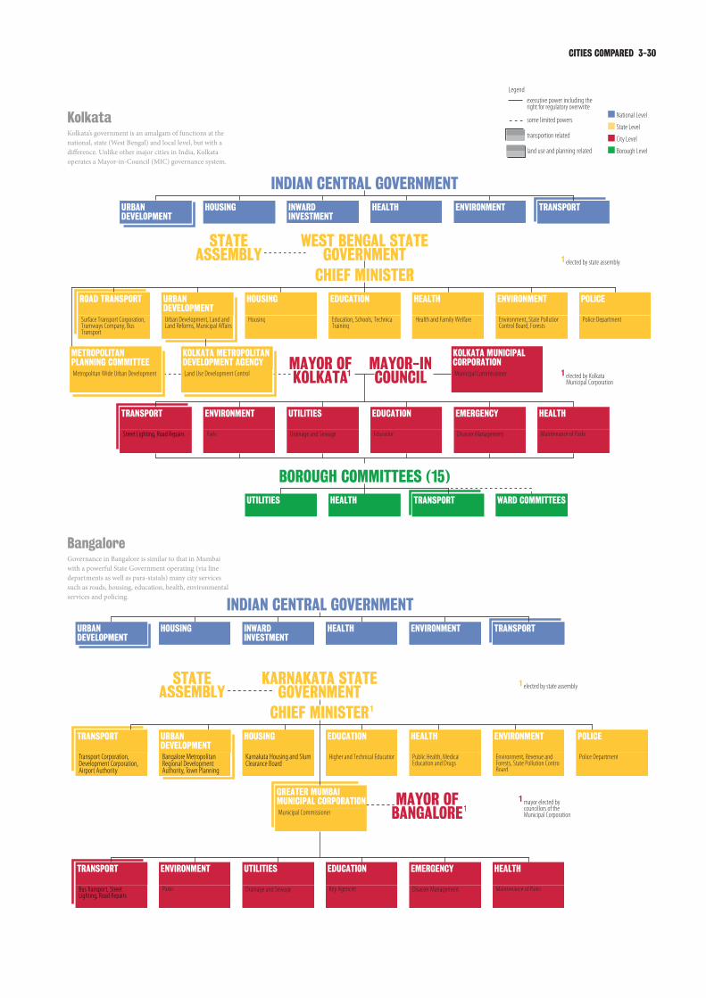
CITIES COMPARED 3-30
KolkataKolkata’s government is an amalgam of functions at the national, state (West Bengal) and local level, but with a difference. Unlike other major cities in India, Kolkata operates a Mayor-in-Council (MIC) governance system.
BangaloreGovernance in Bangalore is similar to that in Mumbai with a powerful State Government operating (via line departments as well as para-statals) many city services such as roads, housing, education, health, environmental services and policing.

3-31 INTEGRATED CITY MAKING
Streets, Sidewalks, Bicycle Paths, Road Repairs
LondonLondon’s government operates within a relatively centralised, unitary state. Several central departments have responsibilities within the city. The Mayor of London is the elected executive for a number of major city-wide services, notably public transport and spatial planning.
New YorkNew York City’s government operates within a legislative framework determined at state level (the federal state of New York). Within its powers, the city is powerful by international standards, with the Mayor of New York one of the most important politicians in the United States. Local legislation is the responsibility of the City Council.

CITIES COMPARED 3-32
JohannesburgSouth Africa’s new constitution regards the different levels of governance as spheres and aims to avoid any hierarchical structures. The country’s three-tier system assigns key powers to the city level with an executive mayor. Transport powers are most pronounced at the province (state) level where strategic projects are being administered.
BerlinBerlin’s city government is an element within Germany’s highly devolved federal system. The city is one of three in Germany that are simultaneously a Land (State) and a municipality. The Berlin senate is, therefore, an immensely powerful institution. Uniquely amongst the eight cities, Berlin and Germany merge powers for spatial planning and transport in one department.

3-33 INTEGRATED CITY MAKING
Governance Hierarchy3.3.3
This chapter examines more closely how governance powers are distributed vertically between national, state, city and borough levels. Below first an overview on the Indian situation followed by a comparison with the four international cases. Further details particularly in relation to the constitutional foundations of governance systems can be found in the annexe to chapter 3.
Developments in Indian urban governance
Mayors and Commissioners In India, local government is characterised as a ‘state subject’2 ; in other words, municipal governance is within the jurisdiction of the states, outside the sphere of national government legislation. Urban local government was not mentioned in the Indian constitution until the landmark 74th Amendment (see next section).
As suggested by one senior official in Bangalore,3 urban governance systems in India can be divided into two main models, the “Mayor-in-Council” model (as seen in Kolkata) and the “Municipal Commissioner” model (broadly applicable in Mumbai and Bangalore). In the “Mayor-in-Council” model the structure is composed of the Corporation with elected councillors from constituent wards, and a Mayor acting as executive authority, sharing responsibility with a cabinet of councillors selected by the Mayor. Kolkata’s municipal commissioner is responsible to the mayor-in-council. Local administration and service provision is provided through easily-accessible administrative units called borough4 committees, which have powers with respect to providing water and sewerage, minor repairs of roads, maintenance of parks, etc.
By contrast, in the “Municipal Commissioner” model (applicable in Mumbai and Bangalore), the Commissioner is neither drawn from nor accountable to the elected representatives, but rather appointed as a corresponding coordinative authority. The commissioner is independent within his sphere of activities, subject only to the general supervision of the Corporation. Moreover the commissioner heads the executive arm of the municipal corporation. Within this Commissioner centred system, the Mayor generally lacks executive authority.
This can be seen as a vestige of colonialism: senior administrative posts were reserved for representatives of the colonial power. However, it remained in place after independence: since states have found it useful to control municipalities and local governments by appointing the municipal commissioners.5
Delhi has an entirely different status. For most of its post-independence history, it was controlled by the national government with the Delhi Municipal Corporation and New Delhi Municipal Council as its local authorities. The 69th Amendment Act (1991) created special provisions for Delhi, calling it the National Capital Territory (NCT) Delhi, and giving it a ‘semi-state’ status. NCT Delhi has a legislative assembly with a chief minister as its chief executive, and the assembly can legislate on all issues on the ‘state list’ These include education and health, but the Act specifically removes police, public order and land from the assembly’s remit. The Act also gives precedence to national government if there is a legislative dispute.6 The Municipal Corporation of Delhi and New Delhi Municipal Council remain in operation under the national government. Consequent multiplicity of authority and responsibility is often cited as one of Delhi’s biggest challenges.7
Para-statals and the 74th AmendmentSince independence, Indian cities have also seen growth of specialised para-statal agencies dealing with erstwhile municipal functions such as housing, sewerage etc. Many would argue that these agencies have been established in an ad hoc manner to provide services beyond the capacity of under-funded local authorities in rapidly urbanising areas.8 Another view is that these para-statals are created for political reasons, to reward allies and control elected municipalities where opposition parties are in power.9 Para-statals are also seen as useful for state bureaucrats, concentrating power in their hands.10
The growth of para-statals, and the persistence of the municipal commissioner-centric model of local government, has diminished the capacity of elected local authorities to govern, reducing them to deliberative institutions. In 1992, to combat this trend, the Indian Government ratified the 74th Constitutional Amendment, to ensure that the elected 3-tier local government was a statutory provision for all urban areas. In addition, the 12th Schedule was created in the Constitution to list
The Constitution of the Republic 2
of India, (1950) Article 246
Lakshmi Venkatachalam, 3
Principal Secretary, Department of Urban Development, Government of Karnataka, April 2007
A Borough is a collection of 4
contiguous Wards. As per the 74th Constitutional Amendment, Wards are entities of local governance with statutory status in all municipalities with a population over 300,000 people. Thus Boroughs are an intermediate tier between the Mayor-in-Council and the Wards.
Sanjay Ubale, Secretary, 5
Special Projects, Government of Maharashtra, April 2007
The Constitution of the Republic 6
of India, (1991) The Constitution (Sixty-ninth Amendment) Act.
Delhi Government. (2006) Delhi 7
Human Development Report 2006: Partnerships for Progress, p.76
Uma Adusumilli, Chief Planner, 8
Mumbai Metropolitan Region Development Authority, March 2007
Ravindra Kumar, Editor and 9
Managing Director, The Statesman, March 2007
Pankaj Vohra, Political Editor, 10
Hindustan Times, March 2007

CITIES COMPARED 3-34
by the Urban Development Minister and Municipal
Affairs Minister.
Senior Planning Official, Kolkata
In both Mumbai and Bangalore, the MPC is still in the process of being formed with matters of composition, chairmanship, and specific powers still being finalised. Furthermore, the municipal corporations of all four cities have only limited authority to raise revenue from taxes, with property tax being the only real instrument. However, the State still decides the tax base, rates and modes of assessment.
Out of all the cities, the situation in Delhi is especially complex since it is home to the national government as well as its own state government. As a legacy of its federally-administered past, Delhi’s main planning and development agency (the Delhi Development Authority, DDA), Municipal Corporation of Delhi (which serves over 90% of the population) and the smaller New Delhi Municipal Corporation, are all under direct control of the national government. As a result, national government (through the DDA) can formulate major policy decisions relating to housing, industrial location, transportation
out the responsibilities that were best performed by elected local government structures.
To address the complex and inter-related needs of metropolitan cities, the metropolitan planning committees (MPCs) were proposed as platforms where integrated and strategic planning could be accomplished.11 However, some experts feel that the MPC’s remit should be extended beyond just planning to implementation as well.12 The 74th Amendment also laid out provisions to ensure the financial sustainability of local self-government entities. However, while many states have passed laws to prepare for implementing the Amendment, only West Bengal has set up a Metropolitan Planning Committee (for Kolkata) so far.
[The] Kolkata Metropolitan Planning Committee
(KMPC)… is a body headed by the Chief Minister
of the state. It has representatives from various
urban local bodies, and also from the various
departments. It is a 60-member body where almost
50% members are elected members… Members
from the general body are a part of sectoral
committees. Above these sectoral committees,
there is an executive committee, which is headed
This provision assumes special 11
significance given situations such as the Kolkata Metropolitan Area where 41 municipal corporations are engaged in urban management and planning functions. Without a Metropolitan Planning Committee to unify the plans of these corporations into a strategic plan, there would be significant duplication, confusion and waste of resources.
D. M. Sukthankar, Former 12
Municipal Commissioner, Brihanmumbai Municipal Corporation, April 2007
Box 3.1
THE DEvOLUTION OF POWER74th CONSTITUTIONAL AMENDMENT, INDIA
In 1992, the 74th constitutional amendment has introduced the basis for a new era of urban governance in India. It has made three significant contributions to the development of urban local government. First, it provides uniform, democratically elected and accountable local government. Second, it provides for an integrated planning system through the establishment of District Planning Committees (DPCs) and Metropolitan Planning Committees (MPCs). Third, this Constitutional amendment makes provisions for the financial sustainability of urban local bodies.
The Constitution (74th Amendment) Act provides for three types of municipal bodies: Nagar Panchayats for transitional areas (in transition from rural to urban), Municipal Councils for smaller towns, and Municipal Corporations for larger urban areas (Article 243Q). Article 243R states that all the seats in a Municipality shall be filled by persons chosen by direct election.
As regards the functional domain of these local bodies, the Act inserted the Twelfth Schedule (Article 243W) to the Constitution of India providing an illustrative list of municipal functions. In addition, Articles 243ZD and 243ZE provides for committees for District and Metropolitan Planning, respectively.
The District Planning Committees are expected to take up integrated planning for urban and rural areas in the district. The draft development plan to be prepared by District Planning Committees has to address critical matters of common interest such as sharing of water and natural resources etc. Similarly, to address the complex and inter-related needs metropolitan cities, the Metropolitan Planning Committee is envisaged as a platform where integrated and strategic planning can be accomplished.
However, as in the case of the DPC, while conformity legislation or enabling laws have been passed by more or less reproducing the language of the constitutional amendment, only West Bengal has set up an Metropolitan Planning Committee (for Kolkata) so far.

3-35 INTEGRATED CITY MAKING
which each of these agencies works they have
overlapping functions. Then there is a different
layer of a bureaucracy which is, in some sense,
responsible for planning and administration and
a policy agency which is the political system…
there is huge multiplicity of governance functions,
different kinds of bodies; elected bureaucratic and
service agencies. It makes chaos of what has to be
done in the city.
P. V. Ravi, MD and CEO, Infrastructure and Development Corporation Karnataka Limited, Bangalore
As can be inferred, urban governance in the four cities under study is a multi-layered and often complicated affair. In Mumbai, Bangalore and Delhi, the elected municipal government only has recommendatory powers while the real financial and administrative authority exists with an appointed bureaucrat i.e. the municipal commissioner. The structure in Kolkata comprising the Mayor-in-Council and the ward and borough committees is much more democratic and accessible to the people. Kolkata is also the only city of the four that has a functioning Metropolitan Planning Committee.
However, in all four cities, the existence of para-statals as well as national and state government departments, which often have urban development and planning functions independent of these municipal entities, leads to overlapping jurisdictions, and confusion about the roles and accountability of each institution. Unsurprisingly, this issue is one that has been highlighted by experts across all the cities15 and is one that will need to be urgently addressed.
Urban governance in the comparator cities -
structures and remits
Berlin, in addition to being the capital and the seat of the national government, has full state status and has the same powers and responsibilities as the other Lander in Germany’s federal structure. There is an elected house of representatives, which elects the governing-mayor who, along with 8 senators, forms the Berlin Senate or executive wing of the government. The city is further divided into twelve boroughs, each with a borough assembly and borough mayor.
In London, there was a long period during which the city was controlled directly by the national government. For fifteen years following the abolition of the Greater London Council,
planning etc, without including input from the state government or the municipal entities.13 This arrangement is contrary to the spirit of the 74th Amendment, and there is no provision of a MPC for Delhi. The Pradhan Committee on Multiplicity of Authorities in Delhi has recommended that both the DDA and the MCD be placed under the direct control of the State Government but this has yet to be implemented.
In Mumbai, the Brihanmumbai Municipal Corporation is the largest and richest municipal body in India. It is also unique since it is the only local body engaged in the provision and maintenance of a majority of civic services including water supply and sewerage, health and sanitation, roads, fire brigade, electricity and bus transport (through its subsidiary the Brihanmumbai Electric Supply and Transport Undertaking). However, para-statals such as the Mumbai Metropolitan Regional Development Authority (MMRDA), the Maharashtra Housing and Area Development Agency (MHADA) and Maharashtra State Road Development Corporation (MSRDC) are also active. Rail-based mass transit is run by the Indian Railways which is a national government agency. The disconnect between them and the state planning authorities is evident from the following statement referred to before.
We are at the mercy of the city planners... The
population in this area has increased a lot. In
the last eight years the number of passengers
has almost doubled. But when this was being
developed, the city authorities never told us about
the new housing plans and, most importantly, did
not leave any land for new railway stations.
Senior Transport Expert, Mumbai
Therefore, even though the Mumbai institutional set-up is simpler than that in Delhi, there are still multiple authorities that cause problems of coordination and duplication. Despite this, initiatives to streamline and integrate the urban planning and management system have been limited.14
Similar sentiments have been echoed by the experts in the case of Bangalore.
There is no single agency which plans and executes,
and lays a policy for what is to be done in the
city… If you look at the government acts under
Rakesh Mehta, Chief Secretary, 13
Government of National Capital Territory of Delhi, March 2007
Sanjay Ubale, Secretary, 14
Special Projects, Government of Maharashtra, April 2007

CITIES COMPARED 3-36
Box 3.2
TOWARDS A NATIONAL AGENDA FOR URBAN DEvELOPMENT, JAWAHARLAL NEHRU NATIONAL URBAN RENEWAL MISSION
In December 2005, the Indian government launched the USD 11 billion Jawaharlal Nehru National Urban Renewal Mission (JNNURM) for urban development over the next seven years throughout the country. The aim is to improve basic services in over 60 cities including those with a population of over a million, all state capitals and select cities of religious, historical and tourist importance.
The Mission stands for a fundamental change of attitude on the part of the Indian state which had previously focused predominantly on rural development. This Mission is largely seen as a response to pressure from some cities, particularly Mumbai, that are desperately in need of infrastructure improvements. It also reflects the realisation that cities are the engine of India’s growth and aims to re-emphasise that the National Government cannot only focus on mega-infrastructure but also needs to value urban infrastructure on the ground.
The Mission has three basic elements - integrated development of infrastructure, provision of basic services to the urban poor, and adoption of wide ranging urban sector reforms, which will facilitate establishment of linkages between asset-creation and asset-management and ensure long-term project sustainability.
The JNNURM also addresses the unwillingness of state governments to implement the 74th Constitutional Amendment and operates with a ‘World Bank approach where cities are only able to access national funds if they comply with the general agenda put forward by the National Ministry of Urban Development’. The Mission establishes a range of mandatory as well as optional conditions on the basis of which funding is made available to cities.
Cities that want to apply for JNNURM funding - which then needs to be matched with private capital - are required to commit to a roadmap on property tax, decentralisation, budgeting, the preparation of a City Development Plans (CDP) through multi-stakeholder consultations, and detailed project reports. Compliance to new policy is required in particular for urban land sealing, rent control, stamp duty and property rights. Of particular relevance is the implementation of metropolitan planning commissions which are needed to prepare holistic plans for entire metropolitan regions. JNNURM’s focus is three-fold. First, it looks at issues related to urban management and governance. Second, it aims to secure cities as key growth engines through urban infrastructure. Third, it emphasises non-spatial service provision to cities. JNNURM also operates as a toolkit for local governments, helping to implement projects. The mission requires quite a lot of freedom at the local level. Both the preparation of the municipal five year plans and their execution need to be done locally.
JNNURM has been largely welcomed throughout different constituencies concerned with urban development in India. Critiques range from the fact that the National Government seems to have an idea of decentralisation but still focuses on central implementation, to the worry that city development plans (CDPs) will largely be influenced by consultants due to a lack of local knowledge, and only lip-service to the required multi-stakeholder consultation. Some experts have also raised fears about increased slum demolition due to the need to release land for projects. Another important critique is that JNNURM places too much emphasis on the private sector and profitability/viability. Critics question the aim of ultimately having all infrastructural investment done by the private sector. Both these points raise worries about the urban poor being able to afford a certain basic minimum of services. A problematic issue is that key indicators used by the National Government to assess urban development in the different cities are not able to measure real successes or failures. Often, key indicators do not link to actual conditions on the ground, which are mostly immeasurable and incomparable.

3-37 INTEGRATED CITY MAKING
If you are going to think about infrastructure,
if you think about the housing market about
transportation, if you don’t think in a bi-state or in
a tri-state way…you really are only doing partial
planning. If you don’t start with a regional view, you
are a little myopic.
Senior City Official, New York City
To tackle its challenges, New York City is using local powers and local resources to increase the supply of affordable housing. The city is also subsidising the largest municipal affordable housing plan in the nation’s history. Over the next seven years, the city plans to commit billions of dollars to build and preserve 165,000 units of affordable housing. The city is creatively using zoning and regulatory powers to re-use vacant industrial sites in its old port areas to accommodate new development.
Johannesburg benefits from one of the most nuanced approaches to the allocation of governmental responsibilities. The South African Constitution, re-written after the end of apartheid, mentions three spheres (rather than the more conventional tiers) of government i.e. national, provincial and local, as distinctive, interdependent, and inter-related.19 It also asserts that a municipality has a right to govern local government affairs and that the national or provincial governments may not compromise or impede the municipality’s ability or right to exercise its powers. Furthermore, the national and provincial government must support the capacity of municipalities to manage their own affairs.
Planning and public transport are included in a municipality’s responsibilities.20 The Local Government Municipal Systems Act (2000) stipulates active engagement of the community in planning, service delivery and performance management, including developing a simple and enabling framework for planning. These participatory mechanisms must take into account the needs of those who can not read or write - e.g. providing writing services for oral suggestions and complaints.21 Although implementation of such provisions may not be complete, it is still of immense significance that they are incorporated into law. In Johannesburg, interviewees cited a range of agencies and the City Integrated Development Plan as the most critical tools for taking on the city’s most pressing challenges.
responsibilities and powers in the city were divided between national government and London’s 33 elected boroughs, an arrangement that was criticised for its lack of strategic planning.16 The 1999 Greater London Authority Act established the GLA, consisting of a scrutinising assembly and a directly-elected mayor. The mayor of London is responsible for strategic planning, policing, fire services, transport, economic development, and also (after new legislation in 2007) health, housing, and climate change mitigation and energy strategy.17 The boroughs remain responsible for local planning, schools, social services, local roads and refuse collection. Although the Act mentions that the national secretary of state may issue guidelines, or even over-rule the mayor in some cases, the mayor can play a strong leadership role in planning and development.
Despite this relatively limited remit, interviewees focused on the Mayor as the organising force.
In London, the Mayor and his office obviously play a
very large role in trying to shape the development
of the London economy with the London plan.
Senior Planning Expert, London
In New York, the Mayor was also cited as the organising force behind directing the spatial, economic and social development of the city. The New York City Charter, almost a city-constitution, lays out the responsibilities of the NYC government. The Mayor is the Chief Executive of the New York City Council, which has much greater powers than its five boroughs.18 The NYC Council, through the Mayor, is directly responsible for most of the city’s day-to-day affairs, but New York State has indirect control over housing policy, transport policy, and economic development through state-controlled public authorities.
But New York is at the epicentre of a much bigger region, and the City’s ability to take on these challenges also depends on the State of New York and whether the State has advanced policies that are city-supportive. In the United States, cities are a feature of their states rather than of the Federal government and different stages gave very different track records in empowering cities.
New York’s workforce is drawn from nearby States, such as New Jersey and Connecticut.
E. Sreedharan, Chairman and 15
Managing Director, Delhi Metro Rail Corporation, March 2007; Rakesh Mehta, Chief Secretary, Government of National Capital Territory of Delhi, March 2007; Ramesh Ramanathan, Co-Founder and Director, Janaagraha Centre for Citizenship and Democracy, Bangalore, April 2007; P.V. Ravi, MD and CEO, Infrastructure and Development Corporation Karnataka Limited, Bangalore, April 2007; Lakshmi Venkatachalam, Principal Secretary, Department of Urban Development, Government of Karnataka, April 2007; S. K. Chaudhary, Executive Director and Regional Chief, HUDCO, West Bengal, Kolkata, March 2007
UK Government (1985) Local 16
Government Act
The Greater London Authority 17
Act, (1999) and Amendment, (2007)
City of New York (2004) City 18
Charter
The Constitution of the Republic 19
of South Africa. (1996) Chapter 3
The Constitution of the Republic 20
of South Africa. (1996) Chapter 7
Republic of South Africa. (2000) 21
The Local Government: Municipal Systems Act, Chapter 4

CITIES COMPARED 3-38
have managed to resolve these tensions to enable clarity and accountability. This resolution is still awaited in many Indian cities.
There are grounds for optimism, however, and Indian cities face an exciting opportunity. As more cities move to implement the 74th Amendment, they have the opportunity to create this type of resolution for themselves, and thereby to unlock their capacity to actively manage their future.
Governance - concluding observations
The day-to-day significance of any of the constitutional arrangements discussed above will be variable. Constitutions set out only the positions and broad structures of urban governance (further details on this can be found in the annexe of chapter 3). The way these structures operate is often highly dependent on the individuals that occupy positions of power, as well as the influences that are exerted through multiple stakeholders. Yet, different constitutional and structural systems are more likely to respond to certain influences, and may lend themselves more easily to different styles of operation.
Nonetheless different governance settlements give different cities varied toolkits of ways to achieve their aims. In comparing the non-Indian case study cities to their Indian counterparts some patterns emerge. The chequered history of urban government in London demonstrates the tension - between state power, metropolitan power and local power - that all cities face, but most cities
Controlling planning and transport
The diagram shows the principal and secondary location of political powers over spatial planning and transport. Generally these powers are more centralised in India than in comparators.Source: Urban Age research
Spatial Planning Transport Planning
National
Regional
Metropolitan
City
Borough
New
Yor
k
Bang
alor
e
Berli
n
Lond
on
Joha
nnes
burg
Kolk
ata
Del
hi
Mum
bai
New
Yor
k
Bang
alor
e
Berli
n
Lond
on
Joha
nnes
burg
Kolk
ata
Del
hi
Mum
bai

3-39 INTEGRATED CITY MAKING
URBAN CHALLENGES3.4
Having summarised the key challenges for the four Indian cities in Chapter 2, below follows a brief overview on the challenges that were identified by experts in the other four case study cities, both through interviews and at the relevant Urban Age conferences. As illustrated below, these experts identified specific policy areas and objectives as challenges, while many Indian interviewees highlighted the problems with the government mechanisms needed to resolve these challenges. Both perspectives are valuable when discussing the complexities of managing and governing urban development.
London3.4.1
Over the last decade, London has enjoyed stable growth with a booming urban economy and has been able to re-enforce its status amongst the top three global cities as a financial powerhouse as well as a creative hub. Over the past 20 years, the city’s population has grown by an average of 45,000 persons per year. The population increase has accelerated in recent years and in 2005 reached almost 90,000 persons per year.22 Partially as a result of its success but also due to numerous structural deficiencies, London faces persistent challenges, emphasised in Urban Age interviews. Amongst experts, transport was most frequently referred to, followed by the city’s economic base, social inclusion, housing and the environment. Less frequently but nevertheless important were concerns about governance, planning, migration, urbanity and the labour market.
Transport remains a huge challenge for London, but it is also one of the areas where London has received most international attention for its innovation. It could easily be argued that only the recognition of urban transport as one of most pressing challenges paved the way for progressive demand management strategies such as London’s Congestion Charging or new forms of multimodal transport planning facilitated by Transport for London. In any event, transport was highlighted by the largest number of interview partners in London as one of the key challenges.23
More specific transport issues include underinvestment in infrastructure maintenance,24 road congestion, and sometimes severe overcrowding on trains, underground lines and buses, coupled with poor service quality. The
transport system also struggles to cope with a growing metropolitan region,25 a problem accelerated due to the lack of integrating urban activity patterns and land use.
Third, I think, it has to be transport, because
transport ties homes and jobs together, and there
are particular issues of transport relating/not
relating to the pattern of land use and particularly
to the activities that give rise to that land use and
generate a demand for transport and I don’t think
this is being handled 100% satisfactorily, although
we may get there.
Senior Planning Expert, London
Over the past decades, London has been incredibly successful in attracting banks, insurances and financial services from around the world while strengthening its position as Europe’s global city. And although the creation of new jobs within the service sector has more than compensated for the reduction of manufacturing jobs, the city’s economic base was mentioned most frequently as the second most important challenge. Experts stress that maintaining the growth of employment26 and fostering confidence in London as a business location27 will be crucial, in order to sustain London’s position as the world’s leading international financial centre.28
If for any reason, the financial services stop
growing or reduce, London’s integral problem will
be that [it] doesn’t have any other sector, which
is as firm as this. The next is something to do with
creativity; again globally, world advertising, and
design; including music and stuff like that- London
is a big place for that. The challenge is to keep
inventing these things that are going to be wanted
around the world which are going to make money,
which is the economic basis for London and for the
whole of Britain. This is one challenge.
Senior Planning Official, London
Related to economic prosperity is a far-reaching concern about social inclusion and the extent to which all of London’s citizens gain from the economic success of recent years.29 Despite a rapid growth in wealth and employment, some sections of society are not partaking in this prosperity; a result of a severe mismatch of skills and labour market needs.30
Transport for London. (2006) 22
Transport 2025, Transport Vision for a Growing World City
Including Irving Yass, Policy 23
Adviser, London First, August 2007; Sir Stuart Lipton, Deputy Chairman, Chelsfield Partners, August 2007; Manny Lewis, Chief Executive, London Development Agency, August 2007
Peter Wynne Rees, City Planning 24
Officer, Corporation of London, August 2007
Peter Bishop, Director, Design for 25
London, August 2007
Peter Hendy, Commissioner, 26
Transport for London, August 2007
Graham King, Head, City 27
Planning, Westminster City Council, August 2007
John Ross, Director of Economic 28
and Business Policy, Greater London Authority, August 2007

CITIES COMPARED 3-40
Number one would be, jobs and economy and
London is a very successful global city that has
however faced a lot of problems considering how
inclusive this growth is in terms of the ability to
encompass quite large sections of the population,
who are not I think fully joining in.
Senior Planning Expert, London
The impact of this widening gulf can be seen in the shortage and high cost of housing.31 Interview partners in London confirmed in particular the potential risk of imbalances within the housing market and its regional consequences.
London is so expensive that no one can live here or
things are so tight that people can’t find a place to
live and in fact a lot of people just give up. … I think
it is really going to make people say that this is too
much- I am not going to do this anymore..
Senior Planning Official, London
The growth of London in the south of the country
generally, is giving rise to this extraordinarily and
increasingly difficult imbalance in the housing
market with complex questions as to how London
relates to the region around it.
Senior Planning Expert, London
London’s environmental agenda focused, in the early years of the twenty-first century, on pollution: in 2000, the city’s air quality was the
worst of any capital city in Western Europe. The city government has recognised the importance of the problem.32 Pollution has reduced and the debate has moved on to address sustainable development as a whole, and in particular to tackling climate change.33 Interviewees in London also highlighted the importance of environmental quality in creating a good quality of life.34
Two further challenges are directly relevant to this report. First, interviewees continued to see problems with governance, political leadership35 and streamlined structures36 despite the successful introduction of the Greater London Authority. Some interviewees also argued that land-use planning needed to be more flexible and to enable better integration of infrastructure.37
New York3.4.2
City officials, business representatives and community leaders agree that housing bottlenecks, and particularly the shortage of affordable housing constitute a major challenge for the future of New York. The housing issue has economic, social and even environmental implications for the city’s future.
While the growth of the city is a boon to the city’s
economic health, the increasing demand for
housing at all income levels, in a city built to its
edges, puts additional pressure on housing prices.
Senior Planning Official, New York City
John Ross, Director of Economic 29
and Business Policy, Greater London Authority, August 2007
Irving Yass, Policy Adviser, 30
London First, August 2007
Irving Yass, Policy Adviser, 31
London First, August 2007
John Ross, Director of Economic 32
and Business Policy, Greater London Authority, August 2007; Manny Lewis, Chief Executive, London Development Agency, August 2007
Peter Hendy, Commissioner, 33
Transport for London, August 2007
Peter Bishop, Director, Design for 34
London, August 2007
Sir Stuart Lipton, Deputy 35
Chairman, Chelsfield Partners, August 2007
Peter Wynne Rees, Chief Planner, 36
City of London, August 2007
Graham King, Head, City 37
Planning, Westminster City Council, August 2007
LONDON
60%50%
40%
20%
10%
10%
10%
20%
40%
40%
London: Key Challenges
Stakeholders in London were asked about the three biggest challenges their city is currently facing.Source: Urban Age research

3-41 INTEGRATED CITY MAKING
The city’s economic prosperity is tied to its performance as a global centre. In order to remain competitive in the world economy, economic development officials believe that New York needs both to upgrade its basic infrastructure and to develop a cutting-edge telecommunications and transport infrastructure.
The city’s infrastructure is simply very old, although
it has survived remarkably well. Replacing physical
infrastructure is the task of the public sector, but
there are challenges for the private sector as well,
e.g. investments in the telecom area.
Kate Ascher, Executive Vice President, New York City Economic Development Corporation
There is a firm commitment to public transport and infrastructure investment in New York, both from government and private actors. Public transport is seen as beneficial to both New York City and the municipalities serviced throughout the New York Tri-State area. Public transport accessibility is deemed key to local economic development.
Our ridership has climbed to record levels and we
have also seen real estate development, not only
in the city but throughout the suburban regions
that we service. We went out to the suburbs and
what I found interesting is that almost every leader
in areas we service indentified our railroads and
transit systems as absolutely critical to their future.
Katie Lapp, Executive Director, Metropolitan Transportation Authority, Urban Age New York Conference, February 2005
Speaking from the standpoint of major employers,
we have significantly invested in the transit system.
I agree that this is a top priority for investment and
certainly agree with the current leadership of the
MTA. Their position is that investment in maintaining
services and security on the existing system has to
be the number one funding priority
Kathryn Wilde, President, Partnership for New York City, Urban Age New York Conference, February 2005
Interviewees agree that, in the face of economic volatility and more unstable employment dynamics, city government needs to generate local employment actively. But urban actors disagree on the policies and interventions that can best achieve this outcome.
I like to think that the actions of city government
do create jobs. But there is sobering evidence that
this role is very limited. Studies show that, rather
than reductions in local taxes or improvements
to educational outcomes, the factors with an
actual influence are infrastructure investments
and service delivery that improve private sector
productivity.
Carl Weisbrod, President, Real Estate Division for Trinity Church and Member of the Board of Directors, Lower Manhattan Development Corporation, New York
Educating the resident population is a major issue for city government. Delivering quality educational services is not only seen as a social imperative but also as the backbone to the city’s future economic development in a knowledge-based economy.
Every child should have a right to a good
public education. But this is also an economic
development strategy. When you don’t educate
kids, they can’t become part of the work force.
You can do big economic development projects in
the city, but the people who live there won’t get the
jobs. I think education makes a big difference in the
quality of life in New York over the long terms, and
in our ability to engage in serious visionary planning.
Esther Fuchs, Special Advisor to the Mayor for Governance and Strategic Planning, Urban Age New York Conference, February 2005
Economic development patterns and rising property prices have led to a decrease in middle-income groups living in the central city. Middle-class residents also find difficulty in finding adequate schools and other services. Supporting the urban middle class is a seen as a priority for the city to maintain a socially diverse profile but also to steer development towards a more balanced and sustainable direction.
The loss of the middle class is a challenge for the
city. With the middle class absent, all sorts of things
play out. Take congestion, the middle class works
in the city but lives elsewhere. It tears apart the
fabric that makes the city work, and it changes
the way people commute back and forth. It then
disenfranchises the poor because the economy
continues to slip.
Christoper Ward, Former Commissioner, Department of Environmental Protection, New York City

CITIES COMPARED 3-42
Community leaders demand more policies to address deepening social inequalities in the city. City government has responded in a number of ways, including zoning schemes promoting mixed-used and mixed-income residential developments to increase opportunities among the city’s diverse population.
New York and other world cities generate, on
the one hand, wealth, knowledge and creativity,
but on the other, inequality, segregation and
poverty. As much as we need policies to sustain
the positives, we also need to wrestle with the
negatives. We must think of how to get healthcare
benefits to workers in a flexible labour force; how
to insure minimum livable wages; how to protect
the manufacturing jobs that provide entry level
opportunities and are now threatened by the rise in
real estate values; how to create mixed-use spaces
that also benefit low-income communities.
Brad Lander, Director, Center for Community and Environmental Development, Pratt Institute, Urban Age New York Conference, February 2005
We see incentives in zoning policy and the links
between additional density and the creation of
affordable housing as a bedrock way of fighting the
potential increased segregation that the city may
face as the result of rising real estate values. There
has been attention in social policy in the US on how
to break concentrations of poverty. Compared to
this “pull” of integration policy, not enough attention
is given to the mechanisms to insure that new
communities that we are creating, e.g. through
re-zoning, are inclusive from the very beginning in
terms of both income and race.
Shaun Donovan, Commissioner, Department of Housing Preservation and Development, Urban Age New York Conference, February 2005
Environmental protection is seen as key to the city’s long-term prosperity. Together with the search for more sustainable forms of waste management, sustainability policies in New York focus on the protection of the city’s numerous waterways and recovering waterfront areas for public use.
In New York City, until 1983 every single toilet to
the west side of Central Park, from the George
Washington Bridge to Canal Street, went directly
into the Hudson River untreated. That is just an
astounding amount of environmental degradation
that took place in the Hudson River and almost
killed it. Now they have miraculously turned it
around, and cleaned it up. You can almost swim in
the Hudson River.
Christoper Ward, Former Commissioner, Department of Environmental Protection, New York City
In response to demographic growth and intensifying land uses, the city pursues structural densification, seeking to increase residential densities in areas close to employment clusters and well-served by public transport. Densification initiatives take urban design and neighbourhood character into consideration, increasingly relying on form-based plans.
New York is experiencing a remarkable resurgence,
and reaping unprecedented immigration, population
growth, and private investment…This is a
tremendous challenge to those of us in charge of
planning this city. We must find places to channel
this growth, while preserving local character. We
have a challenge to provide, in those areas we
can grow, enough density to ensure affordability;
enough density to leverage open public space;
enough density to provide vitality and vibrancy of
neighbourhoods. At the same time, we need to
respect the built fabric of adjacent communities.
The city’s strategy has been to direct growth
to transit-oriented regional centers throughout
the five boroughs, while discouraging growth in
low-scale neighborhoods lacking mass transit
resources. Each rezoning proposal is an urban
design master plan working block-by-block,
designating places to grow while protecting the
unique built context of each neighbourhood.
Amanda Burden, Chair, City Planning Commission and Director, Department of City Planning, New York City
Several large-scale urban development projects are currently underway in New York City. Reversing previous trends, city government has taken a more assertive attitude towards physical planning and regeneration schemes. The question remains on how best to integrate public consultation and the participation of residents into the planning process.
From a governance perspective, I think with
processes such as the Unified Land-Use Review

3-43 INTEGRATED CITY MAKING
Process (ULURP) all the public gets to do in New
York City is basically obstruct development but not
really feed into it in a constructive way. I think this
is preventing us from planning in any kind of serious
way.
Esther Fuchs, Special Advisor to the Mayor for Governance and Strategic Planning, Urban Age New York Conference, February 2005
Berlin3.4.3
The challenges identified by stakeholder interviews in Berlin differ substantially from any other city in this investigation. Most importantly, Berlin is the only city where all interview partners confirmed the enormous challenge of one single issue: the city’s labour market, which in turn relates to ongoing consideration of the city’s function in Germany and Europe. Berlin’s aging population is another Berlin-specific issue requiring a tailored local approach, as is the need to reform a large and change-resistant public sector and a continuing budgetary crisis. At the same time, references to well known urban challenges such as segregation, the environment, public transport, implementation capacity and land policy also appeared as essential points in Berlin.
Berlin’s weak urban economy is well documented and its grave effect on the city’s labour market was the single most significant challenge all interview partners in Berlin agreed upon.38 Unlike other large German cities (and other Urban Age cities), Berlin’s GDP per head (USD 22,134) is significantly lower than the national average.
Consistent with this economic weakness is the city’s high unemployment rate of about 19%, the persistent legacy of Berlin’s history as a divided city.39 As in many other developed world cities, the decline of manufacturing industry has proved to be particularly problematic for blue-collar workers, who often lack the skills for jobs in growth sectors like the service sector, creative and cultural industries, and research and technology.
Berlin has to have an additional innovative
employment sector; research and technology
related to be more precise. But also other services
will be crucial.
Hilmar von Lojewski, Head, Urban Planning and Projects, Senate Department for Urban Development, Berlin
Directly related to the struggle of Berlin’s economy is the issue of its function. Today, Berlin is a quasi-metropolis with cosmopolitan flair but limited economic reach. It seems unclear how innovation and the knowledge economy could turn around the city’s stagnation and to what extent it can acquire a new role as part of the EU’s eastward expansion.40 Finally, Berlin’s role as the German capital is still compromised with numerous governmental bodies still located in the former capital of Bonn.41
There is certainly the big question how to activate
the potentials for large cities within the area of
innovation, knowledge networks and knowledge
society.
Engelbert Lütke Daldrup, State Secretary, German Federal Ministry of Transport, Building and Urban Affairs, Berlin
Berlin has a relatively strong middle class and comparatively low levels of inequality (Germany’s Gini index is 28 compared to 34 in the UK, and 45 in the US), but concerns regarding social segregation are frequently emphasised in the city. In fact, it is a defining debate in many German cities and has led to the creation of a significant federal funding programme called ‘social city’.
The second theme in Berlin is certainly similar
to many other German cities, the issue of
integration. This does not only include the question
of integrating migrants or their second or third
generations but also people of different social
classes and age groups.
Klaus J. Beckmann, Director, German Institute of Urban Affairs (Difu), Berlin
Interviewees also frequently spoke about the environment, an issue which tends to receive great attention in Germany. With regards to urban development, the debate is coupled to the liveable cities agenda 42 aiming for a higher quality of life across the metropolitan region. It is for this reason that motorised transport continues to be seen as one of the most problematic factors with a severe negative impact on local environments, air quality and safety. Over the last years and similar to many other cities around the world, energy consumption and CO₂ emissions are increasingly dominating the debate on environmental sustainability.43
Klaus J. Beckmann, Director, 38
German Institute of Urban Affairs (Difu), Berlin, July 2007
Christian Gaebler, Speaker, SPD 39
Parliamentary Group, Berlin Senate, July 2007
Siegfried Dittrich, Director, 40
Transport Planning, Borough Berlin-Mitte, July 2007
Hilmar von Lojewski, Head, 41
Urban Planning and Projects, Senate Department for Urban Development, Berlin, July 2007
Christian Gaebler, Speaker, SPD 42
Parliamentary Group, Berlin Senate, July 2007
Friedemann Kunst, 43
Director, Transport Planning, Senate Department for Urban Development, Berlin, August 2007

CITIES COMPARED 3-44
Experts in Berlin also highlight the city’s struggle to reform its public administration. As a direct result of the particular history of Berlin’s public management which was heavily subsidised by federal sources prior to re-unification, inefficiencies became built into the system that is difficult to modify.45 At the same time, planning in the city became too dependent on public-private partnerships, thereby marginalising public-led initiatives.
The second challenge includes the need of
Berlin’s planning policy to recognise that urban
development lead by public bodies can not only
be delivered based on public-private partnership
but that they have to come forward with their own
initiatives.
Hilmar von Lojewski, Head, Urban Planning and Projects, Senate Department for Urban Development, Berlin
The degree of public debt that was accumulated in Berlin over the last two decades is arguably a massive challenge, confirmed in interviews as a crucial limitation on city finance. Berlin today has more than Euros 60 billion in total debts - Euros 17,000 debt per capita.46 Besides capital intensive investments into infrastructure, housing and regeneration, these debts were created by speculative developments on the part of one of the State-owned banks.
I would think the third theme, that in particular
gained importance in Germany as a whole,
is the environmental quality which nowadays
focuses increasingly on the issue of CO₂, climatic
consequences and the reduction of CO₂ emissions.
Klaus J. Beckmann, Director, German Institute of Urban Affairs (Difu), Berlin
A more particular challenge is the overall demography of Berlin, an issue that to date has not been identified in the other cities examined. The average age in Berlin is relatively high as a result of an increasing percentage of older people together with low reproduction rates prevalent in most parts of the country. According to experts, this requires the city to particularly address adequate policies for children and youth, making it far more attractive to raise kids in the city.44 At the same time, interviewees emphasised the emerging competition amongst European cities to attract the younger generation.
The frequently quoted issue which I myself refer
to quite regularly is the demographic development
of European cities. The increase of an ageing
population puts us into direct competition for
attracting the young in Europe. That includes many
other big cities such as London and Paris but also
cities in Spain.
Ingeborg Junge-Reyer, Senator for Urban Development, Berlin
Franziska Eichstädt-Bohlig, 44
Opposition Leader, Bündnis 90/Die Grünen, Berlin, August 2007
Jan Eder, Managing Director, 45
Berlin Chamber of Commerce and Industry (IHK), July 2007
Senatsverwaltung für Finanzen. 46
(2007) Haushalt und Finanzen Berlins. Ein Überblick. BERLIN
100%
50%
30%
40%
20%10%
10%
10%
20%10%
Berlin: Key Challenges
Stakeholders in Berlin were asked about the three biggest challenges their city is currently facing.Source: Urban Age research

3-45 INTEGRATED CITY MAKING
We have to solve this financial crisis which we have
slipped into through political failures. This structural
and financial crisis must be overcome and the
reduction of debt needs to be addressed.
Friedemann Kunst, Director, Transport Planning, Senate Department for Urban Development, Berlin
Johannesburg3.4.4
Johannesburg is experiencing rapid growth, economically, demographically and physically. But, added to the challenges that all cities and regions face as they try to accommodate growth, recent dynamics in Johannesburg include highly complex, unbalanced and contested developments. A top planning priority for the twenty-first century is to steer the city’s expansion towards more socially desirable conditions.
Johannesburg has about 4 million people, and there
are about 9-10 million in the city-region. This is one
of the fastest growing cities of Southern Africa. We
are looking at an additional 50% more people within
10 years, and a possible doubling of our population
in 15-20 years. Therefore I think that a critical
priority is finding ways to manage growth without
exacerbating the existing social tensions in the city.
Philip Harrison, Executive Director, Development Planning and Urban Management, City of Johannesburg
Johannesburg like any developing city in the third
world faces development pressure. This has
an implication for open space protection and
management. Appropriate measures should be
put in place to reduce the impact on open spaces
thereby making them available for environmental
means.
Bhutana Mhlanga, Department of Environment and Planning, City of Johannesburg
Emulating their peers in numerous other cities around the world, and largely influenced by internationally widespread planning paradigms, economic development specialists in Johannesburg seek to stimulate local growth by placing the city in strategic positions within global networks of production, consumption and distribution. Part of this agenda is to prepare the city to service markets throughout the African continent and beyond, as well as to host events and activities considered to be world-class.
The view is that if we can make the city globally
competitive, there will be a trickle down effect.
Everyone will benefit, not least the poor. This
way of thinking involves considerable amnesia.
Johannesburg has been globally integrated from its
very beginning. It was a boom city and at that very
moment when there was a massive flow of foreign
investment, when it was at its height of global
belowHigh density apartment housing in Johannesburg is limited to the city’s core and often linked to overcrowding, squatting and substandard living conditions.Adam Broomberg and Olivier Chamarin

CITIES COMPARED 3-46
Our perspective is that of a Gauteng without
borders, not just only within the province but also
externally. We want to look at the city region in
functional terms. Before implementing this initiative,
we found four independent proposals for new
freight hub airports being developed by different
municipalities. We found eleven development
corridors that stopped at municipal boundaries
with no discussion with adjacent municipalities. We
found that local governments were setting up their
own development agencies, they were setting up
their own tourism agencies, all chasing a bigger
slice of the same cake.
Steve Topham, Managing Director, International Development South Africa, Urban Age Johannesburg Conference, July 2006
In South Africa, there is a strong focus on inter-
governmental co-operation. Spheres are distinct in
our Constitution, but inter-related at the same time.
Over the last twelve to fifteen years we have seen
not only the role of local government written into
our Constitution and the devolution of significant
powers to the local level, but also a far-ranging
consolidation of our local government boundaries.
We have gone from 1100 local authorities in 1994 to
our current 283.
Andrew Boraine, Chief Executive, Cape Town Partnership, Urban Age Johannesburg Conference, July 2006
competitiveness, the very foundations of apartheid
were laid down: the compound system, pass laws,
migrant labour, the whole range of things and the
spatial realities of Johannesburg.
Jeremy Cronin, Deputy Secretary General, South African Parliament, Urban Age Johannesburg Conference, July 2006
The initial vision in the city very much focused on
the economy and on the concept of producing a
sort of world-class city. This vision was received
with some caution and even criticism from some
quarters. It seemed to ignore many other aspects,
particularly of human development. It seemed to
only be dealing with the city’s linkages with the
global economy.
Philip Harrison, Executive Director, Development Planning and Urban Management, City of Johannesburg
Johannesburg is part of a large and dynamic urban region that government officials and planners are now calling the Gauteng City-region. Many interviewees call for more policy coordination among the multiple metropolitan governments of Gauteng in order to avoid dysfunctional competition within the city-region. In terms of multi-level governance, municipal, provincial and national cooperation is required by the South African Constitution and, though not easily achievable, an effective way of synergising funding streams and sectoral programs.

3-47 INTEGRATED CITY MAKING
Furthering inclusion and generating a sense of belonging are among the top social challenges for Johannesburg. The city needs to grapple with both historical and novel problems of economic, social and spatial inequality. As well as the spatial legacy of apartheid, which excluded the majority population, Johannesburg is facing the challenges of economic globalization, suburban sprawl, and large-scale in-migration.
Since 1997 we have created a third more formal
sector jobs in Johannesburg. That is a big number.
At the same time the rate of unemployment
remains stubbornly high, because as we create
jobs so people move to Johannesburg. We have
an in-migration rate which adds nearly 5% to our
population a year.
Lael Bethlehem, Director, Johannesburg Development Agency, Urban Age Johannesburg Conference, July 2006
Even though the metropolitan economy has expanded significantly, Johannesburg still has high rates of unemployment, and the employment level in some local areas is alarmingly low. The task for planning and economic development practitioners is to create local employment opportunities and career-ladders leading to liveable wages and sustainable livelihoods. One important hurdle is the skills gap between the city’s workforce and opportunities arising in the new Johannesburg economy.
In Johannesburg disposable income has grown
43% since 1997. There have been 380,000 new jobs
created. However, unemployment remains the big
issue. It sits at 30%, when estimated on the basis of
an expanded definition that includes discouraged
job seekers. According to some measures, about
a quarter of the population lives in poverty, and of
course economic growth is not shared equally by
different parts of the city.
Rashid Seedat, Director, Corporate Planning Unit, City of Johannesburg, Urban Age Johannesburg Conference, July 2006
In response to previous shortages in Johannesburg, and in South Africa as a whole, government has focused on the production of affordable housing. Large-scale schemes have been able to house previously neglected populations, but on the other hand ambitious quantitative targets have led to housing being built in less desirable areas that are poorly serviced
by transport networks. Producing the housing needed in the right places, while overcoming past inequalities, is an important planning issue for Johannesburg.
At the beginning of the democratic era most
housing was built in the peripheries of the city,
because land was available there, and people
in need of housing where also located in those
areas. But over time we have realised that you
cannot do that. People are being marginalised and
disadvantaged by still being on the periphery of the
city. New housing projects now need to be located
closer to economic opportunities and to other
infrastructures such as transport.
Samantha Naidu, Director, Housing Department, City of Johannesburg
Traffic congestion has risen in Johannesburg as a result of population growth and increasing car-dependency. But many residents still suffer from spatial isolation, being unable to reach employment centres or social services. The issue for planning is producing efficient and equitable multi-modal transport solutions that, coordinated with the distribution of land-uses, will effectively serve the city’s polycentric structure and diverse populations.
There is an increasing level of congestion. Even
if you double the lanes, people are still buying
more cars. This is also because of the lack of a
good public transport system, and it continues
to put pressure on the infrastructure of the city.
Therefore, we need to change the mindset and
reconcile people with the public transport system.
But we also need to improve existing minibus taxi
services, 72% of people in Johannesburg still use
this mode so it still remains a very important public
transport mode.
Alfred Sam, Director, Transportation Planning and Regulation, City of Johannesburg
Johannesburg needs major infrastructure investments, not only to improve existing conditions but also to meet the additional requirements that arise from rapid growth. The issues for planning concern the coordination and joint-management of public investments across different levels of government as well as the use of large-scale events as catalysts of infrastructure investments.

CITIES COMPARED 3-48
Everybody is asking if we are going to be ready
for the World Cup. There is one thing that is going
to make us ready, if we can sort it out. That is
Metrorail. It is not sexy to sort out Metrorail. It is
much more sexy to talk about stadiums and so on.
But we need a very good rail network in Gauteng.
The rail network to working class areas is good. It is
not used because it is not safe and that is what we
should be prioritising.
Lisa Seftel, Deputy Director, Department for Public Transport, Gauteng Province, Urban Age Johannesburg Conference, July 2006
Improving liveability in Johannesburg is a crucial task for planning in the city. High crime rates affect quality of life in the city severely. Low life expectancy and poor health conditions in Johannesburg are also reflective of the city’s quality of life deficits. While these issues fall mainly within the realms of security and public health specialists, innovative approaches to urban planning and city design have also begun addressing the mounting challenge of liveability in Johannesburg through environmental improvements and interventions on the city’s built form.
We recognise that crime and the perceptions of
crime impact negatively on investor confidence
and this creates barriers to economic growth but
that is only part of the issue. When policing was
devolved from the national government to the
city, it was clear that local government needed
to play a bigger role in the issue of safety and
security, integrating these issues to overall urban
management. Our focus now is to create a safe,
secure city where people can enjoy the benefits of
urban life free from the fear of crime and violence.
I think that in this way we also create, inadvertently,
the conditions for investment to foster economic
growth.
Nazira Cachalia, Programme Manager, Economic Development Unit, Johannesburg 2030 City Safety Plan, Urban Age Johannesburg Conference, July 2006
Once abandoned by the city’s business community and neglected by governmental policies, downtown Johannesburg is now the object of serious regeneration efforts on the part of public and private actors. These efforts focus on goals such as attracting businesses; promoting clusters of cultural activity; refurbishing the existing stock of vacant office space; re-branding the area’s stigmatised image and attracting residents; generating vibrant street life; and improving transport connections.
The office space of downtown Johannesburg
has become more adaptable to the changing
environment that we have in front of us. We are
also seeing a very different type of investor, real
estate player in this game, the shift moving away
from the institutional pension funds to other types
of players and I think that by itself is starting to
influence how buildings are used and what they are
being used for.
Francois Viruly, Professor of Property Studies, School of Construction Economics and Management, University of Witwatersrand, Urban Age Johannesburg Conference, July 2006
aboveBy far the largest share of public transport in Johannesburg is facilited by informal Minibus taxi service.Graeme Williams

3-49 INTEGRATED CITY MAKING
Johannesburg also aspires to be “a world class African city for all”; London aspires to become “an exemplary, sustainable world city”; Mumbai is “transforming…into a City of the Millennium”; while New York is striving to become “A greener, greater NY”; Kolkata intends “…to remain… the industrial and intellectual hub”; and Berlin aspires to brand itself as “city of change”.
While these tag lines underscore a common ambition to reach, or sustain, world class status, these cities are far from identical. Some cities are faced with the challenge of upgrading millions of slum housing units, while others are striving to maintain housing affordability. Some cities are confronted with limited economic growth, if not economic decline, while others have surpassed economic expectations. Some cities are attempting to manage high crime and its impact on overall urban prosperity, while others have experienced some of the lowest crime rates in decades. Clearly, these simple examples illustrate the immense distinction found across the eight cities, and that they are at different economic, as well as social and environmental, ‘starting points’.
The Roadmap to becoming world 3.5.1 class
So there is plenty of distinction between the eight cities in terms of their most vexing challenges and most compelling assets. Are their roadmaps to become ‘world class’ as distinct? Or are they as similar as their tag lines appear to be?
While a library of literature exists arguing for cities to balance economic, social and environmental goals, these eight city stories tell us they need a more tailored approach. Three
CITY vISIONS3.5
Is visionary planning reawakening from its timidity? Are cities in this new urban age - which are changing at a speed, at a scale, and with a complexity never witnessed before - trying to manage, if not boldly choreograph, how and where these changes occur? Further examination of Urban Age cities tells us that many have articulated a vision to guide their future development. But nothing is ever quite that simple; cities can, and do, have multiple visions in the form of multiple plans. Furthermore, some of these visions are authored by different urban actors with disparate values, goals and aspirations.
Urban Age researchers reviewed a vision or visionary plan authored by eight of our Urban Age cities,47 with the aim of understanding how the cities saw their own future, and what they thought was most important to future success. In some cases, these plans were recently released, offering a snapshot of a city’s most current thinking. In other cases, plans were in place, widely understood and commonly referred to by practitioners as their roadmap.
While the differences between these urban aspirations are interesting, what is also intriguing is that all have found it necessary to ‘sum up’ their future vision with a short city brand or tag line. With over 400 cities above one million residents today, compared to 140 in 1960, each of these eight cities has made sure to stake their future claim in the midst of increasing competition: to be ‘exemplary’, ‘greater’, if not ‘world class’:
For Bangalore, it’s to be “a City of the Future”; in Delhi, the aspiration is to “make Delhi a global metropolis and a world-class city”;
BERLIN ‘city of change’
JOHANNESBURG ‘world class African city’
MUMBAI‘city of the millennium’
KOLKATA‘industrial and intellectual hub’
BANGALORE‘city of the future’
DELHI‘global metropolis and world-class city’
NEW YORK ‘greener and greater city’
LONDON ‘exemplary, sustainable world city’
City visions
Overview on prevailing vision tag lines for the eight case study cities.Source: Urban Age research

CITIES COMPARED 3-50
to stimulate the market and attract resources to fund, among many other investments, the tripling of Mumbai’s freeways and expressways.
With low unemployment, a rebounding economy, and a crime rate at a 40-year low, New York’s vision intends to play its part in addressing the global environmental crisis. For New York, to become greener and greater translates into 127 programmes to help the city to achieve the cleanest air quality of any big US city and reducing carbon dioxide emissions by 30%. Of all the recommended investments, the one receiving most international attention is New York’s congestion pricing strategy for Manhattan. However, in spring 2008, the speaker for New York State Assembly confirmed that this strategy would not be introduced for vote and ratification due to its overwhelming opposition. This incident has impeded an opportunity for New York City to set an important precedent for U.S. cities to ‘up the ante’ of cities’ roles in the reduction of greenhouses gas emissions.
Four cities see that a balance between economic, social and environmental goals is their way to proceed: For Berlin, to become City of Change means striking a balance between advancing their economic power, advancing social inclusion and diversity, and strengthening Berlin as an ecologically green city. Like Kolkata, Berlin’s plan also recognises the value and power of the region. Facing a financial crisis and needing to meet the needs of an aging population, Berlin is channelling development inward rather than exporting resources to broader geographic areas.
Delhi’s ambition, to become a global metropolis and a world-class city, underpins a vision for India’s capital as a global metropolis, where residents are engaged in productive work, adequate housing is provided, and environmental conservation is at the very least contemplated. The weakest vision of the eight cities by far, Delhi offers no quantitative goals or measures and no clear spatial link between aspiration and implementation.
For Johannesburg, to be a World Class African City denotes serving as the key economic hub on the continent and where prosperity is shared in a way that “enables all residents to gain access to the ladder of prosperity...” 48 While the emphasis of Johannesburg’s vision is sustained (economic) shared (inclusive) growth, the vision also underscores the need to reduce the city’s vulnerability to global and local environmental
cities argued this balance was indeed their way forward while several others instead specifically emphasised economic and social imperatives.
Some cities are seeking to grow a world-class economy while sorting out how to grow more inclusively: For Bangalore to become a City of the Future means consolidating their ‘economic strengths’, such as IT, biotech, and healthcare while improving the housing conditions of the many residents who have been excluded from the city’s economic success. But the speed and scale of Bangalore’s success has also meant sprawl. Their vision, recognising their inability to provide adequate support and services to an outward stretching city, suggests that continued growth could ultimately mean losing their international success and status, or restricting expansion to selected areas. While the plan emphasises an integrated approach to tightening their development patterns and developing a blend of new public transportation options, it is unclear how a new elevated ring road and a peripheral ring road will further these goals.
For Kolkata to remain… the industrial and intellectual hub is translating into expanding their focus to the metropolitan region scale to identify its true assets and attributes. Unlike most other Indian cities, Kolkata looks outward, recognising the region’s projected population growth, the size of the region’s skilled workforce, and regionally linked infrastructure as the necessary ingredients for long-term success. While the plan is not written with an inspirational tone, it nonetheless advises that this city needs: nine industrial centres, streamlined travel for the plethora of goods traversing the city, and to target specific economic niches. At the same time, Kolkatta intends to target the urban poor for ‘redistributive justice’. Like the other cities in India, this means upgrading slum housing and providing water and sanitary services.
For Mumbai to be a City of the Millennium translates into reducing slums from an incredible 50-60% to 10-20%, while at the very same time, growing its annual GDP to eight-ten per cent. These substantial goals are not the only ambitions for this city. They aspire to reduce air pollution, increase educational attainment, while increasing travel speeds. Given the scale of their challenges and the conflicts that exist between some of these goals, questions arise as to how they will be able to achieve all these aims. The vision argues for strong governance reforms and lower tax rates
Bangalore Development 47
Authority (2007) , The Bangalore Vision. Bangalore Master Plan 2015; Senate Department for Urban Development (2000), Strategie Berlin 2020 (StEK 2020); Delhi Development Authority (2005), The Vision 2021. Master Plan for Delhi 2021; City of Johannesburg (2006), Growth and Development Strategy; Kolkata Metropolitan Development Authority (2001), Vision 2025: Perspective Plan of CMA; Greater London Authority, (2004) The London Plan: Spatial Development Strategy for Greater London; Bombay First and McKinsey (2003), Vision Mumbai: Transforming Mumbai into a World-Class City; City of New York (2007), PLANYC: A Greener, Greater New York. .
City of Johannesburg. (2006) 48
Growth and Development Strategy, p. 84

3-51 INTEGRATED CITY MAKING
One interviewee described London’s tradition as “almost anti-planning” with a long history of private sector-led—and consequently piecemeal—development. But the Mayor’s strategic although loose vision is essential given that “no one has the ability or power to stamp any particular imprint on the city,” shared Peter Bishop, Director, Design for London.
Growing differently into world 3.5.2 class status
With ‘world class’ status on the minds of so many cities, their city visions are increasingly viewed as a necessary instrument to guide intentions. A good vision can act like a measuring stick, a guiding light, a beacon of bold moves to create some degree of order and prioritised action in the midst of speed, complexity and chaos.
Some cities are in fact managing to pull off many of their documented intents, even in the midst of a highly organic process of urbanization. All cities, even those with limited results to show for their efforts, have managed to identify their unique set of challenges and assets as the basis for justifying necessary change. Those cities facing economic problems argue that a strong economic imperative is fundamental to achieving truly inclusive and sustainable growth.
In other cases, cities now on solid economic ground are currently able to take stock of how their economic success can be balanced with social and environmental imperatives. As history has shown us, today’s most economically advanced cities reached their place not by striking this balance but by placing a stronger emphasis on making economic gains.
But today, given what we know of the causes and consequences of global warming, countries and their cities—irrespective of their economic starting point—are under pressure to find more environmentally responsible ways to grow. These additional demands, and heightened scrutiny, require cities and their nation states to think differently about how city visions can reconcile these varied objectives. We are not there yet.
risks. This means becoming an environmentally sustainable city by changing its settlements patterns to reduce reliance on motorised vehicles.
When asked about Johannesburg’s vision, city leaders pointed to the city’s Integrated Development Plan as the roadmap for directing the city long-term. A few years ago, Johannesburg completed ‘Vision 2030’, a vision primarily for advancing the city’s economy. It received immense criticism for failing to adequately address some of the city’s pressing social challenges, such as poverty and unemployment. With the Integrated Development Plan, growing a socially inclusive city is a major thrust.
In addition to providing a long-term roadmap for becoming a “world-class African city”, the development of this vision was an exercise of integrating multiple visions from disparate sectors.
It certainly is a vision that has been developed
jointly by the various departments, because we
have city processes where departments and
managements should go away and formulate this
vision, and focus on the interrelationships.
Alfred Sam, Director of Transportation Planning and Regulation, City of Johannesburg.
“[The vision] also provides direction for various departments so as to how they should move forward,” added a senior official in Johannesburg.
And, finally, for London to become an exemplary, sustainable world city, their spatial plan explicitly argues that the balance across the trinity is what it will take to move this city in the right direction. London therefore aspires to become “a city for people, a prosperous city, a fair city, an accessible city and a green city.” While keeping a careful eye on economic growth, their visionary plan outlines three bold housing strategies, with one being the promise to eliminate all sub-standard housing within ten years. To make London a sustainable city, it intends to recycle more waste, restrict new development to previously developed sites within the city’s green belt, and to set tough new targets for on-site renewable energy provision. The vision also sets out, in broad terms, the ways in which different opportunity areas will play a part in realising this vision.
rightNew York City’s Central Park is surrounded by high-rise towers and Manhattan’s dense urban grid. The 3.41 km² (843 acre) park was created in the mid-nineteenth century to provide a place of refuge for the city’s expanding population.Richard Berenholtz

CITIES COMPARED 3-52

3-53 INTEGRATED CITY MAKING
ANNEx - CONSTITUTIONAL FOUNDATIONS OF GOvERNANCE SYSTEMS
Governance, especially in a democratic state, is a complex and shifting process of reconciling competing interests. In large cities, this process becomes more intensified, with millions of people living together in a limited geographical space. The questions of “who decides?” and “how do they decide?” become even more difficult to answer. An entry point into these questions and one of the most important bases for urban governance is its constitutional foundation. Of course, no constitution is perfectly enforced, and the millions operating in informal economies and structures often remain outside its reach. Yet, constitutional provisions do provide a starting point for analysing governance systems and structures. This section attempts to outline the constitutional foundations of those systems. The word ‘constitutional’ is used in its broadest sense, including not only national codified constitutions, but also state constitutions and other elements of a legal framework.
Individual and government rights and
responsibilities
The constitutions of India, South Africa, Germany, the US and the UK all guarantee certain basic human rights, such as the right to life, freedom of expression, freedom of religion, equality before law etc. The Indian Constitution distinguishes between civil and political rights. The former are seen as inalienable, and are included in the Fundamental Rights Section of the Constitution. The latter are seen as discretionary, and are included in the Directive Principles of State Policy as responsibilities of the government. The German and South African constitutions include both socio-economic and civil-political rights in their Basic Rights or Bill of Rights section. In the Urban Age context, it is interesting how these rights and responsibilities relate to land-use, planning and the shape and form of cities. For this purpose, we shall examine two rights in greater detail- the right to housing, and the right to property, as well as the organisation and priorities of spatial development.
Right to Housing
The Indian Constitution makes no mention of the right to housing or shelter in its codified form. However, there have been certain landmark judgements such as in the Olga Tellis vs. Bombay Municipal Corporation (1985), in which the
right to housing was upheld as a part of the right to life, right to a livelihood, and right to settle in any part of the country. Yet, there have been several later judgements that do not uphold the right to housing. Since the right to housing is not specifically mentioned in the codified constitution, it is left entirely open to the interpretation and discretion of the courts. Although the Bombay Municipal Corporation Act does give the Municipal Commissioner the power to acquire land for housing accommodation, it does not mention a right to housing. Moreover, the Maharashtra Slum Areas (Improvement, Clearance and Redevelopment) Act, 1971, gives greater powers in declaring an area a slum, and the Maharashtra Vacant Lands (Prohibition of Unauthorised Structures and Summary Eviction) Act considers all land encroached by settlements to be vacant. In contrast, in Johannesburg, the right to housing is a part of its Bill of Rights of the South African constitution, which also protects against eviction without a court order. In Berlin, although the German constitution does not mention the right to housing, the Berlin constitution provides for a right to housing, and considers it a duty of the state to promote adequate housing for low-income groups. Similarly, in New York, though the U.S. constitution does not mention housing, Article 18 of the New York State Constitution says that the legislature may provide for low-income housing.
Right to Property
In India, ‘the right to property’ was initially included as a Fundamental Right in the constitution, which also provided for the acquisition of property by the state in ‘public interest’ or for ‘proper management’. However, following independence there was a strong attempt to reform the zamindari (landlord-control) system, which led to many disputes. In order to facilitate the land-reform process, the right to property was revoked as a Fundamental Right, and became only a common legal right in 1978 through the 44th amendment. In Mumbai, the Municipal Corporation Act grants the Municipal Commissioner the powers to claim an area for clearance, or redevelopment, and acquire property in those areas once designated. South Africa provides an interesting parallel in terms of land-reform concerns. Though it includes the right to property in the Bill of Rights, it also allows for land reform as well as compensation and redress of past racial discrimination. The German Grundgesetz or Basic Law declares

CITIES COMPARED 3-54
from 1940-levels, in order to protect tenants. In most cases, the impact has been that owners have had little incentive or resources to maintain or improve their properties, leading to their dilapidation. Together, the Urban Land Ceiling Act and the Rent Control Act effectively limited supply of land and drove up urban land prices. Also, the Municipal Corporation Acts do not clearly lay out priorities for spatial development, but do emphasise services such as sanitation and water supply.
The city with the strongest legal expression of the organisation, priorities and function of spatial development is London. The Greater London Authority Act (1999) clearly states the GLA’s responsibility for economic and social development and the improvement of the environment, taking into account the health of London’s inhabitants and greater sustainable development in the UK. The preparation of a spatial development strategy and a transport strategy, is prescribed as one of the GLA’s duties (to be exercised by the elected Mayor). To these responsibilities, the GLA Act (2007) also adds a London Housing Strategy, as well as a Climate Change Mitigation and Energy Strategy. As guidelines for the transport strategy, the act speaks of “safe, integrated, efficient and economical transport facilities and services,” and specifically mentions that these must include facilities for pedestrians.
Johannesburg’s priorities are also expressed legally. The South African Constitution sets out the responsibilities of local government. These include ensuring the provision of services in a sustainable manner, and promoting social and economic development as well as promoting a safe and healthy environment. Also, the Local Government Municipal Systems Act (2000) says that municipal planning should be development-oriented, and that there should be a single, inclusive and strategic plan that links and integrates sector-specific plans. The National Land Transportation Transition Act states that “land transport planning must be integrated with the land development process.”
Berlin and New York’s spatial development priorities are not so clearly expressed in legal documents, although the New York City Charter does mention the “orderly growth, improvement and future development of the city including housing, business, industry, transportation, distribution, recreation, culture, comfort, convenience, health and welfare of its population.”
the right to property in Article 14, but says that ‘property shall also serve the public good’, and article 15 provides for socialisation. Private property is given the highest merit by the US constitution, which puts “life, liberty and property” together, almost equating them in value. Yet, even the US governance structure provides for eminent domain i.e. powers through which government may acquire property, and the New York State constitution includes the construction of roads as a justifiable reason for the acquisition of land. In the UK, theoretically, all property belongs to the Crown and there are different kinds of freeholding or leaseholding rights, but these are not absolute. The Compulsory Purchase Act (1965) sets out processes of compulsory purchase, and the Town and Country Planning Act (1990) allows the local government authority, with consent from the national government, to acquire land for “development, redevelopment or improvement”, or in “interests of proper planning”.
Organisation, Priorities and Operation of Spatial
Development
The Indian constitution does not express much concern for the organisation or priorities of urban spatial development, which reflects the attitude and situation at the time of its writing that “India lives in its villages.” However, policies, mentioned in the Constitution, did lead to certain acts that impacted spatial development in cities. The preamble of the Constitution declares India a ‘socialist democratic Republic’ and resolves to secure social and economic justice as well the equality of opportunity and status.
The Directive Principles of State Policy include minimising inequality in income, and eliminating inequality in status and opportunity as well as ensuring that ownership and control of material resources are best distributed to serve the common good. It was such principles that led to the Urban Land Ceiling Act (1976), which put a ceiling on the amount of land a private entity could own in a city to “prevent the concentration of urban land in hands of the few”. In effect, this made development in cities the monopoly of government development agencies for more than two decades. In 1999, the government repealed the Urban Land Ceiling Act, in an attempt to encourage and enable more private participation in urban development. Another act, which has been critiqued for adversely affecting development in cities, is the Rent Control Act that provided for minimal increase of rents

4-1 INTEGRATED CITY MAKING

INTEGRATED CITY MAKING 4-2
INTEGRATED CITY MAKING4
leftCentral London and the river Thames viewed from Canary Wharf.Philipp Rode

4-3 INTEGRATED CITY MAKING
ChApTER 4 - INTEGRATED CITY MAKING TAblE of CoNTENTs
4.1 INTRoDUCTIoN 4-4
4.2 DIMENsIoNs of INTEGRATIoN 4-4
4.3 ThE RATIoNAlE foR GREATER INTEGRATIoN 4-54.3.1 The global environmental challenge 4-6
4.3.2 Increasing complexities and interrelationships 4-7
4.3.3 Greaterlong-termefficiency 4-8
4.3.4 Theparticularityoftransportandcityaccess 4-8
4.3.5 Facilitating baukultur 4-10
4.3.6 Requirements for a holistic vision 4-10
4.4 IMpEDIMENTs To INTEGRATIoN 4-11 4.4.1 Limits of joining-up 4-12
4.4.2 Advantages of sectoral silos 4-12
4.4.3 Fragmented governance 4-14
4.4.4 Political power 4-15
4.4.5 Conflictinginterests 4-16
4.4.6 Legacyofspecialisationand segregated practice 4-16
4.4.7 Scepticism about integration 4-17
4.5 INTEGRATED polICIEs foR spATIAl DEvElopMENT 4-194.5.1 European Union 4-19
4.5.2 United Kingdom 4-20
4.5.3 Other contexts 4-21
4.6 INTEGRATED GovERNANCE 4-234.6.1 Organisational integration 4-23
4.6.2 Geographicintegration 4-28
4.7 INTEGRATED plANNING 4-304.7.1 The London Plan 4-31
4.7.2 Berlin Land Use Plan 4-42
4.7.3 Johannesburg’s integrated planning strategies 4-52
4.7.4 NewYorkCity’szoning 4-55
boXEsTransportaspartofcitymakingIndia’snationalurbantransportpolicy 4-22
Regional coordination in India TheKolkataMetropolitanDevelopmentAgency 4-23
Taking the long viewKing’sCrossre-development,London 4-38
Crossing urban barriersOlympicsandLowerLea,London 4-40
WorkingwiththefinegrainofthecityHackesche Höfe, Berlin 4-45
LivinginthenewcitycentrePotsdamerPlatz,Berlin 4-49
Integrating projects on the groundAlexandra, Johannesburg 4-53
Re-zoningforaffordablehousingJamaicaQueens,NewYorkCity 4-56

INTEGRATED CITY MAKING 4-4
INTRoDUCTIoN4.1
Across contemporary politics, management and planning, integration is regarded as a positive feature, both as a prerequisite for and as an indicator of success. But integration is seen as an either/or concept. Nuances between fully ‘integrated’ and ‘fragmented’ are not considered and too often questions about the level of integration desirable or in fact possible are not addressed.
The quest for greater integration is neither new nor particularly ground-breaking. Within politics it tends to be an updated version of the well established agenda of coordinating policymaking and synchronising public administration.1 More recently, however, the rhetoric of ‘holistic’, ‘joined-up’ or ‘integrated’ policy and service delivery has increasingly dominated political debates and has left recognisable marks within government structures, decision making and planning processes. And indeed, the global environmental challenge, coupled with increasing difficulties for governments at all levels to respond to new sets of interdependencies, have elevated the universal need for simple coordination to a far more ambitious strategy for integrated governance.
These new forms of interconnected governance are of particular relevance to cities with their rapidly increasing complexities and entwined dependencies. In fact, urban development is often featured as the ultimate testing ground for greater policy synchronisation and has already produced many of the most innovative practices. In recent years, well-documented integrated policy has emerged from cities as diverse as Barcelona, Johannesburg, Bogota, Kolkata, London and Berlin. Furthermore, it is the exceptional interdependence of spatial development and transport that has pushed these disciplines to the forefront of an agenda for greater synchronisation. Again, it is in cities that this relationship is most pronounced and the need for consistent policy integration most urgent.
Despite these pressures, decision makers and practitioners still find it difficult to find robust strategies that allow for the desired level of policy coordination. 2,3 In particular, as pointed out by Cowell and Martin, there is a sustained naivety regarding the “tough political decisions about control, resources, organisational design, and (potentially conflicting) policy objectives”4 that result from shifting towards more joined-up
practice. Looking at spatial development, Kidd comes to similar conclusions that “while there is general recognition that integration is an essential feature of spatial planning, understanding of its complexity in terms of spatial planning theory and practice is still emerging.”5 Generally, there is surprisingly little academic literature and research on policy integration. Meijers and Stead suggest that it “should be regarded as a relative frontier of knowledge” while its understanding “can build on some decades of research in organisational science addressing cooperation and coordination between different sectors.” 6
This chapter reviews some of the academic discussions, addresses the rationale for and barriers to integration, then looks more specifically at the findings of Urban Age research on how to achieve better integration between planning, transport and governance.
DIMENsIoNs of INTEGRATIoN4.2
Over the last decades, the widespread use of the term ‘integrated’ to characterise policy, governance and planning approaches has blurred the very meaning of the word. Underdal, as quoted in Meijers and Stead, proposes the following three basic features of integrated policies: First, comprehensiveness (recognising a broader scope of policy consequences in terms of time, space, actors and issues); second, aggregation (a minimal extent to which policy alternatives are evaluated from an ‘overall’ perspective); and third, consistency (a minimal extent to which a policy penetrates all policy levels and all government agencies).7
Meijers and Stead also list some of the many more or less synonymous concepts that form part of the greater family of ‘integrated policy-making’: “coherent policy making (OECD, 1996), cross-cutting policy-making (Cabinet Office, 2000), policy coordination (Challis et al, 1988; Alter and Hage, 1993), concerted decision-making (Warren et al, 1974) and holistic government, also known as joined-up policy (Wilkinson and Appelbee, 1999) or joined-up government (Ling, 2002).”8
Three related terms - coordination, cooperation and integration - are often applied in interchangeable ways, but they are subtly different both in their policy impact and in the need for formally structured processes that they require.
Meijers and Stead present a valuable hierarchy of integration, as described in the diagram
Pollitt, C. (2003) “Joined-up 1
Government: a Survey,” Political Studies Review 1 (1) , 34–49
Cowell, R. and Martin, S. 2
(2003) “The joy of joining up: modes of integrating the local government modernisation agenda,” Environment and Planning C, Government and Policy 21(2) 159 – 179
Meijers, E. and Stead, D. 3
(2004) “Policy integration: what does it mean and how can it be achieved? A multi-disciplinary review,” Berlin Conference on the Human Dimensions of Global Environmental Change, Freie Universität Berlin
Cowell, R. and Martin, S. (2003) 4
“The joy of joining up: modes of integrating the local government modernisation agenda”
Kidd, S. (2007) “Towards a 5
Framework of Integration in Spatial Planning: An Exploration from a Health Perspective,” Planning Theory & Practice, 8:2, 161 – 181
Meijers, E. and Stead, D. (2004) 6
“Policy integration: what does it mean and how can it be achieved? A multi-disciplinary review”
Ibid7
Ibid8

4-5 INTEGRATED CITY MAKING
below. Starting with cooperation, which seeks more efficient sectoral policy, the hierarchy then moves on to coordination, where sectoral policies are adjusted to make them more coherent with each other, and finally reaches integration, where different actors work together to create joint policies. For them, this hierarchy correlates with an increase in interaction, interdependence, formality, resources, lack of autonomy, comprehensiveness, accessibility and compatibility.9
Each of these categories includes several elements. Within sectoral integration Cowell and Martin differentiate between cross-sectoral integration - integration between different policy areas within a single organisation - and inter-agency integration.11 Geographic integration, often referred to as territorial integration,12,13 is a direct response to inefficient disjointed planning approaches as a result of different administrations overseeing different but related geographic areas.14 The relationships between these areas can be vertical (where different tiers of government overlap) or horizontal (which seeks coherence between neighbouring authorities).15 The third and final category is organisational integration - an umbrella for greater cooperation between parties.16 This can involve integrating a specific function, like spatial planning, at strategic, operational and disciplinary levels.17
Cowell and Martin emphasise the importance of distinguishing the various categories and sub-categories of integration by concluding that “current policy discourses tend to conflate all of these very different types of joined-up working, and often fail to recognise the tensions that can exist between them.”18
ThE RATIoNAlE foR GREATER 4.3 INTEGRATIoN
Two factors have accelerated the need for greater integration: globalisation and sustainable development.19 Together they epitomise the dynamics of an increasingly interdependent world and reinforce the need for integration between different tiers of government as well as between different countries, states and cities.20 Kidd observes that “Economic, social and environmental issues are now perceived as not only sectorally interrelated, but also as multi-layered, with actions at each layer influencing and being influenced by other layers.”21
At the same time as these factors have assumed rising importance, the role of the state and its organisational principles have been re-thought in recent decades, with an emerging rhetoric of third-way politics, public service delivery, regionalism and devolution. For the UK, Cowell and Martin identify a particular need for coordination as a result of fragmentations at local government level: “the marketisation of key public services and the erosion of traditional local authority functions (see Smith, 2000) have increased institutional fragmentation, blurring lines of accountability as duties, powers, and resources have been spread increasingly thinly across an array of special-purpose bodies, businesses, voluntary organisations, and community groups.”22
At the city level, calls for greater policy integration are motivated by far more pragmatic reasons and are usually a response to the negative outcomes of sectoral policies of previous decades. These calls have been most insistent in relation to spatial planning, city design and urban
Integration pyramidSource: Meijers & Stead (2004)
Cooperation
Coordination
Integration
Interaction
Interdependence
Formality
Resources needed
Loss of autonomy
Comprehensiveness
Accessibility
Compatibility
(between sectors)
Joint new policy
Adjusted + moree�cient sectoralpolicies
More e�cientsectoral policies
Meijers, E. and Stead, D. (2004) 9
“Policy integration: what does it mean and how can it be achieved? A multi-disciplinary review”
Ibid10
Cowell, R. and Martin, S. (2003) 11
“The joy of joining up: modes of integrating the local government modernisation agenda”
Kidd, S. (2007) “Towards a 12
Framework of Integration in Spatial Planning: An Exploration from a Health Perspective”
Cowell, R. and Martin, S. (2003) 13
“The joy of joining up: modes of integrating the local government modernisation agenda”
Kidd, S. (2007) “Towards a 14
Framework of Integration in Spatial Planning: An Exploration from a Health Perspective”
Shaw & Sykes (2005)15
Ibid: Consequent upon both 16
sectoral and territorial integration is a requirement for co-operation between parties in the form of organisational integration (de Boe, 1999, p. 19)
Cowell, R. and Martin, S. (2003) 17
“The joy of joining up: modes of integrating the local government modernisation agenda”
Ibid18
Kidd, S. (2007) “Towards a 19
Framework of Integration in Spatial Planning: An Exploration from a Health Perspective”
Ibid20
Ibid21
Cowell, R. and Martin, S. (2003) 22
“The joy of joining up: modes of integrating the local government modernisation agenda”

INTEGRATED CITY MAKING 4-6
transport. Not only do these policy areas combine exceptionally high levels of interdependence between organisational, professional and policy ‘silos’, but they represent areas exposed to enormous public pressure for policy change, as reflected in the Urban Age expert interviews and conferences.
To reiterate and categorise those factors that are of particular relevance to integrated policy making, the overview below will address the following: the global environmental challenge, recognising causalities, greater long-term efficiency, the particularity of transport and city access, facilitating baukultur, and the requirement for a holistic vision.
The global environmental 4.3.1 challenge
The current focus on integrated development is heavily influenced by the sustainability agenda that began dominating political debate in the late 1980s. This challenged previously applied
development approaches, seeing them as a threat to mankind and ecological systems. Policy making was also seen as too re-active, focusing on repair of damage through re-forestation, re-generating urban territory, re-storing natural habitats, and re-habilitating wild land.23 On a global level, the acknowledgement that future development will have to include a far greater systemic approach was introduced by the UN Rio Declaration on the Environment and Development in 1992.24 As the declaration’s intellectual backbone, the Brundtland Report of 1987 coined the term ‘sustainable development’ and specifically referred to the need for more sectoral integration and for the changes to the machinery of government needed to achieve this.
“The objective of sustainable development and the integrated nature of the global environment/development challenges pose problems for institutions, national and international, that were established on the basis of narrow preoccupations and compartmentalised concerns. Governments’ general response to the speed and scale of global
belowNot even 2% of Mumbai’s residents use private cars to get to work. Their vehicles already occupy most of the city’s road space.
belowSlum dwellings along Mumbai’s waterfront are exposed to severe flooding risks. Throughout the city, informal settlements have occupied land unsuitable for housing, exposing its residents to the increasing dangers following sea level rise and storm intensification as a consequence of climate change.Philipp Rode
World Commission on 23
Environment and Development (WCED) (1987) The Brundtland Report, Oxford University Press
United Nations (UN) (1992) UN 24
Rio Declaration on the Environment and Development

4-7 INTEGRATED CITY MAKING
Idon’tknowofanyevidencethatsuggeststhat
fragmentation or deregulation would work better
[thananintegratedtransportauthority].
PeterHendy,Commissioner,TransportforLondon
One is unable to come up with sound and consistent
policies when things have been segregated and
specialised too far.
Friedemann Kunst, Director, Transport Planning, Senate Department for Urban Development, Berlin
Links between land-use and transport are particularly important and can only be properly understood when professionals jointly consider possible consequences.33 It is at this particular interface that traditional sectoral approaches have simply been unable to confront emerging challenges, most notably the immense increase in vehicular growth and congestion regardless of endless efforts for road expansion programmes. The self-reinforcing dynamics of road building with consequences far beyond the transport sector were persistently underestimated. The resulting process of suburbanisation, with increasing travel distances and a huge jump in energy consumption and carbon emissions, has overwhelmed introverted sectoral planning.34
Negative side effects that are not able to be identified by purely sectoral planning can significantly compromise overall policy progress. Often, introverted disciplines are not even able to learn from failure or success in other areas. This is particularly pronounced when one sector is characterised by quantitative measures, the other by qualitative - architecture and transport planning being a good example.35
Of course this leads to the third dimension. The
urbanlayoutalwaysincludesthebuildingandpublic
space, and public space is also the street. The
debateabsolutelyincludestransportplanningwhich
hasalteredthecityradicallyinthepost-warperiod
andhaschangedtheperceptionofthecityentirely.
Friedemann Kunst, Director, Transport Planning, Senate Department for Urban Development, Berlin
In turn, integrated policy-making often generates strategies that can indeed address particular side effects and are able to limit their contra-productive effects.36 Integrated approaches are not always able to find the ideal strategy, but recognising causalities allows policy-makers
changes has been a reluctance to recognise sufficiently the need to change themselves. The challenges are both interdependent and integrated, requiring comprehensive approaches and popular participation.” 25
More recently, Lafferty and Hovden summarised integrative requirements of the Rio Declaration as follows: “One of the key defining features of ‘sustainable development’ is the emphasis on the integration of environmental objectives into non-environmental policy-sectors … It will have to involve a break with ‘politics as usual’ in the direction of a more principled and consequential integration of environmental concerns in all sectoral activities.”26
Increasing complexities and 4.3.2 interrelationships
In order to take informed decisions about urban development options, policy makers need to consider possible consequences at various geographic levels, for different sectors as well as for a range of time spans. Therefore, it is argued that decision-making has to be positioned at a stage that allows for all three to be professionally reflected as well as democratically decided. This logic further demands that those development components that interact and inform each other need to be considered together when being deliberated, planned and decided.27
De Boe suggests that the interest in integration largely stems from concerns about sectoral divisions28 which are often held responsible for the mainly unexpected, and often unwanted, environmental consequences of their ignorance about external effects.29 Sectoral planning is often further limited to strategies that only deal with effects but not the origins of problems.30
The creation of blind spots - issues that are overlooked by policy - is an additional negative side effect of heavily departmentalised governance. Anderson argues that policy not only fails to respond to these issues but might even fail to articulate the problem fully.31 Kidd summarises the potential negative consequences of sectoral approaches by suggesting “that they can result in competing and contradictory objectives and duplication of effort, and ineffective, in that they ignore the complexity of interactions between different areas of public policy interest.”32
World Commission on 25
Environment and Development (WCED) (1987) The Brundtland Report, Oxford University Press
Lafferty, W. M. and Hovden, 26
E. (2003) “Environmental policy integration: towards an analytical framework,” Environmental Politics, 12:3, 1
Peter Hall, Bartlett Professor 27
of Planning and Regeneration, University College London, August 2007
Kidd, S. (2007) “Towards a 28
Framework of Integration in Spatial Planning: An Exploration from a Health Perspective”
Meijers, E. and Stead, D. (2004) 29
“Policy integration: what does it mean and how can it be achieved? A multi-disciplinary review”
Siegfried Dittrich, Director, 30
Transport Planning, Borough Berlin-Mitte, July 2007
Anderson, W. (2005) “Wiring up 31
Whitehall: Ensuring Effective Cross –Departmental Activity,” Journal of Security Sector Management, Volume 3 Number 3
Kidd, S. (2007) “Towards a 32
Framework of Integration in Spatial Planning: An Exploration from a Health Perspective”: (e.g. Knox, 2003)
A. K. Jain, Commissioner, Delhi 33
Development Authority, March 2007
Christian Gaebler, Speaker, SPD 34
Parliamentary Group, Berlin Senate, July 2007
Friedemann Kunst, 35
Director, Transport Planning, Senate Department for Urban Development, Berlin, August 2007
Engelbert Lütke Daldrup, State 36
Secretary, German Federal Ministry of Transport, Building and Urban Affairs, Berlin, July 2007

INTEGRATED CITY MAKING 4-8
of agglomeration economies with significant increases in transport, land and energy efficiency is only fully activated by integrating the various aspects of development.
But again, development of the spread out cities
is not a good solution because the cost of
transportation goes high. The cost of living and the
costofseweragealsobecomeveryhigh.IfIhave
to make a sewerage line from here to 30 km, it will
beveryexpensiveforme.Evenprovidingelectricity
andwaterwillbeveryexpensive.Itwillbevery
expensive for people to go to work.
S.K.Chaudhary,ExecutiveDirectorandRegionalChief,HUDCO,West Bengal, Kolkata
The particularity of transport 4.3.4 and city access
Transport planning demonstrates how integrated planning can enhance efficiency. Traditional transport planning is locked into an isolated silo of professionals looking at improving the way people move through the city. Here, improvements are primarily about increasing the speed of travel of motorised transport modes, each mode being addressed by separate departments. Possible solutions for urban transport congestion were not only limited to a small set of tools within each modal discipline, (e.g. road widening, more flyovers or tunnels) but
openly to address competing objectives. Testing for all possible consequences is an important feature of advanced urban development practice37 - not least because it facilitates an open dialogue about priorities when one objective competes with another.
Greaterlong-termefficiency4.3.3
Many development strategies are able to improve the situation only in the short-term, while severely compromising long-term objectives. Coherent long-term planning on the other hand is virtually impossible based on a fragmented planning system.38
I would never regard sectoral planning as
superior in the long-run. It tends to have short-
term advantages and is superior with regards to
implementation.However,theywillcomealongwith
all the disadvantages.
Klaus J. Beckmann, Director, German Institute of Urban Affairs (Difu) Berlin
Integrated approaches contribute to greater efficiency and in many instances have led to an improved use of scarce resources. For spatial planning and transport, resource efficiency is directly linked to environmental sustainability, with land and energy as key resources. But even from an economic perspective, the notion
aboveDowntown Johannesburg has suffered a severe decline in business activities and today remains heavily underutilised regardless its high public transport accessibility and potential of combining working and housing.Philipp Rode
Klaus J. Beckmann, Director, 37
German Institute of Urban Affairs (Difu) Berlin, July 2007
Peter Hendy, Commissioner, 38
Transport for London, August 2007

4-9 INTEGRATED CITY MAKING
Transportplanningshouldnotonlyconcentrate
onoptimisingtransportfunctionality.Ifonlythat
wouldbedone,moretrafficwouldbegenerated
and I would have to build more infrastructure
toeasetrafficflows.However,weknowabout
the related side effects and if a goal has been
established such as reducing the environmental
impactsoftransport,therearelimitsbywhichIcan
expandthetransportsystem.ThenIhavetore-
organiseandoptimisethesystemlookingatspatial
development.
Friedemann Kunst, Director, Transport Planning, Senate Department for Urban Development, Berlin
A focus on city access rather than transport has already led to the rehabilitation of one important feature of efficient urban structures - that of mixed use, which is increasingly welcomed particularly within the transport community as an essential tool.
Actually,thecorrectthingistomakethese
thingsalmostself-supporting.Ifyoucanhavea
combinationofresidentialblocks,officeblocks,
commercial areas, a lot of movement, a lot of
pressure on the public transport can be reduced.
SeniorTransportOfficial,Delhi
Withinacitytherearesmallurbangrowthcentres
where people will have to travel, a kilometre for
office,forshopping,forentertainment.Thatis
how housing matters or those relating urban
development, urban renewal, sewerage, drainage
etc. have to be planned - in an integrated manner.
SumantraChowdhury,SecretaryofTransport,GovernmentofWest Bengal, Kolkata
Greater synchronisation between land-use and transport is further emphasised from the spatial development perspective where both strategic decisions and specific projects need to acknowledge transport access as an integrated issue.
Onecannotsay,‘Weareinacentralplaceandthat
iswhyastreetneedstobebuilttous.’Acentral
placeiswherethereisalreadyexistingrailand
road access.
IngeborgJunge-Reyer,SenatorforUrbanDevelopment,Berlin
also failed to activate multi-modal synergies (e.g. park & ride solutions).
The problems are worsened by the fact that decisions are made at a level too low for recognising city access as the real issue, of which movement is just one element: what really lies behind transport is access to different activities and services such as housing, working, shopping, education, and leisure opportunities. And while traditional transport planning narrowly looks at optimising the journey from activity A to activity B, it misses the far greater opportunity of facilitating access to activity A and B. The latter includes strategies of reducing the physical distance between the two or even combing them in one location. Ironically, many transport solutions of the past have severely compromised the latter.
There should be integrated planning. Transport
cannot just work in a vacuum. … Now if
geographical planning is made so that people are
required to travel less, then transportation planning
becomeseasy.
SumantraChowdhury,SecretaryofTransport,GovernmentofWest Bengal, Kolkata
City access can only be optimised when looking at least at transport and land-use together. But a fully integrated approach to transport needs to go beyond city access by incorporating economic, environmental and social aspects. It is only in this way that one elevates decision making to the level where these aspects can be properly taken into account. Alfred Sam, the Director of Transportation Planning in Johannesburg pointed to the need for a mindset change around this historical division of land-use planning and transport. Similar remarks were made in all other cities investigated; below are two examples of Mumbai and Berlin.
I think it is essential [integration of land-use and
transport].Otherthansayingthatit’sapartofthe
city,Ithinkitisnownecessarytodoit.Wehave
neverdoneitinthepastandnowweclearlysee
that the effects of that in terms of where we are
currently.Iguessweneedtointegrateallthatat
this point.
SanjayUbale,SecretarySpecialProjects,GovernmentofMaharashtra, Mumbai

INTEGRATED CITY MAKING 4-10
I used to look at some of these projects, which
were being developed in Southwark - marginal
blocksofflats,milesawayfromtransportandthey
are just not going to work.
Fred Manson, Former Planning Director, London Borough of Southwark
Joined-up thinking has also informed more creative ways of covering the enormous expenses required for new transport infrastructure.
And we never looked at both these things together,
landandtransport.Sobytheonehandwedidthe
land-useplanningandsomebodyelseusedtofund
the transport network. When we started looking
at larger metropolitan region we realised that
the requirement for transport infrastructure, the
funding requirement for the infrastructure is so
high that the State would be never be in a position
to raise that kind of resources. … So then we found
that it’s possible if we use land and transport in
anintegratedway,wecanactuallycapturethe
incremental values and put that value into transport
as well.
SanjayUbale,SecretarySpecialProjects,GovernmentofMaharashtra, Mumbai
Transport operations are another example, for which the degree of integration has an important impact on operational objectives. Without the right incentive structures, transport operators have a limited interest in improving the overall structural efficiency of a city particularly if this leads to the reduction of travel needs. In these cases, multi-modal transport agencies have the enormous advantage of overseeing the entire operational side of movement in the city while not having to generate success based on narrowly constructed indicators.39
facilitating 4.3.5 baukultur
Integration is also regarded as a crucial factor for facilitating a greater awareness of the importance and impact of urban design and architecture. The benefit of linking design quality to the overall success of the city and to emphasise its particular relevance for a well functioning city cannot be underestimated. The UK’s Commission on Architecture and the Built Environment (CABE) and Design for London are just two examples of agencies successfully facilitating this process.
What Design for London started to do, and I
hopequiteeffectively,istobethecatalystfor
greaterintegrationofthephysicalplanningand
development strategies of the three main wings of
the London government.
Peter Bishop, Director, Design for London
As a result of wider awareness of the importance of city design, quality control will be boosted by a change in attitude towards design standards.40 The Leipzig Charter looks at this particular aspect while coining the critical term of Baukultur.
“… the interaction of architecture, infrastructure planning and urban planning must be increased in order to create attractive, user-oriented public spaces and achieve a high standard in terms of the living environment, a Baukultur.”41
Requirement for a holistic vision4.3.6
The development of a holistic vision for the city as a central reference for all subsequent planning efforts is a valuable side product of greater integration. Even as an informal document, this central ambition serves as a useful reference to access even single projects subsequently prepared by individual departments.42
Itisofcoursecrucialforthedailypoliticalbusiness
toagainandagainclarifythepoliticalprinciples
andfundamentalstrategy.Theseneedtobe
communicated in public and towards one’s own
staff. For that it is crucial to have partners for
cooperation.
IngeborgJunge-Reyer,SenatorforUrbanDevelopment,Berlin
To generate a vision it is crucial to combine information systematically across the board. And often, successful ideas are those that address the on-the-ground issues identified by sectoral departments.43
Integrated urban development is a prerequisite for a discursive planning process and for far-reaching cooperation.44 It allows key stakeholders to engage in the process against a backdrop of an integrated vision, rather than debating this with sectoral departments. This way it also ensures that across agencies and departments, everybody is working on the same agenda which was collectively agreed upon.45
Peter Hendy, Commissioner, 39
Transport for London, August 2007
Peter Bishop, Director, Design for 40
London, August 2007
Informal EU Council of 41
Ministers for Urban Development and Territorial Cohesion (2007) Leipzig Charter on Sustainable European Cities, Leipzig, 24-25 May 2007
Franziska Eichstädt-Bohlig, 42
Opposition Leader, Bündnis 90/Die Grünen, Berlin, August 2007
Ingeborg Junge-Reyer, Senator 43
for Urban Development, Berlin, August 2007
Jan Eder, Managing Director, 44
Berlin Chamber of Commerce and Industry (IHK) July 2007
Peter Hendy, Commissioner, 45
Transport for London, August 2007

4-11 INTEGRATED CITY MAKING
Clear visions can help to communicate with the public, and build support for certain interventions. Projects that are already prepared by a diverse group of professionals are more likely to be easily understood by non-professional individuals.
Typical examples include the initial negative reaction to further intensification of land-uses within built-up urban areas. Here, it is crucial to point out positive systemic effects of increasing densities or number of residents by referring to better public transport, shopping facilities and overall city access as direct result. Related are important participatory measures where residents are integrated into a process of defining potential improvements based on increasing populations.46
IMpEDIMENTs To INTEGRATIoN4.4
As interviews with leaders in India illustrated, integrated planning can be a useful framework for guiding the physical and economic growth of cities. Yet in practice, it can easily become complicated, excessively bureaucratic, too politicised, or even corrupt. Interviews in India for instance highlighted that integrated planning processes are time intensive, failing to address the speed, scale and complexity of growth. And, interviewees commonly agreed that many planners in India lack the skills and experience necessary to run and manage complex integrated processes.
Generally, the difficulties of achieving a higher degree of integrated urban practice are best
belowNot even 2% of Mumbai’s residents use private cars to get to work. Their vehicles already occupy most of the city’s road space.
belowDeveloping London’s Thames Gateway poses an enormous challenges to strategic planning due to competing interests of several boroughs.Philipp Rode
Fred Manson, Former Planning 46
Director, London Borough of Southwark, August 2007

INTEGRATED CITY MAKING 4-12
understood when looking at the initial reasons for dividing the overall process into sub-tasks tackled by various professional silos. Similar to most other professional areas, city building over the last centuries has been exposed to continuous specialisation, fragmentation and sectoralisation mainly as a response to increasing complexities and technical progress.
This is best illustrated by the changing profile of architecture as a profession which still in the late 19th century was synonymous with city building.47 This was radically altered with the introduction of urban planning at the beginning of the 20th century, starting a continuous process of the taylorisation of city development. Today, architecture is just one of numerous professional disciplines associated with urban development ranging from transport planning to real estate management. In most cases, effective oversight has been sacrificed to the short-term efficiency of specialisation. Against this backdrop, integration is seen as a disrupting element compromising progress for both theory and urban praxis.48
What do the other four international Urban Age cities see to be their challenges in achieving integrated urban development? City leaders and experts in the cities of Berlin, Johannesburg, New York and London were asked to share what they regard as the most vexing challenges to more integrated planning in their cities. Their responses are reflected below, together with an overview of policy research on joined-up governance and its limitations.
limits of joining-up4.4.1
The importance of recognising the limitations of coherent policy making has been articulated in numerous publications over the last decades. The OECD concludes in one of its reports that the “pragmatic approach adopted... has led to a measure of caution concerning the extent to which coherence can, in practice, be strengthened.”49 A more recent study by the Dutch Scientific Council for Government Policy warns that integration “disguises the fact that there are always multiple, complex and conflicting goals at issue in the public arena, which do not generally complement one another but require choices to be made.”50
Having analysed joined-up governance in the UK, Pollitt identifies the following costs associated with greater integration:51
less clear lines of accountability for policy and •service delivery;
greater difficulty in measuring effectiveness •and impact, because of the need to develop and maintain more sophisticated performance measurement systems;
direct and opportunity costs of management •and staff time spent establishing and sustaining cross-cutting working arrangements;
organisational and transitional costs of •introducing cross-cutting approaches and structures.
The UK’s Cabinet Office published a long list of barriers to coordination between professions and departments, offering a clear overview of the issues at stake52 (see table next page).
Advantages of sectoral silos 4.4.2
Organisational silos are not the result of random evolution but have emerged through an accumulation of rational choices. Recognising the advantages of departmentalised systems is crucial to advancing any strategy for greater integration. Anderson identifies three important benefits. First, “organisational boundaries give a department shape and provide an efficient way of organising work and helping people know what job they are supposed to do.” Second, they promote the loyalty of department members and improve team spirit - something that proves particularly difficult for temporary multi-organisational teams. Third, “vertical management silos provide clear lines of leadership and accountability.”53
Integrated practice suffers from a range of disadvantages compared to sectoral approaches. Due to their obligation of recognising multiple factors, they tend to have too many priorities and allow for fewer opportunities for optimisation.
Thespectrumoftargetswhenlookingequallyat
economic, environmental and social goals reduces
the number of possible optimisations which would
otherwise be available to a sectoral politician.
Friedemann Kunst, Director, Transport Planning, Senate Department for Urban Development, Berlin
Velibeyoglu, Koray (1999) 47
“Urban Design in the Postmodern Context”
Hilmar von Lojewski, Head, 48
Urban Planning and Projects, Senate Department for Urban Development, Berlin, July 2007
Meijers, E. and Stead, D. (2004) 49
“Policy integration: what does it mean and how can it be achieved? A multi-disciplinary review”
Ibid50
Pollitt, C. (2003) “Joined-up 51
Government: a Survey”
Meijers, E. and Stead, D. (2004) 52
“Policy integration: what does it mean and how can it be achieved? A multi-disciplinary review”
Anderson, W. (2005) “Wiring up 53
Whitehall: Ensuring Effective Cross –Departmental Activity”

4-13 INTEGRATED CITY MAKING
Theproblemwithintegrating[disparatedisciplines]
isthatyouthenhaveahopelessseriesofpriorities.
Fred Manson, Former Planning Director, London Borough of Southwark
For example, ‘transport’ can be discussed in terms of public safety, maintenance, upgrading the system, and thinking about the growth and the shape of the city. In these circumstances, it becomes a real issue to decide which one of these things a public authority is going to do, shared Fred Manson, Former Planning Director, London Borough of Southwark. A senior New York City official made a very similar remark.
You never get water people, the roads people, or
the housing people to sit down together and plan
thingsoftheirownvolitionbecausetheyaretoo
busyrunningthings.Idon’tthinkpeopleunderstand
that.
SeniorOfficial,NewYorkCity
The length of time required effectively to integrate and conduct technical analysis, to devise planning proposals, to involve a range of stakeholders, and to formulate a final plan can be more than politicians or the public have patience for.54 For example, the highly integrated London Plan was three years in the making. Granted, these are long-range plans for the entire city, but even short term plans, area-specific plans, or thematically-specific plans (such as housing) can be time intensive. The Director of Planning in New York shared very similar experiences as the opposition leader in Berlin.
Engaging communities in the planning process is
essentialtoagoodplan.Itisourresponsibilityto
spendthetimewithcommunities,electedofficials,
andothercityagencieseducating,finetuning,and
building consensus. For each of our initiatives,
theaffectedcommunityisengagedandinvolved
from the earliest stages of plan development,
barriers to coordination
Based on Cabinet Office (2000);Meijers, E. and Stead, D. (2004)
Narrow perspectives
Policy-makers can fail to look at things from the •perspective of the overall goals of the organisation or the end-user of services
Departments may be over-prescriptive in specifying •the means of delivery which may conflict with objectives set by other departments
lack of management mechanisms
Current mechanisms for sorting out inconsistencies •and conflicts between different departments’ objectives and priorities are sometimes not effective enough to avoid conflicting messages being passed down from different departments to service providers
Mechanisms for reconciling conflicting priorities •between sections can be weak
Appraisal systems are often incapable of identifying •and rewarding a contribution to a successful inter-sectoral project, which reduce the incentive to work together effectively
professional and departmental culture
Departments (and sections within them) tend to •defend their budgets, which are generally allocated on a departmental or sectional basis, rather than to policies or functions, even where these straddle sectoral boundaries
Departmental objectives often take priority over •corporate goals
Weak or perverse incentives
High-profile initiatives often receive more recognition •than lower-key contributions to corporate goals, even where lower-key contributions have as much impact as high-profile initiatives
Current incentive structures encourage more interest •in what an individual department contributes to a corporate goal, rather than what the whole organisation contributes to the goal
There is little or no reward, either in financial terms •or in terms of enhanced status or career prospects, for helping someone else to achieve their objectives: conventional public sector pay
Appraisal systems are generally not very good at •recognising or rewarding a contribution to a team effort, especially to a team effort which will deliver another department’s objectives
Recognition tends to be given to individuals skilled in •perceptive policy analysis, not to those who make it easier for others to achieve their objectives
There is often a reluctance to promote inter-sectoral •working because it involves complex relationships and lines of accountability, which means they can be risky, or at least difficult to manage
Inter-sectoral working can mean significant costs •falling on one budget while the benefits accrue to another, which discourages a corporate approach
The skills required for successful inter-sectoral •working are different from those required to promote a departmental brief but the lack of incentives for inter-sectoral working (above) inhibits individuals and organisations from developing these skills
Christian Gaebler, Speaker, SPD 54
Parliamentary Group, Berlin Senate, July 2007

INTEGRATED CITY MAKING 4-14
allowing for extensive, meaningful, and substantive
collaboration.NewYorkerscaredeeplyabouttheir
neighborhoodsandtheirinputalwaysensuresa
better plan.
AmandaBurden,Chair,CityPlanningCommissionandDirector,DepartmentofCityPlanning,NewYorkCity
Itisaverycomplicatednetwork[integratedcity
development]anditisobviousthatdecisionmaking
aboutprojectsinGermanyandBerlininvolvesmany
actorsindifferentfieldsandcanthereforetake
verylong.
FranziskaEichstädt-Bohlig,OppositionLeader,Bündnis90/DieGrünen,Berlin
Even with public acceptance and understanding of a plan, short terms of office can further undermine the case for integration. And, many new mayors are loath to implement plans that articulate the vision of a previous administration - regardless of the quality of work or the level of integration that went into them.
Concerns about the time needed to develop strategic and rational plans appear to be particularly prevalent in fast growing cities in developing nations, where urban landscapes are changing more rapidly and pressure for change is more intense. This becomes clear through a review of the goals that cities have set themselves.
Finally, integrated planning projects are sometimes harder to communicate owing to complex interrelationships. Sectoral planning has a narrower profile that is also more easily understood.55
Obviouslysometimesoneneedstoexplain
more.Many[integrated]initiativesarenotself-
explainablebutneedtobejustifiedthroughtheir
interrelationship with other issues.
ChristianGaebler,Speaker,SPDParliamentaryGroup,BerlinSenate
fragmented Governance4.4.3
Integration is often hampered by fragmented governance systems, often highly departmentalised while suffering from a limited geographical reach. The latter in particular has become a severe limitation to regional integration as governance geography is unable to adjust to the rapid expansion of urban territory. All
cities recognised both the long standing and increasing trend of job and housing growth along the periphery of cities and across the broader metropolitan region. While this phenomenon is melting away barriers between the central city and the outer city, administrative boundaries between these areas have remained largely intact. New York, Johannesburg, Berlin and London have all recognised that their current administrative boundaries - for constructing and maintaining infrastructure, protecting open spaces, supporting employment centres - no longer mirror their real, and much larger, spatial geography.
Thereisadisconnectbetweentheartificial
geographyofgovernment,andtherealfootprintof
theeconomyandenvironment.
BruceKatz,VicePresidentandDirector,MetropolitanPolicyProgram, Brookings Institution, Urban Age Berlin Summit, November 200656
This administrative mismatch requires greater coordination among neighbouring jurisdictions, which in turn increases the length in time needed to plan, make joint decisions and fund projects sequentially.
Furthermore, the already mentioned highly disjointed departments pose a severe obstacle to joined-up thinking and interdisciplinary working. Even with a largely consistent theoretical discourse over the value of planning, thinking, or acting in an integrated manner, several interviewees still expressed frustration with the extent to which other agencies remain sector-specific.
The fact that we still have a lack of integration
between Transport for London and the London Plan
team,isprobablyinevitableatthisstage.
SeniorPlanningOfficial,London
With increasing numbers of agencies and departments coordination becomes more complex, and communication flows become more difficult to synchronise, adding to the difficulties of an integrated agenda with competing priorities.57 The segregation of different urban development sectors further diminishes the opportunities for building stronger cross-sectoral team spirit and an interdisciplinary culture.
Klaus Beckmann, Director, 55
German Institute of Urban Affairs (Difu) Berlin, July 2007
Katz, B. (2006), “An Urban 56
Agenda for an Urban Age,” Urban Age Berlin Summit, Berlin, November 2006.
Siegfried Dittrich, Director, 57
Transport Planning, Borough Berlin-Mitte, July 2007

4-15 INTEGRATED CITY MAKING
Whenpeoplesitindifferentdepartments,theydo
not have a strong common team spirit.
Klaus J. Beckmann, Director, German Institute of Urban Affairs (Difu) Berlin
Integration also relies on informal coordination, but this is difficult to promote and impossible to prescribe.58 At the same time, frequent re-structuring of administrative set-ups tends to interfere with established interdisciplinary links, particularly at an informal level.
Ifyousittogetheronamonthlybasisthisevidently
leads to a personal relationship. But if then again
the organisation is re-structured, there are again
new people and one is unable to have a more
holistic understanding of issues.
PlanningOfficial,Berlin
Initiating more holistic approaches, which take people away from their implementation agencies, risks focusing only on coordination itself, without actually delivering policy or projects. Similarly, many managers express concern about a focus on integration compromising efficient line management.
When I sit in some of these coordinating steering
committees where there are a lot of formalities to
gothroughanddebatestendtobeverygeneric,it
isallverydryandwithlittlepassion.
PlanningOfficial,Berlin
Thereisalwaysaninherentconflicttowhichextent
line management can be compromised to all for
greater operative and cross-sectoral coordination.
Hilmar von Lojewski, Head, Urban Planning and Projects, Senate Department for Urban Development, Berlin
Integrated practice is further hugely dependent on political leadership and to which extent integration is practised at the highest level of governance.59 The more fragmented the organisational design of a government, the fewer incentives it produces for the individual leader to advance with greater integration.
political power4.4.4
Integration relies heavily on independence from struggles over the distribution of political power. Too often, integrated approaches are the first to be sacrificed in a complicated process of negotiation, whether this is regarding the distribution of power between different levels of governance or within one governmental structure.
Thereisalwaysatensionbetweensectoral
policywhichhasitsownsectorallogicandthe
acknowledgement that integrated action generates
additionalutility.Itisadebateasoldasplanning
itself.…Itisaprocessthatisalwaysdifficultand
requires a degree of power sharing.
EngelbertLütkeDaldrup,StateSecretary,GermanFederalMinistryofTransport,BuildingandUrbanAffairs,Berlin
Interviewees in London were particularly sensitive to the limited devolution of power from central government. While London has been handed more powers than other UK cities, the capital still finds itself stifled in its ability to finance the level of transport, housing, and other investments the city arguably needs. Planning for transport, for housing, and for other investments, is therefore tempered by what the national government is willing to support and ultimately finance.
The negative impact of power games as a major hindrance for holistic city development was also identified by interviews in Berlin.60 Here, experts refer to conflicting agendas between the city-wide administration and the boroughs often characterised by different political majorities.61 More relevant however, is the city’s experience with different organisational structures administering urban development. The negative experience with two divided departments - one for urban planning the other for transport - has only recently led to the creation of one joint department for urban development. The previous struggle was summarised the following way.
Overseveralyearswehaveworkedonit
[integratedplanning]invariousconstellationsand
project groups but it did not materialise. This was
due to the two heads of each department who
regardless of being part of a coalition government
were at odds with each other. Adequate integrative
planning was therefore impossible.
Friedemann Kunst, Director, Transport Planning, Senate Department for Urban Development, Berlin
Siegfried Dittrich, Director, 58
Transport Planning, Borough Berlin-Mitte, July 2007
Engelbert Lütke Daldrup, State 59
Secretary, German Federal Ministry of Transport, Building and Urban Affairs, Berlin, July 07
Siegfried Dittrich, Director, 60
Transport Planning, Borough Berlin-Mitte, July 2007
Klaus J. Beckmann, Director, 61
German Institute of Urban Affairs (Difu) Berlin, July 2007

INTEGRATED CITY MAKING 4-16
Regardless of the great success of this unified urban development department particularly in synchronising transport and urban design, the latest political struggle of establishing a coalition government after the last election once more showed how easily integration can be sacrificed. Environmental issues have been taken away from the portfolio of Berlin’s urban development department to strengthen another department controlled by the coalition partner.62
Conflictinginterests4.4.5
Moreover, joined-up approaches are always challenged by conflicting interests. These can be individual interests of other governments involved in strategic alliances as well as those of particularly powerful urban actors. Berlin has experienced both.
Principallythis[strategicplanning]iscoordinated
with Brandenburg. However, our experience tells
usthatourcolleaguesinBrandenburgalways
approach us later on to ask for exceptions;
otherwise their shopping malls would not work.
SeniorOfficial,Berlin
Itisaproblemwhenonehadaprocessformany
yearsestablishinganintegratedstrategyfor
railwayoperationsandthentheCEOofDeutsche
Bahnsaysthatheisnolongerinterestedinallthis
andthatheisgoingtodoitinadifferentway.
ChristianGaebler,Speaker,SPDParliamentaryGroup,BerlinSenate
At the same time, integrated approaches by definition tend to have greater difficulties in acknowledging individual interests. This is best exemplified by holistic city-wide plans struggling to address specific local issues.63
legacy of specialisation and 4.4.6 segregated practice
All the Urban Age cities are moving from segregated urban development to more integrated practice. However the legacy of many decades of specialisation and isolation makes aiming for more strategic joined-up urban governance difficult. The problems of truly integrating different silos of planning with all their cultural differences in thinking and problem solving was
emphasised by the State Secretary of Germany’s Federal Urban Development Department.
It[integration]isalongjourney.Thetwo
departments [transport and spatial development at
thefederallevel]werejoinedalmost10yearsago
and the integration process is still not completed. It
isnoteasytobringtogetherthevariousviewpoints
and approaches.
EngelbertLütkeDaldrup,StateSecretary,GermanFederalMinistryofTransport,BuildingandUrbanAffairs,Berlin
In Johannesburg, the long lasting effects of segregation have even cemented historic laws that are still challenging efforts for integrated planning.
Historicwhiteareasarestillguidedbymany
different town-planning schemes while historic
blackareashaveentirelydifferenceschemesall
together so land-use patterns, what is allowable,
what is not, is undermining integration.
SeniorPlanningOfficial,Johannesburg
For New York, a senior city official shared his frustration about persistent obstacles to greater integration.
It is stovepiped; New York is changing but it is still
stovepiped.Ithinkyouneedzonecodes,building
regulations, land-use regulations, which require
integration of different priorities.
SeniorCityOfficial,NewYorkCity
scepticism about integration4.4.7
Lastly, we may ask, is integration really desirable? Does integration allow for competition? Is 100% integration a throwback to central planning? Linked to these questions are the policy pathologies identified by OECD: “that excessive efforts to enhance coherence can result in a high degree of central control, and a consequent loss of flexibility in the policy making system.’64
Imean,itisn’tacompletelyelegantprocessbut
nocityintheworldhasgotacompletelycoherent
processotherthantheSovietplannedeconomyin
the 1950s.
PeterHendy,Commissioner,TransportforLondon
Christian Gaebler, Speaker, SPD 62
Parliamentary Group, Berlin Senate, July 2007
Hilmar von Lojewski, Head, 63
Urban Planning and Projects, Senate Department for Urban Development, Berlin, July 2007
Meijers, E. and Stead, D. (2004) 64
“Policy integration: what does it mean and how can it be achieved? A multi-disciplinary review”: OECD, 1996:8
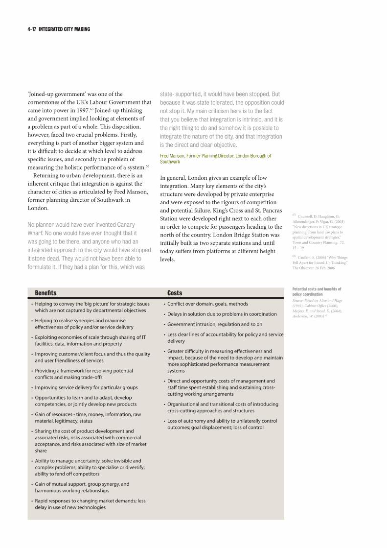
4-17 INTEGRATED CITY MAKING
state- supported, it would have been stopped. But
because it was state tolerated, the opposition could
notstopit.Mymaincriticismhereistothefact
thatyoubelievethatintegrationisintrinsic,anditis
the right thing to do and somehow it is possible to
integratethenatureofthecity,andthatintegration
is the direct and clear objective.
Fred Manson, Former Planning Director, London Borough of Southwark
In general, London gives an example of low integration. Many key elements of the city’s structure were developed by private enterprise and were exposed to the rigours of competition and potential failure. King’s Cross and St. Pancras Station were developed right next to each other in order to compete for passengers heading to the north of the country. London Bridge Station was initially built as two separate stations and until today suffers from platforms at different height levels.
‘Joined-up government’ was one of the cornerstones of the UK’s Labour Government that came into power in 1997.65 Joined-up thinking and government implied looking at elements of a problem as part of a whole. This disposition, however, faced two crucial problems. Firstly, everything is part of another bigger system and it is difficult to decide at which level to address specific issues, and secondly the problem of measuring the holistic performance of a system.66
Returning to urban development, there is an inherent critique that integration is against the character of cities as articulated by Fred Manson, former planning director of Southwark in London.
NoplannerwouldhaveeverinventedCanary
Wharf. No one would have ever thought that it
wasgoingtobethere,andanyonewhohadan
integratedapproachtothecitywouldhavestopped
itstonedead.Theywouldnothavebeenableto
formulateit.Iftheyhadaplanforthis,whichwas
Potentialcostsandbenefitsofpolicy coordination
Source: Based on Alter and Hage (1993); Cabinet Office (2000);Meijers, E. and Stead, D. (2004); Anderson, W. (2005) 67
Costs
Conflict over domain, goals, methods•
Delays in solution due to problems in coordination•
Government intrusion, regulation and so on•
Less clear lines of accountability for policy and service •delivery
Greater difficulty in measuring effectiveness and •impact, because of the need to develop and maintain more sophisticated performance measurement systems
Direct and opportunity costs of management and •staff time spent establishing and sustaining cross-cutting working arrangements
Organisational and transitional costs of introducing •cross-cutting approaches and structures
Loss of autonomy and ability to unilaterally control •outcomes; goal displacement; loss of control
Benefits
Helping to convey the ‘big picture’ for strategic issues •which are not captured by departmental objectives
Helping to realise synergies and maximise •effectiveness of policy and/or service delivery
Exploiting economies of scale through sharing of IT •facilities, data, information and property
Improving customer/client focus and thus the quality •and user friendliness of services
Providing a framework for resolving potential •conflicts and making trade-offs
Improving service delivery for particular groups•
Opportunities to learn and to adapt, develop •competencies, or jointly develop new products
Gain of resources - time, money, information, raw •material, legitimacy, status
Sharing the cost of product development and •associated risks, risks associated with commercial acceptance, and risks associated with size of market share
Ability to manage uncertainty, solve invisible and •complex problems; ability to specialise or diversify; ability to fend off competitors
Gain of mutual support, group synergy, and •harmonious working relationships
Rapid responses to changing market demands; less •delay in use of new technologies
Counsell, D; Haughton, G; 65
Allmendinger, P; Vigar, G. (2003) “New directions in UK strategic planning: from land use plans to spatial development strategies,” Town and Country Planning. 72, 15 – 19
Caulkin, S. (2006) “Why Things 66
Fell Apart for Joined-Up Thinking.” The Observer. 26 Feb. 2006

INTEGRATED CITY MAKING 4-18
Buttheriskwastakenbytheprivatesectorand
theynurturedwhattheywantedtodoandmostly
failed,instaggeringways.Buttheintegrationofthe
operation was a post-hoc rationalisation after the
investment was done.
Fred Manson, Former Planning Director, London Borough of Southwark
The positive interpretation of a disjointed private sector involvement in city making is possibly a higher degree of creativity applied and ultimately a greater willingness to experiment with innovative approaches. Market-led integration has also been promoted by land values.
Large major development has taken place in
areasofhighesttransportaccessibility.Thecity
of London, which has the densest areas, has the
highestlandvaluesandhasthebestaccessibilityas
comparedtoanyothercentralcityintheworld.
Peter Bishop, Director, Design for London
However, Fred Manson also emphasised that the reliance on return on investment can also have fatal consequences for a city.
InLondonatpresent,youmakemoremoneyoutof
holdingontolandthanyoudobybuildingit.Peter
Stuartusedtosaythateverydevelopmentisa
failedpropertydealandthatitwasfarbettertodo
apropertydealthantoactuallyhavetobuildthe
site out.
Fred Manson, Former Planning Director, London Borough of Southwark
facilitators and inhibitors of organisational coordination
Source: Adapted from Halpert (1982); Meijers, E. and Stead, D. (2004) 68
Inhibitors
Vested interests•
Perceived threat or competition•
Disparities in staff training•
Perceived loss of organisational and program identity •or strategic positions
Perceived loss of prestige or authority•
Inter-professional and intra-professional differences•
Lack of a common language•
Different priorities, ideologies, outlooks or goals•
Differing organisational-leader-professional •socialisation
Poor historical relations or image formation•
facilitators
Perceived need •
Positive attitudes •
Consensus between administrators and staff •
Maintenance of organisational and paradigm identity•
Maintenance of prestige or power •
Group-centred approach to problems •
Similar resources, goals or needs •
Common commitment•
Common definitions, ideologies, interests or •approaches
Good historical relations •
2. Contextual factors (internal environmental conditions):
1. Interpretive factors (attitudes, values and perceptions of personnel):
Actual needs or benefits •
Standardisation•
Decentralisation•
Professionalism•
Occupational diversity •
Informal contacts or exchange of information and •resources
Geographic proximity •
Boundary permeability •
Complementary organisational or personnel roles•
Similarity of structures, supply capabilities, needs or •services
Costs outweigh benefits•
Bureaucratisation•
Centralisation•
‘Professionalisation’•
Specialisation•
Infrequent or inadequate communication (internal or •external)
Fragmentation of levels of government•
Little or no boundary permeability•
Inadequately trained personnel•
Structural differences•

4-19 INTEGRATED CITY MAKING
INTEGRATED polICIEs foR spATIAl 4.5 DEvElopMENT
With the rising importance of sustainability, spatial development, particularly in cities, increasingly requires a comprehensive and integrated approach. In fact, in their response to the negative social consequences of modernist city visions and the dramatic anti-urban results of decisions taken in sectoral ‘silos’, cities anticipated the growing focus on integration driven by sustainability. For many cities, increasing urban sprawl, fragmentation and social exclusion demanded a more balanced cross-sectoral recognition of environmental, social and economic components. Celebrated success stories of sustainable urban development in cities as diverse as Bogota, Curitiba, Barcelona and Copenhagen all share roots in a solid interdisciplinary approach facilitated by cross-sectoral, integrated planning.67
The overall affluence and relatively low growth rate of European cities in particular have allowed them to implement integrated urban development with a degree of success,68 while prevailing practice in many other parts of the world remains more fragmented. However, at least the rhetoric of integration has found its way into many urban policy documents at national levels while acknowledging a shortcoming in adopting more strategic collaboration. In this section, we review recent policies relating to integrated spatial development, across the European Union, as well as within the United Kingdom and other states.
European Union4.5.1
The European Union itself is of course based on a joint effort for greater geographic integration. As part of this ambition, the EU has a keen interest in integrated spatial development as a means for achieving its sustainability targets. Schoen concludes that there is “a growing sense that a territorially more integrated approach (to spatial development) is necessary to achieve the goals of structural innovation and sustainable economic growth.”69 The most recent spatial development perspective confirms his assessment: “The ESDP [European Spatial Development Perspective] provides the possibility of widening the horison beyond purely sectoral policy measures, to focus on the overall situation of the European territory and also take into account the development opportunities which arise for individual regions.”70
The ESDP recognises the crucial relationship between transport and spatial planning by recommending that location policy must be compatible with transport policy71 and regards strategies operating at the transport/land-use interface particularly effective in reducing car-dependency and promoting public transport.72 The EU’s Transport White Paper of 2001 also urges policy-makers to integrate transport policy with “urban and land-use planning policy to avoid unnecessary increases in the need for mobility caused by unbalanced planning of the distances between home and work.”73
With regards to urban development, the EU specifically re-emphasises the need for holistic strategies and coordinated action by all key
aboveFor many years, Canary Wharf in London suffered the lack of public transport. It became successful only after it was connected to London’s underground system.Philipp Rode
Kidd, S. (2007) “Towards a 67
Framework of Integration in Spatial Planning: An Exploration from a Health Perspective”
European Commission (1999) 68
European Spatial Development Perspective ESDP, Paragraph 8
Stead, D. (2003) “Transport and 69
land-use planning policy: really joined up?”, International Social Science Journal. 55 (176) 333–347: (European Commission 1999: 23)
European Spatial Development 70
Perspective ESDP (1999) Paragraph 119
European Commission (2001) 71
White Paper - European transport policy for 2010: time to decide. Luxembourg: Office for Official Publications of the European Communities
Leipzig Charter on Sustainable 72
European Cities (2007)
Ibid73

INTEGRATED CITY MAKING 4-20
stakeholders in its latest agreement, the Leipzig Charter on Sustainable European Cities.74 The document draws on the positive experiences of many cities in urging governments to make greater use of integrated urban development policy, and stresses the importance of compact, mixed-use settlement structures as the basis of sustainable development: “Urban transport must be reconciled with the different requirements of housing, work areas, the environment and public spaces. … An important basis for efficient and sustainable use of resources is a compact settlement structure. This can be achieved by spatial and urban planning, which prevents urban sprawl by strong control of land supply and of speculative development. The strategy of mixing housing, employment, education, supply and recreational use in urban neighbourhoods has proved to be especially sustainable.”75,76
United Kingdom4.5.2
Over the last decade, the UK - more than most other Western European countries - has gone through an intense phase of reforming its governance structure while establishing new forms of spatial planning coupled with a renewed focus on urban regeneration. Partially as a correction of the radical limitation of government functions throughout the 1980s77 but also as a result of the requirement for a more holistic approach to sustainable development, the New Labour government has passed a number of measures promoting greater integration since it came to power in 1997. For London, the most significant milestone was certainly the re-introduction of a city-wide government in 2000 with important powers over transport and strategic planning.
The critique of fragmented decision-making emerged in the late 1980s when the UK’s Audit Commission looked at urban policy and identified severe failings in regeneration due to uncoordinated approaches.78 Ling notes that “urban policy began to emerge as a key example of why joined-up government was needed.”79
The growing environmental challenge coupled with the recognition of its interrelationship with transport and spatial development jump started reform of governmental structures, and in particular for creating the Department of Environment, Transport and the Regions (DETR)under Deputy Prime Minister John Prescott.
Begg and Gray emphasise that “Prescott was a passionate advocate of an integrated approach to planning, and the explicit objective of DETR80 was to achieve a more integrated or joined-up approach to policy making.”81 Stead confirmed the obvious advantages of DETR, which replaced two departments of government, and stresses the benefits of greater integration: “Coordination of decision making is naturally easier with fewer tiers.”82
For England, Planning Policy Guidance on Transport (PPG13) which was initially introduced in 1994 and updated in 2001 reflects this understanding: “Land-use planning has a key role in delivering the Government’s integrated transport strategy. By shaping the pattern of development and influencing the location, scale, density, design and mix of land-uses, planning can help to reduce the need to travel, reduce the length of journeys and make it safer and easier for people to access jobs, shopping, leisure facilities and services by public transport, walking, and cycling.”83 These principles were developed further by the Integrated Transport White Paper84 in 1998 and the most recent Future of Transport White Paper of 2004.85
A general agenda for joined-up government was not spelled out until the release of the 1999 White Paper on Modernising Government which stated that “the Government’s strategy is one in which the keystones of its operations are inclusiveness and integration.”86 At the same time, the Government published the Urban Task Force report,87 which set out a vision for delivering inner city renewal through integrating transport planning, architectural excellence, sensitive urban design and environmental responsibility. The Report substantially informed the 2001 Urban White Paper,88 and has had a sustained and wide-reaching influence urban planning practice across the UK.
However, this integrative intention did not survive for long and it is now argued that the government has shifted away from its focus on joined-up governance.89,90 In 2001, DETR was divided into two separate departments, the Department of Transport, Local Government and the Regions (DTLR) with environment going to the Department of Environment, Food and Rural Affairs (DEFRA). This was partially due to concerns that DETR with 15,000 members of staff and annual budget of £13 billion had become to big and unmanageable.91 In subsequent re-
Ibid74
Pollitt, C. (2003) “Joined-up 75
Government: a Survey”: (Rhodes, 1997)
Ling, T. (2002) “Delivering 76
joined-up government in the UK: dimensions, issues and problems”
Ibid77
UK Department of Transport, 78
Local Government and the Regions (DTLR) (2001) DETR Annual Report 2001
Begg, D. and Gray, D. (2004) 79
“Transport policy and vehicle emission objectives in the UK: is the marriage between transport and environment policy over?”, Environmental Science & Policy, Vol. 7, No. 3, 155-163
Stead, D. (2003) “Transport and 80
land-use planning policy: really joined up?”
UK Department for 81
Communities and Local Government (2001) Planning Policy Guidance on Transport 13: Transport (PPG 13)
UK Department for Transport 82
(DfT) (1998) A New Deal For Transport: Better For Everyone – White Paper
UK Department for Transport 83
(DfT) (2004), The Future of Transport - White Paper CM 6234
Cabinet Office (1999) 84
Modernising Government - White Paper
Urban Task Force (1999) 85
Towards an Urban Renaissance
Office of Deputy Prime Minister 86
(ODPM ) (2000) Our Towns and Cities the Future
Begg, D. and Gray, D. (2004) 87
“Transport policy and vehicle emission objectives in the UK: is the marriage between transport and environment policy over?”
Caulkin, S. (2006) “Why Things 88
Fell Apart for Joined-Up Thinking”
Stead, D. (2003) “Transport and 89
land-use planning policy: really joined up?”
Begg, D. and Gray, D. (2004) 90
“Transport policy and vehicle emission objectives in the UK: is the marriage between transport and environment policy over?”
Ibid91

4-21 INTEGRATED CITY MAKING
organisations, transport was also split off.These adjustments to the organisational
structures of government coincided with refocusing policy on narrower issues particularly in relation to transport. For example, Begg and Gray suggest that the emphasis on demand management had been dropped in favour for supply side investment policies.92 They conclude that “Environmentalists may be frustrated at an apparent lack of integration, but congestion and a perceived lack of delivery on transport have emerged as more salient public concerns, and a potential vote loser. No Government can be blamed for taking a more politically pragmatic approach in order to avert potential unrest among the electorate.”93 As a consequence Begg and Gray see difficult choices such as demand management and congestion charging being transferred to local governments.94
A far more sustained effort for greater integration of spatial development in England was introduced in 2004 by the Planning and Compulsory Purchase Act.95 It pioneers consistent vertical integration facilitated by Regional Spatial Strategies (RSS) and Local Development Frameworks (LDF), as well as promotes sectoral integration by requirung consideration of the range of public policy areas including air quality, biodiversity, climate change, culture, education, energy, environment, health, soil use and sustainable development as well as transport, economic development and housing.96 The most recent government publication on planning, the Planning for a Sustainable Future White Paper of 2007 endorses these reforms and highlights the importance of “better integration with the plans of other public sector bodies.”97 For the future it pushes for “better integration of the Regional Economic Strategies (RES) and Regional Spatial Strategies (RSS)” as well as “planning better for mixed-use developments to allow, for example, greater flexibility of land-use” and “reduced impact on the environment including the need to travel by car.”98
other contexts4.5.3
The German experience with integrated approaches has been manifold and in many ways laid the ground for strategies that can now be found at the European level. Besides a clearly structured planning regime from the national to the local level, Germany recently pushed for a
much greater integration particularly of transport and urban development, not least by creating one single government department overseeing both.
This differs greatly from the US experience. Here, federal guidance on and promotion of more integrated planning is limited. As for most other policy areas, spatial planning in the US is the responsibility of state and city governments. There has been innovation at these levels, with integrated strategies such as ‘transit oriented development’, ‘smart growth’ and ‘new urbanism’ changing spatial practice to some extent. In 1991 the US also introduced a national transport scheme that to a degree emphasises the importance of integrated strategies from a transport perspective. The Intermodal Surface Transportation Efficiency Act of 1991 (ISTEA),99 later re-authorised as TEA-21, promotes consideration of the effects of metropolitan transport plans and programmes on land-use and development, and their consistency with short- and long-term land-use and development plans. TEA-21 also encourages integrated multi-modal strategies that include pedestrians and bicycle facilities.100
In the post-apartheid era, the South African government has been proactive in fostering enhanced intergovernmental planning. In 1996, the national government first embraced greater coordination with the Integrated Development Plan (IDP) appendage to the Local Government Transition Act, Second Amendment Act 97. The IDP promoted policy convergence among the three spheres of government (national, provincial and local), as well as defining a specific spatial component, the Spatial Development Framework (SDF), which effectively functions as an instrument for local planning.
In 2000, the Municipal Systems Act further defined the content of the IDP to include SDF as well as sectoral plans for transport, water, housing strategies etc. For Johannesburg in particular, the long term economic strategy, ‘Jo’burg 2030’ (2002) and subsequent City IDPs and SDFs have also encouraged integration of land-use and transport planning to achieve greater urban sustainability and accessibility. However, in practice, multilateral integration of planning across the spheres of government has been top-down. Specifically, planning in Johannesburg still remains a ‘concurrent’ rather than ‘integrated’ exercise since local planning agents operate within a structure defined by the
Ibid92
ODPM (2004) Planning and 93
Compulsory Purchase Act 2004
Kidd, S. (2007) “Towards a 94
Framework of Integration in Spatial Planning: An Exploration from a Health Perspective”
UK Government (2007) Planning 95
for a Sustainable Future - White Paper, pg. 124
Ibid, pg. 113 96
US Congress (1991) H.R. 2950 97
Intermodal Surface Transportation Efficiency Act of 1991 (ISTEA).
Ibid, Sec. 134. Metropolitan 98
planning
Government of India, Ministry 99
of Urban Development (2005) National Urban Transport Policy
Ibid100

INTEGRATED CITY MAKING 4-22
Box 4.1
TRANspoRT As pART of CITY MAKINGINDIA’s NATIoNAl URbAN TRANspoRT polICY
In 2006 the Government of India approved the National Urban Transport Policy (NUTP). The policy embraces urban transport as a crucial component for urban development and planning.
It recognises that, due to rapid population growth, cities in India have begun to sprawl and increased travel distances have made non-motorised modes increasingly difficult to rely on. This has made access to livelihoods, particularly for the poor, far more difficult and time-consuming. Billions of working hours are lost with people “stuck in traffic”.
The NUTP recognises that transport planning is intrinsically linked to land use planning and both need to be developed together in a manner that serves the entire population and yet minimises travel needs. And since cities in India vary considerably in terms of their population, area, urban form, topography, economic activities, income levels, growth constraints, etc., the design of transport systems will have to depend on these city specific features. Transport plans should, therefore, enable a city to take an urban form that best suits the geographical constraints of its location and also one that best supports the key social and economic activities of its residents.
Furthermore, the policy recommends the setting up of unified metropolitan transport authorities (UMTAs) in all cities above one million residents, to facilitate more coordinated planning and implementation of urban transport programs and projects and an integrated management of urban transport systems. Such bodies would, inter-alia, design networks and routes, assess demand, contract services, monitor performance, manage common facilities like bus stations and terminals, etc. They would have representation from all the major operators and stakeholders. Via the UMTAs, the policy also seeks to encourage the establishment of quality-focused multi-modal public transport systems that are well integrated and providing seamless travel across modes.
The policy’s objective is also to ensure safe, affordable, reliable and sustainable access for a growing number of city residents to education and employment. In this regard, the policy brings about an equitable allocation of road space, with people, rather than vehicles, as its main focus. It recognises that buses carrying 40 people require only two and a half times the road space that is allocated to a car carrying only one or two persons. In effect this means that lower income groups are paying, in terms of higher travel time and higher travel costs, for the disproportionate space allocated to personal vehicles. Users of non-motorised modes have tended to be squeezed out of the roads on account of serious threats to their safety.
Finally, the policy also highlights that urban transport policies can not succeed without the fullest cooperation of all the city residents. Such cooperation can be best secured if the objective of any initiative is made to the general public. It is, therefore, necessary to launch intensive awareness campaigns that educate people on the negative effects of the growing transport problems in urban areas - especially on their health and well being. The campaigns would seek their support for initiatives like greater use of public transport and non-motorised vehicles, the proper maintenance of their vehicles and safer driving practices.
Sources of municipal finance and their periodic review by a statutorily constituted State Finance Commission (Article 243Y) are also provided for by the Act, which makes it obligatory for the Central Finance Commission to recommend steps to support state resources for the assistance of municipal governments. Article 243X states that a state may by law authorise a municipality to levy and collect property taxes, duties, tolls and fees. The Act also allocates one-third of the seats for women and scheduled castes in municipal bodies.
However, over the last 14 years little has changed and planning procedures largely remain the same. All the powers to legislate the provision of urban infrastructure are still vested with the states, as is the resource-raising authority, evident in the usual urban taxes, from stamp duty to entertainment tax. The only levy left to the municipalities is property tax. But here, too, the state decides the tax base, rates and modes of assessment. India fares poorly in its record of devolution to local bodies. Civic government expenditure in India is just 0.6 % of national GDP, compared with 5 % in Brazil and 6 % in South Africa.

4-23 INTEGRATED CITY MAKING
INTEGRATED GovERNANCE4.6
Integrating transport and land-use is a complex challenge for any city. This section will look at positive experiences amongst the four comparator cities, highlighting how urban governance can facilitate synchronisation by organisational and geographic integration.
organisational integration4.6.1
Interviewees in all four comparator cities referred to various examples of organisational integration that within their context contributed to a more synchronised delivery of land-use and transport strategies. The most relevant examples for this study include the Greater London Authority and Transport for London, Berlin’s Urban Development Department, Stadtforum Berlin and Berlin Board, Johannesburg’s Interagency Committees and New York’s Deputy Mayor of Economic Development.
TheGreaterLondonAuthority
The creation of the Greater London Authority (GLA) in 2000 brought with it a significant degree of integrating formerly fragmented agencies
national planning agendas, such as Medium Term Strategic Framework and Provincial Growth and Development Strategy.
In India, the push for integrated urban practices goes well beyond JNNURM and the push for implementing metropolitan planning authorities. For example, the Indian National Urban Transport Policy published in 2005 emphasises that transport is intrinsically linked to land-use and that both need to be developed in an integrated way to minimise the need to travel. Future development should further be channelled to transport corridors and uncontrolled sprawl needs to be limited.101 The policy states the integration of land-use and transport as a central goal and further as a tool for social policy.
“Encourage integrated land-use and transport planning so that travel distances are minimised and access to livelihoods, education, and other social needs, especially for the marginal segments of the urban population is improved.”102
India’s National Urban Transport Policy also explicitly states the commitment of the National Government to integrated land-use and transport plans and the requirements for cross-sectoral expertise and management at state level.103
Box 4.2
REGIoNAl CooRDINATIoN IN INDIA, ThE KolKATA METRopolITAN DEvElopMENT AUThoRITY
The Kolkata Metropolitan Development Authority (KMDA) was set up as the statutory planning and development organisation under the West Bengal Town and Country (Planning and Devel-opment) Act 1979. The Kolkata Metropolitan Area now extends to 1851 km2 with a population of 14.7 million (2001) and includes the city of Kolkata and parts of few adjoining districts (including North 24 Parganas), three Municipal Corporations, 38 Municipalities and 24 Panchayat Samitis. KMDA has a workforce of 3,500 including 75 planners and social scientists and 400 engineers and para technical staff.
With the 74th Constitutional Amendment, a “Kolkata Metropolitan Planning Committee” (KMPC) has been formed and KMDA has prepared “Vision 2025”- a 25 year perspective plan for the Kolkata Metropolitan Area (KMA). “The vision is to provide a sustained and improved quality of life through basic urban services in an inclusive manner and create enabling environment for attract-ing domestic and international investors to live, work and invest in the KMA.”
The plan envisages one Metro Center (Kolkata), one Sub Metro Center (Howrah) and five Trans-Metro cities (population 250,000 to 500,000) of Kalyani, Barasat, Saltlake-Rajarhat, Baruipur, Ulube-ria. A 25 year master plan and 5 year development plan have drawn up for:
Water supply •Sewerages, drainage, sanitation •Traffic and transport •Development plan for environment, wetlands and Heritage Sites •Development programme for health, education, slum and employment •
KMDA claims that its “policies and strategies use a decentralised paradigm involving peoples’ par-ticipation at a grass roots’ level and stress specially balanced urban growth.” However evidence for this level of public participation for planning is not easily available.
Ibid101
Design for London (2002) 102
Ibid, Projects 103

INTEGRATED CITY MAKING 4-24
While the Greater London Authority has been largely successful in advancing far more coordinated urban development, the full integration of its various agencies is not yet concluded and requires further adjustments. However, persistent fragmentation can be seen as the legacy of decades of neglecting strategic city-wide governance.106
Transport for London
Organisational integration in London has been pushed to maximum levels within the area of transport planning and operations through the creation of Transport for London (TfL). The agency is directed by a management board whose members are appointed by the Mayor of London who also sets the organisation’s budget and can also chair the board, if he wishes. As a unique example of a multimodal transport agency, TfL brings together strategic city-wide transport planning, public transport operations including rail, bus and taxi service, traffic management, road maintenance, and facilitating walking and cycling. As such, TfL combines responsibilities that are in most cities dealt with separately by a department for transport, a department for public works, one or several public transport agencies, a road traffic management body and local level works on public space, walking and cycling. Peter Hendy, Commissioner of Transport for London points out that the overriding strength of this organisational structure is the ability to produce truly comprehensive transport plans that are not only dealing with public transport modes and are therefore far better suited for strategic planning in cities and for having some influence on urban planning.107
TfL’s success further relies on its regulatory and budgetary powers. Equipped with an annual budget of around 6 billion pounds108 - by far the largest of any GLA agency - it has sufficient regulatory control to determine not only the nature and volume of public transport services (and particularly buses, the de-regulation of which has been seen as a failure in many other UK cities), but to manage travel demand and mobility patterns. As Peter Hendy points out, it is this combination of powers that allowed the successful implementation of the London’s most innovative transport policy, the city’s congestion charge scheme.
responsible for urban development and transport. As well as a core GLA, which includes spatial planning and other policy teams, the Mayor of London also controls Transport for London and the London Development Agency, two agencies that integrate previously dispersed functions. Together with the Metropolitan Police and Fire Service, these organisations form the GLA Group. More recently, the Mayor has also established Design for London (DfL) as an inter-agency team focusing in design quality across the GLA Group.
Between these agencies, it is the executive power and direct oversight of the Mayor of London that allows for coordination and synchronisation. However, the very nature of the GLA Group as distinct organisations ensures a degree of independence which in itself compromises integration particularly between transport and spatial planning.
An example for the innovative approach to integrated urban planning within the organisational framework of the GLA Group is Design for London (DfL). DfL was created by merging architecture and urban design teams from the GLA, LDA and TfL. It operates as a city design agency with the core mission “to support the delivery of well-designed projects across London, and to make sure that the Mayor’s commitment to design excellence is reflected within all projects that the mayoral agencies commission or fund.”104
It is amongst the few organisations that bridge across Transport for London, the London Development Agency and the Greater London Authority. Anything related to spatial design is reviewed and commented on.
This way DfL - set up only in early 2007 - offers the promise to operate as catalyst for greater integration of the physical planning and development strategies. Rather than continuing to reply on ad hoc steering groups and liaison meetings at various levels, DfL allows design expertise to be brought to bear on activities throughout London government. As part of their work, the agency has developed strategic documents such as design guidelines for developing high density housing; policies and best practices for designing green roofs; and policies and for the ‘Green Grid’, a project to “create a network of interlinked, multi-functional and high quality open spaces” that connect with town centres, employment and residential areas and public transportation nodes.105
Peter Bishop, Director, Design 104
for London, August 2007
Peter Hendy, Commissioner, 105
Transport for London, August 2007
Greater London Authority 106
(GLA) (2006) The Greater London Authority’s Consolidated Budget and Component Budgets for 2006-7.
Peter Hall, Bartlett Professor 107
of Planning and Regeneration, University College London, August 2007

4-25 INTEGRATED CITY MAKING
Berlin’s Department for Urban Development
Throughout most of the 1990s, Berlin’s governance was characterised by sharp divide between the Department for Urban Affairs and a separate Department for Transport. Coordination and communication between the two was difficult not only because they were headed by senators from each of the two coalition parties but also due to a different organisational cultures. As a result of these perceived problems, and of a far-reaching recognition of the important role of spatial development in Berlin, a joint department was created in 2000. This Department for Urban Development brought together all of the related sectors ranging from building, construction and planning to transport, housing and the environment. Across the board, experts and key stakeholders in Berlin emphasised the positive impact of this merger.
This was an important step [creating the
DepartmentforUrbanDevelopment].Backthen,
forthefirsttimeurbandevelopment,thebuilt
environment, transport and environment were
joined in one department. This has enormous
advantages.
Friedemann Kunst, Director, Transport Planning, Senate Department for Urban Development, Berlin
A positive situation is that with the Department for
Urban Development we have all sectors under one
roof. … Urban development planning and transport
planningareinonehand.Thisisundoubtedly
positive.
PlanningOfficial,Berlin
I do think it is a positive precondition [a holistic
urbandevelopmentdepartment]butoneshould
not overestimate the effects. But when people are
sittingindifferentdepartments,theylackasense
for coordination and cooperation.
Klaus J. Beckmann, Director, German Institute of Urban Affairs (Difu), Berlin
In particular, effects on the relationship between urban development and transport were highlighted as beneficial. Only now is it possible to derive a transport strategy from an overall strategy for urban development.
A commercial operator would never produce
sufficientpublictransportasapartofalargeroad
user charging scheme to deter people from car
usage. We could not have done congestion charging
without control over the bus service.
PeterHendy,Commissioner,TransportforLondon
TfL’s holistic transport agenda has allowed it to make a clear commitment to reducing travel demand. Given less comprehensive organisational designs for transport planning in other cities, this strategic goal is often neglected, or even rejected as inimical to the interest of individual transport providers.
Wearetakingseriouslytraveldemandmanagement
in order to encourage people not to travel as much
astheycurrentlydo.Idon’tthinkapublictransport
companywoulddothisbutitisinourinteresttodo
that.
PeterHendy,Commissioner,TransportforLondon
TfL’s role in proactive planning for urban transport in London109 has also allowed the city to commit to ambitious targets for tackling climate change. By 2025, the 40% reduction in London’s CO2 emission will include a significant reduction within ground-based transport of 4.3 million tonnes or 22% of all reductions. These are generated by a combined strategy including modal shift, more efficient operations and infrastructure improvements that all heavily rely on coordinated strategies across transport modes.110
TfL has been a success in many ways, but continues to struggle with some issues. The first was the public-private partnership (PPP) scheme for maintaining and upgrading the London Underground network. This was pushed through by Central Government against the Mayor’s will and ultimately led to bankruptcy of the operating company Metronet.111 The second is the oversight of national rail operators, who are hugely important for commuting within the metropolitan region but were initially not within the remit of TfL.112 Both issues are closely linked to the overarching transport challenge of reducing overcrowding and improving service quality of public transport. The last critical project, over which TfL has only limited control, is Crossrail, the £17 billion rail mega-project offering fast east-west service underneath the city.113
Greater London Authority 108
(GLA) (2007) Action Today to Protect Tomorrow: The Mayor’s Climate Change Action Plan.
Editorial (2008) “Learning 109
Lessons from the Wreckage“,The Guardian. 9 Feb 2008: 38.
Peter Hall, Bartlett Professor 110
of Planning and Regeneration, University College London, August 2007
Peter Hall, Bartlett Professor 111
of Planning and Regeneration, University College London, August 2007
Franziska Eichstädt-Bohlig, 112
Opposition Leader, Bündnis 90/Die Grünen, Berlin, August 2007
Mabin, A. (2004) “Local 113
Government in South Africa’s Larger Cities.” Democracy and Delivery: Urban Policy in South Africa. Cape Town: HSRC Press, 135-156.

INTEGRATED CITY MAKING 4-26
say that negative consequences were already felt within the first year.
At the moment we are implementing the emission
zonefortheinnercityfor2008whichisfarmore
exhausting for coordination with transport and
urban development now that environment has
been separated [from the urban development
department].
Opposition Leader, Berlin
Stadtforum Berlin and Berlin Board
Particularly throughout the 1990s, when Berlin experienced a substantial construction and building boom following Germany’s re-unification, the city’s public debate relied upon and was facilitated by the Stadtforum (Cityforum). There were two phases of the Stadtforum. At first it was a bottom-up initiative by active citizens and experts, which later became institutionalised, with many of the key experts becoming formal advisors to the city. The formalisation of the Stadtforum was seen as an important part of constituting an engaged urban society at a time when the city was going through enormous changes.114
Thediscussionabouturbandevelopmentpolicyis
public and we conduct it through a series of events
under the umbrella of the Stadtforum.
ElectedOfficial,Berlin
Transport planning has a particular status. Since
1999 all related departments are under one roof
- urban development, building and transport.
Together with a corresponding political input this
has the advantage of operating in a more integrated
wayandthaturbanplanningisputtingforwardthe
keyobjectivesandnottransportplanning.
ElectedOfficial,Berlin
New synergies were appreciated by transport operators feeling the positive impact of having one organisation they can report to and request resources from.
Generally,itisimportantthatforboth,transport
operators and urban planning there is one
organisational unit under which these issues are
brought together. Berlin has joined three separate
departments into one, the urban development
department. This was an important step regardless
thefactthatthedepartmentisrelativelylargeand
there is a need for optimisation. But having one
senator who brings together urban design, urban
planningandtransportiskey.Thiseasesmany
issues for planning but also for needs of transport
operators.
Felix Pohl, Director, Planning, S-Bahn Berlin GmbH
Despite its successes, following the election in 2006 the integrated character of the urban development department had to be reduced by creating a separate environment department due to political reasons. Opposition politicians
aboveBerlin features a highly integrated rail transport system including intercity rail crossing the city along two corridors with several multi-modal rail stations.Anja Schlamann
Ibid114

4-27 INTEGRATED CITY MAKING
There is a prominent culture of debate about these
themesinBerlin[urbandevelopmentrelated].Itis
not about whether I or someone else wins but that
thereisaveryengagedscenelookingatbuilding
andcityculture.Theyarejournalistswritingin
newspapers and for a long time there has been the
Stadtforum.
Opposition Leader, Berlin
Experts confirm the general importance of organisational set-ups facilitating a fruitful public debate and exchange. To achieve greater integration this participation needs to be organised early in the process.
Usually,specificprocessesandorganisational
structureswereneeded[forgreaterintegration]
-processeswithanearly-onparticipationof
all interest groups and communities. If I want
toorganisethese,Ineedspecificformsof
engagement. … Organisational forms such as round
tables or the Stadtforum where this exchange is
possible.
Klaus J. Beckmann, Director, German Institute of Urban Affairs (Difu), Berlin
More recently, the Mayor of Berlin expanded the list of bodies engaged in debating Berlin’s future by constituting the Berlin Board. This Board, consisting of 15 experts from various backgrounds, advises on strategic decisions for the city and reports directly to the mayor. Besides 12 local members, it includes 3 experts from abroad. Its main purpose is to ensure that the development of visions in Berlin is based on clear measures and objectives, though it also considers the basic principles that underpin development options.
WhattheMayorofBerliniscurrentlydefiningwith
the Berlin Board is of course structured around the
fundamental questions on urban development.
ElectedOfficial,Berlin
Johannesburg’sInteragencyCommittees
In Johannesburg, interviewees explained that committees between city departments and the national government to discuss city plans are immensely useful in increasing integration. The Technical IDP Committee, where national and local government departments review sector plans
collectively, was specifically identified as a good example of this.
Themayoralcommitteeisobviouslychairedbythe
Mayorandthemembersofthemayoralcommittee
are political appointees for various portfolios.
Forpriorityprojectsforthecity,theMayorwill
designateaspecialmayoralcommittee.
SeniorPlanningOfficial,Johannesburg
That allows for political coordination and is
supportedbyvarioustechnicalsupportstructures.
For example, we have the infrastructural
coordinating committee, which brings the
various departments together such as housing,
infrastructural services, planning control, and
transportation. So there are these integration
structuresinternally.
SeniorPlanningOfficial,Johannesburg
In South Africa, President Mbeki issued a statement asking for vertical and horizontal alignment when planning.
You know that the president issued a statement
sometimetosaythatinplanning,thereneedsto
beverticalandhorizontalalignment.Ithinkthat
statementthatwasissuedbythePresidentis
forcing people to think outside of their work and
seethatwhattheydoimpactswhatotherpeople
do.Ithinkthatfacilitatesthatbecauseevery
timepeopletalkabouthorizontalalignment.Even
theMayorwillbesayingthathowfarareyouin
meeting the objectives of the President? So for
example,inthecity,theMayorwillnotsignoff
the IDP document, if we cannot demonstrate that
there has been some talking with the other spheres
of the government, that there has been some
understandingandtheyhaveseenourplansandwe
have agreed on some things. He will not approve it
if we cannot demonstrate that.
SeniorCityOfficial,Johannesburg
NewYork’sDeputyMayorofEconomic
Development
In New York, one of the first decisions of Mayor Bloomberg, when he was elected in 2001 was to organise all economic development agencies under the Deputy Mayor of Economic

INTEGRATED CITY MAKING 4-28
Development, who guides large-scale planning and development projects. The Deputy Mayor chairs meetings every two weeks on all of those projects, forcing all the agencies together and making short timetables with assignments for each benchmark. One interviewee emphasised that the Deputy Mayor does much more than drive the process; his technical and analytical insights about city building are critical in designing liveable, integrated spaces.
The other component of integrated planning is
multidisciplinaryanditismanyagencies.That
wasaseachangewiththisMayor.Oneofthe
firstactionshetookwastoorganisealleconomic
developmentagenciesunderasingleDeputy
Mayorwhooverseesprojects,suchasGreenpoint-
Williamsburg,LongIslandCity,HighLine,Downtown
Brooklyn,orJamaica.Wehadtwelveagencies
meeting in Jamaica last week- Environmental
Protection, Transportation, Schools, Jobs,
Economic Development- all of those agencies met
togetherbecausetheyallplayaroleinmakinga
new regional business center work well.
SeniorPlanningOfficial,NewYorkCity
One interviewee added that the city’s planning tends to be integrated irrespective of scale or project intent.
It’saboutbeinginterdisciplinaryandworkingwith
manyagenciesatthesametimetocreatevibrant
places. You can’t make a great place without an
integrative approach.
SeniorPlanningOfficial,NewYorkCity
New York’s Economic Development Corporation (EDC) is a non-profit corporation that facilitates the sale and development of property on the behalf of the City of New York. Kate Ascher, Executive Vice President of EDC, said that in doing so, its primary role is to bring together city planning, housing preservation and development, and the department of transportation, on a project by project basis.
TheDeputyMayoressentiallyrunsthisplace,sowe
are considered his staff that gets things done that
cut across traditional jurisdiction boundaries.
SeniorCityOfficial,NewYorkCity
The EDC is able to bypass many of the time consuming and cumbersome procurement procedures that can slow, if not stifle city government. Ascher added that because of different recruitment processes, development corporations often hire people that are more entrepreneurial, which “is the great secret of a lot of urban development corporations.” For other cities, she advised that a development corporation model is worth considering.
Geographic integration4.6.2
Geographic integration has been amongst the biggest challenges for cities whose boundaries extend only over a fraction of the functional urban area. With a few exceptions, this is the case for almost all large cities worldwide. Amongst the four comparator cities that were analysed for this study, two examples stood out as promising practice for responding to complex governance system of metropolitan regions. These were Johannesburg’s Unicity and Berlin-Brandenburg’s joint state planning agency.
Johannesburg’sUnicity
South Africa offers us lessons on the value of making administrative boundaries reflect the real geography. With the Local Government Transition Act of 1993, Johannesburg was determined to have ‘transitional metropolitan status’ which legislated that metro areas have two levels of government: metropolitan and local.115
In 2000, the transitional status in the six largest urban areas, including Johannesburg, gave way in local elections to full metropolitan standing with a Unicity, or single local government body as defined by the Municipal Structures Act 1998.116 Since then, South Africa has effectively reduced the number of local jurisdictions (from 1100 in 1994 to 283 as of early 2007) to facilitate the redistribution of resources. Commercial and industrial revenue generated within historical white areas became accessible to black townships for the first time. “At the stroke of a pen we drew boundaries around scores of not just segregated but separate local authorities and made them into one. It has helped us overcome that urban/suburban divide and we haven’t had to proceed piecemeal.”117
Boraine, A. (2006) “Governance 115
and the City: Introduction.” Urban Age Johannesburg Conference, Johannesburg, 6-8 July 2006.
Harrison, P. (2004) “Integrated 116
Development Plans and Third Way Politics.” Democracy and Delivery: Urban Policy in South Africa. Cape Town: HSRC Press, 186-207.
Mabin, A. (2004) “Local 117
Government in South Africa’s Larger Cities.”

4-29 INTEGRATED CITY MAKING
Unicitywasformedin2001andhasdeveloped
visions. So, at least in terms of what is done on
paperthere,thereisafairlyclearvision.Thecity
hassetupaclearstrategyunit,whichisthecentral
strategyunitCSUwhosemaintaskistodevelop
this vision.
SeniorPlanningOfficial,Johannesburg
Thevariousmechanismsthatwehavebeentrying
to introduce including urban management, which
isabouttryingtointegrateandcoordinateacross
themunicipalownedentities,butit’sdifficult,for
reasonsthatIhavealreadyexplained,withits
separategoals.Internallywithinthecity,andits
core departments, the mechanism of integration
are quite strong, mechanisms of integration not
onlyincludetheintegrateddevelopmentplanwhich
isaverypowerfulcoordinatinginstrument,but
alsotheperformancemanagementsystemwhich
obviouslycascadesdownfromthecitymanagers.
So what is beginning to happen now is an alignment
in scorecards between departments, which is
in fact, quite powerful because people operate
againstscorecards.Technicallyspeaking,thatisa
verypowerfulintegratingmechanism,internally.
SeniorPlanningOfficial,Johannesburg
Prior to the establishment of the Unicity, the economic decline of the city centre in 1990s led to mass dispersal of businesses to northern suburbs and low-income housing to the peripheral areas. However, Johannesburg’s Unicity and investor-friendly Spatial Development Framework aimed to shape spatial form to achieve desirable densification and infill development.118 Within the Unicity structure, services, such as metropolitan police, emergency management, and planning, were centralised while responsibility for other services, i.e. health and housing, was devolved to the seven regions within the Greater Johannesburg Metropolitan Area. Alongside the restructuring process, utilities, agencies and corporatised entities (UACs) were established under the Companies Act as municipally regulated enterprises which undertook the delivery and development of services, i.e. water, solid waste and road management. The fiscal crisis during the late 1990s in Johannesburg had served as a warning of the dangers of municipal overstretch. The new approach was to cultivate economic development through integrated city
management and design which would lead to subsequent stability and the efficient distribution of services and resources.
As the engine for the nation’s economic growth, the Greater Johannesburg Metropolitan Area’s economic development is of national importance and a contributing factor to its consolidation of power into Unicity government formation. Beyond its own borders, the city of Johannesburg has been coordinating its economic development with its neighbours, the two major metropolitan municipalities: the City of Tshwane (formerly known as Pretoria), and the Ekurhuleni Metropolitan Municipality on the East Rand. These urban cores within the Gauteng Province have been increasingly functioning as one entity contributing to the Province’s economic prowess. With much support from the National Government, both provincial and metropolitan leaders are committed to the growth of the province as a polycentric urban region, with increased capacity to attract foreign direct investment and to ensure international status as a commercial hub. Yet, as Johannesburg’s geographic extent increases to promote economic ascendancy, urban governance becomes more distanced from the electorate.119
Berlin-Brandenburg’s joint state planning
Following Germany’s reunification, Berlin emerged as a united city-state covering most of the core urban territory. However, a significant part of the metropolitan region became part of the surrounding state of Brandenburg. At the time, the far-reaching economic and political transition brought with it immense upgrading of infrastructure combined with spatial development and required both states to work closely together.
While joint state planning between federal states in Germany has a long tradition, it is unique for the case of Berlin and Brandenburg to acknowledge the entire territory as one planning area by instituting the Joint State Planning Agency (Gemeinsame Landesplanungsabteilung).120 This Agency was established by a bi-lateral bill in 1995 and remains a crucial component of the agreement for metropolitan-wide planning, following a failed attempt to merge the two states in 1996. The Joint State Planning Agency is part of both the Berlin Urban Development Department and the Ministry of Infrastructure and Spatial Planning in Brandenburg.
Leibniz-Institut für 118
Regionalentwicklung und Strukturplanung IRS (2006) Zehn Jahre Gemeinsame Landesplanung Berlin-Brandenburg - Leitbilder, Masterpläne, Visionen. IRS aktuell No. 51/52. Juni 2006; Länder Berlin und Brandenburg (2006)“Gemeinsame Landesplanungsabteilung der Länder Berlin und Brandenburg (Hrsg.)“, Leitbild Hauptstadtregion Berlin-Brandenburg. Potsdam. August 2006; Länder Berlin und Brandenburg (2007) Landesentwicklungsplan Berlin-Brandenburg (LEP B-B). Entwurf vom 21. August 2007; Länder Berlin und Brandenburg (2003) Gemeinsames Landesentwicklungsprogramm der Länder Berlin und Brandenburg (LEPro) in der Fassung vom 1. November 2003.
UK Government (2000) The 119
Town and Country Planning (London Spatial Development Strategy) Regulations 2000.
Counsell, D; Haughton, G; 120
Allmendinger, P; Vigar, G. (2003) “New directions in UK strategic planning: from land use plans to spatial development strategies”

INTEGRATED CITY MAKING 4-30
Particularly for transport and land-use coordination, experts confirmed the important contribution of the joint state planning exercise. It is further recognised, that it is indispensable for limiting urban sprawl and for addressing public transport oriented development
Obviously,thisintegrationalsostemsfromthe
coordination between Berlin and Brandenburg
which-althoughrepeatedlybeingdifficult-is
fortunatelyclearlyinstitutionalisedandregulated.
Hilmar von Lojewski, Head, Urban Planning and Projects, Senate Department for Urban Development, Berlin
INTEGRATED plANNING4.7
Even with challenges abounding, city leaders and experts in Berlin, Johannesburg, New York and London were easily able to identify specific tools and processes to plan, design and develop their cities in a more integrated way. Two city-wide plans emerged as particularly important to the overall debate on coordinated city-making. The London Plan and Berlin’s Land-Use Plan both offer valuable insights from two very distinct approaches to greater integration, and these are discussed further below, together with case studies from Johannesburg and New York.
belowNew York’s Franklin D. Roosevelt (East River) Drive is a legacy of the city’s era of urban motorway construction. In many cities around the world, elevated highways in similar settings are taken down to allow for public access to urban waterfronts.Philipp Rode

4-31 INTEGRATED CITY MAKING
The london plan4.7.1
Over the last decade, London has reformed strategic planning more than any other mature western city of similar size. At the same time as setting up the Greater London Authority (GLA) in 2000, the UK Government proposed (in the GLA Act and secondary legislation)121 a new city-wide spatial development strategy. The level of integration involved was strongly influenced by spatial planning policy at European level, by the UK’s move towards sustainable development, and by the Labour Government’s rhetoric of joined-up thinking.122 The degree to which the London Plan (as the first spatial development strategy was known) rehabilitated the city’s positive attitude to strategic planning in general and integrated plan-led development more specifically can hardly be overestimated. Today, it has become the essence of integrated planning practice in the city.
Undoubtedly,thewholestructureoftheLondon
Plan,thestatutoryrequirement,thatthemayor
hastheprimaryresponsibilitytocreate,review
and revise the London Plan with a requirement to
integrate these different elements, has been the
outstanding development of the past decade.
Peter Hall, Bartlett Professor of Planning and Regeneration, UniversityCollegeLondon
The major innovation in London has been the
introduction of a strategic spatial development
plan,theLondonPlan,supportedbythemayor’s
TransportStrategy.
PeterHendy,Commissioner,TransportforLondon
The first London Plan was published in 2004 putting an end to a period of nearly 20 years where London did not have any strategic plan. The London Plan was developed by the GLA in close consultation with Transport for London (TfL) and the London Development Agency (LDA).123 The plan directly addresses the key challenges facing the city and is based on an integrated vision for the city’s future.124
The London Plan is of particular relevance to the international planning discourse, considering the difficult circumstances under which it needs to operate. Urban governance, development and fiscal structures differ greatly between London and many other European cities that have a longer tradition of strategic planning. Firstly, London
does not have a tax base allowing for financial freedom and its governmental powers at the city-wide level remain rather limited compared to non-UK cities. Secondly, much implementation is in the hands of the private sector. And thirdly, London is regarded as a difficult territory for planning due to a tradition of vigorous community activism, which can exhibit a deep mistrust in government as a whole. Together, these points tend to challenge any strong political visions coming along with a set of physical interventions.125
The process for preparing the London Plan was heavily influenced by the European Spatial Development Perspective (ESDP)126 of 1999. Approved in 1999, the ESDP is less of a master plan for development in the EU than an agreed commitment of all member states to advance with its principles and strategies through adjustments to individual national planning policies. The ESDP gives emphasis to spatial development strategies as a tool to address a wide range of activities that have spatial dimensions.127 As such, it has a central ambition for greater sectoral integration and it specifically endorses policies for “Better coordination of spatial development policy and land-use planning with transport and telecommunications planning.”128
The London Plan takes up many of the ESDP’s recommendation and, while being a spatial strategy, addresses a cross section of policy fields. Its thematic orientation includes sustainable growth, quality of life, economic growth, social inclusion, accessibility, design quality and climate change adaptation. However, as experts point out, the London Plan has a particular emphasis on housing, responding to one of London’s core challenge not covered by any other strategy document of similar stature.129
All parts of the GLA group must have regard to the policies set out in the London Plan when preparing their own strategies, and detailed development plans (local development frameworks) prepared by London’s 33 boroughs must be in general conformity with the Plan. The Mayor of London can over-rule borough planning decisions on strategic planning applications if they violate London Plan policy, and can also direct them to change their own local development frameworks if they are not in general conformity.
Peter Hendy, Commissioner, 121
Transport for London, August 2007
Peter Hendy, Commissioner, 122
Transport for London, August 2007
Peter Bishop, Director, Design 123
for London, August 2007
EU Committee on Spatial 124
Development (1999) European Spatial Development Perspective: Toward Balanced and Sustainable Development of the Territory of the European Union, (ESDP). EU Commission, Postdam.
Counsell, D; Haughton, G; 125
Allmendinger, P; Vigar, G. (2003) “New directions in UK strategic planning: from land use plans to spatial development strategies”
EU Committee on Spatial 126
Development (1999) ESDP.
Peter Hall, Bartlett Professor 127
of Planning and Regeneration, University College London, August 2007
The Town and Country 128
Planning (London Spatial Development Strategy) Regulations 2000, Part I, 5 (4)
Greater London Authority 129
(GLA) (2004) The London Plan: Spatial Development Strategy for Greater London, Policy 3A.7

INTEGRATED CITY MAKING 4-32
based on a Draft London Plan and is followed by an Examination in Public, a process by which a government-appointed panel tests the strategy for robustness, effectiveness and consistency with other strategies and government policies. The panel publishes a report to inform the drafting of the final London Plan, which can also be vetoed by central government if it conflicts with national policy.
VerticalIntegration
The English planning system secures central government a key role in spatial planning. The Department for Communities and Local Government issues guidance to local authorities, for regional development strategies and initiates programmes to achieve sustainable communities and urban regeneration. A spatial plan for all of England does not exist and the top hierarchy of plans is assigned to the regional level - the London Plan being one of them. It has a similar status to the regional spatial strategies (RSS) that are prepared for the two adjacent regions, East of England and South East England. However, the integration with planning efforts of the two neighbouring regions is limited due to the general lack of coordination across English regions.
However, the one exception is certainly the government’s green belt planning policy guidance (PPG2)132 which since its introduction in 1955 has become a defining regulation for urban development in the London metropolitan region and is fully integrated within the regional strategies of all three regions. Its main contribution has been to limit urban sprawl and to promote brownfield site regeneration.
With regards to transport, power remains within the hands of central government, not only as a result of their control over funding but also as a result of reserved planning powers.
Thesystemofplan-making(nationalguidance
to the London Plan to Local Development
Frameworks)facilitatesintegration.Onedifficult
anomalyisthatalthoughtheofficeoftheMayor
has planning powers over major applications,
centralgovernmentreservestherightto‘callin’
planningapplicationsandtriggerapublicinquiry.So
applicationswhichhavebothboroughandMayoral
support(LondonBridgeTower,ThamesGateway
Bridge)canstillbesubjecttoinquiryanddelay.
PeterHendy,Commissioner,TransportforLondon
TheLondonPlanisastatutorydocumentonwhich
development plans at a local level are then based
(LocalDevelopmentFrameworksproducedby
theboroughs),andplanningdecisionsbyboththe
mayorandtheboroughshavetobebased.Soit
carriessubstantialstatutoryweight.
PeterHendy,Commissioner,TransportforLondon
It is important to bear in mind that the London Plan is, despite its name, a strategy rather than a detailed land-use plan. The London Plan is a text heavy, 400-page document setting a strategic vision rather than specifying territorial features or land-uses based on a scaled map. In fact, the only map-like representation within the document is the so-called ‘key diagram’ which has to be kept at a schematic level to avoid conflicting with the detailed planning undertaken by the boroughs. As the legislation expresses it, “no key diagram or inset diagram contained in the spatial development strategy shall be on a map base.”130
The key diagram identifies key growth corridors, ‘opportunity areas’ and ‘areas for intensification’. By doing so, it furthers the strategy of accommodating London’s future growth on brownfield sites. The specific strategies for these corridors and areas are then dealt with in greater detail by the relevant boroughs.
In spatial terms the London Plan directs
developmenttokeyareas(OpportunityAreasand
AreasforIntensification).Theseareinterpretedby
the boroughs at a detailed level through their plans
and development control decisions.
PeterHendy,Commissioner,TransportforLondon
The diagram highlights other structural features including the central activities zone, metropolitan centres, major transport infrastructure as well as metropolitan open land and the green belt. For each it refers to policies that are further elaborated on within the text. The plan still sets a number of quantitative targets such as 50% affordable housing.131 Boroughs are required to take this figure into account when preparing their own plans, though negotiation on a borough-by-borough, and case-by-case basis leads to differing housing quotas being set at a local level.
The process that leads to the publication of the London Plan includes a statutory three month public consultation period. The consultation is
OPDM (1995) Planning Policy 130
Guidance 2: Green Belts (PPG2)
Peter Hendy, Commissioner, 131
Transport for London, August 2007
Greater London Authority 132
(GLA) (2004) The London Plan, Policy 3C.1

4-33 INTEGRATED CITY MAKING

INTEGRATED CITY MAKING 4-34
Planning permission in London is generally granted by the city’s boroughs (except where decisions are taken by the Mayor, called in by central government, or taken by para-statal agencies like urban development corporations and the Olympic Delivery Authority). Besides being the implementation agency for most spatial initiatives, boroughs are also responsible for developing local plans - LDFs. Some of the key objectives for introducing LDFs was to improve flexibility, strengthen community and stakeholder involvement, and ensure that key decisions are taken early in the planning process.
Regarding transport, as well as the requirement for general conformity with the London Plan, there is an additional link to the Mayor’s Transport Policy through local implementation plans (LIPs), borough programmes of transport improvements funded by Transport for London.
Thelatter[LDFs]shouldtranslatetheLondonPlan’s
integratedpoliciesatalocallevel.Specificallyon
transport,anewMayor’sTransportPolicywill
facilitate implementation of the London Plan and
should be translated at a local level in the boroughs’
local implementation plans.
PeterHendy,Commissioner,TransportforLondon
Particularly within an international context it needs to be emphasised that LDFs are by no means binding plans that directly pass on rights for development to individuals. For that, the English planning system still requires a planning process where planning permission is ultimately given on a case to case basis. Mayor Livingstone also stipulated that every development project funded or commissioned by TfL or the LDA must be approved through a formal design review process. To accomplish this, Design for London established what its Director calls a ‘control system,’ where design experts are hired and trained to implement specific review processes. “This is crucial to institutionalising integrative work,” shared Peter Bishop, the Director of Design for London.
HorizontalIntegration
While the London Plan is the Mayor’s central city-wide plan, there are a number of other statutory strategies. They include Air Quality, Ambient Noise, Cultural, Economic Development (LDA), Transport, Biodiversity and Waste
Management. The London Plan is the integrating framework for all others. In particular, the plan aims to synchronise urban planning, design and transport, being closely linked to main objectives of the Mayor’s Transport Strategy which was published in 2001 - prior to the London Plan.133
WethenhavetheMayor’sTransportStrategy
although there is a timing issue because that
actuallycameinfirstandwhenitisnextrevised
whichisin2008,itwillbeatransportstrategyasa
partoftheplanwhichwillmakeitabetterstrategy.
We have further done a development document
called Transport 2025, which looks forward the
nexttwentyyearsonthebasisoftheLondonPlan’s
predictionsonpopulationandeconomicactivity.
PeterHendy,Commissioner,TransportforLondon
Key transport targets, such as shifts in modal split are dealt with in the Mayor’s Transport Strategy, which outlines current modal split in central, inner and outer London, and identifies 20 year targets to improve the balance between private vehicles, pedestrians, cyclists and public transport. It is also this strategy that laid the foundation for London’s Congestion Charge. With regards to land-use implications, the publication of PTAL (Public Transport Accessibility Level) plans was highly influential.
I think that recent planning has been, things like
PTALs[PublicTransportAccessibilityLevels]
andthewaysinwhichthosearebeingused,
scrutinisedbytheplanningsystemhasmeant
that there has been a great deal of thought in a
schemebyschemebasiswhichhaslinkedplanning,
development,land-useandtransportsystems
together.
SeniorPlanningOfficial,London
The London Plan’s density matrix uses PTAL levels to set ranges for housing density: the better public transport access, the higher the density level at which the area should be developed (and the lower the private parking provision). Targets are also set for the reduction of car use in central London and for limiting traffic growth in inner and outer London.134 It also looks at the design of public space in relation to transport strategies aiming to promote walking and cycling.
rightCentral London relies on one of the most extensive - though relatively old - urban rail system in the world. More than 90% of employees in the City of London use public transport to get to work.Cityscape Digital Ltd
Peter Hendy, Commissioner, 133
Transport for London, August 2007
Peter Hendy, Commissioner, 134
Transport for London, August 2007

4-35 INTEGRATED CITY MAKING
The overall synchronisation of the London Plan with its transport components is facilitated by Transport for London (TfL).
TfLhasdevelopeditstransportplansinaway
which supports the areas where uses are to be
intensified.ThedraftLondonPlanwastestedbyTfL
to assess whether its proposals could be delivered
through the improved transport included in the TfL
Investment Plan. This was shown to be the case
whenitwasexaminedindependentlyattheLondon
Plan’s Examination in Public. … So for the London
Plantobeapproved,wehavetogoandsayyes,we
can do it.
PeterHendy,Commissioner,TransportforLondon
However, proposals put forward in the London Plan remain on a general level. Crucial elements of city design and transport integration, which can have a decisive impact on urban form, remain within the remit of boroughs or private developers.
Intermsofformanddesign,Londonisnotacity
whichhastraditionallybeensubjecttoarigidset
of design guidelines, although conservation is
ensuredthroughlegislation.…Manyofthedetailed
decisions on form and design are taken at a local
levelbyboroughs.DesignforLondonhasrecently
beenestablishedbytheMayortotakeastrategic
view of design.
PeterHendy,Commissioner,TransportforLondon
Success Factors
The London Plan is generally seen as having a positive impact and with its rather loose but inclusive vision has been generally welcomed as a new instrument guiding future development in London - a city that has met any planning effort with great scepticism.
I think that the London tradition is almost anti-
planning.London’sgrowthhasalwaysbeen
piece meal, which is private sector led- going
backhundredsofyears.Therehasbeenprivate
investment and state investment rather than just
a state investment. The fragmentation of power
withinthecityhasbeenoneofLondon’sgreatest
achievements.Thismeansthatnobodyhasthe
abilityorthepowertostampanyparticular
imprintonthecity.ThevisionoftheMayor,isa
verystrategicvision.Thisisavisionthatmost
Londoners, who are in a position to improve the
citywouldinsomewayarticulate,eveniftheydidn’t
realisethatitwastheMayor’svision.
Peter Bishop, Director, Design for London
aboveMore than 50% of the housing stock in London is either detached, semi-detached or terraced. The average density levels particular within more central areas are relatively low compared to cities of similar size.Jason Hawkes

INTEGRATED CITY MAKING 4-36
When looking at its most relevant success factors it is important to emphasise that the experience with the plan is rather limited and that its outcomes to date are hard to assess. In particular, it is too early to assess its success in integrating the various sectors of planning. There are however several points that already emerge as success factors of the plan. They include the commitment to a clear vision, communication, transport agency backing, site-specific endorsements, strategic alliances and plan updating.
The commitment to a clear vision is regarded as having a particularly positive impact on follow-up decision making. While openly recognising overarching objectives, certain aspects become more comprehensible and can be translated more easily to sectoral strategies and to the local implementation scale.
There is a London Plan- it is a new London Plan and
itisbeingpreparedbythemayorwithhiseconomic
objectives in mind and I think we would all claim that
itwouldbeparticularlyimportantbecausewithout
thatoverallvisionyouarenotabletofitanything
underneath it.
PeterHendy,Commissioner,TransportforLondon
Being a spatial strategy, the London Plan’s clear ideas for the general form of London were summarised by one expert as follows.
We have the London plan and it encapsulates the
physicalvisionforLondon.Itisgoingtobemore
compact and is going to grow eastwards along the
ThamesGateway.Newdevelopmentwillbearound
publictransportsystems.Publicspaceswillhave
toplayanincreasinglyimportantrole....Wewill
developBrownfieldsitesandnotgrowthecity
physicallyintothegreenbelt.
Peter Bishop, Director, Design for London
The Plan is clearly communicated to London’s citizens, both through the consultation process and through being written in accessible language. It is also available as a summary document in many of the key languages spoken in London.
Urban transport, which for decades has been identified as one of the most significant pressure points in the city, is centrally acknowledged by the London Plan. The Plan’s transport policies profit from far-reaching transport agency backing. Essential for public transport operations, the
plan’s strong commitment to increasing residential density levels and relating density to transport accessibility is exemplary.
A welcome initiative of the London Plan is to
encourage greater densities of residential use
andtomakeasapolicythelinkbetweenhigher
residentialdensities,andsignificantemployment
generatingusessuchasoffices,andpublic
transport provision.
PeterHendy,Commissioner,TransportforLondon
The approval of the London Plan by the city’s transport agency is particularly effective considering that Transport for London has been established as an integrated, multi-modal transport authority.135
While having to keep away from land-use specifications, the London Plan includes site specific endorsements and as such returns to crucial location based considerations. The plan’s designation of priority ‘opportunity areas’ for redevelopment are interpreted at a local level by the boroughs (working with the Mayoral agencies) and since 2004 a number of these areas have seen developments come forward including Stratford, Greenwich and King’s Cross. It is in this context, where the London Plan is able to successfully combine interests of the private sector and national policy for more sustainable urban development.136
The strategic alliance with national policy further strengthens policy for the key development corridors identified in the London Plan.
[ThetwogrowthcorridorsintheLondonPlan]are
remarkablywellintegratedwithnationalstrategies,
becausetheyformthestartofthetwoofthe
three major development corridors under the UK
government’s 2003 Sustainable Communities plan.
Peter Hall, Bartlett Professor of Planning and Regeneration, UniversityCollegeLondon
The way the London Plan has been set-up is also allowing for a further crucial success factor related to frequent updating. Partial alterations to the Plan were drafted in 2006, and implemented in 2008 (following consultation and an Examination in Public). Experts repeatedly emphasise the importance of working with a ‘living document’ - a plan that adjusts to changing circumstances
Fred Manson, Former Planning 135
Director, London Borough of Southwark, August 2007
Peter Hall, Bartlett Professor 136
of Planning and Regeneration, University College London, August 2007

4-37 INTEGRATED CITY MAKING
Missing vertical integration of the second direction towards the local level is even more severe for the actual impact on the ground. Here, the London Plan’s fate is a combined result of its own non-binding character for local planning and the limited powers that were given to the Mayor of London to implement a city-wide strategy.
IftheMayorhasbeengiventhejobofstrategic
planning,hehastobegiventhecapabilitytodeliver
thatplanevenwhentheboroughsmaynotagree
with him. We have to accept that politics will enter
intothis:therewillalwaysbeboroughs,whichwill
haveanoppositeviewtothatofthemayor,and
that will create tensions. Some of these issues are
majorones:forinstance,theMayorhasdropped
his proposal for a West London tram, because of
the opposition of the local boroughs.
Peter Hall, Bartlett Professor of Planning and Regeneration, UniversityCollegeLondon
These tensions are even more pronounced in relation to housing, where Mayor Livingstone sought power to intervene on a wider range of planning applications, and also lobbied successfully for the Mayor to be given control over London’s affordable housing budget. This points to a core problem of how responsibilities are divided between strategic and local planning authorities.138 Similar doubts were raised regarding transport integration at the local level while highlighting once more the governance issues as the underlying factor weakening coordination.
The challenge for boroughs and TfL is to ensure
this integration is also translated at a local level.
… Given that London has the right framework
of policies and that these should over time be
fed down from a strategic to a local level, those
areaswhereregenerationandplanning/transport
integrationareworkinglesswellareprobablydown
toorganisational/governanceissuesratherthan
policies or planning tools.
PeterHendy,Commissioner,TransportforLondon
Additional risks for integration stem from a lack of funding not allowing for desired projects to be implemented. Here, London-wide strategic planning is fundamentally constrained by its dependency on mostly national financing schemes.
and has a great ability to take on board the latest experiences. With the election of a new Mayor, Boris Johnson, in 2008, a more extensive revision of the Plan may now take place.
Whatyouwouldexpectinfactishappeningwiththe
London Plan. It is being revised and updated in the
light of experience and the change in demands. For
example, it is being updated to take into account
climate change and so forth.
PeterHendy,Commissioner,TransportforLondon
To conclude, the London Plan is certainly a useful tool for a mature city like London but experts also warn that it might be difficult to apply a similar strategic planning effort to other cities, particularly when they are at a different development stage.137
Critical Comments
Operating within a cultural context where planning is traditionally regarded as an undesirable form of state intervention, the London Plan has little direct power to steer developments on the ground. Furthermore, any agenda for holistic integration of spatial planning from the national to the local level is often exposed to great scepticism by a political system, where power is continually contested between national, metropolitan and local levels. This is particularly pronounced for London, being the country’s political capital and economic powerhouse.
First and foremost, vertical integration remains largely unsatisfactory. Serious shortcomings of the London Plan’s relationship are identified in both directions, towards the regional and national level as well as to the local, borough level. Regarding the first, concerns highlighted in particular the absence of coordination within the metropolitan region.
There are of course, issues about the relation
betweentheMayor’svisionandthenationalvision
-veryseriousissuesofhowtheLondonplanjoins
up - or, in some cases, does not join up - with the
plansoftheregionsimmediatelyoutsideLondon’s
boundaries. There are interesting relationships
tosimilarissuesinothermajorcityregionsofthe
world.
Peter Hall, Bartlett Professor of Planning and Regeneration, UniversityCollegeLondon
Peter Hall, Bartlett Professor 137
of Planning and Regeneration, University College London, August 2007
Peter Hendy, Commissioner, 138
Transport for London, August 2007

INTEGRATED CITY MAKING 4-38
Box 4.3
TAKING ThE loNG vIEWKING’s CRoss RE-DEvElopMENT, loNDoN
Following the arrival of direct rail services to Paris and Brussels at neighbouring St Pancras Station, King’s Cross is becoming one of the best connected places in London, with rail services to north-east England and Scotland, five metro lines and planned improvements to the cross-London Thameslink service. However, though the station abuts London’s academic district to the south of Euston Road, its environs have for decades had a reputation for crime, drug-dealing and prostitution.
To the north of the station, King’s Cross Rail Lands are one of a series of goods yards that ring central London and formed the basis for rail-based logistics into the city in the 19th and 20th centuries. The site is isolated despite its central location, cut off from the mixed and intense residential neighbourhoods of Camden and Islington, forming a break in the fabric of North London, albeit one punctuated by elegant industrial buildings, gas holders and a romantic urban landscape along the Regent’s Canal.
Proposals to redevelop this site have been in preparation since the mid-1970s, and have been the subject of intense and sustained opposition from community organisations like the Railway Lands Community Development Group, who worked with London’s Bartlett Planning School to prepare alternative plans to those promoted by the London Regeneration Consortium (LRC), a partnership between the UK’s privatised national freight operator and a private developer [Fainstein, 1994].
The LRC plans were never implemented (partly as a result of the early 1990s property market crash), and in 2000 Argent St George were appointed as developers. Argent commissioned new masterplans, from 2000-2004 (during which period the site was largely used as a construction site for the reconstruction of King’s Cross/St Pancras transport interchange). While these plans remained controversial, they were granted outline planning permission in 2006 (from three authorities - the London boroughs of Camden and Islington, and the Mayor of London). A subsequent legal challenge to the decision was rejected in 2007.
These will generate more than 450,000 m² of office space, 45,000 m² of retail and nearly 2,000 housing units, centred on a framework of tree-lined avenues and public squares. The proposals include clusters of activities for children, of space for small and medium sized enterprises, of tertiary education facilities (centred round a proposed new campus for the University of the Arts), cultural attractions and health facilities. Over 40% of the development will be public realm, including three new bridges, 20 new streets, ‘home zones’, 10 new public spaces and more than 400 trees.
Argent say that the first building should be ready for occupation in 2010, and the University of the Arts campus should open the following year. Unusually, Argent have made a commitment to retain a freehold interest in the site, giving them a long-term interest in the viability and success of King’s Cross as a place.
The long history of Kings Cross is typical of complex London projects, where community interest, infrastructure delivery, a slow planning process and a cyclical property market converge to create endless possibilities for delay. Though the current financial climate may threaten early construction, the regeneration of Kings Cross Rail Lands now looks more likely than it has done at any time over the last 30 years.
One key question raised by this mega-project is how to reconcile the aspiration to create a commercially viable neighbourhood with the enormous volume of through movement generated by its bustling transport infrastructure. How will the development cope with the needs of both transient and local populations, current and future residents?

4-39 INTEGRATED CITY MAKING
theboroughstoacceptthem.…Themayorwould
have to take greater powers and also a greater
interest in those questions, as a basis of achieving
thedensitiesandnumbersthathesodesperately
wantstoachieve….Youcan’tdoitbytellingthe
boroughstoplanthehousing;youneedtotellthem
how to achieve it.
Peter Hall, Bartlett Professor of Planning and Regeneration, UniversityCollegeLondon
Inordertofacilitatebrownfieldregenerationthere
are examples where transport standards have
beenoverriddenbytheprioritiesoftheprivate
developer. An example is car parking standards at
theStratfordCitydevelopmentwherethenumber
ofspacessignificantlyexceededtheLondonPlan
standard.
PeterHendy,Commissioner,TransportforLondon
In some of London’s former suburbs, one can see that new underground stations have failed to generate any real intensity of development. What was not done in these instances, shared, Fred Manson, Former Planning Director, London Borough of Southwark, was establish “the principle that public transport is going to be a central reference for living in London; that there isn’t going to be an additional amount of transport, and therefore you have got to use what is there better.”
An area where many of the problems of the London Plan have surfaced is the Thames Gateway, the city’s most important development corridor along the former industrial land framing the river Thames east of central London. On the one hand, the city’s strategy for compact urban development relies heavily on public transport accessibility that can only be delivered by new rail infrastructure financed by central government.139 On the other hand, local implementation of the plan’s general strategy is compromised by a multiplicity of boroughs and agencies within the area.
Thedangeristhattheyincludesomepolicieswhich
conflictwiththeLondonPlanortheTransport
Strategyetc.…Thereisadangerthattherecently
establishedLondonThamesGatewayDevelopment
Corporation does not have the transport expertise
or powers to ensure transport is delivered
commensurate with developments.
PeterHendy,Commissioner,TransportforLondon
Funding is often a major impediment to better
integration and there is a danger that major
new proposals around transport interchanges
(e.g.VictoriaandtheElephant&Castle)donot
realise their full transport potential because the
expenditure needed to improve the interchange
alongside, and consistent with, the development
proposalsisbeyondthescopeofwhatthe
developercanpayforasaplanningobligation,or
what can be afforded from the public purse.
PeterHendy,Commissioner,TransportforLondon
A particular struggle to implement the specifications set in the London Plan is ultimately related to refraining from binding land-use standards. While development may or may not occur in the identified opportunity areas with corresponding public transport accessibility, there is a great degree of risk that ground realities will not follow the compact city standards that were set for London.
They[GLA]haveahierarchyoftowncentresand
noonewillactuallyeverobjecttothat.Itisjust
that how can we make shopping investors go to
these areas? You could argue that out of town
jurisdictions are not restrictive enough.
PeterHendy,Commissioner,TransportforLondon
What hasn’t happened has been a conscious
interventiontobuildnewtransportsystemsand
thenzonedevelopment.Ithastendedtobethe
otherwayround.…Wearenotpreplanningit.We
are reacting to the market.
Peter Bishop, Director, Design for London
In a similar way, despite the formal requirements for conformity, the London Plan’s quantitative standards for housing, density and parking provision have not always been followed by boroughs and developers when implementing actual projects. This problems is exacerbated by the time lag between the publication of the London Plan and the preparation of borough LDFs.
Itisverydifficultindeedbecauseitisaquestion
ofhowfartheLondonPlanoranystrategicplan
shouldgointodetail.Thedevilisalwaysinthe
detail….Essentially,youneedtorelatedstrategic
planning targets for housing to the capacities of
Peter Hall, Bartlett Professor 139
of Planning and Regeneration, University College London, August 2007

INTEGRATED CITY MAKING 4-40
Box 4.4
CRossING URbAN bARRIERsolYMpICs AND loWER lEA, loNDoN
London’s Mayor and the UK Government plan to use the Olympic and Paralympic Games in 2012 as a catalyst of social, physical and environmental change in east London and its Thames Gateway growth corridor. Located in one of east London’s most diverse - and most deprived - neighbourhoods, the 270-hectare Olympic site is close to Stratford town centre, a major transport hub connecting metro and light rail services with Stratford International Station, which will allow fast connections to central London and continental Europe.
The Olympic Park site is located on former industrial land, heavily contaminated in places, and fragmented and constrained by busy roads and train lines. The former Mayor of London, Ken Livingstone, chose the site on the basis of its excellent transport links, and its potential to act as a catalyst for regeneration and increased prosperity for communities across east London.
Masterplans were commissioned by the London Development Agency in 2004 as part of Lon-don’s Olympic Bid process. These plans, prepared by a consortium including EDAW, Allies and Morrison and Foreign Office Architects, proposed grouping Olympic venues around the River Lea and associated waterways, which had once been the basis for industrial development in the Valley, but now joined with road, rail and sewage infrastructure to form an almost impassable blockage for local residents.
Overcoming these barriers, through creating new walking and cycling routes across the Valley was a critical priority for both the Olympics and the legacy: one of the London’s key commit-ments was that the 2012 Games would be low-carbon, public transport Games. With the excep-tion of people with specific mobility problems, all spectators will travel to the Olympic Park by public transport, on foot or on cycle.
At the same time as the plans for the Olympic phase, outline plans were prepared for the legacy of the site after the 2012 Games. Five venues will be remodeled and retained. These venues, together with the Athletes Village, will form the basis for the creation of a new piece of city in east London, including more than 100 hectares of green space, revived waterways and more than 9,000 new homes, including a high proportion of subsidised housing for sale or rent. Detailed masterplanning for these developments is now being undertaken by a consortium led by KCAP Architects and Planners.
A major commercial and retail complex at Stratford City will form another anchor of this new urban district, creating a new focus for jobs and economic development. The key challenge for the promoters of this scheme is that of building, in a previously decayed area, a new piece of city that integrates with, and improves the prosperity of, existing neighbourhoods, while attracting new residents and workers from a wide range of income and social groups, and achieving the financial returns needed to sustain success.

4-41 INTEGRATED CITY MAKING
An awful lot of development on the Thames
Gateway,hasbeenverypoorquality.Ithasbeen
piecemeal;ithasnotbeenrelatednecessarilyto
public transport.
SeniorPlanningOfficial,London
The controversy about the Thames Gateway partly revolves around the quantity, location and density of new housing. Again, this is directly related to those specifications where the London Plan is able to sketch out a general vision but is limited in carrying it through. There are also doubts about the entire strategy for the Thames Gateway which, as well as prioritising already highly accessible areas in East London for new housing, also looks at opening-up large brownfield sites which will require extensive investment in public transport if their development is not to be dependent on private car use.
Wealreadyhavetransportcapacityfor77,000
dwellings…sowhynothavethedevelopment
there.Thisiswhatyouwouldexpecttohavewhich
isaniteratedprocess.…thatyouwouldn’thave
seen prior to the itineration of both the plans,
butthatiswhatIthinkyouwouldexpecttosee
thereafter.
PeterHendy,Commissioner,TransportforLondon
The London Plan has also been criticised for a failure to set a clear agenda for polycentric development, though this was the result of a conscious political decision rather than of neglect. The London Plan argues that London needs to maintain economic competitiveness by permitting increased office concentrations in Central London. In doing so, the plan is accused of neglecting opportunities for strengthening town centres - a spatial strategy with great opportunities for shifting transport behaviour towards walking, cycling and public transport due to shortened journeys.140 This perceived bias has also led to the prioritisation of radial rather than orbital railway developments.141
Theotherbigconceptisaspatialone:howpoly-
centricisLondon?andhowpolycentricshouldit
be? That was a major issue in preparing the London
plan,whichgaverisetoverybigtensions,between
twogroupsofpeople:one,includingmyself,believe
that London should, be structured so as to become
muchmorepolycentric,andtheother-finally
includingtheMayor-whohadamuchmorelimited
ideaofpolycentricity,andareessentiallyinterested
in an eastern extension of the Central Business
District.
Peter Hall, Bartlett Professor of Planning and Regeneration, UniversityCollegeLondon
In that sense, the London Plan can be criticised for encouraging a rather zoned city and continues with London’s tradition of having a central business district embedded in an inner and outer ring of housing. This pattern of growth has traditionally resulted in longer commuting distances and times - a crucial issue left unanswered by the London Plan. Although frequently referenced, the related issue of small and large scale mixed-use is not treated in the London Plan as part of a strategy to reduce the need to travel. As already mentioned, by refraining from taking a clear position regarding city-wide land-use patterns, the plan neither clarifies the appropriate scale nor the degree of mixing different types of uses. Related to this is the London Plan’s inability to address seriously development patterns in outer London where town centres face strong competition from new shopping centres. Their loss would certainly mean a grave setback for sustainable city development.
ThemajorfailureoftheLondonPlanisitsinability
to attack the problem of the major Outer London
shopping centres, which I think are looming larger
andlarger…youonlyhavetolookatcentreslike
EalingBroadwaytoseethattheyaresuffering
serious problems. These centers are not growing,
theyareevencontracting,theyalreadyhave
problemswhicharegoingtobeexacerbatedby
huge new developments now taking place... You
willfindlittleaboutthisintheLondonPlan,butitis
atleastpossiblethatWhiteCity[amajorshopping
centredevelopment]willkillmostofthetown
centres in southwest, west and northwest London.
Peter Hall, Bartlett Professor of Planning and Regeneration, UniversityCollegeLondon
Hilmar von Lojewski, Head, 140
Urban Planning and Projects, Senate Department for Urban Development, Berlin, July 2007
Friedemann Kunst, 141
Director, Transport Planning, Senate Department for Urban Development, Berlin, August 2007

INTEGRATED CITY MAKING 4-42
berlin land Use plan4.7.2
Berlin enjoys an international reputation as a well-planned city with a high degree of integrated urban development in particular with regards to land-use and transport. An important contribution to the overall production of urban form is a clearly structured and comprehensible planning process created by Germany’s federal planning system. While vital integrative elements are positioned within plans at various levels from the national to the local stage, it is above all Berlin’s Land-Use Plan (Flächennutzungsplan - FNP) in conjuncture with sectoral Urban Development Plans (Stadtentwicklungspläne) that are credited by most experts as the defining element at the strategic city-wide planning level.
Berlin’s Land Use Plan is the city’s primary planning instrument for spatial development, coordinating all territorial planning efforts. It is essentially a decision-making process that leads to a city-wide strategy for urban development, documented in a 1:25.000 scaled plan.142 The legal requirement for instituting a Land Use Plan is defined within Germany’s Federal Building Code (Baugesetzbuchs - BauGB, §5). The plan and its frequent updates are enacted by Berlin’s city council (Abgeordnetenhaus).
The Land-Use Plan is legally binding for local authorities and other public and statutory bodies that are part of the preparation process. Individual citizens are not directly affected by the plan and it does not grant planning permission for specific projects, even if they adhere to its principles. However, Local Development Plans (LDP) (Bebauungspläne) containing specific and legally binding regulations for the development of individual sites have to follow the general zoning framework of the Land Use Plan.
The first Land Use Plan for the combined territory of East and West Berlin was constituted in 1994. Proposals for greater integration of the various sectors of urban development were put forward during the plan’s development in 1993 but the implementation was not finished until 2000 when all sectors involved were combined in one Department for Urban Development.143
Following Germany’s federal planning tradition, the Land Use Plan is not a big central plan that defines details of site-specific urban development. In that respect, it differs significantly from master planning in Indian cities or from zoning plans common in the US.144 It does however define areas
available for development and others that need to be kept as open space. It also identifies residential land to which it attaches different density levels, mixed-use areas, industrial/commercial land, and development areas for special purposes. Crucial for successful land-use and transport integration, it defines and synchronises major transport corridors including important thoroughfares, the network of Berlin’s U-/S-Bahn and of regional/inter-city distance rail.145 In addition, it looks at community facilities and public utilities of supra-local importance, as well as at green spaces, forests and agricultural land.146 Berlin’s Land Use Plan deploys its integrative nature largely by its concise role within a larger planning framework as outlined below.
VerticalIntegration
Spatial planning in Germany is largely within the remit of the country’s federal states and municipalities. As such, Berlin with its city state status accumulates the most important planning powers at the city level. However, while European and national planning schemes are of minor relevance for Berlin’s spatial development, a unique mechanism for coordinated planning between Berlin and the surrounding State of Brandenburg has created an influential superior plan to the Land Use Plan itself.
The Joint State Development Plan (Gemeinsamer Landesentwicklungsplan) covers 5,370 km² and includes the entire Berlin-Brandenburg Metropolitan Region. It is prepared at a scale of 1:100,000 and defines amongst others the hierarchy of central places, the principal infrastructure including transport, potential development areas, land for open space and conservation.147
This[ jointstateplanning]includesthedifficult
coordination processes within the transport sector,
the assignment of land uses, the protection of open
space, the overall issue of urban sprawl and the
development orientation along the historic S-Bahn
and regional rail lines. … The joint state planning
attempts to balance competing objectives, it is
never perfect but of enormous importance and a
crucialinstrumentforcityplanning.
FranziskaEichstädt-Bohlig,OppositionLeader,Bündnis90/DieGrünen,Berlin
Hilmar von Lojewski, Head, 142
Urban Planning and Projects, Senate Department for Urban Development, Berlin, July 2007
Ibid143
Department for Urban 144
Development, Berlin (2008) Land Use Plan
Department for Urban 145
Development, Berlin (2008) Joint State Planning Berlin-Brandenburg
Department for Urban 146
Development, Berlin (2008) Local Development Frameworks
Christian Gaebler, Speaker, SPD 147
Parliamentary Group, Berlin Senate, July 2007

4-43 INTEGRATED CITY MAKING
The real power of any of the plans listed above unfolds through their reflection in Local Development Plans (LDP) (Bebauungspläne). Most importantly, these plans need to follow the Land Use Plan. LDPs are in effect laws that regulate possible uses of the entire area they include. Besides overall type of use, they define binding boundaries (e.g. for open space, transport corridors and streets). Furthermore, they assign height limitations, floor area ratios and ground coverage of buildings. The kind of regulation Local Development Plans can put forward is put in place by Germany’s Federal Building Code (BauGB, § 9). Local Development Plans are further legally binding for individuals.148 In principle, Local Development Plans are prepared by Berlin’s boroughs.149 However, there are certain areas of particular relevance where the Berlin Senate is in charge of preparing these plans. In any event, all Local Development Plans need to be confirmed by the Senate.150
HorizontalIntegration
Berlin operates with a set of plans and planning mechanisms that run parallel to the Land Use Plan. These include city-wide sectoral plans as well as area-specific masterplans. They are all developed by the Department for Urban Development and need to follow the principles set in the Land Use Plan.
With its city-wide sectoral plans called Urban Development Plans (UDP) (Stadtenwicklungspläne) Berlin has introduced an innovative tool for integrated planning. UDPs are prepared for different sectors such as housing, the economy, social infrastructure, transport, supply and waste disposal, while always relating back to the big picture set by the Land Use Plan.151 Their statutory relevance relies on a clause within the German Federal Building Code granting UDPs a critical role for the preparation of subsequent Local Development Plan (Bebauungsplan).152
Nonetheless, these plans have more of an informal character and to a large extent rely on their factual effect.153
There is a degree of legal backing on the state level
butIwouldstillsaythatthey[UDPs]areinformal
plans.AlthoughtheyaresanctionedbytheSenate
theyareessentiallyaselfcommitment.
Friedemann Kunst, Director, Transport Planning, Senate Department for Urban Development, Berlin
Theofficialstatusofsuchplansisthatofanon-
mandatoryrecommendation[UDPs].Theydonot
haveanylegallybindingcomponentsforproperty
ownersandinvestorscannotclaimanyrightsbased
onthem.Buttheyareofenormousimportance
as guiding principles for spatial planning based on
which individual projects can and are assessed
particularlybyusrepresentativesinthecity
council.
FranziskaEichstädt-Bohlig,OppositionLeader,Bündnis90/DieGrünen,Berlin
Due to their integrative character, UDPs are widely appreciated across different sectors and political parties and have become a successful instrument for Berlin’s urban development.154
Berlinhasafeatureforwhichmanyothercities
inGermanyenvyus.Wedevelopedsectoral
urban development plans. … What works here
relativelywellisthatthesesectoralplansarewell
coordinatedbetweeneachotherandareregularly
synchronisedandupdatedwiththeLandUsePlan.
Jan Eder, Director, Managing Director, Berlin Chamber of CommerceandIndustry(IHK)
Amongst the various UDPs, the Urban Development Plan for Transport (UDPT) (Stadtentwicklungsplan Verkehr - StEP) plays a key role in integrated strategic planning. The UDPT combines specifications from the Land Use Plan with elements of the overall vision for Berlin as well as more transport specific objectives.155
Thereisatrulyremarkablecoordinationbetween
urban development and transport. The Urban
DevelopmentPlanforTransportisevidently
based on the spatial development strategies as
represented in the Land Use Plan, as well as on
sectoral concepts and the overarching political
visionforBerlinsuchasthekeycomponents
‘scienceandculture’.Insofarthereexistsan
integratedapproachthatfrommyperspective
deserves all the honour.
Hilmar von Lojewski, Head, Urban Planning and Projects, Senate Department for Urban Development, Berlin
Siegfried Dittrich, Director, 148
Transport Planning, Borough Berlin-Mitte, July 2007
Department for Urban 149
Development, Berlin (2008) Planning Introduction
Friedemann Kunst, 150
Director, Transport Planning, Senate Department for Urban Development, Berlin, August 2007
Engelbert Lütke Daldrup, State 151
Secretary, German Federal Ministry of Transport, Building and Urban Affairs, Berlin, July 2007
Jan Eder, Managing Director, 152
Berlin Chamber of Commerce and Industry (IHK) July 2007
Christian Gaebler, Speaker, SPD 153
Parliamentary Group, Berlin Senate, July 2007
Friedemann Kunst, 154
Director, Transport Planning, Senate Department for Urban Development, Berlin, August 2007
Ibid155

INTEGRATED CITY MAKING 4-44
With the Urban Development Plan for Transport we
haveessentiallyforthefirsttimearealintegration
of spatial development and transport following
urbandevelopmentpolicytargets.Ithinkthisis
animportantpoint.…Transportprojectstoday
areconcretelyanalysedregardingtheirtransport
effects but also concerning overarching objectives
putforwardintheLandUsePlanandjointly
developed principles within the UDPT.
ChristianGaebler,Speaker,SPDParliamentaryGroup,BerlinSenate
When we set-up the Urban Development Plan
forTransportonthecity-widelevel,theentire
procedurestartingwithdefiningtheoverall
objectivesallthewaytoitsmeasureswasdesigned
inanintegratedway.Everythingthatbelongedto
transport causes and effects had to be looked
at and included the spatial structure, economic
development as well as environmental effects.
Friedemann Kunst, Director, Transport Planning, Senate Department for Urban Development, Berlin
Part of these procedures was the implementation of a scientific board that includes appointed practitioners and academics. They are frequently asked to comment on key strategies and inform the planners about state-of-the-art practice. A parallel committee included those agencies directly affected by the UDPT - above all the transport operators - to ensure commitment to the implementation phase.156 These integrative procedures enabled the UDPT to put forward a central transport-related argument against urban sprawl within the metropolitan region. This was accompanied by transport models showing the increase of transport resulting from ongoing suburbanisation. The integrated development of UDPT ultimately served as a tool for communicating these causalities and allowed the Plan to make a strong case for spatial development that recognised the negative effects of urban sprawl.157
Another unique feature of the UDPT is the fact that it includes a financial assessment of all measures proposed. Each are further matched with possible funding sources and categorised by potential short, medium or long term
Friedemann Kunst, 156
Director, Transport Planning, Senate Department for Urban Development, Berlin, August 2007
Department for Urban 157
Development, Berlin (2008) Urban Masterplanning
belowBerlin’s Reichstag viewed from the city’s new main rail station built in walking distance to Germany’s parliament.Philipp Rode

4-45 INTEGRATED CITY MAKING
Box 4.5
WoRKING WITh ThE fINE GRAIN of ThE CITYhACKEsChE hÖfE, bERlIN
In the late 1990s the Hackesche Höfe in Berlin’s district of Mitte became a popular destination for both local residents and tourists. A mixed-use scheme was able to preserve the early 20th-century character of the compound (1905-1907), integrating residential, cultural and commercial uses after the German reunification.
With 92,000 m² the commercial and residential facilities constitute the largest inner-court complex in Germany. The structure consists of eight interconnected inner courtyards conceived from the outset to facilitate the greatest possible mix of uses - it provides space for apartments, workshops, shops and eateries. The structural changes that occurred after national reunification forced many firms to close down and this produced a shift in uses. Artists were the first to discover possible uses for the empty workshops and furnished studios, but it did not take long for investors to notice the potential of this inner-city structure, which has been listed for preservation as a historical building since 1977. In order to preserve the character of the courts and represent the interests of tenants, in 1994 the Hackesche Höfe Society was founded as the Association for the Support of Urbane Living. With support of the complex administration, this association conducted research on the history of the courts. This research was used as the basis for a draft plan that attributed equal importance to economic and cultural uses of the complex. But in 1994 the courts were sold to building contractor Roland Ernst and the real-estate developer Dr. Rainer Behne, who favored the construction of a shopping galleria instead of the original mixed use plan.
Residents and commercial tenants engaged with the subsequent planning process vigorously. Through multiple rounds of informational and planning gatherings, this group refined a specific proposal regarding the private reconversion. It then became clear to the investors that cooperating with tenants was to their best interest. Not only would they be able to tap directly into the local knowledge and the experiences of residents, but they could also avoid possible confrontations between different interest groups early on. This led to considerable time savings in the planning process. An equally important factor was that the investors recognised the appeal of diversity and hence the economic value of mixed uses. Furthemore, the integration of the residents, cultural producers and commercial tenants in the planning process was not

INTEGRATED CITY MAKING 4-46
restricted to the programmatic level. On the contrary, it extended to the archicterural level, and design issues were included in the renovation agreements that they reached with the investors. Eventually, 80 residential units with a total residential floorspace of 8,000 m² could be redeveloped between 1995 and 1997. Close collaboration with the city department of historical preservation allowed the refurbishing of 16,000 m² of commercial space. Additionally, 23 new lofts were built with a total area from 1,600 m². The construction costs for the preservation-compatible refurbishing amounted to 50 million Euros.
The tenants’ draft plan set an example of urban living with high quality of life. A more upscale approach to the site’s refurbishment was foresaken in order to maintain the social and historical character of the Hackesche Höfe. Tenants could remain in their units during the renovation and some social housing units were created. The commercial, gastronomic and entertainment establishments in the complex also show an explicit departure from mainstream trends. None of the shops has a floor area above 100 m². Self-proprietors run the shops, which prioritise products either manufactured or processed in the courts. The floor area in office units ranges between 80 and 3,000 m², and hence the complex is able to accommodate different users and their respective demands. The entertainment facilities, which include vaudeville theater, cinema and a disco club, feature a customised programming that differentiates them quite consciously from mainstream commercial venues. This is also the case with the gastronomic establishments.
The continuity of these small-scale shops is unclear in the face of a tourism boom and the proliferation of branches from large retailers, which have also surfaced near the complex on the lively Rosenthaler Street. Also in question is the heterogeneous tenant’s structure with the growing popularity of the Hackesche Höfe. The residents of the more affordable units are not able to access the exclusive merchandise increasingly sold in the complex and its neighborhood.

4-47 INTEGRATED CITY MAKING
Success Factors
For most interviewed experts, the Land Use Plan combines a range of critical parameters for successful strategic planning.162 In particular, the plan’s capacity to bring together the various disciplines involved with urban development, while defining a common spatial strategy for all subsequent Urban Development Plans, was widely welcomed.
In Berlin, the coordination between various planning
instruments such as the Land Use Plan and other
spatialdevelopmentplansistraditionallyorganised
inanexemplaryway.
Jan Eder, Managing Director, Berlin Chamber of Commerce and Industry(IHK)
It is further regarded as a good example for process orientation, flexible planning, frequent updating, overall coordination and participation. More generally, the Land Use Plan is appreciated as an efficient tool for converting a holistic vision for Berlin into a spatial strategy. This is noticeable for example with the city’s ambition to strengthen its status as a cultural and scientific hub, which is clearly reflected in the plan’s key land use specifications.163
Process orientation was identified by several interview partners as a critical pre-requisite for successful integrated planning in Berlin. To allow for a step-by-step approach that ensures that all agents involved remain engaged is regarded as far superior to causing alienation with a plan that was developed too quickly while leaving behind those that remain sceptical.164 This approach required Berlin’s strong commitment to involving key stakeholders from planning to implementation.
ForBerlin’sLandUsePlan,wehavemeetingsevery
sixmonthswherereallyeverybodysitsatalarge
table to talk about required changes. This is then
not about some minor details but about how our
criteria or the consensus of urban development
plansisreflectedinthesechanges.Thisisa
continuous process. … What works quite well in
Berlinistheabilitytocooperateregardingthemost
relevantissuestoultimatelyreachaconsensus.
This consensus has to be in the heads and not on
paper.
Jan Eder, Managing Director, Berlin Chamber of Commerce and Industry(IHK)
implementation.158 The current budget for the period of 2003 to 2015 is about 12 billion Euros prioritising funding for projects that promote public transport as well as walking and cycling. At the same time, the UDPT aims not to optimise just one category of the sustainable development trinity (economic, environmental and social objectives).
With the UDPT we have documented the objectives
clearlyandbasedonanimpactassessment
ensuredthatwewouldnotoptimiseoneareaby
100% but rather generate a balanced effect.
Friedemann Kunst, Director, Transport Planning, Senate Department for Urban Development, Berlin
A second category of congruent plans supplementing the Land Use Plan are so called Masterplans (Planwerke) which are prepared for areas of ongoing change and strategic importance. Currently, masterplans have been prepared for four areas. These include the inner city, and the south-eastern, north-eastern and western areas. Masterplans are entirely informal plans that are used to generate discussions, spread information and develop guiding principles for future urban development.159 Unlike the two dimensional Land Use Plan, Masterplans include a significant amount of urban design and architectural principles.160 They are the most three-dimensional planning efforts conducted by Berlin’s Urban Development Department. Of particular interest for urban design visions for Berlin is the Masterplan Inner City (Planwerk Innenstadt) which was sanctioned by the Berlin Senate in 1999 following many years of intense debate.161 One expert summarised the effectiveness of Masterplans as follows.
The Land Use Plan does not lead to urban form.
Weknowthat.TheMasterplanInnerCityonthe
other hand generates interest amongst investors,
identifiesareasforbusinessopportunities,public
land to be sold, and other areas that the State of
BerlinwouldliketoseeactivatedbytheFederal
Government.However,itonlycoversanareaof30
km2andisonlyrelevantfortheinnercitywithits
300.000 inhabitants, not even 10% of the population.
Therefore it should not be overrated.
Hilmar von Lojewski, Head, Urban Planning and Projects, Senate Department for Urban Development, Berlin
Friedemann Kunst, 158
Director, Transport Planning, Senate Department for Urban Development, Berlin, August 2007
Friedemann Kunst, 159
Director, Transport Planning, Senate Department for Urban Development, Berlin, August 2007
Felix Pohl, Director, Planning, 160
S-Bahn Berlin GmbH, July 2007
Hilmar von Lojewski, Head, 161
Urban Planning and Projects, Senate Department for Urban Development, Berlin, July 2007
Klaus J. Beckmann, Director, 162
German Institute of Urban Affairs (Difu) Berlin, July 2007
Jan Eder, Managing Director, 163
Berlin Chamber of Commerce and Industry (IHK) July 2007
Christian Gaebler, Speaker, SPD 164
Parliamentary Group, Berlin Senate, July 2007

INTEGRATED CITY MAKING 4-48
Regular updating of Berlin’s Land Use Plan is another feature that was frequently referred to as core strength.166 To adjust plans to fast changing conditions on the ground, constant reviews are the only way to ensure that plans are not dangerously out-of-sync with ground realities. In many cities it is the latter that discredits many plans and in the long run compromises the overall trust in planning.
WecertainlyhaveaLandUsePlanthatismost
frequentlyupdatedcomparedtotherestof
Germany.Butitisnotaproblematall.…What
worksverywellinBerlinisthatforthemost
pressingissuesweworkcooperativelyand
succeed in having consensual agreements.
Jan Eder, Managing Director, Berlin Chamber of Commerce and Industry(IHK)
This flexibility and responsiveness is enhanced by the fact that smaller changes can be agreed, and can later be included in the re-drawing of the overall plan. Small changes to the Land Use Plan are agreed between twenty and thirty times a year167 and announcements of updates are published every three to five years while the overall plan which was initially published in 1994 has so far been overhauled once in 2004. In relation to the Urban Development Plan for Transport, frequent updating has further ensured that all key projects were able to be processed by city’s cooperative planning scheme rather than one agency having to push through developments in parallel to the overall plan.168
As a direct consequence of a multi-layered planning system, the level of detail in Berlin’s Land Use Plan has been calibrated over decades and according to experts today represents a good mix of reliable strategic specifications at a scale of 1:25,000 on the one hand, and enough leeway for planning at a local scale for details of sites less than 3 hectares, on the other.
Afterre-unification,wehavereducedthelevelof
detailoftheLandUsePlan.Itnowhasarelatively
rough representation so that the boroughs
have increased opportunities for interpretation.
However, the principles that are set here need to
be adhered to, otherwise changes to the Land Use
Plan will be required.
Friedemann Kunst, Director, Transport Planning, Senate Department for Urban Development, Berlin
Therewereroundtablesthatincludedkey
stakeholders ranging from motorist clubs to
the chamber of commerce as well as from
environmental groups to advocacies for the
disabled. … There was a lot of exchange of the
various interests and due to process orientation
ultimatelyledtofarreachingsupportofthefinal
results.Today,thisisrequiredforamodern
transportstrategyintegratedwithurban
development.
Klaus J. Beckmann, Director, German Institute of Urban Affairs (Difu), Berlin
The latter point is directly linked to the second success factor of integration, namely participation. This includes two key components. The first, already mentioned, is key stakeholder participation (Trägerbeteiligungsverfahren), which is required by the German Federal Building Code and brings together representatives of public agencies and organisations of public interest.165 Typically this includes transport operators, the chamber of commerce and a whole range of advocacy groups.
For the Urban Development Plan for Transport
there were two, three larger rounds, otherwise
drafts were circulated and we were asked to
comment.Usuallywehaverepliedinwritten
format.…Regardingthefinalproduct,wehada
sense that we were heard and that our contribution
mattered. We were able to push through our ideas
within some of the elements.
Felix Pohl, Director, Planning, S-Bahn Berlin GmbH
The second key component includes the participation of citizens and is again clearly regulated.
TheLandUsePlanprocessincludescitizen
participation. … Suggested changes are published.
Citizenswillthenbeabletoasserttheirobjections
which will also be published. Then there is a
one-month review period where objections and
commentsarebalancedandthecitycouncilwill
vote on them.
ChristianGaebler,Speaker,SPDParliamentaryGroup,BerlinSenate
Christian Gaebler, Speaker, SPD 165
Parliamentary Group, Berlin Senate, July 2007
Felix Pohl, Director, Planning, 166
S-Bahn Berlin GmbH, July 2007
Friedemann Kunst, 167
Director, Transport Planning, Senate Department for Urban Development, Berlin, August 2007
Amanda Burden, Chair, City 168
Planning Commission and Director, Department of City Planning, New York City, March 2007

4-49 INTEGRATED CITY MAKING
Box 4.6
lIvING IN ThE NEW CITY CENTREpoTsDAMER plATZ, bERlIN
Only a select number of urban development projects in Berlin have motivated the debate on models for city-building as much as the planning process for the Postdamer Platz and the Leipziger Platz in the 1990s. This area first attracted public interest in the Golden Twenties, when it stood as one of the most important transport nodes in the city. But in the late 1980s nobody could have anticipated that Postdamer Platz would rise to become a new city center in the capital of a reunified Germany. It was only a few months before this historical event that the Berlin Senate transferred to the Daimler-Benz AG the land titles in the area adjacent to the Berlin Wall. Numerous controversies have accompanied the planning of Postdamer Platz since then, including the concern that a largely indebted city government would grant unilateral land-use decision powers to its major investor.
A major planning imperative for Postdamer Platz was to become the exemplar of reunification, both reconnecting the urban fabric and providing guidance to shape future city-building practices in a way that could reconcile the fundamentally different planning systems that had developed in the East and West. A paradigm change had already occurred in West Berlin after the International Building Exhibition or IBA of 1987. Departing from modernist principles of development, planners had rediscovered the city centre under the principle of “gentle urban regeneration”. Also adopted was the notion of the “European City” as a principle of sustainable urban development. Modeled after 19th century urban patterns, this paradigm proposed mixed uses and the spatial integration of life and work activities.
The consensus that soon emerged for Postdamer Platz was that this new centrality was to be integrated to the existing urban structure of Berlin, which had a markedly polycentric character. Championing these tenets and the principle of “Critical Reconstruction” was Hans Stimmann, who oversaw the recreation of the historical layout of the city centre in his role as Director of the Senate Department of Construction. Physical interventions during this period focused on redrawing roads, plazas and plots, while also consolidating the internal perimeter of numerous city blocks. Architects Hilmer and Sattler adopted these guidelines for their proposed scheme for Postdamer Platz, which won the urban-development competition that was held in the summer of 1991, and hence influenced the design of the entire district.
With an area of 68,000 m2, the land that Daimler-Benz AG (later Debis) acquired with an

INTEGRATED CITY MAKING 4-50
investment of 2 billion Euros constitutes the largest section by far (According to data provided by DaimlerChrysler Immobilien GmbH). This development created 10,000 jobs and its multiple uses attract between 70,000 and 100,000 visitors daily. It was built according to the competition-winning masterplan designed by Renzo Piano and Christoph Kohlbecker. This scheme incorporates the “European City” principles in the sense that it accommodates mixed uses and it is subdivided into multiple small parcels. The adjacent development for Sony corporation occupies the second largest section of Postdamer Platz — over 26,000 m2. The US-based firm of Murphy/Jahn is responsible for this scheme, which is much less attuned to the urban-design guidelines that Hilmer and Sattler had proposed. In contrast to the “Critical Reconstruction” parceled-blocks of Debis, the Sony-Center was perceived as a self-referential architectural gesture of a giant global corporation, and this fueled the debate on the contrasts between European and American urban values.
Beyond these debates, the Senate was able to enforce building specifications through the use of planning regulations. In parallel with the design competitions for the different sections of Postdamer Patz, the Senate also began procedures to determine the appropriate regulatory framework for the planning and coordination of land uses. With vigorous public participation, these procedures addressed the public infrastructure investments needed for Postdamer Platz and the overall distribution of uses in the district, also setting a framework for the roads, railway facilities and tunnels to be developed. Based on this input the Senate passed a general plan in 1994, which was to be complemented by more detailed area plans for the different sections of the district. The latter were to determine the position and height of buildings as well as their internal floor areas and uses. This plan allowed the Senate to enforce the mix of uses it desired. The ratios were set at 50% office space, 30% commercial and 20% residential. Particularly the amount of residential was initiialy strongly opposed by the deverlopers of Potsdamer Platz.
In the year 1994 construction began in Postdamer Platz. Touted as “the largest construction site in Europe”, the district became a magnet for tourists long before the opening of cafés and shops. Today Potsdamer Platz stands as a successful example of new mixed-use developments that include high-density urban living, which is an indispensable feature in this type of scheme. Today, even the developers admit that having been pushed to integrate residential units within the area was crucial - even for commercial success. Nevertheless, there is still controversy on how far this particular development advanced the notion of the “European City”. Even though 20% of the district is indeed dedicated to housing, many units are occupied by transient corporate users, and the social profile of residents is by no means representative of a socially mixed city. As landlords establish the rules for the privately-owned public spaces in the district, certain populations are not tolerated there. After some debating, a commercial mall was built. Euphemistically named “Postdamer Platz Arcades”, this mall concentrates 35,000 m² of commercial space under a single roof, which contradicts the “European City” principles of urban design.

4-51 INTEGRATED CITY MAKING
In addition to the level of detail, it is a certain flexibility of applying the Land Use Plan that enables local planning authorities to undertake their role and further increases the credibility of a city-wide plan. For example, floor area ratios provided by Berlin’s Land Use Plan assign maximum levels to large sites. These density specifications are given at relatively broad ranges and boroughs are allowed to develop areas at slightly lower floor area ratios. Even more important, there is a degree of flexibility for residential areas with regards to mixed-use.169
This leads to the final success factor that can be described as agenda setting. Berlin’s Land Use Plan very openly communicates and rather successfully implements a normative agenda for urban development. It strengthens a compact, polycentric structure of the city and prioritises the development of the inner city areas rather than the city’s fringes. In this respect, an important example for the effectiveness of the Land Use Plan is its promotion of mixed-use areas and the limitation of large scale shopping centres.
A prominent example is the retail sector. This is
oneoftheareasthatisrapidlyrestructuringwith
large and larger developments. However, large
scaleretailisonlypossibleondesignatedsites
withinthecentralareasandonlytoalimiteddegree
in the outer areas. The Land Use Plan prevents
largescaleretailanywhereelse.Thisprotects
polycentricstructuresandlimitsretailmigrationto
greenfieldsitesoutsidethecity.
Friedemann Kunst, Director, Transport Planning, Senate Department for Urban Development, Berlin
The mix of uses and functions at a district level is further seen as an important factor for creating transport efficiency within the city and as such are addressed by the Land Use Plan. However, this needs to be accompanied by incentives for business development that ensure that investors follow these guiding principles.
It remains important to convince investors that this
site and not somewhere else is the right location.
Insofar,spatialplanningneedstobereinforcedby
business development policies. That in itself is again
integration.
Friedemann Kunst, Director, Transport Planning, Senate Department for Urban Development, Berlin
Critical Comments
Regardless of the overall positive response of local experts concerning Berlin’s integrated planning efforts, several shortcomings were also identified. The Land Use Plan continues to struggle with specific local conditions and great efforts are required to synchronise the design of individual projects with the overall strategic specifications set in the plan. Often this is related to retail developments.
We think that something would work well but
thelanduseplannersobjectbylookingatthings
throughthecodesoftheLandUsePlan.Theydon’t
lookatthespecificlocalconditionparticularly
regarding retail development or some individual
projects within residential areas.
SeniorPlanningOfficial,Berlin
In this connection it was also questioned to which extent the Land Use Plan is actually able to avoid undesirable retail developments.
There are these plans at the Senate level …
Theoreticallythislooksverywellbutstillcertain
shopping developments can be signed-off because
infacttheyarecompatiblewiththeplan.…You
cannotdoanythingaboutthisgeneraloutcome.
Theonlythingwecandoistolimitthenumberof
parkingplacesoflet’ssayaretailcentreto250
instead of 400.
PlanningOfficial,Berlin
One expert even questioned the plan’s core strength of being strategic by suggesting that it includes too many random components and that it lacks strategic elements for implementation.
I am not that convinced that the things included
intheLandUsePlanreallyimpactonallpublic
agencies and sectors at various levels. There are
toomanyrandomandlittlestrategiccomponents
although the general commitment for it exists. … It
istheimplementationphasethatisnotstrategically
organised.
Klaus J. Beckmann, Director, German Institute of Urban Affairs (Difu), Berlin
The plan also faces the common problem sequencing which ideally could have been worked out in a more consistent way.
New York City Department 169
of City Planning (2006) Zoning Handbook. New York City Department of Planning, 2006, p. 1

INTEGRATED CITY MAKING 4-52
We started with the Urban Development Plan
for Transport when the Department for Urban
Developmenthadnotyetstartedanewdebate
for an integrated urban development scheme. This
in fact happened afterwards. There were not too
manyimplicationsbutideallyoneshouldhavedone
it in the reverse order.
Klaus J. Beckmann, Director, German Institute of Urban Affairs (Difu), Berlin
A warning note was also sounded about the dangers of plan proliferation.
Onealsohastobecarefulthatnottoomanyplans
are prepared. However, the general integration
with sectoral Urban Development Plans works quite
well.
Jan Eder, Managing Director, Berlin Chamber of Commerce and Industry(IHK)
Johannesburg’s integrated 4.7.3 planning strategies
In Johannesburg, the Integrated Development Plan (IDP) was the most frequently cited and praised tool for advancing integrated thinking and planning. Although still a new process, the IDP provides a framework for integration never previously used or considered in this city. Initially
a plan requirement by national government for all South African cities, the IDP has become the lynchpin for strategic, coordinated and integrated planning for Johannesburg. To develop the IDP, all departments must first develop individual sector plans (such as a housing sector plan or a transport sector plan). Before sector plans are submitted however, departments are required to work together in cross-sector planning meetings to discuss how to shape the plans collectively. Following the submittal of sector plans, departments jointly conduct a comprehensive review of plans.
Thedevelopmentplanistryingtoensureaneasein
integration. In that IDP document, all departments
withinthecityarerequiredtosubmitthesector
plans as a part of the IDP and from there, that’s
where the integration part of it is supposed
tohappen.Thisiswhereyouseewhatother
department are planning to do in a particular area.
SeniorCityOfficial,Johannesburg
The five-year Integrated Development Plan draws on the growth and development strategy - a non statutory plan spelling out a long term vision for Johannesburg - and provides integrated, city-wide guidance. To provide more spatially specific guidance, seven regional spatial development
belowIntegrated planning in Johannesburg is a relatively new process and has been facilitated by Integrated Development Plans. The Brickfields social housing area borders to the city’s CBD and is easily accessible by public transport.Graeme Williams

4-53 INTEGRATED CITY MAKING
Box 4.7
INTEGRATING pRoJECTs oN ThE GRoUNDAlEXANDRA, JohANNEsbURG
Greater Alexandra is located in the north-eastern suburbs of Johannesburg in the Gauteng province, South Africa. “Scarred and isolated by apartheid,” Alexandra today remains a community challenged by a myriad of problems. Alexandra is immensely overcrowded; home to an estimated 350,000 people although the physical infrastructural is intended to support only 70,000. The housing stock in Alexandra is approximately 8,500 formal houses, 34,000 shacks, 3 hostel complexes, and 2,500 flats. Large, unplanned informal settlements have contributed to the area’s polluted environment. In terms of employment, estimates have placed Alexandra’s unemployment rate around 60 %, with the vast majority of residents living at low-income levels. The Alexandra Renewal Project, has concluded that “most people are unskilled and regarded as unemployable within the sub-regional economy.” [The Alexandra Renewal Project, 2006] Social health is a serious threat to Alexandra as the area has high number of cases of HIV/Aids, substance abuse problems, and domestic violence cases. These statistics alone clearly indicate the immensity and complexity of challenges facing Alexandra.
In February 2001, the State President announced a seven-year project to redevelop Greater Alexandra in Johannesburg. The Province (Department of Housing) and the City of Johannesburg organised themselves to create the Alexandra Renewal Project (ARP), establishing a joint project office. In an effort to guide a comprehensive and coordinated transformation, the partners developed a spatial development framework, focusing on spatial, transport and environmental considerations. “The challenges are not sectoral and isolated, but rather integrated in nature,” underscores the Alexandra Renewal Project. “Any solutions need to factor in the interrelationships between economic, social, physical and institutional problems. This is equally true both for large state development programmes as well as smaller private sector initiatives.” [ibid]
This joint project management team is accountable to a joint political and administrative structure. “The ARP is not a housing project but rather a urban renewal project that aims to bring together social, economic, physical and institutional factors together into a coherent integrated strategy.” In other words, this team, recognising the complexity and connectivity of challenges,

INTEGRATED CITY MAKING 4-54
established goals that implicitly cross the spectrum of the physical, economic, and social: to reduce levels of employment, to create a healthy and clean living environment, to provide urban services at an affordable and sustainable level; to reduce crime levels and violence; to upgrade existing housing environments; to create additional affordable housing opportunities; to de-densify households.
Although ARP receives an operational budget from the City of Johannesburg (which pays for rent, salaries and other operational expenses), City and Provincial government allocates monies from their own budgets according to its priorities. As of February 2006, the ARP has spent R700 million or approximately 4 billion rupees (not including the housing subsidy) on a full range of projects.
Given the level of coordination, the intensity to improve the area comprehensively, the myriad of project outcomes to-date are far reaching in both breadth and depth. A range of project outcomes include the following:
Master Planning: Before anything new could be added, master planning was conducted on •a massive scale for all services (i.e. water, sanitation, solid waste, roads, stormwater drainage and electricity). As there were almost no records, the ARP conducted above ground audits of services and below ground inspections of sewers and stormwater drains.
Housing: Mixed-income settlements are being built in at least 13 areas “to promote social •integration and to create opportunities for the poor in the mainstream housing market.”
Sewer and Sanitation: Bulk water and outfall sewer projects are substantially complete, •including the upgrading of water mains for Frankenwald, Westlake and Marlboro. 12,232 of the 12,303 households using the bucket system, now have decent sanitation.
Water Supply: water supply into Alexandra was seriously under-capacitated with the supply •sometimes slowing to a trickle. The ARP financed a new reservoir in Linbro Park with a pipeline (installed using new trenchless technology) into Alexandra now providing consistent water pressure. 72% of Alexandra’s residents now have access to water and sanitation.
Electricity: 88% of residents now have safe access to electricity - this in a place once known as •“Dark City”.
Crime: The ARP reports that crime has reduced by 40% since the start of the Renewal Project. •Projects they cite that have contributed to crime reduction include: a new police station, three new police vehicles for Alexandra, a community policing program, and training of over 800 volunteer community marshals.

4-55 INTEGRATED CITY MAKING
commercial nodes. With these nodes providing the backbone for where growth is to occur, the city developed a transport network to connect these nodes to each other and to the rest of the city.
This is to see if the development is for residential
purposes, or for commercial purposes. So the
systemwillbeconnectingthedifferentnodesto
ensurethatthepeoplemovespeedilyfromtheir
houses to their businesses and vice versa.
SeniorCityOfficial,Johannesburg
New York City’s Zoning4.7.4
Unlike most of the other cities discussed here, planning for New York City does not include a formal strategic city-wide plan. The largest spatial plans tend only to cover up to the neighbourhood or district level - plans for Downtown Brooklyn, the Hudson Yards and Greenpoint-Williamsburg being good examples.170 Efforts to integrate transport and land-use therefore mainly rely on the city’s refined zoning mechanism.
Zoning is considered the fundamental tool for US cities to organise land and control its use. Defined simply, zoning sets the allowable height of buildings, the distance buildings can be constructed from the street, and the permitted uses (residential, office, retail, manufacturing). Historically, zoning was a tool to separate ‘incompatible’ land-uses (such as residential, commercial and manufacturing uses) but with the emerging post-industrial city many US cities have devised innovative zoning mechanisms that now require integration while minimising the impacts brought on by intensified urban development (i.e. the increased size, scale, and number of buildings). Particularly in New York City, zoning has facilitated the creation of mix-use districts, public transport integration and the city’s vibrant urban places. Amanda Burden Director of New York’s Department of City Planning emphasised this important role of zoning for creating a mix of uses and integrating the transport agenda. She regards it as powerful tool for cities to create a range of residential, retail shopping, offices, light industrial, and even some manufacturing within walkable areas.171
New York was the first US city to establish zoning regulations as a response to the intensity of building construction during the early 1900s,
frameworks are crafted based on the goals of the IDP. Lastly, neighbourhood-specific plans, called Precinct Plans, give more details down at the block level. While the relationship between the various plans is managed in a satisfying way, experts highlighted problems regarding more specific planning tools as part of the implementation process.
I think the cascading set of interlocking plans
isworkingquitewell.Thatreallyisthemost
important mechanism for integration. In terms of
specifictools,ifyoulookatourland-useplanning
managementsystem,andthezoningschemes,
the problem there is that perhaps it is the least
advanced. The national legislation for land-use
management has failed to materialise so far.
Philip Harrison, Executive Director, Development Planning and UrbanManagement,CityofJohannesburg
Despite this lack of tools, there are examples of successfully integrated implementation on the ground. The Alexandra case was commonly cited during the interviews as a great example of integrated planning, and solving a community’s immensely vexing and complex problems.
It[AlexandraProject]isaninter-governmental
projectandinterestinglyifyouarelookingatone
area where we have achieved coordination across
thespheresofgovernment.…Whatreallymakes
itworkisthatyouhaveaprojectmanager,who
hastheautonomyreallytooperateintermsofhis
own budget and his own terms. Although he has
toreporttothecityandothers,anditallowsalot
moreflexibilitythananormalbureaucraticprocess,
Ithinkthatisaverygoodexampleofanintegrated,
inter-governmental project.
SeniorPlanningOfficial,Johannesburg
I think there has been a whole range of activities
andthingsthathaveresultedinnotonlyintegrated
planning but also integrated development at the end
oftheday.
SeniorHousingOfficial,Johannesburg
As part of the city’s macro strategy in planning for growth, Johannesburg continues with the tradition of segregating city functions and has identified priority development areas which are primarily grouped into residential and
New York City Department 170
of City Planning (2006) Zoning Handbook. New York City Department of Planning, 2006, p. 3
Ibid, pp. 73-79171

INTEGRATED CITY MAKING 4-56
for how and where to accommodate new growth, but can also advance other city objectives, such as a mixing of activities, affordability, and quality design. Zoning in New York is now considered to be a fundamental tool for creating, rather than isolating, a mix of uses to create vibrant, dynamic urban spaces. Zoning is furthermore central for securing funding for major infrastructure developments.
Wehaveleveragedfundsthroughthezoningto
issuebondsfortheconstructionofthefirstnew
subwayfordecades,theextensionofthenumber7
line, which will begin this summer and go right into
the area and will trigger redevelopment. Zoning is
oneofthekeytools;itisnottheonlytool.Youhave
to have public investments.
SeniorPlanningOfficial,NewYorkCity
Some of New York’s interesting zoning techniques include incentive zoning and special district techniques. Incentive zoning is a reward-based system to encourage development that meets
most noticeably constraining the city’s light and air. The construction of the 42-story Equitable Building, which cast a seven acre (28,328 m²) shadow over adjacent neighbourhoods, in 1915 galvanised the necessary support to set land controls . One year later, New York passed its first zoning regulation, effectively establishing height, setback controls (the distance the building is from the street), and exclusions of certain uses near residential areas.
In future years, zoning in most US cities became increasingly rigid, as it purposefully and decisively segregated specific land-uses from each other (e.g. residential uses were separated from commercial and industrial). While intended to ‘preserve and protect’, this zoning model effectively sterilised the organic mixing that made cities vibrant and active. Sharp delineations between residential, commercial office, and industrial uses transformed organic city life into self-contained areas. Today, cities have come to realise that more flexible zoning approaches can not only provide the blueprint
Box4.8
RE-ZoNING foR AffoRDAblE hoUsING JAMAICA QUEENs, NEW YoRK CITY
The Jamaica Queens neighbourhood is 368 blocks and by far the largest re-zoning effort in the history of New York. It is an example of trying to leverage existing transport infrastructure including the subway, regional rail and a rail system that takes passengers to JFK Airport. Given the proximity to the airport, New York’s Mayor set out a vision of creating a regional business district that includes hotels, offices and other mixed use components. The area is currently zoned for low density manufacturing, significantly limiting the types of development in the area. Still, with the access to various rail systems, Jamaica Queens is considered an ideal location for affordable housing.
Understanding the potential for new uses and activities required all different agencies involved to cooperate. The Housing Preservation and Development Agencies worked on the density of housing and on inclusionary housing. The City Planning Department together with the Economic Development Corporation determined the level of density necessary to leverage private sector development. Following community outreach efforts, many small business owners voiced their concern about the planning efforts and were included accordingly in the re-zoning process. Throughout the process, the list of agencies continued to grow as participating agents increasingly recognised that successful re-zoning would have to involve multiple agencies and the community-at-large. Today, the planning efforts for Jamaica are considered a classic integrated planning exercise, where multiple objectives, multiple uses, and subsequently a multiplicity of agencies and voices are at the table to conceive a complementary and successful plan.

4-57 INTEGRATED CITY MAKING
specific city goals. One city goal for New York is to provide considerably more affordable housing. New York’s considerable housing shortage problem is upstaged by the even greater problem of providing adequate numbers of affordable housing units. In response, New York developed one incentive zoning mechanism called the Inclusionary Housing Program, which allows residential development projects to increase their floor area in exchange for constructing below market rate housing (affordable housing). Areas across the city planning to accommodate more residents have incorporated inclusionary zoning as part of the redevelopment process.172
In addition, New York designated 39 special zoning districts to achieve highly tailored outcomes that could not have been achieved under existing zoning rules. For example, the Mixed Use Special District encourages development in existing mixed residential and industrial neighbourhoods while at the same time attempting to create new mixed use areas. The district allows a range of new uses to be developed in the same area as (and often beside) other uses. The Natural Area Special District guides development in areas with unique natural characteristics such as forests and creeks. These natural features are protected by limited changes in topography.173
Zoning has also been instrumental in facilitating some of the city’s most innovate projects, such as the preservation of the High Line, a former elevated rail line currently converted into a linear park.
rightNeighbourhood street in Williamsburg, Brooklyn with view on Midtown ManhattanPhilipp Rode
ThezoningfacilitatedthesavingoftheHighLine,
the transfer of development rights from the High
Linetotheadjacentbuildings.Thezoningwas
adoptedanddone,andrunsallthewaythrough
WestChelsea,andthroughthegallerydistrictand
everythingelse.
SeniorPlanningOfficial,NewYorkCity
Public participation regarding changes in land-use as well as for any larger project is facilitated by New York’s Uniform Land Use Review Process ULURP. Any effort by the City to buy, sell, and/or develop property triggers the ULURP. While this process includes a formal step where community-elected leaders are asked to review applications, various city departments must also review and evaluate the project to assess impacts.
Basicallyanyprojectrequirespartiestocome
togetherandverycomprehensive,maybetoo
comprehensive, evaluation of all the impacts of a
specificproject,sothatyouarenotdevelopinga
project, planning for a project when there is no
subwaycapacity,ornoairqualitycapacity.
SeniorCityOfficial,NewYorkCity
As already indicated above, this process can be quite lengthy. With the City Planning Commission ultimately rendering decisions on each application using these and other inputs, the ULURP can take up to 150 days to complete.174
New York City Department 172
of City Planning (2008) ULURP Review Prcoess, The Uniform Land Use Review Procedure.
Ibid, pp. 73-79173
New York City Department 174
of City Planning (2008), “ULURP Review Prcoess”, The Uniform Land Use Review Procedure.

INTEGRATED CITY MAKING 4-58

5-1 INTEGRATED CITY MAKING

IMPLICATIONS FOR POLICY 5-2
IMPLICATIONS FOR POLICY5
rightBerlin’s Oranienburger StrasseMarcus Bredt

5-3 INTEGRATED CITY MAKING
INTRODUCTION5.1
Faced with the pace of change within modern cities, with the forces of a globalising economy, and with the stresses imposed on urban infrastructure by migration and informal development, traditional normative urban planning approaches can seem weak, even futile. However, the experience of Urban Age cities suggests that integrated planning can make a difference, in directing the momentum of urbanisation to create places that work for and are valued by all their citizens.
There is no single prescription of the right way to approach urban planning. But the Urban Age’s research and conference programme has identified some lessons that can make the realisation of a common goal more easily achieved.
STRATEGIC PLANNING5.2
Take a long-term view5.2.1
Integrated planning must begin with a single long-term assessment of a city’s assets and weaknesses, underpinning a vision for a city’s future.
I reckon, one must have a longer view at City and
Transport planning, one cannot simply plan from
one day to the next and also not from one scheme
to another. One should take the time to have as far
as possible an integrated overall concept (master
plan) and then also a long term plan.
Christian Gaebler, Speaker, SPD Parliamentary Group, Berlin Senate
Without this clearly articulated vision, cities can end up returning to the same ground repeatedly:
I was told that another plan had been prepared by
the CMDA (or the KMDA as they are known today).
I got a copy of that plan and it was again just a
physical plan with nothing that this Perspective Plan
was talking about. It did not have the dimensions
needed for city development. So I asked which plan
is the government going to follow? I got the answer
- none! They said that they were making another
plan called the Mega City Plan! So, this is the
chaos in the planning process. We have seen three
different planning exercises between 1990 -1997.
A. K. Ghosh, Director, Centre for Environment and Development, Kolkata
belowTraditional courtyard housing juxtaposed with new high-rise appartments in MumbaiChirodeep Chaudhuri

IMPLICATIONS FOR POLICY 5-4
If, on the other hand, you can secure agreement to
a core vision, you can avoid this type of repetition:
At the beginning one should first of all agree upon
common objectives. A general vision or motive
based on which an administration says “Based
on this we want to work.” This way one does
have to go back the general discussion when
working on more specific questions. I believe, the
quintessence, what has also worked here.
Elected Official, Berlin
Spatial plans should emerge from this vision, and plans for housing, transport and other infrastructure should respond to the priorities identified. Fred Manson, former Planning Director for the London Borough of Southwark, said that not all cities enjoy this privilege, but that “there is a point when a city sees the future, is confident about it, and is building it.”
Maintain realism5.2.2
Visions must be grounded in reality, and plans must take account of what is already in place, as well as what can feasibly be put in place. Otherwise they will quickly lose credibility.
They not only don’t have the permission, they have
already built up to the 32nd floor! But they are
reasonably confident that once you build it and you
have sold it and you have enough of a constituency,
you can get somebody to sanction it.
Gautam Adhikari, Editor, Daily News and Analysis, Mumbai
As demonstrated in Kolkata, London and Berlin, an iterative process that brings different professionals and different agencies together can ensure that spatial plans command consent and consensus, and are more capable of delivery.
We then have the Mayor’s Transport Strategy
although there is a timing issue because that
actually came in first and when it is next revised
which is in 2008, it will be a transport strategy as a
part of the plan which will make it a better strategy.
We have further done a development document
called Transport 2025, which looks forward the
next twenty years on the basis of the London Plan’s
predictions on population and economic activity.
Peter Hendy, Commissioner, Transport for London
Balance ambition with flexibility 5.2.3
Few city governments (and none in pluralised democratic societies) can command and control urban development. A city’s spatial and transport plans must be specific enough to make a difference to development, but loose-fit enough to respond to changing circumstances and permit regular updating. Ramesh Ramanathan of Bangalore’s Janaagraha Centre for Citizenship and Democracy was clear: “20 year plans don’t mean anything.”
I would recommend a masterplan, although with
relativey few details. The more details are included,
it will be obsolete within two days. And then the
entire plan is invalid because something has
developed against it.
Klaus J. Beckmann, Director, German Institute of Urban Affairs (Difu), Berlin
The master plan as a concept is too inflexible. A
fixed master plan for twenty years? No way. We
need a master vision rather than a master plan.
The society in the city is growing and becoming
very affluent. People’s requirements are constantly
changing - they need more power, water - a plan
for twenty years can not reflect the changing
requirements.
Sheila Dikshit, Chief Minister, Delhi
Earlier generations of London plans, like the Greater London Development Plan, which took 13 years to be adopted, show the risk of plans becoming outdated even as they are adopted. This may explain the scepticism shown by many London interviewees towards an exclusive focus on integration, as opposed to responsiveness.
No planner would have ever invented Canary
Wharf. No one would have ever thought that it
was going to be there, and anyone who had an
integrated approach to the city would have stopped
it stone dead. They would not have been able to
formulate it. If they had a plan for this, which was
state- supported, it would have been stopped. But
because it was state tolerated, the opposition could
not stop it. My main criticism here is to the fact
that you believe that integration is intrinsic, and it is
the right thing to do and somehow it is possible to

5-5 INTEGRATED CITY MAKING
integrate the nature of the city, and that integration
is the direct and clear objective.
Fred Manson, Former Planning Director, London Borough of Southwark
You never get water people, the roads people, or
the housing people to sit down together and plan
things of their own volition because they are too
busy running things. I don’t think people understand
that.
Senior Official, New York City
Integrate transport and land-use 5.2.4 planning
After the myriad actions of citizens, transport is the biggest driver of modern urban form. Without coordinated planning and delivery arrangements, development will continue to take place in locations without transport, and transport will only be able to respond to past and present use patterns, not to fulfil its potential in forging the future. As Sanjay Ubale of the Government of Maharashtra observed, “transport links are becoming almost a precursor to land development today.”
Given the long lead-times required for new transport infrastructure, both transport and land-use planning need to be based on the same long-term plan. An iterative process, which allows existing transport to inform short- to medium-term development, but also allows long-term land-use proposals to inform transport planning, has been crucial to the success of the London Plan.
If you link that with a city development plan, as we
do with the London Plan and land-use planning and
that works better. This is the best situation ever. In
the days of the old London transport, before the
city was actually shaped, and the green belt was
developed where it is, because London transport
developed the railways. So London transport is a
pretty strong power with authority and I don’t know
of any evidence that suggests that fragmentation or
deregulation would work better.
Peter Hendy, Commissioner, Transport for London
But long-term integration may require a more fundamental shift in how we consider transport and land-use planning:
I think there is a need for a mindset change around
this historical division of land-use planning and
transport. I think we need to change that. People
need to start looking at cities as urban systems
and also transportation as a land-use, at least
road transport. How it relates to other land-uses
and then you can begin to see how the various
components of urban systems come together.
Then they are like the pieces of a puzzle that fit
together - houses and economic development,
and environment, transport, social facilities and
everything else fits in and contribute to urban
functionality, etc. Then you get a fully functional
system.
Alfred Sam, Director, Transportation Planning and Regulation, City of Johannesburg
I believe that mixed-use on the district level is
even more relevant than on the block level. The
latter will automatically adjust as long as the basic
structure allows for it. It also is hard to control and
will develop more informally. What is key are the
neighbourhood distances in relation to the daily
activities. For larger open space, this can be up to
3 to 5 km.
Friedemann Kunst, Director, Transport Planning, Senate Department for Urban Development, Berlin
Get the level of detail right5.2.5
Calibrating plans, so that there is a clear hierarchy and an appropriate level of detail at every stage is crucial. At the top of this hierarchy, plans should be relatively light touch, allowing detail to be supplied in individual area plans or delivery plans. In this way, individual area plans can be developed to different programmes, and can respond to changing circumstances (without invalidating the overall framework).
Klaus J. Beckmann suggests that remitting some detail to lower levels helps in a variety of ways:
I would advise to look at very generic framework
planning, master planning with little details. To have
a layered procedure with the option of transferring
responsibilities to sub-areas is recommendable.
These sub-areas can then be developed under the
general guidance of the framework plan without
having to question the latter. The general corridors
of accessibility and settlement areas need to be
included in the framework plan but it will allow for
design details that can also be organised in a more

IMPLICATIONS FOR POLICY 5-6
other social issues... In Britain, the same authorities
cover education, social services, leisure and
everything else. The problem is that these issues
are big and they tend to dominate the political
agenda.
Peter Bishop, Director, Design for London
Form-based design codes are a zoning innovation offering real promise. Form-based codes focus on the form of the building (height, design, bulk) and less on the use within the building (such as residential, office, light industry). Greater emphasis on form means greater attention to the design of individual buildings, how buildings compliment one another, and the public realm. Generally, form-based codes are guided by visual diagrams and text to ensure each development adequately follows the plan.
More flexible zoning tools like these could be considered as one approach to promoting better quality design without excessive intervention in the market. Experience in US and UK cities suggests that highly rigid, extensive zoning rules and regulations do not necessarily bring about the kind of interaction, integration and energy increasingly sought after in city life.
participatory way. This is important to make people
feel part of planning. Between the key corridors
of the transport network, many things can happen
that do not hurt. However, I have to ensure that
I get my settlement areas close to the central
transport network.
Klaus J. Beckmann, Director, German Institute of Urban Affairs (Difu), Berlin
Urban design matters5.2.6
Planning should not just be about the quantitative issues of land-use, density and transport accessibility; it should also address the quality of a city. Urban design is the glue that enables integrated urban development to take place. Through involving urban designers, architects and landscape architects in the process, cities can protect themselves from costly mistakes - the buildings and neighbourhoods that will quickly become derelict and need demolition.
I think that the failures in this country are that we
have lost the political focus of the importance of
making great places. One of the truly sad things
about the work here is the politicians and local
bodies, with a few great exceptions, are not
strategic. They are rarely interested in the physical
environment, and more often driven by votes on
belowMumbai’s parks play a major role in providing opportunities for recreational and sporting activities.Chirodeep Chauduri

5-7 INTEGRATED CITY MAKING
Governance is not fully transferable, however, and changing constitutions is not easy, so urban autonomy must remain a long-term objective. But cities can nonetheless consider how to integrate and streamline functions, while preserving scope for accountability, probity and public participation.
In some cases this might mean establishing a fully integrated transport authority, and for integrating this authority (whether through merger or management) closely with development authorities. Some elements of transport will always have a national, as well as a metropolitan dimension. In London, for example, the issue of giving the city’s mayor greater powers over commuter rail services has been actively debated in recent years.
Peter Hendy, Director, Transport for London, recommended that if integration is a city goal, governments should expand the role of the public transportation authority into a multi-modal, “all embracing” transport planning authority:
It is quite a struggle to make it work, but the
strength of it is in terms of planning because
you can produce transport plans which are
MANAGEMENT AND GOvERNANCE5.3
Get the organisational 5.3.1 infrastructure right
While there will always be a degree of tension with central or state governments, cities need a level of autonomy to be able to manage their own development. Where accountability is confused or dispersed between different tiers of government, citizens are unable effectively to participate in shaping their city, and the incentive to pass the buck - to higher or lower tiers - will always be present.
Constitutions and cultures differ, but it is hard to avoid the conclusion that successful cities are those that have structures covering the whole functional urban area, which enable them to respond to their own challenges (within a national policy framework), rather than depending on the decisions of remote central government, or complex negotiations between neighbouring authorities in the same urban area. In Sheila Dikshit’s words, “we need city-states.”
belowChowpatty Beach in Mumbai embodies the city’s inclusive public life, providing leisure space for people living in very high density neighbourhoods.Jehangir Sorabjee

IMPLICATIONS FOR POLICY 5-8
comprehensive, are not just limited to the
public transport modes that you control. A
comprehensive transport authority with sufficient
regulatory control to determine the nature and
volume of public transport systems and services,
power network and other services etc., with
investment stream as well is a very powerful tool in
taking urban development forward.
Senior Transport Official, London
Several experts suggested that fully integrated authorities could help meet the needs of Indian cities, especially if they could be funded by rising land values:
Establish a strategic organisation, with a political
mandate, which has real powers and financial
control over transport and land-use planning,
and responsibility for both strategic planning and
decision making.
Senior Transport Official, London
Create an extremely large strategic development
and planning authority, give it substantial powers
and - bearing in mind that you are talking about
developing countries - with substantial resources,
including resources from taxes on land values
arising from development. And do this over a large
area.
Peter Hall, Bartlett Professor of Planning and Regeneration, University College London
Sir Hall’s approach to funding development is echoed by Indian experts like Sanjay Ubale, who identified capturing incremental values as a major opportunity for Indian infrastructure development.
When we started looking at larger metropolitan
region we realised that the requirement for
transport infrastructure, the funding requirement
for the infrastructure is so high that the State
would be never be in a position to raise that kind of
resources. … So then we found that it’s possible if
we use land and transport in an integrated way, we
can actually capture the incremental values and put
that value into transport as well.
Sanjay Ubale, Secretary Special Projects, Government of Maharashtra, Mumbai

5-9 INTEGRATED CITY MAKING
Lead from the top5.3.2
Integrated plans are important; integrated planning - the process of working across departmental and professional boundaries - is critical too. One senior New York official observed, “you never get the water people, the roads people and the housing people to sit down together and plan things of their own volition, because they are too busy running things.” Especially where it is not feasible to create single agencies, city governments can establish formal and informal networks that mimic the integrated behaviour of single agencies. The short-term transaction costs of integration can quickly be outweighed by the benefits it brings, especially if the energy and commitment can be maintained:
The engagement In terms of integrated planning
and to ensure that integrated planning, it is not
just one particular process. There are a number
of things that feed into each other and at various
levels; you need to ensure that integration. Don’t
automatically assume that we have got the IDP
now and that’s it, from that we can have integrated
development within the city. But, it requires bilateral
engagements with particular departments; we
need to ensure that al these things are happening.
Aligning different organisational budgets is another way of supporting integration without necessarily needing institutional changes. The process can be complex, but it is crucially important. Even where organisations remain separate, incentives can be built into the system to ensure integration. Engelbert Lütke Daldrup, Secretary at the German Ministry of Urban Development, suggests that funding should be made conditional on integrated plans.
Funding streams need to be set-up in such a way
that the system rewards integration. Integrated
concepts need to be the condition for co-
financing. Also, they should not be sectoral funding
instruments but allow for flexible adoption on the
ground from social to spatial strategies.
Senior Government Official, Berlin
In the UK, the City Challenge and Single Regeneration Budget schemes required cities to bid for resources for regeneration projects, and made partnership working a pre-condition for funding. In many cases, this made a profound and lasting difference to inter-agency working.
belowStreen scene in Central MumbaiPhilipp Rode

IMPLICATIONS FOR POLICY 5-10
It is not just having one plan and then a miracle. It
requires various processes and engagements at
various levels to reinforce that kind of integrated
planning. Also, it takes time.
Samantha Naidu, Director, Management Support, Housing Department, City of Johannesburg
Senior managers and politicians need to take on the responsibility of making integration work, so that professionals in individual departments feel able openly to share problems, information and solutions, rather than defending their policy territory.
Basically you need to have a strategy and a
structure and from those two things basically you
are able to implement the entire integrated planning
because the problem is that to get the views
from the other side. You might find that you have
conflicting priorities, but if there is only one sort
of a committee sitting there then you can have the
same goals and priorities.
Senior City Official, Johannesburg
[Integrated city and transport planning] must
be anchored at a relatively high level in city
administrations and in the states as a solid
programme. The top leaders will have to make this
their issue.
Senior Government Official, Berlin
Whatever mechanism was adopted, to make integration work, cities needed the right people, with the right skills and political mandate, and to bring them together to work in new ways:
The most important recommendation is to provide
professionals (experts/specialists), who lead
projects with a political mandate. We will not
achieve integration in the Indian context through
a line management approach. From my point
of view, people must be pulled out of their line
commitments. One must find well-trained people,
who commit over a sufficiently long time period
with sufficient political legitimacy and professional
reputation to a topic.
Hilmar von Lojewski, Head, Urban Planning and Projects, Senate Department for Urban Development, Berlin
Ensure deliverability through 5.3.3 enforcement and negotiation:
Several Indian interviewees commented on the futility of developing plans that simply declared existing development illegal, without any means of enforcing change. This is liable to strip plans, however carefully crafted, of their credibility.
So we have a different system which does the
planning, and we have a different system which
does the execution. So, I think unless, there is a
sense of merging these into one unless actually
the city owns both the planning process and the
implementation of it, we will never get a solution
which is going to be done.
P.V. Ravi, Chief Executive Officer, Infrastructure and Development Corporation Karnataka Limited, Bangalore
But effective planning is about negotiation as well as enforcement. In London, for example, the mayor’s power to refuse planning applications is rarely used; most issues are resolved through pre-application discussion and negotiation, rather than through the use of the power itself.
Improve working relationships 5.3.4 between politicians and professionals
Land-use and transport planning are not ends in themselves; they are disciplines designed to shape a city’s development. In many countries, there is a legacy of mistrust between politicians and planners, which is frustrating for all parties.
I would say most of the cities have Commissioner-
centric organisations for the administration of
the city. …The real challenge is how do you get a
political machinery in place, that is in-sync with the
executive machinery which then together starts
serving this larger civil society around you? So
that’s one of the issues that we are looking at.
Lakshmi Venkatachalam, Principal Secretary, Urban Development, Government Karnataka, Bangalore
A city bureaucrat in India would say I have very
little authority, very high expectations, huge
human resource challenges, too much political
interferences, too many agencies, too much
jurisdictional schizophrenia, and anyway I am only
here for two years so let me try and do the best
that I can.
Ramesh Ramanathan, Co-Founder, Janaagraha Centre for Citizenship and Democracy, Bangalore

5-11 INTEGRATED CITY MAKING
The final thing, which I don’t know if it is so in the
case of India, is a huge problem I think, but it is so
in ours is that there is a huge divide, a mistrust
between politicians, and the technical professional
advisors. There is always a difficult relationship
there - if they would manage to understand the
other well and form it in a creative way but in most
cases, there is a mistrust and particularly with
politicians, who work over a shorter timeframe,
which goes back to our first question of loose
political visions like London, where you have to pin
point what the city should be and then articulate the
different people to work it out.
Senior Planning Official, London
While it is important for politicians to lead and champion a vision for their cities, planners must also be outward-looking. They must demonstrate the value to politicians of integrated city planning, of urban design and of making great places for people.
Involve civil society5.3.5
City-shaping is not just the preserve of the professional and political classes. Successful plans are those that engage with the diverse stakeholders within a city, from private developers, to community groups, to non-governmental organisations. Through involving these stakeholders early and consistently in the planning process, city authorities can develop plans that command consent, and also reflect the contribution that different elements of society can make.
The second way is, that one also makes use of
the great potential that lies within the Indian civil
society, specifically right from the top to the middle
class.
Hilmar von Lojewski, Head, Urban Planning and Projects, Senate Department for Urban Development, Berlin
Also, one needs to include local stakeholders in
a formalised form in this process. One must not
regulate everything from the top.
Senior Government Official, Berlin
rightA footpath in Versova, a suburb of Mumbai, is converted into an open school and is run by one of the city’s 2,900 NGOs to supplement educational curriculum of government-run schoolsRajesh Vora

IMPLICATIONS FOR POLICY 5-12

A-1 INTEGRATED CITY MAKING
MumbaiGautam Adhikari, Editor, Daily News and AnalysisUma Adusumili, Chief, Planning Division, Mumbai Metropolitan Region Development AuthorityAshok Bal, Deputy Chairman, Mumbai Port TrustPranai Prabhakar, Chief Public Relations Officer, Western Railways, Government of IndiaR. A. Rajeev, Additional Municipal Commissioner, Brihanmumbai Municipal CorporationVikas Sharma, Senior Planner, LEA AssociatesS. Sriraman, Professor of Transport Economics, Mumbai UniversityD. M. Suthankar, Former Commissioner, Brihanmumbai Municipal Corporation Sanjay Ubale, Secretary Special Projects, Government of Maharashtra
DelhiSheila Dikshit, Chief Minister of DelhiShreekant Gupta, Professor of Economics, Delhi UniversityK. Jagmohan, Opposition Leader, BJPA. K. Jain, Commissioner, Planning, Delhi Development Authority, Government of IndiaRakesh Mehta, Principal Secretary, Energy, Government of DelhiDinesh Rai, Vice-Chairman, Delhi Development Authority, Government of IndiaE. Sreedharan, Chairman and Managing Director, Delhi Metro Rail CorporationPankaj Vohra, Political Editor, Hindustan Times
KolkataP. R. Baviskar, Chief Executive Officer, Kolkata Metropolitan Development AgencyBikash Ranjan Bhattacharya, Mayor of KolkataT. Bhattacharya, Chair, Centre for Human Settlement Planning, Jadavpur University Manas Ranjan Bhunia, Opposition Leader, Congress, West BengalSumantra Chowdhury, Secretary of Transport, Government of West BengalS. K. Chaudhary, Executive Director and Regional Chief, HUDCO, West BengalA. K. Ghosh, Director, Centre for Environment and Development, KolkataRavindra Kumar, Editor, The Statesman
BangaloreH. B. Mukunda, Director, Town Planning, Government of KarnatakaSubir Hari Singh, Principal Secretary, Housing Department, Government of KarnatakaK. Jai Raj, Commissioner, Bangalore Mahanagara PalikeA. V. S. Namboodiri, Editor, Deccan HeraldK. R. Veerendra Nath, Joint Director of Town Planning, Bangalore Metropolitan Region Development AuthorityRamesh Ramanathan, Co-Founder, Janaagraha Centre for Citizenship and Democracy, BangaloreG. R. Reddy, Regional Chief, Housing and Urban Development Corporation, HUDCO, KarnatakaP. V. Ravi, Chief Executive Officer, Infrastructure and Development Corporation Karnataka LimitedLakshmi Venkatachalam, Principal Secretary, Urban Development, Government of Karnataka
LondonPeter Bishop, Director, Design for LondonPeter Hall, Bartlett Professor of Planning and Regeneration, University College LondonPeter Hendy, Commissioner, Transport for LondonGraham King, Head, City Planning, Westminster City CouncilManny Lewis, Chief Executive Officer, London Development AgencyStuart Lipton, Deputy Chairman, Chelsfield Partners and former Chairman, Commission for Architecture and the Built Environment (Cabe)Fred Manson, former Planning Director, London Borough of Southwark John Ross, Director of Economic and Business Policy, Greater London AuthorityPeter Wynne Rees, City Planning Officer, Corporation of LondonIrving Yass, Policy Adviser, London First
New YorkKate Ascher, Executive Vice President, New York Economic Development Corporation Amanda M. Burden, Chair, City Planning Commission and Director, Department of City Planning, New York CityKen Patton, Director, Real Estate Institute and the Klara and Larry Silverstein Professor of Real Estate, New York UniversityChris Ward, former Commissioner, Department of Environmental Protection, New York City Carl Weisbrod, President, Real Estate Division for Trinity Church and Board Member, Lower Manhattan Development Corporation, New York
BerlinJan Eder, Managing Director, Berlin Chamber of Commerce and Industry (IHK Berlin)Franziska Eichstädt-Bohlig, Opposition Leader, Bündnis 90/Die GrünenChristian Gaebler, Speaker, SPD Parliamentary Group, Berlin Senate Klaus J. Beckmann, Director, German Institute of Urban Affairs (Difu), BerlinIngeborg Junge-Reyer, Senator for Urban Development, BerlinFriedemann Kunst, Director, Transport Planning, Senate Department for Urban Development, BerlinEngelbert Lütke Daldrup, State Secretary, German Federal Ministry for Transport, Building and Urban Affairs Felix Pohl, Director, Planning, S-Bahn Berlin GmbHHilmar von Lojewski, Head, Urban Planning and Projects, Senate Department for Urban DevelopmentSiegfried Dittrich, Director Transport Planning, Borough Berlin-Mitte
JohannesburgPhilip Harrison, Executive Director, Development, Planning and Urban Management, City of JohannesburgBhutana Mhlanga, Policy and Coordination, Department of Environment and Planning, City of JohannesburgSamantha Naidu, Director, Management Support, Housing Department, City of JohannesburgAlfred Sam, Director, Transportation Planning and Regulation, City of Johannesburg
lIsT of INTERvIEws
Note: listed are only the main interviewees regardless whether meetings were attended by more than one key stakeholder or expert. All positions and organisations refer to the time when interviews where conducted in 2007.

A-2
BIBlIoGRAphY
The Alexandria Renewal Project (2006), Challenges facing the Alexandra Renewal Project in 2006. ( http://www.alexandra.co.za/)
Alter, C. & Hage, J. (1993) Organizations Working Together. (Newbury Park, CA : Sage).
Anderson, W. (2005), “Wiring up Whitehall: Ensuring Effective Cross -Departmental Activity,” Journal of Security SectorManagement, 3 (3).
Bangalore Development Authority (2007) , “The Bangalore Vision”, Bangalore Master Plan 2015
Begg, D. and Gray, D. (2004), “Transport policy and vehicle emission objectives in the UK: is the marriage between transport and environment policy over?”, Environmental Science & Policy, Vol. 7, No. 3, 155-163.
Blowers, A. (Ed.) (1993) Planning for a Sustainable Environment (Earthscan: London).
Bombay First and McKinsey (2003), Vision Mumbai: Transforming Mumbai into a World-Class City. (New Delhi, Cirrus Repro).
Boraine, A. (2006), “Governance and the City: Introduction.” Urban Age Johannesburg Conference, Johannesburg, 6-8 July 2006.
Cabinet Office Performance and Innovation Unit (PIU). (2000) ‘Wiring it up. Whitehall’s management of cross-cutting policies and services.’ Performance and Innovation Unit report. (London: The Stationary Office)
Cabinet Office (1999), Modernising Government - White Paper.
Caulkin, S. (2006) “Why Things Fell Apart for Joined-Up Thinking.” The Observer. 26 Feb. 2006.
City of New York (2004) City Charter. State of New York Legislative Bill Drafting Commission. (www.nyc.gov/html/charter/downloads/pdf/citycharter2004.pdf)
City of Johannesburg (2006), Growth and Development Strategy
City of New York (2007), PLANYC: A Greener, Greater New York.
Commonwealth Local Government Forum (2008) Country Profiles: India, South Africa and United Kingdom (www.clgf.org.uk)
The Constitution of Berlin, (1995) (www.berlin.de/rbmskzl/verfassung/section1.html)
The Constitution of the Republic of India, (1950) (www.constitution.org/cons/india/a1.html)
The Constitution of the Republic of India, (1991)
The Constitution of the Republic of India, (1992)
The Constitution (Sixty-ninth Amendment) Act.
The Constitution (Seventy-fourth Amendment) Act. (http://indiacode.nic.in/coiweb/amend/amend74.htm )
The Constitution of the Republic of South Africa, (1996) (www.theconstitutional.org/constitutions/south_africa.html)
The Constitution of the State of New York State, (1938) (www.dos.state.ny.us/info/pdfs/cons2004.pdf)
Counsell, D; Haughton, G; Allmendinger, P; Vigar, G. (2003), “New directions in UK strategic planning: from land use plans to spatial development strategies,” Town and Country Planning. 72, 15 - 19
Cowell, R. and Martin, S. (2003) “The joy of joining up: modes of integrating the local government modernisation agenda,” Environment and Planning C: Government and Policy 21(2) 159 - 179
D’Souza, D. (2005) Nobody Touches the Act, India Together. (http://www.indiatogether.org/2005/nov/ddz-rentact.htm)
De Boe, Ph., Grasland, C. & Healy, A. (1999) Study Programme on European Spatial Planning Strand 1.4: Spatial Integration (Stockholm, Nordregio). Available at www.nordregio.se/spespn/Files/1.4.final.pdf
Debroy, B. and Bhandari, L. (2007) Exclusive Growth - Inclusive Inequality. Center of Policy Research.
Delhi Government. (2006) Delhi Human Development Report 2006: Partnerships for Progress, Oxford University Press, Delhi.
Delhi Development Authority (2005), “The Vision 2021”, Master Plan for Delhi 2021
Department for Urban Development, Berlin (2008), Land Use Plan. (http://www.stadtentwicklung.berlin.de/planen/fnp/en/fnp/index.shtml)
Department for Urban Development, Berlin (2008), Joint State Planning Berlin-Brandenburg. (http://gl.berlin-brandenburg.de/ueber/landesplanungsvertrag/index.html#8)
Department for Urban Development, Berlin (2008), Local Development Frameworks. (http://www.stadtentwicklung.berlin.de/planen/b-planverfahren/de/allg.shtml)
Department for Urban Development, Berlin (2008), Planning Introduction. (http://www.stadtentwicklung.berlin.de/planen/stadtentwicklungsplanung/en/einfuehrung/index.shtml)
Department for Urban Development, Berlin (2008), Urban Masterplanning., (http://www.stadtentwicklung.berlin.de/planen/planwerke/de/einleitung/index.shtml)
Design for London. (2002). (http://www.designforlondon.gov.uk)
Editorial (2008), “Learning Lessons from the Wreckage“, The Guardian. 9 Feb 2008: 38.
EU Committee on Spatial Development (1999), European Spatial Development Perspective: Toward Balanced and Sustainable Development of the Territory of the European Union, (ESDP). EU Commission, Postdam.
European Commission (2001), White Paper - European transport policy for 2010: time to decide. Luxembourg: Office for Official Publications of the European Communities.
Fainstein, S. (1994) The City Builders: Property, politics, and planning in London and New York. (Oxford, Blackwell)

A-3 INTEGRATED CITY MAKING
Friedmann, J. (2005) “Planning Cultures in Transition.” Comparative Planning Cultures. Ed. Bishwaspriya, S. (New York, Routledge).
German Bundestag (1949) Grundgesetz (Basic Law) for the Federal Republic of Germany (www.bundestag.de/htdocs_e/parliament/function/legal/germanbasiclaw.pdf)
GLA (2007), Action Today to Protect Tomorrow: The Mayor’s Climate Change Action Plan.
GLA (2004), The London Plan: Spatial Development Strategy for Greater London
Government of India, Ministry of Urban Development (2005). National Urban Transport Policy.
Greater London Authority, (2004) The London Plan: Spatial Development Strategy for Greater London
Greater London Authority (GLA) (2006), The Greater London Authority’s Consolidated Budget and Component Budgets for 2006-7.
Halpert, B.P. (1982). Antecedents. In: Rogers, D.L. and Whetten, D.A. (1982). Interorganizational Coordination: Theory, Research, And Implementation. Iowa State University Press, Ames.
Harrison, P. (2004). “Integrated Development Plans and Third Way Politics.” Democracy and Delivery: Urban Policy in South Africa. Cape Town: HSRC Press, 186-207.
Held, D., McGrew, A., Goldblatt, D. & Perraton,
J. (1999) Global Transformations: Politics, Economics and Culture (Cambridge, Polity).
Informal EU Council of Ministers for Urban Development and Territorial Cohesion (2007), Leipzig Charter on Sustainable European Cities, Leipzig, 24-25 May 2007.
Jayal, N.; Prakash, A.; Sharma, P ed. (2006) Local Governance in India: Decentralization and Beyond, Oxford University Press, Delhi.
Kidd, S. (2007) “Towards a Framework of Integration in Spatial Planning: An Exploration from a Health Perspective,” Planning Theory & Practice, 8:2, 161 - 181
Knox, C. (2003) Joined up government, Policy and Politics, 31, pp. 20–35.
Kolkata Municipal Corporation (www.kolkatamycity.com)
Kolkata Metropolitan Development Authority (2001), Vision 2025: Perspective Plan of CMA
Kothari, J. (2002) “Right to Housing”, India Together, (http://www.indiatogether.org/opinions/rhousing02.htm)
Lafferty, W. M. and Hovden, E. (2003) “Environmental policy integration: towards an analytical framework,” Environmental Politics, 12 (3).
Länder Berlin und Brandenburg (2006), “Gemeinsame Landesplanungsabteilung der Länder Berlin und Brandenburg (Hrsg.)“, Leitbild Hauptstadtregion Berlin-Brandenburg. Potsdam. August 2006.
Länder Berlin und Brandenburg (2007),
Landesentwicklungsplan Berlin-Brandenburg (LEP B-B). Entwurf vom 21. August 2007. (http://gl.berlin-brandenburg.de/)
Länder Berlin und Brandenburg (2003), Gemeinsames Landesentwicklungsprogramm der Länder Berlin und Brandenburg (LEPro) in der Fassung vom 1. November 2003. (http://gl.berlin-brandenburg.de/)
Leibniz-Institut für Regionalentwicklung und Strukturplanung IRS (2006), Zehn Jahre Gemeinsame Landesplanung Berlin-Brandenburg - Leitbilder, Masterpläne, Visionen. IRS aktuell No. 51/52. Juni 2006
Ling, T. (2002) “Delivering joined-up government in the UK: dimensions, issues and problems,” Public Administration, 80 (4), 2002 (615–642)
Litman, T. (2005) Transportation Land Valuation: Evaluating Policies and Practices That Affect the Amount of Land Devoted to Transportation Facilities. Victoria Transport Policy Institute, (www.vtpi.org)
Mabin, A. (2004), “Local Government in South Africa’s Larger Cities.” Democracy and Delivery: Urban Policy in South Africa. Cape Town: HSRC Press, 135-156.
Maitreyi, K. and Alternative Law Forum. (2005) “Slum Policies”, Making Mumbai into Shanghai without Slums, (http://www.altlawforum.org/Resources/Cities%20as%20a%20Legal%20Arena/Mumbai_demolition/Mum_slum_policy)
Meijers, E. and Stead, D. (2004), “Policy integration: what does it mean and how can it be achieved? A multi-disciplinary review,” Paper presented at Conference on the Human Dimensions of Global Environmental Change, Freie Universität Berlin
Morphet, J. (2004) RTPI: Scoping Paper on Integrated Planning, London, Royal Town Planning Institute Research and Knowledge Committee.
Mumbai Metropolitan Region Development Authority (MMRDA) (2007), Integrated Public Transport Planning / Comprehensive Transportation Study. Mumbai.
The Mumbai Municipal Corporation Act, (1888) (www.karmayog.org/library/docs/mmca.pdf)
National Institute of Urban Affairs (NIUA) (1993), “Urban Statistics”, NIUA Handbook, New Delhi.
New York City Department of City Planning (2006), Zoning Handbook. New York City Department of Planning, 2006
New York City Department of City Planning (2008), “ULURP Review Prcoess”, The Uniform Land Use Review Procedure. (http://www.nyc.gov/html/dcp/html/luproc/ulpro.shtml#review).
ODPM (2004), Planning and Compulsory Purchase Act.
Office of Deputy Prime Minister (ODPM ) (2000), Our Towns and Cities the Future.
OPDM (1995), Planning Policy Guidance 2: Green Belts (PPG2).
Organisation for Economic Co-operation and Development (1996). Building Policy Coherence,

A-4
Tools and Tensions, Public Management
Occasional Papers, No.12. OECD, Paris.
Pollitt, C. (2003) “Joined-up Government: a Survey,” Political Studies Review 1 (1) , 34–49
Pucher, J; Korattyswaroopam, N; Ittyerah, N. (2004) “The Crisis of Public Transport in India: Overwhelming Needs But Limited Resources.” Journal of Public Transportation. 7 (4).
Republic of India (1999) The Urban Land (Ceiling and Regulation) Repeal Act. (http://indiacode.nic.in/incodis/whatsnew/newacts/URBANLAND.HTM)
Republic of South Africa (2000) The Local Government: Municipal Systems Act (www.legalb.co.za/SANaTxt/2000_000/2000_032_000-Ove-v20001120.htm)
Republic of South Africa (2000) The National Land Transportation Transition Act (www.legalb.co.za/SANaTxt/2000_000/2000_022_000-Act-v20000823asunamended.html)
Rhodes, R. (2000) New Labour’s Civil Service: summing-up joining-up, The Political Quarterly, pp. 151–165.
Schön, P. (2005) “Territorial Cohesion in Europe?”, Planning Theory and Practice. 6 (3), 389-400
Senate Department for Urban Development (2000), Strategie Berlin 2020 (StEK 2020)
Senatsverwaltung für Finanzen. (2007) Haushalt und Finanzen Berlins. Ein Überblick.
Shaw, D. & Sykes, O. (2005) “Addressing connectivity in spatial planning: the case of the English regions.” Planning Theory & Practice, 6(1), pp. 11–33.
Sivaramakrishnan, K.C. (2006) Growth in Urban India: Issues of Governance, Centre for Policy Research, Delhi.
Stead, D. (2003), “Transport and land-use planning policy: really joined up?”, International
Social Science Journal. 55 (176), 333–347
Transport for London. (2006) Transport 2025: Transport Vision for a Growing World City (London, TfL)
UK Parliament (1999), The Greater London Authority Act, Chapter 29 (www.opsi.gov.uk/acts/acts1999/ukpga_19990029_en_1)
UK Parliament (2007), The Greater London Authority Act, Chapter 24 (www.opsi.gov.uk/acts/acts2007/ukpga_20070024_en_1)
UK Parliament (1985), Local Government Act, Chapter 51 (www.opsi.gov.uk/RevisedStatutes/Acts/ukpga/1985/cukpga_19850051_en_1)
UK Parliament (1990), The Town and Country Planning Act, Chapter 8 (http://www.opsi.gov.uk/acts/acts1990/UKpga_19900008_en_1.htm)
UK Department of Transport, Local Government and the Regions (DTLR) (2001), DETR Annual Report 2001
UK Department for Communities and Local Government (2001), Planning Policy Guidance on Transport 13: Transport (PPG 13).
UK Department for Transport (DfT) (1998), A New Deal For Transport: Better For Everyone - White Paper.
UK Department for Transport (DfT) (2004), The Future of Transport - White Paper CM 6234.
UK Government (2007), Planning for a Sustainable Future - White Paper, pg. 124
UK Government (2000) The Town and Country Planning (London Spatial Development Strategy) Regulations 2000.
United Nations Development Program (UNDP) (2007) “Human Development Report Statistical Tools.” Human Development Report 2007-2008. (http://hdr.undp.org/en/statistics/data/).
United Nations (UN) (1992), UN Rio Declaration on the Environment and Development
The United States Constitution, (1791) (www.theconstitutional.org/us_constitution.html)
Urban Task Force (1999), Towards an Urban Renaissance.
US Congress (1991) H.R. 2950 Intermodal Surface Transportation Efficiency Act of 1991 (ISTEA).
Wilkinson, D. & Applebee, E. (1999) Implementing Holistic Government: joined-up action on the ground. (Bristol: The Policy Press).
World Commission on Environment and Development (WCED) (1987), The Brundtland Report, Oxford University Press

A-5 INTEGRATED CITY MAKING
MIC - Mayor-in-council
MMRDA - Mumbai Metropolitan Regional Development Agency
MMRDA - Mumbai Metropolitan Regional Development Authority
MPD-2021 - Master Plan for Delhi 2021
MSRDC - Maharashtra State Road Development Corporation
MSRDC - Maharashtra State Road Development Corporation
MTA - Metropolitan Transport Authority
NCR - National Capital Region Development Authority
NCT - National Capital Territory
ODA - Olympic Development Agency
OECF - Japan’s Overseas Economic Cooperation Fund
Planwerke - Masterplans
PPG - Planning Policy Guidance
PPP - Purchasing Power Parity
RSS - Regional Spatial Strategies
Stadtentwicklungsplan Verkehr (StEP) - Urban Development Plan for Transport (UDPT)
Stadtentwicklungspläne - Urban Development Plans
TfL - Transport for London
UDP - Unitary Development Plans
UDRI - Urban Development Research Institute
ULURP - Unified Land-Use Review Process
Abgeordnetenhaus - City Council
Baugesetzbuchs - Federal Building Code
BBMP - Bruhat Bengaluru Mahanagara Palike
Bebauungsplan - Local Development Plan
CMDA / KMDA (India) - Kolkata Metropolitan Development Agency
DDA - Delhi Development Authority
DfL - Design for London
DMRC - Delhi Metro Rail Company
ESDP - European Spatial Development Perspective
Flaechennutzungsplan (FNP) - Land Use Plan
Gemeinsame Landesplanung - Joint State Planning
Gemeinsamer Landesentwicklungsplan - Joint State Development Plan
GLA - Greater London Authority
GLA - Greater London Authority
GNCTD - Government of the National Capital Territory Delhi
GOI - Government of India
IDP (Johannesburg) - Integrated Development Plan
JNNURM - Jawaharlal Nehru National Urban Renewal Mission
KMPC - Kolkata Metropolitan Planning Committee
KRVI - Kamala Raheja Vidhyanidhi Institute
LDA - London Development Agency
LDF - Local Development Frameworks
MCD - Municipal Corporation of Delhi
MCP - Metropolitan Planning Committee
MHADA - Maharashtra Housing and Area Development Agency
GlossARY

A-6
DATA souRCEs
Credits for maps and graphics and data source references in page order
Unless stated otherwise, all maps and graphics have been produced by the Urban Age project at the London School of Economics and Political Science. The references below indicate - page number: subject of map or graphics and the data source.
1-4 population Growth 8 urban Age Cities MMRDA, ‘Population and Employment Profile of Mumbai Metropolitan Region’, 2003, http://www.mmrdamumbai.org/docs/Population%20and%20Employment%20profile%20of%20MMR.pdf; MMDRA, ‘Statistics on Corporations & Councils’, 2007, http://www.mmrdamumbai.org/basic_councils.htm; Department of Urban Development GNCTD, ‘Delhi City Development Plan under JNNURM’, 2006 , http://www.ccsindia.org/delhicdp.asp; Center for Civil Society, ‘Good Governance: JNNURM’, http://www.ccs.in/jnnurm.asp; ‘Census of India,2001’ provided by CED Kolkata; Bangalore Metropolitan Corporation Ltd. ‘Environmental Impact Assesment Report’, 2003, http://www.bmrc.co.in/pdf/eia.zip; Bruhat Bengaluru Mahanagara Palike, ‘City Development Plan for Bangalore’, 2006, http://www.bmponline.org/Bruhat%20Bangalore/Vol-1%20Bangalore%20CDP.pdf; Greater London Authority, ‘Data Management and Analysis Group: Greater London Demographic Review 2005’, 2006, http://www.london.gov.uk/gla/publications/factsandfigures/dmag-briefing2006-35.pdf; Department of City Planning, New York City, ‘Population Projections by Age/ Sex & Borough’, 2006, http://www.nyc.gov/html/dcp/pdf/census/projections_report.pdf; Berliner Senatsverwaltung fuer Stadtenwicklung, http://www.stadtentwicklung.berlin.de/planen/bevoelkerungsprognose/de/prognose_berlin/bezirke.shtml, accessed June 2007; Tomlinson, R. (2007) ‘Impact of HIV/AIDS at the Local Level in South Africa,’ report commissioned by the Urban Management Programme of UN Habitat, http://web.wits.ac.za/NR/rdonlyres/BFD2EE6D-0893-4D3C-AC45-BE943B96E41C/0/Cities_in_a_World_of_Cities.ppt; UN Population Division, ‘World Urbanization Prospects: The 2005 Revision’, http://www.un.org/esa/population/publications/WUP2005/2005wup.htm.
3-4: City size and population growth UN Population Division, ‘World Urbanization Prospects: The 2005 Revision’, http://www.un.org/esa/population/publications/WUP2005/2005wup.htm.
3-5 - 3-6: Administrative boundariesLondon School of Economics and Political Science
3-7 - 3-8: City compared to nation GDP: PricewaterhouseCoopers, ‘PwC Economics: Which Are The Largest City Economies In The World And How Might This Change By 2020?’ 2005; UN Population Division, ‘World Urbanization Prospects: The 2005 Revision’, http://www.un.org/esa/population/publications/WUP2005/2005wup.htm; World Bank, ‘World Development Indicators’, 2007, http://siteresources.worldbank.org/DATASTATISTICS/Resources/table1_1.pdf;Car Ownership: Department of Road Transport and Highways, 2001, http://morth.nic.in/writereaddata/sublinkimages/table-12458822488.htm; Office of the Registrar General and Census Commissioner, Census of India, 2001; Transport and Communication Division, ‘Basic Transport & Communications Statistics for Mumbai Metropolitan Region,’ MMRDA 2005; Directorate of Economics & Statistics, ‘Delhi Statistical Handbook’, GNCTD 2006, http://des.delhigovt.nic.in/Publications/HB2006/HB2006.pdf; Public Vehicles Department, Govt. of West Bengal provided by CED; Bruhat Bengaluru Mahanagara Palike, ‘City Development Plan for Bangalore’, 2006, http://www.bmponline.org/Bruhat%20Bangalore/Vol-1%20Bangalore%20CDP.pdf; UK National Statistics, ‘Population and Migration’, Aug 2007, http://www.statistics.gov.uk/pdfdir/popest0807.pdf; UK Department for Transportation (DfT), ‘Vehicle Licensing Statistics 2006 - data tables’, http://www.dft.gov.uk/172974/173025/221412/221552/228038/252194/bodytype2006.xls; US Bureau of Transport Statistcs, 2001, http://www.bts.gov/publications/state_transportation_statistics/summary/excel/table_05_01.xls; US Bureau of Transport Statistcs, 2001, http://www.census.gov/prod/2003pubs/02statab/pop.pdf; New York Metropolitan Transportation Council, NYMTC online, http://www.nymtc.org/; Statistisches Bundesamt Deutschland, ‘Bevölkerungsstand’, 2007, http://www.destatis.de/jetspeed/portal/cms/Sites/destatis/Internet/DE/Navigation/Statistiken/Bevoelkerung/Bevoelkerungsstand/Bevoelkerungsstand.psml; Statistisches Landesamt Berlin, http://www.statistikberlin.de/framesets/berl.

A-7 INTEGRATED CITY MAKING
htm ; Amt für Statistic Berlin-Brandendurg, http://www.statistik-berlin-brandenburg.de/; South African Department for Transport, http://www.statssa.gov.za/census01/html/default.asp2006; National Traffic Information System (NaTIS) South Africa. Life Vehicle population and, STASSA, Census 2001.Homeownership: Office of the Registrar General and Census Commissioner, Census of India: Housing Profile, 2001, http://www.censusindia.gov.in/Census_Data_2001/States_at_glance/State_Links/07_del.pdf; England, Office of the Deputy Prime Minister; National Assembly for Wales; Scottish Executive; Department for Social Development, Northern Ireland, 2005; Berliner Senatsverwaltung für Stadtentwicklung, 2005; Deutsche Gesellschaft für Immobilienfonds mbH (DEGI), 2006, http://www.degi.com/research/thema_d_monats/2006_06_boom_bei_Wohnungsportfolios.htm; Statistics South Africa, ‘Census 2001’, http://www.statssa.gov.za/census01/html/C2001Interactive.asp. Per cent working in Service Sector: CIA, ‘WorldFact Book: India, Germany, and United Kingdom’ https://www.cia.gov/library/publications/the-world-factbook/; Mumbai Metropolitan Region Development Agency. 2003. Population and Employment Profile of Mumbai Metropolitan Region; Department of Urban Development GNCTD, ‘Delhi City Development Plan under JNNURM’, 2006 , http://www.ccsindia.org/delhicdp.asp; Office of the Register General, Govt. of India for 1998-2002; Bruhat Bengaluru Mahanagara Palike, ‘City Development Plan for Bangalore’, 2006, http://www.bmponline.org/Bruhat%20Bangalore/Vol-1%20Bangalore%20CDP.pdf; UK Office for National Statistics. NOMIS, Official labour market statistics; NYS Department of Labor, NAICS Based Industry Employment and Wages.Census of Employment and Wages; Statistisches Landesamt Berlin ‘Berlin in Figures’, 2005, http://www.statistik-berlin.de/aktuell/berlinzahlen/berlin-fbe.pdf; Statistics South Africa, ‘Census 2001’, http://www.statssa.gov.za/census01/html/C2001Interactive.asp. Percentage of Population below 20 years of age - Office of the Registrar General and Census Commissioner, Census of India: Marital status of age and sex, 2001, http://www.censusindia.gov.in/Census_Data_2001/Census_data_finder/C_Series/Marital_status_by_age_and_sex.htm; Centre for Environment and Development; Indian Council of Medical Research 1997-98, 1998; UK National Statistics, ‘Census 2001: Population Pyramids: UK’ http://www.statistics.gov.uk/census2001/pyramids/printV/UK.asp; UK National Statistics, ‘Census
2001: Population Pyramids: London’ http://www.statistics.gov.uk/census2001/pyramids/pages/h.asp; US Census Bureau, ‘Profile of General Demographic Characteristics: 2000’ http://factfinder.census.gov/servlet/QTTable?_bm=y&-geo_id=01000US&-qr_name=DEC_2000_SF1_U_DP1&-ds_name=DEC_2000_SF1_U&-_lang=en&-_sse=on; NYC US Census 2000; Statistisches Bundesamt Deutschland, ‘Genesis-Online’, 2005, https://www-genesis.destatis.de/genesis/online/dWerteabruf_Page;jsessionid=436F5F239451C9DEDF74200F84FF5883.tc2; Federal Statistical Office Germany; Statistics South Africa, ‘Census 2001’, http://www.statssa.gov.za/census01/html/C2001Interactive.asp.
3-11: Employment by sector MMDRA, ‘Business Plan for Mumbai Metropolitan Region’; MMRDA, ‘Population and Employment Profile of Mumbai Metropolitan Region’, 2003, http://www.mmrdamumbai.org/docs/Population%20and%20Employment%20profile%20of%20MMR.pdf; Department of Urban Development GNCTD, ‘Delhi City Development Plan under JNNURM’, 2006 , http://www.ccsindia.org/delhicdp.asp; Center for Civil Society, ‘Good Governance: JNNURM’, http://www.ccs.in/jnnurm.asp; ‘Census of India,2001’ provided by CED Kolkata; Department of Employment and Training, Government of Karnataka; Bangalore Metropolitan Corporation Ltd. ‘Environmental Impact Assesment Report’, 2003, http://www.bmrc.co.in/pdf/eia.zip; Bruhat Bengaluru Mahanagara Palike, ‘City Development Plan for Bangalore’, 2006, http://www.bmponline.org/Bruhat%20Bangalore/Vol-1%20Bangalore%20CDP.pdf
3-12: Employment by sector Office for National Statistics, ‘Labour Market’, 2004; New York State Department of Labour, ‘NAICS based Industry Employment and Wages, Census of Employment and Wages’, 2005; Statistisches Landesamt Berlin, ’Berlin in Figures 2005’, http://www.statistikberlin.de/aktuell/berlinzahlen/berlin-fbe.pdf; ‘Statistics of South Africa, Census 2001’, http://www.statssa.gov.za/census01.
3-17: Transport Infrastructure Biond Software Technologies Pvt. Ltd, ‘GIS Dataset: Mumbai, Bangalore, Delhi, Kolkata’ Mumbai, India 24 July 2007; Urbanrail.net; Metro Railways; GM, Eastern and South Eastern Railways provided by Centre for Environment and Development. 18: Transport Infrastructure - Office for National

A-8
population and, STASSA, Census 2001.
3-20: Road fatality rates Transport and Communication Division, ‘Basic Transport & Communications Statistics for Mumbai Metropolitan Region,’ MMRDA 2005; Directorate of Economics & Statistics, ‘Delhi Statistical Handbook’, GNCTD 2006, http://des.delhigovt.nic.in/Publications/HB2006/HB2006.pdf; Public Vehicles Department, Govt. of West Bengal provided by CED; BMRC 2003 prepared by University of Bangalore, Environmental Impact Assessment, http://www.bmrc.co.in/news.html; Department of Transport and National Statistics, ‘Road Casualties Great Britain 2005, Annual Report’, London; New York State Department of Motor Vehicles, ‘Summary of New York City Motor Vehicle Accidents’, http://www.nydmv.state.ny.us/Statistics/2005_NYC.pdf; Shanghai Statistical Yearbook, 2006; Statistisches Bundesamt Deutschland, ’Lebenserwartung der Menschen in Deutschland steigt weiter an’, http://www.destatis.de/jetspeed/portal/cms/Sites/destatis/Internet/DE/Presse/pm/2006/10/PD06__443__12621,templateId=renderPrint.psml ; S. Burrows and C. Harris, ‘South African Health infor: violence’, Chapter 4 ‘Johannesburg’, http://www.sahealthinfo.org.za/violence/2003chapter4a.pdf.
3-20: Modal split Transport for London, 2006; US Census Bureau, ‘2005 Data Profiles’, http://factfinder.census.gov/servlet/ADPTable?_bm=y&-geo_id=16000US3651000&-qr_name=ACS_2005_EST_G00_DP3&-ds_name=ACS_2005_EST_G00_&-_lang=en&-_sse=o; Berliner Senatsverwaltung für Stadtentwicklung, ‘Passenger Traffic by mode of transport and purpose of journey’, http://www.stadtentwicklung.berlin.de/verkehr/verkehr_in_zahlen/download/en_s_018.pdf; Statistics of South Africa, ‘Census 2001’, http://www.statssa.gov.za/census01.
3-23 - 3-24: Zooming InOffice of the Registrar General and Census Commissioner, Census of India, 2001.
3-25 - 3-26: Zooming In US Census Bureau, United States Census 2000, 2005; Office for National Statistics, Official Website; Mayor of London, Official Website; Statistics South Africa, 2005; Statistisches Landesamt Berlin, 2006; Senate Department for Urban Development Official Website, Berlin; United Nations Populations Division, World Population Prospect, 2006.
Statistics, ‘UK Census 2001’; Transport for London, http://www.tfl.gov.uk publications from various years; United States Census Bureau, Population Division, Decennial Programs Coordination Branch, ‘United States Census 2000’; Metropolitan Transportation Authority, State of New York, http://www.mta.info/nyct/ publications from various years; New York Metropolitan Transportation Council, NYMTC online, http://www.nymtc.org/; Berliner Senatsverwaltung für Stadtentwicklung, 2005; Statistics of South Africa, ‘Census 2001’, http://www.statssa.gov.za/census01.
3-19: Modal split Jurisdiction of ‘Municipal Corporation of Greater Mumbai, received 2007; Special theme-Health Impact Assessment-World Health Organisation 2003 ref to 1994; Transport and land-use policies in Delhi: Geetam Tiwari; Sanjay K. 2005 Singh Review of Urban Transportation in India, Journal of Public Transportatino, Vol.8, No1:85 citing Singal 2000 Urban transport strategy for Indian cities. Urban Transport Journal; Bruhat Bengaluru Mahanagara Palike, ‘City Development Plan for Bangalore’, 2006, http://www.bmponline.org/Bruhat%20Bangalore/Vol-1%20Bangalore%20CDP.pdf
3-20: Car ownership Department of Road Transport and Highways, 2001, http://morth.nic.in/writereaddata/sublinkimages/table-12458822488.htm; Transport and Communication Division, ‘Basic Transport & Communications Statistics for Mumbai Metropolitan Region,’ MMRDA 2005; Directorate of Economics & Statistics, ‘Delhi Statistical Handbook’, GNCTD 2006, http://des.delhigovt.nic.in/Publications/HB2006/HB2006.pdf; Public Vehicles Department, Govt. of West Bengal provided by CED; Bruhat Bengaluru Mahanagara Palike, ‘City Development Plan for Bangalore’, 2006, http://www.bmponline.org/Bruhat%20Bangalore/Vol-1%20Bangalore%20CDP.pdf; Car ownership - UK Department for Transportation (DfT), ‘Vehicle Licensing Statistics 2006 - data tables’, http://www.dft.gov.uk/172974/173025/221412/221552/228038/252194/bodytype2006.xls; New York Metropolitan Transportation Council, NYMTC online, http://www.nymtc.org/; Statistisches Landesamt Berlin, http://www.statistikberlin.de/framesets/berl.htm ; Amt für Statistic Berlin-Brandendurg, http://www.statistik-berlin-brandenburg.de/; National Traffic Information System (NaTIS) South Africa. Life Vehicle

A-9 INTEGRATED CITY MAKING
rightMumbai’s extensive urban rail system is the city’s backbone and makes use of its linear geography. Overcrowded trains with each up to 5,000 passengers penetrate deep into the core of the city, moving about 6.4 million people daily.Chirodeep Chaudhuri
Urban Age Board
Ricky Burdett, Director, Urban Age, LSEPhilipp Rode, Executive Director, Urban Age, LSEWolfgang Nowak, Managing Director, AHSUte Weiland, Deputy Director, AHS Bruce Katz, Vice President & Director, Metropolitan Policy Progam, Brookings Institution, Washington DCAndy Altman, Deputy Mayor, Philadephia
Executive Group
Ricky Burdett, Director, Urban Age, LSEPhilipp Rode, Executive Director, Urban Age, LSEUte Weiland, Deputy Director, AHS
Staff London School of Economics andPolitical Science/ Urban Age, Cities Programme
Pamela Puchalski, Projects CoordinatorKay Kitazawa, Research Associate Mira Krusteff, Programme AssistantAdam Kaasa, Programme AssistantRichard Simpson, ResearcherChristos Konstantinou, ResearcherNatznet Tesfay, Researcher
Staff Alfred Herrhausen Society, The International Forum of Deutsche Bank
Jessica Barthel, Project Manager Christiane Timmerhaus, Events and Publications Manager Priya Shankar, Project Manager
Advisory Board
Richard Sennett (Co-chair), Professor of Sociology, LSE & MITDeyan Sudjic (Co-chair), Director, Design Museum, LondonDavid Adjaye, Architect, Adjaye Associates, LondonSophie Body-Gendrot, Director, Center for Urban Studies, Sorbonne, ParisAmanda M. Burden, Chair, City Planning Commission and Director, Department of City Planning, New York CityYung Ho Chang, Head of Department of Architecture, MIT, Cambridge, MAXiangming Chen, Dean and Director, Center for Urban and Global Studies, Trinity College, Hartford, CTJoan Clos, Mayor of Barcelona 1997 to 2006, from 2006 Minister of Industry, Tourism and Trade, SpainCharles Correa, Architect, Charles Correa AssociatesFrank Duffy, Architect, DEGW, LondonGerald Frug, Louis D. Brandeis Professor of Law, Harvard University, Cambridge, MANiall Hobhouse, Governor, LSE and member of Urban Age Steering CommitteeGareth Jones, Senior Lecturer in Development Geography, LSEHermann Knoflacher, Professor of Transport Planning and Traffic Engineering, Vienna University of TechnologyRem Koolhaas, Architect, Office for Metropolitan Architecture, RotterdamDieter Läpple, Professor of Urban & Regional Economics, HafenCity University, HamburgMurray Low, Lecturer in Human Geography, LSEGuy Nordenson, Professor of Structural Engineering, Princeton University and Engineer, Guy Nordenson and AssociatesEnrique Peñalosa, former Mayor of BogotáAnne Power, Professor of Social Policy, LSEHashim Sarkis, Aga Khan Professor of Landscape Architecture & Urbanism, Harvard University, Cambridge, MASaskia Sassen, Lynd Professor of Sociology, Committee on Global Thought, Columbia University, New York and Centennial Visiting Professor, LSEEdward Soja, Professor, LSE and University of California, Los AngelesMichael Storper, Centennial Professor of Economic Geography, LSEGeetam Tiwari, Chair and Associate Professor, TRIPP, Civil Engineering Department, Indian Institute of Technology, DelhiTony Travers, Director, Greater London Group, LSELawrence Vale, Ford Professor of Urban & Environmental Planning, MIT, Cambridge, MAAnthony Williams, former Mayor, Washington DCAlejandro Zaera-Polo, Architect, Foreign Office Architects, LondonSiegfried Zhiqiang Wu, Dean and Professor, College of Architecture and Urban Planning, Tongji University, Shanghai
uRBAN AGE TEAM

A-10