Institutional Innovation of Eco-Environmental Redlining
63
China Council for International Cooperation on Environment and Development (CCICED) Institutional Innovation of Eco-Environmental Redlining CCICED Special Policy Study Report CCICED 2014 Annual General Meeting 2014.12.1 – 3
-
Upload
khangminh22 -
Category
Documents
-
view
6 -
download
0
Transcript of Institutional Innovation of Eco-Environmental Redlining
China Council for International Cooperation on Environment andDevelopment (CCICED)
Institutional Innovation of Eco-EnvironmentalRedlining
CCICED Special Policy Study Report
CCICED 2014 Annual General Meeting2014.12.1 – 3
i
Special Policy Study Members
Co-chairs*:
OUYANG Zhiyun, Professor/Deputy Director, Research Center for Eco-Environmental Sciences (RCEES), Chinese Academy of Sciences (CAS)
Derek THOMPSON, former Deputy Minister of Environment, Lands & Park,British Columbia, Canada
Special Policy Study Members*:
GAO Jixi, Professor, Director, Nanjing Institute of Environmental Sciences,Ministry of Environmental Protection (MEP)
LIN Jian, Professor, Peking University ZHANG Lijun, Professor, Information Center of Ministry of Land and
Resources Scott PERKIN, Head, Natural Resources Group, IUCN Asia Regional Office,
Bangkok John MacKINNON, Professor, University of Kent, U.K. Tundi AGARDY, Ecosystem Services Program, Forest Trends, USA
Support Team:
ZHANG Huiyuan, Professor, Chinese Research Academy of EnvironmentalSciences, MEP
ZOU Changxin, Professor, Nanjing Institute of Environmental Sciences,MEP
SONG Feng, Professor, Peking University FU Rong, Associate Professor, Information Center of Ministry of Land and
Resources LIN Xiyi, Peking University LUO Yilin, Peking University
Coordinators:
ZHENG Hua, Professor, Research Center for Eco-Environmental Sciences,Chinese Academy of Sciences; Program Coordinator
ZHU Chunquan, Country Representative, China Office, IUCN; ProgramCoordinator
* Co-chairs and Special Policy Study Members serve in their personal capacities.
ii
Background and Summary of the Study
China’s rich and varied ecosystems deliver a wealth of benefits in the form ofecosystem services and should form a sound pillar for the creation of an ecologicalcivilization. However, the pace and nature of physical and economic growth arehaving alarming impacts on the health of those ecosystems and will limit nationalaspirations to achieve an ecological civilization unless addressed.
Admirable government efforts to protect and restore environmental health byestablishing Protected Areas, restoring forests, controlling the use of grasslands,farmlands, wetlands, and strengthening the administrative and legal framework areproving inadequate to the task, especially in the context of an ecological civilizationapproach and in optimizing ecological goods and services.
In recognition of these problems the Government of China has issued the followingdirection. To strengthen ecological protection and establish ecological security pattern,in 2011, “State Council’s Opinions on Priorities of Strengthening EnvironmentalProtection” (GF [2011] No. 35) made it clear that in important ecological functionareas, terrestrial and marine ecology sensitive areas, fragile areas, and other areas,ecological redlining shall be drawn. “Decisions on Several Major Issues ofComprehensively Deepening Reform” adopted on Third Plenary Session of 18th CPCCentral Committee set the ecological protection redlining as key content to speed upthe ecological civilization institutional construction. It explicitly requested “todelineate ecological protection redlining. Establish national spatial development andprotection system”, “establish spatial planning system, delineate production, life andecology space development control limits, and implement use controls.”
The Special Policy Study officially commenced in March 2014. Over the succeedingsix months the SPS has met with a wide range of experts and studied the rationale forand current practice of redlining in China by examining many practical cases inJiangsu, Shenzhen, Beijing, and the Bohai Sea. The SPS team has identified severalreasons why current efforts have failed to reverse the trend of ecological degradation,including: (1) the lack of a coordinating institution with the primary role andresponsibility for ecological well-being; (2) insufficient recognition of ecologicalconservation in spatial planning; (3) the reality that the Protected Area system was notspecifically designed to protected ecosystem services; (4) problems withaccountability and enforcement for all types of environmental protection; (5) lack ofan integrated approach to managing land, water , and marine uses and insufficientcoordination among different agencies; (6) the inadequacy of eco-compensationsystems to pay for protection of ecological services, and to provide adequate incentiveto ensure local agencies pay attention to these issues.
iii
Summary of Recommendations and Implementation Plan
The SPS study team recommends several institutional reforms to address the pressingneed for safeguarding and improving ecological and environmental goods andservices. These suggested reforms are based on using the mechanism proposed by thecentral government of establishing ecological protection red lines (EPRL) in order todelineate additional lands and water areas for strict protection and restoration ofecological functions. The SPS team views this effort as essential for China’s nationaland local ecological security and sustainable development. The specificrecommendations are to:
1. Institute a major redlining effort starting immediately to identify adequateecological lands and water areas to ensure sustained delivery of ecosystemservices, at a level sufficient to guarantee protection of China’s national needs;and strengthen the legal framework for ecological protection with introduction ofa comprehensive law and regulations covering existing and new Protected Areas,their use and management in relation to Ecological Civilization, and the newdesignations of ecological protection red lines.
2. Integrate these EPRLs into a reformed land-use planning process by introductionof a new land-use category for ecological protection and to pay specific attentionto situations involving areas surrounding China’s urban areas, coastal, marine andwatershed areas, which otherwise will face environmental and ecosystemdegradation.
3. Establish a new coordination agency to plan, supervise and monitor ecologicalconservation in China since redlining is just one tool in the battle to preserve ahealthy and safe living environment; additional institutional changes and marketreforms also need to be made.
4. Reform the mechanism of payment for ecological services, including aperformance-based approach to improve the environmental benefits and cost-effectiveness of eco-compensation and environmentally based transfer paymentsfor ecological construction and other ecosystem protection mechanisms.
5. Reform the existing Protected Areas system in China to allow more managementcategories and include protection of areas for primarily ecological function.Similarly, introduce into ocean and coastal zoning initiatives a category of zoneimportant to protect sustainability of ecosystem services delivery and ecologicalfunctioning, and for the protection of sea life, migratory birds, fish and mammals,and other biodiversity components.
The recommended changes need to be institutionalised within recognized nationalplans and strategies by:
1) Approval of the SPS recommendations by the central Government Economicand Eco-civilization Reform Group;
2) Mainstream the Recommendations into the National and Provincial Five-YearPlan to be approved at the March 2016 National Peoples’ Congress;
3) Refer all law and regulatory changes to the National Peoples’ Congress forapproval in 2016.
iv
These steps will take some years and a number of tasks are required to beimplemented in parallel. Immediate actions are required to:
1) Establish the national coordination function to oversee all implementation;
2) Set the EPRL definition and characteristics and targets;
3) Establish management rules and regulations by State Council;
4) Freeze all incompatible development in nationally significant approvedEcological Function Zones and existing nature reserves.
Within one year actions required to:
1) Commence full implementation of planning, management and enforcement ofthe ERPL system throughout China
2) Change the spatial and land use planning systems
3) Undertake the necessary steps to rationalise and improve the Protected Areassystem.
4) Develop the payments for performance approach
National implementation at all levels will take five years. By that time the completeinstitutional system will be in place and technical functions will have become routine.At the end of a ten year period China will have in place a fully functionalcomprehensive and systematic approach to the conservation and restoration ofecologically important lands, services and environments that will be the underpinningof an Ecological Civilisation and will also lead the world in practice.
v
Contents
Special Policy Study Members..................................................................................... iBackground and Summary of the Study....................................................................iiSummary of Recommendations and Implementation Plan.................................... iii1. THE NEED TO STRENGTHEN ECOLOGICAL PROTECTION IN CHINA71.1 The Importance of Healthy Ecosystems...............................................................7
1.2 Growing Threats to China’s Ecological Health....................................................8
1.3 Government Efforts to Strengthen Ecological Protection.................................... 9
1.4 Why are these efforts failing?.............................................................................10
1.5 New Approach to Be Followed.......................................................................... 15
2. ECOLOGICAL PROTECTION REDLINING (EPRL) NEEDS ANDOPTIONS....................................................................................................................152.1 Definition and Characteristics of EPRL............................................................. 16
2.2 Components, Procedures and Responsibilities for Identifying EPRLs.............. 22
2.3 Monitoring, Evaluation and Management of EPR............................................. 27
2.4 Requirements to Make EPRLs Operational........................................................30
3. LESSONS LEARNED FROM INTERNATIONAL AND NATIONALCHINESE EXPERIENCES...................................................................................... 353.1 Ecosystem Management and Protection.............................................................35
3.2 Peri-Urban Conservation.................................................................................... 36
3.3 Nature Conservation Management..................................................................... 37
3.4 IUCN Protected Area System.............................................................................38
3.5 Summary of International and Chinese Experiences..........................................38
4. KEY CONCLUSIONS...........................................................................................404.1 Imminent Challenge of Eco-Environmental Protection in China.......................40
4.2 Opportunity Presented by the Reform Process for the Establishment ofEcological Protection Red Lines.............................................................................. 41
4.3 Clarifying Responsibility to Protect Ecosystem Services and EcologicalConditions.................................................................................................................42
4.4 Critical Components to Successful Implementation of the Ecological ProtectionRed Lines (EPRL).................................................................................................... 42
5. POLICY RECOMMENDATIONS...................................................................... 445.1 Set into law the definition and characteristics of ecological protection red lines................................................................................................................................... 44
vi
5.2 Reform the spatial, land-use planning and marine-use planning systems toinclude EPRLs.......................................................................................................... 44
5.3 Establish new national coordinating mechanisms for ecological conservationand for monitoring and compliance..........................................................................45
5.4 Renew and expand a national Protected Areas system.......................................46
5.5 Design and implement a national program of payment for performance in EPRL.................................................................................................................................. 46
5.6 Implement the Institutional and Operational Priority Actions........................... 47
APPENDICES............................................................................................................ 50Appendix 1: Case Examples.....................................................................................50
Appendix 2: IUCN PA Category System and Best Practices...................................55
Appendix 3: Steps in Acquiring Development Permits............................................59
GLOSSARY................................................................................................................60REFERENCES........................................................................................................... 61
7
1. THE NEED TO STRENGTHEN ECOLOGICAL PROTECTION IN CHINA
1.1 The Importance of Healthy Ecosystems
Human welfare and development depend to a large extent upon the ecosystemservices provided by our natural environment. For centuries we have taken the fertilityof soils, the patterns of annual climate, rainfall, river flow of clean water, the bountyof the lakes and oceans for granted and treated the growth of timber and thepollination of our crops by insects as free gifts from nature. These services are notfree and we can no longer take them for granted. They can and are being irreversiblydamaged by the pace and scale of modern development and need careful protection1,2.
Ecosystem services can be classed into four main categories:
Provisioning – drinking water, timber, fuels, fish, game, medicinal plants,fibres, etc.
Regulating – pollination, decomposition, water purification, erosion and floodcontrol, carbon storage, and climate regulation
Cultural – contributions to local practices, beliefs, inspiration, and recreation
Supporting – photosynthesis, nutrient cycling, the creation of soils, and thewater cycle
The total value of such ecosystem services is immense. Globally, these have beencalculated to be in the order of $125 trillion per annum3. With 6% of global land areaand 20% of the human population, China is a primary beneficiary of this total but alsoa country with a high demand for such services. Further, due to its overall geographicsetting, China contains a wide range of extremely rich and valuable ecosystems.National efforts to determine the value of ecosystem services in China suggest theymust be at least worth several times national GDP4.
While few would doubt these values exist, many are somewhat intangible and difficultto fully capture or audit in national accounting. However, the scale of economic lossesfaced if ecosystem services start to fail becomes painfully evident when China facesfloods, landslides, typhoons, droughts, or when valuable soils, coastline, houses andloved ones are being washed away5.
The continued flow of these benefits is vital for human health, security and afoundation for sustained economic development, but is dependent on the health offunctioning ecosystems such as forests, grasslands, farmlands, wetlands and oceans.However, the Government of China is alert to growing evidence that ecosystem healthis degrading at an alarming pace. In large part this change is the undesirableconsequence of the remarkable pace of economic and physical development over the
1 TEEB Reports2 CCICED 2010a3 Costanza 20144 Ouyang Z Y, Zhu C Q, Yang G B, Xu W H, Zheng H, Zhang Y, Xiao Y. Gross ecosystem product:concept, accounting framework and case study. Acta Ecologica Sinica,2013,33(21):6747-67615Wang et al. 2010
8
past few decades. Human-induced changes to climate are placing an additional andaccelerating stress on already degrading ecosystems in China.
1.2 Growing Threats to China’s Ecological Health
Deteriorating ecosystem functions in China slow the attainment of ‘ecologicalcivilization’. Recent reviews of the status of China’s ecological environment are causefor alarm and urgent attention6. Certainly economic development since the 1970s hasraised hundreds of millions out of poverty, but these ‘miracles’ have not been withoutenvironmental costs. Land reclamation, deforestation, overgrazing, uncontrolledmining, unsustainable fishing, pollution and improper use of water resources haveresulted in ecological degradation on almost all fronts.
Water resources – The Ministry of Water Resources reported in 2012 that twothirds of Chinese cities were “water-needy”, nearly 300 million rural residentslacked access to safe drinking water, and 40% of rivers were seriouslypolluted.7
Forests – China’s original forest cover was reduced in area and quality byunsustainable logging, fuel collection, agriculture encroachment and forestfires. New forest plantings are now restoring forest area from a low of 8%cover to 22% cover, but new forests lack sufficient biomass and biodiversitylevels and deliver reduced hydrological functions.
Grasslands –These have been severely degraded as a result of over-grazingand losing biodiversity as a result of fencing and misguided pest controlpolicies. The situation has worsened through reduced water tables, changingclimate and desertification8.
Wetlands – Over 1.3 million ha of lake surface have been lost to reclamationand more than 1,000 lakes have disappeared forever9. Large lakes have beenreduced, e.g., Dongting was 430,000 ha in the 1940s but is only 240,000 hatoday. Marshes have been drained. For instance, Sanjiang Plain had 2.44million ha of marshland in 1975 but was reduced to only 1.13 by 1990. Riverflow has been altered by thousands of dams, and wetlands face increasingpollution, water diversions and reduced water tables. Wetland biodiversity isunder severe pressure – 40% of all amphibians and 88% of all fish evaluatedare categorized as ‘threatened’ in the China Red List10.
Coasts – 50% of the intertidal zones of Bohai and Yellow Sea have been lostto reclamation11 and 80% of China’s mangroves have been lost11,12. Reductionin silt deposition rates caused by major dam projects plus rising sea levels arecausing fast erosion of precious coastal lands13 along with nursery habitats
6 Ouyang Z Y et al. 2014 MEP & CAS Special Project: “National Wide Remote Sensing Survey andAssessment of the Ten Years Changes of Ecological Environment of China (2000-2010)7 http://news.xinhuanet.com/english/china/2012-02/16/c_131414176.htm8 Piao et al. 20109 An et al. 200710 China Red List of Endangered Species, 2002, IUCN 201111 IUCN 2012 Situation Analysis12Murray et al. 201413 Chen 1997
9
needed by commercial fish populations. Sediment starvation and subsequenterosion also puts coastal lands, infrastructure, and cities at hazard risk.
Ocean and islands – Onshore habitat destruction has increased sediment flowand pollution into marine waters, land reclamations14, destruction of sea-grass,mangroves and coral reefs, and destructive fishing methods all reduce fishcatch and negatively impact coastal communities15.
Fragile soils – Loose dusty sands and fragile soils of the Loess Plateaucontinue to be lost and create spreading deserts and dust storms that reachBeijing and beyond.
Deserts – Desert cover of China has increased throughout history and nowcovers 2.6 million ha or 27% of the entire country.
Air – High-rise urban developments combined with increases in factory,household and car emissions have resulted in dangerous levels of air pollutantsand subsequent acid rain.
Agro-biodiversity – A shift from traditional crop varieties adapted to localconditions towards more mechanical cultivation of high-yield varieties is wellunderway. Much greater use of chemicals and water leads to the loss of soilfertility and hundreds of traditional varieties16. Soils are becoming toxic;natural pest control and pollinating bees are endangered. High diversityprovides resilience and adaptability to change and this capacity is being lost, ata time when China is facing climate changes.
Urban environments are choked with pollution, and are affected by introducedalien species17 and water-hungry grasses. Industrial brownfield zones are inneed of environmental restoration and greening. Paving of vast areas for roadsand parking lots leads to flooding and loss of plant and animal habitat.Interurban transportation and utility construction damages wildlife corridorsand fragments key ecosystems.
1.3 Government Efforts to Strengthen Ecological Protection
China’s government has given increasing policy attention to the state of the livingenvironment, undertaken a wide range of related actions, and expended very largeinvestments in programs to strengthen protection of the natural environment. Thegovernment has adopted a green development path to achieve harmony between manand environment and has recently clarified this policy in the goal of attaining anecological civilization. Major elements of the government’s actions pertinent toecosystems and ecology include:
Protected Area (PA) system – Built up gradually since 1956 originally ofnature reserves for species or representative ecosystems, with acceleratingincrease in spatial cover following the logging ban of 1997. Recent additionsto the PA system include a wide range of land-type titles such as national andprovincial parks, scenic areas, forest parks, geoparks, wetland parks, marine
14 Barter 200615 CCICED 2010b16 NEPA 199817 Yu & Yan 2002
10
reserves and agro-genetic resource reserves. Different PA types areadministered by several agencies at different levels of government fromnational to local. The total PA system covers more than 15% of China’s landarea, much less of the marine and coastal area. According to China’s NationalMain Ecological Function Zoning Plan issued by State Council in 2010,Development-prohibited Zones include all types and all levels of protectedareas of nature, culture and resources and any other areas of key ecologicalfunctional zones, which are the first category of the Key Ecological FunctionalZones, and not allowed to carry out industrialization and urbanization, andrequire special protection.
Reforestation programs – Designed to restore diminished forest cover byprotection of remaining natural forests, post-logging replanting, green shelterbelts establishment, logging ban over most of the country, returning steepfarmlands to tree and grass cover, and ecological restoration of mangroves andwetlands.
Ministry of Environmental Protection (MEP) – Serves as focal point forConvention on Biological Diversity and administers Environmental ImpactAssessments and Strategic Environmental Assessments. MEP has played a keyrole nationally and within the regions of China concerning pollution controland many important matters such as public participation.
National Biodiversity Conservation Strategy and Action Plan18,19issued byState Council and developed by MEP in collaboration with other relevantagencies outlining policy and strategy for biodiversity conservation andidentification of key programmes and a system of key biodiversity priorityareas, including marine areas.
The Key Ecological Function Zones identify Development-restricted Zoneswhich are defined as the areas where large scale and high intensityindustrialization and urbanization is not allowed, which include water sourcesprotection areas, soil and water erosion control areas, wind break anddesertification control areas and biodiversity maintaining areas. Twenty-fiveareas of Development-restricted Zones had been identified based on integratednational wide assessment, with total areas of 3.86 million km2, takes 40.2% ofthe total land territory of China.
Revised Environmental Protection Law – Taking effect from January 2015,this major revision will be the overarching law to cover the use and protectionof both physical and biotic environments. It provides much more severepenalties for infractions. However many new regulations will need to be putinto place and other sectoral laws also will need to be made consistent,especially with respect to ecological civilization needs.
1.4 Why are these efforts failing?
The current approach to ecological health can be summarized still as ‘develop firstand clean up after’, and sometimes responding post facto rather than taking a
18 NEPA 199419 China National Biodiversity Conservation Strategy and Action Plan (CNBSAP), 2011, ChinaEnvironmental Sciences Press
11
precautionary approach. There is a tendency to solve environmental problems with yetmore development (dams, reservoirs, water diversions, plantations), rather than tackleroot causes, or to take heed of early warnings of emerging environmental andecological problems. Other specific reasons for failing efforts are noted in thefollowing sections.
1.4.1 Inadequacy of the Existing PA System
The existing PA system protects some superb and important sites for biodiversityconservation and natural heritage (scenic, geological and cultural values). Althoughthese sites also deliver other important ecosystem services, such as clean water supply,this was not the function for which most PAs were originally selected or established.Also, huge areas with important ecological functions exist outside of the PA system.The Protected Area system itself faces many problems, including patchy managementeffectiveness, designation overlap and poor coordination with uses in surroundingareas, and the lack of specific legislation or an overall strategic framework.
The core of the PA system consists of some 2,669 nature reserves, covering 14.9% ofChina’s total land area. Reserves are registered at the national level (363), provinciallevel (876) or city and county level (1,430). These nature reserves are established andmanaged by several different agencies, with the majority under the State ForestryAdministration (SFA), the Ministry of Environmental Protection (MEP), the Ministry
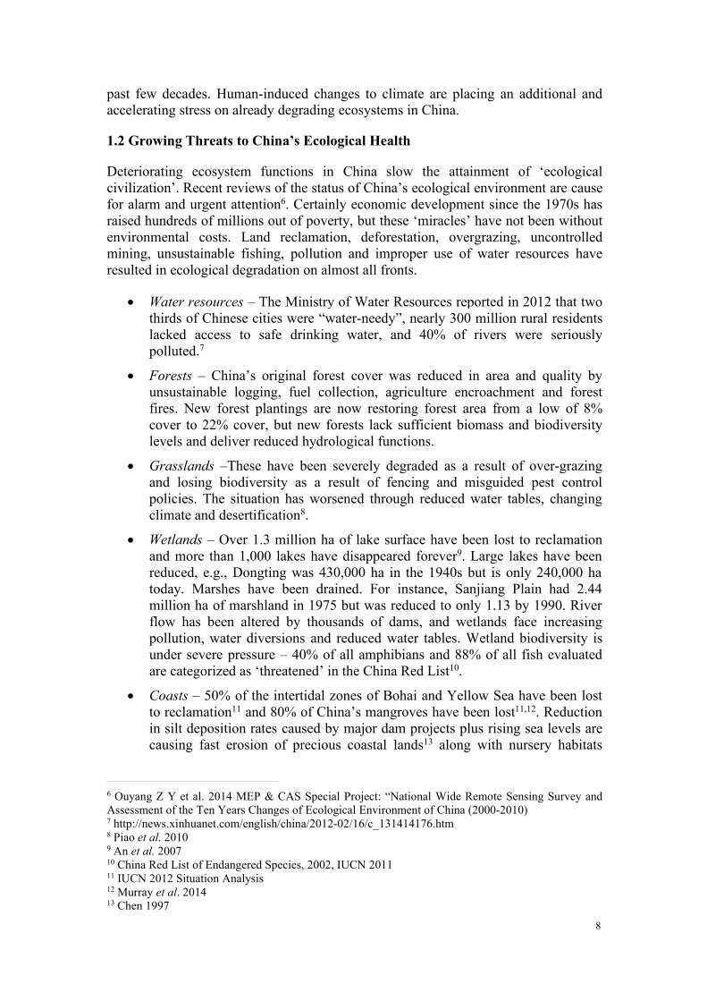
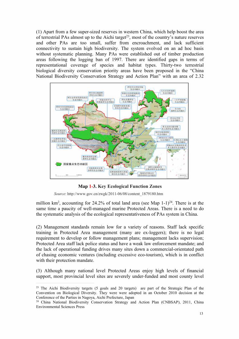
Map 1-1. Priority Biodiversity AreasSource: “NBSAP Strategies and action plan for biodiversity conservation in China” (2011-2030)
12
of Agriculture (MoA), the Ministry of Lands and Resources and the StateOceanography Administration (SOA).
The Nature Reserve system is augmented by scenic areas. The Temporary Regulationof Scenic Spots was issued by the State Council in 1985 and revised in 2006 and2013The State Council has approved eight batches of 225 national scenic spots, withan area of about 103,600 km2. Provincial governments have approved 737 ScenicSpots, with an area of about 90,100 km2. The total area accounts for 2% percent ofChina’s land area. Additional designations of protected areas include forest parks,wetland parks and geoparks.
International designations cut across the national system including World HeritageSites, Man and Biosphere Reserves, Global Geoparks, and wetland sites of globalsignificance (Ramsar Sites). There is a great deal of overlap in designation. For
instance Jiuzhaigou is listed as a national nature reserve, national level scenic spot,National Forest Park Global Geopark and World Natural Heritage Site. The followingmajor issues have been highlighted by earlier studies and CCICED working groupsand task forces20,21,22:
20Wang Sung & MacKinnon 199721 Yan et al. 200422 CCICED 2010c
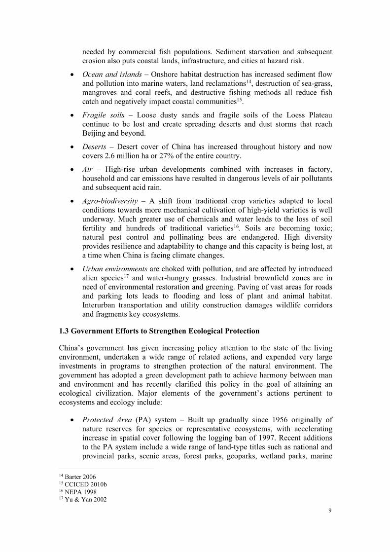
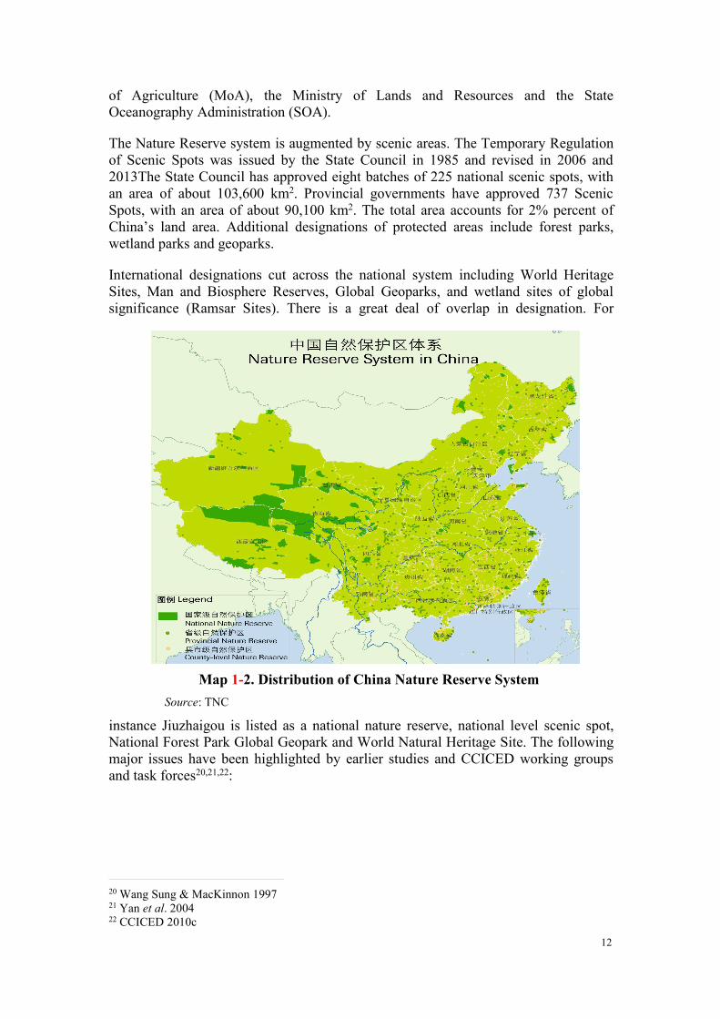
Map 1-2. Distribution of China Nature Reserve SystemSource: TNC
13
(1) Apart from a few super-sized reserves in western China, which help boost the areaof terrestrial PAs almost up to the Aichi target23, most of the country’s nature reservesand other PAs are too small, suffer from encroachment, and lack sufficientconnectivity to sustain high biodiversity. The system evolved on an ad hoc basiswithout systematic planning. Many PAs were established out of timber productionareas following the logging ban of 1997. There are identified gaps in terms ofrepresentational coverage of species and habitat types. Thirty-two terrestrialbiological diversity conservation priority areas have been proposed in the “ChinaNational Biodiversity Conservation Strategy and Action Plan” with an area of 2.32
million km2, accounting for 24.2% of total land area (see Map 1-1)24. There is at thesame time a paucity of well-managed marine Protected Areas. There is a need to dothe systematic analysis of the ecological representativeness of PAs system in China.
(2) Management standards remain low for a variety of reasons. Staff lack specifictraining in Protected Area management (many are ex-loggers); there is no legalrequirement to develop or follow management plans; management lacks supervision;Protected Area staff lack police status and have a weak law enforcement mandate; andthe lack of operational funding drives many sites down a commercial-orientated pathof chasing economic ventures (including excessive eco-tourism), which is in conflictwith their protection mandate.
(3) Although many national level Protected Areas enjoy high levels of financialsupport, most provincial level sites are severely under-funded and most county level
23 The Aichi Biodiversity targets (5 goals and 20 targets) are part of the Strategic Plan of theConvention on Biological Diversity. They were were adopted in an October 2010 decision at theConference of the Parties in Nagoya, Aichi Prefecture, Japan24 China National Biodiversity Conservation Strategy and Action Plan (CNBSAP), 2011, ChinaEnvironmental Sciences Press
Map 1-3. Key Ecological Function ZonesSource: http://www.gov.cn/zwgk/2011-06/08/content_1879180.htm
14
sites have no operational funds at all. There is no specific law to define different typesor categories of Protected Areas. Nature reserves are regulated through an outdatedregulation issued by the State Council. It was drafted by the Ministry of Forestry (nowSFA) and National Environmental Protection Agency (now MEP) in 1986. Theregulation is weak, fails to protect nature reserves from mining and other impactingdevelopments, uses confusing terms for zones, offers no opportunities for wildlife orhabitat management or rehabilitation, and gives no consideration to new threats suchas Alien Invasive Species (AIS) and climate change. The regulation also fails toprovide for any forms of public participation or co-management. The legal status ofall other types of PAs remains undefined and vague. Many sites enjoy multipleoverlapping status and titles. One reason for the proliferation of many types of legallyundefined ‘parks’ is a deliberate effort to avoid the strictures of the Nature Reserveregulation.
(4) The weakness of PA status is revealed by GIS analysis of the rate of conversion ofone key biodiversity habitat—intertidal estuarine in the Yellow Sea25. This studyreveals the frightening rate of habitat loss, matched by documentation of the rates ofspecies losses. Both South Korea and China have been reclaiming coastal lands at asimilar pace, but there is an alarming difference between the two countries: in thoseareas in which South Korea has declared nature reserves, the rate of habitat loss hasbeen significantly reduced, whereas in China, the status of nature reserve has had noimpact on the rate of coastal development and land reclamation.
1.4.2 Inadequacy of the Key Ecological Function Zones
National Ecological Function Zones have been identified and published at the nationalscale by the Ministry of Environment and the Chinese Academy of Sciences (CAS) in2008 and the National Main Ecological Functional Zones Plan was issued by StateCouncil in 2010. These maps (see Map 1-3 above) are useful as a strategic planningtool but the identified areas lack protective legal status and have little meaning forground level management. The Ecological Function Zones are not approved by allministries. The 50 Important Ecological Function Zones proposed in the “NationalEcological Function Zoning” have a total area of 4,360,000 – accounting for 45.4% oftotal land km2, and the 25 Key Ecological Function Zones26 proposed in the“Nationwide Main Functional Zones Plan” have a total area of 3.86 million km2,accounting for 40.2% of total land.27
1.4.3 Weak Incentives for Ecological Protection
There are insufficient legislative mechanisms for the identification, management andprotection of critical ecosystem services across the landscape outside the PA system.Ecosystem services are being assessed across the landscapes of China, but very littleassessment or valuation has been done on marine and coastal ecosystem services,which are some of the most valuable and most threatened services. Where ecosystemservices have been identified and attempts have been made to alleviate pressures that
25Murray et al. 201426 The Nationwide Main Functional Zones Plan is a strategic level plan released by the State Counciland identifies the Four categories of i) Optimal Development ii) Key Development iii) LimitedDevelopment iv) Prohibited Development. It is intended as guidance to provincial and localgovernments.27 Ouyang ZY and Zheng H, 2014, Ecological Security Strategy.
15
cause declines in services, fines and penalties for ecological damage are weak andpoorly enforced, providing little disincentive for many destructive activities anddevelopments.
Considerable financial support has been expended for ecological work in Chinathrough reforestation programs, ecological construction projects, protection of fragilesoils and water catchment sources and post-disaster restoration projects. However,some of these activities are misdirected and payments for ecosystem services areinefficient and fail to reach the most critical targets.
1.4.4 Lack of Institutional Coordination Enforcement and Accountability
Responsibilities for ecological protection are scattered among many organizationsincluding nine major governmental agencies. This in itself is not unworkable, butthere is no agency for which ecological well-being forms the major mandate, andthere is little coordination among the activities and programs of these nine agencies.Indeed, there are overlaps of responsibilities, jealous protection of mandates and landmanagement allocations, gaps in attention, no overall plan or legal basis and notransparent reporting or effective enforcement. There is no agency with overallcoordination or supervisory role and no comprehensive plan for ecological protection,or mainstreaming of ecological protection and biodiversity conservation into holisticgovernment plans at different levels.
1.4.5 Poor Awareness
Senior government leaders clearly understand the value of ecosystem services,recognize the threat of degrading ecological health of the country, and have madeecological protection redlining a high priority for the government developmentprogram. Yet this level of awareness is not shared fully by many other governmentofficials, especially at a local level. Nor is it shared by some members of the publicand perhaps not by the majority of enterprises.
Such lack of awareness leads to half-hearted support of the program and regularignoring or deliberate disregard for the government policies and regulations. Theseattitudes, combined with a lack of laws and weak penalties, explain why ecologicallydamaging developments and activities remain so widespread across the landscape.
1.5 New Approach to Be Followed
New approaches are clearly needed. Chinese leaders have identified the red lineconcept as a key mechanism. To strengthen ecological protection, the “State Council’sOpinions on Priorities of Strengthening Environmental Protection” (GF [2011] No. 35)made it clear that for important ecological function areas, terrestrial and marineecology sensitive areas, fragile areas, and other areas, red lines for ecologicalprotection shall be drawn. “Decisions on Several Major Issues of ComprehensivelyDeepening Reform” adopted by the Third Plenary Session of 18th CPC CentralCommittee set ecological protection redlining as a key action to speed up theecological civilization institutional construction. It explicitly requested “to delineateecological redlining. Establish national spatial development and protection system”,“establish spatial planning system, delineate production, life and ecology spacedevelopment control limits, and implement use controls.”
16
2. ECOLOGICAL PROTECTION REDLINING (EPRL) NEEDS ANDOPTIONS
Despite a relatively clear introduction of the term ‘ecological red line’ in nationalpolicy documents, it is apparent that there is a lack of clarity and uncertainty in theunderstanding of this term, how it relates to red lines for environment, and what itentails. Different agencies of the government have initiated quite separate efforts todescribe and apply their own ideas. There is a great need for a clear, commonlyaccepted definition of the term, better understanding of what China expects from suchred lines for ecological protection, and improved harmonization among the differentapproaches being launched.
2.1 Definition and Characteristics of EPRL
2.1.1 Definition
The term EPRL is proposed to best convey the primary focus and intent with regard toecology and it is defined as the aggregate minimum space or area within which strictdevelopment controls can ensure the sustainable provision of ecosystem services thatunderpin regional and national development and support the attainment of China’svision of an ‘ecological civilization’. EPRL includes natural and constructedecosystems (terrestrial, freshwater and marine), and degraded areas with potential forecological restoration to high ecosystem services value.
2.1.2 Characteristics of the Ecological Protection Red Line (EPRL)
2.1.2.1 What is contained within the EPRL?
There is already a plethora of red lines emerging in China for different purposes. Asone senior official noted “there are enough red lines to knit a sweater”. We haveagreed that there should be a single EPRL rather than several “ecological” red lines orlines of yet more colours. The line is simply the tool to delineate spatial land units thatrequire various measures of special protection or strict limits on activities anddevelopments. Moreover, it is not the only regulatory designation that may apply to aspecific unit of land since these lands may be used for various purposes. Within theEPRL, different land units will be labelled as to what ecological functions needprotection or enhancement. The responsible agencies and managers will beaccountable to ensure that the correct designation and regulations are applied.
It should also be pointed out that the EPRL is only the final line that should not bebreached. Lands falling outside of the EPRL also serve important ecological functionsand require various levels of protective management and controlled use. And theviability of continued ecological function within redlined areas is also influenced bythe context – islands of protection in a sea of degradation will have little ability toprovide services or meet the needs of the China ecological civilization into the future.This is especially true in marine and coastal areas, where degradation from afar isoften the driver of ecosystem services loss. So in many cases, the redlined lands willrequire establishment of an external buffer that allows some appropriate level ofdevelopment that is compatible with the adjacent EPRL and provisions to protectfunctional connectivity to ensure, for example, migration routes for wildlife.
17
The EPRL can thus be seen as a category division in a land-use classification systemthat contains a review of the ecological protection needs of all land units, freshwaterand marine areas of China, dividing those lands for which ecological protection is theprimary function from lands where other uses – farming, forestry, mineraldevelopment, etc. – may be the primary function. However, attention will also beneeded to protect some ecological functionality in these lands.
Some areas within the EPRL may be primarily for water catchment protection andrequire strict protection of vegetation cover but not necessarily native vegetation.Other areas may be important for biodiversity and the emphasis would be more onnatural conditions or even conditions managed to favour a specific target species orspecies community. And even other areas may be primarily concerned with bindingloose soils or creating wind or storm barriers to protect crops and property. Many landunits will serve multiple ecological functions and may need attention from severaldifferent agencies to ensure their proper management. Marine redlining couldunderpin the country’s marine spatial planning and ocean zoning, in such a way that itimproves the prospect for food security and assures that ecosystem services flow intothe future, even as global change stresses ecosystems everywhere28.
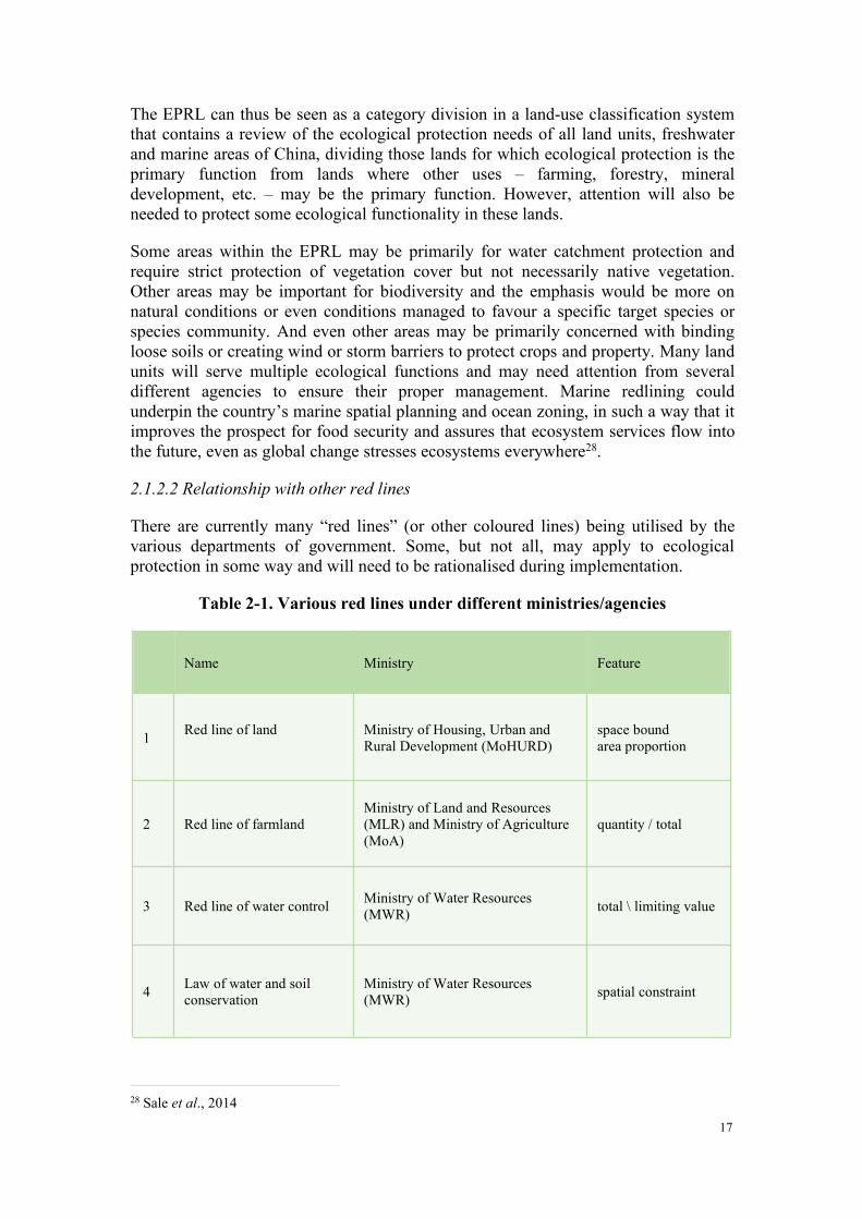
2.1.2.2 Relationship with other red lines
There are currently many “red lines” (or other coloured lines) being utilised by thevarious departments of government. Some, but not all, may apply to ecologicalprotection in some way and will need to be rationalised during implementation.
Table 2-1. Various red lines under different ministries/agencies
28 Sale et al., 2014
Name Ministry Feature
1 Red line of land Ministry of Housing, Urban andRural Development (MoHURD)
space boundarea proportion
2 Red line of farmlandMinistry of Land and Resources(MLR) and Ministry of Agriculture(MoA)
quantity / total
3 Red line of water control Ministry of Water Resources(MWR) total \ limiting value
4 Law of water and soilconservation
Ministry of Water Resources(MWR) spatial constraint
18
These different red lines vary according to their nature and purpose; some arespatially fixed, while others are quantile rather than spatial. For instance, theagricultural red line simply demands that an adequate extent of arable lands beprotected from conversion so as to guarantee long-term food security (assuming percapita food consumption levels remain constant with growing wealth, China’spopulation levels off, and soil fertility is maintained). Such lands can be identified andmarked on a map.
Clearly, there will be overlaps among these red lines. For example, some of the landsreserved under the agricultural red line may serve important ecological functions,notably in steep terrain, important water catchment areas, and on fragile soils. Someagricultural lands may be important for biodiversity conservation – feeding areas forgeese and cranes, breeding sites for endangered Crested Ibis, etc. Thus, the EPRL islikely to overlap the agricultural red line and identify some farmlands that requirespecial protection measures or controlled use.
There will be more overlap with lands redlined to protect forest lands, wetlands andlands redlined to protect water sources. During implementation these overlaps canbecome harmonized through the land-use planning process, where overlay of allclassifications are considered during the allocation of appropriate land or marine-usecategory.
2.1.2.3 Basic characteristics of the EPRL
Once an EPRL has been delineated it should satisfy the following properties andcharacteristics:
Nature remains unchanged. The main goals of EPRLs include ecosystem servicesprotection, protection of ecologically sensitive areas and fragile areas, andbiodiversity conservation. EPRL blocks shall be clearly fixed, and the naturalenvironment and ecosystem types inside the red line area shall remain unchanged.These conditions may be difficult to guarantee, especially when climate change andother drivers come into full play.
Functions are not reduced. For important ecological function areas with goodecological conditions, ecosystem services delivered by the EPRL cannot be reduced.For ecologically sensitive areas, vulnerable areas, and areas within ecologicalprotection red lines, measures of ecological restoration and management shall betaken to continuously improve the ecological function.
Area is not diminished. After the EPRL is delineated, it is not permanentlyunchanged. When the borders and thresholds of ecological protection redliningchange due to external environment changes, the EPRL be adjusted so as to ensuretimely supply of basic ecological functions. However, the EPRL area cannot be
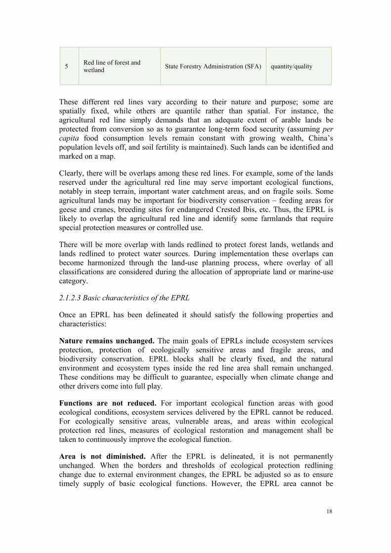
5 Red line of forest andwetland State Forestry Administration (SFA) quantity/quality
19
reduced, and shall be appropriately increased with the enhancement of ecologicalprotection ability and optimization of land spaces.
2.1.2.4 Objectives of the EPRL
As implicit in the definition of the ecological protection red line, the objective is tosafeguard or restore a minimum of ecological functions that underpin the safety andsustainability of human development.
The EPRL delivers three main categories of function. First, it protects the most criticallands for delivery of regulatory and supporting functions with protection of waterresources, soil formation/protection and climate mitigation as the main objectives.Secondly, the EPRL protects and conserves areas vital for protection of highconservation values of biodiversity, important species, wild crop relatives,representative ecosystem types and genetic resources. These are valuable asprovisioning services, and provide ecological resilience and adaptability as well asforming an important part of national natural heritage. Thirdly, the EPRL includesareas of sensitive/fragile ecological conditions that can be easily threatened ordestroyed by erosion, flooding, landslides, flooding, coastal typhoons, etc. Again,there is considerable overlap between these functional types and many areas deliverservices of all three.
2.1.2.5 What can establishing EPR deliver?
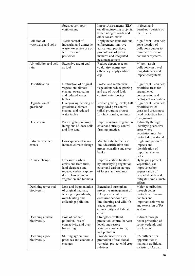
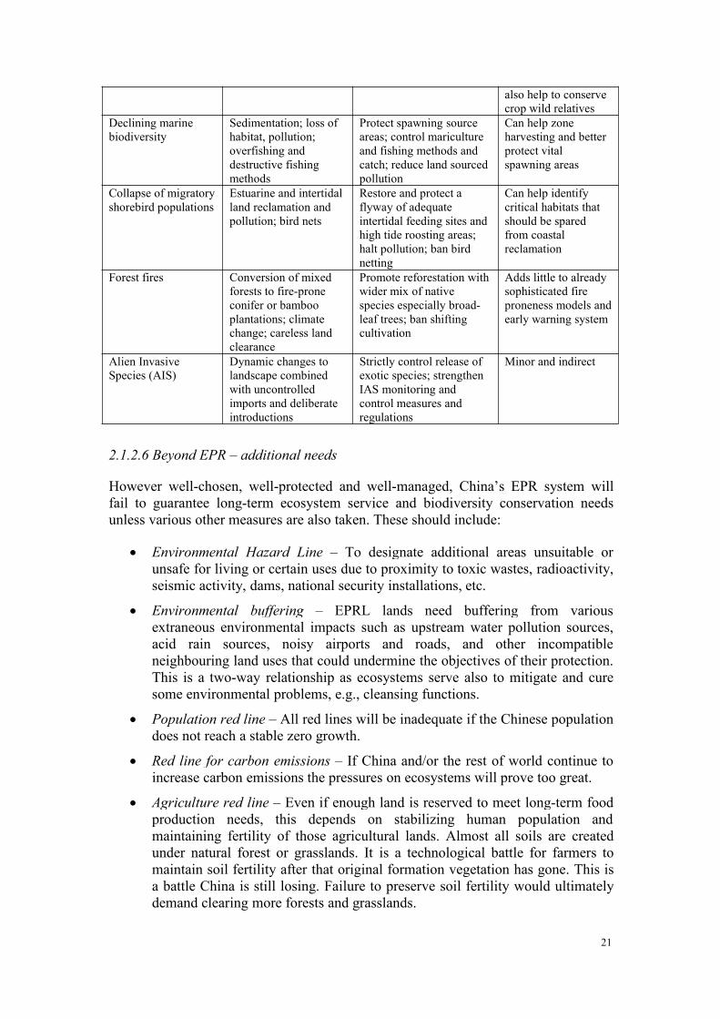
EPR alone cannot cure all that ails China’s degrading ecosystem functionality. It isone important set of tools in an arsenal of measures needed. Table 2-2 lists the mainecological problems and failings being experienced in China and annotates therelevance of EPR in the remedial prescription.
Table 2-2. Ecological problems and relevance of EPR
Ecological problemsfaced
Causes and drivers Remedial actions required Contribution of EPR
Drying up of dryseason river flows
Loss of forest,grassland and wetlandsponges in uppercatchments; excessiveand wasteful upstreamwater use
Strengthen protection ofnatural vegetation incatchments; improvereforestation techniquesand farm practices
Helps identify andprotect critical watercatchment areas
Drying up andreduced volume offreshwater lakes
Diversion of watersupplies; excessive andwasteful upstreamwater use; reducedwater tables fromtapping undergroundsources; climate change
Better regulate diversionand extraction of water;improve efficiency ofirrigation, strengthen waterconservation
Minor and indirect
Loss of speciesconnectivity throughaquatic habitats
Construction of damsand weirs;disconnection andreduction of lakes; alienintroductions
Create fish ‘ladders’around dams; restoreimportant lakes and reopenconnections to major rivers
Used to protect orrestore aquaticecosystems
Excessive siltation ofwaterways
Poor soil conservationpractices; cultivation ofsteep slopes; loss of
Improve forestry andagricultural practices;apply strict Environmental
Identifies areas mostprone to soil losses,but these are mostly
20
forest cover; poorengineering
Impact Assessments (EIA)on all engineering projects;better siting of roads andother constructions
in forest andfarmlands outside ofthe EPRLs
Pollution ofwaterways and soils
Weak control ofindustrial and domesticwaste; excessive use offertilizers andpesticides
Apply better standards andenforcement; improveagricultural practices;promote use of greenmanures and integratedpest management
Significant – can helpzone location ofpollution sources tominimize effect onnatural ecosystems
Air pollution and acidrain
Excessive use of coalas fuel
Reduce dependence oncoal; raise energy useefficiency; apply carboncap
Minor – as airpollution can travellong distances andimpact ecosystems
Desertification Destruction of originalvegetation; climatechange; overgrazingand reduced watertables
Protect and reestablishvegetation; reduce grazingand use of wood fuel;control water boring
Significant – can helpprioritize areas forstrengthenedconservation andecological restoration
Degradation ofgrasslands
Overgrazing; fencing ofgrasslands, climatechange; and reducedwater tables
Reduce grazing levels; haltmisguided pest control(pika) program; protectkey functional grasslands
Significant – can helpprioritize whichgrassland areas mostneed protection fromovergrazing
Dust storms Poor vegetation coverin regions of loose soilsand fine sand
Improve natural vegetationcover and strictly controlfarming practices
Indirectly throughidentifying sensitiveareas wherevegetation must beprotected or restored
Extreme weatherevents
Consequence of man-induced climate change
Maintain shelter belts tolimit desertification andprotect coastline and riverbanks
Slight mitigation ofimpacts andidentification ofimportant shelterbelts
Climate change Excessive carbonemissions from fuels,land clearance andreduced carbon capturedue to loss of greenvegetation and biomass
Improve carbon fixationby intensifying vegetationcover and carbon storageof forests and wetlands
By helping protectvegetation, canimprove carbonsequestration ofdegraded lands andmitigate some climateeffects
Declining terrestrialbiodiversity
Loss and fragmentationof original habitats;fencing of grasslands;over-hunting andcollecting; pollution
Extend and strengthenprotective management ofPA system; controlexcessive eco-tourism;limit hunting and wildlifetrade; promoteconnectivity and habitatcover
Major contributionthrough betterprotection of naturalhabitats andimportant reforms toand extension of PAsystem
Declining aquaticbiodiversity
Loss of habitat;pollution, loss ofconnectivity and over-harvesting
Strengthen wetlandprotection; control harvestlevels and restorewaterway connectivity;halt pollution
Indirect throughbetter protection ofsome wetlands andcatchments
Declining agro-biodiversity
Shifting agriculturalpractices and economicchanges
Provide incentives forpromotion of traditionalvarieties; protect wild croprelatives
PA buffers offeropportunities tomaintain traditionalvarieties; PAs can
21
also help to conservecrop wild relatives
Declining marinebiodiversity
Sedimentation; loss ofhabitat, pollution;overfishing anddestructive fishingmethods
Protect spawning sourceareas; control maricultureand fishing methods andcatch; reduce land sourcedpollution
Can help zoneharvesting and betterprotect vitalspawning areas
Collapse of migratoryshorebird populations
Estuarine and intertidalland reclamation andpollution; bird nets
Restore and protect aflyway of adequateintertidal feeding sites andhigh tide roosting areas;halt pollution; ban birdnetting
Can help identifycritical habitats thatshould be sparedfrom coastalreclamation
Forest fires Conversion of mixedforests to fire-proneconifer or bambooplantations; climatechange; careless landclearance
Promote reforestation withwider mix of nativespecies especially broad-leaf trees; ban shiftingcultivation
Adds little to alreadysophisticated fireproneness models andearly warning system
Alien InvasiveSpecies (AIS)
Dynamic changes tolandscape combinedwith uncontrolledimports and deliberateintroductions
Strictly control release ofexotic species; strengthenIAS monitoring andcontrol measures andregulations
Minor and indirect
2.1.2.6 Beyond EPR – additional needs
However well-chosen, well-protected and well-managed, China’s EPR system willfail to guarantee long-term ecosystem service and biodiversity conservation needsunless various other measures are also taken. These should include:
Environmental Hazard Line – To designate additional areas unsuitable orunsafe for living or certain uses due to proximity to toxic wastes, radioactivity,seismic activity, dams, national security installations, etc.
Environmental buffering – EPRL lands need buffering from variousextraneous environmental impacts such as upstream water pollution sources,acid rain sources, noisy airports and roads, and other incompatibleneighbouring land uses that could undermine the objectives of their protection.This is a two-way relationship as ecosystems serve also to mitigate and curesome environmental problems, e.g., cleansing functions.
Population red line – All red lines will be inadequate if the Chinese populationdoes not reach a stable zero growth.
Red line for carbon emissions – If China and/or the rest of world continue toincrease carbon emissions the pressures on ecosystems will prove too great.
Agriculture red line – Even if enough land is reserved to meet long-term foodproduction needs, this depends on stabilizing human population andmaintaining fertility of those agricultural lands. Almost all soils are createdunder natural forest or grasslands. It is a technological battle for farmers tomaintain soil fertility after that original formation vegetation has gone. This isa battle China is still losing. Failure to preserve soil fertility would ultimatelydemand clearing more forests and grasslands.
22
China needs red lines in territories beyond its boundaries to protect its long-term dependence on resources from those territories and to ensure that othercountries do not suffer loss of ecological services.
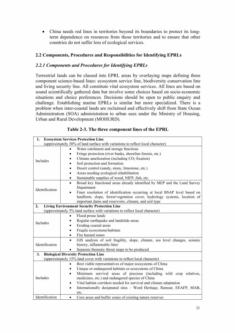
2.2 Components, Procedures and Responsibilities for Identifying EPRLs
2.2.1 Components and Procedures for Identifying EPRLs
Terrestrial lands can be classed into EPRL areas by overlaying maps defining threecomponent science-based lines: ecosystem service line, biodiversity conservation lineand living security line. All constitute vital ecosystem services. All lines are based onsound scientifically gathered data but involve some choices based on socio-economicsituations and choice preferences. Decisions should be open to public enquiry andchallenge. Establishing marine EPRLs is similar but more specialized. There is aproblem when inter-coastal lands are reclaimed and effectively shift from State OceanAdministration (SOA) administration to urban uses under the Ministry of Housing,Urban and Rural Development (MOHURD).
Table 2-3. The three component lines of the EPRL
1. Ecosystem Services Protection Line(approximately 30% of land surface with variations to reflect local character)
Includes
Water catchment and storage functions Fringe protection (river banks, shoreline forests, etc.) Climate amelioration (including CO2 fixation) Soil protection and formation Desert control (sandy, stony, limestone, etc.) Areas needing ecological rehabilitation Sustainable supplies of wood, NIFP, fish, etc.
Identification
Broad key functional areas already identified by MEP and the Land SurveyDepartment
Finer resolution of identification occurring at local BSAP level based onlandform, slope, forest/vegetation cover, hydrology systems, location ofimportant dams and reservoirs, climate, and soil type
2. Living Environment Security Protection Line(approximately 5% land surface with variations to reflect local character)
Includes
Flood prone lands Regular earthquake and landslide areas Eroding coastal areas Fragile ecosystems/habitats Fire hazard zones
Identification GIS analysis of soil fragility, slope, climate, sea level changes, seismic
history, inflammable litter Separate thematic threat maps to be produced
3. Biological Diversity Protection Line(approximately 15% land cover with variations to reflect local character)
Includes
Best viable representatives of major ecosystems of China Unique or endangered habitats or ecosystems of China Minimum survival areas of precious (including wild crop relatives,
medicines, etc.) and endangered species of China Vital habitat corridors needed for survival and climate adaptation Internationally designated sites – Word Heritage, Ramsar, EEAFP, MAB,
etc.Identification Core areas and buffer zones of existing nature reserves
23
Additional reserves, extensions and corridors as identified by several gapanalysis exercises
Broad priority areas already identified in National Biodiversity Strategy andAction Plans (NBSAPs), local Biodiversity Strategy and Action Plans(BSAPs), hotspot reviews, Key Biodiversity Areas, etc.
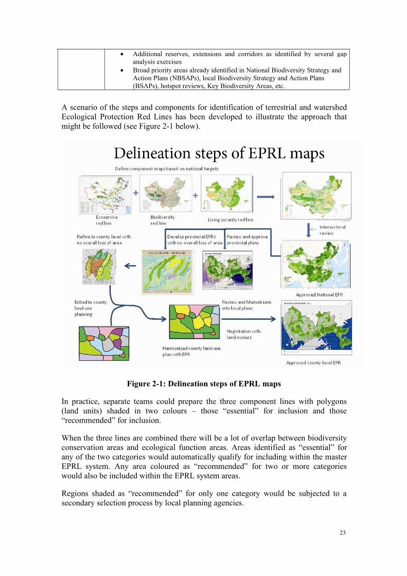
A scenario of the steps and components for identification of terrestrial and watershedEcological Protection Red Lines has been developed to illustrate the approach thatmight be followed (see Figure 2-1 below).
Figure 2-1: Delineation steps of EPRL maps
In practice, separate teams could prepare the three component lines with polygons(land units) shaded in two colours – those “essential” for inclusion and those“recommended” for inclusion.
When the three lines are combined there will be a lot of overlap between biodiversityconservation areas and ecological function areas. Areas identified as “essential” forany of the two categories would automatically qualify for including within the masterEPRL system. Any area coloured as “recommended” for two or more categorieswould also be included within the EPRL system areas.
Regions shaded as “recommended” for only one category would be subjected to asecondary selection process by local planning agencies.
24
Final EPRL maps would, at each hierarchical level (national, provincial, county etc.),be reviewed by all relevant agencies prior to final ratification
Marine EPRL, a Special Case
In order to define red lines for protection of ecology and environment in marine andcoastal areas in a way that maximizes benefits flowing from natural capital andreduces environmental threats and risks, the People’s Republic of China has severaloptions. One option is to mirror what is already beginning on land – this is theidentification of coastal / marine areas having high ecosystem services value,including provisioning and regulating services, priority areas delivering multipleservices, and areas of economic value. Another approach would be to do somethingmore akin to systematic conservation planning, in which the focus is on theidentification of coastal and marine areas having high conservation value, usingcriteria such as: species richness, endemism, and habitat diversity; vulnerable orsensitive species and habitats; and highly migratory or mobile species.
Regardless of which approach is used, China will have to deal with data gaps andinconsistent information, a situation in which heavily studied areas like the Bohai Seaprovide a much greater amount of data and higher degree of analysis, while otherareas lack this information. It will be important for national agencies to work closelywith academic and epistemic communities. Since every effort should be made toapply criteria consistently and to systematically assess all marine areas in concert withcoastal and watershed areas, the precautionary approach is likely warranted.International experience has shown that the most efficient way to identify areas inwhich ecosystem services and conservation are maximized is that which uses ahierarchical approach, beginning with the largest geographical scale.
The People’s Republic of China has embarked on an effort to identify priority areasfor protection in order to safeguard natural capital, keep the flow of natural goods andecosystem services flowing, and reduce risks borne from natural catastrophe. Whilethese benefits can also flow from protecting natural capital in the marine environment,there are special challenges inherent in attempting redlining in the marineenvironment, which include:
• The reality that the oceans are opaque, contain ecosystems with nebulousboundaries, and often have overlapping jurisdictions that make agencyresponsibilities and opportunities difficult to determine;
• The undeniable fact that much of ocean health and productivity is linked toterrestrial and wetland ecosystem condition, therefore marine redlining should bedone systematically with redlining on land;
• The difficulties inherent in defining, mapping, quantifying and valuing marineecosystem services, despite the fact that marine and coastal ecosystems mayprovide even more natural capital and services of value than terrestrial; and
• The limited options available for effective management of priority areas, giventhe need for inter-agency cooperation, surveillance and enforcement, andgeographically large scale coordinated and collaborative action.
China also presents a particularly opportune case in marine priority area identification
25
and protection since many redlining initiatives are already underway. A uniquechallenge, and opportunity, exists to strategically align all these ecological protectionredlining initiatives, and systematically link them to other spatial planning processesunderway, such as spatial and land-use planning, regional marine redlining, nationalocean zoning, and both terrestrial and marine protected area designations.
In practice there should be three important steps in marine redlining:
Step 1. Identification of areas having high ecosystem services value:
Provisioning and regulating services
Priority areas delivering multiple services
The role of economic valuation
Step 2. Identification of coastal and marine areas having high conservation value:
Species richness, endemism, and habitat diversity
Vulnerable or sensitive species and habitats
Highly migratory or mobile species habitats
Step 3. Drawing boundaries around what is important.
This process is not totally scientific and objective. There is an important socialdimension. There are three principles for application.
(1) Delimiting target areas in view of ecosystem complexities:
Shorelines are dynamic systems
Boundaries at sea are fluid and shifting
Size and shape of area depends on scale
Redlining requires periodic revision as ecosystems, conditions, and needschange (especially in the face of changing sea level, temperature and seacurrents)
(2) No redlined area is ‘an island’; marine areas are intimately connected.
Target areas need to be considered for their linkages to other areas, bothmarine and terrestrial
Marine areas are often degraded due to poor land-use practices and poorwatershed management, even when the area is strictly protected at sea
Need to take an integrated approach, recognizing connections
(3) Ecological protection redlining of marine areas must be fitted into existinginitiatives:
Land-use planning
Regional marine redlining
National ocean zoning
26
Marine protected area designations
2.2.2 Harmonizing the Land-Use Planning Process to Include Recognition ofEcological Functions
All land is useful and much of the currently defined wasteland or unused lands are infact delivering valuable ecological services. Use of these negative terms should beceased.
Strict division of marine, urban and rural area planning causes harmonizationproblems, as different agencies have differing land classification systems andcontrol/planning procedures. The division in reality is not so clear-cut. Coastlinechanges rapidly, towns grow into country with urban sprawl, and new towns areconstantly built. The very valuable intertidal zone is a case in point. Most marineareas are under control of SOA but this zone can also be classed as a forest or wetland,both under nominal control of SFA. However, plans to reclaim such areas as dry landports or docks fall under MOHURD. Only a harmonized land-use planning systemunder Ministry of Lands and Resources can effectively control and harmonize suchtransitions.
Responsibilities
National government responsibilities are to: set targets for the area andquality of lands to be established as EPRLs; identify national major ecologicalzones, including those which cross provincial boundaries or are criticalwatersheds; and set acceptable uses and performance standards for red linemanagement. A national target should be put in place to establish 35% of theland and water area and coastline of China within the EPRLs29.
Define acceptable quality standards and establish the monitoring andenforcement regime. For Oceans a target is still required to be set.
Provincial government responsibilities are to: translate national targets tolocal government; work in cooperation with surrounding provinces on cross-border EPRLs; and ensure no net loss of areas at a provincial scale resultingfrom the local land use planning
Local government responsibilities are to: identify ecological lands, resolveconflicting objectives, and ensure achievement of targets for identification ofecological lands through land use planning that involves both local peoplesand ministry representatives; and manage and report on Ecological Landsaccording to national standards.
2.2.3 Negotiation with Local Land Owners and Planners
There will be quite heated negotiations with landowners and local planners to achieveagreement for a mainstreamed and approved version of the draft EPRL map producedby the agencies. Much at this stage will depend on the confidence of local agencies
29 Based on analysis undertaken by the CAS Eco-environmental Laboratory
27
and communities in the incentive system and methods of payment for ecosystemservices that are bought into play.
2.3 Monitoring, Evaluation and Management of EPR
2.3.1 Guiding Principles and Practices for Compliance and Enforcement
Effective compliance and enforcement is vital for ecological protection and successfulimplementation of the redlining initiatives in China. It is a topic on which there isconsiderable international experience. This set of principles and practices has beenderived from that experience and is intended to provide guidance in the next steps ofimplementation.
Table 2-4. Principles and practices for effective compliance and enforcement
Defined clear authorities; separate those who are responsible for decision making fromthose responsible for compliance and enforcement at the local government levels
Systematic well-coordinated approach between the various agencies and levels ofgovernment
Focused on compliance as much as on enforcement.Rules that are clearly defined and can be enforced effectivelyPredictable transparent, rules and information driven actionsEngaged citizens and societyInformed monitoring, accurate and transparentTrusted integrity in deliveryFair dispute resolution mechanism
2.3.2 Management Responsibilities for EPRL
Identification of a red line will not in itself alter the designation of the land orauthority of land managers. It is proposed that direct responsibilities for the day-to-day management of EPRL lands will remain in the hands of the current responsibleagencies unless the lands are to become new Protected Areas. The EPR process willadd protection to many new areas. These are already mostly under control of SFA ifthey are forests or wetlands, MOA if they are grasslands (including mountains), orSOA if marine. Newly added areas should be reviewed against available options ofnew protection status and, depending on specific protection demands, may be suitablefor allocation under any of the existing PA categories to be systematically reformed.Many existing PAs are inappropriately allocated and may need to have statusrevisions to more suitable use categories. In making such selections and reallocations,the needs for protecting identified ecological functions should be given priority overopportunities to maximize economic potential.
Table 2-5. Main Protected Area types and management agencies in China
TypesAgencies
SFA MEP MOA SOA MLR MHURD MWR Other
Nature reserve X X X X X X X XProtected Area forfish germplasm X
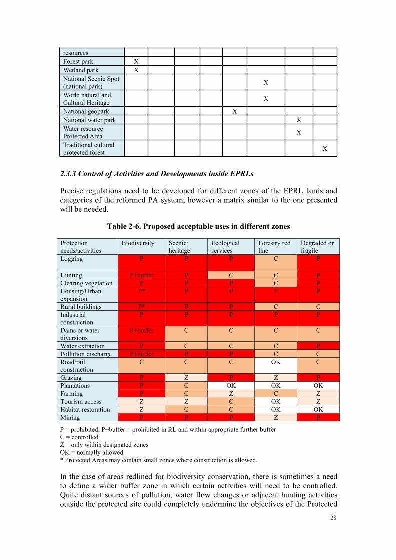
28
resourcesForest park XWetland park XNational Scenic Spot(national park) X
World natural andCultural Heritage X
National geopark XNational water park XWater resourceProtected Area X
Traditional culturalprotected forest X
2.3.3 Control of Activities and Developments inside EPRLs
Precise regulations need to be developed for different zones of the EPRL lands andcategories of the reformed PA system; however a matrix similar to the one presentedwill be needed.
Table 2-6. Proposed acceptable uses in different zones
Protectionneeds/activities
Biodiversity Scenic/heritage
Ecologicalservices
Forestry redline
Degraded orfragile
Logging P P P C P
Hunting P+buffer P C C PClearing vegetation P P P C PHousing/Urbanexpansion
P* P P P P
Rural buildings P* P P C CIndustrialconstruction
P P P P P
Dams or waterdiversions
P+buffer C C C C
Water extraction P C C C PPollution discharge P+buffer P P C CRoad/railconstruction
C C C OK C
Grazing P Z P Z PPlantations P C OK OK OKFarming P C Z C ZTourism access Z Z C OK ZHabitat restoration Z C C OK OKMining P P P Z P
P = prohibited, P+buffer = prohibited in RL and within appropriate further bufferC = controlledZ = only within designated zonesOK = normally allowed* Protected Areas may contain small zones where construction is allowed.
In the case of areas redlined for biodiversity conservation, there is sometimes a needto define a wider buffer zone in which certain activities will need to be controlled.Quite distant sources of pollution, water flow changes or adjacent hunting activitiesoutside the protected site could completely undermine the objectives of the Protected
29
Area and have negative impacts on the protected biodiversity. This type of externalbuffer zone is relatively common in other countries but very different from thecurrently designated ‘buffer zones’ inside Chinese nature reserves, which are strictprotection zones with no exploitative human activities permitted.
2.3.4 Freeze on Major Developments and Approval of Plans in Nationally IdentifiedCandidate EPRL Areas
In order to immediately prevent EPR planning from being undermined by a flood ofother plans and claims in anticipation of delineation and introduction of this and othernew reforms, regulations and zoning, it is necessary to put in place an immediatefreeze on major developments inside the already identified Key Ecological FunctionZones. When the final EPRLs are agreed, frozen developments that fall outside theEPRLs can be reactivated while those that fall within the EPRLs can be terminatedwithout need of undue compensation. A freeze such as this will require urgent anddecisive action by the State Council.
This freeze would also serve as a massive awareness measure. Everyone wouldquickly realize that the government means business, and consequently understand theimportance of ecological protection in government policy objectives. The freezewould also accelerate the completion of the drawing and agreement of red lineboundaries by local agencies if they wish to speed up the thaw on halteddevelopments.
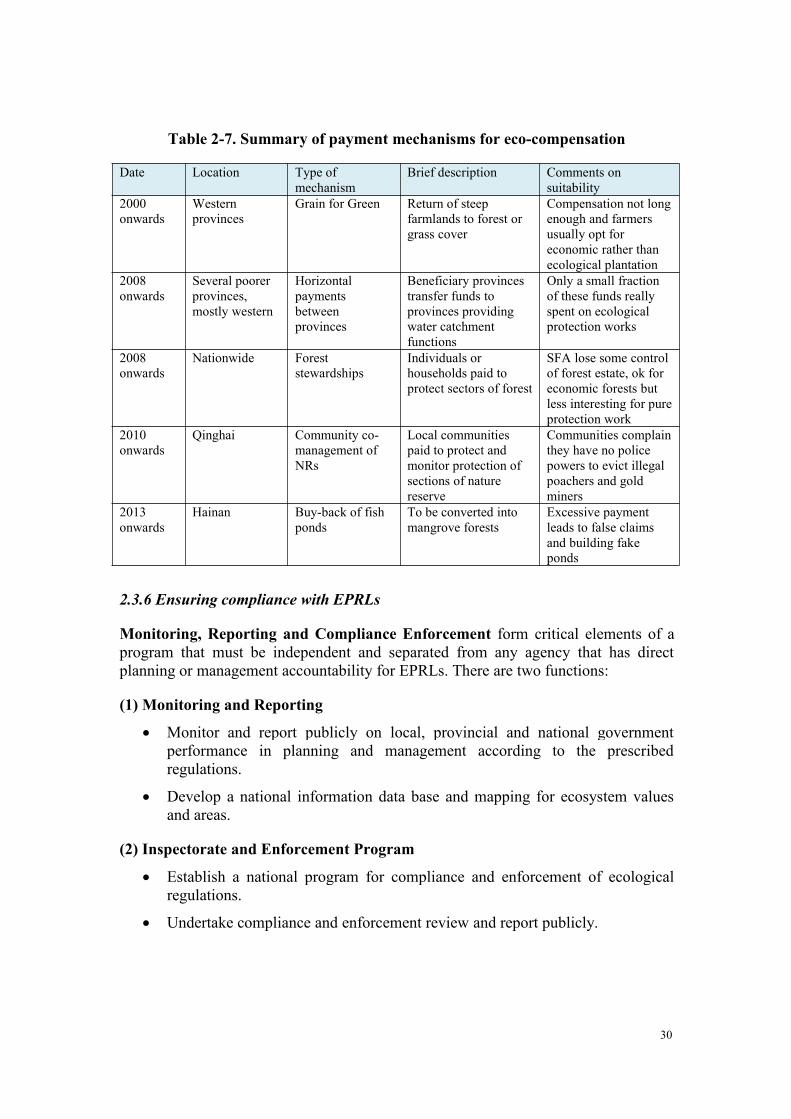
2.3.5 Paying for Redlining
The costs of the identification, legislation, demarcation, education and buildingawareness of EPRLs and EPRL monitoring, law enforcement and revision are allresponsibilities of government and good governance. Their full costs must be borneby government at different levels, but these costs could be covered by new forms oftaxation on areas of the economy that most benefit from good ecosystem services.
The costs of managing PAs, establishing protected forests or undertaking ecologicalrestorations are also primarily government responsibilities and should be covered bythe relevant establishing agencies. These costs may be offset by earnings from eco-tourism, public or private sector donations, or co-management partners. Costsinvolved in responsible protection of the environment are a fundamental part ofgovernment expenditure and should not be termed eco-compensation.
The term ‘eco-compensation’ should be reserved for payments to individuals,communal or private land-use owners whose loss of development options will belimited through the application of EPRLs. A variety of such eco-compensationmechanisms have been tried in China with varying degrees of success. A CCICEDtask force on Eco-compensation measures advised on how ecosystem services can beincorporated into Green Development (CCICED 2006). The task force report suggestsa variety of payment mechanisms for different types of compensation. One importantpoint of the report is the stress placed on involving local communities in the process.The following table summarizes several such mechanisms.
30
Table 2-7. Summary of payment mechanisms for eco-compensation
Date Location Type ofmechanism
Brief description Comments onsuitability
2000onwards
Westernprovinces
Grain for Green Return of steepfarmlands to forest orgrass cover
Compensation not longenough and farmersusually opt foreconomic rather thanecological plantation
2008onwards
Several poorerprovinces,mostly western
Horizontalpaymentsbetweenprovinces
Beneficiary provincestransfer funds toprovinces providingwater catchmentfunctions
Only a small fractionof these funds reallyspent on ecologicalprotection works
2008onwards
Nationwide Foreststewardships
Individuals orhouseholds paid toprotect sectors of forest
SFA lose some controlof forest estate, ok foreconomic forests butless interesting for pureprotection work
2010onwards
Qinghai Community co-management ofNRs
Local communitiespaid to protect andmonitor protection ofsections of naturereserve
Communities complainthey have no policepowers to evict illegalpoachers and goldminers
2013onwards
Hainan Buy-back of fishponds
To be converted intomangrove forests
Excessive paymentleads to false claimsand building fakeponds
2.3.6 Ensuring compliance with EPRLs
Monitoring, Reporting and Compliance Enforcement form critical elements of aprogram that must be independent and separated from any agency that has directplanning or management accountability for EPRLs. There are two functions:
(1) Monitoring and Reporting
Monitor and report publicly on local, provincial and national governmentperformance in planning and management according to the prescribedregulations.
Develop a national information data base and mapping for ecosystem valuesand areas.
(2) Inspectorate and Enforcement Program
Establish a national program for compliance and enforcement of ecologicalregulations.
Undertake compliance and enforcement review and report publicly.
31
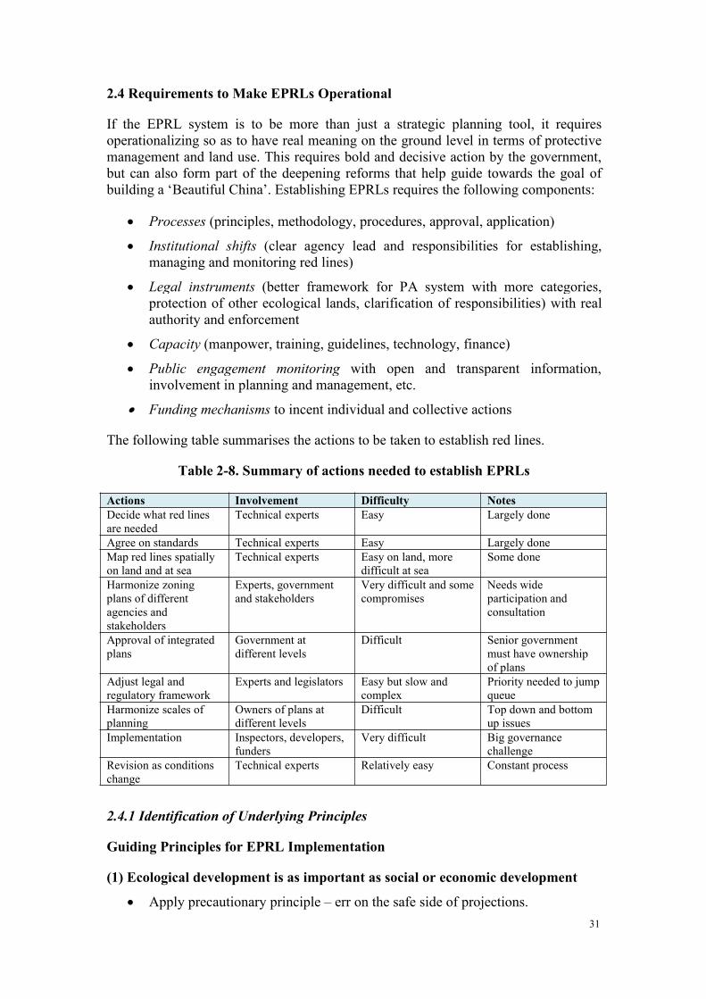
2.4 Requirements to Make EPRLs Operational
If the EPRL system is to be more than just a strategic planning tool, it requiresoperationalizing so as to have real meaning on the ground level in terms of protectivemanagement and land use. This requires bold and decisive action by the government,but can also form part of the deepening reforms that help guide towards the goal ofbuilding a ‘Beautiful China’. Establishing EPRLs requires the following components:
Processes (principles, methodology, procedures, approval, application)
Institutional shifts (clear agency lead and responsibilities for establishing,managing and monitoring red lines)
Legal instruments (better framework for PA system with more categories,protection of other ecological lands, clarification of responsibilities) with realauthority and enforcement
Capacity (manpower, training, guidelines, technology, finance)
Public engagement monitoring with open and transparent information,involvement in planning and management, etc.
Funding mechanisms to incent individual and collective actions
The following table summarises the actions to be taken to establish red lines.
Table 2-8. Summary of actions needed to establish EPRLs
Actions Involvement Difficulty NotesDecide what red linesare needed
Technical experts Easy Largely done
Agree on standards Technical experts Easy Largely doneMap red lines spatiallyon land and at sea
Technical experts Easy on land, moredifficult at sea
Some done
Harmonize zoningplans of differentagencies andstakeholders
Experts, governmentand stakeholders
Very difficult and somecompromises
Needs wideparticipation andconsultation
Approval of integratedplans
Government atdifferent levels
Difficult Senior governmentmust have ownershipof plans
Adjust legal andregulatory framework
Experts and legislators Easy but slow andcomplex
Priority needed to jumpqueue
Harmonize scales ofplanning
Owners of plans atdifferent levels
Difficult Top down and bottomup issues
Implementation Inspectors, developers,funders
Very difficult Big governancechallenge
Revision as conditionschange
Technical experts Relatively easy Constant process
2.4.1 Identification of Underlying Principles
Guiding Principles for EPRL Implementation
(1) Ecological development is as important as social or economic development
Apply precautionary principle – err on the safe side of projections.
32
EPR area shall not be diminished and areas not reduced.
EPR ecosystem services shall not decline.
Nature remains unchanged.
(2) Use creative financial, market and regulatory measures
Employ incentives and market mechanisms to drive action as well as use ofpunishment systems.
Polluter pays – apply heavy fines and disincentives to those developments thatdamage the ecosystem. Such fines to be proportional to damage caused.
Developers should not benefit from any illegal development.
Fair play – losers will be compensated (especially rural communities).
Beneficiaries should be taxed to cover costs of redlining.(3) The land use system needs to adapt to the ecological imperatives of China
Environment and ecology are not separate but inextricably bound together.
All land in China is valuable.
No such thing as ‘waste’ land.
“Ecological” land needs to be recognised.
Both natural and damaged lands are essential components.
(4) The Institutional regime must accommodate EPRL
Common objectives and standards but differentiated solutions and approaches.
EPR includes terrestrial, freshwater and marine system.
Not just about EPRL but the whole landscape.
Separation of planning, management and monitoring/assessment functions.
Professional Compliance and Enforcement is necessary.
Full operational costs to be covered.
2.4.2 Reform of the Protected Area System
There is a strong case for comprehensive reform of the existing PA system to helpsolve the many problems alluded to in section 1.4.1. Reforms should include theimposition of an overall framework of approved PA categories to allow moreappropriate management options for different situations in China. In particular, thisshould include clarification of standards and management objectives for suchcategories as national and provincial parks so that they can achieve a sound balancebetween the objectives of earning income from eco-tourism and protection ofecological, scenic, cultural and biodiversity values contained in such sites. There isalso a need to include a managed reserve category to allow various forms of landmanagement for specific biodiversity or ecological restoration, which are currentlyprohibited in nature reserves. An appropriate category needs to be defined forprotection of extensive grasslands, where grazing needs to be integrated with the
33
presence of valuable wildlife and ecological functions of catchment control. Inaddition, a new category of Protected Area should be added for designation of landswhose primary function is protection of ecosystem services.
A national PA system plan is required, one that identifies the overall objectives of thePA system and the roles of the individual units in it. The framework needs to clarifyand expand the system of zoning on land and at sea and specify how much of each PAcategory can be zoned into different levels and types of use, ranging from strictprotection to visitor zones, management zones, administrative areas, and sustainableuse external buffer zones, consistent with international standards.
New regulations should be issued for the proper management procedures for eachrecognised category and level (national, provincial, county) of Protected Areas.Regulations should clarify objectives, management responsibilities, managementprocedures, law enforcement procedures, financing mechanisms, public engagement,and permitted co-management arrangements.
These regulations should be enshrined within an overall Law of Protected Areas.While it is anticipated that drafting and approval of such a law might take a matter ofyears, appropriate regulations could be brought into play very quickly.
Finally, PAs need proper budgets that are dedicated for expenditures on the planningand management of the system and the individual units in it.
2.4.3 Legal Framework for EPRLs
In addition to the need for a revised legal framework for Protected Areas, there is abroader need to review and strengthen the entire process of ecological protectionredlining. The process can be launched by decisions of State Council but wouldrequire a legal context, approved plans, standards, targets, procedures and budgets30 31.
The core existing framework is the current process of land-use planning and approvalof development plans. This is controlled under the “The Law of Land Administrationof the People’s Republic of China”, which specifies, “The State is to place a strictcontrol on the usages of land. The people's governments at all levels should manage tomake an overall plan for the use of land to strictly administer, protect and developland resources and stop any illegal occupation of land. Land should be used strictly inline with the purposes of land use defined in the general plan for the utilization of theland whether by units or individuals.”
30 Song 200731 There are several options for developing the legal instruments:
i) Develop and pass a completely new piece of legislation. While ultimately desirable, this willtake some time to accomplish.
ii) Add specific rules and regulations into the Sections that have been deliberately designed underthe recently amended Environmental Protection Act. While this is both expeditious andquickly achievable, it may well be that the Ministry of Environmental Protection is notdeemed to be the most desirable host for this law, in which case,
iii) State Council can issue a “Regulation for Ecological Protection” in the short term. While thisis expeditious and the recommended approach, it ought not to be seen as the best final solution.
34
The so-called “One proposal and three permits” is the core system for implementationof urban and rural planning, achieving the comprehensive objectives of relevantdepartments. The proposed development must acquire three different permits beforeconstruction can start (construction land-use permit, planning permit for constructionproject, and planning permit for rural construction). Procedures are similar for eachpermit and could be adjusted to allow evaluation against agreed red lines, or a fourthpermit could be required. The proposal and three permits steps must be transparencyand with public participations. (See Appendix 3 for detail on the Steps in AcquiringDevelopment Permits.)
2.4.4 National Capacity Development and Engagement Program
China needs to encourage active participation in planning and managing all aspects ofthe system of EPRLs and the new PA system. It will be important to establish andimplement a program to develop and engage all parts of society (government and nongovernment) in planning and managing ecological values and areas, and in themonitoring and enforcement functions.
2.4.5 Incentives and Penalties “Sticks and Carrots”
Legislation will clarify the regulations relating to controlling developments within theEPRL areas, but judicious use of several other incentives is needed to help inenforcement and compliance.
Table 2-9. Examples of incentives, penalties and principles
Incentives
Civil service performance appraisal to include evaluation of ‘green’performance
Local administrators to be held responsible for ecological damagesresulting from neglect or wrong decisions
Tax incentives to encourage appropriate types of development in differentEPRL zones
Payments for ecosystem services (watershed, forest protection, carbonstorage, guarding, reporting, fire fighting, reforestation, etc.)
Penalties
Fines/prison for polluters of EPRL ecosystems Fines/prison for damage to EPRL ecosystems or species Confiscation or demolition of inappropriate developments, structures or
equipment within EPRL areas Confiscation of illegal traps, fences, structures, harvested materials or
domestic animals within respective zones of EPRL Taxes on prime beneficiaries of ecosystem services – users of water,
lands, minerals, extracted goods; costs of goods and products (includingtimber, water, coal, etc.) should include all environmental externalities
Compensationoffered for
Loss of economic benefits or land/property values caused byestablishment of EPRLs to individual households or enterprises
Compensation for damage caused to private property by wildlife (systemalready in place)
Compensation for voluntary abandoning of agriculture/grazing rightswithin EPRLs
Principles fordetermininglevels ofpenalties andcompensation
Polluter pays – apply heavy fines and disincentives to those developmentsthat damage the ecosystem. Such fines to be proportional to damagecaused
Penalties high enough to ensure that developers should not benefit fromany illegal development
35
Fair play – losers will be compensated (especially rural communities) Beneficiaries should be taxed to cover costs of redlining Full operational costs (externalities) to be covered
This chapter has examined the definition, characteristics and the potential approachesto establishment of Ecological Protection Red Lines. It has identified applicablenational and international experiences and identified a number of principles on whichfurther progress might be based. By examining the possible technical approaches it isclear that significant work and change is required, but also that this important workcan be brought to successful fruition. In the next chapter the conclusions of the teamand recommendations for implementation are presented based upon the analysispresented here.
3. LESSONS LEARNED FROM INTERNATIONAL AND NATIONALCHINESE EXPERIENCES
The term Ecological Red Line does not exist in international practice, however, thereis international experience worth learning in the conservation and management ofecological values, the construction and management of natural ecological protectedareas including building global natural protection area, and large-scale green corridorprotection promoted by International Union of Conservation of Nature (IUCN) andmany others.
3.1 Ecosystem Management and Protection
Global assessments of the status of biodiversity and the protection of ecosystemservices generally observe that:
In the developed world though there are very many reasons for concern andcontinuing vigilance, the situation (for terrestrial systems at least) is relativelystable and there are in fact places where the prospects and conditions areimproving.
In the developing world (where much of the globally critical biodiversity stillexists) ecosystem services are under considerable pressure and subject tocontinuing loss of biodiversity and imminent threat of early collapse in someecosystem services in particular locations and more extensively in the longterm.
Many explanations have been offered:
The Developed world; has less diversity, fewer pressures and a longer historyof resource management and development as a result of which these countrieshave evolved a complex set of governance institutions and measures that areopen, comprehensive, continuously evolving and well adapted to theparticular needs of those jurisdictions.
The Developing world is subject to significant drivers of change (povertyalleviation, agricultural development, settlement expansion, resourceextraction and development) in the absence of stable governance regimes orthe application of locally adapted and accountable modern managementmeasures.
36
The counties of Brazil, Colombia and a very few African nations are often mentionedas the best examples of large countries in the developing world that are dealing mosteffectively with these pressures. Countries such as Australia and Canada aredeveloped world countries that are often identified as most like the developing worldwith models of resource conservation that are seen as effective. Commoncharacteristics and predictors of effective performance in these jurisdictions areidentified as:
Governance structures that are well grounded continuously evolving and thatderive from and are well adapted to local and cultural roots as well asresponding to larger national needs.
A well integrated, open and comprehensive land use planning system thatdeals effectively with conservation as well as development needs by zoning alllands for those purposes including identification of areas that might beconsidered Redlines (though this terminology is exclusive to China).
A history of good resource science and knowledge systems along with trainingand deployment of highly capable professionals into the field.
A diversity of modern and traditional market and regulatory “carrots andsticks” that are adapted to local needs and are intended to ensure a mixture ofconservation along with development.
3.2 Peri-Urban Conservation
In some ways the challenge of ecosystem service management and protection in urbanareas is a very specific, intense and particularly local example of those challenges asencountered in the wider arena of rural resource management.
However, development and in particular the expansion or “sprawl”, of urban areas isthe outcome of the complex interaction of many forces. It is reflective of culturaldifferences, and is driven by the interaction of infrastructure development (inparticular but not only transportation) for residential, commercial and servicecentralization, market and taxation differentiation and variations in governancestructures.
The challenge of “urban containment” and the “transition” between urban and ruralareas has been one with which many developed and developing world countries havewrestled with varying degrees of success.
Some early examples of structural solutions to the development and containmentchallenge include the long history of “Green Belt” zonation in the UK and ofAgricultural and Nature Reserve establishment in some Canadian jurisdictions. Thesemight be considered as early “red lines” for development control and protection ofvarious values including aesthetics, liveable communities and the quality ofenvironment and ecosystem services.
Experience has demonstrated, however, that a purely structural approach has limitedeffectiveness. In practice the imperatives of residential and commercial developmentand service provision both within and around cities have to be considered. Anintricate set of policy measures including taxation and market mechanisms along with
37
zonation and accompanying development “codes” also have to evolve to deal withthese and related pressures.
3.3 Nature Conservation Management
3.3.1 Established a system of legal protection for ecological values
Many countries have passed national legislation and set in place coordinated andcohesive policy and practice, that taken together are intended both to establish a“system or systems” of Protected Aeas (Parks, Nature reserves, Areas of OutstandingNatural Beauty, Habitat and Wildlife Protection Areas, etc) and a systematic approachto management of those natural values and ecosystem services that are located inareas outside those protected entities.
For instance, basic laws of the United States involving natural protected areas includea number of special laws such as “National Parks Basic Law”, “Law of NaturalReserve”, “National Environmental Policy Act”, “Federal Endangered Species Act”,and “Federal Advisory Committee Act”; “Russian United Specially Protected NaturalAreas Law” comprehensively regulates the construction and management of speciallyprotected nature reserves in Russia. In addition, German “Law of Nature andLandscape Protection”, Japanese “Natural Environment Preservation Law”, “NaturalPark Law” and “Forest Law”, and Canadian “National Parks Act” and “CanadianWildlife Act” have all specified the management practices of their countries’ naturereserves, national parks, and other protection parks. EU Natura 2000 ConservationNetwork, based on “Habitats Directive” and “Birds Directive”, carries out constraintsand management on the protection areas of the 27 member states. Managementprocedures, responsibilities and protection requirements of all countries’ naturalprotected area are governed by the above-mentioned laws.
3.3.2 Unified regulation achieved scientific planning
In most countries for example in North America, or Europe, Australia, and Asia, themanagement of their national Parks is placed within the jusrisdcition of a singleagency. This ensures clear accountability and consistent amangeemnt according to asingle set of legislation and policy.
In many of these nations this single “Parks” entity may also be responsible to managemany other types of Protected Areas. However, there are also many jurisdictionswhere multiple agencies are responsible for various different areas and laws; however,there are strong coordination or unification processes in such jurisdictions.
The unification or single agency approach is intended to facilitate unified supervision,assessment and unified planning, ensure the integrity of the ecosystems, and improveprotective effect. Most countries have made detailed plans on their national naturereserve system, and divide and identify the different types and levels of protectionsaccording to the conservation goals, providing guidance reference for the scientificmanagement of protected areas. For instance, the United States carried out nationalnatural protected areas system development planning based on ecological zoningprinciple, European Union gave detailed development plan on network construction ofEuropean natural protected areas based on IUCN protected area classification system(i.e. Natura 2000); New Zealand authorities established two supreme statutory
38
policies on management, that “Protection General Policies” and “National ParksOverall Policy” to provide guidance for all types of natural protected areas to developprotection management strategies and conservation management plans.
3.4 IUCN Protected Area System
International Union of Conservation of Nature (IUCN) has been committed topromoting global conservation construction, the protected area is defined as:geological space with clear range, recognizable and manageable, to achieve long-termprotection of its naturally associated ecosystem services and cultural values throughlegal or other effective methods. IUCN, on the basis of summarizing the status quo,systematically classified global conservation systems. In 1994, IUCN issued“Protected Area Management Type Guidance”, according to the key managementobjectives of natural conservation, divided nature reserves into six types. IUCNsystem of protected areas are accepted and learned by more and more countries, somecountries have also included this classification system into the relevant regulations onthe construction and management of national nature reserves (e.g., Australia). UnitedNations List of Natural Ecological Protection Zones (UN List) also regards thissystem as the standard structural mode for statistical of data of world naturalecological protected areas See Appendix 2.
According to the conservation, management and utilization levels, IUCN protectedarea classification system can be divided into three categories, namely strictprotection class (Ia, Ib, II), habitat/site management class (III, IV) and sustainable useclass (V, VI), currently the world's strict protection class accounts for 15.4% of thetotal natural protected areas, its coverage area accounts for 38.3% of the total area ofall natural ecological protections.
With the exacerbated human activities and enhancement of conservation awareness,the number and size of protected areas worldwide have rapid growth rate and thescope of protection also expanded from land to sea. 104,791 protected areas includedby World Commission on Protected Areas (WCPA) under IUCN cover an area ofmore than 200 million square kilometres of earth's surface, most of which is land, andcovers more than 12.2% of the land area of the earth's surface, marine protection areais only 0.5% of the earth’s oceans.
3.5 Summary of International and Chinese Experiences
Lessons from international (derived from experience in UK, Australia, Canada, USA,Malaysia, Indonesia, Thailand and others) and national (Shenzhen, Beijing, Zhejiang,and Jiangsu) experience. See appendices for more detail.
No countries reviewed specifically use the ecological protection red lineconcept, but all have taken measures to protect biodiversity and importantecological lands.
Most countries have a broad range of PA categories, from strictly protectednature reserves to multiple-use management sites. IUCN categories provide aclassification system of the main types.
39
Most countries additionally have various designations of lands protected forecosystem services, such as green belts (UK), protection forests (Indonesia),national forests (USA), Sites of Special Scientific Interest (SSSIs) (UK), etc.
Most countries have multiple agency involvement and responsibilities. This isnot a problem as long as they are harmonized, with clear differentiation ofroles and responsibilities and high levels of information exchange andcoordination.
Most countries recognise the need to mainstream conservation of biodiversityand ecosystem services into broader planning processes. The use of municipal-level spatial plans in the Cape Floral Kingdom of South Africa is a goodexample. The ‘Working for Water’ program in South Africa is another successstory, where the removal of invasive plants from wetlands saves water,reduces the need for reservoir capacity and provides employment.
There is a growing recognition of the need to involve the public and localcommunities not just in awareness and education, but also in decision-makingand co-management.
There is a proven need for transparency, open decision making, independentoversight and public enquiry.
There is growing recognition that biodiversity conservation needs a landscapeapproach with enough connectivity to allow migration, redistribution andadaptation to changing climate.
Most countries have complex histories of different laws but these need to becompatible. Although laws need periodic updating, much can be done underhigh-level directives, subsidiary regulations and through development of plansand budgets. Good laws do no guarantee high performance. There needs to beeffective compliance and enforcement.
Most countries have land-cover, land-use and land-ownershipdatabase/cadastre systems that form the basis of land-use planning, zoning andapproval of developments.
Models of payments for ecosystem services are emerging, particularly withregard to agriculture and conservation (the EU and US) and tropical forestconservation (Brazil, Guyana and Costa Rica).
Lessons about ecological protection redlining can be derived from marineprotected area (MPA) establishment, marine spatial planning (MSP), andocean zoning initiatives around the world. The premise here is that spatialplanning requires the identification of priority areas, which can then bemanaged or protected in a spatial plan or MPA. The methods used to identifythese priority areas mirror some of the methods used to do ecologicalprotection redlining at sea. Intrinsic to MSP is the concept of ecosystem-basedmanagement (EBM), which reiterates the need to think about priority areas inthe broader context (and necessitates the linking of marine redlining withterrestrial
A recent report32 commissioned by the Global Environment Facility’s
32 Agardy, P. Christie, and E. Nixon. 2012. Marine Spatial Planning in the Context of the Convention
40
Scientific and Technical Advisory Panel, at the request of the Convention onBiological Diversity, presents lessons learned about MSP at all scales. Thefindings confirm that the theoretical basis for MSP is well established, but thepractical execution of MSP is still in its infancy. The report reviewsconventional planning processes, identifies innovative new tools, anddiscusses the potential MSP has – as yet not fully realized – in aligningconservation and development interests while protecting vital ecosystems, theservices they deliver, and the biodiversity they support. A review of MSP at allscales across the world suggests that one of the important keys to successincludes using planning approaches appropriate to the particular circumstancesof the place (this includes using scientific information as well as traditionalecological knowledge to support management plans and regulations). Anotheressential element is having a supportive legislative framework in place, with ameans to determine priorities (based on the best available science), and ahierarchical system to clearly establish goals, objectives, and strategies forMSP. Governance of management that flows from marine spatial plans is atleast as important as effective planning of MSP, so the current undue emphasison planning as opposed to implementation needs to be overcome (Agardy etal., 2012). China is in a leadership position in this regard, as it already has anocean zoning initiative underway, and has developed plans for the Bohai Sea,among other areas.
A number of Chinese municipalities, cities and provinces and the State OceansAdministration have made considerable progress in delineating “ecological”red lines of various types in spite of the previously identified (above)challenges (see Appendix 1) These provide valuable case examples on whichto build.
4. KEY CONCLUSIONS
4.1 Imminent Challenge of Eco-Environmental Protection in China
Experts agree that despite significant government initiatives to improve environmentalconditions, China’s continued prosperity and social advancement are now threatenedby the lack of sufficient attention to protection and management of ecological values.Continuing deterioration of natural ecology now poses a significant risk of naturaldisaster and constitutes a very real threat to achievement of an EcologicalCivilization33.
At risk annually are trillions of dollars in calculated ecosystem service values34.Coastal areas are particularly at risk, as demographic trends indicate further massmigration of people to coastal cities and suburban areas or into downstream areas ofwatersheds draining to the coasts. The resulting degradation and loss of services can
on Biological Diversity: A study carried out in response to CBD COP 10 Decision X/29. CBD Tech.Series 68, Montreal
33 ADB 2012 Toward an Environmentally Sustainable Future34 Costanza et al 2014The SPS supports the conclusions of previous CCICED task force studies on the importance ofecosystem services.
41
be countered by effective protection of natural infrastructure and restoration of keyareas providing multiple ecosystem services.
For the marine environment, it is vital to ensure that critical areas (in particular theintertidal zone) and regions providing ecosystem services are identified and protected,whether through existing planning processes such as the marine spatial planningundertaken under China’s ocean zoning, or by dedicated initiatives such as thoserelated to the Bohai Sea and other areas. Considerations related to connectivitybetween land, freshwater, and coastal systems are paramount. Thus redliningprotection and future restoration should be designed in a comprehensive andintegrated manner—from mountain to sea.
4.2 Opportunity Presented by the Reform Process for the Establishment ofEcological Protection Red Lines
The wide-ranging Reform agenda now underway via the Economic and Eco-civilization Reform sub-group under the direction of the President-led DeepeningReform Central Party leading group35 is timely and highly appropriate in light of theseverity of the risks and the interrelated and complex nature of the issues.
Arresting the current decline in ecological conditions will require significant newaction to put in place initiatives such as the low carbon economy and solutions thatwill deal with the fundamental economic, financial, social and institutional driversthat are causing these problems.
Establishment and proper management of Ecological Protection Red Lines (EPRLs) isone key part of the solution. These lines will identify the important functional featuresand locations of the terrestrial, freshwater and marine ecosystems of China that mustnot be impaired or must be restored, in order to provide ecological and environmentalservices essential for social and economic development. However they are not theonly part of the necessary solution to maintaining ecological services. In fact, theywill only succeed if part of specific reforms to the institutional approach to and themanagement of these services on all lands and resources in China, including thoseexploited by resource and development sectors of China’s economy.
While most attention by government so far has focused on land-based ecologicalprotection, establishing red lines at sea presents a unique opportunity. Critical areascan be demarcated within existing marine spatial planning processes, such as China’socean zoning initiatives, to maximize and even enhance marine and coastal ecosystemservices delivery. Demographic and economic trends in China suggest coastalpressures will only rise in the future, through direct pressure caused by coastalindustrialization, and, importantly, indirect pressures caused by land and water use inwatersheds, and coastal land reclamation. However, establishing and maintainingredlined areas may be easier at sea than doing so on land, since displacement and eco-compensation needs are more limited. The time is right to insert red line
35 Naughton 2014
42
considerations into all coastal and marine planning processes in China, to ensuregrowth of the blue economy will be as sustainable as possible.
4.3 Clarifying Responsibility to Protect Ecosystem Services and EcologicalConditions
Within the current institutions of the government of China there is no fullycomprehensive understanding of eco-environmental issues and no vision or systematic,cohesive and well-integrated, strategic and operational approach to confronting theloss of ecosystem services. A responsible authority with the mandate to identify areasof high ecosystem services value is needed to ensure these areas get protected throughthe planning and management undertaken by all agencies.
Responsibility and accountability to address, identify and manage ecological values isscattered among many government organizations; none is fully responsible foranalyzing the issues, developing a fully integrated national policy or implementingand enforcing management solutions, and there is limited coordination andaccountability in the governance system.
Responsibility should no longer be seen as only a government task. All of societyneeds to be welcomed as part of the solution by playing a more significant part inplanning, active management, oversight and rules enforcement.
4.4 Critical Components to Successful Implementation of the EcologicalProtection Red Lines (EPRL)
The current legislation, policy and institutions available are insufficient to protectterrestrial and especially marine areas that provide high ecosystem service values.Experience within China and internationally indicates that reform of the followingcomponents of the governance system is required:
Lack of legally enforceable rules that protect ecological services is a problem.There is need to clearly define, identify and strictly (but flexibly) manageEPRLs by setting and enforcing limits to development and use.
There is a lack of a systematic set of designations. These need to be designedto identify, “zone” and manage ecological values inside and outside the redlines in a manner that is sensitive to the differing ecological situations acrossthe nation.
The planning and management tools at the ground level are not effectiveenough. Ecological Function Zones are identified at the national level but thisis primarily for strategic planning and not for ground-based management.
The current Protected Areas System (PAS) should be a key component of thesolution. It is inadequate in terms of its size, types of designation, the lack ofsystematic planning, the lack of marine and coastal representation, andproblems of jurisdictional overlap and conflicts. PAs should be expanded inthe coastal and marine areas as well, and designed as networks that allow fortrue ecosystem-based management.
The current spatial and land-use planning systems in China are wellestablished and have great potential. However, they lack any identification of
43
ecological lands36 (The current system includes instead “Waste Land” which isat best misleading). Additionally a process is required to resolve conflictingland uses at the local level.
China’s spatial land-use planning systems could benefit from a moreecosystem-based approach, in which case marine planning, coastal planning,and watershed planning will be done in a complementary way that maximizesthe ecosystem services flowing from all its biomes. Currently, marine spatialplanning is done to accommodate existing and emerging maritime industries,with insufficient attention to identification of ecologically critical areas, andimpacts of degradation from afar.
Clarity of intent is required. Experience with EPRLs for agricultural landsindicates that use of targets is effective in the process to resolve conflict overthe EPRLs at provincial and local government levels of implementation. To beeffective the approach needs both top down and bottom up approaches forharmonization.
Local governments and peoples are key to success. They sometimes lackknowledge and motivation. Enforcement actions on their own are unlikely tosucceed. They need in addition capacity development and positive incentivessuch as principled, properly financed and centrally controlled eco-compensation or performance payment schemes. These will help resolveimpacts on local peoples as well.
The current institutional problems are well documented. Resolution requires anew institution. This would be responsible for: improved coordination andaccountability for ecology and greater coordination of all initiatives; morepublic involvement and transparent monitoring, reporting and accountability;professional compliance and enforcement mechanisms that are separate fromthe actual decision makers at a local level; development and management of apayment for performance approach; and capacity development for ecologicalprotection.
Key nationally important “candidate” EPRL areas can be identified quicklygiven current information, although full implementation will take time.Without a freeze development within these candidate areas, essentialecological values will be lost and government could face significantunnecessary extra compensation costs to establish the EPRLs.
A reformed institutional framework and systematic approach to identification andprotection of critical ecological values is necessary for China. It is possible tocomplete implementation within a reasonable timeframe if undertaken in acoordinated and urgent manner. This is necessary to avoid future costly losses of eco-environmental services and to restore those already compromised. The identificationand full implementation of Ecological Protection Red Lines, the identification ofEcological lands and improvements to the national protected areas system are keycomponents of that work. High priority must be placed on urban and peri-urban areas,coastal and marine areas and critical watersheds. In this way it will be possible to
36 Ecological Lands would be those lands that are primarily and essential to ensure retention ofecological and environmental service functions but this does not mean that these functions are ONLYsupported on those lands.
44
properly balance the various competing imperatives necessary to achieve anEcological Civilization.
5. POLICY RECOMMENDATIONS
The Special Policy Study has identified five recommendations and an implementationplan to guide the work that is necessary to respond to the task force conclusions.
5.1 Set into law the definition and characteristics of ecological protection redlines.
Successful implementation requires a single clear definition that identifies acceptableuses for ecological and environmentally redlined areas and that is legally enforceable.It is also critical that national targets are set to guide the identification of candidatesfor EPRL designation.
An ecological protection red line (EPRL) defines the minimum spatial areawithin which strict development controls ensure sustainable provision ofecosystem services vital for national and regional development. EPRLincludes natural and constructed ecosystems, terrestrial, freshwater and marine,and degraded areas with potential for ecological restoration to valuable health.The ecosystems may be located in rural or urban settings.
Ecological protection redlines include three components: Ecosystem ServicesProtection line, Living Environment Security Protection line and BiologicalDiversity Protection line37.
Establish a national target of 35% of China’s land area to be within an EPRLon the basis of ecological problems, ecological sensitivity and importantspatial characteristics of ecosystem services in China this will include somebut not all existing Protected Areas.
New Law is required but in the interim State Council should be authorized toissue as regulations “Management Measures for Ecological Protection RedLines” that establish this definition and intent of EPRLs, along with rules andregulations to describe intended uses and restrictions on such activity in orderto guide implementation and ensure enforcement of the intended uses andclear identification of a responsible agency.
5.2 Reform the spatial, land-use planning and marine-use planning systems toinclude EPRLs
Change in the national spatial and land- and marine-use planning processes is requiredin order to resolve jurisdictional overlaps, and identify and describe a new set ofdesignations and processes associated with EPRLs and Ecological Lands and toremove the designation of Waste Land:
Establish a new terrestrial land-use category to protect as “Ecological Lands”those lands that have the dominant function of providing ecosystem services.
37 See Chapter 2.2.1 Table 2-3 for a full documentation of these three components.
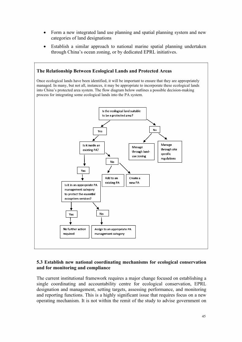
45
Form a new integrated land use planning and spatial planning system and newcategories of land designations
Establish a similar approach to national marine spatial planning undertakenthrough China’s ocean zoning, or by dedicated EPRL initiatives.
The Relationship Between Ecological Lands and Protected Areas
Once ecological lands have been identified, it will be important to ensure that they are appropriatelymanaged. In many, but not all, instances, it may be appropriate to incorporate these ecological landsinto China’s protected area system. The flow diagram below outlines a possible decision-makingprocess for integrating some ecological lands into the PA system.
5.3 Establish new national coordinating mechanisms for ecological conservationand for monitoring and compliance
The current institutional framework requires a major change focused on establishing asingle coordinating and accountability centre for ecological conservation, EPRLdesignation and management, setting targets, assessing performance, and monitoringand reporting functions. This is a highly significant issue that requires focus on a newoperating mechanism. It is not within the remit of the study to advise government on
46
where such a mechanism or agency should be established. Major functions andresponsibilities of this mechanism or agency should include:
State ecological conservation policy: develop a single integrated nationalecology strategy and policies.
EPRL oversight, coordination and facilitation;
Oversee and coordinate the work to develop a single integrated nationalProtected Areas system plan and management approach;
Plan and Implement the new payment for performance and eco-compensationapproach (see 5.5 below);
Plan and organise regional major ecological construction and restorationprojects to protect and restore ecosystem services in EPRL lands;
Implement unified EPRL monitoring, reporting and enforcement;
Plan and implement a national capacity development and engagement program.
5.4 Renew and expand a national Protected Areas system
A national PA system plan, new legislation and strengthened management arerequired to strengthen the status and functionality of existing protected areas. This isconsistent with earlier CCICED task force and working group recommendations.Protected Areas form an essential part of the backbone of China’s ecological securityand have a key role to play in delivering EPR. Therefore it is necessary to:
Develop a single integrated national PA system plan that includesconsolidation of PA categories and management approach and ensureintegration with the EPRL system.
Further examine the need and requirement for a National Park Agency andadministration.
Develop a Protected Areas law to strengthen Protected Area management byimproving public engagement, management plans and dedicated financing.
5.5 Design and implement a national program of payment for performance inEPRL
A new eco-compensation program is recommended that would provide incentives tolocal governments and to those impacted by the designation of Ecological ProtectionRed Lines. This would be a payment for performance directly to the impactedindividuals, cooperatives or local governments, rather than the more traditional simpletransfers of moneys to provincial or local government bodies. It will require carefulmonitoring to ensure that work undertaken does provide desired improvement andprotection of ecological services, or other ecological and environmental benefits.
47
5.6 Implement the Institutional and Operational Priority Actions
5.6.1 Institutionalise the recommended changes
It is important that these changes become a full part of recognized national plans andstrategies. For this reason the following actions need to be undertaken.
Approval of the SPS recommendations by the central Government Economicand Eco-civilization Reform Group.
Mainstream the Recommendations into the National and Provincial 13th Five-Year Plan to be approved at the March 2016 National Peoples’ Congress.
Refer all law and regulatory changes to the National Peoples’ Congress forapproval by 2016.
These steps will require some time to implement and must necessarily be undertakenin parallel with a number of immediate actions that are identified below.
5.6.2 Operationalise the EPRLs
5.6.2.1 Critical immediate tasks
In order to meet government leaders stated objective to have the EPRLs identified asquickly as possible, the following tasks need to be underway immediately.
Define a time-limited national coordination office for EPRLs; this wouldinvolve all key agencies and would report to a committee of vice-ministers.The coordination office would provide direction, oversight and coordination ofthe development and implementation of the EPRL system for China. Thecoordination office would be responsible to ensure the various policyinitiatives, program changes, and actions are well coordinated and initiated by2015. If a conservation agency were established later, its function would bepart of that mandate.
Refine the EPRL system by:
i. Finalizing the definitions and characteristics of a simplified andharmonized system that covers all lands, resources and environmentregulatory functions;
ii. Identifying nationally significant ecological land as Candidate EPRLsbased on the existing analyses undertaken by MEP and CAS;
iii. Confirm the national 35% target; and
iv. Create a set of technical guidelines for local governments to assist theirwork in identifying local level EPRLs.
Develop the rules and regulations that will immediately be set in regulation as“Management Measures” by state council (or, under Section 3 Article 30 ofthe new Environmental Protection Law) to govern the development andmanagement of the EPRL system. This includes:
i. Defining the roles and responsibilities of all agencies and levels ofgovernment;
48
ii. Defining guiding principles that will govern the EPRL system;iii. Defining acceptable uses inside EPRLs;
iv. Defining the provisions for differentiation and situational flexibility bothspatial and temporal;
v. Developing separate and specific provisions for rural-urban, coastal-marine, resource development areas, rehabilitation lands, etc.; and
vi. Ordering an immediate development freeze in approved EcologicalFunction Zones and existing nature reserves. This follows theprecautionary principle and avoids a rush to start developments inanticipation of future prohibition or stricter controls. The freeze shouldremain in place until the EPRL planning of the zone concerned has beencompleted. At that time it will be clear whether such development is tobe permitted, controlled or prohibited.
5.6.2.2 Tasks to be completed within one year
To oversee practical implementation on the ground, the coordination agency should:
Develop a strategy for establishment and review of an expanded system ofpilots for fast implementation of the system approach to land -use planning;
Fully incorporate new categories into spatial planning; define how to consulton resolving issues and making decisions to establish “National Priority”EPRL areas within the main functional zones as a priority for first phase ofplanning;
Define the rules to rationalize the national PA system and categories and setpriorities for work to review all existing “designated areas” to place them inthe correct category;
Oversee implementation of the new EPRL regulations;
Develop and implement a national approach to compliance and enforcementand public monitoring and reporting;
Develop and implement a strategy for capacity development and stakeholderengagement, targeted at the local level;
Develop a “decision support and analytic tool” to enable choices betweencompeting land designations during land-use planning; and
Determine development, approval and funding of the new performance basedpayments system for local peoples and governments.
The individual ministries, provincial and local governments should:
Undertake their own EPRL plan (SFA, MOHURD, MOA, MEP, SOA, etc);
Strengthen protective management of the nature reserve system following selfassessment of needs using IUCN assessment toolkit, managementeffectiveness tracking tool (METT) and adoption of competence standardsalready proposed by CCICED Protected Areas Task Force (2004); and
49
Complete a PA systems review including proposals for completing ecosystemtype coverage, species coverage needs and distribution corridors. Prioritiesinclude potential Ramsar sites already identified by Birdlife International, keycoastal sites identified by the East Asia Australasian Flyway Program and keytrans-frontier sites already identified by IUCN WCPA.
5.6.2.3 Tasks to be completed within five to ten years.
EPRL monitoring and reporting procedures routine; first report complete andpublicly available by 2016;
Full legislation and institutional reform completed by 2020;
PA system reconfigured, expanded and integrated with EPRLs;
10-year EPRL review and revisions;
Eco-compensation payment and payment for performance system fullyinstitutionalized;
PA competence standards form basis for in-service training programs, careerpromotions and professional hiring;
Evaluation study of EPRL success and economic contribution;
China assists supply countries to put in place their own EPRL systems.
At the end of this ten year period China will have in place a fully functionalcomprehensive and systematic approach to the conservation and restoration ofecologically important lands, services and environments that will be the underpinningof an Ecological Civilisation and will also lead the world in practice.
This report is submitted by the CCICED Special Policy Study on InstitutionalInnovation of Eco-Environmental Redlining.
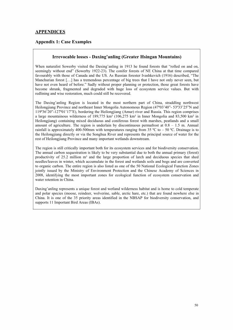
50
APPENDICES
Appendix 1: Case Examples
Irrevocable losses - Daxing’anling (Greater Hsingan Mountains)
When naturalist Sowerby visited the Daxing’anling in 1913 he found forests that “rolled on and on,seemingly without end” (Sowerby 1922-23). The conifer forests of NE China at that time comparedfavourably with those of Canada and the US. As Russian forester Ivashkevich (1916) described, “TheManchurian forest […] has a tremendous percentage of big trees that I have not only never seen, buthave not even heard of before.” Sadly without proper planning or protection, those great forests havebecome shrunk, fragmented and degraded with huge loss of ecosystem service values. But withredlining and wise restoration, much could still be recovered.
The Daxing’anling Region is located in the most northern part of China, straddling northwestHeilongjiang Province and northeast Inner Mongolia Autonomous Region (47º03’40”- 53º33’25”N and119º36’20”-127º01’17”E), bordering the Heilongjiang (Amur) river and Russia. This region comprisesa large mountainous wilderness of 189,775 km² (106,275 km² in Inner Mongolia and 83,500 km² inHeilongjiang) containing mixed deciduous and coniferous forest with marshes, peatlands and a smallamount of agriculture. The region is underlain by discontinuous permafrost at 0.8 – 1.5 m. Annualrainfall is approximately 400-500mm with temperatures ranging from 35 ºC to – 50 ºC. Drainage is tothe Heilongjiang directly or via the Songhua River and represents the principal source of water for therest of Heilongjiang Province and many important wetlands downstream.
The region is still critically important both for its ecosystem services and for biodiversity conservation.The annual carbon sequestration is likely to be very substantial due to both the annual primary (forest)productivity of 25.2 million m³ and the large proportion of larch and deciduous species that shedneedles/leaves in winter, which accumulate in the forest and wetlands soils and bogs and are convertedto organic carbon. The entire region is also listed as one of the 50 National Ecological Function Zonesjointly issued by the Ministry of Environment Protection and the Chinese Academy of Sciences in2008, identifying the most important zones for ecological function of ecosystem conservation andwater retention in China.
Daxing’anling represents a unique forest and wetland wilderness habitat and is home to cold temperateand polar species (moose, reindeer, wolverine, sable, arctic hare, etc.) that are found nowhere else inChina. It is one of the 35 priority areas identified in the NBSAP for biodiversity conservation, andsupports 11 Important Bird Areas (IBAs).
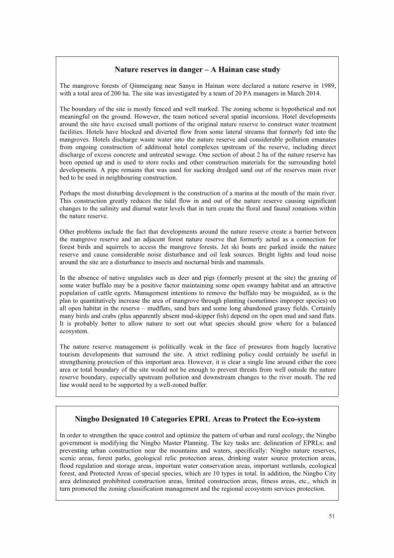
51
Nature reserves in danger – A Hainan case study
The mangrove forests of Qinmeigang near Sanya in Hainan were declared a nature reserve in 1989,with a total area of 200 ha. The site was investigated by a team of 20 PA managers in March 2014.
The boundary of the site is mostly fenced and well marked. The zoning scheme is hypothetical and notmeaningful on the ground. However, the team noticed several spatial incursions. Hotel developmentsaround the site have excised small portions of the original nature reserve to construct water treatmentfacilities. Hotels have blocked and diverted flow from some lateral streams that formerly fed into themangroves. Hotels discharge waste water into the nature reserve and considerable pollution emanatesfrom ongoing construction of additional hotel complexes upstream of the reserve, including directdischarge of excess concrete and untreated sewage. One section of about 2 ha of the nature reserve hasbeen opened up and is used to store rocks and other construction materials for the surrounding hoteldevelopments. A pipe remains that was used for sucking dredged sand out of the reserves main riverbed to be used in neighbouring construction.
Perhaps the most disturbing development is the construction of a marina at the mouth of the main river.This construction greatly reduces the tidal flow in and out of the nature reserve causing significantchanges to the salinity and diurnal water levels that in turn create the floral and faunal zonations withinthe nature reserve.
Other problems include the fact that developments around the nature reserve create a barrier betweenthe mangrove reserve and an adjacent forest nature reserve that formerly acted as a connection forforest birds and squirrels to access the mangrove forests. Jet ski boats are parked inside the naturereserve and cause considerable noise disturbance and oil leak sources. Bright lights and loud noisearound the site are a disturbance to insects and nocturnal birds and mammals.
In the absence of native ungulates such as deer and pigs (formerly present at the site) the grazing ofsome water buffalo may be a positive factor maintaining some open swampy habitat and an attractivepopulation of cattle egrets. Management intentions to remove the buffalo may be misguided, as is theplan to quantitatively increase the area of mangrove through planting (sometimes improper species) onall open habitat in the reserve – mudflats, sand bars and some long abandoned grassy fields. Certainlymany birds and crabs (plus apparently absent mud-skipper fish) depend on the open mud and sand flats.It is probably better to allow nature to sort out what species should grow where for a balancedecosystem.
The nature reserve management is politically weak in the face of pressures from hugely lucrativetourism developments that surround the site. A strict redlining policy could certainly be useful instrengthening protection of this important area. However, it is clear a single line around either the corearea or total boundary of the site would not be enough to prevent threats from well outside the naturereserve boundary, especially upstream pollution and downstream changes to the river mouth. The redline would need to be supported by a well-zoned buffer.
Ningbo Designated 10 Categories EPRL Areas to Protect the Eco-system
In order to strengthen the space control and optimize the pattern of urban and rural ecology, the Ningbogovernment is modifying the Ningbo Master Planning. The key tasks are: delineation of EPRLs; andpreventing urban construction near the mountains and waters, specifically: Ningbo nature reserves,scenic areas, forest parks, geological relic protection areas, drinking water source protection areas,flood regulation and storage areas, important water conservation areas, important wetlands, ecologicalforest, and Protected Areas of special species, which are 10 types in total. In addition, the Ningbo Cityarea delineated prohibited construction areas, limited construction areas, fitness areas, etc., which inturn promoted the zoning classification management and the regional ecosystem services protection.
52
EPRL Region Protection Planning of Jiangsu Province released
In order to protect the important areas for ecosystem services and eco-security of Jiangsu Province, inMay 2012, Jiangsu Province started the program of Eco-red Line Region Protection Planning ofJiangsu Province, and it was released in August 30, 2013. The total land area within EPRLs is22,839.58 square kilometers, accounting for 22.23% of Jiangsu Province, where the first-level controlarea accounts 3.03%, the secondary control area accounts 19.2%. For marine EPRL areas, the total areareaches 1263.91 km2. The main experience of this was:
(1) Taking the protection of the regional biodiversity and ecosystem services as the leadingfactors in EPRL delineation. There are 15 kinds of important protection types, including: naturereserves, scenic areas, forest parks, geological relic protection areas, wetland, drinking watersource protection areas, special marine Protected Areas, flood regulation and storage areas,important water conservation areas, important fishing areas, important wetlands, water channelmaintenance areas, eco-public forest, Taihu important Protected Areas, and Protected Areas ofspecial species.
(2) Classified guidance, hierarchical management. The control measures for the 15 kinds ofimportant protection areas are divided into two levels: the first control areas and the secondarycontrol areas. The first control areas are the core of the EPRLs, with the most stringent protectionand all forms of development and construction activities are prohibited. While the secondarycontrol areas focus on ecological protection, with differentiated control measures, although theactivities detrimental to the ecosystem are also prohibited.
(3) Combined the eco-red line assessment and supervision with the eco-transfer payments.Jiangsu Province issued the Interim Measures for Assessment and Supervision of Eco-red LineProtection and Interim Measures for Eco-transfer Payments. The eco-transfer payments includesubsidies and incentive funds. The subsidies should be calculated comprehensively according tothe EPRL areas’ level, type, size, local financial security, and other factors, while the allocation ofincentive funds are based on the assessment results that related to the task completion on a yeararound.
Beijing designated ecological land to strengthen regional ecological protection
The Law of Land Administration indicates that the state shall compile general plans to control usages ofland including those of farm or construction use or unused. The Guide on compiling general plans atprefecture level subdivided three categories of land use, namely farmland, construction land, andunused land, into 10 second classes and 23 third classes. The traditional classification reflects economicand social values; however, biological value is neglected. Ecological land is added into the existingcategories to intensify regional ecological protection in Beijing practices.
Ecological land provides fundamental security for regional ecological security and habitable urbanconstruction, with important ecologically sensitive areas and ecologically functional zones included.Based on evaluation of ecological sensitivity and ecological services, the designated ecological landcovers 5722.05 km2, accounting for approximately 34.87% of the prefecture area, which is comprisedof water conservation land, water and soil conservation land, eco-diversity conservation land,ecological protective land, urban green, and others. It is of great importance to protect the regionalecological security by land-use planning. In order to strengthen the delineation and management ofecological land, further researches are needed: the improvement of the existing land use planningsystem; the coordination of ecological land and other land types; and specific management measures ofecological land.
53
Marine Ecological Protection Red Line (MEPRL) Identification in Bohai Sea
In 2012, State Administration of Oceanic Administration issued “Opinions on establishing marineecological redline institutions in Bohai Sea”, which require to draw marine ecological red lines andidentify management measures of marine ecological red line areas.
MEPRL means the areas are identified and strictly protected to maintain the marine ecological healthand ecological security. MEPRLs include important estuaries, important coastal wetlands, sea islandsunder special protection, marine conservation areas, natural landscape and historical cultural relics andremains, sandy coastlines and sand-source marine protection areas, important fisheries waters andimportant coastal tourism areas. The marine ecological red line areas are divided into forbiddendevelopment zones and restricted development zones.
“Opinions on establishing marine ecological redline institutions in Bohai Sea” also identified 4management goals to strengthen the management of MEPRL in Bohai Sea: (1) The area of marineecological red line area in the Bohai Sea accounts for at least 1/3 of total of the offshore area of theBohai Sea; (2) The retention rate of natural coastline of the Bohai Sea should be not less than 30% ofthe total coastline of the Bohai Sea; maintain the length of the existing sandy coastline; (3) By 2020,the overall standard-reaching rate of water quality should be not less than 80%; (4) The standard-reaching rate of pollutant discharge at the land-based direct outlets in the marine ecological red lineareas of the Bohai Sea reaches 100%; by 2020, the total amount of land-based river pollutantsdischarged to the sea in the marine ecological red line areas should decrease by 10% - 15%.
Designation and Implementation of “Basic Ecological Control Line”
——Experiences from Shenzhen
The “basic ecological control line” (BECL) was designated on the basis of urban green systemplanning in Shenzhen, 2005, which covered an area of 974.5 km2, approximately 50% of the prefectureland. The designation of BECL consistently plays an important role in ecological protection, whichprevents disorderly urban sprawl and promotes sustainability of urban development.
Experiences:
Systematic management. Led by the Shenzhen Municipal Government, the planning departmentis responsible for delineation and adjustment of BECL. Enforcement is stringently carried out bythe joint effort of district governments and departments in charge of the following fields:planning, land management, environmental protection, development and reform, agriculture,urban management, and others.
Detailed regulation. In 2005, Regulation of Shenzhen Municipality for management of basicecological control line was promulgated. Then in 2007, the government issued Opinions onimplementation of Regulation of Shenzhen Municipality for management of basic ecologicalcontrol line, to clarify the responsibilities of various departments and policies on legal mercantileactivities and buildings previously located inside the line. In 2013, the government issued Opinionon further regulation of basic ecological control line management, which proposed specificpractices to combine the BECL management and ecological civilization construction. N.b. It takesseveral years to undertake.
Integrated system of ecological protection areas. The main protection areas include: major riverand wetland, green and ecological corridors, important seafront land, water source PAs, scenicspots, natural reserves, basic farmland, forest park, and ecological fragile zones where the slope isgreater than 25%.
54
Problems:
Contradictions between protection and development within BECL is still intense. Since someresidents have not sufficient awareness of BECL, they may have antagonism against it; thereforethe contradiction could go on for a long period.
Construction before planning remains a big problem. Some buildings within BECL are illegal,while some are legal with property certificates or construction permissions, which makesmanagement complex.
Regulation of Shenzhen Municipality for management of basic ecological control line is at alow position in the legal hierarchy, which limits the accountability for violations and punishments.
Public engagement is not enough. There is a lack of mechanisms for stakeholders to participate,which adversely affects the practicality of BECL.
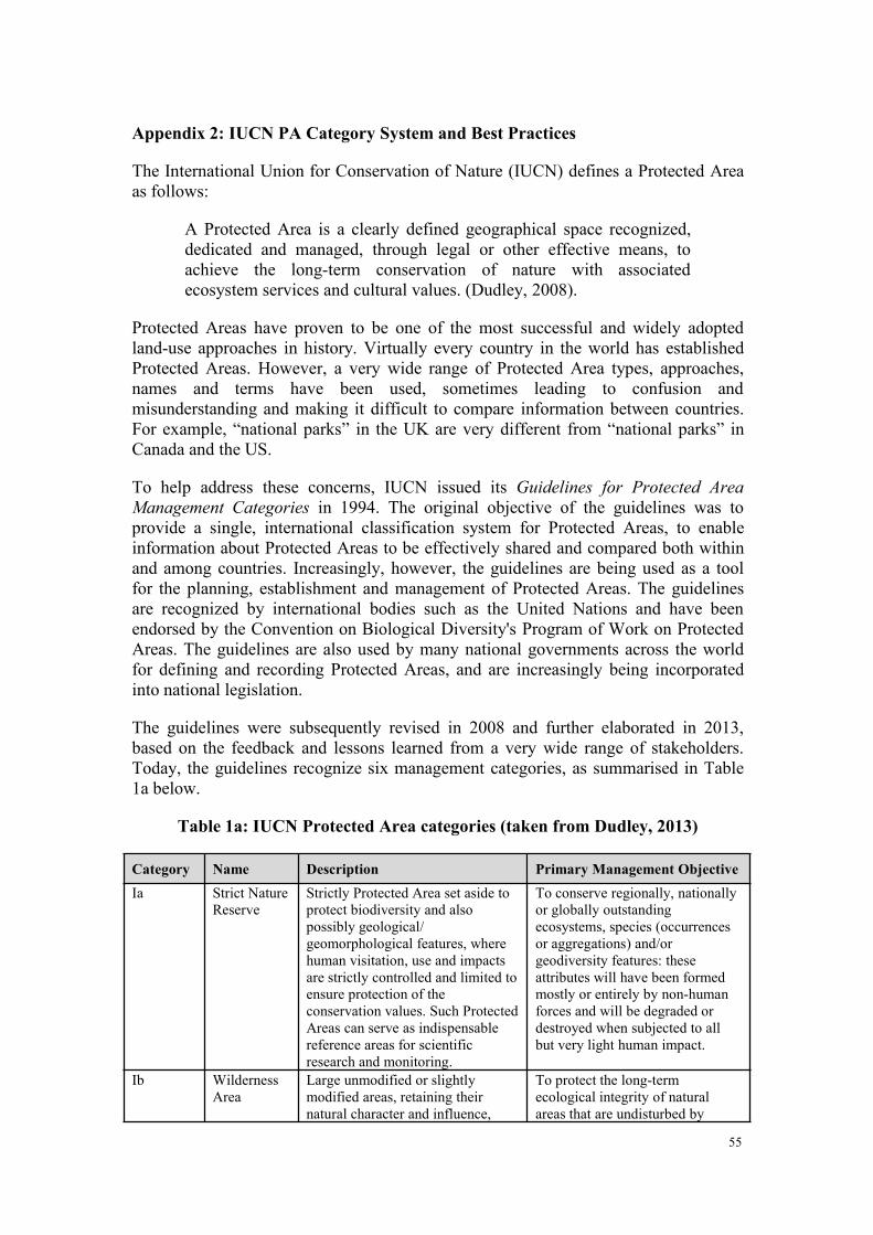
55
Appendix 2: IUCN PA Category System and Best Practices
The International Union for Conservation of Nature (IUCN) defines a Protected Areaas follows:
A Protected Area is a clearly defined geographical space recognized,dedicated and managed, through legal or other effective means, toachieve the long-term conservation of nature with associatedecosystem services and cultural values. (Dudley, 2008).
Protected Areas have proven to be one of the most successful and widely adoptedland-use approaches in history. Virtually every country in the world has establishedProtected Areas. However, a very wide range of Protected Area types, approaches,names and terms have been used, sometimes leading to confusion andmisunderstanding and making it difficult to compare information between countries.For example, “national parks” in the UK are very different from “national parks” inCanada and the US.
To help address these concerns, IUCN issued its Guidelines for Protected AreaManagement Categories in 1994. The original objective of the guidelines was toprovide a single, international classification system for Protected Areas, to enableinformation about Protected Areas to be effectively shared and compared both withinand among countries. Increasingly, however, the guidelines are being used as a toolfor the planning, establishment and management of Protected Areas. The guidelinesare recognized by international bodies such as the United Nations and have beenendorsed by the Convention on Biological Diversity's Program of Work on ProtectedAreas. The guidelines are also used by many national governments across the worldfor defining and recording Protected Areas, and are increasingly being incorporatedinto national legislation.
The guidelines were subsequently revised in 2008 and further elaborated in 2013,based on the feedback and lessons learned from a very wide range of stakeholders.Today, the guidelines recognize six management categories, as summarised in Table1a below.
Table 1a: IUCN Protected Area categories (taken from Dudley, 2013)
Category Name Description Primary Management ObjectiveIa Strict Nature
ReserveStrictly Protected Area set aside toprotect biodiversity and alsopossibly geological/geomorphological features, wherehuman visitation, use and impactsare strictly controlled and limited toensure protection of theconservation values. Such ProtectedAreas can serve as indispensablereference areas for scientificresearch and monitoring.
To conserve regionally, nationallyor globally outstandingecosystems, species (occurrencesor aggregations) and/orgeodiversity features: theseattributes will have been formedmostly or entirely by non-humanforces and will be degraded ordestroyed when subjected to allbut very light human impact.
Ib WildernessArea
Large unmodified or slightlymodified areas, retaining theirnatural character and influence,
To protect the long-termecological integrity of naturalareas that are undisturbed by
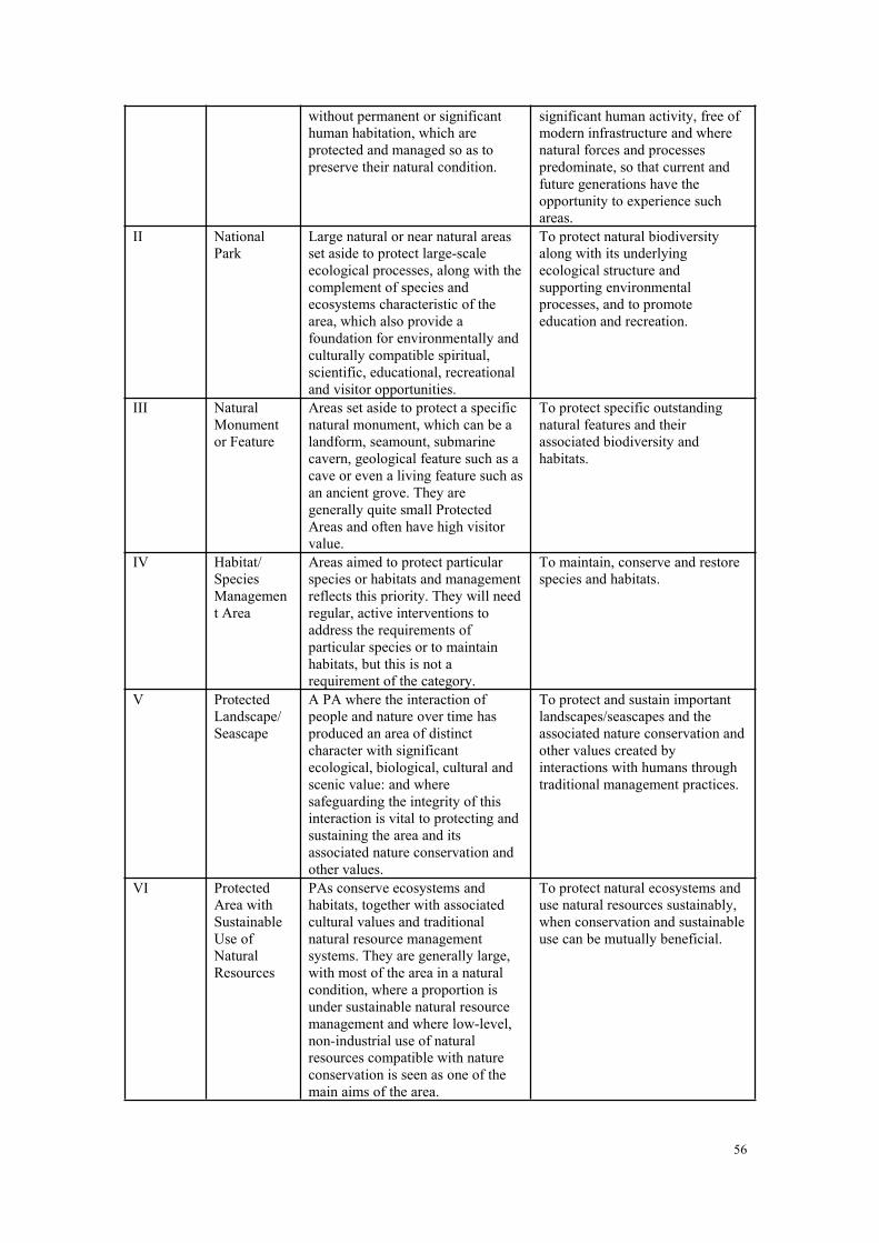
56
without permanent or significanthuman habitation, which areprotected and managed so as topreserve their natural condition.
significant human activity, free ofmodern infrastructure and wherenatural forces and processespredominate, so that current andfuture generations have theopportunity to experience suchareas.
II NationalPark
Large natural or near natural areasset aside to protect large-scaleecological processes, along with thecomplement of species andecosystems characteristic of thearea, which also provide afoundation for environmentally andculturally compatible spiritual,scientific, educational, recreationaland visitor opportunities.
To protect natural biodiversityalong with its underlyingecological structure andsupporting environmentalprocesses, and to promoteeducation and recreation.
III NaturalMonumentor Feature
Areas set aside to protect a specificnatural monument, which can be alandform, seamount, submarinecavern, geological feature such as acave or even a living feature such asan ancient grove. They aregenerally quite small ProtectedAreas and often have high visitorvalue.
To protect specific outstandingnatural features and theirassociated biodiversity andhabitats.
IV Habitat/SpeciesManagement Area
Areas aimed to protect particularspecies or habitats and managementreflects this priority. They will needregular, active interventions toaddress the requirements ofparticular species or to maintainhabitats, but this is not arequirement of the category.
To maintain, conserve and restorespecies and habitats.
V ProtectedLandscape/Seascape
A PA where the interaction ofpeople and nature over time hasproduced an area of distinctcharacter with significantecological, biological, cultural andscenic value: and wheresafeguarding the integrity of thisinteraction is vital to protecting andsustaining the area and itsassociated nature conservation andother values.
To protect and sustain importantlandscapes/seascapes and theassociated nature conservation andother values created byinteractions with humans throughtraditional management practices.
VI ProtectedArea withSustainableUse ofNaturalResources
PAs conserve ecosystems andhabitats, together with associatedcultural values and traditionalnatural resource managementsystems. They are generally large,with most of the area in a naturalcondition, where a proportion isunder sustainable natural resourcemanagement and where low-level,non-industrial use of naturalresources compatible with natureconservation is seen as one of themain aims of the area.
To protect natural ecosystems anduse natural resources sustainably,when conservation and sustainableuse can be mutually beneficial.
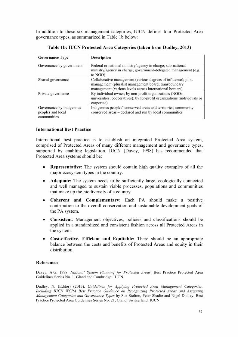
57
In addition to these six management categories, IUCN defines four Protected Areagovernance types, as summarized in Table 1b below:
Table 1b: IUCN Protected Area Categories (taken from Dudley, 2013)
Governance Type Description
Governance by government Federal or national ministry/agency in charge; sub-nationalministry/agency in charge; government-delegated management (e.g.to NGO)
Shared governance Collaborative management (various degrees of influence); jointmanagement (pluralist management board; transboundarymanagement (various levels across international borders)
Private governance By individual owner; by non-profit organizations (NGOs,universities, cooperatives); by for-profit organizations (individuals orcorporate)
Governance by indigenouspeoples and localcommunities
Indigenous peoples’ conserved areas and territories; communityconserved areas – declared and run by local communities
International Best Practice
International best practice is to establish an integrated Protected Area system,comprised of Protected Areas of many different management and governance types,supported by enabling legislation. IUCN (Davey, 1998) has recommended thatProtected Area systems should be:
Representative: The system should contain high quality examples of all themajor ecosystem types in the country.
Adequate: The system needs to be sufficiently large, ecologically connectedand well managed to sustain viable processes, populations and communitiesthat make up the biodiversity of a country.
Coherent and Complementary: Each PA should make a positivecontribution to the overall conservation and sustainable development goals ofthe PA system.
Consistent: Management objectives, policies and classifications should beapplied in a standardized and consistent fashion across all Protected Areas inthe system.
Cost-effective, Efficient and Equitable: There should be an appropriatebalance between the costs and benefits of Protected Areas and equity in theirdistribution.
References
Davey, A.G. 1998. National System Planning for Protected Areas. Best Practice Protected AreaGuidelines Series No. 1. Gland and Cambridge: IUCN.
Dudley, N. (Editor) (2013). Guidelines for Applying Protected Area Management Categories,Including IUCN WCPA Best Practice Guidance on Recognizing Protected Areas and AssigningManagement Categories and Governance Types by Sue Stolton, Peter Shadie and Nigel Dudley. BestPractice Protected Area Guidelines Series No. 21, Gland, Switzerland: IUCN.
58
Dudley, N. (Editor) (2008). Guidelines for Applying Protected Area Management Categories. Gland,Switzerland: IUCN.
IUCN and WCMC. (1994). Guidelines for Protected Area Management Categories. Gland,Switzerland: IUCN.
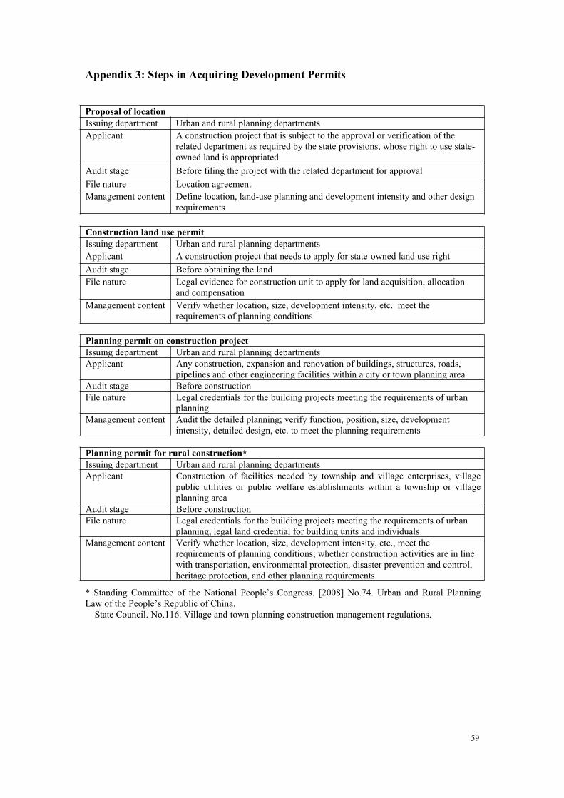
59
Appendix 3: Steps in Acquiring Development Permits
Proposal of locationIssuing department Urban and rural planning departmentsApplicant A construction project that is subject to the approval or verification of the
related department as required by the state provisions, whose right to use state-owned land is appropriated
Audit stage Before filing the project with the related department for approvalFile nature Location agreementManagement content Define location, land-use planning and development intensity and other design
requirements
Construction land use permitIssuing department Urban and rural planning departmentsApplicant A construction project that needs to apply for state-owned land use rightAudit stage Before obtaining the landFile nature Legal evidence for construction unit to apply for land acquisition, allocation
and compensationManagement content Verify whether location, size, development intensity, etc. meet the
requirements of planning conditions
Planning permit on construction projectIssuing department Urban and rural planning departmentsApplicant Any construction, expansion and renovation of buildings, structures, roads,
pipelines and other engineering facilities within a city or town planning areaAudit stage Before constructionFile nature Legal credentials for the building projects meeting the requirements of urban
planningManagement content Audit the detailed planning; verify function, position, size, development
intensity, detailed design, etc. to meet the planning requirements
Planning permit for rural construction*Issuing department Urban and rural planning departmentsApplicant Construction of facilities needed by township and village enterprises, village
public utilities or public welfare establishments within a township or villageplanning area
Audit stage Before constructionFile nature Legal credentials for the building projects meeting the requirements of urban
planning, legal land credential for building units and individualsManagement content Verify whether location, size, development intensity, etc., meet the
requirements of planning conditions; whether construction activities are in linewith transportation, environmental protection, disaster prevention and control,heritage protection, and other planning requirements
* Standing Committee of the National People’s Congress. [2008] No.74. Urban and Rural PlanningLaw of the People’s Republic of China.State Council. No.116. Village and town planning construction management regulations.
60
GLOSSARY
Ecological Protection Redlining Terms
Eco-environmental redline
Component of the environmental red line relating to safeguarding theecological environment
Ecological protectionred line (EPRL)
A red line that defines those lands that deliver critical ecosystem servicesand require protection from threatening developments and activities
Ecological protectionredlining (EPR)
The act of establishing ecological protection red lines
Environmental red line A red line that defines danger limits to a variety of environmental hazards,including ecological, chemical, radioactivity, climate, seismic, etc.
Red line A line or limit that cannot be breached without severe danger,consequences, and/or penalties
Redlining The process of defining and establishing a red line
Environment and Ecology Terms
Biodiversity The diversity of living organisms in a given area, including genetic, speciesand ecosystem diversity; usually refers to nature but also includesdomesticated species and varieties (agro-biodiversity)
Ecological restoration Recovery of ecosystems damaged by natural disaster or human abuse, eitherby natural processes or human inputs (rehabilitation)
Ecology/ecological Study of relationships between living organisms and their physicalenvironment/relating to ecology and its processes
Ecosystem The complex community of organisms and their environment functioning asan ecological unit, e.g. forest, lake, grassland
Ecosystem services Beneficial services delivered through the functions and processes ofecosystems
Environment Physical and biotic living context of humans and other life-forms; can benatural, man-modified or artificial
Habitat Specific living environment (physical and biotic) of a given species orspecies assemblage
Protected Area (PA) A clearly defined geographical space that is recognized, dedicated andmanaged, through legal or other effective means, to achieve the long-termconservation of nature with associated ecosystem services and culturalvalues (IUCN 2013).
Financial Mechanism Terms
Eco-compensation A form of payment mechanism used to reward work undertaken to protectecological health, or compensate for losses and damages caused bymeasures taken to protect the natural environment
Ecological transfers Budgetary transfers paid from primary benefitting regions to regions oragencies that generate or protect valuable ecosystem services
Green taxes Taxes imposed on goods or services (water, timber, etc.) needed tointernalize external environmental damage or recover environmentalprotection inputs from beneficiaries of ecosystem services
Green incentives Fiscal measures applied to encourage ‘greener’ development optionsincluding grants, tax breaks, eco-compensation, etc.
61
REFERENCES
Agardy, P. Christie, and E. Nixon. 2012. Marine Spatial Planning in the Context of the Convention onBiological Diversity: A study carried out in response to CBD COP 10 Decision X/29. CBD Tech.Series 68, Montreal.
An, S., Li, H., Guan, B., Zhou, C., Wang, Z., Deng, Z., Zhi, Y., Liu, Y., Xu C., Fang, S, Jiang, J. &Hongli Li, H. (2007) China’s natural wetlands: past problems, current status, and future challenges.Ambio 34: 335-342.
Barter, M.A. (2006) The Yellow Sea – a vitally important staging region for migratory shorebirds. Pp663-667 In: Boere, G.S., Galbraith, C.A. and Stroud, D.A. (eds) Waterbirds around the world. TheStationary Office, Edinburgh, UK.
CCICED (2010a) Report of Ecosystem Task Force to CCICED AGM. Beijing.
CCICED (2010b) Report of marine Ecosystems Task Force to CCICED AGM, Beijing.
CCICED (2010c) Mainstreaming Biodiversity into China’s Green Development Background paper forAGM 2010. CCICED, Beijing.
Chen, J.Y. (1997) The impact of sea level rise on China’s coastal areas and its disaster hazardevaluation. Journal of Coastal Research 13: 925-930.
Costanza, R.,Rudolf de Groot, Paul Sutton, Sander van der Ploeg, Sharolyn J. Anderson, IdaKubiszewski, Stephen Farbe, R. Kerry Turner (2014) Changes in the global value of ecosystemservices. Global Environmental Change 26: 152–158.
Hanson, A.J. & Martin, C. (2006) One Lifeboat – China and the World’s Environment andDevelopment. CCICED and International Institute for Sustainable Development. Available at:http://www.iisd.org/pdf/2006/china_one_lifeboat.pdf
IUCN (2011) The IUCN Red List of Threatened Species Version 2011.2 Available at:http://www.iucnredlist.org
Ministry of Environmental Protection (2011) China National Biodiversity Strategy and Action Plan.Beijing, China. In Chinese
MacKinnon, J., Verkuil, Y.I and Murray, N. (2012) IUCN situation analysis on East and SoutheastAsian intertidal habitats, with particular reference to the Yellow Sea (including the Bohai Sea).Occasional Paper of the IUCN Species Survival Commission No. 47. IUCN, Gland, Switzerland andCambridge, UK. ii + 70pp.
National Environmental Protection Agency (1994) China – Biodiversity Conservation Action Plan.Beijing, China.
Naughton, B. (2014) ‘Deepening Reform’: The Organization and the Emerging Strategy ChinaLeadership Monitor, no. 44.
Nicholas J Murray, Robert S Clemens, Stuart R Phinn, Hugh P Possingham, and Richard A Fuller 2014.Tracking the rapid loss of tidal wetlands in the Yellow Sea. Frontiers in Ecology and the Environment(e-View) http://dx.doi.org/10.1890/130260
Ouyang Z Y, Zhu C Q,Yang G B,Xu W H,Zheng H,Zhang Y,Xiao Y.Gross ecosystem product:concept, accounting framework and case study. Acta Ecologica Sinica,2013,33(21):6747-6761.
Sale, P., T. Agardy, C.H. Ainsworth, B.E. Feist, J. D. Bell, P. Christie, O. Hoegh-Guldberg, P. J.Mumby, D.A. Feary, M. I. Saunders, T.M. Daw, S.J. Foale, P.S. Levin, K.C. Lindeman, K. Lorenzen,R.S. Pomeroy, E.H. Allison, R.H. Bradbury, J. Corrin, A.J. Edwards, D.O. Obura, Y.J. Sadovy de
62
Mitcheson, M.A. Samoilys, C. R.C. Sheppard. (2014) Transforming management of tropical coastalseas to cope with challenges of the 21st century. Marine Pollution Bulletin 85:8-23.
Song, L.P. (2007) The problem in the environmental legal system and recommendations. (In Chinese).Security, Health and Environment 7(11): 2-3.
Yan, X., Wang Sung & Schei, P. (eds.) (2004) China’s Protected Areas. Tsinghua University press,Beijing.
TEEB (2010) The Economics of Ecosystems and Biodiversity for Local and Regional Planners.
Wang, X., Chen, W., Zhang, L., Jin, D. & Lu, C. (2010) Estimating the ecosystem service losses fromproposed land reclamation projects: A case study in Xiamen. Ecological Economics 69: 2549-2556.
Yu, L.Z. & Yan, X. (2002) Invasive Alien Species in China. Forestry Publishing House, Beijing (InChinese).
Piao, Shilong, et al. (2010) The impacts of climate change on water resources and agriculture in China.Nature 467: 43-51.
NEPA 1998 (50,000 rice cultivars and 20,000 soya cultivars in China).
Wang Sung & MacKinnon, J. (1997) Conserving China’s Biodiversity – Reports of the BiodiversityWorking Group (BWG). China Council for International Cooperation on Environment andDevelopment, Beijing.