A novel approach to fog/low stratus detection using Meteosat 8 data
Upload
independentCategory
view
6download
0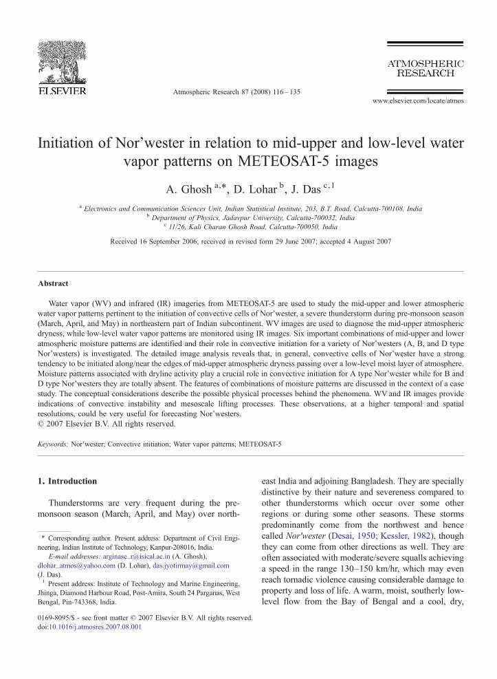
7 (2008) 116–135www.elsevier.com/locate/atmos
Atmospheric Research 8
Initiation of Nor'wester in relation to mid-upper and low-level watervapor patterns on METEOSAT-5 images
A. Ghosh a,⁎, D. Lohar b, J. Das c,1
a Electronics and Communication Sciences Unit, Indian Statistical Institute, 203, B.T. Road, Calcutta-700108, Indiab Department of Physics, Jadavpur University, Calcutta-700032, India
c 11/26, Kali Charan Ghosh Road, Calcutta-700050, India
Received 16 September 2006; received in revised form 29 June 2007; accepted 4 August 2007
Abstract
Water vapor (WV) and infrared (IR) imageries from METEOSAT-5 are used to study the mid-upper and lower atmosphericwater vapor patterns pertinent to the initiation of convective cells of Nor'wester, a severe thunderstorm during pre-monsoon season(March, April, and May) in northeastern part of Indian subcontinent. WV images are used to diagnose the mid-upper atmosphericdryness, while low-level water vapor patterns are monitored using IR images. Six important combinations of mid-upper and loweratmospheric moisture patterns are identified and their role in convective initiation for a variety of Nor'westers (A, B, and D typeNor'westers) is investigated. The detailed image analysis reveals that, in general, convective cells of Nor'wester have a strongtendency to be initiated along/near the edges of mid-upper atmospheric dryness passing over a low-level moist layer of atmosphere.Moisture patterns associated with dryline activity play a crucial role in convective initiation for A type Nor'wester while for B andD type Nor'westers they are totally absent. The features of combinations of moisture patterns are discussed in the context of a casestudy. The conceptual considerations describe the possible physical processes behind the phenomena. WV and IR images provideindications of convective instability and mesoscale lifting processes. These observations, at a higher temporal and spatialresolutions, could be very useful for forecasting Nor'westers.© 2007 Elsevier B.V. All rights reserved.
Keywords: Nor'wester; Convective initiation; Water vapor patterns; METEOSAT-5
1. Introduction
Thunderstorms are very frequent during the pre-monsoon season (March, April, and May) over north-
⁎ Corresponding author. Present address: Department of Civil Engi-neering, Indian Institute of Technology, Kanpur-208016, India.
E-mail addresses: [email protected] (A. Ghosh),[email protected] (D. Lohar), [email protected](J. Das).1 Present address: Institute of Technology and Marine Engineering,
Jhinga, Diamond Harbour Road, Post-Amira, South 24 Parganas, WestBengal, Pin-743368, India.
0169-8095/$ - see front matter © 2007 Elsevier B.V. All rights reserved.doi:10.1016/j.atmosres.2007.08.001
east India and adjoining Bangladesh. They are speciallydistinctive by their nature and severeness compared toother thunderstorms which occur over some otherregions or during some other seasons. These stormspredominantly come from the northwest and hencecalled Nor'wester (Desai, 1950; Kessler, 1982), thoughthey can come from other directions as well. They areoften associated with moderate/severe squalls achievinga speed in the range 130–150 km/hr, which may evenreach tornadic violence causing considerable damage toproperty and loss of life. A warm, moist, southerly low-level flow from the Bay of Bengal and a cool, dry,

117A. Ghosh et al. / Atmospheric Research 87 (2008) 116–135
westerly or northwesterly upper-level flow give rise toa favorable synoptic setting for the formation ofNor'westers. Further, Nor'westers have a mesoscalestructure with a very rapid development. The surfaceobservations and radiosonde data are usually being usedfor forecasting Nor'westers. However, the timing andspacing of these observations are often inadequate todiagnose the evolution of pre-convective conditions ofNor'westers. Consequently, the forecasting of initiation ofNor'wester becomes a very difficult task. One possiblesolution to this problem is to use remotely sensed satelliteobservations with high temporal and spatial resolutions.The recent advancement of geostationary meteorologicalsatellites allows the forecasters and researchers to monitorthe gradual development of atmospheric features over alarge geographical area more adequately than with theconventional data sources alone.
One such important feature is the atmosphericmoisture field. Sufficient moisture in the atmosphere isan essential ingredient for severe convection. Previousstudies reveal that the water vapor observations canpotentially improve the analysis and prediction ofprocesses which lead to the development of convectivestorms (Miller, 1972; McNulty, 1995). Both the verticaland horizontal distributions of moisture are importantfor thunderstorm forecasting. The low-level moist airand mid-tropospheric dry air create a convectivelyunstable pre-storm environment. (Srinivasan et al.,1973; Doswell, 1985, 1987). On the other hand, hori-zontal boundary of moisture is often associated withsecondary circulation which acts as a mesoscale liftingagent. However, in general, the presently availableconventional data do not have the potential for pro-viding such mesoscale information. There is still muchto learn about how water vapor changes in space andtime and how these changes will effect severe weatherformation. In this regard, WV and IR images fromMETEOSAT-5 and other geostationary satellites offer awealth of information relevant to the temperature andmoisture structures of the atmosphere. Many researchershave used these information to a number of mesoscaleforecasting and research problems, especially thoserelating to the development of severe convective storms.Petersen et al. (1984) analyzed IR and visible (VIS)imageries from the Visible Infrared Spine-Scan Radi-ometer (VISSR) Atmospheric Sounder (VAS) (on theGeostationary Operational Environmental Satellite(GOES)) to delineate middle and lower troposphericmoisture fields for a variety of severe thunderstorms insouthern and central United States. METEOSAT WVdata were also used to define a new instability parameterfor the thunderstorms over the mountainous regions in
southern Bulgaria (Georgiev, 2003). Krennert andZwatz-Meise (2003) identified the transition zone ofdark (dry) and light (moist) regions on METEOSATWV images as a favored areas for the initiation of deepmoist convections over Europe. However, in the contextof Nor'wester, although it has been studied extensivelyby Indian meteorologists (Floyd, 1839; Normand, 1921;Rai, 1953; Koteswaram and Srinivasan, 1958; Mukher-jee and Bhattacharrya, 1972; Patra, 1998), we foundvery few research works based on high resolutionsatellite data/images to understand various aspects ofNor'wester (Sadhukhan, 2001; Mukhopadhyay et al.,2005). In other words, satellite data/images are not beingexplored effectively for studying Nor'westers.
For the present study, we investigate few inter-esting features of initial outbreak of Nor'wester usinghigh resolution METEOSAT-5 WV and IR imageries.Here, WV images are used to monitor the middle andupper tropospheric moisture fields while IR imagesdepict the low-level moisture information for a varietyof Nor'westers during pre-monsoon season in north-eastern India and the adjacent regions. Interpretation ofWV and IR images in combination with meteorologicalfields is used to identify the possible soft spots forconvective initiation of Nor'wester.
The next section discusses the pre-monsoon weatherpatterns over the study area. The data used in this studyis described in Section 3, initiation of Nor'wester andthe water vapor patterns on METEOSAT-5 WV and IRimages are discussed in Section 4, a case study is pre-sented in Section 5, the conceptual considerations tounderstand the possible physical processes behind thephenomena are described in Section 6, and the con-clusions are given in Section 7.
2. Pre-monsoon weather patterns in northeasternpart of Indian subcontinent
The present study covers northeastern part of Indiansubcontinent (West Bengal, Bihar, Jharkhand, Orrisa,Assam, Meghalaya, and Tripura of India, and adjacentBangladesh), extending approximately from 20° N to27° N and 84.5° E to 92° E (Fig. 1). The Gangetic Plainin India and the Plain in Bangladesh cover a large areain the study region. The region in the foothills ofHimalayas is in northern part, Garohills and Khasihillsare in northeastern part, Chota Nagpur Plateau is inwestern/southwestern part, and the Bay of Bengal is insouthern part of the study region. This region belongs toa tropical monsoon climatic type.
Pre-monsoon season is the hot season covering themonths March, April, and May. This is the transition
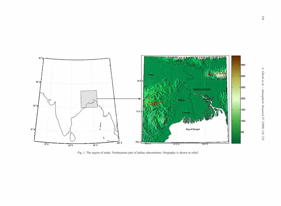
Fig. 1. The region of study: Northeastern part of Indian subcontinent. Orography is shown as relief.
118A.Ghosh
etal.
/Atmospheric
Research
87(2008)
116–135
2 Hills of Nagaland, Manipur and Mizoram are outside the studyregion (Fig. 1).
Fig. 2. Schematic of different types of Nor'wester (A, B, C, and D type): Origin and direction of movement (IMD T.N. 10, 1944).
119A. Ghosh et al. / Atmospheric Research 87 (2008) 116–135
period from winter monsoon to summer monsooncirculations. The insolation is very intense which helpsto develop a heat low over the subcontinent. ChotaNagpur Plateau, West Bengal, Assam, Bangladesh, andthe adjoining regions are under the influence of a lowpressure system (or an extended trough of low pressure),while the seasonal high is over the Bay of Bengal. Ingeneral, the low-level winds are southerly/southwesterlywhich lead to a well-marked shallow inflow of moisturefrom the Bay of Bengal into the study region, while inthe mid-upper troposphere a moderate to strong westerlyflow, often associated with westerly jet, continues overthe northern part of Indian subcontinent (Weston, 1972;Lohar and Pal, 1995).
The high surface temperature and intense convectiveactivities are the characteristics of this season. On anaverage, there are as much as 30–40 thunderstorm daysduring this season (Srinivasan et al., 1973). There are fourvarieties of these pre-monsoon thunderstorms(Nor'westers); A, B, C, and D type (IMD T.N. 10, 1944):
• Type A develops over Chota Nagpur Plateau and theadjoining areas (Gangetic Plain in West Bengal, India
and Bangladesh), mainly in the afternoon, and sub-sequently moves in a southeasterly direction.
• Type B originates in the submontane districts of northBengal and move southwards. Generally, it occursduring night and early morning.
• TypeC originates over the hills2 of Nagaland,Manipurand Mizoram and travel westwards. It is very rare.
• Type D is very similar to type B but the place oforigin is near the Garohills and Khasihills, not theHimalayas. The direction of movement is also fromnorth to south.
The origin and direction of movement of differenttypes of Nor'wester is schematically shown in Fig. 2.The previous studies show that a majority of thisthunderstorms is of type A (Rao and Boothalingam,1957).
The rainfall is very less during this season, andwhatever the rainfall received over the region is mainly
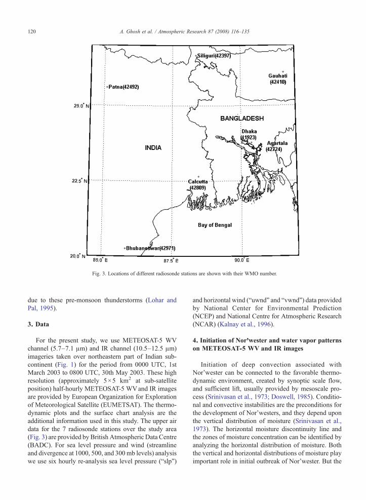
Fig. 3. Locations of different radiosonde stations are shown with their WMO number.
120 A. Ghosh et al. / Atmospheric Research 87 (2008) 116–135
due to these pre-monsoon thunderstorms (Lohar andPal, 1995).
3. Data
For the present study, we use METEOSAT-5 WVchannel (5.7–7.1 μm) and IR channel (10.5–12.5 μm)imageries taken over northeastern part of Indian sub-continent (Fig. 1) for the period from 0000 UTC, 1stMarch 2003 to 0800 UTC, 30th May 2003. These highresolution (approximately 5×5 km2 at sub-satelliteposition) half-hourly METEOSAT-5 WVand IR imagesare provided by European Organization for Explorationof Meteorological Satellite (EUMETSAT). The thermo-dynamic plots and the surface chart analysis are theadditional information used in this study. The upper airdata for the 7 radiosonde stations over the study area(Fig. 3) are provided by British Atmospheric Data Centre(BADC). For sea level pressure and wind (streamlineand divergence at 1000, 500, and 300mb levels) analysiswe use six hourly re-analysis sea level pressure (“slp”)
and horizontal wind (“uwnd” and “vwnd”) data providedby National Center for Environmental Prediction(NCEP) and National Centre for Atmospheric Research(NCAR) (Kalnay et al., 1996).
4. Initiation of Nor'wester and water vapor patternson METEOSAT-5 WV and IR images
Initiation of deep convection associated withNor'wester can be connected to the favorable thermo-dynamic environment, created by synoptic scale flow,and sufficient lift, usually provided by mesoscale pro-cess (Srinivasan et al., 1973; Doswell, 1985). Conditio-nal and convective instabilities are the preconditions forthe development of Nor'westers, and they depend uponthe vertical distribution of moisture (Srinivasan et al.,1973). The horizontal moisture discontinuity line andthe zones of moisture concentration can be identified byanalyzing the horizontal distribution of moisture. Boththe vertical and horizontal distributions of moisture playimportant role in initial outbreak of Nor'wester. But the
121A. Ghosh et al. / Atmospheric Research 87 (2008) 116–135
understanding of the phenomenon is mostly limited inthe synoptic scale development while the mesoscalestructure of the phenomenon remains both poorlymeasured and poorly understood. In the recent years, anumber of important discoveries using geostationarysatellite imagery have had a dramatic impact onmesoscale meteorology. When high resolution satelliteimages are viewed in animation, the movement,orientation, and evolution of important mesoscale fea-tures can be observed, adding a new dimension tomesoscale reasoning. In the present study, we interprethigh resolution METEOSAT-5 WV and IR images toanalyze (qualitatively) the mid-upper and lower atmo-spheric water vapor patterns associated with the ini-tiation of convective cells for a variety of Nor'westers.
The interpretation of WVand IR images is discussedin Section 4.1, while the analysis and statistics of watervapor patterns pertinent to the convective initiation ofNor'wester are given in Section 4.2.
4.1. Interpretation of METEOSAT-5 WV and IR images
Moisture information from METEOSAT-5 WV andIR images are very useful to study both the vertical andhorizontal distributions of moisture in pre-storm envi-ronment. The WV imagery depicts regions of mid-upperlevel moisture and clouds. In a normally moist atmo-sphere, most of the WV (5.7–7.1 μm) radiation receivedby satellite is originated in the 300–600 mb layers, butwhen air is dry some radiation may come from layers aslow as 800 mb (Bader et al., 1995; Manual of synopticsatellite meteorology and case studies, 2007). Thedistinct patterns of moist areas (light tones) and drier(darker tones) are the characteristic of WV images.These features have a close relationship with both thesynoptic and mesoscale motions (Ramond et al., 1981;Santurette and Georgiev, 2005; Soden and Fu, 1995;Weldon and Holmes, 1991). They also provide usefulinformation on the flow patterns in the middle and uppertroposphere (Santurette and Georgiev, 2005; Weldonand Holmes, 1991). It is particularly important to notethat even when a WV image indicates a very dry uppertroposphere, there may be a well moist air near the earthsurface. Moist air or clouds in the lower half of thetroposphere, rather than WV imageries, is better de-picted in IR images (10.5–12.5 μm) (Bader et al., 1995).During daytime, after the surface has been heated, amoist low-level environment will cause the IR temper-ature (brightness temperature) to appear cooler (lightertones) than the land surface temperature (brightnesstemperature) (Bader et al., 1995). This is due to absorp-tion (mainly caused by the water vapor lines and by the
water vapor continuum absorption in IR windowbetween 10.5 and 12.5 μm (Gaertner and Schmetz,1986)) and re-emission by the cooler overlying moistair. On the other hand, at night, low-level moisturewithin or just above a nocturnal surface inversion willcause the IR temperature to appear warmer (darkertones) than the underlying surface. When the atmo-sphere is dry, day or night, the IR temperature will beclose to the true land surface temperature.
4.2. Analysis and statistics of water vapor patterns
As the moisture is an important ingredient in thedevelopment of severe thunderstorm, it is expected thatthe evolution of atmospheric moisture field in lower aswell as mid-upper levels during the pre-storm hoursitself contains some useful signatures of convectiveinitiation. In this context we analyze some cases throughthe interpretation of METEOSAT-5 WVand IR images.There are three basic water vapor patterns on both theWV and IR images : dry regions (darker tones), moistregions (lighter tones), and the edges separating thesetwo regions. However, there are some differences inappearance of these patterns on WVand IR images. OnWV images dry and moist regions, in general, have aband like structure, whereas on IR images these regionsare more or less homogeneous. Edge of mid-upperatmospheric dryness appears as narrow transition zonebetween relatively high and low pixel values on WVimages (hereafter this transition zone is referred as WVboundary following the work of Krennert and Zwatz-Meise (2003)). On the other hand, dryline in the lowerlevel appears as a moisture discontinuity line (Rhea,1966; Ziegler and Hane, 1993) separating a dry regionfrom a moist region on IR images. These mid-upper andlower level water vapor patterns, in together, revealmany clues for forecasting the initiation of Nor'wester.In this regard, the following combinations of mid-upperand lower level moisture field are expected to beimportant: (a) WV boundary in mid-upper atmosphereand dryline in lower level (WV_DL), (b) WV boundaryin mid-upper atmosphere and lower level moist region(WV_LM), (c) mid-upper moist region and dryline inlower level (MUM_DL), (d) mid-upper moist regionand low-level moist region (MUM_LM), (e) mid-upperdry region and dryline in lower level (MUD_DL), and(f ) mid-upper dry region and low-level moist region(MUD_LM). Interestingly, there is no case when con-vective cells are initiated in a warm but dry low-level air.So the combinations of lower level dry region with WVboundary, mid-upper moist region (MUM), and mid-upper dry region (MUD) have been excluded, and this
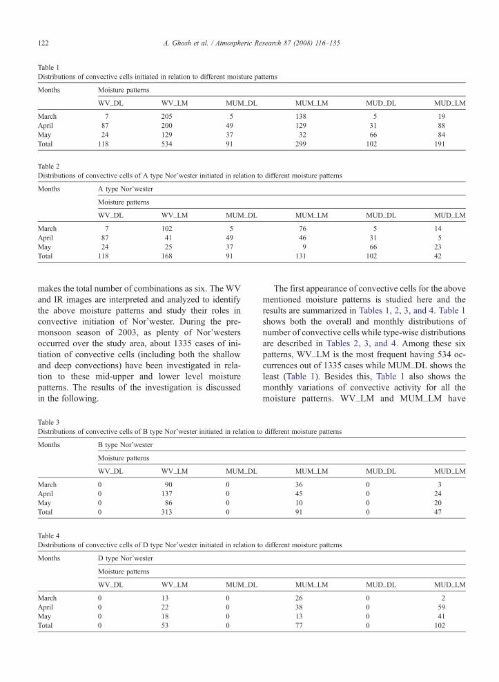
Table 1Distributions of convective cells initiated in relation to different moisture patterns
Months Moisture patterns
WV_DL WV_LM MUM_DL MUM_LM MUD_DL MUD_LM
March 7 205 5 138 5 19April 87 200 49 129 31 88May 24 129 37 32 66 84Total 118 534 91 299 102 191
Table 2Distributions of convective cells of A type Nor'wester initiated in relation to different moisture patterns
Months A type Nor'wester
Moisture patterns
WV_DL WV_LM MUM_DL MUM_LM MUD_DL MUD_LM
March 7 102 5 76 5 14April 87 41 49 46 31 5May 24 25 37 9 66 23Total 118 168 91 131 102 42
122 A. Ghosh et al. / Atmospheric Research 87 (2008) 116–135
makes the total number of combinations as six. The WVand IR images are interpreted and analyzed to identifythe above moisture patterns and study their roles inconvective initiation of Nor'wester. During the pre-monsoon season of 2003, as plenty of Nor'westersoccurred over the study area, about 1335 cases of ini-tiation of convective cells (including both the shallowand deep convections) have been investigated in rela-tion to these mid-upper and lower level moisturepatterns. The results of the investigation is discussedin the following.
Table 3Distributions of convective cells of B type Nor'wester initiated in relation to
Months B type Nor'wester
Moisture patterns
WV_DL WV_LM MUM_DL
March 0 90 0April 0 137 0May 0 86 0Total 0 313 0
Table 4Distributions of convective cells of D type Nor'wester initiated in relation to
Months D type Nor'wester
Moisture patterns
WV_DL WV_LM MUM_DL
March 0 13 0April 0 22 0May 0 18 0Total 0 53 0
The first appearance of convective cells for the abovementioned moisture patterns is studied here and theresults are summarized in Tables 1, 2, 3, and 4. Table 1shows both the overall and monthly distributions ofnumber of convective cells while type-wise distributionsare described in Tables 2, 3, and 4. Among these sixpatterns, WV_LM is the most frequent having 534 oc-currences out of 1335 cases while MUM_DL shows theleast (Table 1). Besides this, Table 1 also shows themonthly variations of convective activity for all themoisture patterns. WV_LM and MUM_LM have
different moisture patterns
MUM_LM MUD_DL MUD_LM
36 0 345 0 2410 0 2091 0 47
different moisture patterns
MUM_LM MUD_DL MUD_LM
26 0 238 0 5913 0 4177 0 102
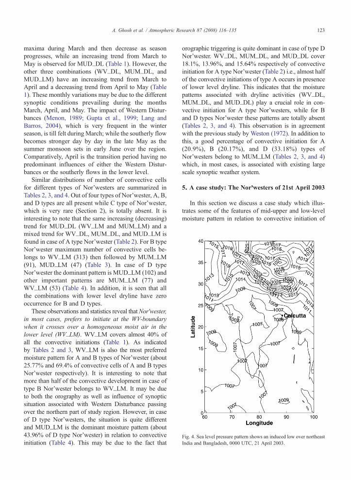
Fig. 4. Sea level pressure pattern shows an induced low over northeastIndia and Bangladesh, 0000 UTC, 21 April 2003.
123A. Ghosh et al. / Atmospheric Research 87 (2008) 116–135
maxima during March and then decrease as seasonprogresses, while an increasing trend from March toMay is observed for MUD_DL (Table 1). However, theother three combinations (WV_DL, MUM_DL, andMUD_LM) have an increasing trend from March toApril and a decreasing trend from April to May (Table1). These monthly variations may be due to the differentsynoptic conditions prevailing during the monthsMarch, April, and May. The impact of Western Distur-bances (Menon, 1989; Gupta et al., 1999; Lang andBarros, 2004), which is very frequent in the winterseason, is till felt during March; while the southerly flowbecomes stronger day by day in the late May as thesummer monsoon sets in early June over the region.Comparatively, April is the transition period having nopredominant influences of either the Western Distur-bances or the southerly flows in the lower level.
Similar distributions of number of convective cellsfor different types of Nor'westers are summarized inTables 2, 3, and 4. Out of four types of Nor'wester, A, B,and D types are all present while C type of Nor'wester,which is very rare (Section 2), is totally absent. It isinteresting to note that the same increasing (decreasing)trend for MUD_DL (WV_LM and MUM_LM) and amixed trend for WV_DL, MUM_DL, and MUD_LM isfound in case of A type Nor'wester (Table 2). For B typeNor'wester maximum number of convective cells be-longs to WV_LM (313) then followed by MUM_LM(91), MUD_LM (47) (Table 3). In case of D typeNor'wester the dominant pattern is MUD_LM (102) andother important patterns are MUM_LM (77) andWV_LM (53) (Table 4). In addition, it is seen that allthe combinations with lower level dryline have zerooccurrence for B and D types.
These observations and statistics reveal thatNor'wester,in most cases, prefers to initiate at the WV-boundarywhen it crosses over a homogeneous moist air in thelower level (WV_LM). WV_LM covers almost 40% ofall the convective initiations (Table 1). As indicatedby Tables 2 and 3, WV_LM is also the most preferredmoisture pattern for A and B types of Nor'wester (about25.77% and 69.4% of convective cells of A and B typesNor'wester respectively). It is interesting to note thatmore than half of the convective development in case oftype B Nor'wester belongs to WV_LM. It may be dueto both the orography as well as influence of synopticsituation associated with Western Disturbance passingover the northern part of study region. However, in caseof D type Nor'westers, the situation is quite differentand MUD_LM is the dominant moisture pattern (about43.96% of D type Nor'wester) in relation to convectiveinitiation (Table 4). This may be due to the fact that
orographic triggering is quite dominant in case of type DNor'wester. WV_DL, MUM_DL, and MUD_DL cover18.1%, 13.96%, and 15.64% respectively of convectiveinitiation for A type Nor'wester (Table 2) i.e., almost halfof the convective initiations of type A occurs in presenceof lower level dryline. This indicates that the moisturepatterns associated with dryline activities (WV_DL,MUM_DL, and MUD_DL) play a crucial role in con-vective initiation for A type Nor'westers, while for Band D types Nor'wester these patterns are totally absent(Tables 2, 3, and 4). This observation is in agreementwith the previous study by Weston (1972). In addition tothis, a good percentage of convective initiation for A(20.9%), B (20.17%), and D (33.18%) types ofNor'westers belong to MUM_LM (Tables 2, 3, and 4)which, in most cases, is associated with existing largescale synoptic weather system.
5. A case study: The Nor'westers of 21st April 2003
In this section we discuss a case study which illus-trates some of the features of mid-upper and low-levelmoisture pattern in relation to convective initiation of
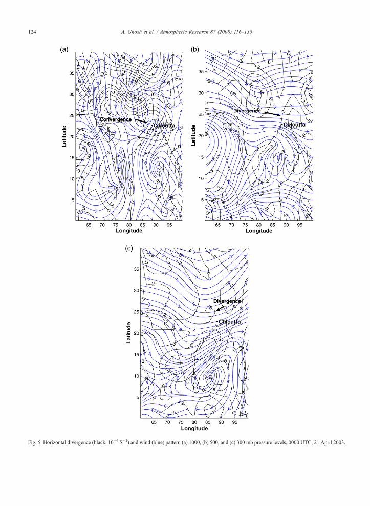
Fig. 5. Horizontal divergence (black, 10−6 S−1) and wind (blue) pattern (a) 1000, (b) 500, and (c) 300 mb pressure levels, 0000 UTC, 21 April 2003.
124 A. Ghosh et al. / Atmospheric Research 87 (2008) 116–135
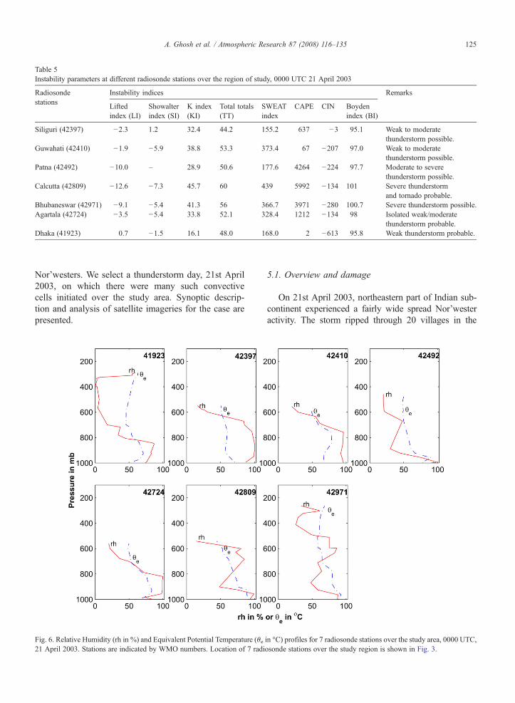
Table 5Instability parameters at different radiosonde stations over the region of study, 0000 UTC 21 April 2003
Radiosondestations
Instability indices Remarks
Liftedindex (LI)
Showalterindex (SI)
K index(KI)
Total totals(TT)
SWEATindex
CAPE CIN Boydenindex (BI)
Siliguri (42397) −2.3 1.2 32.4 44.2 155.2 637 −3 95.1 Weak to moderatethunderstorm possible.
Guwahati (42410) −1.9 −5.9 38.8 53.3 373.4 67 −207 97.0 Weak to moderatethunderstorm possible.
Patna (42492) −10.0 – 28.9 50.6 177.6 4264 −224 97.7 Moderate to severethunderstorm possible.
Calcutta (42809) −12.6 −7.3 45.7 60 439 5992 −134 101 Severe thunderstormand tornado probable.
Bhubaneswar (42971) −9.1 −5.4 41.3 56 366.7 3971 −280 100.7 Severe thunderstorm possible.Agartala (42724) −3.5 −5.4 33.8 52.1 328.4 1212 −134 98 Isolated weak/moderate
thunderstorm probable.Dhaka (41923) 0.7 −1.5 16.1 48.0 168.0 2 −613 95.8 Weak thunderstorm probable.
125A. Ghosh et al. / Atmospheric Research 87 (2008) 116–135
Nor'westers. We select a thunderstorm day, 21st April2003, on which there were many such convectivecells initiated over the study area. Synoptic descrip-tion and analysis of satellite imageries for the case arepresented.
Fig. 6. Relative Humidity (rh in %) and Equivalent Potential Temperature (θe21 April 2003. Stations are indicated by WMO numbers. Location of 7 radi
5.1. Overview and damage
On 21st April 2003, northeastern part of Indian sub-continent experienced a fairly wide spread Nor'westeractivity. The storm ripped through 20 villages in the
in °C) profiles for 7 radiosonde stations over the study area, 0000 UTC,osonde stations over the study region is shown in Fig. 3.
126 A. Ghosh et al. / Atmospheric Research 87 (2008) 116–135
Nadanghat–Purbasthali areas of Kalna subdivision,Burdwan, West Bengal, India. Many people were injuredand about 250 families were rendered homeless. InBangladesh, the worst affected areas were the Dhaka andBrahmanberia. Two Bangladeshi ferries sank on theBuriganga and Megna rivers. At least 208 people werekilled and 161 were missing.
5.2. Pre-storm environment
On 21st April, there were two severe Nor'westers.The first one (hereafter referred as Nor'wester-I), a Btype Nor'wester, was initiated over Sub-HimalayanWest Bengal and Assam while the second one (hereafterreferred as Nor'wester-II), an A type Nor'wester, wasinitiated over Jharkhand and Gangetic West Bengal. InOrissa, there were also a few isolated thunderstorms. Incomparison to Nor'wester-I and Nor'wester-II, theseisolated thunderstorms were less severe.
To visualize the synoptic situation on 21st April2003, we use NCAR/NCEP reanalysis sea level pres-sure (“slp”) and horizontal wind data (“uwnd” and“vwnd”). The sea level pressure pattern is shown inFig. 4, while Fig. 5 shows the horizontal divergenceand wind pattern (streamline) at 1000, 500, and 300 mbpressure levels at 0000 UTC 21st April 2003. There isa near-surface cyclonic circulation over northeast Indiaand Bangladesh. A synoptic scale convergence at thelower level (Fig. 5a, 1000 mb) is developed by theinduced low over northeast India and Bangladesh(Fig. 4) which controls an inflow of moisture from theBay of Bengal. On the other hand, an upper leveldivergence associated with the westerly trough is pre-sent (Fig. 5b, 500 mb and Fig. 5c, 300 mb). Theseupper level divergence and lower level convergencemay act as a synoptic scale setting favorable forinitiation of Nor'westers.
There are seven radiosonde stations over the studyregion(Fig. 3). The Skew-T plots for all these radio-sonde stations are drawn (not shown here) and differentstability indices along with convective available poten-tial energy (CAPE), convective inhibition energy (CIN)are calculated and summarized in Table 5. The verticaldistribution of relative humidity (rh) and equivalentpotential temperature (θe) for all the radiosonde stationsare shown in Fig. 6. As usual radiosonde data are notavailable at the exact location of deep convection.Nor'wester-I is initiated at the location in betweenSiliguri (42397) and Guwahati (42410). The instabilityindices calculated using 0000 UTC radiosonde datashow that there is a weak to moderate thunderstormpossibilities at Siliguri and Guwahati (Table 5). The
vertical distribution of rh for these two stations indi-cates that the lower atmosphere is very moist (rhN90%)and the upper atmosphere is quite dry (Fig. 6). However,the vertical profile of θe shows that atmosphere ispotentially quite stable over these two stations (Fig. 6).For Nor'wester-II the nearby stations to the convectivecells are Patna (42492), and Calcutta (42809). Theinstability indices indicate that there is moderate tosevere thunderstorm possibility for Patna, while forCalcutta severe thunderstorm and tornado are probable(Table 5). For these two stations, rh is very high nearthe ground surface, while in mid-upper atmosphere rhis quite low (Fig. 6). The vertical profile of θe shows thatatmosphere is potentially unstable over these twostations (θe decreases continuously, Fig. 6). Similarly,Bhubaneswar (42971) has a possibility of severethunderstorm. At Bhubaneswar, the rh profile is quitesimilar to that of Calcutta, but the θe profile is quitedifferent; θe increases in the mid-upper atmosphere.
Similarly, Dhaka (41923) and Agartala (42724) havea possibility of isolated weak/moderate thunderstorm,and the corresponding rh and θe profiles are shown inFig. 6.
The vertical distribution of θe indicates the presenceof atmospheric instability. Areas with high θe in lowerlevels that is overrun by areas with lower θe, this wouldresult in an increase in the lapse rate, i.e., increase ininstability. As indicated by the vertical distribution of θe,there is a strong instability over the western andsouthwestern part of the study area (Panta, Calcutta,and Bhubaneswar, Fig. 6). Similarly, the northern part ofthe study area (Siliguri and Guwahati, Fig. 6) shows aweak to moderate instability, while in the eastern andsoutheastern parts (Dhaka and Agartala, Fig. 6) indicatea very weak instability. These observations are alsosupported by the other instability parameters (i.e., Liftedindex, Showalter Index, K Index, Total Totals, SWEATIndex, CAPE, CIN, and Boyden Index, Table 5).Although the conventional radiosonde observations arewidely used for forecasting Nor'westers, these observa-tions are limited by their coarse spatial and temporalresolutions which result in a failure of forecasting thelocation and time of convective initiation cells ofNor'wester.
5.3. Moisture information in satellite observations:METEOSAT-5 WV and IR channels
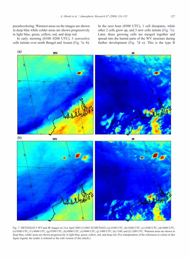
The sequences of METEOSAT-5 WVand IR imagesfor the growing convective cells of these Nor'westers(Nor'wester-I and Nor'wester-II) is displayed in Fig. 7.Here all the images (WV and IR) are enhanced with
127A. Ghosh et al. / Atmospheric Research 87 (2008) 116–135
pseudocoloring. Warmest areas on the images are shownin deep blue while colder areas are shown progressivelyin light blue, green, yellow, red, and deep red.
In early morning (0100–0200 UTC), 3 convectivecells initiate over north Bengal and Assam (Fig. 7a–b).
Fig. 7. METEOSAT-5 WVand JR images on 21st April 2003 (©2003 EUME(e) 0500 UTC, (f ) 0600 UTC, (g) 0700 UTC, (h) 0800 UTC, (i) 0900 UTC, (deep blue; colder areas are shown progressively in light blue, green, yellow,figure legend, the reader is referred to the web version of this article.)
In the next hour (0300 UTC), 1 cell dissipates, whileother 2 cells grow up, and 3 new cells initiate (Fig. 7c).Later, these growing cells are merged together andspread into the humid parts of the WV structure duringfurther development (Fig. 7d–e). This is the type B
TSAT); (a) 0100 UTC, (b) 0200 UTC, (c) 0300 UTC, (d) 0400 UTC,j) 1000 UTC, (k) 1100, and (l) 1200 UTC. Warmest areas are shown inred, and deep red. (For interpretation of the references to colour in this
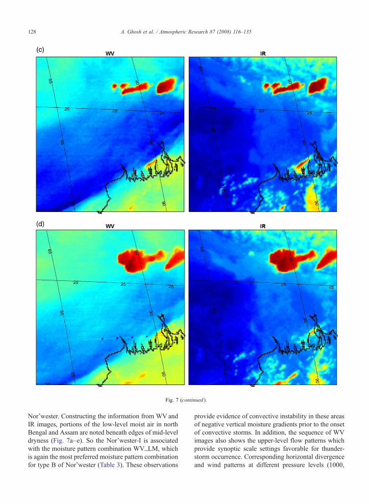
Fig. 7 (continued ).
128 A. Ghosh et al. / Atmospheric Research 87 (2008) 116–135
Nor'wester. Constructing the information from WVandIR images, portions of the low-level moist air in northBengal and Assam are noted beneath edges of mid-leveldryness (Fig. 7a–e). So the Nor'wester-I is associatedwith the moisture pattern combination WV_LM, whichis again the most preferred moisture pattern combinationfor type B of Nor'wester (Table 3). These observations
provide evidence of convective instability in these areasof negative vertical moisture gradients prior to the onsetof convective storms. In addition, the sequence of WVimages also shows the upper-level flow patterns whichprovide synoptic scale settings favorable for thunder-storm occurrence. Corresponding horizontal divergenceand wind patterns at different pressure levels (1000,
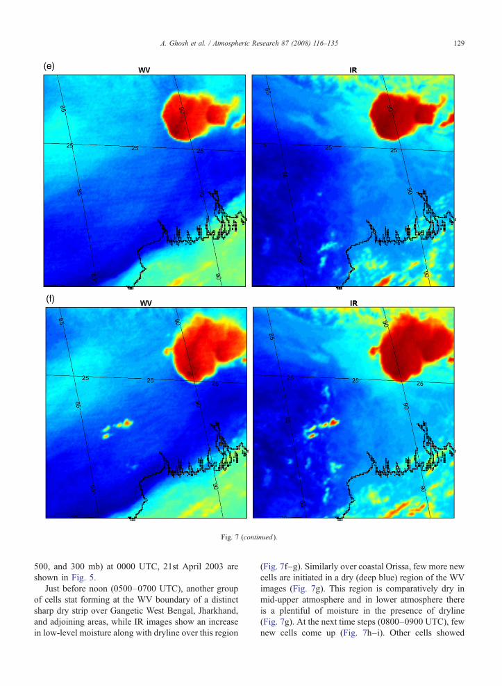
Fig. 7 (continued ).
129A. Ghosh et al. / Atmospheric Research 87 (2008) 116–135
500, and 300 mb) at 0000 UTC, 21st April 2003 areshown in Fig. 5.
Just before noon (0500–0700 UTC), another groupof cells stat forming at the WV boundary of a distinctsharp dry strip over Gangetic West Bengal, Jharkhand,and adjoining areas, while IR images show an increasein low-level moisture along with dryline over this region
(Fig. 7f–g). Similarly over coastal Orissa, few more newcells are initiated in a dry (deep blue) region of the WVimages (Fig. 7g). This region is comparatively dry inmid-upper atmosphere and in lower atmosphere thereis a plentiful of moisture in the presence of dryline(Fig. 7g). At the next time steps (0800–0900 UTC), fewnew cells come up (Fig. 7h–i). Other cells showed

Fig. 7 (continued ).
130 A. Ghosh et al. / Atmospheric Research 87 (2008) 116–135
further development and few are also merged together totake a form of severe Nor'wester (Fig. 7j–l). This is thetype A Nor'wester, and the associated moisture patterncombination is WV_DL, the most preferred moisturecombination for type A Nor'wester in the month ofApril (Table 2).
In both the cases of Nor'wester-I and Nor'wester-II,the convective cells are mostly initiated over the regionswhere mid-upper level WV boundaries pass over thelow-level moist air (Fig. 7). In addition to this,Nor'wester-II, which is basically a type A Nor'wester,is also supported by the presence of dryline over

Fig. 7 (continued ).
131A. Ghosh et al. / Atmospheric Research 87 (2008) 116–135
Gangetic West Bengal, Jharkhand, coastal Orissa, andadjoining areas (Fig. 7). Another observation shows thatdeeply growing convective cells initially start at a WVboundary and then spread into the humid parts of theWV structure during further development (Fig. 7). Incontrast the convective cells of less severe isolatedthunderstorms develop over the dry (deep blue) region
of the WV images (having less moisture in the mid-upper levels) and dissipate in a comparatively short time(Fig. 7).
These high resolution satellite images draw attention tothe evolution of, otherwise undetected, patterns of mid-upper and low-level water vapor in relation to theinitiation of convective cells of Nor'wester. Interpretation
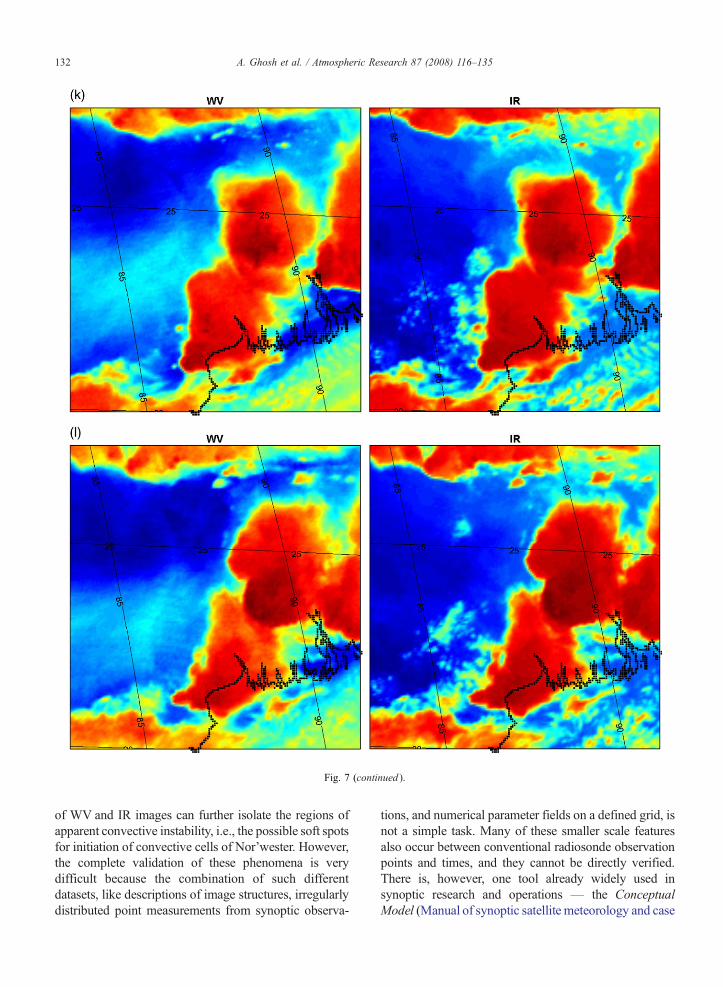
Fig. 7 (continued ).
132 A. Ghosh et al. / Atmospheric Research 87 (2008) 116–135
of WV and IR images can further isolate the regions ofapparent convective instability, i.e., the possible soft spotsfor initiation of convective cells of Nor'wester. However,the complete validation of these phenomena is verydifficult because the combination of such differentdatasets, like descriptions of image structures, irregularlydistributed point measurements from synoptic observa-
tions, and numerical parameter fields on a defined grid, isnot a simple task. Many of these smaller scale featuresalso occur between conventional radiosonde observationpoints and times, and they cannot be directly verified.There is, however, one tool already widely used insynoptic research and operations — the ConceptualModel (Manual of synoptic satellite meteorology and case
133A. Ghosh et al. / Atmospheric Research 87 (2008) 116–135
studies, 2006). The following section describes someconceptual considerations to understand the essentialfeatures of the meteorological phenomenon and toidentify the possible physical processes taking place.
6. Conceptual considerations: Possible physicalprocesses
Srinivasan et al. (1973) found that convective (alsoknown as potential instability) and conditional instabil-ities are the preconditions for the development ofNor'wester. The variation of vertical distribution ofmoisture determines the conditional and convectiveinstabilities. As discussed in Section 5.2, radiosondeobservations taken at 0000 UTC 21st April 2003 atPatna and Calcutta indicate that the atmosphere ispotentially very unstable (Table 5 and Fig. 6). Althoughthese conventional sounding data provide useful infor-mation about temperature structure and water vaporgradients in pre-storm environments, but they only takemeasurements twice a day, and can miss many small-scale water vapor features in the hundreds of kilometersbetween sounding locations. Using only the radio-sonde data we have just a gross idea about the differentphysical processes occurring in relation to mid-upperand lower level moisture patterns. However, this can beexplained conceptually by analyzing METEOSAT-5WVand IR images. On 21st April 2003, IR images showan almost homogeneous distribution of humidity atlower levels over the study region, while WV imageriesindicate an inhomogeneous distribution of humidity inthe mid-upper atmosphere (Fig. 7). Higher potentialinstability is gained in connection with a higher verticalgradient of humidity. Consequently, between these dryand moist regions there is a horizontal gradient inpotential instability which corresponds to the WV-boundary (Krennert and Zwatz-Meise, 2003).
Besides this, there are some evidences of mesoscaleascent on both the WV and IR images. Although thesynoptic scale situation provides a favorable conditionfor initiation of convection (e.g., at 0000 UTC 21st April2003 a synoptic scale lower level convergence (Fig. 5a,1000 mb) and an upper level divergence (Fig. 5b,500 mb and Fig. 5c, 300 mb) may act as a synopticscale setting favorable for thunderstorm occurrence(Section 5.2.)), often the required lift is associated withmesoscale processes which are very difficult to evaluateand forecast operationally using conventional data. Theprimary source of energy for initiation of convection isthe daytime heating of the earth surface and lower layersof atmosphere by incoming solar radiation. About 50%of incoming solar energy is contained in the near-IR and
water vapor is the most important absorber in this por-tion of solar spectrum (Liou, 2002). So the presence/absence of water vapor in the mid-upper atmosphere isone of the factors which determines the amount of solarradiation that should reach the earth surface. As a result,if lower level is homogeneously moist, the solar energyreaching the earth surface below a mid-upper humidregion is less compared to that below a mid-upper dryarea (Krennert and Zwatz-Meise, 2003). It is very likelythat, due to this differential heating, a new shallowconvergence zone will appear on the earth surface belowthe WV boundary. Consequently, a secondary circula-tion with ascending flow over the dry region is likely tobe established there. This concept, however, describes avery idealized situation. In practice, effects of orogra-phy, land-surface characteristics, and lower levelmoisture distribution play important role in relation todifferential heating on the earth surface. In this regard,the analysis of IR images reveals another importantmesoscale feature in the lower atmosphere — the dry-line. Over the Gangetic Plain the dryline is a interfacebetween relatively moist air flowing from the Bay ofBengal and relatively dry air mass subsiding over theChota Nagpur Plateau (Weston, 1972). Dryline has itsown associated vertical circulation which arises fromthe dependence of air density on its heat and moisturecontent (Kessler, 1982). In addition, the topography,soil moisture and wind shear play important roles indryline morphology. Interaction of these componentsresults in a solenoidally induced circulation which isresponsible for generating strong low-level horizontalconvergence and deep vertical ascending motion neededfor convective initiation at/near dryline (Sun and Ogura,1979). The dryline activity plays a crucial role in con-vective initiation for A type Nor'westers, while for B andD types Nor'wester it is totally absent. A type Nor'westerdevelops mostly in the afternoon, while B and D typesNor'westers occur during night and early morning. Thedryline contributed surface differential solar heating maybe dominant in case of A typeNor'wester, while for B andD types Nor'westers this mechanism is not significant.
In summary, the analysis of moisture fields on WVand IR images reveals the presence of atmospheric in-stability and the signature of mesoscale lifting processesduring pre-storm environment of Nor'wester. Theselower and upper levels moisture fields are often coupledtogether, leading to release the convective instability. Theimportant combinations of mid-upper and lower levelmoisture patterns are: WV_DL, WV_LM, MUM_DL,MUM_LM, MUD_DL, MUD_LM (Section 4.2). Atmo-sphere is potentially unstable and except MUM_LM andMUD_LM, all other patterns receive the mesoscale
134 A. Ghosh et al. / Atmospheric Research 87 (2008) 116–135
lifting from the presence of WV boundary or/and dry-line. In case of MUM_LM, both the lower and upperlevels are either homogeneously moist or cloudy, i.e.,convection initiates within a deep layer of moisture or inpresence of a existing weather system. The mesoscalelifting other than that ofWV boundary and dryline, suchas orographic lifting, may play a crucial role inconvective initiation for MUM_LM. On the otherhand, for MUD_LM a deep layer of dry air layingover the shallow moist air in the lower atmospherewhich generates potential instability and the orographictriggering along with solar heating would likely to leadto convective initiation.
7. Conclusions
This paper investigates few features of initiation ofconvective cells of Nor'wester analyzing METEOSAT-5WV and IR images. The mid-upper and lower watervapor patterns pertinent to the initiation of convectivecells of different types of Nor'wester are monitoredusing WVand IR images during the 2003 pre-monsoonseason over northeastern part of Indian subcontinent.The comprehensive observations and statistics (Section4.2) reveal that the first appearance of Nor'wester aremostly associated with the WV boundary when it passesover low-level homogeneous moist layer of atmosphere(WV_LM). This moisture pattern (WV_LM) is alsodominant for A and B types of Nor'wester. The A typeNor'wester is also favored by dryline activity which istotally absent for B and D types Nor'wester. The drylinecontributed surface differential solar heating may playdominant role for the initiation of A type Nor'wester,while this mechanism may be insignificant for B and Dtypes Nor'westers. For type B both orography and thesynoptic situation associated with Western Disturbancepassing over the Himalayan region may play a crucialrole. In case of D type Nor'wester convective cellsare mostly initiated when the mid-upper dry air overliesthe lower level moist air (MUD_LM), i.e., the atmo-sphere is potentially unstable and the orography liftingmay trigger the convection. A case study is furtherdiscussed to illustrate the features of combination ofmoisture patterns. The sequences of WVand IR imagesprovide evidence of convective instability in the areas ofnegative vertical moisture gradients prior to the onset ofNor'wester. A close look on these images also givessome clues regarding the mesoscale lifting processeswhich are almost impossible to evaluate and forecastoperationally using conventional observational data.The conceptual considerations (Section 6) explainthe secondary circulations associated with WV bound-
ary and dryline. These are the two possible mesoscalefeatures which might frequently release the convec-tive instability and the convective cells of Nor'westersoutbreak.
Thus the water vapor patterns in mid-upper andlower atmosphere as seen on METEOSAT-5 WVand IRimages, along with other meteorological parameters(e.g., spatial distribution of different stability indexes,synoptic analysis etc.), could be the interesting clues forforecasting Nor'westers.
However, in the present study, we do not have suf-ficient high resolution meteorological observation (e.g.,mesonet)/model (e.g., local area model) data. Theorographic triggering, which plays an important role inconvective initiation, cannot be isolated from triggeringdue to secondary circulation at or near WV boundary or/and dryline. In case of A type Nor'wester, least hillyregion of Chota Nagpur Plateau has a definiteorographic effect on convection. On the other hand,for B and D types Nor'westers there are possibilities oforographic triggering by forced lifting, katabatic windflow etc. over hilly regions in northern/northeastern partof the study region. In future, we plan to study the effectof orography on convective initiation for different typesof Nor'wester.
Acknowledgment
The first author acknowledges the Senior ResearchFellowship of the Council of Scientific and IndustrialResearch (CSIR), India. Authors would also like tothank European Organisation for the Exploration ofMeteorological Satellites (EUMETSAT) for providingthe METEOSAT-5 data. The radiosonde data providedby British Atmospheric Data Centre (BADC), are alsoacknowledged. NCEP Reanalysis data were provided bythe NOAA-CIRES Climate Diagnostics Center, Boul-der, Colorado, USA, from their Web site at http://www.cdc.noaa.gov/. The anonymous referees deserve specialthanks for providing very useful suggestions that haveimproved the manuscript.
References
Bader, M.J., Forbes, G.S., Grant, J.R., Lilley, R.B.E., Waters, A.J.(Eds.), 1995. Images in Weather Forecasting: A Practical Guide forInterpreting Satellite and Radar Imagery. Cambridge UniversityPress, Cambridge, 499 pp.
Desai, B.N., 1950. Mechanism of Nor'wester of Bengal. IndianJournal of Meteorology and Geophysics 1, 74–76.
Doswell III, C.A., 1985. The Operational Meteorology of ConvectiveWeather, Volume II: Storm Scale Analysis. EnvironmentalSciences Group, Boulder, Colorado.
135A. Ghosh et al. / Atmospheric Research 87 (2008) 116–135
Doswell III, C.A., 1987. The distinction between large-scale andmesoscale contribution to severe convection: a case study example.Weather Forecasting 2, 4–16.
Floyd, J., 1839. Account of the hurricane or whirlwind of the 8th April1838. American Journal of Science 36, 71–75.
Georgiev, C.G., 2003. Use of data from METEOSAT water vapourchannel and surface observations for studying pre-convectiveenvironment of a tornado-producing storm. Atmospheric Research67–68, 231–246.
Gaertner, V., Schmetz, J., 1986. Implementation of a new atmosphericcorrection scheme for the Meteosat IR channel. Report of theProceedings, 6th Meteosat Scientific User's Meeting, Amsterdam,The Netherlands, pp. 25–27. November.
Gupta, A., Rathore, L.S., Singh, S.V., Mendiratta, N., 1999.Performance of a global circulation model in predicting the wintersystems and associated precipitation over North West India during1994–97. In: Dash, S.K., Bahadur, J. (Eds.), The HimalayanEnvironment. New Age International, pp. 123–138.
India Meteorological Department, 1944. Nor'westers of Bengal,Technical Note, No 10.
Kalnay, E., Kanamitsu, M., Kistler, R., Collins, W., Deaven, D.,Gandin, L., Iredell, M., Saha, S., White, G., Woollen, J., Zhu, Y.,Leetmaa, A., Reynolds, B., Chelliah,M., Ebisuzaki,W., Higgins,W.,Janowiak, J., Mo, K.C., Ropelewski, C., Wang, J., Jenne, R.,Joseph, D., 1996. The NCEP/NCAR 40-Year Reanalysis Project.Bulletin of the American Meteorological Society 77, 437–471.
Kessler, E. (Ed.), 1982. Thunderstorm Morphology and Dynamics.U.S. Department of commerce. National Oceanic and AtmosphericAdministration, Environmental Research Laboratories, vol. 2.
Krennert, T., Zwatz-Meise, V., 2003. Initiation of convective cells inrelation to water vapour boundaries in satellite images. Atmo-spheric Research 67–68, 353–366.
Koteswaram, P., Srinivasan, V., 1958. Thunderstorms over GangeticWest Bengal in the pre-monsoon season and the synoptic factorsfavorable for their formation. Indian Journal of Meteorology andGeophysics 9, 301–312.
Lang, T.J., Barros, A.P., 2004. Winter storms in the Central Himalayas.Journal of the Meteorological Society of Japan 82 (3), 829–844.
Liou, K.N., 2002. An Introduction to Atmospheric Radiation, 2ndedition. International Geophysics Series, vol. 84. Academic Press,San Diego.
Lohar, D., Pal, B., 1995. The effect of irrigation on pre-monsoonseason precipitation over south west Bengal, India. Journal ofClimate 8, 2567–2570.
Manual of synoptic satellite meteorology and case studies, Version 6.0,2006. http://www.zamg.ac.at/docu/Manual/SatManu/index.htm(as visited on 16 September).
McNulty, R.P., 1995. Severe and convective weather: a central regionforecasting challenge. Weather and Forecasting 10, 187–202.
Menon, P.A., 1989. Our Weather. National Book Trust, India. 342 pp.Miller, R.C., 1972. Notes on analysis and severe storm forecasting
procedures of the Air Force Global Weather Central. AWS Tech.Rep. 200, Air Weather Service, Scott AFB, IL, 190 pp.
Mukherjee, A.K., Bhattacharrya, P.B., 1972. An early morning tornadoat Diamond Harbour on 21st march 1969. Indian Journal ofMeteorology and Geophysics 23, 223–226.
Mukhopadhyay, P., Singh, H.A.K., Singh, S.S., 2005. Two severeNor'westers in April 2003 over Kolkata using Doppler Radarobservations and satellite imagery. Weather 60 (12), 343–353.
Normand, C.W.B., 1921. Wet-bulb temperature and thermodynamicsof air. Memoirs of the Indian Meteorological Department, 23.Part I.
Patra, A.K. ,1998. Observational and modeling studies of mesoscaledevelopments in Gangetic West Bengal region of Indian duringpre-monsoon season, Ph.D. thesis, Jadavpur University, Calcutta,India, 179 pp.
Petersen, R.A., UccellinI, L.W., Mostek, A., Keyser, D.A., 1984.Delineating mid- and low-level water vapor patterns in pre-convective environments using VAS moisture channels. MonthlyWeather Review 112, 2178–2198.
Rai, S.N.C., 1953. On the use of tephigrams for forecastingNor'westers. Indian Journal of Meteorology and Geophysics 4,269–278.
Ramond, D., Corbin, H., Desbois, M., Szejwach, G., Waldteufel, P.,1981. The Dynamics of Polar Jet Streams as Depicted by theMETEOSATWVChannel Radiance Field, vol. 109, pp. 2164–2176.
Rhea, J.O., 1966. A study of thunderstorm formation along drylines.Journal of Applied Meteorology 5, 58–63.
Rao, D.V., Boothalingam, P.N., 1957. Of forecasting the time ofincidence of Nor'westers at Calcutta. Indian Journal of Meteorol-ogy and Geophysics 8, 61.
Sadhukhan, I., 2001. Land useland cover alteration and its possibleimpact on pre-monsoon climatic variables over Gangetic WestBengal and its neighborhood, Ph.D. thesis, Jadavpur University,Calcutta, India, 125 pp.
Santurette, P., Georgiev, C.G., 2005. Weather Analysis and Forecast-ing: Applying Satellite Water Vapor Imagery and PotentialVorticity Analysis. Elsevier Academic Press, Burlington MA,San Diego, London, 179 pp.
Soden, B.J., Fu, R., 1995. A satellite analysis of deep convection,upper tropospheric humidity, and the greenhouse effect. Journal ofClimate 8, 2333–2351.
Srinivasan, V., Ramamuthy, K., Nene, Y.R., 1973. Summer–Nor'westers and Andhis and large scale convective activity overpeninsula and central parts of the country. India MeteorologicalDepartment, Forecasting Manual, Part III.
Sun, W.Y., Ogura, Y., 1979. Boundary-layer forcing as a possibletrigger to a squall-line formatiom. Journal of Atmospheric Science36, 235–254.
Weldon, R.B., Holmes, S.J., 1991. Water vapor imagery: interpretationand applications to weather analysis and forecasting, NOAATechnical. Report. NESDIS 57, NOAA, US Department ofCommerce, Washington D.C., 213 pp.
Weston, K.J., 1972. The dryline of northern India and its role incumulonimbus convection. Quarterly Journal of Royal Meteoro-logical Society 98, 519–531.
Ziegler, C.L., Hane, C.E., 1993. An observational study of the dryline.Monthly Weather Review 121, 1134–1151.
Copyright © 2022 FDOKUMEN