Influence of Environmental Factors on Urban and Architectural ...
38
Citation: Jó´ zwik, R.; Jó ´ zwik, A. Influence of Environmental Factors on Urban and Architectural Design—Example of a Former Paper Mill in Nanterre. Sustainability 2022, 14, 86. https://doi.org/10.3390/ su14010086 Academic Editors: El ˙ zbieta Ry ´ nska, José Guadalupe Vargas Hernández, Janusz Marchwinski, Jan Winkler and Magdalena Grochulska-Salak Received: 7 November 2021 Accepted: 15 December 2021 Published: 22 December 2021 Publisher’s Note: MDPI stays neutral with regard to jurisdictional claims in published maps and institutional affil- iations. Copyright: © 2021 by the authors. Licensee MDPI, Basel, Switzerland. This article is an open access article distributed under the terms and conditions of the Creative Commons Attribution (CC BY) license (https:// creativecommons.org/licenses/by/ 4.0/). sustainability Article Influence of Environmental Factors on Urban and Architectural Design—Example of a Former Paper Mill in Nanterre Renata Jó ´ zwik 1, * and Anna Jó ´ zwik 2, * 1 Department of Architectural and Urban Design, Faculty of Architecture, Warsaw University of Technology, 55 Koszykowa Street, 00-659 Warsaw, Poland 2 Department of Structural Design, Construction and Technical Infrastructure, Faculty of Architecture, Warsaw University of Technology, 55 Koszykowa Street, 00-659 Warsaw, Poland * Correspondence: [email protected] (R.J.); [email protected] (A.J.) Abstract: Biophilic design is developed in urban planning concepts for cities—in line with sustainable development. A case study of converting a former paper mill in Nanterre into a university campus showed what factors influence the emergence of the biophilic form. The research informs the planning and design mechanisms and directs attention to the process. As a result, the study demonstrates that biophilic elements from the place-based pattern group are directly related to in-depth environmental analysis—similar to elements from the nature-based and element-based pattern groups. Together they result in a biophilic form. The element of creation is also present in the design process but is not the primary determinant of the choice of a design approach. In part, the form is adapted to the area’s environmental characteristics, which result from their interaction with objective determinants. Nevertheless, the implementation is not devoid of compositional, creative, and cultural elements— that is, it assumes the features of biophilic architecture. This fact proves that the environment can influence the creative potential in architecture and urban studies. Keywords: urban area transformations; environmental conditions; sustainable development; biophilic architecture 1. Introduction Dynamic global urbanization poses a threat to the functioning of cities. It causes socio-economic problems, degrades natural ecosystems, and negatively impacts climate change [1]. It is estimated that by 2030, approximately 9.8 billion people will inhabit cities [2]. Metropolises are responsible for 80% of greenhouse gas emissions [3]. For this reason, systemic actions are taken globally, aimed at sustainable and inclusive city development to ensure the residents’ prosperity and security. Thus, environmental goals constitute an essential issue of these activities. These goals consist mainly of protecting the natural environment (including natural ecosystems) and mitigating the climate change effects. Thus, shaping resilient cities is the main objective [4–11]. The most important provisions in force that affect sustainable city development have been included in the following documents: Agenda 21 (1992) [12]; the Aalborg Charter (1994) [13]; The New Athens Charter 2003, Visions for Cities in 21st Century (2003) [14]; the Leipzig Charter for the Sustainable Development of European Cities (2008) [15] and the New Leipzig Charter—the transformative power of cities for the common good (2020) [16]— drawing attention to the cultural importance of cities; the provisions of the conference for sustainable development, ”The Future We Want” (2012) [17]; the 2030 Agenda for sustainable urban development (2015) [18]; the Paris Agreements—United Nations Con- ference on Climate Change (2015) [19]; the Decade of Biodiversity 2011–2020 (2010) [20]; HABITAT III; the New Urban Agenda (2016) [21]; International Decade of Action ”Water for Sustainable Development” 2018–2028 (2016) [22]; a decade of ecosystem restoration 2021–2030 (2019) [23], etc. An extensive review of these documents was carried out by Hanna and Comin [24]. Sustainability 2022, 14, 86. https://doi.org/10.3390/su14010086 https://www.mdpi.com/journal/sustainability
-
Upload
khangminh22 -
Category
Documents
-
view
1 -
download
0
Transcript of Influence of Environmental Factors on Urban and Architectural ...
�����������������
Citation: Józwik, R.; Józwik, A.
Influence of Environmental Factors
on Urban and Architectural
Design—Example of a Former Paper
Mill in Nanterre. Sustainability 2022,
14, 86. https://doi.org/10.3390/
su14010086
Academic Editors: Elzbieta Rynska,
José Guadalupe Vargas Hernández,
Janusz Marchwinski, Jan Winkler
and Magdalena Grochulska-Salak
Received: 7 November 2021
Accepted: 15 December 2021
Published: 22 December 2021
Publisher’s Note: MDPI stays neutral
with regard to jurisdictional claims in
published maps and institutional affil-
iations.
Copyright: © 2021 by the authors.
Licensee MDPI, Basel, Switzerland.
This article is an open access article
distributed under the terms and
conditions of the Creative Commons
Attribution (CC BY) license (https://
creativecommons.org/licenses/by/
4.0/).
sustainability
Article
Influence of Environmental Factors on Urban and ArchitecturalDesign—Example of a Former Paper Mill in Nanterre
Renata Józwik 1,* and Anna Józwik 2,*1 Department of Architectural and Urban Design, Faculty of Architecture, Warsaw University of Technology,
55 Koszykowa Street, 00-659 Warsaw, Poland2 Department of Structural Design, Construction and Technical Infrastructure, Faculty of Architecture,
Warsaw University of Technology, 55 Koszykowa Street, 00-659 Warsaw, Poland* Correspondence: [email protected] (R.J.); [email protected] (A.J.)
Abstract: Biophilic design is developed in urban planning concepts for cities—in line with sustainabledevelopment. A case study of converting a former paper mill in Nanterre into a university campusshowed what factors influence the emergence of the biophilic form. The research informs the planningand design mechanisms and directs attention to the process. As a result, the study demonstrates thatbiophilic elements from the place-based pattern group are directly related to in-depth environmentalanalysis—similar to elements from the nature-based and element-based pattern groups. Togetherthey result in a biophilic form. The element of creation is also present in the design process but isnot the primary determinant of the choice of a design approach. In part, the form is adapted to thearea’s environmental characteristics, which result from their interaction with objective determinants.Nevertheless, the implementation is not devoid of compositional, creative, and cultural elements—that is, it assumes the features of biophilic architecture. This fact proves that the environment caninfluence the creative potential in architecture and urban studies.
Keywords: urban area transformations; environmental conditions; sustainable development;biophilic architecture
1. Introduction
Dynamic global urbanization poses a threat to the functioning of cities. It causessocio-economic problems, degrades natural ecosystems, and negatively impacts climatechange [1]. It is estimated that by 2030, approximately 9.8 billion people will inhabitcities [2]. Metropolises are responsible for 80% of greenhouse gas emissions [3]. Forthis reason, systemic actions are taken globally, aimed at sustainable and inclusive citydevelopment to ensure the residents’ prosperity and security. Thus, environmental goalsconstitute an essential issue of these activities. These goals consist mainly of protectingthe natural environment (including natural ecosystems) and mitigating the climate changeeffects. Thus, shaping resilient cities is the main objective [4–11].
The most important provisions in force that affect sustainable city development havebeen included in the following documents: Agenda 21 (1992) [12]; the Aalborg Charter(1994) [13]; The New Athens Charter 2003, Visions for Cities in 21st Century (2003) [14]; theLeipzig Charter for the Sustainable Development of European Cities (2008) [15] and theNew Leipzig Charter—the transformative power of cities for the common good (2020) [16]—drawing attention to the cultural importance of cities; the provisions of the conferencefor sustainable development, ”The Future We Want” (2012) [17]; the 2030 Agenda forsustainable urban development (2015) [18]; the Paris Agreements—United Nations Con-ference on Climate Change (2015) [19]; the Decade of Biodiversity 2011–2020 (2010) [20];HABITAT III; the New Urban Agenda (2016) [21]; International Decade of Action ”Waterfor Sustainable Development” 2018–2028 (2016) [22]; a decade of ecosystem restoration2021–2030 (2019) [23], etc. An extensive review of these documents was carried out byHanna and Comin [24].
Sustainability 2022, 14, 86. https://doi.org/10.3390/su14010086 https://www.mdpi.com/journal/sustainability

Sustainability 2022, 14, 86 2 of 38
Based on the above concepts, on theoretical and disciplinary sources, and on dis-courses, the concepts of green cities, sustainable cities, compact cities, and smart cities arebeing developed.
Sustainable development largely encompasses ecological and physical environmentalissues (Figure 1).
Sustainability 2022, 13, x FOR PEER REVIEW 2 of 39
decade of ecosystem restoration 2021–2030 (2019) [23], etc. An extensive review of these
documents was carried out by Hanna and Comin [24].
Based on the above concepts, on theoretical and disciplinary sources, and on dis‐
courses, the concepts of green cities, sustainable cities, compact cities, and smart cities are
being developed.
Sustainable development largely encompasses ecological and physical environ‐
mental issues (Figure 1).
Figure 1. The diagram illustrates the main pillars of sustainable city development.
Individual countries have implemented the provisions of the agreements mentioned
above in the spatial planning regulations. These, in turn, determine the directions of re‐
gional and local plans.
Brownfield sites in cities are currently being converted to new functions, in line with
sustainable, inclusive urban developments. The accumulation of these investments and
the scope of transformations make the mutual influence significant and subject to syn‐
ergy, improving the lives of urban inhabitants and the environmental quality [25,26].
At the same time, the importance of biophilic projects, such as those which link el‐
ements of nature and nature, is growing [27]. Their emergence depends on the degree of
understanding and consideration of environmental factors and the ability to transform
these aspects into the spatial design and shaping of areas subject to urban transformation.
This impact may be observed in the application of functional and spatial solutions (on
various scales: city, urban unit, place, or building), the use of safety measures to mitigate
the negative effects on the environment, and the application of solutions to increase the
range of ecosystem services. They create a new quality of place. In addition, the biophilic
shaping of the environment emotionally engages people [28,29]. It sensitizes them to en‐
vironmental issues, which stems from the primal need to connect with nature, developed
over thousands of years of evolution. The basis of biophilic thinking in architectural and
urban design is derived from the theory of E.O. Wilson, who defined biophilia ʺas man’s
innate emotional belonging to other living organismsʺ [30]. “Innate” means hereditary
and, therefore, part of the ultimate human nature.
The present article formulates a hypothesis that the emphasis on improving envi‐
ronmental conditions (on various scales) results in a modified architectural appearance
and aesthetics of the transformed urban areas, as well as in the emergence of objects that
assume the ʺgreen urbanismʺ or ʺgreen architectureʺ dimensions. However, this is not the
result of a reductionist approach that aims to eliminate barriers or attempts to restore a
degraded urban area to the proper functioning of an environment. The creation of bi‐
ophilic form is the creation of new added value. This trend is favorable for the city
dwellers as a population, also due to the health‐promoting properties introduced by bi‐
ophilic elements.
Aesthetic issues are not entirely detached from the approach towards meeting en‐
vironmental needs. Gernot Böhme develops an aesthetic concept of atmospheres to
which, for example, landscapes apply. According to the theory, urban areas reflect the
Figure 1. The diagram illustrates the main pillars of sustainable city development.
Individual countries have implemented the provisions of the agreements mentionedabove in the spatial planning regulations. These, in turn, determine the directions ofregional and local plans.
Brownfield sites in cities are currently being converted to new functions, in line withsustainable, inclusive urban developments. The accumulation of these investments andthe scope of transformations make the mutual influence significant and subject to synergy,improving the lives of urban inhabitants and the environmental quality [25,26].
At the same time, the importance of biophilic projects, such as those which linkelements of nature and nature, is growing [27]. Their emergence depends on the degreeof understanding and consideration of environmental factors and the ability to transformthese aspects into the spatial design and shaping of areas subject to urban transformation.This impact may be observed in the application of functional and spatial solutions (onvarious scales: city, urban unit, place, or building), the use of safety measures to mitigatethe negative effects on the environment, and the application of solutions to increase therange of ecosystem services. They create a new quality of place. In addition, the biophilicshaping of the environment emotionally engages people [28,29]. It sensitizes them toenvironmental issues, which stems from the primal need to connect with nature, developedover thousands of years of evolution. The basis of biophilic thinking in architectural andurban design is derived from the theory of E.O. Wilson, who defined biophilia ”as man’sinnate emotional belonging to other living organisms” [30]. “Innate” means hereditary and,therefore, part of the ultimate human nature.
The present article formulates a hypothesis that the emphasis on improving envi-ronmental conditions (on various scales) results in a modified architectural appearanceand aesthetics of the transformed urban areas, as well as in the emergence of objects thatassume the “green urbanism” or “green architecture” dimensions. However, this is not theresult of a reductionist approach that aims to eliminate barriers or attempts to restore adegraded urban area to the proper functioning of an environment. The creation of biophilicform is the creation of new added value. This trend is favorable for the city dwellers as apopulation, also due to the health-promoting properties introduced by biophilic elements.
Aesthetic issues are not entirely detached from the approach towards meeting envi-ronmental needs. Gernot Böhme develops an aesthetic concept of atmospheres to which,for example, landscapes apply. According to the theory, urban areas reflect the physi-cal and spiritual presence of a human in space [31], which, in turn, is strongly relatedto human biophilic preferences [30]. Human psychological needs have been establishedwithin such theories as place attachment theory [32], restorative environmental design [33],attention restoration theory [34], stress reduction theory [35], and prospect and refuge

Sustainability 2022, 14, 86 3 of 38
theory [36]. In this regard, deliberations were made by Peters and D’Penna [37]. TimBeatley moved the concept of biophilia to the field of urban topics and described it as”a daily dose of nature” [38]. In this case, all elements of the built environment can bebiophilic [38–40]. Therefore, it can be concluded that the following factors constitute thebasic premise for biophilia in cities, architecture, and design: ecological, psychological, andaesthetic (Figure 2).
Sustainability 2022, 13, x FOR PEER REVIEW 3 of 39
physical and spiritual presence of a human in space [31], which, in turn, is strongly re‐
lated to human biophilic preferences [30]. Human psychological needs have been estab‐
lished within such theories as place attachment theory [32], restorative environmental
design [33], attention restoration theory [34], stress reduction theory [35], and prospect
and refuge theory [36]. In this regard, deliberations were made by Peters and DʹPenna
[37]. Tim Beatley moved the concept of biophilia to the field of urban topics and de‐
scribed it as ʺa daily dose of natureʺ [38]. In this case, all elements of the built environ‐
ment can be biophilic [38–40]. Therefore, it can be concluded that the following factors
constitute the basic premise for biophilia in cities, architecture, and design: ecological,
psychological, and aesthetic (Figure 2).
.
Figure 2. Factors that influence the development of biophilia in architecture and urban planning.
The following main objectives of large‐scale revitalization projects include improv‐
ing housing conditions, increasing employment opportunities, improving living condi‐
tions, and a wide range of environmental benefits. As a result, the following actions are
taken: sustainable building development densification as part of urban‐planning projects,
the creation of new districts with an identity of their own, communication system and
public space recognition, improving the attractiveness of the area and its surroundings,
increasing the share and significance of green areas, and enhancing valuable landscape
elements. These projects serve as specific experimental laboratories for future urban
transformations on a macro scale.
Kellert and Wilson developed a method to study the built environment and formu‐
lated the dimensions, elements, and attributes of biophilic design [41]. One dimension,
termed organic/naturalistic, relates to a spatial form in the built environment. It is de‐
fined as the human affinity with nature. The other dimension is place‐based/vernacular.
Six elements and seventy characteristics of biophilic design are further subdivided [41].
Apart from the fact that the form can take on a biophilic character, the atmosphere, the
process, and the actual impact on the experience are also important.
Browning refers precisely to the criteria of biophilicity. They are presented in the
categories nature in space, analogies to nature, and nature of space, and are developed in
14 points: visual connections with nature; non‐visual connections with nature; biomor‐
phic forms & patterns; non‐rhythmic sensory stimuli; variability of temperature and air‐
flow; the presence of water; the presence of water; connection with natural systems; ma‐
terial relationship with nature; complexity and order; view; shelter; mys‐
tery/mysteriousness; risk/hazard elements [42].
Kellert and Calabrese identified five principles of biophilic design [43]:
The requirement of repeated and sustained engagements with nature;
The concentration on human adaptations to the natural world that, over evolution‐
ary time, have advanced people’s health, fitness and wellbeing;
The encouragement of an emotional attachment to particular settings and places;
The promotion of positive interactions between people and nature that encourage an
expanded sense of relationship and responsibility for the human and natural com‐
munities;
Figure 2. Factors that influence the development of biophilia in architecture and urban planning.
The following main objectives of large-scale revitalization projects include improvinghousing conditions, increasing employment opportunities, improving living conditions,and a wide range of environmental benefits. As a result, the following actions are taken:sustainable building development densification as part of urban-planning projects, thecreation of new districts with an identity of their own, communication system and publicspace recognition, improving the attractiveness of the area and its surroundings, increasingthe share and significance of green areas, and enhancing valuable landscape elements.These projects serve as specific experimental laboratories for future urban transformationson a macro scale.
Kellert and Wilson developed a method to study the built environment and formulatedthe dimensions, elements, and attributes of biophilic design [41]. One dimension, termedorganic/naturalistic, relates to a spatial form in the built environment. It is defined as thehuman affinity with nature. The other dimension is place-based/vernacular. Six elementsand seventy characteristics of biophilic design are further subdivided [41]. Apart from thefact that the form can take on a biophilic character, the atmosphere, the process, and theactual impact on the experience are also important.
Browning refers precisely to the criteria of biophilicity. They are presented in thecategories nature in space, analogies to nature, and nature of space, and are developed in14 points: visual connections with nature; non-visual connections with nature; biomorphicforms & patterns; non-rhythmic sensory stimuli; variability of temperature and airflow;the presence of water; the presence of water; connection with natural systems; materialrelationship with nature; complexity and order; view; shelter; mystery/mysteriousness;risk/hazard elements [42].
Kellert and Calabrese identified five principles of biophilic design [43]:
• The requirement of repeated and sustained engagements with nature;• The concentration on human adaptations to the natural world that, over evolutionary
time, have advanced people’s health, fitness and wellbeing;• The encouragement of an emotional attachment to particular settings and places;• The promotion of positive interactions between people and nature that encourage an ex-
panded sense of relationship and responsibility for the human and natural communities;• The encouragement of mutually reinforcing, interconnected, and integrated architecture.
Concerning urban design, the last point directly relates to visual objects.Tim Beatley, when adopting the principles of Biophilic Design, notes that “biophilic
cities are cities of abundant nature in close proximity to large numbers of urbanites; biophilic

Sustainability 2022, 14, 86 4 of 38
cities are biodiverse cities that value, protect and actively restore this biodiversity; biophiliccities are green and growing cities, organic and natureful” [38].
Beatley [38,39,44] selected the following blocks of biofilm aspects relevant to urbanfunctioning: biophilic conditions and infrastructure; biophilic behaviors, patterns, practices,lifestyles; biophilic attitudes and knowledge; and biophilic institutions and governance.The first block contains spatial attributes, or indicators indicating a relationship withbiophilicity: the percentage of the population within a few hundred feet or meters of a parkor greenspace; the percentage of a city’s land area covered by trees or other vegetation—thenumber of green design features (e.g., green rooftops, green walls, rain gardens); the extentof natural images, shapes, and forms employed in architecture and seen in the city; theextent of flora and fauna (e.g., species) found within the city.
Referring to specific elements, Beatley divided, according to scale (from building scaleto region), as follows [39]: green rooftops, sky gardens and green atria, rooftop gardens,green walls, daylight interior spaces, green courtyards, clustered housing around greenareas, native species yards and spaces, green streets, urban trees, and low-impact devel-opments (LID); vegetated swales and skinny streets, edible landscaping, high degreesof permeability, stream daylighting, stream restorations, urban forests, ecology parks,community gardens, neighborhood parks/pocket parks, greening greyfields and brown-fields, urban creeks and riparian areas, urban ecological networks, green schools, citytree canopy, community forest/community orchards, greening utility corridors, river sys-tems/floodplains, riparian systems, regional greenspace systems, and the greening of majortransport corridors.
According to Tabb [45], biophilic urbanism is a discussion about the desirabilityof incorporating nature into the physical characteristics of the city and buildings. Thebiophilic design process is determined by the following attributes: a climate-friendly,healthy, sustainable environment; a commitment to nature; the responsible use of resources;and planning in accordance with climatic conditions and local ecological processes.
Designs embodying biophilic intentions are: nature-based patterns, element-basedpat-terns, form-based patterns, place-based patterns, and numinous-based patterns [45].
Andreucci et al. [46] divided biophilic forms according to the scales of building, district,and city. The authors point out the discrepancies between biophilic designs, urban designs,and designs in terms of health needs. They explain this, usually, by the lack of coordinationin the interdisciplinary process. The link between urban design and biophilic design fillsthis gap. The relationship between urbanism and biophilia was coined by Amat et al.between the frameworks: ecological features (natural resources that define the space);existing infrastructure (built environment); and the function of the place [47].
In the case studies, Andreucci et al. cite various examples of applying the biophilicdesign paradigm. In the Greenwich Millennium Village project (London), the followingfeatures can be pointed out: the protection and basic restoration of wildlife habitats (TheEcology Park), the use of wood as a building material, a high greening index, the human-friendly scale of the place, the occurrence of susceptibility to seasonal variation, etc. In thiscase, it was the architect Ralph Erskin’s idea, and in the case of other projects, the result ofa combination of design guidelines and individual decisions [46].
In the case of urban biophilic design, the essence is the connection of everyday lifewith nature and experiencing nature.
An interesting and different approach to typology in biophilicity is presented by Leeand Park, who make a division according to the effects of impact: health (physical, physio-logical, psychological), economic (health care costs, energy consumption, excavation costs,profits, and economic impact obtained from regeneration) and social (the strengtheningof social ties and the reduction of weaknesses related to the urban character of the place).They propose specific strategies, or a catalogue of actions, that can be applied at three scales:building, unit, and complex [48].
A broad framing and review of urban biophilic criteria was done by Lee and Kim [49].

Sustainability 2022, 14, 86 5 of 38
This biophilic design framework can be used as a guideline for new projects, asa conscious design strategy, or as criteria for evaluating already-established areas withthese characteristics.
The target function, a university campus or school, obliges using the best developmentmodels. They are intended to support the development of users and be an expression of theachievements of science and culture—spirit and time. Additionally, in the case of universityareas, solutions of an exceptionally high standard are expected to meet the life-qualityconditions according to the criteria of physical health, mental well-being, social conditions,and environmental comfort [37,50–53].
In the case of restructuring areas that undergo radical changes, the issue of placeidentity and, in particular, a reference to the past arises. Currently, whether nationalor local, historical identities are increasingly being replaced by the continental or globalperspective on identity, i.e., by universal references [54].
History should not be seen as the only explanation to the concept of place identity, asthe heritage by which it is shaped includes a range of components, such as environmentalpotential or the native culture of the place.
Although the effects of changes in biophilic designs are well-known and well-described,it is interesting to deepen our understanding of their source concerning specific realign-ments. To what extent is the biophilic form the result of environmental analyses? Is it acreative invention, or an aesthetic concept? How does this application transform into acoherent shaping of the development and its surroundings at the scales of city, urban unit,and site?
2. Methodology
The example of the transformation of a former paper mill in Nanterre was used as acase study to investigate the impact of process and environmental determinants and otherson a biophilic form.
A case study method was applied to a multifaceted example in which knowledgecomes from multiple data sources. It is explanatory, descriptive, and partly exploratoryin nature. The detailed data was triangulated against general, theoretical knowledge.Analytical generalizations were used in the study of specific issues [55–58]. The purposeof choosing this method was to confirm the biophilic nature of the new development and,above all, to explore the reasons which contributed to such design decisions.
The former paper mill conversion area of 19 hectares is located in the northern part ofNanterre, near Paris, in the République district, between the streets Rue Gutenberg, Avenuede la Commune de Paris, and Rue de Bezons, adjacent to the Seine valley. There is thenorthern part of Nanterre, on the extension of the Historical Axis of Paris, approximately4.5 km from the historic city center. In the vicinity towards the north-west, the Parc duChemin de l’Île from 2006 and the Seine valley are located, whereas to the north-east, thereis the city prison. A little further, the pitch used by students of the Université Paris Nanterreis located, whereas the main campus area, cut off by the A86 motorway, is found to thesoutheast of the paper mill area. Towards the southwest of the mill, there are residentialareas and military barracks behind the A14 motorway and the railway line (Figure 3).
The paper mill was established in 1904 by Jean Dupuy, who owned ”Le Petit Parisien”,the daily newspaper (in the circulation of approximately 1 million copies in 1900). The sitehas played an essential role in the city’s history [59]. The object presents a rather typical loca-tion for this type of function because river transport was often used for industrial purposes.
The plant was in operation until 2008, with very little activity or production since1980, like many such facilities. Maintaining the post-production area in the city center in arelatively attractive landscape area on the Seine ceased to be rational, mainly for economicreasons. In 2008, it was decided that the paper mill site would undergo a transformation,initially with no specific use profile.

Sustainability 2022, 14, 86 6 of 38
Sustainability 2022, 13, x FOR PEER REVIEW 6 of 39
Figure 3. Design concept, together with the surroundings.
The paper mill was established in 1904 by Jean Dupuy, who owned ʺLe Petit Paris‐
ienʺ, the daily newspaper (in the circulation of approximately 1 million copies in 1900).
The site has played an essential role in the cityʹs history [59]. The object presents a rather
typical location for this type of function because river transport was often used for in‐
dustrial purposes.
The plant was in operation until 2008, with very little activity or production since
1980, like many such facilities. Maintaining the post‐production area in the city center in
a relatively attractive landscape area on the Seine ceased to be rational, mainly for eco‐
nomic reasons. In 2008, it was decided that the paper mill site would undergo a trans‐
formation, initially with no specific use profile.
The former paper mill in Nanterre was selected for a case study as an example of an
area that meets the following criteria: a post‐industrial wasteland destined for reuse, a
multi‐problem area, an area that underwent a transformation process in the last decade.
In addition, several feasibility studies have been carried out for the current area using
different approaches. An innovative approach was required to introduce the proposed
dominant function, i.e., the university campus. The approach may be seen as referential
in terms of the scope of the pro‐environmental challenges undertaken. The reuse of
post‐industrial wastelands constitutes a sustainable action with which suburban sprawl
is limited. In the case of this type of land, it is necessary to perform decontamination and
implement other measures by which the site may be adapted for reuse.
Figure 3. Design concept, together with the surroundings.
The former paper mill in Nanterre was selected for a case study as an example of anarea that meets the following criteria: a post-industrial wasteland destined for reuse, amulti-problem area, an area that underwent a transformation process in the last decade. Inaddition, several feasibility studies have been carried out for the current area using differentapproaches. An innovative approach was required to introduce the proposed dominantfunction, i.e., the university campus. The approach may be seen as referential in terms ofthe scope of the pro-environmental challenges undertaken. The reuse of post-industrialwastelands constitutes a sustainable action with which suburban sprawl is limited. In thecase of this type of land, it is necessary to perform decontamination and implement othermeasures by which the site may be adapted for reuse.
The query of sources concerning the subject matter and place covered thefollowing materials:
• formal and legal (legislative) documents;• sources directly related to the place: archives, planning materials, expert (opinions,
reports, and expert opinions), iconography;• design materials;• public information (including the local law);• elements of journalism (as part of the discourse);• scientific source literature related to the described issues—broadly understood sus-
tainable city development.
Based on this part of the research, the initial context of the place (its history andsignificance) was presented. Moreover, a description of the transformation process ofthe area was prepared; the chronology of the main stages and the current state scope

Sustainability 2022, 14, 86 7 of 38
were established, the scope of planning arrangements was identified; critical points wererecognized; experimental design concepts were reviewed; the final project proposal andassumptions were established.
A comparative analysis of solutions presented at various stages of the investmentprocess constituted a vital part of the present research. Such a study showed the projectevaluation as a result of subsequent environmental analyzes performed after 2017.
As the next stage, groups of problem issues (A–G) with a significant impact on deci-sions and design solutions were distinguished. These include:
• A. Ideological concepts in city planning and formal conditions resulting from regionaland local development plans;
• B. Urban conditions resulting from the built environment;• C. The importance of history and heritage;• D. The influence of the physical environment on the formation of the concept for the
development complex;• E. Landscape protection and shaping; the influence of the natural environment
on decisions;• F. The influence of social and economic conditions;• G. Actions against anthropopressure and factors that lead to urban
environmental degradation.
Design solutions were divided into four groups (mainly according to the scale im-pact criterion): I—urban solutions—relations with the city; II—urban and architecturalsolutions—the scale of the ZAC des Papèteries de la Seine zone; III—architecture andlandscape architecture, green infrastructure; IV—the implementation process. These issueshave been divided into a total of 21 design aspects. A slightly different division was madeby Beatley and Newman [39], based on the study by Girling and Ronald [60]. In thesestudies, the processual aspect is overlooked, although various scales were analyzed.
Groups of problem issues were juxtaposed with groups of solutions in order to in-vestigate the scope of the influence exerted by the given conditions on the project in theresult section. Moreover, in this way, an attempt was made to determine the share of thenatural environment elements as the decisive design solution factors. The assessment isquantitative (number of factors) and qualitative (the impact is marked by gradation).
Table 1 presents the general model of post-industrial wasteland transformation andthe directions of actions taken during the transformation process.
Table 1. Model for urban wasteland transformation as a part of sustainable development.
State Before the Change The Main Trends to Set the Directions of ActivitiesFocused on the Environment Target State
Degraded areasPost-industrial areas
Urban wastelands
using wastelands for re-management in the name of thecompact city concept;
adaptation to climate change;protection of biodiversity;restoration of ecosystems;
including the environment in pro-health programs;certification;procedures;legislation;
including the stage of the transformation process(construction) in pro-environmental activities;
design solutions focused on a zero-emission operation(waste, communication, renewable energy sources).
Biophilic areasan environmentally friendly city
sustainable city
In the final stage, the biophilic nature of the transformation project was assessedaccording to the criteria proposed by Browning et al. [42].

Sustainability 2022, 14, 86 8 of 38
In the synthesis of the results, a model of issues was presented. It can be applied as auniversal method to develop design and planning concepts, with the account to environ-mental issues, and to evaluate them. With regards to the scale of impact, solutions can bedivided into urban-planning—urban, i.e., those related to a broader context; architecturaland urban-planning, i.e., those relating to the layout (composition, space organization,zoning, scale of development) and architectural (form of architecture, selection of materials,and technologies).
Process of Urban Transformation
The decision-making process concerning the design of the urban-planning layout andfunctions required an extensive environmental analysis phase. This was due to the complexenvironmental conditions resulting from the form of activity and infrastructural limitations.Another factor is that the area is characterized by a high environmental sensitivity and ahigh natural potential (typical for riverside areas). No such large and thorough surveyswere carried out for previous feasibility studies. The emphasis on environmental issuesstemmed from the investment process and the eventual creation of the urban developmentzone—Zone d’Aménagement Concerté des Papèteries de la Seine (ZAC des Papèteries dela Seine).
Since April 2008, efforts have been made to include the site of the former plant withinthe Deferred Development Zone (ZAD—Zone d’Aménagement Différé). In 2010, themunicipality of Nanterre granted this status for six years, with the possibility of a one-time extension. The pre-emption right was granted to the municipal company EPADESA(Établissement Public d’Aménagement de La Défense Seine Arche), which manages the LaDéfense Seine-Arche project. Officially, the factory ceased operations in March 2011. Sincethen, it has constituted an urban wasteland cut off by transport infrastructure, that is, byrailway lines, the A14 and A86 motorways, a detention area, and the Rathelot barracks.
From 2008–2015, this area was repeatedly subject to feasibility studies as designanalyses were conducted on behalf of further development. Based on this study, for formal(planning) and environmental reasons, the proposal to transform the area into housingfunctions was rejected. Ultimately, in 2014, EPADESA refused to start building the ZACarea and rejected its pre-emptive right to the site. Similarly, in 2015, the commune rejectedthis option.
Following another land ownership change in August 2015, a land development projectwas commissioned with a logistics center and an economic activity program (arch. FrançoisLeclercq). These attempts were aimed at developing a new management method by thenew investor in cooperation with public partners: the municipality of Nanterre, the publicdevelopment company SPLAN (Société Publique Locale d’Aménagement de la Ville deNanterre), the authorities of the Paris-Ouest La Défense metropolis, the council of thedepartment Hauts-de-Seine, the EPADESA company, prefecture of the Hauts-de-Seineregion. The initial framework project was created in 2016 as a necessary element to applyfor the creation of the ZAC zone.
The procedure for establishing the ZAC zone at the request of the SPLAN companywas launched in March 2016. The required public consultation took place in the sameyear. In December 2016, the environmental documentation was submitted and approved.In February 2017, the Regional Office for Environmental Protection (MRAe—Missionsrégionales d’autorité environnementale) issued an opinion with a recommendation toconduct additional environmental studies. In March 2017, a procedure was initiated toverify the compliance of the program assumptions with the commune’s urban plan (PLU deNanterre—Plan Local Urbanisme de Nanterre). It was then necessary to further transformthe ZAD des Papèteries zone by ceasing its production. The ZAC des Papèteries de laSeine zone was established in May 2017. In the second half of 2017, the activities to amendthe provisions of the PLU plan were initiated so that the plan was compatible with theinvestment plans. The plan was supplemented with functional and spatial guidelines of

Sustainability 2022, 14, 86 9 of 38
the OAP (Orientation d’Aménagement et de Programmation) for the zone, including thejunction of the A14/A86 motorways, apart from the paper mill and its surroundings.
The choice of the ZAC procedure influenced the scope of the analyses and the extensionof public participation in forming the urban concept.
The following were included in the ZAC area: the former paper mill with its buildingdevelopment (approximately 17 ha), wastelands in the Parc du Chemin de l’Île, the publicutility administrative building (Direction Départementale des Territoires), and about tenother facilities—19 ha in total. The investment commencement was possible only on thecondition that the owner acquired additional plots of land (an area of 3,283 m2), partlycovering Rue de Bezons and the area between that street and Avenue de la Communede Paris. For this reason, the procedure for removing these sites from the public domainwas conducted. The ownership changes affected the organization of traffic. The permit tocommence works was issued in 2018 [61] and updated in 2020 [62].
3. A Case Study of the Urban Development Zone—Zone d’Aménagement Concertédes Papèteries de la Seine (ZAC des Papèteries de la Seine)
The process of transforming the former paper mill has concerned many aspects typicalof this type of project. They have been analyzed in individual subsections. It was importantto capture all the aspects (formal and directly resulting from the site) to bring out those thathad a real impact on the form of the designed object.
3.1. Formal Conditions Resulting from Urban Plans (A)3.1.1. Arrangements Resulting from the Plans: Regional and Local Arrangements for theFormer Paper Mill Area
The following general postulates are contained in the main assumptions of the plan forthe Île-de-France region (Le Schéma directeur de la région Île-de-France—SDRiF), 2013: thepreservation of open spaces and landscapes, the optimization of urban transport logistics,the reduction of risk and environmental arduousness, and the reduction of greenhouse gasemissions [63].
At the time of establishing the ZAC des Papeteries zone, the 2015 local Nanterre planwas in force (Plan Local d’Urbanisme de la Commune de Nanterre—PLU de Nanterre) [64].It was amended several times—also for the area in question between 2017 and 2021 [65]. In2017, functional and spatial guidelines (OAP—Orientation d’Aménagement et de Program-mation) for the A14/A86 motorway junction zone and the paper mill area was introducedin the plan.
The 2015 plan assumed the following goals: creating an intermodal logistics platformaimed at reducing car traffic; the development of the economic function in the area; intro-ducing innovative investments to promote knowledge and technology; improving access tothe river and the park; and the preservation of particular historical objects as an expressionof time continuity.
Overall long-term goals in the field of sustainable planning and development wereset in the local plan for Nanterre (Projet d’Aménagement et de Dévelopement Durable—PADD). These goals included the postulate of a city that is friendly to living and working.Attention was paid to the role of the city in the energy transformation, as the area shouldact for the benefit of the environment and inhabitants. The importance of Nanterre wasdetermined as a city that supports the development of the metropolis. The need for changesin the scope of traffic was indicated [64]. The target locations of the economic function andthe green transport function were indicated within the former paper mill area. The area wasplaced in the so-called green and blue ecological zones, for which the existing ecologicalconnections should be maintained and new ones should be introduced. The emphasis onthe area’s connection with the Seine was the main objective. The plan also points to thegreat importance of the neighboring Parc du Chemin de l’Ile to preserve biodiversity.
In the functional and spatial guidelines (Orientation d’Aménagement et deProgrammation—OAP) prepared as part of the local plan, detailed development rules

Sustainability 2022, 14, 86 10 of 38
were established for the paper mill area and its surroundings. These included the follow-ing issues: workplace diversity, the protection of residence places against arduous roads(mainly noise from highways), the urban tissue continuity, the quality and cohesion ofpublic space, urban and landscape quality, and the principles of ecological, economic, andhousing development [65]. Detailed arrangements covered several dozen indications, themost important of which were as follows: limiting office space to 145,000 m2, covering theA14/A86 motorway junction, ensuring public space availability, connection with the Seinevalley and the Parc du Chemin de l’Ile park, the extension of Rue Anatole France, and thepreservation of the Historical Axis of Paris viewpoint.
Changes in the formation of functional zones in the plans for 2015 and 2021 arepresented in Figure 4, whereas the development parameters are compared in Table 2.
Sustainability 2022, 13, x FOR PEER REVIEW 10 of 39
2021 [65]. In 2017, functional and spatial guidelines (OAP—Orientation dʹAménagement
et de Programmation) for the A14/A86 motorway junction zone and the paper mill area
was introduced in the plan.
The 2015 plan assumed the following goals: creating an intermodal logistics plat‐
form aimed at reducing car traffic; the development of the economic function in the area;
introducing innovative investments to promote knowledge and technology; improving
access to the river and the park; and the preservation of particular historical objects as an
expression of time continuity.
Overall long‐term goals in the field of sustainable planning and development were
set in the local plan for Nanterre (Projet dʹAménagement et de Dévelopement Dura‐
ble—PADD). These goals included the postulate of a city that is friendly to living and
working. Attention was paid to the role of the city in the energy transformation, as the
area should act for the benefit of the environment and inhabitants. The importance of
Nanterre was determined as a city that supports the development of the metropolis. The
need for changes in the scope of traffic was indicated [64]. The target locations of the
economic function and the green transport function were indicated within the former
paper mill area. The area was placed in the so‐called green and blue ecological zones, for
which the existing ecological connections should be maintained and new ones should be
introduced. The emphasis on the areaʹs connection with the Seine was the main objective.
The plan also points to the great importance of the neighboring Parc du Chemin de lʹIle to
preserve biodiversity.
In the functional and spatial guidelines (Orientation dʹAménagement et de Pro‐
grammation—OAP) prepared as part of the local plan, detailed development rules were
established for the paper mill area and its surroundings. These included the following
issues: workplace diversity, the protection of residence places against arduous roads
(mainly noise from highways), the urban tissue continuity, the quality and cohesion of
public space, urban and landscape quality, and the principles of ecological, economic,
and housing development [65]. Detailed arrangements covered several dozen indica‐
tions, the most important of which were as follows: limiting office space to 145,000 m2,
covering the A14/A86 motorway junction, ensuring public space availability, connection
with the Seine valley and the Parc du Chemin de lʹIle park, the extension of Rue Anatole
France, and the preservation of the Historical Axis of Paris viewpoint.
Changes in the formation of functional zones in the plans for 2015 and 2021 are
presented in Figure 4, whereas the development parameters are compared in Table 2
Sustainability 2022, 13, x FOR PEER REVIEW 11 of 39
Figure 4. Part of the 2015 Nanterre urban plan at the examining stage on the compatibility of investment provisions [64]
and the plan after the changes (as of 2021) [65].
Table 2. Comparison of the change in the share of built‐up and open areas in plans from 2015 [64]
and 2021 [65]. Table by authors.
2015 2021
Zone UFa Zone UL Zone ULa
Zone UFe: for the Service Sector
(campus) and PME/PMI Sites
and Logistics Platform
Zone Ufa
maximum build‐
ing development
area
70% no provi‐
sions
no provi‐
sion
no restrictions on a 50‐m wide
lane, calculated from the edge of
Avenue de la Commune de Paris
36%—for buildings with an area
of 14 m
50%—for buildings up to 14 m
high
70%
maximum build‐
ing development
height
22 m 20 m 9 m
14 m
35m—with the possibility of local
elevation to 44 m
22 m
minimum share of
open areas
25% of open
spaces
within the
site,
i.e., 7.5% of
the plot area
10% of the
plot area
60% of the
plot area
8%—if no buildings are located
with an area of approx. 14 m
33%—if the object on the site is 14
m in the height
+ additional obligations towards
the EVP zone
8%
25%, and 60% if the build‐
ing is situated away from
the building development
line
Greenery ‐ ‐ ‐
protection of greenery in EVP
areas + green terraces or renewa‐
ble energy sources on roofs for a
minimum of 70% of the roof area
green terraces or renewable
energy sources on roofs for
a minimum of 70% of the
roof area
Changes in building development parameters were introduced and related ar‐
rangements were made. This allowed for building development concentration in the
Avenue de la Commune de Paris zone. Thus, a more effective use of areas with less nat‐
ural values was ensured. Such a location of the development was possible, owing to the
partial covering of the A86 motorway. The new arrangements comprised the protection
of grasslands and a ban on development thereof in the rest of the plot. Comparing these
two provisions (Table 2), it can be concluded that greater development possibilities have
been obtained while ensuring more effective environmental conditions.
3.1.2. Land Subdivision
While comparing the ownership division as of 2015 and 2021, it stems from this that
it was necessary to introduce secondary land subdivisions with which to separate the
future park areas and communication areas from the Avenue de la Commune de Paris
Figure 4. Part of the 2015 Nanterre urban plan at the examining stage on the compatibility ofinvestment provisions [64] and the plan after the changes (as of 2021) [65].
Changes in building development parameters were introduced and related arrange-ments were made. This allowed for building development concentration in the Avenue dela Commune de Paris zone. Thus, a more effective use of areas with less natural values wasensured. Such a location of the development was possible, owing to the partial coveringof the A86 motorway. The new arrangements comprised the protection of grasslands anda ban on development thereof in the rest of the plot. Comparing these two provisions(Table 2), it can be concluded that greater development possibilities have been obtainedwhile ensuring more effective environmental conditions.

Sustainability 2022, 14, 86 11 of 38
Table 2. Comparison of the change in the share of built-up and open areas in plans from 2015 [64]and 2021 [65]. Table by authors.
2015 2021
Zone UFa Zone UL Zone ULaZone UFe: For the Service Sector
(campus) and PME/PMI Sites andLogistics Platform
Zone Ufa
maximumbuilding
developmentarea
70% no provisions no provision
no restrictions on a 50-m wide lane,calculated from the edge of Avenue de
la Commune de Paris36%—for buildings with an area of 14 m
50%—for buildings up to 14 m high
70%
maximumbuilding
developmentheight
22 m 20 m 9 m14 m
35m—with the possibility of localelevation to 44 m
22 m
minimum shareof open areas
25% of openspaces within the
site,i.e., 7.5% of the
plot area
10% of the plotarea
60% of the plotarea
8%—if no buildings are located with anarea of approx. 14 m
33%—if the object on the site is 14 m inthe height
+ additional obligations towards theEVP zone
8%
25%, and 60% if thebuilding is situated
away from thebuilding
development line
Greenery - - -
protection of greenery in EVP areas +green terraces or renewable energy
sources on roofs for a minimum of 70%of the roof area
green terraces orrenewable energy
sources on roofs for aminimum of 70% of
the roof area
3.1.2. Land Subdivision
While comparing the ownership division as of 2015 and 2021, it stems from this thatit was necessary to introduce secondary land subdivisions with which to separate thefuture park areas and communication areas from the Avenue de la Commune de Paris side.Together with a uniform ownership structure, large plots of land provided relatively goodinitial conditions for the functional zone development (Figure 5).
Sustainability 2022, 13, x FOR PEER REVIEW 12 of 39
side. Together with a uniform ownership structure, large plots of land provided rela‐
tively good initial conditions for the functional zone development (Figure 5).
Figure 5. Land subdivision in 2015 (a) and 2021 (b).
3.1.3. Functional‐Spatial Program
The functional program has evolved since the creation of the ZAC. Eventually, a
permission was granted for the development with the following functional division [62]:
zone A—a campsite with a greenery area—an arboretum (usable area: 127,800 m2); zone
B—a business park with small‐ and medium‐sized enterprises (usable area: 25,000 m2);
zone C—river logistic platform (usable area: 10,000–15,000 m2); zone E—shops and ser‐
vices (usable area: 5000 m2); zone E4—new mosque (usable area: 2922 m2). Zone D, with
an area of 1.99 ha, was allocated to the expansion of the Parc du Chemin de lʹIle. As part
of the entire area, 2030 parking slots are planned in the underground storeys and in the
car park building (with the possibility of changing the function in the future). The areaʹs
division into functional zones is presented in Figure 3. The landscape relations are pre‐
sented in Figure 6.
Figure 5. Land subdivision in 2015 (a) and 2021 (b).
3.1.3. Functional-Spatial Program
The functional program has evolved since the creation of the ZAC. Eventually, apermission was granted for the development with the following functional division [62]:zone A—a campsite with a greenery area—an arboretum (usable area: 127,800 m2); zoneB—a business park with small- and medium-sized enterprises (usable area: 25,000 m2);zone C—river logistic platform (usable area: 10,000–15,000 m2); zone E—shops and services

Sustainability 2022, 14, 86 12 of 38
(usable area: 5000 m2); zone E4—new mosque (usable area: 2922 m2). Zone D, with an areaof 1.99 ha, was allocated to the expansion of the Parc du Chemin de l’Ile. As part of theentire area, 2030 parking slots are planned in the underground storeys and in the car parkbuilding (with the possibility of changing the function in the future). The area’s divisioninto functional zones is presented in Figure 3. The landscape relations are presentedin Figure 6.
Sustainability 2022, 13, x FOR PEER REVIEW 13 of 39
Figure 6. Land development project (source: Leclercq Associés; Leclercq Associés;
Laisné—DREAM, BASE).
3.2. Urban and Built Environment Conditions (B)
3.2.1. Location of the Area within the City Structure
The former paper mill site is situated at the extension of the Historical Axis of Paris,
i.e., the axis marking urban structures of significance to Paris’ history, built since the 17th
century.
The Seine coastal strip is primarily developed with post‐industrial storage and ware‐
housing sites, currently under a large‐scale urban transformation. The former paper mill
site is located in the land quarter cut off by the A14 and A86 motorways and railway lines,
which created conditions for unfavorable isolation of the area from the city structure.
The proximity of the Chemin de lʹIle park and the University of Nanterre campus
allowed mutual connections to be formed. Several spatial barriers had existed in the area.
This situation called for action to integrate the space into the city structure and integrate
the area with the river through green connections and communication routes. The elim‐
ination of the existing barriers and obstacles to communication was also crucial. These
conditions mainly influenced the communication system, as well as the creation of public
spaces and the functional zoning in the transformation areas.
3.2.2. Urban Layout Characteristics
The former paper mill layout was subject to the production function. No structure of
public spaces was present, apart from the entrance area and the administration building,
as well as a wide access path along with the paper warehouses in the entrance area (Fig‐
ure 7). In the new layout, the entrance zone has been shifted to the northeast. This was
determined by the extension of Rue Anatole France. A part of the former road that con‐
nected the pumping station and the maintenance workshop has become part of the park
extension area. The boundaries of the former paper mill delineated the area of the new
architectural, landscape, and architectural complex.
The individual objects, as well as the complex, provided a research topic in terms of
historical heritage.
Figure 6. Land development project (source: Leclercq Associés; Leclercq Associés; Laisné—DREAM, BASE).
3.2. Urban and Built Environment Conditions (B)3.2.1. Location of the Area within the City Structure
The former paper mill site is situated at the extension of the Historical Axis of Paris,i.e., the axis marking urban structures of significance to Paris’ history, built since the17th century.
The Seine coastal strip is primarily developed with post-industrial storage and ware-housing sites, currently under a large-scale urban transformation. The former paper millsite is located in the land quarter cut off by the A14 and A86 motorways and railway lines,which created conditions for unfavorable isolation of the area from the city structure.
The proximity of the Chemin de l’Ile park and the University of Nanterre campusallowed mutual connections to be formed. Several spatial barriers had existed in the area.This situation called for action to integrate the space into the city structure and integrate thearea with the river through green connections and communication routes. The eliminationof the existing barriers and obstacles to communication was also crucial. These conditionsmainly influenced the communication system, as well as the creation of public spaces andthe functional zoning in the transformation areas.
3.2.2. Urban Layout Characteristics
The former paper mill layout was subject to the production function. No structure ofpublic spaces was present, apart from the entrance area and the administration building, aswell as a wide access path along with the paper warehouses in the entrance area (Figure 7).In the new layout, the entrance zone has been shifted to the northeast. This was determinedby the extension of Rue Anatole France. A part of the former road that connected thepumping station and the maintenance workshop has become part of the park extension

Sustainability 2022, 14, 86 13 of 38
area. The boundaries of the former paper mill delineated the area of the new architectural,landscape, and architectural complex.
Sustainability 2022, 13, x FOR PEER REVIEW 14 of 39
3.3. The Importance of History and Heritage (C)
Since the 1960s–1970s, an increase in the importance of protection was noticed, es‐
pecially regarding monument complexes being building complexes. A historical heritage
became an essential factor in spatial planning [66]. Industrial heritage arises as a rela‐
tively new type of heritage [67–69]. Although its value is widely recognized, the trans‐
formation of post‐industrial areas still results in the disappearance of factories and
plants. These objects, however, offer a material testimony of importance to the function‐
ing of cities and constitute an explicit element of the urban landscape [70].
The site of the paper mill does not lie within the influence of the monuments. On the
other hand, the areaʹs location on the extension of the Historical Axis of Paris has histor‐
ical potential, as the feature determines the structural system and connections.
3.3.1. Valorization of Facilities on the Former Paper Mill Premises
The former paper mill buildings were under no legal protection. The majority of
construction was erected in the initial period of the plantʹs operation—i.e., in 1900–1920
and in the 1940s. The system was characterized by the rationality typical of industrial fa‐
cilities; it was subordinated to a specific production. The layout consisted of production
buildings, warehouses, power‐generating facilities, and conservation workshops. Sub‐
sequent extensions and demolitions, as well as transformations, followed the evolving
production process, the change of the raw materials used, and the required energy
sources. The buildings were then connected by the Number 60 railway line, with a
branch of the Paris–Le Havre line. The production function determined the shaping of
the urban layout at that time.
In the local urban development plan of 2015 [64], several former paper mill objects
were considered valuable and recommended for preservation. Ultimately, however, it
was decided in the design prepared for establishing the ZAC zone to retain three build‐
ings as evidence of architectural heritage and the place identity. The choice was made via
social consultations and agreements with the historian community before creating the
ZAC zone [71]. One of the industrial buildings in the western part of the complex, in
which the technology to process wheat straw into pulp (‘Pâte à paille’) had been devel‐
oped, was recognized as a high‐quality facility intended for revitalization. The second
building—the so‐called grinding mill (“Trituration”) had previously been used to obtain
cellulose by crushing wood logs. In its vicinity, industrial cranes have also been pre‐
served. Both objects date back to the 1930s and 1940s. In addition, attention was drawn to
the chimney, i.e., the dominant element in the former industrial landscape. It was in‐
cluded in the urban plan as an ʺexceptional objectʺ, but, in 2020, it was demolished due to
the technical condition of its foundations.
Figure 7. Entrance to the paper mill premises—visible chimneys characteristic of the land‐
scape—view from around 1911 (the first chimney was demolished in 1982, the second one in 2020).
(Source: Archives départementales des Hauts‐de‐Seine; CC BY‐NC‐SA 2.0 FR.).
Figure 7. Entrance to the paper mill premises—visible chimneys characteristic of the landscape—view from around 1911 (the first chimney was demolished in 1982, the second one in 2020). (Source:Archives départementales des Hauts-de-Seine; CC BY-NC-SA 2.0 FR).
The individual objects, as well as the complex, provided a research topic in terms ofhistorical heritage.
3.3. The Importance of History and Heritage (C)
Since the 1960s–1970s, an increase in the importance of protection was noticed, espe-cially regarding monument complexes being building complexes. A historical heritagebecame an essential factor in spatial planning [66]. Industrial heritage arises as a relativelynew type of heritage [67–69]. Although its value is widely recognized, the transformationof post-industrial areas still results in the disappearance of factories and plants. Theseobjects, however, offer a material testimony of importance to the functioning of cities andconstitute an explicit element of the urban landscape [70].
The site of the paper mill does not lie within the influence of the monuments. On theother hand, the area’s location on the extension of the Historical Axis of Paris has historicalpotential, as the feature determines the structural system and connections.
3.3.1. Valorization of Facilities on the Former Paper Mill Premises
The former paper mill buildings were under no legal protection. The majority ofconstruction was erected in the initial period of the plant’s operation—i.e., in 1900–1920and in the 1940s. The system was characterized by the rationality typical of industrialfacilities; it was subordinated to a specific production. The layout consisted of productionbuildings, warehouses, power-generating facilities, and conservation workshops. Sub-sequent extensions and demolitions, as well as transformations, followed the evolvingproduction process, the change of the raw materials used, and the required energy sources.The buildings were then connected by the Number 60 railway line, with a branch of theParis–Le Havre line. The production function determined the shaping of the urban layoutat that time.
In the local urban development plan of 2015 [64], several former paper mill objectswere considered valuable and recommended for preservation. Ultimately, however, it wasdecided in the design prepared for establishing the ZAC zone to retain three buildingsas evidence of architectural heritage and the place identity. The choice was made via

Sustainability 2022, 14, 86 14 of 38
social consultations and agreements with the historian community before creating the ZACzone [71]. One of the industrial buildings in the western part of the complex, in whichthe technology to process wheat straw into pulp (‘Pâte à paille’) had been developed, wasrecognized as a high-quality facility intended for revitalization. The second building—theso-called grinding mill (“Trituration”) had previously been used to obtain cellulose bycrushing wood logs. In its vicinity, industrial cranes have also been preserved. Both objectsdate back to the 1930s and 1940s. In addition, attention was drawn to the chimney, i.e., thedominant element in the former industrial landscape. It was included in the urban plan asan "exceptional object", but, in 2020, it was demolished due to the technical condition ofits foundations.
3.3.2. Assessment of the Preservation of Past Elements in the Project
It was decided that these buildings are modernized and adapted to sports and gastro-nomic functions. In the first building, a fitness center (LA Fabrique) was proposed, whereas,in the second one, a restaurant was planned to benefit from local supplies and crops. Dueto poor technical conditions, it was eventually decided to demolish the remaining objects.Moreover, the decision was prompted by the functional-spatial requirements of the area’stransformation, as well as the requirements of changing the site into a high environmentalquality area.
The intangible elements of heritage include the complex nature of the building de-velopment, the area’s boundaries, and the use of the Seine for river transport. The area’scultural significance, so far, originated from its development. Therefore, the protectionof the past values of the place became essential for its space–time continuity. The mate-rials obtained from demolishing buildings were partly intended for reuse in landscapeprojects—e.g., paving stones, bricks, or tall cranes visible in the distance.
Traces of material remnants in the new development are reminiscent of the plant’simportance for the economic development of Nanterre. None of the objects have beenprotected as monuments. The history is documented by the departmental archive, includingthe heritage documentation associated with the factory real estate. Both industrial buildingsand workers’ housing are described therein. Archive resources include the documentationof buildings and land (documents, registers, contracts, property, appraisals, approvals, andinventories); industrial infrastructure (documentation related to production); productioninventories; and insurance for particular years and plans [72]. Archaeological researchis planned before construction work to verify the existence of potential archaeologicalheritage elements [61].
3.4. The Influence of the Physical Environment on the Formation of the Building DevelopmentComplex Concept (D)3.4.1. Climate
Global climate changes require adaptation to make cities more resilient. [73]. Adapta-tion activities exert a significant impact on such factors as shaping the architectural form,location, layout, and size of functional zones, the orientation of buildings, the choice ofmaterials, the energy sources applied, the use of passive low-energy solutions, shapinggreenery zones with water, the construction process, and on programming the building’slifecycle [74,75].
By strengthening the existing city structure, the new development of the post-industrialwasteland counteracts urban sprawl, as well as limits the need for expanding transportationnetworks to serve distant city parts. In terms of climatic conditions, a great emphasis wasplaced on sustainable land development and low-emission solutions in the design concept.
The previously existing type of development (hall buildings and concrete-coveredsurfaces) was characterized by a large extent of area sealing, over 70% of the total area,which contributed to the emergence of heat islands. In the new layout, biologically activeand mineral areas with tree-covered fields and surface waters cover over 10.6 ha (approx.55%), which positively affects the microclimate of the entire site [71]. These elements
Sustainability 2022, 14, 86 15 of 38
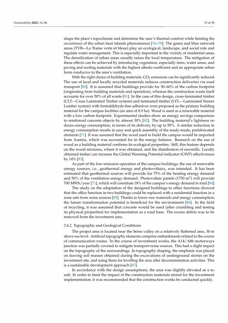
shape the place’s topoclimate and determine the user’s thermal comfort while limiting theoccurrence of the urban heat islands phenomenon [76–79]. The green and blue networkareas (TVB—La Trame verte et bleue) play an ecological, landscape, and social role andregulate water management. This is especially important in the vicinity of residential areas.The densification of urban areas usually raises the local temperature. The mitigation ofthese effects can be achieved by introducing vegetation, especially trees, water areas, andpaving and roofing materials with the highest albedo coefficient and an appropriate urbanform conducive to the area’s ventilation.
With the right choice of building materials, CO2 emissions can be significantly reduced.The use of local and locally recycled materials reduces construction deliveries via roadtransport [80]. It is assumed that buildings provide for 50–60% of the carbon footprint(originating from building materials and operation), whereas the construction waste itselfaccounts for over 50% of all waste [81]. In the case of this design, cross-laminated timber(CLT—Cross Laminated Timber system) and laminated timber (LVL—Laminated VeneerLumber system) with formaldehyde-free adhesives were proposed as the primary buildingmaterial for the campus facilities (an area of 8.9 ha). Wood is used as a renewable materialwith a low carbon footprint. Experimental studies show an energy savings comparisonto reinforced concrete objects by almost 30% [82]. The building material’s lightness re-duces energy consumption, in terms of its delivery, by up to 50%. A similar reduction inenergy consumption results in easy and quick assembly of the ready-made, prefabricatedelements [71]. It was assumed that the wood used to build the campus would be importedfrom Austria, which was accounted for in the energy balance. Research on the use ofwood as a building material confirms its ecological properties. Still, this feature dependson the wood mixtures, where it was obtained, and the distribution of sawmills. Locallyobtained timber can increase the Global Warming Potential indicator (GWP) effectivenessby 14% [83].
As part of the low-emission operation of the campus buildings, the use of renewableenergy sources, i.e., geothermal energy and photovoltaics, was intended. It has beenestimated that geothermal sources will provide for 75% of the heating energy demandand 50% of the ventilation energy demand. Photovoltaic panels (1750 m2) will provide700 MWh/year [71], which will constitute 18% of the campus’s energy demand in total [84].
The study on the adaptation of the designed buildings to other functions showedthat the office function in two buildings could be replaced with a residential function in azone safe from noise sources [85]. Thanks to lower raw materials and energy consumption,the future transformation potential is beneficial for the environment [86]. In the fieldof recycling, it was assumed that concrete would be used (after crumbling and testingits physical properties) for implementation as a road base. The excess debris was to beremoved from the investment area.
3.4.2. Topographic and Geological Conditions
The project area is located near the Seine valley on a relatively flattened area, 30 mabove sea level. Artificial topography elements comprise embankments related to the courseof communication routes. In the course of investment works, the A14/A86 motorwaysjunction was partially covered to mitigate transport-noise sources. This had a slight impacton the topography of the surroundings. In topography shaping, the emphasis was placedon leaving soil masses obtained during the excavations of underground stories on theinvestment site, and using them for levelling the area after decontamination activities. Thisis a sustainable development approach [87].
In accordance with the design assumptions, the area was slightly elevated as a re-sult. In order to limit the impact of the construction materials stored for the investmentimplementation, it was recommended that the construction works be conducted quickly.

Sustainability 2022, 14, 86 16 of 38
3.4.3. Subcutaneous and Surface Waters
The Seine provides the fundamental elements of the area’s hydrological system. Inthe planning documentation, part of the area was classified as class 3 wetlands, that is,areas with a high probability of surface waters requiring an inspection [88]. Physically,the wetland is present only in the form of a small pond in the western part of the site.This factor was used as part of the landscape design in the project. The groundwatercondition was recognized as poor in chemical terms due to heavy metals, hydrocarbons,and pesticides [85]. However, this did not affect the drinking water catchment locatedoutside the range of the water impact from this area. During the design works, measureswere taken to protect the surface waters and purify the rainwater, e.g., by infiltration, theapplication of hydrophytic greenery, the elimination or isolation of contamination hazards,the separation of rainwater, and sanitary sewage systems.
The threat to the hydrological system may impact the construction process. Thedangers may arise from the organization of the construction site, primarily, various typesof building material storage and the operation of machines, both of which may cause theformation of contaminant suspensions. The risk of polluting the Seine’s waters resultsfrom the river’s proximity. The protection of subcutaneous waters consists primarily inthe protection of surface waters and soil. The water circulation and water protection issuesduring the construction process have been specified in the Charter of Ecological Building(Charte Chantier Vert) as one of its objectives [71]. Any construction processes resulting inpossible contamination were shortened so as to avoid the runoff of harmful substances intothe river valley.
3.4.4. Flood Threat
Restrictions in the use of underground stories resulted from the groundwater leveland the flooding risk. The initially assumed depth of the excavations was not to exceed thewater level noted during the 2016 flooding period. Two underground stories have beendesigned for the campus buildings.
In the Flood Risk Prevention Plan for the Hauts-de-Seine department (Plan de Préventiondes Risques d’Inondation des Hauts-de-Seine—PPRI), the area partially belongs to theorange "C" zone, which indicated the need to limit the development densification andthe use of basements (except for underground car parks). For zone "C", the plan includeslimiting the construction to 40% in residential and office functions and 60% for otherfunctions if the buildings are located on plots bigger than 2500 m2 [89]. In the designopinion, attention was drawn to the high water table, which may result in flooding duringheavy rainfall (mainly in the western part of the area). It was recommended that theresearch be supplemented, and simulations for 10-year, 50-year, and 100-year floods wereperformed [85]. A study conducted by the specialized BURGEAP office in 2017 showedthat in the event of a 50-year flood, the two-storey parking lot might be flooded up to thelevel of 0.5 m [85].
In the case of a 100-year flood, water runoff along secondary roads to open greeneryareas and towards the Seine was indicated [61]. The existing buildings were demolishedin the flood zone, with no disturbance to the area’s topography. In this zone, two objectswere built (in zones C and E4), thanks to the designed safety installations. To compensatefor the area subtraction in the Seine valley flood zone, the creation of an embankment wasproposed. Moreover, the site would be provided with a special flood zone connected to theSeine, for which the water level would be regulated by a floodgate [62].
3.4.5. Solutions Related to Rainwater Collection
The rainwater drainage system assumes water retention within the plot, and slowsdown water runoff so as to ensure a balance in the functioning of the sewage system. InNanterre, additional retention reservoirs are used to relieve the rainwater drainage systemduring heavy rainfall. Storm drains that flow into the Seine were introduced in the streetnetwork. According to the sanitary plan for the Hauts-de-Seine department (Le schéma

Sustainability 2022, 14, 86 17 of 38
départemental d’assainissement pour la période 2005–2020), the basic solution consists inrainwater management within the plot [90]. If this is not possible, a permit can be obtainedfrom the sewage system operator to dispose of the rainwater into the public networkwith a specific throughput value. Pursuant to the regulations, it is forbidden to dischargerainwater into the sanitary system.
At the design stage, it is compulsory to prepare a rainwater management plan [89],which influences biologically active surface zones and the LID (Low-Impact Drainage)solutions. Such a plan consists of using wet ditches, setting up roof gardens, storingrainwater within the inhabitants own plots, and, most importantly, minimizing the useof constricted surfaces to reduce the average rainwater runoff coefficient. These activitiesbelong to the basic sustainable design scope [91–93].
It is assumed in the rainwater management plan that during the investment imple-mentation, water will be collected in a temporary drainage system and then drained andtransferred into the ground. In the project, for an area of 19 ha, greenery and mineral(permeable) areas constitute approximately 10.6 ha. Further design assumptions providefor constructing an open reservoir system in zone A and a watertight channel (area 1.2 ha),into which water will flow naturally, whereas the quays will be provided with an infil-trating substrate (area 2725 m2). The channel is provided with a safety bolt to cut off thewater supply in case of contamination. Rainwater from the roof surfaces will be storedin four underground tanks (125 m3 each) and intended for watering plants in the park.The reservoirs include an overflow system—it will be transferred to the water channel inthe event of excess water [62]. Rainwater discharge into the network was not allowed inzones B and D. The water is collected through the ditch located to the north of these zones,whereas the infiltration areas are 1460 m2 and 1580 m2, respectively. Depressions exist in theD zone (i.e., the park extension zone); thus, almost the entire area is greenery-covered. Thewhole area serves the infiltration [62]. In some zones, discharge to the rainwater sewagesystem is allowed on the terms specified by the network operator—e.g., in the E2 and E3zones. In the E4 zone, rainwater is taken over by the valley extension, whose area totals1.33 ha, to an open retention reservoir for water infiltration [62]. Actions to enable thenatural drainage of water to the ground influence the regulation of water circulation andlead to the minimization of the heat island effect [62].
3.5. Landscape Protection and Shaping; the Impact of the Natural Environment on DesignDecisions (E)3.5.1. Landscape and Influence on Design Solutions
According to the European Landscape Convention, the landscape is most often definedas a “space perceived by people, containing natural elements or products of civilization,shaped as a result of the action of natural factors or human activity” (translation by theauthor) [94]. It can also be defined by reference to the nearby characteristic and valuablelandscape units, which constitute elements to structure the overall landscape.
The juxtaposition of the studied area with its surroundings, especially if it expressesthe landscape continuity of natural areas, is also of ecological significance. The complexesof characteristic and valuable landscape units have been distinguished in the so-calledlandscape atlas of the Hauts-de-Seine department and included as the ”The Seine ringfrom Rue-il-Malaison to Villeneuve-la-Garenne” [95]. The following elements have aconsiderable impact on the landscape: the Seine valley and its layout emphasized by treeplantings; diversified and, occasionally, contradictory urban development intersected bythe road infrastructure; the area of La Défense constituting a landscape with a strong imageand an orientation spot within the space; and in some places, a flat topographic layout andan open landscape with valuable, extensive viewing fields. The Mont-Valérien hill and itsslopes dominate the Seine inter-river basin (Les deux Seine). They provide a viewing pointfrom which the vast landscapes at its foot can be observed. The Historical Axis of Paris—anextension of the Seine-Arc (Seine-Arche) section, plays a structuring role [96]. The complexof characteristic landscape units also includes areas distinguished by a functionally and

Sustainability 2022, 14, 86 18 of 38
spatially coherent layout, e.g., the University of Nanterre area. City fragments undergoingtransformations, and the resultant new building developments, blur the readability of theSeine valley and Mont-Valérien hill as the original topographic system. Contrasts emergein the development of areas, which causes interruptions in the continuity of landscapeperception. Thus, its legibility is locally reduced, which makes it challenging to identifythe area.
The use of the landscape and natural potential is consistent with the sustainableplanning and development project provisions in the local urban-planning plan. It ispostulated that natural forms are developed in the city, while the landscape values areapplied to consolidate identification and identity elements and strengthen bonds betweenusers [62]. In developing the former paper mill area, the critical action to connect landscapeswas to introduce a landscape axis perpendicular to the Seine (extension of the Parc duChemin de l’Île). Further notable actions included opening the landscape in the westernpart of the area—from the Seine—and introducing frontage (compact) development formsalong Avenue de la Commune de Paris. In the open areas, the potential was used related tovegetation and habitat formation once the production was ceased. The area created in thisway totals 4.3 ha. The landscape design was inspired by the vegetation of l’Ile Fleurie, anisland on the Seine.
In the natural system of Paris, the following elements are of regional importance: theSeine valley and the Parc du Chemin de l’Île, as these areas constitute ecological corridors.They have been demonstrated in the Regional System of Ecological Cohesion (SchemaRegional de Coherence Ecologique—SRCE) [97]. At a distance of 100 m, a special area ofecological importance was located, which is important for flora and fauna (Zone naturelled’intérêt écolo-gique, faunistique et floristique—ZNIEFF). In the National Inventory ofNatural Heritage (L’Inventaire National du Patrimoine Naturel—INPN), it was listedas ZNIEFF 110030012: BERGES DE LA SEINE A NANTERRE—linked to other areas,including areas sensitive in terms of nature (l’Espace Naturel Sensible—ENS) [98].
3.5.2. Plant and Animal Habitats
As part of investment activities in the spring of 2015, a partial inventory of flora andfauna was conducted. The survey, completed in 2017, covers the entirety of the ZAC zone,as well as the Seine riverside [99]. Initially, the inventory consisted of three wastelandzones covered with ruderal vegetation. The first two, situated towards the southwesternpart of the plot, were characterized by a similar plant cover, i.e., wastelands colonizedby tree vegetation. Native species accounted for 14% of all inventoried plants [99]. Thezone adjacent to the railway has been classified as a naturally sensitive area (l’EspaceNaturel Sensible—ENS). It has been shown that invasive species constitute a large part ofthe vegetation in the zone [99]. The third zone is an apparently deserted area. However, theinventory proved that it promotes water vegetation and animals owing to water reservoirs.In the Seine zone, these areas may provide a habitat for willows, which, in turn, may serveas a bat sanctuary [99].
Based on the 2017 inventory, the occurrence of species of rare animals has beenrevealed. The abandonment of land use resulted in the development of anthropogenichabitats of three bat species in walls and lintel cracks. Protected species present in the arearesulted in the obligation to prepare an additional report on the environmental impactassessment. The document was attached to the application for establishing the ZAC zone.In the final assessment, the report indicated the possibilities for improving the habitatconditions of wild bird species, amphibians, and reptiles (e.g., wall lizards (Podarcismuralis) and animals living in railway embankments after the investment’s completion. Atotal of fifty-seven animal species were identified, eighteen of which belong to the naturalheritage. Thanks to this research, it was decided to enlarge some areas and to transfervegetation to the restored areas [85].
In the field of biodiversity protection, the main activity refers to the protection ofgrasslands and the expansion of green zones and combating invasive vegetation. The

Sustainability 2022, 14, 86 19 of 38
implementation project assumed the use of ecosystem service elements, i.e., insect hotelsand nesting boxes, and arranged places for insects to live (stones, walls, shrubs, storageplaces for wooden elements). Paths have been delineated in order to isolate some areasand retain them as nature sanctuaries. In terms of fauna protection, it was recommendedto indicate whether any bats inhabit the buildings before demolishing them. Works inthe modernized "Trituration" building were planned outside the breeding season of thepond bat (Myotis dasycneme). Moreover, it was planned that, after the modernization,bats would be transferred to special nesting boxes. The demolished parts of the walls wereconsidered in the arrangement of green areas for the needs of lizard habitats [61].
According to the plan for the Ile-de-France region (Le Schéma directeur de la régionÎle-de-France—SDRiF), greenery areas in the Seine-Arche zone should constitute a mutualconnections system [63]. The level of greening was negatively affected by the buildingdevelopment densification in the area, as well as by the change in the nature of its develop-ment. New buildings have been erected in the main campus area, and the pitch betweenthe campus and the Anatole de la France district has been removed, whereas developmentis planned along the Avenue de la Republique for the greenery wasteland area.
According to the environmental decision for the area in question, it was orderedto retain the area of 1000 m2 of the existing wastelands. An additional area of 1500 m2
was intended to restore the remaining part to preserve the diversity of species, i.e., totransfer flora and fauna from zones 1 and 2 (e.g., this applies mainly to the habitats of theblue-winged grasshopper (Oedipoda caerulescens)). It was also recommended to createa wetland within the internal green area [85]. The existing 1800 m2 of green wastelandlocated in the campus zone (zone A) was finally secured. An additional 2000 m2 of the areawas subsequently added to the wasteland in the park zone (zone D) [61].
3.5.3. Special Protection for Greenery Areas (EVP1 and EVP2)
The design assumptions for green areas included the following: the enlargement ofthe Parc du Chemin de l’Ile; an increase in the number of trees (about 1000 plants) withthe simultaneous protection of open areas, meadows, wastelands, and dry environments;and increasing landscape and species diversity, thus increasing the ecological value. Thisinvolved the need to reconstruct the infrastructure, which offered a chance to introducenew plantings along the roads. Two greenery-protected areas have been formed in thearea—marked as EVP1 (area 18,162 m2) and EVP2 (area 16,269 m2). These were includedin the local plan (Figure 4). The following provisions entered into force as part of theirprotection: a ban on cutting trees and disturbing their integral parts, and a prohibitionto changing the landscape nature or the plant factor dominance. The removal of a tree ispossible only provided that it poses a threat to health, life, or property. This danger mustbe confirmed by phytosanitary expertise. Additionally, the tree may be removed in theevent of remedial measures, e.g., the need to clear the flow of water courses. A consent fortree removal is equivalent to an obligation to compensate for the loss. It was establishedthat the scope of such activities in the EVP area might not exceed 5% of the total area. Theconstruction of permanent objects cannot exceed the 200 m2 built area. A minimum of 95%of the protected area must comprise a landscape area, and 80% is a biologically active zonein the form of open greenery. In the EVP2 area, a height-related limitation for newly erectedstructures, namely, 5 m, was introduced [62].
In shaping the landscape, it was decided to take systematic actions. They consistedin the reconstruction of the ecological corridor along the Seine and connections relatedto it. The development method was conducted in line with the neighboring ENS area.Towards the west of the plot, its development has been abandoned. This decision was alsoprompted by the recognition of the existing flora and fauna. These areas were recognizedas part of the internal greenery system and benefited from the connections perpendicularto the Seine. In this way, the Historical Axis of Paris, i.e., public space in the Seine-Archearea, was emphasized, as it constitutes a crystallizing element of the area as well as anatural system element with which green areas of supra-local importance are connected.

Sustainability 2022, 14, 86 20 of 38
The limitations resulting from natural conditions contributed to the decision to implementcompact development forms in the areas facing the Avenue de la Commune de Paris(Figure 8) and in the detention center. The remaining areas, valuable in terms of nature,comprise the landscape (Figure 9).
Sustainability 2022, 13, x FOR PEER REVIEW 21 of 39
Figure 8. The use of wood as a construction material for buildings as an element of sustainable de‐
sign (source: Leclercq Associés; Leclercq Associés; Laisné—DREAM, BASE).
Figure 9. Biophilic way of shaping the form of the complex. (source: Leclercq Associés; Leclercq
Associés; Laisné—DREAM, BASE).
3.5.4. Landscape Solutions in the Project—Composition
The Parc du Chemin de l’Île (landscape architecture: Mutabilis Landscape Archi‐
tecture, 2015), with its extension (landscape architecture: BASE Landscape Architecture),
acts as a green corridor that connects the public space to the Seine riverbank. The park is
of departmental importance. It contains exemplary water circulation solutions and joins
other greenery areas. The extension of the Parc du Chemin de lʹÎle (total area of almost 2
ha) within the former paper mill site forms a green axis towards the Seine.
A new park in the ʺArboretumʺ campsite offers the second greenery area. In its
planning phase, the total area amounts to 6 ha. In this park, an innovative approach to
various types of outdoor practices is implemented (landscape architecture: BASE Land‐
scape Architecture, 2016–17). Landscaping in campus areas exerts a particular impact on
the creativity and innovation aspects [100]. In this way, a holistic approach to science is
practiced by using the open air as a place for education, thanks to the properties of the
green area itself. The open spaces within the campus area also provide opportunities for
learning through experience and a sense of belonging to the academic community [101].
The zoning and character of individual places were determined by urban planning
indications and the presence of grasslands, as well as by the vicinity of the Parc du
Chemin de lʹIle. The open area is divided into two parts, i.e., an open part towards the
Figure 8. The use of wood as a construction material for buildings as an element of sustainable design(source: Leclercq Associés; Leclercq Associés; Laisné—DREAM, BASE).
Sustainability 2022, 13, x FOR PEER REVIEW 21 of 39
Figure 8. The use of wood as a construction material for buildings as an element of sustainable de‐
sign (source: Leclercq Associés; Leclercq Associés; Laisné—DREAM, BASE).
Figure 9. Biophilic way of shaping the form of the complex. (source: Leclercq Associés; Leclercq
Associés; Laisné—DREAM, BASE).
3.5.4. Landscape Solutions in the Project—Composition
The Parc du Chemin de l’Île (landscape architecture: Mutabilis Landscape Archi‐
tecture, 2015), with its extension (landscape architecture: BASE Landscape Architecture),
acts as a green corridor that connects the public space to the Seine riverbank. The park is
of departmental importance. It contains exemplary water circulation solutions and joins
other greenery areas. The extension of the Parc du Chemin de lʹÎle (total area of almost 2
ha) within the former paper mill site forms a green axis towards the Seine.
A new park in the ʺArboretumʺ campsite offers the second greenery area. In its
planning phase, the total area amounts to 6 ha. In this park, an innovative approach to
various types of outdoor practices is implemented (landscape architecture: BASE Land‐
scape Architecture, 2016–17). Landscaping in campus areas exerts a particular impact on
the creativity and innovation aspects [100]. In this way, a holistic approach to science is
practiced by using the open air as a place for education, thanks to the properties of the
green area itself. The open spaces within the campus area also provide opportunities for
learning through experience and a sense of belonging to the academic community [101].
The zoning and character of individual places were determined by urban planning
indications and the presence of grasslands, as well as by the vicinity of the Parc du
Chemin de lʹIle. The open area is divided into two parts, i.e., an open part towards the
Figure 9. Biophilic way of shaping the form of the complex. (source: Leclercq Associés; LeclercqAssociés; Laisné—DREAM, BASE).
3.5.4. Landscape Solutions in the Project—Composition
The Parc du Chemin de l’Île (landscape architecture: Mutabilis Landscape Architecture,2015), with its extension (landscape architecture: BASE Landscape Architecture), acts asa green corridor that connects the public space to the Seine riverbank. The park is ofdepartmental importance. It contains exemplary water circulation solutions and joins othergreenery areas. The extension of the Parc du Chemin de l’Île (total area of almost 2 ha)within the former paper mill site forms a green axis towards the Seine.
A new park in the "Arboretum" campsite offers the second greenery area. In itsplanning phase, the total area amounts to 6 ha. In this park, an innovative approach to

Sustainability 2022, 14, 86 21 of 38
various types of outdoor practices is implemented (landscape architecture: BASE LandscapeArchitecture, 2016–17). Landscaping in campus areas exerts a particular impact on thecreativity and innovation aspects [100]. In this way, a holistic approach to science ispracticed by using the open air as a place for education, thanks to the properties of thegreen area itself. The open spaces within the campus area also provide opportunities forlearning through experience and a sense of belonging to the academic community [101].
The zoning and character of individual places were determined by urban planningindications and the presence of grasslands, as well as by the vicinity of the Parc du Cheminde l’Ile. The open area is divided into two parts, i.e., an open part towards the Seine, anda kind of green ravine between the buildings, the axis of which is provided by a waterchannel. The area may also serve as a strolling space. The course of the avenues is free,i.e., organic. As part of the green area, small closed enclaves have been designed, whichprovide a flora and fauna sanctuary.
The traces of the past, such as cranes, rails, tanks, and paving stones, are used in thepark’s design. The southwestern part is wooded, which refers to the vegetation of the ÎleFleurie, an Isle on the Seine.
The diversity in the functional and plant design confirms the assumed biodiversity.Patio gardens, a flowering orchard, grasslands, a green amphitheater, and a vegetablegarden were planned. The utility garden crops provide a supply source for a nearbyrestaurant. The eastern part corresponds more to the meadow landscape. The Arboretumavenue runs through the park and connects all landscape concepts. Places for meetings,cultural events, and outdoor work have been arranged within the parking space. The wholearea was arranged in such a way as to ensure natural, visual, and ecological continuity [102].
3.6. Influence of Social and Economic Conditions (F)3.6.1. Improving Public Health as the Project’s Guideline
The spatial shaping of urban areas significantly affects public health by creatingfavorable spatial and social conditions, influencing the change of consumption habits,lifestyle, and environmental improvement [36,103,104].
Rich-in-vegetation urban spaces increase exposure to greenery, which positively affectspsychophysical health and offers a regenerative environment [105]. This impact mayassume a social and individual dimension and may exert a genuine impact on the physicalcondition (through opportunities for recreation, sport, and a clean and healthy environment)and mental health. The spatial configuration, order, and application of vegetation positivelyaffect the comfortable feeling of the space [106–108].
These aspects are promoted within the framework of health-friendly urbanism(L’urbanisme favorable à la santé—UFS), based on which the Health Impact Assessment(EIS—Evaluation d’impact sur la Santé) was conducted. The assessment was intended tostudy the impact of the environment and the proposed solutions on the population of theindicated region, with the account to particularly vulnerable groups. The territorial rangecovered the land quarter of the former paper mill and the detention center, as well as theimmediate surroundings. Five main issues related to health and economy were identified,based on which nearly forty recommendations for the project were prepared [109]. Themain assumptions and propositions were summarized in APUR report [110]. The Table 3shows synthesis of all determinants.
According to the above analysis based on public consultations, the focus was on thefunctional program of the area that is visible. This was mainly due to the need to increase thepossibilities for employment for people entering the labor market [108]. Health-promotingfactors resulted from the spatial order, the shape of places, and exposure to green areas.These, however, were of less importance, despite their significant impact on health. Areview of the source literature on the topic indicates the importance of green areas [111].The Burton and Grant based on Dahlgren and Whitehead [112] diagram included factorsthat affect health, depending on the scale of impact, i.e., the personal, local, and generalscales [113].

Sustainability 2022, 14, 86 22 of 38
Table 3. Thematic scope of the analyses under the Eis procedure for the former Nanterre paper millarea, and proposed solutions. Table by authors.
Thematic Scope Recommendations (Synthesis)
Environment
partial coverage of the A86 motorway; protection against noise and pollution through the appropriatelocation of public buildings, placing an air intake on the appropriate sides of buildings, isolating shared
places from hazards/pollution; additional soil tests in utility gardens; limitation of vehicular traffic;creating permeable and green areas, creating green protective barriers, equipping streets and squares
with complete infrastructure; expanding the possibility of new uses of the environment—e.g.,considering the creation of a bathing beach on the Seine (indoor swimming pool), developing sports
practices in open spaces;
Mobility and PhysicalActivity
ensuring continuity of walking and cycling routes, providing facilities and connections to publictransport nodes; distinguishing urban routes—promoting quiet areas, making the layout more readable;reducing employee parking spaces to encourage car users to use alternate modes of transport; provision
of parking spaces for electric and shared cars; creation of sanitary services in the vicinity of publictransport nodes, creation of bicycle and scooter rentals; the possibility to change the function of a
multi-storey car park within the same structure;
Urban Facilities andAmenities
creating public functions—sports, cultural, recreational, etc.; to enable the use of the site by the localpopulation; availability of services and commerce on the ground floors of buildings; creating functionsthat promote physical activity; providing a variety of services—e.g., for different types of gastronomy
(use of the Trituration building);Access to
Employment andProfessional
Development
creating business innovation incubators; subsidizing jobs; promoting the diversity of employment;support for small- and medium-sized companies; providing courses and training; enabling different
career paths; providing social welfare for people applying for a job or working;
ProjectImplementation
Process
making land available at the implementation stage—e.g., access to the Seine; communication with localpeople during the project implementation; animating activities involving the community; minimizing the
nuisance resulting from the investment;
3.6.2. Area Function, Workplace, Program Variety
During its operation, the paper mill employed the local population. For economicreasons, it was not possible to maintain the business profile. In 2008–2015, feasibility studieswere conducted for various new programs and for the business activity district withinthe Bords de Seine sector. Ultimately, a mixed program with an indication of strategicfunctions proved the most optimal. It included innovation developments by expanding theuniversity area, a logistic platform to regulate public transport, and growth possibilitiesfor small- and medium-sized enterprises. The benefits of mixed development include agreater frequency of pedestrian and cycling traffic [114–116] and a more stable employmentstructure—in line with the principles of a compact city based on smart development [117].
3.6.3. Communication System
The contemporary urban development assumes a modification to communicationservices, mainly to reduce air pollutants and noise emissions. It consists of promotingpublic transport, cycling, pedestrian communication, electric cars, and possibly car-sharing,all in line with the departmental travel plan (PDUIF) [118].
The existing communication system strongly impacted the functional and spatialsystem by cutting off the area from the city with communication arteries. Urban-planningactivities led to the integration of this area.
The communication development strategy in the former paper mill area implementsthe idea of creating an appropriate urban tissue density that is friendly to pedestrians andcyclists, and connecting it to the Transit-Oriented Development (TOD) traffic [119]. It isestimated that this approach may reduce 30% of greenhouse gas emissions, compared toconventional traffic [120].
One solution within this system comprises optimizing the freight-delivery systemby planning an intermodal logistics platform to serve the Nanterre and La Défence areausing river transport. The facility is functionally related to the Seine, while the individualzones of the platform are adapted to the unloading, storing, and receiving of transport
Sustainability 2022, 14, 86 23 of 38
functions. By locating the object in a given place, the properties of the urban tissue with theappropriate development intensity are applied.
The public transport node (Nanterre-Universite railway station) is 700 m from theformer paper mill site. The station constitutes a junction of the SNCF L and RER-A linesand is connected by the Rue Anatole France route, which leads to the investment area. Anew element in the form of the designed T1 tram line is introduced to connect Nanterreand the neighboring community of Rueil.
Following the current plan of walking trails (Plan départemental des itinéraires depromenade et de randonnée—PDIPR) [121], two routes have been mapped in the area ofthe former paper mill (on the shore and towards the island on the Seine), with the indicationthat the routes should be greenery-covered and landscape-related.
The spatial effects of changing the communication strategy resulted in a visual mini-mization of the road infrastructure and its environmental impact. In functional terms, thearea was provided with better communication of sites located along the Seine riverside.
3.6.4. Social Importance of Public Space
Due to the social impact, three significant places located on the former paper millsite can be distinguished. These include the extension of the Parc du Chemin de l’Ile, theinternal green area of the campus, and the Avenue de la Commune de Paris street withactive commercial frontages. A mosque was also built in this street, as well as an entrancearea to the campus.
The campus area has been planned as space available to people from the outside, as itoffers sports and catering services, as well as the possibility of organizing outdoor events.
3.7. Actions against Anthropopressure and Factors That Degrade the Urban Environment (G)
The condition of the environment affects both the health of city dwellers and thesocial conditions. Currently, it is recognized that bad environmental conditions (poor aircleanliness, high noise levels, poor soil quality, nuisance, etc.) may lead to certain socialexclusion and cause social segregation by inequalities in living conditions. Dempsey et al.develop this problem in research on the ”sustainable social development of cities” [122,123].
Under European and French law, the former paper mill development project wasrequired to be preceded by an environmental assessment and an environmental impactassessment. In the Regional Health and Environment Plan for Ile-de-France in force at theinvestment time (Plan Régional Santé Environnement—PRSE 2), the goal was establishedto reduce environmental inequalities [124]. As part of the report prepared for the 2016plan, areas with a high environmental burden were selected—the so-called environmentalblack spots (PNE—Points Noirs Environnementaux). The area of the former paper millwas classified as such an area. In the qualification of PNE points, five indicators wereused as the criterion for which the limits of exceedances were defined. These included:air pollution, noise, soil condition, water pollution, and industrial contamination. On thepremises of the former paper mill, the first three indicators proved the most important.The following preventive measures were specified: the proper orientation of buildings, theuse of noise barriers, greenery designs, the proper location for public spaces, the properorientation of the building’s air intake, and the removal of pollutants.
3.7.1. Air Quality
Air quality testing within the former paper mill area revealed the presence of thefollowing pollutants: NO2, PM 2.5, PM10, benzene, and ozone [110]. According to localmeasurements, the negative impact of nitrogen dioxide emitted by car traffic on motorwaysranged as far as 200 m from the emission source. Measurements of air pollution within theformer paper mill area indicated the highest permissible value exceedances in the vicinityof the A14/A86 motorway junction, i.e., in the southern and western zones. The averagefor NO2 equaled 62.03 µg/m3 (with the standard of the quality target at 40.00 µg/m3), for

Sustainability 2022, 14, 86 24 of 38
benzene—1.3 µg/m3 (at the edge of the norm). In other local background locations, thesevalues reached 44, 65, and 1.1 µg/m3 [110].
The adverse health effects of PM 2.5 air pollution are well established. Research onthe French population has shown that these pollutants cause about 48,000 deaths annually,contributing to 9% of all cases. Moreover, they reduce the average life expectancy by twoyears (for every thirty years lived) [125,126].
The identification of air quality hazards at an early investment stage made it possibleto counteract the effects. This can be achieved by the proper location of buildings, the use ofbuffer zones to separate pollutant emission sources, the proper orientation of the air intake,changing the transportation system to lower emission ones, and, above all, introducingcompact greenery areas. Such activities were undertaken within the framework of theZAC des Papeteries. The recommendation to counteract pollution effects concerned theapplication of such security measures while shaping the architecture and technical devicesthat would protect people inside buildings [110]. The reconstruction of the A14/A86junction was of great importance, as it deemed the removal of the buildings away from themotorway line necessary.
3.7.2. Noise
Noise poses an equally important threat to the development of a sustainable envi-ronment and health. Mental stress usually occurs at noise-related discomfort at the levelbetween 60 and 65 dB (A). This is a personal perception, depending on individual bioavail-ability. However, as has been scientifically proven, the effect of night noise on the body’sresponse and health is already detrimental at the level of 30–40dB (A) [127]. Such environ-mental properties do not correspond to the conditions required from a university campusarea, i.e., the proposed dominant function in the former paper mill.
The following noise sources have been identified within the site: the A14 and A86motorways, the RER A and TER L railway lines, and planes taking off and landing atRoissy Charles de Gaulle airport. The width of the most burdensome impact zone fromthe A86 motorway was determined at 300 m. The background noise level was estimated at65–70 dB (A), and as much as 70–75 dB along communication routes (A). In terms of noise,the area was classified as a moderate arduousness zone due to the terrain differences thatcause a dampening of the noise [110].
The fact that the A14 and A86 motorways junction was located at a depression trans-formed the Avenue de la Commune de Paris into an urban boulevard. The new campus andthe Nanterre Universite railway station were safely connected by extending Rue AnatoleFrance. Limiting the noise in critical places (e.g., at the point of crossing an arterial road)is essential for pedestrian and cyclist safety. Scientific research in the field of an acousticenvironment shows that noise may affect the deterioration of spatial orientation and thusaffect the auditory and visual modality [128].
This factor is of great importance in ensuring locomotion safety in the city. At thedesign stage, solutions for a safe, collision-free crossing on the extension of Rue AnatoleFrance were proposed.
In addition, strategies for limiting noise effects were applied. These solutions areuniversal and include the following: limiting noise sources themselves, using appropriatedistances for residing places, recreation, sports, using acoustic barriers (e.g., screens, densegreenery), introducing appropriate security measures in the building, etc. [129].
3.7.3. Industrial Contamination
Environmental problems, whose sources were located within the investment bound-aries, were distinguished and compiled according to different types and levels of pollution.The areas most challenged by the adverse effects were indicated. Preparing the area for safeuse and planning decontamination works was crucial. Industrial contamination, mainlysoil contamination related to the operation of the paper mills, was demonstrated in twostudies: BASOL [130] and BASIAS [131]. Environmental studies were conducted in various
Sustainability 2022, 14, 86 25 of 38
periods: from 2010–2012, after the cessation of production, in 2014, and later, to establishthe ZAC zone.
The activities to cease the functioning of the paper mill involved the following steps:removing the radiation source in the machinery building; the disassembly of industrialinstallations, including oil and grease storage and storage tanks, the decommissioning of atransformer which contained polychlorinated biphenyls; the removal of biological sludgefrom the water treatment plant on the premises of the plant (decommissioned in 2010).Boreholes in the vicinity of industrial installations have proved the presence of the followingsubstances: PAHs—polycyclic aromatic hydrocarbons, PCBs—polychlorinated biphenyls,and polychlorinated terphenyls (PCTs), and chlorinated tricholethylenes solvents [130].
Additionally, based on the BASIAS study, a storage area for bituminous materials usedfor road works has been identified (IDF9207091) in addition to the paper mill area (IDF9200496) [131].
Decontamination works conducted in 2014 enabled the adaptation of the site to theproposed service functions and the needs of small- and medium-sized enterprises. It wasassessed that the works were compliant with the 2013 environmental decision, based onwhich the operator of the site was required to conduct repair works [71].
After the decontamination works, the partial risk analysis of 2015 showed that thearea posed no threat for establishing service, production, or housing functions, should theybe necessary for proper land use [130].
On the site of the former asphalt plant, in operation in 2017 during the A14 motorway(1966) road construction, thirty-one boreholes were drilled to a depth of 6 m. These studiesshowed contamination in the form of backfill with heavy metals, THCs—total hydrocarbons,PAHs—polycyclic aromatic hydrocarbons, and PCBs—polychlorinated biphenyls. Part ofthe backfill was designated for hazardous material storage in waste plants [71,131].
Taking the fieldwork into account, including the slopes and excavations to be shapedfor two underground levels, the need to export over 16,000 m3 of soil was estimated [71].
In conclusion, decontamination work was performed with regard to contaminants.The above-mentioned activities towards removing harmful pollutants and contaminationdid not constitute a determinant for limiting the urban or architectural form design.
Decontamination works, however, had an impact on the progress of preparatory workand on-field works, by which the topography was shaped.
3.7.4. Construction Waste Management
Following the construction waste management obligation, the investor was requiredto take measures in this regard. The following activities are commonly recommended:the reuse of construction waste (if possible), recycling, composting, and use for energyproduction [132]. Regional regulations govern waste management in the Ile-de-France area.For industrial plants, these are separate regulations [133]. Wastes are classified dependingon their environmental impact. It is estimated that construction waste accounts for over50% of all waste [81].
The construction waste management plan (Plan régional de prévention et de gestiondes déchets de chantiers—PREDEC) assumes the following objectives: waste inventorying,determining storage possibilities, processing, storing, and defining recovery targets andreducing storage, determining the possibility of using recycled materials, and preparingenvironmental assessment [134].
The 2017 inventory enabled the grouping of the waste and estimating its quantity asfollows: ordinary waste—309 tons, concrete—116,000 tons, rubble—22,000 tons, scrap—1371 tons [135]. Asbestos-containing materials were identified as floorboards, cement-glassboards (roofing), sealants, adhesives, paint, and thermal insulation [136]. Storage on special,separated pallets for asbestos-based materials was prepared, together with a disposal plan.
The following architectural heritage elements of decorative significance were intendedfor reuse: brick walls (230 m3), ceramic and cobblestone floors (200 m2), and metal rails.These applications influenced the architecture of the area. The reuse of concrete is intended

Sustainability 2022, 14, 86 26 of 38
for the main foundation in the logistic platform roads (approx. 45,000 m3) and as aggregatein concrete once the physical and chemical properties are defined. The total amount ofreuse of these materials is estimated at 50 tons [71].
These activities mitigate the demand for waste-disposal trucks.Actions to counteract environmental threats mainly consisted of eliminating the
sources of these emissions and shaping a user-safe environment.
4. Results
Table 4, below, presents a comparison of factors determined into groups of the problemissues (A–G), with groups of design solutions depending on their impact scale: I—cityscale; II—the scale of the ZAC zone; III—architecture, landscape architects and green in-frastructure, while group IV comprises the transformation process itself. The considerationof process is legitimate because it influenced the choice of a design approach. This is not acommonly considered aspect in the analysis of the state of the research conducted. Suchaction is aimed at assessing the impact of the above-mentioned analyzed determinants onindividual project areas.
Table 4. The impact of various aspects of the existing state on design solutions in the scale of a city,area, designed facilities and the implementation process. Study by the authors, 2021.
Existing State
Assessment of the Impact on Design Solutions
I—UrbanSolutions—Relations with
the City
II—Urban and ArchitecturalSolutions—the Scale of the ZAC des
Papèteries de la Seine
III—Architecture andLandscape
Architecture, GreenInfrastructure
IV—Implementation
Process
Ia Ib Ic Id Ie IIa IIb IIc IId IIe IIf IIg IIIa IIIb IIIc IIId IVd IVa IVb IVc IVd
Rel
atio
nsw
ith
the
Stru
ctur
alEl
emen
tsof
the
Are
aC
ity—
Nei
ghbo
rhoo
d
Con
nect
ions
wit
hSy
stem
san
dO
bjec
tsof
His
tori
cal(
Cul
tura
l)Im
port
ance
Con
nect
ions
wit
hPu
blic
Spac
esan
dPu
blic
Sign
Obj
ects
Con
nect
ions
wit
hO
pen
Are
as,G
reen
Are
as
Com
mun
icat
ion
Syst
em
Gra
nice
—Z
akre
sO
bsza
row
y
Func
tion
alPr
ogra
m
Spac
eO
rgan
izat
ion—
Layo
ut,Z
onin
g
Form
and
Scal
eof
Dev
elop
men
t
Dev
elop
men
tof
Ope
nA
reas
Dir
ecti
ons
ofSp
atia
lRel
atio
nsw
ithi
nth
eIn
tern
alSy
stem
Elem
ents
ofth
eC
ompo
siti
on
Bui
ldin
gM
ater
ials
Arc
hite
ctur
alSo
luti
ons
Bui
ldin
gLi
feC
ycle
Form
sof
Gre
eery
Infr
astr
uctu
reEl
emen
ts
Sele
ctio
nof
aPr
oced
ural
Path
Prep
arat
ory
Wor
k
Envi
ronm
enta
lPro
tect
ion
Impl
emen
tati
onTi
me
A–
form
alfa
ctor
san
dtr
ends
A1 land parcellingand ownership +++ ++ ++ ++ +++
A2
regional andlocal
developmentplans, legislation
+++ +++ +++ +++ +++ +++ +++ +++ ++ + ++ +++
A3ideological
concepts, trends,etc.
++ + + ++ ++ ++ ++ ++ +++ ++ + ++ ++ ++ ++ ++ +++ ++ ++ ++
B—bu
ilten
viro
nmen
t(c
ultu
ral)
B1structure of the
city—layout,tissue
+++ + ++ ++ ++ ++ +++ ++
B2
the form andlayout of the
development ofthe area
+ +
B3visual
environment—aesthetics
++ ++ ++ ++ ++ ++
C—
cult
ural
heri
tage
C1 archeology +
C2 historicalheritage
+ +
C3
elements ofindustrial
heritage: layoutand facilities
+ + ++ + ++ ++ ++
C4 intangibleheritage items +

Sustainability 2022, 14, 86 27 of 38
Table 4. Cont.
Existing State
Assessment of the Impact on Design Solutions
I—UrbanSolutions—Relations with the
City
II—Urban and ArchitecturalSolutions—the Scale of the ZAC des
Papèteries de la Seine
III—Architecture andLandscape Architecture,
Green Infrastructure
IV—Implementation
Process
Ia Ib Ic Id Ie IIa IIb IIc IId IIe IIf IIg IIIa IIIb IIIc IIId IVd IVa IVb IVc IVd
Rel
atio
nsw
ith
the
Stru
ctur
alEl
emen
tsof
the
Are
aC
ity—
Nei
ghbo
rhoo
d
Con
nect
ions
wit
hSy
stem
san
dO
bjec
tsof
His
tori
cal(
Cul
tura
l)Im
port
ance
Con
nect
ions
wit
hPu
blic
Spac
esan
dPu
blic
Sign
Obj
ects
Con
nect
ions
wit
hO
pen
Are
as,G
reen
Are
as
Com
mun
icat
ion
Syst
em
Gra
nice
—Z
akre
sO
bsza
row
y
Func
tion
alPr
ogra
m
Spac
eO
rgan
izat
ion—
Layo
ut,Z
onin
g
Form
and
Scal
eof
Dev
elop
men
t
Dev
elop
men
tof
Ope
nA
reas
Dir
ecti
ons
ofSp
atia
lRel
atio
nsw
ithi
nth
eIn
tern
alSy
stem
Elem
ents
ofth
eC
ompo
siti
on
Bui
ldin
gM
ater
ials
Arc
hite
ctur
alSo
luti
ons
Bui
ldin
gLi
feC
ycle
Form
sof
Gre
eery
Infr
astr
uctu
reEl
emen
ts
Sele
ctio
nof
aPr
oced
ural
Path
Prep
arat
ory
Wor
k
Envi
ronm
enta
lPro
tect
ion
Impl
emen
tati
onTi
me
D—
natu
rale
nvir
onm
ent
(ele
men
tsof
inan
imat
ena
ture
)
D1
atmosphere,climate,weather
conditions
+++ +++ ++ ++ ++ +++ ++ ++ ++ +++ ++ + ++ ++
D2 land shape,topography + ++ ++ + ++ ++
D3 geologicalstructure
+ + ++
D4 soil conditions ++ ++ ++
D5surface and
undergroundwaters
+ ++ ++ ++ ++
D6 environmentalrisks ++ ++ + ++ ++ +++ +++
E—na
tura
lenv
iron
men
t(e
lem
ents
ofan
imat
ena
ture
and
thei
rre
lati
onsh
ips)
E1fauna and
flora—biodiversity
++ + ++ +++ ++ +++ ++ + + +++ ++ ++ ++
E2 naturalconnections
+++ +++ +++ + ++ ++ + ++ +++ +++ + + +
E3
fauna andflora –
biodiversitynatural
connectionsnatural
landscape inthe city area
+++ ++ ++ +++ ++ + ++ ++ ++
F—so
cial
and
econ
omic
envi
ronm
ent
F1 area function ++ ++ ++ ++ ++
F2 communicationsystem ++ +++ +++ ++ + +
F3 workplaces +++ +++ ++ +++ ++
F4function and
socialmeaning of
space
+++ ++ +++ +++ +++ +++ ++ ++ +++ ++ + ++
F5 variety of theprogram
++ ++ ++ ++
G—
anth
ropo
pres
sion
and
urba
nen
viro
nmen
tdeg
rada
tion
fact
ors G1 atmospheric
pollution+ ++ +++ ++ +++ ++ ++ +++ ++ ++ ++
G2acoustic
environment—noise
+ ++ +++ ++ +++ ++ +++ +++
G3 soil quality—contamination
+ + +++ ++ ++
G4 buildingsubstance
+ + + ++ ++ ++ ++
G5 precipitation ++ ++ ++
G6 invasivevegetation
+ ++ + ++ ++
G7 sight nuisance ++ ++ ++ +++ ++ ++ ++ +++
The designation: +++—significant impact, ++—medium impact, +—minor or general impact.

Sustainability 2022, 14, 86 28 of 38
Groups of problem issues related to the existing state, i.e., D and E, comprise groupsof factors related to the natural environment (abiotic and biotic). They constitute importantdesign conditions both on the city and area scale. In this group, the biosphere componentsthat influenced design decisions emerged as worth protecting. Group G comprises riskfactors resulting from anthropopressure, for which the following actions are recommended:elimination, reduction, combating, or securing. All three groups (D, E, and G) consistof environmental condition elements. The remaining groups (A, B, C, and F) create con-ditions related to the spatial, economic, and social order. They refer to environmentalissues indirectly.
The presented assessment is organized in the form of a three-level scale. It discussesthe level of influence exerted by given factors on design solutions. These can be defined asfollows: significant impact (+++), medium impact (++), minor or general impact (+). Interms of quantity and importance, environmental factors account for approximately 50% ofall determinants.
Based on the analysis as a whole, it can be concluded that the following factors playeda significant role:
• change within the communication system, forced by environmental factors;• creating landscape connections (also: ecological and visual)—opening to the Seine
valley, connecting with other elements of the city’s natural system—e.g., Parc duChemin de l’Ile;
• the protection of grasslands, introducing elements of surface water and wetlands intothe landscape—the protection of biodiversity; creating refuges for flora and fauna;
• the use of the landscape nature of the campus for the development of educational andsocial practices outdoors;
• the use of wood in the construction of academic facilities;• the use of surface water and greenery to create a microclimate of the place—leveling
the effects of urban heat islands;• the minimization of sealed and built-up areas for the drainage of rainwater within
the plot;• creating a buffer zone with greenery facing the railway;• shaping the topography with the use of earth masses from a given area.
Significant differences in shaping the form can be noticed when comparing the prelim-inary design before 2017 to the current one (after extensive environmental analyses). Thegreenery interior of the complex was extended towards the Seine and a water canal wasintroduced, along with a wetland. Initially, it was assumed that the greenery areas in thewestern part would be built-up. The greenery area near the railway has been widened as abuffer zone to suppress noise. The road connection towards the Seine has been transformedinto a park (Figure 10).
Sustainability 2022, 13, x FOR PEER REVIEW 28 of 39
the minimization of sealed and built‐up areas for the drainage of rainwater within
the plot;
creating a buffer zone with greenery facing the railway;
shaping the topography with the use of earth masses from a given area.
Significant differences in shaping the form can be noticed when comparing the pre‐
liminary design before 2017 to the current one (after extensive environmental analyses).
The greenery interior of the complex was extended towards the Seine and a water canal
was introduced, along with a wetland. Initially, it was assumed that the greenery areas in
the western part would be built‐up. The greenery area near the railway has been widened
as a buffer zone to suppress noise. The road connection towards the Seine has been
transformed into a park (Figure 10).
(a) (b) (c)
Figure 10. Comparison of the three management options: baseline (a), preliminary project before
2017 (b), target project—2021 (c). The photographs show the landscape—the connection with the
Seine valley and the scenic connection with the Historical Axis of Paris (La Defense in the back‐
ground). (source: Leclercq Associés.).
Based on the results in Table 4, the relationships between the groups were estab‐
lished.
All impact levels were influenced by: A2, regional and local plans and legislation;
A3, ideological concepts, trends, etc.; D1, atmosphere, climate, weather conditions; E1,
fauna and flora—biodiversity; E2, natural connections.
The issues contained in the following groups had a significant impact on the city and
area scale: A—formal factors; E—the natural environment; F—social and economic en‐
vironment; and G—concerning anthroporesia and factors degrading the urban envi‐
ronment. Protection against air pollution and noise was vital (G1 and G2). A close rela‐
tionship with campus landscape‐shaping can be observed in the D and E groups of fac‐
tors. Group G was essential in planning the investment process.
For technical reasons, only two buildings could eventually be adapted to new pur‐
poses despite the assumptions that the industrial heritage should be included in the ar‐
chitectural complex. The chimney, a characteristic element of the campus composition
(intended as a dominant feature), was demolished during the construction phase due to
its poor technical condition. To sum up, regardless of the potential of the historical factor,
it has not become a guideline for new transformations.
Figure 10. Comparison of the three management options: baseline (a), preliminary project before 2017(b), target project—2021 (c). The photographs show the landscape—the connection with the Seinevalley and the scenic connection with the Historical Axis of Paris (La Defense in the background).(source: Leclercq Associés.).

Sustainability 2022, 14, 86 29 of 38
Based on the results in Table 4, the relationships between the groups were established.All impact levels were influenced by: A2, regional and local plans and legislation; A3,
ideological concepts, trends, etc.; D1, atmosphere, climate, weather conditions; E1, faunaand flora—biodiversity; E2, natural connections.
The issues contained in the following groups had a significant impact on the city andarea scale: A—formal factors; E—the natural environment; F—social and economic envi-ronment; and G—concerning anthroporesia and factors degrading the urban environment.Protection against air pollution and noise was vital (G1 and G2). A close relationship withcampus landscape-shaping can be observed in the D and E groups of factors. Group G wasessential in planning the investment process.
For technical reasons, only two buildings could eventually be adapted to new purposesdespite the assumptions that the industrial heritage should be included in the architecturalcomplex. The chimney, a characteristic element of the campus composition (intended as adominant feature), was demolished during the construction phase due to its poor technicalcondition. To sum up, regardless of the potential of the historical factor, it has not become aguideline for new transformations.
The obtained spatial form assumes the biodegradable architecture dimension. How-ever, rather than resulting from the adopted aesthetic criteria, the form responds to envi-ronmental guidelines and problems. In Table 5, using the criteria of biophilic architectureaccording to Browning [42], solutions and spatial features which determine the biophilicityin the former paper mill design were selected.
Table 5. Assessment of the biophilic character of the development of the ZAC des Papèteries de laSeine area.
Elements/Criteria of Biophilic Design [42] Application in the Design of the ZAC des Papèteries de la SeineArea or the Natural Conditions of the Site
visual connections with nature Xecological and scenic connection with the Seine valley and with theParc du Chemin de l’Ile; elements of green infrastructure includedin the architecture of facilities;
non-visual connections with nature Xthe industrial area was devoid of natural elements but benefitedfrom local conditions (e.g., river transport was used);
non-rhythmic sensory stimuli Xvariability, seasonality typical of open areas with greenery—theinfluence of natural light, birds singing, etc.;
variability of temperature and airflow Xabove the ground surface, open areas susceptible to weathervariability were designed;
the presence of water Xthe water layout in the former paper mill—referring to the Seineand the layout of the nearby park—serves as a habitat for avifaunaand supports drainage and purification of rainwater;
the presence of water X trees and other greenery diffuse natural light;
connection with natural systems Xconnection with the ecosystem of regional importance—the Seinevalley and Parc du Chemin de l’Ile;
biomorphic forms & patterns Xlayout partially open—adjusted to the landscape interior, greeneryelements within the building (facade—pots on terraces, roofs);
material relationship with nature X wood as the primary construction material;complexity and order X the form of the building uses a modular element—softly shaped;
view Xgreen areas play the role of open areas; they are surrounded bybuildings—a layout of mutual viewing;
shelter Xin the grasslands, there are quiet enclaves inaccessible tousers—serving as fauna habitats; shaping places for users alsoinvolves small and large interiors;
mystery/mysteriousness Xopen areas include enclaves—small landscape interiors, landscapescreens, multi-planed layout;
risk/hazard elements X the risk related to weather variability in open areas.

Sustainability 2022, 14, 86 30 of 38
The results presented above support the thesis that an emphasis on environmentalissues results in the emergence of biophilic forms. One piece of evidence is that previousfeasibility studies have produced a very different spatial effect.
In this case, many solutions have a universal dimension, which can be applied toother sites:
- making the natural system more readable in urban structure;- highlighting the landscape values of a river valley;- seeking landscape continuity;- the protection of flora and fauna habitats (possible compensation of development
elsewhere in the plot);- the creation of wetland habitats;- the use of water to create microclimate of the site;- a high degree of greening (use of various forms of greenery, green infrastructure);- the creation of enclaves excluded from active use;- shaping the topography with the use of earth masses from the site;- the use of natural materials as building material—e.g., wood;- the creation of soft forms, referring to natural forms.
The example of the former paper mill confirms that the change in the design processwith an emphasis on environmental issues influences the result—the idea of new devel-opments. The key aspects for the architectural form of the complex turned out to be theprotection of local resources, the highlighting of ecological connections, and the protectionagainst harmful effects mainly from communication. From the environmental point of view,they are essential. Referring to Tabb’s division, these are place-based factors [45]. The useof forms imitating nature or related to nature—the use of vegetation in the facades and theuse of wood material for the construction of the building—was also important. This aspecthas a visual value. These elements were based on patterns of nature and characteristics ofnature [45]. Combining these two groups is a free form that is reminiscent of a canyon orriver valley and, therefore, has a reference to nature. Another of the patterns captured byTabb, the way resulting from forms, was not created separately but was the result of thecombination of two others (Figure 11).
Sustainability 2022, 13, x FOR PEER REVIEW 31 of 39
‐ seeking landscape continuity;
‐ the protection of flora and fauna habitats (possible compensation of development
elsewhere in the plot);
‐ the creation of wetland habitats;
‐ the use of water to create microclimate of the site;
‐ a high degree of greening (use of various forms of greenery, green infrastructure);
‐ the creation of enclaves excluded from active use;
‐ shaping the topography with the use of earth masses from the site;
‐ the use of natural materials as building material—e.g., wood;
‐ the creation of soft forms, referring to natural forms.
The example of the former paper mill confirms that the change in the design process
with an emphasis on environmental issues influences the result—the idea of new de‐
velopments. The key aspects for the architectural form of the complex turned out to be
the protection of local resources, the highlighting of ecological connections, and the pro‐
tection against harmful effects mainly from communication. From the environmental
point of view, they are essential. Referring to Tabbʹs division, these are place‐based fac‐
tors [45]. The use of forms imitating nature or related to nature—the use of vegetation in
the facades and the use of wood material for the construction of the building—was also
important. This aspect has a visual value. These elements were based on patterns of na‐
ture and characteristics of nature [45]. Combining these two groups is a free form that is
reminiscent of a canyon or river valley and, therefore, has a reference to nature. Another
of the patterns captured by Tabb, the way resulting from forms, was not created sepa‐
rately but was the result of the combination of two others (Figure 11).
Figure 11. Model for a process of biophilic form creation.
As in the case of Kellert and Willson, a division into organic aspects (inspired by
nature) and those resulting from the place is visible [41].
Although Andreucci et al. divide biophilic forms into three scales, they do not take
the process into account. They note, however, that in multi‐criteria and interdisciplinary
projects, the coordination aspect is essential [46]. This can be provided by a formal ap‐
proach that takes into account the planning procedures, or by a very highly professional
project team. However, in the latter case, this is not guaranteed.
The most common biophilic elements are all elements that exploit the aspects of
vegetation, spatial order, and connectivity with other elements of nature.
Figure 11. Model for a process of biophilic form creation.
As in the case of Kellert and Willson, a division into organic aspects (inspired bynature) and those resulting from the place is visible [41].
Although Andreucci et al. divide biophilic forms into three scales, they do not takethe process into account. They note, however, that in multi-criteria and interdisciplinaryprojects, the coordination aspect is essential [46]. This can be provided by a formal approach

Sustainability 2022, 14, 86 31 of 38
that takes into account the planning procedures, or by a very highly professional projectteam. However, in the latter case, this is not guaranteed.
The most common biophilic elements are all elements that exploit the aspects ofvegetation, spatial order, and connectivity with other elements of nature.
5. Discussion
Global environmental requirements and local conditions impact urban and architec-tural forms that assumes a biophilic dimension. Initially, knowledge of cities and ecologystood in opposition to each other. Currently, the coexistence of these two development areasis required. In the revitalization or transformation of urban areas, biophilic architecture isvital with regard to participation and social outlook. It strengthens the relationship betweenhumans and nature [28].
In the course of works on urban concepts, various arguments clashed in the socialdiscourse. Historians and history lovers from the local association raised issues of place-identity preservation: “Elected officials, project managers, users and citizens—they allwant to build the city of tomorrow, a sustainable city, but shouldn’t we stop destroying thesurviving city?” (Translation by the author) [137]. According to the approach presentedby Cappai et al. [138], social consent, identity-seeking, and consultation with variousstakeholders are crucial for transforming former industrial sites but are often overlooked.In the case of the area in question, the consultations mainly focused on the availability ofnew jobs. Environmental proposals emerge from expert studies and regulations. The aspectof the total management makeover takes no account of the social relations of a person withthe place, which can be defined as an attachment, habit, familiarization, etc. [139].
In order to effectively (economically and sustainably) reintegrate the areas into thelocal and regional system, namely, to define priority objectives, user assessments should beconducted at an early planning stage in the revitalization process [140].
Another approach to comparing the design conditions is to use groups of social andeconomic factors and to use the values of indicators [138,141,142].
This approach can serve as an extension to the method. The above study covers suchissues, with the possibility of a framework assessment thereof, e.g., in terms of connectionsthat impact the shaping of the form.
Abdelaal presents biophilia as a philosophical approach that strongly influences theimprovement of physical, social, intellectual, and psychological well-being [51]. Accordingto Jones, the concept of a "biophilic university" provides an element of narrative andheuristics [143].
In the research presented in the above article, biophilia results from pro-environmentalactivities and is perceived in terms of spatiality and design. In most studies, biophilia isassociated with sustainability. It is seen in campus solutions, which can provide predictivepractices for cities in implementing biophilic design values and patterns.
The biophilic approach more often constitutes a sustainable development tool thanemerges due to environmental factors. In the research by Revell and Anda, biophilia is givenan aesthetic dimension that translates into regenerative landscapes, shaping ecologicalresponsibility, ecological management and intellectual benefit [144].
Case studies conducted by other researchers on the aspect of biophilicity lead todifferent conclusions.
Brokking et al. conclude that nature-based solutions (NBS) are an important aspectof spatial planning, but the examples given do not indicate that the layout of new devel-opment adapts to environmental conditions. Rather the land use itself contains biophilicsolutions. Three examples from Stockholm, Fyrklövern, Täby Park, and the StockholmRoyal Seaport, generally present traditional quarter development—typical of Swedishurban planning [145]. In the paper mill case, the form and layout of the buildings haveresulted from the environmental conditions.
This aspect of the distinction between the biophilicity of the site and the developmentis highlighted in the work of Panlasigui et al. [146]. This raises the question of whether

Sustainability 2022, 14, 86 32 of 38
site-planning should not be holistic and also take into account the spatial aspect of thefacilities. From the point of view of human perception, this is of importance. Man’s stay inthe natural environment changes his attitude towards nature [28,147].
Blau et al. distinguished between regenerative and conventional designs as twomethods with different foundations [148]. Regenerative design, according to the researchers,goes beyond sustainable design because it adopts a holistic and not a reductionist attitude.According to this definition, the new development of the paper mill is such a regenerativeenvironment. The cited area from Portugal in the city of Albufeira takes a biophilic form.The quarters adapt to the place in three dimensions: atmosphere, function, and space [148].
Birmingham, which belongs to the network of biophilic cities [149], introduces sys-temic solutions into urban plans [150]. However, it is difficult to assess the form of the cityas a whole, as it is a multi-year process and is currently at an early stage. However, it wouldbe interesting to examine some smaller areas in Birmingham, concerning these provisions.
6. Conclusions
A framework comparison of environmental conditions and their reference to solutionson the city, facility, and detail scale may serve as a model example for this type of urbanrevitalization/transformation or assessments thereof. Based on further work, the modelcan be developed and transformed. A study for any transformed urban unit (with divisioninto land use and the scope of the analyzed issues) can be used for such goals as thetransformation assessment—e.g., in terms of access and benefits from the introducedecosystem services, or pro-health aspects of the urban environment.
Rather than being only an aesthetic practice or architectural creation, the trend towardsusing biophilic forms stems from the interaction between environmental conditions andthe proposed new site development.
The analysis of the case study-based research has led to the following statements:
- Nature-based solutions (NBS) do not always lead to biophilic forms. This depends onthe accumulation of biophilicity criteria. The multifaceted nature of environmentalconditions is the source of the emergence of a biophilic form in the form of layout andbuilt form;
- Systemic planning solutions strongly support the development of biophilicity, anddo not determine the form of areas completely but may have a dimension at the scaleof the entire city (e.g., by strengthening ecosystem connections or a greater share ofgreenery in the development of individual areas). The choice of a formal approachwith an in-depth environmental analysis is a key aspect that provides the opportunityand suggestion to implement this type of project;
- Usually, the identification of biophilicity is made based on criteria: Beatley, Kellert,Browning, etc. Spatial, perceptual aspects resulting from the research experience ofenvironmental psychology can be added to these indications;
- The formal process has an impact on the design approach.
The emphasis on environmental issues in these types of projects (important now andin the future) is very strong. It displaces the approach focused on the past, historical identityof the place.
A holistic approach to the problem of urban transformation focused on environmentalaspects results in the emergence of biophilic forms as a need for the environment and anew aesthetic dimension in architecture and urban planning.
While analyzing the conditions and the solutions proposed for the new layout, i.e.,mainly consisting of the University of Nanterre office campus (Campus Seine—Arboretum),it can be argued that the environment has determined the development form. This is visibleboth in relation to the functions offered by individual zones and the space that combineselements of culture and nature in a sustainable manner.
The result of the study showed that the process of choosing a design path and carryingout thorough environmental studies is very important. It affects the elements at threescales: the urban unit city, the site, and, additionally, in terms of process. In addition

Sustainability 2022, 14, 86 33 of 38
to the environmental sustainability benefits gained, this approach is an added element,influencing the visual aesthetic form—the biophilic form. This in turn influences theattitude of the users of buildings and the site towards environmental problems. This aspect,however, can be tested in the future.
Author Contributions: Conceptualization, R.J.; methodology, A.J. and R.J.; validation, R.J. and A.J.;formal analysis, R.J. and A.J.; investigation, R.J.; resources, R.J. and A.J.; data curation, R.J. andA.J.; writing—original draft preparation, R.J.; writing—review and editing, R.J. and A.J.; visualiza-tion, R.J. and A.J.; supervision, A.J. All authors have read and agreed to the published version ofthe manuscript.
Funding: This research received no external funding.
Institutional Review Board Statement: Not applicable.
Informed Consent Statement: Not applicable.
Data Availability Statement: Data is contained within the article.
Acknowledgments: We would like to thank architects and designers from Leclercq Associés forproviding photos and visuals for the article.
Conflicts of Interest: The authors declare no conflict of interest.
References1. Global Platform for Sustainable Cities. Urban Sustainability Framework; World Bank: Washington, DC, USA, 2018. Available
online: http://documents1.worldbank.org/curated/en/339851517836894370/pdf/123149-Urban-Sustainability-Framework.pdf(accessed on 3 May 2021).
2. United Nations. World Urbanization Prospects: The 2014 Revision; United Nations, Department of Economic and Social Affairs,Population Division: New York, NY, USA, 2015. Available online: https://esa.un.org/unpd/wup/Publications/Files/WUP2014-Report.pdf (accessed on 3 May 2021).
3. Hoornweg, D.; Sugar, L.; Gómez, C.L.T. Cities and greenhouse gas emissions: Moving forward. Environ. Urban. 2011, 23, 207–227.[CrossRef]
4. Goodland, R. The concept of environmental sustainability. Annu. Rev. Ecol. Syst. 1995, 26, 1–24. [CrossRef]5. Haughton, G.; Hunter, C. Sustainable Cities; Routledge: London, UK, 2004.6. Andersson, E. Urban landscapes and sustainable cities. Ecol. Soc. 2006, 11, 36. [CrossRef]7. Bithas, K.P.; Christofakis, M. Environmentally sustainable cities. Critical review and operational conditions. Sustain. Dev. 2006,
14, 177–189. [CrossRef]8. Moldan, B.; Janoušková, S.; Hák, T. How to understand and measure environmental sustainability: Indicators and targets. Ecol.
Indic. 2012, 17, 4–13. [CrossRef]9. Pickett, S.T.; Cadenasso, M.L.; McGrath, B. (Eds.) Resilience in Ecology and Urban Design: Linking Theory and Practice for Sustainable
Cities; Springer Science & Business Media: Berlin/Heidelberg, Germany, 2013; Volume 3, p. 499.10. Martos, A.; Pacheco-Torres, R.; Ordóñez, J.; Jadraque-Gago, E. Towards successful environmental performance of sustainable
cities: Intervening sectors. A review. Renew. Sustain. Energy Rev. 2016, 57, 479–495. [CrossRef]11. Bibri, S.E.; Krogstie, J. Smart sustainable cities of the future: An extensive interdisciplinary literature review. Sustain. Cities Soc.
2017, 31, 183–212. [CrossRef]12. United Nations. Rio declaration on environment and development. In Proceedings of the United Nations Conference on
Environment and Development, Rio de Janerio, Brazil, 3–14 June 1992. Available online: https://www.un.org/en/development/desa/population/migration/generalassembly/docs/globalcompact/A_CONF.151_26_Vol.I_Declaration.pdf (accessed on 25April 2021).
13. European Cities & Towns Towards Sustainability. The Aalborg Charter. Available online: https://sustainablecities.eu/fileadmin/repository/Aalborg_Charter/Aalborg_Charter_English.pdf (accessed on 3 May 2021).
14. European Council of Town Planners. The New Charter of Athens; Alinea: Florence, Italy, 2003.15. European Commision. LEIPZIG CHARTER on Sustainable European Cities; Official Journal of the European Union, 2009.
Available online: https://ec.europa.eu/regional_policy/sources/activity/urban/leipzig_charter.pdf (accessed on 25 April 2021).16. European Commision. THE NEW LEIPZIG CHARTER The Transformative Power of Cities for the Common Good; Official
Journal of the European Union, 2020. Available online: https://ec.europa.eu/regional_policy/en/information/publications/brochures/2020/new-leipzig-charter-the-transformative-power-of-cities-for-the-common-good (accessed on 25 April 2021).
17. United Nations. United Nations Conference on Sustainable Development “The Future We Want” (UNCSD); United Nations: New York,NY, USA, 2012. Available online: https://sustainabledevelopment.un.org/content/documents/733FutureWeWant.pdf (accessedon 25 April 2021).

Sustainability 2022, 14, 86 34 of 38
18. United Nations. Transforming Our World: The 2030 Agenda for Sustainable Development; United Nations: New York, NY, USA, 2015.Available online: https://www.un.org/ga/search/view_doc.asp?symbol=A/RES/70/1&Lang=E (accessed on 25 April 2021).
19. United Nations. Paris agreement. In Proceedings of the United Nations Framework Convention on Climate Change, 21st Confer-ence of the Parties, COP21, Paris, France, 20 November–12 December 2015. Available online: https://www.undp.org/content/undp/en/home/presscenter/events/2015/december/COP21-paris-climate-conference.html (accessed on 25 April 2021).
20. United Nations. United Nations Decade on Biodiversity 2011–2020. Available online: https://undocs.org/A/RES/65/161(accessed on 25 April 2021).
21. United Nations. HABITAT III. New Urban Agenda. Available online: https://europa.eu/capacity4dev/file/31483/download?token=b_Z4h8W4 (accessed on 25 November 2021).
22. United Nations. International Decade for Action, “Water for Sustainable Development” 2018–2028. Available online: https://undocs.org/en/A/RES/71/222 (accessed on 25 April 2021).
23. United Nations. United Nations Decade on Ecosystem Restoration 2021–2030. Available online: https://undocs.org/A/RES/73/284 (accessed on 25 April 2021).
24. Hanna, E.; Comín, F.A. Urban Green Infrastructure and Sustainable Development: A Review. Sustainability 2021, 13, 11498.[CrossRef]
25. Mathey, J.; Rink, D. Greening brownfields in urban redevelopment. In Sustainable Built Environments; Encyclopedia of Sustainabil-ity Science and Technology Series; Loftness, V., Ed.; Springer: New York, NY, USA, 2020.
26. Hammond, E.B.; Coulon, F.; Hallett, S.H.; Thomas, R.; Hardy, D.; Kingdon, A.; Beriro, D.J. A critical review of decision supportsystems for brownfield redevelopment. Sci. Total Environ. 2021, 785, 147132. [CrossRef]
27. Mestre, N.; Roig, E.; Almestar, M. Beyond Nature-Based Rhetorics: A Prospect on the Potentials of Redundancy in Ecology-Oriented Design. Sustainability 2021, 13, 13293. [CrossRef]
28. Totaforti, S. Emerging Biophilic Urbanism: The Value of the Human–Nature Relationship in the Urban Space. Sustainability 2020,12, 5487. [CrossRef]
29. Brand, J.L.; Augustin, S. Can We Sustain Sustainability? A Critical Synthesis of Pertinent Literature. Sustainability 2021, 13, 12753.[CrossRef]
30. Wilson, E.O. Biophilia; Harvard University Press: Cambridge, MA, USA, 1984.31. Böhme, G. The Aesthetics of Atmospheres; Routledge: London, UK, 2016.32. Qingjiu, S.; Maliki, N.Z. Place attachment and place identity: Undergraduate students’ place bonding on campus. Procedia Soc.
Behav. Sci. 2013, 91, 632–639. [CrossRef]33. Kaplan, S. The restorative benefits of nature: Toward an integrative framework. J. Environ. Psychol. 1995, 15, 169–182. [CrossRef]34. Kaplan, R.; Kaplan, S. The Experience of Nature: A Psychological Perspective; Cambridge University Press: Cambridge, UK, 1989.35. Ulrich, R.S. Aesthetic and affective response to natural environment. In Behavior and the Natural Environment; Altman, I., Wohlwill,
J.F., Eds.; Springer: Boston, MA, USA, 1983; Volume 6, pp. 85–125.36. Appleton, J. The Experience of Landscape; John Wiley & Sons: Hoboken, NJ, USA, 1975.37. Peters, T.; D’Penna, K. Biophilic Design for Restorative University Learning Environments: A Critical Review of Literature and
Design Recommendations. Sustainability 2020, 12, 7064. [CrossRef]38. Beatley, T. Biophilic Cities: Integrating Nature into Urban Design and Planning; Island Press: Washington, DC, USA, 2011.39. Beatley, T.; Neman, P. Biophilic Cities Are Sustainable, Resilient Cities. Sustainability 2013, 5, 3328–3345. [CrossRef]40. Kellert, S.R.; Heerwagen, J.; Mador, M. (Eds.) Biophilic Design: The Theory, Science and Practice of Bringing Buildings to Life; John
Wiley & Sons: Hoboken, NJ, USA, 2011.41. Kellert, S.R. Dimensions, Elements, and Attributes of Biophilic Design. In Biophilic Design: The Theory, Science, and Practice of
Bringing Buildings to Life; Kellert, S.R., Heerwagen, J., Mador, M., Eds.; John Wiley & Sons: Hoboken, NJ, USA, 2018.42. Browning, W.; Ryan, C.; Clancy, J. 14 Patterns of Biophilic Design; Terrapin Bright Green, LLC: New York, NY, USA, 2014. Available
online: https://www.terrapinbrightgreen.com/reports/14-patterns/ (accessed on 5 April 2021).43. Kellert, S.; Calabrese, E. The Practice of Biophilic Design; Terrapin Bright LLC: New York, NY, USA, 2015.44. Røe, P.G.; Mark Luccarelli, M. Biophilic Oslo, Green Oslo Visions, Planning, and Discourse; Routledge: London, UK, 2013.45. Tabb, P.J. Biophilic Urbanism: Designing Resilient Communities for the Future; Routledge: London, UK, 2020.46. Andreucci, M.B.; Loder, A.; Brown, M.; Brajkovic, J. Exploring Challenges and Opportunities of Biophilic Urban Design: Evidence
from Research and Experimentation. Sustainability 2021, 13, 4323. [CrossRef]47. Amat, R.C.; Ismail, S.; Wahab, M.H.; Ahmad, N.H.; Rani, W.N.M.W.M. A Dimension of Biophilia in Urban Design. IOP Conf. Ser.
Earth Environ. Sci. 2020, 409, 12–16. [CrossRef]48. Lee, E.J.; Park, S.J. Toward the Biophilic Residential Regeneration for the Green New Deal. Int. J. Environ. Res. Public Health 2021,
18, 2523. [CrossRef]49. Lee, S.; Kim, Y. A framework of biophilic urbanism for improving climate change adaptability in urban environments. Urban For.
Urban Green. 2021, 61, 127104. [CrossRef]50. Ghaziani, R.; Lemon, M.; Atmodiwirjo, P. Biophilic Design Patterns for Primary Schools. Sustainability 2021, 13, 12207. [CrossRef]51. Abdelaal, M.S. Biophilic campus: An emerging planning approach for a sustainable innovation-conducive university. J. Clean
Prod. 2019, 215, 1445–1456. [CrossRef]52. König, A. Regenerative Sustainable Development of Universities and Cities; Edward Elgar: Cheltenham, UK, 2013; p. 352.

Sustainability 2022, 14, 86 35 of 38
53. International Sustainable Campus Network. Sustainable Development: Education with Purpose; 2018 Sustainable Campus CaseStudies. Available online: https://international-sustainable-campus-network.org/download/521/ (accessed on 22 April 2021).
54. Ashworth, G.J.; Larkham, P.J. A heritage for Europe. The need, the task, the contribution. In Building a New Heritage. Tourism,Culture and Identity in the New Europe; Ashworth, G.J., Larkham, P.J., Eds.; Routledge: London, UK, 1994.
55. Tellis, W. Application of a case study methodology. Qual. Rep. 1997, 3, 1–19.56. Yin, R. Case Study Research: Design and Methods, 4th ed.; Sage: Thousand Oaks, CA, USA, 2009.57. Hafiz, K. Case study example. Qual. Rep. 2008, 13, 544–559.58. Groat, L. Case studies and combined strategies. In Architectural Research Methods; Groat, L., Wang, D., Eds.; John Wiley & Sons:
Hoboken, NJ, USA, 2013; pp. 415–453.59. Cornaille, J. La papeterie de la Seine 1904–2004. In Bulletin n 38–juin 2007; Sociéte d’Historie de Nanterre: Nanterre, France.60. Girling, C.; Ronald, K. Skinny Streets and Green Neighborhoods: Design for Environment and Community; Island Press: Washington,
DC, USA, 2005.61. Le Prefet des Hauts-de-Seine. Arrete Prefectoral No 2018-184 en Date du 23 Novembre 2018 Autorisant l’Amenagement
de la ZAC des Papeteries sur la Commune de Nanterre (92). Available online: https://www.hauts-de-seine.gouv.fr/index.php/content/download/12499/87602/file/AP+d%27autorisation+environnementale+du+23+novembre+2018+-ZAC+des+papeteries_Nanterre.pdf (accessed on 1 December 2020).
62. Le Prefet des Hauts-de-Seine. Arrêté Prefectoral DCPPAT No 2020-23 en Date du 21 Fevrier 2020 Complementaire de l’Arrete no2018-184 en Date du 28 Novembre 2018 Portant Autorisation de l’Amenagement de la ZAC des Papeteries a Nanterre. Availableonline: https://www.hauts-de-seine.gouv.fr/index.php/content/download/14924/99998/file/2020+20+02+APC+ZAC+des+Papeteries.pdf (accessed on 1 December 2020).
63. Le Schéma Directeur de la Région Île-de-France (SDRiF). Décret No 2013-1241 du 27 Décembre 2013 Portant Approbation duSchéma Directeur de la Région d’Ile-de-France. Available online: https://www.legifrance.gouv.fr/loda/id/JORFTEXT000028396726/ (accessed on 1 December 2020).
64. Plan Local d’Urbanisme de la Commune de Nanterre 2015 (PLU de Nanterre). PLU Approuvé par le Conseil Municipal du 15Décembre 2015; Départment des Hauts-de-Seine/Ville Naterre: Nanterre, France, 2015.
65. Plan Local d’Urbanisme de la Commune de Nanterre 2015 (PLU de Nanterre). PLU Approuvé par le Conseil Municipal du 15Décembre 2015 et Mis à Jour par Arrêté en Date du 6 Avril 2021 (The Revision of the Plan from 2021). Départment des Hauts-de-Seine/Ville Naterre, Nanterre, France 2021. Available online: https://www.nanterre.fr/746-plan-local-d-urbanisme.htm(accessed on 15 April 2021).
66. Burtenshaw, D.; Bateman, M.; Ashworth, G.J. The European City: Western Perspectives; Routledge: London, UK, 1991.67. Alfrey, J.; Putnam, T. The Industrial Heritage: Managing Resources and Uses; Routledge: London, UK, 2003.68. Douet, J. (Ed.) Industrial Heritage Re-Tooled: The TICCIH Guide to Industrial Heritage Conservation; Left Coast Press: Walnut Creek,
CA, USA, 2013.69. Wicke, C.; Berger, S.; Golombek, J. (Eds.) Industrial Heritage and Regional Identities; Routledge: London, UK, 2018.70. Monnet, A. Menaces pour “Les Papeteries de la Seine”. Écho Val Seine 2013, 67. Available online: http://valdeseinevert.org/
menaces-pour-les-papeteries-de-la-seine/ (accessed on 7 April 2021).71. Société d’Économie Mixte d’Aménagement et de Gestion de la Ville de Nanterre (SEMNA) & SCE Aménagement & Envi-
ronnement. Projet d’Amenagement de la ZAC des Papéteries—Commune de Nanterre (92)—Étude d’Impact; SEMNA: Nanterre,France, 2017.
72. Archives Départementales des Hauts-de-Seine. Papeterie de la Sein; AD92_GHERRAM_20190826113040. Available online:https://francearchives.fr/findingaid/ef27551e3dced6dbf313279c9ac9bab0bf3cf0c2 (accessed on 7 April 2021).
73. Masson, V.; Marchadier, C.; Adolphe, L.; Aguejdad, R.; Avner, P.; Bonhomme, M.; Bretagne, G.; Briottet, X.; Bueno, B.; de Munck,C.; et al. Adapting cities to climate change: A systemic modelling approach. Urban Clim. 2014, 10, 407–429. [CrossRef]
74. Omer, A. Renewable building energy systems and passive human comfort solutions. Renew. Sustain. Energy Rev. 2008,12, 1562–1587. [CrossRef]
75. Foster, J.; Lowe, A.; Winkelman, S. The Value of Green Infrastructure for Urban Climate Adaptation; The Center for Clean Air Policy:Washington, DC, USA, 2011.
76. Wilmers, F. Effects of vegetation on urban climate and buildings. Energy Build. 1990, 15, 507–514. [CrossRef]77. Wong, N.-H.; Chen, Y. The role of urban greenery in high-density cities. In Designing High-Density Cities for Social and Environmental
Sustainability; Ng, E., Ed.; EarthScan: London, UK, 2010; pp. 227–262.78. Heidt, V.; Neef, M. Benefits of urban green space for improving urban climate. In Ecology, Planning, and Management of Urban
Forests; Springer: New York, NY, USA, 2008; pp. 84–96.79. Grochulska-Salak, M. Re-urbanization in a model of sustainable development of an eco-city. Acta Sci. Pol. Archit. 2021, 20, 3–12.
[CrossRef]80. Meggers, F.; Leibundgut, H.; Kennedy, S.; Qin, M.; Schlaich, M.; Sobek, W.; Shukuya, M. Reduce CO2 from buildings with
technology to zero emissions. Sustain. Cities Soc. 2012, 2, 29–36. [CrossRef]81. Roodman, D.; Lenssen, N. Worldwatch Paper #124: A Building Revolution: How Ecology and Health Concerns are Transforming
Construction; Worldwatch Institute: Washington, DC, USA, 1995.

Sustainability 2022, 14, 86 36 of 38
82. Guo, H.; Liu, Y.; Chang, W.S.; Shao, Y.; Sun, C. Energy saving and carbon reduction in the operation stage of cross laminatedtimber residential buildings in China. Sustainability 2017, 9, 292. [CrossRef]
83. Chen, C.X.; Pierobon, F.; Ganguly, I. Life Cycle Assessment (LCA) of Cross-Laminated Timber (CLT) produced in WesternWashington: The role of logistics and wood species mix. Sustainability 2019, 11, 1278. [CrossRef]
84. Sabbah, C. Le bois à l’assaut d’un mégaprojet immobilier. Le Echos, 4 May 2017. Available online: https://www.lesechos.fr/2017/05/le-bois-a-lassaut-dun-megaprojet-immobilier-170920(accessed on 5 May 2021).
85. Missions Régionales d’Autorité Environnementale (MRAe). Avis en Date du 28 Décembre 2017 de la Mission Régionaled’Autorité Environnementale d’Île-de-France sur le Projet d’Aménagement du Site des Papeteries Situé r Nanterre (Hauts-de-Seine). Available online: http://www.mrae.developpement-durable.gouv.fr/IMG/pdf/171228_mrae_avis_amenagement_site_papeteries_nanterre_92.pdf (accessed on 13 April 2021).
86. Mora, E.P. Life cycle, sustainability and the transcendent quality of building materials. Build. Environ. 2007, 42, 1329–1334.[CrossRef]
87. Magnusson, S.; Lundberg, K.; Svedberg, B.; Knutsson, S. Sustainable management of excavated soil and rock in urban areas–aliterature review. J. Clean Prod. 2015, 93, 18–25. [CrossRef]
88. DRIEE Ile-de-France, Enveloppes d’Alerte des Zones Humides Avérées et Potentielles en Région Île-de-France. Available online:http://carto.geo-ide.application.developpement-durable.gouv.fr/73/Zones_humides.map (accessed on 13 April 2021).
89. Plan de Prevention du Risque Inondation de la Seine dans le Département des Hauts-de-Seine (P.P.R.I.). Arrêté DRCT/1 no 2004-01 en Date du 9 Janvier 2004 Portant Approbation du Plan de Prevention du Risque Inondation de la Seine dans le Départementdes Hauts-de-Seine (P.P.R.I.), Le Prefet des Hauts-de-Seine. Available online: http://www.driee.ile-de-france.developpement-durable.gouv.fr/IMG/pdf/arrete_prefectoral_09012004_ppri_92.pdf (accessed on 26 March 2021).
90. Service Assainissement des Hauts-de-Seine. Règlement du Service Départemental d’Assainissement des Hauts-de-Seine (Adoptépar Délibération du 14 Décembre 2018). Available online: https://www.hauts-de-seine.fr/fileadmin/user_upload/Mon_departement/01_Missions_et_actions/01.6_Eau/01.6.1_Assainissement/Assainissement.pdf (accessed on 26 March 2021).
91. Fletcher, T.D.; Shuster, W.; Hunt, W.F.; Ashley, R.; Butler, D.; Arthur, S.; Viklander, M. SUDS, LID, BMPs, WSUD and more–Theevolution and application of terminology surrounding urban drainage. Urban Water J. 2015, 12, 525–542. [CrossRef]
92. Pour, S.H.; Abd Wahab, A.K.; Shahid, S.; Dewan, A. Low impact development techniques to mitigate the impacts of climate-change-induced urban floods: Current trends, issues and challenges. Sustain. Cities Soc. 2020, 62, 102373. [CrossRef]
93. Józwik, R. Rainwater Management Solutions and their Impact on Shaping Inner City Areas Undergoing Transformation (CaseStudy of the ZAC Clichy-Batignolles Area in Paris). J. Ecol. Eng. 2020, 21, 209–219. [CrossRef]
94. Council of Europe. European Landscape Convention. Florence, 2000. Available online: https://rm.coe.int/1680080621 (accessedon 26 April 2021).
95. Direction Régionale et Interdépartementale de l’Équipement et de l’Aménagement de la Région d’Île-de-France (DRIEA). Atlasdes Paysages et des Projet Urbains des Hauts-de-Seine; l’Unité de la Boucle de la Seine, de Rueil-Malmaison à Villeneuve-la-Garenne. Available online: http://www.paysages.hauts-de-seine.developpement-durable.gouv.fr/portrait-de-l-unite-de-la-boucle-de-la-seine-de-a82.html (accessed on 26 April 2021).
96. Direction Régionale et Interdépartementale de l’Équipement et de l’Aménagement de la Région d’Île-de-France (DRIEA). Portraitde Territoire les Deux Seine. Available online: http://www.driea.ile-de-france.developpement-durable.gouv.fr/IMG/pdf/Portrait_Les_deux_Seine_2012_cle583b24.pdf (accessed on 26 April 2021).
97. Schéma Régional de Cohérence Écologique d’Ile-de-France (SRCE). Arrêté No 2013294-0001 du 26 Septembre 2013, Préfet dela Région d’Ile-de-France. Available online: http://www.driee.ile-de-france.developpement-durable.gouv.fr/le-srce-d-ile-de-france-adopte-a1685.html (accessed on 14 April 2021).
98. Muséum National d’Histoire Naturelle. Inventaire National du Patrimoine Naturel. Available online: https://inpn.mnhn.fr(accessed on 14 April 2021).
99. Eco-Environnement Conseil & EODD. Inventory of flora and fauna in the ZAC des Papeteries de la Seine Area in Paris. In Projetd’Amenagement de la ZAC des Papéteries—Commune de Nanterre (92)—Étude d’Impact; Société d’Économie Mixte d’Aménagement etde Gestion de la Ville de Nanterre & SCE Aménagement & Environnement: Nanterre, France, 2017.
100. Way, T. The urban university’s hybrid campus. J. Landsc. Archit. 2016, 11, 42–55. [CrossRef]101. Scholl, K.G.; Gulwadi, G.B. Recognizing campus landscapes as learning spaces. J. Learn. Spaces 2015, 4, 53–60.102. BASE (Landscape Architecture). Nanterre: Eco-Campus Arboretum Park. Available online: https://www.baseland.fr/en/
projets/nanterre-eco-campus-parc-de-larboretum (accessed on 24 April 2021).103. Crane, M.; Lloyd, S.; Haines, A.; Ding, D.; Hutchinson, E.; Belesova, K.; Turcu, C. Transforming cities for sustainability: A health
perspective. Environ. Int. 2021, 147, 106366. [CrossRef]104. Berto, R. Exposure to restorative environments helps restore attentional capacity. J. Environ. Psychol. 2005, 25, 249–259. [CrossRef]105. Douglas, O.; Lennon, M.; Scott, M. Green space benefits for health and well-being: A life-course approach for urban planning,
design and management. Cities 2017, 66, 53–62. [CrossRef]106. Barton, H.; Tsourou, C. Urbanisme et Santé; World Health Organistaion: Geneve, Switzerland, 2004.107. Lee, A.C.; Maheswaran, R. The health benefits of urban green spaces: A review of the evidence. J. Public Health 2011, 33, 212–222.
[CrossRef]

Sustainability 2022, 14, 86 37 of 38
108. Tonne, C.; Adair, L.; Adlakha, D.; Anguelovski, I.; Belesova, K.; Berger, M.; Brelsford, C.; Dadvand, P.; Dimitrova, A.; Giles-Corti,B.; et al. Defining pathways to healthy sustainable urban development. Environ. Int. 2021, 146, 106236. [CrossRef] [PubMed]
109. Agence de la Transition Écologique (ADEME) & Agence Régionale de Santé (ARS). Santé, Environnement & Aménagement Durable.Appel à Manifestation d’Intérêt. Retour d’Expériences Évaluation d’Impact sur la Santé (Eis) de la Reconversion du Site des AnciennesPapeteries de la Seine; Mairie de Nanterre: Nanterre, France, 2019.
110. Atelier Parisien d’Urbanisme (APUR). Projet de Reconversion du Site des Anciennes Papeteries de la Seine à Nanterre. Étudepour un Urbanisme Favorable à la Santé. Octobre 2017. Available online: https://www.apur.org/sites/default/files/documents/publication/etudes/eis_nanterre.pdf (accessed on 26 January 2021).
111. Krefis, A.C.; Augustin, M.; Schlünzen, K.H.; Oßenbrügge, J.; Augustin, J. How does the urban environment affect health andwell-being? A systematic review. Urban Sci. 2018, 2, 21. [CrossRef]
112. Dahlgren, G.; Whitehead, M. “The main determinants of health” model (1991). In European Strategies for Tackling Social Inequities inHealth: Levelling up Part 2; Dahlgren, G., Whitehead, M., Eds.; WHO Regional Office for Europe: Copenhagen, Denmark, 2007.Available online: https://www.euro.who.int/__data/assets/pdf_file/0018/103824/E89384.pdf (accessed on 2 May 2021).
113. Barton, H.; Grant, M. A health map for the local human habitat. J. R. Soc. Promot. Health 2006, 126, 252–253. [CrossRef]114. Moudon, A.V.; Hess, P.M.; Snyder, M.C.; Stanilov, K. Effects of site design on pedestrian travel in mixed-use, medium-density
environments. Transp. Res. Rec. 1997, 1578, 48–55. [CrossRef]115. Frank, L.D.; Pivo, G. Impacts of mixed use and density on utilization of three modes of travel: Single-occupant vehicle, transit,
and walking. Transp. Res. Rec. 1994, 1466, 44–52.116. Gehl, J. Life Between Buildings: Using Public Space; Island Press: Washington, DC, USA, 2011; p. 200.117. Talen, E. New Urbanism and American Planning: The Conflict of Cultures; Routledge: London, UK, 2005; p. 328.118. Plan de Déplacements Urbains d’Île-de-France (PDUIF). Approuvé par la Délibération du Conseil Régional no CR 36-14 du 19
Juin 2014. Available online: http://www.pduif.fr/ (accessed on 17 April 2021).119. Cervero, R. Public Transport and Sustainable Urbanism: Global Lesson; Science Council of Japan: Tokyo, Japan, 2006.120. Cervero, R.; Sullivan, C. Green TODs: Marrying transit-oriented development and green urbanism. Int. J. Sustain. Dev. World Ecol.
2011, 18, 210–218. [CrossRef]121. Plan Départemental des Itinéraires de Promenade et de Randonnée (PDIPR). Approuvé par l’Assemblée départementale
Délibérante Lors de la Séance de la Commission Permanente du 15 Avril 2019. Available online: https://www.hauts-de-seine.fr/fileadmin/user_upload/Mon_departement/01_Missions_et_actions/01.2_Patrimoine_vert/PDIPR/MAJ_PDIPR__Presentation.pdf (accessed on 1 May 2021).
122. Mohai, P.; Pellow, D.; Roberts, J.T. Environmental justice. Annu. Rev. Environ. Resour. 2009, 34, 405–430. [CrossRef]123. Dempsey, N.; Bramley, G.; Power, S.; Brown, C. The social dimension of sustainable development: Defining urban social
sustainability. Sustain. Dev. 2011, 19, 289–300. [CrossRef]124. Plan Régional Santé Environnement (PRSE2). Arrêté No 2011208-0017 Signé par le Préfet de la Région d’Ile-de-France, Préfet de
Paris le 27 Juillet 2011. Available online: http://www.driee.ile-de-france.developpement-durable.gouv.fr/IMG/pdf/PRSE2_cle2e91b1.pdf (accessed on 26 April 2021).
125. Peters, A.; Dockery, D.W.; Muller, J.E.; Mittleman, M.A. Increased particulate air pollution and the triggering of myocardialinfarction. Circulation 2001, 103, 2810–2815. [CrossRef] [PubMed]
126. Medina, S.; Pascal, M.; Tillier, C. Impacts de l’Exposition Chronique Aux Particules Fines sur la Mortalité en France continentale etAnalyse des Gains en Santé de Plusieurs Scénarios de Réduction de la Pollution Atmosphérique; Santé Publique: Saint-Maurice, France,2016; p. 12. Available online: https://www.santepubliquefrance.fr (accessed on 17 April 2021).
127. World Health Organization (WHO). Night Noise Guidelines for Europe; WHO: Copenhagen, Denmark, 2009; Available online:https://www.euro.who.int/__data/assets/pdf_file/0017/43316/E92845.pdf (accessed on 11 July 2013).
128. Hidaka, S.; Ide, M. Sound can suppress visual perception. Sci. Rep. 2015, 29, 10483. [CrossRef] [PubMed]129. Morillas, J.M.B.; Gozalo, G.R.; González, D.M.; Moraga, P.A.; Vílchez-Gómez, R. Noise pollution and urban planning. Curr. Pollut.
Rep. 2018, 4, 208–219. [CrossRef]130. BASOL. Base de Données BASOL sur les Sites et Sols Pollués (ou Potentiellement Pollués) Appelant Une Action Des Pouvoirs
Publics, à Titre Préventif ou Curatif, SMURFIT KAPPA (Anciennes Papèteries de Nanterre). 19 May 2017. Available online:https://basol.developpement-durable.gouv.fr/fiche.php?page=1&index_sp=92.0095, (accessed on 1 September 2020).
131. BASIAS, Smurfit Socar (Papeterie de la Seine). Available online: https://fiches-risques.brgm.fr/georisques/basias-detaillee/IDF9200496 (accessed on 15 March 2021).
132. Rynska, E.D.; Oniszk-Poplawska, A.T.; Kozminska, U. Quality of resilient cities, the issue of urban waste: Waste management aspart of urban metabolism. In Megacities and Rapid Urbanization: Breakthroughs in Research and Practice; IGI Global, InformationResources Management Association: Hershey, PA, USA, 2020; pp. 228–249.
133. CCI France. La Planification de la Gestion des Déchets en Ile-de-France. Available online: https://www.enviroveille.com/public/fiches_pratiques/fiches-pratiques.html?cat_id=1&dossier_id=128836&fiche_id=1675802 (accessed on 15 March 2021).
134. Unité Aménagement Durable. Direction de l’Environnement. Plan Régional de Prévention et de Gestion des Déchets de Chantiers(PREDEC). Région Île-de-France. Available online: https://www.actu-environnement.com/media/pdf/news-27071-predec-ilde-de-france-juin-2015.pdf (accessed on 15 March 2021).

Sustainability 2022, 14, 86 38 of 38
135. NUDEC. Un diagnostic déchets, en date du 06/06/2017 (réf: No RDPRIF01115). In Projet d’Amenagement de la ZAC des Papéteries—Commune de Nanterre (92)—Étude d’Impact; Société d’Économie Mixte d’Aménagement et de Gestion de la Ville de Nanterre &SCE Aménagement & Environnement: Nanterre, France, 2017.
136. CONTEX. Un diagnostic amiante, en date du 09/06/2017 (réf: 150-425-01). In Projet d’Amenagement de la ZAC des Papéteries—Commune de Nanterre (92)—Étude d’Impact; Société d’Économie Mixte d’Aménagement et de Gestion de la Ville de Nanterre &SCE Aménagement & Environnement: Nanterre, France, 2017.
137. Val de Seine Vert—Association des Hauts-de-Seine Agréée Environnement. Papeteries de la Seine: Démarrage de la reconver-sion. Actualités Écho Val Seine 2016, 81. Available online: http://valdeseinevert.org/papeteries-de-la-seine-demarrage-de-la-reconversion (accessed on 15 March 2021).
138. Cappai, F.; Forgues, D.; Glaus, M. Methodological Approach for Evaluating Brownfield Redevelopment Projects. Urban Sci. 2019,3, 45. [CrossRef]
139. Biloria, N. From smart to empathic cities. Front. Archit. Res. 2021, 10, 3–16. [CrossRef]140. Schadler, S.; Morio, M.; Bartke, S.; Rohr-Zanker, R.; Finkel, M. Designing sustainable and economically attractive brownfield
revitalization options using an integrated assessment model. J. Environ. Manag. 2011, 92, 827–837. [CrossRef]141. Pediaditi, K.; Doick, K.J.; Moffat, A.J. Monitoring and evaluation practice for brownfield, regeneration to greenspace initiatives: A
meta-evaluation of assessment and monitoring tools. Landsc. Urban Plan. 2010, 97, 22–36. [CrossRef]142. Chan, E.; Lee, G.K.L. Critical factors for improving social sustainability of urban renewal projects. Soc. Indic. Res. 2008, 85, 243–256.
[CrossRef]143. Jones, D.R. ‘The Biophilic University’: A de-familiarizing organizational metaphor for ecological sustainability? J. Clean. Prod.
2013, 48, 148–165. [CrossRef]144. Revell, G.; Anda, M. Sustainable urban biophilia: The case of greenskins for urban density. Sustainability 2014, 6, 5423–5438.
[CrossRef]145. Brokking, P.; Mörtberg, U.; Balfors, B. Municipal Practices for Integrated Planning of Nature-Based Solutions in Urban Develop-
ment in the Stockholm Region. Sustainability 2021, 13, 10389. [CrossRef]146. Panlasigui, S.; Spotswood, E.; Beller, E.; Grossinger, R. Biophilia beyond the Building: Applying the Tools of Urban Biodiversity
Planning to Create Biophilic Cities. Sustainability 2021, 13, 2450. [CrossRef]147. Jaszczak, A.; Kristianova, K.; Wasilewska, O.; Dunisijevic-Bojovic, D. Concepts of “Biophilia” and “Livability” in the context of
social perception of public space in cities. Przestrz. Forma 2020, 42, 133–146. [CrossRef]148. Blau, M.L.; Luz, F.; Panagopoulos, T. Urban river recovery inspired by nature-based solutions and biophilic design in Albufeira,
Portugal. Land 2018, 7, 141. [CrossRef]149. Biophilic Cities. Partner Cities. Available online: http://biophiliccities.org/partner-cities/ (accessed on 7 December 2021).150. Novosadová, L.; Van Der Knaap, W. The role of biophilic agents in building a green resilient city; the case of Birmingham, UK.
Sustainability 2021, 13, 5033. [CrossRef]