"Indigenous knowledge of soil and agriculture at Zuni Pueblo ...
143
Indigenous knowledge of soil and agriculture at Zuni Pueblo, New Mexico by Roman R. Pawluk A Thesis Submitted to the Graduate Faculty in Partial Fulfillment of the ReqUirements for Degrees of MASTER OF SCIENCE and MASTER OF ARTS Departments: Majors: Signatures have been redacted for privacy Agronomy Anthropology Soil Science (Soil Morphology & Genesis) Anthropology Iowa State University Ames, Iowa 1995 Copyright © Roman R. Pawluk, 1995. All rights reserved.
-
Upload
khangminh22 -
Category
Documents
-
view
0 -
download
0
Transcript of "Indigenous knowledge of soil and agriculture at Zuni Pueblo ...

Indigenous knowledge of soil and agriculture at Zuni Pueblo, New Mexico
by
Roman R. Pawluk
A Thesis Submitted to the
Graduate Faculty in Partial Fulfillment of the
ReqUirements for Degrees of
MASTER OF SCIENCE and
MASTER OF ARTS
Departments:
Majors:
Signatures have been redacted for privacy
Agronomy Anthropology Soil Science (Soil Morphology & Genesis) Anthropology
Iowa State University Ames, Iowa
1995
Copyright © Roman R. Pawluk, 1995. All rights reserved.

i i
'IFUs worR.. is affectionatefy aelicatel in fwrwr of '.MyK:pfa Paw(uR.. ana Ylnna 1G Paw(uR.. wfw passel from this eartli 6eJore its compCetion. !Tor sfwwing me strength. ana 6eautg in (ife ani to my mother for re:rJeaCing the Creator's fiana in nature.

iii
TABLE OF CONTENTS
CHAPTER 1. INTRODUCTION
CHAPTER 2. THE PHYSICAL AGRICULTURAL ENVIRONMENT Geology and Topography
Impression of Zuni land, the middle place Geologists' history Earth forces and topography
Climate and Vegetation Rainfall variation Vegetation Microclimate and growing season
Water and Soil Erosion and sedimentation Balance; geomorphic equilibrium Other water sources Geomorphology and Zuni soils Natural soil fertility
CHAPTER 3. AGRICULTURAL STRATEGY Adaptive Pressures
Cultural survival Farming Techniques and Technology
Maize selection Geomorphic setting Dry farming Channel irrigation Runoff farming Seepage fields
Soil Repercussions Developing a soil
CHAPTER 4. ETHNOSCIENCE THEORY AND METHODOLOGY Cultural Ecology
Unilinear evolution Cultural ecology Values and behavior
Ethnoscience Indigenous knowledge Ethnopedological studies Eliciting soil terms Field interviews at Zuni
CHAPTER 5. RESULTS AND INTERPRETATIONS Results of Investigation
Organization of Zuni texts Zuni soil term matrix Supplemental matrix
Interpretations of Findings
1
9 9 9
1 5 1 6 1 7 1 7 1 9 20 21 21 24 25 26 33
35 35 35 37 37 39 40 42 45 54 55 55
62 62 62 64 66 67 67 70 73 77
79 79 79 81 83 86

iv
Soil terms and agronomic implications Indigenous soil classification
Cultural Interpretations Language and concepts Ritual and maize cultivation Mythological understanding
Conclusions
REFERENCES
ACKNOWLEDGMENTS
APPENDIX A: QUESTIONNAIRE
APPENDIX B: CONSULTANT PROFILES
86 99
106 106 111 116 119
122
133
134
138
v
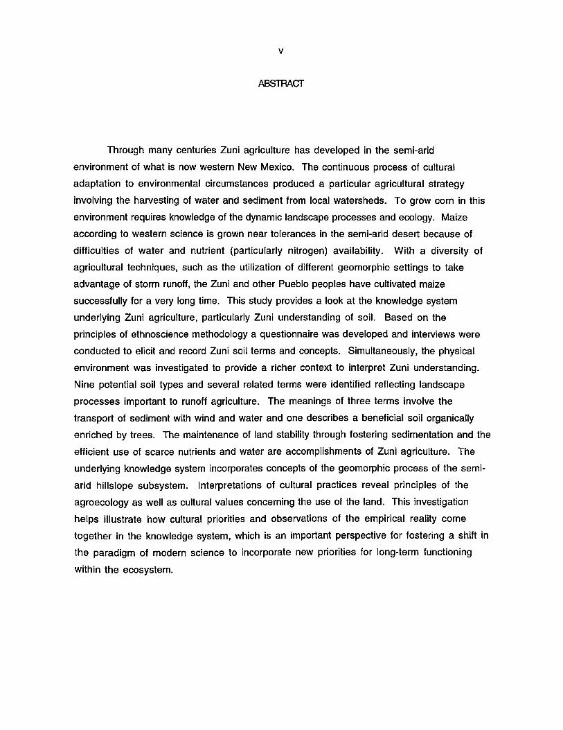
ABSTRACT
Through many centuries Zuni agriculture has developed in the semi-arid
environment of what is now western New Mexico. The continuous process of cultural
adaptation to environmental circumstances produced a particular agricultural strategy
involving the harvesting of water and sediment from local watersheds. To grow corn in this
environment requires knowledge of the dynamic landscape processes and ecology. Maize
according to western science is grown near tolerances in the semi-arid desert because of
difficulties of water and nutrient (particularly nitrogen) availability. With a diversity of
agricultural techniques, such as the utilization of different geomorphic settings to take
advantage of storm runoff, the Zuni and other Pueblo peoples have cultivated maize
successfully for a very long time. This study provides a look at the knowledge system
underlying Zuni agriculture, particularly Zuni understanding of soil. Based on the
principles of ethnoscience methodology a questionnaire was developed and interviews were
conducted to elicit and record Zuni soil terms and concepts. Simultaneously, the physical
environment was investigated to provide a richer context to interpret Zuni understanding.
Nine potential soil types and several related terms were identified reflecting landscape
processes important to runoff agriculture. The meanings of three terms involve the
transport of sediment with wind and water and one describes a beneficial soil organically
enriched by trees. The maintenance of land stability through fostering sedimentation and the
efficient use of scarce nutrients and water are accomplishments of Zuni agriculture. The
underlying knowledge system incorporates concepts of the geomorphic process of the semi
arid hillslope subsystem. Interpretations of cultural practices reveal principles of the
agroecology as well as cultural values concerning the use of the land. This investigation
helps illustrate how cultural priorities and observations of the empirical reality come
together in the knowledge system, which is an important perspective for fostering a shift in
the paradigm of modern science to incorporate new priorities for long-term functioning
within the ecosystem.

1
CHAPTER 1: INTRODUCTION
Beginning in the Pleistocene epoch tongues of the great continental glaciers crept
across what is now the United States corn belt in several episodes grinding the land surface
under the immense weight of mile thick ice. Upon retreating these Arctic giants deposited
their burden, blanketing the land with a flour of ground calcareous bedrock. During the next
several thousand years enough precipitation had fallen to support, not trees as in the East,
but the most beneficial plant community for agricultural soil development: tall grass
prairie. The landscape, in its primordial state on a geologic time-scale, has undergone little
drainage development: water settling in closed depressions frequently saturated the soil.
Anaerobic soil conditions prevented the complete breakdown of biomass fostering a large
accumulation of soil organic matter contributed by the rapid turnover of the fine, deep roots
of prairie vegetation.
The pervasive net of grass roots bound the delicate topsoil to the land surface. The
organic residue bound together the soil particles, allowing the well-aggregated soil to
capture and hold water effectively in addition to providing a reservoir for plant nutrients.
The result was a deep, dark soil with excellent chemical and physical properties for plant
growth. Sufficient rainfall and length of growing season provide modern farming in the
heartland of America the benefit of one of the most favorable agroecosystems in the world for
growing corn. In short, a unique combination of natural factors reached a relatively stable
state and produced an unparalleled natural resource by the time the steel plows of the Anglo
Europeans cut the prairie open in the mid-nineteenth century.
In the American Southwest where the Zuni people also grow corn, the landscape
ecology and climate are very different in almost every respect. Earth forces of wind and
water have mercilessly eroded the ancient stone layers on an imposing scale, producing a
landscape of broad tablelands, isolated buttes and hills and steep, narrow canyons.
Ephemeral streams and washes extensively dissect the high sloping plateau forming
networks integrated drainages or ak'quabanena -- "descending grooves" in Zuni. The course
of geologic history is not only painted in the colored bands of exposed rock formations, but in
the mosaic of alluvial soils which are continually rearranged by water racing, with each
torrential rainfall, from the mesa tops toward the depths of the canyons and beyond to the
ocean.

2
The semi-arid region where the Zuni live receives only 301 mm of precipitation
annually or one third of the precipitation that falls in Iowa. It is not enough rain to support
the growth of maize directly. When the mist laden clouds do bring moisture in the summer
months, localized thundershowers are so intense that the desiccated soil often has little
ability to soak in water. Surface runoff is quickly generated especially on the shallow soils
and exposed bedrock of the uplands. As water and energy accumulate in the descent down the
watershed, dry streams briefly come alive with the turbulent flow of water and sediment.
Surface soil may be swept away or buried, ruts and channels cut deeper or filled, depending
on the caprice of the elements. These factors define a precarious and variable agricultural
environment where dynamic fluvial and landscape processes are easily sent into motion by
disruption. Into this precarious landscape the Zuni fit their farming and began an entire
history of maize-based agriculture which continues over 2000 years later, though
flickering now like a small flame.
Native plants have evolved a range of specific adaptations to the difficult ecological
conditions of this environment where intense solar radiation, high temperatures, large
diurnal temperature fluctuations and drying winds present particular challenges to the local
biotic community. Shifting surface soils and blowing sand make it difficult for even natural
vegetation to become established. Two months in spring are known in Zuni as Li'dekwakkya
Ts'anna, "crescent-of-the little-sand-storm" and Li'dekwakkya Lanna, "crescent-of-the
big-sand-storm". In addition to an uncertain and short frost-free season, crop plants face a
nutrient deficient environment, especially of soil nitrogen. Not only does the landscape
differ remarkably in stability and process from that of the Midwest, it presents formidable
practical problems for crop cUltivation. The most obvious is that evaporative demand for
water far exceeds precipitation for the growing season (Figure 1:1).
Despite these limiting conditions, Zuni agriculture and therefore Zuni society
flourished. During the last four and a half centuries since contact, historic accounts of Zuni
food abundance have emerged from diverse sources through the historical period (Figure
1 :2). The archeological record indicates an elegant natural farming technology that
stretches many centuries into prehistory. Under scrutiny by anthropologists and scholars
for the last century Zuni culture revealed itself a gem of the ethnographic record. The Zuni
speak a uniquely expressive language, linguistically distinct from even their closest
neighbors. The matrilineal social and kinship system are among the most complex in the
world. The enduring religious drama that is acted out through an elaborate array of

3
Prec:i~ibtiQn
Q P otlH1tial en:xx:-zr=oir,rtion
x----t;( Ac::::al .'t.pccu:r:--;:i~tion
--
4.0"
2.0
1.0'
=----I J F
Figure 1:1
Soil mot$tur. utilbt50n
Soil mo~r1! rec::-o:;rge
Water d.tic:it
M A M J J A S 0
:= I: <: ::
2J4~ L 2 <
1 I
N D J
Potential evapotranspiration graph for Zuni, New Mexico. Growing
season moisture deficit is 13.87 inches and winter recharge is 2.74
inches, indicating low moisture availability is a severe stress on plants.
(Rhode, 1990).

4
Figure 1:2 Late nineteenth century photograph of "a typical Zuni cornfield" showing abundant corn (Cushing, 1920).
Figure 1:3 A few Zuni katchinas that visit the pueblo during ritual dances including one of the powerful and mysterious "mudheads" or Koyemshi (Duane Dishta, 1985: poster).

5
ritual events and personalities throughout the year, signifies a religious world order still
known in its entirety exclusively by Zuni (Figure 1 :3). These wondrous facets of Zuni
culture are testament to cultural achievement that sprang from the roots of a successful and
continuous agriculture.
The purpose of this investigation was to identify Zuni soil terms and concepts which
relate to their agriculture. Based on the cultural ecology concept of Julian Steward it is
assumed here that cultures continually adapt to environmental circumstances. Refinement
of information from observation and practice over centuries forms the basis for a body of
knowledge that underlies agriculture. Though extensive knowledge has been documented for
some traditional groups, most knowledge systems remain unknown. The knowledge does not
always look like our own and therefore has been difficult to see. Information may lie in the
form of principles embodied in religious teachings and rituals or in detailed taxonomies that
rival our own. It may be that the arrangement of information itself will require
investigation and provide insight.
The objective of this research, to identify Zuni soil terms and concepts relating to
soil use, was pursued with fieldwork in the summer of 1991. As part of the field soil study
of Dr. Jonathan Sandor, active Zuni farmers were located and interviewed according to a
comprehensive question set designed to elicit Zuni understanding of soils and soil processes
as well as information about agricultural practices. The ethnographic work was done within
the framework of the study of field sites, agricultural features, and soils, and therefore
interview questions incorporated the current observations and insights of western soil
science. In this study a description of the Zuni landscape and agricultural system are given
to provide a context for the Zuni understanding of the soil resource. Also the principles of
ethnoscience that underlie the methodology used here are discussed before the presentation
of findings concerning Zuni terms and concepts. Agronomic implications of this data are
given along with interpretations of Zuni cultural practices regarding the cultivation of
maize. Conclusions center on how ecological observation and cultural priorities concerning
land use are related to the long-term maintenance of the agricultural system.
During the two millennia of cultural development the Zuni produced a particular
agricultural strategy with farming techniques that take advantage of subtle physiographic
attributes and related geomorphic processes of the arid landscape. The most prevalent
farming technology harnessed runoff of storm events on alluvial fans, to provide water and
nutrient enrichment to an area and to "develop" a field surface making agricultural tasks
easier (the Zuni did not have million-year-old energy as fossil fuel for power and
6
fertilizer). It is hypothesized here that the knowledge system of the Zuni contains insight
into the landscape and soil processes of their semi-arid region.
The task was to combine socio-cultural field methodology to elicit this knowledge,
with an investigation of Zuni agricultural soils. Another culture's world view and
explanation of nature guides their behavior toward the natural environment along with
specific information and understanding needed to solve real problems of agricultural
production. That collective information is the knowledge system. The challenge is to
understand the way the material world is viewed from within another cultural tradition. To
this end this study relied on the principles of ethnoscience which have unlocked some
remarkable views of the botanical world by traditional people. There has, however, been
relatively little work on indigenous soil knowledge despite the central role of the soil
resource for sustaining society. The on-going soil study in which I took part seeks to
characterize anthropogenic and natural soils to further western scientific understanding of
the semi-arid region and shed light on the consequences of Zuni farming methods both for
production of crops and for maintaining the soil resource. For this study the investigation of
agricultural soils produced a richer context for viewing Zuni understanding.
It is an important assumption of this paper that there is an inherent contradiction in
trying to validate Zuni knowledge by a simple matching to our own. Categories of a
classification system are not reality. They are concepts of reality. Consider the simple
characteristic of soil texture. Soil is not made up of sand, silt and clay particles, though
this is taught to soil scientists as a rudimentary fact. It is made up of a continuum of
particle sizes that we choose at this time to divide up into these three categories. This is an
important and central distinction. Similarly, there is no inherent natural assemblage of
diagnostic properties which is a soil type, only various continuum, segments of which we
combine to define the concept of a particular soil type. Concepts are from the mind and
therefore colored by culture: shared beliefs, values and priorities of the social group. It
was not an anthropologist who noted that "classification systems are contrivances made by
men to suit their purposes" --it was Guy Smith, the principle designer of the U.S. soil
taxonomy (1975:7). Though many modern agricultural scientists readily admit that
agronomist's classifications of soils are no more intrinsically valid than for instance, the
soil classification used by engineers who are concerned not with properties related to
agriculture but to construction, they would be hard pressed to back the validity of how
indigenous people chose to look at soils. It is a difficult to step out of the biases of one's
history and culture.

7
Interdisciplinary research has offered information that was overlooked when
researchers stayed strictly within the confines of disciplines which divide up a complete
natural system. The Zuni may divide their understanding of nature differently and
therefore categories may transcend our boundaries. Or possibly the Zuni organize their
view of the material world in a unique way that defines altogether different axis. In that
case our understanding would be served well by viewing that unique organization.
In another area, a central underlying assumption of this work is a rejection of the
concept of universal history. The Hopi and Zuni and Yoruba and Quechua peoples are not at a
previous state of development through which industrial culture has already passed: their
cultural history, like our own, spans millennia and continues to the present moment. Each
culture has had a unique journey. To some this may seem obvious. However, the legacy of
unilinear evolution is deep and pervasive in western thought. It underlies formative social
theory in the works of Hobbes, Comte, Tylor, Morgan, Spencer and others from which many
contemporary concepts and the disciplines of sociology and anthropology flow. Thirteen
years before Wounded Knee broke the back of Native resistance to the invasion and
occupation of the North America, Henry Lewis Morgan published his seven stages of human
cultural evolution. The sequence begins with Lower Savagery, moves through Barbarism to
Civilization and includes corresponding societies based on the racial order of the Black,
Native American, Asian and White races respectively. Though few now claim to adhere to
social Darwinism, the idea that competition for property results in the "beneficial
elimination of the ill-adapted," is a powerful economic concept today and has been a key
philosophy for the political and economic history that shaped the globe's geopolitical
boundaries in the last 400 years.
The combination of a moral and godly mission to lead the dark children of nature to
the light of white, rational civilization and the technological power to inflict this will turned
out to be a fateful combination for the world's cultural species during colonial expansion.
One tragic result is a loss of a diverse array of philosophies and wisdom for the enduring
task to live with the land. The practical applications of considering industrial culture at the
apex of a universal human progression remains as lucrative today for the acquisition of land
and the mining of natural systems for profit as when they were conceived by 19th century
theorists. However, the degree to which the predatory adaptation of industrial culture is
now threatening the life-support system of the earth, makes a mockery of unilinear
philosophy and brings into question the very definition of "progress" in western culture.
The fact that industrial society is choking in its affluence and gambling away the birthright

8
of its children, suggests that unless we act with urgency and prudence history may show that
it was we who needed to come out of the darkness.
9
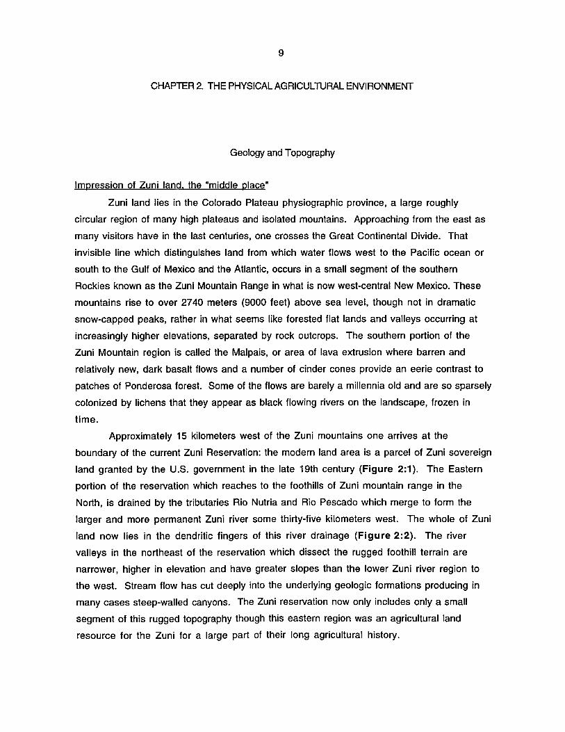
CHAPTER 2. THE PHYSICAL AGRICULTURAL ENVIRONMENT
Geology and Topography
Impression of Zuni land. the "middle place"
Zuni land lies in the Colorado Plateau physiographic province, a large roughly
circular region of many high plateaus and isolated mountains. Approaching from the east as
many visitors have in the last centuries, one crosses the Great Continental Divide. That
invisible line which distinguishes land from which water flows west to the Pacific ocean or
south to the Gulf of Mexico and the Atlantic, occurs in a small segment of the southern
Rockies known as the Zuni Mountain Range in what is now west-central New Mexico. These
mountains rise to over 2740 meters (9000 feet) above sea level, though not in dramatic
snow-capped peaks, rather in what seems like forested flat lands and valleys occurring at
increasingly higher elevations, separated by rock outcrops. The southern portion of the
Zuni Mountain region is called the Malpais, or area of lava extrusion where barren and
relatively new, dark basalt flows and a number of cinder cones provide an eerie contrast to
patches of Ponderosa forest. Some of the flows are barely a millennia old and are so sparsely
colonized by lichens that they appear as black flowing rivers on the landscape, frozen in
time.
Approximately 15 kilometers west of the Zuni mountains one arrives at the
boundary of the current Zuni Reservation: the modern land area is a parcel of Zuni sovereign
land granted by the U.S. government in the late 19th century (Figure 2:1). The Eastern
portion of the reservation which reaches to the foothills of Zuni mountain range in the
North, is drained by the tributaries Rio Nutria and Rio Pescado which merge to form the
larger and more permanent Zuni river some thirty-five kilometers west. The whole of Zuni
land now lies in the dendritic fingers of this river drainage (Figure 2:2). The river
valleys in the northeast of the reservation which dissect the rugged foothill terrain are
narrower, higher in elevation and have greater slopes than the lower Zuni river region to
the west. Stream flow has cut deeply into the underlying geologic formations producing in
many cases steep-walled canyons. The Zuni reservation now only includes only a small
segment of this rugged topography though this eastern region was an agricultural land
resource for the Zuni for a large part of their long agricultural history.

10
Figure 2:1 Area of Zuni land in 1846 and successive lands taken (modified from Ferguson and Hart, 1985).

1 1
r-·'·_·_·'·_·: i \ ... I • i • Upper. I Nutria I I i
i , '-_._._._. _. _.
I I i I
ZU'" 'NOIAH 1t'(.5£lIy.&no"l .~~.T_ . .-" /. : _ ... I
I i /· ... 6·~'" .UrTU i ".; . I .. - -:t . .......
I . ..'(. w: • ..!.:..: , I ......
I 1,;,1 ••• • : ) I : r···-.•. '\. J' .
... ~ ... ) \ '" .. : " .. . , .'\
\ ,..X i...,
"r'- ........... .i .... ·t
/ \. I '._ / J _ ,._ .
•• ' P'u",.,.« r; / .,-···....-···~ .... ,.",,-···~~~,.,crJ'.. .0- .""." 0 •• -",,-_ :-
Oio Celienl. _._( _!""._._._.-r r _. _.J r .. -~.. L._._._._. ,.._._._. K;'omo,.,. ~o /~~~.-.--.-.~ -I i ~ o ~ 10
Figure 2:2 Current Zuni Reservation land showing the proximity of Zuni Pueblo to the Zuni river and major tributaries. Traditional farming villages are located at Upper Nutria, Pescado and Ojo Caliente (modified from Kintigh, 1985).

1 2
Further west Zuni land decreases in elevation and the landscape becomes more
typical of the Zuni Plateau. There are hills and mesas which are flat on the top, many with
steep sides showing the underlying layers of sedimentary rock. The landforms are benches,
mesa surfaces, cliffs, dunes, slopes of erosional material and alluvial flood plains. Much of
this land surface and the underlying rock that shapes it is easily visible here because shrub
and grass cover is not continuous. Moving west, the tributary valleys broaden allowing
fuller views of the larger, steeper and more isolated mesas. Boson Wash, Oak Wash and
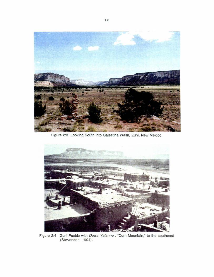
Galestina Wash enter the Zuni river valley in this region. Looking south into the Galestina
canyon area (Figure 2:3) it is possible with some consideration to get a clue of the
processes that created this unique landscape. Distinctly colored and nearly level sandstone
layers, white, red and tan-brown, are consistent mesa to mesa. Connecting them with your
eye makes it possible to imagine land surfaces at previous times. The broad Galestina valley
is nearly level, in most places right to the debris and Pinyon pine covered slopes that yield
to the mesa sides. Only gravity, through the cumulative power of erosion, could disintegrate
these impressive stones and create such a level surface in the river valley.
Just before reaching the ancient Zuni Pueblo one comes to a distinctive, isolated mesa
the Zuni call Dowa Yalanne, whose cliffs rise almost 900 feet from the surrounding land
surface. The dominant rock strata is the pure white and variegated Zuni sandstone, 500 feet
of massive, highly cross-bedded sandstone that sits on a base of the dark red Chinle
formation of the earlier Triassic period. In its presence the Zuni carry out their venerable
cultural and religious rituals (Figure 2:4). According to both the archaeological record
and oral history, the Zuni went through a period of movement over large distances before
settling at this place. It was, according to the Zuni, a search for the middle place, "the
center of the world, the midmost spot among all of the great oceans and lands, the spot in the
middle of all the heavens of the universe ... " (Ferguson & Hart, 1975:22) (Figure 2:5).
Southwest of Zuni Pueblo the terrain shows less relief; the landscape consists of low
broad valleys with gentle slopes of alluvial and eolian material. The towering mesa walls
are absent in this region. To the north the sandstone that is visible is light red to pale
brown and not very thick. It is easily weathered apart as is evidenced by the low, rounded
and well worn rock formations. The elevation has dropped some 300 meters from the
eastern reservation boundary and the corresponding reduction in precipitation is reflected
in the sparse and more dispersed vegetation. Wind, which predominately comes from the
South and the West sweeps across the broad flood plain unimpeded by high relief, picking up
and depositing colluvium and soil particles, especially sands, in the broad valley. Grass and
1 3
Figure 2:3 Looking South into Galestina Wash, Zun i, New Mexico.
Figure 2:4 Zuni Pueblo with Dowa Yalanne , "Corn Mountain," to the southeast (Stevenson 1904).

1 4
Figure 2:5 Dowa Yalanne

1 5
vegetation are more sparse among the shifting piles of sandy soil. The Zuni river meanders
through this region West to the Little Colorado river which flows along the Mogollon rim to
the great chasm from which the Zuni and the Hopi and other Pueblo peoples emerged to the
earth's surface, named by Anglo-Europeans, the "Grand Canyon".
Geologists' history
The landscape around Zuni Pueblo offers an opportunity to simultaneously view the
products of land shaping forces of very recent events and events that occurred 225 million
years ago. The large sedimentary rock formations were formed from fluvial deposits in
large ancient lake beds and marine seabeds during previous geologic eras. Though there
remains little record it is believed that during geologic periods as early as the Paleozoic, the
area was covered with seas from which limestones, sandstones and shales were formed.
According to Darwin's theory, lifeforms at that time were at the amphibian stage-- before
the great age of the dinosaurs. Many of these strata are not seen today. According to
geologists' interpretations they were completely eroded away. What are seen are younger
sedimentary stone formations formed in a similar way during the next geologic era, the
Mesozoic.
Much of the sedimentary rock reflects its method of creation, showing thin layers
oriented according to type of deposition that laid them there at some ancient time also
showing the color of the material which was their source. In the eastern part of the current
reservation it's possible to view the Crevasse Canyon formation, red and yellow Gallup
sandstone and gray-brown Dakota sandstone intertongued with the softer black Mancos shale.
These are all Cretaceous rocks. In some cases these strata thinly overlay older and more
impressive formations such as the towering white Zuni sandstone and dark red variegated
Chinle formation of the previous Jurassic and Triassic periods respectively. These
formations occur in the central area of Zuni land.
Deep within the Zuni mountains outcrops are visible of the geologic basement of the
southeast Colorado Plateau; pink coarse-grained granite. High in the mountains water
effectively cut through and stripped away the rock of all the previous geologic periods
revealing the Pre-Cambrian granite. The character of this rock reflects its vastly different
source: it is the solidified form of the molten magma below the earth's surface. The grain
size and color of this intrusive igneous rock reflects the mineral composition of the parent
magma. The light color indicates few mafic minerals and the large grains show that the
magma cooled slowly as it rose to the surface and therefore had time to form large

1 6
interlocking crystals. Granite is extremely resistant to weathering and therefore is
resistant to the erosional wear of time.
By contrast, if you continue West out of the Zuni pueblo you come to the low
Bidahochi formation, a light red sandstone and conglomerate formed in the current Cenozoic
era. This very young sandstone is loosely consolidated and easily weathered apart. Wind
sweeping across the broad low valleys has picked up the particles of the disintegrating rock
and deposited them extensively producing eolian planes and sand dunes on the land surface
covering the older Chinle formation below. The only younger formations are the lava flows
and cinder cones to the southeast of the Zuni reservation, which flowed as recently as 900
years ago: young enough to be mentioned in Zuni origin myths.
Earth forces and topography
To understand how soil, topography and rock formations are linked is to begin to
understand how exogenetic earth forces such as wind and water interact with endogenetic
forces such as tectonic activity to produce the characteristic semi-arid landscape at Zuni.
In the beginning of the geologic era following the Mesozoic era (when most of the current
sedimentary rocks were deposited), the interior of the North American Continental Plate
underwent a time span of tectonic activity, pushing up the Rocky Mountains and creating the
rugged Basin and Range topographic province. The Colorado Plateau area underwent
epeirogenic movement or broad uplift in which strata are not folded or crumpled and retain
much of their original horizontal attitude. Streams always seeking the base level cut more
dramatically under these conditions and therefore have worn down the landscape on a large
scale. Occasionally faults or great fractures in the crust occurred, moving one set of crust
strata up relative to the other. In some places stone layers became warped, tilting strata
down onto the earth or upward often along a single axis forming anticlines and synclines.
When the upper surfaces are sheared off by erosion, the once stacked strata now show up as
successive regions of different aged rock on the land surface. Zuni has two synclines
oriented on a Northwest-to-Southeast axis providing chronological order to the rock
formations observed moving from the Zuni Mountains to the Southwest along the Zuni River
valley.
The character and age of the rocks influences what we see today. Softer layers gave
way with greater ease but more resistant strata and areas capped with resistant stone
endured, forming benches, mesas and buttes as the rest of the landscape was worn down.
This process continues and is fully visible to the visitor at present. Older more cemented

1 7
layers like the Zuni sandstone maintain steeper angles as they erode producing steep
escarpments and cliffs like those of Dowa Yalanne. Loosely consolidated rock such as the
formation created in the earlier Lake Bidahochi wears down more completely under the
onslaught on the elements leaving low rounded rock outcrops. The soils that lie in the
valleys between the stone formations and mesas developed in the different weathered
material most of which was moved by wind and water.
As one researcher notes the "modern physiography of the Colorado Plateau is the
product of nearly continuous erosion throughout the Cenozoic time" (Patton et aI.,
1991 :376). During the uplift of the Colorado Plateau in the Tertiary, those sedimentary
rock layers formed by the seas of earlier times were raised higher and exposed more to the
elements. Colluvial slopes, the product of mass wasting, are swept over and eroded by the
overland flow of floodwater heading for the tributary stream channels. In turn, streams
emerging from the tributary valleys onto the floodplains and terraces empty their sediment
again and again, building up fans of this alluvial material. As fans connect and the river
planes the valley flat, the entire process of aggregation which built up the sedimentary
deposits which became stone over the ages-- begins again.1 The effects of this epicycle of
erosion on the current landscape are profound.
Climate and Vegetation
Rainfall variation
Variation in rainfall and subsequently in moisture availability on several levels, is
the most challenging characteristic of the Zuni environment next to overall water scarcity,
for successful, continuous agriculture. Zuni is a temperate, semi-arid environment
receiving an average of 301 mm precipitation annually. There is a period of light soaking
rains and snow in February and a period of intense thundershower activity from mid-July
through September, providing the highest percentage of precipitation for the year. May and
especially June can be extremely dry, "the average June rain at Zuni is only 10 mm (0.40
inch) and in 15 of the 68 years recorded less than 0.5mm (0.02 inch) of rain fell"
(Kintigh, 1985:92). July can bring fierce ephemeral flows because the desiccated soil has
difficulty soaking in the sudden rains. For crops as well as natural vegetation the soaking
1 Powell's "period of great denudation" (Patton et aI., 1991 :376).

1 8
winter rain and snow are important (Ferguson and Hart, 1985:11) because water stored in
alluvial aquifers supplies much needed moisture in the dry spring. Ferguson and Hart note
that high temperatures in spring and summer augmented by strong winds that also cause
evaporation, tend to desiccate vegetation and dry up available moisture (Ferguson and Hart,
1985:9). Much of the year there is a small amount of cloudiness and abundant clear
weather (Tuan et aI., 1973:100). Ambient relative humidity is ordinarily low; the air may
become so hot and dry near the earth's surface a fierce rain shower may be seen evaporating
before hitting the ground. The rapid gain and loss of heat underlies the large diurnal
temperature fluctuation of up to 30 and 40 degrees F. from night to day (Ferguson and
Hart,1985:15). In general conditions are such that they insure sharp daily and seasonal
changes in temperature (Tuan et aI., 1973).
Solar radiation heating up the land surface and the rapid thermal exchange between
rock surfaces and air produces the convection storms of the mid and late afternoons at Zuni
in the summer when moist air is available. Air masses riding up high slopes of larger
mesas also contribute to the formation of thunderheads. These storms have the distinct
characteristic of being highly localized and sometimes very intense for short durations,
contributing much water, but in a potentially destructive form. The locations of these
storms occur is random and sporadic. Kintigh notes "with any given year, there may be
localized but dramatic differences in rainfall patterns" (1985:93). Based on several
decades of data from four locations he notes there is "substantial, highly localized, but
essentially random variation in total rainfall" though he goes on to admit there may be some
systematic difference in rainfall based on orographic effect2.
So far two types of variation were discussed with regard to precipitation at Zuni. In
a single year plants may receive anywhere from next to zero millimeters precipitation in
one month and nearly 150 mm (6.25 inch) or half the annual amount in one storm of a
different month. Spatial variation is also important to understand. Torrents may fall in a
very small area while a neighboring watershed remains dry and without a break from the
persistent rays of the sun. These types of variation are both important to the farmer
laboring over a field, attempting to bring his corn to maturity. Though native corn is better
adapted to the local climatic conditions, conditions of low humidity, wind and solar intensity
increase the daily water use of corn plants here above the daily use in more humid regions
2 This appears explainable. When average rainfall is compared to elevation the correspondence is "remarkably close" though shifting direction of moisture bearing winds with the season combined with topographic relief produces great local variability (Tuan et aI., 1973:34).

1 9
(Muenchrath and Salvador, 1992:7). The amount of precipitation at Zuni is less than half
the growing season and annual precipitation of the corn belt and below what is considered
sufficient as a lower limit for corn growth overall (Neild and Newman, 1987:5; Shaw,
1988:611). Discussing moisture stress on maize, the concept of soil moisture availability
becomes emphasized with amount of moisture in the soil and soil texture (sand better than
clay) as important factors for combating atmospheric demands for water (Shaw,
1988:611) It remains a fact that there is little chance of securing a harvest without
manipulating factors that increase the likelihood of sufficient moisture in the field
throughout the season to nourish the crop. That is the work of the farmer .here and the topic
of the remainder of this work.
Looking at the very long agricultural history in this region there is one other major
variation in precipitation: trends in total annual rainfall (as surmised from tree-ring data)
which mean entire years are drier than usual. Given the other factors of this environment
years with low total precipitation can be disastrous3 In order to survive a society would
either have to keep large stores of grain from good years or have a very diversified and
flexible farming system that could incorporate the natural variations in the amount of
moisture available. The Zuni used both of these strategies. More will be discussed in the
section on agriculture.
Vegetation
Temperature and rainfall (and therefore vegetation) vary with altitude as in other
arid regions. The general relationship is that mean annual temperature increases and mean
annual precipitation decreases from higher to lower elevation in the Colorado Plateau region
(Hack, 1942:7). The lifezones are described in Zuni Atlas (Ferguson & Hart, 1985:17).
The forest in the Zuni Mountain area is Ponderosa pine accompanied by many shrubs, herbs
grasses an occasional oak, juniper and Pinyon pine trees. This Montane Conifer Forest
occurs mainly between 6000 and 9000 feet. The next natural biotic community is Great
Basin Conifer Woodland, between 5000 and 7000 feet made up mostly of relatively small
Pinyon pine and juniper trees which are common along the tops and slopes of mesas. This
combination also occurs in open savannas with grasses and herbs, juniper dominating at the
lower elevations. Slightly drier Plains and Great Basin Grassland consists of well developed
3 In the semi-arid environment of New Mexico the difference in precipitation from year to year is usually less than in humid climates, but this smaller difference is of greater importance to agriculture (Tuan et aI., 1973:50).

20
grasses including gramma, fescue, dropseed, wheatgrass, muhly brome and galleta
sometimes occurring in broad areas and generally located between 5000 and 7000 feet.
Along more permanent waterways at Zuni there are riparian tree species such as
cottonwood, walnut and willow. The willow branches and their relation to water have great
ceremonial significance to the Zuni.
Though these categories of natural plant communities serve as a guideline and are
derived from widespread data, they are not useful at the scale of the agricultural field. All of
the fields of the soil study, and indeed all of the historical farming villages of the Zuni, fall
within the elevation intervals of the three biotic communities described. In other words,
although specific biotic communities can be identified and correlated to elevation, any of the
communities may occur at locations at Zuni depending on the combination of local factors. In
this semi-arid region microclimate and thus vegetation is strongly influenced by local
environmental conditions. This principle is important to understanding one characteristic
of the more flexible indigenous knowledge systems which are non-universal and based on
local phenomena.
Microclimate and growing season
Hack comments on the frost free season, "The length of this period varies roughly
with mean annual temperature, but it cannot be closely related to altitude because the
geographic location and physiographic position of a station are equally important"
(1942:7). Kintigh presents a thorough discussion of problems associated with describing
the length of the frost free season based on data from several stations (1985:92-93). The
average growing season at Zuni is 150 days and east at EI Morro National Monument 810
feet higher, it is 113 days. Even at the lowest elevations at Zuni the standard deviation year
to year is 21 days: great enough to dip below, anywhere on the reservation, the requirement
of native corn types of approximately 130 days (Hack, 1942:20 and Bradfield, 1971:6 for
corn at Hopi). However each climate station is influenced by local land forms which
complicate the picture because frost is highly dependent on wind and terrain (Ferguson and
Hart, 1985:15). Rhode (1990:36) makes the observation that neighboring rock types
contribute to length of growing season variability. Kintigh and others note nighttime
temperatures along lower slopes of mountains and mesas are moderated by the effects of cold
air drainage and for that reason those locales would be advantageous for fields in cases where
the length of growing season presents a problem (Kintigh, 1985:93; Rhode, 1990:37).
Hack in (1942) describes this phenomena well and elaborates on how the Hopi people used

21
lower side slopes, where frost drains off, to create sufficient growing season while taking
advantage of the greater annual rainfall of higher elevations. This aspect of Indian
agriculture alone indicates the incorporation of important ecological-topographical
relationships into farming technology.
Water and Soil
Erosion and sedimentation
There is a close visible relationship between landforms, geomorphic processes and
soils in desert areas. Geomorphology is the earth study concerned with the geometry,
creation and age of land forms, and therefore is concerned with the wearing down and
building up of land surfaces such as alluvial fans and consequent soil development
(pedogenesis). This branch of soil science is appropriate for looking at the dynamic soil
surfaces at Zuni which are under constant influence of fluvial and eolian processes in
comparison to humid regions. These processes are also where the Zuni farmer intervenes to
create a favorable field surface and favorable soil moisture conditions for growing corn.
Earlier a description was given of how tectonic and erosional forces combined to
produce the landscape seen at Zuni. In the study by Gile et al. it is generalized that "The
small scale forms that are superimposed on the major features were produced ... primarily
by the action of running water, and were locally influenced by mass wasting and wind action"
(1981 :22). Yet in the short-term the shape of the landforms also dictates water flow as
pointed out in another discussion of surface soils, "The movement of water is critical to the
type of soil found and this water movement is very much governed by the slopes and
landforms present" (Gerrard, 1981 :75). The fact is that at any given landscape position
there is an interaction of many dependent and independent variables which combine to
influence surface hydrology and produce the soils at Zuni. Again, there is great local
variability, "Although water, among non-eolian processes, has a pervasive influence on
landforms, its interrelations with soils, plants and geology are different for each hill and
stream" (Bull, 1987:43).
Rainfall that falls in upland watersheds and does not soak into the soil surface begins
to flow downward toward the lowest point. In an idealized, roughly basin shaped tributary
watershed the low point is the stream channel which begins at the headslope and grades
downward toward the main river valley. Obviously the more intense the rainfall the greater

22
the overland flow and the greater the stream flow, though there are physical factors relating
to the basin that are important. Bull in his study lists the chief variables of fluvial
geomorphic systems in deserts. Among the independent variables of the drainage are rock
type, basin level, drainage area and climate. Dependent variables listed in order of
increasingly subject to feedback mechanisms are total relief, hillslope morphology,
drainage net morphology, soil profile development, vegetation, sediment yield, channel slope
and pattern and water and sediment discharge from the basin (Bull, 1987:43). This
observation is important to indigenous desert agriculture for two reasons. Site selection for
fields is a critical part of the technology representing many landscape factors. Also Zuni
manipulation of the agro-environment is efficient in that it takes place at the most summary
location of the fluvial system, " .. .the discharge of water and sediment from a basin ... may be
regarded as the output of all the preceding interactions" (Bull, 1987:43).
In his study of traditional agriculture and water use at Zuni Rhodes puts the practical
issues more simply, "The type of soil and the area of the catchment basin have obvious
effects on the runoff because they effect infiltration capacity and the volume of rainwater
which is directed towards the stream channel" (Rhode, 1990:33). Very shallow soils and
exposed bedrock areas, for example, would contribute more precipitation to flow. Stable
upland areas may also have lower permeability because they have developed clay or calcium
carbonate pans.
Water flow increases in energy as volume and velocity increase further downslope,
particularly if there is little vegetation to impede the flow and stabilize the soil with roots.
As the momentum of the water increases, so does its ability to sweep with it weathered
colluvium, loose soils or whatever else lies on the soil surface. Fine soil particles are
particularly susceptible to erosion because sparse vegetative cover allows raindrops to
smash directly into the earth, destroying the surface soil peds and contributing to the
entrainment of fine sands and silts. Sediment further increases momentum of the flow. By
the time runoff water is concentrated into the tributary stream there is enough energy to
cut into the alluvial fan eroding a channel. This gully is known as an arroyo and factors that
guide its formation are drainage basin size and morphology, type and density of vegetation
and intensity of rainfall. As the streamflow emerges out of the arroyo into the main river
valley an entirely different set of processes begins, dominated not by erosion, but by
deposition (Figure 2:6).
The place where the arroyo ends, is named the 'arroyo mouth' or akchin by the
Tohono O'odham people of southern Arizona. Here" the channel ceases rather abruptly and a

/
~I, \1
V
23
Figure 2:6 Transition from erosional zone to depositional zone at the tributary outwash area or arroyo mouth. Note changing loci of deposition and fan-building. (Cook and Warren, 1973).

24
shallow fan is built, up over which the water spreads" (Hack, 1942:28). The stream, no
longer confined in the stream channel begins dissipating energy by spreading, forcing the
wash to reduce its sediment load, dropping first the larger heavier particles such as coarse
sand and carrying the fine particles down the slope until they too settle out. The overall
alluvial surface is constructed over time, encompassing diverse sets of hydraulic conditions.
From one event to the next factors combine differently and produce different deposition
results:
The akchin of an arroyo is not a fixed location, because position
depends upon the ratio of the velocity of the flowing water to the
relative volume of the debris carried. In one flood the critical point
at which deposition occurs may be down stream from the similar
point of another flood. The result is that the alluvial fan produced
by one flood may be channeled by the next and a new fan will form
below. (Hack, 1942:28).
Another possibility is that sediments may overtop established channels (before reaching the
channel mouth usually because debris of previous deposition obstructs flow) resulting in a
widening of deposits (Cook and Warren, 1993:171) as water moves laterally away from the
stream channel. The description of Zuni runoff techniques presented in the next chapter
parallels the description of natural processes given here. The shifting slope process of
alluvial fans is one of the most important processes of this landscape and has a large
influence on the soils found at different places in the valley margins at Zuni.
Balance: geomorphic equilibrium
The important principle in terms of soil and water movement is that there is
relative balance established between forces governing erosion and deposition (within the
greater epicycle of erosion that is wearing down the uplands and aggrading the valleys). The
hillslope system seeks to achieve this balance. The shifting loci of initial deposition at the
arroyo mouth, the depth of the channel cut and the amount of sediment eroded and deposited
are variables the stream can use to respond to rainfall intensity and other factors which
work in combination to determine the degree of erosion in the watershed for a runoff event.
An alteration of a major factor, for instance reduced vegetative cover which generates more
runoff, disrupts the balance that has been achieved and sends processes searching for a new
equilibrium. In many cases the result of disruption is arroyo downcutting. Once initiated,

25
processes can move quickly away from the steady state because of the delicate interaction of
landscape variables:
The changes in the independent variables that cause the decrease in
vegetative density also initiate other changes that effect behavior of
water within the hillslope subsystem. Reduction of vegetation
density exposes more soil to raindrop impact, which results in
decreased infiltration rates. The resulting increase in runoff of
water for a given rainfall event, will have a higher sediment
concentration than before the decrease in vegetation density. The
decrease in soil moisture establishes a self-enhancing feedback
mechanism that tends to decrease vegetation further. Because this
feedback mechanism is self-enhancing instead of self-arresting, the
operation of the hills lope subsystem is driven further from
equilibrium (steady state) conditions (Bull, 1987:46).
Bull goes on to explain that an important threshold is crossed as rate of hills lope erosion
exceeds the rate of soil formation. This change further pushing the landscape away from the
steady state, where conditions are more favorable for the growth of vegetation. It has been
noted from precipitation data, a climatically induced drop in water table below plant roots
affected surface vegetation at one time, resulting in an onset of arroyo cutting at Zuni.
Logically, any agricultural system that hoped to endure in this environment, would take into
account the self-enhancing characteristic of factors of the hills lope subsystem and the
resulting potential for erosion.
Other water sources
There is another aspect of water processes at Zuni that is not emphasized here but
deserves mention. There are several permanent and semi-permanent springs at Zuni, some
of which were made by geologic faults which have shifted strata in such a way as to release
trapped ground water, others are simply where the water table under current conditions
appears at the ground surface. The three historical farming villages, Upper Nutria, Pescado
and Ojo Caliente have such springs. Water channeled from these springs has supplied crops
for centuries.
Another important phenomena is differential flow of water through sedimentary
strata of mesas. Precipitation soaking in at the mesa surface percolates downward through
the coarse sandstone layers until reaching a less permeable layer such as shale at which

26
point it moves horizontally, sometimes emerging as springs and sometimes remaining near
the soil surface at the bottom of mesa sides. The Hopi used these spots as field locations and
the Zuni have used them for peach orchards (see figure 3:4 in discussion of seepage fields,
Chapter 3). The Zuni river itself along with these other permanent water sources have
provided a means of diversifying Zuni agricultural strategy (see Kintigh 1985 and Rhode
1990 for longer discussions of permanent water source farming at Zuni). The focus of this
paper, however, is on the runoff and floodwater agriculture associated with slope processes.
This type of farming was thought by Hack to make up a large part (76%) of Hopi agriculture
and was probably the most extensive agricultural technique at Zuni.
Geomorphology and Zuni soils
The discussion will now turn to the soils associated with the different geomorphic
settings at Zuni, particularly the valley margins where runoff from the upland watershed is
concentrated. Later, after the methods of Zuni agriculture are described, there will be a
discussion on the impacts those methods have on the surface soil horizons of Zuni fields. For
now, as part of the description of the physical environment at Zuni, I want to present what
we know generally of the different types of soils found on Zuni land, and the general
geomorphic principles that are expected to explain the formation and properties of different
soils 'of this environment. Since maps at the field level are not yet available, specific soil
series descriptions will be used to illustrate the type of soils associated with the different
topographic positions at Zuni.
One guiding principle for understanding the location of different soils is horizontal
sorting of sediment particle sizes by runoff heading to the valley bottom. Generally, coarser
material is deposited proximally, near to where deposition occurs just below the shallow
soils and exposed bedrock of the valley side slopes. This is in the footslope position where
arroyos generally open onto alluvial fans. Finer textured material is carried downward and
more frequently deposited in the distal position, lower on the gently sloping terraces and
nearly level floodplains where water has a much lower energy. Note that over time the point
of deposition shifts, as well as the amount and texture of the alluvium according to the
different size of flood events. Alluvial parent material shows stratification in the soil pedon
of different textured layers.
Another principle is that the parent material undergoes pedogenic development over
time. Development of soils from weathering in place effects the soil texture because soil
processes accumulate clay particles below the surface in the B horizon. Thus one key

27
subsurface pedogenic process over time is the accumulation clay (as well calcium carbonate
in arid and semi-arid regions) and therefore a well developed soil is less likely to reflect
texture of the original parent material. For stable areas on the landscape (Le. surfaces
where erosion/deposition have had a minimal effect for some time) there may be a developed
argillic or clay accumulation horizon present regardless of the general trend of finer parent
material lower on the hillslope. Several well developed argillic horizons were found in soils
excavated in 1991. Despite the dynamic nature of surface material, clay elluviation/
iIIuviation can occur in the soil profile, especially in areas where conditions consistently
foster the infiltration of water into the soil profile. Fans encompass a range of degrees of
pedogenic development, " ... soils on different slopes and even on different portions of the
same slope may be of different ages .... The steeper slopes where erosion is greatest have the
youngest soils whilst the lower angle slopes have the oldest soils. Repeated phases of erosion
and deposition on alluvial surfaces produce more complex situations" (Gerrard, 1981 :75).
The Desert Project (Gile et aI., 1981) an extensive study of soils in the Rio Grande
Valley, has findings which are consistent with the hillslope relationships described. That
study generalizes that stable uplands are often Paleorthid and Calciorthid complexes as
opposed to the less developed Torriorthent soils found on fans and less steep slopes along side
arroyos and the sandier Torrispamment associations of fans and young terraces. The reason
this general arrangement is important is because it is thought that many Zuni fields
purposefully lie at the valley margins above the main floodplain often on tributary fans.
Cook and Warren in their investigation of desert drainage systems, make the generalization
that valley-side slopes are associated with high infiltration capacity (1973:151). These
generalizations are widescale and don't necessarily reflect the findings for soils associated
with small tributary drainages at Zuni, but they suggest an important reason for Zuni
emphasis on farming valley margins. Berndtsson and Larson (1987: 117,118) note that
spatial patterns of infiltration are governed by geomorphology and occurring vegetation and
are more complex in semi-arid regions as compared to more humid areas.
To complete the description of the Zuni agricultural environment, it is necessary to
give a brief explanation of the typical soils at Zuni and elaborate on several important soil
characteristics. Rhode divides the soils of the reservation into four broad categories based
on physiographic setting and parent material; soils developed in alluvial material4, in
4 The "alluvial" soils discussed by Rhode can be considered alluvial floodplain soils more accurately because his "upland slope" soils include soils on fans which are also formed in alluvial material.

28
eolian material, soils of the upland slopes and soils of the level uplands (1990:10). This
organization is useful here because it allows a continuation of the discussion of landscape
ecology. At the same time it also appears to parallel the organizing principle of Zuni soil
terms gathered in this research. Each of the four types will be briefly discussed with
examples. Understanding the soils at Zuni will make it clearer why the Zuni, to a large
degree, put their fields not on the floodplain as in modern agriculture, but in the valley
margins on toeslopes of alluvial fans.
Generalizations made by Rhode (1990) and Maker et al. (1974) will be discussed
here for reservation soils overall in order to give a general picture of the soil
characteristics generally associated with a topographic position at Zuni. These
generalizations are obviously not true everywhere. Typical soils that illustrate relevant
points about soil forming processes will be used as examples with soil description
information from the unpublished SCS Soil Survey by Steven Parks (forthcoming) and our
observations. A soil hillslope cross-section was constructed to organize information so a
relative comparison could be made for the soil characteristics in relation to landscape
position in a single tributary valley. A drainageway on the southern side of Rio Pescado was
used because it contains field 133, investigated as part of the field soil study (Figure
2: 7) .
The cross section diagram (Figure 2:8) is a vertically exaggerated expression of
the topography along the line A-A' in figure 2:7. The soil sequence along the A-A' transect is
similar to other tributary valleys on the southern side of the river valley and therefore
representative for this area. However, there are many variations of sequences over the
reservation. The forthcoming Soil Survey report will make it easier to characterize the
overall nature of the soil associations at Zuni. Most valuable for a greater understanding of
soil on the scale of a Zuni farmers field will be the detailed soil mapping of the watersheds
containing the Pescado and Galastina field sites of the field soil study (forthcoming). The
paper "Production of Zuni Mountain Forest Soils" by Leven and Dregne (1963) along with
the irrigation soil study of Maker et. al.(1974), the water use study by Rhode (1990) and
unpublished Soil Survey by Parks make up the source of soil information presented here.
Rhode, relying on soil associations described in the irrigation study by Maker et al.
(1974) generalizes that the floodplain soils at Zuni have a high available water holding
capacity (AWHC), nearly twice the average of the rest of the soil associations (according to
the information in Table 2:1, Rhode, 1990:14). They are classified as having slow
permeability. This can be explained because the greater amount of fine soil particles

29
Figure 2:7 Topographic map of a Pescado tributary drainageway showing the location of field 133 of the field soi l study. Line A-A' is the transect for the hillslope cross section (figure 2:8) .

elev
.{f1)
7400
--
7200
-
7000
6000
-
6600
-
AWH
O <
3.5
" A
WIIO
7.5
-10"
AW
HO
>10
"
sand
ston
e &
al
luvi
um &
al
luvi
um
resi
duum
al
luvi
um
eolia
n se
d.
mod
erat
e ve
ry s
low
per
mea
bilit
y sl
ow p
erm
eabi
lity
perm
eabi
lity
slow
per
mea
bilit
y
I I .1 I
I ,..1
-1, !
! E
RO
SIO
N
DE;
POSI
TIO
N
-)
i I j I I I .
I -I.
.; ;
arr
oyo
.... :'-
. fi
eld
1
33
,
! '-
0. '-
0 '~
...
t7--
-i
Pes
cad
o R
iver
. !.
I -~
,--V
35
0 To
ldoh
n·
i I
I V
essl
lla c
ompl
ex I
310
Flug
le I
49 C
onch
o
rocl<
oul
crop
36
0 H
osla
loam
IIh
e sa
ndy
loam
cl
ay lo
am
!'
r !
1 km
Fig
ure
2:8
Cro
ss-s
ectio
n of
Pes
cado
dra
inag
e co
ntai
ning
fie
ld 1
33 w
ith U
SG
S S
oil
Ser
ies
and
sele
ct s
oil
char
acte
ristic
s re
leva
nt t
o fie
ld p
lace
men
t (V
E=
x2).
t<) o

31
carried to the lower areas produces finer textured soils. In the Pescado region the soils of
the main floodplain are clay loams of the Concho or Conchovar series. They are slowly
permeable and very slowly permeable respectively. The are also characterized as having as
limiting factors in addition to permeability, salinity and overflow (of river floodwaters)
(Maker et aI., 1974: Table 5). Parks survey of this region maps Heshotauthla soil slightly
down the river valley, which is classified as a Natrustoll, natric because of high amounts of
sodium or magnesium and sodium salts5. Though no other soils classified as natric, it is
thought that floodplain soils with very slow permeability may accumulate salts in the
surface horizon, making them difficult for intensive farming under modern irrigation
practices (pers. comm. Sandor, 1994)6.
For the following discussion refer to the cross-section diagram (Figure 2:8) of a
tributary drainage of the Rio Pescado river valley which was investigated in the field soil
study. The soil characteristics listed in the diagram are from the unpublished Soil Survey
Report by Parks. Notice the cross-section begins with the Concho soil series at the
floodplain position. The next two consecutive soil mapping units moving up the side valley
are the Flugle fine sandy loam and the Hosta loam in the toeslope and alluvial fan position
respectively. These soils are no longer clay loams and the Flugle soil with a sandy loam
texture has greater permeability. Leven and Dregne conclude in their study of Zuni forest
soils, that generally "the permeability of soils with a given parent material decreased as
texture became finer" (1963:9)7. Surface permeability of soils is critical because put
simply, water that does not infiltrate the soil is lost as runoff. Looking at the profile
diagram notice that the highest permeability classification (moderately permeable) is the
5 On the soil description sheet the presence of sodium sulfite and calcium sulfate crystals, is noted. 6 It is interesting to note that Maker et. al. describes one of the two floodplain soil associations as appearing to offer "the best possibilities for expansion of irrigation in McKinnley county" (1974:45). Other factors were included in the irrigation rating by that study including those land/soil characteristics that allow alteration for the methods of modern irrigation agriculture including flatness, extensiveness of soil type, and nearness to conventional water sources. The difference in approach to farming is evident in these words concerning the high potential of the Sanson-Barnum association, "These irrigable lands occupy nearly level to gently sloping landscapes and will require a minimum amount of land leveling and conditioning in preparation for irrigation"(1974:45). This is an example of production concerns influencing classification and the reason why the study of soils in their natural setting is a more appropriate basis for crosscultural study. 7 Leven and Dregne also present the exception of a soil with a finer overall texture that has good permeability. They conclude this may be due to a larger coarse sand fraction and higher organic matter. Soil structure could also increase permeability in clayier areas.

32
Flugle soil just downslope of the current arroyo mouth. Water falling on the very slowly
permeable uplands is later released over the Flugle soil which represents the location on the
profile where both AWHC and permeability are maximized. This is the area of the Zuni field.
Adding information about parent material of these soils sheds light on another
interesting point about the Flugle soil series. This soil is developed not just in alluvium but
also in eolian material. From the color soil map, the patches of Flugle series are distributed
equally on the margins of the floodplain soils moving up the Pescado river valley. These
areas evidently have accumulated windblown sediments. The important point for discussion
of the continuum of soil characteristics on the cross-section, is that this eolian material
contributes to the fine sandy loam texture and the increased permeability of this soil.
Generally, large deposits of coarse material like windblown sand greatly retard
runoff because they are loosely consolidated and have a large porosity which allows for rapid
permeability. Hack mentioned that sand dune fields on top of mesas made of permeable
sandstone, make the best intake areas for mesa side seeps and springs. He also mentions that
in low elevation dune fields over less permeable substrata, the Hopi plant sacred, highly
valued crops. He concludes that within the arms of the lowest barcan dune of a dune field
there is an area of consistent moisture. Hack's study describes this topic of water seepage in
dune hollows and many other versions of Hopi sand dune agriculture.
Today at Zuni in windblown areas such as broad valleys and the lowlands of the
southwestern reach of the Zuni river, vegetation, fences and even landforms foster enough
deposition to create piles and ridges of sand along the ground surface. In the broad Galestina
valley southeast of the Zuni pueblo where field 75 of the field soil study is located, there are
large sandy areas. Even the floodplain soil, the Mido series, is a loamy fine sand with rapid
permeability. The parent material is listed as sandstone derived eolian sediment. This is
consistent with the Maker et. al. study that classifies nearby soils as fine sandy loams
derived from eroded material where the expanses of flatter land allows the wind to blow less
impeded by trees and rock formations. The Mido soil is classified as an Ustic Torripsamment
as is the Zia soil slightly upslope. The Zia soil, however, is listed as derived from eolian
and alluvial sediment and has moderately rapid permeability. Part of field 75 is in this soil
series. Both of these soils are deep with non-existent or weak B horizons.
This brings the discussion back to the Pescado drainage profile and an important
point about pedogenesis. The last two categories of Rhode's division of soils according to land
surfaces and parent material are the soils of the steep upland slopes and the level uplands.
The steep slope soils of the Pescado tributary valley are gravely and shallow to bedrock.

33
Though the coarse surface material is easily infiltrated by water, the presence of the
bedrock not far below the surface means that runoff and erosion occur readily in these
regions. In this case the Toldohn-Vessilla complex mapped for the upper region of the field
133 drainage is classified as shallow to very shallow, very slowly permeable with rapid
runoff and a severe hazard of erosion by water (Parks, 1988 soil series descriptions).
This is the area where water is harvested from. Investigation of field soils showed common
argillic horizons, also enhancing runoff.
Natural soil fertility
Variation in the natural fertility of Zuni soils depends on the parent material in
which the soil developed and the degree of weathering the soil has undergone in addition to
organic material content. From pot tests, Leven and Dregne conclude for some Zuni
mountain soils that the highest fertility was in soils developed in mixed alluvium and
weathered shale. Soils developed in limestone, sandstone and granite residuum follow in
descending order. They also found that the ratio of non-weatherable to weatherable minerals
(quartz: feldspar) correlates to fertility. The greater the ratio the more extensive the
weathering and the more likely the presence of nutrients in the soil. As would be expected
these soils have adequate amounts of potassium (a nutrient released from feldspars and mica
by chemical weathering), they are generally deficient in phosphorous and nitrogen.
However, as stated by at least one semi-arid study, the low phosphorous levels are never
limiting, because where moisture is adequate nitrogen limits growth. Without doubt
nitrogen levels are of great importance for plant growth in this region. In the study by
Leven and Dregne, plants potted in Zuni mountain soils gave a highly significant response to
the application of nitrogen (as well as to nitrogen-phosphorous applications).
For mobile nutrients such as nitrogen, the pool available to plants is difficult to
assess in semi-arid environments. Unlike humid areas where there is a large amount of
plant biomass above the surface, most of the desert ecosystem nitrogen is thought to be in
soil nitrogen (West and Klemmedson, 1978:11). It is thought to be adsorbed to the clay
particles or in the form of resistant humic substances. Chemical transformations and
translocations happen sporadically due to variable moisture conditions resulting in very
high microbial activity when conditions are optimal. Most of the organic matter and
nitrogen exists in the shallow surface layer of soils, therefore soils that have suffered
erosion have less total nitrogen. Nitrate nitrogen levels can be high (relative to other forms
of nitrogen). There is less leaching in desert environments and efficient nitrogen cycling

34
(Wallace et aI., 1978:210). Concerning spatial variation of nitrogen in soils of the semi
arid landscape, West and Klemmedson note "horizontal patterns ... are striking in desert
situations where scattered occurrence of vegetation results in "islands of fertility" or
mosaics of nitrogen accumulation and nitrogen availability coinciding with the pattern of
vegetation" (West and Klemmedson, 1978:13; Wallace et aI., 1978:210). They go on to
note from a study by Beadle and Tchan, (1955) that because nitrogen is in the very surface
strata of soils, "Considerable changes in the spatial distribution my result from movement
of soil by water and wind" (West and Klemmedson, 1978:16)(see also Garcia-Moya Mckell,
1969:82).
Put simply, success for naturally occurring plant species and ultimately for the
manipulated plant communities of agriculture, depends on the fertility of the soils and their
ability to take in moisture and store it in sufficient volume (Leven and Dregne, 1963:27).
Having discussed many of the properties and processes relevant to this environment I can
now describe Zuni farming techniques.

35
CHAPTER 3. AGRICULTURAL STRATEGY
Adaptive Pressures
Cultural survival
Unlike the natural environment of Native American societies in the forested eastern
section of North America, the desert environment of the Southwest provides a more
dispersed set of flora and fauna to gather for sustenance. It is thought that the difficulty of
hunting and gathering over large distances provided a pressure toward agriculture in the
pueblo region. As elsewhere, the expansion of agriculture developed a positive feedback
between food production and population. Linda Cordell, who explores prehistoric
developments of Southwestern societies, states of the transition to farming, lias people
reduced the amount of territory they exploited in order to be closer to their crops they
further depleted the supply of locally available wild resources. This in turn encouraged the
production of even more reliable crops as well as the establishment of new communitiesll
(Cordell 1984:188). As with any society that began down the path of agriculture, it became
increasingly important to intensify land use and provide a consistent and reliable food
source. In the case of the pueblo region this requirement had to be achieved in a challenging
and unreliable environment.
On the Colorado Plateau success at yielding crops from the earth depended on
formulating subsistence strategies adapted to the scarce and dispersed distribution of
moisture and to the extreme climatic variability. Across the Southwest, agricultural
strategies included a variety of indigenous technological methods for enhanCing yields. They
were developed to insure against what Cordell called marginally favorable and often
unpredictable climatic conditions (1984:181). As Guy Stewart described it,
All the settled tribes that have lived in this land of desert and mesa
have had a unifying interest; they have been sedentary farmers
using a specialized maize agriculture as their principle support in
a country where average conditions are more rigorous than those
found in the Dust Bowl. (Stewart 1940: 201).

36
The purpose of the forthcoming section is to present the agricultural techniques and
technology used by the Zuni and others which allowed them to overcome the obstacles and
grow crops for their long agricultural history.
Before outlining the practices, it is important to convey some perspective
concerning the struggle involved in the long cultural history of the Southwest. Communities
of increasing size require increasingly complex mechanisms of social integration. To begin
with, the shift in subsistence strategy to agriculture itself necessitates fundamental changes
in the configuration of a social group. For example, for sedentary agriculture a system of
land tenure must be put into place to allow for continuous use of sections of land. The Zuni
have developed a complex kinship network part of which is the passing on of land parcels
through marriage in the matrilineal line. Since the location of fields is closely linked to
successful farming, access to good land through matrilineal kinship relations is an
important social variable of agriculture. In short, fundamental changes in production
strategy alter social, economic and political relations. A more subtle analysis of the culture
of agriculture shows than even values and beliefs of a social group, the core of culture,
necessarily evolve with changes in the relationship with the land. This area, where
agriculture and culture interact, is another dimension to the purely technological
development of farming innovations: one that is equally important though neglected because
of the way discipline boundaries have traditionally affected analysis of these systems. New
configurations of social relations and culture, including the development of appropriate
values and beliefs, must take place with changes in the subsistence strategy. For a group to
continue successfully, these changes must be appropriate in an ecological sense.
Cordell quotes Plog who notes about the apparent archaeological record of the
Southwest;
The Hopi did ultimately develop an agricultural strategy
appropriate to the substantial variability in rainfall
characteristic of the Colorado Plateau, yet by the time they did so,
most portions of the plateau had been abandoned. We must
consider the possibility that the archeological record of the
northern Southwest is not a record of success, but of failure.
Local populations may never have developed a combination of
social organization and subsistence strategies that were adaptive to
local conditions (Plog 1974 :160, in Cordell 1984: 189).

37
Cordell points out that "conditions of long-term environmental degradation in some cases and
the inability to enhance productivity ... in others, underlay the ultimate lack of
success"(Cordell, 1984:189). Thus, the adaptive pressure on groups existing over long
time spans in the Southwest has been to develop an effective farming strategy despite
environmental limitations and an appropriate cultural context for maintaining it as well as
the resources on which the agriculture depends.
Pueblo groups such as the Zuni which have had a long history in the Southwest, then
logically have a well developed cultural and agricultural system, just as an animal species
such as a bird, which has an elegant adaptation to a particular niche in nature, has had a long
history of evolution to that place. This is a premise of this project. The research sought to
explore the relationship of cultural values to technological innovation in Zuni society, by
revealing to western sensibility the cognition behind Zuni agricultural decisions. It must be
kept in mind, however, that dramatic external influence in the last centuries has done much
to alter this cultural/agricultural configuration. They have been mixed, mangled and diluted
by intentions of occupiers and by the shear speed of cultural exchange and change. Because
of their more remote location, the Hopi and Zuni peoples have maintained stronger remnants
of their religion, philosophy and specialized agriculture. The purpose of this chapter is to
outline the techniques of the Zuni agricultural strategy as context for the knowledge system
that is the unique Zuni understanding of agriculture and the soil resource.
Farming Techniques and Technology
Maize selection
Though many crops have been grown traditionally by the pueblo peoples, maize has
been the central crop for the Zuni, providing their physical and spiritual sustenance for
well over one thousand years. Success or failure in the cultivation of corn in the short
term depends on the ability of farmers to meet the requirements of the crop plant
sufficiently. For corn, which can be considered a tropical grass near its environmental
limits in the Southwest (Cordell, 1984:185), the critical factors are: amount and timing of
water supplied, the number of days between spring and fall killing frost, soil properties
(including fertility and the ability of soil to capture and hold water), and resistance to
damage from pests, diseases and strong wind. (Cordell, 1984:189, Rhode, 1990:97). One
might add ability to withstand high solar intensity and drying power. By selecting and

38
maintaining the seed stock of maize for centuries, both for practical conscious concerns and
for deeper cultural and religious reasons, the inhabitants of this land have done much to
ameliorate the difficulties of growing corn in the semiarid environment. Thus when looking
over the long-term, agricultural technology of Indian farmers begins here.
Among the most important agronomic characteristics of pueblo maize varieties is an
elongated mesocotyl. Cordell states that varieties of the Pima and the Papago peoples have
mesocotyl growth of 25-30 centimeters. This length is more than twice that of modern
hybrid corn. Soleri notes that Hopi corn can be planted over 40 centimeters deep and still
emerge from the soil (Soleri, 1990:6). There are two primary advantages of corn with an
elongated mesocotyl for planting in the Southwest. The corn seed can be placed very deep in
the soil where it can utilize more consistent subsurface moisture for germination and early
growth. In addition, planting can take place longer before the last killing frost which is
detrimental to the crop plant only when the sensitive growing tip is above the soil surface.
Therefore, the selection of maize varieties with the characteristic of an elongated mesocotyl,
by the peoples of the Southwest, has helped to alleviate two of the most difficult constraints
to farming in the region: water scarcity and insufficient growing season. For an in-depth
description of this topic see Kintigh (1985:98-99).
There are other characteristics of these varieties that reflect their selection for the
local environment and ecology. The corn emphasizes a single long radical rather than
seminal roots to take advantage of deep moisture. Corn and other traditional crops grown in
the region for a long time can also better tolerate periods of little or no moisture without
permanently wilting. One mechanism currently being investigated is the ability of the leaf
blades to roll in times of moisture stress, for the purpose of reducing the surface area
exposed to the sun. The reduction of radiation from the sun may also be the purpose of
planting corn in groups rather than in rows of individuals (Pers. comm. Debra
Muenchrath). In this case a short term cultural practice combines with a long term
cultural emphasis in seed selection to solve the same problem. The technology is in both the
choosing of the plant varieties and in the way the plants are used and cared for.
Indian land races of maize are being investigated to better understand the phenotypic
differences which gave pueblo corn an advantage in this difficult environment. It is
encouraging to see researchers today taking seriously the cultural context of locally evolved
crops. Insightful researchers have for quite some time pointed out that the agroecological
information of the people is intimately related to the genetic information of their crops, and
therefore of great value to look at if our goal is to harmonize our genetic crop technology

39
with the natural environment. The message has been heeded little due to the economic
emphasis of modern culture and emphasis on the product rather than the process. For many
indigenous systems the farming techniques and technology have ultimately the same aim as
long term crop selection done by the group, and therefore farming practices are often
complimentary to selected phenotypic characteristics of local maize.1
Socio-cultural mechanisms have been very important in the selection and
maintenance of corn varieties for groups such as the Hopi and the Zuni. Cultural
preferences always reflect priorities: they can be ecologically appropriate or
inappropriate. Certain foods have influenced the selection of maize varieties and
cultural/religious mechanisms have been central for emphasizing important agronomic
concerns. For example, the Zuni practice of planting different color corn in the field
according to the six cardinal directions of the Zuni metaphysic world order, helps maintain
the purity of the open pollinated land races and may be found to have other significance
relating to the maintenance or adjustment of Indian corn varieties. These issues are
discussed at greater length elsewhere. For now let it suffice to say that on a large scale,
Zuni technology involves the development of environmentally and culturally adapted maize
varieties. This process has occurred over a long time span. Discussion now goes to the
methods by which pueblo farmers, and Zuni farmers in particular, cultivate their corn
plants.
Geomorphic settings
In the 1930's the renowned geomorphologist J.T. Hack studied the geomorphology and
geology of the Hopi and Navajo region in northern Arizona and the agricultural methods and
cultural change of the Hopi people. He introduces the study with what remains the most apt
synopsis of pueblo agricultural technology, "(The Hopi) system of farming utilizes each
favorable spot so that the number and distribution of fields is dependent on minute details of
the local physiography" (Hack, 1942: xxi). The purpose of such careful choice of field
position, put succinctly by G. Nabhan, is to manipulate by geomorphic alteration the
hydrostatic conditions to make an area agronomically productive (Nabhan, 1979:245).
This is generally accomplished by tapping into subsurface moisture and harvesting surface
1 Dr. A. Munoz 0., a visiting crop geneticist at Iowa State University is examining the possibility of some fifty thousand maize varieties in one central valley in Mexico because of the high heritability of certain characteristics in corn, emphasized by the local people. He hypothesizes that the is one variety for each household.

40
runoff from upland areas larger than the field area. Hack, Nabhan and others organize these
methods into typologies for research convenience, based on the geomorphic position of the
fields and consequent water supply. Though these typologies differ in detail they generally
recognize four basic categories of field type: dry farm fields, irrigated fields, floodwater
fields and seepage fields. Each category will be discussed here with a particular emphasis on
the geomorphic position and relevant soil processes occurring there. Several in-depth
descriptions of these techniques exist. The goal here is to present those details that are
relevant and important to this particular analysis concerned with the landscape knowledge of
the Zuni people.
These classifications include a broad array of methods not all of which are observable
at a given time. This is especially true at present where researchers witness only remnants
of the traditional agricultural systems. The broad discussion as presented here includes
technologies that are prevalent with particular groups and in particular places and also
methods which mayor may not be utilized at the current moment including practices thought
more important in the archaeological record. This range of techniques is presented to
illustrate the breadth of principles and practices used by Indian farmers in traditional
systems. It is also important to bear in mind that categories are conceptual and always
meant to facilitate our own discussion. In reality the distinctions blur. It was found in this
research that the techniques used by individual farmers grade into one another and many
fields actually benefit from several water/nutrient harvesting principles simultaneously.
Dry farming
In dry-farmed fields the soil moisture available to crops is supplied only by
rainwater which falls directly on the field surface. This may not appear at first to be of
much interest as a specific technique. After all as Hack notes of modern farming, lion
ordinary farms in the eastern United States, crops are watered by the rain that actually
falls on the field and by the moisture that is stored in the ground between rains .... II
(1942:26). At Zuni, however, precipitation alone is insufficient generally for the
maturation of maize. This is true for much of the Colorado Plateau. Dry farming is only
successful under particular circumstances. Fields may be located at high elevations of the
land and in certain geomorphic settings.
At high elevations such as in the Zuni mountains and on very high mesas there is
more rainfall. However, at these elevations a shortened frost-free season is the trade off
for greater moisture availability. Field locations, then, would attempt to optimize these two

41
variables. An additional variable is the micro climate variation that corresponds with the
placement of fields near particular land formations. By using sloping land for fields instead
of basins or upland surfaces farmers could take advantage of frost "drainage" and hedge
against killing frosts. The choice of South-facing slopes adds the effect of increased sun
exposure for the same purpose. These two principles are thought to underlie the logic of
field locations observed. However, there are doubtless other sensitive factors that are just
speculation at present, such as fields in wind sheltered areas or where stored solar warmth
radiates back from a particular rock formation. In any case, climatic variation is the factor
manipulated by location of field in dry farming.
Farming is also possible where specific soil/geomorphic conditions concentrate and
store water for use by crop plants. Such is the case with the sand dune agriculture
described by Hack at Hopi and for archaeological field sites at Mimbres, New Mexico (Sandor
et aI., 1990). The basic principle is that less permeable soil horizons such as a dense clay
horizons lie under more permeable surface horizons such as sand, thereby forcing an
accumulation of water flowing downward. Clay horizons may hold or perch water in the
shallow area available to crop roots. In the dune fields of the Hopi, the lowest barchan dunes
in a dune field usually formed over a more dense soil or rock surface, hold within their
arms sufficient moisture for crops. It can be speculated that the small extent of these
particular areas as well as their reliability would provide the reasoning for the Hopi
practice of planting very important ceremonially significant crops there. The similar
principle of increased water retention due to slowly permeable substrata, which is behind
the terraces observed at Mimbres, is closer to the working of floodwater farming and
therefore will be discussed in more detail in that section rather than here under dry
farming.
Even with these possibilities, however, the method of dry farming remains somewhat
puzzling. This method of farming appears to be mentioned in text about the Zuni more often
than seems reasonable given the local ecology. Also, informants of my own research spoke of
corn planted with no apparent attempt to supplement rain water. In cross-cultural analysis
discontinuity in the outsider's logic and findings often proves interesting on further
investigation. I will offer several factors I consider important in this respect. In many
examples of early cultural contact it is not uncommon, and somewhat unavoidable, that
judgments are made based on conceptual categories of the dominant culture. Many
distinctions regarding pueblo maize agriculture might have been absorbed into what
European farmers saw as two categories of farming; irrigated and un-irrigated, rainfed

42
farming. The presence of references to dry farming may reflect this ignorant view of
Pueblo agriculture.
The comments of current agriculturalists suggest another possibility. The decline of
the importance of farming that accompanies the relinquishing of an agricultural way of life
by the Zuni people because of modern pressures, makes it impossible for the knowledge
system behind the agriculture to remain intact. It appears to me that some farmers now
have to rely solely on their own knowledge in the absence of a vibrant farming community
which can more easily keep the knowledge system alive and whole. Therefore techniques that
allowed the planting of certain field areas are lost. Though it is speculation, fields now left
to the chance of sufficient rainfall may have relied on techniques and methods such as
modifications of the upland watershed which are now simply forgotten or not maintained. Of
course there is one other factor affecting both of these issues. Our science also categorizes
climate into rather large categories out of a priority to characterize whole complete regions.
Certainly at a more local level specific characteristics determine conditions which are
independent of the macro classification, especially given local climatic variability. Given
the borderline aspect of water availability and frost free season, corn may have more of a
chance of survival than appears to outside researchers, who are measuring aggregate
parameters to determine the feasibility for growing crops.
Channel irrigation
The other category of agricultural technology that overlaps with Anglo-European
agricultural experience is the movement of water to fields from permanent sources for
agriculture. At Zuni there are three perennial springs; Nutria Spring, Ojo Pescado and Ojo
Caliente. Also at various times in the Zuni past the Zuni river and some tributary streams
flowed continuously throughout the year at or near the land surface. The relevance of these
water sources to settlement patterns is discussed by Kintigh. Based on proximity to pueblo
archaeological sites he concludes that these permanent sources of water were important to
the Zuni from prehistory through present time. He also interprets archaeological data as
showing an increased reliance on spring water sources around 1300 AD which he attributes
to increased difficulty in other farming methods due to arroyo downcutting.
This inference is very consistent with a unifying principle revealed by many
important studies on indigenous subsistence strategy in such diverse settings as tropical
forest zones and high mountain regions. The complexity of many indigenous systems lies in
the development of a sufficiently diverse range of techniques that the vagaries of climate can

43
be survived by the entire agricultural system so that there is rarely a significant shortage
of foodstuff. When tributary streams become entrenched the Zuni farming techniques that
rely on the overbank flow become ineffective. Emphasizing the use of springs for crop
irrigation would help ameliorate crop land loss under downcutting conditions and therefore
minimize the risk of grain scarcity. With this logic it could be expected that in the last
thousand years, given the possibility of cycles of erosion and deposition in this environment
due to climatic change and other factors, that there would be periods when it was necessary
for the society to increase the number of fields in the proximity of more permanent water
sources such as springs.
Another important point that emerges from the findings of Kintigh is the widespread
use of canal agriculture, based on the evidence of remaining material constructions, has not
occurred in the Zuni region. Based on the conceptions of Western agricultural development,
it has often been assumed by Anglo-Europeans viewing indigenous or traditional agriculture,
that lack of material construction was evidence for lack of ability and knowledge to intensify
agriculture. This is because it is how we intensify agriculture2. More sensitive ecological
and cultural analysis in the last decades has shown that such judgments were a part of an
overall social conception. We've come to understand that some techniques familiar to us are
known but thought less desirable in particular indigenous situations and some new arrivals
in our system such as no-till planting, integrated pest management, efficient use of natural
nutrient cycling have been hallmarks of many time tested indigenous systems.
Overall the Hopi people and the Zuni have not developed elaborately built reservoir
and canal irrigation setups. Presumably such constructions would remain to be observed,
even after centuries of disuse. Hack notes that for the Hopi there is no record of water
stored in reservoirs (1942:11) and Kintigh in his lengthy discussion on Zuni settlement
near permanent water sources doesn't cite much physical evidence for the existence of canal
irrigation systems as we know them, especially which take advantage of river flow. There is
evidence that this type of irrigation was known by pre-contact pueblo people and also for
why it was not widely used.
At the abandoned Indian sites of Cliff Palace and Spruce Tree House ruins at Mesa
Verde, 1 SO miles north of the current Zuni reservation, there are the remnants of a
2 With an insight well ahead of his time Cliffard Geertz revealed the subtleties of wet rice farming in Indonesia in Agricultural Involution (1963). It opened the idea that agriculture was a socially and ecologically complex endeavor and that technology is not the only avenue for intensifying production.

44
remarkable irrigation system constructed from a mesa top lake to a network of lower
elevation fields. It includes an accurately pitched four mile long canal (stone-lined at some
locations) and a set of weirs and diversion dams. This region is well within the expected
range of the cultural exchange area of the Hopi and Zuni and has been well into prehistory,
indicating that the idea and physical technology were available to pueblo peoples prior to the
arrival of the Anglo-Europeans. The topographic conditions at Mesa Verde are somewhat
distinct which may explain why such a system was developed at that particular location.
Overall on the Colorado Plateau reservoir and river canal irrigation are particularly
difficult options according to the logic of modern soil science when one considers the
interaction of water and salts in the desert soil environment. Reservoir systems require a
natural or constructed reservoir as a storage area to supply water when needed, via a
network of canals, to cultivated fields. Under the desiccating conditions of this environment
such a reservoir increases evaporative loss of moisture, consequently concentrating the
soluble salts picked up by water running toward the lake over sandstone and throughout the
soil. This same disadvantage of exposing water to drying effects of the sun and wind
continues as water flows in ditches toward the field surface, making salinization and
alkalization of the field soil a greater risk. Methods for diverting river flow avoid the
drawbacks of a water storage area, however farming the immediate floodplain soils offers a
similar risk. The clayey soils of the basin floodplains where water would necessarily be
diverted to create farmable land, have poor permeability and therefore hold water near the
soil surface where again wind and sun removes the pure water leaving higher concentration
of salts. The unfavorable result of continued farming this way in these climatic conditions is
excruciatingly evident in the modern agricultural system of the Central Valley of California
where economic ruin threatens as vast tracts of converted cropland are becoming too saline
for production.
The other ecological characteristic that challenges the wisdom of river irrigation is
the likelihood of violent flooding and the potential for destruction of constructed irrigation
structures. Everywhere in this landscape storm water flows in bursts from intense
thunderstorms. Intermittent occurrences of excessive rainfall which have a range of
intensities, will over time eventually produce an flood pulse of river energy capable of
destroying labor intensive construction projects (it is thought that the range of intensity of
flood water events is greater in this region of semi-arid climate than in areas of higher
rainfall with more complete vegetative cover though it is unclear whether this has been
documented). All the major dam systems constructed by the U.S. government meant to

45
modernize the Zuni farming system have at some time been wiped out by floodwaters3. They
were rebuilt at great cost. The notion that we can and therefore should control the river and
live where we want has clearly been a characteristic of the industrial culture of the
nineteenth and twentieth centuries: one that is being seriously reconsidered in the wake of
costly, damaging floods such as the one that occurred in Iowa in 1993 and elsewhere where
population pressures and affluent desires led to the development of the more unstable
locations of the natural landscape.
Runoff farming
The most extensive and from a geomorphic point of view, one of the most interesting
farming techniques used by the Zuni and other neighboring groups is the use of water and
sediment flow from upland basins. There is an excellent treatment of floodwater farming
published in 1929 by Bryan in the Geographical Review. In that article he looks at what he
calls the geographical relationship of active floodwater farming to stream channel flow. The
subject Bryan explored, surface water flow in relation to field and stream location,
embodies the central concepts of Zuni farming techniques. A two-part article published in
Scientific Monthly in 1940 by Guy Stewart (then senior soil conservationist of the USDA's
Soil Conservation Service) entitled "Conservation in Pueblo Agriculture", sought to explore
soil conservation in the Hopi and Zuni region. The study illustrates well the use of sediment
and water in this type of farming, especially in Part II, "Present-day Floodwater
Irrigation." The work by J.T. Hack on Hopi (1942) explains the complete array of
techniques used by the Hopi people and has the most thorough and insightful presentation of
floodwater farming. These works along with a later article by Vorsilla Bohrer entitled
"Zuni Agriculture" (Bohrer, 1960) make up the core required reading for an understanding
of Zuni agriculture and floodwater farming. These sources should be consulted for a more
complete look at this topic. What will be presented here are points about this type of
farming found interesting to me as a student of soil geomorphology.
Water which falls on the upland watershed and does not soak in moves toward the
tributary stream channels both on and below the soil surface, accumulating in volume and
energy. It eventually emerges onto the alluvial fans at the margins of major rivers
3 It is important to keep in mind that these large dams, built in the mid-twentieth century, were constructed with the aid of fossil fuel. For societies without this luxury, only highly beneficial, low-risk endeavors would warrant a large investment of manpower. Given the history of modern dams and destroying floods at Zuni, it was prudent not to invest in such an approach.

46
naturally spreading and depositing sediment. Topographic characteristics influence this
downward flow particularly slope grade and the stability of surface material. Stream
activity also shapes the land surface, especially alluvial fans (refer to figure 2:6). It is an
interactive system of hydrology, climate and surface geology. The Zuni use a variety of field
locations along with water diversion techniques to take advantage of these interactive
landshaping processes. Techniques are utilized in the location generally where runoff water
from the much larger watershed is naturally concentrated in order for farmers to utilize
more water than falls on the field site as rain. It also allows farmers to capture the debris
rich and soft sediment the waterflow carries with it. In this way a specific area is developed
to grow crops (see schematic, Figure 3:1). In the case of our investigation of the
agricultural methods of the Zuni, each closer look required a more thorough knowledge of
fluvial processes and geomorphology.
Figure 3: 1 Schematic diagram of the principle of arroyo mouth, floodwater farming. (modified from Nabhan, 1979).
Nabhan writes, "the significance of the runoff agriculture outlined ..• is that each
exploits local intermittent water supplies and a particular geomorphic habitat"
(1979:2.46). From the discussion of surface forces acting on the sedimentary rock
formations recall that the hills lope subsystem is characterized by a fundamental transition

47
from a predominantly erosional area to a predominately depositional area (refer to figure
2:8). The basic principle behind runoff agriculture is to place fields carefully on the
landscape in the beginning of the lower deposition zone to take advantage of the sedimentation
process. There are a variety of techniques to enhance this deposition or otherwise modify it
for the benefit of the farmer including slowing, obstructing and shifting the various types of
water flow. On a micro-geomorphic level local conditions such as texture of the surface
soil, plant groupings, stone debris, and slope variations cause the water to flow differently
in different places. It may flow in sheets across the surface, in a series of shallow or deep
rills or a single channel depending on the surface conditions and also on the intensity of the
rain event (Figure 3:2).
Indigenous farming methods therefore utilize a varied assortment of dams including
stone lines, stone and earth weirs, stone terrace walls, brush fences, shrub fences, earth
ridges, sand embankments and diversion ditches. When the flow of water is checked in its
scurry down the to the rivers because it has to go over or around small stone check dams or
through brush fences, the speed is reduced and water spreads out over a wider area.
Consequently water has more time to penetrate the surface soil horizon and infiltrate to soil
profile. Furthermore, the lower velocity and resulting lower energy of the flow requires
that suspended particles drop out of the water rather than remaining entrained. This
inseparable phenomena of harvesting the water and sediment of upland areas is the basis of
the floodwater agriculture. This method of farming is aptly characterized by Rhode as
"capturing water in a body of sediment" (Rhode, 1990:52) (Figure 3:3).
From interviews conducted for this study it became clear that the intention was to
develop the field surface and it became increasingly evident that value was placed on plots of
land that were maintained. This emphasis may be better understood from an observation of
Fogel in his discussion of worldwide arid zone runoff agriculture. After mentioning some of
the dangers and drawbacks of inundation with sediment, he notes,
If sediment of high silt content is deposited slowly, (deposition)
may be beneficial rather than harmful. The spreading of water
tends to deposit the sediments in a gently sloping plane which fills
the low spots and small gullies and other irregularities. Silt
deposited in such a manner actually improves the site for
spreading purposes. The silt also adds to the soil depth and thus,
generally improves growing conditions (Fogel, 1975:135).
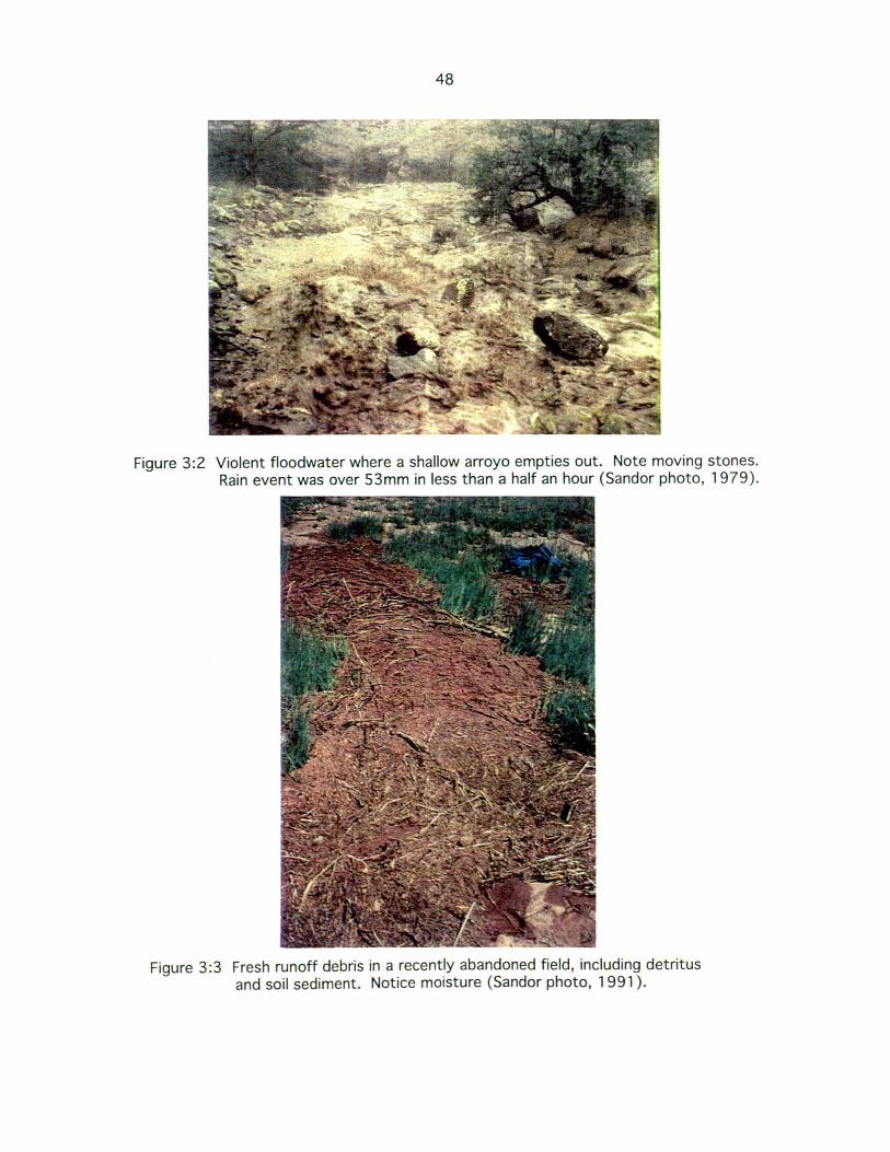
48
Figure 3:2 Violent floodwater where a shallow arroyo empties out. Note moving stones. Rain event was over 53mm in less than a half an hour (Sandor photo, 1979) .
Figure 3:3 Fresh runoff debris in a recently abandoned field, including detritus and soil sediment. Notice moisture (Sandor photo, 1991).

49
Zuni runoff farming parallels this natural process it its efforts to develop a field to grow
crops. It appears that partial damming fosters a positive feedback process of deposition. On
the axis of relative impacts on the landscape ecology of agricultural practices, this is
opposite the effect commonly associated with agricultural interference of the natural
environment.
So far discussion has mainly centered on arroyo-mouth fields. In other settings it is
possible to utilize larger areas for crop production though other efforts are required to
create the favorable flooding conditions. On large shallow arroyos which travel for a long
distance on a large fan, the stream channel is first dammed to liberate the water onto the
gentle surrounding slopes. This overland flow is then captured in field soils with a series of
check dams. Hack classifies this type of farming agriculture of the flood terraces4 of large
arroyos. This technique is most effective when the arroyo remains shallow enough so that it
is not too difficult to cause overbank flooding. This requirement explains archaeological
features of check dams within stream channels and the more elaborate stone lined channel
beds such as those at Mesa Verde.
In his thorough pursuit of food and culture of the Zuni, Frank Hamilton Cushing
records his observations of Zuni agriculture. In his sketch of a Zuni cornfield he provides a
view of how such a set of dam features may be fit into the topography to farm larger areas.
Figure 3:4 is a diagram from the turn of the century of the orchestrated overflooding
described above. It leans toward what Stewart calls a herringbone arrangement where
obstructions in the stream bed turn out the water from the main channel at various points.
The water is used to moisten field sections as it flows less forCibly down the hillslopes. The
diagram is also important because it provides insight into how larger acreages can be
developed and therefore provides historical data to support the archaeological determination
that large acreages of farmland were necessarily developed to support a large and self
sufficient Zuni population during past centuries. Though the scale is ambiguous in Cushing's
diagram, it clearly opens the option of development of greater acreages than the more
geomorphically specialized arroyo mouth fields. Notice also from the diagram that the Zuni
do not separate the endeavors of agriculture and religion as we do.
Another related technology, further along on the spectrum of transformation of the
landscape is the development of contour terraces for field areas to plant crops. Stone walls
are constructed in strategic locations perpendicular to the slope in areas of shallow soils.
4 A stream "flood terrace" is a geomorphic term for the fairly level areas on each side of a waterway built up by lateral overbank flooding and subsequent downcutting of the stream.

50
Figure 3:4 1884 diagram of a plan for a Zuni cornfield by Frank H. Cushing showing checkdam arrangement (Cushing, 1920).

51
Deep sediment builds up behind them. They are present in the Zuni area mostly as
archaeological remnants suggesting that this labor intensive method may have been more
emphasized in the past:
Contour terraces are also found clustered together, often in a
patterned array on gentle to moderate slopes. Unlike check dams,
however, most terraces appear pre-historic in age. They represent
widespread use of surface runoff irrigation for cultivating crops
during the pre-historic period. (Rhode, 1990:117).
Hack, however, also notes the use of artificial terraces in drainage ways at Hopi in the
1940's. He calls them Trinchera fields. Rhodes uses the conclusion of Sandor's work on
prehistoric terraces to the South of Zuni at Mimbres to explain the advantage of this
technology, "The use of contour terraces stabilizes moderate grade slopes allowing enough
soil and moisture to build up to grow crops" (Sandor, 1990:79) (Figure 3:5). In Rhode's
study under the description of features found in valley margins at Zuni, he describes a forty
meter long contour terrace on the edge of a bench with retained sediments behind the wall
approximately 40 to 60 cm deep (Rhode 1990:95).
32
E
25 31 I-« surfcce > w --1 W 30 r""---"",<---
o 5 10 lS 20 25 DISTANCE (m)
Figure 3:5 Increased A horizon thickness for some prehistoric agricultural terraces (Sandor et aI., 1990).
In addition to those types of farming already described, arroyo mouth, flood terraces
of large arroyos and terraces or stone terraced fields there are other techniques that, though
used less extensively, nevertheless tap into unique settings to expand the range of
exploitable geomorphic locations and therefore spread the risk of overall crop failure. One
such area is the actual channel floor of large waterways. Kintigh notes of arroyo bottom

52
farming, "even the sandbars in the bed of the river are utilized" (Kintigh, 1990:90). Many
of the bottoms of large arroyos and small rivers are lined with very coarse sediment from
raging flows that occurred in the past. It is not uncommon in this variable environment that
these stream beds are at present only dissected by much smaller intermittent streamsS.
This stream can be dammed and diverted so that its flow spreads over a favorable large flat
area such as a sand deposit at a large bend in the arroyo gully. Though these areas have
characteristics which may provide a more consistently moist soil for crops, they are
subject to complete destruction by a raging flood event.
Another type of floodwater farming is the use of overland flow which has not yet
entered into a drainage stream. In many areas it is possible to simply position crops at an
advantageous lower position where hills lope wash will flow over the surface of the field
before entering any channel. These are usually broad gently sloping areas. There are
observations of small stone lines in these settings, which presumably were check dams
positioned to guide the overland flow of these mild slopes. There is also evidence of
temporary shelters or field houses near fields which among other practical purposes,
allowed farmers to observe fields under flooding conditions protected from the storm. The
principle is simply to observe the flow of water down the slope and later make modifications
to the surface to bring a greater amount of flow to the field area and to make constructions
within the field for a more even wetting of the field soil during the next flood event.
Though these features are generally in disuse today, this method is important because
of what appears to be an adaptation to more current means of agricultural production. Many
farmers talked about utilizing this moisture yet with the loss of knowledge of check dam
techniques and the reduced desire to invest the labor for constructing stone, brush and earth
dams, some farmers today employ plows to a similar ends. In the summer of 1991 farmers
talked of constructing ridges, furrows or ditches to assist in capturing slope wash. Rhode
(1990:53) notes this modern Zuni practice is "functionally identical" to the checkdams that
traditionally guided waterflow. Ridges are plowed up to guide water toward the field which
otherwise would continue downslope without crossing the field and furrows are plowed
perpendicular to the slope at the upper end of a field to disperse the flow laterally before it
moved over the field area. Farmers also mentioned plowing up embankments at the far end
of a field to halt water flow and cause back-flooding of the field sometimes including linear
5 This change could occur with natural shifts in rainfall amount and distribution. On the reservation at this time non-flowing arroyos may be the result of a lowered water table and increased down-cutting spurred by the over exploitation of land this century.

53
border embankments to enclose the field6. These methods are also mentioned by farmers
using water from modern irrigation projects. By carefully noting the way water moves on
the field during flooding, adjustments can be made before the next irrigation to insure the
water wets the field more evenly. These procedures are important because they represent a
carry-over of traditional irrigation knowledge to current circumstances. In the traditional
context this process represents the direct use of accumulated empirical knowledge to solve
agronomic problems.
Lastly, in the broad valley of Galestina Wash in central area of the reservation I
observed another interesting principle of floodwater farming that exists in a modified
version today as well as in past descriptions of Indian maize farming. Wind blowing across
this open area carries sandy material until some obstruction causes it to drop out (two
months of the year, April and May, are referred to by Zuni names characterizing the
severity of sandstorms that occur at those times). Barbwire fences, living shrubs, dead
brush and even plowed ridges will accumulate sand deposits. It appears from direct
observation of Zuni fields and from information from farmer interviews that such deposits
have been consciously fostered for the general purpose of developing a field surface? The
next section on ;soil repercussions of Zuni practices will discuss the beneficial accumulation
of a sand layer on the field surface. However, for now it is important to note that sand ridges
are very effective for slowing or stopping overland flow and for the absorption of water.
Cushing in his selected writings on Zuni gives an intriguing description of the
preparation of a new field which includes the construction of sand ridges to mark the field
boundaries (see chapter 5). In Stewart there are several photos of Hopi land that show
fields that have clearly taken advantage of eolian sand deposition-- even to produce terraces
(1940:331-333). Hopi land is approximately a thousand feet lower in elevation and
somewhat drier than Zuni land which explains why much of our information on these
methods is from Hopi. Less vegetative cover and much open, unsheltered space means that
6 This method is an extension of the concept of Zuni waffle gardens where small raised squares less than one meter square are used to hold water for garden crops. There are examples of squares as large as livestock corrals along side the Zuni river in historic photographs as well as a description of similar fields fed by hollowed log pipes from the Nutria spring in Cushing (1896:).
? Blowing sand has its drawbacks too, especially for young com plants. Older descriptions of Hopi farming mention Hopi and Zuni people setting up sticks and rocks around young seedlings for protection from sandstorms in open areas. Fostering sand deposition around the groups of com plants however, is a desirable accomplishment to Indian farmers (it's effects on maize growth are now being investigated). This is also the reasoning behind leaving tall stalks standing in the field, and planting next to them according to Indian farmers.

54
soil drifting is important there. It appears at Zuni that they did practice sand field methods
though there is an abundance of alluvial fan features that benefit from the greater rainfall of
the Zuni uplands which often are the high end of watersheds in the eastern half of Zuni land.
The successive movement of sediment by wind and water was a point that emerged from Zuni
interviews in the summer of 1 991. More will be discussed on this topic in the section on
interpretations of data from Zuni farmer interviews.
Seepage fields
So far three major categories, dry farming, irrigated agriculture, and floodwater
farming have been discussed. It is necessary also to mention seepage field agriculture to
bring out a few important points that will round out discussion of Zuni agriculture. One
principle type of seepage that occurs is at mesa sides, illustrated simply in Hack (Figure
3:6). Because of the discontinuity of the material through which the water is flOWing,
there will be accumulations which initiate lateral flows that either emerge as springs or
remain near the ground surface as seeps.
Figure 3:6 Use of mesa side seepage fields by the Hopi (Hack, 1942).
For the type of seepage field illustrated schematically by Hack the ideal intake area is
a sand dune field over permeable sandstone. The result would be no runoff and therefore
infiltration of nearly all rainfall (there is greater rainfall at the higher elevations of some
mesa tops). Of course a less permeable geologic strata such as shale where percolating
water can accumulate is also needed, however these are common in this region. If the seep
was shallow crops could utilize the moisture as illustrated in Hack's diagram. The Zuni have
historically utilized the deep roots of peach trees to tap these often unseen sources. Rhode,

55
who discusses quantitatively the agricultural features at Zuni, notes peach orchards
predominately at the base of Dowa Yalanne , and also near the Zuni Buttes and on a bench on
the side of Pie Mesa (1990:104) (Figure 3:7). He notes from the General Land Survey
and other sources there were over 310 known acres of peach orchards on Zuni land in 1893.
To make use of the natural technology of deep tap roots and also the perennial hardiness of
these woody species to take advantage of this subtle moisture source on the landscape, is
consistent with the overall character of Zuni agriculture. Most interesting is the fact that
peaches are an old world crop. Such selection of technology to harmonize with an
agricultural worldview demonstrates the adaptiveness of the agricultural system and the
society's ability to maintain indigenous values and priorities (Figure 3:8).
Soil Repercussions
Developing a soil
This section is meant to illustrate the impact that Zuni farming methods have on the
soil. This is a logical extension of the discussion of field location in relation to soil type, but
including now the manipulation of surface soil by agricultural techniques. The floodwater
farming techniques described show the emphasis on fostering the deposition of coarse
alluvial sediment. The stone lines themselves cause deposition of floodwater bedload
material which bounces along the surface in the flood wash. The strategic placement of dams
causes leveling of the larger field surface because water is spread over the land surface and
silts in depressions. Recall that this is an enhancing effect: water in turn spreads more
readily during the next event, when there is an even surface. The purpose of all of the effort
of the farmer appears to be to develop the soil of the field. These techniques mimic natural
soil processes
Guy Stewart makes the point that "Finley noted that the soil in check dam areas, in
most cases, was a rich highly organic clay loam of fine sandy loam which should have been
adequate for excellent crop growth" (Stewart, 1940:210). In Sandor et al. it is noted that
the "most visible change in prehistorically cultivated soils is increased A horizon thickness
resulting from deposition within agricultural terraces (Sandor, 1990:79). At Zuni,
terraces were not emphasized, however, the principle of the checkdam fields is the same. In
the Mimbres study there emerged a very interesting correlation concerning the placement of
these agricultural terraces: they were below or on land surfaces with strongly developed

56
Figure 3:7 Historic Navajo peach orchard in Canyon del Muerto (Hill, 1938).
Figure 3:8 Modern runoff agriculture with plow furrows. Field 75, Galestina Wash, in early August, 1994 (photo by J . B. Norton).

57
argillic (Bt) horizons. This observation connects the earlier discussion of the location of
field 133 on the hill profile. The technology consists, essentially, of placing the field at the
end of the shallow argillic and fostering deposition of sediment that may have naturally
occurred a short distance downslope.
One advantage of developing the field soil where there is a shallow less permeable
clay horizon as opposed to simply utilizing the thicker topsoil downslope is the enlargement
of the area where water is retained high in the plant root zone. This phenomena of holding
water at the depths of the crop roots works in combination with the reduced evaporation that
comes from having a layer of sand on the soil surface. Together these alterations work to
increase the likelihood of sufficient moisture for maturing crops. Hack writes in 1942,
In Hopi sand dune agriculture, the loose surface of the sand acts as
a dry mulch which invites absorption of the rain and which also
prevents evaporation ... only a thin layer of sand dries out and the
sand below will remain saturated for a long time by the water held
up by the less pervious soil below (Hack 1942:32).
This Indian principle is also illustrated in the planting procedure described for the Hopi that
involved the digging of a hole in the sand down to the harder subsoil and placing handfuls of
mixed loamy soil with the corn seed. The hole is then partially filled with sand. The mixed
soil provides a favorable soil environment for germination, the depression captures
overland flow and the sand mulch protects against evaporation. More will be discussed in the
results of the farmer interviews about what is known concerning a sand mulch on the soil
surface as it emerged in much of the discussion with Zuni farmers. It is not uncommon that
once a topic is discovered by the outsider, almost immediately there is evidence concerning
that point everywhere. Now that we have looked closely at Indian agriculture, there is a
richer significance for all references to water and moisture related to agriculture including
movement, accumulation, cycling, storage and its different forms such as vapor and dew.
The natural principles are woven into much of the Zuni cultural fabric and there are
many manifestations of them in anecdotes, myths and sacred teachings. These are the books
of a non-literate culture. Hopi priests according to Guy Stewert in 1940, did not like the
use of steel tools because it "was likely to make the seed suffer drought ... " (1940:331).
There is a scientific backing to the concern that plowing, as done today, opens the soil to
drying effects. It is very interesting that the Zuni consider the surface of the earth as the
surface of a womb from which they as early people emerged. Such a view has led to
reluctance for oil exploration which would require drilling of deep wells. This worldview

58
certainly provides reasoning behind the use of the digging stick. That instrument is well
suited to move the fresh new soil deposited on a well developed field. Notice the blade length
is nine and a half inches and recall the advantages of the pueblo maize varieties with an
elongated mesocotyl.
It is very informative to look at the entire chapter on runoff agriculture by Martin
Fogel in the USAID study entitled "Watershed Management in Arid Zones: A Prototype Short
Course." It was held at Saltillo Mexico in 1975. The chapter discusses management options
for runoff agriculture based on modern analysis, exploring everything from watershed
characteristics to strip-cropping techniques. Although certainly informed at some level by
worldwide observations of indigenous practices, the purpose is clearly to develop the logic
and design of runoff agriculture from our agronomic view. The similarities of the
conclusions of that study to aspects of the Zuni system are at times striking. Under
watershed characteristics it is noted about the soil,
The soils of the runoff area should be carefully examined. Most
clay soils absorb water slowly. Shallow soils over clay or
impervious rock yield high runoff after the permeable layers
become filled with water. Deep sandy soils and soils with good
structure will absorb water rapidly and release it slowly. Sandy
or silty soils are likely to be erodible, especially on steep slopes.
Sometimes soils examined in the sides of gullies or cut banks
(Fogel, 1975:132)
Zuni checkdam methods help develop this strata of sandy soil. Also it appears damming near
the arroyo mouth may shift the loci of fan deposition upslope on top of the shallow, less
permeable soils of the footslope. The last line in Fogel's observation points out how one
might go about gathering empirical information for understanding subsurface texture
characteristics. Certainly by examining the sides of arroyo cuts over a long period of time
an understanding could be developed of the sedimentation/stratification process. One can
readily see thin wedges of different textured material on top of one another in the soil pits
dug and described in this study, each corresponding to a different intensity flood event.
Stratigraphy is the analysis and story telling of episodic occurrences manifested in the soil
profile.
In Figure 3:9 there are schematic diagrams of two stream channel patterns and
adjacent fields. The left diagram is one possibility for various types of structures used in
water spreading systems, from the prototype short course of USAID. The right diagram is a

C""
YU
CI
Spr
eadi
., O
ih
Dlh
--,... ~
i"'" "
t',..,
~
, O~tlll'~.
""'1;1
J
...,
...
p;t: C(~ !(
\(
r..
C·
•
/! S,ill
w2r
lo
r w
2lcr
I .... JPuu~
w,tr
r It
••
uhra
c4
II s
hu
-••
Ite
It .i
II N
t 1ft"
.'Z.
.~
\~~
--~
.~
J///?
-. ~II
~1~~
~.!~
~ '.
, ~-l.:
~ ~-:
:::::)
l!i
'" ~~~
\~~
\ ~;,..
-:.-::
:::..~
•• ~ J.!
o' f.~
\:~~~\~~,~~. "
'P' :~~ .. (i\
AJ\,
.)~hl
l~~ I'~~\~
~: \\ .}\
\\\ '\\~~
. ::::::~ q
~~
~r~~
~ 2:~1I
II -II. \
., \\ \
I ,.,\
". '.'
.,.:
\'''~-:''J
';~n1iWi;.
'M ~ /I~III
I\ \YI~\ '
\\j~ .. i,\h
·<f'\-
... ~~1
!\\'~I
~I/
IIJ 'I/ I \ ,
~I · t
},,,
'\.
i ' ""
'r~'
,£,L
VN
1/1/" !<
)~~ !
I!~_~ '
:;~&~.
.
. ... , -~
~',\:\
... ~.~ ......
... ../'
Ii' -.
~~~;'
t~ .... ""
\'\1
".
?'~. ~~
': /,.. E
..... · .....
. -~ . ..-
iii
~"(_:.
..-:::
<.
//
.-.:::
, ...
-
--'
-"#
" '-
--
~~"",.
..-..
. :;--
'\ .
!~n::.::
:---"
'... _
._
!~~-'~~'
2~':~ ';
I \,.)
~.~~
~~
" II
V-:\~
/ .
I ••
,~la ~~_
" ,
'/.)",
.,\.~
,,~ ......
.. 1
!·
)..
/".,
, ~
/. "~. ,
,",,,
,,,,,-
, "--
. .'
>',
I ••• 1,
, ~_"'
i~;-~\
:/", ...
... UP
,1l i \
'~~t., =-
--~rB.::
~-::::::
'.
-.;\ "~'
'''1a !i1¥~
f..:;t-
': ...
.. "'''',
I, [)
=~
ii. .. '
,'
\/ ,)<
,1 i~
. <',
~:::.
:, /'
>.~.
. J
, •
I I
....
If. }!~_
· ·
/, '
,,* <
' •
" -:s
:::-II
, '~., "~"
-l •
~'':.L
~ i!
/ .. ~ loX
, '~,r(I
"'\"~\ '
~~
~~~
!i 40
,:...
I /
l ";~~.1
?' I
Jr Ii ,
.. ~ ~I
"~
...~-.
. :!
/,.
''tt I
• \
t ~
I' .
. ~
F /
" ,/
1// '\
:~~~ ',tf.
.'~~.~~. 's.
~~\\~~
:1 /
' 7'-'
-/' 'I .
. '~,
'~
~~ .:
I,,,,
1"
. >1>
;;. ..u
'i
/ ~
. ,
. {
..... ~
.~::.
. /.
.. '.
.J!!,!
; ..
""
II I
I /
,"",}'''~~~~
'''''ii,) ,
~,
,/
.~.,'~~::::.
" '~:'~
iI' ",1
'
.-',Co
'."
"i';;
-i,
._!:.:
-.:.':
.~' .
I • _
_ _
~i:.:.
:.::.
....
Fig
ure
3:9
C
ompa
rison
of
field
and
che
ckda
m a
rran
gem
ents
rel
ativ
e to
str
eam
flow
, fo
r th
e
capt
ure
of s
trea
m f
lood
wat
er (
mod
ified
fro
m F
ogel
, 1
97
5 a
nd C
ushi
ng,
18
84
).
U1
tD

60
version of the plan of a Zuni corn field sketched by Frank H. Cushing one hundred years
earlier.
Fogel noted the propensity for steep slopes with loose sands to erode. Once water
flow, in this environment, is given the opportunity to concentrate its energy (usually
through some disruption of conditions that allow for energy dissipation such as removal of
surface vegetation in the watershed) fairly dramatic downcutting and headwater cutting
could be the result. In Stewert's article "Conservation in Pueblo Agriculture" the
conclusion reached is that floodwater farming methods, such as those of the Zuni, work to
impede these erosional processes. That conclusion was from the senior soil scientist of the
U.S. Soil Conservation Service made in 1940. The practices of damming the arroyo to keep
it shallow, spreading the fan water with checkdams and furrows, fostering the deposition of
a sand mulch, stone and earth terraces and other technology described, led many observers
to the conclusion that the practicing of Indian agriculture helped keep the land stable (G.
Stewart, 1940:208, Stewert and Donnelly, 1943:226, Rhode, 1990:85, Ferguson and
Hart, 1990:37). This is an important observation since it is an accepted notion in Western
agriculture that there will be a necessary decline in agronomic characteristics of the soil
with the cultivation of the land. The reclamation of eroded slopes and the build-up of topsoil
are characteristics which appear in traditional farming from Mesoamerica to the Sehel and
the Middle East. One can explore more detail of the conservation issues of Pueblo
agriculture in the studies referred to here.
Lastly, one might consider the impact of Indian practices on soil fertility. There is
very little base line data on sediment and field soils from which to draw conclusions.
Western understanding of the overall semi-arid environment is scanty, though there are
some in-depth studies. In such a variable environment studies often have unique
circumstances. The research findings of Norton and Sandor will be important to getting a
view of the nutrient repercussions of some of Zuni agricultural practices. Preliminary
findings from analysis of sediment in the drainage valley of field 133 show "Total nitrogen,
nitrate, ammonium and organic carbon concentrations all correlate strongly with silt
content (but not clay) across the sampling area (r=0.7 to 0.8), suggesting depositional
processes may play an important role in replenishment of soil nitrogen and organic matter"
(Norton and Sandor, pers. comm.,1994). Pueblo corn cultivation is a unique scientific
exploration because it is an attempt to unravel the puzzle where the result is already known:
Indian peoples in this region have grown a beautiful supply of grain with these methods and
still produce impressive ears in deficient circumstances today without fertilizer, organic or

61
inorganic. Some of the possible avenues for understanding the nutrient enhancement of soils
with Zuni techniques will be discussed with the results of Zuni farmer interviews.

62
CHAPTER 4: ETHNOSCIENCE THEORY AND METHODOLOGY
Cultural Ecology
Unilinear evolution
The refined thinking of Julian Steward on the relationship of society and the natural
environment produced the core insights of cultural ecology on which enthoscientific inquiry
and this research rests. A hypothesis underlying this research is that traditional cultures
which have existed on a finite resource base for a long period of time, contain a body of
knowledge that is the basis for successful adaptation to the particular environment. Since
the Zuni people have lived on the same land for more than a millennium, important
ecological observations ought to exist within the culture. The methodology described here
was to explore suspected knowledge of soils in particular. In order to know Steward's view
the of interaction of culture and nature it is valuable to understand his contributions
concerning the diverseness of human societies. What follows is a brief outline of theoretical
developments that contributed to Steward's notion of cultural ecology.
Nineteenth century social theorists and philosophers were interpreting a body of
information about different cultures (most from cultural contact during colonial
exploration) in an effort to explain the diversity of human society. There was interest in
uncovering the sequence of cultural stages from Paleolithic hunters to industrial
civilization. This was known as the science of universal history, and it was based on the
concept of unilinear evolution. Early anthropology struggled with interpreting findings
about other cultures within the greater framework of this broad social theory. One effect of
this effort was to provide a body of information which supported the self-serving ideology of
the conquering cultures by helping to define more clearly the lower "natural stagesU of the
universal cultural progression. This emphasis with regard to the study of society is
expressed in anthropological history as the search for nomothetic theory or a theory that
would uncover the natural laws that govern the progression of human society. With
anthropology emerging as a fledgling discipline in the early 20th century there was an
overemphasized concern with gaining "scientific" status in the tradition of the natural
sciences. This concern enhanced the preoccupation of uncovering the causality of cultural
configurations.

63
Universal history provided a framework to explain difficult social questions. Its
influence was clear on the capacities of different racial types and the position of white
culture in relation to others and to nature,
In the view of many eighteenth century social philosophers, the
explanation of why the Iroquois did not behave like Frenchmen was
the Indians' self-imposed failure to think their way far enough out
of the state of nature (Harris, 1968:39).
In 1877 Henry Lewis Morgan, a lawyer from upstate New York, published his work,
Researches into lines of Human Progress which laid out the cultural stages through which
human society progressed, from lower savagery, to savagery, barbarism and on to
civilization. He included representative examples of societies and correlated them to the
racial order of black, Native American, Asian and White races respectively. Racial
determinism was a parallel theory explaining the perceived halted development of different
indigenous societies. In politics this view, which incorporated Darwin's notion of evolution,
had a chilling practicality in light of the manifest destiny being carried out by the U.S.
military in the interior of the North American continent in the late 1800's. Social
Darwinism was based on the premise that the competition for property resulted in the
elimination of the ill-adapted and also contributed to the preservation of racial soundness.
Of course the economic and political exploits of European merchants and monarchs during
the previous century, and the view of indigenous people that it required, made it difficult to
conceive of a path of development other than a universal progression with European
industrial culture at the top. Indigenous cultures along with their stable and pristine land
resource, were dispensable. They still are based on the priorities of the industrial economy.
These theories, which ranked societies, were not asides to the intellectual discourse
of the time, pet theories fostered by the industrial elite. At deeper levels of epistemological,
philosophical, and scholarly thought the notion of the stratification of human sociaV
psychological existence was crucial. A pivotal figure in the social thinking whose work
would eventually spawn the discipline of sociology, was the French philosopher Comte who
made clear the relative positions of non-western thought in his proposed secularized
spiritual order; science metaphysics
______ theology monotheism polytheism fetishism

64
It is not difficult to understand why knowledge systems of for example the Pueblo peoples or
the indigenous cultures of West Africa were overlooked given this epistemological order
which puts their mode of thinking at the bottom of a universal progression (see Warren
1989) .
Cultural ecology
Reacting to the theoretical absurdity of racial determinism, Franz Boas emphasized
that particular historical conditions of each culture contributed to different cultural forms.
He also makes a huge methodological break by rejecting generalizations made by social
philosophers who never sought to experience other cultures. Boas stressed empirical
evidence as the basis for understanding cultures "from within". Historical particularism
(belief that individual historical circumstances influenced cultural development) and the
"emic" approach with an emphasis on empiricism led to the notion of cultures as individual
entities that can best be understood by scrutinizing them in their individual contexts.
As more and more ethnographic data accumulated it was clear that material condition
affected sociocultural life and that material condition was related to the environment by
subsistence strategy. The question hinged on which one was ultimately responsible for
specific cultural features. One position was that the techno-economic situation was the
basis for a interpretation of culture as argued by Leslie White based on his comparative
study of energy usage in societies. His comparative approach focusing on a basic ecological
variable, energy, foreshadows the method of ecological anthropologists who approach human
society as an actor in the greater biophysical system. Also White's fierce opposition to
"anti-evolutionists" brings the valuable idea of evolving culture renewed respectability
-important groundwork for Steward's emphasis on cultural adaptation.
The other important notion resulting from a search for the determining factors of
culture is environmental determinism. Some anthropologists were making generalizations
of geographic determinism including Meggers who sought to correlate cultural development
(in terms of sophistication) to soil fertility. Another was Kroeber who pursued the idea of
definable culture areas in North America and showing that they strongly corresponded to
environmental regions. Interestingly in both cases the conclusion was the idea of
environmental possiblism --an idea which strengthens the cultural determinist viewpoint
because environments only impose boundaries, and therefore cultural innovation is the
important variable for the features of a culture.

65
Julian Steward presents chapter two, "The Concept and Method of Cultural Ecology"
in Theory of Culture Change (1955). A clearer understanding of the whole issue of what
determines culture emerges because of a few simple insights presented by Steward. The first
is that the monumental theoretical achievement of the nineteenth century, evolution, need
not be constrained by the nomothetic and racist position of a belief in universal stages of
human development, " ... evolution can be considered an interest in determining recurrent
forms, processes, and functions rather than world-embracing schemes and universal
laws, ... " (Steward, 1955:19) By combining the ontological assumption that cultures
evolve, with Boas's notion that distinct cultures are products of their own particular
historical conditions, Steward presents multilinear evolution.
This approach proposes individual explanations of different cultural processes
instead of universal generalizations. Put simply, Steward questions why cultural creativity
itself and the natural environment can't both be responsible for culture. Putting these ideas
together Steward arrives at the idea of cultures adapting to their natural environment
through a process of cultural change, being both influenced by the environment and
influencing it via cultural inventions or adoptions;
I have endeavored in various studies to demonstrate how cultural
ecological adaptations--the adaptive processes through which a
historically derived culture is modified in a particular
environment-- are among the important creative processes in
culture change (Steward, 1955:21).
The theory more generally sees human societies as searching for a niche in the surrounding
natural system --only the process involves cultural (including technological), rather than
biological modification and therefore includes the development of shared assumptions and
beliefs of the social group.
Methodological implications of Steward's theory also built on past theoretical
achievements. The careful analysis called for by Steward of the processes of each complex
cultural-ecological situation (rather than vague comparisons), is consistent with Boas's
cultural relativist position which demanded a strongly empirical approach to understanding
each culture. Both the idea of collecting measurable data on human ecology and the idea of
emic understanding of local ecology would become important topics in anthropology. The
latter is the basis of the ethnoscience methodology utilized in this study. Before discussing
the particulars of that approach a few points need to be made about the importance of the

66
belief and value system and its influence on behavior with regard to the natural
environment.
Values and behavior
It is the interaction of biological variables of human society, primarily the need for
food and food security (as well as other material needs) with the less quantifiable though
extremely important collective assumptions, beliefs and values which we call culture-
that is at the heart of human adaptation. This weltanschuaung is formulated based on a slow
collective process of cultural evaluation and re-evaluation of observations of the natural
world including the repercussions of human behavior, which becomes incorporated into and
shapes cultural views. The rate of change of cultural values and beliefs, especially at a
fundamental level, is slower than the time span of individuals. In turn then, culture
influences behavior. Every day we respond unknowingly to shared cultural norms of our
own groups. This interaction is where the lens of cultural ecology is focused. Steward
notes,
Cultural ecology pays primary attention to those features which
empirical analysis shows to be most closely involved in the
utilization of the environment in culturally prescribed ways.
(Steward, 1955:37).
and later in an applied form by Netting,
The thrust of ecological inquiry is to distinguish more adequately
those features of social organization and cultural values that are
closely related to the human use of the environment as opposed to
those that are less relevant. (Netting, 1986:99).
One specific aspect of the cultural ecology approach, somewhat reversed, but also
useful in anthropological analysis is, "the application of ecological principles and concepts
to explicitly delimited aspects of human social and cultural life for which they are
particularly appropriate ... " (Geertz, 1963:6). Agriculture is the most intimate interaction
of human endeavor and ecology. In his monumental work Agricultural Involution: The
Processes of Ecological Change in Indonesia (1963) Geertz demonstrates the value of these
principles in both theory and methodology. With an understanding of the ecological concepts
of biotic communities, Geertz discerns that it is the aim of Indonesian farmers to replicate
the natural ecosystem in the designing of their agricultural plots. This insight not only
explained aspects of behavior in agricultural communities but also opened up the whole

67
notion of Indonesian farmers' knowledge. On another level, Geertz's overall contribution to
anthropological theory was that he saw the primary job of the anthropologists as describing
phenomena in detail in order to explain its real and symbolic meaning, using the advantage of
both an insider and outsider point of view.
At about the same time Levi-Strauss was writing on the complex meanings behind
indigenous practices and symbolism. The importance to cultural ecology is that he sheds
more light on the feedback relationship of environment and human behavior. Levi-Strauss's
notion was that groups of people formulate "ideological constructs" in their minds based on
the reality they perceive,
When confronted with technological and economic conditions linked
with the natural environment, the mind does not stay passive. It
does not merely reflect upon these conditions; it reacts to them and
works them into a logical system. (Levi-Strauss, 1985:110).
From this construct they determine logical behavior. Understanding how a people sees itself
in relation to the natural world (as reflected in cultural symbolism including in ritual and
myth) can be very informative for understanding why they do what they do. There was now
a theoretical basis for understanding that there is a relationship between seeing the tropical
forest as a complex web of life and having an agriculture that reflects that view.
Ethnoscience
Indigenous knowledge
Even before Levi-Strauss was writing about the complex cognitive processes of
"primitive" culture, some field work was being done that would change the modern
perception of indigenous understanding, especially as it relates to ecology and agriculture.
In the 1950's Harold Conklin returned from his fieldwork with the Hanunoo in the
Philippines to study Western botanical classification to better document Hanunoo
understanding of their natural environment. He subsequently determined that they had 10
basic and 30 derivative soil and mineral categories as well as a selection of more than 1600
useful plant types including 430 cultigans (Conklin, 1957). Their swidden plots,
unrecognizable to modern agriculturalists, were replacements of natural ecosystems. Plot
management was based on complex natural cycles. Thus, this work began the documentation
of ethnoscience, based on the emic and empirical perspective put forth by Boas. Since

68
researchers began to look for them, indigenous classification systems have been documented
with regard to ethnobotany, ethnomedicine (and ethnoveternary medicine), and more
recently ethnopedology (soils). In many cases the degree of understanding of the local
ecology has been astonishing--enhancing and sometimes challenging modern classification of
local phenomena. In the example of the Hanunoo, plant categories outnumbered by more than
four hundred types the taxonomic species into which the same local flora was grouped by
systematic botanists (Conklin, 1957). Though this important information from traditional
producers is being increasingly documented today, the storehouse of indigenous knowledge is
eroding in many places as modernizing and exploitive forces unravel the fabric of non
Western societies.
Nearly a decade ago several books explored the agroecology of small farms, breaking
out of the constraining paradigm of industrial agriculture. These works brought scholarly
and scientific attention to a subject that is important to understanding indigenous
agricultural knowledge. The edited volume by S.R. Gleissman, Agroecology: Researching the
Ecological Basis for Sustainable Agriculture (1987) and M. A. Altieri's book Agroecology:
The Scientific Basis for Alternative Agriculture (1987) both contain examples of efficient
effective indigenous agricultural techniques. Wilken provides solid documentation of a large
number of indigenous soil and land management techniques in Good Farmers: Traditional
Agricultural Resource Management in Mexico and Central America (1987). Atte (1989)
provides a thorough review of indigenous knowledge examples that emerge in literature on
African agriculture.
Work has emerged in recent years utilizing the concept and strategy of ethnoscience
research for the purpose. of revealing indigenous knowledge systems to the standard western
scientific view. A definition of these systems is the starting point for a brief outline of
different avenues of investigation,
Indigenous knowledge systems relative to agriculture, are bodies of
knowledge that develop as a certain cultural or ethnic group strives
to meet subsistence goals in a particular ecological setting.
Information is collected from astute observation of the local
environment to solve agricultural production problems. This
information is passed on through generations and thereby becomes
refined into a system of understanding of natural resources and
relevant ecological processes. As a result of this process, knowledge
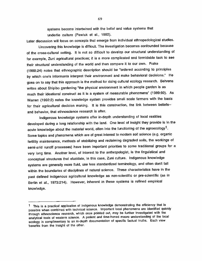
69
systems become intertwined with the belief and value systems that
underlie culture (Pawluk et aI., 1992).
Later discussion will focus on concepts that emerge from individual ethnopedological studies.
Uncovering this knowledge is difficult. The investigation becomes confounded because
of the cross-cultural setting. It is not so difficult to develop our structural understanding of
for example, Zuni agricultural practices; it is a more complicated and formidable task to see
their structural understanding of the world and then compare it to our own. Frake
(1988:24) notes that ethnographic description should be "ordered according to principles
by which one's informants interpret their environment and make behavioral decisions." He
goes on to say that this approach is the method for doing cultural ecology research. Behrens
writes about Shipibo gardening "the physical environment in which people garden is as
much their ideational construct as it is a system of measurable phenomena" (1989:92). As
Warren (1992:2) notes the knowledge system provides small scale farmers with the basis
for their agricultural decision making. It is this construction, the link between beliefs-
and behavior, that ethnoscience research is after.
Indigenous knowledge systems offer in-depth understanding of local realities
developed during a long relationship with the land. One level of insight they provide is in the
acute knowledge about the material world, often into the functioning of the agroecology 1.
Some topics and phenomena which are of great interest to modern soil science (e.g. organic
fertility maintenance, methods of stabilizing and reclaiming degraded soils, the workings of
semi-arid runoff processes) have been important priorities to some traditional groups for a
very long time. Another level, of interest to the anthropologist, is the linguistical and
conceptual structures that elucidate, in this case, Zuni culture. Indigenous knowledge
systems are generally more fluid, use less standardized terminology, and often don't fall
within the boundaries of disciplines of natural science. These characteristics have in the
past defined indigenous agricultural knowledge as non-scientific or pre-scientific (as in
Berlin et aI., 1973:214). However, inherent in these systems is refined empirical
knowledge.
1 This is a practical application of indigenous knowledge demonstrating the efficiency that is possible when combined with technical science. Important local phenomena are identified quickly through ethnoscience research, which once pointed out, may be further investigated with the analytical tools of western science. A patient and time-honed macro understanding of the local ecology is complimentary to an in-depth documentation of specific factual truths. Each view benefits from the insight of the other.

70
Ethnopedological studies
At the onset of a study into a cross-cultural view of soils it is important to conceive
of the task broadly and explore all approaches uncovering information. Williams and Ortiz
Solorio provide a summary of the breadth of the possible avenues to get at indigenous
understanding;
Folk perception of soil properties and processes, folk soil
classification and taxonomy, folk theories and explanations of soil
properties and dynamics, folk soil management, folk perceptions of
the relationships between soil and plant domains, comparison
between folk and technical science, assessment of the role of folk
soil perception in agricultural practices and other behavioral
realms all may be encompassed under the term "ethnopedology"
(1981 :335).
The application of ethnoscientific principles to uncover indigenous knowledge
systems directly related to soil and soil management has produced intriguing examples in
recent years, especially on projects that include the perspective of a soil scientist.
Computer modeling was used to construct folk expert systems for soil management decision
making and for indigenous soil classification for Quechua speakers in highland Peru
(Guillet, 1989; Furbee, 1989). That system was developed and maintained with the
capture of eroded topsoil and addition of organic soil amendments. The cognitive study was
done in conjunction with a field soil study of the ancient agricultural terraces. The context
of the indigenous knowledge system is made richer by the findings of the soil study. With
respect to fertility and tilth ancient anthropogenic soils had properties favorable for
agriculture (Sandor, 1989) exceeding those of naturally occurring Mollisols. After fifteen
centuries of cultivation, traditional farming improved the agricultural landscape and
maintained the soil. These findings provide a unique example of documentation of successful
and sustainable land use, greatly expanding the time frame of studies on anthropogenic
effects on soil. That system illustrates the potential achievements that are possible with
indigenous approaches to understanding the agro-environment. A taxonomic tree of soil
related terms from one informant is shown in Figure 4:1.
In the Amazon Basin analysis of Kayapo cropping systems revealed the matching of
crops with specific soil microenvironments in the forest ecosystem along with the
correlation of specific soil amendments to particular plant species in a concentric ring,
swidden cropping pattern (Hecht and Posey, 1989). Swidden agriculture in the Peruvian

h:lllp'a :llIinlmllp'a h:lllp'a pum= licrr:I lupida
lamosa
y:m:lq h:lllp'a k'illu hallp'a
arenoso
~ nkko kaskah:lI nkko kuchu nrenos:I pcdrcgnl nUI'u akko
71
haJlp'a
)\ A ~,:Jt" ,',,,," ~!~ ""',,":;\'p" 1\
srcda hallp':I k'illi h:lllp'n llink'i= y:mnq hnll(l'n IIink'i greda yannq gredn IIink'j h:lllp'a IIink'j blanco grcdos:I llink'i negro
IIink'j amnrillo IIink'j rojo llink'i luqmq
Figure 4:1 A taxonomic tree of 46 soil terms by one Quechua-speaking farmer in the Colca Valley, Peru (Furbee, 1989).

72
Amazon also revealed soil-plant associations, in this case as the basis for Shipibo
classification (Brehens, 1989).
Studies of local agroecological knowledge in Africa have been occurring for some time
greatly adding to understanding of indigenous soil knowledge. The work of Paul Richards
(1985) on agricultural development and farm ecology in West Africa noted on-farm
experimentation by traditional farmers using natural variations on the landscape. Osunde
(1988) discusses soil evaluation, in the case of the Yoruba people based on physical
properties noted by feel, look, smell and taste of the soil. These properties are the basis for
indigenous soil suitability classification. Kerven notes observations of soil including
texture, color, heaviness are basis for classification in Zambia. Soil science consultant, Joe
Tabor, has conducted soil surveys in many African countries benefiting from the fact that
local people have their own classifications systems. Meeting with traditional farmers
allows Tabor to identify soils and expedite the soil survey process (Tabor 1990, 1992).
The exploration of locally recognized soil types for facilitating soil surveying was examined
in Sierra Leon and Tanzania (Tabor et aI., 1990; Acres, 1987). Indigenous knowledge
behind soil and water management and conservation have been reported for Senegal and Mali
(Carney, 1991; Ayers, 1992). Traditional soil terms have been recently researched for
four ecozones in Nigeria revealing in preliminary analysis, an elaborate soil classification
(Warren, 1992). The implications of beginning with these systems for rural development
efforts have been explored in several places (Chambers, 1985; Atte, 1989; Richards,
1985; Mosi et aI., 1991; Warren, 1992; Pawluk et al.,1992).
The project of the four ecozones in Nigeria included research by Karen Ann Dvorak
(1988) who has also produced an in depth study of indigenous soil classification in semi
arid tropical India which includes soil analysis of identified soils. This study along with the
Peruvian project with the work of Sandor are among the few studies conducted thus far that
include corresponding soil analysis.
The investigation of indigenous farming practices has often revealed techniques of
soil conservation and in such diverse environments as Nepal, Papua New Guinea, Mexico and
the Southwest U. S. (Subedi, 1989; Puri, 1980; Bocco, 1991; Nabhan, 1979, 1980). A
common characteristic of indigenous systems, where farmers can count on no external
support for the misuse of resources or agricultural failure, is the simultaneous emphasis
on utilization and preservation of the integrity of resources for agriculture. Bocco
examines these techniques in central Mexico, some of which are used as effective methods
for rehabilitating degraded or eroded soil areas. The potential of indigenous techniques for

73
improving the land are of interest to development researchers and planners because they
embody many of the principles now considered important for fostering successful
agricultural development (Pawluk et aI., 1992). The pervasivness of practices that
counter erosion has prompted Bocco to conclude the main principle guiding most techniques
is the management of sedimentation rather than erosion. (Bocco, 1991 :348). This is an
appropriate characterization of systems where unfavorable landscapes are transformed into
farmable land when field surfaces are developed with techniques that foster the build up of
the A horizon behind constructed terraces (Sandor 1989; Sandor and Gersper, 1988).
Eliciting soil terms
The preceding examples show the type of information that may be uncovered
pertaining to indigenous knowledge of soil and soil management. The studies discussed
included investigations of behavior as well more direct investigations of the cognitive
system behind soil and land classification. The emphasis of this project is on the latter.
Research conducted for this project was the first stage of ethnoscientific inquiry for
producing an indigenous soil taxonomy--the elicitation of native terms and their meanings
related to the domain of soil. This section is meant to present the principles of this specific
approach that have arisen from theory on classification and from individual case studies.
One important understanding is that observations are based on the local environment
and local cultural priorities. The western trained soil scientist conceives of soil
classification as having as an ultimate goal the complete incorporation of information of all
soils. This notion was in fact a major priority of the development of the U.S. soil taxonomy.
Indigenous classification is based on a small set of local conditions and specific concerns
while technical classification attempts to arrange information in a wide-scale, systematic
fashion that can incorporate new material from anywhere. Regardless of the varying
perspective of individual scientists this difference reflects the western cultural priority on
belief in universal natural laws and in an omniscient science which seeks to uncover those
laws.
There are several points about indigenous soil classification that have surfaced from
existing studies. Furbee, in her study of Quechua soil classification stresses the important
point that much of any knowledge system underlying behavior, may not be in the conscious
understanding of an informant. Collecting information from several informants obviously
allows for the emergence of commonalties in the response of individuals whose personal
experience and psychology vary. However, below the consciousness of the consultant one is

74
likely to find the principles that are shared by members of the cultural group which
underlie choices the consultant makes. Furbee notes, "Experts- folk and otherwise- seldom
realize how much they know, much less how they structure that knowledge cognitively"
(1989:86). One can begin by asking consultants directly about the rationale behind
practices, but this approach won't lead far. Investigating the consequences to agricultural
practices sheds light on the workings of the system and helps elucidate indigenous logic.
However, one can also investigate the classification system directly through language.
Commenting on Harold Conklin's monumental work on the ethnobotany of the Hanunoo, Frake
noted, "by discovering what one must know in order to classify plants and other ecological
components in Hanunoo fashion, one learns what the Hanunoo consider worth attending to
when making decisions of how to behave within their system" (Frake, 1980:20).
Here is an insight of ethnoecology. Considering some aspect of the environment, the
items and phenomena that are named, the characteristics that are emphasized, the groupings
and classifications that are made--are all reflections of how another people construe their
world. Conklin notes that organizational criteria point to priorities: what is considered
important to the classifiers. The knowledge system is the link between attitudes and beliefs,
and behavior. My hypothesis then, is that looking at soils and soil classification will reveal
Zuni priorities and therefore some of the conceptualization of the natural world. Looking at
behavior, real or described, will help reveal how this worldview translates via their
knowledge system into adaptive agricultural behavior. The degree to which the agriculture
is adaptive, and therefore maintainable within the specific ecosystem over time, will be
assessed more clearly with the results of the long-term soil study. Fieldwork of this
project was meant to identify terms to find out what is considered important in terminology
to Zuni farming and compare these findings to consultant practices, to investigations of Zuni
farming in the literature and to preliminary soil sample findings.
Before briefly explaining the questionnaire designed for this research, one point
needs to be discussed about uncovering another culture's arrangement of information about
the topic of sOils. When designing and conducting the inquiry, one must be constantly aware
that an outsider has no way of knowing how unique the system is and that the tendency will
always be to look for the analogous components to our system. However, core principles of
the Zuni system may be peripheral concerns of the modern production trained agronomist.
One possibility noted by several researchers is that a group may not think and talk directly
about "soils" because soil knowledge is, for example, based on association to vegetation
(Behrens, 1989). Dolva et al. (1988:7) feels that Zambian farmers' method of soil

75
classification is unlike the "technical" (modern) soil classification system in that "it is not
necessarily hierarchical". Such ideas are just beginning to be discussed. In an essay on new
directions in cognitive anthropology, Michael Agar (1987:431) discusses the possibility
for the existence of "knowledge structures (that) are schematic rather than taxonomic
and/or componential"
Based on the incorporation of these ideas a questionnaire was developed to guide
interview discussions for this project which included one hundred and five questions about
soil and agriculture (Appendix A). Using understanding from the study of Zuni soils and
landscape the questionnaire strategy was designed to approach as many aspects of soils as
possible. Werner and SchoepfJe (1987) discuss an effective progression of questioning
beginning with general "stage" questions which are open ended and meant to create a context
for deeper probing. The line of inquiry must proceed from "grand tour" questions at the
start to "mini-tour" questions later when it is clearer what avenues to pursue. This is the
skill contributed by anthropological training. At the onset practically nothing is known an
the researcher must rely on mental openness to get a sense for what may be important.
Werner and SchoepfJe elaborate on the very important notion of "negotiating" the question.
Later in discussion (ideally in a follow-up interview sessioll) specific, close ended
questions serve to pinpoint or verify stated points.
A large range of information regarding agricultural practices was incorporated
specifically because little was known about what would be later considered important and
relevant information. Werner and Schoepfle suggest a method of questioning to include with
taxonomic elicitation which they call the verbal action plan or simply questions about how
activities are performed. This was adopted to collect a variety of information of Zuni view
and management of the agroecosystem (Figure 4:2). This information is made richer with
corresponding western scientific investigation of known Zuni practices and on the natural
ecosystem for comparison. For this study the topic of soils and soil management was framed
in the questionnaire to address questions of particular interest to the soil science study of
Zuni fields (Figure 4:3). This is one advantage of an interdisciplinary study design.
Though techniques exist to pursue the taxonomic structure further such as triad sorting,
true/false verification, back translating and others, the core of this inquiry was a free
listing (Bernard, 1988:227) of Zuni soil terms with definitions and no specific aim at
grouping.

76
Figure 4:2 Recording information from a Zuni farmer (summer 1990). Notice sloped runoff area which supplements water to this irrigated field.
Figure 4:3 Exposing a soil pedon outside of field 75 in Galestina Wash as part of the field soil study. Notice the fine sand horizon.

77
Field Interviews at Zuni
In the summer of 1990, a preliminary visit to Zuni, New Mexico was made to choose
field sites for the field soil study and to assess the possibility of securing a translator and a
list of possible informants for interviewing the following summer. Fieldwork began in June
1991 and lasted for approximately four weeks including two weeks follow up in August. The
tentatively selected translator had departed Zuni two weeks prior to the onset of this field
project, so work began with this search.
Werner & Schoepfle, in their minimum standards for ethnography, advise that every
ethnographer should make a serious attempt to learn the language, though with some
exception for short-term studies. Because of constraints of project size and resources this
advise was not appropriate. The intention was, however, to have a translator present
questions in Zuni when English was insufficient for the farmer and to paraphrase for the
ethnographer when responses were in Zuni so discussion would continue. Since the sessions
were audio taped a more accurate translation could take place at a later date, resources
allowing. After speaking with suggested translators, one was chosen and he agreed to
participate in the study. He was a middle-aged Zuni man with a family and some translating
history with the Zuni school system.
The Zuni interview participants were also being chosen at this time. There was no
emphasis on random selection; the project design does not call for statistical sampling. Each
possible lead concerning knowledgeable and active farmers was pursued, obtained from other
researchers and the Zuni contacts of Dr. Sandor who conducted a systematic analysis to
identify field sites based on specific criteria, most important of which was long-term
documentation of land use. Each Zuni approached about the study was also asked to identify
other knowledgeable farmers. Exceptionally good fields were also noted when traveling
around Zuni land and an effort was made to identify farmers, and these individuals were
sought out and approached about participating in the study. This process was continued until
ten Zuni had agreed to an interview session. During this time formal interviews began.
The final group of consultants consisted of eleven individuals, of which all farmed or
had been farming recently except one (KK, interview seven), a woman who was thought by
some to be the best and most active waffle garden maker (a Zuni waffle garden is a
distinctive garden plot consisting of earth embankments in squares containing garden crops,
constructed near a river or spring). See Appendix B. All of the interviews were conducted
at the home of the participants except one, interview two, which was conducted in the
farmer's field house at Pescado. This demographic information is rather weak by good

78
ethnographic standards. Except for age and clan most of the information is incidental, come
upon in a natural way in conversation. This was partially an oversight and partially the
reflection of belief that any intrusion into the lives of the consultants must be significantly
valuable for understanding the topic investigated or it is not warranted.
A time was set for interviewing after a preliminary meeting which included the
purpose of the project and information being requested in the interview. Most informants
agreed to an interview in one to several days after the initial meeting. At the onset of the
actual interview the research project was outlined further, along with the terms of the
interview session. A series of questions were asked in the presence of me and the Zuni
translator, if they agreed to have him present. Informants were asked for permission to
tape the interview session particularly to capture their response in Zuni language. The task
of the interviewer was to control the interview discussion in the sense that the questions
"lead the interview through content areas required by theory and the cultural domains under
study" (Werner & Schoepfle, 1987:327). Consultants were encouraged to give answers
that were as specific or general as they desired. Any question can be refused or left
unanswered and informants were asked to substitute their own questions, when considered
more appropriate from a Zuni perspective. The translator clarified questions not well
understood in English and provided a synopsis of Zuni responses in order to facilitate a
sensible and consistent discussion. Informants were told they could terminate the interview
at any time.
Interview durations ranged from 1.25 hours to 4 hours including one post interview
visit to the consultant's field (informants were encouraged to accompany the ethnographer to
their field following the interview or at a later date). Zuni were asked for permission to be
photographed. At the onset of the interview it was reiterated that all time spent with the
researcher was time away from their agricultural tasks and therefore would be
compensated. The discussion of soil terms and agriculture concluded with the consultant
supplying their name address for the purpose of payment.

79
CHAPTERS: RESULTS AND INTERPRETATIONS
Results of Investigation
Organization of Zuni texts
People everywhere need a set of words to converse about phenomena that are
important to them. Without the currency of words it is impossible to exchange information
and thoughts and therefore produce a collective body of knowledge that goes beyond individual
experience. Words will provide entrance into the Zuni knowledge system of soil. In this
section, terms and meanings that were elicited in ten formal interviews with active Zuni
farmers and a body of ethnographic observation of agriculture and Zuni commentary make
up the data set which will be presented in this chapter. Werner & Schoepfle's double volume
Systematic Fieldwork (1987) provides the basis for the principles used here to systematize
and organize the presentation of original ethnographic data. One concept utilized (for the
elusive task of minimizing ethnocentric bias) is to make a separation of information colored
by the ethnographer from information that is more directly an expression or reflection of
the Zuni internal view.
Exploring the internal cultural view of another people is not a scientific analysis in
the common sense. The collective culture and mind of a group of people is the subject of
inquiry and therefore ultimately elusive. There exists no objective vantage point for the
kind of comparison required in the scientific method; most factors can not be held constant.
The ethnographer is inherently biased and so is the informant because each necessarily
relies on their own cognitive template that is their culture. Through it perceptions must be
filtered. For the same reason, the task of fully knowing the other view can not be completed.
We can only attempt to grasp the view of the group in study (the emic view) and then
express our understanding of their perspective (etic view). The power of qualitative and
quantitative discussion lies in the logical and thorough presentation of ideas, however there
is no comparison of quantities as a starting point in qualitative work.
A binocular view is possible when a distinction is made in the body of observational
material about a particular domain between the Zuni and ethnographer's view. Text 11is the
1 This notation is an inversion of the definitions for Text 1 and Text 2 of Werner and Schoepfle. The logic more appropriate here is that primary information directly from native consultants be considered Text 1.

80
text created by the native consultant and includes correspondingly "any written part of the
ethnographic record that is the product of the native consultant's mind" (Werner &
Schoepfle 1987:311). Information is grouped as Text 2, on the other hand, that is created
by the ethnographer, including direct observations, recalled information (usually jotted
down directly after discussion), supplemental information noted about an interview or
consultant and other types of informal, unstructured data. It includes anything that is the
production of the ethnographer's mind. This organization allows for information that is
directly the Zuni view to be held somewhat protected from being unnecessarily tainted by
the view of the ethnographer. At the same time it also allows for the inclusion in the corpus
as data, the ethnographer's valuable impressions and observations from experience. The
reader of the ethnographic report as a result of this organization has two views to compare:
an original impression from Zuni comments and the ethnographer's views of the topic, in
this case the soil knowledge system of the Zuni.
The Text 1 referred to above is a soil term matrix of meanings compiled from actual
comments of ten Zuni farmers responding to the series of questions (questionnaire discussed
in chapter 4). It is the main body of ethnographic data and includes discussion that can be
checked for accuracy because it was audio recorded. Though audio recording serves accuracy
well, there are reasons why a host of other experiences outside the taped formal interviews
are also important to the ethnographic data set,
The quality of information depends on the form of recording. As we
showed earlier, structured, recorded data may be reproduced with
the greatest accuracy but are more likely to be stilted by self
consciousness and/or fear of technology. Informal interviews
utilizing recordings or note taking are intermediate in their
accuracy of recall. Casual interviews are least reliable, especially
when the recall of their contents comes some time after the
interview itself. Yet casual statements may represent the most
natural conversations. A blend of formal, informal, and casual
interviews seems best because it guarantees a balance between
accuracy and candor (Werner and Schoepfle, 1987:331).
Later they note "serendipitous insights simplify and clarify the picture of another culture"
(1987:337). Also included are soil term conclusions of Ford in a previous broad study of
Zuni ethnoecology and meanings discerned and recorded by Stanley Newman for the primary

81
Zuni dictionary (Newman 1958). These fit loosely here because they are relevant
information not generated by Zuni directly, but by ethnographers.
There are two exceptions that should be noted briefly concerning this separation of
texts. Interviews are necessarily interactions between people so there is a degree to which
even recorded information is directed and therefore tainted by conceptualizations of the
ethnographer. The Zuni soil term matrix contains both direct quotes and paraphrases by the
ethnographer of meanings that emerged in the interview discussion. It should be possible to
determine when terms came up first from the informant as opposed to terms provided by the
ethnographer. A plus sign denotes that the term in that column was provided by the
consultant before mention by the interviewer. Also in the category of informal information
are comments included by a group of Zuni elders assembled to discuss the main points of the
soil questionnaire. Though responses are from Zuni directly and audio recorded, the group
setting of the discussion is different enough to warrant findings not being displayed within
the soil matrix.
Following presentation of results, the remainder of the chapter will be devoted to
interpretations of findings. These included patterns discerned regarding the primary data of
the knowledge system elicited from Zuni consultants and agronomic explanations of the
topics that have emerged. The reader can assess the strength of the explanation of the data.
Zuni soil term matrix
The soil term matrix was compiled from twenty three and a half hours of officially
recorded time with interviewees. The actual conversation time is slightly less. Much of the
Zuni language dialogue now on tape, even of interviews with the translator present, remains
untranslated. There is an additional taped hour with Zuni senior citizens (referred to as
elders at Zuni), mostly women, who provided discussion following loosely the interview
questionnaire. The corpus of this research includes, in addition to the taped interview time,
four and a half hours of taped personal notes and 85 pages of field book notes.
Zuni soil term meanings are presented as columns in Table 5:1. A few points can
serve as easy clues to making the table more meaningful:
- The coded initials of the informants are given in the left column in the
order in which the interviews were conducted.
- The cells of the matrix contain meanings of soil terms given by
informants: quotations indicate near exact wording of the informant.

Tab
le 5
:1
Zun
i so
il te
rm m
atrix
.
Ma
:ko ..
1!"I'
or
man
ls
1 I D
.K
I ..
• un
,hiM
S o
n Jr,
CI •
• '.S •
tJ.rd
pan,
a
lka
ll.w
hlt
e
0.5
.
3 I R
.F.
4 I H
.A.
5II
.8.K
e I R
.D.
1 I K
.K.
8 I D
.'.
g IK
.N.
I·wh
". I,k
... It
on
to
p-
Lu
po
po
.. "s
an
dy,
and
I,k
o th
e d
Ull
. d
ry',
·w
her.
nO
lhln
g gr
ows"
"g
ray'
"lo
UIY
'
.. gr
ay
"lik
e
dust
" "I
Ind
y
type
cl
av
... I,
pl
ant.b
IG b
ut y
ou n
ee
d
to
wa
ler
mor
e ol
lon"
°d
rle
, u
p q
uic
k"
"Une
, hk
e a
sh";
"a
dd
san
d o
r d
ay a
nd I
ts
ok
", "
hke
a s
pong
e bu
1 dr
ies
qu
ickl
y"
'O,.
Y
bro
wn
10..
Iu"p
opo
mo'
"c
lay
loos
e o
n t
op
, h
ard
bel
ow'
Ha
pa
ka
+ "U
ght
lolli,
kIu
: lO
ll"
.. "re
d cl
ay,
ya k
now
.
the
grou
nd"
'wal
er I
tays
In
a ho
le
on l
OP
' "n
ot s
oa
kin
g
in"
(nfl
v I
I N
utri
a
,,"'
ed
lin
d"
"Ih
e
cla
v ar
ea"
(gra
v ci
a V
al
NU
lria
)
"II,
p
relly
ha
rd
, .. lIy
lile
ky'
"w
ho
le
lolla
lig
ht"
"ha
rd
grou
nd',
"wat
er
won
't 00
dow
n"
·In
th
a N
or!h
, te
ll a
ller
win
d bt
ows
.an
d
aw
ay
.-d
ay
me
.n.
N.'
pe
k,
stic
ky"
-ora
y at
P
ese
ad
o.
Nu
tria
,r
od a
LOto
"w
aler
do
e.n
', go
10
the
bo
nom
" ·s
am
e I
S h
.'kK
ho
-red
cl
ay
"ge
lS
ha
rd",
"w
ate
r w
on't
00 I
n°
Ha
yalo
:we
.. ',
and
y l
oam
Iy
peo;
o
,IW
So
tan
na
"san
dy'
"g
ood
sol1
";
1-+ '
Ooo
d ric
h ,o
il"
"!ro
m
up
thor
e ..
wh
on
'com
a h
om
Ihe
II '1
Ins,
brin
g th
e so
U w
aler
,.whe
re
we
gel
do
wn
" th
e n
lea
fo
rtili
zer
.. on
(II)
ca
rrie
d in
th
e W
ile
r ov
er
Ihe
bank
"; '
all
whe
n w
alo
r re
cede
d"
"aan
d 0
08
1 p
ile
up
ra
m
lake
. th
e SO
il on
to
p yo
ur
field
, co
ve,.
cl
ay
.. :
" .. m
e a
s S
ot.
nn
."
.. °w
lnd
y ,0
U".
wh
lch
ever
dire
ctio
n w
ind
I.
com
ing
hom
",
"II'
ju
st n
othi
ng b
ut
blow
ed u
nd
o
fro
m"
°san
dy l
oil •
10
1 m
ore
easi
er
and
lert
llo
10
larm
" °b
eUar
fo
r C
llch
ino
wa'
e'"
"win
d co
ll.ct
lno
lo
tl..
.whe
n th
. ra
in
com
as
they
pus
h It
low
ard
the
'ie
ld a
nd
bri
ng
s al
l Ih
. ,k
:h
soil.
sa
ndy
dow
n"
"wal
l co
me
hom
th
e lo
pso
il h
om
a
bo
ve ..
wa
she
d d
own
he
re",
"c
an
u
tura
le
Ihe
gro
un
d"
"ho
m
tho
rive
r b
ed
•...
no
l lu
cky'
·s
,ays
wei
lo
ngo,
,.e
dlm
en
t ho
m
wal
er I
"la
nd
in
the
'tald
"
°san
d th
at c
om
es
WIth
I "lIke a
sand
· th
e w
ate
,",
"so
ak.
m
·hey
,/o
w.
tha
I Is
th
e w
lter
an
d h
otds
re
..oep
ollk
td b
y th
e It
" w
ind
He
k.o
ho
"gra
y cl
ay'
"ora
y cl
ay
',
"re
ally
cl
a."e
y .I
ull u
p
al
Nu
tria
"
".lic
k."
m
ud
",
"alm
oll l
ook
ah
k.
(H,'p
ot_
)"
.. "cl
ay
.01i
.. .11
H
,'ke
cho
" ,.
licky
, fe
d
"ora
y ct
ay"
'fed
dis
h
gray
cla
y lo
r p
olle
ry
Tan
aya
sow
e I B
inn
. so
We
"'or
esl
san
d ..
. ho
m
un
de
r lh
e tr
ee
s',
"O
ood
rtch
soil"
.. "m
ix I
n an
d m
akes
oa
rden
s b
elte
r"
• lo
ll 'ro
m
Ir ..
. "m
lgh
l h
ave
le
tllllz
er .
.•
"i'
Ihe
bes
l o
ne
";
I "with
th
e
win
d .
.. 100
"!
tom
Ih
e
lore
sl,
dU
Sly
' u
nd
er
Ihe
trH
"; "
hke
mui
e w
e (m
an
ur.
r
"tre
, so
il";
"mix
w
ith ,"p
iled up
on
the
ga
rde
ns
.. ke
ep
. 'e
nc,"
m~llure
" ·d
ark
co
lor,
go
od g
row
th
1 ,R
,N.
,"al
kall
'011"
. "w
hile
I "
Une
d
usl
.,ea
l lin
e I-
rOd
clay
", "
dry
up
10
llne
r sa
ndO
o
on
lop ..
can'
, g
row
li
nd
" qu
ick"
a
nyt
hin
g"
",a
al
.an
d".
"ou
l of
,"
po
llery
m
akin
g m
ud"
,"ri
ch
IOU
h
om
la
r th
e rlv
erbe
d.C
Olrs
e"
aw
ay
, lo
rell'
·acc
um
ula
tlo
n o
f sa
nd
tr
om
w
ind
KEY
At
the
be
oin
ntn
g o
f th
. ce
ll m
ea
n,
the
term
was
pro
vid
ed
by
the
Info
rman
t be
lora
bei
ng m
entI
oned
by
lhe
re
sear
cher
, In
dic
atu
s p
hra
se I
I a
dir
ect
qu
ola
llon
ho
m t
he
In
lorm
an
t,
uru1
iLllr
ul
An
Indi
ca li
on
01
em
ph
asl
, on
th
e pa
rt 0
1 In
lorm
an
l a
lthe
r by
v<>
'ce o
r r4
Ipeu
tion
01
desc
riplo
r,
"aI,
e.
Ar.
use
d I
Of
Zun
i w
ord
i II
wor
d w
as p
ron
ou
nco
d d
lller
ontS
y ph
onet
iC s
ptJl
hng
I, I
n b
rack
etl
I
·no
rma
l le
x'
A p
ara
ph
rase
or
sum
mar
y 01
d
iscu
s,.o
n W
Ith
rese
arch
er 1
0 cl
arl'y
the
me
an
ing
01
a te
rm
Ore
al
fine
use
d 1
0 m
alee
~asler
"
Te
kosn
a
+ "
jusl
lik
e a
sand
.. dr
y d
irl
°ha
,d
an
d
dry
";
°cla
y la
nd
O
Msc
ella
neou
s
+ H
.'/o
k o
ra·
"Iu
'pop
o Is
one
tv
pe ..
. of
gra
y cl
ay"
"me
lalll
c,
min
era
l lo
il
... c
om
po
lU
T.a
pa
wa:
w.
·'tl
Of~' n
ot
too
good
UN
th
MI ~
._ , .
. , o
n II
_'M
II •• '
mu
h.
:w.·
m
anur
e
ch
ap
.:w
. o
roa
nlc
d
eb".
, d
elr
ilu.
un
mm
o:w
. lo
am
wi th
ru
nol!
aeh
',..
n
ow
:w.
.. "s
ma
ll g
rave
' on
the
h
ills
"
.eh
'U.
now
: ....
• "
hllle
ro
cks
.,.m
lxe
d
up
Wllh
lo
ts o
f
I ""bb
l.,·
00
tv

83
- Straight text indicates paraphrase of conversation by the ethnographer.
- The terms are listed across the top of the table roughly in the order (left to
right) as they appeared during the course of fieldwork.
- A plus sign directly inside the box means the term was first mentioned
by the informant and not provided by the ethnographer.
The purpose of providing this notation is to separate Zuni responses from the
ethnographer's idea of Zuni responses making the information more useful in the future to
others who might interpret Zuni understanding. Since the order of the interviewing is
chronological, the emergence of new terms and concepts in the columns is visible. Those
columns are filled after the term became known to the ethnographer. The most dramatic
example is the term tanaya sowe (pronounce all of the Zuni soil terms with an accent on the
first syllable). A meaning was given by almost all of the informants once it emerged in the
field study between interviews four and five. This term and its meanings are important
since they help elicit the elusive Zuni notion of soil fertility. Increased emic understanding
by the ethnographer translated into more terms and richer meanings as more interviews
were conducted. The next round of ethnoscientific fieldwork would, likewise, should benefit
from the work begun here. Photographs of two of the soil types identified in the matrix are
included in Figure 5:1.
Supplemental matrix
Agronomic and cultural interpretations of meanings that emerge from the soil term
matrix will be discussed in a later section of this chapter. Table 5.2 is a matrix table
summarizing the soil meanings from a variety of sources including; an ethnoecological study
of the Zuni, an interview with the translator of this study after formal interviews were
completed, several Zuni knowledgeable of farming with whom casual interviews were
conducted and a dialogue with Zuni elders at the Senior Center. Also definitions of relevant
terms were added from the Zuni dictionary compiled by Newman (1958). The analytical
tool offered by this research is the comparison of meaning by column. Of course, a
dimension of value is lost compared to the Zuni soil term matrix, Table 5.2, because the
circumstances of the consultants in the left column of this matrix are very different. All
comments are recalled except the column for responses of the Zuni elders which were audio
recorded but were included here because of group discussion format and looser use of the
interview instrument.

84
Figure 5:1 (Top) Precipitated salts accumulating on the soil surface at Zuni. (Bottom) Build up of eolian sands in Galestina Wash. Phenomena related to Zuni terms ma:kose and binne sowe respectively.

Tab
le 5
:2
Sup
plem
enta
l m
atrix
.
Ma
:koa
e L
up
op
o
Hap
eka
So
urc
••
Dr.
Rlc
hord
F
ord
mak
o$l:
w,
lupo
po:w
. lN
Jpec
ha
alk
alle
101
1. c
om
mo
n
clay
cr
usl
(on
cla
y at
ir
rlga
lion
ar
•• a
l Ir
rlga
'ed
land
) "t
igh
t"
2 Z
un
I T
rln
.l.t
or ~ C
alle
n,e
1-
ho
psk
s I1
na:
cla
y &
.h
ale
cl
ay .
r8.
be
ceu
se 0
1
3 I.
V.
miX
IUrl
j dr
y ..!2.~ ~ocIl.2. _
__
__
.
(6/,
0/9
0 by
S
.nd
ot)
~---
-;;
;;:---
.-R
.....
m
a ko
u:w
e W
O/O
:/.
by
San
dor)
pr
ompt
ed t
o C
aeC
a
cla
y
5 8
.S.
--"-
Zuni
eld
er
(6/1
7/9
I)
6 Z
IInl
.I
dat.
rn
akM
ana
h.p
Ha
(g
'ou
p.
612
4/9
2)
IIl
ty.
alka
line
soil
stic
ky;
.Im
llar
10
whi
r.
wal
er
we.
lN
okec
ho
aft.
r !!I~
7 S
ionf
oy
New
man
m
alto
s.·
.alt
Iii
-as
h 1'0
11-
mud
clo
y Zu
oi C
iGtia
Otlr¥
••
11y
lu/o
-cl
oud
of d
uo,
19
58
_b.~" ..
lum
p ---
-----
---
He
yalo
:we
S
ota
nn
a
He
kech
o
f
h"y
a/o
:we
loam
w
I sa
ndy
qu~lIty
: a
l o
utw
ash
la
ns
he
ya/o
so
lann
a nU
lrle
nts
tro
m
run
oll
sed
ime
nt
hara
·lo
·we
$0
·'8
n8
n8
aand
dune
sa
nd
y lo
am ·
com
mo
n
on
runo
ff or
ra
infa
ll ty
pe
larm
s·
har
a/a:
we
sola
nn
a
heke
cho
rlne
lan
d,
slit;
w
I co
ars
e s
an
dy
soil
(on
clay
o~
.rba
nk n
oodl~g .
......
.. ~
e'i~
) .
noun
fo
r 'cl
a,y!L
-,
hey
.'o
'10
co
ver
plan
ts·
'_/0-ro
d In
' '0
-to
ll ...
. nd
'akW
acho
-ty
pe
oj
yolD
-b
e on
lo
p
t.·n
a·y
tt··
on t
he
cla
y m
Od.
cet
emol
'\ial
su
rf,c
•• a
p
i."
pig.
".",
C
OU
e:C
ft ...
ity
_ ~_f
Tan .
• V.·
so
w.
Bln
n.
11O
'lie
::r.~
~"
Sinn
. so
we
blo
wn
sand
¥
don
nays
so
:we
Iree
lan
d (
esp.
be5
0w
~n
tr ••
s}
t.~na
'·ya
· on
the
p
in,,&
--W
itld
surf
ace,
8
001 •
SO
--d
US
l\ sa
nd.
soif
loc,
Mty
01
; fo
r."
....
(p'
ural
)
r.t ~,11 a
l'iilo
Ull'
; iii
',;;:~n:
.. p
So
Iw
sand
ex
celle
nt f
or c
rop
s
.. JliW{_,~.A~·
[~
achu
er:w
e g
rave
l
""
muh
e:W
B m
an
ure
.0-
duo,
... n
d, s
oh
w.·
(pl
ural
)
00
U
1

86
The first column is definitions given by Ford (1985) who has done an
ethnoecological study on the topic of Zuni land use. The aim of that study was to fill the gap
in the literature of Zuni beliefs and behavior toward the land and overall ecology of their
region. Ford combined interviews with Zuni to elicit tetms and beliefs with direct
observation of Zuni practices to compile information on a whole host of topics from
cosmology, to agriculture and the use of animals and plants. In his section on Zuni land use
and agriculture he provides five Zuni terms for soil types along with their meanings.
Though he does not indicate how these meanings were compiled, he had sufficient confidence
in his methodology to conclude, ''The Zuni soil typology is not highly refined" (1985:29).
Of the five terms, four compare to terms found in this study: ma:kose, /upopo, hepeka, and
heya/o:we. Ford's fifth term, sowe, according to Newman's dictionary, is dust, sand, soil
(we is the plural suffix) and is thought of in this study as the general unspecified lexeme
for soil or soils. Interestingly, the definition given for so:we by Ford fits well with sotanna
in the soil term matrix.
The second tier of Table 5.2 is the responses of the translator, in a discussion about
soils at Zuni after he had assisted in negotiating four formal interviews of Zuni farmers. He
noted a distinction between the two clay terms, hepeka and hekecho. The next two sets of
soil information are from casual unstructured interviews conducted by Dr. Jon Sandor with
two Zuni men both slightly younger than formal interview consultants the second of which
was actively farming at the time of this research. His field has been sampled for the field
soil study. The conversations with IV and RA took place in the summers of 1990 and 1992,
respectively. Remarks are from notes written directly after dialogue. The mention of
sotanna by IV is the first known mention to this research. It is a term that may have the
richest meaning for understanding knowledge behind Zuni runoff farming. The next tier is
the results from a group dialogue with Zuni elders. Other closely resembling roots from
Zuni soil terms, as defined in Newman's 1958 dictionary are included in the last tier of the
supplemental matrix as information for the reader.
Interpretations of Findings
Soil terms and agronomic implications
The strength of the interpretations of this research lies in the familiarity and
knowledge of the domain being explored, namely soils and soil process of this semi-arid

87
region. Soil genesis is the study of the natural soil forming factors and the soils they
produce. All scientific views of the material world are tainted by the utility that is
ultimately served by that knowledge, however there are some branches of study within the
sciences that attempt to look at the natural occurrence of phenomena as the main focus.
Morphology and genesis is such a branch within soil science. That the Zuni were acutely
aware of natural cycles and transformations that characterized their environment, is
evidenced by the occurrence of these phenomena everywhere in Zuni cultural symbolism. It
was likely then, that the Zuni's understanding of soils would also be parallel to the
understanding of soils in their natural setting. It was not likely that the Zuni made a special
attempt to isolate understanding of soil from the understanding of the processes that make up
the rest of the agricultural environment. However, to learn that there was not much of a
distinction of concepts of agriculture from concepts about the configuration of the mythical
Zuni world, made the task more difficult and interesting. For now, interpretations will be
presented of Zuni terms and important Zuni principles that emerge when looked at from the
perspective of a student of soils.
There are two terms that mean clay soil, hepeka and hekecho. Hekecho is defined
with simple descriptors of the soil as it is observed: gray and clay. Sticky appears as a
characteristic associated with clay everywhere in the Zuni text and apparently is
synonymous with clayey.2 These are descriptors of a soil as a static phenomena and
independent of ecological context. It is interesting that the soil term associated with pottery
is known to farmers. The term hekecho has the etic definition "gray clay." The other clay,
hepeka, involves more than a simple static definition and will be discussed shortly after
pointing out one other static descriptive definition. Salty is the meaning of the term makose,
given as the first soil type. The word is literally the same for salts in Zuni. -Hard pan"
given by the younger consultant with more western training along with "salt on top", leads
to etic counterpart of alkali pan soils. Agronomic science goes a step further to note whether
soils are saline, saline sodic, or sodic depending on the presence of sodium salts. This
distinction is left ambiguous in the first columr:' of the Zuni soil term matrix. Mapped soil
series of the reservation show many calcareous and one natric soil at the great group level
(Heshotauthla, a fine, mixed, mesic acidic Natrustoll).
2 Nonsticky, slightly sticky, sticky and very sticky are also the classifications for 'wet consistence' in the Soil Survey Manyal (Soil Survey Division Staff, 1993).

88
Lupopo is an interesting soil type not clearly defined but seemingly related to a
light-colored surface clay soil observed in some of the Zuni tributary valleys (pers. comm.
Sandor, 1995). Ash is mentioned by Zuni farmers as an analogy for this soil, suggesting
light color and fine texture and also possibly poor water holding capacity (see Table 5:2).
Dusty implies similar physical characteristics as ash, though more dynamic because dusty
implies movement by wind. According to Newman the root, Ju, is ash and in another
formation, Jujo, is "dust, cloud of" (1958:27,64). Zuni comments about behavior of this
soil with water include "dries up quick" and "water frequently". These are consistent with
other characteristics given. One consultant (KN) mentions "clay, loose on top" which is
inconsistent with other definitions and apparently with Ford's notion of a clay crust.
However, a broken surface crust could be considered "loose". Notice the translator in the
supplemental matrix in the row below Ford (Table 5:2) does indicate clay in the definition
of Jupopo as does interviewee three under a miscellaneous term (Table 5:1).
Hepeka, the other clay soil, and two coarser soils, heyaJo:we and sotanna are the
terms mentioned most in agricultural context and therefore would be expected to relate to
soils concepts relevant to Zuni agriculture. Hepeka is thought of as "tight clay" or hard and
considered almost universally by informants as less permeable. No such information is
given by any informant for the other type of clay hekecho, indicating distinction between the
two terms (though two consultants and the group of elders say the soils are very similar).
This term was referred to as an area by several consultants and also was reported to have a
grayer color at the Upper Zuni farming village, Nutria also indicating an association with
place. From the supplemental matrix, the translator also associates hepeka with an area.
(Table 5:2). He notes that hekecho is the substance that makes the hepeka, which refers to
an area of clayey soil. According to him hekecho it is "that which makes the stickiness"
(unpublished field notes 6/21/91)3. The interpretation here is a soil type with a clay
horizon and low infiltration. Clay loam soils do occur generally in the flood plains the major
waterways. This soil is not thought of as favorable to corn according to the Zuni because of
its inability to take in moisture. According to Ford (1985:30) it is the least favorable for
corn growing because of the labor required to work it and because of potential for greater
runoff. The term may indicate recently eroded soils where a clayey layer is exposed. The
3 He also provides another case of the mention of pinna so:we as eolian material (note it is unclear whether this term begins with a 'p' or a 'b' sound and has been written both ways). The roots of this compound word are wind or windy and soil respectively according to Newman (1958:34,63) confirming the meaning given by Zuni farmers.

89
description from interview five of "the soil left after wind blows the sand away." supports
this interpretation. Clarification of such topics is well within the reach of the next phase of
ethnoscientific inquiry, not carried out in this research.
The next two soil terms I would like to comment on are heyalo:we and sotanna which
both refer to newly deposited sediment and are excellent for growing corn and other crops
according to Zuni farmers. They embody concepts central to Zuni runoff farming. Notice
heyalo:we and sotanna are both brought by water. Interview two and interview three,
respectively, speak of two different types of fluvial deposition: outwash of floodwater runoff
and overbank flooding. A look through Newman's dictionary (1958) and Hart (1973)
shown in Table 5.3, produced a surprising array of words dealing with fine distinctions
regarding the movement of water (and wind) including whether or not sediment is present
indicating that these phenomena are closely observed.
Table 5:3 Zuni words relating to water and wind processes.
so lujo
pinna
binnakkya Li'dekwannanne
chepe chlapa
chlaqla chlokli chloqla
chlu:kli chlu:lhi
dust, sand, soil dust, cloud of wind, breath, life
wind wind storm with dust
(Newman 1958)
(Hart 1973)
make a splash; water being splashed horizontally make the sound of splashing mud make the sound of splashing water make a liquid-like slapping sound make a liquid-like plopping sound make a liquid-like sucking sound make a squirting sound (Newman 1958)
The most elaborate definition given for heyalo:we was from the father in interview
five which enriches the meaning. It may help explain the anomaly in the heyalo:we column,
in interview six of wind blown sand because it may describe half of a process. In interview
five the definition of heyalo:we not only notes it is soil carried by runoff onto the field but
also that the source of the alluvial sediment is sand that 'piles up.' Presumably he is
referring to wind deposits, such as along fences or brush, though sand could also be piled up
by a past fluvial event. A comment by his son for sotanna sheds light on the source of water
material. He explains clearly that sediment was first deposited by wind. Note that the

90
father, who provided the matrix definition of heyaJo:we considers sotanna synonymous. The
solution to the ambiguity is yet unclear, however the relation of heyaJo:we to floodwash
alluvium is sound. The odd definition of heyaJo:we, "to cover plants," given by the seniors
(Table 5:2) is illustrative when looked at in the context of the other Zuni meanings. The
most common way crop plants are 'covered' is by the sediment deposit of a large flood event.
With this understanding the apparently illogical definition of the elders points further to
the emerging idea of heyaJo:we being water deposited sediment.
There are a few descriptive points that make a distinction between heyaJo:we and
sotanna. There are several indications that heyaJo:we is fine-textured, probably more silt
and less sand than sotanna which is characterized overall as sandy and coarse sandy in
texture. "Sandy loam type and silt" is given as the meaning of heyaJo:we in interview one.
In interview nine it was noted that heyaJo:we soaks in water and holds it, also indicative of a
loamier texture which has greater water holding capacity. Sotanna, on the other hand, is
emphasized as sandy throughout, including from interview ten, "real soil, out of the river
bed,- coarse". This point helps explain number seven of soil "from the river bed, not
sticky." Rivers can deposit all textures but river bed deposits are generally coarser.
Pointing out that it is "not sticky" presumably indicates very different from clay. The
interpretation here is that sotanna is sandy to coarse sandy alluvium.
A closer look at the literature spurred by the meanings of these two words revealed
several mentions of this consecutive movement of parent material by wind and water (this
specific phenomena was unfamiliar to this research prior to its mention in the interview).
A closer look at Hack's study showed that he had observed a similar process,
The streams bring sand and silt from Black Mesa to the lower plains
where prevailing southwest winds separate them and carry the sand
back northward to bank it against the escarpments (Hack,
1942:xix).
This description is very close to one definition of sotanna. In interview nine sotanna is
noted as "heyaJo:we that is re-deposited by the wind". Hack notes later that in the intervals
between ephemeral floods, some of the flood debris is carried upstream by the prevailing
southwest winds leading to a "constant contest between water and wind work which results in
the accumulation of large areas of sand in the region of the Tusayan washes" (1942:5). He

91
notes in other more sheltered areas, the land is covered with a thin veneer of sand4 which is
quickly carried away by water. Though ten interviews were not sufficient for clarifying the
exact meanings of the two alluvial terms with regard to this complex process, they
obviously reflect subtleties of this phenomena. According to interviews of this study sand
carried down to the field is very desirable for ease of use as well as for its fertility and
moisture advantages5. Before exploring the source of the fertility, a few final points need to
be said about the phenomena of the sand layer on the field, and its effects on soil moisture.
The impression from the meanings listed in the sotanna column is of a sand layer
deposited over the field which is consistent with the floodwater and outwash techniques
described in chapter 3, on Zuni agriculture. Ford pointed out that the phrase for a field in
Zuni, soyhaltho deachi, translates into "sand on top of field." Recall the earlier discussion
of developing a topsoil under Zuni agricultural techniques, particularly over soils with
shallow A horizons. Note SK says that when heyalo:we (or sotanna) is deposited it "covers
the clay." There are many other referrals from conversation with farmers that mention
developing different versions of a sand mulch layer. Some are purely eolian, such as the
leaving of old corn stalks in the fields to develop sand piles that can be planted at a later
time. Besides developing the workable topsoil over the denser, hard to manage clay, there
are moisture advantages. As explained in chapter 3, and noted here in interview two, loose
sand on the surface is better for capturing overland flow because of high infiltration
capacity. However, a coarse surface mulch also has the benefit of providing a barrier to
evaporation of water held in the finer textured soil below. A drying front is produced when
the top of the coarse layer dries out. In the dead air space in the large pore matrix,
hydraulic conductivity becomes extremely low, and therefore the layer becomes a barrier to
the desiccating winds just above the soil surface (Figure 5:2).
In varying degrees, these areas of sandy loose sediment become basins where water
can enter and remain. The results presented show clearly the effectiveness of a sand layer
on top of loam for reducing cumulative evaporation (Figure 5:3). In a period of twenty
five days, there was an 82% reduction in moisture loss from the loam core with a 6cm sand
mulch compared to a loam soil core with no mulch. Other, more recent studies, explore this
4 Hopi land which is lower in elevation and consequently drier and more barren has more extensive deposits of eolian sand. Hack notes ·windblown sand mantles all the interstream divides as well as the mesa edges an mesa tops· (1942:25).
5 According to Ford, so:we was the best for crops. The majority of Zuni consultants in this study put sotanna in that category. The meanings of Ford for the remainder of the terms hepecha, heya/o:we, and ma:kose are very consistent with the findings of this study.

.. ------~
.. .
92
son. PARTIClES
WATER IAOLECULES
Figure 5:2 Principle of a drying front.
basin effect (see Kemper 1994). The moisture savings of this sand mulch arrangement are
substantial and appear of the magnitude to overcome periods of moisture deficit in the Zuni
growing season (refer to Figure 1:1).
The next term, tanaya so:we, represents the striking discovery of the overall
inquiry. It came from a brief and impromptu encounter with this same group of seniors
prior to the taped interview. During a visit to their community gardens in Pescado, they
were introduced and asked to talk with me about the soil as they worked their plots. After
some small talk, one elderly gentleman mentioned that recently his wife made him go get a
pick-up load of Don na ya so:we for their garden. This term was completely unfamiliar
from the literature and previous discussion with Zuni farmers. As noted in the table, he
gave the meaning of -tree sand-, especially from under pinyon pine trees. The sound of the
word was completely unfamiliar and the explanation of tree sand in the Zuni dictionary did
not clarify further; tree is ta-tta. However, the next interview with the father and son
farmers, clarified my strained pronunciation and defined Don na ya so:we as tanaya so:we
meaning -forest sand-.
Upon further exploration in Newman's dictionary, ta, is -wood-, in the form ta-na
ya is "on the surface, a growing collectivity of" (1958:38) and used in plural form is
-forest-. From the composite meaning, tanaya so:we equals forest sand, possibly including
the richer notion of accumulation on the surface. The growing collectivity of biomass is a
tree. The growing collectivity of trees is forest. Forest sand could be literally, be a growing
collectivity of organic matter or organic soil under trees. The consultants of interview five
finds this soil type "under the trees," as did the Zuni senior who first mentioned the term.

93
8.-------------------------------~ E.P •• 1.1 cmtd
7
6
6 em fine sand
35
Figure 5:3 Cumulative soil water evaporation vs. time for different sand mulch treatments (Modaihsh et al., 1985).
E '" ~ ~ J:! Q.
Q. .. .. ~ .., =-0 n VI .!
<4/3 3/3 213 1/3 013 1/3 213 313 <4/3
~nopy distance
Figure 5:4 Percent total nitrogen as a function of canopy distance and depth under mesquite, Arizona (West and Klemmedson, 1978).

94
With this new idea a careful look at the discussion in the second interview showed that where
AS is talking about fresh soil from the flood being fertile he notes it is soil "from on top,
those trees ya know." Later in the discussion in response to a question of where to locate the
good rich soil he instructs, "up in the pine tree ... that a good soil. You can't beat that." A
close look at interview four revels that HA in passing mentions "tree sand and bushes to mix
makes a good hot bed "(garden). The clue on June 18th at the seniors' community garden led
to more meaning from comments in earlier interviews, more information elicited from
future interviews and helped bring out an important concept from the literature.
Tanaya so:we played a role in linking concepts of soil fertility. It was known that the
highland areas of Zuni land had forests and that forest cover produces organic litter at the
soil surface, but these facts were not linked with runoff farming fields in the literature
except for a few interesting mentions of organic debris and foam that sometimes come down
from uplands with severe flood events. Two of the consultants here gave versions of
chepe:we, an organic litter, such as leaves, sticks and pine needles, that is deposited by
water. KM of interview nine even gave the term unmmo:we for foam. Tanaya so:we was
important enough to haul ''from far away ... forest" to make richer garden beds. It is quite
feasible that manure, which was also mentioned to be used for exactly this purpose, (used
interchangeably with tanaya sowe to KK who specialized in gardens) was a technology that fit
into the Zuni cognitive scheme in the slot of "tree sand". Manure was only physically
available after the arrival of the Spanish who brought sheep, cattle, and horses as
domesticated animals. Otherwise it is thought there was no use of fertilizer in prehistoric
agriculture of the Southwest, (Arrhenius, 1963; Fish & Fish, 1984). Even at Zuni today,
farmers do not fertilize their field inorganically, and only in a few rare mentions fertilize
it with manure, even though many farmers also own livestock.
The other reason tree sand can be thought of as the more central concept for
fertilization of fields is the meanings of the two terms for the desirable sediment that comes
with water, heya/o:we and sotanna. They are defined as coming "from above" in the forested
uplands. Consider the verbatim words from as trying to teach me what sotanna is, "Trees
up there. Rain brings down the soil. That's it." and later, "Up in the trees ... from the
mountains, all those places there, bring fertilizer. The soil holds the fertilizers from those
trees up there" (aS unpublished transcript NM-91-2Ab). Almost all consultants
mentioned the benefits of organic flood debris from above. It is evident that the existence of
chepe:we (detritus), tanaya sowe (forest sand) and the two terms heya/o:we and sotanna

95
(alluvial sediment from above), share a common concept about the upland forest being a
source of their richness.
These findings are parallel to the observations of Nabhan (1983) of the deposition of
organic rich debris by storm runoff at the fields of the Tohono O'odham people in the
Sonornan Desert, Arizona. In Chapter 6 on floods and soil renewal Nabhan reasons that with
no use of chemical fertilizer and no systematic use of animal manure, "field soils are either
being depleted or they are being renewed in ways other than those by which conventional
agriculture counters fertility loss" (1990: 158). He explores the historic literature to
produce references of debris and sediment deposition to fertilize field sites. In the analysis
there are several soil terms and concepts closely related to findings presented here, most
important of which is wakola which according to composite root meanings is "to be full of
driftwood in one location" given the etic definition of floodwash detritus. By placing weirs
and brush dams at the mouth of washes these agriculturists trap and spread water, sediment
and organic debris. From contemporary interviews Nabhan notes wakola sometimes is used
interchangeably for both windblown debris and also topsoil (1983: 162-163). He
summarized that there is a dual nature of the term as both a favorable soil and a soil
amendment to improve fields including positive effects for moisture retention. Another
term kui wa:ga jewed Nabhan lists as "tree (litter) mixture soil" which is topsoil from
below certain trees, different from wakola in that it is more commonly manually
transported to fields or gardens. This range of meaning, extraordinarily close to findings at
Zuni, suggests a pan-southwestern technological complex regarding the renewal of nutrients
in fields in the semi-arid desert. It appears Hack's findings at Hopi emphasize eolian
deposition, Nabhan's study organic debris, and at Zuni alluvial sediment.
Nabhan study also describes foam associated with the turbulent, silty, debris-rich
sediment that comes with overland flood water of severe storms and suggests it may indicate
nutrient enriched water containing the substances of decomposition. He cites a report that
shows peak flows during flash floods can have phosphate levels in water many times greater
than those base flows (1983: 171). It is not known what substances produce the foam.
With regard to nitrogen, Nabhan notes that surface runoff water itself does not appear to be
a particularly outstanding contributor of nitrogen reporting the a mean of a approximately
one half ppm for N03-N, 6 ppm for NH4-N and 65 ppm total Kjeldahl nitrogen for the
water alone. However, for the overall detritus from severe floods Nabhan reports a mean of
9600 ppm total N(+1-1702) (see Table 6.3, 1983: 175). Though overall organic matter
contributions of detritus are higher than desert soils though lower than common fertilizing

96
amendments used in modern agriculture. From his findings, however, the total N
contributed is comparable to the contribution of manure in modern agriculture (1983:
178). In Sandor (1983) the conclusion of analysis of runoff suspended sediment at the
Mimbres study area (south-central New Mexico) indicates it is quite high in organic
carbon, N, P and the four micro nutrients tested compared to existing soils (1983:256)
reporting a range of 2120-4260 ppm total N (see Table 4, 1983:107). See also Beadle and
Tchan (1955). It must be kept in mind that sampling and nutrient analysis represent a
snapshot of the overall workings of the system. There are changes at various times in the
floodwater cycle, according to the season, with intensity of the rain event and location, and
time relation to previous flood events. Whether water, organic debris and/or sediment is
sampled and how the samples are treated also confound the set of information available to
western science for comparison.
This notion prompted a closer look at the phenomena of nutrient cycling in this agro
environment, especially of nitrogen. Though, the following observations do not prove
specific points made by Zuni, they add to our understanding of the phenomena the Zuni are
describing. In addition to the actual organic debris, leaves, Pinion needles and twigs, that
make up the surface litter below trees and shrubs, there is an enriching of the organic
matter constituent of the soil directly below vegetation in the very surface of the soil
profile. In the semi-arid environment spatial distribution of the organically enriched areas
is different than in more humid regions. In this environment the distribution of shrubs and
trees is more sporadic rather than continuous 50 this soil is not everywhere on the land
surface. Soluble nutrients such as nitrate nitrogen are relatively immobile during dry
periods and remain near source plants (Figure 5:4). Together these factors combine to
produce the phenomena of "islands of fertility" noted by researchers where organically
enriched soils lie at the surface directly below stands of vegetation (West and Klemmedson,
1978; Garcia-Moya and McKell, 1970; Wallace et aI., 1978). Several studies point out
that nitrogen movement and transformation to different forms occurs at a very high rate
when conditions are favorable or when the soil is moist and microbial activity booms.
Microbial activity sharply declines and almost completely curtails in times of desiccation.
One implication that deserves more investigation is the antecedent effects of increases in
duration of moist conditions (such as with the shading effect of shrubs and trees) could have
influence on soil nitrogen levels.
Another possible contribution of soil nitrogen to the surface is an intriguing lichen
that colonizes bare calcareous soil areas and rocks in this region known as cryptogamic

97
crust. "Blue green algae belong to this group of free-living nitrogen fixers that are
especially important in desert ecosystems. This blue-green algae are apparently the major
nitrogen fixing entities of a variety of microorganisms which comprise cryptogamic soil
crusts found throughout American deserts" (West and Klemmedson, 1978:3). The
symbiotic association of this lichen contributes plant usable N to the extreme soil surface,
occurring as with our microbial activity, rapidly when moisture is present. However, not
much is known about its overall contribution to soil nitrogen. The prevalence of
cryptogamic crust and its vitality are being reconsidered with current research (Carl
White personal communication). Cryptogamic colonies were observed in the watershed
above field 33 and at field 75 in the Pescado and Galestina regions at Zuni.
In both of these cases the additions of nitrogen are thought to be relatively mild
compared to more humid environments with continuous grass or forest cover. There are,
however, a few important factors of the nitrogen economy in these semi-arid regions. Much
soil nitrogen (a greater percentage than in humid regions) in this area can be in the form of
the soluble nitrate nitrogen ion because there is far less leaching through the soil profile.
Much of this nitrogen, as well as the organic matter constituent, are concentrated at or near
the soil surface. In this region, slope wash of surface materials is very significant. Slope
wash erosion varies with the interdependent variables of precipitation and vegetation.
However, there is not a smooth function of increasing erosion with increased precipitation;
there is a significant erosion peak. Maximum surface erosion, according to the study of ten
meter long, ten degree pitched slopes, occurs at very nearly 30 cm precipitation (Figure
5:5) which is the mean annual precipitation at Zuni. This indicates that slopewash of
surface material is very significant at rainfall ranges such as at Zuni.
In the same report, there is a comparison of three types of watershed erosion and
their relative contributions to the sediment yield in Coyote Canyon, New Mexico, which also
receives 30 cm precipitation annually. The table of the results is reprinted here in Table
5:4. Ninety-seven percent of the annual sediment yield was from surface erosion. These
characteristics of the landscape at Zuni support the possibility that fostering deposition of
this sediment at the arroyo mouth may concentrate soluble nitrogen and humic substances
from the soil surface of the upland watershed. This phenomena of coincidental transport of
nutrients with the suspended of runoff is currently being investigated by Norton and Sandor
as part of the ongoing field soil study.
There are several concepts that have emerged as the picture of Zuni land ecology and
agriculture came more into focus. Concepts behind the meanings elicited from Zuni farmer

>= 103 ........ E ~ 102 .., E ~ 10' -~ o a. (I)
c III !: 10-' ~ (I)
~ 10-2
cD
/
BARE
98
Drainage on Desert Watersheds
/ f'\ I
V ,
./ i\ V- 1\ V
""" \ ./
V'
( RAS S F9 REST a. 10-3 .S2 10 20 50 100 200 500 1.000 2.000 5.000 10.000 en
Mean annual precipitation (mm)
Figure 5:5 Relationship between slope wash transport and annual rainfall. (Peterson, 1987).
Table 5:4 Proportion of annual sediment yield contributed by three types of erosion (Coyote Canyon, NM)(Peterson, 1987).
Surface erosion (wash)
Gully erosion Mass movement
Annual sediment yieid (tonnes/km~)
8640
125 63
% total yield
97.8
1.4 0.7

99
consultants were rich in meaning and almost universally embodied soil forming processes
especially related to characteristics important to their farming needs. The Zuni notion of
organic debris, as well as the enriched sandy soil coming down to the field from uplands, is
indicated by three Zuni terms and much discussion of water movement and farming on Zuni
land. Another important concept that comes to light is the emphasis on texture of field soils
and the deposition process that provided the sediment. Several consultants mentioned
advantages of mixing the soils of different textures. The idea was ambiguous at first.
However, it became clearer that sotanna was considered a beneficial soil amendment for
clayier soils such as hepeka and lupopo in order to gain advantages for plant growth. KK
noted the ideal soil was created when she mixed sotanna from the river with her clayey
garden soil. From other interviews and the matrix it becomes clear that bringing sandy
sotanna onto fields with clayey soils was desirable, though it remains unclear whether the
advantages are from having it as a surface deposit or from having a mixed loamier textured
soil to plant in. Several farmers did mention the current practice of plowing the sotanna
into clayey field soils.
Tanaya so:we and manure are also mentioned in the context of mixing with poorer
clay soils to produce a favorable garden soil. There is obviously a correlation of
water/nutrient advantages of organic matter additions. This mixing notion is related to
another common sentiment that emerged from interview transcripts. There was great value
in a "developed field" where the farmer has not been "lazy" in his duties to prepare the
field surface. This is usually in regard to the process of leveling the field with dams and
furrows and the subsequent advantages for more even wetting. It may also be in regard to
producing a thick, soft surface deposit with possible benefits of nutrient and moisture
accumulation. Cushing describes a year fallow for the work of constructing a field, with the
purpose "that it may become thoroughly enriched" (1920:165).
Indigenous soil classification
From the scattered reports of soil knowledge of traditional agriculturalists, it is
evident that there are different ways of arranging empirical information about soils. The
grouping of properties of a variable phenomena such as soils is thought of as developing a
knowledge base of the material world, ·variation within a population (such as soils) is so
great that man is unable to see similarities and understand relationships among individuals
in the disorderly arrangement in which he finds them" (Cline, 1949:78). This logic is the
basis for classification schemes including taxonomies which seek to develop a more elaborate

100
hierarchical structure based on increasingly inclusive categories or taxa6 However,
classifications of soil by indigenous people who have understood and managed their
agroenvironments for very long time periods have at times shown limited correspondence to
the technical soil classification and in many cases there are few levels of hierarchical
structure. The purpose of this section is to examine Zuni soil classification within the
context of other folk classifications of soils and explore some emerging ideas on alternative
ways of understanding the soil.
In important articles by Williams and Ortiz-Solorio (1981) and Wilshusen and
Stone (1990) much is discussed about the fact that many systems appear to not have well
developed taxonomic structure compared to folk taxonomies of flora and fauna. Unlike
animals and plants that have an evolutionary history soils do not have an inherent phylogeny
which can serve as a basis for classification as in botany and zoology classification.
Exposing a soil profile reveals the result of a combination of independent factors of soil
formation at that time. How we should and do represent this information is subject to
discussion even within our system 7. In Berlin et al. (1973) general principles are
presented of folk classification and nomenclature for the domain of biology. These principles
are thought to be universal for the classification of observations, regardless of language, of
properties in any domain of the biological universe. They are based on a four level
universal structure which orders linguistically recognized groupings of organisms of
varying degrees (1973:214). Though useful for ethnoscientific research of biological
topics it is too early to conclude on the relevance of its application to the topic of soils. For
an in-depth of the importance of universal taxonomic structure in language see Werner and
Fenton (1970).
In their study of Tzeltal (Mexico) soil classification, Williams and Ortiz-Solorio
summarize,
Middle American folk soil taxonomies exhibit structures similar to
those of folk biological taxonomies, but nomenclature patterns are
quite unlike those found in other domains. Although many of the
properties that differentiate technical soil taxa are recognized also
6 As stated in Soil Taxonomy (1957:8) 'Consequently the taxa must be grouped on some rational basis into progressively smaller numbers of classes of hig~er categories in a manner that permits the mind to grasp the concepts and relationships of all taxa .
7 Even formal U.S. soil classification includes two dual classifications, Soil Series which are concepts of local soils and the universal U.S. Soil Taxonomy. Taxonomy is based on a system of eleven soil orders and a string of minutely defined descriptors.

101
in folk taxonomies, there is a low level of correspondence between
technical and folk taxa because of differences in the perception of the
classificatory unit (Williams and Ortiz-Solorio, 1981 :335).
That study nevertheless fits folk terminology into the taxonomic structure of Berlin et al. A
key observation with respect to technical classification is that the primary difference of the
indigenous view is that soils are viewed as two dimensional because it is surface soils that
are mainly considered by traditional farmers. It is true that the technical U.S. soil
taxonomy has had the resources to examine a very large number of soil profiles, however
the conclusion about fundamental difference in perception of the soil unit is more far
reaching as will be argued in the following discussion. Some traditional groups do recognize
subsurface variation and horizonization to a limited extent (Sandor 1989; Nabhan, 1983).
Given the range of soil information sought in ethnopedological studies (see Chapter 4) it
would be somewhat self-defeating to only look only for one structure, a taxonomy, and judge
its value by comparison to our.
In this initial study the aim was particularly to get a free listing of related terms,
meanings and concepts from the Zuni farmers to begin to circumscribe the Zuni
understanding of soils. Nine terms were identified, eight of which have discernible
meanings which are thought to represent soil types (on the order of what Wilshusen and
Stone note as average number of terms in indigenous systems, 1990:179). Groupings do
appear from those meanings since there are clearly two types of clay soils (hepeka and
hekecho) and two alluvial derived soils (heya/o:we and sotanna), however these terms were
not grouped by Zuni informants. That work is another step in ethnoscience procedure not
carried out in this study. The Zuni may classify terms into higher classes, or they may not.
It is clear, however, that much emic soil understanding and priorities are reflected in the
one-dimensional classification compiled as the result of this investigation.
One issue regarding the complexity of indigenous systems, the role of a descriptor
word for defining a classes, is unclear and deserves mention. In some cases in folk
classification systems a descriptor word such as hard, heavy or weak will be added to a
distinct lexeme to actually denote a specific category of soils. In Werner and Fenton an
example is given of a one dimensional paradigm structure, where the Navajo have a word for
meaning heart-lung. When round is added to the lexeme, "round heart-lung," the term
means explicitly "heart", when soft is added "lung" is the meaning (1970:549). Sometimes
the descriptor simply provides more information and does not specifically define a new
category. It can be hypothesized that literate cultures employ many more distinct lexemes

102
for objects. In any case care should be taken on the part of the ethnographer to be aware of
the distinction. Wilshusen and Stone (1991) discuss the topic of simplicity in terms of soil
categories or higher taxa for a range of culture areas and make what they feel is an
important conclusion from analysis of several apparently complex taxonomies. They caution
to ethnographers for recording "types" of soils that may have been distinguished for the
interviewerS, This warning had been given earlier in linguistic terms,
One problem associated with analyzing taxonomic nomenclature is
differentiating between lexemes and (less stable) descriptive
phases, which might have similar grammatical structure but are
not categorical labels (Williams and Ortiz-Solorio, 1981 :338).
Wilshusen and Stone agree with that study that most indigenous systems focus on surface
soils, but they go a step further to present a key point, "although soil classifications miss
much of the subsurface variability, this need not suggest that the classifiers are unaware of
other indicators of variability of their environment" (1990:108). Such awareness could
come in many forms. A complex classification mayor may not exist and recognized
categories mayor may not match technical soil categories9.
Evaluation of information becomes a more complex task with the realization that
understanding may be represented and organized along completely different lines and
therefore comparison to for instance the U.S. soil taxonomy, no matter how comprehensive
that system is, may reveal little about what they know. A more open-ended approach would
be to phrase the interpretive questions as "Do these traditional farmers recognize
variability of specific properties in their system ?" and compare those answers with what
we know from technical science. This could include variation in morphological
characteristics in addition to color (especially texture subtleties), subsurface variation and
horizonation, intra-field soil variation, topographic variation, factors influenCing fertility
(including amendments), parent material variation, erosional and depositional processes,
behavioral characteristics under different conditions, variation with regard to moisture
(infiltration, retention), associations with vegetation, and suitability for yielding crops.
Besides the obvious advantages for identifying what distinctions are of concern, comparisons
8 'In most studies it is not clear how widely soil terms are recognized in a particular community and whether a truly taxonomic or hierarchical relationship between taxa is present' (1990:106).
9 One intriguing case is reported by Mosi et al. (1991 :31) where soil surveyors in southern India note that 'diagnostic features are recognized by both the pedologist and the farmer' and that four orders in the U.S. system of soil taxonomy each had distinct local names.

103
can be made with other ethnopedological studies to formulate conclusions on environmental
and cultural similarities. Also insight and information from technical science can be applied
with minimal influence from our culturally preconceived notions of organization. Three
such features recognized by the Zuni will be discussed simply in comparison since soil
science interpretations have already been given above. The following comparison is not
comprehensive, simply illustrative.
Zuni meanings show variation in texture is an important distinguishing
characteristic of soils, related to how soil behaves with water and the source of deposition of
the soil parent material (see Table 5:1). Two types of clay soil are labeled (possibly
distinguished by color) as well as two types of alluvial derived soil indicated as sands, one
being distinguished as fine sand. The attribute of stickiness is talked about to indicate
relative amounts of clay. Many ethnographic studies report similar findings of texture as a
guiding feature in the distinction of soil types (seven of the ten studies surveyed by
Wilshusen and Stone, 1990:107). Nabhan notes for the runoff agriculture of the Tohono
O'odham in the Sonoran Desert "fine soil", "sandy soil", "red clay", "sand" and "hard ground"
for meanings of native terms. Texture is thought to be the most important feature of
classification in highland Peru where 46 shared soil terms were documented in four levels
of the expert folk classification (Furbee, 1989; Sandor 1989). Sandor reports that three
native soil classes represent distinct textures which correspond fairly closely with USDA
textural classes and particle-size classes in Soil Taxonomy (Sandor, 1989).10 Many
other studies note the recognition of texture variation in indigenous classifications
(Behrens, 1989; Acres, 1989; Osunade, 1988; Dialla, 1993; Wilshusen and Stone,
1990). In Warren (1992) two-level taxonomic arrangements are presented based on
texture for the Yoruba, Kulere and Nupe groups of Nigeria. Tabor notes that in Kenya
farmers knowledge of typical soils was used to correct soil survey information that
described the texture of a typical local soil incorrectly (Tabor, 1992:3). One hypothesi~
that should be explored in future work is that texture may be emphasized in semi-arid
environments where closely related variables, surface porosity, available water and
retention, are critical for crop success.
10 Interestingly in the Peruvian study intermediate texture was considered optimum for cultivation. "Mixing" of different textured soils was most favorable for the Zuni and the Tohono Q'odam of the Southwest. Also in the Quechua village of highland Peru sand and fine sand were distinguished as is suspected for the Zuni classification system.

104
To Zuni moisture variation with soil type is clearly a priority in the soil
classification system. The Zuni spectrum includes "dry up quick", "needs water more
often" (Jupopo) , ''tight, water won't go down" (hepeka) , soaks in water and holds it"
(heyaJo:we), "can saturate the ground" (sotanna) , and "keeps moisture" (tanaya so:we).
From our understanding these moisture characterizations are logical with the overall soil
type. Nabhan also describes Tohono O'odham notion that sandy soil has greater infiltration
capacity. The rate of infiltration is one of the key distinguishing characteristics of soil in an
ethnopedology study in southern India (Dvorak, 1988). Other soil moisture characteristics
recognized are "excessively drained soil" (Sandor, 1989), length of times saturated
(Osunade, 1988), and period and frequency of flooding (Tabor, 1992). See Behrens for an
interesting example of where soil types labeled by texture, combine with different
descriptors according to the rain season and whether they are wet or dry (1989:86). This
is a feature noted in other systems as well (e.g. Conklin, 1957 36).
Topographic relationship to soil is a principle that underlies the Zuni runoff
agricultural system and is manifest in the terms describing alluvial deposition. Regarding
deposition the Zuni distinguish windblown, outwash, overbank flooding and riverbed
sediments. The sources include direct wind carried material, eolian deposits subsequently
washed onto the field, detritus carried from vegetated uplands, and organically enriched soil
hauled from forest areas. The placement of structures to develop deeper A horizons for
cultivation is the basis for other key ethnographic findings in diverse regions including
Mexico, Peru, the Philippines (Bocco, 1991; Sandor et aI., 1990; Conklin, 1957, 1980)
and undoubtedly many others. Richards (1985) notes farmer trials in West Africa
conducted in soil interzone areas between drier uplands and bottomlands with the subsequent
moving of plots up and down slope to vary soil microenvironments. Agriculturalists in
Richard's study in Sierra Leone and in eastern Indonesia show "sophisticated understanding
of the topographic (catenary) variation of soils and how their properties are exploited in
different ways" (Thomas, 1990:xi). In Tanzania farmers "are aware of changes of soil
with slope from crests of interfluves to valley floors" and usually someone from the village
can locate soil boundaries on the ground (Acres, 1989:78). Intrafield soil variation is
widely recognized including inclusions (small areas within larger areas that are noticed but
not individually classified) (Sandor, 1989; Mosi et aI., 1991; Wilshusen and Stone, 1990)
while micro soil variation (especially corresponding to vegetation type) is the basis of the
Kayapo swidden system in the Amazon Basin (Hecht and Posey, 1989). Natural vegetation is
the key to locating favorable garden sites in the Peruvian Amazon (Behrens, 1989).

105
The notion of "man the classifier" has deep seated roots in Western cultural history,
according to Haskett "the direct antecedent to what we know as taxonomy and classification
was the quest for a system of universal knowledge" (1995: 179) which began in the
Renaissance. Though U.S. Soil Taxonomy claims to have as a central feature the
relationships that characterize soils, its emphasis and achievement is far and away the
organization of astute observation of morphological characteristics of soil individuals. That
system requires very fine detail in defining classes based on distinctions of various
continuums. The purpose of any classification system underlies the distinctions and
arrangement of information as is clearly noted by the creators of the U.S. Soil Taxonomy who
explain the system was organize the information of the ongoing soil survey11 Though
theoretically genesis underlying the morphology should be guiding classification, for the
purposes of Soil Taxonomy related to soil survey, essentially an inventory of U.S. soils,
taxonomy became more of a descriptive than an explanatory model. One conclusion from an
examination of the history and evolution of U.S. Taxonomy is that former systems U.S.
systems had as a greater objective the classification of soil forming factors or processes
(Bartelli, 1984:9). Another conclusion was that genesis and natural landscape setting were
not priorities reflected in classification,
the U.S. system of soil taxonomy ... negates the reality of nearly
continuos variations in soils. To understand soils, and particularly
to describe the genesis and interrelationships of soils in a landscape,
this continuum of variation must be described and recognized.
However, this is not the goal of classification (Hallberg, 1984:53).
Put most straight forwardly in Soil Taxonomy itself, Guy Smith says,
In other words, we learn about most of the properties of a soil by
study of samples extracted to represent a sampling unit, not by
study of the whole soil body that we classify. A concept of what to
sample must be developed before soils can be classified in a manner
that meets the needs of the soil survey, and different concepts might
lead to different classifications (Soil Taxonomy, 1975:3).
11 "This taxonomy has been developed to serve the purposes of soil surveys.". The primary explicit purpose, besides the collection of soil information for basic research in soil science, was an inventory of soils for production agriculture and for engineering. See explanation in preamble to Soil Taxonomy (1975:8).

106
Certainly the application of soil science in production agriculture has demonstrated much
greater advantage in affecting singular goals than in comprehending systematic responses of
our activities to the overall landscape/soil system. In-situ studies are critical to new
priorities in behavior of soils for instance with regard to heavy metal movement, where
investigation of the lab sample to understand specific mechanisms may not be able to provide
the necessary understanding to deal with the problem of conta,!,inants in the real soil world.
Though indigenous systems share a utilitarian bent, it is possible that in some indigenous
systems that have little or no hierarchy and even a reasonably small number of terms for
soil classes, tag soil processes rather than properties to organize information and
understanding of the soil. In the case of the Zuni within the eight terms complex processes
are illustrated associated with the functioning and utilization of natural runoff.
The difference in perception of the classification unit by indigenous groups may
provide a valuable view for a fundamental shift toward process and setting in our natural
science away from reductionism. Future studies, I believe, will look at ideas such as erosion
differently as we move to a more dynamic understanding of the natural phenomena of the
agroecosystem. From a look at Zuni and other indigenous systems it becomes clearer that
conservation itself is a concept that may belong to our own conception of an entity
necessarily degraded by our use. Conservation and preservation are not accurate for
describing the Zuni system which is agriculture based on integration into the cycling of
natural processes and maintenence of steady conditions. This notion represents a profoundly
different view which may contribute to the advancement of our infantile ecological
understanding of societie's long-term relation to the soil.
Cultural Interpretations
Language and concepts
There are many facets of Zuni cultural practices that are of interest from a variety
of perspectives including agronomic science, for example the meeting of the following
generation of seed corn, the detailed description of the grow stages of corn in mythological
texts, ceremonies involving corn pollen, the selection and segregation of different land races
based on the mythical associations of the corn colors. No less intriguing is Zuni cultural
symbolism regarding the earth, the heavenly forces of lightening and rain and the
cUltivation of the "seed of seeds," the "flesh of men'" maize. So far agronomic

107
interpretations of Zuni soil words and meanings have been discussed. However, this soil
knowledge investigation cuts through Zuni culture exposing a slice that only strangely
represents the whole of Zuni belief so information collected provides a picture that is
inherently odd from a Zuni perspective. This was evident when conducting the field
interviews in that questions carefully formulated sometimes made practically no sense to
the consultant. The purpose of this section is to provide a richer cultural context for
various aspects of cultivation and use of the land.
The entire conceptualization of the surface of the earth and human presence on it is
very different from our own western view. The core myths of origin center on the arrival
of humans onto the surface of the earth (from the four caverns of the underworld, wombs of
the earth mother who conceives after impregnation from the sky father) and the arrival of
maize, the primary crop from which the Zuni people derive their sustenance. They provide
parables for correct moral and religious behavior required to nourish it and therefore
sustain the Zuni people. These central myths and hundreds of folk narration and religious
incantations outline a whole host of observances and obligations of the Zuni in the utilization
of the material world and proper behavior with respect to the deities that control the
natural forces. The work here is to cultivate a deeper understanding from several angles
simultaneously of a large, intricate and ultimately incomprehensible picture. The
distinctness of Zuni cultural history requires of an outsider a great deal of flexibility. The
Zuni priest/farmer steps comfortably from the material reality of his cornfield to the
mythical reality of his religious world.
Ceremonial organization reflects this mythical world order in the reenactment of a
sequence of a religious dramas involving a complex array of personalities (see Bunzel
1884; Stevenson, 1904) often carried out in the sacred dance court in the heart of Zuni
Pueblo. The abstract conceptual arrangement of the mythical world involves visitation of
greater and lesser deities and ancients of the various priesthoods. All the information that
underlies these ritual events have been, for almost the entire history, reproduced orally
since there is no written Zuni language. Epic narratives, prayers and other forms contain
fundamental principles of existence (as in the origin of humans and corn and rain etc.).
These metaphysical explanations are captured in the elaborate and rich narrative texts
which also encapsulate important truths about the social and physical world. In this section
discussion with focus a few concepts of the Zuni ceremonials and mythology that pertain to
the agricultural practices described in chapter 3. The ultimate purpose of examining the
cultural context of agricultural practices and beliefs is twofold: to begin to see the way in

108
which important information is reproduced to maintain the complex agricultural system and
to get a glimmer of how empirical information about natural phenomena may be codified in a
way other than the concrete, systematic and usually hierarchical arrangement of
information familiar to Western literate culture. To begin with one can look at the way
meaning is incorporated into key Zuni phrases regarding agriculture.
An important cultural feature concerning the language of the Zuni follows from a look at
Cushing's Zuni word for sand embankment. So'-pit-thlan he translates as "sand string." The
first syllable is obviously soil or sand. Roots given in several other sources produce a word
with a meaning consistant with Cushing but provide a richer meaning (see Table 5:5).
Table 5:5 Zuni words for earthen dams.
sand string diversion dam
Cushing 1920 Graham 1990b
so' pit thlan sop' bilanne* so' pi tanne sand pile in ditch to divert water Informant ZSK (unpublished
interview tape NM-91-5b) so pi pi/Ian
-nne
dust, sand, soil line or row; string be together on the ground; be lined
up shoulder to shoulder (singular suffix)
* recall ambiguity in pronunciation of 'b' and 'p'.
Newman 1958
The composite meaning according to Newman's definition of root words can be construed as "a
sand ridge in a line on the ground." A similar analysis helps explain a term given by Ford
(1985), 50yalthlo deachi which he gives the literal translation "sand on top of field." The root
words that are related are as shown in Table 5:6 containing some interesting connotations.
Table 5:6 Root derivation of 50yalthlo deachi (Ford 1985).
so yala
teyachina deachinawa
dust, sand, soil be a mountain, be on top, be on the edge, teyala -terrestrial: roof, ground (sacred meaning of place of emergence). field any planted field
Newman 1958 Ford 1985

109
We see that Ford's literal translation is logical. More importantly from an agronomic point of
view the word Ford gives for a dry farmed field incorporates the principle of sand mulch.
Before continuing with the discussion of Zuni language and concepts it is worth pointing out that
this example illustrates the important earlier notion of the uniqueness of the Zuni view.
Mountain and roof and ground are connected thoughts having the same word, yaJa. Similarly ka
is can mean salt or South, a seeming discontinuity until it is known that the Zuni salt lake is to
the South of Zuni Pueblo. These are small indications of a completely original arrangement of
ideas with an internal logic.
Cushing goes on to explain, in his description of making a Zuni field, the months of a Zuni
year, including the crescent when the branches are broken (from the descending snow), the
crescent of no snow on the roads (waterways or "trails of the rainmakers"), the crescent of
lesser sandstorms and of greater sandstorms corresponding roughly to February, March, April
and May. Each word for these months denotes not simply the location in the year but associated
natural phenomena. This feature of Zuni culture is well developed and prevelant everywhere
from associations that describe specific practical phenomena to ones that illustrate
metaphysical principles, undoubtedly what Cushing meant when he noted that strange as it may
seem the Zuni utilize "the teaching of nature by her appearances, for natural philosophy is
hidden under natural phenomena" (1920:634).
Another very important feature of Zuni language emerges in Cushing's response to the
question of whether or not the Zuni have a large vocabulary,
"It is very ample, and .. .is capable of being indefinitely expanded in
any direction at once."
"By the adding of syllables?"
"Yes, by the perfectly regulated combination and accentuation of
different roots. If they have occasion to change the mood or tense of
such a sentence-word as one of these coinages, they simply add the
requisite prefixes or suffixes or interjections of a single word, and
that makes a single word of many. The promptness with which they
will manufacture a word is surprising, and the promptness with
which the applicability of that word will be recognized by another
man who knew nothing of the coining of it is a little more so."
(Green, 1979:107)

110
Cushing then goes on to clearly illustrate his point with a concise example. He shows a piece
of land survey equipment for measuring the relative heights of the land to a Zuni to obtain a
Zuni word which was a simplification of a string of words. At another time upon being asked
what the implement is Cushing repeats the condensed Zuni word given to him, to which
another Zuni responded "Can they actually tell how far up and down the journeying the world
is?" (1979:108).
This feature of Zuni language seems very efficient and expeditious for transferring
conceptual material, a feature which on further thought appears as necessary given the
complexity of the enormous corpus of Zuni ceremonial and mythological text that has been
replicated for a very long time period. Epic narration of Zuni mythological history, lengthy
prayers and supplications, ritual poetry and many common folk tales make up the Zuni body
of knowledge of their world. Many religious recantations occur during the succession of
religious ceremonies that make up the Zuni year, many different for each clan or society
which make up the Zuni social-kinship network. Responsibility for the preservation of
ritual practices as well as spoken material, is thus spread around. Some clans became
extinct, and undoubtedly much information was lost when Zuni society was squeezed to just
over one thousand members. However, much remains today though pressures and
difficulties for reconciling traditional and modern ways of life make it difficult to continue
the perpetuation of this information base in traditional ways. Songs are sung and stories
told for many of the activities of Zuni life such as corn grinding, corn roasting etc. some of
which are no longer practiced.
The incantations recited during the meditative preparations of the Bow Priests or
Koyemshi before religious ceremonies are rigorously guarded by the Zuni from outsiders
(who would most likely would pervert their meaning with a lack of the proper context for
interpretation). There is a distinction and separation of what has been termed esoteric
knowledge, or the essential prayers and incantations which are reproduced accurately and
unfailingly in sacred contexts from stories, folk tales and songs which are allowed to be
altered with the subjective interpretations of the teller. Much work remains to draw solid
conclusions, however, this feature of Zuni oral tradition may parallel the process of
incorporation of tested "truths" by mutual agreement into the corpus of excepted literature
in literate culture. Whether the overt purpose of these stories is entertainment or deeper
religious preparation they serve to reinforce Zuni cultural history , the social, political and
kinship order, and a normative moral code for existence in the Zuni way. The opinion of this

111
research is that they also reinforce an understanding of the structure of the natural world
and of the processes that govern its workings.
The combined features of the extensive use of natural metaphors and the ability of
words to encompass sentences and therefore concepts points to the potential for the
development and exchange of principles important to floodwater farming and the formulation
of a knowledge system to carry out agriculture successfully for a long time period. The
flexibility of an oral cultural tradition, along with the rigidness of core religious texts could
well allow for experimentation and the simultaneous perpetuation of essential facts of
cultural as well as agricultural existence. The devoutness of the Zuni people, including
religious obedience in reproducing cultural practices and information, may reflect the
importance of doing things correctly in this precarious natural environment as well as a
corresponding deep sense of reverence and respect for natural forces.
Ritual and maize cultivation
In Cushing's Zuni Breadstuff (1920) a description of a young Zuni farmer preparing
a new field site provides factual information concerning the construction of a checkdam
system, and how it functions, as well as a look at the devout religious intentions and beliefs
that guide the practical behavior of the farmer. Refer to Figures 3:2 and 3:5 of Cushing's
sketched plan for a Zuni cornfield (the former is the original with religious
embellishments, the latter is a simplified version to interpret water flow).
The first act described for when a young Zuni wishes to add to his landed possessions
is to "go out over the country" to locate a suitable field location at an arroyo mouth, "to all
appearance caring nothing at all for distance." "He selects the mouth of some arroyo (deep
gully or stream course) which winds up from the plain into the hills or mountains and
seeking, where it merges into the plain, some flat stretch of ground, his first care is to 'lift
the sand' ". We can see here, whether intended by Cushing or not, an emphasis on the
geomorphic setting of the field site. A long travel to a field, where a great deal of work will
be done, is worth the trade-off for having a proper location.
The farmer makes small mounds of soil or sand (unclear) in and outline of the field.
He then chops and burns the sagebrush, grasses and weeds in a pile in the interior of the
field and subsequently forms long ridges outlining the field to create a type of bin. This
technique of walling in the growing space is a consistent feature of Zuni semi-arid farming
techniques most obvious in the smallest form, the individual "waffles" of Zuni waffle
gardening. After this procedure it is noted the field is then left fallow for some time (up to

112
several years) following the initial field preparation, "not infrequently even years before
the land is actually required for cultivation, the 'sand is lifted' and a stone of particular
shape is placed at one corner as a mark of ownership." In this environment there are
benefits of a cleared uncultivated site for enhancing the nutrient and possibly moisture
status of the soill2.
Cushing goes on to state that during his time at Zuni in the 1890's there were many
abandoned fields noticeable because of these features of ridges and mounds. Since such ridges
and mounds probably didn't remain for great lengths of time in this highly variable soil
surface environment, he may have been noting relatively recent abandonment. He does point
out the use of columnar stones to mark corners and even the use of distinctive engravings on
the stones. Again there is an implicit emphasis on good field sites. While many much closer
fields are abandoned, some distant field sites may remain in cultivation for several
generations he speculates, "in consequence of great fertility."
The Zuni farmer returns to the field in the planting month (crescent of lesser
sandstorms) to produce the dams that will prepare the field surface for planting and to
supply the necessary moisture. A dry dam is constructed across the arroyo where it enters
the field (already outlined with embankments). The ends are left open and approximately
fifteen meters (several rods which are 5.3 meters) downstream embankments are again
constructed in the path of the floodwash. More small dams are built in strategic locations,
producing a system of dams. This system illustrates the principle of successive
obstructions to slow the potentially destructive flood pulse and spread evenly the water and
sediment. Cushing notes the "practiced eye" of the farmer for placing these embankments
which are strategically suited to the topography (1920:158). In reference to his cornfield
diagram he notes,
On the outskirts of the field, thus planned, little enclosures of soil,
like earthen bins are thrown up wherever the ground slopes how
little-so-ever, from a central point, these enclosures being either
irregularly square or in conformity to the lines of slope
(1920:160).
12 Fallowing and its effects was noted by a Zuni runoff farmer in 1994. He had a healthy, beautiful stand of com at the bottom of a slope on the North side of Rio Pescado on land he claimed had been fallow for several years which was next to a much poorer stand of com on land cropped the previous four years.

113
The purpose of such a sensitive observation of the lay of the land and attunement of the dam
structures is also noted in Cushing's description:
The effect of the network of barriers is what the Indian prayed for
(attributes, furthermore, as much to his prayer as to his labors),
namely, that with every shower, although the stream go dry three
hours afterward, water has been carried to every portion of the
field, has deposited a fine loam over it all, and moistened from one
end to another the substratum. Not only this, but also, all rainfall
on the actual space is retained and absorbed within the system of
minor embankments (1920:164).
Before leaving Cushing's important description one last observation is necessary for
its importance to the soil terms presented which relate to the movement of soil by wind and
water consecutively. Noting that the field is often left fallow for a year after use Cushing
describes that the farmer upon returning t the field repairs the embankments and proceeds
"to adopt quite a different method for renewing or enriching the soil" (Cushing, 1920:165).
Sagebrush is planted (not noted whether live plants or not) along the Western edge of the
field and in the interior in such spots" ... as were are worn out or barren." The result during
the following month (of greater sandstorms) is that,
behind each row of the sagebrush a long, level, deep deposit of soil is
drifted. With the coming of the first (and as a rule the only)
rainstorm of spring time, the water carried about by the
embankments and retained lower down by the 'earth bins'
redistributes the soil 'sown by the winds' and fixes it with moisture
to the surface it has usurped. (1920:166)
This concept of reworking locally deposited eolian material is only slightly different from
the wind blown material of the watershed which is washed down, in the meaning of
heyalo:we. Having examined the more logical features from our perspective of the Cushing
description, several points need to be made concerning the ritual or religious-psychological
side of the field preparation which Cushing weaves into the factual description.
The first example which is given, is an attempt to show the Indian logic behind the
ritual use of the ti'kwa , or clay ball, by Zuni farmers. A practice is described which at
first seems quite odd, of the Zuni farmer seeking "in the tracks of some former torrent" a
ball of clay which according to Cushing, had been detached from the bank further upstream,
carried by the water flow and now lies embedded in the deposited sand. This rather obscure

114
phenomena has been observed by modern scientists and is described in a discussion of water
flow over desiccated muddy areas. A broken piece of dried clay is tumbled along it becomes
rounded to produce a flat discoidal body or mud pebble which is deposited in the sand stratum
(Reineck and Singh, 1975:50; American Geological Institute, 1976:77). The farmer places
this object to the side of the stream "where it is desirable to have the rain-freshets
overflow" and from that point embankments are constructed in two directions. The practical
implications of this ritual practice are careful observance of past water flow and
consequently, strategic placement of diversion dams to take advantage of subsequent flows.
An emic view, of the ti'kwa practice, however, provides a critical insight into Zuni logic of
nature and ultimately to the elusive Zuni notion of soil fertility.
To explain the logic of the Zuni farmer who according to Cushing believes that this
clay object will lure the water to where he wants it to go, Cushing describes the popular
Zuni activity of the ti'kwa we, or race of the kicked stick. When running this marathon
length race, young Zuni men kick a small wooden cylinder on ahead, and run to kick it gain
and again. Cushing explains that from the Zuni perspective the stick allows the runner to
run further faster, so that a Zuni farmer coming in from a distant field may employ the
method to hasten himself. He makes clear the analogy to the mud roll,
The interesting feature about all this, that the Indian in this, as in
most things else, confounds the cause and the effect, thinks the stick
helps him, instead of himself being the sole motive power of the
stick. The lump of clay before mentioned is supposed to be the
ti'kwa of the water gods, fashioned by their invisible hands and
pushed along by their resistless feet, not hindering, but adding to
the force and speed of the waters. The field-maker fancies that the
waters, when they run down the trail again, will be anxious to catch
up with their ti'kwa as he would be. So he takes this way of
tempting the otherwise tameless (he thinks) torrents out of their
course (Cushing 1920:159).
From an overall look at Zuni natural understanding it is more accurate to characterize the
Zuni view as a disregarding cause and effect rather than confounding them. This is a good
example chosen by Cushing because the runner may actually be sped up by incorporating the
stick-- but not for reasons pertaining to motive power, perhaps because of psychological
influence. In that case the association is effective.

115
The use of the association appears elsewhere. Cushing describes in the same
description of field-making the all important prayer sticks and their ritual use in
consecrating the cornfield. The prayer stick is constructed with feathers of various birds
each of which is thought to impart the particular strengths associated with that specie.
Whatsmore the stick itself is made from Willow saplings. Willow is a riparian tree specie
occurring in the moist soils at the margins of streams and ponds. Since these prayer plumes
are ritually planted in the corn field at the time of corn planting, the logic is directly
related to that of the ti'kwa. Cushing describes the gathering of the willow sticks as "having
severed and brought hither the flesh of the water attracting tree" (Cushing 1920:163).
Whether the willow grows near streams because of the presence of moisture or moisture is
there because of the willow, is immaterial-- it is the association that is important in the
ritual context. This is not ill-logic, but a different emphasis. The overall affect, as this
discussion has tried to make clear, is that a deeply held mythical view is effective for
reproducing the successful agricultural techniques. Discussing the correspondence of Zuni
oral history to archeological interpretation of Zuni migration, Furguson and Hart (1984)
note that the lack of factualness does not diminish the effectiveness of the metaphor. This
seems an important insight into the alternative way of thinking behind Zuni natural science
(see footnote 20, Cushing, 1920:634).
When the Zuni farmer has carried out the religious prescriptions of field
preparation the Zuni farmer kneels on a blanket below his earthworks and with his pipe
offers prayers according to Cushing. Hardly at a loss to suffer the vagaries of natural
forces, the Zuni farmer nevertheless takes a wholly reverent stance in his view of flood
water farming. With the all sacred prayer sticks and the prayers of consecration of the field
the Zuni farmer,
beseeches the god-priests of earth, sky, and cavern, the beloved gods
whose dwelling place are in the great embracing waters of the
world, not to withhold their mist-laden breaths, but to canopy the
earth with cloud banners, and let fly their shafts little and mighty of
rain, to send forth the fiery spirits of lightening, lift up the voice of
thunder whose echoes shall step from mountain to mountain, bidding
the mesas shake down streamlets. The streamlets shall yield
torrents; the torrents, foam-capped, soil laden, shall boil toward
the shrine he is making, drop hither and thither the soil they are
bearing, leap over his barricades unburdened and stronger, and in

116
place of their lading, bear out toward the ocean as payment and
faith-gift the smoke-cane and the prayer-plume. Thus thinking,
thus believing, thus yearning, thus beseeching (in order that the
seeds of the earth shall not want food for their growing, that from
their growth he may not lack food for his living, means for his
fortune), he this day plants, standing in the trail of the waters, the
smokecane and prayer-plume (Cushing, 1920:164).
Consider the reference to nutrient fertility, food for the "seeds of the earth"
(maize), which comes in the form of an analogy to nourishment required by the Zuni farmer
himself. One surprising revelation in the discussion with Zuni farmers was the complete
absence, despite repeated quires on the subject, of a Zuni word or phrase for soil fertility or
nutrients given that renewing the field with fresh soil is such an important feature of flood
water farming. The fact that Cushing mentions it here, even in a fairly emic description of
Zuni corn cultivation, is not so significant given the prevalence of the concept in the western
thinking. One possibility is that given the coincidental transport of nitrogen with
waterborne sediment a distinction is unnecessary from a physical management point of view.
This is unlike other systems as in highland Peru or modern corn agriculture where
management of fertility and soil moisture are separate endeavors.
Another possibility was that such an important natural principle lies deeper in the
cultural mind and therefore does not emerge as a simple term. There is a strong possibility
that fertility exists as a more complex religious/metaphysical concept which is beyond the
scope of this investigation. In the 47th Annual Report to the Bureau of American
Ethnography Bunzel notes "Zuni myth and ritual contain innumerable expressions of what
Haeberlin calls the 'idea of fertilization' " (Bunzel, 1929:488). Interestingly, in
Haeberlin's work where it is hypothesized that fertility is a central cultural concept for
Hopi and Zuni cultures, Haeberlin makes a very elaborate correlation of fertility to the
prevalent symbolism of rings, cylinders and amulets that refer to the tj'kwa or rolling mud
cylinder. One issue that emerges from pueblo culture in the middle of this century is that
sex, fertility and fecundity are different versions of one concept the result of which is
manifest in the children, the corn plants (see Broder, 1978:16).
Mythological understanding
This brings discussion, finally, to a few relevant concepts and observations from
Zuni mythology which has numerous references to natural phenomena discussed in this

117
study. Specific conclusions will not be made except to say that the concept of moisture and
nutrient enrichment and associated processes is woven at different levels into Zuni
mythical/religious narrative which describes among many things, the origins of Pueblo
agriculture. Bunzel notes in her report to the American Bureau of Ethnology (1929: 483)
that Zuni "prayers are full of description of natural phenomena in anthropomorphic guise"
and proceeds to present a lengthy segment on an incantation which speaks among other topics
of the value of the earth mother's living waters. When it rains and the "roads of the rain
makers come forth" (stream channels flow) the mossy mountains are washed out and
torrents and silt rush forth. The rain deities who arrive behind the masks of the cummulus
clouds (Figure 5:6) were petitioned in order that the "forests and brush stretch out their
water-filled arms" so there is joyous dancing when the water-filled fields which contain
different kinds of corn, are nourished with fresh water (1929:483).
When Bunzel gives her version of a central Zuni origin myth, or "Words According to
the First Beginning" the text is in Zuni and includes what for lack of an analogous English
concept are considered fetishes of essential elements necessary for Zuni existence. They are
guarded by the priests. Three of the four are translated: kaetone, water fetish, tcuetone,
corn fetish and leetone or wood fetish. The forth muetone is left untranslated13. In
Haeberlin's discussion of fertilization as a central Zuni and Hopi concept, some light is shed
on the native meaning associated with the this Zuni word/concept. He describes a Hopi deity
called Muyinwu who is associated with the underworld and "with the idea of germination."
This god "sends the germs of living things" and controls vegetation and the all important corn
(1916:23). A parallel deity, the Great Water Serpent, is associated with water and
fertility which according to Haeberlin are synonymous in the mind of the Pueblo14.
Finally, in the earliest account turned in by Cushing in 1896 we get a glimpse of the
central importance associated with muetone and the preparation of the field in a religious
symbolic and physical sense. In Outlines of Zuni Creation Myths, in the section on the
"Generation of the Seed of Seeds, or the Origin of Com" the early Zuni people who are
migrating, come across a long lost band of kinspeople who engage them in the divination of
13 The root "mu-" appears in the current Zuni dictionary as "a piece of solid substance" and appears in the word muje meaning manure (also elicited in this study) (Newman, 1958:32).
14 This is an interesting notion. In this environment nutrient enrichment and moisture arrive at the field as a package and therefore with regard to management, there is little need for separation of the concepts, as is apparently the case. However, from references throughout the esoteric literature that touch on the essence of maize growth, there is a separation as will be illustrated below.

118
Figure 5:6 Clouds over Zuni land.

I 19
sacred substances in order to demonstrate their abilities and their connection to the wisdom
and power of the Ancients. A shrine is constructed at the "border of the plain." The Zuni are
camped in the midst of the cedars and shade of the hemlocks (an incorrect translation, since
there are no hemlocks in the Zuni environment) which are nevertheless thought of as the
"tree goddesses of the food-growing waters." The Zuni group sets to work over the powerful
medicine substances they carried which included chuetone (medicine seed of grains),
kyaetone (medicine seed of the water and rain) and muetone (medicine seed of hail and
sOil15) The Zuni, the People of the First-growing-grass, prayed "for the plain was dry and
barren, and they wanted fresh soil by the hail torrents, moisture by the rain, and growth of
the seed-substance, that they might the better exhibit their powers to these strangers .... "
In response to the Zuni workings and petitions "there arose thick mists, hail and rain
descended until torrents poured down from the mountains bringing new soil and spreading it
evenly over the plain." In this soil the Zuni sage priests planted prayer sticks and the seeds
of largest and most beautiful grass seeds, growing exceptional specimens of wild grasses.
Commenting on their achievements the leader of the People of the Seed, the Drinkers of the
Dew of Grasses compliments the early Zuni, "Truly water and new soil ye have brought and
grasses growing great therefrom .... New soil and the seed of its production, the seed of water,
yea even the substance of seed of itself we had not, yet the seed of seed we are verily the
people." He then produces the Seed of Seeds, the Flesh of Men, maize --in order that they
perfect what their brethren had begun.
Conclusions
A close look at the geomorphology of the Zuni region and the climate and ecology gives
a sense of the importance of interplay and balance of natural forces there. The dynamics are
visible in the disintegrating mesa formations, rock debris swept across a road after a storm
in near-by watershed, in the fresh deep incises of recent arroyo cutting. Experiencing the
occurrence of summer thundershowers gives a sense for the great temporal and spatial
variability of rainfall patterns, especially if one's interest is in witnessing the runoff of a
watershed. For cultivating crops many factors are not only variable but near tolerances. To
pull out of this environment an abundance of foodstuff, to use agricultural devices to hedge
against water shortage, nutrient deficiency, wind and flood damage, and to maintain the
dynamic but steady state conditions of the land, is an accomplishment. Bull notes, " ... where
15 Interpreted as the "seed substance of hail, snow and new soil" by Appleton (1987:136).

120
self-enhancing instead of self regulating feedback mechanisms are present, there may be a
distinct tendency for increasingly great departures from equilibrium conditions." (Bull
1987:57). The broad adaptability of Zuni agriculture with agricultural techniques to match
nearly all landscape settings, and the fluid unbounded movement of planting spots up and
downslope of alluvial fans with changing conditions, shows a sophistication in a particular
direction modern society has only begun to go. Approach natural variability with knowledge
and understanding of the ecology rather than with imposition and disregard. From the Zuni
view they are taught to cultivate from the deified ancients. It is as if the dynamics of the
landscape taught the Zuni to look close and adapt to earth forces, rather than impose on them.
Their tools are nature made.
From the level of adapting values appropriate to the land environment to the specific
techniques practiced by the farmer, the Zuni have a unique way of knowing about their land.
Consider the remark by Flint and Skinner about the sparse semi-arid ecosystem, "this
pattern (intermittent bare areas) of vegetation promotes active movement of sediment by
the wind and by running water as well" (Flint and Skinner 1987:195). This important
relationship which describes Zuni landscape ecology, especially at the location of the
alluvial fan, was found in this study to be reflected in Zuni soil terminology which was based
on texture, means of transport and deposition and the source of soil parent material. The
elicitation of more soil terms and concepts from Zuni farmers and the relationship of those
terms is possible with more fieldwork using ethnoscience methods. A more sophisticated
linguistical analysis of natural terminology would help better define and explain the Zuni
knowledge system. Study of the local environment, especially soil processes, will further
elucidate the logic of Zuni techniques and the overall affect of the agricultural strategy. Of
special interest is efficiency of the nitrogen cycle and the timing of nitrogen supply to crop
plants.
The mechanical technological path of development allows the exploitation of an
increasingly broad range of habitats, predominately in the past because of increased ability
to transform the natural environment to supply our needs. This is a different direction
from the development of the Zuni system of agriculture which intensified by 'the refinement
of knowledge to respond to a wider range of habitats. Knowledge of biophysical processes
should be used to allow humankind to tap into natural systems, preserving their integrity
while meeting our needs. This is the direction of true sustainable ecosystem use. The way in
which nature is observed and subsequently recorded in a classification system incorporates
values that ultimately underlie actions in the ecosystem. Given the huge degree to which our

121
modern actions currently disrupt natural processes, it is imperative modern society
develop appropriate values for our functioning within the natural ecosystem. This goal is
furthered by an understanding of the way values are necessarily incorporated in our science.
The look at a knowledge system of a group with a history so distinct from our own provides a
rare avenue to open up the paradigm of modern science to incorporate new priorities.

122
REFERENCES
Acres, B. D. 1984 "Local Farmers' Experience of Soils Combined With Reconnaissance Soil
Survey for Land Use Planning: An Example from Tanzania". Soil Survey and Land Use 4(3):77-86.
Adams, E.C. 1 979 "Cold Air Drainage and the Length of Growing Season in the Hopi Mesas
Area". The Kiva 44:285-296.
Agar, Michael H. 1987 "Whatever Happened to Cognitive Anthropology?: A Partial Review". In
Herbert Applebaum (edt.) Perspectives in Cultural Anthropology, State University of New York Press, New York.
Altieri, M.A. 1 987 Agroecology: The Scientific Basis for Alternative Agriculture. Division of
Biological Control, University of California, Berkeley.
American Geologic Institute 1957 Dictionary of Geological Terms. Anchor Books, New York.
Arrhenius, o. 1963 "Investigation of Soil from Old Indian Sites". Ethnos 2:122-136.
Atte, David O. 1989 "Indigenous Knowledge as a Key to Local-level Development: Possibilities,
Constraints and Planning Issues in the Context of Africa". Seminar on Reviving Local Self-Reliance: Challenges for Rural/Regional Development in Eastern and Southern Africa, Arusha, Tanzania.
Ayers, A. 1992 "Indigenous Soil and Water Conservation in Djenne, Mali". In D. M. Warren,
D. Brokensha and L. J. Slikkerveer (edts.) Indigenous Knowledge Systems: The Cultural Dimension of Development. Kegan Paul International, London.
Bartelli, L. J. 1984 "Soil Taxonomy: Its Evolution, Status, and Future". In R. B. Grossman, R. H.
Rust and H. Eswaran (edts.) Soil Taxonomy: Achievments and Challenges, Soil Science Society of America, Special Publication No. 14, Madison.
Beadle, N.C. and Y. T. Tchan 1955 "Nitrogen Economy in Semi-arid Plant Communities". Proceedings of the
Linnean Society of New South Wales 80:62-70.

123
Behrens, Clifford A. 1 989 ''The Scientific Basis for Shipibo Soil Classification and Land Use: Changes in
Soil-Plant Associations with Cash Cropping". American Anthropologist, 91(1):83-100.
Benfer, Robert A. 1989 "Individual Differences in Rule-Based Systems of Knowledge with Behavioral
Implications". Anthropological Quarterly, 62(2):69-82.
Berlin, B., D. E. Breedlove and P. H. Raven 1 973 "General Principles of Classification and Nomenclature in Folk Biology".
American Anthropologist 75(1 ):214-242.
Berndtsson, R. and M. Larson 1 987 "Spatial Variability of Infiltration in a Semi-Arid Environment". Journal of
Hydrology, 90:117-133.
Bernard, Russell H. 1 988 Research Methods in Cultural Anthropology. Sage Publications, London.
Birkeland, P. W. 1984 Soils and Geomorphology. Oxford University Press, New York.
Bocco, Gerardo 1991 "Traditional Knowledge for Soil Conservation in Central Mexico". Journal of
Soil and Water Conservation 46(5): 346-348.
Bohrer, V. L. 1 960 "Zuni Agriculture". EI Palacio 67:181-202.
Bradfield, M. 1971 "The Changing Pattern of Hopi Agriculture". Royal Anthropological Institute
of Great Britain and Ireland Occasional Paper 30, London.
Broder, Patricia J. 1978 Hopi Painting: The World of the Hopis. Brandywine Press, New York.
Bryan, K. 1929 "Floodwater Farming". The Geographical Review 19:444-456.
Bull, W. B. 1 987 "Soils, Geology, and Hydrology of Deserts". In Water in Desert Ecosystems by
D. D. Evans and J. L. Thames (edts.), Dowden, Hutchinson & Ross, Inc., Pennsylvania.
1 99 1 Geomorphic Responses to Climatic Change. Oxford University Press, New York.
124
Bunzel, R. 1929 "Introduction to Zuni Ceremonialism", "Zuni Origin Myths". In 47th Annual
Report of the Bureau of American Ethnology, Government Printing Office, Washington.
Carney, J. 1 991 "Indigenous Soil and Water Management in Senegambian Rice Farming
Systems". Agriculture and Human Values 8(1/2):37-48.
Castetter, E., and W. Bell 1942 Pima and Papago Agriculture. University of New Mexico Press, Albuquerque.
Chambers, R. 1 985 Rural Development: Putting the Last First. Longman, London.
Clark, S. P. 1928 "Lessons from Southwestern Indian Agriculture". Agricultural Experiment
Station Bull. 125, University of Arizona, Tucson.
Cline, M. G. 1949 "Basic Principles of Soil Classification". Soil Science 67:81-91.
Cooke, Ronald U. and Andrew Warren 1973 Geomorphology in Deserts. B.T. Batesford Ltd., London.
Conklin, Harold C. 1954 "An Ethnoecological Approach to Shifting Agriculture". Transactions
of the New York Academy of Sciences, Series II, 17:133-142.
1972 Folk Classification. Yale University Press, New Haven.
Cordell, L. S 1984 Prehistory of the Southwest. Academic Press, New York.
Cushing, F. H. 1 896 "Outlines of Zuni Creation Myths". In 13th Annual Report of the Bureau of
American Ethnology, Government Printing Office, Washington.
1 9 2 0 Zuni Breadstuff. Indian Notes and Monographs 8. Museum of the American Indian. Heye Foundation, New York.
1990 "Understanding Another Dimension of Zuni Language". In J. Green (edt.) Cushing at Zuni: Correspondence and Journals of F. H. C. 1879-1884, University of New Mexico Press, Albuquerque.
Dialla, B. E. 1 993 "The Mossi Indigenous Soil Classification in Burkina Faso". Indigenous
Knowledge and Development Monitor 1(3): 17-18.

125
Dolva, Hilde et al. 1988 Indigenous Soil Classification in Northern Province of Zambia: Preliminary
Report. Misamfu Regional Research Station, Kasama, Zambia.
Donkin, R. A. 1979 Agricultural Terracing in the Aboriginal New World. University of Arizona
Press, Tucson.
Doolittle, W. E. 1 985 "The Use of Check Dams for Protecting Downstream Agricultural Lands in the
Prehistoric Southwest: A Contextual Analysis". Journal of Anthropological Research 41 :279-305.
1989 "Arroyos and the Development of Agriculture in Northern New Mexico". In Fragile Lands of Latin America. J. Browder (edt.), Westview Press, Boulder.
Dvorak, Karen Ann 1988 "Indigenous Soil Classification in Semi-Arid Tropical India". International
Crops Research Institute for Semi-Arid Tropics (ICRISAT), Resource Management Program, Progress Report 84, Andhra Pradesh, India.
Ferguson, T. J. and R. E. Hart 1 990 A Zuni Atlas. University of Oklahoma Press, Norman.
Fish, S. K. and P. R. Fish (edts.) 1 984 "Prehistoric Agricultural Strategies in the Southwest". Anthropological
Research Papers No. 33. Arizona State University, Tempe.
Fogel, M. M. 1 975 "Runoff Agriculture: Efficient Use of Rainfall". In Watershed Management in
Arid Zones, pp.130-146. School of Renewable Natural Resources, University of Arizona, Tucson.
Ford, Richard 1985 Exhibit 7000: Zuni Land Use and Damage to Trust Land. Docket 327-811,
Zuni Indian Tribe vs. United States.
Frake, Charles O. 1980 Language and Cultural Description. Stanford University Press, California.
Furbee, Louanna 1989 "A Folk Export System: Soils Classification in the Colca Valley, Peru".
Anthropological Quarterly, 62(2) :83-102.
Garcia-Moya, E. and C. M. McKell 1970 "Contribution of Shrubs to the Nitrogen Economy of a Desert-Wash Plant
Community". Ecology 51 :81-88.

126
Geertz, Clifford 1963 Agricultural Involution: The Processes of Ecological Change in Indonesia.
University of California Press, Berkeley.
Gerrard, A. J. 1 98 1 Soils and Landforms: An Integration of Geomorphology and Pedology. George
Allen & Urwin, London.
Gile, L. H., J. W. Hawley and R. B. Grossman 1 981 Soils and Geomorphology in the Basin and Range are of Southern New Mexico
Guidebook to the Desert Project. New Mexico Bureau of Mines & Mineral Resources, Socorro.
Gliessman, S.R. 1987 Agroecology: Researching the Ecological Basis for Sustainable Agriculture.
Springier-Verlag, New York.
Graham, M. 1 990 "Report on Documented Twentieth Century Irrigated Agricultural Fields on
the Zuni Reservation". Preliminary Report of the Water II Project, Zuni Archeology Program, Zuni.
Guillet, David 1989 "A Knowledge-Based-Systems Model of Native Soil Management".
Anthropological Quarterly, 62(2):52-68.
Guillet, D., L. Furbee, J. Sandor, and R. Benfor 1 995 "A Methodology for Combining Cognitive and Behavioral Research: The Lari
Soils Project". In Warren et al. The Cultural Dimension of Development:
Hack, J. T.
Indigenous Knowledge Systems, Intermediate Technical Publications, London (In Press).
1942 The Changing Physical Environment of the Hopi Indians of Arizona. Papers of the Peabody Museum of American Archaeology and Ethnology 35(1). Harvard University Press, Cambridge.
Hallberg, G. R. 1984 "The U. S. System of Soil Taxonomy: From the Outside Looking In". In R. B.
Grossman, R. H. Rust and H. Eswaran (edts.) Soil Taxonomy: Achievements and Challenges, Soil Science Society of America, Special Publication No. 14, Madison.
Hardesty, Donald L. 1977 Ecological Anthropology. Alfred A. Knopf, New York.
Harris, Marvin 1 968 The Rise of Anthropological Theory: A History of Theories of Culture. Harper
& Row, New York.

127
Hart, R. 1973 A Glossary of Common Zuni Terms. The Pueblo of Zuni, Zuni.
Haskett, J. D. 1995 "The Philosophical Basis of Soil Classification and its Evolution". Soil
Science Society of America Journal 59: 179-184.
Hecht, S. B. 1 990 Indigenous Soil Management in the Latin American Tropics: Neglected
Knowledge of Native Peoples. In M. A. Altieri and S. B. Hecht (edts.) Agroecology and Small Farm Development, CRC Press, Boca Raton.
Hecht, Susanna B. & Darrell A. Posey 1989 "Preliminary Results on Soil Management Techniques of the Kayapo Indians".
Advances in Economic Botany, 7:174-188.
Hill, W. W. 1938 The Agricultural and Hunting Methods of the Navajo Indians. Yale University
Publications in Anthropology No. 18. Yale University Press, New Haven.
Kemper, W.o., A. D. Nicks and A. T. Corey 1994 "Accumulation of Water in Soils under Gravel and Sand Mulches". Soil
Science Society of America Journal 58:56-63.
Kintigh, K. W. 1 985 Settlement. Subsistence. and Society in Late Zuni Prehistory.
Anthropological Papers of the University of Arizona No. 44. The University of Arizona Press, Tucson.
Leven, A. A. and H.E. Dregne 1 963 "Productivity of Zuni Mountain Forest Soils". Bulletin 469 of University of
New Mexico Experiment Station, Albuquerque.
Levi-Strauss, C. 1985 "Structuralism and Ecology". The View From Afar,
Basic Books, Inc., New York.
Maker, H. J., H. E. Bullock and J. U. Anderson 1974 "Soil Associations and Land Classification for Irrigation, McKinley County".
Maxwell, T. M.
New Mexico State University Agricultural Experiment Station Research Report 262, Albuquerque.
1992 "The Comparative Study of Prehistoric Farming Technologies". Paper presented at New Mexico Archaeological Council Agriculture Symposium, Santa fe.
Modaihsh, A. S., R. Horton, and D. Kirkham 1985 "Soil Evaporation Suppression by Sand Mulches". Soil Science
139(4):357-361.
128
Mosi, D., M. Janikiraman, and H. Eswaran 1 991 Communicating Soil Survey Information to Traditional Farmers". Soil
Survey Horizons, 32(2):31-52.
Muenchrath, D. A. and A. J. Salvador 1995 "Maize Productivity and Agroecology: Effects of Environment and Agricultural
Practices on the Biology of Maize". In H. W. Toll (edt.) Southwest
Nabhan, G. P.
Agriculture. Proceedings of the at New Mexico Archaeological Council Symposium, 2-4 October 1992, Santa Fe.
1 979 "The Ecology of Floodwater Farming in Arid Southwestern North America". Agro-Ecosystems 5:245-255.
1983 "Papago Fields: Arid Lands Ethnobotany and Agricultural Ecology" Ph. D Dissertation, University of Arizona, Tucson.
1984 "Soil Fertility Renewal and Water Harvesting in Sonoran Desert Agriculture". Arid Lands Newsletter 20:21-28.
Neild, A.E. and J.E. Newman 1 987 "Growing Season Characteristics and Requirements in the Corn Belt".
National Corn Handbook, 40, Cooperative Extension Service, Iowa State University, Ames.
Netting, Robert M. 1986 Cultural Ecology. Waveland Press Inc., Illinois.
Newman, S. 1 958 Zuni Dictionary. International Journal of American Linguistics publication
series 24(1), Indiana.
Osunde, Adewole M. A. 1 988 "Soil Suitability Classification by Small Farmers". The Professional
Geographer, 40(2):194-201.
Patton, P. C., N. Biggar, C. D. Condit, M. L. Gillam, D. W. Love, M. N. Machette, L. Mayer, A.B. Morrison, J. N. Rosholt
1 991 "Quaternary Geology of the Colorado Plateau". In Quaternary Nonglacial Geology; Conterminous U.S., A. B. Morrison (edt.), Geological Society of America, Boulder.
Pawluk, A. A. and J. A. Sandor 1 992 "Characteristics and Indigenous Knowledge of Zuni Agricultural Soils". Paper
presented at the 84th Annual Meeting of the American Society of Agronomy, Minneapolis. Agronomy Abstracts, p. 311.

129
Pawluk, R. R., J. Sandor and J. A Tabor 1 992 "The Role of Indigenous Knowledge in Agricultural Development". Journal of
Soil and Water Conservation 47(4):298-302.
Peterson, A 1977 "Drainage on Desert Watersheds". In J. A. Mabbutt Desert Landforms, MIT
Press, Cambridge.
Plog, F. T., and C. K. Garrett 1972 "Explaining Variability in Prehistoric Southwestern Water Control
Systems". In Contemporary Archaeology, edited by Mark Leone, pp. 280-288. Southern Illinois University Press, Carbondale.
Puri, Tugusup Posul 1982 "Soil Conservation and Gardening in Egari Village, Southern Highlands
Province". In Morauta, L. et al. (edts), Traditional Conservation in Papua New Guinea: Implications for Today. Institute of Applied Social and Economic Research, Boroko, Papua New Guinea.
Reineck, H. E. and I. B. Singh 1975 Depositional Sedimentary Environments. Springer-Verlag, New York.
Rhode, D. 1 990 "Agriculture and Water Use Before the Twentieth Century on the Zuni
Reservation, West-Central New Mexico". Export testimony in City of Gallup v. United States, District Court, McKinley County, New Mexico.
Richards, Paul 1 985 Indigenous Agricultural Revolution: Ecology and Food Production in West
Africa. Westview Press, Boulder.
Sandor, J. A 1983 "Soils at Prehistoric Agricultural Terracing Sites in New Mexico". Ph. D
dissertation, University of California, Berkeley.
1989 Investigation of Agricultural Soils at Lari, Colca Valley, Peru". In D. W. Guillet et aI., Cognitive and Behavioral Studies of Soil Management in the Colca Valley. Peru, Technical Report to the National Science Foundation, Washington D.C.
1 992 "Long-term Effects of Prehistoric Agriculture on Soils: Examples from New Mexico and Peru". In V.T. Holliday (edt.) Soils in Archaeology: Landscape Evolution and Human Occupation, Smithsonian Institution Press, Washington, DC.
Sandor, J. A, and N. S. Eash 1 991 "Significance of Ancient Agricultural Soils for Long-term Agronomic Studies
and Sustainable Agriculture Research". Agronomy Journal 83:29-37.

130
Sandor, J. A., and P. L. Gersper 1988 "Evaluation of Soil Fertility in some Prehistoric Agricultural Terraces in
New Mexico". Agronomy Journal 80:846-850.
Sandor, J. A., P. L. Gersper, and J. W. Hawley 1986 "Soils at Prehistoric Agricultural Terracing Sites in New Mexico: I. Site
Placement, Soil Morphology, and Classification. II. Organic Matter and Bulk Density Changes. III. Phosphorus, Selected Micronutrients, and pH". Soil Science Society of America Journal 50:166-180.
1990 "Prehistoric Agricultural Terraces and Soils in the Mimbres area, New Mexico". World Archaeology 22 (1): 70-86.
Shaw, Robert H. 1988 "Climate Requirement" in Corn and Corn Improvement: Third Edition by G.F.
Sprague and J.W. Dudley (edts.), Agronomy Series No. 18, American Society of Agronomy, Inc., Madison.
Soil Survey Staff 1975 Soil Taxonomy. USDA-SCS Agricultural Handbook 436. U. S. Government
Printing Office, Washington, DC.
Soleri, Daniela 1990 "Diversity and Change in Hopi Corn Repertoires". The Seedhead News No.
29:5-7.
Stevenson, M. C. 1904 "The Zuni Indians: Their Mythology, Esoteric Societies, and Ceremonies". In
23rd Annual Report of the Bureau of American Ethnology, Government Printing Office, Washington.
Steward, Julian H. 1937 "Ecological Aspects of Southwestern Society" Anthropos 32: 87-104.
1955 Theory of Culture Change. University of Illinois Press, Urbana.
1 977 Evolution and Ecology. University of Illinois Press, Urbana:
Stewart, G. R. 1 940 "Conservation in Pueblo Agriculture". Scientific Monthly 51: 329-340.
Stewart, G. R., and M. Donnelley 1943 "Soil and Water Economy in the Pueblo Southwest". Scientific Monthly 56:
31-44, 134-144.
Subedi, K. D. et al. 1 989 "Traditional Methods of Maintaining Soil Fertility in the Mid and High Hills
(1200-2100m asl) of the Western Development Region of Nepal (Kaski and Lamjung District): Problems and Potentials". A Report of a Soil Fertility Thrust, Samuhik Bhraman, Working Paper No. 89/3.

131
Tabor, Joseph A. 1990 "Ethnopedology: Using Indigenous Knowledge to Classify Soils". Arid Lands
Newsletter, University of Arizona, Tucson, 30 (fall/winter): 28-29.
1 992 "Ethnopedological Surveys--Soil Surveys that Incorporate Local Systems of Land Classification". Soil Survey Horizons 33(1 ):1-22.
Tabor, J. A., D. W. Kilambya, and J.M. Kibe 1 990 "Reconnaissance Survey of Ethno-pedology in Embu, Meru, Machakos and
Kitui Districts of Kenya's Easter Province". University of Missouri, Columbia and U.S. Agency for International Development, Nairobi, Kenya.
Thomas, K. (editor) 1 990 "Soils and Early Agriculture". World Archaeology 22 (1 ):vii-xiii.
Tuan, Y.F., C. E. Everard, J. G. Widdison, I. Bennett 1973 "The Climate of New Mexico". State of New Mexico Planning Office, Sante Fe
Wallace, A., E. M. Romney and R. B. Hunter 1978 "Nitrogen Cycle in the Northern Mohave Desert: Implications and
Predictions" In Nitrogen in Desert Ecosystems, N.E. West and J. Skujins (edts.), Dowden, Hutchinson & Ross Inc., Pennsylvania.
Warren, D. M. 1 989 "The Impact of Nineteenth Century Social Science in Establishing Negative
Values and Attitudes Towards Indigenous Knowledge Systems". In Indigenous Knowledge Systems: Implications for Agriculture and International Development by D. M. Warren, L. J. Slikkerveer and S. O. Titilola (edts.), Monograph II, Technology and Social Change Program, Iowa State University, Ames.
1990 "Indigenous Knowledge and Development". Agricultural Department, World Bank, Washington D.C.
1 991 "Indigenous Knowledge Systems for Sustainable Agriculture in Africa". Proceedings, International Conference on Sustainable Agriculture in Africa, Center for African Studies, Ohio State University, Columbus.
1 9 9 2 "A Preliminary Analysis of Indigenous Soil Classification and Management Systems in Four Ecozones of Nigeria". Discussion Paper RCMD 92/1, International Institute of Tropical Agriculture and Nigerian Institute of Social and Economic Research, Ibadan, Nigeria.
Werner, O. and J. Fenton 1 970 "Method and Theory in Ethnoscience or Ethnoepistemology". In R. Naroll and
R. Cohen (edts.) A Handbook of Method in Cultural Anthropology, The Natural History Press, New York.

132
Werner, O. and G. M. Schoepfle 1 987 Systematic Fieldwork: Volume 1 Foundations of Ethnography
and Interviewing. Sage Publications, London.
West, N. E. and J. J. Skujins (edts.) 1978 Nitrogen in Desert Ecosystems. Dowden, Hutchinson and Ross Inc.,
Pennsylvania.
West, N. E. and J. O. Klemmedson 1978 "Structural Distribution of Nitrogen in Desert Ecosystems". In Nitrogen in
Desert Ecosystems, N.E. West and J. Skujins (edts.), Dowden, Hutchinson & Ross Inc., Pennsylvania.
Wilken, G. C. 1 987 Good Farmers: Traditional Agricultural Resource Management in Mexico and
Central America. University of California Press, Berkeley.
Williams, B. J. and Ortiz-Solorio, C. A. 1 981 "Middle American Folk Soil Taxonomy". Annals of the Association of American
Geographers, 71: 335-358.
Wilshusen, Richard and Glenn D. Stone 1 990 "An Ethnoarchaeological Perspective on Soil". World Archaeology
22(1):104-114.

133
ACKNOWLEDGMENTS
The author would like to acknowledge the support of the Agronomy Department at
Iowa State University for support which made this study possible and thank the program
of study committee members, especially the anthropology major professor, Dr. Michael
Warren, for guidance in the field of ethnoscience. With deep gratitude I would like to
acknowledge the contribution to my study and development as a researcher of Dr.
Jonathan Sandor, major professor in agronomy. Without the extraordinary patience,
unfailing guidance and friendship of Dr. Sandor this study would not have come to
completion. Dr. Sandor stands to me as an example of commitment to principle and to
teaching. Profound thanks for taking me to the Southwest landscape and to Zuni and for
the support to conduct fieldwork. Thanks to Carl White and Steve Williams for
information and discussion, Stephen DeGloria for the invitation to present at Cornell, my
Zuni translator, Tilford Hannaweeke, and the Zuni Heritage and Historical Preservation
Office.
Many people have shown me their enthusiasm for Indian culture and indigenous
agriculture and have patiently endured mine. Their discussion was invaluable. Mary
Holmes for sharing the beauty of rural life in Iowa and for showing deep conviction to
sane agriculture. Jeff Berland who took me first to Native culture and to Bear Creek. To
Deb Muenchrath for discussion, friendship and support over the years. To Jay B. Norton
and Urszula Choromanska for walking and talking of plants, for their kindness and
especially for sharing Ancient Chaco Canyon. To Jay and Jon for sharing the long
awaited experience of watching a drainage at Zuni come alive with runoff.
I would like to thank Neil Arditi. His wisdom has informed my thinking; his life
has inspired and taught me. To Gabriella Galasso for loving friendship. To Marya
Bradley for showing me nature through an artist's eye. Also Rick Rheingans for a long
standing friendship and for teaching me about agrarian struggle and oppression. To my
family for support at a crucial time, especially Marilyn and Harry and Waldemar. Jay
J. Joyner for Rasta wisdom and to Rich Scharf for his generosity. Thank you to Ron
Jackson for listening, Linda and Laurant Hodges for their hospitality, and to Linda for
bringing me to my own cultural heritage.
Walk gently.
I would like to acknowledge and honor the Zuni farmers and people who let me
come learn about the world through them.

134
APPENDIX A: QUESTIONNAIRE
INTERVIEWING ZUNI FARMERS
Points to go over before beginning I am here to learn from you.
I am collecting information for an agricultural study on soils which has been approved by the Tribal Council.
I am working with a Soil Scientist who is testing soils in different places around Zuni.
May I take notes and record our conversation? The questions I have to ask you will take between one to three hours.
Here are a few points to keep in mind:
please feel free to give me any words, phrases, or explanations in Zuni.
Assume I know absolutely nothing about what you are telling me when giving a definition or describing a practice.
Please feel free to tell me if a question doesn't make sense, so I can rephrase the question-especially if my view is different from the Zuni.
Feel free to say you don't know or to give me more than the simple answer for it. I am interested in whatever comes to mind in reference to my questions.

135 INTERVIEW QUESTIONS
1. Your name is , correct? 2. Could you tell me your clan? 3. Your age? 4. How long have you been farming? 5. When you were younger did you spend a lot of time with your father or other relatives
that farmed? 6. Do you have farm land now? Where? 7. Are you the only one who farms that field? 8. Who else? 9. How long has that field been farmed? 1 o. Continuously? 11 . Do you grow com there? 12. Can you tell how you plant the com? (depth, # of seed per hole, spacing) Why? 1 3. What color com do you grow? 1 4. What else do you grow? 1 5. Do you plant (intercrop) anything else with your com crop? 1 6 . When do you usually plant? 1 7 . Do you plow the field? 1 8. What kinds of farm equipment do you use? 1 9. Do you get a good harvest? (Can you tell me how much and when?) 20. Why do you farm? 21 . Is it worth it to farm?
PART II: IRRIGATION AND RUNOFF
22. How do you get water to your crops? (Le. irrigation or dry farming) 23. Can you grow com at Zuni with just the rain that falls on the field?
Schedule A: I r rig at ion
24. From where do you get your water? 25 . How does it get to your field? 26 . Do you have to participate in ditch cleaning? 27 . Is your supply of water steady so you have water when you want it? 28. How often do you irrigate? 29 . Can you describe how you go about irrigating? 30. Does it take time to learn how to irrigate? Why? 31 . Does the type of soil effect the way you irrigate? 32. Can you think of any Zuni words or phrases that farmers use when they are talking about
irrigating? 33. Does water running off nearby land help you in any way? 34. Do you feel you can answer questions about using this runoff water for farming?
If answer is yes, go to schedule B. If answer is no continue with questioning. End of schedule on irrigation.
Schedule B: Runoff "Irrigation"
35 • Does water running off of nearby land help you in any way? 36. Can you describe how this happens? 37. Do you do anything, for example dig ditches or make dams to help get water to your field? 38. Does there have to be a lot of rain, large amounts or at a rapid rate. to get runoff water? 39. How often in the growing season do you think this happens?

136
40. Does this type of soil on the land make a difference for getting this water? 41 . Is your field in a good position to get this water? Why? 42. Do you think the field was made there for that reason? 43. Does runoff water coming into your field serve any other purpose besides providing
moisture to your crops? 44. Do you lose soil from your field or gain soil with water running over it? 45. Is that good or bad? Why? 46. Are there many farmers using runoff? 47. Were there more farmers doing this? 48. Why aren't more farmers doing it? 49. Do you think your older relatives knew more about that kind of farming? 50 . Have you seen the brush fences and stone dams in the old fields? 5 1 . Are there different Zuni words for these dams and fences? 52. Is there any obvious differences that would help me distinguish a brush fence from a
field boundary fence? 53. Do you know about anyone who used the overflow from an arroyo? 54. Can you tell me anything else about dry farming in the old days?
end of schedule B on runoff
Part III -- Soils
Preface: I would like to talk a little about the soil now.
56. Can you please tell me any Zuni terms for different types of soil? 57. Could you write or spell them for the translator (make sure to use name)? 58. Do you test the soil in any way; for example, color, feel, taste? 59. Can you give me Zuni words that farmers might use to describe the soil? 60 . Can you give me a definition of the terms you named? . 61 • Would you group them in any way? 62. What type of soil is best for corn? Why? 63. What type of soil is worst? Why? 64. Do you consider any other kinds of soil best for a particular crop? 65. How do you distinguish different soils in the Zuni area? 66. Do you have different types of soil within your field? 67. Would you show them to me some time? 68. Is the soil in your field good? Why? 69. What are the main characteristics of good soil? 70. Are there certain soils good for catching water? Why? 71 • Do some soils stay wet longer after a rain? 72. Do you consider the kind of soil below the surface? 73. Do you associate any types of plants with certain soils? 74. Do different places on the landscape have different soils; for example, tops of hills,
sides, valley bottoms? 75. What are the Zuni words for different places on the landscape? 76. Do people consider soil when they buy and sell land? 77. Is there an explanation for why soils are different in different places? 78. Do soils change over time? 79. Did your ancestors or the elders of today know more about soils and farming? Will you
children know as much as you? Why?
Part IV -- Farming Practices and Soils

137
80. What do plants need from the soil? Are there Zuni words? 81 . Do you use fertilizer? Manure? How? 82. How often do you fertilize? How much do you use per time? 83. How do you control insect and weed problems? 84. You said you plow you field? How do you do this? 85. What kind of plow do you use? Why? 86. How deep do you plow? Why? 87. How long has plowing been practiced on your fields? 88. Do you know how they did it before they plowed? 89. What are the advantages and disadvantages to plowing? 90. Do you always cultivate the entire field? Why not? 91. What kind of rotation or fallow do you use? Why? 92. Can you plant com year after year on the same ground? Why or why not? 93. Who does the harvest and how? Do you leave the com plant in the field? 94. Do you add anything to the field to work into the soil? 95. Do Zuni farmers ever talk about the health of the land or soil? How? Why? 96. Do you think farming has hurt the land in any way?
98.
99. 100. 101. 102. 103. 104.
105. 106. 107.
Part V -- General Topics
If you are willing to tell me, I would be interested in knowing about any religious events that relate directly to the growing of crops; for example, seeds and etc. Does religion and ritual teach anything about how to look at growing crops on the land? Does anybody perform rituals in their fields? Why? Do you remember any of these rituals? Can you tell me any stories or myths that relate or have to do with farming and the soil? What is the difference between a ritual, religious beliefs, and a myth? . Are their any rituals, religious beliefs, myths, or teachings that deal with the soil or water used in farming? What are the things good farmers has to know about? How do they learn them? Do you think a good farmer has a stronger religious faith than non-farmers? Why do you think the Zuni people have been able to live off of their land for so long and continue to sustain production?
Part VI -- Follow-Up Points
Do you have any questions you would like to ask me?
Do you know anyone else I should speak to that would provide insight into the questions I asked you?
Thank you again for you time and consideration_

138
APPENDIX B: CONSULTANT PROFILES
1. OK 2.QS 3.RF 4.HA 5. ZSK
Age: 79 72 79 80 62 Gender: male male male male male Clan: dogwood eagle crow pelican badger Where farmed: Ojo Ojo Ojo Pescado OakWsh Interview length (hrs.): 1.25 4 2 2.5 3 Interview location: home, home, home, field hs, home,
Black Rock Zuni Zuni Pescado Zuni Translator present: no no yes yes no Percent Zuni language: unknown unknown unknown unknown unknown Visit field: no yes yes yes yes
6. RD 7. KK 8. OS 9.KN 10. RN
Age: 76 65 77 69 90+ Gender: male female male male male Clan: bear parrot corn turkey coyote Interview length (hrs.): 2.5 1.5 2.75 2 2 Interview location: trailer, home, home, home, home,
Pescado Zuni Zuni Zuni Zuni Translator present: no yes yes no no Percent Zuni language: unknown unknown unknown unknown unknown Visit field: no garden yes yes no