Incorporating Science into the Environmental Policy Process: a Case Study from Washington State
17
Copyright © 2005 by the author(s). Published here under license by the Resilience Alliance. Francis, T., K. Whittaker, V. Shandas, A. V. Mills, and J. K. Graybill. 2005. Incorporating science into the environmental policy process: a case study from Washington State. Ecology and Society 10(1):35. [online] URL: http://www.ecologyandsociety.org/vol10/iss1/art35/ Research Incorporating Science into the Environmental Policy Process: a Case Study from Washington State Tessa B. Francis 1 , Kara A. Whittaker 1 , Vivek Shandas 1 , April V. Mills 1 , and Jessica K. Graybill 1 ABSTRACT. The incorporation of science into environmental policy is a key concern at many levels of decision making. Various institutions have sought to standardize the protection of natural resources by requiring that decisions be made based on the “best available science.” Here we present empirical data describing the incorporation of best available science in the land-use policy process on a local scale. Results are based on interviews with planners and others who conducted scientific reviews associated with a Washington State Growth Management Act amendment that requires the inclusion of best available science in protecting critical areas. Our results show that jurisdictions varied with respect to how they included science in their land-use policies. Specifically, we found that smaller jurisdictions were very reliant on scientific information provided by state agencies, communicated frequently with other jurisdictions and agencies, and most often let scientific information guide the policy development process. Medium-sized jurisdictions, in contrast, were more inwardly focused, relied predominantly on local information, communicated little with outsiders, and more often looked to political influences to guide the policy process. Large jurisdictions, including most counties, often generated their own best science, communicated with and often informed state agencies and other jurisdictions, and more often considered science first during the policy development process. Jurisdictions also differed in terms of how best available science was defined, and how jurisdictions dealt with conflicting scientific information. Our results provide empirical evidence of the variation with which best available science is used in environmental policies. Key Words: best available science; critical areas ordinance; environmental policy; Growth Management Act; land-use planning; Washington State INTRODUCTION The use of science in environmental policy is a primary goal of resource management and conservation that is relevant to issues at global, national, and local scales. Explicit calls for the inclusion of science in policy decisions are found at levels ranging from the United Nations to city governments. The relationship between science and policy has been the topic of special issues of scientific journals, e.g., a 1995 supplement to BioScience, issue 51(6) of BioScience in 2001, an Ecological Society of America symposium in 1999, and countless national and international meetings involving scientists, policy makers, and natural resource managers. The debate about the use of science in policy has recently been highlighted by a report charging the White House with distorting the process by which scientific information is used to develop policy (UCS 2004). However, there is little empirical information about how science is actually used in formulating environmental policy at any scale. The debate about the relationship between science and policy centers on questions related to how scientific information is incorporated into public policy. It is largely believed that there are inherent differences between the fundamental structures and traditions of science and policy. Correctly or not, the scientific process is assumed to be objective and logical compared with the policy process, which is often described as nonlinear and chaotic (Norse and Tschirley 2000). Alternate views describe the 1 University of Washington
Transcript of Incorporating Science into the Environmental Policy Process: a Case Study from Washington State

Copyright © 2005 by the author(s). Published here under license by the Resilience Alliance.Francis, T., K. Whittaker, V. Shandas, A. V. Mills, and J. K. Graybill. 2005. Incorporating science into theenvironmental policy process: a case study from Washington State. Ecology and Society 10(1):35. [online]URL: http://www.ecologyandsociety.org/vol10/iss1/art35/
Research
Incorporating Science into the Environmental Policy Process: aCase Study from Washington State
Tessa B. Francis1, Kara A. Whittaker1, Vivek Shandas1, April V. Mills1, and Jessica K. Graybill1
ABSTRACT. The incorporation of science into environmental policy is a key concern at many levels ofdecision making. Various institutions have sought to standardize the protection of natural resources byrequiring that decisions be made based on the “best available science.” Here we present empirical datadescribing the incorporation of best available science in the land-use policy process on a local scale. Resultsare based on interviews with planners and others who conducted scientific reviews associated with aWashington State Growth Management Act amendment that requires the inclusion of best available sciencein protecting critical areas. Our results show that jurisdictions varied with respect to how they includedscience in their land-use policies. Specifically, we found that smaller jurisdictions were very reliant onscientific information provided by state agencies, communicated frequently with other jurisdictions andagencies, and most often let scientific information guide the policy development process. Medium-sizedjurisdictions, in contrast, were more inwardly focused, relied predominantly on local information,communicated little with outsiders, and more often looked to political influences to guide the policy process.Large jurisdictions, including most counties, often generated their own best science, communicated withand often informed state agencies and other jurisdictions, and more often considered science first duringthe policy development process. Jurisdictions also differed in terms of how best available science wasdefined, and how jurisdictions dealt with conflicting scientific information. Our results provide empiricalevidence of the variation with which best available science is used in environmental policies.
Key Words: best available science; critical areas ordinance; environmental policy; Growth ManagementAct; land-use planning; Washington State
INTRODUCTION
The use of science in environmental policy is aprimary goal of resource management andconservation that is relevant to issues at global,national, and local scales. Explicit calls for theinclusion of science in policy decisions are found atlevels ranging from the United Nations to citygovernments. The relationship between science andpolicy has been the topic of special issues ofscientific journals, e.g., a 1995 supplement toBioScience, issue 51(6) of BioScience in 2001, anEcological Society of America symposium in 1999,and countless national and international meetingsinvolving scientists, policy makers, and naturalresource managers. The debate about the use ofscience in policy has recently been highlighted by
a report charging the White House with distortingthe process by which scientific information is usedto develop policy (UCS 2004). However, there islittle empirical information about how science isactually used in formulating environmental policyat any scale.
The debate about the relationship between scienceand policy centers on questions related to howscientific information is incorporated into publicpolicy. It is largely believed that there are inherentdifferences between the fundamental structures andtraditions of science and policy. Correctly or not,the scientific process is assumed to be objective andlogical compared with the policy process, which isoften described as nonlinear and chaotic (Norse andTschirley 2000). Alternate views describe the
1University of Washington

Ecology and Society 10(1): 35http://www.ecologyandsociety.org/vol10/iss1/art35/
scientific method as limiting and inflexible, andinappropriate for use in environmental policy(Tarlock 2002). Ultimately, gaps between scienceand policy probably exist because of their differentstated values and goals (Collingridge and Reeve1986, Policansky 1998, Kinzig and Starrett 2003).
Communication of science represents one of severalkey barriers to the use of science in policy(Policansky 1998, Weber and Word 2001, Kinzigand Starrett 2003), for example, when scientificarguments are used to mask a debate over values(Policansky 1998, Kinzig and Starrett 2003).Scientific uncertainty itself may also pose a majorbarrier to the effective use of science in policy(Lubchenco 1995), in part as a result of thedifficulties in quantifying uncertainty (Kinzig andStarrett 2003). Furthermore, ecological research hastraditionally excluded humans, which may havecontributed to the gaps between science and publicpolicy, especially in urban areas (Alberti et al.2003).
Over the past decade, environmental policies havebeen amended to require that decisions be based on"best science" or "best available science" (BAS).These terms are often invoked to indicate theexistence of some standard against which thescientific information collected and used by policymakers will be judged. In addition, requiring thatdecisions be based on BAS ensures that a recordexists of the decision-making process that can bechallenged and defended later. This requirement isapplied to policies at all levels of decision making,including the United Nations EnvironmentalProgramme (UN 1992), the U.S. strategic policy onglobal climate change (CCSP 2003), the U.S.Endangered Species Act (ESA), the WashingtonState Salmon Recovery Program (JNRC 1999), andWashington State's Growth Management Act (36R.C.W. § 70A.172). The BAS standard iscontroversial, as evidenced by legal action (Bogert1994) as well as a report by the U.S. GeneralAccounting Office (GAO) on the effectiveness ofthe BAS tenet of the U.S. Fish and Wildlife Service(USFWS) in the ESA (Brennan et al. 2003, GAO2003). The GAO expressed concerns over theadequacy and function of the data used by theUSFWS to designate critical habitat, suggesting thatthere were some disconnects between the scienceand its application in the ESA. The meaning of BASis ambiguous, and its principle is often invokedwithout accompanying definitions or prescriptionsfor use (Bisbal 2002). Despite the widespread
requirement that environmental policies be basedon BAS, to date there have been few empiricalstudies on how decision makers include science inpolicy (but see Eliasson 2000).
Washington State's Growth Management Act(GMA) requires cities and counties to include BASas part of the planning process for protecting criticalareas. Critical areas include wetlands, fish andwildlife habitat conservation areas, aquifer rechargeareas, geologically hazardous areas, and frequentlyflooded areas (Ousley 2003). The GMA requiresthat critical areas be protected before other planningrequirements are fulfilled while acknowledging thatother considerations are part of the decision-makingprocess about land use. A technical work teamassembled to interpret the GMA concluded that, byrequiring the inclusion of science in critical areasordinances, the state aims to "protect the functionsand values" of critical areas (Ousley 2003). Inaddition, they acknowledged that some developmentmay occur within designated critical areas, and thatnot all critical areas must be protected to the samedegree (Ousley 2003). The work team alsorecognized that, before jurisdictions can includeBAS, they must accomplish two tasks: (1) they mustidentify and collect the BAS relevant to their criticalareas, and (2) they must interpret the assembledinformation to determine its validity andapplicability to their local characteristics.
Washington State's Department of CommunityTrade and Economic Development (DCTED) hasprovided some guidance to jurisdictions inaccomplishing these tasks (Ousley 2003), but hasleft much of the decision-making process up to localdiscretion. For example, the DCTED developeddefinitions of BAS, including the types of scientificinformation and associated characteristics that areconsidered by the state to be the BAS (Ousely 2003).Despite such efforts by state government, andbecause local governments must balance theprotection of critical areas with other GMA goalssuch as increasing housing density within the urbangrowth boundary, it is likely that the variousmethods by which jurisdictions collect, interpret,and incorporate BAS mediate the influence ofscientific information on the development of policyrelated to critical areas and, ultimately, theirprotection. Attention to jurisdictional characteristicssuch as population size, degree of urbanization, orresource base, as opposed to policies aimed atblanket solutions such as requiring the BAS, maybe more effective in achieving policy goals.

Ecology and Society 10(1): 35http://www.ecologyandsociety.org/vol10/iss1/art35/
In this study, we aim to provide some of the firstempirical data addressing the major outstandingquestions related to how science informs policydecision making. For example, how do policymakers determine what is the "best" availablescience? What gaps, if any, actually exist betweenscience and policy? To answer these questions, weinterviewed local policy makers in westernWashington about how they used BAS to updatecritical areas ordinance (CAO), i.e., the local policythat governs land-use decisions in critical areas.Specifically, we present results related to howplanners and others define, collect, and interpretBAS. Our study addresses four key questions: (1)How do jurisdictions define BAS? (2) Howextensive was the review of BAS? (3) What werethe major steps in the process for updating the CAO,and at what stage was scientific informationincorporated? (4) How do jurisdictions make policywhen they encounter what they perceive as conflictwithin BAS?
Where policy makers are required by law toincorporate science into policy, it is extremelyuseful to describe this process, not only for thepurposes of adapting science to meet the needs ofpolicy, but also for informing the interactionsbetween policy makers and researchers. The resultsof our study provide much-needed information toecologists who aim their research toward informingenvironmental management decisions. Our generalgoal here is to provide a case study lending insightinto the process by which scientific information isincorporated into land-use planning policy at localscales, the resolution that is particularly relevant toissues of urbanization in the United States andacross the globe.
METHODS
Critical areas ordinance update process
Washington State's Growth Management Act(GMA) was updated in 1995 to require cities andcounties, as part of the planning process, to includebest available science (BAS) in designating andprotecting the functions and values of critical areas.In addition, jurisdictions must "give specialconsideration to conservation or protectionmeasures necessary to preserve or enhanceanadromous fisheries" (Ousley 2003). Typically,jurisdictions designate and protect their critical
areas in a policy document called a critical areasordinance (CAO). In 2002, the GMA was furtheramended to require jurisdictions to update theirCAOs every 7 yr, and the first jurisdictions weredue to complete their updates by December 2004.Thus, our study was motivated in part by the factthat most western Washington jurisdictions wouldbe incorporating BAS into their CAOs for the firsttime in 2004. It is the duty of the jurisdiction tojustify its decisions about designating andprotecting critical areas through its review of BAS.CAOs are subject to a public hearings process, andobjections to the designation and protection ofcritical areas may be filed with the WesternWashington State Growth Management HearingsBoard, which then rules on the appropriateness ofthe ordinance.
Study sample and design
Our study area included the nine counties inWashington State mandated to update their CAOsby this first deadline (Fig. 1). We studied the citiesand counties that had completed at least half of theBAS review associated with the update as of early2003; their status was determined by phoning eachjurisdiction. We contacted the planning or otherdepartments responsible for the ordinance update ofall 112 cities and nine counties in the study area.Our study sample included 21 cities and sixcounties, or 23% of all possible jurisdictionsupdating their CAOs by 2004. In addition, wefocused exclusively on the sections of eachjurisdiction's CAO that dealt with the biologicalcritical areas: wetlands and fish and wildlife habitat,which also typically incorporated the "specialconsideration" for anadromous fisheries.
Following standard qualitative research methods,we used an interview strategy for data collection.Our approach involved an exploratory phase duringwhich we conducted preliminary interviews,followed by the use of a semistructured interviewprotocol (Miles and Huberman 1994). In thepreliminary interviews conducted over the phone,jurisdictions were queried about their generalimpressions of the requirement to include BAS intheir CAOs. We used the information gatheredduring the preliminary interviews to develop thesemistructured interview protocol (Miles andHuberman 1994). We pretested the protocol onplanners in jurisdictions outside of our sample and

Ecology and Society 10(1): 35http://www.ecologyandsociety.org/vol10/iss1/art35/
Fig. 1. Map of counties of Washington State. Counties and cities therein required to update their criticalareas ordinance by December 2004 are shaded. (Adapted fromhttp://quickfacts.census.gov/qfd/maps/washington_map.html).
on other local government employees involved inthe implementation of the GMA amendment.
From December to May of 2003 we conducted 43structured interviews, representing 27 jurisdictions,with city and county planners in lead positions forthe CAO update process in their jurisdictions, aswell as with any consultants they had hired toconduct the BAS review. In those cases in whichthe responsibility for the BAS review was specificto a particular type of critical area, we selectedinterviewees who had focused specifically onwetlands and fish and wildlife habitat conservationareas, because of the concern over threatened
salmonid species and habitat in this region. Weconducted face-to-face interviews with the majorityof our respondents (n = 40), but, for logisticalreasons, three were interviewed by telephone. Theinterviews consisted of a mixture of open-ended,fixed-response, i.e., yes/no, and scale questions,with the majority being open-ended. Interviewerswere closely familiar with the interview guide andoccasionally used prompts to clarify the intent ofthe question or to elicit a more detailed response.The interviews lasted 60–90 min and were tapedand later transcribed. The four major themes thatare the focus of this study are as follows:How did the jurisdiction define BAS, and what types

Ecology and Society 10(1): 35http://www.ecologyandsociety.org/vol10/iss1/art35/
of scientific information did they consider to beBAS? What was the extent (breadth, scope) of thereview of BAS by the jurisdiction? Where did it getits scientific information? What were the majorsteps taken by the jurisdiction in the process ofupdating its CAO? How did the jurisdiction makedecisions when there was contradictory scientificinformation? The complete interview guide is foundin Appendix 1.
Data analysis
We developed an approach for analyzing interviewdata according to the principles of content analysis(Glaser 1967, Strauss and Corbin 1990), whichdescribes an iterative process of breaking down,conceptualizing, and restructuring textual data. Weimported entire interview transcripts into Atlas.ti(Scientific Software Development, Berlin, 1997), aqualitative data analysis software package fororganizing and coding interview data. Codes, ordescriptive labels, were applied to selections of textfrom the interviews to organize responses intocategories for analysis. These codes were developedusing both a priori (Miles and Huberman 1994) andinductive coding techniques (Strauss and Corbin1990), such that some categories of responses weredeveloped in advance based on our preliminaryresearch, and some were developed based on whatwas said by the interviewees. The coding process isiterative and flexible, ultimately allowing for thedesignation of codes to be responsive to the data.To minimize bias in our results, coding wasperformed by all the authors, and each author codeda unique portion of the transcript. Throughout thedata analysis process, all the authors comparedcoding strategies for consistency.
We hypothesized that we would see some variationin the use of BAS in CAOs, and that one pattern ofthis variation would be along a gradient ofjurisdictional population size. We used populationsize as a proxy for variables that might impact theuse of science in policy, such as resource base, levelof urban development, and distance to ametropolitan center. We therefore analyzeddifferences in the patterns of BAS use betweenjurisdictions of different population sizes. Wegrouped jurisdictions into size categories based onU.S. Census 2000 figures: small = 1–30,000 (n = 11jurisdictions), medium = 30,001–100,000 (n = 8jurisdictions), and large = >100,000 (n = 7jurisdictions, including all five counties in the
sample). It is worth noting that 67% of the largejurisdictions were counties, which may differ fromcities in terms of their political structure, financialresources, staff resources, and other keycharacteristics that may influence the questionsaddressed in this research. However, for most of theresults shown here, the responses from the two largecities did not vary consistently from those of thefour counties. It is also important to note that,because not all individuals answered everyquestion, sample size varies slightly throughout theresults.
RESULTS
Definition of best available science
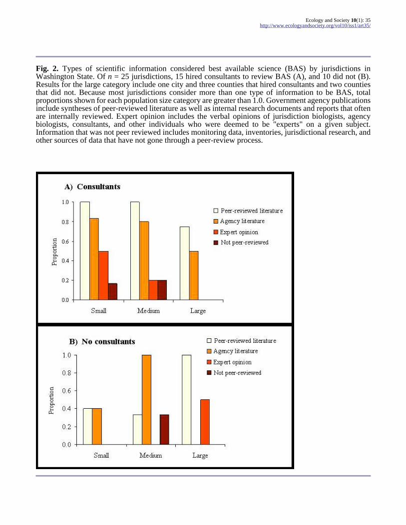
Jurisdictions of different population sizes variedwith respect to the types of scientific informationdefined as best available science (BAS) and used intheir critical areas ordinance (CAO). All thejurisdictions interviewed used a variety of types ofscientific information in their BAS review process(Fig. 2). Of 25 jurisdictions, 17 considered peer-reviewed literature to be BAS. In addition, 15 of 25jurisdictions deemed government agency publications,such as those produced by the Washington StateDepartment of Fish and Wildlife, to be BAS. Thesetwo categories were the most commonly used typesof scientific information by jurisdictions of all sizes(Fig. 2). Jurisdictions differed, however, when itcame to classifying data that were not peer reviewedas BAS. Some small (10%) and medium-sized(25%) jurisdictions used information that was notpeer reviewed, such as local monitoring or surveydata, as a form of BAS, in contrast with largejurisdictions, which did not.
Consultants hired by jurisdictions used peer-reviewed literature more frequently than plannersdid in their science review process. Consequently,whether or not a jurisdiction hired a consultantinfluenced the type of scientific information it usedin its CAO (Fig. 2). Additionally, jurisdictions thathired consultants relied on a broader range of typesof BAS (Fig. 2A). Of 11 small jurisdictions in oursample, six hired consultants, and those that didwere approximately twice as likely to use stateagency literature as were small jurisdictions that didnot hire consultants. Medium-sized jurisdictionsthat did not use consultants were much less likelyto use peer-reviewed literature than were
Ecology and Society 10(1): 35http://www.ecologyandsociety.org/vol10/iss1/art35/
Fig. 2. Types of scientific information considered best available science (BAS) by jurisdictions inWashington State. Of n = 25 jurisdictions, 15 hired consultants to review BAS (A), and 10 did not (B).Results for the large category include one city and three counties that hired consultants and two countiesthat did not. Because most jurisdictions consider more than one type of information to be BAS, totalproportions shown for each population size category are greater than 1.0. Government agency publicationsinclude syntheses of peer-reviewed literature as well as internal research documents and reports that oftenare internally reviewed. Expert opinion includes the verbal opinions of jurisdiction biologists, agencybiologists, consultants, and other individuals who were deemed to be "experts" on a given subject.Information that was not peer reviewed includes monitoring data, inventories, jurisdictional research, andother sources of data that have not gone through a peer-review process.
Ecology and Society 10(1): 35http://www.ecologyandsociety.org/vol10/iss1/art35/
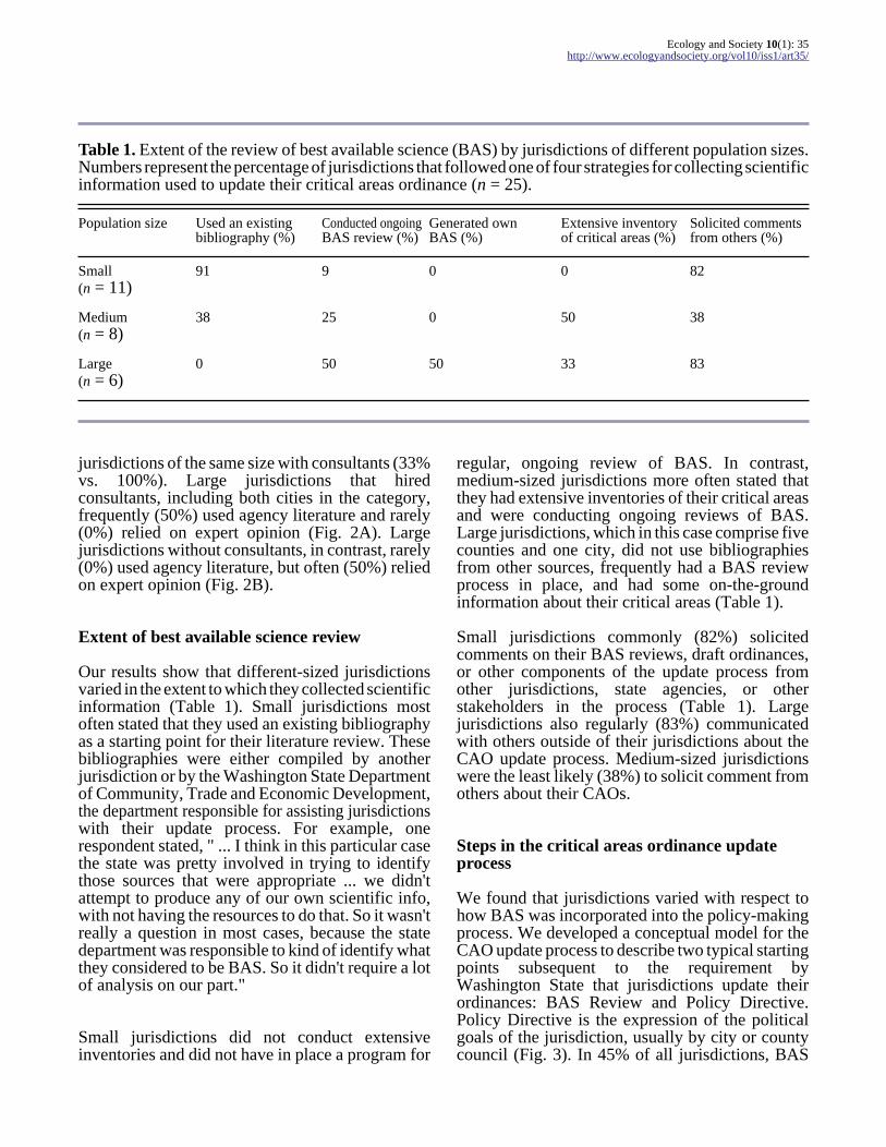
Table 1. Extent of the review of best available science (BAS) by jurisdictions of different population sizes.Numbers represent the percentage of jurisdictions that followed one of four strategies for collecting scientificinformation used to update their critical areas ordinance (n = 25).
Population size Used an existingbibliography (%)
Conducted ongoingBAS review (%)
Generated ownBAS (%)
Extensive inventoryof critical areas (%)
Solicited commentsfrom others (%)
Small(n = 11)
91 9 0 0 82
Medium(n = 8)
38 25 0 50 38
Large(n = 6)
0 50 50 33 83
jurisdictions of the same size with consultants (33%vs. 100%). Large jurisdictions that hiredconsultants, including both cities in the category,frequently (50%) used agency literature and rarely(0%) relied on expert opinion (Fig. 2A). Largejurisdictions without consultants, in contrast, rarely(0%) used agency literature, but often (50%) reliedon expert opinion (Fig. 2B).
Extent of best available science review
Our results show that different-sized jurisdictionsvaried in the extent to which they collected scientificinformation (Table 1). Small jurisdictions mostoften stated that they used an existing bibliographyas a starting point for their literature review. Thesebibliographies were either compiled by anotherjurisdiction or by the Washington State Departmentof Community, Trade and Economic Development,the department responsible for assisting jurisdictionswith their update process. For example, onerespondent stated, " ... I think in this particular casethe state was pretty involved in trying to identifythose sources that were appropriate ... we didn'tattempt to produce any of our own scientific info,with not having the resources to do that. So it wasn'treally a question in most cases, because the statedepartment was responsible to kind of identify whatthey considered to be BAS. So it didn't require a lotof analysis on our part."
Small jurisdictions did not conduct extensiveinventories and did not have in place a program for
regular, ongoing review of BAS. In contrast,medium-sized jurisdictions more often stated thatthey had extensive inventories of their critical areasand were conducting ongoing reviews of BAS.Large jurisdictions, which in this case comprise fivecounties and one city, did not use bibliographiesfrom other sources, frequently had a BAS reviewprocess in place, and had some on-the-groundinformation about their critical areas (Table 1).
Small jurisdictions commonly (82%) solicitedcomments on their BAS reviews, draft ordinances,or other components of the update process fromother jurisdictions, state agencies, or otherstakeholders in the process (Table 1). Largejurisdictions also regularly (83%) communicatedwith others outside of their jurisdictions about theCAO update process. Medium-sized jurisdictionswere the least likely (38%) to solicit comment fromothers about their CAOs.
Steps in the critical areas ordinance updateprocess
We found that jurisdictions varied with respect tohow BAS was incorporated into the policy-makingprocess. We developed a conceptual model for theCAO update process to describe two typical startingpoints subsequent to the requirement byWashington State that jurisdictions update theirordinances: BAS Review and Policy Directive.Policy Directive is the expression of the politicalgoals of the jurisdiction, usually by city or countycouncil (Fig. 3). In 45% of all jurisdictions, BAS

Ecology and Society 10(1): 35http://www.ecologyandsociety.org/vol10/iss1/art35/
Fig. 3. A generalized model of the critical areas ordinance update process. Point A represents one startingpoint, specifically, review of science; 45% of all jurisdictions review science as the first step in updatingtheir ordinance. Point B represents an alternate starting point at which political considerations precedescientific information and often drive research; 23% of all jurisdictions consider politics before science inupdating their ordinance. In gap analysis, a jurisdiction’s ordinance is compared to scientific findings orthe state's model ordinance to identify missing pieces. Policy directive is potentially applied by twostakeholders in the process: the City or County Council and the Planning Department, Planning Commission,or work groups that include political appointees and citizens.
Review is the first step in the policy formationprocess (Point A in Fig. 3). Typically, this isfollowed by a gap analysis in which the jurisdiction'sexisting ordinance is compared against scientificfindings or the state's model ordinance and "gaps"or areas that require updating to bring the ordinancein line with scientific recommendations or the state'sguidelines are identified. Following the gapanalysis, recommendations for updates to the
ordinance are drafted, typically by the person(s)who reviewed the science. These recommendationsare given to the staff responsible for writing theordinance, usually the jurisdiction's planningdepartment, for inclusion in the revised ordinance.At this point (Policy Directive II), the planningdepartment may consider the political climate of thejurisdiction or the political aims of the city or countycouncil, which may in some cases result in a policy
Ecology and Society 10(1): 35http://www.ecologyandsociety.org/vol10/iss1/art35/
that diverges somewhat from the purely scientificrecommendations. A draft policy is then producedand taken through a public review process, whichis often iterative and results in more ordinancerevisions. Once the public review process iscomplete, the draft is forwarded to either the city orcounty council for adoption. The council mayrequest further revisions, after which the policy maybe sent through the public process again.
In nearly a quarter of jurisdictions examined, thepolicy formation process is initiated by the politicaldirective of either the city or county council (Fig.3). In these situations, policy directives drive thescientific review, either by directing the review ofBAS toward certain findings to achieve a desiredoutcome, or by limiting the scope of the scientificreview to certain sections of the ordinance update.As one interviewee noted, " ... [the city/county]council decided to ... write their own [critical areasordinance] ... they figured this was their best shot atmaking their mark on a policy document. It actuallysays that in the contract—they want their policydirection to be incorporated. Now they would've hadtheir shot at it anyway, once it got to them—it's alot better if you can have your fingers in it from thevery beginning and draft it and direct it all the wayfrom the beginning to the very end."
From here, the process follows the review processdescribed above, although the scientific review istypically abbreviated and less emphasis is placed onthe gap analysis.
Two additional policy formation frameworks exist.In one, the model ordinance created by the stategovernment is adopted largely without changes,including the biophysical standards for critical areaprotection, and no scientific review or policydirective is applied. This process is used by 14% ofthe jurisdictions. The last framework is one in whichscientific information and political concerns areaddressed simultaneously and throughout the policyformation process. In this framework, representing18% of the jurisdictions, the basic steps are the same,but at each point the scientific information isconsidered in conjunction with the socio-politicallandscape of the jurisdiction. For example, in onejurisdiction, scientific information included in thestate's model critical area code is consideredalongside existing city code and planningcommission recommendations. As one interviewrespondent explained, " ... what the consultant and
the city staff have come up with is this matrix as atool ... [The matrix describes] each different criticalarea and what the BAS ought to be, based on statestatute requirements and ... the [state's] model codeand GMA. [It summarizes] what the [state's] modelcode is saying, what our existing city code says, andthen what the planning commission has beendeveloping as recommendations to the city council."
Jurisdictions of different population sizes varied asto when BAS was incorporated into the policyprocess (Table 2). Approximately three-quarters oflarge jurisdictions, including both cities in thiscategory, started by reviewing BAS at the beginningof their ordinance update process. Likewise, thenumber of small jurisdictions that consideredscience first was greater than the number that eitherstarted with a policy direction, or considered bothpolicy and science concurrently. In contrast, noneof the medium-sized jurisdictions stated that theybegan the policy update process by considering onlyscientific information. Further, in approximatelytwo-thirds of these jurisdictions, policy directivedrove the rest of the process. Approximately one-quarter of small jurisdictions relied on the state'smodel ordinance without using either the directionof science or policy to inform the update process.
Resolving decisions about conflicting bestavailable science
We found some variation in how jurisdictions makechoices about conflicting scientific information.Because most cities and counties incorporate criticalareas designations and protection measures intoland use regulations, they typically include specificbiophysical standards of protection, for example,wetland buffer widths. Therefore, jurisdictionsoften select single values even when they perceivethat there is disagreement within the scientificcommunity about appropriate protections. Amajority of respondents (64%) said that they decideon these single values by evaluating the scientificinformation, whereas 31% considered political orlegal influences. One example of how jurisdictionsevaluated science was that they use the most reliableor rigorous science available, as described byanother respondent, "So what we do is try to lookat all of [the studies] and figure out which is mostapplicable and which is most reliable—which hasbeen developed under the more controlledcircumstances so that you can actually relate it,hopefully, to the situation that you're concerned

Ecology and Society 10(1): 35http://www.ecologyandsociety.org/vol10/iss1/art35/
Table 2. Critical areas ordinance update process followed by jurisdictions inwestern Washington State. Numbers represent the percent of jurisdictionsfollowing one of four policy formation processes (n = 25). The first threeprocesses are diagrammed in Fig. 2.
Population size Consider bestavailable sciencefirst (%)
Consider politicalinfluences first(%)
Science andpolicy areconsidered concurrently (%)
Used state'smodel ordinanceonly (%)
Small(n = 11)
36 18 18 28
Medium(n = 3)
0 67 33 0
Large(n = 7)
72 14 14 0
with."
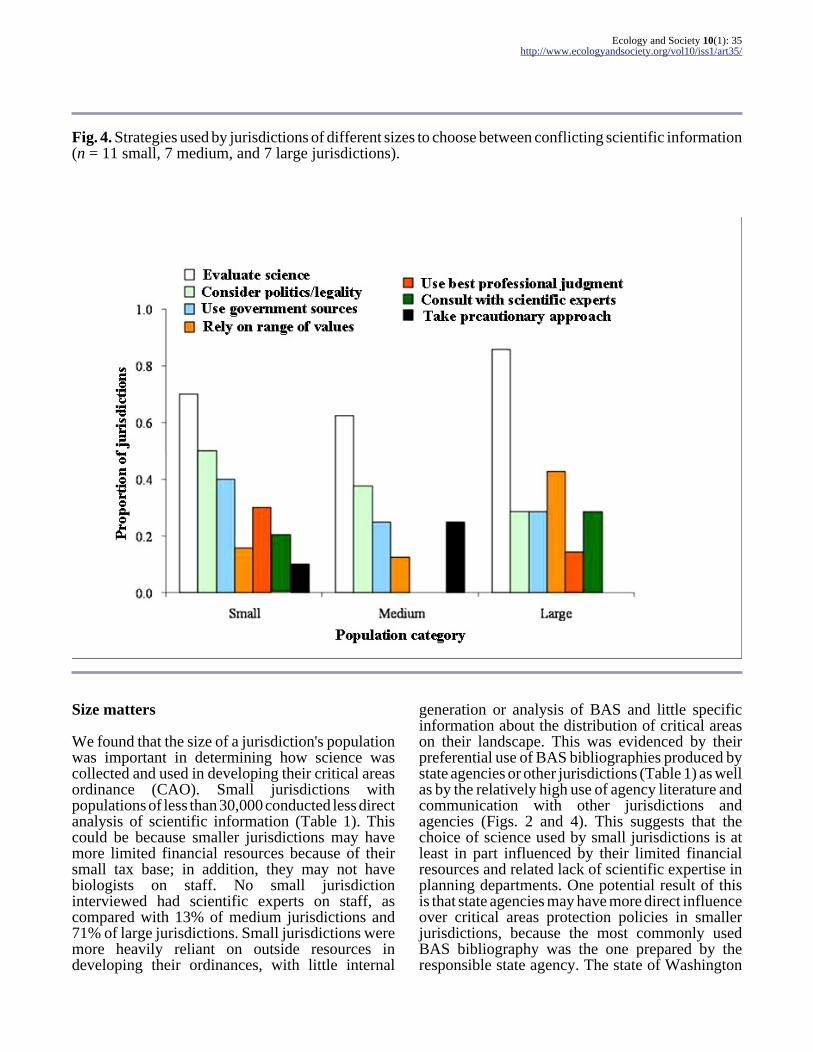
This pattern did not hold, however, for jurisdictionsof all population sizes (Fig. 4). After evaluatingscience, the most common strategies for smalljurisdictions were relying on state governmentsources (40%) and considering political or legalinfluences (50%). One respondent noted,"Scientists have the luxury of looking only at thescience, whereas a city, a functioning multifacetedentity, a political entity has to think about andbalance a wide range of considerations whenapplying the science."
Similarly, the second most common (38%)influence on choices for medium jurisdictions waspolitics or legality. Another respondent describedthis as, "Policy pull. You look at what you're tryingto do. When you have conflicting information likethat you always have to look at what the goals ofthe city are. You have to look at where the councilwants us to go in the future. We weigh towardspolicy."
In addition, medium-sized jurisdictions often (25%)said they applied a conservative or precautionaryapproach in the face of conflicting scientificinformation. A respondent from a mediumjurisdiction stated, "I have a fairly conservativeapproach towards protecting resources where I thinkthat in the absence of information, we should err on
the side of protecting things. So that's probably theoverarching philosophy that guides my decisionmaking."
In contrast, the second most common (43%) strategyused by those reviewing science in largejurisdictions, both cities and counties, was toprovide a range of scientific criteria to decisionmakers, rather than making a single recommendation.
DISCUSSION
Environmental policies at all levels of governmentare increasingly expected to be developed throughdecision-making processes with a scientific basis.One of the goals of Washington State's GrowthManagement Act in requiring that policy makersuse best available science (BAS) is to provide morespecific policy direction to cities and counties thatensures protection of critical areas (Copsey 1999).However, the results of this study suggest that theuse of scientific information by local governmentsin land-use policy is variable, and that requiringBAS may not serve the function intended for alljurisdictions.
Ecology and Society 10(1): 35http://www.ecologyandsociety.org/vol10/iss1/art35/
Fig. 4. Strategies used by jurisdictions of different sizes to choose between conflicting scientific information(n = 11 small, 7 medium, and 7 large jurisdictions).
Size matters
We found that the size of a jurisdiction's populationwas important in determining how science wascollected and used in developing their critical areasordinance (CAO). Small jurisdictions withpopulations of less than 30,000 conducted less directanalysis of scientific information (Table 1). Thiscould be because smaller jurisdictions may havemore limited financial resources because of theirsmall tax base; in addition, they may not havebiologists on staff. No small jurisdictioninterviewed had scientific experts on staff, ascompared with 13% of medium jurisdictions and71% of large jurisdictions. Small jurisdictions weremore heavily reliant on outside resources indeveloping their ordinances, with little internal
generation or analysis of BAS and little specificinformation about the distribution of critical areason their landscape. This was evidenced by theirpreferential use of BAS bibliographies produced bystate agencies or other jurisdictions (Table 1) as wellas by the relatively high use of agency literature andcommunication with other jurisdictions andagencies (Figs. 2 and 4). This suggests that thechoice of science used by small jurisdictions is atleast in part influenced by their limited financialresources and related lack of scientific expertise inplanning departments. One potential result of thisis that state agencies may have more direct influenceover critical areas protection policies in smallerjurisdictions, because the most commonly usedBAS bibliography was the one prepared by theresponsible state agency. The state of Washington
Ecology and Society 10(1): 35http://www.ecologyandsociety.org/vol10/iss1/art35/
was at least in part aware of the potential for thisfinancial disadvantage, because they offered smallgrants (U.S. $16,000) to all jurisdictions to helpdefray the cost of the ordinance update process.
The patterns of collection and use of BAS bymedium-sized jurisdictions demonstrates that thesejurisdictions have greater resources as well as ahigher degree of on-the-ground knowledge abouttheir critical areas. Higher levels of financialresources, as would be expected because of thelarger tax base, as well as larger staffs with morebiologists allowed for ongoing review andcollection of scientific information as well asextensive inventories (Table 1). Extensiveinventories, which usually include detailedmapping and classification of all the critical areasin a jurisdiction, are a source of information aboutlocal conditions and are often costly and time-consuming to produce. The Growth ManagementAct (GMA) requires jurisdictions to designate theircritical areas, and medium-sized jurisdictions areconsistently able to do this.
The relatively high level of internal biogeographicalknowledge in medium-sized jurisdictions that didnot hire consultants was coupled with somereclusive tendencies, such as relatively low relianceon expert opinion as BAS (Fig. 2), littlecommunication with other jurisdictions or agenciesregarding their BAS reviews (Table 1), and lowlevels of expert consultation or government agencyinput to help resolve conflicts (Fig. 4). Thisinfrequent consultation with agencies or otherexperts implies a more inward focus, with anemphasis on local conditions and locally generatedinformation. In addition, some medium-sizedjurisdictions were highly insular, indicating no useof peer-reviewed literature or government agencydata but, rather, high dependence on locallygenerated information. As one respondent noted, "Iintend to show people we're using local knowledge,local resources, local science, local common sense,and we are not flying in from Harvard with a 1500-page manual on how wetlands should be."
This locally focused approach by medium-sizedjurisdictions was coupled with a greater influenceof politics on the ordinance update process. Afterevaluating science, the most common influences onthe choices made by medium-sized jurisdictionsabout conflicting scientific information werepolitics or legal issues (43%) and the use of aconservative or precautionary approach (29%; Fig.
4). Policy direction from city or county councils andstakeholders is not uncommon at this stage of theprocess, and, in the face of scientific uncertainty, aconservative approach is often the safest one, bothlegally and ecologically. Critical areas ordinancesare subject to challenge by any party, and suchdisputes are resolved by the Growth ManagementHearings Board (GMHB). If a jurisdiction's CAOis challenged and found to be out of compliance withthe GMA by the GMHB, the jurisdiction may riskthe loss of state funding.
Small jurisdictions were also influenced by politics,but this influence probably had less effect on theoverall update process. Although nearly half (45%)of small jurisdictions also considered politicalinfluences when making choices about conflictingscience, only 9% used this as their sole strategywhen making choices. This is in contrast to medium-sized jurisdictions, 29% of which relied on politicalor legal considerations as their sole strategy inmaking decisions about conflicting science.Political influence ultimately is reflected in thepolicy update process. Medium-sized jurisdictionsmost frequently started their ordinance updateprocess with policy directives or other politicalinfluences, rather than science. Thus our resultssuggest that medium-sized jurisdictions haveenough resources to make them less reliant onoutside sources, more inwardly focused, and moreresponsive to local political influences than toagency science.
Large jurisdictions, which included all the countiesin our sample, have the greatest resource base, bothfinancially and in terms of staff expertise. Thepatterns we observed in large jurisdictions areconsistent with what might be expected of counties,given their elevated resource levels. However, wealso found that the two cities in the large categoryshared these characteristics, suggesting that thepatterns we see are not necessarily associated witha particular jurisdictional level, but rather withpopulation size and resource base.
Not only did larger jurisdictions more oftenregularly review scientific information outside ofthe ordinance update process, but they alsofrequently conducted their own scientific researchand generated their own BAS, which was often peer-reviewed and published (Table 1). Theoverwhelming majority of the BAS used by largejurisdictions is peer-reviewed literature, suggestingthat large jurisdictions are familiar with the
Ecology and Society 10(1): 35http://www.ecologyandsociety.org/vol10/iss1/art35/
literature, probably because of their greaterresources and expertise. Moreover, largejurisdictions, when faced with making choicesabout conflicting scientific information, evaluatedthe science itself and relied less on documentsproduced by government agencies. In several cases,the flow of information between large jurisdictionsand agencies was reversed: counties and large citiesoften provided data and research findings toagencies. Thus, the larger jurisdictions generatetheir own BAS, are more familiar with the primaryliterature, and also provide BAS to governmentagencies.
The level of political influence in the ordinanceupdate process was relatively low in largejurisdictions. These jurisdictions were lessfrequently guided by the political climate in theirjurisdictions when confronted with conflictingresults in BAS (Fig. 4), and instead preferentiallyrelied on ranges of biophysical standards. In thesecases, respondents frequently dealt with conflictingscientific information by giving a range of scientificvalues, also called scenarios (Bennett et al. 2003),to decision makers. This is a strategy common toconsultants charged with scientific review,indicating their role in providing scientificinformation but refraining from making choices forthe jurisdictions. As one consultant observed,"What we usually tell our clients and the cities andcounties is that the science doesn't give you a onepoint, one answer. It gives you a range."
Additionally, the policy update process in largejurisdictions was most frequently informed byscience, rather than by political direction (Fig. 3).It may be, therefore, that the high resource levelsand high degree of connection to peer-reviewedliterature in large jurisdictions supercede relianceon political motivations for decisions about criticalarea protection.
Role of consultants
Consultants were commonly hired by thejurisdictions in our sample (62% of all jurisdictionshired consultants) to review BAS, makerecommendations about protection standards,update ordinance language to meet staterequirements, and, in some cases, write entiresections of the CAO. Another factor that influencedboth the collection and use of scientific informationwas the involvement of consultants in the scientific
review process, and this influence differed amongjurisdictions of different sizes. Over half of the smalljurisdictions in our sample hired consultants, manyof them using grants from Washington State'sDepartment of Community Trade and EconomicDevelopment (DCTED) to pay for consultantservices. For these small jurisdictions, consultantsincreased the effective availability of scientificinformation for jurisdictions that might otherwisehave been limited by their expertise and resources.Also, hiring consultants to review BAS more oftenwas associated with using science to inform the restof the update process in jurisdictions of all sizes. Insome cases in which science was not the driver ofthe policy update process, and in which jurisdictionstaff were responsible for the entire update process,jurisdictions simply adopted the model ordinancewithout any science review. Thus, it appears thatone role of consultants in this process is to temperthe isolation characteristic of small jurisdictions andbroaden their access to science.
What is uniformly clear in these results is theinfluence of the Washington State government onthe CAO update process. Jurisdictions of all sizes,whether they hired consultants or not, relied heavilyon the resources provided by DCTED. Nearly alljurisdictions had seen or used both the modelordinance and the Citations of RecommendedSources of Best Available Science prepared andcirculated by DCTED when it was known as theOffice of Community Development (OCD 2002).Because of this, there was a high degree of similarityamong the bibliographies of all the jurisdictionsincluded in this study, although we do not presentthe results of those analyses here. In addition, theappearance of a specific piece of scientific literaturein a jurisdiction's bibliography was not necessarilyassociated with following the protection levelscontained therein. State agencies often review draftCAOs for compliance with the GMA prior toadoption by the jurisdiction. This process providesan opportunity for BAS to carry more weight, butlower standards are allowed if they are explicitlyjustified by the jurisdiction in the context of the othergoals of the GMA. Thus, despite an overarchingsimilarity in the definition of BAS, the nature of theBAS used in critical areas ordinances by thejurisdictions in our sample varies widely.
Ecology and Society 10(1): 35http://www.ecologyandsociety.org/vol10/iss1/art35/
CONCLUSION
Complex environmental policy decisions are ofteninformed by scientific data, and calls for theinclusion of best available science (BAS) inenvironmental policies occur at local to globalscales. As yet, scientists and policy makers have notdetermined how best to make this relationship work.It is expected that governments, which are requiredto represent all their constituents and their myriadneeds, will consider many factors in decisions aboutresource use and protection. However, even insituations in which it has been determined that theprotection of critical habitat should be the primarygoal of the decision-making process, it is likely thatthis protection will vary.
Our results show that the incorporation of scientificinformation into local policies is not uniform, andthat, in many cases, political rather than scientificforces have a greater influence on decisions aboutnatural resources. This study reflects the commonperception among those individuals responsible forprotecting critical areas in western WashingtonState that they are straddling a science/policy divide.It is unclear to whom the responsibility belongs forthis continued science/policy disconnect. Scientistsoften present conflicting information to policymakers without providing adequate tools forhandling scientific uncertainty and disagreement.Further, there is room within the findings presentedby scientists for policy makers to mask their politicalor social values with scientific data, confirmingwhat others have suggested: that the different valuesand objectives inherent in science and policyprevent successful partnerships. It is also clear thatfinancial resources and other pressures on localgovernments can influence the protection of naturalresources, and that policy makers in differentjurisdictions are not using the same science whenmaking their decisions.
To fully understand the direct connection betweenthe use of science and on-the-ground protection ofnatural resources, quantitative analyses of thevariability in protection measures as a function ofthe policy process are necessary. As the worldbecomes more and more urban (Sadik 1999), thegap between scientific information, typicallycollected in "natural" settings, and the policy goalsof growing cities may widen. The good news is thatheavy involvement by state agencies, in this case inthe form of suggested protection measures based onthe review of scientific literature, can bridge the gap
of limited financial and expertise resources.However, it is likely that, given the often divergentgoals and values of scientists and policy makers,and until the pressing environmental questions areposed jointly, simply offering up the goods, i.e.,BAS, and telling people to use them correctly willnot work to uniformly protect natural resources.
Responses to this article can be read online at:http://www.ecologyandsociety.org/vol10/iss1/art35/responses/
Acknowledgments:
The authors would like to thank Gordon Bradley,John Marzluff, Clare Ryan, and Daniel Schindlerfor their input and suggestions in improving thismanuscript. An anonymous reviewer also providedhelpful suggestions. We would also like to thank theabove group as well as Marina Alberti and CraigZumBrunnen for their guidance during thedevelopment of this project. This research wasfunded by the National Science Foundation(IGERT-0114351) and the University of Washington'sCollege of Forest Resources, particularly its RachelWood's Endowed Graduate Program.
LITERATURE CITED
Alberti, M., J. M. Marzluff, E. Shulenberger, G.Bradley, C. Ryan, and C. Zumbrunnen. 2003.Integrating humans into ecology: opportunities andchallenges for studying urban ecosystems.BioScience 53:1169-1179.
Bennett, E. M., S. R. Carpenter, G. D. Peterson,G. S. Cumming, M. Zurek, and P. Pingali. 2003.Why global scenarios need ecology. Frontiers inEcology and the Environment 1:322-329.
Bisbal, G. A. 2002. The best available science forthe management of anadromous salmonids in theColumbia River Basin. Canadian Journal ofFisheries and Aquatic Sciences 59:1952-1959.
Bogert, L. M. 1994. That's my story and I'm stickin'to it: is the "best available" science any availablescience under the Endangered Species Act? IdahoLaw Review 31:85-150.
Ecology and Society 10(1): 35http://www.ecologyandsociety.org/vol10/iss1/art35/
Brennan, M. J., D. E. Roth, M. D. Feldman, andA. R. Greene. 2003. Square pegs and round holes:application of the "best scientific data available"standard in the Endangered Species Act. TulaneEnvironmental Law Journal 16:387-444.
Climate Change Science Program (CCSP). 2003.The U.S. Climate Change Science Program: visionfor the program and highlights of the scientificstrategic plan. CCSP, Washington, D.C., USA.
Collingridge, D., and C. Reeve. 1986. Sciencespeaks to power: the role of experts in policy making. St. Martin's Press, New York, New York, USA.
Copsey, A. D. 1999. Including best availablescience in the designation and protection of criticalareas under the Growth Management Act. SeattleUniversity Law Review 23:97-143.
Eliasson, I. 2000. The use of climate knowledge inurban planning. Landscape and Urban Planning 48:31-44.
General Accounting Office (GAO). 2003.Endangered species: Fish and Wildlife Service usesbest available science to make listing decisions, butadditional guidance needed for critical habitatdesignations. U.S. General Accounting Office,Washington, D.C., USA.
Glaser, B. G., and A. L. Strauss. 1967. Thediscovery of grounded theory: strategies forqualitative research. Aldine, Chicago, Illinois,USA.
Joint Natural Resources Cabinet (JNRC). 1999.Statewide strategy to recover salmon. JNRC,Olympia, Washington, USA.
Kinzig, A., and D. Starrett. 2003. Coping withuncertainty: a call for a new science-policy forum.Ambio 32:330-335.
Lubchenco, J. 1995. The role of science informulating a biodiversity strategy. BioScience (Supplement):S7-S9.
Miles, M. B., and A. M. Huberman. 1994.Qualitative data analysis: an expanded sourcebook. Second edition. Sage Publications, London, UK.
Norse, D., and J. B. Tschirley. 2000. Links between
science and policy making. Agriculture Ecosystemsand Environment 82:15-26.
Office of Community Development (OCD). 2002.Citations of recommended sources of best availablescience for designating and protecting criticalareas. OCD, Olympia, Washington, USA.
Ousley, N. K. 2003. Critical areas assistancehandbook: protecting critical areas within theframework of the Washington Growth ManagementAct. Washington State Department of Community,Trade and Economic Development, Olympia,Washington, USA.
Policansky, D. 1998. Science and decision makingfor water resources. Ecological Applications 8:610-618.
Sadik, N. 1999. The state of world population 1999—6 billion: a time for choices. United NationsPopulation Fund, New York, New York, USA.
Strauss, A., and J. Corbin. 1990. Basics ofqualitative research. Sage Publications, LondonUK.
Tarlock, A. D. 2002. Who owns science?Pennsylvania State Law Review 10:135-154.
Union of Concerned Scientists (UCS). 2004.Scientific integrity in policymaking: an investigationinto the Bush administration's misuse of science. UCS, Cambridge, Massachusetts, USA.
United Nations (UN). 1992. Agenda 21, Chapter35: Science for sustainable development. UnitedNations Department of Economic and SocialAffairs, Division for Sustainable Development, Riode Janeiro, Brazil.
Weber, J. R., and C. S. Word. 2001. Thecommunication process as evaluative context: whatdo nonscientists hear when scientists speak?BioScience 51:487-495.

Ecology and Society 10(1): 35http://www.ecologyandsociety.org/vol10/iss1/art35/
APPENDIX 1. INTERVIEW TRANSCRIPT
The following is the full interview conducted with planners in western Washington State, as well as theconsultants they hired, concerning the update of critical areas ordinances (CAOs) in their jurisdictions. Theinterviews were conducted primarily face-to-face, and the questions are a mix of three types: open-ended,fixed response, i.e., yes/no, and scale questions. The interviews were taped and later transcribed, and thetext was used in the analyses presented in the main article. We do not present results from all of the datacollected below in the present article.
Introduction spoken to interviewee prior to beginning interview
We are interested in the science-policy relationship, and our goal is to understand how the critical areasordinance update process varies across jurisdictions and what factors can explain this variation. Specifically,we are focusing on wetlands, fish and wildlife habitat conservation areas, and anadromous fish.
Questions to planners:
1. Within your department, please explain the main steps in the update process, and identify the mainpeople involved and their roles. What other groups are part of the update process, and how are theyrelated to your department and each other? What stage in the update is your jurisdiction currently in?
Questions to consultants: Please explain what you were specifically hired to do for the city or county's CAO update. How extensiveof a review were you tasked with? How far into this process are you?
Questions to all:
Has your jurisdiction completed a critical areas inventory? How detailed is it? Has your current CAOchanged since the last CAO? In a general sense, how much has it changed? More specifically, what typesof changes occurred? Do you expect that this update process will lead to additional variances or exemptionsin your new ordinance? Considering all the changes you've just described, what are the main factors youthink are responsible for these changes? Are any of the changes being made to the current CAO a directresult of your best available science review? If yes, which ones? Please describe why. If no, please describewhy not. (If update not fully completed) Do you anticipate that the final draft of your CAO will be differentfrom your current draft? On a scale of 1 to 5, how much do you expect it to change?
1 2 3 4 5 ?
no change minor change moderate change significant change very significantchange
don't know (tooearly)
In addition to your critical areas ordinance, does your jurisdiction have other measures or regulations toprotect or conserve specific critical area types? What is your working definition of best available science(BAS)? What types of scientific information constitute BAS? How did you compile your BAS list? Forexample, did you start with an existing list? Are you familiar with the BAS list prepared by the state Officeof Community Development? Does your bibliography vary from it? How? Why? What qualities orcharacteristics of BAS make it useful to you? When there is conflict in BAS, how do you decide what BASto include in making recommendations for the CAO? What types of information do you pull from BAS?Using an example, could you describe how you synthesize multiple ideas, numbers, or information foundin BAS? If BAS suggests a range of biophysical criteria to protect a critical area type, how do you decidewhat criteria to recommend for the CAO? How well does BAS apply to the critical areas in your jurisdiction?

Ecology and Society 10(1): 35http://www.ecologyandsociety.org/vol10/iss1/art35/
Can you describe why/why not, using an example? Are there any constraints on your review of BAS? (Only for those who have completed their update process) Did your BAS review lead to any specificbiophysical changes?
(If YES) Was one of those changes in your buffer widths?(If YES) Can you identify any specific BAS that led to the buffer width change?If the BAS didn't lead to that change, how did you arrive at the specific change?(If NO) Why not?Were there any other specific changes to the biophysical criteria?
We're interested in three main types of critical areas. I'd like to know which of them this jurisdiction has.Wetlands? Fish and Wildlife Habitat Conservation Areas? Anadromous Fish? I'm going to read you a directquote from the RCW (36.70A.172) related to critical areas ordinances and then ask you to interpret threeparts of it. "In designating and protecting critical areas under this chapter, counties and cities shall includethe best available science in developing policies and development regulations to protect the functions andvalues of critical areas." For each critical area type you just listed, how do you interpret "designating andprotecting?" For these same critical areas, how do you interpret "functions and values?" How do youinterpret "shall include the best available science?" Are you working with scientific experts on this update?(If yes) What kind? On a scale of 1 to 5, what is the priority of the update process for your jurisdiction?
1 2 3 4 5
no priority minimum priority moderate priority high priority very high priority
Is there a specific person or group who is making the update a priority? (If yes) Who and why? Does thispriority impact the way the science is reviewed or how the ordinance is updated? (If yes) How? Whatproportion of your time is devoted to the update process? Are there any competing environmental regulatoryissues you are dealing with?