Impact of Bank protection structures on riverine fisheries
12
13 th Bangladesh International Geography Conference Impact of riverine structures on fish of the Jamuna river Mahmud Hasan Tuhin 1 , Rezaur Rahman 1 , Munsur Rahman 1 , Tarekul Islam 1 , M. H. Sarker 2 , Shahad M. Chowdhury 3 , Munir Ahmed 4 Abstract: The Jamuna is one of the largest rivers in the world. The width of the river varies from 3 km to 18 km but the average width is about 10 km. The river is in fact a multi-channel flow consisting of many different size channels, and of different patterns including braiding and meandering. It also discharges a large volume of water and at the same time brings huge amounts of sediments. Due to high discharge of water and braided nature, the river has a severe flooding and bank erosion problem. Every year, millions of people are affected by flood and erosion that destroys standing crops, farm and homestead land. To protect from these flood and bank erosion, different riverine structures such as embankment, revetment, spur, hard point, groyne and bandal have been installed at different places of the bank of Jamuna. Due to the construction of these riverine structures, the connection with flood plain, natural flow and environment of the river has changed. The ideas of fishermen about the change in species composition for the construction of riverine structures have been collected by using PRA technique. The study identifies the different species found near different riverine structures of the Jamuna River. Jamuna is a good and important source of natural resource like riverine fisheries. Once upon a time, more than 100 fish species was available in the river. But near the riverine structures, a change in species catch is observed. Flow modification was visually observed and the opinion of local fishermen was collected during survey and it is found that, for construction of the riverine structures, the natural fish habitat and the river flow are modified. Thick layer of sediments are found near CC blocks of revetment which supports fishes like Baila, Baim, Chingri etc. Near spur, scour hole is formed where some infrequent species are found, which were not available before construction of the structure. Fishes like Air, Baghair, Kalbaus are now available near hard point. KEY WORDS: Jamuna river; structures; flow modification; fish. 1. Introduction The Brahmaputra-Jamuna River, is one of the world's great rivers. The high water and sediment discharges are generated by the monsoon-dominated floods and the tectonic setting, which provides abundant sediment from Himalayan uplift into the subsiding Bay of Bengal. Structural, climatic and auto cyclic fluvial processes have produced a large multi-channel river in Bangladesh with individual channels up to 5 km wide that can scour down to 50 m. 1 1 Institute of Water and Flood Management - Bangladesh University of Engineering and Technology, 2 Center for Environmental and Geographic Information Services, 3 Inertnational Union for Conservation of Nature, 4 Technological Assistance for Rural Advancement.
Transcript of Impact of Bank protection structures on riverine fisheries

13th Bangladesh International Geography Conference
Impact of riverine structures on fish of the Jamuna river
Mahmud Hasan Tuhin1, Rezaur Rahman1, Munsur Rahman1, Tarekul Islam1, M. H. Sarker2, Shahad M. Chowdhury3, Munir Ahmed4
Abstract: The Jamuna is one of the largest rivers in the world. The width of the river varies from 3 km to 18 km but the average width is about 10 km. The river is in fact a multi-channel flow consisting of many different size channels, and of different patterns including braiding and meandering. It also discharges a large volume of water and at the same time brings huge amounts of sediments. Due to high discharge of water and braided nature, the river has a severe flooding and bank erosion problem. Every year, millions of people are affected by flood and erosion that destroys standing crops, farm and homestead land. To protect from these flood and bank erosion, different riverine structures such as embankment, revetment, spur, hard point, groyne and bandal have been installed at different places of the bank of Jamuna. Due to the construction of these riverine structures, the connection with flood plain, natural flow and environment of the river has changed. The ideas of fishermen about the change in species composition for the construction of riverine structures have been collected by using PRA technique. The study identifies the different species found near different riverine structures of the Jamuna River.
Jamuna is a good and important source of natural resource like riverine fisheries. Once upon a time, more than 100 fish species was available in the river. But near the riverine structures, a change in species catch is observed. Flow modification was visually observed and the opinion of local fishermen was collected during survey and it is found that, for construction of the riverine structures, the natural fish habitat and the river flow are modified. Thick layer of sediments are found near CC blocks of revetment which supports fishes like Baila, Baim, Chingri etc. Near spur, scour hole is formed where some infrequent species are found, which were not available before construction of the structure. Fishes like Air, Baghair, Kalbaus are now available near hard point.
KEY WORDS: Jamuna river; structures; flow modification; fish.
1. Introduction
The Brahmaputra-Jamuna River, is one of the world's great rivers. The high water and
sediment discharges are generated by the monsoon-dominated floods and the tectonic
setting, which provides abundant sediment from Himalayan uplift into the subsiding Bay
of Bengal. Structural, climatic and auto cyclic fluvial processes have produced a large
multi-channel river in Bangladesh with individual channels up to 5 km wide that can
scour down to 50 m.
1
1Institute of Water and Flood Management - Bangladesh University of Engineering and Technology, 2Center for Environmental and Geographic Information Services, 3Inertnational Union for Conservation of Nature, 4 Technological Assistance for Rural Advancement.

13th Bangladesh International Geography Conference
The Brahmaputra-Jamuna has experienced large-scale avulsion at the end of the 18th
century, recent widening and westerly migration and exhibits rapid bank erosion in
response to large floods (Best et al. 2007). The Hydrology Directorate of the Bangladesh
water development board (BWDB) refers to the whole stretch as the Brahmaputra-
Jamuna (Banglapedia, 2009).
The river system has an intensive problem of flood and bank erosion. Its meandering and
braided nature is responsible for bank erosion. Valuable properties, crop land, homestead,
commercial land everything is destroyed by the river bank erosion. For the protection of
valuable properties, different bank protection
and flood control structure have been
constructed in this part.
Jamuna is an important habitat for the fishes.
More than 100 fish species are available in
the river. Riverine and floodplain riverine
migratory species are most common in the
river. For the meandering pattern of the river,
it contain different fish favorable habitats
such as channels, sub channels, oxbow lake
and seasonal pool formed in char, shallow
submersible char land etc. Figure 1 shows a
cross section of the river containing such
habitats. For these suitable environments, annually a huge amount of fish is being
captured from this river. It is estimated that between March 1993 to February 1994 total
5044 tones fish was captured from Jamuna (FAP 17, 1995). From this statistics, it is clear
that, once upon a time the Jamuna River was an important source of fresh water fish for
our country. A good numbers of people lived beside the Jamuna river was involved with
direct fishing and fisheries based economic activities like direct flood plain fishing,
boating, treading, transporting etc. But the riverine structures change the natural flow of
the river and flood control structure stop the connection between the flood plain and river.
Between 1970 and 1990, around 2.1 million ha of floodplain were removed from river
fisheries production because of the construction of levees (Siddiqui, 1990).
2. Riverine structures
2
Main Channel
Sub Channel
Flood plain connectivity
Channel formed in char
land
Oxbow lake formed in char
land
Figure 1: Different fish habitats in river(Source: CEGIS, 2010)

13th Bangladesh International Geography Conference
2.1 Erosion control structures
Different structural measures are adopted by
Bangladesh Water Development Board (BWDB)
for erosion protection. On the basis of river
morphology and flow characteristics the
structures are constructed. Most common
structures for erosion protection are i)
Revetment with Cement Concrete (CC) blocks,
ii) Groyne, iii) Spur, iv) Hard point, v) Bandal,
and vi) Geo bag revetment. Among all,
Revetment with CC blocks is the widely
practiced erosion control measures in our
country. Figure 2 shows the overall bank
protection structures of the Jamuna river.
Revetment protects the bank from direct hit of
water flow, wave and scouring. Scouring creates
a vacant place beneath the toe of the revetment
and for that reason it fails. Hard point is such a
structure, which protect bank from direct hit of
the river water. The head of the hard point is
exposed to the open river. So the water directly hit and diverted. In Sirajganj and both
side of Bangabandhu Bridge, these types of structures are present. Figure 3 shows
different bank protection structures present around the bank of Jamuna.
3
Kamarjani Hard point
Bangabandhu Bridge
Sirajgonj Hard point
Figure 2: Bank Protection structures of Jamuna Source: CEGIS, 2010)
Bandal
CC Block revetment Groyne
Spur Geo bag RevetmentSpur
Hard point

13th Bangladesh International Geography Conference
Figure 3: Different bank protection structures
Spurs are both permeable and impermeable. But in this study impermeable spurs are
considered. Spurs are constructed in the river for the diversion of the flow. The flow is
diverted for the spurs and a huge land reclaimed on the other side of the spurs. Groynes
are also constructed for the flow diversion. Groynes divert the flow and protect the
downstream side bank. Groynes are also permeable and impermeable types but in our
country impermeable groyne are many in numbers rather than permiable groyne.
Revetment constructed by geo bag is also a kind of erosion protection measures. In Bera
of Pabna district geo bag protection work is observed. Bandal construction is also a new
idea for bank protection by diverting flow by using bamboo pillars and mats. It is very
active in sub channels as erosion protection measures. In Bhuapur of Tangail district such
protection work is present.
4

13th Bangladesh International Geography Conference
2.2 Flood control structures
Brahmaputra Right Bank Embankment One of
the first embankments constructed in 1960s to
provide flood protection to about 230,000 ha
lying on the western side of the Brahmaputra-
Jamuna and Tista rivers. It is 217 km long and
extends from Kaunia in Rangpur at the northern
end up to Bera upazila in Sirajganj district at the
southern end. Construction of the embankment
started in 1963 and was completed in 1968 at a
cost of about Tk 80 million. The average height is
4.5m, crest width 6m and side slope 1:3 on both
sides. The embankment has been under constant
threat of erosion by the Jamuna river and needs
relocation further away from the riverbank. On
the other hand, no flood control embankment is
constructed on the left bank of the Jamuna river.
Figure 4 shows the Brahmaputra Right Embankment (BRE).
3. Data Collection
The study is based on primary and secondary information.
The primary information is collected form directly field and
the secondary information is collected from detail literature
survey. For primary data collection, PRA a technique of
social survey is conducted. In PRA, FGD and KII is mainly
used for data collection, near different bank protection
structures. FGD was conducted when fishers were back in
bank after fishing. By this way primary data was collected
from the field. The secondary data was collected from
different published journal, reports and from FAP 17 study.
After collection of field data, it was verified with different
literature, analyzed and after that the data are used in the
study.
5
Figure 4: Brahmaputra Right Embankment(Source: Banglapedia)
Figure 5: The study area
13th Bangladesh International Geography Conference
For the study, protected and non protected bank of the river was selected. For the
protected bank, revetment and groyne of Shariakandi of Bogura, hard point and
Enayetpur spur of Sirajganj and Geo bag revetment of Bera, Pabna was selected, for non
protected bank downstream of the structures were selected. Figure 5 shows the study area.
4. Flow pattern
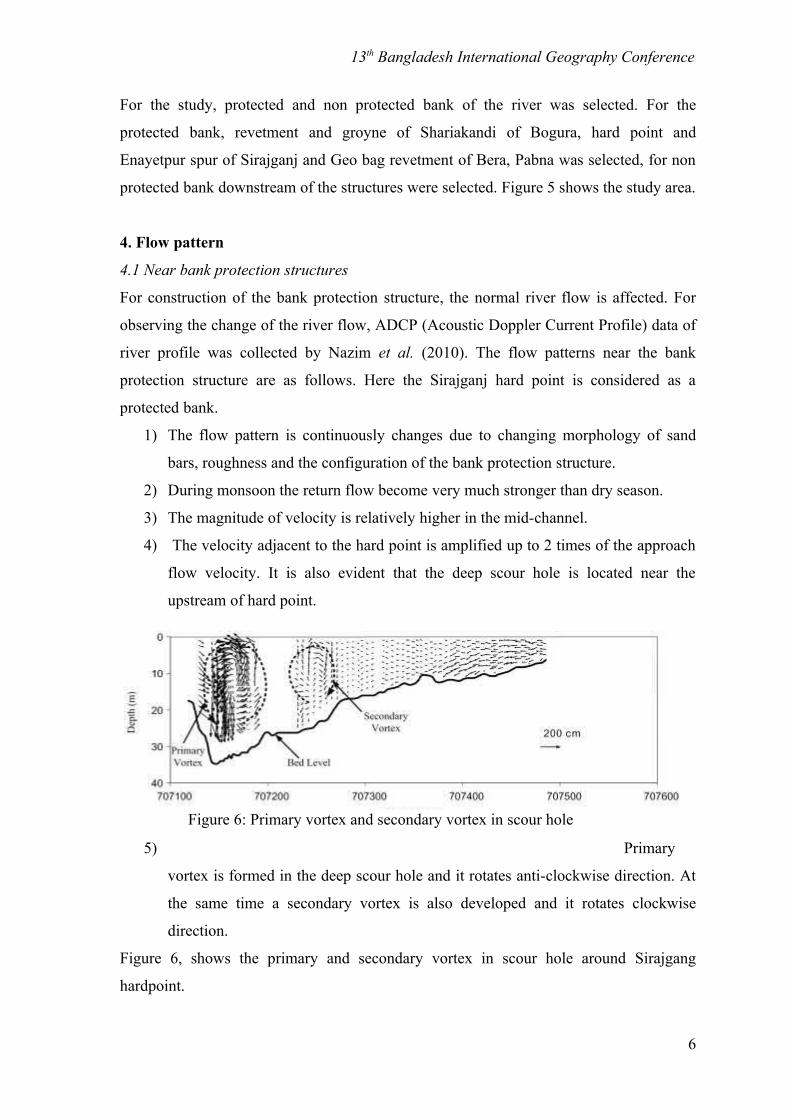
4.1 Near bank protection structures
For construction of the bank protection structure, the normal river flow is affected. For
observing the change of the river flow, ADCP (Acoustic Doppler Current Profile) data of
river profile was collected by Nazim et al. (2010). The flow patterns near the bank
protection structure are as follows. Here the Sirajganj hard point is considered as a
protected bank.
1) The flow pattern is continuously changes due to changing morphology of sand
bars, roughness and the configuration of the bank protection structure.
2) During monsoon the return flow become very much stronger than dry season.
3) The magnitude of velocity is relatively higher in the mid-channel.
4) The velocity adjacent to the hard point is amplified up to 2 times of the approach
flow velocity. It is also evident that the deep scour hole is located near the
upstream of hard point.
5) Primary
vortex is formed in the deep scour hole and it rotates anti-clockwise direction. At
the same time a secondary vortex is also developed and it rotates clockwise
direction.
Figure 6, shows the primary and secondary vortex in scour hole around Sirajgang
hardpoint.
6
Figure 6: Primary vortex and secondary vortex in scour hole

13th Bangladesh International Geography Conference
4.2 Flow pattern near non protected bank
Without bank protection structure, the river flow is its natural state. There is no
disturbance, so there is no turbulence and no high water vortex. Only a slight water vortex
was observer near non protected bank. Less depth scour hole formed. Slight back flow
observer where fish take rest there and collect their food in that place. Some features of
non protected bank are given below.
1) Regular flow of river.
2) Water flow is normal.
3) No water vortex.
4) Near eroded bank, slight back flow found.
5) In deep channel, high velocity water flow and clam wave.
.
Figure 7 and 8 showing the normal flow pattern of river near a non protected bank.
7
Figure 7: Flow pattern upstream of a bandal structure
Figure 8: Velocity vectors along vertical planes
13th Bangladesh International Geography Conference
4.3 Indigenous knowledge
According to the fisher’s knowledge, fish is less available in high vortex (ghurni) region.
Fishers, who are catching fish near the hard point, informed during KII, that less fish are
available near structure. Some uncommon and previously not available fish species are
found now a day, because of habitat change. And for that reason, fish is less available.
This information match with the above ADCP data.
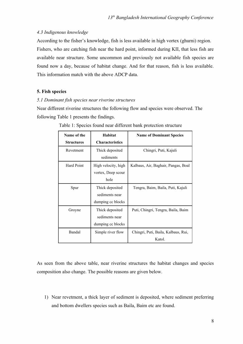
5. Fish species
5.1 Dominant fish species near riverine structures
Near different riverine structures the following flow and species were observed. The
following Table 1 presents the findings.
Table 1: Species found near different bank protection structure
Name of the
Structures
Habitat
Characteristics
Name of Dominant Species
Revetment Thick deposited
sediments
Chingri, Puti, Kajuli
Hard Point High velocity, high
vortex, Deep scour
hole
Kalbaus, Air, Baghair, Pangas, Boal
Spur Thick deposited
sediments near
dumping cc blocks
Tengra, Baim, Baila, Puti, Kajuli
Groyne Thick deposited
sediments near
dumping cc blocks
Puti, Chingri, Tengra, Baila, Baim
Bandal Simple river flow Chingri, Puti, Baila, Kalbaus, Rui,
Katol.
As seen from the above table, near riverine structures the habitat changes and species
composition also change. The possible reasons are given below.
1) Near revetment, a thick layer of sediment is deposited, where sediment preferring
and bottom dwellers species such as Baila, Baim etc are found.
8
13th Bangladesh International Geography Conference
2) High water velocity and high vortex observed near revetment, where species like
Air, Kalbaus are common which prefer high velocity.
3) Almost near all structures, deep scour hole and vortex are formed, where bottom
dwellers species are common. As a result, near spur, Tengra, Baim, Baila, Puti are
mostly available. Almost all of the same species are available near groyne.
4) A back flow is formed beside groyne and spurs, where fish is usually available.
5) Bandal dose not affect the river flow too much, so almost normal river flow was
observed and the common species of river are available there.
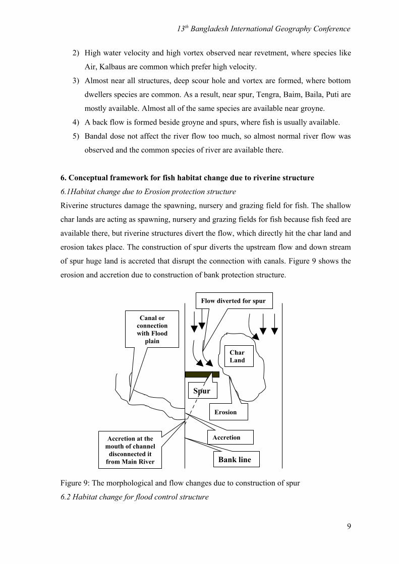
6. Conceptual framework for fish habitat change due to riverine structure
6.1Habitat change due to Erosion protection structure
Riverine structures damage the spawning, nursery and grazing field for fish. The shallow
char lands are acting as spawning, nursery and grazing fields for fish because fish feed are
available there, but riverine structures divert the flow, which directly hit the char land and
erosion takes place. The construction of spur diverts the upstream flow and down stream
of spur huge land is accreted that disrupt the connection with canals. Figure 9 shows the
erosion and accretion due to construction of bank protection structure.
Figure 9: The morphological and flow changes due to construction of spur
6.2 Habitat change for flood control structure
9
Erosion
Spur
Flow diverted for spur
CharLand
Accretion
Bank line
Canal or connection with Flood
plain
Accretion at the mouth of channel
disconnected it from Main River

13th Bangladesh International Geography Conference
Flood plain – river migration is very important for the migratory fish. They spend some
important stages of their lifecycle in flood plain and again come back to the river.
Construction of flood control embankment cut off this migration cycle. And this is also a
main cause of decline of fish in Jamuna (FAP 12, 1992). Figure 10 shows the Migration
cycle of floodplain fish and the disruption for embankment.
Figure 10: Before and after construction of embankment (Source: Adpoted from Rahman,
2008.)
10
Embankment

13th Bangladesh International Geography Conference
6.3 Overall causes of fish decline due to riverine structures
Figure 11 is prepared from the identified causes for fisheries resources declination due to
the bank protection and flood control structure.
Figure 11: Flow chart shows the linkage for fish decline and bank and riverine structure
6. Conclusion
Natural hydrological and morphological characteristics are important constituents of an
ideal fish habitat. But when the natural environment of the river is disturbed by the human
intervention, it become unfavorable as a fish habitat. For the river Jamuna, such situation
is common due to construction of different riverine structures. Due to change in habitat
near riverine structures, new and uncommon species are found. Bottom dwellers such as
11
BankProtectionStructures
Flood control
Structure
Groyne
Spur
Hard point
Revetment
Embankment
De links the connection
between flood plain and river
Divert the natural flowof the river,
causes morphological
change
Erosion and accretion in char land, flow type change, high
vortex formed, high turbidity, rising of the river
bed
Migration, spawning,
nursery and grazing place of fish are affected
Fish decline in the Jamuna river
13th Bangladesh International Geography Conference
Baila, Baim species are found near spur because of deposition of thick sediment
there,.High velocity preference fish species such as Air, Baghair, Kalbaus are found near
hard point because high water velocity is present there. Such types of change in species
composition are observed near different structures.
7. Acknowledgement
This paper is produced as a part of research project “Hydraulic Profiling of the Important
fish Habitats of the Jamuna River” conducted by IWFM-BUET. The author also praise to
Mohammad Nazim Uddin, PhD student, IWFM-BUET, for providing the ADCP data to
fulfill the research and the paper.
8. ReferencesBest, James L, Ashworth, Philip, Sarker, M.H. and Roden, Julie (2007) “The
Brahmaputra-Jamuna River, Bangladesh” Wiley & Sons Ltd, Chichester.
FAP 12 (1992). FCD/I Agriculture study, Vol. 1, Main Report. Flood Plan Coordination organization, Ministry of Irrigation Water Development and Flood Control, Government of People’s Republic of Bangladesh.
FAP (Flood Action Plan) 17, (1995). “Final report - Main volume” Overseas Development Administration, UK.
Nazim Uddin M., Hoque. M. M., Rahman, M. M. (2010), “Flow Field Around Bank Protection Structures Along the Jamuna River”, 17th congress IAHR APD 2010, Paper no 3d043, 21th to 24th February, Auckland, New Zealand.
Rahman, M.M. 2008. Capture-based aquaculture of wild-caught Indian major carps in the Ganges Region of Bangladesh. In A. Lovatelli and P.F. Holthus (eds). Capture based aquaculture. Global overview. FAO Fisheries Technical Paper. No. 508. Rome,FAO. pp. 127–140.
Siddiqui, M.H. 1990. Flood control and drainage development: Physical Environmental issues. In: A.A. Rahman, S. Huq and Conway, G.R. (Editors), Environmental aspects of surface water systems of Bangladesh. University Press Ltd. Dhaka.
12