IIFET 2008 Vietnam Proceedings COMMUNITY PERCEPTION TOWARDS A SET BACK AREA : A CASE STUDY IN GALLE...
11
IIFET 2008 Vietnam Proceedings 1 COMMUNITY PERCEPTION TOWARDS A SET BACK AREA : A CASE STUDY IN GALLE DISTRICT, SRI LANKA DILANTHI KORALAGAMA, UNIVERSITY OF RUHUNA, [email protected] ABSTRACT In view of the coastal areas, vulnerability to natural hazards particularly tsunami, earthquakes, etc, are rather increasing. The tsunami, giant tidal waves struck on 26th of December 2004 caused severe damage to people and their livelihood. It is now felt that the country should enforce a regulation procedure to manage the coastal zone. This addresses the concept of a set back area in order to mitigate the severity of natural disasters. But, the promulgation of set back area should be account for community perception. Hence, this study was aimed to assess the community perception, possible constraints, and to extract criteria to demarcate a set back area in the littoral. The study was carried out in Galle district, in Southern Sri Lanka, which is one of the districts greatly affected by the tsunami. Three divisional secretariat (DS) divisions viz; Habaraduwa, Hikkaduwa and Galle were selected. Simple random sampling was used to select 120 households. Primary data were gleaned using a pre-tested questionnaire. Informal discussions were held with coastal dwellers, government officers, &etc. The data were analyzed and evaluated to assess the objectives. Accordingly, 54 percent of the community is involved in activities based on fisheries and tourism. The rest 46 percent are engaged in other activities, which are non-stationed in the coastal zone. More than 80 percent households of the area are vulnerable for natural disasters. In consequence, 66 percent were fully damaged and 34 percent were partially damaged. Totally 76 percent of the villagers are willing to have a set back area. But, only 48 percent from 100 m boundary, agreed to have a buffer zone and majority (52%) did not want to leave the place. The reason is that their livelihood activities are adhered to the shore. Further, the buffer zone would reduce the land use efficiency since, it requires 0.25 percent land area. Hence, it is advisable to maintain a buffer zone with a green belt, which is most effective to abate the sea waves. The demarcation of a set back area should consider the geomorphology, natural vegetation cover, &etc. Moreover, government incentives, concessionary loans, permits &etc are tools to promote settlements in inland. Since, the community is in uncertainty and unsecured, willing to have more secured land strip as a buffer zone. Ipso facto, a set back area is a community-blessed concept to mitigate dreadful natural destructions and also to assure the sustainability of the area. Keywords: set back area, no build zone, restricted zone INTRODUCTION Coastal zone in Sri Lanka Sri Lanka, The Pearl of the Indian ocean, is an island lying to the south east of India between latitudes 5 0 55’- 9 0 51’ north and longitudes 79 0 41’- 81 0 54’ east, between the tropic of cancer and the equator. The island has a land area of 65610 km 2 (25000 mile 2 ). The country has a 1700 km long coastline and 30,000km 2 continental shelf area up to 120 m depth. From the declaration of the Exclusive Economic Zone in 1978, Sri Lanka has sovereign rights over 517,000 km 2 of ocean; which is around 7.8 times than the land area of the country.
Transcript of IIFET 2008 Vietnam Proceedings COMMUNITY PERCEPTION TOWARDS A SET BACK AREA : A CASE STUDY IN GALLE...
IIFET 2008 Vietnam Proceedings
1
COMMUNITY PERCEPTION TOWARDS A SET BACK AREA : A CASE STUDY IN GALLEDISTRICT, SRI LANKA
DILANTHI KORALAGAMA, UNIVERSITY OF RUHUNA, [email protected]
ABSTRACT
In view of the coastal areas, vulnerability to natural hazards particularly tsunami, earthquakes, etc, arerather increasing. The tsunami, giant tidal waves struck on 26th of December 2004 caused severe damageto people and their livelihood. It is now felt that the country should enforce a regulation procedure tomanage the coastal zone. This addresses the concept of a set back area in order to mitigate the severity ofnatural disasters. But, the promulgation of set back area should be account for community perception.Hence, this study was aimed to assess the community perception, possible constraints, and to extractcriteria to demarcate a set back area in the littoral. The study was carried out in Galle district, in SouthernSri Lanka, which is one of the districts greatly affected by the tsunami. Three divisional secretariat (DS)divisions viz; Habaraduwa, Hikkaduwa and Galle were selected. Simple random sampling was used toselect 120 households. Primary data were gleaned using a pre-tested questionnaire. Informal discussionswere held with coastal dwellers, government officers, &etc. The data were analyzed and evaluated toassess the objectives. Accordingly, 54 percent of the community is involved in activities based onfisheries and tourism. The rest 46 percent are engaged in other activities, which are non-stationed in thecoastal zone. More than 80 percent households of the area are vulnerable for natural disasters. Inconsequence, 66 percent were fully damaged and 34 percent were partially damaged. Totally 76 percentof the villagers are willing to have a set back area. But, only 48 percent from 100 m boundary, agreed tohave a buffer zone and majority (52%) did not want to leave the place. The reason is that their livelihoodactivities are adhered to the shore. Further, the buffer zone would reduce the land use efficiency since, itrequires 0.25 percent land area. Hence, it is advisable to maintain a buffer zone with a green belt, which ismost effective to abate the sea waves. The demarcation of a set back area should consider thegeomorphology, natural vegetation cover, &etc. Moreover, government incentives, concessionary loans,permits &etc are tools to promote settlements in inland. Since, the community is in uncertainty andunsecured, willing to have more secured land strip as a buffer zone. Ipso facto, a set back area is acommunity-blessed concept to mitigate dreadful natural destructions and also to assure the sustainabilityof the area.
Keywords: set back area, no build zone, restricted zone
INTRODUCTION
Coastal zone in Sri Lanka
Sri Lanka, The Pearl of the Indian ocean, is an island lying to the south east of India betweenlatitudes 50 55’- 90 51’ north and longitudes 79041’- 810 54’ east, between the tropic of cancerand the equator. The island has a land area of 65610 km2 (25000 mile2). The country has a 1700km long coastline and 30,000km2 continental shelf area up to 120 m depth. From the declarationof the Exclusive Economic Zone in 1978, Sri Lanka has sovereign rights over 517,000 km2 ofocean; which is around 7.8 times than the land area of the country.

IIFET 2008 Vietnam Proceedings
2
Figure 1. Exclusive Economic Zone – Sri Lanka
In fact, for a small island like Sri Lanka, the coastal zone obviously forms a significant part ofthe landscape. Development activities covering the fisheries sector and the coastal zone play avital role in the economy of the country. Therefore, the coastal belt provides unlimited benefitsto the coastal dwellers over a wide range.
For management and conservation purposes of the coastal environment, the coastline is definedas the “Coastal Zone” (Fig. 3), which is described in the coast conservation act of 1981 as “thearea lying within a limit of 300m landward of the mean high water level and a limit of 2 kmseaward of the mean low water level. In the case of rivers, streams, lagoons or any other body ofwater connected to the sea either permanently or periodically the landward boundary extends to alimit of 2km measured perpendicular to the straight base line drawn between the natural entrancepoints. Thereof and includes the waters of such rivers, streams and lagoons or any other body ofwater so connected to the sea.”
Figure 2: Coastal Belt in Sri Lanka

IIFET 2008 Vietnam Proceedings
3
Fig 3 : Boundaries of the Coastal Zone
Sri Lankan coastal line is characterized by a series of picturesque sandy bays, sand dunes, spits,rocky headlands, and sand beaches, lagoons, mangroves and estuaries are the other importantcoastal habitats that contribute considerably to the coastal livelihood.
Socio economic features
The coastal region comprises of 74 Divisional Secretariat divisions (DSDs) with a coastalboundary which contains about 24 percent of the total land area. The inhabitants of the coastalzone make up roughly 25 percent of the population of the island (4.6 million people out of 18.73million people in the whole country). Of the total number of tourist hotels, 70 percent (159hotels) locate in the coastal zone plus 62 percent of industrial units which are contributing to thenational GDP (CZMP, 2004).
Sri Lankan coastal and marine areas have considerable socio economic significance since timeimmemorial and the use of coastal ocean resources are linked to public health, food security andeconomic benefits including traditional livestock and social benefits and cultural values of thepeople. The inhabitants of the coastal zone are comparatively in poverty and under poor standardof living.
Fishing activities play an important role in the coastal economy. Estimates show that the coastalfishery accounts for around 64 percent of the marine fishery. This in turn provides 91 percent ofthe total fish production in Sri Lanka, (CZMP, 2004) which earns foreign exchange over 6billion rupees (600 USD). The fisheries sector including coastal aquaculture provides directemployment to about 150,000 people and sustenance to at least a million. The coastal region isthe hub of industrial production and contains 62 percent of all industrial units. There are over 30coastal DS divisions with industrial units; most of these units are clustered in Colombo,Gampaha, Kalutara, Galle, Matara and Puttalam districts. Tourism is the fifth largest income
IIFET 2008 Vietnam Proceedings
4
earner in Sri Lanka and had netted in 18,863.3 million LKR (US$ 211 million) in 2001. It alsoprovides direct and indirect employment to over 85,000 people.
High priority sites of archeological, historical, religious, scenic and recreational in the coastalzone enhance the economic value by promoting tourism related activities. Country’s economy isalso enhanced by the commercial ports, fishing harbors, anchorages, fish landing sites and salternlocated in this area. Therefore, it can be said that the coastal zone provides its assistance forsocio economic factors.
Tsunami Devastation
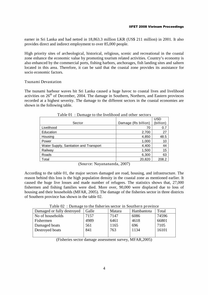
The tsunami harbour waves hit Sri Lanka caused a huge havoc to coastal lives and livelihoodactivities on 26th of December, 2004. The damage in Southern, Northern, and Eastern provincesrecorded at a highest severity. The damage to the different sectors in the coastal economies areshown in the following table.
Table 01 : Damage to the livelihood and other sectors
Sector Damage (Rs billion)USD(billion)
Livelihood 70 0.7
Education 2,700 27
Housing 4,850 48.5
Power 1,000 10
Water Supply, Sanitation and Transport 4,400 44
Railway 1,500 15
Roads 6,300 63
Total 20,820 208.2
(Source: Nayanananda, 2007)
According to the table 01, the major sectors damaged are road, housing, and infrastructure. Thereason behind this loss is the high population density in the coastal zone as mentioned earlier. Itcaused the huge live losses and made number of refugees. The statistics shows that, 27,000fishermen and fishing families were died. More over, 90,000 were displaced due to loss ofhousing and their households (MFAR, 2005). The damage of the fisheries sector in three districtsof Southern province has shown in the table 02.
Table 02 : Damage to the fisheries sector in Southern provinceDamaged or fully destroyed Galle Matara Hambantota TotalNo of householdsFishermenDamaged boatsDestroyed boats
71574989561841
714764611165763
608646186961134
7459666801710516101
(Fisheries sector damage assessment survey, MFAR,2005)

IIFET 2008 Vietnam Proceedings
5
In general, 32,000 fishing fleets (about ¾ of total number from the whole country) were damagedor fully destroyed. Apart from that, 10 fishery harbours, 37 anchorages, 200 landing sites, fisherycooperation buildings, ice plants, cold stores, and boat repair yards were damaged.
The coastal habitats were extensively damaged due to the tsunami. The shore line was severelyaffected, eroded and covered with debris. Sea water intrusion destroyed cultivatable lands, paddyfields and natural vegetation in the area (Nayanananda, 2007). According to the FAOassessment, the damage due to tsunami in the Special Area Management (SAM) sites and coastalenvironment was around US $ 32 million.
The coastal GDP to the national GDP is around 44 percent. Due to the tsunami devastation, thenational GDP loss in 2005 is estimated as 1676.7 million Sri Lankan rupees reflecting 25. 2percent decline (Central Bank, 2006).
BACKGROUND AND OBJECTIVE
Coastal zone is a key economically important land strip for any country nearby the sea. It adds ascenic beauty to enhance tourism, substrate for the fishing community to empower the fisheryindustry and a landscape with higher bio diversity. More over, the coastal areas vulnerability tocertain natural hazards particularly tsunami, earthquakes, wind storms land slides, …etc, are ratherincreasing. Hence, any country might be obliged to take anticipatory measures, planning, andexpenditure measures, in order to minimize danger and damage. The tsunami, giant waves struck on26th December 2004 caused severe damage to people as well as their livelihood systems along thecoastal region in Sri Lanka. Recent experience has shown, if disaster-preparedness programs andemergency response measures were available, could reduce the loss of life and economic costsresulting from such events. Hence, it is vital to formulate a coastal zone management strategy inorder to maintain this precious resource for its sustainability as well as to strengthen theeconomy. It is also emphasized that a tsunami vulnerable zone should be defined and all permanentconstructions should be moved inland beyond this zone. This addresses the concept of a set backarea in order to mitigate the severity of natural disasters (Koralagama, 2006). A setback area is aninexcusable component, which comes under the coastal zone management. In fact, it isworthwhile to get community scope towards the establishment of a set back area in order tomaintain the coastal zone and use to avoid natural disasters like tsunami. Therefore, this studymainly formulated to extract the possible criteria to demarcate the set back area to minimize thelosses from hazards and to evaluate the community perception over a set back area.
SET BACK AREA
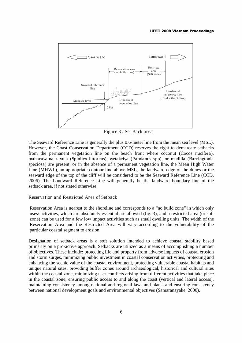
A Setback Area is a geographical strip or band within the coastal zone within which certaindevelopment activities are prohibited or significantly restricted. The entire set back band isdivided into segments viz. the reservation area and the restricted area lying between the SeawardReference Line and the Landward Reference Line of the particular coastal segment(www.coastal.gov.lk).
IIFET 2008 Vietnam Proceedings
6
Main sea level
Seaward referenceline
Reservation area( no build zone)
Restrictdarea
(Salt zone)
Landward
Permanentvegetation line
Landwardreference line
(total setback line)
Sea ward
0.6m
Figure 3 : Set Back area
The Seaward Reference Line is generally the plus 0.6-meter line from the mean sea level (MSL).However, the Coast Conservation Department (CCD) reserves the right to demarcate setbacksfrom the permanent vegetation line on the beach front where coconut (Cocos nucifera),maharawana ravula (Spinifex littoreus), wetakeiya (Pandanus spp), or mudilla (Barringtoniaspeciosa) are present, or in the absence of a permanent vegetation line, the Mean High WaterLine (MHWL), an appropriate contour line above MSL, the landward edge of the dunes or theseaward edge of the top of the cliff will be considered to be the Seaward Reference Line (CCD,2006). The Landward Reference Line will generally be the landward boundary line of thesetback area, if not stated otherwise.
Reservation and Restricted Area of Setback
Reservation Area is nearest to the shoreline and corresponds to a “no build zone” in which onlyuses/ activities, which are absolutely essential are allowed (fig. 3), and a restricted area (or softzone) can be used for a few low impact activities such as small dwelling units. The width of theReservation Area and the Restricted Area will vary according to the vulnerability of theparticular coastal segment to erosion.
Designation of setback areas is a soft solution intended to achieve coastal stability basedprimarily on a pro-active approach. Setbacks are utilized as a means of accomplishing a numberof objectives. These include: protecting life and property from adverse impacts of coastal erosionand storm surges, minimizing public investment in coastal conservation activities, protecting andenhancing the scenic value of the coastal environment, protecting vulnerable coastal habitats andunique natural sites, providing buffer zones around archaeological, historical and cultural siteswithin the coastal zone, minimizing user conflicts arising from different activities that take placein the coastal zone, ensuring public access to and along the coast (vertical and lateral access),maintaining consistency among national and regional laws and plans, and ensuring consistencybetween national development goals and environmental objectives (Samaranayake, 2000).
IIFET 2008 Vietnam Proceedings
7
In fact, a formation of a set back area is an excellent idea to lessen the severity of the unforeseenhazards and also to protect the precious eco systems in a sustainable way. Communityparticipation and their ideas are required to a greater extent in order to implement such a strategyin an efficient and effective way.
METHODOLOGY
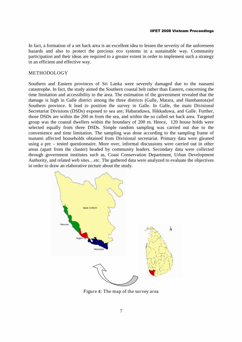
Southern and Eastern provinces of Sri Lanka were severely damaged due to the tsunamicatastrophe. In fact, the study aimed the Southern coastal belt rather than Eastern, concerning thetime limitation and accessibility to the area. The estimation of the government revealed that thedamage is high in Galle district among the three districts (Galle, Matara, and Hambantota)ofSouthern province. It lead to position the survey in Galle. In Galle, the main DivisionalSecretariat Divisions (DSDs) exposed to sea are; Habaraduwa, Hikkaduwa, and Galle. Further,those DSDs are within the 200 m from the sea, and within the so called set back area. Targetedgroup was the coastal dwellers within the boundary of 200 m. Hence, 120 house holds wereselected equally from three DSDs. Simple random sampling was carried out due to theconvenience and time limitation. The sampling was done according to the sampling frame oftsunami affected households obtained from Divisional secretariat. Primary data were gleanedusing a pre – tested questionnaire. More over, informal discussions were carried out in otherareas (apart from the cluster) headed by community leaders. Secondary data were collectedthrough government institutes such as, Coast Conservation Department, Urban DevelopmentAuthority, and related web sites…etc. The gathered data were analyzed to evaluate the objectivesin order to draw an elaborative picture about the study.
Figure 4: The map of the survey area
IIFET 2008 Vietnam Proceedings
8
RESULTS AND DISCUSSION
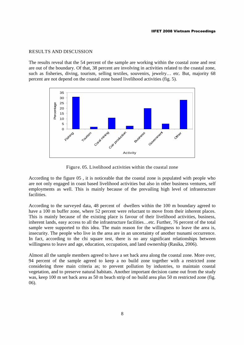
The results reveal that the 54 percent of the sample are working within the coastal zone and restare out of the boundary. Of that, 38 percent are involving in activities related to the coastal zone,such as fisheries, diving, tourism, selling textiles, souvenirs, jewelry… etc. But, majority 68percent are not depend on the coastal zone based livelihood activities (fig. 5).
0
5
10
15
20
25
30
35
Fish
ing
Tourism
Coral
mining
Coir p
rodu
ction
Bus
ines
s
Gov
ernm
ent
Other
Activity
Perc
enta
ge
Figure. 05. Livelihood activities within the coastal zone
According to the figure 05 , it is noticeable that the coastal zone is populated with people whoare not only engaged in coast based livelihood activities but also in other business ventures, selfemployments as well. This is mainly because of the prevailing high level of infrastructurefacilities.
According to the surveyed data, 48 percent of dwellers within the 100 m boundary agreed tohave a 100 m buffer zone, where 52 percent were reluctant to move from their inherent places.This is mainly because of the existing place is favour of their livelihood activities, business,inherent lands, easy access to all the infrastructure facilities…etc. Further, 76 percent of the totalsample were supported to this idea. The main reason for the willingness to leave the area is,insecurity. The people who live in the area are in an uncertainty of another tsunami occurrence.In fact, according to the chi square test, there is no any significant relationships betweenwillingness to leave and age, education, occupation, and land ownership (Rasika, 2006).
Almost all the sample members agreed to have a set back area along the coastal zone. More over,94 percent of the sample agreed to keep a no build zone together with a restricted zoneconsidering three main criteria as; to prevent pollution by industries, to maintain coastalvegetation, and to preserve natural habitats. Another important decision came out from the studywas, keep 100 m set back area as 50 m beach strip of no build area plus 50 m restricted zone (fig.06).

IIFET 2008 Vietnam Proceedings
9
Figure 06: Community perception for a No build Zone
The community perception towards the criteria to determine the set back goes to geomorphologyand exposure to extreme natural hazards. Fishing and tourism are the demanding activities withinthe set back area. About 30 percent of the sample agreed for fishing and 23 percent for tourism,where only 15 percent wanted to use the land strip for cultivation (Rasika, 2006).
The extent of area reserves as set back is significant (0.25%) to an island like Sri Lanka. In fact,it is worth while to use this strip in an effective way. The community’s suggestion was topreserve the area as a green belt with 49 percent of sample votes.
According to this study, it is obvious that the area should be preserved as a set back is importantand accepted by the community as well. But, a blanket recommendation of either 50m, 100m, or150m is not wise. In fact, it is advisable to evaluate certain other parameters in order to assign aneffective set back area along the coastal line. The Sri Lankan Coast Conservation Departmenthas been put forward the basic criteria which they had been used for East and North – east coastof Sri Lanka. Coastal erosion rate, level of user conflicts, legal status, land titles, vulnerability ofcoastal habitats, level of development (urbanization, infrastructure facilities, business units),significance of cultural and archeological sites (ancient religious places, cultural centers), specialarea management sites (Rekawa lagoon), geographical characteristics (mean sea water level,elevation, permanent vegetation line, sand bars), and exposure to extreme natural attributes(cyclones, storm) are paramount (CCD, 2006).
On the other hand, government together with urban Development Authority (UDA), encouragepeople to leave the coastal zone and settle in inland areas. All the families within 100 m and 200m coastal zone, those who are willing to construct their own houses outside will be paid, 2500USD financial assistance and if necessary concessionary loans by the state banks. Further,government maintaining a permit systems, tax, levies, licensing to mitigate the activities withinthe coastal zone. Also, it provides, grants, incentives, promotion schemes for the activitiesoutside the coastal zone. This would motivate people to be resettle in the landward.
0
5
10
15
20
25
30
35
40
45
50
25 50 75 100
Size of nobuild zone
Fre
qu
en
cy
IIFET 2008 Vietnam Proceedings
10
CONCLUSION
Mainly because of the insecurity in coastal area, people willing to have a set back area of 100 m.But, it also undergoes on certain variances like, geomorphology, natural vegetation cover, sanddunes, coral reefs, and other wave breakers. On the other hand, the buffer zone or the set backarea would reduce the land use efficiency, since it requires 0.25 percent from total land area ofSri Lanka. With the high growing population, this would be a major issue. Hence, it is advisableto maintain a buffer zone with a green belt, which is most effective to abate the sea waves aswell as proliferate tourism. The demarcation of a set back area should consider the permanentvegetation line, mean high water level, contour line, landward edge of the dunes,geomorphology, …etc. This can be maximized the land use efficiency. Moreover, governmentincentives, grants, concessionary loans, permits…etc are valuable tools to promote settlements ininland. Since, the community is in uncertainty and unsecured, willing to have more secured landstrip as a buffer zone. Ipso facto, a set back area is a community blessed concept to mitigatedreadful natural destructions and it will assure the sustainability of this precious resource for thenext generations too.
BIBILIOGRAPHY
Central Bank, (2006)., Annual Report, Central Bank, Sri Lanka.
Coastal Zone Management Plan (2001). Dublin, Spatial Planning Unit, Department of theEnvironment & Local Government.
Coastal Zone Management Plan, (2003, 2004). Coast Conservation Department, Ministry ofFisheries and Aquatic resources, Colombo, Sri lanka.
Koralagama D N and Piyadasa R U K, (2006). Development of Market Based Instruments forthe Medium & Long Term Implementation of the National Program of Action for theprotection of the Marine Environment from Land Based Activities – Coastal sector,Ministry of Environment, Sri Lanka.
Nayananada, O K., (2007). The study of economic significance of coastal region of Sri lankain the context of environmental changes of pre and post tsunami, Coast Conservationdepartment, Sri Lanka.
Rasika, Amarasinghe, O., (2006), Set Back criteria for coastal zone management,Unpublished thesis, University of Ruhuna, Sri Lanka.
Samaranayake. R.A.D.B., (2000). Sri Lanka’s Agenda for Coastal zone Management, Thereview of advanced technologies for the integrated Management of EEZ and coastalzones worldwide, 5th Edition, ICG publishing limited.
IIFET 2008 Vietnam Proceedings
11
Statistical unit of Ministry of Fisheries and Aquatic Resources, (2004). Colombo 10, SriLanka.
Weeragala, N N M S G D., 2005. Definition of a Tsunami Safe Boundary for Sri Lanka, Acase study in the Coastal zone of Galle, Matara and Hambantota Districts. Coasts andCoastal People Scenarios of Change and Responses, Netherlands, June.
http://www.coastal.gov.lkhttp://www.nara.lk/
http://www.naqda.gov.lk/pages/stats.asp
http://www.fisheries.gov.lk/
http://www.uda.lk/