II. - New York State Department of State
139
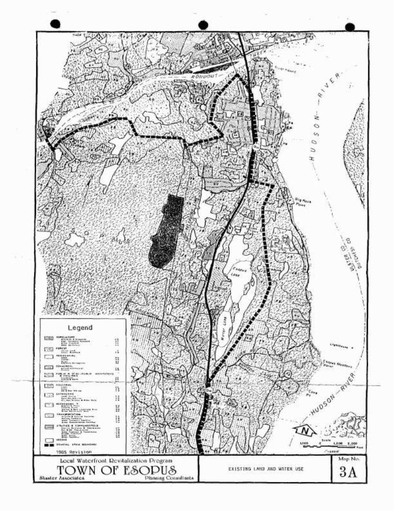
• II. INVENTORY AND ANALYSIS A. Overview (see Map No.3) The Town of Esopus has a coastal area of great diversity and beauty. With three miles of frontage on the Rondout Creek and 11 miles on the Hudson, the range of uses and natural features is exceptional. The proposed coastal boundary rangesrrom 2,000 to 5,000 feet inland frem the water's edge. The Rondout Creek contains most of the active waterfront commercial activity and more intensive residential develop- ment. With the exception of the hamlet of Port Ewen, the Hudson River shoreline is developed at very low density, with many large estates and institutional holdings. The Town is fortunate in that it is the first pIece north oT Rockland County where the railroad shifts inland and does not impose a barr ier at the water's edge. . • • B. Section B. below describes the various natural and man-made features of the coastal area and their implications for waterfront policy making. Section C. highlights some major issues and opportunities which this Local Waterfront Revitali- zation Program will address • Inventory and Analysis* Field surveys, previous studies, and published data were all used to assemble an inventory of existing conditions and features in the coastal area. Base maps at several different scales were prepared in order to map the data and photographs taken to record selected images. The re- sults of this inventory and analysis process are presented belcw and illustrated on maDS No.3. 4 and 5. 1. Land and Water Use (See Maps 3A and 38) a. Land Use Patterns Land use in the Esopus coastal area still reflects historic set:lement pattern along the major waterways. The most intensive is in the hamlets of Connelly and Sleightsburg (on the Kcndout Creek) and Port Ewen (just south of the Creek mouth), although most of the water oriented ccmmercial and industrial activity, which was the basis for the settlements. has disappeared. South of Port Ewen, a more rural pattern prevails with a mixture of orchards, estates, religious institutions -The inventory and analysis includes some data outside the proposed boundary but within the original boundary (see Map No.2), since the decision to revise the boundary was made only after consideration of all available data. 11- 1
-
Upload
khangminh22 -
Category
Documents
-
view
6 -
download
0
Transcript of II. - New York State Department of State
• II. INVENTORY AND ANALYSIS
A. Overview (see Map No.3)
The Town of Esopus has a coastal area of great diversity andbeauty. With three miles of frontage on the Rondout Creekand 11 miles on the Hudson, the range of uses and naturalfeatures is exceptional. The proposed coastal boundaryrangesrrom 2,000 to 5,000 feet inland frem the water's edge.
The Rondout Creek contains most of the active waterfrontcommercial activity and more intensive residential development. With the exception of the hamlet of Port Ewen, theHudson River shoreline is developed at very low density,with many large estates and institutional holdings. TheTown is fortunate in that it is the first pIece north oTRockland County where the railroad shifts inland and doesnot impose a barr i e r at the water's edge. .
•
•
B.
Section B. below describes the various natural and man-madefeatures of the coastal area and their implications forwaterfront policy making. Section C. highlights some majorissues and opportunities which this Local Waterfront Revitalization Program will address •
Inventory and Analysis*
Field surveys, previous studies, and published data wereall used to assemble an inventory of existing conditionsand features in the coastal area. Base maps at severaldifferent scales were prepared in order to map the dataand photographs taken to record selected images. The results of this inventory and analysis process are presentedbelcw and illustrated on maDS No.3. 4 and 5.
1. Existin~ Land and Water Use (See Maps 3A and 38)
a. Land Use Patterns
Land use in the Esopus coastal area still reflectsth~ historic set:lement pattern along the majorwaterways. The most intensive develop~ent is inthe hamlets of Connelly and Sleightsburg (on theKcndout Creek) and Port Ewen (just south of theCreek mouth), although most of the water orientedccmmercial and industrial activity, which was thebasis for the settlements. has disappeared. Southof Port Ewen, a more rural pattern prevails with amixture of orchards, estates, religious institutions
-The inventory and analysis includes some data outside theproposed boundary but within the original boundary (see MapNo.2), since the decision to revise the boundary was madeonly after consideration of all available data.
11- 1

• and seasonal resorts occupying large parcels ofland. Smaller residences and scattered commercialuses are strung out along Route 9W and in the hamletsof Esopus and West Park.
b. Water Dependent Uses
Few historicwater dependent uses remain--ice houses,boat builders, brick yards, and commercial fishingall have disappeared. The remaining water dependentuses are recreational or require the river for transportation. With exception of the Hidden Harbor Boat Clubat Port Ewen, all of these remaining uses are situatedon Rondout Creek. These include two industries whichdepend on water borne transportation--The CallananQuarry and Kosco oil storage facility--and a marinain Connelly. All of these uses are active and will remain for the foreseeable future. Although many otheruses, particularly resicen:es, benefit frcm t~e proximityof the water, none requ ire it. *
•c. Underutilized Sites
While much of the Town1s Coastal area is undevelopedor developed at a very low density, it cannot beclassified as "underutilized". These areas, particularly the Hudson River frontage in the southernhalf of Town, are part of an open space system whichis of considerable benefit to the Town and region.
However, some of the land in and around the hamletsof Connelly, Sleightsburg and Port Ewen--formerly thesites of active waterfront commerce and industry--arenot used to the full extent that the existirq infrastructure could support. The available public sewer,water and highway system will allow these areas toaccommodate more intensive uses.
•
d. Recreation and Public Access
The low density, scatterd development throughoutmost of the Town has resulted in few opportunitiesfor centrally located public recreation facilities.Most active recreation takes place at sc~ool athleticfields and several small neighborhood parks. However,the Town has purchased and developed a waterfront parkon the Hudson at Port Ewen whiCh includes a beach andpicnic pavillion. This facility is located near theTown's most populous area and is heavily used .. Shallowwater at this location, however, hampers accessfor any but the smallest vessels. Therefore, no provisions for boat launChing have been made. A privatemarina 1n Connelly and a private club in Port Ewen provide the only boat launching facilities in Town .
*It should be noted thJt an acpllcatlcn tor d small scalehydroelectric faCility ~t the Eddyville Dam is pendingbefore tr.e Ff~deral En~r'J:I Regulatory CcmmiSSlon.
11-2

>. •
•
•
Physical access to the water's edge by the generalpubl ic is Quite lim i ted. The pUbl ic beach and asmall stretch of River Road that abuts the riverprovide opportunities for direct access. Two otherpublic properties are on the waterfront--the PortEwen Water Plant and the pump station at the footof Broadway in Sleightsburg: however, neitheris designed or intended for public use.
In its report entitled "Recommendaticns for ImprovingPublic Recreational Access to the Hudson River",November 1, 1984, the New York State Department ofEnvironmental Conservation identified two potentialdevelopment projects and assigned both a medium priority. One in the hamlet of Esopus, is privatelyowned, has poor vehicular access and is of limitedsize. The other is the beach site described above.Recent dediccticn of an ac~e of land en tne northend of the beach has increased the potential for"a boat launch here, particularly if some fillingto create a dock proves feasible.
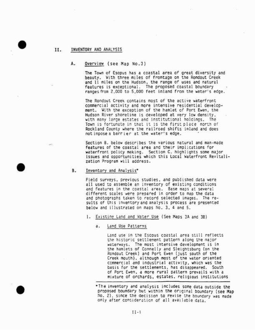
e. Photograohs (See locat~on Map)
1. A quiet bac~water of the Rondout Creek.
2. The Callanan Quarry .3. The railroad trestle and old chinmey.
4. Marina at Connelly.S. Oil storage in Sleightsburg. Proposed "fishing
wall" is between tanks and small building atright.
6. Abandoned barges at Sleightsburg.7. The Sleightsburg Spit. site of proposed park.
8. Duck blind on the Hudson.9. Access on River Road.
10. Mount St. Alphonsus11. Riverfront home.12. Mouth of Black Creek13. Riverfront estate.
14. No access •
( [ - 3

•
•
• Local Waler(ront Qevll allullOlI Drl"!ir:1m
TOWN Of E60PU&.'Jh"~'cr !\.UOC'lAtCA Plln,w".: l_-":""uh.,ft',,
.r-
r--... :\' ,_"_i''-""'""-: I.y.... :.::=.- ',"
'.. ;'"~' ':.\" /
• ..l~r .•'''::'' . '. f_..- ~..... i. -,~ -. /~-
.~ '" .......~. \--:(
\
PHOTO LOCATIOllM A i'

•
•
•
1
2
3
•
•
•
4
5

•
•
•
7
8
9
3iii:it.

•
•
•
10
11
12

•
•
•
13
14

2. Geology*
•
•
a.
b.
Topography
The Esopus coastal zone is characterized by highlyvaried topography with steep slopes, thin rockysoils and much exposed bedrock. For its wholelenth the land rises steeply from the river for100-200 feet. South of Esopus Meadows Point,the steep slopes have precluded any developmentalong the shoreline. North of Esopus MeadowsPoint, River Road follows the shoreline and thereis intermittent residential development along theshorel ine.
Inland the landscape is dominated by north-southtrending ridges with occasional flat depressionscontaining lakes or wetlands. Areas of moderate~lope are largely utilized for apple and pearorchards.
On the west the zone is bordered by two quartziteridges (Hussey Hill and Shaupeneak Mountaih' .which rise steeply 700 feet above the coasta1zone.
Bedrock
The entire study area is underlain by the AustinGlen Graywacke. except for a small area underlyinaConnelly. This formation consists of two divisions.The lower is composed of thin-bedded graywacke*and sandstone interbedded with shale. The upperhas thick. massive coarse textured graywacke, withsome thinner bedded graywacke, and a little shale(mostly as rare seams). Fossil graptolites (anextinct colonial organism generally thought to berela~~d to primitive chordates) are cowman.
The Austin Glen formation was highly folded andfaulted during the Toconic mountain building period.Later deformation resulted in additional broadfolding with considerably more faUlting. The twostages of deformation have caused the Austin Glenformation to become fairly erodible and permeable.
•
fmmediately to thewest of the study area. the QuassaicQuartizite outcrops as a large. steep, north-southtrending ridge. The Quassaic Quartizite was foldedalong with the Austin Glen Greywacke. The ridge remains as Hussey Hill and Shaupeneak Mountain becausethe Quartizite is harder and less easily erodiblethen greywacke.
Note: Sections 2 through 7 were prepared with the assistance ofBaadon Environmental Associates.
*Graywacke is an extremely hard sedimentary rockcharacterized by the presence of angular mineraland rock fragments In a dark claylike matrix.
1[-4

•
•
•
The bedrock underlying the Connelly area iscomposed of Lower Devonian and Silurian rocks,including some limestone, dolostone, Quartzite,and shale. They were deposited in a shallowmarine environment 400 to 440 million years ago.Considerable folding and faulting has occurredsince then. Thicknesses are variable.
c. Surf icia I
Prior to the Pleistocene glaciation, the topographyof the study area consisted of ~arply folded andfaulted ridges and valleys. The continental glacierthat covered the region subdued the bedrock topography and co~ej2d the: area with glacial s2cimen:s.Glacial lake deposits (silts and clays) now fillthe preglacial valleys. These deposits have modified the bedrock-controlled drainage system which,for the most part, follows the northeast-southwesttrend of the preglacial valleys. In the higher
_elevations, ground moraines (unstratified glacialtill) and kames (stratified sands and gravels)dominates the landscape •
3. Soils and Erosion
ne ~ils of the coastal zone are descibed in detailin the Ulster County Soil S~rvey (U.S. Departmentof Agriculture, 1979). The soils in the area areof three major types, being distinguished by thetype of geologic deposit or parent material inwhich they developed: glacial till--an unsortedmixture of material from silt and cl~y particlesthrough large cobbles; stratjfied drift--well-sortedsands and gravels deposited by fast moving glacialmeltwater; lake bed sediments--silts and claysdeposited at the bottom of ancient glacial lakes.
The most abundant soils in the area are thosedeveloped on glacial till. called the Bath-NassauAssociation. This Association consists of well toexcessively well-drained medium textured soils ofvariable depth. The Bath soils are deep, and havea medium textured surface layer with a medium ormedium-coarse tectured subsoil or substratum.Slopes range frem gently sloping to very steep.The shallow, medium-textured Nassau soils are underlain by shale-bedrock at a depth of 10-20 inches.Slopes are generally gently sloping to moderatelysteep. This Association is commonly used for orchards.meadow crops and pasture •
I 1-5

•
•
-.
The hi 11y topography and rock outcropsare limitations for cultivated crops. Availablewater capacity is Quite variable because of theunderlying tilted bedrock. Development is limitedby slope, variable depth to bedrock and slow watermovement in th~ deeppr soils 0f this Association.
The shoreline of the Rondout Creek and the HudsonRiver is covered by Bath and Nassau soils withnumerous rock outcrops. These soils are found'in northeast-southwest trending patches conformingto underlying bedrock topography. They are hillyto very steep.
The soils developed on stratifieddrift are thePlainfield, Riverhead and Hoosic. These soilstend to be deep, stone-free and well-drained.As such they are well-suited to a wide varietyof US2S including both farming and urban deveiopment. 60th ?ort Ewen and Connelly are underlainprimari ly by Ri verhead fi ne sandy loam. In otherareas, t his so iii s devoted to orchard use suchas west of route 9W--iust south of Ulster Park.*The Plainfield Rock outcrqD(:omplex is an excessively well drained sandy soil with intermittentbedrock exposures. This soil is found in the areasurrounaing Camp Chi-wan-aa, ana in the.vicinity ofthe Marist Brothers Seminary and the Holy CrossMonastery .
Soil developed on lake bed sediments are generallypoorly drained, with a seasonally high watertabl~
These soils are poorly suited for development, aremoderately well suited for farming if drained.and are well-~uited for woodland and wildlifehabitaLMost inland '""etlands (marshes and swamp~ occur intheses types of so i 1s. In the coasta I zone mostof these soils fall into the Rhinebeck, Hudson,Canadaigua, and Williamson series. These soilsare found ina broad stri p at the base of Hussey Hi IIand in the wetland areas bordering Esopus and Mirrorlakes. They are also found in other small wetlandsscattered through the area and underlying most ofthe hamlet of Esopus.
Most of the natural shoreline of the Rondout Creekand Hudson River is steep. rocky and quite stable.However, where the shoreline has been extended fordevelopment purposes, through a combination of fill
·Oue to the limltea amount of actual commerClalagriculture in the coastal areas. data on quantityor value of crops is not available from any stateor federal agency.
I1-6

Significant Habitats and Wetlands
•
•
•
4.
a.
and bulkheading, erosion and ~eterioration of bulkheads are problems unless frequent maintenance andrepair are practiced. Bulkhead deterioration isparticularly evident along the Rondout Creek wherea man-made peninsula extends out into the river.Repairs of this condition is important to maintainnavigation at the mouth of the Creek and to preservethis unusual site for potential recreational use.Erosion of bulkheads is also evident elsewhere onthe Creek. where industries were formerly located.and on individual properties on the river in thePort Ewen area.
Significant Habitats
New York is in the process of designating significanthabitats in the coastal zone. DEC. under contractto the Department of State. is evaluating and recommending for designation significant habitats in thecoastal zone. The sites may be the same as thosealready listed by DEC as Significant Habitats. However, whereas the regular DEC Significant Habitatsexist only for documentary purposes, the eZM designated habitats afford greater legal protection. Noadditional permits are required for the developmentof designated sites; however. DOS must determinethat the develooment would be consistent with coastalpolicy if its funding or approval are involved,and will disapprove proposed actions that wouldsignificantly alter or destroy a designatedhabitat.
As shewn in Map 4, five habitats have been identifiedin the study area. These are: two stretches ofthe Hudson River. (1) the Kingston Deepwater Habitat,and (2) the Poughkeepsie Deepwater Habitat. (3)the Rondout Creek (including the tidal flats).(4) theEsopus Meadows, and(S) the rocks of the Hudson Riverused for basking by Map Turtles. All but the lastof these is likely to be designated by the State.The five habitats are described below:
11-7.

'~.' •
•
•
KinQston Deepwater Habitat
The Kingston Deepwater Habitat encompasses a sixmile stretch of the Hudson River from the City ofKingston to the southern boundary of the Margaretlewis Norrie State Park. The significant habitatarea is a nearly continuous river bottom trench.where water depths of 50 feet or greater occur.
The Kingston Deepwater Habitat isthe northern-mostextensive section of deepwater habitat in the Hudson River. Deepwater estuaries such as this arerare in the eastern United States and the HudsonRiver is the only river in New York State thatcontains these ecosystems.
Deepwater areas trap pockets of denser saline water,providing wintering habitat for shortnose sturgeon(E) and supporting a diversity of marine speciesin the Hudson River. Recent fisheries investigationsof the Hudson River in this area indicate soawnina aswell as wintering of sturgeon in the Kingston Deepwater Habitat area. This area is also signifi~nt
since it is largely responsible for the abundanceof marine species upriver (the northern range limitformany in New York), especially during periods oflow freshwater flows (summer). The majority ofboth Atlantic and shortnose sturgeon taken for agegrowth analysis during the 1936 biological surveycame from Rhinecliff and Port Ewen. During thespring spawning runof shad, commercial drift nettingtakes place in the area.
Poughkeeosie Deeowater Habitat
The Poughkeepsie Deepwater Habitat encompasses af~ mile stretch of the Hudson River extendingfrom the hamlets of West Park in Ulster County andHyde Park in Dutchess County south t~ t~e hamlet ofMarlborough in Uls~er County. Towns with jurisditionsincluded in the area are Hyde Park, Poughkeepsie,and Wappinger, Dutchess County; and Esopus, Lloydand Marlborough, Ulster County (7.5' Quadrangles:Hyde Park, N.Y .• Poughkeepsie N.Y., and WappingersFalls, N.Y.). The important fish and wildlifehabitat is a nearly continuous river bottom trench,from 30 feet deep to the bottom. Most of this areahas water depths of 50 feet or greater, includinga small area in the "Crum Elbow" section of theriver which exceeds 125 feet in dePth.
11-8
•:','
•
Deepwater estuaries such asthe Poughkeepsie Deepwater Habitat are rare in the eastern United States.The Hudson River is the only river in New YorkState that contains this ecosystem type.
Deepwater areas provide wintering habitat for shortnose sturgeon (E), and support an unusual diversityof marine species in the Hudson River. Shortnosesturgeon also use this area as spawning grounds.Yolk-sac shortnose sturgeon larvae have been collected from this region at depths of 45 feet to 120feet. Although habitat requirements of thisspecies in the Hudson River are not well known, itis believed that these deepwater areas maybe critical t~icughcut the year. A variety of estuarineand marine species appear in numbers in this area.including bay anchovies, silversides, bluefish,weakfish, and hog chokers . The abundance of shortnose sturgeon and these otherestuarine species isunusual in New York State. However. commercial orrecreational uses of fish and wildlife in this areaare not know to be significant.
Rondout Creek
Rondout Creek is located on the west side of theHudson River, on the boundary between the City ofKingston. and the Towns of Esopus and Ulster.Ulster County (7.5' Quadrangles: Kingston East,N.Y.; and Kingston West. N.Y.) The fish and wildlife habitat is an approximate four mile segmentof this freshwater tributary, extending from itsmouth en the Hudson River to a dam which is locatedjust upstream from the N.Y.S. Route 13 bridge atEddyville. Rondout Creek is a large. medium gradient, perennial, warmwater stream. with a drainagearea of over 1.100 square miles, and an averageannual discharge volume of approximately 1,600cubic feet per second. Municipal water withdrawalsupstream may reduce flows year-round by as much as200 cubic feet per second. Most of the habitatis within the tidal range of the Hudson River. andis relatively deep, with a silt and clay SUbstrate.Only t~e first half-mile of stream below the dam isnon-tidal; this segement is rapids. with a rOCK andQravel substrate. The lower one to two miles ofRondout Creek has been Channelized to facilitatebarge traffic to adjacent commercial and industrialdevelopments in Kingston. An extensive marsh andmudflat area, locally known as Sleightsburgh Marsh,exists at the mouth of the creek. Portions of Rondout Cr~ek and its associated riparian zone remainin a relatively natural condition, but habitat
11-9

•
•
disturbances in the area include dredging, discharges of wastewater from industrial and municipalpoint sources, and altered flows resulting fromupstream Impoundments.
Rondout Creek is one of the largest freshwatertributaries of the Hudson River estuary. Theconsiderable length of stream channel accessibleto migratory fishes, and lack of significant humandisturbance in the upper portion of the creek,provide favorable habitat conditions for a varietyof anadromous as well as resident freshwater fishspecies. Rondout Creek is an important spawningarea for alewife, smelt, blueback herring, whiteperch, tomcod, and striped bass. Generally, thesespecies enter the stream between March and June;the adul~s leave the area shortly after spawning,and within several weeks, the eccs have hatched,and larval fish begin moving downstream to nurseryareas in the Hudson River. American shad spawn inshallow water areas at the mouth of Rondout Creek.Substantial populations of brown bullhead, yellowperch, sunfish, and smallmouth and largemouth bass,occur in the creek throughout the year. Freshwaterinflows from Rondout Creek are very important formaintaining water quality in the Hudson River estuary .
The abundant fisheries resources of Rondout Creekprovide significant opportunities for recreationalfishing. Although no developed public access facilities exist, the area is popular among anglers fromthroughout the mid-Hudson Valley, especially inspring (March-April) for smelt, herring, and bullhead fiShing, and in summer for largemouth andsmallmouthbass fishing. Access to the area isavailable by beat and frem many shoreline lecations.
Wetlands lccated at the mouth of Rondout Creek areproductive feeding areas for a variety of waterfowlspecies during spring and fall migrations (MarchApri I and Octeber-~lovember, respec.ti vely). Al thoughlandfilling and waste disposal have eliminatedmuch of the ~etland area north of Rondout Creek,sizeable marshes and flats still remain. Concentrations of waterfowl in this area attract huntersfrom throughout the mid-Hudson Valley; this is oneof the 4 significant waterfowl hunting areas inthis region.
I r ., a

.. •
•
•
Esopus Meadows
Esopus Meadows is located on the west side of theHudson River, approximately four miles south of theCity of Kingston, in the Town of Esopus, UlsterCounty (7.5 1 Quadrangles: Kingston East, N.Y: andHyde Park, N.Y.).
The fish and wildlife habitat is an approximate350 acre shoal in the river. most of which is shallow(less than 10 feet deep at mean low water), freshwater. intertidal, mud flats, and subtidal aquaticbeds (dominated by wild celery). Esopus Meadows islocated adjacent to a natural deepwater area in theHudson River. so the area is not subject t~ disturbance from periodic maintenance dredging. Theland area bordering Esopus Meadows is mostly wooded,with some low to medium density residential development where River Road runs close to the shore-line.
Esopus Meadows is a relatively large, undisturbed.area of shallow, freshwater, tidal flats. Areassuch as this are extremely valuable fish and wildlife habitats in the Hudson River. and are not foundin other coastal regions of New York State .
E30PUS Meadows comprises an important part of theprimary wintering area for shcrtnose sturgeon (E)in th~ Hudson. It has been estimated that as muchas 80-90% of the adult shortnose sturgeon populationwhich will spawn in the spring overwinters in EsopusMeadows and the adjacent deepwater channel areas.These fish move into the area during October orNove~ber. and remain there until March, when theybegin moving upriver to spa~ning areas. The vegetated shallo~s at Esopus Mecdows are valuable nighttime foraging areas for the adult sturgeon, whichfeed on snails and other bottom organisms. Thesefish ~emain in adj~cent deeper areas during the day.Esopus Meadows also serves as spawning, nurseryand feeding habitat for striped bass, American shad.white perch. and various resident freshwater species.The abundant fisheries resources in the area provideexcellent opportunities for recreational and commerical fishing, attracting fishermen frem throughoutthe mid-Hudson Valley, Access to the area is available by boat and frcmmucn of the river shorelinenorth to Esopus Meadows Point .
[ 1- 11

•
•
•
Significant concentrations of waterfowl also occurin the Esopus Meadows area. Dense growths of wildcelery provide valuable feeding areas for manyspecies of ducks, and are especially importantduring spring (March-April) and fall (mid-September--early December) migrations. Concentrationsof diving ducks, SUCh as scaups, redhead, canvasback,common goldeneye, and mergansers, are regularlyfound out in this area. This open water area isalso used by dabbling ducks, including mallard,black duck, and blue-winged teal, especially duringcalm weather, and much of the area provides refugefrom hunting pressure in shoreline areas. However,portions of Esopus Meadows that are accessiblecomprise one of the most popular waterfrowl huntingareas on the lower Hudson River. Depending onweather conditions. some waterfowl may remain inthe area throuahout winter; mid-winter aerial surveys for the ten year period 1976-1985 indicateaverage concentrations of approximately 80 birds inthe area each year (500 in peak year), includingblack duck, mallard, canvasback, and mergansers.The extent to which other bird species such asloons, grebes, gulls, wading birds, and shorebirds,may use the area has not been documented. However,the variety of birds observed here, and its accessibilit~ makes Esopus Meadows popular among birdwatchers in the lo~er Hudson Valley.
Mao Turtle Baskina Rocks
This area is located on the western bank of theHudson Riverdirectly across from the Franklin Delano Roosevelt Manor. The map turtle GraDemvs oseudoaeoQraohica. so named because tne maze of lightmarkIngs on their backs resemble an intricatesystem of canals and waterways. are native to LakeChamplain, the St. Lawrence and the Great Lakesin New York. They are not considered native to theHudson, but have beccme established presumably byrelease from domestic aquariums. The rip-rap naturallyoccurring rocks along the western bank of the riverhave been mentioned as a knewn basking site. However, because they are an introduced species. thissite being designated a significant habitat is un-Ii ke I y •
11-12

•b• Wetlands
The Legislature has declared that it is "thepublic policy of the state to preserve, protectand conserve freshwater wetlands and the benefits derived therefrom" (Article 24, of theEnvironmental Conservation Law). Accordingly,DEC is identifying and mapping all freshwaterwetlands larger than 12.4 acres (final maps forUlster County have not yet been filed). UnderArticle 15, excavation and filling in navigablewaters and contiguous marshes, estuaries, tidalmarshes and wetlands are regulated. Under Articles15 and 24 of the Environmental Conservation Law,any development of protected wetlands requiresa permit from DEC. Based on their evaluationof the permit application, DEC may limit development. require mitigative measures or preventdevelopment.
•
•
The DEC has identified one freshwater wetlandin the coastal area (see Map NO.4). This areaincludes the southern portion of the peninsulaat the mouth of the Rondout Creek and is withinthe Rondout Creek Habitat described above.
5. Hydrology and Water Quality
a. Drainaae
The study area lies entirely within the HudsonRiver drainage basin. The Rondout Creek is theonly other major stream in the study area. Itcarries waters from the Shawangunk Mountains and,via the Wallkill Ri~er which joins the Rondoutsouthwest of the study area in Rosendale, from thesouthern Catskill Mountains. Most of the streamsthat drain the area-flow northeasterly. followingtrends imposed by bedrock topography, eventuallydraining into the Hudson River which flows to thesouth.
Black Creek, whose main branch flews north fremthe iown of Lloyd. drains much of the southerncoas:al zene. The major drainage in the northernportion is Plantasie Creek, whiCh flows north fromthe Flats telcw Hussey Hill into the Rondout atConnelly.
b. Flood Protection
The Federal Emergency Management Agency has developeda flood insurance study and maps of the Town ofEscp~~ :~Jt ir.cic~te flood event: of a magnitude
: 1- 13

•
•
•
which are expected to be equalled or exceeded onceduring a 100--or SOO--year period. The maps alsoshow base flood elevation lines which indicateanticipated water surface elevations during a 100-year flood. Local planning requires that developments must either be built above the base floodelevations or contain flood protection devices tothat height.
The 100-year boundary is shown on Map 3.tn the Town of Esopus, the 100-year boundary lies~ery close to the shoreline of the Rondout Creekand the Hudson River, the exceptions being thePlantasie Creek near Connelly, the tidal flats andmarshlands near Sleightsburg, and Black Creek. Thelow-lying .inland area .comprised of Esopus.Lake, Mirror Lake, and surrounding wetlands also lies belowthe 100-year boundary. The SOO-year boundary issignificantly different from the 100-year boundaryonly along the creeks, where it is slightly furtherinland.
The 100-year floodplain boundary encroaches slightlyupon Connelly and Sleightsburg. No streets are10cated within the floodplain, but some coastalfacilities may be. Outside of these two communities,a few scatte~ residences and stretches of roads liewithin the 100-year boundary.
Base flood elevations* range from a high of 11 feeton the Rondout Creek near Eddyville, falling to9 feet at the mouth of the Creek. The base flood~levations on the Hudson River are 9 feet throughout the stUdy area.
Local history indicates that the Town is subjectto flooding from hurricanes and northeasters ',ojhichbring heavy rains tothearea. Ice jams have beenreported infrequent lyon the Rondout Creek; however,they are generally brief and cause little flooding.
The Rondout Reservoir prOVides the principal floodprotect ion for the Town. It is located at therelease Chamber of the Merriman Oa~ 1.3 miles northwest of Lackawack in Ulster County.
*Natlonal Geoaetic Vertical Datum (OGvoj
[ [-14
•
•
c. Surface Waters
Surface waters in the Town of Esopus are monitoredby the state DEC and Health Department and the UlsterCounty Health Department •. DEC maintains a monitoringstation on the Hudson River north of Esopus nearCatskill and on the Rondout Creek just above Eddyville Dam. The Ulster County Health Department monitors Hudson River Water at the Port Ewen Water Treatment Center and Rondout Creek water at the KingstonSewage Treatment Plant.
The quality of the Hudson River has dramatically improvedover the past several years due to significant improvements at the upstream sewage treatment plants. Standardparameters such as coliform, fecal coliform, ph and dissolved oxygen have been monitored since the mid-1960.s.Data on organic pollutants is far more limited; however,preliminary examination of val=tile ccmpc~nds in theHudson River showed no measureable contamination (D.Palen, Director of Environmental Sanitation Division,Ulster County Health Department). The water is ratedas Class A, i.e. suitable for drinking provided that itis adequately treated.
The Rondout Creek is presently considered a Class Cwater which is suitable for fishing, but not fordrinking or swimming. Sewage from Port Ewen andKingston are introduced into the Rondout Creek assecondary effuent frem the Kingston Sewage TreatmentPlant. In addition. there are several industrial rawsewage effluents. DEC hope to raise the qualityof water in Rondout Creek to Class B. Black Creekis classified as A west of Route 9W and C east.
d. Sewage
The Port Ewen Sewer Improvement District (Whichincludes the Hamlets of Port Ewen. Sleightsburgand Connelly) disposes of the sewage at the KingstonSewage Trect~ent Plant. The plant has acapacityof 4.8 million gallons per day, 500,000 of 'Nhichare alloca:~d to the Port Ewen Sewer IffiprovementDistrict. The Sewer ImprovementOistrict currentlyruns at only 250,000 gal Ions per day, or half theirallocated flow. The Kingston facility will be ableto acccmmodate additional development within the PortEwen Sewer Improvement District for the near future.although several recently approved and proposedprojects wi II use a substantial portion of the remaining allocation .

•
••
•
6.
e. Toxic Waste
NYS DEC has no knowledge of any active or inactivehazardous waste disposal sites within the proposedcoastal boundary.
f. Drinking Water and Groundwater
Shallow glacial aquifers and bedrock aquifers aretapped for drinking water. The shallow aquifersprovide good quality water through wells or artesian springs to most of the Town1s outlying residents.Yield from shallow aquifers are generally low. Thebedrock aquifers supply good quality water as well.Bedrock-supplies are adequate for domestic use orsmall farms, but are insufficient for large industrial or municipal systems. Bedrock derived watersmay be moderately to very hard, smell of hydrogensulphide, and contain elevated levels of iron andmanganese.
Port Ewen obtains drinking water primarily fromthe Hudson River. In the past, it also obtainedwater from·bedrock wells. These have been shutdown because of insuffici~ yields and elevatediron and manganese levels. Water drawn from theHudson river is processed using filtration, sedimentation, and chlorination. See Map No.3 •
Outlying facilties, for the most part isolateddevelopments on the Hudson River, rely on theirown wells or springs. The Redemptionist F~thers
of New York supply water to 110 persons using asand filter infiltration gallery. The Order ofthe Holy Cross and the Rosemarie Mobile Home Parkdraw their supplies from glacial aquifer wells,and Saint Cabrini Heme and the Santa Maria ChristianBrothers supply water to 160 person from combinationof glacial aquifer wells and artesian springs thatare located on the nearby hillside.
Air Quality
The New York State Department of EnvironmentalConservation follows the federal EnvironmentalProtection Agency (EPA) quality standares for ambient air. Areas where the ambient concentrationof a pollutant is greater than the standard for
. each major category of pollutant (total suspendedparticulates, carbon monoxide, sulphur.dioxide,oxides of nitrogen and ozone) are considered to bein non-attainment for that pollutant, and areas whereambient concentrations are less than standard are considered in attainment .
11- 16

•
•
•
The Town of Esopus is currently classifed as anattainment area for criteria pollutants. Whenconsidering the siting of a new facility or modification of an existing facility the status of airquality at the facility and the magnitude of theprojected annual emissions of criteria pollutantsmust be evaluated.
7. Cultural Archaeoloaical Resources
a. Cultural
The Town of Esopus. particularly the shorelinearea along the Rondout Creek and its confluencewi th the Hudson Ri ver, is ric h in cuI tura I andarchaeological resources. Unfortunately, nothourough survey of the entire area has beenundertaken. However, a preliminary survey ofprobable areas of historic sensitivity was undertaken in conjunction with the installation ofsewers in Port Ewen (see Port Ewen ImprovementArea C-36-764. Cultural Impact Study--HistoricPeriod, 1977). This survey identified twentysites in the hamlets of Port Ewen, Sleightsburgand Connelly, listed below, worthy of historicinterest. These are identified on Map No.4.Also indicated are five sites already listedon the National Register of Historic Placesand other sites identifed by local historiansor inventoried by the office of Parks. Recreation and Historic P~servation (see discussionfollowing list) .
11-17

• 1.2.
3.
4.5.6.7.8.9.
10.
•
General vicinity of Kingston Commons.Waterfront area developed after completionof D&H Canal c. 1828-1850.Dam across Plantasie Creek and channel includingboat yards and possibly two 18th century houses.Red brick engine house. c. 1865.William Litts' red frame dwelling.Possible site of early habitation by Dutch.Site of 18th century Petrus Sleight EstateSite of 19th century Ferry House.Site of 19th century_shipyard.Earliest road to Kingston from south along riverapproximate site of late 19th century velocipedeUlster sled factory and early store.
11. Pennsylvania Coal Company planned community.c. 1851 (docks. steamboat landing. office andwarehouse).
12. Brick house of Pennsylvania Coal Co.13. Cut stone manager's house erected by Pennsylvania
Coal Co. .14. J.D. Rattray frame clapboard buildingc. 17th
century.15. Store house.16. Vicinity of Robert J. Torrens and site of 18th
century settlement. c. 1767.
17. Stone house usedas first school in Esopus. c.1777.18. Hugo Carlen house and ice house, c. 1768.
19. M. Van Aken home.20. Original Van Aken homestead. c. 1660.
Five sites have already been 'placed on the NationalRegister of Historic Places. These are the summerresidence and study of the naturalist, John Burroughs.two lighthouses on the Hudson and the Port Ewen-Rondout suspension bridge.
John Burroughs published his first significant natureessay in the Atlantic Monthly in 1865. He ~roduced
numerous articles and bOOKS about the natural world
11-18

::' •
•
•
until his death in 1921. Burroughs is creditedwith creating a receptive environment for conservation legislation and establishing the nature essayas a literary form.
john Burroughs' study at Riverby isa small one story frame building located below themain house and above the ri verbank, looking eastacross the river. The interior consists of a singleroom which still contains Burroughs' original furnishIngs. fhe exterior and interior appear basicallythe sa~e as in Burroughs' day.
Burroughs' sanctuary "s l absides" is locatediust outside of the study area on a 173acre estate, one mile west of Riverby. The cabinsits on a rock ledge, at the foot of a cliff in amarshy area. The marsh, which Burroughs had drainedfor cultivation purposes, has reverted to its wildstate. Although some houses have been built nearby,the cabin appears to be located in the wilderness.It can only be reached by a narrow dirt road and afoot path. A few changes have been made to theoutside of the structure; however, the interiorwith all its furnishings, is unchanged •
During the 1800's, when the Hudson Riyer was themain traffic artery from the upstate farms and icehouses to New York City, the National LighthouseService constructed a series of lighthouses alongthe River to warn traffic away from dangerous shallows.Over time the lighthouses were modernized and automated. Keepers and their families have been replacedand the lighthouses have, in some instances. deterioratFour lighthouses remain in the mid-Hudson region; twoof these are in or very near the study area.
The older of the two lighthouse, the Esopus MeadowLighthouse, is located offshore of the Esopus Meadowshallows. Construction of the originallighthouse began in 1838. Attack from ice floesbrought the structure to ruins withing 30 years. Anew structure, not far from the old one, was builtin 1871. It is the only Hudson River lighthouse tobe bui It wi th a woodframe and sheathed wi th clapboard.It is accessible only by water, so for the extent ofits operation it was maintained by a keeper and hisfamily. The keeper was replaced after the Coast Guardacquired the lighthouse service. Plumbing and heatinghave been added to the structure. The lighthouseis in a slightly deteriorated condition •
[ i - 19

•
•
•
The Kingston/Rondout 2 lighthouse is located justnorth of the study area in the City of Kingston.It is mentioned here because it is in the KingstonTidal Flat at the mQuth of the Rondout Creek.
The existing Kingston/Rondout 2 Lighthouse replacedan earlier structure that was built in 1867. butbecame unserviceable by 1913. The new lighthousebegan service in 1915 not far from the originalsite. It was the largest and last lighthouse builton the Hudson. It remains in very good conditionand is still in use as a lighthouse by the CoastGuard while under lease to the City of Kingston.
The Port Ewen-Rondout suspension bridge. built in1921, spans the Rondout Creek 80 feet aboV~ the'/later. It is the only such structure in the region and commands a dramatic setting between twosteep hill s•
In addition to those sites described above. anumber of other significant structures have beenidentified including:
1. Klyne Esopus Church
2. Mt. St. Alphonsus (Pell Estate)
3. Rosemount, home of presidential candidateAl ton B. Parker.
4. The Payne Estate.
b. Archaeological
The region at the confluence.of the Rondout Creekand the Hudson Ri ver is knCW'l to be important archaeological area. It has been inhabited at least sincethe Woodland Period (100 B.C.--1600 A.D.) and probablysince Paleo-Indian times (c.l0,000 B.C.). Siteshave been reported in Sleightsburg. along Route 9W.alona the bank of the Hudson River and in a baysouth of Kingston Point. Large maizelands and largeIndian populations in this area are reported in varioushistoric accounts (Jeanette Col lamer and Karen Hartgen.Town of Port Ewen Sewer Improvement Area c. 36-74,Stage 1: Prehistoric Literature Review, February1977) •
A field study of historic sites was conducted as partof the review process for the Town of Port Ewen sewerproject. As a result of this study, three areas
11-2C

•
•
•
8 •
of potential archaeological resources were identified: a prehistoric site on First Street in Connelly, a prehistoric site on Parsell Street inSleightsburg, and a historic site at the Sleightsburg Pump Station.
The prehistoric site in Sleightsburg has been declared eligible to be listed on the National Register of Historic Places. The site includes FirstAvenue from Parsell Street on the east to to adistar.c~ of 30m--75m westwards. The site on SecondAvenue extends westward from Parsell Street a distance of 50 to 90m. In prehistoric times, thesesites were situated at the junction of the RondoutCreek and the Hudson River. high enough to seeapproaching enemies at a distance and also offeringan easily defendable position. Fresh water, fishand shellfish were provided by both water bodies.In addition the marshes at the mouth of the creeksupplied abundant wildlife. The areas have producedlarge amounts of prehistoric material from theWoodland Period and the late Archaic Period including structural features (hearths, postmolds), stonetools, (chipped and rough), prehistoric pottery andpersonal items.
Transportation
Transportation in the coastal area is primarily byprivate automobile. The major artery is Route 9Wwhich parallels the river from the southern Townboundary to the Rondout Creek. Once the major northsouth artery on the west bank of the river, it stillcarries significant volumes of intra-regional trafficand, in the southern part of town, provides directaccess to river front property. Proposals to relocate Route 9W around Port Ewen. active in the 1960's,have not been pursued. The proposed alignment eastof the existing road would significantly affect thecoastal area if implemented.
East-wes~ reads in the Town are few and their designand capacity are limited by the steep north-southridges which traverse the Town. River Road, whichconnects with Route 9W at both ends, provides accessto other riverfront property and is a very scenicand picturesque route. Salem Street, althoughwinding and narrow in spots, provides the only continuous route parallel to the Rondout Creek .
[ 1-21

e·Rail service in the coastal area, for frieght trafficonly, is provided by the Penn Central Railroad lineparallel to Route 9W. Fortunately, this line divertsinland from the river shortly after it enters the Townfrom the south and does not create a barrier to thewater. No Town industries are serviced by rail.
The only mass transit available is via the UlsterCounty bus system or private long distance carriers.Water borne transportation is confined to pleasurevehicles and barge service to the quarry and oilstorage facilities on the Rondout Creek.
9. Scenic Resources
The Town is blessed with many fine scenic resources-natural and man-made. Both Route 9W and RiverRoad \tere nominated as "scenic roads" by the Heritage Task Force for the Hudson Valley because ofthe continuous high quality of the visual environment, particularly the many exceptional views ofthe Hudson River. River Road was included in thefirst such designations in the Fall of 1985.
e
e
10.
Many of the finest scenic features of the coastal.area are best viewed from the water or the Oppositeshore. The Hudson River shoreline as viewed fromthe River or the East shore--which is the Mid-HudsonHistoric Shorelands Scenic District--includes naturalescarpments, landscaped estates and historic settlements against the magnificent back-drop of the Catskill Mountains. From the Rondout Creek,or AbeelStreet on the North shore. a variety of views includeplacid backwaters, an abandoned chimney, a high railroad trestle and historic suspension bridge and ruggedhillsides.
Solid Waste Manaaement
Solid waste is disposed of in the Town landfilllocated west of the railroad tracks with accessfrom Floyd Ackert Read. outside of the coastalarea. The Town has been orcered by DEC ~o takeactions to bring the facility into co~pllancewith applicable regulations and ~as Signed aletter of consent to install monltorlng wellsas required.
11-22

• c. Major Waterfront Issues and Opportunities
While the large extent and diverse characteristics of the Esopuswaterfront include many concerns which the LWRP will addres~ anumber of issues are of major importance and will receive particular attention in Sections III, IV, and V of this report.These issues and related opportunities are summarized below.
1. Future of the Hudson River Waterfront South of Hemlock Point
•2.
. .For nearly eight miles, a broad swath of land between theriver and Route 9w is dominated by large estates, majorinstitutional uses, orchards and the rugged escarpmentsalong the river's edge. With the exception of the hamletsof Esopus and West Park, much of this land is in largeparcels of 40 acres or more. Almost 900 such acres areowned by religious institutions and 700 acres by privateowners--nearly twO and one-half square miles with over fivelinear miles of river frontage.
This land is an extremely attractive feature of the Town andprovides v(ewsand vistas from both land and water that are ofthe highest quality. However, the good access and strategiclocation of this area, between Kingston and ~eepsie, andthe lack of rail frontage on the river north of West Park arebeginning to create pressures for more intensive development.Although zoned for low density residential use, developmentcould dramatically change the character of this unique area,both in Esopus as well as viewed from the mid-Hudson HistoricShorelands Scenic District on the east shore of the River,unless measures to protect the most sensitive resources areprovided.
Public Access to the Water
Although the Town has scme 14 miles of waterfront, there arevery few places where the general public has access for boating,fishing, swi~ming or similar activities. A number of opportunities exist to increase access. However, such access must beaccomplished ~ithout damaging the natural environment orcreating adverse impacts on adjacent land uses.
•
3. Preservation and Promotion of Historic and Scenic Resources
The Town has an abundance of historic structures in the coastalarea as well as magnificEm scenic vistas of the Hudson Riverand Rondout Creek. These significant resources should notonly be preserved but also opportunities to establish a linkedsystem to view them should be explored .
11-23

•
•
•
4. Economic Development in the Coastal Area
The coastal area of the Town has been the source of economicactivity for hundreds of years. While the nature of suchactivity has changed significantly. the waterfront stillprovides numerous opportunities for development that requiresor benefits from being on or near the water and that cancontribute to the economic well-being of the Town and itsresidents. The location and development guidelines for suchactivity must consider the nature of available servicesand impact on the natural and man-made environment.
5. Use and Reclamation of Quarry Site
The Callanan Quarry, on the roundout Creek west of the railroad. consists of over 150 acres with more than 3.100 feet offrontage on the Rondout Creek. While most of the site has beenextensively mined. a narrow strip along the Creek has been leftin its natural state for most of the site. The use of the landwhich has not been mined and the ultimate reclamation of theentire site when mining is completed must" be analyzed andresolved in the best interests of the community •
11-24

LEGEND
~~~~~ Orchards and Vineyards
.., Hamlets
~ Major Institutional Lands
~,,~ Industry
3Map No.
RECONNAISSANCEPI[l1I11i118 COI1!'iull<lIll!'i
~ Quarryo Marina/Yacht Club
•• Oil Storage Tanks
• Public WaterCront ~ccess
11/1 1\ Escarpments
• Lighthouse
~ Scenic Viewpoints
"'l. Water In-take
r~i
\
Local WalerrronL ReviLalizaLion PrOSfam
TOWN Of E<£,OPU8>&huolcr t\o!'iocinlcs
\
II
/
\
/
3AMop No.
Scot.
'.D",g."~",__.",_,,__",O....__'...O,,,OO=~ka;;;'O,,"CO,. .. ,
r.:.... / J'
EXISTING LAND AND WATER USE
COASTAl. AREA. II-OUIolOAiRY
UtlUUES 6 CO Uhll(AJlOIIS,.. " ~ .1 .. "111' I ......... t._'-.., .. 1 •••• ~1 .. '........ , .0.... r.."I""
LegendAGAI(IJ'L"tUfI[
............ , •••u ........ I ~, •••,,~ c.••••••01'" (.Ul ..c ........ " ••" ..
... [.S~.~~.N.U.r..
......... "4 .••••••••
1985 Revision
" ".•.......C,' ,I.'••••• llo'h. _"0'
•
c=J••
lilllIJ
~~ f'U~L •.,-Cl\c~,i[t~~· I'UIll-IC W5111UI.O~IS
~~~;:::::'";.:..... ..~-~~l-~~j;·~ II.D~:.T.~'Al
"' .
Local Walerfronl ReviLalizaLion Program
TOWN or ESOPUS&hu!">lcr <\!">!">ocialc6 Plonning Con!">lIllanls

Local Walerfronl Qcvilnliznlion Progmlll
TOWN OF E00PU06husler AS50ciales PlllIlIIing Consullanls
EXISTING LAND AND WATER USE
M"p No.
3B

c
. r-+I
4MllpNo.
<' •
..
, ,I/
,., )
. '. -.--~;J t..::.
----.l I' -r-·-C~': .-:-.-:"'1".......•• '04' •••• ~1.(I- - .
"'''.'' n;:"':':"-
Ni\TUQAL ANDCULTURAL fEATURES
_ Wetlands
~'" Wildlife Habitats(Numbers correspond to text)
Historic and Archeological Sites
~ Listed on the National Register
• Other Sites
LEGEND
Local Walcrrronl QevilalizBlion Pfogram
TOWN Of E00PUS·<Shusler Associal.es Dlanning Consultanl.s

•
LEGEND
.. Flood Hazard Area
:::::::::: High Water Table/Shallow So11s
.~ Excessive Slope
1111I11I1111 Area Served By Public Waterand Sewer Systems
Area Served By Public Water Only
Local Waterfront Revitalization Pro8ram
TOWN Of ESOPUSShuster Associates Planning Consultants
c
(
, r-+I
..
DEVELOPMENTCONSIDERATIONS
Map No.
5

POLICY
•
•
TOWN OF ESOPUS
Local Waterfront Revitalization Progaram
III. LOCAL POLICIES AND APPLICABLE STATE POLICIES
This section includes a listina of each State CoastalPolicy and an indication of its applicability to the LocalWaterfront Revitalization Program in the Town of Esopus.Also included are additional local policies and an explanation of hew both state and local policies relate to thelocal coastal area.
DEVELOPMENT POLICIES
RESTORE, REVITALIZE, AND REDEVELOP DETERIORATED AND UNDERUTILIZED WATERFRONT AREAS FOR COMMERCIAL, INDUSTRIAL, CULTURAL, RECREATIONAL AND OTHER COMPATIBLE USES.
POLICY lA MARITIME BUSINESS, INDUSTRIAL, AND COMMERCIAL RECREATION USES,AS WELL AS INTENSIVE RESIDENTIAL DEVELOPMENT, SHALL BE STRONGLYENCOURAGED TO LOCATE IN THE PORT EWEN, SLEIGHTSBURG AND CONNELLY WATERFRONTS WHILE OTHER USES WHICH DO NOT REQUIRE AWATERFRONT LOCATION OR WHICH ARE UNSUITABLE IN A WATERFRONTENVIRONMENT SHALL 8E DIRECTED TO OTHER LOCATIONS.
Exolanation of Policy: Although most of the Esopus waterfrontis either unaevelopea or developed at a very low density,several small urbanized areas have experienced loss of traditional waterfront activity and, in some cases, deteriorationof buildings and facilities. Two of these areas in particular-- the hamlets of Sleigh:sburg and Connelly on the Rondout .Creek-- are appropriate for revitalization efforts based ontheir specific attributes. SpeCifically, both areas providedirect access to the Rondout Creek channel, are served bypubliC ~at~r sUDoly and sewa~e diseosal systems and heve along history of maritime commercial and in~ustrial use. To alesser extent the ',o/aterfront of the of the hamlet of PortEwen has the same characteristics. Therefore, these areas inparticular shall be the preferred location for suitable urbanized waterfront development. See also Policy 5.
In determining ~hether an action ~rcposed to take place in thewaterfront areas is suitable, the follOWing gUidelines will beused:
• 1. Priority should~ given to uses whlcn ar~ dependent on alocaticn adjacent to the w~ter;
I I 1-1

•
•
•
POLICY 18
2. The action should enhance existing and anticipated uses;
3. The action should serve as a catalyst to private investmentin the area;
4. The action should improve the deteriorated condition of a siteand. at a minimum. must not cause further deterioration;
5. The action must lead to development which is compatible withthe Character of the area, with consideration given to scale.architectural style. density, and intensity of use;
6. The action should have the potential to improve the existingeconomic base of the community. and. at a minimum, mustnot jeopardize this base;
7. The action should improve adjacent and upland views of thewater. and. at a minimum, must not affect these views inan insens i t ive manner or detract from the views as seenfrom the water; and
8. The action should improve the potential for multiple usesof the site.
Unsuitable or inappropriate commercial or industrial uses arethose which (1) pose potential pollution hazards; (2) obstructor degrade views of or impede access to the water; (3) reducethe attraction of the waterfront for other water-related usesby virtue of visual or operational characteristics.
UPON CESSATION OF OPERATION AT THE CALLANAN QUARRY, RECLN~ATION
AND REUSE SHALL BE UNDERTAKEN IN A MANNER WHICH PROTECTS THEVISUAL AND NATURAL RESOURCES OF THE RONDOUT CREEK AND [S CONSISTENT WITH THE POLICIES HEREIN.
Exolanation of Policy: Plans for reuse of the quarry will beevaluated Wlth respect to the follcwing criteria:
1. The existing natural escar~ment which seperates most ofthe quarry frem the Rondcut Creek shall not be removedor altered.
2. Priority for use shall be given to those which requireor can make use of the existlng docking facilities.(see Po 1icy 2)
3. Reclamation shall restore the natural appearance of the siteto the maximum extent posslble.
I I 1- 2

•
•
•
POLICY 2 FACILITATE THE SITING OF WATER DEPENDENT USES AND FACILITIESON OR ADJACENT TO COASTAL WATERS.
Explanation of Polic~: The Esopus waterfront is qUite extensivein terms of lengtn ot shoreline. However, in terms of accessand availability of suitable sites, the supply is more limited.Furthermore. not all available waterfront sites are necessarilyappropriate for any water dependent use. Therefore, it is neces-sary to define such uses and to establish criteria for the locationof sites approoriate for continued use or future develocment.
The follOWIng uses and facilities are considered as water aependent and potentially appropriate for the Esopus waterfrontin areas designated for Waterfront use (see Map No.6).
1. Uses which depend on the utilization of resources foundin coastal waters;
2. Private recreational facilities and public parks whichdepend on access to coastal waters (for example: swimmingfishing, yacht clubs, boat launching, charter fiShingboats, wildlife viewing); (See Policies 19,20,21,21A and22) ;
3. Uses involved in the sea/land transfer of goods (for example:fuel storage and sale, if located at least 100 feet froma residence district);
4. Structures needed for navigational purposes (for example:light houses and bouys);
5. Flood and erosion protection structures (for example:breakwaters, bulkheads);
6. Facilities needed to store and -service boats and ships(for example: marinas, docking facilities, boat repairand boat construction yards. if buildings area at leastSO feet fram residence districts);
7. Uses requiring large quantities of ''''Her for processingOr consumption;
8. Scientific/educational activities ~hic~, by their nature,require access to coastal waters (for example: certainmeteorological and oceanographic activites); and
9. Commercial fiShing piers and necessary support facilities.
10. Support facilities which are necessary for the successfulfunctioning of permitted water dependent uses (for example:parking lots, snack bars. first aid stations, short-term
II 1-3
• storage facilities and sale of marine products, as longas fuel sales are at least 50 feet from a residencedistrict and storage tanks are underground). Thoughthese uses must be near the given water dependent usethey should, as much as possible, be sited inland fromthe water dependent use rather than on the shore.
In addition to water dependent uses, uses which are enhanced bya waterfront location should be encouraged to locate along theshore. though not at the expense of water dependent uses. Awater-enhanced use is defined as a use that has no criticaldependance on obtaining a waterfront location, but the profitibility of the use and/or the enjoyment level of the users wouldbe increased significantly if the use were adjacent to, or hadvisual access to. the waterfront. Resi~ential uses certainlyfall within this category, especially if development is designedto preserve open space along the water's edge and views of andfrom the water (see Policy 25).
Sites for water dependent uses should satisfy certain criteria,based on the type of use being considered. The following guidelines should be considered when development plans for waterrelated uses are being reviewed.
• 1• Soecial Suitability: sites which are particularly suitedto a particular type of use should be used for such use ifpossible. For instance, a few sites have the appropriateland and water characteristics for marinas or boat launches.Development plans for suc~ sites should make provision forthese facilities.if at all possible.
•
2. In-place Facilities and Service~: most water dependentuses, if they are to functIon effectively, ~ill requirebasic public facilities and services. Development plansshould demonstrate the following factors: (see also Policies 1 and 5).
a. The availability of public sewers, public water linesand adequate power supply;
b. ~cces5 to the area for trucks or rail, if neavy industryis be accommodated; or boat trailers for marinas orboat launches; and
c. Access to publ ic transportaton, if a high number ofperson trips is to be generated.
3. Access to Naviaational Channels: co~mercial shipping, cammerClal tisnIng, ana recreatIonal boating should provide asheltered harbor with access to adequately sized naVIgationchar-nels such as those on the Rendout Creek .
I 11- 4

• 0
4 . comoatibilit1with Adjacent Uses and the Protection ofOther Coasta Resources:-water dependent uses shouldenhance, or at least not detract from, the surroundingcommunity. Consideration should also be given tothe protection of nearby residential areas from odors,noise and traffic. Water dependent uses must alsoavoid adverse impacts on the significant coastal resources such as wetlands and scenic areas.
•
•
POLICY 3
POLICY 4
5. Use of Underutilized Sites and Exoansion of Existing Uses:-Sites which are presently underuti.lized and/or which willpermit expansion of existing wat~r dependent uses will begiven preference when sites for water dependent use requireapprovals.
ENCOURAGE THE DEVELOPMENT OF THE STATE'S EXISTING MAJOR PORTS OFALBANY, BUFFALO, NEW YORK, OGDENSBURG, AND OSWEGO AS CENTERS OFCOMMERCE AND INDUSTRY, AND ENCOURAGE THE SITING, IN THESE PORTAREAS, INCLUDING THOSE UNDER THE JURISDICTION OF STATE PUBLICAUTHORITIES OF LAND USE AND DEVELOPMENT WHICH IS ESSENTIAL TO ORIN SUPPORT OF WATERBORNi;'TRANSPORTATION OF CARGO AND PEOPLE.
Explanation of Policy: The policy is not applicable since the Esopuscoastal area is not situated with in any of the Staters major portareas.STRENGTHEN THE ECONOMIC BASE OF SMALLER HARBOR AREAS BY ENCOURAGINGTHE DEVELOPMENT AND ENHANCEMENT OF THOSE TRADITIONAL USES AND ACTIVITIES WHICH HAVE PROVIDED SUCH AREAS WITH THEIR UNIQUE MARITIMEIDENTITIES.
Exolanation of Policy: Maritime activity on the Rondout Creekat SlelgntsDurg, Connelly and New Sdl~m once included a fullrange of traditional uses and activities from ice houses toboat building. Most have disappeared, but the sheltered harbor,deep water access and historic setting are still home to recreational boating. several uses dependent on water transportationand residential neighborhoods oriented toward the water.
Revitalization of the harbor can contribute mUCh to the economicstrength and attractiveness of the Town. Thus. efforts to prc~ote
such desirable activities as recreational and cerr.mercial fishina.marinas. beat building, historic preservation, cultural pursuits.and other ccmpatible activities whicn have made smaller harDorareas appealing as tourist destinations and as ccr.mercial andresidentIal areas will be pursued .
II I - 5

•
•
•
The following guidelines will be used to evaluate specific actionsaffecting the harbor.
1. Priority shall be given to water-dependent or waterenhanced uses which are compatible with the existingpattern of use and will enhance rather than detractfrom existing uses and the potential to attract additional water dependent uses.
2. An action shall not be out of keeping with existingdevelopment in terms of scale. intensity of use. architectural character. or potential as a source of noise.litter, traffic jams, or other nuisance.
3. Actions shall not det~act frem views of the water orfrom views of the shorecS seen from the water. sincethe visual quality of the area is part of its appealand potential economic strength.
4. Actions which enhance the economic base by protectingagainst environmental abuses and furthering use andenjoyment of recreational facilities are to encouraged.Such actions include:
a. Development of new facilities for boat launching andwaterfront access.
b. Prevention of more intensive residential developmentof the shoreline which would restrict recreationalopportunities.
c. Dreging and removal of abandoned vessels to permitcontinued use and enjoyment of the harbor for boating.
d. ·Elimination of pollution sources which detract fromthe waterfront environment.
5. Waterfront ccrrmercial activity shall be favored in harborareas which have traditionally been devoted to such useand their elimination by ncn-water dependent uses shallbe discouraged.
6. An action shall not cause a site to deteriorate throughremoval of vegetation or top soil. or result in theabandonment of structures without adequate protectionagainst vandalism or structural decline .
( I I • is

• POLICY 5 ENCOURAGE THE LOCATION OF DEVELOPMENT IN AREAS WHERE PUBLICSERVICES AND FACILITIES ESSENTIAL TO SUCH DEVELOPMENT AREADEQUATE, EXCEPT \~EN SUCH DEVELOPMENT HAS SPECIAL FUNCTIONALREQUIREMENTS OR OTHER CHARACTERISTICS HHICH NECESSITATE ITSLOCATION IN OTHER COASTAL AREAS.
Explanation of Policy: Development, particularly large-scaledevelopment, in the Coastal Area will be encouraged to locate
.within, contiguous to, or in close proximity to, existing areasof concentrated development in Port Ewen and along Rondout Creekwhere infrastructure and public services are adequate, wheretopography, geology, and other environmental conditions aresuitable for and able to accorr~odate development.
The above policy is intended to accomplish the following:
1. Strengthen existing residential, industrial and corrmercialcenters;
2. Foster an orderly pattern of groWth where outward expansionis occurring;
3. Increase the productivity of existing public services andmoderate the need to provide new public services in outlyingareas; and
DEVELOPMENT SOUTH Of THE PORT EWEN WATER DISTRICT SHALL ONLY BE PERMITTED AT A LOW DENSITY AND IN A MANNER WHICH PRESERVES THE MAXIMUMAMOUNT OF OPEN SPACE, VIEWS AND UNDISTURBED RIVER FRONTAGE.
• POLICY SA
4. Preserve open space in sufficient amounts.
Exolanation of Policy: The area south of Port Ewen includes someof the Town's finest scenic and historic resources. The uniquecharacter of this part of the Town shall be preserved by reducingdensity and establiShing development review criteria pertainingto the areas of most sensitive resources. To accomplish t~ispolicy, the permitted density of development will be reduced toone unit for each two and one-half or five acres for much of thearea between the water plant and Marist Brothers (see Section IV,A.2.C. and MaD No.6). Development density may be increased. onsites in excess of 25 acres, to about one unit per acre if minimumset-baCKS from the river are provided, and minimum portions ofthe site (25 or 33~) preserved as permanant open space. Toencourage the preservation of the large, historic resident~aland institutional structures (at least 5,000 square feet) In partsof this area, adaptive reuses such as apartments, offices,conference centers and inns will be permitted on sites of atleast 25 acres if the architectural character of the structureis preserved. Densities of one unit per acre and adaptive reuses will only be permitted in these areas upon a finding thatthe infrastructure and public services serving the site areadequate. including the following:
[11-7
•
•
'.
~OLICY 6
1. Streets and highways serving the proposed site cansafely accommodate the peak traffic generated bythe proposed land use;
2. Water needs (consumptive and fire fighting) and sewagedisposal can be met by the connection to the existingpublic system or an adequate on-site system;
3. Energy needs of the proposed land development can beaccommodated by existing utility systems;
4. Stormwater runoff from the proposed site can be accommodated by on-site and/or off-site facilities and willnot cause erosion; and
5. Schools, police and fire protection, and health and socialservices are adequate to meet the needs of the populationexpected to live, work, or conduct business in the areaas a result of the development.
See also Policies 14, 23. 24, 25 and 32 .
EXPEDITE PERMIT PROCEDURES IN ORDER TO FACILITATE THE SITINGOF DEVELOPMENT ACTIVITIES AT SUITABLE LOCATIONS.
I
Explanation of Policy: When administering existing regulationsand prlor to propoSlng new regulations, every effort should be
. 'made by all levels of government to determine the feasibility ofcoordinating administrative procedures and incorportating newregulations in existing legislation, if this can reduce the burden on a particular type of development without jeopardizing theintegrity of the regulation's objectives.
111-8
• FISH AND WILD LIFE POLICIES
POLICY 7 SIGNIFICANT COASTAL FISH AND WILDLIFE HABITATS. AS IDENTIFIEDON THE COASTAL AREA MAP. SHALL BE PROTECTED, PRESERVED. AND.WHERE PRACTICAL, RESTORED SO AS TO MAINTAIN THEIR VIABILITY ASHABITATS.
Explanation of Policy: This policy is not applicable since nohabitats have been identified on the coastal area map at thistime. Habitat protection is recognized. however, as fundamentalto assuring the survival of fish and wildlife populations. Certain habitats, are particularly critical to the maintenance of agiven population and therefore merit special protection. Suchhabitats exhibit one or more of the following characteristics:
1. Are essential to the survival of a large portion of aparticular fish or wildlife population (e.g., feedinggrounds, nursery areas);
2. Support population of rare and endangered species;
3. Are found at a very low frequency within a coastal region;
•4.
5.
Support fish and wildlife populations having significantcommercial and/or recreational value; and
Would be difficult or impossible to replace.
•
One habitat has been tentatively identified in the Esopus CoastalArea. See Policy 7A
POLICY 7A THE LOCALLY IMPORTANT KI~GSTON AND POUGHKEEPSIE DEEPWATER HABITATSSHALL BE PROTECTED AND PRESERVED SO AS TO MAINTAIN THEIR VIABILITYAS HABITATS.
Exolanation of PolicY:
Fish and Wildlife Values: See Section 11.6 4. a.
Impact Assess~ent: Ac~ivities that would affect the waterquailty. temperature, turbidity or freshwater to saline distribution in the deepwater portions of the river may adverselyimpact on the estuarine community. Major reduction in over-all depths within this deepwater trench may also have adverseeffects on the en~angered shortnose sturgeon spawning, winteringand continued use of the habitat. Deposition of dredgedmaterial or natural sidei~e~ts. especially if contaminated. maydegrade the quality of this unusual area. lmoingement of shortnose sturgeon on water intake screens could affect the populationstatus of this endangered species .
I I 1-9
•
•
•
Both Habitats may be especially sensitive to discharges ofmunicipal or industrial wastewater. sewage effluents andagriculture runoff. Degradation of the Kingston Habitatcould adversely impact commercial s~ad fishing.
POLICY 78 THE LOCALLY IMPORTANT RONDOUT CREEK HABITAT SHALL BE PROTECTEDAND PRESERVED SO AS TO MAINTAIN ITS VIABILITY AS A HABITAT.
Explanation of Policy:
Fish and Wildlife Values: See Section II. B. 4. a.
Imoact Assessment: Any activity that would substantially degrace water quality, increase turbidity or sedimentation,reduce flows. or increase water temperatures in Rondout Creekcould adversely affect the fish and wildlife resources of thisarea. Discharges of sewage or stormwater runoff containing ,sediments of Chemical pollutants may result in adverse impactson fish or wildlife populations. Of particular concern arethe potential effects of upstream disturbances. including waterwithdrawals. impoundments. stream bed disturbances. and effluent discharges. Habitat disturbances would be most detrimental during fish spawning and incubation periods. whichgenerally extend from March through mid-July. Redevelopment of hydroelectric facilities on the creek shouldonly be allowed with run-of-river operations. Barriers tofish migration. whether physical or c~emical. would have asignificant impact on fish populations in this creek as well asin the Hudson River.
Construction of fish passage facilities at the Eddyville damwould be beneficial to a variety of anadromous fish soeciesin the Hudson estuary. Wetlands and s~all:ws at the mout~
of Rondout Creek should be protected from further dearadationby activities suc~ as dredging, filling (e.g., dredge spoildisposal). bulkheading. waste disposal. and oil spills.Existing woodlands and other natural vegetation bordering Rondout Creek and it tributaries should be maintaine~ to ~rcvide
bank c:ver, soil stabilization, an~ tuffer areas. Deveioc~ent
of public access to the area is desirable to ensure thatadequate oCDortunities tor ccmpdtible human uses of the fishand wl[d1lfe resources are availabie.
POLICY 7C THE LOCALLY IMPORTANT ESOPUS MEADOWS HABITAT SHAll BE PROTECTEDAND PRESERVED SO AS TO MAINTAItI ITS 'lIABILITY AS A HMITAT.
[ I 1- HJ

•
•
•
POLICY 70
Explanation of Policy:
Fish and Wildlife Values: See Section II. B. 4. a.
Impact Assessment: Any activity that would substantiallydegrade water quality in Esopus Meadows could affect thebiological productivity of this area. All species of fishand wildlife may be adversely affected by water pollution, .such as chemical contamination (including food chain effects),oil spills, excessive turbidity or sedimentation, and wastedisposal. Continued efforts should be made to improve waterquality in the Hudson River, which is primarily dependentupon controlling discharges frem cembined sewer overflows,industrial point sources, and ships. Oil and other hazardous substance spills are an especially significant threatto this cree, because t~e biolocical cctivitv of tidal flatsis concentrated at the soil surface, much of"which may bedirectly exposed to these pollutants. Disruption of plantcommunities or benthos in the area, through dredging, filling(inclUding dredge spoil disposal). or bulkheading, couldreduce its value as a fish and wildlife habitat. No new navigation channels should be cut thrugh the area; any dredgingactivities needed to maintain the existing channel should bescheduled in late summer and early fall to minimize potentialimpacts on most aquatic organisms and migratory birds. Thermaldischarges. depending on time of year may have variable effectson use of the area by aquatic species and wintering waterfowl.Installation and operation of water intakes could have a significant impact on juvenile (and adult, in some cases) fishconcentrations, through impingement or entrainment. Publicaccess to Esopus ~eadows should be maintainedor enhanced to ensurethat adequate opportunities for compatible human uses of thefish and wildlife resources are available.
THE OTHER IDENTIFIED LOCAL HA8ITAT--THE MAP TURTLE BASKINGROCKS--SHALL ALSO BE PROTECTED FROM THE ADVERSE IMPACTS OF USEOR DEVELOPMENT
Exolanation of Policv: This habitat (see Section lIB. d. a)plays a part In the dlversewaterfrcnt envir:nment of thecoastal area. although not of ~he s\~nificance of the habitatsdescribed above. Actions which ~lg~t disturJ or disruptthose features which contribute to the quality of the habitatwill be discouraged unless it can be demonstrated that thebenefits occuring from SUCh action substantially outweigh thenegative impacts .
I I 1- 11

•
•
•
POLICY 8
POLICY 9
PROTECT FISH AND WILDLIFE RESOURCES IN THE COASTAL AREA FROMTHE INTRODUCTION OF HAZARDOUS WASTES AND OTHER POLLUTANTSWHICH BIOACCUMULATE IN THE FOOD CHAIN OR WHICH CAUSE SIGNIFICANT SUB-LETHAL OR LETHAL EFFECT ON THOSE RESOURCES.
Explanation of Policy: Hazardous wastes are unwanted by-products ofmanufacturing processes and are generally characterized as being flammable. corrosive, reactiv~, ·or toxic. More specifically. hazardouswaste is defined in Environmental Conservation Law [§27-0901.3]as "a· waste or combination of \~astes which because of itsquantity, concentration. or physical. chemical or infectiouscharacteristics may: (a) cause. or significantly contributeto an increase in mortality or an increase in serious irreversible, or incapacitating reversible illness; Of (b) pose asubstantial present or potential hazard to human health or theenvironment when improperly treated, stored, transported, disposed or otherNise managed:. A list of hazardous wastes hasbeen adopted by DEC (6 NYCRR Part 371).
EXPAND RECREATrONAL USE OF FISH AND WILDLIFE RESOURCES IN COASTALAREAS BY INCREASING ACCESS TO EXISTING RESOURCES, SUPPLEMENTINGEXISTING STOCKS AND DEVELOPING NEW RESOURCES. SUCH EFFORTS SHALLBE t1ADE IN A MANNER WHICH ENSURES THE PROTECTION OF RENEWABLE FISHAN~ WILDLIFE RESOURCES AND CONSIDERS OTHER ACTIVITIES DEPENDENT ONTHEM.
Explanation of Policy: Recreational uses of coastal fish andwildlife resources lncluce cons~mptive uses such as fishing andhunting, and non-consumptive uses such as wildlife photography,bird watching and nature study. The resources for such recreationin the Esopus ccastal area are extensive, although, the opportunities for access are limited. See Policies 19 and 20. Increasedrecreational use of these resources should be made in a mannerwhich ensures the protection of fish and wildlife resources andwhich takes into consideration other activities dependent on theseresources. Also, such efforts must be done in accordance 'f/ithexistingState law and in keeping with sound resource ~anaSE~ent c~nsider
ations. Such ccnsicerations incluce biology of the species. carryingcapacity of the resource, public de~and, cost and availabletechnology.
111- 12

•
•
•
The following additional guidelines should be considered asagencies determine the consistency of their proposed actionwith the above policy.
1. Consideration should be given as to whether an action willimpede existing or future utilization of the State's recreational fish and wildlife resources.
2. Efforts to increase access to recreational fish andwildlife resources should not lead to overutilizationof that resource or cause impairment of the habitat.Sometimes such impairment can be more subtle than actualphysical damage to the habitat. ~or example. incre~sed
hUman presence can de:~r animals ~rc~ uSing ~~e habitatarea.
3. The impacts of increasing access to recreationalfish and wildlife resources should be determinedon a case-by-case basis, consulting the significanthabitat narrative (see Policy 7) and/or conferringwith a trained fish and wildlife biologist.
POLICY 10 FURTHER DEVELOP COMMERCIAL FINFISH, SHELLFISHAND CRUSTACEAN RESOURCES IN COASTAL AREA BY :(1) ENCOURAGING THE CONSTRUCTION OF NEW. ORIMPROVEMENT OF EXISTING ON-SHORE COMMERICALFISHING FACILITIES; (2) INCREASING MARKETINGOF THE STATE'S SEAFOOD PRODUCTS; AND (3) MAINTAINING ADEQUATE STOCKS AND EXPANDING AQUACULTURE FACILITIES. SUCH EFFORTS SHALL BE INA MANNER WHICH ENSURES THE PROTECTION OF SUCHRENEWABLE FISH RESOURCES AND CONSIDERS OTHERACTIVITIES OEPENDE~T ON THEM.
Explanation of Policy: Comr:1ercial fishing offEsopus 1n the Hudson River was an active industryfor many years. The economics of the industry andpollution in the river brought an end to this eraafter World War II. Recently the environment forsuch activity has shown signs of improvement. althoughmany obstacles still exist. and actions whiCh improvethe Quality and management of the stock and which provide onshore facilities for "fishermen are encouraged •

•
•
•
FLOODING AND EROSION POLICIES
POLICY 11 BUILDINGS AND OTHER STRUCTURES WILL BE SITED IN THE COASTALAREA SO AS TON MINIMIZE DAMAGE TO PROPERTY AND THE ENDANGERINGOF HUMAN LIVES CAUSED BY FLOODING AND EROSION.
Explanation of Policy: The design and location of buildingsexisting or to be placed in designated flood hazard areas isregulated by local flood damage prevention laws which havebeen adopted pursuant to the federal Flood Insurance Program.These regulations are intended to prevent construction ofbuildings that will be subject to damage by flooding as wellas to prevent construction that may increase the likelihoodor severity of flooding. Most areas affected are along theRondout Creek in Sleightsturg and Connelly. See Map No.5.
Coastal erosion hazard areas have not been mapped in the Town.However, erosion of man~made land and structures at the mouth ofthe Rondout Creek and the Hudson River is a recurring problem.Future construction on filled land and any future filling shallbe undertaken in a manner to minimize property damage from erosion.
POLICY 12 ACTIVITIES OR DEVE LOPMENT IN THE COASTAL AREA loJILL BE UNDERTAKENSO AS TO MINIMIZE D~~AGE TO NATURAL RESOURCES AND PROPERTY FROMFLOODING AND EROSION BY PROTECTING NATURAL PROTECTIVE FEATURESINCLUDING BEACHES. DUNES. BARRIER ISLANDS AND BLUFFS. PRIMARYDUNES WILL BE PROTECTED FROM ALL ENCROACHMENTS THAT COULD IMPAIRTHEIR NATURAL PROTECTIVE CAPACITY.
ExoIanation of Policy: This policy is not applicable since none oftne protective features cited are present in the Esopus coastal area.See Policy 14 for general erosion protecticn guidelines.
POLICY 13 THE CONSTRUCTION OR RECONSTRUCTION OF EROSION PROTECTION STRUCTURESSHALL BE UNDERTAKEN ONLY IF THEY HAVE A REASONABLE PROBABILITYOF CONTROLLING EROSION FOR AT LEAST THIRTY YEARS AS DEMONSTRATEDIN DESIGN AND CONSiRUCTIGN SiA:IDARDS ANDIOR ASSURED :-1ANTENANCE ORREPLACEMENT PROGRAMS.
Exolanation of Polic1: Not acplicable. No coastal erosion hazardareas have been ICentlfied in ~he Esopus ccas~al area.
POLICY 13A REPA1R ,iilD RESTORATIOil CF EXrSTU,G SULKHEliOS SHALL aE UtlOERT,l.KEilIN A MANNER THAT WILL ADEQUATELY PROTECT ADJACENT PROPERTY.PARTICULARLY THAT US EO FOR WATER RELATED USES.
Exolanation of Policy: Erosion protec:ion structures have beenconstructea 'Ila varIOUS teChniques to protect "made" land. mostlynear the mouth of the Rondout Creek. Many of these structureshave deteriorated due to original design deficiencies or lac\< of
iIi - 14

•
•
POLlCY 14
maintenance. Bulkheads protecting existing water dependentuses or possible sites for such uses, particularly thosedesigned to provide public access to the water, should receive priority for repairs. Such repairs shall be made ina manner which enhances access to and use of the waterfrontby such means as ramps, docking facilities, walkways, overlooks, etc. See Policies 19, 20 and 21.
ACTIVITIES AND DEVELOPMENT, INCLUDING THE CONSTRUCTION ORRECONSTRUCTION OF EROSION PROTECTION STRUCTURES, SHALL BEUNDERTAKEN SO THAT THERE WILL BE NO MEASURABLE INCREASEIN EROSION OR FLOODING AT THE SITE OF SUCH ACTIVITIES ORDEVELOPMENT, OR AT OTHER LOCATIONS.
Explanation of Policy: Erosion and flooding are processeswhich occur naturally. However, by his actions, man canincrease the severity and adverse effects of those processes,causing damage to, or -loss of, pro~er:.y and endangeringhuman lives. Those actions include: The use of erosionprotection structures such as groins, or the use of impermeable docks which block the littoral transport of sediment tondjacent shorelands, thus increasing their rate of recession;the failure to ODserve proper arainage practices, thereby causingthe erosion and weakening of shorelands; and placing of structures in identified floodways so that the base flood levelis increased causing damage in otherwise hazard-free areas •
New development on the steep slopes along the Hudson River andthe Rondout Creek may well result in increased erosion unlessproper erosion protection measures are taken during constructionand incorporated into final design. Review of developementplans in these areas. particularly those for intensive residendential or cc~mercial ~evelopment, under site plan or special permit procedures will be required to inclu~e erosion protection planswhich will be reviewed for compliance with the following objectives:
1. Natural ground centours Should be fallowed as closelyas possible.
2. Areas of steep slopes. where hi~h cuts and fills maybe required, should be avoided.
3. Extreme care should be exer~ised in areas aojacent to~atural watercourses a~d in locating artificial drainageways so that their final gradient and resultant dischargevelocity will not create additional erosion prOblems.
4. Natural protec~ive ve~etation should remain undisturbedif at all possible and restored wherever possible .

•
•
.'
5. The amount of time that disturbed ground surfaces areexposed to the energy of rainfall and runoff water shouldbe limited.
6. The velocity of the runoff water on all areas subjectto erosion should be reduced below that necessarJ toerode the materials.
7. A ground cover should be applied sufficient to restrainerosion on that portion of the disturbed area undergoingno further active disturbance.
8. Runoff from a site should be collected and detained insediment basins to trap pollutants whiCh would otherwise be transported from the site.
9. The angle fei gi~ded slG~es a~d fills s~ould be limitedto an angle no greater than that whiCh can be retainedby vegetative cover. Other erosion control devicesshould only be used where vegetation is not sufficientto control erosion.
10. The length as well as the angle of graded slopes shOuldbe minimized to reduce the erosive velocity of runoffwater .
POLICY 15 MINING, EXCAVATION OR DREDGING IN COASTAL WATERS SHALL NOTSIGNIFICANTLY 'INTERFERE WITH THE NATURAL COASTAL PROCESSESWHICH SUPPLY BEACH MATERIALS TO LAND ADJACENT TO SUCH WATERSAND SHALL 8E UNDERTAKEN IN A MANNER ~HICH ~ILL NOT CAUSE ANINCREASE IN EROSION OF SUCH LAND.
Exolanation of Policy: There is li:tle natural beach material in thecoastal area whiCh is supplied to the adjacent land via natural coastalprocesses. Dredging should be done so that the man-made shoreline(see Policy 35) is not undermined ar.d so that natural wa:er movementis not changed in a manner that will increase erosion potenial.
POLICY 16 PU8LIC FUNDS SHALL ONLY 8E USED FOR EROSION PROTECTIVE STRUC~
TURES WHERE NECESSARY TO PROTECT HUMAN LIFE. AND ~E~ DEVELOPMENT ~HICH REQUIRES A LOCATIm~ '..J!THW OR ADJACENT TO AN E;:lOSIONHAZARD AREA TO BE ABLE TO FUNCTION, OR EXISTING OEVELOP~ENT;
AND ONLY WHERE THE PUBLIC BENEFiTS OUT~EIGH THE LONG TERMMONETARY AND OTHER COSTS INCLUDING THE POTENTIAL FOR INCREASING EROSION AND ADVERSE EFFECTS ON NATURAL PROTECTIVE FEATURES.
Explanation of PoliC~: ThlS policy recognizes the public needfor tne prOtection OT human life and existing investment indevelopment or new development whic~ requires a location inproximity to the coastal area or in adjacent wat~ to be ableto function. However. it also rerc~nizes the adverse impacts
111-16

•
•
•
POLICY 17
GENERAL POLlCY
POLICY 18
of such activities and development on the rate of erosionand on natural protective features and requires that carefulanalysis be made of such benefits and long-term costs priorto expending public funds.
WHENEVER POSSIBLE. USE NON-STRUCTURAL MEASURES TO MINIMIZEDAMAGE TO NATURAL RESOURCES AND PROPERTY FROM FLOODING ANDEROSION. SUCH ~EASURES SHALL INCLUDE: (1) THE SETBACK OFBUILDINGS AND STRUCTURES; (2)· THE PLANTING OF VEGETATIONAND THE INSTALLATION OF SAND FENCING AND DRAINAGE SYSTEMS;(3) THE RESHAPING OF BLUFFS; (4) THE FLOOD-PROOFING OF BUILDINGS OR THEIR ELEVATION ABOVE BASE FLOOD LEVEL.
Explanation of Policy: This policy recognizes both thepotentIal adverse impacts of flooding and erosion upondevelODmen: and upon na~ural proLec~ion fea:ures in thecoastal area as well as the costs of protection againstthose hazards which structural measures entail. Thispolicy shall apply to the planning, siting and design ofproposed activities and development, including measuresto protect eXIsting· activities and development. Toascertain consistency with the policy. it must be determinedif anyone, or a com~ination of, non-s~ructuraI measureswould afford the degree of protection appropriate botn tothe character and purpose of the activity or development .and to the hazard. If non-structrual measures aredetermined to offer sufficient protection, then consistencywith the policy would require the use of such measures,whenever possible.
Application of the Flood Damage Prevention regulations and BestManagement Practices (see Policies 11 and 14) will be effectivein many instances as preventive measures. It must be recognized,however, that where damaGe has alreadY occurred to bulkheads orwhere non-structural ~eas~res are not feasible, due to naturalconditions or use of the property, structural solutions will berequired.
TO S~F ::GU~RO THE VITAL EccrlQ:'l! C. SOC I.J.L AilD Eil'/ IROiil'1El'lTALINTERESTS OF THE ST~iE ArlO OF liS CIiIE:lS. PROPOSED ~~;'JOR
ACTIONS [N THE COASTAL AREA ~UST G[VE FULL CONSIDERATION TOTHOSE INTERESTS. AND TO THE SAFEGUARDS WHICH THE STAT:: HASESTABLISHED TO PROTECT VALUA8LE COASTAL RESOURCE AREAS.
Exolanation of Policy: Proposed major actions may be undertaken In the c~astal area if tney will not siqnificantlvimpaIr valuable coastal water~ ana resources, thus frustrating the aC~levement of :~e ~ur~oses of t~e safeguards
j I [ - 1,'

• which the State has established to protect those waters andresources. Proposed actions must take into account the social,economic and environmental interests of the State and its citizens in such matters that would affect natural re~ources, waterlevels and flows, Shoreline damage, and recreation. Reviewunder the SEQR process will allow a weighing of the costs andbenefits of such actions.
PUBLIC ACCESS POLICIES
•
•
POLICY 19 PROTECT, MAINTAIN, AND INCREASE THE LEVEL AND TYPES OF ACCESSTO PUBLIC· WATER-RELATED RECREATION RESOURCES AND FACILITIESSO THAT THESE RESOURCES AND FACILITIES MAY SE FULLY UTILIZEDBY THE PUBLIC IN ACCORDANCE WITH REASONABLY ANTICIPATED PUBLICRECREATION NEEDS AND PROTECTION OF HISTORIC AND NATURAL RESOURCES. IN PROVIDING SUCH ACCESS PRIORITY SHALL BE GIVEN TOPUBLIC BEACHES, BOATING FACILITIES, FISHING AREAS AND WATERFRONT PARKS.
Explanation of Policy: Implementation of this Dolicy req~ires
careful balancing of several factors: The demand for specificrecreation facilities; the adequacy and type of access to facilities; the capacity of the resource; and, the protection of naturaland historic resources. Despite having nearly 14 miles of shoreline. the Town Beach is the only waterfront recreation designedor intended to accommodate public use. Actions to increase theaccess to new public water-related recreation facilities are tobe strongly encouraged. In particular, improvements to NorthBroadway and First Street to enhance vehicular and pedestrian access to the publically owned land adjacent to the pump stationon the Rondout Creek. proposed for development as a fishing pier.and to the proposed recreation facility to be created on the"S1 e ightburg Spit" (see E.'(hibit IV-A) areccnsistent'Hith thispolicy. The following guidelines shall apply to both existing andproposed access:
1. Existing access shall net be i~paired by reducing the nu~ber
of available parking spaces; imposing barriers such as roads,utility rights-of-way. or other public facilities; sale orlease of public lands; or construction of prIvate faCIlities(including residential development) which hinder access.
2. Such access may benctcnly via ;::ublic ac~uisitisn of land butalso as a result of easements or dedicatIons of less than f~~
sirr.ple rights.
3. Proposed projects to increase public acc~ss to existing orfuture public water-related recreation resources and faCIlities shall be analyzed and foundC::lnsistent',dth this policyonly if:
II I -18

• a. The level of access to be provided is in accord withestimated public use.
•
•
POLICY 20
b. The level of access to be provided does not cause adegree of use which would exceed the physical capabilityof the resource or facility.
c. The level of use and nature of the access Goes notadversely affect adjacent land uses, including historic resources, or the natural environment.
4. The potential for future increases in public access shall notbe limited by construction of public facilities; sale, leaseor transfer of lands that could provide such access; orconstruction of private facilities.
5. The State will not undertake or fu~d any pjoject ~hich increases access to a water-related resource or facility thatis not open to all members of the public.
ACCESS TO THE PUBLICLY-OWNED FORESHORE AND TO LANDSIMMEDIATELY ADJACENT TO THE FORESHORE OR THE WATER'SEDGE THAT ARE PUBLICLY OWNED SHALL BE PROVIDED, ANDIT SHOULD BE PROVIDED IN A MANNER COMPATIBLE WITH ADJOINING USES. SUCH LANDS SHALL BE RETAINED IN PUBLICOWNERSHIP.
Explanation of Policy: Access to the publicly-owned lands ofthe coast snould be provided, where appropriate, for numerousactivities and pursuits which require only minimal facilitiesfor their enjoyment, such as walking along the waterfront or toa vantage point frem which to view the water, bicycling, birdwatching, photography, nature study, beachcombing, fishing andhunting. Methods of providing access include the developmentof water~ront trails, tne i~orove~ent of vehicular access_tothe waterfront and the prcmotion of mixed and multi-use development. However, sale of ease~ents on under water lands to adjacent on shore property owners may be granted if public useof the foreshore is not substantially limited. Public use ofsuch publicly-owned under~ater lands and lands i~~ediately
adjacent to the shore shall be discoura~ed where such use wouldbe inappropriate for reasons of public safety or the protectionof fragile coastal resources.
There are only three instances, in addition to the Town beach,where lands immediatedly adjacent to the publicly-owned foreshore are also publicly-owned--the pump station on North Broadway,the Port Ewen Water Company, and a small strip along River Road.Each of these sites is of limited size and is not suitable forintensive use but, rather, for the pa~sive ac~ivities discussedabove. This policy requires that acc~ss be maintained and that
! r I . ~ ".

•
•
the right of the public to use these sites be clear, but thatno additional parking or active recreation facilities be created.
Access to the remainder of the foreshore requires access throughprivately owned lands. Therefore,to foster provision of suchaccess, any development plan requiring approval. under the PlannedUnit Development or special permit provisions of the ZoningOrdinance, or any sub-division of 10 lots or more. which abuts thepublfcly owned foreshore. shall be reviewed with the objectiveof providing pUblic access unless specifically found to be infeasible.
One area in particular where both public acquisition and privatedevelopment of access to the foreshore is appropriate is the areaextending frem the Town's beach in Port Ewen to the new bridgeacross the Rondout Cree~. This are~ contains a variety of existing and potential water-related recreation facilities near theTown's population center and acquisition and development of continuous access along the shore is to be encouraged including useof public land between the high and low water marks. In general.access is considered most appropriate in locations whiCh provideopportunities for views of the water or unique physical features(such as the lighthouse). or where the shoreline permits pedestriantrails, or where maritime activity can be viewed without intrusionon adjacent land uses. See also Policy 19 •
RECREATIONAL POLICIES
•
POLICY 21 WATER DEPENDENT AND WATER ENHANCED RECREATION SHALL BE ENCOURAGEDAND FACILITATED AND SHALL BE GIVEN PRIORITY OVER NONWATER RELATED USES ALONG THE COAST. PROVIDED IT IS CONSISTENT WITH THEPRESERVATION AND ENHANCEMENT OF OTHER COASTAL RESOURCES ANDTAKES INTO ACCOUNT DEMAND FOR SUCH FACILITIES. IN FACILI-TATING SUCH ACTIVITIES, PRIORITY SHALL BE GIVEN TO AREAS WHEREACCESS TO THE RECREATION OPPORTU~ITIES OF THE COAST CAN BEPROVIDED BY NEW OR EXISTING PUBLIC TRANSPORTATION SERVICES ANDTO THOSE AREAS WHERE THE USE OF THE SHORE IS SEVERELY RESTRICTEDBY EXISTING DEVELOPMENT.
Exolanation of PolicY: Water-related recreation includes suchooviously ~ater-deDencent activities as boating, s~i~~ing. andfishing as well as certain activities ~hich are enhanced by acoastal location and increase the general public's access tothe coast such as pedestrian trails. picnic ares. scenic overlooks and passive recreation areas that take advantage ofcoastal scenery .
I I I - ~(l

•
•
•
Provided the development of water-related recreation is consistent with the preservation and enhancement of such importantcoastal resources as fish and wildlife habitats, aestheticallysignificant areas, historic and cultural resources, agriculture and significant mineral and fossil and deposits, andprovided demand exists, water-related recreation developmentis to be increased and such uses shall have a higher prioritythan any non-coastal dependent uses, including non-water-relatedrecreation uses. In addition, water-dependent recreation usesshall have a higher priority over water enhanced recreation uses.Determining a priority among coastal dependent uses will requirea case-by-case analysis.
There is only one existing public water related facility .in Town,the Town Beach, and two private marinas. Expansion of bothpublic and private opportunities for ~ater related' recreation isimportcnt to enhance the quality of life in TCwn as well as economic growth. Therefore, priority will be given in land useplanning and decision making to expanding the number, diversityand geographic distribution of water dependent and enhancedrecreation facilities throughout the Town.
The primary opportunity for new water dependent and enhancedrecreation facilities is at the Sleightburg Spit. Acquisitionof this unique site is strongly encouraged so as to preserve itsfeatures as a wildlife habitat while developing both active andpassive recreation opportunities. See Section IV. B. 1 and Exhibit IV-A.
Private co~mercial waterfront recreation facilities are mostappropriate on the Rondout Creek where similar facilities existand where public services are available, particularly in thehamlets of Connelly and Sleightsburg.
The Siting or design of new p~blic develocment should not createbarr:ers to :~e recreational use of :~e ~a:erfront and, ifpossible should create opportunities for joint use (see Policies2, 19. and 22). Expansion plans at the Pert Ewen ~ater Plantshould be developed in accord with this policy .
111-2 t

• POLICY 22 DEVELOPMENT, WHEN LOCATED ADJACENT TO THE SHORE, SHALL PROVIDEFOR WATER-RELATED RECREATION, AS A MULTIPLE USE, WHENEVER SUCHRECREATIONAL USE IS APPROPRIATE IN LIGHT OF REASONABLY ANTICIPATED DEMAND FOR SUCH ACTIVITIES AND THE PRIMARY PURPOSE OFTHE DEVELOPMENT.
Explanation of Policy: Certain waterfront developments presentpractical opportunities for providing recreation facilities asan additonal use of the site or facility. Therefore, wheneversuch developments are located adjacent to the shore they should,to the fullest extent permitted by existing law, provide for someform of water-related recreation use unless there are compellingreasons why any form of such recreation would not be compatiblewith the development. or a reasonable demand for public usecannot be foreseen.
Uses which are appropriate in :he Esopus coas:al area and whichcan provide opportunities for water-reiated recreation as amultiple use include: parks, existing utility transmission lines,water treatment facilities, schools, nature preserves, large scaleresidential and mixed use projects. and maritime commercial uses.
Whenever a proposed development would be consistent with coastalpolicies and the development could, through the provision ofrecreation and other multiple uses. significantly increase publicuse of the shore, then such development should be encouraged tolocate adjacent to the shore. See Policy 20.
HISTORIC AND SCENIC RESOURCES
•
POLICY 23 PROTECT AND RESTORE STRUCTURES. DISTRICTS. AREAS OR SITES THATARE OF SIGNIFICANCE IN THE HISTORY, ARCHITECTURE, ARCHEOLOGY ORCULTURE OF THE STATE, ITS COMMUNITIES OR THE NATION.
EXDlanation of Policy: Among the most valuable manmade resourcesare tnose structures or areas which are of historic. archeological.or cultural significance. The protec:icn cf t~ese structures mustinvolve a recognition of their importance by all agencies and theability to identify and describe them. Protection must includeconcern not just with specific sites but with areas of significance.and with the area around specific sites. The policy is not tobe construed as just a passive mandate but alsc suggests effectiveefforts. when approprate. to restore or revitali:e rescurces throughadaptive re~se. ~hile the policy is concerned with the preservation of all suCh resources within the coastal boundary. the preservation of historic and cultural resources which have a coastalrelationship is of particular significance.
Among the structure, districts, areas or sites in Esopus thatinclude areas of significance in ter~s of history, arChitecture,arCheology or culture are the foi!C'oIing sites listed on the ~4ational
Register of Historic Places:
[11-22

• 1- Jonn Burroughs su~mer residence ("slabsides")(Outside coastal area)
2. John Burroughs study.
3. The Port Ewen-Rondout suspension bridge.
4. The Esopus Meadows Lighthouse.
5. The Kingston/Rondout 2 Lighthouse.
All practicable means shall be taken to protect these structures.as well as the structures. districts and sites in Port Ewen, Sleightsburg and Connelly and others listed in Section II 8. 7., includingmeasures to prevent significant adverse impact.
A significant adverse i~oac: incluces but is no: limited :c:
•
Alteration of or addition to one of more of the architectural, structural ornamental or func~ional featuresof a building, structure, or site that is a recognizedhistoric, cultural. or archeological resource, or component thereof. Such features are defined as encompassingthe style and general arrangement of the exterior of astructure and any original or historically significantinterior features including type. color and texture ofbuilding materials; entry ways and doors; fenestration;lighting fixtures; roofing, sculpture and carving; signs;canopies; and other appurtenant fixtures and, in addition,all buildings. structures. outbuildings, walks, fences,steps, topographical features. earthworks, paving andsigns located on the designated resource property.
2. Demolition or removal in full or part of a building.struc~ure, or earthworks that is a recognized historic,cultural, or archeological resource or cc:noonent thereof, to include all those features described in (a) aboveplus any other appurtenant fixture associated ·,.,i th abuildinq structure or earthwork.
•
3. All proposed ac:ions within 500 feet of the ~erimeter ofthe property boundary of the historic. arc~ite~tural.
cultural, or arCheological resource and all actions withinan historic district that would be incompatible with theobjective of preserving the quality and intergrity of theresource. Primary considerations to be used in makingjudgement about compatibility Should focus on the visualand loeational relationShip bet~een the proposed actionand the special character of the historic, cultural, orarcheological resource. Comoatibility between the proposed action and the resource means that the general appearance of tne r~~ource should te reflected in thearchitectural style, design material, scale, proportion,composition, ma~s. line, color, texture, detail, setback,landscaPln~ and r~late1 itEms of the ~rODosed actions.
1[1-23

1.
-.
•
•
POLICY 24
POLICY 25
Adaptive reuse of structures covered by this policy.particularly in the waterfront area south of Port Ewen,includes such uses as apartments. corporate or professional offices. conference centers. and inns ortransient housing accommodations subject to standardswhich preserve their character and prevent adverseaffect on adjacent properties. (See Exhibit V-A).Review of development plans for parcels including oradjacent to such structures, shall consider the gUidelines set forth in 3. above in addition to other designcriteria.
This policy shall not be construed to prevent normal maintenance,actions necessary to remove a threat to the public welfare. healthor safety, or rehabilitation or restoration in accord with standardsand design which do not adversely impact the significant features.
Given -the possibility of archaeclc~ically significant sites within the Town;s waterfront are~. ccencies ",~st contact the StateHistoric Preservation Office to ensure that archaeological resources are considered during the development process.
PREVENT IMPAIRMENT OF SCENIC RESOURCES OF STATEWIDE SIGNIFICANCE,AS IDENTIFIED ON THE COASTAL AREA i1AP. IMPAIRMENT SHALL INCLUDE:
THE IRREVERSIBLE MODIFICATION OF GEOLOGICAL FORMS. THEDESTRUCTION OR REMOVAL OF VEGETATION, THE DESTRUCTION ORREMOVAL OF STRUCTURES. WHEREVER THE GEOLOGIC FORMS. VEGETATION OR STRUCTURES ARE SIGNIFICANT TO THE SCENIC QUALITYOF AN IDENTIFIED RESOURCE: AND
2. THE ADDITION OF STRUCTURES WHICH 8ECAUSE OF SITING OR SCALEWILL REDUCE IDENTIFIED VIEWS OR WHICH BECAUSE OF SCALE. FORM.OR r·lATERI;'LS WILL DH~INISn THE SCENIC QUALITY OF AN IDENTIFIED RESOURCE.
Exolanation of Policy: Not applicable. No scenic resources ofstatewide Slgnl~lcance have yet been identified.
PROTECT. RESTORE AND E~IHAIlCE 1IATURA.L Arm :'1;";:;~AOE RESOURCES '"IH ICHARE NOT IDEtlTIFIED AS BEIllG OF STATEWIDE SIG11IFICAtICE. BUT '"tHICHCONTRIBUTE TO THE SCENIC QUALITY OF THE COASTAL AREA.
Exolanation of Policy: The Esopus coastal area inc!uces a widerange or scenic resources whic~ contribute to a di~erse scenicresource of generally high quality. The blend of rugged escarpment along t~e river and creek. natural wetlands. historic waterfront settlements. estates, orchards. historIC bridges anaindustrial,(:crrmercial relOains--ccrr.bined '~ith varied and spectacular views of the water--is a unique and valuable resource .
[ 11- 24

••
•
The coastal area along the Hudson is directly opposite the MidHudson Historic Shorelands Scenic District ·on the east bank ofthe river, the first state designated scenic district under Article 49 of the Environmental Conservation Law,which contains twoNational Register Districts. The Vanderbilt Historic Siteand Norrie and Mills State Parks are included in this districtas well. The Esopus coastal area provides the foreground to theviews which contribute to the importance and integrity of thescenic/historic district.
Across the Rondout Creek from Sleightsburg isthe Rondout HistoricDistrict, listed on the National Reqister of Historic Places, andincluded in the City of Kingstan1s state designated Il urban cultu-ral park".
When considering a proposed cc:icn,care shall be taken to protect.restore or enhance the overall scenic Quality of the coastal area.Activities which could impair or further degrade scenic qualityare the same as those cited under the previous policy, i.e.,modification af natural landforms, removal of vegetation, etc.
The following siting and development guidelines will be U5ec toachieve this policy, recognizing that each development situationis unique and that the guidelines will have to be applied accordingly and consider both the scenic resource and the Town1sdevelopment objectives and priorities.
a. Siting structures and other development such as power lines,and signs, back from the sharline or in other inconsnicuauslocations to maintain the attractive quality of the shoreline and to retain views to and from the shore.
b. Clustering or orienting structures to retain views. saveopen space and provide visual organization to a development.
c. rncor~orating existing historic structures into the overalldevelopment sc~eme.
d. Maintaining or restoring the original land for~, except whenChanges screen unattrac:ive elements and/or add appropriateinterest.
e. Maintaining or adding vegetation at provide interest, encouragethe presence of wildlife, blend structures into the site.and obscure unattractive elements, except when selective clearing creates views of coastal waters.
f. Using appropriate materials. in addition to vegetation, toscreen unattractive elements.
•g. Using appropriate scales. forms and materials to ensure that
buildings and other str~c:ures are ccmpatible with and addinterest to the landscape.
111-25

•POLICY 25A
Also, actions to improve visual access to coastal waters or toscreen or otherwise mitigate the adverse impact of certain existingelements will be pursued. Selective removal of vegetation at keyvantage points along Route 9W can enhance scenic vistas of theRiver and actions to screen or otherwise reduce the visual impactof the .:juarry and 0 i I storage fac iIi ties on the Rondout Creek wi 11be considered as will removal of abandoned barges. Reviews ofdevelopment proposals along Route 9W will consider the affect onviews to the river from public streets.
ESTABLISH PORTION OF ROUTE 9W AND RIVER ROAD AS A "SCENIC ROAD"AND PRESERVE THE SCENIC QUALITY OF THE ROAD CORRIDOR.
Explanation of Policy: These two roads include some of the mostscenic Vlews or the Hudson River in Town and are of a generallyhigh visual quality. River Road has already been designated asa scenic road while Route 9W has not. Actions to preserve theintegrity of these roads will include establishment of scenicover-looks at appropriate locations and regulations to controlsicnace and other visual intrusions: includinc eventual removalof-those features along Route 9W wnich prevent its designation.
AGRICULTURAL LANDS POLICY
•
•
POLICY 26 TO CONSERVE AND PROTECT AGRICULTURAL LANDS IN THE STATE'S COASTALAREA, AN ACTION SHALL NOT RESULT IN A LOSS, NOR IMPAIR THE PRODUCTIVITY, OF IMPORTANT AGRICULTURAL LANDS, AS IDENTIFIED ON THECOASTAL AREA MAP, IF THAT LOSS OR IMPAIRMENT WOULD ADVERSELY AFFECTTHE VIABILITY OF AGRICULTURE IN AN AGR£CULTURAL O£STR£CT OR IF THERE£N NO AGRICULTURAL DISTRICT, IN THE AREA SURRQUNO£NG SUCH LANDS.
Exolanation of Policy: The Esopus coastal area includes bothorchards and vlneyaras classified by the U.S. Department ofAgriculture as "unique farmland". Although not officially designated on the Coastal Area Map, these areas are likely to bedesignated in the future. Therefore, any action which involvessuch farmland must be evaluated in terms of its impact on theagricultural environment, as well as other factors; and thefarmlands protected to the maximum extent possible.
An action would be likely to significantly impair the viabilityof an important agricultural area if:
1. The action would consume more than 10~ of the land of anactive farm or 100 acres of identified i~portant agricultural~and,.or d~v~de an active farm into two or more parts thuslmpedlng erfIclent farm o~eration.
2. The action would result in environmental changes whiCh mayreduce the.prod~ctivity or adversely affect the quality ofthe produc~ of lmportant agricultural lands.
3. The action would create real estate market conditions favorableto the conversion of large areas of identified important agricultural land to non-agrlcultural uses. SUCh conditions maybe created by:
I r 1- 26
•
•
a. Extention of public water or sewer facilities to servenon-farm structures.
b. Development of major non-agribusiness commercialdevelopment adjacent to identified agriculturallands.
c. Any change in land use regulati~ applying to agri~
cultural land which would encourage or allow usesincompatible with the agricultural use of the land.
Virtually all of the significant agricultural lands are south ofEsopus Lake and beyond the service areas of public sewage disposaland water supply districts. The development policy for this area(see Policies 5 and SA) is consistent with conservation of aqricultural lands. The formation of agricultural districts in thissame area cculd provide further incentives to preserve this i~portant component of Esopus diverse coastal area.
ENERGY AND ICE MANAGEMENT POLICIES
POLICY 27 NOT INCLUDED IN THE LOCAL PROGRAM *
POLICY 28 ICE MANAGEMENT PRACTICES SHALL NOT DAMAGE SIGNIFICANT FISHAND WILDLIFE AND THEIR HABITATS. INCREASE SHORELINE EROSIONOR FLOODING. OR INTERFERE WITH THE PORDUCTION OF HYDROELECTRICPOWER.
Explanation of Policy: Prior to undertaking actions requiredfor lce management. an assessment must be made of the potentialeffects of suc~ actions upon fish and wildlifeand·their habitats.flood levels and dama~e. rates of shoreline erosion damage.and upon natural protective features. This policy shall applyto the Rondout Creek. where no ice management practices presently are undertaken as well as to the Hudson River whereactions to maintain navigation are followea. Methods tomitigate potential adverse impacts should be identified andutilized whenever feasible.
POLICY 29 NOT INCLUDED IN THE LOCAL PROGrt~~ *
WATER AND AIR RESOURCES POLICIES
POLICY 30 MUNICIPAL. WDUSTRIAL. COMMERCIAL AND RESIDENTIAL DISCHARGEOF POLLUTMITS. INCLUD IllG Bur NOT LIM IrED TO. TOX IC ANDHAZARDOUS SUBSTANCES. UITO COASTAL \.JATERS WILL CONFORM TOSTATE AND NATIONAL WATER qUALITY STANDARDS •
[11-27

•
•
•)
POLICY 31
POLICY 32
Explanation of Policy: Municipal, industrial, commercial andresidential discharges include not only "end-of-the-pipe" discharges into surface and groundwater but also plant siterunoff, leaching, spillages, sludge and other waste disposal,and drainage from raw material storage sites. Also the regulatedindustrial discharges are both those which directly empty intoreceiving coastal waters and those which pass through municipaltreatment systems before reaching the State's waterways. Stateand federal laws adequately govern pollutant discharge into coastalwaters. However, constant inspection and adequate monitoring ofcoasta 1 waten~ays and vigorous regu 1atory andlor 1ega 1 act ions arenecessary to insure that violations are identified and the regulations are enforced. Municipal government will take all necessarysteps, both at the local level and in coopera~ion Wl~n nlgner levelsof government, to apply existing monitoring and enforcement machineryand, where apDropriate, to strengthen it. Local citizen participationis to be encouraged both for educational ana enforcement purposp.,.
STATE COASTAL AREA POLICIES AND PURPOSES OF APPROVED LOCALWATERFRONT REVITALIZATION PROGRAMS WILL BE CONSIDERED WHlLEREVIEWING COASTAL WATER CLASSIFICATIONS AND WHILE MODlFYINGWATER QUALITY STANDARDS: HOWEVER, THOSE WATERS ALREADY OVERBURDENED WITH CONTAMINANTS WILL BE RECOGNIZED AS BEING ADEVELOPMENT CON~TRA[NT.
Explanation of Policy: Pursuant to the Federal Clean WaterAct of 1977 (PL 95-217) the State has classified its coastaland other waters in accordance ~ith considerations of bestusaae in the interest of the public and has adopted waterquality standards for each classof waters. These classifications and standards are reviewable at least every three yearsfor possible revision or amenc~ent.
The classification of the Hudson and Black Creek west of 9\~as A,suitable for all uses, is compatible with the present use andfuture objectives for the river. Any action taken in the coastalarea ·.... hich ·....ould leadto revision of such classification ·.... ill beconsiCered inconsistent ~ith these coastal oolicies.
Actions to imDrove the Quality of the Rondout Creek to ~arrant
a clasSification of a ~ill be in keeping with the objectivesof developing recreational usage ~f the Creek and shall bedeemed consistent with these policies. Similar actions shouldbe considered on Black Creek from Route 9W to the Hudson,currently classified as C.
ENCOURAGE THE USE OF ALTERNATI~E OR l~NO~ATIVE SANITARY WASTESYSTE:'1S IN S;~ALL C01~r~U:lITIES ';JH£~E THE COSTS OF CmNENTIOtIALFACILITIES ARE urlREAsmlABLY HIGH GI'/Erl THE SIZE OF THE EXISiItIGTAX OASE OF THESE CCMfo1UrllTIES.
ill-28

•
•
•
POLlCY 33
POLlCY 34
Explanation of Pol-icy: Alternative systems include individualseptic tanks and other subsurface disposal systems, dual systems,small systems serving clusters of households or commercial users,and preserve or vacuum sewers. These types of systems are oftenmore cost effective in smaller less densely populated areas forwhich conventional facilities are too expensive.
The most intensively developed areas in Town--Port Ewen, Sleightsburg and Connelly--are served by a central sanitary sewage disposalsystem. However, several hamlets such as New Salem, Esopus and WestPark, while small, also include some intensive development. Sincethey are far removed from the central sewer system, alternative meansto collect and/or dispose of sanitary waste should be explored beforeproblems in these areas develop. SUCh alternatives may also be appropriate in new larg~ scale cluster development south of Port Ewenand will be carefully considered during review of all developmentplans.
BEST MANAGEMENT PRACTICES WILL BE USED TO ENSURE THE CONTROL OFSTORMWATER RUNOFF AND COMBINED SEWER OVERFLOWS DRAINING INTOCOASTAL WATERS.
Explanation of Policy: Best management practices include bothstructural and non-structural methods of preventing or mitigatingpollution caused by the discharge of stormwaterrunoff. In semeinstances, structural approaChes to controlling stormwater runoff(e.g., construction of retention basins) are not economically feasible. Non-structural approaches (e.g., improved street cleaning,reduced use of road salt) will be encouraged in such cases. Thestandards set forth in Policy 14 will apply to all construction inthe coastal area to control stormwater runoff and erosion. Thereare no ccmbined sewers in the Town.
DISCHARGE OF WASTE MATERIALS ItlTO COASTAL WATERS FROM VESSELS ~ILL
8E LIMITED SO AS TO PROTECT SIGNIFICANT FISH AND WILDLIFE HABITATS,RECREAT IONAl AREAS MID WATER SUPPLY AREAS.
Exolanation of Policy: The disc~arge of se~age. garbase, rubbish,and other sollc and liquid materials from watercraft and marinasinto the State's waters is re~ulated by State Law. Priority shouldbe given to the enforcement of this Law in significant habitats andbeac~es which need protection from contamination by vessel wastes.Specific effluent standards for marine toilets have been promulgatedby the Department of Environmental Conservation (5NYCRR, Part 557)and shall be strictly enforced. The most serious concern frem vesseldiSCharge, however, is pollution of the public water supply servingPort Ewen, Sleightsburg and Connelly whiCh draws its supply directlyfrem the Hudson. During review of any expanded or new marinas ordocking facilities, consideration will be gi~en to requiring pumpout facilities as part of necessary support ~~r~ices.
I [ [-29

-.
•
POLICY 34A
POLICY 35
POLICY 36
NO VESSEL SHALL DISCHARGE WASTE OR OTHER WATER UNSUITABLE FORHUMAN CONSUMPTION INTO THE COASTAL WATERS WITH THE INTENT OFTAKING ON FRESH WATER FROM THE RIVER TO BE TRANSPORTED ELSEWHERE FOR SALE OR USE, E..XC-EPT IN ACCORD WITH APPLICABLE STATE LAW.
Explanation of Policy: The recently"discovered practice of largetankers exchanging contaminated water for the pure water of theriver is a threat not only to Esopus' water supply but to theecology of the river as well. This policy shall apply in theEsopus coastal waters and is recommended to other communities onthe river as well.
DREDGING AND DREDGE SPOIL DISPOSAL IN COASTAL WATERS WILL BEUNDERTAKEN IN A MANNER THAT MEETS EXISTING STATE AND FEDERALDREDGING PERMIT REQUIREMENTS, AND PROTECTS SIGNIFICANT FISHAND WILDLIFE HABITATS, SCENIC RESOURCES, NATURAL PROTECTIVEFEATURES, IMPORTANT AGRICULTURAL LANDS, AND WETLANDS.
Explanation of Policy: Dredging often proves to be essentialfor waterfront revitalization and development, maintainingnavigationchannels at sufficient depths, pollutant removaland meeting other coastal management needs. Such dredgingprojects, however, may adversely affect water quality, fishand Wildlife habitats, wetlands and other important coastalresources. Often these adverse effects can be minimizedthrough careful design and timing of the dredging operationand proper siting of the dredge spoil disposal site •
Dredging may be required frem the Town beach north to theSleightsburg Peninsula to provide water of sufficient depthfor boating. The use of dredged spoils may be appropriate tostabilize or expand the peninsula in conjunction with thedevelopment of recreation facilities. Prior to such acticns,however. thorcugh"analysis of possible impacts shall be undertaken in accord with SEQR requirements and shall not be author~
ized unless adverse irr.pac~s can be satisfactorily mitigated.
ACTIVITES RELATED TO THE SHIPME~T AND STORAGE OF PETROLEUMAND OTHER HAZARDOUS MATERIALS ~ILL BE CONDUCTED IN A~ANNE~THAT WILL PREVENT OR AT LEAST MINIMIZE SPILLS INTO COASTALWATERS; ALL PRACTIC~eLE EFFORTS WILL 9E UNDERTAKEN TO EXPEDITETHE CLEA~lUP OF SUCH DISCHARGES; ~ilD RESTITUTlO~1 FOR O;':·\AGESWILL BE REQUIRED WHEN THESE S?[LLS OCCUR.
Exolanation of Policy: This policy shall apply notonly to commerCial storage and distribution facilitiesbut also to residential and other users for petroleumproducts and radio-active and other toxic or hazardousmaterials. Spills. seepage or other accidents on oradjacent to coastal waters or which, by virtue ofnatural or man-made drainage facil Lties. eventuallyreach coastal 'liaters are Included under this policy.See Po Ii cy 39.
111- :0

•
•
•
POLICY 37
POLICY 38
POLICY 39
BEST MANAGEMENT PRACTICES WILL 8E UTILIZED TO MINIMIZE THENONPOINT DISCHARGE OF EXCESS NUTRIENTS, ORGANICS AND ERODEDSOILS INTO COASTAL WATERS.
Explanation of Pol icy: Best management practices used toreduce these sources of pollution could include but are notlimited to, encouraging organic farming and pest managementprinciples, soil erosion control practices, and surface drainage control techniques. See also explanation of Policy 14.
The quarry upstream of the railroad bridge has radicallychanged the configuration of the lana dnd resulting drainagepatterns. Management of the existing operations as wellas the reclamation plan for the ultimate reuse of thisproperty must consider the affects of erosion and siltationon the Rondout Creek.
THE QUALITY AND QUANTITY OF SURFACE WATER AND GROUNDWATERSUPPLIES, WILL BE CONSERVED AND PROTECTED, PARTICULARLYWHERE SUCH WATER CONSTITUTES THE PRIMARY OR SOLE SOURCEOF \JATFR SIIPPI Y.
Explanation of Policy: The Town of Esopus depends exclusivelyon local grounawater supplies and the surface water of theHudson River for its water supply. Both sources must be protected. The impact of an action on the Quality of HudsonRiver water will be a major factor in planning and decisionmaking. Such impacts include those, resulting from construction activity, land use management, point and non-pointpollution sources and direct actions on the water ways. Theimpact of large scale residential develop~ent, outside thewater district, on groundwater supplies will be analyzed as partof development review. See Policies' 14, 30, 31, 33, 34, 34Aand 37.
THE TRANSPORT 1 STORAGE, TREAr:'1E~lT A~m 0IS?OSAL OF SOLI D 'r/ASTES,PARTICULARLY HAZARDOUS WASTES, WITHIN COASTAL AREAS WILL 3ECONDUCTED IN SUCH A MANNER AS TO PROTECT GROUNDWATE~ AND SURFACE WATER SUPPLIES, SIG~lFICANT FISH AND WILDLIFE HABITATS,RECREATION AREAS, !i·\PORTANT AGRICUL rURAL LArlDS AND SCEr! IeRESOURCES.Explanation of PoliO: The cefiniticns of ter:;;s "solid ',o/cstes"and "sollo wastes management facilities" are taken from :lewYorK'S Solid Waste Manage~ent Act (Environmental ConservationLaw, Article 27). Solid wastes include slUdges frem air orwater pollution control facilities, de~olition and constructiondebris and industrial and cc~~ercial wastes.
111- J i

•
POLICY 40
POLICY 41
POLICY 42
POLICY 43
Hazardous wastes are unwanted by-products of manufacturingprocesses and are generally characterized as being flammable,corrosive, ~tive, or toxic. More specifically, hazardouswaste is defined in Environmental Conservation Law [§27-0901.3]as "a waste or combination of wastes which because of its Quantity,concentration, or physical, chemical or infectious characteristics may: (a) cause, or significantly contribute to an increasein mortality or an increase in serious irreversible, or incapacitating reversible illness; or (b) pose a substantial present or potential hazard to human health or the environment whenimproperly treated, stored, transported, disposed or other~isemanaged". 6 NYCRR Part 371 1i sts hazardous I'lastes. txamp iesof solid waste management facilities include resource recoveryfacilities, sanitary landfills and solid waste reduction facilities. Altnough a fundamental problem associated with t~e disposal and treatment of solid waste is the contamination of waterresources, other related problems may include: filling of wetlands and littoral areas, atmospheric loading, and degradationof scenic resources.
EFFLUENT DISCHARGED FROM MAJOR STE~~ ELECTRIC GENERATING ANDINDUSTRIAL FACILITIES INTO COASTAL WATERS WILL NOT BE UNDULYINJURIOUS TO FISH AND WILDLIFE AND SHALL CONFORM TO STATE WATERQUALITY STANDARDS.· .
Exolanation of Policy: No such facilities exist or are likely.Therefore this policy is not applicable at this time.
LAND USE OR DEVELOPMENT IN THE COASTAL AREA WILL NOT CAUS~
NATIONAL OR STATE AIR QUALITY STANDARDS TO BE VIOLATED.
Explanation of i'olicy: tlewYork'sCoastal :~anagement Programincorporates tne alr quality policies and programs developedfor the State by the Department of Environmental Conservationpursuant to the Clean Air Act and State Laws on air Quality.The requirements of the Clean Air Act are ~~e minimum airquality control requirements applicable within the coastalarea.
NOT WCLUOED IN LOC,\L PROGRA:~ *
NOT lUCLUOED IN LOCAL PROGRAM *
r [ 1- 32

•
'.
POLICY 44 PRESERVE AND PROTECT TIDAL AND FRESHWATER WETLANDS AND PRESERVETHE BENEFITS DERIVED FROM THESE AREAS.
Explanation of Policy: Freshwater wetlands include marshes,swamps, bogs, and flats supporting aquatic and semi-aquaticvegetation and other wetlands so defined in the NYS FreshwaterWetlands Act and the NYS Protection of Waters Act.
No tidal wetlands have yet been designated on the Hudson northof Yonkers.
The benefits derived from the preservation of wetlands "includebut are not limited to:
a. Habitats for wildlife and fish and contribution to associated aquatic food chains; (see Policies 7 and 7A)
b. Erosion, fleed and storm control;
c. Natural pollution treatment;
d. Groundwater protection;
e. Recreational opportunities;
f. Educational and scientific opportunities; and
g. Aesthetic open space in developed areas.
Existing state laws establish the basis for preservation ofcoastal resources but should be reinforced by appropriatelocal action were necessary. Activities in the coastal areawhich would adversely affect freshwater wetlands by causingincreases in erosion, sedimentation, pollution or similar affects shall be scrutinized carefully and mitigating actionsrequired where such impac:s cannot be avoided.
•
Footnote: * - Fedreal a~encies should refer to the ~ew York StateCoastal Management Program and Final EnvironmentalImoact Statement for the text of this policy .
I 11·33

•
.'
•
SECTION IV
PROPOSED LAND AND WATER USES AND PROPOSED PROJECTS

IV. PROPOSED LAND AND WATER USES AND PROPOSED PROJECTS
• A. Proposed L,.nel <1n<1 ,",0 to.r l'se'S
T he Land and Water Use Plan for the cOustal area reflectsthe many policies established in Section Ill. The Plandesignates land and water areas for those purposes mostappropriate based on physical features. land-water relationship, land and water access. utility service, historicalcontext and env i ronmenta lsi on if icance. Map No. 6iflustrates the general conc~Pt of land use proposed for thewaterfront area which is discussed below. Specific zoninglegislation necessary to implement the land use concept isdiscussed in Section V. Techniques for Imolementino theProgram. and illustrated on Maps No.7 and 7A. -
1. Description of Prooosed Uses
Seven general land use ca:egories are proposed in t~e
coastal area. These are not directly cC~Darableto
zoning districts but. rather. are descriotive of areaswith simi lar characteristics and common features. Thenature and location of eaCh category is as follows.
•
•
a.
b.
Urban Area
This area, which encompasses the ,hamlets of Port Ewen,Sleightsburg and Connelly. presently includes amixture of residential and commercial uses. It isthe only area in Town served by both central sewerand water systems and is, therefore, where higherdensity development should be encouraged. Multifamily residential development. commercial usesand related facilities would be appropriate here inan urban setting. Current zoning generally reflectsthis development pattern although some minor adjustments may be appropriate to permit more flexibilityin residential deve!ccment.
Very low Density Residential
The area along the river's edge. from the point where RiverRoad turns inland scut~to incluce t~e :-Iaris: 3rot~ers. contains 17 parcels. Six of these are over 100 acres in sizeand include several large institutional uses. The totalcoast line ~easures over four miles. Only one public roadpenetrates this area. extending peroendicularly to the riverfrom Esopus hamlet. This is the largest single open spacesystem in the Esopus coastal area. Development limitationsare imposed by shallow or poorly drained soils and steepslopes. The area includes some significant landmark structures. landscaped groundS. orc~ards and natural escarpmentsplunging to the water'S edge. It is an area of greatbeauty. providing vistas to the river and majestic viewsfrom the water and the eastern shore .
I 'J-l

•
•
•
c.
d.
The plan designates this area for very low densityresidential use to maintain its present character .A basic density of one unit for each five acres isproposed. However. if development is clustered andnatural open space maintained, density may be increasedto one unit per acre upon approval of a special permitby the Planning Board. Additional appropriate uses oflarge existing structures (e.g. offices conferencecenters, research facilities) will be permitted to encourage their preservation. should present use change.Agricultural uses are also appropriate. Developmentguidelines will be established to mi~imize visual impactalong the river shore and on other environmental features.New zoning regulations are required to implement thisproposal (see Section V and Exhibit V-A).
Low Densitv Residential- (2.5)
This desiqnation apolies to one contiguous area, QEtNeenRiver Road and the coastal boundary. extending from thewater treatment plant south to the lower end of RiverRoad. This area includes nine parcels of 40 acres or moreandonlyone small cluster of smaller sites. Although ithas no direct frontage on the river, it provides a 1.5 milenatural background to the more concentrated waterfrontsites along River Road; The basic density in this areawill be one housing unit for each 2.5 acres. Withclustering. the density can be increased to one unit peracre. A greater density is allowed if public sewer andwater are provided. Analysis of the visual impact andenvironmental concerns will be considered during review ofdevelopment plans.
Low Density Residential - (1.0)
The existing R-40 residential zoning (which requires one acreper house) is considered appropriate here because one ormore factors have already established the c~aracter of thearea or preclude lower density development. These areasinclude the following:
1. The area from the Port Ewen hamlet south to the PortEwen water plant whic~ already is ser~ed by both publicwater supply and sewage disposal systems.
2. The area between River Road and the Hudson River (tothe point where River Road turns inland) which isvery narrow and includes many small parcels of landwhich are already developed.
3. The area on the south side of River Road, includingHudson Lane and properties fronting on Route 9W.which has some existing subdivisions of one acre lots.ThIS area cernes no closer than 1,000 feet to the riverand, for the most part, is one-half mile distant .
IV-2

•
•
•
4. The area south of Marist Brothers. Much of this iswest of Route 9W and has limited visibility fromthe river. No ~ingleparcel along the river, fromMarist Brothers to West Park is larger than 22 acres,and most are less than 10. thereby limiting theextent of any single development. South of West Parkthe topography is quite steep and the railroad runsalong the water1s edge, thereby, limiting directaccess. The single largest parcel in this latterarea, the Mother Cabrini School, already includesa large multi-story structure.
e. Waterfront
Certain portions of the waterfront are particularlysuited to the location of specific uses which requireor are enhanced by siting an the water's edge. Suchlocaticns are primarily on the Rondout Creek. or justsouth cf its junction with the Hudson. due tc a ccmblnation of physical features and existing waterfront useswhich have already been attracted to these sites. Theareas designated for such use under the existing zoningregulations are to be expanded to include most of t~eRondout Creek waterfront from Connelly to the EddyvilleBridge. However. zoning revisions will distinguish between thOSe areas suitable for waterfront commercial orindustrial activities and those appropriate for waterrelated recreation .
f. Hamlet
The hamlets of Esopus and West Park, in the southernportion of the coastal area. are t~o small enclavesin this other~ise lew density area. They should continue as concentrations of local services and higherdensity residential uses. No significant zoningrevisicns are necessar J to maintain thIS pattern.
g. Moderate Density Residential
The area along Salem Street west of the railroad is amixture of older hemes and more recent residentialdevelopment. The current zoning reflects this patternwhich should be maintained.
h. Reclamation Area
The large Quarry bet~een the Rondout Creek and SalemStreet. west of the railroad. is the major industrialuse in the coastal area and has had a significantvisual and physical affect on the coastal environment.Expansion and continued use of the site will eventually
IV-3

•
•
•
B.
be limited by surrounding property ownership and physical features. The use of this area, upon cessation ofQuarry operations, is subject to severe physical constraints. A real istic reclamation plan must considerboth physical 1imttations a'nd land and water use objectives for the area.
Reclamation and reuse of the Quarry should reflectthe following objectives:
(1) The existing natural escarpment which separatesmost of the Quarry from the Creek should bepreserved.
(2) Priority should be given to a use which uses theexisting docking facilities.
(3) Any site reclamation should be sUbject toa full environmental impact analysis.
(4) Within the above parameters, the maximumflexibility in permitted uses should beprovided.
It is to be noted that a proposal to use the site byConsolidated Edison Corporation for disposal of flyash from coal burning generating plants is inactiveat this time. Such a use, under careful guidelinesand monitoring, might offer an acceptable means torestore the site for other use. However, detailedanalysis of all potential impacts related to the material to be disposed, its transportation to the site,changes in site features, and affects on adjacentland must first be undertaken.
Proposed Publ ic t1nd Prl vale Pro]cc.s
The physical projecls proposed as part of this Program aredescribed below and located on t~ao rlo. 7 ana 7A; legal andadministrative measures to implement the Program are setforth in Section V. The number of projects included has beenlimited to those most apnropriate to the objectives of theprogram or lhose of nighest priority.. It is recognizedthat limited Town funding resources will require that projectsbe staged over many years or that outside financial assistancebe obtained. The accompanying chart indicates the priorityof the project, its estimated cost (where availablel. and thepolicy(s) to which it is related .
1'1-4

•
•
1. Boat Launchinq and Public Access Sites
A number oL_sites were investigated and evaluated aspossible locations to create boat launching facilitiesand multi-purpose publicaccess sites. The site with thegreatest potential is the man-made peninsula a~ Sleightsburg extending into the Hudson at the mouth of theRondout Creek. The entire peninsula includes some 35acres of land and underHater rights with waterfront onboth the" Creek and the River. Vehicular access islimited to local streets and the entire site is withinthe 100 year flood hazard area. However. it is of sufficient size and has the diverse qualities to offer arange of active and passive recreation facilities includinga boat launch on the Rondout Creek with access to thedredged channel. cmple parking for cars and boat trailers.pic~ic areas. nc:~~e walks and cccess to the foundationof the first Kingston Lighthouse. Development of the sitecould be staged to coincide with available resources. SeeExhibit IV A.
Although water depths adjacent to the Town Beach limitaccess to larger boats. the site is suitable for smallboat launching. A one acre parcel recently dedicated bya private developer enhances opportunities for such afacility. This possible project should be investigatedcarefully. including possible environmental impacts anddevelopment feasibility.
The access point where River Road abuts the river'sedge is the only existing publ ic access to the Riversouth of Port E~en. At present only a parking area isprovided. If additional land to the south cen be obtained, it may be appropriate to provide additionalfacilities such dS picnic area~.
•
2. Waterfront Path ~ystems
Opportunities to c,eate pathways along the water existin several areas so as to permit the Dublic to walk alongthe water's edGe or to waterfront viewina points. Onesuch opportunity i~ to create a path frem the Town Beachto the peninsula at SJeightsburg described above. Onehalf mile of shoreline. in three parcels. se::l"arates the
1'1- 5

•
•
3.
the two properties. A right-of-way for a Central Hudsongas line runs along the shore and could well provide thebase for a continuous walkway. As the Town reviewsdevelopment proposals for the three intervening sites,it should seek to have this walk system incorporatedin development plans. The path system could be extended,eventually, to the foot of Broadway on the Rondout Creek(see 7. below) to complete a walk of well over a mile.
If some of the large parcels south of River Road aredeveloped in accord with the land use concept describedin A above. opportunities to create a pedestrain pathsystem should be considered when development proposalsare reviewed. Such a system might follow, in part, thesame Central Hudson gasl~ne from River Road south toBlack Creek.
Water Treatment Plantlmorovements
The water treatmen~ plant on River Road draws Hudson Riverwater to serve the Port Ewen Water District, the onlypublic water supply in Town. In service for over 20 years,the plant equipment must be upgraded to improve treatmentQuality. The Water District has also been advised by theDepartment of Environmental Conservation that it mustrevise its procedures for "backflushing" its tanks toavoid introducing pollutants into th~ River. Finally,as the Tcwn continues to develop--and as such growth ischannelled into the Water Distric~-additional plantcapacity will be required since the plant currentlyoperates at 70-80~ of capacity.
The three projects are integrally related and should beplanned concurrently, even thou~h implementation is staged.A majcr cbstacle is :he li~ited size of the existing site.To ensure the ability to meet these future needs, sc~e
land to the north of the existing plant should be acquired.
•
4. Removal of Abandoned 3arges
At several locations along the Rcndout Creek. acandcnedbarges and other vessels rest partially under watercreating a visual blight and a potential hazard to navIgaticn or inquisitive visitors. These abandoned hulksshould be removed as part of Creek and channel maintenance.
SUCh a project is beyond the scope of the Town and will requirefinancial and tec~nical participation by the state and/orfederal gcvernment .
['1-6

• 5. Hiqhway Overlooks
Route 9W in the southern part of Town pro~ides some magnificent vistas of the Hudson River and the eastern shore. However, there are no opportunities to pull off the road to takeadvantage of this scenery and the volume and speed of trafficon the road makes it especially hazardous to view while driving. Several opportunities to create scenic overlooks atstrategic locations exist. Location and design of these siteswill be investigated in cooperation with the New York StateDepartment of Transportion.
•
•
6. Esoous Meadows Liohthouse Preservation
One of four mid-Hudson lighthouses on the NationalRegister of Historic Places, the Esopus Meadows ligh:has been unused for a nu~ter of years. AlthouSh itsexterior was recently painted. a permanant custodianof this significant structure is vital to its preservation.Recently the environmental organization Clearwater, Inc.has taken an interest in the structure and is consideringleasing it for use in their education programs. Useand preservation by such an organization is an idealsolution and will be encouraged and assisted by theTown in any way possible .
7. Fishinq Wall at North Broadway
The pump station at the foot of North Broadway in Sleightsburgis one of the few spots where public property abuts thewater. The site is a small paved area separated frem theCreek by a chain link fence. However, it is directly acrossthe Rondout Creek frem the Hudson River Maritime Centerin Kingston and offers an excellent spot to view the shipsat dock or passing by end could provide a scot for fishingor walking. With replace~ent of the fence by a lo~ ~all
and addition of a few benches this spot would provide aninteresting opportunity for passive recreation.
8. Historic Trail
The Esopus coastal area includes many historic buildingsand sites. However, they are scattered over a large areaand most are unmarked or otherNise designated. ?reperationof a map for self-guided tours. markers or displays atkey locations and a central location for informationwould enable both residents and visitors to locate andappreciate the Town's many historic resources •

•
•
•
PROPOSED PROJECTS
Town of Esopus
PROJECT I Responsible or I Estimated cost I priority**IRelevantInvolved Aoencv* Pol icy
I I I
$35{l,OOJ 11,4.9.1O.13A1- Boat Launching Sites TB, DEC, OPR 1 19,20,21
2. Waterfront Paths PB, P I"art or Dn vate2 b::A,19,21development
3. Water Plant Improvements TB,DEC 1 1,5
4. Removal of Abandoned Barges DEC. CE KS::1U 1res u:u'1l11C311 1.2.4,19,44analysis
5. Scenic Overlooks DOT 10 !;)e. CO'.:)roma"CSJ3 25with COT
6. Lighthouse Preservation OPR, P I $100-15J,COO 2 23
7. Fishing Wall: N. Blway TB, OPR S20,OCO 1 14,1:A.19,21
8. Historic Trail TB, P $500 per sigl 3 23
*Aaency Abbreviation
TB :: Town BoardPB :: Town Planning Board (through review of Subdivisions and Site Plans)DEC = Department of Environmental Conservation (NY State)DOT = Department of Transportation (NY State)CE :: US Army Corps of EngineersOPR = Office of Parks. Recreation and Historic Preservation (NY State) .P = Private group or developer
**Priority Code
1 = High Priority2 = Medlum Priority3 = Long Range

•
•
C'Gs::: ~
ro - ~- a.0- m
0'1 v.u...,
""" ....c.~
;:l
\J <:(1) 0 ICI) 01' :::-
01'
(J...
<{.cs::: 0'1 ~ I-
U
0 .- ~ c=Q) '"~u - .r ><C/) til L.o..
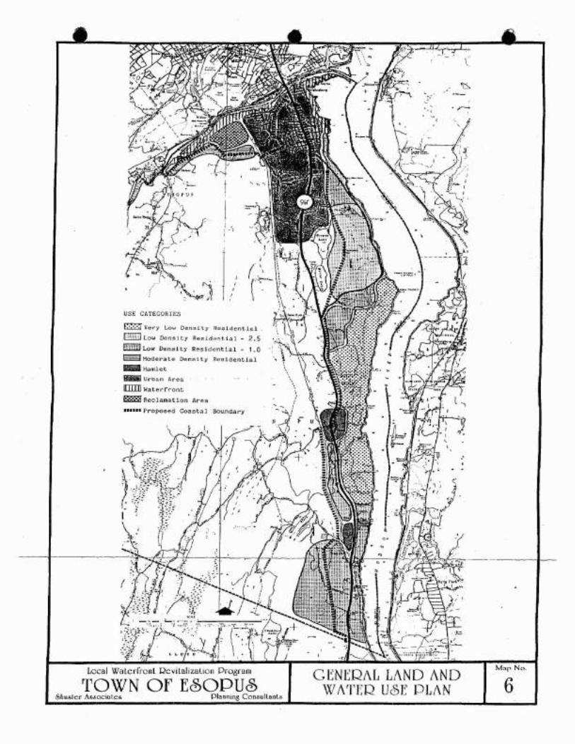
LI I
USE CA.TEGORIES
E:·;·:·:I Very Low Densi ty ncsidential
P;!!!!;J Low Density Residential - 2.5
R;i!!i!F!! Low Denai ty Residential 1. a~ Moderate Densi ty Resident.ial ':.._ Hamlet
f!Tiiiiil Urban A.rea
UIIIIJ WaterCron.t
B888lJ Reclamation Area
...... Proposed Coastal Boundary
Local WalcrrronL RC\lilalizalioli Pr08ram
TOWN Of ESOPUS<f>nuslcr IIssoci"tcs PI"nning Consultanls
., , ;---'I
.0
Mar No.
6

Loclll WlllcrrrOlll Rcvilllliznt ion Progrnm
TOWN Of E<§)OPUS.shusler I\5bOCilllcs Plllnnins Consultnnls
LEGEND
~ nf-2 Low Den~!ty
7Mal' No.
."
, ,
(
"~,"'
ACTION PROGRAM
Possible ruture extenslonor Waterrront Dlst~lcl
Ex1"t1ng ZoningDistr1ct Boundary
Coastal Bdry
•• Scenic Ro~d
o 0 Path or Trall
Boat Launch/Access Site
2 Remove Abandoned Garges
3 fishing Wall
~ Water Plant Improvements
~ Scehlc Overlooks
6 Lighthouse Rest0ration
E><1sting Zon1ng
R-40 One Family Resi(jcflce
R-12 One and Two Family Res.
Ne Ne ighborhood Comnlc rc i a 1
GC General and Service
LI L1ght Industr1~1
III fleavy Industrial
W Waterfront
Proposed Zeninp.
~1~ Jtr-l Very Low [J""'rl~~lt.y
-
•

•
o 0
4 Water ?lant !~~rove~~r.~s
5 Scenic Overlook~
6 Ligh~~ouse Restoration
TO\VN Of ESOPU6 Map No.
,- ,
7A

•
•
SECTION V
TECHNIQUES FOR LOCAL IMPLEMENTATION
•v. TECHNIQUES FOR LUCAL IMPLEMENTATION OF THE PROGRAM
This section descibes the local techniques--legal, administrative,managerial and financial--required to carry out the LWRP.
Part A describes legislation, both existing and proposed, which willhelp to implem:nt the program. Part B sets forth specific implementingactions or projects. Part C describes the management structure proposedto coordinate the program. Part 0 indicates the financial resourcesneeded and. where possible. available to carry out specific proposedactions. Part E is a chart summarizing proposed actions and the policiesfrom Section III to which they relate.
A. Local Laws and Reaulations
1. Existina Laws and Reaulations
The followinc exis:ina la~s and regulations are used by theTown to reguiate or review land use and development activityin the coastal area:
•a.
b.
Zonina Ordinance: The Town Zoning Ordinance establishesland use and density controls, in designated districts.based on a comprehensive plan of development.
Application: The regulations controlling the type anddensity of development are essential to implement theDevelopment Policies (1.1A. 2.4.5. and SA). See alsoproposea zoning amendments concerning c.he riverfront.Keview of site plans for certain uses is important toachieve Historicand Scenic Resource Policies 23 and 25.
Subdivsion Regulaticns: The Subdivision RegulationsestabllS~ stancaras and ~rocedures for the divisionot land Into Individual building lots and the designand construction of Dublic imorovements.
Application: These regulations are important to oroerlydevelo~ment and the ~ost efficient ane environmentallysensitive use of land end ~ill support Flooding andErosion Policies 14 and 17. Public Access Policy 20.and ~ater and Air ~esaurces Policies 32.33 and 44.
•
c. Floed Da~aGe Pr~v~nticn Re~ulations: Adopted pursuantto requ:rements Oi the fecerai Flccd Insurance Prc~ram.these re~ulations centrol the location and type ofconstruction per.7.itted in designated floed hazardareas.
Aoolication: These reguldtlons dre used to aChieveFlOCCing and EroSlcn PoliCies 14 and 1i.
<' •• - I

• d. Environmental Qualitv Review: Town agencies are responsible tor administering the State EnvironmentalQuallty Review (SEQR) Act as part of their review ofactions which may significantly affect the environment.Such responsibility includes identification of possibleadverse impacts and recommendation of mitigating measures. In addition to the lead agency. the Town ofEsopus Environmental Board provides data and co~ment
to assist review of proposed projects and actions.
Aoplication: Virtually all policies of the LWRP willbe supported by adherance to the procedures requiredby SEQR.
2. ProDosed Ne,o( Leoislation (Adooted by Town)
a. Establishment of Waterfront Commission: A Cowmissionto coordinate and ac~inlster varlOUS actions necessaryto implement the LWRP and to make "consistency determinations" will be created under local law. See C. below.
Application: This action relates to the entire LWRP.
•b. Local Consistency Law: A local law will be enacted to
require that all local boards, agencies,commissionsand departments act consistently with the ooliciesestablished in the LWRP •
Aoolication: This action relates to all aspects of theLWRP.
•
c. Zonine Amenc~ents: The Tcwn's existing Zoning OrdinanceprovlCes. in general. appropriate regulation of land usein the ccaS:2J area to ac~ieve the land use plan cescribedin Sec:ion IV. The ~ajor exceptions, however, are landuse contr8ls for the t~c lew density areas pro~osed alongthe Hudscn Ri~er south of Part Ewen. (See IV A.I. band cand Map No.7). To accompliSh the objective of protectingthis unique area two new zoning districts are proposed tobe added to the Zoning Ordinance. The proposed amencmentsare set forth in Exhibit V~A and discussed briefly below.Some ~ccifications to the rlaterfront District are alsopropos.:':.
(I) Very Lew Density District (RF-I)
[ntent: The intent of thisdistrict is to controlGevelccment so as to preserve the existing lewdensity character and large open spaces along theHudson River sMreJ ine 'tihi Ie providi ng opportunitiesfar clusterec dev~lccment and preservaticn of large,eXlstinS lanc~ar~ structures .
IJ - 2

•
•
•
Permitted Uses
Uses permitted by right include single familyhomes, agricultural uses and related accessoryuses.
Subject to issuance of a conditional use permit, the followinq uses may be allowed: certain public, recreationaland institutional use, town houses and; in existinqstructures onl~ apartments. offices. conference centers.research facilities and transient housing accommodations.
Density
Single fami ly houses wi 11 be !=€rmitted by right onparcels of at least five acres. Subject to issuanceof a conditional use pero.it, clustered single familyhomes or town houses may be permitted at an over-alldensity of one per acre.
Special Review Criteria for Conditional Use Permits
Review of application for conditional use permitsshall consider the following guidelines and criteriain particular prior to approval:
* All structures shall be set back at least 500 feet*from the river1s ecge, except those requiring awaterfront site (i.e. boat house, water plant,etc.), and at least 200 feet frcm Route 9W.
* Open space o~eser~ed through clustering shall bedesigned and located so as to preserve significantnatural features such as streams, hillsides, ridgetODs, natural weoded areas and rock out-CiOPS, andexisting landscaping.
* The visual i~pact of proposed develc~ment shallbe analyzed in ter~s of view frcm the site to theriver and from the rl~er and the oppcsite shoreto the site. Suc~ analysis shall consider thematerials used, the ~cssing sf buildings, thescale of develo~ment, the use of landscaoing andnatural growth, etc.
* Site design and constructicn ~anagemerrtshall usebest manage~ent practices to prevent adverse affectsfrem erosion. siitatlcn, fleccing, etc.
* The use of existing !cr~e structures as other thansingle family hc~es shall only be ~er~ltted if t~e
charJcter and sCJle sf the ~ulldlns and grounds aremainta:ned.
'J - :;
•
•
•
(2) low Density District (RF-2)
Intent: The intent of this district is to regulatecompatIhle low density development in areas wherethe shoreline is already developed or which arevisible from but do not have access to the water.The density of residential uses will be greater thanin the RF-l District, particularly where public utilities are available, but the range of other uses isless since unusually large, landmark structures arenot as prevalent.
Permitted Uses
Uses permitted by right include single family homes,agricultural uses and related accessory uses.
Subject to issuance of a conditional uses permit,town houses may be allowed as well as certainpublic, recreational and institutional uses.
Density
Single family homes will be permitted on lots ofat least 2.5 acres. Clustered single family homesand town houses at density of one per acre will bepermitted; if the units are served by public seweror water facilites density may be increased.
Special Review Criteria
The criteria and guidelines established for the RF-lDistrict will apply.
Aoplication: These amendments are among the most importantactions proposed by this LWRP and are required to achieveDevelopment Policies lA, 2, 4 and SA, and will supportPUblic Access Policies 19 and 20, Recreational Policy 21and Historic and Scenic Resource Policies 23 and 25 .
V-4
.;.; • d. Sian Reoulations
As part of the effort to preserve the scenic qualityof the Town, certain roads--primarily Route 9W and RiverRoad--are proposed to be designated as scenic roads, asdiscussed in B. below. Among the actions that shouldbe considered are regulations to control the location.size and design of commercial signs on these roads.Such regulations could eliminate off-premises billboards and ensure that business signs do not detractfrom the visual environment.
Application: These regulations will support Scenic andHistoric Resources Policies 23 and 25.
B. Other Actions
Physical projects related to the LWRP are described in SectionIV. B; required laws and reaulations are setfcrth in Section V.A. However, a number of.oth~er actions are also included in thisLWRP for consideration.
•1.
2.
Scenic Roads Desicnation
Roate 9W an&Ri~er Road are roads with great appeal whosehigh visual Quality is apparent to all whO drive them.Article 49 of the State Environmental Conservation Lawauthorizes designation of such scenic resources by. the Commissioner of DEC and the development of programs to preserveand enhance them. River Road hasalreadv received such designation--among the first in the state. This designation shouldbe supported by local actions. suCh as the enactment of signcontrols. state action such as development of scenic overlooks and joint cooperation in maintenance and techniques topreserve important vistas.
Creation of Acricultural Districts
The orchards and vineyards in the southern part of Town areimportant to the local economy as well as to the visual character of the area. Owners of these properties should be encouragedto petition the County to designate Agricultural Districts sothat they may avail themselves of the tax advantages whilepreser'ling these important resources for the Town and region.
•
3. Possible Extension of Waterfront District
In the future. the ~aterfront District may be expanded toinclude virtually all of the Rondout Creek frontage. InSUCh case, regulations will be refined to distinguish be-tween the location for maritime commercial uses-~in Connellyand Sleightsburg--and those for waterfront recreational uses.See Exhibit V-B.
'1-5

':-. •
•
4. Callanan Quarry Reclamation
While this site may continue in use for many years, the Townshould encourage DEC to continually monitor its operationsand carefully study existing and proposed reclamation plansto determine their impact and possible relationship toTown policies_and objectives for this area.
C. Mana~t Structure to Imclement the Program
1. Existino Orcanization and Manacement Resources
No existing municipal body in this area has overall responsibility for the wide range of activities covered by the policiesin Section III and the actions in Section IV. Physical operationsaffecting the Coastal Zone are dealt with primarily by the publicworks department and the water and sewer department. Land useand related functions are primarily the responsibility of thePlanning Board, Zoning Board, Environmental Commission andTown Board .
Since no part of this pattern fitted the unique requirementsof LWRP planning, a Waterfront Advisory Committee was createdto undertake the drafting of the LWRP under a State planninggrant. In its drafting work the Co~mittee and its planningconsultant have conferred with many of the bodies mentionedabove. Moreover, its membership includes chairmen or membersor a number of them, notably the Planning 80ard and the Environmental Commission. Thus the Committee has developed d uniqueover'fiew of the problems and possibilities facing the coastal zonewhich is extremely important and should be provided fer in theimplementation phase. The management structure set forth belowis designed to accomplish this purpose.
•
2. Waterfront Advisory B~ard
To provide advice and assistance in :he i~plementati~n of the localWaterfront Revitalization Program, a Waterfront Advisory Board of9 members has been established.
The Board snould be constituted as follows:
a. ACDointment
Members will be appointed for a term of three years and willbe eligible for reappointment; except that at the outset
v-~

•b.
three members will be appointed for a term of three years,three for a term of two years, and three for a term of oneyear.
Organization and Procedure
The Board will make its own rules of procedure, sub-ject to applicable law. It will elect a Chairman, and mayin its discretion also elect other officers, from among itsmembers. -
•
•
c. Qualifications
Each member appointed must be a resident of the Town. Members will be chosen for their demonstrated knowledge, ability,and readiness to serve the Board in the functions de-cribed below I and wi th due regard for maintaining among themembership a range of special aotitudes and exoertise relevant to the Board's work. In addition two members shallbe members of the Planning Board, two shall be members of theEnvironmental Board and one shall be a member of the ZoningBoard of Appeals.
d. -Functions and Powers
Tl1e Board's basic task will be to advise and coordinatethe implementation of the LWRP, its policies and projects,including physical,. legislative, regulatory, adminis~rative,
and other actions included in the program. In pursuance ofthis task the Commission will:
(1) Advise the Town Board on implementation priorities,work assignments, timetables, and budgetary requirementsof the program.
(2) Review applications for site plans, zone changes, subdivisions and public works projects in the coastalarea and advise the appropriate agency ~s to theirconsistency wtih policies of the LWRP.
(3) Subject to the approval of the Tox~ Board, mak~ application for funding from State. Federal, or othersources to finance projects und~r the LWRP.
(4) Maintain liaison with related Town bodies, includingbut nat limited to the Planning and Zoning Boardsand the Environmental Board, and with concernednongovernmental bodies, in order to further theimplementation of the L~RP .
'1- 7

•
•
(5) On behalf of the Town Board, evaluate in timelyfashion proposed actions of State agencieswithir! the coastal zone in order to assure cOrJsistency of such actions with policies ~f th~ LWRP,advise the Board of any confl iets, and participatein discussion to resolve SUCh conflicts.
(6) Review propo$ed federal actions referred to itby the Department of State and advise the DOSas to its opinion concerning the consistency ofthe action with local coastal policies.
(7) Prepare an annual report on progress achieved andproblems encountered during the year, and recommendsuch-actions as the Board considers necessary forthe further implementation of the LWRP to theappropriate body.
(8) Perform ether funtions regarding the CoastalZcneas the Town Board may assign to it from time to time.
e. Other Provisions
(l) Members will serve without .compensation. They will beentitled to reimbursement for necessary expendituresin the performace of their work, subject to budgetarylimitations .
(2) The Board may engage such professional and clericalhelp and purchase such supplies and services as arenecessary for its work, subject to prior budgetaryapproval by the Town Board.
(3) The Board will meet as necessary to conduct its busine~~.Its me~tings will be open to the public. It willkeep and distribute minutes of its proceedings. Amajorit J of its ~embers will constitute a quorum.
3. Limitations
Notwithstanding anyother provision of this Program, no powers,duties, or func~ions are conferred by it en the WaterfrontAdvisory Board other than those set forth in paragraphs d. and e.above; and no provision of this Program shall be construed asaltering the powers, duties, and functions of any existing Townboard, agency or officer of the Tawn of Esopus.
•4. Sunset Provision
Five years frem the date of initial appointment and everythree years thereafter, the Board shall issue a finding asto its continued need and future function. Should the Boardfind that there is no longer a need for its services or thatits functions are no lon~er appropriate, or should the Boardfail to render any finding in a timely manner, the Board's termshall be considered to hav~ eXPired and its oowers and dutiesshall automatically be JSSl~ne1 to tn~ Planning Goard.
IJ .~

•5. Consistency Review of Federal Actions
Federal actions in the coastal area will be reviewed in accordwith the procedures set forth in Exhibit V-C.
e·
•
O. Financial Resources to Implement the LWRP
Financial resources in varying amounts are required to implemeltthe threetypes of actions included in the LWRP--administrative, legislative andphysical projects. Resources necessary for the fi rst two categories arerelatively small and can be included in the normal annual budget allocations of the Town. Although the list of physical projects has beenintentionally limited to those of highest priority, several are be-yond the normal financial capacity of the Town.
Section VI indicates various State and Federal programs whiCh mayaffect implementation of the LWRP. including some potential funding sourcesfor soecific ohvsical projects. However. it is recognized that suchflJndinp is limited and ccmoetition for available frtnds is fi-er-:e.Setforth Below is the estimated cost Of each proposed phySical project,where avai lable, and possible sources of funds to implement them.Preconstruction costs may be available from the New York State Depart-ment of State upon approval of this LWRP. ~
1. Boat LaunchinQ Site and Access: Sleightsburg Spit
a. Estimated Cost: S 350,000 (InclUdes acquisition and construction)
b. Possible Funding Sources
- New York State DEC- New York State OPR &HP- Town Recreation Fund- Hudson River Foundation
2. Waterfront Path System
a. Estimated Cost: not specifiedb. Possible Funding Sources
- Private cevelc~e~$ as part of 'site ae~elODment
- Tmm Recreation Fund
3. Water PIant ImorovEments
a. Estimated Cost: Sb. Possible Funding Sources
- u. S. Department of Agricul ture
4. RemovJI of Abandoned Bar~es
a. EstimJted Cost: S Unknc~n

• b. Possible Funding Sources
- J,,"-S. Corps of Eng ineers
5. Scenic Overlooks
a. Estimated Cost: Coordinate with highway improvements
•
•
b. Possible Funding Sources- New State DOT
6. Lighthouse Preservation
a. Estimated Cost: $100-150,000
b. Possible Funding Sources- New York State OPR &HP- New York State Dept. of State- Private Corporations- HUdson River Foundation
7. Fishing Wall at North Broadway
a. Estimated Cost: $20,000
b. Possible Funding Sources- New York State DEC- Town of Esopus- Hudson River Founca~icn
8. Historic Trail Markers
a. Estimated Cost: S500 per sign
b. Possible Funding Sources- New York State OPR &H?- New York State DOT- Private Donations
E. Summary Chart of Actions and Policies
The following chart (or matrix) indicates the Policy(s) set forth inSection III that are addressed by each ot the various implementingactions described in Sections IV and V.
'J. ,'J

• PROPOSED RIVERFRONT ZONING
•
•
Local \Valerfronl Qevilalizalion Program
TOWN Of E~OPU~***
The Esopus Haterfront Advisory Corrmittee has been developing a plan forthe Town1s entire-coastal area--Rondout Creek and the Hudson River--formore than tHO years. During this prcc2ss, the preservation of portions ofthe scenic, low density shoreline southof Port E'",en was established as animportant priority. The means proposed to accomplish this objective isvia _revisions in the Town Zoning Ordinance which will require preservationof open space and encourage use of landmark structures for appropriatepurposes.
A public hearing on the entire Local Waterfront Revitalization Program washeld on August 13, 1986, at which many comments on the proposed riverfrontzoning were received. As a result, the Waterfront Advisory Committee hasreviewed the original proposal and recommended substantial revisions whichsignificantly reduce the area included in the two new districts proposed.
The only areas affected by the proposed zoning are now zoned R-40. Thehamlets of Esopus and West Park are not included and existing businessuses and business zoning on Route 9W are not affected in any way_
The text of the proposed zoning is attached as -,o/ell as a r:lap sho'rdng therevised boundaries of the two new Riverfront Zoning Dist~icts .

•
•
p~ ftCTICNS Pn) PPPLIOBLE PClICIES
.ocrICll (see leaerd Be1cw1Pelley flO.
1 2 3 4 5 6 7 8 9 10 11 12 13 14
1 • • • • •I--IA • • •- ~ • I • • •- 4 • • • • • •- 5 • • •-- ::JA • • •f--0
I--1
I--- 7A-D I •i--8 I,...-9 •I---
10 •I---'1 I I I I I I I I I I • I •I---13A •• •I---14 I • • •i--15 I- 16 I I- 11 I • I •- 18 I I
I---19 • • • • •i--20 • I I •- 21 • I • • I •- I
~ 22 I • •I-- -2.J I • • I •i--I I
i-- 2::> I • I I • I • I • I I I •i--25A I I I -I • I I •I--- 2b I I \ , I I- I I •I---28 I I I I f I I I I I
i--30 I I I I I I I 1 •- j2 I I I I I I I I I I I I •- j.J I , I I I , • I , I I •- 34 I I I I I I I- 341-\ I I I I I I I !
i--35 I I I I I I I
I--36 I I I I I I I i
I-- 3/ I I I ,. I I I I I •i--38 I I I I I I I I I •I--39 I I I I II--41 I I I 1 I
I--44 I I I I • I•
Acticns
•1.2.,..J •
4.5 .6.I •
';cce~: SitePct~ S!s~em
W~:~r ~lant l~orovements
8J r:~r: ~;::mO'Ia 1SC';r1:: O'lerl ock~L; ,~:: :.:I';IJ~e rr~::;cr'/JtlenF: :,: ,:.~ ',~d [ J
8. Historic Trail9. ~at~rfr:nt/L:~ Density Zsnir.g
10. SiGn ~e~ulatlcns
11. Sc~nlC Rc~d Qe~l~n~~!On
12 . I~q r tcuI t ur J I 0 I ~ t rIC t :1:;. £.~l':tln'J L::"'':Jnl~p.:r;IJIG:i0n:
14. LGCJl (Cr.Sl';:'0"':"! 1-,:',1

•
•
•
SHUSTER ASSOCIATES
8/12/85Revised 10/15/85
5/2/865/8/86
11/17/86PROPOSED AMENDMENTS
TOWN OF ESOPUS ZONING ORDINANCE
RIVERFRONT DISTRICTS
The following amendments to the Town of Esopus Zoning Ordinance are proposedto implement the recommendations of the Local Waterfront Revitalization Program concerning the Hudson River coastal area.
Article III. District Regulations. shall be amended by adding new Sections123-14.1 and 123-14.2. as follows:
§123-~4.l. RF-1 Riverfront District
Intent: The intent of this district is to control development so as to preserve the existing low density character and large open spaces along theHudson River shoreline while providing opportunities for clustered development and preservation of large, existing landmark structures.
In an RF-I Riverfront District. no building or premises shall be used and nobuilding or part of a building shall be erected or altered which is arranged.intended or designed to be used. in whole or in part, for any uses exceptthe following. (See also Article V.)
A. Permitted Uses
(1) Any use permitted in the R-40 One-family Residence District in§123-6A.
B. Conditional Uses
The following conditicnal ~ses are permitted subject to the apprcval ofthe Planning Board in accordance with §123-56 and §123-57, hereof, including a finding that such uses are consistent with the Town's approvedLocal Waterfront Revitalization Progran., and to the regulations specifiedbelow and elsewhere in this chaoter.
(1) The following uses. subject to the condi:ions establisned therefore.in §123-6a:
(a) Places of worship(b) Schools(c) Munieioal parKS(d) Annual membership clUbs(e) Chilcren's recreation camos(f) Cemeteries(g) Summer cotteges

•
•
(2) Clustered single family and town house dwellings, subject to theprovisions of §123-25 S,C and E and the following:
(a) Minimum gross site area shall be 20 acres.
(b) The maximum number of dwelling units permitted shall be determined by reducing the gross site area by 25% and cividingthe remaining area by 40,000 square feet.
(c) No structure shall exceed 30 feet in height.
(d) All structures shall be set back at least 500 feet fromthe river's edge, except those requiring a waterfront site(i.e. boat house, water plant, etc.), This set back maybe reduced to 300 feet upon a finding by the PlanningBoard that, due to the nature of the site, such reductionwill not adversely affect the guidelines set forth in (g)below. Structures shall also be set back at least 200 feetfrom Route 9w and 100 from other streets or property lines.
(e) The Planning Board shall consider the size and configurationof lots during its review in terms of the criteria set forthin (g) below and the provision of adequate water supply andsewage disposal systems.
(f) At least one third of the gross site area shall be preservedas permanent open space by appropriate legal covenants as setfor in )125-25 E and recorded as such on all filed maps. TheTown may, at its discretion, accept all or part of such openspace if offered for dedication. At least two thirds of suchopen space shall be preserved in its natural state. The remainder may be used for active recreation facilities and mayalso contain water supply or sewage disposal systems if- theyare designed so as to preserve the scenic or functional purposes to which said open space is devoted. Such open spacemust have a ~ir.imum dimension of at least 100 feet at all points.
(g) In addi·.ian ta criteria ccntained in§123-56 and )123-57,the Plar.ning 90arc shall also c~nsider the following guidelines and criteria in its review of a cluster developmentunder this section:
(i) Open space preserved through clustering shall be designedand locate1 so as to Dreser~e significant nat~ral featuressuc~ as streams, hillsides, ridge tops, natural ~coGed
areas and roc~ outcrcDS, and existing landscaoins.
(ii) The visual impact of proposed development shall :e minimized in te~s of views from the site and adjacent roadsto the river and frem the river and the oDPosi~e shoreto the sit~. An~lysis Shall consider the materials used,the massing cf buildings, the scale of develoc~ent, theuse of land~caoing and natural grcwth ~tc. The ~ossible
intrusivn of new dev~lopment on th~ vi~ual set:lng of estates, inztitutions and hi~torlC structures on n~arby
prop~rtles shall al:o l;e ':'1dluatefj .
-2-

•
•
(iii) Site design and construction management shall be undertaken in a manner so as to prevent adverse affects fromerosion, siltation, flooding, etc.
(iv) Provision of public access to and along the shoreline isto be encouraged and review of site plans will includeconsideration of opportunities to incorporate the development of such access.
(h) The Planning Board may require sUbmission of a clustered development plan, in accord with the provisions of this paragraph, ifit finds that such type of development is necessary to preservespecific features of the site and the general character of thedistrict. However, the Planning Board may not require the development of multi-family dwellings in place of single familyhomes.
(i) Site plan review under the provisions of this Section shallsuffice for Planning board review of SUbdivisions under theTown Subdivision Regulations, subject to the followingconditions:
(i) The developer shall prepare sets of subdivision olatssuitable for filing with the office of the Ulster CountyClerk in addition to those drawings required under§§123-56 &~.
(ii) The developer shall plat the entire development as asubdivision; however, projects being developed in stagesmay be platted and filed in the same stages.
(iii) Final site plan aoproval under §123-57 shall constitutefinal plat approval under the Town Subdivision Regulations,and the provisions of §276 of the Town Law requiring that,the plat be filed with the Ulster County Clerk withinninety (90) days of approval shall apply.
(3) The following uses, if housed entirely in structures erectedprior to January 1, 1985, and SUbject to the provisions set forthbelow: apartments; corporate or professional offices; conferencecenters, inns or transient housing acce~~odations.
•
(a)
(b)
Gross site area shall be at least 25 acres and cross fleerarea of existing buildings shall beH leastS,OOO squarefeet. Maximum density Shall be cc~puted as in (2) (b) above.
The scale and character of the ~xisting building shall notbe substantially altered in terms of architectural detailing,size anc shape of door ar-d windew openings, exterior materialsand colors and similiarfeatur~s. Additions to eligiblestructures shall be kept to a mini~um and in no case shalladditions to any structure exceed 20~ of its aggregate floorarea or cubic volume.

•
•
•
(c) All required off-street parking in excess of five spaces shallbe located at least 200 feet from adjacent streets and properties and fully screened therefrom.
(d) The Planning Board shall also consider the guidelines setforth in paragraph (2) (g) above in reviewing proposals.
C. Permitted Accessory Uses
(1) Any accessory use permitted in §123-6C.
S123-14.2 RF-2 Riverfront District
Intent: The intent of this district is to regulate compatible low densitydevelopment in areas where the shoreline is already developed or which arevisible from but do not have access to the water. The density allowed forresidential uses is greater than in the RF-I District. particularly wherepublic utilities are available. but the range of other uses is less sinceunusually large. landmarK structures are not prevalent.
In an RF-2 Riverfront District. no building or premises shall be used andno building or part of a bUilding shall be erected or altered which isarranged. intended o~-designed to be used, in whole or in part, for anyuses except the following. (See also Article V.)
A. Permitted Uses
(1) Any use permitted in the R-40 One-family Residence District inS123-6A.
B. Conditional Uses
The following conditional uses are permitted subject to the approvalof the Planning Board in accordance with §123-56 and S123-57. hereof,including a finding that such uses are consistent with the Town's approved Local Waterfront Revitalization Program, and to the regulationsspecified below and elsewhere in this chapter.
(1) The following uses, subject to the conditions established therefore.in S123-6B:
J
~a) Places of worship(b) Schools(c) Municipal parks(d) Annual membership clubs(el Children's recreation camps(f) Cemeteries(g) Su~~er cottages
(2) Clustered single family and town house dwellings. subject to theprovisions of S123-25 e.c and E and the following:
(a) Items (a). (el, (e). (h) and (i) of S123-14.1 9 (2) .
.~-

•
•
•
(b) The maximum number of dwelling units permitted shall bedetermined by reducing the gross site area by 25% anddividing the remaining area by 40.000 square feet. However. if the proposed units are to be connected to the pub--lie water supply or sewage disposal systems. the remainingarea may be divided by 30.000 square feet; or by 25,000square feet if connected to both.
(c) All structures shall be set back at least 200 feet fromthe river's edge. except those requiring a waterfrontsite (i.e. boat house. water plant, etc.), and at least100 feet from all streets and adjacent properties.
(d) At least 25~ of the gross site area shall be preserved aspermanent open space by appropriate legal covenants as setfor in §125-25 E. Such open space may be preserved in itsnatural state or developed for passive or active recreation.Water supply or sewage disposal systems may also be containedin such open space as long as they do not adversely affectthe scenic or functional purposes to which said open spaceis devoted. Such open spaces shall have a minimum demensionof at least 100 feet at all points.
(e) In addition to criteria contained in §123-56 and §123-57.the Planning Board shall also consider the following guidelines and criteria in its review of a clusterdevelopmentunder this section:
(i) Open space preserved through clustering shall bedesigned and located so as to preserve significantnatu~al feat~res such as streams. hillsides. ridgetops. natural weeded areas ~nd rock out-crops. andexisting landscaoing.
(ii) The visual i~pact of proposed development shall beminimized in ter~s of views from the site and adjacentroads to the river and frcm the river and the oopositeshore to the site. An3lysisshall considei th~ materialsusee. the massing of bUildir.gs, the scale of develcp~ent,
the use of landscaping and natural growth. etc.
(iii) Site desi~n and construction ~anage~ent shall ~se testmanage~ent ~racticc$ to prevent adverse affe(:: fr:merosicn, siltation. flooding. etc.
C. Permitted Accessory U~es
(1) Any accessory use ~er~itted in §123-6C .
-:-

• 2. Article IV, District Bulk and Parking ReQulations. shall be amendedby additIon ot a new Section 123-16.1 Riverfront Districts. asfollows:
§123-16.1 RF-l and RF-2 Riverfront Districts
The following bulk and parking regulations for RF-I and RF-2 RiverfrontDistricts shall apply. (See also Article V)
Minimum Requirements
Total Lot Area (square feet)Lot Width (feet)Lot Depth (feet)Front Yard (feet)Each Side Yard (feet)Rear Yard (feet)Off-street parking spaces*:(per d.u.)
RF-1
200,000300500
7550
1002
RF-2
100,000200300
503075
2
•Note: See also provisions for clustered development as a conditional use.
~ReQuired parking for conditional uses permitted under §123-14.1 and§123-14.2 shall be established by the Planning Board prior to approvalof any such conditional use permit based on the requirements set forthin §123-23.
3. Article XII,Definitions. Shall be amended by addition of the following:
•
DWELLING, TOWNHOUSE - A one-family dwelling in a row of at least two suchunits in which each unit has its own front and rearaccess to the outside, no unit is located over another unit. and each unit is separated from any otherunit by one or more common fire resistant walls.
-6-

"
The boun~arle5 snawn ~~ ~n:~ are illustratIve only, ~ ce::m4C sheWing eJ4ct eO~~C:rl~~ .available for revie~ :' :~€ "Clerk's Offlce.
!!Q!l:
U .. I Ytr, Lo" Olllnstt,
....% law a.,,, 1tr
k-:31 '~'4lcrfronl ~C ...131IZ3llon PrC'srJ::l
TOWN Of E60PU6~!lUI('r '~"Lea DJIII_lfte ('~.~.,,~lS-:~'
l'l,Ul'USLl) lU\'UtFltO:\T Zl,):\l:-"
..
I;--<~.U,..~ '.
(II ~
~'~
1'1.I
,'jJ/'ij':"'.l-. r~ t,'::'t
!... " •'-, '. j
.. L 'I
tJ
1•
•

•
•
•
11IIII Existing Waterfront District
~ Proposed Extension
Areas in ~ich waterfrmtcanrerc ia1 uses to t€ t:'€rmitted. subject to s~€':iel
pennit•
1" = 2.GCO'
LocDI WDlc:rfronl QcvlllIlilllllon :', '~$ram :: .'tll:, I ' .. '.' _:;.
TO\XlN Of E80DUcS "r·~i"'_' '; ~.;,:, ..-.~ .. ";'.' :JI-:::_r:'.::.~tIlJ ... ler A&6OCt.I.tl:A '": I. :''''''. C' 'l"I~: III!·

•EXHIBIT V-C
Procedural Guidelines for Coordinating NYS DOS & Lw~
Consistency Revie~ of Federal Agency Actions
DIRECT ACTIONS
1. After acknouledging the receipt of a consistency deter.::lination andsupporting documentation from a federal agency. DOS will :orward copiesof the deter.::lination and other descripti~e info~ation on the proposeddirect action to the program coordinator (of an approved L~~) and otherinterested parties.
2. This notification will indicate the date by which all co=ents andreco:::::lendations must be subll:itted to DOS and will identify theDepartment's principal reviewer for the proposed action.
3. The review period will be about twenty-five (25) days. If co~ents andrecolll:lendations are not received by the date indicated in thenotification. DOS will presume that the ltunicipal1ty has "no opinion" onthe consistency of the proposed direct federal agency action with localcoastal policies.
•4. If DOS does not fully concur with and/or has any questions on the
c:otr.::en ts and recocmenda tions submit ted by the munic ipality. DOS willcontact the municipality to discuss any differences of opinion orquestions prior to agreeing or disagreeing with the federal agency'sconsistency detercination on the proposed direct action.
5. A copy of DOS' "agreement" or "disagreement" letter to the federal agencywill be forwarded to the local prograc coordinator.
PE~~!T ~~D LICE~S~ ACrIO~S
1. DOS will acknculedge the receipt of an applicant' s consistencycertification and application caterials. At that ti:::e, DOS will for.;arda copy of the subcitted documencation to the progra= coordinator and willidentify the Department's principal revie~er for the proposed action.
2. ~ithin thirty (0) days of receiving such infor::ation. the programcoordinator ...·U1 contact the principal revie_er for DOS to discuss: (a)the need to request additional infor:ation for revi~J purposes; and (b)any possible problecs pertaining to the consistency of a proposed accionwith local coastal policies.
3. Yhen DOS and the progra~ coordinator agree that additional info~ation isnecessary. DOS will request the applicant to prOVide the 1nfor=at1on. Accpy e! ~hio i~:v~.~1an ~~~t be ~~~id~ to t~c p~~g~~ ~~v~i"Q~Q~~
receipt.
•4. Vithin thirty (30) days of receiving the requested additional information
or discussing possible problems of a proposed action with the principalreviewer for DOS, whichever is later, the program coordinator ~ill notifyDOS of the reasons why a proposed action cay be 1nconsistent or consistentwith local coastal policies.

• 5.
6.
7.
- 2 -
After that notification. the program coordinator will submit themunicipality's ~ritten co~ents and reco~endations on a proposed percitaction to DOS before £! ~ the conclusion of the official public commentperiod. If such co~ents and recommendations are not fo~arded to DOS bythe end of the public cocment period. DOS viII presume that themunicipality has "no opinion" on the consistency of the proposed actionvith local coastal policies.
If DOS does not fully concur \Jith anc/or has any questions or. thecomments and reco~endations subcitted by the municipa~ity on a proposedpe~it action, DOS will contact the program coordinator to discuss anydifferences of opinion prior to issuing a letter of "concurrence" or"obj ection" letter to the applicant lo'ill be forwarded to the prograocoordinator.
A copy of DOS' "concurrence" or "objective" letter to the applicant .illbe forwarded to the program coordinator.
FIN~~CIAL ASSIST~~CE AC!IOXS
1. Upon receiving notification of a proposed federal fin4ncial assistanceaction. DOS vill request infor=ation on the action from the applicant forconsistency reviev purposes. As appropriate, DOS \Jill also request theapplicant to prOVide a copy of the application docu::entation to theprogram coordinator. A copy of this letter vill be forwarded to thecoordinator and vill serve as notification that the proposed action maybe subject to revie\J.
2. DOS .ill ackno\Jlecge the receipt of the re~uested info~ation and prOVidea copy of this ack~o.ledge=ent to the program coordinator. DOS cny, atthis ti~e, request the appljcant to su~c1t add1tiona: infor=at~on forrevie\J purposes.
3. the rev~e~ period ~ill conclude thirty (30) cays after the date on DeS'letter of ackno\Jledgel:lent or the receipt of requested additional1nfor=ation. whichever is later. The revie~ pe=ioc! ~ay be extended formajor financial assistance actions.
t... The prog':a:::l coordinator ll:ust sub::it the ::u~ic1pality's cc:=.ents andreco:=1er-.dations on the proposed action to DeS ""ithin t·.en:::: cays (orother til:le as"eed to by DOS and the progra~ coordinator) for= the startof the review period received .ithin this period, DOS ~111 ?resu~e thatthe cunicipal1ty has "no opinion" on the consistency of the proposedfinancial assistance action v1th local coastal policies.
5. If DOS does not· fully concur \Jith and/or has any questions on theCCiZiIi:r.;:ii Iffid yteti'!:::oenda1:1ons subcitted by tbe mun1cipa::'1ty. DOS willcontact the program coordinator to discuss any differences of opinion orquestions prior to notifying the applicant of DeS' consistency decision.
• 6• A copy of DOS' consistency decision letter to the applicant \o"~ll beforwarded to theprogratn coord1n<!tor.

•
•
•
NEW YORK STATE DEPARTMENT OF STATECOASTAL MANAGEMENT PROGRM1
Guidelines for Notification and Review of State Agency ActionsWhere Local Waterfront Revitalization Programs Are in Effect
I. PURPOSES OF GUIDELINES
A. The Waterfront Revitalization and Coastal Resources Act (Article 42 ofthe Executive Law) and the Department of State's regulations (19 NYCRRPart 600) require certain state agency actions identified by theSecretary of State to be consistent to the maximum extent practicablewi th the policies and purposes of approved I.ocal WaterfrontRevitalization Programs (LWRPs). These guidelines are intended toassist state agencies in meeting that statutory consistencyobligation.
B. The Act also requires that state agencies provide timely notice to thesitus local government whenever an identified action will occur withinan area covered by an approved LWRP. These guidelines describe aprocess for complying with this notification requirement. They alsoprovide procedures to assist local governments in carrying out theirreview responsibilities in a timely manner •
C. The Secretary of State is required by the Act to confer with stateagencies and local governments when notified by a local governmentthat a proposed state agency action may conflict with the policies andpurposes of its approved LWRP. These guidelines establish aprocedure for resolving such conflicts.
II. DEFINITIONS
A. Action means:
1. A "Type 1" or "Unlisted" action as defined by the StateEnvironmental Quality Review Act (SEQR);
2. Occurring within the boundaries of an approved LWRPi and
3. Being taken pursuant to a state agency program or activity whichhas been identified by the Secretary of State as likely to affectthe policies and purposes of the LWRP.
B. Consistent to the maximum extent practicable means that an action willnot substantially hinder the achievement of any of the policies andpurposes of an approved LWRP and, whenever practicable, will advanceone or more of such policies. If an action will substantially hinderany of the policies or purposes of an approved LWRP, then the actionmust be one:
•1.
2.
3.
2
For which no reasonable alternatives exist that would avoid orovercome any substantial hindrance:
That will minimize all adverse effects on the policies or purposesof the LWRP to the maximum extent practicable: and
That will result in an overriding regional or statewide publicbenefit.
'.
C. Local Waterfront Revitalization Program or LWRP means a progranprepared and adopted by a local government and approved by theSecretary of State pursuant to Executive Law, Article 42: whichprogram contains policies on the management of land, water andman-made resources, proposed land uses and specific projects that areessential to program implementation.
III. NOTIFICATION PROCEDURE
A. When a state agency is considering an action as described in II above,the state agency shall notify the affected local government.
B. Notification of a proposed action by a state agency:
1. Shall fully describe the nature and location of the action;
2. Shall be accomplished by use of either the State Clearinghouse,other existing state agency notification procedures, or throughany alternative procedure agreed upon by the state agency andlocal government:
3. Should be provided to the local official identified in the LWP~ cfthe situs local government as early in the planning stages of theaction as possible, but in any event at least 30 days prior to theagency's decision on the action. (The timely filing of a copy of acompleted Coastal Assessment Form with the local LWRP of ficialshould be considered adequate notification of a proposed action.)
c. If the proposed action willenvironmental impact statement,the chief executive officernotification to the situs local
require the preparation of a draftthe filing of this draft document with
can serve as the state agency'sgovernment.
•IV. LOCAL GOVERNMENT REVIEW PROCEDURE
A. Upon receipt of notification from a state agency, the situs localgovernment will be responsible for evaluating a proposed actionagainst the policies and purposes of its approved LWRP. Upon reque~t
of the local official identified in the LWRP, the state agency should

•
•
•
3
promptly provide the situs local government with whatever additionalinformation is available which will 'assist the situs local governmentto evaluate the proposed action.
B. If the situs local government cannot identify any conflicts betweenthe proposed action and the applicable policies and purposes of itsapproved LWRP, it should inform the state agency in writing of itsfinding. Upon receipt of the local government' s finding, the stateagency may proceed with its consideration of the proposed action inaccordance with 19 NYCRR Part 600.
C. If the situs local goverrunent does not notify the state agency inwriting of its finding within the established review period, the stateagency may then presume that the proposed action does not conflictwith the policies and purposes of the municipality's approved LWRP.
D. If l:he situs local government notifies the state agency in writingthat the proposed action does conflict with the policies and/orpurposes of its approved LWRP, the state agency shall not proceed withits consideration of, or decision on, the proposed action as long asthe Resolution of Conflicts procedure established in V below shallapply. The local government shall forward a copy of the identifiedconflicts to the Secretary of State at the time when the state agencyis notified. In notifying the state agency, the local government shallidentify the specific policies and purposes of the LWRP with which theproposed action conflicts.
V. RESOLUTION OF CONFLICTS
A. The following procedure applies whenever a local government hasnotified the Secretary of State and state agency that a proposedaction conflicts with the policies and purposes of its approved LWRP.
1. Upon receipt of notification from a local government that aproposed action conflicts with its approved LWRP, the state agencyshould contact the local LWRP official to discuss the content ofthe identified conflicts and the means for resolving theI:l. 11.meeting of state agency and local governIl'lent representatives maybe necessary to discuss and resolve the identified conflicts.This discussion should take place within 30 days of the receipt ofa conflict notification from the local government.
2. If the discussion between the situs local government and the stateagency results in the resolution of the identified conflicts,then, within seven days of the discussion, the situs localgovernment shall notify the state agency in writing, with a copyforwarded to the Secretary of State, that all of the identifiedconflicts have been resolved. The state agency can then proceedwi th its consideration of the proposed action in accordance with19 NYCRR Part 600.

6. The state agency shall not proceed with its consideration of, ordecision on, the proposed action as long as the foregoingResolution of Conflicts procedures shall apply •
•
•
•
2/1/85
3.
4.
5.
4
If the consultation between the situs local government and thestate agency does not lead to the resolution of the identifiedconflicts, either party may request, in writing, the assistance ofthe Secretary of State to resolve any or all of the identifiedconflicts. This request must be received by the Secretary within15 days following the discussion between the situs localgovernment and the state agency. The party requesting theassistance of the SecretaI)- of State shall forward a copy of theirrequest to the other party.
Within 30 days following the receipt of a request for assistance,the Secretary or a Department of State official or employeedesignated by the Secretary, will discuss the identified conflictsand circumstances preventing their resolution with appropriaterepresentatives from the state agency and situs local government.
If agreement among all parties cannot be reached during thisdiscussion, the Secretary shall, within 15 days, notify bothparties of his/her findings and recommendations.
•
••
•
SECTION VI
FEDERAL AND STATE PROGRAMS
LIKELY TO AFFECT IMPLEMENTATION

';'. •
•
Statp. and Federal actions will affect and be affectp.d by impleoentationof the LVRP. lJnl'ler f.tate law and the U. S Coastal Zone "{ana~ement Act,certain State and Federal actions within or affecting the local waterfrontarea oust be "consistent" or "consistent to the maximum extent practicable"\11 th the enforceable policies and purposes of the L~P. This consistencyrequirement makes the Lw~P a unique, intergovernmental mechanism forsetting policy and making decisions and helps to prevent detricer.talactions fro~ occurring and future options from being needlessly foreclosed.At the same time, the active participation of State and Federal agencies isalso likely to be necessary to implement specific provisions of ~he th~P.
The first part of this section identifies the actions and pro~raC$ ofState and Federal agencies which should be undertaken in a ~anner
consistent with the Lt~P. :his is a ger.eric list of actions and pro~ra~s,
as ic('ntified by the NYS Depart~ent of State; thereforE", some of theac:ions ·and ?ro?,rams listed cay not be relevant to this l~~P. Pursuant tothe State Waterfront Revitalization and Coastal Rt>sources Act: (C:~ecuti\·e
law, Article 42), the Secretary of ~tate individually anc separatp.lynotifie~ affected State agencies of those agency actions and pro~~acs whichare t~ be undp.rtaken in a manner consistent with approved t~~?s.
Sinilarly, Feceral agency actions and programs subject to consiste~cy
Tequire~er.ts are identified in the manner prescribed by the U.S. CoastalZone Xanagement ~ct and its implementing regulations. The lists of Stateand Federal actions and pro~rams included herein are inforoational only anddo not represent or substitute for the required identif~cation andnotification procedures. The current official lists of actions subject to.State and Federal consistency requirel'1ents may be obtained from the }'"Y!:Departnent of State.
The second part of this section is a more focused and descriptive listof State and Feceral 3s:tency actions which are necessary to f'lrt~er
it:1ple~p.r.tation of the T:..~? It is reco~nized that a State or Fede~al
3Stencv'!' c:bility to undertake such actions is subject to a vilriet:r 0:~actors and considerations; that the consistency provisions refer,:~d toa~ove. Qay not apply; and that the cor.sistency require~ents can root be useeto require a State or Federal C1~encv to uncertai<e an action it could ~ot
undertake pursuant to other provisions of law. Reference should be nade toSection IV and Section V, which also discuss State ar.d Federal assistanceneec!ed to implement the t.!''PP •
•VH.

•DIRECT FEDERAL ACTIVITIES Ah~ DEVE10P~~T PROJECTS
DEPARTMEh7 OF COMMERCE
National Marine Fisheries Services
1.00 Fisheries Management Plans
DEPARTMD:T OF DrF~SE
Armv Corps of En2ineers
1.00 Proposed authorizations for dredging. channel impr~vements.
breakwaters. other navigational works. or erosion control structur~s.
beach replenishment. dams or flood control works. ice management?ractices and activities. and other projects with poter-tial toi:pract coastal lands ar.d waters.
2.00 Land acquisition for spoil disposal or other purposes.
3.00 Selection of open .ater disposal sites.
•4.00
Arev. Navv and Air Force
Location. design, and acquisition of newir.stallations (active or reserve status t
housing, transprotation or other facilities).
OT expanded defenseincluding associated
5.00 Plans. procedures and facilities for land1n~ or storage use zones.
6.00 Establishment of impact. compatabil~ty or restricted use zones.
DEPARn!E~7 OF ~ERCY
1.00 Prohi~it1on orders.
GENERAL SERVICES AD~INISTRATION
1.00 Acquisition.property orGoverrur.ent.
location and design of proposed Federal Cove~~ent
buildings. whether leased or o~~ed by the Federal
:- . •
2.00 Disposition of Federal surplus lands and structures.
DEPARTMENT OF INTERIOR
Fish and -11dliCe ~erv1ce
1.00 Mana~ement of National ~i1dl1fe refuges and proposed acquisitions.
1/1-2
•
•
DEPARTMEST OF INTERIOR (continued)
~ational Park Sen'ice
3.00 ~ational Pa~k and Seashore ~a~age=ent and proposed acquisitions.
DE?ARTHE~T OF T~~SPORrA!ION
A=t:-ak. Conrail
1.00 Expansions. curtall::e%)ts, ne\: construction, upgradings orabandon=ents of railroad facilities or services. in or affecting theState's coastal area.
Coast Guard
2.00 Location an~ design, construction or enlarge~ent of Coast Guardstations. bases. and lighthouses.
3.00 Location. placecent or re::2oval of navigation devices which are notpart of the routine operations under the Aids to Navigation Progra:(ATOS).
4.00 txpal".s1or:., abancon::ent, designation or anchorages, lighterin~ areasor shipping lanes and ice canage:ent practices and activities.
5.00 Location and design, const:-uction, ::aintenanc:e, and de::ol1tion offederal aids to air navigation.
Federal ?12hv2v Ad:in1stration
6.00·-Highvay construction.
St. La~ence Sea~av Develop~ent Corporation
•
7.00 Acquisition. location. design. 1=provement and construction of nevand existing facilities for the operation of the Seavay. incucHngtraffic safety. traffic control and length or navigation season.
'J 1- 3

•
•
•
FEDERAL LICE~SES ~\~ PE~~ITS
DEPAR~T OF DEF~SE
Armv Corps of Engineers
1.00 Construction of dams, dikes or ditches across navigable vaters, orobstruction or alteration of navigable vaters required under Sections9 and 10 of the Rivers and Harbors Act of 1899 (33 U.S.C. 401, 403).
2.00 Establishment of harbor lines pursuant to Section 11 of the Riversand Harbors Act of 1899 (33 U.S.C. 404, 40S).
3.00 Occupation of seawall, bulkhead, jetty, dike, levee, wharf, pier, orother work built by the U.S. pursuant to Section 14 of the Rivers andHarbors Act of 1899 (33 U.S.C. 408).
4.0C Apprc\'al 0: plar.s for i::prove:le:o.cs cade at pr:'vace expense underUSACE supervision pursuant to the Rivers and Harbors Act of 1902(33 U.S.C. 565).
s.oo Disposal of drecged spoils in~o the waters of the U.S., pursuant tothe Clean ~ater Act, Section 404, (33 U.S.C. 1344).
6.00 All actions for which permits are re~uired ~ursuant to Section 103 ofthe Marine Protection, Research and Sanctuaries Act of 1972(33 C.S.C. 1413) •
7.00 Construction of artificial islands and fixed structures in LongIsland Sound pursuant to Section 4(f) of the River and Harbors Act of1912 (33 U.S.C.).
DEPAR!~T OF ~ERGY
Econo~ic Re2ulator~ Co~1gsicn
1.00 Regulation of gas pipelines, and licensing of icport or export ofnatu~a1 gas pursuant to the ~atural Gas Act (15 U.S.C. 717) and theEnergy Reorganization Act of 1974.
2.00 Exe=ptions from prohibition orders.
Federal Ener2v Regulato~ Co=o1ssion
3.00 Licenses for non-Federal hydroelectric projects and pri=arytransmission lines under Sections )(11), 4{e) and 15 of the FederalPover Act (16 U.S.C. 796(11). 797(11) and 808).
4.00 Orders for interconnection of electric transmission facilities underSection 20~{b) of the Federal Paver Act (15 U.S.C. 824a{b» •
V(-4

•DEPARTME~T OF ENERGY
Federal EnerEv Regulato,v Co::!ssion (continued)
s.oo Certificates for the construction andgas pipeline facilities, includingfacilities under Section 7(c)(15 D.S.C. 7l7f(c».
operation of interstate naturalboch pipelines and tereinal
of the ~atural Gas Act
•
6.00 Pe~ission and approval for the abandor~enc of natural gas pipelinefacilities under Section 7(b) o! the ~atural Gas Act(15 U.S.C. 7l7f(b».
£SVIRO~~ESTAL PROTECTIOS AG~CY
1.00 ~PPES percics and ocher percits for Federal installations, discha:gesin contiguous zones and ocean 1Oaters, sludge runoff and a~uaculture
permits pursuant to Section '01, '02, 403, 405. and 318 of theFederal ~ater Pollution Control Act of 1972 (33 U.S.C. 1341, 1342.1343, and 1328).
2.00 Pen::its pursuant to the Resources Recovery and Conse:vation Act: of1976.
3.00 Per=i ts pursuant to the underground inj ect10n eontro1 prosram underSection 1424 of the Safe ~ater Prinking ~ater Act (42 U.S.C. 300h-c).
4.00 Percits pursuant to the Clean Air Act cf 1976 (42 U.S.C. 1857).
DEPAR~7 OF I~rERIOR
Fish a~d ~11dlife Se~v1ces
1.00 Enc.angered species pen:its pursuant to the Endangere~ Spedes Act(16 U.S.C. 153(a».
2.00 Percits to drill, rights of use and' eaSeI:ents for construction andmaintenance of pipelines. sathering and flov lines and associatedstructures pursuant to 43 U.S.C. 133-', exploration and developcentplans, and any other permits or authorizations granted for activitiesdescribed in detail in OCS exploration, development. and productionplans.
3.00 Permits required for pipelines crossing federal lands. including OCSlands, and associated activities pursuan~ to the oes Lands Act(43 U.S.C. 1334) and 43 U.S.C. 931 (c) and 20 U.S.C. 185 .
VI-5

• INTERSTATE CO~~ERCE COMMISSION
1.00 Authority to abandon rail~ar lines (to the extent that theabandomnent involves removal of trackage and disposition ofright-of-way); authorit~ to construct railroads; authority toconstruct coal slurry pipelines.
NUCLEAR REGt~TORY CO~lSSION
1•.00 Licensing and certification of the siting, construction and operationof nuclear power plans pursuant to Atomic Energy Act of 1954, TitleII of the Ener~y Reorganization Act of 1974 and the NationalEnvironmental Policy Act of 1969.
DE?AR~E~ OF I~~S?ORrAIION
Coast Guard
1.00 Construction or modification of bridges, causeways or pipelines overnavigable waters pursuant to 49 U.S.C. 1455.
2.00 Pemits for Deepwater Ports pursuant to the Deepwater Ports Act of1974 (33 C.S.C. IS01).
~ Feceral Aviation Administration
3.00 Per:::its anc! licenses for construction, operation or alteration ofairports •
•VI-6

• rEDEF~L ASSISTk~CE·
DEPARTME~T OF.AGRIC~L7l~E
DE?ARTIe"T OF CO~CE•
•
10.06810.40910.41010.41110.41310.41410.41510.'1610.41610.ld910.42210.42310.'2410.42610.42910.43010.90110.90210.90410.906
11.300
11. 30111. 30211. 30411. 30511.307
11. 308
11. 40511.40711.'171l.lol7
11. 50111. 509
Rural Clean ~acer Pregra:Irrigation, Drainage, and Other Soil and ~arer Conservation LoansLo~ to Moderate Income Housing LoansRural Housing Site LoansRecreation Facility LoansResource Conservation and Develo?~ent LoansRural Rental Housing LoansSoil anc ~ater Loans~ater and ~aste Disposal Systecs for Rural Coc=unities~atershed Protection and Flood Prevention LoansBusiness and Incustrial LoansCo~un1ty Facilities LoansIndustrial Develop:ent GrantsArea Develo?cent Assistance Planning GrantsAbove Moderate Income Housing LoansEnergy Icpactec Area Development Assistance Progr~
Resource Conse~'ation and DevelopmentSoil ~,d ~ater Conservation~atershed Protection and Flood PreventionRiver Basin Surveys and Investigations
Economic Development - Grants and Loans for Public ~orks andDevelopment Facilities
Economic Development - Business Develop:ent AssistanceEconocic Development - Support for Pl~,ning OrganizationsEconocic Develo?me~t - State a~d Local EconoQie Developme~t Pla~ning
Econoc1c Development - State and Local Economic Developme~t PlanningSpecial Econo:ic Developoent and Adjustcent Assistance Progra: -
Long Te~ Econocic Dete~ioratio~
Grants :0 States for Supple:eneal and Basic Funding ofTitles I. II, Ill, IV. and V Activities
Anadromous and Great Lakes Fisheries ConservationCoc=erc1al Fisheries Research L'C Develo:entSea Grant Suppo~t
Fisheries Development and UtiliZAtion - Research and DemonstrationGrants and Cooperative Agreements Progra:
Develop:ent and Pro:otion of Ports and Inter:odal TransportationDeveIop:e~t a~d ?romotio~ of Do:estic ~aterborne Transport Syste:s
VI-7
• DEPARTME~T OF HO~SING ~\~ LKB~~ DEVELOP~~T
It.. 112
14.115It..11714.12t.14.U514.126It..12714.2181!..~19
14.22114.~23
Mortgage Insurance - Construction or Substantial Rehabilitationof Condominium Projects
Mortgage Insurance - Development of Sales Type Cooperative ProjectsMortgage Insurance - HomesMortgage Insurance - Investor Sponsored Co~peratlve HousingMort~a~e Insurance - Land Development and ~ev CommunitiesMortgage Insurance - ~anage~ent Type Cooperative ProjectsMortgage Insu~ance - Mobile Home ParksCoc:unity Development Block Grants/Entitlement GrantsCo~unity Development Block Grants/Small Cities Programerban Develop~ent Action Gra~ts
Indian Cow.=unity Development Block Grant Program
DE?AR::!.~:I OF IS7ERIOR
•
15.40015.40215.403
15.41115.t.1715.60015.60515.61115.61315.80215.95015.951
15.59:
Outdoor Recreation - Acquisition. Development and PlanningOutdoor Recreation - Technical AssistanceDisposal of Federal Surplus Real Property for Parks.
Recreation. and Historic MonumentsHistoric Preservation Grants-ln-Aiderhan Park and Recreation Recovery ProgramAnadromous Fish ConservationFish RestorationYlldlife RestorationMarine Ma~al Grant ProgramMinerals Discovery Loan Progra~
National Water Research and Developcene Program~ater Resources Research and Teehnology -
Assistance to State Institutes~ater Research and Technology
~~tching Funds to State Institutes
•
20.10220.10320.20520.30920.310
20.50620.509
Airport Develop=ent Aid Progra~
Airport Planning Grant Progra=H1gh~ay Research. Planning. and ConstructionRailrcad Rehahilitation and lcprove:ent - Guarantee of ObligationsRailroad Rehahilitation and I:provecent -
Redeemable Pre!erence SharesUrban Mass Transportation Demonstration GrantsPublic !ransportation for Rural and S~ll Urban Areas
'.' r-~
• CENtRAl SERV1CES ADXINISTRATIO~
39.002 Disposal of Federal Surplus Real Property
Co~~rTY SERVICES ADMINISTRAITO~
'9.00~
1.9.011£9.013£9.01749.018
Coc:un1ty ActionCoc:unity Econooic DevelopcentState Econo:ic Opportunity OfficesRural Developcent Loan FuneHousin£ and Co~unity Develop:ent (Rural Housing)
S~'!'!.!. SrSlNESS AD~!!N!STRATIO~:
~~IRO~~~~Al PROTECTION AG~CY
•
59.01259.01359.02459.01559.031
66.00166.'1866.416
66.45166.45266.600
Small Business LoansState and Local Development Co:pany Loans~ater Pollution Control LoansAir Pollution Control LoansSmall Business Pollution Control Financing Cuarantee
Air Pollution Control Progrz= GrantsConstruction Grants for ~astewater Treat~ent ~orks
~ater Pollution Control - State and Areavide'~ater QualityXana~ent Planning Agency
Solid and Ha:ardous ~aste ~~nage:ent Prograc Support GrantsSolid ~aste ~anage:e~t De:onstration GrantsEnviron~ental Protection Consolidated Grants Progr~~ Support
Co:?rehens1ve Env1ron=e~tal Response, CompensationLiability (Super Fund)
and
•*Nucbers refer to the Catalog of Federal Domestic AssistancePrograms. 1980 and its two auosequent updates •

•
•
••
2. STATE ACTIONS AND PROGRAMS
The following is a generic list of State agency programs andactivities, as identified by the NYS Department of State,which should be undertaken in a manner consistent with approvedLWRPs. It should be noted that some of these programs andactivities may not be relevant to the Town of Esopus WaterfrontRevitalization Area.
Pursuant to Article 42 of the Executive Law. the Sectetary ofState individually and separately notifies affected Stateagencies of those agency programs and activities which are tobe undertaken in a manner consistent with approved LWRPs. Thefollowing list is informational only and does not represent orsubstitute for the notification required by Article 42 •
VI-l0

• OFFICE FOR THE AGING
1.00 Funding and/or ~p~roYal pro&racs for the establishment of nev orexpanded facilities providing various services for the elderly.
DEPAR~""I' OF AGRICULTURE A...."D l't.Alt.,rrS
1.00 Agricultural Districts Progr~.
2.00 Rural developcent progracs.
3.00 Fa~ worker services ?rog~~s.
4.00 Pe~it and approval progracs:
1.00 Permit and approval progracs:
DIVISIO~ OF ALCOHOLIC BEVERAGE CONTROL/STATE LIQUOR AL""I'HORIIY
•
•
4.014.024.03
1.011.02l.031.041.051.061.071.08
.1.091.10l.ll1.121.131.141.151.161.171.181.191.201.211.221.23
Custoo Slaughters/Processor Per:itProcessing Plant LicecseRefrigerated Warehouse and/or Locker Plant License
Ball Park - Stadiuc LicenseBottle Club LicenseBottling PercitsBrewer's Licenses and Pe~1ts
Brewer's Retail Beer LicenseCatering Estab1ishcent Liquor LicenseCider Producer's and _nolesaler's LicensesClub Beer, Liquor, and ~1ne LicensesDistiller's LicensesDrug Store. Eating Place, and Grocery-Store Beer LicensesFarm ~inery and ~inery LicensesHotel Beer, Wine, and Liquor LicensesIndustrial Alcohol MAnufacturer's PermitsLiquor Store LicenseOn-Pre~i5es Liquor LicensePlenary Permit (Miscellaneous-Annual)Succer Beer and Liquor LicensesTavern/Restaurant and Restaurant ~iQe LicensesVessel Bee= and Liquor Licenses~arehouse Pe~it
Wine Score LicenseYinter Beer and Liquor Licenses~~ole5ale 3eer. ~1ne. and Liquor Licenses
v! -11
• DIVISION OF ALCOHOLISM ~~ ALCOHOL ABUSE
1.00 Facilities construction. rehabilitation, expansion, or demolition or thefunding of such actiVities.
~.oo Peroit and approval programs:
2.01 Letter Approval for Certificate of Need2.02 Operating Certificate (Alcoholism Facility)2.03 Operating Certificate - Co~nity Residence2.04 Operating Certificate (Outpatient Facility)2.05 Operating Certificate (Sobering-Up Staticn)
COUNCIL ON THE ARTS
1.00 Facilities construction, rehabilitation, expansion, or de~oliticn or thefunding of such activities.
2.00 Architecture and environoental arts progr~.
DEPAR~T OF BA.\1G~G
1.00 Permit and approval progracs:
•
•
1.011.021.031.04LOS1.061.07
1.08
1.091.10loLl1. 121.13
.1.141.151.161.17
1.181.191.201. 21
1.221. 23
Authorization Certificate (Bank Branch)Authorization Certificate (Bank Change of Location)Authorization Certificate (Bank Charter)Authorization Certificate (Credit Union Change of Location)Authorization Certificate (Credit Union Charter)Authorization Certificate (Credit Union Station)Authorization Certificate (Foreign Banking Corporation Change ofLocation)Authorization Certificate (Foreign Banking Corporation PublicAcco~odations OfficeAuthorization Certificate (Invest=ent Cocpany Branch)Authorization Certificate (Invest~ent Co~p~~y Change of Location)Authorization Certificate (Investcent Cocpany Charter)Authorization Certificate (licensed Lender Change of location)Authorization Certificate (Mutual Trust Cocpacy Charter)Authorization Certificate (Private Banker Charter)Authori:ation Certificate (Public Accoc=odat1on Office - Banks)Authorization Certificate (Safe Deposit Co=pany Branch)Authorization Certificate (Safe De?osit Cocpany Change ofLocation)Au~hori:ation Ce~ifica~e (Safe Deposic CoapaDy Charter)Authori:ation Certificate (Savings Bank Charter)Auchori:ation Certificate (Savings Bank De Kovo Branch Office)Authorizac1on Certificate (SaVings Bank Public Accommodac1onsOffice)Authori:ation Certificate (SaVings and Loan Association Branch)Authorization Certificate (SaVings and Loan Association Change ofLocation)
'/ ( - i 2

1.24 Authorization Certificate (Savings and Loan Association Charter)• 1. 25 Au thoriza~ ion Certificate (Subsidiary Trust Company Charter)1. 26 Authori:ation Certificate (Trust Company Branch)1.27 Authorization Certificate (Trust Company-Change of Location)1.28 Authorization Certificate (Trust Cacpany Charter)1.29 Authorization Certificate (Trust Cocpany Public Accommodations
Office)1.30 Authorization to Establish a Life Insurance Agency1. 31 License as a Licensed Lender1.32 License for a Foreign Banking Corporation Branch
NEW YOR.' STATE BRIDGE AUTHORITY [regional agency]
1.00 Acquisition. disposition. lease. grant of ease~en: and other activitiesrelated to the canage:lent·· of ·land under the jurisdiction of theAuthority.
2.00 Facilities construction. rehabilitation. expansion. or demolition.
•
•
DEPARIMD.""I' OF COMMERCE
1.00 Preparation or revision of statewide or specific plans to address Stateeconomic developcenc needs.
2.00 Allocation of the state tax-free bonding reserve.
DEPAR~D.-r OF CORRECTIONAL SERVICES
1.00 Facilities construction. rehabilitation. expansion. or demolition or thefunding of such activities.
DOR-'HTORY AL"THORITY OF THE STATE OF NE"'01 YOR.~
1.00 Financing of higher education and health care facilities.
2.00 Planning and design services assistance progra=•
IJ 1-1 J

• EDUCATION DEPARnrorr
1.00 Facilities construction, rehabilitation. expansion, delllolition or thefundiog of such activities •
. 2.00 Pe~it and approval programs:
2.012.022.032.042.052.062.0i2.08
Certificate of Incorporation (Regents Charter)Private Business School RegistratiooPrivate School LicenseRegistered Manufacturer of Drugs and/or DevicesRegistered Phar:acy CertificateRegistered ~nolesaler of Drugs and/or DevicesRegistered ~nolesaler-R~packerof Drugs and lor DevicesStorekeeper's Certificate
•
ENERGY PLA.,,~:r~G BOA.lt!) ~"D ESERGY OFFIC;:
1.00 Preparation and revision of the State Energy Master Plan.
NEY YOR." STATE ~ERGY RESEARCH A1"D DEVELOP~'1' AUTdORITY
1.00 Issuance of revenue bonds to finance pollution abatement modificationsin po~er-generation facilities and various energy projects •
1.00 Acquisition. disposition. lease. grant of easelllent and other activitiesrelated to the canage::ent of lanes un~er the jurisdiction of theDe~art:ent.
2.00 Classification of ~aters Progr~; claSSification of land areas under theClean Air Act.
3.00 Facilities construction. rehabilitation. expansion. or demolition or thefunding of such activities.
4.00 Financial ass1stance/g~antprogra:s:
.t•. 0 14.024.034.044.054.06
Ca?1tal projects for li~1ting air pollutionCleanup of toxic ~aste ducpsFlood control. beach erosion and other vater resource projectsOperating aid to cun1c1pal vastevater treat;ent facilitiesResource recovery ~nd ~lid ~3ste :anage=en~ c~p1tal projects~astevater treat=ent facilities
•5.00 Funding assistance for issuance of peraies and other regulatory
activities (~ev York City only) •
~J1-14

• 6.00 Icplementation ~f the Enviro~ental Quality Bond Act of 1972. including:
(a) ~ater Quality Improvement Projects(b) Land Preservation and lmprovecent Projects including ~etlaad
Preservation and Restoration Proj ects. Unique Area PreservationProjects. Metropolitan Parks Projects. Open Space PreservationProjects and ~aterways Projects.
7.00 Marine Finfish and Shellfish Progracs.
8.00 Nev York Harbor Drift Re~oval Project.
9.00 Per=it and approval progr~s:
Air Resources
•
9.019.02
9.03
9.049.059.069.07
Certificate of Approval for Air Pollution Episode Action PlanCertificate of Cocpliance for Tax Relief - Air Pollution ControlFacilityCertificate to Operate: Stationary Combustion Installation;Incinerator;,Process. Exhaust or Ventilation SystecPercit for Burial of Radioactive ¥~terial
Perc!t for Discharge of Radioactive Material to Sanitary SeverPercit for Restricted BurningPerclt to Construct: a Stationary Combustion Installation;Incinerator; Indirect Source of Air Contamination; Process.Exhaust or Ventilation Systec
Construction Manage=ent
9.08 A?proval of Pla::s and Specificat1o~s for ~aste"'ater TreatI:1eotFacilities.
Fish and ~ile1ife
•
9.099.109.119.129.139.149·.159.16
9.179.189.199.20
Certificate to Possess and Sell HatcherJ Trout in Nev York StateCoc:ercial Inland Fisheries LiceosesFishi~S P=eserve LicenseFur Breecer's LicenseCa:e Dealer's Lice~se
Licenses co Breed Do=escic Ca:e Ani:alsLicense to Possess and Sell Live CamePecit to I=port. transport and/or Export under Section 184.1(11-05 Ll)Percit to Raise and Sell Troutl'r1vate Bass Hatchery Per.:l.itShooting Preserve L~censes
Taxidec1 License
'/1- : 5
9.229.239.249.259.26
• Lands and Forest
9.21 Certificate of L~vironmental Safety (Liquid Natural Gas and LiquidPetroleum Ga.s)Floating Object PermitMarine Regatta PermitMining Per:titNavigation Aid Pe~it
Per:t1t to Plug and Abandon (a non~commercial oil. gas or solution1:1ning ....ell)
9.27 Per=ic Co Use Che:icals for the Control or Ellcination of AquaticInsects
9.~8 Pe~it to Use Che:1cals for the Control or Elimination of AquaticVegetation
9.19 Pe::-::1C to Use Checicals for the Control or Extercination ofundesirable Fish
9.30 _ Underground Sto:-age Per=it (Gas)9.31 ~ell Drilling Per:tit (Oil. Gas. and Solution Salt Mining)
Marine Resources
•9.329.339.349.359.369.379.389.399.409.419.42
Digger's Per=it (Shellfish)License of Menhaden Fishing VesselLice~se for Non-Resident Food Fishing VesselNon-Resident Lobster Per:tit~~rine Hatchery and/or Off-Bottom Culture Shellfish PermitsPermits to Take Blue-Clav CrabsPercit to Use Pond or Trap NetReside~t Co~ercial Lobster PermitShellfish Bed PercitShellfish Shi?per's Per---itsSpecial Per=it to 'ta.ke Surf Cla::.s frat: "'aters Ocher Than theAtlantic Ocean
Re~lato~v Affai~s
•
9.439.449.459.469.479.48
9.49
9.509.519.529.539.549.55
Ap?roval - Drainage Icproveoe~t DistrictApproval - ~ater (Diversions for) Po~er
Approval of Yell Syste= and Percit to OperatePercit - Article 1S. (Protection of ~acer) - D~Per=it - Article 15. (Protection of ~ater) - Dock. Pier or ~nar!
Percit - Article 15. (P:otection of 'o:ater) - Drecge or Dep06itMaterial in a ~ate~ay
Permit - Article IS, (Protection of ~ater) - Streac Bed or BankD1stur~ances
Per=it - Article 15. Title 15 (~ater Supply)Permit - A~ticle 24. (~shvater ~etlands)
Per:~t - Article 25. (Tidal 'o:etland&)River !=p~ovecent District approvalsRiver Re;ulatory District approvals~ell nri~ling Cert1!icate of Registration
'11-16
• Solid \.l.1Stcs
9.56 Per::lit toFacility
9.57 Septic Tank
\.later Resources
Construct andlor Operate a Solid ~aste Management
Cleaner and Industrial Yaste Collector Per:it
•
•
9.58 Approval of Plans for ~aste~3ter Disposal Syste~s
9.59 Certific3te of Approval of Realty Subdivision Plans9.60 Certific;J.te of Coc?lia:.ce (Incustrial ~aste~ater Treatcent
Facility)9.6l Letters of Certification for ~~jor Onshore Pett'oleuo Facility Oil
Spill Prevention and ContrQl Plan9.62 Pc~it - Article 36, (Construction in Flood Hazard Areas)9.63 Pe:::::it for State Agency Activities for Developcent in Coastal
Eros~on P.~=a~ds Areas9.64 Pe~it Granted (for Use of State Maintained Flood Control Land)9.65 State Pollutant Discharge Elicinat10n Systec (SPDES) Per=it9.66 401 ~ater Quality Certification
10.00 P:"eparation and revision of Air Pollution State Icple:entation Plan.
11.00 rreparation and revision of Continuous Executive Progra= Plan.
12.00 Preparation and revision of State~~de Environ:ental Plan.
13.00 Protection of ~atural and ¥.an-:::.ade Beauty Progra=.
14.00 Urban Fisheries Progra=.
15.00 Urban Fo=est=y r~ogra:.
16.00 Urban ~ildlife Progra=.
17.00 Floodplain Mana;ement Criteria for State Progects (6NYCCR part 502).
~"'VIRCS~!E~'IAL FACILITIES COR?OitAT:OS
1.00 Fir.anc~ng p=og=a: fo= pol~ut~cn con::"ol facilities for industrial firesand s:all busi:esses.
FACILITIES DEVEI.O?~;! CORPORATIO:\
1.00 Facilities construction. rehabilitation. expans1ou. or de~o11t1on or thefunding of such activities •
'Jl-17

~ OFFICE OF GENERAL SERVICES
1.00 Administration of the Public tar-ds Lav for acquisition and dispositionof lands, grants of land and grants or easement of land under vater.issuance of licenses for removal of caterials froQ lands under vater,and oil and gas leases for exploration and development.
2.00 Ad:inistration of Article 4-B. Public Buildings Lav, in regard to theprotection and manage:::ent of State historic and cultural properties andState uses of buildings of historic, architectural or culturalsignificance.
3.00 Facilities construction, rehabilitation, expansion. or de:olition.
1.00 Facilities co~struction. rehabilitation. ex?~~sion, or de:olition or thefuncing of such activities.
2.00 Per=it ~~d approval progracs:
•2.012.022.032.042.052.062.072.082.092.102.112.122.132.142.15
2.162.17
Approval of Completed ~orks for Public ~ater Supply I:prove:entsApproval of Plans for Public ~ater Supply l=proveeents.Certificate of Need (Health Related Facility - except Hospitals)Certificate of Need (Ho6pitals)Operating Certificate (Diagnostic and Treat:ent Center)Operating Certificate (Health Related Facility)Operating Certificate (Hospice)Operating Certificate (Hospital)Operating Certificate (Nursing Roce)Per:it to Operate a Children's Overnight or Day Ca:pPer:~t to Operace a ~~~ant Labor CaepPe~~t to Operate as a Retail Fro:en Dessert ~~nu!acturer
Percir to Operate a Service Fooe Establ1s~ent
Per:i: to Operace a recpor~ry Residence/~~ss GatheringPer:it to Operate or ~~intain a Sw1.=ing Pool or Public BathingBeachPer--it to Operate Sanitary Facilit~es for Realty SubdivisionsShared Health Facility Registration Certificate
DIVISIO~ OF HOVSI~G ~~ CO~~~!:Y R~~;AL and its subsidiaries and affiliates
1.00 Facilities construction, rehabilitation. expansion. or de:olition.
2.00 Financial assistance/grant progra:s:
•2.012.022.032.042.052.0E
Federal Housing Assistance Payments Progra~s (Section 8 Progracs)Housing Developcent Fund ProgracsNeighborhood Preservation Coc?anies PrograoPublic Housing Progr~s
Rural Initiatives Grant ProgramRural Preservation Cocpanies ?rosr~
• 2.072.082.092.10
Rural Rental Assistance Prosra~
Special Needs De~onstration ProjectsU~ban Initiatives Grant P~ogram
Urban Rene~al Progracs
•
3.00 Preparation and icplecent3tion of plans to address housing and co~nityreneval neecs.
ROUSING FIN&~CE AG~CY
1.00 FU:lcing prograr.s for the construction, rehabilitation. or expansion offacilities.
JOB DEVELOP~-r AutHORIn
1.00 Financing assistance p~ogra=s fo~ co~ercial a.~d industrial facilities.
MEDICAL C~~ FACILITIES FIN~~CING AG~CY
1.00 Financing of medical care facilities.
OFFICE OF ~TAL HEllTH
1.00 Facilities cons~ruc~ion, rehabilitation. expansion, or demolition or thefunding of such activities.
2.00 ?e~it and approval progr~:
2.01 Operati:g Certificate (Coc:unity Residence)2.02 Operating Certificate (Fa=ily Care Homes)2.03 Operating Certificate (In?atient Facility).~.04 Operating Ce~if1cate (Out?atient Facility)
OfFICE OF ~~~AL RE!A.~ATION ~~ DEVELO?~~ DISABILITIES
1.00 Facilities construction. rehabilitation, exp~sio:l. or ~e:ol~ion or thefunding of 8UC~ activities.
2.00 Peroit acd approval prog~a:s:
2.012.022.03
Establish=ent and Construction Prior ApprovalOperating Cert1fic~te Coc=unity ResidenceOutp8t1ene Facility Operae1ng Cere1f1cate
•DIVlSIO~ OF MILITARY AlID NAVAL AFFAIRS
1.0Q Preparation ~nd 1=plc=ent~t1on of the State Disaster Preparedness Plan•
NATURAL H£P.ITAG:: TitUS:-
1.00 Fund1n b progr~ for n~tural her1t3g~ ~ns:1tut~on~.
'11-11)

•
•
OffICE OF PARKS, RECREATION M1> HISTOR.1C PRESERVATlO~ (including RegionalState Park Coc:issions)
1.00 Ac:~~~~~tio~. ~i~.c~~tion. lease, trent of easeQent or other activitiesrelated to the canagecent of land under the jurisdiction of the Off!ce.
2.00 Facilities construction. rehabilitation. expansion, or decol1t1on or thefunding of such activities.
3.00 Funding prograc for recreational boating, safety and enforcecent.
4.00 Funding program for State and local historic preservation projects.
5.00 La~G and ~ate~ Conservation fund prog=a~s.
6.00 ~ocinat1on of properties to the Federal and/or State Register ofHistoric Places.
7.01 Floating Objects Per:it7.02 Marine Regatta Pe~it
7.03 ~avigation Aide Per:it7.04 Posting of Signs Outside State Parks
8.00 Preparation and revision of the State\o"ide CO=i'rehensive OutdoorRecreation Plan and the Statevide Cocprehensive Historic PreservationPlan and other. plans for public access, recreation, historicpreservation or related purposes.
9.00 Recreation services progra=s.
10.00 Urban Cultural Parks Program.
PO\.1ER AUTHORITY or THE STAtE OF ~E'I: YOR.I~
1.00 Ac~uisition. disposition, lease, g=ant of ease:ent and other activitiesrelated to the canage:ent of land under the jurisdiction of theAutho:-it)·.
2.00 Facilities construction, rehabilitation, expa~sion, or d~o11tion.
l::!i: YORK STATE SCI~C:: A.\1) TEC~OLOGY FOL~1)A!IO~
1.00 Corporation for In~ova:ion Developcent Progra=.
2.00 Center for Advanced Technolcsy Prosr~•
Vl-20

DErARTMENT OF SOCIAL SERVICES
1.00 Facilities construction. rehabilitation. expansion, or demolition or thefunding of such activities.
2.00 Homeless Housing and Assistance Program.
3.00 Pe~it and approval programs:
3.013.023.033.043.053.063.073.08
Cert1!ica~ of Incorporation (Adult Residential Care Facilities)Operacing Certificate (Children's Services)Operating Certificate (Enriched Rousing Prograg)Operating Certificate (Home for Adults)Operating Certificate (Proprietary Rome)Operating Certificate (Public Hooe)Operating Certificate (Special Care Home)Permit to Operate a Day Care Center
DEPAR'I'M£',T OF StArr:
1.00 Appalachian Regional Develo?cent Prograc.
2.00 Coastal Management Program.
3.00 Coc=unity Services Block Grant Prograc.
4.00 Permit and approval progra=s:
4.014.024.03
Billiard Room LicenseCemetery OperatorUniform Fire Prevention and Building Code
STAtE l~lVERSITY Co~srRrcr:O~ :~~~
1.00 Facilities cor.structio~. reha~ilitat10n. expansion, or demolition or the:u~c:~~ 0: suc~ activities.
STATE 1J~!VE.':\SI'!Y OF SC:-': 10:'_,
1.00 Ac~uisition.
re!.atec! tot:n1versity.
~iSpo6i:ion. lease,the ~3~age=~~t of
g=an: of easement and other activitiesland under the jurisdiction of the
•
2.00 F3cilities construction. rehabilitation, ex?ans1on, or de:olition.
DIVISIOS OF SUBS!~~CE ABUSE SERVICES
1.00 Facilities construction, rehabilitation, expansion, or demolition or thefunding of such actiVities •
2.00 ?cr:it and approval progracs:
2.01 Certif~C3te of Approval(Substances Ab~se Services Progr~)
" 1-21

NE'J YORK STATE THRU'lJAY AUTHORITY
1.00 Acquisition, di5pvsitic~, le~se, grant of easement and oth~r activitiesrelated to the management of land under the jurisdiction of theAuthority.
2.00 Facilities construction, rehabilitation, expansion, or demolition.
3.00 Peroit and approval progracs:
3.01 Advertising Device Per:it3.02 Approval to Transport Radioactive ~aste
3.03 Occupancy Per--it
DEPA:~.1:'ET OF TRA."lS?ORTATIm;
1.00 Acquistion, disposition, lease, grant of easement and other activitiesrelated to the QAnageme~t of land under the jurisdiction of theDepartcent.
2.00 Construction, rehabilitation, expansion, or det:101ition of facilities,including but cot lit:1ited to:
(a)(b)(c)(d)(e)
Highvays and parkvaysBridges on the State high~ays systemH1ghvay and parkvay =aintenance facilitiesBarge CanalRail facilities
3.00 Financial assistance/grant progracs:
3.01
3.02
3.03
3.043.05
Funding progra::s for construction/reconstruction andreconditioning/preservation of cuniclpal streets and highvays(excluding routine maintenance and minor rehabilitation)Funding progracs for developcent of the ports of Albany, Buffalo,Osvego, Ogdensburg and Nev YorkFunding progr~s for rehabilitation and replacement of municipalbridgesSubsidies progt~~ fot ca:gL~al branchlines abandoned by ConrailSubsidies prograc fot passenger rail serJice
•
4.00 Permits and ap?toval progracs:
4.01 Approval of applications fot airport iDprovements (constructionprojects)
4.02 Approval of municipal applications for Section 18 Rural and SmallUrban Transit Assistance Cranta(construction projects)
4.03 Approval of municipal or regional transportation authorityapplications for funds for design, construction and rehabilitationof omnibus mainten&~ce and storage facilities
4.04 Approval of municipal or regional transportation authorityapplications for funds for design and construction of rap~d
transit (ac~li~1es
'/I - 22

•• 4.054.064.074.08
4.09
4.10
Certificate of Convenience and ~ecessity to Operate a RailroadHighvay York PercitsLicense to Operate ~~jor Petroleum FacilitiesOutdoor Advertising Perc1t (for off-premises advertising signsadjacent to interstate and prioary high~ay)
Per.:rlts for Use and Occupancy of N.Y. State Can.al Lands (exceptRegional Pe~its (Snow Dumping)]Real Property Division Percit for Use of State-~~ed Property
5.00 Preparation or revision of the Statevice ~~ster Plan for Transportationand sub-area or special plans and studies related to the transportationneeds of the State.
6.00 ~ater Operation and ~~intenance
contai~ent of petroleu~ spillsoil-spill control netvork.
Progr~--Activities related to theand development of an emergency
•
URBAN DEVELO~EST CORPORATION and its subsidiaries and affiliates
1.00 Acquisition. disposition. lease. grant of ease:ent and other activitiesrelated to the manage:ent of land under the jurisdiction of theCorporation.
2.00 Construction. rehabilitation. expansion. or demolition of residential.com:nercial. industrial. and civic facilities and the funding of suchactivities. including bur: nor: limited to actions under the follovingprogral:ls:
(a) Tax-Exempt Financing Program(b) Lease Collateral Program(c) Lease Financial ProgramCd) Targeted Invest:ent Program(e) Industrial Buildings Recycling Program
DIVISION OF YOu!H
1.00 Facilities constructioa. rehabllitatio:l. expansio:l. or de:olition andthe fu~ding or approval of such activities •
'11- 23
•• B. FEDERAL AND STATE ACTIONS NECESSARY TO FURTHER THE LWRP
1. Federal Actions and Proorams
a. Deoartment of Defense, Army Corps of Enoineers
(1) Authorization of Dredoino, etc: Will be importantto maintain navigation an the Rondout Creek and.specifically to develop the proposed boat launch onthe Sleightsburg peninsula; Erasion Control Structures can be used to protect portions of theproposed park on the peninsula and to repair deteriorated bulkheads along the Creek.
b. General ServicesAG~inistration
(1) Disposition of Federal Surplus Land and Structures:May oe appropriate for the Esopus Meadows Lighthouseupon agreement as to restoration by an appropriateuser.
c. Deoartment of the Interior
(1) Outdoor Recreation-Acquisition, Development and Plannino: Such assistance could be used to acquire anddeVelop the proposed waterfront park on the Sleightsburg peninsula.
(2) Historic Preservation Grants-in-Aid: Could be usedto restore hIstorIC propertIes Including the EsopusMeadc~s LIghthouse.
d. Deoartment of Transoortation
(1) Coast GL:ard: Ccc::eraticn anc assistance~"ith regard todispOSItion of Esopus Meadows Lighthouse for appropriatereuse.
2. State Actions and Proorams
a. Department of Aaricultur~ and Markets
(1) Administration of the Aoricultural DistrictsProgram: Can be useo to preserve open spacein the law density riverfront areas.
b. Department of Environmental Conservation
•(1) P~rmit~ for TrJnsoortation of Water bv V~ss~l and
Aooro~JI or r!Jns for ~J~~r:wJter Tr~Jtm~nt: If Issuedin conrormance wltn L~~P poliCIes WIll nelp preservethe Quality of the Hud~on River and the Town's water~up~ly.
J f -2,1

•
•
(2) Minina Permit: Monitoring of activities at theCallanan Quarry and review of reclamation progresswill help to ensure the eventual reclamation of thissite in accord with LWRP policies.
c. Office of Parks. Recreation and Historic Preservation
(1) Land and Water Conservation Funds: Can be used toacquire and develop the proposed waterfront park.
(2) Nomination to State and Federal Recister of HistoricPlaces: Can designate appropriate structures anddistricts making them eligible for funding and taxincentives.
(3) Historic Preservation Funds: Can be used for restoration of the Lignthouse and other significant structures.
d. Department of State
(l) Funds for LWRP Implementation: Can be used for preconstruction activities for such projects as parkacquisition and development. study of the feasibilityof Lighthouse restoration and reuse and other publ icfacilities.
e. Department of Transportation
(1) Desion. Construction and Rehabilitation of StateHianwavs: Can include improvements to Route 9W southof Port Ewen to create scenic overlooks. and preservestone walls and maintain vistas .

•
•
SECTION VII
CONSULTATION WITH OTHER AFFECTED STATE.
REGIONAL AND LOCAL AGENCIES

• VII. CONSULTATION WITH OTHER AFFECTED FEDERAL. STATE. REGIONAL AND LOCALAGENCIES
A. Local Consultation
Consultation has consisted of maintaining a close liaison with otherTown agenices whose actions or functions may be affected by the LWRP.The chairman of both the Planning Board and Environmental Board serveon the Waterfront Advisory Committee and have kept their respectiveboards informed of progress. In addition. a meeting was held witheach board to review the entire program. A presentation to the localhistorical society was also made.
The only other local government likely to be affected by the LWRP isthe City of Kingston. on the north side of the Reneout Creek. Sincethe City is also ~reparing an LWRF, the icwn's ccnsultant met withthe City Planner to exchange preliminary drafts and review possibleconflicts. At this point no conflicts have been identified.
B. Regional Consultation
,. Ulster Coun~v Planninq Board: A meeting was held with ~he staffof ttle Planning 80ard early in the program to inform them ofthe nature of the L~RP and to offer them the opportunity to com·ment on County concernS,which the program might address. Anumber of suggestions were made and have been incorporated inthe program. A copy of the first draft ~a~ ref~rred to the staffand no potential conflicts wittl county programs were identified.
2. Heritace Task Force for the Hudson River Valley: The directorof the TaSK Force was consul:ed With regara to the Esopus MeadowsLighthouse. The Task Force has been involved in an effort topreserve the four Mid-Hudson lighthouses and their advice andconsultation '~as soughtLn t~Lsrer;ard. They '..ere able to stlarethe experiences at the other three lighthouses and provide generalsupport.
C. State Acencv Cons~ltation,
1. Deoar:ment cf Envircr.:r.enta! Ccnserva:icn: tlu:::ercus c::n:.acts weremade to gather data concerning flooo hazard management, wetlanddesignations dnd fish and ~ildlife resources.
2. Deoartment of State: Consultation wittl the Oe~artment of Statehas taken place throughout ~ne preparation of the L~RP. Inaddition to :::atters directly dealing with pre~aration of thisprogram discussion has ccn~~rned methods of implementation andlegal and nr~Qrammatic con(~rns •..... o. F~d~rJl Ccn~ultJl!~n
SECTION VIII
LOCAL COMMITMENT

VIII LOCAL COMMITMENT
From the inception of the LWRP. it was recognized that involvement andcommitment by both local officials and citizens was essential to thedevelopment of an effective program and to carrying out the various tasksto achieve its implementation. The program to achieve local commitment isdescribed below:
A. Waterfront Advisory Co~mittee
The first action taken by the Town Board following approval of theLWRP planning grant was to invite inter~~ted citizens and members oflocal boards to participate in we program. The appointment of a Waterfront Advisory Co~ittee was made from this group. The Committeeincludes former members of the Town Board. members of business, civic.planning and environmental groups. and residents of the waterfrontarea.
The Committee was assigned major responsibility for guiding and developing the program. During the planning period the Committee met at leastonce a month. Subcommittees were formed to discuss policy. consideralternative approaches and recommend specific actions. The entireCommittee has endorsed the program developed herein and recommendedto the Town Board that it be adopted.
B. Public Meetings
The general public has been informed of the planning process throughperiodic releases and through participation in two public meetings.The first meeting was held at the start of the program to determinepublic concerns. to explain the purpose of the program and its potential benefits and to set forth the schedule and procedures to befollowed. The second meeting was held at a point when the policieshad been established and a program determined but when modificationswere still possible based on public response. A final public hearingwill be held prior to approval by the Town Board.
C. Town Board Briefinas
The SUDer~isor and the Town Bcard have followed the activities of theWaterfrcnt Advisory Cc~mittee and the preparation of the L~RP throughout the planning period. The supervisor is the local official responsible for the preparationof the program and has attended many AdvisoryCommittee ~eetings as wel~ as attending to various administrativefuntions.
The Town Board received copies of preliminary reports and was providedwith several briefing sessions at which it had an opportunity to expressits concerns and discuss the rationale for various elements of the plan.
'II [ (- t

>;' .
DATE DUE !
:. l \ .
.1'.: ~:', ,'.•• ~ p ;".
\ .-"," - "'. '-,
.- .. : ',. ;'.-'
: :,' -' . ~ ·cO::;"_·.- . . ~ '; - ..•
'itdi~I~" ....:....':3:. '.. ' . '.'.," • '_~J~f:l :.~!."fSlni~
. .~. 'fW t.l." rM emu ~~~
.... ,·~v ~pJ :Sl!l1
111~~llm~rl~fl ~1)!tl~I~~lf~~~~I!I~~~~~~I~113 6668 141085078