Identifying dwellings in Upper Palaeolithic open-air sites: the Magdalenian site at Monruz and its...
29
Introduction Identifying the locations of dwellings in past hunter-gatherer habitation sites is an important issue because the spatial setting of dwellings at campsites and the internal organisation of the sheltered spaces are likely to provide information on social organisation, group size and composition. Numerous ethnographic and ethnoarchaeological studies demonstrate indeed that the distribution of dwellings in residential campsites and the spatial organisation inside the habitation structures are key data to understand many aspects of social, economic and even spiritual behaviour (e.g. Ränk, 1951; Clarke, 1977; Yellen, 1977; Binford, 1978; Hodder, 1982; Binford, 1983; Fisher & Strickland, 1991; Gamble & Boismier, 1991; Parkington & Mills, 1991; Guidoni, 1994; Prussin, 1995; Otte, in press). Identifying the location and delimiting the extension of huts, tents and windbreaks has therefore become a major concern in spatial analysis of Palaeolithic and Mesolithic sites. Consequently, numerous attempts have been made to develop appropriate methods and techniques for localising habitation features and associated activity areas (e.g. Simek & Larik, 1983; Hietala, 1984; Carr, 1987; Stapert, 1989, 1990; Blankholm, 1991; Stapert, 1992; Boekschoten & Stapert, 1993, 1996; Wenzel, 2009). Outlining hut- and tent floors remains however a delicate matter even at sites that present only low-density find scatters that possibly resulted from a single occupation episode. When dealing with archaeological palimpsests in the sense of “ s s cumulative products of intermittent episodes of deposition resulting from high residential mobility” (Galanidou, 1997: 1), this task becomes nearly impossible. Since this is the case at Monruz, the problem of dwellings has not yet been seriously investigated at this site (Bullinger et al., 2006). However, when all spatial data will be available (flint refitting analysis is still ongoing: Cattin, in prep.) this topic will not be avoided. Meanwhile, ‘playing’ with the distribution of various find categories other than flint (i.e. hearths, stones and red ochre) and confronting the Monruz 10 Identifying dwellings in Upper Palaeolithic open-air sites – The Magdalenian site at Monruz and its contribution to analysing palimpsests Denise Leesch 1 & Jérôme Bullinger 2 Abstract : This contribution questions the heterogeneity of dwellings in Late Upper Palaeolithic open-air sites: does it correspond to an archaeological reality or is it a methodological artefact? If it is the former, it might be due either to distinctive behaviour of different populations, or to factors such as the natural environment, season of occupation, duration of selement, site function, group size or social context. If it is the laer, then the lack of recurrence of dwelling ground plans could be related to different preservation of the sites, different methodological approaches, research traditions or problems in untangling palimpsests. The difficulty in reconstructing reliably hut- and tentfloors is illustrated by confronting the occupation layer of the open-air site Monruz with various habitation plans that have been proposed for other Magdalenian sites. It has to be emphasized that the major difference between Monruz and most other contemporaneous sites is the extreme density and proximity of the hearths at Monruz, a consequence of the multiple reoccupations of the site. However, this dissimilarity may only be an apparent one, due to the exceptional preservation of the charcoal that has allowed identifying hearths that would have stayed undetected otherwise. Prior to the delimitation of habitations it is therefore crucial to clarify the site formation process and to precisely locate all hearths. Keywords: Late Upper Palaeolithic, Magdalenian, Switzerland, dwellings, spatial analysis, hearths, palimpsest, site formation process. Part II – The Late Upper Palaeolithic
Transcript of Identifying dwellings in Upper Palaeolithic open-air sites: the Magdalenian site at Monruz and its...

IntroductionIdentifying the locations of dwellings in past hunter-gatherer habitation sites is an important issue because the spatial setting of dwellings at campsites and the internal organisation of the sheltered spaces are likely to provide information on social organisation, group size and composition. Numerous ethnographic and ethnoarchaeological studies demonstrate indeed that the distribution of dwellings in residential campsites and the spatial organisation inside the habitation structures are key data to understand many aspects of social, economic and even spiritual behaviour (e.g. Ränk, 1951; Clarke, 1977; Yellen, 1977; Binford, 1978; Hodder, 1982; Binford, 1983; Fisher & Strickland, 1991; Gamble & Boismier, 1991; Parkington & Mills, 1991; Guidoni, 1994; Prussin, 1995; Otte, in press). Identifying the location and delimiting the extension of huts, tents and windbreaks has therefore become a major concern in spatial analysis of Palaeolithic and Mesolithic sites. Consequently, numerous attempts have been made to develop
appropriate methods and techniques for localising habitation features and associated activity areas (e.g. Simek & Larik, 1983; Hietala, 1984; Carr, 1987; Stapert, 1989, 1990; Blankholm, 1991; Stapert, 1992; Boekschoten & Stapert, 1993, 1996; Wenzel, 2009).
Outlining hut- and tent fl oors remains however a delicate matter even at sites that present only low-density fi nd scatters that possibly resulted from a single occupation episode. When dealing with archaeological palimpsests in the sense of “palimpsests in the sense of “palimpsests cumulative products of intermittent episodes of deposition resulting from high residential mobility” (Galanidou, 1997: 1), this task becomes nearly impossible. Since this is the case at Monruz, the problem of dwellings has not yet been seriously investigated at this site (Bullinger et al., 2006). However, when all spatial data will be available (fl int refi tting analysis is still ongoing: Cattin, in prep.) this topic will not be avoided. Meanwhile, ‘playing’ with the distribution of various fi nd categories other than fl int (i.e. hearths, stones and red ochre) and confronting the Monruz
10 Identifying dwellings in Upper Palaeolithic open-air sites – The Magdalenian site at Monruz and its contribution to analysing palimpsests
Denise Leesch1 & Jérôme Bullinger2 & Jérôme Bullinger2 & Jérôme Bullinger
Abstract Abstract : This contribution questions the heterogeneity of dwellings in Late Upper Palaeolithic open-air sites: does it correspond to an archaeological reality or is it a methodological artefact? If it is the former, it might be due either to distinctive behaviour of diff erent populations, or to factors such as the natural environment, season of occupation, duration of se� lement, site function, group size or social context. If it is the la� er, then the lack of recurrence of dwelling ground plans could be related to diff erent preservation of the sites, diff erent methodological approaches, research traditions or problems in untangling palimpsests. The diffi culty in reconstructing reliably hut- and tentfl oors is illustrated by confronting the occupation layer of the open-air site Monruz with various habitation plans that have been proposed for other Magdalenian sites. It has to be emphasized that the major diff erence between Monruz and most other contemporaneous sites is the extreme density and proximity of the hearths at Monruz, a consequence of the multiple reoccupations of the site. However, this dissimilarity may only be an apparent one, due to the exceptional preservation of the charcoal that has allowed identifying hearths that would have stayed undetected otherwise. Prior to the delimitation of habitations it is therefore crucial to clarify the site formation process and to precisely locate all hearths.
Keywords: Late Upper Palaeolithic, Magdalenian, Switzerland, dwellings, spatial analysis, hearths, palimpsest, site formation process.
Part II – The Late Upper Palaeolithic

166 Part II – The Late Upper Palaeolithic
palimpsest with diverse ground plans that palimpsest with diverse ground plans that palimpsesthave been proposed at other Magdalenian sites already illustrates the complexity of this pending study. As no indisputable hut- or tent fl oor can be currently presented, the aim of this paper is merely to discuss the diffi culty of localizing shelters reliably at Monruz and to advance towards the solution of this problem.
The diversity of dwelling plansSurprisingly, the dwellings that have been reconstructed so far at Magdalenian sites show a considerable diversity (see e.g. Yar & Dubois, 1999). The various ground plans can be divided
into two major groups: circular / oval and polygonal / rhombic (Fig. 1), corresponding to conical, dome-shaped or ridge tents known from the ethnographic record (Bidault & Giraud, 1946; Faegre, 1979; Couchaux, 2004). The delimited surfaces vary noticeably in size, for example the smallest constructions covering hardly 6 m2 at Marsangy-H17 (Schmider, 1992) and Étiolles-Q31 (Pigeot, 2004), the largest extending over nearly 40 m2 at Gönnersdorf-KIIa (Sensburg, 2007). Sometimes composite structures are proposed, notably ‘Habitation 1’ at Pincevent with a total surface of about 30 m2 (Leroi-Gourhan & Brézillon, 1966). In most of the reconstructions the outlines of the
Pincevent section 36(Leroi-Gourhan & Brézillon 1972)
Etiolles P15(Olive 1988)
Etiolles U5(Pigeot 1987)
Gönnersdorf K I(Bosinski 1979)
Gönnersdorf K IV(Terberger 1997)
Gönnersdorf K III(Terberger 1997)
Gönnersdorf K IV(Jöris & Terberger 2001)
Gönnersdorf K IIa(Sensburg 2007)
5 m
Pincevent habitation 1(Leroi-Gourhan & Brézillon 1966)
Verberie D1(Audouze1987)
Marsangy H17(Schmider 1992)
Plateau Parrain(Gaussen 1994)
Le Cerisier(Gaussen 1992)
Orp-Est(Vermeersch et al. 1984)
Orp-Est(Wenzel 2009)
Pincevent T125(Bodu et al. 2006)
Etiolles Q31(Pigeot 2004)
Verberie D1(Stapert 2003)
Figure 1. Various dwelling contours that have been proposed for diff erent Magdalenian open-air sites. All sketches are drawn to the same scale (drawings J. Bullinger & D. Leesch).

Leesch & Bullinger 167
dwellings are placed upon an area that includes one or several hearths associated with more or less dense fi nd scatters.
The reconstructed ground plans also vary signifi cantly when a site is analysed by diff erent researchers. Despite the methodological ad-vances that have been made, no general consensus has yet been found as to how to interpret the confi guration of the various distribution patterns in terms of dwellings, the type of constructions proposed thus depending largely on the person who studies a site. Examples for such diff erences are illustrated by the studies of Pincevent-‘Habitation 1’ (Leroi-Gourhan & Brézillon, 1966; Binford, 1983: 156-159; Stapert, 1989), Pincevent-Section 36 (Leroi Gourhan & Brézillon, 1972; Audouze, 1987; Julien et al., 1987) Étiolles-W11 (Julien, 1988; Jöris & Terberger, 2001); Verberie-D1 (Audouze, 1987; Stapert, 2003); Gönnerdorf-KIV (Bosinski, 1981; Terberger, 1997; Jöris & Terberger, 2001; Moseler, 2008), Gönnersdorf-KII (Boekschoten & Stapert, 1993; Stapert, 2003; Sensburg, 2007) and Orp-Est (Vermeersch et al., 1984, 1987; Wenzel, 2005, 2009).
The question therefore is: does the apparent heterogeneity in Late Upper Palaeolithic architecture correspond to an archaeological reality or is it a methodological artefact? If it is the former, it might be due to distinctive behaviour either of diff erent populations, or related to factors such as the natural environment, season of occupation, duration of settlement, site function, group size or social context. If it is the latter, then the lack of redundancy in dwellings could be related to diff erent preservation of the sites, diff erent methodological approaches, research traditions or problems in untangling palimpsests.
The natural environmentIn the harsh climatic conditions that prevailed during the Late Upper Palaeolithic, use of tents and huts seems to have been crucial for human groups to survive in the northern part of Europe, at least during the cold season of the year. At the same time, the landscape of this period is characterised by extreme scarcity or even total absence of trees, thus off ering only few possibilities to obtain construction material for building complex shelters. Dwarf birch and various willow species growing close to the ground were the main wood sources off ered by
the pioneer vegetation of that period. Although it cannot be entirely ruled out that some tree birches, juniper and sea buckthorn grew in confi ned locations, macrofossils of these taxa are rarely found in deposits dated prior to the signifi cant warming of the Greenland Interstadial event GI-1e (Thew et al. 2009). According to the botanical evidence there was thus only limited access to wood that could have been used as stakes for tents and huts. In most North-European regions long-distance transport of these elements would therefore probably have been necessary. Conversely, tent covering material could have been made of hides acquired from reindeer, horse and bison, the three larger animals that are usually associated with Magdalenian assemblages. In addition, brushwood and grass would have been easy to obtain and provide suitable materials for isolating dwellings, whereas bark from birch and pine, used in later periods, was not available.
Hearths: essential habitation featuresDespite the meagre quality and quantity of the available wood, use of fi re is attested at all Magdalenian sites and a heat source seems to have been necessary for realizing many domestic and technical activities. Constructed hearths usually represent the only evident habitation features. They are of various dimensions and either of fl at- or bowl-shaped type (pit-hearths). As can be demonstrated from several sites, they were not open-burning fi res but stone-covered combustion areas conceived to best exploit the brushwood used for fuel (Coudret et al., 1989; Valentin, 1989; Valentin & Bodu, 1991; Leesch, 1997: 170-172; Plumettaz, 2007).
Most of the activities were performed in the immediate vicinity of the hearths, regardless of whether the combustion area was enclosed within a supposed dwelling or established in the exterior. However, since charcoal is rarely preserved, the precise location of the hearths is not always possible, which considerably hampers the interpretation of the spatial organisation of activity areas (Leesch et al., 2010). Moreover, pebbles and stone slabs belonging to hearth-constructions are sometimes placed very densely so that they give the impression of intentionally paved areas, a phenomenon which still adds confusion to the general picture of the internal organisation of

168 Part II – The Late Upper Palaeolithic
the campsites. Although the existence of such pavements cannot be excluded in certain cases, it seems more likely that in most situations this interpretation arises only because charcoal is not preserved, so that a palimpsest of distinct palimpsest of distinct palimpsesthearths is diffi cult to identify.
Finally, it is imperative to underline that stone-covered hearths do not provide any light, which is of importance when discussing the role of fi replaces inside dwellings. If this type of hearth was established inside a dwelling, it would not have illuminated the interior and would not have facilitated the performance of technical tasks such as sewing or fl int knapping. Although acceptable light level for realizing these activities may have been lower than nowadays (Dawson et al., 2007), it does not seem very probable that tasks requiring great
precision could have been performed inside closed dwellings.
Locating dwellings Methodological strategies for reconstructing the location of dwellings basically aim at de-tecting wall eff ects in the fi nd distribution. Since bones are not frequently preserved, the analytical procedures used to locate these structures principally consider the distribution of the fl int artefacts and the arrangement of the larger stones that may have been used to fi x the tent sheets to the ground. In addition to the examination of these two fi nd categories, surfaces stained with red ochre serve as indi-cators to determine the inner space of a ha-bitation structure since they are supposed to
Figure 2. Monruz. View of the occupation horizon (surface K-P/47-57). Notice the well defi ned charcoal accumulations indicating the position of the combustion features. The three large boulders that can be seen le� of the centre of the picture lie on top of the rich occupation horizon. This position demonstrates that the stones have been removed from former positions or brought to the site only at a late stage of the occupation (photo Y. André, Offi ce et musée cantonal d’archéologie, Neuchâtel).
Leesch & Bullinger 169
mark the areas where ochre-treated hides were placed onto the fl oor. Pavements are sometimes used to defi ne the inner surface or the entrance of a dwelling, e.g. in Gönnersdorf (Bosinski, 1979), Andernach (Eickhoff , 1995) and in several sites from the Isle valley (Gaussen, 1980). Possible entrances of dwellings are also reconstructed on the basis of discontinuities in stone alignments, elongated fi nd scatters, or circulation patterns between a supposed dwelling and exterior activity areas or dumps. Empty spaces interpreted as rest- and sleeping areas are taken as supplementary evidence to
postulate the existence of a dwelling (Leroi-Gourhan & Brézillon, 1972, Leroi-Gourhan 1984: Fig. 26; Bentsen, 2010).
The location of dwellings is based either on visual inspection of the distribution plans or on the ring and sector method as developed by Dick Stapert (1989, 1990, 1992). The latter procedure proposes a more scientifi c approach to diff erentiate hearths established inside a tent from those that were constructed outside. In using the distance of the various fi nd categories to the centre of a hearth it becomes plausible that unimodal distribution diagrams
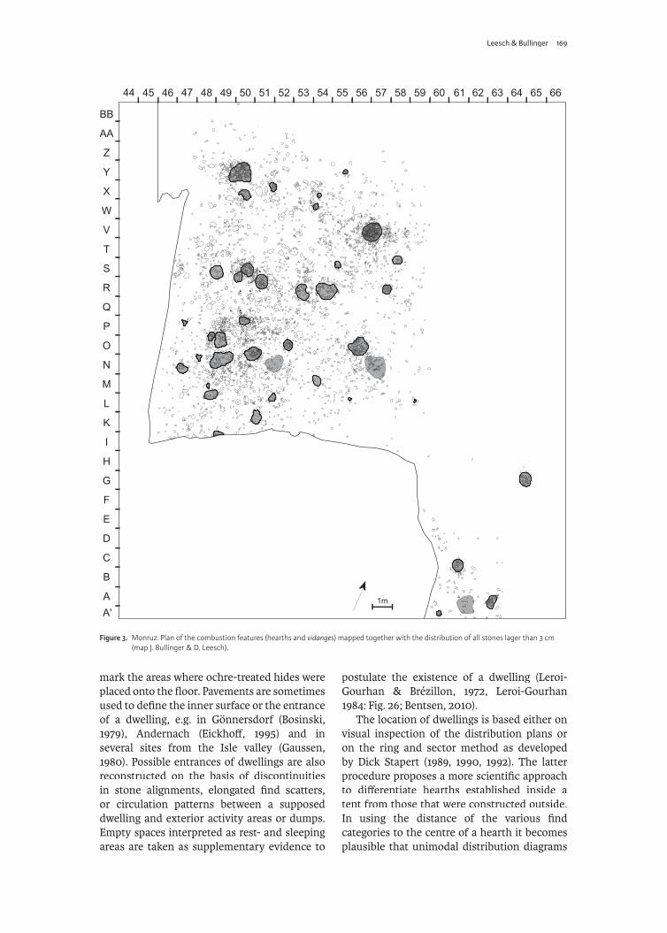
Figure 3. Monruz. Plan of the combustion features (hearths and vidanges) mapped together with the distribution of all stones lager than 3 cm (map J. Bullinger & D. Leesch).
170 Part II – The Late Upper Palaeolithic
are signifi cant for exterior hearths, whereas bimodal or multimodal distributions are characteristic of fi replaces established inside dwellings. The outer peak of these diagrams is interpreted as resulting from objects that came to lie at the base of the wall during the occupation of a dwelling. This method, although valuable in single-occupation sites, cannot be applied to complex palimpsests or to palimpsests or to palimpsestssituations where hearths are spaced too close to each other, or where the fi replaces are located near the entrance of a dwelling.
The palimpsest at MonruzThe Magdalenian open-air site at Monruz is situated on the edge of Lake Neuchâtel (Switzerland) and was excavated between 1989 and 1992 during the construction of a motorway (Bullinger et al., 2006). It was discovered shortly after the excavation of the contemporaneous site Champréveyres situated only 1 km northeast of Monruz (Leesch, 1997; Morel & Müller, 1997; Cattin, 2002). As charcoal was remarkably well preserved, the hearths could be located with great precision (Fig. 2). A wealth of 43 combustion features, associated with abundant lithic and faunal remains, was uncovered over an area of
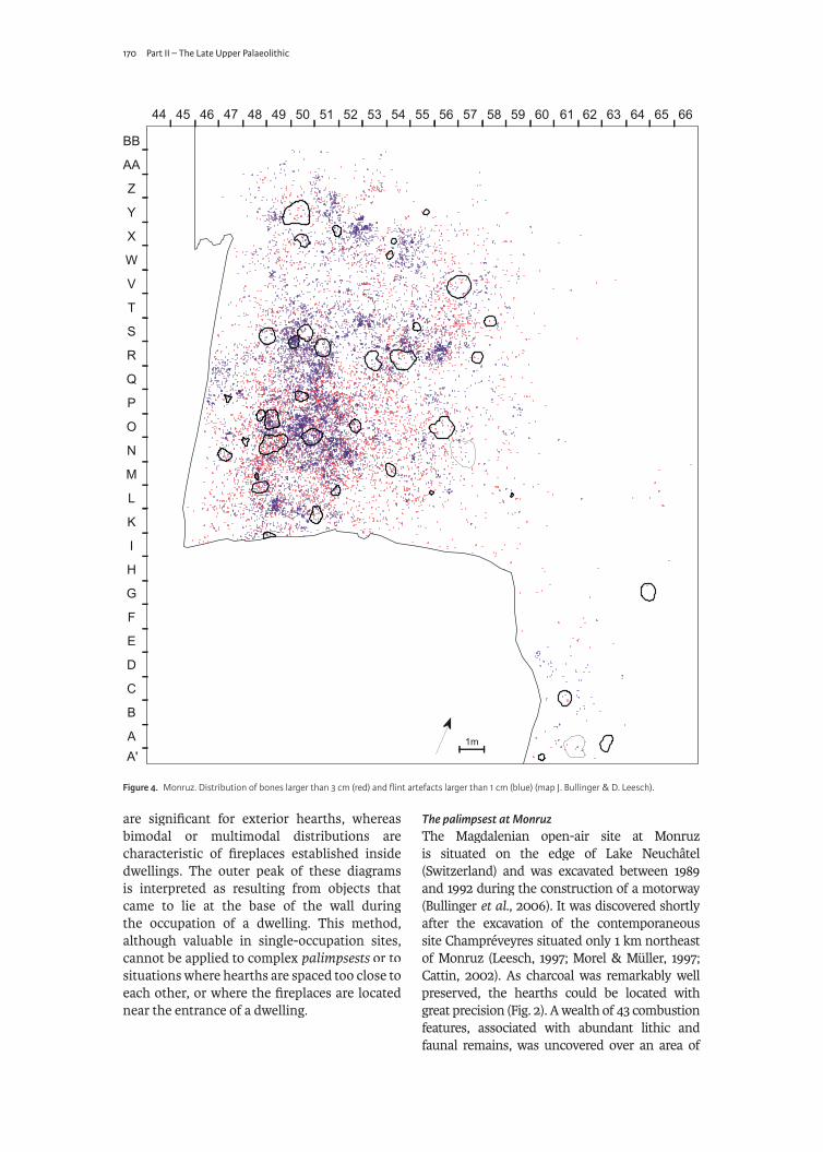
Figure 4. Monruz. Distribution of bones larger than 3 cm (red) and fl int artefacts larger than 1 cm (blue) (map J. Bullinger & D. Leesch).

Leesch & Bullinger 171
about 300 m2 (Figs. 3 & 4). Two tons of pebbles and stone slabs that had been used almost exclusively for constructing the hearths were dispersed over the whole area (Plumettaz, 2007). On this surface, a minimum of 56 horses, as well as 3 reindeer, 4 ibex, 17 marmots, 7 hares and various other mammals, birds and fi shes had been processed. Activities that were performed on-site were diverse: In addition to the consumption of the killed animals, maintenance of hunting gear, hide treatment and sewing is attested. These activities are demonstrated by 883 backed bladelets, 212 burins, 152 borers, 45 scrapers, 184 cores, 101 items of waste from needle production, 20 needles and 9 antler points. Ornamental objects made from molluscs, bones and jet are also abundant. Most of the activities were performed at a distance less than 1 m from a hearth according to the same pattern as could be shown for Champréveyres (Leesch, 1997: Fig. 213).
Stratigraphic evidence of palimpsestIn most parts of the site, the main archaeological layer is only 1-2 cm thick and does not show any further subdivision (Fig. 5). Some areas however exhibit higher stratigraphic resolution that unmistakably proves successive occupation episodes. A good example of the re-occupation of the site at short intervals can be demonstrated in square N47 where a hearth is separated from an underlying occupation horizon rich in horse ribs by a thin layer of sandy silt (Fig. 6). The layer containing the horse ribs can be traced a few square metres but then becomes undistinguishable from the overlying occupation level (Fig. 7). Some large bowl-shaped hearths also show distinct phases of abandonment and re-usage indicated by layers of sterile sediment deposited between diff erent combustion episodes. This is particularly evident in hearth V57 where an accumulation of heat-altered pebbles is sealed by a sterile sediment layer which is itself covered by a new charcoal layer and another deposit of pebbles and slabs (Plumettaz, 2007: 133). Dense concentrations of fl int debitage, charcoal, bones and red ochre underneath the large boulders situated in square O50 also indicate that these heavy blocks have been relocated from former positions or brought to the site during a later occupation episode (see Fig. 2). These few examples illustrate that the fi nal ‘living fl oor’ is the result of diverse activities that were performed during diff erent stays. However, as hardly any overlapping of hearths
can be observed, most of the habitation features were still visible during the diff erent settlement phases.
Evidence of multiple occupations through the refi � ing of the hearth-stonesExtensive refi tting of fractured hearth-stones has demonstrated that the combustion features at Monruz were not strictly contemporaneous and that no more than three large hearths were in use simultaneously (Plumettaz, 2007). Most of the hearths had been partly or entirely dismantled in the course of the successive occupation episodes. Stones were not only re-used several times in the same hearths but also collected from abandoned fi replaces in order to build new constructions. Consequently, only few hearths were preserved in their original state of function, with the intact stone-cover still in situ (e.g. Y50, C61 and O56: Figs. 8-10), in situ (e.g. Y50, C61 and O56: Figs. 8-10), in situnotably those that had been used during the last occupation. It has to be stressed that no fuel can be added in these stone-covered constructions while a fi re is burning and that before starting a new combustion cycle the hearths must be completely dismantled and rebuilt.
Seasons of occupationThe site at Monruz was occupied only during spring and summer (Müller, 2006; Müller et al., 2006). The strongest evidence comes from eight foals, one bear and one dog of very young age producing precise seasonal indications. Furthermore, three bones from ptarmigan contain medullary bone, a tissue that is formed only during the egg laying period, and therefore indicating bird-hunting in the fi rst half of the warm season. The remains of these animals are not limited to a particular sector of the excavated area but are distributed over the whole occupation horizon. In addition, most hearths are associated with skeletal elements of marmot or ground squirrel, animals that cannot be caught during winter since they hibernate. Finally, burned fi sh bones and scales were recovered from many hearths, and since fi shing could not have been practised while the lake was frozen, this is further evidence for the occupation of the site during the warm season.
Repeated occupations a� er successful horse-hunting eventsThe site is not considered to represent a large aggregation camp but a palimpsest of distinct palimpsest of distinct palimpsestoccupation episodes. The time span between the

172 Part II – The Late Upper Palaeolithic
diff erent reoccupations cannot be determined. However, taking into account the little overlapping of the hearths and the good state of preservation of the bones, it seems probable that the occupations occurred at rather short intervals. The most plausible scenario is that the site was repeatedly occupied after a successful horse-hunt (Müller et al., 2006). These horse-hunting expeditions were necessarily conducted at a strategically favourable location situated some kilometres away from the inhabited campsite. After a successful hunt, during which only a small number of horses were killed (one to a maximum of three animals), it is thought that the whole group moved to the kill site in order to process the animals to live at this place until the horses were consumed. During each
occupation episode at Monruz, which may have lasted from one to several weeks according to the number of horses that were killed, small transportable animals such as ibex, marmot, ground squirrel, birds and fi shes were hunted in the surroundings and brought to the camp. These animals were generally processed and consumed in the immediate vicinity of the hearths. In the proposed model, the horse-kill site at Monruz was thus repeatedly transformed into a short-lived residential campsite where all members of a group stayed until the camp was relocated to another kill site.
Hypothetical dwelling variants No obvious tent rings or other wall eff ects were recognized during the excavation, nor did any unquestionable dwelling become apparent during the analysis of the distribution plans of the various fi nd categories. Blocks weighing more than 6 kg are strikingly few despite the fact that they were abundant near the site and would have been easy to collect. Only one, not entirely convincing ground plan of a circular tent, about 5 m in diameter, with a pit-hearth in its centre was outlined on the basis of the distribution of some larger stones situated in the surroundings of hearth S50 (see Plumettaz, 2007: Fig. 311). Consequently, this fi nd category is not useful to reconstruct the location of dwellings at Monruz. Moreover, since the hearths are too close to each other, the ring and sector method cannot be applied to distinguish the fi replaces that were set up inside dwellings from those that were built outside.
Contrary to Champréveyres, where all hearths are of fl at type, at Monruz several hearths are bowl-shaped. At Champréveyres the fl at hearths are considered to have been established in the exterior, with diverse technical and domestic activities having been performed next to them (Leesch, 1997: 189-191). The bowl-shaped hearths at Monruz, instead, may have had a diff erent function (Bullinger et al., 2006: 173) and it can be speculated that they were associated with sheltered spaces. Although it cannot be ruled out that even at Monruz all hearths were situated in the open and that no dwellings were set up at this location because the occupations did only take place during the ‘warm’ season, the hypothesis of tents or huts must be tested and confronted to various existing models.
Figure 5. Monruz. Stratigraphic view of the occupation
layer. In most parts of the site,
the Magdalenian layer is only 1-2
cm thick without further apparent
subdivisions (photo Y. André, Offi ce et
musée cantonal d’archéologie,
Neuchâtel).
Figure 6. Monruz. In square N47
numerous horse ribs are separated from an overlying
fi replace by 1 cm of sterile sediment,
which can be seen in the section of
the charcoal patch at the top of the picture (photo Y. André, Offi ce et musée cantonal
d’archéologie, Neuchâtel).
Figure 7. Monruz. Dense accumulation
of unburnt horse bones lying on
top of a large fl at hearth indicated by a well marked charcoal patch in
zone N48-49 (photo Y. André, Offi ce et
musée cantonal d’archéologie,
Neuchâtel).

Leesch & Bullinger 173
In a previous publication, a proposition of small circular tents, about 3 m in diameter, was based on the spatial distribution of the six large pit-hearths (C61, N50, O56, S50, V57, Y50) in combination with the dispersion of the charcoal residues in the vicinity of these structures (Plumettaz, 2007: Figs 312 & 313). In this model (Fig. 11), the pit-hearths are placed in the exterior, with the tents being positioned north of the combustion structures and the tent openings facing the lake. Four out of the six hearths are associated with only small amounts of debitage products and remains from other activities. This could possibly indicate that these dwellings were mainly used for resting and sleeping. However, no barrier eff ect of any kind supports the contours of the presumed tent walls.
The more or less arbitrary projection of dwelling plans borrowed from other sites (put to the same scale) onto the palimpsestof Monruz gives an idea of numerous other reconstructions that may be considered (Figs. 12 & 13). These projections also allow direct comparison of the diff erent ground plans and give a visual impression of the surfaces that these dwellings would cover at Monruz. Some of these (im-) possible plans presented in Figure 12 and 13 are briefl y discussed hereafter. In order not to overcharge the plans, fl int debitage and bones are not indicated (see Fig. 4), whereas the few stones weighing more than 6 kg, likely to have been used as weight stones, appear in black and are represented together with the hearths and the surfaces stained with red ochre.
In the south-eastern corner of the site a large pit-hearth established in C61 is associated with a more or less circular patch of red ochre and few fl ints and bones (Fig. 9). This confi guration could indicate a covered space where hardly any domestic and technical activities were performed. The plan of the yaranga-like structure borrowed from Gönnersdorf-KI can be placed onto the ochre-stained surface, the hearth being thus situated approximately in the centre of the habitation (Fig. 12). An ash refuse deposit (vidange) located in A61 and two smaller hearths would also come to lie within the construction, whereas another bowl-shaped hearth in G64 would be situated two meters north of the construction. Another possibility would be to consider this area as comprising just a small tent placed north of the large hearth (Fig. 13) and all combustion
features being located in the exterior of this ‘habitation unit’. In this model, the main hearth could be considered as the ‘domestic’ hearth and the others as ‘satellite’ fi replaces.
In the north-western corner of the surface, a large pit-hearth covered with many stone slabs is situated in Y50 (Fig. 8). If charcoal were not preserved, this structure may have been interpreted as a pavement. A circular tent borrowed from Verberie can be placed north to the hearth, with drop and toss zones associated with several satellite hearths to the south (Fig. 12). An alternative proposition would be a tent of more or less the same diameter but with the
Figure 8. Monruz. View of a large stone-covered hearth in Y50. Numerous large slabs are placed on top of pebbles covering the charcoal layer. If charcoal were not preserved, this type of construction could be mistaken for a ‘pavement’ (photo Y. André, Offi ce et musée cantonal d’archéologie, Neuchâtel).
Figure 9. Monruz. Large pit-hearth in C61 surrounded by well preserved red ochre patches. This hearth is situated in a area with only few fl int artefacts and bones (photo Y. André, Offi ce et musée cantonal d’archéologie, Neuchâtel).
Figure 10. Monruz. Large stone-covered pit-hearth in O56 with adjacent vidange (photo Y. André, Offi ce et musée cantonal d’archéologie, Neuchâtel).

174 Part II – The Late Upper Palaeolithic
large hearth and three smaller structures placed in the centre of the tent, a surface stained with ochre indicating a resting area (Fig. 13).
On the northern border of the site, in square V57, a large pit-hearth that has been used during diff erent occupation episodes (Fig. 10) can equally be positioned inside a large oval hut similar to those reconstructed at Étiolles (Figs. 12 & 13) or placed in the open as proposed in Figure 11. No weight stones support any of these hypothetical reconstructions at Monruz.
In the western part of the site, some large stones can be used to draw a polygonal plan
borrowed from Orp. In this case the dwelling would include the hearths R50, S49, S50 and R51 (Fig. 12). The same surface enlarged by the areas containing the hearths R53, R54, O56, O52 O50 and P50 can be covered by the large composite construction of ‘Habitation 1’ from Pincevent (Fig. 13). Since the hearths incorporated in these tent models are not strictly contemporaneous, these reconstructions are of course very unlikely in this case.
In the eastern part of the site, a large trape-zoidal ground plan can be positioned arbi-trarily onto a surface comprising pit-hearth
Figure 11. Monruz. Dwelling model based on the distribution of the large pit-hearths and the associated charcoal patches (modifi ed a� er Plume� az, 2007).

Leesch & Bullinger 175
O56 in its centre and an elongated concentration of red ochre bordering the western ‘wall’ (Fig. 12). No weight stones support this type of tent reconstruction. Nevertheless, it is inte-resting to confront the size of this structure borrowed from Gönnersdorf-KIV to the occu-pation horizon at Monruz.
Projecting various ground plans in this more or less arbitrary way is of course not meant to be a scientifi c approach and none of the dwellings
proposed here is convincing. The purpose of this rather playful procedure is simply to compare diff erent habitation structures and try to match them to some obvious features of Monruz. It should have become clear that failing to recognize the palimpsest could lead palimpsest could lead palimpsestto the inclusion of non-contemporaneous combustion structures and activity areas in one dwelling.
Figure 12. Diff erent dwelling contours taken from Magdalenian sites and projected more or less arbitrarily onto the palimpsest of Monruz. In order not to overcharge the plan, only the combustion structures, the red ochre patches and the stones are represented. The few blocks weighing more than 6 kg are represented as black surfaces (map J. Bullinger & D. Leesch).

176 Part II – The Late Upper Palaeolithic
Concluding remarksCompared to other large Magdalenian sites, the palimpsest at Monruz does not seem palimpsest at Monruz does not seem palimpsestexceptional. The major diff erence with many sites is the extreme density and proximity of the hearths at Monruz. However, this divergence may only be an apparent one, essentially due to the incomparable preservation of the charcoal that has allowed identifi cation of hearths that would probably have stayed undetected otherwise. Another point that has become clear is that despite the huge amount of stones that
were brought onto the site, there are hardly any big boulders that could possibly outline contours of tents. This seems to be the case in many other sites and means either that no weight stones were needed to fi x the tents to the ground or that no tents were erected.
Finally, in a palimpsest situation the re-palimpsest situation the re-palimpsestconstruction of the location of dwellings will always be extremely problematic. This de-tailed research requires integration of multi-ple and complex data, such as understanding the dy namics of site formation, retracing the
Figure 13. Diff erent dwelling contours taken from Magdalenian sites and projected more or less arbitrarily onto the palimpsest of Monruz. In order not to overcharge the plan, only the combustion structures, the red ochre patches and the stones are represented. The few blocks weighing more than 6 kg are represented as black surfaces (map J. Bullinger & D. Leesch).

Leesch & Bullinger 177
internal chronology of the occupation horizon, determining seasonality and site function. Dick Stapert has shown how this challenging pro blem can be best pursued by confronting facts, methods and views, and by collaborating in research teams. The question of dwelling structures being far from resolved, we are looking forward to many more years of stimulating input from him.
Notes1. Laboratoire d’archéozoologie, Université
de Neuchâtel, 51 Avenue de Bellevaux, CH-2000 Neuchâtel, Switzerland. Email: [email protected]@unine.ch.
2. Musée cantonal d’archéologie et d’histoire, Palais de Rumine, 6 Place de la Riponne, CH-1014 Lausanne, Switzerland. Email: [email protected]@vd.ch.
ReferencesAudouze, F., 1987. Des modèles et des faits: les
modèles de A. Leroi-Gourhan et de L. Binford confrontés aux résultats récents. Bulletin de la Société préhistorique française 84 (10-12): la Société préhistorique française 84 (10-12): la Société préhistorique française343-352.
Bentsen, S.E., 2010. A sound of silence? Interpreting empty areas at Pincevent. In: M. Połtowicz-Bobak & D. Bobak (eds.), The Magdalenian in central Europe. New fi nds and concepts. Conference on the Magdalenian culture in central Europe, Rzeszów, 20-23 september 2005 (= Collectio Rzeszów, 20-23 september 2005 (= Collectio Rzeszów, 20-23 september 2005archaeologica ressoviensis 15). Instytut Archeologii Uniwersytetu Reszowskiego, Rzeszów, 47-51.
Bidault, J. & Giraud, J.-P., 1946. L’homme et la tente. J. Susse, Paris.
Binford, L.R., 1978. Dimensional analysis of behavior and site structure. Learning from an Eskimo hunting stand. American antiquity 43 (3): 330-361.antiquity 43 (3): 330-361.antiquity
Binford, L.R., 1983. In pursuit of the past. Decoding the archaeological record. Thames and Hudson, London.
Blankholm, H.P., 1991. Intrasite spatial analysis in theory and practice. University Press, Aarhus.
Bodu, P., M. Julien, B. Valentin & G. Debout, 2006. Un dernier hiver à Pincevent. Les magdaléniens du niveau IV0 (Pincevent, La Grande-Paroisse, Seine-et-Marne). Gallia préhistoire 48: 1-180.préhistoire 48: 1-180.préhistoire
Boekschoten, G.R. & D. Stapert, 1993. Rings and sectors: a computer package for spatial analysis; with examples from Oldeholtwolde and Gönnersdorf. Helinium 33 (1): 20-35.Helinium 33 (1): 20-35.Helinium
Boekschoten, G.R & D. Stapert, 1996. A new tool for spatial analysis: ‘Rings & Sectors 3.1 plus density analysis and tracelines’. In: H. Kamer-mans & K. Fennema (eds.), Interfacing the Past. Computer Applications and Quantita-tive Methods in Archaeology, CAA95 (= Ana-tive Methods in Archaeology, CAA95 (= Ana-tive Methods in Archaeology, CAA95lecta Praehistorica Leidensia 28, Vol. 1). Uni-versity of Leiden, Leiden, 241-250.
Bosinski, G. (ed.), 1979. Die Ausgrabungen in Gönnersdorf 1968-1976 und die Siedlungs-befunde der Grabung 1968 (= Der Magda-befunde der Grabung 1968 (= Der Magda-befunde der Grabung 1968lénien-Fundplatz Gönnersdorf 3). Franz Steiner, Wiesbaden.
Bosinski, G., 1981. Gönnersdorf. Eiszeitjäger am Mittelrhein (= Schriftenreihe der Bezirks-Mittelrhein (= Schriftenreihe der Bezirks-Mittelrheinregierung Koblenz 1). Rhenania-Verlag, Ko-blenz.
Bullinger, J., D. Leesch & N. Plumettaz, 2006. Le site magdalénien de Monruz, 1. Premiers éléments pour l‘analyse d‘un habitat de plein air (= Archéologie neuchâteloise 33). Service air (= Archéologie neuchâteloise 33). Service airet musée cantonal d’archéologie, Neuchâtel.
Carr, C., 1987. Dissecting intrasite artifact palimpsests using Fourier method. In: S. Kent (ed.), Method and theory for activity area research. Columbia University Press, New York, 236-291.
Cattin, M.-I., 2002. Hauterive-Champréveyres, 13. Un campement magdalénien au bord du lac de Neuchâtel: exploitation du silex (secteur 1) (= Archéologie neuchâteloise 26). Musée cantonal d’archéologie, Neuchâtel.
Clarke, D.L., 1977. Spatial information in archaeology. In: D.L. Clarke (ed.), Spatial archaeology. Academic press, New York, 1-32.

178 Part II – The Late Upper Palaeolithic
Couchaux, D., 2004. Habitats nomades. Éditions alternatives, Paris (Collection anarchitecture).
Coudret, P., M. Larrière & B. Valentin, 1989. Comparer des foyers: une entreprise diffi cile. In: M. Olive & Y. Taborin (eds.), Nature et fonction des foyers préhistoriques. Colloque international de Nemours, 12-14 mai 1987(= Mémoires du Musée de préhistoire d’Ile-de-France 2). Association pour la Promotion de la Recherche Archéologique en Ile-de-France, Nemours, 37-45.
Dawson, P., R. Levy, D. Gardner & M. Walls, 2007. Simulating the behaviour of light inside Arctic dwellings: implications for assessing the role of vision in task performance. World archaeology 39 (1): 17-35.archaeology 39 (1): 17-35.archaeology
Eickhoff , S., 1995. Wohnplatzstrukturen - Strukturierung eines Wohnplatzes. Zur Besiedlungsgeschichte des Magdalénien-Fundplatzes Andernach. Ph.D. thesis, Philosophische Fakultät der Universität zu Köln, Köln.
Faegre, T., 1979. Tents, architecture of nomads. Murray, London.
Fisher, J.W. Jr. & H.C. Strickland, 1991. Dwellings and fi replaces: keys to Efe Pygmy campsite structure. In: C.S. Gamble & W.A. Boismier & (eds.), Ethnoarchaeological approaches to mobile campsites. Hunter-gatherer and pastoralist case studies (= Ethnoarchaeological pastoralist case studies (= Ethnoarchaeological pastoralist case studiesseries 1). International Monographs in Pre-history, Ann Arbor, 215-236.
Galanidou, N., 1997. ‘Home is where the hearth is’. The spatial organisation of the upper Palaeolithic rockshelter occupations at Klithi and Kastritsa in Northwest Greece (= British and Kastritsa in Northwest Greece (= British and Kastritsa in Northwest GreeceArchaeological Reports, International Series 687). Archaeopress, Oxford.
Gamble, C.S. & W.A. Boismier (eds.), 1991. Ethnoarchaeological approaches to mobile campsites. Hunter-gatherer and pastoralist case studies (= Ethnoarchaeological series 1). case studies (= Ethnoarchaeological series 1). case studiesInternational Monographs in Prehistory, Ann Arbor.
Gaussen, J., 1980. Le Paléolithique supérieur de plein air en Périgord (industries et structures d’habitat). Secteur Mussidan - Saint-Astier. Moyenne vallée de l’Isle (= Supplément à Moyenne vallée de l’Isle (= Supplément à Moyenne vallée de l’IsleGallia préhistoire 14). Centre National de la Recherche Scientifi que, Paris.
Gaussen, J., 1992. Gisements élémentaires dans le Magdalénien I de la vallée de l’Isle. In: Le peuplement magdalénien. Paléogéographie physique et milieu humain. Colloque de Chancelade, 10-15 octobre 1988 (= Documents Chancelade, 10-15 octobre 1988 (= Documents Chancelade, 10-15 octobre 1988préhistoriques 2). Éditions du Comité des Travaux Historiques et Scientifi ques, Paris, 357-364.
Gaussen, J., 1994. Le Plateau Parrain (l’orga-nisation). L’anthropologie 98 (2/3): 418-426.. L’anthropologie 98 (2/3): 418-426.. L’anthropologie
Guidoni, E., 1994. Architecture primitive. Galli-mard, Paris.
Hietala, H.J. (ed.), 1984. Intrasite spatial analysis in archaeology. Cambridge University Press, Cambridge.
Hodder, I., 1982. Symbols in action: ethno-archaeological studies of material culture. Cambridge University Press, Cambridge.
Jöris, O. & T. Terberger, 2001. Zur Rekonst-ruktion eines Zeltes mit trapezförmigem Grundriß am Magdalénien-Fundplatz Gön-nersdorf/Mittelrhein – eine ‘Quadratur des Kreises‘? Archäologisches Korrespondenz-blatt 31 (2): 163-172.blatt 31 (2): 163-172.blatt
Julien, M., 1988. Organisation de l‘espace et fonction des habitats magdaléniens du Bassin parisien. In: M. Otte (ed.), De la Loire à l’Oder. Les Civilisations du Paléolithique Final dans le Nord-Ouest Européen. Colloque de Liège, décembre 1985 (= British Colloque de Liège, décembre 1985 (= British Colloque de Liège, décembre 1985Archaeological Reports, International Series 444). BAR, Oxford, 85-124.
Julien, M., C. Karlin & P. Bodu, 1987. Pincevent: où en est le modèle théorique aujourd’hui?Bulletin de la Société préhistorique française, études et travaux 84 (10-12): 335-342.études et travaux 84 (10-12): 335-342.études et travaux

Leesch & Bullinger 179
Leesch, D., 1997. Hauterive-Champréveyres, 10. Un campement magdalénien au bord du lac de Neuchâtel: cadre chronologique et culturel, mobilier et structures (secteur 1) (= Archéologie neuchâteloise 19). Musée cantonal d’archéologie, Neuchâtel.
Leesch, D., J. Bullinger, M.-I. Cattin, W. Müller & N. Plumettaz, 2010. Hearths and hearth-related activities in Magdalenian open-air sites: the case studies of Champréveyres and Monruz (Switzerland) and their relevance to an understanding of Upper Paleolithic site structure. In: M. Połtowicz-Bobak & D. Bobak (eds.), The Magdalenian in central Europe. New fi nds and concepts. Conference on the Magdalenian culture in central Europe, Rzeszów, 20-23 September 2005 (= Collectio Rzeszów, 20-23 September 2005 (= Collectio Rzeszów, 20-23 September 2005archaeologica ressoviensis 15). Instytut Archeologii Uniwersytetu Reszowskiego, Rzeszów, 53-69.
Leroi-Gourhan, A., 1984. Pincevent. Campement magdalénien de chasseurs de rennes. Imprimerie nationale, Paris (Guides archéo-logiques de France).
Leroi-Gourhan, A. & M. Brézillon, 1966. L’habitation magdalénienne N° 1 de Pince-vent près Montereau (Seine-et-Marne). Gallia préhistoire 9: 263-385.Gallia préhistoire 9: 263-385.Gallia préhistoire
Leroi-Gourhan, A. & M. Brézillon, 1972. Fouilles de Pincevent. Essai d’analyse ethnographique d’un habitat magdalénien (la section 36) (= Supplément à Gallia préhistoire 7). Centre National de la Recherche Scientifi que, Paris.
Morel, P. & W. Müller, 1997. Hauterive-Champréveyres, 11. Un campement magda-lénien au bord du lac de Neuchâtel: étude archéozoologique (secteur 1) (= Archéologie neuchâteloise 23). Musée cantonal d’archéologie, Neuchâtel.
Moseler, F., 2008. Die Konzentration IV von Gönnersdorf. Eine räumliche Analyse der Steinartefakte. In: M. Sensburg & F. Mose-ler (eds.), Die Konzentrationen IIb und IV des Magdalénien-Fundplatzes Gönnersdorf (Mittel rhein) (= Monographien des Römisch-Germanischen Zentralmuseums 73). RGZM, Mainz, 55-168.
Müller, W., 2006. Les témoins animaux. In: J. Bullinger et al. (eds.), Le site magdalénien de Monruz, 1. Premiers éléments pour l’analyse d’un habitat de plein air (= Archéologie d’un habitat de plein air (= Archéologie d’un habitat de plein airneuchâteloise 33). Service et musée cantonal d’archéologie, Neuchâtel, 123-137.
Müller, W., D. Leesch, J. Bullinger, M.-I. Cattin & N. Plumettaz, 2006. Chasse, habitats et rythme des déplacements: réfl exions à partir des campements magdaléniens de Champréveyres et Monruz (Neuchâtel, Suisse). In: M. Olive & B. Valentin (eds.), Variabilité des habitats tardiglaciaires dans le Bassin parisien et ses alentours: quelles signifi cations? Actes de la table ronde - Séance de la Société préhistorique française, Institut d’art et d’archéologie, Université de Paris 1, 23 novembre 2005 (= Bulletin de la Société préhistorique française 103 (4)). Société préhistorique française, Paris, 741-752.
Olive, M., 1988. Une habitation magdalénienne d’Étiolles. L’unité P15. Société préhistorique française, Paris (Mémoire ; 20).
Otte, M., in press. The management of space during the Paleolithic. Quaternary Interna-tional. (doi:10.1016/j.quaint.2010.11.031).
Parkington, J. & Mills, G., 1991. From space to place: the architecture and social organization of Southern African mobile communities. In: C.S. Gamble & W.A. Boismier (eds.), Ethnoarchaeological approaches to mobile campsites. Hunter-gatherer and pastoralist case studies (= Ethnoarchaeological series 1). case studies (= Ethnoarchaeological series 1). case studiesInternational Monographs in Prehistory, Ann Arbor, 355-370.
Pigeot, N., 1987. Magdaléniens d’Etiolles. Économie de débitage et organisation sociale (l’unité d’habitation U 5). Centre National de la Recherche Scientifi que, Paris.
Pigeot, N. (ed.), 2004. Les derniers magdaléniens d’Étiolles. Perspectives culturelles et paléo-historiques (l’unité d’habitation Q31) (= Supplément à Gallia préhistoire 37). CNRS Éditions, Paris.

180 Part II – The Late Upper Palaeolithic
Plumettaz, N., 2007. Le site magdalénien de Monruz, 2. Étude des foyers à partir de l’analyse des pierres et de leurs remontages(= Archéologie neuchâteloise 38). Offi ce et musée cantonal d’archéologie, Neuchâtel.
Prussin, L., 1995. African nomadic architecture: space, place and gender. Smithsonian Insti-tution Press / The National Museum of African Art, Washington /London.
Ränk, G., 1951. Das System der Raumeinteilung in den Behausungen der nordeurasischen Völker. Ein Beitrag zur nordeurasischen Ethnologie. Vol. 2 (= Skrifter utgivna av Institutet för Folklivsforskning vid Nordiska Museet och Stockholms Högskola 3). Institutet for Folklivsforskning, Stockholm.
Schmider, B. (ed.), 1992. Marsangy. Un campement des derniers chasseurs magda-léniens, sur les bords de l’Yonne (= Études et léniens, sur les bords de l’Yonne (= Études et léniens, sur les bords de l’YonneRecherches Archéologiques de l’Université de Liège 55). Service de préhistoire de l’Université, Liège.
Sensburg, M., 2007. Die räumliche Organisa-tion der Konzentration IIa von Gönners-dorf. Struktur und Dynamik eines mag-dalénienzeitlichen Siedlungsbefundes am Mitter hein (= Monographien des Römisch-Mitter hein (= Monographien des Römisch-Mitter heinGermanischen Zentralmuseums 69). RGZM, Mainz.
Simek, J.F. & R.R. Larick, 1983. The reconstitution of multiple spatial patterns: a case study from French Upper Palaeolithic. Journal of Archaeological Science 10: 165-180.Archaeological Science 10: 165-180.Archaeological Science
Stapert, D., 1989. The ring and sector method: Intrasite spatial analysis of Stone Age sites, with special reference to Pincevent. Palaeohistoria 31: 1-57.Palaeohistoria 31: 1-57.Palaeohistoria
Stapert, D., 1990. Within the tent or outside? Spatial patterns in Late Palaeolithic sites. Helinium 29: 14-35.Helinium 29: 14-35.Helinium
Stapert, D., 1992. Rings and sectors: intrasite spatial analysis of Stone Age sites. Ph.D. thesis, University of Groningen, Groningen.
Stapert, D., 2003. Towards dynamic models of Stone Age settlements. In: S.A. Vasil’ev et al. (eds.), Perceived landscapes and built environments. The cultural geography of Late Paleolithic Eurasia. Actes du XIVePaleolithic Eurasia. Actes du XIVePaleolithic Eurasia. Actes du XIV congrès de e congrès de e
L’UISPP, Université de Liège, Belgique, 2-8 septembre 2001, colloques 6.2 & 6.5. (= British Archaeological Reports, International Series 1122). Archaeopress, Oxford, 5-15.
Terberger, T., 1997. Die Siedlungsbefunde des Mag-dalénien-Fundplatzes Gönnersdorf. Konzen-trationen III und IV (= Der Magda lénien-trationen III und IV (= Der Magda lénien-trationen III und IVFundplatz Gönnersdorf 6). Franz Steiner, Stuttgart.
Thew, N., P. Hadorn & G.R. Coope, 2009. Haute-rive/Rouges-Terres. Reconstruction of Upper Palaeolithic and early Mesolithic natural environments (= Archéologie neuchâteloise environments (= Archéologie neuchâteloise environments44). Offi ce et musée cantonal d’archéologie de Neuchâtel, Neuchâtel.
Valentin, B., 1989. Nature et fonction des foyers de l’habitation n°1 à Pincevent. In: M. Olive & Y. Taborin (eds.), Nature et fonction des foyers préhistoriques. Colloque international de Nemours, 12-14 mai 1987 (= Mémoires de Nemours, 12-14 mai 1987 (= Mémoires de Nemours, 12-14 mai 1987du Musée de préhistoire d’Île-de-France 2). Association pour la Promotion de la Recherche Archéologique en Île-de-France, Nemours, 209-219.
Valentin, B. & P. Bodu, 1991. Perspectives de l’expérimentation appliquée à l’étude des foyers paléolithiques: le cas des foyers de l’ «habitation N°1» à Pincevent (Seine-et-Marne). In: Archéologie expérimentale, 2.L’os et la pierre, la maison et les champs. Colloque international ‘Expérimentation en archéologie: bilan et perspectives’, Archéodrome de Beaune, 6-9 avril 1988. Errance, Paris (Archéologie aujourd’hui), 138-145.
Vermeersch, P.M., R, Lauwers, H. van de Heyning & P. Vynckier, 1984. A Magdalenian open air site at Orp, Belgium. In: H. Berke et al. (eds.). Structures d’habitat du Paléolithique supérieur en Europe. Colloque de Reisenburg/Günzburg, 8-14 mai 1983 (= Urgeschichtliche Materialhefte 6). Archaeologica Venatoria, Tübingen, 195-208.
Leesch & Bullinger 181
Vermeersch, P.M., N. Symens, P. Vynckier, G. Gijselings & R. Lauwers, 1987. Orp, site magdalénien de plein air (comm. de Orp-Jauche). Archaeologia belgica (nouvelle série)3: 7-56.
Wenzel, S., 2005. Orp-East indications for a dwelling. Notae Praehistoricae 25: 83-90.. Notae Praehistoricae 25: 83-90.. Notae Praehistoricae
Wenzel, S., 2009. Behausungen im späten Jungpaläolithikum und im Mesolithikum in Nord-, Mittel- und Westeuropa (= Monogra-Nord-, Mittel- und Westeuropa (= Monogra-Nord-, Mittel- und Westeuropaphien des Römisch-Germanischen Zentral-museums 81). RGZM, Mainz.
Yar, B. & P. Dubois, 1999. Les structures d’habitat au Paléolithique en France (= Préhistoires 1). au Paléolithique en France (= Préhistoires 1). au Paléolithique en FranceÉditions Monique Mergoil, Montagnac.
Yellen, J.E., 1977. Archaeological approaches to the present. Models for reconstructing the past (= Studies in archaeology). Academic past (= Studies in archaeology). Academic pastpress, New York.


A mind set on fl intStudies in honour of Dick Stapert

Groningen Archaeological StudiesVolume 16
Editorial boardProf. dr. D.C.M. Raemaekers
Prof. dr. P.A.J. AttemaProf. dr. R.T.J. Cappers
Prof. dr. L. HacquebordDr. W. Prummel
Prof. dr. H.R. ReindersProf. dr. S. Voutsaki
Groningen Institute of ArchaeologyPoststraat 6
NL-9712 ER Groningenthe Netherlands
Websitewww.gas.ub.rug.nl
Publishers’ addressBarkhuis
Zuurstukken 37 9761 KP Eelde the NetherlandsTel. 0031 50 3080936 Fax 0031 87 7844285
[email protected] www.barkhuis.nl

A mind set on fl intStudies in honour of
Dick Stapert
Edited by M.J.L.Th. Niekus, R.N.E. Barton, M. Street & Th. Terberger
Barkhuis Groningen University Library
Groningen 2012
Book design, cover design and typesetting: Nynke Tiekstra, ColtsfootMedia, Noordwolde
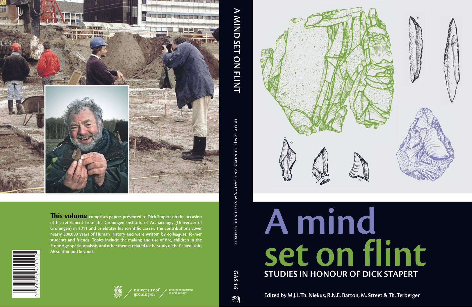
Image Front cover: A refi tted core from the Hamburgian site Oldeholtwolde (province of Friesland), a Creswell point from the Creswellian site Zeijen (province of Drenthe), a tanged point of Havelte-type from Oldeholtwolde, three points from the Ahrensburgian site Oudehaske (province of Friesland) and a ‘mini-handaxe’ from a Middle Palaeolithic site in the northern part of the province of Drenthe (drawings Lykke Johansen, Haren).
Image Back cover: Dick during the excavation (in 1992) of a Hamburgian site in the city of Groningen (photo Gijsbert Boekschoten, Groningen) and Dick holding a fl int fl ake at a Middle Palaeolithic site in the province of Drenthe in December 2011 (photo Marco Langbroek, Leiden).
Image Part I (p. 25): from the contribution by Müller-Beck (Fig. 2), Part II (p. 163): points from the Creswellian site Zeijen, province of Drenthe, the Netherlands (drawings Lykke Johansen), Part III (p. 341): from the contribution by Louwe Kooijmans (Fig. 10), Part IV (p. 447): from the contribution by Kortekaas (Fig. 13), Appendix (p. 523): refi tted core from the Hamburgian site Oldeholtwolde, province of Friesland, the Netherlands (drawings Lykke Johansen, Haren).
This publication was made possible with the aid of the following organisations:- Groningen Institute of Archaeology - Stichting Nederlands Museum voor Anthropologie en Praehistorie (Amsterdam)- Municipality of Groningen- Centre for Isotopic Research at the University of Groningen- Universiteitsmuseum Groningen- Drents Museum (Assen)
Preface © authors and Introduction © the editorsChapters © the authors of the individual chapters
ISBN 9789491431012
All rights reserved. No part of this publication or the information contained herein may be reproduced, stored in a retrieval system, or transmitted in any form or by any means, electronical, mechanical, by photocopying, recording or otherwise, without prior written permission from the copyright owners.
Although all care is taken to ensure the integrity and quality of this publication and the information herein, no responsibility is assumed by the publishers nor the authors for any damage to property or persons as a result of operation or use of this publication and/or the information herein.

Preface 7 G.J. Boekschoten, G.R. Boekschoten,
J.H. Looijenga & M.J.L.Th. Niekus
Introduction by the editors 9 M.J.L.Th. Niekus, R.N.E. Barton,
M. Street & Th. Terberger
‘A mind set on fl int’ 11G.J. Boekschoten
Part I – The Lower & Middle Palaeolithic 25
1 Wie „modern“ war das kulturelle Verhalten von Heidelbergern und Neandertalern? (with English summary) 27
H.-J. Müller-Beck
2 Some refl ections on fi re usage in the Middle Palaeolithic 41
W. Roebroeks & P. Villa
3 Some workpieces by Middle Palaeolithic apprentice fl intknappers from the Netherlands 49L. Johansen & D. Stapert
4 Fellow travellers on the ‘great trek’? – Some thoughts on British MIS 3 Neanderthals and spotted hyaenas 77P.B. Pe� i�
5 Neanderthal fi nds in Schleswig Holstein? – Middle Palaeolithic fl intscatters in Northern Germany 93S. Hartz, J.R. Beuker & M.J.L.Th. Niekus
6 Hällefl inta – ‘Next best’ or even better Hällefl inta – ‘Next best’ or even better Hällefl intathan fl int? 107
J.R. Beuker
7 Late Middle Palaeolithic artefacts and archaeo-stratigraphical dating of the bone gravels (Knochenkiese) in Central Westphalia and the Ruhrgebiet(Germany) 119M. Baales
8 Palaeolithic radiocarbon and the retouchoirs from Mauern (Germany) retouchoirs from Mauern (Germany) retouchoirs 141J.H. van der Plicht
9 Trace formation, strike-a-lights, and the contribution of functional analyses for understanding Palaeolithic contexts 149V. Rots
Part II – The Late Upper Palaeolithic 163
10 Identifying dwellings in Upper Palaeolithic open-air sites – The Magdalenian site at Monruz (Switzerland) and its contribution to analysing palimpsests 165D. Leesch & J. Bullinger
11 Revisiting ‘intentional breakage’ in the British Late Upper Palaeolithic 183R.N.E. Barton
12 A presumed ‘Creswellian’ site in the Leudal near Neer (province of Limburg), the Netherlands 193E. Kramer
13 The cores from the Creswellian site at Zeijen (province of Drenthe), the Netherlands 203
E. van de Lagemaat
14 The ‘Eastern extension’ – New data on the Hamburgian in Poland 217J. Kabaciński & I. Sobkowiak-Tabaka
15 A new Hamburgian site near Stroe (province of Gelderland), the Netherlands 235
E. Rensink & J.-W. de Kort
16 A lot of good points – Havelte points in the context of Late Glacial tanged points in Northwestern Europe 251
S.B. Grimm, D.S. Jensen & M.-J. Weber
17 Milheeze – A very large Federmessersite on the northern edge of the Peel peat bog (Southern Netherlands) and its environmental and social context 267N. Arts
Table of contents

6 Table of contents
18 Two sites to every story – Late Upper Palaeolithic site variability in Denmark 281
K.B. Pedersen
19 The Pope, a miracle and an Ahrensburgian windbreak in the municipality of Waalre (province of Noord-Brabant), the Netherlands 295
J. Deeben & J. Schreurs
20 The ‘big sieve’ – Some notes on the discovery of the Mesolithic and Late Upper Palaeolithic in the Netherlands 321H.T. Waterbolk
Part III – The Mesolithic & Neolithic 341
21 The underestimated fi sh? –Early Mesolithic human remains from Northern Germany 343
Th. Terberger, B. Gramsch & J. Heinemeier
22 Dance and suspense – Reassessing Dutch Mesolithic anthropomorphic engravings 355
L.B.M. Verhart & F. d’Errico
23 Spade paddling on a Mesolithic lake – Remarks on Preboreal and Boreal sites from Duvensee (Northern Germany) 369
K. Bokelmann
24 Camping and foraging in Boreal hazel woodland – The environmental impact of Mesolithic hunter-gatherers near Groningen, the Netherlands 381
H. Woldring, M. Schepers, J. Mendelts & R. Fens
25 Dværgebakke I – A Danish Mesolithic site with activity areas for children? 393T. Møbjerg
26 Refl ections on the Mesolithic burial pits at Mariënberg (province of Overijssel), the Netherlands 401
L.P. Louwe Kooijmans
27 Struck by an infectious light – Neolithic strike-a-lights in Swifterbant (province of Flevoland), the Netherlands? 425
I. Woltinge
28 Dating the objects from Rolde and Molen van Bels in the Northern Netherlands – van Bels in the Northern Netherlands – van BelsNeolithic ‘handaxes’ revisited 433L. Kiers
Part IV – Miscellaneous contributions 447
29 Seven archaeological surprises at the ‘Trout Site’ (Greenland) 449
E.B. Petersen
30 IJzer als echtheidstoets – De omstreden Vermaning-artefacten: vervalsingen of niet? (with English summary) 457
F. de Vries, L. Postma, M. Postma, M.J.L.Th. Niekus, H. Paas, H. de Kruijk & J. Timmner
31 “Ik weet ook hoe snel praatjes ontstaan” – Assien Bohmers en vier vervalsingsaff aires in de Nederlandse archeologie (with English summary) 473A. Carmiggelt
32 ‘First contact’ 505 G.L.G.A. Kortekaas
Appendix 523List of Dick’s publications 525
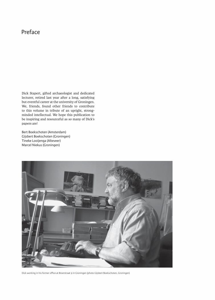
Dick Stapert, gifted archaeologist and dedicated lecturer, retired last year after a long, satisfying but eventful career at the university of Groningen. We, friends, found other friends to contribute to this volume in tribute of an upright, strong-minded intellectual. We hope this publication to be inspiring and resourceful as so many of Dick’s papers are!
Bert Boekschoten (Amsterdam) Gijsbert Boekschoten (Groningen) Tineke Looijenga (Alteveer) Marcel Niekus (Groningen)
Preface
Dick working in his former offi ce at Broerstraat 9 in Groningen (photo Gijsbert Boekschoten, Groningen).


Initially the intention was to publish a small booklet with no more than a dozen contributions celebrating Dick’s career. However, what started out as a small and intimate project has grown over the past year and has become an impressive volume in the series Groningen Archaeological Studies. More than 50 authors from the Nether-lands, Germany, Poland, United Kingdom, Den-mark, Switzerland, France, Belgium and the United States have willingly and enthusiastically responded to the call for papers.
In total 32 papers have been incorporated in this volume, spanning more than 300,000 years of Human History, from the Lower Palaeolithic through the Late Upper Palaeolithic well into the Neolithic and even beyond. The subjects the authors deal with, are all in one way or the other related to Dick’s long and diverse career. These include the making and use of fi re, children in the Stone Age, spatial analysis and the Ring & Sector method, stratigraphy, dating, and a range of Sector method, stratigraphy, dating, and a range of Sectorother topics.
For those who have intimate knowledge of Dick’s career (see the contribution by Bert Boekschoten), the Vermaning forgeries and controversial objects like the ‘Venus of Geldrop’ and the ‘Dancer of Wanssum’ also play a role in this Festschrift.
This Festschrift could not have been realised Festschrift could not have been realised Festschriftwithout fi nancial support from the Groningen Institute of Archaeology - a special word of thanks to administrator Mr. Luuk Tol -, the Stichting Nederlands Museum voor Anthropologie en Prae-historie (Amsterdam), the municipality of Gro-ningen, the Centre for Isotopic Research at the University of Groningen, the Universiteitsmuseum Groningen and the Drents Museum in Assen.
The editors also wish to extend their gratitude to publisher Mr. Roelf Barkhuis and designer Ms. Nynke Tiekstra for their continuing help in bringing this project to a satisfying end. Mr. Erwin Bolhuis (GIA) was very helpful in preparing several fi gures for this publication. Last but not least we thank all the contributors without whom ‘A mind set on fl int’ could never have been realised.
We as editors are extremely happy that we are able to present Dick such an impressive Festschrift and Festschrift and Festschriftsincerely hope he and the readers will enjoy this book!
Marcel Niekus (Groningen)Nick Barton (Oxford)Martin Street (Neuwied) Thomas Terberger (Greifswald)
Introduction by the editors

� is volume comprises papers presented to Dick Stapert on the occasion of his retirement from the Groningen Institute of Archaeology (University of Groningen) in 2011 and celebrates his scientifi c career. � e contributions cover nearly 300,000 years of Human History and were written by colleagues, former students and friends. Topics include the making and use of fi re, children in the Stone Age, spatial analysis, and other themes related to the study of the Palaeolithic, Mesolithic and beyond.
A M
IND
SET ON
FLINT
ED
ITED
BY M
.J.L.TH
. NIEK
US, R
.N.E. B
AR
TO
N, M
. STR
EET &
TH
. TER
BER
GER
G
AS 16
A mind set on flint STUDIES IN HONOUR OF DICK STAPERT
Edited by M.J.L.� . Niekus, R.N.E. Barton, M. Street & � . Terberger