How much water do we need for nature, livelihoods and people?
36
How much water do we need for nature, livelihoods and people? Assessing the environmental flow of the Wami River Sub-Basin August 2008 Prepared by the Wami - Ruvu Basin Water Office Coastal Resources Center at the University of Rhode Island Florida International University with support from the Water and Development Alliance (WADA) The Tanzania Coastal Management Partnership for Sustainable Communities and Ecosystems
-
Upload
khangminh22 -
Category
Documents
-
view
1 -
download
0
Transcript of How much water do we need for nature, livelihoods and people?
How much water do we need for nature, livelihoods and people?
Assessing the environmental flow of the Wami River Sub-Basin
August 2008
Prepared by the Wami - Ruvu Basin Water Office
Coastal Resources Center at the University of Rhode IslandFlorida International University
with support from the Water and Development Alliance (WADA)
The Tanzania Coastal Management Partnership for Sustainable Communities and Ecosystems
The Water and Development Alliance (WADA) is a collaboration between the Coca-Cola System (including corporate, foundations, and bottling partners) and USAID to improve water resource management and expand access to improved drinking water and sanitation services for poor and marginalized people in developing countries.
This publication is available electronically on the Coastal Resources Center’s website at http://www.crc.uri.edu. For more information contact: Coastal Resources Center, University of Rhode Island, Narragansett Bay Campus, South Ferry Road, Narragansett, Rhode Island 02882, USA. Tel: (401) 874-6224; Fax: (401) 874-6920.
Citation: Coastal Resources Center, University of Rhode Island and Florida International University. 2008. “How much water do we need for nature, livelihoods and people? Assessing the environmental flow of the Wami River and its sub-basin,” 34 pp.
Disclaimer: This report is made possible by the generous support of the American people through the United States Agency for International Development (USAID), the Coca-Cola Africa Foundation, and the Coca-Cola Atlanta Foundation. The contents are the responsibility of the Coastal Resources Center at the University of Rhode Island as part of the Coca-Cola System (including corporate, foundations and bottling partners) and USAID Water and Development Alliance.
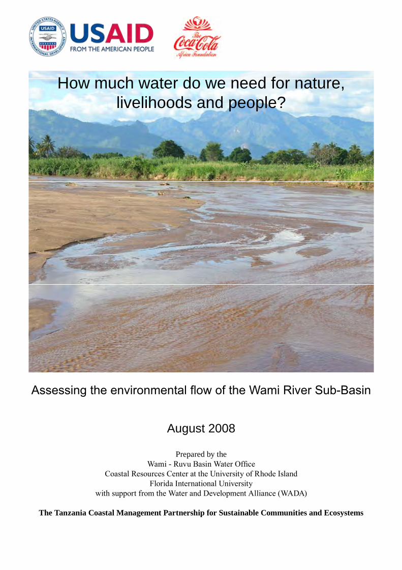
On the Cover: Magole River, Wami River Sub-Basin at Magole bridge, Kilosa, with Nguru mountains in the background. April, 2006
Cover photo credit: J. Tobey
Editing and Design: James Tobey and Donald Robadue Jr. First printing

List of Figures
Figure 1. The Wami River Sub-Basin 4Figure 2. Flow season identification across the Wami River Sub-Basin, with hydrographs from 1
October to 30 September 9Figure 3. Hydrological zones of the Wami River Sub-Basin 10Figure 4. Wetlands of the Wami River Sub-Basin 11Figure 5. The longitudinal profile of Mkata-Wami River from headwaters to mouth at the Indian
Ocean 12Figure 6. The Eastern Arc Mountains and their main rivers 13Figure 7. The selected sites for detailed environmental flow assessment using the BBM 17Figure 8. Wami River at Mandera (IG 2) in a) dry year, b) average year, and c) wet year 21-23
List of Tables
Table 1. The Wami-Ruvu Basin Water Office: Vision, mission, core values, and main responsibilities 3
Table 2. Major rivers of the Wami River Sub-Basin 8Table 3. Number of endemic vertebrate and tree species in Eastern Arc Forests in the Wami
River Sub-Basin 12Table 4. Population distribution in Wami River Sub-Basin 15Table 5. Goods and services from the Wami River Sub-Basin 16Table 6. Summary of experts’ determinations of environmental management class (EMC)
for five sites in the Wami River Sub-Basin 19Table 7. Summary of priority data collection and research for improving flow recommendations
for the Wami River Sub-Basin 24
CONTENTS
List of Figures iList of Tables iForeword iiAcknowledgments iii1. Introduction 12. Forward Thinking Water Resources Management in
Tanzania 23. The Wami River Sub-Basin 34. Wami Environmental Flows Assessment Methodology 55. Characteristics of the Wami River Sub-Basin 86. How Much Water does the Wami River Need? 187. The Way Forward 24References 25Annex I Documents produced for the assessment 26Annex II Wami River Initial Environmental Flow Assessment Team 27
i

FOREWORD
Fresh water supplies in Tanzania are increasingly under assault and future threats of global climate change, irrigation, deforestation and land cover change, and other human activities are all expected to be more severe in the coming years. In the face of these challenges, integrated water resources management must be based on sound scientific knowledge and needs to reconcile economic development with environmental protection and social welfare.
Environmental Flow Assessment (EFA) is a vital new concept and tool in Tanzania and around the world for balancing water needs for nature, livelihoods and people. An EFA is a scientific and planning tool that is used to draw the line between the amount of water that can be withdrawn from a river for human uses and the amount of water that the river needs to sufficiently maintain natural ecosystems. The overall aim is to develop quantitative guidelines for management of flows in rivers.
Tanzania’s new and forward thinking water policy, by according the environment second priority as a user of water, provides the necessary legal backing for the EFA process. However, to date few rivers in Tanzania have been subjected to this detailed assessment.
This report describes the pioneering EFA approach and findings for the Wami River Sub-Basin with the aim of sharing our experience with other water resource management professionals and practitioners. EFA’s take many forms and the Wami EFA was a selection of the best of several methodologies tailored to our specific context and needs. The adopted approach yields results in a short timeframe and can be replicated in other water basins in Tanzania – as is already the case in the Ruaha basin – and in other countries.
I urge policy makers and water management professionals to make use of this report and recommend the use of EFA methods as a decision-making tool for sustainable development of our invaluable water resources.
We should not wait until all rivers have gone dry and their ecosystems collapse. If we do not plan and invest properly now, the cost to recreate the services healthy water basins provide will dwarf the cost of preserving and protecting them in the first place.
Julius D. SarmettWami/Ruvu Basin Water Officer11 August 2008
ii
ACkNOWlEDgmENTS
The Wami River Environmental Flow Assessment (EFA) would not have been possible without the dedication, hard work, and collaborative spirit of the Wami EFA team, the support and leadership of the Wami-Ruvu Basin Water Office (WRBWO), the technical guidance of Florida International University, the logistical and administrative support of the Tanzania Coastal Management Partnership (TCMP), and the oversight provided by the Coastal Resources Center at the University of Rhode Island. The USAID Global Water for Sustainability Program, based at Florida International University, was also instrumental in providing complementary financial and administrative support. Special thanks go to the Tanzanian Ministry of Water and Saadani National Park for their cooperation and support. Funding was provided by the United States Agency for International Development (USAID), the Coca-Cola Africa Foundation, and the Coca-Cola Atlanta Foundation through the Water and Development Alliance (WADA).
iii

The Wami Ruvu River basin within Tanzania (dark purple)
iv

Assessing the environmental flow of the Wami River Sub-Basin
1. INTRODuCTION
Freshwater resources are essential to human life, livelihoods, national growth and healthy natural ecosystems. The challenging task facing those charged with management of freshwater resources is balancing human needs for water with those of nature to ensure adequate access to water resources without undue environmental degradation. Finding this balance requires sound understanding of freshwater systems and human uses of water; clear policies and strong legislation that recognize the environment as a user of fresh water; and capable institutions to guide the management process. This report is an important first step.
This Environmental flow assessment (EFA) is a management tool that will assist the Wami-Ruvu Basin Water Office (WRBWO) and other water management authorities meet the challenges of balancing the diverse needs for water in a rapidly changing landscape. The process of conducting an EFA brings together specialists from different disciplines as well as stakeholders in the basin, and the emergent product is a quantitative estimate of the flow needs of the environment.
This report is a synthesis of the key findings and conclusions of a longer technical report of the Wami EFA is aimed at the integrated water resource management practitioner. (The full technical report is available online at http://wami.fiu.edu.) This synthesis describes the process and project outcomes of the environmental flow assessment (EFA) conducted in the Wami River Sub-Basin during 2007. The Wami EFA is one of the first projects of its kind to be facilitated by a basin water office in Tanzania, and represents a realistic, proactive approach to water resources management. Similar work was recently conducted by the Pangani River Basin Water Office. This report summarizes findings, and shares the approach used and lessons learned that can be transferred and replicated in other water basins in Tanzania as well as other countries in Africa and elsewhere. The Wami EFA methodology has already been adopted by the team conducting the EFA for the Ruaha river basin, Tanzania.
An EFA is a tool used to learn how much water that can be withdrawn from a river for human uses and the amount of water that the river needs to sufficiently maintain ecosystems.
1
How much water do we need for nature, livelihoods and people?
2. FORWARD ThINkINg WATER RESOuRCES mANAgEmENT IN TANzANIA
Water resources policy and management in Tanzania are governed by the National Water Policy adopted in 2002 and the Water Utilization Act No. 42 of 1974, and its subsequent amendments. The amendment Act No 10 of 1981 devolved the responsibility for water management to hydrological units called river basins. In 1989, the Minister responsible for Water Affairs gazetted nine basins, including the Wami Ruvu River Basin. Each basin is managed by a Basin Water Office and Basin Water Boards. These Basin Offices and Water Boards were established chronologically as follows: Pangani (1991), Rufiji (1993), Lake Victoria (2000), Wami-Ruvu (2002), Lake Nyasa (2002), Lake Rukwa (2003), Internal Drainage (2003), Lake Tanganyika (2004) and Ruvuma and Southern Coast Rivers (2004).
Tanzania has undertaken various water sector reforms in order to address emerging challenges in water resources development and management. Major reforms include: the National Rural Water Supply Program (1985), the First National Water Policy (1991), the Water Sector Review (1993), the Rapid Water Resources Assessment (1994), and the River Basin Management and Small Holder Irrigation Improvement Project, which among other things revised the 1991 policy to a new National Water Policy (NAWAPO) as approved by the cabinet in July 2002.
The thrust of the NAWAPO 2002 is:
To develop a comprehensive framework for sustainable development and management of the nation’s water resources, putting in place an effective legal and institutional framework for its implementation.
To ensure that beneficiaries participate fully in planning, construction, operation, maintenance and management of community-based domestic water supply schemes.
To address cross-sectoral interests in water and promote integrated and participatory approaches to water resources planning, development and management.
To lay a foundation for sustainable development and management of water resources by changing the role government from service provider to that of coordination, policy and guideline formulation and regulation.
Water for basic human needs in adequate quantity and acceptable quality receives highest priority in the NAWAPO 2002. Sufficient water to protect ecosystems is second priority. Other uses are prioritized subject to social and economic criteria. Tanzania is among the most progressive countries in this respect.
With its new water policy, Tanzania has set a new benchmark for water resources management in East Africa. Tanzania’s new water policy, by according the environment second priority as a user of water, provides the necessary legal backing for the EFA process. The Wami EFA is a proactive and pioneering response to the National Water Policy.1
1 Other ongoing EFA efforts in Tanzania include the Pangani, Mara, and Ruaha river basins. For more information on these initiatives, see www.globalwaters net (Mara), www.panganibasin.com (Pangani), and www.wwf.org.uk (Ruaha).
2

3. THe WAmi RiveR SuB-BASin
The Wami-Ruvu Basin Water Office (WRBWO), with its headquarters in Morogoro town, is the government authority responsible for management of water resources in the Wami-Ruvu water basin. The Basin Office and Basin Water Board are relatively new institutions, established in 2002. Table 1 shows the vision, mission, core values and principal responsibilities of the WRBWO.
Table 1. The Wami-Ruvu Basin Water Office: vision, mission, core values, and main responsibilities
vision: Basin water resources sustainably managed for the socio-economic and environmental needs, interests and priorities of the basin population.
mission: To facilitate integrated water resources management efficiently and effectively in order to address the resource needs, interests and priorities of the Basin population while protecting and conserving the water resources.
Core values of the WRBWO reflect a strong commitment to:Equitable and fair allocation of water that is socially desirable, economically
viable and environmentally sustainableTransparent and accountable service provision to all people in the Wami-Ruvu
BasinPromotion of Integrated Water Resources Management (IWRM) in the basinBeing responsive to basin stakeholders’ needs and queries
main responsibilities of the WRBWO:Issue water use permits and collect water user feesMonitor and regulate water use according to natural availabilityControl and take legal measures against water resource pollutersResolve water use conflictsRaise awareness on sustainable use of water resourcesFacilitate the formation of catchment/sub-catchment committees and Water User
AssociationsMaintain water resource monitoring stationsMonitor the quantity and quality of water in the basinCoordinate Integrated Water Resources Management plansParticipate in water resource protection programs
The Wami-Ruvu Basin, consisting of the two main rivers of Wami and Ruvu, and minor coastal rivers, drains into the Indian Ocean. The Wami River EFA focused only on the Wami, and not the Ruvu River. From its source in the Eastern Arc Mountain ranges of Tanzania, the Wami River flows in a south-eastwardly direction from dense forests, across fertile agricultural plains, and through grassland savannahs along its course to the Indian Ocean. Located between 5°S-7°S and 36°E-39°E, the Wami River Sub-Basin (as it is commonly referred to by the Tanzanian Ministry of Water) extends from the semi-arid Dodoma region to the humid inland swamps in Morogoro region to Saadani Village in the coastal Bagamoyo district. It encompasses an area of approximately 43,000 km2 and spans an altitudinal gradient of approximately 2,260 meters (Figure 1). The Wami Sub-Basin is home to 1.8 million people (2002 census) in twelve districts: Kondoa, Dodoma-urban, Bahi, Chamwino, Kongwa, Mpwapwa, (Dodoma region) Kiteto, Simanjiro (Manyara region), Mvomero, Kilosa (Morogoro region), Handeni, Kilindi, (Tanga region) and Bagamoyo (Coast region).
3

With its headwaters in the Eastern Arc Mountains and its estuary within Saadani National Park, the Wami River Sub-Basin harbors unique and important ecosystems. The Eastern Arc chain of mountains is a world-renowned hotspot for biological diversity and endemism. Saadani National Park and its coastal forests is the latest addition to the vast network of protected areas in Tanzania, and the country’s only park to bridge terrestrial and marine environments. The central part of the basin covers an agricultural region that includes the Mtibwa Sugar Plantation and Dakawa Rice Fields, some of Tanzania’s most significant commercial agricultural operations. The lower parts of the sub-basin hosts the Chalinze Water supply scheme, which provides water for about 60 villages in Bagamoyo and Morogoro Rural districts.
Figure 1. The Wami River Sub-Basin
4
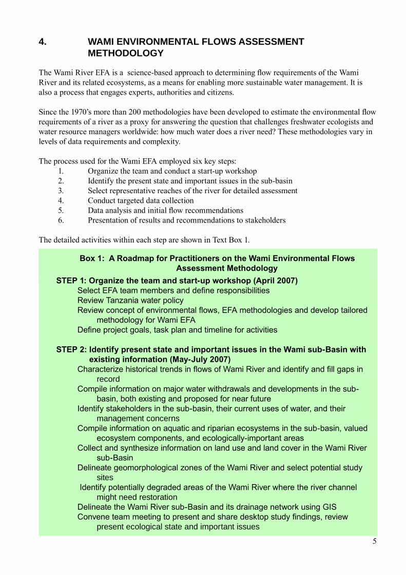
4. WAmI ENvIRONmENTAl FlOWS ASSESSmENT mEThODOlOgy
The Wami River EFA is a science-based approach to determining flow requirements of the Wami River and its related ecosystems, as a means for enabling more sustainable water management. It is also a process that engages experts, authorities and citizens.
Since the 1970’s more than 200 methodologies have been developed to estimate the environmental flow requirements of a river as a proxy for answering the question that challenges freshwater ecologists and water resource managers worldwide: how much water does a river need? These methodologies vary in levels of data requirements and complexity.
The process used for the Wami EFA employed six key steps:1. Organize the team and conduct a start-up workshop2. Identify the present state and important issues in the sub-basin3. Select representative reaches of the river for detailed assessment4. Conduct targeted data collection5. Data analysis and initial flow recommendations6. Presentation of results and recommendations to stakeholders
The detailed activities within each step are shown in Text Box 1.
5
Box 1: A Roadmap for Practitioners on the Wami environmental Flows Assessment methodology
STeP 1: Organize the team and start-up workshop (April 2007)Select EFA team members and define responsibilitiesReview Tanzania water policy Review concept of environmental flows, EFA methodologies and develop tailored
methodology for Wami EFADefine project goals, task plan and timeline for activities
STeP 2: identify present state and important issues in the Wami sub-Basin with existing information (may-July 2007)
Characterize historical trends in flows of Wami River and identify and fill gaps in record
Compile information on major water withdrawals and developments in the sub-basin, both existing and proposed for near future
Identify stakeholders in the sub-basin, their current uses of water, and their management concerns
Compile information on aquatic and riparian ecosystems in the sub-basin, valued ecosystem components, and ecologically-important areas
Collect and synthesize information on land use and land cover in the Wami River sub-Basin
Delineate geomorphological zones of the Wami River and select potential study sites
Identify potentially degraded areas of the Wami River where the river channel might need restoration
Delineate the Wami River sub-Basin and its drainage network using GISConvene team meeting to present and share desktop study findings, review
present ecological state and important issues

6
The Wami EFA process sought to form a strong team of Tanzanian experts that specialize in environmental flow assessment and to build the knowledge and capacity of the WRBWO staff by introducing them to new approaches and tools. A local team of experts was assembled, composed of the following disciplines:
GeomorphologistRiparian specialistSociologistHydraulic EngineerAquatic ecologistHydrologist
Some of these experts recruited had already undergone similar training in EFA and had previously participated in river studies in Tanzania and the East Africa region.
STeP 3: Select representative reaches and sites for detailed flow assessment analysis (September 2007)
Field reconnaissance survey to identify potential sampling sites Select representative reaches and sites
STeP 4: Conduct targeted data collection at representative sites to determine flow dependence of ecosystems (October-november 2007)
Determine ecological importance of study areasComplete social survey of study areasDescribe present flow regime at study areas based on existing data, as availableSurvey river channel and determine discharge as a function of water levelAssess flow dependence of geomorphological characteristics of study areasAssess flow dependence of water quality at study areasAssess flow dependence of biological characteristics at study areas
STeP 5: Data analysis and definition of initial environmental flow recommendation (December 2007)
Exchange of information from data collection at study areas Determination of the management class for the river in the study areasDefinition of the initial environmental flow recommendations (EFR)Discuss future steps
STeP 6: Presentation of results and recommendations to stakeholders (December 2007)
Convene formal meeting of water basin Board Convene forum for discussion of EFA among stakeholdersDiscuss implementation of recommendations
7
The team defined the overall project goal as: “To develop quantitative guidelines for management of flows in the Wami River Sub-Basin”. A task plan and time frame were developed with the following major tasks:
Review hydro-meteorological data for the Wami River Sub-Basin and fill gaps in the hydrologic record
Collect and synthesize existing information on hydraulics, geomorphology, ecology, and socioeconomic conditions in the Wami River Sub-Basin
Conduct targeted data collection at representative, strategically-identified sites in the Wami River Sub-Basin
Estimate the flow requirements at selected sites, each located in a different part of the Wami River Sub-Basin
Compared to other EFA methodologies conducted or in progress in Tanzania and elsewhere in the world, the Wami EFA was completed in a relatively short timeframe (April-December 2007) with a modest budget. Few scientific studies had been completed so far in the Wami River Sub-Basin and limited baseline data are available. Accordingly, the Wami EFA project adopted an approach appropriate to the time, finances and data available.
The Wami EFA draws from several methodologies for conducting EFAs, including the Building Block Methodology (King et al. 2000); Downstream Response to Imposed Flow Transformation (King et al. 2003); and the Savannah River Method (Richter et al. 2006). It was determined that none of these methodologies were feasible in their entirety given limited resources, information requirements and timeframe, but that they each contained ideas and tools that could be useful. The Savannah River method, a process-based approach, was chosen in recognition of the limited the information and resources available. Some tools and techniques were also borrowed from other published methods for environmental flow assessment, particularly the Building Block Methodology. Both the Building Block and Savannah River methodologies fall into the category of holistic methodologies for environmental flow assessment.
8
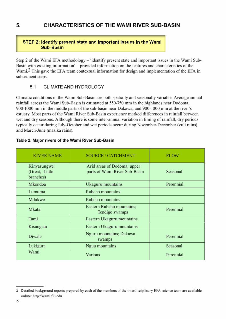
5. CHARACTeRiSTiCS OF THe WAmi RiveR SuB-BASin
Step 2 of the Wami EFA methodology – ‘identify present state and important issues in the Wami Sub-Basin with existing information’ – provided information on the features and characteristics of the Wami.2 This gave the EFA team contextual information for design and implementation of the EFA in subsequent steps.
5.1 ClIMATE AnD hyDRoloGy
Climatic conditions in the Wami Sub-Basin are both spatially and seasonally variable. Average annual rainfall across the Wami Sub-Basin is estimated at 550-750 mm in the highlands near Dodoma, 900-1000 mm in the middle parts of the sub-basin near Dakawa, and 900-1000 mm at the river’s estuary. Most parts of the Wami River Sub-Basin experience marked differences in rainfall between wet and dry seasons. Although there is some inter-annual variation in timing of rainfall, dry periods typically occur during July-October and wet periods occur during November-December (vuli rains) and March-June (masika rains).
Table 2. major rivers of the Wami River Sub-Basin
RIVER NAME SOURCE / CATCHMENT FLOW
Kinyasungwe (Great, Little branches)
Arid areas of Dodoma; upper parts of Wami River Sub-Basin Seasonal
Mkondoa Ukaguru mountains Perennial
Lumuma Rubeho mountains
Mdukwe Rubeho mountains
Mkata Eastern Rubeho mountains; Tendigo swamps Perennial
Tami Eastern Ukaguru mountains
Kisangata Eastern Ukaguru mountains
Diwale Nguru mountains; Dakawa swamps Perennial
Lukigura Nguu mountains SeasonalWami Various Perennial
2 Detailed background reports prepared by each of the members of the interdisciplinary EFA science team are available online: http://wami.fiu.edu.

Figure 2. Flow season identification across the Wami River Sub-Basin, with hydrographs from 1 October to 30 September
Many rivers in the sub-basin are intermittent and ephemeral during the dry season and experience high flows during periods of heavy rainfall. Seasonal flows, like rainfall, are non-uniform across the sub-basin. Long term average monthly flows from select sites suggest that the Wami River Sub-Basin experiences a transition pattern of intra-annual flow variation between the bimodal (two peak periods) regime in the north and the unimodal (single peak period) regime in the south (Figure 2). All sites have a defined peak during the long rains, and a second smaller peak is apparent in larger catchments during the short rains. The lowest flow periods of the year are typically in October for all sites; low or no flow periods extend longer for seasonal rivers like the Kinyasungwe and Lukigura.
Based on this information about seasonality and water flows, the Wami River Sub-Basin can be divided into six hydrologic zones: Kinyasungwe, Mkondoa, Mkata, Diwale, Lukigura and Wami (Figure 3). Rivers in the Kinyasungwe zone, regardless of size, are predominantly seasonal and typically only flow between November and May. The Mkondoa zone contributes the highest volume of flows in the sub-basin, and rivers in this hydrological zone are mostly perennial. The Mkata zone covers mostly inland plains and the Tendigo swamps. Rivers of the Diwale zone are mainly perennial and drain parts of the Turiani plans and wetlands; it is thought that the Diwale River and its tributary the Divue have continuous interactions with the Turiani wetlands and swamps in the zone. Rivers of the Lukiguara zone drain relatively small catchments and consequently are predominantly seasonal. The main Wami zone, which includes the Wami River and its tributaries the Tami and Kisangata rivers, comprises mostly perennial systems. The Wami zone also includes the Wami River estuary.
9

Wetlands are an important component of surface-water resources in the Wami River Sub-Basin, and four different kinds of wetland systems are present: palustrine, riverine, lacustrine and estuarine (Figure 4). Riverine wetlands are the dominant kinds in the sub-basin, and are found along many large rivers, such as the Wami, Mkata and Mkondoa, and a few smaller rivers. The Tendingo and Dakawa swamps are the major palustrine (vegetated) wetlands in the Wami River Sub-Basin, extending almost the whole length of the inland plain zone. Estuarine wetlands are found near the Indian Ocean coastline amidst mangroves. A few small natural lakes (Nzuhe, Gombo) as well as several manmade lakes (Hombolo, Ikowa, Dabalo) constitute the lacustrine (lake and deep water habitats) wetlands of the Wami River Sub-Basin.
On the basis of topographical characteristics, the rivers of the basin drain zones that can be classified as (1) upland plains, (2) mountain torrents, (3) inland plains, (4) rejuvenated cascades, and (5) coastal plains as shown in Figure 5. Rivers in upland and mountainous areas are relatively straight, confined channels. In the inland and coastal plains, the Wami River becomes a meandering system, broken in a few places by small cascades at gradient breaks. One such cascade is located near Wami at Mandera, just upstream from the bridge crossing on the Chalinze-Arusha highway.
Water flow and the shape of the channel are primary determinants of physical habitat in a river, which in turn influences ecosystem function and flora and fauna. In the mountainous areas of the Wami River Sub-Basin, headwater streams are high-gradient systems with fast water flow and low water retention time. Conversely, the main stem of the Wami River is primarily a system of low hydraulic energy through its middle and lower reaches, characterized by low water velocities and the frequent presence of sandbars and pools in the river bed.
Figure 3. Hydrological Zones of the Wami River Sub-Basin
10
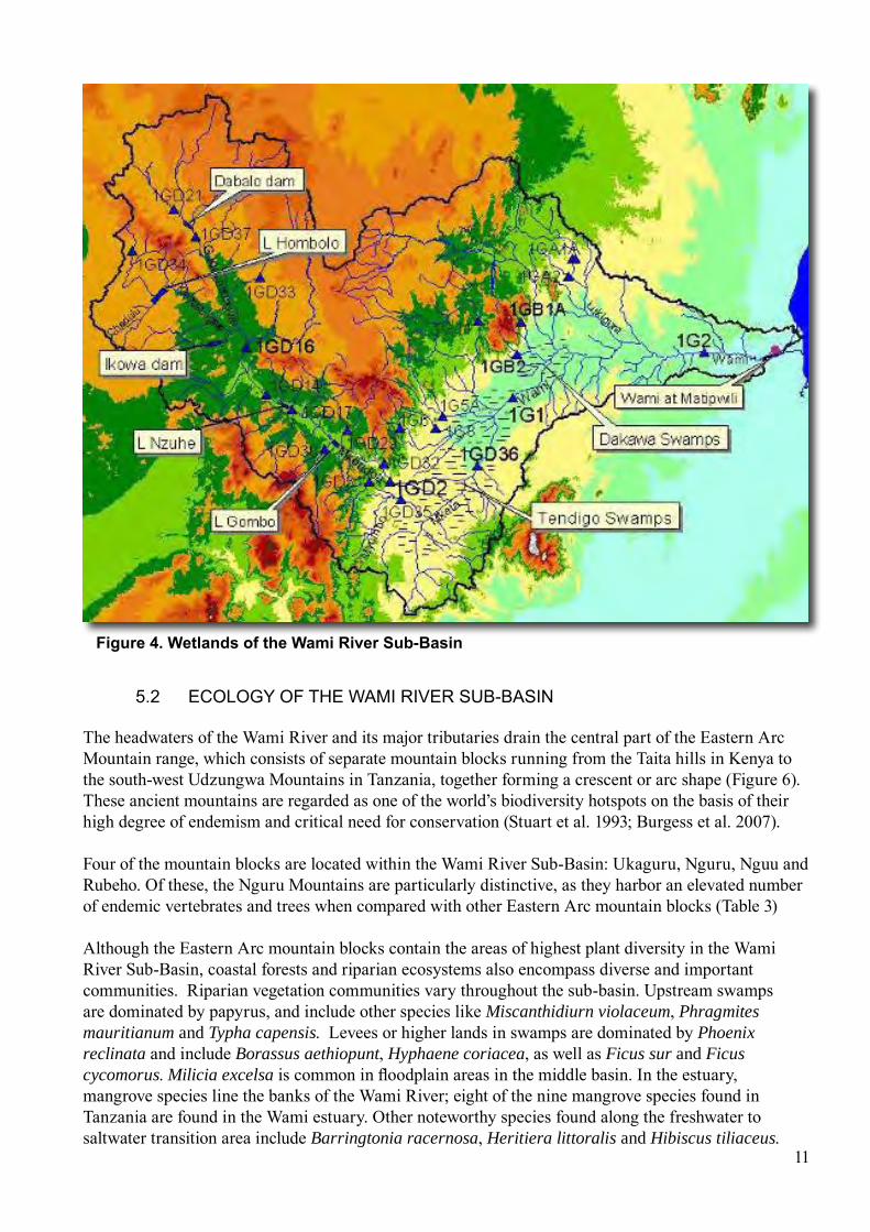
Figure 4. Wetlands of the Wami River Sub-Basin
5.2 EColoGy oF ThE WAMI RIvER SUB-BASIn
The headwaters of the Wami River and its major tributaries drain the central part of the Eastern Arc Mountain range, which consists of separate mountain blocks running from the Taita hills in Kenya to the south-west Udzungwa Mountains in Tanzania, together forming a crescent or arc shape (Figure 6). These ancient mountains are regarded as one of the world’s biodiversity hotspots on the basis of their high degree of endemism and critical need for conservation (Stuart et al. 1993; Burgess et al. 2007).
Four of the mountain blocks are located within the Wami River Sub-Basin: Ukaguru, Nguru, Nguu and Rubeho. Of these, the Nguru Mountains are particularly distinctive, as they harbor an elevated number of endemic vertebrates and trees when compared with other Eastern Arc mountain blocks (Table 3)
Although the Eastern Arc mountain blocks contain the areas of highest plant diversity in the Wami River Sub-Basin, coastal forests and riparian ecosystems also encompass diverse and important communities. Riparian vegetation communities vary throughout the sub-basin. Upstream swamps are dominated by papyrus, and include other species like Miscanthidiurn violaceum, Phragmites mauritianum and Typha capensis. Levees or higher lands in swamps are dominated by Phoenix reclinata and include Borassus aethiopunt, Hyphaene coriacea, as well as Ficus sur and Ficus cycomorus. Milicia excelsa is common in floodplain areas in the middle basin. In the estuary, mangrove species line the banks of the Wami River; eight of the nine mangrove species found in Tanzania are found in the Wami estuary. Other noteworthy species found along the freshwater to saltwater transition area include Barringtonia racernosa, Heritiera littoralis and Hibiscus tiliaceus.
11

mkata Wami Channel morphology
0
100
200
300
400
500
600
700
800
0 12 23 35 47 59 70 82 94 105
117
129
140
152
164
176
187
199
211
222
234
246
257
Distance (km)
Elev
etio
n (m
)
Figure 5. The longitudinal profile of mkata-Wami River from headwaters to mouth at the Indian Ocean
Table 3. number of endemic vertebrate and tree species in eastern Arc Forests in the Wami River Sub-Basin (Source: Burgess, 2005)
Mountain Block Approximate forest area remaining (hectares)
Number of single area (mountain block) endemic vertebrates
Number of Eastern Arc endemic vertebrates
Number of Eastern Arc endemic trees
Nguu 24,900 0 9 6
Nguru 34,000 0 20 25
Ukaguru 17,400 1 10 4
Rubeho 47,400 2 12 0
Although the Eastern Arc mountain blocks contain the areas of highest plant diversity in the Wami River Sub-Basin, coastal forests and riparian ecosystems also encompass diverse and important communities. Riparian vegetation communities vary throughout the sub-basin. Upstream swamps are dominated by papyrus, and include other species like Miscanthidiurn violaceum, Phragmites mauritianum and Typha capensis. Levees or higher lands in swamps are dominated by Phoenix
12
Mountain torrent
SwampLowerRiver
RejuvinatedCascade
LowlandRiver

Figure 6. The eastern Arc mountains and their main rivers
reclinata and include Borassus aethiopunt, Hyphaene coriacea, as well as Ficus sur and Ficus cycomorus. Milicia excelsa is common in floodplain areas in the middle basin. In the estuary, mangrove species line the banks of the Wami River; eight of the nine mangrove species found in Tanzania are found in the Wami estuary. Other noteworthy species found along the freshwater to saltwater transition area include Barringtonia racernosa, Heritiera littoralis and Hibiscus tiliaceus.
Several riverine habitat types for aquatic biota are represented by the sub-basin. Mountain torrent streams are often clear and cool, with rocky bottoms that provide habitat for aquatic invertebrates. The Wami River along much of its meandering course through the plains and lower parts of the sub-basin is a warm, muddy system, as are its main tributaries in these regions. Submerged vegetation in these areas increases the diversity of habitat in the Wami channel, and provides areas of feeding, nursery, and refuge for fish and other aquatic biota. In the estuary, aquatic habitat is influenced by the spatial and temporal variability of freshwater and saltwater inflows. The estuary is a mixing area and meeting ground for both saltwater and freshwater aquatic species.
13

From an environmental conservation perspective, one concrete goal of maintaining suitable environmental flows and sediment delivery to the estuary is protection of critical habitat to a diversity of commercially important fish species. One resident fish species (Synodontis wamiensis) is endemic to the Wami River and Labeo victorianus is listed as among the threatened and declining fish species in Tanzanian water bodies. To date, 49 species have been recorded from the Wami River and its tributaries, but the fish fauna of the Wami River Sub-Basin is one of the least known among the eastern flowing rivers of Tanzania. Fish species known from the Wami River Sub-Basin can be categorized into three major groups (after Welcomme et al. 2006): main channel communities inhabiting rivers and pools; communities inhabiting floodplain and low dissolved oxygen environments; and communities inhabiting estuarine and coastal lagoon areas.
Other animals also spend all or parts of their lives in freshwater systems of the Wami River Sub-Basin. These include macroinvertebrates, such as aquatic insects and shrimp, as well as larger animals like turtles, crocodiles (Crocodylus niloticus), and hippos. As with fish, flow conditions influence the habitat of these species and their ability to complete important phases of their life cycles. For example, for crocodiles and hippos, pools in the lower Wami River provide refugia during dry periods. Terrestrial animals also rely on the Wami River main stem as a source of drinking water during dry periods or as a migration corridor, especially within Saadani National Park (USFS 2007). Aquatic birds are commonly found in wetland areas and along river edges, particularly in the middle and lower parts of the basin. The Wami River estuary is reported to have at least 20 commonly-sighted species of birds (Anderson et al. 2007); many more species would likely be added to that list following additional periods of observation.
The amount of freshwater flow to the ocean drives the ecology of the Wami River estuary, which lies at the river’s mouth near Saadani Village and bridges the land to sea continuum along the Indian Ocean coastline. Riparian village residents report that saline water intrudes in the Wami River channel to a distances of approximately 5 km upstream from the coast during dry periods (Anderson et al. 2007). The presence of saltwater in the river channel helps sustain mangrove forest ecosystems along the estuary. During the transition and wet seasons, the Wami River forms a giant freshwater plume that has been documented to extend ~2 km into the Indian Ocean (Anderson et al. 2007). Saadani Village has long been the site for artesanal and commercial prawn fisheries (Penaeus monodon, Penaeus japonicus, Penaeus indicus and Penaeus semisulcatus), and local fishermen recognize the importance of freshwater inputs for shrimp productivity. Beaches along the coastline near the Wami River estuary provide critical spawning areas for endangered sea turtles, and five different species are known to nest in the region (Tamatamah 2007).
Several protected areas have been established in the Wami River Sub-Basin to promote wildlife conservation. These areas also serve to safeguard freshwater ecosystems in critical areas of the sub-basin. The Nguru Forest Reserve of the Eastern Arc Mountains protects mountain torrent streams in the northern part of the sub-basin, and the headwaters of the Mkata River are situated within Mikumi National Park. The Wami-Mbiki Wildlife Management Area and the Zaraninge Forest Reserve are two additional protected areas in the coastal plain of the sub-basin. The newest addition to Tanzania’s system of national parks is the Saadani National Park, which encompasses much of the Wami River estuary and covers both coastal forest and marine areas. Nevertheless, while these parks and reserves are a positive step towards environmental conservation, other important areas of the Wami River Sub-Basin are still in need of protected status, in particular wetland ecosystems and other Eastern Arc Mountain blocks.
14
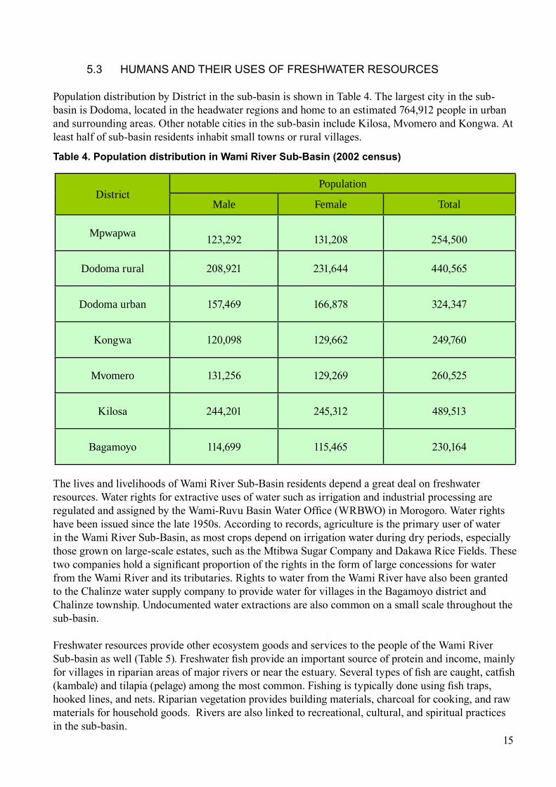
5.3 hUMAnS AnD ThEIR USES oF FREShWATER RESoURCES
Population distribution by District in the sub-basin is shown in Table 4. The largest city in the sub-basin is Dodoma, located in the headwater regions and home to an estimated 764,912 people in urban and surrounding areas. Other notable cities in the sub-basin include Kilosa, Mvomero and Kongwa. At least half of sub-basin residents inhabit small towns or rural villages.
DistrictPopulation
Male Female Total
Mpwapwa 123,292 131,208 254,500
Dodoma rural 208,921 231,644 440,565
Dodoma urban 157,469 166,878 324,347
Kongwa 120,098 129,662 249,760
Mvomero 131,256 129,269 260,525
Kilosa 244,201 245,312 489,513
Bagamoyo 114,699 115,465 230,164
Table 4. Population distribution in Wami River Sub-Basin (2002 census)
15
The lives and livelihoods of Wami River Sub-Basin residents depend a great deal on freshwater resources. Water rights for extractive uses of water such as irrigation and industrial processing are regulated and assigned by the Wami-Ruvu Basin Water Office (WRBWO) in Morogoro. Water rights have been issued since the late 1950s. According to records, agriculture is the primary user of water in the Wami River Sub-Basin, as most crops depend on irrigation water during dry periods, especially those grown on large-scale estates, such as the Mtibwa Sugar Company and Dakawa Rice Fields. These two companies hold a significant proportion of the rights in the form of large concessions for water from the Wami River and its tributaries. Rights to water from the Wami River have also been granted to the Chalinze water supply company to provide water for villages in the Bagamoyo district and Chalinze township. Undocumented water extractions are also common on a small scale throughout the sub-basin.
Freshwater resources provide other ecosystem goods and services to the people of the Wami River Sub-basin as well (Table 5). Freshwater fish provide an important source of protein and income, mainly for villages in riparian areas of major rivers or near the estuary. Several types of fish are caught, catfish (kambale) and tilapia (pelage) among the most common. Fishing is typically done using fish traps, hooked lines, and nets. Riparian vegetation provides building materials, charcoal for cooking, and raw materials for household goods. Rivers are also linked to recreational, cultural, and spiritual practices in the sub-basin.
5.4 ThREATS To ThE EnvIRonMEnT
At present, the Wami remains in a relatively intact state from an ecological perspective, especially when compared with the adjacent Ruvu River Sub-Basin. Proactive measures are needed to prevent unnecessary impact to ecosystems and balance the needs of humans and nature for water. The connections between upstream and downstream areas (longitudinal connectivity), between rivers and their floodplains (lateral connectivity), and on natural time scales (temporal connectivity) has not been substantially altered, with the exception of a few small storage dams in the upper parts of the Wami River Sub-Basin. These important connections facilitate the movement of water, sediment, debris, organic material and animals along riverine pathways that link terrestrial, freshwater and marine ecosystems. Much of the land area of the basin remains relatively undeveloped and human population densities are low outside of urban areas. Wildlife is abundant in national parks and reserves.
At issue for environmental conservation and water management is the future development and ecological state of the Wami River Sub-Basin. Three current patterns of resource use are of particular concern for freshwater resources in the future.
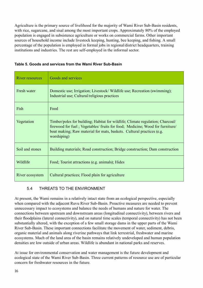
Agriculture is the primary source of livelihood for the majority of Wami River Sub-Basin residents, with rice, sugarcane, and sisal among the most important crops. Approximately 80% of the employed population is engaged in subsistence agriculture or works on commercial farms. Other important sources of household income include livestock keeping, hunting, bee keeping, and fishing. A small percentage of the population is employed in formal jobs in regional/district headquarters, training institutions and industries. The rest are self-employed in the informal sector.
Table 5. Goods and services from the Wami River Sub-Basin
River resources Goods and services
Fresh water Domestic use; Irrigation; Livestock/ Wildlife use; Recreation (swimming); Industrial use; Cultural/religious practices
Fish Food
Vegetation Timber/poles for building; Habitat for wildlife; Climate regulation; Charcoal/ firewood for fuel ; Vegetables/ fruits for food; Medicine; Wood for furniture/ boat making; Raw material for mats, baskets. Cultural practices (e.g. worshiping)
Soil and stones Building materials; Road construction; Bridge construction; Dam construction
Wildlife Food; Tourist attractions (e.g. animals); Hides
River ecosystem Cultural practices; Flood plain for agriculture
16

Figure 7 The selected sites for detailed environmental flow assessment using the BBm (building block methodology)
17
First, forest clearing for agricultural expansion, timber or charcoal-making results in increased sediment loads in rivers, thereby altering water quality and aquatic habitat. The problem of deforestation is exacerbated in riparian areas, which are frequently cleared for cultivation and livestock access to rivers. Clearance or trampling of riparian vegetation can quickly result in river bank instability, degradation of edge habitats, and siltation, and can negatively affect aquatic ecosystems.
Second, water pollution from industrial sources, large-scale agriculture or domestic wastes could become an emerging concern in the near future, unless treatment of wastewaters becomes more widespread. Use of toxic substances for fishing also contributes to water pollution and negatively affects ecosystem health.
Third, increasing water withdrawals from rivers and wetlands in the sub-basin, and particularly during dry periods, will affect freshwater delivery to downstream areas, including the estuary. The Wami River Sub-Basin is poised to become a major source of food and bioenergy for Tanzania in the next two decades, which will probably mean more and greater water withdrawals for crop irrigation. The Chalinze water supply project may also increase the amount of water currently withdrawn from the Wami River to meet the domestic water needs of a growing human population.

6. HOW muCH WATeR DOeS THe WAmi RiveR neeD?
Following the desktop research, the Wami EFA team met in August 2007 and discussed representative field study locations in the Wami River Sub-Basin for detailed analysis in order to estimate environmental flow requirements of the Wami River. Following this discussion, in September 2007 a reconnaissance mission to various parts of the sub-basin was made to identify representative, strategically-located sites for field study. A description of the findings of the reconnaissance mission and the rationale for site selection can be found in the report “Wami EFA Site Selection” available online at http://wami.fiu.edu.
The five sites selected (see Figure 7) are:
Kinyasungwe River at Kongwa (IGD 16)Mkondoa River at Kilosa (IGD 2)Wami River downstream from Mtibwa (IG 1)Wami River at Mandera (IG 2)Wami River at Matipwili (IG 0)
Field surveys were conducted by the inter-disciplinary science team during October and November and technical reports of findings were produced on each science theme (available online: http://wami.fiu.edu). Surveys included hydrological, macroinvertebrate, fish and human usage surveys. A series of four cross-section transects was placed at each study site. Geometric surveys were conducted on each transect, yielding information on distance between transects, streambed elevation and water surface elevation. Longitudinal profiles of the river section were mapped using the deepest point of the riverbed in order to determine channel slope. Cross-section profiles were mapped to illustrate the geometric characteristics of the streambed.
In December 2007, the team came together in Dar es Salaam for a five-day workshop to collaboratively estimate environmental flow requirements for the five representative sites. Following presentation and synthesis of all data known and available for the Wami River Sub-Basin, the team went through several exercises to identify management options and then quantified flow needs for the five representative sites. The details of this process are described in the following paragraphs.
The framework and guidelines found within the Building Block Methodology (BBM) approach were adopted to identify management classes and goals for water condition and use (King et al. 1998). Each of the experts in the Wami EFA project team was first asked to identify the present environmental state at each of the five sites. The present environmental state refers to what the natural conditions would 18

have been without any human alterations and includes a judgment about how far each component (e.g., fish abundance, riparian vegetation, channel condition) has changed from the reference conditions. Experts select the category which best represents current conditions for each component, from natural (category A) to critically / extremely modified (category F). To characterize the environmental state experts then estimated the direction of change, as a measure of whether the component is getting better or worse under the present situation; this measure is simply expressed as a plus sign, zero, or minus sign.
The team also discussed as a group the importance or sensitivity of each site, and river resource use by local human populations. The importance or sensitivity was classified as either low, medium, or high. These three measures were taken into account for the final determination of environmental management class for each site (Table 6). In this case, the experts were asked to categorize the site as A (natural, unmodified); B (largely natural with few modifications); C (moderately modified); or D (largely modified), according to King et al. (1998). For the Wami River Sub-Basin, with the exception of the Kinyasungwe River at Konga site (C class), the desired and feasible management class for all sites was B, largely natural with few modifications. The establishment of these classes helped to guide the subsequent process of determining environmental water allocations.
19
Table 6. Summary of experts’ determinations of environmental management class (emC) for five sites in the Wami River Sub-Basin
Wami EFA study sites
Present state (A is natural, D is largely modified)
Trajectory of change
Sensitivity and importance
Recommended Environmental Management Class (EMC)
Recommend- ed Actions
SITE 1: Kinyasungwe River at Kongwa (1GD16)
C/D Declining Medium C Maintain
SITE 2: Mkondoa River at Kilosa (1GD2)
B/C Declining to neutral
Medium / high B Maintain/
Restore
SITE 3: Wami River at Mtibwa (no gauge)
B/C Declining Medium / high B Maintain/
Restore
SITE 4: Wami River at Mandera (1G2) B Declining
to neutral High B Maintain
SITE 5: Wami River at Matipwili (new gauge)
C Declining Medium / high B Restore
B = Management initiatives should maintain or restore system to be largely natural with few modifications. A small change in natural habitats and biota may have already taken place, or may take place in the future, but most or all ecosystem functions should be essentially unchanged.
C= Management initiatives should maintain or restore system to be moderately modified. A loss and change of natural habitat and biota may have already taken place, or may be permitted to occur in the future. Basic ecosystem functions should be predominantly unchanged.
20
To estimate environmental flow requirements for each of the five sites, a combination of professional judgment and quantitative information on flow needs for different riverine processes or biota was used.
Flow periods were divided into six distinct categories:
(1) wet periods during a dry year (2) dry periods during a dry year (3) wet periods during an average year (4) dry periods during an average year (5) wet periods during a wet year(6) dry periods during a wet year
These categories were designed to account for natural inter- and intra-annual variation in river flows. Experts on the team were then asked to identify the minimum hydraulic requirements (in terms of depth, velocity, wetted perimeter, or water level) necessary to ensure survival of biota or to facilitate key geomorphologic processes. The hydraulic engineer used field data from channel cross-sections and modeling techniques to approximate discharge for each of the hydraulic conditions identified by the experts. This exercise was repeated for each of the six aforementioned cases of flow periods and for each of the five sites; thus, each expert completed 30 forms as part of the process of quantifying environmental flows. The social scientist was simultaneously asked to quantify the amount of water necessary to fulfil basic needs for local human populations. As a team, all environmental flow recommendations were discussed and the hydrologist provided information as to the availability of flows during different seasons and different years, based on previous analysis of the hydrologic record.
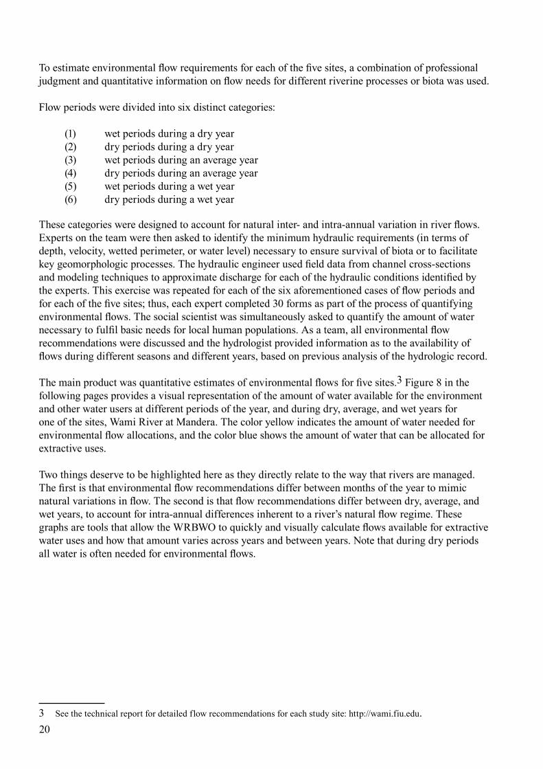
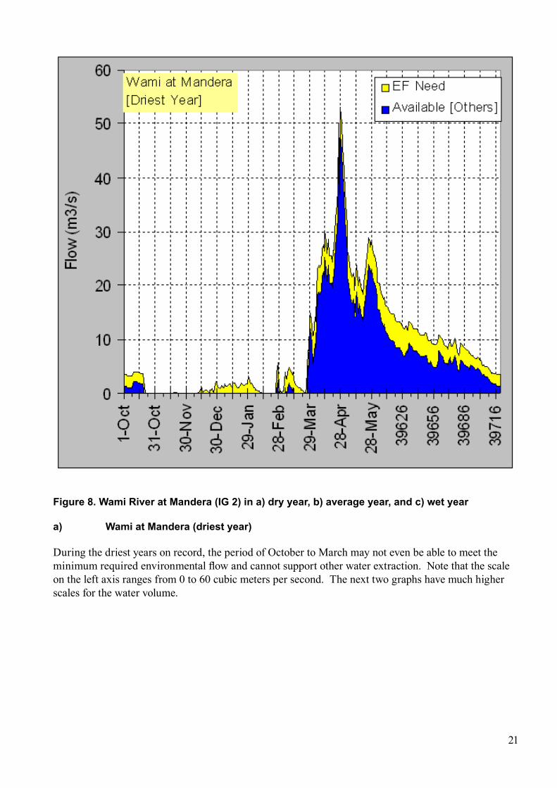
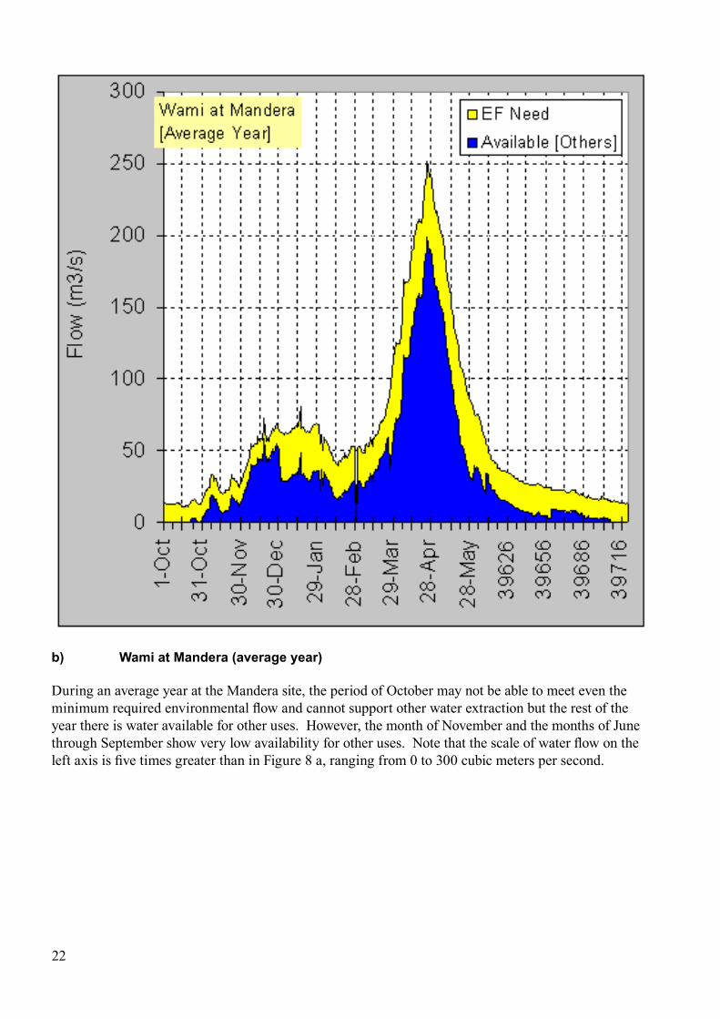
The main product was quantitative estimates of environmental flows for five sites.3 Figure 8 in the following pages provides a visual representation of the amount of water available for the environment and other water users at different periods of the year, and during dry, average, and wet years for one of the sites, Wami River at Mandera. The color yellow indicates the amount of water needed for environmental flow allocations, and the color blue shows the amount of water that can be allocated for extractive uses.
Two things deserve to be highlighted here as they directly relate to the way that rivers are managed. The first is that environmental flow recommendations differ between months of the year to mimic natural variations in flow. The second is that flow recommendations differ between dry, average, and wet years, to account for intra-annual differences inherent to a river’s natural flow regime. These graphs are tools that allow the WRBWO to quickly and visually calculate flows available for extractive water uses and how that amount varies across years and between years. Note that during dry periods all water is often needed for environmental flows.
3 See the technical report for detailed flow recommendations for each study site: http://wami.fiu.edu.
21
Figure 8. Wami River at mandera (iG 2) in a) dry year, b) average year, and c) wet year
a) Wami at mandera (driest year)
During the driest years on record, the period of October to March may not even be able to meet the minimum required environmental flow and cannot support other water extraction. Note that the scale on the left axis ranges from 0 to 60 cubic meters per second. The next two graphs have much higher scales for the water volume.
b) Wami at mandera (average year)
During an average year at the Mandera site, the period of October may not be able to meet even the minimum required environmental flow and cannot support other water extraction but the rest of the year there is water available for other uses. However, the month of November and the months of June through September show very low availability for other uses. Note that the scale of water flow on the left axis is five times greater than in Figure 8 a, ranging from 0 to 300 cubic meters per second.
22
23
c) Wami at mandera (wettest year)
During a very wet year at the Mandera site, the minimum required environmental flow is met through out the year. However, the month of November and the months of June through September show the same pattern of significantly less availability for other uses. Note that the scale of water flow on the left axis is 100 times greater than in Figure 8 a and 10 times greater than Figure 8 b, so the volume of water depicted is substantially greater than the other graphs, ranging from 0 to 2500 cubic meters per second.
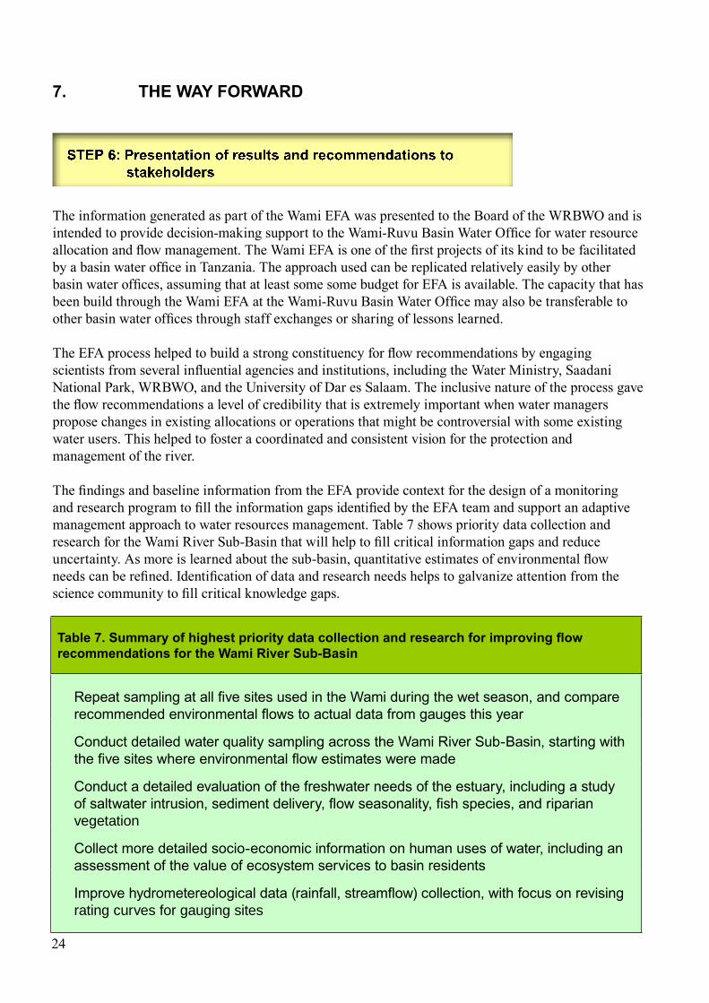
7. THe WAy FORWARD
The information generated as part of the Wami EFA was presented to the Board of the WRBWO and is intended to provide decision-making support to the Wami-Ruvu Basin Water Office for water resource allocation and flow management. The Wami EFA is one of the first projects of its kind to be facilitated by a basin water office in Tanzania. The approach used can be replicated relatively easily by other basin water offices, assuming that at least some some budget for EFA is available. The capacity that has been build through the Wami EFA at the Wami-Ruvu Basin Water Office may also be transferable to other basin water offices through staff exchanges or sharing of lessons learned.
The EFA process helped to build a strong constituency for flow recommendations by engaging scientists from several influential agencies and institutions, including the Water Ministry, Saadani National Park, WRBWO, and the University of Dar es Salaam. The inclusive nature of the process gave the flow recommendations a level of credibility that is extremely important when water managers propose changes in existing allocations or operations that might be controversial with some existing water users. This helped to foster a coordinated and consistent vision for the protection and management of the river.
The findings and baseline information from the EFA provide context for the design of a monitoring and research program to fill the information gaps identified by the EFA team and support an adaptive management approach to water resources management. Table 7 shows priority data collection and research for the Wami River Sub-Basin that will help to fill critical information gaps and reduce uncertainty. As more is learned about the sub-basin, quantitative estimates of environmental flow needs can be refined. Identification of data and research needs helps to galvanize attention from the science community to fill critical knowledge gaps.
Table 7. Summary of highest priority data collection and research for improving flow recommendations for the Wami River Sub-Basin
Repeat sampling at all five sites used in the Wami during the wet season, and compare recommended environmental flows to actual data from gauges this year
Conduct detailed water quality sampling across the Wami River Sub-Basin, starting with the five sites where environmental flow estimates were made
Conduct a detailed evaluation of the freshwater needs of the estuary, including a study of saltwater intrusion, sediment delivery, flow seasonality, fish species, and riparian vegetation
Collect more detailed socio-economic information on human uses of water, including an assessment of the value of ecosystem services to basin residents
Improve hydrometereological data (rainfall, streamflow) collection, with focus on revising rating curves for gauging sites
24
REFERENCES
Anderson, E., McNally, C.G., Kalangahe, B., Ramadhani, H., and H. Mhitu, (2007), “The Wami River Estuary: A Rapid Ecological Assessment,” Technical report prepared for the Tanzania Coastal Management Partnership and the Coastal Resources Center, University of Rhode Island (http://wami.fiu.edu)
Burgess, N.D. et al., (2007), “The Biological Importance of the Eastern Arc Mountains of Tanzania and Kenya,” Biological Conservation, 34: 209-231.
Gritzner, J. and D. Sumerlin (2007), “Rapid Assessment of the Interdependence of the Wami River to the Ecosystems and Biodiversity of Saadani National Park,” United States Department of Agriculture, Forest Service, Washington, D.C., 54 pp. ((http://wami.fiu.edu)
King, J. M., R. E. Tharme, and M. S. de Villiers (eds.) (2000), “Environmental Flow Assessments for Rivers: Manual for the Building Block Methodology,” Water Research Commission Report No. TT131/00. Water Research Commission: Pretoria, South Africa, 340 pp.
King, J., Brown, C. and H. Sabet (2003), “A Scenario-based Approach to Environmental Flow Assessment for Rivers,” River Research and Applications, 19:619-639.
Richter, B.D., Warner, A.T., Meyer, J.L. and K. Lutz (2006), “A Collaborative and Adaptive Process for Developing Environmental Flow Recommendations,” River Research and Applications, 22:297-318.
Stuart, S.N., Jensen, P.F., Brogger-Jensen, S. and Miller, R.I. (1993), “The Zoogeography of Montane Forest Avifauna of Eastern Africa,” in: Lovett, J.C. and Wasser, S.K.(Eds.) (1993), Biogeography and Ecology of the rain forests of eastern Africa, Cambridge University Press, pp 203-228.
United Republic of Tanzania (2002), Tanzania Population Census, National Profile, Bureau of Statistics, President’s Office, Planning Commission. Dar es Salaam, Tanzania.
Welcomme, R. L., Winemiller, K. O., and Cowx, I. G. (2006), “Fish Environmental Guilds as a Tool for Assessment of Ecological Condition of Rivers,” River Research and Applications, 22: 377–396.
25
Annex i DOCumenTS PRODuCeD FOR THe enviROnmenTAl FlOW ASSESSmENT
All documents available online at http://wami.fiu.edu
Main Technical Report:
Sarmett, J., and Anderson, E., editors. (2008), Wami River Initial Environmental Flow Assessment. Synthesis Report, June 2008.
Background Reports:
Environmental Flows Assessment Team, (2007), Wami EFA Sites Selection Report. Hyera, P. (2007) Environmental Flow Assessment (EFA), Wami River Sub-Basin, Tanzania:Socio-
Economic Assessment.Hyera, P. (2007), Environmental Flow Assessment (EFA), Wami River Sub-Basin, Tanzania: Socio-
economic component of the Wami River EFA Study. Literature Review for BBM WorkshopMligo, C. (2007) Environmental Flow Assessment (EFA), Wami River Sub-Basin, Tanzania:
Vegetation Survey Of The Ecosystem Along The Wami RiverMwanukuzi, P. (2007), Environmental Flow Assessment (EFA), Wami River Sub-Basin, Tanzania:
Geomorphology. Ndomba, P. (2007), Environmental Flow Assessment (EFA), Wami River Sub-Basin, Tanzania:
Hydraulics Component. Starter Report For Environmental Flow Recommendations Tamatamah, R. (2007), Environmental Flow Assessment (EFA), Wami River Sub-Basin, Tanzania:
Aquatic Ecology Component Of The Wami River. Starter Document for BBM Workshop Tamatamah, R. (2007), Environmental Flow Assessment (EFA), Wami River Sub-Basin, Tanzania:
Aquatic Ecology Component Of The Wami River EFA Study. Literature Review For BBM Workshop
Valimba, P. (2007), Environmental Flow Assessment (EFA), Wami River Sub-Basin, Tanzania: The Wami Hydrology. Volume 1 – General Description
Valimba, P. (2007), Environmental Flow Assessment (EFA), Wami River Sub-Basin, Tanzania: Hydrology component of the Wami River EFA Study. Literature Review for BBM Workshop.
Related reports:
Anderson, E., McNally, C., Kalangahe, B., Ramadhani, H. and Mhitu, H. (2007), A Rapid Ecological Assessment of the Wami River Estuary, Tanzania. Global Water for Sustainability Program, Florida International University and Tanzania Coastal Management Partnership.
Tobey, J. (2008), A Profile of the Wami River Sub-Basin. Tanzania Coastal Management Partnership for Sustainable Coastal Communities and Ecosystems. http://www.crc.uri.edu
26
Project leaders:Mr. Julius Sarmett Basin Water OfficerWami-Ruvu Basin Water OfficeTanzania Ministry of Water
Ms. Appa MandariWADA project coordinatorTanzania Coastal Management Partnership
Scientific experts:Mr. Mligo Cosmos, Riparian SpecialistUniversity of Dar es Salaam
Ms. Pendo Hyera, SociologistWami-Ruvu Basin Water Office
Dr. Phillip Mwanukuzi, GeomorphologistUniversity of Dar es Salaam
Dr. P. M. Ndomba, Hydraulic EngineerUniversity of Dar es Salaam
Dr. Rashid Tamatamah, Aquatic EcologistUniversity of Dar es Salaam
Dr. Patrick Valimba, HydrologistUniversity of Dar es Salaam
Dr. Elizabeth AndersonDeputy DirectorGlobal Water for Sustainability ProgramFlorida International University, USA
27
Wami-Ruvu Basin Water Office:Mr. Ernest LemaProject Coordinator
Eng. M.D. RukikoProject Coordinator
Eng. Misigaro KigadyeProject Coordinator
Mr. Ebbo MakalingaProject Assistant
Project Assistant:Catherine McNallyDoctoral StudentUniversity of Rhode Island, USA
ANNEx II WAmI RIvER INITIAl ENvIRONmENTAl FlOW ASSESSmENT TEAm