Holistic versus monomeric strategies for hydrological modelling of human-modified hydrosystems
16
Hydrol. Earth Syst. Sci., 15, 743–758, 2011 www.hydrol-earth-syst-sci.net/15/743/2011/ doi:10.5194/hess-15-743-2011 © Author(s) 2011. CC Attribution 3.0 License. Hydrology and Earth System Sciences Holistic versus monomeric strategies for hydrological modelling of human-modified hydrosystems I. Nalbantis 1 , A. Efstratiadis 2 , E. Rozos 2 , M. Kopsiafti 2 , and D. Koutsoyiannis 2 1 Laboratory of Reclamation Works and Water Resources Management, School of Rural and Surveying Engineering, National Technical University of Athens, Greece 2 Department of Water Resources and Environmental Engineering, School of Civil Engineering, National Technical University of Athens, Greece Received: 30 September 2010 – Published in Hydrol. Earth Syst. Sci. Discuss.: 20 October 2010 Revised: 15 February 2011 – Accepted: 15 February 2011 – Published: 4 March 2011 Abstract. The modelling of human-modified basins that are inadequately measured constitutes a challenge for hydrolog- ical science. Often, models for such systems are detailed and hydraulics-based for only one part of the system while for other parts oversimplified models or rough assumptions are used. This is typically a bottom-up approach, which seeks to exploit knowledge of hydrological processes at the micro-scale at some components of the system. Also, it is a monomeric approach in two ways: first, essential interac- tions among system components may be poorly represented or even omitted; second, differences in the level of detail of process representation can lead to uncontrolled errors. Addi- tionally, the calibration procedure merely accounts for the re- production of the observed responses using typical fitting cri- teria. The paper aims to raise some critical issues, regarding the entire modelling approach for such hydrosystems. For this, two alternative modelling strategies are examined that reflect two modelling approaches or philosophies: a dom- inant bottom-up approach, which is also monomeric and, very often, based on output information, and a top-down and holistic approach based on generalized information. Critical options are examined, which codify the differences between the two strategies: the representation of surface, ground- water and water management processes, the schematization and parameterization concepts and the parameter estimation methodology. The first strategy is based on stand-alone mod- els for surface and groundwater processes and for water man- agement, which are employed sequentially. For each model, a different (detailed or coarse) parameterization is used, which is dictated by the hydrosystem schematization. The second strategy involves model integration for all processes, Correspondence to: I. Nalbantis ([email protected]) parsimonious parameterization and hybrid manual-automatic parameter optimization based on multiple objectives. A test case is examined in a hydrosystem in Greece with high com- plexities, such as extended surface-groundwater interactions, ill-defined boundaries, sinks to the sea and anthropogenic in- tervention with unmeasured abstractions both from surface water and aquifers. Criteria for comparison are the physical consistency of parameters, the reproduction of runoff hydro- graphs at multiple sites within the studied basin, the likeli- hood of uncontrolled model outputs, the required amount of computational effort and the performance within a stochas- tic simulation setting. Our work allows for investigating the deterioration of model performance in cases where no bal- anced attention is paid to all components of human-modified hydrosystems and the related information. Also, sources of errors are identified and their combined effect are evaluated. 1 Introduction and motivation Two different general approaches or philosophies are applied in modelling of natural processes at large spatial scales, e.g., a whole catchment (in the order of at least a few km 2 ): The first approach, called bottom-up or upward (BU), seeks to ex- ploit knowledge (typically physical laws) at the micro-scale (in the order of a few m 2 ) and then proceeds to larger scales through spatial aggregation. The second approach, called top-down or downward (TD), examines processes directly at the large scale and then eventually proceeds to making in- ferences about processes at smaller scales (Klemeˇ s, 1983; Sivapalan et al., 2003b). Apart from this categorization of modelling approaches whose criterion is the initial spatial scale of process representation, another categorization arises when the criterion is the level of modelling detail: Very often, Published by Copernicus Publications on behalf of the European Geosciences Union.
Transcript of Holistic versus monomeric strategies for hydrological modelling of human-modified hydrosystems

Hydrol. Earth Syst. Sci., 15, 743–758, 2011www.hydrol-earth-syst-sci.net/15/743/2011/doi:10.5194/hess-15-743-2011© Author(s) 2011. CC Attribution 3.0 License.
Hydrology andEarth System
Sciences
Holistic versus monomeric strategies for hydrological modelling ofhuman-modified hydrosystems
I. Nalbantis1, A. Efstratiadis2, E. Rozos2, M. Kopsiafti 2, and D. Koutsoyiannis2
1Laboratory of Reclamation Works and Water Resources Management, School of Rural and Surveying Engineering,National Technical University of Athens, Greece2Department of Water Resources and Environmental Engineering, School of Civil Engineering,National Technical University of Athens, Greece
Received: 30 September 2010 – Published in Hydrol. Earth Syst. Sci. Discuss.: 20 October 2010Revised: 15 February 2011 – Accepted: 15 February 2011 – Published: 4 March 2011
Abstract. The modelling of human-modified basins that areinadequately measured constitutes a challenge for hydrolog-ical science. Often, models for such systems are detailedand hydraulics-based for only one part of the system whilefor other parts oversimplified models or rough assumptionsare used. This is typically a bottom-up approach, whichseeks to exploit knowledge of hydrological processes at themicro-scale at some components of the system. Also, it isa monomeric approach in two ways: first, essential interac-tions among system components may be poorly representedor even omitted; second, differences in the level of detail ofprocess representation can lead to uncontrolled errors. Addi-tionally, the calibration procedure merely accounts for the re-production of the observed responses using typical fitting cri-teria. The paper aims to raise some critical issues, regardingthe entire modelling approach for such hydrosystems. Forthis, two alternative modelling strategies are examined thatreflect two modelling approaches or philosophies: a dom-inant bottom-up approach, which is also monomeric and,very often, based on output information, and a top-down andholistic approach based on generalized information. Criticaloptions are examined, which codify the differences betweenthe two strategies: the representation of surface, ground-water and water management processes, the schematizationand parameterization concepts and the parameter estimationmethodology. The first strategy is based on stand-alone mod-els for surface and groundwater processes and for water man-agement, which are employed sequentially. For each model,a different (detailed or coarse) parameterization is used,which is dictated by the hydrosystem schematization. Thesecond strategy involves model integration for all processes,
Correspondence to:I. Nalbantis([email protected])
parsimonious parameterization and hybrid manual-automaticparameter optimization based on multiple objectives. A testcase is examined in a hydrosystem in Greece with high com-plexities, such as extended surface-groundwater interactions,ill-defined boundaries, sinks to the sea and anthropogenic in-tervention with unmeasured abstractions both from surfacewater and aquifers. Criteria for comparison are the physicalconsistency of parameters, the reproduction of runoff hydro-graphs at multiple sites within the studied basin, the likeli-hood of uncontrolled model outputs, the required amount ofcomputational effort and the performance within a stochas-tic simulation setting. Our work allows for investigating thedeterioration of model performance in cases where no bal-anced attention is paid to all components of human-modifiedhydrosystems and the related information. Also, sources oferrors are identified and their combined effect are evaluated.
1 Introduction and motivation
Two different general approaches or philosophies are appliedin modelling of natural processes at large spatial scales, e.g.,a whole catchment (in the order of at least a few km2): Thefirst approach, called bottom-up or upward (BU), seeks to ex-ploit knowledge (typically physical laws) at the micro-scale(in the order of a few m2) and then proceeds to larger scalesthrough spatial aggregation. The second approach, calledtop-down or downward (TD), examines processes directly atthe large scale and then eventually proceeds to making in-ferences about processes at smaller scales (Klemes, 1983;Sivapalan et al., 2003b). Apart from this categorization ofmodelling approaches whose criterion is the initial spatialscale of process representation, another categorization ariseswhen the criterion is the level of modelling detail: Very often,
Published by Copernicus Publications on behalf of the European Geosciences Union.

744 I. Nalbantis: Holistic vs. monomeric modelling of modified hydrosystems
some parts of the studied system are modelled in detail (inspace-time) while for other parts simplified models are em-ployed; in that way essential interactions among system com-ponents may be poorly represented or even omitted; we willcall this approachmonomeric(M), which originates from theGreek words “µoνoς ” and “µερoς ” respectively denoting“solely” and “part”. Specifically, we call a modelling ap-proach “monomeric” when some, one or a few, components,processes or information regarding the studied system, areexamined in detail, while at the same time other importantcomponents are roughly accounted for or even omitted. Con-versely, when all parts of the studied system are modelledin similar detail and are linked via feedback mechanisms,the approach will be calledholistic (H); this derives fromthe Greek word “oλoν”, which means “whole”. The dis-tinction between the monomeric and the holistic characterof a specific approach can be extended to the type of in-formation about the system that is exploited in modelling;in a monomeric approach often limited information is used,which encompasses a small number of measured system out-puts or responses, whereas in an holistic approach often oneseeks to exploit information that is more general. Thus,apart from observations, qualitative information of any kindabout the system responses is also taken into account to-gether with the empirical interpretation of the unmeasuredvariables (whether output or internal ones).
Focusing on hydrological modelling, Savenije (2009)pointed out that “. . . the dominant paradigm of hydraulics isreductionism, or a bottom-up approach, whereas in hydrol-ogy it is (or should be) empiricism and a top-down approachlooking for links with fundamental laws of physics.” The im-plementation of the BU approach into hydrology has led tomodelling of hydrological processes at the small scale (e.g.,local, plot or hillslope), which has been an active researcharea in recent years (Zhang and Savenije, 2005; Zehe et al.,2006; Bardossy, 2007). The practical usefulness of suchmodels lies in that these allow hydrological predictions at thecatchment scale, supposedly without using any informationon hydrological responses (Kilsby et al., 1999). Essentiallythis was the initial central focus of the “Predictions in Un-gauged Basins (PUB)” initiative (Sivapalan et al., 2003a).
Critiques on the fundamental limitations of this approach,promising substantial reduction of uncertainty through re-duction (i.e., theoretical explanation of small-scale pro-cesses) rather than deduction (i.e., explanation based on“lumped” response data) have appeared recently (Kout-soyiannis et al., 2009), but the underlying idea has been crit-icised from its early steps (Beven, 1989). Savenije (2009)reports examples where the BU approach fails, while takinga broader perspective of the system under study through atop-down (TD) approach manages to better explain reality.Applications of the latter approach, which is rather macro-scopic and, in this sense, holistic, are few (e.g., Tekleab etal., 2010).
The problems of the bottom-up approach become appar-ent when hydrological models are called to support engi-neering and management decisions, i.e., meet their majorrole (Efstratiadis and Mamassis, 2009). Supporting of de-cisions often requires modelling hydrosystems that involveextended surface-groundwater interactions and extended an-thropogenic interventions in the hydrological cycle, such asabstractions from surface water bodies, pumping, and returnsthrough artificial drainage systems. Theoretically, apply-ing the BU approach for such human-modified hydrosystemswould necessitate putting together all physical processes andprocess interactions. Obviously, this would require a tremen-dous amount of information, which is absent in every real-world application. Although there are some “integrated”physically-based tools, e.g., the SHE model, that have beeneffectively used for solving complex water management is-sues (see the recent discussion by Refsgaard et al., 2010),what is very frequently encountered within the BU approachis the monomeric character of modelling as this is definedearlier in this section. For example, a very detailed model isoften formulated for one part of the system (or sub-system),while using oversimplified models for other parts or even ig-noring dynamic links between sub-systems. More often thannot, the focus is on the detailed hydraulic model of a specificsub-system, such as an aquifer. According to the two catego-rization criteria, this approach will certainly be characterizedas bottom-up/monomeric (BU-M). Although one may say inadvance that this is simply a bad modelling practice, whichmerits no further attention, the use of such approach is stillso widespread that the analysis of its implications is, to ourview, justified.
In this paper, we will concentrate our effort to human-modified hydrosystems, since this is a practical problemof high interest. Nowadays, especially in western coun-tries, natural (i.e., pristine) river basins no longer exist (e.g.,Sanderson et al., 2002; Wagener et al., 2010). Thus, in ourtime, dealing with hydrological issues often implies deal-ing with human-modified systems. To represent the BU-Mapproach we will consider a particular modelling strategy,called here strategy A. This focuses on hydraulic modellingof one natural sub-system only, which is the basin aquifer. Tocope with the system complexities, a multi-stage modellingprocess is used that involves four stages: (1) splitting the hy-drosystem into a number of natural sub-systems (sub-basinsand the aquifer) and one man-made sub-system; (2) mod-elling natural sub-systems individually; (3) transferring pre-dictions from the natural sub-systems to the man-made sub-system; and (4) optimizing the operation of the latter sub-system so as to represent as close as possible the observedconditions of the past (calibration). This is typically the strat-egy followed in engineering studies with the aid of popularcommercial computer packages for water resources manage-ment. It presupposes that: (a) pure natural sub-systems canbe effectively found, and (b) sufficient information is avail-able for each sub-system modelled.
Hydrol. Earth Syst. Sci., 15, 743–758, 2011 www.hydrol-earth-syst-sci.net/15/743/2011/
I. Nalbantis: Holistic vs. monomeric modelling of modified hydrosystems 745
Strategy A may lead to erroneous predictions in complexbasins where no simple natural sub-systems can be identi-fied due to complex water exchanges. Moreover, inadequateinformation on some sub-systems may prohibit successfulmodelling. Data inadequacy involves, among others, ill-defined system boundaries due to unknown leakages, sinksto the sea and anthropogenic intervention with unmeasuredabstractions both from surface and groundwater. In the lastyears some approaches have appeared that cope with some ofthe above problems, although they do not cover the case ofhuman-modified basins (e.g., Singh and Bhallamudi, 1998;Bari and Smettem, 2004; Panday and Huyacorn, 2004; Gau-thier et al., 2009) neither do they treat the case of unknownabstractions (e.g., Schoups et al., 2005). Few exceptionsare found in literature, which follow a TD approach (e.g.,Ivkovic et al., 2009; Payan et al., 2008); noteworthy is theeffort by Hingray et al. (2010) to simultaneously cope withhuman-modified basins (with strong influence of hydraulicworks) and data scale incompatibility.
An alternative modelling strategy, called here strategy B,will be used to represent a TD-H approach. Here the hy-drosystem under consideration is viewed as a whole, havingthe input and the required information as guides to formu-late spatial modelling units and process models. Ultimately,this strategy leads to model integration, parsimonious pa-rameterization and simultaneous optimization of all modelparameters. All these features provide flexibility to strat-egy B, which may be critical in cases with human-modifiedbut poorly measured hydrosystems.
The motivation for this work is to test the applicability ofmodelling strategy A when the latter is employed for sys-tems such as those described above. Our target is to ex-amine the every-day modelling strategies in a critical spirit.It is the effects of these strategies that are investigated andnot the value of the models used therein. In this respect,our work differs from a number of large-scale comparativestudies reported in the literature (e.g., WMO, 1975, 1992;Bell et al., 2001; Velazquez et al., 2010), including the Dis-tributed Model Intercomparison Project (Smith et al., 2004).The potential benefit when the problems of strategy A arefaced is evaluated through applying strategy B. In this con-text, we followed a two-step procedure; initially, we esti-mated the model parameters using historical data through ahybrid multi-objective calibration framework, and then wefurther evaluated the model performance via stochastic sim-ulation.
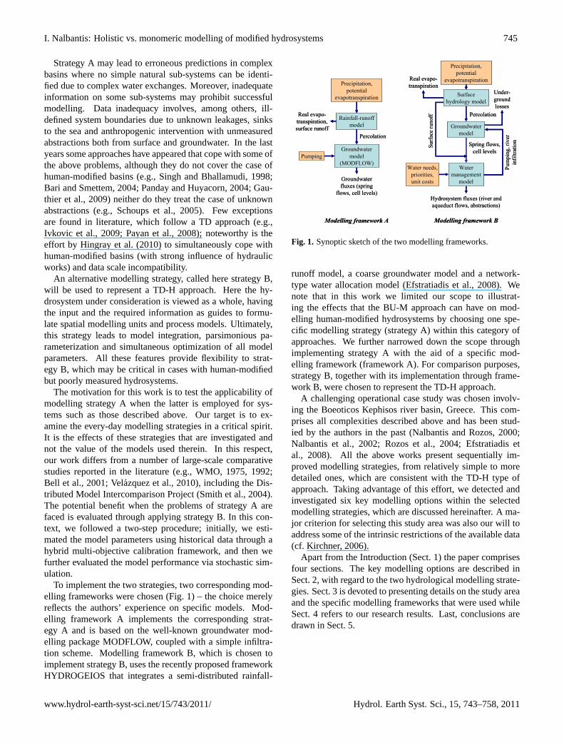
To implement the two strategies, two corresponding mod-elling frameworks were chosen (Fig. 1) – the choice merelyreflects the authors’ experience on specific models. Mod-elling framework A implements the corresponding strat-egy A and is based on the well-known groundwater mod-elling package MODFLOW, coupled with a simple infiltra-tion scheme. Modelling framework B, which is chosen toimplement strategy B, uses the recently proposed frameworkHYDROGEIOS that integrates a semi-distributed rainfall-
Groundwater
model
Percolation
Spring flows,
cell levels
Pumping, river
infiltration
Surface runoff
Hydrosystem fluxes (river and
aqueduct flows, abstractions)
Water needs,
priorities,
unit costs
Precipitation,
potential
evapotranspirationReal evapo-
transpiration
Rainfall-runoff
model
Groundwater
model
(MODFLOW)
Precipitation,
potential
evapotranspiration
Real evapo-
transpiration,
surface runoff
Percolation
Groundwater
fluxes (spring
flows, cell levels)
Pumping
Modelling framework A Modelling framework B
Under-
ground
losses
Surface
hydrology model
Water
management
model
Groundwater
model
Percolation
Spring flows,
cell levels
Pumping, river
infiltration
Surface runoff
Hydrosystem fluxes (river and
aqueduct flows, abstractions)
Water needs,
priorities,
unit costs
Precipitation,
potential
evapotranspirationReal evapo-
transpiration
Rainfall-runoff
model
Groundwater
model
(MODFLOW)
Precipitation,
potential
evapotranspiration
Real evapo-
transpiration,
surface runoff
Percolation
Groundwater
fluxes (spring
flows, cell levels)
Pumping
Modelling framework A Modelling framework B
Under-
ground
losses
Surface
hydrology model
Water
management
model
Figure 1
Fig. 1. Synoptic sketch of the two modelling frameworks.
runoff model, a coarse groundwater model and a network-type water allocation model (Efstratiadis et al., 2008). Wenote that in this work we limited our scope to illustrat-ing the effects that the BU-M approach can have on mod-elling human-modified hydrosystems by choosing one spe-cific modelling strategy (strategy A) within this category ofapproaches. We further narrowed down the scope throughimplementing strategy A with the aid of a specific mod-elling framework (framework A). For comparison purposes,strategy B, together with its implementation through frame-work B, were chosen to represent the TD-H approach.
A challenging operational case study was chosen involv-ing the Boeoticos Kephisos river basin, Greece. This com-prises all complexities described above and has been stud-ied by the authors in the past (Nalbantis and Rozos, 2000;Nalbantis et al., 2002; Rozos et al., 2004; Efstratiadis etal., 2008). All the above works present sequentially im-proved modelling strategies, from relatively simple to moredetailed ones, which are consistent with the TD-H type ofapproach. Taking advantage of this effort, we detected andinvestigated six key modelling options within the selectedmodelling strategies, which are discussed hereinafter. A ma-jor criterion for selecting this study area was also our will toaddress some of the intrinsic restrictions of the available data(cf. Kirchner, 2006).
Apart from the Introduction (Sect. 1) the paper comprisesfour sections. The key modelling options are described inSect. 2, with regard to the two hydrological modelling strate-gies. Sect. 3 is devoted to presenting details on the study areaand the specific modelling frameworks that were used whileSect. 4 refers to our research results. Last, conclusions aredrawn in Sect. 5.
www.hydrol-earth-syst-sci.net/15/743/2011/ Hydrol. Earth Syst. Sci., 15, 743–758, 2011

746 I. Nalbantis: Holistic vs. monomeric modelling of modified hydrosystems
Table 1. Features of test modelling frameworks in regard to key modelling options.
Key modelling option Modelling framework A Modelling framework B
SW-GW The surface hydrology model is separate from thegroundwater flow model (MODFLOW).
Surface and groundwater models are integrated within asingle computer package.
SW-GW-WM No water management model is considered; ground-water abstractions are set equal to the theoretical wa-ter requirements.
A water management model, accounting for alternativesources and demand priorities through an optimizationframework, is integrated with hydrological models.
SCHEM-SCALE The groundwater flow model (MODFLOW) isimplemented as a fully distributed physics-basedmodel, whereas the infiltration model used is semi-lumped.
A semi-distributed approach is used (combination ofsub-basins and HRUs for surface water processes and asmall number of non-rectangular cells for the aquifer).
SCHEM-PARAM Parameterization of surface processes is simplisticdue to the elementary model; for groundwater flowprocesses parameterization follows schematization;zonation is possible.
The HRU concept helps to decouple schematization andparameterization of the surface hydrology model. For thegroundwater model decoupling is possible by groupingparameter values of several groundwater cells (zonation).
OPT MODFLOW includes a module for automatic pa-rameter optimization, which implements a determin-istic local-search method without any possibility ofintervention to guide solution.Parameter fitting is based on measurements and can-not take into account other types of data (e.g., timingof interruption of spring hydrographs).
Calibration follows a hybrid (i.e., manual-automatic)procedure, where multiple criteria are embedded to con-trol unmeasured responses and take advantage of thephysical interpretation of parameters. The sparse wa-ter table measurements are taken into account to iden-tify rising or falling trends in groundwater level. Theglobal (i.e., evolutionary) character of the optimizationmethod, supported by manual interventions during cali-bration, ensures finding a consistent solution.
STOCH-SIM The calculations are exceptionally time-consumingagainst synthetic data of long time horizons.Synthetic time series of “future” decisions (abstrac-tions) should be externally provided.
Due to its computational efficiency, the model can runfor very long time horizons, to provide probabilistic es-timates.Synthetic time series of “future” decisions are model out-puts.
2 Key modelling options in hydrological modellingstrategies
When formulating a modelling strategy, critical decisions aremade in regard to selecting, formulating and fitting hydrolog-ical models. These decisions lead to defining key modellingoptions that constitute the “ingredients” of the formulatedstrategy, as described next. Table 1 summarizes six such op-tions, linking them with each one of the modelling frame-works (and, hence, the related strategy) that is employed inour tests. All these options are related to specific stages of themodelling process. According to the classification by Refs-gaard and Henriksen (2004) and Scholten et al. (2007), thesestages are: (1) model study plan; (2) data and conceptualisa-tion; (3) model setup; (4) calibration and validation; (5) sim-ulation and evaluation. So, the first two options will referto model conceptualisation (stage 2) since they deal with se-lecting hydrological processes and the interactions thereof,while the next three options will have to do with selectingcalibration parameters, thus referring to stage 4. Finally, thelast option, i.e., the application of models in stochastic simu-lation mode, is linked to stage 5.
2.1 Key modelling option SW-GW: link between modelsfor surface and groundwater processes
In strategy A, different stand-alone models are used for sur-face and groundwater hydrology, which precludes interac-tion between the corresponding processes. Very often, thetwo models differ in their spatial and temporal scale and intheir modelling approach. The surface processes are usuallyrepresented via conceptual (hydrological) models or fully-distributed physically-based schemes, which are also con-ceptual at the grid scale (Beven, 1989). Yet, groundwatermodelling typically follows a hydraulic rationale. Obviously,these options also affect the parameter estimation procedure.In strategy B, the main hydrological interactions are explic-itly represented, and thus model parameters can be simulta-neously optimized, taking advantage of the available mea-surements across all components.
Hydrol. Earth Syst. Sci., 15, 743–758, 2011 www.hydrol-earth-syst-sci.net/15/743/2011/

I. Nalbantis: Holistic vs. monomeric modelling of modified hydrosystems 747
2.2 Key modelling option SW-GW-WM: linkbetween models for hydrological processes andwater management
In the staged modelling procedure of strategy A, hydrolog-ical models are constructed exclusively for the unmodifiedparts of the system (e.g., sub-basins) and the outputs thereof(e.g., river flows) are, then, transferred as inputs to the wa-ter management model of the man-made sub-system, usu-ally implemented within a Decision Support System (DSS).This serial operation, apart from being computationally inef-ficient, suffers from a number of drawbacks: (a) it requiresiterations when decision-related interactions between the hy-drological and the man-made sub-systems are significant;(b) it is infeasible when real abstractions are not measured,since these serve as the boundary conditions for hydrologicaland hydrogeological models; (c) it may require making sim-plified yet unrealistic assumptions regarding the water alloca-tions (e.g., a “first-come, first-served” management policy);(d) it requires data transfer from the hydrological model tothe water management model and hence the space-time scalecompatibility of the related variables; (e) the above prob-lems introduce high uncertainty in the parameters obtainedthrough automatic calibration or even make the calibrationimpossible, since models with unknown yet interrelated pa-rameters have to run individually (Efstratiadis et al., 2010).Attempts to cope with the above problem are rare in litera-ture (Fredericks et al., 1998; Dai and Labadie, 2001). Copingwith these problems requires a fully integrated computationalscheme, as employed in strategy B.
2.3 Key modelling option SCHEM-SCALE: link ofspatial scale and model schematization
The large heterogeneity of mechanisms and properties makesit difficult to achieve compatibility between the measure-ments made at the local scale and the model predictions.Quite often, in strategy A, very detailed models are chosen inthe hope to achieve scale compatibility between the data andthe predicted variables. Yet, the resulting high dimensional-ity leads to extremely time-consuming schemes, which is amajor restricting factor affecting not only the calibration butalso the operational applicability of models; the latter ariseswhen models have to co-operate with DSS that run in fore-cast mode, using synthetic forcing data for long time hori-zons (Nalbantis et al., 2002).
2.4 Key modelling option SCHEM-PARAM: linkbetween hydrosystem schematization andparameterization
Inevitably, in strategy A, the hydrosystem schematization(i.e., the simplification of the process representation in space)dictates the parameterization. Parameters are assigned to in-dividual spatial elements (e.g., sub-basins, grid cells), thus
having limited physical meaning. Moreover, due to the de-tailed spatial scale adopted, the principle of parsimony isbroken, which results to poorly identified parameters (Kucz-era and Mroczkowski, 1998) and increased predictive un-certainty (Efstratiadis and Koutsoyiannis, 2010; Savenije,2010). Attempts to reduce the number of control variables ofthe optimization problem require hybridized strategies, suchas detecting only the most important parameters while es-timating the rest of them on the basis of field data (Refs-gaard, 1997; Eckhardt and Arnold, 2001) or using zonationapproaches (i.e., spatial grouping of parameters). Contraryto the above, in strategy B the schematization and the pa-rameterization are disconnected, thus allowing models to beby construction parsimonious. In this respect, the schema-tization is adapted to the engineering objectives (i.e., whichprocesses should be simulated and where), while the param-eterization is only linked to the available information (cf. De-hotin and Braud, 2008).
2.5 Key modelling option OPT: appropriate use ofoptimization in calibration
In theory, physically-based approaches enable their free vari-ables to be derived from field measurements. Yet, in practice,their applicability is significantly restrained not only by theheterogeneity of processes and the unknown scale dependen-cies of parameters (Beven, 2001; Wagener et al., 2001; Ros-berg and Madsen, 2005), but also by the high computationaleffort and the subsequent inability to co-operate with DSSs(Nalbantis et al., 2002). Hence, optimization is always re-quired for at least some of the model parameters (Refsgaard,1997; Eckhardt and Arnold, 2001). However, within strat-egy A, a “black-box” approach is frequently adopted, seek-ing for a “optimal” parameter set (typically against a single,quantitative performance criterion), through an automatic al-gorithmic procedure. Very often, this leads to: (a) param-eter values that are inconsistent with their physical inter-pretation; (b) poor predictive capacity against independentcontrol data (model validation); (c) unreasonable values ofthe uncontrolled responses (e.g., evapotranspiration, under-ground losses) and the internal model variables (e.g., soil andgroundwater storage) (Rozos et al., 2004; Efstratiadis et al.,2008). On the other hand, strategy B emphasizes both on theoptimization task itself and the comprehensive understandingof the problem components (real system, model and data), toensure reliable results. Particularly in models of complex pa-rameterization, it aims to increase the information that is ex-ploited in calibration as much as possible, by means of bothmulti-response measurements and empirical metrics (“soft”data), accounting for the hydrological expertise (Efstratiadisand Koutsoyiannis, 2010).
www.hydrol-earth-syst-sci.net/15/743/2011/ Hydrol. Earth Syst. Sci., 15, 743–758, 2011

748 I. Nalbantis: Holistic vs. monomeric modelling of modified hydrosystems
2.6 Key modelling option STOCH-SIM: modelevaluation through stochastic simulation
The typical “split-sample” procedure for model building(i.e., calibration/validation based on historical data; Klemes,1986) may hide possible structural deficiencies of the model,given that it is too much depended on the historical data(and the errors embedded in them). A more holistic ap-proach aims to extend model validation, by also examiningthe model responses under hypothetical conditions on the ba-sis of synthetically-generated forcing, i.e., through stochas-tic simulation. This option offers multiple advantages overthe typical model validation procedure: (a) it helps testinga modelling strategy within a framework that is similar toan operational one, i.e., by representing situations that areconsistent to those in which it is supposed to be employedin practice (Klemes, 1986); (b) it allows for examining fu-ture water management scenarios that are different from thehistorical ones, thus also offering a “crash-test” for evaluat-ing the model transposability in time, which is a necessarycondition for its operational adequacy (Andreassian et al.,2009); (c) it provides an opportunity to check for model in-consistencies, e.g., unreasonable long-term statistical trends,jumps, or abnormal patterns (often impossible to spot in theshort period encountered in typical calibration and valida-tion), which constitutes a supplementary verification of themodel credibility and helps highlight hidden artefacts; (d) itprovides estimates of the uncertainty of predictions and thelong-term risk in hydrological studies and water resourcesmanagement, through a proper representation of the vary-ing character of climate and the related processes in stochas-tic terms (Koutsoyiannis et al., 2007; Koutsoyiannis, 2011);(e) it allows for including the evaluation of extremes, whichare not represented in the (usually limited) calibration data(Seibert, 2003).
3 Case study
3.1 The study area
The Boeoticos Kephisos river basin lies on the Eastern StereaHellas, to the north of Athens, and drains a closed area of1930 km2 (Fig. 2). The catchment is formed on heavily kars-tified limestone covered with alluvial deposits in plain areas.Considerable groundwater amount (more than half of the an-nual catchment runoff) is discharged through large springs inthe upper and the middle part of the basin, whereas an un-known amount is leaking to the sea.
The surface runoff of the basin is conducted to the neigh-bouring Lake Hylike, which is one of the major reservoirs ofthe Athens water supply system. Groundwater of the middlepart is also considered as an emergency resource. A signif-icant part of the surface and groundwater resources of thebasin is used in agriculture. For more details the reader may
Fig. 2. The Boeoticos Kephisos river basin and the main hydrosys-tem components, i.e., sub-basins, river network, springs (circles)and rain gauges (rectangles), according to the schematization ofmodelling framework B. The basin location is also shown (upperright).
refer to previous publications (Rozos et al., 2004; Efstratiadiset al., 2008).
For the study area, a major question is about the impacts ofthe abstractions through the Vasilika-Parori boreholes (mid-dle course) to the overall hydrological regime of the basin.These boreholes were drilled during a severe drought in theperiod from 1989 to 1994, at the end of which almost all sur-face resources dried out. Yet, due to the considerable reduc-tion of precipitation and the intense pumping for providingdrinking water to Athens, the discharge of the neighbour-ing Mavroneri springs (which account for 15% of the totalbasin runoff) was interrupted twice during 1990 and 1993,thus creating various social and environmental problems. Inthe last 15 years, several engineering studies were carried outto investigate the complex dynamics of the hydrosystem andto provide reliable estimations regarding the consequencesof water supply abstractions to the system responses. Mod-elling framework A originates from earlier engineering stud-ies (Perleros, 1998; Nalbantis and Rozos, 2000) whereasframework B capitalizes the experience gained after contin-uous research attempts (Nalbantis et al., 2002; Rozos et al.,2004; Efstratiadis et al., 2008).
3.2 Modelling framework A
Within this framework an off-line coupling of MODFLOW isemployed with a simple rainfall-runoff model, as illustratedin Fig. 1, left. MODFLOW is a classical tool for 3-D simula-tion of groundwater flow, where the flow field is discretizedinto a number of rectangular cells and all quantities are re-ferred to cell centres. The 3-D continuity equation and theDarcy’s law written in finite differences form provide one fi-nal flow equation for each cell as a function of the unknownhydraulic headh and other known variables. The latter areeither parameters of the aquifer (conductances for the threeaxes directions and the specific yield) or external stresses of
Hydrol. Earth Syst. Sci., 15, 743–758, 2011 www.hydrol-earth-syst-sci.net/15/743/2011/

I. Nalbantis: Holistic vs. monomeric modelling of modified hydrosystems 749
the cell (percolation from the soil or the river bed, pumpedwater, water outflow to the sea). After defining the initialand the boundary conditions, the final system of equationson h is solved via a variety of methods such as the Precon-ditioned Conjugate Gradient method (PCG) implemented inthe PCG2 solver (Hill, 1990).
For model implementation, we used the computer packageby Waterloo Hydrogeologic Inc. (1999). This includes theoptimization module PEST (Doherty et al., 1994) for the au-tomatic calibration of model parameters. In this work manualcalibration was performed.
The rainfall-runoff process is represented through twomodelling components; the first calculates the effective rain-fall on the basis of precipitation and evapotranspiration,whereas the second divides the effective rainfall into runoffand percolation, assuming a constant ratio between thesetwo variables, which stands as the single model parameter.The above scheme runs independently, to provide externalstresses to MODFLOW cells, due to percolation.
3.3 Modelling framework B
In modelling framework B the computer package HYDRO-GEIOS 2.0 is used. This is a GIS-based model suite, whichallows for flexible representation of hydrological processes,(Efstratiadis et al., 2008, 2009). A synoptic despicttion ofthe modelling framework is illustrated in Fig. 1, right. Moreprecisely, surface flow is considered within the hydrographicnetwork, which is extracted from a digital terrain modelthrough adding control points that correspond to flow mea-surement stations or diversion nodes. The network conveysflow of the sub-basins, which are subject to different hydro-logical stresses (precipitation and potential evapotranspira-tion – PET). Surface processes are considered homogeneouswithin partitioned areas or patches of the basin (not necessar-ily contiguous) termed as the Hydrological Response Units(HRUs). This idea has found a limited number of appli-cations to distributed modelling also (Flugel, 1995; Srini-vasan et al., 2000; Gurtz et al., 2003). The HRUs representsoil and land use types and are defined on the basis of clas-sification of different properties, such as soil permeability,land cover and terrain slope. The surface hydrological modeltransforms precipitation into real evapotranspiration, perco-lation and surface runoff (direct, overland, lateral) and com-prises six parameters per HRU; through selecting the num-ber of classes one can adjust the number of HRUs and, con-sequently, the total number of the surface hydrology modelparameters.
Groundwater flow is modelled through a multi-cell ap-proach involving the discretization of the aquifer into non-rectangular cells (Rozos and Koutsoyiannis, 2006, 2010).This allows the description of complex geometries on thebasis of the physical characteristics of the aquifer (e.g., ge-ology), through parsimonious structures. Two parametersare assigned to each cell (conductivity and specific yield).
Springs and underground losses are implemented as virtualcells of very large base, which allows keeping almost con-stant hydraulic head. Model stresses are: (a) distributed in-flows due to percolation; (b) inflows due to infiltration under-neath each river segment; (c) outflows due to pumping fromeach borehole.
Regulated flow through man-made structures and portionsof the hydrographic network is modelled with the aid of awater management network, which is an extension of thescheme described by Efstratiadis et al. (2004). This has asnodal inflows the surface and the groundwater runoff, asnodal outflows the withdrawals for water uses, and as dis-tributed fluxes the water losses due to infiltration and riverdischarge. Major hydraulic works are also represented aswell as their interactions with the natural system. Modelproperties are discharge and pumping capacities, target pri-orities, demand time series and unit transportation costs ofwater. The allocation of flows is based on a linear program-ming approach where virtual unit costs, positive or negative,are assigned either to prohibit undesirable fluxes or to forcethe model fulfil the hydrosystem targets (Efstratiadis et al.,2010).
HYDROGEIOS embeds an advanced calibration modulethat provides a number of statistical and empirical criteriafor model fitting on multiple responses (river and spring dis-charge, hydraulic heads) and various options regarding thedelineation of the feasible search space. Optimization is car-ried out through the evolutionary annealing-simplex method(Efstratiadis and Koutsoyiannis, 2002; Rozos et al., 2004)
3.4 Model schematization and parameterization
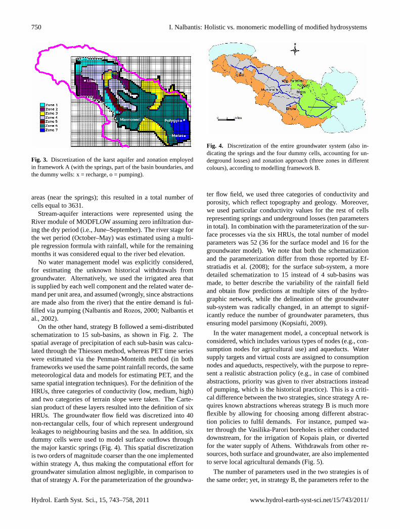
Within strategy A, the karst aquifer is considered as a singlelayer with free surface unsteady flow. The flow field was di-vided into zones (Fig. 3), which resulted to totally 18 param-eters to calibrate (7 parameters for conductivity, 7 for specificyield and 4 for conductances). The alluvial aquifer beneaththe downstream part of the basin was ignored since its wa-ter yield is low. In the whole perimeter of the karst aquiferno-flow boundaries were assigned, apart from two areas: asmall area in the N boundary where small-scale outflows tothe sea were simulated using dummy pumping wells and asmall area in the SW where lateral recharges were simulatedusing dummy recharge wells. The discharge of the dummywells was estimated using a multiple regression formula withrainfall. External stresses due to percolation were modelledin a simple way as explained in Sect. 3.2. Precipitation wasconsidered homogenous in the interior of three sub-basins,which represent different hydrogeologic units (low, middleand upper course). The infiltration depth was taken as a con-stant fraction of the effective precipitation depth, which var-ied from one type of surface geological formation to another;three types of such formations were assumed, correspondingto three permeability levels. The cell sizes were varying from800× 800 m2 near the boundaries to 150× 150 m2 in central
www.hydrol-earth-syst-sci.net/15/743/2011/ Hydrol. Earth Syst. Sci., 15, 743–758, 2011
750 I. Nalbantis: Holistic vs. monomeric modelling of modified hydrosystems
Fig. 3. Discretization of the karst aquifer and zonation employedin framework A (with the springs, part of the basin boundaries, andthe dummy wells: x = recharge, o = pumping).
areas (near the springs); this resulted in a total number ofcells equal to 3631.
Stream-aquifer interactions were represented using theRiver module of MODFLOW assuming zero infiltration dur-ing the dry period (i.e., June–September). The river stage forthe wet period (October–May) was estimated using a multi-ple regression formula with rainfall, while for the remainingmonths it was considered equal to the river bed elevation.
No water management model was explicitly considered,for estimating the unknown historical withdrawals fromgroundwater. Alternatively, we used the irrigated area thatis supplied by each well component and the related water de-mand per unit area, and assumed (wrongly, since abstractionsare made also from the river) that the entire demand is ful-filled via pumping (Nalbantis and Rozos, 2000; Nalbantis etal., 2002).
On the other hand, strategy B followed a semi-distributedschematization to 15 sub-basins, as shown in Fig. 2. Thespatial average of precipitation of each sub-basin was calcu-lated through the Thiessen method, whereas PET time serieswere estimated via the Penman-Monteith method (in bothframeworks we used the same point rainfall records, the samemeteorological data and models for estimating PET, and thesame spatial integration techniques). For the definition of theHRUs, three categories of conductivity (low, medium, high)and two categories of terrain slope were taken. The Carte-sian product of these layers resulted into the definition of sixHRUs. The groundwater flow field was discretized into 40non-rectangular cells, four of which represent undergroundleakages to neighbouring basins and the sea. In addition, sixdummy cells were used to model surface outflows throughthe major karstic springs (Fig. 4). This spatial discretizationis two orders of magnitude coarser than the one implementedwithin strategy A, thus making the computational effort forgroundwater simulation almost negligible, in comparison tothat of strategy A. For the parameterization of the groundwa-
Fig. 4. Discretization of the entire groundwater system (also in-dicating the springs and the four dummy cells, accounting for un-derground losses) and zonation approach (three zones in differentcolours), according to modelling framework B.
ter flow field, we used three categories of conductivity andporosity, which reflect topography and geology. Moreover,we used particular conductivity values for the rest of cellsrepresenting springs and underground losses (ten parametersin total). In combination with the parameterization of the sur-face processes via the six HRUs, the total number of modelparameters was 52 (36 for the surface model and 16 for thegroundwater model). We note that both the schematizationand the parameterization differ from those reported by Ef-stratiadis et al. (2008); for the surface sub-system, a moredetailed schematization to 15 instead of 4 sub-basins wasmade, to better describe the variability of the rainfall fieldand obtain flow predictions at multiple sites of the hydro-graphic network, while the delineation of the groundwatersub-system was radically changed, in an attempt to signif-icantly reduce the number of groundwater parameters, thusensuring model parsimony (Kopsiafti, 2009).
In the water management model, a conceptual network isconsidered, which includes various types of nodes (e.g., con-sumption nodes for agricultural use) and aqueducts. Watersupply targets and virtual costs are assigned to consumptionnodes and aqueducts, respectively, with the purpose to repre-sent a realistic abstraction policy (e.g., in case of combinedabstractions, priority was given to river abstractions insteadof pumping, which is the historical practice). This is a criti-cal difference between the two strategies, since strategy A re-quires known abstractions whereas strategy B is much moreflexible by allowing for choosing among different abstrac-tion policies to fulfil demands. For instance, pumped wa-ter through the Vasilika-Parori boreholes is either conducteddownstream, for the irrigation of Kopais plain, or divertedfor the water supply of Athens. Withdrawals from other re-sources, both surface and groundwater, are also implementedto serve local agricultural demands (Fig. 5).
The number of parameters used in the two strategies is ofthe same order; yet, in strategy B, the parameters refer to the
Hydrol. Earth Syst. Sci., 15, 743–758, 2011 www.hydrol-earth-syst-sci.net/15/743/2011/

I. Nalbantis: Holistic vs. monomeric modelling of modified hydrosystems 751
Fig. 5. Detailed depiction of the water management network in themiddle part of the basin, according to modelling framework B.
whole system components (river network, HRUs, groundwa-ter cells, springs). This naturally qualifies strategy B as beingmore parsimonious, since it achieves a much more extended(and thus holistic) representation of the system processes.We would like to note that both strategies and the relatedframeworks use HRU-type (or zonation-type) parameteriza-tion; their difference lies in the fact that in strategy B this istrue for both the surface and the groundwater processes whilein strategy A only groundwater modelling is essentially ben-efited from such type of parameterization.
3.5 Calibration strategies and data for parameterestimation
Both strategies were tested against the observed hydrologi-cal responses for a 10-year control horizon (October 1984–September 1994), employing a monthly time step. For thisperiod, discharge series at seven locations are available, pre-cisely at the basin outlet (Karditsa tunnel) and downstreamof the six karst springs, as illustrated in Fig. 2. With regardto groundwater, several level gauges were available, mostlylocated in the vicinity of the main river branch.
Regarding the surface hydrology component of frame-work A, its single parameter (i.e., infiltration fraction) wasestimated empirically, on the basis of the main geologicalformations of the basin. The MODFLOW parameters weremanually optimized on the basis of 18 observed level se-ries and through visual inspection of the closeness of the ob-served and the simulated spring hydrographs.
In strategy B, the parameters of the surface and the ground-water models were simultaneously optimized. To cope withparameter uncertainty, which is directly linked to equifinality(Freer et al., 1996), multiple criteria were taken into account,including “soft” data (Seibert and McDonnell, 2002; Efstra-tiadis and Koutsoyiannis, 2010). Thus, a weighted objec-tive function was formulated comprising the following sta-tistical and empirical measures: (a) efficiency and bias ofthe monthly hydrographs at the seven locations mentionedabove; (b) penalties for not reproducing flow intermittency;and (c) penalties for generation of unrealistic trends regard-ing the groundwater levels. The first group of criteria ac-counts for “hard data” (i.e., from measurements) which isessential for reproducing the global water balance and thespring mechanisms, but not sufficient for representing thegroundwater regime; these criteria will be hereinafter re-ferred to as the performance indices. The second group ofcriteria accounts for the information “zero or non-zero dis-charge”, which is easily observable, reliable and is of majorinterest in water management. Finally, the third group of cri-teria is a kind of “soft” data, ensuring reasonable fluctuationof the non-observable internal variables of the model. Theoptimization of parameters was carried out through a hybridstrategy, which combines human experience and automatictools (Boyle et al., 2000; Rozos et al., 2004). In that manner,search was guided towards a realistic, best-compromise pa-rameter set, ensuring satisfactory predictive capacity for allmodel responses.
Initial conditions were empirically assigned. In particular,for the surface model, initial soil moisture depth was set tozero for the all basin partitions (i.e., combinations of sub-basins and HRUs), given that the simulation starts at the endof the dry period (October). For the groundwater model, thecell levels at the beginning of simulation were estimated onthe basis of topography, spring elevations and average piezo-metric information for the plain (karst) aquifer and using ar-bitrary yet realistic values for the peripheral cells, which arefed by the percolation of mountain areas. Preliminary trialswere necessary to establish steady-state conditions during theentire control period.
3.6 Operational use of models through stochasticsimulation
As mentioned in Sect. 2, calibration is an intermediate stepin the modelling procedure, which allows for optimizing thepredictive capacity of the model on the basis of observeddata. Yet, further analysis with “projected” inputs is re-quired, which will provide support to future decisions. Inthis respect, the two strategies are evaluated within a stochas-tic simulation framework, aiming to examine the system re-sponse under different stress conditions, comprising bothnatural (precipitation, PET) and anthropogenic (abstractionsfrom surface and groundwater resources) forcing.
www.hydrol-earth-syst-sci.net/15/743/2011/ Hydrol. Earth Syst. Sci., 15, 743–758, 2011
752 I. Nalbantis: Holistic vs. monomeric modelling of modified hydrosystems
For the representation of rainfall, a multivariate stochas-tic scheme (Castalia model) was used to generate point se-ries of 1000-year length, which preserve the essential statisti-cal characteristics of the observed samples of 12 rain gaugesacross the basin, at the annual and monthly time scales (Kout-soyiannis et al., 2003). Next, the point series were aggregatedto the appropriate spatial scale, thus providing areal rainfallseries for the 3 and 15 sub-basins, which correspond to mod-elling frameworks A and B, respectively. The synthetic rain-fall records were divided into clusters of ten-year length, toformulate a hundred of statistically equivalent forcing sce-narios. Each framework ran 100 times, each one under dif-ferent stochastic forcing, whereas for all runs the same initialconditions were applied. For instance, for modelling frame-work B we used zero soil moisture depths (since simulationbegins at the end of the dry period) and the average ground-water levels of the calibration. In this context, the model out-puts represent statistically consistent trajectories of the sys-tem responses, for a ten-year horizon. Such type of MonteCarlo simulation is typically used in operational applications(e.g., forecasts), and is also known as terminating simulation(Koutsoyiannis et al., 2003; Koutsoyiannis, 2005).
Regarding the PET throughout each sub-basin, we as-signed the monthly averages of the areal values of the controlperiod 1984–1994, since this is a forcing variable of very lowinterannual variability. For the anthropogenic forcing, we ex-amined two alternative water management scenarios. Specif-ically, we assigned the actual irrigation water demands acrossthe basin (223 hm3 yr−1) and assumed either zero or exten-sive (46 hm3 y−1, equal to that of the dry water year 1993–1994) water demand from the Vasilika-Parori boreholes, forproviding drinking water to Athens (Fig. 5). We remind thatin modelling strategy A, the water requirements are by defi-nition fulfilled via pumping (which is an erroneous yet oblig-atory assumption) whereas in strategy B the demands can besatisfied through multiple sources.
3.7 Experiment design
Ideally, testing the effect of adopting modelling strategy Afor human-modified hydrosystems would require a complexcomputer experiment based on a series of alternative frame-works implementing strategies A and B in the sense that wasgiven in Sect. 2 and in Table 1. The practical difficulty ofsuch task led us simplify our experiment by considering thetwo modelling frameworks presented in Sect. 3.2 and 3.3above. Table 1 summarises the a priori knowledge aboutthe relation of each key modelling option to each modellingframework and hence to the related strategy. Application to acommon data set of hydrological variables of the aforemen-tioned test basin enabled an objective evaluation of the effectof adopting strategy A. For this, both numerical and empiri-cal criteria are used for the comparison of the two strategies,in calibration and simulation mode.
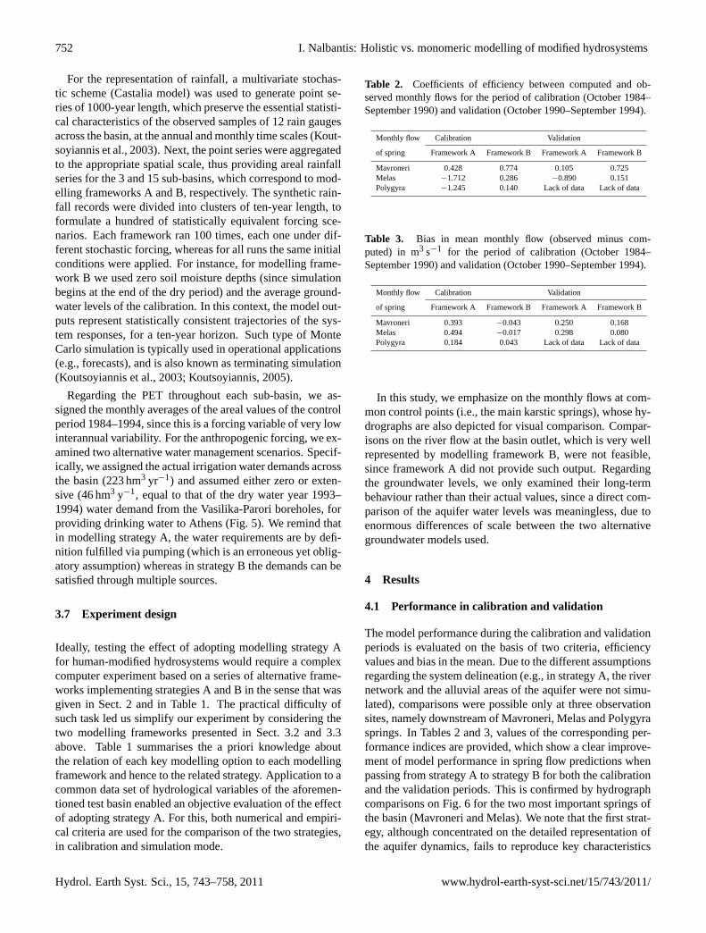
Table 2. Coefficients of efficiency between computed and ob-served monthly flows for the period of calibration (October 1984–September 1990) and validation (October 1990–September 1994).
Monthly flow Calibration Validation
of spring Framework A Framework B Framework A Framework B
Mavroneri 0.428 0.774 0.105 0.725Melas −1.712 0.286 −0.890 0.151Polygyra −1.245 0.140 Lack of data Lack of data
Table 3. Bias in mean monthly flow (observed minus com-puted) in m3 s−1 for the period of calibration (October 1984–September 1990) and validation (October 1990–September 1994).
Monthly flow Calibration Validation
of spring Framework A Framework B Framework A Framework B
Mavroneri 0.393 −0.043 0.250 0.168Melas 0.494 −0.017 0.298 0.080Polygyra 0.184 0.043 Lack of data Lack of data
In this study, we emphasize on the monthly flows at com-mon control points (i.e., the main karstic springs), whose hy-drographs are also depicted for visual comparison. Compar-isons on the river flow at the basin outlet, which is very wellrepresented by modelling framework B, were not feasible,since framework A did not provide such output. Regardingthe groundwater levels, we only examined their long-termbehaviour rather than their actual values, since a direct com-parison of the aquifer water levels was meaningless, due toenormous differences of scale between the two alternativegroundwater models used.
4 Results
4.1 Performance in calibration and validation
The model performance during the calibration and validationperiods is evaluated on the basis of two criteria, efficiencyvalues and bias in the mean. Due to the different assumptionsregarding the system delineation (e.g., in strategy A, the rivernetwork and the alluvial areas of the aquifer were not simu-lated), comparisons were possible only at three observationsites, namely downstream of Mavroneri, Melas and Polygyrasprings. In Tables 2 and 3, values of the corresponding per-formance indices are provided, which show a clear improve-ment of model performance in spring flow predictions whenpassing from strategy A to strategy B for both the calibrationand the validation periods. This is confirmed by hydrographcomparisons on Fig. 6 for the two most important springs ofthe basin (Mavroneri and Melas). We note that the first strat-egy, although concentrated on the detailed representation ofthe aquifer dynamics, fails to reproduce key characteristics
Hydrol. Earth Syst. Sci., 15, 743–758, 2011 www.hydrol-earth-syst-sci.net/15/743/2011/

I. Nalbantis: Holistic vs. monomeric modelling of modified hydrosystems 753
0.0
0.5
1.0
1.5
2.0
2.5
3.0
3.5Oct-84
Oct-85
Oct-86
Oct-87
Oct-88
Oct-89
Oct-90
Oct-91
Oct-92
Oct-93
Obs. Comp. A Comp. B
0.5
1.0
1.5
2.0
2.5
3.0
3.5
4.0
4.5
Oct-84
Oct-85
Oct-86
Oct-87
Oct-88
Oct-89
Oct-90
Oct-91
Oct-92
Oct-93
Obs. Comp. A Comp. B
Figure 6
Fig. 6. Computed and observed discharge (m3 s−1) at Mavroneri(left) and Melas (right) springs, for modelling frameworks A and B.
of the observed flows, namely the monthly variability, whichis overestimated for Melas and underestimated for Mavronerisprings; it also fails to reproduce the interruption of the dis-charge of the latter, during 1990 and 1993.
On the other hand, the advantages of model integration asoffered by strategy B extend beyond predicting flow. Otherimprovements are equally significant, which are commentedin Table 4 and provide explanation of the superior perfor-mance indices regarding observed groundwater variables, de-spite the fact that framework B follows a much simpler mod-elling approach, which focuses on the surface processes andthe water management practices.
4.2 Comparison of model performance in simulation
Obviously, when comparing two modelling strategies in astochastic simulation setting, it is impossible to use quan-titative criteria (e.g., goodness-of-fit measures), as in calibra-tion. Therefore, the evaluations are based on the grounds ofcommon sense, i.e., testing whether the model provides theright answers for the right reasons (cf. Kirchner, 2006), tak-ing advantage of the hydrological experience.
The implementation of the two strategies under syntheti-cally generated inputs further reveals the drawbacks of strat-egy A. In Fig. 7 we plot the projected discharge at theMavroneri springs for a ten-year horizon (mean value of100 flow scenarios and 50% prediction limits), under zeroand intensive pumping through the neighbouring boreholesat Vasilika-Parori (respectively referred to as the “actual ab-straction policy” and the “intensive abstraction policy”). Forboth management policies, there is a sharp decrease of thedischarge, which is inconsistent with the experience so far.Although one could expect that under extensive pumping asystematic negative trend could be possible, it is unlikely thatsuch trend is encountered under the actual abstraction pol-icy, since, in the absence of trend in the input data and thehydrosystem itself, a stationary output should be produced.In fact, the observed water levels, although very sparse intime and space, confirm this. Yet, manual calibration throughvisual inspection used in strategy A yielded model parame-ters that erroneously introduced a mild trend in levels; this
0.0
0.5
1.0
1.5
2.0
2.5
3.0
Oct-10
Oct-11
Oct-12
Oct-13
Oct-14
Oct-15
Oct-16
Oct-17
Oct-18
Oct-19
0.0
0.5
1.0
1.5
2.0
2.5
3.0
Oct-10
Oct-11
Oct-12
Oct-13
Oct-14
Oct-15
Oct-16
Oct-17
Oct-18
Oct-19
Figure 7
Fig. 7. Simulated discharge (m3 s−1) at Mavroneri springs (meanand 50% prediction limits) under the actual abstraction policy (left)and the intensive abstraction policy (right) for the water supply ofAthens, according to modelling framework A.
0.0
0.5
1.0
1.5
2.0
2.5
3.0
3.5
Oct-10
Oct-11
Oct-12
Oct-13
Oct-14
Oct-15
Oct-16
Oct-17
Oct-18
Oct-19
0.0
0.5
1.0
1.5
2.0
2.5
3.0
3.5
Oct-10
Oct-11
Oct-12
Oct-13
Oct-14
Oct-15
Oct-16
Oct-17
Oct-18
Oct-19
Figure 8
Fig. 8. Simulated discharge (m3 s−1) at Mavroneri springs (meanand 50% prediction limits) under the actual abstraction policy (left)and the intensive abstraction policy (right) for the water supply ofAthens, according to modelling framework B.
is hardly noticeable in the six years of the calibration pe-riod. Using synthetic data helped identifying this trend. Thedifferences with the respective results obtained through strat-egy B (Fig. 8) are substantial; here, the mean projection forthe spring outflows (which corresponds to average rainfallconditions) follows a stationary pattern under the actual ab-straction policy, whereas there is a progressive decrease ofthe spring resources under the intensive abstraction policy(Fig. 8). This indicates that, in a long-term perspective, theintensive use of the Vasilika-Parori boreholes for the watersupply of Athens is not a sustainable option.
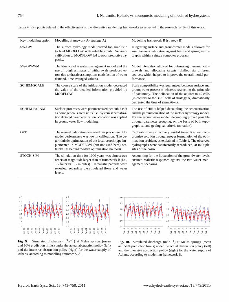
Regarding the response of the Melas springs, both strate-gies exhibit a systematic negative trend under intensivepumping (Figs. 9 and 10). This is reasonable, since the entirekarst aquifer should be affected by the upstream water supplyabstractions. However, the statistical analysis of the stochas-tic flows of strategy A revealed an unrealistic behaviour.Specifically, a prominent peak of the spring discharge ap-pears at the end of each wet period, which is indistinguish-able in the calibrated flows (see Fig. 6) as well as in mostof the individual synthetic flows. Only by getting the statis-tical characteristics of the simulated flows, i.e., the averageand the prediction limits, it was feasible to detect this pattern.The latter originates from the rough description of the bound-ary conditions with regard to the stream-aquifer interactions
www.hydrol-earth-syst-sci.net/15/743/2011/ Hydrol. Earth Syst. Sci., 15, 743–758, 2011
754 I. Nalbantis: Holistic vs. monomeric modelling of modified hydrosystems
Table 4. Key points related to the effectiveness of the alternative modelling frameworks as reflected in the research results of this work.
Key modelling option Modelling framework A (strategy A) Modelling framework B (strategy B)
SW-GW The surface hydrology model proved too simplisticto feed MODFLOW with reliable inputs. Separatecalibration of MODFLOW led to poor predictive ca-pacity.
Integrating surface and groundwater models allowed forsimultaneous calibration against basin and spring hydro-graphs within a single computer program.
SW-GW-WM The absence of a water management model and theuse of rough estimates of withdrawals produced er-rors due to drastic assumptions (satisfaction of waterdemand, time averaged values).
Model integration allowed for optimizing dynamic with-drawals and allocating targets fulfilled via differentsources, which helped to improve the overall model per-formance.
SCHEM-SCALE The coarse scale of the infiltration model decreasedthe value of the detailed information provided byMODFLOW.
Scale compatibility was guaranteed between surface andgroundwater processes whereas respecting the principleof parsimony. The delineation of the aquifer to 40 cells(in contrast to the 3631 cells of strategy A) dramaticallydecreased the time of simulations.
SCHEM-PARAM Surface processes were parameterized per sub-basinas homogeneous areal units, i.e., system schematiza-tion dictated parameterization. Zonation was appliedin groundwater flow modelling.
The use of HRUs helped decoupling the schematizationand the parameterization of the surface hydrology model.For the groundwater model, decoupling proved possiblethrough parameter grouping, on the basis of both topo-graphical and geological criteria (zonation).
OPT The manual calibration was a tedious procedure. Themodel performance was low in calibration. The de-terministic optimization of the local-search type im-plemented in MODFLOW (but not used here) cer-tainly lies behind modern optimization methods.
Calibration was effectively guided towards a best com-promise solution through proper formulation of the opti-mization problem, as explained in Table 1. The observedhydrographs were satisfactorily reproduced, at multiplesites of the basin.
STOCH-SIM The simulation time for 1000 years was almost twoorders of magnitude larger than of framework B (i.e.,∼2hours vs.∼2 minutes). Unrealistic patterns wererevealed, regarding the simulated flows and waterlevels.
Accounting for the fluctuation of the groundwater levelsensured realistic responses against the two water man-agement scenarios.
1.0
1.5
2.0
2.5
3.0
3.5
4.0
4.5
Oct-10
Oct-11
Oct-12
Oct-13
Oct-14
Oct-15
Oct-16
Oct-17
Oct-18
Oct-19
1.0
1.5
2.0
2.5
3.0
3.5
4.0
4.5
Oct-10
Oct-11
Oct-12
Oct-13
Oct-14
Oct-15
Oct-16
Oct-17
Oct-18
Oct-19
Figure 9
Fig. 9. Simulated discharge (m3 s−1) at Melas springs (meanand 50% prediction limits) under the actual abstraction policy (left)and the intensive abstraction policy (right) for the water supply ofAthens, according to modelling framework A.
1.5
2.0
2.5
3.0
3.5
4.0
Oct-10
Oct-11
Oct-12
Oct-13
Oct-14
Oct-15
Oct-16
Oct-17
Oct-18
Oct-19
1.5
2.0
2.5
3.0
3.5
4.0
Oct-10
Oct-11
Oct-12
Oct-13
Oct-14
Oct-15
Oct-16
Oct-17
Oct-18
Oct-19
Figure 10
Fig. 10. Simulated discharge (m3 s−1) at Melas springs (meanand 50% prediction limits) under the actual abstraction policy (left)and the intensive abstraction policy (right) for the water supply ofAthens, according to modelling framework B.
Hydrol. Earth Syst. Sci., 15, 743–758, 2011 www.hydrol-earth-syst-sci.net/15/743/2011/

I. Nalbantis: Holistic vs. monomeric modelling of modified hydrosystems 755
190
200
210
220
230
240
250Oct-10
Oct-11
Oct-12
Oct-13
Oct-14
Oct-15
Oct-16
Oct-17
Oct-18
Oct-19
235
240
245
250
255
260
265
270
Oct-10
Oct-11
Oct-12
Oct-13
Oct-14
Oct-15
Oct-16
Oct-17
Oct-18
Oct-19
Figure 11
Fig. 11. Simulated level (m) at the upstream part of the aquifer(mean and 50% prediction limits) under the actual abstraction pol-icy (zero pumping for the water supply of Athens), according tomodelling frameworks A (left) and B (right).
(Sect. 3.4). The stochastic simulation highlighted this in-consistency, which turns out to be another weakness of themonomeric character of the specific strategy.
Attempting to investigate the reasons for the unrealisticperformance of modelling framework A, we concluded thatwe should revisit the calibration procedure. Actually, weavoided recalibration but we simply evaluated the implica-tions of the initial calibration attempt. In contrast to strat-egy B, where we accounted for the internal variables of themodel by assigning trend penalties on groundwater levels,in strategy A we just focused on fitting the model responses(spring flows and water levels for some points) to the obser-vations. In that manner, we allowed systematic drainage andfilling of the cells lying near the boundaries of the aquiferwhere spring flow or groundwater level observations are notavailable. Actually, inconsistent conductivity values were as-signed in order to maximize the model performance againstobservations via the efficiency indices. On the other hand,within strategy B the soft criteria contributed to a more con-sistent calibration, although this required a time-consuminghybrid procedure. In Fig. 11 we compare the syntheticallygenerated levels obtained through the two strategies, whichcorrespond to the most upstream part of the karst system,assuming the actual abstraction policy. We observe a ques-tionable behaviour (i.e., negative trend) of the projected levelwhen applying strategy A, whereas for strategy B the ground-water system exhibits stationary behaviour, which is morereasonable.
5 Conclusions
Our investigations have shown that in modified watershedsdue to human interventions, the classical modelling strat-egy based on the monomeric bottom-up approach may proveinefficient. This makes use of a detailed hydraulic model foronly a part of the studied system and of separate models forsurface hydrological processes, groundwater flow processesand water management actions. Such serial use of modelsprohibits the modelling of the process interactions and suf-
fers from increased computational burden. The monomericcharacter of this approach also involves other modelling as-pects, including the assignment of parameters (coincidenceof spatial scales of schematization and parameterization).In addition, calibration is based only on “hard information”i.e., measured system variables, while “soft information” i.e.,likelihood of relations of system variables is ignored. All theabove misuse practices are reflected in the predictive capacityof the model, which proved disappointedly poor for such anexhaustive effort (in calibration). These weaknesses of thisapproach became more evident by employing the model instochastic simulation mode for operational use; the obtainedprojections are far from being realistic.
Conversely, a holistic top-down approach allows for modelschematization and parameterization that respects the prin-ciple of parsimony and ensures computational efficiency bymeans of both simulation and optimization/calibration. Thisprecludes taking advantage of the power of fully distributedmodels while, at the same time, favouring the use of the semi-distributed approach. An effective way to reduce the size ofthe parameter set is to decouple parameterization and modelschematization through using the HRU concept. For, themodel structure depends on a limited number of landscapeclasses, whose parameters retain some physical consistencythus allowing for a better identification of their prior uncer-tainty (cf. Savenije, 2010). Last, model integration allowssimultaneous calibration of all models through exploitingmany kinds of information and not only information aboutsome basic output variables. A hybrid process of manualand automatic optimization proved very effective in findinga best compromise solution while, at the same time, respect-ing physical consistency of parameters. In this approach allavailable pieces of information, including hydrological ex-perience, are exploited in model calibration within a multi-objective framework.
Our tests also proved that running models in stochasticsimulation mode can be a useful technique for their testingand validation since this augments information supplied bytypical calibration and validation procedures, while, at thesame time, addressing some data restrictions and revealingpossible model deficiencies. However, this option is a matterof expert judgment. In addition, it may be difficult to imple-ment in complex hydrosystems and is hardly applicable forevaluating the credibility of the model in situations involvingnon-stationary inputs.
In this work we quantified the deterioration of model per-formance in cases that no attention is paid to all compo-nents of a human modified hydrosystem – an issue that isunfortunately encountered in many instances in hydrologicalpractice. Moreover, various sources of error were identified,although their individual contribution to the overall predic-tion error was not quantified. We believe that the results ob-tained suggest that from a qualitative viewpoint, in poorlygauged human-modified hydrosystems the top-down/holisticapproach (TD-H) is expected to perform better than the
www.hydrol-earth-syst-sci.net/15/743/2011/ Hydrol. Earth Syst. Sci., 15, 743–758, 2011

756 I. Nalbantis: Holistic vs. monomeric modelling of modified hydrosystems
bottom-up/monomeric (BU-M) approach. Differences arehowever expected to depend on the kind and the degree ofthe human intervention, the degree of data scarcity, the kindand degree of the monomeric character of the approach thatis followed, and the type of models used.
We believe that the research presented in this paper cancontribute towards (1) formulating specifications for modelpackages applicable to human-modified basins, and (2) open-ing new research paths regarding different types of approachfollowed in hydrological modelling. For example we thinkthat distributed information can well be incorporated to de-scribe specific aspects of heterogeneity (e.g., elevation, landcover, rainfall), as far as this does not contrast the princi-ple of parsimony by introducing additional model parame-ters. High level of integration of such information into theproposed modelling framework certainly allows for a TD-Happroach to be implemented.
Acknowledgements.The second version of the HYDROGEIOSpackage was carried out within the research project “Developmentof Database and software applications in a web platform for the Na-tional Databank for Hydrological and Meteorological Information”.The software is freely available athttp://itia.ntua.gr/en/softinfo/25/;the data for the Boeoticos Kephisos case study are also availablefor download. The authors are grateful to G. Di Baldassare and theother three anonymous reviewers for their comments, critiques andsuggestions during the discussion phase, which contributed to animproved presentation of the paper.
Edited by: G. Bloschl
References
Andreassian, V., Perrin, C., Berthet, L., Le Moine, N., Lerat, J.,Loumagne, C., Oudin, L., Mathevet, T., Ramos, M.-H., andValery, A.: HESS Opinions “Crash tests for a standardized eval-uation of hydrological models”, Hydrol. Earth Syst. Sci., 13,1757–1764,doi:10.5194/hess-13-1757-2009, 2009.
Bardossy, A.: Calibration of hydrological model parameters forungauged catchments, Hydrol. Earth Syst. Sci., 11, 703–710,doi:10.5194/hess-11-703-2007, 2007.
Bari, M. and Smettem, K. R. J.: Modelling monthly runoff gener-ation processes following land use changes: groundwatersurfacerunoff interactions, Hydrol. Earth Syst. Sci., 8, 903–922,doi:10.5194/hess-8-903-2004, 2004.
Bell, V. A., Carrington, D. S., and Moore, R. J.: Comparison ofRainfall-Runoff Models for Flood Forecasting. Part 2: Calibra-tion and Evaluation of Models, Environment Agency R & DTechnical Report W242, Research Contractor: Institute of Hy-drology, Environment Agency, 239 pp, 2001.
Beven, K. J.: Changing ideas in hydrology – The case of physically-based models, J. Hydrol., 105(1–2), 157–172, 1989.
Beven, K.: How far can we go in distributed hydrological mod-elling?, Hydrol. Earth Syst. Sci., 5, 1–12,doi:10.5194/hess-5-1-2001, 2001.
Boyle, D. P., Gupta, H. V., and Sorooshian, S.: Toward improvedcalibration of hydrologic models: combining the strengths of
manual and automatic methods, Water Resour. Res., 36(12),3663–3674, 2000.
Dai, T. and Labadie, J. W.: River basin network model for integratedwater quantity/quality management, ASCE, J. Water Res. Plan.Manag., 127(5), 295–305, 2001.
Dehotin, J. and Braud, I.: Which spatial discretization for dis-tributed hydrological models? Proposition of a methodology andillustration for medium to large-scale catchments, Hydrol. EarthSyst. Sci., 12, 769–796,doi:10.5194/hess-12-769-2008, 2008.
Doherty, J., Brebber, L., and Whyte, P.: PEST: Model-IndependentParameter Estimation, Watermark Computing, 1994.
Eckhardt, K. and Arnold, J. G.: Automatic calibration of a dis-tributed catchment model, J. Hydrol., 251(1–2), 103–109, 2001
Efstratiadis, A. and Koutsoyiannis, D.: An evolutionary annealing-simplex algorithm for global optimisation of water resource sys-tems, Proc. Fifth Intern. Conf. on Hydroinformatics, Cardiff,UK, IWA, 1423–1428, 2002.
Efstratiadis, A. and Mamassis, N.: Evaluating models or evaluatingmodelling practices? – Interactive comment on HESS Opinions“Crash tests for a standardized evaluation of hydrological mod-els”, Hydrol. Earth Syst. Sci. Disc., 6, C1404–C1409, 2009.
Efstratiadis, A. and Koutsoyiannis, D.: One decade of multiobjec-tive calibration approaches in hydrological modelling: a review,Hydrol. Sci. J., 55(1), 58–78, 2010.
Efstratiadis, A., Koutsoyiannis, D., and Xenos, D.: Minimising wa-ter cost in the water resource management of Athens, Urb. Wat.J., 1(1), 3–15, 2004.
Efstratiadis, A., Nalbantis, I., Koukouvinos, A., Rozos, E., andKoutsoyiannis, D.: HYDROGEIOS: a semi-distributed GIS-based hydrological model for modified river basins, Hydrol.Earth Syst. Sci., 12, 989–1006,doi:10.5194/hess-12-989-2008,2008.
Efstratiadis, A., Rozos, E., and Koukouvinos, A.: Hydrogeios:Hydrological and hydrogeological simulation model – Docu-mentation report, 139 pages, Department of Water Resourcesand Environmental Engineering – National Technical Universityof Athens, 2009 (in Greek; available at:http://itia.ntua.gr/en/docinfo/929/).
Efstratiadis, A., Nalbantis, I., Rozos, E., and Koutsoyiannis, D.: Ac-counting for water management issues within hydrological sim-ulation: Alternative modelling options and a network optimiza-tion approach, EGU General Assembly 2010, Vienna, Austria,02–07 May 2010, Geophys. Res. Abstr., 12, EGU2010-10085,2010.
Flugel, W. A.: Delineating Hydrological Response Units by Geo-graphical Information System analyses for regional hydrologicalmodelling using PRMS/MMS in the drainage basin of the riverBrol in Germany, Hydrol. Process., 9(3–4), 423–436, 1995.
Fredericks, J. W., Labadie, J. W., and Altenhofen, J. M.: Decisionsupport system for stream-aquifer management, J. Water Res.Pl.-ASCE 124(2), 69–78, 1998.
Freer, J., Beven, K. J., and Ambroise, B.: Bayesian estimation ofuncertainty in runoff prediction and the value of data: an applica-tion of the GLUE approach, Wat. Resour. Res, 32(7), 2161–2173,1996.
Gauthier, M. J., Camporese, M., Rivard, C., Paniconi, C., andLarocque, M.: A modeling study of heterogeneity and surfacewater-groundwater interactions in the Thomas Brook catchment,Annapolis Valley (Nova Scotia, Canada), Hydrol. Earth Syst.
Hydrol. Earth Syst. Sci., 15, 743–758, 2011 www.hydrol-earth-syst-sci.net/15/743/2011/
I. Nalbantis: Holistic vs. monomeric modelling of modified hydrosystems 757
Sci., 13, 1583–1596,doi:10.5194/hess-13-1583-2009, 2009.Gurtz, J., Zappa, M., Jasper, K., Lang, H., Verbunt, M., Badoux, A.,
and Vitvar, T.: A comparative study in modelling runoff and itscomponents in two mountainous catchments, Hydrol. Process.,17(2), 297–311, 2003.
Hill, M. C.: Preconditioned conjugate-gradient 2 (PCG2), a com-puter program for solving ground-water flow equations, US Geo-logical Survey Water-Resources Investigations Report 90–4048,p. 43, 1990.
Hingray, B., Schaefli, B., Mezghani, A., and Hamdi, Y.: Signature-based model calibration for hydrological prediction in mesoscaleAlpine catchments, Hydrol. Sci. J., 55(6), 1002–1016, 2010.
Ivkovic, K. M., Letcher, R. A., and Croke B. F. W.: Useof a simple surface-groundwater interaction model to in-form water management, Aust. J. Earth Sci., 56(1), 71–80,doi:10.1080/08120090802541945, 2009.
Kilsby, C. G., Ewen, J., Sloan, W. T., Burton, A., Fallows, C. S.,and O’Connell, P. E.: The UP modelling system for large scalehydrology: simulation of the Arkansas-Red River basin, Hy-drol. Earth Syst. Sci., 3, 137–149,doi:10.5194/hess-3-137-1999,1999.
Kirchner, J. W.: Getting the right answers for the right rea-sons: Linking measurements, analyses, and models to advancethe science of hydrology, Wat. Resour. Res., 42, W03S04,doi:10.1029/2005WR004362, 2006.
Klemes, V.: Conceptualization and scale in hydrology, J. Hydrol.,65, 1–23, 1983.
Klemes, V.: Operational testing of hydrologic simulation models,Hydrol. Sci. J., 31, 13–24, 1986.
Kopsiafti, M.: Investigation of parameterization strategies for thehydrogeological module of Hydrogeios software – Applicationto the Boeoticos Kephisos basin, Postgraduate thesis, 133 pages,Dept. of Water Resources, National Technical University ofAthens, 2009 (in Greek; available at:http://www.itia.ntua.gr/en/docinfo/908/).
Koutsoyiannis, D.: Stochastic simulation of hydrosystems, WaterEncyclopedia, Vol. 4, Surface and Agricultural Water, edited by:Lehr, J. H. and Keeley, J., Wiley, New York, 421–430, 2005.
Koutsoyiannis, D.: Hurst-Kolmogorov dynamics and uncertainty, J.Amer. Wat. Res. Assoc., 2011 (in press).
Koutsoyiannis, D., Karavokiros, G., Efstratiadis, A., Mamassis, N.,Koukouvinos, A., and Christofides, A.: A decision support sys-tem for the management of the water resource system of Athens,Phys. Chem. Earth, 28(14–15), 599–609, 2003.
Koutsoyiannis, D., Efstratiadis, A., and Georgakakos, K.: Uncer-tainty assessment of future hydroclimatic predictions: A com-parison of probabilistic and scenario-based approaches, J. Hy-drometeor., 8(3), 261–281, 2007.
Koutsoyiannis, D., Makropoulos, C., Langousis, A., Baki, S., Ef-stratiadis, A., Christofides, A., Karavokiros, G., and Mamassis,N.: HESS Opinions: “Climate, hydrology, energy, water: rec-ognizing uncertainty and seeking sustainability”, Hydrol. EarthSyst. Sci., 13, 247–257,doi:10.5194/hess-13-247-2009, 2009.
Kuczera, G. and Mroczkowski, M.: Assessment of hydrologic pa-rameter uncertainty and the worth of multiresponse data, Wat.Resour. Res., 34(6), 1481–1489, 1998.
Nalbantis, I. and Rozos, E.: A system for the simulation of the hy-drological cycle in the Boeoticos Kephisos basin, Modernisationof the supervision and management of the water resource sys-
tem of Athens, Project report 10, Dept. of Water Resources, Na-tional Technical University of Athens, 2000 (in Greek; availableat: http://www.itia.ntua.gr/en/docinfo/417/).
Nalbantis, I., Rozos, E., Tentes, G., Efstratiadis, A., and Kout-soyiannis, D.: Integrating groundwater models within a deci-sion support system, Proc. 5th Intern. Conf. of European WaterResources Association: “Water Resources Management in theEra of Transition”, edited by: Tsakiris, G., Athens, 4–8 Septem-ber 2002, 279–286, EWRA, IAHR, 2002.
Panday, S. and Huyakorn, P. S.: A fully coupled physically-basedspatially distributed model for evaluating surface/subsurfaceflow, Adv. Water. Resour., 27, 361–382, 2004.
Payan, J. L., Perrin, C., Andreassian, V., and Michel, C.:How can man-made water reservoirs be accounted for in alumped rainfall-runoff model?, Water Resour. Res., 44, W03420,doi:10.1029/2007WR005971, 2008.
Perleros, V.: Hydrogeological model of Boeoticos Kephisossprings, Water resources management study of the basins ofBoeoticos Kephisos and Lakes Hylike and Paralimni, Phase B,Ministry of Environment, Planning & Public Works, 1998 (inGreek).
Refsgaard, J. C.: Parameterisation, calibration and validation of dis-tributed hydrological models, J. Hydrol., 198(1–4), 69–97, 1997.
Refsgaard, J. C. and Henriksen, H. J.: Modelling guidelines – termi-nology and guiding principles, Adv. Water Resour., 27(1), 71–82,2004.
Refsgaard, J. C., Storm, B., and Clausen, T.: Systeme HydrologiqueEuropeen (SHE): review and perspectives after 30 years devel-opment in distributed physically-based hydrological modelling,Hydrol. Res., 41(5), 355–377, 2010.
Rosberg, D. and Madsen, H.: Concepts of hydrologic modelling, in:Encyclopedia of Hydrological Sciences, Chapter 10, John Wiley& Sons, 2005.
Rozos, E. and Koutsoyiannis, D.: A multicell karstic aquifer modelwith alternative flow equations, J. Hydrol., 325(1–4), 340–355,2006.
Rozos, E. and Koutsoyiannis, D.: Error analysis of a multi-cellgroundwater model, J. Hydrol., 392 (1–2), 22–30, 2010.
Rozos, E., Efstratiadis, A., Nalbantis, I., and Koutsoyiannis, D.:Calibration of a semi-distributed model for conjunctive simu-lation of surface and groundwater flows, Hydrol. Sci. J., 49(5),819–842, 2004.
Sanderson, E. W., Jaiteh, M., Levy, M. A., Redford, K. H., Wan-nebo, A. V., and Woolmer, G.: The human footprint and the lastof the wild, BioScience, 52, 891–904, 2002.
Savenije, H. H. G.: HESS Opinions “The art of hydrology”, Hydrol.Earth Syst. Sci., 13, 157–161,doi:10.5194/hess-13-157-2009,2009.
Savenije, H. H. G.: HESS Opinions “Topography driven conceptualmodelling (FLEX-Topo)”, Hydrol. Earth Syst. Sci., 14, 2681–2692,doi:10.5194/hess-14-2681-2010, 2010.
Seibert, J.: Reliability of model predictions outside calibration con-ditions, Nordic Hydrol., 34, 477–492, 2003.
Seibert, J. and McDonnell, J. J.: On the dialog between experi-mentalist and modeler in catchment hydrology: use of soft datafor multicriteria model calibration, Water Resour. Res., 38(11),1241,doi:10.1029/2001WR000978, 2002.
Schoups, G., Lee Addams, C., and Gorelick, S. M.: Multi-objectivecalibration of a surface water-groundwater flow model in an ir-
www.hydrol-earth-syst-sci.net/15/743/2011/ Hydrol. Earth Syst. Sci., 15, 743–758, 2011

758 I. Nalbantis: Holistic vs. monomeric modelling of modified hydrosystems
rigated agricultural region: Yaqui Valley, Sonora, Mexico, Hy-drol. Earth Syst. Sci., 9, 549–568,doi:10.5194/hess-9-549-2005,2005.
Scholten, H., Kassahun, A., Refsgaard, J. C., Kargas, T., Gavardi-nas, C., and Beulens, A. J. M.: A methodology to support mul-tidisciplinary model-based water management, Environ. Modell.Softw., 22, 743–759. 2007.
Singh, V. and Bhallamudi, S. M.: Conjunctive surface-subsurfacemodeling of overland flow, Adv. Water Resour., 21, 567–579,1998.
Sivapalan, M., Takeuchi, K., Franks, S. W., Gupta, V. K., Karam-biri, H., Lakshmi, V., Liang, X., McDonnell, J. J., Mendiondo, E.M., O’Connell, P. E., Oki, T., Pomeroy, J. W., Schertzer, D., Uh-lenbrook, S., and Zehe, E.: IAHS Decade on Predictions in Un-gauged Basins (PUB), 2003–2012: Shaping an exciting futurefor the hydrological sciences, Hydrol. Sci. J., 48(6), 857–880,2003a.
Sivapalan, M., Zhang, L., Vertessy, R., and Bloschl, G.: Downwardapproach to hydrological prediction, Hydrol. Process., 17, 2101–2111, 2003b.
Smith, M. B., Georgakakos, K. P., and Liang, X.: The distributedmodel intercomparison project (DMIP), J. Hydrol., 298(1–4), 1–335, 2004.
Srinivasan, R., Muttiah, R. S., Dyke, P. T., Walker, C., and Arnold,J.: Hydrologic unit model for the United States (HUMUS),Texas Agricultural Experiment Station, Blackland Research Cen-ter, Temple, TX, 2000.
Tekleab, S., Uhlenbrook, S., Mohamed, Y., Savenije, H. H. G.,Ayalew, S., Temesgen, M., and Wenninger, J.: Water bal-ance modeling of Upper Blue Nile catchments using a top-down approach, Hydrol. Earth Syst. Sci. Discuss., 7, 6851–6886,doi:10.5194/hessd-7-6851-2010, 2010.
Velazquez, J. A., Anctil, F., and Perrin, C.: Performance and reli-ability of multimodel hydrological ensemble simulations basedon seventeen lumped models and a thousand catchments, Hy-drol. Earth Syst. Sci., 14, 2303–2317,doi:10.5194/hess-14-2303-2010, 2010.
Wagener, T., Boyle, D. P., Lees, M. J., Wheater, H. S., Gupta, H. V.,and Sorooshian, S.: A framework for development and applica-tion of hydrological models, Hydrol. Earth Syst. Sci., 5, 13–26,doi:10.5194/hess-5-13-2001, 2001.
Wagener, T., Sivapalan, M., Troch, P. A., McGlynn, B. L., Har-man, C. J., Gupta, H. V., Kumar, P., Rao, P. S. C., Basu, N.B., and Wilson, J. S.: The future of hydrology: An evolvingscience for a changing world, Water Resour. Res., 46, W05301,doi:10.1029/2009WR008906, 2010.
Waterloo Hydrogeologic Inc.: Modflow packages – ReferenceManual, 1999.
World Meteorological Organization (WMO): Intercomparison ofconceptual models used in operational hydrological forecast-ing. Operational Hydrology Report No. 7, Geneva, Switzerland,172 pp., 1975.
World Meteorological Organization (WMO): Simulated real-timeintercomparison of hydrological models. Operational HydrologyReport No. 38, Geneva, Switzerland, 241 pp., 1992.
Zehe, E., Lee, H., and Sivapalan, M.: Dynamical process upscalingfor deriving catchment scale state variables and constitutive re-lations for meso-scale process models, Hydrol. Earth Syst. Sci.,10, 981–996,doi:10.5194/hess-10-981-2006, 2006.
Zhang, G. P. and Savenije, H. H. G.: Rainfall-runoff modelling in acatchment with a complex groundwater flow system: applicationof the Representative Elementary Watershed (REW) approach,Hydrol. Earth Syst. Sci., 9, 243–261,doi:10.5194/hess-9-243-2005, 2005.
Hydrol. Earth Syst. Sci., 15, 743–758, 2011 www.hydrol-earth-syst-sci.net/15/743/2011/