Halsey et al 2009 FMT69-2
10
Wind Models Fuel Models Forecasting Suppression Costs Smoke Management n d o d e s u e o e s o r e a s t g S p p r e s s o C o s t s S o e a a g e m e t Fire Management today Volume 69 • No. 2 United States Department of Agriculture Forest Service Fire Research Fire Research Wind Models Fuel Models Forecasting Suppression Costs Smoke Management
-
Upload
californiachaparral -
Category
Documents
-
view
2 -
download
0
Transcript of Halsey et al 2009 FMT69-2

Wind ModelsFuel ModelsForecasting Suppression CostsSmoke Management
Wind ModelsWind ModelsWind ModelsWind ModelsWind ModelsWind ModelsWind ModelsWind ModelsWind ModelsWind ModelsWind ModelsFuel ModelsFuel ModelsFuel ModelsFuel ModelsFuel ModelsFuel ModelsFuel ModelsFuel ModelsFuel ModelsFuel ModelsFuel ModelsForecasting Suppression CostsForecasting Suppression CostsForecasting Suppression CostsForecasting Suppression CostsForecasting Suppression CostsForecasting Suppression CostsForecasting Suppression CostsForecasting Suppression CostsForecasting Suppression CostsForecasting Suppression CostsForecasting Suppression CostsForecasting Suppression CostsForecasting Suppression CostsForecasting Suppression CostsForecasting Suppression CostsForecasting Suppression CostsForecasting Suppression CostsForecasting Suppression CostsForecasting Suppression CostsForecasting Suppression CostsForecasting Suppression CostsForecasting Suppression CostsForecasting Suppression CostsForecasting Suppression CostsForecasting Suppression CostsForecasting Suppression CostsForecasting Suppression CostsForecasting Suppression CostsForecasting Suppression CostsSmoke ManagementSmoke ManagementSmoke ManagementSmoke ManagementSmoke ManagementSmoke ManagementSmoke ManagementSmoke ManagementSmoke ManagementSmoke ManagementSmoke ManagementSmoke ManagementSmoke ManagementSmoke ManagementSmoke ManagementSmoke Management
FireManagement todayVolume 69 • No. 2
United States Department of AgricultureForest Service
Fire ResearchFire ResearchWind ModelsFuel ModelsForecasting Suppression CostsSmoke Management

Fire Management Today2
Fire Management Today is published by the Forest Service of the U.S. Department of Agriculture, Washington, DC. The Secretary of Agriculture has determined that the publication of this periodical is necessary in the transaction of the public business required by law of this Department.
Fire Management Today is for sale by the Superintendent of Documents, U.S. Government Printing Office, at:Internet: bookstore.gpo.gov Phone: 202-512-1800 Fax: 202-512-2250
Mail: Stop SSOP, Washington, DC 20402-0001
Fire Management Today is available on the World Wide Web at <http://www.fs.fed.us/fire/fmt/index.html>.
Tom Vilsack, Secretary Melissa FreyU.S. Department of Agriculture General Manager
Thomas L. Tidwell, Chief Karen MoraForest Service Managing Editor
Tom Harbour, Director EditorsFire and Aviation Management EMC Publishing Arts
The U.S. Department of Agriculture (USDA) prohibits discrimination in all its programs and activities on the basis of race, color, national origin, age, disability, and where applicable, sex, marital status, familial status, parental status, religion, sexual orientation, genetic information, political beliefs, reprisal, or because all or part of an individual’s income is derived from any public assistance program. (Not all prohibited bases apply to all programs.) Persons with disabilities who require alternative means for communication of program information (Braille, large print, audio-tape, etc.) should contact USDA’s TARGET Center at (202) 720-2600 (voice and TDD). To file a complaint of discrimi-nation, write USDA, Director, Office of Civil Rights, 1400 Independence Avenue, S.W., Washington, D.C. 20250-9410, or call (800) 795-3272 (voice) or (202) 720-6382 (TDD). USDA is an equal opportunity provider and employer.
September 2009
This Issue…
This issue provides a glimpse into the role that research and technology play in the management of fires today and into the future. Over the years, the Forest Service and the interagency fire community have considered not only the science behind fire itself, but also the science of predicting fires and what is likely to happen when a fire-start occurs. Many aspects of fire management—fuels, wildland-urban expansion, and environmental factors among them—are different today than they were even a decade ago, making it more critical than ever to use emerging science and state-of-the-art methods of prediction to keep firefighters and the public safe. The articles in this issue reflect just a few of the models, tools, and approaches that are currently shaping and advancing the science and management of fire to achieve that end.
—Tory Henderson, Issue Coordinator
ErratumIn Fire Management Today vol. 69, no. 1 [Winter 2009], the caption for the photo of snow geese near a Marsh Master in the “Myth Busting about Wildlife” article gave an incorrect credit. It should have credited Drew Wilson, Virginia Pilot.
Trade Names (FMT)The use of trade, firm, or corporation names in this publication is for the information and convenience of the reader. Such use does not constitute an official endorsement of any product or service by the U.S. Department of Agriculture. Individual authors are responsible for the technical accuracy of the material presented in Fire Management Today.

Volume 69 • No. 23
On the Cover: ContentsAnchor Point—Wildland Fire Decision Support System Tools . . . . . . .4 Tom Harbour
The Key Decision Log: Facilitating High Reliability and Organizational Learning . . . . . . . . . . . . . . . . . . . . . . . . . . . . . . . . . . . . . . . . . .5
Anne E. Black
A Multi-Disciplinary Approach to Fire Management Strategy, Suppression Costs, Community Interaction, and Organizational Performance . . . . . . . . . . . . . . . . . . . . . . . . . . . . . . . . . . . . . .11
Anne E. Black, Krista Gebert, Sarah McCaffrey, Toddi Steelman, and Janie Canton-Thompson
Efforts To Update Firefighter Safety Zone Guidelines . . . . . . . . . . . .15 Bret Butler
Modeling Fuel Succession . . . . . . . . . . . . . . . . . . . . . . . . . . . . . . .18 Brett Davis, Jan van Wagtendonk, Jen Beck, and Kent van Wagtendonk
Fuel Age and Fire Spread: Natural Conditions Versus Opportunities for Fire Suppression . . . . . . . . . . . . . . . . . . . . . . . . . . . . . . . .22
Richard W. Halsey, Jon E. Keeley, and Kit Wilson
Fuel Treatment Guidebook: Illustrating Treatment Effects on Fire Hazard . . . . . . . . . . . . . . . . . . . . . . . . . . . . . . . . . . . .29
Morris Johnson, David L. Peterson, and Crystal Raymond
A Suite of Fire, Fuels, and Smoke Management Tools . . . . . . . . . . .34 Roger D. Ottmar, Clint S. Wright, and Susan J. Prichard
Using Wind Models To More Effectively Manage Wildfire . . . . . . . . .40 Brian Potter and Bret Butler
Assessing Changes in Canopy Fuels and Potential Fire Behavior Following Ponderosa Pine Restoration . . . . . . . . . . . . . . . . . . . .47
John Paul Roccaforte, Peter Z. Fulè, and W. Wallace Covington
short FeatureWeb Site on Fire . . . . . . . . . . . . . . . . . . . . . . . . . . . . . . . . . . . . .10
Firefighter and public safety is our first priority.
Volume 69 • No. 2Management todayFire
Flames run through a stand of trees as winds push a fire forward during the Skinner Fire, Tusayan Ranger District, Kaibab National Forest, Arizona. Photograph by Mike Uebel, Forest Service, Kaibab National Forest, 2005.
The USDA Forest Service’s Fire and Aviation Management Staff has adopted a logo reflecting three central principles of wildland fire management:
• Innovation: We will respect and value thinking minds, voices, and thoughts of those that challenge the status quo while focusing on the greater good.
• Execution: We will do what we say we will do. Achieving program objectives, improving diversity, and accomplishing targets are essential to our credibility.
• Discipline: What we do, we will do well. Fiscal, managerial, and operational discipline are at the core of our ability to fulfill our mission.

Fire Management Today22
Wildfires are driven and restrained by an interplay of variables that can lead
to many potential outcomes. As every wildland firefighter learns in basic training, the ability of a fire to spread is determined by three basic variables: fuel type and con-dition, weather, and topography. Fire suppression obviously plays a significant role in determining fire spread as well, so firefighter activity becomes an additional variable.
In southern California, where wild-fires occur predominately in shru-bland ecosystems, such as chapar-ral, there is continual debate over the relative roles of weather and fuels in fire spread. During Santa Ana wind conditions, often char-acterized by single digit humidity, temperatures over 90 ºF (23 ºC), and 80 mile-per-hour (130 km/h) sustained wind speeds, weather typically overwhelms the influence of fuel type. During milder condi-tions, fuel type becomes much more important.
Questions about the chaparral’s natural fire regime and what role
younger aged vegetation can play in assisting fire suppression efforts are frequently intertwined when they are actually addressing two differ-ent issues: the role that younger aged vegetation may play in stop-ping fire spread naturally versus its role in assisting firefighting efforts. The fact that fires in younger, light-er fuels are typically easier for fire-fighters to extinguish than those in heavier, older fuels does not neces-sarily correlate with what would occur under natural conditions without active fire suppression.
The StudyTo examine these issues and better understand the interplay of vari-ables that determine fire spread, we examined four sites in San Diego County, California, that burned in the January 2001 Viejas Fire and were adjacent to (but unburned by) the October 2003 Cedar Fire.
The four study sites are particu-larly interesting for two reasons. First, they provide a test case for how young fuels respond during a wildland fire. After the Cedar Fire jumped Interstate Highway 8, spot fires ignited the Viejas Fire scar’s 3-year-old fuels and continued burning for a considerable amount of time. Secondly, the sites are in close proximity to the location of an important fire suppression action taken by Forest Service firefighters that likely prevented the Cedar Fire from dramatically
increasing in size. This has allowed us a unique opportunity to com-bine quantitative analysis of fuels with observations of actual wildfire behavior and the results of actions taken by firefighters.
Although firefighters can provide extremely valuable information about wildland fire, this informa-tion is generally underutilized by the scientific community. To take advantage of their observations, we conducted extensive interviews with those who were on scene when the Cedar Fire burned into the study area. These firefighters provided us with the tactical details of their suppression efforts, as well as the weather conditions they encoun-tered. While Remote Automated Weather Stations (RAWS) can pro-vide a general view of prevailing weather conditions, they are fre-quently too far away from the site of interest to offer the data needed; this was especially true during the Santa Ana wind condition that existed during the Cedar Fire, as wind speeds varied dramatically within relatively short distances.
The LocationThe sites are located in a portion of the Cleveland National Forest, California, in what could be classi-fied as a fire corridor, a site where wildfires frequently start or burn through due to local topographical and weather conditions. Four of San Diego’s largest fires have either
Fuel age and Fire spread: natural Conditions Versus opportunities For Fire suppressionRichard W. Halsey, Jon E. Keeley, and Kit Wilson
Richard Halsey is director of the California Chaparral Institute, Escondido, CA. Jon E. Keeley is a research scientist for the U.S. Geological Survey, Western Ecological Research Center, in Sequoia National Park, Three Rivers, CA. Kit Wilson is a geo-graphic information specialist consultant with Open Spaces GIS, Escondido, CA. The authors would like to thank Bill Howell, Nicholas Halsey, and Jake Halsey for assis-tance in data collection.

Volume 69 • No. 223
burned through or bordered this location. The focal point of the area is the Alpine Overlook, a highway overlook off Interstate 8, about 25 miles (40 km) east of San Diego. About a quarter mile (.4 km) below the overlook lies the canyon bot-tom of the Sweetwater River, only a trickling stream most of the year. At 3,000 feet (914 m), with an aver-age annual rainfall of 17 inches (43 cm), the area supports an interest-ing mix of vegetation, featuring several differently aged patches of chaparral. The south-facing slope, immediately below the overlook, is covered by a sparse stand of chamise (Adenostoma fascicula-tum) chaparral partially burned in a 42-acre (17 ha) blaze in 1982. Across the river, on the north-facing slope, is a dense stand of old-growth mixed chaparral last burned in the 1970 Laguna Fire, a 175,425-
acre (70,992 ha), wind-driven blaze that raced 30 miles (48 km) within 24 hours to the outskirts of El Cajon, CA. The nearby Viejas and Cedar Fire scars complete the patchwork (fig. 1).
When the Cedar Fire made contact with the area on October 27, 2003, the overall weather conditions were conducive to fire spread. The near-est RAWS station recorded relative humidity range of 9–12 percent for October 27, between 0800 and 1630 hours. Temperature ranged from 69 to 78 ºF (67–83 ºC) with 16–24 mph (26–39 km/h) northeast wind speeds. Topography reduced the winds in the canyon below the overlook, although they were still blowing an estimated 10–15 mph (16–24 km/h) from the northeast during the suppression action.
The FuelEstimates of the young fuels in the 2001 Viejas Fire scar that were available but unburned during the October 2003 Cedar Fire were obtained during the summer of 2004. Although these samples were taken 9 months after the Cedar fire, they would have been representa-tive of the fuels burned in 2003 because there was a severe drought in 2004 and observations revealed relatively little growth by most spe-cies.
All plant material was collected from ten 1-meter squares equally spaced along the periphery of a 66- by 164-foot (20-by-50 m) plot. This sampling protocol was repeated at four sites. The sites were on flat or south-facing slopes within the 2001 Viejas Fire scar between Interstate Highway 8 and the Sweetwater River.
Prior to the 2001 fire, the plots were covered by relatively sparse chamise chaparral. The average 3-year-old fuel component con-sisted of approximately .75 kg/m2 coarse fuel (largely shrub skeletons resulting from the 2001 Viejas Fire) and a similar level of fine dead fuels (<0.25 in [0.6 cm] in diameter) arising from annuals, herbaceous perennials, and short-lived peren-nials with annual dieback (fig. 2). Several of the meter squares had more than a total of 2 kg/m2 of fuel due to the presence of large, resprouting chamise and sugar bush (Rhus ovata) and substantial skeletons of coarse fuels (fig. 3a). Much of the cover at the site was contributed by short-lived plants that died back each summer, resulting in a marked relationship between fine fuels and plant cover (fig. 3b).
Figure 1—Looking down (southwest) from the Alpine Overlook into the Sweetwater River canyon. Many of the largest fires in San Diego County have burned through this area. The 2003 Cedar fire scar (“2003”) is the blackened ground in the middle and right of the photo. Two of the study sites where vegetation in the 2001 Viejas fire scar (“2001”) was sampled are located near the “X” mark. The Hotshot handline cut to the large boulder outcropping (B) and down into the canyon starts at the lower middle of the photo. The stain from red fire retardant can also be seen near the boulders. Note how close the Cedar fire came to the dense chaparral stand that last burned in 1970. Photo by Richard W. Halsey.

Fire Management Today24
Although small amounts of non-native grasses, primarily red brome or foxtail chess (Bromus madriten-sis), were present in some of the meter-squares, they did not make a significant contribution to the fine-fuel mix. This was expected because relatively undisturbed chaparral
unable to attempt any fire suppres-sion efforts. Ten- to twenty-foot (3–6 m) flame lengths blasting up from below the overlook, unburned fuel on both sides of the fire, and steep, rocky terrain made an approach too dangerous. In addi-tion, estimated 30 mph (48 km/h) northeastern wind gusts were whip-ping the fire into unpredictable directions.
This was a critical juncture in the Cedar Fire’s southeastern expan-sion. The flames had jumped Interstate 8 and ignited the 3-year-old fuels west of the overlook at approximately 0800 hours. By the time the Hotshots arrived, the fire had moved southeast through the young fuels, across slope, and against the wind into the older chamise chaparral stand directly below the overlook. The flames had also spread to the southwest, hav-ing consumed a significant amount of the 3-year-old vegetation. The winds in the canyon below the overlook were weaker than those near the top, moving an estimated 10–15 mph (16–24 km/h) when the crews began working the fire.
The potential danger was obvious to everyone on scene. The 33-year-old fuels across the Sweetwater River would have created extremely dan-
Figure 2—Fuel types. The study area’s 3-year-old fuel component was an equal mixture of burned sticks (coarse) and fine fuels, such as short-lived perennials.
Figure 3—Fuels analysis. Some of the samples (a) had significant amounts of course fuels due to resprouting shrubs. However, much of the cover was contributed by short-lived plants, (b) resulting in a marked relationship between fine fuels and plant cover.
stands away from roads and fuel breaks with fire return intervals greater than 20 years are generally free of non-native weeds (Keeley 2006). Therefore, the fine-fuel com-ponent was dominated by native ground cover, especially deer-weed (Lotus scoparius), rush-rose (Helianthemum scoparium), and resprouting chamise. Deerweed is a prolific, post-fire species composed of a multitude of thin stems that die back during seasonal drought. The amount of plant material avail-able as fuel in the study area is comparable to similar, unburned plant communities in southern California (table 1).
The FireAfter returning from fighting the Old Fire in the San Bernardino National Forest and a quick brief-ing on the Cedar Fire, the crew of Engine 47 arrived at the Alpine Overlook on Monday, October 27, 2003, at about 1400 hours. “The fire had already jumped the high-way when we got there and was burning directly below the over-look parking lot,” Engineer Jerry Amador recalled (J. Amador, pers. comm. 2005).
Before Engine 47 arrived, the Vista Grande Hotshots had been on scene for less than an hour but were
Plant Community Metric tons/hectare (acre)
Chamise chaparral (study site) 10/24 (59)
Mature chaparral1
LightMediumHeavy
22/34 (84)34/67 (166)65/90 (222)
Mature coastal sage scrub2 7/25 (62)
Annual grassland2 1/5 (12)1Dodge 19752Green 1981
Table 1—Comparison of fuel loads in various plant communities common in southern California.
Volume 69 • No. 225
gerous conditions if ignited, pre-venting firefighters from continu-ing their fire suppression efforts. “If we had any hope of controlling the fire at this location,” Battalion Chief John Truett said, “it had to happen before it jumped into those heavy fuels across the canyon. There’s no way we’d send firefight-ers into that stuff” (J. Truett, pers. comm. 2005).
After a load of fire retardant was dropped by a helicopter, the crew of Engine 47 began laying hose below the overlook and along a barbed-wire fence, extinguishing the flames as they went. Following close behind, the Hotshot crew cut a cold trail through the chamise chaparral on the southeast flank. More aerial support was provided by two twin-engine S-2 tankers, which dropped one load of red fire retar-dant, each, near the lower flank of the fire burning into the chamise (fig. 4).
The Black Mountain Hotshots took over beyond a large rock out-cropping and continued cutting the handline all the way to the Sweetwater River, arresting the fire’s southeastward expansion. As the crew of Engine 47 had run out of hose at this point, the Hotshots worked without water support. The southwest flank, burning through the 3-year-old fuels, was extinguished by helicopter water drops. The fire was cold by approxi-mately 1630 hours. After jumping Interstate 8, the fire burned approx-imately 75 acres (30 ha), moving 0.5 miles (0.8 km)over a period of 8 hours (fig. 5).
AnalysisModeling of expected fire behav-ior using field measures of fuels from these young seral stands was done with Behave Plus, a PC-based Windows software application used
Figure 4—The Alpine Overlook looking toward the northeast. The 2003 Cedar Fire was stopped at the visible Hotshot handline (A) running downslope through the center of the image. The fuel within the blackened ground immediately above the handline (B) was sparse chamise. The lighter burned area to the far left (C) was composed of lighter vegetation that had recovered after the 2001 Viejas fire. Note the previous Viejas fire handline (D) between the darker and lighter burned areas. The boulder outcropping (E) shown in Figure 1 is also visible. Photo by Randy Lyle.
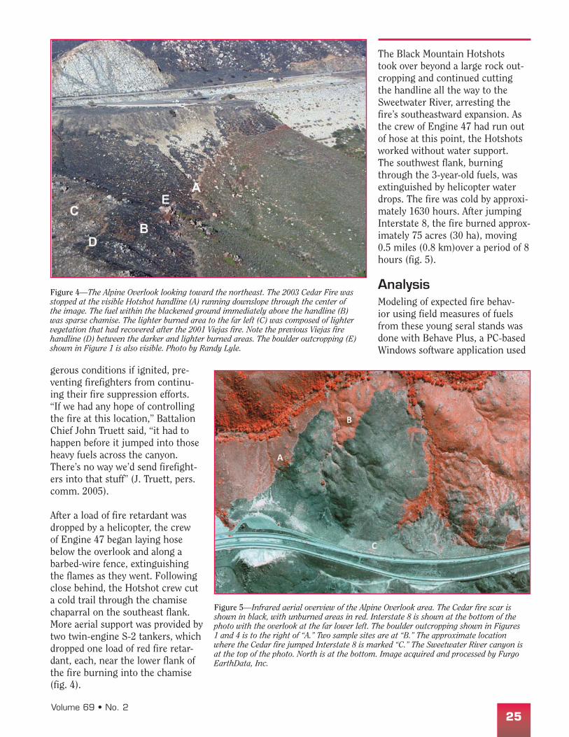
Figure 5—Infrared aerial overview of the Alpine Overlook area. The Cedar fire scar is shown in black, with unburned areas in red. Interstate 8 is shown at the bottom of the photo with the overlook at the far lower left. The boulder outcropping shown in Figures 1 and 4 is to the right of “A.” Two sample sites are at “B.” The approximate location where the Cedar fire jumped Interstate 8 is marked “C.” The Sweetwater River canyon is at the top of the photo. North is at the bottom. Image acquired and processed by Furgo EarthData, Inc.

Fire Management Today26
to predict wildland fire behavior (see <http://www.firemodels.org/content /view/12/26/>). Rothermel equations that are used in Behave have shortcomings when applied to chaparral (Zhou and others 2005), but we believe it is appropriate to our application in young seral chaparral. Here, dead fuels domi-nated and the bulk was within 30 inches (76 cm) of the soil surface (fig. 6).
Based on the fine-fuel component of the sites sampled and expected fuel moisture conditions in late summer and fall, we based the Behave runs with a 1-hour dead-fuel moisture parameter. According to firefighter observations of a 10 mph (16 km/h) wind and our measurements, Behave models pre-dicted a maximum flame length of 10 feet (3 m) with a rate of spread of 0.5 mph (0.8 km/h) for a fire on flat ground. As the actual fire was backing downhill, the predicted maximum flame length was approx-imately 3 feet (1 m) with a rate of spread of about 0.3 miles (0.5 km) over 8 hours. These predictions are relatively close to what was observed on the ground. By con-trast, Behave predicted maximum flame lengths of 28 feet (8.5 m) and a rate of spread of about 1.75 mph (2.8 km/h) under a worst-case sce-nario (figs. 7a and b).
ConclusionsWe have found that 3-year-old, post-fire native vegetation in a recovering chamise chaparral stand is capable of carrying a fire under moderate weather conditions. Under more severe conditions, such fuels are capable of generating sub-stantial flame lengths and spread rates. Consequently, these younger fuels would not likely provide the necessary barrier to stop wildland fires in chaparral systems under natural conditions. This was dem-onstrated on a much larger scale during San Diego County’s 2007 firestorm. Approximately 60,000 acres (24,280 ha) of shrubland that had burned in 2003 burned again when the wind-driven fronts of the 2007 Poomacha, Witch, and Harris Fires pushed into existing fire scars (fig. 8 and table 2).
The 3-year-old fuels within the Viejas Fire scar did, however, make it possible for firefighters to approach the area with acceptable risk in order to conduct fire sup-pression activities. By 1800 hours on Monday afternoon, the northeast winds had begun shifting to the northwest. The flames were already backing southeast downslope toward the heavy fuels across the river prior to the wind shift. If the fire had not been extinguished within the short, 4-hour time win-dow, it is likely the fire would have made the jump into the heavier fuels on the other side of the can-yon that afternoon. Had the jump occurred, this portion of the Cedar Fire would have likely been picked up by the stronger northwest winds on Tuesday, October 28, spread-ing the flames into two wilderness areas and potentially burning an additional 70,000 acres (28,328 ha). This event would have coincided with the wind-driven blowup east of State Highway 79 in Cuyamaca State Park on Tuesday evening. Further movement of the fire into the 3-year-old Viejas Fire scar to the southwest, however, may have been unlikely due to increasing humidity levels and the change in wind direction from a northeast Santa Ana flow to a northwest onshore flow.
ImplicationsThere is considerable speculation concerning the natural fire regime in southern California chaparral ecosystems prior to the arrival of humans. Minnich (1983, 1989) has hypothesized that fires were generally frequent, creating small “patches” (250 to 2,500 acres [101 to 1012 ha]) of mixed-aged vegeta-tion. According to this hypothesis, fuel age is the primary determinant of fire size because fires will stop
Figure 6—Fuels status. Dead fuels dominated the samples within the 2001 Viejas Fire scar.
Figure 7—BEHAVE predicted (a) the rate of spread and (b) the flame length of the 3-year-old fuels sampled in the 2001 Viejas Fire scar.
(a)
(b)

Volume 69 • No. 227
spreading once they reach younger aged patches. Consequently, large shrubland wildfires over 10,000 acres (4,047 ha) are viewed as “unnatural,” byproducts of past fire suppression efforts that have allowed large, older stands of chap-arral to develop.
Our research does not lend sup-port to this hypothesis as we found that younger aged fuels of the type found in recovering chaparral stands can carry fire, even under moderate weather conditions. Although fuel type and condition play a critical role in determining
fire spread, other factors (such as weather and topography) can domi-nate the outcome. For example, the western expansion of the 2003 Cedar Fire burned through numer-ous younger aged patches of veg-etation before hitting the commu-nity of Scripps Ranch in San Diego (Halsey 2006). Interestingly, this edge of the fire finally stopped in extremely dense chaparral without the aide of fire suppression efforts. This abrupt perimeter edge was likely caused by a combination of higher fuel moisture content, slow-ing of Santa Ana winds, and the influx of a marine moisture layer.
Other research has also suggested there is not a strong relationship between hazard of burning and fuel age (Moritz and others 2004) and that large fires are not depen-dent on old age classes of fuels but rather extreme weather conditions (Keeley and others 1999). In addi-tion, the relatively low lightning frequency that occurs in southern California, especially at lower eleva-tions, would not likely ignite the number of fires required to create small, mixed-aged patches of veg-
Figure 8—2003 and 2007 San Diego County fire overlap map. The map shows the perimeters of the 2003 Paradise Fire (A), Cedar Fire (B), and Otay Fire (C). 2007 fires are labeled to the right of their perimeters: Poomacha Fire (D), Witch Creek Fire (E), and Harris Fire (F). Major roads are represented by dark lines. Note the significant areas of overlap between the 2007 and 2003 fires. From Halsey (2008).
Total Habitat
Area (acres/ha)
Area Burned
2007 (acres/ha)
Percent burned 2007
Area Burned
2003 (acres/ha)
Percent Burned
2003
Area Burned Twice
(acres/ha)
Percent Burned Twice
Percent Burned in 4 Yrs
Chaparral 856 (346) 117 (47) 14% 173 (70) 20% 27 (11) 3% 31%
Coastal + Scrub 290 (117) 94 (38) 32% 79 (32) 27% 34 (14) 12% 48%
Grasslands 161 (65) 21 (8.5) 13% 17 (7) 11% 2 (1) 2% 22%
Riparian + Marsh 64 (26) 9 (4) 14% 6 (2) 9% 2 (1) 3% 20%
Woodland 112 (45) 33 (13) 30% 27 (11) 24% 10 (4) 9% 44%
Forest 86 (35) 13 (5) 16% 20 (8) 23% 1 (0.4) 1% 37%
Table 2—Wildlands burned in 2003 and 2007 firestorms. The baseline data for this table was drawn from San Diego County vegetation data, 2003 fire scar perimeter, and 2007 fire perimeter. All results are expressed in thousands and rounded off to reflect estimated values and are intended only as general indicators of habitat loss, as some areas within mapped perimeters may not have burned. Compiled by Kit Wilson.
Fire Management Today28
etation (Keeley 1982, Christensen 1985).
While we seriously doubt that southern California shrubland fires can be naturally constrained by younger aged vegetation, strategi-cally placed fuel treatments can play a supporting role in fire sup-pression efforts. Our data support the observation that younger fuels in post-fire chaparral ecosystems can provide greater opportuni-ties for firefighters to establish fire suppression anchor points, especially under moderate weather conditions and along the flanks of wind-driven fires. This explains the desire of some land managers to establish an artificial “mosaic” of age classes on a landscape scale to prevent the development of large, contiguous old-age fuel beds (P. Scully pers. comm. 2008). However, beyond the strategic application of fuel manipulations at the wildland/urban interface, we have only lim-ited understanding of the efficacy of such treatments on the broad landscape.
Another important factor to con-sider regarding the artificial cre-ation of mixed-aged mosaics is the resource damage that additional
fires may cause to native plant communities. In conjunction with this research, we have been investi-gating the health of the study site’s chaparral ecosystem after it was subjected to the fires of 2001 and 2003. Preliminary data have shown that there is significant mortality of chamise burls, reduction of several native plant species, and spread of invasive, non-native grasses such as foxtail chess (Bromus madritensis). By adding more fire to the land-scape through rotational burning in order to create mosaics, type-conversion of native shrubland sys-tems to non-native grasslands will likely increase.
ReferencesChristensen, N.L. 1985. Shrubland fire
regimes and their evolutionary conse-quences. In Pickett, S.T.A.; White, P.S., eds. The Ecology of Natural Disturbance. New York: Academic Press: 85–100.
Dodge, J.M. 1975. Vegetational changes associated with land use and fire history in San Diego County. Ph.D. dissertation. Riverside, CA: University of California-Riverside.
Green, L.R. 1981. Burning by prescription in chaparral. General Technical Report GTR-PSW-51. Albany, CA: Forest Service, Pacific Southwest Forest and Range Experiment Station. 36 p.
Halsey, R.W. 2006. Weather, fuels, and sup-pression during the 2003 Cedar Fire: Which variables made the critical differ-ence? Proceedings, 3rd International Fire
Ecology and Management Conference. San Diego, CA: Association for Fire Ecology.
Halsey, R.W. 2008. Fire, chaparral, and sur-vival in southern California. San Diego, CA: Sunbelt Publications. 232 p.
Keeley, J.E. 1982. The distribution of lightning and man-caused wildfires in California. In Conrad, C.E., and Oechel, W.E., eds. Proceedings, Symposium on Dynamics and Management of Mediterranean-type Ecosystems. Gen. Tech. Rep. PSW-58: 431–437.
Keeley, J.E. 2006. Fire management impacts on invasive plant species in the western United States. Conservation Biology. 20: 375–384.
Keeley, J.E.; Fotheringham, C. J.; Morais, M. 1999. Reexamining fire suppres-sion impacts on brushland fire regimes. Science. 284: 1829–1832.
Minnich, R.A. 1983. Fire mosaics in southern California and northern Baja California. Science. 219: 1287–1294.
Minnich, R.A. 1989. Chaparral fire his-tory in San Diego County and adjacent northern Baja California: an evaluation of natural fire regimes and effects of sup-pression management. In Keeley, S.C., ed. The California Chaparral: Paradigms Reexamined. No. 34 Science Series. Natural History Museum of Los Angeles County: 37–47.
Moritz, M.A.; Keeley, J.E.; Johnson, E.A.; Schaffner, A.A. 2004. Testing a basic assumption of shrubland fire management: How important is fuel age? Frontiers in Ecology and the Environment. 2: 67–72.
Zhou, X.; Weise, D.; Mahalingam, S. 2005. Experimental measurements and numer-ical modeling of marginal burning in live chaparral fuel beds. Proceedings of the Combustion Institute. 30: 2287–2294.