Guidance for Implementation of the AASHTO Strategic Highway Safety Plan Volume 8: A Guide for...
133
Volume 12: A Guide for Reducing Collisions at Signalized Intersections Guidance for Implementation of the AASHTO Strategic Highway Safety Plan VOLUME 12 NATIONAL COOPERATIVE HIGHWAY RESEARCH PROGRAM NCHRP REPORT 500
-
Upload
independent -
Category
Documents
-
view
2 -
download
0
Transcript of Guidance for Implementation of the AASHTO Strategic Highway Safety Plan Volume 8: A Guide for...

Volume 12: A Guide forReducing Collisions at
Signalized Intersections
Guidance for Implementation of theAASHTO Strategic Highway Safety Plan
VOLUME 12NATIONALCOOPERATIVE HIGHWAYRESEARCH PROGRAMNCHRP
REPORT 500

TRANSPORTATION RESEARCH BOARD EXECUTIVE COMMITTEE 2004 (Membership as of January 2004)
OFFICERSChair: Michael S. Townes, President and CEO, Hampton Roads Transit, Hampton, VA Vice Chair: Joseph H. Boardman, Commissioner, New York State DOTExecutive Director: Robert E. Skinner, Jr., Transportation Research Board
MEMBERSMICHAEL W. BEHRENS, Executive Director, Texas DOTSARAH C. CAMPBELL, President, TransManagement, Inc., Washington, DCE. DEAN CARLSON, Director, Carlson Associates, Topeka, KSJOHN L. CRAIG, Director, Nebraska Department of RoadsDOUGLAS G. DUNCAN, President and CEO, FedEx Freight, Memphis, TNGENEVIEVE GIULIANO, Director, Metrans Transportation Center and Professor, School of Policy, Planning, and Development, USC,
Los AngelesBERNARD S. GROSECLOSE, JR., President and CEO, South Carolina State Ports AuthoritySUSAN HANSON, Landry University Professor of Geography, Graduate School of Geography, Clark UniversityJAMES R. HERTWIG, President, Landstar Logistics, Inc., Jacksonville, FLHENRY L. HUNGERBEELER, Director, Missouri DOTADIB K. KANAFANI, Cahill Professor of Civil Engineering, University of California, Berkeley RONALD F. KIRBY, Director of Transportation Planning, Metropolitan Washington Council of GovernmentsHERBERT S. LEVINSON, Principal, Herbert S. Levinson Transportation Consultant, New Haven, CTSUE MCNEIL, Director, Urban Transportation Center and Professor, College of Urban Planning and Public Affairs, University of
Illinois, ChicagoMICHAEL D. MEYER, Professor, School of Civil and Environmental Engineering, Georgia Institute of TechnologyKAM MOVASSAGHI, Secretary of Transportation, Louisiana Department of Transportation and DevelopmentCAROL A. MURRAY, Commissioner, New Hampshire DOTJOHN E. NJORD, Executive Director, Utah DOTDAVID PLAVIN, President, Airports Council International, Washington, DCJOHN REBENSDORF, Vice President, Network and Service Planning, Union Pacific Railroad Co., Omaha, NEPHILIP A. SHUCET, Commissioner, Virginia DOTC. MICHAEL WALTON, Ernest H. Cockrell Centennial Chair in Engineering, University of Texas, AustinLINDA S. WATSON, General Manager, Corpus Christi Regional Transportation Authority, Corpus Christi, TX
MARION C. BLAKEY, Federal Aviation Administrator, U.S.DOT (ex officio)SAMUEL G. BONASSO, Acting Administrator, Research and Special Programs Administration, U.S.DOT (ex officio)REBECCA M. BREWSTER, President and COO, American Transportation Research Institute, Smyrna, GA (ex officio)GEORGE BUGLIARELLO, Chancellor, Polytechnic University and Foreign Secretary, National Academy of Engineering (ex officio)THOMAS H. COLLINS (Adm., U.S. Coast Guard), Commandant, U.S. Coast Guard (ex officio)JENNIFER L. DORN, Federal Transit Administrator, U.S.DOT (ex officio)ROBERT B. FLOWERS (Lt. Gen., U.S. Army), Chief of Engineers and Commander, U.S. Army Corps of Engineers (ex officio)EDWARD R. HAMBERGER, President and CEO, Association of American Railroads (ex officio)JOHN C. HORSLEY, Executive Director, American Association of State Highway and Transportation Officials (ex officio)RICK KOWALEWSKI, Deputy Director, Bureau of Transportation Statistics, U.S.DOT (ex officio)WILLIAM W. MILLAR, President, American Public Transportation Association (ex officio) MARY E. PETERS, Federal Highway Administrator, U.S.DOT (ex officio)SUZANNE RUDZINSKI, Director, Transportation and Regional Programs, U.S. Environmental Protection Agency (ex officio)JEFFREY W. RUNGE, National Highway Traffic Safety Administrator, U.S.DOT (ex officio)ALLAN RUTTER, Federal Railroad Administrator, U.S.DOT (ex officio)ANNETTE M. SANDBERG, Federal Motor Carrier Safety Administrator, U.S.DOT (ex officio)WILLIAM G. SCHUBERT, Maritime Administrator, U.S.DOT (ex officio)ROBERT A. VENEZIA, Program Manager of Public Health Applications, National Aeronautics and Space Administration (ex officio)
NATIONAL COOPERATIVE HIGHWAY RESEARCH PROGRAM
Transportation Research Board Executive Committee Subcommittee for NCHRPMICHAEL S. TOWNES, Hampton Roads Transit, Hampton, VA
(Chair)JOSEPH H. BOARDMAN, New York State DOTGENEVIEVE GIULIANO, University of Southern California,
Los Angeles
JOHN C. HORSLEY, American Association of State Highway and Transportation Officials
MARY E. PETERS, Federal Highway Administration ROBERT E. SKINNER, JR., Transportation Research BoardC. MICHAEL WALTON, University of Texas, Austin

NATIONAL COOPERATIVE HIGHWAY RESEARCH PROGRAM
NCHRP REPORT 500
SUBJECT AREAS
Safety and Human Performance
Guidance for Implementation of the AASHTO Strategic Highway Safety Plan
Volume 12: A Guide for ReducingCollisions at Signalized Intersections
NICHOLAS D. ANTONUCCI
KELLY KENNEDY HARDY
KEVIN L. SLACK
CH2M HILL
Herndon, VA
RONALD PFEFER
Maron Engineering, Ltd.
Zikhron Yaacov, Israel
TIMOTHY R. NEUMAN
CH2M HILL
Chicago, IL
T R A N S P O R T A T I O N R E S E A R C H B O A R DWASHINGTON, D.C.
2004www.TRB.org
Research Sponsored by the American Association of State Highway and Transportation Officials in Cooperation with the Federal Highway Administration

NATIONAL COOPERATIVE HIGHWAY RESEARCH PROGRAM
Systematic, well-designed research provides the most effectiveapproach to the solution of many problems facing highwayadministrators and engineers. Often, highway problems are of localinterest and can best be studied by highway departmentsindividually or in cooperation with their state universities andothers. However, the accelerating growth of highway transportationdevelops increasingly complex problems of wide interest tohighway authorities. These problems are best studied through acoordinated program of cooperative research.
In recognition of these needs, the highway administrators of theAmerican Association of State Highway and TransportationOfficials initiated in 1962 an objective national highway researchprogram employing modern scientific techniques. This program issupported on a continuing basis by funds from participatingmember states of the Association and it receives the full cooperationand support of the Federal Highway Administration, United StatesDepartment of Transportation.
The Transportation Research Board of the National Academieswas requested by the Association to administer the researchprogram because of the Board’s recognized objectivity andunderstanding of modern research practices. The Board is uniquelysuited for this purpose as it maintains an extensive committeestructure from which authorities on any highway transportationsubject may be drawn; it possesses avenues of communications andcooperation with federal, state and local governmental agencies,universities, and industry; its relationship to the National ResearchCouncil is an insurance of objectivity; it maintains a full-timeresearch correlation staff of specialists in highway transportationmatters to bring the findings of research directly to those who are ina position to use them.
The program is developed on the basis of research needsidentified by chief administrators of the highway and transportationdepartments and by committees of AASHTO. Each year, specificareas of research needs to be included in the program are proposedto the National Research Council and the Board by the AmericanAssociation of State Highway and Transportation Officials.Research projects to fulfill these needs are defined by the Board, andqualified research agencies are selected from those that havesubmitted proposals. Administration and surveillance of researchcontracts are the responsibilities of the National Research Counciland the Transportation Research Board.
The needs for highway research are many, and the NationalCooperative Highway Research Program can make significantcontributions to the solution of highway transportation problems ofmutual concern to many responsible groups. The program,however, is intended to complement rather than to substitute for orduplicate other highway research programs.
Note: The Transportation Research Board of the National Academies, theNational Research Council, the Federal Highway Administration, the AmericanAssociation of State Highway and Transportation Officials, and the individualstates participating in the National Cooperative Highway Research Program donot endorse products or manufacturers. Trade or manufacturers’ names appearherein solely because they are considered essential to the object of this report.
Published reports of the
NATIONAL COOPERATIVE HIGHWAY RESEARCH PROGRAM
are available from:
Transportation Research BoardBusiness Office500 Fifth Street, NWWashington, DC 20001
and can be ordered through the Internet at:
http://www.national-academies.org/trb/bookstore
Printed in the United States of America
NCHRP REPORT 500: Volume 12
Project G17-18(3) FY’00
ISSN 0077-5614
ISBN 0-309-08760-0
Library of Congress Control Number 2003104149
© 2004 Transportation Research Board
Price $24.00
NOTICE
The project that is the subject of this report was a part of the National Cooperative
Highway Research Program conducted by the Transportation Research Board with the
approval of the Governing Board of the National Research Council. Such approval
reflects the Governing Board’s judgment that the program concerned is of national
importance and appropriate with respect to both the purposes and resources of the
National Research Council.
The members of the technical committee selected to monitor this project and to review
this report were chosen for recognized scholarly competence and with due
consideration for the balance of disciplines appropriate to the project. The opinions and
conclusions expressed or implied are those of the research agency that performed the
research, and, while they have been accepted as appropriate by the technical committee,
they are not necessarily those of the Transportation Research Board, the National
Research Council, the American Association of State Highway and Transportation
Officials, or the Federal Highway Administration, U.S. Department of Transportation.
Each report is reviewed and accepted for publication by the technical committee
according to procedures established and monitored by the Transportation Research
Board Executive Committee and the Governing Board of the National Research
Council.

The National Academy of Sciences is a private, nonprofit, self-perpetuating society of distinguished schol-ars engaged in scientific and engineering research, dedicated to the furtherance of science and technology and to their use for the general welfare. On the authority of the charter granted to it by the Congress in 1863, the Academy has a mandate that requires it to advise the federal government on scientific and techni-cal matters. Dr. Bruce M. Alberts is president of the National Academy of Sciences.
The National Academy of Engineering was established in 1964, under the charter of the National Acad-emy of Sciences, as a parallel organization of outstanding engineers. It is autonomous in its administration and in the selection of its members, sharing with the National Academy of Sciences the responsibility for advising the federal government. The National Academy of Engineering also sponsors engineering programs aimed at meeting national needs, encourages education and research, and recognizes the superior achieve-ments of engineers. Dr. William A. Wulf is president of the National Academy of Engineering.
The Institute of Medicine was established in 1970 by the National Academy of Sciences to secure the services of eminent members of appropriate professions in the examination of policy matters pertaining to the health of the public. The Institute acts under the responsibility given to the National Academy of Sciences by its congressional charter to be an adviser to the federal government and, on its own initiative, to identify issues of medical care, research, and education. Dr. Harvey V. Fineberg is president of the Institute of Medicine.
The National Research Council was organized by the National Academy of Sciences in 1916 to associate the broad community of science and technology with the Academy’s purposes of furthering knowledge and advising the federal government. Functioning in accordance with general policies determined by the Acad-emy, the Council has become the principal operating agency of both the National Academy of Sciences and the National Academy of Engineering in providing services to the government, the public, and the scientific and engineering communities. The Council is administered jointly by both the Academies and the Institute of Medicine. Dr. Bruce M. Alberts and Dr. William A. Wulf are chair and vice chair, respectively, of the National Research Council.
The Transportation Research Board is a division of the National Research Council, which serves the National Academy of Sciences and the National Academy of Engineering. The Board’s mission is to promote innovation and progress in transportation through research. In an objective and interdisciplinary setting, the Board facilitates the sharing of information on transportation practice and policy by researchers and practitioners; stimulates research and offers research management services that promote technical excellence; provides expert advice on transportation policy and programs; and disseminates research results broadly and encourages their implementation. The Board’s varied activities annually engage more than 5,000 engineers, scientists, and other transportation researchers and practitioners from the public and private sectors and academia, all of whom contribute their expertise in the public interest. The program is supported by state transportation departments, federal agencies including the component administrations of the U.S. Department of Transportation, and other organizations and individuals interested in the development of transportation. www.TRB.org
www.national-academies.org

COOPERATIVE RESEARCH PROGRAMS STAFF FOR NCHRP REPORT 500
ROBERT J. REILLY, Director, Cooperative Research ProgramsCRAWFORD F. JENCKS, NCHRP ManagerCHARLES W. NIESSNER, Senior Program OfficerEILEEN P. DELANEY, Managing EditorELLEN CHAFEE, Assistant Editor
NCHRP PROJECT G17-18(3) PANELField of Traffic—Area of Safety
THOMAS E. BRYER, Camp Hill, PA (Chair)LEANNA DEPUE, Central Missouri State UniversityADELE DERBY, Alexandria, VABARBARA HARSHA, Governors Highway Safety Association, Washington, DCBRUCE IBARGUEN, Maine DOTMARGARET “MEG” MOORE, Texas DOTKIM F. NYSTROM, Nystrom Consulting, Gold River, CAPETER F. “PETE” RUSCH, FHWARUDY UMBS, FHWAANTHONY D. WYATT, North Carolina DOTJESSE BLATT, NHTSA Liaison RepresentativeRAY KRAMMES, FHWA Liaison RepresentativeKEN KOBETSKY, AASHTO Liaison RepresentativeRICHARD PAIN, TRB Liaison Representative

The goal of the AASHTO Strategic Highway Safety Plan is to reduce annual high-way fatalities by 5,000 to 7,000. This goal can be achieved through the widespreadapplication of low-cost, proven countermeasures that reduce the number of crashes onthe nation’s highways. This twelfth volume of NCHRP Report 500: Guidance forImplementation of the AASHTO Strategic Highway Safety Plan provides strategies thatcan be employed to reduce the number of collisions at signalized intersections. Thereport will be of particular interest to safety practitioners with responsibility for imple-menting programs to reduce injuries and fatalities on the highway system.
In 1998, AASHTO approved its Strategic Highway Safety Plan, which was devel-oped by the AASHTO Standing Committee for Highway Traffic Safety with the assis-tance of the Federal Highway Administration, the National Highway Traffic SafetyAdministration, and the Transportation Research Board Committee on TransportationSafety Management. The plan includes strategies in 22 key emphasis areas that affecthighway safety. The plan’s goal is to reduce the annual number of highway deaths by5,000 to 7,000. Each of the 22 emphasis areas includes strategies and an outline of whatis needed to implement each strategy.
NCHRP Project 17-18(3) is developing a series of guides to assist state and localagencies in reducing injuries and fatalities in targeted areas. The guides correspond tothe emphasis areas outlined in the AASHTO Strategic Highway Safety Plan. Eachguide includes a brief introduction, a general description of the problem, the strate-gies/countermeasures to address the problem, and a model implementation process.
This is the twelfth volume of NCHRP Report 500: Guidance for Implementationof the AASHTO Strategic Highway Safety Plan, a series in which relevant informa-tion is assembled into single concise volumes, each pertaining to specific types ofhighway crashes (e.g., run-off-road, head-on) or contributing factors (e.g., aggressivedriving). An expanded version of each volume, with additional reference materialand links to other information sources, is available on the AASHTO Web site athttp://transportation1.org/safetyplan. Future volumes of the report will be publishedand linked to the Web site as they are completed.
While each volume includes countermeasures for dealing with particular crashemphasis areas, NCHRP Report 501: Integrated Management Process to Reduce High-way Injuries and Fatalities Statewide provides an overall framework for coordinatinga safety program. The integrated management process comprises the necessary stepsfor advancing from crash data to integrated action plans. The process includes method-ologies to aid the practitioner in problem identification, resource optimization, and per-formance measurements. Together, the management process and the guides provide acomprehensive set of tools for managing a coordinated highway safety program.
FOREWORDBy Charles W. Niessner
Staff OfficerTransportation Research
Board

Contents
Acknowledgments
I Summary . . . . . . . . . . . . . . . . . . . . . . . . . . . . . . . . . . . . . . . . . . . . . . . . . . . . . . . . . . . . . . . . . . I-1Introduction. . . . . . . . . . . . . . . . . . . . . . . . . . . . . . . . . . . . . . . . . . . . . . . . . . . . . . . . . . . . . . . . I-1General Description of the Problem. . . . . . . . . . . . . . . . . . . . . . . . . . . . . . . . . . . . . . . . . . . . I-2Objectives of the Emphasis Area . . . . . . . . . . . . . . . . . . . . . . . . . . . . . . . . . . . . . . . . . . . . . . I-3
II Introduction . . . . . . . . . . . . . . . . . . . . . . . . . . . . . . . . . . . . . . . . . . . . . . . . . . . . . . . . . . . . . . II-1
III Type of Problem Being Addressed . . . . . . . . . . . . . . . . . . . . . . . . . . . . . . . . . . . . . . . . . . III-1General Description of the Problem . . . . . . . . . . . . . . . . . . . . . . . . . . . . . . . . . . . . . . . . . . III-1
IV Index of Strategies by Implementation Timeframe and Relative Cost . . . . . . . . . . . IV-1
V Description of Strategies . . . . . . . . . . . . . . . . . . . . . . . . . . . . . . . . . . . . . . . . . . . . . . . . . . . V-1Objectives . . . . . . . . . . . . . . . . . . . . . . . . . . . . . . . . . . . . . . . . . . . . . . . . . . . . . . . . . . . . . . . . . V-1Types of Strategies . . . . . . . . . . . . . . . . . . . . . . . . . . . . . . . . . . . . . . . . . . . . . . . . . . . . . . . . . V-3Related Strategies for Creating a Truly Comprehensive Approach . . . . . . . . . . . . . . . . V-4Objective 17.2 A—Reduce Frequency and Severity of Intersection
Conflicts through Traffic Control and Operational Improvements . . . . . . . . . . . . . . V-6Objective 17.2 B—Reduce Frequency and Severity of Intersection Conflicts
through Geometric Improvements . . . . . . . . . . . . . . . . . . . . . . . . . . . . . . . . . . . . . . . . . V-29Objective 17.2 C—Improve Sight Distance at Signalized Intersections . . . . . . . . . . . . V-50Objective 17.2 D—Improve Driver Awareness of Intersections and Signal Control . . . V-51Objective 17.2 E—Improve Driver Compliance with Traffic Control Devices . . . . . . V-57Objective 17.2 F—Improve Access Management near Signalized Intersections . . . . . V-71Objective 17.2 G—Improve Safety through Other Infrastructure Treatments. . . . . . . V-74
VI Guidance for Implementation of the AASHTO Strategic Highway Safety Plan . . . . VI-1Outline for a Model Implementation Process . . . . . . . . . . . . . . . . . . . . . . . . . . . . . . . . . . VI-1Purpose of the Model Process . . . . . . . . . . . . . . . . . . . . . . . . . . . . . . . . . . . . . . . . . . . . . . . VI-2Overview of the Model Process . . . . . . . . . . . . . . . . . . . . . . . . . . . . . . . . . . . . . . . . . . . . . . VI-2Implementation Step 1: Identify and Define the Problem . . . . . . . . . . . . . . . . . . . . . . . . VI-5Implementation Step 2: Recruit Appropriate Participants for the Program . . . . . . . . . VI-9Implementation Step 3: Establish Crash Reduction Goals . . . . . . . . . . . . . . . . . . . . . . VI-11Implementation Step 4: Develop Program Policies, Guidelines,
and Specifications . . . . . . . . . . . . . . . . . . . . . . . . . . . . . . . . . . . . . . . . . . . . . . . . . . . . . . VI-12Implementation Step 5: Develop Alternative Approaches
to Addressing the Problem. . . . . . . . . . . . . . . . . . . . . . . . . . . . . . . . . . . . . . . . . . . . . . . VI-13Implementation Step 6: Evaluate Alternatives and Select a Plan . . . . . . . . . . . . . . . . . VI-15Implementation Step 7: Submit Recommendations
for Action by Top Management. . . . . . . . . . . . . . . . . . . . . . . . . . . . . . . . . . . . . . . . . . . VI-17Implementation Step 8: Develop a Plan of Action . . . . . . . . . . . . . . . . . . . . . . . . . . . . . VI-18Implementation Step 9: Establish Foundations for Implementing the Program . . . . VI-20Implementation Step 10: Carry Out the Action Plan . . . . . . . . . . . . . . . . . . . . . . . . . . . VI-21Implementation Step 11: Assess and Transition the Program . . . . . . . . . . . . . . . . . . . VI-22
VII Key References . . . . . . . . . . . . . . . . . . . . . . . . . . . . . . . . . . . . . . . . . . . . . . . . . . . . . . . . . . VII-1
Appendixes . . . . . . . . . . . . . . . . . . . . . . . . . . . . . . . . . . . . . . . . . . . . . . . . . . . . . . . . . . . . . . . A-1

Acknowledgments
This volume of NCHRP Report 500 was developed under NCHRP Project 17-18(3), theproduct of which is a series of implementation guides addressing the emphasis areas ofAASHTO’s Strategic Highway Safety Plan. The project was managed by CH2M HILL, andthe co-principal investigators were Ron Pfefer of Maron Engineering and Kevin Slack ofCH2M HILL. Timothy Neuman of CH2M HILL served as the overall project director for theteam. Kelly Hardy, also of CH2M HILL, served as a technical specialist on the developmentof the guides.
The project team was organized around the specialized technical content contained in eachguide, and the overall team included nationally recognized experts from many organizations.The following team of experts, selected based on their knowledge of signalized intersections,served as lead authors for the signalized intersection guide:
• Nicholas D. AntonucciCH2M HILL
• Kelly K. HardyCH2M HILL
• Kevin L. SlackCH2M HILL
Development of the volumes of NCHRP Report 500 utilized the resources and expertise ofmany professionals from around the country and overseas. Through research, workshops, andactual demonstration of the guides by agencies, the resulting documents represent bestpractices in each emphasis area. The project team is grateful to the following list of people andtheir agencies for supporting the project by providing material, participating in workshops andmeetings, and providing input and comments during the development of the signalizedintersection guide:
City of Winston-Salem, NCStan Polanis
Federal Highway AdministrationJoe BaredGreg EvansPat HassonHari KallaFred Ranck
Howard County MarylandPolice DepartmentLt. Glenn Hansen
Minnesota Department ofTransportationMark BrieseLoren Hill
Missouri Department ofTransportationMike CurtitTom EvansGrahm Zieba
In addition, the authors wish to recognize Taylor Fleet of CH2M HILL for his assistance inmaking this document possible.

I-1
SECTION I
Summary
Introduction One of the hallmarks of the AASHTO Strategic Highway Safety Plan (SHSP) is to approachsafety problems in a comprehensive manner. The range of strategies available in the guideswill ultimately cover various aspects of the road user, the highway, the vehicle, theenvironment, and the management system. The guides strongly encourage the user todevelop a program to tackle a particular emphasis area from each of these perspectives in acoordinated manner. To facilitate this, the electronic form of the material uses hypertextlinkages to enable seamless integration of various approaches to a given problem. As moreguides are developed for other emphasis areas, the extent and usefulness of this form ofimplementation will become ever more apparent.
The goal is to move away from independent activities of engineers, law enforcement,educators, judges, and other highway-safety specialists. The implementation processoutlined in the guides promotes the formation of working groups and alliances thatrepresent all of the elements of the safety system. In so doing, members of these groups candraw upon their combined expertise to reach the bottom-line goal of targeted reduction ofcrashes and fatalities associated with a particular emphasis area.
The six major areas of the AASHTO SHSP (Drivers, Vehicles, Special Users, Highways,Emergency Medical Services, and Management) are subdivided into 22 goals, or keyemphasis areas, that impact highway safety. One of these goals addresses the improvementof safety at intersections. This implementation guide provides guidance to highway agenciesthat desire to implement safety improvements at signalized intersections and includes avariety of strategies that may be applicable to particular locations.
The crossing and turning maneuvers that occur at intersections create opportunities forvehicle-vehicle, vehicle-pedestrian, and vehicle-bicycle conflicts, which may result in trafficcrashes. Thus, intersections are likely points for concentrations of traffic crashes.Intersections constitute only a small part of the overall highway system, yet intersection-related crashes constitute more than 50 percent of all crashes in urban areas and over30 percent in rural areas (Kuciemba and Cirillo, 1992). Just under a quarter of fatal crashesoccur at intersections.
Signalized intersections are generally the most heavily traveled intersection types and aretherefore a major element of the highway fatality and crash problem nationally. Fatal crashesat signalized intersections are predominately multivehicle. Signalized intersections areoperationally complex, with many factors contributing to the potential safety problems. Theintent of a signal is to control and separate conflicts between vehicles, pedestrians, andcyclists to enable safe and efficient operations. Operation of a signal itself, however,produces conflicts (e.g., conflicts between through vehicles that could lead to rear-endcrashes). In addition, varying signal operations (timing and phasing) place demands ondrivers that are not always met.

General Description of the ProblemIntersections constitute only a small part of the overall highway system, yet intersection-related crashes constitute more than 20 percent of fatal crashes. It is not unusual that crashesare concentrated at intersections, because intersections are the point on the roadway systemwhere traffic movements most frequently conflict with one another. Good geometric designcombined with good traffic control can result in an intersection that operates efficiently andsafely.
Exhibit I-1 shows the breakdown of fatal crashes by facility type, which is referred to as“relation to junction” in the Fatality Analysis Reporting System (FARS) database. Just undera quarter of fatal crashes occur at intersections.
Exhibit I-2 shows the distribution of fatal crashes at signalized intersections by manner ofcollision. The high percentage of crashes that do not include a collision with another movingvehicle can be attributed to pedestrian and bicycle crashes. FARS data show that 75 percentof the fatal single-vehicle crashes at signalized intersections involve pedestrians or bicyclists(55 percent of fatal single-vehicle crashes at all intersections involve pedestrians orbicyclists).
SECTION I—SUMMARY
I-2
EXHIBIT I-1Fatal Crashes by Relationship to JunctionSource: 2002 FARS data. Other relationships to junctions include crashes categorized in FARS as related to railroadgrade crossings, crossovers, and unknown.
A brief analysis of FARS data for 2002 shows the following:
• 23 percent of all fatal crashes occurred at intersections,• 6 percent of all fatal crashes occurred at signalized intersections,
Roadway72%
Intersections23%
Other1%
Interchange or Ramp
3%
Driveway1%

SECTION I—SUMMARY
• 29 percent of fatal crashes at intersections occurred at signalized intersections,• 84 percent of fatal crashes at signalized intersections occurred in urban areas, and• 59 percent of fatal crashes at signalized intersections involve angle collisions with other
vehicles.
I-3
EXHIBIT I-2 Manner of Collision for Fatal Crashes at Signalized IntersectionsSource: 2002 FARS data. “Other” includes crashes categorized in FARS as sideswipe same direction, sideswipe oppo-site direction, other, and unknown.
Objectives of the Emphasis AreaThe objectives for improving safety at signalized intersections are explained below. Exhibit I-3 lists the objectives and the related strategies for improving safety at signalizedintersections. The strategies considered go across the full range of engineering, enforcement,and education. Physical improvements include both geometric design modifications andchanges to traffic control devices:
• Reduce frequency and severity of intersection conflicts through traffic control andoperational improvements—Improvements to the method of assigning right-of-way atsignalized intersections can reduce the potential for conflicts. This can be accomplishedby modifying signal phasing, providing additional traffic control devices and pavementmarkings, and restricting turn movements. Improvements to traffic control can alsobenefit traffic operations and reduce emergency response time.
• Reduce frequency and severity of intersection conflicts through geometricimprovements—Reducing the frequency and severity of vehicle-vehicle conflicts atintersections can reduce the frequency and severity of intersection crashes. This can beaccomplished by incorporating geometric design solutions that separate through and
Not Collision with Motor Vehicle in
Transport30%
Rear-End6%
Head On4%
Angle59%
Other1%

turning movements at the intersection, restrict or eliminate turning maneuvers, and closeor relocate intersections.
• Improve sight distance at signalized intersections—Provision of clear sight triangles ineach quadrant of an intersection can minimize the possibility of crashes related to sightobstructions.
• Improve driver awareness of intersections and signal control—Some intersection-relatedcollisions occur because one or more drivers approaching an intersection are unaware ofthe intersection until it is too late to avoid a collision. Improved signing and delineationand installation of lighting can help warn drivers of the presence of the intersection. Insome situations, where other measures have not been effective, rumble strips may beused to get the driver’s attention.
• Improve driver compliance with traffic control devices—Many accidents are caused oraggravated by drivers’ noncompliance with traffic control devices or traffic laws atintersections. Both public education and enforcement have been shown to be effective inreducing traffic-law violations and consequently improving safety at intersections.Automated enforcement of traffic signals and speed limits is an increasingly common andcost-effective approach to improving driver compliance with traffic laws. At certain high-speed intersection approaches, implementing speed-reduction measures may provide anapproaching driver with additional time to make safer intersection-related decisions.
• Improve access management near signalized intersections—Navigation, braking, anddecision-making on intersection approaches creates additional workload on the driver.The presence of driveway access at or near a signalized intersection may confuse driversusing the intersection and create additional vehicle-vehicle conflicts. Measures to restrictdriveways and to preclude cross-median turning movements in close proximity tosignalized intersections can effectively reduce or eliminate serious multivehicle conflicts.
• Improve safety through other infrastructure treatments—Other improvements can bemade to the intersection to decrease frequency and severity of crashes at signalizedintersections. These include improving pavement conditions, coordinating operation ofsignals near railroad crossings, and moving signal hardware out of the clear zone.
SECTION I—SUMMARY
I-4
EXHIBIT I-3Emphasis Area Objectives and Strategies
Objectives Strategies
17.2 A Reduce frequency and severity of intersection conflicts through traffic control and operational improvements
17.2 A1 Employ multiphase signal operation (P, T)
17.2 A2 Optimize clearance intervals (P)
17.2 A3 Restrict or eliminate turning maneuvers (including right turns onred) (T)
17.2 A4 Employ signal coordination (P)
17.2 A5 Employ emergency vehicle preemption (P)

SECTION I—SUMMARY
I-5
EXHIBIT I-3 (Continued)Emphasis Area Objectives and Strategies
Objectives Strategies
17.2 B Reduce frequency and severity of intersection conflicts through geometric improvements
17.2 C Improve sight distance at signalized intersections
17.2 D Improve driver awareness of intersections and signal control
17.2 E Improve driver compliance with traffic control devices
17.2 F Improve access management near signalized intersections
17.2 G Improve safety through other infrastructure treatments
P = proven; T = tried; E= experimental. A fuller explanation of P, T, and E appears in Section V. Severalstrategies have substrategies with differing ratings.
17.2 A6 Improve operation of pedestrian and bicycle facilities atsignalized intersections (P, T)
17.2 A7 Remove unwarranted signal (P)
17.2 B1 Provide/improve left-turn channelization (P)
17.2 B2 Provide/improve right-turn channelization (P)
17.2 B3 Improve geometry of pedestrian and bicycle facilities (P, T)
17.2 B4 Revise geometry of complex intersections (P, T)
17.2 B5 Construct special solutions (T)
17.2 C1 Clear sight triangles (T)
17.2 C2 Redesign intersection approaches (P)
17.2 D1 Improve visibility of intersections on approach(es) (T)
17.2 D2 Improve visibility of signals and signs at intersections (T)
17.2 E1 Provide public information and education (T)
17.2 E2 Provide targeted conventional enforcement of traffic laws (T)
17.2 E3 Implement automated enforcement of red-light running (cameras) (P)
17.2 E4 Implement automated enforcement of approach speeds(cameras) (T)
17.2 E5 Control speed on approaches (E)
17.2 F1 Restrict access to properties using driveway closures or turnrestrictions (T)
17.2 F2 Restrict cross-median access near intersections (T)
17.2 G1 Improve drainage in intersection and on approaches (T)
17.2 G2 Provide skid resistance in intersection and on approaches (T)
17.2 G3 Coordinate closely spaced signals near at-grade railroadcrossings (T)
17.2 G4 Relocate signal hardware out of clear zone (T)
17.2 G5 Restrict or eliminate parking on intersection approaches (P)

II-1
SECTION II
Introduction
One of the hallmarks of the AASHTO SHSP is to approach safety problems in acomprehensive manner. The range of strategies available in the guides will ultimately covervarious aspects of the road user, the highway, the vehicle, the environment, and themanagement system. The guides strongly encourage the user to develop a program to tacklea particular emphasis area from each of these perspectives in a coordinated manner. Tofacilitate this, the electronic form of the material uses hypertext linkages to enable seamlessintegration of various approaches to a given problem.
The goal is to move away from independent activities of engineers, law enforcement,educators, judges, and other highway-safety specialists. The implementation processoutlined in the guides promotes the formation of working groups and alliances thatrepresent all of the elements of the safety system. In so doing, members of these groups candraw upon their combined expertise to reach the bottom-line goal of targeted reduction ofcrashes and fatalities associated with a particular emphasis area.
The six major areas of the AASHTO SHSP (Drivers, Vehicles, Special Users, Highways,Emergency Medical Services, and Management) are subdivided into 22 goals, or keyemphasis areas, that impact highway safety. One of these goals addresses the improvementof safety at intersections. Two guides in the NCHRP Report 500 series discuss intersections:this volume covers signalized intersections, and Volume 5 discusses unsignalizedintersections. This implementation guide provides guidance to highway agencies that desireto implement safety improvements at signalized intersections and includes a variety ofstrategies that may be applicable to particular locations.
Intersections are locations where two or more roads join or cross, and it is the crossing andturning maneuvers occurring at intersections that create opportunities for vehicle-vehicle,vehicle-pedestrian, and vehicle-bicycle conflicts. Thus, intersections are likely points forconcentrations of traffic crashes. Although intersections constitute a very small portion ofthe highway system, crashes at intersections account for as much as half of all crashes inurban areas and about one quarter of crashes in rural areas.
Signalized intersections are generally the most heavily traveled intersection types and aretherefore a major element of the highway fatality and crash problem nationally. Fatal crashesat signalized intersections are predominately multivehicle.
Signalized intersections are operationally complex, with many factors contributing to thepotential safety problems. The intent of a signal is to control and separate conflicts betweenvehicles, pedestrians, and cyclists to enable safe and efficient operations. Operation of asignal itself, however, produces conflicts (e.g., conflicts between through vehicles that couldlead to rear-end crashes). In addition, varying signal operations (timing and phasing) placedemands on drivers that are not always met. While the focus of the strategies discussed inthis guide is on reducing fatalities at signalized intersections, the implementation of many ofthese strategies will likely lead to an overall reduction in intersection crashes.

III-1
SECTION III
Type of Problem Being Addressed
General Description of the ProblemIntersections constitute only a small part of the overall highway system, yet intersection-related crashes constitute more than 20 percent of fatal crashes. It is not unusual that crashesare concentrated at intersections, because intersections are the point on the roadway systemwhere traffic movements most frequently conflict with one another. Good geometric designcombined with good traffic control can result in an intersection that operates efficiently andsafely.
Exhibit III-1 shows the breakdown of fatal crashes by facility type, which is referred to as“relation to junction” in the Fatality Analysis Reporting System (FARS) database. Just undera quarter of fatal crashes occur at intersections.
EXHIBIT III-1Fatal Crashes by Relationship to JunctionSource: 2002 FARS data. “Other” includes crashes categorized in FARS as related to railroad grade crossings,crossovers, and unknown.
A brief analysis of FARS data for 2002 shows the following:
• 23 percent of all fatal crashes occurred at intersections,• 6 percent of all fatal crashes occurred at signalized intersections,• 29 percent of fatal crashes at intersections occurred at signalized intersections,• 84 percent of fatal crashes at signalized intersections occurred in urban areas, and• 59 percent of fatal crashes at signalized intersections involve angle collisions with other
vehicles.
Roadway72%
Intersections23%
Other1%
Interchange or Ramp
3%
Driveway1%

SECTION III—TYPE OF PROBLEM BEING ADDRESSED
III-2
Exhibit III-2 shows the distribution of fatal crashes at signalized intersections by manner ofcollision. The high percentage of crashes that do not include a collision with another movingvehicle can be attributed to pedestrian and bicycle crashes. FARS data show that 75 percentof the fatal single-vehicle crashes at signalized intersections involve pedestrians or bicyclists(55 percent of fatal single-vehicle crashes at all intersections involve pedestrians orbicyclists).
EXHIBIT III-2 Manner of Collision for Fatal Crashes at Signalized IntersectionsSource: 2002 FARS data. “Other” includes crashes categorized in FARS as sideswipe same direction, sideswipe oppo-site direction, other, and unknown.
Exhibit III-3 shows the distribution of severity of crashes at signalized intersections in theUnited States, compared to stop-controlled intersections and nonjunctions along which thereis no signal control. While nonjunctions proportionately experience slightly more fatalcrashes, proportionately fewer injury crashes are associated with them than intersectioncrashes. There is little difference between the distributions for the two types of intersectioncontrol.
Analysis of the crash types at a signalized intersection helps focus the efforts forimplementing improvements. The descriptions of strategies in this guide discuss the crashtypes affected by the strategies. The focus of this guide is on reducing fatalities at signalizedintersections through low-cost, short-term improvements. The approach is to providecomprehensive strategies that include intersection design features (e.g., sight distance, left-and right-turn lane presence and design, skew angle, number of legs), as well as trafficoperational factors (e.g., number of phases, type of signal phasing, timing, and signalprogression), enforcement factors such as red-light running, and improved emergencyresponse measures such as signal preemption.
Not Collision with Motor Vehicle in
Transport30%
Rear-End6%
Head On4%
Angle59%
Other1%

SECTION III—TYPE OF PROBLEM BEING ADDRESSED
Fifty percent of all crashes in urban areas and over 30 percent in rural areas (Kuciemba andCirillo, 1992) are intersection related. For signalized intersections, 85 percent of fatal crashesoccur in urban areas (see Exhibit III-4). Since most traffic signals are located in urban areas,this breakdown by area type makes sense. Many of the strategies discussed in this guide aremore feasible in urban situations than in rural ones; this is appropriate due to the prevalenceof fatal crashes at urban signalized intersections.
III-3
EXHIBIT III-4Fatal Signalized Intersection Crashes by Rural and Urban AreasSource: 2002 FARS data.
EXHIBIT III-3Comparison of Severity Distribution of CrashesSource: NHTSA, FARS , General Estimates System (GES) 2002.
0.0%
10.0%
20.0%
30.0%
40.0%
50.0%
60.0%
70.0%
Fatal
Per
cen
t o
f T
ota
l Cra
shes
fo
r E
ach
Typ
e o
f L
oca
tio
n
Signalized Intersection Stop-Controlled Intersection
Nonjunction (no control present)
Injury Property Damage Only
Urban85%
Rural15%

IV-1
SECTION IV
Index of Strategies by ImplementationTimeframe and Relative Cost
Exhibit IV-1 provides a classification of strategies according to the expected timeframe andrelative cost for this emphasis area. In several cases, the implementation time will bedependent upon such factors as the agency’s procedures, the need for additional right-of-way (ROW), the number of stakeholders involved, and the presence of any controversialsituations. The range of costs may also be somewhat variable for some of these strategies,due to many of the same factors. Placement in the table below is meant to reflect costsrelative to the other strategies listed for this emphasis area only. The estimated level of costis for the commonly expected application of the strategy, especially one that does notinvolve additional ROW or major construction, unless it is an inherent part of the strategy.
EXHIBIT IV-1Classification of Strategies
Timeframe forRelative Cost to Implement and Operate
Implementation Low Moderate Moderate to High High
Short(less than a year)
17.2 A1 Employ multiphasesignal operation
17.2 A2 Optimize clearanceintervals
17.2 A3 Restrict or eliminateturning maneuvers(including right turns on red)
17.2 A6 Improve operationof pedestrian and bicyclefacilities at signalizedintersections
17.2 A7 Removeunwarranted signal
17.2 B3 Improve geometryof pedestrian and bicyclefacilities
17.2 C1 Clear sight triangles
17.2 D1 Improve visibility ofintersections onapproach(es)
17.2 D2 Improve visibility ofsignals and signs atintersections
——17.2 E2 Providetargeted conventionalenforcement of trafficlaws
17.2 G4 Relocatesignal hardware out ofclear zone
(continued on next page)

SECTION IV—INDEX OF STRATEGIES BY IMPLEMENTATION TIMEFRAME AND RELATIVE COST
IV-2
EXHIBIT IV-1 (Continued)Classification of Strategies
Timeframe forRelative Cost to Implement and Operate
Implementation Low Moderate Moderate to High High
Medium (1–2Years)
17.2 E1 Provide publicinformation and education
17.2 F1 Restrict access toproperties using drivewayclosures or turn restrictions
17.2 F2 Restrict cross-median access nearintersections
17.2 G5 Restrict or eliminateparking on intersectionapproaches
— ——17.2 A4 Employ signalcoordination
17.2 A5 Employemergency vehiclepreemption
17.2 B1Provide/improve left-turn channelization
17.2 B2Provide/improve right-turn channelization
17.2 E3 Implementautomatedenforcement of red-light running(cameras)
17.2 E4 Implementautomatedenforcement ofapproach speeds(cameras)
17.2 E5 Control speed on approaches
17.2 G1 Improvedrainage inintersection and onapproaches
17.2 G2 Provide skidresistance inintersection and onapproaches

SECTION IV—INDEX OF STRATEGIES BY IMPLEMENTATION TIMEFRAME AND RELATIVE COST
IV-3
EXHIBIT IV-1 (Continued)Classification of Strategies
Timeframe forRelative Cost to Implement and Operate
Implementation Low Moderate Moderate to High High
Long (More than2 Years)
— 17.2 B4 Revisegeometry ofcomplexintersections
17.2 B5 Constructspecial solutions
17.2 C2 Redesignapproaches
—
17.2 G3 Coordinateclosely spacedsignals near at-graderailroad crossings
—

V-1
SECTION V
Description of Strategies
ObjectivesThe main goal of the objectives in this guide is the improvement in the safety of signalizedintersections and their approaches. Safety improvement measures include geometric design modifications, changes to traffic control devices, enforcement, and education.Exhibit V-1 lists the objectives and the related strategies for improving safety at signalizedintersections.
• Reduce frequency and severity of intersection conflicts through traffic control and operationalimprovements—Improvements to the method of assigning ROW at signalizedintersections can reduce the potential for conflicts. This can be accomplished bymodifying signal phasing, providing additional traffic control devices and pavementmarkings, and restricting turn movements. Improvements to traffic control can alsobenefit traffic operations and reduce emergency response time.
• Reduce frequency and severity of intersection conflicts through geometric improvements—Reducing the frequency and severity of vehicle-vehicle conflicts at intersections canreduce the frequency and severity of intersection crashes. This can be accomplished byincorporating geometric design solutions that separate through and turning movementsat the intersection, restrict or eliminate turning maneuvers, and close or relocateintersections.
• Improve sight distance at signalized intersections—Provision of clear sight triangles in eachquadrant of an intersection can minimize the possibility of crashes related to sightobstructions.
• Improve driver awareness of intersections and signal control—Some intersection-relatedcollisions occur because one or more drivers approaching an intersection are unaware ofthe intersection until it is too late to avoid a collision. Improved signing and delineationand installation of lighting can help warn drivers of the presence of the intersection. Insome situations, where other measures have not been effective, rumble strips may beused to get the driver’s attention.
• Improve driver compliance with traffic control devices—Many accidents are caused oraggravated by drivers’ noncompliance with traffic control devices or traffic laws atintersections. Both public education and enforcement have been shown to be effective inreducing traffic-law violations and consequently improving safety at intersections.Automated enforcement of traffic signals and speed limits is an increasingly commonand cost-effective approach to improving driver compliance with traffic laws. At certainhigh-speed intersection approaches, implementing speed-reduction measures mayprovide an approaching driver with additional time to make safer intersection-relateddecisions.

SECTION V—DESCRIPTION OF STRATEGIES
V-2
• Improve access management near signalized intersections—Navigation, braking, anddecision-making on intersection approaches creates additional workload on the driver.The presence of driveway access at or near a signalized intersection may confuse driversusing the intersection and create additional vehicle-vehicle conflicts. Measures to restrictdriveways and to preclude cross median turning movements in close proximity tosignalized intersections can effectively reduce or eliminate serious multivehicle conflicts.
• Improve safety through other infrastructure treatments—Other improvements can be made tothe intersection to decrease frequency and severity of crashes at signalized intersections.These include improving pavement conditions, coordinating operation of signals nearrailroad crossings, and moving signal hardware out of the clear zone.
Ultimately, the driver is the target of all objectives, but specifically of those objectivesrelating to public education and traffic law-enforcement.
This section discusses each of the strategies listed in Exhibit V-1. The order in which thestrategies are listed does not imply a priority with which they should be considered.
Most of the strategies are low-cost, short-term treatments to improve safety at signalizedintersections, consistent with the focus of the entire AASHTO SHSP. For each of these, adetailed discussion of the attributes, effectiveness, and other key factors describing thestrategy is presented below. Several higher-cost, longer-term strategies that have been provento be effective in improving safety at signalized intersections are also presented in thissection, but in less detail. While application of these is outside the implementation frameworkenvisioned by the SHSP, their inclusion in this guide serves to complete the picture ofproven, tried, and experimental strategies to improve safety at signalized intersections.
EXHIBIT V-1Emphasis Area Objectives and Strategies
Objectives Strategies
17.2 A Reduce frequency and severity of intersection conflicts through traffic control and operational improvements
17.2 B Reduce frequency and severity of intersection conflicts through geometric improvements
17.2 A1 Employ multiphase signal operation (P, T)
17.2 A2 Optimize clearance intervals (P)
17.2 A3 Restrict or eliminate turning maneuvers (including right turnson red) (T)
17.2 A4 Employ signal coordination along a corridor or route (P)
17.2 A5 Employ emergency vehicle preemption (P)
17.2 A6 Improve operation of pedestrian and bicycle facilities atsignalized intersections (P, T)
17.2 A7 Remove unwarranted signal (P)
17.2 B1 Provide/improve left-turn channelization (P)
17.2 B2 Provide/improve right-turn channelization (P)
17.2 B3 Improve geometry of pedestrian and bicycle facilities (P, T)
17.2 B4 Revise geometry of complex intersections (P, T)
17.2 B5 Construct special solutions (T)

SECTION V—DESCRIPTION OF STRATEGIES
Types of StrategiesThe strategies in this guide were identified from a number of sources, including recentliterature, contact with state and local agencies throughout the United States, and federalprograms. Some of the strategies are widely used, while others are used at a state or locallevel in limited areas. Some have been subjected to well-designed evaluations to prove theireffectiveness. On the other hand, it was found that many strategies, including some that arewidely used, have not been adequately evaluated.
The implication of the widely varying experience with these strategies, as well as the rangeof knowledge about their effectiveness, is that the reader should be prepared to exercisecaution in many cases before adopting a particular strategy for implementation. To help thereader, the strategies have been classified into three types, each identified by letter symbolthroughout the guide:
V-3
EXHIBIT V-1 (Continued)Emphasis Area Objectives and Strategies
Objectives Strategies
17.2 C Improve sight distance at signalized intersections
17.2 D Improve driver awareness of intersections and signal control
17.2 E Improve driver compliance with traffic control devices
17.2 F Improve access management near signalized intersections
17.2 G Improve safety through other infrastructure treatments
P= proven; T = tried; E = experimental. Several strategies have substrategies with differing ratings.
17.2 C1 Clear sight triangles (T)
17.2 C2 Redesign intersection approaches (P)
17.2 D1 Improve visibility of intersections on approach(es) (T)
17.2 D2 Improve visibility of signals and signs at intersections (T)
17.2 E1 Provide Public Information and Education (PI&E) (T)
17.2 E2 Provide targeted conventional enforcement of traffic laws (T)
17.2 E3 Implement automated enforcement of red-light running(cameras) (P)
17.2 E4 Implement automated enforcement of approach speeds(cameras) (T)
17.2 E5 Control speed on approaches (E)
17.2 F1 Restrict access to properties using driveway closures or turnrestrictions (T)
17.2 F2 Restrict cross-median access near intersections (T)
17.2 G1 Improve drainage in intersection and on approaches (T)
17.2 G2 Provide skid resistance in intersection and on approaches (T)
17.2 G3 Coordinate closely spaced signals near at-grade railroadcrossings (T)
17.2 G4 Relocate signal hardware out of clear zone (T)
17.2 G5 Restrict or eliminate parking on intersection approaches (P)

• Proven (P): Those strategies that have been used in one or more locations and for whichproperly designed evaluations have been conducted which show them to be effective. Thesestrategies may be employed with a good degree of confidence, with the understanding thatany application can lead to results that vary significantly from those found in previousevaluations. The attributes of the strategies that are provided will help the user makejudgments about which ones may be the most appropriate for their particular situation(s).
• Tried (T): Those strategies that have been implemented in a number of locations, andmay even be accepted as standards or standard approaches, but for which there have notbeen found valid evaluations. These strategies, while in frequent, or even general, use,should be applied with caution, carefully considering the attributes cited in the guide,and relating them to the specific conditions for which they are being considered.Implementation can proceed with some degree of assurance that there is not likely to bea negative impact on safety, and very likely to be a positive one. It is intended that as theexperiences of implementation of these strategies continues under the AASHTO SHSPinitiative, appropriate evaluations will be conducted. As more reliable effectivenessinformation is accumulated to provide better estimating power for the user, any givenstrategy labeled “tried” can be upgraded to a “proven” one.
• Experimental (E): Those strategies representing ideas that have been suggested, with atleast one agency considering them sufficiently promising to try them as an experiment inat least one location. These strategies should be considered only after the others haveproven not to be appropriate or feasible. Even where they are considered, theirimplementation should initially occur using a very controlled and limited pilot studythat includes a properly designed evaluation component. Only after careful testing andevaluations show the strategy to be effective should broader implementation beconsidered. It is intended that as the experiences of such pilot tests are accumulated fromvarious state and local agencies, the aggregate experience can be used to further detailthe attributes of this type of strategy, so that it can be upgraded to a “proven” one oridentified as being ineffective and not worthy of further consideration.
Related Strategies for Creating a Truly ComprehensiveApproachThe strategies listed above in Exhibit V-1 and described in detail in the remainder of SectionV are considered unique to this emphasis area. However, to create a truly comprehensiveapproach to the highway safety problems associated with signalized intersections, it isrecommended that additional strategies be included as candidates in any program planningprocess. These additional strategies are of five types:
• Public Information and Education Programs (PI&E): Many highway safety programscan be effectively enhanced with a properly designed PI&E campaign. The primaryexperience with PI&E campaigns in highway safety is to reach an audience across anentire jurisdiction or a significant part of it. However, it may be desirable to focus a PI&Ecampaign on a location-specific problem, such as an individual intersection or corridorwith a history of severe crashes related to red-light running. While this is a relativelyuntried approach compared with areawide campaigns, use of roadside signs and otherexperimental methods may be tried on a pilot basis.
SECTION V—DESCRIPTION OF STRATEGIES
V-4

SECTION V—DESCRIPTION OF STRATEGIES
Within this guide, PI&E campaigns, where application is deemed appropriate, areusually used in support of some other strategy. In such a case, the description for thatstrategy will suggest this possibility (in the exhibits, see the attribute area for eachstrategy entitled “Associated Needs”). In some cases, where PI&E campaigns aredeemed unique for the emphasis area, the strategy is explained in detail. As additionalguides are completed for the AASHTO plan, they may address the details regardingPI&E strategy design and implementation.
• Enforcement of Traffic Laws: Well-designed and well-operated law enforcementprograms can have a significant effect on highway safety. It is well established, forinstance, that an effective way to reduce crashes and their severity is to have jurisdiction-wide programs that enforce an effective law against driving under the influence ofalcohol (DUI) or driving without seatbelts. When that law is vigorously enforced withwell-trained officers, the frequency and severity of highway crashes can be significantlyreduced. This should be an important element in any comprehensive highway safetyprogram.
Enforcement programs, by the nature of how they must be performed, are conducted atspecific locations. The effect (e.g., lower speeds, greater use of seat belts, and reducedimpaired driving) may occur at or near the specific location where the enforcement isapplied. This effect can often be enhanced by coordinating the effort with an appropriatePI&E program. However, in many cases (e.g., speeding and seatbelt usage) the impact isareawide or jurisdiction-wide. The effect can be either positive (i.e., the desiredreductions occur over a greater part of the system) or negative (i.e., the problem movesto another location as road users move to new routes where enforcement is not applied).Where it is not clear how the enforcement effort may impact behavior or where it isdesired to try an innovative and untried method, a pilot program is recommended.
Within this guide, where the application of enforcement programs is deemedappropriate, it is often in support of some other strategy. Many of those strategies maybe targeted at either a whole system or a specific location. In such cases, the descriptionfor that strategy will suggest this possibility (in the exhibits, see the attribute area foreach strategy entitled “Associated Needs”). In some cases, where an enforcementprogram is deemed unique for the emphasis area, the strategy will be explained in detail.As additional guides are completed for the AASHTO plan, they may address the detailsregarding the design and implementation of enforcement strategies.
• Strategies to Improve Emergency Medical and Trauma System Services: Treatment ofinjured parties at highway crashes can have a significant impact on the level of latertreatment and length of time in which an individual undergoes treatment. This isespecially true when it comes to timely and appropriate treatment of severely injuredpersons. Thus, a basic part of a highway safety infrastructure is a well-based andcomprehensive emergency care program. While the types of strategies that are includedhere are often thought of as simply support services, they can be critical to the success of acomprehensive highway safety program. Therefore, for this emphasis area, an effortshould be made to determine if there are improvements that can be made in howemergency medical services interact with signalized intersections, especially for programsthat are focused upon location-specific (e.g., corridors) or area-specific (e.g., rural areas)issues. As additional guides are completed for the AASHTO plan, they may address thedetails regarding the design and implementation of emergency medical systems strategies.
V-5

• Strategies Directed at Improving the Safety Management System: There should be inplace a sound organizational structure, as well as infrastructure of laws, policies, etc., tomonitor, control, direct, and administer a comprehensive approach to highway safety. Itis important that a comprehensive program not be limited to one jurisdiction, such as astate Department of Transportation (DOT). Local agencies often have jurisdiction overthe majority of the road system and are responsible for its related safety problems. Theyknow better than others do what the problems are. As additional guides are completedfor the AASHTO plan, the guides may address the details regarding the design andimplementation of strategies for improving safety management systems.
• Strategies Detailed in Other Emphasis Area Guides: Several of these objectives andmany of the corresponding strategies are applicable to unsignalized intersections as wellas signalized ones. The discussion in this guide of these overlapping strategies is basedupon the Unsignalized Intersection guide. Strategies that overlap between these twoguides are discussed briefly in this section, and the Unsignalized Intersection guideshould be consulted for more details. In addition, there are many treatments forsignalized intersections that would improve safety for pedestrians, bicyclists, and olderdrivers. The pedestrian and older driver guides should be consulted for additionalinformation. Any program targeted at the safety problem covered in this guide onsignalized intersections should be created with consideration given to potentiallyappropriate strategies in these other guides.
Objective 17.2 A—Reduce Frequency and Severity ofIntersection Conflicts through Traffic Control and OperationalImprovementsVirtually all traffic signal timing and phasing schemes are established with the primaryobjective being the efficient movement of traffic. Certain timing, phasing, and controlstrategies can produce safety benefits with only marginal adverse effects on delay orcapacity. Low-cost improvements to signalized intersections that can be implemented in ashort time period include revising the signal phasing and/or operational controls at theintersection to explicitly address safety concerns. Signalization improvements may includeadding phases, lengthening clearance intervals, eliminating or restricting higher-riskmovements, and coordinating signals. A review of crash history at a specific signalizedintersection can provide insight into the most appropriate strategy for improving safety atthe intersection. See the presentation and discussion of the Model Implementation Process,Step 1, for further details. In particular, guidelines linking crash types to candidateimprovement strategies are useful (See Appendix 10).
Strategy 17.2 A1: Employ Multiphase Signal Operation (Combination of Triedand Proven Strategies)General Description
This strategy includes using protected left-turn phases and split phases.
A two-phase signal is the simplest method for operating a traffic signal, but multiple phasesmay be employed to improve intersection safety. Left turns are widely recognized as the
SECTION V—DESCRIPTION OF STRATEGIES
V-6

SECTION V—DESCRIPTION OF STRATEGIES
highest-risk movements at signalized intersections. Protected left-turn phases (i.e., theprovision for a specific phase for a turning movement) significantly improve the safety forleft-turn maneuvers by removing conflicts with the left turn.
Split phases, which provide individual phases for opposing approaches may also increasethe overall delay experienced at an intersection. However, this strategy may improveintersection safety, as it allows conflicting movements to proceed through the intersectionindependently, on separate phases.
Implementation of improvements to signal phasing may necessitate the replacement of olderelectromechanical signal controllers. Even if not necessary, replacing the controller should beconsidered as it may be more cost-effective to implement the changes at the same time asreplacing the controller.
Use Protected Left Turns
The safety problems that left-turning vehicles encounter arise from three sources of conflict:
• Opposing through traffic,• Through traffic in the same direction, and• Crossing vehicular and pedestrian traffic.
These conflict types often produce angle, sideswipe same direction, and rear-end crashes.There are several treatments that could alleviate operational and safety impacts of—andon—left-turn traffic. Protected left-turn phases are warranted based on such factors asturning volumes, delay, visibility, opposing vehicle speed, distance to travel through theintersection, and safety experience of the intersections. Agency policies on the specificthresholds of each of these factors vary in the United States. There are several geometric andoperational characteristics of intersections that should be analyzed when considering whichtype of left-turn signal phasing to use to accommodate left turns (turning volumes, opposingthrough volumes, pedestrian crossing volumes, approach speeds, sight distance, number oflanes, delay, type and nature of channelization, and crash experience).
There are various options available for controlling left turns with signals: permitted,protected only, and protected/permitted (including both lead-protected/permitted and lag-protected/permitted). Several Web sites are available that provide additional information onsignal phasing:
• http://www.webs1.uidaho.edu/niattproject/• http://www.dot.state.mn.us/metro/trafficeng/dsg_crse/chap21.html#_Toc429824696
The use of “protected/permitted” phasing represents a compromise between fully protectedphasing and permitted-only phasing. This operational strategy has several advantages, themost important being the reduction in delay for left-turning vehicles achieved by permittingleft turns while the opposing through movement has a green indication. Other benefitsinclude less green time needed for protected left turns (and hence more time for other high-priority movements) and the potential for improved arterial progression. The safetyperformance of protected/permitted left-turn phases is not as good as that of protected-onlyphases, due to the increased exposure of left-turning and opposing through vehicles toconflicts with each other during the permitted phase. Dual or triple left-turn lanes shouldonly operate with protected turn phases.
V-7

SECTION V—DESCRIPTION OF STRATEGIES
V-8
In terms of explicit concern for safety, protected-only phasing may be the best option. Astudy by Shebeeb (1995) showed that the left-turn signal phases that provide the greatestoperational benefit to left-turning vehicles, with respect to stopped delay, increase thecrash risk for left-turning vehicles the most. Additional guidance on choosing a type ofleft-turn phasing is summarized in NCHRP Synthesis 225: Left-Turn Treatments atIntersections (Pline, 1996).
The choice of lead versus lag phasing for protected left-turn phases depends on intersectioncapacity and the presence of, or desire for, coordinated system timing. Providing the left-turn arrow before the conflicting through movement receives a green indication (“lead” leftturn) minimizes the conflicts between left-turning and through vehicles. With a “lag” left-turn phase, however, left-turning vehicles are given the opportunity to turn during thepermissive portion of the cycle, which may allow clearing all or part of the left-turn queue,resulting in a shorter lag phase or eliminating the need for it during that specific cycle. Astudy of intersections in Kentucky found a higher average number of crashes per approachfor protected/permitted phasing schemes having lag left turns (2.07 crashes per 1,000 left-turning and opposing vehicles) than for those having lead left turns (1.27 crashes).(Stamatiadis et al., 1997). On the other hand, a study of intersections in Arizona concludedthat the potential for left-turn head-on crashes is not high enough to be a main factor indetermining whether to use lead or lag left-turn phasing (Box and Basha, 2003).
EXHIBIT V-2Strategy Attributes for Use of a Protected Left-Turn Signal Phase (P)
Attribute Description
Technical Attributes
Target
Expected Effectiveness
The strategy is targeted at reducing the frequency of angle collisions resulting fromconflicts associated with left-turn maneuvers at signalized intersections involving left-turning vehicles and opposing through vehicles. A properly timed protected left-turnphase can also help reduce rear-end and sideswipe crashes between left-turningvehicles and the through vehicles behind them.
Various studies have proven that installing protected left-turn phases improves left-turn safety due to the decrease in potential conflicts between left-turning and opposingthrough vehicles. The isolation of left-turning traffic usually reduces rear-end, angle,and sideswipe crashes, as well as improves the flow of through traffic. Aprotected/permitted left-turn phase has not been shown to provide the higher degreeof safety of a protected-only phase, but it is safer than permitted-only phasing. Giventhe wide range of conditions at intersections used for studying the effectiveness of left-turn phases, a consensus on the extent of this effectiveness has not been reached.
Consideration may be given to adding a protected left-turn phase when left-turn lanesare constructed. FHWA’s Signalized Intersections: Informational Guide (to bepublished in 2004) provides a summary of studies of the effectiveness of adding left-turn lanes and protected left-turn phases and concludes that providing both a left-turnphase and left-turn lane appears to provide the most safety benefit. California reporteda 35-percent average reduction in total crashes when left-turn lanes were constructed

SECTION V—DESCRIPTION OF STRATEGIES
V-9
EXHIBIT V-2 (Continued)Strategy Attributes for Use of a Protected Left-Turn Signal Phase (P)
Attribute Description
Keys to Success
Potential Difficulties
Appropriate Measures and Data
Associated Needs
and left-turn phases were implemented, as opposed to a 15-percent reduction whenleft-turn lanes were installed without a separate left-turn phase (Neuman, 1985).
Overlapping the adjacent right-turn phase with the protected left-turn phase will allowfor improved operation of the right-turn movements at the intersection.
This strategy applies only where a separate left-turn lane exists (see below fordiscussion of split phasing, which may apply where separate left-turn lanes are notpresent.) The overall length of the turn lane is a key element in the design of the lane.A lane that does not provide enough deceleration length and storage space for left-turning traffic may cause the turn queue to back up into the adjacent through lane.This can contribute to rear-end and sideswipe crashes, as well as adversely affectdelay for through vehicles.
NCHRP Synthesis 225: Left-Turn Treatments at Intersections (Pline, 1996)summarizes recent guidance on determining left-turn phasing (protected,protected/permitted, leading, lagging, etc). This information is based on both trafficvolume data and crash histories.
Appropriate protected left-turn signal indications should be used to communicate thesignal phasing to drivers. Several experimental signal displays are being used acrossthe country (see Appendix 1).
A separate phase for the left-turn movement may reduce delay for the vehicles turningleft but could result in more overall intersection delay, because other movements willlose green time or gain more red time and because the total signal cycle length mayincrease.
The length of signal phase and cycle length should be compatible with the length ofthe left-turn lane. Turn lanes that are too short may be blocked by through-vehiclequeues, making the lane inaccessible and also negating the effectiveness of a leadleft-turn phase.
Provision of a left-turn lane on an intersection approach may involve restricting leftturns in and out of driveways on the intersection approach. The strategies in this guidein the access management objective should be consulted (see Objective 17.2 F).
Key process measures include the number of intersections for which protected left-turn phases are implemented and the number of conflicts eliminated by theimprovements.
Crash frequency and severity by type of crash are key safety effectiveness measures.It is especially important to identify crashes related to left turns (angle, rear-ends).
Crash frequency and severity data are needed to evaluate such improvements. Trafficvolume data are needed to represent exposure, especially the volumes of left-turnmovements of interest and the opposing through volumes. Delay data are needed todetermine the operational impacts of a change.
There is no need for special public information and education programs, as mostdrivers understand the operation of a protected left turn. However, signs may betemporarily erected on the approach to an intersection for which a phasing plan hasbeen significantly altered to help frequent users of the intersection be aware of thechange and not violate expectancy of the familiar driver.
(continued on next page)

SECTION V—DESCRIPTION OF STRATEGIES
V-10
EXHIBIT V-2 (Continued)Strategy Attributes for Use of a Protected Left-Turn Signal Phase (P)
Attribute Description
Organizational and Institutional Attributes
Organizational, Institutional, and Policy Issues
Issues Affecting Implementation Time
Costs Involved
Training and OtherPersonnel Needs
Legislative Needs
Other Key Attributes
Compatibility ofDifferent Strategies
Other KeyAttributes to a Particular Strategy
The signalization policies of many agencies are primarily driven by traffic operationaland delay/capacity concerns. Highway agencies should review their traffic engineeringand design policies regarding the use of, or warrants for, protected left-turn phases toensure that appropriate safety-based action is being taken on routine projects.
Highway agencies and other agencies should ensure that their policies for new orreconstructed intersections incorporate provisions for protected left-turn lanes andsignal phases, where applicable.
Nearly any highway agency can participate in implementing this strategy, which isapplicable to rural, urban, and suburban areas. Where alternatives may involverestricting access, it will be important to involve those potentially affected in the earlystages of planning.
Implementing this strategy may range from a few months to 3 or 4 years. Protected-onlyphasing can be implemented only where separate left-turn channelization exists. Wherethe intersection geometry already exists, the cost can be very small (engineering andtechnician time to install the phasing scheme). In some cases, upgrading of the existingsignal equipment, including the controller, may be necessary. Even where no suchchannelization exists, it may be possible to re-stripe an approach to provide it.
At other locations, lengthening the left-turn lane, widening the roadway, acquiringadditional ROW, or redesigning the horizontal and vertical alignment may be neededin conjunction with changes in signal operation policies. The latter types of projectsrequire time for design and construction.
Costs may be highly variable and may depend on the condition and flexibility of theexisting traffic signals and controller. If the existing traffic signal only requires a minormodification to allow for a protected left-turn phase, then the cost would be low. If acompletely new traffic signal is needed to accommodate the protected left-turn phase,then the cost could be higher. In addition to the costs of the equipment needed for thesignal, expenditures are needed for advance warning signing and signs and markingsneeded at the intersection (such as a “Stop Here On Red” sign). Similarly, costs wouldbe higher if additional dedicated left-turn lanes are required; these costs may includeright-of-way, pavement, pavement markings, and lane use signs.
None identified.
None identified.
This strategy can be used in conjunction with other strategies for improving safety atsignalized and unsignalized intersections. Most notably, strategies concerning additionof left-turn lanes would be compatible
None identified.

SECTION V—DESCRIPTION OF STRATEGIES
Use Split Phases
Certain geometric configurations, such as left-turn travel paths that overlap with theopposing left-turn path, may require the use of split phasing at an intersection. Split phasingallows opposing movements on the same roadway to proceed through the intersection atdifferent times and is a way to address several geometric situations that pose safetyproblems for vehicles on opposite approaches (see Exhibit V-3). These include the following:
• Skewed intersections,• Intersections with a large deflection angle for the through movement,• Wide medians,• Intersections too small to allow simultaneous left turns (limited ROW),• Intersections with lanes shared by left-turn and through movements (i.e., without
separate left-turn lanes),• Intersections with significantly unbalanced opposing left-turn volumes, and• Intersections on a divided highway with different profiles.
V-11
EXHIBIT V-3Split Phasing on One Intersection ApproachSource: Federal Highway Administration, in press.
EXHIBIT V-4Strategy Attributes for Using Split Phases (T)
Attribute Description
Technical Attributes
Target
Expected Effectiveness
This strategy targets crashes that occur related to opposing movements proceedingon the same phase through an intersection with complex geometry or laneassignment. Crash types related to this situation include sideswipe between opposingleft turns, rear end, head on, and angle.
Though studies have not conclusively proven that implementation of split phasesreduces fatalities and severe injuries at signalized intersections, the elimination ofconflicts can logically be expected to reduce crashes. Using split phases to separateopposing traffic can be expected to greatly reduce the sideswipe, rear-end, and angleconflicts and the collisions associated with the geometric situation that contributes to
(continued on next page)

SECTION V—DESCRIPTION OF STRATEGIES
V-12
EXHIBIT V-4 (Continued)Strategy Attributes for Using Split Phases (T)
Attribute Description
Keys to Success
Potential Difficulties
Appropriate Measures and Data
Associated Needs
Organizational and Institutional Attributes
Organizational, Institutional, and Policy Issues
Issues Affecting Implementation Time
the conflicts between the opposing vehicles. The effectiveness in reducing crashesinvolving left-turning vehicles should be similar to that of adding a protected-only left-turn phase. With no movements conflicting with vehicles on a given approach, angle,head-on and sideswipe-opposite-direction crashes should be eliminated. Rear-endand sideswipe-same-direction crashes may not be completely eliminated, but some ofthese crashes may be related to congestion or other factors rather than conflicts withvehicles moving in opposing directions.
A key to success is balancing the safety benefits of split phases with the operationaldisadvantages, such as increased lost time and intersection delay. Care should betaken to examine other potential strategies that could provide the same safety benefit,but with less operational cost. Such strategies might include restricting turningmaneuvers (Strategy 17. 2 A3), improving left-turn channelization (Strategy 17.B1),and revising geometry of complex intersections (Strategy 17.2 B4).
The use of split phasing will generally result in less efficient intersection operations,depending on the intersection characteristics. Increasing the number of phasesusually requires a longer signal cycle and increases lost time, resulting in a longeroverall intersection delay. The delay on an approach could be increased to a pointwhere queues will exceed available storage lengths. This should be a factor toconsider in any change of phasing and timing. Adverse effects on arterial progressionmay also result from implementation of this strategy. (See Strategy 17.2 A4). Drivererror is a potential problem associated with this strategy, specifically when firstimplemented. Changes in signal phasing may violate the expectancy of driversfamiliar with the intersection. Since drivers understand the operation of traffic signalsin general, this should not be a significant problem.
Process measures include the number of intersections for which a split signal phase isimplemented and the number of conflicts affected by the improvement.
Crash frequency and severity data are needed to evaluate such improvements. Iffeasible, both total crashes and crashes related to targeted movements at theintersection should be analyzed separately. Traffic volume data are needed torepresent exposure. Delay data are needed to estimate the operational impacts of achange.
Except for temporary warning of significant phasing changes, public informationshould not be needed when implementing this strategy. Drivers are familiar with theoperation of traffic signals, and the effect of split phasing on driver expectancy is notanticipated to be a serious issue.
Highway agencies should review their traffic engineering and design policiesregarding signal phasing to ensure that appropriate action is being taken when splitphases may provide a safety benefit.
Any highway agency with jurisdiction over signalized intersections can participate inimplementing this strategy, which is applicable to rural, urban, and suburban areas.
Implementation of split signal phasing could vary from a few days to a few months,depending upon the condition and flexibility of the existing traffic signal. Shouldanticipated queuing exceed available storage lengths, much longer time would berequired for reconstruction of the approach(es) in need of additional storage space.

SECTION V—DESCRIPTION OF STRATEGIES
Strategy 17.2 A2: Optimize Clearance Intervals (P)General Description
The clearance interval is the portion of a signal cycle between the end of a green phase andthe beginning of the next green phase for a conflicting movement. Clearance times providesafe, orderly transitions in ROW assignment between conflicting streams of traffic. Theclearance interval can include both yellow and all-red time between conflicting green phases.
There is no standardized method for determining clearance intervals. Clearance intervals area function of operating speed, the width of the intersection area, lengths of vehicles, anddriver operational parameters such as reaction, braking, and decision-making time. ITE hasdeveloped an equation for determining the length of the yellow change interval. Manyagencies use rule-of-thumb methods as well. See Appendix 2 for more information onestablishing clearance intervals.
Clearance intervals that are too short in duration can contribute to rear-end crashes relatedto drivers stopping abruptly and right-angle crashes resulting from signal violations. Onestudy showed clearance intervals shorter than those calculated using the ITE equation havehigher rear-end and right-angle crash rates than intersections with timings that exceed theITE value (Zador et al., 1985). In the extreme, a too-short interval can result in driversoperating at the legal speed limit being forced to violate the red phase. A study by Retting et al. (2000) noted that signal intervals that are considered too short are associated withvehicle conflicts and red-light running.
Increasing clearance intervals may improve safety at signalized intersections where theexisting yellow (or yellow plus red) change intervals do not allow drivers adequate time to
V-13
EXHIBIT V-4 (Continued)Strategy Attributes for Using Split Phases (T)
Attribute Description
Costs Involved
Training and OtherPersonnel Needs
Legislative Needs
Other Key Attributes
Compatibility ofDifferent Strategies
Other KeyAttributes to a Particular Strategy
Costs are variable and may depend upon the condition and flexibility of the existingtraffic signal. If the existing traffic signal only requires a minor modification to allow forsplit phasing, then the cost would be low. If a completely new traffic signal is needed,the cost would of course be higher, due to signal design, timing, and equipment costs.Reconstruction of storage lanes may also result in major costs.
The safety benefits of split phasing should be addressed in agency training onintersection safety and traffic signals.
None identified.
This strategy can be used in conjunction with other approaches for improving safety atsignalized intersections.
None identified.

react to the reassignment of ROW. Longer clearance intervals may also be effective atintersections with significant physical size, to allow drivers to clear the intersection beforethe opposing traffic enters. See Appendix 2 for more information on establishing clearanceintervals. A detailed discussion on yellow and all-red intervals is provided in MakingIntersections Safer: A Toolbox of Engineering Countermeasures to Reduce Red-Light Running(McGee, 2003; available online at http://www.ite.org/library/redlight/MakingInt_Safer.pdf).
Lengthening clearance intervals will often require a commensurate lengthening of the totalcycle length. Clearance intervals represent time that is lost to movement of traffic.Lengthening the cycle reduces the percentage of time that is “lost” for clearance.Unfortunately, widespread use of longer clearance times and cycle lengths has led in manyareas of the country to a growing problem of red-light violations. Drivers are with greaterfrequency learning that the clearance time is long and that if they stop for the signal thedelay they incur will be long. Establishment of a policy for determining clearance intervalduration is necessary to provide consistency throughout a jurisdiction’s system. Also,consideration should be given to other enforcement actions associated with potential red-light running (see strategies enumerated in Objective 17.2 E, Improve Driver Compliancewith Traffic Control Devices).
SECTION V—DESCRIPTION OF STRATEGIES
V-14
EXHIBIT V-5Strategy Attributes for Optimizing Clearance Intervals (P)
Attribute Description
Technical Attributes
Target
Expected Effectiveness
Keys to Success
Potential Difficulties
The target of this strategy is crashes related to clearance interval lengths that are tooshort for a particular intersection. These crashes include angle crashes betweenvehicles continuing through the intersection after one phase has ended (possibly dueto being in the dilemma zone as the clearance interval started) and the vehiclesentering the intersection on the following phase. Rear-end crashes may also be asymptom of short clearance intervals. A vehicle stopping at a signal may be rear-ended by a vehicle following it when the following driver expected to be able toproceed through the intersection during a longer clearance interval.
This strategy is proven effective in reducing multivehicle crashes at signalizedintersections. A study of signalized intersections in one city in New York found a9-percent reduction in multivehicle and a 12-percent reduction in injury crashes atintersections where the duration of the change intervals was lengthened to meet ITErecommendations. The crash risk for rear-end and angle crashes did not changesignificantly. The same study showed a 37-percent reduction in crashes involvingpedestrians or bicyclists. The authors explained that pedestrian- and bicycle-relatedcrashes may be more affected by changes in clearance interval timing because manypedestrians and bicyclists will enter the intersection during the change interval beforethey are given a walk signal. (Retting et al., 2000).
A clearance interval should not be so long as to encourage disrespect in drivers forthe interval, thereby contributing to red-light running and even more severe crashes,nor so short as to violate driver expectancy regarding the length of the interval,resulting in abrupt stops and possible rear-end crashes.
The Retting et al. (2000) study cited above suggests that drivers do not generallyassume that longer change intervals at one or more locations will mean that they will

SECTION V—DESCRIPTION OF STRATEGIES
V-15
EXHIBIT V-5 (Continued)Strategy Attributes for Optimizing Clearance Intervals (P)
Attribute Description
Appropriate Measures and Data
Associated Needs
Organizational and Institutional Attributes
Organizational, Institutional, and Policy Issues
Issues Affecting Implementation Time
Costs Involved
be used at all signalized intersections. Therefore expectancy problems related to thisare not likely to be experienced at intersections having shorter change intervals.Further research may be needed, however, to provide more evidence that the effect oflengthening a change interval does not create general expectancies among drivers.
As clearance intervals are increased, there will usually be an attendant increase in thecycle length and delay. Thus, an intersection may become safer, but the resultinglevel of delay increases, which may raise objections from the traveling public.Moreover, increased cycle lengths and delay may have adverse operational effects onone or more approaches (e.g., left-turn-lane overflow or blockage, loss of progression,queue collision with adjacent intersections). Longer cycle lengths may also lessen theeffectiveness of a signal progression scheme for a route or corridor.
Any of the above difficulties may create a degradation in safety away from theintersection, thus potentially negating some of the benefits of improved clearance times.
A key measure of the implementation process is the number of signalizedintersections for which clearance intervals are optimized.
Crash frequency and severity by type of crash are also key safety effectivenessmeasures. It is especially useful to separately analyze crashes by movement or type.
Crash frequency and severity data are needed to evaluate such improvements. Iffeasible, both total crashes and crashes related to a clearance interval (right angleand rear end) should be analyzed. Traffic volume data are needed to representexposure. Delay data are needed to assess operational impacts.
Except for temporary warning of timing changes, there is no need for special publicinformation and education programs relating to signal clearance intervals. Publicinformation and education campaigns for red-light running should encompass this issue.
Highway and other agencies should ensure that their signal design policies provideguidance and allow some flexibility in clearance interval length. Tort liability is an issueto be considered when selecting change intervals. Agencies responsible for trafficsignals have paid large settlements in cases where clearance intervals did not meetrecommended values. Examples of this are discussed in the ITE Traffic SafetyToolbox (Institute of Transportation Engineers, 1999b).
Highway agencies should review their traffic engineering policies regarding clearanceintervals to ensure that appropriate action is being taken on projects.
Nearly any highway agency can participate in implementing this strategy, which isapplicable to rural, urban, and suburban areas. Very long clearance intervals may berequired in rural areas or at intersections with very high-speed traffic.
Implementation time is low for changing the length of a clearance interval. Engineeringstudies, development of retiming plans, and field implementation are required.
Costs for changing the length of a clearance interval will be low. The design of thenew signal timing and the reprogramming of the signal should be the only costs.
(continued on next page)

Information on Current Knowledge Regarding Agencies or Organizations That AreImplementing This Strategy
Agencies are utilizing technology to automatically extend signal intervals in order to aiddrivers approaching a signalized intersection in determining whether to stop or proceedthrough the intersection. The “dilemma zone” for an intersection is a specific road segment,prior to the intersection, in which the driver will be able neither to stop safely beforeentering the intersection nor to proceed through the intersection without violating the redindication. The ITE Traffic Engineering Handbook (Pline, 1999) contains a more detaileddescription of the dilemma zone, including zone boundaries based on approach speed.Agencies are implementing systems to protect drivers in the dilemma zone by extending thegreen or red interval. Refer to Appendix 3 for additional details. European countries havealso implemented treatments for protecting drivers in the dilemma zone (see Appendix 4).
Strategy 17.2 A3—Restrict or Eliminate Turning Maneuvers (Including RightTurns on Red) (T)General Description
This strategy includes restricting or eliminating left- or right-turning maneuvers usingchannelization or signing and prohibiting right turns on red (RTOR).
Safety at some signalized intersections can be enhanced by restricting or prohibiting turningmaneuvers, particularly left turns. This strategy can be applied during certain periods of theday (such as peak traffic periods) or by prohibiting particular turning movements altogether.This strategy may be appropriate where a turning movement is considered to be “high risk”and other strategies (such as left-turn channelization or retiming of signals) are impracticalor not possible to implement.
SECTION V—DESCRIPTION OF STRATEGIES
V-16
EXHIBIT V-5 (Continued)Strategy Attributes for Optimizing Clearance Intervals (P)
Attribute Description
Training and OtherPersonnel Needs
Legislative Needs
Other Key Attributes
Compatibility ofDifferent Strategies
Other KeyAttributes to a Particular Strategy
Effective use of clearance intervals, including the length of the red clearance interval,should be addressed in highway agency training concerning intersection design andoperation.
Agency engineering staff should be aware of the legal implications of dilemma zonesand clearance intervals in their jurisdiction.
None identified.
Optimizing the length of the clearance interval is compatible with other strategies toimprove signalized intersection safety. Note that some strategies to improve safetymay increase required clearance intervals. One such strategy is widening anapproach to add left-turn lanes. An alternative to optimization of clearance interval isimplementation of measures to reduce speeds on one or more approaches.
None identified.

SECTION V—DESCRIPTION OF STRATEGIES
Crashes related to turning maneuvers include angle, rear-end, pedestrian, and sideswipe(involving opposing left turns) type crashes. If any of these crash types are an issue at anintersection, restriction or elimination of the turning maneuver may be the best way toimprove the safety of the turn.
Restrict or Eliminate Turning Maneuvers Using Channelization or Signing. Turn restrictionsand prohibitions can be implemented by channelization or signing. Raised concretechannelization or flexible delineators can be used to physically prevent drivers from makingrestricted maneuvers. Turning prohibitions or restrictions implemented with signing alonewill most likely require some periodic enforcement. The cost of enforcement should beconsidered when discussing methods for restricting or prohibiting turns.
Prohibit Right Turns on Red. Prohibition of RTOR can help reduce crashes related to limitedsight distance and pedestrians that involve right-turning vehicles. This strategy can also helpreduce the frequency and severity of crashes between vehicles turning right on red andvehicles approaching from the left on the cross street or turning left from the opposingapproach. Prohibition of RTOR may also be a safety-effective strategy where weaving orother conflicts are evident downstream of the right turn. This strategy can be implementedwith signing, although enforcement is often needed to realize the potential benefits of thenew regulation. Prohibition of RTOR at specific intersections can be implemented duringcertain times of the day (such as when pedestrians are more likely to be present). Also,supplemental sign plaques prohibiting RTOR, when pedestrians are present, have been usedto help protect pedestrians.
V-17
EXHIBIT V-6Strategy Attributes for Prohibiting or Eliminating Turning Movements (Including RTOR) (T)
Attribute Description
Technical Attributes
Target
Expected Effectiveness
The target of this strategy is crashes related to turning maneuvers including angle, rear-end, pedestrian, and sideswipe (involving opposing left turns) type crashes. For RTOR,the target of this strategy is right-turning vehicles that are involved in rear-end or anglecrashes with cross-street vehicles approaching from the left or vehicles turning left fromthe opposing approach, as well as crashes involving pedestrians. See the pedestrianguide for additional discussion on strategies for improving pedestrian safety.
Though there are no studies proving that prohibition of turning movements reducesfatal and severe crashes at signalized intersections, prohibition of left-turningmovements—if enforced—would be expected to eliminate crashes involving left turnsover the time period of the prohibition based on the assumption that no drivers willviolate the restriction. Note, however, that a complete assessment of the effect of a turnrestriction or prohibition on safety requires consideration of the impacts on alternativeroutes to which the traffic that desires to make the affected turn is diverted. Also, thebenefit of restricting turn movements may be reduced by an increase in accidentsrelated to formation of queues (such as rear-end collisions) at alternative turn locations.
No data on the effectiveness of prohibiting RTOR are available, but it is expected thatprohibition of RTOR will eliminate crashes related to vehicles making that turn duringthe time period the restriction is in effect, assuming that no drivers violate therestriction. Crashes related to right turns that occur on green would not be affected byprohibiting RTOR.
(continued on next page)

SECTION V—DESCRIPTION OF STRATEGIES
V-18
EXHIBIT V-6 (Continued)Strategy Attributes for Prohibiting or Eliminating Turning Movements (Including RTOR) (T)
Attribute Description
Keys to Success
Potential Difficulties
Appropriate Measures and Data
Fleck and Lee (2002) report in an ITE Journal article that RTOR collisions are notalways reported as such; rather, they are often coded as violation of pedestrian ROW,driving under the influence, or other types of violations. Therefore, it is important tocarefully analyze crash histories, especially those involving pedestrians, to determinethe problem’s nature.
Retting et al. (2002) report that prohibition of RTOR during certain hours of the day iseffective in reducing RTOR without stops. However, prohibition of RTOR whenpedestrians are present is a much less effective strategy. These results are based ona study of intersections in Arlington, Virginia, but it could be expected that similarurbanized areas would experience the same results. A reduction in drivers turningright on red without stopping could lead to a lower number of pedestrian crashes.
A key to success of the prohibition of left turns is the provision for safe and adequatealternative locations to make the left turn in close proximity to the intersection wherethe prohibition is placed. As noted above, a careful traffic engineering study should bemade to ensure that the safety and operational problems calling for the prohibition arenot merely relocated elsewhere.
It will be important to include stakeholders in the planning and implementation of thisstrategy. Law enforcement agencies in the jurisdiction should be partners in the effort.If access to properties may be negatively affected, representatives of those involvedshould be included in the process. Affected transit agencies should also be involved.
With respect to RTOR prohibition, a key to success is to establish that prohibition ofRTOR is justified due to an existing pattern of right-turn collisions. RTOR prohibitionsshould be provided only in areas where the restriction could be beneficial, such asurbanized areas with high pedestrian volumes, at intersections with concentrations ofchildren (e.g., enroute and adjacent to schools, parks, playgrounds), or whereexperience has shown a high number of crashes involving vehicles attempting to turnright on red. Otherwise, installation of a RTOR prohibition is unlikely to providesubstantial safety benefits, while possibly contributing to driver disrespect for theprohibition. Enforcement of the prohibition is also important to the success of thestrategy.
Prohibition of left turns at a major intersection may be difficult to justify, unless the left-turn volumes are very low. Refer to Strategy 17.2 F2 for discussion on restrictingmedian left turns. If at all possible, it is generally preferred to more safelyaccommodate the turning movement at the point where the driver desires to turn thanto displace the turn activity to an alternative location.
Restriction and prohibition of turning maneuvers are discussed in more detail in theunsignalized intersection guide. However, issues in implementing turn prohibitionsbecome more complex in higher-volume suburban and urban signalized intersections.
Drivers familiar with the intersection might fail to notice the prohibition of RTOR whenthe restriction is first put into place. This is expected to be a common occurrencewhere other intersections within the jurisdiction permit RTOR operation. Additionalsigning or public information and educational materials may help alleviate this.
Process measures include the number of intersections for which a prohibition hasbeen implemented, the percentage of intersections at which there is a turn problem forwhich a prohibition has been implemented, and the number of conflicts affected by theimprovements.
Crash frequency and severity data are needed to evaluate such improvements. Iffeasible, both total crashes and crashes related to targeted turning movements at the

SECTION V—DESCRIPTION OF STRATEGIES
V-19
EXHIBIT V-6 (Continued)Strategy Attributes for Prohibiting or Eliminating Turning Movements (Including RTOR) (T)
Attribute Description
Associated Needs
Organizational and Institutional Attributes
Organizational, Institutional, and Policy Issues
Issues Affecting Implementation Time
Costs Involved
Training and OtherPersonnel Needs
Legislative Needs
Other Key Attributes
Compatibility ofDifferent Strategies
Other KeyAttributes to a Particular Strategy
intersection should be analyzed separately. Traffic volume data are needed torepresent exposure.
It will be important that the analysis include all intersections potentially affected by therestriction, including those to which turning traffic will be diverted.
There is a need to inform the public about the change in regulations at the intersectionand about the safety benefits of the prohibition. Informing the public of a RTORprohibition takes on added significance when other intersections within the jurisdictionpermit RTOR operation.
Highway agencies should review their traffic engineering and design policiesregarding RTOR and policies for restricting turns and prohibiting RTOR.
When planning turn restrictions, it is important to include public transport agencies,due to the potential effects on bus transit. Either rerouting a bus route or allowingbuses to make the turns that other vehicles are prohibiting from making are options,should this be an issue.
Implementation of the turn restriction or prohibition could vary from a few days to afew months, depending upon the extent of public information and education provided.
Costs may be variable—turn restrictions can be implemented with low-cost signing,but enforcement of the regulation and PI&E campaigns regarding the new regulationwill increase costs.
Turn restrictions, including RTOR, should be incorporated into agency training onintersection operations and safety.
None identified.
This strategy can be used in conjunction with other strategies for improving safety atsignalized and unsignalized intersections. Refer in particular to the pedestrian guidefor a range of strategies aimed at pedestrian safety, many of which can work inconcert with implementation of turn restriction, specifically with a RTOR prohibition.
RTOR reduces delay for right-turning vehicles and, in fact, was encouraged by thefederal government in the 1970s as an energy conservation measure. Previousresearch has shown that RTOR movements result in a 5-percent reduction in fuelconsumption on urban streets.
RTOR from an auxiliary lane has a negligible impact on delays if the average gap-acceptance is less than 15 sec per vehicle. If the cross flow does not exist or is light,then multiple RTOR can be performed at a rate of one vehicle per 4.7 seconds. Thiscould result in a significant reduction in delays.
If 10 percent of the approaching flow turns right, then the RTOR has little influence onright turn delay. If 40 percent of the approaching flow turns right, then the RTORmovements may reduce delays significantly. However, RTOR is not likely to reducedelays significantly if the saturation ratio of the cross flow is greater than 0.6 sec andthe delays without RTOR are less than 30 sec per vehicle.

Strategy 17.2 A4: Employ Signal Coordination (P) General Description
Signal coordination has long been recognized as having beneficial effects on the quality oftraffic flow along a street or arterial. Good signal coordination can also generate measurablesafety benefits, primarily in two ways.
Coordinated signals produce platoons of vehicles that can proceed without stopping atmultiple signalized intersections. Reducing the number and frequency of required stopsand maintaining constant speeds for all vehicles reduce rear-end conflicts. In addition,signal coordination can improve the operation of turning movements. Drivers may havedifficulty making permitted turning maneuvers at signalized intersections (e.g., permittedleft turns, RTOR after stop) because of lack of gaps in through traffic. Crashes may occurwhen drivers become impatient and accept a gap that is smaller than needed to complete asafe maneuver. Such crashes could be reduced if longer gaps were made available.Increased platooning can create more gaps of increased length for permitted vehiclemovements at intersections and result in improved intersection operation. Also, platooningwill contribute to consistent vehicle speeds along a corridor, which will help decrease rear-end type crashes.
Corridors with coordinated signals that experience a higher level of rear-end and anglecrashes should be reviewed to determine if the timing should be revised or if the signalsshould be optimized again.
SECTION V—DESCRIPTION OF STRATEGIES
V-20
EXHIBIT V-7Strategy Attributes for Signal Coordination (P)
Attribute Description
Technical Attributes
Target
Expected Effectiveness
Keys to Success
The target of this strategy is crashes involving major-street left-turning and minor-street right-turning vehicles where adequate safe gaps in opposing traffic are notavailable. These crash types are generally angle and rear-end crashes. Major roadrear-end crashes associated with speed changes can also be reduced by retimingsignals to promote platooning.
Studies have proven the effectiveness of signal coordination in improving safety. TheITE Traffic Safety Toolbox (Institute of Transportation Engineers, 1999b) cites twostudies of coordinated signals with intersection crash frequencies that dropped by 25and 38 percent. One of the studies showed an improvement in crash rates formidblock sections as well. Signal coordination can also contribute to a decrease inred-light running. A study on the effectiveness of traffic signal coordination (Rakha et al., 2000) concluded that there is a small but significant improvement in crash rateson intersection approaches after signal coordination. Crashes along the study corridorin Arizona decreased 6.7 percent.
A key to success is the appropriate spacing of the signals. Signals within a half mile ofeach other should be coordinated, but signal systems that operate on different cyclelengths do not need to be coordinated. The grouping of the signals to be coordinatedis a very important aspect of design of a progressive system. Factors that should be

SECTION V—DESCRIPTION OF STRATEGIES
V-21
EXHIBIT V-7 (Continued)Strategy Attributes for Signal Coordination (P)
Attribute Description
Potential Difficulties
Appropriate Measures and Data
considered include geographic boundaries (see discussion below), volume/capacityratios, and characteristics of traffic flow (random vs. platoon arrivals).
Spacing of traffic signals is an important factor. As with all signals, coordinated signalstoo close together can present problems related to drivers focusing on a downstreamsignal and not noticing the signal they are approaching or proceeding through a greensignal and not being able to stop for a queue at an immediate downstream signal.Dispersion of platoons can occur if signals are spaced too far apart, resulting ininefficient use of the signal coordination and loss of any operational benefit.Operations on cross streets may be negatively impacted.
Achieving a coordinated system along a corridor may be complicated by signalrequirements associated with crossing facilities, any of which may also require signalcoordination. Need for long signal cycles associated with multiphase operation andlong clearance intervals will dictate the cycle length on which progression will bebased. Such a cycle length may produce additional delays on crossing facilities.Furthermore, if there are unsignalized access points that serve substantial enteringand exiting traffic volumes along the segments between intersections, this may disruptthe platoon effect of signal coordination.
Care should be taken to address effects on gaps produced at unsignalizedintersections once coordination is implemented. Site-specific measures may benecessary if adverse operational effects occur or are expected (see the guide oncrashes at unsignalized intersections).
Coordinating signals for an extended length of highway can involve multiplegovernmental jurisdictions. There is often disagreement over the benefits ordesirability of signal progression, as well as practical issues of developing andmaintaining a coordinated signal system. Agreement among the many governmentalstakeholders must be achieved in such cases.
Along corridors heavily used by fire, ambulance, and other emergency services,implementation of signal preemption for emergency vehicles may be considered (seeStrategy 17.2 A5). On some corridors heavily served by bus transit, transit operators areprovided in-vehicle traffic signal override capability to enable bus operators to maintainschedule and enhance service. Other corridors may include at-grade rail crossings. Insuch situations, preemption by emergency vehicles, transit operators, or arrival of trainswill break up a platoon and negate the effectiveness of a coordination scheme.
Key process measures include the number of conventional signalized intersections, orlength of corridor, for which coordination is implemented.
Crash frequency and severity by type of crash are key safety effectiveness measures.It is especially useful to separately analyze crashes by movement or type. Trafficconflicts may be used as a surrogate measure.
Crash frequency and severity data are needed to evaluate such improvements. Iffeasible, both total crashes and crashes related to gap acceptance (right-anglecrashes involving a vehicle turning left off the main road or permitted RTOR fromminor street) and to driver unawareness of signals or signal indications (rear-endcrashes) should be analyzed. Traffic volume data are needed to represent exposure.
Operational measures are also needed to assess the impact on the subject street andcross streets. Number or percent of vehicles stopped, average speed of progression,
(continued on next page)

SECTION V—DESCRIPTION OF STRATEGIES
V-22
EXHIBIT V-7 (Continued)Strategy Attributes for Signal Coordination (P)
Attribute Description
Associated Needs
Organizational and Institutional Attributes
Organizational, Institutional, and Policy Issues
Issues Affecting Implementation Time
Costs Involved
Training and OtherPersonnel Needs
Legislative Needs
Other Key Attributes
Compatibility ofDifferent Strategies
Other KeyAttributes to a Particular Strategy
and other measures can be derived from use of operational analyses using CORSIMor other traffic operational models. Operational improvement along a corridor mayattract vehicles from parallel corridors, potentially offsetting the benefits ofcoordination in the corridor. However, if the effect on operations in parallel corridors isalso evaluated, a more complete understanding of the system benefits would result.
None identified. However, informing the public that signals are coordinated for safetyand operational benefits can be a positive. Some jurisdictions post the speed at whichthe progression is established, thereby encouraging drivers to maintain that speed.
Highway agencies should review their traffic engineering policies regarding signalcoordination to ensure that appropriate action is being taken on projects.
Nearly any highway agency can participate in implementing this strategy, which isapplicable mainly to urban and suburban areas where signals are typically moreclosely spaced.
Agreement among jurisdictions as to the need for coordination, appropriateoperational parameters, and responsibility for signal system upgrades andmaintenance need to be addressed.
Implementation time for signal coordination is short to moderate. Installation of signalsthat may otherwise be unwarranted will increase implementation time, due toadditional approvals required. The type of signal system to be installed or upgradedwill also affect implementation time.
Costs involved will be low to medium. If a new system is required to control thecoordination, costs will be higher and will include design of the system and purchaseand installation of new equipment. If existing signals in a coordinated system arespaced far enough apart that platoons begin to disperse, additional intervening signalsmay prove beneficial in keeping platoons together (refer to MUTCD Signal Warrant 6).This will also increase costs.
Traffic signal coordination should be addressed in highway agency training concerningintersection operation.
None identified.
Traffic signal coordination is compatible with most other strategies to improvesignalized intersection safety. Strategy 17.2 A7 discusses removing a signal that is nolonger warranted. Consideration may be given to retaining an unwarranted signal touse in a coordinated system.
Traffic signal coordination is generally implemented to improve traffic operations alonga major route or in a network and not solely for safety reasons. Other factors toconsider include distance between intersections, volume/capacity ratio, and othertraffic characteristics.

SECTION V—DESCRIPTION OF STRATEGIES
Strategy 17.2 A5: Employ Emergency Vehicle Preemption (P) General Description
Signal preemption allows emergency vehicles to disrupt a normal signal cycle in order toproceed through the intersection more quickly and under safer conditions. The preemptionsystems can extend the green on an emergency vehicle’s approach or replace the phases andtiming for the whole cycle. The Manual on Uniform Traffic Control Devices [MUTCD (FederalHighway Administration, 2000, 2003)] discusses signal preemption, standards for the phasesduring preemption, and priorities for different vehicle types that might have preemptioncapabilities.
Providing for emergency vehicle preemption capability at a signal or along a corridor can bea highly effective strategy in two ways. Any type of crash could occur as emergency vehiclestry to navigate through intersections and as other vehicles try to maneuver out of the path ofthe emergency vehicles. In addition, a signal preemption system can decrease emergencyvehicle response times therefore decreasing the wait to receive emergency medical attention.Preemption is especially useful where emergency vehicles are likely to have to travel somedistance along a corridor. Also, preemption can provide both a safety and operationalbenefit at signalized intersections on high-speed roadways where emergency vehicles needto enter the intersection from the minor road.
Technologies for detecting emergency vehicles are described briefly in Appendix 5. Many ofthese systems have applications in transit-vehicle priority as well as signal preemption foremergency vehicles. Some jurisdictions use confirmation lights to inform drivers thatemergency vehicles are preempting the signal or signs that inform drivers that a policepursuit is in progress.
V-23
EXHIBIT V-8Strategy Attributes for Employing Emergency Vehicle Signal Preemption (P)
Attribute Description
Technical Attributes
Target
Expected Effectiveness
Keys to Success
The target of this strategy is signalized intersections where normal traffic operationsimpede emergency vehicles and where traffic conditions create a potential for conflictsbetween emergency and nonemergency vehicles. These conflicts could lead to almostany type of crash, due to the potential for erratic maneuvers of vehicles moving out ofthe paths of emergency vehicles.
Installation of signal preemption systems for emergency vehicles has been shown todecrease response times. A review of signal preemption system deployments in theUnited States shows decreases in response times between 14 and 50 percent forsystems in several cities (Collura et al, 2001). In addition, the study reports a 70-percent decrease in crashes with emergency vehicles in St. Paul, Minnesota, afterthe system was deployed (though the extent to which emergency vehicle priority wasimplemented in the city is unclear).
A key to success is ensuring that the preemption system works when needed byproviding clear sight lines between emergency vehicles and detectors. Also, it isimportant to ensure that vehicles from a variety of jurisdictions will be able to participatein the signal preemption program. The focus of the treatment should be on fire andEMS. Some police agencies have found that since officers respond to incidents frommany directions, the preemption system is not as effective for their needs.
(continued on next page)

SECTION V—DESCRIPTION OF STRATEGIES
V-24
EXHIBIT V-8 (Continued)Strategy Attributes for Employing Emergency Vehicle Signal Preemption (P)
Attribute Description
Potential Difficulties
Appropriate Measures and Data
Associated Needs
Organizational and Institutional Attributes
Organizational, Institutional, and Policy Issues
Issues Affecting Implementation Time
Another key to success is the coordination of implementation across jurisdictions,including compatibility of equipment and technology, as well as operational policies.
Preempted signals that stop vehicles for too long may encourage disrespect in driversfor the red signal, and they may decide to proceed even though the signal is red.
Preemption of signals by emergency vehicles will temporarily disrupt traffic flow.Congestion may occur, or worsen, before traffic returns to normal operation. One studyof signal preemption systems in the Washington, DC, metropolitan area demonstratedthat once a signal was preempted, coordinated systems took anywhere from half aminute to 7 minutes to recover to base-time coordination. During these peak periods inmore congested areas, vehicles experienced significant delays. Agency trafficpersonnel indicated that signal preemption impacts increase as the length of the peakperiod increases (Collura et al., 2001).
Light-based detectors need a clear line of sight to the emitter on the vehicles; this linecould become blocked by roadway geometry, vehicles, foliage, or precipitation.
Systems from different vendors may not interact well together. Also, other alarms, suchas from nearby buildings, may be erroneously activated by a sound-based system.
Key process measures include the number of intersection approaches for which signalpreemption systems are implemented and the number and percent of emergencyresponse vehicles that are equipped.
A key operational measure of effectiveness is response time of emergency vehiclesproceeding through the intersections where signal preemption is implemented. Otheroperational measures include delay, conflicts en route, and time to return to normaloperation along affected streets.
Frequency and severity of crashes involving emergency vehicles by type of crash arealso key safety effectiveness measures. Traffic volume data are needed to representexposure. These data should be collected before and after installation of the system.
It is extremely important to coordinate with all surrounding jurisdictions to maximize useof the preemption system chosen.
Highway and other agencies should ensure that their policies for traffic signals includeuse of signal preemption systems. A successful program requires the coordinated andcooperative involvement of agencies from engineering, enforcement, emergencymedical services, etc. throughout the area. Implementation of a preemption systemshould be considered as part of programs to upgrade corridor or jurisdictional trafficsignal and control systems.
Highway agencies should review their traffic engineering policies regarding use ofemergency vehicle signal preemption to ensure that appropriate action is being takenon individual projects.
Nearly any agency can participate in implementing this strategy, which is applicable torural, urban, and suburban areas. In some cases, multijurisdictional programs will bedesirable to create an effective system.
Implementation time will vary from short to medium based upon the number ofintersections and number of agencies involved in the preemption system.

SECTION V—DESCRIPTION OF STRATEGIES
Information on Agencies or Organizations Currently Implementing This Strategy
The Oregon DOT uses an on-line explanation and form for localities desiring to install signalpreemption devices along state highways; see http://www.odot.state.or.us/traffic/signalpre.htm.
Strategy 17.2 A6: Improve Operation of Pedestrian and Bicycle Facilities atSignalized Intersections (Combination of Tried and Proven Strategies)Nearly one-third of all pedestrian-related crashes occurs at or within 50 feet of anintersection. Of these, 30 percent involve a turning vehicle, whereas another 22 percentinvolve a pedestrian either running across the intersection or darting in front of a vehiclewhose view was blocked just prior to the impact. Another 16 percent of these intersection-related crashes occur because of driver violation (e.g., failure to yield the ROW).
The companion guide for crashes involving pedestrians comprehensively addressespedestrian safety. The following discussion summarizes key issues relative to pedestriansafety at signalized intersections.
Traffic control improvements that can be made to an intersection to increase pedestriansafety include the following:
• Pedestrian signs, signals, and markings,• Crossing guards for school children,• Lights in crosswalks in school zones,• Pedestrian-only phase or pedestrian-lead phase during signal operation,• Prohibition of RTOR,
V-25
EXHIBIT V-8 (Continued)Strategy Attributes for Employing Emergency Vehicle Signal Preemption (P)
Attribute Description
Costs Involved
Training and OtherPersonnel Needs
Legislative Needs
Other Key Attributes
Compatibility ofDifferent Strategies
Other KeyAttributes to a Particular Strategy
Costs for installation of a signal preemption system will vary from medium to high,based upon the number of signalized intersections at which preemption will be installedand the number of emergency vehicles to be outfitted with the technology. The numberof detectors and the intricacy of the preemption system could increase costs.
Appropriate signal phasing and timing for periods of preemption control should beaddressed in highway agency training concerning traffic signal operations and signalpreemption.
None identified.
Signal preemption is compatible with most other strategies to improve signalizedintersection safety.
None identified.

• Public information or signs that educate pedestrians regarding use of push buttons(specifically, that they will not receive the walk signal immediately), and
• Technology to show a push button is working (such as a button that lights up, similar toan elevator).
Providing pedestrian push buttons may facilitate safe pedestrian roadway crossings atsignalized intersections (vs. midblock crossings), where pedestrian conflicts with motorvehicles can be managed through use of pedestrian crossing signals and/or exclusivepedestrian-only phases during the signal operation. However, pedestrian push buttons at anintersection are often obscured by roadside furniture or other items. Providing visible signsalerting pedestrians to the presence of push buttons and anticipated wait time for thecrossing signal may increase the use of existing pedestrian push buttons.
Several strategies employed in Europe to improve pedestrian safety at signalizedintersections are described in Appendix 4.
The AASHTO Guide for the Development of Bicycle Facilities (American Association of StateHighway and Transportation Officials, 1999) should be consulted for information on bicyclesafety. Traffic control improvements that can be made to an intersection to increase safetyfor bicyclists include the following:
• “Bicyclist Dismount” signs at intersections, and• Stop and “Bicyclist Dismount” signs at intersections with bike trails.
Additional details are provided in the guides for crashes at unsignalized intersections andfor pedestrian crashes.
Strategy 17.1 A7: Remove Unwarranted Signal (P)General Description
Traffic signals can remedy many safety and operational problems at intersections. However,signals often can adversely affect intersections. It is possible that a signal may no longer bewarranted due to changes in traffic conditions. Problems created by an unwarranted signal,such as excessive delay, increased rerouting of traffic to less-appropriate roads andintersections, higher crash rates, and disobedience of the traffic signal can be addressed byremoving the signal if doing so would not create worse problems.
Signalized intersections generally experience crashes of different types than unsignalizedintersections but not necessarily a lower total crash rate. Converting the intersection tounsignalized may not improve the total crash rate, but it may improve crash severity forsome crash types.
Studies should be performed when considering removing a signal, just as installation of asignal is studied. This study should identify the appropriate replacement traffic controldevices and any sight distance restrictions that may not have been an issue while undersignalized control.
Once the new traffic control has been installed, the signal heads should be set to flash orshould be covered for a minimum of 90 days to draw driver, pedestrian, and bicyclistattention to the change in control. After this period, the signal can be removed if the datacollected during the study period support removal of the signal. The poles and cables mayremain in place, however, for up to a year while additional analysis continues.
SECTION V—DESCRIPTION OF STRATEGIES
V-26

SECTION V—DESCRIPTION OF STRATEGIES
V-27
EXHIBIT V-9Strategy Attributes for Removing Unwarranted Traffic Signals (P)
Attribute Description
Technical Attributes
Target
Expected Effectiveness
Keys to Success
Potential Difficulties
This strategy is targeted at signalized intersections where traffic volumes and safetyrecord do not warrant a traffic signal. Signalized intersections tend to have higherrear-end crash rates than unsignalized intersections, and conversion to two-way stop-control or all-way stop-control may reduce the rear-end crash rate.
Removal of an unwarranted signal will eliminate excessive delay and disobedience ofthe signal indicators at the targeted intersections if these conditions exist because thesignal is no longer needed. Signal removal should also decrease the use ofinappropriate routes (e.g., residential streets) used by drivers in an attempt to avoidthe traffic control signals and decrease the frequency of collisions (especially rear-endcollisions).
Two studies have examined the effectiveness of removing traffic signals. Kay et al.(1975) found a decrease in annual average crash frequency of greater than one crashper year when intersections are converted to all-way stop control. Where signals werereplaced by two-way stop control intersections, right-angle crashes increased, butrear-end crashes decreased by approximately the same amount.
The ITE Traffic Engineering Handbook (Pline, 1999) cites two studies that presentconflicting results of safety analyses of removed signals: Kay et al. (1975) found thatfrequency for all crash types did not change after signals were removed and that ratesfor right-angle crashes increased and rates for rear-end crashes decreased. Anotherstudy showed that rates of right-angle and rear-end crashes both decreased. Sincethere is conflicting evidence on the safety benefits of signal removal, each intersectionfor which signal removal is considered should be analyzed separately, and otherconditions at the intersections (specifically, geometry, sight distance and trafficconditions) should be carefully considered as well.
Keys to success include determining the appropriate traffic control to be used after theremoval of the signal and removing any sight-distance restrictions through theintersection.
Pedestrian and bicycle movements through the intersections should be consideredwhen determining traffic control, geometric changes, and signing improvements thatwill be made when the signal is removed.
Intersection sight distance may not be required where signals are present. If a signalis to be removed, care should be taken to ensure that adequate intersection sightdistance is provided and that necessary improvements to sight distance, such asclearing sight triangles, should accompany the signal removal.
Keeping the public informed about the traffic control removal study will also lead to thesuccess of this strategy.
Right-angle crashes may increase after the signal is removed.
Removal of the traffic signals could delay the flow of pedestrians and bicycliststhrough the intersection.
Confusion to drivers regarding ROW and disorderly movement through theintersection may also result if sufficient PI&E is not provided regarding the change intraffic control.
(continued on next page)

SECTION V—DESCRIPTION OF STRATEGIES
V-28
EXHIBIT V-9 (Continued)Strategy Attributes for Removing Unwarranted Traffic Signals (P)
Attribute Description
Appropriate Measures and Data
Associated Needs
Organizational and Institutional Attributes
Organizational, Institutional, and Policy Issues
Issues Affecting Implementation Time
Cost Involved
Training and Other Personnel Needs
Legislative Needs
Other Key Attributes
Compatibility ofDifferent Strategies
Other KeyAttributes to aParticular Strategy
A key measure of the implementation process is the number of intersections wheresignals are removed. Another measure is the volume of conflicting flows that areaffected by removal.
Crash frequency and severity by type of crash are also key safety effectivenessmeasures. It is especially useful to separately analyze crashes by movement or type.
Crash frequency and severity data are needed to evaluate such improvements. Iffeasible, both total crashes and crashes that may be related to the traffic control (rightangle, rear end) should be analyzed. Traffic volume data are needed to representexposure.
The public should be informed when a study is underway for the removal of a trafficsignal at each intersection. PI&E is a key element of a project to remove a signal, tohelp ensure that driver expectancy is not violated.
Highway agencies should review their traffic engineering and design policies regardingthe removal of traffic signals to ensure that appropriate action is being taken.
Policy guidance regarding the removal of traffic signals is discussed in the MUTCD.The MUTCD should be consulted if agency policy has not incorporated the informationfrom the MUTCD.
Nearly any highway agency can participate in implementing this strategy, which isapplicable to rural, urban, and suburban areas.
Implementation time can vary, depending upon the extent and nature of the publicinvolvement.
Since implementation of this strategy requires the removal of traffic signals andreplacing them with signs, its cost would be low. Costs would be attributed to theequipment needed for signal removal and temporary traffic control while implementingthe new traffic control method (usually signs).
Traffic signal warrants should be addressed in highway agency training regardingtraffic control devices, along with guidelines for recognizing the appropriateness ofremoving a signal.
None identified.
Removal of traffic signals is typically done when studies show that traffic patternshave changed significantly. This strategy is not usually associated with any otherstrategies.
None identified.

SECTION V—DESCRIPTION OF STRATEGIES
Objective 17.2 B—Reduce Frequency and Severity ofIntersection Conflicts through Geometric ImprovementsGeometric improvements can provide both operational and safety benefits at signalizedintersections. Improvements to turning movements, through channelization or evenphysically preventing turns, can result in reductions in certain types of crashes. Geometricchanges can also improve safety for pedestrians and bicyclists. Higher-cost, longer-termimprovements, such as redesign of the intersection, can also improve safety and are brieflydiscussed in this section.
Strategy 17.2 B1: Provide or Improve Left-Turn Channelization (Combination ofTried and Proven Strategies)General Description
This strategy includes the following:
• Providing left-turn lanes,• Lengthening left-turn lanes,• Providing positive offset for left-turn lanes,• Providing positive guidance with channelization, and• Delineating turn path.
Many intersection safety problems can be traced to difficulties in accommodating left-turningvehicles. A key strategy for minimizing collisions related to left-turning vehicles (angle, rear-end, sideswipe) is to provide exclusive left-turn lanes, particularly on high-volume and high-speed major-road approaches. Left-turn lanes allow separation of left-turn and through-trafficstreams, thus reducing the potential for rear-end collisions. Because they provide a shelteredlocation for drivers to wait for a gap in opposing traffic, left-turn lanes may encourage driversto be more selective in choosing a gap to complete the left-turn maneuver. This may reduce thepotential for collisions between left-turn and opposing through vehicles. Provision of a left-turn lane also provides additional flexibility in designing a phasing plan.
Installation, lengthening, and offsetting of left-turn lanes are discussed in further detail inthe guide for crashes at unsignalized intersections.
Install Left-Turn Lane. Left-turn lanes are a proven treatment for addressing safety problemsassociated with left-turning vehicles. By removing left-turning vehicles from the through-traffic stream, conflicts with through vehicles traveling in the same direction can be reduced(and even eliminated, depending on the signal timing and phasing scheme [see Strategy 17.2A1]). Drivers wait in the turn lane until there is a gap in opposing traffic through which theycan turn, which helps reduce the conflicts with the opposing through traffic.
The design of the left-turn lane is crucial to its effectiveness as either a safety or operationalimprovement strategy. In providing left-turn lanes, vehicles in opposing left-turn lanes mayblock the respective driver’s view of approaching vehicles in the through lanes. Thispotential problem can be resolved by offsetting the left-turn lanes (see below).
See Appendix 6 for further considerations for installing left-turn lanes.
V-29

Improve Left-Turn Lane Geometry. Safety improvements can also be made to approachesthat already incorporate separate left-turn lanes. Three treatments are discussed below:lengthening of the left-turn lane, redesigning to provide positive visual offset, anddelineating the turning path.
Lengthen Left-Turn Lane. The length of a left-turn lane consists of three components:entering taper, deceleration length, and storage length. The left-turn lane length shouldallow for the removal of slow or decelerating vehicles from through traffic, thus reducing thepotential for rear-end collisions. A turn lane long enough to accommodate deceleration canhave safety benefits for higher-speed intersections such as are typically found in ruralhighways. The turn lane should be of adequate length to store vehicles waiting to turn leftwithout the queue overflowing into the adjacent through lane. If a left-turn queue extendsinto the adjacent through lane, through vehicles will be forced to stop or, if there aremultiple through lanes, change lanes. These maneuvers can lead to rear-end and sideswipecrashes. Also, if access to a left-turn lane is blocked by a queue of through vehicles at asignal, the left-turners may drive into the opposing lane to reach the left-turn lane. Thiscould lead to head-on crashes.
Design criteria for selecting an appropriate left-turn lane length are presented in theAASHTO Policy on Geometric Design for Highways and Streets (American Association ofState Highway and Transportation Officials, 2001), the TRB Highway Capacity Manual(2000), NCHRP Report 279 (Neuman, 1985), and the policies of individual highwayagencies. NCHRP Report 457 (Bonneson and Fontaine, 2001) also includes guidance ondetermining left-turn length depending on volume and traffic control. A detailed analysisof traffic conditions should be performed to ensure that a left-turn lane is of a lengthappropriate for the given traffic.
Provide Positive Offset for Left-Turn Lanes. A potential for conflict exists when vehicles inopposing turn lanes on the major road block the drivers’ views of approaching traffic. A left-turning driver’s view of opposing through traffic may be blocked by left-turning vehicles onthe opposite approach. When left-turning traffic has a permissive green signal phase, thiscan lead to collisions between vehicles turning left from the major road and through vehicleson the opposing major-road approach. To reduce the potential for crashes of this type, theleft-turn lanes can be offset by moving them laterally, so that vehicles in opposing lanes nolonger obstruct the opposing driver (See Exhibit V-10). This helps improve safety andoperations of the left-turn movement by improving driver acceptance of gaps in opposingthrough traffic. This is especially true for older drivers who have difficulty judging gaps infront of oncoming vehicles. Note that the effectiveness of this strategy is greatest wheresignal operations include permissive signal phasing or permissive/protected phasing forleft-turning movements. (See Strategy 17.2 A1).
AASHTO’s Policy recommends that medians wider than 18 feet should have offset left-turnlanes. One method for laterally shifting left-turning vehicles is to narrow the turn lanewidth using pavement markings. This is accomplished by painting a wider stripe at theright side of the left-turn lane, which causes left-turning vehicles to position themselvescloser to the median. Wider lane lines were implemented at six intersections in Nebraskawith good results. The width of these lines ranged from 0.5 feet to 3 feet. The wider the left-turn lane line used to offset vehicles, the greater the effect on improving sight distance.(McCoy et al., 1999).
SECTION V—DESCRIPTION OF STRATEGIES
V-30

SECTION V—DESCRIPTION OF STRATEGIES
Delineate Turn Path. Even at signalized intersections, where the traffic signals help toeliminate confusion about ROW, driver confusion can exist in regard to choosing the properturn path. This is especially relevant at intersections where multiple left-turn lanes areprovided, the overall pavement area of the intersection is large, or other unfamiliar elementsare presented to the driver. Delineation of turn paths (see Exhibit V-11) is especially useful todrivers making simultaneous opposing left turns, as well as some cases involving drivers
V-31
EXHIBIT V-10Positive Offset of Left-Turn LanesSource: Federal Highway Administration, in press.
EXHIBIT V-11Delineation of Turn Paths for Double Left-Turn LanesSource: Federal Highway Administration, in press.

turning right for which a clear path is not readily apparent. This strategy is also appropriatefor application where the roadway alignment may be confusing or unusual, such as adeviation in the path for through vehicles. Providing positive guidance to the driver in theform of pavement markings can help eliminate driver confusion and eliminate vehicleconflict by “channeling” vehicles in their proper path.
SECTION V—DESCRIPTION OF STRATEGIES
V-32
EXHIBIT V-12Strategy Attributes for Providing or Improving Left-Turn Channelization (P, T)
Attribute Description
Technical Attributes
Target
Expected Effectiveness
This strategy targets intersections where crashes related to left-turn movements arean issue. Crash types that could be reduced by providing or improving left-turnchannelization include angle, sideswipe (both same and opposite direction), rear-end,and head-on crashes.
Recent research has demonstrated the substantive safety effect of providing left-turnlanes. The safety effectiveness varies with the location (rural vs. urban), number oflegs, type of traffic control, and number of approaches for which the lane is installed.Exhibit V-12A (rural) and Exhibit V-12B (urban) below provide the best estimates ofthe relative effectiveness of left-turn lanes (Harwood et al., 2002). The full reportshould be consulted, since the accident modification factors (AMFs) are to be appliedto a base model that is provided therein. Also, there are a variety of effectivenessestimates made for varying types of crashes and left-turn lane treatments.
EXHIBIT V-12ARecommended Accident Modification Factors for Installation of Left-Turn Lanes on the Major-RoadApproaches to Rural Intersections
Number of Major-Road Approaches on
Intersection TrafficWhich Left-Turn Lanes Are Installed
Intersection Type Control One Approach Both Approaches
Three-leg Stop signa 0.56 —
Traffic signal 0.85 —
Four-leg Stop signa 0.72 0.52
Traffic signal 0.82 0.67
a On minor-road approach(es).
EXHIBIT V-12BRecommended Accident Modification Factors for Installation of Left-Turn Lanes on the Major-RoadApproaches to Urban Intersections
Number of Major-Road Approaches on
Intersection TrafficWhich Left-Turn Lanes Are Installed
Intersection Type Control One Approach Both Approaches
Three-leg Stop signa 0.67 —
Traffic signal 0.93 —
Four-leg Stop signa 0.73 0.53
Traffic signal 0.90 0.81
a On minor-road approach(es).

SECTION V—DESCRIPTION OF STRATEGIES
V-33
EXHIBIT V-12 (Continued)Strategy Attributes for Providing or Improving Left-Turn Channelization (P, T)
Attribute Description
Keys to Success
Potential Difficulties
Appropriate Measures and Data
The safety effectiveness of providing a positive offset between opposing left-turn laneshas not been quantitatively demonstrated. The positive offset increases visibility of thesight lines, enabling drivers to perceive safe gaps when operating as permissivemovements at signalized intersections.
Harwood et al. (2002) report some findings related to the use of painted vs. curbedchannelization of left-turn lanes. Delineation of turn paths is expected to improveintersection safety, though the quantitative effectiveness of this treatment has notbeen proven. The additional guidance in the intersection will help separate vehiclesmaking opposing left turns, as well as vehicles turning in adjacent turn lanes.
Keys to success in implementing left-turn lanes include the appropriate design of allelements (length, width of lane, tapers). Re-striping of available width, including use ofall or part of a shoulder or parking lane, can be an effective low-cost way to implementthis strategy. The operational effects, on adjacent approaches, of re-striping orredesign should be addressed. Another key to success with left-turn lanes is toincorporate other safety-effective strategies, such as protected-only signal phasing.
The key to success in using pavement delineators is to make sure that the pavementmarkings are visible to, and understandable by, the driver. Delineators should be usedas guidance devices, rather than warning devices. It is important to maintain themarkings so that they retain their value.
Placement of pavement delineators should be based on prevailing speeds, blocklengths, distance from intersections, and other factors influencing communication withthe driver.
Potential difficulties in providing left-turn lanes where they currently do not exist arethe cost and acquisition of space required for the additional lane and the need torelocate the signal heads and hardware. As noted above, use of shoulders and/orparking lanes may be considered, but potential adverse safety concerns, such aslack of a shoulder for emergency stops, should be addressed. In addition, it will beimportant to address concerns from business owners or other stakeholdersconcerned about loss of parking.
Difficulties may arise due to the need to coordinate design changes with adjacentintersections, as well as accounting for possible operational effects on adjacentintersections.
The addition of left-turn lanes may have other adverse effects that should be addressed.Most notably, the greater pavement width and exposure to traffic for pedestrians(including potentially the loss of median protection for pedestrians) represents a risk.
Decreased visibility of required pavement delineators can be caused by degradedretroreflectivity during night and/or adverse weather conditions. Rain during thedaytime reduces the driver’s ability to see the surrounding area. At night, headlightglare from oncoming vehicles, movement of the windshield wiper, slippery pavementsurface, and degraded retroreflectivity all add to the decreased visibility of pavementmarkings. Snow covers pavement markings, and the use of snowplows and chemicaland deicing agents affect the durability of the pavement markings.
Key process measures include the number of intersections at which left-turn lanes areimplemented and/or improved, the total number and type of left-turn lanes installed,and the number of potential conflicts affected by the improvement.
(continued on next page)

SECTION V—DESCRIPTION OF STRATEGIES
V-34
EXHIBIT V-12 (Continued)Strategy Attributes for Providing or Improving Left-Turn Channelization (P, T)
Attribute Description
Associated Needs
Organizational and Institutional Attributes
Organizational, Institutional, and Policy Issues
Issues Affecting Implementation Time
Costs Involved
Crash frequency and severity by type of crash are key safety-effectiveness measures.It is important to identify crashes related to the targeted movement and to analyzethem separately.
Crash frequency and severity data are needed to evaluate such improvements. Iffeasible, both total crashes and crashes related to the targeted maneuvers at theintersection should be analyzed separately. Traffic volume data are needed torepresent exposure. It is especially desirable to obtain data on the volume of vehiclesusing the intersection, turning volumes, and the conflicting volumes. Driver behaviormeasures may be used as surrogates (e.g., vehicle paths, actual vehicle conflicts,erratic maneuvers).
Many highway agencies have shifted their focus from constructing new roadways toimprovement of existing facilities. The challenge for highway, traffic, and safetyengineers is to develop techniques that will result in the decrease of accidents, delays,and other inconveniences on existing facilities. Maintenance of pavement markings isone aspect of this. Development of a roadway delineation management system is away to track conditions of pavement markings.
Highway and other agencies should ensure that their design polices for new orreconstructed intersections incorporate consideration of all aspects of left-turn lanedesign and operation delineation.
Highway agencies should review their policies for left-turn warrants and design toconsider explicit safety considerations as well as capacity and traffic operationalconsiderations. Highway agencies may also wish to revise their standard intersectiondesign details to accommodate offset left-turn lane treatments as their standardapproach. Highway agencies should also review the MUTCD, in addition to theirtraffic engineering and design policies, regarding use of delineators on routineprojects.
Improving or implementing left-turn lane treatments can range widely in time. Whereno changes to existing pavement or no new construction is needed, implementationcan take only weeks or months (including engineering studies). Where redesign or re-striping of approaches is performed, time may be longer (6 months or more)depending on the need to reposition or change the location of traffic signal heads orother hardware. Also, gaining acceptance from stakeholders for removal of parking orother actions may require time. Implementation time of applying pavement delineatorsis relatively quick (1 to 2 days).
Costs of implementing or improving the design of left-turn lanes can vary. Wherereallocation of available width by re-striping is all that is needed, the cost can berelatively low. Where redesign and widening or other construction is necessary, costswill be moderate. Costs may include upgrading and/or relocation of traffic signals andother hardware.
Left-turn lane improvements that require ROW acquisition or major reconstruction canbe high-cost projects.
The cost of delineators is variable and determined largely by the material used forpavement markings (paint, thermoplastic, epoxy, etc.). When using delineators, anissue of concern is the cost-to-service-life of the material. Predicting how longpavement delineators will last is difficult due to the variable factors influencing servicelife (weather and amount and type of traffic). Materials with a short service life are not

SECTION V—DESCRIPTION OF STRATEGIES
Strategy 17.2 B2: Provide or Improve Right-Turn Channelization (P)This strategy includes providing right-turn lanes and lengthening right-turn lanes.
General Description
Many collisions at signalized intersections are related to right-turn maneuvers. A keystrategy for minimizing such collisions is to provide exclusive right-turn lanes. It is alsoimportant to ensure that the right-turn lanes are of sufficient length to allow vehicles todecelerate before turning, ideally without affecting the flow of through traffic. Right-turnlanes remove slow vehicles that are decelerating to turn right from the through-trafficstream, thus reducing the potential for rear-end collisions.
Provide Right-Turn Lanes. The provision of right-turn lanes can minimize collisions betweenvehicles turning right and following vehicles, particularly on high-volume and high-speedmajor roads. A right-turn lane may be appropriate in situations where there are anunusually high number of rear-end collisions on a particular approach. Installation of aright-turn lane on one major road approach at a signalized intersection is expected to reducetotal crashes according to the AMFs in Exhibit V-13 (Harwood et al., 2002).
The benefits of a right-turn lane are not provided just by the presence of the lane but also bythe specific design. Key design issues addressed in design guides include entering taper,deceleration length, and storage length. Design criteria for selecting an appropriate right-turn lane length are presented in both the AASHTO Policy on Geometric Design for Highwaysand Streets and the FHWA’S 2003 MUTCD, as well as in the policies of individual highwayagencies. Through drivers may enter an excessively long right-turn lane by mistake, withoutrealizing it is a turn lane. Upstream signing and marking of the turn lane may address this.
V-35
EXHIBIT V-12 (Continued)Strategy Attributes for Providing or Improving Left-Turn Channelization (P, T)
Attribute Description
Training and Other Personnel Needs
Legislative Needs
Other Key Attributes
Compatibility ofDifferent Strategies
Other KeyAttributes to aParticular Strategy
desirable, due to the frequent disruption of traffic and threat to worker safety neededto re-mark the pavement.
Revisions to standard intersection designs such as offset left-turn lanes may requiresome training of agency engineering personnel.
Instituting and following a roadway delineation management system will requiretraining. Personnel will require training to apply, inspect, and maintain pavementdelineators.
None identified.
This strategy can be used in conjunction with the other strategies for improving safetyat signalized and unsignalized intersections. In particular, optimum results fromimproving or adding left-turn lanes may result by combining it with signalizationstrategies such as protected phasing and improved clearance intervals.
None identified.

It is possible that installation of a right-turn lane could create other safety or operationalproblems at the intersection. For example, vehicles in the right-turn lane may block the crossstreet right-turning drivers’ view of through traffic; this would be a significant issue whereRTOR are permitted on the cross street. If a right shoulder is re-striped to provide a turnlane, there may be an adverse effect on safety due to the decrease in distance to roadsideobjects. Delineation of the turn lane also should be carefully considered, so that adequateguidance is provided through the intersection. A channelized right-turn roadway may bedesirable in some locations. Channelization of the right turn with a raised or painted islandcan provide larger turning radii and also an area for pedestrian refuge. Details on the designof channelizing islands for turning roadways can be found in the AASHTO Policy onGeometric Design for Highways and Streets.
Channelizing islands can be raised or flush with the pavement. A Georgia study evaluatedthe effects of right-turn channelization in the form of painted islands, small raised islands,and large raised islands. Results from the study show that traffic islands appear to reducethe number of right-turn angle crashes and that the addition of an exclusive turn laneappears to correspond to an increased number of sideswipe crashes given the introductionof a lane change (Dixon et al., 1999). Harwood et al. (2002) report some potentially significantdifferences in the safety performance of painted versus curbed channelization.
Visibility of channelizing islands is very important. Islands can be difficult for drivers to see,especially at night and in inclement weather. This is particularly true for older drivers.Raised islands have been found to be more effective than flush painted islands at reducingnighttime collisions, since they are more easily seen.
Older drivers in particular benefit from channelization as it provides a better indication ofthe proper use of travel lanes at intersections. However, older drivers find that making aright turn without the benefit of an acceleration lane on the crossing street is particularlydifficult (Staplin et al., 1998).
Right-turn roadways can reduce the safety of pedestrian crossings. Crossing distances areincreased, as is pedestrian exposure to traffic. Elderly and mobility-impaired pedestriansmay have difficulty crossing intersections with large corner radii. Right-turn channelizationalso makes it more difficult for pedestrians to cross the intersection safely, adequately seeoncoming traffic that is turning right, and know where to cross. Proper delineation of theturning roadway may help, particularly at night.
SECTION V—DESCRIPTION OF STRATEGIES
V-36
EXHIBIT V-13Recommended Accident Modification Factors for Installation of Right-Turn Lanes on the Major-RoadApproaches to Rural and Urban Intersections
Number of Major-Road Approaches on WhichLeft-Turn Lanes Are Installed
Intersection Traffic Control One Approach Both Approaches
Stop signa 0.86 0.74
Traffic signal 0.96 0.92
a On minor-road approach(es).

SECTION V—DESCRIPTION OF STRATEGIES
Where curbed islands are provided, they offer a refuge for pedestrians. Where it is knownthat channelization islands are being used by pedestrians, crossing paths should be clearlydelineated, and the island itself should be made as visible as possible to passing motorists.
Removal of small right-turn triangular channelizing islands may be an appropriate methodfor improving right-turn channelization. Often, these islands were installed in urban areas asa location to place a signal pole. Right-turning drivers may not see this island whenapproaching the intersection and may stop suddenly, increasing the potential for rear-endcollisions. Removal of this island may be appropriate, especially if the road becomes lessurban in nature. The city of Winston-Salem, North Carolina, has removed such triangularislands in an attempt to reduce rear-end collisions related to right turns. To provide positiveguidance through the turn, the city installed flexible delineators along the gore stripe. The“after” study has not been completed, but it does appear right-turn rear-end crashes arebecoming less common.
Other issues to consider when designing a right-turn lane include provision of clear sighttriangles, increased crossing distance for pedestrians, potential conflicts between turningvehicles and cyclists proceeding through the intersection, and the potential need to move thestop bar on the cross street. Transit stops may also need to be moved from the near side tothe far side of an intersection due to possible conflicts between through buses and right-turning vehicles.
Lengthen Right-Turn Lanes. Lengthening a right-turn lane can help improve operations andsafety by providing additional sheltered space for vehicles to decelerate or wait to turn. Ifthe length of a right-turn lane is inadequate, vehicles waiting to turn may be doing so fromthe through-traffic stream, thus increasing the potential for rear-end collisions. Providinglonger entering tapers and deceleration lengths can reduce the potential for rear-enders.Also, if access to a right-turn lane is blocked by a queue of through vehicles at a signal, theright-turners may block the movement of through traffic, if the two movements operate onseparate or split phases. This could lead to unsafe lane changes and added delay.
The length of a right-turn lane consists of three components: entering taper, decelerationlength, and storage length. Design criteria for selecting an appropriate right-turn lane lengthare presented in both the AASHTO Policy on Geometric Design for Highways and Streets andthe TRB Highway Capacity Manual, as well as in the policies of individual highway agencies.A detailed analysis of traffic conditions should be performed to ensure that a right-turn laneis of proper length.
Improvements to right-turn lanes are discussed in greater detail in the UnsignalizedIntersection guide.
Strategy 17.2 B3: Improve Geometry of Pedestrian and Bicycle Facilities(Combination of Tried and Proven Strategies)The mix of travel modes at intersections, along with the vehicle-vehicle conflicts possible,can create safety and operational concerns for nonmotorists. A variety of relatively low-costtreatments can be implemented to help pedestrians and bicyclists proceed through the
V-37

intersection more safely and more efficiently. Multivehicle crashes (specifically rear-ends)can be reduced if pedestrians are more visible and more drivers expect to encounter them.
Geometric or physical improvements that can be made to an intersection to increasepedestrian safety include the provision of the following:
• Continuous sidewalks,• Signed and marked crosswalks,• Sidewalk set-backs,• Median refuge areas,• Pedestrian overpasses,• Intersection lighting,• Physical barriers to restrict pedestrian crossing maneuvers at higher-risk locations,• Relocation of transit stops from the near side to the far side of the intersection, and• Other traffic calming applications to reduce vehicle speeds or traffic volumes on
intersection approaches.
Improvements to pedestrian facilities are discussed in greater detail in the guide for crashesinvolving pedestrians. Several strategies used by European countries to improve pedestriansafety at signalized intersections are described in Appendix 4.
Some of the problems facing bicyclists at intersections include high traffic volumes and speedsas well as the lack of space for bikes. Possible improvement projects include the following:
• Widening outside through lanes (or adding bike lanes),• Providing median refuge areas,• Providing independent crossing structures,• Upgrading storm drain grates with bicycle-safe designs, and• Implementing lighting.
Additional improvements for bicyclists are listed in the guide for crashes occurring atunsignalized intersections.
Strategy 17.2 B4: Revise Geometry of Complex Intersections (Combination ofTried and Proven Strategies)This strategy includes a series of mostly higher-cost solutions:
• Converting a four-leg intersection to two T intersections,• Converting two T intersections to one four-leg intersection,• Improving intersection skew angle, and• Improving deflection in the through-vehicle travel path.
A fifth solution, closing an intersection leg, is one commonly tried when addressing theproblem of complex intersections. This can be a low-cost solution because it does nottypically require major reconstruction. A detailed description of this strategy follows.
General Description
Some geometric problems with signalized intersections will not be remedied using signing,channelization, or signal phasing. Physical modifications to all or part of an intersection may
SECTION V—DESCRIPTION OF STRATEGIES
V-38

SECTION V—DESCRIPTION OF STRATEGIES
be needed to reduce severe crash rates. There may be multiple problems associated with oneor more movements at the intersection that can be best addressed with significantimprovements to intersection design. Because of the extensive reconstruction required toimplement these strategies, they will not be appropriate for agency programs designed forquick low-cost action.
Convert a Four-Leg Intersection to Two T Intersections. (T) For some signalized four-legintersections with very low through volumes on the cross street, the best method ofimproving safety may be to convert the intersection to two T intersections. This strategyshould help reduce crashes related to the intersection layout, such as angle crashes involvingleft-turning vehicles in which drivers are not expecting to encounter one of the infrequentthrough-vehicles. This conversion to two T intersections can be accomplished by realigningthe two cross-street approaches an appreciable distance along the major road, thus creatingseparate intersections that operate relatively independently of one another. The intersectionsshould be separated enough to ensure the provision of adequate turn-lane channelization onthe major road.
If through volumes are high, the intersection may be safer if left as a conventional four-legintersection. Converting it to two T intersections would only create excessive turningmovements at each of the T intersections.
In a study conducted by Hanna et al., (1976) offset intersections had accident rates that wereapproximately 43 percent of the accident rate at comparable four-leg intersections. Thus, it isexpected that this strategy would reduce the accident experience of targeted four-legintersections.
Convert Two T Intersections to One Four-Leg Intersection. (T) For some signalized offset T intersections with very high through volumes on the cross street, the best method forimproving safety may be to convert the intersection to a single four-leg intersection. Thiscan be accomplished by realigning the two cross-street approaches to meet at a singlepoint along the major road. It is expected that this strategy would reduce accidentsinvolving left-turning traffic from the major road onto the cross street at each of the twoT intersections.
Improve Intersection Skew Angle. (P) Roads that intersect with each other at angles lessthan 90 degrees can present sight distance and operational problems for drivers. A highincidence of right-angle accidents, particularly involving vehicles approaching from theacute angle, may be the result of a problem associated with skew. Vehicles have a longerdistance to travel through the intersection (increasing their exposure to conflicts), anddrivers may find it difficult to turn their head and neck to view an approach on an acuteangle. Furthermore, vehicles turning right at an acute angle may encroach on the lane forvehicles approaching from the opposite direction. When RTOR are permitted, drivers mayhave more difficulty judging gaps when turning. Also, crossing distances for pedestriansare increased.
Skewed intersections (with the angle of intersection less than 75 degrees) pose particularproblems for older drivers, as many older drivers experience a decline in head and neckmobility. A restricted range of motion reduces the older driver’s ability to effectively scan to
V-39

the rear and sides of their vehicle to observe blind spots. They may also have troubleidentifying gaps in traffic when making a left turn or safely merging with traffic whenmaking a right turn. More information on converting a four-leg intersection to two Tintersections, or vice versa, and eliminating intersection skew is contained in the guide forcrashes occurring at unsignalized intersections.
Remove Deflection in Through-Vehicle Travel Path. (T) Intersections with substantialdeflections between approach alignments can produce operational and safety problems forthrough-vehicles as they navigate through an intersection (see Exhibit V-14). Forced pathchanges for through-vehicles violate driver expectations and may be difficult for unfamiliardrivers to navigate. Violation of driver expectancy can result in reduced speed of the vehiclethrough the intersection. Crashes influenced by a deflection in travel path are likely toinclude rear-end, sideswipe, head-on, and angle. Acceptable deflection angles throughintersections vary by individual agency, but are typically related to the design and/orposted speed on an intersection approach. Typical maximum deflection angles are 3 to 5 degrees.
Pavement markings can be a low-cost solution to guide through vehicles through theintersection. Dashed lines similar to those used to delineate left-turn paths are appropriatefor delineation of the through path.
Redesign of an intersection approach is a relatively high-cost solution. Proper design of anintersection involves providing traffic lanes that are clearly visible to drivers at all times,clearly understandable for any desired direction of travel, free from the potential forconflicts to appear suddenly, and consistent in design with the portions of the highwayapproaching the intersection. The sight distance should be equal to, or greater than,minimum values for interchange conditions.
SECTION V—DESCRIPTION OF STRATEGIES
V-40
EXHIBIT V-14Deflection in through-Vehicle Travel Path through IntersectionSource: Federal Highway Administration, in press.

SECTION V—DESCRIPTION OF STRATEGIES
Close Intersection Leg. (T) For some signalized intersections with crash histories, the bestmethod for improving safety may be to close access to a leg of the intersection. This is aradical approach to safety improvement that should generally be considered only when lessrestrictive measures have been tried and have failed. Closure of access to an intersection legcan be accomplished by closing and abandoning a minor approach using channelizingdevices or by reconstructing the minor approach so that it dead-ends before reaching theintersection with the major street. An alternative to closing the entire intersection leg is toconvert the leg to a one-way street that departs the intersection. Though it is a significantmodification to an intersection, it can be a low-cost treatment. A major consideration indeciding to implement this strategy is the impact closure will have on traffic patterns andvolumes at other locations. This treatment may be most applicable to those intersectionswith more than four legs.
V-41
EXHIBIT V-15Strategy Attributes for Revising Geometry of Complex Intersections—Closing Access to an Intersection Leg (T)
Attribute Description
Technical Attributes
Target
Expected Effectiveness
Keys to Success
Potential Difficulties
The target of this strategy should be signalized intersections with high levels ofcrashes on a leg where other strategies have not been successful or are notconsidered appropriate. Any crash type could be targeted by this strategy, sincereasons for closing an intersection leg can vary.
Closure of an intersection leg would be expected to eliminate crashes related to thatleg. Determination of the effectiveness is site specific, due to the varying conditions atintersections where leg closure might be considered. In addition, consideration mustbe given to the adjacent intersections, to alternative routes onto which traffic would bediverted, and to the potential impact to safety on those routes. Where properlyapplied, a net safety benefit can be expected.
The key to success for a project of this type is conducting an adequate system trafficstudy to ensure that the safety and other operational problems are not merelytransferred from the intersection being treated to other locations. Such a study shouldinvolve representatives from the affected neighborhood, businesses, and road. Theirinput should be sought early in the decision-making process and maintained throughimplementation of the agreed-upon plan.
Diverted traffic may contribute to safety or operational problems at adjacentintersections or on alternative routes, resulting in no net benefit. Owners of propertieswhere access would be reduced, especially commercial operations, may oppose thisstrategy.
Care should be taken during the transition period, both before and after the intersectionleg is closed, to alert drivers to the changes as they approach the section involved.
Another potential difficulty is in loss of local access for emergency vehicles on theapproach being closed. Design solutions may need to be considered, including
(continued on next page)
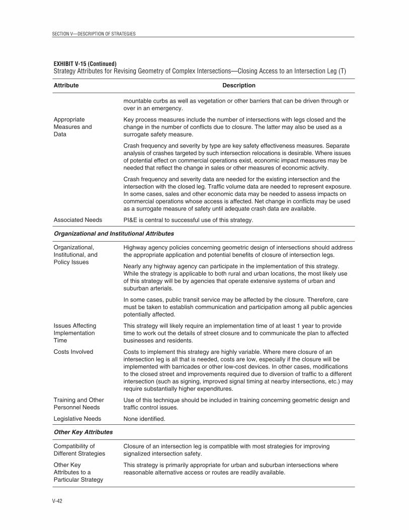
SECTION V—DESCRIPTION OF STRATEGIES
V-42
EXHIBIT V-15 (Continued)Strategy Attributes for Revising Geometry of Complex Intersections—Closing Access to an Intersection Leg (T)
Attribute Description
Appropriate Measures and Data
Associated Needs
Organizational and Institutional Attributes
Organizational, Institutional, and Policy Issues
Issues Affecting Implementation Time
Costs Involved
Training and Other Personnel Needs
Legislative Needs
Other Key Attributes
Compatibility ofDifferent Strategies
Other KeyAttributes to aParticular Strategy
mountable curbs as well as vegetation or other barriers that can be driven through orover in an emergency.
Key process measures include the number of intersections with legs closed and thechange in the number of conflicts due to closure. The latter may also be used as asurrogate safety measure.
Crash frequency and severity by type are key safety effectiveness measures. Separateanalysis of crashes targeted by such intersection relocations is desirable. Where issuesof potential effect on commercial operations exist, economic impact measures may beneeded that reflect the change in sales or other measures of economic activity.
Crash frequency and severity data are needed for the existing intersection and theintersection with the closed leg. Traffic volume data are needed to represent exposure.In some cases, sales and other economic data may be needed to assess impacts oncommercial operations whose access is affected. Net change in conflicts may be usedas a surrogate measure of safety until adequate crash data are available.
PI&E is central to successful use of this strategy.
Highway agency policies concerning geometric design of intersections should addressthe appropriate application and potential benefits of closure of intersection legs.
Nearly any highway agency can participate in the implementation of this strategy.While the strategy is applicable to both rural and urban locations, the most likely useof this strategy will be by agencies that operate extensive systems of urban andsuburban arterials.
In some cases, public transit service may be affected by the closure. Therefore, caremust be taken to establish communication and participation among all public agenciespotentially affected.
This strategy will likely require an implementation time of at least 1 year to providetime to work out the details of street closure and to communicate the plan to affectedbusinesses and residents.
Costs to implement this strategy are highly variable. Where mere closure of anintersection leg is all that is needed, costs are low, especially if the closure will beimplemented with barricades or other low-cost devices. In other cases, modificationsto the closed street and improvements required due to diversion of traffic to a differentintersection (such as signing, improved signal timing at nearby intersections, etc.) mayrequire substantially higher expenditures.
Use of this technique should be included in training concerning geometric design andtraffic control issues.
None identified.
Closure of an intersection leg is compatible with most strategies for improvingsignalized intersection safety.
This strategy is primarily appropriate for urban and suburban intersections wherereasonable alternative access or routes are readily available.

SECTION V—DESCRIPTION OF STRATEGIES
Strategy 17.2 B5: Construct Special Solutions (T)This strategy includes the following:
• Providing indirect left turn,• Reconstructing intersections, converting intersections to roundabouts,• Convert two-way streets to a one-way pair, and • Constructing interchanges.
General Description
Signalized intersections may have such a significant crash problem that the only alternativeis to change the nature of the intersection itself. These types of projects will be high cost andrequire substantial time for implementation. As such, they will generally not be applicablefor agency programs focusing on low-cost, short-term solutions. Note that implementingthese strategies will also necessitate significant public involvement and stakeholder activity.Nonetheless, these strategies are outlined here to provide a complete picture of the range ofsolutions to signalized intersection safety.
Provide Indirect Left Turn. As traffic growth on arterial roadways continues to result incongestion and safety problems at major (high-volume) at-grade intersections, indirect left-turn designs are increasingly being considered and constructed. A few indirect left-turndesigns are relatively common to some areas, while many involve rather innovativesolutions. These projects may result in major reconstruction of an intersection or conversion
to interchanges. ROW restrictions arecommonly a determining factor whenchoosing an alternative. A longer-term,higher-cost design may be the best solutionto severe operational and/or safetyproblems at an intersection.
Safety problems associated with left-turnsat signalized intersections are magnified athigh-volume intersections—or, at least,intersections with high volumes of leftturns. Indirect left-turn treatments, such asjughandles before the crossroad, directionalmedian crossovers, and loop roadwaysbeyond the crossroad, can address bothsafety and operational problems related toleft turns. These treatments remove the left-turning vehicles from the traffic streamwithout causing them to slow down or stopin a through-traffic lane, thereby reducingthe potential for rear-end crashes withthrough vehicles. Right-angle crashes arealso likely to decrease after indirect left-turn treatments are implemented, sincethe turning movement is relocated orchanged to a different maneuver. Suchtreatments are effective on dividedhighways with medians too narrow to
V-43
EXHIBIT V-16Jughandle IntersectionSource: Federal Highway Administration, in press.

accommodate left-turn lanes and on approaches without enough room for a turn lane longenough to provide sufficient storage capacity. In some cases, it is possible to implementindirect left turns using appropriate signing. However for other designs, implementationcosts could be quite high, and the time required to implement could be quite lengthy. IfROW must be acquired, care should be taken to ensure that safety problems are nottransferred to nearby intersections if drivers choose alternative routes, such as in caseswhere less convenient turn arrangements result. Clear signing is a necessity for indirect left-turn designs, especially if there are not similar treatments at other intersections in an area.
This strategy should reduce rear-end collisions resulting from the conflict between vehicleswaiting to turn left and following vehicles as well as right-angle collisions resulting from theconflict between vehicles turning left and oncoming through-vehicles.
Alternative left-turn designs are discussed in various publications and will be included inthe forthcoming FHWA Signalized Intersection Guide. One option is to convert the intersectionto a roundabout (see next substrategy), and various other options for alternative left-turndesigns that may be considered are shown in Exhibit V-17 through Exhibit V-21.
SECTION V—DESCRIPTION OF STRATEGIES
V-44
EXHIBIT V-17Median U-Turn CrossoverSource: Federal Highway Administration, in press.
EXHIBIT V-18Super Street Median CrossoverSource: Federal Highway Administration, in press.

SECTION V—DESCRIPTION OF STRATEGIES
V-45
EXHIBIT V-19Quadrant Roadway Intersection Source: Federal Highway Administration, in press.

SECTION V—DESCRIPTION OF STRATEGIES
V-46
EXHIBIT V-20Split IntersectionSource: Federal Highway Administration, in press.

SECTION V—DESCRIPTION OF STRATEGIES
Convert to Roundabout. A roundabout can potentially have a better crash experience than aconventional signalized intersection. The FHWA publication Roundabouts: An InformationalGuide (Robinson et al., 2000, available online at http://www.tfhrc.gov/safety/00-0671.pdf),summarizes the current state of practice and should be consulted as a source of informationon the design, operation, and safety of roundabouts. The types of conflicts that occur atroundabouts are different from those occurring at conventional intersections; namely,conflicts from crossing and left-turn movements are not present in a roundabout. Thegeometry of a roundabout forces drivers to reduce speeds as they proceed through theintersection. This helps keep the range of vehicle speed narrow, which helps reduce theseverity of crashes when they do occur. Pedestrians only have to cross one direction of trafficat a time at roundabouts, thus reducing their potential for conflicts. However, vehicles in thecirculating roadway are not required to stop by virtue of the presence of a positive trafficcontrol device.
V-47
EXHIBIT V-21Continuous Flow IntersectionSource: Federal Highway Administration, in press.

The safety performance of roundabouts in the United States is not well documented due tothe small number that have been built here. A current NCHRP study (Project 3-65) involvesa comprehensive analysis of the operation and safety of roundabouts in the United States.However, recent conversion of several intersections in the United States to roundaboutsshowed a reduction in crash rates after construction. Data collected after intersections wereconverted to roundabouts in Europe and Australia show that reductions in crash ratesresulted. Single-vehicle crash rates for roundabouts, however, tend to be higher than forconventional intersections (Robinson et al., 2000)
A comparison was made of crash rates for conventional intersections (using a U.S. crash-prediction model) and rates for roundabouts (using a model from the United Kingdom). Forvolumes entering the intersection of 20,000 vehicles/day, the crash rate was 33 percent lowerfor roundabouts than for signalized intersections in urban/suburban areas and 56 percentlower in rural areas. For an entering Average Daily Traffic (ADT) of 40,000 vehicles/day,approximately 15 percent fewer crashes are predicted for roundabouts. At higher volumes(50,000 or more entering vehicles per day), the safety performance of roundabouts andsignalized intersections is probably comparable, and it is less likely there will be a safetybenefit of conversion to a roundabout. (ITE Traffic Safety Toolbox [Institute of TransportationEngineers, 1999b]).
Studies do not show an improvement in rates for crashes involving bicyclists. In addition,since single-vehicle crash rates tend to increase after conversion to a roundabout, centralislands, splitter islands, and the clear zone on the perimeter of the roundabout should bekept clear of obstacles.
Roundabouts are not appropriate for every intersection and will not solve all safetyproblems at specific intersections. Volumes of traffic entering the intersection are animportant factor in the effectiveness of a roundabout, along with turning movements andother operational characteristics. All of these should be studied to ensure that a roundaboutis an appropriate design for a given intersection.
Indirect left-turn treatments and roundabouts are both discussed in further detail in theguide for crashes occurring at unsignalized intersections. European uses of roundabouts aredescribed in Appendix 4.
Convert Two-Way Streets to a One-Way Pair. When two-way streets are converted to one-way streets, it is generally for the purpose of increasing capacity, but the removal ofopposing traffic flows can improve safety as well. Removal of one direction of traffic from atwo-way street allows for better signal synchronization and progression of platoons. Smoothprogression and reduced congestion can reduce rear-end crashes. In addition, the removal ofone direction of traffic can reduce congestion and improve safety by
• Reducing the number of vehicle/vehicle conflict points at intersections,• Allowing for unopposed turn maneuvers,• Simplifying operations and signal phasing at multileg intersections,
SECTION V—DESCRIPTION OF STRATEGIES
V-48

SECTION V—DESCRIPTION OF STRATEGIES
• Allowing pedestrians to only have to deal with traffic from one direction, reducingconflicts with vehicles, and
• Providing more gaps for vehicles and pedestrians at unsignalized crossings.
The ITE Traffic Safety Toolbox (Institute of Transportation Engineers, 1999b) reports thatstudies have shown a 10- to 50-percent reduction in total crashes after conversion of a two-way street to one-way operation. At the same time, this strategy increases capacitysignificantly; a one-way street pair can handle up to 50 percent more volume than twoparallel two-way streets.
Safety-related drawbacks to conversion to one-way streets may include the following:
• Pedestrians not looking in the correct direction for oncoming vehicles, and• Minor sideswipe crashes related to weaving maneuvers as drivers attempt to park or
reach a turn lane.
Supplemental and redundant signing is recommended on one-way streets converted fromtwo-way operation.
Transit operations may be adversely affected with the introduction of one-way operation.Special care should be taken to avoid contraflow bus lanes on such streets, as these present aspecial hazard to crossing pedestrians. One key element of creating a one-way pair is thedesign of the transitions at each end. Care must be taken not to create conditions that causedriver confusion and erratic maneuvers.
Construct Interchange or Grade Separation. At some signalized intersection locations withextremely high volumes, extremely poor crash histories, or other mitigating factor(s),provision of a grade separation or interchange can be considered. This is an expensiveapproach to safety improvement and should generally be considered when other, lessrestrictive measures have been tried and have failed. Often this solution is applied forcapacity and operational reasons, where the capacity of a signalized intersection isinsufficient to accommodate the volume passing through it. If a grade separation alternativeis considered, maintaining access to existing development is a key element to successfullyimplementing the improvement.
By separating the grades of intersecting roadways, volumes of crossing and turning traffic,as well as bottlenecks and spot congestion, may be reduced. This can lower the number andseverity of crashes caused by these movements and intersection conditions, specifically rear-end and angle crashes.
Guidance on constructing and designing interchanges is discussed in the AASHTO Policy onGeometric Design of Highways and Streets (American Association of State Highway andTransportation Officials, 2001). Time required for the design and construction of aninterchange could range anywhere from 4 to 10 years, depending upon location constraintsand environmental factors. Costs would likely be high and variable. Simple serviceinterchanges are less expensive than system interchanges, but construction costs may still beseveral million dollars.
V-49

Objective 17.2 C—Improve Sight Distance at SignalizedIntersections Adequate intersection sight distance contributes to the safety of the intersection. In general,sight distance is needed at signalized intersections for the first vehicle stopped at anapproach to be able to see the first vehicles stopped at the other approaches, for driversmaking permitted left turns, and for right-turning vehicles. Where RTOR are allowed,adequate sight distance should be available. Improvements in sight distance can lead to areduction in crashes caused by drivers stopping suddenly (rear-end), drivers proceedingthrough the intersection when the signal has not assigned them the right-of-way (angle), anddrivers turning through an inadequate gap in opposing traffic (angle).
Strategy 17.2 C1: Clear Sight Triangles (T)General Description
Sight distance improvements can often be achieved at relatively low cost by clearing sighttriangles to restore sight distance obstructed by vegetation, roadside appurtenances,buildings, bus stations, or other natural or man-made objects.
The most difficult aspect of this strategy is the removal of sight restrictions located onprivate property. The legal authority of highway agencies to deal with such sightobstructions varies widely, and the time (and possibly the cost) to implement sight distanceimprovements by clearing obstructions may be longer if those obstructions are located onprivate property. If the object is a mature tree or planting, then local concerns over adverseenvironmental consequences may arise. For a more detailed discussion of trees, see theguide for crashes involving trees in hazardous locations.
Research has established a relationship between intersection safety and sight distance atunsignalized intersections. No such research quantifies the effectiveness of improving sightdistance at signalized intersections. One may expect that crashes related to inadequate sightdistance (specifically, angle and turning related) would be reduced if the sight distanceproblems are improved. However, as the signal assigns ROW for most vehicles crossingpaths at right angles and because traffic volumes affected by the other situations cited aboveare low, the overall impact on crashes could be relatively small.
Since sight distance is a greater issue at intersections with stop control than at signalizedintersections, more research has been performed on the effectiveness of sight distanceimprovements at stop-controlled intersections (several of the studies are summarized inNCHRP Report 440 [Fitzpatrick et al., 2000]). There are several movements at signalizedintersections that operate similarly to stop-controlled intersections (such as RTOR andpermitted left turns) for which expected effectiveness of sight distance improvements atsignalized intersections may be inferred from similar studies at stop-controlled intersections.Such estimates should be performed with caution, taking into consideration the othercharacteristics of signalized intersection operation that would alter the effectivenessestimates.
More information on clearing roadside and median intersection sight triangles is presentedin the guide for crashes at unsignalized intersections.
SECTION V—DESCRIPTION OF STRATEGIES
V-50

SECTION V—DESCRIPTION OF STRATEGIES
Strategy 17.2 C2: Redesign Intersection Approaches (P)General Description
Signalized intersections with sight-distance-related safety problems that cannot beaddressed with less expensive methods (such as clearing sight triangles, adjusting signalphasing, or prohibiting turning movements) may require horizontal or vertical (or both)realignment of approaches. Realigning both of the minor-road approaches so that theyintersect the major road at a different location, or a different angle, can help addresshorizontal sight distance issues.
This is a high-cost, longer-term treatment for the intersection, but if completed according toapplicable design policy, it should help alleviate crashes related to sight distance. The 2001AASHTO Policy on Geometric Design of Highways and Streets contains updated sight distanceguidelines, and these guidelines should be considered when revising intersection approachgeometry. There are significant ROW and property access issues involved in this strategy,and public information campaigns are vital to the success of the intersection improvements.
An intersection leg can be closed in order to address sight distance issues related to thatparticular leg. This strategy is covered in the previous section of this guide.
Intersection relocation and closure, elimination of intersection skew, and offsetting of left-turn lanes are all strategies that involve improvements to approach alignment to improvesight distance. These strategies are each covered in greater detail in the unsignalizedintersection guide.
Objective 17.2 D—Improve Driver Awareness of Intersectionsand Signal ControlDriver awareness of both downstream intersections and traffic control devices is critical tointersection safety. The inability to perceive an intersection or its control or the back of astopped queue in time to react as necessary can result in safety problems. Drivers caughtunaware could be involved in serious crashes, especially at intersections with high speedson the approaches. This objective details strategies aimed at improving driver awareness ofsignalized intersections and the traffic control in place.
Strategy 17.2 D1: Improve Visibility of Intersections on Approach(es) (T)This strategy includes the following:
• Improving signing and delineation,• Installing larger signs,• Providing intersection lighting,• Installing rumble strips on approaches, and• Installing queue detection system.
General Description
Some crashes at signalized intersections may occur because drivers are unaware of thepresence of an intersection or are unable to see the traffic control device in time to comply.
V-51

These crashes are generally rear-end or angle collisions. The ability of approaching driversto perceive signalized intersections immediately downstream can be enhanced by signing,delineation, and warning devices. Other strategies to improve the visibility of anintersection include providing lighting, improving the visibility of the signals, and usingdevices to call attention to the signals. All of these strategies are discussed in detail in theunsignalized intersection guide, and that guide should be consulted for additionalinformation.
The FHWA report Synthesis of Human Factors Research on Older Drivers and Highway Safety:Volume 2 (Staplin et al., 1997) reviews research on older drivers’ visual abilities related todriving. Research shows that recognition and legibility distances as well as response speedsare lower for older drivers than for younger ones. The Synthesis summarizes recent researchby stating that if recognition of an intersection is based on signs being legible to drivers,older drivers will take longer to recognize intersections. Therefore, consideration should begiven to providing traffic control devices that contribute to improved legibility andresponse times for older drivers. This may include redundant signing, overhead signing,and advanced route signing. The older drivers guide should be consulted for moreinformation.
Improve Signing and Delineation. Installing or upgrading signs and pavement markings onintersection approaches can help better prepare drivers for the intersection ahead. This mayinclude advance guide signs, advance street name signs (Exhibit V-22), warning signs,pavement markings, overhead street signing, and post-mounted delineators. Advancewarning signs, such as the standard intersection warning sign or the standard sign withflashers, can also alert drivers to the presence of an intersection. Installing advance warningsigns on both sides of the roadway to provide redundancy in signing may be appropriate insome situations, such as when the intersection approach in on a curve. Street name and laneassignment signs in advance of the intersection prepare drivers for choosing and movinginto the lane they will need to use for their desired maneuver. Signs and flashers warningdrivers they are approaching a red signal might improve both awareness of the intersectionand a red signal (see Exhibit V-23).
SECTION V—DESCRIPTION OF STRATEGIES
V-52
EXHIBIT V-22Advance Street Name SignSource: Federal Highway Administration, in press.

SECTION V—DESCRIPTION OF STRATEGIES
Providing a break in pavement markings at intersections also helps to alert drivers to theirpresence. This includes centerlines, lane lines, and edge lines. Close spacing of progressivesignals can lead to drivers focusing on a downstream signal and not noticing anintermediate signal. Signing, pavement markings, lighting, or alteration of the appearance ofa signal to make it more noticeable should be considered in this situation.
Maintenance of signs and pavement markings is also important to the success of thisstrategy. Retroreflectivity of older pavement markings and signs should be checkedperiodically to determine whether replacement is needed.
Install Larger Signs. The visibility of intersections with existing regulatory and warningsigns and the ability of drivers to perceive the signs can be enhanced by installing signs withlarger letters. Such improvements may include advance guide signs, warning signs,pavement markings, and post-mounted delineators. The FHWA Older Driver Highway DesignHandbook (Staplin et al., 1998; available at http://www.fhwa.dot.gov/tfhrc/safety/pubs/older/intro/) encourages installation of larger signs to contribute to a better drivingenvironment for older drivers. The older driver guide contains additional information aboutengineering improvements to aid older drivers.
Provide Intersection Lighting. Providing lighting at the intersection itself or at both theintersection and on its approaches can make drivers aware of the presence of the intersectionand reduce nighttime crashes. Crash data should be studied to ensure that safety at theintersection could be improved by providing lighting (this strategy would be supported by asignificant number of crashes that occur at night). The costs involved with intersectionlighting may be moderately expensive, especially since maintenance is needed to keep theequipment in working order.
Intersection lighting is of particular benefit to police officers. Lighting not only helps themperform their duties, such as traffic stops, but also helps drivers see them better, especiallywhen out of the vehicle.
V-53
EXHIBIT V-23Advanced Warning Sign for Red SignalSource: Federal Highway Administration, in press.

Install Rumble Strips on Approaches. Rumble strips can be installed in the roadway onintersection approaches transverse to the direction of travel to call attention to the presence ofthe intersection and the traffic control used. Rumble strips are particularly appropriate onintersections where a pattern of crashes related to lack of driver recognition of the presence ofthe signal is evident, often on high-speed approaches. This strategy should be used sparingly,as the effectiveness of rumble strips is dependent on their being unusual. Rumble strips arenormally applied when less intrusive measures, such as “signal ahead” signs or flashers, havebeen tried and have failed to correct the crash pattern, and they are typically used incombination with the advance warning signs. For example, a rumble strip can be located inthe roadway so that when the driver crosses it, a key traffic control device such as a “signalahead” sign is directly in view. Rumble strips in the traveled way can also be used on atemporary basis to call attention to changes in traffic control devices, such as installation of asignal where none was present before. Care must be taken to avoid use of rumble stripswhere the noise generated will be disturbing to adjacent properties. NCHRP Synthesis ofHighway Practice 191 (Harwood, 1993) reviews the state of the art of rumble strip usage.
Install Queue Detection System. Queue detection systems are standard tools for operation oftraffic signals. In normal practice, queue detection is used for actuated signal systems to“call-up” a phase given the presence of a vehicle in a specific lane or movement.
The application of queue detection systems as safety devices is a new and potentiallyeffective device. One such system has been implemented in Oregon on an approach to asignalized intersection in a rural setting that regularly experiences significant queues,especially during the summer when seasonal traffic increases. Two loop detectors in eachlane on the intersection approach detect when a vehicle is stopped at that location. Thedetectors are connected to an overhead sign with beacons located a half mile upstream. Thesign contains the message “Prepare to stop when lights flash.” When a vehicle iscontinuously present at a detector, beacons on the overhead sign flash to warn drivers of thestopped vehicle ahead. A preliminary evaluation indicates a reduction in crashes afterinstallation of this system, but additional data are needed to determine if other factorscontributed to this decrease. For additional information on this system, refer to the FHWAreport Safety Applications of ITS in Rural Areas, (Federal Highway Administration, 2002),available online at http://www.itsdocs.fhwa.dot.gov/JPODOCS/REPTS_TE/5_1_1.htm.
Strategy 17.2 D2: Improve Visibility of Signals and Signs at Intersections (T)General Description
Lack of visibility of traffic control devices may contribute to crash experience at signalizedintersections. Visibility of traffic signals and signs at intersections may be obstructed byphysical objects (such as signs or other vehicles) or may be obscured by weather conditions,such as fog or bright sunlight. Also, drivers’ attention may be focused on other objects at theintersection, such as extraneous signs. Poor visibility of signs and signals may result invehicles not being able to stop in time for a signal change or otherwise violating the intendedmessage of a regulatory or directional sign. Providing adequate visibility of signs andsignals also aids in drivers’ advance perception of the upcoming intersection. The FHWAOlder Driver Highway Design Handbook should be consulted to ensure that improvements tovisibility of traffic control devices will be adequate for older drivers (Staplin et al., 1998;available at http://www.fhwa.dot.gov/tfhrc/safety/pubs/older/home/index.htm).
SECTION V—DESCRIPTION OF STRATEGIES
V-54

SECTION V—DESCRIPTION OF STRATEGIES
In addition to potentially restricting driver sight lines, large numbers of appurtenances andsignage not associated with the driving task in the vicinity of an intersection can impose ahigh workload. This may ultimately distract the driver from the task at hand (i.e. safelynavigating the intersection). This “visual clutter” can make it difficult for the driver toextract the information from the signs required to execute the driving task (directionalinformation, speed information, etc.). Enforcement of existing sign restrictions, and/or thecreation of new restrictions limiting the placement of signs near intersections, can reduce theamount of information provided to the driver near intersections.
Maintenance of signals and signs is important to the visibility of the devices. If visibility oftraffic control devices is considered to be a potential factor in crashes, a field review shouldbe performed to determine if part of a sign’s message is covered, obliterated, or blocked, aswell as to check the reflectivity of the sign.
Methods for improving visibility of traffic signals and signs include the following:
• Install additional signal head (see Exhibit V-24),• Provide visors to shade signal lenses from sunlight,• Provide louvers, visors, or special lenses so drivers are able to view signals only for their
approach,• Install backplates, • Install larger (12-in.) signal lenses,• Remove or relocate unnecessary signs, and• Provide far-side left-turn signal.
Methods for improving visibility of traffic signals and signs are discussed further inAppendix 7. Additional information on improving signal visibility to reduce red-lightrunning can be found in Making Intersections Safer: A Toolbox of Engineering Countermeasures toReduce Red-Light Running (McGee, 2003; available online at http://www.ite.org/library/redlight/MakingInt_Safer.pdf).
V-55
EXHIBIT V-24Signal Head with Double Red SectionSource: Federal Highway Administration, in press.

SECTION V—DESCRIPTION OF STRATEGIES
V-56
EXHIBIT V-25Strategy Attributes for Improving Visibility of Signals and Signs at Intersections
Attribute Description
Technical Attributes
Target
Expected Effectiveness
Keys to Success
Potential Difficulties
Appropriate Measures and Data
Associated Needs
Organizational and Institutional Attributes
Organizational, Institutional, and Policy Issues
Issues Affecting Implementation Time
This strategy is targeted at crashes that occur because drivers are unable to seetraffic signals and signs sufficiently in advance to safely negotiate the intersectionbeing approached. Crash types would include angle and rear-end crashes.
Improved visibility and awareness of traffic control information are expected to reduceconflicts related to drivers not being able to see the device well or in enough time tocomply with the signal indication or sign message (such as those resulting in rear-endand right-angle crashes).
Visibility and clarity of the signal should be improved without creating additionalconfusion for drivers. Additional signing to warn drivers should not clutter theintersection and should not present confusing or conflicting messages to drivers.
Care should be taken to ensure that new or relocated signs do not present additionalsight distance, roadside, or driver distraction hazards.
If rumble strips are used in an area with adjacent residences, the noise may beobjectionable, creating public resistance. Bicyclists may also object to rumble strips asthe treatment may force them to ride in the roadway travel lanes.
If some of the devices recommended are not maintained properly, the expectedbenefits may be lost.
Key process measures include the number of intersection approaches for whichimprovements are implemented, which increase driver perception of traffic signalslocated immediately downstream, and the number of conflicts potentially eliminated bythe improvement.
Crash frequency and severity by type of crash are key safety effectiveness measures.It is especially useful to identify crashes related to unseen signals (inadvertent redlight running, etc). Driver behavior measures (e.g., conflicts, erratic maneuvers,speeds, and braking) may be used as surrogate safety measures.
Crash frequency and severity data are needed to evaluate such improvements. Iffeasible, both total crashes and crashes related to the targeted improvements at theintersection should be analyzed separately. Traffic volume data are needed torepresent exposure, especially the volumes of movements of interest and theopposing through volumes.
Removing signs and other elements contributing to roadside clutter may require publicinvolvement activities.
Highway agencies should review their traffic engineering and design policiesregarding use of traffic control devices to ensure appropriate action is being taken onroutine projects.
Nearly any highway agency can participate in implementing this strategy, which isapplicable to rural, urban, and suburban areas.
Implementation time will be relatively short for procedures to install new signs,improve signals, and remove or relocate signs.

SECTION V—DESCRIPTION OF STRATEGIES
Objective 17.2 E—Improve Driver Compliance with TrafficControl DevicesSafety problems at signalized intersections cannot always be solved only with engineeringcountermeasures. Enforcement of traffic regulations or public information campaigns maybe the best way to improve intersection safety. This section details information on strategiesto improve compliance with traffic control devices, focusing mainly on red-light runningand speeding on approaches to signalized intersections.
Strategy 17.2 E1: Provide Public Information and Education (T)General Description
Providing targeted public information and education (PI&E) on safety problems atintersections is a preventive measure that can help improve driver compliance with trafficcontrol devices and traffic laws. PI&E programs generally add effectiveness to targetedenforcement programs, as well.
Another option is to develop public information campaigns aimed at specific drivers whoviolate regulations at intersections, even though it is often difficult to identify and focusupon a subset of the driving population using a specific intersection. Therefore, an areawideprogram is often the preferred approach. A key to success for this strategy is reaching asmuch of the targeted audience as possible, whether it is through television, radio,distribution of flyers, driver education classes, or other methods. Targeted drivers need to bedefined both in terms of the location of the hazardous intersection(s) and the attributes of thedrivers who may have been identified as over represented in the population involved incrashes. More information on public information that is targeted at specific drivers isprovided in the guide for crashes occurring at unsignalized intersections.
V-57
EXHIBIT V-25 (Continued)Strategy Attributes for Improving Visibility of Signals and Signs at Intersections
Attribute Description
Costs Involved
Training and Other Personnel Needs
Legislative Needs
Other Key Attributes
Compatibility ofDifferent Strategies
Other KeyAttributes to aParticular Strategy
Costs will be low for most procedures to install or upgrade signs and signals toimprove visibility and awareness of the traffic control devices. Ongoing maintenancecosts should be included when considering use of these devices.
Visibility of traffic control devices should be addressed in highway agency trainingconcerning traffic signal installation and human factors.
None identified.
Actions taken to improve visibility of signals are compatible with most other strategiesto improve signalized intersection safety but are not appropriate in conjunction withremoval of a signal.
None identified.

SECTION V—DESCRIPTION OF STRATEGIES
V-58
EXHIBIT V-26Strategy Attributes for Providing Public Information and Education (T)
Attribute Description
Technical Attributes
Target
Expected Effectiveness
Keys to Success
Potential Difficulties
Appropriate Measures and Data
Associated Needs
Organizational and Institutional Attributes
Organizational, Institutional, and Policy Issues
The target for this strategy is crashes related to drivers either being unaware of, orrefusing to obey, traffic laws and regulations that impact traffic safety. Crashes relatedto red-light running, speeding, and not yielding to pedestrians could be reduced withPI&E campaigns.
Data on the effectiveness of this strategy for this specific application are not known,but it is expected that providing information to drivers will help improve safety atintersections. It may not be possible to identify or reach the entire audience that wouldbenefit from a PI&E campaign.
Keys to success include identifying and reaching as much of the intended audience aspossible, providing information in nontechnical terms, and providing agency personnelto answer questions and calls from the public.
It is important to motivate people to drive (and bike or walk) safely. Since unsafeactions do not always result in crashes, road users may have a false sense of securityand may not see the need to drive more safely or follow traffic regulations in allcircumstances.
Use of trained public information specialists is important for program success.Establishing good relationships with media representatives will be extremely helpfulfor maximizing coverage and impact.
The primary potential difficulty associated with this strategy is relating the importanceof informational/educational programs to the public. Many people may see a noticefor a public meeting and think that it is a waste of time and not attend. Brochures,posters, and advertisements can be effective if they are conspicuous and readilyavailable. Use of electronic media is expensive, unless strategies are employed forreceiving donated time. Consideration should be given to people who may needmaterials in languages other than English or in alternative formats to accommodatedisabilities. Another difficulty is maximizing the reach of a public involvementprogram.
Key process measures include identifying the number and frequency of differentmedia used (radio ads, brochures, etc.) and measuring the population exposed to themessage. Level of expenditure is another possible process measure and can be usedto produce a productivity measure.
Crash frequency and severity by type of crash should be tracked before and afterimplementation of the public information campaign. Traffic volume data are needed torepresent exposure. Surrogate safety measures can include driver behavior (e.g.,change in unsafe targeted and untargeted driving acts).
None identified.
Highway agencies should ensure that education and information programs arescheduled when most likely to maximize the exposure of the message to the targetpopulation. Coordination and cooperation with other parts of an organization that haveestablished marketing skills can be useful.
It will be helpful to enlist media representatives as part of the group of stakeholdersinvolved in planning and implementing the program.

SECTION V—DESCRIPTION OF STRATEGIES
Strategy 17.2 E2: Provide Targeted Conventional Enforcement of Traffic Laws (T)General Description
Enforcement is a potential countermeasure to unsafe and illegal motorist behavior atintersections. Studies report the reduction of traffic law violations when enforcement is used(Traffic Engineering Handbook [Pline, 1999]). Traffic law enforcement agencies will often selectlocations for targeted enforcement when crash, citation, or other sources of informationsuggest that the site is unusually hazardous due to illegal driving practices, such as speedingor red-light running. These actions can lead to rear-end, head-on, sideswipe, angle, andpedestrian or bicycle-related crashes.
Traffic law enforcement methods vary depending upon the type of program beingimplemented. For background on methods and approaches please refer to the publicationsavailable at the following Web sites: http://www.nhtsa.dot.gov/people/injury/enforce/DESKBK.html and http://www.nhtsa.dot.gov/people/injury/enforce/millennium/index.htm).
Targeted enforcement of traffic laws is a short-term, moderate-cost measure to address site-specific signalized intersection safety. Though this is an effective strategy, the effectiveness
V-59
EXHIBIT V-26 (Continued)Strategy Attributes for Providing Public Information and Education (T)
Attribute Description
Issues Affecting Implementation Time
Costs Involved
Training and Other Personnel Needs
Legislative Needs
Other Key Attributes
Compatibility ofDifferent Strategies
Other KeyAttributes to aParticular Strategy
Nearly all highway agencies can make use of this strategy, which is applicable in rural,urban, and suburban areas.
Implementation time for this strategy should be short to moderate. Extensive planningof the program and design of the educational materials can lengthen theimplementation time.
Cost will generally be low to moderate and depend upon the kinds of materialsdeveloped (brochures, posters, radio, or television advertisements), the extent of effortspent on designing the materials, and the amount of free media coverage that can beachieved.
Strategies may be used to attract media attention without purchasing air time.
Training for highway personnel in providing PI&E should be included as a part ofdeveloping and implementing the program.
None identified.
This strategy can be used in conjunction with the other strategies for improving safetyat signalized intersections. It may be used in conjunction with overall traffic safetypublic service campaigns.
None identified.

has often been found to be short-lived. It is difficult—if not impossible—to provide constantenforcement of traffic regulations due to funding and staffing reasons, so periodicenforcement may be necessary to sustain the effectiveness of this strategy. For Europeanexperience on the effectiveness of traffic law enforcement, including speeding laws, seeAppendix 11 and Appendix 12.
It is important to correctly identify intersections that would benefit from enforcement. Careshould be taken to first ensure that the existing signals are operating properly, are visible,and meet MUTCD requirements, as well as that timing plans—including clearanceintervals—are appropriate. Analysis of crash statistics can help with this process, as can spotspeed or conflict studies. In some cases, public input or observations by law enforcementpersonnel may suggest that a location should be targeted for enforcement.
Police officers providing targeted enforcement of red-light running can be aided by “tell-tale” or “tattle-tale” lights. These lights are placed at traffic signals, but facing away from on-coming traffic. Police officers are able to wait in their vehicles on the downstream side of thetraffic signal` and view the tattle-tale light. This way, they are able to pursue red-lightrunners without also running through the red light themselves (and possibly into vehiclesentering the intersection from the cross street).
Targeted enforcement at intersections is covered in more detail in the unsignalizedintersection guide.
Strategy 17.2 E3: Implement Automated Enforcement of Red-Light Running(Cameras) (P)General Description
Red-light running is a well-documented and growing traffic safety problem. Variousengineering countermeasures can be used to address red-light running; refer to Strategy 17.2A2 for a discussion of optimizing clearance times, as well as the ITE and FHWA reportMaking Intersections Safer: A Toolbox of Engineering Countermeasures to Reduce Red-LightRunning (McGee, 2003; available online at http://www.ite.org/library/redlight/MakingInt_Safer.pdf). While some occurrence of this can be addressed by engineering, inmany instances inappropriate driver behavior is the primary problem. Because it is notfeasible to provide police officers to enforce traffic signals as often or in as many locations asan agency might need, automated enforcement is an attractive alternative (see Exhibit V-27).
Automated enforcement refers to the use of photo radar and video camera systemsconnected to the signal control. Such systems record vehicles proceeding through theintersection after the signal displays red. Red-light-running cameras turn on after the signalturns red. A detector senses approaching vehicles and sends a signal to the camera, whichphotographs the vehicles as they enter the intersection. It is possible to set a grace period(generally one second) so that the cameras do not photograph people who were caught inthe dilemma zone and enter the intersection just after the signal turns red. Data on the
SECTION V—DESCRIPTION OF STRATEGIES
V-60

SECTION V—DESCRIPTION OF STRATEGIES
violation, such as date, time, speed of vehicle, and the time that had elapsed since the signalturned red, are printed on the photograph. Police officers review the photos to determine if aviolation occurred, and if so, a citation is mailed to either the driver or the vehicle owner,depending on the legislation for the jurisdiction.
Automated enforcement of red-light running has been shown to significantly decreaseviolations, not only at intersections where cameras are installed, but also at otherintersections in the area.
There are many applications of red-light-running technology throughout the world. Foradditional information on red-light-running cameras available on the Internet, seehttp://www.iihs.org/safety_facts/rlc.htm, http://safety.fhwa.dot.gov/programs/srlr.htm,and http://www.ite.org/library/redlight/index.asp.
In Canada, cameras are being used for the purpose of speed enforcement as well as red-lightrunning. Strathcona County in Alberta was the first jurisdiction in North America to use red-light cameras to record speeding violations. A red-light-running camera installed at theintersection of Wye Road and Ordze Avenue in 1998 was used for speed enforcementbeginning in 2000. This strategy has been effective in reducing speeding: a 75-percent dropin violations was experienced from 2001 to 2002. For additional information, visit the Royal
V-61
EXHIBIT V-27Red-Light-Running CameraSource: Federal Highway Administration, in press.

Canadian Mounted Police Web site for Strathcona County (http://www.strathconacountyrcmp.ca/redlightcam.htm).
Red-light-running camera equipment can be used not only to record violators but also toprotect cross-street vehicles. There are systems capable of using a vehicle’s speed to predictwhether the vehicle will run the red light, and if so, the system can extend the cross-streetred indication to prevent cross-street vehicles from entering the intersection while theviolating vehicle is still in the intersection.
Red-light-running cameras are used in Europe as well; refer to Appendix 4 for additionalinformation on several countries’ experiences. Automated enforcement offers theopportunity to address a systemwide problem in an efficient manner, using technology as asubstitute for law enforcement personnel time. While the advantages in terms of safety andcost-effectiveness are clear, there are problems and in some cases controversies associatedwith automated enforcement. Concerns over invasion of privacy and the ability to identifyand cite the driver (most systems identify the vehicle through identification of the plates), aswell as the belief by some that the systems are unfair or intended to generate fine revenueversus address safety problems are all issues that have arisen. In some jurisdictions, enablinglegislation may be needed for successful prosecution of red-light-running camera violations.The National Conference of State Legislatures tracks status of legislation and providesexamples of model legislation (http://www.nhtsa.dot.gov/ncsl/Index.cfm).
SECTION V—DESCRIPTION OF STRATEGIES
V-62
EXHIBIT V-28Strategy Attributes for Providing Automated Enforcement of Red-Light-Running (Cameras) (P)
Attribute Description
Technical Attributes
Target
Expected Effectiveness
The target for this strategy is drivers who intentionally disobey red signal indications.Intersections where observations or crash histories indicate a red-light-runningproblem may be suitable for installation of a red-light-running camera. Crashes of thistype are likely to be angle and rear-end collisions.
Several studies have shown the effectiveness of automated red-light enforcement inreducing red-light violations and crashes related to those violations.
Fairfax, Virginia, experienced a 44-percent reduction in violations during the first yearof operation. Two other sites in the city that did not have cameras experienceddecreases in violations of 34 percent. Control sites in nearby counties experiencedlittle change. (Retting et al., 1999a).
Oxnard, California, experienced approximately 41 percent fewer red-light violationswithin a few months after beginning to use the cameras to enforce the signals (Retting et al., 1999b).
FHWA has made a general estimate of a 15-percent reduction in red-light-runningincidents resulting from these programs.
The ITE Informational Report, Automated Enforcement in Transportation (Institute ofTransportation Engineers,1999a), contains information on experiences with red-light-running cameras in other jurisdictions. The automated enforcement programshighlighted in this document experienced a range of reduction in violations of 23 to 83percent. An evaluation of a program in Victoria, Australia, showed a decrease in

SECTION V—DESCRIPTION OF STRATEGIES
V-63
EXHIBIT V-28 (Continued)Strategy Attributes for Providing Automated Enforcement of Red-Light-Running (Cameras) (P)
Attribute Description
Keys to Success
Potential Difficulties
violations of 35 to 60 percent, accompanied by a 35-percent reduction in right-anglecrashes, 25-percent reduction in right-angle turning crashes, 31-percent reduction inrear-end crashes, and 28-percent reduction in rear-end turning crashes.
Keys to success of red-light-running programs primarily relate to acceptance of localstakeholders, including both officials and the public. Acceptance by local lawenforcement is another critical element necessary for the success of an automatedenforcement program. Indeed, local law enforcement needs to be seen as central tosuch a program. So, incorporation of a public information campaign explaining theprogram, the need for it, how the cameras work, and what the benefits may be is akey to successful implementation.
Successful red-light camera programs have generally begun as safety improvementprograms. Programs that are perceived as revenue generators (i.e., through collectionof fines) are generally not well-accepted. Therefore, there should be clear justificationof the installations based upon documented violation levels.
It is important that both the highway agency and the law enforcement agency(ies) inthe jurisdiction be involved jointly in planning and operating the program. Moreover,where private contractors are used to implement parts of the program, it is importantthat their contract and compensation not be directly linked to revenue or ticketsissued. Some programs have lost public support because it was perceived that aprivate company was profiting from traffic ticket revenue. Avoiding controversialcontract provisions and maintaining clear control over administration of the programby the appropriate police agency are keys to success.
FHWA and NHTSA developed guidelines for implementation of red-light-runningcameras, which can be found online at http://safety.fhwa.dot.gov/rlcguide/index.htm.
See Appendix 8 for a description of a successful red-light camera program in HowardCounty, Maryland.
Adequate legislative authority is needed to conduct such a program (see the sectionbelow on “Legislative Needs”).
There are many opponents to red-light-running enforcement cameras. Argumentsagainst this strategy include violation of personal privacy, violation of constitutionalrights, lower effectiveness than other types of enforcement, high cost outweighing thebenefits, and implementation solely to generate revenue. Recent challenges alsoinclude questioning the precision of the cameras and the proper setting of the camera.Counter-arguments to all of these issues are presented in ITE’s AutomatedEnforcement in Transportation.
Other potential difficulties to overcome include administration of the program throughthe use of contractors. The program needs to be clearly identified as a public safetyprogram, with administrative responsibility remaining clearly in the hands of the police.
Timeliness of the citation is important. Administrative systems may slow theprocessing and create a lengthy gap between the moment of the violation and themoment the sanction is received by the driver. Principles of effectiveness ofenforcement suggest that the time between violation and punishment should be shortto be effective.
In addition, the technology has spawned an industry directed at defeating it. Forexample, see http://www.phantomplate.com.
(continued on next page)

SECTION V—DESCRIPTION OF STRATEGIES
V-64
EXHIBIT V-28 (Continued)Strategy Attributes for Providing Automated Enforcement of Red-Light-Running (Cameras) (P)
Attribute Description
Appropriate Measures and Data
Associated Needs
Organizational and Institutional Attributes
Organizational, Institutional, and Policy Issues
Issues Affecting Implementation Time
Costs Involved
Training and Other Personnel Needs
A key process measure is the number of intersection approaches on which red-light-running cameras are installed. A more detailed measure is the number of citationsissued from the program, as well as the number of traffic convictions resulting.
Crash frequency and severity data by type are key safety effectiveness measures.Data describing these crashes and data on the frequency of violations are needed forperiods both before and after installation of the cameras. Traffic volume data areneeded to represent exposure. Where feasible, the effect of automated enforcementon total crashes and crash types potentially related to signal violations should beevaluated separately. Surrogate safety measures include violation frequency and thenumber of intersections where potential benefits may be observed even thoughcameras are not installed.
PI&E is needed to make automated enforcement successful. Public opinion andacceptance can “make or break” an automated enforcement program. Information andawareness efforts and materials typically include the following: (1) documentation ofthe problem (in nontechnical terms), (2) objectives of the automated enforcementprogram, (3) advantages of automated enforcement or conventional enforcement, (4)general locations or areas of automated enforcement systems, (5) uses of revenuegenerated by automated enforcement, and (6) information on what to do when acitation is received in the mail.
Signs before each approach to the intersection, informing the public that automatedtechnology is being used, have been used to make the public aware of an automatedenforcement system. Some jurisdictions have even painted the cameras in highly visiblecolors. Having members of local law enforcement speak on television and radio shows,or on panels at local meetings, has been helpful to some agencies installing cameras.
Highway agency crash analysis procedures should include methods to identify theneed for automated red-light enforcement. It is important that the program be handledin a coordinated manner by the highway, law enforcement, and judicial agencies.
The time to implement red-light-running cameras can vary depending upon the extentof public involvement and whether new legislation is needed.
Costs may vary, depending upon the effort put into public information and need foradditional legislation. Equipment costs can vary somewhat, due to the type of cameraselected (i.e., 35-mm, video, digital). Costs also include monitoring of the videotapes,issuance of citations, collections and records maintenance, maintenance ofequipment, maintaining quality control, and rotating or moving the equipment fromlocation to location. Some agencies have established staffs or hired consultants toperform work associated with program implementation.
Some cost information may be found at http://www.iihs.org/safety_facts/rlc.htm
Proceeds from citations can be used to cover all or some of the costs of implementing,operating, and maintaining the system. If fines are set sufficiently high, additionalmonies can be put into a general fund or a special fund targeted for safetyimprovements. It is important, however, for the program revenue to not be the reasonfor the program itself.
Training for highway engineers, safety analysts, and police officers should addressautomated red-light enforcement. Implementation of the program either through the

SECTION V—DESCRIPTION OF STRATEGIES
Information on Current Knowledge Regarding Agencies or Organizations That AreImplementing This Strategy
See Appendix 8 for a description of a red-light camera program in Howard County,Maryland.
Charlotte, North Carolina, has had a red-light running program in operation since 1998. It iscalled the “Safelight” program. Detailed information on it may be found at http://www.charmeck.org/departments/transportation/special+programs/safelight.htm.
The City of Portland, Oregon, has a summary of its red-light running program at: http://www.portlandonline.com/police/index.cfm?c=30592.
Also see http://www.ite.org/library/redlight/index.asp for descriptions of other programs.
V-65
EXHIBIT V-28 (Continued)Strategy Attributes for Providing Automated Enforcement of Red-Light-Running (Cameras) (P)
Attribute Description
Legislative Needs
Other Key Attributes
Compatibility ofDifferent Strategies
Other KeyAttributes to aParticular Strategy
jurisdiction or private contract requires acquisition of the necessary hardware andsoftware, training in their use, implementation of quality control processes andprocedures, and development of new processes to measure program costs andsuccess.
Legislation may be necessary before implementing an automated enforcementprogram. The legislation is necessary to meet constitutional standards, state legalstandards, state vehicle code standards, and local jurisdiction standards. A state’senabling legislation should address the broad constitutional issues (federal and state)within a framework that includes elements such as definitions of acceptableautomated enforcement devices, any restricted uses, description of acceptablephotographic evidence, and penalty provisions. Local legislation should coverrequirements in much more detail. This should include issues such as operatingcriteria, the agency that is responsible for camera operation, restricted uses in thatjurisdiction, and requirements for advance notification.
An example of both state and local legislation authorizing red-light-running programs maybe found at the site explaining the Safelight program in Charlotte, NC. (available athttp://www.charmeck.org/departments/transportation/special+programs/safelight.htm).
A summary of state legislation on automated enforcement may be found at:http://www.iihs.org/safety_facts/state_laws/auto_enforce.htm.
The National Conference of State Legislatures tracks status of legislation andprovides examples of model legislation (http://www.nhtsa.dot.gov/ncsl/Index.cfm).
Additional information on related legislation can be found atwww.stopredlightrunning.com.
This strategy can be used in conjunction with the other strategies for improving safetyat intersections. Indeed, as noted above, this strategy should be accompanied by apublic information or outreach campaign to explain the program.
None identified.

Strategy 17.2 E4: Implement Automated Enforcement of Approach Speeds(Cameras) (T)Enforcement of traffic regulations is an important part of an overall intersection safetyimprovement strategy, but limited resources constrain the efforts police can devote toproviding speed enforcement. Traffic law enforcement agencies will often select locations fortargeted enforcement when crash, situation, or other sources of information suggest that thesite is unusually hazardous due to illegal driving practices. Crash types that might indicatespeeding as a concern include right-angle and rear-end collisions. Speed-enforcementcameras (also known as photo radar) are a potential method to use in these locations.
SECTION V—DESCRIPTION OF STRATEGIES
V-66
EXHIBIT V-29Strategy Attributes for Implementing Automated Enforcement of Approach Speeds (Cameras) (T)
Attribute Description
Technical Attributes
Target
Expected Effectiveness
The target for this strategy is drivers who speed on approaches to signalizedintersections. Crash types related to these actions include angle and rear-end crashes.
Automated enforcement of speeds may provide a longer-term effect than on-siteenforcement by police officers. It is not feasible to provide officers to constantly enforcespeed limits, but a camera is more flexible regarding the duration it can operate.
There is very little evidence available concerning the crash-reduction benefits of thisstrategy. Most studies use surrogates, such as speed reduction, to measure theeffectiveness of automated speed enforcement.
Several agencies have shown reductions in crashes after speed enforcementcameras were installed. Paradise Valley, Arizona, experienced a 40-percent decreasein crashes after it began using a camera mounted in a mobile vehicle. In National City,California, a 51-percent decrease in crashes was experienced in the 6-year periodfollowing installation of a camera unit in a mobile vehicle in 1991 (Institute ofTransportation Engineers, 1999a).
However, these individual evaluations may have methodological problems. “Otherresearch by Bloch (1998) questions the effectiveness of automated speedenforcement versus other enforcement strategies (e.g., speed display boards orperiodic police patrols). Bloch claims that more than half of the 18 studies evaluatingautomated enforcement programs have serious methodological problems, therebynegating the validity of their positive results” (Popolizio, 1995).
Furthermore, many applications of automated speed enforcement are not directed atapproaches to intersections. While results may be similar, there is no sound evidencethat this would in fact be the case.
In an effort to provide a more definitive answer to the question of effectiveness, a1993 study in Riverside, California examined “the effect of photo-radar and speeddisplay boards on traffic speed . . . on comparable streets. . . .” The study sought todetermine which device is more effective (including more cost-effective) and “whethersupplementing speed display boards with police enforcement makes them moreeffective.” Bloch reported the study’s results (1998), the primary conclusion of whichwas “[W]hile both photo-radar and speed display boards can be effective in reducingvehicle speeds, display boards offer better overall results.”
Findings showed that photo radar and speed display boards had about the sameeffectiveness, reducing mean speeds by 5.1 and 5.8 miles per hour (mph),

SECTION V—DESCRIPTION OF STRATEGIES
V-67
EXHIBIT V-29 (Continued)Strategy Attributes for Implementing Automated Enforcement of Approach Speeds (Cameras) (T)
Attribute Description
Keys to Success
respectively, where baseline speeds averaged 34 to 35 mph in 25-mph zones. All speedcontrol devices produced more noteworthy results on speeds 10 mph or more over the25-mph speed limit. At the experimental site, the photo radar reduced these excessivespeeds by 30.2 percent; the speed display board reduced them by 34.9 percent, and theenforced display board by 31.8 percent. However, these significant speed reductioncapabilities were not sustained after the devices were removed. Researchers noted onelong-term, statistically significant effect with the unenforced display board: a 1.7-mphdecrease in speed continued at the experimental site after the display board was gone.
The study also analyzed the cost-effectiveness in three areas of the three speedcontrols. Cost per deployment represented an overall estimate for a speed controlprogram, while cost per mph of speed reduction determined whether a device hadbeen cost-effective in achieving speed reductions. Cost per driver exposed assessed“the cost of exposing an individual driver to a speed management device.” Exhibit V-29A illustrates the overall cost estimates for the three areas. As indicated, theunenforced speed display board was the most cost-effective device on both an hourlyand daily basis, and photo radar was the least cost-effective of the three speed controldevices (TransSafety, 1998).
EXHIBIT V-29ACost-Effectiveness Estimates for Enforced and Unenforced Speed Display Boards and Photo Radar
Cost-Effectiveness Measure
Cost per MPH of Speed Reduction
Type of Speed Per Per Hour of Per 12-Hour Per Driver Control Deployment Deployment Day Exposed
Photo radar (police $155.00 $8.42 $119.23 $0.39costs only)
Photo radar (police and $220.36 $11.98 $169.51 $0.55equipment)
Unenforced speed $10.29 $0.20 $2.39 $0.01display board
Enforced speed display $91.79 $1.27 $16.39 $0.08board
A key to the success of this strategy is planning the enforcement and prioritizing theintersections that need it (Transportation Research Board, 1998). Such intersectionsshould have a combination of high-speed violation rates and related crash patterns. Insome cases, public input or observations by law enforcement personnel may suggestthat a location should be targeted with enforcement.
It is important that both the highway agency and the law enforcement agency(ies) inthe jurisdiction be involved jointly in planning and operating the program.
Another critical key to the success of an automated enforcement program is publicawareness and acceptance. Acceptance by local law enforcement is another criticalelement necessary for the success of a program.
(continued on next page)

SECTION V—DESCRIPTION OF STRATEGIES
V-68
EXHIBIT V-29 (Continued)Strategy Attributes for Implementing Automated Enforcement of Approach Speeds (Cameras) (T)
Attribute Description
Potential Difficulties
Appropriate Measures and Data
Associated Needs
Organizational and Institutional Attributes
Organizational, Institutional, and Policy Issues
There are many opponents to speed enforcement cameras. Arguments against thisstrategy include violation of personal privacy, violation of constitutional rights, lowereffectiveness than other types of enforcement, high cost outweighing the benefits,accuracy of the devices and the settings, and implementation solely to generaterevenue. For an example of organized opposition, see http://www.sense.bc.ca/.
For the perspective of a defense attorney on the legal issues, seehttp://www.azbar.org/ArizonaAttorney/June98/6-98a1.asp.
For a position in favor of the technology, see http://www.safety-council.org/news/media/letters/sept17-photoradar.html.
In addition, this technology has spawned an industry focused upon defeating it. Forexample, see http://photo-radar.net/ and http://www.phantomplate.com.
A key process measure is the number of intersection approaches on which automatedspeed enforcement is applied. A more detailed measure is the number of citationsissued from the program, as well as the number of traffic convictions resulting.
Crash frequency and severity data by type are key safety effectiveness measures. Datadescribing these crashes and data on the frequency of violations are needed for periodsboth before and after installation of the cameras. Traffic volume data are needed torepresent exposure. Where feasible, the effect of automated speed enforcement on totalcrashes and crash types potentially related to speed violations should be evaluatedseparately. Surrogate safety impact measures include mean speed, 85th-percentilespeed, and percentage of drivers exceeding the speed limit by specific amounts.
PI&E is needed to make automated enforcement successful. Public opinion andacceptance can “make or break” an automated enforcement program. Information andawareness efforts and materials typically include the following information: (1)documentation of the problem (in nontechnical terms), (2) objectives of the automatedenforcement program, (3) advantages of automated enforcement or conventionalenforcement, (4) general locations or areas of automated enforcement systems, (5)uses of revenue generated by automated enforcement, and (6) information on what todo when a citation is received in the mail.
As one approach, the public is being informed about the presence of automatedtechnology by placing signs on each approach to an intersection. Having members oflocal law enforcement speak on television shows, radio shows, or panels at localmeetings has been helpful to some agencies installing cameras. The City of Tempe,Arizona, publishes a schedule of locations at which photo enforcement will beoccurring (see http://www.tempe.gov/police/Public%20Information%20Office/photo_radar_shedule.htm). The City of Calgary, Canada, also lists locations and informationat: http://www.gov.calgary.ab.ca/police/news/photoradarf.html.
Highway agency crash analysis and field reconnaissance procedures should includemethods to identify the need for automated speed enforcement. It is important that theprogram be handled in a coordinated manner by the highway, law enforcement, andjudicial agencies.
Nearly every highway and police agency has intersections under its jurisdiction wherethis strategy may be applied. Any speed control program should be based upon well-established policies and procedures regarding the setting of speed limits. Speed limitsshould reflect sound principles and application of current scientific knowledge on what

SECTION V—DESCRIPTION OF STRATEGIES
Information on Current Knowledge Regarding Agencies or Organizations ThatAre Implementing This StrategyPortland and Beaverton, Oregon have jointly published an excellent report on the Internetregarding their experience with photo radar. Although this was not focused uponintersection approaches, it should provide insights that are equally applicable thereto.http://www.portlandonline.com/police/index.cfm?&a=32388&c=29870.
A description of the program in Calgary, Canada, may be found at: http://www.gov.calgary.ab.ca/police/news/photoradarf.html. It is directed at public information.
V-69
EXHIBIT V-29 (Continued)Strategy Attributes for Implementing Automated Enforcement of Approach Speeds (Cameras) (T)
Attribute Description
Issues Affecting Implementation Time
Costs Involved
Training and Other Personnel Needs
Legislative Needs
Other Key Attributes
Compatibility ofDifferent Strategies
Other KeyAttributes to aParticular Strategy
speeds are considered safe, as well as protect against demands based solely onpolitical considerations.
The time to implement speed enforcement cameras can vary somewhat, dependingupon the extent of public involvement, the need to purchase new equipment, andwhether new legislation is needed.
Costs may vary depending upon the effort put into public information and need foradditional legislation. Equipment costs can vary somewhat due to the type of cameraselected (i.e., 35-mm, video, or digital), collections and records maintenance, andmaintenance of equipment. Funding may be available at the national level throughNHTSA. Information on grants obtained from NHTSA under TEA 21 may be found athttp://www.nhtsa.dot.gov/nhtsa/whatsup/tea21/tea21programs/402Guide.html.
While any cost data will soon become outdated, Exhibit V-29A quotes costs in a cost-productivity context.
Training for highway engineers, safety analysts, and police officers should addressautomated speed enforcement.
Legislation may be necessary before implementing an automated enforcementprogram if such legislation has not already been enacted. The legislation is necessaryto meet constitutional standards, state legal standards, state vehicle code standards,and local jurisdiction standards. A state’s enabling legislation should address thebroad constitutional issues (federal and state) within a framework that includeselements such as definitions of acceptable automated enforcement devices, anyrestrictive uses, description of acceptable photographic evidence, and penaltyprovisions. Local legislation should cover requirements that address local needs forautomated enforcement programs in much more detail and should include issues suchas operating criteria, the agency that is responsible for camera operation, restrictiveuses to that jurisdiction, and requirements for advance notification.
This strategy can be used in conjunction with the other strategies for improving safetyat intersections.
None identified.

A description of the program in Boulder, Colorado, may be found at: http://www.ci.boulder.co.us/publicworks/depts/transportation/safety/photoradar.html.
Refer to Appendix 4 for information on several European countries’ experiences withautomatic speed enforcement.
Strategy 17.2 E5: Control Speed on Approaches (E)General Description
Since speed contributes to crash severity, lowering speeds on approaches to intersections canhelp reduce the severity of crashes. Slowing vehicle speeds on intersection approaches canimprove safety for motorists, pedestrians, and bicyclists. Various techniques for attemptingto control speeds on approaches involve geometric design, signal control technology, andother traffic calming treatments.
While warning signs or reduction of speed limits on an intersection approach cannot beexpected to be extremely effective in lowering speeds, redesign of the approach can be moreeffective. Construction of a horizontal curve with an appropriate design speed couldaccomplish speed reduction. However, the curve should be designed so as not to createproblems related to violations of driver expectancy or limited sight distance to the intersection.
Some jurisdictions are using signal control technology to change the signal indication to redwhen a vehicle is detected traveling at a speed significantly over the speed limit on theapproach to the intersection. These systems can be accompanied by a sign warning driversthat the technology is in use. Speeding vehicle activated traffic signals have been deployedin the northern Virginia suburbs of Washington, D.C. Additional information can be foundon the US DOT’s Intelligent Transportation System Joint Program Office (ITS JPO) Web site.(http://www.its.dot.gov/inform/p79.htm). This technology is also used by severalEuropean countries. Refer to Appendix 4 on this and other strategies used in Europe toimprove intersection safety.
A raised intersection is another example of a design that could be implemented to slowvehicles. Traffic calming is not intended to be used in place of a signal that meets warrantsbut can be used as a method of addressing crash severity if designed to slow vehicle speeds.
Roadway treatments such as chicanes, speed tables, and reduced lane widths throughwidening sidewalks or landscaped areas can be used to slow speeds on roadway approachesto intersections. These are discussed in more detail in the pedestrian guide.
Traffic calming strategies are typically intended to reduce vehicle speeds or traffic volumeson collector and local streets. A main benefit of traffic calming is the potential improvementin pedestrian safety. The history of traffic calming is one centered upon neighborhood trafficmanagement rather than collector and arterial streets. Care must be taken not to extend thesemethods beyond their range of appropriate application.
The Institute of Transportation Engineers has assembled information on traffic calming onits Web site, which is also sponsored by FHWA: http://www.ite.org/traffic/index.html.The ITE site includes links to Web sites for organizations that are implementing trafficcalming strategies. Traffic calming is discussed in the guide for crashes at unsignalizedintersections and in even more detail in the guide for crashes involving pedestrians.
SECTION V—DESCRIPTION OF STRATEGIES
V-70

SECTION V—DESCRIPTION OF STRATEGIES
Objective 17.2 F—Improve Access Management nearSignalized IntersectionsEffective access management is a key to improving safety at, and adjacent to, intersections.The number of access points, coupled with the speed differential between vehicles travelingalong the roadway and vehicles using driveways, contributes to rear-end crashes. TheAASHTO Policy on Geometric Design states that driveways should not be located within thefunctional area of an intersection. The ITE Traffic Engineering Handbook suggests that thefunctional area include storage lengths for turning movements and space to maneuver intoturn lanes, and consideration should be given to locating driveways, so as to provideenough space to store queues ahead of or behind driveways.
Closing or relocating driveways will reduce turning movements near intersections.Prohibiting turn movements is another strategy to address access management atintersections.
Strategy 17.2 F1: Restrict Access to Properties Using Driveway Closures orTurn Restrictions (T)General Description
Restricting access to commercial properties near intersections by closing driveways on majorstreets, moving them to cross streets, or restricting turns into and out of driveways will helpreduce conflicts between through and turning traffic. Such conflicts can lead to rear-end andangle crashes related to vehicles turning into and out of driveways and speed changes nearthe intersection and the driveway(s).
Locations of driveways on both the cross street and major street should be determined basedon the probability that a queue at the signal will block the driveway. Directing vehicles toexits on signalized cross streets will help eliminate or restrict the access to the mainroadway. Restricting turns to rights-in and rights-out only will address conflicts involvingvehicles turning left from the road and left from the driveway.
Restricting access to properties is discussed in greater detail in the guide for crashesoccurring at unsignalized intersections.
Strategy 17.2 F2: Restrict Cross-Median Access near Intersections (T)General Description
When a median opening on a high-volume street is near a signalized intersection, it may beappropriate to restrict cross-median access for adjacent driveways. For example, left and U-turns can be prohibited from the through traffic stream, and left turns from adjacentdriveways can be eliminated. Restrictions can be implemented by signing, by redesign ofdriveway channelization, or by closing the median access point via raised channelization.When access patterns are changed or restricted, the movements restricted in that locationshould be accommodated at a safe location nearby.
V-71

SECTION V—DESCRIPTION OF STRATEGIES
V-72
EXHIBIT V-30Strategy Attributes for Restricting Cross-Median Access near Intersections (T)
Attribute Description
Technical Attributes
Target
Expected Effectiveness
Keys to Success
Potential Difficulties
Appropriate Measures and Data
Associated Needs
The target of this strategy is crashes involving drivers making turns across medianson approaches to signalized intersections. Angle crashes between vehicles turningthrough the median and opposing vehicles, as well as rear-end crashes involvingvehicles waiting to turn and following vehicles, are crashes related to the cross-median movement. Sideswipe crashes may occur when a following vehicle on themajor road attempts to pass a vehicle waiting to turn left through the median.
Restricting cross-median access is expected to eliminate conflicts related to vehiclesusing the median opening, as well as related rear-end and angle crashes.
Provision of alternative locations for turning maneuvers is a key to the successfulrestriction of access at a median opening. Care should be taken to prevent the safetyproblems related to the median opening from being transferred to another location.
It is also important for land owners and affected persons to be involved early in theplanning process. The quadrants of many signalized intersections are developed withcommercial land uses that rely on pass-by traffic. Demonstrating a linkage to thesafety of their customers as well as the operational efficiency of the street serving theirbusiness can be a key to overcoming resistance to this strategy.
The most successful access management techniques rely on physical barriers torestrict movements. Reliance on only signing and pavement markings requires strongenforcement to be effective, which in many cases will not be feasible.
Restricting access at one location will cause turning movements to shift to anotherlocation. Care should be taken to ensure adequate capacity and access are providedto accommodate this and that the diversion to alternative access points will not createa safety problem.
Adjacent land owners, particularly commercial businesses, are generally opposed toclosing and restricting access that they believe will adversely affect their businesses.
Key process measures include the number of intersection approaches for whichmedian access restriction is implemented and the number of potential or actualconflicts eliminated by improvements.
Crash frequency and severity by type of crash are key safety effectiveness measures.It is especially useful to identify crashes related to the median access and analyzethem separately. A surrogate safety measure is the actual frequency of conflictsoccurring at the target locations.
Crash frequency and severity data are needed to evaluate such improvements. Iffeasible, both total crashes and crashes related to the targeted median access pointsat the intersection should be analyzed separately. Traffic volume data are needed torepresent exposure. It is especially desirable to obtain data on the volume of vehiclesusing the median opening and the conflicting volumes.
There is a definite need to inform the public, especially adjacent property owners,about the safety benefits of access management techniques, as well as methodsavailable to overcome potentially adverse effects of restricting access. In particular,relating the benefits to the specific location is generally required. Thus, accessible,quality data describing the actual safety performance of the location in question is astrong need.

SECTION V—DESCRIPTION OF STRATEGIES
V-73
EXHIBIT V-30 (Continued)Strategy Attributes for Restricting Cross-Median Access near Intersections (T)
Attribute Description
Organizational and Institutional Attributes
Organizational, Institutional, and Policy Issues
Issues Affecting Implementation Time
Costs Involved
Training and Other Personnel Needs
Legislative Needs
Other Key Attributes
Compatibility ofDifferent Strategies
Other KeyAttributes to aParticular Strategy
The optimal situation is to avoid driveway conflicts before they develop. This requirescoordination with local land use planners and zoning boards in establishing safedevelopment policies and procedures. Avoidance of high-volume driveways nearcongested, or otherwise critical, intersections is desirable. Driveway permit staff withinhighway agencies also needs to have an understanding of the safety consequences ofdriveway requests.
Any highway agency can participate in implementing this strategy. While this strategyis applicable to both rural and urban locations, the greatest need is for agencies thatoperate extensive systems of urban and suburban arterials.
Highway agencies should establish formal policies concerning driveways located nearintersections to guide the planning and permitting process and to provide a basis forremedial treatments at existing locations where driveway-related safety problems occur.
Local units of government, working as partners with local highway and transportationagencies, should commit to development and implementation of access managementguidelines governing land use and site access near signalized intersections for newlyconstructed facilities. Avoiding safety problems and conflicts with landowners is thepreferred approach.
Implementation of driveway closures and relocations can require 3 months to 3 years.While an extensive project development process usually is not required, discussionswith affected property owners must be carried out to reach agreement on accessprovisions. Essential aspects of such an agreement may include driveway permits,easements, and driveway sharing agreements. Where agreement cannot be reached,the highway agency may choose to initiate legal proceedings to modify access rights.Contested solutions are undesirable and require considerable time to resolve.
Costs of closing median access points are low, but the cost of providing access in otherlocations can vary. The materials and labor needed to install signing or additionalmedian curbs or barriers may be low, but relocation of driveways could increase costs.
Training for highway agency personnel in access management techniques isimportant to help ensure that the strategies are properly implemented.
The power of a highway agency to modify access provisions is derived from legislationthat varies in its provision from state to state. Highway agencies generally do not havethe power to deny access to any particular parcel of land, but many do have the powerto require, with adequate justification, relocation of access points. Where highwayagency powers are not adequate to deal with driveways close to intersections, furtherlegislation may be needed.
This strategy can be used in conjunction with the other strategies for improving safetyat signalized intersections.
Since the safety effectiveness of this strategy has not been adequately quantified, itwould be desirable to conduct formal evaluations of any projects that are implemented.

A number of major efforts have produced useful guidance documents on accessmanagement. The Transportation Research Board Committee on Access Management(ADA70) recently completed and published an Access Management Manual. (Seehttp://www.accessmanagement.gov/manual.html.) The Florida DOT has developed anAccess Management CD-Library which can be obtained throughhttp://www.dot.state.fl.us/planning/systems/sm/accman.
Objective 17.2 G—Improve Safety through OtherInfrastructure TreatmentsSafety problems at signalized intersections may not be specifically related to traffic control,geometry, enforcement, or driver awareness of the intersection. This section providesinformation on strategies for special intersection conditions that were not covered in theobjectives above.
Strategy 17.2 G1: Improve Drainage in Intersection and on Approaches (T)General Description
One of the most important principles of good highway design is drainage. Drainageproblems on approaches to and within intersections can contribute to crashes just as theycan on roadway sections between intersections. However, within an intersection, thepotential for vehicles on cross streets being involved in crashes contributes to the likelihoodfor severe crashes, specifically angle crashes. It is necessary to intercept concentrated stormwater at all intersection locations before it reaches the highway and to remove over-the-curbflow and surface water without interrupting traffic flow or causing a problem for vehicleoccupants, pedestrians, or bicyclists.
Where greater volumes of truck traffic cause rutting in asphalt pavement, especially in thesummer when the pavement is hot, consideration should be given to replacing the asphaltwith a concrete pavement. Though this is more expensive than a flexible pavement, less ruttingwill occur, and repair of pavement damage due to trucks will be needed less frequently.
SECTION V—DESCRIPTION OF STRATEGIES
V-74
EXHIBIT V-31Strategy Attributes for Improving Drainage in Intersection and on Approaches (T)
Attribute Description
Technical Attributes
Target
Expected Effectiveness
Keys to Success
The target for this strategy is crashes at signalized intersections that are related topoor drainage. Such crashes involve vehicles that hydroplane and hence are not ableto stop when required; these crash types include angle, rear end, and head on.Pedestrians and bicyclists would also be at risk.
Improved drainage can help improve safety, increase traffic capacity, and increase theload capacity of the pavement. However, no adequate documentation of the effect oncrash experience seems to be published. It can be expected that improved drainagewould reduce crashes related to hydroplaning.
A key to success for this strategy is involving hydrologic and hydraulic specialists duringthe initial phases to ensure that proper considerations are given to drainage aspects.

SECTION V—DESCRIPTION OF STRATEGIES
V-75
EXHIBIT V-31 (Continued)Strategy Attributes for Improving Drainage in Intersection and on Approaches (T)
Attribute Description
Potential Difficulties
Appropriate Measures and Data
Associated Needs
Organizational and Institutional Attributes
Organizational, Institutional, and Policy Issues
Issues Affecting Implementation Time
Costs Involved
Notification of proposed projects should be communicated to other agencies and thepublic. Any permits and regulations needed by the project should be identified as soonas possible so there are no delays due to legal processes. The success of thisstrategy will be significantly aided when provision is made for regular conditionsurveys of existing structures and hydraulic performance to evaluate the functionalityof the improvements.
Problems related to drainage design include (1) lateral encroachments on a channel;(2) disruption of water supplies, irrigation facilities, or storm drainage systems; (3)encroachments into environmentally sensitive areas; and (4) failure to plan for ROW.
Pavement cross slopes in intersections should be considered in relation to vehiclespeeds. For further information, see Appendix 9.
Increased maintenance costs and responsibilities due to change in material costs ordrainage systems, regardless of how minor, may present problems in implementingdrainage improvements. The responsibilities may include many needs, from mowinggrass banks to clearing a channel of debris or ice.
A serious potential problem associated with drainage design is the legal implicationsthat may be overlooked or not investigated thoroughly. Overlooking a needed permitor regulation can delay a project for months.
Key process measures include the number of intersections at which drainageimprovements have been made and the number of each type of improvement(improving inlet structures, redirecting flow away from pavement). The daily volume ofvehicles affected by the change is another process measure to consider.
Frequency and severity of crashes related to insufficient drainage should be trackedbefore and after implementation of the improvements. Traffic volume data are neededto represent exposure.
There is no need for special PI&E programs. Adjacent property owners could beinformed of the safety benefits of proper drainage maintenance procedures that willneed to be performed by the agency with jurisdiction in the area.
Nearly all highway agencies can make use of this strategy. This strategy is applicableto rural, urban, and suburban areas. Highway agencies should review their designmanuals regarding drainage design to ensure that proper drainage design/techniquesare being used on all projects.
Policy guidance on drainage design/techniques is discussed in AASHTO’s A Policy onGeometric Design of Highways and Streets (2001) and Highway Drainage Guidelines(1993) and other policy manuals. Highway agencies should consider these policies ifthey are not covered in their own guidelines.
Many small projects that could include drainage improvements, such as spot safetyimprovements, single bridge replacements, and similar work, are often planned andconstructed within several months. Longer-term improvements sometimes require asmuch time to complete as construction of an entirely new section of highway.
While minor drainage improvements can be low cost, the costs involved in designingand implementing a drainage system is not an incidental or minor task on most roads.
(continued on next page)

Strategy 17.2 G2: Provide Skid Resistance in Intersection and on Approaches (T)Slippery pavement should be addressed to reduce the potential for skidding. The coefficientof friction is most influenced by vehicle speed, vehicle tire condition, and surface condition.Consideration should be given to improving the pavement condition to provide good skidresistance, especially during wet weather. This can be accomplished by
• Providing adequate drainage,• Grooving existing pavement, and• Overlaying existing pavement.
Refer to the guide for addressing run-off-road crashes, which contains a discussion ofproviding skid-resistant pavements.
Strategy 17.2 G3: Coordinate Closely Spaced Signals near at-Grade RailroadCrossings (T)General Description
At-grade railroad crossings on approaches to intersections have potential safety problemsrelated to vehicle queues forming across the railroad tracks. The railroad and nearby trafficcontrol signals should be coordinated to provide preemption of the traffic signals whentrains are approaching the intersection.
SECTION V—DESCRIPTION OF STRATEGIES
V-76
EXHIBIT V-31 (Continued)Strategy Attributes for Improving Drainage in Intersection and on Approaches (T)
Attribute Description
Training and Other Personnel Needs
Legislative Needs
Other Key Attributes
Compatibility ofDifferent Strategies
Other KeyAttributes to aParticular Strategy
Careful attention should be given to adequate drainage and protection of the highwayfrom floods in all phases of location and design; this will be effective in reducing bothconstruction and maintenance costs.
Drainage is usually more challenging and costly for urban projects than for ruralprojects due to more rapid runoff rates and larger volumes of runoff, increases in costdue to potential damage to adjacent property by flooding, greater restrictions becauseof urban developments, lack of natural areas of water bodies to receive flood water,and higher volumes of traffic or pedestrians.
Effective drainage techniques should be addressed in highway training concerningdesign applications/methods of intersections.
None identified
This strategy can be used in conjunction with the other strategies for improving safetyat signalized and unsignalized intersections.
None identified.

SECTION V—DESCRIPTION OF STRATEGIES
V-77
EXHIBIT V-32Strategy Attributes for Coordinating Closely Spaced Signals near at-Grade Railroad Crossings (T)
Attribute Description
Technical Attributes
Target
Expected Effectiveness
Keys to Success
Potential Difficulties
Appropriate Measures and Data
This strategy targets crashes related to queues on approaches to signalizedintersections in close proximity to at-grade railroad crossings. This situation presents asignificant potential for vehicle-train crashes, but vehicle-vehicle crashes could alsooccur if drivers try to speed through an intersection to avoid waiting in a queue nearthe railroad. Rear-end and angle crashes between vehicles should be analyzed todetermine if they are related to the presence of the railroad crossing.
Coordination of signals to clear the tracks when a train is approaching shouldeliminate the potential for vehicles to be trapped on the tracks.
A key to success is the compatibility of the traffic signal and railroad active warningdevices in order to safely control vehicle, train, bicycle, and pedestrian movements.Vehicles must be provided with adequate green time to clear the railroad tracks whena train is approaching. This means that potential queue lengths during congestedperiods must be considered and train detection systems provided on the railroadtracks far enough upstream of the crossing for the signal preemption to clear allvehicles. A gate is an integral part of the active warning system.
The MUTCD states that warning lights shall flash for at least 20 seconds before a trainapproaches (for train speeds of 20 mph or more). Train detection may need to occurearlier than when the train is 20 seconds away from the crossing, depending upon theamount of time needed to preempt the nearby signal and clear the tracks (Korve, 1999).
The railroad track may be so close to the intersection that a design vehicle cannot fitbetween the tracks and the intersection if it has to stop for a red signal. A presignal canbe used to control traffic approaching the at-grade crossing. Presignals are installed onthe near side of an at-grade railroad crossing, upstream of the traffic signal. Thepresignal turns red as a train approaches; this will occur before the downstream trafficsignal turns red in order to allow vehicles to clear the railroad tracks. Care must betaken that a driver with a red presignal does not mistakenly think the green track-clearance signal at the intersection is their signal. A special design of the signal facemay be needed to ensure vehicles approaching the track do not misunderstand thesignals (see Strategy 17.2 D2). A railroad crossing gate would also contribute tounderstanding of the presignal, since it would be lowered when the presignal is red.
Traffic engineers should communicate with railroad agencies to verify the signalpreemption system being designed is compatible with the railroad signal systems.Often there are problems with differences in terminology between various agencies(such as “preemption”), and care should be taken to clarify terminology.
Key process measures include the number of signalized intersections near at-graderailroad crossings for which coordination between the train detection and warningsystem and the traffic signal is implemented.
Crash frequency and severity by type of crash and involvement of trains are keysafety effectiveness measures. It is useful to separately analyze crashes that did notinvolve trains by type and whether they occurred during a preempted signal cycle.
Crash frequency and severity data are needed to evaluate such improvements. Iffeasible, both total crashes and crashes related to signal preemption and vehiclesclearing the tracks (mainly rear-end crashes) and to driver unawareness of signals (rear-end crashes) should be analyzed. Traffic volume data are needed to represent exposure.
(continued on next page)

Strategy 17.2 G4: Relocate Signal Hardware out of Clear Zone (T)General Description
Traffic signal hardware represents a potential roadside hazard similar to utility poles, trees,and other large fixed objects. Traffic signal supports and controller cabinets should belocated as far from the edge of pavement as is possible, especially on high-speed facilities, aslong as this does not adversely affect visibility of the signal indications. Considerationshould be given to shielding the signal hardware if it cannot be relocated. Where there is anexisting roadside barrier, the cabinet should be located behind the barrier when feasible. Ifpractical, signal supports in medians should be located to provide more than the minimumclearance required by the agency. The signal hardware should not obstruct sight lines.
SECTION V—DESCRIPTION OF STRATEGIES
V-78
EXHIBIT V-32 (Continued)Strategy Attributes for Coordinating Closely Spaced Signals near at-Grade Railroad Crossings (T)
Attribute Description
Associated Needs
Organizational and Institutional Attributes
Organizational, Institutional, and Policy Issues
Issues Affecting Implementation Time
Costs Involved
Training and Other Personnel Needs
Legislative Needs
Other Key Attributes
Compatibility ofDifferent Strategies
Other KeyAttributes to aParticular Strategy
None identified.
Communication between railroad and highway agencies is an important issue inimproving the safety at railroad grade crossings and nearby intersections. TheAmerican Association of Railroads has information concerning the type of signalequipment to be used. State and local regulations should also be consulted whendetermining how the traffic signal will operate.
Implementation time can vary, depending on the communication and coordinationamong railway, highway, and any other agencies that would be involved inimprovement of signal control at and near railroad grade crossings.
Costs involved in improving signal control near at-grade crossings can vary, dependingupon the compatibility of existing equipment with the desired treatment. Installation ofnew equipment that allows coordination of signals will increase costs. Maintenance isanother cost element to be considered.
Coordination of traffic control signals with railroad warning and train detection systemsshould be addressed in highway agency training concerning intersection operation andrailroad grade crossing safety.
None identified.
Coordination of traffic signals with train detection and warning systems is compatiblewith most other strategies to improve signalized intersection safety.
A traffic signal preemption system should be designed considering many geometric,traffic flow, and vehicle and train characteristics. The ITE document entitledPreemption of Traffic Signals At or Near Railroad Grade Crossings with Active WarningDevices contains discussion on these items (Institute of Transportation Engineers,1997).
Additional information can be found in NCHRP Synthesis 271: Traffic Signal OperationNear Highway-Grade Crossings, including discussion on traffic signal and traindetection systems (Korve, 1999).

SECTION V—DESCRIPTION OF STRATEGIES
V-79
Post-mounted signals in the median of a road are often deemed appropriate to reinforce theinformation presented by the overhead signal heads at the intersection, especially at left-turnlanes, but they are a hazard in that location. However, their benefit may outweigh thedisadvantage of the location of the post in the median.
EXHIBIT V-33Strategy Attributes for Relocating Signal Hardware Outside of Clear Zone (T)
Attribute Description
Technical Attributes
Target
Expected Effectiveness
Keys to Success
Potential Difficulties
Appropriate Measures and Data
Associated Needs
Organizational and Institutional Attributes
Organizational, Institutional, and Policy Issues
Issues Affecting Implementation Time
Costs Involved
Training and Other Personnel Needs
Legislative Needs
This strategy is targeted at crashes with signal hardware at signalized intersections,especially on high-speed roadways, where signal hardware is located within the clearzone or is a sight obstruction. Single-vehicle run-off-road crashes involving the signalhardware, as well as angle crashes related to insufficient sight distance, could occurwhen signal hardware is in an improper location.
Relocating the signal hardware outside the clear zone should reduce the likelihood ofvehicles striking the hazard. The effectiveness of this strategy is difficult to estimategiven the range of conditions and relative infrequency of such conflicts at any onelocation.
The new location of the signal hardware should not present a greater safety hazardthan the previous location by creating a sight distance obstruction.
Care should be taken to ensure signal hardware is not relocated to a position where itobstructs sight distance or presents a safety hazard to pedestrians or bicyclists. TheAmericans with Disabilities Act should be consulted to ensure compliance.
A process measure is the number of intersection approaches for which signalhardware is relocated.
Frequency and severity of crashes involving signal hardware are key safetyeffectiveness measures. Traffic volume data are needed to represent exposure. Thesedata should be collected before and after installation of the system for comparisonpurposes. Traffic volume data are also needed to establish levels of exposure.
None identified.
Highway agencies should review their traffic engineering and design policiesregarding clear zone and location of signal hardware to ensure appropriate action isbeing taken on routine projects.
Nearly any highway agency can participate in implementing this strategy, which isapplicable to rural, urban, and suburban areas.
Implementation time will be relatively short if additional ROW is not needed in order tomove the hardware outside of the clear zone. Acquisition of ROW will increaseimplementation time.
Costs will be moderate if acquisition of ROW is not required to move the hardwareoutside of the clear zone. Acquisition of ROW will increase costs.
Clear zone issues should be addressed in highway agency training concerning trafficsignal installation and roadside design.
None identified.(continued on next page)

Strategy 17.2 G5: Restrict or Eliminate Parking on Intersection Approaches (P)General Description
Parking adjacent to turning and/or through lanes on intersection approaches may create ahazard. It can cause a frictional effect on the through traffic stream, can often block the sighttriangle of stopped vehicles, and may occasionally cause the blocking of traffic lanes asvehicles move into and out of parking spaces. Restricting and/or eliminating parking onintersection approaches can reduce the workload imposed on the driver and limit additionalcollision opportunities. Parking restrictions can be implemented through signing, pavementmarkings, or restrictive channelization. Restrictions can be implemented for specific times ofday or specific vehicle types. Enforcement of parking restrictions, accompanied by publicinformation, including towing offending vehicles, is a necessary component to this strategy.
SECTION V—DESCRIPTION OF STRATEGIES
V-80
EXHIBIT V-33 (Continued)Strategy Attributes for Relocating Signal Hardware Outside of Clear Zone (T)
Attribute Description
Other Key Attributes
Compatibility ofDifferent Strategies
Other KeyAttributes to aParticular Strategy
Relocation of signal hardware is compatible with most other strategies to improvesafety at signalized intersections.
None identified.
EXHIBIT V-34Strategy Attributes for Restricting or Eliminating Parking on Approaches (P)
Attribute Description
Technical Attributes
Target
Expected Effectiveness
This strategy targets crashes related to parking on intersection approaches. Theparking, though currently permitted, may present a safety hazard by blocking sightdistance (and contributing to angle crashes) or due to parking maneuvers (contributingto rear-end and sideswipe crashes).
On-street parking can decrease pedestrian safety if parked vehicles block drivers’ andpedestrians’ views of each other. Curb extension can be constructed wherepedestrians cross streets, and parking should not be permitted on approaches tocrosswalks. Further information on this aspect of the problem is covered in thepedestrian crash guide.
The ITE Traffic Engineering Handbook (Pline, 1999) states that based upon a review ofcrash data, 20 percent of nonfreeway crashes in cities are in one way or anotherrelated to parking. Midblock crash rates on major streets with parking stalls that areused about 1.6 million hours per year per kilometer could be expected to decrease upto 75 percent after parking is prohibited.
An Australian Bureau of Transport Economics study (available at http://www.dotars.gov.au/transprog/downloads/road_bs_matrix.pdf) of a black spot treatment programshowed that banning parking adjacent to an intersection resulted in an average

SECTION V—DESCRIPTION OF STRATEGIES
V-81
EXHIBIT V-34 (Continued)Strategy Attributes for Restricting or Eliminating Parking on Approaches (P)
Attribute Description
Keys to Success
Potential Difficulties
Appropriate Measures and Data
Associated Needs
Organizational and Institutional Attributes
Organizational, Institutional, and Policy Issues
Issues Affecting Implementation Time
Costs Involved
Training and Other Personnel Needs
decrease in crashes of 10 percent on the approach that formerly had parking(Appendix C of Bureau of Transport Economics, 2001). These decreases were seen inthe rear-end-, lane-change-, pedestrian-, and parking-maneuver-related crash types.
Parking regulation signs need to be posted conspicuously. Consistent and rigorousenforcement of these regulations is necessary as well. Working with adjacent landowners to communicate the reasons for prohibiting parking is also essential toachieving success.
The Uniform Vehicle Code does not require use of No Parking signs in somecircumstances. Drivers are often not aware of some of the locations where parking isprohibited, however, and signs should be used to convey this information to drivers.
Adjacent land owners, particularly commercial businesses, may be opposed to theremoval of on-street parking.
Removal of parking requires a commitment to enforcement through ticketing andtowing where needed.
Key process measures include the number of signalized intersections for which parkinghas been prohibited on the approaches, the number of approaches on which parkinghas been restricted, the number of parking spaces eliminated by restrictions, and thepercent of problem parking spaces eliminated by restrictions.
Crash frequency and severity by type of crash are also key safety effectivenessmeasures. It is especially useful to separately analyze crashes that are related, directlyor indirectly, to on-street parking on the approach (for example, crashes involvingvehicles making parking maneuvers, or limited sight distance due to parked vehicles).
Crash frequency and severity data are needed to evaluate such improvements. Iffeasible, both total crashes and crashes related to on-street parking should beanalyzed. Traffic volume data are needed to represent exposure.
Public involvement activities may be required in order to gain understanding andacceptance of the proposed changes in parking regulations.
Highway agencies should review their traffic engineering and design policies regardingon-street parking to ensure appropriate action is being taken on projects. Allstakeholders should be involved from the earliest stages of planning, including ownersof adjacent properties and representatives of legislative bodies for the jurisdictionsinvolved.
Nearly any highway agency can participate in implementing this strategy, which isapplicable to rural, urban, and suburban areas.
Time to implement parking restrictions is low if no new ordinances are required.Implementation may, however, require passing of ordinances by city councils.
Costs to implement parking restrictions with signing are low. If enforcement is used tohelp implement the restrictions, costs will be increased.
Safety issues related to parking should be addressed in highway agency trainingconcerning intersection design and operation.
(continued on next page)

SECTION V—DESCRIPTION OF STRATEGIES
V-82
EXHIBIT V-34 (Continued)Strategy Attributes for Restricting or Eliminating Parking on Approaches (P)
Attribute Description
Legislative Needs
Other Key Attributes
Compatibility ofDifferent Strategies
Other KeyAttributes to aParticular Strategy
Approval of appropriate legislative body (mayor, town council, etc.) may be requiredbefore no-parking zones can be created.
Restriction of parking is compatible with most other strategies for improving signalizedintersection safety.
On-street parking has a detrimental effect on capacity of the roadway. Improved flow ofvehicles to and through the intersection may be enough to warrant parking prohibitionas well.

VI-1
SECTION VI
Guidance for Implementation of the AASHTOStrategic Highway Safety Plan
Outline for a Model Implementation ProcessExhibit VI-1 gives an overview of an 11-step model process for implementing a program ofstrategies for any given emphasis area of the AASHTO Strategic Highway Safety Plan. Aftera short introduction, each of the steps is outlined in further detail.
EXHIBIT VI-1
AAS HT O Strategic High wa y Sa fety PlanMo de l Implem entation Process
1. Identify and Definethe Problem
2. Recruit AppropriateParticipants for the
Program
4. Develop ProgramPolicies, Guidelinesand Specifications
5. Develop AlternativeApproaches toAddressing the
Problem
6. Evaluate theAlternatives and
Select a Plan
8. Develop a Plan ofAction
9. Establish theFoundations for Implementing the
Program
10. Carry Out theAction Plan
11. Assess andTransition the
Program
7. SubmitRecommendations
for Action byTop Management
3. Establish CrashReduction Goals

SECTION VI—GUIDANCE FOR IMPLEMENTATION OF THE AASHTO STRATEGIC HIGHWAY SAFETY PLAN
VI-2
Purpose of the Model ProcessThe process described in this section is provided as a model rather than a standard. Manyusers of this guide will already be working within a process established by their agency orworking group. It is not suggested that their process be modified to conform to this one.However, the model process may provide a useful checklist. For those not having a standardprocess to follow, it is recommended that the model process be used to help establish anappropriate one for their initiative. Not all steps in the model process need to be performed atthe level of detail indicated in the outlines below. The degree of detail and the amount of workrequired to complete some of these steps will vary widely, depending upon the situation.
It is important to understand that the process being presented here is assumed to be conductedonly as a part of a broader, strategic-level safety management process. The details of thatprocess, and its relation to this one, may be found in a companion guide. (The companionguide is a work in progress at this writing. When it is available, it will be posted online athttp://transportation1.org/safetyplan.)
Overview of the Model ProcessThe process (see Exhibit VI-1, above) must be started at top levels in the lead agency’sorganization. This would, for example, include the CEO, DOT secretary, or chief engineer, as appropriate. Here, decisions will have been made to focus the agency’s attention andresources on specific safety problems based upon the particular conditions and characteristicsof the organization’s roadway system. This is usually, but not always, documented as aresult of the strategic-level process mentioned above. It often is publicized in the form of a“highway safety plan.” Examples of what states produce include Wisconsin DOT’s StrategicHighway Safety Plan (see Appendix A) and Iowa’s Safety Plan (available at http://www.iowasms.org/toolbox.htm).
Once a “high-level” decision has been made to proceed with a particular emphasis area, thefirst step is to describe, in as much detail as possible, the problem that has been identified inthe high-level analysis. The additional detail helps confirm to management that the problemidentified in the strategic-level analysis is real and significant and that it is possible to dosomething about it. The added detail that this step provides to the understanding of theproblem will also play an important part in identifying alternative approaches for dealingwith it.
Step 1 should produce endorsement and commitments from management to proceed, atleast through a planning process. With such an endorsement, it is then necessary to identifythe stakeholders and define their role in the effort (Step 2). It is important at this step to identify a range of participants in the process who will be able to help formulate acomprehensive approach to the problem. The group will want to consider how it can drawupon potential actions directed at
• Driver behavior (legislation, enforcement, education, and licensing),• Engineering,

SECTION VI—GUIDANCE FOR IMPLEMENTATION OF THE AASHTO STRATEGIC HIGHWAY SAFETY PLAN
• Emergency medical systems, and• System management.
With the establishment of a working group, it is then possible to finalize an understandingof the nature and limitations of what needs to be done in the form of a set of programpolicies, guidelines, and specifications (Steps 3 and 4). An important aspect of this isestablishing targets for crash reduction in the particular emphasis area (Step 3). Identifyingstakeholders, defining their roles, and forming guidelines and policies are all elements ofwhat is often referred to as “chartering the team.” In many cases, and in particular whereonly one or two agencies are to be involved and the issues are not complex, it may bepossible to complete Steps 1 through 4 concurrently.
Having received management endorsement and chartered a project team—the foundationfor the work—it is now possible to proceed with project planning. The first step in this phase(Step 5 in the overall process) is to identify alternative strategies for addressing the safetyproblems that have been identified while remaining faithful to the conditions established inSteps 2 through 4.
With the alternative strategies sufficiently defined, they must be evaluated against oneanother (Step 6) and as groups of compatible strategies (i.e., a total program). The results of the evaluation will form the recommended plan. The plan is normally submitted to theappropriate levels of management for review and input, resulting ultimately in a decision onwhether and how to proceed (Step 7). Once the working group has been given approval toproceed, along with any further guidelines that may have come from management, thegroup can develop a detailed plan of action (Step 8). This is sometimes referred to as an“implementation” or “business” plan.
Plan implementation is covered in Steps 9 and 10. There often are underlying activitiesthat must take place prior to implementing the action plan to form a foundation for whatneeds to be done (Step 9). This usually involves creating the organizational, operational,and physical infrastructure needed to succeed. The major step (Step 10) in this processinvolves doing what was planned. This step will in most cases require the greatestresource commitment of the agency. An important aspect of implementation involvesmaintaining appropriate records of costs and effectiveness to allow the plan to beevaluated after-the-fact.
Evaluating the program, after it is underway, is an important activity that is oftenoverlooked. Management has the right to require information about costs, resources, andeffectiveness. It is also likely that management will request that the development teamprovide recommendations about whether the program should be continued and, if so, whatrevisions should be made. Note that management will be deciding on the future for anysingle emphasis area in the context of the entire range of possible uses of the agency’sresources. Step 11 involves activities that will give the desired information to managementfor each emphasis area.
To summarize, the implementation of a program of strategies for an emphasis area can becharacterized as an 11-step process. The steps in the process correspond closely to a 4-phaseapproach commonly followed by many transportation agencies:
VI-3

• Endorsement and chartering of the team and project (Steps 1 through 4),• Project planning (Steps 5 through 8),• Plan implementation (Steps 9 and 10), and• Plan evaluation (Step 11).
Details about each step follow. The Web-based version of this description is accompanied bya set of supplementary material to enhance and illustrate the points.
The model process is intended to provide a framework for those who need it. It is notintended to be a how-to manual. There are other documents that provide extensive detail regarding how to conduct this type of process. Some general ones are covered inAppendix B and Appendix C. Others, which relate to specific aspects of the process, arereferenced within the specific sections to which they apply.
SECTION VI—GUIDANCE FOR IMPLEMENTATION OF THE AASHTO STRATEGIC HIGHWAY SAFETY PLAN
VI-4

SECTION VI—GUIDANCE FOR IMPLEMENTATION OF THE AASHTO STRATEGIC HIGHWAY SAFETY PLAN
Implementation Step 1: Identify and Define the Problem
General DescriptionProgram development begins with gathering data and creating and analyzing information.The implementation process being described in this guide is one that will be done in thecontext of a larger strategic process. It is expected that this guide will be used when thestrategic process, or a project-level analysis, has identified a potentially significant problemin this emphasis area.
Data analyses done at the strategic level normally are done with a limited amount of detail.They are usually the top layer in a “drill-down” process. Therefore, while those previousanalyses should be reviewed and used as appropriate, it will often be the case that furtherstudies are needed to completely define the issues.
It is also often the case that a core technical working group will have been formed by the lead agency to direct and carry out the process. This group can conduct the analysesrequired in this step, but should seek, as soon as possible, to involve any other stakeholderswho may desire to provide input to this process. Step 2 deals further with the organizationof the working group.
The objectives of this first step are as follows:
1. Confirm that a problem exists in this emphasis area.
2. Detail the characteristics of the problem to allow identification of likely approachesfor eliminating or reducing it.
3. Confirm with management, given the new information, that the planning andimplementation process should proceed.
The objectives will entail locating the best available data and analyzing them to highlighteither geographic concentrations of the problem or over-representation of the problemwithin the population being studied.
Identification of existing problems is a responsive approach. This can be complemented by aproactive approach that seeks to identify potentially hazardous conditions or populations.
For the responsive type of analyses, one generally begins with basic crash records that aremaintained by agencies within the jurisdiction. This is usually combined, where feasible,with other safety data maintained by one or more agencies. The other data could include
• Roadway inventory,
• Driver records (enforcement, licensing, courts), or
• Emergency medical service and trauma center data.
To have the desired level of impact on highway safety, it is important to consider thehighway system as a whole. Where multiple jurisdictions are responsible for various partsof the system, they should all be included in the analysis, wherever possible. The bestexample of this is a state plan for highway safety that includes consideration of the extensive
VI-5

mileage administered by local agencies. To accomplish problem identification in this mannerwill require a cooperative, coordinated process. For further discussion on the problemidentification process, see Appendix D and the further references contained therein.
In some cases, very limited data are available for a portion of the roads in the jurisdiction.This can occur for a local road maintained by a state or with a local agency that has verylimited resources for maintaining major databases. Lack of data is a serious limitation to thisprocess, but must be dealt with. It may be that for a specific study, special data collectionefforts can be included as part of the project funding. While crash records may be maintainedfor most of the roads in the system, the level of detail, such as good location information,may be quite limited. It is useful to draw upon local knowledge to supplement data,including
• Local law enforcement,
• State district and maintenance engineers,
• Local engineering staff, and
• Local residents and road users.
These sources of information may provide useful insights for identifying hazardouslocations. In addition, local transportation agencies may be able to provide supplementarydata from their archives. Finally, some of the proactive approaches mentioned below may beused where good records are not available.
Maximum effectiveness often calls for going beyond data in the files to include specialsupplemental data collected on crashes, behavioral data, site inventories, and citizen input.Analyses should reflect the use of statistical methods that are currently recognized as validwithin the profession.
Proactive elements could include
• Changes to policies, design guides, design criteria, and specifications based uponresearch and experience;
• Retrofitting existing sites or highway elements to conform to updated criteria (perhapswith an appropriate priority scheme);
• Taking advantage of lessons learned from previous projects;
• Road safety audits, including on-site visits;
• Safety management based on roadway inventories;
• Input from police officers and road users; and
• Input from experts through such programs as the NHTSA traffic records assessmentteam.
The result of this step is normally a report that includes tables and graphs that clearlydemonstrate the types of problems and detail some of their key characteristics. Such reports
SECTION VI—GUIDANCE FOR IMPLEMENTATION OF THE AASHTO STRATEGIC HIGHWAY SAFETY PLAN
VI-6

SECTION VI—GUIDANCE FOR IMPLEMENTATION OF THE AASHTO STRATEGIC HIGHWAY SAFETY PLAN
VI-7
should be presented in a manner to allow top management to quickly grasp the key findingsand help them decide which of the emphasis areas should be pursued further, and at whatlevel of funding. However, the report must also document the detailed work that has beendone, so that those who do the later stages of work will have the necessary background.
Specific Elements1. Define the scope of the analysis
1.1. All crashes in the entire jurisdiction1.2. A subset of crash types (whose characteristics suggest they are treatable, using
strategies from the emphasis area)1.3. A portion of the jurisdiction1.4. A portion of the population (whose attributes suggest they are treatable using
strategies from the emphasis area)2. Define safety measures to be used for responsive analyses
2.1. Crash measures2.1.1. Frequency (all crashes or by crash type)2.1.2. Measures of exposure2.1.3. Decide on role of frequency versus rates
2.2. Behavioral measures2.2.1. Conflicts2.2.2. Erratic maneuvers2.2.3. Illegal maneuvers2.2.4. Aggressive actions2.2.5. Speed
2.3. Other measures2.3.1. Citizen complaints2.3.2. Marks or damage on roadway and appurtenances, as well as crash
debris3. Define measures for proactive analyses
3.1. Comparison with updated and changed policies, design guides, designcriteria, and specifications
3.2. Conditions related to lessons learned from previous projects3.3. Hazard indices or risk analyses calculated using data from roadway
inventories to input to risk-based models 3.4. Input from police officers and road users
4. Collect data4.1. Data on record (e.g., crash records, roadway inventory, medical data, driver-
licensing data, citations, other)4.2. Field data (e.g., supplementary crash and inventory data, behavioral
observations, operational data)4.3. Use of road safety audits, or adaptations
5. Analyze data5.1. Data plots (charts, tables, and maps) to identify possible patterns, and
concentrations (See Appendixes Y, Z and AA for examples of what somestates are doing)

5.2. Statistical analysis (high-hazard locations, over-representation of contributingcircumstances, crash types, conditions, and populations)
5.3. Use expertise, through road safety audits or program assessment teams5.4. Focus upon key attributes for which action is feasible:
5.4.1. Factors potentially contributing to the problems5.4.2. Specific populations contributing to, and affected by, the problems5.4.3. Those parts of the system contributing to a large portion of the
problem6. Report results and receive approval to pursue solutions to identified problems (approvals
being sought here are primarily a confirmation of the need to proceed and likely levels of resourcesrequired)
6.1. Sort problems by type6.1.1. Portion of the total problem6.1.2. Vehicle, highway/environment, enforcement, education, other
driver actions, emergency medical system, legislation, and systemmanagement
6.1.3. According to applicable funding programs6.1.4. According to political jurisdictions
6.2. Preliminary listing of the types of strategies that might be applicable6.3. Order-of-magnitude estimates of time and cost to prepare implementation
plan6.4. Listing of agencies that should be involved, and their potential roles
(including an outline of the organizational framework intended for theworking group). Go to Step 2 for more on this.
SECTION VI—GUIDANCE FOR IMPLEMENTATION OF THE AASHTO STRATEGIC HIGHWAY SAFETY PLAN
VI-8

SECTION VI—GUIDANCE FOR IMPLEMENTATION OF THE AASHTO STRATEGIC HIGHWAY SAFETY PLAN
VI-9
Implementation Step 2: Recruit Appropriate Participants forthe Program
General DescriptionA critical early step in the implementation process is to engage all the stakeholders that maybe encompassed within the scope of the planned program. The stakeholders may be fromoutside agencies (e.g., state patrol, county governments, or citizen groups). One criterion forparticipation is if the agency or individual will help ensure a comprehensive view of theproblem and potential strategies for its resolution. If there is an existing structure (e.g., a StateSafety Management System Committee) of stakeholders for conducting strategic planning, itis important to relate to this, and build on it, for addressing the detailed considerations ofthe particular emphasis area.
There may be some situations within the emphasis area for which no other stakeholders maybe involved other than the lead agency and the road users. However, in most cases, carefulconsideration of the issues will reveal a number of potential stakeholders to possibly beinvolved. Furthermore, it is usually the case that a potential program will proceed better inthe organizational and institutional setting if a high-level “champion” is found in the leadagency to support the effort and act as a key liaison with other stakeholders.
Stakeholders should already have been identified in the previous step, at least at a level to allow decision makers to know whose cooperation is needed, and what their potentiallevel of involvement might be. During this step, the lead agency should contact the keyindividuals in each of the external agencies to elicit their participation and cooperation. Thiswill require identifying the right office or organizational unit, and the appropriate people ineach case. It will include providing them with a brief overview document and outlining for them the type of involvement envisioned. This may typically involve developinginteragency agreements. The participation and cooperation of each agency should besecured to ensure program success.
Lists of appropriate candidates for the stakeholder groups are recorded in Appendix K. Inaddition, reference may be made to the NHTSA document at http://www.nhtsa.dot.gov/safecommunities/SAFE%20COMM%20Html/index.html, which provides guidance onbuilding coalitions.
Specific Elements1. Identify internal “champions” for the program2. Identify the suitable contact in each of the agencies or private organizations who is
appropriate to participate in the program3. Develop a brief document that helps sell the program and the contact’s role in it by
3.1. Defining the problem3.2. Outlining possible solutions3.3. Aligning the agency or group mission by resolving the problem3.4. Emphasizing the importance the agency has to the success of the effort

SECTION VI—GUIDANCE FOR IMPLEMENTATION OF THE AASHTO STRATEGIC HIGHWAY SAFETY PLAN
VI-10
3.5. Outlining the organizational framework for the working group and otherstakeholders cooperating on this effort
3.6. Outlining the rest of the process in which agency staff or group members arebeing asked to participate
3.7. Outlining the nature of commitments desired from the agency or group forthe program
3.8. Establishing program management responsibilities, including communicationprotocols, agency roles, and responsibilities
3.9. Listing the purpose for an initial meeting4. Meet with the appropriate representative
4.1. Identify the key individual(s) in the agency or group whose approval isneeded to get the desired cooperation
4.2. Clarify any questions or concepts4.3. Outline the next steps to get the agency or group onboard and participating
5. Establish an organizational framework for the group5.1. Roles5.2. Responsibilities

SECTION VI—GUIDANCE FOR IMPLEMENTATION OF THE AASHTO STRATEGIC HIGHWAY SAFETY PLAN
Implementation Step 3: Establish Crash Reduction Goals
General DescriptionThe AASHTO Strategic Highway Safety Plan established a national goal of saving 5,000 to7,000 lives annually by the year 2005. Some states have established statewide goals for thereduction of fatalities or crashes of a certain degree of severity. Establishing an explicit goalfor crash reduction can place an agency “on the spot,” but it usually provides an impetus toaction and builds a support for funding programs for its achievement. Therefore, it isdesirable to establish, within each emphasis area, one or more crash reduction targets.
These may be dictated by strategic-level planning for the agency, or it may be left to thestakeholders to determine. (The summary of the Wisconsin DOT Highway Safety Plan inAppendix A has more information.) For example, Pennsylvania adopted a goal of 10 percentreduction in fatalities by 2002,1 while California established a goal of 40 percent reduction in fatalities and 15 percent reduction in injury crashes, as well as a 10 percent reduction inwork zone crashes, in 1 year.2 At the municipal level, Toledo, Ohio, is cited by the U.S.Conference of Mayors as having an exemplary program. This included establishing specificcrash reduction goals (http://www.usmayors.org/uscm/uscm__projects__services/health/traffic/best__traffic__initiative__toledo.htm). When working within an emphasis area, it may bedesirable to specify certain types of crashes, as well as the severity level, being targeted.
There are a few key considerations for establishing a quantitative goal. The stakeholdersshould achieve consensus on this issue. The goal should be challenging, but achievable. Itsfeasibility depends in part on available funding, the timeframe in which the goal is to beachieved, the degree of complexity of the program, and the degree of controversy the programmay experience. To a certain extent, the quantification of the goal will be an iterative process.If the effort is directed at a particular location, then this becomes a relatively straightforwardaction.
Specific Elements1. Identify the type of crashes to be targeted
1.1. Subset of all crash types1.2. Level of severity
2. Identify existing statewide or other potentially related crash reduction goals3. Conduct a process with stakeholders to arrive at a consensus on a crash reduction goal
3.1. Identify key considerations3.2. Identify past goals used in the jurisdiction3.3. Identify what other jurisdictions are using as crash reduction goals3.4. Use consensus-seeking methods, as needed
VI-11
1 Draft State Highway Safety Plan, State of Pennsylvania, July 22, 19992 Operations Program Business Plan, FY 1999/2000, State of California, Caltrans, July 1999

Implementation Step 4: Develop Program Policies,Guidelines, and Specifications
General DescriptionA foundation and framework are needed for solving the identified safety problems. Theimplementation process will need to be guided and evaluated according to a set of goals,objectives, and related performance measures. These will formalize what the intended resultis and how success will be measured. The overlying crash reduction goal, established in Step 3, will provide the context for the more specific goals established in this step. The goals, objectives, and performance measures will be used much later to evaluate what isimplemented. Therefore, they should be jointly outlined at this point and agreed to by all program stakeholders. It is important to recognize that evaluating any actions is animportant part of the process. Even though evaluation is not finished until some time afterthe strategies have been implemented, it begins at this step.
The elements of this step may be simpler for a specific project or location than for acomprehensive program. However, even in the simpler case, policies, guidelines, andspecifications are usually needed. Furthermore, some programs or projects may require thatsome guidelines or specifications be in the form of limits on directions taken and types ofstrategies considered acceptable.
Specific Elements1. Identify high-level policy actions required and implement them (legislative and
administrative)2. Develop goals, objectives, and performance measures to guide the program and use for
assessing its effect2.1. Hold joint meetings of stakeholders2.2. Use consensus-seeking methods2.3. Carefully define terms and measures2.4. Develop report documenting results and validate them
3. Identify specifications or constraints to be used throughout the project3.1. Budget constraints3.2. Time constraints3.3. Personnel training3.4. Capacity to install or construct3.5. Types of strategies not to be considered or that must be included3.6. Other
SECTION VI—GUIDANCE FOR IMPLEMENTATION OF THE AASHTO STRATEGIC HIGHWAY SAFETY PLAN
VI-12

SECTION VI—GUIDANCE FOR IMPLEMENTATION OF THE AASHTO STRATEGIC HIGHWAY SAFETY PLAN
Implementation Step 5: Develop Alternative Approaches toAddressing the Problem
General DescriptionHaving defined the problem and established a foundation, the next step is to find ways toaddress the identified problems. If the problem identification stage has been done effectively(see Appendix D for further details on identifying road safety problems), the characteristicsof the problems should suggest one or more alternative ways for dealing with the problem.It is important that a full range of options be considered, drawing from areas dealing withenforcement, engineering, education, emergency medical services, and system managementactions.
Alternative strategies should be sought for both location-specific and systemic problems thathave been identified. Location-specific strategies should pertain equally well to addressinghigh-hazard locations and to solving safety problems identified within projects that arebeing studied for reasons other than safety.
Where site-specific strategies are being considered, visits to selected sites may be in order ifdetailed data and pictures are not available. In some cases, the emphasis area guides willprovide tables that help connect the attributes of the problem with one or more appropriatestrategies to use as countermeasures.
Strategies should also be considered for application on a systemic basis. Examples include
1. Low-cost improvements targeted at problems that have been identified as significant inthe overall highway safety picture, but not concentrated in a given location.
2. Action focused upon a specific driver population, but carried out throughout thejurisdiction.
3. Response to a change in policy, including modified design standards.
4. Response to a change in law, such as adoption of a new definition for DUI.
In some cases, a strategy may be considered that is relatively untried or is an innovativevariation from past approaches to treatment of a similar problem. Special care is needed toensure that such strategies are found to be sound enough to implement on a wide-scalebasis. Rather than ignoring this type of candidate strategy in favor of the more “tried-and-proven” approaches, consideration should be given to including a pilot-test component tothe strategy.
The primary purpose of this guide is to provide a set of strategies to consider for eliminatingor lessening the particular road safety problem upon which the user is focusing. As pointedout in the first step of this process, the identification of the problem, and the selection ofstrategies, is a complex step that will be different for each case. Therefore, it is not feasible to provide a “formula” to follow. However, guidelines are available. There are a number oftexts to which the reader can refer. Some of these are listed in Appendix B and Appendix D.
VI-13

In addition, the tables referenced in Appendix G provide examples for linking identifiedproblems with candidate strategies.
The second part of this step is to assemble sets of strategies into alternative “programpackages.” Some strategies are complementary to others, while some are more effectivewhen combined with others. In addition, some strategies are mutually exclusive. Finally,strategies may be needed to address roads across multiple jurisdictions. For instance, apackage of strategies may need to address both the state and local highway system to havethe desired level of impact. The result of this part of the activity will be a set of alternative“program packages” for the emphasis area.
It may be desirable to prepare a technical memorandum at the end of this step. It woulddocument the results, both for input into the next step and for internal reviews. The latter islikely to occur, since this is the point at which specific actions are being seriously considered.
Specific Elements1. Review problem characteristics and compare them with individual strategies,
considering both their objectives and their attributes1.1. Road-user behavior (law enforcement, licensing, adjudication)1.2. Engineering1.3. Emergency medical services1.4. System management elements
2. Select individual strategies that do the following:2.1. Address the problem2.2. Are within the policies and constraints established2.3. Are likely to help achieve the goals and objectives established for the program
3. Assemble individual strategies into alternative program packages expected to optimizeachievement of goals and objectives
3.1. Cumulative effect to achieve crash reduction goal3.2. Eliminate strategies that can be identified as inappropriate, or likely to be
ineffective, even at this early stage of planning4. Summarize the plan in a technical memorandum, describing attributes of individual
strategies, how they will be combined, and why they are likely to meet the establishedgoals and objectives
SECTION VI—GUIDANCE FOR IMPLEMENTATION OF THE AASHTO STRATEGIC HIGHWAY SAFETY PLAN
VI-14

SECTION VI—GUIDANCE FOR IMPLEMENTATION OF THE AASHTO STRATEGIC HIGHWAY SAFETY PLAN
Implementation Step 6: Evaluate Alternatives and Select a Plan
General Description
This step is needed to arrive at a logical basis for prioritizing and selecting among thealternative strategies or program packages that have been developed. There are severalactivities that need to be performed. One proposed list is shown in Appendix P.
The process involves making estimates for each of the established performance measures forthe program and comparing them, both individually and in total. To do this in a quantitativemanner requires some basis for estimating the effectiveness of each strategy. Where solidevidence has been found on effectiveness, it has been presented for each strategy in theguide. In some cases, agencies have a set of crash reduction factors that are used to arrive ateffectiveness estimates. Where a high degree of uncertainty exists, it is wise to use sensitivityanalyses to test the validity of any conclusions that may be made regarding which is the beststrategy or set of strategies to use. Further discussion of this may be found in Appendix O.
Cost-benefit and cost-effectiveness analyses are usually used to help identify inefficient orinappropriate strategies, as well as to establish priorities. For further definition of the twoterms, see Appendix Q. For a comparison of the two techniques, see Appendix S. Aspects offeasibility, other than economic, must also be considered at this point. An excellent set ofreferences is provided within online benefit-cost guides:
• One is under development at the following site, maintained by the American Society ofCivil Engineers: http://ceenve.calpoly.edu/sullivan/cutep/cutep_bc_outline_main.htm
• The other is Guide to Benefit-Cost Analysis in Transport Canada, September 1994,http://www.tc.gc.ca/finance/bca/en/TOC_e.htm. An overall summary of thisdocument is given in Appendix V.
In some cases, a strategy or program may look promising, but no evidence may be availableas to its likely effectiveness. This would be especially true for innovative methods or use ofemerging technologies. In such cases, it may be advisable to plan a pilot study to arrive at aminimum level of confidence in its effectiveness, before large-scale investment is made or alarge segment of the public is involved in something untested.
It is at this stage of detailed analysis that the crash reduction goals, set in Step 3, may berevisited, with the possibility of modification.
It is important that this step be conducted with the full participation of the stakeholders. If theprevious steps were followed, the working group will have the appropriate representation.Technical assistance from more than one discipline may be necessary to go through more complex issues. Group consensus will be important on areas such as estimates ofeffectiveness, as well as the rating and ranking of alternatives. Techniques are available toassist in arriving at consensus. For example, see the following Web site for an overview:http://web.mit.edu/publicdisputes/practice/cbh _ ch1.html.
VI-15

Specific Elements1. Assess feasibility
1.1. Human resources1.2. Special constraints1.3. Legislative requirements1.4. Other1.5. This is often done in a qualitative way, to narrow the list of choices to be
studied in more detail (see, for example, Appendix BB)2. Estimate values for each of the performance measures for each strategy and plan
2.1. Estimate costs and impacts 2.1.1. Consider guidelines provided in the detailed description of strategies
in this material2.1.2. Adjust as necessary to reflect local knowledge or practice 2.1.3. Where a plan or program is being considered that includes more than
one strategy, combine individual estimates 2.2. Prepare results for cost-benefit and/or cost-effectiveness analyses2.3. Summarize the estimates in both disaggregate (by individual strategy) and
aggregate (total for the program) form3. Conduct a cost-benefit and/or cost-effectiveness analysis to identify inefficient, as well as
dominant, strategies and programs and to establish a priority for the alternatives3.1. Test for dominance (both lower cost and higher effectiveness than others)3.2. Estimate relative cost-benefit and/or cost-effectiveness3.3. Test productivity
4. Develop a report that documents the effort, summarizing the alternatives considered and presenting a preferred program, as devised by the working group (for suggestionson a report of a benefit-cost analysis, see Appendix U).
4.1. Designed for high-level decision makers, as well as technical personnel whowould be involved in the implementation
4.2. Extensive use of graphics and layout techniques to facilitate understandingand capture interest
4.3. Recommendations regarding meeting or altering the crash reduction goalsestablished in Step 3.
SECTION VI—GUIDANCE FOR IMPLEMENTATION OF THE AASHTO STRATEGIC HIGHWAY SAFETY PLAN
VI-16

SECTION VI—GUIDANCE FOR IMPLEMENTATION OF THE AASHTO STRATEGIC HIGHWAY SAFETY PLAN
Implementation Step 7: Submit Recommendations for Actionby Top Management
General Description The working group has completed the important planning tasks and must now submit theresults and conclusions to those who will make the decision on whether to proceed further.Top management, at this step, will primarily be determining if an investment will be madein this area. As a result, the plan will not only be considered on the basis of its merits forsolving the particular problems identified in this emphasis area (say, vis-à-vis otherapproaches that could be taken to deal with the specific problems identified), but also itsrelative value in relation to investments in other aspects of the road safety program.
This aspect of the process involves using the best available communication skills toadequately inform top management. The degree of effort and extent of use of media shouldbe proportionate to the size and complexity of the problem being addressed, as well as thedegree to which there is competition for funds.
The material that is submitted should receive careful review by those with knowledge inreport design and layout. In addition, today’s technology allows for the development ofautomated presentations, using animation and multimedia in a cost-effective manner.Therefore, programs involving significant investments that are competing strongly forimplementation resources should be backed by such supplementary means forcommunicating efficiently and effectively with top management.
Specific Elements1. Submit recommendations for action by management
1.1. “Go/no-go” decision1.2. Reconsideration of policies, guidelines, and specifications (see Step 3)1.3. Modification of the plan to accommodate any revisions to the program
framework made by the decision makers2. Working group to make presentations to decision makers and other groups, as needed
and requested3. Working group to provide technical assistance with the review of the plan, as requested
3.1. Availability to answer questions and provide further detail3.2. Assistance in conducting formal assessments
VI-17

Implementation Step 8: Develop a Plan of Action
General DescriptionAt this stage, the working group will usually detail the program that has been selected forimplementation. This step translates the program into an action plan, with all the detailsneeded by both decision makers, who will have to commit to the investment of resources,and those charged with carrying it out. The effort involves defining resource requirements,organizational and institutional arrangements needed, schedules, etc. This is usually done inthe form of a business plan, or plan of action. An example of a plan developed by a localcommunity is shown in Appendix X.
An evaluation plan should be designed at this point. It is an important part of the plan. Thisis something that should be in place before Step 9 is finished. It is not acceptable to wait untilafter the program is completed to begin designing an evaluation of it. This is because dataare needed about conditions before the program starts, to allow comparison with conditionsduring its operation and after its completion. It also should be designed at this point, toachieve consensus among the stakeholders on what constitutes “success.” The evaluation isused to determine just how well things were carried out and what effect the program had.Knowing this helps maintain the validity of what is being done, encourages future supportfrom management, and provides good intelligence on how to proceed after the program iscompleted. For further details on performing evaluations, see Appendix L, Appendix M, andAppendix W.
The plan of action should be developed jointly with the involvement of all desiredparticipants in the program. It should be completed to the detail necessary to receive formalapproval of each agency during the next step. The degree of detail and complexity requiredfor this step will be a function of the size and scope of the program, as well as the number ofindependent agencies involved.
Specific Elements 1. Translation of the selected program into key resource requirements
1.1. Agencies from which cooperation and coordination is required1.2. Funding1.3. Personnel1.4. Data and information1.5. Time1.6. Equipment1.7. Materials1.8. Training1.9. Legislation
2. Define organizational and institutional framework for implementing the program2.1. Include high-level oversight group2.2. Provide for involvement in planning at working levels2.3. Provide mechanisms for resolution of issues that may arise and disagreements
that may occur2.4. Secure human and financial resources required
SECTION VI—GUIDANCE FOR IMPLEMENTATION OF THE AASHTO STRATEGIC HIGHWAY SAFETY PLAN
VI-18

SECTION VI—GUIDANCE FOR IMPLEMENTATION OF THE AASHTO STRATEGIC HIGHWAY SAFETY PLAN
3. Detail a program evaluation plan3.1. Goals and objectives3.2. Process measures3.3. Performance measures
3.3.1. Short-term, including surrogates, to allow early reporting of results3.3.2. Long-term
3.4. Type of evaluation3.5. Data needed3.6. Personnel needed3.7. Budget and time estimates
4. Definition of tasks to conduct the work4.1. Develop diagram of tasks (e.g., PERT chart)4.2. Develop schedule (e.g., Gantt chart)4.3. For each task, define
4.3.1. Inputs4.3.2. Outputs4.3.3. Resource requirements4.3.4. Agency roles4.3.5. Sequence and dependency of tasks
5. Develop detailed budget5.1. By task5.2. Separate by source and agency/office (i.e., cost center)
6. Produce program action plan, or business plan document
VI-19

Implementation Step 9: Establish Foundations forImplementing the Program
General DescriptionOnce approved, some “groundwork” is often necessary to establish a foundation forcarrying out the selected program. This is somewhat similar to what was done in Step 4. Itmust now be done in greater detail and scope for the specific program being implemented.As in Step 4, specific policies and guidelines must be developed, organizational andinstitutional arrangements must be initiated, and an infrastructure must be created for theprogram. The business plan or action plan provides the basis (Step 7) for this. Once again,the degree of complexity required will vary with the scope and size of the program, as wellas the number of agencies involved.
Specific Elements1. Refine policies and guidelines (from Step 4)2. Effect required legislation or regulations3. Allocate budget4. Reorganize implementation working group5. Develop program infrastructure
5.1. Facilities and equipment for program staff5.2. Information systems5.3. Communications5.4. Assignment of personnel5.5. Administrative systems (monitoring and reporting)
6. Set up program assessment system6.1. Define/refine/revise performance and process measures6.2. Establish data collection and reporting protocols6.3. Develop data collection and reporting instruments6.4. Measure baseline conditions
SECTION VI—GUIDANCE FOR IMPLEMENTATION OF THE AASHTO STRATEGIC HIGHWAY SAFETY PLAN
VI-20

SECTION VI—GUIDANCE FOR IMPLEMENTATION OF THE AASHTO STRATEGIC HIGHWAY SAFETY PLAN
Implementation Step 10: Carry Out the Action Plan
General DescriptionConditions have been established to allow the program to be started. The activities ofimplementation may be divided into activities associated with field preparation forwhatever actions are planned and the actual field implementation of the plan. The activitiescan involve design and development of program actions, actual construction or installationof program elements, training, and the actual operation of the program. This step alsoincludes monitoring for the purpose of maintaining control and carrying out mid- and post-program evaluation of the effort.
Specific Elements1. Conduct detailed design of program elements
1.1. Physical design elements1.2. PI&E materials1.3. Enforcement protocols1.4. Etc.
2. Conduct program training3. Develop and acquire program materials4. Develop and acquire program equipment5. Conduct pilot tests of untested strategies, as needed6. Program operation
6.1. Conduct program “kickoff”6.2. Carry out monitoring and management of ongoing operation
6.2.1. Periodic measurement (process and performance measures)6.2.2. Adjustments as required
6.3. Perform interim and final reporting
VI-21

Implementation Step 11: Assess and Transition the Program
General DescriptionThe AASHTO Strategic Highway Safety Plan includes improvement in highway safetymanagement. A key element of that is the conduct of properly designed programevaluations. The program evaluation will have been first designed in Step 8, which occursprior to any field implementation. For details on designing an evaluation, please refer toStep 8. For an example of how the New Zealand Transport Authority takes this step as animportant part of the process, see Appendix N.
The program will usually have a specified operational period. An evaluation of both theprocess and performance will have begun prior to the start of implementation. It may alsocontinue during the course of the implementation, and it will be completed after theoperational period of the program.
The overall effectiveness of the effort should be measured to determine if the investmentwas worthwhile and to guide top management on how to proceed into the post-program period. This often means that there is a need to quickly measure programeffectiveness in order to provide a preliminary idea of the success or need for immediatemodification. This will be particularly important early in development of the AASHTOStrategic Highway Safety Plan, as agencies learn what works best. Therefore, surrogates forsafety impact may have to be used to arrive at early/interim conclusions. These usuallyinclude behavioral measures. This particular need for interim surrogate measures should bedealt with when the evaluation is designed, back in Step 8. However, a certain period,usually a minimum of a couple of years, will be required to properly measure theeffectiveness and draw valid conclusions about programs designed to reduce highwayfatalities when using direct safety performance measures.
The results of the work is usually reported back to those who authorized it and thestakeholders, as well as any others in management who will be involved in determining thefuture of the program. Decisions must be made on how to continue or expand the effort, if atall. If a program is to be continued or expanded (as in the case of a pilot study), the results ofits assessment may suggest modifications. In some cases, a decision may be needed toremove what has been placed in the highway environment as part of the program because ofa negative impact being measured. Even a “permanent” installation (e.g., rumble strips)requires a decision regarding investment for future maintenance if it is to continue to beeffective.
Finally, the results of the evaluation using performance measures should be fed back into aknowledge base to improve future estimates of effectiveness.
Specific Elements1. Analysis
1.1. Summarize assessment data reported during the course of the program1.2. Analyze both process and performance measures (both quantitative and
qualitative)
SECTION VI—GUIDANCE FOR IMPLEMENTATION OF THE AASHTO STRATEGIC HIGHWAY SAFETY PLAN
VI-22

SECTION VI—GUIDANCE FOR IMPLEMENTATION OF THE AASHTO STRATEGIC HIGHWAY SAFETY PLAN
1.3. Evaluate the degree to which goals and objectives were achieved (usingperformance measures)
1.4. Estimate costs (especially vis-à-vis pre-implementation estimates)1.5. Document anecdotal material that may provide insight for improving future
programs and implementation efforts1.6. Conduct and document debriefing sessions with persons involved in the
program (including anecdotal evidence of effectiveness and recommendedrevisions)
2. Report results3. Decide how to transition the program
3.1. Stop3.2. Continue as is3.3. Continue with revisions3.4. Expand as is3.5. Expand with revisions3.6. Reverse some actions
4. Document data for creating or updating database of effectiveness estimates
VI-23

VII-1
SECTION VII
Key References
American Association of State Highway and Transportation Officials. A Policy on GeometricDesign of Highways and Streets. Washington, D.C. 2001.
American Association of State Highway and Transportation Officials. Guide for theDevelopment of Bicycle Facilities. Washington, D.C. 1999.
American Association of State Highway and Transportation Officials. Highway DrainageGuidelines. Vols. 1–11. Washington, D.C. 1993.
American Association of State Highway and Transportation Officials. Roadside Design Guide.Washington, D.C. 1996.
Bauer, K. M., and D. W. Harwood. Statistical Models of At-Grade Intersection Accidents. ReportNo. FHWA-RD-96-125. Federal Highway Administration. Washington, DC. November 1996.
Bloch, Steven A. “A Comparative Study of the Speed Reduction Effects of Photo-Radar andSpeed Display Boards.” Paper presented at the Transportation Research Board AnnualMeeting. January, 1998. Washington, DC.
Bonneson, J., and M. Fontaine. Evaluating Intersection Improvements: An Engineering StudyGuide. NCHRP Report 457. TRB, National Research Council, Washington, DC. 2001.Available online at http://gulliver.trb.org/publications/nchrp/esg/esg.pdf (last accessedMay 20, 2004).
Box, Paul C., and Paul E. Basha. “A Study of Accidents with Lead versus Lag Left-TurnPhasing.” ITE Journal. May 2003.
Bureau of Transport Economics. The Black Spot Program 1996–2002: An Evaluation of the FirstThree Years. Canberra, Australia. 2001. Available online at http://www.bte.gov.au/docs/r104/htm/contents.htm (last accessed May 20, 2004).
Collura, J., J. Chang, E. Willhaus, and J. Gifford. “Traffic Signal Preemption and Priority:Technologies, Past Deployments, and System Requirements.” Conference Proceedings.Intelligent Transportation Society of America (ITS America) Annual Meeting. June, 2001.
Compton, R. P., and E. V. Milton. Safety Impact of Permitting Right-Turn-On-Red. PublicationNo. HS-808 200. National Highway Traffic Safety Administration. Washington, D.C.December 1994.
Dixon, K; J. Hibbard; and H. Nyman. “Right-Turn Treatment for Signalized Intersections,”Urban Street Symposium, Dallas, Texas, June 28–30 1999. Conference sponsored by theTransportation Research Board. Available online at http://www.mackblackwell.org/research/finals/arc9012/righturn.pdf (last accessed May 20, 2004).
Federal Highway Administration. Guidance for Using Red Light Cameras. Washington, D.C.2003. Available online at http://safety.fhwa.dot.gov/rlcguide/index.htm (last accessed May 20, 2004).

SECTION VII—KEY REFERENCES
VII-2
Federal Highway Administration. Manual on Uniform Traffic Control Devices for Streets andHighways. FHWA. Washington, D.C. 2003.
Federal Highway Administration. MUTCD 2000: Manual on Uniform Traffic Control Devices forStreets and Highways: Millennium Edition. Washington, D.C. 2000.
Federal Highway Administration. Safety Applications of ITS in Rural Areas. Washington, D.C.2002. Available online at http://www.itsdocs.fhwa.dot.gov//JPODOCS/REPTS_TE//13609.html (last accessed May 20, 2004).
Federal Highway Administration. Safety Effectiveness of Intersection Left-and Right-Turn Lanes,Tech Brief, Report No. FHWA-RD-02-089, McLean, Virginia, 2002.
Federal Highway Administration. Signalized Intersections: Informational Guide. In press.
Fitzpatrick, K., K. Balke, D. Harwood, and I. Anderson. Accident Mitigation Guide forCongested Rural Two-Lane Highways. NCHRP Report 440. TRB, National Research Council,Washington, DC. 2000.
Fleck, J., and B. Lee. “Safety Evaluation of Right Turn on Red.” ITE Journal. Volume 72. Issue 6. 2002. Pp. 46–48.
Gallagher, V. P. New Directions in Roadway Lighting. Report No. FHWA-TS-80-223.Illuminating Engineering Society. FHWA, Washington, DC. 1980.
Gluck, J., H. S. Levinson, and V. Stover. Impacts of Access Management Techniques. NCHRPReport 420. TRB, National Research Council, Washington, DC. 1999.
Hanna, J. T., T. E. Flynn, and W. L. Tyler, “Characteristics of Intersection Accidents in RuralMunicipalities,” Transportation Research Record 601, TRB, National Research Council,Washington, DC. 1976.
Harwood, D. W. Use of Rumble Strips to Enhance Safety. NCHRP Synthesis of HighwayPractice 191. TRB, National Research Council, Washington, D.C. 1993.
Harwood, D. W., F. M. Council, E. Hauer, W. E. Hughes, and A. Vogt. Prediction of theExpected Safety Performance of Rural Two-Lane Highways. Report No. FHWA-RD-99-207.Federal Highway Administration. 1999.
Harwood, D. W., et al. Safety Effectiveness of Intersection Left- and Right-Turn Lanes, FHWA-RD-02-089, July 2002. Available online athttp://www.tfhrc.gov/safety/pubs/02089/index.htm (last accessed May 20, 2004).
Harwood, D. W., J. M. Mason, R. E. Brydia, M. T. Pietrucha, and G. L. Gittings. IntersectionSight Distance. NCHRP Report 383. TRB, National Research Council, Washington, DC. 1996.
Harwood, D. W., M. T. Pietrucha, M. D. Wooldridge, R. E. Brydia, and K. Fitzpatrick.Median Intersection Design. NCHRP Report 375. TRB, National Research Council,Washington, DC. 1995.
Highway Capacity Manual. TRB, National Research Council, Washington, DC. 2000.
Institute of Transportation Engineers. Automated Enforcement in Transportation. Washington, D.C. December 1999a.

SECTION VII—KEY REFERENCES
Institute of Transportation Engineers. Determining Vehicle Signal Change and ClearanceIntervals. Washington, D.C. 1994.
Institute of Transportation Engineers. Guidelines for Prohibition of Turns on Red. Washington D.C. 1986.
Institute of Transportation Engineers. Preemption of Traffic Signals At or Near Railroad GradeCrossings with Active Warning Devices. Washington, D.C. 1997.
Institute of Transportation Engineers. Traffic Safety Toolbox: A Primer on Traffic Safety.Washington, D.C. 1999b.
Jack E. Leisch and Associates. Planning and Design Guide: At-Grade Intersections. 1990.
Kallberg, V-P, and Ranta, S. “Impacts of Urban Speed-Reducing Measures.” 2nd InternationalSymposium on Highway Geometric Design. 2000. Pp. 93–109.
Kay, J. L., J. C. Allen, and J. M. Bruggerman. Evaluation of First-Generation UTCS/BPS ControlStrategy. FHWA-RD-75-26 through 28. FHWA, Washington, D.C. 1975.
Knapp, K. K. “Traffic-Calming Basics.” Civil Engineering. Volume 70. Issue 1. 2000. Pp. 46–49.
Korve, H. Traffic Signal Operation near Highway-Grade Crossings. NCHRP Synthesis 271. TRB,National Research Council, Washington, D.C. 1999.
Koupi, P. A., and A. M. Kothari. Recommended Guidelines for Protected/Permissive Left-TurnPhasing. Conference Proceedings, Institute of Transportation Engineers Annual Meeting. 1999.
Kuciemba, S. R., and J. A. Cirillo. Safety Effectiveness of Highway Design Features, Volume V:Intersections. Report No. FHWA-RD-91-048. Federal Highway Administration. November 1992.
Larsen, J. H. “Develop Your Own In-House Public Relations Program.” ITE Journal. Volume 61. No. 1. January 1991.
Lin, F. B. “Right-Turn-on-Red Characteristics and Use of Auxiliary Right-Turn Lanes.”Transportation Research Record 1010. TRB, National Research Council, Washington, DC. 1985.
Lunenfeld, H. “Human Factors Associated with Interchange Design Features,” TransportationResearch Record 1385, TRB, National Research Council, Washington, DC. 1993.
McCoy, P., P. Byrd, G. Pesti, and V. Singh. “Improving Sight Distance from Opposing Left-Turn Lanes.” Institute of Transportation Engineers Annual Meeting. 1999.
McGee, H. Making Intersections Safer: A Toolbox of Engineering Countermeasures to Reduce Red-Light Running. Federal Highway Administration and Institute of Transportation Engineers.2003. Available online at http://www.ite.org/library/redlight/MakingInt_Safer.pdf (lastaccessed May 20, 2004).
Migletz, J., Fish, J. K., and J. K. Graham. Roadway Delineation Practices Handbook. Report No.FHWA-SA-93-001. Federal Highway Administration. Washington, D.C. August 1994.
Neuman, T. R. Intersection Channelization Design Guide. NCHRP Report 279. TRB, NationalResearch Council, Washington, DC. 1985.
Pline, J. L. Left-Turn Treatments at Intersections. NCHRP Synthesis 225. TRB, NationalResearch Council, Washington, DC. 1996.
VII-3

Pline, J. L. Traffic Engineering Handbook. Institute of Transportation Engineers, Washington, DC. 1999.
Popolizio, Rudolph E. “New York City’s Red Light Camera Demonstration.” 1995Compendium of Technical Papers. Institute of Transportation Engineers, Washington, DC. 1995.
Rakha, H. A. Medina, H. Sin, F. Dion, M. Van Aerde, and J. Jenq. “Traffic SignalCoordination across Jurisdictional Boundaries: Field Evaluation of Efficiency, Energy,Environmental, and Safety Impacts.” Transportation Research Record 1727. TRB, NationalResearch Council, Washington, DC. 2000.
Retting, R., J. Chapline, and A. Williams. Changes in Crash Risk Following Retiming of SignalChange Intervals. Insurance Institute for Highway Safety, Arlington, VA. September 2000.
Retting, R., and M. Greene. “Influence of Traffic Signal Timing on Red-Light Running andPotential Vehicle Conflicts at Urban Intersections.” Transportation Research Record 1595. TRB,National Research Council, Washington, DC. 1997.
Retting, R., M. Nitzburg, C. Farmer, and R. Knoblauch. “Field Evaluation of Two Methodsfor Restricting Right Turns on Red to Promote Pedestrian Safety.” ITE Journal. Volume 72.Issue 1. 2002. Pp. 32–36.
Retting, R. A., A. F. Williams, C. M. Farmer, and A. F. Feldman. “Evaluation of Red LightCamera Enforcement in Fairfax, Va., USA.” ITE Journal. August 1999a.
Retting, R. A., A. F. Williams, C. M. Farmer, and A. F. Feldman. “Evaluation of Red LightCamera Enforcement in Oxnard, California.” Accident Analysis and Prevention. 1999b.
Robinson, B. W., et al. Roundabouts: An Informational Guide. Report No. FHWA-RD-00-067.Federal Highway Administration. June 2000. Available online at http://www.tfhrc.gov/safety/00068.pdf (last accessed May 20, 2004).
Shebeeb, O. “Safety and Efficiency for Exclusive Left-Turn Lanes at Signalized Intersections.”ITE Journal. July 1995.
Stamatiadis, N., K. R. Agent, and A. Bizakis. “Guidelines for Left-Turn Phasing Treatment.”Transportation Research Record 1605. TRB, National Research Council, Washington, DC. 1997.
Staplin, L., K. Gish, L. Decina, K. Lococo, D. Harkey, M. Tarweneh, R. Lyles, D. Mace, andP. Garvey. Synthesis of Human Factors Research on Older Drivers and Highway Safety: Volume 2.Federal Highway Administration, Report No. FHWA-RD-97-095. Washington, D.C.October 1997.
Staplin, L., K. Lococo, and S. Byington. Older Driver Highway Design Handbook. Report No.FHWA-RD-97-135. Federal Highway Administration. Washington, D.C. January 1998.
Traffic Safety Facts 2002, National Highway Traffic Safety Administration, Available online athttp://www-nrd.nhtsa.dot.gov/pdf/nrd-30/NCSA/TSFAnn/TSF2002Final.pdf (lastaccessed May 20, 2004).
Transportation Research Board. Access Management Manual. TRB, National Research Council,Washington, DC. 2003.
Transportation Research Board. Special Report 254, Managing Speed: Review of Current Practicefor Setting and Enforcing Speed Limits. TRB, National Research Council, Washington, DC. 1998.
SECTION VII—KEY REFERENCES
VII-4

SECTION VII—KEY REFERENCES
TranSafety, Inc., “Study Reports on the Effectiveness of Photo-Radar and Speed DisplayBoards.” USroads Web site. 1998. Available online at http://www.usroads.com/journals/p/rilj/9805/ri980504.htm (last accessed May 20, 2004).
Twomey, J. M., Heckman, M. L., Hayward, J. C., and R. Zuk. “Accidents and SafetyAssociated with Interchanges.” Transportation Research Record 1385. TRB, National ResearchCouncil, Washington, DC. 1993.
Walker, R. A. “Coordination of Basic Intersection Design Elements: An Overview.”Transportation Research Record 1385. TRB, National Research Council, Washington, DC. 1993.Pp. 51–59.
Zador, P., H. Stein, S. Shapiro, and P. Tarnoff. “Effect of Signal Timing on Traffic Flow andCrashes at Signalized Intersections.” Transportation Research Record 1010. TRB, NationalResearch Council, Washington, DC. 1985.
VII-5

A-1
Appendixes
The following appendixes are not published in this report. However, they are availableonline at http://transportation1.org/safetyplan.
1 Alternative Permissive Left-Turn Signal Indications2 Establishing a Clearance Interval3 Methods for Providing Dilemma Zone Protection4 European Strategies for Improving Signalized Intersection Safety 5 Emergency Vehicle Detection Technologies6 Considerations for Left-Turn Lane Design7 Methods for Improving Visibility of Traffic Signals and Signs8 Agency Profile: Red-Light-Running Cameras in Howard County, Maryland9 Intersection of Roadway Profiles
10 Table of Crash Attributes vs. Candidate Strategies for Crashes Occurring at SignalizedIntersections
11 Traffic Enforcement in Europe12 Cost-Benefit Analysis of Road Safety Improvements
A Wisconsin Department of Transportation 2001 Strategic Highway Safety PlanB Resources for the Planning and Implementation of Highway Safety ProgramsC South African Road Safety ManualD Comments on Problem DefinitionE Issues Associated with Use of Safety Information in Highway Design: Role of Safety
in Decision MakingF Comprehensive Highway Safety Improvement ModelG Table Relating Candidate Strategies to Safety Data ElementsH What is a Road Safety Audit?I Illustration of Regression to the MeanJ Fault Tree AnalysisK Lists of Potential StakeholdersL Conducting an EvaluationM Designs for a Program EvaluationN Joint Crash Reduction Programme: Outcome MonitoringO Estimating the Effectiveness of a Program During the Planning StagesP Key Activities for Evaluating Alternative ProgramQ Definitions of Cost-Benefit and Cost-EffectivenessR FHWA Policy on Life Cycle CostingS Comparisons of Benefit-Cost and Cost-Effectiveness AnalysisT Issues in Cost-Benefit and Cost-Effectiveness AnalysesU Transport Canada Recommended Structure for a Benefit-Cost Analysis ReportV Overall Summary of Benefit-Cost Analysis Guide from Transport CanadaW Program Evaluation—Its Purpose and NatureX Traffic Safety Plan for a Small DepartmentY Sample District-Level Crash Statistical SummaryZ Sample Intersection Crash SummariesAA Sample Intersection Collision DiagramBB Example Application of the Unsignalized Intersection Guide
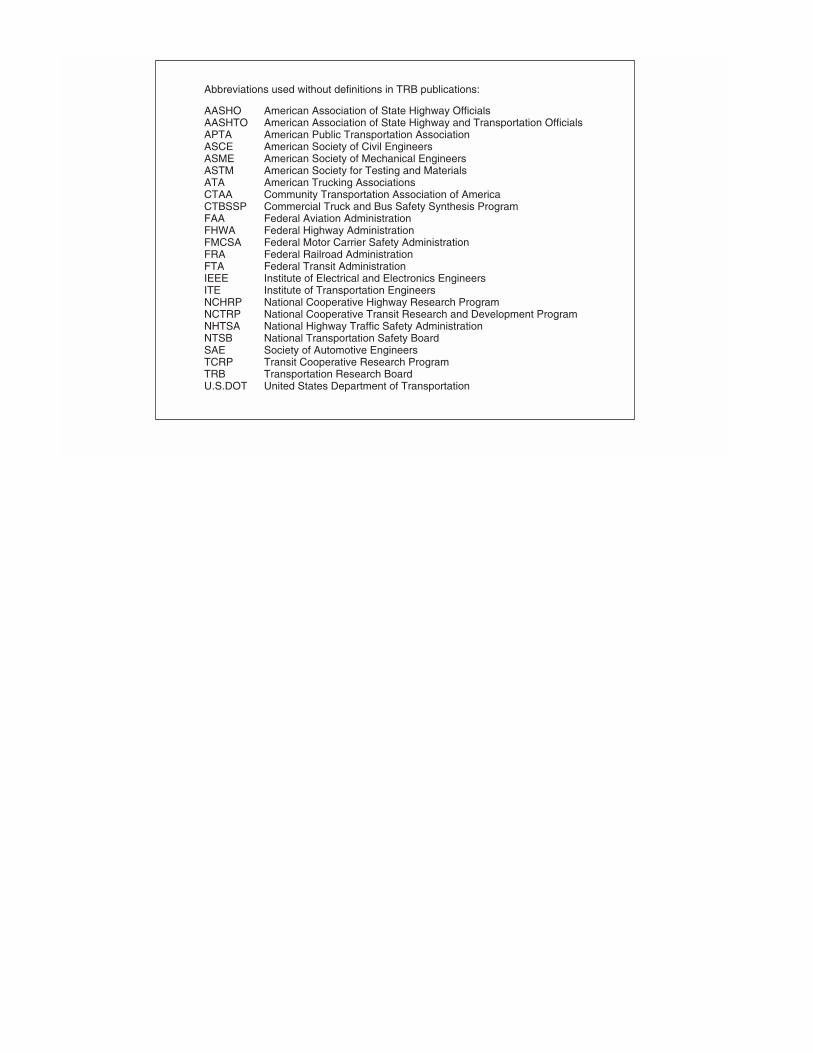
Abbreviations used without definitions in TRB publications:
AASHO American Association of State Highway OfficialsAASHTO American Association of State Highway and Transportation OfficialsAPTA American Public Transportation AssociationASCE American Society of Civil EngineersASME American Society of Mechanical EngineersASTM American Society for Testing and MaterialsATA American Trucking AssociationsCTAA Community Transportation Association of AmericaCTBSSP Commercial Truck and Bus Safety Synthesis ProgramFAA Federal Aviation AdministrationFHWA Federal Highway AdministrationFMCSA Federal Motor Carrier Safety AdministrationFRA Federal Railroad AdministrationFTA Federal Transit AdministrationIEEE Institute of Electrical and Electronics EngineersITE Institute of Transportation EngineersNCHRP National Cooperative Highway Research ProgramNCTRP National Cooperative Transit Research and Development ProgramNHTSA National Highway Traffic Safety AdministrationNTSB National Transportation Safety BoardSAE Society of Automotive EngineersTCRP Transit Cooperative Research ProgramTRB Transportation Research BoardU.S.DOT United States Department of Transportation