Grounwater availavility in Mexico
21
GROUNDWATER AVAILABILITY IN MEXICO Felipe I. Arreguín and Rubén Chávez National Water Commission. Insurgentes Sur 2416 - 8 th floor, Mexico DF 04340 MEXICO [email protected], [email protected] ABSTRACT The groundwater is essential for the development of man’s activities. It represents a single water source permanently available for arid and semi-arid zones. In humid regions, it compensates the variability of precipitations with time. Its rational management must consider imposed limitations because of its slow renovation rate along with other physical, economical and environmental restrictions in order to provide a flexible use and avoid overdraft. A methodology to determine the water availability for aquifers in Mexico is presented. This method, enforced by law, has been published as an Official Mexican Norm by the Official Journal of Mexico (Diario Oficial de la Federación). Published data are included and show that at least one hundred aquifers are over-drafted. Currently applied strategies for an enhanced water preservation and management are also discussed. AN OVERVIEW OF GROUND WATER IN MEXICO A total volume of 28,000 cubic hectometers per year (hm 3 /a) of water is currently being abstracted from Mexico’s subsurface, having the following use: approximately 71% for agriculture, 20% for public supply (satisfying the requirements of 55 million people living in Mexican cities), 6% for industrial purposes, and 3% for rural population (domestic and livestock). As a result of an excessive groundwater abstraction, almost 100 aquifers are considered as being over-drafted. It has been estimated that water pumped from aquifer storage has risen during the last four decades reaching an actual rate of 5,400 hm 3 /a.
Transcript of Grounwater availavility in Mexico

GROUNDWATER AVAILABILITY IN MEXICO
Felipe I. Arreguín and Rubén ChávezNational Water Commission. Insurgentes Sur 2416 - 8th floor, Mexico DF
04340 [email protected], [email protected]
ABSTRACT
The groundwater is essential for the development of man’sactivities. It represents a single water source permanentlyavailable for arid and semi-arid zones. In humid regions,it compensates the variability of precipitations with time.Its rational management must consider imposed limitationsbecause of its slow renovation rate along with otherphysical, economical and environmental restrictions inorder to provide a flexible use and avoid overdraft.
A methodology to determine the water availability foraquifers in Mexico is presented. This method, enforced bylaw, has been published as an Official Mexican Norm by theOfficial Journal of Mexico (Diario Oficial de laFederación). Published data are included and show that atleast one hundred aquifers are over-drafted. Currentlyapplied strategies for an enhanced water preservation andmanagement are also discussed.
AN OVERVIEW OF GROUND WATER IN MEXICO
A total volume of 28,000 cubic hectometers per year (hm3/a)of water is currently being abstracted from Mexico’ssubsurface, having the following use: approximately 71% foragriculture, 20% for public supply (satisfying therequirements of 55 million people living in Mexicancities), 6% for industrial purposes, and 3% for ruralpopulation (domestic and livestock).
As a result of an excessive groundwater abstraction, almost100 aquifers are considered as being over-drafted. It hasbeen estimated that water pumped from aquifer storage hasrisen during the last four decades reaching an actual rateof 5,400 hm3/a.

An important environmental impact was generated during thefirst decades of overdraft (1960-1980) including amongothers: spring vanishing, lake and wetland fading,reduction of flow base discharges, disappearance of nativevegetation and lost of ecosystems, decreasing well yields,increase of pumping cost, land subsidence and shrinking,groundwater pollution, and seawater intrusion.
Many of the main Mexican cities, including Mexico Cityitself, are partially supplied from aquifer storage. Waterimportation from neighboring basins and surrounding areashas increased during the last decades to fulfill publicdemands. This solution, however, is becoming less feasibleas the water availability is decreasing, the costsinvolving water importation are rising, and the oppositionof rural population for transferring water to cities,interfering with local development, is growing.
Water pumping from aquifer storage is being avoided in mainbasins through several corrective actions, including:management of water demand, campaigns on water preservationand efficient water use, user participation on the designof water resources policies, and artificial aquiferrecharge. During the last years, Mexico has faced a severedrought in many regions with a subsequent decrease on bothrunoff and aquifer recharge. Consequently, pressure ongroundwater sources has risen.
Strategies for a sustainable management
Traditionally, growing water demands were satisfied byincreasing supply through new waterworks. This commonpractice was applied by water authorities even when theywere well aware of an important water fraction lost fromaqueducts and pipes or a non-efficient water use. As waterresources became limited and overdraft effects were morenoticeable, the former approach has changed and evolvedinto an integrated strategy.
Special attention is given to the management of waterdemand depending on use. In the case of public supply, thenew approach includes: implementation of leaking

detection/reduction programs; improvement of both macro andmicro water metering; enhancement of efficient water usethrough informative campaigns, penalties for breakingcorresponding water regulations; sewerage modernization;and a limited tariff adjustment. Industrial use comprises:water recycling and reuse of treated wastewater inactivities not requiring drinking water, and application ofsome tax exemptions to water users exchanging finishedpotable water for wastewater. New agricultural projects arebeing implemented to modernize irrigation practicesincluding: change of traditional crops into more productiveand less-water consuming ones, enhancement of irrigationfacilities, and farmer education to apply new technologies,such as “plasticulture”.
Considering the water user as the most important playingactor for water management, the new Nation’s Water Lawpromotes his active participation in councils andcommittees collaborating with the water authority in thedesign and execution of programs to develop, distribute,and preserve water resources.
Where water availability is limited to satisfy demands fromcities, it has been promoted the release of groundwaterrights for agriculture and industrial uses and theirsubsequent change into public usage. Release is achievedthrough several administrative mechanisms: transference ofwater rights from agricultural users being displaced bycity growing to industry owners and/or municipal waterutilities; wastewater exchange for activities not requiringdrinking water; implementation of programs to improveagricultural water consumption.
AQUIFER STORAGE
Mexico’s subsurface contains a considerable water reserve:many hydrological basins include regional aquifers beingsome hundred to thousand square kilometers in area andseveral hundred meters thick. In general terms, aquifersare composed by unconsolidated clastic material of varioussizes within their first dozen to hundred meters depth,

whereas their matrix is made of consolidated rocks (igneousor sedimentary ones) deeper.
It has been estimated that during the last 40 yearsapproximately 60,000 hm3 of water has been withdrawn fromaquifer storage at a national level. Most of the usefulwater reserve is -or was- stored within the first hundredmeters depth in the most permeable aquifers, showing themost dynamic renovation, being the most economicallyavailable and having the best quality. It has also beenconsidered that there are large amounts of water stored upto a reference depth of 400 m.
Although the groundwater reserve is huge, it is importantto point out that it is mostly a non-renewable resource andits use presents different types of limitations; therefore,it should not be considered as an inexhaustible reservoir.It is urgent and important to implement managementstrategies focused on the preservation and the increment ofthis resource. Publication of the water availability foreach aquifer represents one of several actions forestablishing suitable strategies for a wiser use.
WATER AVAILABILITY
The term “availability” is commonly used and its meaning isapparently quite obvious, however, it can be confused ifits background is not enough clarified. Regarding water,different significances can be considered: the total amountof water (including that from aquifer storage), therenewable water, the economically available water, thegood-quality water being suitable for specific uses, etc.
The “Average Natural Water Availability Per Capita”, a term commonlyused to express the amount of water in a given geographicallocation, is defined as the annual volume of renewed waterdivided by the number of people living in the correspondinggeographical locality. Its value reflects the relationshipbetween the natural supply (subject to climatic conditions)and the resource demand (depending on population). Mexico,whose water resources are managed by the National WaterCommission (CNA) on the basis of 13 administrative regions,

for instance, has an average annual water availability of4,685 m3 per capita, and the Southern InternationalBoundary Administrative Region has an average annual valueof 25,843 m3 per capita, contrasting with a minimum annualvalue of 1,445 m3 per capita at the Baja CaliforniaPeninsula Administrative Region. Although, this term isvery specific from the statistical and comparative point ofview, it is necessary to adopt a legal definition from thewater management perspective. A legal definition mustrepresent the amount of water available for granting,discounting the water volumes already compromised to userspreviously established (including the environment).
LEGAL BRACKGROUND
The Nation’s Water Law and its Regulations (2004)establish:
Article 22nd.- To fulfill water grants (private) or waterassignations (public), the National Water Commission shallpublish the nation’s water availability for basin, regionor location. This information may be consulted at the localoffices of the Public Registrar of Water Rights and throughthe National Information System on Volume, Quality, Uses,and Conservation of Water.
The National Water Commission, following law commands, ishardly working on an overall project including: water userregulation to complete the Public Registrar of WaterRights; formal definition of units for water managementwith user participation (enforced by law according to theOfficial Journal of Mexico in 2001); development of anOfficial Mexican Norm to establish methodologies todetermine water availability (enforced by law according tothe Official Journal of Mexico in 2002); updating oftechnical studies to quantify renewable volumes of bothground and surface waters for main supplies; anddetermination of water availability and its officialpublication.
On January 31, 2003, an Official Agreement was publisheddefining boundaries for 188 aquifers in Mexico. Results

from technical studies to determine their average annualwater availability and their location maps were alsopresented (Official Journal of Mexico, 2003). Officialpublication constituted an important step within theNational Water Commission’s internal process ofreorganization, tending to achieve an integral waterresources management. Water availabilities of 14 additionalaquifers were presented on December 29, 2003, totalizing212 aquifers that represent 87% of the total volume ofpumped ground water.
Official Mexican Norm NOM-011-CNA-2000
The norm is a legal obligation for the National WaterCommission of Mexico and for those water users performingtechnical studies to determine the average annualavailability for the Nation’s water. It defines theGroundwater Availability as “the average annual volume ofwater that can be abstracted from a hydrogeological unitfor distinct uses, in addition to withdrawals alreadygranted, and not including a compromised natural dischargeto avoid endangering the equilibrium of ecosystems.”Surface Water Availability is defined as “the valueresulting from the difference of the average annual volumeof surface down-gradient runoff within a given basin, minusthe current annual volume of granted down-gradient water.”According to the above definitions, a null wateravailability implies that no additional water volumes maybe granted.
This norm was prepared by a group of experts representinggovernmental agencies, universities, research institutes,and consulting firms, under the coordination of specialistsfrom the National Water Commission. It was published onApril 17, 2002 by the Official Journal of Mexico and itdescribes the methodology to determine the availability ofthe Nation’s water (both surface water and ground water),and it is mandatory in all over the country. It includesmethods being applied using existing information; however,more accurate procedures can be used if enough data andfinance are available. In summary, the describedmethodology is based on the mass balance applied in

management units (either basin or aquifers) or in part ofthem (Figure 1).
Figure 1.- Schematic description of methodology fordetermining groundwater availability
REFERENCE FRAMEWORK
In order to meet the requirements expressed by the Nation’sWater Law and its Regulations, it was essential to define areference framework for the Nation’s water management thatincluded the official denomination and delimitation of bothsurface and ground water supplies. Therefore, a first stepwas publishing an Official Agreement (Official Journal ofMexico: December 05, 2001) listing the official aquifernames and recognized homologous names used by the NationalWater Commission on a conventional basis.
Another important step was the preparation of a NationalAquifer Catalog for the entire Mexico’s territory. Itincludes 653 aquifers and defines the boundaries for eachone through simplified surrounding polygons. The Catalogalso contains official maps at national, regional and localscales showing corresponding aquifer names, codes andofficial boundaries (Figure 2). The related cartographic
data base has been properly georeferenced and is part of ageographic information system (GIS), allowing the searchfor aquifer information and the exchange with other systemsand geodatabases.
TECHNICAL ASPECTS
Sources of Information
The diverse technical studies, that served as a basis forthe determination of groundwater availability, werepreformed during the last four decades by the NationalWater Commission, its parental governmental agencies (i.e.:The Ministry of Water Resources and The Ministry ofAgriculture and Water Resources), some universities,research institutes, and consulting firms.
Recently, state government water commissions and municipalwater utilities have performed valuable studies on watersupply. Water users have also been contributed for theenrichment of this knowledge through technical data fromtheir water works. Most of this technical information hasbeen compiled and integrated by the National WaterCommission to determine groundwater availability.

Figure 2.- Official Map taken from the Catalog of Aquifers.It corresponds to the Administrative Region I: BajaCalifornia Peninsula. Source: Diario Oficial de laFederación, December 05, 2001.
Definition of Aquifers Boundaries
In general, groundwater characterization is a difficulttask since aquifers are invisible systems, with anirregular geometry, complex structure, heterogeneouslithology and huge size. Their lateral and verticalboundaries can be defined only in a simplified andpresumptive form, because real impermeable rocks are hardto find: even consolidated rocks can have conductive zonessuch as faults, fractures, stratified beds, or dissolutionconduits.
For purpose of groundwater availability determination,hydrogeological units were defined to include both zones ofgroundwater withdrawal (mostly plain regions) and rechargeareas (commonly located at their corresponding mountainousportions). It is important to explain that unit limits arenot physical borders, since they correspond to conventional

boundaries. In this case, their highlands/elevated partscoincide to surface water divides, whereas their plainareas meet political limits (municipal and state) orhydrological elements (i.e.: rivers) for administrativesimplification.
Groundwater Budget
Groundwater availability, according to its correspondingOfficial Mexican Norm, is determined by subtracting thegranted water amounts and the quantities compromised forenvironmental purposes from the average annual renewablevolumes. The amounts of granted groundwater are recorded inthe Public Registrar of Water Rights (REPDA, as it is knownin Mexico), controlled by the Administrative Branch of theNational Water Commission. Recent PresidentialDecrees/Ordinances have allowed the incorporation intoREPDA of a large number of water users being in a previousirregular status.
Before the application of any methodology to determine thegroundwater budget, it is necessary to define a conceptualaquifer model. This is achieved using groundwaterexploration techniques (e.g.: hydrogeological surveys,remote sensing, geophysical investigations, exploratoryboring, isotopic methods, etc.), along with hydrodynamicanalysis and hydrogeochemical data examination. Such aconceptual model must describe: boundary conditions,recharge and discharge mechanisms (both natural and induceddue to water withdrawal), groundwater flow system andrelationships between ground water and surface water.
Aquifer recharge is generally calculated through a methodknown as “Groundwater Balance” that directly takes intoaccount the mass of ground water without considering thecomplex phenomena occurring in both surface and vadosezone. Natural discharges and abstracted volumes areestimated or measured during a specified time interval forgroundwater budget determination. Then, change in aquiferstorage is calculated for the same time interval fromgroundwater table evolution.

Groundwater withdrawals in aquifer at the more developedbasins, especially in arid zones, constitute the hydrologiccomponent having the highest relative weight in terms ofwater budget. Any imprecision in recharge calculationhighly depends on the lack of accuracy during withdrawalaccounting. The latter is easy to measure; however, it iscommonly determined through indirect methods, since thereis a great water-user resistance for governmental controlon water abstraction. Implemented programs on installationand conservation of water-metering devices have shown apoor success. Indirect methods depend on water use, forinstance: size of irrigated lands, irrigation lamina, wellyields and pumping lengths, number of inhabitants beingsupplied, electricity bills, etc.
Since groundwater recharge cannot be directly measured, itsmagnitude is considered as an unknown variable to bedetermined within the groundwater budget equation. Anaverage annual recharge is calculated considering thevariability of the numerous natural and artificial factorscontrolling recharge and the availability of historicalinformation. The water balance is solved for differentmultiannual periods to include rainy and dry years.
Resulting balances are correlated with the conceptualhydrological model to establish surface and ground waterrelationships and to evaluate how aquifer recharge issubject to modification by human activities, such as: newinfrastructures, recondition of agricultural facilities,programs on water conservation and efficient use. If thereis enough information, recharge evaluation is complementedwith a mathematical aquifer model, a powerful tool thatallows the integration and fitting of available data tovalidate the conceptual model, simulate the natural aquiferconditions and define both magnitude and distribution ofrecharge more accurately. A mathematical model also servesto refine aquifer characterization and predict aquiferbehavior under different management scenarios. Estimationof groundwater budget can be completed with studies ontracers (natural and artificial), unsaturated zone andsolute balance. The application of the latter techniquesinto a regional scale is incipient.
Additional aspects considered for more complete studies andcomprehensive aquifer management scenarios are: estimationof environmental costs of groundwater abstraction,administration of groundwater demand, and artificialrecharge, etc.
Groundwater Balance
The average annual availability of groundwater, Das, for agiven hydrogeological unit is determined according to:
Das = r – dncom – vcas (1)
where,
r, represents the average annual total recharge calculatedaccording to a methodology described below;
dncom, corresponds to the compromised natural dischargecomposed by the total volume of granted springs and riverbaseflows (compromised as surface water and representingaquifer discharges), and all discharges required tomaintain ecosystems previously established, avoiddisturbances to neighboring aquifers, and prevent themigration of poor-quality water to the hydrogeological unitunder concern;
vcas, is the granted groundwater volume resulting from theaddition of the annual volumes from water grants (private)and water assignations (public), conferred by the NationalWater Commission through titles/certificates of waterrights registered at the Public Registrar of Water Rights,for withdrawal, use, and profit/utility of water within ahydrogeological unit. Corresponding volumes for reserves,and those included in specific regulations and WaterResources Planning can be also be considered whenever thisapplies.
The total recharge for an aquifer or hydrogeological unitwithin a certain period of time is determined through asimplified groundwater balance budget equation:

(2)donde:
R, represents the total recharge (sum of inputs);
ΔAlm, is the change of storage for the hydrogeological unitof interest;
d, corresponds to the sum of outputs.
To estimate a representative average recharge, thegroundwater budget equation is solved to include severalyears if there is enough information on basic data. Bothrainy and dry years are considered. Otherwise, groundwaterbalance will be solved at least for one year.
The change of storage within a given time interval forbalancing purposes is estimated from groundwater tableevolution for the same period of time, consideringrepresentative values for the storage coefficient. Thiscoefficient is determined from well pumping analyses and/ortaking into account aquifer type and lithology.
Total discharge of a particular hydrogeological unit forthe time interval considered during balance is calculatedfrom the addition of all natural discharge volumes andthose resulted from well withdrawals for the same period oftime.
The natural discharge occurring throughout the most commonoutlets is determined using the methods described below,depending on the particular case.
The discharge into a stream for a given hydrogeologicalunit, known as “River Baseflow”, is determined from recordeddata at stream gauges. Hydrographs are then analyzed toidentify river baseflow. If there are several gaugingstations along a given river, this methodology must beapplied for all river reaches between gauges to identifyhow baseflow varies. Stream gauging must be performedduring the dry periods of each year.

Discharge of a particular hydrogeological unit through aspring is calculated by integrating the area under therespective hydrograph, that is, the average spring yieldtimes the length of time during balance. Spring hydrographwill be constructed from gauging information frequentlyenough to describe annual and seasonal variations. In anycase, spring origin linked to the hydrogeological unitunder budget evaluation must be verified throughtopographic and hydrogeological interactions, as well ashydrodynamic and hydrogeochemical relationships.
Atmospheric discharge of a given hydrogeological unit canoccur through direct evaporation of shallow water table andby transpiration from vegetation. Direct evaporation isestimated as the size of study area times a laminaequivalent to a fraction of the average potentialevaporation value obtained from climate stations. Thisfraction varies from one, a maximum value for anoutcropping water table, through zero, when water tablelies at depth greater than the thickness of the capillaryfringe (extinction depth). Fringe thickness depends on thetype of lithology found in the vadose zone. When noinformation on vadose-zone characteristics is available, itwill be assumed that the average potential evaporationfraction varies linearly with the water-table depth.
Groundwater discharge through evapotranspiration depends onseveral factors, such as climate, hydrogeological setting,and density and type of vegetation. Those factors aredifficult to control at basin or aquifer scale, since theyshow a large variation in time and space. Thus, themagnitude of this groundwater budget component will not beestimated separately, and it will be implicitly included inthe balance results, yielding conservative estimations ofaquifer recharge and groundwater availability.
Aquifer discharge will be determined applying Darcy’s Lawat cross sections for outputs flow channels defined by flowlines and water-table configurations. Water-tablevariations during the period of interest must beconsidered.

Volumes of abstracted groundwater for time intervals withinthe period of interest are estimated by water metering andthrough indirect methods depending on water use, such aswell yields and pumping lengths, electricity bills, numberof inhabitants being supplied, water-consumption indexes,size of irrigated lands, and irrigation lamina.
The total average annual recharge will be determineddividing the total recharge estimated from budget equationby the number of years of the time period being considered.
Average annual availability of the Nation’s water.
Finally, the average annual water availability in Mexico isdetermined as the addition of the average annual surfacewater availability plus the average annual groundwateravailability. Any hydraulic connection between surface andgroundwater supplies must be considered to avoid omittingor double counting one or more terms of the water budgetequation, resulting into an over or under estimation ofGroundwater Availability or Surface Water Availability.
RESULTS
The groundwater availability for the 188 most important andthoroughly studied aquifers of Mexico was published onJanuary 31, 2003. Both clearly over-drafted aquifers andthose having large water availability are included. Thegroundwater availability for 14 additional aquifers and oneup-dating were published on December 29, 2003. This groupof aquifers represents only one third from the total numberdefined by the National Aquifer Catalog. Its importance,however, is clear since it constitutes 87% of the totalvolume of abstracted groundwater within the entire country(Figure 3).
From 212 aquifers, 86 of them have a water availability of18,207 hm3/a, whereas the remaining 106 present a waterdeficit of 4,694 hm3/a. The most severe cases of overdraftare: Lerma river Basin (Guanajuato and Queretaro States),Baja California Peninsula, Mexico Basin, and Chihuahua and

Sonora States. Figure 4 shows the distribution ofgroundwater availability by Administrative Region of theNational Water Commission.
Table 1 is an example of groundwater availability data forthe Northern Central Basins Administrative Region. Showndata include total recharge, compromised discharge, grantedvolume (according to REPDA), estimated volume of abstractedground water, groundwater availability, and groundwaterdeficit. In some cases, the volume of abstractedgroundwater, estimated with technical studies, differsconsiderably from the granted volume. The gradualadjustment of these differences represents the mainobjective of a verification process currently undertaken.
ADVANTAGES/BENEFITS
There are a number of advantages drawn from thedetermination of the nation’s water availability and itsofficial publication, such as:
Figure 3.- Geographical distribution of aquifers withpublished water availability. Source: Diario Oficialde la Federación, January 31 and December 29, 2003.

Water users and the overall society may access basic data,technical study results, figures on granted water, andgroundwater availability. Free information access providesclarification and transparency on water management,particularly on water granting.
The publication of the corresponding Official Mexican Norm,the conventional definition of the units for Nation’s watermanagement, and the establishment of the Public Registrarof Water Rights have eliminated the use of differentcriteria for determining the groundwater availability.Thus, consistent methodologies for calculating waterbalance components, a unique and confident geographicalreference framework, and a more complete knowledge ofgranted water volumes have been established.
Administrative process facilitates the resolution onapplications for water grants and water assignations, whoseapproval would depend on water availability. Users may knowabout the existence of a null water availability inadvance. Therefore, they would avoid applying for a watergrant, as the response will be immediate and negative.
Table 1. Examples of information on groundwateravailability published by the Official Journal ofMexico on January 31, 2003.
CODE HYDROGEOLOGICALUNIT (AQUIFER)
R Dncom Vcas Vextet Das DEFICIT
(Figures in cubic hectometers per year)
Coauhila State
0505 General Cepeda-Sauceda 57.40 0.000 48.574237 26.4 8.825763 0.000000
0523 Principal-Región Lagunera 518.90 0.000 701.834604 1,010.
8 0.000000 -182.934604
San Luis Potosi State2402 El Barril 31.60 0.000 89.627149 53.0 0.000000 -58.0271492405 Ahualulco 10.90 0.000 17.656868 10.9 0.000000 -6.7568682408 Villa de Arista 48.20 0.000 96.719732 74.8 0.000000 -48.5197322411 San Luis Potosí 78.10 0.000 149.346618 113.0 0.000000 -71.246618
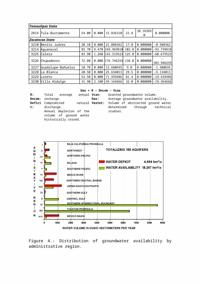
Tamaulipas State
2814 Tula-Bustamente 54.00 0.000 15.836310 21.8 38.163690 0.000000
Zacatecas State3210 Benito Juárez 20.10 0.000 21.088362 17.0 0.000000 -0.9883623214 Aguanaval 85.70 9.470 169.969810 102.0 0.000000 -93.7398103225 Calera 83.90 1.260 143.319523 125.0 0.000000 -60.679523
3226 Chupaderos 72.80 0.000 176.746259 138.0 0.000000 -103.946259
3227 Guadalupe-Bañuelos 10.70 0.000 12.680695 9.0 0.000000 -1.9806953228 La Blanca 20.50 0.000 25.634013 29.5 0.000000 -5.1340133229 Loreto 52.50 0.000 71.939486 81.4 0.000000 -19.4394863230 Villa Hidalgo 31.90 2.100 49.164666 32.0 0.000000 -19.364666
Das = R – Dncom – VcasR:Dncom:Deficit:
Total average annualrecharge.Compromised naturaldischarge.Annual depletion of thevolume of ground waterhistorically stored.
Vcas:Das:Vextet:
Granted groundwater volume.Average groundwater availability.Volume of abstracted ground waterdetermined through technicalstudies.
Figure 4.- Distribution of groundwater availability byadministrative region.

Water supply management. Water availability, as defined by thecorresponding Official Mexican Norm, is one of the mostimportant technical elements for water resourcesadministration. Conferring on new water grants, hydraulicsplanning, designing water management strategies,establishing new areas for development, and definingprohibited zones for water abstraction, areas of waterreserve and regulations are based on water availability.
Social participation. The transparency of information, which thegroundwater availability is based on, results in a societysufficiently aware of the status of water supplies,allowing an effective participation of people on waterresources administration.
FUTURE ACTIONS
The official publication of water availability is just oneof the first steps of a dynamic process supporting theadministration of the nation’s water resources. There aremore actions involved in this process:
Water monitoring modernization for every water cyclecomponent.
Publication of water availability for both watershedsand aquifers, and periodic up-dating of publishedinformation.
Adaptation, revocation, formulation and covenant ofordinances for basins and aquifers such as: prohibitedzones for water abstraction, laws and regulations, andareas for water reserve.
Verification and adjustment of volumes of granted waterrecorded at REPDA.
Incorporation of water quality issues during thedetermination of water availability.
Design of strategies to reach a sustainable developmentthrough the implementation of programs on waterresources administration that include: management ofwater demand, changes in water use, up-dating irrigationtechnologies, water reuse, and, wherever it applies,reduction of granted volumes.
Assistance for the configuration of Watershed Councilsand Groundwater Technical Committees, where water-userrepresentatives would actively participate in theadministration of the nation’s water resources.
Water user training regarding efficient waterutilization for all applications.
CONCLUSIONS
Understanding water availability is a key factor for waterresources administration. Its determination, throughconsistent methodologies, the definition of units for watermanagement within a unique reference framework, and itsofficial publication are important steps to confer ontransparency, stimulate social participation and support acomprehensive management of country’s water resources.
REFERENCES
Ley de Aguas Nacionales y su Reglamento, 1992.
Secretaría de Medio Ambiente y Recursos Naturales: Acuerdopor el que se establece y da a conocer al público en general ladenominación única de los acuíferos reconocidos en el territorio de losEstados Unidos Mexicanos, por la Comisión Nacional del Agua y lahomologación de los nombres de los acuíferos que fueron utilizadospara la emisión de los títulos de concesión, asignación o permisosotorgados por este órgano desconcentrado. Diario Oficial de laFederación, 5 de diciembre de 2001.
Secretaría de Medio Ambiente y Recursos Naturales: NormaOficial Mexicana NOM-011-CNA-2000, Conservación delrecurso agua-Que establece las especificaciones y elmétodo para determinar la disponibilidad media anualde las aguas nacionales. Diario Oficial de laFederación, 17 de abril de 2002.
Secretaría de Medio Ambiente y Recursos Naturales: Acuerdopor el que se dan a conocer los límites de 188acuíferos de los Estados Unidos Mexicanos, losresultados de los estudios realizados para sudisponibilidad media anual de agua y sus planos de

localización. Diario Oficial de la Federación, 31 deenero de 2003.
Comisión Nacional del Agua (2001-2002): Documentos derespaldo de la determinación de la disponibilidad deagua de 188 acuíferos. Gerencia de Aguas Subterráneasde la Subdirección General Técnica.