Grade 9 Social Science Unit 1 People and Places in the Pacific
187
G9 SS U1 1 TITLE PAGE GRADE 9 SOCIAL SCIENCE UNIT 1 PEOPLE AND PLACES IN THE PACIFIC TOPIC 1: MAPPING SKILLS TOPIC 2: SHAPING THE LAND TOPIC 3: CLIMATES OF THE PACIFIC TOPIC 4: VEGETATION TYPES OF THE PACIFIC TOPIC 5: LAND USE IN THE PACIFIC
-
Upload
khangminh22 -
Category
Documents
-
view
2 -
download
0
Transcript of Grade 9 Social Science Unit 1 People and Places in the Pacific
G9 SS U1 1 TITLE PAGE
GRADE 9
SOCIAL SCIENCE
UNIT 1
PEOPLE AND PLACES IN THE PACIFIC
TOPIC 1: MAPPING SKILLS TOPIC 2: SHAPING THE LAND TOPIC 3: CLIMATES OF THE PACIFIC TOPIC 4: VEGETATION TYPES OF THE
PACIFIC TOPIC 5: LAND USE IN THE PACIFIC
GRADE 9 SOCIAL SCIENCE 2 ACKNOWLEDGMENT
Published in 2017 by the Flexible, Open and Distance Education, Papua New Guinea © Copyright 2017, Department of Education, Papua New Guinea. All rights reserved. No part of this publication may be reproduced, stored in a retrieval system, or transmitted in any form or by any means electronic, mechanical, photocopying, recording or otherwise without the prior permission of the publisher.
Printed by Flexible, Open and Distance Education.
ISBN: 978 9980 87 744 4
National Library Service of Papua New Guinea
ACKNOWLEDGEMENT
We acknowledge the contributions of all Secondary Teachers who in one way or another have helped to develop this Course. Our profound gratitude goes to the former Principal of FODE, Mr. Demas Tongogo for leading FODE team towards this great achievement. Special thanks to the Staff of the Social Science Department of FODE who played an active role in coordinating writing workshops, outsourcing lesson writing and editing processes, involving selected teachers of Central Province and NCD. We also acknowledge the professional guidance provided by Curriculum and Development Assessment Division throughout the processes of writing, and the services given by member of the Social Science Review and Academic Committees. The development of this book was Co-funded by GoPNG and World Bank.
DIANA TEIT AKIS PRINCIPAL
GRADE 9 SOCIAL SCIENCE 3 COURSE INTRODUCTION
Content………………………………………………………………………………………………………... Secretary’s Message………………………………………………………………………………………… Course Introduction ………………………………………………………………………………………… Unit Introduction…………………………………………………………………………………………….. Study Guide ………………………………………………………………………………………………….. TOPIC 1: MAP SKILLS………………………………………………………………………………....... Introduction…………………………………………………………………………………………………..
3 4 5 6 7 8 9 10 18 26 34 40 47 50
Lesson 1 Lesson 2 Lesson 3 Lesson 4 Lesson 5
Where is Papua New Guinea……………………………………………………….. Grid Reference………………………………………………………………………… Contour Lines………………………………………………………………………….. Directions……………………………………………………………………………….. Calculating Distance…………………………………………………………………..
ANSWERS TO PRACTICE EXERCISE………………………………………………………………….. TOPIC 2: SHAPING THE LAND…………………………………………………………………………..
Introduction………………………………………………………………………………………………….. 51
Lesson 6 Lesson 7 Lesson 8 Lesson 9 Lesson 10 Lesson 11
Landforms in the Pacific……………………………………………………………… Plate tectonics…………………………………………………………………………. Weathering…………………………………………………………………………….. Erosion and Deposition………………………………………………………………. Natural Disasters………………………………………………………………………. Man-made changes in the Environment……………………………………………
52 58 70 78 86 94 99 102 103 104 109 114 118 127 129 130 131 138 143 148 152 154 155 156 161 167 176
ANSWERS TO PRACTICE EXERCISE………………………………………………………………….. TOPIC 3: CLIMATES OF THE PACIFIC……………………………………………………………... Introduction……………………………………………………………………………………………………
Lesson 12 Lesson 13 Lesson 14 Lesson 15
Tropical Climate in the Pacific………………………………………………………... Temperate Climate in the Pacific…………………………………………………….. Types of Climates in Papua New Guinea………………………………………..… Climograph………………………………………………………………………………
ANSWERS TO PRACTICE EXERCISES……………………………………………………………….. TOPIC 4: VEGETATION TYPES IN THE PACIFIC……………………………………………….. Introduction……………………………………………………………………………………………………
Lesson 16 Lesson 17 Lesson 18 Lesson 19
Natural Vegetation Distribution……………………………………………………… Vegetation types in Papua New Guinea……………………………………………. Changes to Vegetation………………………………………………………………... Introduced Vegetation…………………………………………………………………
ANSWERS TO PRACTICE EXERCISE…………………………………………………………………. TOPIC 5: LAND USE IN THE PACIFIC………………………………………………………………….. Introduction……………………………………………………………………………………………………
Lesson 20 Lesson 21 Lesson 22 Lesson 23
Types of Land Use in Papua New Guinea………………………………………….. Rural and Urban Land Use…………………………………………………………… Land Use and Climate Change……………………………………………………… Case Study: Land Use of Local Area……………………………………………….
ANSWERS TO PRACTICE EXERCISE…………………………………………………………………… 182
CONTENT
GRADE 9 SOCIAL SCIENCE 4 COURSE INTRODUCTION
SECRETARY’S MESSAGE
Achieving a better future by individual students and their families, communities or the nation as a whole, depends on the kind of curriculum and the way it is delivered. This course is part and parcel of the new reformed curriculum. The learning outcomes are student-centred with demonstrations and activities that can be assessed. It maintains the rationale, goals, aims and principles of the national curriculum and identifies the knowledge, skills, attitudes and values that students should achieve. This is a provision by Flexible, Open and Distance Education as an alternative pathway of formal education. The course promotes Papua New Guinea values and beliefs which are found in our Constitution and Government Policies. It is developed in line with the National Education Plans and addresses an increase in the number of school leavers as a result of lack of access to secondary and higher educational institutions. Flexible, Open and Distance Education curriculum is guided by the Department of Education’s Mission which is fivefold:
to facilitate and promote the integral development of every individual
to develop and encourage an education system that satisfies the
requirements of Papua New Guinea and its people
to establish, preserve and improve standards of education throughout Papua
New Guinea
to make the benefits of such education available as widely as possible to all
of the people
to make the education accessible to the poor and physically, mentally and
socially handicapped as well as to those who are educationally
disadvantaged.
The college is enhanced through this course to provide alternative and comparable pathways for students and adults to complete their education through a one system, two pathways and same outcomes. It is our vision that Papua New Guineans’ harness all appropriate and affordable technologies to pursue this program. I commend all the teachers, curriculum writers and instructional designers who have contributed towards the development of this course.
DR. UKE KOMBRA, PhD Secretary for Education

GRADE 9 SOCIAL SCIENCE 5 COURSE INTRODUCTION
COURSE INTRODUCTION
Dear Student,
Welcome to the Grade 9 Social Science Course. This course is based on the National department of Education Department (NDOE) Lower Secondary Social Science Syllabus. However, you will be doing this course through correspondence or at your convenient time at home. It has been written to enable you to do it at the comfort of your home.
Social Science is about how people relate to other people and their environments and how they organize themselves and use their resources. There are four units in this course. Unit 1: People and Places in the Pacific explores the Pacific region particularly the physical environment of the region, including the climate, vegetation and land use patterns. This strand also covers important geographical issues that relate to land use and climate change. Unit 2: Population Change, Resources and Migration covers the causes and effects of population change and how people affect and influence the environment and their resources. Unit 3: Investigating Papua New Guineas History covers Papua New Guinea’s history. It explores aspects of Papua New Guinea’s past from a range of historical sources or evidence and communicates findings through oral and written forms. Unit 4: Civics and Citizenship covers the rights and responsibilities of citizens. You will also study the legal structures and political systems of Papua New Guinea. Each unit is divided into topics and each consists of Lessons, Summaries, Practice Exercises and Answers. At the end of each lesson, you are expected to do the practice exercises. The answers to each practice exercise are found at the end of each sub-strand. You must correct your own answers. A test is given for each topic in the Assignment Booklet. There are three Assignments and three Projects Assignments giving a total of six assignments. You will find each assignment after each strand you study. You must do these assignments. Before working on them, you must revise all the lessons. Remember to check all your assignments before you send them in for marking. The Assignment marks will be added together with your final external examination mark. This will give you a final mark and grade. There will be an examination after you have completed this course. You will do the examination only after all your Assignments have been marked. We hope you will find this course interesting and informative. All the best in your studies! Your Teacher

GRADE 9 SOCIAL SCIENCE 6 UNIT 1 INTRODUCTION
UNIT 1 INTRODUCTION
Dear Student,
Welcome to Unit 1 of Grade 9 Social Science course. This unit is titled Places in the Pacific Region. At the end of this unit you should be able to:
demonstrate a range of mapping skills
apply geographic skills to describe the physical surrounding you live in
demonstrate an understanding of physical characteristics of places in the Pacific.
This unit comprises of five topics.
Topic 1 – Map Skills, you will learn various mapping skills which will enable you to describe places and features in relation to others.
Topic 2 – Shaping the land, you will learn about the internal and external forces that are responsible for building and shaping the land. You will also learn about how human activities and natural disasters have transformed the environment.
Topic 3 – Climates of the Pacific, you will learn about factors influencing the climate and locate places of the Pacific with tropical climate and those with the temperate climate. You will also identify the different types of climate in Papua New Guinea.
Topic 4 – Vegetation types in Papua New Guinea, you will learn about Natural Vegetation Distribution, types of vegetation in Papua New Guinea and describe the alteration that have been done to the natural environment.
Topic 5- Land Use in the Pacific, you will learn about the various land use in the Pacific and its impact on the environment.
Each topic comprises of lessons followed by Practice Exercises and finally Answers to the exercises. You must read and understand the content of the lessons well in order for you to do the exercises efficiently. You are required to do your own corrections after completing all the questions in each exercise. Answers to the Practice Exercises are provided at the end of each topic. All lessons in each topic must be covered thoroughly. You will then do the topic test in the Assignment Booklet and then you proceed to the next topic.
The lessons in each topic are written in simple language. If you have any problems understanding the lessons, please talk to your FODE Provincial Coordinator, ring or write to us.
We hope that you will enjoy studying this Topic.
We wish you all the best in your study!
GRADE 9 SOCIAL SCIENCE 7 STUDY GUIDE
STUDY GUIDE
Follow the steps given below and work through the lessons.
Step 1 Start with Topic 1, Lesson 1 and work through it in order.
Step 2 When you complete Lesson 1, you must do Practice Exercise 1. Step 3 After you have completed the Practice Exercises, you must correct your
work. The answers are given at the end of each sub-strand.
Step 4 Then revise well and correct your mistakes, if any.
Step 5 When you have completed all these steps, tick the check- box for Lesson 1 on the content page, like this: Lesson 1: Where is Papua New Guinea? Then, go on to the next lesson. Repeat the process, till you complete all the lessons in a topic. Assignment: Topic Test and Strand Test When you have completed all the lessons in a Topic, do the Topic test for that Topic in your Assignment Book. The Course Book (Topic 1) tells you when to do this. Marking The Sub-strand Tests in each Assignment will be marked by your Distance Teacher. The marks you score in each assignment will count towards the final result. Remember, if you score less than 50% in three Assignments, your enrolment will be cancelled. So, do your work carefully and make sure that you pass all Assignments. ALL THE BEST!
√
As you complete each lesson, tick the box for that lesson on the contents
page, like this . This will help you check your progress. √

GRADE 9 SOCIAL SCIENCE 8 TITLE PAGE
TOPIC 1
Mapping Skills
In This Topic, You Will Learn About:
Lines of Latitude
Lines of Longitude
Calculating Distance
Directions
Grid reference
Contour Lines
G9 SS U1 9 TOPIC 1 INTROUCTION
TOPIC 1: INTRODUCTION
In this Topic you, will learn about the basic mapping skills. These mapping Skills are important as they provide the necessary steps involved in understanding maps and abstracting useful information about the features and places on a map. The map skills you will study in this topic include:
defining lines of latitude and lines of longitude.
locating places using lines of latitude and lines of longitude
calculating distance
giving direction and
using grid referencing to locate places and features on a map. When map skills are understood and applied well, accurate information can be abstracted and communicated accurately. Basically you will be learning about each of the skill and the processes involved in locating places, calculating distance, giving direction and using grid reference respectively. We hope you will enjoy this topic.
G 9 SS S1 10 TOPIC 1 LESSON 1
Lesson 1: Where is Papua New Guinea?
Welcome to lesson 1 of Topic 1. In this lesson you will learn the basic facts about lines of latitude and lines of longitude and locate Papua New Guinea in relation other places in the world on a given map.
Your Aims
define lines of latitude and lines of longitude.
identify places in the pacific using lines of latitude and longitude.
locate Papua New Guinea on a map and
state the location of Papua New Guinea in relation to other places in the Pacific Region using latitude and longitude lines.
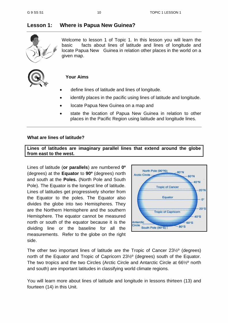
What are lines of latitude?
Lines of latitudes are imaginary parallel lines that extend around the globe from east to the west.
The other two important lines of latitude are the Tropic of Cancer 23½º (degrees)
north of the Equator and Tropic of Capricorn 23½º (degrees) south of the Equator.
The two tropics and the two Circles (Arctic Circle and Antarctic Circle at 66½º north
and south) are important latitudes in classifying world climate regions.
You will learn more about lines of latitude and longitude in lessons thirteen (13) and
fourteen (14) in this Unit.
Lines of latitude (or parallels) are numbered 0º
(degrees) at the Equator to 90º (degrees) north
and south at the Poles. (North Pole and South
Pole). The Equator is the longest line of latitude.
Lines of latitudes get progressively shorter from
the Equator to the poles. The Equator also
divides the globe into two Hemispheres. They
are the Northern Hemisphere and the southern
Hemisphere. The equator cannot be measured
north or south of the equator because it is the
dividing line or the baseline for all the
measurements. Refer to the globe on the right
side.

G 9 SS S1 11 TOPIC 1 LESSON 1
Below is a map showing the important parallels of latitude.
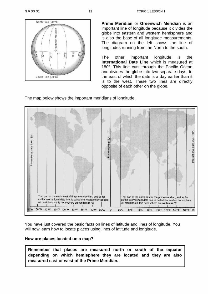
In order to locate a place on a map, you also need lines of longitude to pin point the exact location of a place on a map. What are lines of Longitude?
Lines of longitude (or meridian) are numbered from 0° Greenwich (near London) to
180° west and east which is a line of longitude passing through the Pacific Ocean.
The longitude 0° Greenwich is also known as Prime Meridian. It is called the Prime
Meridian because it is the baseline from which all other longitude measurements are
made. From 0º to the right or going clockwise around the globe to 180° is east of the
Prime Meridian. From 0º to the left or going anti-clockwise around the globe to the
same 180 line is west of the Prime Meridian. All lines of longitude have the same
length and all end at the two poles. Lines of longitude are wide apart at the equator
and progressively get narrower towards the poles.
I only know of northern and southern hemisphere. I wonder if there is eastern and western
hemisphere.
Well, the globe is also divided into western and eastern hemisphere. Find out more in in the next paragraph.
Lines of longitude are imaginary lines that extend from the North Pole to the South Pole.
G 9 SS S1 12 TOPIC 1 LESSON 1
Prime Meridian or Greenwich Meridian is an important line of longitude because it divides the globe into eastern and western hemisphere and is also the base of all longitude measurements. The diagram on the left shows the line of longitudes running from the North to the south. The other important longitude is the International Date Line which is measured at 180º. This line cuts through the Pacific Ocean and divides the globe into two separate days, to the east of which the date is a day earlier than it is to the west. These two lines are directly opposite of each other on the globe.
The map below shows the important meridians of longitude.
You have just covered the basic facts on lines of latitude and lines of longitude. You will now learn how to locate places using lines of latitude and longitude. How are places located on a map?
Remember that places are measured north or south of the equator
depending on which hemisphere they are located and they are also
measured east or west of the Prime Meridian.
G 9 SS S1 13 TOPIC 1 LESSON 1
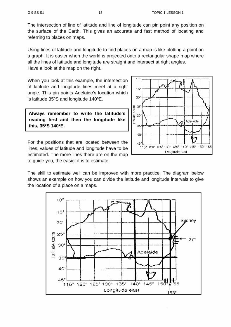
The intersection of line of latitude and line of longitude can pin point any position on
the surface of the Earth. This gives an accurate and fast method of locating and
referring to places on maps.
Using lines of latitude and longitude to find places on a map is like plotting a point on
a graph. It is easier when the world is projected onto a rectangular shape map where
all the lines of latitude and longitude are straight and intersect at right angles.
Have a look at the map on the right.
When you look at this example, the intersection
of latitude and longitude lines meet at a right
angle. This pin points Adelaide’s location which
is latitude 35ºS and longitude 140ºE.
In this example, you notice that only a limited
number of lines of latitude and longitude are
marked on the map.
For the positions that are located between the
lines, values of latitude and longitude have to be
estimated. The more lines there are on the map
to guide you, the easier it is to estimate.
The skill to estimate well can be improved with more practice. The diagram below
shows an example on how you can divide the latitude and longitude intervals to give
the location of a place on a maps.
Adelaide
Sydney
27°
153°
Always remember to write the latitude’s
reading first and then the longitude like
this, 35ºS 140ºE.
G 9 SS S1 14 TOPIC 1 LESSON 1
From this example, Sydney is located between the latitude 25 and 30 degrees south
of the equator and 150 and 155 degrees east of the Prime Meridian. You will notice
that the lines of latitude and longitude on this map are increasing at a regular interval
by 5 degrees. Divide the main interval into 5 equal intervals. For this case it is the
main interval between 25 and 30 degrees south and 150 and 155 degrees east.
After dividing the intervals, identify the latitude line and the longitude line that
intersect at Sydney.
Now what is the latitude and longitude reading for Sydney? The latitude is 27° south and longitude is 153° east and written as such 27°S153°E. On some maps, lines of latitude and longitude curve and the distance between them
gets progressively smaller especially towards the poles. When you locate places on
such map, make allowances for the curve.
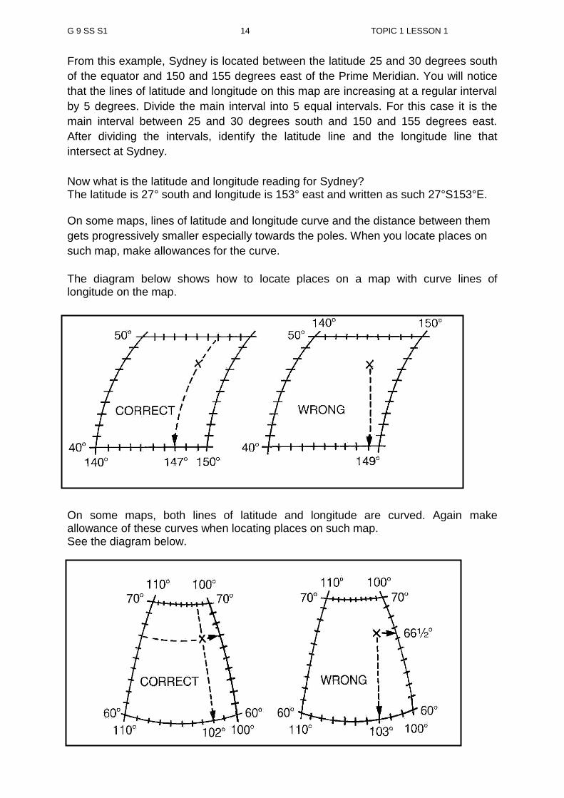
The diagram below shows how to locate places on a map with curve lines of longitude on the map.
On some maps, both lines of latitude and longitude are curved. Again make allowance of these curves when locating places on such map. See the diagram below.
G 9 SS S1 15 TOPIC 1 LESSON 1
Now do the activity below.
Activity 1
Use a world map in the Jacaranda Atlas to answer these two questions. First locate Papua New Guinea on the world map and then answer these two questions. 1. Locate Port Moresby by giving its latitude and longitude.
_______________________________________________________________
2. Name the countries that border Papua New Guinea.
_______________________________________________________________
lines of latitude are imaginary parallel lines that extend around the globe from west to east.
lines of latitude are numbered from 0º at the Equator to 90º north and south at the poles.
the Equator is the longest of the latitude lines
all other latitude lines get progressively shorter towards the poles.
lines of latitude are measured in angular distance north or south of the Equator.
lines of longitude are imaginary lines that extend from the North Pole to the South Pole.
lines of longitude are numbered from 0º to 180º west or 0º to 180º east of the Prime Meridian.
all lines of longitude have the same length and meet at the two poles.
NOW DO PRACTICE EXERCISE 1 ON THE NEXT PAGE
SUMMARY
You have come to the end of this lesson. In this lesson you have learnt that:

G 9 SS S1 16 TOPIC 1 LESSON 1
Practice Exercise 1
1. Define lines of latitude and longitudes.
______________________________________________________________
______________________________________________________________
2. Which line of latitude is the longest and is measured at 0° degrees?
______________________________________________________________ 3. Use a world map in a Jacaranda Atlas to answer this question. Name at least five countries located at the following lines of latitude.
4. What is the name of the longitude at 0 degrees and is used as the baseline of all the longitude readings?
______________________________________________________________
5. Use a world map in the Jacaranda School atlas to answer this question. Name at least five countries situated at the following lines of longitude.
30° N 15° S 60° N
30°E 15°W 60° E
G 9 SS S1 17 TOPIC 1 LESSON 1
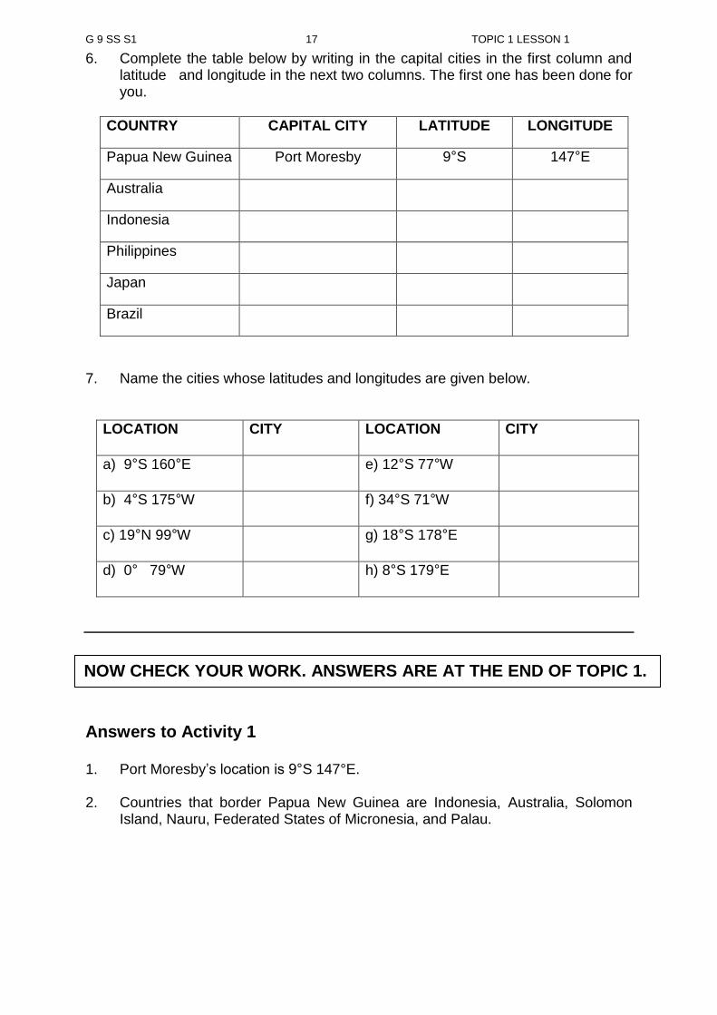
6. Complete the table below by writing in the capital cities in the first column and latitude and longitude in the next two columns. The first one has been done for you.
COUNTRY CAPITAL CITY LATITUDE LONGITUDE
Papua New Guinea Port Moresby 9°S 147°E
Australia
Indonesia
Philippines
Japan
Brazil
7. Name the cities whose latitudes and longitudes are given below.
LOCATION CITY LOCATION CITY
a) 9°S 160°E e) 12°S 77°W
b) 4°S 175°W f) 34°S 71°W
c) 19°N 99°W g) 18°S 178°E
d) 0° 79°W h) 8°S 179°E
Answers to Activity 1 1. Port Moresby’s location is 9°S 147°E. 2. Countries that border Papua New Guinea are Indonesia, Australia, Solomon
Island, Nauru, Federated States of Micronesia, and Palau.
NOW CHECK YOUR WORK. ANSWERS ARE AT THE END OF TOPIC 1.
G9 SS U1 TOPIC 1 LESSON 2
18
LESSON 2 Grid Reference
Welcome to lesson 2 of Unit 1. In your last lesson you learnt about lines of latitudes and longitudes. For lesson 2 you will learn how to locate places or features using Grid Reference.
Your Aims
define a grid
describe the four figure and six figure grid reference
identify places and features using grid reference.
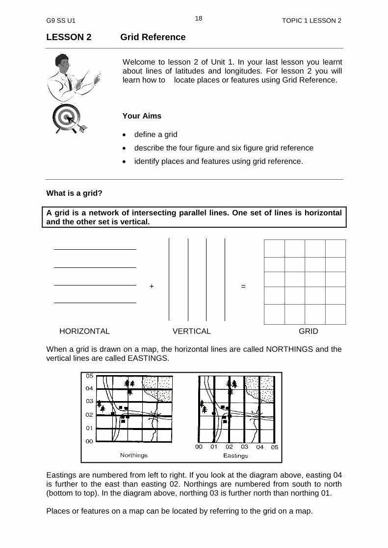
What is a grid?
A grid is a network of intersecting parallel lines. One set of lines is horizontal and the other set is vertical.
+ = HORIZONTAL VERTICAL GRID When a grid is drawn on a map, the horizontal lines are called NORTHINGS and the vertical lines are called EASTINGS. Eastings are numbered from left to right. If you look at the diagram above, easting 04 is further to the east than easting 02. Northings are numbered from south to north (bottom to top). In the diagram above, northing 03 is further north than northing 01. Places or features on a map can be located by referring to the grid on a map.

G9 SS U1 TOPIC 1 LESSON 2
19
There are two types of grid reference:
1. four figure grid reference and 2. six figure grid reference
1. Four-figure grid reference
Most often a four figure gives a general location of a place or a feature on a map.
The reading is always taken from the bottom left hand corner of the square in which
the place or the feature is in.
Remember to write EASTING figures FIRST and then the NORTHING figures. 01 02 03 04 05
E A S T I N G What would be the four figure grid reference (Area Reference) for the star? Easting is
01 and Northing is 04. The location of the star using the four figure grid reference is
0104.
What do you think is the Area Reference for the tree? Easting is 02 and Northing is
03. The location of the tree using the four figure grid reference is AR 0203.
Four figure grid references are used only when it is not necessary to give a precise
position to describe the location of a feature. For example, a large area of forest may
nearly fill one or more grid squares. Obviously no one point would give the forest’s
location. In this case a four figure grid reference would be used.
N O R T H I N G
03
04
02
05
01
A four figure grid reference is also known as Area Reference and consists of four figures, two eastings and two northings.
G9 SS U1 TOPIC 1 LESSON 2
20
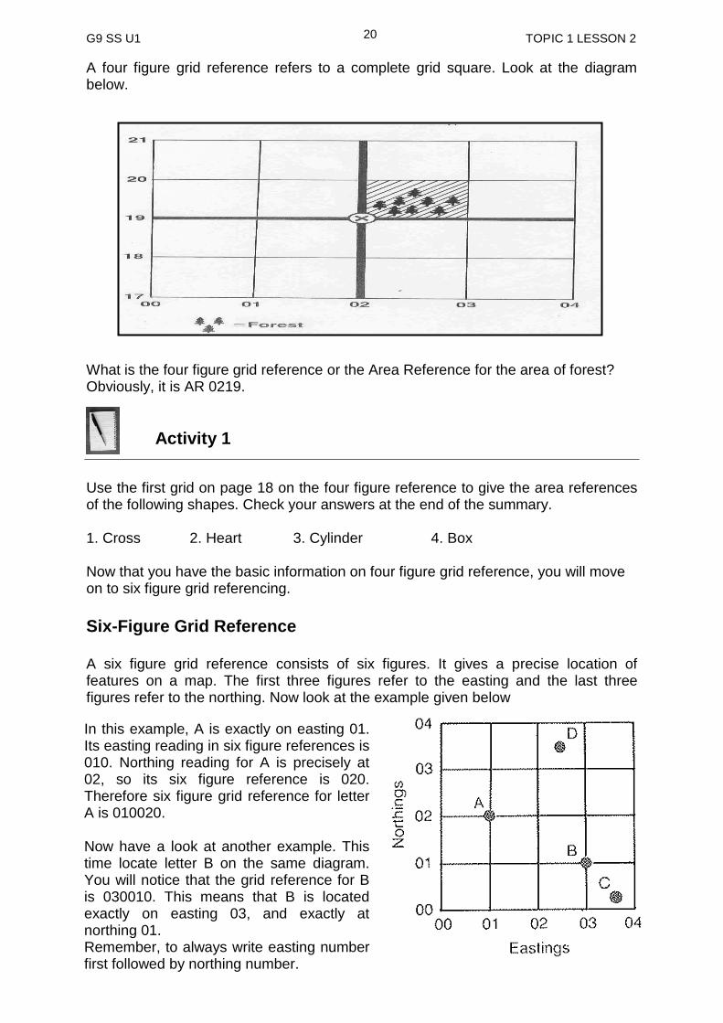
A four figure grid reference refers to a complete grid square. Look at the diagram below. What is the four figure grid reference or the Area Reference for the area of forest? Obviously, it is AR 0219.
Activity 1
Use the first grid on page 18 on the four figure reference to give the area references of the following shapes. Check your answers at the end of the summary. 1. Cross 2. Heart 3. Cylinder 4. Box Now that you have the basic information on four figure grid reference, you will move on to six figure grid referencing.
Six-Figure Grid Reference A six figure grid reference consists of six figures. It gives a precise location of features on a map. The first three figures refer to the easting and the last three figures refer to the northing. Now look at the example given below
In this example, A is exactly on easting 01. Its easting reading in six figure references is 010. Northing reading for A is precisely at 02, so its six figure reference is 020. Therefore six figure grid reference for letter A is 010020. Now have a look at another example. This time locate letter B on the same diagram. You will notice that the grid reference for B is 030010. This means that B is located exactly on easting 03, and exactly at northing 01. Remember, to always write easting number first followed by northing number.
G9 SS U1 TOPIC 1 LESSON 2
21
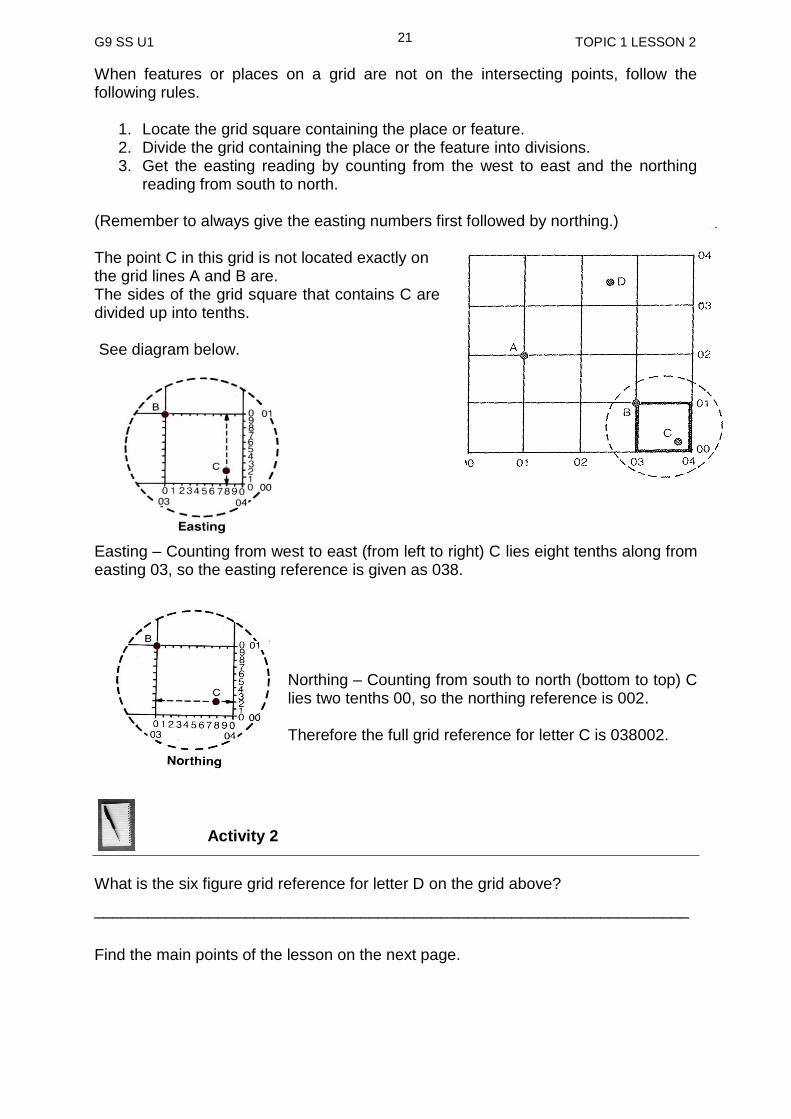
When features or places on a grid are not on the intersecting points, follow the following rules.
1. Locate the grid square containing the place or feature. 2. Divide the grid containing the place or the feature into divisions. 3. Get the easting reading by counting from the west to east and the northing
reading from south to north. (Remember to always give the easting numbers first followed by northing.) The point C in this grid is not located exactly on the grid lines A and B are. The sides of the grid square that contains C are divided up into tenths. See diagram below.
Easting – Counting from west to east (from left to right) C lies eight tenths along from easting 03, so the easting reference is given as 038.
Northing – Counting from south to north (bottom to top) C lies two tenths 00, so the northing reference is 002. Therefore the full grid reference for letter C is 038002.
Activity 2
What is the six figure grid reference for letter D on the grid above?
___________________________________________________________________
Find the main points of the lesson on the next page.

G9 SS U1 TOPIC 1 LESSON 2
22
Summary
You have come to the end of lesson 1. In this lesson you have learnt that:
A grid is a network of intersecting lines.
One set of line is horizontal and the other set is vertical.
The horizontal lines are called northing and the vertical lines are called easting.
Easting is numbered vertically from west to east (left to right).
Northing is numbered horizontally from bottom to top.
Four figure grid references consist of four figures and give a general location of a feature or a place.
Four figure grid references are also known as Area References
Six figure grid references consist of six figures and give a precise location of a feature or a place on the grid.
NOW DO THE PRACTICE EXERCISE 2 ON THE NEXT PAGE

G9 SS U1 TOPIC 1 LESSON 2
23
Practice Exercise 2
1. What is a grid? ___________________________________________________________
1. In grid referencing the horizontal lines are known as ________________ and the vertical lines are known as _______________________.
3. When giving grid reference, which set of numbers are given first? _______________________________ 4. Use the grid below to locate the letters using four figure grid references.
N
M
C
J
P
K
S
E
L
A
10 11 12 13 14 15
a) Give area reference (four figure grid reference) for each of the grid square which contain the following letters.
N ____________________
S ____________________
K ____________________
P ____________________
M ____________________
b) Which letters are located at the following references?
1416 ___________________
21
20
17
19
18
16
G9 SS U1 TOPIC 1 LESSON 2
24
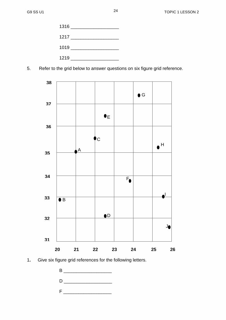
1316 ___________________ 1217 ___________________ 1019 ___________________ 1219 ___________________ 5. Refer to the grid below to answer questions on six figure grid reference.
G
E
A
C
H
F I
B D
J
20 21 22 23 24 25 26 1. Give six figure grid references for the following letters. B ___________________
D ___________________
F ___________________
37
36
33
34
35
31
32
38
G9 SS U1 TOPIC 1 LESSON 2
25
G ___________________
J ___________________
2. Write the correct letter of the grid references given below.
220355 _____________ 225365 _____________ 210350 _____________ 255330 _____________ 258315 _____________
Answers to activity questions Activity 1
1. 0101 2. 0302 3. 0404 4. 0402 Activity 2 2. Grid reference for letter D is 025035.
NOW CHECK YOUR WORK. ANSWERS ARE AT THE END OF TOPIC 2.

G9 SS U1 TOPIC 1 LESSON 3
26
LESSON 3: Contour Lines
Welcome to lesson 3. You will start by looking at the meaning of contour lines, the different types of lines and how they function.
Your Aims
Learn the definitions of the term contour
Identify the different types of contours found in maps
Define and explain the characteristics of different types of
contours
What are contour lines?
Map makers use contour lines to show relief of the land. If you walk along a contour
line you neither gain nor lose elevation. Contour lines are useful because they
illustrate the topography on the map (mapping of surface features such as
mountains, rivers hills etc.). Below are some images of contour lines.
The water surface marks an elevation we call sea level, or zero. As you walk along
the shore, your elevation will remain the same, because you are following a contour
line. If you stray or walk away from the shoreline and start walking into the sea, the
elevation of the ground (in this case the seafloor) is below sea level. If you stray the
other direction and walk up the beach, your elevation will be above sea level. The
contour line represented by the shoreline separates areas that have elevations above
sea level from those that have elevations below sea level.
Contour lines are lines drawn on maps joining points of equal height above or below sea level, Elevation
I cannot remember coming across
the word elevation.
Well, elevation is height given in relation to a given level. In this case, it is height above or below sea level.

G9 SS U1 TOPIC 1 LESSON 3
27
We refer to contour lines in terms of their elevation above or below sea level. In this
example, the shoreline would be the zero contour line.
See the illustration below.
Contour lines are the main feature of a topographic map.
Political boundaries, such as the limits of towns, provinces, countries, and states, are
also shown. With great variety of information included on them, topographic maps
are most often used as general reference maps. See example below.
Mm! What is a topographic map?
Topographic map is a basic type of map used to represent land areas. Such maps show the natural features of the area covered as well as
certain man-made features, known as cultural features.
G9 SS U1 TOPIC 1 LESSON 3
28
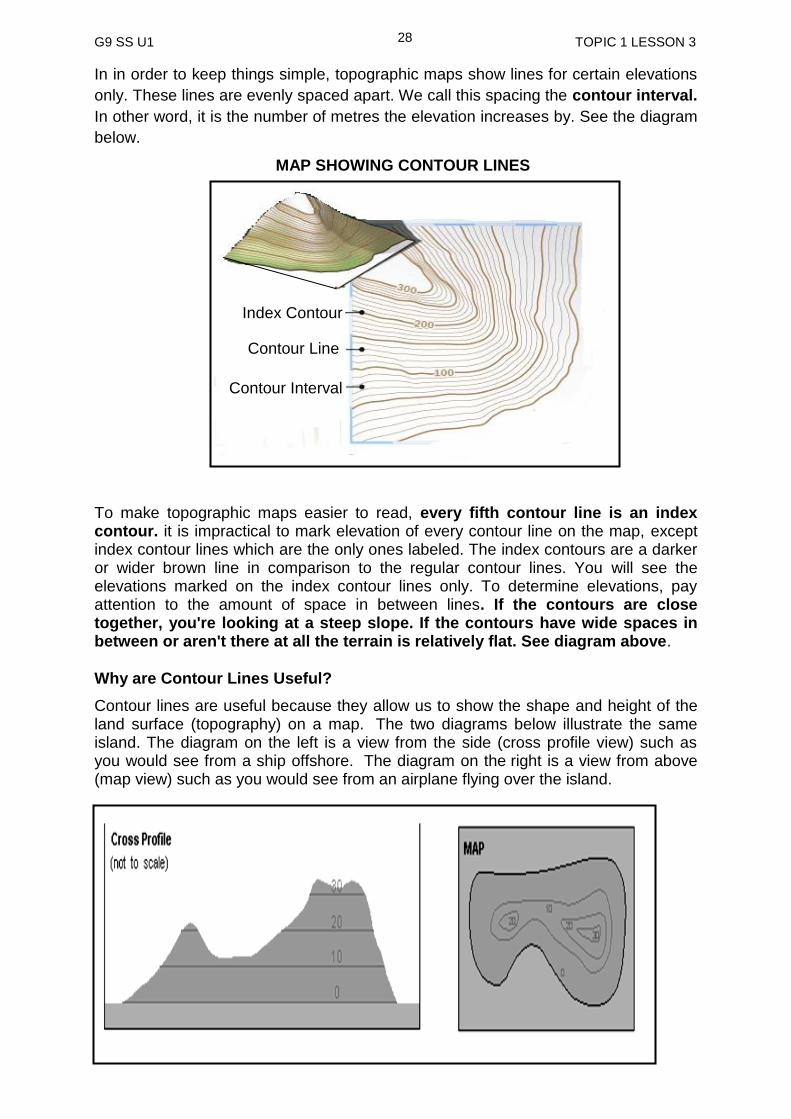
In in order to keep things simple, topographic maps show lines for certain elevations
only. These lines are evenly spaced apart. We call this spacing the contour interval.
In other word, it is the number of metres the elevation increases by. See the diagram
below.
To make topographic maps easier to read, every fifth contour line is an index contour. it is impractical to mark elevation of every contour line on the map, except index contour lines which are the only ones labeled. The index contours are a darker or wider brown line in comparison to the regular contour lines. You will see the elevations marked on the index contour lines only. To determine elevations, pay attention to the amount of space in between lines. If the contours are close together, you're looking at a steep slope. If the contours have wide spaces in between or aren't there at all the terrain is relatively flat. See diagram above.
Why are Contour Lines Useful?
Contour lines are useful because they allow us to show the shape and height of the land surface (topography) on a map. The two diagrams below illustrate the same island. The diagram on the left is a view from the side (cross profile view) such as you would see from a ship offshore. The diagram on the right is a view from above (map view) such as you would see from an airplane flying over the island.
Index Contour
Contour Interval
Contour Line
MAP SHOWING CONTOUR LINES

G9 SS U1 TOPIC 1 LESSON 3
29
The shape of the island is shown by the shoreline on the map. Unlike shorelines, contour lines are imaginary lines. They just exist on maps.
Taken all together, the contour lines supply us with much information on the topography of the island. From the map (and the profile) we can see that this island has two "high" points. The highest point is above 30 m elevation (inside the 30 m contour line). The second high point is above 20 m in elevation, but does not reach 30 m. These high points are at the ends of a ridge that runs the length of the island where elevations are above 10 m. Lower elevations, between the 10 m contour and sea level surround this ridge.
With practice we can picture topography by looking at the map even without the cross profile. That is the power of topographic maps.
Now do the activity below. Check your answers at the end of Practice Exercise.
Activity
1. What is topography?
____________________________________________________________
____________________________________________________________
2. What is a topographic map?
____________________________________________________________
____________________________________________________________
3. Why are contour lines useful?
___________________________________________________________
___________________________________________________________
We will now look at reading elevation. Read the notes below to find out more on reading elevation
Reading Elevations
A common use of a topographic map is to determine the elevation at a specified locality. The map on the next page is an enlargement of the map of the island on the previous page. Each of the letters from A to E represents locations for which we wish to determine elevation.
Study the map on the next page carefully and follow through the example given on
how to read the elevations. (Assume elevations are given in metres)

G9 SS U1 TOPIC 1 LESSON 3
30
Point A = 0 metres Point A sits right on the 0 m contour line. Since all points on this line have an elevation of 0 m, the elevation of point A is zero.
Point B = 10 m Point B sits right on the 10 m contour line. Since all points on this line have an elevation of 10 m, the elevation of point B is 10 m. Point C = 15 m Point C does not sit directly on a contour line so we cannot determine the elevation precisely. We do know that point C is between the 10m and 20 m contour lines so its elevation must be greater than 10 m and less than 20 m. Because point C is midway between these contour lines we can estimate the elevation is about 15 m (Note this assumes that the slope is constant between the two contour lines, this may not be the case). Point D = 25 m We are even less sure of the elevation of point D than point C. Point D is inside the 20 m. contour line indicating its elevation is above 20 m. Its elevation has to be less than 30 m because there is no 30 m. contour line shown, but how much less? There is no way to tell. The elevation could be 21 m, or it could be 29 m. There is now way to tell from the map. (An eight metre difference in elevation does not seem like much, but remember these numbers are just an example.
Point E = 8 m Just as with point C above, we need to estimate the elevation of point E somewhere between the 0 m and 10 m contour lines it lies in between. Because this point is closer to the 10 m line than the 0 m. line we estimate an elevation closer to 10. In this case 8 m. seems reasonable. Again this estimation makes the assumption of a constant slope between these two contour lines. Once we know how to determine the elevation of the unmarked contour lines we should be able determine or at least estimate the elevation of any point on the map.
30
20
10
0
20
G9 SS U1 TOPIC 1 LESSON 3
31
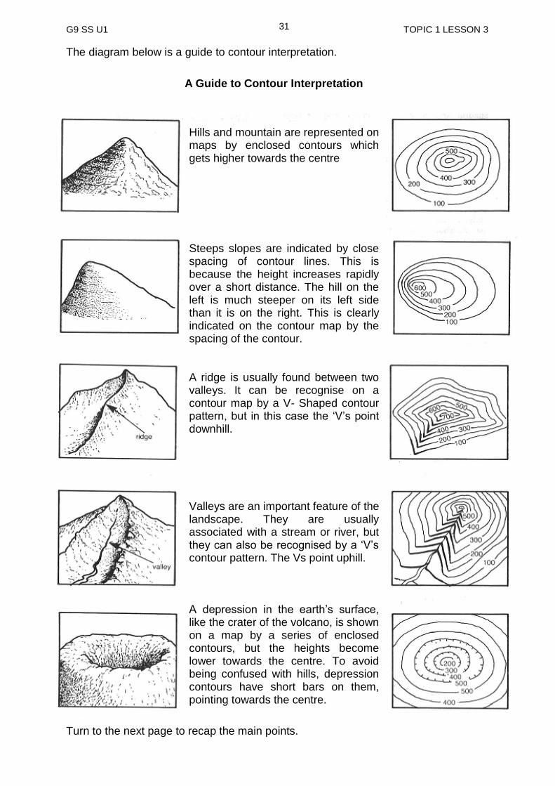
The diagram below is a guide to contour interpretation.
A Guide to Contour Interpretation
Turn to the next page to recap the main points.
Hills and mountain are represented on maps by enclosed contours which gets higher towards the centre Steeps slopes are indicated by close spacing of contour lines. This is because the height increases rapidly over a short distance. The hill on the left is much steeper on its left side than it is on the right. This is clearly indicated on the contour map by the spacing of the contour. A ridge is usually found between two valleys. It can be recognise on a contour map by a V- Shaped contour pattern, but in this case the ‘V’s point downhill. Valleys are an important feature of the landscape. They are usually associated with a stream or river, but they can also be recognised by a ‘V’s contour pattern. The Vs point uphill. A depression in the earth’s surface, like the crater of the volcano, is shown on a map by a series of enclosed contours, but the heights become lower towards the centre. To avoid being confused with hills, depression contours have short bars on them, pointing towards the centre.
G9 SS U1 TOPIC 1 LESSON 3
32
contour lines are lines drawn on a map joining points of equal height above or
below sea level. (elevation).
they are useful because they illustrate the shape of the land surface on the map.
the water surface marks an elevation we call sea level, or zero (o).
topographic map is a basic type of map used to represent land areas. such maps show the natural features of the area covered as well as certain artificial features, known as cultural features.
in order to keep things simple, topographic maps show lines for certain elevations only. these lines are evenly spaced apart. we call this spacing the contour interval. in other word, it is the number of metres the elevation increase by.
to make topographic maps easier to read, every fifth contour line is an index contour.
the index contours are a darker or wider brown line in comparison to the regular contour lines.
Summary
You have come to the end of lesson 3. In this lesson, you have learnt that:
NOW DO PRACTICE EXERCISE 3 ON THE NEXT PAGE
G9 SS U1 TOPIC 1 LESSON 3
33
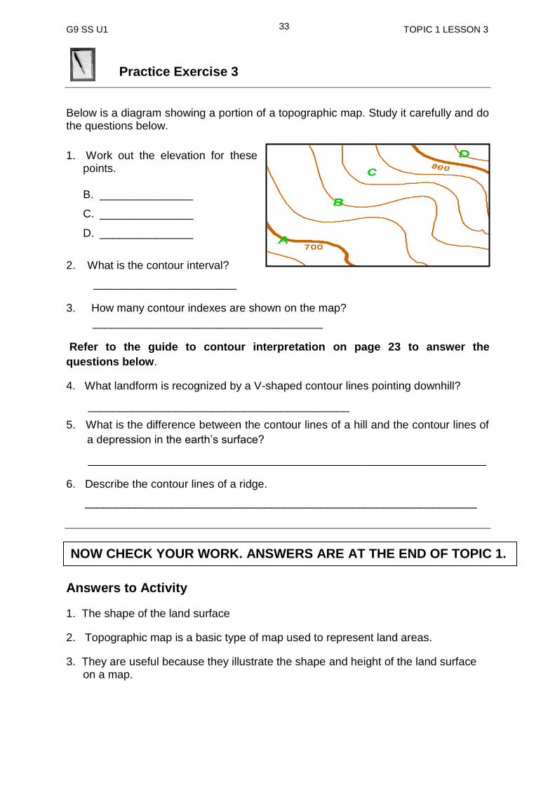
Practice Exercise 3
Below is a diagram showing a portion of a topographic map. Study it carefully and do the questions below.
1. Work out the elevation for these points.
B. _______________
C. _______________
D. _______________
2. What is the contour interval?
_______________________
3. How many contour indexes are shown on the map?
_____________________________________
Refer to the guide to contour interpretation on page 23 to answer the
questions below.
4. What landform is recognized by a V-shaped contour lines pointing downhill?
__________________________________________
5. What is the difference between the contour lines of a hill and the contour lines of
a depression in the earth’s surface?
________________________________________________________________
6. Describe the contour lines of a ridge.
_______________________________________________________________
Answers to Activity
1. The shape of the land surface
2. Topographic map is a basic type of map used to represent land areas.
3. They are useful because they illustrate the shape and height of the land surface on a map.
NOW CHECK YOUR WORK. ANSWERS ARE AT THE END OF TOPIC 1.

G9 SS U1 TOPIC 1 LESSON 4
34
LESSON 4 Compass Directions
Welcome to lesson four of Unit 1. In this lesson will learn about
the compass directions. Compass direction helps us to describe the location of a place in relation to others or assist in describing direction of travel.
Your Aims:
identify the compass points
give direction of places using these compass points.
Points of a Compass A compass has four main points called cardinal points. They are north, south, east and west. For example, if you are facing north then south is behind you, east your right and west your left. See diagram below.
.The cardinal points are very important
because they are the base of all the other
compass readings however they are of
limited value as they may not give precise
location of features or places. Between
the cardinal points lie the inter-cardinal
points. The points are shown on the
diagram on the right. The inter-cardinal
points increase the number of compass
directions to eight which can be more
accurate as compared to the cardinal
points. The points of a compass can be
used to describe the direction of travel or
the position of features in relation to
others.
EIGHT POINT COMPASS DIRECTION

G9 SS U1 TOPIC 1 LESSON 4
35
These are the sixteen-point compass direction as shown on the diagram on the right. N North S South NNE North North East SSW South South West NE North East SW South West ENE East North East WSW West South West E East W West ESE East South East WNW West North West SE South East NW North West SSE South South East NNW North North West How do we find directions? When finding directions on maps you must first know where north is on the map. This would set the base on where to give directions. An arrow is usually used to indicate north on maps. Once you identify north, south will be directly opposite. What do you notice about the direction of the arrow on the map above? You can obviously see that the arrow is pointing straight up indicating where north is.
More accurate than an eight compass is the sixteen-point compass direction. The extra eight compass points fall in between the inter-cardinal points or eight point compass direction. This makes it a sixteen point compass
SIXTEEN POINT COMPASS DIRECTION
MAINLAND OF PAPUA NEW GUINEA
G9 SS U1 TOPIC 1 LESSON 4
36
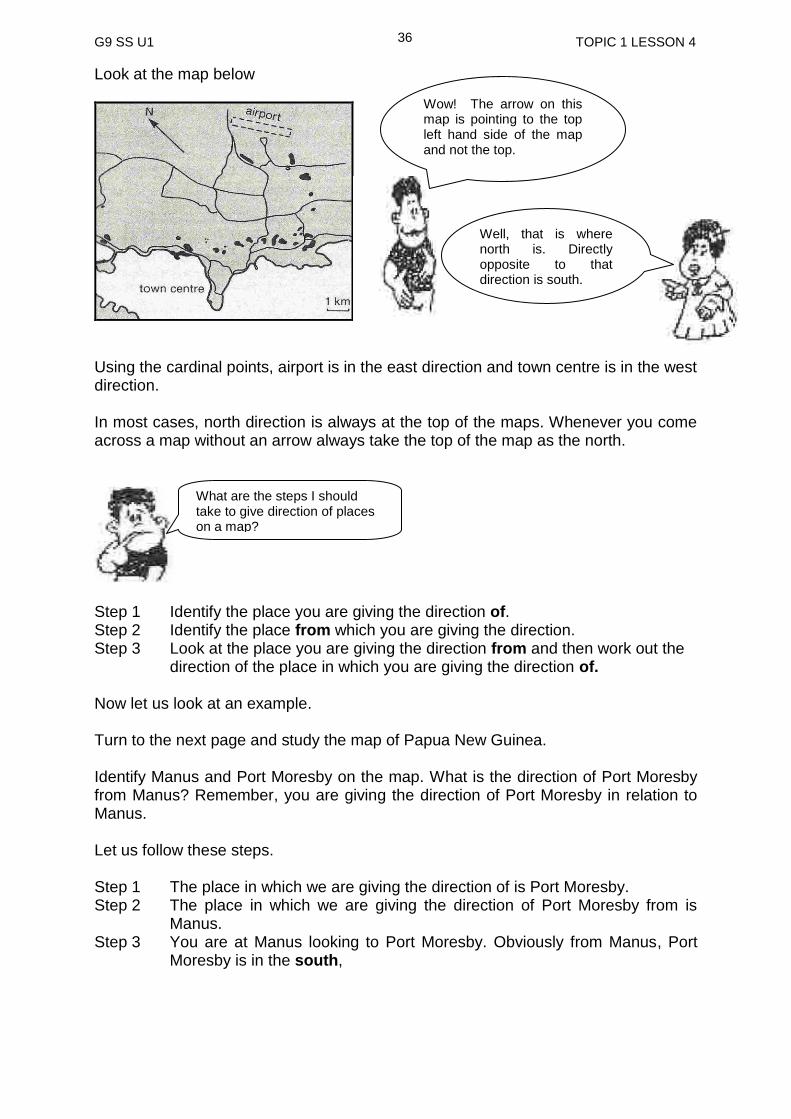
Look at the map below
Using the cardinal points, airport is in the east direction and town centre is in the west direction. In most cases, north direction is always at the top of the maps. Whenever you come across a map without an arrow always take the top of the map as the north.
Step 1 Identify the place you are giving the direction of. Step 2 Identify the place from which you are giving the direction. Step 3 Look at the place you are giving the direction from and then work out the direction of the place in which you are giving the direction of. Now let us look at an example. Turn to the next page and study the map of Papua New Guinea. Identify Manus and Port Moresby on the map. What is the direction of Port Moresby from Manus? Remember, you are giving the direction of Port Moresby in relation to Manus. Let us follow these steps. Step 1 The place in which we are giving the direction of is Port Moresby. Step 2 The place in which we are giving the direction of Port Moresby from is
Manus. Step 3 You are at Manus looking to Port Moresby. Obviously from Manus, Port
Moresby is in the south,
Wow! The arrow on this map is pointing to the top left hand side of the map and not the top.
Well, that is where north is. Directly opposite to that direction is south.
What are the steps I should take to give direction of places on a map?

G9 SS U1 TOPIC 1 LESSON 4
37
In this example, you use the cardinal points to give direction of Port Moresby from
Manus. We know that the cardinal points are important but they cannot give accurate
direction of places that do not lie exactly at the cardinal points, north, east, west and
south. To give a more accurate direction, we use inter-cardinal points.
Go back to the map of PNG and identify Wewak and Madang. What is the direction
of Madang from Wewak? You will notice that from Wewak, Madang lies between the
cardinal points south and east. It cannot be south and it cannot be north. It lies
between south and east and therefore it is South East.
There are times when places fall in between the cardinal points and the inter-cardinal
points. In general, inter-cardinal points can be used to give direction for such location
however it will not be precise. The sixteen point compass can be used to give a more
precise direction of a place or a feature on a map.
Now find Kimbe and Kavieng on the map.
Does Kavieng lie directly north of Kimbe?
No it is not. It is slightly to the right, but not exactly north
east.
MAP OF PAPUA NEW GUINEA
G9 SS U1 TOPIC 1 LESSON 4
38
If Kavieng is not exactly north of Kimbe and not directly north east of Kimbe then what is the direction of Kavieng from Kimbe? The direction of Kavieng from Kimbe is north north east (NNE).
Activity
Give the direction of the following place from Lae. a) Rabaul b) Vanimo c) Alotau d) Daru Let us now look at the summary below to recap the main points in this lesson.
compass points or cardinal points are used in giving directions of places in relation to other places.
there are four cardinal points, North, East, South and West. They are important because they are the base of all the readings.
for a more accurate direction, inter-cardinal points or the eight point compass directions are used. They are north east, south east, North West, South West and the four cardinal points.
sixteen-point compass directions are also used for a more precise location compare to the eight points or the inter-cardinal points and the cardinal points.
SUMMARY
You have come to the end of this lesson. In this lesson you have learned that:
NOW DO PRACTICE EXERCISE 4 ON THE NEXT PAGE
G9 SS U1 TOPIC 1 LESSON 4
39
Practice Exercise 4
1. What is the name given to the four main compass directions?
______________________________________________________________ 2. How many points make up the inter-cardinal points? ___________________________________________________________ 3. Why are compass points important? ___________________________________________________________ 4. Which of the three different compass points, gives a more accurate description of locations or features on a map?
_____________________________________________________________ Use a Jacaranda World Map to answer Questions 5 and 6. 5. Give the direction of the following places from Papua New Guinea?
a) Indonesia _________________ d) Australia_________________
b) New Zealand ________________ e) Japan _________________
c) USA ______________________ f) Vanuatu _________________ 6. A plane flew from Papua New Guinea via Hawaii to Florida in the United
States. In which two directions did the plane fly? _________________________________________________________________
Answers to Activity a) North east b) North west c) South east d) South west
NOW CHECK YOUR WORK. ANSWERS ARE AT THE END OF TOPIC 1.
G9 SS U1 TOPIC 1 LESSON 5
40
LESSON 5 Calculating Distance
Welcome to Lesson 5. In this lesson, you will learn how to calculate distance between different places.
Your Aims:
identify the difference between map distance and ground distance.
explain the importance of a map scale.
calculate distances on maps using scales.
What is a scale?
A scale is a ratio between map distance and the distance on the ground.
Maps with scales are very useful because they enable us to calculate real distances
on the ground by taking measurements from the map. A scale on a map will have a
figure usually in centimetres which is the distance on the ground. This figure
represents the actual distance on the ground which is usually in metres (m) or
kilometres (km). Map scales are not all the same. They vary according to the number
of times the land represented by the maps has been reduced in size. On some maps,
one centimetre would represent a very big distance, while on others it might
represent only a few hundred metres. It depends on how many times the land
represented by the map has been reduced.
The scales on maps can be represented in three different ways.
1. Word statement
2. Linear or line scale
3. Representative Fraction
1. Word Statement The scale shown in a statement is given in words. (e.g. ‘one centimetre to one
kilometre). This statement means that one centimetre on the map represents one
kilometre on the ground. In metric scales, the most common is one centimetre to one
kilometre. On these maps, every one centimetre on the map represents 1000 metres
or one kilometre. Thus a map distance of 7.5 centimetres would represent 7.5
kilometres on the ground. Do not make this mistake by writing one centimetre is
equals to one kilometre. The equation will not be possible.
G9 SS U1 TOPIC 1 LESSON 5
41
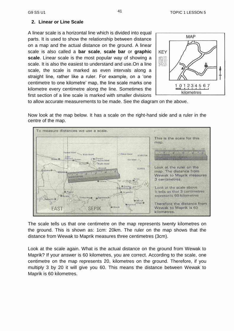
2. Linear or Line Scale A linear scale is a horizontal line which is divided into equal
parts. It is used to show the relationship between distance
on a map and the actual distance on the ground. A linear
scale is also called a bar scale, scale bar or graphic
scale. Linear scale is the most popular way of showing a
scale. It is also the easiest to understand and use.On a line
scale, the scale is marked as even intervals along a
straight line, rather like a ruler. For example, on a ‘one
centimetre to one kilometre’ map, the line scale marks one
kilometre every centimetre along the line. Sometimes the
first section of a line scale is marked with smaller divisions
to allow accurate measurements to be made. See the diagram on the above.
Now look at the map below. It has a scale on the right-hand side and a ruler in the centre of the map.
The scale tells us that one centimetre on the map represents twenty kilometres on
the ground. This is shown as: 1cm: 20km. The ruler on the map shows that the
distance from Wewak to Maprik measures three centimetres (3cm).
Look at the scale again. What is the actual distance on the ground from Wewak to
Maprik? If your answer is 60 kilometres, you are correct. According to the scale, one
centimetre on the map represents 20, kilometres on the ground. Therefore, if you
multiply 3 by 20 it will give you 60. This means the distance between Wewak to
Maprik is 60 kilometres.
G9 SS U1 TOPIC 1 LESSON 5
42
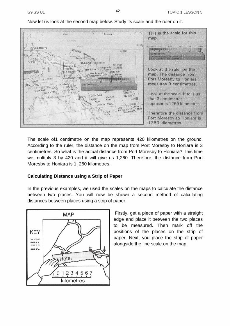
Now let us look at the second map below. Study its scale and the ruler on it.
The scale of1 centimetre on the map represents 420 kilometres on the ground.
According to the ruler, the distance on the map from Port Moresby to Honiara is 3
centimetres. So what is the actual distance from Port Moresby to Honiara? This time
we multiply 3 by 420 and it will give us 1,260. Therefore, the distance from Port
Moresby to Honiara is 1, 260 kilometres.
Calculating Distance using a Strip of Paper
In the previous examples, we used the scales on the maps to calculate the distance
between two places. You will now be shown a second method of calculating
distances between places using a strip of paper.
Firstly, get a piece of paper with a straight
edge and place it between the two places
to be measured. Then mark off the
positions of the places on the strip of
paper. Next, you place the strip of paper
alongside the line scale on the map.

G9 SS U1 TOPIC 1 LESSON 5
43
The example here demonstrates how the
distance is measured between a hotel and a
church. You will notice that the hotel mark
starts with zero. Always make sure that the
first mark is placed right below zero before
you take the reading of the next mark. In this
example, the second mark which is the
church is right below 6 and therefore the
distance between the hotel and the church is
6 kilometres.
In case the distance on the map is not a whole number, follow these steps:
1. Mark the distance you intend to measure on a strip of paper. In this case, it is X and Y. See diagram below.
2. Use the scale to measure that distance up to the last complete kilometre, and mark the number on your strip at that point. For this case, it is 3km.
3. Now measure the extra fraction of a kilometre on the fine line scale at the beginning of the line scale. Do this by placing the 3km mark on your strip at the start of the fine line scale and counting off the tenths until you reach Y. See diagram below.
4. The full distance between X and Y is therefore 33/4 0r 3.4kilometres. The Distance between the two places would be 1167km 3. Representative Fraction The numerical scale of a map indicates the relationship of distance measured on a
map and the corresponding distance on the ground. This scale is usually written as a
fraction and is called the representative fraction.
G9 SS U1 TOPIC 1 LESSON 5
44
The scale can be shown as
1___ __1___ __1___
100 000 25 000 50 000
The numerator represents the number of units on the map and the denominator
represents the number of unit on the ground. The numerator is always shown as the
number 1, the denominator then shows the number of units that one unit on the map
represents on the ground. For example,
_1___ means that one unit on the map represents 100 000 units on the ground.
100 000
The numerator and denominator also must be expressed in the same units.
For example,
_1___ could be expressed as one centimeter to 100 000 centimetres.
100 000
It would be convenient to convert the 100 000 centimetres to a more manageable
unit, such as (100 00 cm = 1 kilometre). The scale would then be stated as one
centimetre to one kilometre.
a scale is a ratio between map distance and the distance on the ground.
maps with scales are very useful because they enable us to calculate the real distance on the ground.
the scale on a map can be represented in word statement, line or linear scale and representative fraction.
map scales vary according to the number of times the land represented by the map is reduced in size.
to get the actual distance on the ground, measure the distance on the map using a ruler or a strip of paper and then calculate using the scale.
the numerical scale of a map indicates the relationship of distance measured on a map and the corresponding distance on the ground. This scale is usually written as a fraction and is called the representative fraction.
SUMMARY
You have come to the end of this lesson. In this lesson you have learnt that:
NOW DO PRACTICE EXERCISE 5 ON THE NEXT PAGE.
G9 SS U1 TOPIC 1 LESSON 5
45
PRACTICE EXERCISE 5
1. What is a scale?
_______________________________________________________________
_______________________________________________________________
2. Explain why scales are useful?
_______________________________________________________________
_______________________________________________________________
_______________________________________________________________
3. To calculate the actual distance on the ground, we must first obtain the map distance. How do we obtain the distance on the map?
_______________________________________________________________
_______________________________________________________________
_______________________________________________________________
_______________________________________________________________
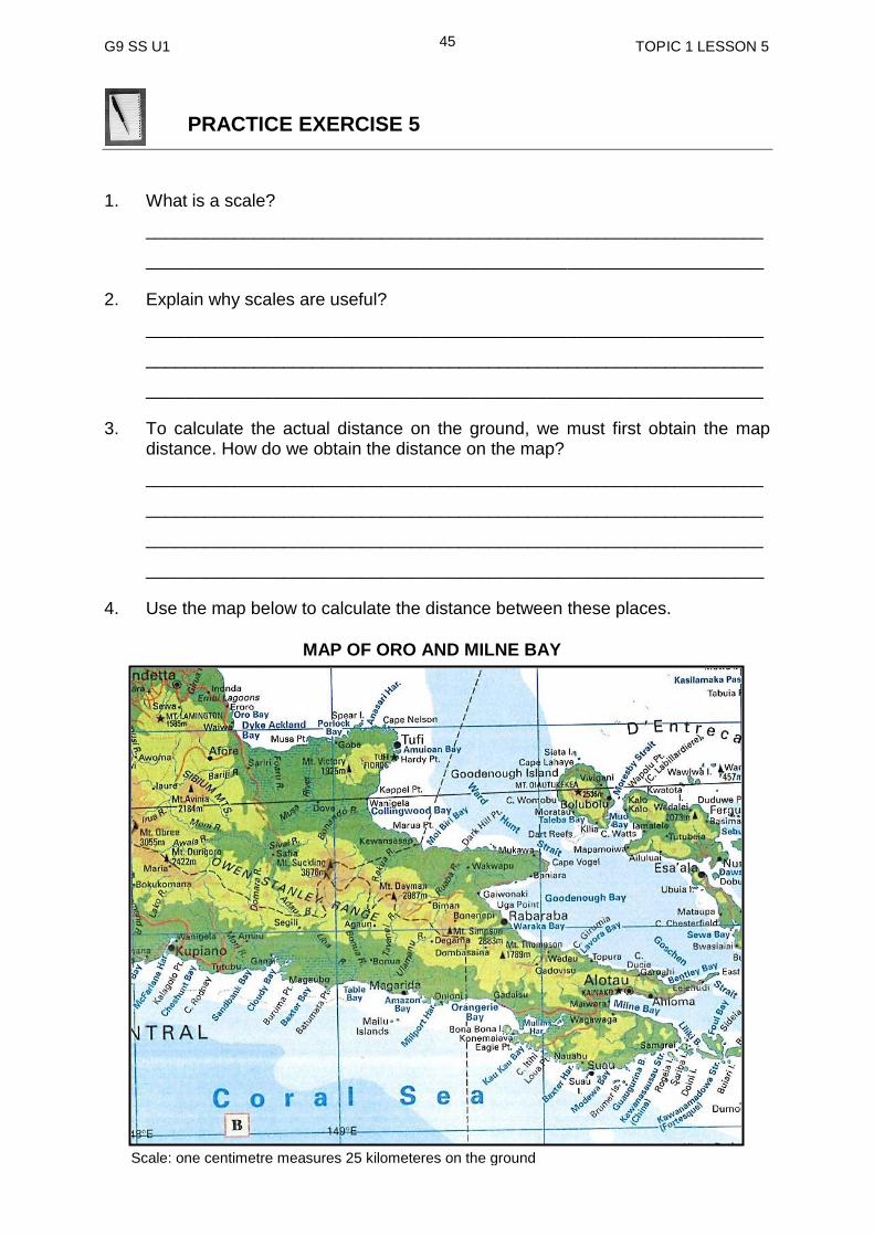
4. Use the map below to calculate the distance between these places.
Scale: one centimetre measures 25 kilometeres on the ground
MAP OF ORO AND MILNE BAY

G9 SS U1 TOPIC 1 LESSON 5
46
a) Kupiano and Alotau ____________________________
b) Alotau and Rabaraba ____________________________
c) Kupiano and Tufi ________________________________
d) Tufi and Esa’ala ________________________________
1. Express the following scales as:
a) Statements
(i) 1: 250 000 ____________________________________________
(ii) 1: 100 000 ____________________________________________
b) Ratios
(i) One centimetre to 10 000 centimetres ________________________
(ii) One centimetre to one kilometre ____________________________
NOW CHECK YOUR WORK. ANSWERS ARE AT THE END OF TOPIC 1.
G9 SS U1 TOPIC 1 ANSWERS
47
ANSWERS TO PRACTICE EXERCISE 1-5
ANSWERS TO PRACTICE EXERCISE 1
1. Lines of latitude are imaginary parallel lines that extend around the globe from
west to East. Lines of longitude are imaginary lines that extend from the North Pole to the South Pole.
2. Equator
3. (Any five countries for each respective degree can be correct) 30º North 15º South 60º North Morocco Angola Norway Algeria Zambia Sweden Libya Mozambique Russia Egypt Malawi Alaska (USA) Israel Madagascar Canada Jordan Australia Saudi Arabia Vanuatu Kuwait American Samoa Iran Tahiti Afghanistan Peru Pakistan Bolivia India Brazil China Mexico USA 4. Greenwich or Prime Meridian 5. (Any five countries for each respective degree can be correct)
30º East 15º West 45º East
Finland Iceland Russia Russia Morocco Iran Turkey Mauritania Iraq Cyprus Senegal Saudi Ar abia Lebanon Gambia Yemen Egypt Guinea Bissau Ethiopia Sudan Somalia Rwanda Comoros Zambia Madagascar Zimbabwe South Africa
6.
COUNTRY CAPITAL CITY LATITUDE LONGITUDE
PNG Port Moresby 9º 147º
Australia Canberra 35º 149º
Indonesia Jakarta 6º 107º
Philippines Manila 15º 121º
G9 SS U1 TOPIC 1 ANSWERS
48
Japan Tokyo 36º 140º
Brazil Brasilia 15º 48º
7 9ºS, 160ºE Solomon islands 4ºS, 75ºW Peru 19ºN, 99ºW Mexico 3ºS, 118ºE Indonesia 62ºS, 97ºW Canada 37ºS, 71ºW Chile 18ºS, 179ºE Fiji 6ºS, 35ºE Tanzania
ANSWERS TO PRACTICE EXERCISE 2 1. A grid is a network of intersecting lines. 2. Horizontal lines are known as Northings and vertical lines are known as
Eastings. 3. Easting numbers are given first. 4 a) b) N = 1120 1416 = A S = 1017 1316 = L K = 1318 1217 = E P = 1118 1019 = C M = 1420 1219 = J 5 a) b) B = 201329 220355 = C D = 226321 225365 = E F = 238338 210350 = A G = 242375 253353 = H J = 259317 256330 = J
ANSWERS TO PRATICE EXERCISE 3 1. B = 740 m C = 770 m D = 820 m 2. 20 m 3. 2 contour indexes
4. Valleys
5. Depression contours have short bars on them pointing towards the centre and
the figures decrease towards the centre indicating a depression in the centre. The hill contours do not have short bars and besides the contour figures increase towards the centre indicating the highest point of the hill.
6. The contour lines of a ridge are recognised by a V shaped contour pattern
pointing downhill.
G9 SS U1 TOPIC 1 ANSWERS
49
ANSWERS TO PRATICE EXERCISE 4 1. Cardinal points 2. 8 points 3. Compass points are important because they can be used to describe the
direction of travel or position of features in relation to others. 4. The sixteen - point compass 5 Indonesia - West Australia - South New Zealand - South east Japan - North North east USA - North east Vanuatu - South east 6. East and then North east
ANSWERS TO PRACTICE EXERCISE 5 1 A scale is a ratio between map distance and the distance on the ground. 2 The scales are useful because they enable us to calculate real distances on the
ground by taking measurement from the map. 3. To get the actual distance on the ground, measure the distance on the map
using a ruler or a strip of paper and then calculate using the scale 4. a) 275 km b) 87.5 km c) 182.5 km d) 200 km 5. a) (i) one to 250 000 centimetre (ii) one to 100 000 centimetres b) (i) 1: 10 000 (ii) 1: 100 000
G9 SS U1 TOPIC 2 TITLE
50
TOPIC 2
SHAPING THE LAND
In This Topic You Will Learn About:
Landforms in the Pacific
Plate tectonics
Weathering
Erosion and Deposition
Natural Disasters
Man-made Changes in the Environment
G9 SS U1 TOPIC 2 INTRODUCTION
51
TOPIC 2: INTRODUCTION
In this Topic, you will learn about the Geographical processes that build and shape
the land. These processes are forces that work both within the earth’s crust and on
the surface of the earth. The landforms we see around us today have been
developed and shaped over time through these processes.
In addition, you will also identify human activities and the natural disasters that have
also contributed to the changes in our natural environment.
After studying this topic, you will understand how physical features have developed
and how they have changed over time.
We hope you will enjoy this Topic.
G9 SS U1 TOPIC 2 LESSON 6
52
Lesson 6: Landforms in the Pacific
Your Aims:
define landform
state the processes that build and shape the land and
identify the different type of landform in the Pacific
What is Landform? Landform is the physical or natural features of the Earth’s surface. Mountains, valleys, plains and hills are some of these features. Landforms are formed through geographical processes. What are Geographical processes? Geographical processes are a series of events or actions that occur either within or outside of the Earth’s crust. Those processes that occur within the Earth’s crust are referred to as internal processes or forces and they include Earth Movements (plate tectonic) and Volcanic Eruptions. It is through these forces that landforms are built or formed.
These landforms are then exposed to the processes that work on the surface of the Earth. The processes that work on the surface of the earth are called External Processes or forces. The external processes include Denudation and Deposition.
Denudation involves Weathering, Erosion and Transportation. These external
forces lower the level of the land or reshape the land by wearing them away.
Weathering refers to the gradual breaking down of rocks which lie expose to the
weather. Erosion refers to the breaking down of rocks which lie expose to what are
called the agents of erosion that is running water, wind and moving ice. You will now
notice that in denudation landforms are worn away through weathering, erosion and
transportation.
Deposition is the other external process that transforms landforms by dropping off
materials which has been picked up and transported by the agents of erosion.
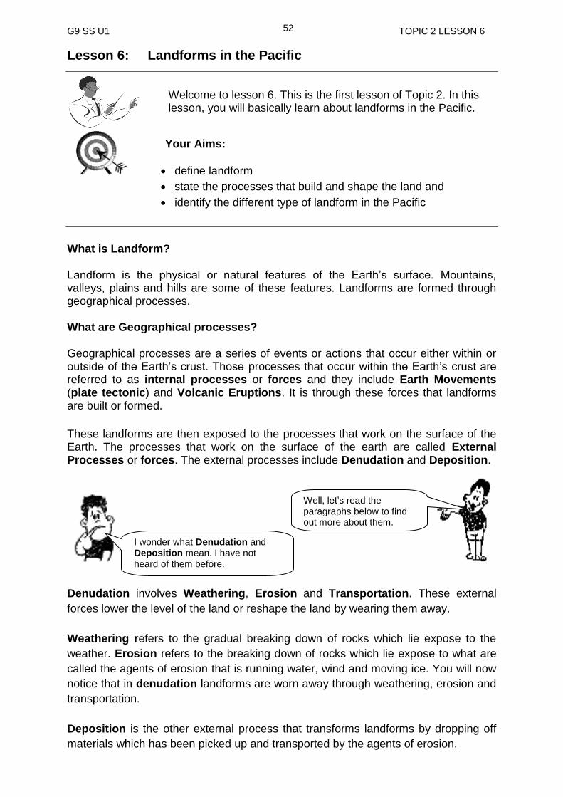
Welcome to lesson 6. This is the first lesson of Topic 2. In this lesson, you will basically learn about landforms in the Pacific.
I wonder what Denudation and Deposition mean. I have not heard of them before.
Well, let’s read the paragraphs below to find out more about them.
G9 SS U1 TOPIC 2 LESSON 6
53
More on the internal and external processes will be studied in lessons seven and
eight of this topic.
Now that you know the factors that are responsible for the formation of land forms in
our environment, you will identify some of these landforms in the Pacific Region.
In the Pacific Region, landforms vary from small coral atoll to large continental land
masses such as Australia, from rugged mountains in the centre of the Island of New
Guinea to large areas of lowlands or plains in Western and Gulf. In fact all around
the edges of the Pacific Ocean are many active volcanoes. This zone of earthquakes
and volcanoes extend from New Zealand and Papua New Guinea in the south west
through Philippines and Japan in the west, across to Canada and U.S.A in the north
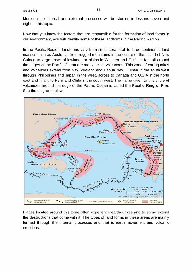
east and finally to Peru and Chile in the south west. The name given to this circle of
volcanoes around the edge of the Pacific Ocean is called the Pacific Ring of Fire.
See the diagram below.
Places located around this zone often experience earthquakes and to some extend
the destructions that come with it. The types of land forms in these areas are mainly
formed through the internal processes and that is earth movement and volcanic
eruptions.

G9 SS U1 TOPIC 2 LESSON 6
54
Below are photographs showing some of these landforms formed through these
internal processes.
Activity
Refer to the map showing the Pacific Ring of Fire to answer the following questions. 1. Which of the two forces is directly associated with the formation of landforms
around this area?
_______________________________________________________________ 2. Name a landform in Papua New Guinea that is most likely formed through the
earth movement. _______________________________________________________________ 3. Which of these two countries will experience frequent earthquakes, Australia or
Papua New Guinea?
______________________________________________________________
Markham Valley
Sogeri Plateau Manam Volcano - Madang
Volcanic Island formed in Hawaii

G9 SS U1 TOPIC 2 LESSON 6
55
4. Give a reason to the answer you gave in question 3.
_______________________________________________________________
_______________________________________________________________
_______________________________________________________________
_______________________________________________________________
Pacific Region also has landforms formed through the external processes such as
weathering, erosion, and deposition. Coral atolls, lime stone caves, waterfalls are
some examples of these landforms.
Below are some photographs of landforms formed through these external processes.
.
The photographs of landforms in this lesson are examples of landforms we have in the Pacific. You will learn more about land forming processes later on in this Unit. Let us now move to the next page to recap the important points in this lesson.
Tasman Glacier in New Zealand
Waterfall in Palau - Micronesia
Aerial View of Fiji Atoll
Menyamya – Morobe province
G9 SS U1 TOPIC 2 LESSON 6
56
landform is the physical or natural features of the Earth’s surface.
landforms are formed through geographical processes.
geographical processes are series of events or actions that occur either within or outside of the Earth’s crust.
those that operate within the Earth’s crust are referred to as internal processes or forces and they include Earth Movements (plate tectonic) and Volcanic Eruptions. It is through these forces or processes that landforms are build or formed.
the processes that work on the surface of the earth are called External Processes or forces. The external processes include Denudation and Deposition.
denudation involves Weathering, Erosion and Transportation. These external forces lower the level of the land or reshape the land by wearing them away.
SUMMARY You have come to the end of this lesson 6. In this lesson you have learned that:
NOW DO PRACTICE EXERCISE 6 ON THE NEXT PAGE
G9 SS U1 TOPIC 2 LESSON 6
57
Practice Exercise 6
1. What is landform?
___________________________________________________________
2. Which two factors are classified under internal processes?
(a) _________________________
(b) _________________________
3. Name the two main external processes that work on the surface of the earth.
(a) ________________________
(b) ________________________
4. Which processes are classified under denudation?
_________________________________________
5. How do the external processes affect the surface of the earth?
______________________________________________________________
______________________________________________________________
6. Which two plates is Papua New Guinea located in?
__________________________________________
Answers to Activity 1. Internal Forces including plate movements and volcanic eruptions.
2. Markham Valley in Morobe Province, Karkar Island and Manam Island in
Madang Province, Balopa Islands in Manus Province, East New Britain Island,
the Owen Stanley Range, the highlands of New Guinea, etc. (any two can be
correct)
3. Australia
4. Papua New Guinea is located close to the plate boundary and therefore
experiences a lot of earthquakes while Australia is situated further away from
the plate boundaries and therefore experience less earthquakes.
NOW CHECK YOUR WORK. ANSWERS ARE AT THE END OF TOPIC 2.
G9 SS U1 TOPIC 2 LESSON 7
58
Lesson 7: Plate Tectonics
Welcome to lesson 7. In the previous lesson, you learnt about the Land forms in the Pacific. In this lesson, you will learn about Plate Tectonics and their movements. You will also study how the movements of Plate Tectonics form different landforms such as mountains and valleys
Your Aims:
define plate tectonics, faulting, folding and volcanism
identify the different types of plate boundaries
list the different landform features that are formed at these plate boundaries
Let us first look at the structure of earth before we begin with plate tectonics. You have looked at the structure of the earth in the Grade 7 Strand 1 course book but it is important we revise it now to help you understand this lesson.
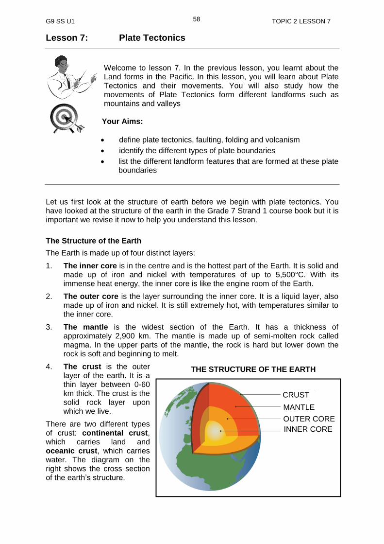
The Structure of the Earth
The Earth is made up of four distinct layers:
1. The inner core is in the centre and is the hottest part of the Earth. It is solid and made up of iron and nickel with temperatures of up to 5,500°C. With its immense heat energy, the inner core is like the engine room of the Earth.
2. The outer core is the layer surrounding the inner core. It is a liquid layer, also made up of iron and nickel. It is still extremely hot, with temperatures similar to the inner core.
3. The mantle is the widest section of the Earth. It has a thickness of approximately 2,900 km. The mantle is made up of semi-molten rock called magma. In the upper parts of the mantle, the rock is hard but lower down the rock is soft and beginning to melt.
4. The crust is the outer layer of the earth. It is a thin layer between 0-60 km thick. The crust is the solid rock layer upon which we live.
There are two different types of crust: continental crust, which carries land and oceanic crust, which carries water. The diagram on the right shows the cross section of the earth’s structure.
THE STRUCTURE OF THE EARTH
CRUST
MANTLE
OUTER CORE
INNER CORE
G9 SS U1 TOPIC 2 LESSON 7
59
Plate tectonic (earth movement) is an internal process that can build or destroy land shape. It is an internal process because it begins in the earth’s crust.
To understand this movement, let us first look at plate tectonics.
Plate Tectonics
The land we live on seems to be very solid for most of the time. However, there is evidence to show that violent earth movements in the past have built the mountains and hills we see around us. Many of the processes are even continuing today.
The earth’s crust is made up of a very thin layer of solid rock which is much thicker under the continents (35 to 70 kilometres) than under the ocean (only 6 kilometres). The crust is cracked in many places. These cracks divide the surface into large tectonic plates on which the continents and oceans are sitting on.
What are Tectonic Plates?
The idea that pieces of earth’s crust moving is called the ‘Theory of Plate Tectonics’. Tectonic refers to the movement of the crust and a tectonic plate is a piece of moving crust. The biggest pieces are thousands of kilometres wide and they move around on a layer of hot, slightly melted rock in the mantle. Some plates make up big pieces of land called continents or continental crust while other plates make up the bottom of the oceans and are called oceanic crust.
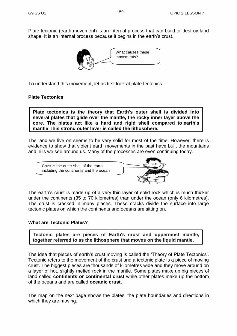
The map on the next page shows the plates, the plate boundaries and directions in which they are moving.
Crust is the outer shell of the earth including the continents and the ocean floor.
What causes these movements?
Plate tectonics is the theory that Earth's outer shell is divided into several plates that glide over the mantle, the rocky inner layer above the core. The plates act like a hard and rigid shell compared to earth’s mantle This strong outer layer is called the lithosphere.
Tectonic plates are pieces of Earth's crust and uppermost mantle, together referred to as the lithosphere that moves on the liquid mantle.
G9 SS U1 TOPIC 2 LESSON 7
60
TECTONIC PLATES
.Plate Movements/Boundaries
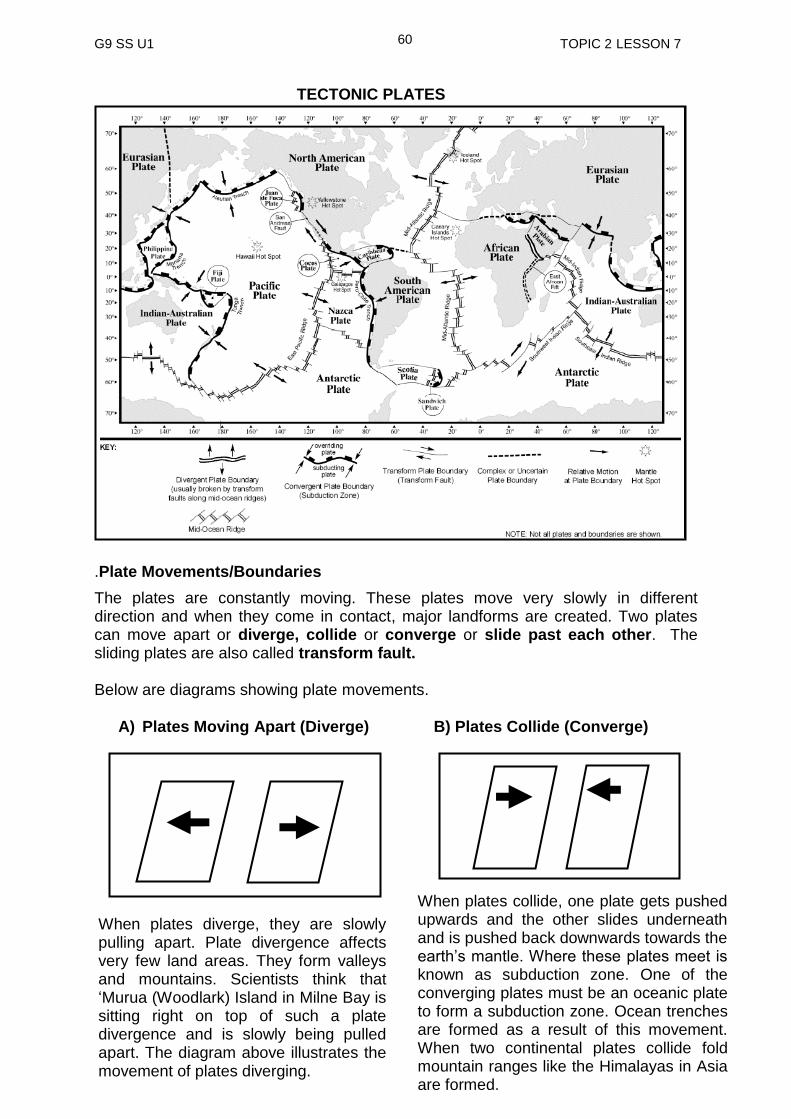
The plates are constantly moving. These plates move very slowly in different direction and when they come in contact, major landforms are created. Two plates can move apart or diverge, collide or converge or slide past each other. The sliding plates are also called transform fault. Below are diagrams showing plate movements.
A) Plates Moving Apart (Diverge) B) Plates Collide (Converge)
When plates collide, one plate gets pushed upwards and the other slides underneath and is pushed back downwards towards the earth’s mantle. Where these plates meet is known as subduction zone. One of the converging plates must be an oceanic plate to form a subduction zone. Ocean trenches are formed as a result of this movement. When two continental plates collide fold mountain ranges like the Himalayas in Asia are formed.
When plates diverge, they are slowly pulling apart. Plate divergence affects very few land areas. They form valleys and mountains. Scientists think that ‘Murua (Woodlark) Island in Milne Bay is sitting right on top of such a plate divergence and is slowly being pulled apart. The diagram above illustrates the movement of plates diverging.

G9 SS U1 TOPIC 2 LESSON 7
61
A transformed fault is also known as conservative plate boundary because it does not build nor destroy lithosphere. Converging plates destroy when they collide. Where they meet is known as destructive plate boundary. Diverging plate movement builds new landforms and where they move apart is known as constructive plate boundary.
Activity 1
Complete the exercise below. 1. Name the 7 major Tectonic Plates found in the World.
a) ___________________________________
b) ___________________________________
c) ___________________________________
d) ___________________________________
e) ___________________________________
f) ___________________________________
g) ___________________________________
2. On which Plate is Papua New Guinea sitting? _______________________________
A transform boundary is a fault zone where two plates slide past each other horizontally. Most transform faults are found in the ocean where they offset spreading ridges creating a zigzag pattern between the plates. Some transform faults occur on land. The most famous transform fault is the San Andreas Fault in California which connects the East Pacific Rise and the Juan de Fuca Plate. The diagram on the left illustrate the movement of the plates sliding past each other.
C. Plates moving alongside each other (Transform Fault)
Lithosphere is the rigid outer part of the earth, consisting of the crust and upper mantle.

G9 SS U1 TOPIC 2 LESSON 7
62
3. What are the three main movements of the plates?
a) ____________________________________
b) ____________________________________
c) ____________________________________
Features formed as a result of Plate Movements
We will now look at the different landforms created by the movement of the earth’s
crust.
A) Faulting
A fault is a crack in the earth’s crust. When plates move together, faults are produced
in the earth’s crust. The blocks of land between fault lines may move producing new
land forms such as mountains and valleys.
HOW MOUNTAINS AND VALLEYS ARE FORMED BY FAULTING
Below are pictures of landforms formed through faulting.
Fault Fault
Fault
(Mountain)
Faulted Rocks in Entrada, Utah Markham Valley formed by faulting
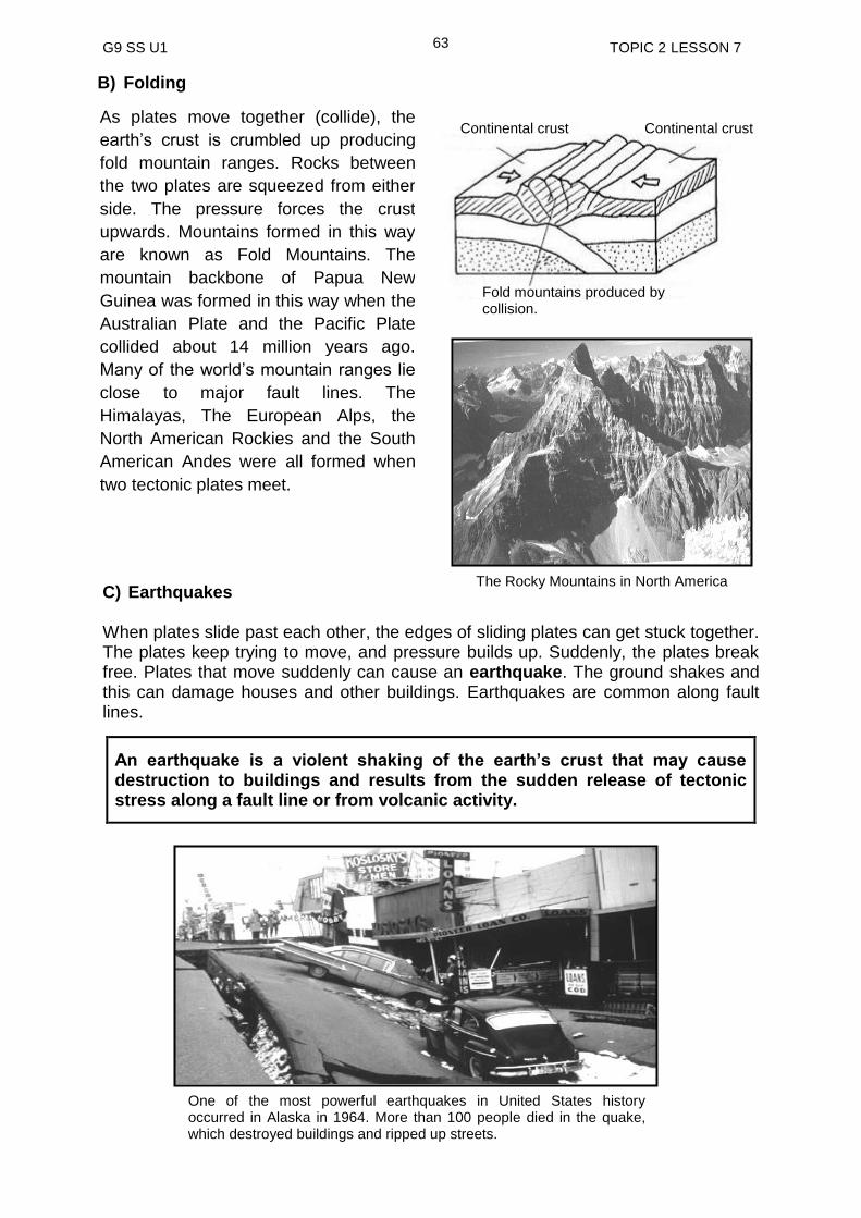
G9 SS U1 TOPIC 2 LESSON 7
63
B) Folding
C) Earthquakes When plates slide past each other, the edges of sliding plates can get stuck together. The plates keep trying to move, and pressure builds up. Suddenly, the plates break free. Plates that move suddenly can cause an earthquake. The ground shakes and this can damage houses and other buildings. Earthquakes are common along fault lines.
An earthquake is a violent shaking of the earth’s crust that may cause destruction to buildings and results from the sudden release of tectonic stress along a fault line or from volcanic activity.
One of the most powerful earthquakes in United States history occurred in Alaska in 1964. More than 100 people died in the quake, which destroyed buildings and ripped up streets.
As plates move together (collide), the
earth’s crust is crumbled up producing
fold mountain ranges. Rocks between
the two plates are squeezed from either
side. The pressure forces the crust
upwards. Mountains formed in this way
are known as Fold Mountains. The
mountain backbone of Papua New
Guinea was formed in this way when the
Australian Plate and the Pacific Plate
collided about 14 million years ago.
Many of the world’s mountain ranges lie
close to major fault lines. The
Himalayas, The European Alps, the
North American Rockies and the South
American Andes were all formed when
two tectonic plates meet.
The Rocky Mountains in North America
Fold mountains produced by collision.
Continental crust Continental crust

G9 SS U1 TOPIC 2 LESSON 7
64
D) Volcanoes
As the plates push and rub against each other, cracks appear in the crust. In some weak places, magma or molten rock which is under great pressure, forces its way up to the surface through this cracks. The magma is now known as lava. Magma and lava are the same substance in two different forms. Magma is molten rock that is found beneath the earth's crust, while lava is what magma becomes once it reaches the surface and erupts from a volcano or crack in the earth. Lava and ash are often shot hundreds of meters into the air. The mountain that is formed as a result of this eruption of magma is known as a volcano. After an eruption most volcanoes become blocked by the rock that is formed as the lava cools. Volcanoes may remain inactive or dormant for a long time. Gradually the pressure builds up inside the volcano until more lava is forced out. If the blockage is very strong, the pressure builds up for many years until there is a very big explosion and the whole mountain is blown up. Now take a look at the diagrams on the next page. You will see that a volcanic mountain is formed as lava cools to form solid rock on the earth surface. It usually has a CONICAL shape. Crack in the earth’s crust Molten/melted rock pushed to the surface
Activity 2
1. Make a list of active volcanoes that you have heard of or seen in Papua New
Guinea a) __________________________________________________________
b) __________________________________________________________
We have all seen volcanoes or pictures of volcanoes. Do you sometimes wonder how volcanoes are formed? Read the paragraph below. It tells you how volcanoes are formed?
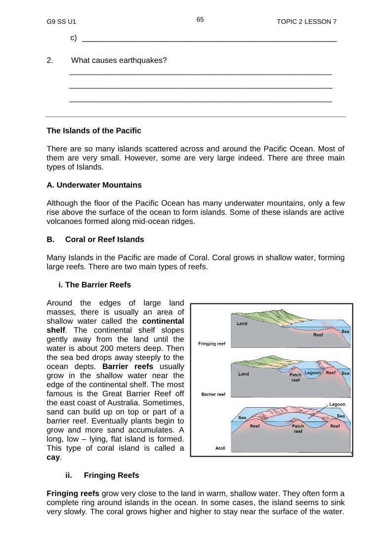
G9 SS U1 TOPIC 2 LESSON 7
65
c) __________________________________________________________
2. What causes earthquakes?
____________________________________________________________
____________________________________________________________
____________________________________________________________
The Islands of the Pacific There are so many islands scattered across and around the Pacific Ocean. Most of them are very small. However, some are very large indeed. There are three main types of Islands. A. Underwater Mountains Although the floor of the Pacific Ocean has many underwater mountains, only a few rise above the surface of the ocean to form islands. Some of these islands are active volcanoes formed along mid-ocean ridges.
B. Coral or Reef Islands
Many Islands in the Pacific are made of Coral. Coral grows in shallow water, forming large reefs. There are two main types of reefs.
i. The Barrier Reefs
Around the edges of large land masses, there is usually an area of shallow water called the continental shelf. The continental shelf slopes gently away from the land until the water is about 200 meters deep. Then the sea bed drops away steeply to the ocean depts. Barrier reefs usually grow in the shallow water near the edge of the continental shelf. The most famous is the Great Barrier Reef off the east coast of Australia. Sometimes, sand can build up on top or part of a barrier reef. Eventually plants begin to grow and more sand accumulates. A long, low – lying, flat island is formed. This type of coral island is called a cay.
ii. Fringing Reefs Fringing reefs grow very close to the land in warm, shallow water. They often form a complete ring around islands in the ocean. In some cases, the island seems to sink very slowly. The coral grows higher and higher to stay near the surface of the water.
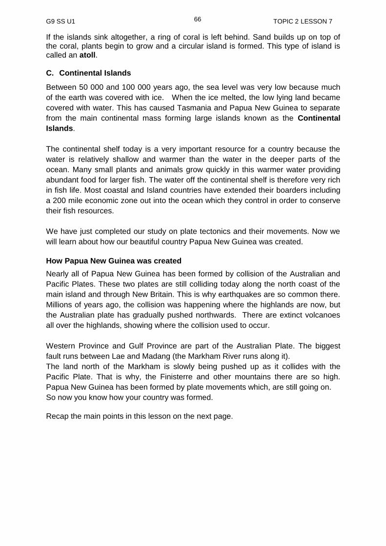
G9 SS U1 TOPIC 2 LESSON 7
66
If the islands sink altogether, a ring of coral is left behind. Sand builds up on top of the coral, plants begin to grow and a circular island is formed. This type of island is called an atoll. C. Continental Islands
Between 50 000 and 100 000 years ago, the sea level was very low because much
of the earth was covered with ice. When the ice melted, the low lying land became
covered with water. This has caused Tasmania and Papua New Guinea to separate
from the main continental mass forming large islands known as the Continental
Islands.
The continental shelf today is a very important resource for a country because the
water is relatively shallow and warmer than the water in the deeper parts of the
ocean. Many small plants and animals grow quickly in this warmer water providing
abundant food for larger fish. The water off the continental shelf is therefore very rich
in fish life. Most coastal and Island countries have extended their boarders including
a 200 mile economic zone out into the ocean which they control in order to conserve
their fish resources.
We have just completed our study on plate tectonics and their movements. Now we
will learn about how our beautiful country Papua New Guinea was created.
How Papua New Guinea was created
Nearly all of Papua New Guinea has been formed by collision of the Australian and
Pacific Plates. These two plates are still colliding today along the north coast of the
main island and through New Britain. This is why earthquakes are so common there.
Millions of years ago, the collision was happening where the highlands are now, but
the Australian plate has gradually pushed northwards. There are extinct volcanoes
all over the highlands, showing where the collision used to occur.
Western Province and Gulf Province are part of the Australian Plate. The biggest
fault runs between Lae and Madang (the Markham River runs along it).
The land north of the Markham is slowly being pushed up as it collides with the
Pacific Plate. That is why, the Finisterre and other mountains there are so high.
Papua New Guinea has been formed by plate movements which, are still going on.
So now you know how your country was formed.
Recap the main points in this lesson on the next page.
G9 SS U1 TOPIC 2 LESSON 7
67
tectonic refers to the movement of the crust and a tectonic plate is a piece of moving crust.
there are seven major tectonic plates; Eurasian Plate, Australian Plate, Pacific Plate, North American Plate, Antarctic Plate, Philippines Plate and Nazca Plate.
when the plates are moving, they either, collide (converge), go apart (diverge) or move alongside each other.
different features are formed as a result of the movements of the plates.
faults are cracks created by the tectonic plates.
fold Mountains are formed by the collision of plates.
volcanoes are formed from the cracks created by the rubbing of plates.
an earthquake occurs due to two plates rubbing together causing the earth to shake violently.
there are three different types of islands found in the Pacific Ocean. They are underwater mountains, coral islands and continental islands.
SUMMARY
You have come to the end of lesson 7. In this lesson you have learnt that:
NOW DO PRACTICE EXERCISE 7 ON THE NEXT PAGE

G9 SS U1 TOPIC 2 LESSON 7
68
Practice Exercise 7
1. Define Tectonic Plates.
_______________________________________________________________
_______________________________________________________________
2. What are the three main layers of the earth?
i) ___________________________________________________________
ii) __________________________________________________________
iii) __________________________________________________________
3. Differentiate between the terms fault and fold.
_______________________________________________________________
_______________________________________________________________
_______________________________________________________________
4. Name two mountain systems that were formed as a result of plates meeting or
colliding into each other.
i) ____________________________________________________________
ii) __________________________________________________________
5. State the movement of these plates.
6. Explain how:
i) Volcanoes are formed?
_________________________________________________________
A ____________________
C ______________________
B ____________________

G9 SS U1 TOPIC 2 LESSON 7
69
_____________________________________________________________
_____________________________________________________________
ii) Earthquakes occur?
______________________________________________________________
______________________________________________________________
______________________________________________________________
7. Name the main types of islands in the Pacific.
i) _____________________________________________________________
ii) ____________________________________________________________
iii) ____________________________________________________________
Answers to Activities Activity 1
1. Eurasian plate ,Indian Australian plate, Philippines plate, Pacific plate, Nazca
plate, North American plate, South American plate and Antarctic plate
2. Pacific plate 3. a) Divergence / Move apart b) Convergence / Move towards each other/ collide c) Transform / Move alongside or pass each other Activity 2 1. Vulcan ENB
Tavurvur ENB Karkar Madang Manam Madang Mt Lamington Oro Tuluman Manus Balbi AROB
2. Earthquakes occur when plates collide or slide pass each other.
NOW CHECK YOUR WORK. ANSWERS ARE AT THE END OF TOPIC 2.
G9 SS U1 TOPIC 2 LESSON 8
70
Lesson 8: Weathering
Welcome to Lesson 8. In the last lesson, you learnt about the processes that build the land. In this lesson, we will briefly study the processes that are slowly changing the shape of the land.
Your Aims
define weathering
identify the types of weathering
identify landform features shaped by weathering
What is Weathering?
This means that the rocks are broken down through exposure to the forces of rain,
wind, heat, frost, temperature change, plants and organisms such as worms and
plant roots.
The energy necessary for weathering to take place is from the sun. It is solar energy
which provides heat inputs, moves water so that it can infiltrate rocks, and make
possible plants and animal life. There are three types of weathering.
1. Physical weathering
2. Chemical weathering
3. Biological weathering
1. Physical Weathering
Physical weathering is sometimes called Mechanical Weathering.
There are five types of physical weathering and they include
i) Freeze and thaw
ii) Salt crystalisation
iii) Insolation
iv) Pressure release
v) Wetting and Drying
Weathering is the breaking down of rocks at the Earth’s surface, by the action
of water, extreme temperature differences wind, and biological activity.
Physical weathering is the breaking down of rocks through the cracks and
joint from temperature changes and the action of water.

G9 SS U1 TOPIC 2 LESSON 8
71
i) Freeze and thaw
When rock is exposed to weather conditions it becomes subject to processes, such as freeze-thaw, that cause it to change and break down.
The freeze-thaw weathering process is also known as frost shattering.
Water for example, from rainfall or melting snow and ice becomes trapped in a crack
or joint in the rock. If the air temperature drops below freezing, the water will freeze
and expand by 9-10 per cent putting pressure on the rock. The ice will melt when the
temperature rises above freezing. If this process happens repeatedly, the rock will
weaken and eventually shatter into angular fragments. The fragments may then be
deposited as scree at the foot of a slope. It is most effective where the temperature
fluctuates especially during winters in temperate region and in high mountains like
the Himalayas. The diagram below shows how rocks are broken down through freeze
and thaw process.
ii) Salt Crystallisation
Salt crystalisation is effective in desert region where daily temperature ranges and
evaporation rates are high. Salt is drawn up from the soil through capillary action.
When water is collected in the cracks or crevices in rocks, saline solution is formed.
During the day when the temperature becomes very hot, water in the solution
evaporates leaving salt crystals behind in the cracks. Repetition of this process
results in the growth of salt crystals in the cracks. As they grow, they exert great
pressure as in freeze and thaw. This eventually shatters or breaks down rocks such
as sandstone, chalk limestone and shale. The photograph below shows salt crystals
deposited on a rock.
Effect of salt crystallisation on a rock
Water collected in cracks or crevices are solidified
Pressure builds up as ice continues to expand
Rocks shattered into angular fragments

G9 SS U1 TOPIC 2 LESSON 8
72
iii) Heating and cooling (Insolation) Exfoliation or Onion Weathering
Heating and cooling is also called Insolation, Exfoliation or Onion weathering. Again
this tends to happen in areas with a high daily temperature range (very hot in the day
and cold at night). During the day rock heats up and expands and during the night it
cools down and contracts. Continuous expanding and contracting of the rocks make
the rocks weak and layers beginning to peel off, just like an onion. The photographs
below illustrate the effect of heating and cooling on rocks especially in desert
environment.
iv) Pressure Release
This happens when overlaying rocks exert pressure on the rocks within the crust.
After erosion of the overlying material, pressure is released. This allows the newly
exposed rock to expand; leading to cracks and eventually it disintegrates or breaks
down into pieces. The photograph below shows a rock that has been through the
pressure release process.
Effects of insolation on Rocks
Effects of Pressure Release on a rock
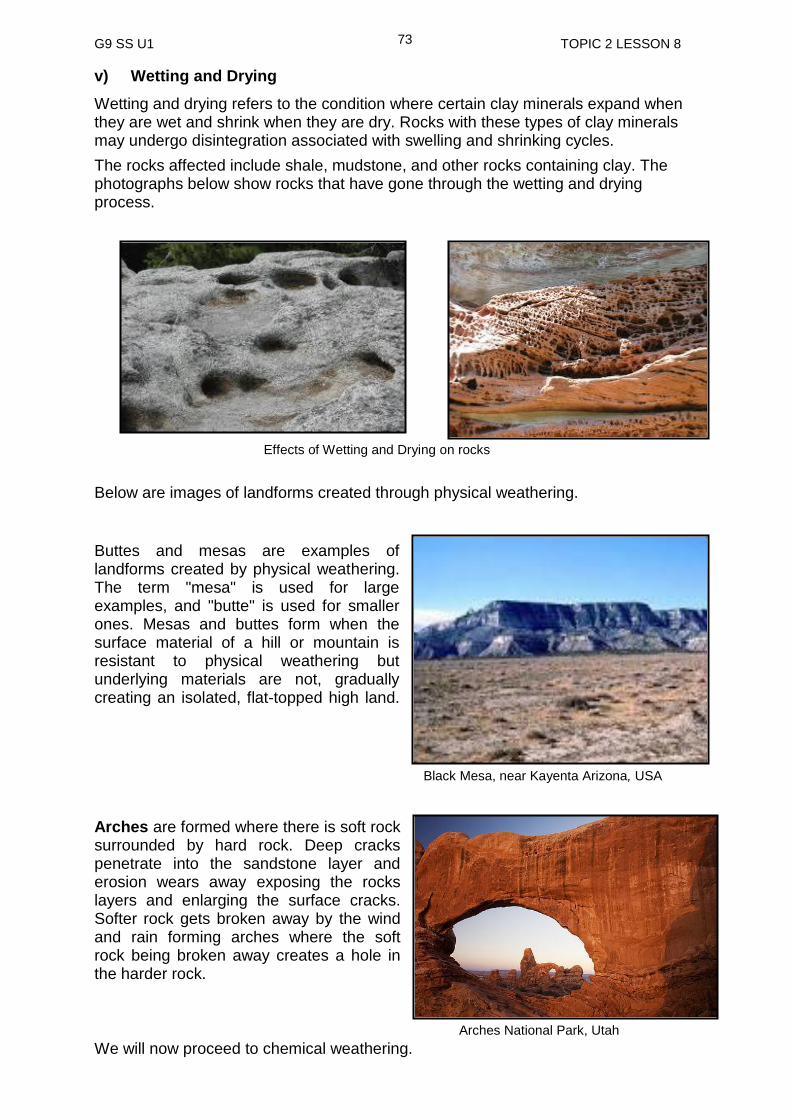
G9 SS U1 TOPIC 2 LESSON 8
73
v) Wetting and Drying
Wetting and drying refers to the condition where certain clay minerals expand when they are wet and shrink when they are dry. Rocks with these types of clay minerals may undergo disintegration associated with swelling and shrinking cycles.
The rocks affected include shale, mudstone, and other rocks containing clay. The photographs below show rocks that have gone through the wetting and drying process.
Below are images of landforms created through physical weathering.
Buttes and mesas are examples of landforms created by physical weathering. The term "mesa" is used for large examples, and "butte" is used for smaller ones. Mesas and buttes form when the surface material of a hill or mountain is resistant to physical weathering but underlying materials are not, gradually creating an isolated, flat-topped high land.
Arches are formed where there is soft rock surrounded by hard rock. Deep cracks penetrate into the sandstone layer and erosion wears away exposing the rocks layers and enlarging the surface cracks. Softer rock gets broken away by the wind and rain forming arches where the soft rock being broken away creates a hole in the harder rock.
We will now proceed to chemical weathering.
Black Mesa, near Kayenta Arizona, USA
Arches National Park, Utah
Effects of Wetting and Drying on rocks

G9 SS U1 TOPIC 2 LESSON 8
74
2. Chemical Weathering
There are six types of chemical weathering. They include:
i) Solution
ii) Carbonation
iii) Hydrolysis
iv) Hydration
v) Oxidation
Chemical weathering involves changes in the chemical character of rock minerals. It
takes place because, minerals which were stable in their original environment
become unstable when they come within range of the atmosphere and particularly
when they come into contact with water. Water which has penetrated near surface
layers is the most important chemical agent affecting rocks.
Now, let us discuss the chemical weathering processes. i) Dissolving (Solution)
It is the process whereby a substance in the rock is dissolved (mixed with), either by rain water, or by other substances such as acids in the water. Rocks such as limestone disintegrate or rot away when they come into contact with water. The rain water slowly dissolves the rock away. Dissolving is a very highly significant weathering process because of its direct effects on rocks and also because of the reactions it creates. Rainwater dissolving limestone has caused large caves to be formed. Often the dissolved lime is deposited again as pillars of limestone inside the caves. The picture on the left shows limestone cave with pillars of deposited lime. ii) Hydration
Hydration weathering occurs when water is absorbed by the minerals in rocks causing a chemical change. When water is absorbed there is a chemical change, increasing the size of the mineral structure. This causes the rocks to swell putting stress on the rock, leading to physical or mechanical weathering such as spalling, pitting and flaking, as well as an overall colour change. When this happens in granite, the rock undergoes granular disintegration.
The photograph on the right shows the effect of hydration on a rock.
Chemical weathering is what happens when rocks are broken down and chemically altered.
Limestone cave
A rock affected by hydration

G9 SS U1 TOPIC 2 LESSON 8
75
iii) Hydrolysis
Hydrogen in water reacts with minerals in the rocks. Instead of dissolving the rock, the water actually combines with the rock. One example of hydrolysis is feldspar found in igneous rocks such as granites can be turned into a form of clay.
iv) Oxidation
This process is similar to the rusting of metal objects. Oxidation reaction takes place in the presence of water and heat especially when the rocks are in contact with oxygen.
4. Biotic Weathering
Vegetation may cause chemical and mechanical weathering. The decay of plant leaves may make rainwater more acid and speed up chemical weathering in the soil and at the rock surface. The presence of lichens and mosses on rock surfaces concentrate moisture and increase the amount of chemical weathering that occurs.
Tree roots, as they grow break apart rocks. This is a powerful type of mechanical rock
Effects of hydrolysis on a rock
Effects of oxidation on granite
(v) Carbonation
This is the reaction of certain materials such as calcium, magnesium and sodium with carbon dioxide. Water and carbon dioxide combine to form carbonic acid which attacks many rock minerals and the rock wears away. The photograph on the left shows disseminated gold, left behind after a cubic crystal of pyrite dissolved away.
Effects of carbonation on a rock
Disintegration of rock by tree roots

G9 SS U1 TOPIC 2 LESSON 8
76
disintegration. Organisms such as earthworms and rabbits contribute to weathering by exposing new rock surface to the air and water.
Now do the activity below. Check your answers at the end of the summery.
Activity
1. Which of the three main types of weathering is also known as mechanical
weathering? ________________________________
2. Heating and Cooling in physical weathering is also known as __________. You have learnt about the different types of weathering and the landforms created by weathering.
Weathering is the name given to the process by which rocks are gradually worn away by the action of weather.
There are three types of weathering processes, Physical weathering, Chemical Weathering and Biotic weathering.
Physical weathering is the destruction or shattering of rocks by force. It occurs mainly in cold and dry climates.
Chemical Weathering involves changes in the chemical character of rock minerals. Water is the most important agent in chemical weathering. It is most common in cold and wet climates.
Biotic Weathering involves the roots of plants and activities of animals. Tree roots penetrate through rocks creating cracks and eventually the rocks fall apart while animals’ activity expose the rocks to the surface to heat and rain.
NOW ANSWER PRACTICE EXERCISE 8 ON THE NEXT PAGE
SUMMARY
You have come to the end of this lesson. In this lesson you have learned that:

G9 SS U1 TOPIC 2 LESSON 8
77
Practice Exercise 8
1. What is weathering?
______________________________________________________________
______________________________________________________________
______________________________________________________________
2. List the three main types of weathering and the climates where they are
commonly found.
i) ______________________________
ii) ______________________________
iii) ______________________________
3. Name the type of weathering which involves shaping the landforms listed
below.
(i) Caves ________________________________
(ii) Mesa _________________________________
(iii) Arch __________________________________
4. In which areas is freeze – thaw activity most common? _______________________________________________________________ 5. How can plants and animals cause the physical weathering of rocks?
_______________________________________________________________
_____________________________________________________________
Answers to Activity 1. Physical weathering 2. Insolation, exfoliation or onion weathering. (Any of the three can be correct)
NOW CHECK YOUR WORK. ANSWERS ARE AT THE END OF TOPIC 2.
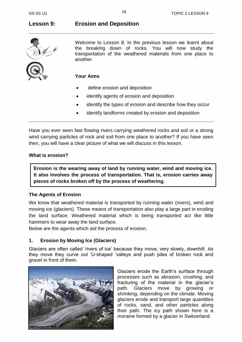
G9 SS U1 TOPIC 2 LESSON 9
78
Lesson 9: Erosion and Deposition
Welcome to Lesson 8. In the previous lesson we learnt about the breaking down of rocks. You will now study the transportation of the weathered materials from one place to another.
Your Aims
define erosion and deposition
identify agents of erosion and deposition
identify the types of erosion and describe how they occur
identify landforms created by erosion and deposition
Have you ever seen fast flowing rivers carrying weathered rocks and soil or a strong
wind carrying particles of rock and soil from one place to another? If you have seen
then, you will have a clear picture of what we will discuss in this lesson.
What is erosion?
The Agents of Erosion
We know that weathered material is transported by running water (rivers), wind and
moving ice (glaciers). These means of transportation also play a large part in eroding
the land surface. Weathered material which is being transported act like little
hammers to wear away the land surface.
Below are the agents which aid the process of erosion.
1. Erosion by Moving Ice (Glaciers)
Glaciers are often called ‘rivers of ice’ because they move, very slowly, downhill. As they move they curve out ‘U-shaped ‘valleys and push piles of broken rock and gravel in front of them.
Glaciers erode the Earth’s surface through processes such as abrasion, crushing, and fracturing of the material in the glacier’s path. Glaciers move by growing or shrinking, depending on the climate. Moving glaciers erode and transport large quantities of rocks, sand, and other particles along their path. The icy path shown here is a moraine formed by a glacier in Switzerland.
Erosion is the wearing away of land by running water, wind and moving ice.
It also involves the process of transportation. That is, erosion carries away
pieces of rocks broken off by the process of weathering.
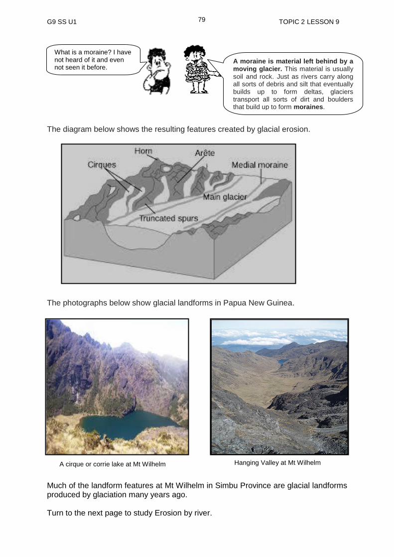
G9 SS U1 TOPIC 2 LESSON 9
79
The diagram below shows the resulting features created by glacial erosion.
The photographs below show glacial landforms in Papua New Guinea. Much of the landform features at Mt Wilhelm in Simbu Province are glacial landforms produced by glaciation many years ago. Turn to the next page to study Erosion by river.
What is a moraine? I have not heard of it and even not seen it before.
A moraine is material left behind by a moving glacier. This material is usually soil and rock. Just as rivers carry along all sorts of debris and silt that eventually builds up to form deltas, glaciers transport all sorts of dirt and boulders that build up to form moraines.
A cirque or corrie lake at Mt Wilhelm Hanging Valley at Mt Wilhelm
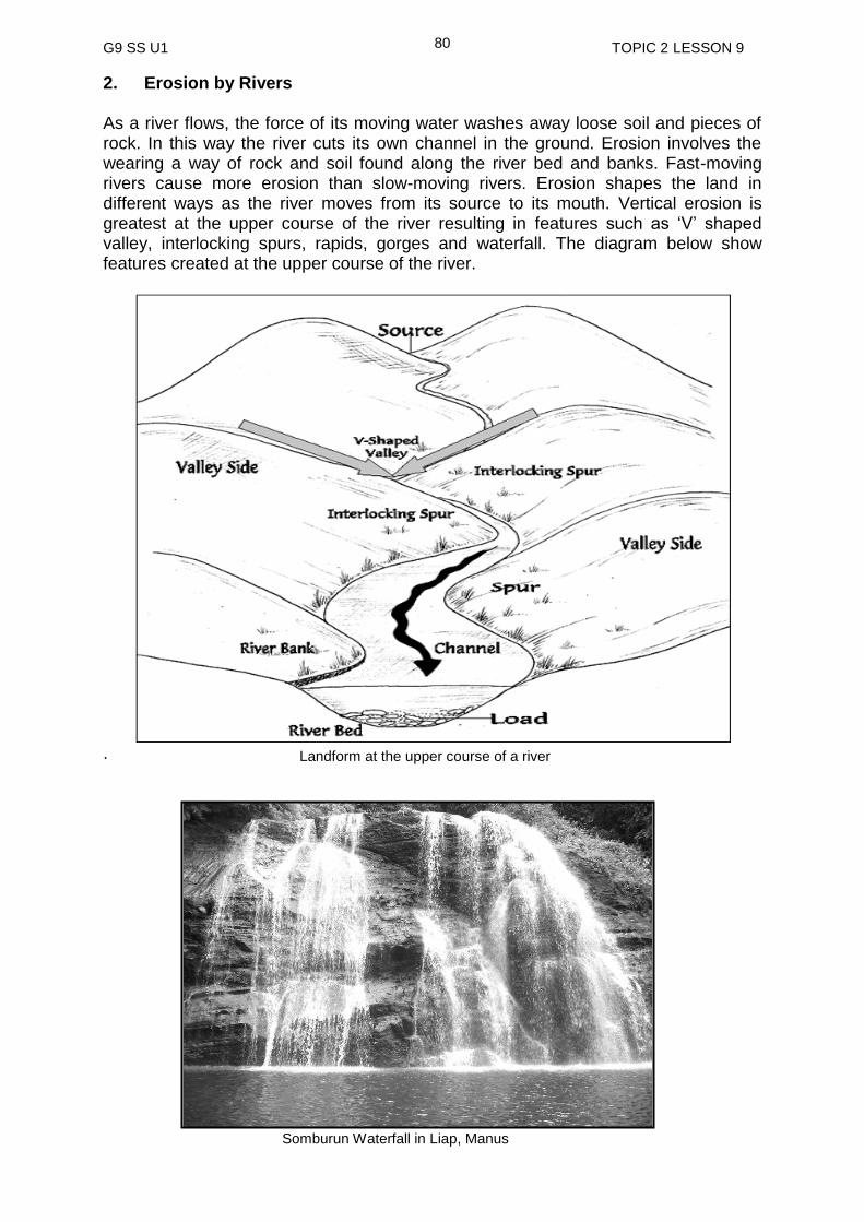
G9 SS U1 TOPIC 2 LESSON 9
80
2. Erosion by Rivers As a river flows, the force of its moving water washes away loose soil and pieces of rock. In this way the river cuts its own channel in the ground. Erosion involves the wearing a way of rock and soil found along the river bed and banks. Fast-moving rivers cause more erosion than slow-moving rivers. Erosion shapes the land in different ways as the river moves from its source to its mouth. Vertical erosion is greatest at the upper course of the river resulting in features such as ‘V’ shaped valley, interlocking spurs, rapids, gorges and waterfall. The diagram below show features created at the upper course of the river.
. Somburun Waterfall in Liap, Manus
Landform at the upper course of a river

G9 SS U1 TOPIC 2 LESSON 9
81
3. Erosion by the Sea
Where the land meets the sea, erosion is constantly taking place. Waves, carrying sand and pebbles, beat against the shore where the land is steep. The waves wear away the rock to form cliffs. Landform features such as headland, caves, arch, stack and stump are formed by the hydraulic action of waves. The diagram below shows features formed through coastal erosion.
Where the rock is soft the waves carve out inlets and bays. Bays are useful to people because ships and canoes can shelter there from strong winds. Sydney in Australia and Port Moresby are examples of cities built in the shelter of a large bay.
A river in Russia's Altai region showing the ‘V’ shaped Valley and the interlocking spur in the background
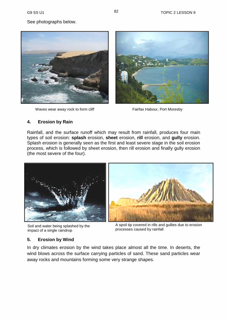
G9 SS U1 TOPIC 2 LESSON 9
82
See photographs below.
4. Erosion by Rain Rainfall, and the surface runoff which may result from rainfall, produces four main types of soil erosion: splash erosion, sheet erosion, rill erosion, and gully erosion. Splash erosion is generally seen as the first and least severe stage in the soil erosion process, which is followed by sheet erosion, then rill erosion and finally gully erosion (the most severe of the four).
5. Erosion by Wind
In dry climates erosion by the wind takes place almost all the time. In deserts, the
wind blows across the surface carrying particles of sand. These sand particles wear
away rocks and mountains forming some very strange shapes.
Waves wear away rock to form cliff Fairfax Habour, Port Moresby
A spoil tip covered in rills and gullies due to erosion processes caused by rainfall
Soil and water being splashed by the impact of a single raindrop
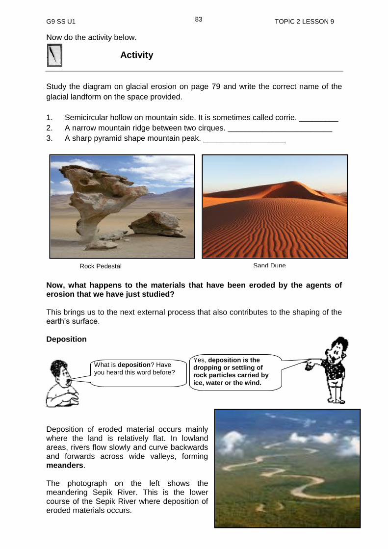
G9 SS U1 TOPIC 2 LESSON 9
83
Now do the activity below.
. Activity
Study the diagram on glacial erosion on page 79 and write the correct name of the
glacial landform on the space provided.
1. Semicircular hollow on mountain side. It is sometimes called corrie. _________
2. A narrow mountain ridge between two cirques. ________________________
3. A sharp pyramid shape mountain peak. ___________________
Now, what happens to the materials that have been eroded by the agents of erosion that we have just studied? This brings us to the next external process that also contributes to the shaping of the earth’s surface. Deposition
Deposition of eroded material occurs mainly where the land is relatively flat. In lowland areas, rivers flow slowly and curve backwards and forwards across wide valleys, forming meanders.
The photograph on the left shows the meandering Sepik River. This is the lower course of the Sepik River where deposition of eroded materials occurs.
Sand Dune Rock Pedestal
What is deposition? Have you heard this word before?
Yes, deposition is the dropping or settling of rock particles carried by
ice, water or the wind.
G9 SS U1 TOPIC 2 LESSON 9
84
Eroded rock carried by the river has by now been broken up into very small particles like mud. Some of this mud, called alluvium is deposited on the plains on each side of the river when the river floods. Alluvium is important to farmers because it is usually very fertile.
Most of the rock particles carried by rivers are eventually deposited in the sea. Over a period of years, layers of deposited rock particles harden and form new rocks. These new rocks may then be lifted up by earth movements to form mountains.
In desert areas, particles of rocks blown by the wind are deposited to form sand dunes. If the wind is very strong, the dunes appear to move very slowly, across the desert as the sand particles are pushed up on one side of the dune and roll down the other.
Erosion is the wearing away of land by water (flowing river), wind and moving ice (glacier).
Water, wind and ice aid the process of erosion.
Deposition is the dropping or settling of rock particles carried by ice, wind and water.
Deposition of weathered material is common in flat land.
Alluvium is the fine particles of soil dropped by rivers which are deposited on the plains on each side of the river when the river floods.
Alluvium is very fertile, therefore, it is very important for farmers.
Layers of deposited rock particles in the sea harden and form new rocks which are then uplifted by earth movements to form mountains.
The island of Papua New Guinea was formed as a result of the collision of the Australian continent with the Pacific Ocean floor.
The Highlands of Papua New Guinea has gone through major uplifting processes which have caused immense deformation of the rock layers.
These uplifting processes still continue up to today, however, high
temperatures, high rainfall and steep slopes combine to wear down the land as
fast as it rises.
So far you have learnt many things about erosion and deposition. Below are the summary of the main points.
NOW Do PRACTICE EXERCISE 9 ON THE NEXT PAGE
SUMMARY
You have come to the end of this lesson. In this lesson you have learned that:
G9 SS U1 TOPIC 2 LESSON 9
85
Practice Exercise 9
1. What is the difference between erosion and deposition?
__________________________________________________________________________________________________________________________________
2. List the agents of erosion.
______________________________________________________________
3. Why is alluvium very important to farmers?
__________________________________________________________________________________________________________________________________
4. Write the type of erosion responsible for creating these landforms.
a) U shaped valley ________________
b) V shaped valley ________________
c) Cliff ________________
d) Sand dune ________________
e) Waterfall ________________
Answers to activity 1. Cirque 2. Arête 3. Horn
NOW CHECK YOUR WORK. ANSWERS ARE AT THE END OF TOPIC 2.
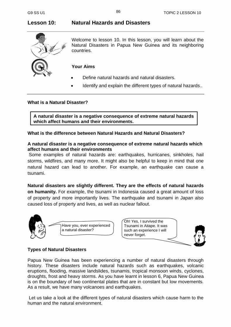
G9 SS U1 TOPIC 2 LESSON 10
86
Lesson 10: Natural Hazards and Disasters
Welcome to lesson 10. In this lesson, you will learn about the Natural Disasters in Papua New Guinea and its neighboring countries.
Your Aims
Define natural hazards and natural disasters.
Identify and explain the different types of natural hazards..
What is a Natural Disaster?
What is the difference between Natural Hazards and Natural Disasters? A natural disaster is a negative consequence of extreme natural hazards which affect humans and their environments Some examples of natural hazards are: earthquakes, hurricanes, sinkholes, hail
storms, wildfires, and many more. It might also be helpful to keep in mind that one
natural hazard can lead to another. For example, an earthquake can cause a
tsunami.
Natural disasters are slightly different. They are the effects of natural hazards
on humanity. For example, the tsunami in Indonesia caused a great amount of loss
of property and more importantly lives. The earthquake and tsunami in Japan also
caused loss of property and lives, as well as nuclear fallout.
Types of Natural Disasters Papua New Guinea has been experiencing a number of natural disasters through history. These disasters include natural hazards such as earthquakes, volcanic eruptions, flooding, massive landslides, tsunamis, tropical monsoon winds, cyclones, droughts, frost and heavy storms. As you have learnt in lesson 6, Papua New Guinea is on the boundary of two continental plates that are in constant but low movements. As a result, we have many volcanoes and earthquakes. Let us take a look at the different types of natural disasters which cause harm to the human and the natural environment.
Have you, ever experienced a natural disaster?
Oh! Yes, I survived the Tsunami in Aitape. It was such an experience I will never forget.
A natural disaster is a negative consequence of extreme natural hazards which affect humans and their environments.
G9 SS U1 TOPIC 2 LESSON 10
87
Volcanoes A volcano is a hole (vent) or crack (fissure) in the earth’s crust through which molten rock (magma) and hot gases escape to the surface during an eruption. Earthquakes An earthquake is a violent shaking of the earth’s crust. You can get some idea of what is involved from the following eye witness account. We saw the earth all around heaving in a most frightful manner. The earth resembled waves coming from opposite directions and meeting in a great heap and then falling back. Each time the waves seemed to fall back, the ground opened slightly, and each time they met , water and sand were thrown up to a height of 18 inches or so.
While they shake, buckle and crack the earth, earthquake waves themselves are
rarely the direct cause of death and injury. Earthquake victims have more often been
affected by the collapse of buildings, the loss of essential services, disruptions to
transport or the lack of food, water and medical aid. Earthquakes often trigger off
landslides and tsunamis.
Tsunami
These are huge waves which hit the coastlines. Tsunamis are very dangerous and cause much more damage than earthquakes. The waves can travel at speeds of 1,000 km per hour in open water, although they slow to about 65km per hour close to land, when they reach up to 15 km in height.
Cyclones and Tornadoes
Before understanding cyclones and tornadoes, it is important to understand what
wind is. Wind is the invisible movement of air from one place to another. It is caused
by differences in atmospheric pressure. Therefore, cyclones and tornadoes are very
strong winds.
A cyclone is like a giant whirlwind in which air spirals around a center of
extreme low pressure.
Cyclones are often called hurricanes or typhoons. Hurricanes have three major
effects: strong winds, heavy rain and storm surge. The winds cause damage to
property by lifting roofs and fields of crops may be flattened completely. People are
killed by falling debris and trees and a few are literally blown off mountain tops and
sea cliffs annually.
Torrential rain may produce 150 – 300 centimeters of rain in a single day, which can
result in flooding as rivers overflow their banks.The greatest of a hurricane is a storm
surge. This is a rapid rise in sea level resulting from the moving hurricane. A Wall of
water, some 25 meters high, can demolish houses and harbors and drown many
people. Surges are thought to cause 90% of deaths resulting from hurricanes.
A tsunami is triggered by an earthquake which occurs at sea or near the coast

G9 SS U1 TOPIC 2 LESSON 10
88
Hurricanes are serious and cause loss of life and injury, destruction of crops and
property, as well as creating terror and worry in those areas affected by them.
However, tornadoes are the most powerful storms, although their funnel like shapes
means that they affect only small surface areas. They move at speeds up to 80km
per hour, carving destructive paths through landscapes.
More on cyclone will be discussed in Grade 9 project 1.
Tornadoes are known for their strong winds and severe up draughts, which act like
huge vacuum cleaners, able to suck clothes off people and feathers off chickens.
They can lift cars and even houses. Tornadoes do not move in straight lines but twist
and turn and even double back, so making their paths impossible to predict.
Tornadoes are found in many parts of the world but are very common in the central
state of the United State of America.
Landslides and Mudflows
A landslide or landslip is a geological phenomenon which includes a wide range of
ground movement, such as rock falls, deep failure of slopes and shallow debris flows,
which can occur in offshore, coastal and onshore environments.
These destructive slides can be triggered by a number of different causes. Often rain
which adds additional weight to a slide of a slope can cause slides.
Other times, they might be caused by erosion as the base of a slope is slowly
removed by a stream, weakening the entire side of the mountain. As a slide
progresses down a mountain slope, it can pick up tremendous speed and energy.
Some slides have been reported to travel at speeds approaching 200 miles per hour.
The resulting winds can be so forceful, that they are known to strip the leaves off of
surrounding trees. The amount of material moved in a landslide can be tremendous.
Below are Examples of Landslides Mud Flows / Debris flow
Flows take place much more slowly than slides, and usually involve great amount of
water. After a heavy rainstorm, the ground can become too wet to absorb any
additional water. The result is that the water is forced to run off the surface, gathering
dust, dirt, rocks and in some cases even boulders as it builds up. The leading edge of
a flow gathers the most debris, causing it to be thicker, and slower moving.
This acts as a slow moving dam. Eventually, more liquid mud from behind, breaks
through the dam and rushes out creating a muddy plain. The resulting slurry of rock
and mud may pick up trees, houses and cars, thus blocking bridges and tributaries
causing flooding along its path.

G9 SS U1 TOPIC 2 LESSON 10
89
Pictures below show the extend of damages caused by mud flow.
Debris Avalanche A debris avalanche is a type of slide characterized by the chaotic movement of rocks
soil and debris mixed with water or ice (or both). They are usually triggered by the
saturation of thickly vegetated slopes which results in mixture of broken timber,
smaller vegetation and other debris. Debris avalanches differ from debris slides
because their movement is much more rapid. This is usually a result of lower
cohesion or higher water content and commonly steeper slopes. Steep coastal cliffs
can be caused by disastrous avalanches.
The photograph below shows an example of an avalanche.
Good ell Creek Debris Avalanche, Washington Floods A flood is an overflowing of water that eventually covers areas of land not normally
covered by water. Flooding may result from the volume of water within a body of
water, such as a river or lake, which overflows or breaks it banks.
Floods can also occur in rivers, when flow exceeds the capacity of the river channel,
particularly at bends or meanders. Floods often cause damage to homes and
businesses if they are placed in natural flood plains of rivers. Damages caused by
flooding can be minimised if people be relocated from flood prone areas to higher
Debris flow occurred on 9 November 2001 in Kerala, India. The event killed 39 people.

G9 SS U1 TOPIC 2 LESSON 10
90
ground. This sometimes does not happened easily as many people have long lived
close to rivers for easy access to water for cooking, washing, gardening,
transportation and for commercial purposes.
People seeking refuge from flood in Java.1865-1876.
Flooding caused by monsoonal rain Flash flooding caused by heavy rain falling in a short amount of time.
Flooding from Hurricane Wilma's storm surge in October 2005
G9 SS U1 TOPIC 2 LESSON 10
91
Drought
Drought can be defined as a lack of sufficient water to meet essential needs for an unusually long period of time. Droughts can occur at any place in the world, but are most common where rainfall fluctuates (rainfall not steady) greatly. Many of these areas are on the edges or margins of deserts where there is very little water at any time. When the rains don’t come, the effect can be disastrous; no drinking water, crops and animals die and food supplies become scarce. Droughts are often caused by the failure of expected rain and other factors such as pollution of fresh water, inappropriate land use practices and increased levels of water use in agriculture or industry. Bushfires A bushfire is any fire occurring in the open and burning out of control. Bush fires can
be naturally caused by lightning and volcanic action. However, in most places, the
majority result from the actions of people. Electricity cables, sparks from rubbish
dumps and the discarding of matches and cigarettes from cars are all common
causes. A disturbing trend more recently has been the deliberately lighting of fires.
Fires that threaten people’s lives are those that are likely to become major disasters.
On the other hand, those that burn bushes in remote areas may destroy large areas
of natural vegetation, but attract only minor attention.
Now do the activity below. Check your answers at the end of the summary.
Activity
1. Which of the disasters discussed is a result of internal forces? _________________________________________________________ 2. Which disasters can be triggered by earthquakes? ___________________________________________________________
A natural disaster is a negative consequence of extreme natural hazards which affect humans and their environments.
A volcano is a hole (vent) or crack (fissure) in the earth’s crust through which molten rock (magma) and hot gases escape to the surface during an eruption.
SUMMARY
You have come to the end of this lesson. In this lesson you have learned that:

G9 SS U1 TOPIC 2 LESSON 10
92
An earthquake is a violent shaking of the earth’s crust.
A cyclone is like a giant whirlwind in which air spirals around a center of extreme low pressure.
Pollution is a substance which causes an undesirable change in the physical, chemical or biological characteristics of the natural environment.
Air pollution is the introduction of chemicals, particulate matter or biological materials that cause harm or discomfort to humans or other living organisms or cause damage to the natural environment or built environment into the atmosphere.
Water is polluted when waste or other unwanted substances are added to it, making it unsuitable for it intended use (for example, drinking, washing, irrigation or recreation).
Marine pollution occurs when harmful, or potentially harmful effects, can result from the entry into the ocean of chemicals, particles, industrial, agricultural and residential waste, noise or the spread of invasive organisms.
A landslide or landslip is a geological phenomenon which includes a wide range of ground movement, such as rock falls, deep failure of slopes and shallow debris flows, which can occur in offshore, coastal and onshore environments.
A flood is an overflow of an expanse of water that submerges land or a covering by water of land not normally covered by water.
Drought can be defined as a lack of sufficient water to meet essential needs for an unusually long period of time.
A bushfire is any fire occurring in the open and burning out of control.
NOW DO PRACTICE EXERCISE 10 ON THE NEXT PAGE.

G9 SS U1 TOPIC 2 LESSON 10
93
Practice Exercise 10
1. What is the difference between natural hazards and natural disasters? _____________________________________________________
_____________________________________________________
_____________________________________________________
_____________________________________________________
2. Which natural hazards are the results of extreme climatic conditions? _______________________________________________________________
____________________________________________
3. What is a debris avalanche? _____________________________________________________
_____________________________________________________
4. State the three major effects of hurricanes. (i) ____________________________
(ii) ____________________________
(iv) ____________________________
5. Which natural hazard can Tsunami be a resultant effect of? _______________________________
Answers to Activity
1. Earthquakes and volcanic eruptions
2. Tsunami and Landslide
NOW CHECK YOUR WORK. ANSWERS ARE AT THE END OF TOPIC 2.
G9 SS U1 TOPIC 2 LESSON 11
94
Lesson 11: Man – made Changes in the Environment
Welcome to Lesson 11. In this lesson, you will learn about the changes men have made to our natural environment.
Your Aims
define man – made changes.
identify the type of human activities that transform the environment.
illustrate how human activities have transformed the environment.
identify ways of reducing negative impacts of man – made changes on the environment.
So far you have studied the natural processes which change the shape of the land and also the formation of the landform. In this lesson, you will look at how human beings have altered the environment to suit their needs.
The effects of peoples’ activities on the environment have increased as the human
population has increased. The world’s population has increased over the last 200
years, therefore, more and more land has been cleared of its natural vegetation to
allow the cultivation of crops to feed the growing numbers of people. In many cases,
this has caused great destruction to the natural environment.
Human Activities that Transform the Natural Environment and the Landform As stated above, our own activities have changed the natural environment. There are
so many activities people are engaged with to satisfy their unlimited needs and
wants. These activities include farming, logging, mining, building infrastructure
such as roads, buildings and bridges.
Farming which includes growing of crops as well as raising livestock is one major
activity a lot of people are engaged with. About 10 000 years ago people in Papua
New Guinea’s highlands first learnt how to cultivate crops. Areas of rainforests were
cleared for cultivation. Today with the introduction of commercial activities, large
rainforests and grassland areas are being cleared for cash cropping. Cash cropping
refers to`growing crops for sale in large quantities such as tea and coffee in the
highlands, sugar, oil palm, copra etc.
What are Man-made Changes?
Man – made changes refer to the transformation of the natural environment as a result of human activities.
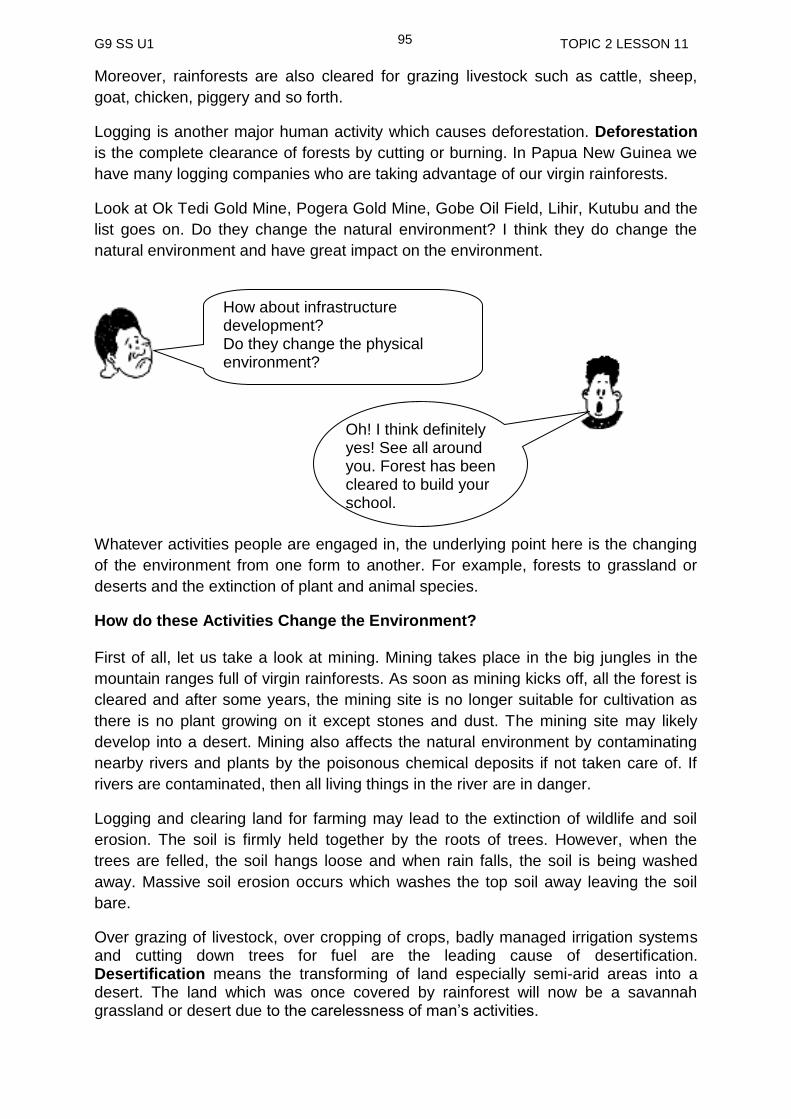
G9 SS U1 TOPIC 2 LESSON 11
95
Moreover, rainforests are also cleared for grazing livestock such as cattle, sheep,
goat, chicken, piggery and so forth.
Logging is another major human activity which causes deforestation. Deforestation
is the complete clearance of forests by cutting or burning. In Papua New Guinea we
have many logging companies who are taking advantage of our virgin rainforests.
Look at Ok Tedi Gold Mine, Pogera Gold Mine, Gobe Oil Field, Lihir, Kutubu and the
list goes on. Do they change the natural environment? I think they do change the
natural environment and have great impact on the environment.
Whatever activities people are engaged in, the underlying point here is the changing
of the environment from one form to another. For example, forests to grassland or
deserts and the extinction of plant and animal species.
How do these Activities Change the Environment? First of all, let us take a look at mining. Mining takes place in the big jungles in the
mountain ranges full of virgin rainforests. As soon as mining kicks off, all the forest is
cleared and after some years, the mining site is no longer suitable for cultivation as
there is no plant growing on it except stones and dust. The mining site may likely
develop into a desert. Mining also affects the natural environment by contaminating
nearby rivers and plants by the poisonous chemical deposits if not taken care of. If
rivers are contaminated, then all living things in the river are in danger.
Logging and clearing land for farming may lead to the extinction of wildlife and soil
erosion. The soil is firmly held together by the roots of trees. However, when the
trees are felled, the soil hangs loose and when rain falls, the soil is being washed
away. Massive soil erosion occurs which washes the top soil away leaving the soil
bare.
Over grazing of livestock, over cropping of crops, badly managed irrigation systems and cutting down trees for fuel are the leading cause of desertification. Desertification means the transforming of land especially semi-arid areas into a desert. The land which was once covered by rainforest will now be a savannah grassland or desert due to the carelessness of man’s activities.
Oh! I think definitely yes! See all around you. Forest has been cleared to build your school.
How about infrastructure development? Do they change the physical environment?
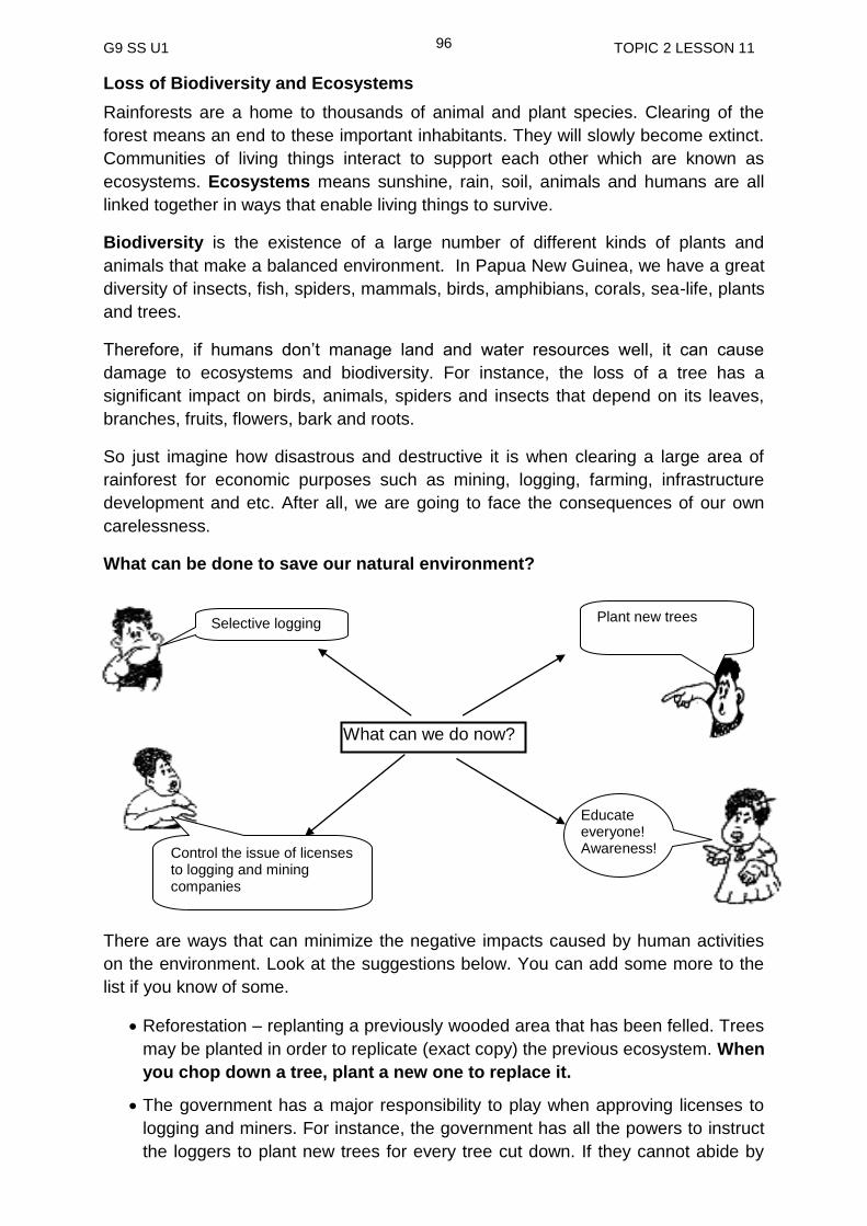
G9 SS U1 TOPIC 2 LESSON 11
96
Loss of Biodiversity and Ecosystems
Rainforests are a home to thousands of animal and plant species. Clearing of the
forest means an end to these important inhabitants. They will slowly become extinct.
Communities of living things interact to support each other which are known as
ecosystems. Ecosystems means sunshine, rain, soil, animals and humans are all
linked together in ways that enable living things to survive.
Biodiversity is the existence of a large number of different kinds of plants and
animals that make a balanced environment. In Papua New Guinea, we have a great
diversity of insects, fish, spiders, mammals, birds, amphibians, corals, sea-life, plants
and trees.
Therefore, if humans don’t manage land and water resources well, it can cause
damage to ecosystems and biodiversity. For instance, the loss of a tree has a
significant impact on birds, animals, spiders and insects that depend on its leaves,
branches, fruits, flowers, bark and roots.
So just imagine how disastrous and destructive it is when clearing a large area of
rainforest for economic purposes such as mining, logging, farming, infrastructure
development and etc. After all, we are going to face the consequences of our own
carelessness.
What can be done to save our natural environment?
There are ways that can minimize the negative impacts caused by human activities
on the environment. Look at the suggestions below. You can add some more to the
list if you know of some.
Reforestation – replanting a previously wooded area that has been felled. Trees
may be planted in order to replicate (exact copy) the previous ecosystem. When
you chop down a tree, plant a new one to replace it.
The government has a major responsibility to play when approving licenses to
logging and miners. For instance, the government has all the powers to instruct
the loggers to plant new trees for every tree cut down. If they cannot abide by
What can we do now?
Selective logging
Educate everyone! Awareness!
Plant new trees
Control the issue of licenses to logging and mining companies
G9 SS U1 TOPIC 2 LESSON 11
97
this law then do not give them license. There are others who might abide by
such a law. This also applies to mining companies; they must follow the
conditions set by the government on environmental impact. To see whether they
do abide by these laws, the government really needs to monitor their operations.
Otherwise, these companies’ main focus is on making money out of our
resources and do not care about our environment. Papua New Guinea
Government must pay attention to this issue and address it as soon as possible.
Reforestation should be a requirement for any logging and mining
companies.
Selective logging is much better than clear felling. In selective logging, only
selected trees are chopped while clear felling involves everything, from very
young trees to matured trees. Therefore, selective logging should be preferred.
Awareness programs should be carried out to educate everyone on the impact
of human activities on the environment. This will encourage individuals to at
least take precautions on their actions to the environment. For example,
unnecessary bush fires.
Observe the World Environment Days (5th to 6th June).
Every one of us has a very significant role to play to look after our environment.
We should not BLAME others. If we keep on pointing fingers at each other, we
will be heading for disaster. Therefore, at your level do something to save your
environment.
Man made changes are changes to the natural environment caused by
human activities.
People’s activities on the environment have increased to meet the demand
for the increasing population.
Farming, logging and mining have all contributed to the destruction of the
environment.
Deforestation leads to other environmental problems, such as
desertification, soil erosion, and loss of ecosystems and extinction of wildlife.
Reforestation is very important to minimise the extension of environmental
problems.
Every individual has an important role to play in looking after our beautiful
environment.
NOW ANSWER PRACTICE EXERCISE 11 ON THE NEXT PAGE
SUMMARY
You have come to the end of this lesson. In this lesson you have learned that:

G9 SS U1 TOPIC 2 LESSON 11
98
Practice Exercise 11 1 Define man-made changes. _____________________________________________________________ _____________________________________________________________ 2. Make a list of human activities that may have resulted in the transformation of
the natural environment? _____________________________________________________________ _____________________________________________________________ _____________________________________________________________ 3. The complete clearance of forest by cutting or burning is known as
_____________________. 4. Explain the term desertification. _____________________________________________________________ _____________________________________________________________ 5. What are the main causes of desertification? _____________________________________________________________ _____________________________________________________________ 6. Write the correct term next to the meanings below.
a. Replanting trees to replace those that have been felled. ___________________________________________
b. Harvesting of trees for commercial purposes.
___________________________________________ 7. Name the two main methods of harvesting trees.
(I) _________________________________ (II) _________________________________
8. Which method of logging is sustainable? _____________________________________
NOW CHECK YOUR WORK. ANSWERS ARE AT THE END OF TOPIC 2.
G9 SS U1 ANSWERS TO PRACTICE EXERCISES
99
Answers to Practice Exercise 6-11
Practice Exercise 6 1. Landform is the physical or natural features of the Earth’s surface. Mountains,
valleys, plains and hills are some of these features. 2. a) denudation b) deposition 3. a) earth movements b) volcanic eruption 4. Weathering, erosion and transportation. 5. They lower the level of the land or reshape the land by wearing them away. 6. Pacific plate and the Indian – Australian plate Practice Exercise 7 1. a piece of moving crust. 2. (i) crust (ii) mantle (iii) core 3. A fault is a crack in the earth’s crust and a fold is a bend in the earth’s crust 4. The Himalayas, the European Alps, the North American Rockies and the South
American Andes. 5. A. diverge B. converge C. plates moving alongside each other 6. (i) As the plates push and rub against each other, cracks appear in the crust.
In some weak places, magma which is under great pressure, forces its way up to the surface through this cracks. The magma is now known as lava. Lava and ash are often shot hundreds of meters into the air. The mountain that is formed as a result of this eruption of magma is known as a volcano.
(ii) When plates slide past each other, the edges of sliding plates can get stuck together. The plates keep trying to move, and pressure builds up. Suddenly, the plates break free. Plates that move suddenly can cause an earthquake. The ground shakes and this can damage houses and other buildings. Earthquakes are common along fault lines.
7. (i) cay (ii) atoll (iii) continental islands Practice Exercise 8 1. Weathering is the process by which rocks are gradually worn away by the
actions of water. 2. (i) Chemical weathering (ii) Physical weathering
(v) Chemical and physical weathering

G9 SS U1 ANSWERS TO PRACTICE EXERCISES
100
3. (i) Caves – chemical weathering (ii) Mesa – Physical weathering (iii) Chemical and physical weathering 4. Freeze and thaw is common in areas where the temperature fluctuates
especially during winters in temperate region and in high mountains like the Himalayas.
5. Tree roots, as they grow prise apart rocks. This is a powerful type of mechanical
rock disintegration. Organisms such as earthworms and rabbits contribute to weathering by exposing new rock surface to the air and water.
Practice Exercise 9 1. Erosion is the wearing a way of land by water (flowing river), wind and moving
ice (glacier). Deposition is the dropping or settling of rock particles carried by ice, wind and water.
2. ice/glacier, wind, rain, river and sea 3. Alluvium is very fertile as it is reach in plant nutrients. 4. a) Glaciation b) River c) Sea d) wind e) River Practice Exercise 10 1. Natural hazards are events that take place in nature that can cause harm.
Natural disasters are bad effects that people experience as a result of occurrences of natural hazards.
2. Floods, landslides, cyclones, frosts and drought 3. A debris avalanche is a type of slide characterized by the chaotic movement of
rocks soil and debris mixed with water or ice (or both). They are usually triggered by the saturation of thickly vegetated slopes which results in an incoherent mixture of broken timber, smaller vegetation and other debris.
4. (i) strong winds (ii) heavy rain (iii) storm surge 5. Earthquakes, especially when it occurs under the sea. Practice Exercise 11 1. Man-made changes refer to the transformation of the natural environment as a
result of human activities. 2. Farming, logging, mining, hunting, fishing and construction of infrastructures. 3. Deforestation 4. Desertification is the transformation of land especially semi-arid areas into
deserts.

G9 SS U1 ANSWERS TO PRACTICE EXERCISES
101
5. Overgrazing, overcropping, badly managed irrigation systems and cutting down trees for fuel and logging.
6. a) Reforestation b) Logging 7. a) Selective logging b) Clear felling

G9 SS U1 TOPIC 3 TITLE
102
TOPIC 3
CLIMATES OF THE PACIFIC
In This Topic, You Will Learn About:
Tropical Climates in the Pacific
Temperate Climate in the Pacific
Types of Climate in Papua New Guinea
Climograph
G9 SS U1 TOPIC 3 INTRODUCTION
103
TOPIC 3: INTRODUCTION
In this Topic, you will learn about Climates in the Pacific Region. The Pacific region is a vast area that extends from the equator to both the tropical and the temperate climatic regions. In addition, you will also identify human activities and the natural disasters that have
also contributed to the changes in our natural environment.
After studying this topic, you will understand how physical features have developed
and how they have change over time.
We hope you will enjoy this Topic.

G9 SS U1 TOPIC 3 LESSON 12
104
Lesson 12: Tropical Climates in the Pacific
Welcome to lesson 12. In this lesson you will study tropical
climates in the Pacific.
Your Aims
Define climate
Identified the different types of climatic zones in maps
Identified types of tropical climate in the Pacific.
Before we look at the tropical climate in the Pacific, let us first revise the basic
information on climate.
What is climate?
Observing weather over a period of time enables us to describe climate. Climate may
vary from region to region. Different climates may exist in close proximity to one
another. Many factors, such as the geographical features, vegetation and the
availability of water influence the climate of any location. Humans also affect their
climate as they modify (change) the natural environment to meet their needs.
The world has several climatic zones. These are summarised in the map below.
The classification is based on maximum and minimum temperatures and the temperature range as well as the total and seasonal distribution of precipitation.
Climate is defined as the averaged weather conditions of a place over a
period of time.
Source UK Meteorological Office

G9 SS U1 TOPIC 3 LESSON 12
105
A simple summary is shown in the table below.
CLIMATE ZONE DESCRIPTION
Polar very cold and dry all year
Temperate cold winters and mild summers
Arid dry, hot all year
Tropical hot and wet all year
Mediterranean mild winters, dry hot summers
Mountains (tundra) very cold all year
Tropical climates in the Pacific Region Climates in the Pacific Region differ from place to place depending on their location. Generally tropical climate is the most dominant in the Pacific region. However places further to the north and south may experience temperate climates which comprise of four seasons summer, autumn, winter and spring. Let us now look at the tropical climates. There are three types in the tropical group. 1. Tropical Wet Places with a tropical wet climate are also known as rain forests. Rain forests have the most predictable weather on Earth, with warm temperatures and regular rainfall. Annual rainfall exceeds 150 centimetres (59 inches) and the temperature varies more during a day than it does over a year. The coolest is about 20-23 degrees Celsius (68-73 degrees Fahrenheit) and occurs just before dawn. Afternoon temperatures usually reach 30-33 degrees Celsius (86-91 degrees Fahrenheit). Rain forests experience very little seasonal change, meaning average monthly temperatures remain fairly constant. Tropical wet climates exist in a band extending about in degrees of latitude on either side of the equator. Some tropical wet climates are wet throughout the year. Others experience more rainfall during the summer or winter, but they never have especially dry seasons. The U.S. state of Hawaii; Kuala Lumpur, Malaysia, Belém and Brazil, are examples of areas with tropical wet climates.
Tropical monsoon is another tropical climate. Turn to the next page to read more about monsoon

G9 SS U1 TOPIC 3 LESSON 12
106
2. Tropical Monsoon Tropical monsoon climates are most common in southern Asia, West Africa Papua New Guinea and North western parts of Australia. A monsoon is a wind system that reverses its direction every six months. They usually flow from sea to land in the summers and from land to sea in the winters.
Summer monsoons bring large amounts of rainfall to tropical monsoon regions. People living in these regions depend on the seasonal rains to bring water to their crops. India and Bangladesh are famous for their monsoon climate patterns. The diagram below illustrates the flow of wind during winter and summer monsoons.
3. Tropical Wet and Dry Tropical wet and dry climate has three seasons. These areas are near the Equator. One season is cool and dry. The other season is hot and dry and the last season is hot and wet. Life in these tropical wet and dry regions depends on the wet season’s rains. During years when rains are light, people and animals suffer. Havana, Cuba; Kolkata, India; and Africa’s vast Serengeti Plain are in the wet and dry tropics.
Papua New Guinea has two distinct seasons in a year and they are wet and dry seasons. Generally Pacific islands that are located within the tropical region have tropical climate which comprise of high temperatures and high rainfall throughout the year with a low temperature range.
Places in the Pacific that would experience tropical climate are those located within the tropical region.
G9 SS U1 TOPIC 3 LESSON 12
107
Activity
Use an atlas (PNGSSA) to do the exercise below. Make a list of all the Pacific Island Countries that lie between tropic of Cancer and tropic of Capricorn. These are the places in the Pacific that have tropical climate. ___________________________________________________________________
___________________________________________________________________
___________________________________________________________________
_________________________________________________________________
The other elements of climate may cause slight variations in the tropical climate in the Pacific however in general tropical climate is the dominant climate.
Climate is defined as the averaged weather conditions of a place over a period of time.
There are six basic climate types in the world. They include polar, temperate, arid, tropical, Mediterranean and mountain (tundra).
Tropical climate is the dominant climate in the Pacific Region.
There are three types of tropical climates in the Pacific Region. Tropical wet, tropical monsoon and tropical wet and dry.
Places with a tropical wet climate are also known as rain forests. Rain forests have the most predictable weather on Earth, with warm temperatures and regular rainfall.
Tropical monsoon climates are most common in southern Asia, West Africa Papua New Guinea and North western parts of Australia. A monsoon is a wind system that reverses its direction every six months. They usually flow from sea to land in the summers and from land to sea in the winters.
Tropical wet and dry has three seasons. One season is cool and dry. The other season is hot and dry and the last season is hot and wet.
________________________________________________________________
SUMMARY
You have come to the end of this lesson. In this lesson you have learned that:
NOW DO PRACTICE EXERCISE 12 ON THE NEXT PAGE

G9 SS U1 TOPIC 3 LESSON 12
108
Practice Exercise 12
1. What is climate?
_____________________________________________________________
2. Make a list of the basic types of climate in the world.
_____________________________________________________________
3. What are the three types of tropical climates in the Pacific?
(i) ________________________________________
(ii) ________________________________________
(iii) ________________________________________
4. Which of the three climates has the most predictable weather?
__________________________________
Refer to the map showing the monsoon winds to answer the two questions below.
5. Which monsoon brings a lot of rain to East Asia? Winter monsoon or summer
monsoon
__________________________________
6. What will the air pressure be in the interior of Asian continent? High or low
__________________________________
Answer to activity
Pacific countries with tropical climate include Papua New Guinea, Federated State of Micronesia, Palau, Solomon Islands, Vanuatu, Fiji, Tuvalu, Kiribati, Nauru, Marshall Islands, Tonga, Hawaii, Western Samoa, American Samoa and cook islands.
NOW CHECK YOUR WORK. ANSWERS ARE AT THE END OF TOPIC 3.
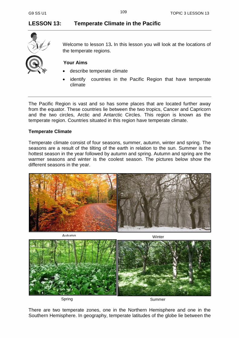
G9 SS U1 TOPIC 3 LESSON 13
109
LESSON 13: Temperate Climate in the Pacific
Welcome to lesson 13. In this lesson you will look at the locations of
the temperate regions.
Your Aims
describe temperate climate
identify countries in the Pacific Region that have temperate climate
The Pacific Region is vast and so has some places that are located further away from the equator. These countries lie between the two tropics, Cancer and Capricorn and the two circles, Arctic and Antarctic Circles. This region is known as the temperate region. Countries situated in this region have temperate climate. Temperate Climate
Temperate climate consist of four seasons, summer, autumn, winter and spring. The seasons are a result of the tilting of the earth in relation to the sun. Summer is the hottest season in the year followed by autumn and spring. Autumn and spring are the warmer seasons and winter is the coolest season. The pictures below show the different seasons in the year.
There are two temperate zones, one in the Northern Hemisphere and one in the Southern Hemisphere. In geography, temperate latitudes of the globe lie between the
Autumn Winter
Summer Spring

G9 SS U1 TOPIC 3 LESSON 13
110
tropics and the Polar Regions. The changes in these regions between summer and winter are generally relatively moderate, rather than extreme hot or cold.
The North Temperate Zone extends from the Tropic of Cancer (at about 23.5 degrees north latitude) to the Arctic Circle (at approximately 66.5 degrees north latitude). The South Temperate Zone extends from the Tropic of Capricorn (at approximately 23.5 degrees south latitude) to the Antarctic Circle (at approximately 66.5 degrees south latitude).
However, in certain areas, such as Asia and central North America, the variations between summer and winter can be extreme because these areas are far away from the sea, causing them to have a continental climate.
Apart from the continental climate is the Temperate Maritime Climate. The Temperate Maritime Climate is influenced by the oceans, which help to sustain or stable temperatures throughout the year. In temperate zones, the prevailing winds are from the west, thus the western edges of temperate continents most commonly experience this maritime climate. Such regions include Western Europe, and western North America at latitudes between 40° and 60° north (65°N in Europe).
Places in and around the edges of the Pacific region that lie between the two tropics and the two circles are those that have temperate climate. These places include China, Japan, Australia, New Zealand, Chile, USA and Canada. These places may have variations in temperatures and rainfalls but in general all have the four seasons, winter, spring, summer and autumn in a year. Generally, countries in the Southern Hemisphere have their summers towards the end and at the beginning of the following year while those in the Northern Hemisphere have their winters at the same time. The seasons change towards the mid-year with Southern Hemisphere experiencing winters while Northern Hemisphere experiencing summers. The change in seasons is due to the position of the earth as it revolves around the sun.
More on this will be discussed in Project 1 of your course.
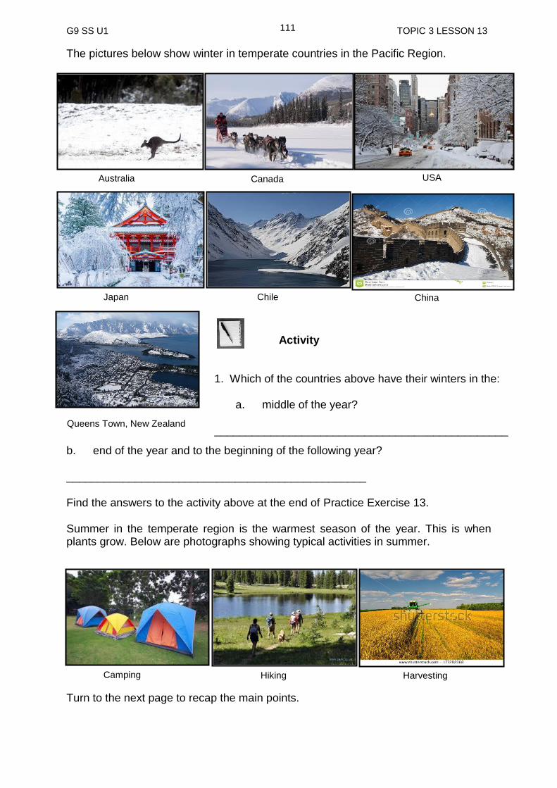
G9 SS U1 TOPIC 3 LESSON 13
111
The pictures below show winter in temperate countries in the Pacific Region.
Activity
b. end of the year and to the beginning of the following year?
________________________________________________
Find the answers to the activity above at the end of Practice Exercise 13.
Summer in the temperate region is the warmest season of the year. This is when plants grow. Below are photographs showing typical activities in summer.
Turn to the next page to recap the main points.
Australia
Canada
Queens Town, New Zealand
China
Japan
Chile
USA
1. Which of the countries above have their winters in the:
a. middle of the year? _______________________________________________ __________________________________________________________________
Harvesting Hiking Camping
G9 SS U1 TOPIC 3 LESSON 13
112
Countries that lie between the two tropics (Tropic of Cancer and Tropic of Capricorn and the two circles, Arctic and Antarctic Circles ) are temperate countries which mean they have temperate climate.
There are two temperate zones, one in the Northern Hemisphere and one in the Southern Hemisphere.
The North Temperate Zone extends from the Tropic of Cancer (at about 23.5 degrees north latitude) to the Arctic Circle (at approximately 66.5 degrees north latitude).
The South Temperate Zone extends from the Tropic of Capricorn (at approximately 23.5 degrees south latitude) to the Antarctic Circle (at approximately 66.5 degrees south latitude).
Temperate climate consist of four seasons, summer, autumn, winter and spring. (SAWS) The seasons are result of the tilting of the earth in relation to the sun.
Summer is the hottest season in the year followed by autumn and spring which are the warmer seasons and winter the coolest season.
Places in and around the edges of the Pacific region that lie between the two tropics and the two circles are those that have temperate climate. These places include China, Japan, Australia, New Zealand, Chile, USA and Canada.
SUMMARY
You have come to the end of this lesson. In this lesson you have learned that:
NOW DO PRACTICE EXERCISE 13 ON THE NEXT PAGE

G9 SS U1 TOPIC 3 LESSON 13
113
Practice Exercise 13
1. What type of climate is dominant in the Pacific region?
__________________________________________
2. Briefly describe the location of temperate region.
______________________________________________________________
_____________________________________________________________
_____________________________________________________________
_____________________________________________________________
3. Name the four seasons in the temperate climate.
(i) _________________________________
(ii) _________________________________
(iii) _________________________________
(iv) _________________________________
4. Between which two latitudes can you find:
a) Northern temperate zone? _____________________________________
b) Southern temperate zone? _____________________________________ 5. Complete the sentence below by inserting the correct word.
______________ consist of four ______________ in a year. The seasons are
the result of the ______________ of the earth in relation to the ___________.
Answers to Activity
1. a) Canada, USA, China and Japan
b) Australia, New Zealand and Chile
NOW CHECK YOUR WORK. ANSWERS ARE AT THE END OF TOPIC 3.
G9 SS U1 TOPIC 3 LESSON 14
114
Lesson 14 Types of Climate in Papua New Guinea
Welcome to lesson 14 of Topic 3. In this lesson you will study
types of climate in Papua New Guinea.
Your Aims
identify the types of climate in Papua New Guinea
discuss the characteristics that influence climate in Papua New Guinea
explain the difference between climates of the coastal and highland areas of Papua New Guinea
Before you look at the types of climate in Papua New Guinea, let us first recap the
definition of climate.
What is climate?
Papua New Guinea is located in the tropical region, about 5 degrees south of the equator and therefore has a tropical climate, which is generally hot and wet all year round. Although all the climate regions of Papua New Guinea are basically tropical, they vary from place to place. This is due to certain factors which we will discuss in this lesson. 1. Altitude
Places in Papua New Guinea that are located on high altitudes (highland areas) tend
to have a cooler climate compare to those located at lower altitudes (coastal areas).
This is due to the fact that on higher altitude the air is thin and does not trap heat that
is given of from the earth’s surface thus keeping the place cooler. It is opposite in the
coastal areas where a lot of moisture is present in the air allowing it to trap heat that
is given off from the surface of the earth thus keeping the place generally hot. In the
lowlands, mean annual maximum temperatures range from about 30°C to 32°C, and
the minimums are between 23°C and 24°C. Up in the highlands are cooler where
night frost are common. Daytime temperatures generally exceed 22°C.
2. Seasons
Papua New Guinea basically has two seasons in a year and these seasons are
determined by two wind systems. They are the southeast trade winds and the
northwest trade winds.
Climate is the pattern of temperature, rainfall, sunshine and wind in an area over a period of time
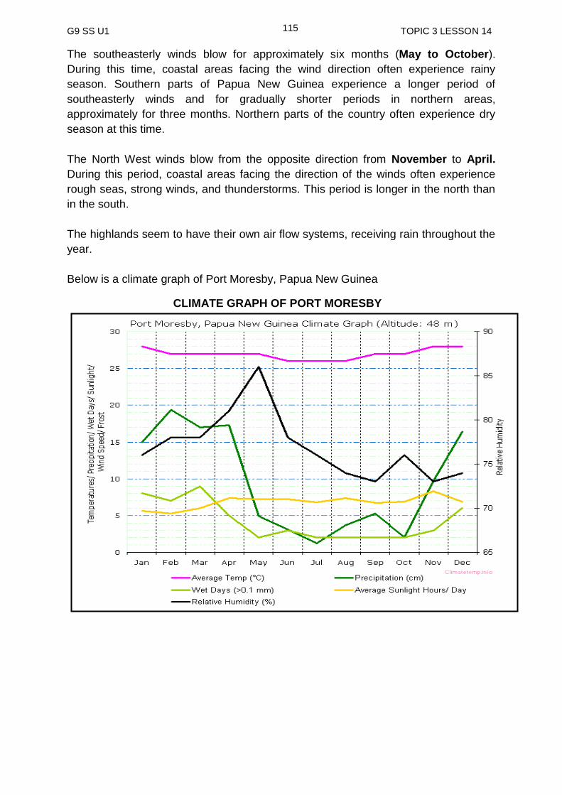
G9 SS U1 TOPIC 3 LESSON 14
115
The southeasterly winds blow for approximately six months (May to October).
During this time, coastal areas facing the wind direction often experience rainy
season. Southern parts of Papua New Guinea experience a longer period of
southeasterly winds and for gradually shorter periods in northern areas,
approximately for three months. Northern parts of the country often experience dry
season at this time.
The North West winds blow from the opposite direction from November to April.
During this period, coastal areas facing the direction of the winds often experience
rough seas, strong winds, and thunderstorms. This period is longer in the north than
in the south.
The highlands seem to have their own air flow systems, receiving rain throughout the
year.
Below is a climate graph of Port Moresby, Papua New Guinea
CLIMATE GRAPH OF PORT MORESBY
G9 SS U1 TOPIC 3 LESSON 14
116
Climate is the pattern of temperature, rainfall, sunshine and wind in an area.
Altitude – places in Papua New Guinea that are located on high altitudes (highland areas) tend to have a cooler climate compare to those located at lower altitudes (coastal areas).
Seasons – Papua New Guinea basically has two seasons in a year and these seasons are determined by two wind systems. They are the South East trade winds and the North West winds.
The southeasterly winds blow for approximately six months (May to October).
The northwesterly winds blow from the opposite direction from December to April.
The highlands seem to have their own air flow systems, receiving rain throughout the year.
NOW DO PRACTICE EXERCISE 14 ON THE NEXT PAGE
SUMMARY
You have come to the end of this lesson. In this lesson you have learnt that:

G9 SS U1 TOPIC 3 LESSON 14
117
Practice Exercise 14
1. What is climate?
______________________________________________________________ 2. What are the two wind systems we have in Papua New Guinea?
___________________________________
___________________________________
3. When do they blow?
_________________________________________
_________________________________________
4. Find the meaning to the word altitude.
______________________________________________________________
Study the graph of Port Moresby’s climate on page 115 carefully and answer the
questions below.
5. How many different elements of climate are shown on the graph?
____________________________
6. In what unit is humidity measured? ___________________________
7. Which month is the driest month of the year?
______________________ 8. Which month of the year is the wettest?
_________________________
9. Briefly describe the climate of Papua New Guinea.
_______________________________________________________________
_______________________________________________________________
_______________________________________________________________
NOW CHECK YOUR WORK. ANSWERS ARE AT THE END OF TOPIC 3.
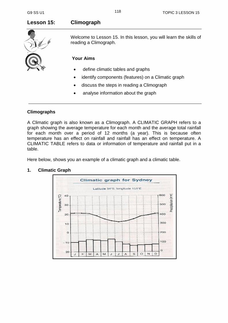
G9 SS U1 TOPIC 3 LESSON 15
118
Lesson 15: Climograph
Welcome to Lesson 15. In this lesson, you will learn the skills of reading a Climograph.
:
Your Aims
define climatic tables and graphs
identify components (features) on a Climatic graph
discuss the steps in reading a Climograph
analyse information about the graph
Climographs A Climatic graph is also known as a Climograph. A CLIMATIC GRAPH refers to a graph showing the average temperature for each month and the average total rainfall for each month over a period of 12 months (a year). This is because often temperature has an effect on rainfall and rainfall has an effect on temperature. A CLIMATIC TABLE refers to data or information of temperature and rainfall put in a table.
Here below, shows you an example of a climatic graph and a climatic table. 1. Climatic Graph
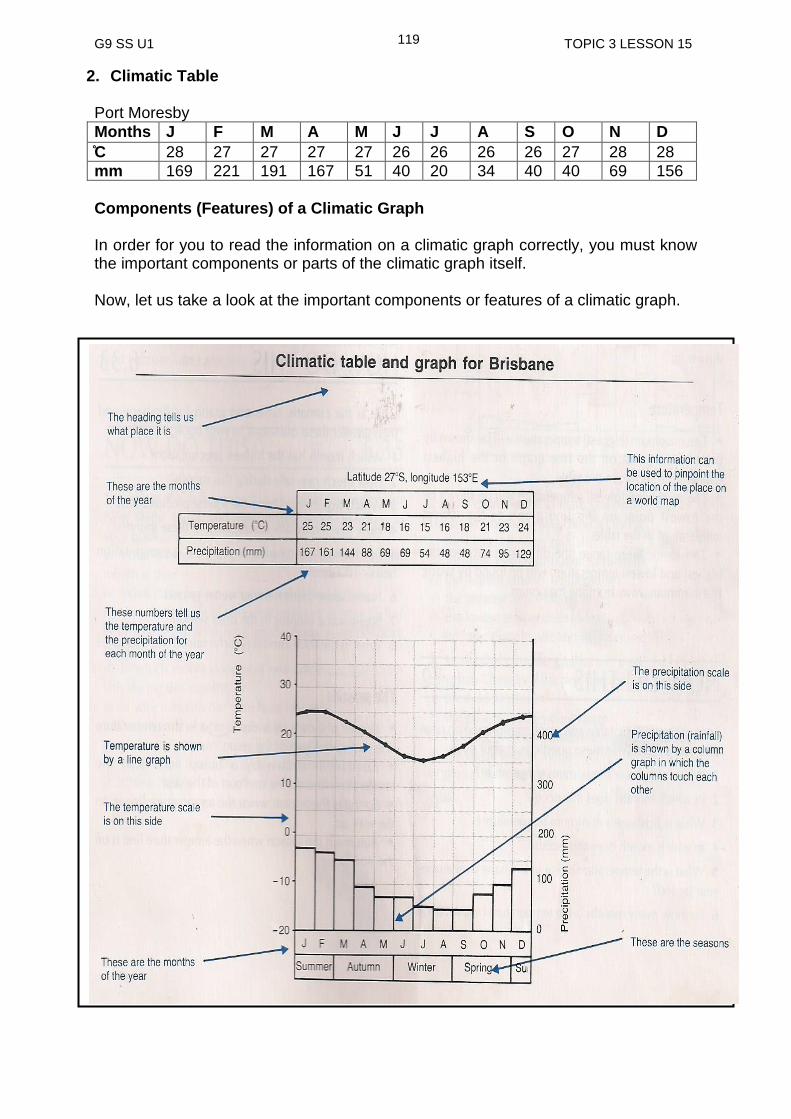
G9 SS U1 TOPIC 3 LESSON 15
119
2. Climatic Table Port Moresby
Months J F M A M J J A S O N D
C 28 27 27 27 27 26 26 26 26 27 28 28
mm 169 221 191 167 51 40 20 34 40 40 69 156
Components (Features) of a Climatic Graph
In order for you to read the information on a climatic graph correctly, you must know the important components or parts of the climatic graph itself. Now, let us take a look at the important components or features of a climatic graph.
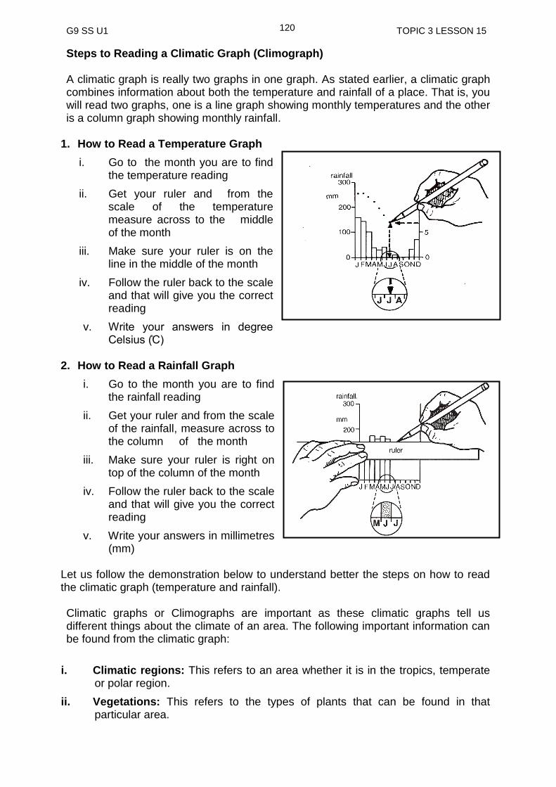
G9 SS U1 TOPIC 3 LESSON 15
120
Steps to Reading a Climatic Graph (Climograph) A climatic graph is really two graphs in one graph. As stated earlier, a climatic graph combines information about both the temperature and rainfall of a place. That is, you will read two graphs, one is a line graph showing monthly temperatures and the other is a column graph showing monthly rainfall.
1. How to Read a Temperature Graph
i. Go to the month you are to find the temperature reading
ii. Get your ruler and from the scale of the temperature measure across to the middle of the month
iii. Make sure your ruler is on the line in the middle of the month
iv. Follow the ruler back to the scale and that will give you the correct reading
v. Write your answers in degree Celsius ( C)
2. How to Read a Rainfall Graph
i. Go to the month you are to find the rainfall reading
ii. Get your ruler and from the scale of the rainfall, measure across to the column of the month
iii. Make sure your ruler is right on top of the column of the month
iv. Follow the ruler back to the scale and that will give you the correct reading
v. Write your answers in millimetres (mm)
Let us follow the demonstration below to understand better the steps on how to read the climatic graph (temperature and rainfall). Climatic graphs or Climographs are important as these climatic graphs tell us different things about the climate of an area. The following important information can be found from the climatic graph:
i. Climatic regions: This refers to an area whether it is in the tropics, temperate or polar region.
ii. Vegetations: This refers to the types of plants that can be found in that particular area.

G9 SS U1 TOPIC 3 LESSON 15
121
iii. Locations (hemisphere): This refers to the location of the place that is whether in the northern or southern hemisphere.
iv. Temperature range: This refers to the difference between the highest and the lowest temperature. It tells us how far away an area is. That is, whether it is closer or far away from the equator or the coast.
v. Rainfall: indicates the highest and lowest rainfall received at particular times of the year. It also shows the wet and dry seasons and shows the total amount of rain received in a year.
Remember the following important information about temperature, precipitation and location on a climograph. Temperature
The maximum (highest) temperature will be shown by the highest point on the line graph or the highest temperature on the table.
The minimum (lowest) temperature will be shown by the lowest point on the line graph or the lowest temperature in the table.
The temperature range (the difference between the highest and the lowest temperature) will be found by taking the minimum away from the maximum.
Precipitation
The highest precipitation will be shown by highest column in the graph or the largest precipitation figure in the table.
The lowest precipitation will be shown by the lowest column in the graph or the smallest precipitation figure in the table.
A grouping together of a number of higher columns will show a distinct wet season.
A grouping together of a number of lower columns will show a distinct dry season.
If all columns are quite high it is probably wet all year round.
To find the total precipitation for the year, add up all twelve precipitation figures from the table or simply taking the reading for each column on the graph and adding them up to give the total precipitation for the year.
Location
A temperature line which is almost flat or level shows that this place is close to the equator. Places close to the equator have small temperature range.
A temperature line which has a large dip in it shows a place that is quite a long way from the equator or a long way inland. These places have large temperature ranges.
If the temperature line dips during June, July and August (showing winter is in the middle of the year), this place is in the southern hemisphere.
If the temperature line dips during December, January and February, this place in the northern hemisphere.
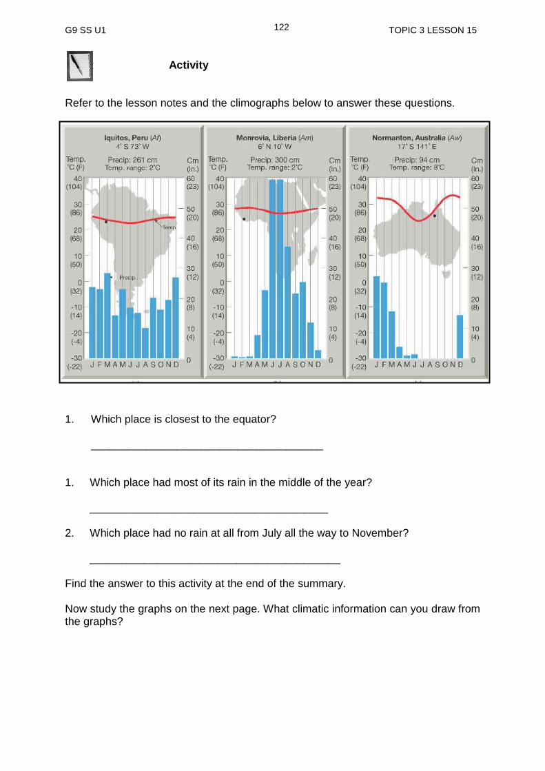
G9 SS U1 TOPIC 3 LESSON 15
122
Activity
Refer to the lesson notes and the climographs below to answer these questions.
1. Which place is closest to the equator? ______________________________________ 1. Which place had most of its rain in the middle of the year?
_______________________________________
2. Which place had no rain at all from July all the way to November?
_________________________________________
Find the answer to this activity at the end of the summary. Now study the graphs on the next page. What climatic information can you draw from the graphs?

G9 SS U1 TOPIC 3 LESSON 15
123
You can obviously see that two of the three countries above are located in the northern hemisphere, Guangzhou in China and Alaska in USA. Cape Town on the other hand is in the southern hemisphere. This can be clearly seen in the shape (dips) in the line graphs. Guangzhou and Alaska have summers in the middle of the year which is indicated by the temperature line bending upward in the middle of the year and dipping at the end of the year to the following year showing winter, which is between November and February of the following year. It is opposite to Cape Town which has its summers at the end of the year to the beginning of the following year and winters in the middle of the year as shown by the dipping of the line graph in the middle of the year. Guangzhou receives most of its rain in the middle of the year while Alaska receives a fair bit throughout the year with a little less in May, June and July and a little more from September to December. Cape Town has very low precipitation record as compared to the other two places. It receives most of its rain in the middle of the year but still is quite low. The advantage of a climpgraph as compared to the single temperature and rainfall graph is that you can get more information on climate of a place which eventually gives you a clear picture of the climate of a place. Turn to the next page to revise the main points of this lesson.

G9 SS U1 TOPIC 3 LESSON 15
124
A Climatic graph is also known as a Climograph
A Climatic or Climograph refers to the average temperature and rainfall of an area over a period of 12 months ( year)
The climatic graph shows the temperature and the rainfall details of an area
The climatic graph has two graphs in it. A line graph for the temperature and the column graph for the rainfall
It is important that scales of the graphs are read carefully before correct measurement or reading is taken
Other important information that can be taken from the climatic graph are climatic regions, vegetation, location and temperature range and precipitation.
___________________________________________________________________
NOW DO PRACTICE EXERCISE 15 ON THE NEXT PAGE
SUMMARY
You have come to the end of this lesson. In this lesson you have learned that:
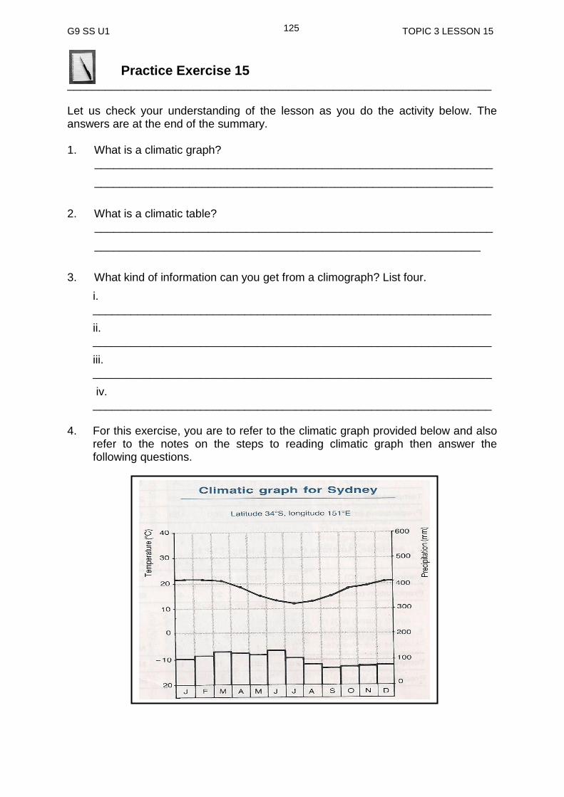
G9 SS U1 TOPIC 3 LESSON 15
125
Practice Exercise 15
___________________________________________________________________ Let us check your understanding of the lesson as you do the activity below. The answers are at the end of the summary.
1. What is a climatic graph?
_______________________________________________________________
_______________________________________________________________
2. What is a climatic table?
_______________________________________________________________
_____________________________________________________________
3. What kind of information can you get from a climograph? List four.
i. _______________________________________________________________
ii. _______________________________________________________________
iii. _______________________________________________________________
iv. _______________________________________________________________
4. For this exercise, you are to refer to the climatic graph provided below and also
refer to the notes on the steps to reading climatic graph then answer the following questions.
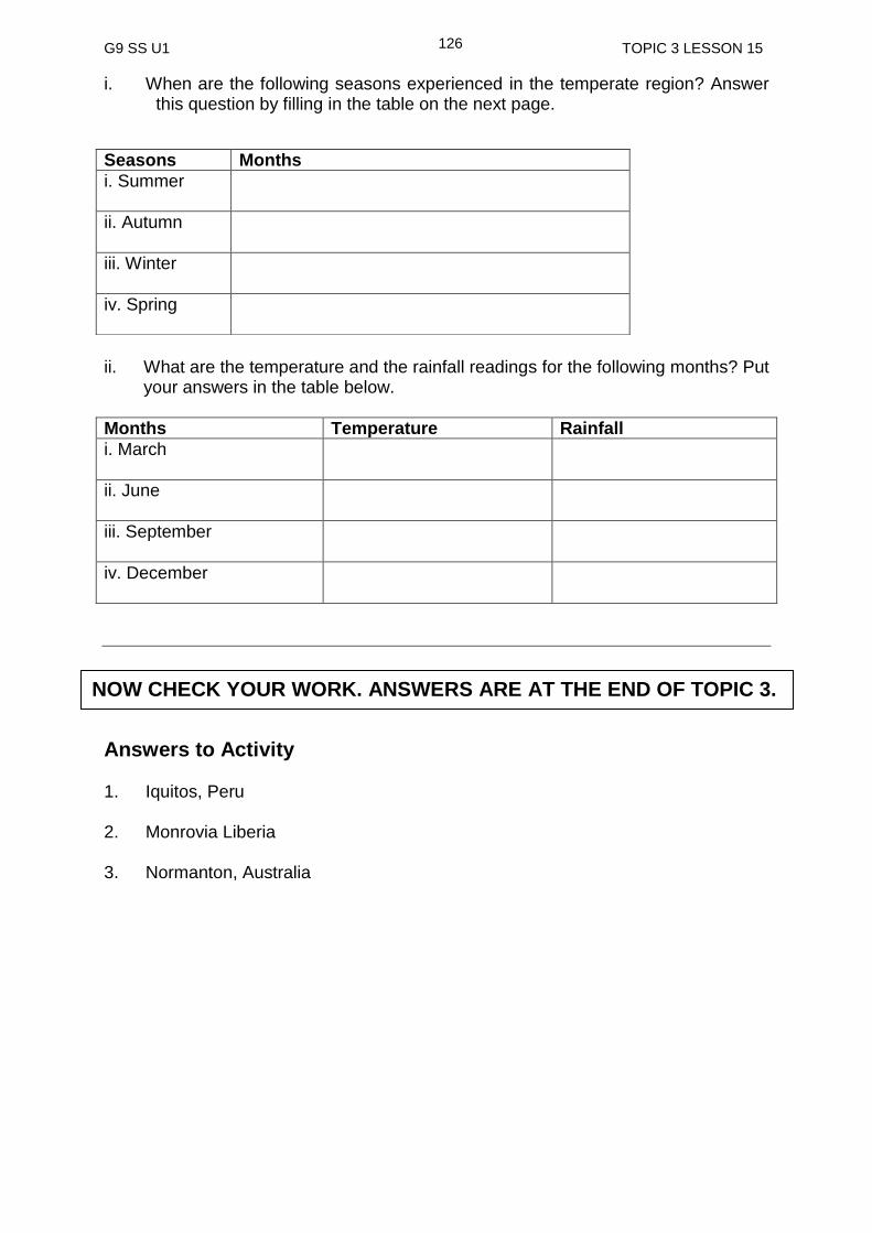
G9 SS U1 TOPIC 3 LESSON 15
126
i. When are the following seasons experienced in the temperate region? Answer this question by filling in the table on the next page.
ii. What are the temperature and the rainfall readings for the following months? Put
your answers in the table below.
Months Temperature Rainfall
i. March
ii. June
iii. September
iv. December
Answers to Activity 1. Iquitos, Peru 2. Monrovia Liberia 3. Normanton, Australia
Seasons Months
i. Summer
ii. Autumn
iii. Winter
iv. Spring
NOW CHECK YOUR WORK. ANSWERS ARE AT THE END OF TOPIC 3.

G9 SS U1 TOPIC 3 ANSWERS
127
ANSWERS TO PRACTICE EXERCISES 12-15
Practice Exercise 12 1. Climate is the average weather condition of a place over a period of time. 2. Polar, temperate, arid, tropical, Mediterranean, and mountain
3. (i) Tropical wet
(ii) Tropical monsoon
(iii) Tropical wet and dry
4. Tropical wet 5. Summer monsoon 6. High pressure Practice Exercise 13 1. Tropical climate 2. Temperate regions are located between the two tropics and the two circles. 3. (i) summer (ii) autumn (iii) winter (iv) spring
4. a) between 23.5° N , tropic of Cancer and 66.5° N , the Arctic circle
b) between 23.5° S, tropic of Capricorn and 66.5° S, the Antarctic circle 5. Complete the sentences below by inserting the correct word in the blank
spaces.
Temperate climate consist of four seasons in a year. The seasons are the result of the tilting of the earth in relation to the sun.
Practice Exercise 14 1. Climate is the pattern of temperature, rainfall, sunshine and wind in an area. 2. Southeast trade winds and north-westerly winds 3. Southeast trade winds blow from May to October and north-westerly winds blow
from November to March. 4. Height above sea level 5. 5 elements 6. Percentage
G9 SS U1 TOPIC 3 ANSWERS
128
7. July 8. February 9. Papua New Guinea has a tropical climate which is generally hot and wet all
year round. There are two distinct wet and dry seasons. The two main winds that blow are the north-westerly winds and the south east trade winds.
Practice Exercise 15
1. A Climatic graph is a graph showing the average monthly temperature and
average monthly rainfall over a period of 12 months (year) 2. A Climatic table refers to the data or information about the monthly temperature
and monthly rainfall of an area in a table
3. i. Climatic regions: This refers to an area whether it is in the tropics, temperate or Polar region
ii. Vegetation: Thist refers to the types of plants that can be found in that particular area.
iii. Location (hemisphere): This refers to the location of the place that is whether it is in the northern or southern hemisphere
iv. Temperature range: This refers to the difference between the highest and the lowest temperature. It tells us how far away an area is, whether it is closer or far away from the equator or the coast.
4. i
ii. Any figures that fall in between the numbers given in bracket can be correct.
Months Temperature Rainfall
i. March 22°C (22-24)
130mm (120-140)
ii. June 12°C (12-13)
125mm (120-130)
iii. September 14°C (13-15)
90mm (80-100)
iv. December 21°C (20-23)
85mm (80-90)
Seasons Months
i.Summer December, January, February
ii.Autumn March, April, May
iii.Winter June, July, August
iv.Spring September, October, November
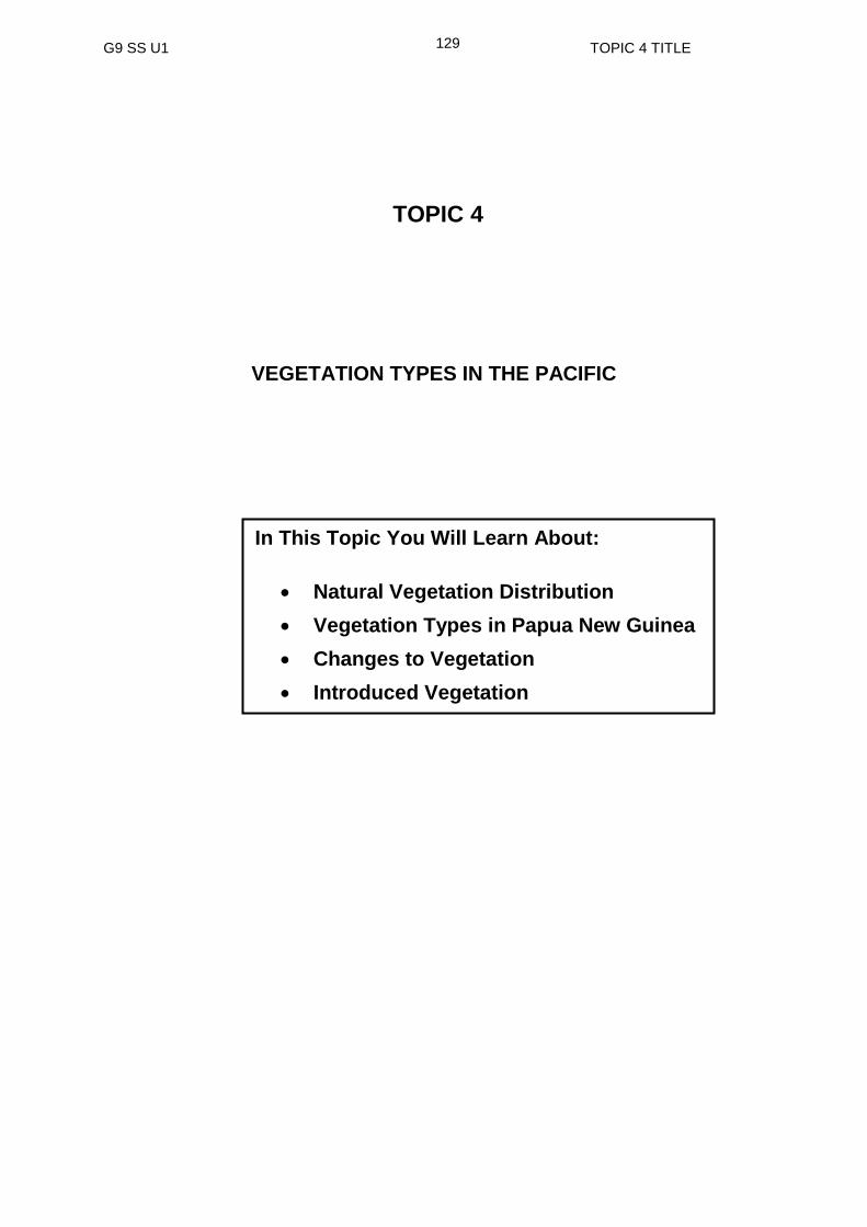
G9 SS U1 TOPIC 4 TITLE
129
TOPIC 4
VEGETATION TYPES IN THE PACIFIC
In This Topic You Will Learn About:
Natural Vegetation Distribution
Vegetation Types in Papua New Guinea
Changes to Vegetation
Introduced Vegetation

G9 SS U1 TOPIC 4 INTRODUCTION
130
TOPIC 4: INTRODUCTION
In this Topic you will learn about VEGETATION Types in the Pacific region. The
Pacific region is a vast area that extends from the equator to both the tropical and the
temperate climatic regions.
In addition you will also identify human activities and the natural disasters that have
also contributed to the changes in our natural environment.
After studying this topic, you will understand how physical features have developed
and how they have changed over time.
We hope you will enjoy this Topic.

G9 SS U1 TOPIC 4 LESSON 16
131
Lesson 16: Natural Vegetation and Distribution
Welcome to Lesson 16. In this lesson you, will learn about Natural Vegetation and Distribution.
Your Aims
define natural vegetation and distribution
discuss the variety of vegetation in the Pacific
identify the characteristics of each vegetation type
interpret the different vegetation types from given maps
identify factors that influence vegetation distribution in the Pacific
Vegetation refers to all plants that grow in an area. The vegetation of an area is largely determined by the type of climate in that area. More on climate and vegetation will be discussed in your project 1. Let us now look at Natural vegetation and distribution. What is Natural Vegetation and Distribution?
Places around the world including the Pacific have different kinds of vegetation. The distribution of vegetation changes from one area to another.
There are three basic types of vegetation.
1. Forests
2. Grasslands
3. Desert
There are several types of forests, grasslands and deserts across the globe but for this lesson, we will concentrate on the Pacific region. The Pacific region has four main types of vegetation.
1. Tropical forest
2. Atoll vegetation
3. Temperate vegetation and
4. Grassland
What then is Natural Vegetation and Distribution?
Natural Vegetation refers to the types of plants found in an area that has been growing before the change by human activity (original plants). Distribution is the spread of the types of plants from one place to another in that area.
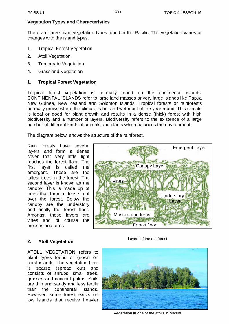
G9 SS U1 TOPIC 4 LESSON 16
132
Vegetation Types and Characteristics There are three main vegetation types found in the Pacific. The vegetation varies or changes with the island types. 1. Tropical Forest Vegetation
2. Atoll Vegetation
3. Temperate Vegetation
4. Grassland Vegetation 1. Tropical Forest Vegetation Tropical forest vegetation is normally found on the continental islands. CONTINENTAL ISLANDS refer to large land masses or very large islands like Papua New Guinea, New Zealand and Solomon Islands. Tropical forests or rainforests normally grows where the climate is hot and wet most of the year round. This climate is ideal or good for plant growth and results in a dense (thick) forest with high biodiversity and a number of layers. Biodiversity refers to the existence of a large number of different kinds of animals and plants which balances the environment. The diagram below, shows the structure of the rainforest. Rain forests have several layers and form a dense cover that very little light reaches the forest floor. The first layer is called the emergent. These are the tallest trees in the forest. The second layer is known as the canopy. This is made up of trees that form a dense roof over the forest. Below the canopy are the understory and finally the forest floor. Amongst these layers are vines and of course the mosses and ferns 2. Atoll Vegetation ATOLL VEGETATION refers to plant types found or grown on coral islands. The vegetation here is sparse (spread out) and consists of shrubs, small trees, grasses and coconut palms. Soils are thin and sandy and less fertile than the continental islands. However, some forest exists on low islands that receive heavier
Vegetation in one of the atolls in Manus
Layers of the rainforest
Canopy Layer
Emergent Layer
Forest floor
Mosses and ferns
vines
Understory Layer

G9 SS U1 TOPIC 4 LESSON 16
133
rainfall. As with other islands, mangroves and other salt-tolerated plants line the coasts of atolls, for instance, the Tuamotu atolls in Tahiti. Introduced plants that have adapted to the area are brought there by wind, sea currents and seabirds. Tolerate refers to being able to accept something without complaining. So these plants are able to grow in salty area. 3. Temperate Vegetation The TEMPERATE VEGETATIONS are of two types found in the temperate region of the Pacific. That is the warm temperate where the deciduous broadleaf forest is found and the cold temperate where the evergreen coniferous forest is found. For instance, countries like New Zealand in the cold temperate region which are isolated (far away) from other land masses have developed unique or special and wonderful plant life. Of New Zealand’s indigenous species of plants about 1500 are found nowhere in the world. Indigenous means native or originally belonging to that country. i. Deciduous Broadleaf Forest This forest type grows mainly in the warmer temperate regions between 25 and 55 latitudes. For example, in Australia and New Zealand the trees have to cope (keep up) with differences in temperature between summer and winter. Cold weather, especially frost, can kill the delicate or soft growing tips of plants. In order to protect themselves, deciduous trees stop growing and lose their leaves when it becomes too cold in the winter. Deciduous means to lose leaves in one season. When the temperature begins to get warmer the trees start growing again, producing new leaves for summer. ii. Coniferous Forest In colder parts of temperate regions, which experiences colder climate, there are trees of the Antarctic (or southern beech type) and of the Araucaria pines (trees with spiky or scale like leaves, klinki or hoop pine). In New Zealand, Australia and New Guinea all have kauri trees which a large conifer tree is growing up to 30 metres tall with rounded cones and a widespread crown. Conifer trees refer to trees that have tall, straight trunks and its leaves are long, thin and like- needle.
Coniferous forest in New Zealand
Deciduous Forest in autumn, Australia
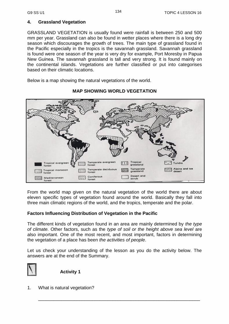
G9 SS U1 TOPIC 4 LESSON 16
134
4. Grassland Vegetation GRASSLAND VEGETATION is usually found were rainfall is between 250 and 500 mm per year. Grassland can also be found in wetter places where there is a long dry season which discourages the growth of trees. The main type of grassland found in the Pacific especially in the tropics is the savannah grassland. Savannah grassland is found were one season of the year is very dry for example, Port Moresby in Papua New Guinea. The savannah grassland is tall and very strong. It is found mainly on the continental islands. Vegetations are further classified or put into categorises based on their climatic locations. Below is a map showing the natural vegetations of the world.
MAP SHOWING WORLD VEGETATION
From the world map given on the natural vegetation of the world there are about eleven specific types of vegetation found around the world. Basically they fall into three main climatic regions of the world, and the tropics, temperate and the polar. Factors Influencing Distribution of Vegetation in the Pacific The different kinds of vegetation found in an area are mainly determined by the type of climate. Other factors, such as the type of soil or the height above sea level are also important. One of the most recent, and most important, factors in determining the vegetation of a place has been the activities of people. Let us check your understanding of the lesson as you do the activity below. The answers are at the end of the Summary. Activity 1 1. What is natural vegetation?
_______________________________________________________________

G9 SS U1 TOPIC 4 LESSON 16
135
2. What is distribution?
______________________________________________________________ ______________________________________________________________ 3. List the vegetation types found in the Pacific.
i. ____________________________________
ii.____________________________________
iii. ___________________________________
iv. ___________________________________
Natural Vegetation refers to the types of plants (original plants) found in an area that has been growing before the changes by the human activity
Distribution is the spread of the types of plants from one place to another in that area
The vegetation type of the Pacific depends on the type of islands
There are 4 main types of vegetation found in the Pacific based on the types of islands: Tropical forest; atolls; temperate and grassland
The temperate vegetation are of two types: Broadleaf forest or warm temperate and coniferous forest or cool temperate
The kind of grassland vegetation found in the Pacific and especially Papua New Guinea is called Savannah grassland
Factors that influence the distribution of vegetation are: climate; type of soil; height above sea level and human activities
NOW DO PRACTICE EXERCISE 16 ON THE NEXT PAGE
SUMMARY
You have come to the end of this lesson. In this lesson you have learned that:
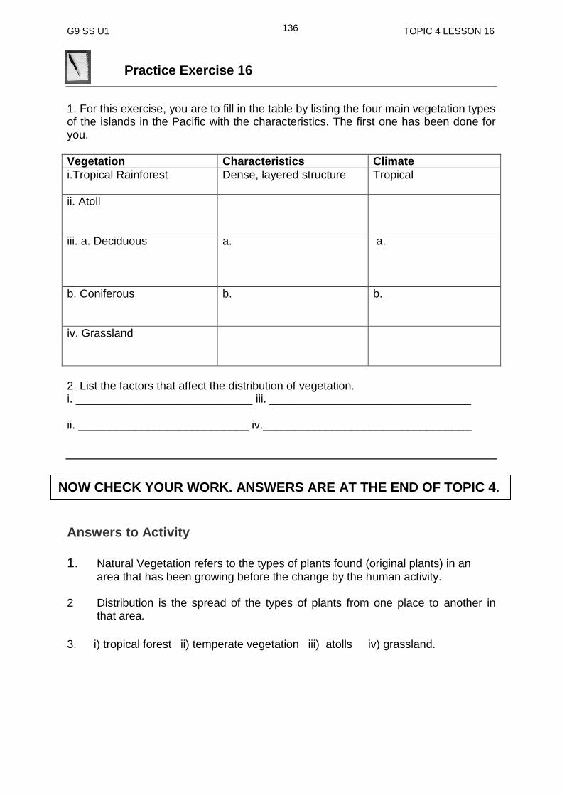
G9 SS U1 TOPIC 4 LESSON 16
136
Practice Exercise 16
1. For this exercise, you are to fill in the table by listing the four main vegetation types of the islands in the Pacific with the characteristics. The first one has been done for you.
Vegetation Characteristics Climate
i.Tropical Rainforest
Dense, layered structure Tropical
ii. Atoll
iii. a. Deciduous
a. a.
b. Coniferous
b. b.
iv. Grassland
2. List the factors that affect the distribution of vegetation. i. ____________________________ iii. ________________________________ ii. ___________________________ iv._________________________________
Answers to Activity 1. Natural Vegetation refers to the types of plants found (original plants) in an
area that has been growing before the change by the human activity. 2 Distribution is the spread of the types of plants from one place to another in
that area.
3. i) tropical forest ii) temperate vegetation iii) atolls iv) grassland.
NOW CHECK YOUR WORK. ANSWERS ARE AT THE END OF TOPIC 4.
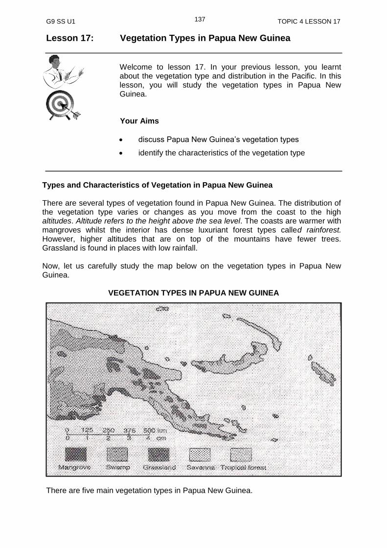
G9 SS U1 TOPIC 4 LESSON 17
137
Lesson 17: Vegetation Types in Papua New Guinea
Welcome to lesson 17. In your previous lesson, you learnt about the vegetation type and distribution in the Pacific. In this lesson, you will study the vegetation types in Papua New Guinea.
Your Aims
discuss Papua New Guinea’s vegetation types
identify the characteristics of the vegetation type
Types and Characteristics of Vegetation in Papua New Guinea There are several types of vegetation found in Papua New Guinea. The distribution of the vegetation type varies or changes as you move from the coast to the high altitudes. Altitude refers to the height above the sea level. The coasts are warmer with mangroves whilst the interior has dense luxuriant forest types called rainforest. However, higher altitudes that are on top of the mountains have fewer trees. Grassland is found in places with low rainfall. Now, let us carefully study the map below on the vegetation types in Papua New Guinea.
VEGETATION TYPES IN PAPUA NEW GUINEA
There are five main vegetation types in Papua New Guinea.
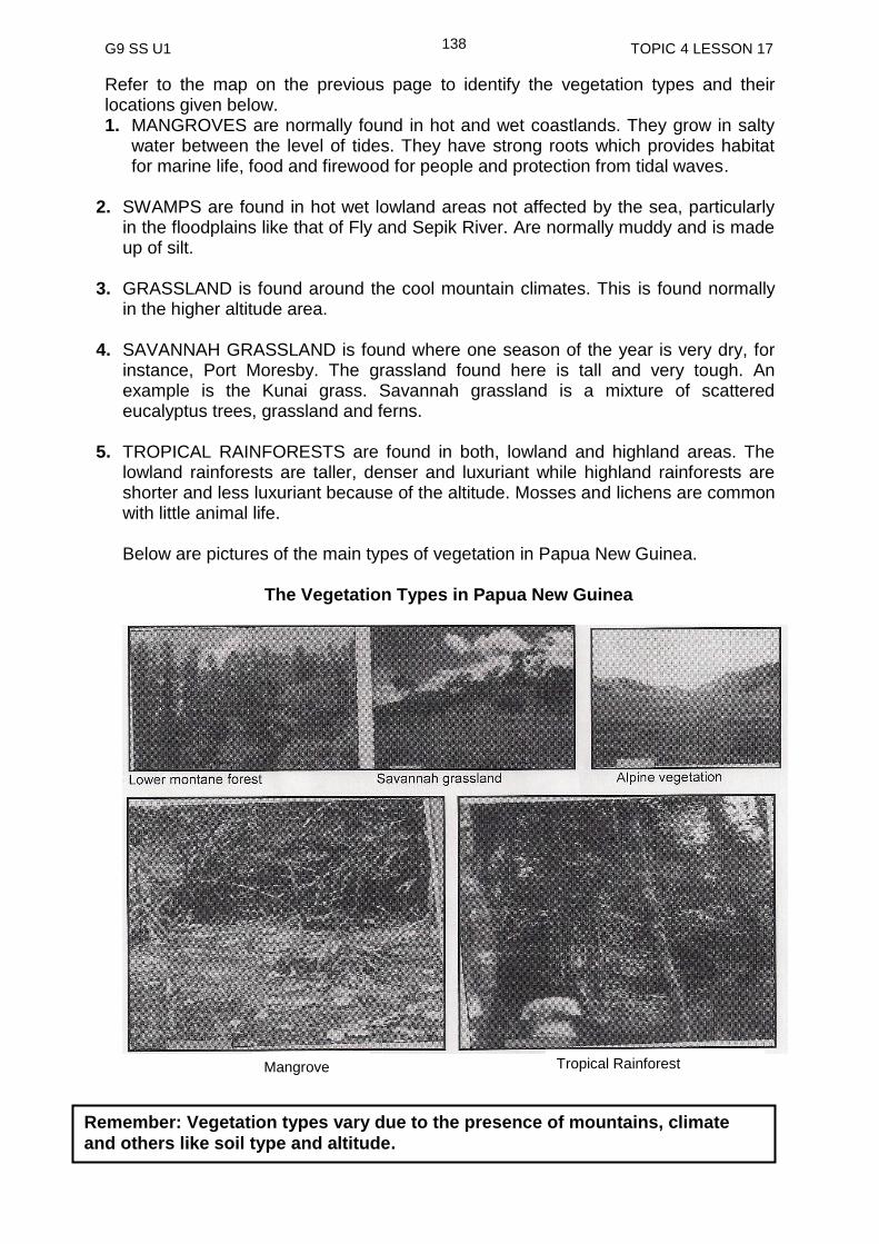
G9 SS U1 TOPIC 4 LESSON 17
138
Refer to the map on the previous page to identify the vegetation types and their locations given below. 1. MANGROVES are normally found in hot and wet coastlands. They grow in salty
water between the level of tides. They have strong roots which provides habitat for marine life, food and firewood for people and protection from tidal waves.
2. SWAMPS are found in hot wet lowland areas not affected by the sea, particularly
in the floodplains like that of Fly and Sepik River. Are normally muddy and is made up of silt.
3. GRASSLAND is found around the cool mountain climates. This is found normally
in the higher altitude area.
4. SAVANNAH GRASSLAND is found where one season of the year is very dry, for instance, Port Moresby. The grassland found here is tall and very tough. An example is the Kunai grass. Savannah grassland is a mixture of scattered eucalyptus trees, grassland and ferns.
5. TROPICAL RAINFORESTS are found in both, lowland and highland areas. The
lowland rainforests are taller, denser and luxuriant while highland rainforests are shorter and less luxuriant because of the altitude. Mosses and lichens are common with little animal life. Below are pictures of the main types of vegetation in Papua New Guinea.
The Vegetation Types in Papua New Guinea
Remember: Vegetation types vary due to the presence of mountains, climate
and others like soil type and altitude.
Mangrove Tropical Rainforest
G9 SS U1 TOPIC 4 LESSON 17
139
Let us check your understanding of the lesson as you do the activity below. The answer is at the end of the summary. Activity 1
1. Fill in the table below by listing characteristics of the vegetation types in Papua
New Guinea. The first one has been done for you.
Vegetation Characteristics
i. Mangroves Have strong roots and grows in salty water
ii.
iii.
iv.
v.
___________________________________________________________________
Places around Papua New Guinea have various types of vegetation
These vegetation types are determined by the following: mountain, climate, soil type and altitude
There are five types of vegetation in Papua New Guinea: mangrove, swamp grassland, savannah grassland, and rainforest
These vegetation types have characteristics that can identify where they are located
__________________________________________________________________
NOW DO PRACTICE EXERCISE 17 ON THE NEXT PAGE
SUMMARY
You have come to the end of this lesson. In this lesson you have learned that:
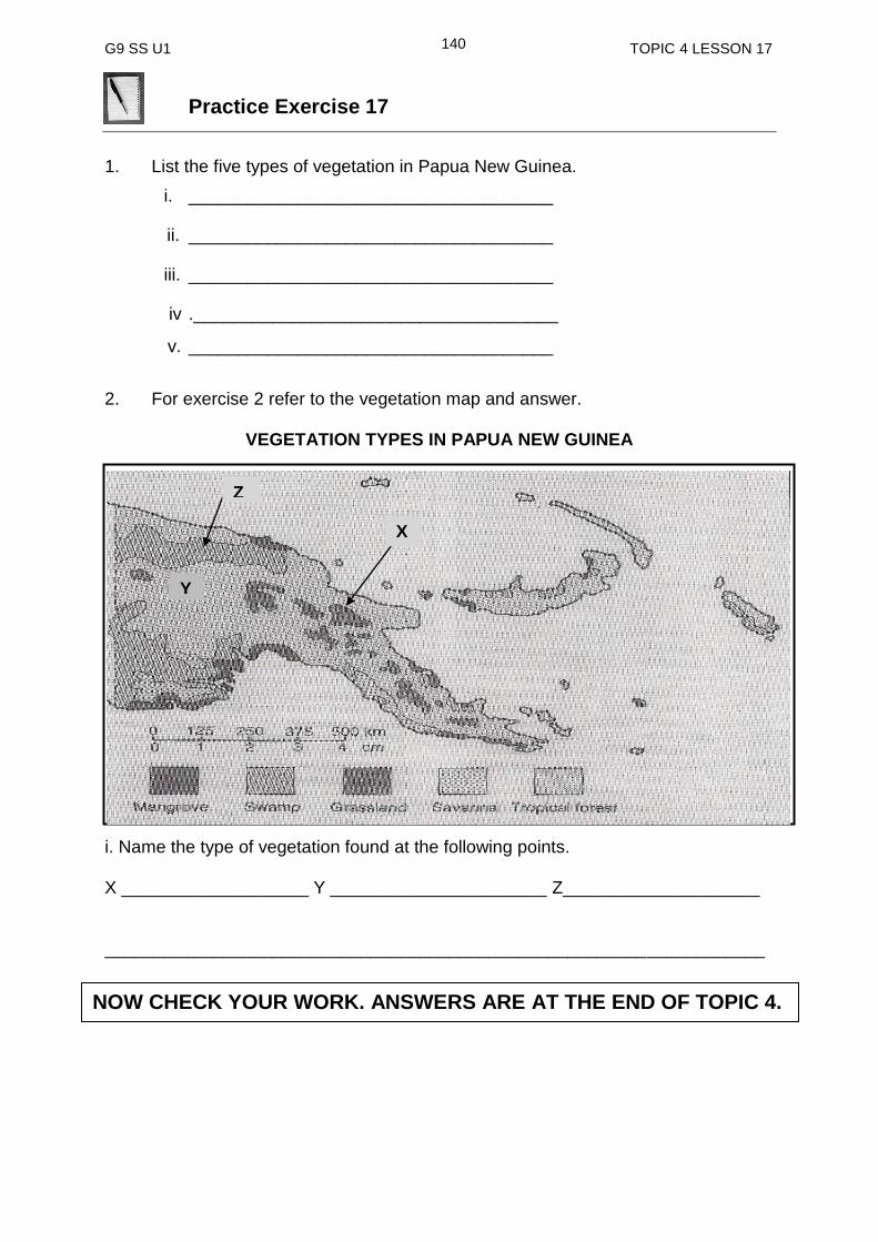
G9 SS U1 TOPIC 4 LESSON 17
140
Practice Exercise 17
1. List the five types of vegetation in Papua New Guinea.
i. _____________________________________
ii. _____________________________________
iii. _____________________________________
iv ._____________________________________
v. _____________________________________
2. For exercise 2 refer to the vegetation map and answer.
VEGETATION TYPES IN PAPUA NEW GUINEA
i. Name the vegetation labelled at a. X __________________________ b. Y___________________________ c. Z___________________________ i. Name the type of vegetation found at the following points. X ___________________ Y ______________________ Z____________________ ___________________________________________________________________
X
Y
Z
NOW CHECK YOUR WORK. ANSWERS ARE AT THE END OF TOPIC 4.
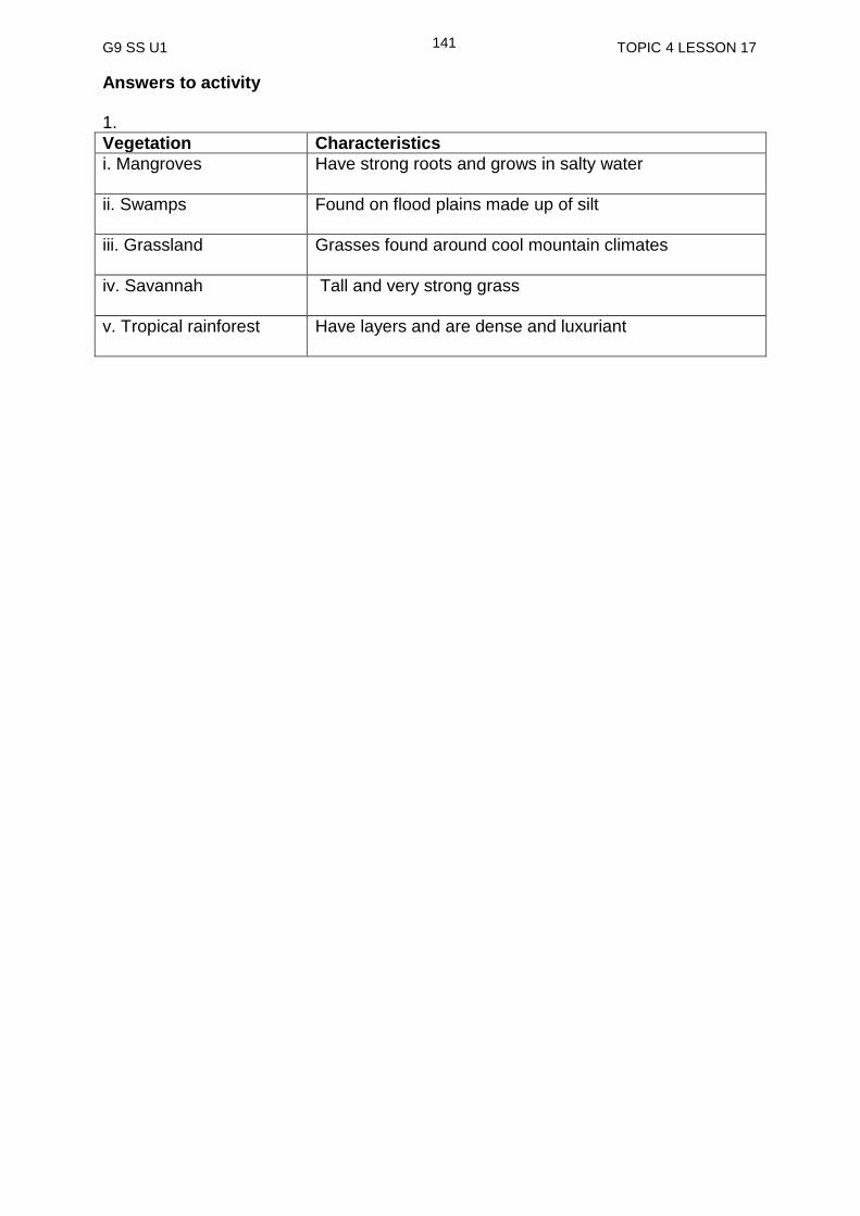
G9 SS U1 TOPIC 4 LESSON 17
141
Answers to activity 1.
Vegetation Characteristics
i. Mangroves Have strong roots and grows in salty water
ii. Swamps Found on flood plains made up of silt
iii. Grassland Grasses found around cool mountain climates
iv. Savannah Tall and very strong grass
v. Tropical rainforest Have layers and are dense and luxuriant

G9 SS U1 TOPIC 4 LESSON 18
142
Lesson 18: Changes to Vegetation
Welcome to Lesson 18. In this lesson, you will learn about the changes made to vegetation
Your Aims
explain how human activities cause change to natural vegetation
identify the impact of pollution on vegetation
explain how natural factors cause change to vegetation
Change of Vegetation by Human Activities The vegetation of an area changes and adapts when the conditions for growth changes. Adapt means fitting into an area comfortably. However, change comes about through the impact (actions) of people. You and I are part of the changes made to the natural environment. As population grows, so does the demand put on the natural vegetation of an area. What then are the CAUSES of the changes to the environment? Causes refer to the human activities that change the vegetation are:.
logging
clearing for agriculture
clearing for urban growth
road building, pipeline construction
mining for minerals, petroleum and natural gas
damming for hydropower
excessive timber removal for firewood and building
setting fire ( for example to grassland)
human activity that causes climate change ( factories producing vehicles)
pollution Here below, shows you examples of the pictures of human activity of clearing forest for agriculture (gardening) and logging.
Picture showing land cleared for agriculture and logging
Here are the causes or the human activities that has changed the natural vegetation.
a b

G9 SS U1 TOPIC 4 LESSON 18
143
Impacts of Pollution on Vegetation There are various types or forms of POLLUTION. Humans have caused enormous pollution on the natural environment especially vegetation.
Pollution refers to the process of making air, water, and soil dirty. The water, air and soil that the vegetation depends on become polluted making it difficult for them to survive. Now, let us take a look at the diagram below to fully understand how pollution can change the vegetation.
The diagram shows creation of acid rain and its effects on the vegetation and the ecosystem as a whole.
Effect of mining on vegetation along a river Effect of acid rain on a forest in Germany called Black Forest .
I have heard of the word pollution but what really is pollution?
G9 SS U1 TOPIC 4 LESSON 18
144
Change of Vegetation by the Natural Factors
Apart from the impact of human activities on the vegetations, natural factors have long before changed the vegetations you see today. Natural factors refer to things that come about without the actions of human. The natural factors are sometimes referred to as natural disasters. Disaster refers to an unexpected event such as an accident, a flood or a fire that kills a lot of people and destroys the environment. The following are the natural factors that changes vegetation;
bushfire
drought
flood
landslide
volcanic eruption
These natural factors change the vegetation into what is called secondary growth. The natural vegetation is known as the primary growth. When the natural factors destroy the primary growth, there is regrowth or new plants which maybe different to the original plant.
Let us check your understanding of the lesson as you do the activity below. The answers are at the end of Practice Exercise 18.
Activity 1
1. Describe the impact of pollution on vegetation.
_______________________________________________________________
_______________________________________________________________
_______________________________________________________________
______________________________________________________________

G9 SS U1 TOPIC 4 LESSON 18
145
Human activities are quickly changing the natural vegetation
There are nine activities of humans that have caused the vegetation to change
Pollution refers to the process of making the air, water and soil dirty
The natural vegetation has changed from its original state to what is called the secondary growth because of human activities as well as pollution
Apart from the human activities, natural factors are also the cause of the change
Natural factors are sometimes referred to as natural disasters
The following are the natural disasters; bushfire, drought, flood, landslide, volcanic eruption, global warming (rising sea level)
NOW DO PRACTICE EXERCISE 18 ON THE NEXT PAGE
SUMMARY
You have come to the end of this lesson. In this lesson you have learned that:

G9 SS U1 TOPIC 4 LESSON 18
146
Practice Exercise 18
1. What are two factors stated in this lesson that cause vegetation change?
i) ____________________________________
ii) ____________________________________
2. Make a list of all the activities, human are engaged in that have caused changes in the natural vegetation?
_______________________________________________________________
_______________________________________________________________
_______________________________________________________________
_______________________________________________________________
_______________________________________________________________
3. List and explain the six natural factors that changes vegetation.
i.______________________________________________________________
_______________________________________________________________
ii.______________________________________________________________
_______________________________________________________________
iii.______________________________________________________________
_______________________________________________________________
iv._____________________________________________________________
_______________________________________________________________
v.______________________________________________________________
_______________________________________________________________
vi._____________________________________________________________
_______________________________________________________________
Answer to Activity Pollution dirties the air, water and soil making it difficult for the vegetation to grow. When they take in air, water and soil that is polluted they are likely to die or their growth will change. For instance, once a dense forest area may change to a grassland area with short scattered trees after.
NOW CHECK YOUR WORK. ANSWERS ARE AT THE END OF TOPIC 4.
G9 SS U1 TOPIC 4 LESSON 19
147
Lesson 19: Introduced Vegetation
Welcome to Lesson 19. In your previous lesson you studied changes to vegetation. For this lesson, you will learn about introduced vegetation.
Your Aims
define introduced vegetation
explain the difference between introduced plants and native plants
discuss examples of introduced plants and vegetation
compile pictures of introduced vegetation
discuss how introduced vegetation has an impact on natural vegetation
What is Introduced Vegetation?
Vegetation changes and grows well in an environment if it adapts to that area. Introduced plants that are able to adapt well can have both positive and negative impact. You will study this as we go on. Introduce plants pose a threat to the native plants. That is, they create or cause harm to the vegetation.
All around the Pacific, there are many introduced plants from the outside world. Outside world refers to places like America, Europe and Asia. In Papua New Guinea there are numerous examples of introduced plants which results in mixed vegetations. Below, are examples of introduced plants to our native vegetation.
i. Weeds: mikania (mile a minute); Coral vine or chain-of-love (Antigonon leptopus); Beggar’s tic (Bidens pilosa) and water hyacinth (Eichhornia crassipes).
ii. Trees: African tulip tree ( Spathodea campanulata) and Mimosa sensitive
plant (Mimosa pudica).
What are native plants? Simple! Native plants are plants that originally grow in that particular place.
Plants that are not native or originally grow in an area. They were brought into an area/introduced from a different location and planted to grow there.
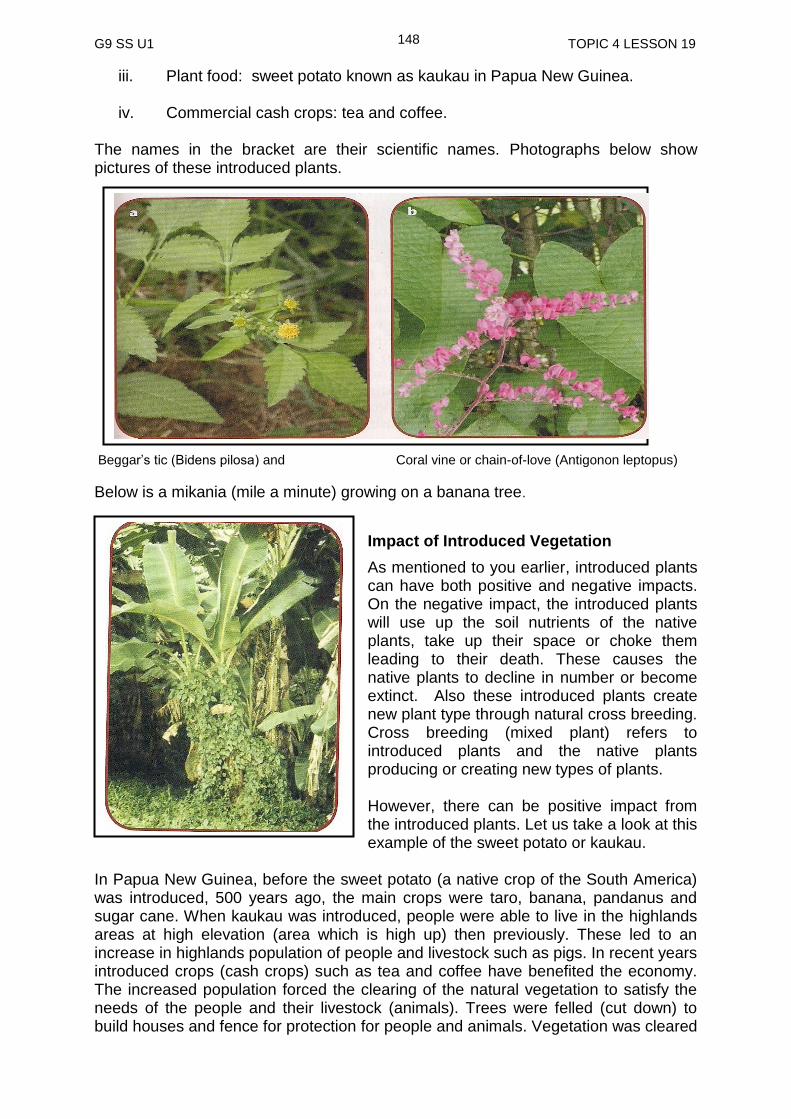
G9 SS U1 TOPIC 4 LESSON 19
148
iii. Plant food: sweet potato known as kaukau in Papua New Guinea.
iv. Commercial cash crops: tea and coffee. The names in the bracket are their scientific names. Photographs below show pictures of these introduced plants.
Beggar’s tic (Bidens pilosa) and Coral vine or chain-of-love (Antigonon leptopus)
Below is a mikania (mile a minute) growing on a banana tree.
Impact of Introduced Vegetation
As mentioned to you earlier, introduced plants can have both positive and negative impacts. On the negative impact, the introduced plants will use up the soil nutrients of the native plants, take up their space or choke them leading to their death. These causes the native plants to decline in number or become extinct. Also these introduced plants create new plant type through natural cross breeding. Cross breeding (mixed plant) refers to introduced plants and the native plants producing or creating new types of plants. However, there can be positive impact from the introduced plants. Let us take a look at this example of the sweet potato or kaukau.
In Papua New Guinea, before the sweet potato (a native crop of the South America) was introduced, 500 years ago, the main crops were taro, banana, pandanus and sugar cane. When kaukau was introduced, people were able to live in the highlands areas at high elevation (area which is high up) then previously. These led to an increase in highlands population of people and livestock such as pigs. In recent years introduced crops (cash crops) such as tea and coffee have benefited the economy. The increased population forced the clearing of the natural vegetation to satisfy the needs of the people and their livestock (animals). Trees were felled (cut down) to build houses and fence for protection for people and animals. Vegetation was cleared

G9 SS U1 TOPIC 4 LESSON 19
149
to grow more food and build more villages. Also large land area was cleared to grow newly introduced crops like tea and coffee.
introduced vegetations refer to plants that have been brought from another place and planted to grow in a new location.
native plants are the plants that originally belong to that place.
there are various plants like weed, trees, food crops and cash crops that have been introduced from the outside world.
impact of introduced plants can be positive and negative to the native plants.
crops like kaukau, tea and coffee are introduced crops that have had the most positive impact on the highlands population of Papua New Guinea.
__________________________________________________________________
NOW DO PRACTICE EXERCISE 19 ON THE NEXT PAGE
SUMMARY
You have come to the end of this lesson. In this lesson you have learned that:

G9 SS U1 TOPIC 4 LESSON 19
150
Practise Exercise 19
1. What is introduced vegetation?
___________________________________________________________________ 2. Explain the difference between introduced plants and native plants
___________________________________________________________________
_________________________________________________________________
3. List examples of introduced plants
i._______________________________ v._______________________________
ii.______________________________ viii.______________________________
iii.______________________________ vi._______________________________
iv.______________________________ ix._______________________________ vii. _____________________________
4. Fill in the table by stating the advantages and the disadvantages of introduced vegetation.
Advantage Disadvantage
NOW CHECK YOUR WORK. ANSWERS ARE AT THE END OF TOPIC 4.

G9 SS U1 TOPIC 4 ANSWERS
151
ANSWERS TO PRACTICE EXERCISE 16-19
Practice Exercise 16
1.
Vegetation Characteristics Climate
i. Tropical Rainforest
Dense, layered structure Tropics
ii. Atoll
Salt-tolerated plants such as mangroves, shrubs, grasses and coconut palms
Tropics
iii.a. Deciduous Broadleaf forest
a. Broad leaf trees that loose leaves during winter
a. Warm Temperate
b. Coniferous forest
b. Tall straight trees with long needle-like leaves
b. Cool Temperate
iv. Grassland
Savannah- grasses are tall and the leaves are very strong
Tropics
2. i. Climate iii. Height above sea level ii. Type of soil iv. Human Activities
Practice Exercise 17
1. i. Mangrove ii. Swamps iii. Grassland iv. Savannah
v. Tropical rainforest
2. .X: Grassland Y: Swamps Z: Tropical rainforest
Practice Exercise 18
1. (i) Changes of vegetation by human activites
(iii) Change of Vegetation by natural factors
2 (I) Bushfire: This happens when the suns heat makes an object become
very hot especially can tins which causes fire to start
( ii) Drought: This happens when no rain falls in an area for a very long time
(iii) Flood: When there is a lot of rainfall ,this cause a lot of water to flow in the river eventually causing the river to spill its banks
(iv) Landslide: This happens when side of mountain falls apart

G9 SS U1 TOPIC 4 ANSWERS
152
(v) Volcanic eruption: This happens when molten rock from under the earth comes out of the earth
(vi) Global warming: This happens when the earth becomes warmer because of the increase in the level of greenhouse gases due to the increase in human activities.
3. i. logging
ii. clearing for agriculture
iii. clearing for urban growth
iv. road building, pipeline construction
v. mining for minerals, petroleum and natural gas
vi. damming for hydropower
vii. excessive timber removal for firewood and building
viii. setting fire ( for example to grassland)
ix. human activity that causes climate change ( factories producing vehicles)
Practice Exercise 19 1. Introduced plants refer to the plants that have been brought from another place
and planted to grow in a new location. 2. Introduced plants are plants brought from elsewhere to grow in a new location
whilst native plants are the original plants that belong to that location. 3. i. mikania (mile a minute)
ii. Coral vine or chain-of-love (Antigonon leptopus)
iii. Beggars tic (Bidens pilosa)
iv. Water hyacinth (Eichhornia crassipes).
v. Mimosa sensitive plant
vi. African tulip tree (Spathodea campanulata)
vii. Sweet potato
viii. Tea ix. Coffee 4.
Advantage Disadvantage
- New variety of plants - Improve diet (kaukau) - Generate income for the people and the
country as a whole
- Choke the native plants - Change the original vegetation - Decline in the growth of native plants - Native plants may become extinct (die out)
G9 SS U1 TOPIC 5 INTRODUCTION
153
TOPIC 5
LAND USE IN THE PACIFIC
In This Topic, You Will Learn About:
Types of Land Use
Rural and Urban Land use
Land Use and Climate Change
Case Study: Land Use of Local Area
G9 SS U1 TOPIC 5 INTRODUCTION
154
TOPIC 5: INTRODUCTION
In this Topic you will look at the different land use in the Pacific region and their
effects on the natural environment. You will also look at measures we can employ to
sustain and preserve our environment.
After studying this topic we hope that you will learn to appreciate what we have in our
environment and strive to protect it for future generation.
We hope you will enjoy this Topic.

G9 SS U1 TOPIC 5 LESSON 20
155
Lesson 20: Types of Land Use
Welcome to lesson 20. In this lesson you will look at the different types of land use both in rural and urban areas.
Your Aims:
define land use
discuss the types of Land use in the Pacific.
discuss the impact of different types of Land use in the local area.
identifies the types of land use in a local area
What is Land Use?
Less than 30% of the Earth’s surface area is usable land (land that is suitable for various uses). This means that usable land is a valuable natural resource. This resource is under pressure in many parts of the world from increasing population and how these resources are used, so the study of land use is important in decision making. Land use varies from area to area. In rural areas (countryside), land use can include forestry and farming. In urban areas (towns and cities) land use could be housing or industry. Land can be used in many ways. Below are some ways in which land can be used. 1. Agriculture Though most of the Pacific island countries are still developing, they still value their traditions. They have adapted to changes in their societies by being engaged in two types of agricultural practices, the Traditional Agriculture also called Subsistence Agriculture and modern agriculture also called commercial agriculture.
a) Traditional agriculture (subsistence agriculture)
This type of agriculture activity involves use of land in the rural areas where people still live very simple lives and are very much dependent on their environments for most of their basic needs like shelter and food. Food for this group of people is taken from their gardens while protein comes from the sea or the rivers and the forest where wild animals are hunted for their meat. Most of the land use activities done here is for their own consumption.
LLaanndd UUssee iiss tthhee ddiiffffeerreenntt wwaayyss iinn wwhhiicchh ppeeooppllee uussee tthhee llaanndd..

G9 SS U1 TOPIC 5 LESSON 20
156
b) Commercial agriculture
The second type of agriculture activity is practiced in both towns and villages. In rural areas, the surplus they produce are sometimes sold at the, markets to obtain cash. However, commercial agriculture involves the growing of crops and grazing animals purposely to make money. With the increased population, more land is now being cleared for commercial agriculture. Plantation system which was a form that involves growing of one particular cash crop over a large area of land. In Papua New Guinea, crops such as coconut, oil palm, and coffee are grown on plantations. 2. Residential
As more and more people move to live
and work in the cities and towns, this
increases the population of the urban
areas and so more houses are built to
accommodate the increasing population.
This means that a lot more houses or
building in general will have to be
constructed or built and this will result in
more land being cleared for use. One
third of the total land mass in urban
areas is used for the construction of
residential buildings.
Houses built for residential purposes at Rainbow in Port Moresby
Photographs showing subsistence agriculture in Paua New Guinea
Higaturu oil palm in Oro Province
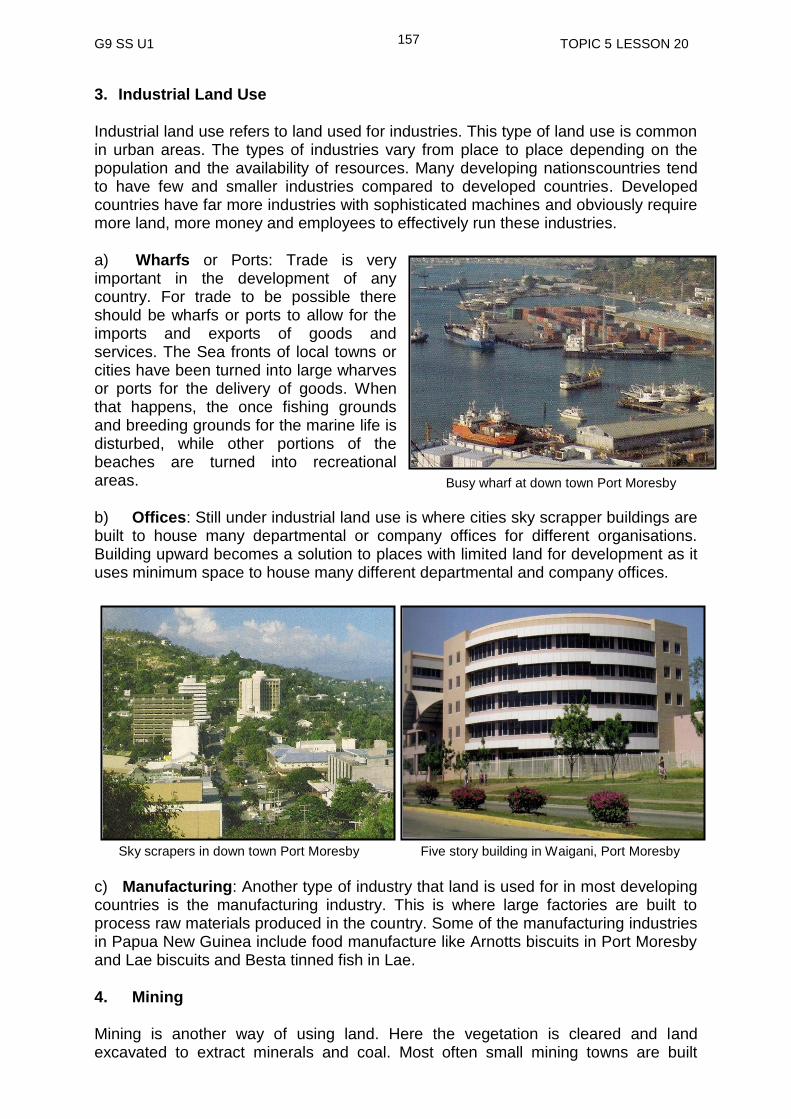
G9 SS U1 TOPIC 5 LESSON 20
157
3. Industrial Land Use
Industrial land use refers to land used for industries. This type of land use is common in urban areas. The types of industries vary from place to place depending on the population and the availability of resources. Many developing nationscountries tend to have few and smaller industries compared to developed countries. Developed countries have far more industries with sophisticated machines and obviously require more land, more money and employees to effectively run these industries.
a) Wharfs or Ports: Trade is very important in the development of any country. For trade to be possible there should be wharfs or ports to allow for the imports and exports of goods and services. The Sea fronts of local towns or cities have been turned into large wharves or ports for the delivery of goods. When that happens, the once fishing grounds and breeding grounds for the marine life is disturbed, while other portions of the beaches are turned into recreational areas.
b) Offices: Still under industrial land use is where cities sky scrapper buildings are built to house many departmental or company offices for different organisations. Building upward becomes a solution to places with limited land for development as it uses minimum space to house many different departmental and company offices.
c) Manufacturing: Another type of industry that land is used for in most developing countries is the manufacturing industry. This is where large factories are built to process raw materials produced in the country. Some of the manufacturing industries in Papua New Guinea include food manufacture like Arnotts biscuits in Port Moresby and Lae biscuits and Besta tinned fish in Lae.
4. Mining
Mining is another way of using land. Here the vegetation is cleared and land excavated to extract minerals and coal. Most often small mining towns are built
Busy wharf at down town Port Moresby
Sky scrapers in down town Port Moresby Five story building in Waigani, Port Moresby
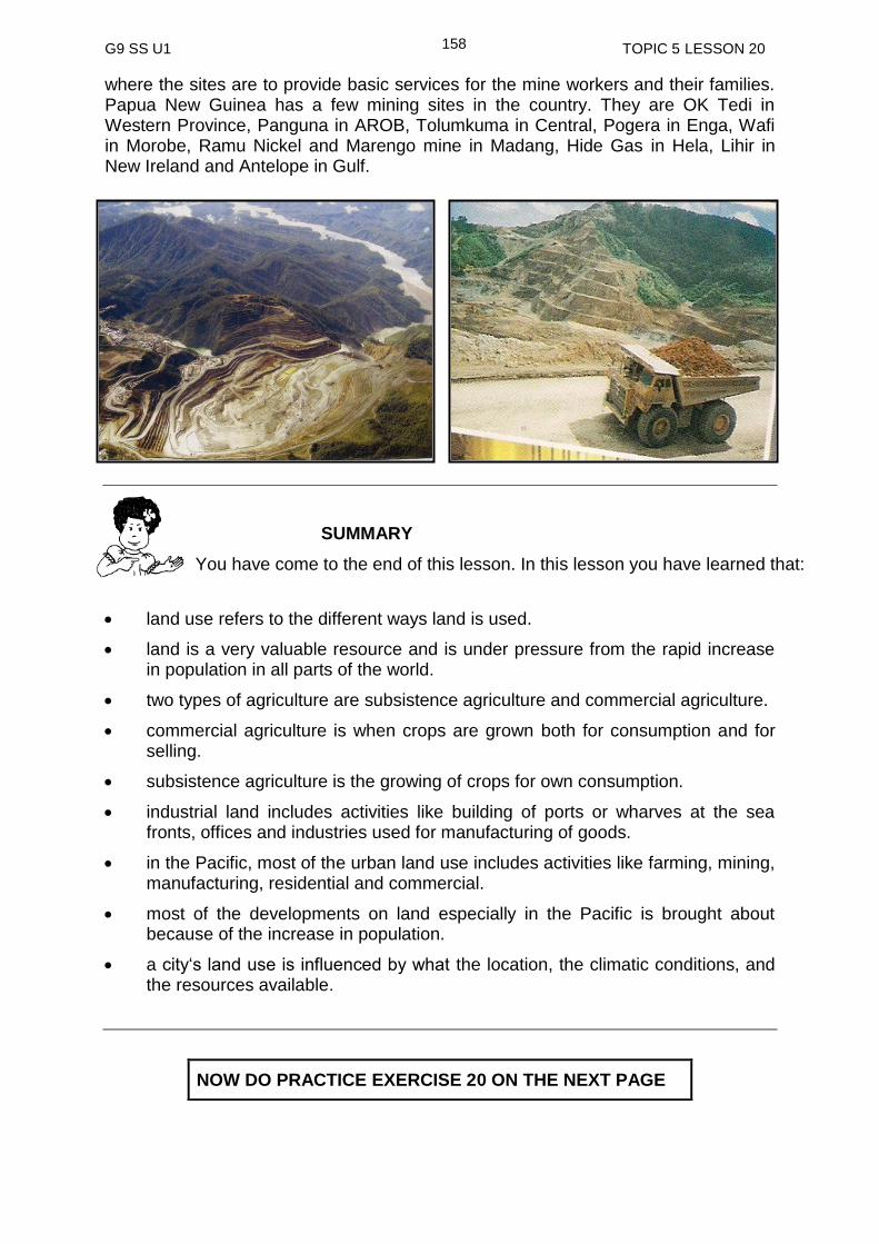
G9 SS U1 TOPIC 5 LESSON 20
158
where the sites are to provide basic services for the mine workers and their families. Papua New Guinea has a few mining sites in the country. They are OK Tedi in Western Province, Panguna in AROB, Tolumkuma in Central, Pogera in Enga, Wafi in Morobe, Ramu Nickel and Marengo mine in Madang, Hide Gas in Hela, Lihir in New Ireland and Antelope in Gulf.
land use refers to the different ways land is used.
land is a very valuable resource and is under pressure from the rapid increase in population in all parts of the world.
two types of agriculture are subsistence agriculture and commercial agriculture.
commercial agriculture is when crops are grown both for consumption and for selling.
subsistence agriculture is the growing of crops for own consumption.
industrial land includes activities like building of ports or wharves at the sea fronts, offices and industries used for manufacturing of goods.
in the Pacific, most of the urban land use includes activities like farming, mining, manufacturing, residential and commercial.
most of the developments on land especially in the Pacific is brought about because of the increase in population.
a city‘s land use is influenced by what the location, the climatic conditions, and the resources available.
NOW DO PRACTICE EXERCISE 20 ON THE NEXT PAGE
SUMMARY
You have come to the end of this lesson. In this lesson you have learned that:

G9 SS U1 TOPIC 5 LESSON 20
159
Practice Exercise 20
From reading the notes on Land use, answer the question that follow;
1. What is Land use?
___________________________________________________________ 2. List the two types of agricultural activities that are practised in both the rural and
urban areas.
(i) ________________________________________________________
(ii) ________________________________________________________ 3. Give an example of a cash crop in your area
_____________________________________________________________ 4. Give an example of an Industrial Land use and explain the purpose it is built
for? _______________________________________________________________
NOW CHECK YOUR WORK. ANSWERS ARE AT THE END OF TOPIC 5.
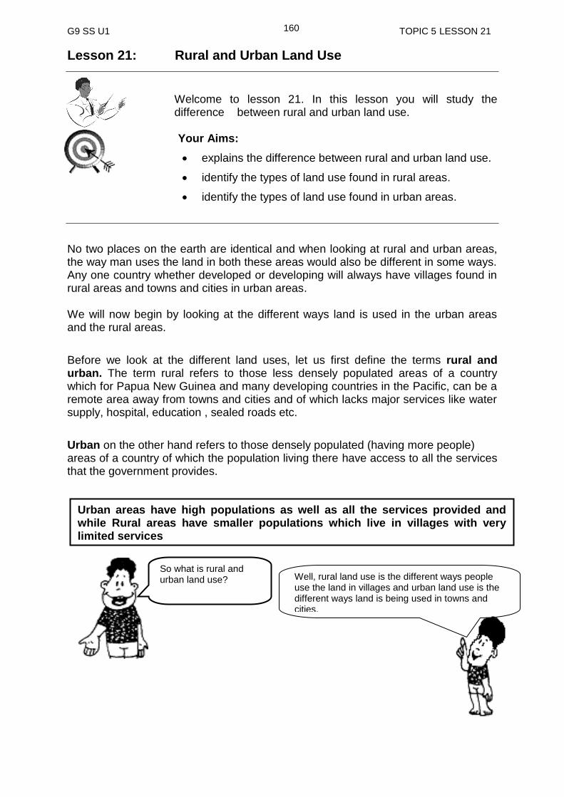
G9 SS U1 TOPIC 5 LESSON 21
160
Lesson 21: Rural and Urban Land Use
Welcome to lesson 21. In this lesson you will study the difference between rural and urban land use.
Your Aims:
explains the difference between rural and urban land use.
identify the types of land use found in rural areas.
identify the types of land use found in urban areas.
No two places on the earth are identical and when looking at rural and urban areas, the way man uses the land in both these areas would also be different in some ways. Any one country whether developed or developing will always have villages found in rural areas and towns and cities in urban areas. We will now begin by looking at the different ways land is used in the urban areas and the rural areas.
Before we look at the different land uses, let us first define the terms rural and urban. The term rural refers to those less densely populated areas of a country which for Papua New Guinea and many developing countries in the Pacific, can be a remote area away from towns and cities and of which lacks major services like water supply, hospital, education , sealed roads etc.
Urban on the other hand refers to those densely populated (having more people) areas of a country of which the population living there have access to all the services that the government provides.
So what is rural and urban land use? Well, rural land use is the different ways people
use the land in villages and urban land use is the different ways land is being used in towns and cities.
Urban areas have high populations as well as all the services provided and while Rural areas have smaller populations which live in villages with very limited services
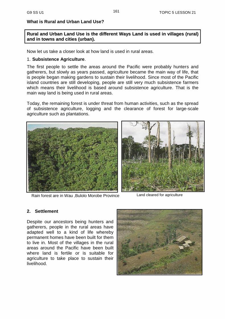
G9 SS U1 TOPIC 5 LESSON 21
161
What is Rural and Urban Land Use?
RRuurraall aanndd UUrrbbaann LLaanndd UUssee iiss tthhee ddiiffffeerreenntt WWaayyss LLaanndd iiss uusseedd iinn vviillllaaggeess ((rruurraall))
aanndd iinn ttoowwnnss aanndd cciittiieess ((uurrbbaann))..
Now let us take a closer look at how land is used in rural areas.
1. Subsistence Agriculture.
The first people to settle the areas around the Pacific were probably hunters and gatherers, but slowly as years passed, agriculture became the main way of life, that is people began making gardens to sustain their livelihood. Since most of the Pacific island countries are still developing, people are still very much subsistence farmers which means their livelihood is based around subsistence agriculture. That is the main way land is being used in rural areas. Today, the remaining forest is under threat from human activities, such as the spread of subsistence agriculture, logging and the clearance of forest for large-scale agriculture such as plantations.
2. Settlement Despite our ancestors being hunters and gatherers, people in the rural areas have adapted well to a kind of life whereby permanent homes have been built for them to live in. Most of the villages in the rural areas around the Pacific have been built where land is fertile or is suitable for agriculture to take place to sustain their livelihood.
Rain forest are in Wau ,Bulolo Morobe Province Land cleared for agriculture
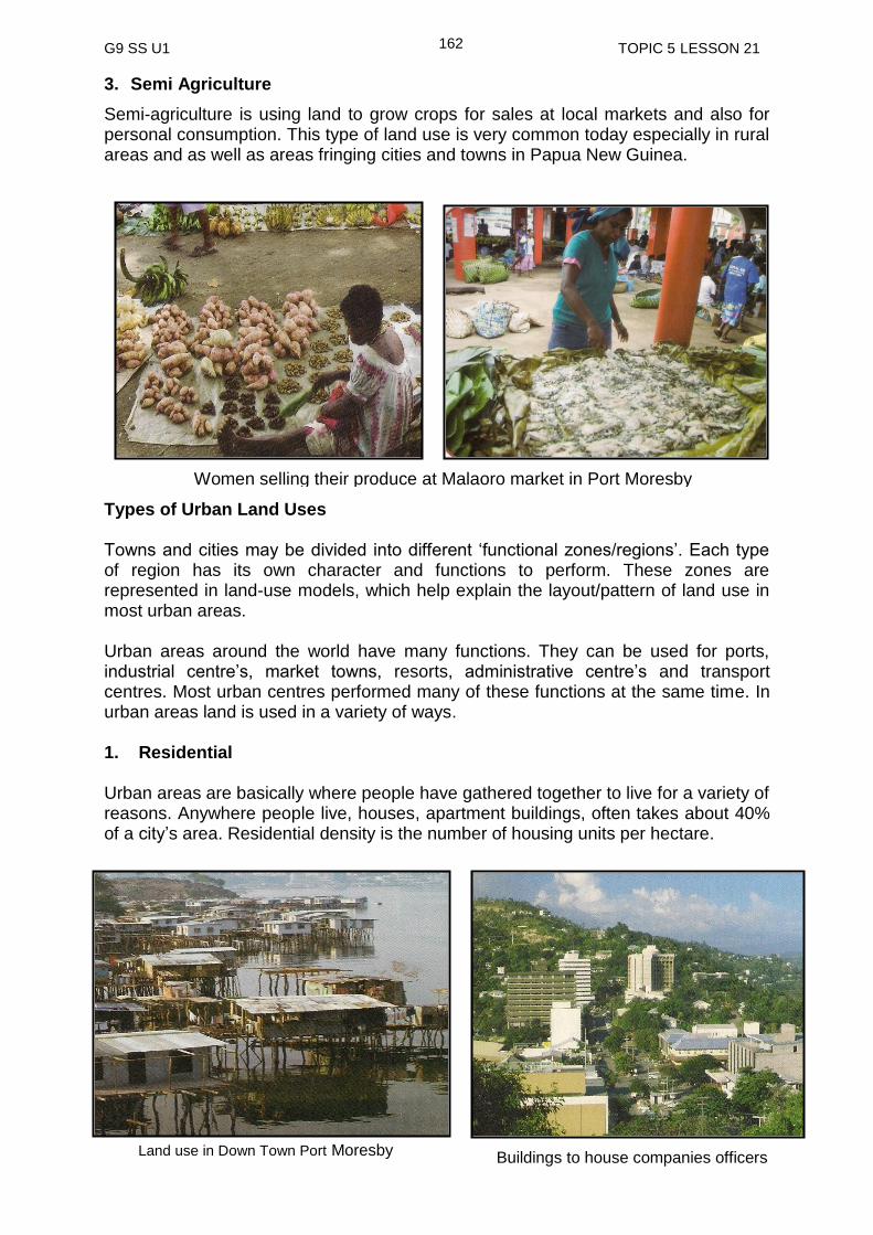
G9 SS U1 TOPIC 5 LESSON 21
162
3. Semi Agriculture
Semi-agriculture is using land to grow crops for sales at local markets and also for personal consumption. This type of land use is very common today especially in rural areas and as well as areas fringing cities and towns in Papua New Guinea.
Types of Urban Land Uses Towns and cities may be divided into different ‘functional zones/regions’. Each type of region has its own character and functions to perform. These zones are represented in land-use models, which help explain the layout/pattern of land use in most urban areas. Urban areas around the world have many functions. They can be used for ports, industrial centre’s, market towns, resorts, administrative centre’s and transport centres. Most urban centres performed many of these functions at the same time. In urban areas land is used in a variety of ways. 1. Residential Urban areas are basically where people have gathered together to live for a variety of reasons. Anywhere people live, houses, apartment buildings, often takes about 40% of a city’s area. Residential density is the number of housing units per hectare.
Women selling their produce at Malaoro market in Port Moresby
Land use in Down Town Port Moresby Buildings to house companies officers
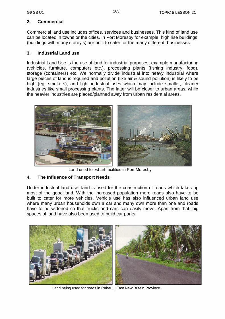
G9 SS U1 TOPIC 5 LESSON 21
163
2. Commercial Commercial land use includes offices, services and businesses. This kind of land use can be located in towns or the cities. In Port Moresby for example, high rise buildings (buildings with many storey’s) are built to cater for the many different businesses. 3. Industrial Land use
Industrial Land Use is the use of land for industrial purposes, example manufacturing (vehicles, furniture, computers etc.), processing plants (fishing industry, food), storage (containers) etc. We normally divide industrial into heavy industrial where large pieces of land is required and pollution (like air & sound pollution) is likely to be high (eg. smelters), and light industrial uses which may include smaller, cleaner industries like small processing plants. The latter will be closer to urban areas, while the heavier industries are placed/planned away from urban residential areas.
4. The Influence of Transport Needs Under industrial land use, land is used for the construction of roads which takes up most of the good land. With the increased population more roads also have to be built to cater for more vehicles. Vehicle use has also influenced urban land use where many urban households own a car and many own more than one and roads have to be widened so that trucks and cars can easily move. Apart from that, big spaces of land have also been used to build car parks.
Land used for wharf facilities in Port Moresby
Land being used for roads in Rabaul , East New Britain Province

G9 SS U1 TOPIC 5 LESSON 21
164
High ways are needed for quick and easy access to the workplaces and shopping centres. In Port Moresby, a four lane highway was recently built connecting Konedobu and Waigani to cope with the increased number of vehicles in the city Some buildings in Lae and Port Moresby have underground car parks for workers. There are cities where roads and parking spaces take up a third or even half the total city area. 5. Institutional Land Use
Institutional land use refers to land used for schools, hospitals, government buildings, and churches. 6. Recreational Land Use
Recreational land use refers to land used for parks, playgrounds, golf courses, and social gatherings.
rural land use refers to land that is used in the rural areas.
rural land use includes activities like subsistence agriculture.
land uses in rural areas have resulted in forest being destroyed.
destruction of forest destroys natural habitat for animals and plants and animals
urban land uses refer to the use of land in urban areas.
there are 6 main urban land uses. Land is being used for 1.commercial, 2. residential, 3. industrial, 4. transport, 5. institutional and 6. recreational purposes.
about one third of land in urban areas is used for the construction of roads because of the rapid increase of population in these areas.
NOW DO PRACTICE EXERCISE 21 ON THE NEXT PAGE
SUMMARY
You have come to the end of this lesson. In this lesson you have learned that:

G9 SS U1 TOPIC 5 LESSON 21
165
Practice Exercise 21
1. Identify two ways land is used in an urban area?
(i) _____________________________________________________________ (ii) _____________________________________________________________ 2. Give two examples of how land is used in rural areas
(I) ___________________________________________________________
(II) ___________________________________________________________ 3. What is institutional land use for?
___________________________________________________________
4. Explain why land in the urban areas is used in a variety of ways than those of rural areas. _______________________________________________________________
NOW CHECK YOUR WORK. ANSWERS ARE AT THE END OF TOPIC 5.

G9 SS U1 TOPIC 5 LESSON 22
166
Lesson 22: Land Use and Climate Change
Welcome to lesson 22. In this lesson you will look at how land uses have affected the climate resulting in Climate Change.
Your Aims
define climate change and global warming.
Identify the causes of global warming and climate change.
Identify evidence of climate change.
Describe the effects of global warming on land use patterns.
Enumerate sustainable ways to reduce the effects of global warming and climate change.
Climates all over the world are subject to change. They have changed and are constantly changing over the years. The changing rate was quite slow before but scientists now believe that it is changing at a faster rate than it was in the last 10 000 years. The changing climate is partly a result of human activities on earth. Now, before we take a closer look at Climate change and global warming, lets first of all look at the causes of climate change and global warming. In doing so, we will have to look at Green House Effect.
What are Greenhouse Gasses? The greenhouse effect is one of the leading causes of global warming. The most significant greenhouse gases are water vapor (H2O), carbon dioxide (CO2),
What is Greenhouse
Effect?
Let us check the definition below.
]
A greenhouse gas is any gaseous compound in the atmosphere that is capable of absorbing infrared radiation, thereby trapping and holding heat in the atmosphere. By increasing the heat in the atmosphere, greenhouse gases are responsible for the greenhouse effect, which then leads to global warming.
Greenhouse effect is the trapping of the sun’s warmth in the earth’s lower atmosphere due to the increased emission of greenhouse gases into the atmosphere.
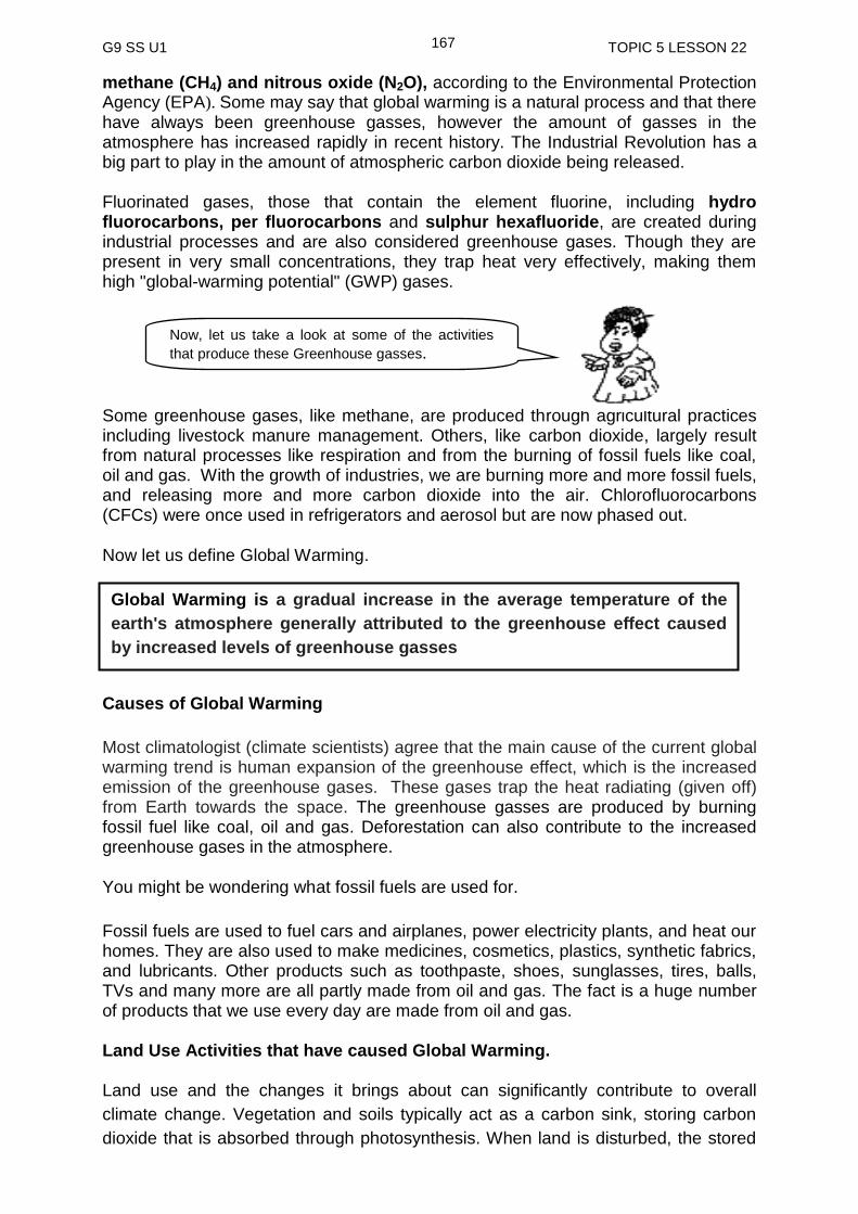
G9 SS U1 TOPIC 5 LESSON 22
167
methane (CH4) and nitrous oxide (N2O), according to the Environmental Protection Agency (EPA). Some may say that global warming is a natural process and that there have always been greenhouse gasses, however the amount of gasses in the atmosphere has increased rapidly in recent history. The Industrial Revolution has a big part to play in the amount of atmospheric carbon dioxide being released. Fluorinated gases, those that contain the element fluorine, including hydro fluorocarbons, per fluorocarbons and sulphur hexafluoride, are created during industrial processes and are also considered greenhouse gases. Though they are present in very small concentrations, they trap heat very effectively, making them high "global-warming potential" (GWP) gases.
Some greenhouse gases, like methane, are produced through agricultural practices including livestock manure management. Others, like carbon dioxide, largely result from natural processes like respiration and from the burning of fossil fuels like coal, oil and gas. With the growth of industries, we are burning more and more fossil fuels, and releasing more and more carbon dioxide into the air. Chlorofluorocarbons (CFCs) were once used in refrigerators and aerosol but are now phased out.
Now let us define Global Warming.
Causes of Global Warming
Most climatologist (climate scientists) agree that the main cause of the current global warming trend is human expansion of the greenhouse effect, which is the increased emission of the greenhouse gases. These gases trap the heat radiating (given off) from Earth towards the space. The greenhouse gasses are produced by burning fossil fuel like coal, oil and gas. Deforestation can also contribute to the increased greenhouse gases in the atmosphere.
You might be wondering what fossil fuels are used for.
Fossil fuels are used to fuel cars and airplanes, power electricity plants, and heat our homes. They are also used to make medicines, cosmetics, plastics, synthetic fabrics, and lubricants. Other products such as toothpaste, shoes, sunglasses, tires, balls, TVs and many more are all partly made from oil and gas. The fact is a huge number of products that we use every day are made from oil and gas. Land Use Activities that have caused Global Warming. Land use and the changes it brings about can significantly contribute to overall
climate change. Vegetation and soils typically act as a carbon sink, storing carbon
dioxide that is absorbed through photosynthesis. When land is disturbed, the stored
Now, let us take a look at some of the activities
that produce these Greenhouse gasses.
Global Warming is a gradual increase in the average temperature of the
earth's atmosphere generally attributed to the greenhouse effect caused
by increased levels of greenhouse gasses
G9 SS U1 TOPIC 5 LESSON 22
168
carbon dioxide along with methane and nitrous oxide is emitted, re-entering the
atmosphere. The clearing of land can result in soil degradation, erosion, and the
leaching of nutrients; which can also possibly reduce its ability to act as a carbon
sink. This reduction in the ability to store carbon can result in additional carbon
dioxide remaining in the atmosphere, thereby increasing the total amount of
greenhouse gases.
Below is a list of human activities that are contributing to global warming.
Farming
Manufacturing of goods
Abstraction of natural resources through logging, mining, and fishing
Development of infrastructures and settlements
Transportation – Using of motor vehicles and aircrafts
Using of electrical items and
burning of wood to provide energy
There are two types of changes that land use can bring about.
1. Direct Changes (caused by human)
Examples of direct changes include deforestation, reforestation and afforestation,
agriculture, and urbanization. The effect of land use on the climate primarily depends
on the type of land cover present within an area. For example, if rainforest is
removed and replaced by crops, there will be less transpiration (evaporation of water
from leaves) leading to warmer temperatures in that area. On the other hand, if
irrigation is used on farmland, more water is transpired and evaporated from moist
soils, which cools and moistens the atmosphere. The additional transpiration can
also affect levels of precipitation and cloudiness in an area.
In regions with heavy snowfall, reforestation or afforestation would cause the land to
reflect less sunlight, resulting in the absorption of more heat on the land. This would,
in turn, result in a net warming effect despite the removal of carbon dioxide from the
atmosphere through the process of photosynthesis during the growing season.
Additional reforestation could increase transpiration, leading to more water vapour in
the air. In the troposphere, water vapour is considered to be the biggest greenhouse
gas contributor to global warming.
Urbanization is another change in land use that can affect the climate, sometimes
significantly. Local climates tend to be warmer due to the increased amount of heat
released within a densely populated area. Average temperatures in city centers can
increase even more due to the high density of construction materials such as
pavement and roofing materials since they tend to absorb, rather than reflect,
sunlight. The higher urban temperatures, compared to lower temperatures in the
surrounding rural areas, is known as the urban heat island effect
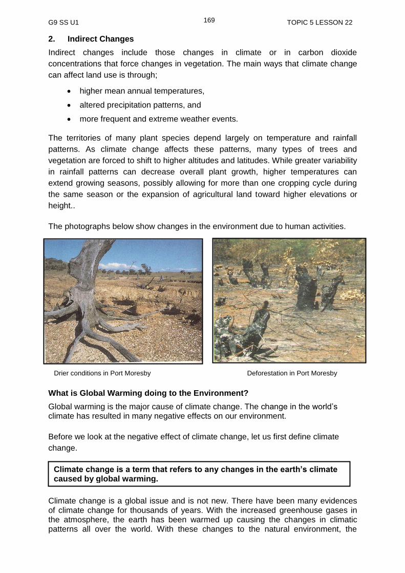
G9 SS U1 TOPIC 5 LESSON 22
169
2. Indirect Changes
Indirect changes include those changes in climate or in carbon dioxide
concentrations that force changes in vegetation. The main ways that climate change
can affect land use is through;
higher mean annual temperatures,
altered precipitation patterns, and
more frequent and extreme weather events.
The territories of many plant species depend largely on temperature and rainfall
patterns. As climate change affects these patterns, many types of trees and
vegetation are forced to shift to higher altitudes and latitudes. While greater variability
in rainfall patterns can decrease overall plant growth, higher temperatures can
extend growing seasons, possibly allowing for more than one cropping cycle during
the same season or the expansion of agricultural land toward higher elevations or
height..
The photographs below show changes in the environment due to human activities.
What is Global Warming doing to the Environment?
Global warming is the major cause of climate change. The change in the world’s climate has resulted in many negative effects on our environment.
Before we look at the negative effect of climate change, let us first define climate
change.
Climate change is a global issue and is not new. There have been many evidences of climate change for thousands of years. With the increased greenhouse gases in the atmosphere, the earth has been warmed up causing the changes in climatic patterns all over the world. With these changes to the natural environment, the
Drier conditions in Port Moresby Deforestation in Port Moresby
Climate change is a term that refers to any changes in the earth’s climate caused by global warming.

G9 SS U1 TOPIC 5 LESSON 22
170
natural inhabitants both plants, animals and humans of those environments have been affected in many ways. Effects of Climate Change on the Environment
The indicators below clearly show that there have been changes in the world’s climate.
Rising carbon dioxide in the atmosphere
Rising air and sea temperature
Rising sea level
Changing ocean chemistry and increasing ocean acidity
Changing rainfall patterns and
Changing habitats and species distribution
Changes in temperature and rainfall can increase the risk of insect infestation
outbreaks that can threaten the forests and other plants. Extreme weather events
can cause significant amounts of damage to trees and other vegetation from high
winds, flooding, and storm surges. Floods and storms can also alter water flows,
hurting the overall health of the forest, agricultural area, or ecosystem. In other areas,
changes in climate could produce droughts that greatly reduce agricultural
production, limiting food supply both regionally and beyond.
The most vulnerable areas are the atolls (low lying islands) and coastal areas and coral reefs. Effect of Climate Change in the Small Pacific Island Nations 1. Impact on Fresh Water Supply The Atolls (low lying islands) often have no surface water or rivers. The only source of fresh water supply comes from rainwater and underground water, which is accessed by digging wells. Underground water can become salinized (intrusion of salt water into fresh water causing it to become salty) by the rising sea level. This may result in the shortage of fresh water and soil salinity. The direct effect of soil salinity includes the inability of soil sustaining or retaining its plant nutrients for food crops and other plants life. The inhabitants of the islands may face shortage of food supply from their environment. A rise in sea level, droughts and floods all threaten water supply which can have a negative effect on the people and the disruption to the marine ecosystem which in turn will reduce the availability of fish and other sea food.
2. Climate Change Refugees
Pacific islanders living on affected islands face the possibility of relocation as the environment can no longer sustain their livelihood. In Papua New Guinea, the Carteret Islanders have been affected badly by the effect of climate change. The situation is far worse due to their isolation and the inaccessibility to basic food supply
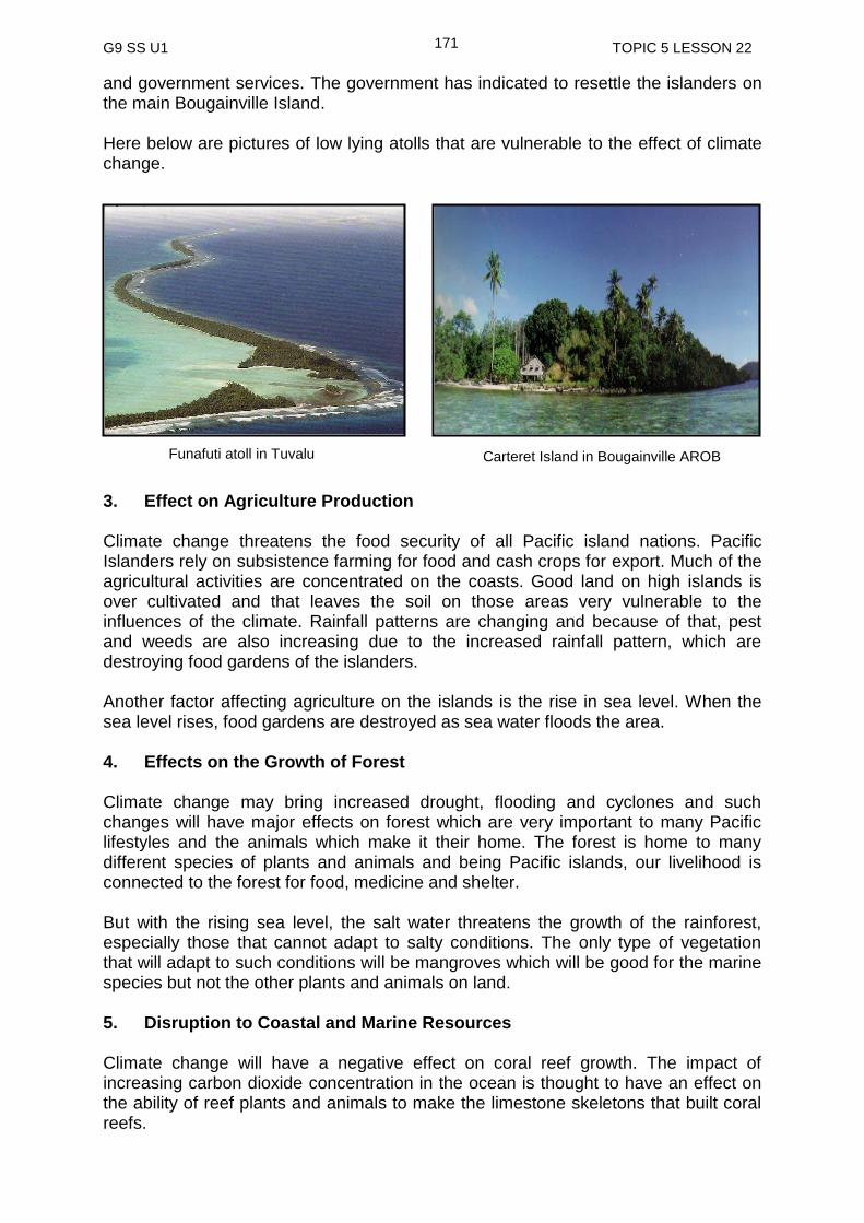
G9 SS U1 TOPIC 5 LESSON 22
171
Funafuti atoll in Tuvalu Carteret Island in Bougainville AROB
and government services. The government has indicated to resettle the islanders on the main Bougainville Island.
Here below are pictures of low lying atolls that are vulnerable to the effect of climate change.
3. Effect on Agriculture Production Climate change threatens the food security of all Pacific island nations. Pacific Islanders rely on subsistence farming for food and cash crops for export. Much of the agricultural activities are concentrated on the coasts. Good land on high islands is over cultivated and that leaves the soil on those areas very vulnerable to the influences of the climate. Rainfall patterns are changing and because of that, pest and weeds are also increasing due to the increased rainfall pattern, which are destroying food gardens of the islanders. Another factor affecting agriculture on the islands is the rise in sea level. When the sea level rises, food gardens are destroyed as sea water floods the area. 4. Effects on the Growth of Forest Climate change may bring increased drought, flooding and cyclones and such changes will have major effects on forest which are very important to many Pacific lifestyles and the animals which make it their home. The forest is home to many different species of plants and animals and being Pacific islands, our livelihood is connected to the forest for food, medicine and shelter. But with the rising sea level, the salt water threatens the growth of the rainforest, especially those that cannot adapt to salty conditions. The only type of vegetation that will adapt to such conditions will be mangroves which will be good for the marine species but not the other plants and animals on land. 5. Disruption to Coastal and Marine Resources Climate change will have a negative effect on coral reef growth. The impact of increasing carbon dioxide concentration in the ocean is thought to have an effect on the ability of reef plants and animals to make the limestone skeletons that built coral reefs.

G9 SS U1 TOPIC 5 LESSON 22
172
Mangroves protect the islands against storms, tides and cyclones. They provide breeding places and vital protection for marine species. Sea level rise could affect the survival of mangroves. This could affect the distribution of some fish resources. 7. Human Health Risk Diseases carried by insects are sensitive to the warming and flooding of the affected areas. Waterborne diseases are the result of flooding and contaminated water. One example of that is the Cholera outbreak which can easily spread through contaminated water. Sustainable ways to reduce the effects of Global warming and Climate Change Responding to the challenge of controlling global warming will require fundamental changes in energy production, transportation, industry, government policies, and development strategies around the world. These changes take time. The challenge today is managing the impacts that cannot be avoided while taking steps to prevent more severe impacts in the future.
Reducing emissions of greenhouse gases, also called greenhouse gas mitigation, is a necessary strategy for controlling global warming. There are two major approaches to slowing the build-up of greenhouse gases.
One is to reduce the consumption of fossil fuels, thereby reducing greenhouse gas emissions.
The other is to keep carbon dioxide out of the atmosphere by storing the gas or its carbon component somewhere else, a strategy known as carbon capture.
One way to keep carbon dioxide emissions from reaching the atmosphere is to preserve and plant more trees. Trees, especially young and fast-growing ones, soak up a great deal of carbon dioxide from the atmosphere and store carbon atoms in new wood. Worldwide, forests are being cleared at an alarming rate, particularly in the tropics. In many areas, there is little regrowth as land loses fertility or is changed to other uses, such as farming or housing developments. In addition, when trees are burned to clear land, they release stored carbon back into the atmosphere as carbon dioxide. Slowing the rate of deforestation and planting new trees can help counteract the build-up of greenhouse gases.
Carbon dioxide gas can also be captured directly. Carbon dioxide has traditionally been injected into depleted oil wells to force more oil out of the ground or seafloor. The same process can be used to store carbon dioxide released by a power plant, factory, or any large stationary source. For example, since 1996 this process has been used at a natural gas drilling platform off the coast of Norway. Carbon dioxide brought to the surface with the natural gas is captured, compressed, and then injected into an aquifer deep below the seabed from which it cannot escape. In most cases, the process of carbon capture would also involve transporting the gas in compressed form to suitable locations for underground storage. Deep ocean waters could also absorb a great deal of carbon dioxide, although the environmental effects may be harmful to ocean life. The feasibility and environmental effects of these options are under study by international teams.
G9 SS U1 TOPIC 5 LESSON 22
173
greenhouse effect is the trapping of the sun’s warmth in the earth’s lower atmosphere due to the increased emission of greenhouse gases into the atmosphere.
a greenhouse gas is any gaseous compound in the atmosphere that is capable of absorbing infrared radiation, thereby trapping and holding heat in the atmosphere. By increasing the heat in the atmosphere, greenhouse gases are responsible for the greenhouse effect, which then leads to global warming.
the greenhouse effect is one of the leading causes of global warming.
the most significant greenhouse gases are water vapor (H2O), carbon dioxide (CO2), methane (CH4) and nitrous oxide (N2O).
global Warming is a gradual increase in the average temperature of the earth's atmosphere generally attributed to the greenhouse effect caused by increased levels of greenhouse gasses.
main cause of the current global warming increased emission of the greenhouse gasses. These gasses trap the heat radiating (given off) from Earth towards the space thus increasing the average world’s temperature.
the main human activities that contribute significantly to global warming include farming, manufacturing of goods, abstraction of natural resources through logging, mining, and fishing, development of infrastructures and settlements, transportation (Using of motor vehicles and aircrafts), using of electrical items and burning of wood to provide energy
global warming is the major cause of climate change. The change in the world’s climate has resulted in many negative effects on our environment.
the most vulnerable areas are the atolls (low lying islands) , coastal areas and coral reefs
NOW DO PRACTICE EXERCISE 22 ON THE NEXT PAGE
SUMMARY
You have come to the end of this lesson. In this lesson you have learned that:
G9 SS U1 TOPIC 5 LESSON 22
174
Practice Exercise 22
1. Explain the Greenhouse effect
______________________________________________________________
2. Give some examples of the greenhouse gases.
_______________________________________________________________
3. State one way methane gas is produced
_______________________________________________________________
4. What is global warming? Explain
_______________________________________________________________
5. What is the relationship between greenhouse effect and global warming?
_______________________________________________________________
_______________________________________________________________
6. List the different ways climate change has affected the environment around the
Pacific
i. ___________________________________________
ii. ___________________________________________
iii. ___________________________________________
iv.___________________________________________
7. State the two major approaches to slowing the build-up of greenhouse gases.
i________________________________________________________________
________________________________________________________________
Ii______________________________________________________________
_______________________________________________________________
NOW CHECK YOUR WORK. ANSWERS ARE AT THE END OF TOPIC 5.
GRADE 9 SS U1 TOPIC 5 LESSON 23
175
What is a customary land?
Lesson 23: Case Study: Land Use of Local Area
Welcome to lesson 23. In this lesson, you will learn about a case study on land use. That is how and why a land is used.
Your Aims
observe and identify the type of land use in your area
categorise the main land use on a sketched diagram
Land Use of Local Areas
There are many ways in which land is used. Before a piece of land can be used, the government and the customary land owners should know the purpose of the land use. There must be an agreement between the developer and the government or the developer and the customary landowners.
In this lesson, you will study how land is used in Port Moresby in the National Capital District. It is situated at the southern part of this island country and has a population of just over a million people. Port Moresby is divided into three electorates. They are Moresby Northwest, Moresby Northeast and Moresby South.
Port Moresby is an urban centre therefore its land use will defer greatly to that of a rural area. For instance, Tapini in the Goilala district of the Central province, has its land mainly used for agricultural purposes and others like mining. Port Moresby is developing rapidly. Political (government) and economic (wealth) factors have determined its size, the way it was built and the way it is spaced and also its location. A city’s land use is influenced by its site (location), the climatic conditions and what resources (especially building materials and fresh water). Influence refers to ability to change something. Port Moresby is located along the coast for easy access to other parts of Papua New Guinea and neighbouring countries. Access refers to getting things easily from one place to another.
A customary land refers to land or area recognised traditionally. It is people’s land being passed down from one generation to another by their ancestors.
Local land area refers to land in a particular province. Developer refers to person, people or groups of people who wish to use the land whether for building houses or offices, doing agricultural activities, mining or setting up recreational parks. A Recreational parks refers to an area used mainly for sports, picnic or for relaxing.
Electorate refers to all the people in a country or area who are entitled to vote in an election.
A customary land refers to land or area recognised traditionally. It is people’s land being passed down from one generation to another by their ancestors.
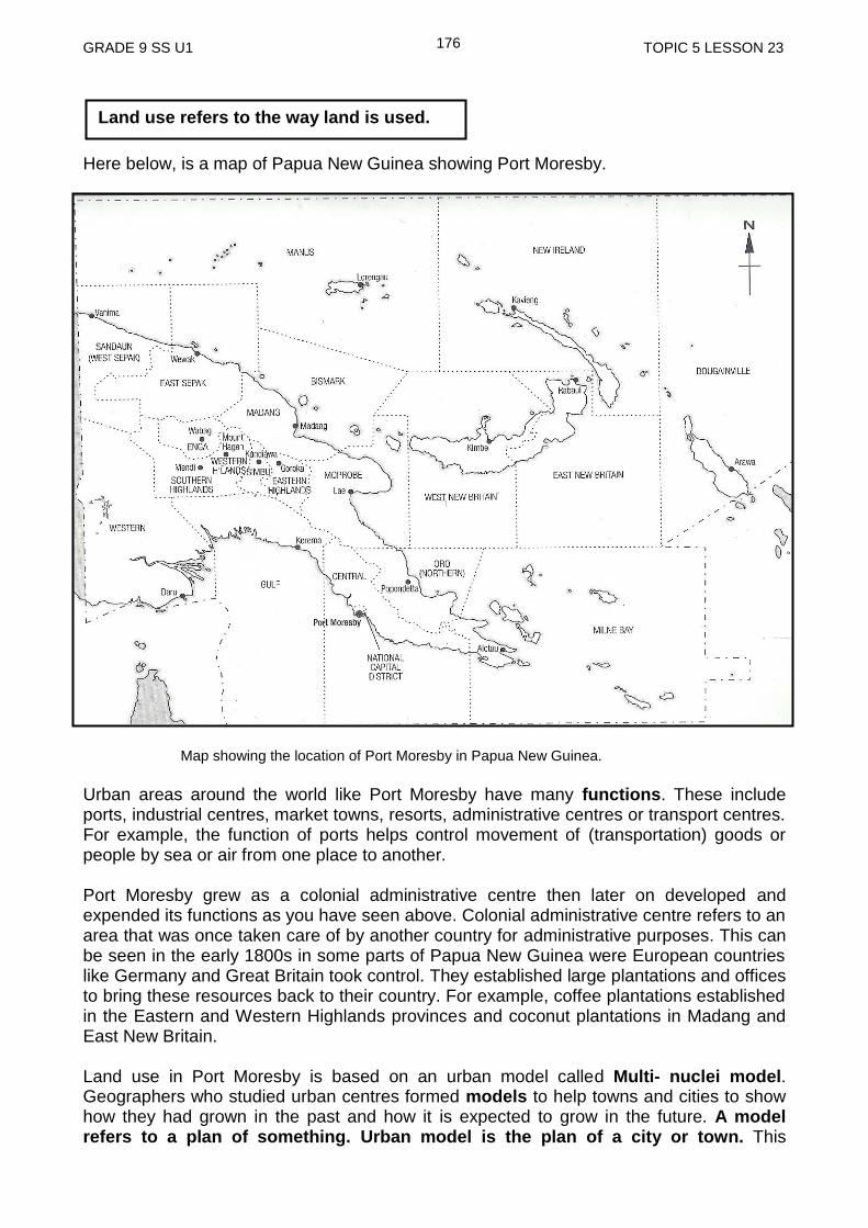
GRADE 9 SS U1 TOPIC 5 LESSON 23
176
Here below, is a map of Papua New Guinea showing Port Moresby.
Map showing the location of Port Moresby in Papua New Guinea.
Urban areas around the world like Port Moresby have many functions. These include ports, industrial centres, market towns, resorts, administrative centres or transport centres. For example, the function of ports helps control movement of (transportation) goods or people by sea or air from one place to another. Port Moresby grew as a colonial administrative centre then later on developed and expended its functions as you have seen above. Colonial administrative centre refers to an area that was once taken care of by another country for administrative purposes. This can be seen in the early 1800s in some parts of Papua New Guinea were European countries like Germany and Great Britain took control. They established large plantations and offices to bring these resources back to their country. For example, coffee plantations established in the Eastern and Western Highlands provinces and coconut plantations in Madang and East New Britain. Land use in Port Moresby is based on an urban model called Multi- nuclei model. Geographers who studied urban centres formed models to help towns and cities to show how they had grown in the past and how it is expected to grow in the future. A model refers to a plan of something. Urban model is the plan of a city or town. This
Land use refers to the way land is used.
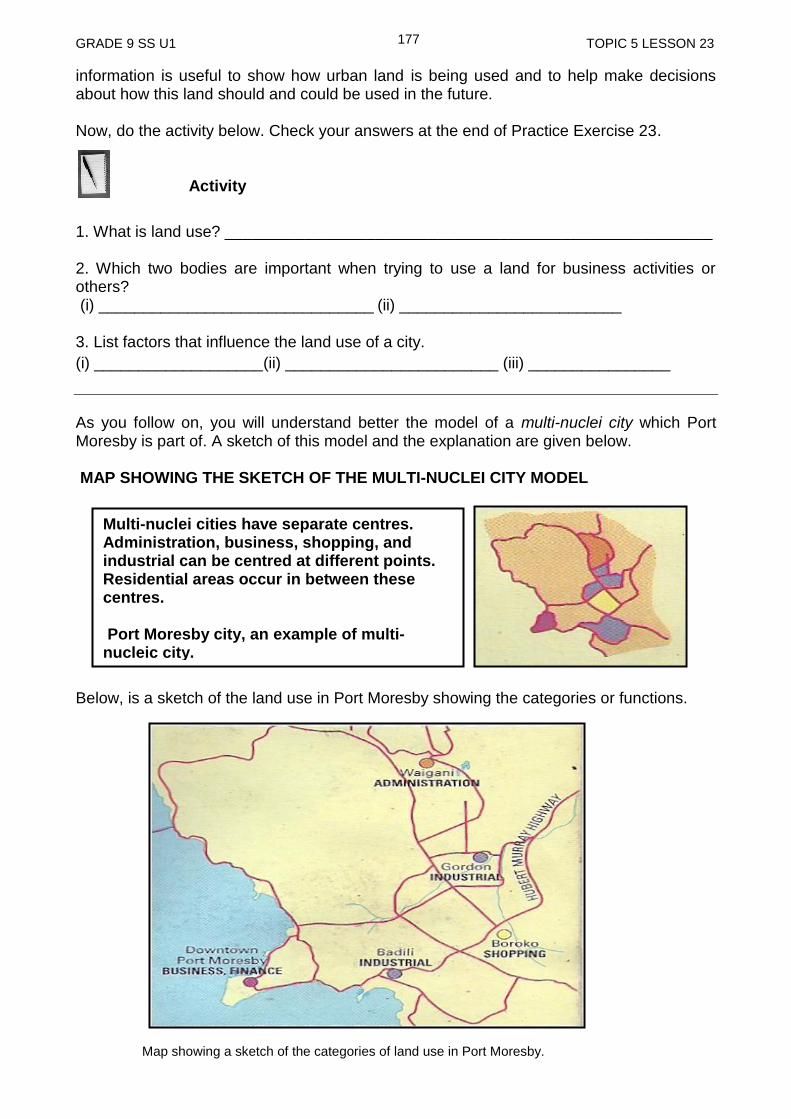
GRADE 9 SS U1 TOPIC 5 LESSON 23
177
information is useful to show how urban land is being used and to help make decisions about how this land should and could be used in the future. Now, do the activity below. Check your answers at the end of Practice Exercise 23. Activity
1. What is land use? _______________________________________________________ 2. Which two bodies are important when trying to use a land for business activities or others? (i) _______________________________ (ii) _________________________ 3. List factors that influence the land use of a city.
(i) ___________________(ii) ________________________ (iii) ________________
As you follow on, you will understand better the model of a multi-nuclei city which Port Moresby is part of. A sketch of this model and the explanation are given below. MAP SHOWING THE SKETCH OF THE MULTI-NUCLEI CITY MODEL Below, is a sketch of the land use in Port Moresby showing the categories or functions. Map showing a sketch of the categories of land use in Port Moresby.
Multi-nuclei cities have separate centres. Administration, business, shopping, and industrial can be centred at different points. Residential areas occur in between these centres. Port Moresby city, an example of multi-nucleic city.
GRADE 9 SS U1 TOPIC 5 LESSON 23
178
Let us find out about the categories or the functions of the land use in Port Moresby. Land use in Port Moresby 1. Industrial areas are those that are involved with the production or manufacturing of goods like fish canning, cement products, soap, matches and wire products. Here the land use can be divided into heavily industrial (that can cause pollution) and light industry less noisy and polluting (for example, the making of furniture, building components, soft drinks and clothing). In Port Moresby, light industrial areas are located at Badili, Hohola, Gordon and Six mile. Napa Napa is new industry for oil refining and Motukea Island has a ship repair facility.
2. Residential: This refers to areas where people live. People live either within the city and go to work or outside the city and travel to work in the city. 3. Recreational areas are those that are used mainly for sports, picnic and relaxing. These are not developed for business. 4. Commercial areas are those that are involved in business and shopping. Here the land use includes offices (for example, for banks, lawyers firms, accountants), services (for example, hairdressers), retail stores (for example, supermarkets, chemist) and wholesale business. This kind of land use can be located in or near the CBD or separate nuclei. Our capital city has a number of commercial centres, such as Downtown, Boroko, Waigani, Gordon, Hohola, Gerehu and Tokarara. You can see this in the sketch of the land use categories or functions on page 178. 5. Administrative This refers to an area that was established to take care of the interest of the foreign country. For instance, interest like making plantations and sending the raw material back to their country to help build own country. Today, we have buildings in place of this that make the decision on how best our country should work like the Parliament, Education Department offices and other Department offices like Works, Finance, Justice and National Planning and Monitoring. Some other departments like Agriculture and Health headquarters are run in other parts of the city.
Central Business District (CBD), refers to the area in the centre of the city which is very expensive. Those who can afford to pay the high price and do business are the major stores (for example Stop and Shop) and bigger business like Hotels (for example, Holiday Inn).
GRADE 9 SS U1 TOPIC 5 LESSON 23
179
land is used in many ways.
developer refers to people who are interested in the land and wish to use it to create business or for other purpose.
the categories or the functions of land use of an urban area are as follows; administrative, residential, commercial, recreational and industrial.
urban refers to a town or a city and rural refers to a village or the country side.
urban cities land use are also based on the pattern called multi-nuclei model.
multi-nuclei model refers to a plan of the city where its land use categories or functions can be based at other parts of the city and not only in one part of the city.
the two factors that determine the size of the city, way it is built and the way it is spaced as well as its location are the political (government) and the economic (wealth) factors.
colonial administrative centre refers to an area that was once taken care of by another country for their countries interest.
CBD stand for Central Business District. It refers to the area in the centre of the city which is very expensive.
NOW DO PRACTICE EXERCISE 23 ON THE NEXT PAGE
SUMMARY
You have come to the end of this lesson. In this lesson you have learned that:
GRADE 9 SS U1 TOPIC 5 LESSON 23
180
Practise Exercise 23
1. Define the following words:
(i) Electorate
_______________________________________________________________
(ii) Urban
_____________________________________________________________
(iii) Rural
_______________________________________________________________
(iv) Influence
_____________________________________________________________
2. Who are customary landowners?
_______________________________________________________________
_______________________________________________________________
3. Why is the multi-nuclei model important for urban cities like Port Moresby to follow?
_______________________________________________________________
_______________________________________________________________
_______________________________________________________________
4. What are colonial administrative centres?
_______________________________________________________________
_______________________________________________________________
5. List the five categories or functions of the land use in the urban area.
(i) _____________________________
(ii)_____________________________
(iii)_____________________________
(vi)_____________________________
(v)_____________________________
Answers to Activity
1. Land use refers to the way in which land is used.
2. (i) Government (ii) Customary Landowners
3. (i) Site (ii) Climate Conditions (iii) resources
NOW CHECK YOUR WORK. ANSWERS ARE AT THE END OF TOPIC 5.
GRADE 9 SOCIAL SCIENCE S1 181 REFERENCES
ANSWERS TO PRACTICE EXERCISE 20-23
Practice Exercise 20 1. Land use can be defined as the way land is used 2. i) Subsistence agriculture
ii) Commercial agriculture 3. coffee, coconut, cocoa, oil palm, tea, sugar cane, vanilla, betel nut, banana, 4. Building of sky scrapper building in towns and cities. The purpose is to house
offices of different companies
Practice Exercise 21 1. i) residential, commercial, industrial land use, transport, institutional land use, and
recreational land use. (Any two can be correct) 2. i) Subsistence agriculture, hunting, fishing, and settlement (Any two can be
correct) 3. Subsistence agriculture is when people clear the forest for gardening activities or
the land is used for hunting and fishing while Commercial agriculture is when land is used to plant crops that will be used for selling to markets or large stores.
4. The main reason for a variety of land use in urban areas would be because more
people move to live there, increased population and more land needs to be used for many other activities practised in these areas.
Practice Exercise 22 1. Greenhouse effect is the trapping of the sun’s warmth in the earth’s lower
atmosphere due to the increased emission of greenhouse gases into the atmosphere.
2. Water vapor (H2O), carbon dioxide (CO2), methane (CH4) and nitrous oxide (N2O) hydro fluorocarbons, per fluorocarbons and sulphur hexafluoride.
3. Methane is produced through agricultural practices.
4. Global Warming is a gradual increase in the average temperature of the earth's atmosphere generally attributed to the greenhouse effect caused by increased levels of greenhouse gasses.
5. Global warming occurs as a result of the greenhouse effect. Greenhouse effect is the resultant effect of the emission of greenhouse gasses.
6. (i) Impact on fresh water supply

GRADE 9 SOCIAL SCIENCE S1 182 REFERENCES
(ii) Climate change Refugees
(iii) Effects on the growth of forest
(iv) Disruption to coastal and marine resources
(v) Human Health Risk
7. (i) Reduce the consumption of fossil fuels, thereby reducing greenhouse gas emissions.
(ii) The other is to keep carbon dioxide out of the atmosphere by storing the gas or its carbon component somewhere else, a strategy known as carbon capture.
Practice Exercise 23 1. (i) Electorate refers to all the people in a country or area who are entitled to
vote in an election.
(ii) Urban refers to a town or city
(iii) Rural refers to village or the country side
(iv) Influence refers to the ability to change something
1. Customary Land refers to land or area recognised traditionally. It is peoples’ land
being passed down from one generation to another by their ancestors.
2. Multi-nuclei model are used to help towns and cities to show how they had grown in the past and how it could expect to grow in the future.
3. Colonial administrative centres are areas that were once taken care of by another
country for their own personal interest. 5. (i) Administrative (ii) Residential (iii) Commercial (iv) Recreational (v) Industrial
END OF UNIT 1
NOW COMPLETE ALL THE QUESTIONS IN TOPIC TEST 1,2,3,4 AND 5 IN ASSIGNMENT BOOK 1. SEND THE COMPLTED ASSIGNMENT BOOK TO
YOUR PROVINCIAL CENTRE FOR MARKING.
GRADE 9 SOCIAL SCIENCE S1 183 REFERENCES
References
Exploring Geography in PNG (1992), Department of Education Papua New Guinea, Jackaranda Press, Auckland, New Zealand.
People and places in the Pacific, Department of Education Papua New Guinea, Grade 9 Social Science Text Book Stephen, Codrington and Chris, Chittenden. The Geography Skills Book. New ed. Australia: Heinemann, 1989. http://education.nationalgeographic.com/encyclopedia/climate/?ar_a=1#page=6
Source(s) http://www.bbc.co.uk/weather/features/un…
Emanuel, K. A. (2005) Increasing destructiveness of tropical cyclones over the past 30 years. Nature, 436; 686-688
IPCC. (2007) Climate change 2007: the physical science basis (summary for policy makers), IPCC.
Jones, C. Climate Change: Facts and Impacts [online]. Available from: What effects are we seeing now and what is still to come?
Miller, C. and Edwards, P. N. (ed.)(2001) Changing the Atmosphere: Expert Knowledge and Environmental Governance, MIT Press
Ruddiman, W. F. (2003) The anthropogenic greenhouse era began thousands of years ago, Climate Change 61 (3): 261-293
Ruddiman, W. F. (2005) Plows, Plagues and Petroleum: How Humans Took Control of Climate, Princeton University Press
Ruddiman, W. F., Vavrus, S. J. and Kutzbach, J. E. (2005) A test of the overdue-glaciation hypothesis, Quaternary Science Review, 24:11
Schmidt, G. A., Shindel, D. T. and Harder, S. (2004) A note of the relationship between ice core methane concentrations and insolation GRL v31 L23206
McColl, R. W. (2005). Encyclopedia of World Geography, Volume 1. (Facts on File Library of World Geography). New York: Facts on File. p. 919.
Encyclopedia.com. http://www.encyclopedia.com/topic/Daylight.aspx. Retrieved October 4, 2012..
http://old.thesustainabilitycouncil.org/climates/temperate/default.php. Retrieved October 4, 2012 Brinch, Brian (2007-11-01). "How mountains influence rainfall patterns". USA Today (Tysons Corner, Virginia: Gannett). ISSN 0734-7456.

GRADE 9 SOCIAL SCIENCE S1 184 REFERENCES
http://usatoday30.usatoday.com/weather/tg/wrnshdw/wrnshdw.htm. Retrieved October 4, 2012
http://www.ehow.com/facts_5882122_temperate-zones-located_.html#ixzz2EGqCtblq https://www.geolsoc.org.uk/ks3/gsl/education/resources/rockcycle/page3461.html
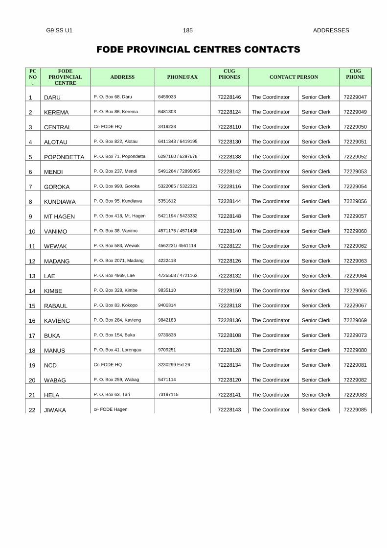
G9 SS U1 185 ADDRESSES
FODE PROVINCIAL CENTRES CONTACTS
PC
NO
.
FODE
PROVINCIAL
CENTRE
ADDRESS
PHONE/FAX
CUG
PHONES
CONTACT PERSON
CUG
PHONE
1 DARU P. O. Box 68, Daru 6459033 72228146 The Coordinator Senior Clerk 72229047
2 KEREMA P. O. Box 86, Kerema 6481303 72228124 The Coordinator Senior Clerk 72229049
3 CENTRAL C/- FODE HQ 3419228 72228110 The Coordinator Senior Clerk 72229050
4 ALOTAU P. O. Box 822, Alotau 6411343 / 6419195 72228130 The Coordinator Senior Clerk 72229051
5 POPONDETTA P. O. Box 71, Popondetta 6297160 / 6297678 72228138 The Coordinator Senior Clerk 72229052
6 MENDI P. O. Box 237, Mendi 5491264 / 72895095 72228142 The Coordinator Senior Clerk 72229053
7 GOROKA P. O. Box 990, Goroka 5322085 / 5322321 72228116 The Coordinator Senior Clerk 72229054
8 KUNDIAWA P. O. Box 95, Kundiawa 5351612 72228144 The Coordinator Senior Clerk 72229056
9 MT HAGEN P. O. Box 418, Mt. Hagen 5421194 / 5423332 72228148 The Coordinator Senior Clerk 72229057
10 VANIMO P. O. Box 38, Vanimo 4571175 / 4571438 72228140 The Coordinator Senior Clerk 72229060
11 WEWAK P. O. Box 583, Wewak 4562231/ 4561114 72228122 The Coordinator Senior Clerk 72229062
12 MADANG P. O. Box 2071, Madang 4222418 72228126 The Coordinator Senior Clerk 72229063
13 LAE P. O. Box 4969, Lae 4725508 / 4721162 72228132 The Coordinator Senior Clerk 72229064
14 KIMBE P. O. Box 328, Kimbe 9835110 72228150 The Coordinator Senior Clerk 72229065
15 RABAUL P. O. Box 83, Kokopo 9400314 72228118 The Coordinator Senior Clerk 72229067
16 KAVIENG P. O. Box 284, Kavieng 9842183 72228136 The Coordinator Senior Clerk 72229069
17 BUKA P. O. Box 154, Buka 9739838 72228108 The Coordinator Senior Clerk 72229073
18 MANUS P. O. Box 41, Lorengau 9709251 72228128 The Coordinator Senior Clerk 72229080
19 NCD C/- FODE HQ 3230299 Ext 26 72228134 The Coordinator Senior Clerk 72229081
20 WABAG P. O. Box 259, Wabag 5471114 72228120 The Coordinator Senior Clerk 72229082
21 HELA P. O. Box 63, Tari 73197115 72228141 The Coordinator Senior Clerk 72229083
22 JIWAKA c/- FODE Hagen 72228143 The Coordinator Senior Clerk 72229085

G9 SS U1 186 SUBJECT LIST
SUBJECT AND GRADE TO STUDY
GRADE LEVELS SUBJECTS/COURSES
Grades 7 and 8
1. English
2. Mathematics
3. Personal Development
4. Social Science
5. Science
6. Making a Living
Grades 9 and 10
1. English
2. Mathematics
3. Personal Development
4. Science
5. Social Science
6. Business Studies
7. Design and Technology- Computing
Grades 11 and 12
1. English – Applied English/Language& Literature
2. Mathematics - Mathematics A / Mathematics B
3. Science – Biology/Chemistry/Physics
4. Social Science – History/Geography/Economics
5. Personal Development
6. Business Studies
7. Information & Communication Technology
GRADES 11 & 12 COURSE PROGRAMMES
Notes: You must seek advice from your Provincial Coordinator regarding the recommended
courses in each stream. Options should be discussed carefully before choosing the stream when
enrolling into Grade 11. FODE will certify for the successful completion of seven subjects in
Grade 12.
No Science Humanities Business
1 Applied English Language & Literature Language & Literature/Applied
English
2 Mathematics A/B Mathematics A/B Mathematics A/B
3 Personal Development Personal Development Personal Development
4 Biology Biology/Physics/Chemist
ry
Biology/Physics/Chemistry
5 Chemistry/ Physics Geography Economics/Geography/History
6 Geography/History/Economic
s
History / Economics Business Studies
7 ICT ICT ICT
REMEMBER:
For Grades 7 and 8, you are required to do all six (6) courses.
For Grades 9 and 10, you must study English, Mathematics, Science, Personal
Development, Social Science and Commerce. Design and Technology-Computing is
optional.
For Grades 11 and 12, you are required to complete seven (7) out of thirteen (13)
courses to be certified.
Your Provincial Coordinator or Supervisor will give you more information regarding
each subject.
G9 SS U1 187 SUBJECT LIST
CERTIFICATE IN MATRICULATION STUDIES
No Compulsory Courses Optional Courses
1 English 1 Science Stream: Biology, Chemistry, Physics
2 English 2 Social Science Stream: Geography, Intro to
Economics and Asia and the Modern World
3 Mathematics 1
4 Mathematics 2
5 History of Science &
Technology
REMEMBER:
You must successfully complete 8 courses: 5 compulsory and 3 optional.