Selecting 3D urban visualisation models to support urban disaster management: A rule-based approach
Upload
khangminh22Category
view
0download
0
Models of Urban Places
• Gideon Sjoberg explained the stages of urban development in The Preindustrial City: Past and Present (1960)
• Sjoberg said that all cities were a product of their societies and went through stages:
– Folk-preliterate
– Feudal
– Preindustrial
– Urban-industrial

Primate Cities
• Gideon Sjoberg was also
the first to study the
primate city.
• A nation’s leading city in
size that serves as an
expression of national
culture.
– Not necessarily large
– Dominated by religious and
govt. buildings
– Spacious with wealth near
the center
– Less privileged near the edge
or outside wall

• Not all pre industrial primate cities
were the same-Muslim cities were
dominated by the great mosque
and had less variation in
surrounding housing.
• Commerce and crafts were
focused in the bazaar which has
no western equivalent

The Modern Western City
• Medieval city was bleak and grimy with narrow dangerous streets.
• Unpaved streets provided poor sanitation
• The tallest buildings were the Church & Castle
• Mercantile cities of the 16th & 17th cent. were nodes of regional, national and international trade
• Great cities like London, Amsterdam, Lisbon and Copenhagen grew with the wealth of colonies.

The Second Urban Revolution
A large scale movement of people to cities to work in manufacturing. Made possible by:
1. second agricultural revolution that improved food production and created a larger surplus
2. industrialization, which encouraged growth of cities near industrial resources

The Modern Western City
• Manufacturing city first
developed in Britain, later
Western Europe and
North America.
• Rapidly growing factory
system with railroads and
tenement slums
• Sanitary systems, water
supplies and housing were
overwhelmed with rapid
growth and pollution.

The Modern Western City
• Modernization of American cities took place in late 19th cent.
• Electric trolley and other forms of mass transportation transformed cities-transport systems became circumferential and radial.
• Suburbanization of the city became possible with 1920s revolution of the automobile
• Modern cities of North America are sprawling expanses of suburbs, shopping malls and business parks

• Hinterland-a German word
that means land behind the
city
• Spacing of cities-large
cities lie farther apart-
smaller settlements are
closer to each other
• Industrial Revolution began
in Europe-arrived in the US
around 1870-in only 50 yrs.
US surpassed Europe
• 25 million European
immigrants arrived in
America-many in
manufacturing centers

John Borchert’s “American Metropolitan
Evolution”-4 Stage model of evolution
• First Stage-Sail-
Wagon Epoch
(1790-1830)
slow, primitive
overland and waterway
transport-Boston, New
York and Philadelphia
were major cities
oriented to European
trade.

John Borchert’s “American Metropolitan
Evolution-4 Stage model of evolution
• Second Stage-Iron Horse
Epoch (1830-1870)
Diffusion of steam-powered
railroads-coal mining-boomed,
tracks laid coast to coast-
manufacturing spread outward
from New England hearth-by
1850 New York was primate
city with Pittsburgh, Detroit &
Chicago growing rapidly

• Third Stage-Steel-Rail Epoch (1870-1920)
coincided with the Industrial Revolution
Steel industry in Chicago, Detroit & Pittsburgh
Coal & iron ore supply areas-northern Appalachia and Lake Superior (Mesabi) Agglomeration in raw materials and market location due to railroad. Steel replaced iron rails-safer-more powerful locomotives-larger freight cars & even refrigerated cars added.

• Fourth Stage-Auto-Air-Amenity Epoch (1920-1970)
Gasoline-powered internal combustion engines-truck based regional and metropolitan distribution of goods; increased automation of blue-collar jobs; shift to white-collar jobs; highways, expressways and jet aircraft made travel faster & cheaper; amenities of suburbs, Sunbelt;
New activities responded less to cost-distance factors

• Fifth Stage?- (1970-
Now)
decline of Rust belt
continues;
high tech. will stimulate
an even greater dispersal
of city populations;
telecommuting, working
from home, globalization
and outsourcing change
the way we work

Urbanization and Location
• 1800-despite Ind. Rev. Europe was still rural-by 1950 Europe was 50% urban-today 85% urban
• World today is 50% urban
• Agglomeration-clustering of industries for mutual benefit
• Specialization-certain industries dominate certain regions-Manchester textiles, Pittsburgh, Pa. steel

• Urban Geographers look at:
– How cities are arranged
– What cities look like
– Transport & communications
– Why people move from place to place within the city
• Hinterland: the surrounding service area of
a city that includes smaller villages and
hamlets
• Centrality: the economic power or draw of
a place compared to its competition

• Hamlet-small collection of houses-may have services.
• Village-several dozen services-stores, gas stations and so forth
• Town-larger than a village-higher level of specialization-banks, schools, libraries, specialized stores-furniture, appliances, hardware, etc.
• City-more functional specialization-larger hinterland, greater centrality, well defined CBD and suburbs
• Metropolis or Metropolitan area-urban area larger than a city
• Megalopolis-when large metropolises coalesce into a megacity, e.g. Boston to New York

Site and Situation
Site
* absolute location
of a city
* a city’s static
location, often
chosen for trade,
defense, or
religion.
Situation
* relative location
of a city
* a city’s place in
the region and
the world
around it.

• Paris-situational
advantage-grew as
the hinterland
prospered; became
multifunctional-
religious, cultural,
political,
industrial center;
today a megacity
of 10 million; the
next largest city is
Lyon, France at
1/7th the size
• A primate city

Eiffel Tower
built for the
1889 World’s
Fair

Anchored by the Bois de Boulogne in the west and the Bois de
Vincennes in the east, Paris’s 450 parks and gardens cover over
7,400 acres-almost 30% of the city-one of Europe’s greenest cities.

• Chicago-situational advantage-Great Lakes & Mississippi water complex junction; west end of the industrial core; next to vast, rich farmland; location of rail, road, water (St. Lawrence Seaway 1959) & air route junction; major natural resource hinterland

• Guangdong Province-southern China; city of Shenzen-3 million, 30 yrs ago only 20,000
• Urban situation-proximity to Hong Kong & status as Special Economic Zone
• Its relative location has enabled it to benefit from trade & commerce

Shenzhen changed from a fishing village to a major metropolitan area in just 25 years.
25 years ago, all of this land was duck ponds and rice paddies.
Shenzhen, China

• Homes being constructed in King Dragon Villa complex in Lishui-this
midsize town is a prime example rapid urban growth in China


• Situations can deteriorate:
• Cities of Northeast Manufacturing (Rustbelt) in decline
• Brugge, Belgium-declined in size after river silted up.
• Berlin, Germany destroyed in WWII and divided during the Cold War
• Many rural towns were bypassed by expressways-withered and died.
• As cars replaced horse & buggy, many rural hamlets, & villages declined
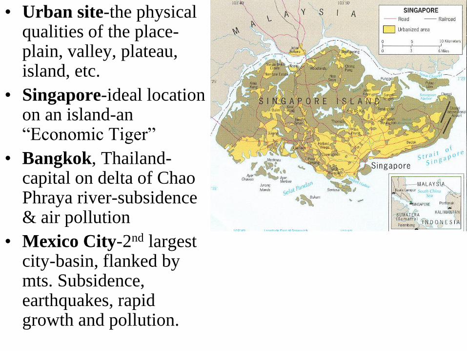
• Urban site-the physical qualities of the place-plain, valley, plateau, island, etc.
• Singapore-ideal location on an island-an “Economic Tiger”
• Bangkok, Thailand-capital on delta of Chao Phraya river-subsidence & air pollution
• Mexico City-2nd largest city-basin, flanked by mts. Subsidence, earthquakes, rapid growth and pollution.
Copyright © 2022 FDOKUMEN